Bradford’s Account of the Wreck.—His Visit to the Scene of the
Disaster.—The Passengers and Crew received at Plymouth.—Tradition
of the Name “Sparrow-Hawk.”—Extracts from the Work of Amos Otis,
Esq.—Recovery and Saving of the Wreck.
 E
now proceed to give the history of the ancient ship according to the
chronological order of events. The reader’s attention is invited to the
following interesting and important extract from “Bradford’s History of
Plymouth Plantations, A. D. 1626–7,” MS. p. 146:—
E
now proceed to give the history of the ancient ship according to the
chronological order of events. The reader’s attention is invited to the
following interesting and important extract from “Bradford’s History of
Plymouth Plantations, A. D. 1626–7,” MS. p. 146:—
“Ther is one thing that fell out in ye begining of ye winter
before, which I have refferred to this place, that I may handle
ye whole matter togeither. Ther was a ship, with many passengers
in her and sundrie goods, bound for Virginia. They had lost them
selves at sea, either by ye insufficiencie of ye maister, or his
ilnes; for he was sick & lame of ye scurvie, so that he could
but lye in ye cabin dore & give direction; and it should seeme
was badly assisted either wth mate or mariners; or else ye
fear and unrulines of ye passengers were such, as they made them
stear a course betweene ye southwest & ye norwest, that they
might fall with some land, what soever it was they cared not. For
they had been 6. weeks at sea, and had no water, nor beere, nor
any woode left, but had burnt up all their emptie caske; only
one of ye company had a hogshead of wine or 2. which was allso
allmost spente, so as they feared they should be starved at sea, or
consumed with diseases, which made them rune this desperate course.
But it plased God that though they came so neare ye shoulds of
Cap-Codd [147] or else ran stumbling over them in ye night,
they knew not how, they came right before a small blind harbore
that lyes aboute ye midle of Manamoyake Bay to ye Southward of
Cap-Codd, with a small gale of wind; and about highwater toucht
upon a barr of sand that lyes before it, but had no hurte, ye sea
being smoth; so they laid out an anchore. But towards the evēing,
the winde sprunge up at sea, and was so rough, as broake their
cable, & beat them over the barr into ye harbor, wher they saved
their lives & goods, though much were hurte with salt water; for
wth beating they had sprung ye but end of a planke or too,
& beat out their occome; but they were soone over, and ran on a
drie slate within the harbor, close by a beach; so at low water
they gatt out their goods on drie shore, and dried those that were
wette, and saved most of their things without any great loss;
neither was ye ship much hurt, but shee might be mended, and made
servisable againe. But though they were not a litle glad that they
had thus saved their lives, yet when they had a litle refreshed
them selves, and begane to thinke on their condition, not knowing
wher they were, nor what they should doe, they begane to be
strucken with sadnes. But shortly after they saw some Indians come
to them in canows, which made them stand upon their gard. But when
they heard some of ye Indeans speake English unto them, they were
not a litle revived, especially when they heard them demand if they
were the Gover of Plimoths men, or freinds; and yt they would
bring them to ye English houses, or carry their letters.
“They feasted these Indeans, and gave them many giftes; and sente
2. men and a letter with them to ye Gover, and did intreat him
to send a boat unto them, with some pitch, & occume, and spiks,
wth divers other necessaries for ye mending of ther ship (which
was recoverable). Allso they besought him to help them with some
corne and sundrie other things they wanted, to enable them to make
their viage to Virginia; and they should be much bound to him, and
would make satisfaction for any thing they had, in any comodities
they had abord. After ye Govr was well informed by ye messengers
of their condition, he caused a boate to be made ready, and such
things to be provided as they write for; and because others were
abroad upon trading, and such other affairs, as had been fitte to
send unto them, he went him selfe, & allso carried some trading
comodities, to buy them corne of ye Indeans. “It was no season
of ye year to goe withoute ye Cape, but understanding wher ye
ship lay, he went into ye bottom of ye bay, on ye inside, and
put into a crick called Naumskachett,[4] wher it is not much above
2. mile over [148] land to ye bay wher they were, wher he had
ye Indeans ready to cary over any thing to them. Of his arrivall
they were very glad, and received the things to mend ther ship,
& other necessaries. Allso he bought them as much corne as they
would have; and wheras some of their sea-men were rune away among
ye Indeans, he procured their returne to ye ship, and so left
them well furnished and contented, being very thankfull for ye
curtesies they receaved. But after the Gover thus left them, he
went into some other harbors ther aboute, and loaded his boate with
corne, which he traded, and so went home. But he had not been at
home many days, but he had notice from them, that by the violence
of a great storme, and ye bad morring of their ship (after she
was mended) she was put a shore, and so beatten and shaken as she
was now wholy unfitte to goe to sea.[5] And so their request was
that they might have leave to repaire to them, and soujourne with
them, till they could have means to convey them selves to Virginia;
and that they might have means to trāsport their goods, and they
would pay for ye fame, or any thing els wher with ye plantation
should releeve them. Considering their distres, their requests
were granted, and all helpfullnes done unto them; their goods
transported, and them selves & goods sheltered in their houses as
well as they could.
“The cheefe amongst these people was one Mr. Fells and Mr. Sibsie
which had many servants belonging unto them, many of them being
Irish. Some others ther were yt had a servante or 2. a peece; but
ye most were servants, and such as were ingaged to the former
persons, who allso had ye most goods. Affter they were hither
come, and some thing setled, the maisters desired some ground to
imploye ther servants upon; seing it was like to be ye latter
end of ye year before they could have passage for Virginia, and
they had now ye winter before them; they might clear some ground
and plant a crope, (seeing they had tools & necessaries for ye
same) to help to bear their charge, and keep their servants in
imployment; and if they had oppertunitie to departe before the same
was ripe, they would sell it on ye ground. So they had ground
appointed them in convenient places, and Fells & some other of them
raised a great deall of corne, which they sould at their departure.”
The historian here details some domestic infelicities of Mr. Fells in
consequence of which the Plymouth Pilgrims
“pact him away & those that belonged unto him by the first
oppertunitie, and dismiste all the rest as soone as could, being
many untoward people amongst them; though ther were allso some
that caried them selves very orderly all ye time they stayed. And
the plantation [149] had some benefite by them, in selling them
corne & other provisions of food for cloathing; for they had of
diverse kinds, as cloath, perpetuanes, & other stuffs, besids hose,
& shoes, and such like comodities as ye planters stood in need
of. So they both did good, and received good one from another; and
a cuple of barks caried them away at ye later end of somer. And
sundrie of them have acknowledged their thankfullnes since from
Virginia.”
To the account of the loss of the ship, Freeman’s “History of Cape Cod;
Annals,” &c., appends the following note:
“The beach where this ship was wrecked was thenceforward called
“The Old Ship.” The remains of the wreck were visible many years.”
The January number of the N. E. Historical and Genealogical Register
for 1864 (p. 37) contains an able article by Amos Otis,
Esq., in which allusion is made to the tradition that the name of the
old ship was “Sparrow-Hawk.” Mr. Otis speaks of this tradition as
uncertain. We will give the tradition as it is, and leave it to make
its own impression on our readers. A family by the name of Sparrow has
long resided in the close vicinity of the Old Ship Harbor. The first
settler of the name, Mr. Jonathan Sparrow, bought the land, where the
family now live, in 1675. The present proprietor, Mr. James L. Sparrow,
states that it had been “handed down” from father to son that there was
an old ship buried in the sand in Potanumaquut Harbor in the early days
of the colony, and that its name was “Sparahawk,” or “Sparrow-Hawk.”
Mr. Otis remarks, that “the evidence which seems to prove beyond a
reasonable doubt that those remains belong to the ship which Gov.
Bradford informs us was lost in Potanumaquut harbor in the winter
of 1626–7 ... is principally based on the geological changes that
have occurred on the coast, since its discovery. Archer’s account of
Gosnold’s voyage around the Cape, in 1602, and of the appearance of
the coast, is so unlike anything seen by the modern mariner, that his
relation has been considered a myth or traveller’s tale, unreliable and
unworthy of credence. Geological inquiries may seem out of place in a
historical and genealogical journal; but if they do nothing more, they
will verify the accuracy of Archer’s descriptions, and thus aid us in
our investigations of the truths of history.
“The accounts of the wrecked ship in Morton and Prince, are copied
from Bradford. Morton is not careful in his dates, but he informs us
that the master was a Scotchman, named Johnston, a fact not stated
by Bradford. Mr. Prince with his accustomed accuracy, states that a
ship was lost in the beginning of the winter [December], 1626. Gov.
Bradford’s description of the place where the ship was lost, would be
perfectly clear and distinct if the configuration of the coast was the
same now as it was when he wrote. Namaskachet Creek remains, but Isle
Nauset, Points Care and Gilbert, have been swept away by the waves and
currents of the ocean. Where Monamoick Bay was, there is a straight
line of sea-coast; where an open sea then was, now long beaches meet
the eye; and where were navigable waters, now we see sandy wastes and
salt meadows.
“Such remarkable changes having been made in the configuration of this
coast since its discovery by Gosnold, and its examination by Smith, in
1614, is it surprising that the knowledge of the location of “Old Ship
Harbor” should have been lost, or that the readers of Bradford should
have been unable to determine where Monamoick Bay was?
“Prof. Agassiz, of Cambridge, in company with the writer and others,
has recently made a careful geological examination of the eastern coast
of the towns of Eastham, Orleans, and Chatham.... The result was a
verification of the accuracy of Archer’s description of the coast.
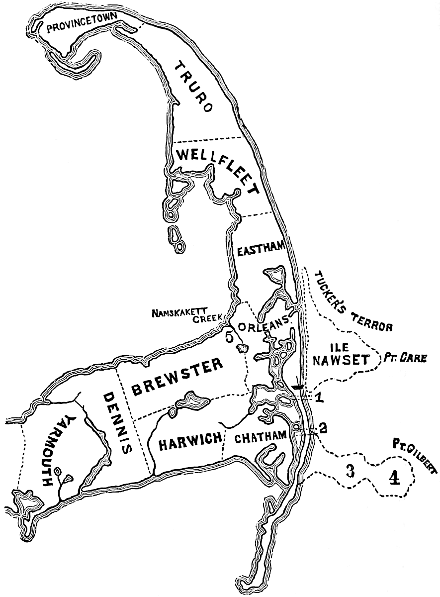
“This examination enables me to draw an outline map of the coast as it
was in 1602, and in 1626. I have also a map of the harbors, beaches,
and salt meadows as they were, and as they now are.” [V. map, p. 14.]
In Gov. Bradford’s account, which we have already quoted, he says
that “he landed on Naumskachett creek” on the inside of the bay.
From the fact that the distance from this creek, which now forms
a part of the boundary line between Brewster and Orleans, to the
navigable waters of Potanumaquut is about two miles,—as stated by
Bradford,—while to Nauset harbor, the distance is greater, Mr. Otis
considers it proved “beyond controversy that Potanumaquut was the
harbor into which the ship ‘stumbled.’”
We quote from Mr. Otis, the facts in relation to the discovery:
“On the 6th of May, 1863, Messrs. Solomon Linnell, 2d, and Alfred
Rogers, of Orleans, were on Nauset Beach, and discovered portions
of a wreck. Mr. Linnell was at the same place on the 4th, when no
part of the wreck was visible. This proves that it was uncovered
between the 4th and 6th of May, 1863. When first discovered, it was
partially covered with the marsh mud in which the wreck had been
embedded. On removing some of the mud, they found a quantity of
charcoal, and the appearance of the timbers and planks indicated
that the vessel of which these were the remains had been burnt.[6]
On Saturday, May 9, Leander Crosby, Esq., visited the wreck, and
collected a quantity of beef and mutton bones; several soles of
shoes, probably made for sandals; a smoking pipe of the kind used
by smokers of opium; and a metallic box.”
Dr. Benj. F. Seabury and John Doane, Jr., afterwards visited the wreck,
and found the rudder lying a few feet distant; this they removed, and
it is now deposited in the hall of the Pilgrim society, at Plymouth.
Messrs. Seabury and Doane took measurements of the ship, and public
attention was now drawn to a consideration of the subject.
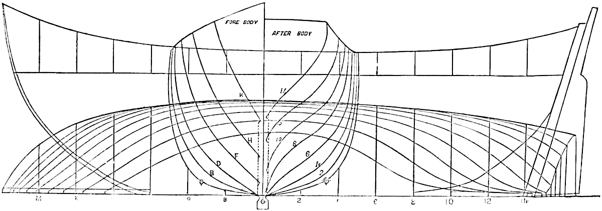
“The peculiar model of the wreck excited the curiosity of the
people, and although four miles from the village, it was visited
by hundreds, and each one took a fragment as a memento of his
visit. At the time the writer was there the current had swept out
a basin in the sand around the wreck, and it being low tide, every
part excepting the keel could be examined. One striking part was
immediately noticed by everyone,—the long, tail-like projection
at the stern. The oldest sailor never saw a vessel built on
that model, she must have had, to use a nautical expression, “a
clean run,” and have been a good sea-boat.... She had been most
carefully built. The frames were placed side by side.... There
were twenty-three regular frames remaining, or forty-six timbers,
not counting the six at the stern. At the bow several frames were
missing. The planks were fastened with spikes and treenails, in the
same manner as at the present time. Some of the treenails had been
wedged after they were first driven, showing that some repairs had
been made.
“The timbers and planks of the old ship are very sound, there
is no appearance of rot. There are no barnacles upon them, they
are not eaten by worms, and there is no indication that they have
been for any considerable length of time exposed to the action of
the elements. The spikes, bolts and other fastenings of iron have
entirely disappeared, ... rust had gradually consumed them, and
discolored sand indicated the places where the iron once was. The
wreck was embedded in marsh mud and covered deeply in sand. Under
such circumstances air was almost wholly excluded, and oxidation
must have been slow.
“Though called a ship, she had only one mast, and that as shown by
the mortise in the keelson, was nearly midship.”
“In August last, the wreck was again covered with sand, and is
now buried several feet below the surface, where it may remain
undiscovered for ages. Centuries hence some plodding antiquarian
may labor to prove it to be the same I have described in this
article.[7]
“One point remains to be considered. Is the wreck recently discovered
a part of Capt. Johnston’s ship, lost in 1626? The reader will look at
his map. ‘Ile Nawset’ was of the drift formation, hilly, and in some
parts rocky. No part of it now remains. About fifty years ago, a small
portion of it, called Slut’s Bush, had not washed away. The sand on
its shores, and most of which has been washed by the currents from the
north, has blown inward by the winds, covering the meadows within, and
in some places filling the navigable channels and harbors on the west.
In some places the waves of the ocean have swept across the beach, and
transported immense quantities of sand to the meadows in a single tide.”
“The wreck of the Old Ship is on the second lot of the Potanumaquut
meadows.[8] This was always known as the Old Ship lot, but why it
was so called no one could explain. Now the reason is apparent. The
position of the wreck has not probably changed since it sunk in the
place where it now lies. At low tide there are about two feet of water
around it, showing that at high water there was a sufficient depth to
have floated a vessel of seventy tons burthen. Every portion of the
wreck is below the surface of the meadows. These two facts prove that
this vessel was not cast away upon a beach nor on the meadows.
“At the present time a wreck sunk in such a situation would be covered
with sand and mud in the course of a month. Similar causes existed
then, and it is safe to assume that Capt. Johnston’s vessel was covered
up very soon after she was lost.
“Salt meadows do not form on a shore where a surf beats, or where a
strong current exists. While the ancient entrance to the harbor was
open, there was such a current on the west or inside of Isle Nauset,
which prevented the formation of salt meadow near the wreck. After
the closing of the old entrance, the current turned west of Pochett
and Sampson’s islands, and found an outlet through Pleasant bay,
to Chatham harbor, thus leaving a body of still water favorable to
the rapid formation of salt meadows. This view is confirmed by the
Eastham records. That town was settled in 1646, and in the early
division of meadows, the Potanumaquut are not named. As salt meadows
were considered more valuable then, than at the present time, it is
surprising that they are not named till 1750, if they had then existed.
“Records cannot be quoted to prove the antiquity of this wreck, neither
can it be proved by living witnesses; we necessarily have to rely on
other testimony. That the rust had entirely consumed all the iron used
in its construction is evidence of its antiquity. The position of the
wreck in reference to navigable waters, to the salt meadows, and to the
beaches is reliable testimony.
“Now it is perfectly certain that this wreck must have been in
its present position since the year 1750, or 113 years, for since that
date there have been no navigable waters within a quarter of a mile of
the spot where it lies. It is also certain that it must have
been in its present position during all that period, prior to 1750,
while the meadows were forming around it, and on the west. If it is
admitted that those meadows are of recent formation, one hundred years
would be a low estimate, making the whole time 213 years.
“If it be said that the Potanumaquut meadows belong to the older and
not to the recent formation, it proves too much; it proves that the
wreck has been in its present position many centuries—that it is
the remains of an old ship in which the Northmen, or other ancient
navigators sailed.
“The position of this wreck in reference to the salt meadows and to the
beach, is the best possible evidence of its antiquity. If driven there
it must have been by a westerly wind, which would cause a low tide.
Admitting that the vessel of which this wreck is the remains, was, by
some unknown cause, forced on the meadows, how was the wreck buried
below the line of the surface?
“To suppose that she was so buried on hard meadows by natural causes
is an impossibility. That the wreck was there first, and the meadows
formed over it, seems a self-evident truth, and judging from the rate
at which similar meadows have formed, two hundred and thirty-seven
years is not an unreasonable length of time to assign for the formation
of the Potanumaquut meadows, and consequently the length of time that
the wreck of the Old Ship, at Orleans, has remained in its present
position.
“Those who are not aware of the remarkable geological changes that have
occurred on the eastern coast of Cape Cod since its discovery, doubt
the truthfulness of Archer, who was the historian of Gosnold’s voyages.
I have in this article assumed that he was a careful and an accurate
observer, and faithfully recorded what he saw. Great geological changes
make their own records; they leave in the strata and in the various
deposits, the footprints which the scientific student of nature can
trace and follow.
“Cape Cod was discovered by Bartholomew Gosnold, May 15th, 1602, O.
S. He anchored at first near the end of the Cape, which he called
Shoal Hope, but afterwards changed to the name it has since retained.
Afterwards he anchored in the harbor, in latitude 42°. On the 16th
he sailed round the Cape. After proceeding twelve leagues in this
circuitous course, he descried a point of land ‘a good distance off’
with shoals near it. He ‘kept his luff’ to double it, and after passing
it ‘bore up again with the land’ and at night anchored, where he
remained that night and the following day, May 17.
“He saw many shoals in that vicinity, and ‘another point that lay in
his course.’ On the 18th he sent a boat to sound around the point, and
on the 19th passed around it in four or five fathoms and anchored a
league or somewhat more beyond it, in latitude 41° 40′.
“Nothing is named in this account that the most careless observer would
not have seen and noted. When he discovered the first point he was
off Eastham, a little north of the beach where the ‘Three Lights’ are
now located. He saw the danger, and like a prudent mariner kept his
luff to avoid it. The shoal he called Tucker’s Terror, the headland,
Point Care. After passing Point Care he bore up again to the mainland.
This description of the coast is simple and truthful. To determine the
exact position of Point Care, is attended with some difficulty. That it
was the north end headland of the island named by Capt John Smith ‘Ile
Nawset,’ there appears to be no reason to doubt. The only difficulty
is in determining precisely where the north end of that island was
in 1602. The northern end of it, which persons living remember, was
opposite the present entrance to Nauset Harbor. In 1602 it probably
extended half a mile further north, that is, as far north as the low
beach extended, that persons now living remember. John Doane, Esq., now
seventy years of age, was born in the immediate vicinity of Point Care,
his father and grandfather, in fact all his ancestors from the first
settlement, owned the land and meadows between Ile Nawset and the main.
He says that within his recollection Point Care has worn away about
half a mile. When his grandfather was a boy, Point Care extended much
further into the ocean than it did when he was young.”
These are not vague and uncertain recollections. Mr. Doane points to
monuments, and the exact distance that the ocean encroached on the
land within his recollection can be ascertained. He states that fifty
years ago a beach extended from the present entrance of Nauset harbor
half a mile north, where the entrance then was. Within this beach his
father owned ten acres of salt meadows, on which he for several years
assisted him in cutting and raking the hay. Now where that beach was
there are three or four fathoms of water, and where the meadows were is
a sand bar on which the waves continually break, and make Nauset harbor
difficult of access. Within his memory the north beach, connected
with Eastham shore, has extended south one mile, and the whole beach
has moved inward about its width, say one fourth of a mile. Formerly
there were navigable waters between Nauset and Potanumaquut harbors.
It is about a century since vessels have passed through, and about
fifty years since the passage was entirely closed. This is caused by
the moving of Nauset beach inward. Dunes always travel inward, never
outward, let the direction be what it may.
“Mr. Doane says that his grandfather informed him, that when he was
young, a rocky, swampy piece of land, known as Slut’s Bush, was about
in the middle of Isle Nauset; that many berries grew there, and that
he had repeatedly been there to pick them. When the present John Doane
was a lad, only the western edge of this swamp remained. The roots of
the trees and bushes that grew there ran under and between the rocks
and stones, and when the waves undermined the rocks, the whole, rocks,
stumps and roots, settled together. Slut’s Bush is now some distance
from the shore, in deep water; vessels pass over it, and on a calm day
the stumps and roots may be seen at the bottom. The fisherman sometimes
gets his line entangled with them and pulls them up. During violent
gales of wind they are sometimes loosened and driven to the shore.
“Beyond Slut’s Bush, about three miles from the shore, there is a
similar ledge called Beriah’s Ledge, probably formed in precisely
the same manner as Slut’s Bush ledge is known to have been formed.
Six nautical miles south of Point Care, Gosnold discovered another
headland, which he named Point Gilbert. Archer furnishes us with all
the particulars respecting the soundings, the straits, his passing
round it, and anchoring a league or more beyond, in latitude 41° 40′.
We have historical and circumstantial evidence that Point Gilbert
existed in 1602; it united with the main land at James Head, near
Chatham lights. From James Head on its south shore, it extended nine
miles on an east-by-south course, to its eastern terminus, afterwards
known as Webb’s Island, situate where Crabb’s Ledge now is. Cape Care
was worn away by the gradual abrasion of the waves; over Point Gilbert
the sea, during a violent gale, swept, carrying away long sections in
a single day. The inner ledge on the line of Point Gilbert is known as
Island Ledge, and the name indicates that the sea broke over the point
at two places about the same time. Rev. Dr. Morse states that Webb’s
island at one time contained fifteen acres of rocky land covered with
wood from which the early inhabitants of Nantucket procured fuel.[9]
The process which has been described as having occurred at Slut’s Bush
ledge also occurred at Crabb and Island ledges; the stumps and roots of
the trees were carried down by the superincumbent rocks. Mr. Joshua
Y. Bearse, who resided many years at Monamoit point, and has all his
life been familiar with the shoals and ledges near Chatham, informs
me that it is very difficult to obtain an anchor lost near either of
these ledges; the sweeps used catch against the rocks and stumps at the
bottom where the water is four fathoms deep. He also states that after
the violent gale in 1851, during which the sea broke over Nauset Beach
where the ancient entrance to Potanumaquut harbor was, and where the
entrance to Chatham harbor was in 1775, with a force which seems almost
incredible, sweeping away banks of earth twenty feet high, cutting
channels therein five fathoms deep, moving the sea around to its very
bottom, and tearing up the old stumps which had been there more than a
century,—Mr. Bearse states that more than one hundred of these drifted
during that gale to the shore at Monamoit beach, and that he picked
them up for fuel. A part of these were stumps that bore the marks of
the axe, but the greater part were broken or rotted off.
“These old stumps did not grow under the water; they did not float to
the positions from which they were dragged up; they grew in a compact
rocky soil overlying a loose sand. The waves and the currents removed
the loose substratum, and the rocks and the stumps went down together
into the deep water where they are now found. From the place where
Gosnold anchored, a league or more from Point Gilbert, there was an
open sea to the southwest. Monamoit beach, which projects out eight
miles south from Morris island, did not then exist; there was nothing
there to impede navigation.”
[“Prof. Agassiz who is the author of the geological theory which the
accompanying map delineates, furnishes us with the following note,
dated Cambridge, December 17, 1863.
“Surprising and perhaps incredible as the statements of Mr. Amos Otis
may appear, they are nevertheless the direct and natural inference
of observations which may easily be made along the eastern coast of
Cape Cod. Having of late felt a special interest in the geological
structure of that remarkable region, I have repeatedly visited it
during the last summer, and in company with Mr. Otis examined on
one occasion with the most minute care, the evidence of the former
existence of Isle Nauset and Point Gilbert. I found it as satisfactory
as any geological evidence can be. Besides its scientific interest,
this result has some historical importance. At all events it fully
vindicates Archer’s account of the aspect of Cape Cod, at the time
of its discovery in 1602, and shows him to have been a truthful and
accurate observer.—Editor.”]
It only remains to state the facts in regard to the final recovery
and saving of the wreck. Messrs. Leander Crosby and John Doane, Jr.,
assisted by Solomon Linnell, 2d, Alfred Rogers, and others, conveyed
the planks and timbers, at various times, to the upland. One mass,
including the keel and thirteen timbers, was thrown out by the sea, and
was at once secured. The whole was collected together, on the premises
of Mr. Crosby, whence it was conveyed to Boston, and the pieces
restored to their original position, as already related, by Messrs.
Dolliver and Sleeper.