This is indeed a Cockney trip, but a visit to Iceland without it would
be much like Dante’s Commedia with the Inferno omitted.
Mr Chapman and I determined to secure comparative novelty by a “hysteron
proteron,” beginning with the “Cope” and ending with the Gusher and the
Thingplain Lake.
We hastily collected the small quantity of harnoys de gueule
absolutely required—man eats less when travelling, and more when
voyaging. Our stores represented a ham, one serving for one mouth per
month; a couple of sausages, to be avoided when thirst is threatened;
four loaves of rye-bread (each 6 lbs. = one man per week); snuff,
cigars, and pigtail for friendship; small change for £5; and, lastly,
two mighty kegs of schnapps, the load of one-twelfth our carriage. The
Fylgjumaðr (leader) was Paudl (Páll) Eyúlfsson, before mentioned as the
“French guide;” our Lestamaðr (“last” driver) was “Smalls,” alias
Sigrbjörn Björnsson, fourteen years old, and four feet nothing: we are
careful to see that they do not monopolise the very best of the eight
riding-horses. We ourselves at once become Martednn (Marteinn)
Kaupmansson and Ríkarður Burtonsson; and thus having borrowed as much
local colouring as possible, we leave, nothing loath, the hard-soft
bosom of semi-civilisation.
Spurring hotly over ground now familiar (July 8, 1872), we delayed a few
minutes at Foss-vogr to inspect the “sedimentary and sandstone
stratifications,” found so interesting by older travellers in a purely
volcanic island. They suggested, in early times, to daring spirits that
granite might not be Plutonic, and they made the devil-may-care doubt
even the eruptive origin of basalt. The travels of Von Waltershausen
have settled Foss-vogr and its Palagonite.
There was nothing to keep us at Hafnafjörð, after a longing glance at
the “Jón Sigurðsson,” which lay in harbour. A man happened to mention
that the one herd of reindeer still haunting this part of the island had
been lately seen; it was not our fate to sight them.
At four P.M. we inspected the Kaldá—an exceptional feature. Rising from
a little tarn in the northern flank of the lone hill Helgafell, it winds
westward down a shapely river-valley. Half of the stream suddenly
disappears in a hollow of the right bank, a little below the farm
crossed by the high road or path, and the remainder follows suit about
two miles farther down. The feature suggested a limitation of the
accepted dictum, “Calcareous rocks are almost the only ones in which
great caverns and long winding passages are found.” This is true of
water-made passages, where carbonic acid has dissolved the limestone;
the cooling of the upper lava crust has the same effect in Plutonic
formations. The course of the Kaldá is very badly traced in the great
map; nor does the latter show where the lower stream reappears.
The next feature of importance was the Lángahlíð, a stepped and
buttressed block of trap like Esja, the Akrafjall, and the Skarðsheiði.
A tolerably regular triangle to the south-west, it acts bastion to the
great lava-plateau which extends from the Thingvallavatn, and our
morrow’s ride will subtend its southern flank. Immediately below the
western slopes, which are regular, lies the Kleifavatn
(cliff-water),[88] a lake of intensely gloomy shore. The dark waters,
ending south in a swamp, were lashed by the wind into mimic waves, and
the shores were grisly masses, standing and fallen, of dark Palagonite,
a conglomerate of small and large breccia, easily washed into gaps and
clefts, arches and caverns. I could not but remember the Lake of Hums so
similar, and yet so different, under the glowing Syrian sky; the
picturesque contrasts of cultivation and desert contrasting with the
lava-bound water, and the memory-haunted stream which once found a mouth
at Rome—
“In Tiberim defluxit Orontes.”
Cutting across a hill-brow we sighted a tall, white plume whose fibrils,
causing many a cough, suggested the end of this day’s march. The
Icelandic traveller who has not read “The Great Sulphur Cure” of Dr
Robert Pairman, often lands with the idea that inhaling sulphur-vapour
is unwholesome, as the sulphuric acid and the sulphuretted hydrogen are
decidedly unpleasant: he soon corrects the impression, finding the
people of the two great brimstone centres exceptionally healthy. The
Krísuvík diggings are upon a line of volcanic hills, running from
north-north-east to south-south-west, and their irregular and tormented
flanks contrast sharply with the monotonous Lángahlíð wall, rising
opposite them. The “Ketill” (caldron) of Krísuvík, a huge “corrie,”
whence the puffs come, lies high up: the four “Brennisteins Námur” are
low upon the eastern flank, with the little blue pond, Grænavatn,
farther to the south. The scene is that of solfataras generally, a
distempered land of disordered cuticle, bright red, brass-yellow,
slate-grey, pink, purple, pale green, brown-black, and leprous white;
the water is milky and slimy, and even the dwarf willow and juniper
cease to grow. “Exhalations of sulphurous acid, sulphuretted hydrogen,
steam, and sulphur, burst in wild disorder from the hot ground.”[89]
Martednn looked at Ríkarður, and vice versâ; both had expected not a
single block, a mere patch, but a sulphur region to be measured by many
square miles.
We passed two huts, one of iron, the other of wood, with ore-heaps lying
around them, and, scrambling through a bog, we rode up to the Krísuvík
chapel and the three-gabled farm-house of a little widow, Mrs Ingveldr
Hannesdóttir. The district is tolerably populous; on the flanks of the
various rises we counted five farms, fringed with haystacks, under
sticks and turf, and white ponies dotted the long, swampy expanse,
between the Krísuvíkfell, a lump north of the chapel, the Arnarfjall to
the south-east, capped by a spitz or bec, and the long slope leading to
the Krísuvíkurberg, the precipice some 200 feet tall which boldly faces
the Deucaledonian main. Unhappily Henderson’s fine port is utterly
absent; on the other hand, it is said that an easy line of tramway has
been traced from the head of the Kleifavatn to Hafnafjörð.
The day’s work surprised us, we had not yet realised the shortness of
the distances travelled over. This mild march also has been called a
“maniac ride”—“one of the wildest in the world.” It is, however, only
fair to own that we took the lake road, which is not laid down in the
map, and that a few yards on either side of the way would offer as many
difficulties as the horseman, however ambitious, could desire.
The steepleless chapel, which was not worse than that of Blúdán, had
lost its key, and when the latter was found, the cabin proved a store
and a lumber-room: clothes hung to the seats, milk stood to cream, and
salt barrels cumbered the floor. A coffin, unfurnished, also stood on a
beam: the idea underlying this premature precaution is that it prolongs
the owner’s life. Here the chapel is the “mountain-stove” of Norway, the
Indian traveller’s bungalow, and the Sind mosque in which Kafirs ate
pork and drank wine. We pitched the tent near the byres, where broken
bottles showed the habits of civilisation, and slept despite the normal
evil, cold feet caused by riding in a hard head-wind. The frequent weary
halts to adjust pack-saddles should be utilised for restoring
circulation. “Les picotements sont plus incommodes que le froid
lui-même,” justly remarks M. Gaimard’s expedition; and the French
doctor advises the feet to be gradually warmed, or they will swell and
cause demangeaisons, which prevent rest. Above all things avoid the
Brazilian wrinkle, so valuable against damp in tropical climates—a
glassful of spirits poured into the riding-boots. We must not leave the
sulphur-field without some notice of the supply.
From Captain, now Commodore, Commerell’s Reports, dated Leith, July 9,
1857, we learn that “the mines of Krisuvik were worked from 1723 to
1730, with considerable profit; during that year, all the sulphur
consumed in Denmark and Norway and the Duchies was obtained from there,
but one of the owners, who had also been the director in Iceland, dying,
the mines were abandoned in consequence.
“In 1833, a merchant of Copenhagen, a Mr Kenidzen, obtained one large
cargo of sulphur from Krisuvik; the affair was managed through an agent
or factor, whose mismanagement was the principal cause of failure, since
then only a few tons having been taken by the peasants for home use.
“The actual extent of the sulphur beds it is quite impossible to
calculate; but from Krisuvik to Hengill (the mountain mass south-west of
the Thingvallavatn) forty-seven have been discovered, the distance of
the latter (former?) place to Havnefiord (Hafnafjörð) is from fourteen
to fifteen miles, but the road is much more hilly. The deposit of
sulphur I personally saw at Krisuvik must amount to many thousand tons;
hitherto the sulphur taken away has been reproduced in two or three
years, all the mines, or nearly all, being in a living state. Sulphur in
a pure state, I have little doubt, could be supplied at Havnefiord for
£1 per ton.”
We are also told that “Dr Hjaltalín, an Icelander and mineralogist, who
was ordered by the Danish Government to report on the sulphur beds,
informed Captain Commerell that those at Krisuvik could be worked very
easily, producing a large amount of sulphur, and as a speculation would
pay very well indeed.”
I need not here enter into the history of the Krísuvík diggings since
the date of Commander Commerell’s report, or during Mr Bushby’s
concession. Suffice it to say that the concession has now been granted
to Englishmen, and that Messrs Randall and Thorne, Curtis and Seymour,
are the actual owners. Until 1873, I believe, nothing has been done in
the working line—we shall hope to see more activity soon.
After expressing my surprise, as bound to do, at the smallness of the
Krísuvík area, it is only fair to own that Commander Commerell’s third
paragraph, if correct, is most hopeful. The supply which is puffed away
in air can be controlled by walls and roofs, upon which the vapour would
be deposited, and thus the period of renewal would probably be reduced
from two or three years to the same number of months. As regards Dr W.
Lauder Lindsay’s assertion that whilst crude Sicilian sulphur contains
80 to 90 per cent, of pure ore, and that of Krísuvík from 96·39 to
98·20, I am unable to pronounce judgment; but my suspicion is that
severely picked specimens were used as averages.
Since my return from Iceland, Mr Charles W. Vincent, F.C.E., published
in the Journal of the Society of Arts (January 17, 1873), a valuable
paper “On the Sulphur Deposits of Krisuvik, Iceland.” It is here
reprinted with his express permission: the importance of the subject
will excuse its length, and the reader will exercise his undoubted right
of “skipping.”
“The canton of Krisuvik, in the south-west corner of Iceland, has long
attracted great interest, on account of its boiling mud caldrons, hot
springs, and above all, its ‘living’ sulphur mines; these are all
arranged in lines, evidently corresponding to the great volcanic
diagonal line stretching from Cape Reykjanes to the Lake of Myvatn.[90]
At the present time the greatest amount of volcanic activity is
manifested at the southern end of this line.
“In the last century it was the northern end of the volcanic diagonal,
near about Myvatn, where, according to the Icelandic records, the kind
of pseudo-volcanic action was most vigorous, by which the boiling
springs are set in operation and the sulphur deposits are formed; but a
violent eruption of the mud volcano Krabla, to a great extent buried the
then active strata beneath enormous masses of volcanic mud and ashes, so
that the energy has been probably transferred along the line
southwards.[91]
“The Krisuvik springs are in a valley beneath some high mountains. They
are reached by a track, so narrow that there is no more than room to
enable horses to pass along it—across the brink and along the side of a
vast hollow, termed the ‘kettle.’ Following this rude track, the
‘Ketilstip,’ the summit of the range of hills, is reached which
overlooks Krisuvik. In the midst of a green and extensive morass,
interspersed with a few lakes, are caldrons of boiling mud, some of them
fifteen feet in diameter, numberless jets of steam, and boiling mud
issuing from the ground, in many instances to the height of six or eight
feet. Sir George Mackenzie (who was accompanied by Sir Henry, then
Doctor, Holland, now the President of the Royal Institution), in his
justly-celebrated ‘Travels in Iceland, in 1810,’ gives a vivid
word-picture of the scene. ‘It is impossible,’ he writes, ‘to convey
adequate ideas of the wonders of its terrors. The sensation of a person,
even of firm nerves, standing on a support which feebly sustains him,
where literally fire and brimstone are in incessant action, having
before his eyes tremendous proofs of what is going on beneath him,
enveloped in thick vapours, his ears stunned with thundering
noises—these can hardly be expressed in words, and can only be
conceived by those who have experienced them.’[92]
“On the other side of the mountains subterranean heat is also
manifested, and hot springs, accompanied by sulphur beds, are also
found; but they have not been as thoroughly examined
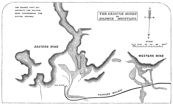
THE KRISUVIK MINES
OR
SULPHUR MOUNTAINS
as those in the valley, and are represented as being less active.
“Mr Seymour, who has spent many months at Krisuvik, tells me that the
sulphur beds on this side have been submerged by the clays washed down
by the winter rains, and are, for the most part, now completely
overgrown with grass. On digging beneath the surface, however, the
sulphur earth is found to be only a short distance down, and on analysis
the percentage of sulphur in one bed, 116 yards long, running up the
side of the mountain, was discovered to range between 64 and 65·5. Here
the earth was completely cold, and all further deposition of sulphur
appeared to have ceased.
“In the valley itself the springs are not always visible at the surface,
being so completely covered by the earth that it is only by piercing
through the crust of indurated sulphur earth, that their presence is
discovered. Sometimes the explorer is made unpleasantly aware of the
insecure nature of his footing by falling through, and thus opening up a
fresh thermal spring. The late Sir William Hooker, when visiting this
place, in endeavouring to escape a sudden gust of strongly odorous
vapour, jumped into a mass of semi-liquid hot earth and sulphur—and but
for his presence of mind, in throwing himself flat upon the ground,
would have sunk to a considerable depth; as it was, the difficulty of
extricating himself was very considerable.
“The surface of the ground is covered in many places with a crust of two
to three feet in depth of almost pure sulphur; and in the valley, where
the steam jets are protected from the extreme violence of the wind, the
sulphur is deposited tolerably evenly over the whole surface. If it were
not for the ever-varying direction of the wind, the sulphur would,
Captain Forbes is of opinion, be precipitated in regular banks, but it
hardly ever falls for twenty-four hours in one direction, the wind
capriciously distributing the shower in every direction.
“It has been suggested by those who wish to utilise the immense
sulphur-producing power of this wonderful locality, that chambers should
be erected (Sir George Mackenzie), or walls built up (Dr Perkins), by
which means the force of the wind being broken, the sulphur would be
quietly floated to the ground, instead of being carried up the sides of
the hills, and thus more widely distributed.
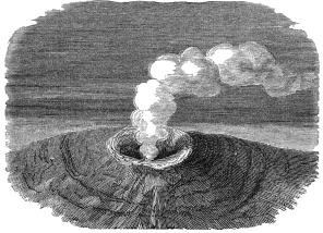
“With little variation the general appearance of the ‘solfataras’ over
the space of twenty-five miles along the volcanic diagonal is much
alike: an elevation about two feet high and three feet in diameter,
which is composed of a dark-bluish-black viscid clay, forms a complete
circle round the mouth of a medium-sized spring. The water is sometimes
quiescent, and sunk about two feet within the aperture; at other times
it is ejected, with great hissing and roaring noise, to the height of
from five to eight feet. At all times clouds of steam, strongly
impregnated with sulphuretted hydrogen and sulphurous acid gas, issue
from the orifice, both of which, during an eruption of the water, are
greatly augmented in quantity. From the dark coloured and elevated
margin of the fountain the yellow crust of crystallised sulphur extends
a great distance in every direction. Columns of steam ascend from
numberless points in the whole district, which are thus impregnated; and
thus it is that, apparently for ages past, sulphur has been gradually
heaped up in this locality till there are actually hills, which, as far
as they have yet been pierced, show sulphur earth to be their main
constituents. Hence they have acquired the name of the Sulphur
Mountains.
“The soil is of different colours, but most generally white. It is, in
the vicinity of the springs, a viscid earth, less plastic than clay, and
more readily broken.
“When excavations are made into this earth, it is found to be composed
of multitudinous layers, of different colours or shades of colour, each
layer being quite distinctly divisible from those above and below it,
though frequently no more than an inch or two in thickness.
“It is much to be regretted that the good example set by Olafsen and
Povelsen of investigating the nature of the earth’s crust round about
the solfataras, by piercing the soil, has not been more frequently
carried out. In the summer of last year one of the suggestions which I
made for the instruction of an expedition to this place, was that boring
implements should be taken out and extensively used; but accident
prevented the necessary appliances being forthcoming at the right time.
I believe, however, that one of the chief features in the expedition
which is to set out in March, will be the thorough examination, to as
great a depth as practicable, of the strata in various parts of the
Sulphur Valley.
“The spring chosen by Olafsen and Povelsen as the subject of their first
experiment, was one which had made its appearance since the preceding
winter, and which was just beginning to be surrounded by other mud
springs and jets of steam. The ground was still covered with lovely
verdure, and charming flowers were abundant, even at the very verge of
the caldron of hideous hue and odour. A short distance from this opening
they established their boring apparatus. The sequence of the layers was
as follows:
“1. Three feet of reddish-brown earth, of a fatty consistence—of the
ordinary temperature; at the bottom heat was perceptible to the touch.
“2. Two feet of a firmer kind of earth, nearly the same in colour as the
first layer, unctuous to the touch.
“3. One foot of a lighter kind of soil.
“4. Five feet of a very fine earth of different colours, the first two
feet being veined red and yellow, with streaks of blue, green, red, and
white intermingled. The lower portion of this earth was somewhat firmer
than that which covered it. The heat of this thick bed was so great that
the soil extracted by the auger could not be handled until it had been
for some time exposed to the air.
“5. One foot of a compact greyish-blue earth.
“6. In tapping this bed, which was four feet nine inches in thickness,
and consequently at a depth of about twelve feet, water was first met
with. It was found by comparison that the level of the water in the
boiling mud spring coincided at this time with that of the water thus
discovered. The heat was now very great, and a constant hissing and
bubbling could be heard as proceeding from the bottom of the hole which
had been made.
“7. Nine inches of greyish-blue earth.
“8. One foot six inches of a similar unctuous earth, containing many
small white stones. This was the hottest layer of any yet pierced; the
buzzing, humming noise was now much louder than before.
“9. Three feet of the same kind of clay, but much harder and more
compact; this layer was also full of small, round, white stones.
“10. Six inches of a violet tinged earth, very greasy to the touch. In
this bed the heat sensibly diminished.
“11. One foot six inches of red and blue clay intermingled. The heat
continued to diminish very fast.
“12. One foot of reddish-looking clay, the temperature remaining about
the same.
“13. Six inches of yellow and red clay.
“14. One foot of a greenish coloured earth, much less coherent than the
previous layers. Here the heat again began to increase.
“15. One foot six inches of blue clay, filled with small pieces of white
tufa. This bed was much hotter than either that above or that below it.
“16. One foot three inches of soft blue clay.
“17. Nine inches of an earth, easily pulverised when dry, which, whilst
moist, was of a violet colour; on exposure to the air, however, this
rapidly changed to a chocolate brown. The heat was again augmented as
the centre of the bed was approached.
“At thirty-two feet the full length of the boring implements was used
up; but from the set of the country in the vicinity, the experimenters
believed they were close upon basaltic rock, when the heat probably
ceased.
“In digging for the peculiar kind of brown coal which they call
‘surturbrand’ (a kind of fuel very much resembling Irish bog-oak, which
can be used for like purposes), the inhabitants frequently go as deep as
twenty-eight feet. They report that before reaching this depth they
frequently pass through three or four beds of blue, yellow, and brown
clay, and almost invariably find that the layers of blue clay are much
hotter than any of the other strata.
“A second trial of the soil was made in the neighbourhood of some recent
springs, farther to the east. The activity of the agencies at work here
appeared to be greater than in the former case, and to have been longer
in operation. The whole surface was thickly covered with sulphur, in a
finely-divided state; there was much gypsum, and a large efflorescence
of feathery alum. Thousands of very minute holes were discoverable on
close examination, through which continuous jets of steam, sulphuretted
hydrogen and sulphurous acid gases were emitted.
“An attempt was made to dig with spades; but the soil was found to be so
hot, whilst the footing was at the same time so insecure, that it could
not be persisted in. A spot some distance farther off was therefore
pitched upon, where the earth was firmer and colder. The borer pierced
through six feet of blue clay with great facility, the lowest portion
being extremely hot. After this depth the earth became rapidly softer,
at the depth of seven feet the same peculiar bubbling noise before
noticed was heard. Continuing to bore, the bottom of the hole appeared
to be in a state of ebullition, a boiling liquid being ejected in the
narrow space around the handle of the auger with extraordinary violence,
and no sooner was the tool withdrawn than a thick black fluid was
ejected from the orifice to the height of several feet. A short time
afterwards the jet ceased, the subterranean fire appeared to have
expended its fury, but it soon recommenced with redoubled activity to
dart forth fresh jets of steam and black, muddy water, continuing to
boil and dance with but slight intermission. It appeared, therefore,
evident that the result of this experiment was the premature formation
of a fresh hot spring, which would otherwise have been, perhaps, a
considerable time in forcing its way to the surface.
“It is somewhat to be regretted that no one amongst the numerous eminent
men, men accustomed to experimental investigations and acute observers,
who have since traversed this region, should have investigated the
question of the origin of these hot springs and sulphur deposits from
the point of view which was thus displayed by these careful and
painstaking philosophers.
“The phlogistic theory being generally accepted in their day, and the
chemistry of the earths and metals being in a very undeveloped state, we
cannot now accept to its full extent the explanation they put forth of
these phenomena; but the facts they disclose appear to me to be of the
highest value, and to afford a clue which, if carefully followed, may
lead to discoveries of much importance in the domain of volcanic energy.
“The conclusion they drew from their investigation is, that the hidden
fires of Iceland dwell in the crust of the earth, and not in its
interior; that the boiling springs and the mud caldrons certainly do not
derive their heat from the depths of our globe, but that the fire which
nourishes them is to be found frequently at only a few feet below the
surface, in fermenting matters, which are deposited in certain strata.
“By their theory the gases from the more central parts of the earth
penetrate these beds by subterranean channels, and so set up the
chemical action, producing fermentation and heat, these channels also
forming the means of intercommunication between the separate sites of
activity, and equalising and transferring pressure.
“To return to their facts. They further observed that the heat is
invariably found to be greatest in the blue and bluish-grey earth; that
these earths almost always contain sulphuric acid; that they contain
also sulphur, iron, alum, and gypsum; and lastly, that finely-divided
particles of brass-coloured pyrites are visible throughout the whole of
the beds when heat exists.
“Sulphuric acid is found in the hot beds above and below that which is
the hottest, but this latter manifests no acidity that is sensible to
the taste.
“Sulphuretted hydrogen is continually evolved from the clays containing
the brass-coloured pyrites. Silver coins dropped into a hole made in
these strata become rapidly reddened, and brass becomes quite black if
held over it for a short time.
“Lastly, not only does the heat increase and diminish in various
successive layers of the earth, in the neighbourhood of the active
springs, but the locality of the heat, as might be expected from their
previous observations, travels very considerably in different years.
“The solfatara of Krisuvik, with the mountains about it, is shown in the
accompanying sketch by M. Eugène Roberts. It appears from afar to occupy
the place of an ancient crater, but, as we have already seen, it is not
near the crater, about the centre of the drawing, but at a considerable
distance from the old volcanic centre, that the thermal springs and
sulphurous exhalations have their present origin.
“Wherever they may have been previously, the springs are now situated
between two mountains, the one Badstofer, on the right, originally
composed of lava, the other, Vesturhals, on the left, of basaltic
formation. Both, by the action of the thermal springs, are undergoing a
process of disintegration and reconstruction.
“The kind of hills which form the solfataras, properly so called,
increase in extent day by day; by the addition to the disintegrated rock
of sulphur and of sulphurous and sulphuric acids.
“The yellow sulphur earth contains about four per cent. of free
sulphuric acids; sometimes a little free hydrochloric acid, and a
variety of sulphates, as might be supposed. Treated with distilled
water, the filtered solution reddens litmus strongly; on addition of
acetate of lead a flocculent precipitate is produced, which, when heated
with carbon, disengages sulphurous acid.
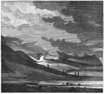
SOLFATARA OF KRISUVIK. From a Sketch by M. Eugène
Roberts.
“The sulphur is found in many different conditions, but for the most
part in the same finely-divided, whitish-yellow form in which it is
precipitated from sulphuretted hydrogen solutions. Where it assumes
other states, crystallised in tears on the surface of the rocks, or
coagulated in veins, it is on account of its having undergone subsequent
heating. Of its primary origin by the decomposition of sulphuretted
hydrogen, there is in my opinion no doubt.
“Professor Bunsen visited Krisuvik in 1845; his opinion is that
sulphurous acid is evolved from the earth’s interior, which, oxidised
either at the surface by the atmosphere, or at subterranean depths by
atmospheric oxygen dissolved in cold water, is converted into sulphuric
acid. The sulphuric acid thus generated is diffused among the
constituents of the decomposed beds. This process represents the first
stage of the fumerole action, which is manifested in the namar or
solfatara of Krisuvik.
“Sulphur is now generally regarded as emanating from the stage of
intermittent lethargy of a volcano, and the sulphides of iron, copper,
arsenic, zinc, selenium, etc., fall in the same category as sulphur;
they are secondary, not primary, formations. In the stage further off we
have the host of sulphates produced by the oxidation of the sulphur into
sulphuric acid, and its subsequent reaction on the metals and earths
with which it becomes associated.
“The description of the Sicilian sulphur beds coincides so very exactly
with that of the Icelandic mines, that one might pass very well for the
other. D’Aubigny pictures nearly the whole of the central portion of
Sicily as being occupied by a vast bed of blue clay or marl, in which
are numerous and thick beds of gypsum and sulphur, and a combination of
this mineral with iron and copper. The natural process by which they
have been formed must, I think, be the same in each case. At Krisuvik
copper has been found only in small quantities, but that is probably
because it has not been sought for below the surface. Carbonate of
copper, associated with sulphate of lime, is of frequent occurrence; and
native copper has to a limited extent been discovered.
“A district in America, very similar in most of its characteristics, has
recently been explored. The great hot-spring region of the sources of
the Yellowstone and Missouri Rivers, in the United States, has, on
account of the wonderful natural phenomena there manifested, been set
apart by the United States Congress as a great national park for all
time.
“The whole of this district is covered with rocks of volcanic origin of
comparatively modern date. At present there are no signs of direct
volcanic action going on, but the secondary kind of action, resulting
probably as at Krisuvik, from the disintegration and decomposition of
beds of volcanic origin, is in full progress. Boiling springs,
mud-caldrons, and geysers are found in all parts of the region, and the
description given by Mr V. Hayden, of the Yellowstone Lake and its
vicinity, in every respect coincides with those of the geysers,
mud-caldrons, and hot-springs of Iceland.
“In all cases there was found to be free access of water; free sulphur
was widely dispersed, and the steam-jets were invariably accompanied by
large quantities of sulphuretted hydrogen. The subterranean action in
this country does not appear to have continued long enough to produce
beds of sulphur and sulphur-earths, but has, nevertheless, been of
sufficiently long standing to build up geyser tubes of so great a length
that the internal pressure has formed other vents, rather than lift the
immense column of water above it.
“The water of the springs contains sulphuretted hydrogen, lime, soda,
alumina, and a slight amount of magnesia; some of these are only
occasionally at the boiling point, and these, when the temperature is
reduced below 150° Fahr., deposit great quantities of the sesquioxide of
iron, which lines the insides of the funnels, and covers the surface of
the ground wherever the water flows. If the reaction consists in the
decomposition of iron pyrites, and the sulphur is carried sufficiently
far off to prevent its re-combination with the iron to form iron
sulphate, the formation of the iron sesquioxide is fully accounted for.
“As a rule, the groups of hot springs are, as in Iceland, in the lower
valleys, and either along the margins of streams, or nearly on a level
with them. The grand area where they occur is within the drainage of the
Yellowstone, where a space of forty miles in length, with an average
width of fifteen miles, is either at the present time, or has been in
the past, occupied by hot springs.
“That the quantity of sulphuric acid here produced is very large, is
proved by the immense quantity of alum which is found, for the streams,
the mud, the earth are thoroughly impregnated with it. The funnel-shaped
craters from which the boiling mud is ejected, are so similar to those
of the Krisuvik that the figure on page 140 will answer for both places.
The circular rim varies from a few inches to several feet in diameter.
Sometimes these are clustered close together, yet each one being
separate and distinct from the others.
“The foregoing are the most prominent facts connected with the
development of sulphur from the earth in the elementary state. The full
explanation of all the phenomena accompanying it appears to me to be the
key by which the great secret of volcanic energy may he ultimately
unlocked. At present it appears to be doubtful whether the sulphur
results from the decomposition of metallic sulphides, by heat and water
combined, or by sulphuric acid formed by the oxidation of sulphurous
acid. In the one case, the whole action is so far within our reach, that
it should not be an insurmountable difficulty to establish the point as
to whether the whole action does not depend on the percolation of water
into beds of pyrites surrounded by other beds which are non-conductors
of heat.
“The other view, viz., that the sulphur proceeds as sulphurous acid from
a lower depth, is on account of the more complicated action required,
far from being as satisfactory to my mind as the more simple supposition
above.
“Until boring experiments have been made, conducted with great care, and
to considerable depths, no positive conclusion can be arrived at. It is
also an element in the question of much importance, to discover whether
the beds penetrated by the water are already heated, whether the water
is heated before it reaches the sulphur-bearing strata (the clays
containing pyrites), or whether both are not alike cold till they have
been for some time in contact.
“Less than a quarter of a mile from the hot springs is a lake,
Geslravatn, formed by the filling up of an extinct crater. This the
inhabitants describe as being fathomless (Mr Seymour, last year, found
no bottom at five and twenty fathoms). The depth is, at any rate, very
considerable. Although so close to a spot where the ground is, even at
the surface, scorching to the feet, the water in this lake is ice-cold.
Sir George Mackenzie also remarked a somewhat similar fact. On the side
of the Sulphur Mountain, amidst the seething, steaming hills of almost
burning earth, a spring of clear cold water was met with. To my mind
these facts are most in accordance with the view that the action is
local and self-dependent.
“The Krisuvik sulphur mines have been worked at various times, but want
of proper roads, and ignorance of the proper method of extracting and
refining the sulphur, have prevented their proper development. The
Sicilian mines can be worked at a considerable profit, where, more than
390 feet below the surface, beds are met with containing only 15 per
cent. of sulphur. At Krisuvik, absolutely on the surface, clays are met
with which contain from 15 to 90 per cent. of sulphur. Under proper and
careful supervision, their future should be prosperous.
“Two German gentlemen, under the auspices of the Danish Government,
worked these mines in the early part of the last century, and so much
was exported to Copenhagen during the time the excavations were carried
on, that a sufficiently large stock was laid up to serve the consumption
of Denmark and Norway from 1729 to 1753.
“Horrebow describes the sulphur mines as being actively worked from 1722
to 1728, to the great advantage of the inhabitants, who reaped much
profit from its extraction.
“By his account of their mode of prosecuting this enterprise, the
sulphur does not appear to have been refined in the island, but exported
in its crude state. The less active mines were chosen for cutting into.
He says: There is always a layer of barren earth upon the sulphur, which
is of several colours, white, yellow, green, red, and blue. When this is
removed, the sulphur earth is discovered, and may be taken up with
shovels. By digging three feet down, the sulphur is found in proper
order. They seldom dig deeper, because the place is generally too hot,
and requires too much labour, also because sulphur may be had at an
easier rate, and in greater plenty, in the proper places. Fourscore
horses may be loaded in an hour’s time, each horse carrying 250 lbs.
weight. The best veins of sulphur are known by a kind of bank or rising
in the ground, which is cracked in the middle. From hence a thick vapour
issues, and a greater heat is felt than in any other part. These are the
places they choose for digging, and after removing a layer or two of
earth, they come to the sulphur, which they find best just under the
rising of the ground, when it (the sulphur) looks just like sugar candy.
The farther from the middle of the bank, the more it crumbles, at last
appearing as mere dust. But the middle of the bank is an entire hard
lump, and is with difficulty broken through. The brimstone, when first
taken out, is so hot that it can hardly be handled, but grows cooler by
degrees.
“In two or three years these veins are again filled with sulphur. The
death of the person at Copenhagen who had the sole and exclusive
privilege of exporting sulphur from Iceland put an end to what had
promised to be a very thriving industry. The inhabitants continued to
collect the sulphur earth for some time after its exportation had
ceased; and many of them lost considerably by it, large quantities
having been gathered which they were never able to dispose of.
“According to Dr Perkins, the sulphur mines were again worked by the
Danish Government for fifteen years, but the method of purifying adopted
was very imperfect. The sulphur earth was heated in iron boilers, and
when the sulphur was melted, fish oil was added, and the whole mass
stirred up. On allowing the mixture to stand for a time, the earthy
matter formed a soap on the top of the molten mass; this being removed,
tolerably pure sulphur remained behind.
“In 1832, these mines were visited by K. von Nidda, the celebrated
geologist, by whose advice a Danish merchant, named Kenidzon, purchased
them. He only worked them for a short period. The sulphur earth was
collected without much regard being paid to the relative richness of the
beds. It was taken on the backs of horses to Havnafiord, and thence
shipped to Copenhagen. The cost of transport brought the sulphur to too
high a price to render the undertaking successful.
“In 1857, political matters caused the attention of Her Majesty’s
Government to be directed to finding a new source of sulphur supply.
Commander J. E. Commerell, of her Majesty’s ship ‘Snake,’ was sent to
Iceland by the Lords Commissioners of the Admiralty, to visit and report
upon the capabilities of the mines of Krisuvik and Husavik. He found
that the nearest safe port to the Krisuvik beds was Havnafiord; this
port is fourteen miles from the sulphur beds by the present roads, and
nine miles from Reikjavik. The harbour is well sheltered, with good
anchorage of seven or eight fathoms three cables’ length from the beach;
it at present enjoys as much traffic as Reikjavik. The road from
Krisuvik might be much shortened, and a tramway might also he laid down.
During the past year a survey has been made, and plans drawn for a
railway or tramway to Havnafiord.
“The actual extent of the sulphur beds it is quite impossible to
calculate; forty-seven have been already discovered. The deposit of
sulphur Commander Commerell personally saw he describes as amounting to
many thousands of tons, and, all the mines being in what is called a
‘living’ state, the sulphur taken away is reproduced in two or three
years. He considers that sulphur in a pure state could be shipped at
Havnafiord for £1 per ton.
“The sulphur at Myvatn, though great in quantity, is, he considers, at
too great a distance from a port of embarkation to permit its extraction
being carried on with any chance of competing with that from the
Krisuvik mines.
“No further steps were taken in the matter by the British Government,
the political complications which led to the expedition having been
removed; but the attention of English merchants having been drawn to
these rich deposits by the highly favourable character of Commander
Cornmerell’s remarks, renewed attempts are being made to render
commercially available the immense sulphur-producing power which the
Krisuvik solfataras undoubtedly possess. To some of these gentlemen I am
greatly indebted for much valuable information, put at my disposal for
the purposes of this paper, and amongst them I have specially to tender
my thanks to Mr Ramsdale and Messrs Thorne, of Gracechurch Street, and
particularly for the use of numerous and carefully-selected samples of
the sulphur earths which were freely placed at my disposal. These
samples I hope to make the subject of a future paper.
“Since writing the foregoing paper, I mentioned, in the course of
conversation with Sir Henry Holland, the conclusions which are derived
from the examination of all the trustworthy facts relating to the
sulphur deposits. This led him to examine entries in his unpublished
diary, made at Krisuvik in 1810. The theory which he then conceived so
thoroughly agrees with all that has been learnt respecting the phenomena
in question, that I, with his kind permission, print an extract from his
note-book:
“‘The theory of these sulphureous springs (if springs they may be
termed) at Krisuvik is an interesting object of inquiry. They are
situated in a country decidedly of volcanic origin. The high ground on
which they appear is composed principally of the conglomerate or
volcanic tufa, which has before been noticed. The source of the heat
which can generate permanently so enormous a quantity of steam must,
doubtless, reside below this rock; whether it be the same which produces
the volcanic phenomena may be doubted, at least if the Wernerian theory
of volcanoes be admitted. It certainly seems most probable that the
appearances depend upon the action of water on vast beds of pyrites. The
heat produced by this action is sufficient to raise an additional
quantity of water in the form of steam, which makes its way to the
surface, and is there emitted through the different clefts in the rocks.
The sulphates of lime and alumina, appearing upon the surface, are
doubtless produced, in process of time, by these operations. In
corroboration of this view, it may be observed that the quantity of
steam issuing from the springs at Krisuvik is always greater after a
long continuance of wet weather, and that whenever earthquakes occur on
this spot, it is during the prevalence of weather of this kind.’
“The learned and now aged author expressed the highest gratification
that the views which he formed at twenty-two years of age should possess
so much value so many years after.”
The visit of the two engineers, Messrs Shields & Gale, has also been
elsewhere alluded to. Finally, Mr R. M. Smith informs me that the
prospects of the Krísuvík diggings now look brighter. The project of
tramways, or locomotives, seems to have been abandoned in favour of
carts and ponies plying on a good road, about sixteen miles long,
between the Sulphur Mountain and Hafnafjörð.
The next morning’s work began with a path which introduced us to the
mud-bog, as opposed to the turf-bog. This pleasant feature led to lava,
whose three main torrents and many secondary streamlets could be seen
spilling over the trap wall of Lángahlíð. There were the two normal
kinds, the soft and cindery, caverned and friable, which makes good
paths: it degrades to the dark red and yellow-red humus which is here,
as in the Haurán, the general colour of the ground. This variety is clad
with two lichens; the grey with black scutella (L. calcareus?), and
the pure white (L. Tartareus?) which makes the ejections of the Safá
near Damascus simulate limestone. The other is intensely hard, ruddy
black or brown-grey, and in places solid as if poured out yesterday; the
reason generally given is the presence of olivine in this trachytic or
silicious form. M. Durocher’s theory is, that being lighter than the
doleritic and augitic (basic), it therefore floats separately, and thus
he would explain how lava floods of different composition may proceed
from the same locality.[93] The plications of this hard lava, looking as
if hogs-heads of honey had been poured upon stone, the domes and the
drops, not to speak of the sharp-toothed mouths and crevasses, make the
traveller suffer for the sufferings of his nag.
At the end of the first great lava-stream was the farm of Herdísarvík;
now not a “vik” but a “vatn”—we looked around for sulphur, but in vain.
Hard by our right the fierce seas burst and roared upon a coast cruel
and harbourless as that of Kafir-land; whilst in the smooth distance a
few catspaws suggested shoaly islets. The Hlíðarvatn (lithe or slope
water) is not like its neighbour a misnomer, but the supply is brackish,
ebbing and flowing with the tide, like wells in the valley of the
Thames. The only birds seen were wild geese, crees, gulls, curlews,
young snipes, and ravens which especially affect this warm part of the
island. During the halt we especially noticed a number of web-less
hunting spiders, whose little nests were full of young—the peasants
still preserve the old Köngur-váfa (web-weaver) which the citizens hold
obsolete, preferring Könguló or Konguló. There are spider-stories, too,
like the Gold Coast “Anansesem;” a small red species, for instance,
kills when it bites.
From Litlaland, which we reached whilst the sun was still high, we
enjoyed a pleasant view. Beyond the rise of Thorlakshöfn lie the “Irish
Islands,” tall and picturesque, fronted by the great alluvial plain of
south-western Iceland. It has been called Tempe, Arcadia, and Vale of
Enna, though utterly unlike the grim defile of Peneus, the stern
limestone mounts of the Peloponnesus, and the waterless slopes of
Sicily. The “Pastorale in A flat,” as Thomas Hood, sen., would have
called it, a raw northern facsimile of the Lagos Lagoon, as it appeared
to me, gains dignity by the eastern background of eternal snows, the
flat top of Eyjafjall, the long ridge of Tindafjall, and the sharp point
of Torfajökull. And it is “classic ground.” From a commanding site we
can prospect Ingolfsfjall, where Iceland’s first settler is supposed to
be buried, and the Bergthórshvoll farm in the delta of the Markarfljót;
behind it lies Hlíðarendi, where the “peerless Gunnar” sleeps in the
Tverá Holm.[94]
There is—for Iceland—rare pathos in this description of the hero’s
tomb.
“They cast a cairn over Gunnar, and made him sit upright in the
cairn.”
“He sang in the cairn which opened, and he turned himself and
looked at the moon, which was shining clear and bright. And men
thought they saw four lights burning in the cairn, and none of them
cast a shadow. He sang a song, after which the cairn was shut up
again.”
The next morning led us to Reykir. As we rode up the valley of the
Ölfusá we could mark the features of the scene. In front the river was a
lake, and the green expanse of the water-veined delta was scattered over
with south-facing farms, not acknowledged by Gunnlaugsson and Olsen.
Eyrarbakki, so called from the host of islets which line the shore, is
the only port till Berufjörð on the eastern coast, and it was wholly
occupied by two ships. Mr William Hogarth of Aberdeen, who owned the
establishment, has not been here, we were told, for years; lately,
however, some English visitors had excellent fishing in the river, and
were hospitably entertained by Hr Thorgrimsson, agent to M. Lefolii, a
Danish merchant. All this greenery was set off by the barrenness of the
buttressed Lángahlíð hard on our left. The regular horizon of trap-wall
had been succeeded by a sharp slope of Palagonite conglomerate, which
evidently underlies the whole block. On the summit is a desert where no
man dwells, broken by pyramids which are evidently lava-cones, Skálafell
(scald or bald hill?) being the chief feature; upon the lips of the
plateau are gushes of modern lava, and on the low levels appears an
ancient sea-beach, scattered with rounded blocks like giant rocs’ eggs.
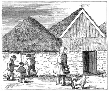
“Hjalli,” which we reached about noon, was somewhat peculiar—instead
of being a single farm, four establishments clustered round the black
chapel. It had its rivulet where the girls comb their yellow hair o’
mornings; the Lavapés (wash-feet) of the Brazilian country town; it had
also its Paradís, a poetical name for the grassy combe, where men bask
i’ the sun. The males were clad in pastoral attire, the old native dress
deemed somewhat too marqué for town and comptoir. The chief items are
a shirt, a waistcoat, and a tight, very tight, flannel culotte, braccæ
gartered below the knee and ending in stockings and Iceland shoes. The
stranger’s first impression is that harlequin, without his spangles, has
forgotten his overalls. This primitive toilette of the non-Roman
races,[95] which gave birth to our civilised attire, still lingers in
parts of Europe, notably in the Cicería of Istria, where the
charcoal-burners (Cici) will adopt no other costume. And what can be
more ridiculous than the Hungarian footsoldier wearing his drawers, when
we know the wide Turkish Shalwar to be his national terminations?
“Reykir!”[96] ejaculated Páll, pointing triumphantly to a little yellow
splotch on the far side of the broad valley. As we progressed towards
the Reeks, we found the forage improving, and the soil becoming damper;
this is commonly the case, because the western frontage enjoys the most
sun. Of five springs clustered upon either bank of the little Varmá, the
largest lies on the left, where Palagonite breccia forms the base of a
ruddy spine, projected by the northern outliers of the Ingolfsfjall
massif. The usual motley colours of a solfatara are set off by a more
brilliant green than usual, and by a silver-tinted moss (Trichostomum
canescens), which makes the turf-carpet feel soft as velvet.
Reykir is known as the Litlé Geysir, or “the Geysir in Ölfus.” In 1770
Uno Von Troil declared that it used to rise sixty to seventy
perpendicular feet, in fact, as high as the Great Geysir of 1872, but
that an earthquake, after cutting off a few feet (fifty-four to sixty),
made it spout sideways. Nothing can be meaner than the modern display,
and my companion compared it disadvantageously with that “furious
fountain” of the guidebooks, the Sprudel of Carlsbad. The chief well to
the north has built for itself a party-coloured mound like a nest of
African termites, and puffs only vapour with the sumph of a
donkey-engine. A hundred yards or so to the south is a younger spring
with double boilers, in which the water may rise at times a foot and a
half high: the “hell broth” slithers through a soft and soppy circle,
down a foul channel of burnt pyrites and silica-clothed trap to the
bubbling Varmá. This stream shows from a height, three branches draining
from the north-west, where are other sulphur springs.
A whole generation of travellers has complained of the farmer of Beykir,
who is said to have charged one man $52 per diem. We can only speak of
him as we found him; his demand for forage was extremely moderate, and
we attributed the fact to having an honest and thrifty guide.
A swampy ride in the afternoon led to the ferry of the Ölfusá or lower
Hvitá. The ground was spangled with Fífa or cotton grass (Eriophorum),
a weed with a bad name. It is more common here than in the southern
islands, Scotland, and Germany, and it is supposed to haunt the worst
and most dangerous bogs, where water sinks instead of flowing. “Avoid
cotton grass ground” is the advice of every traveller: unfortunately you
cannot, and you must make the best of it. But why call it the
“treacherous cotton grass,” when it at once tells you the worst? On the
other hand, buck-bean (Hor-blaka, or Menyanthes trifoliata) is praised
because it shows the surface to be safe.
After three hours we reached the ferry, a busy scene for Iceland.
Caravans charged with imported boards and fish to be exported, lay
unloaded on either bank. Amongst the travellers was the Bishop of
Iceland with a party of six; he had ridden from Reykjavik to Reykir in
nine hours, and as he sat waterproof’d in the sun, he complained sadly
of fatigue. A couple of two-oared boats, big and small, with a third
high and dry, did not tend to expedite transit—nothing would be easier
than to establish a wire rope and a ferry with lee-boards, thus making
the current do all the work.
Rain threatened, and we lodged, as Abyssinians might lodge, in the
church of Laugadælir, after duly admiring the farmer’s chef d’œuvre, a
brass chandelier. All was very grotesque; the Psalms were chalked up on
the wall, a Mambrino’s helmet acted font, and the altar-piece showed
bow-legged Mattheus, with Marcus, Lucus, and Johannes to match. Around
the fane lay the churchyard, where the peasant
“lies at peace with all his humble race,
And has no stone to mark his burial-place.”
It was the usual reverse of gardenesque or picturesque. Sheep grazed
upon the weeds that “had no business there,” and the railings were
utilised for drying socks and small-clothes.
The fourth march proved peculiarly unpleasant. When the weather is bad
at Reykjavik, here it is detestable. The display of water-works seemed
the effort of the old Polynesian giants, who submerged the greater part
of earth—Terrible-rain, Long-continued-rain, Fierce-hailstorm, and
their progeny, Mist, Heavy-dew, and Light-dew. In plain English it was a
“jolly wet day.” The horses very sensibly bolted up stream, and refused
to be caught till noon, when the men returned dripping as loons or
roaches. The delta of the two great streams is said to be, in fine
weather, one of the fairest pastoral scenes the island can show; but we
saw it at its worst, sadly deformed, and we gathered practical
experience of what a few hours of downfall can do in this semi-saturated
region. The paths were “dead,” or rather, they were shown only by lines
of puddle; the sloughs and quagmires admitted our ponies to the hocks;
the drains overflowed like little hill-races, and the labour of rounding
the deeper fens was immense. A few peaks which lay but a little distance
to the north seemed immeasurably removed, like
“Far-off mountains turnèd into clouds.”
About mid-afternoon we came upon the Thjórsá, “fluviorum rex Eridanus”
of Iceland: even at this upper part it looked like an estuary, split by
sandbars, piles of basalt, sandbars and basalt again. We pushed hard
over the few good places; and moist, mouldy, and malcontent, we were
right glad to find ourselves in the strangers’ room of the ferryman’s
house: 20 feet long by 14 broad and 7 high: dated 1848, it was an
omnium gatherum of the family goods, and it boasted of one four-paned
window, which has never opened, and which never will. The features
denoting wealth were huge wooden lockers, like seamen’s chests, of
bright colours, painted with flowers and arabesques of still brighter
tints: I could not but remember the pea-green and gamboge box which
carried to Meccah the drugs of a certain “Haji Abdullah.” The soiree
ended with a distressing banality. Fair visions of girls who kiss the
stranger on the mouth, who relieve him of his terminal garments, and who
place a brandy bottle under his pillow, and a bowl of milk or cream by
his side, where are ye? Icelanders have allowed their pleasant primitive
fashions to be laughed away by the jeering stranger, who little thought
how much the custom told in favour of the hosts. The naïve modesty of
antiquity, when Nestor’s youngest daughter laved, anointed, and dressed
Telemachus, and when the maids of Penelope had a less pleasant task with
the elderly Ulysses, has departed with the public bathings, in angelic
attire, of Iceland, of Sind, and of Japan, and the kiss given to the
guest by the young wife or the eldest daughter of the Morlacchi house.
This sublime impudeur was possible only amongst a pure race: the
sneers of a single civilised savage suffice to demolish this “heureuse
absence du ‘schoking.’”
Next morning, while the horses were grazing, we ascertained that the
farm had its therma: a jet of steam issuing from the ground near the
river had been turfed over, with room to stand; and thus a Turkish, or
rather a Russian, bath was possible on bath-day. We then walked down to
the Thjórsá, an especially grisly spectacle. Its breadth, 250 yards, was
occupied by white glacier water, with a sulphury tinge, rendered more
ghastly by the black sand, rocks, and islets studding the bed above and
below the ferry. The right bank showed a wall of conglomerate, and on
both sides “cachociras” dashing over the stones gave pleasant
reminiscences of San Francisco. The left bank is of Hekla lava, either
compact or very porous containing crystals of lime. We found a natural
hatchet and quantities of pumice, many-coloured, but mostly yellow: it
floats in water, and it is useful for holystoning the skin. The velocity
was three knots, and the temperature 52° (F). The ferry creeps up from
the stone-head acting pier on the right bank, swings across below the
break, and lands you in water on the far side.
The conduct of ponies at the ferry is always amusing. They are driven in
by the shouts of lads and lasses, by tossings and wavings of the arms,
by sticks and stones, and by the barking and biting of curs. They sidle,
jostle, step in daintily, smell the water, and, after trembling on the
brink for a time, some plucky little nag takes the lead. He is followed
by the ruck, but there are often cowards ready to hark back: these must
be forced on with renewal of stick and stone, and by driving those that
have crossed up and down the bank. In dangerous narrow beds, it is often
necessary to tow over shirkers one by one with a rope. The swimmers
gallantly breast the flood, which breaks upon their crests; and they
paddle with heads always up stream, dilated eyes and nostrils snorting
like young hippopotami; the best always carry the back high. As they
reach the far end, they wade slowly to shore, and fall at once to
grazing. They took four minutes thirty seconds to cross the Thjórsá, and
as usual they were drifted far down.
We then pricked fast over the little pampa which lies between the
Thjórsá and the Hekla-foot, making, I know not why, for Stóruvellir.
Here we were received by Síra Guðmundr Jónsson, a gentlemanly man, who
has accompanied several travellers, notably the “Oxonian,” up the
volcano; he showed the Iceland peculiarity of “walking the
quarter-deck;” and his handsome blue-eyed daughter wore the sternest of
looks, apparently engendered by semi-solitude. He indulged in wild
archery about the dangers of the climb, which, over biscuits and coffee,
sounded truly awful. After leaving the parsonage, we enjoyed our first
fair view of Hekla: during the earlier ride it had been buried in
clouds, and hidden by the chapel block, Skarðfjall.
The Hekla of our ingenuous childhood, when we believed in the “Seven
Wonders of the World,” was a mighty cone, a “pillar of heaven,” upon
whose dreadful summit white, black, and sanguine red lay in streaks and
patches, with volumes of sooty smoke and lurid flames, and a pitchy sky.
The whole was somewhat like the impossible illustrations of Vesuvian
eruptions, in body-colours, plus the ice proper to Iceland. The Hekla
of reality, No. 5 in the island scale,[97] is a commonplace heap, half
the height of Hermon, and a mere pigmy compared with the Andine peaks,
rising detached from the plains; about three and a half miles in
circumference, backed by the snows of Tindafjall and Torfajökull, and
supporting a sky-line that varies greatly with the angle under which it
is seen. Travellers usually make it a three-horned Parnassus, with the
central knob highest—which is not really the case. From the south-west,
it shows now four, then five, distinct points; the north-western lip of
the northern crater, which hides the true apex; the south-western lip of
the same; the north-eastern lip of the southern crater, which appears
the culminating point, and the two eastern edges of the southern bowls.
A pair of white patches represents the “eternal snows.” On the right of
the picture is the steep, but utterly unimportant, Thríhyrningr, crowned
with its bench-mark; to the left, the Skarðsfjall, variegated green and
black; and in the centre, the Bjólfell, a western buttress of the main
building, which becomes alternately a saddleback, a dorsum, and an
elephant’s head, trunk, and shoulders.
We came upon the valley of the Western Rángá[98] at a rough point, a
gash in the hard yellow turf-clad clay, dotted with rough lava blocks,
and with masses of conglomerate, hollowed, turned, and polished by
water: the shape was a succession of S, and the left side was the more
tormented. Above the ford a dwarf cascade had been formed by the lava of
’45, which caused the waters to boil, and below the ford jumped a
second, where the stream forks. We then entered an Iceland “forest,” at
least four feet high; the “chapparal” was composed of red willow (Salix
purpurea), of Grá-viðir, woolly-leaved willow (Salix lapponum),[99]
the “tree under which the Devil flayed the goats”—a diabolical
difficulty, when the bush is a foot high—and the awful and venerable
birch,[100] “la demoiselle des fôrets,” which has so often “blushed with
patrician blood.” About mid-afternoon we reached Næfrholt (birch-bark
hill),[101] the “fashionable” place for the ascent, and we at once
inquired for the guide. Upon the carpe diem principle, he had gone to
Reykjavik with the view of drinking his late gains; but we had time to
organise another, and even alpenstocks with rings and spikes are to be
found at the farm-house. Everything was painfully tourist.
In the evening we scaled the stiff slope of earth and Palagonite which
lies behind, or east of, Næfrholt: this crupper of Bjólfell, the
Elephant Mountain, gives perhaps harder work than any part of Hekla on
the normal line of ascent. From the summit we looked down upon a dwarf
basin, with a lakelet of fresh water, which had a slightly (carbonic)
acid taste, and which must have contained lime, as we found two kinds of
shells, both uncommonly thin and fragile. Three species of weeds floated
off the clean sandstrips. Walking northwards to a deserted byre, we
found the drain gushing under ground from sand and rock, forming a
distinct river-valley, and eventually feeding the Western Rángá. This
“Vatn” is not in the map; though far from certain that it is not
mentioned by Mackenzie, we named it the “Unknown Lake.” Before night
fell we received a message that three English girls and their party
proposed to join us. This was a “scare,” but happily the Miss Hopes
proved plucky as they were young and pretty, and we rejoiced in offering
this pleasant affront of the feminine foot to that grim old solitaire,
Father Hekla.
Before the sleep necessary to prepare for the next day’s work, I will
offer a few words concerning the “Etna of the North,” sparing the
reader, however, the mortification of a regular history. It was
apparently harmless, possibly dormant, till A.D. 1104, when Sæmund, the
“Paris clerk,” then forty-eight years old, threw in a casket, and awoke
the sleeping lion. Since that time fourteen regular eruptions, without
including partial outbreaks, are recorded, giving an average of about
two per century. The last was in 1845. The air at Reykjavik was
flavoured, it is said, like a gun that wants washing; and the sounds of
a distant battle were conducted by the lava and basaltic ground. The
ashes extended to Scotland. When some writers tell us that on this
occasion Hekla lost 500 feet in height, “so much of the summit having
been blown away by the explosions,” they forget or ignore the fact that
the new crater opened laterally, and low down.
Like Etna, Vesuvius, and especially Stromboli, Hekla became mythical in
Middle-Age Europe, and gained wide repute as one of the gates of
“Hel-viti.” Witches’ Sabbaths were held there. The spirits of the
wicked, driven by those grotesque demons of Father Pinamonti which would
make the fortune of a Zoological Society, were seen trooping into the
infernal crater; and such facts as these do not readily slip off the
mind of man. The Danes still say, “Begone to Heckenfjæld!” the North
Germans, “Go to Hackelberg!” and the Scotch consign you to “John
Hacklebirnie’s house.” Even Goldsmith (Animated Nature, i. 48) had heard
of the local creed, “The inhabitants of Iceland believe the bellowings
of Hecla are nothing else but the cries of the damned, and that its
eruptions are contrived to increase their tortures.” Uno Von Troil
(Letter I.), who in 1770, together with those “inclyti Brittanici,”
Baron Bank and Dr Solander, “gained the pleasure of being the first
who ever reached the summit of this celebrated volcano,” attributes the
mountain’s virginity to the superstitions of the people. He writes
soberly about its marvels; and he explains its high fame by its
position, skirting the watery way to and from Greenland and North
America. His companions show less modesty of imagination. We may concede
that an unknown ascent “required great circumspection;” and that in a
high wind ascensionists were obliged to lie down. But how explain the
“dread of being blown into the most dreadful precipices,” when the
latter do not exist? Moreover, we learn that to “accomplish this
undertaking” they had to travel from 300 to 360 miles over uninterrupted
bursts of lava, which is more than the maximum length of the island,
from north-east to south-west. As will be seen, modern travellers have
followed suit passing well.
The next morning (July 13) broke fair and calm, reminding me
“Del bel paese la dove il sì suona.”
The Miss Hopes were punctual to a minute—an excellent thing in
travelling womanhood. We rode up half-way somewhat surprised to find so
few parasitic craters; the only signs of independent eruption on the
western flank were the Rauðhólar (red hills), as the people call their
lava hornitos and spiracles, which are little bigger than the
bottle-house cones of Leith.
At an impassable divide we left our poor nags to pass the dreary time,
without water or forage, and we followed the improvised guide, who
caused not a little amusement. His general port was that of a bear that
has lost its ragged staff—I took away his alpenstock for one of the
girls—and he was plantigrade rather than cremnobatic: he had stripped
to his underalls, which were very short, whilst his stockings were very
long, and the heraldic gloves converted his hands to paws. The two
little snow fonds (“steep glassy slopes of hard snow”) were the easiest
of walking. We had nerved ourselves to
“Break neck or limbs, be maimed or boiled alive,”
but we looked in vain for the “concealed abysses,” for the “crevasses to
be crossed,” and for places where “a slip would be to roll to
destruction.” We did not sight the “lava wall, a capital protection
against giddiness.” The snow was anything but slippery; the surface was
scattered with dust, and it bristled with a forest of dwarf
earth-pillars, where blown volcanic sand preserved the ice. After a slow
hour and a half we reached the crater of ’45, which opened at nine A.M.
on September 2, and discharged lava till the end of November. It might
be passed unobserved by an unexperienced man. The only remnant is the
upper lip prolonged to the right; the dimensions may have been 120 by
150 yards, and the cleft shows a projecting ice-ledge ready to fall. The
feature is well marked by the new lava-field of which it is the source:
the bristly “stone-river” is already degrading to superficial dust. A
little beyond this bowl the ground smokes, discharging snow-steam made
visible by the cold air. Hence doubtless those sententious old
travellers “experienced, at one and the same time, a high degree of heat
and cold.”
Fifteen minutes more led us to the First or Southern Crater, whose
Ol-bogi (elbow or rim) is one of the horns conspicuous from below. It is
a regular formation about 100 yards at the bottom each way, with the
right (east) side red and cindery, and the left yellow and sulphury;
mosses and a few flowerets grow on the lips; in the sole rise jets of
steam, and a rock-rib bisects it diagonally from north-east to
south-west. We thought the former the highest point of the volcano, but
the aneroid corrected our mistake.
From First Crater we walked over the left or western dorsum, over which
one could drive a coach, and we congratulated one another upon the
exploit. Former travellers, “balancing themselves like rope dancers,
succeeded in passing along the ridge of slags which was so narrow that
there was scarcely room for their feet,” the breadth being “not more
than two feet, having a precipice on each side several hundred feet of
depth.” Charity suggests that the feature has altered, but there was no
eruption between 1766 and 1845; moreover, the lip would have diminished,
not increased. And one of the most modern visitors repeats the “very
narrow ridge,” with the classical but incorrect adjuncts of “Scylla
here, Charybdis there.” Scylla (say the crater slope) is disposed at an
angle of 30°, and Mr Chapman coolly walked down this “vast” little
hollow. I descended Charybdis (the outer counterscarp) far enough to
make sure that it is equally easy.
Passing the “carriage road” (our own name), we crossed a névé without
any necessity for digging foot-holes. It lies where sulphur is notably
absent. The hot patches which account for the freedom from snow, even so
high above the congelation-line, are scattered about the summit: in
other parts the thermometer, placed in an 18-inch hole, made earth
colder than air. After a short climb we reached the apex; the
ruddy-walled north-eastern lip of the Red Crater (No. 2): its lower or
western rim forms two of the five summits seen from the prairie, and
hides the highest point. We thus ascertained that Hekla is a linear
volcano of two mouths, or three including that of ’45, and that it wants
a true apical crater. But how reconcile the accounts of travellers?
Pliny Miles found one cone and three craters; Madame Ida Pfeiffer, like
Metcalfe, three cones and no crater.
On the summit the guides sang a song of triumph, whilst we drank to the
health of our charming companions and, despite the cold wind which
eventually drove us down, carefully studied the extensive view. The
glorious day was out of character with a scene niente che montagne, as
the unhappy Venetian described the Morea; rain and sleet and blinding
snow would better have suited the picture, but happily they were
conspicuous by their absence. Inland, beyond a steep snow-bed
unpleasantly crevassed, lay a grim photograph all black and white;
Lángjökull looking down upon us with a grand and freezing stare; the
Hrafntinnu Valley marked by a dwarf cone, and beyond where streams head,
the gloomy regions stretching to the Sprengisandur, dreary wastes of
utter sterility, howling deserts of dark ashes, wholly lacking water and
vegetable life, and wanting the gleam and the glow which light up the
Arabian wild. Skaptár and Öræfa were hidden from sight. Seawards,
ranging from west to south, the view, by contrast, was a picture of
amenity and civilisation. Beyond castellated Hljóðfell and conical
Skjaldbreið appeared the familiar forms of Esja, and the long lava
projection of the Gold Breast country, melting into the western main.
Nearer stretched the fair lowlands, once a broad deep bay, now traversed
by the network of Ölfusá, Thjórsá, and the Markarfljót; while the
sixfold bunch of the Westman Islands, mere stone lumps upon a blue
ground, seemingly floating far below the raised horizon, lay crowned by
summer sea. Eastward we distinctly traced the Fiskivötn.[102] Run the
eye along the southern shore, and again the scene shifts. Below the red
hornitos of the slope rises the classical Three-horned, not lofty, but
remarkable for its trident top; Tindfjall (tooth-fell) with its two
horns, or pyramids of ice, casting blue shadows upon the untrodden snow;
and the whole mighty mass known as the Eastern Jökull, Eyjafjall
(island-fell), so called from the black button of rock which crowns the
long white dorsum; Kátlá (Kötlu-gjá), Merkrjökull, and Goðalands, all
connected by ridges, and apparently neither lofty nor
impracticable.[103] I venture to predict that they will succumb to the
first well organised attack.
The descent, in three hours, was as fast as the ascent had been slow. We
soon saw the last of our fair companions who, mounted and attended by
their train, rode gallantly back to Stóruvellir. Amongst the party was
Síra Guðmundr’s son, a sharp youth of eighteen, and if there was not
something under his waistcoat buttons which was beating at an
accelerated pace, I am much mistaken. We felt demoralised by this
unusual dissipation; we cooled our blood with Skyr; we bathed in the
Lavapés, and we tried throwing a line, but came back with a hook behind,
as the people say.
The reader will probably determine that this account of Hekla is a
trifle hypercritical. But after a single day spent upon the volcano,
which has so often been ascended, what can man find to explore except
the labours of his predecessors? Nor would it be fair to leave unnoticed
this excellent specimen of exaggerated writing upon the subject of
Thule, which perhaps culminates on Hekla.
I would willingly have spent another day on Hekla, but the seething hot
morning (82° F., at nine A.M.) had animated the flies with a more than
normal “cussedness.” The scene was unusually “Arcadian.” Betimes the
dogs folded the ewes with loud barkings, re-echoed by the backing ridge;
and mother and daughters went to milk them, the “help” carrying a pair
of pails fended by a square hoop. Meanwhile the lads drove the cows
towards the womankind, and accompanied the horses to pasture. Even the
hyæna-striped cats, bastard tortoise-shells, crept towards the fields,
as if intent on grasshopper-hunting. About the house hung only the
mankind, too dignified for labour; and the grandmother here is, like the
grandfather, an institution; the bearded, mustachioed “old soldier,”
with huge fez and hair cut boy-fashion, wanted to “swop” with us for
spirits: all the males, middle-aged or old—the latter plutôt vieillis
que vieux—appeared cut in the same pattern. Their necks were swathed
as if lately recovering from diphtheria; their coarse heavy limbs were
displayed by the flannel “tights;” their unshaven faces with loose lips,
open mouths, and noses embrowned by preeing the sneeshing-mull, looked
stolid enough when blear-eyed; when not so the hard optics had a cunning
rat-like expression, showing that abundant selbstgefühl and a strong
brain lie behind that unpromising mask. Such in some points was, in days
we have read of, the rude Carinthian boor, now most polished of
peasants.
This day’s march, between Hekla and the Geysir, is one of the most
unpleasant in civilised Iceland. Travellers going eastward complain of
it, and we found it worse for horse and rider, as the progress was from
good to bad. A clerical friend subsequently divided the iter into
three: between Næfrholt and the Thjórsá it was “bonum,” “mediocre” from
the river to Hruni, and thence to the end “malum”—“pessimum.” As it is
Sunday, the ferry lacks ferryman, and delays us for some time. The
peasants are all endimanchés, and they stare at the stranger,
expecting him to bow first. The Brazilian Caipira bends to the best
mule, the Styrian to the black coat, but these men have no standard, and
a rough nod is the extent of their recognition. They remind me much of
what was said about the Siebenburgers of Transylvania: “The people are
shrewd and intelligent, and, thanks to the national custom, they possess
a fair amount of knowledge. But the peasant’s demeanour imposes at
first, and all would be adelig. After this it rather tells against him
than otherwise, for when you come to measure him, you involuntarily do
so by a higher scale than you would apply to another in his position of
life. Then, if you find discrepancies, you are apt to judge him over
severely, but this is partly his own fault, for it was solely his air
and manner which caused you to apply the standard you have chosen.” On
the other hand, the unpromising figure that rides by with a glare in
Iceland may be a man of substance, possibly even a vestryman.
We saw Hekla more than once on both sides of the Thjórsá, and now, aided
by experience, we could explain the varying of the apices. About
mid-afternoon we came upon the Laxá, for which Páll condescended to make
certain preparations. An old man mumbled some directions about the ford,
but they were utterly unintelligible. A mark persuaded a barefooted
woman to leave the house: after spitting, as did the gentlemen of Beaux
before they drank, she led the way, knitting and talking at least a
quarter of an hour, to impress upon us the necessity of making for
that rock. Crossing the broad bed was quite easy, and the view was
unusually picturesque. The goodly stream was girt on both sides by spoil
banks of red and white earth, suggesting hot springs; there were green
side-gorges ready for homesteads, and the upper part was a rugged brown
ravine, somewhat like what may be seen on the higher Arno.
After fording we rode up to the Sólheimar farm, a large and comfortable
establishment; its approach was the usual avenue which wants ditches and
drains instead of turf walls. The churlish owner detained us till the
horses were strung together and sent, under the charge of his son,
outside the “tún.” He gave us some skimmed milk, and we paid him
half-a-mark. The idea of a gentleman farmer, or even humble Giles,
taking twopence for a glass of small beer!
We sat, after reaching Hruni, amongst the graves, which had just been
utilised by mowing. Seeing our forlorn plight, the Prófastr, Síra Johann
Brím or Briem, came out of his house, kindly greeted us in Latin, and
did the honours of his little church. On the right of the entrance was
the small library, containing the oldest Icelandic translation of the
New Testament[104]—not bad pro pauperie nostrâ. Better still, he led
us to his home and, enlarging upon the mal paso before us, he
adhibited a most copious feed of Hvítá salmon, smoked beef, cheese,
biscuits, and white bread, with golden sherry and sundry cups of café
au lait. And as we mounted with many vales and gratias agimus, he
insisted upon a final Hesta-skál (stirrup-cup) of distilled waters. I
afterwards learned that we were not the only travellers whom the good
Prófastr has sent on their way rejoicing: he extends a similar
hospitality to all strangers.
Mightily refreshed, we looked forward with pleasure to the novelty of a
really vile Iceland path, and to fording a river with a notably bad
name. The line was certainly foul, a succession of ugly swamps: in this
part of the island the meridional routes are good, not so those running
east to west, and striking the streams at right angles. The Hvítá proved
itself a barking dog; the muddy white water, like the discharge of a
gutter, was split into six veins, and swashed round the sand-holms,
bright with the island-rose. The worst were Nos. 1, 4, and 6, the latter
nearest the right bank. Páll’s nag came to grief over a round stone, but
he cleverly dismounted; and our stout little animals, now waxing sadly
tired, mustered courage to spring goat-like up the steep side. In the
Morea this Hvítá would be called Gaidaropnictis, or the donkey-drowner.
We travelled along the right-hand valley of the White Water, which here
assumes a menacing, sinister aspect, and the frequent ferries, above and
below the ford, prove that it can be really dangerous: when the
spring-snows melt, the scene must be imposing. The current, like that of
the Congo, boils and swirls through a deep gorge, a trough of
perpendicular rocks which wholly ignore landing-places. A number of “old
men” showed the desolation of the land, all gorges and dykes, and the
sheep followed us, as young bisons do, for company’s sake. We remarked,
for the first time, that the sun really set, and that in Iceland there
is such a thing as a moon: this simulation of night without a dawn
before one A.M. was comforting. Still in the brassy northern sky rose
the weird forms of the Jarlhettur, the earl’s hats—and we wearily
wondered who the hatter might have been. A tower and a rampart, jagged
into a saw, form a castellated wall defending the south-eastern glacis
of Lángjökull. About ten P.M. we fell into a long descent, clothed with
birch forest, and we idly discussed how long it would take a rhinoceros
to graze it down. Mr Bryson could not trace any birch or bush nearer
than thirty miles from the Geysir: he might have found them within five
miles to the west and seven to the east. A big column of white vapour on
our right, and others scattered over the distance, again and again
deluded us, and we neglected the real thing, two humble puffs, to the
left or west.
A short colloquy at a farm-house made Páll sure of his direction, and he
hurried us on to the goal through villainous bog and splashing streams.
Disappointment at once awaited us. A large party of travellers had, we
heard, pitched tents at the water-works, stubbornly resolved to wait an
explosion. The hay, the firewood, the broken bottles, the scraps of
newspaper, and the names fresh-graved upon the sintery saucer told their
own tale: the Gusher had gushed, we afterwards learned, on the 13th, and
might not gush again for a fortnight. In melancholy mood we pitched the
“pal,” open towards the basin, and under the shadow as it were of the
steam, which we could hear, see, feel, touch, and smell. The guide went
off to sleep at Haukadalr (hawk dale), a farm dimly looming to the
north; but the traveller is, to speak figuratively, tied by the leg,
chained to the Geysir. Unless Fate favour him with a display, he can
neither visit the home of Ari Fróði nor St Martin’s baths, whose
miraculous cures of the lame and the leper have ceased with the
child-like, trusting faith that caused them.
Once or twice during the remnant of the night we heard a growl, when
“Fell Geyser roared and struggling shook the ground.”
Each time the rumble and the crepitus caused a rush from the tent, but
beyond the pleasing mobility of the vapour-clouds there was nothing to
see. The cold morning air showed the puffs and sheets of steam rising
from the Geysir-ground to great advantage.
St Swithin’s Day “in the morrnin’,” began with a visit from Páll, who
brought an old woman to make coffee at the boiling spring, and Haukadalr
cream which savoured strongly of civilising influences—Hr Sigurðr
Pállsson’s family has evidently learnt “a thing or two.” Came also the
spade de rigeur, which a generation has used for worrying the Strokkr;
it lets for $1 per diem, and by this time it must have proved itself a
small silver mine.
The day broke cold and cloudy, with a wind from north and north-west,
and the air was not swept clean till the afternoon, when a strong
north-wester set in. We found to the west of the Geysir a bath, lately
made with turf and stone; its unconscionable heat drove us farther
south. An excellent therma might easily be cut in the silex; and as for
warm and cold water, they can be turned on ad libitum. The element has
a slimy feel, the effect of silica (?), which reminded me of Central
African frog-pools; it has no appreciable taste nor sediment, yet
clothes washed in it are tainted with sulphur; and we can swear that it
tinges “Schnapps” with a rich horsepond hue.
After the holystoning required for comfort, we proceeded to the serious
study of the emplacement. It has been perfunctorily described by all
travellers, even by Baring-Gould, and worse by the venerable Lyell. The
latter makes “the Geysers” rise through lava which may have been erupted
by Hekla, distant only thirty miles, which is impossible.
The site has been compared with the Vale of Siddim (the gushers?), where
a certain “sad catastrophe” took place, and where general volcanic
action exists only in the brain of M. de Saulcy. Nothing can be more
unlike. These pocket “Campi Phlegræi” cover a few square yards, a patch
probably overlying pyrites, upon the left or western plain, which gently
slopes towards the Túngufljót. The “Tongue”[105] or Mesopotamian “flood”
winds snake-like through the moorland of dull-yellow clay,
rhubarb-coloured humus, and bog, alternating with green vegetation: here
it is hid by high banks; there it shows its vertebræ in streaks and dots
of silvery stream, flashing in the sun. Houses and farms unknown to the
map vary the surface. The readily-flooded river-valley, of old a
sea-arm, trends with almost imperceptible fall from north-north-east to
south-south-west; and at this point it may be nine miles wide: in the
former direction it drains the Haukadalsheiði, and ultimately the
Lángjökull. Up stream the eye ranges from the azure saddleback of
Bláfell, an extinct volcano, they say, to the lumpy cones and
denticulated crests, rocky and snowy, known as the Hrútafell, the
Hrefnubúðir, the Brekkja, and the Hreppfjall. Down stream the glance
rests upon a number of little mounds dotting the various alluvial Doabs
of the ancient Fjörð, especially the Hestfjall, backed by the taller
Örðufell, lying south-east of Skálholt. The eastern bank is a regular
line of rolling hill, separating the main artery from the Hvítá, the
snow-streaked peaks of Gelldingafell: the Berghyllsfjall, and the
coffin-shaped Miðfell are the principal eminences. The western flank is
formed by the major range of the Laugarfjall, which is not named in the
map; this line is backed by the Bjarnarfell, the Sandfell, and the
lava-stream known as Uthliðshraun.
But the intricacy of the site, a valley within a valley, is not yet
ended. On the west of the Túngufljót there are still two influents,
badly shown in the map, which form a watershed of their own, flowing
down troughs which often obscure them from sight, parallel with and
eventually feeding their main stream. This secondary feature is bounded
eastward by a dwarf divide, a shallow arch of ground, and westward by
the Laugarfjall, an insulated node of degraded phonolite and
heat-altered trachyte, which has been driven through the
Palagonite.[106] This rock islet, a few hundred feet high, with its two
green knobs, is divided by a stony precipice, and by a low, marshy,
stream-cut valley from the western range (Laugarfjall), of which it is
an outlier; and it curves with its concavity open to the rising sun.
On the eastern slope of the trachytic pile and extending round the north
of the rock-wall are the Hvers and Geysirs. Nothing can be meaner than
their appearance, especially to the tourist who travels as usual from
Reykjavik; nothing more ridiculous than the contrast of this pin’s
point, this atom of pyritic formation, with the gigantic theory which
it was held to prove, earth’s central fire, the now obsolete dream of
classical philosophers and “celebrated academicians;”[107] nothing more
curious than the contrast between Nature and Art, between what we see in
life and what we find in travellers’ illustrations. Sir John Stanley,
perpetuated by Henderson, first gave consistence to popular idea of
“that most wonderful fountain the Great Geysir:” such is the character
given to it by the late Sir Henry Holland, a traveller who belonged to
the “wunderbar” epoch of English travel, still prevalent in Germany.
From them we derive the vast background of black mountain, the single
white shaft of fifty feet high, domed like the popular pine-tree of
Vesuvian smoke, the bouquet of water, the Prince of Wales feathers,
double-plumed and triple-plumed, charged with stones; and the minor jets
and side squirts of the foregrounds, where pigmies stand and extend the
arm of illustration, and the hand of marvel.
In this little patch, however, we may still study the seven forms of
Geysir life. First, is the baby still sleeping in the bosom of Mother
Earth, the airy wreath escaping from the hot clay ground; then comes the
infant breathing strongly, and at times puking in the nurse’s lap;
third, is the child simmering with impatience; and fourth, is the youth
whose occupation is to boil over. The full-grown man is represented by
the “Great Gusher” in the plenitude of its lusty power; old age, by the
tranquil, sleepy “laug;” and second childhood and death, mostly from
diphtheria or quincy, in the empty red pits strewed about the dwarf
plain. “Patheticum est!” as the old scholiast exclaimed.
It is hardly fair to enter deeply in the history of the Great Geysir,
but a few words may be found useful. The silence of Ari Fróði (A.D.
1075), and of the Landnámabók, so copious in its details, suggests that
it did not exist in the eleventh century; and the notice of Saxo
Grammaticus in the preface to his History of Denmark proves that it had
become known before the end of the thirteenth. Hence it is generally
assumed that the volcanic movements of A.D. 1294, which caused the
disappearance of many hot springs, produced those now existing.[108]
Forbes cleverly proved the growth of the tube by deposition of silex on
the lips,[109] a process which will end by sealing the spring: he placed
its birth about 1060 years ago, which seems to be thoroughly reasonable;
and thus for its manhood we have a period of about six centuries.
In 1770 the Geysir spouted eleven times a day; in 1814 it erupted every
six hours; and in 1872 once between two and a week. Shepherd vainly
waited six days; a French party seven; and there are legends of a wasted
fortnight. The heights are thus given by travellers:
| Ólafsson and Pállsson (1770-72), | 360 | feet. |
| Von Troil (1772), | 92 | ” |
| Stanley (1789), measured with a quadrant, | 96 | ” |
| Lieutenant Ohlsen (1804), mentioned by Henderson, also with a quadrant, | 212 | ” |
| Hooker (1809), upwards of a | 100 | ” |
| Mackenzie (1810), | 90 | ” |
| Henderson (1815), | 60-80 | “ | Second visit, above 200 ft. |
| Barrow (1834), | 80 | ” |
| Pliny Miles (1854), | 70-72 | ” |
| Forbes (1860), | 60-100 | ” |
| Symington (1862), | 200 | ” |
| Baring-Gould (1863), | 90-100 | ” |
| Bryson (1864), | “as high as the | Scott Monument.” |
| Robert Mackay Smith (1864), | 100 | measured feet. |
Thus the mean of the best authorities would be 80 feet, exactly equal to
the Grandes Eaux of Versailles. The artificial maximum is popularly
laid down at 90 feet. But torpedo experiments with 100 lbs. of picric
powder have lifted a 2000-ton column 53 yards high; and we hear of
pillars 50 feet thick reaching 123 yards. The Giant Geysir, a silicious
spring near the head of the Firehole River, according to Dr F. V.
Hayden, propels an 8-feet shaft by steady impulses from 150 to 200 feet
from the orifice.
The shooting action of the Geysir, an affair of 700 horse-power, has
been explained in four distinct and several ways: by a reservoir, by a
straight tube, by a bent tube, and by no tube at all. Furthermore, one
experimenter applies fire to the centre of the tube, another cold,
whilst a third heats the angle. Mackenzie suggested the “hypothetical
subterranean cave” which was adopted by all the writers of his day; by
Scrope, Dufferin, the Napoleon Book, and many others. They all forget
that the reservoir and the syphon would produce regular and not
intermittent action.
The epoch-marking visit of Professor Bunsen proved, by soundings, the
Geysir to be a regular tube, 60 to 74 feet deep, with a diameter of 10
feet 4 inches: he found the temperatures by termometres à deversement
varying to a maximum of 270° (F.), or 58° above boiling point; and Mr
Bryson (1864) verified these observations, making the bottom of the pipe
240°, and the centre 270°. Superheated water loses the cohesion of its
particles with the expulsion of air, and, if pressure be removed,
“flashes into steam;” this well-known fact at once suggested the
chemist’s explanation. Thus M. Müller was able to make an artificial
Geysir; M. Douay of Ghent corked a straight brass tube, and caused
explosion by heating it at the bottom and at half length; and Professor
Tyndall followed with his pipe of galvanised iron, 6 feet long,
surmounted by a basin, and girt about the centre with burning gas. Even
the detonations were imitated; those of the model were explained by
steam being condensed in the saucer, whose diameter is 52 to 60 feet,
and whose contents are cooled by abundant evaporation—the same
phenomenon on a small scale will be observed if water be heated in a
bottle. Whilst the far-famed Werner held that volcanoes were caused by
the burning of coal-beds, George Stephenson, a great and original
mechanical genius, more Wernerian in this point than the master himself,
was so impressed by the rhythm and regularity of movements as he first
sighted a volcano that he at once referred them to steam and superheated
water.
But presently observers raised the valid objection that if air were
liberated in large quantities, the Geysir surface would be ever boiling
like that of the “Strokkr.” Hence Baring-Gould suggested that an angle
in the pipe is sufficient to produce all the phenomena, and he calls the
following experiment “merely an adaptation of Sir George Mackenzie’s
theory.” Bend an iron tube to 110°, making one arm half the length of
the other; fill with water, and place in the fire. For a minute the
liquid will remain quiet; presently it begins to quiver; steam generated
in the shorter section causes a slight overflow, without signs of
ebullition, till the bubble turns the angle: the column of the longer
arm is then suddenly forced high in the air, and a jet of eighteen feet
can be produced with a tube, whose long arm measures two feet, and whose
bore is three-eighths of an inch. The bending pipe is given by Forbes
(p. 252), but he has drawn no conclusions from it.
Finally, Dr Hochstetter (Revue Hebdomadaire de Chimie), whose highly
interesting experiments throw much light upon volcanic action, can
almost dispense with a pipe. When sulphur is melted under water, with a
pressure of forty-five pounds to the square inch, the mineral absorbs
part of the fluid, and as the former cools, the latter is driven out as
steam accompanied by explosions. When the quantity of sulphur is
excessive, upheavals take place, craters are formed, and melted
brimstone is ejected.
Evidently the several theories require reconciling. A friend wrote to
me: “Your suggestion of emptying the Geysir can be done only by a force
pump. The long arm of a syphon would require to measure upwards of a
hundred yards to find a lower level than the bottom of the tube, which
lies eighty-six feet below the upper basin-rim. And even if you succeed,
we shall learn very little more than what we already know, or we have
reason to assume.” I rejoin that the position of the spring which fills
the Geysir after each explosion, and which keeps up the constant flow
over its saucer, is a matter of the greatest importance.
Ólafsson produced a new “Gusher,” by simply piercing through eighteen
feet of sulphur ground at Krísuvík; and in Tuscany there are artificial
soffioni, one of which has been driven 168 metres into strata showing
145° (Centig.). In the present state of science we evidently need not
despair of being able to create a Great Geysir upon the grandest scale:
these eruptions come from earth’s skin not from her intestines; and the
subterranean laboratories of metallic bases are readily opened to
oxidation.
Remains now only to walk over the ground, which divides itself into four
separate patches: the extinct, to the north-west, below and extending
round the north of the Laugarfjall buttress; the Great Geysir; the
Strokkr and the Thikku-hverar to the south.
In the first tract earth is uniformly red, oxidised by air, not as in
poetical Syria by the blood of Adonis. The hot, coarse bolus, or
trachytic clay, soft and unctuous, astringent, and adhering to the
tongue, is deposited in horizontal layers: snowy-white, yellow-white,
ruddy, light-blue, blue-grey, mauve, purple, violet, and pale-green, are
the Protean tints; often mixed and mottled, the effect of alum,
sulphuric acid, and the decomposition of bisulphide of iron. The saucer
of the Great Geysir is lined with Geysirite (silica hydraté), beads or
tubercles of grey-white silica; all the others want these fungi or
coral-like ornaments. The dead and dying springs show only age-rusty
moulds and broken-down piles, once chimneys and ovens, resembling those
of Reykir, now degraded and deformed to couthless heaps of light and
dark grey. Like most of the modern features, they drained to the cold
rivulet on the east, and eventually to the south. The most interesting
feature is the Blesi (pronounced Blese), which lies 160 feet north of
the Great Geysir. This hot-water pond, a Grotta Azurra, where cooking is
mostly done, lies on a mound, and runs in various directions. To the
north it forms a dwarf river-valley flowing west of the Great Geysir;
eastward it feeds a hole of bubbling water which trickles in a streak of
white sinter to the eastern rivulet and a drip-hole, apparently
communicating underground with an ugly little boiler of grey-brown,
scum-streaked, bubbling mud, foul-looking as a drain. The “beautiful
quiescent spring” measures forty feet by fifteen,[110] and is of
reniform or insect shape, the waist being represented by a natural arch
of stone spanning the hot blue depths below the stony ledges which edge
them with scallops and corrugations. Hence the name; this bridge is the
“blaze” streaking a pony’s face. Blesi was not sealed by deposition of
silex; it suddenly ceased to erupt in A.D. 1784, the year after the
Skaptár convulsion, a fact which suggests the origin of the Geysirs. It
is Mackenzie’s “cave of blue water;” and travellers who have not enjoyed
the lapis lazuli of the Capri grotto, indulge in raptures about its
colouration. North-west of the Blesi, and distant 300 feet, is another
ruin, situated on a much higher plane and showing the remains of a large
silicious mound: it steams, but the breath of life comes feebly and
irregularly. This is probably the “Roaring Geyser” or the “Old Geyser,”
which maps and plans place eighty yards from the Great Geysir.
The Great Geysir was unpropitious to us, yet we worked hard to see one
of its expiring efforts. An Englishman had set up a pyramid at the edge
of the saucer, and we threw in several hundredweights, hoping that the
silex, acted upon by the excessive heat, might take the effect of turf;
the only effects were a borborygmus which sounded somewhat like
B’rr’rr’t, and a shiver as if the Foul Fiend had stirred the depths. The
last eruption was described to us as only a large segment of the tube,
not exceeding six feet in diameter. About midnight the veteran suffered
slightly from singultus. On Monday the experts mispredicted that he
would exhibit between eight and nine A.M., and at one A.M. on Tuesday
there was a trace of second-childhood life. After the usual eructation,
a general bubble, half veiled in white vapour, rose like a gigantic
glass-shade from the still surface, and the troubled water trickled down
the basin sides in miniature boiling cascades. Thence it flowed
eastwards by a single waste-channel which presently forms a delta of two
arms, the base being the cold, rapid, and brawling rivulet: the
northern fork has a dwarf “force,” used as a douche, and the southern
exceeds it in length, measuring some 350 paces.
We were more fortunate with the irascible Strokkr, whose name has been
generally misinterpreted. Dillon calls it the piston, or churning-staff;
and Barrow the “shaker:” it is simply the “hand-churn” whose upright
shaft is worked up and down—the churn-like column of water suggested
the resemblance. This feature, perhaps the “New Geyser” of Sir John
Stanley and Henderson, formerly erupted naturally, and had all the
amiable eccentricity of youth: now it must be teased or coaxed. Stanley
gave it 130 feet of jet, or 36 higher than the Great Geysir; Henderson,
50 to 80; Symington, 100 to 150 feet; Bryson, “upwards of a hundred;”
and Baring-Gould, “rather higher than the Geysir.” We found it lying 275
feet (Mackenzie, 131 yards) south of the big brother, of which it is a
mean replica. The outer diameter of the saucer is only 7 feet, the inner
about 18; and it is too well drained by its silex-floored channel ever
to remain full. A funnel or inverted cone, whereas the Great Geysir is a
mound and a cylinder, it gives the popular idea of a crater: the upper
bore is 8 feet 4 inches to 9 feet, the depth 44 to 49, and about
half-way down it narrows to 11 inches. The surface is an ugly area of
spluttering and even boiling water. A “fulminating dose” of twenty-four
turfs and stones, with three by way of “bakhshísh,” brought on the usual
tame display of “bouquets d’eau in sheaves, gerbes, lanceolations, and
volutes,” the highest rising at most 40 feet: travellers give twelve
minutes for the operation, others see it “almost instantaneously;” we
had to wait more than an hour. Bryson explains (pp. 44, 45) the action
of turf by its organic matter causing violent ebullition, like the mucus
or albumen of eggs, which make the pot boil over, or like the vesicles
in foam or custard-confining atmospheric oxygen. But a second experiment
with stones only, and the want of suddenness in the outburst, made us
fall back upon the homely old theory, namely, that stopping the narrow
tube enables the water to overcome the pressure of the upper column. The
French expedition, after duly “activising it,” fired a shotted gun at
the surface of the Strokkr, which is said at once to have ceased
boiling.
The most interesting part to us was the fourth or southern tract. It is
known as Thikku-hverar, thick caldrons (hot springs), perhaps in the
sense opposed to thin or clear water. Amongst its “eruptiones flatuum,”
the traveller feels that he is walking
“Per ignes,
Suppositos cineri doloso.”
There are at least fifty items in operation over this big lime-kiln;
some without drains, others shedding either by sinter-crusted channels
eastward or westward through turf and humus to the swampy stream. It
shows an immense variety, from the infantine puff to the cold
turf-puddle; from Jack-in-the-box to the cave of blue-green water,
surrounded by ledges of silex and opalline sinter (hydrate of silica),
more or less broad: the infernal concert of flip-flopping, spluttering,
welling, fizzing, grunting, rumbling, and growling never ceases. The
prevalent tints are green and white, but livelier hues are not wanting.
One “gusherling” discharges red water; and there is a spring which
spouts, like an escape pipe, brown, high and strong. The “Little
Geysir,” which Mackenzie places 106 yards south of the Strokkr, and
which has been very churlish of late years, was once seen to throw up 10
to 12 feet of clean water, like the jet of a fire-plug. The “Little
Strokkr” of older travellers,[111] a “wonderfully amusing formation,
which darts its waters in numerous diagonal columns every quarter of an
hour,” is a stufa or steam-jet in the centre of the group, but it has
long ceased its “funning.”
Here we tried our final experiment. The small spring farthest to the
south-west, and about 310 feet from the Strokkr; raised upon a little
platform of silicious laminæ, and draining southwards, has two distinct
issues, one nearly circular (1 foot by 10 inches), and the other
long-oval (1 foot by 6 inches), distant 2 feet 2 inches, but apparently
communicating; the depth is 11 feet, after which soundings are prevented
by irregularities. We blocked up both apertures with well-tamped turf.
The northern remained closed. After forty minutes, the southern began
to play; it threw up gerbes some 30 feet, which showed fragments of
“Geysir rainbow,” and this lasted at least an hour and a half, after
which it was completely exhausted; its earths were stopped next morning,
but during six hours there were no results. Simultaneously with this
eruption, and reminding us of Horrebow’s sympathetic water, the Red
Mouth, a dwarf basin some 440 feet to the south-east, into which we had
also thrown stones, began to play. This experiment suggested
considerable doubts as to the general applicability of all existing
theories. Another point which still remains for inquiry is that of the
Salses or cones emitting slime and hydrogen. In the United States it is
supposed that these “mud-puffs” begin as clear Geysirs, or as boiling
springs, and that they become thicker and thicker till the heat dies
out, when the fetid matter no longer appears. As far as I know, the
theory has never been applied to Iceland.
I cannot but hold the Geysirs, in their present condition, to be like
Hekla, gross humbugs; and if their decline continues so rapidly, in a
few years there will be nothing save a vulgar solfatara, 440 by 150
yards in extent. But, luckily for the sight-seer, facilities of travel
increase in still greater proportion. A few will visit the jetting
boiling water near the beautiful Lake Roto-ma in New Zealand, made known
to us by the Curse of Manaia. Many will picnic to the “Grand National
Park” of the Yellowstone, where, as in the new hemisphere generally,
every feature, lakes and cataracts, forest and cañon, is on a scale
unknown to the old.[112] Here the Mud Geysir (Firehole Basin) is a
greater Strokkr; the Mud Puffs are the Thikku-hverar en grand; and the
silicious mound of the “Giant Geysir” is so broken that its sinuous
orifices expose the boiling water forty feet below, and its paroxysms
have lasted three hours.
After this depreciatory notice of another “Wonder of the World,” it is
only fair to the reader that he should be supplied with a description of
it by a more enthusiastic pen.
“I was particularly fortunate,” writes a friend from Edinburgh, “in
witnessing two grand eruptions of this magnificent fountain: the first
from its commencement till its close.
“By the favour of the Danish Government, the 18-gun ship ‘Thor’ received
six travellers on board in Leith Roads on the 18th of June 1855. My
friend the late Dr Robert Chambers, in his ‘Tracings of Iceland and the
Faroe Islands,’ gives an interesting account of our voyage, of a boat
trip with him and a friend through the Faroe group, and of our ride to
the Geysers.
“We arrived at Reykjavik on the 27th, having difficulty in getting a
pilot to come on board the monster that could sail against wind and
tide, the ‘Thor’ being the first steamer that had appeared in Iceland
waters.
“After a ball at the Governor’s on the evening of the 28th, we started
in the morning for Thingvellir, accompanied by Captain Raffenberg, three
officers of the ‘Thor,’ our kind host and entertainers, and by young
Count Carl Trampe, son of the Governor, with forty-one horses, and
arrived on the field of the Geysers in the evening of the 30th. Shortly
before, as we were descending to the ford of the river, a column like
smoke was observed in the distance before us; this, as we afterwards
learnt, was from Geyser—one of his great displays.
“A little tent pitched near the great Geyser was not proof against the
pelting rain, but I was glad to get a friend to share it, the rest of
the party taking refuge at the neighbouring farm-house.
“The night was dark, with heavy rain. Geyser (as he is emphatically
called by the Icelanders) gave no sign.
“The first of July was warm and bright.
“There were several eruptions during the day, making me familiar with
his operations, but there were none of them to any great height, lasting
only for two or three minutes: the basin not quite emptied.
“Several eruptions of Strokkr were witnessed, two of them by giving him
a dose of turf: the prescription discovered by Henderson. These were a
series of violent explosions, without any warning; the first burst went
up like a rocket fifty or sixty feet, followed in such quick succession
lower and higher that frequently the ascending mass passed through the
descending waters, falling outwards on all sides. During the ten minutes
they lasted, a stream of boiling water was given off only inferior to
that of the Great Geyser.
“The last shoot into the air was generally the highest.
“It is not quite safe to be near this fellow in his spasmodic pranks,
but they cannot be looked upon without amazement. The action is
altogether different from that of the orderly majestic movements of the
great King of all the Geysers, with whom he has evidently no connection.
“In his normal state, eight feet down from his not very pretty mouth,
the water in Strokkr is always in violent ebullition.
“The estimate we formed of the extreme height of the sheaves of water
was above 100 feet. In order to assist in the computation, we had
measured that distance to the ground where we stood. The more practised
eyes of the naval officers agreed in this estimate.
“It was now eleven P.M.; the sky as clear as day.
“With the exception of my tent friend and a companion, who had gone to
visit the Little Geyser, the rest of the party had left for the night.
“Standing on the edge of the basin to windward, assisted by the
Hoffmeister in measuring the line I had stretched across it at different
points, several heavy thumps were felt under our feet, followed by
earthquake movement, and the rolling sound, so often described, coming
from a distance to the south. My assistant had thrown down the lines and
fled.
“The water in the basin was as smooth as glass, the slight vapour rising
being carried to the south-west, when suddenly in the centre of the
basin over the well or pipe (10 feet 4 inches in diameter, as afterwards
measured) the water rose, through the water in the basin, to the full
circumference of the pipe (31 feet), to the height of about 3 feet.
“The column appeared for an instant as if a solid body, immediately
falling into the basin, and ruffling its surface with a series of
waves.
“Lord Dufferin, in his charming ‘Letters from High Latitudes,’ in happy
illustration of this phenomenon adds in a foot-note:
‘As if an angel troubled the waters.’
“Again, the water rose 5 or 6 feet, falling as before, creating a little
storm in the basin, and rushing out at the two openings in the rim, the
one on the north-east, the other on the east. By the third and fourth
rise of these columns, following each other with increasing rapidity,
the boiling water came tumbling like a cataract over the basin and down
the mound on all sides. Compelled to retire a little distance, columns
of water were now dimly seen following each other with loud noise, as
they rushed through the tube into the air, each succeeding column higher
than the one before it. These were now a series of explosions, giving
off enormous clouds of steam, black from their density.
“My two friends then joined me and witnessed this rare sight in all its
grandeur. The display lasted for about seven minutes from the
commencement.
“Immediately after the last and highest explosion, the flow down the
sides of the mound suddenly ceased, and running up and into the basin,
we found it empty, and the water standing some ten feet down, the tube
gradually filling again.
“The Hoffmeister of the ‘Thor’ had returned, and throwing some stones
into the well, myriads of steam bubbles were disengaged, and rose to the
surface, making him run again for his life from the wrath of the demon
he had thus provoked.
“2d of July.—Fast asleep in the tent at six in the morning. I was
roused by the underground thundering to the south: my friend, who was
up, had looked out and thought it was only an abortive attempt; the
noise continued, accompanied by the sound of rushing waters near us.
Following my friend, I lost him for a minute or two in the dense mass of
steam, which smelt of sulphur, but he speedily joined me in my former
position; and before the explosions had attained their highest
elevation, the whole party were near us. Their opinion was, that the
height the explosions had attained was quite as great as that of Strokkr
on the previous day. I was much too near to form any adequate opinion.
Rising above the dense clouds of vapour, the water in columns was
distinctly seen opening out at the top into separate shoots at varying
heights, the lower curving outwards, the higher shot up perpendicular,
and shattered into diamond drops, sparkling in the sun. The well opens
up trumpet-shape into the basin, the diameter of the curve being about 2
feet 6 inches. To this it appears to be due that most of the water falls
outside its margin.
“From one of the last columns about a third broke off, and, bending
between me and the sun, left his image quite black upon the retina.
“Prepared for the close, we had reached the basin in time to see the
last portion of its contents running into the well, leaving the basin
burning hot, and not a drop of water in it. The well was standing about
12 feet down, the water slowly rising, and taking about 15 minutes again
to fill the basin.
“During these eruptions the rush of boiling water never ceased; but
uniting to the east of the mound, it flowed down to the river in a
continuous stream, in some places 20 yards in breadth.
“Taking the average height of the columns of water at 45 feet, and eight
shoots in a minute during a period of eruption of 7½ minutes, the
discharge is 1,410,600 gallons; or take one column 80 feet by 10 feet 4
inches diameter, gives 41,797 gallons at one discharge; a shot weighing
186 tons 11 cwts. 3 qrs. 17 lbs. from this great gun, to which the
Woolwich Infant is but a babe.
“To the eye, so far as could be seen, the pipe was quite cylindrical;
and, plumbed all round, no irregularity was discovered, except at the
bottom, which was very irregular, giving to my line a depth of 80 feet
on one side, 82 on the other. My tent companion and friend, the late
Robert Allan, in a paper read at the meeting of the British Association
at Glasgow in 1855, and published in its Transactions, gave the depth 83
feet 2 inches. The diameter of the basin from two points—72 feet 6
inches, 68 feet 1 inch: my four measurements taken twice on the surface
of the water gives the average of 66 feet.
“Assembled round the basin, which had now filled, the water smooth and
bright, with a thin screen of vapour carried to the south, a curious
discovery was made. Standing with his back to the sun, and looking into
the basin, the spectator saw his face and head clear as in a mirror,
surrounded by a halo of bright prismatic colours. The coloured rays
extended round the head to the distance of 2 or 3 feet, forming
two-thirds to three-fourths of a circle, the lower portion wanting. The
observer could only see his own likeness, not that of his neighbour.
“The temperature of Geyser at rest varied from 180° to 188°, but no
perceptible difference was noticed before or after the explosions.
“The heat of the water may be ascertained very nearly by observing the
amount of steam given off.
“During eruptions the water was expelled at a temperature far above the
boiling point, as the dense masses of steam clearly showed.
“There was no steam from Geyser, which was not given out from the water
itself, during the explosions.
“On examining the basin, little ripple markings were found all over its
surface, similar to what are left on the sands of the sea by the
retiring tide.
“It was unbroken by sacrilegious chisel and hammer, then busily employed
by all three in collecting specimens.
“On my visit three years after, in 1858, some of these rejected
specimens were found so firmly cemented in the place they were left that
my hammer could not disengage them without tearing up a portion of the
rock to which they adhered.
“In the little pools on the sides of the mound films of pure silica were
discovered; and on the edge of the little falls of the stream towards
the river I got some good specimens of calcedony in process of
formation, but they were too brittle to carry safely away.
“On my second visit to the Geysers I was congratulated by Captain Verron
of the ‘Artemise’ of being sure to witness a grand eruption, seeing he
had been two days there without one; but, storm-stayed for four days,
and never out of sight of my tent, I was disappointed. The incessant
rain had so subdued the motive powers of action that the Great Geyser
seldom rose near half his former height. Strokkr growled, making some
praiseworthy efforts, and the smaller Geysers did their best under such
adverse circumstances.
“Among the preparations made I had for ascertaining the temperature of
the well of the Geyser:
“1. A cord repeatedly shrunk in hot water, then stretched, and marked
every ten feet.
“2. Another to span the basin with a ring in the centre, through which
No. 1 was passed.
“The thermometer being attached to No. 1, was let down into the tube
every 10 feet successively, and with the help of two assistants on
opposite sides of the basin, bringing it home to note the temperature.
“Unfortunately, a Negretti by Stevenson, though in a case, and well
protected, got injured during the operation; one of the screws which
fastened the glass tube to its case was out, and a bit at the upper end
broken off. The injury I found, after all, would not have amounted to
more than a difference of 5° to 6° Fahrenheit in temperature, but I had
lost confidence in it.
“So far as observed, the temperature rose very nearly in proportion to
the depth of the well, from about 188° at the top to about 260° at the
bottom.”
The following are the temperature measurements at the Great Geyser,
taken on August 6 and 7, 1874, and given on April 29, 1875, at the Royal
Society of Edinburgh by Robert Walker, Esq., a Fellow of the Society:
| Depth in feet from surface. | Observed temperature (Fahr.). |
| 0 = | 187° |
| 10·5= | 190° |
| 18 = | 197° |
| 27 = | 211° |
| 36 = | 243° |
| 39 = | 247° |
| 45 = | 250°·5 |
| 49·5= | 254° |
| 54 = | 256°·5 |
| 58·5= | 254° (?) |
| 67·5= | 259°·5 |
| 77·5= | 257° |
“As an example of change in these springs: on the first visit, a pool
was found near the Little Geyser, from which a stream ran eastwards, the
temperature on the surface was 168°; adhering to the sides thick fleshy
leaves of Algæ of a greenish-brown colour were floating. The spot was
marked, and three years after, the Algæ were gone, all but a little on
the sides, the temperature reduced to 139°, the water had sunk down, and
the stream had ceased, leaving its former course quite discernible by
the grass which covered it being of a lighter green tint than that on
each side of its course. To the west, steam issued out of a minute hole:
a stroke of the hammer disclosed a little pool in ebullition, but the
temperature was only 184°. Is this little fellow destined at some future
day to rival his companions?
“Between the Geyser and the beautiful caverns often described there is
an ugly hole about 8 feet diameter, most dangerous, and horrible to look
at; unlike all the rest, containing the purest water, it is filled to
within 4 or 5 feet of its mouth with a silicious paste of a dark-brown
colour, of the consistency of porridge, alternately popling and boiling
furiously.
“Visiting Reykir in 1858, we were informed by the pastor that the period
of its Geyser was just six hours, so we had but an hour to wait. True
to time, the water gradually rose with a continuous flow, rising higher
and higher during a space of twenty minutes, until it had reached a
height of 38 feet. A little instrument, designed by the Astronomer Royal
for Scotland, with the aid of a friend from Bo’ness, was sufficient to
give this close approximation.
“The charm of the Geyser at Reykir could not be exceeded; the shafts, as
they rose, curved outwards all round in perfect symmetry, a tree of live
water, throwing off steam, but not sufficient to obscure its marvellous
beauty, as the sun played and sparkled among its branches.
“It is difficult to account for these various phenomena.
“Place a glass tube half filled with water over a lamp or gas light.
After the water is boiled, it will be ejected by successive spurts; and
looking at the bottom of the tube, an air space will be seen, expanding
as the water is ejected. This is the explosive material so often
referred to, and it is upon this operation that the diminutive Geysers
have been constructed to so far explain the action and time of these
water volcanoes.
“The observations made upon these two visits led me to the following
conclusions as to the phenomena accompanying the eruptions of the Great
Geyser:
“The cavity of Sir George Mackenzie, or boiler, as I shall here term it,
I would place from 200 to 230 yards to the south of it, not far from the
little Strokkr, from which the sound of underground ‘artillery’ is heard
to proceed. Here it is that the explosive force—highly superheated
steam—is generated. Connected with it and the underground passage to
Geyser is the reservoir of hot water.
“These underground caverns are numerous over Iceland, Surseitler being
the most famous; in it the sides of the cave, a mile in length, are
smooth and rounded to the ceiling, evidently formed when the lava was in
a plastic state—blown out like the molten glass under the hands of the
bottle-maker. From the roof large blocks had fallen, rendering the
passage extremely difficult.
“It seems highly probable that the cause of the sharp rattling noise
heard during eruption is due to such loose angular masses of lava rock
being driven against each other with the force that propelled the rush
of waters to the Geyser. The explosive force unequal at first to impel
more than a portion of water up the tube, the resistance becomes less as
the reservoir gets emptied by its escape up the tube, and so the water
is propelled higher and higher to the last. The explosions cease by the
steam in the boiler being suddenly condensed, and the vacuum thus
created drawing back the water from the passage, and from the basin, and
in part from the well. The premonitory thumps were probably caused by
the first waves of the rushing mass of water striking against a wall of
rock close to the bottom of the well.
“Numerous Geysers worthy of note are scattered all over Iceland, the
joint production of water and the subterranean fires which underlie
them.”
The next morning (July 16) saw our departure. The breeze had chopped
round to the north, and, perhaps, this change of wind produced the
general excitement which we noticed in the springs. Both yesterday and
to-day several parties of Icelanders came to see the sights, the women
shawled to the ears, despite the hot sun, and with bodices unpleasantly
tight-laced by lines of eyelet-holes across the breast. Formerly the
people “never passed the Geysir without spitting into it; or, as they
say, utí Fjandans munn—into the Devil’s mouth.” We set off at eleven
A.M., passing south-south-west to the Laug farm, where some travellers
have slept and “lost the eruption,” and crossing the filthy swamp, where
sheep graze and curlews scream, we forded the little stream which drains
between the Laugarfjall and its trachytic outlier. The approach to the
thermæ from the south is even meaner than the eastern, a dwarf slope of
bright-coloured ground trending from the concave lump to the Túngufljót.
Most of this march is only fit for the itinerary. The path in places
becomes like the hollow ways of the Brazil, whose gullies spread over a
hundred yards of ground, and the “forest,” as on the Anti-Libanus, shows
more root than hole, the tree hugging earth, as it were, to save itself
from being blown away. The first chapel farm gives an extensive view of
the coast features and of the highly picturesque formations, the
Jarlhettur rampart, the twin bluffs and spines of Hagafell, and the
grim, black isolated castellation of Hljóðufell, outlying the
Lángjökull. At about half-past one P.M., warned by a rustling which was
mistaken for that of the forest, we came “lickity, lickity, switch,”
upon the planks of the Brúará or Bridgewater: in Perthshire there is
also a Bruar, so called from its natural arch. Gaimard, carefully copied
by later writers, shows a plank forty feet long, utterly undefended by
“gardefou,” and “spanning the depths of a narrow cleft in a precipice,”
where men “rush for their lives,” and where “the danger is at least a
hundred feet.” Symington was reminded of the Mósi-wá-túnyá (Victoria)
Falls, the Niagara of South Africa! The river, classical in Iceland
story for the lynching of Jón Gerikson, the Swedish bishop, here washes
over a rocky channel about 160 feet broad. There is a ferry below;
higher up a gash, nearly 100 yards long, forms a wedge-shaped crevasse,
opening down stream, and a drop of half-a-dozen feet in the bed combines
to make a miniature horse-shoe, over which the blue water pours, foaming
and mildly roaring. Over the gash is thrown a bridge of twelve
planks,[113] some twelve feet broad, and well guarded by iron-cramped
rails. Man must lately have suffered from “Dil. Tre.” to feel nervous in
such a place, and we went our ways laughing.
Shortly after six P.M. we sighted Thingvallavatn, the “monarch of
Iceland lakes,” an expanse of placid blue, ruffled by the pleasant
south. Its two crater-islets are Nesjaey, small and green, near the
western shore, and larger Sandey, a two-pronged lump of black stone and
green turf, rising a little south of a “Lisán,” a dark foreland
projected by the eastern shore. Shortly afterwards we came suddenly upon
the Hrafnagjá, or Raven’s Geo,[114] whose “startling depths” extend from
the snow-patched Hrafnabjörg, or Raven’s Crag, about four miles long to
the Vellankatla, Bay of the Lake. This longitudinal crevasse is the
facsimile of a “Ká’ah” in Hauránic Leja or the Refuge; the long parallel
lines show corresponding angles, and there is little difference of level
between the upper and lower lips of the barranco; in fact, it is the
lateral rent to be found, in a smaller scale, upon every lava-field. The
arched form is common to such streams, and where the sides find a soft
and yielding foundation, and cold contracts the heated mass, it splits
on both sides of the major axis, and thus forms chasms, often one or
more, upon each flank. Here, at least, no “collapse theory” is wanted.
A fair causeway across the Raven’s Rift is made by the falling of many
rocks. Upon the lower slopes we found “forest,” which does not exist on
the sister formation. We then crossed the eastern or, as it is known in
history, the “upper plain;” the surface on both sides of the path is
streaked with “Geos,” mostly running parallel; we remarked one disposed
obliquely to the lay, and the various names given to us were Háflagjá,
Hólagjá, and Breðnigjá. At half-past nine P.M. we entered the
Thingvellir church: the altar-piece, a Last Supper, is old; the pulpit
dates from A.D. 1683; and the loft is not, as usual, a store-room for
the farm, but a sleeping apartment for travellers, provided with pillows
and mattresses, decently clean. Prófastr Bech was happily absent: his
wife sent us forelles and Kaka,[115] thin rye cakes, but Icelandic
modesty did not admit of our seeing the lady.
The next morning was spent in prospecting the humble wonders of
Thingvellir; the Tingvold of Norway; the Dyngsted of Oldenburg;[116] the
Dingwall of Ross-shire; the Tingwall of Hjaltland; and Tynwald of
Dumfries and the Isle of Man. This assembly plain owes all its fame to
history; its civilising influence upon the race reminds us of the annual
reunions of the Greeks at Delphi, and the Hebrews at Jerusalem.
Sentimentalists would restore the obsolete practice, and transfer the
legislators from their comfortable hall at Reykjavik to this wild and
savage spot—why not propose that the barons of England meet in
parliament at Runnymede?
The lake is computed at thirty miles in circumference, and the depth in
places to exceed a hundred fathoms. The aspect on a cloudless morning is
that of the humble Scotch waters, wanting only gentlemen’s seats and a
small steamer: here, however, we are in Snowland, and we see it. The
depressed plain begins with the rugged delta of the Öxará,[117] or
Axewater, and runs to the north-east about four miles each way: the
limits north and south are mountains and hills, east and west run the
twin “stone-streams.” Maps and plans make all the lava flow to the
south-west from Skjaldbreið: this must be an error, as in parts it would
flow upwards. I suspect a crater behind Hrafnabjörg, whence issued the
double stream, which can be seen from Thingvellir: the two forks circled
round that burnt red cone, anastomosed, and formed the Hrafnagjá and two
shorter Geos in the eastern half of the same stone-torrent: the latter
do not cut the road, but they are visible from every height. The fiery
flood west of the plain which forms the Almannagjá (all-men or great
rift),[118] is not so easily traced. A traveller might pass a
satisfactory week to himself and others by journeying to Skjaldbreið,
where a path leads, and by ascending the mountain high enough to map the
lava-sources and the streams which form the two Geos.
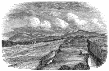
The popular theory is, that the whole plain, an item of the pyroxenic
plateau from Reykjavik to Geysir, has bodily “dropped at once and
subsided” to its present level, leaving exposed a section of the rent
rocks on either side. It reposes solely on the evidence of the two
parallel Geos, and I do not see that they bear it out. Both of the inner
sides have sunk, not from subterraneous crevassing, but because the
strips of ground which subtended them could not bear the weight. Mr
Scrope would account for the fosses, not by vertical settlement of
superficial lava into any cavity beneath, but by the “simple and usual
process, the bulk of the semi-fluid lava-stream, upon the cessation of
supply from above, having run out into the depths of the Thingvalla
Lake.” The normal operation of this movement, however, is to form a
tunnel, not an open trough, and this objection is one of the least.
The contrast of mountain and water, as usual, gives a certain
picturesqueness to the site. South-east of the lake rises the Búrfell,
here a goodly presence, and no longer the little cone seen from about
Reykir; south lies familiar Ingólfsfjall, and south-west towers the
“tall hanging hill,” Hengilshöfði, famed for sulphur springs;
snow-streaked, blue-tinted, and shaped somewhat like an elephant’s head.
Wheeling round to face north-west, we see the pinnacles of Súlarfell,
bristled as with trees; the fretted peaks about Gagnheiði; the dull
black heap of Ármannsfell, so called from Orman the Irish giant, who
there lies in his grave; and the ridgelet of Jornkliff, crouching below
it. There to north-east stands Skjaldbreið, shield-shaped as its name
says, ending in a snow-flaked umbo which suggests a crater. The peaks of
Tindaskagi at its foot apparently connect with the great Hrafnabjörg;
and far behind them, but brought near by the surpassing atmospheric
clearness, sparkle the snows of Lángjökull. The eastern view ends with
the quaint serrations of Dímon, which may be either lava blisters, or
the lips of a true crater, with the long buttress-like promontory of
Arnarfell, and with the background heights of Miðfell.
Dasent’s “Topography of the Thingfield,”[119] will confine our notices
of details to a narrow range. We inspected the Ell-stone or
Fathom-stone, a block of vesicular lava, 4 feet 9 inches high, opposite
the church door, and planted upon a rubble foundation. The six lines
upon the east face measure 1 foot 9 inches, 11 (10·50), 8, 7, 5, and 4
inches; they may be standards, but they look like the work of nature. We
then walked up to the grassy site of the Althing, and that local Sinai,
the Lögberg or Moothill, the latter a natural stone-mound to the north.
Parliament was formerly held on an island; it was for the best of
reasons transferred here, where the public was railed off by deep
chasms, and where hon. members could be attacked only by a single
gateway. So the Shetland Tingwall (Thingvöllr) was held on a holm,[120]
accessible only by stepping-stones, and the Thing-booths were on the
lake-plain. East is the Hrossagjá, and 20 yards west, the
Nikolásagjá,[121] with the smaller Brennrugjá below the latter. These
miniatures of the two great rifts, distant about a mile and a half from
the lake, are of crumbling subcolumnar black rock, varying from 16 to 40
feet in breadth, and falling sheer some 30 feet to clear blue-green
water, whose depths show detached blocks of lava. The two former unite
to the north, the second and third to the south, enclosing a long oval
with a natural bridge, a few feet wide, to the south-east. We admired
the leap, worthy of Morton and the Black Linn, by which Flosi escaped
the “blood-stone;” this article was shown to us on the western bank of
the Hrossagjá, a detached slice some 12 feet long, whence the victim
would fall into the “Geo.” Below to the west lay the lower Öxará, which
has probably changed all its features since Njál’s day. Yet the guides
still point out the islet, where holm-gangs were fought in presence of
the multitude;[122] and amongst the sand-banks formed by ankle-deep
rivulets, the “Thorleifshólmr,” upon which criminals were beheaded.
I passed the greater part of the morning examining the Almannagjá, whose
total length is about two miles,[123] and the average breadth 100 feet.
Ascending the outer or eastern edge by a slope of 20°, I found the upper
strata to be ropy, treacly, and scoriaceous lava, whilst below and
inside the couches are hard and crystalline. There is a slip in the
“Topography of the Thingfield” (p. cxxvii.), where it says, “about a
mile and a half from where the great rift touches the lake, its inner
lip ceases,” and the “Enlarged Plan” makes it break off where it is very
distinctly marked. The sole was a mass of débris fallen from the
sides, and good pasture streaked with many a path. Up the chasm there
are rude dry walls of mortarless stone, the Makíl of the Syrian
goat-herd, and serving as Sæters for sheep—the guides declare them to
be the Búðir of the old Thingmen, but their booths did not extend north
of the river. The upper or western wall, whose crest is weathered into
pinnacles, varies from 80 to a maximum of 100 feet, whilst the lower
ranges from 30 to 50; both are perpendicular and show stratifications
which seem to proceed from a succession of discharges.
The Axewater, above the “Geo,” is a stream like an English rivulet,
flowing through a wild and desolate Heiði. It tumbles over the western
lip by a gap about 50 feet high; here the layers of lava are well
defined on both sides, and it is easy to climb up either flank of the
toy cascade. This fall was sighted during the last march, and suggested
great expectations as the foot was hidden. M. Gaimard takes the liberty
of removing the screen, and showing the whole height prodigiously
exaggerated. It does not “explode in a cataract,” but falls decently
into a font-like kieve, and threads the sand and boulders of the Geo.
After a few yards it finds a gap in the inner lip, and here it dashes
towards the plain with two falls, mere steps in the rock. In the lower
basin, “sack-packed wretched females”—the author must have been
dreaming of the Bosphorus—were let down by ropes and drowned as a
punishment for infanticide. Farther on, witches were burned; less lucky
than other travellers, I could not find their bones. After thus
bisecting the Geo from north-west to south-east, the Axewater runs along
its eastern base, and enters the Thingvallavatn. The latter is drained
to the south-east by the Sog (inlet) outlet, which eventually feeds the
Ölfusá or lower Hvítá; it may be reached in five hours’ sharp riding
from Thingvellir, and in about double that time from Reykjavik. Here in
July any quantity of salmon-trout may be caught; the fish lie above the
first foss thick as water-plants. My informant had taken twenty-five in
one day; the heaviest was 7 lbs., and only two weighed under 6 lbs.; but
he had been almost blinded by the plagues of gnats and flies, which
covered his pony with blood-points.
In the afternoon we rode merrily “home.” The road began by fording the
Axewater, after which was a rude causeway of basalt, about thirty feet
long, ascending the eastern lip. It crossed diagonally the grassy
surface of the “Geo,” and climbed the western wall. A short ramp, paved
for beasts, like a bad flight of steps, runs between the true rampart
and a slice of rock which has been parted from it. Travellers usually
sight it from above, hence we read of the “frightful dangerous chasm,”
and we are told (N.B.—not by an Irishman) that “this is perhaps the
most unique scene in the world.” The moderns compare it with the
“Devil’s Staircase” in the Pass of Glencoe. The path would hardly
startle the most nervous girl, and a Harfushi horseman would gallop his
Arab up and down it.
Beaching the summit, we spurred across the Mossfellsheiði, which those
fresh from home describe as a “horrible stony waste, bordered by lofty
mountains.” But we had met with worse things than this
“ever-to-be-avoided heiði,” where, moreover, labourers were working at
the road. Seen in bad weather, it must be grim enough, as the many
“stone-men” show; hence, doubtless, general complaints about the
“mournful wail of the plover, and the wild scream of the curlew.”[124]
We found a number of these birds, besides sandpipers, purple
oyster-breakers, whimbrels, whose “soft fluid jug,” according to the
“Oxonian,” “is not unlike the nightingale’s song,” and a fair scatter of
ravens. I proposed a turkey-buzzard on a blasted tree, proper, as the
arms of Dahome, and Grip on a lava pinnacle would suit Iceland passing
well.
The only interest of this day’s ride is, that it crosses the “great
trachytic band” opposed to the lesser trachytic band of Snæfellsjökull;
the former made by old writers to stretch clean across Iceland from near
Reykjanes (south-west) to Langanes (north-east). We examined a few veins
of that rock, but the surface was mainly lava above and Palagonite
below. The latter is said to be remarkably well developed in the
Seljaland gorge,[125] and we dismounted to secure red specimens, and to
find, if possible, an Irish rose. This feature, I suppose, is one
writer’s “vast precipice, where there is only about sixteen inches to
tread on,” and the “deep ravine, wild, horrid, and frightful,” of
another pen, whose pencil supplies it with a herd of deer.
As we drew near Reykjavik the sun, after shimmering horizontally along
the ground, obliged us by occasionally setting behind the hills, and
when it
“Burned
The old farm-gable, we thought it turned
The milk that fell in a babbling flood
Into the milk-pail, red as blood.”
The moon arose with a judicious repression of details: the silver light,
the dark purple brooding at the hill-feet, and the gleam of the golden
west gave more colour than usual to the view. The ponies, under boxes
now empty, seemed to fly as they scented home. The only difference in
the familiar scene was a vast eruption of peat-stacks, made, like hay,
whilst the sun shines. Shortly before midnight we were again at home: in
Iceland there are no hours, and kind-hearted Frú Jonassen did not keep
us waiting either for supper or for bed.
Reykjavik to Krísuvík.
Monday, July 8, 1872.
Left Reykjavik at A.M. 11.30. Rounded heads of two dwarf Fjörðs (1
P.M.), Fosvogr and Kópavogr (seal-cub voe); turf at valley-heads.
1.45 P.M.—Hafnafjörð = 2 hours 15 min. riding; path tolerable up
torrent bed; crossed first divide of rugged ropy lava; path bad.
3.20 P.M. (= 3 hours 50 min.).—Changed horses in grassy cup-shaped
hollow, under broken wall of lava.
3.30 P.M.—Started again; at 4 P.M. forded Kaldá (cold water) River.
4.45 P.M.—Short halt on grassy bottom at foot of Lángahlíð.
6.30 P.M. (=7 hours).—Kleifarvatn (cliff-water); path along western
shore of lake.
7.15 P.M.—Left lake; over bog and up hill.
⊙ I. 8.30 P.M.—Reached Krísuvík (Bay of Krísa, proper name of woman), 5
hours + 3.50 = 8 hours 50 min. Frequent halts and delays with
pack-saddles. At most 3 miles per hour by 9 = 27 indirect statute miles.
People call the distance “10 to 15 miles.” Road upon map, 16 direct
geographical miles from Reykjavik to Krísuvík. General direction, north
to south with a little westing.
Good, grey, travelling day; no sun and no rain till night.
Paid at Krísuvík, $1, 3m. 0sk. (the cheapest).
Krísuvík to Litlaland.
July 9.
Left Krísuvík 10.45 A.M.; floundered over bog. Great arid plateau of
Iceland to left.
11.45.—Crossed rocky divide. Short cut over livid plain of lava; sea to
right; road along slopes.
12.45.—Entered great lava-field, which lasted with intermissions
throughout day.
1.15 P.M.—Sweet-water lakelet (not shown on map) of Herdisarvík
(Her-dís, proper name); first great lava-stream ends.
3.15 P.M.—Rode across Hlíðarvatn, at foot of Lángahlíð, now not open to
sea as in map; water brackish. Halted 1 hour near Vogsósar (voe’s
mouths) farm; gnats and flies. Rode 4 hours 30 min. = 13½ indirect
statute miles.
4.15 P.M.—Left Vogsósar. Basaltic sands and shells; thin grass. Then
loose sand and old flow of lava; domes, caves, and circular blow-holes,
like those of the Haurán. Deep sand, black and red. Rocky divide; went
gently over the stones.
7.30 P.M.—Passed Hlíðarendi (not the Lithe-end, or Ridge-end) to the
left (north); farm under green slope.
Forded streamlet in swampy river-valley; rough causeway; should have
crossed at the stone-man farther down.
⊙ II. 8 P.M.—Reached Litlaland; five-gabled farm of Magnús Magnússon.
Rode 3 hours 30 min. = 11 indirect statute miles. Total, 8 hours =
24½ indirect statute miles; on map, 19 direct geographical miles.
General direction, west to east.
Misty morn. Day like yesterday, but more sun. Wind ranged from
south-east to north. At night cirri; show clear day to-morrow.
Paid $2, 0m. 0sk.
Litlaland to Reykir and Laugardælir Farm.
July 10.
Set out 10.30 A.M. Up rise over cindery lava.
11.30.—Road forks, right branch leading to big farm. Took path to left;
reached old beach, water-worn galettes lying in long lines. Skálafell
above to left (north-west).
11.35.—Right bank of Ölfusá (proper name) valley, higher up called the
Sog. Ölfusvatn is the old name for Thingvallavatn.
11.45.—Hjalli (a hillock, much the same as “Hóll;” Cleasby says, “a
shelf or ledge in a mountain-side”); chapel farm. Skirted tall
Palagonite precipice on left.
1 P.M.—Passed through Níupat (?), filthy Bær, dunghill to pony’s knees.
Up right bank of Varmá, influent of broad Ölfusá. Wet riding, water
draining and sinking from above. Then white, smooth soil.
1.50 P.M.—Forded Varmá; easy descent and ascent; water to horses’
knees. Left baggage animals. Reached Reykir 2 P.M. Morning ride, 3 hours
40 min. by 4 miles = 16 indirect statute miles; on map, 9 direct
geographical miles. Direction, south-west to north-east.
Left Reykir 3.40 P.M. Circled round south of hill spine dividing Varmá
and Ölfusá. Forded two small streams and trotted over causeway (Brú),
here common, with some dwarf bridges. After third stream fine riding
along west and south walls of Ingólfsfjall. On slopes and at tongue-tip
fallen masses of light, lavender-coloured Palagonite, water-worn to
shape of volcanic bombs. Crossed two causeways, down slope of Ölfusá
valley.
⊙ III. At 6.45, ferry of Laugardælir; spent 1 hour 20 min. in crossing.
Reached farm of Sæmund Bjarnarson 8 P.M. Afternoon ride, 3 hours by 5 =
15 miles; on map, 6 direct geographical miles. Direction,
north-north-west to south-south-east. Total ride, 6 hours 45 min. = 30
indirect statute miles; on map, 15 miles. General direction,
south-south-west to north-north-east.
Weather charming; real enjoyment. Sun clear, not hot; high north-easter;
lofty cirri and woolpack. Evening cloudy. Rain at night; wind changed to
west and south-west; heat brought bad weather.
At ferry paid $1, and the bishop paid $2. Tariff, 10sk. Danish per
horse, and 12sk. per man or load. Pays well at this season; travellers
by day and night. Englishmen have been asked $20 and got off with $12
(rascality of guide?).
For lodging (church) and forage, coffee and biscuits, paid $3.
Laugardælir to Thjórsárholt Ferry.
July 11.
Horses strayed. Left at noon. Over delta-like flat between Hvítá and
Thjórsá (bull’s water); to north of former, detached bills of Búrfell (a
cabochon seen from north and south, and a hogsback elsewhere),
Stóraborg, and Hestfjall, resembling dots. Bog on old lava: stone
outcrops at places; wettest part often most solid base.
1.30 P.M.—Hraungerði (lava garth) chapel; two farms 8 miles from ferry;
horses and neat cattle.
2 P.M.—Hill dividing Ölfusá and Thjórsá. Rough work; showed
lake-country below, and Thjórsá line raised by refraction. Along natural
lava-dyke to dismal, dreary moor, all knobs and hummocks. Even ravens
avoid it in this weather.
4.30 P.M. (3 hours 30 min. = 18 indirect statute miles).—Halted thirty
minutes and changed horses at Lángamýri; large farm-house, one of many;
wire fence, two strands, and stripped branches for hedge.
5 P.M.—Remounted. Bad riding.
5.40.—Came upon Thjórsá. Ólafsvellir to left; ferry saves distance, but
dangerous in fierce wind. Path along stream excellent, black basaltic
sand, at times cut off corners, clay covering sand. Turned from
north-east to east. Farms and cattle. Passed Sandlækr and tall riverine
islet, Arnesthing. “Rústir,” or ruins, on right. Ponies tired; when
leaving river often lost way.
7 P.M.—Country more thickly peopled.
⊙ IV. 8.30 P.M.—At Thjórsárholt ferry-house (3 hours 30 min. = 20
miles). Total 8 hours, varying pace = 46 indirect statute miles; map, 26
direct geographical miles. General direction, west-south-west to
east-north-east.
Weather vile, unlike the finest month, July, as possible; forenoon cold;
driving rain. At noon stopped. Furious in afternoon. At times drizzle,
like hoar-frost on grass by decomposition of light. Rain again violent
till end of march.
Paid $3 for night’s lodging and ferry. Tariff, 11sk. per man or pack; on
return paid $1.
Thjórsárholt to Næfrholt Farm.
June 12.
Left Thjórsárholt 10 A.M.; up stream to ferry. Spent 1 hour 30 min.
crossing Thjórsá.
11.30 A.M.—Over turf of left (east) valley, like a dwarf prairie; 50
min. Many farms; good land, grassy sward, two to three feet deep.
Threads of lava, with dangerous holes and sinks, sometimes covered with
grass-turf. In places lava bare and broken. Crossed rivulet.
12.55 P.M.—Stóruvellir parsonage, 1 hour 30 min. = 6 miles; map, 4
direct geographical miles. Direction, south with a little easting. Place
afflicted by winds from Sprengisandur, distant two to three days’ ride.
2.30 P.M.—Left Stóruvellir with guide. Pastoral scene at foot of Hekla,
a pampa. Sheep everywhere; ditto stinging flies throughout the inhabited
part, few at Geysir.
3.45 P.M.—Leirubakki farm. Changed guides. After a few minutes reached
Vestri (west) Rangá (“wrong” or crooked stream), at the mouth called
Ytri (outer or uttermost) Rangá. Forded two preliminary brooks, and
tethered horses together for third or main channel, girth deep. Dwarf
forest, birch and willows. Then two streams, one a ditch, the other a
“lavapés,” flowing, like lava, north-east to south-west.
⊙ V. 5 P.M.—Næfrholt (birch-bark copse), last cottage at foot of
Bjólfell, western outlier of Hekla. Formerly travellers slept at Selsund
farm, south-south-west of Næfrholt.
Afternoon march, 2 hours 30 min. = 12 indirect statute miles. Total of
day’s ride, 4 hours = 18 indirect statute miles; map, 10 direct
geographical miles.
Grey day, like the start; clouds had expended ammunition. Wind
south-east. In evening weather doubtful, wind west. Hekla misted over,
good sign; travellers often stopped by fogs, and even by snow, in July.
Flies suddenly disappeared, wings wetted; not the case with the gnats
and midges acting mosquitoes.
Instruments in evening.
Aneroid, 30·24; thermometer, 58° (F.).
Hygrometer, 4° (exceptionally dry).
At Næfrholt.
July 13.
Ascended Hekla.
Left Næfrholt 8.25 A.M.
Rode down the turf lane; crossed the dwarf stream (lavapés), up right
grassy bank, and crossed again. Entered basin of “Unknown Lake”—thin
strip of flat land with holes often marked by grass and willows. All
“sinks” (sink-holes) and punchbowls, as if limestone country. Last thick
vegetation 1500 feet high. Then into dreary region, sand and cinder;
powdery red cone of fine cinder on left. Slabs of heat-altered trachyte.
Obsidian of two kinds—(1.) Huge blocks of pitchstone found from top to
bottom of cone, hard and flinty (Hrafntinnu proper); and (2.) Small
pieces of “Samidin,” or obsidian with crystals of white jasper like that
of Tenerife and other places. Bombs showed furious cannonade. Palagonite
everywhere in situ and in scatters: some contained obsidian.
Made for big, rough lava-stream, rusty and in heaps; in places rapidly
degrading, and leaving only core. Ponies sank to fetlock. Hugged left of
Steiná (stone stream). After two hours’ ride, at 10.30 A.M. crossed
hill, reached barren divide too steep for horses.
Aneroid in air, 28·18 (difference, 2·06); thermometer, 92° (in pocket);
hygrometer, 2°.
Walked up slope of divide; descended very short pitch of stone and
débris, steepest bit of whole march. Crossed vein of lava (Sept. 2,
1845) like pulled bread, all slag and clinker; pulverising above.
Reached a kind of couloir, a rim on left of lava-stream. Black sand
and two large tongues of ice-based snow, white and brown, ridged with
dirty earth, and dotted with dwarf ice-tables, sable above and ermine
below. More ice as we ascended, keeping on the earthy parts. Many halts.
12.20.—Reached crater of 1845. Observed instruments.
Aneroid in air, 26·33 (difference, 3·90); thermometer, 83° (in pocket).
Stiff ascent (15 min.) to First or Southern Crater. At 1.13 P.M. sat
down upon its western lip. Walking lasted 2 hours 45 min. Total ascent,
4 hours 45 min.
Aneroid, 25·94 (difference, 3·30); thermometer, 68° (air); hygrometer,
0°.
Passed over ridge, and reached snow; thence to north-east lip of Second
or Northern Crater, the apex. Reached highest point 1.53 P.M. Total, 3
hours 13 min. (included halts, not bad for difference 2·56 of aneroid).
Aneroid, 25·62 (difference, 4·84); thermometer, 67°; hygrometer, 0°.
2.30 P.M.—Began descent (walked 1 hour 25 min.).
3.28 P.M.—Lowest snow.
3.45 P.M.—Mounted horses (rode slowly 1 hour 45 min.).
5.30 P.M.—Næfrholt farm. Total descent, 3 hours 10 min.
Total of ascent and descent, 7 hours 55 min. (say 8 hours).
Day clear, sun very hot; air thirsty for man and beast.
Paid guide $1, 4m. 0sk. To house for forage, etc. (two days), $5.
Næfrholt to Geysir.
July 14.
Long, weary day.
Left Næfrholt 9.40 A.M. Wind drove away flies. Crossed Rangá and five
other streams.
12.10 P.M.—Reached Thjórsá, 2 hours 30 min. of fast riding—five miles
per hour. Ferried over at Thjórsárholt. This third of road good.
1.45 P.M.—Remounted; crossed flat land; two Kálfá; east fork big and
west fork small. Bad mosses; rounding foul swamps; one furlong of good
path to one mile of bad.
3.45 P.M.—Reached (Eastern) Laxá; reported bad ford; found it very
good.
4.10 P.M.—Crossed Laxá valley to Sólheimar (sun-home) farm. Rounded
fens and crossed morasses. Passed a made tank for washing sheep—rare
luxury here. Foul bog of cotton-grass; deep vein along causeway.
5.20 P.M.—Hruni chapel; 4 hours 35 min. from Thjórsá, fast riding. This
third of road moderate.
6.45 P.M.—Left Hruni; road to Geysir now very bad; five fast or seven
slow hours; took guide ($1), or it would have been worse. Went north;
road not on map. Crossed ugly wet swamp to Minni Laxá (lesser
salmon-river); ford not bad.
Up divide of Palagonite running north-east to south-west. Rounded and
crossed easiest part of another swamp. Causeway. Up another divide
showed us valley of Hvítá. West of us smokes of Reykholt, Laugs
everywhere. Avoided causeway, because it runs through tún of large farm,
Gröf (the pit).
8 P.M.—Changed pack-horses. Ugly swamp and causeway to Hvítá River.
8.20 P.M.—Forded Hvítá stream; the heaviest, but not bad. Up right
bank, a wild gorge; guide left us. Through swamps. Entered ugly system
of broken ground, rock-walls, earth and stone, faults and dykes.
10 P.M.—Fell into long descent of birch “forest.” Long trot. Forded
Túngufljót (Tongue, i.e., Mesopotamia or Doab) River.
10.50 P.M.—Beached Geir-hóll farm, then villainous swamp for tired
nags. Crossed eastern three branches of the Árbrandsá (upper
Túngufljót), all troublesome; and two other foul, flowing fast influents
of the right or western bank.
⊙ VI. At 12 P.M. reached Geysir.
Total of this day’s ride, 12 hours 20 min., at least 50 indirect statute
miles; map, 31 direct geographical miles. General direction,
south-south-east to north-north-west.
Dew very heavy, yet plague of flies. Sweltering morn. At 9 A.M.,
thermometer 82° (F.). 9.30 A.M., good sea-breeze from south. Fine day.
In evening cold; clouds from east gathering, 9 P.M.; thick at night,
threatened rain.
Geysir to Thingvellir.
July 16.
Left Geysir 11 A.M. Passed Laug farm to south-west, and crossed spongy
bog and swamp in rivulet-influent of Túngufljót, passing between
Laugarfjall and the outlier. Rounded south end of Laugarfjall.
12 (noon).—Múli (muzzle, maul, mull) farm, one of the best; skirted
southern Bjarnarfell, between ugly, black, bare hills and swamp over
triangle (Biskupstúngur), formed by Túngufljót and Brúará.
12.20 P.M.—Chapel farm, Uptirhlíð (?); extensive view; sunk road. Two
rivulets, second small and boulder-paved. Forest (birch and willow)
begins and lasts with interruptions all day. See more wood in one hour
than on all south coast.
1 P.M.—Passed to left chapel farm, Úthlið, at foot of Hraun of same
name.
1.40 P.M.—Crossed bridge of Brúará (bridgewater), and entered lands of
Laugardalr. Forded a fourth stream. On right, Efstidalr (uppermost
dale), at foot of black plateau, ugly, bare, and gashed with many
drains. Hognhöfð pyramid to north, rhinoceros head and horn. Left
Miðdalr chapel on right, and rounded upper swamp of Apavatn (ape or fool
water, from a settler in the ninth century).
3.15 P.M.—Crossed streamlet fed by many drains and trickles; first
down, then up bed, sand-bars and islets; must be unfordable below.
Rounded Laugarvatn (lake), large farm and hot spring.
4 P.M.—Halted Laugarvatnsvellir; fine pastures. Five hours tolerably
fast = 20 indirect statute miles. Good view of Hekla. Saw two
snow-fonds, up which we had walked.
5.20 P.M.—Left Laugarvatn by made road on “barmr” (edge) of low rolling
ground and humus, confining big swamp on north; Bjarnarfell hill to
right, then three peaks of Kálfstindar. Travellers and caravans.
6 P.M.—Entered old lava. Path rose to 600 feet, and showed Thingvellir
Lake. Grim hill, Reyðarbarmr (red, i.e., salmon-trout edge), to right.
Road rutty. Dimon or Tindhruni (Bryson’s Tintron), an extinct crater in
shield form, rising at base of high hill on right.
7.30 P.M.—Gjábakki farm, close to Vellankatla (boiling kettle),
north-eastern bay of lake (proper name of boiling well; Cleasby supposes
it sank below water-level), along lake.
8.15 P.M.—Hrafnagjá; eastern crevasse.
9.15 P.M.—Middle crevasse, called Háflagjá, Hólagjá, or Breðnigjá (?).
⊙ VII. 9.30 P.M.—Chapel of Thingvellir.
Second march, 4 hours 10 min. = 20 miles. Total, 40 indirect statute
miles; map, 26·5 direct geographical miles.
General direction, north-east and by north to south-west and south.
Glorious morning; cloudless; gentle breeze from north. At 11 A.M.,
chopped round to south-west. At noon west, blowing dust in face
everywhere except on lava. Clouds. Few drops of rain. Presently weather
recovered itself. Very fine evening and night.
Thingvellir to Reykjavik.
July 17.
3.35 P.M.—Left Thingvellir (paid $2, 3m. 0sk.).
Forded Öxará; up rude basaltic causeway, some ten yards long, a little
south of where Öxará escapes into plain—site of Búðir. A few yards down
grassy surface of Almannagjá. Up split in western wall. Dreary scene on
summit; old lava, grassy and moss grown.
5.40 P.M.—Last sight of Thingvellir Lake, and first view of black
buttressed Esja, with gleam of sea. Entered Mosfellsheiði; soil damp,
sour, and barren; signs of road-making, and Varðas everywhere. Left to
right two ponds, Leiruvogsvatn and Geldingatjörn, latter undrained;
skirted east and south base of Grimmansfell (ugly man’s fell); to right,
steaming spring (Reykjalaug).
7 P.M.—Descent to the far-famed Seljadalr (sallow = willow dale).
7.45 P.M.—Dwarf ravine on left. Its stream finds the Hrafnavatn
reservoir of Reykjavik Laxá. Rode down grassy basin; forded stream
twenty-five times, fetlock to knee-deep.
8 P.M.—Halted to graze ponies. First march, 4 hours 25 min. = 20
indirect statute miles.
8.45 P.M.—Remounted. Continued Seljaland valley; ponds on both sides
with and without drains. View of Snæfellsjökull. On left
porcupine-shaped Helgafell.
Hill and basins. Travellers camped where forage is not paid for. Then
inhabited country.
10 P.M.—Causeway and made road to Reykir. Ponies dashed through two
branches of Laxá.
⊙ VIII. 11.30 P.M.—Reykjavik. Home.
Second march, 3 hours = 15 indirect statute miles. Total, 8 hours= 35
miles; map, 24 direct geographical miles.
General direction, east and by north to west and by south.
Weather fine and clear like yesterday. Sun now sets at 10 P.M., and air
grows cold. Find people strolling at midnight. Dust in Reykjavik very
bad.
| Expenses of Trip for Two Travellers. |
| Guide (10 days at $2, 3m. 0sk.), | $25 0 0 |
| Boy (10 days at $1, 3m. 0sk.), | 15 0 0 |
| Returning horses to owners, | 4 3 0 |
| Hire of pack-saddles and boxes, | 7 0 0 |
| Twelve horses (at $1 per diem), | 120 0 0 |
| Total, | $171 3 0 |
The extras and minor expenses, $27, 2m. 0sk.
Share of each traveller, $104, 2m. 8sk., or £12 for ten days.
![[Image of the book's cover unavailable.]](https://openoldbooks.sgp1.digitaloceanspaces.com/books/ultima-thule-vol-2/images/cover.jpg)


![[image of figure not available.]](https://openoldbooks.sgp1.digitaloceanspaces.com/books/ultima-thule-vol-2/images/mark.png) (G. T. and cross), a
large and thick duodecimo, with the beginning and the end restored by
manuscript—Icelanders, as a rule, are very skilful in supplying lost
pages. Of this book only three copies are known, the two others are at
the deanery of Hruni and in Glasgow. Another New Testament (1609),
reprinted at Hólar by Bishop Guðbrand, whose high-nosed and fork-bearded
face remind us of his kinsman Rustam in far Iran, is a small stout
octavo, with an old binding and metal clasps.
(G. T. and cross), a
large and thick duodecimo, with the beginning and the end restored by
manuscript—Icelanders, as a rule, are very skilful in supplying lost
pages. Of this book only three copies are known, the two others are at
the deanery of Hruni and in Glasgow. Another New Testament (1609),
reprinted at Hólar by Bishop Guðbrand, whose high-nosed and fork-bearded
face remind us of his kinsman Rustam in far Iran, is a small stout
octavo, with an old binding and metal clasps.