TWENTY UNSETTLED MILES IN THE NORTHEAST BOUNDARY.
For nearly three hundred years, and almost without cessation,
there has raged a conflict of jurisdiction over territory
lying near to what is known as the Northeast Boundary of
the United States. It has been generally assumed, however,
that the Webster-Ashburton treaty of 1842, together
with the Buchanan-Packenham treaty of 1846, settled all
outstanding differences with Great Britain in the matter of
boundaries, and few people are aware that there is an
important failure in these and earlier treaties, to describe
and define all of the line which extends from ocean to ocean
and fixes the sovereignty of the adjacent territory. From
the mouth of the St. Croix River to the ocean outside
of West Quoddy Head is a distance of about twenty-one
miles, if the most direct route through Lubec Channel
be taken. Somewhere, from the middle of the river at its
mouth to a point in the ocean about midway between the
island of Campobello and Grand Menan, the boundary between
Maine and New Brunswick must go, and, inferentially,
for about one mile of this distance it is tolerably well
fixed. But this is only an inference from the generally
accepted principle that where two nations exercise jurisdiction
on opposite sides of a narrow channel or stream of
water, the boundary line must be found somewhere in that
stream. That this has not been a universally accepted principle,
however, will appear later. Throughout the remaining
twenty miles, the territory under the jurisdiction of the
United States is separated from that under the dominion of
Great Britain by a long, irregularly shaped estuary, almost
everywhere more than a mile in width and over a large part
of its length opening into Passamaquoddy Bay and other
extensive arms of the sea. This large body of water, with
an average depth of twenty-five fathoms and everywhere
navigable for vessels of the largest size, flows with the alternations
of the tides, the rise and fall of which is here eighteen
to twenty feet, now north, now south, with a current in
many places as swift as five and six miles per hour. Nothing
like a distinct channel or “thread of stream” exists, and
it can in no way be likened to or regarded as a river. When
once the mouth of the St. Croix is reached, the boundary
line is defined by the treaty of 1783 to be the middle of
that river, up to its source, but literally, as well as figuratively,
we are at sea as to its location from that point to the
open ocean. It is the purpose of this paper to give some
account of the circumstances which gave rise to such a
curious omission; the incidents which led to a diplomatic
correspondence and convention relating to the matter, in
1892, between the two governments interested; and the
attempt which was made during the two or three years
following the convention to determine and mark the missing
boundary.
The present controversy really had its beginning nearly
three hundred years ago. Up to the end of the 16th
century, not much attention had been given by European
colonists to the northeastern coast of America, although
it had been visited by Cabot before the beginning of that
century. The coast was tolerably well known, however,
and it had been explored to some extent by both English
and French, who were alive to the importance of
the extensive fishing and other interests which it represented.
In 1603, the King of France (Henry IV.) made
the famous grant to De Monts of all the territory in
America between the fortieth and forty-sixth degrees of
north latitude, thus furnishing a beautiful example of the
definition of a most uncertain quantity in a most certain and
exact manner, an example which later boundary-line makers
might wisely have followed. The Atlantic coast-line
covered by this extensive charter, extends from a point
considerably below Long Island to another point on Cape
Breton Island and includes all of Nova Scotia. In the
spring of 1604, De Monts sailed for his new domain, to
which the name Acadia had been given, carrying with him
Champlain as pilot. After landing on the southern coast of
what is now known as Nova Scotia, he sailed around Cape
Sable to the northward, entered the Bay of Fundy, discovered
and named the St. John River, and afterward entered
Passamaquoddy Bay, and ascended a large river which
came into the bay from the north. A little distance above
its mouth, he found a small island, near the middle of the
stream, which at that point is nearly a mile and a half wide.
As this island appeared easy of defence against the natives,
he determined to make a settlement there, and proceeded
to the erection of buildings, fortifications, etc. A few miles
above the island, the river was divided into two branches
nearly at right angles to the main stream, and the whole so
resembled a cross, that the name “St. Croix” was given
to the new settlement, and the same name came, afterward,
to be applied to the river. The subsequent unhappy fate
of this first attempt to plant the civilization of Europe upon
the northern coast of America is so well known that further
reference is unnecessary. This most interesting spot is
now partly occupied by the United States Government as a
lighthouse reservation, about one-third of the island having
been purchased for that purpose. The St. Croix River
lighthouse, carrying a fixed white and 30-sec. white flashlight
of the fifth order, now stands where in 1605 stood
the stone house and palisade of the dying Frenchmen,
who found in disease a worse enemy than the aborigines.
The area of the whole is only a few acres, and it has
apparently wasted away a good deal since the French
settlement, relics of which are occasionally found even at
this day. The island has borne various names, that first
given having long since attached itself to the river. On
modern Government charts, it is known as Dochet’s Island,
derived, doubtless, from Doucet’s, one of its early names,
but it is, perhaps, more generally known as Neutral Island.
The significance of its discovery and settlement as affecting
the question in hand, will appear later.
Very shortly after the grant of the French King in 1603,
King James of England issued a charter to all of the territory
in America extending from the Atlantic to the Pacific
Ocean, included between the thirty-fourth and forty-sixth
degrees of north latitude, covering and including the previous
grant of the French King, and thus setting fairly in
motion the game of giving away lands without consideration
of the rights or even claims of others, in which the
crowned heads of Europe delighted to indulge for a century
or more. Colonization was attempted, and now one power,
now another, was in the ascendant. Occasional treaties
in Europe arrested petty warfare on this side, and out of it
all came a general recognition of the St. Croix River as the
boundary between the French possessions and those of the
English. It is impossible and would be improper to go
into these historical details, most of which are so generally
known. It is only important to note that the province
known as Nova Scotia by the one nation, as Acadia by the
other, after various vicissitudes became the property of the
English, and that it was assumed to be separated from the
province of Massachusetts Bay by the river St. Croix.
While the latter province remained a colony, loyal
to the King, and the former a dominion of the Crown,
there was naturally no dispute over boundary lines. In
the provisional peace treaty of 1782, between the United
States and Great Britain, and in the definitive treaty of
peace in 1783, it is declared that in order that “all disputes
which might arise in future, on the subject of the
boundaries of the said United States may be prevented, it
is hereby agreed and declared that the following are and
shall be their boundaries,” and in this embodiment of
peaceful intent is to be found the origin of international
controversies which lasted more than a half a century, and
which were often provocative of much bitterness on both
sides. The phrase in which reference is made to the line
under consideration is as follows: “East by a line to be
drawn along the middle of the river St. Croix, from its
mouth in the Bay of Fundy to its source.” During the
last days of the Revolutionary War many who had been
loyal to the King during its continuance fled from the
Colonies to Nova Scotia, and naturally they were not much
in favor among those who had risked all in the founding of
a new republic. It was believed by them that the loyalists
were encroaching on the territory rightfully belonging to
the province of Massachusetts, and even before the definitive
treaty of peace had been proclaimed, Congress had
been appealed to to drive them away from their settlement
and claim what was assumed to be the property of the
United States of America. There at once developed what
proved to be one of the most interesting controversies in
the history of boundary lines. It was discovered that
although the St. Croix River had long served as a boundary,
“between nations and individuals,” its actual identity
was unknown. The treaty declared that the line of demarcation
between the two countries should be “drawn along
the middle of the river St. Croix from its mouth in the Bay
of Fundy,” but it was found that there were several rivers
debouching into this bay and that several of them had
been, at one time or another, known as the St. Croix.
In accordance with time-honored diplomatic practice, the
English were for taking the most westerly of all these, and
the Americans contended with much vigor and no small
amount of justice that it was the most easterly. The St.
John, a large river emptying into the Bay of Fundy, had
been so long and so well known that it was out of the question.
There remained three considerable streams, which,
beginning with that farthest east, were known as the
Magaguadavic, or popularly at the present day, the “Magadavy,”
the Passamaquoddy and the Cobscook, all pouring
their waters into the Passamaquoddy Bay.
In the Grenville-Jay Treaty of 1794, the settling of this
dispute is provided for in an agreement to appoint three
commissioners, one each to be named by the respective
governments and the third to be selected and agreed upon
by these two, whose duty it was to “decide what river is
the river St. Croix intended by the treaty,” and to declare
the same, with particulars as to the latitude and longitude
of its mouth and its source, and the decision of these
commissioners was to be final. In a supplementary treaty
of 1798, this commission was relieved from the duty of
determining latitude and longitude, having, for some reason
or other, found difficulties in the same, or, possibly, recognizing
the absurdity of defining a boundary in two distinct
and independent ways. It was not until 1798 that the
commissioners made their report. As is usual, indeed,
almost universal in diplomatic affairs, it represented a compromise.
There seems to be little doubt that the river
which was called St. Croix at the time of the negotiation of
the treaty of peace in 1783 was really the most easterly
river or the “Magadavy,” this being the testimony of the
commissioners, Adams, Jay and Franklin. But at the
same time it cannot be denied that the stream finally
accepted as the St. Croix was the real river of that name,
referred to in the traditions and treaties of two centuries,
and the discovery of the remains of the French settlement
on Dochet’s Island quieted all doubt in the matter. England
gained a decided advantage by the not-unheard-of
proceeding of adhering to the letter of the treaty rather
than to its spirit.
But the report of the commission of 1798 fell far short
of terminating the boundary-line controversy. The identity
of the St. Croix River was fixed and its mouth
and source determined, but from the beginning of the
line in the middle of the river there were still twenty
miles before the open ocean was reached. Along this
stretch of almost land-locked water were numerous islands,
several of them large and valuable, and on some of them
important settlements had already been made. The Commissioners
of 1794 were urged to continue the line to the
sea, thus settling the sovereignty of these islands and ending
the dispute. They declined to do so, however, on
account of a lack of jurisdiction, as they believed, and it
was not then thought that these subordinate problems
would be difficult of solution. As a matter of fact, Great
Britain claimed dominion over all of these islands and
exercised authority over most of them, except Moose
Island, upon which was the vigorous American town of
Eastport. A treaty was actually arranged in 1803 between
Lord Hawkesbury and Rufus King in which the question
of the extension of the boundary line to the open sea was
agreed upon and in a most curious way. It was declared
that the boundary line should proceed from the mouth of the
St. Croix and through the middle of the channel between
Deer Island and Moose Island (which was thus held by the
United States) and Campobello Island on the west and
south round the eastern part of Campobello to the Bay of
Fundy. This would apparently give the island of Campobello
to the United States; but it was especially declared
that all islands to the north and east of said boundary, together
with the island of Campobello, should be a part of
the Province of New Brunswick. The curious feature of
this treaty, providing that an island actually included on
the American side of the boundary line should remain in
the possession of Great Britain, resulted from a provision
of the treaty of 1783, which declared that all islands heretofore
under the jurisdiction of Nova Scotia should remain
the property of Great Britain. It is also an admission of
the fact that the natural extension of the boundary line is
around the eastern end of Campobello, as described above;
and while this treaty was never ratified, it is of great
significance as proving the admission on the part of the
English, that the natural boundary would include the island
of Campobello in American territory.
During the war of 1812 matters remained in statu quo,
and Moose Island (Eastport) continued to be regarded as
American, although Great Britain had yielded nothing of
her claims. Finally, just as peace had been declared, an
armed English force appeared before the town and compelled
its surrender. This was undoubtedly to gain that
possession, which is nine of the ten points, before the meeting
of the Commission at Ghent; and in the discussion
which afterward took place, the British Commissioners
claimed absolute and complete ownership of Moose Island
and others near by. To this the Americans would not
yield; but they finally gave way to the extent of allowing
continued possession until commissioners, to be appointed
under the treaty, could investigate and decide the question.
Thus the boundary line was thrown into the hands of
another commission, which was again unfortunate in not being
clothed with sufficient power to definitely fix it. Indeed,
the importance and desirability of considering the extension
of the boundary line to the sea does not seem to have been
realized, the commissioners being restricted in their duties
to the determination of the sovereignty of the several islands
in Passamaquoddy Bay. The report of this commission
was made in November, 1817. As this decision has a most
important bearing on the matter under consideration, it
will be well to quote its exact language. The Commissioners
agreed “that Moose Island, Dudley Island and Frederick
Island, in the Bay of Passamaquoddy, which is part of
the Bay of Fundy, do and each of them does belong to the
United States of America; and we have also decided, and
do decide, that all other islands and each and every one of
them, in the said Bay of Passamaquoddy, which is a part
of the Bay of Fundy, and the Island of Grand Menan in the
said Bay of Fundy, do belong to his said Britannic Majesty,
in conformity with the true intent of said second
article of said treaty of one thousand seven hundred and
eighty-three.” A very superficial examination of this
decision reveals the possibility of a decided advantage to
Great Britain in consequence of its wording, an advantage
doubtless foreseen and foresought by the more shrewd and
accomplished diplomatists by whom that nation was represented
in this instance, as in almost every other controversy
with this country. Here is a group of scores of
islands, lying in an inland sea, separating the two countries.
It is true that the sovereignty of one or two of the most
important is apparently determined by the treaty of 1783,
but on this the arguments were almost equally strong on
both sides. In any event it would have been easy, and
infinitely better to have drawn a line through the Bay,
from the mouth of the river to the open sea, and to have
declared that all islands on one side of that line should
belong to Great Britain and all on the other side to the
United States. Had this been done, much subsequent
dispute would have been avoided. With much ingenuity,
however (as it seems to me), the American Commission
was induced to accept three islands, definitely named and
pointed out, as their share, while the Englishmen, with
characteristic modesty, contented themselves with everything
left. Of the sovereignty of Moose, Dudley and
Frederick Islands, there was hardly room for discussion,
notwithstanding the three or four years’ occupancy of the
town of Eastport by British troops after the War of 1812.
Our being worsted in the matter, as we unquestionably
were, is to be attributed to the general indifference of the
great majority of our people to the future value of outlying
territory, the resources of which have not yet been
explored. This unfortunate indifference is quite as general
today as it was a century ago, and is in marked contrast
with the policy of our English ancestors.
It is important to note that this partition of the islands
in Passamaquoddy Bay, unfair as it unquestionably was,
gave no definition of the boundary line from the mouth of
the St. Croix to the sea, except inferentially. In the
absence of description it must be inferred that the boundary
is to be drawn so as to leave on one side all territory
admitted to be American and on the other all admitted to
be British. For a distance of about a half a mile the island
of Campobello lies so close to the American shore that a
channel, known as Lubec Channel, not more than a thousand
feet in width, separates the two countries, and the
thread, or deepest axis of this channel might well define
the boundary. For the remaining score of miles, however,
as has already been explained, the estuary is too wide, its
depth too great and too uniform to afford any physical
delimitation, except that based on equal division of water
areas.
This ill-defined, or rather undefined boundary line has
so remained for nearly eighty years. It is true that government
chart-makers, both English and American, have
often indicated by dotted lines their own ideas as to its
whereabouts, but they have not been consistent, even with
themselves, except as to making Lubec Channel a part of
it, and they have had no authority except that of tradition.
There has been no small amount of commercial activity
among the settlements on both sides of the Bay, and a considerable
proportion of the population have been, at one
time or another, engaged in fishing. The customs laws of
both countries, and especially the well-established fisheries
regulations of the Canadians, and the activity of their fisheries
police, have led to various assumptions as to the location
of the boundary by one of the interested parties and to
more or less tacit admission by the other. It happens that
the greater part of the best fishing-grounds in the immediate
vicinity of the town of Eastport is distinctly within
Canadian waters, so that most of the trespassing has been
done by the Americans. This has resulted in a great
development of Canadian police activity, which necessarily
implies assumption as to the existence and whereabouts of
the boundary. The continued readiness to claim that
American fishermen were trespassers, accompanied occasionally
by actual arrest and confiscation, naturally led to
a gradual pushing of the assumed boundary towards the
American side; and there is no doubt that during the past
twenty-five years, the people on that side have acquiesced
in an interpretation of the original treaty which was decidedly
unfavorable to their own interests. On the other
hand, from Lubec Channel to the sea, through Quoddy
Roads, a condition of things just the reverse of this seems
to have existed. Here certain fishing-rights and localities
have been stubbornly contended for and successfully held
by Americans, although the territory involved, is, to say
the least, doubtful. In the matter of importation of dutiable
foreign goods into the United States, there existed
for many years an easy liberality among the people whose
occupation at one time was largely that of smuggling, for
which the locality offers so many facilities. It is plain that
this condition of things would give rise to no great anxiety
about the uncertainty of the boundary line, although in one
or two instances the activity (no doubt thought pernicious)
of the Customs officers resulted in disputes as to where the
jurisdiction of one country ended and that of the other
began; and in at least one notable case, to be referred to
at some length later, this question was adjudicated upon
by the United States courts.
The question was not seriously considered by the two
governments, however, from the time of the treaty of Ghent
to the year 1892. It is not an uncommon belief that this
part of the boundary line was considered in the famous
Webster-Ashburton Treaty of 1842; and many people
have unjustly held Webster responsible for the continued
possession by Great Britain of the island of Campobello,
which, by every rule of physiographic delimitation, ought to
belong to the United States. But, as already recited, the
sovereignty of this island was settled in 1817, and practically
so in the original treaty of 1783. The Webster-Ashburton
Treaty was apparently intended to settle the
last outstanding differences between Great Britain and the
United States in the matter of boundary lines, but disputes
relating to them seem difficult to quiet. The treaty of
1842 carried the line only as far as the Rocky Mountains,
and another in 1846 was necessary for its extension to the
Pacific. Examining both of these in the light of today,
there can be no doubt of the fact that the United States
was seriously at fault in yielding, as she did, her rightful
claims at both ends of the great trans-continental line.
Enormous advantages would be hers today, if she had not
so yielded; and her only excuse is that at the time of
negotiation the territory involved did not seem of material
value, at least when compared with her millions of acres
then undeveloped.
In all of these controversies nothing was said of the little
stretch of undefined boundary in Passamaquoddy Bay, and
it is quite probable that those who had to do with such
matters were quite unaware of its existence.
On July 16th, 1891, the Canadian cruiser, Dream, doing
police duty in those waters, seized seven fishing-boats,
owned and operated by citizens of the United States, while
they were engaged in fishing at a point near what is known
as Cochran’s Ledge, in Passamaquoddy Bay, nearly opposite
the city of Eastport, Maine. It was claimed by
Canadian authorities that the crews of these boats were
engaged in taking fish in Canadian waters. On the other
hand, the owners of the boats seized contended that they
were well within the jurisdiction of the United States at
the time of the seizure, and there was much interest in the
controversy which followed. The matter was referred
to the Department of State, where it became evident
that future conflict of authority and jurisdiction could be
avoided only by such a marking of the boundary line
as would make the division of the waters of the Bay
unmistakable.
Accordingly, in Article II. of the Convention between the
United States and Great Britain, concluded at Washington,
on July 22, 1892, it is agreed that each nation shall appoint
a Commissioner, and that the two shall “determine upon
a method of more accurately marking the boundary line
between the two countries in the waters of Passamaquoddy
Bay in front of and adjacent to Eastport in the State of
Maine, and to place buoys and fix such other boundary
marks as they may deem to be necessary.” The phrasing
of this Convention furnishes in itself, a most excellent example
of how a thing ought not to be done. There is no
doubt that a large majority of the boundary-line disputes
the world over, are due to the use of faulty descriptions
involving hasty and ill-considered phraseology. We are
particularly liable to this sort of thing in the United States,
by reason of the fact that most of our diplomatic affairs are
too often conducted by men of little experience and no
training, and who are unaccustomed to close criticism of the
possible interpretation of phrases and sentences relating to
geographical subjects. A treaty of this kind is usually
satisfactory to both parties when entered into, and it is
only at a later period, when it must be interpreted, that one
or the other of them is likely to find that it is capable of a
rendering and an application very different from what had
been thought of at the time. Innumerable examples of this
looseness of language might be given if necessary, but it is
important to call attention to the inherent weakness of the
document now under consideration. The first phrase, requiring
the commissioners “to determine upon a method of
more accurately marking the boundary line” implies that it
was already marked in some unsatisfactory manner, and it
implies still further, that such a boundary line exists,
neither of which assumptions is correct. As a consequence
of this erroneous hypothesis, the description of the part
of the line to be marked, namely, that in front of and
adjacent to Eastport, is vague and inadequate, and,
indeed, there is nowhere a hint of a recognition of the
real facts.
Under this convention, Hon. W. F. King, of Ottawa,
Canada, was appointed commissioner on the part of Great
Britain, and the writer of this paper represented the United
States.
The commissioners were immediately confronted with
the fact that they were expected to mark a boundary line
which really did not exist and never had existed; but by a
liberal interpretation of that part of the convention in which
it was agreed that they were “to place buoys or fix such
other boundary marks as they may determine to be necessary,”
they found a basis on which to proceed to the consideration
of the question. Evidently the just and fair
principle according to which the boundary might be drawn,
was that which, as far as was practicable, left equal water-areas
on both sides. There was no other solution of the
problem clearly indicated by the physics of the estuary or
the topography of the shores. Furthermore, there is a
precedent for adopting this principle, in the treaty of 1846,
in which the extension of the boundary from the point of
intersection of the forty-ninth parallel of north latitude with
the middle of the channel between Vancouver Island and
the Continent, to the Pacific Ocean, is along the middle of
the Strait of Fuca. This was agreed to by both sides; and
also, that the boundary line should consist, in the main, of
straight lines, because of the impossibility of marking a
curved line on the water, or indicating it clearly by shore
signals; that the number of these straight lines should be
as small as possible, consistent with an approximately equal
division of the water area. In view of the great desirability
of fixing the line for the whole distance, from the mouth of
the St. Croix River to West Quoddy Head, the commissioners
tentatively agreed to so interpret the words “adjacent
to Eastport,” as to include the entire twenty miles,
thus hoping to definitely settle a controversy of a hundred
years’ standing. Proceeding on these principles, the whole
line was actually laid down on a large scale chart of the
region at a meeting of the commission, in Washington, in
March, 1893, with the exception of a distance of a little
over half a mile, extending north from a point in the middle
of Lubec Channel. The omission of this part in the Washington
agreement was due to the existence of a small island
about a quarter of a mile from the entrance to the channel,
now known as “Pope’s Folly,” but early in the century
known as “Green” Island and also as “Mark” Island. The
sovereignty of this island has been almost from the beginning
a matter of local dispute. It contains barely an acre of
ground, and except for possible military uses, it has practically
no value. Its location is such, however, as to form a
stumbling block in the way of drawing a boundary line,
which, if laid down with a reasonable regard to the principles
enunciated above, would certainly throw it on the side
of the United States, while a line so drawn as to include it
in Canadian waters would be unscientific and unnatural.
It was agreed to postpone further consideration of this
question until the meeting of the commissioners in the field
for the purpose of actually establishing the line, which
meeting occurred in July, 1893.
Nearly two months were occupied in the surveys necessary
to the establishment of the ranges agreed upon and in
the erection of the shore signals. It was agreed that the
line should be marked by buoys at the turning-points, but
as the strong tidal currents which there prevail promised to
make it difficult, if not impossible, to hold these in their
places it was determined to mark each straight segment of
the boundary by prominent and lasting range-signals so that
it could be followed without regard to the buoys, and cross-ranges
were also established by means of which the latter
could be easily replaced if carried away. Permanent natural
objects were in a few instances used as range signals,
but for the most part they were stone monuments, conical
in form, solidly built, from five feet to fifteen feet in height,
and painted white whenever their visibility at long range
was thus improved. At the close of the work, first-class
can-buoys were placed at the principal turning-points, although
with little hope of their remaining in place. As a
matter of fact, it was found impossible to keep in place more
than three of the six or seven put down, but, fortunately,
these are at the most important points in the line. As
already stated, the commissioners had failed to agree, in
Washington, as to the direction of the line around Pope’s
Folly Island, and on further investigation of the facts they
were not drawn together on this point. As the work in
the field progressed, other important differences developed
which finally prevented the full accomplishment of the
work for which the commission had been appointed. A
brief discussion of these differences will properly form a
part of this paper.
As to jurisdiction over Pope’s Folly Island, the claim
of the British Commissioner is, at first blush, the strongest.
It rests upon the report of the commissioners appointed
under the treaty of Ghent for the partition of the islands
in Passamaquoddy Bay. It will be remembered that in
this report three, only, of these islands were declared to
belong to the United States, and Pope’s Folly was not
one of them. As all others were to be the property of
Great Britain it would seem that the sovereignty of this
small island was hers beyond doubt. There is, however,
very distinctly, another aspect of the question. In the
first place, it is highly probable the Commissioners under
the treaty of Ghent restricted their consideration and
action to those islands the domain of which was and had
been actually in dispute. The language of the treaty distinctly
implies this and the language of the report closely
follows that of the treaty. It is true that reference is had
to “the several islands in the Bay of Passamaquoddy,
which is part of the Bay of Fundy,” etc., but it is further
said that “said islands are claimed as belonging to His
Britannic Majesty, as having been at the time of and previous
to the aforesaid treaty of one thousand seven hundred
and eighty-three, within the limits of the Province of Nova
Scotia”; for by that treaty all of the important islands of
the group would have come to the United States, had not
exception been made of all then or previously belonging to
this province. Obviously, then, the partition commissioners
would consider only those for which such a claim could
be set up. There is also good reason to believe that the
island called Pope’s Folly may not have been considered
by the commission, on account of its trifling importance.
It is a significant fact that there are many other small
islands in the bay, some of them much larger and more
important than this, of which no mention was made by the
commission, yet Great Britain has never claimed or even
suggested that they were rightfully British territory.
Their sovereignty was probably not even thought of by the
commission. In short, a literal interpretation of their
report is not admissible and it has never been so claimed.
Its phraseology is another example of hasty diplomatic
composition, into the acceptance of which the Americans
may have been led by their more skilful opponents.
At the time this question was under consideration, the
region was sparsely settled, many of the islands having no
inhabitants at all; and the whole dispute was thought,
at least on our side, to be a matter of comparative little
importance. It was natural, therefore, that in selecting
those islands which were to belong to the United States,
only the most important would be thought of, it being
understood that geographical relationship should determine
jurisdiction over many small islands not named and doubtless
not thought worthy of enumerating at that time. But
if it could be shown that the island was at the time of the
treaty of 1783, or had been previously, a dependency of
the Province of Nova Scotia, the claim of the British
Commissioner would be good. On this point I believe the
evidence is entirely with us. It goes to show that so far
as there has been any private ownership of the island it has
been vested in American citizens. At the time of my
investigation, in the summer of 1893, I had the pleasure
of a long interview with the owner of this little island,
Mr. Winslow Bates, who was born in the year 1808, in
which year Pope’s Folly was deeded to his father by one
Zeba Pope. A copy of this deed I obtained from the
records at Machias, but I was unable to find any trace of
an earlier proprietor than Mr. Pope. It was deeded to
Mr. Bates under the name of “Little Green Island”; but
there is evidence that Pope had erected upon it a house and
a wharf, the uselessness of which had suggested to his
neighbors the name by which it is now known. Bates, the
father of my informant, continued in peaceful possession of
the island until the British forces came into control at
Eastport at the close of the war of 1812. In August,
1814, David Owen, of Campobello, posted a placard
proclamation in the town of Eastport, announcing his
assertion of ownership of this island. It was hardly
posted, however, before it was torn down by an indignant
American patriot, probably Elias Bates himself, for it is
now in the possession of Mr. Winslow Bates. It shows
the holes made by the tacks by which it was originally
held and is a curious and valuable relic of those troublesome
days in the history of Eastport. Backed by the
British army, Owen took forcible possession of the island
and removed the buildings to Campobello. The American
owner, Bates, procured a writ for the arrest of Owen,
claiming damages to the extent of $2,000. The writ
was never served, as Owen was careful never to come
within the jurisdiction of the Court, after the withdrawal
of the British troops. After this it was in the continued
occupancy of Americans; Bates pastured sheep on it, and
Canadians who had attempted to erect a weir at the east
end of the island were prevented from doing so by a
warning from Winslow Bates, and did not further assert
their claim. The island was incorporated into the town
of Eastport, and when that town was divided it was
included in that part known as Lubec. As long ago as
1823, the sovereignty of the island was adjudicated upon
by the American courts, on the occasion of the confiscation
near its shore, of “sundry barrels of rum” by alert
Customs officers. Judge Ware made an elaborate decision,
in which the whole case was admirably presented.[1]
His construction of the Report of the Commission was
“that it assigns to each party a title according to its
possession, as it was held in 1812,” and he finds that the
island is within the domain of the United States.
If further evidence were necessary, it could be found in
the early cartography of this region.
In a map entitled “A Map of Campobello and other
Islands in the Province of New Brunswick, the property of
Will Owen, Esq., sole surviving grantee, etc., drawn by
John Wilkinson, Agt., to Wm. Owen Esq., Campobello,
30th September, 1830,” there is drawn a broken straight
line extending from the southern end of Deer Island to the
eastern point of Lubec Neck, which line is designated
“Filium Aquae” which must be interpreted as meaning
water line or boundary. Pope’s Folly is on the American
side of this line. Moreover, it is an historical fact that
English and American vessels formerly exchanged cargoes
on such a line, not far from Eastport, which was assumed
to be the boundary line. A British Admiral’s chart of that
region, dated 1848, shows a dotted line intended to represent
the boundary, which runs to the eastward of Pope’s
Folly. Moreover, the principal ship channel is between
the island and Campobello.
In the light of all of this evidence, and more of a similar
character, it seems unreasonable to suppose that the Commission
under the treaty of 1814 ever intended this island
to be included in the general declaration “all other islands
shall belong to His Britannic Majesty.” According to all
recognized geographical principles, to traditional ownership
and continued possession, and to early and authoritative
maps and charts, it is a part of the State of Maine. To
deflect the boundary line so as to bring the island under
British control, would distort it to an unreasonable degree,
and would result in greatly increased difficulty and confusion
in the administration of customs laws and regulations.
Against all of this the British Commission could
only set up a literal interpretation of the report of the
Commissioners under the treaty of Ghent, to which the
representative of the United States felt compelled to refuse
assent.
Another difference of opinion, almost trivial in magnitude
but suggestive in character, arose as soon as the range-marks
defining the line as agreed upon in Washington had
been actually located on the ground. Nearly opposite the
city of Eastport there is rather a sharp change in the direction
of this line, amounting to about 57° 25′. It was discovered
that there was included in the angle at this point,
on the side towards the United States, the better part of a
shoal known as Cochran’s Ledge, a locality much frequented
by fishermen, and, indeed, the very spot on which
the American fishermen had been arrested by the Canadian
police in 1891. The result of this discovery was that the
commissioner representing Canadian interests declared his
unwillingness to agree to the line as laid down at this
point, and desired to introduce a new short line cutting
off this angle so as to throw the ledge into Canadian
waters.
In some measure growing out of this controversy was a
third, relating to the line from Lubec Channel to the sea.
For about half of this distance the channel now and for
many years in use is a dredged channel, created and maintained
at the expense of the United States. Through this
it was proposed and agreed at Washington to run the
boundary line. Previous to the making of this there was
a more or less complete and satisfactory natural channel,
through which all vessels passed. It was crooked,
and was, for the most part, much nearer the Canadian
shore than the present channel. It has now largely filled
up and disappeared; the principal current having been
diverted into the new channel. In running the boundary
line through the latter a much more even and, in
the judgment of the American Commissioner, a much
more just division of the water area was secured, but
it was discovered to have the locally serious disadvantage
of throwing to the Canadian side certain fishing weirs
which had been maintained practically in the same spot for
many years and which were mostly owned and operated by
American citizens, resident in the town of Lubec. It is
true, as suggested in an earlier part of this paper, that
their continued occupation had been stoutly resisted by the
Canadians, and serious conflict had once or twice arisen.
There was, of course, a certain amount of reason in demanding
a line following the old channel, which undoubtedly
was the only channel, when the original treaty was made.
Adherence to the well-founded principle of equal division
of water areas, however, was thought to be wiser and more
just by the representative of the United States, even if it
required the surrender of a few comparatively valueless
fishing-privileges, the right to which was of very doubtful
origin. Those who thought they would suffer in this way
made strong appeals to the Department of State and a
claim for the old channel was afterwards embodied in the
propositions made by the United States.
The differences between the Commissioners regarding the
three points above referred to were the only differences that
were at all serious, and these, it is believed, might have
been removed had they enjoyed absolute freedom and full
power of adjustment. Thus restricted, the Commissioners
could not and did not come to an agreement. At their
meeting on December 30th, 1894, the American Commissioner
submitted three propositions, to any one of which
he was willing to subscribe. The first proposed the entire
line as originally laid down in Washington, with an additional
section throwing Pope’s Folly Island into the United
States; the second suggested a literal interpretation of the
Convention of July 22nd, 1892, restricting the marking to
three lines “in front of and adjacent to Eastport”; the third
recommended an agreement on portions of the line, with
alternative propositions as to Pope’s Folly and Lubec
Channel, to be afterwards determined by such methods as
the two governments might agree upon. None of these
was acceptable to the British Commissioner and in turn he
submitted five propositions, none of which was satisfactory
to the representative of the United States. They all
involved non-action as to Pope’s Folly Island, but included
action favorable to Canadian interests below Lubec.
At the last meeting, in April, 1895, it was finally agreed
to disagree, and the preparation of a joint report, setting
forth the principal lines of agreement and disagreement
was undertaken. It was at last resolved, however, to
report separately, and a full and detailed report of all
operations was made by the American Commissioner and
submitted to the Department of State.
What was actually accomplished by this joint Commission
was the laying out in Washington of a rational
boundary line, extending over the entire twenty miles of
undetermined boundary, and the actual erection on the
ground of range-signals and monuments indicating this line.
These still remain and, as a matter of fact, are quite generally
accepted as authoritative in the immediate vicinity,
thus making it every day easier for a future convention to
fix definitely the direction of the boundary and thus quiet a
dispute which has already continued a century longer than
was necessary.
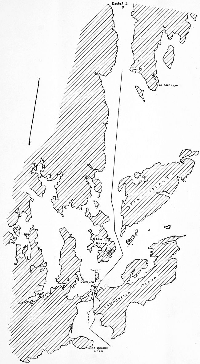
Sketch Map of Passamaquoddy Bay showing proposed Boundary with alternate lines
below and above Lubec.
Transcriber’s Note:
Variations in hyphenation and compound words have been preserved.