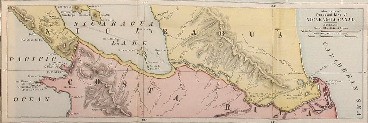
The State of Costa Rica.
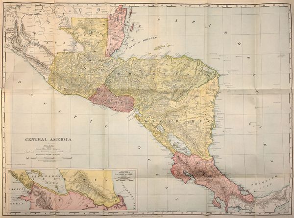
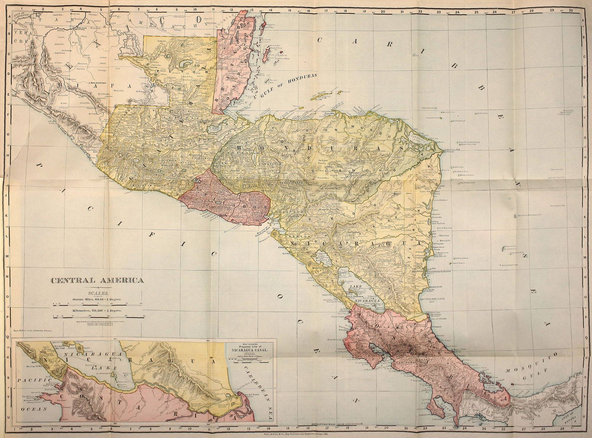
Costa Rica, the southernmost Republic of Central America,
is advantageously situated within the North tropical zone,
adjoining Colombia, the most northern state of South America.
It is between the two great oceans, having also the prospect
of one inter-oceanic ship-canal at one extremity and another
ship-canal near the other.
Costa Rica is between 8° and 11° 16′ N. latitude
and 81° 35′ and 85° 40′ W. longitude from Greenwich. Its
area is between 54,070 and 59,570 sq. kilometers, the difference
arising from the boundary line unsettled with Colombia.
We follow here Colonel George Earl Church’s paper
in the London Geographical Journal of July, 1897, which
gives in a condensed form all important results of extensive
explorations by Professor H. Pittier as well as well-written
abstracts of important publications of the “Instituto fisico geografico
Nacional” and of the “Museo Nacional” of Costa Rica.
The mountains of Costa Rica are not a continuous Cordillera,
although in general they extend from the frontier of
Colombia to within a few miles of Brito. The entire country
may properly be divided into two distinctive groups by a
natural line running between the mouths of the Reventazon
and Rio Grande de Pirris; groups which can be called “volcanic
mountains” or “mountains of the northwest,” and “Talamanca
mountains” or “mountains of the southeast.” It is
clear that the Caribbean Sea once joined the Pacific
Ocean through this valley of the river Reventazon in which
the Costa Rica Railway now climbs to reach Cartago. In
weighing existing data there seems to be no room for doubt
that the highlands of Costa Rica once formed part of a vast
archipelago extending from Panama to Tehuantepec. The
lowest inter-oceanic depressions between the Arctic Ocean
and the Straits of Magellan are the divide between the two
oceans at Panama which is 286 feet above the sea-level, and
the narrow strip of land separating Lake Nicaragua from the
Pacific, which has only about 150 feet elevation.
The “volcanic mountains” or “the mountains of the
northwest” can again be divided into two sections. The first
comprises the part situated between the Rio Reventazon and
a depression which connects San Ramon with the water-shed
of San Carlos, including the groups of the volcanoes Turialba
(11,000 feet), Irazú (11,200 feet), Barba (9335 feet) and Poas
(8675 feet). The second section comprises the part which extends
from the Barranca River to the Lake of Nicaragua with
the groups of Tilaran, Miravalles, La Vieja and Orosi.
The first section may be called “Cordillera Central” or
“Cordillera del Irazú” and the second “Cordillera del Miravalles.”
The three masses which form the volcanic Cordillera
of Irazú are separated by two depressions: first by that of
La Palma, 1500 meters above the sea, between Irazú and
Barba, and second by that of Desengaño, 1800 meters above
the sea, between Barba and Poas.
The basis of the two western masses seems to be formed
of basaltic rocks, while the trachytes dominate in the eastern
mass. Irazú and Turialba, which is part of the same mass,
seem to have ejected lavas in a compact state. The height of
volcanoes diminishes towards the west.
The three orographic groups which dominate the
northern central plateau do not show the regular conical form
which usually characterizes a volcano. The general line of
the southern slopes ascends in an imperceptible manner towards
the summit, notwithstanding that they are composed of
a succession of terrace plains. On the Irazú, for instance,
eight such terraces are observable from Cartago to the summit.
The northern declivity is more precipitous, being over
60° on the Irazú.
The peak of the Irazú is a point from which go various
spurs and secondary mountains in opposite directions, one
to the west and one to the east, the latter terminating in a
crater where the Parismina River takes its origin. The western
mountains trend first in a westerly direction to the Cerro
Pelon, where they divide, one part descending south to the pass
of Ochomogo, 1540 meters above sea-level; the other, after
taking a northwesterly direction, terminating in the plain of
La Palma, which is a part of the water-shed of the two
oceans. On the south various mountains follow the rivers
Pirris and Turialba. The Irazú has various craters, formed
successively, each one contributing to the gradual rising of
the mass.
The Irazú, which had eruptions in 1723, 1726, 1821 and
1847, has now an altitude of 3414 m. (11,200 feet), and from its
summit both oceans are visible, and also the great valleys of
San Juan and of Lake Nicaragua, as well as the mountains of
Pico Blanco, Chirripo, Buena Vista and Las Vueltas.
Turialba had a famous eruption of sand and ashes which
began on the 17th of August, 1864, and lasted to March,
1865. Its heaviest ejected matter fell to the west, and Seebach
classifies it as andesite. Another eruption, occurring on
February 6, 1866, was accompanied by heavy earthquakes
and sent its ashes as far as Puntarenas.
The Cordillera del Miravalles commences with the volcano
Orosi, situated near the southwest extremity of Lake
Nicaragua. In its southeast trend it recedes more and more
from the lake and the San Juan River. It is an irregular,
broad and volcano-dotted chain, about sixty geographical
miles long, breaking down gradually on the northwest from
Orosi to the Sapoa River, one of the southern boundaries of
Nicaragua. In this short distance are found the Cerro de la
Vieja (6508 feet), the Montemuerto (8000 feet), the beautiful
volcano Tenorio (6700 feet), the volcanoes Miravalles (4665
feet), the Rincon (4498 feet), and the Orosi (5195 feet).
These mountains, as far as they have been examined, are
found to be of eruptive origin, basalts and trachytes predominating,
but extensive sedimentary rock formations are also
found upon their slopes, as well as vast deposits of boulders,
clay, earth and volcanic material.
The peninsula of Nicoya, forming a part of Guanacaste,
is partly an elevated plain and partly consists of hills and
mountain ridges seldom attaining a greater elevation than
1500 feet. It is also composed of eruptive rocks and sedimentary
formations, the latter being especially visible in the
valley of Tempisque.
Between the northern volcanic section and the more
regular Talamanca range is the notable “Ochomogo” Pass,
about twenty miles broad, and a little more than 5000 feet
above the sea-level at the water parting.
To the eastward through this gap, and in a broad, deeply
eroded valley, runs the tumultuous Reventazon River, and to
the westward the Rio Grande de Pirris. On the south of this
depression the Chirripo Grande mountain mass sends off
east and west two immense flanking ranges. A part of the
western range, lying between San Marcos and Santa Maria,
for a length of about six miles, is known as the Dota ridge, to
which former explorers gave great importance.
This lofty, transverse and precipitous mountain system
almost forbids communication between the northern and
southern halves of the Republic, and, as Colonel Church says,
must at all times have had a marked influence on the movement
of races in this part of Central America. Both the
northern and Talamanca sections present mountains in masses
instead of sierrated like many Andean chains of North
America. Those of the Talamanca section are Rovalo
(7050 feet), Pico Blanco (9650 feet). Chirripo Grande (11,850
feet) and Buena Vista (10,820 feet). There are no signs of
recent volcanic activity in the Talamanca range. The Talamanca
mountains have narrow crests and are very precipitous
on the Atlantic side, with evidences of extensive denudations
and erosions caused by the ceaseless rain-laden
trade-winds.
Professor William M. Gabb, in his geological sketch of
Talamanca, observes that the geological structure of the entire
region is very simple. The greatest expanse is occupied
by recent sedimentary rocks raised and nearly entirely metamorphosed
by the action of volcanic masses.
At several points along the Atlantic coast, there are
found masses of rocks of still later date. Professor Gabb
maintains that the nucleus of the great Cordillera of the interior
is formed by granites and syenites, which, like the sediment
that covers them, are broken through here and there
by dikes of volcanic origin identical with the eruptive material
found on a greater scale in the northern part of Costa
Rica. The syenites are intrusive and have their culminating
point and greatest development in the Pico Blanco or Kamuk,
a mountain of great altitude, unusual ruggedness and scarred
with deep and precipitous cañons. All these dikes are of
more modern formation and are porphyritic. Professor Gabb
also notes a thick deposit of conglomerates and sandstones,
schists and limestones, the schists being the most abundant;
although the conglomerates, found all over the region, indicate
the previous existence of an older sedimentary formation.
The pebbles which form the conglomerates are composed
of metamorphic clay, having a character distinct from all the
other rocks found in the country. The cement is also clay
or sand. The absence of crystalline rocks in the conglomerates
is irrefutable proof that, when these were deposited, the
syenites and granites had not yet appeared from the interior of
the earth. The limestone and sandstone represent a less developed
geographical horizon of the sedimentary group, the
latter appearing occasionally in layers, interstratified with
conglomerates or more recent schists. In no place in Talamanca
have fossils been found in these sandstones, although
the same rocks are very fossiliferous near Zapote on the River
Reventazon.
In regard to fossils, Professor Gabb saw at Las Lomas
Station, about seven hundred feet above the sea, in the Bonilla
Cliffs cutting, shark’s teeth, compact masses of sea shells,
fish, etc., and at an elevation of 2500 feet large deposits of
compact shell limestone.
The schists have a fine, leaf-like texture, and are easily decomposed
and reduced to a black mud, if they have not been
metamorphosed. In this rock fossils have been found which
belong to a Miocene age.
Along the Talamanca coast calcareous deposits are
found in horizontal layers, and are probably elevated coral
reefs, a rock which Professor Gabb calls “antillite,” and
which is developed in the entire Caribbean region. It belongs
to the post-Pliocene formation, the last of the Tertiary
series.
In the interior valleys a thick deposit of pebbles and clays
of recent origin is observed. The limit between the syenites
of the high mountains and the metamorphosed Miocene
formation is found in proximity to the Depuk River. In
the slopes of the hills the schists are usually decomposed and
covered with red clay, a sub-soil above which is found a small
cap of fertile vegetable mold. In the valley of Tsuku the
schists are profoundly altered and transformed in a magnesic
or semi-talcous rock. The schists are more silicified in
coming near to the limits of the syenites.
Higher up, the granitic rocks extend in the direction of
the Pico Blanco without interruption. The Pico Blanco itself
is of granite. Three hundred feet below the summit porphyry
is observed, while the summit itself shows a greenish-brown
trachyte with black spots.
In regard to the Pacific side of this Talamanca section,
Professor H. Pittier says, “The southern coast Cordillera, as
a whole, is formed of a nucleus of basaltic or syenitic rocks,
above which are found successively limestone in very deep
banks and sometimes fossiliferous: then argillaceous and
marly schists; again, sandstone and conglomerates, the latter
forming generally the crests of the hills and giving way very
easily to atmospheric action, which produces its decomposition
and is the cause of sterile lands characterized by
savannas and the absence of forests on the upper parts of the
mountains, as well as in certain lower and denuded parts.
The conglomerates are made up of heterogeneous elements
whose resistance to erosion is variable. Some disintegrate
as soon as they are exposed to erosion, while others remain
unaltered for a long time. For this reason the savannas
are in many places covered with stones of varied sizes.”
The lower valley of the Pirris presents a cap of impervious
red clay, and, as the waters do not readily drain off
they become stagnant and make an unhealthy district.
Dr. Frantzius, referring to the same region, speaks of
diorites and syenites, also of calcareous deposits of the
Miocene age covered with sandstone formations containing
useful lignites. In his opinion the mountain of Dota is
formed almost entirely of dioritic rocks with some syenitic
nucleus. The same scientist says further that the high plains
of Caños Gordas are formed of conglomerates of ashes ejected
by the volcano of Chiriqui and brought there by the trade-winds
which prevail in Central America.
The Pacific slope, which comes boldly to the water’s
edge, is margined almost throughout by headlands and lofty
hills, and has fewer evidences of extensive denudations and
erosions than the Atlantic coast.
There is also a notable difference between the outlines of
the two coasts. The eastern is regular and slightly concave
to the southwest, while the western is indented with large and
small bays and gulfs.
The most northern of these bays is the Salinas, belonging
partly to Nicaragua and partly to Costa Rica. It is a
spacious deep-water harbor, overlooked by the volcanic peak
of Orosi. It is separated from the adjoining bay, the Santa
Elena, by Sacate Point.
Continuing south, we come, south of Cacique Point, to
Port Culebra, which is a mile wide, with a depth of eighteen
fathoms. At the outlet of this harbor lies Cocos Bay, capacious
enough for a thousand ships to anchor in the roadstead.
The coast line south of Cocos Bay, bordered by numerous
and lofty hills and cut into gorges by small impetuous
water courses, presents no harbor as far as Cape Blanco,
which is at the western entrance of the extensive Gulf of
Nicoya. The gulf extends fifty miles to the northwest and is
a magnificent sheet of water, surrounded by green scenery,
rivaling, if not surpassing, that of the Bay of Naples, the
Bosphorus, or the harbor of Rio de Janeiro. Some twenty
islands, large and small, nearly all bold, rocky and covered
with vegetation, contribute to its beauty, while many small
rivers, draining the slopes of the Miravalles and Tilaran
sierras and the mountains of the peninsula of Nicoya, flow
into it and diversify the scenery. The principal river, the
Tempisque, enters at the head of the gulf, and with numerous
small branches irrigates much of the province of Guanacaste.
All of the streams have bars at their mouths, composed
generally of mud and broken shells, and but few of them are
navigable even for a short distance inland, and then by very
small craft. The whole eastern part of the peninsula of
Nicoya is broken into hills and low mountains, wild and
rarely cultivated, although there are many beautiful and fertile
valleys. The west side of the gulf is full of reefs, rocks,
violent currents, eddies that run from one to three and a half
miles an hour, and is subject to violent squalls coming from
the northwestern sierras. The eastern shore is less beset by
obstructions, and small craft go along it with ease, and at high
tide penetrate a few of its many rivers. It rises rapidly a short
distance inland, but is at times bordered by mangrove
swamps.
Near the mouth of the river Aranjuez, on a sand spit
three miles long, stands Puntarenas, the only port of entry of
Costa Rica on the Pacific coast, and which had, from 1814
until recently, nearly the entire foreign trade of the country.
Ocean vessels anchor from one to two miles off in the roadstead.
There is an iron pier for loading and discharging.
From Puntarenas southward to the unnavigable Barranca
River there is a broad beach lying at the foot of the
high escarpment of Caldera.
The Rio Grande de Tarcoles, which enters the gulf south
of the Barranca, has a dangerous bar, but once inside it may
be navigated a few miles. Its upper waters irrigate the table-land
of San José, Alajuela and Heredia. In the neighborhood
of these towns is garnered nearly the entire coffee crop
of Costa Rica. The coast line south is rocky and precipitous
until near Punta Mala, or Judas, at the southeastern mouth
of the gulf, and is low and surrounded by reefs and rocks.
From Point Judas, low and covered with mangrove
swamps, the coast trends southeast in a long angular curve for
about one hundred marine miles to Point Llorena. It is dominated
by lofty hills, cut through at intervals by short impetuous
streams and a few estuaries. The only safe and excellent
anchorage in this one hundred miles is Uvita Bay, behind
a rocky reef. From the precipitous headline, called
Punta Llorena, to Burica Point, the southern limit of Costa
Rica, the coast is abrupt, soon rising into ridges and peaks
from 300 to 700 meters high (985 to 2300 feet). These give
birth to a few short turbulent streams. About half way between
these two points the great Golfo Dulce, having a main
width of six miles, penetrates inland northwest about twenty-eight
miles. It has an average depth of one hundred fathoms.
Cape Matapalo, which marks its western entrance, is
deep and forest-covered, but Banco Point, opposite to it, is
low. At the head of the gulf is found the little Bay of Rincon.
From here to the Esquinas River, at the northeast angle of
the gulf, the shore is hilly, and thence to the harbor of Golfito,
which is surrounded by high hills, the country rises rapidly
inland, but between Golfito and the entrance to the gulf it is
lower and less broken, and thence to Platanal Point and
Burica Point, the coast is bold, the country descending gradually
from the northeast.
From Point Llorena to Point Burica the coast is wild
and almost uninhabited. The coasts of Golfo Dulce have but
a few hundred half-breeds as their sole occupants.
There are but two rivers in the long coast line from the
Gulf of Nicoya to the Golfo Dulce, the Rio Grande de Pirris,
and the Rio Grande de Terraba, the head waters of the former
flowing through deep canyons with steep sides, which are
almost bare of vegetation until the region of Guaitil is
reached, where dense forests are encountered. The valley of
the Rio Grande de Terraba is one of the most beautiful, extensive
and fertile of Costa Rica, but is occupied by only
a few families. Formerly it was the home of a large indigenous
population.
In the angle made by the River Buena Vista and Chirripo
there is a vast ancient cemetery, the graves of which contain
many ornaments of gold, principally eagles. An ancient road
runs by near this place.
Turning to the hydrographic basin of the San Juan River
and Lake Nicaragua, the northeastern slope of the Miravalles
range is found to send off several small streams to the lake.
Between Cuajiniquil, two and one-fourth miles east of
Rio Sapoa, and Tortuga, six miles further east, are the little
streams, Lapita, El Cangrejo, Puente de Piedra, La Vivora,
Guabo, Genizaro and Tortuga, the latter the greatest in volume,
being about one hundred and sixty feet wide at its
mouth and navigable. In the further distance of seventeen
miles going east, we cross the rivers Zavalos, Cañitas,
Quesera, Mena, Mico, Sapotillo, Quijada, Quijadita, Santa
Barbara, Sardinia, Barreal, Cañas, Perrito and, finally, Las
Haciendas which is navigable by small boats. From here to
San Carlos, at the outlet of Lake Nicaragua, the distance is
sixty-four kilometers, and the principal rivers which cross
this tract are El Pizote, Papalusco, Guacolito, Zapote, Caño
Negro and Rio Frio. The Rio Frio is of considerable magnitude,
and with its many branches drains a large area of the
territory lying on the slopes of the volcanoes of Miravalles
and Tenorio. It pours much sedimentary matter into Lake
Nicaragua, and has thrown an extensive mudbank across the
lake entrance to the River San Juan.
For three or four miles above the mouth of the River
Frio the lands are low and swampy. Several of its branches
can be reached and navigated by canoe, and even a small river
steamer can ascend a few miles from the lake.
The San Carlos River joins the San Juan sixty-five
miles from Lake Nicaragua. The depth of its mouth, which
is obstructed by a sand-bar, varies from eight to twenty feet,
according to the season.
The San Carlos has numerous affluents which at times
have a volume of water altogether disproportionate to their
lengths. The distance up to the first rapid of the San Carlos
River, which is at El Muelle de San Rafael where there are
from four to six feet of water is roughly fixed at sixty-two
miles by the course of the river. Small steamers could
reach this point, although with difficulty on account of many
snags. The floods sometimes rise to their full height in
twenty-four hours and carry with them a great number of
trees and much sand, from which floating islands are formed.
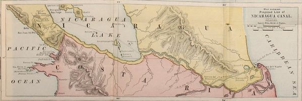
Should the plans of Engineer Menocal for the Nicaragua
Canal be realized, the waters of the upper San Juan and the
lower San Carlos would be impounded and form an arm of
Lake Nicaragua, which would flood a large area in Costa
Rica. The interval between the San Carlos and the River
Frio is an extensive forest, covering an undulating plain with
occasional low hills and watered by numerous little streams.
This territory is fertile and beautiful.
The next great river, the Sarapiqui, reaches the San Juan
about twenty miles east of San Carlos. It is 600 feet wide at
its mouth, and has numerous affluents from the sides of the
volcanoes Poas, Barba and Irazú, the principal ones being
the Toro Amarilla and Sardinal from the west, and the River
Sucio from the east. The river is navigable for large canoes
up to its confluence with the Puerto Viejo. Its banks as
high up as to the River Sucio are low. The lands are extremely
fertile. El Muelle Nuevo is the head of navigation,
forty-five miles from the River San Juan and sixty-six miles
by the road across the mountains from San José.
From the Sarapiqui River to the River Colorado, a
branch or bayou of the San Juan, the banks of the latter in
Costa Rica are but slightly elevated. The lands are low and
swampy, but occasionally a hill is found from fifteen to
eighteen feet high.
Below the Machuca Rapids the San Juan River is broad
and deep as far as the junction with its Colorado outlet, about
seventeen miles from the sea. Here it turns about nine-tenths
of its volume of water into the Colorado. It is navigable for
river steamers at all seasons, but has a dangerous bar at its
mouth where the sea breaks heavily, and on which there are
only from eight to nine feet of water.
From the Colorado Junction to Greytown, some twenty
miles distant, the San Juan averages about three hundred
feet in width for sixteen miles and 100 feet for the remaining
four, with a depth at high water of from six to eight feet.
The Colorado has several islands in its course, but has
excellent anchorage at its mouth. This river forms several
lagoons which communicate with each other by caños or
bayous perfectly navigable, the principal being the Agua
Dulce, a short distance from the sea, eleven miles in length,
800 feet in width and from ten to forty feet in depth.
Passing from the difficult Caño de la Palma in the
midst of swamps, the Caño de Tortuguero is reached, the
entrance to which from the sea is called Cuatro Esquinas.
It is approximately thirty-eight miles long, about one thousand
feet in width, with a depth of from fifty to sixty feet.
The rivers Palacio and Penetencia, navigable for boats,
empty into this caño. The River Tortuguero, which gives
name to the plains watered by its affluents, is formed from several
of these caños, as the Caño Desenredo, Caño Agua Fria
and Caño de la Lomas. The Caño de Tortuguero communicates
with the Parismina by the caños California and Francisco
Moria Soto, which are also navigable. The margins of
the Parismina are swampy. It has as its affluents the Guasimo,
Camaron, Novillos and the Destierro.
The lower district drained by the Tortuguero is raised
but little above the ocean, and in flood time the river communicates
by several caños with the Matina and with the
delta of the Colorado, as well as with the lagoon of Caiman,
lying south of the Colorado. Its numerous upper streams
rise in the spurs of Irazú and Turialba.
The Sierpe and Parismina rivers flow into the sea south
of Tortuguero. The former is short, but the Parismina with
its several branches is a child of Irazú. Its lower course is
sometimes considered to be a part of the River Reventazon,
which however has its confluence with the former a few
miles from the sea.
The Reventazon River has carved its way to a profound
depth around the south and southeastern bases of Irazú and
Turialba, and, flanking the latter volcano, it turns northward
to join the Parismina. It receives many tributaries from the
northern slope of the Talamanca range, and interweaves its
head waters with those of the Rio Grande de Tarcolles and
the Rio Grande de Pirris, which flow into the Pacific Ocean.
The Pacuare River, once known as Suerre, enters the
sea about half way between the mouth of the Reventazon and
that of the Matina. Its waters, in 1630, instead of flowing
to the sea, joined the Reventazon, closing the port of Suerre,
but in 1651 Governor Salinas closed the northern channel,
deflecting its waters and restoring the port.
The Matina River is a short stream with a large volume
of water, which enters the sea just north of Port Limon near
the roadstead of Moin, where, up to 1880, ocean craft anchored.
The River Matina is navigable by small steamers
over the bar and by large ones above the bar to the point
where it receives its principal affluents, the Chirripo, Barbilla
and Zent. It yearly overflows its lower valley, depositing an
inch or two of exceedingly fertile mud highly appreciated
by the banana planters.
The entire mainland of the coast, from the River Colorado
to the Matina, is separated from the Caribbean Sea by
a continuous narrow sand bank, between which and the mainland
is a lagoon, said to be navigable the whole distance by
boats. The intermediate rivers pour into this narrow lagoon,
driving their currents across it, and, cutting through the sand
bank, enter the sea. Sometimes a violent gale closes one of
the openings, which are all shallow, but the river again forces
an exit to the ocean through the obstruction. This whole
coast for sixty-five miles, is forbidding and dangerous, and has
but little depth of water within a mile of the shore, upon
which a monotonous, heavy surf breaks during the entire
year. It is only frequented from April until August by fishermen,
who find their way to the River San Juan through the
intricate system of rivers and caños described.
Port Limon, in latitude 10° north and longitude
83° 3′ 13″ west from Greenwich, is the only port of entry of
Costa Rica on the Caribbean Sea. The first house was built
there in 1871. The harbor faces the south, and is formed by
a little peninsula on which Limon is situated. It is behind a
narrow coral reef. The site, which now has perhaps 3500
to 4000 population, is being raised with earth about four
feet, and its port will become one of the smoothest of the
Caribbean Sea. A small island, called Uvita, lies east at a distance
of 3660 feet from the town. Port Limon has a wooden
pier 930 feet long, accommodating two sea-going ships, but
an iron pier is about to replace it, which will berth four large
ones of deep draught.
The Talamanca coast lying south of Limon is low, flat
and swampy, except where it is broken by hills. The little
River Banana is the first one met with going south, and its
valleys produce large quantities of timber and bananas. Next
comes the Estrella, also a short stream; then follows the
Teliri, called in its lower course the Sicsola. It is the
largest stream in Costa Rica south of Port Limon. It runs
along the southern base of the great eastern mountains of the
Talamanca range, through a spacious, undulating, wooded
valley of 100 to 150 square miles area, partly low grounds
in some places dry and in others swampy. It has several
branches, like the Uren coming from the slopes of the
Pico Blanco, the Supurio and others. At the entry of the
high valleys of the Teliri and Coen rivers, the pyramid-like
mountains of Nefomin and Nenfiobete appear, at the foot of
which the interior plain of Talamanca, fifteen kilometers in
length and eight kilometers in width, extends from southwest
to northeast, and so uniformly that the water courses run
indifferently and frequently change their beds.
Southward of Sicsola is the Tilorio or Changuinola,
which makes a turbulent way to the sea from the Talamanca
mountains. Along its lower margin mud flats
spread to a great width, and, from its mouth towards the
northwest, cover a region which surrounds also the lagoon
of Sansan, and extends up the rivers Zhorquin and Sicsola.
Behind the muddy zone the lands rise rapidly into hills, which
in a few miles reach an altitude of several thousand feet, at
times intermingling with the Cordillera. Along the entire sea
margin of Talamanca runs a narrow sand-belt of firm land,
at times not a hundred feet wide, like that described between
the Matina and San Juan rivers.
Within this sand-belt are long, narrow, deep lagoons
filled with half-stagnant water from the mud flats. These
lagoons usually open into the rivers which descend from the
mountains.
Between the Sicsola and the Tilorio lies the already
mentioned, crooked and deep lagoon called the Laguna de
Sansan.
At Limon, Cahuita and Puerto Viejo, the hills, which are
connected by spurs with the more elevated country of the
interior, extend to the ocean coast. Between them, in plains
extending from one to five miles inland, are forest-covered
swamps, overflowed with not less than ten feet of water in
the rainy season and only traversable in the dry.
Costa Rica claims sovereignty on the Atlantic side
southeast as far as the Island of Escudo de Veragua, including
the ancient Ducado de Veragua, whose frontier follows
the coast of Chiriqui Viejo to the crest of the Cordillera, and
crosses it to the head waters of the River Calobebora, then
down this stream to the Escudo de Veragua.
Since their independence Colombia and Costa Rica have
been in dispute in regard to their boundary line. Colombia
has never ceased to claim jurisdiction over the entire Caribbean
coast of Costa Rica, and even over that of Nicaragua as
far north as Cape Gracias á Dios. In November, 1896, both
governments signed a convention submitting their dispute
to the arbitration of the President of the French Republic, or,
in the event of his failure to act, to the President of Mexico
or of the Swiss Confederation.
The principal lakes of Costa Rica are the Laguna Manatí,
northwest from the Sarapiqui River; the Lagunas de Poas
and de Barba, each on a volcano bearing its name; Lagunas
de Sansan and Samay, towards the east and near the Sicsola
River, in Talamanca; Laguna Tenoria, in Guanacaste; Laguna
San Carlos, in the plains of San Carlos; Laguna de
Arenal, between Las Cañas and San Carlos, and Laguna de
Sierpe, in the south, northward from the Golfo Dulce.
Far away from Costa Rica, in the Pacific Ocean, lies the
Cocos Island, about two hundred and sixty-six miles to the
southwest of the Golfo Dulce, in N. latitude 5° 32′ 57″ and
longitude 86° 58′ 25″ W. of Greenwich. Its highest point
reaches 2250 feet, whence the descent is gradual to a bold,
steep coast, which has many irregularities and rocks and a
surf-beaten shore. Chatham Bay is its best harbor, having
room for a dozen ships. The interior is broken into numerous
fertile valleys, but there is probably not a square kilometer
of level ground in the entire island. Other islands are
Chira, Venado, San Lucas, Caño, etc.
Mineral Wealth.—In regard to the mineral wealth of
Costa Rica, petroleum has been discovered near Uruchiko
on the Talamanca coast, and coal in certain sandstone formations
on both the Atlantic and Pacific sides of the Talamanca
section.
In the province of Alajuela, a little to the north of the
cart-road which runs from San José to Puentarenas, is Monte
Aguacate, part of an old mountain range which extends far
to the northwest, and not very distant from the Gulf of
Nicoya. In general, it is of metamorphic formation, principally
of diorite and porphyry.
Here, in a good climate, at 2000 feet elevation, are found
auriferous veins of great richness. They are of quartz mixed
with decomposed feldspathic rocks, and have yielded very lucrative
bonanzas. The first mine was Guapinol, one bonanza
of which produced $1,000,000. Several other mines were
worked, from one of which (Los Castros) $2,000,000 were
taken in a few years. It is estimated, from the best data obtainable,
that about £1,000,000 have been taken from Monte
Aguacate. Several of these veins are from six to seven feet
wide, but that called the Quebrada Honda is sixteen feet wide.
Most of the ore is of a high grade and of refractory character.
It is probable that the whole southwestern slope of the
Guatusos and Miravalles ranges of mountains is auriferous.
The rocks in the northwestern extension of this district consist
principally of feldspar, porphyry, basalt and dolorite.
The gold veins nearly all ran northeast and southwest,
and are encased in feldspar, sometimes in porphyry, and occasionally
in basalt. They consist, in great part, of crystalline
quartz, and are from two to forty feet wide. Professor Pittier
also found gold in the slopes of the Buena Vista mountain.
Gold is further found in the Talamanca mountains, especially
in the placer grounds of the Duedi River, and on the inferior
hills between the Lari and Coen rivers.
Along the latter, and near Akbeta, also on the shore of
Puerto Viejo, iron exists.
Copper and silver, Professor Pittier says, have been discovered
in Diquis, between Paso Real and Lagarto, and
native copper in Puriscal. Other mines are included in the
following table:
The Principal Mines Registered in 1892.
|
| Name of Mine. |
Canton. |
Location. |
Product. |
|
| La Trinidad |
Esparza |
Rio Ciruelitas |
Gold and silver ores. |
| La Union |
Puntarenas |
Shores of Rio Seco |
” |
” |
| Sacrafamilia |
Alajuela |
Monte de Aguacate |
” |
” |
| La Minita |
” |
” ” |
” |
” |
| Mina de los Castros |
” |
Corralillo |
” |
” |
| San Rafael |
” |
” |
” |
” |
| Mina de los Oreamuno |
” |
” |
” |
” |
| Quebrada Honda |
” |
Quebrada Honda |
” |
” |
| Machuca |
” |
Corralillo |
” |
” |
| Trinidad de Aguacate |
” |
” |
” |
” |
| Peña Grande |
San Ramon |
Cerro de San Ramon |
” |
” |
| Mina de Acosta |
” |
Shores of Rio Jesus |
” |
” |
| Palmares |
” |
Cordillera de Aguacate |
Gold, silver and lead ores. |
| Las Concavas |
Cartago |
Rio de Agua Caliente |
Copper ore. |
| Mancuerna |
Sardinal |
Sardinal |
” |
|
| Mata Palo |
” |
” |
” |
|
| Puerta de Palacio |
” |
” |
” |
|
| Hoja Chiques |
” |
” |
” |
|
| Chapernal |
” |
” |
” |
|
| |
It should be stated that, with the exception of gold and
some silver, little is mined. The deposits of coal, petroleum,
copper and silver have thus far yielded, under present methods
of management, outputs of no commercial value.
However, anthracite is found at Santa Maria Dota, Department
of Puriscal. A specimen of it, analyzed by Dr.
L. J. Mátos, chief of the laboratories of the Philadelphia Commercial
Museum, gave these results:
It is a good quality of anthracite coal and compares very
favorably with the best grades that are mined in Pennsylvania.
Color, black; slight tendency to show iridescence;
fracture, conchoidal, brittle; analysis, specific gravity, 1,343;
weight per cubic foot, 83.93 pounds.
Proximate composition:
| Moisture |
2.60 |
per cent. |
| Volatile matter |
3.56 |
” |
| Fixed carbon |
88.20 |
” |
| Ash |
5.64 |
” |
| Total |
100 |
” |
| Sulphur |
.4319 |
” |
| Coke |
93.84 |
” |
| Coke per ton of coal |
2002.01 |
pounds. |
| Fuel value |
9.14 |
” |
| Fuel ratio |
1 : 24.77 |
|
There are to be mentioned also some mineral waters, as,
for instance, those near the mouth of the Isqui River, on the
Talamanca coast; those in Agua Caliente, about five miles
from the City of Cartago and belonging to the Bella Vista
Company; those of Orosi and Salitral, of Poas, Miravalles,
Ausoles, Bagaces, San Carlos, Liberia, San Roque, etc.