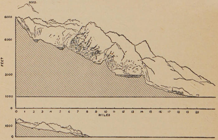
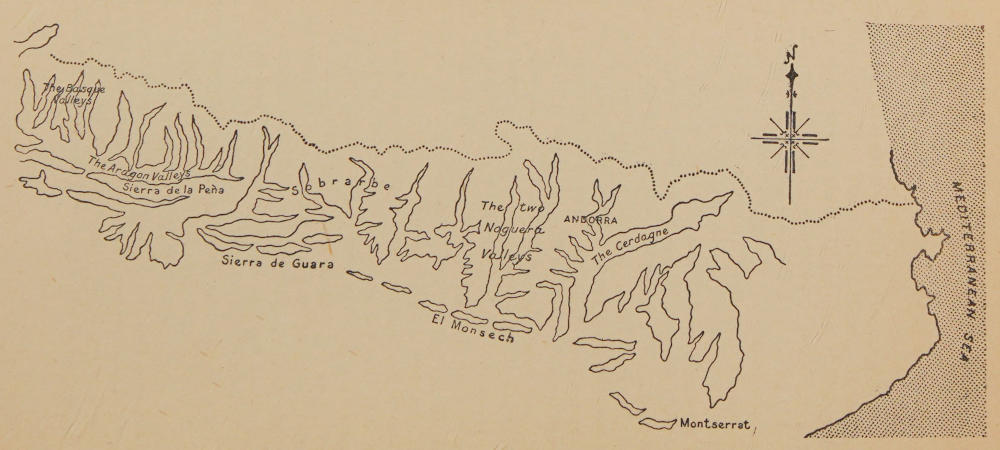
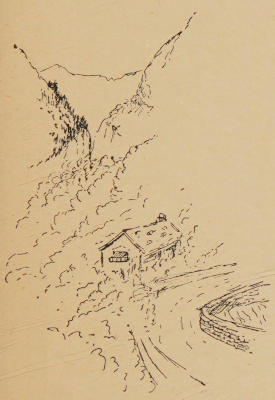
WITH NUMEROUS SKETCHES
BY THE AUTHOR AND TWENTY-TWO MAPS
FOURTH EDITION
WITH A NEW PREFACE
METHUEN & CO. LTD.
36 ESSEX STREET W.C.
LONDON
First Published (Demy 8vo)
June 3rd 1909
Second Edition
June 1916
Third Edition (Crown 8vo)
April 1923
Fourth Edition (Crown 8vo)
1928
PRINTED IN GREAT BRITAIN
TO GILBERT MOORHEAD
IN PIOUS MEMORY OF PAMPLONA, ELIZONDO,
THE CANON WHO SHOT QUAILS WITH A
WALKING-STICK, THE IGNORANT HIERARCH,
THE CHOCOLATE OF THE AGED WOMAN,
THE ONE-EYED HORSE OF THE PEÑA
BLANCA, THE MIRACULOUS BRIDGE, AND
THE UNHOLY VISION OF ST. GIRONS.
PREFACE — PREFACE TO THE THIRD EDITION — PREFACE TO THE FOURTH EDITION — (1) General — (2) Roads — (3) Railroads — (4) Inns — (5) Maps
The only object of this book is to provide, for those
who desire to do as I have done in the Pyrenees, a
general knowledge of the mountains in which they
propose to travel.
I have paid particular attention to make clear those
things which I myself only learned slowly during several
journeys and after much reading, and which I would like to
have been told before I first set out. I could not pretend
within the limits of this book, or with such an object in view,
to write anything in the nature of a Guide, and indeed there
are plenty of books of that sort from which one can learn most
that is necessary to ordinary travel upon the frontier of
France and Spain; but I proposed when I began these few
pages to set down what a man might not find in such books:
as—what he should expect in certain inns, by what track he
might best see certain districts, what difficulties he was to
expect upon the crest of the mountains, how long a time crossings
apparently short might take him, what the least kit was
which he could carry into the hills, how he had best camp and
find his way and the rest, what maps were at his disposal,
the advantages of each map, its defects, and so forth. The
little of general matter which I have admitted into my pages—a
dissertation upon the physical nature of the chain, and a
shorter division upon its political character—I have strictly
limited to what I thought necessary to that general understanding
of a mountain without which travel upon it would
be a poor pleasure indeed.
If I have admitted such petty details as the times of trains,
and the cost of a journey from London, it is because I have
found those petty details to be of the first importance to
myself, as indeed they must be to all those who have but little
leisure. I have in everything attempted to set down only
that which would be really useful to a man on foot or driving
in that country, and only that which he could not easily
obtain in other books. Thus I have carefully set down
directions as minute as possible for finding particular crossings
and camping grounds, for the finding of which the
ordinary Guide Book is of no service. My chief regret is that
the book will necessarily be too bulky to carry in the pocket;
for it is meant to be not so much a lively as an accurate
companion to the general exploration of those high hills
which have given me so much delight.
This third edition of my book on the Pyrenees
necessarily suffers somewhat from the fact that it is
published after the interval of the Great War.
The book in its original form was written in the course of
1908-09, and contained a number of particular details on
prices, etc., which the war has completely changed. These
I have had to revise only approximately, for the value of the
franc still fluctuates violently. But the present conditions
of currency in Europe are not permanent. In other matters
the book is as applicable to the present condition of the
Pyrenees as it was to that thirteen or fourteen years ago.
The road system is the same, and though one or two of the
inns may have changed hands, the account of these I give
holds in the main. There have been no new maps issued,
either, since the date on which the book was written. I have
not added anything on the present system of passports, because
that also presumably will be out of date in a short
time; but I may mention that at the moment of writing
these lines (September, 1922), it is advisable to have one’s
passport viséd to Spain before visiting the mountains. Even
if the reader has no intention of crossing the frontier he may
be compelled to do so under stress of weather, or he may
easily do so by error in the confusion of the higher valleys,
and in the first Spanish town he comes to his passport is sure
to be demanded.
The train service differs little now from what it was before
the war. The night and day services and the average number
of hours required for approaching the mountains from Paris
or London, are again much what they were fourteen years ago.
I write this Preface to the Fourth Edition after five
years.
My last note upon this book was written, as the reader
will see, for the Third Edition, in September, 1922. These
lines are written in November, 1927.
When I wrote my Preface to the Third Edition, Europe,
its currencies, and the rest, were still under the heavy disturbances
of the Great War. But things are now more
settled, notably currencies. Also a few more years of peace
have given both French and Spaniards the opportunity for
building new roads, and for extending the railway system.
In the notes I am about to add here I ought to make it
clear that I am writing principally by information rather than
by direct personal experience, and anyone who finds that
some point ought to be corrected or something added, and
who will communicate with the publishers, or with myself
care of the publishers, will be doing the future readers of this
book a great service. I am sure to be making some mistakes,
and the less there are in any future edition the better.
I humbly beg the reader to remember that the book was
written in the old days of peace, “before ever the sons of
Achaia came to the land.” It was also written when I was
a young man and could go over any number of miles on foot
in any weather and over pretty well anything—even the
worst steeps of the Canal Roya, though I have no claim to
climbing. To-day I can do none of these things, and have
to go by hearsay. I propose to divide what I have to say
into (1) general remarks, (2) additions to the road system,
(3) the (comparatively slight) changes in the railroad system
(including the change in the value of money and present
prices of tickets), (4) changes in inns (here I shall have to be
very tentative, for I have to go mainly by reports), and (5)
maps.
The political situation has so developed that it is no longer
advisable, as I formerly said, but necessary to have one’s
passport viséd for Spain before starting for the Pyrenees,
even if one has no intention of crossing the frontier. For,
as I said when the book was written, there are occasions
when the traveller on foot in the mountains may cross the
frontier unwittingly, and have to deal with the authorities
on the farther side. To this must be added the consideration
that a stricter central government in Spain, coupled
with occasional plots against it, has made the frontier
authorities particularly vigilant. They may take from a
traveller anything which looks like an offensive weapon—an
acquaintance of mine was deprived, for instance, of a
very large stick, and he might have fared worse with a very
large knife. It is well to remember that when you enter
Spain by this frontier you are coming in by its most remote,
least peopled, and most difficult area, and that one must have
nothing to explain if one can help it. I mean, of course,
when you enter over the main range; for the two main
roads and railways at either end of the chain by the sea-coasts
of the Atlantic and the Mediterranean are common
international highways.
Another point to remember, which is a small one but now
and then, though very rarely, important to the traveller, is that
the variation in the compass has changed since this book was
written. It was written twenty years ago, and was published
nearly nineteen years ago, and since then the variation of
the compass has lessened (for this part of the world) by
something like three degrees. The traveller must further
remember that (though it is not very strictly enforced) there
is a new law in France both for travellers proposing to reside
a certain time in the country and (this is strictly enforced)
a daily tax for travellers using foreign motor-cars in the
country; while all the Spanish corresponding regulations
have been tightened up. The wise thing to do, therefore,
if you mean to spend more than a fortnight in these hills
on either side of the border, is to inform yourself thoroughly
upon arrival of what is required of you. You can do it in
France easily enough; but as on the Spanish side the main
towns are a long way from the range, you will do well, if you
intend to spend any number of days to the south of the
frontier, to find out at the Spanish Consulate in London
or at your nearest large town what formalities may be
needed.
On the effect of the change in prices I deal elsewhere. But
there are two things to be remembered here, with one of
which most people are familiar, but the other of which most
people have not as yet appreciated. The first is that on the
French as on the Spanish side, but much more on the
French side than on the Spanish, the old unit of currency
does not mean, in gold, what it meant when this book was
written.
In France it means in gold only one-fifth at the present
apparently stabilized rate of what it meant when I first put
these pages together. We are on a gold basis in England.
A franc used, before the war, to be nearly 10d. It is to-day
almost exactly 2d. On the Spanish side the peseta fluctuates
somewhat, but at the moment of writing it is well below
thirty (twenty-eight odd), which means that the peseta,
once nominally equal to the franc, is between 8d. and 9d.,
or rather more than four times the present value of the
franc.
But the second point, which is much less generally appreciated,
is even more important to retain. Prices in gold
have changed. There are all sorts of views as to the real
amount of the change; but I think we are not very far wrong
in basing any calculation of expense upon a basis of doubling.
At any rate, if you do that you will not be disappointed.
The gold franc or gold peseta buys in 1927 more than half as
much, but not much more than half as much, as it did before
the war. In other words, the franc to-day is not in practice
half of a fifth, that is, one-tenth, of what it was before the
war, nor is the peseta in practice as little as fourpence halfpenny
compared with prices before the war. You get more
for your money than such a rough rule of thumb would
warrant. But remember that you are getting things cheaper
than the strict gold basis would allow. For instance, I know
of one particular inn on the French side of the frontier, high
up in the valleys (it is a very good one and a typical one),
where they charge for food, including wine, and lodging,
fifty to sixty francs a day. You would not have got the
same thing for five or six francs in 1914; but you would
have got it for seven or eight. My object in emphasizing
this is to prevent the traveller from thinking that under
modern conditions he is being bled. It is rather the other
way. He is getting things somewhat cheaper still in these
mountains than world prices would warrant. He must
expect to pay on the very different scale I have indicated.
Lastly, let me add in connexion with prices that, for a
variety of reasons which it would take too long to go into,
he must expect a very distinct rise in general expenses as
measured in English exchange when he passes from French
into Spanish territory. He must allow for something like
an increase of a third, and perhaps in the larger towns of a
half of what he pays on the French side.
Further, when he is looking for anything like luxury, even
in the humblest sense of that term, he must be prepared to
pay (e.g. for foreign wines, or for well-appointed travel by
car) nearly double on the Spanish side what he would have
to pay on the French.
The traveller should remember that there has been a very
great expansion of good roads on the Spanish side compared
with what there was when this book was written, and with
that has gone an almost universal system of motor-buses,
which have quite changed travel on the southern side of the
range. He will do well always to ask before trying to go by
the slow and few trains what the motor-bus services are.
Thus, in the old days when this book was written, a man had
either to go on foot or by slow horse vehicles across Roncesvalles
to Pamplona. To-day there is a first-rate service of
rapid motor-buses, and he will find that to be the case pretty
well everywhere between the Mediterranean end and the
Atlantic.
In the matter of new roads a great deal has been done
since this book was written. First and most important, one
can go by a good road now over the Bonaigua. I regret it,
but so it is. The road does not, indeed, follow the old track
of adventure from the Noguera to the Upper Garonne. It
goes somewhat to the north of it. But it constitutes, what
did not before exist, a proper crossing supplementary to the
two roads of Sallent and Jaca. It leads down through the
hitherto impassable centre of the range to Lerida, and makes
of the Val d’Aran, which used to be a most secluded pocket,
a thoroughfare.
Next, there is now a road which a motor car can follow
from Seo de Urgel to Andorra the Old. In my time no wheeled
vehicle had entered Andorra. They used to boast also that
no man had ever been put to death there by process of law.
I hope that progress has not changed that.
Next note that there is a road for motors now through
Bourg Madame, through Puigcerdá to Seo, and so down into
Spain, and further a first-class road from Puigcerdá to
Barcelona over the Pass by Ripoll, which I think did not
exist when I was a younger man. The main road from
Burguete to Pamplona, cutting off the great corner at Aoiz
and passing through Erro and Larrasoaña, has long been completed;
it is now served by a good service of motor-buses.
Of secondary roads that up the valley of Salazar reaches
as far north as Izalzu; that up the valley of Roncal as far as
Uztarroz. So if you are crossing the Basque ridge anywhere
between St. Jean Pied de Port and Tardets you will find the
beginning of a road on the southern side at either of these
points.
On the French side there are few important changes. I
am afraid that the very difficult road overhanging the
precipices between Argelès and Larunz has not been made
less difficult. It is well called Mount Ugly. If you care
for the experience, it is exciting enough. Nothing, I fear,
could make this road easy without a high parapet at its
worst stretch; and that might be a danger of a new kind,
by giving the driver too much confidence.
There is some secondary extension of the road beyond
Gavarnie up to the frontier. I see it marked: I have not
myself tried it. You can get up from Tardets nowadays
by a road both to Ste. Engrace and Larrau, and there is
something of a road up the Arette from Aramitz. For the
rest, I believe there is on the French side no change, but
developments were proposed some little time ago, and if
there have been any quite recent changes which any of my
readers can acquaint me with they will oblige me by mentioning
them for a further edition.
The railroad system is, for the practical purposes of travel,
what it was when I wrote the book so many years ago. But
we are on the eve of very important changes. One cannot
yet travel by train under the Pass of the Somport and so
directly to Saragossa from Toulouse or Bordeaux. But the
tunnel has long been completed, the rails are being laid—indeed,
perhaps at the moment of writing they may be
already in position. I cannot find out from the authorities
when they think the first train will go through. Perhaps they
do not know themselves. It is amusing to hear that the
tunnel is now continually used by foot-passengers, who are
escorted in a gang and who (so I am assured) have their
passports examined in the bowels of the earth, some thousands
of feet below the summit of the main ridge.
The railway from Ax over the Hospitalet is in a more
backward state—hardly more than surveyed—and I know
not when it is designed to open. On the other hand, the
through railway by the Cerdagne is now virtually completed;
there are only a few hundred yards to be finished; one
still has to go in a vehicle or walk from Puigcerdá station to
Bourg Madame, a matter of a mile or so; but whenever
the authorities choose one can have through traffic through
this very fine piece of scenery round from Perpignan to
Ripoll and Barcelona.
I append what may be of use, though of course it is a
changeable thing, a note on the main trains for approaching
the Pyrenees as the time-table now stands, with the prices
under the new currency and their equivalents in English
money; this time-table changes of course, and inquiry must
always be made, but the main trains (e.g. the Sud Express)
are much the same year after year.
The three main lines of approach to the Pyrenees remain
what they were when this book was written, the western
one by Bordeaux, the central one by Toulouse, the eastern
one by Lyons, Nîmes, and Perpignan. Of these the first
is the most rapid; and of the two routes to Bordeaux—the
State Line and the Orleans Line—the latter is the quicker.
The day train leaves at 8.8 in the morning from the Quai
d’Orsay, and gets you to Pau, which is the jumping-off place
for the Western Pyrenees, at 10.45 at night. The distance is
a little over five hundred miles; the cost, with the franc
apparently stabilized at 124 at the time of writing, is just
over 250 francs second class, just over 370 francs first class,
and not quite 165 third class, that is, about £1 7s. 6d. to
£1 8s. English third class from Paris, about £2 2s. second
class, and about £3 2s. first class. If you are making a very
short stay in the Pyrenees it may pay you to take a return
ticket, the duration of which varies on the French lines with
the length of your journey. In this case it would give you
about ten days, counting the day on which you leave Paris.
There are all sorts of arrangements on the French lines for
round trip tickets, family tickets, etc., at reduced prices,
but on these one must get information specially from an
agency or the French tourist office in London or the main
stations in Paris.
Going first class and paying a supplementary price of
about £1 4s. to £1 5s. and changing at Dax, into an ordinary
first class, one can go from Paris by the Sud Express leaving
the Quai d’Orsay at 10 a.m. and get to Pau at 8.30 in the
evening.
If you are making for the extreme west of the range at
St. Jean Pied de Port, the same trains get you, the one to
Bayonne, where you must sleep, at 9.45 at night, and the
other, the Sud Express, without changing, at 7.45 p.m.
Next morning there is a train on at 8, and another at 11.30,
for St. Jean, the first getting in at 9.45, the other at 1.15.
The distance from Bayonne to Paris is about 485 miles, and
the cost therefore, rather less to Pau, being 350 francs
(about) first class, 235 or 236 second class, and 154 third
class.
The night trains by this line are the 7.10 (which has no
third class), which gets you to Pau at 7.20 the next morning;
there is a luxury train with supplementary payments for
sleeping berth which gets you there no earlier, but has the
advantage of giving you time to dine in Paris. It does not
start till 8.40; however, it costs nearly £2 more than the
first class fare to Pau. Another night train with third
classes in it starts at 9.50, gets you to Bordeaux at 7 in the
morning (where you have nearly half an hour for coffee) and
to Pau for lunch just after noon.
The Central Line leading to Toulouse is a very slow one
because it has to go over the central mountains of France.
You start from the Quai d’Orsay also at 10.20 in the morning,
and you do not get to Toulouse till just on 10.30 at night.
The fares are 142 francs third class, 218 second class, and
324 first class.
The two night trains are, one at 7.50, the other at 9.15—the
latter with sleepers if required; the first gets into
Toulouse at 8.30 the next morning, the other at 9.15.
From Toulouse you have a choice of three ways: to the
Central Pyrenees, to the Valley of the Ariège and Ax, which
is to the west, and to Narbonne and so to Perpignan on the
Mediterranean at the extreme east of the range.
The first is a distance of about 100 miles to Tarbes, or
another 12 miles on to Lourdes.
The second, about 75 miles, but with only one fast train
a day, a morning one, at 9, getting you to Ax at 11.40, in
time for lunch; while the third one is the main through line
with plenty of trains, but a distance of 125 miles. On the
other hand, it has the fastest trains. For instance, you can
leave Toulouse at 9.30 and be in Perpignan by 1.30.
As for the line by Lyons, it is a long way round and not
to be taken unless you want to see anything on the way.
On the other hand, it has the best service of fast trains.
The best morning train is the 9 o’clock from P.L.M. station
in Paris, which gets you to Avignon at 7.45 in the evening,
and there you must sleep, going on next morning to Perpignan.
You usually have to change at Tarascon. It is the better
part of two days, for save in the case of one train, there is
another change at Narbonne. There is no need to dwell on
this line, as no one would take it for the Pyrenees unless they
were visiting other places on the way, such as Nîmes or
Narbonne. The cost also is about thirty per cent greater
than by the more direct line.
The little I have to say on the changes in the inns since
the first edition of this book was published must be very
tentative, as I have to depend upon reports of others, save
for a certain amount of recent travel at the two ends of the
range. Most of the old recommendations still stand. Gabas
is what it always was, and the Golden Lion of Perpignan as
admirable as it has been for these thirty years and more.
The inn at Burguete and that of Val Carlos have been somewhat
modernized since the new motor-bus service began,
but they are still excellent. An inn I did not mention in the
first edition on the Spanish side of the range, in Catalonia,
is that of Ribas Prattes, standing over the torrent, and one
where I, at least, have always been very comfortable. Since
the opening of the new road and railway over the Sierra del
Cadi it has become unfortunately rather famous, and it is
not cheap; but the people treat you charmingly, and that is
a great thing.
At Bourg Madame I have quite recently found myself very
comfortable at Salvat. I am told that the principal inn at
Andorra is rather more sophisticated since the motor road
has been built to the town, but is still as good as it was in
the old days. Of course the cooking and everything else
is Catalan; and I am talking from hearsay, as I have not
been to Andorra for many years.
As you stop at Bayonne on your way you will find good
meals at the Grand Brasserie facing the end of the bridge,
while the hotel for sleeping is the Capagorry; at least that
is my favourite, though there is also the rather more expensive
Grand Hotel.
Nearly all the places on which I have made inquiries seem
to have maintained the old service intact. You still have
the Mur in Jaca, and the more primitive but hospitable inn
of Canfranc; and the little inn at Urdos, where I stopped
some years ago, is passable enough, though I still recommend
as a base the Hotel de la Poste lower down the valley at
Bédous. By the way, if you do stop at Urdos, beware of
the drinking water which for some reason is not very safe—or
was not.
Before leaving these very brief notes I should like to
emphasize again for travellers the change in prices. On the
whole, they are lower, reckoning the real purchasing value of
money, than they were in the old days.
Thus, the place I know best, and where I have stopped
most often, is charging now as a regular pension per day in
francs including wine, and counting in francs, six times
what it charged before the war. Now the nominal value of
the franc in gold is only a fifth of what it was before the war,
and the purchasing power of gold is very nearly half, so a
multiple of six means that you are getting your board and
lodging really cheaper than you did in 1913; but I know it is
difficult to persuade people of this, just as it is difficult to
persuade people in England that railway fares and postage
at home are really less than they were before the war. At
any rate, those who may have had experience of the Pyrenees
before the war may roughly multiply by six for the present
price, at least in modest places; and in some cases by less.
Of course in the very large hotels in places like Bagnères you
may be charged anything. But they are places which I
never go to and on which I therefore can give no advice.
It remains, by the way, as true as ever that on the French
side of the range you must always ask the price of your room
before taking it, and on the Spanish side be quite clear as to
whether the price quoted is for the room and all the day’s
meals including wine (as is the national custom) or for only
a part. On both sides of the frontier service is usually
included in the bill nowadays at 10 per cent on the total, and
it is foolish to pay anything more.
The war interfered with map-making in France so much
that recovery is only beginning, and the revision of the main
surveys is still in arrears. What I have said, however, in
this book still stands for the most part.
I append a list of the maps recommended, with their prices,
to be obtained from Messrs Sifton, Praed & Co., The Map
House, 67, St. James’s Street, S.W. 1.
With regard to this list I would make the following
comment:
(1) This is the standard French ordnance map, the one
most necessary for the pedestrian, especially if he is dealing
only with a limited area.
(2) This is the map for motoring and road work.
(3) This is the map for climbers, but unfortunately the
first three sheets have been allowed to go out of print. I
hear that there is some hope of a reprint being made, and
on my next visit to the publishers I will urge them to advance
it. The map was made years ago for Messrs. Barrere, and
is very useful on account of its numerous contours.
(4) is to be reckoned with (3).
(5) This is the general map for a conspectus of the whole
range.
(6) I have not seen this map, but it can be obtained from
the firm mentioned above. It is I believe detailed and
exceedingly useful, but as yet only applies to this small
section of the mountain.
(7) The Michelin map is a motoring map, but contains a
great deal of useful information, and is very accurate as to
motoring roads.
(8) The Taride is a much rougher map, with general
indications; not so accurate as the Michelin, but useful for
long tours.
With this said I append the list.
(1) 1/100,000 France, covering the Pyrenees in 27 sheets.
Price 1s. per sheet unmounted; mounted on cloth
to fold for the pocket, 2s. 6d. per sheet.
(2) 1/200,000 France. 7 sheets. Price, 2s. each unmounted;
mounted on cloth to fold, 4s. 6d. each.
Sheet 69 mounted on cloth to fold, 4s.
(3) Schrader’s map of the Pyrenees Centrales par F.
Schrader. Sheets 4, 5, 6 only available. The three
northern sheets 1, 2, 3 are out of print.
(4) Schrader’s map “Massif de Gavarnie et du Mont
Perdu,” Scale 1/2000. Paper, folded in cover. Price,
2s. 6d.
(5) Touring Club de France. Scale 1/400,000. Two
sheets cover the whole of the Pyrenees. Mounted on
cloth to fold for the pocket, 5s. each.
(6) Mapa Militar de Espana. Sheet 86 and part of 62.
Seo de Urgel. This is the only sheet published so far
of the Pyrenees. Price, 2s. 6d. unmounted; mounted
on cloth to fold, 4s. 6d.
(7) Carte Routière Michelin. Scale 1/200,000. Two
sheets cover the whole of the Pyrenees on the French
side. Mounted to fold, 4s. each.
(8) Taride Road Maps. Scale 4 miles to 1 inch. Two
sheets cover the whole of the Pyrenees. Paper, folded
in cover, 2s. each. Mounted on cloth to fold, 5s. each.
THE PYRENEES — I THE PHYSICAL NATURE OF THE PYRENEES
To use for travel or for pleasure
a great mountain system, the
first thing necessary is to understand
its structure and its plan; to this
understanding must next be added an
understanding of its appearance, climate, soil, and, as it
were, habits, all of which lend it a character peculiar to itself.
These two approaches to the comprehension of a mountain
system may be called the approaches to its physical nature;
and when one has the elements of that nature clearly seized,
one is the better able to comprehend the human incidents
attached to it.
From an appreciation of this physical basis one must next
proceed to a general view of the history of the district—if it
has a history—and of the modern political character resulting
from it. At the root of this will be found the original groups
or communities which have remained unchanged in Western
Europe throughout all recorded time. These groups are sometimes
distinguishable by language, more often by character.
Changes of philosophy profoundly affect them; changes of
economic circumstance, though affecting them far less, do
something to render the problem of their continuity complex:
but upon an acquaintance with the living men concerned,
it is always possible to distinguish where the boundaries of a
country-side are set; and the permanence of such limits in
European life is the chief lesson a deep knowledge of any
district conveys.
The recorded history of the inhabitants lends to these hills
their only full meaning for the human being that visits them
to-day; nor does anyone know, nor half know, any country-side
of Europe unless he possesses not only its physical appearance
and its present habitation, but the elements of its past.
These things established, one can turn to the details of
travel and explain the communications, the difficulties, and the
opportunities attaching to various lines of travel. In the case
of a mountain range, the greater part of this last will, of course,
for modern Englishmen, consist in some account of wilder
travel upon foot, and the sense of exploration and of discovery
which the district affords.
Such are the lines to be followed in this book, and, first, I
will begin by laying down the plan and contours of the
Pyrenees.
The first impression reached by modern and educated men
when they consider a mountain system is one over-simple.
This over-simplicity is the necessary result of our present
forms of elementary education, and has been well put by some
financial vulgarian or other (with the intention of praise)
when he called it “Thinking in Maps,” or, “Thinking Imperially”;
for the maps in a man’s head when he first approaches
a new range are the maps of the schoolroom.
Thus one sees the Sierra Nevada in California as one line,
the Cascade Range as another parallel to it. The Alps and
the Himalayas alike arrange themselves into simple curves,
arcs of a circle with a great river for the cord. The Atlas is a
straight line cutting off the northern projection of Africa, the
Apennines are a straight line running down the centre of Italy.
Such are the first geographic elements present in the mind.
The next impression, however, the impression gathered in
actual travel, or in a detailed study, is one of mere confusion,
a confusion the more hopeless on account of the false simplicity
of the original premise. Deductions from that premise are
perpetually at variance with the observed facts of travel or
of study, the exceptions become so numerous as to swamp the
rule, and an original misconception upon the main character
of the chain prevents a new and more accurate synthesis of
its general aspect. Thus, the conception of the Cascade Range
upon the Pacific Coast of the United States as parallel and
separate from the Sierras, confuses one’s view of all the district
round Shasta, and of all the watersheds south of the Mohave
where the two systems merge; or again, one who has only
thought of the Alps as a mere arc of a circle misconceives,
and is bewildered by the nature, the appearance, and the
whole history of the great re-entrant angles of the Val
d’Aosta with its Gallic influences; the anomaly of the Adige
Valley will not permit him to explain its political fortunes,
and the outlying arms which have preserved the independence
of Swiss institutions upon the southern slope will not fall into
his view of the mountains.
This confusion, I say, is not due so much to the multitude
of detail as to the permanent effect of an original strong and
over-simple conception remaining in the mind as it continues
to accumulate increasing but sporadic knowledge of a particular
district; and it is a confusion in which those who
have formed such an erroneous conception commonly remain.
In order to avoid such confusion and to allow one’s increasing
knowledge a frame wherein to fit, it is essential to grasp
in one scheme the few elementary lines which underlie a
mountain system, and such a scheme will be a trifle more complex
than the too simple scheme usually presented, but once
one has it one can appreciate the place of every irregularity
in the structure of the whole chain of hills.
In the case of the Pyrenees the common error of too great
simplicity may be easily stated. These mountains are
regarded as a wall separating France from Spain, and running
direct from sea to sea. Such an aspect of the range will more
and more confuse the traveller and reader the more he studies
the actual shape of the valleys. Another picture should
occupy the mind, and it will presently be seen that with this
picture permanently fixed as a framework for the whole
system, an increased knowledge of its details does but expand
the sense of unity originally conveyed. The Pyrenees must
not be regarded as a sharp heaped ridge forming a single
watershed between the plains of Gaul and those of Northern
Spain, and running east and west from the Atlantic to the
Mediterranean. They form a system, the watershed of which
does not exactly stretch from one sea to the other. The axis
of it does not consist of one line; the general direction is not
due east. The axis of the Pyrenean chain is built up of two
main lines, of approximately equal length: the one running
south of east from a point at some distance from the Atlantic,
the other north of west from a point right on the shores of the
Mediterranean. These two lines do not meet. They miss by
over eight miles, and the gap between them is joined by a low
saddle.
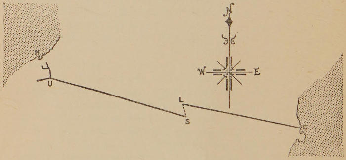
Plan A.
The first of these lines starts from a point (Mount Urtioga)
25 miles south of the corner made by the Bay of Biscay at
Irun, and some 15 miles west of its meridian; it runs
about 9° 15′ south of east to the peak called Sabouredo, the
last of the Maladetta group, the direct distance from which to
Mount Urtioga is precisely 200 kilometres, or 124 miles. The
second runs from Cape Cerberus on the Mediterranean to a
peak called the Pic-de-l’homme, which stands a trifle over 12
kilometres, or 7¾ miles, north of the Sabouredo; its direction
is 9° 25′ north of west, and the total length of this second line
is just over 190 kilometres, or 117 miles.
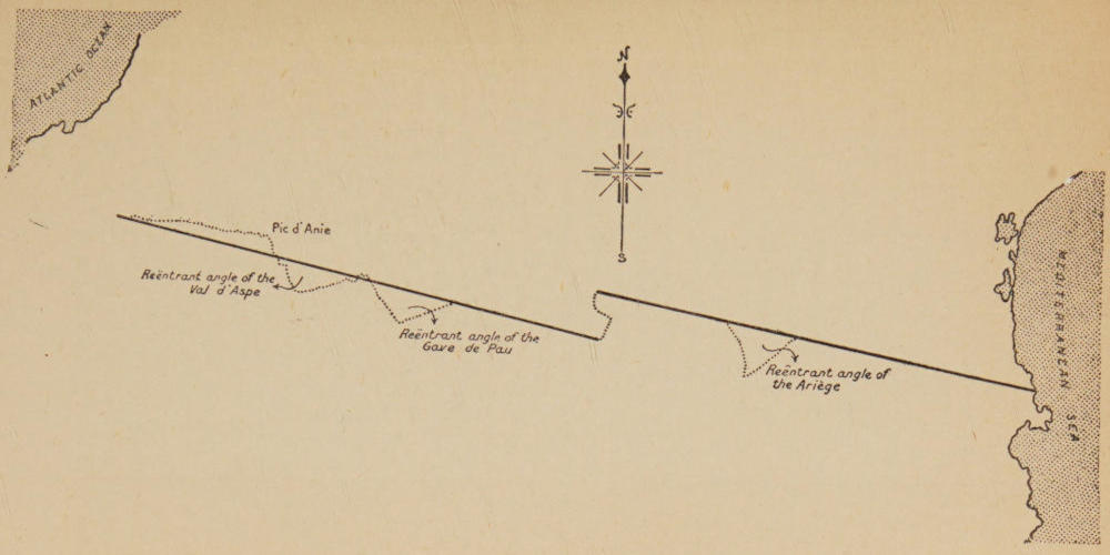
Plan B.
The simplest scheme, then, in which we can regard the
Pyrenees, is as a system of not quite parallel lines of equal
length, running one towards the other, but missing by not
quite 8 miles; the gap or “fault” joined by a zigzag saddle
on the watershed. The westernmost of these lines splits into
several branches before it reaches the Atlantic, so that the
true western end of the chain lies well to the south and east
of that ocean (at Mount Urtioga); the other starts from, and
forms a projection in, the Mediterranean. The full distance
as the crow flies from Mount Urtioga to Cape Cerberus upon
the Mediterranean is 390 kilometres, that is 241 miles. And
there is but 10 kilometres, or 6½ miles, difference in length
between the two halves of the chain.
If U be the point called Mount Urtioga, S the Sabouredo,
L the Pic-de-l’homme, and C Cape Cerberus, these two lines
and the gap between them will lie precisely as in this plan.
With this main guide by which to judge the structure of
the chain, all details will be found to fit in, and the two first
variations which we must superimpose upon so general a view,
are to be found in the “step” or “corner” formed by the
watershed round the Pic d’Anie. The southward turn of
the range is here not gradual but sharp, and the Somport,
the pass at the head of the Val d’Aspe, lies almost a day’s going
below the Port St. Engrace, which is the Pass near the Pic
d’Anie. Next, one should note the two re-entrant angles,
one to the north of the chain, one to the south, which distinguish
the Spanish valley of the Gallego and the French valley
of the Gave de Pau respectively. These features modify the
simplicity of the first or western branch of the chain; one
exceptional feature only modifies the second or Eastern
branch, and this is the deep re-entrant wedge of the Ariège
valley upon the French side. We may therefore regard the
elements of the watershed somewhat according to the sketch
plan B on the preceding page.
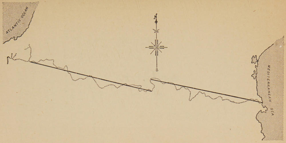
Plan C.
The details of the watershed when they are given in full are
of course indefinitely more numerous and complicated, and
it may be of advantage for those who would understand the
structure of the Pyrenees to glance also at the plan opposite
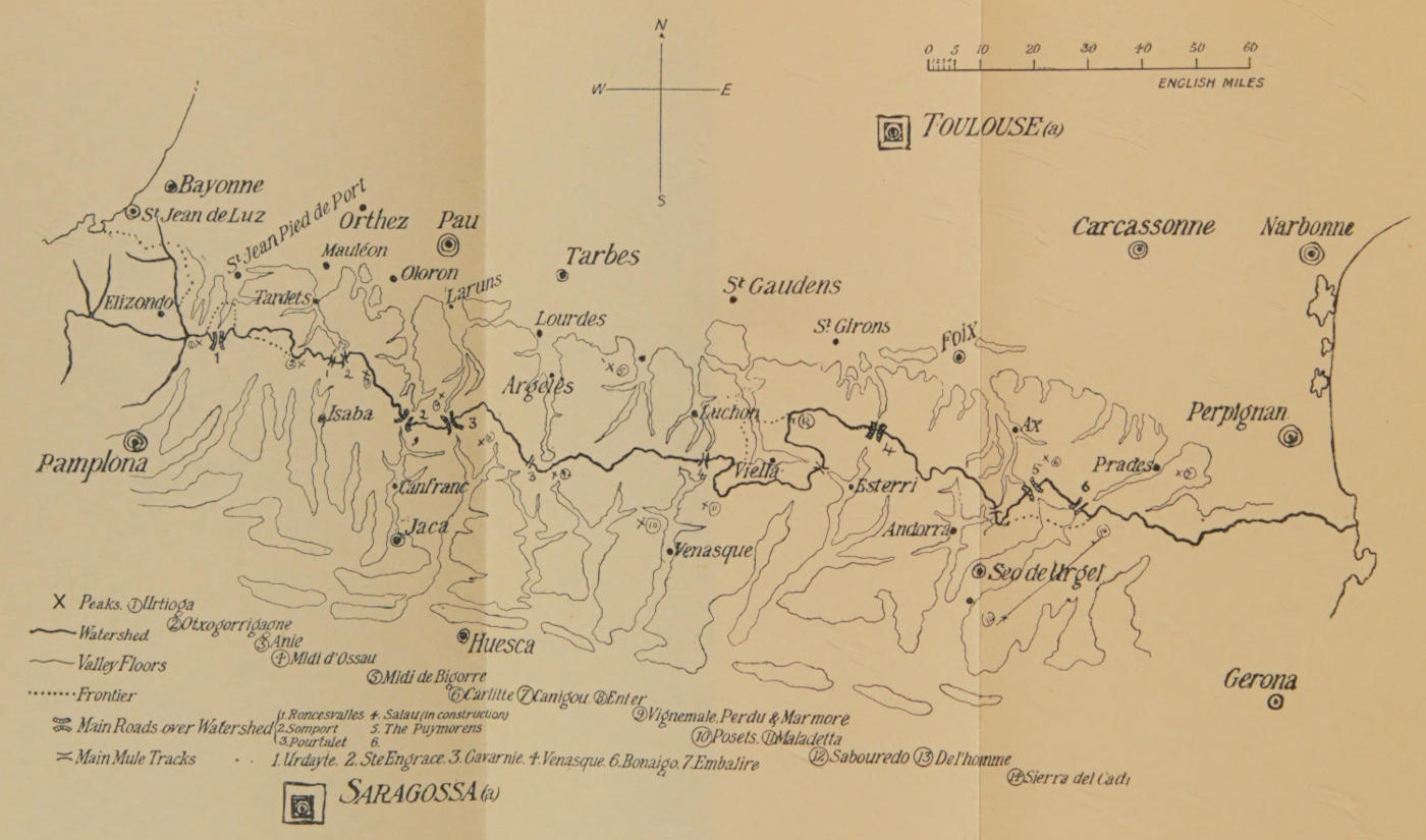
where the dotted line represents the exact trace of the watershed,
the dark lines the simple structure described above.
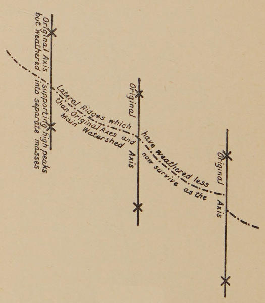
Plan D.
The watershed then should be regarded as the chief feature
in the range, and as the backbone of the whole system.
Geologically, it is not the foundation of the range. Geologically,
the range was piled up by the junction of a number of
short separate ranges, each of which ran with a sharper south-eastern
dip (about 30°) than does the present long line of
saddles which has joined them and forms the existing
watershed, and probably the process of the formation of
the Pyrenees was upon the model sketched in the following
diagram.
But for the purpose of understanding the Pyrenees as they
now are, it is the existing watershed which we must consider,
and that runs as I have said.
Next, the rule should be laid down that the Pyrenees must
be separately considered on their northern and upon their
southern slopes. It will be seen later that the physical and
historical contrast between the two sides of the mountains
is sometimes acute and sometimes slight, but the contrast
between the general contour upon either side is such as to
make it impossible to unite both in one similar system.
The Northern slope of the Pyrenees is narrow and precipitous.
The plains are for the greater part of its length clearly
separated from the mountains; the easy country in some
places (at St. Girons, for instance, and in the Flats between
Lourdes and Tarbes) is not 20 miles as the crow flies from the
highest peaks.
On the Spanish side, on the contrary, the mountainous
district will run from two to three times that distance. Its
extreme width between the open country at the foot of the
Sierra Monsech and the Salau Pass is over 60 miles, and it is
nowhere less than two days’ good journey on foot from the
summits to the plains.
This differentiation between the northern and the southern
slopes is not merely one of width, it is due to profound differences
in the contours which make the Spanish side of the
system a different type of mountain group from the French.
For, on the French side the Pyrenees consist in a series of
great ribs or buttresses running up from the plains perpendicularly
to the main heights of the range, and it is between these
ribs or buttresses that the separate and highly distinct valleys
which are the characteristic habitations of the French Basques
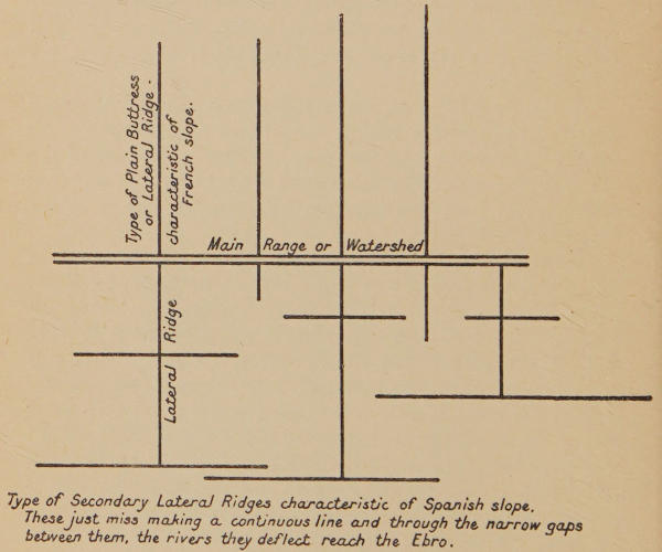
and Béarnais lie. On the Spanish side the main structure is
in folds parallel to the watershed; the lateral valleys descending
from the watershed run southward for but a very short
distance, they come, within a few miles, upon high east-and-west
ridges which sometimes rival the main range itself in
height and which succeed each other like waves down to the
plains of the Ebro. The contrast in structure north and south
of the watershed may be expressed in the formula of this
plan. A man looking at the Pyrenees from the French towns
at their base sees in one complete view a belt of steep rising
slopes, and a long fairly even line of summits against the sky.
A man looking at the range from the Spanish plains can only
in a few rare places so much as catch sight of the main range.
In far the greater number of such views he will have before
him a high ridge which masques the country beyond. If,
then, the reader or the traveller regards the French slope as
being essentially a series of profound valleys parallel to each
other and running north and south, he will have grasped the
main aspect of this side of the range. If he will regard the
Spanish slope as a series of parallel outliers which begin quite
close to the watershed, and which, though falling at last into
the plains of the Ebro, are, even the most southern of them, of
considerable height, he will have grasped the structure of the
Pyrenees upon the side which looks towards the sun.
Plan E.
To these two main aspects the reader must again admit
considerable modifications, the first of which concerns the
French side.
Plan F.
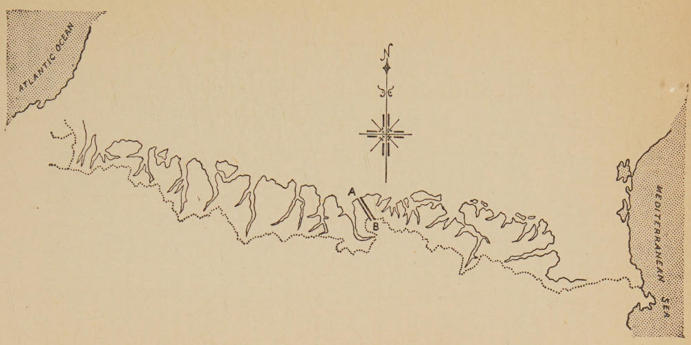
This Northern slope and its valleys, of which the sketch
map over page indicates the general arrangement, may be
divided into two sections: the first a western section, the
second an eastern one, and these two are separated at A-B by
a division roughly corresponding to the “fault” between the
two axes, which, as we have seen, determine the lie of the
range.
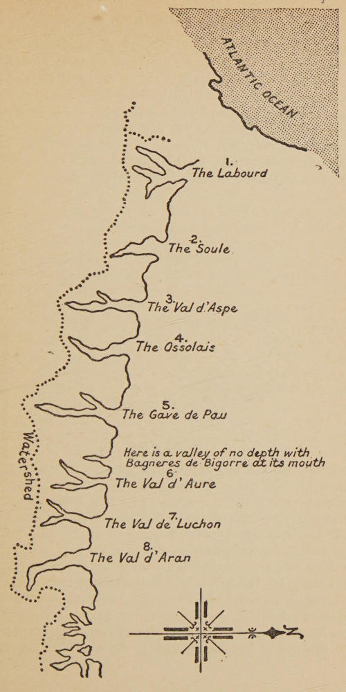
From the first, or western axis, descend with a regular parallelism,
eight valleys. Each valley bifurcates in its higher
part into two main ravines, and a whole system of minor
streams, spread over an indefinite number of tortuous dales
and gullies, attach to each valley.
There is a mark or limit for each of these western French
valleys, which is the spot where it debouches upon the open
country. Thus the Gave d’Ossau falls into the Gave d’Aspe
at Oloron; nevertheless the two valleys must be regarded as
separate, because the meeting of the two streams takes place
in the open plain. On the other hand the valley of Baigorry,
and the neighbouring valley of St. Jean, though containing
two large separate streams, must be treated as one system,
because these streams meet at Eyharee near Ossés, and the
open plain is not reached before a point some miles further
down beyond Canbo.
The test, though it may sound arbitrary upon paper, is
quite easily appreciated in the landscape, and the separate
valleys are more clearly marked, perhaps, than those of any
other European mountain chain.
These eight valleys (see plan G over page), going from west
to east, are first that of the Nive (the bifurcations of which
give St. Jean and the Baigorry), next that of the Gave-de-Mauléon
(Larrau and Ste. Engrace), and both of these are
Basque; next comes the valley of the Gave d’Aspe (with the
bifurcation of Lourdios and Urdos), up which went the main
Roman road into Spain and which is the first of the Béarnese
valleys; next is the Val d’Ossau (with the bifurcation of
Gabas and the lac d’Arrius), next the valley of the Gave de
Pau (with the bifurcations of Cauterets and Gavarnie), next
the valley of Bigorre, a short valley bifurcating in two minor
streams at its head. Next, or seventh, comes the Val d’Aure,
with Vielle upon its western bifurcation and Bordères upon
its eastern; and lastly the bifurcated valley of the Garonne,
whose level and deep floor comes nearest of all to the main
chain, and holds on the west Luchon, on a branch called the
Pique, on the east Viella in the Val d’Aran.
Plan G.
Plan H.
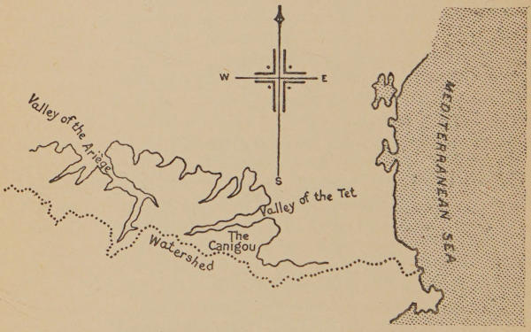
Once past this point, the structure of the hills along the
eastern run of the broken Pyrenean axis changes. The
mountains here are penetrated by only two valleys, but each
is much longer and more important than any of the eight just
mentioned, and these two great valleys run, not parallel to
each other, nor north and south as do the eight western ones,
but at a steep slant: the one (that of the Ariège) goes westward,
and the other (that of the Tet) eastward. Save for
these two main valleys no regular features can be discovered
in the eastern portion; all is here a labyrinth of dividing and
subdividing lateral ridges, and the only thing giving unity to
the group is this system of two great trenches which run up
towards each other, the one from the Plain of Toulouse, the
other from that of Perpignan, to meet on the high land of the
Carlitte group. Strictly speaking, the western valley is not
wholly that of the Ariège, but those of the Ariège and Oriège
combined, and it is further remarkable that no regular passage
exists from the one depression to the other, but by a curious
topographical accident, which will be described later in the
book, the crossing from the Ariège to the Tet has to be made
by going over on to the south side of the range, and then back
again on to the north side.
The importance of these two main valleys upon the eastern
half of the northern slope of the Pyrenees is sufficiently evident
from the historical fact that each determines a great historical
district: the one, that of the Ariège, was the country of Foix,
the other, that of the Tet, was the Rousillon. And while the
eight small western valleys running parallel to each other
separate local customs and dialect alone, the ridge of the
Ariège and the Tet may almost be said to have separated two
nationalities, and owed ultimate allegiance for a thousand
years, the one to a Gallic, the other to an Iberian lord.
Beyond the valley of the Tet and eastward of the Canigou
runs the little fag end of the range, which falls into the sea
at Cape Cerberus, and is called the “Alberes.” Here there is
but little distinction between the northern and the southern
side, the general shape of a sharp ridge is maintained throughout,
but the height lowers more and more as the sea is
approached. These hills are everywhere passable; the
ancient road into Spain which crosses them, should count,
geographically and historically, rather as a road crossing
round the Pyrenees at their sea end, than as a road crossing
the chain.
A Pyrenean valley upon the French side always presents
the same main characteristic, and this is true not only of the
main valleys, but of the innumerable lateral valleys which
ramify from the main valleys in all directions.
The characteristic of these French Pyrenean valleys is that
they are sharply divided by very narrow gorges into two or
more level basins. These level basins in the smaller valleys
and on the high levels where there is pasturage and no habitation
are called “Jasses”; the large and low ones are called
“Plains” or “Plans”; but they are the same in their essential
feature, which is a level floor more or less wide, bounded by
the steep hills upon either side, and ending and beginning with
a rocky gate through which the valley stream cascades. The
whole formation suggests the former existence of great and
small lakes, which burst their way through the gorges at some
remote time (as in plan I below).
Plan I.
These gorges are very rarely of any length, a point in which
the Pyrenees differ from the Alps. Here and there, especially
in the limestone formations, you do get long and difficult
passages. One, the Cacouette in the Western Pyrenees, in
the upper waters of the Gave-de-Mauléon, is not only very profound
but absolutely impassable, like the Black Cañon of
Colorado, but it does not lead from one part of a valley to
another. It occupies the whole of the upper valley; and in
general, you will not find a Pyrenean stream running, as do the
Alpine streams, for some miles between precipices.
Each main valley has a clearly marked mouth where it
debouches upon the plain; by this I do not mean that perfectly
flat land comes up to and meets the hills in every case;
on the contrary, at the mouth of most of these valleys are
moraines left by old glaciers, but I mean that the character
and aspect of the hills visibly and immediately changes, and
that each of the valleys has a distinct final “gate” where it
meets the lowlands, just as a river will meet the sea at a definite
mouth. Now each of these openings has its characteristic
town. Mauléon, for instance, is at the mouth of the last Basque
valley, Oloron at the mouth of the Val d’Aspe, Lourdes at the
mouth of the valley of Argelès, etc.
Further, these towns at the mouths of the valleys have
invariably chosen for their site, whether they be prehistoric
or mediæval, some rock on which to build a citadel; and in
every case a castle is still to be found holding that rock.
Lourdes, Foix, Mauléon are excellent examples of this.
Higher up the valley, the first plain above the mouth will,
as a rule, contain the first mountain town. Thus Argelès
lies above Lourdes, Bédous and Accous above Oloron, Laruns
in the first flat of the Val d’Ossau, etc.
According to the length of the valley and the number and
size of the Jasses, there may be one or more such towns
enclosed by the mountain sides; thus in the valley of Lourdes
we have Argelès, and above it Luz; in the valley of Soule we
have Tardets above Mauléon, and higher still we have Licq.
But all the valleys, whether they contain one or more of these
upland towns, have, just under the last watershed, a hamlet or
village usually giving its name to the Port or Col—that is
the Pass into Spain—above it, and the reason of this is
evident enough; habitations were necessary as a place of
departure and arrival for the crossing of the mountains. Of
such are Gavarnie, Urdos, Morens, and the rest. These high
villages have least history, least wealth, and until recently
had the worst communications. For much the greater part
of the year they are lost in snow, and there was an interval
between the making of the great roads and the beginning of
modern tourist travel when they were in peril of destruction.
The new great roads drew away wealth and visitors from all
but a very few, and but for the beginning of modern mountaineering
they had hopelessly decayed. Even so famous
a place as Gavarnie, the best known of all the valley heads,
was dying in the middle of the century. There are days now
when it is at the other extreme: fine days in August when, for
the crowd of rich people, you might be at Tring or at some
reception of the late Whittaker Wright’s. Even to-day, one
or two of them, however clean or kindly, are odd in the way
of poverty. I have known one where they had no butter
and never had had any butter, and another where I was
charged 8d. instead of 5d. for a bed because it was the season.
The typical Spanish valley differs, in the centre of the Chain
at least, from the typical French valley. With the exception
of Andorra (which reminds one in all features of the French
side; for it has the same enclosed plain, the same steps and
rocky gorges between, the same Jasses, and the same arrangement
of towns and villages) the greater part of the valleys,
whether Catalan or Aragonese, are not only broader and their
streams larger than on the French side, but their arrangement
also is different, most of them lack wide pasturages, nearly all
of them lack enclosed plains, and there has been no motive
to penetrate them since the building of the new roads, for
travel upon this road is rare. The Spanish valley, therefore,
often many days’ walking in length, never direct, and
forming a sort of little province to itself, will have towns and
villages scattered in it, haphazard and thinly. Very often
a considerable town will be found at the very end of the
valley, as Esterri in that of the Noguera Pallaresa, or Venasque
in that of the Esera. The lateral communications from one
Spanish valley to the next are usually more difficult than those
between the French valleys; for many months they are
impossible, and there is no such general arrangement of towns
on the plain holding the approaches to the valleys as in France,
for the reason that the whole plan of the mountains on the
Spanish side is far more troubled and irregular.
Thus the first town of the Aragon is Jaca; but Jaca is
right in the mountains, and nothing at the outlet of the hills
50 or 60 miles down the valley makes a head town for Jaca.
Jaca is a bishopric on its own. On the Gallego there is nothing
but a succession of villages of which Sallent right up at the
head of the valley is among the largest: it is almost a little
town and so is Biescas close by. The Cinca and the Esera
have indeed a town upon the plains at Barbastro, but the
Noguera Ribagorzana has none, nor has its sister the Noguera
Pallaresa, while the Segre has its bishopric and chief town
right up in the highest hills at Urgel, and there is nothing to
compare with that town until you get to Balaguer.
The southern side of the watershed differs greatly in general
structure from the northern, and must be separately recorded.
There are indeed certain accidental similarities. The
enclosed valley of Andorra to the south recalls the enclosed
valley of Bédous or Accous to the north, and the very high
first miles of the torrents, just under the main range, do not
differ much whether they are found on the north or on the
south side of the mountain. But the general plan and contour
of the range presents a great contrast on either side. The
main feature of the southern slope is, as I have said, a series
of parallel ranges pushing out like ramparts in front of the
main heights. If you follow a French valley (on the western
part of the Pyrenees at least) you will find it running fairly
north and south to the point where it debouches upon the
plain some 20, or 25 miles at most, from the watershed.
A Spanish valley will at first appear to have the same
character, but just when you think you are in sight of the
plains (for instance, just after leaving Canfranc upon the banks
of the Upper Aragon) you see—beyond the first lines of flat
country, and barring the view like a great wall—another high
range: in this case the Sierra de la Peña, the ridge of rock
which takes its name from the “Peña-de-Oroel,” a mountain
with its eastern end just above Jaca. Beyond this again you
have the San Domingo ridge, and to the east of it, another
running also east and west, the Sierra de Guara.
Pamplona again is situated at the mouth of a true Pyrenean
valley (that of the Arga), not very different from the valleys
to the north. It stands also on a plain, but immediately in
front of it runs another range of hills, and if you climb these,
you find yet another, strictly parallel and straight, standing
before you and masking the approach to the Ebro. This
formation in parallel outliers continues as far east as the
Segre valley, that is for full three-quarters of the length of the
Spanish Pyrenees, and in a sense it continues even further
east than the river Segre; for the Sierra del Cadi, though it
joins on to the main ridge at one point, is essentially an outlier
in slope and formation. This parallel formation sometimes
comes quite close to the central range, as, for instance, in the
Colorado peaks close to Sallent and Panticosa, and the long
ridge to the south of Vielsa and El Plan. Indeed the
characteristics of Sobrarbe, as this country-side is called,
consist in these long parallel ridges.
One result of this formation is, as I have said above, that
the river valleys do not run straight, as they do to the north
of the range, but are thrust round at right angles when they
come up against these ridges. Sometimes they will eat their
way through a ridge, as do the two Nogueras, and the Arga
itself south of Pamplona; but the greater part of the rivers
on the Spanish side suffer the diversion of which I speak, and
none more than the river Aragon, which gives its name to the
whole central kingdom; for the Aragon, after having run
south and straight for a few miles, like any northern river,
suddenly turns westward, and runs under the foot to Sierra
de la Peña for two days’ march. According to its first direction,
it should fall into the Ebro somewhere near Saragossa;
as a fact it does not come in until far above Tudela.
Another result of the formation is that the mountain
tangle stretches much further on the Spanish side than it
does upon the French. If you stand upon the Pass of Salau
where the French have made, and the Spanish are making,
a high road, you have before you to the north, at a distance of
less than 10 miles, the railway and a fairly open valley.
Fifteen miles at the most, as the crow flies, you have the main
line and the true lowlands at St. Girons. But if you turn and
look out in the opposite direction over the valley of Esterri
and the higher Noguera Pallaresa, you are looking over 60
miles of mountain land. From the high ridge, which is your
standpoint, to the summit of El-Monsech, which is the final
rampart of the hills beyond the plains of Lerida, is more
than 50 miles, and the slopes of that rampart take you nearly
another 10.
A further consequence of this formation is that communications
are very difficult to the south of the Pyrenees. The
traveller naturally ascribes the lack of communications to
the character of Spanish government. It is not wholly due to
a moral, but partly to a material cause. The main Spanish
railway from Saragossa to Barcelona may be compared to the
main French railway from Toulouse to Bayonne, but the
Spanish side everywhere suffers from its great wide stretch
of wild mountain land. Toulouse itself is little more than
50 miles from the crest of the mountains. Saragossa is half
as much again. The Spanish Pyrenees push out civilization,
as it were, far from them. Lerida, a large town of the plains,
is quite 60 miles from the watershed in a straight line. Pau
or Tarbes are less than 30. The difficulty and expense
with which the civilization of the plains, and the things belonging
to it, must reach the remote upper Spanish valleys largely
account for the curiously high degree of their isolation from the
world. Many thousands of men are born and die in those high
valleys, without ever seeing a wheeled vehicle, and without
knowing the gravest news of the outer world for two or three
days after the towns have known it.
It is not easy in such a system to establish general divisions.
We saw that this was simple enough upon the French side:
eight main valleys to the west of the “fault,” and two large
sloping ones on the eastern limb. In the Spanish Pyrenees,
the nearest thing one can get to a classification is first to group
together the Basque valleys of Navarre, the streams of which
all flow down to meet at last near Lumbier and fall into the
Aragon a few miles further south. Next to take the group of
valleys along the mouths of which stands the great Sierra de
la Peña, of which the chief is the ravine of the Upper Aragon.
These dales, which have at their extremities the huge masses
of the Garganta and the Pic d’Anie, form the original stuff
of Aragon. These few square miles were the seat from whence
that race proceeded which fought its way down to the Ebro,
and to the sources of the Tagus, and which can claim the Cid
Campeador for its historic type. Next comes the group of
valleys beginning with the Gallego and ending with that of
Venasque, which forms the eastern limb of Aragon, and has
borne for many centuries the title of “Sobrarbe.” Next to
consider the two Nogueras as the Western, the Cerdagne and
Andorra as the Eastern Catalonian land.
Plan J.
It should be noted that the fine tenacity of Spain in general,
and of these hills in particular, has preserved with exactitude
the ancient and natural divisions of the land. The long
unbroken ridge which encloses the Basque valleys is also the
frontier of Navarre. The unity of Aragon survives in the
present administrative division of Jaca. The eastern valleys
are still called the “Sobrarbe,” and the “fault,” or break
between the two main lines of the Pyrenees, still forms an
historical and racial break to the South as to the North of the
chain. Beyond it eastward begins the Catalan language, and
the next group to consider are the great Catalan valleys of the
two Nogueras and of the Segre. The two Nogueras ultimately
fall into the Segre, but in the mountain regions the three form
three large parallel valleys, each with a character and nourishment
of its own and all Catalan. Of these three, the Segre
is the most striking; its upper waters are the centre of the
flat valley of the Cerdagne, the only natural passage from the
North into Spain, and one of its earliest tributaries nourishes
the Republic of Andorra.
East of the Segre valley, and of the Sierra del Cadi which
bounds it, no classification is possible. It is a labyrinth of
little valleys. A flat welter of hills running down everywhere
to the sea, and narrowing at the extreme end into Cape
Cerberus: these last crests, as I have said, take the name of
“Alberes.”
This contrast in structure between the northern and the
southern side of the range runs through many other aspects of
the hills beyond structure alone. We have seen that it affects
the type of civilization, leaving the deep but short French
valleys far more open to the culture and influences of the
plains than were the Spanish just over the watershed. There
is much more.
The fall of the light is in itself a contrast. The slopes of the
Spanish mountains, and especially of the high mountains,
look right at the blazing sun. They are more bare of wood,
much, than are the French slopes. They are more burnt.
Water is less plentiful. Insects are more numerous, and there
is less cultivation; but one cannot say that there is, as a rule,
a scantier population. Small villages and hamlets are rarer
in the remote gorges, but small towns a little lower down are
common, and apart from the population economically dependent
upon summer tourists in France, it might be doubted
whether the Spanish side were not as well garnished as the
French; one might venture to imagine that in the Dark, and
early Middle, Ages, when the full effect of the natural condition
of the mountains could be felt, the population of either
side was sensibly the same.
The highest peaks are upon the Spanish side, but it does not
show splendid isolated masses of rock like the two Pics-du-Midi,
or lonely masses like the Canigou. On the other hand,
the general character of the rocks is more savage and more
fantastic, and it is upon the south side of the range that one
most feels creeping over one that sentiment of unreality or of
a spell, which so many travellers in the Pyrenees have been
curious to note. The local names express it upon every side.
There are “The Mouth of Hell,” “The Accursed Mountain,”
“The Lost Mountain,” “The Peak of Hell,” “The Enchanted
Hills” or “Encantados,” and hundreds of other legendary
titles that express, as well as do the mountain tunes, the sense
of an unquiet mystery.
The Spanish side is again remarkable for true rivers running
in considerable valleys everywhere east of Navarre. Though
the rainfall is less upon the southern side than upon the
northern, yet, because the catchment areas are broader, the
streams running at the bottom of the Spanish valleys are
larger and more important. A glance at the map will show
upon the French side a whole series of parallel river valleys
running down from the summit into the plains to join the
Adour or the Gironde. Armagnac and Béarn are crowded
with them. A man going eastward from Bayonne to Pau,
from Pau to Tarbes, from Tarbes to Toulouse, will cross more
than forty streams all spreading out like a fan from the central
axis of the Lannemezan Plain; a man going eastward below
the Spanish foot hills from Melida, let us say through Huesca
to Lerida, will find but half a dozen of such water crossings.
Again, you have between the Soule and the Labourd, between
the Val d’Aspe and the Val d’Ossau, between the Val d’Aure
and the Garonne, distances of 8, 10, or at the most 12 miles,
but the distance between neighbouring Spanish valleys (if
we except the near approach of the Gallego and the Aragon),
is always much greater. Between the Noguera and the Segre,
for instance, there is at the nearest point, 20 miles; between
the two Nogueras, another 20; between the last of these two
rivers and the Esera, quite 20 more. The whole Spanish side
with the exception of Navarre is thus built up of considerable
valleys, comparable to those of the Tet and the Ariège alone
upon the northern slope.
The details of Pyrenean structure will concern a man travelling
on foot more than do these general lines, though the whole
aspect of the range must be grasped before one can understand
its details. The separate peaks and valleys, the intimate
structure of the range is remarkable everywhere for its
abruptness. It is this physical feature in the Pyrenees,
coupled with the absence of snow, which gives them the highly
individual character they bear.
Fantastic outlines are not to be discovered in these hills so
frequently as in the Dolomites, nor are wholly isolated hills
common, though such few as exist are very striking, but for
day after day a man wandering in the Pyrenees sees cliffs
more regularly high, a greater succession of rocks more precipitous,
and a more permanent succession of connected summits
above him than in any other European range.
The absence of snow is a further sharp characteristic in
the range. The essential feature of an Alpine landscape is
the snow; and it is not only the essential feature of that
landscape to the eye, it is the condition which controls the
lives of those who inhabit, and of those who visit, the valleys.
You can still wander a trifle in Switzerland. Even to-day
I have come to villages where foreigners were still thought
comic, and an ignorance of the German tongue was still
thought amazing. But though you can wander, your wandering
is strictly limited. Above a certain line you can go forward
only with technical knowledge and in a special way.
You are upon ice or snow. All climbing in the Alps depends
upon this, and most of travel as well. A man may pass many
days for instance in the upper valley of the Rhone, and then
pass many days more in the upper valley of the Aar, but to go
from one to the other he must take one of two strictly defined
paths, unless he is willing to undertake special work requiring
technical knowledge and particular aids. The hills between
the two valleys are not a field for his exploration; they are a
great mass of impassable and unapproachable land, all
frozen, and diversified only by very narrow valleys inhabitable
nowhere but at their base. No one could lose himself for
many days upon the Wetterhorn, the Jungfrau, or the Finsteraarhorn;
you can approach these mountains for the glory
of the thing, but they are not a country-side. Now in the
Pyrenees almost all the surface of the mountains, say 250
miles by 60, is at your disposal. It is this and a local custom
of live and let live which make the pleasure of them inexhaustible;
and which, combined with certain protective methods
of their own, make it certain that the Pyrenees will never be
overcome or changed by men. They are too large.
This surface of some 15,000 square miles is diversified in a
manner fairly continuous throughout the chain. The valley
floors are given up to cultivation in their lower part, their
upper parts consist of damp close pastures, and between the
two types of level are to be found, as we shall presently see,
sharp gates of rock through which the river saws its way in a
gorge. Above the valley floor, and at the end of it, where the
stream springs out below the watershed (such springs bubbling
up suddenly through the porous rock are called Jeous), steep
banks of two, three and four thousand feet, broken almost
invariably here and there into precipices, forbid the way;
and these, in perhaps half their extent, are covered with
enormous woods of beech below (mixed often with oak) and
of pine above.
When you have climbed up these slopes through the forest
or over the naked rock, you come, in the last heights, either
to large grassy spaces, which often sweep right over the
summit of a lateral ridge, and sometimes extend over both
sides, even, of the main watershed (as between the Val d’Aran
and Esterri) or else—more commonly—upon a jumble of
jagged rocks and smooth, perpendicular or overhanging slabs,
which defend the final secrets of the range.
The succession of these features is nearly universal. The
only places where they are modified are the two lower ends of
the range. There the rocks sink, the hills are rounded, the
precipices disappear in the last Basque valleys, while the
Alberes at the other extremity of the chain against the
Mediterranean are at last mere toothed rocks. All between
(with the exception of the Cerdagne, which is a country to
itself) is built up in successive bands of valley floor, steep
forest, or steep rock, broken with limestone precipices, and
finally on the highest ridge sweeps of grass or jagged edges of
stone.
It is this character in the last ridge of the Pyrenees that
determines the nature of a passage over them, and since a
passage from valley to valley is the chief business of the day
when one is exploring the range, I will next describe these
crossings, for the method of them is very different from that
of other mountains, and has largely determined the history
and customs of their inhabitants.
In other high mountains you will either find snow above a
certain level and covering for most of the year most of
the passes, some of the passes for all the year, or, as you
go further south, you will commonly find many gaps
which long years of weathering have reduced to easy
slopes, or you will find great differences in slope between
the one and the other side of the range; as, for
instance, the difference between the long valleys that lead
up eastward into the Californian Sierras, and the sharp escarpment
which falls eastward upon the desert side of those heights.
In all other ranges that I have seen or read of, save the Pyrenees,
there is at least great diversity in the opportunities of
crossing, whether natural or artificial. There is great diversity,
as a rule, in the natural crossings; some are quite easy
ascents and descents on either side (as the Brenner Pass over
the Alps); some, though difficult, are notably lower than the
average height of the range (as the Mont Genèvre from the
Durance into Piedmont); some, these more rare, are deep
gorges cleft right through the range (as the Danube gorge
through the Carpathians).
Now it is characteristic of the Pyrenees that in the main part
of their length no such diversities appear, save that there are
two kinds of summit surfaces on the high cols, rock and grass:
the grass the rarer.
If anyone looks closely at the Somport, especially noting
the line which the old track took before the modern road was
made, he will agree that it is a pass which, though steep, had
no “edge” to it, so to speak. The grass would take any kind
of traffic. The same is true of course of the Cerdagne, the
only broad valley across the Pyrenees. But the Somport is
well to the west end of the range; the Cerdagne is well to the
east end. All the main part between could take no vehicle,
and has crossings of a kind which I shall presently describe:
sharp, the escalade difficult, the first descent upon the far
side, or the last ascent upon the near side, steep.
There is perhaps an exception to be found in the case of the
Bonaigo, but this pass also presents difficulties to wheels
upon its western side, and in the lower valley at the gorge.
In general the crossings of the Pyrenees everywhere display
certain characters rare or absent in other ranges, which are
first that they are very numerous (a feature due to the absence
of snow), secondly, that they are very high, thirdly, that they
hardly ever involve any true climbing, and fourthly, that they
nearly always involve some considerable care on the part of
the wayfarer and are somewhere dangerous either upon the
northern or the southern side.
This can be well illustrated by a particular example in the
few miles between the Pic D’Anéu and the Canal Roya. Here
there is a range no part of which descends much below 2100
metres nor rises much above 2300. There are two distinct
saddles where a man can cross on foot, and neither is appreciably
lower than the peaks of the range, which are but lumps
of rock a little higher than the grassy ridges from which they
spring. Any man knowing the country and with a fairly
good head could trust himself to half a dozen places westward
of the two which I have mentioned (which are called the Col
D’Anéu and the Port of Peyreget). Nevertheless the easiest
of them, the Port de Puymaret, easy as it is upon the French
side, gives some pause upon the Spanish. The traveller finds
himself, once over the crest, within a few yards of a rocky
edge, beyond which there is apparently nothing but air, and,
thousands of feet beyond, the precipices of the Negras. If he
will approach that rocky edge he will see that everything
below it is easily negotiable, and when he has once reached
the floor of the Spanish valley beneath he will perhaps wonder
why it seemed so difficult from above. In truth it is not really
difficult at all, but the scramble looks dangerous, and it is
one which most men, other than regular climbers, would
think twice about when they first saw it from above. If all
this is true of the Peyreget, it is still more true of the other
crossings in its neighbourhood to the right and to the left.
Were the Pyrenees surmountable at comparatively few
passages, these would have been so thought out and perhaps
improved as to make them regular and well-known passes,
which the traveller could easily deal with. It is the very
number of the crossings which add to their difficulties. The
people who live upon either side are indifferent in their choice
among so many difficult passages, and with the exception of
one or two quite modern made roads with which I shall presently
deal, there are some hundreds of Cols and Ports all
having in common a character of difficulty, and few naturally
so much more easy than their neighbours as to concentrate
travel upon them.
This feature may be summed up in the expression that the
crest of the Pyrenees is rather one long ridge slightly serrated
than (as in the case of most other ranges) a succession of high
mountain groups separated by low saddles.
Of all the accidents that strike one in connexion with the
crossing of these hills nothing strikes one more than the accident
of time. A Port is always a day and a long day. Here
and there quite exceptionally there may be food and shelter
upon either side within six or seven hours one from the other;
but as a rule if you propose to sleep under cover upon either
side, your effort will demand a long summer’s day, and it is
best to look forward to a night camp upon the further side of
the range.
Before continuing the description of these passages, or any
rules by which one should be guided in attempting them, it
may be well to speak for a moment of the few practised and
conventional tracks.
First of these come, of course, the high roads. At present,
over the frontier, these are but four in number (for the low
passes to the east of the Canigou may be neglected), Roncesvalles,
the Somport, the Pourtalet, and the Cerdagne. Of
these the Pourtalet has been but recently opened, and was
just before the war still in process of being widened upon the
French side. Moreover, it is so nearly neighbouring to the
Somport (there is but 8 miles between them), that it hardly
affords a true alternative crossing. A fifth high road across
the watershed is that which crosses it at Porté from the valley
of the Ariège into the Cerdagne, but this road is essentially a
lateral one. It lies wholly in French territory, it joins the
French road through the Cerdagne, and you cannot go by it
down the valley of the Segre. It only crosses the watershed
on account of an accidental divergence of this to the south,
in the upper valley of the Ariège.
These four carriage roads are all that lead, at present, over
the political boundary of the Pyrenees. Another is in construction
over the Port of Salau, but it is not finished upon
the Spanish side. The French desire several others to go over
by the Macadou, Gavarnie, etc., but their own preparations
are not completed and the Spanish are not even begun.
Apart, however, from these high roads, which are carefully
graded, possess an excellent surface, and are traversable by
any vehicle, there are a certain number of crossings which
travel has rendered familiar, and whose facility is well known.
Thus, the Embalire from the Hospitalet on the upper Ariège
into the upper Segre in Andorra is a perfectly easy slope of
grass, though high. Again, the Bonaigo, though there have
been natural difficulties in the lower valley to be surmounted,
and though there is not even a track across it, is a perfectly
easy roll of grassy land barely 6000 feet high. A high road leads
as far as Esterri on the Spanish side; another goes from
France on the northern side, right up the valley of the Garonne,
beyond Biella, to the paths at the very foot of the pass, so that
the gap between the two highways is but a few miles in length.
The Port de Venasque again, though but a mule track, is
constantly used, and, though steep and high (close upon 8000
feet), presents no difficulties at all, and is almost a highway
between the two countries. The Port de Gavarnie is similarly
constantly used and may be taken like any other mountain
path. Certain other passes form an intermediate category.
They present no difficulties to one who is acquainted with the
neighbourhood, but either the whole path is difficult to trace
or its last and highest portion is dangerous, or there are precipices
upon its lower slope, or in one way and another they
cannot be regarded as constant and regular communications
of international travel, though the inhabitants use them continually.
Of such a kind is the Port d’Ourdayte; of such a
kind are the passages from the Aston into Andorra, and of such
a kind are most of the passages just west of the Port de Venasque.
If one applied the test of asking where the Pyrenees
could be crossed in doubtful weather, not half a dozen places
could be found beyond the four high roads; and even if one
were to ask in what spots they could certainly be crossed by
a stranger without chance of failure, the number of passages
would prove less than a score. All the rest of the ridge from
the Sierra del Cadi to the Basque mountains is the rocky wall
I have described, with innumerable notches more or less
practicable, but all difficult, and nearly all requiring a detailed
knowledge of either slope.
There are one or two other features needing explanation
before I close this introduction to a physical knowledge of
the range; thus the reader should be acquainted with the
many groups of lakes and tarns which stand just under the
highest peaks and ridges in groups: they are highly characteristic
of the Pyrenees. There is a cluster of half a dozen at
the western base of the Pic du Midi d’Ossau, another cluster
surrounding the neighbourhood of Panticosa, another in the
summit of the Encantados between the Maladetta group and
the valley of the Noguera, another very famous one well known
to fishermen high up in the knot of mountains whose summit
is the Carlitte, and there are many isolated small lakes which
the map discovers. But whether in groups or isolated, one
feature is common to all these lakes of the Pyrenees—first,
that none is of any size; secondly, that all, or very nearly all,
are quite in the highest parts of the hills immediately under
the last escarpment; and thirdly, as a consequence, that it is
rare to find a lake which the presence of wood and the neighbourhood
of habitation render suitable for camping.
It is worth remembering that, unlike most mountain
systems, the Pyrenees do not, even in sudden storms, endanger
one as a rule by a rapid increase in size of the torrents; one
has not to fear spates so much as one might imagine from the
multiplicity of the streams on the northern side or the large
area of the valleys on the southern. This truth, of course,
must not be exaggerated nor too much advantage taken of it.
That part of a stream which will be just traversable after
several fine days may become just too violent to cross after a
few hours of rain, but I have never seen those sudden changes
of level from a rivulet to a considerable torrent which one
may so often see in British mountains, which are common
enough in Scandinavia and even in the Alps, and which are a
regular condition of travel in the Rockies.
Why this should be so it would be difficult to say. The
great area of forest upon the north might account for regularity
upon that slope, but it would not account for it upon the
Spanish side. And one would imagine that snow in large
masses, which is lacking in the Pyrenees and present in the
Alps, would rather tend to regulate the flow of rivers; but
whatever be the cause, the evenness of level is what one used
to other ranges will first remark when he has to cross and
recross under different conditions the higher streams of this
chain in summer.
There should lastly be noted the absence of any important
glaciers, a feature due to the absence of snow-fields. On the
summit of the Cirque de Gavarnie, on the summits of the Pic
d’Enfer and the neighbourhood, on the summits of the Maladetta
group, and in one or two other parts, there are small
glaciers, but they form no general feature in the landscape of
the Pyrenees, and have no effect upon travel.
Lastly, the climate of these mountains should be noted:
it is a very important part of the conditions which determine
travel upon them.
The rain-bearing winds blow from the Atlantic eastward,
and if the Pyrenees stood upon either slope equally accessible
to the sea, it is possible that the Spanish side would be the
more deeply wooded and the best watered. The sudden
trend westward of the Spanish coast, however, at the corner
of the Bay of Biscay, causes the wet winds from the Ocean
to lose most of their moisture to Galicia and the Asturias,
before they can strike the Pyrenees themselves from the south,
while the same winds, coming around the range from the north,
come upon the Pyrenees immediately after leaving the sea.
The result of this is that the French side is throughout its
length more heavily watered than the Spanish side; but on
either side there are three zones which, though not sharply
distinguishable one from the other, are sufficiently remarkable.
The first is that of heavy rains, and, what is more important
for purposes of travel, of continuous rain and frequent mist.
It stretches all along the western end of the range, and only
begins perceptibly to change with the heights of the Pic d’Anie
and the precipitous barrier of the upper valley of the Aspe.
West of this line—that is, in all the Basque-speaking country—you
have deep pastures upon either side of the range, and all
the marks of the damp in the timber and the mode of building,
the vegetable growth and the animals of the place. Snow falls
later here than in the other parts of the Pyrenees, for the
double reason that the neighbourhood of the sea makes the
climate milder and that the hills are less high. In most places,
for instance, communication is not cut off between the north
and south valleys of the Basques, and men can usually cross
from Ste. Engrace to Isaba at all seasons.
The next zone (the eastern frontier of which is very vague)
may be said to stretch, according to the year and the accident
of weather, certainly as far as the Catalans and the valley of
the Noguera on the east, and sometimes as far as the valley of
the Segre itself. In all this central part of the range (which
may normally be said to include more than half its length)
the French or northern side is densely wooded and heavily
watered, the Spanish side more dry and bare; but even the
French side slowly shows a change of climate as one goes
eastward, the forests remain as dense, the rivers as full, but
the days are certainly finer and mist less frequent. On the
Spanish side the change as one goes eastward is less striking,
because the whole climate is drier. It is to be remarked that
if mist gathers upon the northern side of the hills when one
is attempting a pass, one may fairly count upon its disappearance
upon the Spanish side in this section; and, in general,
the whole of the southern slope, from the valley of the Aragon
to that of the Noguera, is of a dry and equal nature, somewhat
barren and burnt, not only from the lack of moisture, but also
from exposure to the sun.
The lack of moisture on the central Spanish slope, by the
way, is not a little aided by the curious formation of the
frontier of Navarre, and the separation between the Basques
and the Aragonese; this consists in a long ridge of high land,
the upper part of which is known as the Sierra Longa, which
runs south and a little west from the Pic d’Anie. The effect of
this lack of moisture and excess of heat upon the central
Spanish side is not only felt on the heights of the mountain,
but also and more particularly when one approaches the Plains.
These in France are northern in type, full of greenery, and
amply watered. In Spain, on the contrary, they are quite
arid, and if one comes in to Huesca by train upon a September
evening, and looks out the next morning over the flats that
run up to the Sierra de Guara, one has all the impressions of a
desert, though these lands are heavy corn-bearing lands in
the summer.
Finally, the third, or eastern, section of the hills is Mediterranean
in character throughout. The Canigou is much more
heavily watered than the Sierra del Cadi, its corresponding
Spanish height. But the olives on the lower slopes, the carpet
of vineyards on the flats, the presence everywhere of bright
insects, the quality of the light and the aridity of everything
which does not happen to be planted with trees, give to this
eastern corner of the Pyrenees the same aspect that you may
notice on the Mediterranean hills of Southern France, Liguria,
or Algeria or the Balearic Islands, for all these landscapes are
of one kind, and binding them all together is not only their
burnt red look, but also that tideless intense blue of the
Mediterranean, the hot white towns, and everywhere the
lateen sail upon the coasts.
These differences of climate also determine the seasons in
which the mountains may best be visited, for the Basque district
is at your service (especially in its western part) from the
spring to the late autumn of the year; the central valleys can
be everywhere travelled in only from late June to mid-September;
the eastern end, again, from the Segre and beyond
it, is open to you from spring to autumn.
II THE POLITICAL CHARACTER OF THE PYRENEES
The Political character of the
Pyrenees corresponds to the
Physical character which has
been described. The high crest is
the bond and division, from the beginning,
between two societies which are
connected by such common social
habits as mountains impose—which
therefore fall under similar local customs,
which have a common jealousy of
the civilized power on the plains below
them, and which support each other in a
tacit way against the stranger, yet which, from the beginning,
have different governments and (especially in the high central
part) deal with different corporate traditions—to the north the
Béarnese, to the south Aragon. The easier passes to the west
and the east of the chain permit a more or less homogeneous
community to straddle across either end of the mountains,
and to hold upon both slopes the sea roads that pass along the
Atlantic and the Mediterranean. The people thus astraddle
of the eastern end have come to be called the Catalans. That
astraddle of the western, a highly distinct group of men with
language, traditions, and physical characteristics wholly their
own, has always been known by some title closely resembling
their modern name of Basques.
The foundation, therefore, upon which Pyrenean History
is built, or (to use another metaphor), the germ from which it
has developed and which explains its course, is a tripartite
division of the inhabitants, corresponding, as I shall presently
show, to the physical features of the chain: an eastern or
Catalan, a western or Basque, and a central group whose
characteristic it is to subdivide according to the deep valleys
into which it is separated, but which falls into two main
societies, the one north of the chain which becomes the group
of French counties whose typical government is Béarn, the
other south of the chain, which assumes at last for its title
“The Kingdom of Aragon.”
The first matter to be noticed with regard to this tripartite
division is the exactitude of its boundaries. One might
imagine that the language, the habits, and the clear characteristics
of any group would merge easily into those of its
neighbours upon either side. This is not the case. The
Basque type—much the most particular—ceases abruptly
upon the watershed between the Gave d’Oloron and the Gave
d’Aspe to the north of the range, upon the watershed between
the Veral and the Esca to the south of it. The Catalans, with
a dialect, mind, and dress wholly their own, are found to the
north from the sea up to the Col de Puymorens, and everywhere
east of the Carlitte mountains; in the Ariège valley and
just over these heights, and on the further side of that Col,
they are changed. To the south of the range they extend
everywhere from the sea to the valley of the Ribagorza.
Cross westward from that Catalan valley to the Esera. There,
after hours of scrambling, down by the rocks and deserted
tarns, you may towards evening find a man; that man will
show the slow gestures, the silence, and the elaborate courtesy
of Aragon.
The mountain ridges which divide these various peoples
are sufficient to mark their boundaries; but they do not
suffice to explain why the Catalan, the Basque, the Aragonese,
the Béarnais should cease suddenly here or there. True, the
high lateral ridges which are so striking a peculiarity of the
Pyrenees form barriers with difficulty passed, but these
barriers are found just as high and just as precipitous and
savage between two valleys of the same speech and nation
as between two of different allegiance. Thus the wild jumble
of mountains, “the Enchanted Range,” cuts off the Catalans
of Esterri from the Catalans of the Ribagorzana. To pass
them is something of a feat for anyone not of these hills—for
much of the year they are closed to the native inhabitants.
Their passage is hardly more of a task or more precipitous
than the passage from Aragonese Venasque to Aragonese
Bielsa, or from Béarnais Gabas, in the Val d’Ossau, to Béarnais
Urdos, in the Val d’Aspe.
An explanation of the unity which rules over each group,
Basque, Central and Catalan, can only be given by referring
each to the plains at the mouths of the valleys. It is the towns
at the entry of these plains that form the markets and rallying
places of the mountaineers and that determine their groupings.
Oloron is the link between the two Béarnais valleys I have
mentioned. Urgel binds Catalan Andorra to Catalan Esterri.
Why, however, the groups should lie exactly where they do it
is impossible to determine, for no records reach beyond the
Romans. All we can say is that the Pic d’Anie, the first high
peak eastward from the Mediterranean, forms the boundary
stone of the Basques, as it does the chief physical mark dividing
the high central ridge from the easier western passes;
that the tangle of difficult and impossible peaks just eastward
of the Maladetta are the boundary of Catalan south of the
range, the similar but less abrupt tangle of the Carlitte, their
boundary upon the north. How these nations arose, whence
they wandered, whether their differentiation has arisen upon
the spot out of an earlier homogeneity or is due to the conflict
of invaders—of all this we know nothing.
The place names of the Pyrenees, like those of all Spain,
and half Gascony, do indeed afford a curious speculation which
arises from the high proportion of names that are certainly
Basque, though out of Basque territory. Of this language I
shall write later: for my present purpose the point I would
desire the reader to note is the sharp contrast which exists
between that idiom and the idioms around it. There is no
mistaking a Basque word, and yet these are found in all the
Pyrenean range and to the north and south of them in a
hundred place names, attached to hills, rivers and towns where
Basque has been unknown throughout all recorded history.
It is even plausibly suggested that the Latin “Vascones,”
the French “Gascon” is equivalent to “Basque,” and the
late Mr. York Powell, the Regius Professor of History at
Oxford, would say in speaking upon this matter that “Gascon
was Latin spoken by Basques.” He possessed that type of
education, rare or unknown in our universities, which
made him capable of individual judgment in departments of
living knowledge where his colleagues could but repeat words
taught them from a book. This quality reposed upon a wide
acquaintance with all matters of European interest. His
diverse reading and considerable travel enabled him to balance
human evidence in a way hopeless to his less fortunate neighbours
in the University, and his conclusion on this important
detail of history has always recurred to me when I have
examined some new point in the early history of these mountains.
There must, however, be set against the general conclusion
that the Basques are the remnant of a people once
universal from the Garonne to the Pyrenees, and throughout
the Iberian Peninsula, the fact that they present a marked
physical type utterly distinct from others upon every side.
That a race of such a character, vigorous, attached to the soil,
in no way nomadic, should have abandoned a large territory
is difficult to believe; moreover, there is no case in all the
recorded history of Western Europe of one people ousting
another, and the process is manifestly physically impossible,
save among nomads. Jews or Arabs could propagate and
even believe such a theory. To Europeans it is laughable:
the peasants and cities of Europe never have been, nor ever
can be, largely displaced.
All we know is that these place names exist throughout
Spain and all over the Pyrenees, and that the million or so
who speak the language whence such names are derived now
occupy a tiny corner only of the vast territory over which
those names are spread. The rest is guesswork.
Ignorant as we are of the origin of the differentiation
between Basque, Béarnais, Catalan and Aragonese, an
historical fact quite certain—though no document proves it—is
the extreme antiquity of these classes of men. That all
Pyrenean history reposes upon their separate existence must
be evident to anyone who has watched the commercial manner,
the mercantile vivacity, the whole mentality of the Catalan,
and has contrasted it with the quiet chivalry of Aragon.
Different military fortunes, different economic outlets, and
different accidents of central government may possibly account
within the historic period for the contrast between the Aragonese
and the people of Béarn, Bigorre, or Comminges. No
such forces can account for the gulf that cuts off the Catalan
and the Basque at either end of the chain from the inhabitants
of its high central portion. Infinite time is the maker of
states, and two thousand years could never have determined
societies so sharply separate. We must regard their constant
and immemorial presence in the Pyrenees as the first and
enduring principle to guide us in the history of those mountains.
From this fundamental truth, which leads the prehistoric
into the historic, one must proceed to another political fact
of high importance, which is that while the watershed of the
range has but partially separated customs and local thought,
and that only in the centre of the range, it has necessarily
served as a political boundary whenever a high civilization
found it necessary to establish such a strict line. The boundary
and the watershed may not exactly coincide—they do
not exactly coincide even in the highly organized condition
of modern society; but in the two historical periods of strict
policy, the Roman and our own, the crest of the range has
marked, and marks, an obvious boundary for most of its
length. The political distinction between Hispania and Gaul
cut the Basque nation into two, following the mountains from
Roncesvalles to the Pic d’Anie: it cut the Catalan people into
two, following the water parting from the two Nogueras to
the Mediterranean. It followed the central chain, indifferent
to the similarity or difference between the northern and the
southern valleys. To-day the political distinction between
Spain and France follows nearly the same line.
The reason of this was, and is, twofold. First, that a clear
physical boundary easily definable and of its nature permanent—the
crest of a chain, a broad river, or what not—necessarily
recommends itself to a bureaucracy in search of simplicity
and economy in the work of a great political machine.
We see it in the new countries to-day, where the instinct of
organized government for easily definable and exact limits
takes refuge in establishing parallels of latitude as state boundaries
in the absence of marked physical lines. Secondly, in
the case of mountains, and especially of mountains as sharp
and as boldly set as are the Pyrenees, the fatigue of climbing,
the absence of carriageways, made each valley dependent for
its connexion with the central government upon some town
of the plains, and the authority of a provincial magistrate
could not but run, as ran the physical instruments of his rule,
up from Huesca northward to Sallent—for instance, or up from
Jaca to Canfranc, and so to the summit of the ridge; or up
from Oloron southward to Accous, and so to Urdos. As the
messengers, writs, powers of each proceeded, the way would
become harder, the progress more doubtful. It was obvious
and necessary that the boundary of either jurisdiction should
lie upon the pass. And though the inhabitants of the northern
and the southern valleys might be accustomed to a regular
intercourse across the crest, the Roman agents of a distant
central government could not but have depended upon cities
far removed to the south and to the north of the watershed, as
to-day the police of Tardets, let us say, and of Isaba, two towns
of one speech, refer respectively through Pau and through
Pamplona to Paris and to Madrid.
It is in the interplay of these two jarring political forces,
the permanent national seats of Basque, Catalan, etc., and the
use of the range as a political or official boundary, that the
political character of the Pyrenees resides; and as their
history begins with the Romans, to whom we owe the first
knowledge of the Pyrenean people and the first use of the
Pyrenean boundary, it will be well to consider it under territories
divided as the Romans divided them, by the main range,
and to follow first the development of the northern slope.
The historical origins of the French Pyrenees are sharply
divided in history by that wall which cuts off all that Rome
made from all that Rome inherited. Rome made of the barbarians
a new world, but before she began that task Rome had
inherited everywhere within a march of the Mediterranean a
belt of land whose civilization was similar to, always as old as,
and sometimes older than, her own. It was a municipal
civilization dependent upon the arts and religion proper to a
city state. It built, whether temples or ships, as Rome would
build them: it was one thing; it is almost one thing to-day;
and its bond at Antioch as at Saguntum, at Marseilles as at
Athens or Alexandria, was, and is, the universal water of the
Mediterranean. To such cities and their territories Rome fell
heir. Little proceeded from her to them save first the sense
of unity, and later the Faith, and of the whole system, the
belt which stretches from Valencia to Genoa, now broadening
to the plains of Nemosus (Nîmes), now narrowing to the rocky
ledge of the Portus Veneris (Port Vendres), concerns the first
evidence of Pyrenean history; for it was from a corner of this
belt—between Tarragona and Narbonne—that the advance of
civilization inland and along the Chain proceeded.
A century before the four imperial centuries which made our
Christian world, a century before Augustus Cæsar, Rome had
fully occupied and impressed that soil—to the south Gerona
and the Catalan fields, to the north the rich floor which lies
under the Canigou and has come to be called the Rousillon.
Thence the Roman advance north of the hills proceeded. The
chief town of the sea-plain—whose name “Illiberis” is so
strongly Basque in form—Rome took for the central municipality
of that plain, and made it the capital of the coastal
district. This hill and citadel, at which Hannibal had halted
a hundred years before, preserved as a bishopric for thirteen
hundred years a memory of the Roman order. Constantine
formed its diocese, rebuilt it, gave it his mother’s name of
Helena. The sea by which it lived has withdrawn from it.
It has sunk to be a little country town, “Elne.” Roscino
which lay also upon the coast march of Hannibal, has sunk to
something smaller still, yet, by some accident, gave the province,
in the dark ages, its name of Roussillon which it still
retains. These two towns, the fruitful plain about them, the
Port of Venus (which is now Port Vendres), formed the municipal
structure of this district, the last corner of the great
province whose headship lay at Narbonne. Its nominal
boundaries included all the vale of the Tet; it extended as
far as now extends the Catalan language, and was bounded, as
that is bounded, by the great form of the Carlitte and its high
lakes and snows. All between that mountain and the sea,
all the eastern decline of the range and the slope north of it,
was ancient land, and had been ploughed and held and walled
by men of the Mediterranean civilization long before Rome
inherited it.
With the much longer stretch that runs from the upper
Ariège to the Atlantic it was very different. This was of what
Rome made, not of what Rome inherited. Before the coming
of Roman government it was barbarous, and the many tribes
or petty states, whose number various guesses of antiquity
record (they were perhaps as numerous in their subdivision
as the valleys), stand in three main groups when first the civilization
to the east of them began to record their existence:
these three were first the Convenæ, south of Toulouse, and all
about the upper waters of the Garonne. Next to these came
the Auscians, and finally, over the Basque end of the hills
towards the ocean, was the seat of the Tarbelli.
The whole point of view of antiquity differed from ours in
speaking of such tribes, nor is it easy to pick out from the
scraps of observation that have come down to us the kind of
information that we want. Sometimes a name survives,
sometimes it does not; sometimes we get a hint of a variety of
race, most often we lack it. It is the very meagreness and
eccentricity of the information upon a barbarous race and
custom which affords such opportunities to our dons for those
forms of speculation which they love to put forward as dogma,
the most absurd example of which, perhaps, is the interpretation
and enlargement of Tacitus’ “Germania.” It is therefore
exceedingly difficult to know of what kind were these
people beyond the old Roman pale. We do not know what
language they spoke. We only know that, like other Gallic
communities, they centred round fortified places, that their
pacification was easy, and that, like everything else in Western
Europe, they were of an unchangeable kind.
The whole district between the Garonne and the Pyrenees
came to be called, during the first four centuries of our era,
“The Nine Peoples.” The Convenæ are early noted to have
attached to them upon their right and upon their left, to east
and to west, the Consevanni and the Bigerriones. The first
of these were (to follow the high authority of Duchesne)
organized as early as the first century; what is now St. Lizier
was their old capital and later their bishopric, which takes its
present name from Glycerius, a saint of the sixth century.
They held all those hills of which St. Girons close by is now
the centre. The Bigerriones are not heard of until the
mention of them in the Notitia of the fourth century. They
must have held Bigorre, and the three valleys which I have
called the valleys of Tarbes. Tarbes—then Turba—was their
capital, and was and is their bishopric.
The Auscians do not concern us. They and the three groups
into which they are later distinguished held the western plains
and foot hills. The Tarbelli held both the foot hills and the
mountains of the west; their capital was at Dax. They also
split into, or are later recognized as three separate groups,
making up with the two other sets of three “The Nine
Peoples,” under which title all this country below the Pyrenees
became permanently known. But of the three only the
Civitas Benarnensium, whence we get the name Béarn, and
the Civitas Elloronensium, with its capital at Iloro, which has
become Oloron, concern us. The capital and soon the
bishopric of the Civitas Benarnensium was at Lescar, as far
as we can make out, and Lescar bore the chief sanctity in
Béarn until that country was swept by the Reformation.
The sovereigns of Béarn were buried there, even the Protestant
sovereigns, and it remained a bishopric, whose bishop was the
President of the Parliament of Béarn, until the Revolution;
but it was the Reformation which destroyed its original
character of a capital.
We have, therefore with the earliest ages of our civilization,
five peoples holding the northern Pyrenees, the Consevanni,
the Convenæ, the people of Bigorre, the Béarnese, and the
Elloronians.
It is remarkable that in such a list, our Roman originators
and their geographers overlooked the Basques. The category
ends precisely at the present limit of the Basque tongue.
For the Val d’Aspe, of which Oloron is the town, is the first
French-speaking valley. Why it is that we hear nothing of
the Basques it is difficult to say, especially as the second of the
great Roman military roads went right through their country.
Bayonne, which is the Basque’s town of the plains on the
north, is heard of in the fifth century. It has a garrison;
but no bishopric until the tenth. Pamplona, which is their
town on the south, was known before the beginnings of our
Christian history. But the Basques themselves are not known
to us from the Romans. The name of the Consevanni survives
locally. The country round St. Girons is still all one
country-side and called the “Conserans.” Of the Convenæ we
have a pleasant legend in St. Jerome telling how Pompey got
together all the brigands of the mountains, drove them
northward hither, and forced them into a garrison (a stronghold
which, like Lyons and the rest, was one of the many
“Lugdunums”). It was destroyed early in the dark ages,
and later revived by St. Bertrand, a little way off in his
Episcopal town. Their name survives in the district of
Comminges. The Béarnese name of course survives and so
does the Bigorrean, while the Elloronean, though no longer
the title of a district, is preserved in the town name of Oloron.
All this country, not only that of the five tribes along the
mountains, but the whole territory occupied by the nine
peoples (who afterwards became twelve), lay in a profound
peace under Roman rule, and we may be certain of its increasing
wealth throughout the first four great formative centuries
of our era.
The advance of Rome upon the Spanish side was of a very
different kind. Rome, after the Carthaginian wars, inherited
broad belts of civilized and half civilized land. All the
Mediterranean slope below the mouth of the Ebro, and a belt
quite three days’ marches wide inland to the north of that
river, was full of ancient populated towns, alive with the full
civilization common to every shore of the inland sea. So, we
may be certain, were the broad plains of the south where the
most complete and earliest absorption of the Celt-Iberian in
Roman speech and ideas took place. The advance into the
north-west and therefore along the Pyrenees covered more
than a century of strict and perpetual warfare, which was
intermixed by the civil wars of the Roman commanders. The
extremities of the Asturias were reached in the century before
the birth of our Lord, but the advance was not, as upon the
north, a rapid expansion beyond the old boundaries. It took
the form of siege after siege and battle after battle, in which
those numerous and crushing defeats, which Rome (like every
truly military power) reckoned to be a necessary part of
history, interrupted the slow progress of her law. The Celt-Iberian
towns were walled and strong; their resistance was
painful and tenacious; there was no sudden illumination of a
willing people by a new culture, such as had taken place in
Gaul, rather was northern Spain kneaded by generations of
warfare into the stuff of the Empire.
When the work was accomplished, it was complete throughout
the Peninsula; and though the silent strength of the
Basques prevented the Roman language from invading their
valleys, the administration of the whole territory south of
the Pyrenees must have been as exact and as bureaucratic
as that to the north of it. There was, however, this great
difference due to local topography between the Spanish and
the French hills, that the municipalities upon which Rome
stretched her power, as upon pegs, were less common, were
farther apart, and approached less nearly to the central
ridge upon the southern than upon the northern side. What
you see to-day south of the Pyrenees is what you might have
seen at any time in the last 2000 years—a very few scattered
towns, still the centres of government, and all the rest rare
isolated villages living their own life, free from the criminal,
and, by a regular payment of small taxes, half independent
of the civil law. Alone of the true mountain sites, Jaca in the
middle, Pamplona and Urgel at either extremity, were bishoprics.
Huesca, St. Laurence’s town, a fourth centre, is in the
plains. For the rest the confused storm of hills ending in
those parallel ranges, pushed right out on to the burnt flats of
the Ebro, forbade the establishment of a municipal civilization.
Upon all this land to the north and to the south of the
mountains came, after five hundred years of a high civilization,
the slow decline of culture, and the infiltration of the
barbarians. In a sense the nominal divisions between the
barbaric kingdoms has its importance, for they help us to
understand changes of dynasty and of custom. But they were
of no political effect. The mass of the people knew little of
the chance soldiers who, with their mixed retinues of Roman,
Breton, German, Slav, and the rest—some able, some not
able to read the letters of Rome—sat in the old seats of office,
issued their writs through the still surviving Roman Bureaucracy
and from palaces which were but those of decayed
Roman governors.
For the greater part of Western Europe, and especially of
Gaul, this process of decay was one into which Europe slowly
dipped as into a bath of sleep, and out of which it rose more
rapidly through the energy of the Crusades and of the renewed
Pontificate into the splendour of the Middle Ages. But the
Pyrenees suffered in this matter a peculiar fate. When
Spain was overrun by the Mohammedan, and when in the
first generation of the eighth century the Asiatic with his alien
creed and morals had even swept for a moment into Gaul,
the Pyrenees became a march: at first the rampart, later,
when they were fully held, the bastion of our civilization
against its chief peril. It is this episode by which the
Pyrenees became the military base of the advance against
Islam—an episode covering the whole life of Charlemagne
and after him the ninth, tenth, and eleventh centuries—which
gives them their legendary atmosphere and fills all their names
with romance.
The northern slope, during the long business by which Gaul
became itself again, was but a remote border province. The
new life of Gaul, after the shock which had so nearly destroyed
Europe was over, sprang from Paris. The influence of Paris
radiating upon every side built up again accuracy of knowledge,
unity of government, and general law. To this
influence the Pyrenees seemed the most remote of boundaries.
The valleys were little affected by the growth of the French
Monarchy; they remained for centuries broken into a maze
of half-republican customs, of tiny independent lordships,
guarded and menaced by separate and jealous walled municipalities
upon the plains—all of this vaguely and slowly
coalesced into larger districts, doubtful of their sovereignty
and perpetually struggling upon their boundaries and their
sub-boundaries.
In this development nothing was more striking than the
way in which this remote border at first looked rather to the
south, where the interest of religious war was ever present,
than to the north, whence government was slowly coming
towards it. The French Pyrenees fought and felt with the
whole range, not with the plains. Jaca in the worst time,
when it was the only mountain bishopric free from the Mohammedan,
counselled with and was perhaps suffragan to Eauze.
Urgel sat in the provincial Synod of Narbonne. As the
success of the Reconquista pushed the noise of crusade further
and further from the range, the northern valleys looked more
and more towards their northern towns. Their nominal allegiances
grew stricter—as of Foix to Toulouse—and every French
bishopric was bound more and more to its northern metropolitan,
the Spanish sees to the new metropolitans of the Ebro.
At last an issue was joined between Northern and Southern
France of the first moment to the unity of Gaul itself and of
all Christendom. The Crusades, the knowledge of the East,
the awakening of the intelligence and of its appetites, had
bred throughout the wealthy towns of what had been from
the beginning Roman land, a desire to be rid of the restraints
of fixed religion. The South of France began to move towards
its pagan past. It was a movement which had already had
its strange echo in the north, a movement which in England
had only been pulled up at the last moment by the martyrdom
of St. Thomas. Here in Gaul, in the sunlight, and backed
by so much gold, the rational and sensual revolt became a
larger thing, and when various sources of disruption, speculation,
and achievement had met in one stream, it was commonly
called the Albigensian movement. The issue was decided,
after heavy fighting, in the early thirteenth century, and the
victory was with the cause of the unity of Europe. Toulouse
(the true centre of the storm) and its lord were conquered.
Northern barons swept down, held no small part of the
southern land, and from that time onward the French
Pyrenees are normally dependent on Paris.
Two exceptions survived, the straddle of the Basque across
the chain and the straddle of the Catalan. The Basque had
his country of Navarre upon either side of the chain; with it
went Béarn, and these were independent of the French crown.
The Catalan, able to traverse the chain by the flat floor of the
Cerdagne, preserved the unity of his mountain province, and
the Roussillon counted with Spain. Apart from this easy
passage into the Roussillon from the south, by way of the
Cerdagne, the isolation of the Roussillon was the more easily
accomplished from the long spur of the Corbieres, which runs
north and east towards the sea and cuts off from France the
wealthy plain of which Elne had once been, Perpignan had
later become, the capital.
This arrangement endured, in name at least, until the seventeenth
century. The last heir of Navarre was also the
heir nearest to the French throne at the close of the religious
wars, and as Henry IV of France he united the two crowns.
A man who, as a boy, might have rejoiced at that union, could
have lived to see, under Mazarin, the signing of the Treaty of
the Pyrenees, which gave the Roussillon also to the French
Crown. The date of this final arrangement coincided with
what is ironically called “The Restoration” in England:
this date, which definitely closed the power of the English
Monarchy, and substituted for it the power of a wealthy
oligarchic class, coincides throughout Europe with the
struggle between absolute central government for the equal
service of all, and local aristocratic custom. In England the
latter conquered; in Spain and France the debate was decided
in favour of the former.
Such centralized governments could but further define and
insist upon a new boundary, and from that time onward, for
250 years that is, the Pyrenees have been once more as they
were under the clear administration of Rome, a fixed political
boundary; and, save certain exceptions that will be mentioned
later, everything north of the chain has been administered
from Paris, and has slowly accepted, side by side with
the local tongue, the tongue of Northern France and the habit
of a centralized French government.
South of the chain the process by which Christendom
recrystallized out of the flux of the dark ages, followed a
different course; it was a process to which Spain owes all
her national characteristics, for out of the mountains a Spanish
nation was formed, and from its various communities, as from
roots, the Catholic kingships grew southward until they once
more reached Gibraltar.
To understand this process, it is necessary to consider factors
absent in the topography of the Gaulish plains, and especially
the factor of that unconquerable tangle of mountains which
occupies all the north-western triangle of the Peninsula.
The ocean boundaries of the Iberian quadrilateral are nearly
square to the points of the compass. It is not so with the
internal divisions that mark off its central part. Here the
edges of the high and arid plateaux, the deep trenches of the
rivers, the mountain ranges, the boundaries of the plains at
their feet, run slantways from north-east to the south-west.
This slant determined the boundaries of Mohammedan expansion,
while the Asiatics and Africans still retained the energy
to advance; it determined the successive frontiers of the
Reconquest, as our race slowly ousted the invader and
reached at last the sea-coast of Granada. The Arab and the
Moor were masters of Narbonne and all the Roussillon on the
east, when, on the west, they could not cross the mouth of
the Mulio a hundred miles to the south. They were at Jaca
within a day’s march of the watershed along the Roman Road,
when, to the immediate west of it, they could not hold Fuente;
they could not even reach Pamplona, though that western
town is two marches at least from the main crest. Toledo was
reconquered a generation before Saragossa, though Saragossa
is by nearly two degrees more northerly, because Toledo was
west of Saragossa. The last Mohammedan kingdom was
crowded, after the thirteenth century, into the extreme
south-east, as the surviving remnant of the free Europeans
of the Peninsula had been crowded into the extreme north-west
in the eighth.
If the boundaries of undisputed Mohammedan rule be traced
for various dates, the receding wave will be found in general
to follow curves that lead, like the main features of the land,
from the north-east downwards towards the Atlantic.
This main character in the geography and history of Spain,
the south-westerly trend of the mountain ridges, largely determined
the fortunes of those fighting bands of mountaineers
who ceaselessly pressed southward until they had wholly
driven out the invader and reconstituted the unity of Europe.
It determined the first advance to be, not from the Pyrenees,
but from the Asturias, and the first captain connected with the
Christian resistance after the overwhelming of all that civilization,
Pelayo (from whose blood Leon, Castille, Aragon, and
Navarre descend) had his stronghold, not in the Pyrenees,
but a week’s march to the west, along the Biscayan coast at
Cangas. Within the decade of the invasion he had checked the
invader in his own hills at Covadonga.
All the eighth century is full of that successful spirit in
the north-west—but nowhere else. Alfonso, the husband of
Pelayo’s daughter, struck the note with his boast, “No pact
with the infidel,” and the tradition or prophecy that Christendom
would regain the south, springs from him. He conquered
down to the Douro, over what is to-day the mountain frontier
of Portugal; he began those long cavalry raids into the heart
of Moorish land. He rode into Astorga, into Zamora, into
Segovia itself—within sight of the central range of the Guadarama:
riding back with booty, harassed and harassing,
nowhere permanently fixing himself save in the towns of the
west, upon the Lower Douro, but building on the ridges of his
defence, those block-houses, the “Castille” from which, long
after, the frontier province began to take its name.
All the ninth century that spirit grew. The body of St.
James was found under the Star at Compostella—its shrine
became the national sacrament as it were, a perpetual refreshment
for arms, and a symbol, in its wild isolation among the
rocks of Galicia, of the impregnable places from which the
Reconquista drew its ardour. The advance continued. The
frontier counties consolidated and were named.
Leon was permanently held, Burgos was founded. If one
takes for a date the opening years of the tenth century, just
after Alfred had saved England also from the pagan, and just
after the Counts of Paris had saved northern Gaul, there is a
full Spanish kingdom standing up against the Mohammedan
power, a king has been crowned in Leon and has died in peace
at Zamora. The cavalry raids have pushed—once at least—to
Toledo. All the north-west lay permanently Christian
beyond a line that ran from the corner of Gaul to the Douro
and down the Douro to the sea; and this united triangle of
Roman land formed a base from which the pushing back of
the alien could proceed.
How did this disposition of forces affect the Pyrenees?
Let it first be noted that the newly organized Christian country
lay wholly to the west of the range. In the Pyrenees themselves
the Mohammedan flood had washed every valley.
The crest had been traversed and retraversed; both slopes
were for a moment held by the invaders. Abd-ur-Rahman had
sent or led his thousands by the Roman roads of Roncesvalles
and Urdos and over the Ostondo and the lower passes of the
west. The mule tracks of these rocks had been twice crowded
with the white cloaks of the Arabs. In the east, Narbonne
was held for fifty years, and with it all the Catalans. Even in
the high centre of the chain, where there is no passing between
the Somport and the Cerdagne, wherever there was something
to rob or to destroy, the invaders had penetrated. There was
not here, as in the Asturias, untouched land.
When the crest of the wave retreated, when the Mohammedan
came back defeated from Gaul, the high valleys
attained—it may be guessed—a savage independence.
Jaca has legends of its battle at the very beginning of the
Independence, before Charlemagne had come to the rescue,
and from all the valleys of the Sobrarbe, bands of men must
have been perpetually volunteering for skirmishes down into
the plains. Navarre was the natural leader of the movement,
the largest and the most fertile belt of Christian land, but the
little lordship upon the Aragon, fighting down south and east
towards the Ebro, the western count of the Asturias fighting
down south and west, cut off the advance of the Basques;
and though Navarre in the period of birth and turmoil which
is that of Gregory VII’s reform of the Papacy, of the establishment
in England and in Sicily of Norman power, and of preparation
for the Crusade, was the head of all the southern
Pyrenees and called itself an “Empire,” it was blocked by the
double line of advance, and the Basques, upon the foundation
of whose tenacity and courage, as upon a pivot, the Reconquest
had proceeded, took little more part in the wars; but
the Basque strip of Navarre gave its first king to Aragon, and
the son of that first king, Sancho, raided so far as Huesca and
was killed beneath its walls; his son again, Peter, took the
town two years later just as the hosts of Europe were gathering
for that first great march upon Jerusalem which threw
open the curtain of the Middle Ages; and his son, Alfonso
(who had united in one crown Leon and Aragon), went forward
under his great name of the Batallador, and twenty years
later (1119) swept into Saragossa, the last of the Mohammedan
strongholds in the north.
Thus were the west and the centre of the Spanish slope
recovered for our race and civilization.
Meanwhile Catalonia upon the east had been since Charlemagne,
since the early ninth century, a march of Christendom;
but it was not until the same creative period which had
brought forth the leadership of Navarre and the advance from
Aragon, the Normans, Hildebrand, and the resurrection of
Europe, that Catalonia began to go forward. Its first true
monarch was Berenguer the Old, who lived round and about the
date of Hastings, and was first master of the whole province.
He also founded and maintained the Cortes of Barcelona.
His son, for a moment, raided the Balearics, and when he died
Catalonia and Aragon, united under one crown, saw the
alien finally driven from these mountains. All the plain
from far beyond the base of the hills was now permanently
held by strong and united kingships which pressed forward
to the Ebro valley, and finally saved all the Spanish
province of Europe. A lifetime later, the last of the foreign
armies had been broken at Navas de Tolosa. Far off in the
south Islam lingered, tolerated and on sufferance, but Spain
was reconquered. For just 500 years Spain, a quarter of all
that makes up our civilization, had lain in peril between our
religion and the other.
I have said that with the thirteenth century, the Albigensian
crusade upon the north, the destruction of Islam upon
the south (the two successes were contemporaneous), the
Pyrenees ceased for ever to be a march between two civilizations,
and became a mere political boundary between two
provinces of Europe; and I have said that the nature of that
boundary was finally fixed in the seventeenth century, or
rather during a period which stretches from the close of the
sixteenth to just after the middle of the seventeenth.
Plan K.
If that political boundary be examined to-day it will be
found to coincide with the watershed, save at certain particular
points, the character of which merits examination.
I take for my boundaries, as throughout this book, Mount
Urtioga on the west, and the beginning of the Alberes on the
east, which may conveniently be placed at the Couloum.
In this distance, there is a slight discrepancy between the
political boundary and the watershed here and there in the
Basque valleys. Mount Urtioga itself, though upon the watershed,
is entirely in Spain, and the sources of the torrents which
feed the valley of Baigorry all rise a mile or so beyond the
political frontier, which is here composed of two straight
conventional lines.
The head waters of the Nive are wholly in Spain also, as is
all the left bank of that river to a point four miles below Val
Carlos. The right bank, however, is French, so far as the
torrent Garratono. Thence forward from the sources of that
torrent (that is, upon the Atheta) the frontier now follows the
watershed, now leaves the very head-springs of the torrents
in Spain until, a few miles further east, it makes a considerable
invasion of Spanish territory, not because the frontier itself
bends, but because the watershed here goes northward in a
half circle. All the upper valley of the Iraty is politically in
France; but from the Pic d’Orhy, where a definite ridge
begins, it follows the frontier strictly for mile after mile (with
the exception of a curious little enclave which gives Spain
two or three hundred yards of the head-waters of the Aspe),
and there is no further exception throughout all the high
Pyrenees until one strikes the curious anomaly of the Val
d’Aran.
I have said in describing the physical structure of the
Pyrenees that the two main axes of those mountains were
joined by a sort of fault, a serpentine bridge of high land which
united them from the Sabouredo to a point ten miles northward,
the Pic de l’Homme overhanging the Pass of Bonaigo.
The valley caught on the French side of this twist is the Val
d’Aran, containing the upper waters of the French river
Garonne. Geographically of course it is French, but politically
it is Spanish so far as a certain gorge where is a bridge
called the King’s Bridge, and where the Garonne pours
through a narrow gate of rock into its lower valley. The
story goes that when the Treaty of the Pyrenees was in
act of negotiation someone said diplomatically and casually
to the French negotiators, “The Val d’Aran of course you
regard as Spanish,” and they, knowing no more of these
mountains than of the mountains of the moon, said, “Of
course.” The true reason is rather that the gate in the mountains
cuts off this upper valley from the lower gorges of the
river much more than the low, easy, and grassy saddle of the
Bonaigo cuts it off from the Spanish valley of Eneou just to
the east of it: and though the Val d’Aran may be geographically
or rather hydrographically French, it is topographically
Spanish, which is as though one were to say that Almighty
God made it so.
Another exception and a big one to the rule that the frontier
follows the watershed, is, of course, to be found in the French
Cerdagne. The true watershed here is coincident with the
frontier as far as the Pic de la Cabanette in latitude 42° 35′
30″. The watershed then goes on over the Port de Saldeu,
along the crest of the Port d’Embalire to the Pic Nègre, and
there it turns to the east along the ridge across the saddle of
which goes the high road over the Col called Puymorens.
It follows that ridge, not to the summit of the Carlitte, but to
a lower peak called the Madides, three miles to the north-east,
runs along two miles of a high rocky ledge to the Pic de la
Madge and then there follows a difficult sort of hydrographical
No Man’s Land, the centre of which is the great marsh of
Pouillouse, nor can you tell exactly where the watershed is
for some miles in the forest below that marsh, for the same
damp flat ground sends water into the valley of the Tet and
into the valley of the Segre. Three miles to the south-west,
however, it is clearly defined again in a low rounded lump of
wooded land, it passes over the flat Col de la Perche and then
follows the crest still going south-west up to the Pic d’Eyne,
where again it becomes the frontier, and the frontier it remains
until it reaches the Mediterranean.
From the Pic de la Cabanette, all the way to the Pic d’Eyne,
France and Mazarin politically took in by the Treaty of the
Pyrenees a belt to the south of the watershed and extending
down to a conventional line which left Bourg-Madame French
and Puigcerdá Spanish; an exception in this is a small strip
beyond the Pic de la Cabanette, on the left bank of the Ariège,
which, though geographically French, was given to Andorra,
so that Andorra might smuggle more comfortably over the
passes.
The causes of this annexation of the French Cerdagne by
Mazarin are clear enough when one remembers that the Roussillon
(which is geographically French) passed to France by
the same treaty. There is no way from the valley of the
Ariège into the Roussillon except by going round this corner
of the Cerdagne, at least no practicable carriage way; the
only other way is the difficult and high short cut described
later in this book. If the frontier be carefully noted, it will
be seen that it is designed merely to preserve a right of passage
over this road. Jurisdiction was only claimed by France over
the villages, and Llivia, being a town, stands in an island of
Spanish territory in the midst of the French Cerdagne, as
will be seen later when I speak of this district in detail.
Such is the present political aspect of the Pyrenees, with
Toulouse for their great French town in the plains, 60 miles
away to the north, Saragossa for their great Spanish town in
the plains, 100 miles away to the south, a string of towns just
at their feet (Bayonne, Pau, Tarbes, St.
Girons, etc.) on the northern side; on the
south a rarer and less connected group
(Pamplona, Huesca, Barbastro, Lerida,
etc.); and against the Mediterranean
the district of Gerona, shut in by the
Sierra del Cadi (with its outposts) and
the Alberes upon the Spanish side, the
town of Gerona its capital; the Roussillon,
with Perpignan for its capital, shut
in between the Alberes and the Corbieres
on the French side.
III MAPS
One of the first ideas that come to a man when he thinks
of wandering about an unknown bit of country is
that it will be more fun if he does not take a map.
There are places of which this is true: you discover for yourself,
and it is more exciting. But it is not true of the Pyrenees.
So little is it true of the Pyrenees that those who have
no maps, that is, the local peasantry, never traverse a country
until they know it well, and when they get into new country
learn all they can from its inhabitants, get themselves accompanied
if possible, and keep to a path. You will find that
the hunters who know the mountains are always local men.
The Pyrenees are built in such a fashion and on such a scale
that you not only can, but must, lose yourself in the course
of any long wandering unless you have some sort of guide to
your hand. There is only one kind of travel off the road
which you can possibly undertake without a map, and that
will be pottering about one small district with a porter, a
friend, or a mule to carry a tent and plenty of provisions;
but if you are attempting several crossings of the ridges, and
especially if you are attempting such a task on foot, a map is
absolutely necessary to you.
Whatever kind of map you take with you into the hills, you
must also take with you a small compass, and that is why I
mention that toy later in talking of equipment. You are
perpetually asking yourself, as you compare the map with the
landscape, which peak is which, and it is often essential to
get the right one on the right bearings. Nothing is easier
than to mistake one part of a ridge for another.
If you are in bad weather or in the dark or enclosed, the
compass gives you a general direction, as for instance upon the
track I describe later in the great wood going to Formiguères,
and the compass further tells you at what point your valley
begins to turn in a certain direction. Now a bend of this sort
is very often the only indication you have for the exact place
in which to branch off for a port, or to look for a cabane.
Remember the variation, which is on the average for this
range about 14 degrees, that is, the true north is 14 degrees
to the right of the direction the needle points to.
A map or maps, then, you must determine to take, and it
next remains to examine what sort of maps are available for
the whole range.
There are but three of the greater countries in the whole
world (to my knowledge, at least) which have sufficient and
numerous maps, these are England, France, and Germany.
I can imagine what reproach and criticism such a statement
may bring from those who know the admirable work done in
India, and the special but laborious surveys of Italy and of
the United States. But I do say (as far as my travels extend)
that maps valuable for the purposes of a man on foot and
covering a whole country are confined to these three among the
greater states. To tell the truth, there is but one large country
that possesses perfect ones, and that is our own. Nowhere else
in the world (to my knowledge, at least) has a complete survey
of every detail of the soil been made, as it has been made
under the Crown of the United Kingdom. And if foreigners
judge, as they are apt to judge, of our cartography by the
excellent one-inch scale map alone, they should remember
that we also possess the six-inch, and in some cases the twenty-five
inch to supplement it. Neither France nor Germany
can boast of such a survey.
Now let me abandon this digression and discuss what maps
are valuable in the Pyrenees.
First, upon the Spanish side, there is nothing. Every one who
tries to get a good cartographical indication of the approaches
to the Pyrenees upon the Spanish side is baffled. Outside of
my own experience, I have heard of many attempts and they
have all failed. There is indeed a legend of a wonderful
military map in Madrid or elsewhere, but I have never seen
it, nor have I ever seen anyone who has seen it. There is a
good contour map extending outwards from Madrid in various
sections, but it does not get anywhere near the Pyrenees.
There is a geological map of Spain upon which some people
fall back in despair, but it tells you very little about Spain
except the geology. It is on an extremely large scale, 1/400,000 if
I remember right, and it is horrible to have to use it even for
the most general purposes of travel.
There is a large general map of Spain, drawn in Germany,
which is equally useless for the pedestrian; it comprises the
whole country within a space that could easily be hung over
the chimney-piece of a small room.
In a word, there is no map of Spain for the foot traveller
upon the Spanish side. Everything of that kind which exists
so far is (I again qualify the statement by adding “to my
knowledge”) of French workmanship.
It is therefore the French maps which the traveller must
consider, and I will detail these in their order with their
respective advantages.
It must first be remarked that these maps are to be regarded
as official and unofficial; the official ones should be divided
into those proceeding from the French War Office and those
proceeding from the French Home Office. The importance
of this will appear in a moment.
Of the unofficial maps (which are very numerous) the most
important by far is that published and printed by Schrader,
and this is important only because it gives contours (at rather
large intervals, it is true) on the Spanish side as well as upon
the French.
The map can be ordered of Messrs. Sifton & Praed, The
Map House, St. James’s Street, and costs (pre-war) twelve
shillings for the six sheets. Its value consists in giving the
traveller details of all the difficult central bit between Sallent
and the Encantados. The French contours, as will immediately
appear, are easily obtainable elsewhere; but to know
the Spanish side, the difficulties of the way between Panticosa
(for instance) and Bielsa, Schrader’s map is a great advantage;
it is final on the heights, the steepness, and the changes in
direction of the way.
The official maps consist first of the War Office maps, the
scale of which is 1/80,000 and 1/320,000.
The first thing to appreciate with regard to the French maps,
is that all of them, whether from the Home Office or from the
War Office (and in a country such as France the work of these
two departments is very different), are based upon the 1/80,000
survey. It was this survey, undertaken by the General Staff
in the course of the nineteenth century, which formed the
basis of every other map that Frenchmen use. Certain of its
early details were slightly inaccurate, as the heights of the
Pelvoux group in Savoy, which Mr. Whymper, when he
climbed those mountains, corrected. It is, however, the best
monument of cartography left by the nineteenth century.
Nothing has since appeared to rival it in any country upon the
same scale. We must except of course the highly detailed
large-scale survey of special districts, which may happen to
be, by a political accident, autonomous and wealthy.
Belgium has a far better map, upon which indeed all modern
work upon the Belgian battlefields is based. Switzerland also
has a better map. But no such large area as that of the
French Republic has upon so small a scale (much less than one
inch to the mile), so complete a record of every track, wood,
habitation, height, and watercourse.
The 1/320,000 is merely a reduction of this map; it is of service
to people who motor or bicycle, to anyone who uses the high
road, and who wishes to be able occasionally to wander into
by-paths; but for little local details and difficulties it should
not be consulted. It is useful advice to anyone who desires
to know the Pyrenees that he should consult before leaving
home a map of the whole range upon the 1/320,000 scale, but travel
in the hills with the 1/80,000 scale.
The disadvantage, however, of the military map, accurate
though it is, and full of detail though it is, lies in two points
inseparable from the early conditions under which it was
produced; the first of these is the use of one colour, that of
printers’ ink, so that the line marking a stream, a wall, or a
path are similar; the second derives from this, and is the confusion
of so many small details, all in one colour and in black.
There are no contour lines. The hatching, though bold, does
not give exact heights, save where such heights are marked
in figures, and what with the lines marking the paths in mountainous
districts, the water-courses, the roads, the marks
indicating the rocks, habitations, etc., the 1/80,000 map tends
(though it still remains the best map for a very careful student,
e.g., for a soldier on manœuvres) to be somewhat crowded and
confused.
An appreciation of the demerits of these maps, and perhaps
a certain rivalry between the two departments, led the French
Home Office to undertake an Ordnance Map of its own. This
map is in various scales, of which the sheets showing the
Pyrenees—the only ones that concern us—are in 1/100,000 and
1/200,000. Let me explain the general qualities of both and the
advantages and disadvantages attaching to either of these.
Both are in colours, giving water-courses and lakes in blue,
woods in green, roads in red, etc., and that is an enormous
and immediate simplification upon the old-fashioned black
map.
Both are brought up to date with more care than the
military map; both are less crowded with detail, and both
indicate such civilian necessities as the telephone, telegraph,
post-office, etc. On the other hand, neither contains hatching—the
only true way of representing a country-side to the
eye—and neither give that minute and exact multiplicity
of markings which it is the boast of the military map to afford.
The civil map is more practical, the military map more full
of duty and more accurate.
It must finally be remembered that the scale of the civil
maps, even of 1/100,000 is so small as to impede the setting down
of details such as we have on a one-inch Ordnance Map. It is
three to four times smaller superficially than our official map
in England. Nevertheless, for reasons that I shall presently
show, it is on the whole the best map to carry in the Pyrenees.
The 1/200,000 map is but a reproduction on a smaller scale of
the 1/100,000 map. It has the great advantage of contour lines,
but the scale is so small and the contours so pressed together,
that, though it is invaluable for giving a general and plastic
impression of the chain (to look down on a general map of
the Pyrenees on this scale is like looking down on a model of
the French side of the range), it is of little use for telling one,
as a contour map should tell one, exactly how much higher
this spot is than that other spot. When you are climbing
and you wish to identify your position, you have usually to
estimate comparative heights on a delicate scale and at a short
distance, for which the 1/200,000 map is of very little use to you.
One way of using the contours of the 1/200,000 which is laborious,
but not without value, is to trace the deeper contour lines in
some particular district, which you are specially studying.
These deeper contour lines stand out much more clearly than
the intermediate faint ones, which, as I have said, are too
numerous for a mountain district. They can be followed
clearly even in the dark shading of a steep ridge, and are set
every hundred metres apart. When such a tracing has been
made, neglecting the finer intermediate lines, you have a good
working relief plan of the mountain you propose to deal with.
Of all the area open to the climber and the man on foot in the
Pyrenees, that upon the Spanish side of the frontier is the
larger and wilder, and this for two reasons. First, because
property and its attendant limitations is more developed upon
the northern slope, so that the vast areas common to all, are,
if anything, vaster upon the southern side, and secondly,
that the formation of the range between the ramparts above
the Ebro and the main chain, covers a larger space than that
between the main chain and the French plains. Yet, as I
have just said, it is on the Spanish side that proper maps are
lacking, and one must do the best one can to supplement them
by the French extensions.
A common plan guides all the French maps in their delineation
of territory south of the frontier. Colours, contour lines,
hatching, and every detail are omitted. Heights are given
in certain cases (but those are rarer of course than on the
French side). The names of towns and, in some cases, their
telegraphic and postal communications are marked, but upon
the whole the Spanish side upon the French maps has far less
detail than is accorded for the territory to which the maps
directly relate.
However, let me explain the various advantages and disadvantages,
for use upon the Spanish side, of the four types of
French maps I have mentioned.
The 1/320,000 of the Ministry of War may be neglected; whatever
use it has upon the French side, it is negligible upon the
Spanish.
The 1/80,000 map of the Ministry of War marks the main water-courses
upon the Spanish side, the main peaks, and the main
important ports and cols, with their heights, but it does not
afford any indication of the shape of the country. It is a bare
white space of paper with but few lines traversing it, one or
two names, and one or two numbers on each sheet.
On the whole it is better not to use the French military maps
for the Spanish side; here it is the maps of the Ministry of
the Interior which must chiefly be relied upon. Of these the
1/100,000 map is the best. It is true that the colours, which are
so valuable in the differentiation of the French side, are absent
upon the Spanish, save in the case of water-courses, which are
marked in blue upon either slope of the range. There is no
indication of woods upon the Spanish side, as there is upon the
French, and as this indication is useful for purposes of
camping, the loss of it on the south side is often felt. Moreover,
the absence of colour upon the Spanish side often makes
one misinterpret the nature of the mountains upon these maps,
giving to the whole a bare look, since the rocky and bare spaces
on the French side are similarly left uncovered. On the other
hand, the 1/100,000 French map does afford upon the Spanish side
a very large number of detailed points of information. I will
enumerate them in their order.
1. The general shape of the country is indicated by
shading, the light being supposed to come (as is the case
throughout this series of maps) from the north-west.
2. Steep rocks and cliffs, the presence of which should
always be indicated to the traveller, are carefully marked upon
either side of the frontier.
3. Paths, the importance of which the reader will presently
appreciate, are clearly marked, with all details, as exactly as
on the French side.
4. Every habitation is marked, and in the case of villages
and towns, the number of inhabitants, the postal and other
facilities.
5. Most of the heights are marked, though not so many
as on the northern slope, but at any rate the height of every
important port, col, and peak appears. In general, it may be
said that there is no map of the Pyrenees, immediately to the
south of the frontier, equivalent to those of the districts which
happen to fall within the French 1/100,000 survey.
This leads me to the principal drawback connected with the
use of the French 1/100,000 map upon the Spanish side, which is,
that it only includes such Spanish territory as accidentally
happens to fall within each square blocked out in the French
survey.
The English reader is acquainted, it may be presumed, with
the one-inch Ordnance Map, and he will have remarked, how,
if it so happens that a little corner of land escapes the regular
series of rectangles into which the one-inch Ordnance Map is
divided, that little corner of land will have a map all to itself,
though the greater part of the rectangular space so marked
may be taken up by the sea. In the same way any little bit
of French territory which projects beyond the scheme of
rectangles into which the whole survey is divided, has, added
to it, an outer part completing the map and extending into
Spain; where (as for instance on the sheet called “Gavarnie”)
the little piece of French territory so projecting is small in
comparison with the whole rectangle, a considerable piece of
Spanish territory will be included; but where (as for instance
on the sheet called “Bayonne”) the frontier very nearly
corresponds with the survey, very little of the Spanish side
will be included.
From this it is easy to perceive that the maximum amount of
Spanish territory in any one map must be inferior either in width
or in length to the full dimensions of each sheet, and that the
total distance into Spain, which any one sheet can mark, south
of the frontier, is less than the width of any one sheet. Now
each sheet of the French 1/100,000 map includes 15 minutes of a
degree from north to south, that is, about 17 miles. One may
say, therefore, that the amount of Spanish territory shown to
the south of the frontier in this excellent survey is always less
than one full day’s journey. In many parts it narrows to
far less than this. There are not a few parts of the range where
even for those who make but short excursions on to the
Spanish side, this drawback is of considerable effect. For
instance, in the easy and pleasant excursion which takes one
from Andorra to Urgel, the 1/100,000 map cuts one short at 42°
30′ below Andorra, and 42° 15′ beyond the main road to
Urgel, and no small part of the road lies south or west of this
limitation.
The 1/200,000 map somewhat makes up for the deficiency of
the 1/100,000 map, but not in a complete manner. The frontier
sections of this survey (five in number) show Spanish territory
to the extent of some 30 miles in the Basque country, they give
but a tiny corner of the extreme east of the territory of Aragon,
they give over 30 miles for the greater part of the north of that
province, but in Catalonia the belt is restricted to far less.
Moreover, the Spanish details afforded are much slighter than
in the 1/100,000. There is no indication of the relief of the country,
no shading, only the principal water-courses and the principal
highways and mule roads are marked. But it is here that the
1/200,000 is useful, if one has the intention of walking for some days
upon the Spanish side. Thus the direction from Castellbo
in Catalonia to Esterri can be roughly drawn upon the 1/200,000
and will not be discovered so clearly in any other survey.
It now remains to sum up the respective advantages of
these four maps for the general purposes of travel, and to
give a few comments upon the uses of each.
The 1/320,000 military map will not be of great use to the
traveller. It can only show him the main roads if he is motoring
or cycling, and present him with a general view of the
country for which the clearer 1/200,000 map will serve his purpose
better.
The 1/80,000 military map is the best for minute details, and if
a man desires to ramble off and explore some special districts
of this great range, it is the 1/80,000 map which will be of most
use to him, though its value will be supplemented and greatly
extended by using it in conjunction with the colour 1/100,000 map
of the Ministry of the Interior or Home Office.
This last, as the reader will have seen, is the staple map,
upon which every form of travel depends. If no other be
purchased, this at least is always indispensable.
It is well here to summarize briefly certain points in the
reading of this map, which do not immediately appear on one’s
first acquaintance with it.
First, the map is on too small a scale to show a certain
number of features, which, though unimportant in the general
landscape, are essential to the traveller on foot. This is true
of rocks, for instance; open rock, extending over a considerable
surface, will always be marked, but hidden ledges,
especially small ones, are more often not marked, and this
may lead to disaster if one trusts the map too exactly. For
instance, in the sheet numbered xi. 37, a range will be seen
rising to the left of the main road, which bisects the map from
north to south: I mean the range running from the Spanish
frontier to the Pic-du-Ger. This ridge is intersected by two
profound valleys, and the whole of it is a mass of greater or
smaller limestone ledges, more or less masked in the density of
the forests. Yet it is impossible to indicate these on such a
scale, save here and there by sharp hatching. These limestone
ledges are in this particular case such, that unless one knows
the paths extremely well, it is impossible to cross the ridge at
all, but one would have no idea of that from merely consulting
the map. On the other hand, every rivulet, however small,
is distinctly marked, and that is something of a guide when
one has tried to ascertain one’s position in a valley. This map
has a further advantage of marking in the clearest way the
paths by which the various ports are approached, and after
a considerable use of it in many places, I can say that when
you have lost the path, the indication afforded you by the
1/100,000 map is invariably right—upon the French side. However
unreasonably the line seems to acting upon the map, if it lies
to the left of a stream, or beneath a particularly clearly marked
rock, then it is to the left of that stream, or beneath that rock
that you must cast about if you want to find it, and if you
find another path in another direction, you may be certain it
is but a random track, which will mislead you, however clearly
it may appear for the moment. When, in first using these
maps, my companions and I neglected such information, it
invariably led to trouble. For instance, in the lower crossings
of the Sousquéou, the map gives the path everywhere on the
north, or right bank of the stream. There is a spot just before
the first rocky “gate” of this ravine where all indication of
further travel upon the right bank disappears, and on the
contrary a fine-made path crosses over by a strong bridge to
the further or left bank. We thought the map must be in
error, and crossed by the bridge, with the result that we spent
a whole day cut off by a bad spate from the further side,
and were for some hours in peril; for the bridge once crossed,
this false path disappeared within half a mile. If we had
pinned ourselves to the map, kept to the north bank, and cast
about in circles, we should have found the path again but a
hundred yards or so further on, running precisely as it was
indicated on the survey. The importance of the 1/100,000 map in
thus giving all tracks accurately will hardly appear to the
reader unused to the Pyrenees, but it will be seen clearly
enough when we come later to speak of travel upon foot in
the mountains.
It is a defect of the 1/100,000 map that heights, though accurately
marked, cannot always be as accurately referred to the
exact spots standing near the figures. This is because the
heights are marked in pale blue ink, and the ambiguity is
accentuated by that absence of contour lines which is the chief
fault of the series. The method of marking is to point a
small blue point close to the figures, and this dot marks the
exact spot to which the figures refer. Where the figures are
printed in a white space, and where there are no other features
to interfere with them, this small blue spot is plain enough,
but where they come upon woodland or steep shading, or
other print, it is almost impossible to discover the dot. Thus,
for instance, in the xi. 37 sheet to which allusion has just been
made, a little lake will be found right upon latitude 42° 50′,
just before its intersection with longitude 2° 40′. The height
of this lake is given as 2170 metres, and the small blue point
to which that altitude exactly refers is unmistakably marked
at the southern extremity of the lake; but immediately to
the right of those very figures, one of the highest peaks of the
Pyrenees, the Bat Lactouse, marked 3146 metres, presents no
point of which one can be certain. The frontier happens to
cross this peak, and the little blue spot has got lost in the
chain of black dots marking the frontier and in the print of the
name of the mountain.
As a general rule, however, if you are in doubt as to what a
figure may refer to, you are pretty safe in referring it to a peak,
rather than to a pass or a group of houses in the neighbourhood.
I have said that the accuracy of the map is undoubted
for the French side; it is less certain upon the Spanish, where
indeed its accuracy is not guaranteed. It is the best map to
use upon the Spanish side (save for that restricted district
over which Schrader’s contour map applies), but do not, upon
the Spanish side, take the map against the evidence of
your senses, as you will be wise always to do upon the
French side. The map is notably wrong upon the Spanish
side where unfinished works are concerned; it is not revised
with the same frequency and care as upon the French side;
for instance, the big new road from Sallent up to the French
frontier goes in long winding zigzags, which make the total
distance between eight and nine miles. The 1/100,000 map marks
it in dots as though it were not finished, makes it far straighter
than it is, and thus reduces the distance by nearly half.
Finally, the 1/200,000 map gives the best bird’s-eye view of the
whole district, and is the only one showing contours, and
penetrating further upon the Spanish side than any other.
It will be my advice to those who desire to take a walking tour
of some length in various parts of the range, to equip themselves
with the whole set of the 1/200,000 maps (5 sheets), with the
whole of the 1/100,000 map, but only with such of the 1/800,000 (the
uncoloured map of the Ministry of War) as cover small districts
of the nature of which one is in doubt. Those, on the
other hand, who purpose spending their time in one or two
valleys only, should, without fail, purchase the sheets of the
1/100,000 survey covering that district, and would do very well to
add to these all the corresponding sheets of the 1/80,000 survey.
With these remarks, most that can be usefully told to my
readers with regard to the maps of the Pyrenees has been told
them, but perhaps a few final notes will not be without their
use, thus: The English traveller must always remember that
none of these maps comes up to the English one-inch Ordnance
for accuracy and detail—the scale forbids this. Next, let
him remember that the dates of revision of each map will
differ, as do the dates of revision of ordnance maps in every
country. For instance, I have before me, as I write, the 1/200,000
of Luz, purchased in this year (1908); no date of revision is
attached to it, but the new road (which is at present an excellent
carriage road, one of the best in Europe, up the Gallego
to the French frontier) is marked, at first as a lane, afterwards
as a mule track. On the 1/100,000 (Laruns sheet), purchasable
this year, the new road is marked as existing for traffic, but
not fully completed beyond a point about three miles from the
frontier, and its true form is not given but merely indicated.
It is evident that these sheets were revised at different times
(the Laruns sheet bears a date six years old), and that we must
always take the later of any two impressions, if we can obtain
it. The highways of the Pyrenees upon the French side especially,
both by road and by rail, are being extended with such
rapidity that every year makes a difference to the accuracy
of the information conveyed.
It remains to enumerate with their titles the maps covering
the district: in England they may be most easily obtained from
Messrs. Sifton & Praed, The Map House, St. James’s Street.
This firm provides the 1/200,000 for the whole chain of the Pyrenees
range mounted on canvas, the most useful map perhaps for
motoring and cycling. Any sheet of the 1/100,000 can also be
obtained from them, as all are kept in stock, but by far the
most convenient form in which to carry them is to have them
folded in the stiff cover issued by the French Government:
to get them in this form, a few days’ notice in London will be
needed. From the same firm the military maps can be procured
in a similar manner, but I do not know whether all are
kept in stock as a regular thing.
In ordering the sheets of the 1/200,000 (if one does not purchase
them as a whole), reference is made not to numbers, but to
names. There are five sheets, “Bayonne,” “Tarbes,”
“Luz,” “Foix,” and “Perpignan,” the price of which in
England is 10s.; the whole series can also be purchased
mounted.
The sheets of the 1/100,000 map may be referred to either by the
names of their central towns, or by the index number of the
series in which they are printed. It is difficult to say what
numbers of these maps exactly cover the range, unless one
knows how far from the watershed towards the plain the
traveller intends to go. The smallest number sufficient to
cover the actual watershed and the highest peaks is 16, or,
for the whole frontier, 17. These sheets are by name (going
from the Atlantic to the Mediterranean, from west to east),
St. Jean-de-Luz, Bayonne, St. Jean Pied-de-Port, Mauléon,
Ste. Engrace, Laruns, Luz, Gavarnie, Bagnères-de-Luchon,
Val-d’Arouge, St. Girons, Mont Rouch, Perles, Ax-les-Thermes,
Saillagouse, Ceret, and Banyuls. Referring to
their numbers in the series upon the index map, they are
respectively viii. 35, ix. 35, ix. 36, x. 36, x. 37, xi. 37, xii. 37,
xii. 38, xiii. 37, xiii. 38, xiv. 37, xiv. 38, xv. 38, xvi. 38, xvi.
39, xvii. 39, and xviii. 39. It will be observed that in the
index map of the 1/100,000 series, the divisions running from north
to south are marked in Roman numerals, those from east to
west in Arabic numerals, and that the gradual increase in
Arabic numerals from 35 to 39, corresponds to the gradual
trend southward of the Pyrenean chain from the Atlantic to
the Mediterranean.
Very few of my readers will be concerned with the main
crest of the range alone; it will therefore be necessary to add
to that list northward of the frontier (the lower Arabic
numerals) the further sheet according to the district each may
have chosen to travel in. A certain number of extra sheets
are necessary to those who travel in the main chain only, for
instance, “Perles” (xv. 38) includes within the limits of its
sheet the frontier upon either side, but this frontier so nearly
approaches the northern limits in one spot, that it will be
quite impossible to travel in this part until we also add the
sheet “Foix” (xv. 37), to the north of it. Even the little lake
of Garbet, which is not three miles from the crest of the range,
is half out of the map and half in.
Those who desire a complete collection of all the sheets of
the 1/100,000 survey, extending from the furthest mountain over
the Spanish side up on the foothills into the French plain, may
remark the following lists: in series viii. 35; in series ix. 35
and 36; in series x. 35, 36, and 37; in series xi. 35, 36, and
37; in series xii. 36, 37, and 38; in series xiii. 36, 37, and 38;
in series xiv. 37 and 38; in series xv. 37 and 38; in series
xvi. 37, 38, and 39; in series xvii. 38 and 39; in series xviii.
39; in all twenty-five sheets will cover the mountainous region
in this survey, and anyone who desires a complete map of the
French Pyrenees, with as much of the Spanish side as the
survey includes, should possess them all.
Schrader’s map is in six sheets upon the scale of 1/100,000 and
with contours. It is essentially a climber’s map. Detailed
maps of special districts of course exist in many shapes, but
they must be sought for in the periodical reviews, and in monographs
in which they have appeared. Finally, it may interest
the reader to know that in the Casino of Bagnères-de-Luchon
he may inspect a fully detailed relief map of the whole range
on a scale somewhat larger than one inch to a mile, though the
inspection of it rather satisfies curiosity than affords any guide
to travel.
Schrader’s map is of the greatest value for one particular
piece of touring, which I shall describe later in these pages.
Meanwhile it may be as well to add a further note upon it
here. It is by far the best, so far as it goes, of all the Pyrenean
maps; it is due to private enterprise, and if the whole range
had been done in the same way there would be no need to
discuss any other type, it would amply suffice for all purposes.
Unfortunately, whereas the range, within the limits laid down
in this book, stretches in length from a degree east of Paris
to nearly four degrees west of that meridian, covering, that is,
four or five degrees of longitude, and stretches in latitude from
43° 25′ to at least 42°, Schrader’s survey covers only 1½° in
longitude (namely, from 1° 10′ west of Paris to 2° 40′), and in
latitude extends over no more than half a degree, namely, from
42° 20′ to 42° 50′.
As the reader may see by comparing these bearings with a
general map, Schrader’s map is intended to include no more
than the very high Pyrenean peaks: it is the result of many
years of careful individual survey, begun before the war of
1870 and carried on to quite the last few years.
Like the French Home Office map, it is in the scale of 1/100,000,
and, like it, it is printed in colours, but unlike the Home
Office map, it shows the invaluable feature of contours. You
have an exact plan of the country before you, and in clear
weather, with the aid of this map, you can fall into no error in
connexion with the relief of the land. The contours are at
some distance, at 100 metres or 328 feet apart, but this in such
country is an advantage; indeed, the cramping of the closer
contours on the official 1/200,000 map, greatly detracts from their
usefulness. Not only are contours marked, but all rocky
places are given with the greatest care, and the impression of
relief is helped by shading as well as contour lines. The only
drawback of the map, apart from its restricted area, lies in the
absence of any indication of woods. As to the steepness, to
which woods are often a guide, his contours amply make up
for the deficiency, but for camping it affords you no indication.
On the other hand, all cabanes and all paths are very clearly
marked.
All heights and distances with which you will have to do in
these hills upon either side are marked in metres, save in the
popular talk, which measures distances by the time taken to
traverse them. With this I shall deal in a moment. Let me
first deal with what is a constant source of trouble to Englishmen
on the Continent, the turning of the metrical system of
measure into its English equivalent.
There are two ways of doing this. One is the application
of quite easy and rough rules of thumb, the other is the more
complicated process which aims at a fairly high degree of
accuracy. It is the first of these of course which most people
will want to know, and there are two simple rules, one for
heights and one for distances.
The rule for heights is, divide by 3, shift the decimal point
one place to the right, and you have the height in English
feet, within a certain limit of error, which I shall presently
detail.
The rule of thumb as applied to measures of distance is to
take the number of kilometres (a kilometre is 1000 metres, and
is, as one may say, the French mile), divide by 8, and multiply
by 5, and you have the corresponding number of English miles
within a certain limit of error, which I shall describe presently.
For all ordinary purposes these two rules are sufficient,
though in both cases they somewhat exaggerate. They make
a French distance measured in English miles a little too far,
and a French height, measured in English feet, a trifle too
high.
The exact constant of error is, in the case of the heights,
1.6 feet in every 100. Thus if your rough calculation gave you
a height of 10,160 feet, the exact height ought to be just
10,000; you see upon the map in the blue figures referring to
metres, “3048” (which happens by the way to be within two
steps of the height of the Bac Lactous). You divide by 3,
add a 0, and get 10,160, and you know by the constant of
error that the true height is just exactly 10,000 feet.
The knowledge of this constant gives us a rough-and-ready
method of getting a height within a very small degree of accuracy,
and for any purposes where such accuracy is required, I
recommend it. It consists in cutting off the last three figures,
multiplying what is left by 4, and then again by 4, and subtracting
that from your first rough calculation. It sounds
complicated, but it does not take half a minute, and you will
be well within two feet of any height; for most heights you
are likely to calculate, you will be right within a few inches.
For instance, you see 2403, in blue figures upon the map
dividing by 3 and shifting your decimal point, you at once
get 8010; there is your rough calculation, which you know to
be a trifle in excess of the truth. Cut off the last three figures
and you have left 8, multiply 8 by 4, and then again by 4,
and you have 128 as the amount of your error. The peak is
by this calculation 7882 feet high, and rough as the rule is
you are within 20 inches of the truth: the exact height of such
a peak in English feet is 7883.7624....
However, if you want absolute accuracy, multiply the
French measure by 3.2808992, and you will be sufficiently
near the truth to save your soul.
As to distances, the exact proportion of error, when you
turn miles into kilometres by dividing by eight and multiplying
by 5, is 2 inches or so short of 50 feet too much in every
mile; when, therefore, you are dealing with a hundred miles,
you are very nearly, but not quite a mile out in this form of
calculation. The error is, within a very small fraction, 1%.
If therefore you want an easy rule for turning your rough
calculation into an accurate one, you cut off the last two figures
and subtract from your total the figures thus left. For
instance, 244 kilometres divided by 8 gives 30½, and that
multiplied by 5 is 152.5; cut off the 52, leaving “1” on the
left, subtract that 1 (making 151.5), and you are within a few
yards of accuracy. As questions of distance count nothing
in mountains compared with questions of height, I will make
no mention of decimals, but proceed to a very different matter,
which is the way of counting that the mountaineers have, and
this you will do well to heed blindly.
When you are tired and distracted and wondering perhaps
whether you can push on, if you have the good luck to find a
shepherd, he will tell you your distance to such and such a
place in hours. The Spanish, the Gascon, the Béarnais, and
the Catalan dialects all use the same words, so far as sound
goes, for this kind of measure, and the Basque will never
speak to you in Basque: it is part of the Basque tenacity
never to do this. So if you find yourself in any part of the
high hills where a man can talk to you of distances, you
always hear the same sounds “Dos Oras,” “Quart’ Ora,”
“Mi’ Ora,” and the rest. This habit, as every reader knows,
is universal throughout the world wherever true peasants
exist; but in mountains, whether they be Welsh or African,
it is not only universal, but it withstands all the invasion of
the modern world.
What I would particularly impress upon anyone going into
the Pyrenees is this, that such a method of counting is exceedingly
accurate, and is moreover the only accurate method.
Nothing is more fatal to a civilized man of the plains than to
take his little measuring stick and measure upon the map by
the scale the distance between two points, saying, “It will
take me so many hours.” There was a Basque at Ste. Engrace
who very well expressed to me the contempt which
mountaineers have for that method of the plains. A deputy
of the French Parliament had stopped in his inn, had thus
measured the distance from the village to the pass, and would
not believe that it could take three hours. It always takes
exactly three hours. I have done it in four by careful dawdling,
and the dawdling, when I came to reckon it up, had taken
exactly one hour out of the four. Now, measured upon the
map, that distance, as the crow flies, is precisely three miles,
but it takes three hours none the less. You will not do it in
less, and what is odder, you can hardly do it in more, for if you
deliberately go too slowly, you are done for in no time, and if
you halt, you will find that your halt fits in exactly to make
the walking time three hours. Similarly, over the Pourtalet,
from the last Spanish hamlet to the first French one, is six
hours; part of the way you may choose between a good road
and a mule track, but whichever you choose it is six hours;
and there is nothing more astonishing in Pyrenean travel than
the accuracy of this rough method. As I said just now, you
must heed it blindly; it is by far your best guide.
The use of maps has one last thing to be said about it, which
applies particularly to the Schrader map and to the 1/100,000, and
this is that where you think you see a short cut, and the map
gives you no track, there the short cut is to be avoided. I
say it applies particularly to the Schrader and 1/100,000, because
these two maps are so particular in detail that you think their
information must be enough without the further aid of a path.
Moreover, the path sometimes takes such apparently needless
turns that you are for escaping it by an easier cut.
You will never succeed. You may indeed succeed in a bit
of exceptionally hard climbing, you may not lose your life,
but you will most certainly wish that you had never attempted
the unmarked crossing of the ridge you have attacked. It is
obvious that the exception to this doctrine would be found
in a piece of genuine experiment. If you say to yourself for
instance, “I can get over the shoulder of the Pic d’Anie into
the valley of the rivulet beyond, which has no name, but which
runs into the Tarn of Uterdineta,” you will probably do it,
but it will not be a short cut from the Val d’Aspe into the
valley of Isaba, though it is the shortest way. These temptations
for cutting across the hills come very often in one’s first
experiments in the Pyrenees: they get less frequent as one
knows more of them. These mountains are full of vengeance,
and hate to be disturbed.
Note.—A convenient map for viewing the whole range is the 1/400,000
which is sold by Messrs. Sifton & Praed, mounted in two sheets,
and in a case. It is especially of use in showing a large belt of the
Spanish side. Motorists in particular should see it.
IV THE ROAD SYSTEM OF THE PYRENEES
There are two
kinds of platforms
for travel
in the Pyrenees—mule
tracks and great,
highly engineered,
modern roads. No
others exist. When,
therefore, one is describing
travel in the
Pyrenees, one must
separately describe the
opportunities of wheeled travel open to all vehicles,
however elaborate, and of travel on foot or with a
mule. As the last will take up the greater part of my space,
I will speak of wheeled travel first.
To understand what are the opportunities of this, one may
take as one’s standard the roads which can be traversed by a
motor car. Those passages which a motor car cannot use
cannot be used by a bicycle or a carriage, for the roads of the
Pyrenees are, as I have said, either very good broad roads, well
graded, and with a hard surface, or they do not exist; the
change is always abrupt throughout the chain from an excellent
highway, carefully engineered, to a mule track.
The scheme of Pyrenean roads, as it exists now, is, briefly,
first: a couple of great lateral roads on the French side, which
may be called the upper and the lower road; next, four roads
traversing the chain (six if you count the roads along the sea-coast
at either end, which I omit—the one goes by St. Jean
de Luz, the other by the Pass of Lacleuse or La Perthuis);
thirdly, a series of roads, numerous on the French side, rare on
the Spanish, which penetrate the valleys but do not cross the
chain, and end at a greater or less distance from the watershed.
The main lateral road from the Atlantic to the Mediterranean,
along the base of the Pyrenees, links up all the towns
upon the plains; it joins Bayonne to Pau, Pau to Tarbes,
Tarbes to St. Gaudens, and so on through St. Girons, Foix,
and Quillan to Perpignan: this may be called the Lower
Road. The upper road has been but recently completed.
It is made up of sections, some of which are old highways,
some links quite newly built, and the characteristic of the
whole is that it skirts as nearly as possible the crest of the main
chain, crossing at some places very high passes over the lateral
ridges, and everywhere keeping right up against the high
summits of the range. The whole line runs from Perpignan
over the Col de la Perche up the Val Carol and over the
Puymorens to Ax, Tarascon, and St. Girons. At St. Girons,
it is compelled by the conformation of the country to touch
the lower road, but it leaves it at once to pass from Fronsac
to Luchon; thence through Arreau, Luz, Argelès, Laruns,
Oloron, and Mauléon—all the high mountain towns—to St.
Jean Pied-de-Port, and thence back again to Bayonne.
The four roads over the ridge into Spain lie all of them on
the western side of the hills. They are, first, the road through
the Baztan valley, which connects Bayonne with Pamplona;
secondly, the Roman road over Roncesvalles, 12 or 15 miles
to the east of this, which used to be the high road between
Bayonne and Pamplona before the Baztan road was built,
and which was during all history the westernmost road of
invasion and communication between Gaul and Spain;
thirdly, the road which goes over the Somport, which was also
a Roman road and the chief one, uniting Saragossa with the
French plains; fourthly, a road parallel to this and not 10
miles east of it, running over the Pourtalet Pass and joining
the Saragossa road lower down. No other roads cross the
range from France into Spain until one reaches the Mediterranean,
and all these four lie within the first westernmost third
of the Pyrenees.
It would be quite easy to open other roads which should
unite the last of the Spanish highways with the first of the
French, notably over the easy pass of Bonaigo, where 20 miles
of work would be enough, and through the Cerdagne, where
there are no engineering difficulties. One such road is now
in process of completion between Esterri and St. Girons over
the pass of Salau. Another, which was begun from the valley
of the Ariège into Andorra, was abruptly stopped, and it will
probably never be completed. There are some half-dozen
other places, where a road could cross and where the French
are building their side of it: but the Spaniards are reluctant
to meet them.
Of the roads of the third kind, roads running up the valleys
but not attempting to cross the mountains, one may say that
on the French side every valley has one or more good roads,
the one drawback to the use of which in a motor is that you
are compelled, unless you can take a cross road from one high
valley to another high valley, to go back by the way you came
into the plain.
Not only has every valley its highway leading to the very
foot of the main range, but often the bifurcations of the valley
will have roads as well. Thus along the valley of the Nive
you can go in a motor not only to St. Jean Pied-de-Port, but
also right up the eastern valley to a country-side called the
“Baigorry” as far as Urepel; along the next Basque valley
to the east, you can go from Mauléon in the plains right up
into the hills as far as Larrau, but you cannot go to Ste.
Engrace, where the valley splits, because the track thither,
though a good one, will not take wheels. You can go up the
branch valley from Oloron as high as Aritte, and the main
road up the Val d’Aspe (which is that leading to Jaca by the
old Roman way), has lateral branches, one taking you to
Lourdios, the other across the foot hills to Arudy and the Val
d’Ossau. The valley of Lourdes has a road which, with the
exception of the roads over the passes, goes nearest to the main
watershed. I mean the road to Gavarnie; and the Val
d’Aure, which comes next to the westward, has a road going
as far as Aragnonette, almost as close to the last cliffs as
Gavarnie is; and there is an embranchment to the east which
takes one to the very foot at the Hôpital of Rivanagon in
one of the loneliest parts of the hills. The road to Bagnères
de Luchon is carried some miles beyond that town, as far as
the Hospitalet, which stands at the foot of the pass into Spain.
The road to Viella in the Val d’Oran goes on up to within a
mile or two of the pass of Bonaigo. A road from St. Girons
takes one up the valley of the Lez as far as Sentein, which,
like Gavarnie, lies right under the main chain, while the road
from the same town up the main valley of the Sallent goes up
to the watershed itself, and is being constructed to cross it,
and to afford (over the pass of Salau) one more badly needed
passage into Spain. The valley of the Ariège has a road all
along it, almost to the sources of that river. It is continued
through the Cerdagne and down the valley of the Tet into the
Roussillon.
There is not a main valley on the French side of the Pyrenees
which has not its great carriage road, and most of the lateral
valleys have now the same kind of communications. The
journey up them is nearly always of the same kind, save the
few which are prolonged to carry over the watershed into
Spain. There is the succession of two or three enclosed plains
or jasses after one has left the plains, the sharp pitch up to one
flat, and then another, through short but steep rocky gorges,
till we reach the little terminal mountain village, sometimes
not more than a group of three or four buildings, lying under
the last escarpment, and in sight of the frontier ridge above it.
Of this terminal sort was Urdos until Napoleon III pushed the
road out beyond it into Spain; Gabas, until the Republic
did the same with the road there; and of this sort still an
old Hospitalet, Sentein in the Val d’Aure, and though it is in
a state of transition, for the road is now being pushed beyond
it, of this sort is Gavarnie. Little places almost as old as our
race, with no history and no national memories, but with
immemorial traditions, rooted as deep as the mountains, were
brought into the life of our time by that new activity of the
French, which is to many foreigners so hateful, to many others
so marvellous.
Plan L.
On the Spanish side there are no roads of this kind penetrating
the valleys except the incomplete road to Isaba from
Pamplona by way of the Val d’Anso, and the short stretch
from Sandinies to Panticosa.
A road is being made up the Val d’Anéu, but it is not yet
finished, and a road goes just so far up the broad Segre valley
as Seu d’Urgel.
All the other valleys have mule tracks alone.
The general scheme of existing roads in the Pyrenees is
roughly as upon the map on previous page, where it will be
seen that much the greater length of the chain is impassable to
a wheeled vehicle.
Motoring sets a standard for every other form of wheeled
traffic, I will therefore first speak of this kind of travel. The
best road to take with a motor, if one wishes to obtain a general
idea of the Pyrenees, is the Lower Road (by Tarbes and Foix)
from Bayonne to Perpignan; one may then come back again
from Perpignan to Bayonne by the upper road, many parts
of which are of very recent construction and which goes right
through the highest part of the chain across the main lateral
valleys of the Pyrenees. Such a round—about 500 miles
altogether—gives one from far and from near the whole of the
French Pyrenees: from the first one sees the chain as a whole
before one: by the second one mixes with its deepest valleys.
The first day’s run from Bayonne had best end at Tarbes;
it is a town central with regard to the chain, and it is also a
very pleasant place to stop at under any conditions; not cosmopolitan
like Pau, and not in a hole and corner like Foix.
The lower road from Bayonne to Tarbes runs through
Orthez, Puyoo, and Pau, and if one starts early, Pau is a good
halting-place for the middle of the day. This part of the road
is, during the whole of its length or nearly the whole of it, a
rolling road of the plains with no striking points of view save
in where it tops a slight rise. It first follows but runs above
and north of the valley of the Adour below it, next descends
after the first 20 miles or so to cross the Adour, and so comes
to Peyrehorade, the first town (and railway station) upon its
course. During all this first part of the run one has sight after
sight of the range which stretches out eastward before one to
the south rising higher as it goes; and one sees at first before
one upon the horizon, later abreast of one and due south, the
pyramid of the Pic d’Anie, which is the first of the high peaks.
From Peyrehorade to Pau, between 40 and 50 miles, the
road goes through Orthez along the valley of the Gave de Pau,
for the most part following the river bank and allowing but
few sights of the range; but at Pau itself it rises on to the high
plateau of the town whence the most famous general view of
the Pyrenees is spread before one.
From Pau there are two roads to Tarbes; for curiosity and
for general travel it is the road round by Lourdes which is
generally taken, and that is during the whole of its length a
lowland road though it runs among the foot hills; but the
better road on such a drive as I am describing is the direct
northern road, which, after it has climbed on to the plateau
of Vignan, goes up and down steep small ravines until it comes
down again upon the main valley of the Adour and the plain
of Tarbes.
There are on this road two points, one just after one leaves
the railway line, not quite half-way to Tarbes on the climb
up to Vignan, the other just before the loop and descent above
Ibos, which afford fine views of the range to the south, and
one begins to gather one’s general impression of these mountains,
which, more than any other range, present an appearance
of simplicity and the united effect of a barrier. Tarbes,
less than 30 miles from Pau, may seem a short run for one
day from Bayonne, but it breaks the journey exactly and
conveniently.
After Tarbes (where the hotel for you is the Hotel Des
Ambassadeurs) the road goes through much broken country,
passing by Tournay up on the high plateau of Lannemezan
to Montréjeau. It is a road full of short hills, but it is necessary
to take this section in order to go eastward from Montréjeau
and to proceed through St. Gaudens, taking an elbow
by St. Martary and so down to St. Girons.
After St. Girons one follows the new and excellent road
which runs along the valley side by side with the new railway
to Foix. From Foix to Nalzen your way is to go along the
main road from Foix up the Ariège Valley for some 4 miles
and then turn to the left, leaving the railway and making
due east. From Nalzen continue to Lavenalet; there take
the right-hand road to Belesta and Belcaire; thence, when you
have crossed the plateau, a very winding road takes you down
hundreds of feet, on to Quillan. After Quillan you have a
few miles through the very little known and wonderful gorges
of Pierre Lys to St. Martin, through which gorges the railway
accompanies you. Do not follow it round by Axat, but cut
across by the road which goes eastward to La Pradelle. This
road takes you across a low pass to the watershed of the
Mediterranean. From La Pradelle to Perpignan the road is
a perfectly clear one through St. Paul and Estagel. It is a
straight, good road, following the valley all the way, save the
last stretch, which runs across the plains between the river
Agly and the Tet.
This second day will of course be far longer than the first;
it is nearer 200 miles than 120. If you would break it, however,
break it rather after the short run to St. Girons, than at
Foix, for though Foix be nearly the half-way house, yet the
accommodation is better at St. Girons, and so is the cooking.
A two days’ run of this kind from the Atlantic to the
Mediterranean, following such a route, gives you the whole
distant range in one general appearance, and gives it you better
than you will have along any other line with which I am
acquainted.
The way back by the upper road from east to west through
the Pyrenees is a piece of travel quite peculiar to these mountains;
nowhere else in Europe is there a lateral road driven
right across the buttresses or supports of a main range. The
Pyrenees possess such a road in their highest part. What
the French have done here is as though the Italians had driven
a road from the sources of the Dora Baltea right under Mont
Rosa, and the Matterhorn to Lake Maggiore, or as though the
Swiss had driven one from Faido and Fusia right over into
the valley of Domo d’Ossola. From Tarascon in the valley
of the Ariège to Laruns in the Val d’Ossau—that is, over all
the central part of the chain and for just over half its length—a
mountain road goes right up against the main heights (only
once coming near the lowlands at St. Girons), crossing the
high, perilous passes which lie between the upper valleys. By
taking advantage of this new piece of engineering you can
return from Perpignan to Bayonne through the midst of those
hills which the road just described from Bayonne to Perpignan
showed you in a distant general view: when you have so
returned you will have seen the heart, the French Pyrenees.
I will now describe such a return journey by the upper road.
From Perpignan you will do well to run the first day to Ax.
The road is the great road from the Roussillon into France.
You go up the valley of the Tet (which is the main river of
the Roussillon) through Prades with the Canigou first right
in front of you, and at last rising steeply to your left. You
continue through Prades up the gorges and tortuous zigzags
of the Upper River until you come to the head of the pass at
Mont Louis: there the broad and easy valley of the Cerdagne
opens to the south, sloping gently before you. The road runs
down, almost as in a plain, to Bourg Madame, where you must
turn to the right up the Val Carol to Porté. The pass above
Porté (called the “Puymorens”) though long, is of an easy
gradient, and once over it you run down all the 18 miles to
Ax, following the valley of the Ariège.
Ax is, of course, an early stopping-place. The whole
distance from Perpignan is under 140 miles, but Ax is so much
more comfortable than Tarascon that it is better to make one’s
halt there.
Next day go down the valley as far as Tarascon and there
take the mountain road off to the left; it is not a national[1]
road but it has a perfectly good surface in spite of a considerable
climb. One little col comes almost immediately at
Bedeillac, after that you climb steadily up the valley to the Col-du-Port
(which is about 4000 feet high) then down the mountain
side to Massat, which lies on the western side of the pass
and about 2000 feet below it. Thence it is an ordinary valley
road until you come to St. Girons again.
[1] The French metalled roads are of three main kinds, supported by
the State, the County and the Parish respectively. Of these the first
and most important are called “National Road.”
From St. Girons you continue this progress parallel to the
watershed and right among the high peaks, by taking the cross
road from St. Girons to the valley of the Garonne. Just
before the railway station at St. Girons turn sharp to your left,
taking the road which goes up the left bank of the Lez. At
this starting point you are not more than 1300 or 1400 feet
above the sea; at Audressein (300 feet up) turn to the right,
cross the river, and begin to climb the upper valley until you
reach the col of Portet-d’Aspet at about 3400 feet, that is,
some 2000 feet above St. Girons, and between 15 and 20 miles
from that town. From this col the road descends rapidly
down the valley of the river Ger, falling in 5 miles 1500 or
1600 feet. At the end of the 5 miles you take a road that goes
sharp off to the left before reaching the village of Sengouagnet,
this road going off to the left crosses a low watershed, makes,
at the end of another 5 miles, a great loop round the forest of
Moncaup (the church of which village you leave to the left
just before making the turn), and comes down into the great
open plain into which the valley of the Garonne here enlarges.
It is one of the finest enclosed plains in the Pyrenees, and to
come down upon it by this road is perhaps the best way to
approach it.
The first village in this plain is Antichan, thence several
long windings take one down to Frontignan below, and thence
it is a straight road through Fronsac to Chaum where there is
a bridge over the river, and where the plain of which I have
spoken terminates in a narrow gateway through the hills.
You cross the river by this bridge, fall at once into the great
national road upon the further or left bank, and a straight
run of not more than 12 miles in which one only rises 300 or
400 feet up the tributary valley brings one to Bagnères-de-Luchon.
Though at the end of an even shorter day than was
Ax from Perpignan, Bagnères will make a convenient stopping-place
after a good deal of hill climbing and roads the surface
of which, especially in the early summer, is occasionally doubtful.
Bagnères has, of course, everything that people motoring
can want, it is the capital of the touring Pyrenees, and even if
this cross journey has not proved enough for one day, the
character of Bagnères makes it the right place to stop at
on the second day.
Though Bagnères is right in the middle of the mountains,
but a mile or two from the frontier of Spain, not 6 miles, as
the crow flies, from the watershed and within ten of the highest
peaks of the Pyrenees, yet the importance of the town has
caused good communications to spring up around it, and there
is an excellent road crossing straight over from the high valley
of Bagnères into the next high valley, the Val d’Aure. It
starts at the market-place just opposite the new church,
crosses the col called “Port-de-Peyredsourde,” and comes
down into the main road of the Val d’Aure at Avajan, which
follows down the stream at an even gradient to Arreau, 7
miles further on.
Arreau is the capital of the Val d’Aure, and when you have
reached it you will have come about 20 miles from Bagnères.
The next parallel valley to the Val d’Aure is that of the
Gave-de-Pau: the valley which has at its mouth the town of
Lourdes, and at its head, right under the Spanish frontier,
the famous village and cliff of Gavarnie. There is, indeed, a
small subsidiary valley in between where the Adour takes its
rise, and of which Bagnères-de-Bigorre is the capital, but it is
shorter and stands lower than the two main valleys upon either
side. The section I am about to describe, the great new road
from the Val d’Aure to the Valley of Lourdes, just touches this
upper valley of the Adour but does not pursue it.
The cross road from Arreau in the Val d’Aure to Luz in the
valley of Lourdes is the steepest and the most diverse in
gradient, as it is also by far the finest in scenery, of all the new
sections which have recently been pierced through the highest
parts of the range and between them build up what I have
called “The Upper Road.” The distance as the crow flies
from Arreau to Luz is not 20 miles, but the long windings of
the road which take it over two passes, and the northern diversion
necessary to turn the great mountain mass of the Port
Bieil, lengthen it to nearly double that distance.
There is no mistaking this road. It branches off at Arreau,
leaving the valley road not half a mile beyond the bridge and
going to the left up a little side stream, the name of which I
do not know. Within 2 miles it crosses this stream and begins
to take the long complicated and graded turns up the
mountain. One must be careful, by the way, at the point
where the road crosses the stream to turn sharp to the right
and not go straight on towards Aspin, for though one can get
to the main road again from Aspin, it is by roads too steep for
a motor. If one so turns to the right, the road goes up to the
col in great zigzags and climbs in some 6 or 7 miles the 2000
feet between Arreau and the summit, thence it falls rapidly
for 3 or 4 miles to a point where the new road cuts off the
corner the old road used to make. It is important to recognize
this point, not only because it saves one at least 6 or 7
miles of travelling, but also because it saves one going right
down into the valley of the Adour and climbing up again.
I will therefore attempt to fix for the traveller the exact
place where he must turn off to the left, though the
description is difficult on account of the absence of any
landmark.
As you come down from the Col d’Aspin, you run through
a wood along the mountain side for perhaps 2 miles. The
road sweeps round the curve of a gulley on emerging from this
wood, crosses the rivulet of that gulley, and comes down
close to the stream at the foot of the valley which is the source
of the Adour. Just at this point a road will be seen coming
in from the left, descending the slope of the valley beyond the
stream and crossing it by a bridge. This is not the road you
are to take. You must continue on the same road you have
been following down from the pass, until, in about half a
mile, it crosses the stream to the left bank, and approaches
on that bank a wood that lies above one on the hill. Immediately
after this bridge there is a bifurcation; one branch goes
straight on, the other goes off to the left; this last is the one
you must follow. The branch going straight on is the old
road which leads down the valley of the Adour, and from
which one used to have to double back some miles on at an
acute angle to reach Luz. The new road, which you must
thus take to the left, cuts off that angle.
There are no difficulties from this point onward. The road
winds a good deal round the hill-side, and almost exactly 5
miles from the point where you turned into it you come again
upon the main road to Luz over a bridge that crosses a stream.
Just where you join that main road it begins its long climb up
to the pass called Col du Tourmalet.
This pass is the highest and steepest on the secondary or
lateral passes, over which the new roads have recently been
driven. It is just under 7000 feet in height, is everywhere
practicable, and once it is surmounted there is a clear run down
of some 10 miles and more (following the valley called locally
that of the Bastan) to Vielle and to Luz in the main
valley.
Of all the crossings between the high valleys of the Pyrenees
this is the one best worth taking. The height of the pass, the
great mass of the Port Bieil dominating one side of the road,
and of the Pic-du-Midi dominating the other, give it an aspect
different from any other of the secondary roads, and comparable
only to the two main passes of the Somport and the Val
d’Ossau.
From Luz a great national road takes one down the valley
to Argelès and the railway, a distance of about 18 miles, and
the end of about as fine a piece of engineering as there is in
Europe. From Argelès, which is just above Lourdes and
whence Lourdes can be reached at once by road or by rail,
the cross road which I am describing goes on over another
high pass into the Val d’Ossau.
The motorist must decide whether to make Argelès his
stopping-place or not. In distance from Bagnères he will
have gone no more than somewhat over 70 miles, and that is
a short day; but it is a day that will have included a great
deal of climbing and of sharp descents, and that will have had
at the end of it one of the highest passes in the Pyrenees.
If he does not choose to stop at Argelès, he will find in Eaux
Bonnes above the Val d’Ossau, rather more than 20 miles on
(but over a high pass), a very wealthy little modern town, like
Bagnères on a lesser scale, with everything that he or his
machine can want; and only an hour or an hour and a half
beyond Eaux Bonnes, by one of the great national roads and
along the lowlands, is Pau.
This cross road from Argelès and the valley of Lourdes,
into the Val d’Ossau runs as follows. You take at Argelès
the road for Aucun, a village about 5 miles off, up a lateral
valley, during which 5 miles you climb over 1200 feet.
From Aucun, still climbing, the road passes Marsous, winds
up the hill-side away from the stream, and reaches the first
pass, the Col de Soulor, thence it makes round the head waters
of the Ouzan valley and round the flank of a bare hill called
in that country-side “Mount Ugly,” until it reaches the point
called the Col de Casteix. Here the foot passenger would
naturally cross, as he might have crossed still lower down by
the Col de Cortes, but for the sake of a gradient the road goes
right round to the north and over the Col d’Aubisque, falling
from thence in very long curves down to Eaux Bonnes. The
town is not 2½ miles from the top of the col in a straight line.
It is more than 5 by the long zigzags of the road.
From Eaux Bonnes a road of less than 3 miles takes one
down the Pyrenees to Laruns in the valley, and here the great
lateral road of the high Pyrenees may be said to end.
One may go to Pau the same night, but, sleeping at Eaux
Bonnes, it is a most interesting journey to continue down the
valley of the Gave d’Ossau to Arudy and to Oloron, thence by
the road through Aramits, and Tardets to Mauléon, thence by
Musculdy, Larceveau, and Lacarre to St. Jean Pied-de-Port,
but all that run is through the foot hills, and though one has
fine views of the range from every little pass and hilltop, these
last 80 or 100 miles are not of the same nature as the track I
have just been describing, the chief feature of which is the
presence of a good carriageway running through the very core
of high and abrupt mountains. Still, anyone who has taken
the lower road, as I have advised, from Bayonne to Perpignan
and wishes to go back all the way to Bayonne by a higher
road nearer the mountains, cannot do better than go on from
Eaux Bonnes to Laruns, to Oloron, Mauléon, St. Jean Pied-de-Port,
and thence down the lovely valley of the Nive to
Bayonne.
So far I have described the main circular journey, west to
east, and from east back again to west, which one can take in
a motor car in the French Pyrenees.
To describe or to advise as to a similar journey from north
to south is not so easy, because the Spanish roads are uncertain.
Moreover, there is no Spanish road crossing the lateral
ranges as the French one does, so that, unless one abandons
the Pyrenees altogether and goes right down into the plains,
a circular journey from north to south and back north again
is confined to the very narrow choice between Roncesvalles,
the Somport, and the new Sallent road.
The road over the Somport is the best international road
between France and Spain. It is completely finished, and
yet it is sufficiently modern to present every advantage for
travel. On the French side it has been complete since the
time of Napoleon III; on the Spanish side its highest
stretches have been finished only in recent years. It is
perfectly possible to take the whole road from Oloron to
Jaca, and so back by Sallent and Laruns to Oloron again in
one day, but it would be a foolish thing to do, and if the ascents
try the machine, it might mean going through some of the
best scenery of the Val d’Ossau in the dark. It is best therefore
to break the journey at Jaca, and no number of hours
spent in that delightful town are wasted. The first part of
the road—the first 16 miles or so—are nearly level. It is
interesting to see the straight line which the Roman track
makes for the gate of the hills at Asasp. The pass seems to
invite the road: it is the most obvious gap in the whole Chain.
The rise, as I have said, is slight. The river, which is rather
less than 800 feet above the sea at Oloron, is not 1400 above it
at Bédous; in the whole 20 miles or so, you rise but 600 feet.
There are occasional hills, but they are insignificant, and the
general impression is that of following the floor of the valley.
When, however, one has passed through the great enclosed
plain of Bédous, and left behind him its chief town, Accous,
one passes through a narrow gorge, which rises continually
to Urdos about 12 miles on. The rise is gradual, however, and
never steep. It was at Urdos that the old valley road used to
stop, until Napoleon III continued it to the summit of the pass,
and for 7 miles above Urdos there are continual and steep
rises. The pass, however, is low (it is but slightly over 5000
feet) and the last 2 miles before the summit are fairly flat.
From the summit the road runs down on the Spanish side a
little steeply, but with no really difficult gradient, and after
about 2 miles of this, where the Canal Roya falls in and forms
the river Aragon, the road takes on quite an easy slope.
Indeed, the escarpment is so much steeper upon the French
side that Jaca, though it is 25 miles away, stands no lower than
Urdos close by just over the ridge. Rather less than half-way
between the summit and Jaca is the little town of Canfranc.
It would be a pity to stop there, the food is doubtful,
and so is the wine, and if one wants to breakfast on the
journey, it is better to make an early breakfast at Urdos.
After Canfranc the mountains open out and you are fairly
in the lowlands; 17 miles on, through a wide valley, you come
to Jaca.
Your hotel at Jaca will be the Hotel Mur, as good and comfortable
a one as you will find in northern Spain. From Jaca
you may go on to Pamplona westward, or down further south
into Spain by Saragossa. As you enter the northern gate of
Jaca, you will have gone exactly 57 miles from Oloron; a
short distance I know, but I repeat, it is foolish to go to Jaca
and not to spend your time in so charming a place. Moreover,
the run back has no opportunities for repose.
The return journey is first eastward by the Guasa road,
which has (or had, when I went along it last), a most indifferent
surface in parts, and you follow this, with a railway never
far from the road, some 10 or 12 miles, until at Sabiñanigo
the railway turns down south and in much the same neighbourhood
(but north of the line) the road turns up north and
reaches Biescas (a smaller town than Jaca), in about another
8 miles. After that it begins to climb. At Sandinies the road
bifurcates. That on the right goes up to Panticosa; crossing
the river by the stone bridge of Escar, your road goes straight
on up the valley and climbs up to Sallent for 3 or 4
miles.
I confess I have never been over this bit, but I am assured
that it is practicable for a motor, and I have indeed seen a
motor which had come round from Panticosa. There is
nothing at Sallent that you can call habitable, though as
motors live there it is to be presumed that there are ways of
looking after them. You will do well to volunteer at the guard
room (which is on the left of the road as you leave the town)
information as to your whereabouts. It has happened to me
not to be allowed to leave a Spanish town without all manner
of formalities, while on other occasions it has happened to me
to walk through one and over into France without a question
being asked.
From Sallent the new road goes up with rather steep gradients
at first, zigzagging up the side of the Peña Forata. The
old road, a mere track, may be seen cutting off the great bends
as one climbs the mountain. About a mile from the frontier,
where the steepness of the road grows level, is a post of police
where they may or may not bother you; they bothered me
on one occasion, and on another they let me alone. From the
summit, which is some 12 kilometres and more—say 8 miles
by road—from the town of Sallent one goes down first
gently, then steeply, with the Pic-du-Midi d’Ossau, a vast
isolated rock, right in front of one, and one is accompanied
by a torrent upon one’s left—which is the Gave d’Ossau.
The road follows the right bank of this for some 7 miles,
crosses over to the left bank, and 3 miles after this
bridge reaches Gabas, a tiny hamlet, where is one of the
most delightful hotels in the Pyrenees. Gabas is the highest
inhabited point in this valley, and is just the same distance
from the summit that Sallent is upon the other side, that is,
between 8 and 9 miles. From Gabas down to Laruns the road
continues all the way downhill, a matter of another 7 or 8
miles, and from Laruns back to Oloron, through Buzy, is a
lowland road with a flat surface. The whole round from
Oloron back to Oloron again is somewhere between 125 and
150 miles.
There is but one other circular journey for which I can vouch
that it can be made in a motor car; it is the journey from
Bayonne to Pamplona, by way of the low passes on the
Atlantic side of the range, and back again through Roncesvalles.
You find yourself at Bayonne as a starting-place. The main
road into Spain and towards Madrid goes along the sea, much
as the railway does, and bears westward, but there is another
road through the tangle of Basque mountains, or rather those
hills which between them make up French and Spanish
Navarre, and this road is the direct road to Pamplona. It is
a short day’s journey of some 60 miles at the most when all
the windings are taken into account, and there are no really
high passes or steep gradients throughout. You leave
Bayonne by the main straight road which leads out south-west
towards Biarritz, but, immediately outside the fortifications,
you turn to the left along the high land above the valley of the
Nive. A mile and a half out you cross over the main line and
immediately afterwards take the road to the left which leads
you to Arcangues. There are many branch roads on this
little bit, which is well under 4 miles, but the chief road is
plain. At Arcangues, just after you have left the church on
the right, you turn to the left, still following the high road,
and in some 2 miles you strike the forest of Ustaritz, the confines
of which were for so many centuries the sacred centre
of the Basque people. Through this forest there is no doubt
of the way. The road leading to the town of Ustaritz, which
goes off to the left in the midst of the forest, comes in at so
sharp an angle that one would not be tempted to take it, and
the high road goes on, without any bifurcations, to St. Pée.
You have, by this time, crossed the low watershed between
the basin of the Adour and that of the Nivelle, upon which
river St. Pée stands at some 13 or 14 miles from Bayonne.
You turn to the left in St. Pée by the road that leaves that
village due south, and take the left-hand road again at the
first bifurcation, which is immediately outside the village;
then follow steadily up the valley of the river. There is but
one doubtful place, not 3 miles out of St. Pée, where you choose
the left of two roads, but even that is not really doubtful,
for your road obviously follows the stream, which it there
crosses by a bridge, while the right-hand road goes over into
the hills. About 3 miles more from this bifurcation you cross
the frontier, and thence onwards there is no doubt of your
way. The high road goes over the Pass of Ostondo, or Maya,
quite low, and brings you into the Basque valley of Baztan.
Come on down through Elizondo, a most delightful town of
this people, and climb up continually thence (taking the left-hand
road at Irurita, one and a half miles from Elizondo)
until you come to yet another pass, called the “Port La
Betal” or “Vetale” in French, some 2000 feet or more in
height. After crossing this col you are in the basin of the
Ebro, and the road thence into Pamplona is a straight stretch
all the way to the plain, which appears suddenly spread out
as you round a corner, a fine sight.
The old road back from Pamplona into France over Roncesvalles,
the road which the armies of Charlemagne took, and
which the Romans built, went first east and west, and was the
first portion of the great road to Saragossa. It met the road
over the mountains and branched north towards Roncesvalles.
There is a modern road which cuts off this corner,
and joins the Roncesvalles road quite close to the hills. It
crosses three low lateral ranges by very easy gradients, and
has an excellent surface. It takes one through Larrasoaña,
Erro, and finally, without any doubtful cross roads or turnings,
falls into the old Roman road, just below Burguete.
Here you must make ready for one of the greatest sights in
Europe. You are on a very high upland plain, something
like the glacis of a fortification. The last crest of the Pyrenees
stands like a long wall of white cliffs, which seems low and
familiar, because you are so very high up on this sloping plain.
You go through a fine northern-looking wood which might
be in England, with great spacious clumps of beeches and
broad glades. You pass the monastery, and then go up
through the hamlet of Roncesvalles, quite an insignificant few
hundred feet of road; you see a ruined chapel upon your
right (ruined quite recently by fire, and yet no one has taken
the trouble to rebuild it!), then suddenly you are at the
summit, and a profound trench opens sheer below you and
points straight to the French plains, miles and miles away.
It is here that Roland died, in the valley below.
From this summit the roads run down directly on the
northern side of the watershed, but still politically in Spain,
till you come to the last Spanish town, Val Carlos, where you
will do well to ask for papers permitting you to leave the
country. These papers are obtained from the Corregidor.
Two miles on you cross the river into France, and four miles
further you are in St. Jean Pied-de-Port, where there is good
food and promptitude and news and all that is necessary to
man.
From St. Jean Pied-de-Port the main valley road takes
you, without any doubtful turnings, down the river and the
railway, now on one side, now on the other, all the way to
Bayonne. There is but one place where the traveller might
be a little confused, and that is some 12 miles or more from
St. Jean Pied-de-Port, where the road, which has been running
right along the railway and the river for miles, turns sharp
over to the right to reach a village called Louhossoa; but this
village (which is but a mile from the river) once reached, everything
is plain again. Turn to the left at the church, where
the road goes straight back to the river (a matter of 2 miles),
crosses it, and goes along the heights on the left bank, all the
way back to Bayonne.
The whole of this circle is about equivalent in distance to
that which I have described round from Oloron to Jaca, and
back again round by Sallent; and, as in the former case, you
will do well to break the journey in Spanish territory and at
Pamplona, for though this makes two short days in a motor,
they are days in which you ought to see what you can see.
For my part also, I would stop at Elizondo, to eat and to watch
the place; but I would not eat at the hotel in the main street,
where the people are cruel and grasping, but rather at the
cheap and genial place kept by one Jarégui.
Besides these two circular journeys upon good roads, which
a man can take across the main range, there is the variation
of them that can be made by taking the valley road from Pamplona
to Jaca, a journey of at least 70 miles or more. I know
that it can be done, for I have seen motors that had done it,
and for all that I know the road may even be excellent: or
it may be very bad—I am not acquainted with it. Such as
it is, it takes you all along Aragon and the parallel outer
ranges of the Spanish Pyrenees.
I have mentioned another extension to the roads described,
the run down to Saragossa from Jaca. This of course takes
you right out of the Pyrenean country, but the first half of it at
least is in the hills, and no journey shows you better the nature
of the outlier mountains on the Spanish slope of the main range.
Off the direct road one may make a long elbow eastward to
reach Huesca, which was St. Laurence’s town. The surface
is good, and there are few steep gradients, though there is a
long climb out of Jaca itself. From Jaca to Saragossa, by
way of Huesca, along this road, is just about 100 miles, and,
as far as Huesca at least, it provides a complete knowledge of
the mountain types upon the Spanish side of the watershed.
Nor is this typical scenery anywhere finer than in the splendid
gorges and chimney-rocks of Riglos, nor is any one of
the parallel ranges more characteristic than the high Sierra
de Guara, which stands up above the burnt plain of Huesca,
30 miles out from the main ridge, quite separate from the
general range, and yet reaching a summit of nearly 6000 feet.
All the roads suitable for motoring, especially in such a
district as this, are suitable for bicycling also. I say “especially
in such a district as this,” because the identity between
motoring and bicycling roads is more striking in the Pyrenees
than in most parts of France, since the expense and difficulty
of making the great highways here has been such that it was
not worth while building a carriage road on these hills unless
the engineering was to be of the most perfect kind, and the
surface of the best, and the gradients as easy as nature would
allow. The consequence is that there are in the Pyrenees no
roads (which he will find in the plains) where a man on a bicycle
can go with difficulty, and a motor cannot go at all. Stretches
of this kind, due to bad surface or to steepness, are familiar
to every one, but I can remember none of the sort, not even of
a few miles, between St. Jean Pied-de-Port and Puigcerdá,
nor between the French plains and the Spanish.
The question will, however, be asked by anyone who proposes
to bicycle in this district for the first time, whether the
long gradients are not such as to destroy the advantage of
using the greater part of the roads. To this objection a
general rule applies, one which will seem a little unusual when it
is first read, but which I have found from experience to be true.
It is this, that the few crossings of the hills from north to south
make easier journeys for the bicyclist than do the lateral
roads across the ribs or buttresses of the main chain. Anyone
going for instance on a bicycle from Laruns to Lourdes,
will have some very fine scenery for his pains, and, if the day
is fine, he will not regret his experience, but he should
be warned that on this lateral road most of his energy will be
taken up in slowly climbing the great pass over the Mont
Laid; for though it is but a few miles as the crow flies, it is
a big and toilsome business along the highway. Nor would
that be the only pass. It is characteristic of these lateral
roads that they usually contain more than one big ascent.
He will be troubled again at the Col-de-Soulor and to get from
Laruns to Lourdes, though the two towns are in contiguous
valleys and no further apart than London and Windsor, would
be a day’s work for most men.
Another example of the same sort could be given from the
other lateral roads of the Pyrenees, as, for instance, the low
cross road between St. Jean Pied-de-Port and the valley of
Mauléon. Here the pass is much less high, but a mile or two
from St. Jean, when you have gone through St. Jean-le-Vieux,
you begin to climb, and all the long way of the valley of the
Bidouze, and out again, over the next range, that overlooks
the Saison, is a succession of long wheelings uphill.
For the purpose of seeing some particular place in the next
valley, it may be worth while to follow one of these lateral
roads, but a general tour of that sort is not worth while. If,
on the contrary, a bicyclist chooses the main north and south
roads, he will find many advantages in the choice, and I would
recommend in particular, as the best that he can undertake
in these mountains, the round from Oloron to Jaca and back,
which I have already described. Such a journey is a task
taking three full days, four or five easy days, and it gives such
an opportunity of contrasting two civilizations, and of learning
the barrier which separates them, as does not offer itself
in so short a space anywhere else, I think, in western Europe.
I will not detain the reader in this particular with what I have
to say upon this road in general, for that will rather concern
the description I will make of it when I speak of travel on foot,
but I will point out in what way it can be dealt with by the
bicyclist.
All the long road from Oloron to Bédous, though it leads to
the very heart of the mountains, needs no more energy upon
a bicycle than does a two-hours’ ride (and it ought not to take
two hours) in any part of the plains. There are one or two half-miles
of hill, all of them rideable, but the general run of the
way is flat, or burdened with a slight rise which is hardly
perceived, and the approach to Bédous, in its magic circle of
hills, is actually down along a fine slope, which faces the last
ridge and the frontier watershed. So far, it is a ride
which one may take even upon a high gear, and have for
his pains as fine a survey of great mountains as he will find in
Europe. From Bédous the road cuts straight across the dead
level of the valley floor for 2½ miles, passes a “gate” of rock,
and thence continually runs through gorges up the 7 miles
to Urdos. It rises considerably in this last bit—nearly 1 in
20—and though the distance from Oloron to Urdos may not
take one more than one afternoon, anyone bicycling into Spain
will do well to pass the night at Urdos, for the big climb
begins just after that place. In this hamlet, of no pretensions,
you may choose with advantage the little inn called the
“Hotel of the Travellers,” of which, and whose charming
terrace, I speak in another place.
Next day, unless you wish to accomplish a feat, you will
begin to walk up to the summit of the road. There are parts
that can be ridden—the last quarter is almost flat—but the
earlier part and the larger is too steep for comfort. The continental
road-book makes the whole distance 12 miles, the
kilometres by the roadside, which are somewhat more reliable,
make it 8, and so does the map; anyhow it is a continuous
uphill which should be taken leisurely, pushing one’s machine
until one gets to the flat bit at the top. The short cuts are
here, unlike those of some other cols, quite impossible to a
bicycle, even when one is pushing it, and the whole way must
be taken upon the high road; if one can afford it, it is wise to
have the machine carried on a cart as far as the hospital, 2
miles from the obelisk which marks the frontier and the
summit of the pass; but whether one pushes it, or whether
one has it carried, it is a three-hours’ climb. It is wisest to
take these three hours in the early morning.
From the summit at the entry into Spain there is 2 miles of
steep new zigzag, falling a little too sharply, and all around is
the very novel aspect of the southern side of the range, where
the dryness and the sun have eaten up the forest; at the foot
of this zigzag begins an easy and continual run down of 7 or 8
miles into Canfranc; your bicycle takes its own way; there
is no place so steep as to fatigue one with the break, still less
to be of any danger. The 17 miles from Canfranc onwards
towards Jaca is a road upon the whole descending, but by that
time one has entered the foot hills, which are flat and undulating
rather than mountainous, and at Jaca you will find the
Hotel Mur, which I have called the kindest little hotel in
Europe, and certainly one of the cleanest in Spain.
You will leave Jaca early after spending there your second
night. I am not saying that the whole distance from Oloron
could not be done in a day, on the contrary, it could be done
quite easily. A man could pass the night at Oloron, starting
in the early morning from that town, be at Urdos easily by
ten, lunch there at leisure, get to the summit by four, and be
down at Jaca before dark on a July day, and before the hour
of the late Spanish meal. But the climbing of the pass would
fatigue him, it would come at an awkward time of the day, and
he would have to count upon what is not so certain in the
Pyrenees, fine weather. It is best to break the journey at
Urdos as I have advised.
From Jaca, a great road leads all the way down to Saragossa,
throughout scenery where you are at first amazed by the contours
of the isolated cliffs above the gorges of the Gallego, and
afterwards almost equally amazed by the aridity of the great
plain that slopes down to the Ebro. The run from Jaca to
Saragossa is too much for one day in the hot season. It had
best be broken at Huesca. If he choose to make this excursion,
the traveller will have to return by the same road, and
he would perhaps be wise to save himself the tedium of it and
to put his machine upon the train, for a railway goes back,
much as the road does, to Jaca.
If one does not take the excursion to Saragossa but returns
to France, the way is by Biescas, Sallent, and the Val d’Ossau.
The Biescas road leaves Jaca to the east and runs so for 10
miles, then it goes 8 miles northward to Biescas.
From Biescas it begins to rise, in the last part heavily;
and Sallent, which is not 10 miles from Biescas as the crow
flies, is nearly 1500 feet higher. The gorge of approach to
Sallent is a plain embranchment from the Panticosa road at
Sandinies about 8 miles from Biescas.
Sallent offers a problem to the bicyclist which it does not
offer to the man with the motor, and that is the problem of
lodging. It is a bad place to stop at, and yet the next place
where one can sleep is over the pass, 17 miles on at Gabas.
One will have gone nearly 40 miles from Jaca, and the last
bit one will have been climbing all the way; for some miles
up to Sallent quite steeply, and more or less uphill all the way
from Biescas. To push the machine up another 8 miles to
the summit (for it cannot be ridden) is a task, but it is a task
worth accomplishing, especially if you have a long evening
before you, for once on the summit you will have not only a
run down of 8 or 9 miles to Gabas without putting your foot to
the pedal, but also the prospect of the best inn in the Pyrenees,
the delightful inn which the Bayous who own it call the Hotel
des Pyrenees; or, if you like to take the whole pass at once,
you have nearly 20 clear miles downhill without stopping,
past Gabas to Laruns; but the inn at Laruns is not to be
compared with the inn at Gabas.
If one takes on a bicycle the round which I have spoken of
for a motor from Bayonne to Pamplona by the valley of the
Baztan and back again by Roncesvalles, there is no difficulty
about inns, but on the other hand there is a multitude of
shorter hills, some of which cannot be ridden. You could
make two short days of the journey out by sleeping at
Elizondo, in which case on your first day you climb up a pass
and down into a valley, and your second day is a repetition
of the same process. The third day back from Pamplona to
France has one hill at Erro, which you will hardly be able to
climb, but from that valley through Burguete and right on to
the top of the pass is rideable on any reasonable gear. From
the summit down to Val Carlos all the way to the frontier is
one long easy run down, and you may continue the valley
road along the Nive as far as you like upon the same day.
Even Bayonne is not too far at a stretch.
As for those who wish to know how to get a series of long
coasts in these hills at the least pains, my advice to them is
this: start from Perpignan, take the train from Perpignan to
Mont Louis. From Mont Louis you have a run of 15 miles,
falling 1000 feet all through the French Cerdagne to Bourg
Madame, uninterrupted save for two or three short rises. At
Bourg Madame next day an omnibus (with a very bad-tempered
driver—at least he was so in my day) will take you
up the Val Carol to the summit of the Puymorens; from there
it is an uninterrupted coast all the way down the valley of
the Ariège to Ax, and beyond as far as you like to go, 20
or 30 miles of downhill with scarcely an interruption.
The other way round is good coasting too. By the rail to
Ax, up the Puymorens by coach, coast down Val Carol, ride
up (through Llivia) to Mont Louis and coast down the gorges
of the Tet. It is only in this eastern part of the range that
you will get such long uninterrupted downhills: there is, in
the central part, the run down from the Pourtalet (but no
coach to take you up), and there is a coach up the Val d’Aran
to Viella, with a run back of a few miles down the Garonne;
but neither of these are like the Ariège valley or that of the
Tet, and the roads up the enclosed western valleys to
Luz, Bagnères, etc., have not sufficient fall for long coasting.
One ought not to leave the road system of the Pyrenees
without saying something on driving. Your best town, I
think, for beginning a drive is Oloron, and there is a job-master
close to the station from whom you can get horses and
carriages by the day, by the week, or by the month. I do not
speak of this from my own experience but from what I have
been told, and I know that there are relays of horses all up the
pass; but whether the job-master has arrangements for relays
I do not know. That sensible kind of travel has so generally
died out that I should think it doubtful. It is better to depend
upon the same horses for the whole journey, and whether upon
the round by Navarre or that by Jaca the posthouses are
frequent everywhere, your longest stretches without one being
the bit of new road, 17 miles long, between Sallent and Gabas,
and the similar 14 or 16 miles between Urdos and Canfranc.
On the other roads, should you determine to drive along
them, there is one rather long piece without a relay up the
Tourmalet, between the eastern foot of that pass and Barèges;
but this road is continually traversed by carriages at all
times, and there is sufficient provision for the distance. These
three are the only long gaps without relays which you have
to fear in driving through the Pyrenees. For the rest, except
that your days’ journeys must be so much shorter, what I
have said of the roads for motoring applies to driving also.
V TRAVEL ON FOOT IN THE PYRENEES
The road system of the
Pyrenees and the opportunities
it affords for motoring,
bicycling, and driving are
but a small part of what most
English readers desire to know
about travel in these mountains.
For most men the pleasure of such travel is to be found in
wandering upon foot from place to place, in learning a district
by slow daily experience, in camping, and in the chance adventures
that attach to this kind of life, and also in climbing.
Of climbing I can write nothing; it is an amusement or a
gamble that I have had no opportunity of enjoying. Those
who think of mountains in this way can learn all they need
in Mr. Spender’s book, “The High Pyrenees.” They can get
more detailed knowledge from Packe—if a copy of the book
is still to be bought—and I am told by those who understand
such matters that the rock climbing of this range is among
the best and the most varied in Europe. In the matter
of travel upon foot other than climbing, I have some considerable
experience, and this is the sort of travel which I
shall presuppose when I come to speak of the various districts
into which travel in the Pyrenees may be divided.
There are two ways in which travel on foot in these hills
can be enjoyed; the first is by laying down some long line of
travel—as over the Somport, across from the Aragon to the
Gallego, and so through Sobrarbe to Venasque—the second
is by fixing upon a comparatively small district in which one
can slowly shift one’s camp from one day to another. In
either case, the aspect of travel on foot is much the same, and
so are its difficulties and its necessities.
I have heard it discussed whether a man should travel with
a mule in these hills. The practice has in its favour the fact
that the mountaineers, whenever they have a pack to carry
and some distance to go, travel with a beast of burden. The
mule goes wherever a man can go, short of sheer climbing,
and it will carry provisions for some days. The expense is
not heavy; a mule is saleable anywhere in these mountains;
one can buy it at the beginning of a holiday and sell it at the
end of one, never at a great loss, sometimes at a profit. Nevertheless,
upon the whole, the mule is to be avoided. You are
somewhat tied by the beast. He is not always reasonable,
and feeding him, though it will be easy two days out of three,
is sometimes difficult, for while he will carry many days of
your provisions, he can carry but few rations of his own. With
a mule one always finds one’s self trying to make an inn,
and that preoccupation is a great drawback to travel in the
mountains. Moreover, the keep of a mule, at a Spanish inn
especially, is expensive. It is a better plan to hire a mule
occasionally, as one needs repose, or in order to carry any
considerable weight for a short distance over some high pass.
I presuppose therefore a traveller upon foot carrying his
own pack, and I will now lay down certain rules which my
experience has taught me to apply to this kind of excursion.
I shall speak later of what sort of kit one should carry,
what amount of provision, etc.; and I shall also speak later
of the nature of camping in these hills; but these two main
things do not cover the whole business, and the more you know
of the Pyrenees, the more you will find them enemies unless
you observe the laws which they teach you in the matter of
exploring them.
Now, the first and the most essential of these laws to regulate
your travel is to make certain of no one distance in any one
time. Do not say to yourself “I will leave Cabanes” (for
instance) “and will sleep the night in Serrat.” Such
plans are too easily made at home or on the plains. One
measures the distance upon the map, and the thing seems
simple enough. One may be lured into security by starting
in fine weather or over easy ground, but unless you have been
over the place before, never make a plan of this kind, and even if
you know the territory, beware of the false confidence which
comes so easily in the plains, when one has forgotten the terrors
of the high places.
Here are two examples within my own experience to show
what dangers attend this sort of confidence, the first taken
from the Aston, the next from that very easy place, the Canal
Roya; and remember that nothing I am saying has to do
with the fantastic exercise of climbing, but only with straightforward
walking and scrambling.
A companion and I had settled to force in 36 hours the
passage from the Aston valley into Andorra. There is a path
marked upon the map; the way is apparently quite clear and
one might have made sure that with provision and calculation
for one night, nothing could prevent one’s reaching the first
houses of the Andorrans. On the contrary, this is what
happened.
The first evening was mild and beautiful, the sky was clear,
the path at first plain. It was so plain that we did not hesitate
to continue it after dark. Here was a first mistake, and
the breach of a rule I shall insist upon when we come to
camping. Still, it was not this error which destroyed us.
We slept the few hours of darkness under a thorn bush before
a most indifferent fire, and the next morning we began our
way.
We came almost immediately after sunrise to a place where
the valley bifurcated, and that in so confused a manner, with
so many interlacing streams and so unpronounced a ridge
between the main bodies of water, that we took the wrong
ascent by the wrong stream, and only found, when we had
ended in a precipitous cul-de-sac, that we had made an error.
We went back to the bifurcation (which, remember, was of
that confused sort where nothing but a very large scale map is
of any use), and we made up the other stream. The hours
which we had lost had brought us into the heat of the day,
and the day was exceptionally hot. We climbed a shelving
slope at the end of this further valley: a matter of 2000 feet,
very steep and rough. When we were already near the
summit there bowled over towards us from beyond it, without
the least warning, a violent storm. We were so close to the
top, and there was so little shelter on the open rocks we were
ascending, that we thought it well to gain the summit before
halting. On the whole the decision was wise. We found overhanging
ledges upon the summit and took refuge there until
the worst of the downpour had ceased. But the storm left
behind it a mass of drifting cloud, now rising and now lifting,
which made it quite impossible to determine what our true
way should be. The summit of the slope was an open grass
saddle with great boulders dotted about, and from this saddle
a man might go down one of three declivities which branched
southward from it. There was no seeing any complete view
of the valleys below even in the intervals of the drooping
clouds, for, as is so frequently the case in these steep hills,
there was a great deal of “dead ground” just below us. We
had to guess which of the undulations of the summit we should
follow, we could not be certain until we had gone down some
hundreds of feet that we had definitely entered an enclosed
valley, but once on the floor of this we were fairly certain by
our general direction that we had crossed the main watershed
and were in Spain. The storm renewed itself; the late hour
made us anxious, we pushed on through the driving mist and
rain, necessarily losing a consistent view of the contours and
the windings of the valley; when the sky cleared again we saw
before us a great open gulf stretching down for miles and
miles, and the very amplitude of the prospect further deceived
us into believing that we were certainly descending into the
first of the Spanish open places, but hour after hour went past
and no sign of men appeared. There were not even any huts
in the Jasses. To confuse us still further and to lead us on in
our error, a definite path suddenly appeared; we naturally
made certain that it was the head of the valley road upon the
Spanish side. So confident were we that we must by the map
and by all common sense be now close to habitations that,
after consulting together a little, we thought it wiser to eat
what little provisions remained so as to gather strength for a
last effort, than to camp hungry and reserve our food for the
morrow. When we had so eaten it grew dark; hour after
hour of the night passed, and the path was still plain—but
there was no sign of men. By midnight we were dangerously
exhausted and incapable of pushing further: we lay down
where we were by the side of a stream and slept. The morning
of the third day we might well enough have failed to reach
succour. We had come to the end of our powers, we had no
more food and it was only the accidental encounter with a
fisherman who happened to be thus far up in the hills that
guided us to safety. He told us that by choosing that particular
one of the three slopes we had come down, not upon the
Spanish side, but into a long curving valley that had led us
back again into French territory. We had made a circle in
those forty-eight hours of strain and certainly had we not
found him our getting home at all would have been doubtful.
Now these errors, for which there seems very little excuse
when they are set down thus in print, were not only natural,
but as it were, necessary. Anyone unacquainted with the
district might have made them, and under our circumstances
would inevitably have made them. Nothing but a large
scale map—which does not exist—would have saved us the
hours lost at the bifurcation of the streams, and not even a
large scale map could have properly decided us at the confused
summit of the pass where a full view, which the storm had
prevented, was necessary to judging one’s direction. The
true remedy lay not in maps, however perfect, but in allowing
for the chances of error, in taking a full three days’ provision,
and in avoiding that sort of forced marching which had
exhausted us, and which we had only undertaken from fears
about our remaining stock of food.
The other matter, that of the Canal Roya, is the more significant
in that it was quite a little detail that might have
betrayed us into a very nasty situation. I knew the Canal
Roya, and acting on the strength of that knowledge, my companion
and I decided late one summer evening not to camp in
the valley but to push on over the pass at the head of it, for
immediately beyond this pass we knew to lie the good new
modern high road which leads down to Sallent. The pass was
marked on the map in the clearest possible fashion, the valley
was of a very particular and decisive shape, and the pass lay
straight over the end of it. Now at that end was a sweep of
high land, and rising up from it two rocky peaks. The map
and the general trend of the land made it certain that the pass
would go to the right or to the left of the lowest of these two
rocky peaks. There was no difficulty of approach, and one
unacquainted with the Pyrenees might have thought that it
mattered little which side of the peak one took, but we both
knew enough about the mountains to be sure that there was
one way and only one way across; smooth and easy as the
approach appeared from our side, all the chances were that
somewhere upon the other side there would be precipices.
The sun was getting low, and the path which we had been
following was suddenly obliterated under a new-fallen mass
of scree. Neither of us can to-day ascribe what we did to
anything but luck. We looked at the peak carefully and
determined that a certain little notch upon the right of it, was
the port. We were fatigued after nearly 20 miles of walking
(which had already included one Col) and we wearily began
the last ascent. It so happened that as we painfully toiled
up over and round the loose boulders, the surface to the
left of the peak became more and more inviting. Our doubts
as we surveyed it were like the conflict which goes on in daily
life between instinct and reason. Every bit of thought out
reasoning put the port at the little notch on the right, but every
temptation which could assail two tired men, made us hope
and wish against reason that it lay over the smooth grass to
the left; at last in a cowardly and (as it turned out) salutary
moment, we broke for the grass. We tried to persuade ourselves
that if that smooth round sward was a cheat, and
betrayed (as such enticements often betray in the Pyrenees)
nasty limestone cliffs on the further side we still had daylight
and strength enough to come down again and to go up
to the rugged notch to which reason and duty pointed. We
reached the grass and there found two things, first, the path
which had been lost on the stones and the scree suddenly reappeared
there, and secondly, the descent on the further side
towards Sallent was as easy as walking down an English hill.
The reason of this apparent error in the map we soon discovered.
Out of sight, beyond the Col, was yet another rocky
mass, to the left. The scale of the map was not sufficient to
indicate every mass of rock, upon this ridge, but the map, as a
fact, did indicate this peak which had been hidden from the
valley and was unable specially to indicate the other peak
which had been more prominent to us as we walked up from
below. The adventure ended well for we got on to the main
road before dark and to Sallent before nine, having covered in
that accidentally successful day close upon 30 miles. But it
might have ended, and should in reason have ended, very
differently. For when we looked at the Sallent side of the
range the next morning we saw that this notch on which we
had first directed ourselves would have led to a perfectly
impossible fall of rocks upon the further side. It would have
been equally impossible to have gone back in the dark. We
should have spent the night on a high stony ledge, without a
fire and without shelter and without food, and the next day
we should have had no choice but to come down again into
the Canal Roya, utterly exhausted, certainly without the
strength to climb up again by way of experiment upon other
issues, but bound to make our way, if we could, to Canfranc,
miles away down the Aragon Valley. It is not certain that
we should have had the strength to do this. These examples
and many more that one might give, prove the inadvisability
of any plan that does not allow for a wide margin of delay:
and, as I have said, a margin of three days is not too ample.
Not only a misjudgment of topography, to which these hills
particularly lend themselves, may put one into a hole of this
sort, but mist may do it, or worse still, a sprained ankle. Or
one may find oneself cut off by marshy ground, or 20 or 30
feet of sheer cliff, too small for the map to mark, may take one
an hour out of one’s way. In general, allow three days’ provision
for any task, and never plan single days in the Pyrenees
unless you are following a high road.
A second rule is to take the first part of the day slowly and
yet without halting. It is the morning usually that gives you
your best chance upon the heights, and such examples of mist
as have endangered any of my excursions have fallen usually
from mid-day onwards. Apart from the danger of mist, if you
break the back of the day by ten or eleven, before the first
meal, you are safe for the end of it; and breaking the back
of the day usually means getting over a port.
A third rule is, stick to the path, and if the path seems lost,
cast about for it with as much anxiety as you would for a scent.
I have already said in speaking of the use of maps in the
Pyrenees, that the great advantage of the 1/100,000 map was the
clear way in which it marked the paths. The idea of paths
does not fit in very well with the wild life which the Pyrenees
promise one as one reads of them at home, and it is of importance
to know what a Pyrenean “Path” is, and why such
tracks are essential to travel in these mountains.
It is perfectly true that if you are going to camp and fish,
or ramble about certain small districts for your pleasure,
the point is unimportant, but if you are making a journey from
one place to another, upon a set itinerary, a very little experience
in the mountains will show you that a “path” must be
known and followed, nor do the inhabitants of these hills,
whose experience is based upon so many centuries, underestimate
the value of these slight and sometimes imperceptible
tracks. On the contrary, you will hear one of the mountaineers
carefully indicating to some fellow of his, who has not
yet made a particular crossing, how to find and keep the path.
You do not hear him giving general indications of scenery,
nor distant landmarks, but particular directions as to how
the path may be made out in passages where it is difficult to
trace.
The reason that these tracks are essential to Pyrenean travel
lies in that formation of the hills which I have already often
mentioned, a formation which causes them to be broken everywhere
with sharp descents of rock down which no man can
trust himself, and many of which are overhanging precipices.
It also lies in the peculiar complexity of the tangled ridges
so that not even with a good map and a compass can you be
certain of guessing your way from one high valley into another.
Now the interest of these paths is that they are not, as the
mention of them suggests to one unacquainted with these
mountains, definite and continuous. Even the most frequented
of them have difficulties of two kinds. The first
difficulty is the crossing and multiplicity of tracks as one
approaches a pasture, the second is the loss of the way over
certain kinds of soil.
Wherever people go to cut wood, or to lead their flocks on
to enclosed fields known to them, a divergent path appears
and it is often difficult to tell the main path from the branch
one. Save over very well-known ports these paths are not
made-ways; they are never mended or laid down, they are
but the marks left by travel which is sometimes that of but
one man on foot in a week, and that man shod in soft and
yielding sandals that leave little impress. For many months
in the year these faint traces are covered with snow, and in
early summer they are soaked in the melting of it. No money
is voted for them, and if here and there the crossing a rivulet
or the getting past a difficult corner of rock has been artificially
strengthened, this will only be upon the main ways and usually
only near the villages. A Pyrenean path is the vaguest of
things: it is a patch of trodden soil here and there, a few worn
surfaces of rock, then perhaps a long stretch with no indication
whatsoever. Yet upon this chain of faint indications with
only occasional lengths marked, your life depends; and the
finding and picking of it up has the same sort of interest and
excitement as the following of a scent or a spoor.
There are three kinds of soil over which the path is almost
invariably lost. The first is swampy land, the second is any
broad stretch of clean grass, the third is scree.
Loss in swampy land is rare, for the simple reason that the
path avoids such land; loss on scree is often made good towards
the end of the summer by the passage of men and
animals whose treading down of the loose stones can be noticed
from place to place, but intervals of grass are most baffling.
The native knows where to pick up the track again upon the
further side; the foreigner has no chance but to guess, from
the last direction it took, where he is likely to find it again.
He will almost invariably be wrong, and then he must cast
about in circles until he finds it upon the further side of the
pasture, entering a wood or picking its way between gaps of
rock. There is a lacuna of this sort on the perfectly easy way
up the Peyréguet, and it cost me last year three valuable hours;
for easy as the Peyréguet is—and it is little more than a plain
walk—if you get too much to the right of it, there is a slope
on the further side that a goat could not get down.
So much for the importance of Paths in the Pyrenees. It is
a point very difficult to make in print, but one which
the reader, if he intend to walk there, will do well to take on
faith. Make the 1/100,000 map your infallible authority, don’t
expect to find on the black line it gives—especially if it is a
dotted line—more than the merest string of indications,
often separated by very wide gaps, and regard the discovery
and continuity of these indications as vital to your safety.
I now turn to equipment.
The first question asked by an Englishman about to
attempt fresh journeys will be what things he must take
with him from England. My answer is. Two things only,
his woollen clothing and a pannikin. With regard to this
last, the best form is one which I myself get from the Army
and Navy Stores, and which is of the following character.
The handle is double-hinged, and curved, so that it fits to
the outside curve of the pannikin. A spirit-lamp is sold
which just fits into the interior, and with it, a curved metal
receptacle for methylated spirit which also fits into the
interior. The whole is bound together by a strap, passing
through staples upon the sides, and through one upon the
cover. The advantage of carrying this sort of pannikin lies
entirely in its compactness. Weight counts. Every ounce
counts when you are knocked out upon the third day; and
the third day—the forty-eighth hour of losing your way and
of missing human succour—may happen to you oftener than
you think.
Weight counts even upon the first day, after the first few
miles. Weight counts all the time. Now it so happens
(why, I cannot tell) that when things are packed in a close
compass they weary a man less than when they are loose
and straggling, and there is the further recommendation that
when they are closely packed, there is less chance of knocking
them about and hurting them. So this is the kind of pannikin
I recommend. Note, that the people who know most about
these hills, the inhabitants of them, carry no provision for
cooking. But there is a reason for this which does not
apply to the traveller I have in view. The inhabitants of
these valleys walk from a house to a house, with the chance
of one night at most in the mountains; they carry with
them, bread, cold meat and wine, and for the night they
make a great fire for warmth but not for cooking. A person
exploring at random, and liable to pass several nights in the
open, must have the chance of getting a warm meal, and that
opportunity will make all the difference if ever he finds
himself, as he probably will very frequently, in a tight place.
As to the woollen clothing, no one needs to hear the merit
of that, and nowhere can it be got so good or so cheap as
in England. Everything upon you should be of wool, except
your boots. The differences of temperature are excessive,
you are certain to be frequently wet, you will not have a
change; good wool is, moreover, the substance that will
wear least in the rough-and-tumble of your going.
In this connexion I must speak of socks. Those who
know most about marching, wear none, and for marching
along roads it is a sound rule (startling and unusual as that
rule may sound) to have the skin of the human foot up
against the animal skin of the boot, that boot being well
soaked in oil and pliable. There is no form of foot covering
within the boot that does not chafe and tear and therefore
blister the skin, if one goes a long way at a time, and for
many days of continual tramping on end. That is the
general rule, and in the French service it is universally recognized
in the infantry. Now, to the particular kind of going
which these mountains involve that rule does not apply,
because, as we will see in a moment, boots are not what one
commonly wears. You must therefore take woollen socks—two
pairs.
If woollen clothing and the pannikin I have described are
to be purchased in England, where are you to get the rest
of your kit, and of what kind will it be?
You must purchase it in any one of the towns of the foothills,
and the nearer to the mountains you buy it, the better
for you, since the further out you are upon the plains, the
more they look upon you, with justice, as a fool who will
buy bad or useless material at too dear a rate, and lose, waste,
or destroy it in a very few days, a mere tourist to be fleeced.
Buy at St. Jean Pied-de-Port, at Tardets (admirable town!),
at Bédous, at Laruns (where the people are hard-hearted),
at Argelès (where they are too used to tourists), or at Ax.
Buy, if you can, in the fairs: to these the mountaineers come
down to sell their wares and one can bargain, and as for
bargaining, I will tell you the prices of things as I proceed.
But of all things do not put off purchasing till you are deep
in the range. Do not buy south of Ax, for instance, nor
north of Jaca. The materials grow scanty and bad.
The things you will need are four: first you will need a
gourd, next sandals, next
a sack, and lastly a
blanket.
As to the gourd. The
gourd is the universal
vessel used throughout
these mountains, and its
use extends from an
indefinite distance upon
the Spanish side (where
it is universal) to the
towns of the plains upon
the French side: to
Oloron that is, Mauléon,
Foix, St. Girons, and the rest. It is a leather bottle of an
oval shape, made in all sizes from a quart to a gallon, and
this picture represents the structure. It is in three parts:
the oval leather case (a), which is made of goat’s skin with
the hair inside; the top (d), which is made of goat’s horn,
with a mouth from an inch to half an inch across, and the
nozzle (e), which screws on to this top and is pierced by a
tiny hole (g), through which one drinks, also made of goat’s
horn. There is a fourth part if you will, the little stopper (h),
which screws on to the nozzle, and is made of the same
material and tied by a string to the mouth of the gourd for
fear of losing it. On the inner edge of the leather bottle
are two leather loops through which to pass the string, by
which the whole thing is carried over the shoulder.
Remember that the name for this invaluable instrument
(one has a right to call it invaluable, for it saves the lives
of men) is Gourde on the French side, and Bota upon the
Spanish. This detail is not unimportant, for in many French
villages they have never heard of a Bota, and certainly in
no Spanish villages have they ever heard of a Gourde. It is
in this convenience that one carries one’s supply of wine.
The horn nozzle on top (g) screws off, the wine is poured into
the mouth (d) through a funnel, until the gourd is completely
full; one then screws the top (g) on again, and the little
stopper (h) into that. When one wants the wine to pour
into one’s mouth or into one’s mug, one screws off no more
than the little stopper which protects the hole in the nozzle.
If you can learn the proper way of drinking out of the small
hole pierced in the horn-work, do so. It saves an infinity
of delays, and it is the universal method of drinking throughout
the Pyrenees. Here is one of those practical things in
the trade which you can never get by book learning, and
which one can only learn by doing them, nevertheless I will
describe it.
Unscrew the little stopper (h) and let it hang by its string;
take the double horn top piece (d and g) in the left hand,
and grasp with your right the bottom of the leather bottle;
tilt the whole up, squeeze slightly with your right hand, held
high in the air, and let the thin straight stream of wine from
the little hole (g) go straight into your open mouth; then
(to paraphrase Talleyrand’s famous phrase to the Maker of
Religions), “if you can possibly manage it,” let it go down
without swallowing; if you swallow you are lost.
For Talleyrand well said to the Maker of Religions, after
having described to him how, to found a religion, he should
first suffer obloquy: how he should be ready to stand alone
and the rest of it, then added, “If you can possibly manage
it,” work a few miracles: and this kind of drinking also
seems at first miraculous. But it can be accomplished; all
it needs is faith, and that strength of will which overcomes
the subconscious reactions of the body.
Do not swallow. When you think enough has poured
down your throat, do three things all at the same time:
relax the pressure of your right hand, tilt the gourd that
you are holding upright, and put the forefinger of your left
hand smartly down upon the hole in the nozzle. For the
first few hundred times you will spill upon yourself a little
wine, but in the long run you will learn, and you will drink
as neatly and as cleanly as any Basque or Catalan.
If you do not learn to use this instrument thus, you will
be compelled to carry a glass, which is not only difficult but
dangerous; and if you compromise by using the gourd, but
pouring the wine into a cup, it would either take you infinite
time through the nozzle, or else you will have to unscrew
the main top piece (e) of the gourd, and if you do that too
often it will certainly leak.
These are the elements of the use of the gourd, but, like
all things noble, the gourd has many subtleties besides. For
instance, it is designed by Heaven to prevent any man
abusing God’s great gift of wine; for the goat’s hair inside
gives to wine so appalling a taste that a man will only take
of it exactly what is necessary for his needs. This defect
or virtue cannot be wholly avoided, but there is a trick for
making it less violent, a trick advisable with an old gourd,
when one is starting out on one’s journey, and absolutely
essential with a new one. This trick consists of pouring
into the gourd somewhat over half a pint of brandy and
shaking it well up and down, and after that carrying it for
a few hours, jolting about and irrigating all the hairy inwards
of the bottle as one goes. But do not imagine that the
brandy so used can be drunk; when you have thus used
it for a few hours it must all be poured away, for it is wholly
spoilt. By the way, if you can get an old gourd second-hand
that does not leak, it is far preferable to a new one;
all things really worth having are better old than new. As
to the price of a gourd, you will not get a small one of a
quart or two for less than 8 to 10 francs, nor a large one from
a quarter to a half gallon or upwards at less than an extra
3 or 4 francs for every quart. Gourds are not things to haggle
about. Satisfy yourself that it does not leak and be grateful
to get a sound one. It will last you all your life. As to
weight, a gallon is ten pounds: a quart is two pounds and
a half.
Further, you will find very often that when your gourd
is empty, especially if you have carried it empty upon a
cold and misty morning, the inside sticks together, and when
you try to blow it out through the mouth (as is advisable,
before pouring in the wine), no effort of yours can swell it;
the trick is to put it before a fire and warm it gently; after
it has warmed about ten minutes, it will swell easily.
As to the sack, nothing is more difficult than to advise
upon this matter. Some men to be happy must carry a
block, and pencils, and colours, and brushes. Others cannot
live without combs. Nothing is really necessary besides
bread and meat. Each traveller must decide his own minimum,
but I can give advice both as to the shape and the
weight of the sack. The people of the hills, when they carry
a sack, carry a light bag slung by a strap over the shoulder,
and for a light weight, up, say, to seven or eight pounds,
that is the most practical equipment: thus what we call
in England a satchel, and what the French call a Havresac
does very well. For anything heavier a knapsack is often
advised; but there are disadvantages in the knapsack: it
is complicated, one cannot get at it without taking it off,
and it is hot to the back. If you will be at the pains of a
knapsack, always have one that is watertight in material,
with a large overhanging flap, and never burden yourself
with a knapsack which has outside pockets. The value of
a knapsack for heavy carriage is that the weight of it comes
right down on to the build of the body. Weight is quite
a different thing, when it sags, backward or sideways, from
what it is when it presses right down upon the framework
of a man’s bones. That is why all those used to carrying
very heavy weights habitually carry them upon the head
or the shoulders, the human body is built for taking a strain
in this way down the length of the bones. Now if you
carry the haversack by a strap over the shoulder, any appreciable
weight, even one so small as ten kilos, becomes a grievous
burden after a short distance. Light weights, under that
amount, can be so borne, but directly upon the shoulders
weights up to forty pounds can be carried without destroying
a man’s marching power, and indeed both French and English
armies have often repeatedly climbed the mule tracks of
these very hills carrying such weights in this fashion.
It must, however, be remarked in connexion with the
knapsack that it will not save you fatigue unless the weight
bears right down upon the crest of the shoulder blades, and
in order to ensure this, make certain of three things. First,
that the shoulder straps come well down the knapsack, so
that a good part of the weight is above the point where
they are sewn on; secondly, that your knapsack is so packed
that the weight is at the top, that no heavy things sag towards
the bottom; and thirdly, that you have strings or straps
going from the shoulder straps in front to a belt round your
middle, whereby you can brace up the knapsack whenever
it begins to lean away backwards. Every soldier knows the
difference between a knapsack fitting close to the back and
coming well above the shoulder, and one that drags away
backwards.
To have said so much about the knapsack may mislead
some of my readers. I would not advise it; it is only necessary
if for some reason or other you want to carry weight.
If you are wise, and content to take only the necessary, a
haversack slung at the side from the shoulder will do perfectly
well, and it has the advantage of being get-at-able at any
moment. You may balance the weight of it by carrying
the gourd slung over the other shoulder.
As to sandals—Many an Englishman will understand the
need of the gourd and the sack who will not understand the
advantage of sandals. All the Pyrenean people, for the
matter of that, most Spaniards, travel not in leather boots
but in cloth slippers with a sole made of twisted cord, and
to these the French give the name of sandals. But, as in
the case of the gourd, the name suddenly changes on the
Spanish side. In France you must ask for Sandales, in
Spain for a pair of Alpargatas. The advantage of these is a
thing of which you can never convince a man the first time
he attempts these mountains, but he is sure enough of it at
the end of his first day. For some reason or other, the loose
stones and the pointed rocks of a mule path make travel
upon foot intolerably painful and difficult if it is too
long pursued in ordinary boots. With Alpargatas on, you
do not feel the fatigue of a track that would finish you
in 5 miles if you tried to do it in leather. And conversely,
oddly enough, a high road with a good surface soon becomes
as intolerable in Alpargatas as is a mule track in boots.
There is nothing for it but to leave your boots at the nearest
town, if you propose to return to it, or if you do not, to
carry them with you and change from one footgear to the
other as you pass from the mountain to the road, and from
the road to the mountains.
Remember that, in Alpargatas, you will always end the
day with wet feet. Let not that trouble you. They dry at
once before the camp fire and they do not shrink. The
reason you will always have wet feet is that in every few
miles of hills you have to cross a marshy place or a stream.
But though it is easy to dry Alpargatas in a few minutes, it
is advisable to change socks at night, while those you have
worn during the day dry before the fire.
As to the blanket—No more than any of the inhabitants
can you go through these hills without a blanket. It is often
of the greatest use in the changes of weather during the day,
it is absolutely necessary at night. Were you to take it
from England, you would certainly take one that would be
too heavy, or if you took a light one, one that would be too
cold. The people of the Pyrenees who have thought out
these things slowly for thousands of years, have ended with
the right formula. They have a thin, close, narrow blanket,
which just protects a man and protects him as much by its
double fold with the air between as by its texture. Get one
of a neutral colour, a sort of dark slate grey is the commonest,
and pay from 30 to 50 francs for it.
With these five things, a pannikin from England, a gourd,
a sack, sandals, and a blanket, you are equipped. You
cannot take less, you need not take more, and if you take
more you will certainly repent it.
I have said nothing about tents. The tent like twenty
other luxuries is taken for granted in England. I have
heard of people roughing it in various mountains who took
with them not only a tent, but an india-rubber bath, a
Norwegian kitchen, and for all I know, collars as well. But
many a man who will have had the sense to get rid of his
luxuries when he begins scrambling, will be reluctant to give
up the tent, for it seems necessary to be at least dry. Now
the arguments against having a tent have always seemed
to me final, so far at least as the Pyrenees were concerned.
You are dealing here with a great expanse of mountain
in which weather is very variable, but in which you do not
have snow or prolonged furious weather during the months
you are likely to travel in. This argument is enforced by
the peculiar structure of the mountains. Everywhere in the
Pyrenees you can find either rock shelter—and you find this
much more frequently than in any other part of the world I
have ever seen—or dense forests, or, on the bare upland
sweeps of grass, those stone cabins of the shepherds, upon
the shelter of which the inhabitants largely depend. These,
of course, are not very near one to another, but they are
always marked on the 1/100,000 French map, under the title of
Cabanes. The owners, when they have owners, never mind
one’s using them, and the only drawback about them is that
sometimes you make certain of using one particularly far
from mankind, and discover it to be all in ruins. One way
with another I have never known three nights upon the
Pyrenees which could not be passed in succession without a
tent, if the rules which I shall give for camping were properly
observed; and that is the experience also of those who have
spent their whole lives in these mountains.
Next, let it be remarked that a tent is a great hindrance,
it is either very light—in which case it is always fairly useless—or
it is heavy, in which case there is an end to your free
going. As will be seen later, when I speak of the way of
settling for the night, there need never be occasion for such
a shelter, which, moreover, in high winds is more troublesome
than an animal or a child.
If your equipment consist in no more than a gourd, pannikin,
blanket, sack, and sandals, what is your provision to be?
You must never make your provision for less than forty-eight
hours, and it is better to make it for sixty. However
modest is your plan, always allow for two nights on the
mountain and for the better part of the third day as well.
Remember that you will start in the early morning from the
shelter of a roof, that you will therefore have a whole day
before you dependent upon your own resources, that if you
are making anything of an effort you will certainly camp the
first night, but if the weather goes wrong or you miss your
way or come upon any accident, you may very well have
to spend the second night out, and if you do this, the chances
are in favour of a long tramp and scramble on the third day
before you reach human beings again. All this will be
clearer to the reader when I come to speak of the accidents
of weather in these hills, but I may here mention as an
example of the truth of what I say that two companions
and myself were once held for exactly twenty-four hours in
a space of not much more than a square mile, and almost
within earshot of a high road and a village, and that yet it
was merely a piece of good luck towards evening—a fog
lifting just at the right place for a few moments—that saved
us from spending a second night out of doors. In work of
this kind the chief part of strategy is to secure your retreat, but
you cannot make even one day’s excursion without your retreat
involving at least another day and perhaps two. Therefore,
inconvenient though it be, you must have ample provision.
The first element of this provision is bread, and you will
do well to allow a pound and half per man per day. Those
are the rations of the French army and they are wise ones.
If each man of a party carries a four-pound loaf, you have
just enough, but not too much for accidents. A man must
have bread, he can do without meat, and at a pinch he can
do without wine, but I know by experience that he cannot
depend upon any form of concentrated food to take the place
of the solid wheaten stuff of Europe. Half a pound of
bread and a pint of wine is a meal that will carry one for
miles, and nothing can take their place. For meat, you
will carry what the French call Saucisson, and the Spaniards,
Salpichon. You will soon hate it, even if you do not, as
is most likely, hate it from the bottom of your heart on the
first day, but there is nothing else so compact and useful.
It is salt pig and garlic rolled into a tight hard sausage which
you may cut into thin slices with a knife, and it is wonderfully
sustaining. If you like to carry other meat do so, but you
can live on salpichon and it means less weight than meat
in any other form.
These two, bread and saucisson, are the essentials of
provision, but other provision hardly less essential should
be added to them, and the first of these extras is Maggi.
Maggi is a sort of concentrated beef essence, sold both in
France and in England, and to be got anywhere in the French
towns, but you will do well to make quite certain by laying
in a good stock of it in some large town, such as Bordeaux
or Toulouse or Paris itself, on your way south: I have
known the grocers of a Pyrenean town to be out of it. The
essence is packed in little oblong capsules which you buy
by the dozen, at about 2d. a capsule, and you will do well
to start with three or four dozen a man. They keep indefinitely,
they weigh next to nothing, and the great advantage
of them will be seen in what follows. You can, with two
capsules to a quart of water, make in a few moments a hot
and comforting soup which quite doubles the nourishment
of your bread; with three capsules to a quart of water you
have a very strong soup, which will bring a man round a
corner of extreme fatigue. It is a food which can be prepared
in a moment under almost any conditions, and one which is
invaluable when you find yourself lost, especially if you are
cut off by thick weather, or in any other way exhausted. It
may seem an insignificant detail to tell the reader how to
prepare so simple a meal, nevertheless I will do so. It took
me a little time to learn, and he may as well be saved the
trouble. Each little cylinder of extract is contained in two
gelatine caps which fit together, you pull these off, you drop
the essence into a little water while it is warming, but it will
not melt of itself, you must crush it and mix it thoroughly
with the water, and then add more water, still stirring till
you have full measure. It needs no salt in the proportions
I have given.
Further, you will do well to fill the little curved receptacle
in the pannikin with methylated spirit, and to carry an
extra provision of this in your sack. A pint is enough for
many days, and very often you have no occasion to use it
at all, but you may be caught in some wet place, or in a
rocky piece where there is no wood, or in one way or another
have a difficulty in making a fire; and even where you have
plenty of wood, a drop or two of the methylated spirit makes
you certain of the fire catching even in wet weather; of that
I shall speak when I come to camping. By the way, take
plenty of English matches and of two kinds, fusees and
others, and if you are carrying a sack and not a waterproof
knapsack, wrap your matches in a little square of india-rubber
cloth, for if there is one thing that imperils a man
more than another, it is to be caught in the hills without the
means of making a fire.
As for brandy, the people of the hills themselves discourage
its use; it is, on the whole, best to have some with you,
only you must not depend upon it; it is quite honestly, under
the circumstances of climbing, what some foolish fanatics
think it under all conditions, that is, a medicine. If you
take it when you do not need it it will fatigue you, especially
in high places. Such as you do take carry in a flask. The
gourd, as I have said, spoils it utterly.
Here then you have the rules for equipment and for
provision, and I will sum them up before continuing.
For equipment: Haversack or knapsack, a blanket,
sandals, a gourd, a pannikin fitted with spirit lamp and
spirit vessel, four pounds of bread for each man, a pound of
sausage, a pint of methylated spirits, and matches; to which
you may add, if you will, a length of candle, and one of
those little mica lanterns which fold into the shape of a
pocket-book, and three or four dozen capsules of Maggi. Fill
your gourd with wine as full as it will hold, you will need it.
So much for equipment and provision.
As for the packing of it I have already spoken of this in
connexion with the knapsack. A few additional remarks
may be of use. See that your bread is always covered from
the air; to wrap it in paper is enough for this, and if it
will fit into the sack so much the better. Work if possible
a broad band of cloth into the straps where they catch the
shoulder, keep the straps short so that the weight hangs
high, carry the blanket loosely over either shoulder: it gives
far less trouble thus carried than it does when it is rolled
and tied over the chest. If you carry a knapsack, however,
roll the blanket tight upon the top of it, it will then incommode
you even less than when it is carried loosely. Wrap your
matches as I have said in a waterproof cloth (if you have no
knapsack), and wrap in the same the maps you need for
each particular climb; forward the rest by post to the town
for which you are making if it is in France; if it is in Spain,
don’t, for they will not get there.
I had forgotten to mention that most useful thing, a pocket
compass. Take a large cheap one, and allow for the variation
when you put it on your map: but of using this and of
several other little points I will speak later. I have dealt
with what regards equipment: let me now speak of Camping.
Camping in the Pyrenees differs from camping under any
other conditions that I know. The structure of the range,
its climate, and even the political condition of the valleys,
make it differ from camping in Ireland or in the Vosges, or
in those few parts of England where the wealthy will allow
plain men to indulge in this amusement. It is not the same
as camping in the Alps, in Savoy, or in the Apennines, or in
the Ardennes; and it is the particular conditions of camping
in the Pyrenees which made me say just now that one can
do without a tent.
Though geologists are careful to describe the very varied
structure of the range, yet to the traveller one feature,
peculiar to these among all mountains, perpetually appears
common in every part of it, and that is the continual presence
of overhanging rock. I can remember no considerable
stretch in any main valley, not any in a crossing between
two valleys, where you are not perpetually finding examples
of this formation. It is this upon which one must first
depend for shelter. Next to such overhanging rocks one
must depend upon the great forests; lastly, upon the cabanes.
But before speaking of their various advantages rules of
time must be given, for upon the time of day chosen for the
halt the success of a camp will depend.
I am speaking of course throughout these notes of the
warm weather alone; that is, of the end of June, July,
August, and the first part of September. Seasons vary, and
there are years when the whole of September may be included.
At the end of the season one may count, especially in the
eastern part of the Pyrenees, upon a sufficient succession of
fine nights to make camping possible; but if one comes
upon a streak of bad weather it will last, especially in the
western part, for three or four days, and it is better, if the
people of the valley foresee such weather, to let it go over
before taking the heights. Thunderstorms and very heavy
rain may happen upon any night in these mountains. They
are said (I do not know upon what authority) to be commoner
upon the French than on the Spanish side. More dangerous
than these, though less momentarily annoying, are the mists
which gather quite suddenly in the higher parts of the range,
and which as suddenly interfere with every form of travel.
It is absolutely necessary, unless one is quite certain of
the finest weather, to cross the col or port, in the route one
has traced out for the day, before that day is far advanced.
The reason for this is twofold; first, that wood for a camp
fire is not usually to be found upon the higher slopes, secondly
that good water is not easily to be found there. It is further
necessary to choose the place for one’s camp an hour or so
before sunset, and it is wiser to make it even earlier. The
disappointments which I remember within my own experience
in this matter have nearly all proceeded from pushing on
from a likely place discovered in the afternoon; one so
pushes on in the hopes of finding a likelier spot before the
end of the day. Such an extension of one’s journey is nearly
always ended in a rough, unsuitable camp, sometimes without
a fire, and under the most uncomfortable conditions. When
therefore you have found in the course of the afternoon, the
shelter of good rock, overhanging a dry place by the stream
you are following, pitch upon it and do not regret the hours
you appear to lose.
When you have chosen the place for your camp your
first act must be to gather at once as much dry, large wood
as you can find. The local customs in this matter are very
liberal. Even if you are quite close to a village, no one
grudges you the use of wood, and your only possible disturbance
will come from the frontier guards if you are so foolish
as to choose their neighbourhood, which, by the way, can
only be the case if you encamp near one of the few chief
crossings of the range. These may ask you questions and
make trouble, not for your gathering of wood, but for their
suspicion that you are smuggling.
The temptation to gather only small wood is strong. It
always seems as though the branch you have chosen will be
large enough to last for some hours. But a little experience
of these fires will show you that nothing small enough for
you to drag will be too large for your purpose. The eight
hours or more during which you must feed the fire consume
a great deal of wood, and the keeping of the fire in depends
upon having large logs for its foundation. You will not, of
course, be able to cut these into the right length, you will
have so to arrange them when the fire is once well started
that they burn through their middles. You can then, later,
shift into the centre of the flame the halves that fall aside.
If there is any breeze pile a few stones to windward of your
hearth, for you will have to sleep to leeward of the fire, and
an arrangement of this kind will break the force of the wind
and prevent the smoke and flame from coming too near
you. If the wind is too strong, you must make your fire and
your camp under the lee of some great rock, or it will both
burn out in a very short time and make itself intolerable to
those who depend upon it for warmth. For a wind that rises
in the middle of the night, you have, of course, no remedy;
short of heavy rain it is the worst accident that can befall
you. If you have enough wood make your fire of a crescent
shape with the hollow towards the wind. It is the warmest
and the best way. You must so arrange that in sleeping
you lie with your feet towards the fire, and your great provision
of wood must be brought quite close to hand otherwise, most
certainly, you will not have the energy to feed it in the few
wakeful moments of the night. That wood should be somewhat
green or wet matters little if you have a great fire well
started, but if you let it get low while you sleep, it will be
impossible to revive it, and when the fire fails, there is an
end to sleep for every one. It is impossible to say what the
effect of such a fire is by giving reasons for it; it does not
perhaps warm one so much as do something to the air which
makes sleep possible and easy without a shelter, and it is
the universal aid and solace of all the Pyrenean mountaineers,
whom you will often find in groups, woodcutters or shepherds,
gathered round one of these great blazes for the night.
The conditions of a good rock shelter, of a neighbouring
stream and plenty of wood, though common, are not universal,
and if from the structure of the hills and from the nature of
the map you fear you will not reach one, or if the greater
part of the afternoon is passed without your finding such a
place, your next choice must be a spot in one of the great
woods that everywhere clothe the range. They are more
common upon the French than upon the Spanish slope.
Here there is always cover from the wind, for they are very
dense, and even a partial cover from the rain, but it is
important to make your fire in a clearing, and luckily there is
nearly always a succession of open spaces between the forest
and the stream. With such a fire and with such an arrangement
to leeward of it the Pyrenean blanket with which you
have provided yourself will be ample covering for the night.
As for using cabanes, I have already said that there is no
grudge felt against you for
doing so, but you must treat
any man coming upon you in
such a shelter as though he
were the owner, for the local
shepherds will certainly regard
you as their guest, and will
think they are doing you the
favour of a host. Moreover,
your fire, if you make one
here, must be lit outside the
building, though the local
people who use the cabanes
most constantly, will often
make it inside. On the whole
the night is more comfortably
spent in the open than in one of these shelters, unless one is
caught by rain.
The open sandy spaces such as are quite common by the
side of the larger streams may be used with safety. There
are no places where a spate will be so rapid as to endanger
one, unless one choose, as a companion and I were once
compelled to choose, a cave almost cut off by the water.
The only places where it is essential that one should not
camp, are the higher flats where wood is rare, and where the
cold of the night is exceptionally severe. It is a choice to
which one is often compelled, if one pushes on too long, after
having miscalculated the fatigues and duration of the climb;
but it is an error which one always regrets.
A further recommendation is, not to camp by the map. The
map may look like that on p. 131, and one may say that one
will follow up the stream at one’s leisure. The reality may
turn out a series of ascending precipices, quite unassailable.
But it is a great temptation. A man may have
known the Pyrenees and experienced time and again the
error of trusting to a map for a camping site, but there
is something so convincing about the print and the
colours that after years of experience one may commit
the same folly again. It was but this year that, trusting
to the 1/100,000 map, I planned to camp at the place where
the Cacouette falls into the main stream below Sainte
Engrace. I did not know the spot; it seemed to come at a
convenient hour in the ascent of the mountains: I should
be there about 5 o’clock. There was wood marked, good
water; it was on the lee side of the wind that was then
blowing from the south. When I came to it the place was a
sharp ledge of limestone higher than Cheddar cliffs, dotted
here and there with trees and affording between the wall of
rock and the water not three feet of ground. It was not to
be approached from above; it could not be reached from
below. A more impossible place for camping never was. I
had the same experience some years ago on the Aston, though
that was before I knew the Pyrenees well. There a place was
chosen by my companion and myself for its mixture of wood
and meadow upon the map, there were cabanes and apparently
plenty of good water; it was so plain on the map, that
one did not hurry to reach it before darkness; but when we
got there it was a marsh; no cabane appeared until daylight,
and there was even that very rare thing in the Pyrenees,
doubtful water. As for the wood that should have dotted
the pasture, it turned out to be tough little live bushes, and
all green, that would neither cut nor burn.
There is one last and very grave danger of which I would
warn the reader in connexion with travel on foot in the
Pyrenees, with a map and even with a map and a compass.
Without map or compass it is more than a danger, it is a sort
of necessary misfortune perpetually attending men, and the
gravity of it is proved by the fact that the local people who
use neither compass nor map when they go into a district
with which they are unacquainted, carefully ask the marks of
the path and get themselves accompanied, if they can, by
someone who knows the country-side. This danger may be
called “Getting into the wrong valley.”
As one sits at home, one thinks of the scheme of mountain
valleys too simply. One thinks of the stream as coming down
through a ravine with its head waters appearing below a definite
saddle or notch in the watershed. This stream, let us
say, is flowing north. One sees on the further side another
stream rising just on the other side of the notch and flowing
on through a simple valley, going to the south. The crossing
of the port between these valleys seems to depend upon no
more than physical endurance and fine weather. One goes
up one stream to the saddle, crosses the saddle, follows the
other stream downhill, and so makes one’s passage from
France to Spain.
There are many passes of this simplicity, but there are many
more that, both between the lateral valleys and over the main
range, present the danger of which I speak, and which consists
in a complexity at a summit such that it is difficult in the
extreme to know—even when one is certain one has gone up the
right part of the hither slope—what one should do on the
thither.
This danger of “getting into the wrong valley” cannot
be seized without illustration, and in the following rough
sketches I give examples of this.
In the first example is a bit of country such as one
very often gets in these mountains with summits round about
the 2600 metre line and the last valleys under the ports somewhat
above the 2000. I have marked with hatching the
contours below 2200 and in black the summits above 2600.
The main watershed I have indicated by a dotted line.
When one is crossing a port of this type one sees before one
from the summit a confused and gentle slope leading apparently
to one obvious valley on the far side like the obvious
valley out of which one has just ascended. It seems indifferent
whether one should come down on to this by M or by N,
to the left or to the right, yet the two valley floors to which
each leads are quite separate and may lead one round to different
river basins. How deceptive such a place is, the rough
sketch appended may help the reader to grasp. It shows the
kind of thing one sees from the summit of such a pass and how
indifferent the choice appears between the ways by which one
may descend.
This type of confusion exists sometimes in a still more
dangerous form, as in the contour lines of sketch on next page.
A man arrived at the port P climbing up from the valley Q,
which is deep and well defined, sees before him another valley
R exactly in line with the last, also deep and also well defined.
On either side of him, as he gets to the saddle, run high ridges
perpendicular to the line of the two valleys. It seems common
sense to take the watershed as running along these ridges and
across the port, and if Q is the French valley, R will be the
Spanish one. As a matter of fact the watershed may not run
in this simple way at all, but (as indicated upon the sketch
map) take a sharp turn to the right. R may be a French
valley after all, and the proper way down into Spain may be
over the gradual grassy slopes indicated by the arrow line.
A man standing just at the port, and having a rocky ridge A
and the rocky ridge B to his left and right, sees before him the
obvious trench of the valley R and takes for granted that it
is the Spanish valley, whereas his true way is across the vague
grassy land towards S, and the watershed which he thinks runs
from B on to A really turns round from B and runs on to the
distant mountains before him.
It must be remembered that on these summits all traces
of a path as a rule disappear. What is worse, indications of
a path may begin on the other side into the wrong valley and
not into the right one.
A second type of this peril is that in which some feature upon
the ridge which looks quite unimportant upon the one side
turns out to be all-important upon the other. Thus a man
coming from A in the map below, where the valleys are
hatched and the highest summits are black, would have before
him the plain ridge B-C. It is indifferent where he crosses
it from that side, but on the far side he finds a confusion of
falling valleys, and if he does not pick out the right one he
may find himself in a few hours shut in by high walls which
constrain him to a journey he never meant to make. He
may have intended to follow valley (1), and so to reach food
and shelter, he may find himself in valley (2) caught for the
night far from men and with walls of 3000 feet between him
and them.
Sometimes this confusion takes the form of one’s being led
on to an obvious notch in the ridge before one: a notch lower
than the general line of the ridge which (one thinks) cannot but
be the port. When one has climbed to it, however, one finds
that the valley one was seeking lies far to the right or to the
left of such a notch, and that the gap which was so noticeable
on the one side of the pass corresponded to nothing useful
upon the further side.
There is a good example of this under the peak called Negras
where an obvious notch which one thinks surely must be the
way over to the Gallego, leads to nothing more useful than an
enclosed Tarn under the precipices of the mountains.
A sketch of the aspect of this particular ridge will make the
difficulty plain.
All the contours upon the Aragonese side invite one to the
notch at N, yet the true way lies over the ridge between A and
B, and the nearer to B the better is the descent upon the
further side. Indeed at A it is perilous, at B it is a very
gradual descent of easy grass.
The third type of mountain structure which may lead one
into the wrong valley is what may be called “The Double
Col.” It is damnably common and a good example of it will be
found in the track I describe later on in this book when I speak
of the short cut from the Ariège Valley into the Roussillon.
The accompanying sketch will explain the character of this
sort of tangle, and it is most important that anyone unacquainted
with these mountains and wishing to learn them
should seize it thoroughly, for it is the worst of all the lures
that get a man astray.
Observe carefully the numerous contours on the sketch
map overleaf. They are numerous because it is necessary to
show the minute details of such a case. I will suppose them
to be about 50 feet apart. The traveller is coming up the
valley marked V, the floor of which is marked in black upon
the sketch, and the apex of which is, let us say, 6000 feet above
the sea; he climbs the last little slope of 250 feet and reaches
the col at C, which is 6250 feet above the sea. On this saddle
he has upon either side of him precipitous slopes, which lead
up to two summits of mountains upon the right and the left,
the one towards A, the other towards B. Right in front of him
opens another valley corresponding apparently to the valley
V from which he has come, and which we will call W. The
floor of this also is marked in black upon the sketch. It
will be observed from the contour lines that the descent on
to W is easy, though the walls bounding it on either
side become increasingly precipitous as one proceeds.
Hidden from him by rising ground upon the right, as he
stands at C, there is yet another valley, the floor of which is
also given in black. This valley we will call Y, and it is this
valley which leads the traveller towards his object; valley W
only gets him deeper into the wilderness. Both valleys W
and Y, are so precipitous that once engaged in either of them
one is caught and compelled to pursue them for many miles.
It is evident that on a very large scale map such as this, and
with full contour lines giving every few feet of height, the
traveller would make no error. Once at C he would go up to
the right around the base of mountain B, rising continually
until, somewhat under 6500 feet, he came to the second col,
D, which would bring him down into valley Y.
But consider how this corner would look upon an ordinary
small scale map!
The whole distance from the apex of valley V to the apex
of valley Y is not half a mile. It would occupy little more
than a quarter of an inch upon your French map. The general
trend and nature of the valleys, which the traveller shut in by
high mountains cannot grasp, would seem obvious upon such
a map and he would take it for granted that he could make no
error and that the passage marked from V to Y would be perfectly
plain sailing. It would never occur to him that he could
be trapped into the little ravine W leading nowhere and in no
way connected with his journey.
The map would look something like this, perhaps, giving
one a perfectly accurate general impression of the whole
country-side, but quite useless for the critical point C-D, the
difficulties of which nothing but numerous contours and a very
large scale can possibly explain. The traveller consults the
map, he sees the mountain group whose summits are A, H,
and K, with their heights marked, he sees the other mountain
group culminating at B with its height also marked, he see
the main valley V up the road of which he has proceeded with
the town in which he stopped and the river which he has been
following. He sees the pass clearly marked at C-D, leading
over to the further valley Y with its town, river, and road—and
the journey seems to present no difficulties. It is only
when he gets actually shut up in the hills at the heads of the
valleys that he may begin to doubt or to be misled. On his
map he could never believe that the little torrent W going
right round out of his direction could take him in, or that he
would get into its valley.
If you consider what he actually sees when he gets to the
summit of the pass, you will appreciate yet more easily how
his error will come about. He will see something like this,
with an obvious way straight before him, and with nothing
to tell him that he must go up a second col, two or three
hundred feet above him to the right at D, if he is to get into
the right valley.
It is in cases of this sort that Schrader’s map is so useful—so
far as it goes; but it only covers the quite central part of
the Pyrenees, and the contours are 100 metres apart.
The particular ways in which one may get into the wrong
valley are innumerable, but these three types which I have
given include all the most common of them; and, of the three,
the last which I have described in such detail is at once the
most perilous and the most common.
While I am upon this subject of getting into the wrong
valley on the downward side, I ought to mention the tricks
which the map and one’s own judgment play upon one as one
goes upwards.
Errors made as one follows the map up a ravine are nearly
always due to making a false estimate of distance. The path
may be lost for a considerable stretch, and the contours may
at first be puzzling, but if one will trust to one’s map and to
one’s compass one will never go far wrong, unless one misjudges
distance, and it is on this account that in the directions
I give below for particular places, I mean distance with what
care I can.
Thus you may miss the path which branches off from the
main path from the valley of the Cinqueta to go eastward
over the Col de Gistian; but if you have made an accurate
estimate of distance, and trust to the measurements given, you
cannot fail to identify the stream up which that crossing lies.
Nothing can replace judgment, but there is a rule of thumb
which is workable enough, and that is, save under conditions
of extreme fatigue, that your kilometre on a mule path hardly
ever takes you less than twelve minutes or more than fifteen.
I except steep climbing of course, but steep climbing only
comes at the port itself, or in quite unmistakable ravines and
gorges, where you will not lose your way. Where you lose
your way is in the Jasse, or in the bifurcation of main valleys,
and there, as you plod up your mule path, you will, as I say,
never take less than ten minutes over your kilometre (which
is a centimetre upon your map)—and you ought always to
have a little measure with you—nor will you ever take much
more than twelve, save when you are quite knocked out and
unable to calculate distance at all.
These limits will seem narrow to those who have not experienced
such paths. But they are wide enough. You must
of course note the times during which you choose to stop,
and it is also true that if you make quite short halts for a
moment or two, of which you take no record, you will quite
put out your calculation; but twelve minutes to the kilometre
is 3 miles an hour, fifteen is 2½ miles an hour, and if a
man gets over a level mule track in the early morning carrying
weight a little faster than the first pace, or on a steep part
at evening a little slower than the second, yet the occasions
when this rule of thumb fails are rare.
When your watch tells you that by the distance measured
you should be approaching a bifurcation, or any other doubtful
place, halt and decide.
If you do miss your way going upwards, or do take the wrong
valley, if, in a word, you are lost (as I was badly four years
ago, so that I have the right to speak of it), the first thing to
remember is that the path, if you will take it downhill, will
lead you at last to men. The rule about following running
water is all very well in many mountains of the ranges, but it
won’t do in the Pyrenees, for the running water very often
goes under sharp limestone cliffs, and if you don’t find your
way round or over them, you may spend more hours than are
safe in looking for a way out. They form a very complete
prison door, indeed, do these gorges.
The path, I say, if you follow it downhill, will save you, but
if, when you find you are in the wrong valley, you attempt to
recover your track by going up the lateral ridge, you always
run a grave risk. It is by experiments of that sort that men
die from exhaustion. It is true that one is not usually tempted
to this extra effort. It is much easier to go on the way one
is going, and to follow the path down, though one knows it
is a wrong one, but there are occasions, especially late in the
day, when one has all but conquered the main crest of the range,
after perhaps one failure, and when one knows that one is lost,
when the idea of one vigorous effort to get over while it is yet
daylight is tempting. It is a fatal temptation.
When you have made up your mind that you are lost, or
even when the map has told you so, pay no attention to anything
else about you or within you, such as the guess that such-and-such
a rock in front of one may hide such-and-such
a village, or the hope that your strength will hold out
for 12 or 15 hours without food, but at once behave like a
person in grave danger, that is, calculate your chances of
retreat, and think of that only, for I repeat, it is more easy
to die from exhaustion than in any other way in these hills,
and nearly all the people that perish in mountains perish from
that cause.
When you have made up your mind that it is your business
to find men again, and that you do not know how far men may
be, first note your bread and wine and the rest, if any provision
is left; next determine to reserve it until nightfall: eat it
then, do not blunder on through the darkness (it is astonishing
what very little distance one makes after sunset, and every
half-hour of twilight makes it more difficult to camp)—sleep,
and take the first half of the next day without food; you are
reserving your very last rations until the noon of that day.
For one can do a considerable distance without food if the
effort is made in the early morning.
Never bathe under such conditions of fatigue, and towards
the end, when you are exhausted, drink as sparingly as
possible.
It is perhaps useless to give any hints about what a man
should do when he is lost, because men get lost in mountains
by hoping against hope and pushing on when common sense
tells them to return. But I write down these hints for what
they are worth. After my first bad lesson in the matter, I
found them fairly useful. Remember, by the way, if you are
lost and if there is no path apparent, that
a cabane even in ruins somewhere in the
landscape means a track visible or invisible,
and that any rude crossing of
the stream with stepping-stones or a
log means the same thing. But you must
not imagine that the presence or traces
of animals will prove a guide, for even
mules wander wild for miles on these
mountains in places where a man can
only go with difficulty and along random
tracks leading nowhere.
VI THE SEPARATE DISTRICTS OF THE PYRENEES — I. The Basque Valleys — II. The Four Valleys (Béarn and Aragon) — III. Sobrarbe — IV. The Tarbes Valleys and Luchon — Luchon — V. Andorra and the Catalan Valleys — VI. Cerdagne — VII. The Tet and Ariège — VIII. The Canigou
For the purposes of travel upon foot, the range of the
Pyrenees falls into certain divisions, which are not
very clearly marked, but which arrange themselves
in a rough manner under the experience of travel. As
I come to deal with each of these, it will be seen that
there is not one which does not overlap its neighbour,
and it will be impossible to describe any mountain
district without admitting this overlapping to some extent,
because any valley connected by certain local ties with the
valleys to the east and west is also, as a rule, connected with
the valleys to the north or south of it. Still, the districts I
speak of are fairly distinct, and consist in (1) the Basque
valleys, (2) the Vals d’Aspe and d’Ossau, with the valleys of
the Aragon and Gallego to their south, which I will call “the
Four Valleys,” (3) the Sobrarbe, (4) the three valleys attaching
to Tarbes, to which I also attach the Luchon valley,
(5) the Catalan valleys and Andorra—in which I include the
Val d’Aran, (6) the Cerdagne (omitting the Tet and Ariège
valleys), (7) the Ariège and Tet valleys, (8) the Canigou.
These I will take in their order, and I will begin with—
The valleys immediately adjoining the
point which we have taken for the
western end of the chain, that is, the
knot of hills just to the west of Roncesvalles,
which have for their pivot
Mount Urtioga, form one country-side
and should be considered together.
They are the Baztan to the west, the first of the many
valleys into which the main range splits up like a fan as it
approaches the Atlantic; the valley of Baigorry, parallel to
it and immediately to the east; the valley called that of the
St. Jean in its lower French part, and that of Val Carlos in its
upper Spanish one; this valley stands eastward of Baigorry,
and unites with it before leaving the hills to join the valley of
the Nive. The two together, and the lower valley of the Nive,
are called by the common name of “The Labourd”; on the
south of the range comes the valley of the Arga and the plain
south of Roncesvalles: these make one division of the Basque
district. The same dialect of Basque is spoken throughout
the Labourd (there are variations upon the Spanish side),
the same type of house and of food and of hill is everywhere
around. The other division of the Basque valleys is the
French district of the Soule, just to the east with its corresponding
valleys south of the frontier.
As to the Labourd and its accompanying Spanish valleys,
the space open for camping or wandering in this corner of the
chain is less than in the higher central part. The low round
hills are often cultivated to their summits, the valleys are
always well populated, roads and villages are many,
and though there are one or two fine stretches of forest in
which a man can spend as many days as he chooses (notably
the forest of Hayra, which lies up southward at the far end
of the Baigorry), they are not to be compared in extent or in
wildness with the forests further east. The whole width of
the Hayra, counting both the French and the Spanish slopes,
is, at its greatest extent, not more than three miles. Its
length is not six. The small lakes also that are characteristic
of the Pyrenees throughout their length, are lacking here, and
the prosperity and industry of the Basques press upon the
traveller wherever he goes.
If one would stay some three or four days in this district,
it is a good plan to leave the train at St. Etienne, just at the
beginning of the Baigorry valley. St. Etienne is the terminus
of the branch line which strikes off a few miles down the river
from the line connecting St. Jean Pied-de-Port with Bayonne,
and one gets to St. Etienne by the morning train from Bayonne
about mid-day.
Immediately to the west of St. Etienne, connecting it with
the Baztan, lies the pass of Ispeguy. It is of course very low,
as are all these hills; it is little more than 1000 feet above St.
Etienne, or perhaps 1500, but from the summit there is a fine
view of the higher distant Pyrenees to the east. The frontier
runs here north and south, passes through the summit of the
col, down the further side of which an easy valley road leads
down on to the main highway of the Baztan.
This highway is the modern representative of the track
which for many centuries connected Bayonne with Pamplona.
It was, until recent times, a mountain way; the main Roman
road went through Roncesvalles. It is now, as was seen when
we spoke of roads for driving and motoring, the best approach
from the French Atlantic coast into Navarre. From the point
where you strike this high road, where the valley debouches
upon it, and where the lateral stream you have been following
falls into the river Baztan, there is a walk down to the left, or
southward, of some 4 miles, into the town of Elizondo, which
means in Basque “The Church in the Valley.” For the
Basques, like the Welsh, have the terms of their religion
mainly in the form of borrowed words, and the Greek Ecclesia,
which is “Egglws” in the Welsh mountains, has nearly the
same sound here, 800 miles to the south, and with all those
days of sea between. Christendom is one country.
There is no easy journey from Elizondo down to the south
of the hills and back east again into the French valleys, unless
you go on to Pamplona, although of course there is nothing
high or steep to stop you, if you have plenty of provisions,
except the absence of maps (which do not exist for this district
upon any useful scale to my knowledge). If you want to make
a mountain journey of it without touching the town of Pamplona,
go down a mile or two from Elizondo to Iruita, where
the main road branches into two; thence going south and a
little east up the stream which comes down from the frontier
summits, you may go over a col between that valley and the
valley of the Esteribar, where the Arga rises. You will find
yourself at the first little Basque village, that of Eugui, by
evening; the total distance from Elizondo to Eugui, if you go
the shortest way, is only 20 miles. But, I repeat, it is a difficult
job. Maps are lacking, the valleys have many ramifications,
and the first part of your journey is all uphill for half the day.
If the weather is cloudy it is more than possible that you
will get into the wrong valley, and find at last, when you have
got over your col, and are following the running water on the
further side, that that running water is not the Arga at all,
but one of the streams that lead you back again into the
Baigorry. However, if you make Eugui in the Estribar, the
rest is simple: there are villages all round, connected by paths,
and not more than a mile or two from one another, and you
may go through Linzoian to Espimal and so to Burguete,
where you get the main road over Roncesvalles, without fear
of losing your way; for there are people everywhere.
It is best, however, when you have slept in Elizondo, which
is a very pleasant little town, to take the motor-bus and get
on to Pamplona; for the Basques, who detest as much as
the Scotch to be behind the world, have a motor-bus along
this mountain road. From Pamplona next day you can go by
the new road to Burguete, passing through Larrasoaña and
Erro. It is a long journey of nearly 30 miles; it can be
broken, if you choose, at Erro, but the sleeping accommodation
there is nothing very grand. If you push on beyond Burguete,
over Roncesvalles, you can, in something under 40 miles, get
to Val Carlos, the last town in Spain, and for those who can
walk 40 miles this is the best thing to do. If not, break the
journey in two at Erro, desolate as the little place is.
The object of course of this walk is the Pass of Roncesvalles,
and the vast contrast between the slightly sloping Spanish
plain of Burguete, running up to the summit of the Pyrenees,
and the great chasm which opens beneath your feet when you
have reached that summit, and which forms the entry into
France.
You will not easily make a camp in any part of this round,
and it is well to remember here, where first mention is made of
crossing the Spanish frontier, that the Spaniards will not let
a man leave their country unless he has due permission upon
a paper form. Why this should be so I do not know, and I
have very often gone in and out of Spain without telling the
authorities, as I have for that matter gone in and out of
Germany on foot, though the German officials are more stupid
than the Spaniards, and therefore attach much more importance
to such things. Still, it is safer to ask for your permit,
and it will be given you by a functionary called a “Corregidor,”
at Val Carlos. A few miles beyond, eight to be exact,
you are in St. Jean Pied-de-Port, which is the head of the
railway to-day, and which has been for nearly 1000 years the
depot town at the foot of the pass for armies and for travellers.
On this same flat where it stands, was the Roman fort and
depot, but not quite on the same place; it stood on the spot
now called St. Jean le Vieux, 2½ miles up the lateral valley.
This last was the halting place of Charlemagne in the famous
story, and St. Jean, as we see it, is a town not of the Dark but
of the Middle Ages.
The next district to this of the Labourd, lying immediately
to the east of it, we have seen to be called the Soule. It is
also Basque, though it is Basque spoken with a different
accent, and with certain verbal differences as well. The way
from one to the other lies through wilder and more likely land
for camping than is to be found in Baztan, Baigorry, or Roncesvalles.
It is a good plan, if one has the leisure, to approach
the Soule on foot by way of St. Jean, though the more ordinary
way is to go round through the plains by train to Mauléon
(which is the capital of the Soule).
If one goes on foot directly across from the Labourd into the
Soule, he strikes that valley in its higher reaches, and well
above Mauléon.
The shortest line, if one does not mind sleeping in a
mountain village, is to take the high road from St. Jean Pied-de-Port
to Lecumberry, and to follow that way up the valley
of the Laurhibar until the high road comes to an end. It did
so abruptly two miles or so beyond Laurhibar, some years ago,
but as it is being continued, one may follow it every year
further up the dale. The high road ends (or ended) about 10
miles from St. Jean; and Lecumberry is the last village
still, however far the road may have progressed up the valley.
When the road ceases one must continue up the valley by a
path on the left bank of the stream. One soon finds on this
left bank a series of precipitous cliffs; one must there cross
over to the path upon the right bank. It is also possible to
keep to the right bank all the way—there is a track on either
side—but I speak of the usual way. Henceforward the path
remains quite clear and runs close alongside the stream, with
steep cliffs upon the further shore, until, in the last mile or
two, before the head of the valley, one enters a wood, and it
is here that, if you are not very careful, you will lose your way.
The contours are complicated, the valleys numerous, and the
alternation of wood and open land most confusing. But if
you will go due east by your compass from the point where you
entered the wood (abandoning the path where it crosses the
stream and goes over to the south), and if you will remember
always to turn any precipice or ledge of rock by descending
to the left of it, and always to descend after you have made the
first high open space, you will come upon a clear track not
quite three miles from the point where the path enters the wood.
It sounds but a vague indication, but it is a sufficient one,
because bad precipices prevent you from going too much to
the right, and the natural tendency of man to go downhill
when he can will prevent you from going up on to the ledge
upon your left. You will find yourself shepherded—if you
always go as due east as is possible, and always turn a ledge of
rock to the left—into a track which runs all along the high
lands above the slopes that dominate the Brook Aphours; a
little way down, that track falls into a high road, and a few
miles further the road reaches Tardets, the central town in
the valley of the Soule, half-way between Mauléon and the
highest summits. The whole journey from St. Jean thus
described is a big distance, nearer 40 miles than 30, with windings
all the way, and you must be prepared if you become
fatigued or have bad luck with your weather, either to camp
out in the woods at the summit of the pass, or to sleep in the
first hamlet upon the eastern side.
There is, indeed, a short cut which strikes the valley much
higher, but it is difficult to make and involves the climbing of
two cols. For this short cut the directions are as for the last,
until your path along the Laurhibar has struck the wood;
there, instead of leaving it when it turns south, and instead of
going east (as above), you must keep to the track. It will
cross the stream, still going due south, wind up between an
open space through the woods, and will point before you lose
it to the climb over the shoulder of the Pic d’Escoliers; it is
a stiff climb of nearly 2000 feet from the point where you
crossed the stream and very steep. The 2000 feet or so are
climbed in under two miles. When you get to the shoulder
of the peak a steep southern slope lies before you, diversified
and made perilous by rocks, and separating plainly into an
eastern and a western valley. Between you and the eastern
valley (which is that you must descend) are steep rocks;
they can be turned, however, by going to the right of them,
but the whole place is precipitous and difficult. The advantage
appears when once you are down on the floor of the valley
(which is but 1000 feet from the peak), for you come within a
mile to a clear path, and once you have come to this, you are
in another two miles, at the village of Larrau, which is the
terminus of the great national road, and stands in the last
upper waters of the valley.
If you approach the Soule by the more ordinary way you
will come by train through Puyoo, change there, and take the
train for Mauléon; and Mauléon, as I have said, is the capital
of the Soule. But the true mountain town is Tardets, half-way
up the valley. Tardets is the market town for all the
Basques of the hills, and you can never have enough of it,
both of its heavenly hotel, of which I shall speak when I come
to speak of hotels, and for its universal shops, and for its kindly
people. It stands in an opening of the lower hills, just before
the valley narrows and enters the high mountains, and you
may reach it from Mauléon by a tramway which runs up the
river as far as Tardets and then turns off to the left and goes
round to Oloron.
If you approach the Soule in this manner, making Tardets
your starting-point, you will do well to equip yourself in that
town and then to continue up the valley some five miles past
Licq, until you come to the fork of the river. It is an unmistakable
point, because a very definite rocky ridge comes down
and separates the two sources of the river Saison, which is
the river of the Soule. The branch to the right (as you go
southward) leads up the valley to Larrau, of which I have just
spoken, and the high road follows it; the one to the left (which
is the main stream and is called the Chaitza) has no main
road along it, but a good mule track, very clear and plain, and
leading at last to the village of Ste Engrace, which lies at the
extreme end of the valley and gives the whole district its
name.
Ste Engrace was a saint of the persecution of Diocletian.
She was martyred in Saragossa, and the name of the village
is one of the many examples of the way in which the southern
influence overlaps these hills. I have said that the Spanish
sandal is used to the very foot of the French Pyrenees, and so
is the wine-skin which is common to all Spain, and so is the
Spanish mule. Here you may see the Spanish saints as well
reaching beyond the summits.
From where you leave the main road and go up the Chaitza
valley to Ste Engrace is a distance of 8 or 9 miles, and in this
valley, in its upper waters, is to be found one of the wonders
of the Pyrenees, and also one of the main passages into Spain.
The wonder is the gorge of the Cacouette; the passage is
the twin passage of the Port d’Ourdayte and the Port Ste
Engrace, and near them to the west are two easier ports.
The Cacouette is a cut through the limestone such as you
might make with a knife into clay or cheese, with immense
steep precipices on either side, and apart from the track above
the cliffs there is some sort of tourist’s way along the cavernous
ravine for those who admire such things. Of the two ports,
the one path goes up the western side of that cleft in the limestone
(which drops 1500 feet into the earth), and the other goes
up the eastern side. To take the road up the western side,
you leave the Ste Engrace road 3 miles after leaving the great
highway, by a lane which goes off to the right and drops down
into the valley; it is quite plain, and is the only road so leaving
the main track, so that it cannot be mistaken. It climbs
the opposing hill, and if you follow it through all its windings
it will take you to the Port Belhay, or to the Port Bambilette,
both under a mountain called Otxogorrigagne, and both easy.
But if you continue just above the limestone precipice, you
will come into a very striking circus of rock just under the
watershed, up which your path perilously climbs to the summit
and the frontier; this is the Port d’Ourdayte.
The Port Ste Engrace, though not half a mile distant from
it, is reached in quite a different manner, and the separation
between the two is due to this limestone gorge, which cuts
off one path from the other.
If you are going to try to cross by Ste Engrace, sleep at
the village before starting. There is a good comfortable inn
kept by people of the same name as those who keep the inn
at Elizondo, Jarégui. It is so steep and difficult a bit that if
you were to attempt to do it in one day, without sleeping at
Ste Engrace, you would hardly succeed unless you already
knew the mountain well, and mist, which is the fatal difficulty
of these western Pyrenees, will more commonly catch you in
the early afternoon than at any other time in the day, so that
you had better make your ascent before noon. When you
have slept at Ste Engrace you will find the path the next morning
winding round through the woods, at the base of the hill
opposite the village. One must ask the way to the start of
this path, and it is not always clear after the first two miles;
one has now and then to cast about for it a little, but at last
it emerges upon a high grassy slope, which runs all the way to
the crest of the hill and the frontier. The path does not follow
the straight ascent of the hill, it curves nearer and nearer to a
precipice which is the same as that climbed by the neighbouring
paths of the Port d’Ourdayte; for ten dangerous yards it
runs on a tiny platform right along the gulf and makes over the
crest into the further Spanish Basque valley, whose capital
is Isaba.
Of this valley I can say nothing, for I have not succeeded
in crossing the Ste Engrace, though I have twice tried, but I
am told that Isaba is among the best of these little mountain
Basque villages or towns for entertainment and for cleanliness,
and all Basque villages and towns are cleanly. There is a
good posada. From Isaba also a high road runs into the
higher valleys of Navarre and to Pamplona.
Near this territory of the Soule, and partly included in it,
are two great districts where a man may spend many days at
his ease in camp there. The first is the great forest of the
Tigra, which stretches to the west of Tardets and is full of
rocks, rivers, and adventure. You may take it at its greatest
width, counting one or two open spaces, to be 8 or 9 miles,
and at its greatest length, from the Peak of the Vultures to St.
Just, to be much the same. Its high places, some of which
are bare peaks, some clothed with woods, range for the most
part round about 3000 feet, but the highest point—of which
I have never heard the name, and which is on the very south
of the forest, just passes 4000 feet. Tardets is always at hand
on the one hand, St. Jean Pied-de-Port rather further on the
other; from both one may re-provision oneself.
Another and still larger district lies on the further side of
the valley to the north and east of Ste Engrace itself. It is
the great mass of wood, mainly beech, which stretches all over
the hills between this last Basque valley and the Val d’Aspe,
next to the east, which is the frontier valley of Béarn. These
woods have no common name, they are intersected by clear
spaces, notably round the higher peaks of the forest, but they
make a district of their own stretching eastward and westward
from Lourdios to Licq, northward and southward from the
frontier nearly to Lanne, and thus measuring not much
less than 10 miles every way, in French territory alone.
There is no forest in which it is easier to lose one’s way than
this great stretch of upland. This is especially true in the
Souscousse district, due east of Ste Engrace; there is here a
labyrinth of complicated valleys, and what seems on the map
so easy a passage from the Soule into the Val d’Aspe is in
practice nearly impossible to find. To camp in and to explore,
this forest is even better than the Tigra; for its summits are
higher, and its views more unexpected and remarkable. There
are points in it which are more than 6000 feet in height,
and the great Pic d’Anie, the first of the really high mountains
of the chain, stands high above them, just beyond the southern
limit of the trees.
THE BASQUE VALLEYS
Four valleys in the Pyrenees count together in travel upon
foot. They are the Val d’Aspe and the Val d’Oussau on the
French side, and the valleys of the rivers Aragon and Gallego
on the Spanish side.
These four form a unity for the reason that in one place
(which is just to the south of the watershed) they are, without
too much difficulty, approachable one from another.
Many historical accidents have also served to unite these
four valleys. One pair of them made the platform for that
great Roman road to which allusion has so often been made in
this book, and which ran from the French plains over what is
now called the pass of the Somport, right down through Jaca
to Saragossa. The parallel pair of valleys just to the east,
the Val d’Ossau and the valley of the Gallego, on the Spanish
side, though no highway ran along them until quite recently,
had a similar historical unity which bound them both together,
and bound a pair of them to the two sister valleys upon the
west. For the eastern part of what later became the kingdom
of Aragon, the county of Sobrarbe, stretched from the valley
of the Gallego eastward, and was a natural line of defence
southward against the Mahommedans; while the Val d’Ossau
to the north of it was reached by an easy pass and must have
formed—though we have no exact historical record of it—a
good road for the parallel advance of armies.
It must never be forgotten that when an army is advancing
in great numbers it is of paramount importance for it that
the host should be able to concentrate before action. But
roads, especially roads over mountains, compel men to march
in long strings, so that the head of the column will have arrived
at a particular point hours before the tail of it; and what is
more, the deployment of the column, that is the getting of
it all into a front perpendicular to its line of advance, takes
time in proportion to the length which the column had before
it began to deploy. This accident it was, for instance, which
destroyed the French and their allies at Crécy, for though they
greatly outnumbered the English they had come up in columns
too long to deploy in time. Now it evidently follows from this
principle that armies on the march, even under the rudest
conditions, will attempt to follow parallel roads. To find two
roads parallel to one another and leading to the same field of
action is to halve the difficulties of transport and of deployment.
But it is very difficult (under primitive conditions) to
find two parallel roads which are near to one another, and
unless the lines by which the army advances are near to one
another the advantage of the alternative routes will disappear
in proportion to their distance one from the other. In
mountain regions it is especially difficult to find two passages
parallel to each other and yet in close neighbourhood. This
is precisely the advantage afforded by the trench of the
Gallego continued in the Val d’Ossau to the east, and in the
trench of the Aragon continued in the Val d’Aspe to the west.
Two hosts using the old mule paths could leave Sallent on the
Gallego and Canfranc on the Aragon at dawn of one day, and
both would meet at Oloron in the French plains before the
evening of the morrow; on the southward march a host could
assemble in the plains of Béarn, separate to use these two
easy passes, and meet at Jaca at the end of the second
day.
It is fairly certain therefore—much more certain than a
thousand of the historical guesses that are put down as truths
in our textbooks—that the easy pass between the Gallego
Valley and the Val d’Ossau was twin throughout the Dark
Ages to the great Somport pass not 8 miles westward of it.
Abd-ur-Rahman must have used both and so must the
Christian knights when they came so often to the relief of
Aragon in the heavy and successful fighting against Islam
which marked the tenth and eleventh centuries.
To appreciate how close these two parallel tracks were to
each other one has but to remember that the gap between the
Val d’Aspe and the next easy pass westward—right away at
Roncesvalles—there is a matter of 40 miles. Between the
Val d’Ossau and the next easy pass eastward there is a gap of
indeterminate length according to the definition of the term
“easy,” but there is at any rate no notch over which one could
take any armed force until one gets to the Bonaigo, quite 60
miles away. All between is the mass of the highest and most
rugged ridges of the Pyrenees, over which certain paths have
always existed, indeed, and over which, in two places at least,
at Gavarnie and at Macadou, the French propose to drive
roads, but no gap in which was ever passable in the Dark and
Middle Ages for a great number of men.
I have said that these two parallel trenches were not only
twin in history for the use of armies, but were also communicable
one from the other just south of the watershed. North
of it, indeed, the Val d’Aspe and the Val d’Ossau, though one
can be reached from the other, only communicate by very high
and rocky ridges, the easiest of which is the Col des Moines.
But on the south side there is one accidental easy passage.
You may go all the way from the Somport to Jaca and find
nothing but the most difficult mountains on your left, and all
the way from the Pourtalet (which is the pass at the top of
the Val d’Ossau corresponding to the Somport) down to Sandinies
and find nothing but difficult mountains on the right,
save just at the beginning of the descent where this accident
of which I speak occurs. Its feature is a lateral valley called
the Canal Roya which takes its name from the streak of intense
red scoring the side of its principal peak.
This lateral valley points right away eastward from the
trench of the Aragon, it is nowhere precipitous along its
stream (a rare advantage in the Pyrenees) save in one spot
where a quite low precipice is easily outflanked along the
grassy slopes above it. And the end of that valley consists in
a sort of semi-circular ridge of grassy steep banks in three
places of which ridge, at least, a man or a beast can walk over
without difficulty or danger. These three places are the Port
de Peyréguet, the Port d’Anéou, and the col of the Canal Roya.
This last is the principal one, the easiest and the lowest. Each
is within half a mile of its neighbour, and on the further
side one comes down quite easily by large steep slopes of
meadow to the valley of the Gallego. The Port de Peyréguet
and the Port d’Anéou bring one down just on the north of the
flat dip of the pass, the col of the Canal Roya just on the
south of it; but whether one comes down just north or south
of the flat Pourtalet pass is an indifferent matter. The travelling
in all three cases is little more than a walk.
These “gates” up the Canal Roya from the Val d’Aragon
into the parallel valley of the Gallego knit the whole four
valleys into one system, and to this day their customs and
their inhabitants have very much in common, and the two
valleys, which were the core and heart of Aragon and the
origins of its crusade southward against the Mahommedans,
count in history and in local geography with the two valleys
which were the heart and origin of Béarn up to the north.
The Val d’Aspe, which is the most important of the four,
is that valley in the Pyrenees where the characteristics of
the range are most strongly marked. It might serve as the
type of all the others. You cannot see the opening of it
southward from Oloron without appreciating that you are
approaching something distinctive and singular in landscape.
It is so clean-cut and so obviously an invitation to the crossing
of the hills. The gorges which divide into separate flat steps
every Pyrenean valley, are nowhere more marked than here.
The village of Asasp which stands at the first of them is
singularly characteristic of such an entry; the gap through
which the old lake broke is so clear, the walls through which
the Gave runs are so perfect.
Somewhat further on when yet another gorge has been
passed there opens out one of those circular and isolated
spaces of which Andorra is the historical example, and
which in greater or less perfection are characteristic of all
these hills.
This plain, which still recalls in its contours the old lake
which created it, and of which it is the floor, is more regular
and more complete than any of the many jasses and “plans”
which distinguish the other vales. It is even more striking
than that of Andorra. It nourishes five villages which
might easily (had not the great international road run through
them for 2000 years) have federated to form an independent
commonwealth as the eight villages of Andorra federated
to form one. Indeed this circus, surrounded by almost
impassable hills which meet at either end in narrow Thermopylæ,
was very nearly independent at the close of the Middle
Ages, and when it appealed against the king for the preservation
of its customs, these were preserved by the authority
of the king’s court.
Of the small towns or large villages which this little secluded
corner of the world contains, Bédous is that which will
seem the capital to the wayfarer, for it is the only one which
stands upon the main road; it is the terminus of a railway
which will soon be finished, and of which nearly all the
track is already made. Bédous, by this time, must also have
more population, as it certainly has more wealth than any
of the surrounding places. But Accous is the true capital
of the five, and it is pleasurable to hear with what reverence
the villagers of the farms around speak of Accous as though
it were an Andorra-viella or a Toulouse. All this wonderful
and silent plain is marked with long lines of poplars which
enhance by their straight lines the immensity of the heights
around them.
If one will pass some days in this singular valley it forms
an excellent place from which to explore the high passes
into the Val d’Ossau, and the bases of the two great mountains
which, to the east and to the west, neither visible from the
floor of the valley, are, as it were, its guardians: the Pic
d’Anie and the Pic du Midi d’Ossau. The man who does
not desire to cover much ground but who wants thoroughly
to know some very Pyrenean part of the Pyrenees will do
well to stop at the Hotel de la Poste at Bédous, and thence
climb at his leisure up on to the platforms from which spring
these isolated and dominant masses of rock.
The Pic du Midi remains in one’s mind more perhaps than
any of the isolated mountains of Europe. It is quite savage
and alone, and you must fatigue yourself to reach it. There
is no common knowledge of it and yet it is as much itself as
is the Matterhorn. The Pic d’Anie, though it is less isolated,
stands even more alone and has this quality that it dominates
the whole of the seaward side of the Pyrenees for it is much
higher than anything westward of it. Also it is the boundary
beyond which the Basques and their language have not gone.
Beyond this plain of Bédous, when you have passed the
southern “gate” of it, you come into a long, deep and
winding gorge which leads you at last to Urdos, and Urdos
is and has been since history began the outpost of the French
in these hills. It was the Roman outpost and the mediæval
one, and it was the outpost through the Revolutionary wars.
Napoleon, who in everything recognized and imitated the
example of Rome, and who, for that matter, caused the
Empire to rise again from the dead, determined that a modern
road should go again where the old Roman road had gone.
He determined this in connexion with his Spanish wars, and
decreed in 1808 that a way for artillery should cross where
the legions had gone. But Europe, as we all know, would
not upon any matter accept in the rush of a few years the
constructive desire of Napoleon and of the Revolution. It
has taken more than three generations to do not half the vast
work they planned, and this road, which like almost every
good road over the Alps and the Pyrenees has Napoleon and
the Revolution for its origin, waited till past the middle of
the nineteenth century before it reached so much as the
summit of the port.
Under Napoleon III, in the sixties if I remember right,
the thing was done and the road reached the summit of the
Somport, the lowest and the most practicable of the high
passes of the central mountains. But the Spaniards still
hung back, and it was not till the other year that the road
upon the Spanish side was completed. Now, however, one
may not only go all the way upon a high carriage road from
Oloron to Saragossa straight south across the hills, but one may
find the whole way marked with mile-stones as the Romans
would have marked it, and saved at every difficulty by
engineering of which the Romans themselves would have
been proud. Once over the summit there is no resting place
till one reaches Canfranc, 6 or 7 miles by the windings of the
road below one. After Canfranc the valley of the Aragon,
which one has been following, opens, and the plain of Jaca
lies before one bounded by its great ridge to the southward,
the Peña de Oroel.
If one would not go all that length of high-road (from
Oloron to Jaca is over 50 miles) there are upon the Spanish
side two lateral diversions which a man may take. The
first is over the Col des Moines, the other into and over the
Canal Roya.
The first can be seen right before one at the summit of
the pass; for when one stands upon that summit one has,
running eastward from the road, a great open valley at the
head of which is clearly distinguishable a bare rocky ridge
with a low saddle which is the Col des Moines. It is perfectly
easy upon either side, and upon the further side it shows
one the splendid and unexpected vision of the Pic du Midi
standing up alone beyond the little tarns at its feet: a
double pyramid of steep rock upon which the snow can
hardly lie in tiny patches and whose main precipices are
dark, to the north, away from the sun.
The next lateral valley southward of the Col des Moines
is that of the Canal Roya, but one can only enter it after
going down the main road for quite a thousand feet. There
a bridge will be seen spanning the Aragon and a little doubtful
path leading beyond eastward up the lateral valley. It is
two hours up that valley to its head by a path going first
on the right bank of the stream then crossing over to the
left one. One thus reaches by a continuous ascent the cirque
or amphitheatre which bounds it at the eastern extremity
of the valley. Here there is a difficulty in finding the easiest
and lowest col. The map is doubtful and the details upon
the map are not sufficiently numerous. The Canal Roya is
well worth camping in and returning by to the main Spanish
road if one is inclined (and if one is, one would do well to
camp near the wood upon the left bank of the stream not
quite half-way up the vale for there is no timber further on).
But if one does not camp and prefers to get over the col
into the valley of the Gallego the rule is to note a sharp
peak which stands exactly at the apex of the valley—it is
the lowest of the peaks around but very distinct, forming an
isolated steeple due east of the last springs of the stream.
The way lies to the left or north of this peak and just under
its shoulder up a loose mass of fallen rocks on which an eye
practised in these things can discover from time to time a
trace not of a true path but at least of infrequent travel.
Upon the far side easy slopes of grass take one down in about
an hour to the Sallent road.
Note that these two cols and the stretch from road to
road and from inn to inn can only with some peril be undertaken
in one day from Urdos. In fine weather and without
accident the thing is simple enough, but when you are baulked
for an hour or two by the trail, or if you start a little late,
or if you are detained by mist you may very easily not manage
the passage from one of the great roads to the other, near as
they look upon the map.
With everything going well, carrying little weight and
fresh, it is quite three hours (and more like three and a half)
from Urdos to the bridge over the Aragon. It will be another
two up the Canal Roya and two more over its col and down
the other side to the high road, and even from that point
on the high road, if you follow the road only, there are two
more hours before you reach Sallent. It is a very heavy
day of quite 30 miles with two cols, one of 5000 feet, the other
of 6500 feet, to be taken on the way, and it is foolish to
undertake either the Col des Moines or the Canal Roya from
Urdos without allowing for the chance of one night at least
upon the mountain.
The second pair of valleys, that of the Gallego on the
Spanish side, and the Gave d’Ossau on the French side, are
linked together by two very easy passes, and one difficult
one of which I shall speak in a moment.
The old port, now called “Port Vieux de Sallent,” or the
“Puerta Vieja,” is easy enough, though it went over a
higher part of the mountain than the new pass just next
door to it. I say it is higher than the pass now used, and
this contrast is not infrequently found in the Pyrenees, some
feature or other in the topography of the ridge making it
more convenient for a native to cross by a slightly higher
saddle than by some lower one close by. For instance, the
Somport itself is somewhat higher than a quite unknown
gap four miles to the west of it, but this lower gap was never
used because it led into a Spanish valley of a difficult and
most isolated kind.
In the case of the two passes from the Val d’Ossau into
Spain, the obstacle which prevented the lower pass being
used until quite lately, was a great mass of rock overhanging
the sources of the Gave d’Ossau, in the highest part of the
valley. When the new highway was made, this rock was
blasted and cut so as to take the road round it, and thus the
low pass beyond, called Pourtalet, was utilized. It is below
6000 feet and exactly 1000 feet lower than the old Port de
Sallent. But even nowadays, if you are on foot you will
do well to cross by the old port, high as it is, for it saves time.
While I am on the subject I must warn the reader that
the 1/100,000 map does not accurately convey the shape of the
last two miles of the road upon the French side, and the line
of road mere guesswork upon the Spanish, though the shape
of the mountains is accurately given.
This pair of valleys is remarkable for another feature upon
the French and upon the Spanish slopes: their wildness.
Let me speak first of the French. The French valley, the
Val d’Ossau, is one of the wildest and most deserted in the
Pyrenees, and also it is the one most densely clothed with
forests. The reason of this is that there is less flat ground
at the foot of it than in any other. Nowhere does it expand
into even a narrow circus, and about Laruns, where it debouches
upon the lowlands, and the summit of the pass into
Spain, a distance of perhaps 17 miles, there is but one large
village, close to the bottom of the valley, and that owes its
existence to Thermal Springs; it is called Eaux Chaudes—a
dismal place, squeezed in between the torrent and the
cliff, dirty, uncomfortable, and sad. Higher up, however,
a tiny hamlet, the humblest and most remote in the world,
one would think, has of recent years taken on some little
importance through travel; this is the hamlet of Gabas,
which may be said to consist in three inns, a ruinous chapel,
most pathetic, and a customs station. Of the excellent inn
at Gabas, I will speak elsewhere.
This valley of the Ossau is the base for two districts, both
of which are very Pyrenean, and on either of which a man
may spend a day or a month of lonely pleasure. One is the
steep and very fine valley of the Sousquéou, the other is the
short and extremely steep torrent bed which leads up to the
foot of the Pic du Midi.
This mountain dominates all this section of the Pyrenees.
The approach to it by the Col des Moines I have already
mentioned; this ascent by the short valley from Gabas,
through the woods, is better, because you come right up on
to the mountain suddenly from the depth of a vast forest,
and you feel its isolation.
I know of no hill which seems more to deserve a name
or to possess a personality. Round its base there is matter
for camping for days or for weeks, good water, lakes to fish
in, shelter, both of rocks and of trees, human succour not
too far off (Gabas is not three miles as the crow flies from
the summit of the mountain), and a complete independence.
The Sousquéou is a less human excursion, though it has a
very fine lake at the head of it. The communication with men
is steeper and more difficult than from the district surrounding
the Pic du Midi, and, as I know from experience, it is not
difficult to lose one’s way. Moreover, the exits from the
upper end of this valley are not easy, and it is bounded
on either side by the most savage cliffs in the whole chain.
Should it be necessary to escape from this ravine by any
path but that which leads down on to the high road near
Gabas, you have no choice but the high and steep Col d’Arrius,
which brings you down into the upper valley of the Gave
d’Ossau, or on to the very high and most unpleasant Col de
Sobe, which gets you into one of the most difficult parts of
the Spanish side near the Peña Forata and so down to the
Gallego. Its very remoteness, however, and its partial
changes, may attract one kind of walker to the Sousquéou,
but if he attempts it, let him go with at least three days’
provisions. There are huts in the lower part of the valley,
but there is no very good camping ground near the lake I
believe, save on the side of the wood to the north. It is
a lonely place, not without horrors, and is perhaps haunted;
the shape of the hills around is very terrible.
The Spanish side of all this is more simply described, the
new high road runs down 8 or 9 miles to Sallent, which
can be turned into 5 or 6 miles by taking the old mule track
that cuts off the windings of the graded road. The river
Gallego runs below and increases as it goes. To the right
or westward of the valley there is nothing in particular to
be done, there is but one place where you can conveniently
cross over into the valley of the Aragon, which is the Canal
Roya I have already described; south of that crossing the
flank of the mountain lies bare and open affording neither
camping ground nor interest. On the left are the curious
serrated precipices of the Peña Forata, where climbing makes
but a day’s amusement, but where also there is no opportunity
for camping, and once Sallent is reached, though the “valley
of Limpid Water” which runs north of it is fine enough,
there is little to be done but to go on to Panticosa. There
is a path over the very high ridge of the Pic d’Enfer, and
there is a main carriage road which goes round the flanks
of that mountain.
All this part the valley of the Gallego is bounded by
some of the highest and most abrupt peaks in the chain,
and (as I shall presently describe) another district, meriting
another type of description and travel, lies to the eastward,
and constitutes those new fortresses of the hills, the roots of
old Sobrarbe, where Christendom first began to hold out
against Islam, and whence the men of Aragon could securely
push southward when the advance to the Reconquest began.
THE FOUR VALLEYS
When one says Sobrarbe one means all
that eastern and larger part of the
original valleys of Aragon which lie between
(and do not include) the valley of the
Gallego and the valley of the Noguera Ribagorzana,
that is, the valley of Broto (which
is that of the river Ara), the valley of the
river Cinca and the valley of the river Esera;
for, with central ramifications, these three make up
Sobrarbe.
That part of it of which I shall here speak, the
part right up against the frontier ridge, is included
between the big lump of mountains which surrounds
Panticosa (of which the Vignemale is the most
conspicuous) and the other big lump of peaks which is called
the Maladetta group.
It has three towns corresponding to its three valleys,
Torla in the Broto upon the Ara, Bielsa upon the Cinca,
Venasque upon the Esera.
The Cinca, however, receives, right up at its sources, an
affluent longer and more important than itself, called the
Cinqueta, and on this stream is a group of villages, none of
them important enough to be called a town, but standing
so close together as to make a considerable centre of habitation.
But for these towns, the group of villages I have mentioned
and one or two tiny hamlets, these Spanish valleys are wholly
deserted, and they form by far the most rugged and difficult
district of all the Pyrenees.
They also hold the highest peaks of the mountains; the
culminating Nethou Peak of the Maladetta group, just upon
the eastern edge of the district (11,168 feet); the Posets
(11,047), the Mont Perdu (10,994), the Pic d’Enfer (10,109),
the Vignemale (10,820) all stand here. Most of the high
peaks are in Spain, but it is another feature of the district
that the frontier ridge is higher here than in any other part,
and is also more continuous. The summit of the Vignemale
forms part of it, and the notches by which it may be traversed
in these 40 to 50 miles lie but very little below the surrounding
peaks. Only 3 of the passes miss the 8000 foot line. The
Port du Venasque, at the extreme eastern end opposite the
Maladetta, is 7930 feet in height; the Port de Gavarnie at
the extreme western end is 7481. These two form the chief
thoroughfares over this high and difficult bit; that of
Gavarnie, upon the French side, is being prepared for wheeled
traffic. The third, the Port de Pinède, also misses the
8000 foot line, but only misses it by 25 feet. All the other
passes are but slight depressions in this barrier of cliff. The
Tillon or rather the passage to the side of it, is little under
10,000 feet, the Pla Laube is over 8000, so is the Marcadou,
so is the better known and more used pass of Bielsa, while
the Port d’Oo is 9846, and the Portillon d’O is 9987.
The impression conveyed by this long line, the only line
in the Pyrenees where even small glaciers may be found, is
of an impassable sheer height, just notched enough at one
point on the west to admit a painful scramble into the valley
of the Gave d’Pau and on the east to admit one into the
Valley of the Lys (into the basin of the Adour, that is) at
one end, and into the basin of Garonne at the other.
A journey through Sobrarbe can be undertaken either
from Sallent and Panticosa or from Gavarnie, and in either
case your exploration of high Sobrarbe begins at the hamlet
of Bujaruelo, which the French call Boucharo.
How to reach Bujaruelo from Gavarnie I shall describe
later: for the moment I propose a start on the Spanish
side.
If you start from the Spanish side at Panticosa, a plain
path takes you up the valley of the Caldares until you are
right under the frontier ridge. There the path bifurcates;
you take the right-hand branch along the chain of lakes
that lies just under the wall of the main ridge, and you
climb slowly up to the path at the head of it. The whole
climb from Panticosa to this pass is 3040 feet, and it will
take you from early morning until noon. Or, if you will
start before a summer dawn, at any rate until the heat of
the morning. For though it looks so short a distance on the
map, and though there is no difficult passage, it is very hard
going. The reason I mention this matter of hours is that
when you have got down the other side into the valley of
the Ara, you are still 8 miles by the mule path from Bujaruelo,
and though it is all downhill, you will hardly do these 8 miles
under two hours and a half; however early you start, therefore,
the back of the day is likely to be broken by the time
you come to Bujaruelo. Once there a new difficulty arises;
for Bujaruelo is not a pleasant place to sleep in. I have
not myself slept there, but the verdict is universal. Though
you are coming from a Spanish town the Customs may
bother you at this hamlet because they cannot tell but that
you have come over some one of the high passages from
France, such as the Pla Laube up the valley. At any rate,
unless you are going to camp out you must push on to Torla,
5 miles on down the valley, and you will pass through a
great gorge on your way. Now at Torla the hospitality,
though large and vague, is good enough.
If, however, you are taking the Upper Sobrarbe with the
idea of camping, you must not go on to Torla, but you must
do as follows. Just at the far end of the gorge of which
I have spoken the path crosses the river Ara by a bridge
called the Bridge of the Men of Navarre. There you will
see a path leaving yours to the left, and zigzagging up the
mountain side eastward. This is the one you must take.
It climbs 600 feet, gets you round the cascade which here
pours into the Ara from a lateral valley, and finally puts
you on to the level floor of that lateral valley: it is called
the valley of Arazas. Here there is excellent camping ground
everywhere, and it will be high time to look for a camp by
the time you are well upon the floor of that gorge; you
may have to go up some little way to find wood, but much
of this valley in its higher part is clothed with forests. The
next day you must, as best you can, force your way to Bielsa,
and unless the weather is fine you may very possibly have to
sleep another night upon the mountain.
The trouble of this difficult bit is the great height of the
lateral ridges. At the end of this fine valley of Arazas, which
curves slowly up northward as you go, is the huge mass of
the Mont Perdu, and you cannot get out of the valley without
going over the shoulder of it. In order to do this proceed
as follows, and go along the stream until the path crosses
over from the northern to the southern bank, at a place
where the cliffs on either side come very close to the water.
The path goes along under and partially upon the face of
these cliffs in a perilous sort of way, until it comes to a lateral
streamlet pouring right down the side of the terminal mountain.
This lateral streamlet you must be sure to recognize,
for upon your recognizing it depends the success of your
adventure; and you may know it thus: The place where
your path strikes it, is exactly 1000 yards from the place
where you crossed the main stream. When you come to
this lateral streamlet you will see, or should see, a transverse
path running very nearly due east and west; and up that
in an eastward direction, immediately above you, a distance
of 800 yards, upon the shoulder of the great mountain is
the depression for which the path makes. It is called the
Col de Gaulis.
For all of this by the way you will do well to consult
Schrader the whole time. What the going is like on the
further side of this col I cannot tell for I have never come
down it, but I know that your way descends right by a
very short and steep gully in which a torrent makes straight
for the valley beneath, and I know that when you have
made that valley your troubles are over.
You fall through a descent of just under 2000 feet in a
distance of less than a mile as the crow flies. You must
therefore be prepared for a very steep bit of work. Once
in the valley, however, everything is straightforward. On
reaching the main stream of this new valley (which runs
north and south) you turn to the right, southward, and follow
its right bank between it and the cliff; you cross a rivulet
flowing from a deep lateral ravine about a mile further on,
and less than half a mile further again see a new path leaving
your path and going to your left, crossing over the valley
and its stream, and making up a gulley which comes down
facing you from the opposing heights. Take this new path
up this gulley (the path runs everywhere to the south of the
water), and you will find yourself after a climb of somewhat
over a 1000 feet on the Col d’Escuain. Thence the way is
perfectly clear, running due south-east for 5 miles, just
above the edge of the cliffs of the gorge of Escuain, until you
reach the village of Escuain perched above that ravine.
Whatever efforts you may have made, and however early
you may have started, you will hardly have reached human
beings again at this place until, as at Bujaruelo the day before,
the back of the day is broken. Nevertheless, unless you are
to camp out again upon the mountain, you must try and
push on to Bielsa. It is more than 10 miles, however much
you cut off the windings of the path, which takes you past
the chapel of San Pablo, leaving the village of Rivella on
the left up the mountain side, then across a steep cliff down
to the profound gorge of the Cinca; from there an unmistakable
road goes through Salinas de Sin and follows straight on up
the valley to Bielsa just 4 miles further on.
If you can do that in one day you will have done well.
There is another and shorter crossing, which, though it is
invariably used by the mountaineers, I have not described
because most people unused to the Pyrenees would shirk it.
When you have come down from the Col de Gaulis into the
valley below, if instead of going southward to the right you
go northward to the left, crossing the stream, and climbing
up on the further side of it, the path takes you at last to a
very high col, called in Spanish the Col of Anisclo, but in
French, the Col of Anicle. This col is not far short of 9000
feet high, and it is particularly painful to have to attempt
it just after the difficult business of the Col de Gaulis. It
means two ports within a few hours of each other, the second
one 3000 feet above the valley, and what that is in the way
of fatigue, a man must go through in order to know. Moreover,
the descent on the far side from the Col of Anisclo is
exceedingly steep.
However, if you do this short cut you have the advantage
of finding yourself at once in the main valley of the Cinca
and, when once you are on the banks of that river, you are
not more than 8 miles or so from Bielsa by a good path
leading all the way down the stream on the left bank. You
save in this way quite 6 miles, and reduce your whole journey
from the mouth of the valley of Arazas to Bielsa to a little
less than 20 miles.
The distance you have to go before you come to human
beings is much the same by either track. Escuain is just
about as far from the Col de Gaulis, as is Las Cortez, the
first hamlet in the Cinca valley. Again, by this shorter way
you miss the gorge of the Escuain, but you see the huge cliffs
of Pinède, which are perhaps the finest wall in the Pyrenees
with their summits along the crest of 9000 feet, 5000 feet
or more above the stream at their feet: it is the edge of
this ridge of cliff which must be crossed at the Col of Anisclo.
Either way therefore is as fine and either as deserted as
the other. But the second much shorter and far more
painful.
Before I leave this passage between the first and second
of the Sobrarbe valleys—between the valley of Broto, that
is (as they call the valley of the river Ara) and the valley of
the Cinca—a few notes on the road should be added.
First, I have said that Torla, Bujaruelo (Boucharo) may be
made from Gavarnie as well as from Panticosa. This is so;
and if you undertake the exploration of Sobrarbe from
Gavarnie, it is a much easier business to get to Bujaruelo
from the French hamlet, than it is to get to it from Panticosa.
The excellent road from Gavarnie to the top of the port
is a very small matter, and from there down into Bujaruelo
is an easy descent of three miles. If you start from Gavarnie,
therefore, in the early morning, you can with an effort and
in good weather go the whole length of the Val d’Arazas,
over the Col de Gaulis, and the Col of Anisclo and sleep in
Bielsa that same night, or you can, taking it more easily,
make a camp at the head of the Val d’Arazas, or you can
break your journey in the valley between the two Cols of
Gaulis and Anisclo, camping there for the night; I am told
the camping ground in this gorge is not very good, otherwise
that would be the ideal place to break your journey.
You may next remark that in the lower part of the Val
d’Arazas, right on the path, there is a good inn, which will
save your camping out in the valley at all, if you are not so
inclined; but the inn is so far down the valley that it does
not save you very much in the next day’s walk. Further,
you should note that all this group of valleys, the Arazas,
the Pinède (which is that through which the Cinca flows),
the Velos, which is the stream at the foot of the Col de Gaulis,
the Escuain, etc., are, unlike most others in the Pyrenees,
true ravines. They correspond to what Western Americans
mean when they use the Spanish word Cañons, that is clefts
sunk deep into the stuff of the world and bounded by precipices
upon either side. These not only make the whole
district a striking exception in the Pyrenean range, but also
make the finding of and keeping to a path necessary as it is
throughout the Pyrenees, more necessary here than anywhere
else. If, for instance, you lose the path at the head of the
Arazas, where it goes up the cliffs, you will never make the
Col de Gaulis though it is less than a mile away, and if you
miss the path up to the Col of Anisclo you can never get
down into the Pinède at all.
It is worth remembering that from the foot of the Col de
Gaulis a path of sorts leads up the flank of the mountain to
the Spanish side of the Brèche de Roland. I have never
followed it, but I believe it to be an easier approach than
that over the glacier upon the French side.
Once you are at Bielsa on the Cinca, you are in the centre
and, as it were, in the geographical capital of the high Sobrarbe
and it is your next business to go on eastward into the last
valley, that of the Esera, the central town of which is
Venasque. Between the upper part of these two valleys
and right between these two towns lies the great mass of
the Posets, a huge mountain which lifts up in a confused
way like an Atlantic wave and is within a very few feet of
being the highest in the Pyrenees. It is a mountain which,
though it is not remarkable for precipices or for any striking
sky line, should by no means be crossed (though it can easily
be ascended), but must be turned.
The straight line from Bielsa to Venasque lies slightly
south of east and is but 15 miles in length, but it runs right
over the mass of the Posets and crosses that jumble of hills
only a couple of miles south of the culminating peak. Venasque
must therefore be reached by a divergence one way or the
other, and one approaches it from Bielsa by going either
to the north or to the south of the mountain group of the
Posets. The northern way is a trifle shorter but much more
difficult and much more lonely. On the other hand, it takes
one into the very heart of the highest Pyrenees, right under
the least known and the most absolute part of the barrier
which they make between France and Spain. I will therefore
describe this northern way first, as I think most travellers
who desire an acquaintance with the hills will take it.
From Bielsa a path going eastward crosses the Barrosa
(at the confluence of which with the Cinca Bielsa is built),
runs round the flank of the mountain and goes right up to
the Col of the Cross “De La Cruz,” 4000 feet above the town.
You may know this pass, if you have a compass, by observing
that it is due east of Bielsa. To be accurate, the dead line
east and west from the top of the Col exactly strikes the
northernmost houses of the town.
The eastern descent of the Col is quite easy and once down
upon the banks of the Cinqueta, you see, half a mile to the
north of you, the hospital or refuge of Gistain. From that
point you follow up the valley north-eastward, on the right
or northern bank of the stream under a steep hill-side for a
couple of miles until you come to a fairly open place where
the two upper forks of the Cinqueta meet. You cross the
northern fork and go on eastward and northward up the
eastern one, still keeping at the foot of the northern hill-side.
THE PASSAGE OVER THE COL DE LA CRUZ AND THE COL DE GISTAIN
What follows is not very easy to describe and should be
carefully noted. What you have to pick out is a particular
col on the opposite slope beyond the stream. This col is
three miles or so from the fork, five from the Refuge, and is
called “the Col de Gistain.” As you go up this valley the
opposing side is formed of the buttresses of the Posets.
From that mountain four torrents descend to join the east
fork of the Cinqueta, between the place where you crossed
and the col you are seeking. The first torrent falls into the
valley which you are climbing half a mile or so after you
have crossed the north fork and begun the new valley; a
second comes in about a thousand yards further on, a third
about a mile further yet, and you may see each of them
coming into the stream at your feet from down the opposing
side, which consists, as I have said, in the buttresses of the
Posets.
Another way of recognizing these three torrents (and it
is essential to recognize them) is to note that between the
first and the second the slope is not violent, while between
the second and the third it is a rocky ridge.
When you have seen the third come in, you must watch
exactly a mile further on for the entry of the fourth. This
fourth one is your mark by which to find the col. Just
after passing in front of the mouth of this fourth torrent,
your path, such as it is, will cross the Cinqueta, turn sharply
eastward, and begin to climb up the right or northern bank
of this fourth torrent.
The ascent is not steep, and in 1500 yards you are on
the Col de Gistain between 8200 and 8300 feet above the sea,
and almost exactly 3000 feet above the spot where you left
the north fork of the Cinqueta to follow the eastern valley.
Another way of making certain that you do not miss the
all-important turning is to count the torrents coming in
upon your side, the north side, of the valley; that is the
torrents, each coming in from its own ravine, which your
path crosses.
They also are three in number and fairly equidistant one
from another, the first about a mile after you have crossed
the north fork, the next a mile further on, and the next just
under a mile beyond that. It is after you have crossed the
third and have proceeded another 500 or 600 yards that
your path to the Col de Gistain will go off opposite to the
right, crossing the stream at your feet, and following the
torrent that falls from that opposing side.
Yet another way of making sure is to watch (if the weather
is fine) for the col itself, an unmistakable notch with a ridge
of sharp rock just to the north of it and a less abrupt arète
going south of it up to the summit of the Posets.
I have written at this length of the passage not only from
the difficulty of discovering, but also from the danger that
will attend any delay in finding it. If you go on past the
turning where the path to the col goes off eastward you may
get over the wrong port on to the French side, miles from
anywhere, or you may take the rocks of the Anes Cruces and
find yourself on a ridge beyond which there is no going
down either way; while if you turn off too early you may
climb right up on to the glacier of the Posets, and lose a day
and be compelled to pass a night in that frost.
Once you have got to the top of the Col de Gistain, however,
you are free. All the running water below you leads you
down into the valley of Venasque; there is no steepness and
no difficulty. The rudimentary path follows the stream,
there is a little cabane on the upper waters of it, soon the
floor of the valley widens out a trifle, and four miles on, not
quite 3000 feet below the pass, is another cabane; that of
the Turmo. The path from this point becomes more definite;
it crosses the stream 2 miles down in order to avoid rocks upon
the southern side, recrosses it again a mile later to negotiate
a steep and narrow gorge, it comes over once again to the
northern side by a bridge a few hundred yards further on,
and almost immediately reaches the valley of the Esera at
a point 9 miles or so from the summit of the pass. Here an
ancient and remarkable bridge, the Bridge of Cuberre, crosses
the Esera, and enables you to gain the wide mule track to
Venasque, which town lies rather more than 2 miles down
the road.
It will be seen that the whole difficulty of this passage
lies in making certain of the Col de Gistain.
If I have exaggerated that difficulty I have fallen into an
error on the right side, for to miss the col is to fail altogether
and possibly to be in danger. If those who have approached
the Col de Gistain from the east, or who have only seen the
place in clear weather, imagine it to be discoverable under
all circumstances, they are in error; indeed, if the weather
is bad, it is just as well not to attempt the passage at all.
This northern way from Bielsa to Venasque is, as I have
said, the most difficult. The southern way is as follows.
You go down the gorge to the Cinca by the road to Salinas
de Sin, there the road branches, the main part goes on down
the Cinca, the side road goes sharply off to the left up the
first affluent of the Cinca, a lateral valley which points south-east,
and is that of the Cinqueta. This road crosses the
Cinca, follows the eastern or right bank of the lateral stream
for some two-thirds of a mile, then crosses over and in about
3 miles from the crossing reaches the hamlet of Sarabillo.
Thence it proceeds, still upon the same side of the stream
and facing a considerable cliff upon the further bank, to the
village of El Plan, which lies somewhat less than 5 miles up
from Sarabillo, and is reached by crossing the stream again
just before one comes to the village.
At El Plan one may repose. One will have walked by
the mule paths more than 12 miles, and there is a long way
before one.
The main path goes on to the next village, that of St. Juan,
and so up the Cinqueta to the hospital of Gistain, where it
joins the northern route we have just been tracing. The
southern way, which I am now describing, is by a path
leaving El Plan at the end of the village and going down to
the river (which here runs through a broad valley floor),
across the river by a bridge, and then up the torrent valley
of the Sentina, a little south of east. The path runs on the
right or northern bank of this torrent, and any path or
tracks to be seen crossing the water are not to your purpose.
Keep always to the same side of the stream until you come
to the col, which is more than 4 but less than 5 miles from
El Plan and is called the Col de Sahun. From this col the
path continues a little less clearly marked, but quite easy,
down the sharp valley on the further side to the village of
Sahun, which lies exactly due east of the col and just over
3 miles from it. The whole passage, therefore, from El Plan
to Sahun, is a matter of not more than two hours, and from
Sahun to Venasque there is an excellent mule road following
up the open valley of the Esera; a distance of just 4 miles.
By this southern approach the whole distance is but a
plain walk of under 20 miles with only one low and easy col
to climb, but of course it tells you far less of what the Pyrenees
can be than does the northern passage.
With the valley of the Esera and the town of Venasque
you have come to the end of Sobrarbe, and of all that remote
and ill-known district which is the most savage and the
most alluring in these great hills. Indeed, you are no longer
properly in the Sobrarbe, but rather in the subdivision of
Ribagorza, which had a Count to itself in the Middle Ages,
and was the march between Aragon and Catalonia. From
Venasque you can get back again at your ease next day, by
one of the best known mule tracks in the Pyrenees, to the
French valleys and to wealth again at Luchon.
THE SOBRARBE
Three valleys, two profound, one shallow, depend upon
and radiate from the town of Tarbes which stands in the plain
below the mountains. Their rail system and their road
system converge upon Tarbes, and it is from Tarbes that
they should be explored.
The two long valleys are the valley of Lourdes, down which
flows the Gave de Pau and the long valley of Arreau or Val
d’Aure (it is the longest enclosed valley of the Pyrenees). The
short valley is the valley of Bigorre, wherein the Adour arises.
For a man on foot these three valleys are of interest chiefly
in their highest portions alone. The energy of French
civilization has penetrated them everywhere with light
railways and with roads, and has united them all three by a
great lateral road running from Arreau to Luz over what
used to be the difficult and ill-known port of Tourmalet;
while it has thus done a great deal for those who only use
the road, it has hurt the district from the point of view
which I am taking in this division of my book.
There is indeed one great hill which no development of
roads can effect, and which is the chief interest of all these
three valleys for the man on foot. It rises in the very centre
of the district and is called the Pic du Midi de Begorre. This
peak stands thrust forward from the main range, a matter
of more than 10 miles from the watershed, and isolated upon
every side save where the isthmus of the Tourmalet binds
it to the general system not much more than 2000 feet below
its summit. But the Pic du Midi de Begorre, fine as it is,
does not afford so many opportunities to the man exploring
the Pyrenees on foot as do other peaks. It is a bare mountain,
all precipice upon the northern side, and steep every
way. There is no camping ground save at the foot of it in
the little wood above Abay. Moreover, there is a road right
up it, an observatory upon the top, and arrangements for
sleeping and for eating and drinking as well. No other of
the great mountains of Europe have been put more thoroughly
in harness. The chief use of it (for the purposes of this
book) is that from its summit you will get a better general
view of the eastern Pyrenees than from any other point
reached with equal ease, and that you can see in one view,
as you look southward, the Maladetta on your extreme left,
the Pic du Midi d’Ossau on your extreme right, each about
30 to 40 miles away. It is also a point from which the sharp
demarcation between the mountain and the plain, which
characterizes the northern slope of the Pyrenees, is very
clear; for this peak, jutting out as it does from the mass
of the hills, dominates all the flat country beneath.
The roads of these three valleys are somewhat overrun—even
in their upper portions. That from the end of the
light railway from Luz to Gavarnie, is, in the summer, the
only really spoilt piece of the Pyrenees; that from Arreau
up to Vielle Aure in the furthest valley is less frequented,
but there is no particular reason for stopping in it or for
camping in it, especially when one considers the waste spaces
on either side, where one may be wholly remote and at peace.
There is, however, in one branch of this valley, that is in
the gulley which runs due south from Trainzaygues, a good
camping ground of woods and stream. A road runs up it
to the refuge of Riomajou at its summit, and from this two
difficult cols can be reached by two branch paths which go
over either shoulder of the Pic d’Ourdissettou, that on the
right or west gets one down to Real and Bielsa; that on the
left ultimately and with some difficulty to Gistain and El
Plan. There is also an entry from the main valley into the
Sobrarbe, going up the main valley through Aragnouet, and
up the very steep pass called the Pass de Barroude; one also
comes out by this way on to Real and Bielsa, but it is by the
other fork of the Spanish valley.
The pass called the Port de Bielsa proper marks what was
once perhaps the main pass north and south over these hills.
It leaves the valley at Leplan above Aragnouet and stands
between the two passes just mentioned. These and all the
difficult ports, springing from the three valleys of Tarbes and
crossing the central part of the range, lead one into the Sobrarbe
and the track described in the last division of this chapter.
The valley of Arreau has an eastern fork following the
Louron at the head of which are further high passes, all in
the neighbourhood of 8000 feet, which lead one into the Posets
group and the eastern end of Sobrarbe. Of these the most
interesting is the port of Aiguestoites, which is that upon
which one comes by error if one misses the Col de Gistain on
the northern way from Bielsa to Venasque.
The Cirques—the great semicircles of precipices—which
have always been remarked as distinctive of the Pyrenees,
are crowded in this region. The Cirque de Gavarnie is the
most famous, and therefore, in our time at least, impossible
for a man who really wants to wander. You cannot be alone
there; but the Cirque of Troumouse is not hackneyed and
should be seen once at least. You may reach it by taking
the road up from Luz to Gavarnie, and following it as far as
Jedre. Here the Gave branches, you go up the zigzag of
the road, past the church of Jedre, and take the path which
leaves the highway to the left and follows up the eastern
Gave, or Gave de Heas on its left bank. The path crosses
that stream 2 miles further on and follows up the right
bank to the little hamlet of Heas (which gives the torrent
its name). It continues getting less distinct past the chapel
of Heas; you turn a corner of a rock and find yourself in
this huge, bare, deserted circle of precipices with the Pic de
Gerbats at the left end of it, the Pic of Gabediou at the
east end, and in the midst the highest point, the Pic
d’Arrouye, which just misses 10,000 feet. The path continued
will take you up past some cabanes over the little glacier,
and across that steep and very difficult ridge down into the
Spanish valley of Pinède—which ends up, of course, in Bielsa.
But for these ramifications of their higher ravines, the
three valleys of Tarbes are the least suitable for a man travelling
on foot; of the three, however, the Val d’Aure will afford
the most variety and the most isolation.
If, for any reason, one of these three valleys is chosen for
a short holiday, Tarbes—where there is a good hotel, The
Ambassadeurs—is the centre from which one should start
and to which one should return; it faces right at the mountains,
it is the most truly Pyrenean town of all the plain,
and it is full of excellent entertainment. From Tarbes also
start the three lines which take you up each valley, to Argelès,
to Bagnères de Bigorre, and to Arreau.
The valley of Luchon stands by itself as a separate division
of the Pyrenees. It has character altogether its own, formed
both by political accidents, which separate it from its twin
valley of the Upper Garonne—the Val d’Aran—and by its
physical conformation which thrusts the level floor of it up
further into the hills than any other of the Pyrenean gorges.
It is indeed made by nature to be one of the great international
roads of Europe and to lead into Spain, for it resembles in
many ways the trench running from Oloron southwards along
which the main Roman road, and the main modern road
find their way into Aragon. The valley of Luchon would
undoubtedly have formed the platform for such a road had
not two accidents interfered with that destiny: the first,
the great height of the ridge at the end of this particular
valley; the second, the lack of open country to the south.
The Roman road from Oloron over the Somport finds a
wide plain and an ancient city at Jaca, within a day’s journey
of the central summit. But the valley of the Esera (which
is the Spanish valley corresponding to that of Luchon) is a
good three days’ travel in length before it gets one out of
the hills, and the first town of the plains on the Spanish side
(the modern symbol of whose importance is the presence of
the railway) is Barbastro 60 miles in a straight line from the
watershed, and not far short of 90 following the turns of the
mule path and lower down the road which reaches it.
But for these accidents the way through Luchon would
undoubtedly be the great avenue from Toulouse to Saragossa,
and even as it is the pass over the ridge here (called the
Port de Venasque) is the most trodden and the clearest of
all the passes, other than those followed by direct highways.
The valley of Luchon is the very centre of the mountain
system, for it lies just east of that division between the two
halves of the mountains, the eastern and the western chains.
It is a frontier also between two types of scenery and two
kinds of travel. It is the last of the deep flat valleys running
north and south, which are, so far eastward, the characteristic
of the chain. Immediately beyond it, to the east, begins a
combination of hills of which St. Girons is the capital, and
into which still further east penetrate the much larger valleys
of the Ariège and of the Tet.
The Thermal Springs of Luchon, and a chance popularity
which made it the wealthiest holiday place in all the mountains,
have now fixed it as a sort of central spot which sums
up all travel in the Pyrenees. For nearly a century it has
had the character, which continually increases in it, of great
luxury, and of a colony, as it were, of the main towns of
Europe. But, for reasons which I mention when I come to
speak of inns and hotels in these mountains, it is in some
way saved from the odiousness which most cosmopolitan
holiday places radiate around them like an evil smell. The
influence of Paris is in some part responsible for better manners
and greater dignity than such tourist places usually show.
The little town is very old; it is probably the site of the
Baths which were mentioned as the most famous of the
Pyrenean waters as early as the first century, and which
certainly stood in this country of Comminges. For Luchon
is the modern centre of the Comminges, and the Comminges
is first historical district of the Pyrenees west of the old
Roman province.
For a man travelling on foot in the Pyrenees the chief
value of Luchon lies in its being the only rail-head which lies
close against the highest peaks. Here one can have one’s
letters sent and one’s luggage, and to this place one can
always return from the wildest parts of the Sobrarbe, or of
Catalonia, which lie on either hand just to the south-west
and south-east. It is also the best place in the whole range
in which to change English money.
The valley, though it has great historical interest (and
everybody who has the leisure should see St. Bertrand at
the mouth of it), has, like those valleys to the west of it
which have just been mentioned, little to arrest a man on
foot, except in its last high reach. The ridge which runs
north for 12 miles beyond Luchon and lies west of the railway,
is high and densely wooded; but it is not good camping
ground and it leads nowhere, while that to the east, less
steep and not quite so densely wooded, has but one large
field for camping, the forest of Marignac; and even in Marignac
there is nothing but the wood to attract one. Once
through the wood one is back again upon a high road and
the valley of the Garonne.
Above Luchon, however, there spread out a number of
valleys which are worthy of exploration in themselves, and
one of which is the main way over into Spain. For this last
we must continue the high road (which follows up the Pique,
the river that waters all the Luchon district) until one comes,
at the end of the causeway, to the hotel that was formerly
a hospice, and is still called by that name. From this point
a steep path takes one 3000 feet right up to the main ridge
and to the little notch in the rock which is called the Port
de Venasque. The path, though not so clear, is equally easy
on the other side, bringing one down into the valley of the
Esera and to the town of Venasque in the Sobrarbe. The
whole way from Luchon to Venasque, counting this steep
ridge, is one day’s easy going. There is no way across the
central range more simple or less difficult (though it is high),
and it has very fine views; as one crosses the summit one
has right before one culminating peaks of the Pyrenees, the
group of the Maladetta.
Just to the east of the Port de Venasque (which is about
8000 feet high—to be accurate, 7930) is the Pic de Sauvegarde,
a path which is almost a road leads up to it; one
pays a toll; it is a sort of Piccadilly. The one purpose of
the climb is to see from the summit a very good all-round
view of the high peaks, which crowd round this turning point
in the chain.
A less frequented valley, but one quite sufficiently frequented,
is that of the Lys, which one turns into out of the
main road by going off to the right; about 2½ miles after
leaving Luchon, a carriage road, 4 miles in length, takes one
up through the woods at Lys to an inn; thence forward in
the lovely valley and the half circle of peaks above, there is
country wild enough for every one, but no good camping ground.
A further experiment for the man on foot, and one in
which he will be more dependent upon himself and less in
fear of invasion, is that of the Val Dastan, by which, and
the high Port d’Oo, one can get down to Venasque. For this
valley one goes up the new lateral road from Luchon as
though one were going into the Val d’Aure and to Arreau.
One may leave the road at any point after St. Aventin to
follow the stream below, but it is best to go on to a village
called Gari, which is somewhat more than 5 miles from
Luchon. At Gari is a road going south along a valley;
you follow that valley still going southward, till the road
comes to an end in the neighbourhood of a wood which bars
the upper end of the vale. A path, however, continues the
line of the road, makes its way through the wood, and at the
upper end of it you come out upon a fine lake. There is an
inn to the south of this lake, and if you will go on a little north
of the inn along the shores of the lake you will find very good
camping ground. Indeed, it is wise to camp over-night on
this side of the range, for the climb up from Luchon is fatiguing,
and the country of a sort inviting one to rest and look
about one.
Rejoining the path it passes between two small lakes, just
after leaving the wood, and climbs up the torrent past the
little tarn called the Lac Glacé, immediately above which is
the Port d’Oo. This port is a very high one, it falls little
short of 9000 feet, and it is not more than a depression in the
ridge around. On the further side a steep scramble marked
by no path, gets one down into the valley beneath the Posets,
and this valley is the same as that which I have described as
lying to the east of the Col de Gistain and leading to the Bridge
of Cuberre, and so to Venasque. It is a long and difficult way
round to that town from Luchon by the Port d’Oo, but it is
the wildest and therefore the best excursion one can make in
the circuit of these hills.
I should mention before I leave this district that curious
plain, Des Etangs “Of the Lakes,” where is the Trou du Toro,
a small circular pond.
The main source of the Garonne lies high up as befits the
dignity of such a river in among the very noblest peaks of the
Pyrenees; it springs from the eastern point of the Maladetta,
flows down in a torrent to this plain “Of the Lakes,” plunges
into the little pond, and there wholly disappears! It
reappears 2000 feet down at the Goueil de Jeou, on the
northern side of the mountains, having burrowed right under
the main range, and so runs down to Las Bordas. Sceptics
to whom all in these bewitched mountains is abhorrent, from
the realities of Lourdes to the legends of Charlemagne, annoyed
by this miraculous action on the part of the Garonne, poured
heavy dyes into the Trou du Toro, and then went and watched
anxiously at Goueil de Jeou to see the coloured stream emerge;
but the Garonne was too dignified to oblige them, and the
water came out limpid and pure; as for the dye, it has stuck
somewhere underground in the hills, and is colouring rocks
that will never be seen until the consummation of all things at
the end of the world.
THE TARBES VALLEYS & LUCHON
One may consider together Andorra
in the Spanish valley of the Segre,
the upper valley of the Noguera
Pallaresa and Val d’Aran, for the
journey through Andorra down
to Seo, thence up out of the valley
of the Segre into that of the
Noguera, and so over to the
Upper Garonne, makes one
round, in which one covers one
whole district of the Pyrenees,
all Catalan.
There are two ways by which the
curious country of Andorra can be
reached from the north; both ultimately depend upon the
valley of the Ariège.
The first shortest and most difficult way is by the vale of
the Aston, a tributary of the Ariège which comes down a
lateral valley and falls in near the railway station of Cabanes
as the line from Foix to Ax; the second and easier way is by
climbing to the sources of the Ariège itself, the main river,
and over the Embalire.
As to the first—all the spreading rocky valleys which combine
to feed the river Aston, form together a district of the
very best for those who propose to explore but one corner of
the Pyrenees during a short holiday. Even if such a traveller
be unable or do not choose to force one of the entries into
Andorra, he will have found on the Aston a country in which
a man may camp and fish and climb anywhere, with a sense
of liberty quite unknown in this kingdom. Here are half a
dozen or more little lakes, deep forests, occasional cabanes,
good shelter, good bits of rock for such as like the risk, and
outlines and distances of the most astonishing kind, and no
landlords. Of the many high valleys I have seen in the world,
there is none less earthly than the last high reaches of the
torrent which runs between the Pic de la Cabillere and the
Pic de la Coumette, and which is the chief source of the Aston.
The whole basin of this river includes six main streams, and,
of course, many smaller torrents feeding these and the names
of the peaks alone discover their desertion and the mixture
of fear and attraction which they have had for the shepherds
of these highland places. You may spend a week or a month
or a whole summer in the neighbourhood and never come on
this enchanted pocket which is bounded on the frontier by the
high ridge running from the “silver fountain,” the Fontargente,
with its high peak and chain of lakes.
The Aston has at its sources, cutting them off from Spain,
a ridge of 8000 to 9000 feet, it is a ridge the passes of which are
but slight notches between the higher rocks.
The ways into Andorra across this ridge from the Upper
Aston are as numerous as these notches are, and nearly every
notch can be climbed with knowledge and patience, but the
only parts where something of a track exists are the Fontargente
on the east, and the Peyregrils on the west. It is easy
enough to fail at either, and there is therefore merit and sport
enough in succeeding at either.
For the Peyregrils you must start from Cabanes and follow
up the main stream of the Aston, by a clear path through the
forest, taking with you the 1/100,000 map as a guide. A little
after a point where a bridge is thrown over the river (called the
Bridge of Coidenes), the two main streams of the Aston meet,
one is seen flowing down from the south-east by the wooded
gorge before one as one climbs, the other comes in cascades
down a steep gully, pointing directly north and south. It is
this gully which must be taken for the Peyregrils. One goes
up over a steep rock still in the thick of the wood. On the
far side of it one comes out into open grass country, and has
one’s first sight of the main range. The path comes down again
to the stream, having turned the cascade, crosses the stream and
flows along its right or eastern bank between the water and a
range of cliffs which are those of the Pic du Col de Gas.
About a mile from this crossing of the stream, as one goes on
southward with a little west in one’s direction, one comes to a
side torrent falling in from the left; the path crosses this
torrent, and still continues up the right bank of the main
stream. It is a difficult point—for the path appears to bifurcate,
and by taking the left-hand branch, as I did four years
ago, one may lose oneself in the empty valley under the Cabillere
and be cut off for two days as I was, or for ever, as I was
not. It is by making these easy mistakes that men do get
cut off, and you may be certain that people who are found dead
in the mountains under small precipices, are not, as the newspapers
say, killed by some accident, but by exhaustion. They
have wandered in a mist, or have been lost in some other
fashion, until privation so weakens them that they no longer
have a foothold; and in general, the great danger of
mountains is not a danger of falling, but of getting cut off from
men. Here, as in many other difficulties of this kind, your
compass will save you; for if you find you are going more and
more to the east, you are on the wrong path. The right one
goes south by west along the left bank of the stream. There
is a broad jasse or pasture which one traverses in all its length,
one crosses another torrent coming in from a rocky gorge upon
the left, the torrent and the path together turn more and more
westward until one’s general direction is due west, and at last
one comes up against steep cliffs which are those of the Etang
Blanc.
Thence, the way is plain, for the stream receives no further
affluents and there is therefore no ambiguity of direction.
The path follows the stream round a corner of rock whence
one can see a tarn called the Etang de Soulauet, lying immediately
under the watershed, and from that tarn the traveller
goes straight up for 500 yards or so over the crest, straight
down the steep further side, and finds at the bottom of the
valley the stream called Rialb: such is the passage called the
Peyregrils.
Once one is down on the banks of the Rialb, one has but to
follow the trail which runs along the bank of that stream, cross
it, reach the hamlet of Serrat, and so follow the broadening
water to the little town of Ordino; four miles beyond is
Andorra the Old. The whole distance from the pass to
Andorra is somewhat over 12 miles, counting all the windings
of the way. On this, as on so many crossings of the Pyrenees,
the difficulty is wholly on the French side, once on the Spanish
the broader valleys lead one without difficulty down one’s
way.
The other entry into Andorra from the valley of the Aston,
that by the Fontargente, is managed thus:—
When the Aston divides just after the bridge, one takes the
south-eastern fork, one crosses the bridge and finds a clear
path going up the right bank of the main stream of the Aston
through a wood. Four miles on this path brings one out of
the wood, and for another 4 miles it goes on still following the
same side of the stream in a direction which is at first east of
south, and at last curls round due south. There is a bridge
or two crossing to the other side, but one must not take them.
One must keep close to the eastern or right bank of the Aston
all the way until one comes to a place difficult to recognize,
and yet the recognition of which is immediately essential to
success. It is a jasse rather narrow and small, lying between a
rocky ridge upon the left or east and a line of cliffs upon the
right or west. Here are a few cabanes, and even if one has
missed the place on first coming to it, it can be recognized from
the fact, that, at the further end of this jasse, the two sources
of the Aston meet in almost one straight line, making with the
main stream one has been following, a shape like the letter
“T.”
The path branches and takes either valley or arm of the
“T”; it is that to the left or east down which one must turn—the
one to the right or west leads nowhere but to the impassable
cliffs and precipices of the Passade and the Cabillere.
The eastern or right-hand path then must be followed in a
direction just south of east for exactly 1 mile, during all of
which it keeps to the north of the stream. At the end of that
mile it crosses the stream, turns gradually round a high lump
of rocky hill, going first south, then in a few yards south-west
until it comes, at about a mile from the place where it crossed,
upon the large tarn or small lake of Fontargente, “The Silver
Water.” The port lies in view just above the lake not 500
yards off. Once over it, it is the same story as the Peyregrils,
a trail following running water which leads one through the
upper villages to Canillo, the first town, to Encamps, the
second one, and so down to Andorra the Old. The distance
from the main range to Andorra by this trail is 2 or 3 miles
greater than by the Peyregrils.
These are the two difficult and mountain ways of making
Andorra from the north.
The easier and much the commoner way is to approach it
from the upper waters of the Ariège.
One takes the main road from Ax to Hospitalet up which
there is a public carriage or “diligence”; it is as well to go
on foot, for one will get to Hospitalet before the diligence if
one starts at the dawn of a summer’s day, and it is important
to get there early as there is no good sleeping place between the
French side and the town of Andorra itself. At Hospitalet
the main track for Andorra runs down in a few feet to the
torrent of the Ariège, crosses it, and follows its left bank. It
goes over the frontier which is here an artificial line, and
though you are still on the French side of the range, you are
politically in Andorra, upon this deserted grassy slope which
forms the left bank of the Ariège.
At the second torrent which comes down this slope into the
river—or rather the second stream, for they are quite small—the
telegraph wire, which has hitherto followed the path, will
be seen going over to the right, up a somewhat steep side
valley. This is at a point about 4 miles from Hospitalet.
You have but to follow that line if it is fine weather, and you
will come right over the ridge and down on to the Spanish
side of the Andorran hamlet, Saldeu. If it is misty on the
heights you will almost certainly lose the line, and possibly
your life as well. Nevertheless the crossing can be made
even in bad weather by going somewhat further south to the
point called the Port d’Embalire. To find this needs a certain
care. Note with your compass the trend of the Ariège; it
curves round more and more as you follow it, and when it
begins to point due south (which it does after a perceptible
bend) you may note a fairly plain track coming down from the
opposite side of the valley: it comes down and strikes the
Ariège at a spot almost exactly 2 miles from the place where
the line of the telegraph left the stream. Here opposite the
road turn sharp up away from the Ariège (which is now but a
tiny brook) and go due west by your compass right up the
mountain, which is here nothing but a steep grassy slope, and
you will strike the Embalire.
It is one of the few crossings which can be made in any
weather, because you will find upon that slope, a little way up,
the beginnings of a made road; that road was never completed.
It has never been metalled, but it is culverted and
graded, and is as good a guide as the best highway in the
Pyrenees could be. Probably it never will be finished, for
the Andorrans are opposed to an easy entry into their country;
but so long as its platform remains, one can never lose one’s
way upon the Port d’Embalire. The further side is a steep
and easy descent over a sort of down, and one finds Saldeu
by this longer route about 4 miles from the summit. Whether
one has followed the telegraph line or come over by the Embalire,
the two tracks join at Saldeu, and the rest of the way is
identical with that which you will come to by Fontargente,
that is, through Canillo and Encamps to Andorra the Old.
Easy as the way is, however, it should be remembered that
it is a long day from Ax, for counting every turning, it is not
far short of 30 miles, and more than half of that is uphill.
Ax stands at about 2000 to 2400 feet (according to the part
of the steep town one measures from) and the summit of the
Embalire is almost exactly 8000 feet. There is no break in
the rise from one to the other.
The interest of Andorra lies in its survival, and the recognition
it receives of being an Independent European State.
All these enclosed valleys of the Pyrenees led a more or less
independent life for centuries; from a decline of the Roman
power until the union of Aragon and Castille on the Spanish
side, and on the French side in some places, up to the Revolution
itself, they boasted their own customs and could plead
their own law.
The violent quarrel between Madrid and Aragon, in which
the independence of Aragon was fiercely destroyed, affected
the greater part of the Spanish valleys, and killed their independence;
but it did not attack the Catalan valleys—of
which Andorra was the most secluded and remote, and therefore
Andorra survives.
One may study in Andorra what all these valleys were in
the long period of local and natural growths between the very
slow death of the Roman bureaucracy, and the rapid rise
of the modern. The French, through the Prefect of the Ariège
(as representing the Crown of France, which in its turn
inherited from the county of Foix) claim a partial control
over the Andorrans who pay to the Government in Paris £40
a year in fealty. The Spaniards have a hold on it through the
Bishop of Urgel, who is not only their Ordinary but also their
Civil Suzerain: he gets only £18 a year from the embattled
farmers.
The Andorrans have all the vices and virtues of democracy
clearly apparent. They are very well-to-do, a little hard,
avaricious, courteous, fond of smuggling, and jealous of interference.
Also in Andorra itself one great shop supplies their
external needs, and conducts all their international exchanges.
Catalan, a provincial dialect in Spain, is here the national
language. They are divided, as are all Catholics, into Clericals
and Anti-Clericals, the Clericals making, I believe, a working
majority, and there is not among them, so far as one can see,
a poor man or an oppressed one.
From Andorra the Old, a good open path leads through the
narrow gates of the country, down on to the valley of the Segre,
and so to Seo de Urgel.
Though it is but a few hours’ walk from Andorra to Urgel,
it is as well to pass the remainder of the day and the night at
Urgel, especially if it is the first Spanish town you have seen,
as it is the first for many people who cross the mountains at
this place. You will certainly find nothing more Spanish
along the whole range. This lump of a town with its narrow
oriental streets was the pivot of the Christian advance into
Catalonia. The Carolingian armies came pouring through
that easiest of the passes, the Cerdagne, enfranchised Urgel,
first of all the Mozarabic Bishoprics, and may be said to have
refounded its Christian existence. For some reason difficult
to discover Urgel fossilized quite early in the Middle Ages.
No line of travel, no road linked up the long valley of the Segre,
the armies and the embassies of the French knew nothing of
Lerida, and it is characteristic of Urgel to-day that even to-day
there should be no great road beyond it up the valley.
From Urgel your road back into France through the upper
valley of the Noguera Pallaresa, and the Val d’Aran is difficult
to discover in its earlier part, unmistakable in the high
mountains; which is the reverse of the rule usual in other
crossings of the hills.
You must go down the high road which runs south of Urgel
until you come, in something over a mile, to Ciudad, which
is that hill-pile of white houses, once fortified, which rises over
against the Cathedral city.
There you must ask the way to Castellbo, which is two or
three hours away up a torrent bed, and you must go up this
torrent bed by way of a road.
If you start early from Urgel you will be at Castellbo well
before noon, and the hospitality of the place is so great that
you will wish to stay there. There is only one drawback to
eating at Castellbo which is that you have after it to make a
passage of the mountains which, though here not very high,
well wooded and fairly inhabitated, do not bring you to proper
food and shelter until you have gone close on 20 miles and have
reached Llavorsi in the further valley of the Noguera; and so,
if you stop to eat your mid-day meal at Castellbo, it is quite
on the cards that you will have to camp out in the hills and
that you will not make Llavorsi until noon of the following
day; for the col in between, though it is very easy, is higher
above the sea than the Somport.
From Castellbo you have but to ask for the village of St.
Croz, which is perched upon a height just up the same valley,
but from there to the port the way is difficult to find for the
very reason that there are no physical difficulties. It is all
one long ridge of wooded grass like a down, with rather higher
peaks to the right and to the left and with more than one
indication of a path several directions. A good rule, however,
for finding the exact place where you should cross, is to make
for a spot due north-west from the village of St. Croz, and this
spot is further distinguished by the fact that it is on the whole
lowest upon the whole saddle. It is a mile and a quarter or
a mile and a half from the village, and as you go to it over the
easy grass you get a superb vision of the Sierra del Cadi barring
your view of Catalonia and standing up against you much
higher than ever it seemed from the floor of the Cerdagne.
No hills in Europe look so marvellously high.
As the saddle of this port, which is called the port of St.
John, is so long and easy it might seem indifferent at what
point one crossed it; it is on the contrary very important to get
the exact place and for this reason, that on the further or north-western
side of it there is a profound ravine densely wooded,
if one does not make the exact spot one has no path
through this wood. That means hours of delay and one may
very well come out upon the right instead of the left bank of
the ravine; in which case in order to find the trail for Llavorsi
at the bottom of the valley one may have a precipitous descent
into the ravine and a bad climb out of it on the other side.
Look, therefore, carefully for the path which begins to be
clearly marked the moment the saddle is crossed, and follow
down it until you come to a steep rock which overhangs the main
stream at the bottom of the valley. This main stream is the
Magdalena and runs not quite 2000 feet below the summit of
the port. The trail is very distinct when once one has
reached the valley; small villages are passed; it climbs up
on the left bank to avoid a precipitous place and comes down
to the water again at a place where the Magdalena falls into
the main stream of the Noguera.
Here you must descend to the floor of the valley and take
the road which is being made and which will in a few years
form another great international highway up the valley of the
Noguera. The road runs all the way on the left or eastern
bank of the stream, which is broad and rapid and confined by
very high steep hills upon either side. Three miles from the
place where the path descended to the junction of the Magdalena
and the Noguera, you will find another large river
coming in. The road crosses by a wooden cantilever bridge
where one pays a toll (I think of ½d.), and once across one is
in the unpleasing village of Llavorsi.
The valley opens somewhat and is called Anéu, having on
the left the exceedingly rugged and tangled chain of the Encantados,
a wilderness of rocky peaks and lakes—and on the right
a clear ridge which cuts off this country-side from the Val
Cardos and the Val Farreira, both wild districts at whose
summits is a bit of country as lonely as the Upper Aston.
All the way from Llavorsi up this Anéu valley the new road
runs. I have not visited it for four years, and by this time it
must be nearly finished, at any rate it is perfectly straight
going and in all between 10 and 12 miles, with the exceedingly
filthy village of Escaló about half-way.
It is not easy to give advice about sleeping in this walk from
Urgel to Esterri. The distance between the two towns in a
straight line is less than thirty miles, but the perpetual turning
of the path makes it quite forty by the time one has reached
Esterri, and what with the casting about for the right crossing
on the port and the height of that crossing, it is too much for
anyone to try and do in one day. Even if one were to sleep
at Castellbo it would not mend matters much, for Castellbo
is but a sixth of the distance, if that, and I would not recommend
sleeping at Llavorsi. I have said that if one ate at
Castellbo in the morning, it would mean camping out in the
woods below the port of St. John and this is perhaps the best
plan after all: to leave Urgel on the morning of one day, to
camp in the deep woods above the Magdalena and to sleep
at Esterri, on the night of the second day. There is a good
inn at Esterri, where everything is comfortable and clean, and
the whole place is more civilized than any other town or village
in the Pallars.
The next day you will go over the Pass of Bonaigo into the
Val d’Aran, unless you prefer the much less amusing walk by
the new road up over the Port de Salau to St. Girons. It is
less amusing because it gets you into France almost at once,
whereas the walk into the Val d’Aran keeps you in Spain and
shows you a very interesting geographical and political accident
of the Pyrenees.
The town of the Val d’Aran is called Viella, and it lies 20
miles west by north of Esterri, between the two there is no
obstacle but a high grassy saddle called the Port of Bonaigo
the summit of which is exactly 3283 feet above the floor of
the Noguera at Esterri, and the interest of which lies in this,
that it stands right upon the junction of that “fault” which
was mentioned in the first division of this book.
The Bonaigo is the exact centre of the Pyrenean system.
On your left as you cross it, to the south that is, is the
Saburedo, which is the last peak of the western branch. To
your right upon the north the hills lift up to the Pic de
l’Homme, which is the terminal peak of the eastern branch,
and the ridge uniting these two branches runs in a serpentine
fashion north and south with the saddle of the Bonaigo for
its lowest point.
You will reach the summit, going easy from Esterri, in
about three hours, and thence you will see, if the weather is
clear, the distant snow of the Maladetta to the west, and in
the vale at your feet, the first trickling of the Garonne. For
by the twist the watershed here takes, you are crossing geographically
from Spain into France, though the valley of the
Garonne before you is still politically Spanish. The descent
upon the Val d’Aran is somewhat steeper than the ascent from
the Noguera, a path of sorts begins at the foot of it, and runs
down the Garonne to the first hamlet, the name of which is
Salardú. At Arties, a road begins, and 5 miles further on you
come to Viella and to rest.
In Viella there is nothing but oddity to note: the oddity
of a French valley governed by Spain. You are quite cut off,
you will hear no news, and the only sign that you are on the
north of the mountains will be the great and excellently
engineered road leading down the Garonne from gorge to gorge
and reaching at last the French frontier at a narrow gate where
is the “King’s Bridge.” Some miles further on is the French
railway-head at Marignac. An omnibus starts in the early
morning from Viella at whatever hour it pleases and gets down
to the French railway in time for the mid-day train, but
whether you take it or walk down on foot, you had better
stop at Bosost, not half-way down, and there take the whittle
woodland road westward over the frontier by a very low gap
called the Portillon and so saunter into Bagnères de Luchon,
the noisy and wealthy capital of luxury. To come into
Luchon suddenly after such a journey is as sharp a change
as you can experience perhaps in all Europe. Do not forget
before you reach Bosost to look up the gully which comes in
from the left at a place called Las Bordas, some six or seven
miles from Viella. This gully is that of the true Garonne, the
fork of the river which we saw having such strange adventures
rising on the wrong side of the main watershed of the mountains,
burrowing right through them in a tunnel and coming
out upon the northern side; surely the only river in the world
which behaves in such a fashion.
The walk which I have just described will have shown you
most thoroughly all the wild north-western corner of Catalonia,
and have taught you Andorra as well. Whether you take
Cabanes for your starting place, entering Andorra by the difficult
passes of the Aston, or whether you take Ax for your
starting place and enter by the easy pass of Embalire, you will
not make the whole round to Luchon in the best weather under
six days, and indeed a man who has but a week in which to
begin to learn the Pyrenees, might very well choose this little
square of them for his first introduction.
THE CATALAN VALLEYS & ANDORRA
The Cerdagne forms a district quite separate from the rest
of the Pyrenees. Its scenery differs from that of the rest of
the range, its facilities for travel, its politics, everything in the
place is different; and though both valleys are Catalan, it is
well not to include in the same summary a description of the
Cerdagne and a description of the Roussillon.
The Cerdagne is the only broad valley in the Pyrenees, and
it is a broad valley held in by walls of high mountains. All the
other trenches which nature has cut into the range, are, without
exception, profound and narrow. They expand occasionally
into enclosed circles of flat land, the floors of ancient lakes,
with a circle of steep banks all around, first wooded, then
rocky, and reaching almost to Heaven. But these solemn
circuses of secluded land, held in by narrow gates at either
end, and small compared with the rocks around them, have a
totally different effect upon the mind from those produced by
such a landscape as the Cerdagne. You here have a whole
country-side as broad as a small English county might be, full
of fields, and large enough to take abreast a whole series of
market towns. This is the sort of plain, which, were it
bounded by hills, rather low like our English downs, would
seem a little country by itself: a place large enough to make
up one of our European divisions, like the counties of
England, or the minor provinces of France. A broad river
valley, such as decides a score of places scattered over Western
Europe, here binds many households all united historically
and defines a corporate condition for a fixed community of
men.
This picture is framed in two great lines of hills roughly
parallel to each other, and the effect when one comes upon it
out of the last of the narrow valleys, may be compared to the
effect upon a child’s mind when he first sees the sea.
In order to perceive the full contrast of this exception in
the Pyrenean group, it is best to approach it from the west;
whether you are coming on foot over the foothills of the
Carlitte groups down on to Mont Louis or Targasonne, or
whether you are coming by the high road over the pass of
Porté, there comes a point in your journey where, after so
many gorges and narrow cliffs, the hills here suddenly cease at
your feet and you see the whole sweep of the Cerdagne as
broad as a field of corn; you will have seen nothing like it
all your way from the first foot hills of the Basque and the
shores of the Atlantic.
On the eastern side, beyond the plain, you see the long ridge
which is among the highest of the Pyrenees, and which stands
steeply out of the flat. It stretches, as it were, indefinitely
away into Spain and was called for centuries by the Mohammedans,
and still is, the Sierra del Cadi. At its feet are a
group of villages and towns, Saillagouse, Odeillo, Bourg
Madame, Puigcerdá (with its curious little isolated hill),
Angoustrine, Palau, Osseja, Nahija, Err, and Caldegas, and
that fascinating territory Llivia, which stands enclosed,
making a little island of Spanish territory in the midst of
French.
The structure of the Cerdagne explains its history. It is
a slightly sloping shelf upon the Spanish side of the watershed,
but the watershed here is not as it is everywhere else a steep
ridge with rocks, it is a large imperceptible flat which, for the
first few miles upon the northern side, slopes quite gently down
towards the valley of the Tet, and on the south side slopes
still more gently and easily away towards Spain. The Segre,
the last and largest tributary of the Ebro, rises in this gentle
plain in innumerable rivulets, which joins innumerable other
rivulets at Llivia, and then receives the river of Val Carol,
the river of Angoustrine, and the little river of Flavanara below
Puigcerdá. There is in the whole extent of this plain no
natural feature to form a frontier, and (as its upper waters
form the only approach to the province of Roussillon) Mazarin,
when the treaty of the Pyrenees submitted the Roussillon to
the French Crown, claimed as a sort of right of way, the upper
stretch of this wide plain.
The negotiations were not difficult, the frontier was drawn
just so as to give the French Government everywhere the road
down the Val Carol and up by Mont Louis to Perpignan. It
was not the frontier between two civilizations or languages,
the few square miles of the French Cerdagne, which is
geographically Spanish, are Spanish also, Catalan Spanish,
in customs, hours, architecture, and even cooking. It is
Spanish in everything save the functions of government;
and here you see just what differences government can and
cannot make in a country-side. Government, where it exists
against the will of the governed, effects nothing; but here
there is no such friction, and you may compare the contented
Cerdagne, which takes its orders from Paris, with the contented
Cerdagne that takes them from Barcelona and Madrid.
The subtle effect of the contrast is sufficiently striking; it
is seen in the type of roadway, the paving of courtyards, in
clocks that keep time upon one side and not upon the other,
and in a certain hardness, which French assurance breeds,
and which the Spanish ease avoids. It is a good plan as one
enters the Cerdagne to take the by-road which leads straight
across the plain from Urgel to Saillagouse. This by-road,
when you have pursued it for about a mile, enters the isolated
Spanish district of Llivia, and when you reach that town you
find yourself in Spain, although all the villages round you in a
circle are French villages. You have the Spanish delay, the
Spanish tenacity, and the Spanish disorder. On coming out
of it again, and immediately over the stream on the first
village, the influence of the distant prefecture and of a strong
hand upon the local community is apparent.
The Cerdagne has one bad drawback that, for all its beauty
and wealth, its entertainment is bad. There is not, I think,
one good inn in the whole of it, and at Saillagouse, where the
exterior looks most promising, the people are so hard-hearted
that there is no comfort to be found under their roofs. If you
are thinking of food, the best place perhaps for your head-quarters
is the little village of La Tour Carol. But if you are
thinking of sights, your best head-quarters is the town of Puigcerdá,
just beyond the Spanish frontier, 3 miles or so from
Latour.
Puigcerdá is the capital of the Cerdagne, and there the
people gather as to a fair. It was the capital of the Cerdagne
long before the people knew or cared whether they were
governed from the north or from the south. One and a half
miles away, over the river in French territory, the tiny hamlet
of Hix marks the place where the old capital was before Puigcerdá
was founded and ousted it in the early Middle Ages.
From many points in Puigcerdá, from the terrace in front of
the Town Hall, from the northern end of one of its streets,
but especially from its church tower, you take in one view
the whole of the Cerdagne. As one gazes upon that view,
one should remember that this was the principal highway of
organized Christendom against the Mohammedan, and through
this went Charlemagne and his son.
The Carolingian tradition is nowhere stronger, strong as it
is throughout the Pyrenees, than in this fruitful plain. The
very mountains perpetuate it with the name Carlitte, and
the valley of Carol and the popular songs perpetuate it also.
It was this broad floor, full of provisions and free from ambuscade
that allowed Christendom to dominate Catalonia, and
render free the country of Barcelona, first of all Spanish territory,
from the weight of unchristian government. It is the
Cerdagne, therefore, to which we owe the later segregation of
the Catalonians from the rest of Spain, their forgetfulness of
warfare, their active commercial unrest, their modern submission
to Jews, their great wealth. The Cerdagne should
possess a great road throughout, for it is all of one type and
all of one valley. By some historical accident it is not yet
(I believe) so served throughout. After Puigcerdá there
is a good new road all the way to Urgel. Another from
Puigcerdá turns out of the valley of the Segre and runs off
south and east to Barcelona. Certainly Urgel—that town
we spoke of in connexion with Andorra—every one travelling
in this part should see: Seo, the “Bishopric,” the “See”;
a sort of Bastion first thrown out against the Mohammedans
by Charlemagne. It is more intensely Spanish perhaps
than any other large town in these hills, and that
because it has long been so thoroughly cut off from communication
with the north. Here also you can find good
hospitality. The people are kind, and local travellers are
common. Urgel is, however, more easily approached from
Andorra than from Puigcerdá. And upon that account I
dealt with it in connexion with the little republic.
THE CERDAGNE
The valley of the Ariège is a basis
for going either southward into Andorra
by the tributary valley of the
Aston or westward into Roussillon
around the flanks of the Carlitte.
Of the former journey
I have spoken in connexion
with Catalonia. The latter
takes one into the valley of the
Tet, and so to the Canigou which
is the principal mountain of that
valley. The high road up the Ariège
and over the Puymorens Pass into
the Cerdagne and so into the
Roussillon does not concern us here. It is designed for travel
upon wheels. For going on foot the district is concerned with
the Carlitte and the Canigou.
If one means to spend some time in the big group of the
Carlitte, one’s head-quarters must be Porté, the little village
just over the Puymorens Pass. It is from here that the ascent
of the highest peak is made and from here the fishermen start
for the lakes that surround that peak. If, then, one proposes
to spend some days camping in the mountain and going
nowhere in particular, it is from Porté that one must start,
as the nearest point to the summits. On the other hand,
nothing can be bought at Porté nor for miles around, and if
one ascends the mountain from Ax, though the distance is
greater, one is more in touch with provisions.
The Carlitte group is remarkable for the number of lakes,
some quite large, which are to be found in the hollows just
under its highest ridges. On the north is the large Lake of
Noguille with the two little tarns of Rou and Torte just above
it on one side; on the other, two little tarns lie under the
Pic d’Ariel. The main lake is 6000 feet above the sea, not
far short of a mile long, 500 or 600 yards across, and very little
visited. On the south of the highest ridge and to the east of
the summit of the Carlitte, just above Porté, lies the still
larger lake of Lamoux. A good mile and a half in length,
but narrower than its twin upon the north. Besides these
two is the little group of lakes at the source of the Tet, another
group at the sources of the Ariège, and another of half a dozen
and more just under the eastern cliffs of the Carlitte which
feed the big marsh of the Puillouse.
Unfortunately all this district, which is so wild and open for
travel, and so full of good fishing, has but few camping
grounds. The forest on the east of the Carlitte is one of the
largest in the Pyrenees, and one may camp anywhere within
it; but for a lake as well as wood one can find but four spots:
one, the Camporeils; the other, the little pond just above
Langles; the third, a whole group of lakes a mile south and
a little west of the marsh of Puillouse. It is by these last that
one will do well to camp if one is making one’s way over the
mountain eastward to Mont Louis, for they are within 5 miles
of that town, and just beyond it is the valley of the Tet.
The best camping ground in the neighbourhood of Ax is the
fourth spot, at the northern end of the lake of Noguille. Here
the lake, the stream flowing from it, and the wood are all close
together and as good a camping ground as any in these mountains
can be chosen. The way to reach this is to leave Ax
by the western road which branches off from the great national
road and runs up the valley of the Oriège to Orgeix. Beyond
this little village of Orgeix is another little village, Orleu, and
beyond that again at the head of the high road and not quite
5 miles from Ax is the point where you must turn off for the
lake. It is not easy to find because the whole distance is very
similar for miles. I will describe the way as best I can.
After the road leaves Orleu you have upon the left very
precipitous steeps, rising to a height of some 6000 feet (or
more than 3000 above the dale) covered with a forest which
comes down very nearly to the road. On the right is a stream,
and beyond it another belt of wood, less steep, with bare and
high rocks above. Somewhat over an English mile, from the
Church of Orleu, a path leaves the road to the right and crosses
the stream, taking its way upwards through the opposing
wood; this path will lead you to the lake, but it is not the
best way. The best way is to go on further, somewhat over
half a mile to a group of huts called “The Forges.” Here you
will see on the other side of the stream a valley running
towards you from the mountain and coming from due south
as you look up it. The valley, or rather ravine, is that of
the torrent called Gnoles, and this is the gully you must follow.
It falls into the Oriège just by the forges. You must go some
yards beyond this junction of the streams and a path will be
seen going right off at a right angle to the road and making for
the gulley opposite. It crosses the Oriège at once, crosses
the torrent almost immediately after, climbs up the steep on
its left bank, crosses again on its right bank, and thence keeps
on due south between the rocks and the stream, through the
wood, until, at a point the height of which I cannot discover
but well over 2000 feet above the road, it comes out suddenly
upon the lake.
Here is the best camping ground within a reasonable
distance of provisions and succour, and yet quite remote
enough for a hermit. Here with the aid of the 1/100,000 map, one
may wander and take one’s luck in the whole of this district
of high peaks, rocks, and tarns, which stretch every way for
8 or 10 miles around.
If one’s object is to make one’s way into the valley of the
Tet, instead of spending one’s time in the mountains, the
direction is straight and the way apparently easy, but it contains
one difficult passage.
Your business is to make from Ax to the village of Formiguères,
which is politically in the Roussillon, and lies south-east
by a trifle east from Ax, and, as the crow flies, barely more
than 15 miles away. You will, however, hardly get there
under 20 miles of going, and it is unlikely that you will do it
in one day.
The first part of the road is plain enough. You follow up
the valley of the Oriège, as though you were going to the lake
of which I have spoken, but instead of crossing over at the
forges and going south towards the lake, you go straight on up
the valley. Your path is not always distinct, but your main
direction is to stick to the Oriège as it gets smaller and smaller
in the high valley, and to look out for a path which runs along
that stream on its left or southern bank.
For about 4 miles from the Forges you continue climbing
up the high valley of the Oriège, which is wooded upon either
slope, until you come to a place where the wood recedes upon
either side (though there is wood in front of you), and the path
crosses the torrent to the opposite or right bank. It is here
that the difficulty of the way begins.
The path, you will notice by your compass, is at this point
going due south, for the Oriège has curled round in that direction.
Five hundred yards in front of you is a wood for which
it makes. Now, if you were to pursue the path through that
wood you would go clean out of your way, and either get
tangled up in the rocks that overhang the sources of the Oriège,
or get down into the marshy sources of the Tet. Neither of
these districts are what you want. When you get to the edge
of the wood, which, as I say, is about 500 yards from the point
where the path crosses the stream, you must turn sharp to your
left and go due east up a little watercourse, which here runs
down beside the trees. As you do this facing due east, and
looking up this watercourse you will see before you a ridge
like any other of the Pyrenees, with peaks upon it. This ridge
is the watershed between the County of Foix and the
Roussillon, and is to-day the frontier of the department of
the Eastern Pyrenees, which is the modern representative of
that ancient province. The ridge is plain enough, but to cross
it is not so simple a task as it looks. You must not attempt
to go across it by the depression which lies immediately before
you between two peaks. It can be done, but the chances are
you will lose your way in the great forest upon the further side.
The right way is to go on due eastward up the stream until
you are right under the ridge, from which point you must bear
to your left up the bank which encloses the gully upon that
northern side. You will notice two peaks of rock at the point
where this bank branches from the main ridge. You must
so bear up that you leave them both to your right, and turning
round the base of that one which lies furthest west of the
two, you will see (when you are round the base and over the
bank) a saddle just east of you and about 600 or 700 feet below
the rocky peaks in question. This is the Porteille; you will
go across it, come into the dense wood on the other side, and
there the path follows running water all the way throughout
what soon becomes a profound gorge, until you reach open
country and a few small buildings 3 miles further down;
though the open country, it is true, is only a small stretch of
meadow between the wood and the river (a stream called the
Galbe). The way is clear between the wood and stream for 2
miles more to the hamlet of Espousouille. There you must
leave your path and take one which branches straight off to
the right, goes down to the stream, crosses it, rises through the
wood beyond, and in less than a mile from Espousouille,
brings you into the considerable village of Formiguères.
I have already said that you would not easily manage this
crossing in a day, even in fine weather. The Porteille is over
7000 feet high, and you may quite possibly lose your way for
an hour or two in the difficult bit, but luckily there is no difficulty
about camping. There is good camping ground with
wood and water in every part of the journey, except the last
mile of the steep going over the ridge. And you have only to
choose where you will pass the night.
This is the shortest cut by far from the County of Foix into
the Roussillon. If you are going down into the Cerdagne a
great national road takes you from Formiguères to Mont
Louis, and the distance is about 9 miles, but if you are going
down into the valley of the Tet in order to climb in the Canigou
you must make for Olette, for that cuts off a corner. Olette
is just under 10 miles in a straight line from Formiguères,
but the county road which joins them has to cross a pass and
is full of windings, so that the whole distance, even if you take
short cuts to cut off the long turns, is more like 14 miles. The
pass, which is nearer 6000 than 7000 feet high, is 1200 feet
above Formiguères, and stands just opposite that town in full
view, the summit of it about 2 miles away to the south-east,
but there is no need to describe the road, as it is an ordinary
carriageway from the one place to the other. At Olette you
are on the Tet, about 5 miles from the old rail-head at
Villefranche (the new rail-head is at Bourg Madame on the
Frontier).
THE ARIÈGE & TET VALLEYS
The Canigou, whichever way one
looks at it, is a separate district
and must be separately approached
and separately travelled in. It
stands apart from the rest of the
range, it has a different character,
and travel in it is of a different sort
from other Pyrenean travel. It is
not only physically cut off from the
rest of the Pyrenees, indeed, its
physical isolation has been a good
deal exaggerated by people who have
looked up to it from the plain and
have not carefully noted its plan;
it is rather morally cut off by the
way in which it dominates one particular province and one
famous plain to the exclusion of every other peak; so that
when you are going through the Roussillon, especially along
the sea coast, the only thing you can think of is the Canigou,
which seems to be as much the lonely spirit of the district,
as Etna does of the sea east of Sicily, or as Vesuvius does of the
Bay of Naples. It will perhaps sound surprising or unlikely
to those of my readers who know the Pyrenees, when I say
that the Canigou is not physically isolated from the chain,
it is indeed less isolated in its way than is the Pic du Midi de
Bigorre, or even the Pic du Midi d’Ossau, for it is connected
with the south by a high ridge which one can hardly ever see
at full length from the plain, and which is, I think, only clearly
observable from the frontier heights south of Arles upon the
Tech. How thorough is the connexion, however, what
follows will show.
The Canigou is somewhat over 9000 feet in height, to be
accurate 9135, yet it is but the terminal point and not the
highest point in a long ridge which runs south-westward to the
frontier at the Roque Couloum. It next forms that frontier
for 15 or 20 miles, and is then continued past the Port de Col
Toses into Spain, where it forms the magnificent wall of the
Sierra del Cadi.
A man without heart or vision would see in the Canigou
nothing but the last northern point of that long range, but the
political accident which makes the Roussillon French, the
cross chain which springs from the Pic de Couloun and runs
to the Mediterranean, and above all the aspect of the mountains
from the civilized wealthy plain to the north and east
(where the connecting ridge cannot be seen), and its false
appearance of isolation when one observes it from the sea, all
make of the Canigou one of the most individual mountains in
Europe.
There are, as I have said, many heights in its own ridge,
further to the south and west, which surpass it. The Donyais
is within a few feet of it, the Enfer or Gous and the Pic du
Géant next door, above the valley of the Tet, are higher; the
Puigmal just on the watershed is much higher. The summit
of the Canigou is but 1500 or 1600 feet above the crest of the
ridge in its own immediate neighbourhood, and even the lowest
point in that ridge (the Col de Boucacers) is not 2000 feet
below it. Nevertheless, it produces, as I have said, an effect
of unity and of isolation, and there is not only the illusion
of its outline as seen from the north and east, but also the fact
that the mountain spreads out in a fan of ridges from its
summit to the lowlands all around, and stands upon a broad
expanded base, more or less circular in shape, spreading from
the Tech upon the south to the Tet upon the east, north, and
west.
The Canigou is not a mountain that gives one any climbing
to speak of, or that affords any problems or difficulties. There
is even, nowadays, a carriage road most of the way up on the
northern side, but it is the best place for camping and changing
camp that you can find anywhere. All the flanks of it
are covered with a series of dense woods; they form a belt
2 or 3 miles deep (in places nearly 5) and running almost
continuously round the whole mountain, a circuit of at least
30 miles. Your choice for halting and camping places in these
woods is infinite, there is water everywhere and you are nowhere
too far from provisions. If you will take the road from
Villefranche up to Vernet you will, at that village, be near the
steepest side of the mountain and a wood which everywhere
affords excellent camping ground. By following up the
path to Casteil and taking the track which leads south and
east from that hamlet, you are at the inhabited point nearest
to its summit, and you have wood and water up to the last
mile in distance, or the last 2000 feet in height; but remember,
if you wish to make for the summit by this trail, that you
must always bear to the right as you walk, choosing always
the right-hand trail when there is a diversion, and coming
out on the south side of that ridge which has the summit at
one end and the Peak de Quazémi at the other. On the open
part of this steep bit there is a definitely marked path which
follows the left bank of the stream until it is right under the
last rocks of the Canigou and then makes straight up by
zigzags. If you would go the easier way which everybody
takes, you must start from Prades, which is the town of the
mountain, and in which anyone will show you the house where
the local agent of the French Alpine Club is ready with
information.
Your road goes through Taurinya (or if you start from
Villefranche, through Fillols), and the new carriage road
runs up the ridge between the two valleys—the valley of the
Fillols and the valley of Taurinya—first over open country,
then through wood until you come to quite the upper part of
the Taurinya, where the road turns round the steep corner
overhanging the sources of the torrent. This particular
wood is called the wood of Balatag, a word that is not so hard
to pronounce in Catalan as in French, for the Catalans add
an “e” at the end of it.
The road does not go to the actual summit, but comes out
on to the shoulder of the mountains, an open space looking
to the north, north-west and east, where stands the hotel
which has been put up by the French Alpine Club. This hotel
is not quite 2000 feet below the highest summit which lies
exactly to the south of it. The other summit to the north-east,
the ridge of which comes round behind the hotel, is the
Pic Puigdarbet. You must allow five or six hours to get to
the hotel without haste from the valley of the Tet, and the
road is somewhat shorter if you start from Villefranche, than
if you start from Prades, but of the two ways, much the more
interesting for a man on foot is the old way by Casteil and the
Brook Cady which I first described. Here you can camp half-way
up the mountain without fear of disturbance from travellers,
choosing, for preference, the end of the wood just under
the summit, and so make that summit at dawn.
Unless you are in a hurry to get on to Perpignan, one of the
best ways of treating the Canigou is to go across it from the
valley of the Tet into the valley of the Tech, and from Arles
on the Tech to take the railway through Ceret and Elne to
Perpignan.
It is of course a long way round, but it shows you both
sides of the mountain.
You could hardly get right across the main ridge from the
hotel; but you can take the path that goes round the northern
flank of the mountain, that is, through the wood that clothes
the buttresses of the Pic Bargebit, and that comes out in the
valley of the Dalmanya, a torrent running down north-eastwards
from the summit. If you are afraid of losing your way
you can go down into the village of Dalmanya and up thence
by a clear path from the church of the village to the iron mines
under the Col de Cirere; from that col there is a very winding
high road (of which of course you can cut off most of the turnings)
which gets you down to Corsady and so to Arles. On
the southern side of the mountain you can go down the path
which follows the Brook of Cady, and do your best to note the
Peak of the Thirteen Winds which is the peak precisely due
south of the main summit and 3000 feet from it at the end of
the long ridge. When you have made quite certain which is
the Peak of the Thirteen Winds, cross the brook, and work up
if you can to the saddle immediately south-west of it, and
between it and the Pic de Routat, which is a trifle lower and
rises a thousand yards to the south-west of the Peak of the
Thirteen Winds.
This col is called the Portaillet, and the valley on the further
side is called “The Old or Abandoned Pass.” When you have
got across you will know why. A wood covers its lower part,
and a little brook called the Cambret runs through it, but there
is no regular path, and it is a business to find the first huts,
which are at an open space upon the stream between it and
the wood, and quite 4000 feet below the col.
The descent is exceedingly steep, and there I leave it.
From these huts (which are called St. Duillem) is a good
plain path down to the Tech, and to the little hamlet which
has the same name as the river (Le Tech) whence the national
high road takes one in 6 miles to Arles, the more usual crossing
(which is not really a crossing of the mountains at all, but a
crossing of the ridge to the south of it) is by the Pla de Guillem,
so called because it does not go near Guillem, and this way is
as plain as a pike-staff. You take the road from Villefranche
to Fuilla, which is not quite 3 miles off, first up the Tet, then
to the left southwards up a lateral valley, you follow that
lateral valley and the high road up it from Fuilla to Py, rather
more than 5 miles on, and southward all the way from Py a
path goes south-west up the right bank of a torrent which
comes in there. The track is quite clear and carries you up
to the sources of the stream, and to the saddle in the final
ridge which is called the Pla de Guillem. It is a steep climb
of nearly 4000 in rather more than 4 miles. Py at the junction
of the streams is just over 3200 feet above the sea. The pass
is about 7000.
On the further side also the track is quite plain, pointing
down due south-east through a little wood and then over the
open country. It takes you down to Prats de Mollo, a jolly
little town, the last on the great national road and the highest
in the Tech valley. Above it the national road becomes the
local road leading to the baths and waters.
So late as the Revolutionary Wars Mollo was of importance
and may be again, for the Spanish armies could come over
(but not with guns) from the other Mollo, which lies beyond
the frontier 7 or 8 miles off south-east, over the Col of Arras.
Mollo is a little lower than Py, but the descent upon it is far
less steep than was the ascent upon Py. From Mollo it is
somewhat more than 10 miles to Arles by the national road
down the valley.
The Canigou is so particular a thing that if a man has but
little time before him, or if he already knows the other Pyrenees—he
might do worse than go to Perpignan and spend
a week upon that mountain. It should be remembered that
you have a better chance of fine weather there than in any
other part of the Pyrenees, and you will usually have dryer
days upon the Tech side than upon the Tet side.
With these eight divisions I have roughly covered the chain
of the Pyrenees for those who may, like myself, think that all
travel on these mountains should be on foot. It is, of course,
but a very rough and general survey, but it would give one,
all taken together, a comprehensive knowledge of the chain.
My limits have necessarily excluded very many valleys, some
of which are unknown to me, such as the valley of Isaba.
Among those which I have not dealt with should be considered
especially the Ribagorza, which is the boundary between the
Aragonese and the Catalan tongues, and runs parallel to Pallars
or the valley of Esterri, and can be reached from the valley
with some difficulty by Espot and the high Portaron above it,
or much more easily from Viella in the Val d’Aran, by the high
Port de Viella, which leads straight into the Ribagorza and
down to Bono. There are also entrances in and out of Andorra,
of which I did not speak, notably the Porte Blanche, which
you make from Porta in the Val Carol, a mile or two south
of Porté. This way involves two cols, one very high one,
the Porte Blanche, another lower one immediately after, the
Port de Vallcivera. It is, however, the shortest way from a
French high road to Andorra the Old. There is another way
in and out of Andorra, very little used, by the Col de la Boella
from Ordino to the Val Farrera. All the Basque valleys
besides those I mention, and notably that of the Isaba, are
places that should be known, and of the passages over the
range, which I have not dealt with in detail, one, the road from
St. Girons to Esterri by the Port de Salau, will soon be an
international highway. It presents no difficulties and no very
considerable interest. But if the traveller finds himself by
some accident in St. Girons with but a day or two in which
to see Spain, here is a very easy way of getting over into
what is still one of the remotest parts of that country.
THE CANIGOU
VII INNS OF THE PYRENEES
There is nothing more
necessary to the knowledge
of a district if one desires to
enjoy travel in it, than to have some
directions upon its inns. I cannot pretend
in what follows to give any complete
list of the inns which the traveller
will find in the Pyrenees, but I will try
to do what the guide-books do not do,
and that is to indicate what an
Englishman, especially one
on foot, may expect in the different
valleys. The foreign
guide-books rarely do this well:
the Scotch and English guide-books
never; for the general
phrases which they use about
inns and hotels leave one as
full of doubt and terror as though nothing had been
said about them, and they always fail to speak good or evil
of the people, the cooking, and the wine—which are the three
main things one wants to hear about.
First then, as to the difference between the Spanish and the
French side.
Though the Basques are one race upon either side of the
frontier, and the Catalans also, yet a single rule governs the
whole length of the chain, which is that French cooking and
French hours are to be found to the north of the political
frontier, and Spanish to the south. This is a matter in which
the difference of Government has, in the course of some generations
of travel, produced a very marked effect. The Val
d’Aran, for instance, is geographically and racially French.
Its river is the Upper Garonne, there is no obstacle between it
and the French plain, but only one good descending road to
unite them both; yet your experiences of an inn in the Val
d’Aran will in general resemble your experiences of an inn
beyond the mountains in the purely Spanish valley of the
Noguera.
Similarly the neighbourhood of Saillagouse and all the
French Cerdagne is geographically and racially Spanish, the
river running through it is the Upper Segre (a tributary of the
Ebro), and one road with no obstacle at the frontier, unites the
French to the Spanish portion of the valley, yet the hours,
habits, cooking, and everything in the inns of the French
Cerdagne are French, in those of the Spanish Cerdagne,
Spanish; and generally you must be prepared, when you
cross the frontier, for a different kind of hospitality.
The French rule of an inn is probably well known to all who
will read this. The coffee in the morning, the first meal at or
a little before mid-day, the second at six or seven at the
latest, and so forth. In Spain they will give you
chocolate for your first meal. Your mid-day meal
will be at the same hour as the French, but your last
meal much later: eight is a usual hour. In France, if you
ask for food at an odd time it will be prepared for you; in
Spain also but only with incredible delays, and you find
universally upon the southern side of the frontier, this
difference from the French that the table d’hôte or common
meal is prepared only for a fixed number of guests. Newcomers,
even if they reach the place two hours before the hour
of the supper, have it separately cooked for them, and will
suffer a corresponding delay. Here is a national custom which
nothing can change, and which is as old as the hills. It was
even once universally the habit to have a separate little cooking
pot for every guest, and in certain inns that habit is still
continued. It is in the last degree inconvenient, and when
one has pushed on to the end of some very long day, to shelter
and food, it is exasperating. One sees the local people who
have done nothing, eat a hearty meal; and one waits an hour
or two hours before one is served with a crust. But you can
no more change it than you can change any other national
habit, and you must be prepared for it on the Spanish side
wherever you go. All the details of the cooking are different
too; notably these: that for some reason or other, the
Spaniard is careless of his oil, or perhaps prefers oil to have a
taste of carelessness about it: in places of rancidity. His
wine is quite different from the wine of the French. It comes
up to him from the hard plains of the Ebro; it has been kept
in wine skins and tastes of them. As a rule drink water with,
or better still after, Spanish wine. The French wine in these
hills (save in the Roussillon) comes from the plains of the
Garonne, and has been kept in wood. It has the taste with
which we are familiar in this country; the Spanish wine has a
roughness, a strength, and a memory of goat’s skin, with
which, until he comes to Spain, no northern man can have any
acquaintance at all.
It must not be imagined that Spanish accommodation is
cheaper than French; comfort for comfort, it is, if anything,
a little dearer. But the Pyrenees are cheap everywhere, save
in one or two watering-places. Nearly every inn upon either
side, however small, can furnish you with a guide, but not
every inn with mules, and still less can you depend upon a
horse or a carriage, even in places which stand upon the few
great highways. If you must hire mules, you will always be
able to find one in the village where the inn stands, but, for
some reason connected with their local economics, the people
of the inn are sometimes actively opposed and often indifferent
to your hiring one, and if they tell you that there is no mule
to be had (which is their way of opposing you) you must then
saunter out and bargain for one with some rival, but remember
that you can always get one: all these mountains are covered
with herds and droves of mules. Yet mules are expensive,
from 1000 to 2000 francs to buy, or even more; from 30 to 50
francs per day to hire, with the man who accompanies you.
Remember also, if you have a choice where to hire, that they
are better by far upon the Spanish than upon the French side.
As for horses and carriages, I will, when I speak of particular
inns, mention the few places where I know they can be hired.
A further difference between the French and Spanish side
is that, on the whole, an inn upon the Spanish side is less
likely to be clean. This does not mean that they are generally
uncleanly, very far from it; the houses of the whole of the
Basque country on either side are excellently kept, and this
is generally true of Catalonia also, but the little hamlets, in
the highest valleys which are doubtful upon both sides, are
usually worse upon the southern. In every case, of course,
you must ask the price of rooms, they expect it, and it is best
to ask the price of meals as well. If you do not bargain in
this manner, they think of you as of some one who is deliberately
throwing money away and they very naturally hasten
to pick it up. I remember one meal in the very unsatisfactory
town or village of Llavorsi, which was as unsatisfactory as the
place itself, and for which a violent Catalonian woman would
have charged us the prices of Paris because we did not bargain
beforehand, and this, note you, in a place where no one ever
comes, which is on the road to nowhere, and which does not
see tourists perhaps, or even travellers, once in six months.
In every valley there is some one inn which, if you are wise,
you will choose, and which it is worth one’s while modifying
one’s plans to visit. I will set down those which I know,
beginning as I have done throughout this book, at the western
end of the chain, and following it to the east.
In the Baztan, a Basque word for tail, for the valley
resembles in shape the tail of a rat, though the other Bastans
in the Pyrenees, out of the Basque countries, derive their
name from the Arabic word for garden, Elizondo should be
your halting-place. Here there are two hotels, one old and
one new, the old one in the very middle of the town on the
high road, the new one a little to the north, just off the high
road. This new hotel is kept by one Jarégui, and in the chief
feature of all good hotels (I mean the courtesy and zeal of the
management) it is far the best, not only in Elizondo, but in
the whole valley. If you should wander on to Pamplona, I
can give no advice, but it is a large town where a man
may have pretty well what he wants according to the price
he pays. My own experience of it is of lodging in small eating-houses,
not in a regular hotel, but I understand that the
Perla and the Europa are the two best hotels, and of these
two, people, as one travels, single out the Europa. On the
road from Pamplona to Roncesvalles, there is no good
stopping-place. At Erro, as I have said above, there is but
one inn and that a very bad one. Burguete is, however, a
very pleasant village, and the Hotel des Postes is praised by
those who have stopped there. Unless one is caught by night,
or in some other way impeded, it is unwise to eat or to sleep
at Val Carlos, the contrast between French and Spanish
methods is nowhere more violent whether in the matter of
cooking, or of delay, or of wine, or of any other thing, than at
this corner of the frontier; but it is to be remembered that if
you need a horse and carriage you can always have it at Val
Carlos for going on into France, and at St. Jean Pied-de-Port
you are in the best halting-place for the valley of the Nive
and the whole Labourd, just as Elizondo is the best halting-place
for the Baztan. St. Jean Pied-de-Port is large enough
and frequented enough to have some choice of hotels. You
had much better go to the best, which is the Central. The
reason it will be worth your while to do this is, that though it
is the best hotel in a town to which many rich people come, it
is as cheap as it is good. It will always have a carriage for you
if you want it, it has a garage, and it is the best centre from
which to start upon any of the roads around; and if
you should be coming from the north and going south there is
a public service from this hotel through the pass as far as
Pamplona.
In the next valley, that of the Soule (the river of which is
the Saison, and the chief town Mauléon) let Tardets be your
head-quarters. It has one of the most delightful inns in all
the mountains, remarkable among other things for having
various names, like a Greek goddess. Sometimes it is called
the “Voyageurs,” sometimes the “Hotel des Pyrenees,”
and it is entered under the arcade of the north-west corner of
the market square. There you may dine in a sort of glass
room or terrace overlooking the river, and every one will treat
you well. It is, I say, one of those places that would make
one hesitate to go on further into the hills the same day, but
if one does, one will find the unique inn at St. Engrace, which
I have already mentioned, one of the best that the smaller
villages have; it must always be remembered, of course, that
these upland hamlets give one nothing but their own fare, and
usually a bedroom that is reached through some other, but
the beds here are good and the cooking plain. This is the
first house in the village on the right as you come in, and as
in Elizondo, Jarégui is the name. Remember that they have
various sorts of wine, and ask for their best, for even their
best costs very little, and their worst is not so good. In
the valley between Tardets and St. Engrace, before you leave
the main road, you pass by the hotel of Licq, “Hotel des
Tourists.” Licq itself you leave to the right beyond the river,
but this hotel is built upon the high road. Here is a good place
for one meal, though there is no point in sleeping there, yet
if one is caught by some accident, one will find it comfortable
enough; a little bothersome in pressing one to take guides.
The next valley, the Val d’Aspe, and its prolongation on the
Spanish side, the Val d’Aragon, contain many inns, the more
important of which should be known before one approaches
them.
In Oloron itself, there are two good hotels of which the
Voyageurs is perhaps the best, and there is, of course, every
opportunity, in such a town, of hiring horses and carriages.
There is also, it must be remembered, a public service
twice a day up the pass as far as Urdos, not expensive
but very slow: no rail yet. It will be possible also at
Oloron to hire a pair of horses and a carriage if one wants
one for several days to go into Spain and back by way of the
Val d’Assau.
There is no occasion to stop, whatever be your mode of
travel, between Oloron and Bédous, but should you take up
your head-quarters at Bédous (which, it will be remembered,
is in the midst of the enclosed plain which characterizes this
valley), make the Hotel de la Paix your head-quarters. You
will be best treated there, and it is the best centre for information
upon the surrounding mountains. Accous is slightly
larger than Bédous, but it is off the road and therefore less
used to travellers; also it is less comfortable. So if you stop
in this plain at all, stop at Bédous.
Your next point will be Urdos, there is nothing of consequence
between.
Urdos, having been, for so many centuries between Roman
civilization and our own, the end of the proper road over this
chief pass and the jumping-off place for the mule tracks and
for Spain, has many inns for its size—(it is no more than a
hamlet)—but of these I will unhesitatingly recommend the
Voyageurs, which is one of the last houses on the left of the
village, having at the south end of it over the road a jolly little
terrace where one dines. The drawback of Urdos is that one
may get bitten, and speaking of this the sovereign remedy is
camphor, or rather I should say, the sovereign preventive,
for all animals that bite hate the smell of camphor. But
for that little drawback, Urdos is delightful and nothing is
pleasanter in Urdos than the Hotel de Voyageurs, also if you
go to this hotel you are following the line of least resistance,
for it is in some mysterious way related to the man who drives
the coach. Remember that Urdos is accustomed to every
form of halt, and though it is difficult to buy things there,
there is a barn for motors—and also, I believe, relays of horses
for carriages.
Your next village on this main international road is Canfranc
in Spain. It is just over 14 miles off with nothing but a refuge
and the pass of the Somport between. The hotel is the Hotel
Sisas, from which a public coach starts for Jaca daily,
still, I believe; the cooking is doubtful, the wine so-so, and
the people are a little spoilt, but they are very ready with
horses and used to hiring them, and you can always hire a
carriage or get a relay for Jaca, which is 16 miles further down
by a road with no steep hills, and for the most part nearly
flat. At Jaca the hotel (which I have already spoken of) is
the Hotel Mur; it is excellent in every way, clean, cheerful,
and not too simple in its customs, with various wines, and a
knowledge of more than the Castilian tongue. The mention of
this leads me to add to what I said above that the language
stops very suddenly at this central frontier, or at least south
of it. There will be people who will understand Spanish
almost anywhere in Béarn because the local dialects are
Spanish in character, but the common French of Paris means
nothing to the people of Aragon and Sobrarbe; you may be
in quite a big place and find no one for a long time who will
understand you, while in the small hotels and inns right up
against the frontier, they do not follow a word of the language.
Of the inns of Biescas I cannot speak from experience, nor
of those of Panticosa, though they say that the only useful
one in Biescas is the Hotel Chauces, while Panticosa has any
number of places with such names as “Continental” and
“Grand,” and masses of lodgings as well, among which I
imagine the only choice is to take the best; nothing is really
dear there, except in the month between the middle of July
and the middle of August. Of Sallent, however, I can speak.
There is but one inn in the place; it has many names but is
best known by the name of the man who owns it, and his name
is Bergua. It is an astonishing mixture. The owner is
wealthy and good natured, but you do not hear the truth
about things for it is coloured by self interest. The place is
clean, but slow even beyond the ordinary of a Spanish inn.
The cooking is neither one thing nor another, the wine is not
bad. It is a place where you may spend one night, but not
two. You will leave it without enthusiasm, and without
regret.
Next, following the itineraries I have given, comes Gabas,
and here is as pleasant an inn as you will find in the whole
world, it is called the Hotel des Pyrenees, and of the several
hotels it is the dearest. The family of Baylou keep it and have
inherited this soil for generations. It is an ancestor of theirs
that planted the delightful Mail outside and set up the charming
little fountain there. They are used in this house to every
sort of gentlemanly habit, they pay no attention to the clothes
in which one comes, and they understand all those who love
to wander in the hills. Everything is clean and good about
the place, they will give one well-cooked food in many courses
at any hour. There is but one criticism to make and that is
in the matter of horses and carriages; these are dear, and the
good and the bad cost the same money, for there is here a
monopoly of the valley, and if you do not take their vehicle,
you must walk to the rail-head, 8 miles lower down. Also if
for some reason you must drive or get a relay of horses, the
longer notice you give the better, for there are few animals to
be had.
Further down the valley is Eaux Chaudes, a dreary place,
incredible from the fact that it was here that much of the
Heptameron was written! If a man must stop there, let
him; of the sad gloomy barracks, take the largest and the
dearest, which is the Hotel de France. Laruns, at the foot
of the valley, where again you are unlikely to stop, but where
you may be caught, has the Hotel des Touristes, where also
horses and a carriage may be hired, and whence the omnibus
goes to Eaux Chaudes and to Eaux Bonnes. This last place,
like Panticosa, is a place one can make no choice in, it is
crowded with the rich, and where the rich have spoilt
things, the only rule I know is to plunge and take the dearest—which
is the Hotel des Princes—if you will not do that you
must choose for yourself.
The next valley, that of the Gave de Pau, has in it
four towns, Lourdes, Argelès, Cauterets, and Luz. Lourdes,
like all cosmopolitan towns, is detestable in its accommodation,
and to make it the more detestable there is that
admixture of the supernatural which is invariably accompanied
by detestable earthly adjuncts. Were it not so the
world would be perfect: but it is so, and honestly one cannot
say that any one hotel at Lourdes is better than another,
only here again if one is compelled to stop for a night, one
cannot do better than the best which is nominally the Angleterre.
Avoid the hotels that have Holy names to them, they
are usually frauds. If you go to Lourdes as a pilgrim, prefer
the religious houses (which take in travellers). If the Angleterre
is too dear for you, the Hotel de Toulouse is not to be despised;
it should take you in at 25 to 35 francs a day. Argelès,
up the valley, is a very different place, it is a little hurt by
the neighbourhood of Lourdes, and by the stream of travellers
who pour up and down its main road to Cauterets and to the
sights of Gavarnie. Nevertheless it remains a French country
town, and the fairly dignified capital of a district. The Hotel
de France is excellent and, by the way (a thing always to be
mentioned when one is speaking of hotels in the Pyrenees),
it is ready at any time to furnish horses, and has, of course,
a garage. At Luz stand two hotels facing each other on either
side of the road, I cannot remember the names, or rather I
cannot remember which is which, but anyhow take the one
on the right of the road as you look up the valley, or as you
come up from the station, that is, the one upon the western
side. They are polite, and that makes all the difference
in one’s relations with people whom one does not often
meet.
Gavarnie, overrun as it is (and it is hideously overrun), has
a very tolerable hotel, clean, and not too dear. The reason
is that the people who come to the place usually go away on
the same day, and that therefore there is some anxiety to
please those who stop. Another inn, up under the mountain,
is not so much to be recommended. Of Cauterets everything
can be said—and much more—that was said of Eaux Bonnes,
you are at the mercy of a place which the rich choose to have
ruined, and apart from their vulgarity you will have that noise
which accompanies them in all their doings, this sort of place
in the Pyrenees is luckily not common, and when it is tolerable
is tolerable in proportion as it is national. Cauterets is
almost as international as Lourdes, and for anyone using the
Pyrenees as I use them in this book, it would be madness to
stop there. Bagnères-de-Bigorre is better, though it is something
in the same line. It is better because it has something
of a past and a history, and is, like Argelès, the chief town of
its district. The Hotel de Paris is the best, but it is very
expensive, and I believe, though I do not know, that the
Hotel des Vignes in the Rue de Tarbes is good among the
moderate places. But the rule holds here, as everywhere,
that where rich people, especially cosmopolitans, colonials,
nomads, and the rest, come into a little place, they destroy
most things except the things that they themselves desire.
And the things that they themselves desire are execrable to
the rest of mankind.
Arreau, in the next valley, merits a more particular attention.
It is thoroughly French, and here you will find side by
side with the expensive places (for even Arreau has its Hotel
d’Angleterre which, however, to tell the truth, is not ruinous) a
most delightful little place called the Hotel du Midi, where
sensible people go. I am speaking on the testimony of others,
but on good testimony. It is a place smelt out by the infallible
nose of the French professional class. It has a garage,
and will tell you where to get carriages, though I believe it
has nothing but an omnibus of its own. It is—or was—really
cheap and good. But for some odd reason this
excellent house charges you extra for your coffee.
Right high up this valley is Vielle where there is one hotel,
the Hotel Mendielle, this is the one you must ask for if you
find yourself caught here, and it is just the place at which one
might be caught if one got into the wrong valley from a col
in the Sobrarbe, or, if, in coming up the Gave, one had not
made way enough by night; I know nothing for or against
this hotel, and I believe it to be the only one. The little
village of Aragnouet, which is at the very end of the road
under the last precipices, has an inn of the quality of which I
know nothing.
The next valley is that of Bagnères-de-Luchon. Now it
might be imagined, seeing what rich places are in the way of
hotels, that Bagnères-de-Luchon (being by far the richest
place in the Pyrenees) would be hopelessly the worst, and that,
as nothing good could be said about Cauterets, and as there
was precious little choice in Eaux Bonnes, Luchon would be
a place to despair of in the matter of hotels, but on the contrary
it is a place to discuss.
Even if Luchon were as detestable as the Riviera, one would
have to come to it because it is the knot and reservoir of all
mountain travel. The valley strikes so deep into the hills,
brings the railway so near their summits, and is so exactly
situated at the “fault” spoken of so frequently in this book
(the break in the Pyrenean line where the landscapes and
peoples of the chain meet) that it is difficult not to pass
through Luchon at one time or another during any length of
days passed in these hills. Even if you make a vow to clear
Luchon, you may find yourself caught in any one of twenty
surrounding barbarisms with a bad foot or no money, and
compelled to set a course for this harbour. Moreover Luchon
is by no means the vulgar place its riches ought to make it.
The fashion for it was first made by reasonable people, many
Spaniards come and help to give the place its tone, and perhaps
the very extremity of evil corrects itself, and Luchon,
being so crammed with wealthy people, knows its own vices
better than places just a little less rich, and it is therefore more
tolerable. At any rate the problem of sleeping at Luchon is
easily solved in July and August because all prices are pretty
much the same, and you cannot depend upon the printed prices
at all. For pension it is otherwise. There are fixed prices
and they are not exorbitant for such a place. A very clean,
decent, rich hotel is the Hotel d’Angleterre, where, if you stop
some days, they will charge you, I believe, about 40 francs a
day. There is a place for poorer people called the Hotel de
l’Europe; all its prices are cheaper, but it has this drawback
that you get nothing national. It is clean and there is a roof
over your head, but you get neither French comfort nor French
discomfort, and you are paying a little less for things a great
deal worse, notably in the matter of food. The bold who fear
nothing will go and stop at the village little inn called the
Golden Lion, which is near the old church and existed before
wealthy Luchon was born or thought of. Here the bold will
consort with Muleteers and the populace in some discomfort.
One of the best uses to which one can put Luchon is to eat in
it, and for sleeping to go outside and camp in the woods:
and the best place for the passer-by to eat is the Café Arnative
on the main street; its cooking is very good indeed, and the
wine really remarkable; it is such good wine that one wonders
why they give it away, and every year as one returns to the
place one fears it may have ceased, but it continues. Speak
to the manager in English for he knows and loves that tongue,
or in Spanish or in French. In the use of the hotels and
restaurants of Luchon, however—always excepting the Golden
Lion—remember that they are snobbish about clothes, and
that even two days in the hills puts you well below the
standard which they can tolerate. I confess that when I
have had to use Luchon, I have depended upon clothes which
were waiting for me at the station; and it is not difficult to
use Luchon as a sort of half-way house in this matter, leading
the right life in the western mountains, coming down to
Luchon to find one’s luggage, dressing up, plunging into
worldly pleasure at Luchon, sending one’s luggage off again
to Ax or Perpignan, and then taking to the eastern
hills for another bout of poverty.
In the Val d’Aran, next to the valley of Luchon, there
is but one place where one is likely to stay, and that is in the
town of Viella, which is the capital; for the Val d’Aran is a
small place, and there is no advantage in stopping anywhere
else. The Posada Deo is that which I know best and is good
but of course Spanish; the cooking is a sort of mixture of
Spanish and French, but the time you have to wait for it and
in the manner in which it is given you is wholly Spanish. The
wine also (oddly enough!) is Spanish. It ought, on the
Garonne, to be of the Garonne, but the customs interfere.
The Catalan valley, south and east of the Val d’Aran, the
valley of Esterri, has, in that town, a good little hotel, the
Hotel Pepe. The people are thoroughly Catalan in their
love of money and therefore you must bargain. Whatever
you do, do not stop at any of the other places in the valley,
it is even better to go through a storm than to risk Llavorsi,
or worse still Escaló, but on the far side of the hill and of the
port called St. John of the Elms there is a most delicious inn,
with an old innkeeper of the very best, at Castellbo.
To return to the French side; if you go by train to St.
Girons you may likely enough change at Boussens, the station
has not (or had not) any buffet, but there was (and I hope is)
an hotel opposite it where people travelling by train ate;
the cooking here is the best in the whole of the Pyrenees, which
is saying a good deal. At St. Girons itself there is not only
good cooking, but the wine which Arthur Young admired, and
which was well worthy of his admiration. Do not go to the
best hotel (which is the hotel of the Princes and of the Alpine
Club), but to the next cheapest which is called the Hotel de
France; at least I have found this last to be excellent and
cheaper for its quality of food and drink and repose than any
other in all this chain. These things change quickly, what was
true so short a time ago may not be true now; but so, at least,
I found it.
In the valley of the Ariège it is always well to make Ax your
sleeping-place, for Ax, though there are waters and though
the baths make the prosperity of the place, is a very pleasant
little town and the right beginning for the mountains, whether
you are going by the main road into the Roussillon, or up the
Ariège in the Carlitte group, or again over the main range into
Andorra. At Ax there are two rival hotels, the Hotel de
France, and the Hotel Sicre. The latter is a little cheaper
though both are cheap, and while I know the second one best
I should recommend the first; it will take you in as cheaply
as any, and seems the more carefully kept; both have
garages. The Hotel Sicre suffers somewhat from being
directly attached to its Thermal Baths. If you are going to
explore the wild country of the Upper Aston, you must start
from Cabanes lower down on the railway. There is no need
to sleep there. The valley above it has some of the best
camping places in the Pyrenees. But it is worth knowing the
name of the hotel, which is “Du Midi.” The whole place
is, of course, quite small and cheap.
On the high road into Roussillon choose Porté, primitive as
it is, and avoid Hospitalet (on the hither side of the pass of
Puymorens) like the plague. Hospitalet and the village just
before it, Merens, are for some reason or other quite spoilt;
I fancy tourists come up so far as these two without going
over the pass which they find too much trouble, and that their
coming and going has spoilt the two places: at any rate they
are detestable. They overcharge you and treat you with
contempt at the same time.
Porté, though it is but a few miles further on, is quite different.
Here is one rude inn, as cheap as the grace of God, and
kept by the most honest people in the world; Michet by name.
It is thoroughly Spanish in character (for remember that
Porté, though politically in France, is on the Spanish side
of the main range, and that the pass just above is on the watershed);
the animals live on the ground floor, the human beings
just above them. You will never regret to have slept at
Porté.
As you go on into the plain of the Cerdagne you will find a
good inn at La Tour Carol: not exactly enthusiastic in their
greeting of the traveller, but polite. It is quite a little place
of only half a thousand inhabitants, and you cannot expect
much from it, but it is better than Saillagousse where they
are most unwilling.
Up the road to France from Saillagousse, at Mont Louis, is
a hotel of which I can speak but little because my own experience
of it was late on a holiday night when everything was
very full, but it is substantial, it is cheap and I have heard it
praised. It is called the Hotel de France, and it is a starting-point
for the omnibus down to the rail-head at Villefranche in
the valley above which rise the flanks of the Canigou.
On the Canigou itself, standing upon a platform a few hundred
feet below the summit facing the Mediterranean and one of
the greatest views in this world, there is now an inn which you
must not despise though it does happen to be somewhat
tourist. It is only open for the end of June, July, August, and
September, though one can sleep there at other times of the
year if one asks at Prades for the housekeeper; he comes down
to that town through the winter and is known there.
In Perpignan (by the way) go to the chief hotel, for
the hotels of that plain can be very vile when they try. This
hotel is called “The Grand” and it stands on the quay of the
smaller river just within the old fortifications. There is a
delightful little restaurant in Perpignan called the Golden
Lion, it is well to order what one wants some hours beforehand,
and to take their own recommendation about wine. Perpignan
is so twirled and knotted a town that I can give no
directions for finding that Golden Lion, where it lies in its
little back alley called the Rue des Cardeurs, save to tell you
that it is but 200 yards from your hotel, and that the Rue des
Cardeurs is the second on the left as you walk away from the
main front of the cathedral; or again, the first on the left
after you have crossed the Place Gambetta. Anyhow, Perpignan
is a small place and anyone will show you where this
eating-house is, and it is a good one. Down the Cerdagne
in Spain, at Seo de Urgel, there are two or three hotels, and
one of the second class called the Posada Universal or
Universal Inn which merits its name; you will do well to
stop there for it has a pleasant balcony overlooking the valley,
with vines trained about it; and the people look after you.
As to the inns of Andorra your best plan is to stop in the
capital, that is, in Andorra The Old itself, where the Posada is
called the Posada Calounes, and is quite a little and simple
place. The entry into Andorra, however, is not always easy.
If you make it from the north, mist may delay you, even on
the grassy Embalire Pass, and may keep you for hours on the
higher crossings of the range, even when it does not defeat
you altogether. You may therefore have no choice but to
stop at one of the little villages; but it is a poor fate, for they
are full of bugs and fleas and appalling cooking, though the
people are kindly enough. The inn at Encamps is the only
one with which I am myself acquainted among these smaller
places; there also it is vile.
I have omitted so far to speak of the inns in the Sobrarbe.
That of Venasque is the largest and most used to travellers.
Like all Spanish inns the life of the people is upstairs and the
life of the animals below. It is clean and seems to be continually
full of people, for there is quite a traffic to and from this
mountain town. The inn has no name in particular that I
know of, but you cannot miss it. Guide books call it “Des
Touristes,” but I never heard anyone in Venasque give it that
name. You have but to ask for the Posada, however, and
anyone will show it you. It is in the first street on the left
out of the main street as you come into the town. As to the
cost of it, it is neither cheap nor dear; but (as I have said is
common to the Spanish inns) it is a little on the side of dearness.
A friend of mine with three companions and two
mules found himself let in for over £3 for one night’s hospitality;
on the other hand, I myself, some years after, with two
companions, passed two nights and the day between with
everything that we wanted to eat, smoke, and drink, and we
came out for under £2. The mules perhaps consume.
In all Sobrarbe there are but the inns of Bielsa and Torla
(I mean in all the upper valleys which I have described)
that can be approached without fear, and in Bielsa, as in
Venasque and in Torla, the little place has but one. At
Bielsa it is near the bridge and is kept by Pedro Perlos; I
have not slept in it but I believe it to be clean and good. El
Plan has a Posada called the Posada of the Sun (del Sol), but
it is not praised; nay, it is detested by those who speak from
experience. The inn that stands or stood at the lower part
of the Val d’Arazas is said to be good; that at Torla is not
so much an inn as an old chief’s house or manor called that of
“Viu,” for that is the name of the family that owns it. They
treat travellers very well.
This is all that I know of the inns of the Pyrenees.
VIII THE APPROACHES TO THE PYRENEES
A traveller from England, on considering his
approach to the Pyrenees, must first appreciate the
road heads or starting-places whence his travels to the
Pyrenees may be made, and it is convenient to regard that one
to which access can be had by rail. These points are eleven
in number—St. Jean Pied-de-Port, Mauléon, Oloron, Laruns,
Argelès, Bagnères-de-Bigorre, Arreau, Bagnères-de-Luchon,
St. Girons, Foix, and Villefranche, which last is the highest
point to which the rail will take one from Perpignan.
One can get nearer the main range by light railways in
certain places. Thus from Mauléon a steam tramway will
take one some miles nearer the hills, to Tardets. From
Lourdes the train goes up the valley several miles, and light
railways go to Cauterets and Luz, and from Foix there is a
considerable reach of rail, as far as Ax-les-Thermes, all up
the valley of the Ariège, from which lateral valleys on every
side enter the high mountains. Nevertheless, if one knows
how to approach these eleven stations, and something of the
hours of arriving at them, the slight extensions in the three
cases named can easily be looked up, and there is no need
to burden these pages with them.
Of these eleven, the first four, St. Jean Pied-de-Port,
Mauléon, Oloron, and Laruns, belong to the western section
of the range, and are approached from Bordeaux. Another
four, Arreau, Bagnères-de-Luchon, St. Girons, and Foix belong
to the central and eastern section of the range, and are
approached by way of Toulouse, while the two intermediate
ones, Lourdes (and its extension up the valley) and Bagnères-de-Bigorre,
may, according to the convenience of trains, be
approached with equal facility from either direction.
There remains Villefranche, the chief station under the
Canigou, and the centre for the extreme eastern end of the
range. The approach to this short and distant part of the
Pyrenees is through Perpignan.
By whichever road one approaches the Pyrenees, and from
whatever town at their base one proposes to make the ascent
of them, one leaves Paris by the Orleans line, choosing for
preference the great new station on the Quai-d’Orsay, though
if one is driving across Paris with no time to spare, it is better
to catch the train at the Austerlitz station a mile or two
further down the line where all the expresses stop, as the
departure from that station is ten minutes later than from
the Quai-d’Orsay. But the Austerlitz station is old-fashioned;
all the conveniences of travel are gathered at the
more recent terminus, and if one has any time to spare it is
always from the Quai-d’Orsay that one should start.
Arrived whether at Bordeaux or at Toulouse, one changes
from the Orleans system to the Midi. This is not an absolutely
accurate way of putting it, because, as a fact, the Orleans
only enjoys running powers to Toulouse, along the main
express line, but this is roughly the best way of putting it to
make the reader understand the way in which the systems
join.
With these connexions, the first journey is made to
Bordeaux, to Toulouse (or, in the exceptional case of the
extreme east end of the Pyrenees, to Perpignan), and the
journey forward from each of these towns is calculated upon
another time table, and is often taken on a different train.
To reach St. Jean, one goes on from Bordeaux to Bayonne
and changes there. To reach Mauléon, one goes on from Bordeaux
to Puyoo and changes there; to reach Oloron or
Laruns, one goes on from Bordeaux to Pau and changes
there.
Roughly speaking, those who want to take the journey
easily, without night travel, will find it necessary to sleep in
Paris, to sleep again at Bordeaux (or somewhere further down
the line, as at Bayonne or at Pau) and only on the third day
to proceed to the towns from which they will begin to climb,
whether that town be St. Jean, Mauléon, Oloron, or Laruns.
For this purpose they must take the morning train which
leaves Paris (Quai-d’Orsay) at an hour which changes but
approximates eight to half-past, and gets to Bordeaux well
before dinner. It is then possible to go on the same evening
to Bayonne, and, if one goes first class, to get on the same night
also to Puyoo or to Pau, but in all cases arrival at the foot of
the mountains will not be possible until the next morning.
Those who are content to suffer night travel will find an
excellent and convenient train leaving Paris in the evening,
reaching Bordeaux in the early morning, and putting them
at any one of the mountain towns at, or a little after, noon.
Thus, a person leaving London upon Saturday morning, will,
if he travels only by day, reach any one of the western
approaches to the Pyrenees on the mid-day of Monday, but
if he will consent to a journey by night, he will save exactly
twenty-four hours and arrive at noon (or in the early afternoon)
of Sunday. The gain of twenty-four hours, by an
apparent sacrifice of only twelve, is due to the nature of the
connexions between the small mountain lines and the main
lines. His return tickets, going in the cheapest manner,
second class from London to the mountains and back will
vary according to the mountain town chosen, from a little
under £10 to £12, of which the French second class return
fare from Paris is about or a little over £4 and the rest second
return London to Paris and incidental expenses.
The approach to the intermediary towns of Lourdes and
Bagnères-de-Bigorre, is of the same sort and is usually better
done through Bordeaux than through Toulouse, but one gets
in a little later. Unless one takes the early night train from
Paris just after eight one does not reach Lourdes until the
late afternoon, nor Bagnères-de-Bigorre until night.
The approach through Toulouse involves a longer train
journey, and is made both by a night and a day train, as in the
case of Bordeaux, and from the same station as I have said
above. You can lunch on the day train, but you cannot
dine upon it. Sleeping at Toulouse, one goes on next day by a
morning train, starting a little after nine, and going through
Tarbes, will get to Lourdes at about half-past one, or to Bagnères-de-Bigorre
a few minutes earlier. Similarly, starting
from Toulouse by the same morning train, one can get to
Bagnères-de-Luchon just after noon, or to St. Girons at a
little before one. It will be seen that these arrivals towards
the centre of the chain are much at the same time as by the
western approaches through Bordeaux. One gets in towards
the middle of the third day in either case.
Moreover, going through Toulouse resembles the journey
through Bordeaux; if one undertakes to travel by night,
one saves time in much the same manner, save that the night
train is earlier. One must leave Paris about half-past eight
in the evening, reach Toulouse at much the same hour the
next morning, and one will find oneself at the foot of the
Pyrenees about mid-day of the day after leaving London,
changing at Toulouse for the morning train to Lourdes,
Bagnères-de-Bigorre, Luchon, St. Girons or Foix, respectively.
There is, however, an exception to this apparently general
rule that the shortest journey to the Pyrenees, even if one
travels by night, must take well over the twenty-four
hours.
As to the approach from Perpignan, this is useful for that
little corner of the range which overlooks the Roussillon which
is less than one-tenth of the total length. Only one important
height is to be found here, the Canigou. The railway journey
is very long. If one goes by day, it is imperative that one
should break it somewhere. It would be more accurate to
say that one can make it by day only if one breaks it somewhere,
and if one makes it by night, one must leave Paris in
the evening in order to get to Perpignan for lunch, or at half-past
eight to get in at two. It is no way to approach the
Pyrenees, unless one happens to be taking a journey down
France for other purposes which will lead him towards the
districts of Narbonne and Perpignan. It must be noted that
since the war there is an excellent cross-country train from
Bordeaux and Toulouse to Narbonne, where change for
Perpignan.
No other approach to the Pyrenees save these by railway
from the north will be of use to most travellers from
England.
The new, good and fast day train from Toulouse is now
at eleven in the morning.
The approaches from the south, in the rare case of a traveller
who may take the Pyrenees on the way back from Spain, are
all difficult with the exception of the line from Saragossa to
Jaca. A main line leads of course from the capital to Saragossa,
there one must cross the Ebro to the station upon the
northern bank. The train to Jaca goes by Huesca and it
takes all day, but it is worth doing in order to get within a
day’s walk of the main range.
From every other centre, except from Pamplona, the
Pyrenees are hopelessly distant. Seo and the Catalan valleys
depend upon Barbastro as does the valley of the Cinca in
Aragon, but it is a most tedious journey in stuffy omnibuses
followed by an equally tedious day and a half or two days upon
a mule before you find yourself in the high Pyrenees. Pamplona
is, roughly speaking, one day’s walk from the heart of
the mountains, and no other town, excepting Jaca, upon the
railway on the Spanish side is worth considering as a rail-head.
It should be noted that there is during the summer months
a motor car service between Pamplona and Jaca, which goes
along the valley of the Aragon and covers the distance in the
better part of a day.
“Wrong valley,” types of danger of getting into, 133-140
Printed by Jarrold & Sons, Ltd., Norwich
METHUEN’S GENERAL LITERATURE — A SELECTION OF Messrs. Methuen’s PUBLICATIONS — PART I. GENERAL LITERATURE — PART II. A SELECTION OF SERIES — THE LITTLE GUIDES
This Catalogue contains only a selection of the more important
books published by Messrs. Methuen. A complete catalogue of
their publications may be obtained on application.
Ashby (Thomas)
Some Italian Festivals. With 24
Illustrations. Crown 8vo. 7s. 6d. net.
Bain (F. W.)
A Digit of the Moon.The Descent
of the Sun.A Heifer of the Dawn.In the Great God’s Hair.A
Draught of the Blue.An Essence
of the Dusk.An Incarnation of
the Snow.A Mine of Faults.The
Ashes of a God.Bubbles of the
Foam.A Syrup of the Bees.The
Livery of Eve.The Substance of a
Dream.All Fcap. 8vo. 5s. net.An
Echo of the Spheres.Wide Demy
8vo. 10s. 6d. net.
Balfour (Sir Graham)
The Life of Robert Louis Stevenson.Twentieth Edition. In one Volume.
Cr. 8vo. Buckram, 7s. 6d. net.
Barker (Ernest)
National Character.Demy 8vo.
10s. 6d. net.Greek Political
Theory: Plato and his Predecessors.
Second Edition. Demy 8vo. 14s. net.
Belloc (Hilaire)
Paris.The Pyrenees.Each 8s. 6d.
net.On Nothing.Hills and the Sea.On Something.This and That and
the Other.On.Each 6s. net.First
and Last.On Everything.On
Anything.Emmanuel Burden.Each
3s. 6d. net.Marie Antoinette.18s.
net.A History of England. In 5
vols. Vols. I, II and III. 15s. net
each.Hills and the Sea. Illustrated
in Colour by Donald Maxwell. 15s.
net.
Birmingham (George A.)
A Wayfarer in Hungary. Illustrated.
8s. 6d. net.A Wayfarer in Ireland.
Illustrated. 7s. 6d. net.Spillikins:
a Book of Essays. 3s. 6d. net.Ships
and Sealing Wax: a Book of Essays.
5s. net.
Budge (Sir E. A. Wallis)
A History of Ethiopia: Nubia and
Abyssinia. Illustrated. In 2 vols.
£3 13s. 6d. net.
Bulley (M. H.)
Art and Counterfeit. Illustrated.
15s. net.Ancient and Medieval Art:
A Short History.Second Edition,
Revised. Crown 8vo. 10s. 6d. net.
Chandler (Arthur), D.D.
Ara Cœli.5s. net.Faith and Experience.5s. net.The Cult of the Passing
Moment.6s. net.The English
Church and Reunion.5s. net.Scala
Mundi.4s. 6d. net.
Chesterton (G. K.)
The Ballad of the White Horse.Charles Dickens.Each Fcap. 8vo,
3s. 6d. net.All Things Considered.Tremendous Trifles.Fancies versus
Fads.Alarms and Discursions.A Miscellany of Men.The Uses of
Diversity.The Outline of Sanity.Each Fcap. 8vo. 6s. net.A Gleaming
Cohort.Fcap. 8vo. 2s. 6d. net.Wine,
Water, and Song.Fcap. 8vo. 1s. 6d. net.
Clutton-Brock (A.)
What is the Kingdom of Heaven?Essays on Art.Shakespeare’s Hamlet.Each 5s. net.Essays on Books.More Essays on Books.Essays on
Life.Essays on Religion.Essays
on Literature and Life.More
Essays on Religion.Each 6s. net.Shelley, the Man and the Poet.7s. 6d. net.
Cottenham (The Earl of)
Motoring Without Fears. Illustrated.
Fcap. 8vo. 2s. 6d. net.
Crawley (Ernest)
The Mystic Rose. Revised and Enlarged
by Theodore Besterman. Two
Vols. Demy 8vo. £1 10s. net.
Dolls’ House (The Queen’s)
The Book of the Queen’s Dolls’
House. Vol. I. The House, Edited
by A. C. Benson, C.V.O., and Sir
Lawrence Weaver, K.B.E. Vol. II.
The Library, Edited by E. V. Lucas.
Profusely Illustrated. A Limited Edition.
Crown 4to. £6 6s. net.Everybody’s Book of the Queen’s
Dolls’ House. An abridged edition
of the above. Illustrated. Crown 4to.
5s. net.
Dugdale (E. T. S.)
German Diplomatic Documents,
1871-1914. Selected from the Documents
published by the German Foreign
Office. In 4 vols. Vol. I, 1871-1890.
Demy 8vo. £1 5s. net.
Edwardes (Tickner)
The Lore of the Honeybee.Thirteenth
Edition. 7s. 6d. net.Beekeeping
for All.3s. 6d. net.The Bee-Master
of Warrilow.Third Edition.
7s. 6d. net. All illustrated. Beekeeping
Do’s and Don’ts.2s. 6d. net.
Einstein (Albert)
Relativity: The Special and General
Theory.5s. net.Sidelights
on Relativity.3s. 6d. net.The
Meaning of Relativity.5s. net.The Brownian Movement.5s. net.Other books on theEinstein Theory.
An Introduction to the Theory of
Relativity. By Lyndon Bolton.
5s. net.The Principle of Relativity. By
A. Einstein, H. A. Lorentz, H.
Minkowski and H. Weyl. With
Notes by A. Sommerfeld, 12s. 6d. net.
Write for Complete List.
Erman (Adolph)
The Literature of the Ancient
Egyptians: Poems, Narratives, and
Manuals of Instruction from the
Third and Second MillenniaB.C.
Translated by Dr. A. M. Blackman.
Demy 8vo. £1 1s. net.
Fouquet (Jean)
The Life of Christ and His Mother.
From Fouquet’s “Book of Hours.”
Edited by Florence Heywood, B.A.
With 24 Plates in Colours. In a box.
Crown 4to. £3 3s. net.
Fyleman (Rose)
Fairies and Chimneys.The Fairy
Green.The Fairy Flute.The
Rainbow Cat.Eight Little Plays
for Children.Forty Good-night
Tales.Fairies and Friends.The
Adventure Club.Forty Good-Morning
Tales.Seven Plays for Children.Each 3s. 6d. net.A Small
Cruse.4s. 6d. net.The Rose Fyleman
Fairy Book. Illustrated. 10s. 6d. net.Letty. Illustrated. 6s. net.A Princess
Comes to our Town. Illustrated.
5s. net.A Little Christmas Book.
Illustrated. 2s. net.The Rose Fyleman
Calendar. Illustrated. 2s. 6d. net.
Gibbon (Edward)
The Decline and Fall of the Roman
Empire. With Notes, Appendixes, and
Maps, by J. B. Bury. Illustrated.
Seven volumes. Demy 8vo. 15s. net
each volume. Also, unillustrated.
Crown 8vo. 7s. 6d. net each volume.
Glover (T. R.)
The Conflict of Religions in the
Early Roman Empire.Poets and
Puritans.Virgil.Each 10s. 6d. net.From Pericles to Philip.12s. 6d. net.
Gosling (Harry), C.H., J.P., M.P.
Up and Down Stream. Illustrated.
Crown 8vo. 7s. 6d. net.
Graham (Harry)
The World we Laugh in: More
Deportmental Ditties. Illustrated by
“Fish.” Sixth Edition. Fcap. 8vo.
5s. net.Strained Relations. Illustrated
by H. Stuart Menzies and
Hendy. Royal 16mo. 6s. net.
Grahame (Kenneth)
The Wind in the Willows.Nineteenth
Edition. Crown 8vo. 7s. 6d.
net. Also, illustrated by Wyndham
Payne. Small 4to. 7s. 6d. net. Also
unillustrated. Fcap. 8vo. 3s. 6d. net.
Hadfield (J. A.)
Psychology and Morals.Seventh
Edition. Crown 8vo. 6s. net.
Hall (H. R.)
The Ancient History of the Near
East.Seventh Edition Revised. Demy
8vo. £1 1s. net.The Civilization
of Greece in the Bronze Age. Illustrated.
Wide Royal 8vo. £1 10s. net.
Hamer (Sir W. H.) and Hutt (C. W.)
A Manual of Hygiene. Illustrated.
Demy 8vo. £1 10s. net.
Heine (Heinrich)
Florentine Nights. Translated by
C. G. Leland. Illustrated in Colour by
Felix de Gray. Fcap. 4to. £1 5s. net.
Herbert (A. P.)
Misleading Cases in the Common
Law. With an Introduction by Lord
Hewart. 5s. net.The Bomber
Gipsy.3s. 6d. net.Light Articles
Only. Illustrated. 6s. net.The
Wherefore and the Why. “Tinker,
Tailor....” Each illustrated. 3s. 6d.
net.The Secret Battle.3s. 6d. net.
Hewlett (Maurice)
The Letters of Maurice Hewlett.
Edited by Laurence Binyon. Illustrated.
Demy 8vo. 18s. net.
Hind (A. M.)
A Catalogue of Rembrandt’s Etchings.
Two Vols. Profusely Illustrated.
Wide Royal 8vo. £1 15s. net.
Holdsworth (W. S.)
A History of English Law. Nine
Volumes. Demy 8vo. £1 5s. net each.
Hudson (W. H.)
A Shepherd’s Life. Illustrated. Demy
8vo. 10s. 6d. net. Also, unillustrated.
Fcap. 8vo. 3s. 6d. net.
Hutton (Edward)
Cities of Sicily. Illustrated. 10s. 6d.
net.Milan and Lombardy.The
Cities of Romagna and the
Marches.Siena and Southern Tuscany.Venice and Venetia.The
Cities of Spain.Naples and
Southern Italy. Illustrated. Each,
8s. 6d. net.A Wayfarer in Unknown
Tuscany.The Cities of Umbria.Country Walks about Florence.Rome.Florence and Northern Tuscany.
Each illustrated. 7s. 6d. net.
Inge (W. R.), D.D., Dean of St. Paul’s
Christian Mysticism. (The Bampton
Lectures of 1899.) Sixth Edition.
Crown 8vo. 7s. 6d. net.
Kipling (Rudyard)
Barrack-Room Ballads.246th Thousand.
The Seven Seas.180th Thousand.
The Five Nations.143rd Thousand.
Departmental Ditties.111th Thousand.
The Years Between.95th Thousand.
Four Editions of these famous volumes
of poems are now published, viz.:—Crown
8vo. Buckram, 7s. 6d. net.Fcap.
8vo. Cloth, 6s. net.Leather, 7s. 6d. net.
Service Edition. Two volumes each
book. Square Fcap. 8vo. 3s. net. each
volume.
A Kipling Anthology—Verse. Fcap.
8vo. Cloth, 6s. net and 3s. 6d. net.Leather, 7s. 6d. net.Twenty Poems
from Rudyard Kipling.458th
Thousand. Fcap. 8vo. 1s. net.A
Choice of Songs.Second Edition.
Fcap. 8vo. 2s. net.
Lamb (Charles and Mary)
The Complete Works. Edited by
E. V. Lucas. A New and Revised
Edition in Six Volumes. With Frontispieces.
Fcap. 8vo. 6s. net each.
The volumes are: I. Miscellaneous
Prose. II. Elia and the Last Essays
of Elia. III. Books for Children.
IV. Plays and Poems. V. and VI.
Letters.
Selected Letters. Chosen and Edited
by G. T. Clapton. Fcap. 8vo. 3s. 6d.
net.
The Charles Lamb Day Book.
Compiled by E. V. Lucas. Fcap. 8vo.
6s. net.
Lankester (Sir Ray)
Science from an Easy Chair.Science
from an Easy Chair: Second Series.
Diversions of a Naturalist.Great
and Small Things. Illustrated.
Crown 8vo. 7s. 6d. net.Secrets of
Earth and Sea. Illustrated. Crown
8vo. 8s. 6d. net.
Lodge (Sir Oliver)
Man and the Universe. (Twentieth Edition).
The Survival of Man. (Seventh
Edition). Each Crown 8vo. 7s. 6d. net.Raymond (Thirteenth Edition). Demy
8vo. 10s. 6d. net.Raymond Revised.Crown 8vo. 6s. net.Relativity
(Fourth Edition). Fcap. 8vo. 1s. net.
Lucas (E. V.)
The Life of Charles Lamb. 2 Vols.
£1 1s. net.Edwin Austin Abbey,
R.A. 2 Vols. £6 6s. net.Vermeer
of Delft.10s. 6d. net.A Wanderer
in Rome.A Wanderer in Holland.A Wanderer in London.London
Revisited (Revised). A Wanderer in
Paris.A Wanderer in Florence.A
Wanderer in Venice.Each 10s. 6d. net.A Wanderer among Pictures.8s. 6d.
net.E. V. Lucas’s London.£1 net.Introducing London.Introducing
Paris.Each 2s. 6d. net.The Open
Road.6s. net. Also, illustrated by Claude
A. Shepperson, A.R.W.S. 10s. 6d. net.
Also, India Paper. Leather, 7s. 6d. net.The Joy of Life.6s. net. Leather
Edition. 7s. 6d. net. Also India Paper.
Leather, 7s. 6d. net.Fireside and
Sunshine.Character and Comedy.Each 6s. net.The Gentlest Art.6s. 6d.
net.AndThe Second Post. 6s. net. Also,
together in one volume. 7s. 6d. net.Her
Infinite Variety.Good Company.One Day and Another.Old Lamps
for New.Loiterer’s Harvest.Cloud and Silver.A Boswell of
Baghdad.’Twixt Eagle and Dove.The Phantom Journal.Giving and
Receiving.Luck of the Year.Encounters
and Diversions.Zigzags
in France.Events and Embroideries.365 Days (and One More).A Fronded
Isle.Each 6s. net.Urbanities. Illustrated
by G. L. Stampa. 5s. net.You
Know What People Are. Illustrated
by George Morrow. 5s. net.The
Same Star: A Comedy in Three Acts.
3s. 6d. net.Little Books on Great
Masters.Each 5s. net.Roving East
and Roving West.5s. net.Playtime
and Company.7s. 6d. net.“The
More I See of Men ...”3s. 6d. net.
See also Dolls’ House (The Queen’s)
and Lamb (Charles).
Lucas (E. V.) and Finck (Herman)
Twelve Songs from “Playtime and
Company.” Words by E. V. Lucas.
Music by Herman Finck. Royal 4to.
7s. 6d. net.
Lynd (Robert)
The Little Angel.6s. net.The
Goldfish.The Pleasures of Ignorance.Each 5s. net.The Blue Lion.The Peal of Bells.The Money Box.The Orange Tree.Each 3s. 6d. net.
McDougall (William)
An Introduction to Social Psychology
(Twenty-first Edition). 10s. 6d.
net.National Welfare and National
Decay.6s. net.An Outline
of Psychology (Fourth Edition).
10s. 6d. net.An Outline of Abnormal
Psychology.15s. net.Body
and Mind (Sixth Edition). 12s. 6d.
net.Character and the Conduct of
Life (Third Edition). 10s. 6d. net.Ethics and Some Modern World
Problems (Second Edition). 7s. 6d. net.
Mackenzie (W. Mackay)
The Mediæval Castle in Scotland.
(The Rhind Lectures on Archæology.
1925-6.) Illustrated. Demy 8vo.
15s. net.
Mallet (Sir C. E.)
A History of the University of
Oxford. In 3 vols. Illustrated. Demy
8vo. Each £1 1s. net.
Maxwell (Donald)
The Enchanted Road. Illustrated
by the Author. Fcap. 4to. £1 1s. net.
Maeterlinck (Maurice)
The Blue Bird.6s. net. Also, illustrated
by F. Cayley Robinson. 10s. 6d.
net.Death.3s. 6d. net.Our Eternity.6s. net.The Unknown Guest.6s. net.Poems.5s. net.The Wrack
of the Storm.6s. net.The Miracle
of St. Anthony.3s. 6d. net.The
Burgomaster of Stilemonde.5s. net.The Betrothal.6s. net.Mountain
Paths.6s. net.The Story of Tyltyl.£1 1s. net.The Great Secret.7s. 6d.
net.The Cloud that Lifted and The
Power of the Dead.7s. 6d. net.Mary
Magdalene.2s. net.
Masefield (John)
On the Spanish Main.8s. 6d. net.A
Sailor’s Garland.6s. net and 3s. 6d.
net.Sea Life in Nelson’s Time.5s. net.
Methuen (Sir A.)
An Anthology of Modern Verse.137th Thousand.
Shakespeare to Hardy: An Anthology
of English Lyrics. 19th Thousand.
Each Fcap. 8vo. Cloth, 6s. net.
Leather, 7s. 6d. net.
Milne (A. A.)
Not that it Matters.If I May.The Sunny Side.The Red House
Mystery.Once a Week.The Holiday
Round.The Day’s Play.Each
3s. 6d. net.When We were Very
Young.Sixteenth Edition. 169th
Thousand.Winnie-the-Pooh.Sixth
Edition. 91st Thousand.Now We
are Six.Fourth Edition. 109th Thousand.
Each illustrated by E. H.
Shepard. 7s. 6d. net. Leather, 10s. 6d.
net.For the Luncheon Interval.1s. 6d. net.
Milne (A. A.) and Fraser-Simson (H.)
Fourteen Songs from “When We
were Very Young.”Twelfth Edition.
7s. 6d. net.Teddy Bear and Other
Songs from “When We were Very
Young.”7s. 6d. net.The King’s Breakfast.Third Edition. 3s. 6d. net.Songs from “Now We are Six.”Second Edition. 7s. 6d. net. Words by
A. A. Milne. Music by H. Fraser-Simson.
Decorations by E. H. Shepard.
Montague (C. E.)
Dramatic Values.Cr. 8vo. 7s. 6d. net.
Morton (H. V.)
The Heart of London.3s. 6d. net.
(Also illustrated, 7s. 6d. net.) The
Spell of London.The Nights of
London.Each 3s. 6d. net.The
London Year.In Search of England.The Call of England. Each illustrated.
7s. 6d. net.
Oman (Sir Charles)
A History of the Art of War in the
Middle Ages, A.D. 378-1485.Second
Edition, Revised and Enlarged. 2 Vols.
Illustrated. Demy 8vo. £1 16s. net.
Oxenham (John)
Bees in Amber.Small Pott 8vo. 2s.
net.All’s Well.The King’s Highway.The Vision Splendid.The
Fiery Cross.High Altars.Hearts
Courageous.All Clear!Each
Small Pott 8vo. Paper, 1s. 3d. net.
Cloth, 2s. net.Winds of the Dawn.2s. net.
Perry (W. J.)
The Origin of Magic and Religion.The Growth of Civilization.Each
6s. net.The Children of the Sun.£1 1s. net.
Petrie (Sir Flinders)
A History of Egypt. In 6 Volumes.
Vol. I. From the Ist to the XVIth
Dynasty.11th Edition, Revised. 12s. net.
Vol. II. The XVIIth and XVIIIth
Dynasties.7th Edition, Revised. 9s. net.
Vol. III. XIXth to XXXth Dynasties.3rd Edition. 12s. net.
Vol. IV. Egypt under the Ptolemaic
Dynasty. By Edwyn Bevan. 15s. net.
Vol. V. Egypt under Roman Rule.
By J. G. Milne. 3rd Edition, Revised.
12s. net.
Vol. VI. Egypt in the Middle Ages.
By Stanley Lane Poole. 4th
Edition. 10s. net.
Ponsonby (Arthur), M.P.
English Diaries.£1 1s. net.More
English Diaries.12s. 6d. net.Scottish
and Irish Diaries.10s. 6d. net.
Raleigh (Sir Walter)
The Letters of Sir Walter Raleigh.
Edited by Lady Raleigh. Two Vols.
Illustrated. Second Edition. Demy 8vo.
18s. net.
Smith (C. Fox)
Sailor Town Days.Sea Songs and
Ballads.A Book of Famous Ships.Ship Alley.Each, illustrated, 6s. net.
Full Sail. Illustrated. 5s. net.Tales of the Clipper Ships.A Sea
Chest.Each 5s. net.The Return of
the “Cutty Sark.” Illustrated. 3s. 6d.
net.A Book of Shanties.6s. net.
Stevenson (R. L.)
The Letters. Edited by Sir Sidney
Colvin. 4 Vols. Fcap. 8vo. Each
6s. net.
Plato: The Man and His Work.Second Edition. Demy 8vo. £1 1s. net.
Tilden (William T.)
The Art of Lawn Tennis.Singles
and Doubles.The Tennis Racket.Each, illustrated, 6s. net. The Common
Sense of Lawn Tennis.Match
Play and the Spin of the Ball.
Illustrated. 5s. net.
Tileston (Mary W.)
Daily Strength for Daily Needs.32nd Edition. 3s. 6d. net. India Paper.
Leather, 6s. net.
Trapp (Oswald Graf)
The Armoury of the Castle of Churburg.
Translated by J. G. Mann.
Richly illustrated. Royal 4to. Limited
to 400 copies. £3 5s. net.
Underhill (Evelyn)
Mysticism (Eleventh Edition). 15s. net.The Life of the Spirit and the Life
of To-day (Sixth Edition). 7s. 6d.
net.Man and the Supernatural.7s. 6d. net.Concerning the Inner
Life (Fourth Edition). 2s. net.
Urwick (E. J.)
The Social Good.Demy 8vo.
10s. 6d. net.
Vardon (Harry)
How to Play Golf. Illustrated.
19th Edition. Crown 8vo. 5s. net.
Waterhouse (Elizabeth)
A Little Book of Life and Death.23rd Edition. Small Pott 8vo. 2s. 6d. net.
Wilde (Oscar)
The Works. In 17 Vols. Each 6s. 6d.
net.
I. Lord Arthur Savile’s Crime and
the Portrait of Mr. W. H. II. The
Duchess of Padua. III. Poems. IV.
Lady Windermere’s Fan. V. A
Woman of No Importance. VI. An
Ideal Husband. VII. The Importance
of Being Earnest. VIII. A
House of Pomegranates. IX. Intentions.
X. De Profundis and
Prison Letters. XI. Essays. XII.
Salome, A Florentine Tragedy, and
La Sainte Courtisane. XIII. A
Critic in Pall Mall. XIV. Selected
Prose of Oscar Wilde. XV. Art and
Decoration. XVI. For Love of the
King. (5s. net.) XVII. Vera, or the
Nihilists.
Williamson (G. C.)
The Book of Famille Rose. Richly
Illustrated. Demy 4to. £8 8s. net.
The Antiquary’s Books
Each, illustrated, Demy 8vo. 10s. 6d. net.
The Arden Shakespeare
Edited by W. J. Craig and R. H. Case.
Each, wide Demy 8vo. 6s. net.
The Ideal Library Edition, in single
plays, each edited with a full Introduction,
Textual Notes and a Commentary
at the foot of the page. Now complete
in 39 Vols.
Classics of Art
Edited by J. H. W. Laing. Each, profusely
illustrated, wide Royal 8vo. 15s.
net to £3 3s. net.
A Library of Art dealing with Great
Artists and with branches of Art.
The Connoisseur’s Library
With numerous Illustrations. Wide
Royal 8vo. £1 11s. 6d. net each vol.European Enamels.Fine Books.Glass.Goldsmiths’ and Silversmiths’
Work.Ivories.Jewellery.Mezzotints.Porcelain.Seals.Mussulman Painting.
English Life in English Literature
General Editors: Eileen Power,
M.A., D.Lit., and A. W. Reed, M.A.,
D.Lit. Each, Crown 8vo, 6s. net.
A series of source-books for students of
history and of literature.
The Faiths: Varieties of Christian
Expression. Edited by L. P. Jacks,
M.A., D.D., LL.D. Each, Crown 8vo,
5s. net each volume. The first volumes
are: The Anglo-Catholic Faith
(T. A. Lacey); Modernism in the
English Church (P. Gardner); The
Faith and Practice of the Quakers
(R. M. Jones); Congregationalism
(W. B. Selbie); The Faith of the
Roman Church (C. C. Martindale);
The Life and Faith of the Baptists
(H. Wheeler Robinson); The Presbyterian
Churches (James Moffatt);
Methodism (W. Bardsley Brash);
The Evangelical Movement in the
English Church (L. Elliott Binns);
The Unitarians (Henry Gow).
A History of England in Seven Volumes
Edited by Sir Charles Oman, K.B.E.,
M.P., M.A., F.S.A. With Maps.
Demy 8vo. 12s. 6d. net each volume.
England before the Norman Conquest
(Sir C. Oman); England under
the Normans and Angevins (H. W. C.
Davies); England in the Later
Middle Ages (K. H. Vickers); England
under the Tudors (A. D. Innes);
England under the Stuarts (G. M.
Trevelyan); England under the
Hanoverians (Sir C. Grant Robertson);
England Since Waterloo (Sir
J. A. R. Marriott).
The Library of Devotion
Handy editions of the great Devotional
books, well edited. Small Pott 8vo.
3s. net and 3s. 6d. net.
Modern Masterpieces
Fcap. 8vo.3s. 6d. each volume.
Pocketable Editions of Works by
Hilaire Belloc, Arnold Bennett,
E. F. Benson, George A. Birmingham,
Marjorie Beown, G. K. Chesterton,
A. Clutton-Brock, Joseph Conrad,
George Gissing, Kenneth Grahame,
A. P. Herbert, W. H. Hudson, Rudyard
Kipling, E. V. Knox, Jack
London, E. V. Lucas, Robert Lynd,
Rose Macaulay, John Masefield, A.
A. Milne, Arthur Morrison, Eden
Phillpotts, Marmaduke Pickthall,
Charles G. D. Roberts, and R. L.
Stevenson.
Methuen’s Half-Crown Library
Crown 8vo and Fcap. 8vo.
Methuen’s Two-Shilling Library
Fcap. 8vo.
Two series of cheap editions of popular
books.
Write for complete lists.
The Wayfarer Series of Books for
Travellers
Crown 8vo. 7s. 6d. net each. Well
illustrated and with maps. The volumes
are:—Alsace, Austria, Czecho-Slovakia,
The Dolomites, Egypt,
French Vineyards, Hungary, Ireland,
The Loire, Portugal, Provence, The
Seine, Spain, Sweden, Switzerland,
Unfamiliar Japan, Unknown Tuscany,
The West Indies.
The Westminster Commentaries
Demy 8vo. 8s. 6d. net to 16s. net.
Edited by W. Lock, D.D., and D. C.
Simpson, D.D.
The object of these commentaries is
primarily to interpret the author’s meaning
to the present generation, taking
the English text in the Revised Version
as their basis.