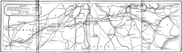
THE EXPLORATION OF THE ROAD
Winchester to Alton
Eighteen miles and a half
Winchester differs from most other towns
which the Romans reorganised in that its
main streets, the street north and south
and the street east and west, do not divide
the city into four equal quarters. The
point where the two ways cross is close to
the western wall, and this peculiar arrangement
was probably made by the first conquerors
in order to avoid an exit upon the
marshy land beside the Itchen; for that
river flowed just against the eastern wall of
the city.
Of the four arms of this cross, the northern,
a street always given up to commerce,
became, in the later Middle Ages, the
Jewry. By a process at first perhaps
voluntary, but later legal, the Jews were
concentrated into one quarter, a sort of
Ghetto. It is to be noticed that in nearly
every case these Jewish quarters were in
the very thick of a city's life, and (as in the
Paris of Philippe le Bel) of far greater value
than any other equal area of the city.[8]
Something of the kind was present at
Winchester. The whole stream of traffic
which passed out from the capital to the
rest of England went through the lane of
the moneylenders, and we may say with
certitude that the north gate, the limit of
that lane, was the starting-point of the
Old Road.
The north gate has now disappeared. It
lay just south of the grounds now known as
North-Gate House. The deflection of the
street is comparatively modern; the original
exit was undoubtedly (as at Chichester and
elsewhere) along the straight line of the
Roman road. This passed near the site of
the present house, and pointed towards the
isolated tree which marks the northern edge
of the garden.
From this point it has been commonly
imagined that the Old Road must have
coincided with the modern Hyde Street,
and have followed this line as far as the
smithy at Headbourne Worthy. Thence
it has been supposed to branch off to King's
Worthy.
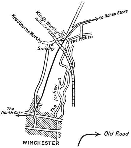
From the church of that village onwards
through Martyrs' Worthy and Itchen Abbas
no one questions but that the modern highway
is identical with the Old Road; but I think
the original track may be shown to have proceeded
not along the modern street, but by
an interior curve, following up the Monks'
Walk, passing under the modern railway
embankment near the arch which is just
north of the Itchen bridge, and making
thence straight for King's Worthy church,
thus leaving Headbourne Worthy on the
left, and running as the thick line runs in
this sketch-map.
The point evidently demands argument,
and I will give the arguments upon one side
and upon the other, so that the conclusion
may recommend itself to my readers.
In favour of the first supposition there is
this to be said, that the line through Headbourne
Worthy carries the road all the way
above the levels which may be marshy,
avoids the crossing of any stream, and
indicates in the continuity of the place-names
(the three Worthies)[9] a string of
similar sites dating from a similar antiquity.
To this consideration may be added that
parallel between Canterbury and Winchester
which will be found throughout this essay.
For at the other end of the road the entry
into Canterbury is of a similar kind. The
Old Road falls, as we shall see, into Watling
Street, a mile before the city, and enters the
ecclesiastical capital by a sharp corner, comparable
to the sharp corner at Headbourne
Worthy in the exit from Winchester.
Against all this one can array the following
arguments. The Old Road, as the
reader has already seen, never during its
course turns a sharp corner. It has to do so
at Canterbury because it has been following
a course upon the north bank of the Stour,
the bank opposite from that upon which
Canterbury grew; no better opportunity
could be afforded for crossing the river than
the ferry or bridge which the most primitive
of men would have provided as an entry into
their township, and such a bridge or ferry
would necessarily run at right angles to a
path upon the opposite bank.
No such necessity exists in this case of
the exit from Winchester. The town is on
the same bank of the river as the road.
Had the Old Road left by the eastern gate,
such a corner would have been quite explicable
and even necessary, but as a matter of
fact it left by the northern.
The argument which relies upon the
necessity of following the high land is of
more value; but that value may be exaggerated.
The shorter and more natural
track, to which we inclined, though it runs
indeed at a lower level, follows the edge of
the chalk, and just avoids the marshy
alluvial soil of the valley.
The objection that it compels a crossing
of the little stream, the Bourne, is not so
well founded as might be imagined. That
stream would indeed have to be crossed, but
it would have been crossed under primitive
conditions in a much easier fashion than
under modern. Its depth and regularity at
the present day are the result of artifice, it
runs at an unnatural level embanked in a
straight line along the Monks' Walk, and
was perhaps turned, as was nearly every
stream that served a medieval congregation,
for the purpose of giving power to the mill
of the Hyde Abbey and of supplying that
community with water.
The mention of the stream and of the
monastery leads me to two further considerations
in support of the same thesis.
This splendid monument of the early twelfth
century and of the new civilisation, the
burial-place of the greatest of our early
kings, the shrine which stood to royal
Winchester as St. Germain des Prés did to
royal Paris, and Westminster later to royal
London, would, presumably, have had its
gates upon the oldest highway of its time.
It should be remarked also that before its
deflection that brook must have followed the
slope and fallen into the Itchen by a much
shorter and smaller channel, reaching the
river near where the railway bridge now
stands. A portion of its water still attempts
a similar outlet, and there can be little doubt
that before the embankment of eight hundred
years ago the fields we traversed in our
search for the path would have been dry, for
they are high enough to escape flood, and
they have a sufficient slope, and their chalky
soil is sufficiently porous to have left the
land firm upon either side of the little
stream.
The Roman road also took the same line,
at least as far as King's Worthy; and a
Roman road was often based upon a pre-Roman
track.[10]
The path so taken not only turns no
abrupt corner (in itself an excellent argument
in support of its antiquity), but points
directly to King's Worthy church so as to
pass its south porch, and then curves easily
into that modern highway which goes on
to Martyrs' Worthy and Itchen Stoke, and
is admittedly coincident with the Old Road.
The alternative has no such regular
development; if one comes through Headbourne
Worthy one is compelled to turn a
sharp corner at the smithy of that village
and another just upon King's Worthy
church before one can fall in with the
modern road at the point where its coincidence
with the old one ceases to be
doubtful.
From all these considerations we determined
to follow the lower and more neglected
path as representing the track of the Old
Road.
We left Hyde Street by the first opening
in the houses of its eastern side; we halted
with regret at the stable door, still carved
and of stone, which is the last relic of Hyde
Abbey. We saw the little red-brick villas,
new built and building, that guard the
grave where Alfred lay in majesty for six
hundred years.[11]
We went up the Monks' Walk, under the
arch, past King's Worthy church, through
King's Worthy village and so on through
Martyrs' Worthy to Itchen Abbas. It is a
stretch which needs little comment, for after
King's Worthy the modern high-road certainly
corresponds with the ancient track.
We were walking these few miles upon
earth beaten (to quote recorded history
alone) by the flight of Saxons from the
battle of Alton, and by the conquering
march of Swegen which was the preliminary
to the rule of the Danes over England. We
noted the sharp dip down into the valley[12]
(whence Itchen-A-Bas is thought to take its
name), and on reaching the green at Itchen
Stoke, six miles from our starting-point,
we determined to explore the first considerable
difficulty which the road would
present to us.
That difficulty we had already presupposed
to exist from a study of the map
before we undertook our journey, and an
examination of the valley confirmed us in
our conjecture.
Thus far the history of the Worthies,
and, as we have seen, the topographical
necessities of the valley had determined
the way with some accuracy; the most of
it had corresponded to the present high-road.
At Itchen Stoke these conditions
disappeared.
The valley of the Itchen here makes a
sharp bend northwards round a low but
rather difficult hill, and leads on to the
Alresfords. The modern road follows that
valley, passes through New Alresford, and
there joins the main road from Winchester
to London.
The Old Road did not follow this course.
It crossed the river at Itchen Stoke, crested
the hill, and did not join the London road
until the point marked by the church at
Bishop Sutton, one mile from Alresford.
That its track was of this nature can be
proved.
We had already noted, upon the earlier
maps, that, barely a century ago, nothing
but irregular lanes connected Itchen Stoke
with the Alresfords by the valley of the
river. These could not represent the
original trail; where that trail passed we
were able to discover. The word Stoke
here, as elsewhere in the South Country, is
associated with the crossing of a stream. It
stands for the 'staking' which made firmer
the track down through the marshy valley,
and supported on either side the wattles
and faggots by which an approach to a river
was consolidated. Moreover, to this day, a
ford exists at Itchen Stoke, and it is an
obvious place for passing the river; not
only is the water shallow, but the bottom is
firm, and the banks are not widely separated,
as is so often the case where the depth of a
river is lessened.
This ford, by itself, might not mean much.
There are plenty of reasons for crossing a
stream whenever one can, and Itchen Stoke
would have provided a convenient ford for
any one living north of the river who desired
to get south of it. But there are a number
of other considerations, which confirm to a
point of certitude the crossing of the river
by the Old Road at this point. Just above
Itchen Stoke is the confluence of all the
head-waters which form the Itchen: the
Alre, and other streams. Now a confluence
of this kind is invariably marshy, and this
marsh could not, in early times, have been
avoided (if one followed the flat right bank)
save by a very long bend to the north:
along that bend no trace of a road or of
continuous prehistoric use exists: while, if
one crosses at Itchen Stoke to the other
bank, one finds a steep, dry bank on which
to continue one's journey.
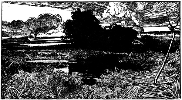
THE HEAD-WATERS WHICH FORM THE ITCHEN, THE ALRE AND OTHER STREAMS
It might be argued that the traveller
would have wished to take on his way such
settlements as the Alresfords; but though
it is true that an ancient track leaves Old
Alresford to the north-east, that track does
not point to Farnham, the known junction
of the 'short-cut' from Winchester with the
original 'Harrow Way.' Old Alresford is
well to the west, and also too far to the
north of the track we had followed to be
touched by it save at the expense of an
abrupt and inexplicable bend. New Alresford
is nearer the alignment (though not on
it), and it is to New Alresford that the
modern road leads. But the town was not
in existence[13] till the end of the twelfth
century, and only grew up in connection
with Bishop Lucy's scheme for rendering
the Itchen navigable. The pond which
was the head of that undertaking still
remains, though much diminished, the chief
mark of the place.
The ford might have been used, and is
still used, for reaching all the district south
of the Itchen, but that district was high,
bare, waterless, unpeopled, and of no great
importance until one got to the Meon valley,
and it is significant that the Meon valley
was in its earliest history independently
colonised and politically separate from the
valley of the Itchen.
In this absence of any but a modern road
up the valley to the Alresfords, in the presence
of the marsh, in the eccentricity of
Old and the modernity of New Alresford,
and in the unique purpose attributable to
the ford, we had a series of negative considerations
which forbade the Old Road to
follow the river beyond Itchen Stoke.
On the other hand, there are as many
positive arguments in favour of the thesis
that the ford was used by the oldest road
from Winchester to Farnham.
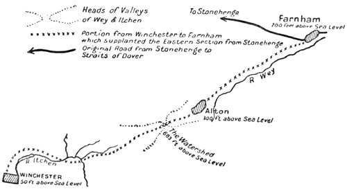
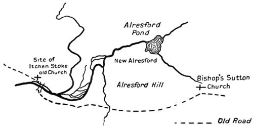
Between these two centres, as will be
seen in a moment by the sketch-map on
p. 137, a high but narrow watershed had to
be crossed. To approach this watershed by
the easiest route must have been the object
of the traveller, and, as the map will show, to
cross at this ford, go straight across the hill
to Bishop Sutton, and thence follow the
Ropley valley was to go in a direct line to
one's object.
As we talked to the villagers and gathered
their traditions, we found that this ford had
been of capital importance. The old church
of the village stood just beside the river, and
in such a position that the road to the ford
passed just by its southern porch. It has
disappeared—'in the year of the mobbing,'
say the peasants: that is, I suppose, in
1831; but the consecrated land around it
is still enclosed, and its site must have
clustered the whole place about the riverside.
It stood, moreover, close against the
ford; and the Old Road that skirted the
churchyard is marked by an alignment of
yews and other trees leading directly to the
river.
Finally, when we accepted the hypothesis
and crossed the river, we found a road
corresponding to what the old track should
be. It has in the past been somewhat
neglected, but it is now a metalled lane; it
is without any abrupt turn or corner, and
leads directly over the hill in the direction
of Bishop Sutton, the Ropley valley, and so
at last to the watershed, the surmounting
of which was the whole object of the trail
from this point onwards.
The points I have mentioned will be made
clearer, perhaps, by a sketch-map, in which
the dark patches and lines represent the
water-ways at this confluence which forms
the Itchen. The Old Road I have indicated
by a dotted line, but for its exact course it
would be advisable for readers to refer to an
Ordnance map.
All these pieces of evidence supporting
one another seemed to us sufficient to determine
the trajectory at this point. The ford,
the position of the church, the number of
streams that would have to be crossed were
the valley to be further pursued, the low
marshy ground at the confluence of these
streams, the non-existence of any ancient
settlement or trace of a road at the base of
Alresford Hill, the fact that the only village
to which such a track could lead is of comparatively
recent creation, the existence of
an old track, direct in its alignment, proceeding
straight from the ford, and pointing
without deviation to Bishop Sutton church
and the Ropley valley—all these facts combined
settled any doubts upon the way we
should go. We climbed and followed the
lane to the top of the hill.
These two miles of the way gave us
(under the evening—for it was the falling
of the light) glimpses of the Itchen westward
and away behind us. The road had
the merit of all savage trails, and of all the
tracks a man still takes who is a-foot and
free and can make by the shortest line for
his goal: it enjoyed the hills. It carried
two clear summits in its flight, and from
each we saw those extended views which to
the first men were not only a delight, but a
security and a guide. It was easy to
understand how from these elevations they
planned their direct advance upon the ridge
of the watershed which lay far before us,
eastward, under the advancing night. As
they also must have done, we looked backwards,
and traced with our eyes the sharp
lines of light in the river we had just
abandoned. We so halted and watched till
darkness had completely fallen; then we
turned down northward to Alresford to
sleep, and next morning before daybreak,
when we had satisfied the police who had
arrested us upon suspicion of I know not what
crime, we took the hill again and rejoined
the Old Road.
By daylight we had come down Whitehill
Lane, the steep pitch into Bishop
Sutton, and were tramping up that vale
which makes for the watershed, and so leads
to the corresponding vale of Alton upon the
further side.
Here, at least as far as the Anchor Inn,
and somewhat further, the modern highway
corresponds to the Old Road. It thus
follows the lowest of the valley, but there is
no reason at first why it should not do so.
The rise is fairly steady, the ground dry (an
insignificant stream gradually disappears
beneath the chalk), and the direction points
straight to the shortest approach for the
ridge which cuts off the basin of the Channel
from that of the Thames.
This direction, does not, however, long
continue. The valley curves somewhat to
the north, and it might be presumed that
the original way, making more directly for
the saddle of the watershed, would gradually
climb the southern hillside. By so doing it
would find two advantages: it would take
a shorter cut, and it would conquer at one
stretch, and rapidly, the main part of the
360 feet between the Anchor Inn and the
summit.
It was but a guess that the Old Road
would probably take a straight line upwards.
The curve of the modern road does not carry
it more than half a mile from the direct
alignment. The Old Road might quite well
have suffered such a deviation, and we were
in some doubt when we proceeded to gather
our evidence. That evidence, however,
proved fairly conclusive.
There is a tradition, which Mrs. Adie
has justly recognised, that the pilgrims of
the Middle Ages passed through Ropley.[14]
What is more important to our purpose,
Ropley has provided a discovery of British
antiquities, Celtic torques, near the track
which the more direct line to the watershed
would presuppose.
We had further the place-name 'Street'
to guide us: it is a word almost invariably
found in connection with a roadway more
or less ancient; later on we found many
examples of it upon this same road.[15] Here
the hamlet of Gilbert Street lay to the
south of our hypothetical alignment, and
another, named North Street, just to the
north of it.
We further noted upon our map that
a very considerable portion of the exact
alignment drawn from the main road at
the Anchor Inn to the saddle of the watershed
would coincide precisely with a lane,
which, when we came to examine it, gave
every evidence of high antiquity.
Possessed of such evidence, it was our
business to see whether investigation upon
the spot would confirm the conclusion to
which they pointed. There was enough
discovered so to confirm it, though the Old
Road at this point has disappeared in several
places under the plough.
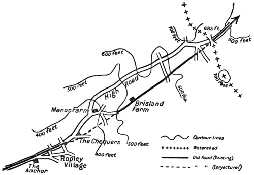
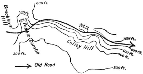
The course of our discovery will be best
followed with the aid of this rough map,
whereon are sketched the contour-lines, the
trace of the Old Road, and the watershed.
About half a mile from the 'Anchor' at
the end of the avenue of trees which here
dignifies the turnpike and just after the
cross-roads,[16] in a meadow which lay to the
right of the road, my companion noticed an
embankment, perfectly straight, slightly
diverging southward from the main road
as the line we were seeking should diverge,
and (as we found by standing upon it and
taking its direction) pointing directly at
the saddle of the watershed. Whether it
was continued through the garden of the
Chequers Inn (a very few yards) I would
not trespass to inquire: in the three fields
beyond, it had entirely disappeared.[17] After
this gap, however, there is a boundary, with
an old hedge running along it and a path
or cartway of a sort.[18] These carry us
exactly the same direction down a short
slope, across a lane called Cow Lane, and
on to the Manor Farm at North Street.
During this stretch of a mile there was
nothing more to guide us. The division
between fields and properties very often
follows the line of some common way: one
could not say more.
But the significant fact which, as we
believe, permitted us to bridge the gap was
this: that the embankment we had first
discovered, and the hedge and path (which
proceeded in the same line after the loss of
the road over the two fields) each pointed
directly towards the lane (Brisland Lane)
which we entered close to the Manor Farm,[19]
which presented, as we found, such marks
of antiquity, which takes the hill steeply,
and which, on the plateau above, continues
to aim straight at the saddle of the watershed.
It is difficult to express in a written
description the sentiment of conviction
which the actual view of such an alignment
conveyed. When we had followed the
lane up the steep hill and stood by Brisland
farmhouse, looking back from that
height we could see the lane we had been
following, the hedge, the corner of the
garden of the 'Chequers,' the embankment
beyond, all in one, stretched out like parti-coloured
sections of one string, and the two
gaps did but emphasise the exactitude of the
line.
Turning again in the direction which we
were to follow, the evidence of ancient usage
grew clearer.
We were upon one of those abandoned
grassy roads, which are found here and there
in all parts of England; it ran clear away
before us for a couple of miles.
It was very broad—twenty yards perhaps.
The hedges stood upon either side, guarding
land that had been no man's land since
public protection first secured the rude
communications of the country. No one
who had seen portions of the Icknield Way
upon the Chilterns, or of this same Old
Road where it has decayed upon the Kentish
hills, could doubt the nature of what we
saw. Long fallen into disuse, it had yet
escaped the marauding landlords during
three centuries of encroachment. They
had not even narrowed it. So much of
its common character remained: it was
treeless, wide, and the most of it neglected;
never metalled during all the one hundred
and fifty years which have transformed
English highways. It was the most
desolate, as it was the most convincing,
fragment of the Old Road we had set out
to find.
It had an abominable surface; we had to
pick our way from one dry place to another
over the enormous ruts which recent carts
had made. For generations the lane had
been untenanted; but there is a place
where, in the last few years, an extraordinary
little town of bungalows and
wooden cottages had arisen upon either side
of the lane.
Not satisfied with the map, we asked of
a man who was carrying milk what local
name was given to this venerable street.
He told us that the part in which we were
walking was called Blackberry Lane, but
that it had various names at different parts:
and as he could tell us nothing more, we
left him.
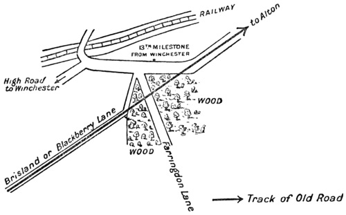
At the very summit this way joined a
modern, well-made lane, called Farringdon
Lane, turned to the left and north, and
immediately fell into the main London
road, which had been climbing from the
valley below and was here at the thirteenth
milestone. The Old Road, suffering no
deviation, plunged into a wood, and reappeared
just at the summit of the pass,
perhaps a quarter of a mile further. It is
the point where the Ordnance map marks a
height of 683 feet, and where one finally
leaves the valley of the Itchen to enter that
of the Wey.
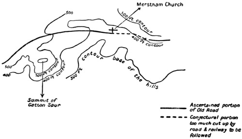
The complexity of this corner is best
understood in the sketch-map on the following
page.
At the point where the Old Road leaves
the wood, it merges again into the London
turnpike, which turns its direction (as the
map shows) so as to correspond with the
direction of the Old Road. This identity
between the prehistoric and the modern is
maintained nearly as far as Alton, and, if
we except a short gap before that town,
the coincidence of the Old Road and some
existing highway may be said to continue
right on to Puttenham, a distance of seventeen
miles.
The valley which now opened eastward
under the dull morning light reminded me
of one of those noble dales which diversify
the long slope of the Chiltern Hills. Like
them it had the round sweep of the Chalk;
beeches, the trees of the Chalk, adorned it;
its direction was the same, its dryness, its
neat turf; but it lacked the distant horizons.
For two miles the road, magnificent in
surface and in breadth, one of the finest in
England, followed the bottom of the valley,
falling in that distance some 300 feet; and
in all this part it was most evidently the
oldest of ways across these hills. There
could be repeated of it what has been said
above with regard to the road between
Bishop Sutton and Ropley, and what will
appear further on in the valley of the Wey:
that any track, ancient or modern, was
bound to follow the same course. For the
dry and porous soil permitted a journey
even under the earliest conditions along the
lowest points, and, so permitted, such a
journey had the advantage of descending
by the easiest gradient. Had it taken to
the hillside it would have fallen at last
upon Alton by way of a steep spur. Moreover,
the bottom of the valley is here constant
in direction, not curving as we had
found it on the far side of the watershed,
and this direction deviates little from the
straight line to Alton.
These characters do not attach to the London
turnpike after the fifteenth milestone is
passed; it turns somewhat sharply to the
right (or southward) and falls by a corner
into the road from the Meon valley at the
entry of Chawton village. Such a course
one may be certain was not followed by the
Old Road. It could not but have preserved
the alignment which the valley had already
given it, and which corresponds, moreover,
with the High Street of Alton itself. For
these seven furlongs there can be no doubt
that it continued straight along the dip of
the valley, and entered Alton on the
northern side[20] of the triangular common
called 'The Butts,' by which one approaches
the town from the south-west.
We were unable to prove this by direct
examination; the main line of railway has
here obliterated much by an embankment,
and to this has been added all the new
work of the Meon valley line, and the
junction. The ground has therefore lost
all its original character, and its oldest
marks have disappeared. We made no
attempt to follow the direct path for this
short mile. We descended the high-road
round by Chawton to Alton, and the first
division of our task, the division in which
a greater proportion of uncertainty would
exist than in any other, was accomplished.
Comforted by such a thought, we drank
mild ale at the 'Three Tuns' for about half
an hour.
Alton to Shalford
Twenty-one miles
At Alton, with the green by which one
enters the town from the west, begins a
stretch of the Old Road, which stands by
itself.
It may be roughly called the division
between Alton and Farnham, but it stretches
for a mile or two beyond Farnham to the
pond at Whiteways, where the main road
climbs the summit of the Hog's Back, and
leaves the Pilgrim's Way a few hundred
yards to the south.
This section, just over thirteen miles in
length, has several peculiarities which distinguish
it from the rest of the Road.
First—It follows the river Wey for miles,
not as it followed the river Itchen, on a dry
ledge above the stream, but right along the
low land of the waterside. This is a feature
in the Old Road not to be discovered in any
other part of its course. It takes care to
be within easy reach of water for men and
horses, but it avoids the low level of a
stream, and thick cover and danger of
floods which such a level usually threaten.
We had not found it (save for a very few
yards) in immediate touch with the Itchen,
nor should we find it later on running by
the Mole, the Darent, or the Medway.
Even the Stour, whose valley it is compelled
to follow, it regards from heights well above
the river.
Secondly—It runs for a part of this division
upon clay, a soil which elsewhere it carefully
avoids as being about the worst conceivable
for a primitive and unmetalled road. Elsewhere
(after Wrotham, for instance), it will
make a detour rather than attempt any
considerable stretch of gault; but here, for
several miles along this valley of the Wey,
it faces the danger.
Thirdly—In every other portion of its
long journey it passes along the edge of
habitations and tilled land; it was brought
to do so by the same economic tendency
which makes our railways to-day pass by
the edges, not the centre of most towns; but
here it must often have run right through
whatever cultivation existed; at Alton,
at Farnham, and in one village between,
Bentley, it forms the high street of the
place. A track which carefully just avoids
Guildford, Dorking, Reigate, Westerham,
Wrotham, Charing, and a dozen smaller
places here touches and occasionally passes
through the earliest groups of houses, the
earliest pastures and ploughed fields.
Finally, there is a correspondence between
it and the modern high-road for the whole of
this considerable distance of over thirteen
miles. In this character, again, the division
we were now entering is unique.
We have indeed already found it identical
with a modern road. The modern high-road
also corresponds with the old way for something
like a mile at Otford over the Darent,
and for two or three miles beyond; it is a
modern road for more than half a mile
before you reach the ferry at Snodland,
and there is a road in construction which
follows its track for some hundreds of yards
on Gravelly Hill, near Caterham. For
many miles of its course it is identical if
not with high-roads at least with metalled
lanes, as we had already found between
Itchen Stoke and Bishop Sutton, and very
commonly with unmetalled tracks or
paths. But in all these cases it is broken:
there are stretches of it unused. Modern
advantages and modern necessities have left
the Old Road continually to one side. Here
for this very considerable distance it is
identical with the great turnpike, and so
remains identical up to and beyond its point
of junction with the older 'Harrow Way'
at Farnham.
Can we discover any explanation for this
coincidence of a prehistoric track with the
high-road of our own time, which is almost
indifferent to soil? for the crossing of the
clay? for the neighbourhood of the river?
A little consideration will enable us to
do so. The hills which everywhere else
afford so even a platform for the prehistoric
road are here of a contour which forbids their
use. To-day, as a thousand years ago, any
road down this valley must have run upon
this lowest line.
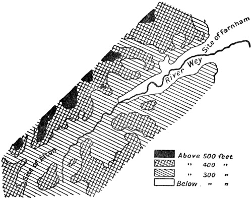
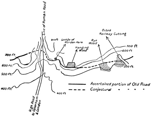
The contour-lines, of which a rough sketch
is here appended, are enough to prove it.
There is a deep combe at Holybourne Down,
two more on either side of Froyle, a fourth
beyond Bentley, a fifth—smaller—before
Farnham. All these gullies cut up into a
hopeless tangle what in Surrey and Kent
will become one unbroken bank of chalk.
Any path attempting these hillsides would
either have doubled its length in avoiding
the hollows, or would—had it remained
direct—have been a succession of steep
ascents and falls; all the dry slopes which
bound the vale to the north are a succession
of steep and isolated projections, thrust out
from the distant main chain of the chalk;
many of them are crowned with separated
summits. The road is therefore compelled
to follow the valley floor with all the consequences
I have noted.
As far as Froyle, two and a half miles
from Alton, it never leaves the river by
more than a quarter of a mile, but the
valley is here dry, the soil gravelly and
sandy, the height considerable (above three
hundred feet), and there is no reason why
it should go further from the stream than
it did in the valley of the Itchen. After
Froyle you get the clay, and then right on
through Bentley the road does attempt to
get away northward from the stream, avoiding
the marshy levels and keeping to the
300-feet contour-line. It does not approach
the river again till firmer ground is found
near the Bull Inn. Thence to within two
miles of Farnham it has to negotiate a good
deal of clay, but it picks out such patches
of gravel as it can find,[21] and it must be
remembered that the valley of the Wey, in
this early part, drains more rapidly, and
has a less supply of water than that of the
Itchen. Near Farnham, somewhat beyond
Runwick House, it finds the sand again,
and can follow along the low level without
difficulty.
The Old Road keeps throughout this
passage to the sunny northern bank of the
river, so that, while it is compelled to keep
to the bottom of the valley, it attempts at
least to get the driest part of it.
Farnham, at the mouth of this valley, the
point of junction between the Old Road and
its still older predecessor from Salisbury
Plain, was always a place of capital importance,
especially in war. The Roman entrenchment,
two miles up the valley, the
Roman dwellings to the south, tell us only
a little of its antiquity; and though our
knowledge of the castle extends no further
than the eleventh century, the fact that it
was the meeting-place of the roads that
came from Salisbury Plain, from the Channel,
from London, and from the Straits of
Dover, necessarily made it a key to southern
England.
We have seen how the western roads
converge there, first the Harrow Way, then
our own road from Southampton Water and
Winchester (a road which probably received
the traffic of all the south beyond Dorsetshire),
then the road from Portsmouth and
the Meons, which came in at Chawton.
The accident of the Surrey hills made all
men who wished to get to the south-western
ports from the Thames valley and the east
pass through Farnham. Travellers going
west and north from the Weald were equally
compelled, if they would avoid the ridge, to
pass through Farnham. The former had to
come down north of the Hog's Back, the
latter from the south of it, and it was ever
at Farnham that they met.
At Farnham, therefore, the first political
division of our road may be said to end;
and after Farnham the western tracks,
now all in one, proceed to the Straits of
Dover, or rather to Canterbury, which is
the rallying-point of the several Kentish
ports.
Just outside the town the road begins to
rise: it is an indication that the road is
about to take the flank of the hills, a position
which it holds uninterruptedly (save
for four short gaps occasioned by four river
valleys) from this point until the Camp above
Canterbury.
Hitherto, for reasons which I have explained,
the road has had no opportunity
of this kind. The hills of the Itchen valley
were not sufficiently conspicuous, those of
the upper Wey too tortuous, for the trail
to take advantage of a dry, even, and well-drained
slope. The height to which it rises
between Ropley and Alton is not a height
chosen for its own purpose, but a height
which had to be overcome of necessity to
cross the watershed. Henceforward, until
we were within a few miles of Canterbury,
there stretched before us, on and on, day
after day, the long line of the northern
heights, whose escarpment presented everything
the Old Road needed for its foundation,
and of which I have written at
such length in the earlier portion of this
book.
The rise continued gently until the inn at
Rumbold was passed, and the fork at Whiteways
was reached. Here the old flanking
road went up along the ridge of the Hog's
Back in the shape of the modern turnpike,
while our track was left to continue its eastward
way, two hundred feet below, upon the
side of the hill.
Its soil was here a thin strip of the
green-sand which continued to support us,
until next day we crossed the Tillingbourne,
just above Shere. It runs, therefore,
firmly and evenly upon a dry soil,
and the villages and the churches mark its
ancient progress.
The afternoon was misty, even the telegraph
poles, which at first marked the
ridge of the Hog's Back above us, disappeared
in the first half mile. We went
unhappily and in the fog regretting the
baker's cart which had taken us along
many miles of road so swiftly and so well:
a cart of which I have not spoken any more
than I have of the good taverns we sat in,
or of the curious people we met (as for
instance, the warrior at Farnham), because
they are not germane to such an historical
essay as is this.
We went, I say, regretting the baker's
cart, and came to the wonderful church of
Seale standing on its little mound. We
noted that the track passed to southward
of it, not right against its southern porch,
but as near as it could get, given the steep
accident of the soil just beyond. We noted
this (but dully, for we were very tired), and
we plodded on to Shoelands.
We were in the thick of the memories
which are the last to hang round the Old
Road, I mean the memories of those pilgrims,
who, after so many thousand years of its
existence, had luckily preserved the use and
trace of the way.
Seale was built at the expense of
Waverley, right in the enthusiasm that
followed the first pilgrimages, just after
1200. The names also of the hamlets have
been held to record the pilgrimage. How
Seale (a name found elsewhere just off the
Old Road) may do so I cannot tell. 'Shoelands'
has been connected with 'Shooling'—almsgiving.
Compton church itself was
famous. Even little Puttenham had its
pilgrim's market, and Shalford its great fair,
called Becket's fair. We left Seale then, and
at last, two miles on and very weary, we
approached Puttenham, where, for the first
time since Alton, something of exploration
awaited us.
There was, indeed, just before reaching
Puttenham, a small difficulty, but it is not
of this that I am writing. The Old Road,
which had for miles coincided with the lane,
turned a sharp corner, and this, as I have
already remarked, is so much against its
nature in every known part of it, that I
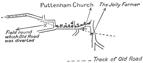
could only ascribe it to a cultivated field[22]
which has turned the road. Once tillage
had begun, the road would be led round
this field, and the old track, crossing it
diagonally, would disappear under the
plough; the original way must have run
much as is suggested at the point marked
X upon the map, and the suggestion has the
greater force from the presence of a footpath
following this line.
But the point is of little importance and
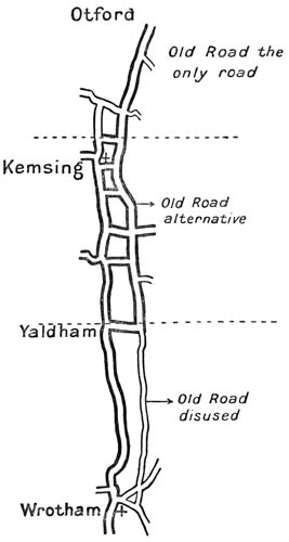
is easily settled. In Puttenham itself lay
the more interesting problem, to elucidate
which this sketch was drawn.
It arises, just before the church is reached,
and affords a very interesting example of
how the Old Road has been lost and may be
recovered.
The present road goes round to the north
of the church, outside a high wall, which
there forbids any passage. It turns sharp
round a corner, and then proceeds due south
to the village of Compton. When it has
passed through this village, it turns north
again, and so reaches St. Catherine's chapel,
near which point it is agreed that the passage
of the Wey was made.
Not only does the modern road take this
circuitous course, but the pilgrims of the
later Middle Ages probably followed a direction
not very different. Compton church
perhaps attracted them.
It is not the only place in which we shall
find their leisurely piety misleading our
research.
The Pilgrimage and the modern road both
tend to make us miss the original track.
That track, as a group of independent facts
sufficiently show, passed south of Puttenham
church, continuing the direction which it
had hitherto followed from Seale; it went
past the inn miscalled 'The Jolly Farmer,'
and so on in a straight line over Puttenham
Heath, where it is still marked by a rough
cart-track kind of way.
One must here repeat an argument which
continually recurs in these pages. Short of
a physical obstacle, there is no reason but
private property, and property long established
and well defined, to give rise to such
an unnatural halt in a path as is here made
by a sudden turn of a right angle.
We know that the enclosure of this church
within the wall was comparatively recent.
We know that in every case where the
Old Road passes directly past a village
church, it passes to the south. From the
south, as we have already seen, the entry of
the traveller was made; for, to repeat the
matter, a custom presumably much older
than our religion, gave approach to sacred
places from the side of the sun.
The face of the Inn, the road before it
(ending now abruptly and without meaning
at the wall), and the road through Puttenham
village are all in the same alignment.
It is an alignment that makes for the
passage of the Wey (for Shalford, that is),
much in the direction the Old Road has held
since Seale.
The alignment is continued on through
Puttenham Heath by an existing track, and
in all this continuous chain there is no break,
save the comparatively modern wall round
the church.
Finally, Puttenham Heath had furnished
antiquities of every sort, especially of the
Neolithic period and of the Bronze: all
within a small area, and all in the immediate
neighbourhood of this Way.
So many indications were sufficient to
make us follow the right-of-way across
Puttenham Heath, and our conjecture was
confirmed by our finding at the further edge
of the heath, a conspicuous embankment
marked by an exact line of three very aged
trees, which everywhere indicate the track.
Though it was hardly a road, rough and
marked only by ruts in the winter soil and
by its rank of secular trees, it was most
evidently the Old Road. We were glad to
have found it.
When we had passed through the hollow
to the north of a few cottages, direct evidence
of the road disappeared at the boundary
of Monk's Hatch Park, but it was not lost
for long. 350 yards further on, laid on the
same line, a slightly sunken way reappeared;
it ran a few yards below the recently made
Ash Path, and led directly by the lane
along the south of Brixbury Wood, across
the Compton Road, and so by a lane called
'Sandy Lane,' beyond, over the crest of the
hill, till, as the descent began, it became
metalled, grew wider, and merged at last
into the regular highway which makes
straight for St. Catherine's Hill and the
ferry and ford below it.
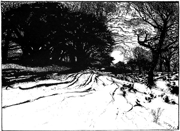
ROUGH, AND MARKED ONLY BY RUTS IN THE WINTER SOIL, AND BY ITS
RANK OF SECULAR TREES
The Old Road having thus coincided once
more with a regular road, we went at a
greater pace, observing little of our surroundings
(since nothing needed to be discovered),
and hoped to make before it was quite dark
the passage of the river.
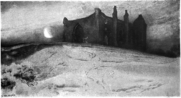
THAT CURIOUS PLATFORM WHICH SUPPORTS IN SUCH AN IMMENSE ANTIQUITY OF
CONSECRATION THE RUINS OF ST. CATHERINE'S CHAPEL
Arrived, however, at that curious platform
which supports in such an immense antiquity
of consecration the ruins of St. Catherine's
chapel, we saw that the exact spot at which
the river was crossed was not easily to be
determined. The doubt does not concern
any considerable space. It hesitates between
two points on the river, and leaves
unmapped about 800 yards of the road;
but that gap is, it must be confessed,
unsolved so far as our investigation could
be carried.
It is certain that the prehistoric road
begins again by the north-western corner
of the Chantries Wood. Tradition and the
unbroken trail hence to St. Martha's hill-top
confirm it. The arguments I have used
in the last few pages show equally that the
road led, on this side of the way, up to the
point below St. Catherine's chapel where we
were now standing.
It is, moreover, extremely probable that
the platform of St. Catherine's was the
look-out from which the first users of this
track surveyed their opportunities for passing
the river, and near to it undoubtedly
their successors must have beaten down the
road.
The precipitous face towards the stream,
the isolation of the summit and its position,
commanding a view up and down the valley,
render it just such a place as would, by its
value for their journeys and their wars, have
made it sacred to a tribe: its sanctity during
the Middle Ages gives the guess a further
credential. But in framing an hypothesis
as to how the valley was taken from the
descent of St. Catherine's to the rise at the
Chantries beyond the stream, one is met
by two sets of facts irreconcilable with one
another, and supporting arguments each,
unfortunately, of equal weight. These facts
are few, simple, and urgent; they are as
follows:—
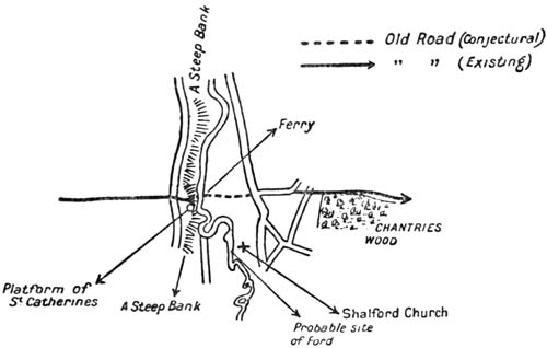
Primitive man we must imagine chose, if
he could, a ford, and kept to such a passage
rather than to any form of ferry. The ford
exists. It has given its name 'The Shallow
Ford' to the village which grew up near it.
The church stands close by. So far it would
seem that the road certainly passed
over the crest of St. Catherine's, came
down to the south of that hill, crossed at
Shalford, and reached the Chantries by that
passage.
On the other hand a sunken way of great
antiquity leads directly from St. Catherine's
Hill down to the river. It follows the only
practicable descent of the bank. It is in
line with the previous trend of the Old
Road; at its foot is a ferry which has had
a continuous history at least as old as the
pilgrimage, and beyond this ferry, the path
over the field, and the avenue beyond the
main road, lead immediately and without
any diversion to that point at the foot of
the Chantries Hill where, as I have said,
the Old Road is again evident.
From Shalford no such track is apparent,
nor could it be possible for a passage by
Shalford to be made, save at the expense
of a detour much sharper than the Old
Road executes in any other part of its
course.
In the face of these alternatives no certain
decision could be arrived at. The medieval
route was here no guide, for it had already
left the road to visit Compton, and was
free to use Shalford ford, the ferry, or even
Guildford Bridge—all three of which the
pilgrims doubtless passed indifferently,
for all three were far older than the
pilgrimage.
It may be that the ferry stands for an
old ford, now deepened. It may be that
the passage at Shalford was used first,
and soon replaced by that of the ferry.
We knew of no discoveries in that immediate
neighbourhood which might have
helped us to decide; we were compelled,
though disappointed, to leave the point
open.
It was now quite dark. My companion
and I clambered down the hill, stole a boat
which lay moored to the bank, and with a
walking-stick for an oar painfully traversed
the river Wey. When we had landed, we
heard, from the further bank, a woman, the
owner of the boat, protesting with great
violence.
We pleaded our grave necessity; put
money in the boat, and then, turning, we
followed the marshy path across the field to
the highway, and when we reached it,
abandoned the Old Road in order to find
an inn.
We slept that night at Guildford, whence
the next morning, before daylight, we returned
up the highway to the spot where
we had left the Old Road, and proceeded
through the gate and up the avenue to
follow and discover that section of the road
between the Wey and the Mole which is by
far the richest in evidences of prehistoric
habitation—a stretch of the Old Road which,
partly from its proximity to London, partly
from its singular beauty, partly from its
accidental association with letters, but
mainly from the presence of rich and leisured
men, has been hitherto more fully studied
than any other, and which yet provides in
its sixteen miles more matter for debate
than any other similar division between
Winchester and Canterbury.
Shalford to Dorking Pits
Eleven miles
The Old Road leaves the Guildford and
Shalford highway on the left, or east, in
a line with the path which has reached it
from the ferry. We passed through a gate
and entered an avenue of trees, at the end
of which the newer road which has been
built along it turns off to the left, while the
Old Road itself, in the shape of a vague
lane, begins to climb the hill. The light
was just breaking, and we could follow it
well.
At this point, and for some distance
further, it is known to historians and
antiquaries, and preserves, moreover, many
indications of that use whereby the medieval
pilgrimage revived and confirmed its course.
It skirts by the side of, and finally passes
through, woods which still bear the name of
the 'Chantries,' and climbs to that isolated
summit where stands the chapel of St.
Thomas: 'the Martyr's' chapel, which, in
the decay of religion and corruption of tradition,
came to be called 'St. Martha's.'
This spot, for all its proximity to London
and to the villas of the rich, preserves a
singular air of loneliness. It has a dignity
and an appeal which I had thought impossible
in land of which every newspaper
is full; and that morning, before men were
stirring, with the mist all about us and the
little noises of animals in the woods, we
recovered its past. The hill responded to
the ancient camps, just southward and above
us. It responded to its twin height of St.
Catherine's: the whole landscape had forgotten
modern time, and we caught its
spirit the more easily that it relieved us of
our fears lest in this belt near London the
Old Road should lose its power over us.
It has been conjectured, upon such slight
evidence as archæology possesses, that the
summit was a place of sacrifice. Certainly
great rings of earth stood here before the
beginning of history; certainly it was the
sacred crown for the refugees of Farley
Heath, of Holmbury, of Anstie Bury, and of
whatever other stations of war may have
crowned these defiant hills.
If it saw rites which the Catholic Church
at last subdued, we know nothing of them;
we possess only that thread of tradition
which has so rarely been broken in western
Europe: the avenue, whereby, until the
sixteenth century, all our race could look
back into the very origins of their
blood.
The hill was an isolated peak peculiar and
observable. Such separate heights have
called up worship always wherever they
were found: the Middle Ages gave this
place what they gave to the great outstanding
rocks of the sea, the 'St. Michaels': to
the dominating or brooding capitols of cities,
Montmartre or Our Lady of Lyons; perhaps
Arthur's Seat had a shrine. The Middle
Ages gave it what they had inherited, for
they revered the past only, they sought in
the past their ideals, and hated whatever
might destroy the common memory of the
soil and the common observances of men—as
modern men hate pain or poverty.
Remembering all this we rested at the
chapel on the hill-top, and considered it
wearily. We regretted its restoration to
new worship, and recollected (falsely, as it
turned out) famous graves within it.
The air was too hazy to distinguish the
further view to the south. The Weald
westward was quite hidden, and even the
height of Hirst Wood above and beyond us
eastward was hardly to be seen.
When we had spent half an hour at this
place we prepared to go down the further
side, but first we looked to see whether the
Old Road passed clearly to one side or the
other of the summit, for we thought that
matter would be of importance to us as a
guide for its direction in similar places later
on. But we could decide nothing. Certainly
the track makes northward of the church
until it is near the top of the hill, but, as it
gets near, it points right at it (as we might
expect), is lost, and is only recovered some
twenty or fifty yards beyond the platform of
the summit, coming apparently neither from
the south nor from the north of the church;
the direction is a little obscured, moreover,
by a modern plantation which confuses the
beginning of the descent. Soon it grew clear
enough, and we followed it at a race, down
the hill perhaps half a mile. It was plainer
and plainer as we went onward, till it struck
the road which leads from Guildford to
Albury.
Here there rises a difficulty unique in the
whole course of the way. It is a difficulty
we cannot pretend to have solved. The
trail for once goes to the damp and northward
side of a hill: the hill on which stands
Weston Wood. It is an exception to an
otherwise universal rule, and an exception
for which no modern conditions can
account.
There is apparently no reason why it
should not have followed its otherwise invariable
rule of taking the southerly slope,
and it could have chosen the dry clean air
of the heath and kept all the way near the
fresh water of the Tillingbourne. On the
other hand, there is no doubt whatever of its
direction. Tradition, the existence of modern
tracks, and more important still, the direction
of the road after it leaves St. 'Martha's'
chapel, all point to the same conclusion.
The Pilgrim's Way crosses diagonally the
field beyond the main road, goes just behind
the little cottage at its corner,[23] and then
makes for Albury Park by way of a wretched
and difficult sunken lane to the north of
Weston Wood. We entered this neglected
and marshy way. It was a place of close,
dark, and various trees, full of a damp air, and
gloomy with standing water in the ruts: the
whole an accident differing in tone from all
that we knew of the road, before and after.
It was not long in passing. We left the
undergrowth for the open of a field, and
found the trace of the road pointing to the
wall of Albury Park. It entered just north
of the new church, and then followed a clearly
marked ridge upon which, here and there,
stood the yews.
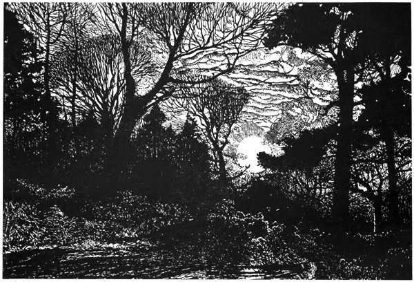
A PLACE OF CLOSE DARK AND VARIOUS TREES, FULL OF A DAMP AIR, AND GLOOMY
WITH STANDING WATER-RUTS
After the Old Road enters Albury Park
there is a doubtful section of about a mile
and a half. The 25-inch Ordnance for
Surrey (revised eight years ago) carries the
track southward at a sharp angle, round the
old church of SS. Peter and Paul and then
along the south of Shere till it stops suddenly
at a farm called 'Gravel Pits Farm.' It
seemed to us as we overlooked the valley
from the north, that the Old Road followed
a course now included in the garden of
Albury, and corresponding, perhaps, to the
Yew Walk which Cobbett has rendered
famous, and so reached the ford which
crosses the Tillingbourne at the limits of the
park—a ford still called 'Chantry' ford,
and evidently the primitive crossing-place of
the stream.
Thence it probably proceeded, as we did,
along that splendid avenue of limes which is
the mark of the village of Shere. But from
the end of this there are some three hundred
yards of which one cannot be very certain.
It comes so very near to the church that one
may presume, without too much conjecture,
that it passed beside the southern porch. If
it did so, it should have crossed the stream
again near where the smithy stands to-day,
and this double crossing of the stream may
be accounted for by the presence of a shrine
and of habitation in the oldest times. But
if the bridge be taken as an indication
(which bridges often are) of the original
place where the stream was re-crossed, then
the track would have left the church on the
right, and would have curved round to
become the present high-road to Gomshall.
Nothing certain can be made of its passage
here, except that the track marked upon the
Ordnance map will not fit in with the
character of the road. The Ordnance map
loses it at Gomshall, finds it again much
further on, having turned nearly a right
angle and going (for no possible reason) right
up to and over the crest of the hills: across
Ranmore Common and so to Burford Bridge.
The first part of this cannot but be a confusion
with the Old Drove Road to London.
As for the crossing of the Mole at Burford
Bridge we shall see in a moment that the
medieval pilgrimage passed the river at this
point, but the prehistoric road at a point
a mile and more up stream.
Taking into consideration the general
alignment of the Old Road, its 'habits,' the
pits that mark it, and its crossing-place in
the Mole valley, we did not doubt that we
should find it again on the hillside beyond
Gomshall.
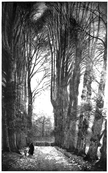
THAT SPLENDID AVENUE OF LIMES
Its track must have crossed the high-road
at a point nearly opposite Netley House, and
by a slow climb have made for the side of
the Downs and for the chalk, which henceforward
it never leaves, save under the
necessity of crossing a river valley, until it
reaches Chilham, sixty miles away.
Beyond the grounds of Netley House the
Old Road is entirely lost. A great ploughed
field has destroyed every trace of it, but the
direction is quite easy to follow when one
notes the alignment which it pursues upon
its reappearance above the line of cultivation.
It must have run, at first, due north-west,
and turned more and more westward as it
neared Colekitchen Lane: it must have
crossed the mouth of Colekitchen Combe,
which here runs into the hills, and have
reached in this fashion the 400-feet contour-line
at the corner of Hacklehurst Down,
where we come on it just at the far edge of
the Combe, on the shoulder about three
hundred yards east of the rough lane which
leads up from under the railway arch to the
Downs.[24]
From this point we could follow it mile
after mile without any difficulty. Its platform
is nearly always distinct; the yews
follow it in a continual procession, though it
is cut here and there by later roads. The
old quarries and chalk pits which mark it
henceforward continually along the way to
Canterbury begin to appear, and it does not
fail one all along the hill and the bottom of
Denbies Park until, at the end of that enclosure,
it is lost in the pit of the Dorking
Lime Works. It does not reappear. Beyond
there is a considerable gap—nearly a
mile in length—before it can reach the river
Mole, which it must cross in order to pursue
its journey. With this gap I shall deal in a
moment, but it was the affair of our next
day's journey, for short as had been the distance
from Shalford, the many checks and
the seeking here and there which they had
entailed had exhausted the whole of the
short daylight. The evening had come when
we stood on the Down looking over to Box
Hill beyond.
From thence across the valley, Box Hill
attracted and held the sight as one looked
eastward: the strongest and most simple
of our southern hills. It stood out like a
cape along our coasting journey, our navigation
of the line of the Downs. The trend
of the range is here such that the clean steep
of this promontory hides the slopes to the
east. It occupies the landscape alone.
It has been debated and cannot be resolved,
why these great lines of chalk north and
south of the Weald achieve an impression of
majesty. They are not very high. Their
outline is monotonous and their surface bare.
Something of that economy and reserve by
whose power the classic in verse or architecture
grows upon the mind is present in the
Downs. These which we had travelled that
day were not my own hills—Duncton and
Bury, Westburton, Amberley and all—but
they were similar because they stood up
above the sand and the pines, and because
they were of that white barren soil, clothed
in close turf, wherein nothing but the beech,
the yew, and our own affection can take root
and grow.
At the end of a day's work, a short winter
day's, it was possible to separate this noble
mark of what was once a true county of
Surrey; to separate it even in the mind,
from the taint of our time and the decay and
vileness which hang like a smell of evil over
whatever has suffered the influence of our
great towns. The advancing darkness which
we face restored the conditions of an older
time; the staring houses merged with the
natural trees; a great empty sky and a river
mist gave the illusion of a place unoccupied.
It was possible to see the passage of the
Mole as those rare men saw it who first
worked their way eastward to the Straits,
and had not the suggestion seemed too
fantastic for a sober journey of research, one
might have taken the appeal of the hills for
a kind of guide; imagining that with such a
goal the trail would plunge straight across
the valley floor to reach it.
By more trustworthy methods, the track
of the Old Road was, as I have said, less
ascertainable. Presumably it followed, down
the shoulder of the hill, a spur leading to
the river, but the actual mark of the road
was lost, its alignment soon reached ploughed
land; nothing of the place of crossing could
be determined till the stream itself was examined,
nor indeed could we make sure of
the true point until we found ourselves
unexpectedly aided by the direction of the
road when we recovered it upon the further
bank. This we left for the dawn of the next
day; and so went down into Dorking to
sleep.
I have said that from Denbies, or rather
from the pits of Dorking Lime Works, the
path is apparently lost. It reappears, clearly
enough marked, along the lower slope of
Box Hill, following the 300-feet contour-line;
but between the two points is a gap extending
nearly a mile on one side of the river
and almost half a mile upon the other.
I have seen it conjectured that the Old
Road approached the Mole near Burford,
and that it turned sharply up over Ranmore
Common on its way. That it crossed Ranmore
Common is impossible. Undoubtedly
a prehistoric track ran over that heath, but
it was a branch track to the Thames—one
of the many 'feeders' which confuse the
record of the Old Road. But that it crossed
at Burford Bridge is arguable.
The name Burford suggests the crossing
of the river. The pilgrims undoubtedly
passed here, going down Westhumble Lane,
and using the bridge—for everybody uses a
bridge once it has been built. Thence they
presumably followed along the western flank
of Box Hill, and so round its base to that
point where, as I have said, the embankment
and the old trees reappear.
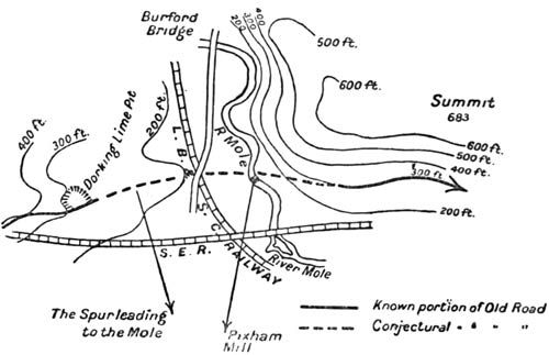
Nevertheless, those who imagine that the
original road, the prehistoric track, followed
this course, were, we thought, in error. We
had little doubt that, after the lime pit outside
Denbies Park, the road followed down
the moderate shoulder or spur which here
points almost directly eastward towards the
valley, crossed the railway just north of the
road bridge over the line, approached the
Mole at a point due east of this, and immediately
ascended the hill before it to that
spot where it distinctly reappears: a spot
near the 300-feet contour-line somewhat to
the west of the lane leading from the Reigate
Road to the crest of the hills.[25]
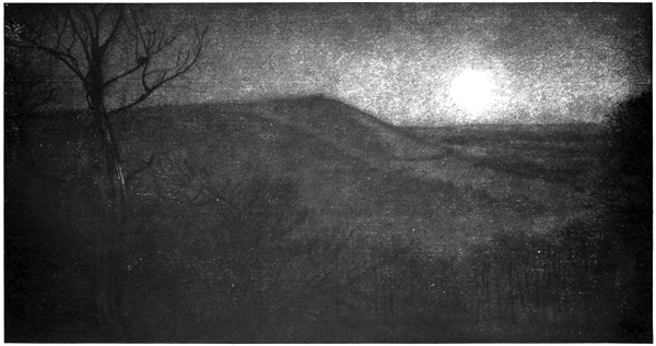
IT STOOD OUT LIKE A CAPE ALONG OUR COASTING JOURNEY, OUR NAVIGATION OF THE LINE OF THE DOWNS
I will give my reasons for this conclusion.
A diversion round by Burford Bridge
would have taken the early travellers far
out of their way. Roughly speaking, they
would have had to go along two sides of an
equilateral triangle instead of its base: three
miles for one and a half. Now, had they
any reason to do this? None that I can see.
Wherever, in crossing a valley, the Old Road
diverges from its general alignment, it
diverges either to avoid bad soil or to find a
ford. The name Burford would suggest to
those who have not carefully examined the
river that this diversion might have been
made necessary in order to find a shoal at
that point; but the Mole is very unlike the
other streams south of the Thames. It disappears
into 'swallows': it 'snouzles,' and
there is a theory that the river got its name
from this habit of burrowing underground.
At almost any one of these numerous
'swallows' the river can quite easily be
crossed, and a considerable diminution of its
stream, though perhaps not a true 'swallow,'
is to be found at the point I indicate.
Again, that all-important consideration in
a new country—I mean the dryness of the
soil over which a road passes—was very
much helped by taking the more direct of
the two lines. Ground with some slope to
it, and always fairly dry, comes here on
either side, close to the river. But down by
Burford, on the western side, there is quite a
little plain, which must have been marshy,
and for all I know, may be so still. Moreover,
we shall find further on at Otford, and at
Snodland, that the Old Road in crossing a
valley always chooses a place where some
spur of high land leads down to the river
and corresponds to a dry rise immediately
upon the other bank. Coupled with the fact
that a direction such as I suggest makes a
natural link between the two known parts
of the road, being very nearly in one alignment
with them, and remembering that
Burford Bridge was built in connection with
a very much later Roman way northward up
the valley (it is evidently the Bridge of the
Stane Street), that its direction and the
place at which it crosses are obviously dependent
on a north and south road, not on
an east and west one, we decided to approach
the eastern bank, and to see whether any
existing trace of a road would support what
seemed to us the most tenable hypothesis.
It cannot be pretended that any very distinct
evidence clinched what remains, after
all, our mere theory; but there was enough
to convince us, at least, and I believe to convince
most people, who will do as we did,
and stand upon the Old Road at the base of
Box Hill looking towards Denbies on the
other side of the valley. He will see, following
a very obvious course, a certain number
of yews of great age, remaining isolated in
the new-ploughed land. These, leading
across the river, are continued at a very
slight angle by a definite alignment of three
trees, equally isolated though far less old,
standing equally in comparatively modern
cultivated land, and leading directly to the
place where the track is lost at its exit from
Denbies Park; and the whole line follows
two spurs of land which approach the river
from either side.
A conclusion thus reached cannot pretend
to such a value as I would demand for the
rest of our reconstructions: such as, for instance,
can legitimately be demanded for the
way in which we filled the gap at Puttenham.
But it is far more convincing on the
spot, and with the evidence before one (such
as it is), than any verbal description can
make it, and I would repeat that any one
making the experiment with his own eyes
will be inclined to agree with us.
When we had arrived at this decision in
the first hour of daylight we turned eastward,
and pursued our way by the raised
and yew-lined track which was now quite
unmistakable, and which we could follow
for a considerable time without hesitation.
It ran straight along the 300-feet contour-line,
and took the southern edge of a wood
called Brockham Warren.
Here for a short way we went through a
stately but abandoned avenue, with the
climbing woods up steep upon our left, and
on our right a little belt of cover, through
which the fall of the slope below us and the
more distinct Weald and sandy hills could
be seen in happy glimpses. When we came
out upon the further side and found the
open Down again, we had doubled (as it
were) the Cape of Boxhill, and found ourselves
in a new division of the road.
Boxhill to Titsey
Eighteen miles
After one turns the corner of Box Hill and
enters this new division of the road is a great
lime pit, which is called Betchworth Pit,
and next to it a similar work, not quite as
large, but huge enough to startle any one
that comes upon it suddenly over the edge of
the Downs. Between them they make up
the chief landmark of the county.
We had already come across the first working
of this kind shortly after we had recovered
the Old Road beyond Gomshall, but that
and the whole succeeding chain of pits were
now disused, grown over with evergreens
and damp enormous beeches. We had found
a more modern excavation of the sort at the
end of Denbies Park: it was called the
Dorking Lime Works. Here, however, in
these enormous pits, we came to something
different and new. I looked up at their
immensity and considered how often I had
seen them through the haze: two patches of
white shining over the Weald to where I
might be lying on the crest of my own
Downs, thirty miles away.
It is the oldest, perhaps, of the industries
of England. Necessary for building, an
excellent porous stratum in the laying of
roads, the best of top-dressings for the stiff
lands that lie just beneath in the valley,
chalk and the lime burnt from it were among
the first of our necessities.
Its value must have come even before
stone building or made roads or the plough;
it furnished the flints which were the first
tools and weapons; it ran very near by the
healthy green-sand where our earliest ancestors
built their huts all along the edges
of their hunting-ground, the Weald, on
ridges now mostly deserted, and dark for the
last three hundred years with pines.
The chalk, which I have spoken of coldly
when I discussed the preservation of the
Old Road, should somewhere be warmly
hymned and praised by every man who
belongs to south England, for it is the
meaning of that good land. The sand is
deserted since men learnt to plough; the
Weald, though so much of its forest has
fallen, is still nothing but the Weald—clay,
and here and there the accursed new towns
spreading like any other evil slime. But
the chalk is our landscape and our proper
habitation. The chalk gave us our first
refuge in war by permitting those vast encampments
on the summits. The chalk
filtered our drink for us and built up our
strong bones; it was the height from the
slopes of which our villages, standing in a
clear air, could watch the sea or the plain;
we carved it—when it was hard enough; it
holds our first ornaments; our clear streams
run over it; the shapes and curves it takes
and the kind of close rough grass it bears (an
especial grass for sheep), are the cloak of our
counties; its lonely breadths delight us
when the white clouds and the flocks move
over them together; where the waves break
it into cliffs, they are the characteristic of
our shores, and through its thin coat of
whitish mould go the thirsty roots of our
three trees—the beech, the holly, and the
yew. For the clay and the sand might be
deserted or flooded and the South Country
would still remain, but if the Chalk Hills
were taken away we might as well be the
Midlands.
These pits which uncover the chalk bare
for us show us our principal treasure and the
core of our lives, and show it us in grand
façades, steep down, taking the place of
crags and bringing into our rounded land
something of the stern and the abrupt.
Every one brought up among the chalk pits
remembers them more vividly than any
other thing about his home, and when he
returns from some exile he catches the feeling
of his boyhood as he sees them far off
upon the hills.
Therefore I would make it a test for every
man who boasted of the South Country,
Surrey men (if there are any left), and
Hampshire men, and men of Kent (for they
must be counted in): I would make it a
test to distinguish whether they were just
rich nobodies playing the native or true men
to see if they could remember the pits. For
my part I could draw you every one in my
country-side even now. Duncton, where
the little hut is, surrounded by deep woods,
Amberley, Houghton, which I have climbed
with a Spaniard, and where twice the hounds
have gone over and have been killed, Mr.
Potter's pit, down which we hunted a critic
once, the pit below Whiteways, Bury Pit,
and Burpham, and all the older smaller
diggings, going back to the beginning, and
abandoned now to ivy and to trees.
I know them and I love them all. The
chalk gives a particular savour to the air,
and I have found it good to see it caked
upon my boots after autumn rains, or feel it
gritty on my hands as I spread them out,
coming in to winter fires.
All this delays me on the Old Road, but
the pits can be given a meaning, even in
research such as that upon which we were
engaged.
The chalk hills, from Betchworth here
right on to the Medway, have many such
bites taken out of them by man, and there
is this peculiarity about them, that very
many of them cut into and destroy the Old
Road.
I think it not fantastic to find for such a
repeated phenomenon an explanation which
also affords a clue to difficult parts of the
way. The Old Road being originally the
only track along these hills was necessarily
the base of every pit that should be dug.
Along it alone could the chalk be carried, or
the lime when it was baked, and it was
necessary for the Britons, the Romans, and
their successors to make the floor of the
lime pit upon a level with this track. Later
when the valley roads were developed and
the Old Road was no longer continuously
used, it was profitable to sink the cutting
further, below the level of the Old Road,
and, indeed, as far as the point where the
chalk comes to mix with the sand or clay of
the lower level. As the Old Road grew
more and more neglected the duty of protecting
it was forgotten, and the exploitation
of the pits at last destroyed it at these
points.
Nevertheless, its line was quite easy to
recover, across these Betchworth pits, though
they are the largest cuttings in the county;
later on we found no difficulty across the
smaller ones near Otford and at Merstham.
It is even true that the pits afforded a guide
in one or two cases where we were in doubt
what path to follow, and that our hypothesis
according to which the pits naturally arose
upon the track of the Old Road confirmed
itself by discovering the way to us in more
than one ambiguity.
Portions of the road remain even along
the great Betchworth pits. These portions
reappear at the same level, wherever the
pits have left a crag of the old hillside
standing, and when one gets to the point
just above Betchworth station and to the
cottages of the workmen, the path reappears
quite plainly. It follows the hillside at a
level of about 400 feet, falls slightly below
this contour-line to round the projecting
spur of Brockham Hill, comes down to the
high-road (the main road to London through
Tadworth), follows it a couple of hundred
yards, and leaves it to climb the hill at a
point just south of the place where the
1-inch Ordnance map marks the height of
353 feet.[26]
Here there is a combe known as 'Pebble
Combe.' The Old Road does not go round
the combe but straight across its mouth, and
begins to assume a character so new as to
perplex us for a considerable time in our
search. We did not understand the nature
of the change until we had very carefully
traced the path for more than another mile.
I will explain the difficulty.
The escarpment of the hills is here extremely
steep. It falls at an angle which
could not conveniently support a road, or
at least could not support it without such
engineering work as primitive men would
have been incapable of performing, and this
steep bit lasts without interruption from
just east of Pebble Combe right away to
the height above Reigate which is known as
Quarry Hill.
Now, if the road could not be supported
upon the bank of the escarpment, and yet
desired—as it always must—to escape the
damp land of the lower levels, it was bound
to seek the crest. Nowhere hitherto in all
this march from Winchester had we found
it attempting the summits of the hills, but
there were here unmistakable evidences
that it was going to approach those summits
and to keep to them as long as the steepness
of the escarpment lasted.
Our inexperience made us hesitate a long
while; but at last we saw, in a line of old
yews above us, an indication that the hill
was to be climbed, and on going up close to
those yews we found that they ran along
a platform which was the trodden and
levelled mark of the Old Road, running here
in a form precisely similar to that which we
had found round Box Hill.
Once we had thus recovered it, it did not
fail us. Within half a mile it climbed
sideways along the hillside from that point,
353 feet above the sea, which I have
mentioned, to the neighbourhood of the
600-feet contour-line which here marks the
edge of the range; and this line it follows
with a slight rise corresponding to the rise
of the crest all the way to what are known
as the Buckland Hills, and the high knot
which just tops the 700 feet near Margery
Wood.[27]
To the north and to the south of this, at
Walton Heath on the plateau above, and at
Colley Farm in the valley below, there had
been discoveries of Roman and of pre-Roman
things; but though they pointed to its
neighbourhood, these relics would not of
themselves have given us the exact line of
the road; that was furnished by the broad
and unmistakable track which it had itself
impressed upon the chalk from the usage of
so many hundred years.
It was slow work here. Much of it ran
through dense brushwood, where one had to
stoop and push aside the branches, and all
of it was damp, shaded from the sun by the
mass of old yews, and less well drained on
this flat edge and summit than it is on the
hillside where it usually hangs. But
though it is a difficult two miles, the path
is discoverable all the way.
With Margery Wood it reaches the 700-feet
line, runs by what I fear was a private
path through a newly-enclosed piece of
property. We remembered to spare the
garden, but we permitted ourselves a
trespass upon this outer hollow trench in
the wood which marked our way.
A magnificent bit of open ground, from
which we saw below us the sandy hills, and
beyond, the whole of the Weald, led us on
to a point where the Old Road once again
corresponds with a modern and usable,
though unmetalled and very dirty lane.
This is the lane which runs to the south of
the park of Margery Hall. It skirts to the
north the property recently acquired by the
War Office, and when it has passed the
War Office boundary-stone it is carried
across the high-road from Reigate to London
by a suspension bridge, which must surely
be the only example in Europe of so modern
an invention serving to protect the record
of so remote a past. Nor would there be
any need for such a suspension bridge had
not the London Road in the early part of
the nineteenth century been eased in its
steepness by a deep cutting, to cross which
the suspension bridge was made. That
bridge, once passed, the road pointed straight
to the lodge of Gatton, and pursued its way
through that park to the further lodge upon
the eastern side.[28]
Here should be submitted some criticism
of the rather vague way in which the place-names
of this district have been used by
those who had preceded us in the reconstruction
of the Pilgrim's Way.
Reigate, which was Churchfell at the Conquest,
has been imagined to take its later
title from the Old Road. Now the name,
like that of Riggate in the north country,
means certainly the passage near the road;
but Reigate lay well below in the valley.
True, the pilgrims, and many generations
before them, must have come down to this
point to sleep, as they came down night
after night to so many other points, stretched
along the low land below the Old Road in
its upland course from the Wey to the
Stour. So common a halting-place was it
in the later Middle Ages that the centre of
Reigate town, the place where the Town
Hall now stands, held the chapel of St.
Thomas from perhaps the thirteenth century
to the Reformation. But Reigate no more
than Maidstone, another station of the
medieval pilgrimage, could have stood on
the Old Road itself. It may be another
track which gives Reigate its name. Some
Roman by-way which may have run from
Shoreham (which the experts do not believe
to have been a port), right through the
Weald to Reigate, and so to London.
AND BEYOND, THE WHOLE OF THE WEALD
It is possible that a way from the Portus
Adurni[29] to London ran here by Reigate and
climbed the hill above; one of those fingers
reaching to the ports of the south coast, of
which the Stane Street, the Watling Street,
and perhaps the fragment further east by
Marden, are the remnants: moreover, in the
existence of such a road I think one can
solve the puzzle of Gatton.
Gatton, which is now some three or four
houses and a church and a park, sent two
members to Parliament, from the fifteenth
century until the Reform Bill. It was
therefore at some time, for some reason, a
centre of importance, not necessarily for its
population but as a gathering-place or a
market, or a place from which some old
town had disappeared. Indeed a local
tradition of such a town survives. One
may compare the place with that other
centre, High Cross, where is now the lonely
crossing of the Fosse Way and Watling
Street in Leicestershire.
Now, what would have given this decayed
spot its importance long ago? Most
probably the crossing of an east and west
road (the Old Road) with another going
north and south, which has since disappeared.
The influence of vested interests (for
Gatton Park fetched twice its value on
account of this anachronism) preserved the
representation in the hands of one man until
the imperfect reform of seventy years ago
destroyed the Borough.
There is another point in connection with
the Pilgrim's Way at Gatton. For the
second time since it has left Winchester it
goes to the north of a hill. At Albury it
did so, as my readers have seen, for some
reason not to be explained. In every other
case between here and Canterbury the explanation
is simple. It goes north to avoid
a prominent spur in the range and a re-entrant
angle at the further side. The
map which I append will make this point
quite clear.
For precisely the same cause it goes north
of the spur south of Caterham and much
further on, some miles before Canterbury,
it goes north of the spur in Godmersham
Park.
We did not here break into another man's
land, but were content to watch, from the
public road outside, the line of the way as
it runs through Gatton, and when we had
so passed round outside the park we came
to the eastern lodge, where the avenue runs
on the line of the Old Road. Here the
public lane corresponds to the Pilgrim's
Way and passes by the land where was
made a find of Roman and British coins,
close to the left of the road.
After this point the road went gently
down the ridge of the falling crest. This
was precisely what we later found it doing
at Godmersham, where also it climbs a crest
and goes behind a spur, and having done so
follows down the shoulder of the hill to the
lower levels of the valley. The valley or
depression cutting the hills after Gatton
is the Merstham Gap, by which the main
Brighton Road and the London and Brighton
Railway cross the North Downs. The Old
Road goes down to this gap by a path along
the side of a field, is lost in the field next to
it, but is recovered again just before the
grounds of Merstham House; it goes straight
on its way through these grounds, and passes
south of Merstham House and just south of
Merstham church; then it is suddenly lost in
the modern confusion of the road and the
two railway cuttings which lie to the east.
We left it there and went down to Merstham
inn for food, and saw there a great
number of horsemen all dressed alike, but of
such an accent and manner that we could
not for the life of us determine to what
society they belonged. Only this was
certain, that they were about to hunt some
animal, and that this animal was not a fox.
With reluctance we abandoned that new
problem and returned to Merstham church
to look for the road from the spot where it
had disappeared.
So to have lost it was an annoyance and
a disturbance, for the point was critical.
We had already learnt by our experience
of the way between Dorking and Reigate,
that when the escarpment is too steep to
bear a track the Old Road will mount to the
crest, and we saw before us, some two miles
ahead, that portion of the Surrey hills
known as Whitehill or (on the slopes) Quarry
Hangers, where everything pointed to the
road being forced to take the crest of the
hill. The escarpment is there extremely
steep, and is complicated by a number of
sharp ridges with little intervening wedges
of hollow, which would make it impossible
for men and animals to go at a level halfway
up the hillside. The Old Road then,
certainly, had to get to the crest of these
Downs before their steepness had developed.
On the other hand the top of the crest was
a stiff and damp clay which lasted up to the
steep of Quarry Hangers.
The pilgrims of the Middle Ages probably
went straight up the hill from Merstham by
an existing track, got on to this clay, and
followed Pilgrim's Lane along the crest—some
shrine or house of call attracted them.
The prehistoric road would certainly not
have taken the clay in this fashion. On
every analogy to be drawn from the rest of
its course it would climb the hill at a slow
slant, keeping to the chalk till it should
reach the summit at some point where the
clay had stopped and the slope below had
begun to be steep. The problem before us
was to discover by what line it climbed.
And the beginning of the climb that would
have given us the whole alignment was
utterly lost, as I have said, in this mass
of modern things, roads, railways, and
cuttings, which we found just after Merstham
church.
We walked along the road which leads to
Rockshaw, and along which certain new
villas have been built. We walked slowly,
gazing all the time at the fields above us, to
the north and the hillside, and searching for
an indication of our path.
The first evidence afforded us was weak
enough. We saw a line of hedge running
up the hill diagonally near the 400-feet
contour-line, and climbing slowly in such
a direction as would ultimately point to the
crest of the Quarry Hangers. Then we
noticed the lime works, called on the map
'Greystone Lime Works,' which afforded us
a further clue. We determined to make by
the first path northward on to the hillside,
and see if we could find anything to follow.
Such a path, leading near a cottage down
a slight slope and the hill beyond, appeared
upon our left when we had covered about
three quarters of a mile of road from Merstham.
We took it and reached the hedge
of which I have spoken. Once there,
although no very striking evidence was
presented to us, there was enough to make
us fairly certain of the way.
A continuous alignment of yew, hedge,
and track, appeared behind us, coming
straight, as it should do, from Merstham
church and right across the old lime pit;
before us it continued to climb diagonally
the face of the hill. Lost under the plough
in more than one large field, it always reappeared
in sufficient lengths to be recognised,
and gained the crest at last at a point
which just missed the end of the clay, and
was also just over the beginning of the
Quarry Hangers steep.[30]
Once arrived at the summit of Quarry
Hangers we found the road to be quite
clear: a neat embankment upon the turf;
and when, half a mile beyond, we came to
the cross-roads and the tower, we had
reached a part of the Pilgrim's Way which,
though short, had already been settled and
did not need to detain us. It corresponds
with the modern lane, goes just north of the
spur known as Arthur's Seat (a spur upon
the southern side of which stands a prehistoric
camp), goes up over the summit of
Gravelly Hill (where it is the same as a
modern road now in the making), and at
last strikes Godstone Woods just at the
place where a boundary-stone marks the
corner of another little patch of land belonging
the War Office.
On the further side of this patch of land,
which is a kind of isolated cape or shoulder
in the hills, runs a very long, deep combe,
which may be called Caterham Combe. Up
this ran one of the Roman roads from the
south, and up this runs to-day the modern
road from Eastbourne to London. On the
steep side of that precipitous ravine, which
is a regular bank of difficult undergrowth
(called Upwood Scrubbs), the Old Road
was, as we had rightly expected from our
previous study of the map, very hopelessly
lost.
It is a difficult bit. Had the road followed
round the outer side of the hill it would
have been much easier to trace, but crossing
as it does to the north of the summit, in
order to avoid the re-entrant angle of
Arthur's Seat, it has disappeared. For the
damper soil upon that side, and the absence
of a slope into which it could have cut its
impression, has destroyed all evidence of the
Old Road. One can follow it in the form
of a rough lane up to the second of the War
Office landmarks. After that it disappears
altogether.
When one considers the condition of the
terrain immediately to the east, the loss is
not to be marvelled at. The hillside of
Upwood Scrubbs falls very steeply into the
valley by which the modern high-road
climbs up to Caterham. It is an incline
down which not even a primitive road would
have attempted to go, and when one gets to
the valley below the whole place is so cut
up with the modern road, the old Roman
road a little way to the east, and the
remnants of a quarry just beyond, that it
would have been impossible in this half-mile
for the trace of the Pilgrim's Way to be
properly preserved. I will, however, make
this suggestion: that it descended the hillside
diagonally going due NE. from the
summit to the old gravel pit at the bottom,
that then it curved round under the steep
bank which supports Woodlands House,
that is Dialbank Wood, went north of
Quarry Cottage, and so reached the face
of the hill again where the lane is struck
which skirts round the southern edge of
Marden Park. This, I say, will probably
be found to be the exact track; but it is
quite certain that the Way cannot have run
more than a couple of hundred yards away
from this curve. It cannot have been cut
straight across the valley, for the steepness
of the valley-side forbids that, and, on the
other hand, there would have been no
object in going much further up the valley
than was necessary in order to save the
steep descent.
At any rate, the gap is quite short and
the road is easily recovered after the combe
and the high-road are passed; it is thence
identical with the lane I have spoken of
above. This lane is called Flower Lane. It
follows the 600-feet contour-line and winds
therefore exactly round the outline of the
hill. It passes the lodge of Marden Park,
and within a few hundred yards comes to a
place where the modern road bifurcates.
The good macadamised lane goes straight
on and somewhat downwards towards the
plain. Another, less carefully made, begins
to wind up the hill above one. From this
point onward the Old Road takes again to
the rough ground.
There lies just before one on the hillside
a wood, called 'The Hanging Wood.'
We skirted the south edge of this
wood and found beyond it a field in
which the track is lost;[31] nor was the task
of recovering it an easy one, for the
light was just failing, and here, as always
where cultivation has risen above the
old level, the Old Road is confused and
destroyed.
We had, however, over these few yards
an excellent clue. In a wood called 'The
Rye Wood' just in front of us the track of
the Old Road is not only clearly marked,
but has been preserved by local traditions.
For this NW. corner of the Rye Wood we
made, through the south of the spinney
called 'Hogtrough Spinney.'
Just beyond the Rye Wood, the hillside
is pierced by a deep railway cutting which
is the entrance to Oxted Tunnel. This
cutting comes right across the line of the
Old Road. We made for this point (which
is a few yards north of the first bridge),
but when we reached it, it was quite
dark, and if we had covered in that day
but eighteen miles or so, it must be
remembered how much of our time had
been spent in the perpetual checks of this
division.[32]
We reluctantly determined, then, to
abandon the hillside for that evening, and to
go down to the plain and sleep. The nearest
place of hospitality was Oxted. We made for
that village in the darkness, stumbling along
the railway-line, and in the inn we met a third
companion who had come to join us, and who
would accompany us now as far as Canterbury.
When we had eaten and drunk wine, and
had had some quarrelling with a chance
traveller who suffered terribly from nerves,
we left our entertainment. We slept, and
the next morning, before it was light, we all
three set out together, taking the northern
road towards the hill.
Titsey to Wrotham
Sixteen miles
Beyond the railway-cutting, the road is
recovered, as I have said, by tradition and
by a constant use which lasted almost to
our own time.[33] It goes beneath the large
wood which here clothes the hill, and after
a partial loss in the field next the park,
leads up to the farm known as 'Limpsfield
Lodge Farm'; it comes to the paling of the
park just north of the farm.
Across Titsey Park the track of the road
is clear, and its interest is the greater from
the anxiety which the owners of the place
have shown to discover its antiquities.
A little off the Way, at the base of the
hill, was discovered in 1867 a Roman villa,
situated thus (as at Walton Heath, at
Colley Hill, at Bletchingly, as later on at
Burham, or, to take a remote instance, as
in the case of the Roman village on the
Evenlode, or again, that at Bignor) not
right on the road itself, but from a quarter
to half a mile off it. So the heirs of the
Roman owners, the feudal lords, built their
manor-houses off the roads and led to them
by short perpendicular ways and avenues
such as you may still see approaching half
the French chateaux to-day.
It is probable (to guess at matters of which
there is no proof) that while this road,
serving no strategical purpose, leading to no
frontier, and communicating between no
two official centres of Roman life, was not
used in the official system, the country
people continued to make it one of their
main ways, and that in the profound peace
which the southern civilisation had imposed,
the rich built for pleasure or to superintend
their farms, along what was nothing but a
British way.
Henceforward antiquities of every kind
were to meet us as we advanced, because
the Old Road on its way to the Straits
gained importance with every ten miles of
its way. Tributary roads continually fell
into it: one had come in long ago at Alton,
from Portsmouth and the Meon valley; at
Farnham, a second had joined, which as
the reader knows was probably older than
the Old Road itself; others at the Guildford
gap, others from the Weald and from
the north as well at Dorking, another at
Gatton, another at the Caterham Road: and
each would swell the traffic and the movement
upon this principal line of advance
towards the Straits of Dover. More were to
come. One of the highest importance (for
it led from London along the valley of the
Darent) was to join us at Otford; the last
and perhaps the greatest, beyond the Medway,
in the stretch before Boxley. With
each of these the importance and the meaning
of the road developed, and the increasing
crowd of memories or records was like a
company coming in on either side to press
on with us to Canterbury.
Before leaving Titsey Park, the Old Road
showed another of its characteristics in
passing again just south of the site where
the old church once stood; thenceforward
for many miles it becomes a good modern
lane, pursuing its way without deviation for
five miles due east along the slope of the
hills. Of this part, as of all such sections
of our way, where a modern road coincides
with the prehistoric way, there is little to
be said. The level was not high, nor the
vale immediately beneath us broad. Above
us from the main ridge was granted, I knew
by many journeys, that great vision: the
whole southern plain, and above the near
sand-hills, at one sweep, half the county of
Sussex. But the matter of our journey
forbade the enjoyment of such a sight, just
as the matter of my book forbids me to
speak of the very entertaining people of all
kinds who came across us during these days
and days, especially in the inns.
The road continues thus, following a
contour between four and five hundred feet
above sea-level, crosses the Kentish Border,
and remains a good, well-kept lane, until it
reaches the border of Chevening Park.
The right-of-way along the road across
the park (where, of course, it has ceased to
be a lane, and is no more than an indication
upon the turf) has ceased since the passing
of an Act of Parliament in the late
eighteenth century, which Act diverts the
traveller to the south, round the enclosure.
But the direction taken by the Old Road
across this ground is fairly evident until the
last few hundred yards.
On the eastern side of the Park it is continued
for about 200 yards as a footpath.
It is then lost under the plough; but a
lane, some seven furlongs further on to the
east, recovers the alignment,[34] and leads
straight on to the crossing of the Darent,
down just such a spur as marked the crossing
of the Mole, while above us went a
flanking road, marked by stunted trees, on
the windy edge of the Downs.
Following it thus we passed the northernmost
of the two railway arches, went down
the hill a mile or so, crossed the plain that
was till recently marshy and difficult, and
entered the village of Otford by the bridge
and over the ford whereby, certainly since
Edmund Ironside, and probably for many
thousands of years before that, men had
come to it.
Indeed, here, where the Old Road falls
into the valley of the Darent, its importance
in recorded history, which had been growing
steadily as we went eastward, was suddenly
increased for us, and the cause was the
reception at this point of its tributary from
London. From Otford the Old Road
becomes strategic. It is the road by which
marched the defending forces when invasion
was threatened from the Thames estuary.
It becomes hierarchic; the power of Canterbury
seizes it; and it becomes royal,
perpetually recalling the names and at last
the tyranny of the kings. The battle against
the invader, the king's progress to the sea,
the hold of the Church upon the land it
traverses, fill all the final marches from the
crossing of the Darent to that of the Stour.
Something of military history as at Alton,
at Farnham, and just down the Stane Street
at Anstie Bury, had attached even to the
earlier part of so ancient a way—but from
Otford onward it is greatly emphasised.
As one comes down from the chalk pit
above the river one is crossing what is
probably the site of Edmund Ironside's
great and successful struggle with the
Danes in 1016, when he defeated Canute
and drove him across the river, and pursued
the rout mile upon mile to Aylesford. Half
a mile further down on the plain, just before
you get into the village, is the field where
Offa is said to have achieved the supremacy
of England by the conquest of Kent in 773.
It is only a doubtful bit of tradition, but
it is worth recording that one more battle
was fought here—as the populace believed—in
the very first struggle of all—in the
legendary fifth century. It is said that the
Saxons were defeated here by the British,
and that they also retreated towards Aylesford.
Canterbury had shown its influence long
before this valley. We had seen the chapels
and had but just left Brasted, whose
allegiance to the archbishop was old beyond
all record. But from Otford onward the
power of the See became peculiar and more
definite.
First there was the string of great palaces,
Otford, Wrotham, Maidstone, Charing:
Otford, Wrotham, and Charing especially,
standing as they did directly upon the Old
Road and created by it. We saw them all.
They are in ruins.
Their authority, their meaning, had been
suddenly destroyed. No one had claimed
or supported their enormous walls. The
new landlords of the Reformation, the
swarm, the Cecils and the Russells and the
rest, seem for once to have felt some breath
of awe. The palaces were permitted to die.
I imagined as I saw them one by one that
the few stones remaining preserved a certain
amplitude and magnificence; it may have
been nothing but the fantasy of one who saw
them thus for the first time, his mind already
held for so many days by the antiquity of
the Road.
They are forgotten. They were great for
their time. Their life was intense. The
economic power of the throne and of the
chief altar in England ran through them.
Otford at Domesday had its hundred small
farms, its six mills; it was twice the size of
Westerham. Wrotham and Charing, somewhat
less, were yet (with Maidstone) the
chief centres of Kent south of the Downs.
And apart from the See the Church in
general held all the line. At Boxley, eldest
daughter of Waverley, Clairvaux and the
spirit of St. Bernard showed; it became as
great as the palaces. Hollingbourne, fifty
years before the Conquest, had been granted
to St. Augustine's, a hundred years before
that Lenham to Christchurch. The connection
of Charing with Canterbury was so
old that men believed their 'Vortigern' to
have dedicated its land, and the church
could show, even of writing, a parchment
older than Alfred by a hundred years.
All these things had gone as utterly as
the power to build and to think and to take
joy in the ancient manner; the country-side
we were treading held their principal and
silent memorials.
For upon all this—which was England and
the people—had fallen first the crown and
then the rich, but the crown had begun the
devastation.
I have said that from Otford the Old Road
becomes royal, for it is at Otford that the
road from Greenwich, after following the
valley of the Darent, falls into the Pilgrim's
Way. From Westminster by water to
Greenwich, from Greenwich down here to
Otford, and thence along the Old Road to
the sea, had been a kind of sacred way, for
the kings, who used as they went the great
palaces of the Archbishops for their resting-places.
By this road, last of so many, went
Henry VIII. to the Field of the Cloth of
Gold. It was an alternative to the straight
road by Watling Street, and an alternative
preferred from its age and dignity.
Then came its ruin. The grip of the
crown caught up all the string of towns
and villages and palaces and abbeys. You
see the fatal date, '20th November, 29th
Henry VIII.' recurring time and time again.
Otford is seized, Wrotham is seized, Boxley,
Hollingbourne, Lenham, Charing, and with
these six great bases, a hundred detached
and smaller things: barns, fields, mills, cells—all
the way along this wonderful lane the
memory of the catastrophe is scarred over
the history of the country-side like the old
mark of a wound, till you get to poor
Canterbury itself and find it empty, with
nothing but antiquarian guesses to tell you
of what happened to the shrine and the bones
of St. Thomas.
The Holy Well at Otford, its twin at
Burham, the rood of Boxley, the block of
Charing were trampled under. The common
people, first apathetic, then troubled,—lastly
bereft of religion, lost even the
memory of the strong common life as the
old men died; sites which had been sacred
ever since men had put up the stones of
Addington or Trottescliffe, or worshipped
Mithra on the bank of the Medway, or put
the three monoliths of Kit's Coty House
together to commemorate their chief, or
raised the hundred stones—all these were
utterly forgotten.
It was not enough in this revolution that
the Church should perish. The private lands
of the most subservient were not safe—Kemsing,
for example. It was the Manor
of Anne Boleyn's father: it may be imagined
what happened to such land. I know of no
district in England where the heavy, gross,
and tortured face of Henry in his decline
haunts one more. Sacredness is twofold—of
pleasure and pain—and this, the sacred
end of our oldest travel, suffered in proportion
to its sanctity.
When we had passed the Darent at Otford
and climbed the hill beyond, we came upon
a section of the road which might be taken
as a kind of model of its character along
these hills.
It is a section six miles long, beginning
upon the hillside just above Otford station
and ending near the schoolhouse above
Wrotham. But in this short distance it
gives examples of nearly all the points
which it is the business of this book to
describe. There is indeed no part of it
here which requires to be sought out and
mapped. The whole is known and has a
continuous history; and such certitude is
the more valuable in a typical division,
because it permits us to deduce much that
can elsewhere be applied to the less known
portions of the road.
The Old Road runs here (as throughout
nearly the whole of its course between
Dorking and Canterbury) up on the bare
hillside above the valley. The road appears,
as one walks it, to run at the same level all
along the hillside, but really it is rising as
the floor of the valley rises, in order to
keep continuously at the same distance
above it. Its lowest point is not much
under 300 feet, but its highest is just
over 500.
Immediately below it lies that string of
habitations which everywhere marks its
course, and between which it was originally
the only means of communication. Just as
Bletchingly, Reigate, Limpsfield, Westerham,
Brasted, and the rest stood below its
earlier course, and just as in its further part
we shall find Hollingbourne, Harrietsham,
Lenham and Charing, so here there runs a
little succession of hamlets, churches, and
small towns, which are the centres of groupings
of arable land in the valley floor, while
above them the Pilgrim's Road follows just
above the margin of cultivation. Their
names are Kemsing, Heaverham, St. Clere,
Yaldham, and at last Wrotham.
The section further gives an admirable
example of the way in which the Old Road
was gradually replaced.
These six miles of its length may, for the
purpose of the illustration they afford, be
divided into three nearly equal parts by the
village of Kemsing, and the hamlet of
Yaldham. Each of these divisions shows
the Old Road in one of its three historical
phases: first as the only artery of the
country-side, then as an alternative way
supplemented by a valley road, and finally
as a decayed and unused path whose value
has been destroyed by the more modern
highway below it. It is astonishing to see
with what precision each of these phases
is shown, how exactly each division ends,
and how thoroughly the character of each
is maintained.
In the first, from Otford to Kemsing, a
distance of about two miles, one can see
the two valley villages below one, and the
track one follows is the only good road
between them, though it lies above them
both and can only be reached from either
by a short rising lane. A short cut across
the fields connects the two places, but if
one wishes to use a proper and made way,
there is none to take but that which still
represents the Old Road, and so to go up
out of Otford and then down into Kemsing.
One has to do, in other words, exactly what
was done for centuries when the archbishops
came up to London from Canterbury; wherever
one may desire to halt one has to leave
the Old Road and come down from it to the
village below.
In the second part, between Kemsing and
Yaldham, the modern influence has been
sufficient to provide an alternative. The
distance is somewhat more than two miles.
The Pilgrim's Way runs up along the hillside,
a metalled lane, while below in the
valley the old footpaths and cart tracks
have been united into a modern permanent
road, and a man going from Kemsing through
Heaverham to Yaldham need not take the
Pilgrim's Road above as his ancestors would
have had to do, but can go straight along the
lower levels.
Finally, with Yaldham and on to Wrotham
the more common condition of modern times
asserts itself. The lower valley road becomes
the only important one, the Pilgrim's Road
above dwindles into, first, a lane very little
used and falling into decay, then a path
thick with brambles and almost impassable.
A man going from Yaldham to Wrotham
nowadays is bound to use the modern valley
road. When we had pushed through the
brambles of the deserted path for perhaps
a mile and a half, the way broadened out
again, crossed the London Road, and turning
the corner of the hill overlooked the
church and roofs of Wrotham a hundred
feet below.
Of Wrotham, the second link in that chain
of palaces which afforded shelter to the
Archbishop and to the King, as the one
journeyed to Lambeth, the other to the
sea-coast, I have already spoken. I desire
here to discuss rather the topographical
interest of the corner upon which we stood
and its connection with the prehistoric road
which it was our principal business to
examine.
And for that purpose, though it occupied
but the last part of a day, I would devote
to a separate division the passage of the
Medway which was now at hand.
Wrotham to Boxley
Eleven miles
At Wrotham is a kind of platform, or rather
shoulder, which is made by such a turning of
the great chalk hills as I shall presently
describe. This turning revealed to us the
plain at our feet as we came round the corner
of the hill and saw before us the whole valley
of the Medway.
We were perhaps some hundred feet
above Wrotham and five hundred above
the sea as we stood upon this platform
before noon, and overlooked the great flats
and the distant river and the further hills.
It is a view of astonishing effect, such as
I did not know to be in south England; for
our rivers are small, and, exquisite as is
their scenery, they do not commonly impress
the mind with grandeur. The Medway,
perhaps because it is the relic of some
much greater river now drowned by the
sinking of the land, perhaps because its
tidal estuary lends it twice a day an
artificial breadth, gives one the impression
of those continental streams, the Seine or
the Meuse, which are sufficient to animate
a whole country-side, and which run in so
wide a basin that a whole province attaches
to their name.
The manner of this landscape was that of
a great gesture; its outline was like the
movement of a hand that sketches a
cartoon; its sweep was like the free arm
of a sower sowing broadcast. The bank,
moreover, upon which the Old Road here
stands is so steep that it produces an
effect of greater height and whatever
expansion of the mind accompanies a wide
horizon.
There dominated that view a character
of space and dignity which not even the
Itchen valley from the heights, nor the
Weald from the crest of the Surrey Downs,
could equal. The crossings of the Wey,
of the Mole, and of the Darent, the valleys
which there interrupted the general line
of our hillside road, seemed narrow and
familiar as one gazed upon this much
greater plain.
Far off, miles and miles away, the hills
continued their interminable line. The
haze, and a certain warm quality in the
winter light, added to the vastness of the
air, and made the distant range seem as
remote as a to-morrow; it was lost in a
grey-blue that faded at last into a mere
sky upon the extreme east.
Along those hills our way was clearly to
be continued. Their trend was not, indeed,
due east and west as the Old Road had run
so long: they turned a little southerly; but
the general line, bending down to Canterbury
and to the Straits, followed that crest, and
its furthest visible height was not far distant
from our goal.
Just opposite us, upon the further side of
the valley, was faintly to be discerned such
another shoulder as that upon which we
stood. We made it out upon our map to
bear the good name of 'Grey Wethers,' as
does that rock far off eastwards, out of
which was built Stonehenge. Upon that
shoulder had stood the abbey of Boxley.
It marked the point where, beyond the
valley, the Pilgrim's Way is recognised
again. But in the interval between, across
this broad flat valley, its passage had never
been fixed.
We might have thought, had we not
hitherto learnt much of the Old Road, that
no problem was there, save to cross in a
direct line the valley before us, and make
by evening that further shoulder of 'Grey
Wethers,' where we should find the road
again; but we had followed the track too
long to think that it could so easily be
recovered. We guessed that in so wide a
gap as was here made by the Medway in
the line of hills a difficulty, greater than any
we had yet met, would arise, and that we
should not overcome it without a longer
search than had been necessary at the Wey
or even the Mole.
We were now familiar with such platforms
and such views. Upon a lesser scale
we had felt their meaning when we stood
upon the rock of St. Catherine's at evening
and considered the crossing of the Wey; or
on that other spur, eastward of Dorking,
when we had seen Box Hill beyond the
valley under the growing night. They
also, the men long before us, had chosen
such particular places from whence to catch
the whole of a day's march, and to estimate
their best opportunity for getting to the
further shore.
We knew how difficult it was to trace
again their conclusion, and to map out the
Old Road in places like these.
To debate its chances and draw up the
main line of our decision, we went down
into Little Wrotham, and at an inn there
which is called the 'Bull,' we ate beef and
drank beer, spoke with men who knew the
fords and the ferries, compared our maps
with a much older one belonging to the
place, and in general occupied our minds
with nothing but the passage of the river:
the passage, that is, which alone concerned
us; the place where men, when men first
hunted here, fixed their crossing-place, and
carried the Old Road across the tide-way of
the stream.
Now, having said so much of the landscape,
it is necessary to turn to the more
minute task of topography. For it is the
business of this book not to linger upon the
pleasures of our journey, but to reconstitute
an ancient thing. And for that purpose a
simple sketch-map will explain perhaps as
much as words can do.
The features of this map are very few, but
their comprehension will be sufficient for my
readers to grasp the matter upon which we
are engaged.
A single heavy line indicates the crest of
the hills—a crest from over six hundred to
over seven hundred feet in height. A
dotted line indicates the limit of what may
be called the floor of the valley. The
brackets )( show the four possible crossings
of the river. Two points, numbered A and
B, mark the 'shoulders' or platform. The
first (A) above Wrotham, the second (B) at
Grey Wethers. Finally, the megalithic
monument at Coldrum and that near Grey
Wethers (whose importance will be seen in
a moment) are marked with circles.
Far up the valley on each hill continues
the remnant of an ancient road, and the
reader will see from this, that, as in the
valley of the Mole and of the Darent,
our difficulties were confused and increased
from the fact that, quite apart from the
crossing of the river, other prehistoric
tracks led off northwards upon either side
of the river, whose crossing was our concern.
The great main range of chalk which runs
all across south-eastern England; the range
whose escarpment affords for sixty miles a
platform for the Old Road is broken, then,
by the Medway, which cuts through it on
its way to the sea. But there is not only
a gap; it will be seen that the hills 'bend
up,' as it were, upon either bank, and follow
the stream northward, making a kind of
funnel to receive it. The effect of this is
best expressed by saying, that it is as
though the Medway valley had been scooped
out by a huge plough, which not only cut a
five-mile gap in the range, but threw the
detritus of such a cutting to left and right
for miles beyond the point of its passage.
It is at the mouth of this gap that the two
shoulders or turning-places are to be found;
one on the west at Wrotham, the other on
the east at Grey Wethers: while beyond
them the Downs turn northward either way,
to sink at last into the flats of the Thames
estuary.
The interval between these 'shoulders'
was the most considerable of any that had
to be filled in all our exploration.
The reason that this gap in the Old Road
should be found at such a place was evident.
It was here that the road had to cross the
most important of the rivers it meets upon
its course, the Medway. Alone of the rivers
which obstruct the road, it is a tidal stream,
and, as though in recognition of its superior
claim, the hills receded from it more grandly
than they had from the Wey at the Guildford,
or the Mole at the Dorking passage.
They left six miles of doubtful valley between
them, and across these six miles a track had
to be found.
THE MOST IMPORTANT OF THE RIVERS IT MEETS UPON ITS COURSE, THE MEDWAY
A clear statement of the problem will lead
one towards its solution.
I have said that for several miles before
Wrotham, the chalk hills, well defined and
steep, running almost due east and west,
present an excellent dry and sunny bank
for the road. As one goes along this part
of one's journey, Wrotham Hill appears
like a kind of cape before one, because
beyond it the hills turn round northward,
and their continuation is hidden.
I have also told how, a long way off,
over the broad flat of the Medway
valley, the range may be seen continuing
in the direction of Canterbury, and
affording, when once the river is crossed, a
similar platform to that from which one is
gazing.
We knew, also, that the road does, as a
fact, follow those distant hills, precisely as
it had the range from which we made our
observation, and if no physical obstacles
intervened, the first travellers upon this
track would undoubtedly have made a
direct line from the projecting shoulder of
Wrotham Hill to the somewhat less conspicuous
turning-point which marks the
further hills of Grey Wethers, where also
Boxley once stood.
But obstacles do intervene, and these
obstacles were of the most serious kind for
men who had not yet passed the early
stages of civilisation. A broad river with
a swift tidal current, flanked here and there
(as tidal rivers always are before their
embankment) by marshes; a valley floor
of clay, the crossing of which must prove
far more lengthy than that of any they had
hitherto encountered, made the negotiation
of this gap a difficult matter. Moreover,
the direct line would have led them by the
marshiest way of all: the fields of Snodland
brook.
Oddly enough the difficulty of rediscovering
the original track by which the road
forded the Medway, does not lie in the
paucity of evidence, but rather in the confusion
arising from its nature and amount.
So great is this confusion that some authorities
have been content to accept alternative
routes at this point.
Savage trails, however, never present
alternatives so widely separate, and least of
all will they present any alternative, even
one neighbouring the main road, where a
formidable obstacle has to be overcome: to
do so would be to forfeit the whole value
which a primitive road possesses as a guide
(for this value depends upon custom and
memory), and when a tidal river had to be
traversed, a further and very cogent reason
for a single track was to be found in the
labour which its construction upon a marshy
soil involved.
If some one place of crossing had held a
monopoly or even a pre-eminence within
the limits of recorded history, the evidence
afforded by it would be of the utmost
value. But an indication of this simplicity
is lacking.
It is certain that within historic times
and for many centuries continuously, the
valley and the river were passed at four
places, each of which now may lay a claim
to be the original passage.
The modern names of these places are, in
their order from the sea, Cuxton, Lower
Halling, Snodland, and Aylesford.
Before proceeding I must repeat what
was said above, that two tracks of great
antiquity continue the Old Road northward
on each side of the Medway far beyond any
point where it would have crossed; these
tracks (I have called them elsewhere 'feeders')
are not only clearly defined, but have each
received the traditional name of the Pilgrim's
Way, and their presence adds a considerable
complexity to the search for the original
passage.
So much of the elements of the problem
being laid down, let us now recapitulate
certain features which we have discovered
to be true of the road in the earlier part of
its course, where it had to cross a river, and
certain other features which one knows to be
common to other British track-ways over
valleys broader than those of the Mole or
the Wey. To these features we may
add a few others, which are conjecturally
those that such a road would possess
although we might have no direct evidence
of them.
A list of these features will run very much
as follows:—
(1) The road will attempt the shortest
passage of the valley floor, the breadth
being more or less of an obstacle, according as
the soil is more or less low, covered, or damp.
(2) It will seek for a ford.
(3) Other things being equal, it would
naturally cross a river as high up as possible,
where the stream was likely to be less
difficult to ford.
(4) It would cross in as immediate a
neighbourhood as possible to that height
upon which survey could be made of the
opportunities for crossing.
(5) The nature of the bottom at the
crossing would influence it greatly, whether
that bottom were gravel and sand, or
treacherous mud. Moreover, a primitive
road would often leave evidence of its choice
by the relics of good material thrown in to
harden the ford.
(6) A point of so much importance would
probably be connected with religion, and
almost always with some relic of habitation
or weapons.
(7) It would often preserve in its place-name
some record of the crossing.
(8) It would (as we had found it at
Dorking and at Otford) choose a place
where a spur on either side led down to
the river.
To these eight points may be added the
further consideration, that whatever was
the more usual crossing in early historic
times affords something of a guide as to
prehistoric habits, and, finally, that where
a tidal river was concerned, the motives
which were present on any river for seeking
a passage as far up stream as possible would
be greatly strengthened, for the tide drowns
a ford.
Now, in the light of what the map tells
us, and of these principles, let us see where
the crossing is most likely to be found, and
having determined that, discover how far
the hypothesis is supported by other evidence.
To begin with Cuxton:
At Cuxton the firm land of the hills comes
upon either side close to the river. An
ancient track-way upon either side leads
very near to the point of crossing and
cannot be followed, or at least nothing like
so clearly followed further down the valley.
At Cuxton, moreover, as a constant tradition
maintains, the crossing of the river by
pilgrims was common.
On the other hand there is nothing
approaching a ford at this place. The
bottom is soft mud, the width of the river
very considerable, the tidal current strong,
and of all the points at which the river
might have been crossed, it is the most
distant from the direct line; indeed, compared
with the next point, Lower Halling,
a traveller would add five or six miles to his
journey by choosing Cuxton.
Now, consider Aylesford, the other extreme;
the highest up as Cuxton is the
lowest down the river of the four points.
Aylesford has many powerful arguments in
its favour. It has produced one of the
most interesting and suggestive prehistoric
relics in England: I mean that 'Aylesford
pottery' which is an imitation, or possibly
even an import, of the pottery of northern
Italy in the first or second centuries before
our area. It has furnished a mass of other
antiquities: armillae of gold have been
found in the river and British coins and
graves on the northern bank. It preserves
in the last part of its name the tradition of
a ford, and though 'ford' in place-names by
no means always signifies a ford any more
than 'bridge' signifies a bridge, yet in this
case we have historic knowledge that a ford
existed; and (as is most frequently the case)
the ford has been bridged.
A further argument, and in its way one
of the strongest that could be adduced, is
the position of the place in the earliest of
our annals. Whether 'the Horse and the
Mare,' Vortigern, and the rest are wholly
legendary or not, cannot be determined.
Certainly the texture of the story is
fabulous, but Bede and 'Nennius' have both
retained the memory of a great battle fought
here, in which the British overcame the
Pirates, and what is most significant of all,
the legend or memory records a previous
retreat of the Saxons from a defeat at
Otford. We know, therefore, that a writer
in the seventh century, though what he
was writing might be fable, would take it
for granted that a retreat westward from
Otford would naturally lead along some
road which passed the Medway at Aylesford.
We get another much later example of
the same thing when Edmund Ironside, after
his great victory at Otford over the Danes,
pursued them to Aylesford, and was only prevented
from destroying them by their passage
over the river under the cover of treason.
This is very strong evidence in favour of
Aylesford, and when one remembers that
the manor was ancient demesne, its antiquity
and importance are enhanced.
But against Aylesford there are three
strong arguments. They are not only
strong, they are insuperable. The first
is the immense width of valley that would
have to be crossed to reach it. That
is, the immense tract of uncertain, wooded
way, without a view either of enemies or of
direction.
The second is the clay. A belt of gault
of greater or lesser width stretches all along
the Downs just below the chalk. Here it
is particularly wide, and no straight line
can be taken from Wrotham to the Aylesford
gravels without crossing nearly two
miles of this wretched footing, which,
throughout its course, the road has most
carefully avoided. That a ford of great
antiquity was there; that the men of the
sandy heights used it; that the Romans
used so admirable a ford (it is gravel near
the river on either side), that they bridged
it, that they made a causeway over the
clay, and that this causeway and that
bridge were continuously used after their
time, I am willing to believe; but not that
the prehistoric road along the chalk hills
could have waded through all that clay to
reach it, and have gone out of its way into
the bargain.
Thirdly, there is the clinching fact that a
number of prehistoric remains, Kit's Coty
House and the rest, lie to the north of such
a crossing, and that to reach Boxley itself,
a site indubitably dependent upon the prehistoric
road, a man crossing at Aylesford
would have to turn back upon his general
direction.
It must further be remembered that by
the seventh century some of the valleys had
acquired firm roads, inherited from the old
civilisation, and that in the rout after a
battle, an army making for a tidal river,
and not able to choose their own time of
crossing (as can a wayfarer), would certainly
make for a point as far up the stream as
possible and for a bridge.
If Cuxton and Aylesford, then, are to be
neglected (as I think they certainly must
be), there remain only Lower Hailing and
Snodland.
At first sight the weight of argument is
for Lower Halling, and if the various parts
of such an argument as I adduce have
different proportions from those I lend
them, one might conclude that at Lower
Halling was the original passage of the
Medway.
True, there is for the passage at Lower
Halling but one evidence that I can discover,
but it is an evidence of the greatest
weight, and such an one as is often permitted
alone to establish a conclusion in
archæology. It is this, that there was
good surface over the original soil from the
Pilgrim's Way on the hills above, right
down to the river-bank at this point. No
clay intervenes between the chalk and
gravel. The primitive traveller would have
had fairly dry land all the way down to
the river. Even beyond the river the belt
of alluvial soil is less broad than it is at
Snodland; and altogether, if the geological
argument alone were considered, the decision
undoubtedly would be given to this place.
The claims of Snodland are asserted by
a number of converging arguments. I will
enumerate them, and it will, I think, be
seen that though each is individually slight,
the whole bundle is convincing.
First.—The spur, which leaves the main
range of hills for the river (such a spur as
has elsewhere, at Shalford, and at Dorking,
and at Otford, attracted the Old Road
towards the ford it points to), touches
indeed both Snodland and Lower Halling
on either side, but with this great difference—that
Snodland is on the south, Lower
Halling upon the north of the ridge. The
elevation is not pronounced, the slope is
slight, but a little experience of such ground
at various seasons will determine one that
the southern bank would be chosen under
primitive conditions. In such a conformation
the southern bank alone has during the
winter any chance of drying, and in a dry
summer, it matters little whether a slope be
partly of clay[35] (as is the descent to Snodland)
or of chalk (as is that to Lower Halling).
During more than half the year, therefore,
the descent to Snodland was preferable;
during the other half indifferent.
Secondly.—Immediately before and beyond
the Lower Halling crossing no antiquities of
moment have been discovered: a grave,
possibly Roman, is, I believe, the only one.
At Snodland, and beyond its crossing, they
are numerous. An ancient and ruined
chapel marks the descent from the hills.
The church itself has Roman tiles. Beyond
the river, the Roman villa which was unearthed
in 1896 by Mr. Patrick is precisely
upon the road that would lead from such a
crossing up to the Pilgrim's Way upon the
hill. Close by the origin of this lane from
the ford to the hillside were discovered the
fragments of what some have believed to
be a Mithraic temple; and earlier, in 1848,
Roman urns and foundations were found
near the road at Little Culand.
Thirdly.—The crossing at Snodland is
shallower than that at Lower Halling, and
(though I do not pretend that the artifice is
prehistoric) the bottom has been artificially
hardened.
Fourthly.—There stands at Snodland a
church, past the southern porch of which goes
the road, and when the river is crossed, and
the same alignment followed along the bank
upon the further side for a little way, the
track again passes by a church, and again by
its southern porch.
Fifthly.—The 'Horseshoe Reach'—the
reach, that is, between Snodland and Burham—has
always marked the limit between
Rochester's jurisdiction over the lower, and
Maidstone's over the upper, Medway. This
is of great importance. All our tidal rivers
have a sea-town and a land-town; the limits
up to which the seaport has control is nearly
always the traditional crossing-place of the
river. Thus Yarmouth Stone on the Yare
divides the jurisdiction of Norwich from that
of Yarmouth; it is close to the Reedham
Ferry, which has always been the first
passage over the river. For London and
the Thames we have the best example of all—Staines.
Finally, it is not extravagant to note how
the megalithic monument (now fallen) near
Trottescliffe, corresponds to Kit's Coty
House on the opposite shoulder beyond the
valley. The crossing at Snodland would be
the natural road between the two.
ROCHESTER
These seven converging lines of proof, or
rather of suggestion—seven points which
ingenuity or research might easily develop
into a greater number—seem to me to settle
the discussion in favour of Snodland.[36]
By that ferry then we crossed. We noted
the muddy river, suggestive of the sea, the
Medway, which so few miles above suggests,
when it brims at high tide, a great inland
river. It has hidden reaches whose fields
and trees have quite forgotten the sea. We
passed by the old church at Burham. We
were in a very field of antiquity[37] as we went
our way, and apart from the stones and fragments
it has left, we were surrounded by
that great legend which made this place the
funeral of the first barbarians.
It was already nearly dark when we came
to the place where that old sphinx of three
poised monoliths, Kit's Coty House, stands
in a field just north of the lane; the old
circle of stones, now overthrown, lay below
us to the south.
We would not pass Kit's Coty House
without going near it to touch it, and to
look at it curiously with our own eyes.
Though we were very weary, and though it
was now all but dark, we trudged over the
plough to where it stood; the overwhelming
age of the way we had come was gathered
up in that hackneyed place.
Whether the name be, or be not, a relic
of some Gaelic phrase that should mean 'the
grave in the wood,' no one can tell. The
wood has at any rate receded, and only
covers in patches the height of the hill
above; but that repeated suggestion of the
immense antiquity of the trail we were
pursuing came to us from it again as we
hesitated near it, filled us with a permanent
interest, and for a moment overcame our
fatigue.
When we had struck the high-road some
yards beyond, just at the place where the
Pilgrims Way leaves it to reach the site
where Boxley Abbey once stood, our weakness
returned. Not that the distance we
had traversed was very great, but that this
kind of walking, interrupted by doubts and
careful search, and much of it of necessity
taken over rough land, had exhausted us
more than we knew.
With difficulty, though it was by a fine,
great falling road, we made the town of
Maidstone, and having dined there in the
principal inn to the accompaniment of wine,
we determined to complete the journey, if
possible, in the course of the next day.
Boxley to Canterbury
Twenty-six miles
From Boxley to Charing the Old Road presents
little for comment, save that over
these thirteen miles it is more direct, more
conspicuously marked, and on the whole
better preserved than in any other similar
stretch of its whole course. The section
might indeed be taken as a type of what the
primitive wayfarers intended when the conditions
offered them for their journey were
such as they would have chosen out of all.
It is not a permanent road as is the section
between Alton and Farnham, therefore
nothing of its ancient character is obliterated.
On the other hand, it is not—save
in two very short spaces—interfered with
by cultivation or by private enclosure.
This stretch of the road is a model to scale,
preserved, as though by artifice, from modern
changes, and even from decay, but exhibiting
those examples of disuse which are
characteristic of its history.
The road goes parallel to and above the
line where the sharp spring of the hill leaves
the floor of the valley; it commands a
sufficient view of what is below and of what
lies before; it is well on the chalk, just too
high to interfere with cultivation, at least
with the cultivation of those lower levels to
which the Middle Ages confined themselves;
it is well dried by an exposure only a little
west of south; it is well drained by the
slope and by the porous soil; it is uninterrupted
by combes, or any jutting promontories,
for the range of the hills is here
exactly even. In a word, it here possesses
every character which may be regarded as
normal to the original trail from the west of
England to the Straits of Dover.
The villages which lie immediately below
it are all at much the same distance—from
a quarter to half a mile: it can be said to
traverse one alone—Detling, and this it
passes through to the north. The others,
Harrietsham, Hollingbourne, Lenham, Charing,
are left just to the south. They are
now connected by the high-road which joins
up the valley, and were once, it may be presumed,
isolated from each other by the
common fields and the waste of each village,
or if connected, connected only by paths.
They may have depended, during many
centuries, for their intercommunication, upon
the Old Road, to which each of them possesses
a definitely marked line of approach:
and the Old Road remains the typical main
artery, which passes near, but not through,
the places it serves.[38]
This thirteen miles of the way is often
vague, and is indeed actually broken at one
point between Cobham Farm and Hart Hill,
a mile and a half east of Charing; but it is
a gap which presents no difficulty. The
alignment is precisely the same before and
after it; it is but seven furlongs in extent; it
has been caused by the comparatively recent
ploughing of this land during the two generations
of our history when food was dear.
From Boxley to Lenham the plain beneath
the Old Road is drained by a stream called
the Len, tributary to the Medway. Just
before or at Lenham is the watershed: a
parting of no moment, not a ridge, hardly
observable to one standing above it on the
hillside. It is the dividing line between
the basins of the Medway and the Stour.
All the hydrography of south-eastern England
presents this peculiarity. The watersheds
are low; the bold ranges do not divide
the river-basins, because the water system
is geologically older than the Chalk Hills.
The Stour rises in Lenham itself, but its
course has at first no effect upon the landscape,
so even is the plain below. A village,
which preserves the great Norman name of
the Malherbes, stands on the watershed: the
whole flat saddle is a rich field diversified
by nothing more than slight rolls of land, in
between which the spring comes as though
up from a warmer earth, long before it
touches the hills.
It is peculiar in England, this county of
Kent, and especially its valleys. I had
known it hitherto only as a child, a stranger,
but no one who has so visited it in childhood
can forget the sheep in the narrow lanes, or
the leaning cones of the hop-kilns against
the sky: the ploughlands under orchards:
all the Kentish Weald.
At Charing the great hills begin to turn
a corner. The Stour also turns, passes
through a wide gap, and from east and south
begins to make north and east straight for
Canterbury; henceforward the spirit of
Canterbury and the approach to it occupies
the road.
We had reached the end of that long,
clean-cut ridge which we had followed all
the way from Farnham, the ridge which the
four rivers had pierced in such well-defined
gaps. Charing is the close of that principal
episode in the life of the Way.
THE SHEEP IN THE NARROW LANES, OR THE LEANING
CONES OF THE HOP-KILNS AGAINST THE SKY
Charing again was the last convenient
halt in any rich man's journey until, say, a
hundred and fifty years ago. It is something
under sixteen miles from Canterbury,
following the track of the Old Road, and
even the poor upon their pilgrimages would
have halted there; though the slow progress
of their cumbersome caravans may have
forced them to a further repose at Chilham
before the city was reached.
Charing, therefore, was designed by its
every character to be a place of some importance,
and was a very conscious little town.
It counts more in Domesday than any
other of the valley villages between Maidstone
and the cathedral; it possessed the
greatest and the first of those archiepiscopal
palaces, the string of which we came on
first at Otford; it has a church once magnificent
and still remarkable after its rebuilding,
and it maintains to this day an air of
prosperity and continued comfort. The inn
is one of the best inns to be found on all
this journey; the whole village may be said,
in spite of its enemies,[39] to be livelier in the
modern decay than the other remote parishes
of that plain.
We had imagined, before seeing the
ground, that, after Charing, we should have
some difficulty in tracing the Old Road.
The Ordnance map, which has given it
the traditional name of the Pilgrim's Road
all through this valley, not only drops the
title immediately after Charing, but, for
some reason I do not understand, omits to
mark it at all along the skirts of Longbeech
wood.
When we came to follow it up, however,
we found it a plainly-marked lane, leading
at much the same height round the shoulder
of the hill, to the western lodge of Lord
Gerrard's park. Just before we entered
that park two local names emphasised the
memories of the road: the cottage called
'Chapel' and the word 'Street' in 'Dun
Street' at the lodge.
Within the fence of this park it is included.
For nearly a mile the fence of the
park itself runs on the embankment of the
Old Road. At the end of that stretch, the
fence turns a sharp angle outwards, and for
the next mile and a half, the road, which is
here worn into the clearest of trenches and
banks, goes right across the park till it comes
out on the eastern side a few yards to the
south of the main gates. The Old Road thus
turns a gradual corner, following the curve
of the Stour valley.
The modern road from Charing to Canterbury
cuts off this corner, and saves a good
two miles or three, but the reasons which
caused men in the original condition of the
country to take the longer course of the Old
Road are not far to seek.
There is, first, that motive which we have
seen to be universal, the dryness of the road,
which could only be maintained upon the
southern side of the hill.
Next, it must be noted that these slopes
down to the Stour were open when the
plateau above was dense forest. This in
its turn would mean a group of villages—such
a group is lacking even to this day to
the main road, and the way would naturally
follow where the villages lay.
Finally, the water-supply of the plateau
was stagnant and bad; that of the valley
was a good running stream.
In its passage through Eastwell Park, the
road passed near the site of the house, and
it passed well north of the church, much as
it had passed north of the parishes in the
valley we had just left. This would lead
one to conjecture, I know not with what
basis of probability, that a village once
existed near the water around the church at
the bottom of the hill. If it did, no trace of
it now remains, but whether (already in
decay) it was finally destroyed, as some have
been by enclosure, or whether the church,
being the rallying-point of a few scattered
farmhouses (as is more often the case), was
enclosed without protest and without hurt
to its congregation, I have no means of determining.
It is worth noting, that no part
of the Old Road is enclosed for so great a
length as that which passes from the western
to the eastern lodge of Eastwell Park.
Nearly two miles of its course lies here
within the fence of a private owner.
It is odd to see how little of the road has
fallen within private walls. In Hampshire
nothing of it is enclosed; in Surrey, if we
except the few yards at Puttenham, and the
garden rather than the park at Monk's
Hatch, it has been caught by the enclosures
of the great landlords in four places alone:
Albury, Denbies, Gatton, and Titsey. It
passes, indeed, through the gardens of
Merstham House, but that only for a very
short distance.
In Kent, Chevening has absorbed it for
now close upon a century; then it remains
open land as far as this great park of Eastwell,
and, as we shall see, passes later through
a portion of Chilham.
Clear as the road had been throughout
Eastwell Park (and preserved possibly by its
enclosure), beyond the eastern wall it entirely
disappears. The recovery of it, rather
more than half a mile further on, the fact
that one recovers it on the same contour-line,
that the contour-line is here turned
round the shoulder of the hill which forms
the entrance into the valley of the Stour,
give one a practical certainty that the Old
Road swept round a similar curve, but the
evidence is lost.[40]
The portion near Boughton Aluph is perfectly
clear; it goes right up under the
south porch. It has disappeared again
under the plough in the field between the
church and Whitehill Farm. There it has
been cut, as we had found it so often in the
course of our journey, by a quarry. Another
field has lost it again under the plough; it
reappears on the hillside beyond in a line of
yews.[41] But within a hundred yards or so
there arises a difficulty which gave rise to
some discussion among us.
A little eastward of us, on the way we
had to go, the range of hills throws out one
of those spurs with a re-entrant curve upon
the far side, which we had previously discovered
in Surrey above Red Hill and
Bletchingly. It was our experience that
the Old Road, when it came to an obstacle
of this kind, made for the neck of the promontory
and cut off the detour by passing
just north of the crest. The accompanying
sketch will explain the matter.
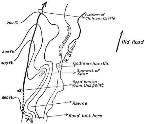
We knew from the researches of others
that the road was certainly to be found
again at the spot marked A. It was our
impression, from a previous study of the
map, that the trail would make straight for
this point from the place where I was standing
(X). But we were wrong. At this
point the road turned up the hill, its track
very deeply marked, lined with trees, and at
the top with yews of immense antiquity.
The cause of this diversion was apparent
when we saw that the straight line I had
expected the road to follow would have
taken it across a ravine too shallow for the
contours of the Ordnance map to indicate,
but too steep for even a primitive trail to
have negotiated. And this led me to regret
that we had not maps of England such as
they have for parts of Germany, Switzerland,
and France, which give three contour-lines
to every 100 feet, or one to every 10
metres.
We followed up the hill, then, certain
that we had recovered the Old Road. It
took the crest of the hill, went across the
open field of Soakham, plunged into a wood,
and soon led us to the point marked upon
my sketch as A, where any research of ours
was no longer needed. It is from this place
that a man after all these hundred miles can
first see Canterbury.
We looked through the mist, down the
hollow glen towards the valley between
walls of trees. We thought, perhaps, that
a dim mark in the haze far off was the tower
of the Cathedral—we could not be sure.
The woods were all round us save on this
open downward upon which we gazed, and
below us in its plain the discreet little river
the Stour. The Way did not take us down
to that plain, but kept us on the heights
above, with the wood to our left, and to our
right the palings of Godmersham.
THE PLOUGHLANDS UNDER ORCHARDS: ALL THE KENTISH WEALD
We had already learnt, miles westward of
this, that the Old Road does not take to
the crest of a hill without some good reason,
but that once there it often remains,
especially if there is a spur upon which it
can fall gently down to the lower levels.
The lane we were following observed such
a rule. It ran along the north of Godmersham
Park, just following the highest point
of the hill, and I wondered whether here, as
in so many other places, it had not formed a
natural boundary for the division of land;
but I have had no opportunity of examining
the history of this enclosure. Chilham Park
marches with Godmersham; where one ends
and the other begins the road passed through
the palings (and we with it) and went on in
the shape of a clear ridge, planted often
with trees, right down to the mound on which
stands Chilham Castle.
Down in the valley below, something much
older bore witness to the vast age of this
corner of inhabited land: the first barrow to
be opened in England; the tomb in which
Camden (whom Heaven forgive) thought
that a Roman soldier lay; in which the
country people still believe that the great
giant Julaber was buried, but which is the
memorial of something far too old to have a
name.
This castle and this grave are the entry
into that host of antiquities which surrounds
upon every side the soil of Canterbury. In
every point of the views which would strike
us in the last few miles, the history of this
island would be apparent.
From the mound on which Chilham Castle
stands to the farm called Knockholt, just
two miles away, is what I believe to be a
gap in the Old Road, and I will give my
reasons for that conviction. Did I not hold
it, my task would be far easier, for all the
maps give the Way continuously from point
to point.
Up to the mound of Chilham the path is
clear. After Knockholt it is equally clear,
and has, for that matter, been studied and
mapped by the highest authority in England.[42]
But to bridge the space between is
not as easy as some writers would imagine.
It will be apparent from this sketch-map
that between Chilham and Knockholt there
rises a hill. On the south-east of it flows
the Stour, with the modern main road alongside
of it; on the north two lanes, coming
to an angle, lead through a hamlet called
Old Wives' Lees.
There is a tradition that the pilgrims of
the later Middle Ages went through Chilham
and then turned back along these northern
lanes, passing through Old Wives' Lees.
This tradition may be trusted. They may
have had some special reason, probably some
devotional reason, for thus going out of their
way, as we found them to have had at
Compton. If their action in this is a good
guide (as their action usually is) to the trace
of the Old Road, well and good; there is
then no appreciable gap, for a path leads to
Knockholt and could only correspond to the
Old Road; but I should imagine that here,
as at Merstham, the pilgrims may have deceived
us. They may have made a detour
for the purpose of visiting some special
shrine, or for some other reason which is now
forgotten. It is difficult to believe that a
prehistoric trail would turn such sharp
corners, for the only time in all this hundred
and twenty miles, without some obvious
reason, and that it should choose for the
place in which to perform this evolution the
damp and northern side of a rather loamy
hill. I cannot but believe that the track
went over the side of the hill upon the
southern side, but I will confess that if it
did so there is here the longest and almost
the only unbridged gap in the whole of the
itinerary. I am confirmed in my belief that
it went over the southern side from the
general alignment, from the fact that the
known path before Chilham goes to the
south of the castle mound, that this would
lead one to the south of the church, and so
over the southern shoulder of the hill; but,
if it did so, ploughed land and the careful
culture of hop-gardens have destroyed all
traces of it. I fancied that something could
be made of an indication about a quarter of
a mile before Knockholt Farm, but I doubt
whether it was really worth the trouble of
examining.[43]
From the farm, right up through Bigberry
Wood, we were on a track not only easy to
recognise, but already followed, as I have
said, by the first of authorities upon the
subject.
We came after a mile of the wood to the
old earthwork which was at once the last
and the greatest of the prehistoric remains
upon the Old Road, and the first to be connected
with written history.
It was a good place to halt: to sit on the
edge of the gravelly bank, which had been
cast up there no one knows how many centuries
ago, and to look eastward out towards
Canterbury.
The fort was not touched with the memory
of the Middle Ages: it was not our goal,
for that was the church of St. Thomas, but
it was the most certain and ancient thing of
all that antiquity which had been the meaning
of the road, and it stood here on the last
crest of so many heights from which we
had seen so many valleys in these eight
days.
History and the prehistoric met at this
point only.
Elsewhere we had found very much of
what men had done before they began to
write down their deeds. We had passed
the barrows and the entrenchments, and the
pits from whence coins with names, but
without a history or a date, had been dug,
and we had trodden on hard ground laid
down at fords by men who had left no
memory. We had seen also a very great
many battlefields of which record exists.
We had marched where Sweyn marched;
Cheriton had been but a little way upon our
right; we had seen Alton; the Roman
station near Farnham had stood above us;
the great rout of Ockley had lain not far off
below our passage of the Mole; and we had
recalled the double or treble memory of
Otford, and of the Medway valley, where the
invader perpetually met the armies of the
island.
But in all these there were two clean
divisions: either the thing was archaic—a
subject for mere guess-work; or it was clear
history, with no prehistoric base that we
knew of behind it.
On this hill the two categories mingled,
and a bridge was thrown between them.
For it was here that the Roman first conquered.
This was that defence which the
Tenth Legion stormed: the entrenchment
which was the refuge for Canterbury; and
the river which names the battle was that
dignified little stream the Stour, rolling an
even tide below.
The common people, who have been
thought to be vacant of history, or at the
best to distort it, have preserved a memory
of this fight for two thousand years.
I remembered as I sat there how a boy, a
half-wit, had told me on a pass in Cumberland
that a great battle had been fought
there between two kings; he did not know
how long ago, but it had been a famous
fight. I did not believe him then, but I
know now that he had hold of a tradition,
and the king who fought there was not a
George or a James, but Rufus, eight
hundred years before. As I considered
these things and other memories halting at
this place, I came to wish that all history
should be based upon legend. For the
history of learned men is like a number of
separate points set down very rare upon a
great empty space, but the historic memories
of the people are like a picture. They are
one body whose distortion one can correct,
but the mass of which is usually sound in
stuff, and always in spirit.
Thinking these things I went down the
hill with my companions, and I reoccupied
my mind with the influence of that great
and particular story of St. Thomas, whose
shadow had lain over the whole of this road,
until in these last few miles it had come to
absorb it altogether.
The way was clear and straight like the
flight of a bolt; it spanned a steep valley,
passed a windmill on the height beyond,
fell into the Watling Street (which here
took on its alignment), and within a mile
turned sharp to the south, crossed the bridge,
and through the Westgate led us into
Canterbury.
We had thoroughly worked out the whole
of this difficult way. There stood in the
Watling Street, that road of a dreadful
antiquity, in front of a villa, an omnibus.
Upon this we climbed, and feeling that a
great work was accomplished, we sang a song.
So singing, we rolled under the Westgate,
and thus the journey ended.
There was another thing to be duly done
before I could think my task was over. The
city whose name and spell had drawn to itself
all the road, and the shrine which was
its core remained to be worshipped. The
cathedral and the mastery of its central
tower stood like a demand; but I was
afraid, and the fear was just. I thought I
should be like the men who lifted the last
veil in the ritual of the hidden goddess, and
having lifted it found there was nothing
beyond, and that all the scheme was a cheat;
or like what those must feel at the approach
of death who say there is nothing in death
but an end and no transition. I knew what
had fallen upon the original soul of the place.
I feared to find, and I found, nothing but
stones.
I stood considering the city and the vast
building and especially the immensity of the
tower.
Even from a long way off it had made a
pivot for all we saw; here closer by it
appalled the senses. Save perhaps once at
Beauvais, I had never known such a magic
of great height and darkness.
SUCH A MAGIC OF GREAT HEIGHT AND DARKNESS
It was as though a shaft of influence had
risen enormous above the shrine: the last of
all the emanations which the sacred city
cast outwards just as its sanctity died.
That tower was yet new when the commissioners
came riding in, guarded by terror all
around them, to destroy, perhaps to burn,
the poor materials of worship in the great
choir below: it was the last thing in England
which the true Gothic spirit made. It signifies
the history of the three centuries during
which Canterbury drew towards it all Europe.
But it stands quite silent and emptied of
every meaning, tragic and blind against
the changing life of the sky and those
activities of light that never fail or die
as do all things intimate and our own,
even religions. I received its silence for
an hour, but without comfort and without
response. It seemed only an awful
and fitting terminal to that long way I
had come. It sounded the note of all
my road—the droning voice of extreme,
incalculable age.
As I had so fixed the date of this journey,
the hour and the day were the day and
hour of the murder. The weather was the
weather of the same day seven hundred and
twenty-nine years before: a clear cold air, a
clean sky, and a little wind. I went into
the church and stood at the edge of the
north transept, where the archbishop fell,
and where a few Norman stones lend a
material basis for the resurrection of the
past. It was almost dark.... I had hoped
in such an exact coincidence to see the
gigantic figure, huge in its winter swaddling,
watching the door from the cloister,
watching it unbarred at his command. I
had thought to discover the hard large face
in profile, still caught by the last light from
the round southern windows and gazing
fixedly; the choir beyond at their alternate
nasal chaunt; the clamour; the battering of
oak; the jangle of arms, and of scabbards
trailing, as the troops broke in; the footfalls
of the monks that fled, the sharp insults,
the blows and Gilbert groaning, wounded,
and à Becket dead. I listened for Mauclerc's
mad boast of violence, scattering the brains
on the pavement and swearing that the
dead could never rise; then for the
rush and flight from the profanation of
a temple, and for distant voices crying
outside in the streets of the city, under
the sunset, 'The King's Men! The
King's!'
But there was no such vision. It seems
that to an emptiness so utter not even
ghosts can return.
In the inn, in the main room of it, I found
my companions. A gramophone fitted with
a monstrous trumpet roared out American
songs, and to this sound the servants of the
inn were holding a ball. Chief among them
a woman of a dark and vigorous kind danced
with an amazing vivacity, to the applause
of her peers. With all this happiness we
mingled.