J. A. Bownocker
Area.—This field lies in the three
counties, Athens, Perry and Morgan. Leaving out of consideration at
present a few small outlying pools, and starting at the south, the
productive territory may be said to begin in Section 22, Trimple
township, Athens county. From this point it runs almost due north to
the Perry county line. The widest part of this portion of the field
does not exceed one-half mile, while the narrowest portion permits of a
single row only of wells.
It enters Monroe township, Perry county in Section 33, and runs almost
due north towards Corning, but bends to the northeast about one mile
south of that place. Here the productive territory attains a maximum
width of 3 miles, the greatest in the field. The northeast course is
continued to the Morgan county line, where it turns due north, skirting
that line with a productive strip about one-half mile wide for 2½
miles, when it turns slightly to the east, entering Morgan county in
Section 31 of Deerfield township. From that place it extends through
Section 30 and into Section 19, beyond which it has not been traced.
Development of this part of the field is retarded by floods of salt
water which may limit it in this direction. The total length of the
field is about 14 miles.
Outside of this belt are four pools, two of which are of little
importance. One lies around Glouster, and has an area of less than one
square mile. A second one lies in Sections 22 and 29, a short distance
northwest of Glouster. This is the principal territory from which the
gas of Corning and surrounding towns is derived. A third pool lies
around Porterville, and the fourth known as the Oakfield lies from 3 to
5 miles north of Corning. It includes parts of sections 5, 21, 28, 29,
32, and 33 of Pleasant and 22, 27 and 34 of Bearfield townships. It is
in this pool that the most extensive work is being done at the present time.
Discovery.—Probably the first deep well
drilled in the Sunday Creek Valley was near Burr Oak, about 4 miles
south of Corning. Its date is not now known, but it must have been 40
or more years ago. Its depth is likewise unknown, but it is reported
to have penetrated the salt sand. To this day it flows salt water, and
with it sufficient gas to be ignited. This well, however, seems not to
have aroused suspicion that there might be valuable liquids other than
salt water buried in the rocks.
The discovery of oil in the Corning field was a matter of accident,
and resulted directly from a scarcity of water for the Toledo and Ohio
Central railroad. To remedy this a deep well was drilled in August,
1891, at the round-house, about three-fourths of a mile south of
Corning. The only water found was in the salt sand which is reported as
having been struck at a depth of 630 feet. The supply was copious, but
the salinity prevented its being used in locomotives. This brine was
shut out of the well by casing and the drill forced down to a depth of
1507 feet. Finding no water at that depth the work ceased, but a few
days later oil was thrown to the top of the derrick, and there were
smaller eruptions later. However further disturbances of this sort were
prevented by the company closing the well.
Development.—The disclosure made by
this well attracted the attention of oil men who immediately entered
the field and began leasing territory. The citizens of Corning
feared the territory was falling into the hands of the Standard Oil
Company, and that it might not under such conditions be developed for
years. Accordingly a home company styled “The Sunday Creek Oil &
Gas Company,” was organized in February, 1892, to make certain the
development of the territory. The capital stock was placed at $10,000
in shares of $50, and $8900 of the stock was sold. Much of this was
raised by citizens of the town subscribing for single shares.
The new Company was successful. By January 1st, 1898, 255% in dividends
had actually been paid the stock holders. In September, 1898, a
power for pumping the wells, and costing over $7000, was erected,
the contractor taking the product of the wells until it paid for the
plant. In November, 1899, the property together with $1250—the amount
received in excess of the cost of the plant—was turned over to the
original holders. The power is now (July 1, 1900,) pumping 20 wells,
which have a daily production of 40 barrels.
The first well drilled by this Company was on the William Fisher farm
in northwest quarter section 14, Monroe township, Perry county. The
Berea was struck at 1012 feet, but the indications were so unfavorable
for a paying well that it was not considered advisable to shoot it.
However, on June 2d, 1892, after waiting nearly a month, the well was
shot with 80 quarts of nitro-glycerine, which had been hauled from
Sistersville, W. Va. The cost of the shot was $200. The first day
following the shooting of the well it produced 12 barrels, and a year
later was still producing 10 barrels per day. Following this other
wells were drilled in sections 14 and 15. In all 25 have been drilled,
only 3 of which were dry holes.
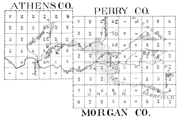
THE CORNING OIL and GAS FIELD
BY J.A. BOWNOCKER.
[Click on image for expanded map.]
Other companies began work and the territory was rapidly leased and
tested. Naturally operations began near the round-house where oil had
first been shown to exist. From this as a center the drill moved out
in all directions until the limits of the field had been disclosed.
The later work has been along the northeast end of the territory in
Morgan county, where the oil seems to be shut out by reservoirs of
salt water. During the present summer (1900) the valuable pool in the
Oakfield district has been developed, though small wells had been
found there several years earlier. The principal farms are the Porter,
Longstreth, Donnelly, Monahan, McDonald and Grenen. The first well was
on the Porter farm and was finished early in 1900. Its production was
35 barrels the first day. The second well was on the Monahan farm. It
was completed soon after the Porter well and had an initial flow of 45
barrels in 24 hours. The next two wells were drilled on the Longstreth
farm, and both were fair producers. Early in the Spring a well was
completed on the Donnelly farm and flowed 125 barrels the first day.
Other wells on this farm are much smaller. Two wells on the Grenen
farm began flowing 675 and 90 barrels respectively. It is interesting
to note that the development of this, the richest part of the Corning
field, occurred late in the territory’s history. Possibly other pools
of equal richness may yet be discovered lying near the principal field.
An important step in the development of the field occurred on August
13th, 1893 when the Buckeye Pipe Line was completed. Before that the
oil was transported by tank cars. The oil which is brought to the tanks
partly by gravity and partly by suction, the latter being produced by
an 8 horse-power gas engine, is stored in two iron tanks, one of which
has a capacity of 30,000, and the other 28,000 barrels. From these
tanks the oil is forced to Elba, a distance of 34 miles, through a 4
inch line. This work is done by a 35 horse-power engine which gives a
pressure in the line of from 700 to 1000 pounds per square inch. The
rate at which the oil is transported varies with the temperature. In
the summer when the oil is warm, and hence thin, 128 barrels may be
pumped in one hour, but in the winter when the oil is cold and thick
the transportation may be restricted to 11 barrels for the same period.
When the pipe line was completed the production of the field was about
500 barrels per day. It increased to 1300 barrels in 1896, but since
then has declined. At present it ranges from 800 to 900 barrels per
day. The total production of the field is shown by the following letter:
The Buckeye Pipe Line Company—Macksburg Division.
Oil City, Pennsylvania, October 25th, 1900.
J. A. Bownocker, Esq., Columbus, Ohio:
Dear Sir—Your favor of October 18th to Superintendent N. Moore,
asking for the total production by years of the Corning Field, has been
referred to me. Below please find the figures of oil received by The
Buckeye Pipe Line Company from the Corning Field from August, 1893, to
September, 1900:
| Part of Year 1893 |
128,918.03 |
Bbls. |
| Year 1894 |
322,313.71 |
“ |
| Year 1895 |
428,385.03 |
“ |
| Year 1896 |
469,258.78 |
“ |
| Year 1897 |
328,188.11 |
“ |
| Year 1898 |
196,417.75 |
“ |
| Year 1899 |
211,060.22 |
“ |
| January 1st to July 31st, 1900 |
143,314.96 |
“ |
| August, 1900 |
26,929.66 |
“ |
| September, 1900 |
22,517.67 |
“ |
| Total |
2,277,303.90 |
Bbls. |
July 31st, 1900, completes the first seven years production and
thinking you might prefer to use the even years, I have given you the
figures for the year 1900 to July 31st in one lump and the oil taken
from that field for the months of August and September separately.
Trusting this will answer your purposes, I remain
Yours truly,
J. R. Campbell, Treasurer.
Leases.—At first
the operators paid no bonuses, but gave a royalty of one-eighth of the
oil to the land owners—a rate of compensation that has been usually
maintained. To this there is one exception worthy of note. When the
round-house well showed the existence of oil, and operators began
leasing the surrounding territory, Fredrick Weaver, a thrifty German
farmer residing a short distance east from the round-house, quietly
visited the oil fields of Washington, Pennsylvania, and investigated
the methods of leasing oil territory in that field. When he returned
home he demanded a royalty of one-fourth the oil and a bonus of $200
for each of the eight wells which it was proposed should be drilled
on his farm of eighty acres, and since his territory was regarded as
very promising, these rather severe terms were granted. However, after
drilling six wells, and the territory not meeting expectations, the
contractors complained and Mr. Weaver generously reduced the bonus.
More recently a royalty of one-sixth the oil has been received by
holders of lands that were deemed especially promising, and bonuses
also have been received. The leases usually required that a well be
drilled in from thirty to sixty days, but sometimes, especially in the
least promising territory, six months were allowed.
That the field was a monopoly for no one is shown by the following
list, which includes the chief operators of the district:
- Corning Oil Company.
- Denman & Thompson.
- O’Connel Oil Company.
- Brooks Oil Company.
- Caldron & Snyder.
- Sunday Creek Oil & Gas Company.
- Perry County Oil Company.
- W. B. Barker & Company.
- Cleveland Oil Company.
- Keystone Oil Company.
- W. E. Detlor.
- William Rosier.
- J. H. Van Wormer.
- Northeast Oil Company.
- Becker Oil Company.
- Allen, Sternberg & Company.
- Bolivar Oil Company.
- William McMullen.
- A. Bulger & Company.
- Corning Natural Gas Company.
- L. D. Langmade.
- Harrington Brothers.
- Ohio Oil Company.
- Church Oil Company.
- Monroe Oil & Gas Company.
- Weaver Brothers.
- W. B. Irwin & Company.
- George Best & Company.
- Foster & Moran.
- Fallen Rock Company.
- Ohlviler & Chambers.
- Mill Oil Company.
- Hemlock Oil Company.
- John Holden.
- Wells & Foraker.
- Longfellow & Stevens.
- Russell Metzger.
- McGee & Stewart.
- Stratton & Mark.
- National Oil Company.
Geology of the Region.—The surface of the
territory lies in the Lower Productive and Lower Barren coal measures.
The highest hills reach up to or extend above the Ames or Crinoidal
limestone. In fact along the northeast extremity of the field the hills
are capped by the limestones which underlie the Pittsburgh coal. The
deepest valley—that of Sunday Creek—cuts through the Middle Kittanning
coal, a short distance north of Corning, but at this town the seam
named is under cover, while the Upper Freeport coal is at about
drainage level.
The succession of strata under ground is shown by the following
record kept and furnished the Survey by Mr. G. W. Delong,
Superintendent of Schools, Corning. The well is located on lot 154 of
the town just named, and the top of the well lies at the base of the
Mahoning sandstone:
| |
Thickness of
Stratum |
Total
Thickness |
| Shale |
25 |
feet |
25 |
feet |
| Bastard Lime |
15 |
“ |
40 |
“ |
| Sand |
10 |
“ |
50 |
“ |
| Coal (No. 6) |
10 |
“ |
60 |
“ |
| White Slate |
65 |
“ |
125 |
“ |
| Sand |
15 |
“ |
140 |
“ |
| White Slate |
25 |
“ |
165 |
“ |
| Blue |
10 |
“ |
175 |
“ |
| Sand |
10 |
“ |
185 |
“ |
| Slate |
50 |
“ |
235 |
“ |
| Shale |
35 |
“ |
270 |
“ |
| Sand |
30 |
“ |
300 |
“ |
| Black Shale |
10 |
“ |
310 |
“ |
| Lime |
25 |
“ |
335 |
“ |
| Shale with Concretions |
100 |
“ |
435 |
“ |
| Slate |
25 |
“ |
460 |
“ |
| Limestone(?) |
30 |
“ |
490 |
“ |
| Shale |
35 |
“ |
525 |
“ |
| Salt Sand |
30 |
“ |
555 |
“ |
| White Slate |
100 |
“ |
655 |
“ |
| Slate and Concretions |
25 |
“ |
680 |
“ |
| Shale |
15 |
“ |
695 |
“ |
| Little Salt Sand |
20 |
“ |
715 |
“ |
| White Slate |
100 |
“ |
815 |
“ |
| Slate and Concretions |
100 |
“ |
915 |
“ |
| Brown Shale |
40 |
“ |
955 |
“ |
| Black Shale |
38 |
“ |
993 |
“ |
| Top Berea |
|
|
993 |
“ |
| Bottom of Berea |
|
|
1008 |
“ |
The depth of the well as shown by the steel line is 1012½ feet. It
was drilled in the Fall of 1896, and was shot with twenty quarts of
nitro-glycerine. It began flowing thirty barrels per day, but the
production has diminished until at present it is producing only one
barrel per day. Below the Berea the Bedford shales are found in their
normal conditions.
The Oil Sand.—This is in all cases the
Berea. The sand has the light gray color so common in this formation
in other parts of the state. It is moderately fine grained, but there
is considerable variation in this respect. Usually it is a pure quartz
sand, but occasionally has thin layers of dark shaly material running
through it. In thickness it shows considerable variation, but never
disappears in this field. The normal thickness is usually given as
twenty feet and the maximum reported is eighty feet. This depth was
found on the Potts farm about one and one-fourth miles northeast of
Corning, and on the O’Farrell farm about two miles east from the same
town. In both cases a dark gray shale, probably the Ohio, lay below.
The Bedford on this theory had been swept away before the Berea was
deposited. In such abnormal depths the additions always appear to be on
the bottom, showing that the surface of the underlying Bedford shale
was quite uneven. Here, as elsewhere in the state, the drill shows the
upper surface of the Berea to be uniform. It is worthy of note that the
production of oil does not vary as the thickness of the sand. In fact
in this field the great thicknesses are generally poor producers.
The “pay streak” or that containing the oil and gas ranges in thickness
from 3 to 8 feet, but very few of the wells attain the maximum figure.
Towards the margin of the productive field the “pay streak” thins, and
finally disappears. The top of the “pay” usually lies from 10 to 15
feet below the surface of the Berea. As a rule the “pay” is coarser
than other parts of the Berea, and generally the coarser the rock the
larger the well. Sometimes in the thick part of the Berea there are two
“pay streaks.”
The Wells.—The number of wells producing
July 1, 1900, exceeded 600. About 100 dry holes have been drilled and
about an equal number of wells have been abandoned, so that 800 is a
fair approximation of the total number of wells drilled in the field.
As a rule a well has been put down for each 8 to 10 acres of surface
territory.
The wells have been cased through the salt sand, a depth of 555 feet in
the valley at Corning. The casing has almost invariably been 5⅝ inches,
inside measurement. The rocks comprising the underlying 160-180 feet,
and terminating with the “Little Salt Sand” have furnished some water
which has been disastrous to the wells. It reduced the gas pressure,
thus necessitating pumping the wells earlier than otherwise would have
been required, and perhaps prematurely destroying the life of the well.
Had the wells been cased through the “Little Salt Sand” time and money
would have been saved, and the production of the field would have been
larger.
The western side of the field is quite free from salt water. It is on
that side that the principal gas territory lies. On the eastern side of
the field the conditions are more variable. In Trimble township, Athens
county, the wells are free from water, while in Monroe township, Perry
county, salt water is found in the northeast corner, and in Morgan
county it is so abundant that operating is prevented. From this it
appears that the western side of the Corning field is free from salt
water, and that it is absent also on the eastern side at the southern
margin of the territory, but that it increases rapidly to the northeast.
While the production of the wells after being shot has varied greatly,
yet they have not furnished the great extremes that many other fields
have. Few, if any of the wells, have started better than 125 barrels
per day, and it has been estimated that the average for the entire
field has been 20 barrels.
The wells have sufficient gas pressure to flow them during the earlier
part of their lives, but later as the pressure diminishes they have to
be pumped. Since the eastern side of the field has salt water the wells
there have to be pumped earlier than those on the western side.
The Gas Wells.—The principal gas
territory is that along Muddy Fork in Sections 22 and 29 Trimble
township, Athens county, the best wells being found in the western half
of the latter section on the lands of the Hocking Coal and Railroad
company. The largest well in this field started at 3,000,000 cubic feet
per day with a rock pressure of 400 pounds. It was drilled in the fall
of 1897, and one year later was producing 2,000,000 cubic feet per day,
and still another year later 1,500,000 cubic feet. Of the other wells
in this territory two started at 2,000,000 feet each, two at 1,000,000
feet each, and three at 500,000 feet each. The decline in the smaller
wells was not as rapid as in the larger ones since the demands made on
them were not as heavy. Thus far no dry holes have been found in this
territory. The reliance of the community is on this field where 5,000
acres are leased in one block.
Another district that has yielded considerable gas is that at Oakfield
about 3 miles north of Corning. These wells started at 2,000,000,
1,500,000, 500,000, and 250,000 cubic feet per day respectively. Two
of the smaller of these have been abandoned after having produced for
two years. The largest of these wells, now four years old, is producing
500,000 cubic feet per day, and the second largest, now three years
old, is producing the same amount. The wells in this field produce
considerable oil and by some are rated as oil wells rather than gas ones.
Outside of these two places an occasional strip is found that produces
gas in paying quantities. Thus about one mile northeast of Corning
two wells were drilled, which combined produced 500,000 cubic feet
per day. They produced three years and were then abandoned. About two
miles north of Corning a good well was drilled on the Newberry farm. It
started at 1,500,000 cubic feet per day, had an initial rock pressure
of 400 pounds and lasted three years.
Another productive tract lies about 6 miles northeast of Corning on
the Finley, Devore and Stoneburner farms. Three wells were drilled on
the Finley farm, and started one at 1,500,000 and two at 250,000 cubic
feet, with an initial rock pressure of 400 pounds. These wells lasted
three years.
The operators of the wells have been much troubled with salt water
in the Muddy Fork field and with oil in the Oakfield territory. Salt
water is removed by “blowing” the wells. For this operation the wells
are closed for a short period, usually about 30 minutes, allowing the
gas pressure to increase; when this has become sufficiently strong the
well is opened at the top and the gas then blows the water from the
well. When the well has been cleansed in this manner it is closed and
the gas turned back into the mains. Sometimes, however, the weight of
the water is so great that the gas cannot drive it from the well in
the manner just stated, especially is this true with wells that have
been in use for a considerable period. Then an iron rod attached to a
long pole is let down through the water, is raised and lowered, and
the gas following the pole in its ascent finally drives the water from
the well. This method of cleaning is known as “agitating.” Finally the
pressure of the gas becomes so small that it cannot lift the water with
the help of “agitating,” and then the well is dead. In winter time each
well is cleaned every other day, and in the summer twice a week.
The gas wells in the Corning field are owned and operated by the
Corning Natural Gas Company. It supplies Jacksonville, Trimble,
Glouster, Murray City, New Straitsville, Shawnee, Hemlock, Corning,
Rendville, Moxahala, New Lexington, and several interior hamlets.
Almost the sole use of the fuel is for heat and light.
The company makes a rate of 20 cents per thousand feet by meter. Where
the meter is not used, the prices in winter are $2.00 per month for the
first fire; $1.50 for the second; $1.00 for the third; 75 cents for the
fourth, and all additional fires at the latter figure. In the summer a
charge of $1.50 for each cooking fire is made. For lights the charges
are 25 cents each for the first two and 15 cents for each additional one.
The number of customers supplied by this company in 1900 was
approximately as follows:
| Corning |
300 |
| Glouster |
250 |
| New Lexington |
250 |
| Shawnee |
200 |
| New Straitsville |
150 |
| Other places |
350 |
| Total |
1500 |
In the Fall of 1899 the wells of the company
produced 6,000,000 cubic feet per day, but during cold weather when the
demand for fuel was great they dropped to 3,000,000 cubic feet, and the
rock pressure which was 300 pounds in the Fall was only 200 during the
winter. On July 7th, 1900, the rock pressure of the wells in the Muddy
Fork field ranged from 170 to 280 pounds, indicating a considerable
drop from that of the preceding autumn. The company expects to drill
four additional wells during the ensuing fall (1900) in the Muddy Fork
territory, and by so doing expects to keep three wells closed, and thus
maintain a good rock pressure.