—No account of the Nile in 1904 would be complete
without an enumeration and slight examination of the projects before
the public for the provision of sufficient water to the Nile in times of
low supply to insure the perennial irrigation of the whole of Egypt;
to utilise these perennial waters by converting basin tracts into perennially
irrigated ones; to protect the country from the dangers accompanying
high floods; and to permit of the reclamation of the low salted
lands of Lower Egypt which border the Mediterranean sea.
Egypt has a total irrigable area of 61⁄4 millions acres. Of this area, 1⁄4
of a million acres, which are to-day inundated in flood and lie along
the edge of the deserts, must continue to be inundated in flood for
all time, to prevent the sands of the desert from spreading over the
Nile Valley. Their value is £5,000,000. Four million acres are perennially
irrigated. They have a mean value of £55 per acre, and have
a total value of £220,000,000. Of the remaining two million acres,
two-thirds are irrigated only in flood and one-third is not irrigated
at all. These 2 million acres have a mean value of £25 per acre, and
are worth £50,000,000. The land of Egypt may be considered as
worth £275,000,000 to-day. If it were possible to perennially irrigate
the 2 million acres which are without such irrigation, their value would
be increased by £30 per acre, or by £60,000,000.
The problem before us is how to provide perennial irrigation to
these 2 million acres and so add £60,000,000 to the wealth of the
country.
It has been calculated that each milliard of cubic metres of water
stored in reservoirs situated in Egypt itself is sufficient to insure the
conversion of half a million acres from flood to perennial irrigation.
Egypt therefore requires reservoirs capable of storing 4 milliards of
cubic metres of water.
In Mehemet Ali’s time, the great preoccupation of the Government
was the pressing on of the cultivation of cotton, and as this crop
needed perennial irrigation, the securing of an abundant supply of
water all the year round was the problem of the day.
The fame of the ancient Lake Mœris had made a profound impression
on the mind of Mehemet Ali, and he urged on his chief engineer
the necessity of undertaking similar works. Linant Pasha first set
himself to discover the site of the ancient lake, and then estimated
roughly the cost of reconstructing it, but considered the cost prohibitive.
He recommended Silsila as a suitable site for a weir and a canal head.
The failure of the Barrage discouraged the Government from
undertaking new works and the question dropped. In 1880 Count
de la Motte proposed a dam at Silsila and a reservoir to the south of
it. He also proposed putting a capacious depression to the east of
Kalabsha in communication with the Nile by the aid of a dam at
Kalabsha.
About two years later Mr. Cope Whitehouse suggested utilising
the Wadi Rayan depression as a reservoir. This depression had been
already mentioned by Linant Pasha in his book and located by him
on his hydrological map. Financial difficulties prevented Sir Colin Scott-Moncrieff
from immediately considering the question of reservoirs.
The success of the Barrage repairs in 1887 however gave new life to
the question of reservoirs and Sir Colin Scott-Moncrieff deputed Col.
Western to give scope to the suggestion made by Mr. Cope Whitehouse,
to make plans of the Wady Rayan and the deserts between it and the
Nile, to find out the capacity of the reservoir, and see if it could be
utilised. Col. Western’s report, plans and estimates were printed by
the Egyptian Government in 1888. At the same time I was deputed to
examine the other projects of Count de la Motte. In 1889 and 1891 I
reported unfavourably on them, because I could find no depression near
Kalabsha to put in communication with the Nile, and could find no
rock at Silsila on which to build a dam. The Bergat Takham pan was
the only depression near Kalabsha which could have been used as a
reservoir and it was over 100 metres above the level of the Nile flood;
while both in the Silsila pass and the Silsila gate I bored for rock
and was everywhere still in sand 10 metres below the level at
which the existence of rock was assumed by the Count’s engineers.
On my report reaching Cairo, M. Prompt proposed using the
trough of the Nile itself at Kalabsha as a reservoir in place of the depression
which did not exist. Col. Western left the country in 1890
and I became Director General of Reservoir Studies. M. Prompt had
supposed that rock could be met with at Kalabsha at a depth of 4 metres
below low-water level. I could not find it at a depth of 26 metres.
After sounding and boring at every possible site on the Nile and
surveying, boring, and levelling in the desert between Wadi Halfa and
the Fayoum, I submitted my report in 1894, proposing an open dam
at Assouan of a type which I trusted would meet the requirements of
a Nile reservoir dam. Sir William Garstin approved of the site and the
design, and the dam was built between 1898 and 1902 with Mr. Maurice
Fitzmaurice C.M.G, as resident engineer.
The Assouan Reservoir at its present level contains one milliard of
cubic metres of water which will suffice for the conversion of half a
million acres to perennial irrigation, adding £15,000,000 to the wealth
of the country. But though the dam was only completed at the end
of 1902, already the whole of the water has been devoted to special
tracts, and the Government is reluctantly compelled to refuse all applications
for water.
—Egypt already possesses
the germ of all the storage works she needs. Six years ago a few far-seeing
men saw clearly what all of us understand to-day; but among
the few, no man had greater faith in the future of the country than
Sir Ernest Cassel. The Assouân Reservoir project had been lying
buried for four years in official pigeon holes, when in 1898 Sir Ernest
came forward with the funds, and with Sir John Aird & Co., as contractors,
and Sir Benjamin Baker as Consulting Engineer, undertook
to complete the Assouân dam and the Assiout weir by December 1903.
The Egyptian Government, advised by Sir William Garstin, accepted
his offer, and received the completed works by December 1902.
The Assouân dam is a granite structure 2,000 metres long which
crosses the head of the Assouân cataract of the Nile in one continuous
straight line. The dam is pierced by 140 under sluices of 7 metres by
2 metres for passing floods, and by 40 upper sluices of 31⁄2 metres by
2 metres for passing the high level water of the reservoir. The sluices are
regulated by “Stoney” gates worked by winches at the roadway level.
While the red, muddy waters of the Nile flood are pouring down
the river, the whole of the sluices are open and the river discharges
itself through them without parting with its silt. This is the real object
of the sluices, for if the dam were solid and the river forced to flow
over the top, the reservoir would soon be filled with deposit and obliterated,
while Egypt, deprived of this rich mud, would be considerably
the poorer. This is the great feature of the dam. While the dam holds
together, the reservoir will be free of silt.
When the turbid flood has passed and the comparatively clear winter
supply of the river has begun to arrive, the sluices are gradually closed
and the reservoir filled. Beginning about the 1st December, the reservoir
is filled in 100 days. It will ordinarily be full on the 1st March.
No additional water is needed for irrigation between March 1st and
May 1st as the river naturally has enough for the requirements of the
area at present under crop at this season. As the area under perennial
irrigation will be gradually increased, the demand for water for
the new lands will begin about the 1st of April. The demand increases
through May and June, and the reservoir will then be aiding the
river with its supplement. If the flood is very late, water may be
required from the reservoir till the 10th July; if the flood is early no
water will be needed after the 20th of June, as in 1903, the first year
of the reservoir. The earlier the flood the more effective the reservoir.
By the time the flood has begun to get turbid, the under and upper
sluices will all be open and the muddy waters of the Nile will sweep
through the dam without impediment.
The dam has worked for two years and given satisfaction. When the
Nile was at its lowest in May 1903, the natural discharge of the river,
supplemented by all the subsoil infiltration water which enters the
river between Assouân and the sea, was 400 cubic metres per second.
The reservoir was adding 200 cubic metres per second to the supply,
raising the total supply available for irrigation to 600 cubic metres per
second. The reservoir was supplying one-third of the water which
was being utilized in Egypt. This water will suffice for an increase to
the perennially irrigated area of 1⁄2 million acres.
At the time of designing the dam it was intended that it should be
of such a section that it could be raised 6 metres in height and hold
up another milliard of cubic metres of water. Such an operation, if
performed to-day, would mean: the whole length of dam being raised
6 metres, the winches working the sluice gates being raised 6 metres
and provided with new wire ropes; and new copings being given to
the parapets. It would necessitate two more locks and three more lock
gates, and nothing else. The expenditure incurred would be about
£500,000.
—When the
Assouân dam will have been raised, we shall be standing on the
threshold of what it will be able to do. The projected Wady Rayan reservoir,
or the modern Lake Mœris, will be well able to supply the two
remaining milliards of cubic metres of water when working in conjunction
with the Assuân Reservoir. The great weakness of this projected
lake has lain in the fact that by itself it could give a plentiful
discharge in April and May, less in June, and very little in July, and
it was for this reason that in my report of 1894 to the Egyptian
Government I had reluctantly to recommend that it be not carried out.
But when the Assouân reservoir is capable of supplying two milliards
of cubic metres of water it will be possible to utilise the Mœris Lake
to its utmost capacity. The Assouan Reservoir, being high above the
level of the Nile can give its supply at the beginning or end of the
summer; it can give it slowly or with a rush; while the projected
Lake Mœris, being directly in communication with the Nile, and only
slightly above low Nile level, its discharge would depend entirely on
the difference of level between it and the Nile, and consequently as the
summer advanced its level would gradually fall and the lake would
not be able to give at the end of the summer a quarter of the discharge
it could give at the beginning.
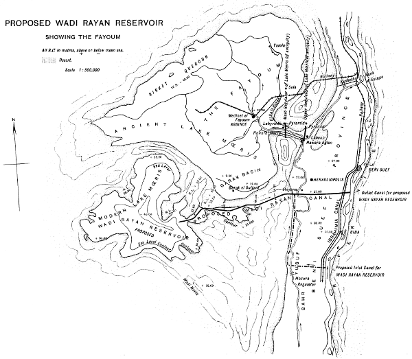
PLATE XV
PROPOSED WADI RAYAN RESERVOIR
SHOWING THE FAYOUM
All R. L.s in metres, above (+) or below (-) mean sea.
Lith. Sur. Dep. Cairo.
Larger map (310 kB)
But let us imagine that the reservoir and the lake are both completed
and full of water, and that it is the first of April. Lake Mœris
will be opened on to the Nile and give all the water needed in that
month, while the Assouan Reservoir will be maintained at its full level.
In May, Lake Mœris will give nearly the whole supply and the reservoir
will give a little. In June the lake will give little and the
reservoir much; while in July the lake will give practically nothing
and the reservoir the whole supply. Working together in this harmonious
manner, the reservoir and the lake, which are the true complements
of each other, will easily provide the whole of the water needed for Egypt.
The Wady Rayan is a depression in the deserts to the south of the
Fayoum and separated from the Fayoum by a limestone ridge. In 1888
Col. Western recommended it very strongly as a reservoir. In this he
was supported by Col. Ross, the first Inspector General of irrigation.
On Col. Western’s leaving Egypt, the study was entrusted to me, and
Messrs. Hewat and Clifton deputed to make a final project. The Wady
Rayan project, with its plans and estimates, was published by the
Egyptian Government in 1894. As I said before, I was reluctantly
compelled to reject its adoption owing to the one radical defect already
described. That defect will have been completely removed by the completion
of the Assouân Reservoir, when it will be possible to undertake
the construction of the modern lake Mœris.
The question of Lake Mœris has interested the world for centuries.
For the ancients it was one of the world’s seven wonders. Sir Hanbury
Brown, in his book on the “Fayoum and Lake Mœris,” has collected
all the information available about the lake, and after a thorough
examination of the question has declared in favour of the Wady Rayan
being converted into a modern Lake Mœris.
Herodotus, writing about B.C. 450, was the first to describe the
lake: “Now the Labyrinth being such as I have described, the lake
named that of Mœris, causes still greater astonishment, on the bank
of which the Labyrinth was built.
“The water in the lake is not derived from local sources, for the
earth in that part is excessively dry and waterless, but it is brought
in from the Nile by a canal. It takes six months filling and six months
flowing back. During the six months of the return flow, it yields a
talent of silver every day to the treasury, and during the flow twenty
minæ for the fish.”
Strabo, writing in B. C. 20, remarks: “It has also a remarkable lake
called the Lake of Mœris, large enough to be called a sea, and resembling
the open sea in colour.
“Thus the Lake of Mœris is, from its size and depth, capable of
receiving the overflow of the Nile at its rising, and preventing the
flooding of houses and gardens; when the river falls, the lake again
discharges the water by a canal at both mouths, and it is available for
irrigation. There are regulators at both ends for controlling the inflow
and outflow.”
Diodorus Siculus, writing at the same time, says:—“King Mœris
dug a lake which is amazingly useful and incredibly large. For as
the rising of the Nile is irregular, and the fertility of the country
depends on its uniformity, he dug the lake for the reception of the
superfluous water, and he constructed a canal from the river to the lake
80 furlongs in length and 300 feet in breadth. Through this he admitted
or let out the water as required.”
At one time there was much discussion as to what was Lake
Mœris, but since the publication of Sir Hanbury’s book there can be
but one opinion. The lake covered the whole of the modern Fayoum
below the level of the contour which is 221⁄2 metres above mean sea
level. The common Nile shells are to be met in myriads at any point
on this contour round the Fayoum that one cares to look for them.
The ordinary high flood level of Kushesha basin to-day is 261⁄2
metres
above mean sea. In Amenemhat’s time, which was 4,000 years ago,
the level was 4 metres lower, or at 221⁄2 metres above mean sea. This
was the highest possible level the lake could have attained in his day.
In the course of time the level of the Nile valley rose by about 10
centimetres per century, but the frequent occasions on which the canal
was kept closed during poor and low floods gradually silted up the
channel and made it less capacious. As there are no Nile shells above
the contour of 221⁄2 metres above mean sea (except a few on the south
side of the lake which have evidently been blown up by the north
west winds in sand drifts) it is evident that the gradual silting up of
the channel more than kept pace with the rising level of the Nile.
Eventually the silting up exceeded the rise, and that at an accelerated
rate, the canal became weaker and weaker, and the Fayoum Province
gradually occupied the site of the lake. Lake Mœris had lasted over
2,000 years.
The connection between the Nile and the germ of the future Lake
Mœris was in existence in King Menes’s time, as I have been informed
by professor Sayce, but it was King Amenemhat, of the XIIth dynasty,
who widened and deepened the canal, cleared away the rocky barriers,
and converted the trifling lake of King Menes’s time into the mighty
inland sea which controlled the highest floods of the Nile. Those
ancient Pharaohs were giants in hydraulic engineering. They were,
moreover, as wise as they were courageous.
Sir Hanbury Brown has well described the action of the lake. It
had a surface of 2,500 square kilometres, and being drained back into
the Nile and kept at a low level it was able to take from a very high
flood 20 milliards of cubic metres of water. It was quite capable of
reducing a very high flood to moderate dimensions; and if injudiciously
or maliciously opened in a low flood, it was capable of depriving Lower
Egypt of any flood irrigation at all; and in those days they had practically
no irrigation except flood irrigation.
The Wady Rayan, as already stated, is a depression in the Lybian
hills immediately south of the Fayoum. It has, at a level of about 29
metres above the sea, a surface of 700 square kilometres, or about one
quarter the area of the ancient lake. Like the ancient lake, the lowest
point of the Wady is 41 metres below sea level. When filled with
water the greatest depth will be 70 metres. The uppermost four or
five metres only will be utilised annually, or some 3 milliards of cubic
metres of water out of a total volume of 20 milliards. Just as the
great size of the ancient lake was of inestimable value to a work whose
principal use lay in moderating high floods, so the smaller area of the
modern lake will render it far more useful as a work for feeding the
low Nile. This lake, will render no mean aid in time of dangerous
floods, but, in its early years, its main use will be the provision of
water in summer. It will supply the two milliards which are needed
to convert the whole of Egypt from basin to perennial irrigation.
In my book on “The Assuân Reservoir and Lake Mœris” I have
worked out the cost of the project and estimated it at £2,600,000.
The rates I have allowed for the excavation work are considered too
low by some critics. If the earthwork in the Nile Valley had to be
excavated within 30-day rotations as on the running canals, I should be
the first to agree; but the work will last three years and the contractors
will be able to concentrate all the spare labour of the country on
the works when demand for labour is slack, and in this way the rate
of P.T. 3 per cubic metre which I have allowed will be found to be
ample. In the hill of salted marl it will be possible to employ the
American system of excavating by the aid of water issuing from nozzles
under pressure. By this method it will be possible to do much work at
P.T. 2 and P.T. 3 per cubic metre as it is done in America. I have
allowed P.T. 5 per cubic metre. To this hydraulic pressure work the
salted marls will be specially suited, and indeed the recollection of the
ease with which Amenemhat dug his canal though this very material
lasted long in the memory of Egyptians. Some 1,600 years after the
canal was excavated, Herodotus was informed that the excavated material
was thrown into the canal and transported by the running water.
A 12-inch pump on the Yusufi canal lifting water on to the top of the
hill, a number of spade men helping the water as it coursed down the
hill and leading the liquid mud along wooden troughs into side ravines
and depressions, and a steep slope on the western half of the hill where
the rock had been blasted away would soon remove all the material
required at a very low cost. I have allowed P.T. 10 per cubic metre
for the soft limestone. Here it will be easy to work on a vertical face
of some 7 metres, blast out the rock, carry it away on four lines of
railway running down hill, deposit the rubble on the desert; and as
each 7 metres depth is completed, to begin the next 7 metres in depth
in the same way.
In my 1894 Report I had anticipated difficulties with the canal
running through the salted marl. Since then I have thoroughly inspected
the ravines in the Fayoum and seen the El-Bats ravine where
it cuts through many kilometres of this very salted marl. The sides
are absolutely vertical and deposits of mud and self-sown tamarisk
bushes protect the vertical sides at places where the running water is
nearly touching the marl. Such natural protection will be far superior
to the masonry lining I proposed and far more effective. It will moreover
cost nothing.
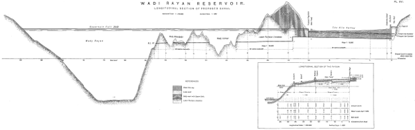
PL. XVI.
WADI RAYAN RESERVOIR
LONGITUDINAL SECTION OF PROPOSED CANAL
Larger illustration (220 kB)
LONGITUDINAL SECTION OF THE FAYOUM
To those critics who suggest that the waters of the lake might
become salted or leak into the Fayoum I have to reply as follows:
When the old Lake Mœris, or the present Fayoum, was full of water
and 63 metres higher than the bottom of the Wady Rayan, and remained
so for thousands of years, there was no question of the waters
having become salted or having escaped into the Wady. The Wady
was as dry as it is to-day and the great inland sea was always fresh. If
there had been any serious infiltration from the ancient Lake Mœris
into the Wady Rayan, there would have resulted a lake which could not
have escaped the notice of the numerous travellers who visited the lake.
No mention was ever made of such a lake. This body of water
moreover would have been inhabited by fresh-water animals whose
remains would have strewn its shores. No such remains are to be
seen to-day. If therefore the ancient Lake Mœris with a head of 63
metres on to the Wady Rayan could not leak into the Wady, it is not
likely that the Wady Rayan reservoir with a head of from 27 to 29
metres on the Garak side of the Fayoum will leak into that part of the
area covered by the ancient lake. Any leakage into the Lake Kurun side
is never contemplated by anybody, since many kilometres of compact
limestone lie between the Wady Rayan and it, while about one or two
kilometres of the same limestone lie between the Wady Rayan and the
Garak depression.
—If we wish not only to
irrigate the whole of Egypt, but to include the Sudan in the sphere of
operations we must regulate the supply issuing from Lake Albert
Nyanza and ensure its passage through the great swamp regions. To
my mind no work in the Sudd regions will be of any substantial value
unless the Albert reservoir dam is first built. Tabulating the information
collected in the gauges and discharge tables we may state that the
discharge of the Albert Nile in cubic metres per second between the
15th January and 15th May was as follows in:—
| |
1901 |
1902 |
1903 |
1904 |
| Discharge at Gondokoro |
600 |
600 |
700 |
1000 |
| Discharge above Sobat mouth |
300 |
300 |
350 |
435 |
In 1861 the discharge at Gondokoro was as low as 500 cubic metres
per second. It will be seen that, in spite of the great waste, there is
an increase at the northern end of the Sudd region even under present
conditions when the discharge at the south end is increased in the
interval between the 15th January and 15th May. The water which
enters the White Nile during these months represents the summer
contingent of the White Nile to the Nile in Egypt.
Now though an increase in April at the south end of the Sudd region
is felt at the north end, no such increase is felt in September and
October, and the reason has been given in Chapters II and III.
In April the Sobat river is discharging practically nothing, and
the whole supply available in the Albert Nile can pass down the White
Nile past the Sobat mouth. In September the Sobat river may be
discharging 750 to 1,000 cubic metres per second, and as the White
Nile cannot discharge the combined waters of the two rivers, the water
of the Albert Nile is headed up and accumulated in the lowlands
between Lake No and the Sobat mouth. This is greatly to the advantage
of Egypt, for it is the discharge at the head of the White Nile
between January 15 and May 15 which decides the White Nile contingent
to the summer supply of the Nile in Egypt, and the greater the
quantity of water above the head of the White Nile, in the absence of
a regulator or barrage at Wadelai or Dufilé, the better the summer
supply of Egypt. After the abnormally high flood of 1878, when
Gordon was up the Nile, so great was the accumulation that the discharge
at Assuân never fell below 1500 cubic metres per second in the
summer of 1879. The Barrage was not regulated upon and yet all
the Lower Egypt canals were full of water, and the cotton crop of
Egypt for that year was quite abnormal for the seventies of the last
century.
Now an expenditure of between £400,000 and £1,000,000, say
£800,000, could secure a regulator for Lake Albert at any point
between the outlet and Dufilé. Such a regulator would insure 1200 cubic
metres per second every year to the Albert Nile at Gondokoro between
the 15th January and the 15th May. With this supply insured, the
training works in the Sudd region would soon begin to affect the
discharge at the north end of this region where the White Nile begins.
The way in which this work of training should be carried out has
been admirably laid down in page 174 of Sir William Garstin’s Report.
“Alter the flood conditions of the Albert Nile (Bahr-el-Gebel) as little
as possible, let the excess flood water escape on both sides, but keep
the summer supply in its channel.” This is, to my view, the soundest
statement from an engineering point of view in the whole report.
Hitherto we have always assumed a vast expenditure for keeping the
flood supply in one channel; but with our attention devoted to the
summer channel, we should have before us all the advantages of summer
training works without any fear of inundations. The very wildness
of the regions would be in our favour. To be able to train a river in
summer without any nervousness about floods, is given to few engineers.
I had never thought that any good thing could come out of the sudd
region, but looked at from this point of view, we can, even in this
inhospitable waste of waters, confirm Shakespeare’s saying that “there
is some soul of goodness in things evil.”
The Lake Albert reservoir could easily insure 1200 cubic metres per
second every year between the 15th January and the 15th May. To
pass through the Sudd regions as much as possible of the 1200 cubic
metres per second received at Gondokoro, the following works would
be necessary:—
The first work to be done would be the removal of sudd block No. 15
which for 37 kilometres south of Hillet-el-Nuer has turned the Albert
Nile out of its course. The importance of this is strongly insisted on
by Sir William Garstin on page 55 of Appendix VI of his Report, which
is the very last thing he wrote. With this block removed, the Albert
Nile would be given a good opportunity of working out its own salvation.
The next point is one to which I attach the greatest importance.
Indeed, I look upon it as the key of the whole region. The Albert
Nile enters the south-east corner of Lake No and almost immediately
afterwards leaves its east corner. Now Lake No is the final evaporating
basin of the Bahr-el-Gazelle, probably the most unsatisfactory river in
the whole world; and it is open to doubt whether in a year of deficient
rainfall on its own catchment basin and a year of good supply down the
Albert Nile, it does not evaporate a considerable quantity of the water
of the Albert Nile. If the discharge of the Albert Nile north of Hillet
Nuer was brought to 450 cubic metres per second in April, this lake
might waste much of it. Such being the case, a cut of a maximum
length of some 5 kilometres should be dredged south of the south-east
corner of the lake, and the waters of the Albert Nile separated from
those of the Gazelle. A cheap wooden lock and regulator would allow
boats to pass, and take in any water from the Gazelle river when it had
it to give. The maximum water we have to deal with is zero in summer
and 40 cubic metres per second in flood. If the Albert Nile were
separated from the Gazelle, it might be found that the waters of the
Gazelle river found their way into the Albert Nile through that mysterious
and unsatisfactory river the Lolle. Some use might even be
found for it. I have, since I wrote this, been informed by Capt. Lyons
that Marno in 1881 proposed this cut round the south-east corner of
Lake No. (Pet. Mitheil, 1881, page 425 and plate 20).
The Albert Nile to-day at Hillet-el-Nuer is capable of carrying 450
cubic metres per second. North of Hillet-el-Nuer, the Albert Nile has
a mean width of 75 metres, but owing to want of training and papyrus
swamps, the discharge dwindles down to 320 cubic metres per second.
The Albert Nile has in this reach a very good section indeed and by
beginning with the west bank and dredging round corners and closing
spills by dredged earth, an improvement of section and slope, backed
up by a permanent discharge of 450 cubic metres per second at Hillet-el-Nuer,
might speedily result in this very discharge of 450 cubic
metres per second being obtained south of Lake No. We are here in
such swamped land that percolation would be practically zero. There
are only 200 kilometres of channel with all its curves, or 160 kilometres
of trained channel to work at, in which 75 per cent of the
work is to hand; and we have to confine our attention to the low
supply without worrying over the flood supplies.
Now the Bahr-el-Zeraf could be made capable of carrying 150 cubic
metres per second by an improvement of the inlet at Baker’s channel
and by dredging north of Ghaba Shambe, as will be seen by examining
the measured discharges of the Bahr. With the Bahr-el-Zeraf carrying
150 cubic metres per second and the Albert Nile carrying 450 cubic metres
per second, we should have ensured 600 cubic metres per second. As time
went on, improvements in the channels would make themselves felt, as
they are even doing to-day, and we might even have 700 and 800
cubic metres per second at the head of the White Nile below the Sobat
mouth. We must always remember that it is assumed that the lake
Albert reservoir dam has been constructed and a supply of 1,200 cubic
metres per second assured at Gondokoro from January to May. If
the Sobat river were capable of regulation downstream of the Pibor
marshes, we might get an increase from that direction as well. The
possibility of a good site for a reservoir upstream of Nasser is very
great. The Nasser gauge rises and falls so slowly that there must be
very great natural accumulations of water upstream of it, which might
be improved. The question of quality needs study.
The discharge of 435 cubic metres per second, which the rivers in
their present state, aided by the Lake Albert reservoir, could deliver
into the White Nile, would thus see itself gradually increased to 500,
550, and 600 cubic metres per second and even more, and would enter the
White Nile past the Sobat mouth in February, March, April and May.
During these months the whole of the supply would pass down the
White Nile without throwing backwater on the rivers. Later on, when
the Sobat river came down in flood and filled up the channel of the
White Nile, the Albert Nile would have its waters reduced at the Albert
regulator, and the waters of Lake Albert would again be stored
for the day when the Sobat floods had fallen and the White Nile
channel was free and ready to take in the waters of the Albert
Nile.
While I had contemplated the training of the flood waters of the
Albert Nile through the Sudd regions I had estimated the cost at
£100,000 per annum, for 25 years, or at £2,500,000. Now, however,
that Sir William Garstin has shown how we need only attend to the
summer supplies, the sum may be reduced to half the former figure or
to £1,200,000, and be more than ample. With £2,000,000 devoted to
the Lake Albert reservoir and the training works in the Sudd region,
the summer supply of Egypt and the northern Sudan would be put on
a firm base.
Dr. Schweinfurth, the eminent African traveller and savant, was the
first to call the attention of the Egyptian Government to the necessity
of closing the spills from the White Nile to the north of Gondokoro,
and so beginning the training of the river. He very rightly said:—“Many
years would elapse before the desired result would be obtained
by the strengthening of the banks, but the works would be increasingly
felt every year in Egypt as the works progressed.”
—In paragraph 30 it was
stated that the floods in the Delta or in Lower Egypt can rise to a
height of from 2 to 31⁄2 metres above the level of the country. Such
floods are really dangerous and means should be found for moderating
them.
The Wady Rayan reservoir, when converted into the modern Lake
Mœris and acting as a reservoir, will have one great advantage, it will
be able to lower a high flood 30 centimetres for 50 days. This will
give relief to the Nile, a relief which will be much appreciated by
the whole country from Beni Suef to the sea, and especially by
Cairo.
I have already stated that the Damietta branch is especially dangerous
and unfit to act as an escape under existing conditions. That
branch could be regulated on at its head and treated like a canal.
Thanks to Sir Hanbury Brown’s initiative the Barrages can be regulated
on in flood as well as in summer, and by lowering the supply in
the Damietta branch and turning the surplus down the Rosetta branch,
the latter would become the flood escape of the Nile. It might be
trained as Mr. Eads suggested that rivers should be treated.
Mr. Eads’ argument is very clear. He insists that rivers eat away
their banks in places, not owing to the direct action of the water but
by the alterations in the velocity of the current. When the river
water is charged with sediment to its full carrying capacity it cannot
take up more unless the rate of current be increased. If the channel
be nearly uniform the river water cannot eat away any of its banks.
If, however, the channel is varying, the silt deposits in the wide
sections, and the water, free of some of its sediment, is ready to eat
more. It is this alternate dropping silt and eating away of earth which
does the harm. To treat the Rosetta branch according to Mr. Eads
it would be necessary to fix the top width to be worked to, at say
550 metres. The river could be brought to this uniform top width
by building light inexpensive permeable spurs on the sandy shoals.
The land between the spurs would become cultivated and such river
training would pay the Government, which taxes all cultivated land;
it would even pay handsomely for any company to undertake the work
once the rule about foreshores was understood. The Government
would, however, always succeed; when it could not sell, it could always
tax. Such training would permanently lower the flood.
In addition to the above it would be necessary to complete the system
of spurs begun in 1884, and to throw back the banks as already
recommended. It has been estimated that the completion of this work
would cost £900,000 for spurs and banks, while the training works
would pay for themselves in addition to greatly improving the channel
and lowering the level of the flood.
It may be humiliating to make the confession, but from B.C. 2,200
to the Arab invasion of Egypt in A.D. 640, while Lake Mœris
performed its allotted task and the Nile possessed training works such
as those we can see to-day in Nubia, Egypt was better protected
from inundation, and the Nile better trained, than it is to-day. And
yet we have many advantages which no Pharaoh possessed. By the
aid of telegraphy we have knowledge of a coming flood a full fifteen
days before it arrives in the Delta; the Khartoum gauge allows us
to anticipate its very height. Meteorology is aiding us still further.
In a paper I read at the Chicago International Exhibition I stated
that years of heavy rainfall in India are years of high flood in Egypt,
while years of poor rainfall in India are years of low flood in Egypt.
Sir John Eliot, the Director General of the Meteorological Department
of India, corrected this statement. He said that though this was
not true of the Bengal monsoon, it was true of the Bombay monsoon.
Years of heavy rainfall in Gujerat and Bombay are years of high
flood on the Nile, and vice versà. As the rain falls in Bombay a
month earlier than the Nile flood reaches Cairo, we have information
of a high flood a month before it arrives, if we receive telegraphic
information from Bombay.
—The complete project for water storage and
flood protection for Egypt as proposed by me, contemplates the following
works:—
| Raising the Assuân reservoir (2 years) |
£ |
500,000 |
| Wady Rayan reservoir (4 years) |
„ |
2,600,000 |
| Training the Rosetta branch |
„ |
900,000 |
| Total |
£ |
4,000,000 |
To these have to be added the approximate estimates of the proposed
works on the Upper Nile:—
| Regulator for Lake Albert (4 years) |
£ |
800,000 |
| Dredging and training works in the Albert Nile and the Zeraf river (12 years) |
£ |
1,200,000 |
| Total |
£ |
2,000,000 |
| Grand total of works on the Upper and Lower Nile |
£ |
6,000,000 |
The total expenditure amounts to £6,000,000 spread over 12 years.
The great advantage of undertaking all those works together may
be thus summarized. The increased supply from the Assuân reservoir
will be felt in Egypt after a period of two years. Five years later the
waters of the Wady Rayan will be added to those of the Assuân
reservoir, and it will be possible to increase the cotton crop of Egypt
from 6 million to 10 million cwt. It will be possible to allow the
Sudan to thoroughly develop its agricultural resources, and with the
aid of the 25,000 horse power as a minimum which the 6th cataract
near Khartoum can supply, to utilise for its own consumption the
waters which can be stored at that cataract; and, in addition to those,
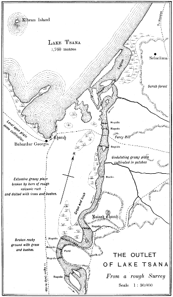
the available supplies from Lake Tsana provided that that lake is furnished
with an outlet tunnel.
While all this life and activity will be developing themselves in
Egypt and the Sudan, the effects of the regulator of Lake Albert and
the training of the Albert Nile in the Sudd regions will be gradually
asserting themselves; and, if the works are being steadily and
perseveringly carried out, it is well within the range of possibility
that before 10 or 12 years will have passed, the additional supplies
from the upper waters of the White Nile will have become so ample,
that it will be possible to dispense with the Wady Rayan as a reservoir.
When this will have happened, the Wady Rayan with its canal will
become the true flood escape of Egypt, like the ancient Lake Mœris,
and will, with the Rosetta branch, afford complete protection to Egypt
against the dangers of a high flood. Egypt, in the fullest meaning
of the term, will be enjoying perennial irrigation and flood protection.
In my book on the “Assuân Reservoir and Lake Mœris” I had
recommended a more extended programme, but the reading of Sir
William Garstin’s Report has convinced me that useful as the Lake
Victoria reservoir dam may be, its postponement as recommended by
Sir William is sound, until all the other works have been executed.
The really essential work is the Lake Albert reservoir dam, of which
the study might indeed be commenced immediately. Sir William’s
proposal to train the summer supply of the Albert Nile and allow the
overflow of the floods to find its way through the Sudd region is so
sound and convincing that the necessary training works in the Sudd
region are greatly reduced. With these reductions the estimated cost
of the project for water storage and flood protection for Egypt is
reduced from £8,200,000 to £6,000,000. I have left the Wady Rayan
estimate as it was in my original programme. Mr. Webb’s criticism
of the project was based on facts which are outside the project.
He supposed that the Wady Rayan was to remain a reservoir for all
time and that it was not to be aided by the works on the Upper Nile.
Now the project I proposed and which I propose now, presupposes
that the Wady Rayan will be a temporary reservoir and final flood
escape for the Nile, and that it will be aided in years of very deficient
flood by the gradual improvement of the Upper Nile owing to the
works undertaken there.
—In the first appendix to his Report on the
Upper Nile, Sir William Garstin, G.C.M.G., Adviser to the Ministry
of Public Works, has drawn up a programme of works for water
storage and flood control in the Nile valley. He approves of the
raising of the Assuân dam for £500,000, and the conversion of the
Rosetta branch of the Nile into a flood escape for £900,000. He
then conditionally approves of a proposal suggested by Mr. J. S. Beresford,
C.I.E., for making a straight cut from Bor on the Albert Nile to
the mouth of the Sobat river at the tail of the Albert Nile. The line
would be 340 kilometres in length and is estimated to cost £5,500,000,
and carry 600 cubic metres per second in summer. In case of the
line being found impracticable when it was surveyed and levelled,
Sir William proposed abandoning the Albert Nile and thoroughly
widening and deepening the Zeraf river for £3,400,000.
As a criticism of the Bor cut project I cannot write anything more
convincing from my point of view than a letter written by me and
published by “The Engineer” in October of this year.
“In your issue of the 16th September Sir Hanbury Brown has
reviewed the scheme suggested by Mr. J. S. Beresford, C.I.E., and
conditionally approved by Sir William Garstin, for diverting the
waters of the Albert Nile (known as the Bahr-el-Gebel) from Bor to
the mouth of the Sobat river, on a length 340 kilometres, and sending
them down a canal capable of carrying 600 cubic metres per second,
at an estimated cost of £5,500,000. In his review Sir Hanbury puts
his finger on the weak point in the project, viz., the difficulty and loss
of water entailed at the crossing of the Albert Nile just upstream of
the Sobat mouth. The difficulty will be got over, as Sir Hanbury
himself suggests, by an earthen embankment provided with a regulator.
The loss of water cannot be got over.
“I have taken the following figures from Sir William’s report and
from the gauge records of the Public Works Ministry:—
Discharge in Cubic Metres per Second During February, March,
and April of the Albert Nile.
| |
1901. |
1902. |
1903. |
1904. |
| At Gondokoro above Bor |
600 |
600 |
700 |
1,000 |
| Upstream of the mouth of the Sobat river |
300 |
300 |
350 |
435 |
“Now, in a year like 1901 or 1902, with 600 cubic metres per second
passing Gondokoro, the diversion canal might be allowed to take in
500 cubic metres per second, leaving 100 cubic metres per second for
the Albert Nile, Atem river, and all the Nuer, Dinka, and Shillook
country between Gondokoro and the Sobat mouth. An allowance of
100 cubic metres per second would not be liberal, and would probably
result in the water becoming stagnant and very impure; but we shall
leave that alone. Starting with 500 cubic metres per second of clear
water the high level diversion canal would never lose less than 50
cubic metres per second through percolation and evaporation before it
reached the Sobat mouth. Many authorities would put the loss at
40 per cent., but we shall say 10 per cent.
“We should then have 450 cubic metres per second entering the
White Nile at its head, just at the end of the Albert Nile and at the mouth
of the Sobat river. At this point, however, under normal conditions
the Albert Nile would have been discharging 300 cubic metres per
second. This supply, after the opening of the diversion canal, would
have failed utterly, as the waters of the Albert Nile would have been
diverted down the diversion canal. Whatever water there was in the
Albert Nile would, moreover, have been at so low a level that it could
not have flowed down the White Nile together with the high level
water of the diversion canal. We should therefore have had in a
year like 1901 and 1902 a net gain of 450 less 300 cubic metres per
second, or 150 cubic metres per second at the head of the White Nile.
By the time this extra water reached Assuân it would have become
100 cubic metres per second.
“If this project, or any other project of any kind, is ever to be
carried out on the upper waters of the White Nile, the very first thing
to be done will be to construct a weir or barrage at the outlet of the
Albert Lake, at Wadelai, or lower down at Dufile. I should say, judging
from the map and the cross section, that Wadelai itself would be
an excellent site for a weir. I have advocated this project in season
and out of season these ten years, and now that actual discharges and
figures are before me I am more than ever convinced that I was no
untrue prophet when I wrote in my book on “The Assuân Reservoir
Dam and After” that “the point where Lake Albert ends and the Albert
Nile begins to have a rapid and contracted stream will be the site of
the future great regulator or barrage of the upper waters of the Nile.
This work will be here or at Dufile.” Such a work would cost anything
between £400,000 and £1,000,000.
“If such a work were carried out it would be possible to insure
every year a discharge of between 1,000 and 1,500 cubic metres per
second at Gondokoro from the 15th of January to the 15th of May, i.e.,
during the months which determine the summer water supply of the
White Nile for Egypt. Such a quantity of water would insure 435
cubic metres per second at the head of the White Nile, as it has done
this year, even under existing conditions; while with training and
dredger work in the Albert Nile and Bahr Zeraf between Gondokoro
and Lake No, it might be increased to 600 cubic metres per second,
and even more. The way in which this work of training should be
carried out has been admirably laid down on page 174 of Sir William’s
Report”.
There are moreover other reasons I think for condemning the excavation
of a straight cut 340 kilometres in length across the eastern
corner of the Sudd regions. The reasons are to be found in Sir William
Garstin’s Report itself. One of the most interesting features of
this report is the number of actually measured discharges at different
sites. Of all these sites Gondokoro, the southern key of the Sudd
region, is the most interesting.
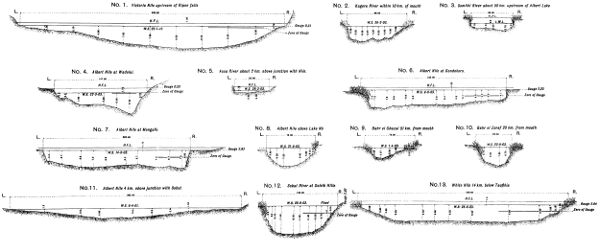
It is very evident from an examination of Sections Nos. 18, 19, 26
and 27, Plate VIII of Sir William’s Report, that the Albert Nile at
Gondokoro scours out its bed very severely after a high flood like that
of 1903. The width of the section is about 230 metres with vertical
sides, and yet while a gauge of ·50 metres on the 1st April 1903
(after the low year of 1902) gave a section of 615 square metres; on
the 9th September 1903 (after a good year), the section was 1,347
square metres for a gauge of 2.33 metres. In other words, a rise of
1.83 metres gave an increased section of 732 square metres; while, if
the bed had not scoured, it would have been 421 square metres. We
have here an increase of 311 square metres, or more than 1 metre of
scour. All this happened in 5 months, and proves that the clear
water of the lakes, when in volume, has a fine cutting edge.
In footnote (2) of page 116 of his Report, Sir William Garstin says that
in the parts of the river where the sudd has been cleared there are indications
that a scour of the bed has set in. Again, on page 55 of the
appendix, he says that the removal of the sudds has caused the levels
of the shallow lakes to fall. All this proves that if the spills and escapes
from the Albert Nile were closed with ambatch, as proposed by Sir
William Garstin on page 175, and a few dredgers put into the Albert Nile
and the Zeraf river the expenditure of a sum of money very moderate
indeed compared with £5,500,000 would in all probability result in
the two rivers being so widened and deepened that they could carry
the full summer supply of the lakes, and so there would be a resulting
economy of over £4,500,000 in the new channel from Bor which,
when it began working, might introduce on an aggravated scale all
the difficulties of to-day in the Albert Nile.
A good description of certain spills is given on page 112 of the
Report, a good idea of scour in Plate XXIX., opposite page 110, while
on page 181 Sir William Garstin makes the remark that the experience
of American engineers has taught us that though in theory it may be
possible to shorten or straighten a great river, in actual practice it is
accompanied with almost insurmountable difficulties. If the new channel
were dug and set working, in a few years it might be as crooked
as the Albert Nile itself, unless it were protected with stone along its
entire length.
In my project for deepening and widening both the Albert Nile and
the Zeraf river to enable them to carry 600 cubic metres per second,
I think I have given very solid reasons against abandoning the Albert
Nile and sending the whole supply down the Zeraf river at a cost of
£3,400,000.
I cannot but think that Sir William Garstin’s recent objections to
the Albert Nile are founded on an oversight. He has, apparently,
not kept the flood discharges of the Albert Nile at Gondokoro
and above the Sobat mouth sufficiently apart from those of low
supply. It is the Sobat flood, combined with the poor carrying
capacity of the White Nile, which is the disturbing factor, and
not any inherent viciousness in the Albert Nile itself. The Albert
Nile has a good section, and, if it were trained in conjunction with
the Zeraf river, would, I feel confident, discharge all the water required
with a very moderate expenditure of money. This, I always understood,
was Sir William’s own opinion. In such projects it is wise to remember
Horace’s saying, “Naturam furcâ expellas tamenusque recurrit.”
—No consideration
of this question would be complete without first examining into
the changes which would be made in the regimen of the Nile flood by
the contemplated conversion of basin irrigation into perennial irrigation.
This question was examined very thoroughly by me in 1892
and 1893 and I give here my arguments for not anticipating any
serious difficulties.
We have to consider the effect of the introduction of perennial irrigation
on the regime of the Nile. The perfection of the perennial
irrigation of the Delta north of Cairo will in no way affect the Nile
in flood. The canals will continue to run as they do at present,
and the question of conversion in Lower Egypt is therefore quite
independent of the subject of flood protection. In Upper Egypt,
however, we have 1,460,000 acres of basin irrigation; and as each
acre receives in a low flood 80 cubic metres of water per day, in an
ordinary flood 130 cubic metres per day, and in an extraordinary flood
170 cubic metres per day, while the demands of perennial irrigation
are only 25 cubic metres per acre per day, it will readily be understood
that we are dealing with a quantity of water which demands the greatest
attention.
To foretell with exactitude the anticipated changes in the regime
of the Nile, it is necessary to know first the daily gauges of the Nile
at Assuân and Cairo for a period of at least twenty years, and the
discharges corresponding to these gauges. The difference between
these discharges represents the consumption of water. We have next
to determine the amount of water which passes into the canals, the
amount utilised in filling up the trough of the Nile and covering the
berms, and the amounts evaporated and absorbed. We know that
the last three items are constant while the canal discharges are variable
and depend on the system of irrigation and, if our data are correct, we
can tell with moderate certainty what changes in the level of the Nile
will follow certain changes in the system of irrigation.
Tables 65 and 67 of Appendix L contain the Assuân and Cairo
gauges for typical years in a period of twenty years from 1873 to
1892, and the mean gauges of these twenty years. Finding it impossible
to understand the Nile without first referring every gauge to
some uniform standard, I have had to choose the line of reference.
The mean high water level and the mean low water level are both
available. In Egypt the mean high water level varies very considerably
whether we take it in August and the early part of September
when the basin canals are running full supply, or in the latter half of
September when the canals are running only half supply, or in October
when the basins are discharging back into the Nile. Early and quick
rising floods have a different series of levels from slow and late floods;
while again the recent works carried out in Upper Egypt by Col. Ross
have so increased the discharging capacity of the canals that the flood
gauges have been appreciably affected. All this points to the conclusion
that the mean high flood is no satisfactory standard. The mean
low flood on the other hand is much less liable to change and is very
fairly constant from year to year. High floods are certainly followed
by scouring out of the bed, and low floods by a silting up of the
channel, but the changes are very moderate compared to those in
high flood. I have chosen the mean low water level as the line of
reference, and referred all gauges to it. From the mean of twenty
years’ observations, this level at Assuân is R. L. 85 metres. By
observations along the Nile generally, and by calculations at Cairo,
I have fixed it at all important places north of Assuân. Table 46
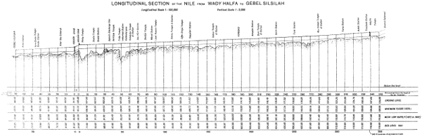
of Appendix K gives the Reduced Levels at different places, while
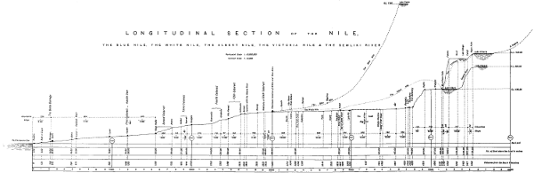
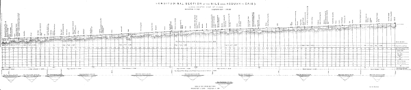
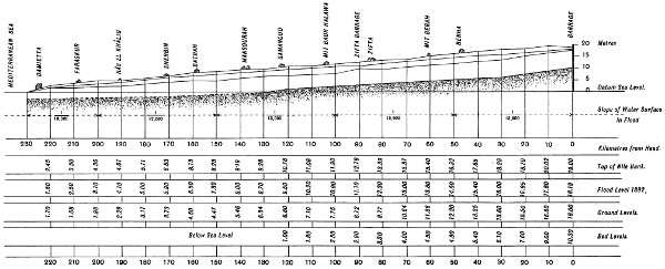
it is also drawn on the longitudinal section of the Nile in Plate XII.
It was on this system that the ancient Egyptian engineers worked
the Nile. They however chose the mean high water level during
the early part of the flood as their standard of reference and consequently
made the so called cubits in the flood reaches of the Cairo
gauge half cubits. This means a discharge of 1600 cubic metres
per second and fairly represents the discharges of the basin canals in
flood. When it is considered that the level of the Nile valley is
raised by about 10 centimetres per 100 years it will be seen that
the old Cairo gauge, which was a living record 1500 years ago, is
to-day a meaningless anachronism. It has also to be compared with
the Assuân gauge which was erected in Ismail Pasha’s time with
an arbitrary zero some 90 centimetres below mean low water level,
and which may be reading 17 cubits while Cairo may be recording 25
cubits. The Cairo gauges in winter and summer are no records of
discharge as the afflux from the Barrage affects them. To find the
discharge at Cairo during these months, I have added those of the
Rosetta and Damietta branches and the Delta canals upstream of the
Barrage. When the Nile falls below mean low water level, the gauges
are recorded as minus quantities.
Discharge sites having been chosen for the Assuân, Assiout and
Cairo gauges on the Nile, a continuous series of surface velocity observations,
cross sections and slope measurements were made during 1892
and 1893 and the resulting discharges recorded. Curves of discharge
have been drawn and referred to the gauges of twenty years and modified
until finally a curve has been found which will suit any year
whether it is a maximum or a minimum. In connection with this
subject, it must be remembered that the Nile bed is raised by silt
during low floods and scoured out during high floods and that consequently
August and September discharges vary considerably at times
from October and November discharges for the same gauge. In addition
to this, it must also be borne in mind that the slope of water
surface and that consequently the discharge of a flood during the rise
is far greater than during the fall for the same gauge reading. Indeed
the Nile often discharges more when it is 30 centimetres below its
maximum and rising fast than when it has reached its maximum and
begun to fall. It is owing to this fact that we often see the discrepancy
of the Assuân gauge reaching its maximum a day before Halfa
which is 350 kilometres higher up the river. The discharge depends
on gauge and slope, and the gauge only records one element. Keeping
these facts in my mind, I saw that it was of no use recording the
gauges to two places of decimals and covering paper with useless
figures, and consequently I have chosen the higher unit for a rising
gauge and the lower for a falling gauge when I have been dealing with
discharges.
Flood discharges have been taken of all the canals in Upper Egypt
through 1892 and 1893 and have been recorded in >Tables 48 and 49 of
Appendix K. From these tables, Table 47 has been compiled which
gives rough approximate discharges of the canals corresponding to the
Assuân gauges in the first half of the flood.
To obtain information about the trough of the Nile, the area exposed
to evaporation and the area of absorption, a longitudinal section of the
Nile from Assuân to Cairo has been levelled, and cross sections taken
at every 3 kilometres. The kilometrage on Plate XII counts from the
Assuân gauge and is measured down the centre of discharge of the
flood, since it is with flood discharges that we are principally dealing.
As the Nile winds about considerably and is often broken into numerous
channels, the areas of the cross sections vary very appreciably
according as they are taken at right angles to the centre line of
discharge or of the deep channel of the river. The former gives the
more reliable results. I have taken 8 millimetres per day as the evaporation
during flood in Upper Egypt. The absorption has been
calculated from the water consumption during the floods of 1892 and
1893, and found to be about 300 cubic metres per second between Assuân
and Assiout, where there is practically no perennial irrigation.
Between Assiout and Cairo, where there is a considerable length of
perennial irrigation on one bank and limestone rock on the other, the
absorption is about 100 cubic metres per second.
When perennial irrigation has once established itself in Upper
Egypt, we may assume that the absorption during flood will be halved
in quantity for the reasons given above, and become 150 cubic metres
per second between Assuân and Assiout, and 50 cubic metres per
second between Assiout and Cairo. The amount of water expended
in irrigation will be about 700 cubic metres per second. The evaporation
during flood will be approximately 120 cubic metres per second.
The quantity of water needed to fill the trough of the Nile will depend
on the gauges and may be calculated from table 43 of Appendix K.
The last item will be the only variable one and the others may be approximately
tabulated as follows:—
Expenditure of water in flood in cubic metres per second:
| |
Between
Assuân
and
Assiout. |
Between
Assiout
and
Cairo. |
TOTAL |
| Perennial irrigation |
350 |
350 |
700 |
| Evaporation |
65 |
55 |
120 |
| Absorption |
150 |
50 |
200 |
| Total of above |
565 |
455 |
1020 |
Taking these quantities and calculating directly for the filling of the
trough from the gauges themselves, I have collected in Tables 50
to 52, the Cairo gauges corresponding to the Assuân gauges for
the high years 1874 and 1878 and the minimum year 1877. As far
as the more important results are concerned, I tabulate them here:—
Gauges at Assuân and Cairo.
| Date. |
1874 |
1878 |
1892 |
1877 |
As-
suan. |
Cairo
with
basin
irriga-
tion. |
Cairo
with
peren-
nial
irriga-
tion. |
As-
suan. |
Cairo
with
basin
irriga-
tion. |
Cairo
with
peren-
nial
irriga-
tion. |
As-
suan. |
Cairo
with
basin
irriga-
tion. |
Cairo
with
peren-
nial
irriga-
tion. |
As-
suan. |
Cairo
with
basin
irriga-
tion. |
Cairo
with
peren-
nial
irriga-
tion. |
| August |
5 |
6.9 |
.. |
.. |
5.6 |
.. |
.. |
6.3 |
.. |
.. |
4.9 |
.. |
.. |
| 10 |
7.4 |
6.5 |
5.8 |
5.3 |
4.9 |
4.4 |
6.8 |
5.3 |
5.1 |
5.4 |
4.0 |
3.9 |
| 15 |
8.5 |
6.9 |
6.4 |
7.2 |
5.4 |
5.2 |
6.7 |
5.8 |
5.8 |
5.8 |
4.7 |
4.6 |
| 20 |
8.6 |
7.3 |
7.8 |
7.5 |
6.0 |
6.3 |
7.4 |
5.4 |
6.2 |
6.4 |
4.6 |
5.0 |
| 25 |
8.7 |
7.5 |
7.9 |
8.1 |
6.3 |
6.5 |
8.3 |
5.8 |
6.5 |
6.1 |
5.3 |
5.5 |
| 31 |
8.7 |
7.6 |
8.1 |
7.6 |
6.6 |
7.2 |
8.3 |
6.6 |
7.7 |
6.2 |
5.3 |
5.6 |
Sep-
tember |
5 |
9.0 |
7.7 |
8.2 |
8.1 |
6.5 |
7.5 |
8.6 |
6.9 |
7.7 |
6.3 |
5.2 |
5.2 |
| 10 |
8.8 |
8.0 |
8.3 |
8.5 |
6.8 |
7.5 |
8.8 |
7.1 |
8.0 |
6.1 |
5.3 |
5.3 |
| 15 |
8.7 |
8.2 |
8.4 |
8.9 |
7.2 |
8.0 |
8.8 |
7.5 |
8.3 |
6.0 |
5.2 |
5.5 |
| 20 |
8.4 |
8.3 |
8.5 |
8.9 |
7.6 |
8.5 |
8.9 |
7.9 |
8.3 |
6.0 |
5.2 |
5.4 |
| 25 |
8.4 |
8.4 |
8.2 |
9.0 |
7.9 |
8.5 |
8.6 |
8.1 |
8.4 |
6.3 |
5.1 |
5.4 |
| 30 |
8.2 |
8.4 |
8.2 |
9.1 |
8.2 |
8.5 |
8.4 |
8.3 |
8.4 |
6.1 |
5.3 |
5.6 |
Oc-
tober |
5 |
7.9 |
8.7 |
7.9 |
8.9 |
8.4 |
8.6 |
8.2 |
8.4 |
8.3 |
5.6 |
5.2 |
5.4 |
| 10 |
7.6 |
8.5 |
7.6 |
8.5 |
8.7 |
8.6 |
7.8 |
8.3 |
8.1 |
5.2 |
5.0 |
5.0 |
| 15 |
7.2 |
8.3 |
7.4 |
7.9 |
8.4 |
8.4 |
7.4 |
8.1 |
7.7 |
4.9 |
4.9 |
4.6 |
| 20 |
6.6 |
8.0 |
7.0 |
7.6 |
8.1 |
8.0 |
7.2 |
7.9 |
7.2 |
4.6 |
4.6 |
4.4 |
| 25 |
6.2 |
7.7 |
6.3 |
7.4 |
7.9 |
7.4 |
6.8 |
7.9 |
7.0 |
4.5 |
4.4 |
4.0 |
| 31 |
5.6 |
7.0 |
5.9 |
6.8 |
7.7 |
7.2 |
6.3 |
7.8 |
6.6 |
4.0 |
4.2 |
3.9 |
To enable one to compare these figures which are in metres and
referred to mean low water level, with the gauges as recorded at
present, I add the following table:—
| ASSUAN |
CAIRO |
Real
gauge
in
metres. |
Gauge as
recorded
in
cubits
and
24ths. |
Real
gauge
in
metres. |
Gauge as
recorded
in
cubits
and
24ths. |
| |
Cubits. |
24ths. |
|
Cubits. |
24ths. |
| 0.0 |
1 |
13 |
0.0 |
6 |
9 |
| .5 |
2 |
12 |
.5 |
7 |
7 |
| 1.0 |
3 |
10 |
1.0 |
8 |
5 |
| .5 |
4 |
8 |
.5 |
9 |
4 |
| 2.0 |
5 |
6 |
2.0 |
10 |
2 |
| .5 |
6 |
4 |
.5 |
11 |
0 |
| 3.0 |
7 |
3 |
3.0 |
12 |
0 |
| .5 |
8 |
1 |
.5 |
13 |
0 |
| 4.0 |
8 |
23 |
4.0 |
13 |
23 |
| .5 |
9 |
21 |
.5 |
14 |
21 |
| 5.0 |
10 |
20 |
5.0 |
15 |
19 |
| .5 |
11 |
18 |
.5 |
17 |
12 |
| 6.0 |
12 |
16 |
6.0 |
19 |
8 |
| .5 |
13 |
14 |
.5 |
21 |
4 |
| 7.0 |
14 |
12 |
7.0 |
22 |
12 |
| .5 |
15 |
11 |
.5 |
23 |
10 |
| 8.0 |
16 |
9 |
8.0 |
24 |
9 |
| .5 |
17 |
7 |
.5 |
5 |
7 |
| 9.0 |
18 |
5 |
9.0 |
26 |
5 |
| 16 |
cubits |
at |
Assuân |
corresponds |
to |
7.8 |
metres. |
16 |
cubits |
at |
Cairo |
corresponds |
to |
5.1 |
metres. |
| 17 |
„ |
„ |
„ |
„ |
„ |
8.3 |
„ |
22 |
„ |
„ |
„ |
„ |
„ |
6.7 |
„ |
| 18 |
„ |
„ |
„ |
„ |
„ |
8.9 |
„ |
23 |
„ |
„ |
„ |
„ |
„ |
7.3 |
„ |
| A cubit is known in Egypt as a pic. |
24 |
„ |
„ |
„ |
„ |
„ |
7.8 |
„ |
| 25 |
„ |
„ |
„ |
„ |
„ |
8.3 |
„ |
| 251⁄2 |
„ |
„ |
„ |
„ |
„ |
8.6 |
„ |
The flood of 1874 was an early one and the basins were discharged
on a falling Nile, still they raised the Cairo gauge to 8·7 metres on the
5th October while it would have risen to 8·5 on the 15th September
with perennial irrigation. The flood of 1878 was an exceedingly late
one and the basins had to be discharged while the river was still very
high. By the 10th October, the river had risen to 8·7 metres at Cairo
when the banks were breached and all future rise stopped. With
perennial irrigation, the maximum gauge of 8·6 metres would have
been reached on the 10th October. The flood of 1892 was at Assuân
10 centimetres below that of 1874 and 20 centimetres below that of
1878, and midway between them in point of time. It was also under
complete control owing to the new regulating works on the basins. It
rose to 8·4 metres at Cairo on the 5th October and fell exceedingly
slowly. With perennial irrigation, it would have risen to 8·4 at Cairo
on the 30th September and then fallen rapidly.
Speaking generally, we may say that with perennial irrigation the
very high floods at Cairo will be 15 days in advance of what they are
at present, that they will not rise higher, and that they will fall 15
days earlier than what they do now. With low floods there will be no
appreciable difference as to date, but the floods will be slightly higher
at Cairo. In ordinary floods, there will be an advance of from 20 to 25
days in the date of the maximum flood, and a maximum gauge at Cairo
50 or 60 centimetres under the maximum gauge at Assuân. We have
so far considered Cairo only, as the Delta proper depends on the Cairo
gauge. We now turn to the Nile in Upper Egypt itself: south of
Sohag, there will be no serious change in levels, but the Sohagia and
Ibrahimia canals between them carry at present 750 cubic metres per
second in excess of what they would carry if there were perennial
irrigation in Egypt, and the greater part of this water is not returned
to the Nile until the Kushesha escape is reached. The reach of the
Nile from Sohag to Kushesha is the one which will experience the
greatest changes, and I calculate that there will be a rise of 40 centimetres
as compared with the maximum gauges under basin irrigation.
It will be noted that at the beginning of this paragraph I stated that
“the perfection of the perennial irrigation of the Delta north of Cairo
will in no way affect the Nile in flood.” This had reference only to the
quantity of water taken from the Nile in high floods. There is however
one very serious aspect of this question. The regulation on the Barrage
in low floods, which has gone on steadily since 1899 when Sir
Hanbury Brown used the Barrages in flood for the first time, has
enormously increased the value of the works, but it has certainly
caused the Main Nile to silt, and probably also the branches, owing to
a reduced discharge and velocity of the silt-bearing water, whose
capacity to carry on that quantity of silt depends on its velocity. It
seems to me that unless steps are taken to insure the scouring out of
this silt by the clear water of November, December and January the
consequences will be very serious. High floods scour out their beds,
but if a very high flood were to come early before the silt had been
scoured out, it might overflow the banks near Cairo or in the middle
reaches of the Nile branches in the Delta.
Sir William Garstin has estimated the cost of converting the existing
basins of Upper Egypt into perennially irrigated land at £7,000,000,
thus made up:—
| Conversion of Upper Egypt basins |
£ |
5,000,000 |
| Two barrages between Assyut and Kena |
„ |
2,000,000 |
| Total |
£ |
7,000,000 |
The resulting land tax from the improved irrigation in Upper or
Lower Egypt he has estimated as follows:—
| Upper Egypt. |
- |
|
Basin land converted |
750,000 |
acres |
@ |
£ |
·50 |
= |
£ |
375,000 |
| Land irrigated by pumps |
100,000 |
„ |
@ |
£ |
·30 |
= |
„ |
30,000 |
| Lower Egypt. |
Reclaimed land |
800,000 |
„ |
@ |
£ |
1.00 |
= |
„ |
800,000 |
| Total |
£ |
1,205,000 |
—Lord Cromer’s wise decision
to construct the Suakin-Khartoum railway immediately and the Abu
Hamed-Dongola railway as soon as possible, is the charter of the development
of the Sudan. With these railways and especially the former
in working order, we can arrange for irrigation works for the production
of cotton and wheat for export, knowing that they can be exported
at a cost of transport which will not be absolutely prohibitive. The
soil of the Sudan along the Blue Nile, the Atbara, the Main Nile and
a great part of the White Nile is the same as that of Egypt itself. It
has all come from Abyssinia. When at Khartoum last February, I
collected specimens of typical Gezireh soil from points 10 miles south
of Khartoum and from near Khartoum itself. They were analysed
by Mr. Frank Hughes and reported on by Mr. Foaden.
The specimens were numbered as follows:—
(1) Typical Gezireh soil from a point 10 miles south of Khartoum
near the Blue Nile.
(2) Typical Gezireh soil from a point 2 miles south of Khartoum
near the White Nile.
(3) White Nile side under cultivation in 1904.
(4) White Nile side below flood level.
(5) Blue Nile side, not so common as (1).
(6) The sandy soil generally within 5 miles of Khartoum.
Nos. 1, 2, 5, and 6 are above high flood level of both Niles.
“The nitrogen and salt were determined in the samples, as received,
without drying.
| Nos. |
1 |
2 |
3 |
4 |
5 |
6 |
| Nitrogen |
0·078 |
0·059 |
0·062 |
0·057 |
0·056 |
0·052 |
| Common salt |
0·050 |
0·020 |
0·010 |
0·090 |
0·170 |
0·020 |
“All contain abundance of carbonate of lime; Nos. 1 and 2 might
almost be called calcareous. All gave a strong reaction for phosphoric
acid, and there is therefore every reason to believe that they are
rich in this ingredient. So far as the texture of the soils is concerned,
little can be said except that they differ from those previously examined
for Kena Mudirieh, in containing a large amount of coarse sand
1-3 m.m., which is entirely absent in most Egyptian soils; No. 6 would
probably be too light for agricultural purposes in its present condition.
“The nitrogen is as high as one would expect but is lower than is
necessary for fertile soils. It would be necessary therefore to encourage
the growth of leguminous crops to increase the quantity of
nitrogen in the soil and to employ nitrogenous manures. It must be
borne in mind that in soils of this class the nitrogen is usually in a
highly insoluble and un-nitrifiable form.
“The salt is in no case high; 0.25% is usually considered to be the
limit for satisfactory growth; all the samples are well below this limit.”
I had complete analyses made of numbers (1) and (2). The results
were as follows:
| |
No. 1 |
No. 2 |
| Silica etc. insol in mineral acid |
74.76 |
73.85 |
| Lime (Ca.O.) |
6.07 |
4.56 |
| Carbonic Acid (C.O.₂) |
3.64 |
2.40 |
| Equal to Chalk (Ca.C.O.³) |
8.27 |
5.46 |
| Potash |
0.23 |
0.34 |
| Phosphoric Acid |
0.14 |
0.12 |
| Organic Matter |
2.88 |
4.07 |
| Nitrogen |
0.075 |
0.062 |
| Calculated on soil dried at 100°. |
Though none of these specimens contained salt in excess, Nile
deposit in certain localities has very large proportions of common salt
and sulphate of soda. The dark soil near the Atbara mouth at El-Damer
is largely exploited for common salt, while similar soil south of
Khartoum is free from it.
The extent of this Nile deposit soil is very great indeed and if irrigation
could be assured, there would be a great future before the
Sudan.
In Mr. Dupuis’s Report which is the last appendix to Sir William
Garstin’s Report, he speaks of this soil as being met with on the Blue
Nile, on the Rahad, on the Atbara and on the Gaash. From Khartoum
northwards the main Nile flows between berms of this soil.
The extent and quality of this soil may therefore be considered as
an undisputed asset of the Sudan. We have next to consider the
seasons.
A reference to tables 76, 77, and 80 will show how much warmer
the Sudan is than Egypt, and any attempt to introduce Egyptian
methods into the Sudan without modifications will not at once turn the
Sudan into Egypt. I allow that extensive plains of irrigated land
greatly moderate the heat as they have already done in Middle Egypt;
but we have to begin from the beginning in the Sudan, and there are
no extensive plains of irrigated land. Basin irrigation will be a
failure in the Sudan unless it is supplemented by two or three waterings
in the winter, for all crops except the cheapest and coarsest
leguminous crops. Wheat must be irrigated in winter whether sown in a
basin or on the Nile berm, except in a few choice, low and damp localities.
Cotton, on the other hand, which has to be sown in spring in Egypt
and reaped in autumn will need such an extraordinary quantity of
water to pull it through the summer that it will be found preferable
to grow it in June with the rising flood and reap it at the end of the
winter. Irrigation therefore from June to October for Indian corn,
from June to February for cotton, and from November to February
for wheat will be essentials of a good harvest in the Sudan.
We now come to the question of the water supply. Unless permits are
given for pumps to work from the 15th June to the 15 February, the
cultivation of cotton and wheat on any scale in the northern part of
the Gezireh, along the main Nile between Khartoum and Dongola,
and on the lower reaches of the Atbara will be out of the question.
Maize and millets and some of the coarser leguminous plants might be
developed by pumps with permits to work from 15th June to 15th
October, but it would pay no one to put up pumps on these terms.
Fortunately for the joint interests of Egypt and the Sudan, though
Egypt cannot spare water between the 15th March and 30th June, which
would correspond to 1st March and 15th June in the Sudan; she has
enough to spare for pumps at other times, though she has not always
enough to spare for large free flow schemes in the Sudan. Free flow
schemes in the Sudan, except during high and good floods, have
however yet to be found.
Speaking generally we may say that the agricultural success of the
Sudan will depend on permits for pumping engines to work between
the 1st June and the end of February. There should be no difficulty
in the way of such permits being given. We have spoken so far of
schemes within the power of individuals and companies. Of schemes
which the Government alone could carry out by itself or in conjunction
with powerful companies, the most promising seem to be those which
are connected with the 6th cataract. This cataract seems well suited
for the construction of a solid dam to create power and develop electricity
to work pumps between it and Khartoum, and some 30 kilometres
up the Blue Nile; and if possible to allow of a canal down the left
bank of the Nile as far as Berber. This project might be studied with
advantage and a greater amount of water storage for summer use be
also obtained.
PLATE XX
Sketch Plan
of
COUNTRY ABOUT DELGI
N.W. of L. Tsana
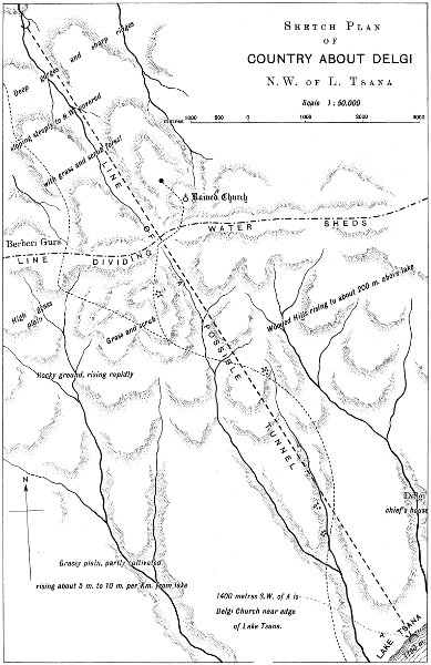
Lith. Sur. Dep. Cairo.
Larger map (380 kB)
Another scheme is the construction of a double barrage and weir
near Wad Medani on the Blue Nile, with canals irrigating the Gezireh
and the right bank of the Blue Nile and the Nile to Shabluka. Unfortunately
no cross sections have been taken of the Blue Nile showing how
high the Gezireh is above the bed and water surface of the Blue Nile
at Wad Medani. A weir further south would, as Mr. Dupuis states,
entail very expensive canals to irrigate the lands south of Khartoum.
Mr. Dupuis’s report on the Atbara is not very hopeful. Without reservoirs
this torrential river could insure no crop except millets and Indian
corn. The same may be said for the Gaash. Basins without
winter irrigation would, I think, be most unsatisfactory.
Examining Mr. Dupuis’s figures and sections for the outlet of lake
Tsana, I calculate that this reservoir would not supply a fraction of the
water estimated by Mr. Dupuis. If I were wrong, and I should be
pleased indeed to be wrong here, a tunnel along the alignment roughly
surveyed by Mr. Dupuis, Plate XX, leading the waters of Lake Tsana
into the Rahad river, and from there under the Blue Nile by a syphon, and
branch canals irrigating both banks of the Rahad and both banks of the
Blue Nile to Khartoum, would be one of the boldest projects in the world.
It will be noted that no mention has been made of the tracts
between the foothills of Abyssinia and Wad-el-Medani which can
produce good crops of Indian corn, millets and even cotton in nine
years out of ten with the aid of rain without irrigation. If the land
could lend itself to basins similar to those of Bundelkund or to river
fed pans as in Madras, a development of this country would be possible.
Ordinary Egyptian basin irrigation would be, I think, of no use.
The following quotations from a letter written by Messrs. Choremi,
Benachi and Co., of Alexandria, to Mr. Foaden on the 8th February 1904,
will give an idea of the estimation in which Sudan grown cotton is
held in Alexandria:—
“The cotton generally is good and superior to any Sudan cotton I
have yet seen. Last year the best I saw was sent by the Sudan
Government and grown in Miralai Stanton Bey’s garden, with artificial
irrigation and quality was (first picking) class “good”, equal to
Beni-Suef or Minieh cotton, but more woolly. In any case it is saleable
cotton for coarse Nos. of Yarn, not what we call Bolton Spinners’
cotton.
“I now give you the following classification and values compared
to Standard of Full Good Fair Lower Egypt which is the basis of
“Futures” in our Market and Liverpool.
“On Upper Egypt the outturn in ginning on basis 315 lbs. per cwt.
in seed runs from 100 to 104, and Lower Egypt 105-110 according to
province grown and quality of seed.
| No. 1 |
Outturn |
96 |
Class “good”, value P.T. 5 over Delta
fully good fair—colour rather light—good
staple, better than Beni-Suef Ashmouni
or even Afifi. |
| No. 2 |
„ |
981⁄2 |
Long staple and finish does not look grown
from afifi seed but from superior quality,
value about P.T. 15 over F.G.F. |
| No. 3 |
„ |
99 |
Class “good”, the seed of this is from
Delta because mixed—there is also some
Abassi in and does not look as from afifi
seed because finer than any afifi grown in
Minieh and Beni-Suef, value 5 to 10 over
F.G.F. |
| No. 4 |
„ |
1021⁄2 |
“Good” in class, from mixed seed—some
looks afifi, other better, probably Yannovich
seed. There are traces of abassi—and
is irregular in strength, value P.T. 15
to 20 over F.G.F. |
| No. 5 |
„ |
100 |
Also from mixed seed—I can trace afifi
quality and Yannovich, also some abassi.
Value over F.G.F. about 7 to 10 P.T. |
| No. 6 |
„ |
1031⁄2 |
About same as No. 5 and with same
mixture. |
“From the above report you will see that quality generally is good—but
I regret the seed got mixed—probably through mistakes in
transport or if in single bags some broke and seed became mixed.
“The outturn in ginning I consider good and the seed I notice
deteriorates but very little as you can see—though with that of
Stanton Bey’s I examined with you last year, the deterioration was,
if I remember right, something like 10% in one year. The seed from
the non irrigated Sudan (I suppose near Khartoum) though from good
Afifi seed, almost becomes unfit for sowing and the quality of this
cotton had a very poor outturn of about 73%.
“Rain crops cannot be depended on, because if no rain for some
time the quality will be totally spoilt.
“I fail to find any trace of sand in the samples—though the common
Sudan non-irrigated cotton was very dirty and sandy.”
The following extracts from a letter written to me by Ibrahim
Effendi Fahmy, originally a student of the Cairo Agricultural College
and at the time of writing Government agriculturist at Khartoum and
on leave in Cairo, will be found interesting.
“There are three seasons in the Sudan, which are different from
those in Egypt. The seasons are:—1st the winter which extends
from the 1st November to the end of February, in this season wheat,
beans, barley, onions, Indian corn and millets are planted: 2nd, the
summer which extends from 1st March to the 15th June, in this season,
practically speaking, nothing is planted except a small quantity of
millets, and in the middle of the season from the 1st May to the
15th June all agricultural work is stopped owing to the great heat
and deficiency of water: and 3rd, the flood season or “Demera” from
the 15 June to the end of October; in this season the rains fall, the
Nile rises and the heat is decreased, two crops of millets can be taken
and cotton, sesame and earthnuts are sown.
“Manures are the same as in Egypt.
“Cotton sown in March, April and May needs so much water through
the summer that its cost is prohibitive. In the really hot weather it
must be irrigated every three days. High winds and rain hurt the first
open pods, and the pickings are on the 20th August, 20th September
and 15th October. After 22 waterings a good field will give 41⁄2 cwt.
per acre.
“Cotton sown in June and July has an even, regular growth. The
rains and moisture in the air encourage the growth of the plant.
The height of the flood permits of easy irrigation even when it is lift.
The plants grow to a great size but have many bolls. The following
table will show the growth of the plants.
Date of
planting. |
No of
waterings |
First
picking. |
Last
picking. |
| 25 June |
16 |
1st January |
March 15 |
| 3 July |
16 |
15th January |
March 31 |
| 30 July |
15 |
15th February |
April 15 |
“The yield of a good field is 51⁄2 cwt. per acre. The fibre is better
than that of the cotton sown in March and April.
“I consider that June and July are the best months for sowing, and
that cotton sown from well-selected seed and well cultivated will prove
itself a cotton of superior quality, ranking with Egyptian cottons.
“The following table gives the kinds of crops, other than cotton
which can be profitably grown in the Sudan:—
| Crop |
Time of
sowing. |
Time of
ripening. |
No of
waterings |
Produce |
| Egyptian wheat |
Nov. & Dec. |
April |
3 |
5 |
1⁄2 |
ardebs |
| Indian wheat |
December |
» |
3 |
5 |
|
» |
| Egyptian barley |
» |
March 31 |
2 |
11 |
|
» |
| Australian barley |
» |
» |
2 |
5 |
|
» |
| Beans |
» |
» |
3 |
5 |
|
» |
| Lentils |
» |
» |
3 |
3 |
1⁄2 |
» |
| Earthnuts |
July |
January |
9 |
9 |
|
» |
| Indian corn |
» |
September |
4 |
6 |
|
» |
| American maize |
» |
October |
7 |
4 |
|
» |
| Potatoes |
November |
March |
3 |
150 |
|
kantars |
| Lucerne |
March |
March year |
12 |
1800 |
|
» |
| |
|
|
|
in 12 cuttings
of 150 kantars
each. |
“Fodder crops such as birseem and vetches (gilban) when well
watered are satisfactory.
“If the land is not well tilled, manured and looked after, wheat will
require 6 waterings and barley 4 waterings.
“If water can be obtained in the Sudan, the agricultural problem is
very easy.”
I cannot do better than close this chapter with this thoroughly
Egyptian remark of Ibrahim Effendi Fehmy.