Observations on F. Horneman’s Description
of the Country and Antiquities of Siwah; with Reference to ancient
Accounts of the Oasis and Temple of Ammon. By Sir William Young,
Bart. F. R. S.
for the culture of their land, read their
preparation of leather.
INTRODUCTION.
The Society, instituted
in the year 1788, for the purpose of exploring the Interior of
Africa, in pursuing their great design, adopted
wise and certain principles of procedure: they inquired,
and then examined; they sought intelligence, and then directed
research: their progress has been answerable to the just system of
their pursuits and perseverance; and the Society, from the epoch of
1798, have been enabled to direct their efforts for further
discovery, on data from actual visitation and experiment.
A volume of the transactions of the Society, printed in the
years 1790—92, sets forth in detail, such communications respecting
the Interior of Africa, as might be collected on inquiry from
British Consuls; from the recital of Negro, or Moorish traders; or
from that of Shereefs and others, who had passed with the caravans
on religious pilgrimage, in different directions between Mecca and
the various and remote stations of Mahomedans in Africa.
Those
communications were, at the time, most interesting and useful; they
afforded at once the incentive and the direction to farther
inquiry; they opened new objects to commercial enterprize, and new
matter for scientific speculation, on the productions of nature,
and the manners and conditions of society, in a quarter of the
globe hitherto unexplored: further, they pointed out the road, and
facilitated the means, of ascertaining the truth of each account,
and of estimating its importance and advantages by actual
visitation and experiment.
Be it allowed, that the narrators spoke of what they had heard,
as well as of what they had seen; let it be granted that they were
mostly ignorant, credulous, or partially informed; and that,
distinctively and in detail, the accuracy of their representations
was little to be depended on; yet on points wherein their accounts
agreed, they merited attention and regard; they together
opened a general view of the society, and of the country; and
afforded matter of such reasonable conjecture and inference, as
might warrant and direct the course of further investigation.
Reflecting on these and other relations made by unenlightened men,
it appears, that as the great continent of Africa, amidst its seas
of sand, occasionally shews its Oasis, or fertile isle, rising in each desert;
so, in analogy to the face of the country, does the blank and
torpid mind of its people, display occasionally notes of
intelligence and philanthropy; rich spots of genius, and partial
scenes of improved social establishment. Having passed whole
regions sterilized by apathy and ignorance, the result of
superstitions, prejudice, and oppression, the enlightened traveller
comes to a sudden view of some rich field of character, and
contemplates with delight the free-born spirit and sagacity of the
Tuarick of Hagara, and the ingenuity and benevolence of the
Houssan. To unfold and disseminate these germs of civilization, is
surely a noble task! What description of men and country can be
more interesting? whither could the refinement of arts? whither
could enlightened philosophy better tend, to humanize and improve?
whither could the spirit of trade better direct its course? As we
speculate on the projected intercourse, the noblest views open to
the mind, anticipating reciprocal advantages: in the dispensation
of intelligence and the arts of peace, carrying therewith
complacent manners to rude and ferocious nations; and in a full
compensation to the enlightened adventurers, from new materials of
ingenuity and of commerce, and from new subjects of scientific
inference, extending the advancement of human knowledge in all its
branches.
The communications
in question, operating on the minds of intelligent Members of the
African Society, and giving a spur to the curiosity and enterprize
of the agents they might employ, formed a suitable and necessary
Preface to the undertaking and efforts for
practical discovery, and for ensuring the advantages thence to be
derived.
The compilation of various informations respecting Africa, had
thus an intrinsic value, as affording premises of inquiry, and as
giving encouragement and direction to adventure.
But further, and even immediately, wisdom and sagacity will
extract truth from accounts, however contradictory, and useful and
certain inference, from documents the most ambiguous or
incomplete.
Efforts of rude ingenuity often suggest not only improvement but
discovery; the rustic forms a lever to raise the mass, and the
sagacity of the mechanic applies it to ascertain the weight.
Science often works with effect on the loose and disjointed
materials which ignorance has heaped together; compares, arranges,
and connects their
substances and forms; shews in their matter, construction, or
decomposition, new uses; derives new informations, and adds to the
stock of human inventions and knowledge.
Were it necessary to illustrate such position by example, the
writer would refer, as a special instance, to the elucidations of
Major Rennell on the communications in question: to that most
accurate and acute philosopher and geographer, the details have
afforded matter of enquiry and deduction of the highest import to
science. By analysis, and a comparative view of accounts given of
journies and places, in reference to the plans of D’Anville, and
other geographers; to modern travels; to ancient expeditions; to
descriptions of ancient writers; and above all, to those of the
father of history, Herodotus; Major Rennell hath corrected the map
of Africa, with a learning and sagacity which hath converted
conjecture into knowledge; and on experience of those who have
explored parts of that great continent, given confidence to each
future traveller who may visit its remotest regions.
Had the proceedings of the Society stopped here, and its work
been confined to the compilation above alluded to, and to the
comments of Major Rennell, the usefulness of its institution would have been
acknowledged by posterity.
But happily the Journal of Mr. Park’s travels to the Niger, and
that of Mr. Horneman’s journey from Cairo to Mourzouk, will fully
shew, that the attainments of the Society are no longer narrowed to
the mere rudiments of discovery, which tradition and ingenious
inference, alone before supplied.
Even under the inauspicious circumstances of wars and
revolutions which from nearly the date of the establishment of the
Society, have spread desolation far and wide, and in the year 1798,
reached to the very capital of Africa; their chosen emissaries have
surmounted all the dangers and difficulties, which these events
superadded to the ordinary risk of enterprise.
It should not be omitted, that the traveller, (whose work is now
submitted to the public,) was further indebted to the liberal and
enlightened spirit, which directs the genius of truly great men to
foster useful arts and sciences amidst the horrors of war; and give
orders to the armies under their command, to forbear all
molestation of the emissary from even an hostile country, whose intentions and
pursuits are directed to objects of common value and concern, to
the nations of the world at large.
Under such patronage and protection from the General Bonaparte,
and with his special passport and safeguard, Frederick Horneman
safely reached the caravan passing from Mecca, and pursued, and
accomplished his journey from Cairo to the kingdom of Fezzan; which
from the general resort of caravans to its capital, Mourzouk, may
be considered as the proper post of direction and outfit, for his
further travels to the remotest regions of Africa.
In planning the routes of Park and of Horneman, the Society
availed itself of former communications, sagaciously discriminated
the proper path of research, and have to exult in the success of
each adventure. These emissaries have explored roads which shortly
mercantile adventure will, and must enter. In this new race of
commerce, shame indeed would it be to our national councils, could
it possibly be supposed that from the default of patronage and
support of Government, our commercial people may lose the start for
a priority of factories and establishments of trade, and permit
other nations to usurp the vantage ground which British enterprise, under the
auspices of a patriotic and enlightened, but private institution,
shall have explored, marked out, and prepared for them.
By Mr. Park’s discoveries, a gate is opened to every commercial
nation to enter and trade from the west to the eastern extremity of
Africa. The navigable parts of the rivers Gambia and Niger are not
so far distant, but that great facilities of trade may thence be
derived, aided by the establishment of intermediate stations and
points of intercourse. A considerable traffic is carried on by the
natives for ostrich feathers, drugs, ivory, and gold, even without
such advantage. On due direction and exertions of British credit
and enterprise, it is difficult to imagine the possible extent to
which the demand for our country’s manufactures might arrive, from
such vast and populous countries in the bosom of which
gold, the great medium of commerce, is readily found; and
which would be sought for and brought into circulation with new
avidity and success, in proportion as objects for the exchange,
became known, desirable, and necessary to the people.
This subject has already been recommended by the Society, to the
attention of Government; and on the return of peace, it is not
doubted, but it will be treated with a consideration and regard, suitable to
the important interests which it involves.
When the thorny track of a Park or a Horneman is become the
beaten road of the merchant, advantages of another sort will
quickly follow; and the intercourse extend to the instruction of
the naturalist and philosopher, to the promotion of civilization,
and to the increase of the general stock of human knowledge and
happiness.
Contemplating such accomplishment of the wise and benevolent
purposes of their Institution, the patriotic members of this
Society cannot but look back with exultation to the hour of its
establishment, and they will with satisfaction recapitulate its
means and progress, towards such happy termination of their
labours.
Of those who transmitted accounts which they had received,
concerning the people and country of Africa, Mr. Ledyard and Mr.
Lucas were specially employed, with the further intent of progress
into the heart of the country; for the purpose of ascertaining the
truth of these recitals, the correcting them on personal
information, and the elucidating, on actual survey, any future plan for turning the
knowledge thence derived to account.
Mr. Ledyard died at Cairo, ere his eager and enterprising spirit
could even start towards its object: Mr. Lucas, deterred by
impending difficulties and dangers, proceeded not further than to
Mesurata, seven days journey S. E. of Tripoly; there collected
informations from the Shereef Imhammed, and traders of Fezzan, and
then measured his road back to Tripoly; and shortly after returned
to England.
The Society, with that persevering spirit which ever
distinguishes manly minds, engaged on sound principles, and for
noble purposes, were not appalled by the death of one emissary, or
the failure of another.
They sought out and appointed a new traveller, and to take a new
road. Mr. Ledyard was to have penetrated from the east, Mr. Lucas
from the north; Major Houghton was appointed in the year 1790, to
sail for the mouth of the Gambia, and to traverse the country from
west to east: Major Houghton arrived on the coast of Africa
November 10, of that year, immediately commenced his journey,
ascended the Gambia to Medina, 900 miles (by the water-course)
distant from the mouth of the river, and thence proceeded to Bambouk
and to the adjoining kingdom of Kasson; where, in September 1791,
he unfortunately terminated his travels with his life, near to the
town of Jarra. Mr. Park, who was engaged in the service of the
Society, in 1795, more successfully followed the route of Major
Houghton, and further explored to the banks of the Niger, to Sego,
and to Silla, the first of that great line of populous and
commercial cities, dividing the southern from the northern deserts
of Africa; and the very existence of which, for centuries past,
hath been rather matter of rumour than of information; and been
made the subject of philosophic romance,[1] in
default of authentic account and description.
The informations of Mr. Park were communicated to the Society at
their annual Meeting in May 1798.
The year 1798 will ever be noted, as the memorable epoch, when
the researches of this Society announced to the world the course of
the Niger, from west to east; and, after the distance of 2300
years, corroborated the testimony of the Nasamones, and accounts of
Herodotus, contested during that long period by ancient and later
writers, and ultimately rejected within the century past, by the learned
D’Anville. But further, the settlements on its fertile shores, are
by the informations of Park, derived from inquiries so near to the
source, as now greatly to be depended on; at least so far, as to
give assurance of objects of commerce and learned inquiry, that
will amply repay further research. The just motto of the Society
is, “quod non peractum, pro non inchoato est;” its
exertions and perseverance answer to it, and it is to be
congratulated that the task is now easy, its accomplishment
assured.
The writer of this Essay, not presuming to graft addition or
observation on the intelligent and authentic Journal of Mungo Park,
ventures a single comment, of import to the Society, and in justice
to its agent.
Mr. Park has not only designated the route of country
but of men. He hath marked the districts of population
covering the great belt of land intersecting Africa from west to
east, and at the same time hath noted the distinctions of Moor and
Negro, in manners, prejudices, and government. He hath thereby
given to the Society information of the viaticum of
character and accomplishments proper and necessary to ensure the
success of their future agents: he hath pointed out
the roads to
districts and cities of the greatest interest, and at the same time
hath shewn the means of securing entrance and hospitable
reception.
The Society hath availed itself of the intelligence; and a new
emissary, Mr. Horneman, hath given his lesson full effect in an
expedition which is the subject of the present Volume.
Of the further progress of this accomplished traveller, the
Editor forbears to intimate design or suggestion.
The season of mere expectation and conjecture is gone by. It
were idle indeed at this period of actual discovery, to hazard
surmise for future correction on experiment.
At outset of the Society instituted for the purpose of exploring
the Interior of Africa, it might have been proper to set forth, in
glowing colours, all that was rumoured, and all that might be
expected; well were general reports and ingenious inferences suited
to rouze curiosity, to excite adventurous spirit, and to give a
spring to the first movements and purposes of the Institution.
Such incentives
are no longer necessary; and knowledge actually acquired, demands,
in the future display, merely accuracy and precision, as the guides
to further success.
The Society is confirmed in its purpose, and assured of its
objects and of the means of attainment.
Its travellers will not in future rush on with zealous but
unadvised curiosity; or hesitate as in the dark, and on unfounded
apprehensions; but, disciplined and educated, proceed with a spirit
corrected and confirmed by knowledge and precaution, towards
certain purposes and ends.
An adventurer may yet fail; but it is presumed the adventure
cannot, unless from failure of the funds and resources of the
Society; which, in this great and opulent country, it would be a
calumny on the generosity and patriotism of its people, for one
moment to anticipate as possible.
Yet let it be remembered, that the extent of our undertakings
can only be commensurate with our means.
Expense and charge attend our present inquiries; and even a more advantageous
extension of our researches apart, demands of much beyond what our
actual numbers and contributions can furnish, will be necessary to
ensure the effect of national advantage, and turn to public account
the successful experiment of an enlightened and patriotic, but not
numerous, Association.
The Society cannot condescend to solicitation; nor is it
necessary: it will suffice, that, emboldened by success, they
suggest to their countrymen, that, under proper patronage, and with
the means of extending their researches, the conclusion will be
of advantage, to Great Britain—to Africa—and to the World.
GIVING SOME ACCOUNT OF MR. FREDERICK HORNEMAN; OF
THE PREPARATIONS FOR HIS VOYAGE; AND OF EVENTS PREVIOUS TO HIS
LEAVING CAIRO.
At the time that Mr.
Mungo Park, engaged in the service of the Society instituted for
the purpose of exploring the Interior of Africa, was prosecuting
discoveries eastward from the river Gambia, it was thought proper
to extend their researches in another line of direction, and engage
an emissary to explore that great continent, proceeding westward
from the city of Cairo.
Early in the year 1796, Mr. F. Horneman offered himself to the
Committee of the Society for this service; he appeared to be young,
robust, and, in point of constitution and health, suited to a
struggle with different climates and fatigues: in his manner and
conversations he displayed temper, acuteness, and prudence: he was
well apprized of the dangers and difficulties of the enterprize he
was to engage in, and shewed a spirit and zeal for the undertaking,
which strongly recommended him as a proper person to be employed
for the carrying it into effect.
The Committee accordingly engaged his services; and observing in
him such foundation of good ordinary education, as
further
attainments might readily be engrafted upon, they sent him, at the
expense of the Society, to Gottingen; there to study the rudiments
and writing of the Arabic language, and, generally, such sciences
as (in the result of due application of the knowledge acquired),
might render any account of his future travels more interesting and
useful to his employers, and to the public.
F. Horneman pursued the requisite studies for several months
with great assiduity, under the tuition of Professors Blumenbach,
Heeren, Hoffman, Tyschen, and Heyne; and in May, 1797, returned to
England, properly instructed for his intended voyage. He was then
introduced to a general meeting of the Society, when his engagement
was approved of, and he was directed to proceed to Egypt with all
convenient dispatch.
Passports from Paris were applied for, and granted, permitting
him to pass through France; and in July, 1797, he left London on
his way to Paris.
He was furnished with letters of introduction to several persons
of literary distinction in that capital; and, on arrival, his
reception was liberal and friendly, and proportionate to the lively
interest which was every where taken in his scheme of enterprize,
and in the means of promoting its success. He was invited to a
meeting of the National Institute. The first members of that
learned society tendered their patronage, encouragement, and
assistance: Mr. Lalande furnished him with copies of his “Memoire
sur L’Afrique.” Mr.
Broussonet recommended him to Mr. Laroche, appointed Consul for
Mogadore; and by this latter gentleman’s means he made a further
and most useful acquaintance with a Turk of distinction (a native
of Tripoly), then resident at Paris. This Mussulman entered into
the motives and plan of his travels with a liberal approbation, and
a zealous interest in the success; which was little to have been
expected from one of such persuasion and character. He gave Mr.
Horneman letters of introduction, strongly recommending him to the
friendship and protection of several leading Mahommedan merchants
at Cairo, who were in the habits of trade with people of the
remotest regions of Africa; and he added his own advice, and
instructions for the journey.
Thus provided, Mr. Horneman, in August, left Paris for
Marseilles, where he embarked the end of the month, and arrived at
Alexandria the middle of September: he staid at Alexandria but a
few days, and then went to Cairo, where he purposed residing some
time, to study the language and manners of the Mograbins, or
western Arabs, with whom he was to associate in his future travels.
His own letter will best describe his further progress.
(Translation.)
“Sir,
Cairo, August 31, 1798.
“In my last letter I mentioned my
intentions of leaving Cairo about the end of May. The plague
beginning to rage in the month of April, it became a proper and
necessary precaution not only to defer my journey, but absolutely
to shut myself up in my house. My zeal for the undertaking I have engaged
in, would have led me to break through this confinement and leave
the city, with a view to join the merchants at their place of
rendezvous, whence they were directly to depart for Fezzan, had not
obstacles arising from the difficulty of procuring the necessary
credits for my equipment prevented my immediate procedure.
“As soon as from abatement of the pestilence, I could safely go
abroad, I met and renewed my acquaintance with several of the
caravan, who remained in the city, expecting the return of others
from Mecca. A French commercial house, on whom I had no letters of
credit or other claim to confidence, than what arose from private
friendship and esteem, having handsomely offered such advance of
monies as I might require, I was enabled to prepare for my journey,
and set out with this caravan, as soon as complete and ready for
departure. All these designs were suddenly frustrated by the
arrival of the French on the coast of Egypt. Those who formed the
caravan at Cairo quickly dispersed; that from Mecca coming to join
it was not yet arrived: myself and other Europeans were seized and
confined in the castle, rather as a place of refuge from the
indignation and fanaticism of the populace, than as a prison, and
we remained there until the arrival of the French at Cairo.
“Soon after their coming, I made acquaintance with two of their
learned men, Berthollet and Monge, they liberated and presented me
to the Commander in Chief, and he received me with every mark of
attention and goodness. His regard for science, and esteem
of learned men are
too well known to render it necessary for me to expatiate on these
high qualities. He promised me protection, he offered me money or
whatever was requisite to my undertaking, and he directed the
necessary passports to be prepared for me.
“I lost no time in seeking out my friends, the merchants of
Fezzan, and renewing my connections with them. Gradually as the
public tranquillity became assured, they returned, one by one into
the city, till the whole were again assembled; and fifteen days
have now passed, since we have been making preparations for our
final departure, actually fixed for the day after to-morrow.
“Commonly those who engage in an extraordinary enterprise,
consider means yet more extraordinary, as requisite to the success
of the undertaking: my opinion, and therewith procedure will be
founded on directly the contrary proposition. The plan which I have
chalked out for my journey will be simple and easy to pursue. You
shall have it in a single line, “it is to travel as a Mahommedan
merchant of the caravan.” I am assured that under such character, I
can travel with the same surety as the natives of the country.
“Many of the caravan having been at Mecca, are aware that there
are numbers of good Mussulmen from various countries who speak not
Arabic, and who have different usages and customs; and thus simply
attaining a knowledge of certain religious ceremonies and prayers,
there is no difficulty in passing generally as a Mahommedan; for as
to a certain less equivocal criterion of a personal nature, the delicacy of
Mahommedan manners precludes any danger of inquiry.
“To travel as a Christian, will perhaps be impracticable for at
least five years to come, for it is incredible how deep and strong
an impression the expedition of the French has made on the minds of
the pilgrims to and from Mecca: dispersed to their several homes
they will carry an aggravated prejudice against Christians far and
wide, and to the very heart of Africa.
“Should it be objected to me, that I risk a similar fate with
that of Major Houghton, by travelling as a trader, my answer is,
“that by travelling as a Mahommedan trader, I shall never travel
alone; and with those too of the caravan, considered as one of the
least of its merchants.
“In respect to my astronomical instruments, I shall take special
care never to be discovered in the act of observation; should those
instruments, however, attract notice, the answer is ready, “they
are articles for sale;” nor is there fear that I should be deprived
of them, whilst master of my price. My comrades know the value of
gold at least better than myself. In a word, the merchants of our
Fezzan caravan, are men of wealth, integrity, and enterprise; but
Mahommedans, the most prejudiced and fanatic.
“I have not yet fixed or methodized my design, as to further
journey into the interior of Africa; but I have made
acquaintance
with a man who has been at Bornou and Cashna, a place, from every
account which I can collect, and particularly from the Jalabs,
deserving my immediate attention after arrival at Fezzan.
“I expect to be at Fezzan by the beginning of November, and I
should propose in the next year, setting out for the Agades and
Cashna, residing in and exploring those countries during ten
months, and then returning viâ Mecca or Senegambia. Should
any necessity of the case oblige me to return to Tripoly, I should
not consider my tour as complete, but (with permission of the
Society,) hold myself in readiness for a further undertaking.
“I will write again from Fezzan, if I can do so without danger;
the safest plan that occurs, is to pack up some bale of goods with
an ordinary letter of advice in Arabic, making my real dispatch the
package or covering of some article of trade.
“Pray write to and direct the English Consul at Tripoly, or
elsewhere, never to make inquiry after me of the traders from
Fezzan, and particularly when conveying any thing from me consigned
to you. These people are of a very jealous and inquisitive temper,
and any inquiries made after me by a Christian, might raise a
thousand suspicions, and prove even of fatal consequence to me.
“Nay, should yourselves not hear of me these three years, make
no inquiry. Under such precaution, my danger will not be that I
travel as a trader and Mahommedan, but such only as results
from climate and
ordinary perils of voyage in these countries; which I trust
successfully to oppose, with a good constitution and strength of
body, and with courage and suitable temper of mind.
“It remains only for me to recommend to the Committee, the man
whom I mentioned in a former letter. I met with the person in
question, Joseph Frendenburgh, who was born in Germany, just on the
eve of his intended departure from Cairo for his native country. I
engaged and employed him as interpreter; and, pleased with the
office, he offered to continue in my service, and attend me in my
expedition. He had been ten or twelve years past forced to embrace
the Mohammedan religion; had three times made the voyage to Mecca,
and spoke perfectly both the Arabic and Turkish languages; in
short, he was precisely the man that suited me. The connection with
him will ensure me character and confidence from others, and
indeed, without him, I should scarcely be able to pursue my
journey, without actually embracing and professing Mahommedanism
myself, I now well know him on ten months experience, and in just
reliance on him, have no apprehension of the calamity incident to
travellers, of being robbed by their servants.
“I shall consign to him the care of my camels and my horses,
(for we merchants of the caravan all go armed, and on horseback,)
he will further have the care of my merchandize, and altogether, I
shall have leisure for my inquiries, and for attending to the
general objects of my undertaking. The demands of this man are far
from exorbitant, and I request of the Society, the attending to a
just remuneration
of his services, and specially, if in case of my death, he should
faithfully preserve my journals and papers, and proceed with them
to England.
“I have been in some doubt as to the means of sending this
letter, but on my request, General Bonaparte has with great
goodness, himself condescended to take charge of its safe
conveyance.
“I hope my next will be from Fezzan, and that after three years,
I shall be enabled to give account of the interior of Africa.
“I am, &c. &c. &c.
“FREDERICK HORNEMAN.”
To Mr. Edwards, Secretary to the Society,
instituted for exploring the interior of Africa.
The above letter was transmitted to the
African Committee, under the seal of General Bonaparte, who in
addition to other marks of favour and protection shewn to the
enterprise of Horneman, took on himself the care of forwarding his
dispatches, as above stated.
Mr. Horneman’s Journal of his Travels from Cairo to Fezzan
commences five days after the date of this letter. It was by him
written in German, and in that language transmitted to the
Committee of the African Society. Under their direction, a
translation of it was made by a native of Germany, sufficiently
versed in the
English language, to render the sense of the original with truth
and perspicuity; and, on collating his version, it appears to have
been executed with fidelity and care. Some correction of foreign
idioms and style was yet required: the Secretary, in performing
this duty of Editor, has been attentive to the preserving not only
the genuine descriptions, remarks, and precise meaning of the
traveller, but likewise the spirit, and (at the same time)
simplicity of narrative which characterizes his Journal; and, it is
presumed, that on reference to the original, the translation
offered in its present form will yet appear to be as
nearly literal, as the different idioms and context of the English
and German languages will admit of.
To the Journal now printed is added an Appendix, containing,
1st. A Note, on Mr. Horneman’s Description
of the Country and Antiquities of Siwah; with Reference to ancient
Accounts of the Oasis and Temple of Ammon; by the Secretary, Sir
William Young, Bart. F. R. S.
2d. A Memoir, containing
various informations respecting the interior of Africa, transmitted
from Mourzouk, in 1799, by F. Horneman.
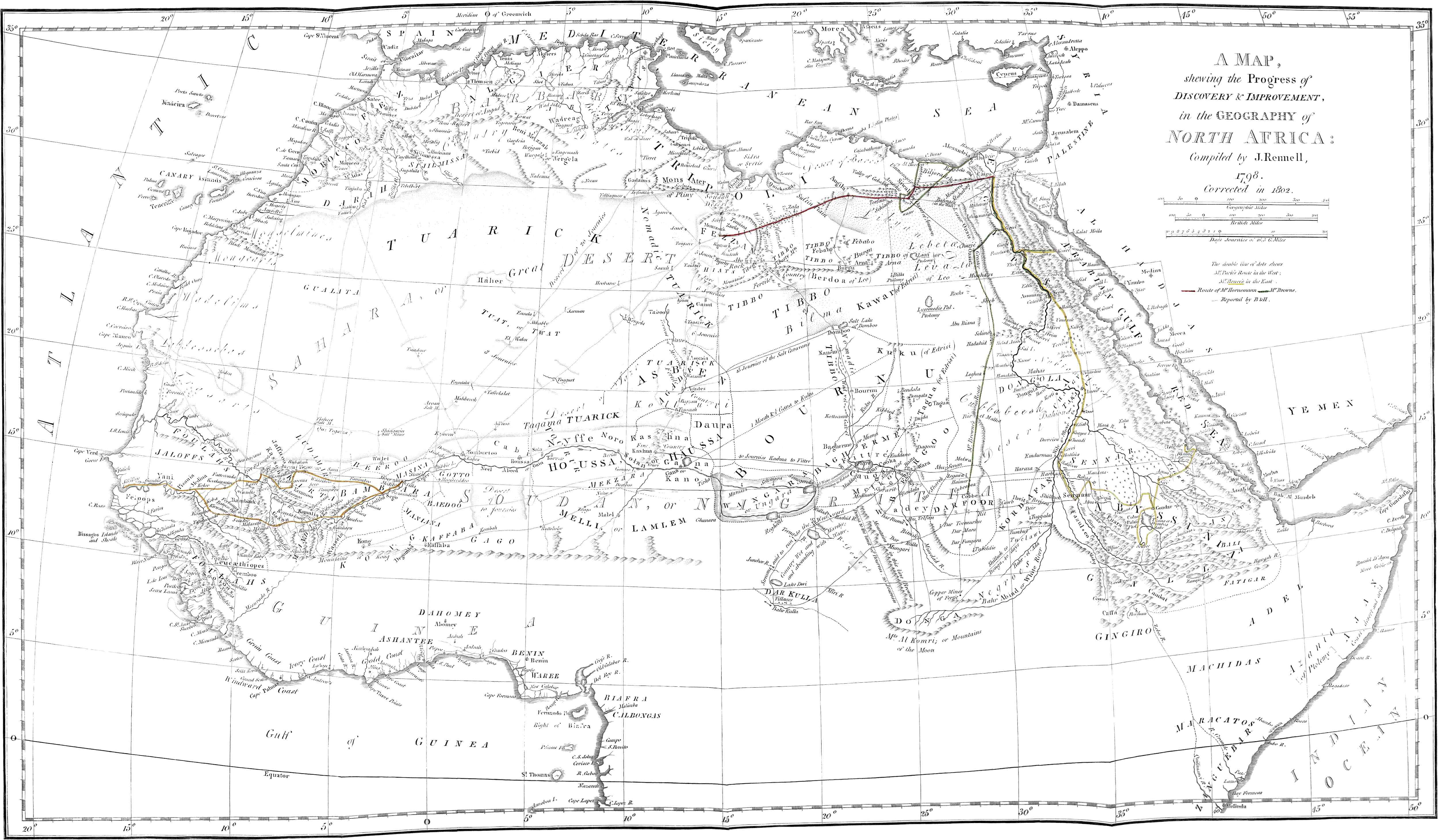
3d. Geographical Elucidations
of the Travels and of the Informations of F. Horneman, with Maps,
by Major James Rennell, F. R. S.
4th. Remarks on the Language of Siwah, in a
Letter to the Right Hon. Sir Joseph Banks, P. R. S. by William
Marsden, Esq. F. R. S.
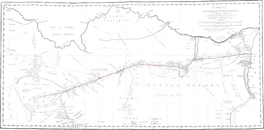
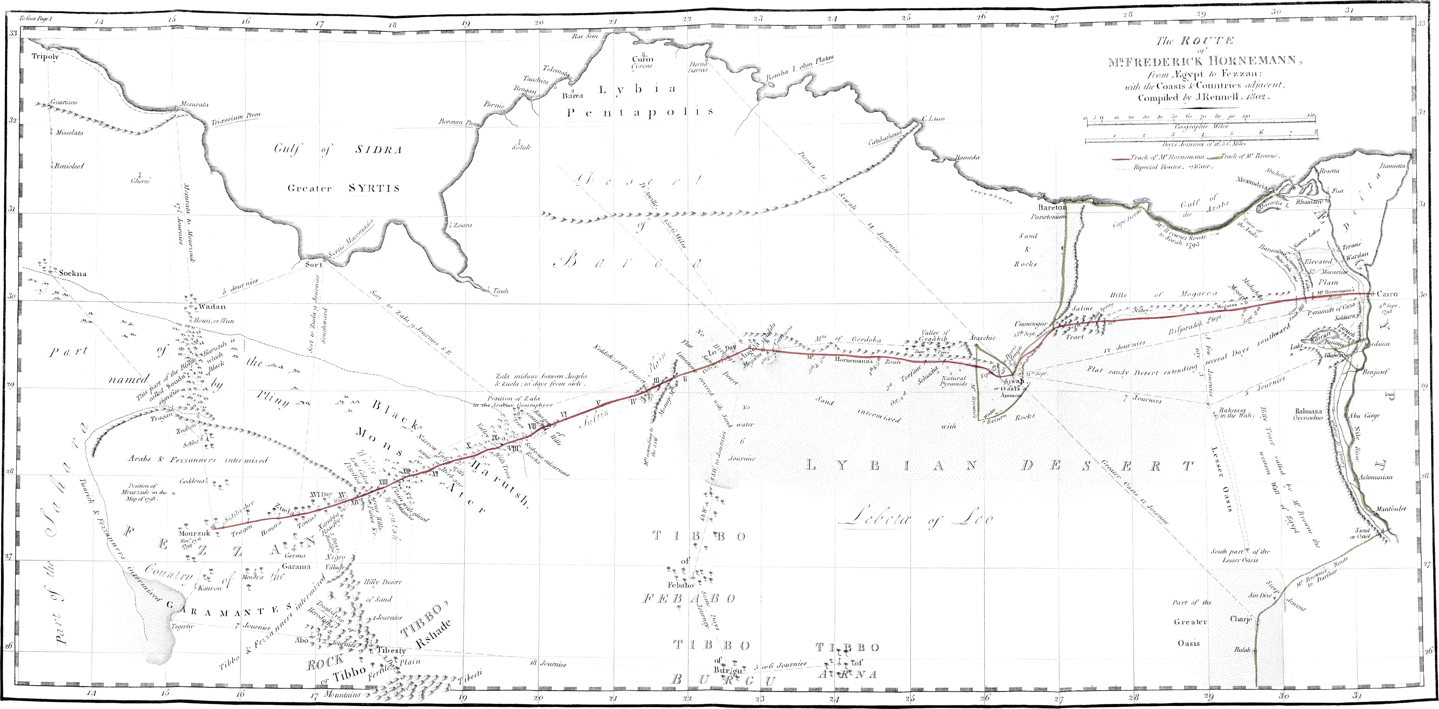
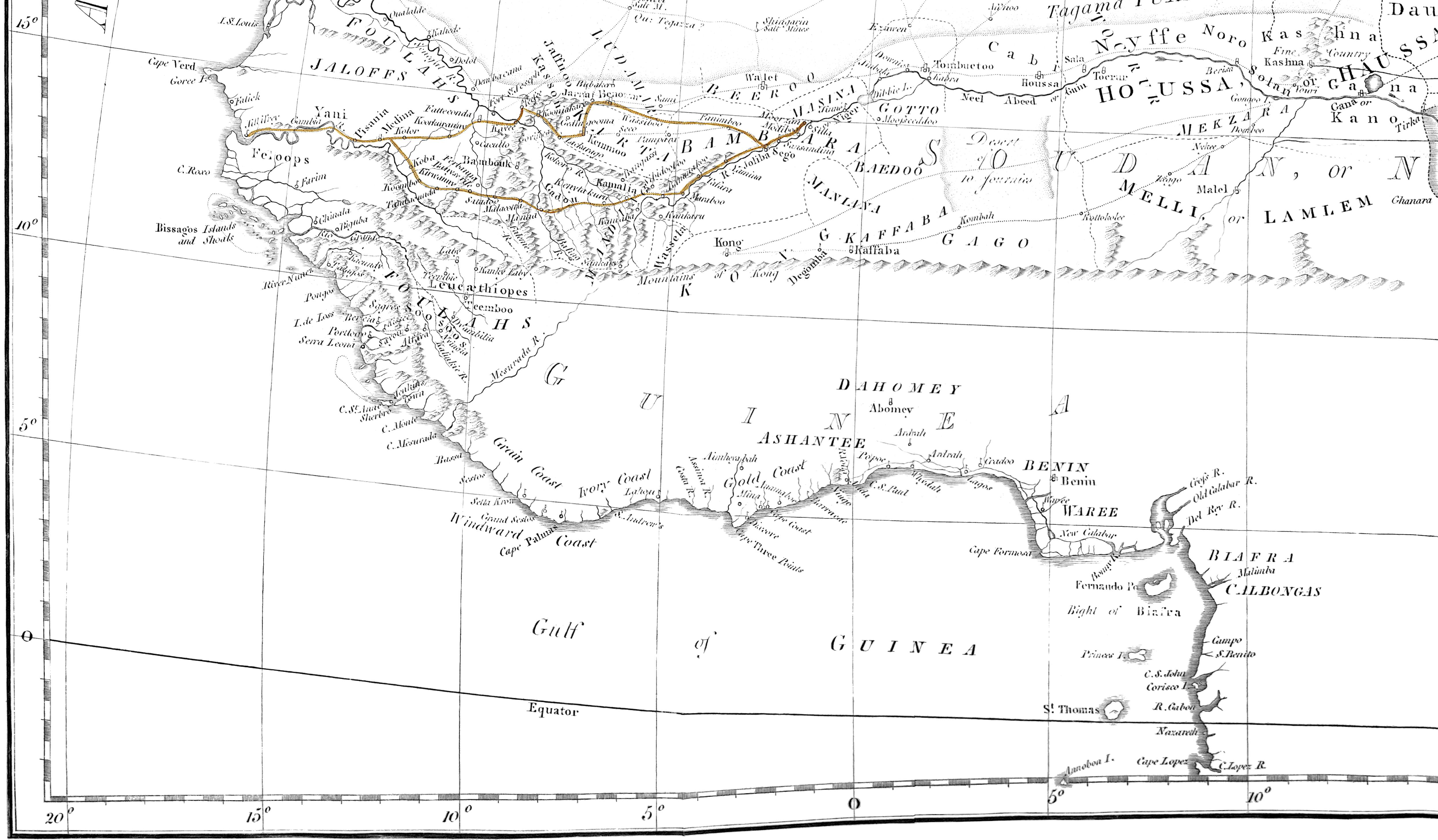
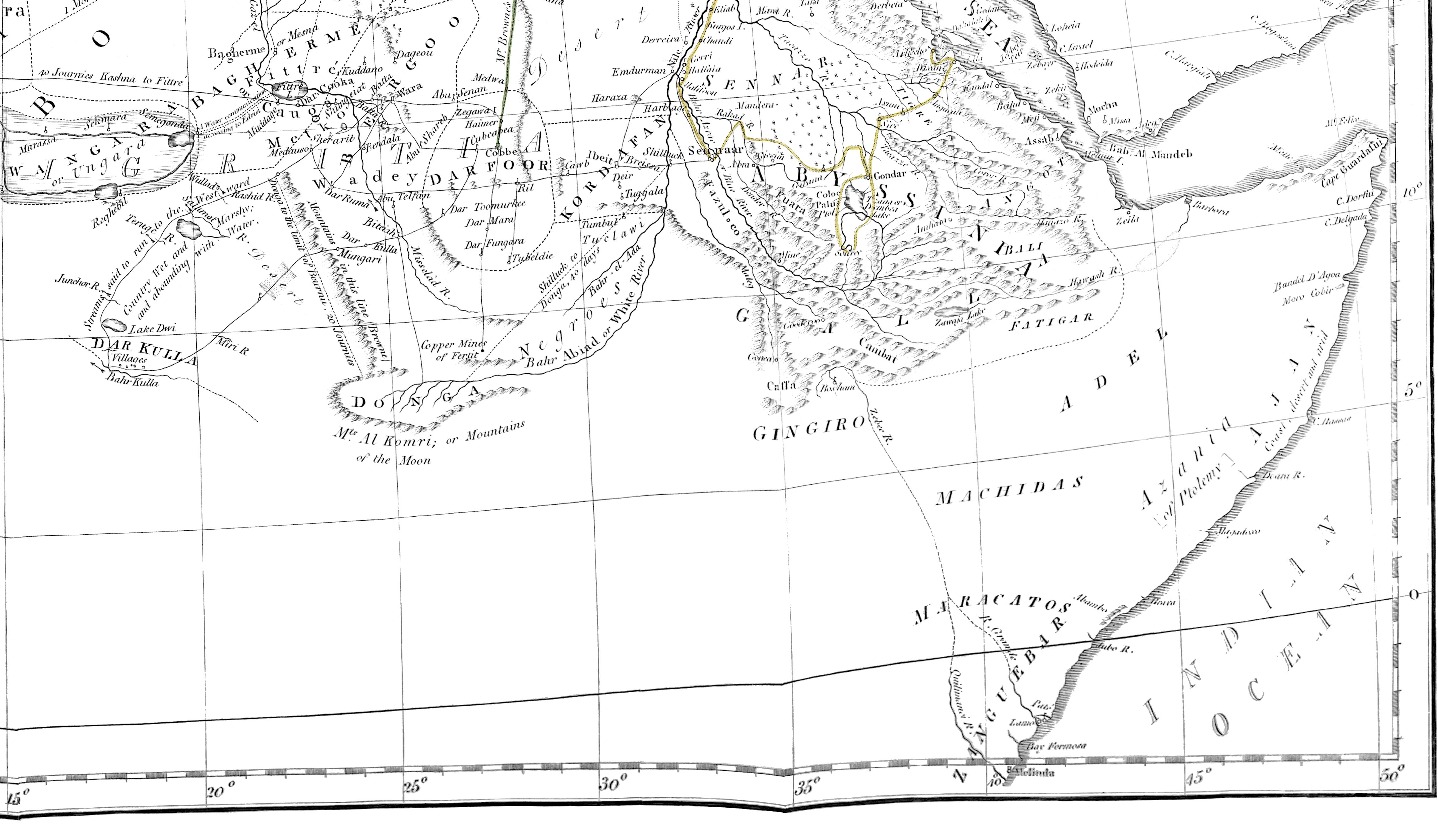
The Route of Mr. Frederick
Hornemann, from Ægypt to Fezzan; with the Coasts & Countries adjacent,
Compiled by J. Rennell, 1802.
Published according to Act of Parliament
by J. Rennell, April 5th. 1802.
CHAPTER I. VOYAGE FROM CAIRO TO AUGILA. — SECTION I. To Ummesogeir. — SECTION II. Observations on the Desert, from the Valley of Natron to the Mountains of Ummesogier. — SECTION III. Ummesogeir, and further Journey to Siwah. — SECTION IV. Siwah. — SECTION V. Antiquities of Siwah. — SECTION VI. Departure from Siwah.—Journey to Schiacha, and Danger which the Traveller there incurred. — SECTION VII. Departure from Schiacha—arrival at Augila.
The merchants of Augila
had appointed their rendezvous to be held at Kardaffi, a
village in the vicinity of Cairo; where I joined them on September
the 5th, 1798, and leaving that place the same day, in about an
hour we reached the great body of the caravan, which yearly returns
from Mecca through Cairo and Fezzan, to the western countries of
Africa. The caravan was waiting for us at a small village called
Baruasch: we halted at some little distance from the
pilgrims, and encamped until the next morning; when the monotonous
kettle-drum of our Sheik awakened us before rise of the sun, with
summons to proceed on our journey.
I had not under-rated the difficulties of the journey; I was
aware that many must arise, especially affecting myself, never
having before travelled
with a caravan, and being little acquainted with the customs and
manners of those who composed it. We had travelled from day-break
till noon, and no indication appeared of halt or refreshment, when
I observed the principal and richest merchants gnawing a dry
biscuit and some onions, as they went on; and was then, for the
first time, informed, that it was not customary to unload the
camels for regular repast, or to stop during the day-time, but in
cases of urgent necessity. This my first inconvenience, was soon
remedied by the hospitality of some Arabs who were riding near me,
and who invited me to partake of their provisions.
Soon after sun-set, our Sheik gave the signal for halting; and
we pitched our tents.
My dragoman, or interpreter, might, even in Europe, have passed
for a good cook; and from remains of the provision which our
hospitable friends at Cairo had supplied, was preparing an
excellent supper, when an old Arab of Augila, observing his
preparations, and that myself was unemployed, addressed me nearly
as follows: “Thou art young, and yet dost not assist in preparing
the meal of which thou art to partake: such, perhaps, may be a
custom in the land of infidels, but is not so with us, and
especially on a journey: thanks to God, we are not, in this desert,
dependent on others, as are those poor pilgrims, but eat and drink
what we ourselves provide, and as we please. Thou oughtest to learn
every thing that the meanest Arab performs, that thou mayest be
enabled to assist others in cases of necessity; otherwise, thou
wilt be less esteemed, as being of less value than a mere woman;
and many will think they may justly deprive thee of every thing in
thy possession, as being unworthy to possess any thing: (adding
sarcastically,) perhaps thou art carrying a large sum of money, and
payest those men well.”
This remonstrance was not thrown away. I immediately assisted in
every thing that was not beyond my force; and proportionally gained
on the good opinion and esteem of my fellow-travellers, and was no
longer considered as a weak and useless idler in their troop.
The next morning we set out early, and after a march of four
hours, arrived at Wadey-el-Latron. The signal had been
made to halt, for the purpose of collecting fresh water, when a
troop of Bedouins appeared at some distance in front, and created
great alarm in our caravan. Our Sheik, or leader, had acquired, and
deserved, the veneration and confidence of his followers, as much
from his known prudence and valour, as from his dignity of Iman. He
immediately ordered us to occupy the spot affording water, and
himself, with about twenty Arabs and Tuaricks, advanced to
reconnoitre the ground where the Bedouins had appeared: they had
now retreated wholly out of sight, and we had time to cook and fill
our water bags. We could not, however, consider this as a proper or
safe station for the night; accordingly at four o’clock we
proceeded on our march; and about eight in the evening reached the
foot of a sand-hill, and encamped in great disorder, created by the
late alarm;—making no fires, and using every precaution to avoid
notice or discovery of our retreat.
The next morning, September 8th, we entered the Desert, which
may be considered as the boundary of Egypt; and after travelling
thirteen hours, encamped on a tract of land by the Arabs called
Muhabag.
The ensuing day, our journey was less fatiguing; in four hours
and a half we reached Mogara, a watering-place on the
verge of a fruitful valley.
The water collected
for the use of the caravans is carried in bags made of goat-skins,
unripped in the middle, and stripped from the animal as entire as
possible; those made at Soudan are the strongest and best; water
may be preserved in them for five days, without acquiring any bad
taste: the bags of an inferior manufacture give an ill taste, and a
smell of the leather, from the second day. To render the skins
flexible and lasting, they are greased on the inside with butter,
and by the Arabs sometimes with oil, which latter gives quickly a
rancid taste, and to any but an Arab, renders the water scarcely
fit for drinking.
The sixth day we had again a difficult and tiresome journey of
twelve hours, without halting; towards the close of our march, the
horse of an Arab near me falling sick, and being unable to proceed
at the same pace as the caravan, I kept in the rear to attend him,
and give such assistance as might be required. On our coming up
with the caravan at its evening encampment, the Arab immediately
sent by his slave, two pieces of dried camel’s flesh, with a proper
compliment, requesting my acceptance of the present, as some return
for the civility I had shewn. I was in an instant surrounded by a
number of meaner Arabs, who eyed with avidity the meat I had
received, and on my dividing it amongst them, seemed greatly
surprised, that I should so readily part with what, in their
estimation, was so great a dainty.
Circumstances light and trivial often delineate manners, and
characterize nations: the method of equipment, and the means of
sustenance which the Arab uses in journeying through these deserts,
may furnish a subject of just curiosity, and certainly of special
use to such as may undertake a similar expedition.
The Arab sets out on
his journey with a provision of flour, kuskasa, onions, mutton
suet, and oil or butter; and some of the richer class add to this
store, a proportion of biscuit, and of dried flesh. As soon as the
camels are halted and the baggage unladen, the drivers and slaves
dig a small hole in the sands wherein to make a fire, and then
proceed in search of wood, and of three stones to be placed round
the cavity, for the purpose of confining the embers and supporting
the cauldron. The cauldron, (which is of copper,) being set over,
the time till the water begins to boil is employed first in
discussing, and then in preparing, what the mess of the day shall
consist of. The ordinary meal is of hasside, a stiff
farinaceous pap, served up in a copper dish, which, in due economy
of utensils and luggage, is at other times used for serving water
to the camels: when this pap or pudding is thus served on table, it
is diluted with a soup poured on it, enriched or seasoned with the
monachie dried and finely pulverized. At other times, the
dinner consists of flour kneaded into a strong dough, which being
divided into small cakes and boiled, affords a species of hard
dumplins called mijotta. A yet better repast is made of
dried meat boiled together with mutton suet, onions sliced thin,
crumbled biscuits, salt, and a good quantity of pepper. The meat is
at dinner time taken out and reserved for the master, and the broth
alone is the mess of his followers. The slaughtering of a camel
affords a feast to the camel drivers and slaves. The friends of the
owner of the beast have a preference in the purchase; and after
dividing the carcase, every slave comes in for a share: no part of
the animal capable of being gnawed by human tooth, is suffered to
be lost; the very bones pass through various hands and mouths,
before they are thrown away. They make sandals of the skin, and
they weave the hair into twine.
It is not on every occasion that time can be allowed, or
materials found, for
dressing victuals: in the anticipation of such an exigency, the
traveller provides a food called simitée: it consists of
barley boiled until it swells, then dried in the sun, and then
further dried over the fire; and lastly, being ground into a
powder, it is mixed with salt, pepper, and carraway-seed, and put
into a leather bag: when it is to be used, it is kneaded into a
dough, with just water enough to give it consistency, and is served
up with butter or oil. If further diluted with water, then dates
are added to the meal, and it is called rouin. Such is the
food of the traveller when there is a scarcity of fuel or of water;
and none can be expended in boiling. I was often, for days
together, without other food than this cold farinaceous pap, mixed
with a few dates. Onions and red Spanish pepper are the general and
the only seasonings of each meal, with the addition of salt.
On the seventh day, after a march of four hours, we reached
Biljoradec, commonly called Jahudie, a term
implying that the water is bad, or that other water is not to be
found but at a considerable distance.
The three following days, travelling occasionally in the night,
we were forty hours in actual journey. On the first of these,
(being the ninth day since leaving the vicinity of Cairo,) we
reached the chain of mountains which bounded the uniform desert
through which we had passed. On the tenth, mounting these hills, I
observed the plain on their summit to consist of a saline mass
spread over so large a tract of surface, that in one direction no
eye could reach its termination, and what might be called its
width, I computed at several miles. The clods of salt discoloured
with sand lay thick and close, and gave to this vast plain the
appearance of a recently ploughed field.
On the summit of
this eminence, and almost in the middle of this saline tract, (on
computation of its width) I discovered a spring; and the passage of
Herodotus[2] occurring to my mind, in which he mentions
springs of fresh water on the salt hills, I eagerly made up to its
brink. I found it edged with salt: some poor pilgrims attending me
tasted the water, but it was so saturated with saline matter, as to
be wholly unfit for drink.
On the eleventh day (September the 15th), we came to an
inhabited spot; after five hours march arriving at the small
village of Ummesogeir.
The Desert forms a
natural boundary to Egypt, on the west extending from the
Natron Valley to the mountains of Ummesogier; to
the north, the dreary and barren plain is bounded by a chain of
lofty hills, in view during the whole course of the caravan; and to
the south, extends a journey, probably, of several days, by the
ordinary mode of computation in these countries; but in this
direction its limits are not defined, or are not known.
In this vast tract of sands, petrified wood is found, of various
forms and size: sometimes are seen whole trunks of trees, of twelve
feet circumference or more; sometimes only branches and twigs,
scarcely of a quarter of an inch diameter; and sometimes merely
pieces of bark of various kinds, and in particular of the oak, are
to be found. Many of the great stems yet retain their side
branches, and in many the natural timber has undergone so little
change, that the circular ranges of the wood are discernible, and
especially in those trunks which apparently were of oak. The
interior of other bodies of timber was become a petrifaction,
shewing no distinctions of grain or fibre, but bearing the
appearance of mere stone; though the outward coat and form of the
substance clearly denoted the tree.
Several Arabs informed me, that in travelling over this Desert,
petrified trees were often found upright, and as if growing in the
soil; but I presume, respecting those I did not see, from those I
inspected, that they were merely trunks raised by hand, round
the base of which the
sand had quickly gathered before the winds, and formed a mound, as
if heaved up by a root. The colour of the petrified wood is in
general black, or nearly so; but in some instances it is of a light
gray, and then so much resembling the wood in its natural state,
that our slaves would often collect, and bring it in, for the
purposes of firing.
These petrifactions are sometimes scattered in single pieces,
but are oftener found in irregular layers, or strata, covering
together a considerable space of ground.
If there yet remains any trace of a western branch of the Nile,
as mentioned by ancient writers,[3] it is probably to be
discovered in some part of this Desert. I observed no channel, or
vestige of such course of river, on the route taken by the caravan.
I would direct the researches of any future traveller specially to
the tract of country round where we encamped on the nights when we
halted at the foot of the sand hill west of
Wadey-el-Latron, and in the district of Muhabag:
these places we reached not till after sunset, and departing before
day, I myself had no opportunity of examining the country. The term
Bahr-bella-ma, commonly rendered river without
water, by no means designates or points to any specific
channel or tract in which any ancient channel may be more probably
discovered: for if petrified trees fit for masts, or petrified
timbers suited to other purposes of ship-building, said to be found
in the
Bahr-bella-ma, characterize and give the name (as we are
told) to the tract of land throughout which they are to be found,
then the appropriate translation is not river, but sea without
water, for such petrifactions are scattered over the whole
Desert. Indeed the general appearance of this vast and barren
tract, well accords to the title of sea without water; its
sandy surface resembling that of a leeshore, over which the waters
streaming before the storm have, on their ebb, deposited timber, or
what else was carried on by the tide. I say not wreck of vessels,
for I saw no wood that had the least appearance of the tool, or of
having been wrought for any purpose of man. Such as, by light
observers, have been taken for fragments of masts, are merely
trunks of trees of from thirty to forty feet in length, broken and
shivered into large splinters, which lying near each other, shew in
their forms and grain of timber, the mass they formerly belonged to
and composed.
To the north of the Desert runs a chain of steep and bare
calcareous mountains, which were in constant view of our caravan
travelling at the distance of three to seven miles in like
direction. At the foot of these, runs a flat tract of moorish
swampy land, from one to six miles in breadth, abounding in
springs, and to which we resorted every second or third day for a
supply of water; but at the period of our journey, the springs
throughout the whole valley were nearly dried up. The water which
remained, and run or spread on the surface, was
bitter;[4] yet digging wells near to these rivulets or
marshes, we found water at the depth only of five or six feet,
which was sweet and palatable.
Ummesogeir is situated
on a sandy plain stretching into the recess between two diverging
branches of the mountain. In the valley thus formed, appear vast
isolated masses of rock, on the largest of which the village is
built; it is small, and contains few inhabitants, furnishing only
thirty men capable of bearing arms. The houses are low, constructed
of stones cemented with a calcareous earth, and thatched with the
boughs of date trees. I was informed, that some of these buildings
covered caves or chambers cut in the rock; probably ancient
catacombs. Our camp was pitched at the foot of the rock, among date
trees, through which the way leads up to the town. Its inhabitants,
poor as they appeared, received us with hospitality; they came
down, almost to a man, from their houses, and assisted us in
watering our camels, or whatever service was required. Towards
evening I walked up to the village by a path of very difficult
access. Coming to a kind of market-place, in its centre I observed
bargains making with such eagerness, noise, and altercation, that
one should suppose the dealings to be of the first moment; but I
soon perceived the sellers to be only a few poor pilgrims of our
caravan, and their articles of trade to be merely henna
hoechel, rings of lead or glass, and such like ornaments for
women; which, with a little shot and gunpowder, they were bartering
for dates: the merchandise on either side was not altogether worth
a crown.
The people of Ummesogeir are indeed in every respect poor,
depending wholly for subsistence on their dates, which they in
part sell to the
Arabs of the Desert, and in part carry to Alexandria, and exchange
for corn, oil, or fat. Their manners are rude and simple, as might
be expected, from a society so small, and separated from every
other, by vast tracts of desert in every direction. Thus
sequestered from the world, too weak in numbers for attack, and too
poor to be attacked, these people derive, from their situation and
habits of life, a simple and peaceful disposition. An old man told
me, that the Bedouins once attempted to deprive them of their rock,
and pittance which the date trees around furnished; and would have
succeeded, had not a marabut (or holy man) who lies buried
in the village, so dazzled the eyes of the invaders, that they
could not find the place, though constantly roving round it. A like
miracle was hoped for, and (in vain certainly) expected in favour
of Cairo, when the French invaded Egypt. The idea of miraculous
interposition of this kind appears to have been common to the
Oriental nations.
During our stay at this place, the effects of a Twater,
who died on the journey were sold by auction. Another man, during
our route, was killed by a fall from his camel, pitching with his
head on a pointed stone, and which caused his instant death. Two
others, poor pilgrims from Mecca, fell victims to the fatigue and
difficulties of so long a journey, and for which their scanty means
were ill suited, either as to food or rest; and this completes our
bill of mortality.
After some days of repose, we proceeded on our journey towards
Siwah, distant from Ummesogeir a journey of twenty hours. We soon
passed the skirts of the broad sandy plain, and reascended the
mountains connected with, and stretching from, those which cover
the vale of Ummesogeir to the west. A long and tedious passage over
these hills led us finally to a green and fertile
valley, towards
which, as we descended from the mountain, we perceived people
gathering provender for their cattle. Our train of heavy laden
camels readily denoted that we were no troop of hostile Arabs; and
the people leaving their work, ran to meet and congratulate us on
our arrival. They told us that the whole neighbourhood was at
peace, and that we might encamp safely and without apprehension.
They mounted their asses and conducted us to a plain west of Siwah,
and not far distant from that town, where we pitched our tents.
Siwah is a small
independent state; it acknowledges, indeed, the grand Sultan
paramount, but it pays him no tribute. Round its chief town called
Siwah, are situated at one or two miles distance, the villages of
Scharkie, (in Siwahian dialect termed Agrmie,)
Msellem, Menschie, Sbocka, and
Barischa. Siwah is built upon, and round, a mass of rock;
in which, according to tradition, the ancient people had only caves
for their habitation. Indeed the style of building is such, that
the actual houses might be taken for caves; they are raised so
close to each other, that many of the streets, even at noon, are
dark, and so intricate, that a stranger cannot find his way into or
out of the town, small as it is, without a guide. Many of the
houses built on the declivity of the rock, and especially those
terminating the descent towards the plain, are of more than
ordinary height, and their walls particularly thick and strong, so
as to form a circumvallation of defence to the town within.
The people of our caravan compared Siwah to a bee-hive, and the
comparison is suitable, whether regarding the general appearance of
the eminence thus covered with buildings, the swarm of its people
crowded together, or the confused noise, or hum and buz from its
narrow passages and streets, and which reach the ear to a
considerable distance.
Round the foot of the eminence are erected stables for
the camels, horses,
and asses, which could not ascend to, or could not be accommodated
in, the town above.
The territory of Siwah is of
considerable extent;[5] its principal and most fruitful district
is a well watered valley of about fifty miles in circuit, hemmed in
by steep and barren rocks. Its soil is a sandy loam, in some places
rather poached or fenny; but, assisted by no great industry of the
natives, it produces corn, oil, and vegetables for the use of man
or beast: its chief produce, however, consists in dates, which,
from their great quantity and excellent flavour, render the place
proverbial for fertility among the surrounding Arabs of the Desert.
Each inhabitant possesses one or more gardens, making his relative
wealth; and these it is his whole business to water and cultivate.
A large garden yielding all such produce as is natural to the
country, is valued at the price of from four to six hundred
imperial dollars, there termed real-patuacks. The gardens
round the towns or villages, are fenced with walls from four to six
feet high, and sometimes with hedges; they are watered by many
small streams of salt or sweet water, falling from the bordering
rocks and mountains, or issuing from springs rising in the plain
itself, and which, for the purposes of irrigation, being diverted
into many small channels, expend themselves in the vale, and in no
instance flow beyond the limits of this people’s territory. The
dates produced are preserved in public magazines, of which the key
is kept by the Sheik: to these storehouses the dates are brought in
baskets closely rammed down, and a register of each deposit is
kept.
North-west of Siwah, there is a stratum of salt extending a full
mile, and near it salt is found on the surface, lying in clods or
small lumps. On this spot rise numerous springs, and frequently a
spring of water
perfectly sweet is found within a few paces from one which is salt.
North of Siwah, on the road leading to El-Mota, I found
many of these salt springs quite close to others which were
sweet.
It is not easy to ascertain the general population of a place,
with so little police, and so little regularity of government as
Siwah, unless opportunity occurred of seeing its people assembled
at some general meeting or festival. The number of its warriors,
however, is more easily known; and on such data, further estimate
of its population may be made. According to the ancient
constitution and laws of the state, the government should be vested
in twelve Sheiks, two of whom were to administer its powers in
rotation; but a few years past, twenty other wealthy citizens,
forced themselves into a share of authority, assumed the title of
Sheik, and enlarging the circle of aristocracy, increased the
pretensions and disputes for power. On each matter of public
concern, they now hold general councils. I attended several of
these general meetings, held close to the town wall, where the
chiefs were squatted in state; and I observed, that a strong voice,
violent action, great gesticulation, abetted by party support and
interest, gained the most applause, and carried the greatest
influence: perhaps such result is not uncommon in most popular
meetings. Whenever these councils cannot agree ultimately on any
point, then the leaders and people fly to arms, and the strongest
party carries the question. Justice is administered according to
ancient usage, and general notions of equity. Fines, to be paid in
dates, constitute the punishments: for instance, the man who
strikes another, pays from ten to fifty kaftas or baskets
of dates; these baskets, by which every thing in this place is
estimated and appraised, are about three feet high, and four in
circumference.
The dress of the
men consists of a white cotton shirt and breeches, and a large
calico cloth, striped white and blue, (manufactured at Cairo,)
which is folded and thrown over the left shoulder, and is called
melaye. On their heads they wear a cap of red worsted or
cotton. These caps, chiefly made at Tunis, are a covering,
characteristic of the Mussulman; and no Jew or Christian on the
coasts of Barbary is permitted to wear them. At times of festival,
the Siwahans dress themselves in kaftans and a
benisch, such as the Arabs commonly wear when in
towns.
The women of Siwah wear wide blue shifts, usually of cotton,
which reach to the ankles, and a melaye (as above
described), which they wrap round their head, from which it falls
over the body in manner of a cloak.
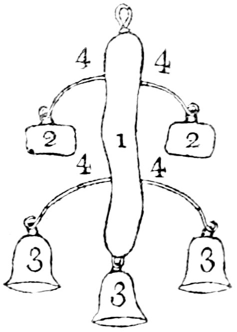
They plait their hair into three tresses, one above the other;
in the lowermost tress they insert various ornaments of glass, or
false coral, or silver, and twist in long stripes of black leather,
hanging down the back, and to the ends of which they fasten little
bells. On the crown of their heads, they fix a piece of silk or
woollen cloth, which floats behind. As ear-rings they wear two, and
some women three, large silver rings, inserted as links of a chain:
their necklace is glass imitating coral; those of the higher class
wear round their necks a solid ring of silver, somewhat thicker
than the collar usually worn by criminals in some parts of Europe;
from this ring, by a chain of the same metal, hangs pendant a
silver plate, engraved with flowers and other ornaments, in the
Arabian taste. They further decorate their arms and legs, (just
above the ancle,) with rings of silver, of copper, or of glass.
I can give no favourable account of the character of the people
of Siwah, either from
general repute, or from my own observation. I found them obtrusive
and thievish. Our tents, and especially my own, were constantly
surrounded and infested by this people; and our merchants were
under the necessity of guarding their bales of goods, with more
than ordinary attention, under apprehension not merely of pillage,
but of general and hostile attack.
I was told much of the riches of this people, and should suppose
there must be men of considerable property amongst them; as they
have a very extensive traffic in dates with different and remote
countries, pay no tribute, and have little opportunity of
dissipating the money they receive. The policy of the Siwahans
leads them to cultivate a strict and close amity with the Arabs to
the north of their country, and who occasionally visit Siwah in
small troops or parties, and carry on a trade of barter for the
dates. Here our caravan disposed of part of its merchandize,
receiving in exchange, dates, meat, and small baskets, in the
weaving and context of which, the women of Siwah are remarkably
neat and skilful, and in the making of which consists their chief
employment. Diseases incident to the country and climate, and from
which the natives most suffer, are the ague and fever, and
opthalmic affections, or disorders of the eyes.
The language of Siwah, whatever words or expressions may have
crept in, from various intercourse of people, is not fundamentally
Arabic; and this has led me to various conjectures. At first I
looked for the root or origin of this language to the East; but on
maturer consideration, and from communications with one of the
Tuaricks from Twat, with whom I was in habits of
intimacy, I am now satisfied of my former error,[6] and
that the language of Siwah is a dialect of that used throughout the great
nation of Africa, to which my friend, the Tuarick, belonged, and
which may be considered as the aboriginal.
The larger collection of Siwahan words, which I had first made,
was lost with other papers, by an accident which I shall hereafter
have occasion to mention.
The following list I had from a man of Siwah, whom I afterwards
got acquainted with at Augila.
Sun,
Itfuct.
Horse,
Achmar.
Clouds,
Logmam.
Horses,
Ickmare.
Ear,
Temmesocht.
Have you a horse?
Goreck Achmar.
Head,
Achfé.
Milk,
Achi.
Eye,
Taun.
Flesh or Meat,
Acksum.
Eyebrow,
Temauin.
Bread,
Tagora.
Beard,
Itmert.
Oil,
Tsemur.
Hand,
Fuss.
Water,
Aman.
Penis,
Achmum.
Dates,
Tena.
Camel,
Lgum.
House,
Achbén.
Sheep,
Jelibb.
Houses,
Gebeun.
Cow,
Ftunest.
Sand,
Itjeda.
Mountain,
Iddrarn.
Cap,
Tschatschet.
Sabre,
Aus.
Catacombs,
Tum-megar.
Sword,
Limscha.
As we approached the
spot destined for our encampment in the Vale of Siwah, I descried
to the westward some ruins of an extensive building, a few miles
distant from the road, and concluded them to be the same as noticed
by a late English traveller, (Mr. Brown,) of whose discoveries I
heard first in London, and afterwards, when in Egypt. Circumstances
rendered it necessary for me to be particularly on my guard, and to
defer any visit to, or actual inspection of, these antiquities,
until I had retrieved the confidence of the natives, who, on my
very first appearance, (as I was informed,) had taken me and my
interpreter, for Christians; and to this supposition they were
induced, from our fairer complexion, from our gait and manners, and
from our Turkish dresses. When I took advantage of the disturbances
at Cairo and its environs, to get introduced as a Mahomedan to the
caravan, I could not indeed speak readily, either Turkish or
Arabic; but in this, I flattered myself, the assumed character of a
young Mameluke might be my excuse; and I further derived confidence
from the experience and abilities of my interpreter, who (a German
by birth,) had been forced, twelve years past, to embrace the
Mahommedan religion at Constantinople, and whose address and
knowledge, I hoped, might preclude, or extricate me from, any
consequences of jealousy or suspicion.
Considering the importance of my mission, and the great purpose
of exploring the whole of Northern Africa, with which I
was entrusted,
perhaps it had been more wise and prudent on my part, not to have
exposed myself to general intercourse, until better qualified to
sustain the character I had assumed; had I so done in the present
instance, and abstained from visiting the curiosities of Siwah, and
exposing myself in the novelty of the attempt, to examinations and
suspicions, I might have avoided a danger which (as will appear in
the sequel) nearly proved fatal to myself, and therewith to the
object of my voyage.
Making such candid admission of not having the requisite
forbearance, with objects of so just curiosity in view, I proceed
to state the course of my inquiries, and the result.
I first visited the ruins of the extensive edifice before
observed. I accosted some men working in the gardens near, and
questioning them as to what they knew of this building, they
answered, “that in former times Siwah was inhabited by infidels,
most of whom lived in caves, but some inhabited these buildings.”
One spokesman, pointing to a building in the centre, said,
“tradition tells us, that edifice was the hall in which
the divan used to assemble; at time of its construction men were
stronger than I am; for those huge stones serving as a roof to the
fabric, were lifted up and placed there by two men only: there is
much gold buried under the walls.” When I then entered into the
ruins, I was followed by all the people near, and thus prevented
examining the place with any accuracy. On a second visit I was not
more successful; and when, after a few days, I returned thither
again, some Siwahans directly said to me, “thou undoubtedly art yet
a Christian in thy heart, else why come so often to visit these
works of Infidels.” In order to maintain the character I had
assumed, I was thus necessitated to abandon any further project of
nice examination or admeasurement, and restrict myself to general observations,
such as I now submit in detail as they occurred.
Ummebeda (the name given to the site of those ruins by
the natives) lies near a village called Scharkie or
Agrmie, between that place and an isolated mountain, on
which a copious spring of fresh water is said to rise. The
buildings are in such a state of delapidation, that a plain
observer, who forms an opinion only from what he sees, and does not
accommodate the object in application and conjecture to
preconceived notions of a particular structure which he is to look
for, and trace out, could scarcely, (I think) from these rude
heaps, and mouldered and disjointed walls, suggest the precise form
or original purpose of the building when first raised. Its
materials might suggest, that it was built in the rudest ages, and
when the Troglodytæ[7] of these parts first left their caves, and
in their first attempt of building, took their scheme and plan of
architecture from their old mansions, heaping rock on rock, in
imitation of the dwelling places which nature had before
furnished.
I ascertained the general bearings of the building by my
compass, and found the outward walls constructed with aspects
facing the four cardinal points, the aberration being only of
twelve degrees, and which might have occurred from variation of the
needle. The total circumference may be several hundred yards, and
is to be traced out and followed by the foundations of a wall, in
most parts visible, and which, from the masses remaining, appears
to have been very strong. The outward wall, in most
places, has been thrown down, and the materials carried away, and
the interior ground has been every where turned up, and dug, in
search of treasure.
In the centre of
this extensive area, are seen the remains of an edifice, which
perhaps may be regarded as the principal building,[8] and
to which all around may have been mere appendage, and
subordinate.
The northern part of this building stands on a native calcareous
rock, rising above the level of the general area, within the outer
walls, about eight feet. The height of the edifice appears to be
about twenty-seven feet; its width twenty-four, and its length ten
or twelve paces. The walls are six feet in thickness, the exterior
of which within and without is constructed of large free stones,
filled up in the interstice with small stones and lime. The ceiling
is formed by vast blocks of stone, wrought and fitted to stretch
over and cover the entire building. The breadth of each such mass
of stone is about four feet, and the depth or thickness three feet.
One of these stones of the roof has fallen in, and is broken; the
entire southern wall of the building hath likewise tumbled, and the
materials have mostly been carried away. But the people have not
been able to remove the large fragments fallen from the roof, which
their ancestors were enabled to bring from the quarry, and to raise
entire to the summit of the edifice. Such are the vicissitudes of
art, of knowledge, and of human powers and means, as well as of
human happiness and fortunes!
The stones that have fallen, lie sunk, with their surface lower
than the base of the yet standing part of the building, and their
bottom almost on a level with the area of the great inclosure. The
appearance of these fallen stones of the southern wall, leads to a
conjecture, that this extremity of the original edifice had its
floor or base lower than that of the northern part. The
entrances to this
building are three, the principal one to the north, and the others
to the east and west. The inside walls (beginning at half their
height from the ground) are decorated with hieroglyphics sculptured
in relief, but the figures seem not to have been sufficiently
engraved in alt, or salient, to resist the
ravages of time and weather; and in some places they are wholly
mouldered and defaced, and especially on the ceiling.
On different parts of the wall appear marks of paint, and the
colour seems to have been green. I could no where discover traces
of the edifice having in any part been lined or inlaid with a finer
stone or material. A few paces from the chief entrance, I observed
two round stones, of about three feet diameter, each indented, as
if to receive the base of some statue or other ornament. The
general material of which the building is constructed, is a
lime-stone, containing petrifactions of shells and small marine
animals; and such stone is to be found and dug up in the
vicinity.
On examining the country around these ruins, I found the soil
contiguous to the foundations of the outward wall on the south to
be marshy, and was informed that it contained salt springs. I asked
if no considerable spring of fresh water was to be seen near; and
was shewn a fine rivulet of sweet water, about half a mile from the
ruins, which takes its rise in a grove of date trees, and in a most
romantic and beautiful situation: it is not, however, its
delightful scene that recommends it to the native of Siwah, but an
opinion that it is a specific against certain diseases.
I am conscious that the above description of the remains of
antiquity near Siwah, is by far too cursory and incomplete, for any
purpose of just and accurate inference; and that it must yet
remain a mere
conjecture, whether these ruins are those of the famous Temple
of Jupiter Ammon. It must be obvious, from many points I have
adverted to in my description, that I had the site of this renowned
temple in view, and that it was a principal object of my research.
Circumstances I was under, and of which the reader is already
apprised, prevented my pursuing this great subject of just and
learned curiosity with the nicety of inspection, and care in the
consideration, which I could have wished to employ. Supposing, on
reference to ancient writers, the comparison of the buildings not
to bear me out in the idea which I entertain; yet on many other
grounds I should contend, that Siwah had been a residence of the
ancient Ammonites. I draw my conclusion from the relative situation
of the country; from the quality of the soil, from its fertility;
from the information of its inhabitants, that no other such
fruitful tract is to be found any where near; and, in addition to
the certainty, at least, that some great and magnificent building
once here stood, I derive a further conclusion from the numerous
catacombs to be found in the vicinity, and which I shall have
occasion more particularly to notice. In regard to the memorable
Temple of Ammon, should even my own description of the existing
vestiges of building not accurately agree with general accounts of
that edifice, yet, notwithstanding, I must continue to hold an
opinion, from the general appearance and from the situation of
those ruins, that they may be remains of the Temple of
Jupiter Ammon. A delineation and decipher of the hieroglyphic
figures, which adorn the inner walls of the building, might be
conclusive on this question.
I will further add on this subject, that on inquiry after
Edrisi’s Santrich, no one knew it even by name; but I was
told that at a distance of seven days journey from Siwah,
six from Faiume, and two or three[9] from Biljoradec,
there exists a country, similar to that of Siwah, its inhabitants
less in number, and speaking the same language. That region I
should take to be the Minor Oasis of the ancients. I speak
of this place from mere report, and could gain no more accurate, or
further account; perhaps it lies among the mountains which traverse
the great Desert near Ummesogeir, extending towards the
south.
I come now to the subject of the various catacombs, to
be found in the territory of Siwah, and which I was enabled more
fully to examine, as lying in more sequestered spots, and where I
was less liable to observation.
If I well understood my companion, an inhabitant of Siwah, there
are four principal places, where catacombs are found. The first,
Belled-el-Kaffer; the second, Belled-el-Rumi;
both these terms, denote one and the same thing, namely, “place or
town of infidels;” the third is, El-Mota, or place of
burial; the fourth, Belled-el-Chamis, or Gamis.
My inquiries were in particular directed to El-Mota,
situated at the distance of about one mile north-east from Siwah.
It is a rocky hill, with a number of catacombs on the declivity,
but the most remarkable, are on the summit. There is a separate
entrance to each, and the descent inwards is gentle and gradual.
The passage from the aperture, leads to a door-way, from which the
space of the room is enlarged, and on each side, are smaller
excavations for containing the mummies. The stones rising from the
threshold are cut in a form that shews a door to have been formerly
hung, and to have closed the entrance. The catacombs are of
different extent, and each is wrought with great labour and
neatness of work, and especially the uppermost, which contains no
traces of any mummy.
In others are found various remains. I long, but in vain, searched
for an entire head: I found fragments, and especially of the
occiput in abundance, but none with any investiture
remaining; and even in the occiputs most entire I could
not discover any stain or mark of their once having been filled
with resin. The cloth still adhered to some ribs,
but so decayed, that nothing could be further distinguished, than
that the stuff in which the mummy had been wrapt, was of the
coarsest kind.
The ground in all these catacombs has been dug and explored in
search of treasure, and I was told, by my guide, that in every one
of these sepulchres gold has been, and is yet sometimes, found.
There is every probability that entire mummies might be
discovered in the catacombs at a greater distance to
westward of Siwah. I was credibly informed, that besides
the open catacombs on the mountains, there are others under ground,
and the entrance of which is to be found at no great depth; and
that Biut-el-Nazari, (houses of Christians, synonymous
here to Infidels,) exist on both sides of a long subterraneous
passage, forming a communication, between two catacomb-mountains.
The catacombs met with on Gibel-el-belled, being the hill
on which Siwah is built, are small, and consist of a
little antichamber, leading generally to two caverns where the
mummies were deposited. Of these the two most remarkable are two
large and high caverns on the north side; the one is twenty, the
other sixteen feet square, and both are open to the north.
There are likewise two other caverns, of similar dimensions, but
not so lofty, to be seen westward of Siwah, and leading to
Augila;
their entrance is low and narrow, and the two excavations are so
near, that the partition, as appears from a small perforation, is
only ten inches thick.
Quitting the subject of antiquities in the territory of Siwah, I
have only to add, that in the nearest plain west of the town, there
are other massive remains of some building, but which bear no token
or note of remote antiquity, such as may be attributed to the ruins
I first described.
Having remained eight
days at Siwah; on the 29th of September, at three in the afternoon,
we broke up our encampment, and proceeded a three hours march, when
we again pitched our tents at foot of a hill. The next day we began
our journey late, being delayed till one o’clock, in search of a
slave who belonged to a court-officer of the Sultan of Fezzan, and
who had absconded from the caravan. Whilst the man was looking for,
I set out with a view of inspecting some catacombs which I descried
on the neighbouring hills, but was stopped at some distance by a
lake of seven or eight miles in circumference, formed at the base
of the mountain by the conflux of springs and small pools of water,
which the rains at this season had swollen and brought together.
Returning to the camp, I took my telescope to examine the
appearances I was not enabled closely to inspect, when the first
object on the mountain which presented itself to my view was the
Negro after whom the search was making. I gave no notice of my
discovery, the poor fellow having a good character, and having been
driven to the attempt of flight by the extreme severity of his
master. I am sorry to say there was little hope of his final
escape, the Siwahans having promised to deliver him up. This day we
travelled till half an hour after sun-set. The next day we marched
at two hours before day-break, and halted at nine. The fourth day
brought us to the fruitful valley of Schiacha.
The mountains by
which we travelled from Siwah to this spot, are branches
of those which I have mentioned as appearing, at all times, to
north of our way through the Desert, and often at but little
distance. They rise abruptly, and as precipices, from the level
ground, and shew a face of mere rock, without the least covering of
soil or even of sand. Their appearance, taken together with that of
the sea-sand which covers the Desert, indicate this vast
tract to have been flooded, and at a period later than the great
deluge. In the sandy plain below these mountains is seen the
surface of a vast calcareous rock, containing no substance of
petrifaction, whereas the mountains near consist of limestone,
crowded and filled with fragments of marine animals and shells. The
strata of all these rocky hills lay horizontal.
Westward of Siwah, I found two banks or heaps of
calcined shells, some of the size of two inches over. My
interpreter told me, that taking his road at some distance from me,
he saw a mountain standing singly and unconnected with others,
composed entirely of shells. Many such vast isolated mounds are to
be seen throughout the whole of this district, and the bed-joints
or interstices of their strata of stone (always horizontal), being
filled up with a reddish, friable, calcareous substance, they often
resemble pyramids, and in so exact and illusive a manner, that more
than once I was deceived into expectation of arrival at such
building. The architecture of the ancient Egyptians was of the vast
and gigantic kind; and builders of such ambitious temper and
stupendous scheme, might readily entertain the idea of transforming
a mountain into a pyramid, shaping the huge rock, already in form
partly adapted, and casing it with wrought stones on the outside,
as they might prefer. Some of the learned have given an opinion,
that the Pyramids of Giza and of Saccara, were
not originally erections from the base, but merely hills of earth or
stone, shaped and covered by the labour of man. The idea is
plausible, though certainly to be controverted, by reasons to be
drawn from history, and from other the best sources of fact and
argument.
I now proceed to the recital of an event in which I was
personally and principally concerned. I shall give the recital in
detail, as, in its consequences, being of the highest import to the
future safety of myself, and therewith to the progress of discovery
which I have engaged in; and, as it has afforded me self-confidence
and new encouragement, ever favourable to the success of
enterprize, so will it, I trust, give satisfaction to those who
have employed me, inspiring just and well-founded hopes of my
finally accomplishing the great purpose entrusted to my care.
The state of quiet and security usually attending our
encampments was interrupted, whilst at Schiacha, by the
arrival of some Siwahans, who, about eight o’clock in the evening,
came with intelligence, that a numerous horde of Arabs from the
vicinity of Faiume were hovering in the Desert, ready to
fall upon our caravan. These messengers at the same time assured
us, that the people of Siwah had resolved to come to our
assistance, and to escort us to the next watering-place; adding,
“that their little army would arrive in a few hours, determined to
risk with us every thing in opposing the attack of the Bedouins,
whose force they represented as consisting of from 800 to 1000 men.
Our leader, the Sheik of the Twaters, immediately assembled the
principal people of the caravan, when it was decided not to desert
our post, but to await the enemy. Scarcely was our little council
broke up, when we heard from afar the braying of some hundred
asses, giving notice of the approach of the Siwahans. They
use this animal on their military excursions, from the advantage it affords of more
easily proceeding by narrow and rugged passes among the mountains,
and evading or attacking any enemy, who from ignorance of the
country, or from the nature of its cattle requiring safer roads, is
obliged to confine its march to broader defiles or vallies. Some
men were immediately dispatched from the caravan, requiring the
Siwahans to halt at half a mile distance from our post. The night
passed in disquietude and alarm: each got his arms in readiness,
and prepared for a battle on the ensuing day. A little before
sun-rise, the Siwahans advanced on foot, and gave apprehension of
immediate attack. Some Augilans rode forward, to inquire
their intentions, and were answered, “that the caravan had nothing
to fear;” on reporting this to the Sheik, he sent the messengers
back, to say he should consider and treat them as enemies, if they
advanced a step further. On this message the Siwahans
halted, formed a circle, and invited some Augilans to a
conference. During all this time, I remained quiet with my baggage,
having sent my interpreter to collect intelligence of what was
passing. Seeing him return, and judging from his manner and haste,
that he had something of importance to communicate, I ran to meet
him. He immediately accosted me with, “cursed be the moment, when I
determined upon this journey; we are both of us unavoidably lost
men; they take us for Christians and spies, and will assuredly put
us to death.” With these words he left me, and ran to the baggage,
where he exchanged his single gun for my double barrelled one, and
armed himself with two brace of pistols. I upbraided him with his
want of firmness, told him “a steady and resolute conduct could
alone preserve ourselves and friends, and reminded him that his
present behaviour was precisely such as to give weight to the
suspicions entertained:” I further urged, “that on his own account
he had nothing to fear, having for twelve years been a Mahommedan,
and perfectly acquainted with the religion and customs; that myself alone was
in danger, and that I hoped to avert it, provided he did
not intermeddle with my defence.” “Friend, (answered he,) you will
never hear of danger: but this time you will pay for your
temerity.”
Perceiving that terror had wholly deprived him of the necessary
temper and recollection, I now left him to himself, and walked up
unarmed, but with a firm and manly step, to this tumultuous
assembly.
I entered the circle, and offered the Mahometan salutation,
“Assulam Alckum,” but none of the Siwahans
returned it. Some of them immediately exclaimed,—“You are of the
new Christians from Cairo, and come to explore our country.” Had I
at this time, been as well acquainted with Mahometan fanaticism,
and the character of the Arabs, as I have been since, I should have
deduced my defence from the very terms of the accusation, and
stated that I was indeed from Cairo, having fled from the Infidels;
as it was, I answered nothing to this general clamour, but sat down
and directed my speech to one of the Chiefs, whose great influence
I knew, and who had been often in my tent whilst at Siwah.
“Tell me, brother, (said I,) hast thou ever before known 300 armed
men take a journey of three days, in pursuit of two men, who dwelt
in their midst for ten days, who had eaten and drank with
them as friends, and whose tents were open to them all? Thyself
hast found us praying and reading the Koran; and now thou sayest we
are Infidels from Cairo; that is, one of those from whom
we fly! Dost thou not know, that it is a great sin to tell one of
the faithful that he is a Pagan?” I spoke this with an earnest and
resolute tone, and many of the congregation seemed gained over by
it, and disposed to be favourable to me: the man replied, “that he
was convinced we were
not Infidels, that he had persuaded no one to this pursuit, and as
far as depended on him alone, he was ready to return to
Siwah.” On this I turned to one of the vulgar, who was
communicating some of the accusations against me to the people of
our caravan. “Be thou silent, (said I,) would to God, that I were
able to speak well the Arabic, I would then ask questions of thee,
and of hundreds like thee, who are less instructed in the
Islam than I am.” An old man on this observed, “This man
is younger than the other, and yet more courageous!” I immediately
continued, “My friend is not afraid of thee, but thou oughtest to
have fears of my friend: dost thou know what it is to reproach a
man, who lives with sultans and with princes, with being an
Infidel?” I was then asked for what purpose we carried Christian
papers. I now found that my interpreter had unwarily shewn a
passport which I had obtained from General Bonaparte, with a view
not to be detained at the French posts through which I was to pass
to the caravan. My interpreter at this moment came up, and finding
me alive, and the assembly less angry and violent, than when on
being first questioned, he had exasperated them by inconsiderate
and perplexed answers; he recovered himself, and stood sufficiently
composed and collected, whilst I explained partly in German, partly
in Arabic, what had passed. Knowing, however, that the paper in
question would be demanded, and not choosing to trust to his
prudence in the manner of producing it; I went myself for it to the
tent, and returning, brought likewise a Koran with me. I
immediately tendered the paper to a Chief of the Siwahans,
who having unfolded it, asked, “if any by-stander could read it.” I
could not help smiling at the question, perilous as was my
situation. The same question was then put to us, when I answered,
“that we did not understand what it contained, but were told, it
would allow us to quit Cairo without being molested.” “This is the
book, (interrupted my interpreter,) which I
understand:” and
immediately took the Koran from my hand. We were ordered, by
reading in it, to give proof of our being truly of the religion.
Our learning in this respect went far indeed beyond the simple
ability of reading. My companion knew the entire Koran by heart,
and as for me, I could even then write Arabic, and well too: which
with these people, was an extraordinary proficiency in learning. We
had scarcely given a sample of our respective talents, when the
chiefs of our caravan, who to this moment had been silent, now took
loudly our part; and many of the Siwahans too, interfered in our
favour. In short, the inquiry ended to our complete advantage,
though not without the murmuring of some in the multitude, who lost
the hopes of plunder which the occasion might have afforded.
Thus the character of Mussulman which I assumed was firmly
established, and I shall not be subjected in future, to like
inquiries, on which, perhaps, more decisive proofs might be
required, and which I could not give. The security of my future
voyage is thus assured, and so great an advantage more than
compensates for some losses attending the above incident, but which
yet I must regret.
During the time I was first in conference with the people of
Siwah, and those of the caravan, my baggage was left with my
interpreter; who in the paroxysms of his fears, and indeed with no
light apprehensions of our bales of goods being searched, took my
remains of mummies, my specimens of mineralogy, my more
detailed remarks, made on my way from Cairo to
Schiacha, and generally my books, and gave them to a
confidential slave of my Arab inmate, to bury them in a bog; this
was done, and I never afterwards could retrieve them.
On the fifth day
(reckoning by our departure from Siwah,) we left Schiacha, and
travelled about four hours, when we encamped. The next morning in
two hours and a half, we came to a district called
Torfaue, where we halted to collect fresh water: from this
place we departed at four in the afternoon of the same day, and
continued our march until eight the next morning, through a desert,
the level of which was interrupted by numerous sand-hills; at eight
o’clock we stopped to refresh, and rested till two o’clock, when we
again pressed forward, and continued our march till eight in the
morning, when we encamped till one. At one we again proceeded,
travelled all night, and till three o’clock the next morning, when
the party with whom I travelled, discovered, that during the night,
we had wandered from the caravan; we resolved thereon to halt and
await the return of day. We placed our baggage by the side of each
camel, to be enabled on emergency, to load again with dispatch, and
I laid me down to sleep on the sand, with the bridle in one hand,
and my firelock in the other, and slept soundly till sunrise.
We now discovered our caravan; and at the same time, that we
were not above half a mile from a spot, fruitful and abounding in
water. We immediately made up to the place and encamped. The
journey from Torfaue to this spot, was the most
disagreeable and fatiguing that in the course of all my travels I
had experienced. Both men and cattle were so wearied and exhausted,
that as soon as the
baggage was unladen, all resorted to sleep. We here reposed the
whole day, and the next set forth for Augila, by short marches,
(altogether not amounting to more than nine hours travel); we used
no haste, as having nothing to apprehend, being now in the country
of our friends.
Our entry into Mojabra, one of the three places
belonging to the dominion of Augila, was solemn and affecting, as
the greater part of the merchants of our caravan had here
habitations and families. The Bey of Bengasi, Vicegerent
for the Bashaw of Tripoly, and at that time resident at
Augila, sent about twenty of his Arabs to note in writing
the burden of the camels, and for which they demanded a small duty.
These Arabs then ranged themselves, and formed a right wing to our
caravan, drawn up for procession. The merchants who had horses
formed the left, and the pilgrims and ordinary Arabs formed the
centre, headed by the Sheik preceded by a green flag. The pilgrims
marched on singing; and the Arabs made their horses prance and
curvet, and so continued until we approached near to
Mojabra; where a number of old men and children met us, to
felicitate and get a first embrace of their sons and relations,
whom, on hearing of the French invasion in Egypt, they had given
over as lost.
We pitched our tents in a spot adjoining the town, and were most
hospitably entertained. The following night I proceeded on my
journey towards Augila, in company with two merchants, one
of whom procured me a lodging on my arrival, it being the intention
of the caravan to stop longer than usual at this place.
There are three towns within the territory of Augila;
Augila, the capital, and Mojabra, and Meledila.
The two last are near to each other, and both about four hours from
Augila; Mojabra to the south, and Meledila to
north of the road by which we passed. Mojabra and
Meledila are occasionally comprehended in the general name
of Fallo, designating the district.
Augila, a town well known in the time of
Herodotus,[10] covers a space of about one mile in
circumference. It is badly built, and the streets are narrow and
not kept clean. The houses are built of a limestone, dug from the
neighbouring hills, and consist only of one story or ground floor.
The apartments are dark, there being no aperture for light but the
door; and are generally ranged round a small court, to which the
entrance of each room faces, for purpose of collecting the more
light. The public buildings, comparatively, are yet more mean and
wretched. Mojabra is of smaller extent, but appears
proportionally more populous than Augila. The inhabitants
of Meledila are chiefly employed in agriculture; those of
Mojabra engage mostly in trade, and pass their lives in
travelling betwixt Cairo and Fezzan. The people of Augila
are of a more sedentary disposition; though some of these too, were
with our caravan.
The men of the above places, who engage in the caravan trade,
generally keep three houses; one at Kardaffi, near Cairo;
one at Mojabra, and a third at Zuila, or
sometimes at Mourzouk. Many have a wife and family
establishment at each of these houses; and others take a wife for
the time, if the stay of the caravan is longer than usual. The men
from their very youth devote themselves to such traveller’s life.
Boys from thirteen to fourteen years of age, accompanied our
caravan the long and toilsome journey from
Augila to
Fezzan on foot, or at least seldom mounting a horse. In
observing the general character of this people, I could not but
remark a degradation, self-interestedness, and mean and shuffling
disposition, derived from early habits of petty trade, and the
manner in which it was conducted, as contra-distinguishing those
engaged in this traffic, and those who remained at home.
The men of the country are engaged in gardening and agriculture;
but in the last to no great extent. The women are very industrious
in manufacturing coarse woollen cloths of five yards in length and
a yard and a half wide, which are called Abbe, and are
sent in considerable quantities to Fezzan. These
constitute the chief clothing of this people; they wrap them about
their bodies, and without even a shirt or shift under.
Round Augila the country is level and the soil sandy,
yet, being well watered, is tolerably fertile. Corn is not
cultivated in quantity sufficient for subsistence of the people.
The Arabs of Bengasi, distant about thirteen days journey,
import annually both wheat and barley; and this their corn caravan
is generally accompanied by flocks of sheep for sale.
The inhabitants of this region can generally speak the
Arabic but their vulgar language is a dialect similar to
that of Siwah, above noticed.
FOOTNOTES:
[2]In hoc supercilio sunt frusta salis, ferè
grumi grandes in collibus, et singulorum collium vertices è medio
sale ejaculantur aquam dulcem pariter et gelidam. Herodot. ed.
Wesseling. p. 181.
[3]Ῥέει γὰρ ἐκ Λιβύης ὁ Νεῖλος, καὶ μέσην τάμνων
Λιβύην. Herodot. Euterpé, § 33. The Editor rather supposes that
Herodotus using the term Lybia, comprised all Africa, west
of Egypt and Ethiopia; and that the river, or branch of river,
alluded to, is the great stream flowing from the west, described by
the Nasamones, and supposed to be a part of the Nile, by Etearchus:
in such case the traveller may in vain look for its channel in the
country suggested by Mr. Horneman, it being undoubtedly far to the
south,—the Joliba or Niger.
[4]So too Alexander, on his march to the Fane of
Ammon, found the water bitter: κατήντησεν ἐπὶ ΠΙΚΡΑΝ
καλουμένην λίμνην.
[9]The distance from Biljoradec is not clearly
expressed in the original.
[10]Herodotus places Augila at ten days
journey from the city of the Ammonians. Melpom. 182. N. B. Mr.
Horneman was nine days on journey from Augila to Siwah,
partly by forced marches.
CHAPTER II. — SECTION I. Augila, to the Confines of Temissa. — SECTION II. Observations on the Region of the Harutsch. — SECTION III. Arrival at Temissa, and further Journey. — SECTION IV. Of Zuila. — SECTION V. Further journey—and arrival at Mourzouk.
Soon after our arrival
at Augila, a man was sent off by the chief of the caravan
to examine the watering-places as far the borders of the kingdom of
Fezzan. This precaution became necessary
from the increased number of people and camels, now forming this
great caravan, and the possibility that, from want of rain or other
causes, the springs on the usual route might not afford sufficient
water for so large a body. The messenger being ordered to use the
utmost dispatch, returned on the twelfth day with the happy
intelligence, that water was in plenty, and that he met with
nothing to impede our journey.
Accordingly, the 27th of October was the day fixed for our
departure from Augila, and myself and party quitted the
town the preceding evening, and encamped in the open air, to be
among the first at the breaking up and movement of the caravan. The
next morning we set out before sunrise, and proceeded in a
direction west by south. Our caravan was increased by companies of
merchants from Bengasi, Merote, and
Mojabra, in all about 120 men. Many of the inhabitants of
Augila and Fallo, accompanied us part of the
way, and, as a mark
of honour and attention, pranced their horses and fired their
muskets round us. This party had scarcely taken their leave, when
an Arab riding to us in haste, gave information, that we were
pursued by a large body of horse, and that they were even then
close upon our rear. On this intelligence the camels were
immediately driven by the slaves and boys to a rising ground, and
those who had arms mustered to cover the retreat, and prevent the
enemy’s irruption and pillage. At the moment we were preparing for
action, we were happily undeceived. The horsemen were troops of the
Bey of Bengasi (then resident at Augila as I before
mentioned), and who, hearing the complimentary discharge of
firelocks by the friends who had just left us, thought we might
have been attacked, and came out to our assistance.
We now resumed our march, and continued it till sunset, each
boasting of his prowess, and what feats of arms he had before done,
and what he would have done had the Bey’s troops been hostile.
The evening we encamped in the open Desert, on a spot devoid of
water, and so completely barren, that not even a single blade of
herb for our camels was to be found, and we were obliged to feed
them with what provender we had with us.
On the second day we advanced for twelve hours through
the Desert, the plain consisting of soft limestone, sometimes bare,
but more frequently covered with quicksand.
On the morning of the third day, the scene somewhat
altered; detached hills rose here and there, taking from the
uniformity of the before level desert. These mounds seemed to
derive their origin from a base of calcareous rock, round, and on
which the sands had
gathered, and been heaped up by the winds, and on some to a
considerable height. From this district of hillocks and hills,
commences a range of mountains called Morai-je, stretching
far to SSW, and seemingly also branching towards the north. This
day we encamped two hours before sunset, for the purpose of
awaiting the return of some Twaters, who separated from us
about noon, to seek pasture for their camels. Our camp was pitched
on the summit of a hill, at foot of which were spread a quantity of
petrified shells and marine substances imbedded in a soft
limestone.
On the fourth day we struck our tents very early in the
morning, with the view of reaching a particular spot for our next
encampment, where fresh water was to be found. The first part of
our day’s journey we travelled on a continued plain on the heights
of the mountain. The ascent from the east had been gentle, but
coming to the western declivity, we found the way down most steep
and difficult. It is noted by the name of Neddeek by the
Arabs. The way down is not only steep, but so narrow that the whole
caravan was obliged to travel in single file, camel after camel.
The perpendicular height of this (almost) precipice was about
eighty feet. From the verge of the summit the prospect was most
beautiful. A narrow vale, extending far beyond the reach of the
eye, was illumined at some distance by the rise of sun, whose beams
slanted over the mountain we had to pass: in regarding the level
and brightness of the distant scene, we looked over a fore-ground
of craggy rocks, and abrupt and frightful chasms yet remaining in
gloomy shade; and the contrast of bright and terrific scene made
the stronger impression on our minds, whilst from this awful height
we had to meditate on the difficulty and danger of our passage down
to the plain. I followed not the narrow track of the caravan, but
picked myself out a way down the mountain with some
difficulty and risk.
Coming to its base, I observed a piece of petrified wood, of about
two feet long and eight inches broad; it was the only such fragment
I saw in these parts. Forward in the plain to some distance, lay
huge stones, or rather rocks. They probably have been there from
the time of some great flood,[11] which, on every
consideration of what I now and before saw, I must suppose to have
inundated these countries, at some distant period, distinctively
and subsequent to the deluge mentioned in Scripture. At some
distance I cast a look back to the Neddeek; its appearance
of wild forms of rock broken into or rent asunder, confirmed my
idea of irruption of waters, and that the deluge had rushed from
the west. Our march was now directed along the valley, skirted by
mountains nearly of the same height and form as those we had
passed; at length it expanded into a wider plain called
Sultin, where, at one o’clock, and after ten hours journey
we encamped, and with water in plenty to replenish our bags for the
ensuing days.
The fifth and sixth days we journied on
through this Desert; for so, from its barrenness and appearance, it
may be justly termed, though throughout abounding in springs. The
waters I should, however, suppose to be bitter, as the Arabs dig no
wells in this district.
The seventh day our way lay between ranges of hills,
and in the evening we came to a spot affording not only verdure but
trees, and that to a considerable extent of country: under
these trees we encamped, and continued travelling through a very
grove the best part of the ensuing day, when our road opened to a
desert checquered with hills, and scabeous calcareous rocks. From
one of these eminences I first observed the mountainous region
Harutsch, so known to and dreaded by travellers. The marvellous
narratives of calamity therein suffered, and which had been recited
to me on our way; and the black and dreary appearances which the
face of the country offered to my view, roused my curiosity, and I
pressed on before the caravan to examine a lower mountain, which,
like a promontory jutted towards us before the rest. The soil of
the desert near was stony, the stones consisting of calcareous
limestone. The mountain presented the form of an imperfect cone:
its strata I take to have lain originally horizontal, as those of
the hills passed on our route, but from some convulsion, they are
now broken, turned over, and promiscuously confused. The substance
of which the mountain consists, on fracture, and as to colour,
resembles the ferruginous basalt; and such I take it to be. Range
upon range of dreary and black mountains succeed, and form the only
prospect!
As the caravan was approaching, I dismounted, and sat me down
close to a large stone which formed my table, whilst I partook of
such frugal fare as the Arab carries with him on these occasions.
When I rose up the caravan had passed the prominence of the
mountain and disappeared. The ground, however, being firm, and
thence the road to be easily traced, I was under no anxiety; though
after half an hour’s march, somewhat surprised at not yet
discovering my old companions, I took out my spy-glass, when I
descried at a little distance four Moroccans, whom I rode
up to and accosted: they told me that the caravan had already
encamped at a short distance from the road, to pasture their
camels, and that they themselves were in search of water to satisfy
their thirst. I was inclined to be of their party, but was fearful
of giving uneasiness to my people by longer absence from the
caravan, which, from its fires now kindled, I easily discovered and
rejoined.
The ninth
day we travelled between black and dreary hills; our road
meandering through narrow and dismal ravines, now and then
spreading to some width, having some grass and even a tree, and
sometimes opening to a space of valley, of which the herbage looked
fresh, and even luxuriant, from the copious rains which fall in
this mountainous region, fertilizing the soil after it is washed
down.
Our watering-place consisted of pools of mere rain water from
the hills, and was situate at the edge of a valley of about six
miles circuit, shewing not only a rich verdure, but bearing shrubs
and trees. Here we saw some gazelles, but so shy, that we
could not get a shot at them.
We passed our tenth, eleventh, and
twelfth days incessantly almost in march through this
dreary solitude; yet we could not expedite our journey as we
wished. Sometimes we were obliged to wander from our direct line
with the windings of our only path; at other times we were forced
to move on slowly and with difficulty, over layers of loose stone
for half a mile together: in the course of one of those days, I
ventured on a walk to the south, accompanied by my Arabian
servant and some Twaters. We could easily, on foot,
outstrip the caravan under all its impediments of march. Every
where I found the mountains of like appearance as exhibited to the
traveller on the common road, with the only difference that views
even more dreary and terrific occasionally caught the eye: it
having been matter of course to work and conduct the road along the
least rugged vallies.
On the afternoon of the thirteenth day, we broke at
length from this dark
region into an extensive plain. Here we continued on march for some
hours, when we came to ranges of low calcareous mountains, and
about sunset encamped at the entrance of the defile which leads
through them.
On the morning of the fifteenth I placed myself among
the foremost of the caravan, consisting chiefly of poor pilgrims,
hastening to precede the other company, with a view of first
quenching their thirst at the spring, which on that day we were to
arrive at. On coming to the watering-place called Ennaté I
perceived a well already cleaned and in order, and several
Twaters lying round. I placed myself near and prepared for
breakfast. An old man had laboured a shorter cut across the sand to
be sooner at the well; after mutual salutation, I offered him a
handful of dates and some meat; these he thankfully accepted,
kissing them and rubbing them on his forehead. Putting the
provisions down on the ground, he got to the spring, and continued
drinking for a considerable time, and recited his prayer
Elham-Dulillah with great devotion. He told me, that for
three days past he had been without his requisite portion of water.
This man (as himself told me), was above sixty years old; and this
was his third voyage from Fez to Mecca, without
possessing the least means of accommodation for the journey;
without preparation of food for his subsistence; nay, even without
water, excepting what commiseration and the esteem in which his
pilgrimage was held, might procure for him, from the charity and
regard of travellers better provided in the caravan.
We reposed the rest of the day on this spot, distant from our
last encampment four hours march, and our chief dispatched a
messenger to Mourzouk, to give notice of arrival of the caravan on
the frontier of the
kingdom, and to bear a letter of respect to the sultan from each
merchant individually.
And now, on the sixteenth, (dating by our departure
from Augila), we came again to the society of men: a march
of nine hours bringing us to Temissa, situated within the
territory of Fezzan.
The mountainous desert
of Harutsch is the most remarkable region that came within
scope of my observation during this journey; its extent has been
stated to me at seven days journey over, from north to south; and
at five days from east to west: but in a subsequent voyage from
Fezzan to Tripoly, I fell in again with a branch or tract of the
Harutsch, and was there told, that it yet extended further
to the west. At Mourzouk, too, I was informed of black
mountains on the road leading southward to Bornou, on whose heights
the climate was of very cold temperature, and whence the people of
Mourzouk obtained their iron; and I conjecture that such
mountainous tract may be a further branch of the Harutsch,
though having indeed no positive information or proof of the
immediate junction or connection of these regions.
The rugged, broken, and altogether wild and terrific scene which
this desert tract affords, leads strongly to the supposition that
its surface at some period took its present convulsed form and
appearance from volcanic revolution. Its inequalities of ground are
no where of great altitude. The general face of country shews
continued ranges of hills, running in various directions, rising
from eight to twelve feet only above the level of the intermediate
ground; and between which branches, (on perfect flats, and without
any gradual ascent of base or fore-ground,) rise up lofty insulated
mountains, whose sides are exceeding steep from the very base. A
mountain of this
description, situated midway on journey over this desert, and north
of our caravan road, is by the Arabs termed Stres; it has
the appearance of being split from the top down to the middle. I
was prevented from particular examination of it, but soon, on our
caravan halting, had the opportunity of inspecting another of the
same kind.
This mountain I perceived, from the foot to the summit, to be
covered with detached stones, such as wholly constitute the lower
hills. The small plain from which this mountain rose, was
encompassed by rows of hills, such as above described, closely
running into each other, and connected as a wall. The flat within
was overspread with white quicksand, on which lay, irregularly
scattered, large blocks of stone, of like nature and substance as
that generally throughout this desert. With some trouble I procured
a sample of the earthy stratum beneath the sand: it seemed to me,
at the time, to have the appearance of ashes thrown out from a
volcano; but I have since lost the paper which contained the
specimen, and cannot further confirm the accuracy of my first
observation. In the vicinity of this mountain, I found stones of
smaller bulk and a reddish colour, resembling that of burnt bricks;
some of these were one-half red, the other blackish; the red part
had not the same weight or density, on fracture, as the black: the
former is more porous and spongy, and bears a general resemblance
to slags or scoriæ.
The stony substance, of which the mass of these mountains
consists, varies in colour and density; in some parts heavy and
compact, in others having small holes and cavities. These species
of stone are intermingled, and I could not discover in either, any
extraneous matter or substance.
The stratification
or lay of these stones is perfectly horizontal, but often
disturbed; parts of the first layer sinking into and mixing with
the second below, and the second with the third. Sometimes the
strata take an oblique direction; sometimes are promiscuously
confused, and sometimes no strata appear at all; and a series of
low hills is formed of one solid mass of rock, with fissures in
direction to the north. The plain too shews occasionally level rock
of the like nature and substance, in parts where bare of sand or
soil. The whole of this region of hillocks, hills, rocks, and
mountains, is, in parts, intersected by vales, occasionally having
water; and though the soil is of white sand, yet it is so far
fertile as to produce single trees, and pasturage for beasts; in
these productive spots are frequently to be seen the tracks and
slots of game. Often, when I thought I could so do without danger
of losing my way, I struck into one of the narrow vales running
apparently in the same direction as our caravan road; and
occasionally led away to defiles becoming more narrow and rugged, I
repented my indiscretion, whilst thus separated from my company,
and exposed to attack from Bedouins, with dependence for safety on
my single sabre and pistols. On regaining the caravan, it yet
occurred that my danger had not been great, for what Arab robber
could look for a traveller in such a tract, or suppose any hardy
enough to wander therein from his troop, excepting, indeed, some
wretched Moroccan pilgrim in search of water!
In the course of these excursions, on the side of one of these
narrow vales, winding among the mountains, I observed a narrow
branch or inlet, towards the termination of which the rocky heights
from each side closed, and formed a cavern of about nine feet deep,
and five feet wide; and, considering its appearance and situation
in this desolate, obscure, and mournful region, I was inspired
with feelings, as on
viewing the entrance to the subterraneous world, and very passage,
ad inferos.
My interpreter told me, that at some time when I had taken
another path, and when the caravan was travelling about midway
through the mountains, he saw a cavern in which the stones to a
considerable depth were black, and that under these lay a stratum
of white stones. On travelling afterwards from Fezzan to Tripoly,
in continuation of the Harutsch, (as I supposed it), I myself
observed ranges of basaltic hills, alternate with ranges of
calcareous hills. My interpreter brought me a specimen of the white
stone taken from the cave himself had seen, but I think was not
happy in its selection, it consisting of a mere lump of indurated
argillaceous earth, such as often adheres to limestone.
In respect to the many hills, and their curious ranges and
direction, the Harutsch exhibits a similitude to the
excrescences on the bordering mountains I refer to in a subsequent
journey; it agrees too in the circumstance of single stones
scattered on the surface, which, in the Harutsch, are distinguished
as being only of one species or substance, peculiar to the
district. There is too a further analogy in the plains formed of
bare rock; and in the white quicksand covering other levels, and
laying round the mountains, and up their base, though to no
considerable height.
Contiguous to the Harutsch-el-assuat, or black
Harutsch, lies the white Harutsch, or Harutsch-el-abiat.
The country denoted by this appellation is a vast plain,
interspersed with mounds or isolated hills, and spreads to the
mountains rising towards Fezzan. The stones covering the surface of
this plain have the appearance of being glazed, and so too every
other substance, and even the rocks which occasionally rise or project from the
level. Among the stones are found fragments of large petrified
marine animals, but mostly shells closed up and insolidated. These
shells struck or thrown forcibly on others, give a shrill sound,
and the fracture presents a vitreous appearance.
The low, bare, calcareous hills which border the plain, are, by
the Arabs, comprised in the Harutsch-el-abiat; but they
are of a nature very different. Of all that I have seen, this range
of hills contains the most petrifactions. These mountains rise
immediately steep from the level, and the matter of which they are
formed is alone friable limestone, in which the petrifactions are
so loosely imbedded, that they may be taken out with ease; they
consist of petrified conchs, snail-shells, fish, and other marine
substances. I found heads of fish that would be a full burthen for
one man to carry. In the adjacent vallies are shells in great
number, and of the same kind as those found on the great plain, and
which, as I before mentioned, have the appearance of being
glazed.
We were yet an hour’s
march distant from Temissa, when the inhabitants of that place
greeted the caravan with welcome and congratulation on arrival.
They put questions without number, concerning our health,
intermingling wishes for peace in the Arabian stile and manner. The
incessant repetition of the same words appeared to me
extraordinary, but I was soon given to understand, that it denoted
polite manners, according to usage of the country. The more noble
and educated the man, the oftener did he repeat his questions. A
well dressed young man attracted my particular attention, as an
adept in the perseverance and redundancy of salutation. Accosting
an Arab of Augila, he gave him his hand, and detained him a
considerable time with his civilities, when the Arab being obliged
to advance with greater speed to come up again with his companions,
the youth of Fezzan thought he should appear deficient in good
manners if he quitted him so soon: for near half a mile he kept
running by his horse, whilst all his conversation was, How dost
thou fare? Well, how art thou thyself? Praised be God thou art
arrived in peace! God grant thee peace! How dost thou do, &c.
&c.
On our approach to Temissa, the pilgrims arranged themselves
with their kettle drum and green flag. The merchants formed a
troop, at head of the caravan, and pranced and curvetted their
horses as they led on, and in this manner we passed on to our place
of encampment near the town, whilst the women assembled without the
walls, welcomed us in their Arabian custom with reiterated and joyful
exclamation, to which we answered by discharge of our fire-arms;
and these compliments continued till we pitched our tents in a
grove of date trees.
All was gladness and felicitation this day throughout the
caravan, and especially amongst the merchants. Perhaps for years
past the caravan had not left Cairo with so gloomy and fearful a
prospect as on the present occasion, when an army of Infidels had
so suddenly assailed and taken the principal city of Africa,
destroyed the ruling power of the Mamelukes, and threatened
immediate abolition to the trade for slaves, on which the caravan
principally subsists. It was but a few days after our leaving
Cairo, that the appearance of an horde of Bedouins gave alarm to
our caravan; indeed it was extraordinary that we should reach Siwah
without attack, as the Arabs had of late been so bold, as even to
pass the French posts, and rob near to the very capital. Whilst at
Siwah, we were apprised of the movements of different hordes of
Bengasi and other Arabian tribes; and not far from our road between
Augila and the frontiers of Fezzan, we descried numerous vestiges
of their depredation, viewing some hundreds of dead camels and
beasts of burthen which they had plundered and left, probably from
deficiency of water for their support. They had robbed in the
neighbourhood, and even made an attack on Temissa, and had waited
for us in these parts for a considerable time, till they concluded
that, from the conquest of Cairo, our caravan would not this year
proceed. Being therefore now in no immediate danger, and our future
route laying through the inhabited districts of the realm of
Fezzan, our fears at once vanished.
Temissa is at present a place of little importance, containing
not more than forty men bearing arms. It is built on a hill,
and surrounded by a
high wall, capable of securing it against hostile incursion if in
due repair, but in many parts the wall is decayed and fallen. I was
told there were inscriptions to be discovered on some of the
buildings, but I found none, and rather suppose none such ever
existed, the ruins consisting of mere dilapidated houses, built
with limestone, and cemented with a reddish mortar. These remains,
however, shew that the ancient inhabitants of Temissa were more
expert in the art of building than the present, who have patched up
dwelling places in and among the ruins scarcely so comfortable as
our sheds for cattle in Europe.
These people have many sheep and goats. Their only beast of
burden is the ass. The place is surrounded with groves of date
trees, which furnish the chief subsistence; corn is produced, but
in very small quantity.
Having visited the town; on my return to camp, I found there a
number of the natives, bartering sheep, fowls and dates, for
tobacco, butter, female ornaments, and the coarse woollen stuffs
with which the Arabs are generally cloathed. The evening closed in
mutual congratulation and festivity, and the younger slaves and
boys of the camp made a bonfire.
Our journies from this place being intended to be short, we did
not decamp the following morning till half an hour after sunrise,
and moved on slowly between date trees, on a generally level
ground, interspersed here and there with low hills formed by the
wind, which had gathered and heaped a deep sand round some of the
trees, so that only the top branches appeared. At two in the
afternoon, we came in sight of Zuila, and proceeded
towards the place destined for our encampment SW. of the town.
Zuila being a
place of importance in the territory of Fezzan, and the place of
residence, not only of many leading and wealthy men, but of
relations to the family of the Sultan; we halted at some little
distance from the town, and prepared to do the proper honours of
our arrival.
The merchants, their pages and slaves dressed themselves in
their best apparel; and the Sheik ordered his green flag
to be borne before him, in honor to the Shereefs who live
in this place. We had scarcely formed ourselves in procession, when
we perceived twenty horsemen, mounted on white horses, with a green
flag carried in their centre. It was the Shereef Hindy,
the principal man of the town, who with his eight sons and other
relations, was come out to meet us: at some distance followed a
great number of men and boys on foot. They joined our caravan, and
we passed together near the town, with huzzas and discharge of
muskets, till we reached our place of encampment and pitched our
tents.
Many other inhabitants then came out to us, some from curiosity,
and some to barter their goods; all behaved with the greatest
decorum and regularity; but the family of the Shereef was
distinguished by its particular complacency and politeness of
manners: they wore the Tripolitan dress, but over it a fine Soudan
shirt or Tob. The dealings of the caravan, on this
occasion, were
considerable, and especially with the women, who purchased various
articles of ornament, in exchange for garden-stuff, milk, and
poultry.
Zuila has received the name of
Belled-el-Shereef, or town of the Shereefs: in former
times it was an important place, and its circumference appears to
have been thrice the extent of what it is now. Some of the
Shereef’s family told me, that some centuries past Zuila had been
the residence of the sultans, and the general rendezvous of the
caravans: and even yet the voyage to Fezzan is termed, the voyage
to Seela, by the caravan from Bornou.
This little city stands on a space of about one mile in circuit;
as in Augila, the houses have only a ground floor, and the
rooms are lighted from the door. Near the centre of the town, are
the ruins of a building several stories high, and of which the
walls are very thick; and report says, this was formerly the
palace. Without the town near the southern wall, stands an old
mosque, little destroyed by time, serving as a sample of the
ancient magnificence of Zuila; it contains in the middle a spacious
hall or saloon, encompassed by a lofty colonnade, behind which runs
a broad passage, with entrances to various apartments belonging to
the establishment of the mosque. At some little distance further
from the city, appear ancient and very lofty edifices, which are
the tombs of shereefs, who fell in battle, at time the country was
attacked by Infidels.
The environs of Zuila are level, supplied with water, and
fertile. The groves of date trees are of great extent; and its
inhabitants appear to pay more attention to agriculture than those
of adjoining places.
In the evening we
had further proof of the Arab hospitality of yore. A slave of the
Shereef’s, brought to each tent a dish of meat and broth, and ten
small loaves; this most ancient custom the Sheik of the Sultan
keeps up and strictly adheres to on arrival of each caravan; soon
after, he sent to each of us three small loaves for the morrow’s
breakfast.
We left the hospitable
Zuila the ensuing morning, and having passed through a
grove of date trees, came to an extensive and open plain over which
we marched seven hours, and then arrived at Hemara; a
small village, thin in people, and wretched in appearance, though
the country round is most fertile. Here for the first time I was
regaled with the great Fezzan dainty of locusts or grass-hoppers,
and a drink called lugibi. The latter is composed of the
juice of date trees, and when fresh is sweet and agreeable enough
to the taste, but is apt to produce flatulencies and diarrhœa. At
first I did not relish the dried locusts, but when accustomed, grew
fond of them: when eaten, the legs and wings are broken off and the
inner part is scooped out, and what remains has a flavour similar
to that of red herrings, but more delicious.
The succeeding day we were on march before sunrise; our road
crossed a plain, with date trees to the south, among which I
descried several small villages. I was till noon separated from my
usual party, the Sultan’s Sheik of Zuila being pleased to select me
as his particular companion. His ordinary clothes were very much
worn, and even ragged; he had a cloak, the badge of his high
office; he chose to ride with me (as he said) because he deemed it
dishonour to ride with the merchants. When permitted to quit him
and rejoin my old comrades, I found them in great glee and spirits,
at being so near the place where they had houses and
families; their
gladness, however, soon received alloy, for the officers of the
Sultan met us to take account of the bales and merchandize, which
had not being usually done till arrival at the gates of Mourzouk;
and the merchants had been in the habit of previously disposing of
at least a third of their goods, in order to evade the duties. Some
however, had contrived to intermingle their baggage with that of
the pilgrims, who pay no duties. Rather out of humour with what had
passed, our traders of the caravan agreed with a proposal of the
Sheik to make a forced march to Tragen, where we arrived
at sunset.
At this place we reposed the whole of the ensuing day, employed
in preparation for honourable appearance before the Sultan, who
usually rides out to meet the caravan, in pious respect to the
pilgrims returning from Mecca. The Sultan sent forward some camels
laden with meat and bread, which were here distributed. The next
morning we proceeded, and after eight hours march, pitched our camp
near to the chapel and tomb of Sidibischir, a holy man of
great renown in ancient times, and from whom the village near is
likewise named Sidibischir. The following day was to be
that of our interview with the Sultan. On that day, the 17th of
November, we finished our long and perilous journey, arriving,
after a three hours march, in the immediate vicinities of
Mourzouk.
The Sultan had posted himself on a rising ground, attended by a
numerous court, and a multitude of his subjects.
Our caravan halted, and every person of the caravan, of any
importance, dismounted to salute him. With others I approached, and
found the sultan seated on an old-fashioned elbow chair, covered
with a cloth striped red and green, and placed at extremity of
an oval area, round
which soldiers were drawn up, of but mean appearance. The sultan
himself wore the Tripolitan vest, and over it a shirt or frock,
embroidered with silver, in the Soudan manner. Close to him, on
each side, were white Mamelukes and Negro slaves, with drawn
sabres; behind these were six banners, and black and half-naked
slaves, holding lances and halberds, of a fashion as old perhaps,
as the times of Saladin. We entered the circle by an opening left
facing the sultan, and about the middle of the area: according to
the ceremonial of his court, we pulled off our slippers, and
approached barefoot to kiss his imperial hand. Each having paid his
compliment, alternately passed to right or left, and seated himself
behind the sultan: the merchants being thus ranged in two equal
groups on either side the throne; lastly entered the Sheik of the
pilgrims, with his sabre drawn, and kettle-drum, and green flag of
Mecca borne before him. The pilgrims followed, chaunting praises to
God, who had so far conducted them in safety; and continued their
hymns until the Sultan was pleased to dismiss their leader, with a
gracious promise of sending his royal present of dates and meat to
every tent. This ceremony of audience being over, the Sultan
remounted his horse and rode back to the city of Mourzouk, preceded
by kettle-drums and banners, and amidst his lance-men and
halberdiers; whilst his courtiers, joined by the Arabs of our
caravan, pranced and curvetted their horses on each flank of the
procession.
The greatest length of
the cultivated part of the kingdom of Fezzan, is about 300
English miles from north to south, and the greatest width 200 miles
from east to west; but the mountainous region of Harutsch
to the east, and other deserts to the south and west, are reckoned
within its territory.
The borderers on the north are Arabs, nominally dependant on
Tripoly, but their obedience is merely nominal, and they take each
opportunity of public weakness or commotion to throw off the yoke.
Fezzan to the east is bounded by the Harutsch, and line of
deserts. To the south and south-east is the country of the Tibboes.
To the south-west that of the Nomadic Tuaricks. On the west are
Arabs.
The kingdom contains a hundred and one towns and villages, of
which Mourzouk is the capital. The principal towns next in order to
the imperial residence are Sockna, Sibha,
Hun, and Wadon to the north; Gatron to
the south; Yerma to the west; and Zuila to the
east.
The climate of Fezzan is at no season temperate or agreeable.
During the summer the heat is intense; and when the wind blows from
the south is scarcely supportable, even by the natives.
The winter might be
moderate were it not for the prevalence of a bleak and penetrating
north wind during that season of the year, and which chilled and
drove to the fire not only the people of the place, but even
myself, the native of a northern country.
It rains at Fezzan seldom, and then but little in quantity. From
November 1798 to June 1799, there was not a single thunder storm;
the 31st of January, 1799, there were some faint lightnings without
thunder. Tempests of wind are however frequent, both from the north
and the south, whirling up the sand and dust, so as to tinge the
very atmosphere yellow. There is no river, nor indeed a rivulet
deserving note throughout the whole country. The soil is a deep
sand covering calcareous rock or earth, and sometimes a stratum of
argillaceous substance.
Dates may be termed the natural and staple produce of Fezzan. In
the western parts of the kingdom some senna is grown, and of a
quality superior to that imported from the country of the Tibboes.
Pot-herbs, and generally vegetables of the garden, are plentiful.
Wheat and barley are suited to the soil and climate, but from
inexpertness or difficulties attending the mode of tillage, and
generally from indolence of the people and oppressions of the
government, corn is not raised sufficient for the inhabitants, and
they rely for subsistence on importations from the Arab countries
bordering Fezzan to the north.
Very little attention is bestowed on the rearing of beasts.
Horned cattle are to be found only in the most fertile districts;
and are even there but few in number; they are employed in drawing
water from the wells, and are slaughtered only in cases of extreme
necessity. The ordinary domestic animal is the goat. Sheep are bred
in the southern parts
of the kingdom; but the general supply is furnished by the
bordering Arabs. The wool is manufactured into abbes, or
coarse woollen cloths, the general clothing throughout the country;
with the meat the very skins are roasted, whilst fresh, and eaten.
The horses are but few: asses are the beasts of general use,
whether for burthen, draught, or carriage. Camels are excessively
dear, and only kept by the chief people, or richer merchants. All
these animals are fed with dates or date kernels.
The commerce of Fezzan is considerable, but consists merely of
foreign merchandize. From October to February, Mourzouk is the
great market and place of resort for various caravans from Cairo,
Bengasi, Tripoly, Gadames, Twat, and Soudan, and for other smaller
troops of traders, such as Tibboes of Rschade, Tuaricks, and Arabs.
The trade from Cairo is carried on by the merchants of
Augila; that from Tripoly, chiefly by the inhabitants of
Sockna, and but by few either of Fezzan or Tripoly. The
commerce with Soudan, is conducted by way of the Tuarick
Kolluvi, by the native Agades; the trade with Bornou
is managed by the Tibboes of Bilma. The caravans
coming to Mourzouk from the south or west, bring, as articles of
commerce, slaves of both sexes, ostrich feathers, zibette, tiger
skins, and gold, partly in dust, partly in native grains, to be
manufactured into rings and other ornaments, for the people of
interior Africa. From Bornou copper is imported in great
quantity. Cairo sends silks, melayes (striped blue and
white calicoes), woollen cloths, glass, imitations of coral, beads
for bracelets, and likewise an assortment of East India goods. The
merchants of Bengasi, who, usually join the caravan from
Cairo at Augila, import tobacco manufactured for chewing,
or snuff, and sundry wares fabricated in Turkey.
The caravan from
Tripoly, chiefly deals in paper, false corals, fire-arms, sabres,
knives, and the cloths called abbes, and in red worsted
caps. Those trading from Gadames, bring nearly the same
articles. The smaller caravans of Tuaricks and
Arabs, import butter, oil, fat, and corn; and those coming
from the more southern districts, bring senna, ostrich feathers,
and camels for the slaughterhouse.
Fezzan is governed by a sultan, descendant from the family of
the Shereefs. The tradition is, that the ancestors of the reigning
prince, coming from western Africa, invaded and conquered Fezzan
about 500 years past. The sultan reigns over his dominions with
unlimited power, but he holds them tributary to the Bashaw of
Tripoly: the amount of tribute was formerly 6000 dollars, it is now
reduced to 4000; and an officer of the bashaw comes annually to
Mourzouk, to receive this sum, or its value in gold, senna, or
slaves. This officer, whilst in commission, is called
Bey-el-nobe. On his departure from Tripoly, which is every
year in November, he takes all travelling merchants under his
protection; and returning from Tripoly to Mourzouk, I shall avail
myself of the opportunity.
The present sultan assumes the title “Sultan Muhammed-ben Sultan
Mansur;” and this title is engraved on a large seal, which he
applies to acts of authority or correspondence within his realm,
but when writing to the bashaw of Tripoly, he uses a smaller seal,
on which, instead of the name Sultan, that of
Sheik only, is engraved.
The throne of Fezzan is hereditary: the crown, however, descends
not in all cases, directly from father to son: it is the eldest
prince of the royal family, who succeeds; and such may be
a nephew, in
preference to a son who is younger. This custom frequently
occasions bloodshed: the son of the deceased sultan may be of
sufficient age to govern, though younger than the collateral heir;
and having interest and adherents formed by his past high
connections and situation, will often be ready to controvert the
law of succession, as inapplicable in principle to the case of
himself and competitor, equally arrived at the age of manhood and
discretion: the question of right is then decided by the sword.
The Sultan’s palace (or house) is situate within the
circumvallation of the castle or fortress of Mourzouk: he lives
there retired, and with no other inmate but the eunuchs, who wait
upon him. His Harem is contiguous; he never enters it, but the
female whom he at any time wishes to see, is conducted to his
apartment. The Harem consists of a Sultana, who, by rules of the
empire, must be of the family of the Shereefs of Wadan or
Zuila, and of about forty slaves. These last are often
sold and replaced by others, if they do not bear children to the
sultan, or do not otherwise endear themselves to him by superior
charms and accomplishments.
There is a place set apart within the precincts of the castle,
for those who attend on public business, from which a long narrow
vestibule leads to a door which opens into the principal apartment
of the sultan. The opening of that door is announced by the beating
of kettle-drums, as a signal of audience. The door of audience is
opened three times in each day. Those who on account of respect or
business, attend for introduction, are conducted by the long narrow
passage between slaves, who incessantly repeat, “May God prolong
the life of the sultan!” On coming to the door, the sultan appears
opposite, seated on an old fashioned elbow chair raised some steps,
and forming his throne. The person introduced,
approaches, kisses
the hand of the sultan, raises it so as to touch his forehead, then
quits it, and kneels before him. He is permitted to state his case,
and address the sultan in ordinary and plain language, but
particular attention must be given, that the expressions, “God
prolong thy life;” “God protect thy country, &c.” be frequently
intermingled; and at each presentation, it is customary to offer a
small present. It is only on Fridays, or on some solemn festival,
that the sultan appears without the castle walls, and then he is
attended by his whole court. He goes on Fridays to the great
mosque, on horseback: on other days of solemnity or public
occasion, he rides on a plain without the town, where his courtiers
prance and run their horses round him, and exhibit their skill in
equestrian exercises, and in the art of shooting.
The sultan’s court or official attendants are, the
kaledyma, or first minister; the keijumma, or
second minister, and the general of his forces; a number of black
slaves, and a few white slaves, who are by the Mahometans termed
Mamelukes. The kaledyma and keijumma must both be
free-born men; whatever their nominal rank, they at present have
but little influence. All the interest and power rests with the
Mamelukes, who are mostly Europeans, Greeks, Genoese, or their
immediate descendants. The black slaves, are purchased whilst yet
boys, and are educated for the court according to their
dispositions and talents; some of these too have gained great
ascendancy with the sultan.
The apparel of the sultan, on days of state and ceremony,
consists of a large white frock or shirt, made in the Soudan
manner, of stuff, and brocaded with silver and gold, or of satin
interwoven with silver. Under this frock, he wears the ordinary
dress of the Tripolitans; but the most remarkable appearance is
that of his turban,
which, from the fore to the hinder part, extends a full yard, and
is not less than two thirds of a yard in breadth.
The revenues of the sultan are produced from certain assessments
of tax on all gardens and cultivated lands, and from arbitrary
fines and requisitions. The slaves employed in collecting these
imposts, are most exorbitant and oppressive, if not bribed. The
sultan derives further income from duties on foreign trade, paid by
the several caravans. That from Cairo pays from six to eight
dollars for each camel load. The caravans from Bornou and Soudan
pay two matkals, for each slave on sale. He further
possesses a territorial revenue, collected from domains of the
crown; from salt-pools; from the natron lakes; and from the royal
gardens and woods. The present sultan has made great addition to
his treasures by predatory expeditions, which he occasionally
directs against the Tibboes of the tribe of
Burgu.
The public expenditure consists chiefly in maintenance of the
sultan, his court, and palace. The cadi and department of justice,
those of the religious order, and the great officers of government,
are severally supported from the produce of date-tree woods and
gardens, granted as usufruct to those holding the
respective offices. The princes of the royal family are supported
from the proceeds of appropriate territory, and by certain
proportions of corn delivered weekly from the sultan’s stores, and
from occasional exactions on the people, levied by their personal
authority, and by means of their slaves. Such oppression is a
natural result of the powers of collection, and means of
enforcement, and adjudication of right, being vested in each
occasional lord of the domain.
Justice is administered by an officer, termed the cadi: his
decisions are
directed by the Mahometan law, old customs, and established
practice; with exception to criminal cases, in which judgment is
arbitrary, or referred to the sultan. In the absence of the cadi,
his secretary or scribe, performs the office.
The dignity of a cadi, or chief judge, is hereditary in a
certain family, ever since the present race of sultans was
established on the throne. The sultan, in each instance of demise
or vacancy, selects from this family, such individual to fill the
office of cadi, as is noted for learning; or in other words,
who can best read and write.
Besides the cadi, all the princes of the sultan’s family, claim
a right of jurisdiction, and even of imposing corporal
punishments.
The cadi is, at the same time, chief of the clergy, and
possesses great influence and authority with the people; the next
to him in rank, is the iman kbir, or great Iman.
The population of Fezzan is not easily determined. On loose
estimate, I should state the inhabitants throughout, at about 70,
or 75,000 souls. All of them, without exception, profess the
Mahometan religion. The colour or complexion of the people varies;
those of the northern parts of the country, for the most part, have
a complexion and features, similar to those of the Arabs. In the
southern districts, they have mixed with the natives of the great
nations bordering on that quarter, and bear a resemblance to the
Tibboes and to the Tuaricks. The genuine or indigenous race of
Fezzans, may be described as a people of but ordinary stature, and
their limbs by no means muscular or strong, their colour a deep
brown, their hair black and short, their form of face such as,
in Europe, we should
term regular, and their nose less flattened than that of the
negro.
The mein, the walk, and every motion and gesture of the people
of Fezzan, denote a want of energy, either of mind or body. The
tyrannic government, the general poverty of the country, and their
only food consisting of dates, or a kind of farinaceous pap, with
no meat, and rarely with even a little rancid oil or fat,
contribute at once to weakness of frame, and dejection of spirit.
Even in those parts, where the race may be supposed to be
ameliorated by a mixture with the Arabs, there is no energy of
character, no industry. Arts and manufactures, will of course
supply but a poor and scanty chapter, exhibiting few articles, and
no ingenuity: throughout Mourzouk, I could not find one single
skilful artificer in any trade or work; indeed, there are no other
tradesmen, but shoemakers and smiths. The latter work every metal
without distinction; and the same man who forges shoes for the
sultan’s horse, makes rings for his princesses. The women, indeed,
fabricate coarse woollen cloths, called abbes; but for the
goodness or value of their manufacture the reader may form his own
estimate, when told, that the weaver’s shuttle is unknown, and that
the woof is inserted into the warp thread by thread, and the whole
worked solely by hand.
The dress of the people of Fezzan consists of a shirt or frock,
made of a coarse linen or cotton cloth, brought from Cairo, and the
abbe so often mentioned. The middling classes wear frocks
made at Soudan, of dyed blue cloth. The richer people and the
Mamelukes of the sultan are clothed in the Tripolitan habit, over
which they wear a Soudan shirt of variegated pattern and colours,
and likewise the abbe. The ornamental distinctions of
dress are chiefly confined to the head-dress, and to rings on the
arms and legs. The
lady of a chief or wealthy man of Fezzan divides her hair into
seven long curls or tresses; one of these is interbraided with long
slips of gilt leather, terminating in a bow; the other six tresses
are bound round by a gilt leather strop, and at the end of each is
a trinket, which a sketch will best describe.
No.
1.
A long stick of coral.
2, 2.
Small pieces of amber.
3, 3, 3.
Little silver bells.
4, 4.
Silver or brass wire.
In addition to these ornaments, the Fezzan woman
fastens to the top of her head silken cords, on which are strung a
number of silver rings, and which hang on each side pendant to her
shoulder. The ears of ladies of rank are bored in two places, and
in each hole is fixed a thick silver ring. In ordinary dress they
wear nine or ten rings of horn or glass on each arm, four or five
of which are taken off on all great occasions, to make room for a
silver armillary of four inches breadth. They wear at the same time
strong rings of brass or silver just above the ankle bones. The
necklace consists of a silk riband, to which are fixed ten or
twelve pieces of agate, and in front a round silver plate. The
meaner women wear merely a string of glass beads, and curl their
hair above the forehead into large ringlets, into which severally
is stuffed a paste made of lavender, carraway-seeds, cloves,
pepper, mastick, and laurel leaves, mixed up with oil.
The women of
Fezzan generally have a great fondness for dancing and every
amusement, and the wanton manners and public freedoms which,
although Mahometans, they are permitted, astonishes the Mahometan
traveller. They dance publicly in the open places of the town, not
only in the day-time, but even after sunset. Two or three men stand
together with their tambourines; the women immediately form a
circle round; the men beat a tune, and those in the circle
accompany it with singing and clapping of hands; a girl then
advances dancing towards the drummers; the men, as she approaches
near, join in the dance and press towards her; on which she makes
some steps backwards, and then falls on her back with her body and
limbs stiff and perfectly straight, when the women behind catch her
in the fall, a few spans from the ground, and toss her in the air,
whence she descends on her feet. The men then resume their station
in the centre, and a second female dancer repeats the sport, which
is successively engaged in by each brisk damsel of the circle.
The men of Fezzan are much addicted to drunkenness. Their
beverage is the fresh juice of the date tree, called
lugibi, or a drink called busa, which is prepared
from the dates, and is very intoxicating. When friends assemble in
the evening, the ordinary amusement is mere drinking; but sometimes
a singing girl, or kadanka, is sent for: kadanka
is a Soudan word, and answers to the term almé used at
Cairo.
The song of these Fezzan girls is Soudanic. Their musical
instrument is called rhababe: it is an excavated
hemisphere, made from a shell of the gourd kind, and covered with
leather; to this a long handle is fixed, on which is stretched a
string of horse hairs longitudinally closed and compact as one
cord, about the thickness of a quill. This is played upon with a bow. I
was once of a party with Sidi Mintesser, the brother of
the sultan, at a small house, some distance from the palace, when
he ordered a Kadanka to be brought, and with whom he soon
after withdrew. On her return to the company, she was asked with a
significant smile where she had been. She immediately took up her
instrument, played upon it, and sung, in the Arabian language,
“Sweet is Sidi Mintesser, as the waters of the Nile, but yet
sweeter is he in his embraces; how could I resist?” As a natural
consequence of the great freedoms allowed to the sex in Mourzouk,
there are more women of a certain description to be found in that
capital, than in any other of the same extent and population; and
the general character of improvidence, and consequent misery and
distress, belong as fully to the frail sisterhood of this place, as
of any other.
There are various sorts of venereal disorders prevalent in
Fezzan; that imported from Soudan is the worst. The common lues
venerea brought from Tripoly and Cairo, is called franzi,
or the frank evil. For the cure of either species they use
salts, and the fruit handal, (colycinth), as powerful
cathartics; and the sores, if any, are at the same time washed with
natron water, or dissolved soda. These remedies seldom fail, unless
the disease has taken a very deep root.
The other maladies prevalent here are hæmorrhoides, no doubt
greatly increased by the immoderate use of red pepper; and a fever
and ague, which is particularly dangerous to foreigners. In these
disorders there is no remedy whatever known or used but amulets,
consisting of certain sentences, transcribed from the Koran, on a
slip of paper, which the patient wears about his neck, and in bad
cases is made to swallow. Phlebotomy is unknown; but blood is
occasionally drawn by means of cupping. As to surgery, I
heard there were
people at Mourzouk who had sufficient ability to cure a simple
fracture.
The houses of the Fezzans are miserably built; they are
constructed with stones or bricks made of a calcareous earth mixed
with clay, and dried in the sun. No other tools are used in the
building but the hands of the labourer. When the walls are
completely raised, the friends of the proprietor assemble, and
assist him to incrust and cover them with a mortar made with a
white calcareous earth. This work too is done only by the hand. The
houses are all extremely low, and the light enters by the door
only.
As to diet, I never knew a more abstemious people than those of
Fezzan. Meat indeed is a food they can at no time abstain from when
set before them; but meat is not an article of food with the people
in general: to indicate a rich man, at Mourzouk, the usual
expression is, “that he eats bread and meat every
day.”
POSTSCRIPT.
The particulars above communicated may
give some general idea of Mourzouk, and of the people and kingdom
of Fezzan. Proposing shortly to return into that country, I may
have an opportunity of gaining more satisfactory intelligence, and
of enlarging on some points, and of rectifying any mistake in
others; I will then draw up for the Society a more full and amended
account, having in view the means of conveyance through one of my
country-friends, who is going with the caravan to Mourzouk, and
proposes returning to Tripoly in May or June 1800, when he will
consign my papers to the care of the British Consul.
(Signed)
FREDERICK HORNEMAN.
APPENDI X. No. I.
Observations on F. Horneman’s Description of
the Country and Antiquities of Siwah, with Reference to ancient
Accounts of the Oasis, and Temple of Ammon. By
Sir William Young, Bart. Secretary.
The papers alluded to
in Mr. Horneman’s Postscript have never been received; and nearly
two years having elapsed since the date from which our expectation
was referred, the above more summary account of his Travels (as
probably the only one extant) is offered for perusal. Opportunities
of correspondence from the interior of Africa can rarely occur, but
by the caravans passing at certain, but distant, periods of time;
and even by such conveyance, any communication from an European and
Christian traveller, must be conducted with so particular a caution
in avoidance of offence to the bigotry and prejudices of the
people, that Mr. Horneman’s intentions of again writing may not
only have been delayed, but wholly precluded, by the circumstances
of his situation. The necessity of sustaining the character of a
Mussulman unconnected with those termed “the Infidels of
Christendom,” is strongly impressed in his letters from Cairo, Aug.
31, 1798, wherein he earnestly deprecates even inquiry concerning
him, as liable to awaken jealousies and suspicions in the natives
who may be so questioned; and any farther communications at
present, from himself, may be matter of similar apprehension.
Under these considerations, it is become a duty to his
public-spirited employers, that such curious intelligence as their
traveller has already given, should no longer be withheld, even in
its present state, and for which they will make a just and candid
allowance.
It is however
presumed, that the Reader will not have found in perusal of this
Journal, that there is much which may require his favour or excuse:
yet some details appear to need explanation, and which (if a
reference to the traveller himself were possible) might be given in
a manner the most clear and satisfactory.
In default of such advantage, the Editor offers an annotation or
comment on two subjects of peculiar interest, treated of in this
Journal, and in a manner apparently incorrect, or contradictory to
accounts given by other writers.
Page 15; the extent of
the Oasis of Siwah, (as represented by Mr. Horneman) differs widely
from that stated by every other writer ancient or modern.
Page 23; the
admeasurements of the sacred Egyptian building appear to vary in
every proportion from those given by a late traveller of allowed
accuracy, Mr. Brown.
In the first instance, it is the purpose of the Annotator to
ascertain the error, and to shew whence it has arisen.
In the second case, he will have to place the subject in a point
of view, by which an apparent variation in the two accounts may not
only be reconciled, but even matter of new and just inference, as
to the ancient construction and purpose of the building in
question, be shewn to arise, from the very elucidation which
corrects and compares these differences.
Page 15; Mr. Horneman
states “the principal and fertile territory of Siwah to be
fifty miles in circuit:” in this he disagrees with
every account given
by the writers cited by Mr. Rennell, and with that latterly given
by Mr. Brown, who, in conformity with the descriptions by other
authors, states the extent of the Oasis, or fertile spot, to be six
miles in length, and four miles and a half in breadth; not
exceeding eighteen miles in circumference at the utmost. It will
further appear that, in this respect, Horneman is not only at
variance with the writings of others, but with his own, and that
his own journal furnishes the strongest internal evidence in
refutation of the fact he asserts.
Horneman names all the towns within the territory of
Siwah,—Scharkie, Msellem, Menschie,
Sbocka, and Barischa, and he places all these
villages, or towns, within one or two miles of Siwah the
capital, which proximity could not be the case, if the rich and
fertile land extended each way sixteen miles in traverse, as a
circle of fifty miles implies. On a small and most fertile tract of
country, surrounded on all sides by barren and sandy deserts, the
rich and productive soil infers a population commensurate with, and
in proportion to, its extent. Diodorus Siculus tells us, that the
ancient Ammonians dwelt κωμηδὸν, i. e. vicatìm. (Ed.
Wesseling, Tom. II. p. 198.) And so too the people at present (on
grounds probably of convenience and defence against the Arabs of
the Desert) appear to live chiefly in towns; and hence those towns
must have been more distant, as more widely diffused over so great
a space of country from its very character and description, to be
supposed in every part occupied and appropriate. Society must have
gathered and increased till it fully covered a country of such
exclusive fertility and means of subsistence. Generally,
increase of population is to be measured by the means of
subsistence; and in converse of the proposition, whatever of
country was productive and habitable situated as the Oasis of
Siwah, must be considered as inhabited and turned to account: the general reasoning and
estimate of increase of people is further strengthened by the
special argument of probable resort, from the barren yet partially
inhabited districts which encompassed it.
Horneman’s description of the territory of Siwah tallies with,
and confirms, the speculation: he represents the country as
consisting of so many gardens walled or fenced on every side, and
cultivated with so nice attention and labour, and with such care in
irrigation, that the water directed in various cuts and channels
from each spring, was in no case suffered to flow beyond the
territory; but was made to lose and expend itself in the cultivated
grounds of the Siwahans: and he describes the people as a swarm,
and their residence as a crowded hive.
Let us now advert to his more particular enumeration of these
Siwahans, and to the practicability of such number (as under any
computation can be supposed labourers in the field) being competent
to work the ground of fifty miles in circuit, with the nice
agriculture he describes.
Horneman states 1500 warriors, or men bearing arms, as
the data for estimating the population of the country: he
must mean to say, men capable of bearing arms, or there
are no data, and he means nothing. Calculate a population
on the widest latitude from such data, and apply it to a
well-cultivated district of 127,360 square acres, and there will
not be more than one cultivator to at least 50 cultivated acres:
for the women, our journalist has otherwise engaged. They (as he
tells us,) are employed in manufacture, and chiefly in that of
wicker-work and baskets, which they work with great neatness and
ingenuity. These statements carry self-contradiction. These lands cannot be so
extensive, or cannot be so cultivated.
Thus from Mr. Horneman’s own account, we may infer, that the
rich spot of country termed the Oasis of Siwah, must be of much
less extent indeed, than that which he directly states.
Observing particular expressions in the Journal relative to this
subject, the cause of error may possibly appear. The traveller
says, “the territory of Siwah is of considerable extent; its
principal and most fertile district is a well watered valley of
about fifty miles in circuit, hemmed in by steep and barren
rocks.”
Now, referring to other descriptions of the fertile district or
Oasis of Siwah, it is to be remarked, that such rich and productive
spot of country is no where described, as immediately
bounded and hemmed in by steep rocks and mountains. Diodorus, lib.
xvii. speaking of the Oasis of Ammon, says, it was surrounded on
all sides by barren and arid sands: so too, Mr. Brown mentions the
fertile soil or Oasis, of from four miles and an half in breadth,
to six in length, as bordered and encompassed by “desert
land;” intimating plain. In truth, it is such desert
border of plain, which further on is bounded by rocky mountains.
Mr. Horneman appears to have made no excursions from the town of
Siwah, further than of a mile and a half to the ruins, and
of one mile to the catacombs of El-Mota. From all
these considerations, it may be surmised, that our traveller
looking from Siwah, or its adjacencies, to the hills or rocks
surrounding him at a distance, comprized in his estimate of rich
country, the whole intermediate plain, not having directed due
inquiry or consideration in the ascertaining of, to what extent
within the area of that plain, the rich and cultivated soil might
reach? Or, perhaps,
he did make enquiries; but of some patriotic Siwahan, who
thought proper to exaggerate the richness and extent of his petty
commonwealth, and confirm his hyperbole, by pointing to the lofty
boundary in view: or, perhaps, from not sufficiently understanding
the dialect of Siwah, (as the traveller himself allows,) he may
have confounded the ideas of country occupied, and of
territory claimed.
Be these surmises and explanations founded or not, our
journalist’s representation of the extent of the Oasis of Siwah, is
not only at variance with every other account, but with the
internal evidence to be extracted from his own account, and must be
rejected as erroneous.
Page 23, of the Journal, to which this note refers, a further
subject of inquiry and explanation occurs, where Mr. Horneman,
describing the ruins of an ancient edifice in the vicinity of
Siwah, gives us dimensions and proportions, in every respect
differing from those before stated by Mr. Brown, in description of
the same building.
The length in feet.
The width.
The height.
By Mr. Brown,
32
15
18
By Mr. Horneman,
30 to 36
24
27
Mr. Horneman informs us, that he was successively interrupted on
entrance into the area of these ruins, and was altogether prevented
by the jealousy of the natives, from pursuing any plan of accurate
examination or admeasurement. The dimensions which he gives us, are
therefore to be taken as the result of computation on mere view;
and from these and other circumstances, it is further to be
presumed, that such computation by view, was made from
without; whilst Mr. Brown expressly tells us, that he took his
measurements in the clear, or inside of the
building.
In this case, a
deduction equal to the thickness of the walls, is to be made from
the length and the breadth of the building, as described by Mr.
Horneman.
The thickness of the end walls may be supposed to be
much less than that of the side walls, which being
constructed to support the vast and ponderous blocks of stone which
formed the roof, must have been built with a proportionate strength
and solidity, not necessary, and probably therefore not used, at
the entrance or end of the building. Mr. Horneman, indeed, when
stating the thickness of the walls to be six feet, makes
no such discrimination; but it may be fairly presumed, that
adverting particularly (as he does,) to the massive roof, he meant
to note exclusively, the strength of that part of the fabric by
which it was supported.
Under such probable conjecture, the length and breadth of the
building given by Mr. Brown from the inside, and by Mr.
Horneman from the outside, may so far agree, as fully to
exculpate our Journalist from any charge of inattention in his
survey, or inaccuracy in his representations; making those
allowances which his situation and circumstances, and (above all,)
his own declarations of want of precision, fully intitle him
to.
The comparative height of the building is a part of the subject,
which suggests matter of new and interesting investigation.
Page 23, Mr. Horneman informs us, “that the northern part of
the building is erected on a native calcareous rock, rising about
eight feet above the level of the area, within a
circumvallation,” which he particularly and exclusively
describes, and which will be a subject of further dissertation. He
then mentions, “that two vast stones of the roof have fallen in from the southern
part of the building, and lay with their bottom nearly on a level
with the plain of the outward enclosure;” and he was thence led to
conjecture, that the base or floor of the southern division, was
originally lower than that of the northern end.
The difference in measurement or estimate of height stated by
the two travellers, strongly corroborates the fact.
It may be premised, that when an object is of no great altitude,
an estimate of height may be made on mere inspection or view, with
much more accuracy than any other line of dimension. A comparison
with known objects, the stature of any human figure near, nay, the
very person of the observer himself, will furnish a sort of scale
for reference, by which he may compute from four to five times his
own height with considerable precision.
A difference so great as that of from eighteen to twenty-seven
feet in estimating the altitude of the building at Siwah, could not
occur between two the most hasty and inaccurate observers, in
noting the height of the same object. The object itself, therefore,
must be considered as different; and in the one case, to be that of
the wall within, and in the other case, that of the
temple from without.
Mr. Brown taking his measurements in the clear, would ascertain
the perpendicular of the wall from a part of the pediment or floor,
the most clear and perfect; and this was, at the northern end. The
dilapidations in the southern part of the building, do not appear
to have attracted his notice in any other consideration, than as
mere ruins: and merely as such, the unequal and broken surface
would not be
preferred for placing a rod in measurement to the summit, or from
whence to look up and make a calculation of height. Mr. Brown
accordingly measured the height from a proper base at the northern
end, and found it to be eighteen feet. It has been already cited
from the journal of Mr. Horneman, that the northern end was built
on an isolated rock, rising eight feet above the plain of the
general enclosure. The top of the wall from north to south, must
have run on a level, and in a direct line: and the actual building
of the southern part must have been eight feet higher than that of
the northern end; and the entire building from without
must have appeared, and in truth, have been, twenty-six feet high,
even to conform with Mr. Brown’s description from within.
The two travellers in other points agree, as to the architecture
of the building, and sculpture on the walls, concurring in proof,
that it was of the highest antiquity, and of Egyptian origin.
The division of the edifice exclusively noticed by Mr. Horneman,
may give some further indication of its use and purpose, and
perhaps may be found to strengthen the conjecture, “that these are
the very ruins of the once famous oracular temple consecrated by
the Egyptian Danaus, to the divinity of Ammon.”
The writer of this note will on no account, and in no degree,
discuss the position of country, within which the renowned temple
of Ammon was erected. He considers that question as concluded, and
for ever set at rest, in the acute and learned comment on the
Geography of Herodotus, by Mr. Rennell. The facts, the arguments,
and the inferences stated in that admirable work, indisputably shew
the Oasis of Siwah, to have been the Oasis of Ammon. The precincts
are thus narrowed, within which our researches are to
be directed, for
ascertaining the locality, and even the very remains of the temple
itself: and this concurrent circumstance will be held in mind,
whilst certain details in the description given us of the ruins
discovered at Siwah, are examined and brought to the test, by
reference to such few particulars as are recorded by ancient
writers concerning the temple of Ammon.
The general description of the materials, of the architecture,
and of the sculptures, may render it unnecessary to prolong this
essay, by discussing the question of when, and by
whom was the building erected? Those who may yet entertain a
doubt, that it was a most ancient Egyptian edifice, are referred to
the writings of Norden, of Pocock, of Lucas, and above all, to the
treatise of Major Rennell above cited. The annotator ventures to
assume the fact; and merely add, τὸ μὲν τέμενος φασὶν ἰδρύσασθαι
Δαναὸν τον Αιγύπτιον. Diod. Sic. Tom. II. Ed. Wesseling. page
198.
So much as to the building and its antiquity being taken for
granted; the following comment will advert to circumstances
exclusively noticed by Mr. Horneman, and which may lead to further
inferences, as to its original purpose and designation.
First, In ascertaining the supposed remains of an oracular
temple, vestiges of the adytum, would be an object of
particular research: and perhaps such may be discovered in that
part of Mr. Horneman’s description, where he mentions the
different levels of the basement or floor of the ancient edifice at
Siwah.
Hen. Steph. in Thesaur. art. “Adytum,” ἄδυτον, locus secretior
templi, ad quem non nisi sacerdotibus dabatur accessus, nam ex eo
oracula reddebantur.
The
adytum, was not only a recess, rendered secret by the
reverential awe which forbad approach of the vulgar; but was
actually a kind of crypt, or place of concealment: among
the prodigies forerunning the victories of Cæsar in Asia, “Pergami
in occultis ac remotis templi, quæ Græci ἄδυτα appellant,
tympana sonuêre. Bell. Civil. lib. iii. cap. 105.
In the itinerary of Pausanias, the ἄδυτα of the oracular temples
appear to have been sunk beneath, and under the basement or floor
of the building. This was so generally the case, that in
Bœoticis, the word adytum is used as synonymous
for the cave of Trophonius. In Corinthracis, cap.
i. the entrance and passage to the adytum of Palæmon at Chronium,
is represented as subterraneous; ἔστι δὲ καὶ ἄλλο ἄδυτον
καλούμενον, κάθοδος δὲ ἐς ἀυτὸ ὑπὸ γεως. edit. Kuhn. p. 113, and in
the Achaicis, the entrance of the adytum of the temple of
Minerva, at Pellené, is from under the base of the statue of the
goddess, and the recess is hyperbolically represented, as
penetrating to the very centre of the earth.
The purposes of these crypts, or concealed recesses in the
oracular temples, may readily be surmised: and to conduct their
oracle with proper mystery and imposition of respect, was a
necessary policy in the priesthood, to prevent any visit or
examination of these hallowed places: the hand of the deity was
denounced as punishing the trespasser with instant death. Of the
many examples that offer, we will take one from Egypt:
Pausanias in Phocicis, mentions, “That a Roman Prefect
having from impious curiosity, sent a person to inspect the
adytum of Isis at Coptos, the unhallowed intruder was
struck dead on the spot.
The oracle was
given ex adyto.
· · ·
· isque adytis hæc tristia dicta reportat.
Virg. Æn. l. ii. v. 115.
It was given too imo adyto, or as others express it,
from the depth of the adytum.
Nec dum etiam responsa Deûm monitusque
vetusti
Exciderant, voxque ex adytis accepta
profundis
Prima,—“Lycurge dabis Dircæo funera
bello.”
Stat. Theb. l. v. 645.
Diod. Sic. lib. xvii. says, that when Alexander required an
oracle from Ammon, the chief priest retired back to the sanctuary
or holy place, and gave the answer, ex adyto; so the Latin
version of Wesselingius expresses it: in truth, there is no Greek
word in the original, immediately corresponding with ex
adyto; yet the priest retiring εις σήκον, i. e. to the
fane or secret recess of the temple; his giving the oracle from
such secret recess may be implied.
Applying the accounts of the adytum to the building
under consideration, it may be observed, that to form such recess,
the rock rising in the centre of the enclosure described at Siwah,
offered a peculiar accommodation to the architect. The soil around
is represented as wet and marshy, and not therefore suited to
excavation. The erecting the Προνὰος, or forepart of the temple, on
the elevation of the rock, admitted of the interior end or
penetrale being built over a crypt, or artificial cave of
eight feet deep, suitable to the purpose and mysteries of an
oracular temple.
The entrance to the ancient edifice described by Mr. Horneman
was to the north; and from the northern end or division of the
building there was a descent of eight feet, in coming to the
southern or interior extremity.
Whether anciently
the pavement was level and continued, “covering the adytum
as a cave;” or whether it was an open vault or recess, from which
the priest (as mentioned by Diodorus) might utter the predictions
of the oracle unseen by the vulgar; in either case the construction
may agree with the ideas to be derived from ancient authority, of
the oracular Fane of Ammon; and more strongly warrant a conjecture,
that the ruins described by Horneman, may be those of that renowned
temple.
Secondly, Mr. Horneman, observing on the rude and stupendous
architecture of the building at Siwah, says, “that he could in
no part discover any mark or trace on the walls, of their having
been incrusted or lined with marbles, or of any ornament having
been once affixed.” Indeed the building appears not to have
been large, and could little admit of such.
Niches, or pedestals were not required; the most ancient
Egyptian temples had no statues: Lucian says,—τὸ δὲ παλαιὸν καὶ
παρὰ Αἰγυπτίοισι αξόανοι νηοὶ ἔσαν· edit. Bourdelot. p. 1057. The
sole interior decoration of the ancient Egyptian temple at
Heliopolis, described by Strabo, was a rude sculpture on the walls
in the old Tuscan taste, apparently similar to that
observed by Mr. Horneman on the walls at Siwah. Strabo’s words
are,—ἀναγλυφὰς δ᾿ ἔχουσιν οἱ τοῖχοι οὗτοι μεγάλων ειδώλων ομοίων
τοῖς Τυῤῥενικοῖς, καὶ τοῖς αρχαίοις σφόδρα των παρὰ τοῖς Ελλησὶ
δημιουργημάτων· edit. Casaub. p. 806. This, and the indications of
rude simplicity observable in the remains of the ancient building
at Siwah, may thus strengthen the conjecture that it was the one
sacred to Ammon. Diodorus, Arrian, and Curtius, all indeed talk of
gold and ornaments, and even of a statue in procession, displayed
on the visit of Alexander: but Strabo directly taxes Callisthenes
(and therewith those writers who followed him) with exaggerations and additions,
introduced to do honour to their hero. Edit. Casaub. p. 813.
The poet Lucan, in his description of the Temple (and its being
a fiction will be taken in aid of the argument),
states the people of Lybia to be “beati,” i. e. rich; and
he had all the gold of Africa before him, if the general account
and actual knowledge of this temple at the time he wrote, could
have bore him out in a luxuriant description of its splendour and
magnificence. From this he appears to have abstained, in deference
to fact and to what was generally known, of the rudeness and
simplicity of this holy place. His being a poet thus
strengthens his authority, whilst he foregoes the splendour of
description specially suited to his genius; and gives up
matter too of fine poetical contrast, with the simple and pure
morals and religion of his Cato. He had no other inducement but
truth when he says,
“Non illic Libycæ posuerunt ditia
gentes
Templa, nec Eöis splendent donaria
gemmis
Quamvis Æthiopum populis Arabumque
Beatis
Gentibus, atque Indis, unus sit
Jupiter Ammon:
Pauper adhuc deus est;
nullis violata per ævum
Divitiis delubra tenens, morumque
priorum
Numen Romano templum defendit ab
auro.”
Lucan, lib. ix.
The Temple of Ammon further may be presumed, to have been of
small dimension. When Alexander alone enters the building, it is
mentioned by his historians, that such exclusive permission was a
mark of high respect; but Strabo further informs us, that all who
attended on Alexander, “heard the Oracle from
without:” ἔξωθὲν τε τῆς θεμεστείας ΑΚΡΟΑΣΑΣΘΑΙ πάντας πλὴν
Αλεξάνδρου, Τουτον δ᾿ ἔνδοθὲν εἶναι. edit. Casaub. p. 814. The
Oracle given from the extreme recess of the interior, (to which the
priest retired for the purpose, as before cited from Diodorus), could be
heard and distinguished from without, only under supposition, that
the entrance was at no great distance from the adytum, and the
temple, of course, not large.
Thirdly, It is exclusively stated by Mr. Horneman, that the
building at Siwah is situated in the centre of an inclosure,
surrounded at some distance by ancient foundations of a strong and
massive wall. Not to lengthen this note by unnecessary
citations, it may be sufficient to refer generally to the Itinerary
of Pausanias, wherein scarcely a temple is mentioned throughout
Greece, without noticing, at the same time its inclosure and
circumvallation: and even the sacred grove, distinctively from the
temple, was often surrounded by a wall, as was that of Venus in
Eliacis, cap. xxv.
These walls may be considered, in one respect, as marking the
boundary of the holy ground; but further, they were built with a
view to protecting not only the sanctity, but the wealth too of the
temple.
The statues were often of gold and ivory; and the offerings of
golden shields and goblets, and other votive presents, given by
those who consulted the oracles, formed a treasure considerable in
proportion to the character and renown of the sacred place. Cicero,
in his accusation of Verres, notices that the treasures of a state
were often deposited too in sanctuaries, not only as protected by
the abhorrence of sacrilege, but by the strength of the place: thus
the general subsidies collected by the Athenians, at the close of
the Persian wars, were kept in the Parthenon; and the wealth
pillaged from the temple at Phocis, by Philomelus, and which
occasioned the holy war, was immense. On these accounts the greater
temples were often
placed in actual fortresses. The Temple of Minerva at Syracuse, was
in the Ortygia; the Parthenon of Athens, in the Acropolis; the
Roman Temple of Jupiter, in the Capitol; and the Editor, when in
Sicily, remarked the circumvallations inclosing the temples at
Selinunté, and the almost impregnable situations of those at
Agrigentum and Segesté.
The foundations of ancient circumvallation at Siwah may thus be
considered, in some degree, as indications of the origin and
purpose of the building within the inclosure.
The Ammonian temple was certainly surrounded by a strong wall;
“triplici muro circumdatum,” as Diodorus, lib. xvii. and Q.
Curtius, lib. iv. cap. 7, both inform us. Curtius uses the word
munitio, and the Ἀκρόπολις, or arx of Diodorus,
answers in description to the mount of Siwah itself; and the temple
of Ammon being represented as being erected within the third or
more distant inclosure of wall, its distance from the citadel may
well correspond with that of the ruins in question, from
the town of Siwah.
Horneman further informs us, that the ancient building which he
describes, stood in the centre of the area, and partly on
a rock; and at the same time observes, that the ground generally
throughout the area was broken and dug up in search of treasure;
from which may be inferred that formerly there were other
buildings within the inclosure. On this head it is almost
unnecessary to cite ancient authorities; it will appear from a view
of the well known ruins in Greece, Sicily, and the Magna Græcia,
&c. that the ancients often availed themselves of one and the
same circumvallation, and erected different temples within the
general inclosure; so, in the Achaicis of Pausanias, cap. cxx. the
temples of Minerva and of Diana Laphia are within the same boundary of wall, without
enumerating the many other instances in that curious journal; or to
the three temples actually remaining at Pæstum, &c. within the
inclosure of one and the same wall. In reference to the subject
more immediately under consideration, the Ammonian temples of
Juno and Mercury were in high repute with the Greeks, as
mentioned in the Eliacis, p. 416, edit. Kuhn: and these temples
were probably within the same inclosure as that of Ammon. The
temple of Ammon being the principal, might be supposed to be
erected in the centre and on the rock, which
strong foundation may have in part yet preserved it, whilst the
foundations of the others more easily dug and broken up, have
brought those edifices low to the ground; and hence the very
materials (as we are told) have been carried away, and no vestiges
remain but of the area of the earth having been disturbed and
heaped, as the work of search, dilapidation, and pillage was
carried on.
Fourthly, Mr. Horneman was shewn, at the distance of half a mile
from the ruins, “a spring of fresh water, which takes its rise
in a grove of date trees, and in a most romantic and beautiful
situation.”
This description precisely answers to that of the Fountain
of the Sun, mentioned by ancient writers: and the distance
from the chief temple too, seems to agree. “Haud procul arce
extrinsecùs alterum Hammonis fanum jacet, quod multæ
arbores proceræ inumbrant, et fons proximus est,
ὀνομαζομένη Ἠλίου κρήνη·” Diod. Sic. Tom. II. p. 199. So too
Curtius, “Est etiam aliud Hammonis nemus; in medio habet fontem;
Aquam Solis vocant.” Lib. iv. cap. 7.
Thus far the merely descriptive accounts agree. If a further
point can be ascertained, it will be conclusive, and the beautiful
spot visited by our traveller, be identified as that of the
Fountain of the Sun,
situated extrinsecùs, or without the inclosure, in which
stood the principal temple of Ammon.
The water of the Fountain of the Sun was, at different periods
of each twenty-four hours, successively hot and
cold: “Aquam enim habet, cum horis diei miris subinde
vicibus re variantem. Nam sub lucis ortum tepidam emittit. Die hinc
progrediente pro horarum succedentium ratione, frigescit. Sub æstum
vero meridianum frigedo ejus summa est. Quæ rursùs parili modo
remittit usque ad vesperam. Tunc appetente nocte rursùs incalescit,
ad mediam usque noctem, ubi exæstuat. Exinde calor sensìm deficit:
donec unà cum exortâ luce pristinam teporis vicem recuperârit.”
Diod. Sic. Tom. II. edit. Wesseling, p. 199.
Mr. Horneman appears to have made no inquiries on this curious
subject; but tells us, that having asked, “if there was any spring
of fresh water near?” he was shewn to the one he describes,
undoubtedly the nearest, and probably the same as seen by
Mr. Brown, who says, (p. 24 of his Volume of Travels), “that one of
the springs which rise near the ruins described, is observed by the
natives, to be sometimes cold and sometimes warm.” Mr.
Brown does not appear to have considered the Oasis of Siwah as that
of Ammon. He had no favourite discovery to set forth and confirm by
particular remarks and circumstances: he had not an interest in his
account of the changeable temperature of this spring, but that of
truth. The periodical variation from hot to cold, and from cold to
heat, may rather, therefore on his relation, be assumed as fact;
and be taken as a matter of proof concurrent with the grove, the
spring itself, the distance from the ruins, and the beauty of the
situation, all answering to the descriptions of the
Fountain of the Sun, given by ancient writers, and, in
reference to the ruins, rendering the conjecture more probable, that they are
those of the Temple of Ammon.
Fifthly, Mr. Horneman says, “that the material of which the
building is constructed, is a limestone, containing
petrifactions of shells and small marine animals; and that
such stone is to be found and dug up in the
neighbourhood:” so too Strabo tells us, p. 49, that sea
fossils and shells were spread on the Oasis of Ammon; κατὰτὴν
μεσόγαιαν ὁρᾷται πολλαχου κόχλων καὶ ὀστρέων καὶ χηραμίδων πληθος,
καὶ λιμνοθάλαττοι καθάπερ φησὶ περὶ τὸ ἱερον τοῦ Ἄμμωνος. Strabo,
p. 50, further noticing the marine substances scattered on the
Oasis of Ammon, cites Eratosthenes, supposing that the sea once
reached to that interior spot of Africa, and supporting his
conjecture by observing, that the oracle could not anciently, and
in the first instance, have been so renowned and visited, if
difficult of access, by being far inland. Casaubon’s
version expresses it, “fortassis etiam Ammonis templum, aliquando
in mari jacuisse, quod nunc maris effluxu sit in mediâ terrâ; ac
conjicere se, oraculum illud optimâ ratione tam illustre ac celebre
factum, esse quòd in mari esset situm, neque ejus gloriam probabile
esse tantam potuisse existere, quanta nunc est, si tam longè
fuisset a mari dissitum.” P. 50. The poet follows the geographer’s
idea, and derives a fine sentiment for the mouth of Cato.
Numen · · ·
· · · · · · · · · · · · · · · · ·
· · · · · ·
· · · · steriles nec legit arenas,
Ut caneret paucis, mersitque hoc pulvere
verum.
Pharsal. lib. ix. v. 576.
Now, taking the simple fact, the stones with which the Temple of
Ammon was built, might be supposed to contain fragments of
marine animals and shells, such as those mentioned by
Horneman. For the rest, Strabo’s (or rather Eratosthene’s)
conjecture is scarcely admissible.
The Libyan Ammon
had long been venerated in Greece, and throughout the then
civilized world. A subordinate temple was consecrated to Ammon in
Laconia, and the god was yet more anciently worshipped by the
Aphytæi. Paus. Kuhn, p. 293. Another temple was raised to Ammon in
Bœotia, and in which Pindar dedicated a statue of the god; and the
same great poet wrote a hymn to the Lybian deity, and sent the copy
to its priesthood in Africa. Bœotica, p. 741. So anciently and so
highly as the oracle of Ammon was revered, and so much as it was
resorted to by the most enlightened nations of Greece, Asia, and
Egypt, the circumstance of its once having been situated on the
coasts of the sea, could not have escaped tradition or direct
historical account, if such had ever been the fact.
The above remarks are with deference submitted to the reader, as
adding probability to the conjecture, that the ruins seen by Mr.
Horneman, in the vicinity of Siwah, may be the actual remains of
the ancient oracular temple of Ammon.
Having in the above comment cited a passage from the
Pharsalia, not as authority, but for purpose of inference;
and having further adverted to a sentiment attributed to the
philosophic hero of the poem, in reference to the inland and
sequestered situation of the temple of Ammon; the annotator is
induced to close this essay with a version of the admirable speech
of Cato at length, as deriving a peculiar interest from connection
with the subject under discussion, appearing to terminate, (and
leave as it were, in ruins,) the superstitions of the oracle, with
the fabric of its temple.
Lucan tells us, that Cato approaching the Fane of Jupiter Ammon
in Lybia, was requested by Labienus to demand of the oracle,—“What was to be the fate
of Cæsar?—whether Rome was to be enslaved or free?—and in what
consisted virtue, &c. &c.”
Cato, (his spirit flaming high, as
e’er
From Ammon’s fane burst forth in
prophecy)—
Spoke from his heart,—the sacred shrine
of truth!—
“What wouldst thou, Labienus?—should I
ask,
If being free, that freedom I’d
resign?
If I would die,—before I’d be a
slave?
If life is nought,—when measur’d but by
years?
If evil can affect the good;—or
whether
The threat of Fortune’s lost upon the
brave?
If to deserve well is enough?—or
if,
Desert is yet dependant on success?
All this I know:—Ammon can’t tell
me more!
We all depend on God:—(his priest and
oracle
Silent) His will is known, nor does he
need
A voice, but that within the breast of
man:
Our duties are implanted on our
births!
The God of Nature ne’er confin’d his
lessons
Here, to the few;—or buried his great
truths
In Afric’s sands.—Is not his holy place,—
At once all earth, sea, air, and heav’n,
and virtue?—
God is, whate’er we see,—where’er we
move!
Let those who doubt, go ask at yonder
fane
Their lot?—not knowing how they’d act, or
feel.
No oracle confirms, or moves, my
thoughts;
—Makes nought more sure:—I know I am to
die,
And this doth make me sure,—of how to
live!
The coward and the brave, the bad and
good
Alike must die!—and God declaring
this,
Made known to man, all man requires to
know!”
Thus Cato spoke,—turn’d from the hallow’d
fane
In faith and virtue satisfied; and
left
Ammon, to Ammon’s votaries,—the
people.
W. Y.
Ille Deo plenus, tacitâ quem mente
gerebat,
Effudit dignas adytis è pectore
voces:
“Quid quæri, Labiene, jubes?—an liber
in armis
Occubuisse velim potiùs, quàm regna
videre?
An sit vita nihil, sed longam
differat ætas?
An noceat vis ulla bono?—Fortunaque
perdat
Oppositâ virtute minas,—laudandaque
velle
Sit satis, et nunquam successu
crescat honestum?
Scimus; et hoc nobis non altiùs
inseret Ammon.
Hæremus cuncti Superis, temploque
tacente,
Nil facimus non sponte Dei: nec
vocibus ullis
Numen egit: dixitque semel
nascentibus auctor
Quicquid scire licet; steriles nec
legit arenas
Ut caneret paucis, mersitque hoc
pulvere verum.
Estne Dei sedes, nisi terra, et
pontus, et aër,
Et cœlum, et virtus? Superos quid
quærimus ultrà?
Juppiter est quodcunque vides,
quocumque moveris!
Sortilegis egeant dubii, semperque
futuris
Casibus ancipites: me non oracula
certum,
Sed mors certa facit: pavido,
fortique cadendum est.
Hoc satis est dixisse Jovem.” Sic
ille profatur
Servatâque fide, templi discedit ab
aris,
Non exploratum populis Ammona
relinquens.
Lucan, lib. ix. v. 564.
POSTSCRIPT.
POSTSCRIPT.
It may be satisfactory
to his Employers and to the Public, to receive some further account
of Mr. Horneman, on termination of the travels more immediately the
subject of his Journal.
By a letter from Mr. Horneman, dated at Tripoly, August 19,
1799, it appears, that on coming to Mourzouk, the end of October,
1798, he was informed that a caravan was preparing to set out for
Soudan in three divisions, of which the first was to depart in
three days after his arrival. The period fixed for departure of the
last division, allowed time for the necessary preparations, and Mr.
Horneman had intended to proceed with it on a journey to the Agades
and Cashna; but informations he afterwards received induced him to
alter his purpose. He was told that the caravan was likely to meet
with obstruction or attack in passing through a country of the
Tuaricks, then at war with Fezzan; and he observed that the caravan
consisted wholly of black traders, from whose intercourse or
connection he was not likely to derive either useful consequence or
patronage, which might facilitate his friendly reception with the
Moors of interior Africa. These and other circumstances induced him
to forego the present opportunity, and with the less regret, as, at
no distant period, a great caravan was expected from Bornou, with
which, on its return, he might travel to the greatest advantage.
Whilst remaining at Mourzouk, himself and his servant Frendenburgh
were seized with the country fevers: Horneman recovered, but his
servant died.
On the
re-establishment of his health, Horneman found that some months yet
must elapse before the caravan could be expected from Bornou: and
in the interval of public resort from the arrival or passage of the
caravans, Mourzouk affording no further objects of curiosity or
interest, he determined to proceed to Tripoly, for the purpose of
transmitting to the Committee of the African Association, such
intelligence as he had hitherto collected in their service. He
arrived at Tripoly, after a journey of two months, about the middle
of August; transacted the business he had in view, and on the 1st
of December, 1799, set out on his return to Mourzouk, where he
arrived January 20th, 1800.
Two letters from Mourzouk have been since received, and at date
of writing the last, Mr. Horneman was on the eve of setting out
with the caravan for Bornou; and with intention from that
remote kingdom to prosecute further discoveries to the westward,
and in the heart of Africa.
The letters from Mourzouk are as
follow:
“Sir,
“Mourzouk, February 20, 1800.
“I left Tripoly the 1st of December, 1799, and arrived here (the
capital of Fezzan) January 20th, 1800, after a safe and good
journey, though protracted and slow. I am in the best health, and
with fair probability of its continuance.
“The route from hence to Soudan, is not yet secure enough for me
to undertake proceeding by way of the Agades.
“There is now at this place, a Shereef of Bornou, a man of
sense, and very much considered by the Sultan of that country. I
have made him my friend, and it is in his company I shall depart
from this place
about the 15th of March for Bornou, whence in the months of August
or September, I think to reach Cashna, distant from Bornou about
fifteen days journey.
“I shall write as often as opportunity offers, that at least
some letters may arrive for your information, and the tranquillity
of my family.
“I remain, with great esteem,
“Sir,
“Your most obedient,
“FREDERICK HORNEMAN.”
Right Hon. Sir Joseph Banks, K. B.
President of the Royal Society, &c.
“Sir,
“Mourzouk, April 6, 1800.
“Our caravan is on the point of setting off for Bornou, myself
shall join it in the evening.
“Being in an excellent state of health, perfectly inured to the
climate, sufficiently acquainted with the manners of my
fellow-travellers, speaking the Arabic language, and somewhat of
the Bornou tongue, and being well armed and not without courage,
and under protection of two great Shereefs, I have the best hopes
of success in my undertaking.
“The Soudan caravan left this place about a month ago; I did
well not to join it, as some time past a number of Tibbo were seen
hovering, with an intention of attacking that caravan.
“Being the first
European traveller undertaking so long a journey in this part of
the world, I will not put my discoveries to the hazard, by
exposing myself to the casualties of long and unnecessary residence
and delays in any one place, and propose staying no longer at
Bornou than till the month of September, when I shall proceed to
Cashna with the great caravan, which always about that time of the
year sets out from Bornou for Soudan.
“I cannot yet decide on my further procedure on leaving Soudan,
or Cashna, but you may depend on my best intentions and wishes to
give full satisfaction to the Society.
“Consider this letter as the last for this year, or perhaps as
the last before my arrival at some port on the coast of Africa.
March the 24th I sent a long letter from Tripoly, and being by a
good opportunity, have no doubt of its arriving safe.[12]
“In addition to what I stated in my letter of the 24th of March,
I have to observe, that in the small-pox, the application used here
to preserve the eyes of children, consists of what they term
samsuc, (tamarinds,) and zurenbula zigollan,
(onions,) and this with good effect, as I am told.
“I have more particularly made inquiry respecting venereal
disorders, and can confirm what I before wrote, that salts and
coloquintida, (in Arabic handal) are specific remedies for
that disease in this country, and used in the manner I
described.
“From every information I can collect, the natives of Fezzan are
not susceptible of venereal infection more than once in their
lives. It is singular, that notwithstanding there is a great
difference as to
the nature of this disease, between poxes brought here by the
caravan from Soudan, and by those from Tripoly and Cairo, yet never
(or at least very seldom,) can a man get these two sorts one after
the other in the course of his life.
“Some days past I spoke to a man who had seen Mr. Brown in
Darfoor; he gave me some information respecting the countries he
travelled through, and told me, that the communication of the Niger
with the Nile was not to be doubted, but that this communication
before the rainy season was very little in those parts; the Niger
being at the dry period reposing, or non fluens.
“Not long ago, the same custom was observed at Bornou as in
ancient times at Cairo, ‘a girl very richly dressed, was thrown
into the river Niger.’
“Comparing my enquiries as to Soudan, and its communication with
the western and south-western coasts of Africa, it must lay
generally by the way of Nyffé and Jerba, and be twelve times
greater than that between Fezzan and Soudan.
“I recommend myself to your remembrance, and assuring you of my
great esteem, am
“Sir,
“Your most obedient,
“FREDERICK HORNEMAN.”
Right Hon. Sir Joseph Banks, K.
B. President of the Royal Society, &c.
Mr. Horneman,
previous to setting out for Bornou, had availed himself of the
intimacies he had formed with intelligent pilgrims and merchants of
the Egyptian caravan, and with others at Mourzouk, who were natives
of, or had traded to, different regions of Africa, to collect every
possible information respecting the countries he was about to
visit; and, together with his Journal, transmitted the following
result of his enquiries.
INTELLIGENCE CONCERNING THE INTERIOR PART OF NORTH AFRICA. — SECTION I. — SECTION II. — SECTION III. — SECTION IV. — SECTION V. — SECTION VI. — Extracts from a Letter accompanying the above Informations, dated Tripoly, 19th of August, 1799.
Westward from Fezzan,
and to the south and south-west, the country is inhabited by the
Tibbo, who command also the country from Fezzan towards Egypt, from
which it is said to be separated by a large desert. The nearest
inhabited places north of Tibbo are Augila and Siwah. On the south
they are bounded by wandering Arabs; and on the west beyond Fezzan,
by the dominions of the Tuaricks.
The Tibbo are not quite black; their growth is slender; their
limbs are well turned; their walk is light and swift; their eyes
are quick, their lips thick, their nose is not turned up, and not
large; their hair is not very long, but less curled than that of
the Negroes. They appear to have much natural capacity, but they
have too few opportunities of improving it, being surrounded by
barbarous nations, or Mahometans. Their intercourse with the Arabs,
to whom they convey slaves, has probably corrupted them; they are
accused of being mistrustful, treacherous, and deceitful. The
Fezzanians do not travel singly with them, for they are afraid of
being surprised and
murdered at the instigation of the company with whom they travel.
The language of the Tibbo is spoken with extraordinary rapidity,
and has many consonants, particularly the L and S. They number
thus:
One,
Trono.
Two,
—.
Three,
Agesso.
Four,
Fusso.
Five,
Fo.
Ten,
Markum.
Their cloathing consists of sheep-skins, which they
dress with or without the wool; the former for winter, the latter
for summer; but the inhabitants of the principal places, or others,
when they go to Fezzan, clothe themselves like the Burmuans, in
large blue shirts; their head is wrapt in a dark blue cloth in such
a manner, that their eyes only are seen. Their weapons are a lance
about six feet long, and a knife from fifteen to twenty inches
long, which they carry on their left arm, the sheath being fastened
to a ring of leather about three inches wide, which they bear on
their wrist.
The Tibbo are divided into several tribes, the principal of
which are, the Tibbo of Bilma, whose chief resides at Dyrke, about
one day’s journey from Bilma. This tribe is a good deal mixed,
having established itself forcibly among the Negroes who lived in
that district: to this day, the inhabitants of Bilma are mostly
Negroes; in Dyrke, on the contrary, they are Tibbo. This tribe
carries on a commerce between Fezzan and Burnu, and apparently with
great safety to themselves; for they travel in small companies of
six or eight men; but on account of their bad character, the slaves
of either sex, from Burnu, who have been freed, do not return
with them, as the
poor people are afraid of being plundered and sold again, or
murdered by them.
The religion of the Tibbo of Bilma, is the Mahometan; but it is
said they hold it very cheap.
The tribe of the Tibbo Rschade, or the Rock Tibbo, is so called
from their houses being built under rocks, and they frequently live
even in caves, before which they build huts of rushes in a very
coarse manner, for their summer residence. The chief of this tribe
lives in Abo; next to which Tibesty is the largest place. The Tibbo
Rschade go in multitudes to Fezzan, at which time they clothe
themselves like the Tuarick; however, I have seen several wearing
their sheep-skins. This tribe is reported to be good
Mahometans.
The Tibbo Burgu are said to be still Pagans: the district which
they inhabit, abounds in dates, corn, and grass.
A company of Fezzanians having this year been plundered by some
of the people of Burgû, as they were travelling from Bergami to
Mourzouk, the sultan of Fezzan sent a small army into their
country: it consisted of thirty-two men on horseback, seventy Arabs
on foot, and about two hundred Tibbos of the Rschade tribe. The
Arabs went from Mourzouk into Gatron, fifty-four miles south of
that place; to Fegherie thirty-three miles south-south-east of
Gatron; then to Abo seven days, and Tibesty three days, in an
easterly direction; then to Burgu eighteen days, (reckoning a day’s
journey eighteen miles.) They stole about two hundred people, the
greatest part of whom were sold in a treacherous manner.
The women of the
Burgu tribe, wear their hair in plaits, which hang down from their
heads, but the hair on the fore-part of their heads is cut off. The
girls are accused of becoming pregnant by their brothers. The slave
of one of my friends, who spoke the Tibbo language, assured me,
that he had questioned a young woman who was with child, and that
she did not deny it.
Farther towards the east lies Arna, the principal place of
another Tibbo tribe, at the distance of five or six days.
South-south-west of Augila dwell the Febabo, who are exposed to
the yearly depredations of the Arabs of Bengasi, who go out with
the Arabs of Augila, to steal men and dates; and for that purpose,
they convey with them several hundred camels.
The distance to Febabo was stated to me by the Augilarians to be
ten days journey, (twenty-one miles per day,) and that during the
first six days no water is to be found. The most southerly of the
Tibbo tribes are the Nomadic Tibbo, who live in the
Bahr-el-Gasel, which is said to be a long and fruitful
valley, seven days journey from Bergami northward.
The west and south of
Fezzan is inhabited by the Tuarick, a mighty people, who border
south-west on Burnu; south on Burnu, Soudan, and Tombuctoo;
eastward on the country of the Tibbo and Fezzan; northward on part
of Fezzan, and the Arabs who live behind the regions of Tripoly,
Tunis, and Algiers; and westward on the great empire of Fez and
Morocco, of whom a few colonies are found in Sockna, (in the dominion of
Fezzan), Augila, and Siwah; in which places the language of the
Tuarick is the only one spoken by the inhabitants.[13]
The Tuarick are divided into many nations and tribes, who all
speak the same language; but, by their colour and manner of living,
it is probable that they differ widely in their origin. As I will
give only certain informations, on this account I confine myself,
in the following relation, to the Tuarick of the nation of Kolluvi
and the tribe of Hagara. These are thin in growth, rather tall than
short; their walk is swift but firm; their look is stern, and their
whole demeanour is warlike. Cultivated and enlightened, their
natural abilities would render them, perhaps, one of the greatest
nations upon earth. Their character (particularly that of Kolluvi,)
is much esteemed. The western tribes of this nation are white, as
much as the climate and manner of living will admit. The Kolluvians
who reached the region of Asben and conquered Agades, and mixed
with the nations, are of different colours; many of them are black;
but their features are not like those of Negroes. The Hagara and
Matkara are yellowish, like the Arabs; near Soudan there are tribes
entirely black. The clothing of this nation consists of wide
dark-blue breeches, a short narrow shirt of the same colour, with
wide sleeves, which they bring together and tie on the back of
their neck, so that their arms are at liberty. They wind a black
cloth round their head in such a manner that at a distance it
appears like a helmet, for their eyes only are seen. Being
Mahometans, they cut off their hair, but leave some on the top of
the head, round which those who wear no cap, contrive to fold their
black cloth, so that it appears like a tuft on their helmet. Round
their waist they
wear a girdle of a dark colour; from several cords which fall from
their shoulders, hangs a koran in a leather pouch, and a row of
small leather bags containing amulets. They always carry in their
hands a small lance, neatly worked, about five feet long. Above the
left elbow, on the upper part of the arm, they wear their national
badge, a thick, black or dark-coloured ring, of horn or stone.
Their upper dress is a Soudanian shirt, over which a long sword
hangs from the shoulder. The travelling merchants of this nation
carry fire-arms; the others use only the sword, the lance, and the
knife, which they carry on their left arm, like the Tibbo, but the
handle is finely worked; for they have the art of giving to copper
as bright a colour as the English artists, and this art they keep
very secret.
They carry on a commerce between Soudan, Fezzan, and Gadames.
Their caravans give life to Mourzouk, which, without them, is a
desert; for they, like the Soudanians, love company, song and
music.
The Tuarick are not all Mahometans. In the neighbourhood of
Soudan and Tombuctoo live the Tagama, who are white, and of the
Pagan religion. This must have occasioned the report, to which my
attention has been called, by several learned men, that there are
white Christians in the neighbourhood of Tombuctoo. I am convinced
that the fable arises solely from the expression Nazary
(i. e. Christians), which the Arabs and Mahometans use in general
for unbelievers.
The greatest part of the eastern Tuarick lead a wandering
life. A place, for
instance, under the government of Hagara consists of about
twenty-five or thirty stone houses only; but at the time of their
markets (which are said to be very considerable), many hundred men
assemble there with their leathern tents.
Behind these countries lies
Tombuctoo, of which I shall say nothing, as I could not get any
well-founded and certain accounts, for there is little intercourse
between this region and Fezzan; however, it certainly is the most
remarkable and principal town in the interior of Africa.
Eastward from Tombuctoo lies Soudan, Haussa, or Asna; the first
is the Arabic, the second is the name used in the country, and the
last is the Burnuan name. Of these three names I choose the second,
as being the most proper, and understood by the Arabs below Soudan,
and all the land southward from Ghaden. The Burnuan name means
properly only Kano and Kashna, and the country lying eastward from
that region Asna, but incorrectly spoken, it comprehends also
Tombuctoo.
As to what the inhabitants themselves call Haussa, I had, as I
think, very certain information. One of them, a Marabut, gave me a
drawing of the situation of the different regions bordering on each
other, which I here give as I received it. (See the Sketch
opposite.)
The land within the strong line is Haussa; my black friend had
added Asben.
These regions are governed by Sultans, of whom those of
Kashna and Kano are
the most powerful; but they all (either by constraint or policy)
pay tribute to Burnu, except Cabi or Nyffé, their districts being
at too great a distance. Guber pays, moreover, a tribute to Asben.
Zamtara is united with Guber; the Sultan of the latter having taken
possession of it, killed the Sultan, and sold all the prisoners he
could take.
The Haussa are certainly Negroes, but not quite black; they are
the most intelligent people in the interior of Africa; they are
distinguished from their neighbours by an interesting countenance;
their nose is small and not flattened, and their stature is not so
disagreeable as that of the Negroes, and they have an extraordinary
inclination for pleasure, dancing, and singing. Their character is
benevolent and mild. Industry and art, and the cultivation of the
natural productions of the land, prevail in their country; and, in
this respect, they excel the Fezzanians, who get the greatest part
of their clothes and houshold implements from the Soudanians. They
can dye in their country any colour but scarlet. Their preparation
of leather is as perfect as that of the Europeans, although the
manner of doing it is very troublesome. In short, we have very
unjust ideas of this people, not only with respect to their
cultivation and natural abilities, but also of their strength and
the extent of their possessions, which are by no means so
considerable as they have been represented. Their music is
imperfect, when compared to the European; but the Haussanian women
have skill enough to affect their husbands, thereby even to
weeping, and to inflame their courage to the greatest fury against
their enemies. The public singers are called Kadanka.
Eastward from Haussa are
situated the dominions of the Sultan of Burnu (i. e. the
city). It appears to be much increased since the time of Leo
Africanus, as other regions belong to it, which he considered as
independent; for example, Wangara, also Edrisi’s Cauga, &c.
belong to it.
The Sultan of Burnu is reckoned the most powerful in that
district; all the neighbouring states pay him tribute. He certainly
possesses an extensive tract of land, but he gains more by his
authority in the unceasing animosity of his neighbours.
The Burnuans are blacker than the Haussanians, and completely
Negroes; they are stronger, and very patient of labour; their
constitution is in the greatest degree phlegmatic; they are,
altogether, much more rude and uninformed than the Haussanians.
Their men are fond of women only of a large size; the Soudanians,
on the contrary, prefer those of a slender form.
A paste made of flour and flesh is the only food of the
Burnuans; the liquor they drink is an intoxicating kind of beer,
which is very nourishing. The best natural production of Burnu is
copper, which is said to be found in small native pieces. That
which is gold in Tombuctoo and Haussa, is answered by copper in
Burnu; the value of all their commodities is fixed by pounds of
this metal.
Northward from the principal town of that district lies Kanena,
which is inhabited by the nation Kojam, so called from their food,
which is cow’s milk and beef.
Towards the
north-east lies Begarmé, the capital of which is called Mesna. Both
these territories are dependants of Burnu. Begarmé is famous for
its slave trade, perhaps particularly so, as at that place the
greatest number of boys are mutilated.
Southward from Burnu lie Margi and Couga; westward, Ungura,
(Wangara); they are under the dominion of governors appointed by
the Sultan.
Towards east by north lies
Lussi; by the natives it is called Fiddri, and by the people who
dwell eastward, Cougu. The dominions of the Sultan of Fiddri are
situated round a lake which bears the same name. This realm was
formerly one of the most powerful, now it is considerably
diminished, by the treachery of the Sultans of Begarmé and Wadey.
The natives live in small huts, which they prefer to houses; they
are said to be in a very low degree of civilization. There is not
any salt in their country, but they procure it in the following
manner: they burn a great heap of straw of gassab, gather
the ashes and put them in a basket, pour water on them, and collect
it as it runs through; this water they boil until the salt
settles.
Towards the south-east of Fiddri lies Metko, a small independent
district in a mountainous country. Eastward lies Wadey, which
formerly consisted of several small states, but was conquered by
the Arabs, who united and made them one realm. The principal
language is Arabic; but above ten other languages are spoken in the
district. Wandering Arabs occupy the space from Wadey to Begarmé
northward.
Eastward from
Wadey lies Darfoor; from whence flows a river, the banks of which
are very rich in sugar canes: it runs through Wadey, and falls into
the lake Fiddri above-mentioned. I had very different accounts of
the circumference of this lake, as in the rainy season it swells to
double the extent, which, ordinarily, is from four to eight days
journey.
The river that was seen by
Mr. Park on his journey to Tombuctoo, flows southward from Haussa.
It waters Nyffé and Cabi, where it is called Julbi; and runs
eastward into the district of Burnu, where it takes the name of
Zad, which means the great water; in some parts of Haussa, it is
called Gaora, or the great water.
All the Burnuans and Haussans whom I questioned about the
distant regions of this river, agreed in telling me, “that it ran
through the land of Majies, (i. e. Heathens;) by Sennaar:
others affirmed that it passes Darfoor, in its course eastward, and
flows to Cairo, being one stream with the Egyptian Nile.”
A native of Egypt from Osuit, who had travelled several times to
Darfoor, and southward from that place to collect slaves, and
lately returned through Wadey, Fiddri, and Begarmé, to Fezzan,
informed me, that the river called Bah-el-Abiad, is this
river. I could get no intelligence about a great inland lake,
although I made every possible inquiry.
Besides these two great rivers here described, there are seven
small streams in Haussa, which fall into the Julbi near Berva.
Northward from Burnu, there is a river which disappears
among the
mountains, and is said to rush into the earth. All these rivers are
very low in the dry season, and swell amazingly during the rainy
season. The breadth of the Zad was given me for one mile, (others
said two); but in the rainy season, the breadth is said to be a
day’s journey, (i. e. eight hours). The Budumas always keep
themselves in the middle of this stream; they are a very savage,
heathenish nation.
These few informations are the best that I have been able to
collect, on the interior of Africa. In this relation, I pass over
men with tails, without necks, and without hair, without land, and
living only on the great sea. It would be an easy matter for me to
write you many letters on the interior state of Africa; but I might
thereby convey information inaccurate or untrue. Besides, am I not
returning to England? and if I do return, should I not reserve
something new and interesting to plead my excuse for returning?
If I do not perish in my undertaking, I hope in five years, I
shall be able to make the Society better acquainted with the
people, of whom I have given this short description.
(Signed)
FREDERICK HORNEMAN.
1798.
“After a journey of eleven days from Siwah, four of which
we travelled eighteen hours each day, through a desert, we arrived
at Augila, a small miserable town belonging to Tripoly; and after a
journey of sixteen days more, we reached Temissa, the first village
of Fezzan. Seven of these sixteen days, I was passing a black rocky
desert, certainly the worst of all routes in the world; and which
has doubtless been formed by some volcanic revolution. It is called
Harutsch, and extend very far to the south-west.
“From Temissa, I came by way of Zuila, Tuila, and Tragan, to
Mourzouk, (which is also called Fezzan, and by the people of Burnu,
Zela). Mourzouk is situated in 25° 54′ 15″ north
latitude.
“With regard to the interior of Africa, I have made all the
inquiries possible, and will send you the result of them by the
first opportunities. Accept for the present the following notices
on that subject.
“The river you call Niger—in Soudan, Gulbi, or
Gaora; in Burnu, Zad; is a very large river, into
which fall more than twelve other rivers. It comes from Tombuctoo,
as I am told, runs to the south of Haussa (or Soudan), in the
empire of Burnu; here it takes a more southern direction, and falls
(at least I could not find a single man who said to the contrary),
south of Darfoor into the Nile. There is another river coming from
Darfoor, which passes by Wadey and Metko, and terminates in a large
lake called Fiddri, in a kingdom called by the inhabitants
Fiddri; by the people to the east of them, Cougu; and by
those on the west, Lussi. The lake of Fiddri is four days
in circumference, but in the time of the rains much more extensive,
inundating the surrounding country, which, after the waters are
withdrawn, is sown and cultivated.
“Near to Mesna, the capital of Bergamé, is another
large river; but it is considerable only in the rainy season. Bahr
of Gazelles, or Wad-el-Gazelles, is not a river, but a
long and fertile valley, inhabited by Nomadian Tibbo, whose houses
are made of skins.
“Burnu is the most powerful kingdom in the interior of
Africa. The next to it is the sultan of Asben, who resides
at Agades. The kings of the countries of which Haussa consists, all
pay tribute to Burnu; these are Kashna, Daura,
Keeno, Sofau, Noro, Nyffé,
Gaauri, Cabi, Guber, (Zanfara belongs to
Guber.) Kashna pays every year 100 slaves, &c. Some of them pay
to Burnu and Asben. The king of Asben with the greatest part of his
nation are Tuaricks of the tribe Kolluvi. Many of the
Tuaricks near to Tombuctoo, are white; and another tribe near to
Burnu, are also white, like the Arabs of the northern coast of
Africa.
“Begarmé pays tribute to Burnu; Ungura, (doubtless
Wangara, Leo. Afr.) and Cougu, are governed by
officers of that sultan.
“There is a general opinion of all Burnu and Fezzan people, that
Burnu and Fezzan, according to our manner of speaking, lie under
the same meridian. Burnu is distant from Kashna 15 days, by
travelling very slow 20 fisturnees, or about 330 English miles.
Fiddri from Burnu E by N 25 days. The people of Fiddri have no salt
in their country, but what they prepare from straw ashes.
“A great part of
the people of Wadey, together with their king, are
Arabs.
“In the direction of south by west from Augila, distant ten
days, or about 200 miles, are the Febabo, and some days
more to the south the Birgu, nations of the Tibbo, whose
country is very fine and fertile: they are said to be Pagans. It is
singular, that the people of Augila, in speaking of these tribes,
make much the same comparison which Herodotus (Melpom. c. 183.)
does, when speaking of the Ethiopian Troglodytæ, hunted by
the Garamantes, ‘that their language is like the whistling of
birds.’
“The most interesting nation of Africa, is the Tuarick.
(Leo Afr. calls them Terga, طرجي.) They are in possession of all the country
between Fezzan, Gadames, the empire of Morocco, Tombuctoo, Soudan,
Burnu, and the country of the Tibbo. They are divided into several
nations, of which the Kolluvi in Asben, and the
Hagara near to Fezzan, are the chief.
“Christians and tailed men, I suppose, never will be found in
the interior of Africa. The Mahometans call Nazari (which
is properly the name for Christians) not the Christians only, but
also every other people who are not of their religion. Of tailed
men I heard no accounts, except from one person, (but not a
testis fide dignissimus,) who placed them ten days south
of Kano; he called them Yem Yem, and said that they were
cannibals. In ten months I shall be near to that direction.
“I shall now, Sir, conclude this letter, which I hope will find
you in good health. I am, &c. &c.
“FREDERICK HORNEMAN.”
FOOTNOTES:
[13]I have given further particulars on this
subject in the account of my journey, from Cairo to Fezzan.
GEOGRAPHICAL ILLUSTRATIONS OF MR. HORNEMAN’S ROUTE; AND ADDITIONS TO THE GENERAL GEOGRAPHY OF AFRICA. BY MAJOR RENNELL. — CHAPTER I. — I. Cairo to Siwah. — II. Siwah to Augila. — III. Augila to Fezzan. — IV. Respecting the Position of Mourzouk, Capital of Fezzan. — CHAPTER II. — I. The Bahr-bela-ma, and Valley of Mogara. — Valley of Mogara. — II. Siwah. — III. The Lesser Oasis. — IV. Valleys of Schiacha, and Gegabib. — V. Augila. — VI. The Harutsch, White and Black. — VII. Fezzan. — CHAPTER III. — CHAPTER IV. — Of the Tuarick . [74] — GENERAL OBSERVATIONS. — POSTSCRIPT.
CONSTRUCTION OF THE GEOGRAPHY OF MR. HORNEMAN’S
EXPEDITION
IN AFRICA.
In the discussion of
the construction of this Geography, I shall confine myself, as much
as possible, to general statements; reserving more particular
details to a future time, when more materials may arrive: for it is
to be observed that although Mr. Horneman has transmitted much
valuable matter, yet that it is not altogether of the kind required
for the construction of mathematical geography. Fortunately,
however, the observations of Mr. Browne and others, enable me to
derive more advantage from those of Mr. Horneman, than could have
been obtained from them, alone.
The geographical positions of Cairo, Alexandria, and Fezzan,
have undergone some small change in the present maps,[14]
in consequence of recent, and it may be supposed, more accurate
information. Cairo is placed 2 min. and Alexandria 13, more to the
west, in consequence of the French observations: and Mourzouk,
the capital of
Fezzan, 39 G. miles more to the south-east, on a general result of
the authorities; amongst which Mr. Horneman’s is allowed its due
weight. Some other trifling changes have been made, in the
positions of Siwah, and of El Bareton, or Parætonium: but
none of them are more than shades of difference, in respect of the
geography at large.
The chief alteration is that of Mourzouk, which, by the former
accounts, was said to lie directly south from Mesurata:
and this alteration is grounded on the line of distance of Mr.
Horneman, which does not allow of so great an interval between
Egypt and Fezzan, as that position requires, by nearly 25 G. miles;
which after all, is no great proportion, in more than 800. It is
conceived that Mr. Horneman’s time, although kept in a
coarse way, ought still to be preferred to the mere report of the
bearing from Mesurata, on a distance of seventeen or eighteen
journies.
I shall begin by tracing in detail the route of Mr. Horneman
from Egypt to Fezzan, dividing it into four parts: 1. From Cairo to
Siwah: 2. Siwah to Augila: 3. Augila to Fezzan: and 4. Remarks on
the position of Mourzouk.
Mr. Horneman’s time may be taken at about 123
hours,[15] which at 2,05 G. miles, the ordinary caravan
rate, reduced to direct distance, is equal to 252 G. miles. If
taken at 2½ B. miles per hour, which is the ordinary road distance,
with an allowance of ¹⁄₂₀ for inflexions, (the Desert routes are remarkably
straight,) we have 255. Now, Mr. Browne’s route, along the sea
coast from Alexandria, and thence inland from the neighbourhood of
Parætonium, gives about 259½, or 6½ more than the lowest
of these calculations; 4½ more than the highest. Mr. Browne’s rout
lay first along the coast, 75½ hours; from whence he made a course
of about S 19 W (true) 62¼ hours, to Siwah, in the parallel of 29°
12′ by observation. Considering the sinuosities of the coast, which
he kept to, almost the whole way, perhaps no more than 144, or 145
G. miles, ought to be allowed in direct distance.
His station on the coast, at about 20 miles east of Parætonium,
should be in lat. 31° 7′, according to M. D’Anville; so that the
bearing of S 19 W cuts the parallel of Siwah, in longitude 26° 24′:
and my former position of it, in the Geography of Herodotus, p.
574, is 26° 21′ 30″. And as Mr. Horneman does not profess to be
perfectly accurate in his account of the time, (doubtless because
he had lost his papers) I shall adopt the position given
by Mr. Browne; but
which differs, as has been shewn, only 4½ miles from the other.
It is proper to be remarked, that the people of Siwah, report
the distance of Cairo, from that place, to be twelve journies only:
but it becomes necessary to inquire what kind of journies these
are, in order to turn this, and other reports of the same kind to
use. These journies then, are meant for those of light travellers,
going few in number together; and not of caravans, where, amongst a
number of camels, there must of course be some of slow pace, (to
which the whole caravan must, of necessity, conform,) not to
mention the increased number of delays by accidents. The people of
Siwah reported the length of the following journies, which are in
point:
Siwah to
Charje, in the Greater Oasis
12 days.
Derna
14
Faiume (through the Lesser Oasis)
12
Cairo
12
A mean of these, gives about 20,6 per day; the
journies to Charje and Faiume giving 19⅔, the others 21½.[16]
As Siwah lies directly between Derna and the Greater Oasis, we have
one line of 26 days, pretty satisfactorily determined in point of
distance, and here the result is 20,6 also. Twelve such days would
give only 247, of course, for the distance between Cairo and Siwah:
so that a rate of 21½ is required. Pliny, lib. v. c. 9, reports
twelve journies between Memphis and Ammon, requiring a rate of 21
per day.
There is yet another statement of the distance, and that is,
fifteen ordinary caravan journies, taken at 16¼ or 16½.
The result is 247½; about equal to the 12 days of light
travelling.
Possibly, I have
taken the distance rather too high, at 259½; but I know not how to
do away Mr. Browne’s line from the neighbourhood of Parætonium,
considering that Mr. Horneman must have given his time
from recollection. At all events, Siwah cannot be many miles out,
in its longitude; but whilst the longitudes of the places on the
sea coast remain in a state of uncertainty, one is not likely to
get nearer the truth.
Mr. Browne appears to have been 17 days from his station in lat.
28° 40′, and not far to the SW of Siwah, to Alexandria. A rate of
15⅓ miles is the result; but Mr. Browne being exceedingly ill, the
whole way, it is most probable that his attendants relaxed in their
speed.
Mr. Horneman’s time from Siwah to Augila is 87½ hours,[17]
which, at 2,05 G. miles, give 179,35: but taken on the road
distance at 2½ B. miles, as before, 181½. Taken on Horneman’s 11
mean days, at 16½, it is also 181½. The Arabian
geographers reckon it 10 days, implied of 19 G. miles each, equal
to 190. Herodotus also allows 10 days between Ammon and Augila.
It is certain, that Mr. Beaufoy’s MSS. allow 13 days by the
route of Gegabib (the Valley of Dates), which, by Mr. Browne’s
information, lies to the NW of Siwah, whilst the ordinary route, by
Schiacha, leads by
the west; but we can hardly suppose that the northern road is two
days farther about than the other. Mr. Horneman, it is true, lost
his papers at Schiacha, and may not have recollected the exact
account of time during the three first days, to that place. I have
accordingly allowed 186, as a mean between Mr. Horneman and
Edrisi.
Mr. Horneman could not obtain a satisfactory account of the
distance between Augila and Bengasi, on the sea coast. Edrisi
allows 10 days from Barca; but these, reckoned at 19 each, meet the
line from Siwah, in 30° 7′, which gives a bearing of W 18° N from
the latter; whereas it seems to be the universal opinion, that they
lie nearly in the same parallel.[18]
Delisle and D’Anville go much beyond Edrisi’s distance. The
latter allows 215 from Barca, which is very probable: and he may
perhaps have allowed it from the relations of modern travellers. I
have accordingly adopted it; and it meets the line of 186 from
Siwah, in lat. 29° 30′, lon. 22° 50′. In this position it bears
about W ½ N from Siwah.
Ptolemy allows 3° 16′ diff. lat. between Derna (Darnis)
and Augila, which would place the latter, on our Map, in 29½°. He
also makes the line of bearing between Ammon and Augila to be
nearly parallel to the sea coast, between Parætonium and Derna; and
it is certain, although Ptolemy thought otherwise, that the coast
lies much to the north of west.
It may be that the longitudes of the places on the coast of
Barca, are too far
to the west, in M. D’Anville’s Maps. Lucas appears to reckon Augila
11 days only, from Bengasi.
From Augila to Fezzan, Mr. Horneman’s time is not kept regularly
in hours, the whole way; owing, perhaps, to the excessive fatigues
he underwent in the Harutsch or Black Desert, in
which whole days only, are given; but these were
exceedingly long, being usually from morning till night.
All that could be done, was, to reduce these particular days to
hours, and add them to the enumerated hours in the
Journal; whence there results a total of 195 to 196 hours, at the
highest calculation: and these, with proper deductions for the
badness of the paths, in the Harutsch, may be taken at 395 G. miles
in direct distance.[19]
M. Delisle
states the distance at about 405, or 10 more than the above result.
He probably collected it from the Journals of modern travellers, as
the Arabian geographers allow no less than twenty of their journies
between Augila and Zuila, which place is about 60 G. miles short of
Mourzouk.
I shall here set forth the reports of divers persons, respecting
the distance between Cairo and Fezzan; which has been taken above,
chiefly on the report of Mr. Horneman: and, when reduced to a
straight line comes out 829 G. miles.
Messrs. Browne and Ledyard state the distance to be fifty
caravan days; which at 16½, give 825 G. miles.
Edrisi allows forty journies, between Cairo and Tamest
(Temissa). These, at 19 each, are equal to 760 G. miles: to which,
if 73 are added, as Horneman allows, from Temissa to Mourzouk, the
total is 833. This route leads through Bahnasa, in the Lesser
Oasis; and, by circumstances, near Siwah also; as a river occurs at
eight days from Bahnasa. Thence it goes to the south of Augila, and
by Seluban, which may be intended for the Plain of
Sultin.[20]
It is obvious, that if Augila should lie yet more to the south,
or nearer in a line between Cairo and Fezzan, this would lengthen
the given line of distance; and that by 10 or 12 miles.
The comparison
of the different authorities, then, is as follows:
By Horneman,
829
⎱
⎰
mean 827
By Browne and Ledyard,
825
By Edrisi, (direct)
833
By Edrisi and Abulfeda, reckoned from
Siwah only, and thence through Augila and Zala
Thus Horneman’s account falls short of the interval between
Cairo and Mourzouk, when the latter is placed in reference to
Mesurata, by 25 miles only; and the reported caravan distance falls
only four short of Horneman’s. The reports of the Arabian
geographers ought not to be put in competition with either.
Mr. Horneman in his Journal transmitted from Tripoly, states the
latitude of Mourzouk, by observation, to be 25° 54′ 15″; a parallel
so different from the result of the other authorities, that it
becomes necessary to examine those authorities, minutely. The
reported observation, differs nearly two degrees from the parallel
assigned it in the Proceedings of the Association printed in 1798.
Without attempting to account for so great an (apparent) error, I
shall proceed to adduce the authorities for its parallel, as
assumed in the present map.
1. Mr. Beaufoy, from the information of certain Tripoline
merchants, has given 17½ journies of the caravan, in a direct
south bearing, from
Mesurata on the sea coast.[22] These journies are given
at 8 hours, or 20 British miles per day: and I allowed for them 15
geographical miles, in direct distance; but I shall now, finding by
experience that the paths in the Desert are generally very
straight, allow 16½; whence the 17½ days will be found to produce
288¾, or say 289 G. miles. If these miles were entirely difference
of latitude, Mourzouk would not be lower than 27° 22′ 2″, as
Mesurata is said to lie in 32° 10′.
2. Another authority adduced by the same gentleman, allows 23
days from Tripoly, by the way of Gwarian and Sockna, which turns
out much the same as the former result. The distance from Tripoly
to Fezzan, through Mesurata, is 24½ days; consequently that by
Sockna, is the shortest, although now generally disused, on account
of its being unsafe.[23]
The intersection of the two lines of distance from Augila and
Mesurata; that is, 395 G. miles from the former, and 289 from the
latter, place Mourzouk in latitude 27° 23′; and at 30 G. miles east
of the meridian of Mesurata. Consequently, the bearing will be
about S. ½ E, instead of south, as reported.
3. Edrisi says, that the distance from Sort to Zuila,
is nine journies, which, on his scale of 19 per day, are equal to
171 G. miles: and Abulfeda says that they lie N. and S. from each
other. Zuila is a point in Horneman’s route, about 60 G. miles to
the E by N or ENE of Mourzouk: and Sort, according to M. D’Anville,
lies in about 30° 28′. Consequently, Zuila, if in the same
meridian, should be in latitude 27° 37′, or 14 min. to the N. of
Mourzouk. By the construction, Zuila bears about S 7° W from Sort,
which, in respect of the difference of latitude, is much the same
thing: and hence, Mourzouk ought not to be to the south of 27° 23′,
or thereabouts.
4. Ledyard was told, that Augila lay west from Siwah;
and Wadan, (or Zala,) in the way to Fezzan, WSW from Augila.
Horneman gives much the same idea; saying that they went W by S
from Augila, at setting out. Unfortunately, Mr. Horneman omits to
state the distance between Fezzan and Tripoly, although he
travelled it.
5. Zala, (called also Wadan,[24])
is said by Edrisi, page 40, to be nine days SE from Sort; and
midway between Augila and Zuila; that is ten days from both.[25]
A glance at the map will shew how utterly improbable it is, that
Mourzouk should be below the parallel of 26°, considering its
relative situation to Wadan and Zuila.
Lastly, if it be admitted that Fezzan is the country of the
Garamantes, (and I know not where else to look for it,
according to the ancient descriptions,) then, its distance from the
sea coast, as stated by Strabo, p. 835, at nine or ten days
journey, agrees exactly, if reckoned to Garama, the
ancient capital. Pliny confirms it strongly, by placing the
Garamantes beyond the Mons Ater, (of which
more, under the
article Harutsch,) which will be proved clearly to mean
the rocky Desert of Souda, between Fezzan and
Mesurata.
It should be remarked, that this alteration in the position of
Mourzouk, which is about 39 miles to the SE of its position in the
map of 1798, does not, in any material degree, affect the interval
of space between it and Tombuctoo.[26]
General Remarks on the
Countries, in the Line of Mr. Horneman’s Route.
I shall next proceed to
offer some geographical, and other, remarks, on certain of the
subjects that present themselves in and about the line of Mr.
Horneman’s route; as, 1. The Bahr-bela-ma, and Valley
of Mogara. 2. Siwah. 3. The Lesser Oasis. 4.
The Valleys of Schiacha and Gegabib. 5.
Augila. 6. The Harutsch. 7. Fezzan and
Gadamis.
The term Bahr is well known to signify (in Arabic) an
expanse of water, whether sea, lake, or
river: and Bahr-bela-ma, a hollow space that is
supposed to have contained them: in other words, the sea, lake, or
river, without water. In its application to the present
subject, it has been understood by some great authorities, to be
the ancient bed of a river; and that river, the Nile of Egypt;
which they suppose to have quitted its present course, at Benjusef,
and, passing through the province of Faiume, and the lake Kairun,
entered the sea at the Gulf of the Arabs. Having already given an
opinion on this subject, I shall say no more concerning it in this
place, than that it is by no means weakened by any thing that has
appeared since: that opinion was, “that in ancient times
the bed of the Nile
lay lower than the province of Faiume:” and it is certain, that the
gap, or outlet at Sakkara, is still above the level of the
Nile.
Mr. Horneman’s observations, added to those of General
Andreossy, and of Mr. Browne, throw some further light on the
course of the hollow bed, or channel in question.
It appears that the General, as well as Mr. Browne,[27]
came to the Natron Valley at about 32 G. miles to the westward of
Terané: and that the General also found, adjacent to it, on the
west, separated only by a narrow ridge, a second and larger valley,
which the Arabs name Bahr-bela-ma; and also
Bahr-el-farigh, which signifies the empty river.
These he found to run parallel to each other, in a direction of
about NNW ½ W and SSE ½ E, for about 30 miles; and without any
appearance of termination, either way. The Natron Valley, he
reckons 2½ French leagues, or about 6½ G. miles, in breadth; the
other, 3 leagues, or 7¾ such miles; or, both together, from one
extreme to the other, more than 14¼. See the Mémoires, p.
239, 240, and also the map.
Mr. Horneman, in his way westward from Cairo, passed the Natron
Valley, at the distance of about 40 G. miles from Cairo; and, by
circumstances, not more than 9 or 10 from the extreme southern part
seen by General Andreossy. At the distance of about 8 miles from
the Natron Valley he descended, and came to what he calls
the foot of a sand hill; but it being dark, he
could not form any
idea of the place itself, or of the adjacent country: he however
observes, that it will be proper for future travellers to look in
this place, for the course of the Bahr-bela-ma:
doubtless, because he found a deep and capacious hollow; but
concerning which, he gives no farther intimation. Adverting,
therefore, to the description of General Andreossy, I regard the
sand hill rather as the ridge that separates the
two valleys or hollows, than as the thing Mr. Horneman took it for.
He says, that they descended the sand hill, in
indescribable disorder;[28] which seems to imply a
long, as well as a steep descent: and, leaving
the place, before it was light enough to form a judgment of the
nature of it, he only directs the attention of others to it:
surely, because it was a hollow tract.
It may be allowed, therefore, that the Bahr-bela-ma and Natron
Valleys extend 40 or more G. miles, pointing northward to the Lake
Mareotis, or to the Gulf of the Arabs; and on the other hand,
towards the quarter of the lake of Kairun; from whence they seem to
be less than 30 miles distant.
The four hours of travelling, between the station at the Natron
Valley, and the foot of the sand hill, does not ill agree with the
ground. The breadth of the Natron Valley, 6½ G. miles, is,
reckoning the ascent on the west, equal to 3¼ hours travelling; and
General Andreossy says, that he was 40 minutes in descending the
slope, to the bottom of the Bahr-bela-ma. (Mem. p. 240.) Here then
we have made out nearly the four hours: besides, it is not certain
that the hollows may not have been crossed obliquely, by Mr.
Horneman.
It appears that M. D’Anville believed the existence of, and has
expressed on his map of Egypt, a hollow or valley, extending
the whole way from
the lake Kairun, to the neighbourhood of the Gulf of the Arabs. The
French, it seems, have never had an opportunity of determining the
questions; which appears extraordinary. I shall now proceed to the
description of another valley, which may possibly be a branch of
the Bahr-bela-ma.
Mr. Horneman states, that the morning on which he left the
foot of the sand hill, he entered the Desert which may be
considered as “the natural limit of Egypt.” This Desert extends
more than 150 G. miles from east to west: its extent southward, is
not known, but it probably borders on the Lesser Oasis. Whether it
be a part of that great sandy desert of twelve journies across,
between the Greater Oasis and Siwah, Mr. Horneman had no
opportunity of knowing; as he remained in uncertainty respecting
the course of the Ummesogeir hills, southward.
This Desert, perfectly flat, and covered with shifting sand, is
bounded northward by a chain of bare calcareous hills, running
nearly east and west, in the line of our traveller’s route. On the
side towards the Desert, they are steep, and are bordered by a
remarkable valley or hollow, known to extend from the
neighbourhood of the Bahr-bela-ma, to the length of a
journey of seven days westward. Its breadth is from one mile, to
six; it had much standing water in it, at certain seasons; but when
Mr. Horneman saw it (in September 1798,) it had only some small
lakes or ponds, at intervals; and in several places, tracts of
marshy or swampy land, extending for several miles together. The
water of the pools was bitter; but sweet water was found close to
them, on digging to the depth of four to six feet. (See above,
p. 10.) The caravans in
this route, keep along the edge of the valley, availing themselves
of its resources of
water, every two or three days; but preferring the sandy path, as
being best adapted to the feet of the camels.
How far the valley extends westwards, is not known to us:
whether it terminates at the place where Mr. Horneman ascended the
hills of Ummesogeir, (which form a continuation of the range of
calcareous hills before-mentioned;) or whether it communicates with
those valleys, which contain the Greater or Lesser Oasis. Be it as
it will, it seems to partake of the nature of those valleys; being
situated at the foot of steep calcareous hills, and below the level
of the flat Desert beneath them. It is remarked, that the steep
sides of all these ranges face the south or west.[29]
In one particular, however, this valley of Mogara, differs very
widely from those which contain the Oasis, (although it seems very
much akin to that of Schiacha; of which more in the
sequel,) in that no water springs up to the surface; to which cause
we may probably attribute the absence of such tracts of land, as
are denominated Oases. The springs indeed, appear to me,
to be a characteristic feature of the Oases.
We learn a curious particular from General Andreossy, whilst
speaking of the Bahr-bela-ma. He says, (Mém. sur l’Egypte, p. 246,)
that the people of Terané on the Nile, transport from a valley
situated three days journey beyond the Bahr-bela-ma, a species of
rushes, which are manufactured into mats at Menouf, in the
Delta. The General supposes the place in question to be a
continuation of the Bahr-bela-ma, into the interior of Africa; and
indeed it may well be, that the valley of Mogara is a branch of the
former: separating from it, at, or near, the place where Mr.
Horneman crossed
it. The place alluded to by the General, may be about
Biljoradek, and in one of the swampy tracts spoken of
above: or if the three journies are meant from Terané, as
is not impossible, that it will be about Mogara. At all
events, we must regard this valley as the place intended by General
Andreossy.
This gentleman’s description of the Bahr-bela-ma is well worthy
of attention, but is too long to be inserted here. He found in it,
petrified wood, of the same kind with that seen by Horneman, in the
adjacent sandy Desert:[30] but both of them remark,
that the wood has not any mark of a tool on it, as some have
fancifully imagined, and have thence regarded the valley as an
ancient bed of the Nile, deserted about the date of the foundation
of Memphis.
No doubt the hollow in question very much resembles a
water-course, both as to form, and from its having pebbles in it;
but where is the body of fresh water that could have scooped it
out, or have filled it? General Andreossy reckons it nearly nine
British miles in breadth, and exceedingly deep; and the Nile does
not at any time carry a body of water, equal to one mile in
breadth! What the state of things was, at an earlier period of the
world, we know not, but within the reach of history, the Nile
appears to have been much of the same bulk, as at present.
But this is not the only difficulty. The province of Faiume,
through which the supposed issue of the Nile must have been, is
separated from the valley of the Nile, by a continuation of the
ridge of hills that forms the western wall of Egypt; and through
which, (if I understand the matter right,) the passage to the lake
of Kairun, by Illahon and Hawara, has been made
by art. At all events, this canal or passage cannot be regarded as the
continuation of the ancient bed of the Nile from Upper
Egypt into the Bahr-bela-ma, because of its confined
dimensions: and of course, all idea of the Nile having detached a
western branch, or thrown itself into the bed of the lake
of Kairun and Bahr-bela-ma, is done away; for even admitting the
continuity of these, the hollow that contains the lake, and also
constitutes the province of Faiume, must be regarded as a kind of
cul de sac to the Bahr-bela-ma, whilst the hills by
Illahon existed. And hence I took occasion to remark,
elsewhere,[31] that it is possible, that the famous work of
the lake Moeris, which now forms a kind of enigma amongst the
learned, might have been formed by the very act of cutting through
a low part of the western wall of Egypt, and letting the water into
the hollow space which now contains the lake of Kairun. But had the
Nile ever formed its alluvions adjacent to the Gulf of the Arabs,
there would surely be some traces of them remaining, either along
the shore, or in the sea itself.
It may be remarked, that there are other valleys or hollows
along the course of the Nile, almost equally extensive with that of
Faiume, but to whose level the Nile is not yet risen. And
here it may not be out of the way to repeat what has been said in
another place,[32] that although the Nile in these times, when
swoln, flows into the lake Kairun, yet there must have been a time,
when its bed was too low to reach it: for it cannot be doubted,
that its bed has been gradually rising, by deposition; a necessary
effect of the protrusion of the lands of the Delta into the sea:
and, of course, that it will continue to rise.[33]
The progress of
the moving sands of Lybia, eastward, into the Bahr-bela-ma, &c.
is treated of by General Andreossy, Mem. page 247, and is also well
worthy of attention. This movement appears to take place, very
generally; and Mr. Horneman remarks, that in their line of course,
every obstruction gives rise to a sand hill; but he more
particularly remarks a smaller kind of sand hill, formed by the
obstruction of the trunks of palm trees; and so high as to leave to
the view, nothing more than the topmost branches.
The geographical position of this remarkable place, considered
generally, cannot now be questioned; since we possess, in addition
to the information communicated by Mr. Browne, that of Mr.
Horneman; both in respect of the time employed on his way thither,
and of the reports of the natives, concerning its relative position
to Cairo, the Oases, Faiume, and Derna: and when it is considered
that these new authorities differ from the former ones, by a few
minutes of longitude only.
The report of Mr. Horneman is no less favourable to the former
idea, of its being the Oasis of Ammon; and
the remains of the Egyptian structure within it, those of the famed
Temple of Jupiter Ammon: the honour of which original discovery is
due to Mr. Browne. For, in addition to what may be deemed the
inner temple, Mr. Horneman has viewed the foundations
indicated by Mr. Browne, in circumference some hundred paces; and
even some remains of the walls themselves, of what may be supposed
to have been the including temple; the materials of which
are probably existing in the construction of the stone houses of a
town, estimated to contain a population of six to seven thousand[34]
persons. We need no longer to entertain a doubt, founded on the
disappearance of the materials of the temple and palace described
by the ancients. Besides, on a review of the subject, so many
particulars accord with the ancient descriptions; such as the
dimensions, and accordance of geographical situation; the fruits,
the copious fountains, fertility of soil; and finally, although a
negative proof, perhaps one of the strongest circumstances of all,
the declaration of the inhabitants, that “no other fertile spot
exists in the vicinity; or nearer than the Lesser Oasis.”
A proof of the populousness and affluence of the ancient state
of Ammon, exists in the numerous catacombs pointed out to, or
visited by, Browne and Horneman: and by the probability that the
rocky hill on which the modern town stands, is also full of
catacombs. Such are indeed known to exist within the habitations of
the people of the neighbouring village of Ummesogeir; which may
thence be supposed, notwithstanding its present miserable state, to
have been a flourishing appendage to ancient Ammon: and might
probably have been the Siropum of Ptolemy.
One particular requires discussion. Mr. Horneman differs very
widely from Mr. Browne, in his estimation of the extent of the
territory of Siwah. Mr. Browne reckons it six miles by four: but
Mr. Horneman a circumference of 50 miles. His words are,
“a well-watered valley of 50 miles in circuit, surrounded by naked
steep rocks.” (Abulfeda also says, that the territory is
environed by
hills.) Very probably, Mr. Horneman’s idea goes to the whole space
inclosed by the hills; Mr. Browne’s to the fertile part of it only;
and it must be acknowledged, that the dimensions given by the
latter, accord with those of the ancients.
Mr. Horneman says, that all the waters of the springs,
are consumed in the irrigation of the gardens and fields; so that
no stream flows beyond the district. It is certain, that
Edrisi describes a river named Costara, at eight
journies from Bahnasa, in the Lesser Oasis, towards Fezzan;
agreeing almost exactly with the distance to Siwah from Cairo,
fifteen days; which, at 19 G. miles, are equal to 285; and the
construction has 275. According to Mr. Horneman’s description of
the copious and numerous springs in Siwah, one of which alone, he
says, forms a considerable rivulet, and another, several rivulets,
it might be expected that some of the waters flowed to a
considerable distance before they were entirely absorbed in the
sands. The Costara river, may, however, flow from a distinct
fountain in the Desert: but the coincidence of position is
remarkable.
The description of the lands of Siwah, by Mr. Horneman, and of
the Greater Oasis, by Mr. Browne, appear to be of the same nature;
each possessing copious fountains and verdant fields, fitted either
for pasture or cultivation. The lands of the Lesser Oasis are said
to be much the same, though rather inferior: whence it would seem,
that the Valley of Mogara, which has good water at the depth of
four feet, only wants that it should spring up to the surface, in
order to form it into an Oasis, like the others!
Mr. Horneman was told that at the distance of seven journies
from Siwah, five from Faiume, and at only a few from
Biljoradek, there existed a country, similar to Siwah, and whose
inhabitants, who are less numerous, spoke the same
language. He with reason, concluded it to be a part of the
Lesser Oasis of the ancients; and, from its position, it ought to
be the northern extremity.
If by a few days journey, when five and seven have been
mentioned before, we may understand three, or thereabouts, the
place in question, should lie in the parallel of 28° 50′; at about
midway between Cairo and Siwah;[35] and 89 G. miles to the
westward of Bahnasa, at the canal of Joseph. Hence it falls very
near to Bahnasa, in the Oasis, which has been already placed,[36]
at 83 from the forementioned place.
Ptolemy places the Lesser Oasis in lat 28° 45′: and at 75 G.
miles to the west of Oxyrinchus, taken for the last
mentioned Bahnasa. He no doubt meant to express some particular
point in the Oasis; and that point, probably, the principal town,
which may have been on the site of Bahnasa in the Oasis. So that
there is a general agreement between the ancient and the modern
accounts of it.[37]
But Mr. Browne, when at Charje in the Greater Oasis, was told,
that the southern part of the Lesser Oasis, named by the
inhabitants
Al-wah-el-Gherbi, was only forty miles distant to the
northward. This being the case, the Lesser Oasis should have an
extent of more than 100 miles from north to south: that is, more
than the other tract, of the same name, denominated the
Greater; but which may, nevertheless, be true, as the term
greater or lesser, may refer to other qualities than dimensions.
Mr. Browne describes the Greater Oasis (which he had traversed
throughout) to consist of large detached spots or islands, like
Siwah, extending in a chain from N to S, and separated by intervals
of desert from two to fourteen hours of travelling. The Lesser
Oasis, most probably, is much of the same nature; but is, by
general report, inferior to the other, and vastly inferior to
Siwah. See an account of the Oases in the Geog. of Herodotus,
Sections xx. and xxi.
Mr. Browne adds, that the Lesser Oasis is a kind of capital
settlement of the Muggrebine (or western) Arabs, who pass from it,
to the western extremity of the lake Kairun; whose shore, on that
side, is also in their possession. (Pages 132, 170.)
Thus, our modern travellers have fixed, pretty satisfactorily,
in the view of general geography, the positions of all the three
Oases: but it would be more satisfactory to have correctly the
latitude of the northern extremity of the Lesser one, as well as
some account of the number and position of the islands
contained in it.
At the distance of about three days journey to the westward of
Siwah, Mr. Horneman came to Schiacha, a fruitful
valley on the right; and, as appears from a circumstance that
occurred during the unpleasant visit of the Siwahans, there were
many little bogs, in the neighbourhood of their camp, in that
valley. Again, at six hours farther, was Torfaue, where
they also obtained fresh water. Moreover, in the way from Siwah to
Schiacha, at the distance of 6 or 7 miles from the former, he saw
at the foot of the hills, a lake, implied to be of fresh water,
(see Journal, page 57,)
of several miles in extent.
Combining with this, the remark of Mr. Horneman, that they had
travelled by a chain of hills from Siwah; that these hills were a
continuation of those which they had always seen to the
northward of their route through the Desert; and that they
“rose immediately from the level ground of the Desert, without any
declivity, and without any arenacious, or other cover, only the
bare rock being seen;” one may conclude, that the valley described,
at the foot of these hills, is much of the same nature, with that
of Mogara. Moreover, it appears, that he considered the
whole extent of the hills, from the Bahr-bela-ma to
Schiacha, at least, as one continued ridge; and which has an abrupt
declivity to the south. The continuity, however, remains
to be proved.
The remarkable valley of Gegabib, famous for its dates,
cannot be far from the neighbourhood of Schiacha and
Torfaue; since Mr. Browne says, page 26, that when he had
advanced two journies to the north-westward of Siwah, he was
not far from Gegabib. Mr. Beaufoy calls it, from the
description of Ben Ali, “a narrow plain, sandy, and uninhabited,
but fertile in dates;” which, he adds, are gathered by the people
of Duna on the sea coast, eight journies distant.[38]
As Mr. Horneman remarked no date trees on his way from Siwah to Augila, his
route must have been wide of this valley or plain, and no doubt to
the south of it. This seems proved by Ben Ali’s
description of the route from Augila to Siwah, which lay
“across the extensive mountains of Gerdoba,” to this
valley; since Mr. Horneman left the mountains to the northward of
him, the whole way.
As the dates of Gegabib are now gathered by the people of the
sea coast; and those of Augila in ancient times, by the
Nasamones of the coast of the Syrtis; so the
people of the same coast, aided by the modern
Augilans, undertake expeditions ten days journey inland
from Augila, to steal men and dates, at
present![39] So that this system of inroad, from the quarter
towards the coast, inland, seems to have been practised at all
times; and I shall have occasion to remark it again, hereafter.
Augila was an inhabited place in the time of Herodotus, and yet the
dates were carried off by strangers: and it seems the present
Augilans retaliate on others, the injuries sustained by their
ancestors.
This small, but celebrated territory, is situated nearly midway
between Egypt and Fezzan; and somewhat less than 170 miles from the
nearest coast of the Mediterranean. It seems to possess much of the
character of an Oasis, being flat, well watered, fertile, and
surrounded by arid deserts, either sandy or rocky; in particular,
that to the west is so destitute of herbage, that the camels of Mr.
Horneman’s caravan, carried their provender with them. Its extent
from east to west, seems to be little more than a long day’s
journey. The agriculture of the Augilans is confined more
to gardening, than
to raising of corn: but Mr. Horneman is silent respecting the
culture of dates, for which it has been so celebrated both in
ancient and modern times.[40]
It appears that the Augilans are the merchants who carry on the
commerce between Egypt and Fezzan; for which, their middle
situation, and ready communication with the port of Bengasi,
qualify them. The people of one of their most populous towns,[41]Mojabra, are solely occupied with this commerce: and Mr.
Horneman contrasts, in a most unfavourable light, the character of
these traders, with the people of the other towns, whose employment
is agriculture. In a few short remarks, we are shewn, in the most
pointed manner, the natural, and almost necessary effect, of the
occupations of mankind on their moral habits. Notwithstanding the
possession of this commerce, Augila is still a very poor place
indeed.
It may be remarked, that Augila is one of the few
places in Africa that has preserved its ancient name entire.
These remarkable tracts (of which see the description above,
page 48et seq.)
had been noticed by Ben Ali, to Mr. Beaufoy, who has recorded them
(in chap. x. of the Proceed. Afr. Assoc. for 1790;) the one under
the description of the rocky Desert of black and
naked
rock, of four days extant; the other, of soft and
sandy stone, of three days extent: but they are described
in a very obscure manner, and their respective positions are
transposed.
Mr. Horneman appears to have employed nearly fifty hours in
crossing the black Harutsch; fourteen more in the
white Harutsch; or altogether sixty-four hours, equal to
eight ordinary caravan days; which does not differ very widely from
the report of Ben Ali, who allowed seven.
The white Harutsch forms the extreme boundary of Fezzan, and
extends southward, into the district of the Tibbo Rshade;
of which more in the sequel. The black Harutsch appears to be much
more extensive. Horneman was told, that it was in breadth five
journies from east to west; (he crossed it in WSW direction;) and
in length seven, from north to south. However, Mr. Horneman justly
observes, that it must be more extensive, since he crossed a tract
of the same nature, in his way from Fezzan to Tripoly; and even
from that point it was said to extend a considerable distance to
the west. He adds, that he learnt at Mourzouk, that there were
black mountains also in the road from that place to Bornou: that
is, to the south-east.
Mr. Beaufoy was also informed, (See chap. iv. Afr. Proceed.
1790,) that a desert named Souda, (that is,
black,) is crossed in the way from Mesurata to Fezzan;
agreeing with Mr. Horneman’s report. The breadth, in a north and
south direction, is given at four days, or somewhat narrower than
in Mr. Horneman’s line of route from Augila.
Mr. Horneman describes the black Harutsch to consist of
matter, that, in
his idea, was volcanic, or had undergone the action of fire: and
its conformation appears very singular indeed. There exists in
Pliny, an evident proof that it was known to the Romans; for they
had crossed it, in their expeditions to Fezzan, and towards the
Niger, &c.; and had even explored and remarked the shortest
route across the same mountains.
Pliny says, that “from Cydamus (i. e. Gadamis,
which, by the bye, he says lies opposite to Sabrata, on
the sea coast) there extends a mountain a long way to the east,
called by the Romans, Mons Ater; and which
appears as if it were burnt or scorched by the rays of the sun.”
(Lib. v. c. 5.) And he adds, that beyond those mountains, are
deserts, and the towns of the Garamantes, which were conquered by
the Romans under Balbus. In this description, we clearly recognise
the Souda, or Black
Desert, to the north of Fezzan; and which Mr. Horneman
saw, both there, and to the east, of the same country; and
also learnt, that it continued far westward,
beyond the line of the road from Fezzan to Mesurata: in other
words, towards Gadamis.
Sockna, which is a town of some consideration, lies midway
between this road and Gadamis: and it is known that the Desert of
Souda passes to the south of it. So that there is little
doubt but that Pliny is right, in extending the Mons Ater
westward to Cydamus, (i. e. Gadamis) and to a long
extent eastward of it.
It has been said, that there is no material difference between
the position of the capital of this country (Mourzouk), as given by
Mr. Horneman, and the former assumed position in the maps,
drawn for the
African Association, in 1790 and 1798; considered in the view of
general geography. It is for this reason, that I have not altered
it in the general Map, but have accommodated the positions eastward
to it; instead of altering the entire Map. But in the Map of Mr.
Horneman’s Route, all the positions affected by his observations,
are given according to those observations.
Neither do the boundaries and extent, as given by Mr. Horneman,
differ materially from those given by Mr. Beaufoy; which is
remarkable, considering under what disadvantage he collected his
materials, compared with the mode of collecting them on the spot.
But in arranging the boundaries, a distinction is to be made
between the proper country of Fezzan, and its
dependencies.
Mr. Horneman says, that the cultivated part of Fezzan
has an extent of 300 British miles from north to south; by 200 from
east to west: which dimensions have a general agreement with Mr.
Beaufoy’s, in respect of the area of the whole;
but Mr. Beaufoy makes it a circle, whilst Mr. Horneman makes it an
oval. It would appear, also, that Mr. Horneman reckons the whole
extent thus given by himself and Mr. Beaufoy as cultivated land;
and we know too little of the actual geography to attempt any
detail. Mr. Horneman came to the eastern border of Fezzan at 44 to
45 hours, equal to about 110 B. miles by the road, from Mourzouk.
In order to justify Mr. Horneman’s calculation, Mourzouk ought to
stand nearly in the centre, between the eastern and western limits;
but Mr. Beaufoy says, that the territory does not extend far to the
west of the capital.
Again, Mr. Beaufoy allows five days from the northern boundary,
at the edge of the black Desert, to Mourzouk: that is,
about 100 B. miles
by the road. And from Mourzouk southward to the mountains of
Eyre, the southern boundary, fourteen days; equal to 280
such miles: total 380: or perhaps, in direct distance, 350 such
miles. But there lies in the midway, a desert of five journies in
breadth; and it is uncertain to what point Mr. Horneman
reckons.
The dependencies are very extensive. The regions of the
Harutsch, together with Wadan, Houn, (or Hun), and Sockna, all of
which lie beyond the Harutsch, Mr. Horneman classes as
belonging to Fezzan. Sockna should be a place of note, as its
merchants are in possession of the chief part of the commerce,
between Fezzan and Tripoly.
Mr. Horneman was informed that there are 101 inhabited
places in Fezzan; and it is remarkable that this is
precisely the number stated in M. Delisle’s Map of Africa, drawn in
1707; and Mr. Beaufoy’s informant said, little less than 100. But
amongst these, there are few places of note, and still fewer whose
positions are given; and in the report of these, Mr. Beaufoy’s
informant differs in some respect, from Mr. Horneman.
Of the position of the capital, Mourzouk, I have already spoken,
very fully.
Zuila, or Zawila, (probably the Cillaba of Pliny, lib.
v. c. 5.) is placed, by Mr. Horneman’s route, at 59 G. miles to the
eastward of Mourzouk. Mr. Beaufoy was told that it was 7
days journey distant, and the bearing, in his reports, varies from
east to ENE. I have allowed E by N. This was the
capital in the time of Edrisi:[42] and probably, from this circumstance, some
of the neighbouring nations still call the country of Fezzan,
Seela, as we are told by Mr. Horneman.
Temissa, another principal town, is placed by Mr. Horneman about
7 hours travelling, to the eastward of Zuila. This appears to be
the Tamest of Edrisi, situated at 40 journies (of his
scale) from Cairo.
Germa, or Jermah, is placed, by Mr. Beaufoy, southward
from Zuila, and at nearly the same distance from Mourzouk. This is
unquestionably the Garama of the Romans,[43]
the capital of Fezzan, or Phazania, at the time of the
Roman conquest; and which appears to have given the name of
Garamantes to the whole nation. (As the discussion of this
subject is already before the Public, in the Geography of
Herodotus, Section XXII. the Author begs leave to refer to it). Mr.
Horneman, who names this place Yerma, places it to the
west of the capital: however, M. D’Anville has placed it
under the name of Gherma, to the SE, with Tessoua
(or Tosaûa) between the two; and this is Mr. Beaufoy’s
arrangement of it. It should be noticed that M. D’Anville places
these towns out of all proportion too far to the south-east of
Mourzouk; being unconscious that Gherma, or
Garama, was situated within Fezzan, although he recognises
it as the capital of the Garamantes.
Kattron is placed SE from the capital, by Mr. Beaufoy, distant
60 road miles. This is the Gatron of Mr. Horneman, placed
by him directly south. D’Anville names it Catron, and
places it about
SSW, distant 75 G. miles. In another place, where Mr. Horneman
describes a march of troops from Fezzan to Burgu, he reckons Gatron
S 54 miles from Mourzouk, in the way to Teghery; which being, by
every account, to the west of south, from Mourzouk, it may be
inferred that Katron lies to the southward, rather than to the
south-eastward. The report of the distance differs but little
between Mr. Horneman and Mr. Beaufoy. M. D’Anville probably was not
so well informed as either of these gentlemen, in respect of the
distance.
Mendra is said, by Mr. Beaufoy, to be 60 miles nearly south,
from the capital. But this is the position of Katron, according to
Horneman, and which, as we have seen, appears probable: and Mendra
being a province, as well as a town, must be in some other
situation. Possibly, it ought to change places with Katron, in Mr.
Beaufoy’s description.
Teghery is given by Mr. Beaufoy, as the most westerly, or rather
south-westerly town of Fezzan; and he places it SW 80 road miles
from the capital. The same place appears in a route (mentioned
before) from Mourzouk to Burgu, by Mr. Horneman, who places it SSW
33 such miles, from Katron; whence the position of Teghery would be
about S ¾ W, 85 miles. But D’Anville places it at SSW ½ W 116 G.
miles from Mourzouk; and although the distance in this case, as in
that of Katron, is excessive, yet some regard ought to be had to
the bearing. Accordingly, a mean of the three gives S 26 W; and the
mean distance of Beaufoy and Horneman 68 G. miles, reduced to a
direct line.
A place named Tai-garee appears in a route from Tunis to Kashna,
communicated by Mr. Magrah, at fifteen journies from Gadamis.[44]
It appears highly probable that this is the same place with Teghery
in Fezzan: but the distance arising on the fifteen journies falls
very short of the position of Teghery, placed as above. Could this
point be ascertained, it would operate as a check on the position
of Mourzouk; and I cannot but suspect, that this capital is
somewhat more to the west, or north-west, than it now stands in the
Map.
These facts are particularly noticed here, that future
geographers may inquire, whether the route of the Tunis caravan, to
Soudan, passes through Teghery in the western skirt of the country
of Fezzan; as I conceive it doth: and also that there is some error
in the combination of the geographical context, between Tunis, and
the eastern positions, which prevents the closing of the lines, to
the aforesaid town of Teghery.
One cannot dismiss the subject of Fezzan, without
remarking, that the
observations of Mr. Horneman have added another proof of its being
the country intended by the ancient authors, for that of the
Garamantes. For he has shewn us, that the black rocky Desert, the
continuation of the black Harutsch, passes between Fezzan
and Tripoly, and extends yet farther west, towards Gadamis; and as
Pliny places the Mons Ater in this position, with a desert
and the cities of the Garamantes beyond them, these cities
cannot well be any others than those of Fezzan. (See above,
page 151). I shall also
mention, in its place, another circumstance brought to light by Mr.
Horneman, concerning the Troglodytæ mentioned by
Herodotus, in the neighbourhood of the Garamantes; and which
induces a very strong belief that the people bordering on the
south-east of Fezzan, are meant.
A Map, shewing the Progress of DISCOVERY & IMPROVEMENT, in theGeographyof North Africa: Compiled by J. Rennell, 1798. Corrected in 1802.
Published according to Act of Parliament by
James Rennell May 25th. 1798.
Improvements in the general Geography of North
Africa.—Remote Sources of the Nile, and Termination of the
Niger.—Lake of Fittré, or Kauga.
This division of the
present subject respects the improvements of the general geography
of the eastern quarter of North Africa. Since the construction of
the General Map, in 1798,[45] much new matter has
appeared in the Travels of Mr. Browne: and to these are now to be
added, the observations and inquiries of Mr. Horneman. These
important notices will be found mutually to explain and confirm
each other, as far as they go, over the same ground; and which is
to a very considerable extent.
Mr. Browne has the advantage in point of materials proper for
mathematical geography; whilst Mr. Horneman’s range of inquiry,
though equally extended, consists more of general notices, in the
nature of sketches. Both possess very great merit; both appear
indefatigable in collecting the most useful matter that either
presented itself, or could be procured: and how much soever a
person at his ease, and in a state of perfect security, may blame
the want of a clear and connected series of notices, respecting the
geography and present state of the countries treated of; yet it
should be considered, under what disadvantages, and at what
hazard, a European traveller in the interior of Africa, collects
his information: and which, the histories of these gentlemen’s
proceedings, now before the Public, as well as those of their old
acquaintance Mr. Park, abundantly shew.
Mr. Browne’s materials consist of a line of 16 degrees of
latitude, from Cairo to the capital of Darfoor; corrected by
observations of latitude and longitude: together with an extension
of this line southward, six degrees farther, by enquiries amongst
the natives, and other travellers, on the spot. His inquiries
reached to about the parallel of 8 degrees north; in which position
there were pointed out to him, the heads of the Bahr
Abiad, or White River, taken for the most remote, and
long sought for, head of the Egyptian Nile.
And besides this line, his inquiries were pointed eastward
and south-east, to the borders of Abyssinia;
westward and south-west, to Bornu; also to other
countries, not before heard of in Europe; the whole forming an
extent of more than 15 degrees of longitude.
The line from Cairo to the head of the White River, is in length
upwards of 1360 G. miles: or more than 1440, from the mouth of the
Nile; taken in direct distance. In its bearing, it varies
so little from the meridian, that the head of the river bears only
about a point and a half to the west of south, from the place of
its discharge into the Mediterranean.
This route departing from the Nile at Siout, first
passes through, and fixes the position of the Greater
Oasis; then successively, through the positions of Sheb,
Selimé, Leghea, and Bir-el-Malha, in the way to Darfoor.
From the known
caution and accuracy of Mr. Browne, this line becomes an important
acquisition: and in respect of the place of the head of the White
River, his information is corroborated generally, by that collected
by Ledyard and Maillet, at Cairo. In other parts of his geography,
he is corroborated by the recent information of Mr. Horneman; by
the notices in Edrisi; by Maillet; and even by Bruce himself.
It is unnecessary to enter into any details, respecting this
geography, which is already before the public, in his excellent
book of Travels, which furnishes an important part of the subject
now before the reader; particularly what respects the head of the
White River, (that is, the Nile;) and, by implication, what
concerns the termination of the Niger also.
In the selection of materials from the map made by Mr. Browne,
from his own observations and inquiries, I have scrupulously
adhered to the map itself, (except in the single instance of the
position of the capital of Bornou;) on a supposition that he had
well compared and weighed the authorities for the different reports
of bearings and distances; and thence formed a better result than
could be done by any other person. But I have added from his
Appendix, some intermediate routes, and positions, which he judged
proper to omit in his map.
He informs us, that he determined by inquiries, that proved
satisfactory, the distance of the Nile from Selimé; whence it
appears, that although the position of the great cataract, as well
as those of Moscho, and of Dongola, taken on the authority of Mr.
Bruce, ought to come somewhat more to the south or
south-west; yet that, in a general point of view, the agreement is
closer than could have been expected. The same may be said of
Sennaar, in respect of Darfoor; Mr. Browne being satisfied, that
the interval of distance between them, agreed to the observations;
the one being determined by Mr. Bruce, the other by himself. Mr.
D’Anville had placed Sennaar nearly four degrees of longitude too
far to the west, in his map of Africa, 1749.[46]
It may be observed, that between Egypt and Darfoor, no waters
whatsoever communicate with the Nile, from the west: and that Mr.
Browne was assured, that the same state of things existed to the
south, between Darfoor and the head of the White River. So far
indeed, from any water running to the east in that quarter, he was
told (and the fact is corroborated in part by others,) that the
waters to the west and south-west of Darfoor, all ran to the
west or north-west.
Mr. Browne relates, from the information of the people at
Darfoor, that the head of the White River consists of a number of
streams, issuing from certain lofty mountains named Kumri,
or Komri, situated in a country named Donga,
distant a month’s journey from Shilluk; which is itself 3¼ days
short of Sennaar: so that the remotest spring of the White
River may be 45 journies from Sennaar. Now, some of the slaves
brought in the Darfoorian caravan to Cairo, told Mr. Ledyard that
they came from a place 55 journies westward from Sennaar;
and Mr. Browne informs us, that the people of Bergoo (adjacent to
Darfoor) make a practice of going a slave hunting into the
quarter of Donga. (Travels, p. 473.) Another person amongst those
questioned by Mr. Ledyard (implied to come from the same place,)
said, that the head of the Nile was situated in his country.[47]
If it be supposed that, in stating the distance of Sennaar from the
head of the Nile, they meant that the road lay through
Darfoor, (which is not improbable) the distance of 55 days would be
fully made up. It is reckoned 23 days from Darfoor to Sennaar, and
somewhat more from Darfoor to the copper mines of Fertit; which are
yet very far short of the head of the White River.
In the map of Africa, 1798, I had placed the head of the White
River, about 130 miles to the SE of the place now assigned by Mr.
Browne.
Mr. Horneman having again set afloat the idea of the junction of
the Niger with the Nile, it becomes necessary to examine, minutely,
the geographical materials furnished by Mr. Browne and Mr.
Horneman, as well as the notices found in Edrisi; in order to shew
the improbability of such a fact. Mr. Horneman was informed by
persons who had travelled to Darfoor, that the Niger
(Joliba) passed by the south of Darfoor, into the White
River. It is certain that Herodotus[48] collected much the same
kind of information in Egypt: but it is equally certain that the
people whom Mr. Browne consulted at Darfoor, were silent,
respecting any such junction: on the contrary, they report, not
only that the White River is formed of sources, springing from the
mountains on the south, but also that the waters between Darfoor
and those mountains, run to the westward. It is proper to add, that the
mountains in question, named Kumri, or Komri, are, as the
name imports, the Mountains of the Moon; in which
Ptolemy, and the Arabian geographers, place the remote head of the
Nile.[49]
In chapter vi. of the Geographical Illustrations, 1798, I have
set forth several facts, with a view to shew the probability of the
termination of the Niger, by evaporation, in the country
of Wangara, &c. To that, I shall beg leave to refer: but as
many additional facts, tending to strengthen my former ideas, have
been furnished by recent travellers, I shall have occasion to
repeat some of the former statements and arguments, in the course
of the discussion.
Towards the west and SW, to the extent of several hundred miles
from the capital of Darfoor, Mr. Browne learnt, that the country
was intersected by a number of streams, whose courses pointed to
the west and north-west. He appears to speak, however, with less
confidence of the courses of all the other waters, save the
Misselâd, and the small river Batta, its adjunct.
These, he unequivocally conducts from SE to NW. (See pages 449—464,
and his map at page 180). But of the others, he merely says, “the
course of the rivers, if rightly given, is, for the most part, from
E to W.” But he also says, p. 449, “the country they flow through,
is said to be, great part of the year, wet and marshy; the heat is
excessive, and the people remark that there is no winter.” The
principal, as well as the most remote of these rivers, is the
Bahr Kulla, denominated from a country of the same name,
described (p. 308), to abound with water; and
this Bahr Kulla is considerable enough to require boats to cross it, of which
some are made of single trees, large enough to hold ten
persons.[50]
It would seem, therefore, (if Mr. Browne was correctly informed,
and I can see no reason to doubt, because he speaks with caution),
as if these rivers descended from the high country on the south of
Darfoor, into a comparatively low, and hollow tract to the west, in
which also two large lakes are marked in Mr. Browne’s map: and this
tract falls, in our geography, nearly midway between the head of
the White River, and the country of Wangara, placed
according to the notices found in Edrisi; and which are
corroborated, generally, by Mr. Horneman, who was told that Wangara
lay to the westward of the empire of Bornu.[51]
Through this country of Wangara, the great river of interior Africa
(our Niger) runs, and beyond Wangara, eastward, we are
unable to trace it. (It may be necessary to remark here,
that Edrisi conceived that the Niger ran to the west, from a
source, common to that, and to the Egyptian Nile.)
In fact, one ought not to be surprised to find, considering how
very loosely and inaccurately such kind of information must
necessarily be given, at so great a distance from the seat of
inquiry, (that is, many hundred miles from Mr. Browne’s station in
Darfoor), if the lakes and rivers in question should turn out to be
those of Wangara
itself! It may be observed, that the distances from the capital of
Darfoor agree nearly as well to the lakes of Wangara, as to those
of Hermad and Dwi; and the bearing does not
differ two points of the compass.[52] There is nothing to check
the bearings from Darfoor, on that side; and it would not be at all
extraordinary, if two descriptions, such as those of Edrisi, and of
the people of Darfoor, should be even more at variance, than the
difference between the positions of the two sets of lakes
and rivers, on the map.
But how ambiguous soever the subject of the western
streams, between the head of the White River and Wangara, may be,
the waters that flow from the southern and western borders of
Darfoor, are clearly known to run to the north-west, and to form a
large lake; proving a hollow space to exist, in the quarter,
north-west of Darfoor; and little more than 160 miles eastward of
Wangara.[53] Whether this hollow be a continuation of that
which receives the waters of the Niger, and forms a part of them
into lakes, in Wangara, remains to be discovered. It is, however,
in proof, that Edrisi believed the fact, by his describing a water
communication the whole way. I now proceed to describe the course
of these waters, that flow from the quarter of Darfoor, towards the
north-west.
Mr. Browne was informed, (page 449,) that on the south of
Darfoor, and between that country and the source of the White
River, the waters formed a considerable river, named
Misselâd. This he traces on his map at page 180, and in
the routes given in his Appendix, p. 449, 464, 468, towards the NNW
and NW, to a point above the parallel of 15 degrees north (i.
e. through near 400 G. miles of course); but he is silent,
otherwise than by implication, respecting its future course. But of
a second river (the Batta) whose course lies
between the Misselâd and Darfoor, and very near to the
former, he says, that it flows from the south, and then,
deviating to the west, it falls into the
Bahr-el-Fittré. (P. 464). It remains to be added, that,
following the western road from Wara to Bagherme (in his Appendix,
p. 464, 465), we come to the Bahr Fittré itself: but without any
notices respecting the crossing of the Misselâd river, by the way.
This matter, however, will be made clearer, presently, by the aid
of Horneman and Edrisi.
Mr. Browne continues to say, (p. 465,) that “the people on the
banks of the Bahr Fittré use little boats, for the purpose of
passing from one place to another, on the river.” The word
Bahr indicating equally a lake or a river, is here
understood for the latter, by Mr. Browne; but we learn
from Mr. Horneman, that the dominions of the sultan of
Fiddri, (as he writes it,) are situated round a large
fresh-water lake, which bears the same name: and that, into this
lake flows a river which comes from Darfoor; and whose
banks are very rich in sugar-canes. (See above, p. 115.)
This account of the lake is strengthened by several
circumstances. Horneman says, that the district of Fiddri, although
so named by its own inhabitants, is called Cougu, or
Cugu, by the people who dwell eastward; (the Arabs;)
Luffe, by those on the west. Now, Couga, or
Kauga, is noted by Edrisi, as a country and city near a
large lake of fresh water, situated at 30 journies westward, or
south-westward, from Dongola; 36 eastward from Gana: and here we
have the very position. Moreover, Mr. Browne describes, in the
before-mentioned western route, at 3½ journies short of the
Bahr Fittré,
Dar Cooka,[54] doubtless the country of Couga
or Cugu in question.
The circumstance of boats plying on the Bahr Fittré (Browne’s
Travels, p. 465,) also accords with the idea of a lake. Nor can
there be a doubt that the Misselâd of Browne, is the river from the
quarter of Darfoor, intended by Horneman: and that it, as
well as the river of Batta, falls into the lake of Fittré.[55]
It may be remarked, that what Edrisi describes as the upper part
of the course of the Niger, (Nilus Nigrorum) is
evidently intended for this river: but he describes it as
originating from the same source as the Egyptian Nile, and
flowing westward. There also appears in Ptolemy, the same river
springing from about the 10th degree of north latitude; as the
Misselâd does.
It appears certain then, that the ground declines, from the
quarter of Darfoor, towards the interior of Africa, to the
north-west and west: and the descriptions of Edrisi, (page 13,) go
equally to prove that the ground also declines from the NE to SW,
towards the lake of Fittré; because he describes the river of
Kuku to run southward.[56]
The same must be
understood of the river of the Antelopes, or Wad-el-Gazel,
which is marked by Mr. Browne, (p. 465,) at two journies to the NW
of the lake Fittré; and by Mr. Beaufoy at the distance of one
journey from the capital of Bournu. Mr. Horneman indeed was told,
that the Wad-el-Gazel was not a river, but a fruitful and well
inhabited valley. It is probably both: that is, a fertile valley,
with a river running through it. Hence we must suppose the
Wad-el-Gazel to be another river that falls into the lake Fittré,
from the north; and consequently, the lake itself, to be the
receptacle of the eastern waters of the interior of North
Africa.
Edrisi places Semegonda at ten journies to the westward or SW of
Kauga, (our Fittré,) and within the country of
Wangara, which is entirely surrounded by the branches of the Niger,
and periodically inundated by its waters: and it is clear that he
believed, that there was a water communication between Wangara and
Kauga; because he says, (p. 7.) that salt was conveyed all along
the Niger, eastward to that point. It may be remarked, that
Horneman says, that the people of Fittré (Kauga) have no salt, but
what they obtain from vegetable substances.[57]
If there be, as
Edrisi says, (page 7,) a water communication between Kauga and
Wangara, (no matter which way the water runs), the fact of a common
level, would, of course, be proved; and then it must be admitted to
be highly improbable, that any part of the course of the White
River, southward of Darfoor, should be on a lower level, than the
lake of Fittré. But, perhaps, some may doubt the authority of
Edrisi, in this point; and possibly, the more so, since he says,
that the Niger runs to the west.
But placing this circumstance out of the question, and leaving
the facts set forth by Mr. Browne and Mr. Horneman, to speak for
themselves, it may be asked,
1. Whether it is
probable that the Niger, after running about 2250 British miles in
direct distance from its source, should not have arrived at a lower
level, than that of the countries adjacent to the heads of the
Nile?[58]
2. Whether the course of the Misselâd river, from the south of
Darfoor, is not almost directly contrary to that which the Niger
should take from Wangara, in order to join the White River?
3. Whether the course of the waters, to the west of Darfoor, and
of the head of the White River, are not also reported to run
towards the quarter that contains the Niger, instead of
coming from it? and are they not said to run through a wet
marshy country; whilst that to the east, in the line between Fittré
and the White River, is high and mountainous?[59]
4. Has not the country of Wangara, &c. like that of Fittré,
the character of an alluvial tract, inundated by the periodical
floods of the Niger, to the extent of more than 350 British miles
in length, by more than 170 in breadth: and has not both that and
Gana, large fresh
water lakes in the dry season?[60] May not so great an extent
of surface, suffice for the evaporation of the waters of the Niger;
as we have already an instance of the kind in Persia, in which the
Heermend, a river of more than 400 miles length of course,
is evaporated in less than ¹⁄₂₀ part of the surface of the
inundation formed in Wangara?[61] I now return to the
general geography.
Mr. Horneman, in describing the position of the southern states,
speaks of Wadey, bordering on the west of Darfoor; then
Metko, west, (or rather NW) of Wadey; both of which are
watered by the river which flows from Darfoor to the lake Fittré,
(i. e. the Misselâd); and, finally, Fittré itself,
to the NW of Metko. Continuing the
description—Begarmé[62] is said to lie N of Wadey;
Bournu, N of Fittré. Bergoo seems not to have been known
to Horneman; or, perhaps, he may have confounded it with the
Burgu towards
Augila (the Berdoa of Delisle and D’Anville). Bergoo,
according to Mr. Browne, is an independent country: Metko and
Wadey, the same: so that the empire of Bournu ends with Fittré (or
Cooka) Margi, and Wangara, southward.[63]
Of these countries, Mr. Browne had not heard of Wangara, under
that name;[64] nor of Wadey, or Metko; although he describes
the tract which contains them, in his map. Nor does Dar
Cooka appear to have been known to him, as the Kauga of
Edrisi, or as the Fittré of Horneman.
At the capital of Bournu, the interesting inquiries of Mr.
Browne end, northward: but as those of Mr. Horneman extend to the
borders of Darfoor, they of course overlap each other; so
as to give much greater authority to the report of the course of
the waters from Darfoor to the lake Fittré.
With respect to the line of distance, between Fezzan and
Darfoor; Darfoor and Sennaar; these are the details: (that from
Gana to Dongola, has been already given, page 188.)
Mr. Beaufoy allows between Temissa (in Fezzan) and the capital
of Bournu, 43 days of caravan travelling, in a
south-easterly direction. Mr. Browne places the same capital,
deduced from inquiries made at Darfoor, in lat. 19° 45′, lon. 21°
33′; so as to leave an interval of distance equal to 562 G. miles, between
Temissa and Bournu; giving a rate of only 13 miles and a small
fraction, per day. This rate falls far short of caravan
travelling; and it is possible that the halting days may have been
included in the aggregate number 43; as is often done, when the
inquiries are not sufficiently pointed. In the Proceed. Afr. Assoc.
1798, it is stated, that Bornou falls at 534 G. miles from Dongola
on the Nile; and Mr. Browne’s result gives about 600. It should,
however, be noted, that Mr. Browne’s Tables (page 467), give a
bearing of N ¼ W between Begarmé and Bournu, which I have followed
in preference to his map, where it is N 13 W; and thus place Bournu
at 562 from Dongola. A mean between the position in the former map,
and that given by Mr. Browne, would be 567. But through the want of
a cross line of distance, that can be depended on, the position of
this important point in geography, remains in uncertainty. Mr.
Horneman was told that Bournu was 15 days journey from Kashna: and
at 25, in a W by S direction, short of Fittré. This is, no doubt,
meant of the boundary of the empire of Bournu, towards
Kashna, and not of the capital; and this report appears very
probable, as the Bournuan dominions are said to terminate on that
side, with the country of Wangara.
Concerning the Tribes that occupy the habitable
Parts of the Great Desert.—Tibbo and Tuarick.—Empires of Bournu,
Asben, and Houssa.—General Observations.
The inquiries of Mr.
Horneman throw some new light on the distribution of the habitable
tracts, inclosed by, or adjoining to, that part of the Sahara which
lies to the east of Tombuctoo; as well as of the tract that stands
in the same relation to the Eastern, or Libyan Desert.
The empires of Houssa and Bournou, consisting of various lesser
states, appear to divide the space along the Niger, from the
quarter of Tombuctoo, to that of Darfoor, eastward; and to extend a
considerable way to the north, beyond the general line of the
river.
Two considerable nations, also, the Tibbo and Tuarick, appear to
divide the remainder of the space, northward, within the
Deserts; embracing Fezzan on every side but the north; and closing
on the maritime states along the Mediterranean, from the Desert
which shuts up Egypt on the west, to Mount Atlas. Mr. Horneman
appears to be the first person who has given these general ideas of
the Tibbo and Tuarick; and they merit attention.
The Tibbo, or Tibboo, possess the eastern, and the Tuarick
the western, and
most extensive part of this vast tract. Fezzan separates them on
the north: and its meridian forms nearly their common boundary,
until they close southward on Kashna and Bournu.[65]
According to Mr. Horneman, the settlements of the Tibbo, begin
at the south and south-east of Fezzan, and extend from thence
eastward, along the south of the Harutsch and of the Augilan
Desert, to the wide sandy Desert of the Lebetæ[66]
(Libya), which shuts up Egypt, on the west. This Desert
forms the eastern boundary of the Tibbo. On the south, wandering
Arabs possess the tract between them and the empire of Bournu; and
on the west, are the Tuarick of Asben (Agades), Tagazee,
&c.
The Tibbo are said to be divided into the following tribes: 1.
Rshade, or Rock Tibbo. 2. Febabo. 3. Burgu, or Birgu. 4.
Arna. 5. Bilma. 6. Nomadic Tibbo.
1. The Rshade. This tribe possesses the country
adjoining to the south and south-east of Fezzan; and is besides
intermixed with the Fezzaners, in those quarters of Fezzan, (as the
Tuarick are in the
western quarters, and the Arabs in the north.) The towns of the
Rock Tibbo, are Abo and Tibesty; which I am enabled to place
generally, by means of a route given by Mr. Horneman.[67]
The Tibbo Rshade, or Rock Tibbo, are so
denominated from their building their habitations under rocks, or
living in caves; before which they build huts of rushes,
for their summer’s residence.
Some idea of the tract inhabited by this tribe, may be collected
from Mr. Beaufoy’s account of the country between Fezzan and
Bournu, ch. vi.; and from Mr. Horneman’s description of the white
Harutsch. The road to Bournu leads out of the country of Fezzan,
from Temissa; from which town, seven journies bring us to the plain
of Tibesty, said to be inhabited by Mahomedans; which is
indeed the religion of the Rock Tibbo. The last four days lead
across what is termed “a hilly desert of sand.” So far Mr.
Beaufoy’s informant.
The white Harutsch, crossed by Mr. Horneman, is in this
vicinity, and extends southward, from the line of his route across
it, from Augila to Mourzouk: so that it is not improbable that
the “hilly desert”
just mentioned, is a continuation of the white Harutsch. What
renders it more probable is, that Mr. Horneman was told, that
certain black mountains, which he suspected to be a part
of the black Harutsch, are crossed in the way from Fezzan to
Bournu. And it has been shewn, that the black Harutsch adjoins to
the white Harutsch on the east; and this arrangement may continue,
southward: in which direction Mr. Horneman was informed the black
Harutsch stretched, beyond the line of his route.
This gentleman describes the hilly part of the white Harutsch to
consist of “loose friable limestone, in which the
petrifactions are imbedded so loosely, that they may be
taken out with ease.” No rocks therefore are more likely to contain
natural caves, or are more easily excavated, when wanted. This
tract, therefore, seems, as well from description, as position, to
be that inhabited by the Rock Tibbo.
A circumstance in Herodotus (Melpom. 183), leads one to
conclude, that these are the Ethiopian Troglodytæ, hunted by
the Garamantes. The Garamantes, I trust, I have made to
appear, are the Fezzaners; and here are a tribe of Troglodytæ, on
their very borders. They are said, in the same place, to be very
swift of foot. Mr. Horneman says, that the walk of the Tibbos is
light and swift: as if remarkably so: but then he speaks of the
Tibbo, collectively; and not of any particular tribe. But, on the
other hand, it appears that he saw more of the Rock Tibbo, than any
other: for he says, “they go in multitudes to Fezzan;” and it may
be that his opinion of the nation at large was, in a great measure,
formed by what he saw of this tribe.[68]
A strange
particular is related of the Troglodytæ, by Herodotus. He says,
that their language bears some resemblance to the screaming of
bats.[69] Melpom. 183.
2. The Febabo. This tribe is found at 10 journies SSW
from Augila; between which territories, on the side of Augila, is a
desert of 6 journies, void of water. And notwithstanding this
circumstance, and the distance from the sea coast of Bengasi (20
days, at least), they are annually exposed to the depredations of
the people of Bengasi, who, joined with those of Augila, go to
steal men and dates. See above, on Gegabib, page 148.
3. Burgu, or Birgu. (This must not be mistaken for
Bergoo, a state situated in the quarter of Darfoor.) It appears in
D’Anville and Delisle, as well as in Leo, under the name of
Berdoa; but the name is too often repeated by Mr. Horneman
to be a mistake of his. This tribe resides to the south of Febabo,
at the distance of some days; and at eighteen, eastward
from Tibesty. Hence the Burgu tribe may be placed S a little W from
Augila, and about the parallel of the south of Fezzan.
Their territory is said to be fertile, but they bear the
character of
robbers. A caravan of Fezzanners, from Begarmé and Bournu, about
the time of Mr. Horneman’s visit, was plundered by them. The Sultan
of Fezzan sent a force to punish them; the smallness of which,
seems to prove that the Burgu are either not numerous, or are very
much dispersed. (See above, page 107). The route of the Sultan’s army helps to
fix the positions both of Burgu, and of the Rock Tibbo.[70]
Mr. Beaufoy relates (ch. iv. 1790,) that on another occasion,
the Tibbo of Tibesty plundered a caravan of Fezzan, which robbery
was also punished: but on the last occasion, the Tibestians (who
are the Rock Tibbo), aided the Sultan. It appears by the geography,
that the caravans from the SE are much exposed to the Burgu and
Tibesty, in their route to Fezzan.[71]
4.
Arna. This tribe is said to live five or six journies to
the eastward of the Burgu; and must therefore border on the sandy
Desert of the Lebetæ. Mr. Horneman appears to have known
them only by name.
5. Bilma. This is the principal tribe of the Tibbo.
They occupy the middle space, between Fezzan and Bournu, adjacent
to the great Desert of Bilma. Their capital of Dyrke is
said to be one journey from Bilma; which may be the Balmala of
Edrisi. They carry on a commerce between Bournu and Fezzan. (See
above, p. 106.) The
Billa of Ptolemy may possibly be meant for Bilma; but is
too far to the eastward.
Mr. Beaufoy states the distance to be 45 days of the salt
caravans from Agadez to the lake of Dumboo; which is situated
within the Desert of Bilma. These, at 13 G. miles per day,[72]
give a total of 585 miles. The interval on the construction is
about 60 less. Either then, Agadez is more to the west, or Dumboo
more to the east. Two circumstances render it probable that Agadez
should be more to the west: Mr. Magrah was told that it lay S 30° W
from Fezzan: and that it lay N from Kashna. That part of the
General Map of 1798, has not been altered.
6. Nomadic
Tibbo. These are the most southerly of the tribes; and are
seated in the Bahr-el-Gazel, which, Mr. Horneman was told,
was a long and fruitful valley, 7 journies north of Begarmé. Of the
Bahr (or Wad)-el-Gazel, I have already spoken, in
page 168. The distance
of 7 journies N of Begarmé would place the Nomadic Tibbo within the
empire of Bournu. Perhaps, in Bournu, as in Persia, both ancient
and modern, Nomadic tribes find plenty of room:[73]
but whether so far southward, may be a doubt, for a river of the
name of Wad-el-Gazel, is said to flow even into the Desert of
Bilma. Antelopes are found in the neighbourhood of Dumboo; and
there may be a river denominated from them, in that quarter, as
well as in that of Begarmé.
These, whom Mr. Horneman styles a mighty people, appear
to occupy the habitable parts of the Great Sahara, situated to the
west of the meridian of Fezzan. They must necessarily be widely
dispersed; and they are also divided into many tribes. Mr. Horneman
very properly confines himself to what he knew, concerning
them: and this knowledge related to little more than to the tribes
of Kolluvi and Hagara, who live the nearest to
Fezzan; and carry on a commerce between that place, Soudan, and
Gadamis.
The Kolluvi possess (from recent conquest, it would seem,)
the country of
Agadez; which, with other provinces adjacent, forms a state named
collectively, Asben. It adjoins to Kashna (a part of the
empire of Houssa,) on the south; Bournu on the east. Its capital is
the city of Agadez, said, by Mr. Magrah’s informant, to be in size
equal to the suburbs of Tunis; which, Mr. Magrah observes, compose
the largest proportion of that city.
But it would appear by the Soudan route, transmitted by
that gentleman, that the establishments of the Tuarick in other
places, as Gazer, Tagazee, Jenet, &c. consisted only of small
villages, scattered through an immensity of space: indeed, like
most of the other tribes situated within this singular region.
Zanfara and Guber, which are said to lie adjacent, pay a tribute to
Asben.
The Hagara are the most easterly of the Tuarick, and are near
Fezzan. These I am not able to place on the Map: possibly, they
either occupy Ganat, on the south of Fezzan; or, as the Tuarick
possess Jenet and Sockna, on the NW of it, the town of Agaree, in
the same quarter, may be the Hagara meant. It appears in the routes
collected by Mr. Magrah, at Tunis.
Mr. Horneman also mentions, but without any notice of situation,
the Matkara tribe: also that of Tagama, situated
towards Tombuctoo and Soudan.[75] He forms an ingenious
conjecture respecting this tribe. They are said to be whiter than
the rest of the Africans of the interior (or rather, perhaps, less
black); and are not Mahometans. Now, as the term
Nazary, or Christian, is applied generally to those whom
the Mahometans call unbelievers, Mr. Horneman infers that this circumstance has given
rise to the report of there being a tribe of white
Christians near Tombuctoo.[76]
The eastern Tuarick live chiefly a Nomadic life.
One curious particular relating to the Tuarick is, that they
have formed colonies in Siwah, Augila, and
Sockna; all of which are commercial places, forming a
chain along the northern border of the Libyan Desert, towards the
maritime states along the Mediterranean. To these, the Lesser
Oasis is to be added, in course; as speaking the same language
as Siwah; and this is corroborated by Mr. Browne, who says (page
132), that the Lesser Oasis forms a kind of capital settlement of
the Muggrebine Arabs. Gadamis also may possibly be found to be a
colony of the same people; whose establishments of this kind, may
extend along the northern border of the whole Sahara; since they
have colonies in a quarter so remote from their own nation.[77]
The Tuarick are said, by Mr. Horneman, to be a very interesting
people; the most so, of any of the tribes of the Sahara: but he
gives the palm of intelligence, benevolence, and mildness, to the
people of Houssa; who are, however, Negroes.
This Houssa, (or
Haussa, as Mr. Horneman calls it), whose position has so
long evaded geographical research, is, according to this gentleman,
an empire, consisting of a number of lesser states, in the
very centre of North Africa. Kashna, or Kasna, which has so long
figured on the Map as an independent empire, must, according to his
description, (and which is very consistent), give way to Houssa, of
which Kasna is no more than a province. He includes in Houssa, on
the authority of a Maraboot, the countries situated generally
between Tombuctoo, Asben, and Bournu.[78]
He says that three names are applied to this empire (as to
Fittré:) Haussa, the name among the people themselves;
Soudan,[79] (meaning the country of the Blacks, or
Negroes) by the Arabs; and Asna, by the people of Bournu. But this
last, he says, in strictness, applies only to the countries of
Kasna, Kano, (Gana,) and such parts of Houssa, as lie to the eastward of
these: in effect, those parts of Houssa which border on,
or are nearest to, the Bournuans: a practice that has prevailed,
more or less, in every country.
Concerning the existence of a city of Houssa, Mr.
Horneman is silent: but he learnt that Tombuctoo (between which,
however, and Fezzan, there is very little intercourse,) is
certainly the principal city, and most worthy of notice, in the
interior of Africa.
It must be admitted that the information collected by Mr.
Magrah, at Tunis, respecting Houssa, agrees with the report of Mr.
Horneman; but still there may also be a city of the name
of Houssa, in the quarter towards Tombuctoo, and within the limits
of the empire now denominated Houssa; and which city, at an earlier
period, may have been the capital of the empire.
Mr. Magrah says, (Beaufoy’s MSS.) “All my late informants
persist in representing Houssa as a considerable empire,
comprehending many principalities. Kasna, (says Sidi Cossem,) is
the great city, Houssa, the country of the
Negroes. The course from Tunis to Gadamis is due south; and the
same from thence to Houssa.” (The same authority gave the bearing
from Fezzan to Agades, at S 30° W.; and thence to Kasna, due
south.)[80]
It is an unquestionable fact, that
Geography has gained very considerably by Mr. Horneman’s travels;
though not quite so much as if he had transmitted the general
bearings of the different portions of his routes; as well as the
latitudes of some important geographical points; together with an
account of the time employed between Fezzan and Tripoly. However,
very great allowances must be made, for the critical situation in
which he was placed; from the difficulty of supporting the
character he had assumed, whilst he was forwarding the purposes of
the Association.
It may be justly remarked, that the course of a few years, has
solved many of the questions respecting the geography and natural
history of Africa, that appeared the most important and curious,
during a series of ages: and it may be added, that the physical
geography of Africa, turns out to be more remarkable than was even
supposed.
Of the questions either wholly, or in part, solved, may be
reckoned the following:
First. The general direction of the stream of the
Niger, now proved by Mr. Park, to be from west to east;
although the place and mode of its termination,
are not exactly known.
Secondly. The place of the remote head of the Nile; in
all ages a desideratum: and which, although it has not
been actually visited, may fairly be believed, on the authority of
Mr. Browne’s information: more especially, as it agrees so nearly
with the report of the Darfoor people, to Ledyard, at Cairo; with
the reports of the Arabian geographers; and with the information
collected by M. Maillet, in Egypt.
Thirdly. The place of the Oasis, and remains of the
temple of Jupiter Ammon; discovered by Mr. Browne, and corroborated
by Mr. Horneman: as also, the exact position and extent of the
Greater Oasis, by Mr. Browne; and the approximated position of the
Lesser Oasis, by the joint inquiries of the same gentlemen.
Fourthly. The position of the nation called
Garamantes by the ancients; derived from information
collected by the African Association.
Fifthly. The truth of the question respecting the
Lotus; which, considered fairly, and stripped of the
poetical ideas annexed to it, is really what the ancients described
it to be. The merit of this discovery, or at least, the distinct
proof of it, rests, in a great measure, with Mr. Park.
Sixthly. The proof of certain facts stated by the
ancients; as,
1. The Dates of the distant inland tracts, being gathered by the
people of the sea coast.
2. The Mons Ater of Pliny, recognised in the Black
Harutsch.
3. The site of Memphis, before involved in doubt and
obscurity.
4. The singular
conformation of the Mound of Bubastis, in Lower Egypt,
proved by the French Sçavans.[81]
Although a part, only, of these
discoveries, have been made by persons employed by the Association,
yet it is probable that the gentleman to whom we owe some of the
most brilliant of them, was in part determined to the pursuit, by
the discussions set on foot by the Association; which had been
established some years before Mr. Browne’s travels commenced.
When the above Memoir
was printed, I was ignorant that the following passage occurred, in
Mr. Horneman’s Letter of the 6th April, from Mourzouk.
“I spoke to a man who had seen Mr. Browne in Darfoor: he gave me
some information respecting the countries he travelled through, and
told me, that the communication of the Niger with the Nile, was not
to be doubted, but that this communication before the rainy season,
was very little; in those parts, the Niger being at the dry period
reposing, or non fluens.”
If the authority is to be depended on, it proves two facts:
first, that the Niger and Nile, (that is the
western branch, or White River), are by no means
one and the same river; but, on the contrary, that their fountains
are perfectly distinct: for, it is agreed on all hands, that the
White River is a very large stream, at all seasons; whereas, we are
here told that the Niger discharges into the Nile, during the dry
season, only a very small portion of its waters: consequently, the
waters of the Nile must come from some other quarter than the
Niger.
The other fact is, that during the dry season, the waters of the
Niger are generally evaporated in the inland country: a fact
disbelieved by many, from their not being well informed respecting
the powers of evaporation.
The communication above alluded to, may probably turn out to be
that, between the lakes of Wangara and Fittré; which is described
by Edrisi as a part of the track of the salt trade along the Niger.
It may be proper to repeat, that the Misselâd of the map,
answers to the upper part of Edrisi’s Niger.
[15]Mr. Horneman had the misfortune to lose his
papers at Schiacha, three days beyond Siwah; so that he must have
written down the time, previous to that accident, from recollection
only. Between Cairo and Siwah, his time is given, as follows:
Hours.
Cairo to Wady-el-Latron, or the Natron Valley,
about
19
To
a sand hill, (supposed to be the ridge between the Natron
Valley and the bed of the Bahr-bela-ma)
4
To
Muhabag
13
Mogara
4½
Biljoradeck
16
To
a station on the hills of Ummesogeir: said to be 40 hours,
or more, say
41½
To
Ummesogeir
5
Siwah
20
Total
123
[16]The ordinary caravan day of 8 hours, appears
to be about 20 British miles, by the road; and in
direct distance across deserts, about 16¼ or 16½
Geographic miles.
Across the Plain or Desert of
Sultin, &c. to a woody tract, 3 journies; but no account in
hours, say
34
To the entrance of the black Harutsch, about 1 day,
say
10
To a watering-place in the Harutsch
4
To the end of the black Harutsch, 3½ days; say
40
Through the white Harutsch, 1½ day; say
15
To a watering-place on the borders of Fezzan
4
To
Temissa
9
Zuila
6¾
Hamarra
7
Tragan
10¾
Sidi Bisher
8
Mourzouk
3
195½
The road distance, at 2¼ British miles per hour,
gives 488¾, which, at ¹⁄₂₀ part for windings, as before, would give
463½; or in G. miles about 409. I have deducted 14 for the
extraordinary windings and roughness of the paths, in the black
Harutsch.
Remains G. miles 395, for the direct distance between Augila and
Mourzouk.
[20]Herodotus has a line of distance from
Thebes, westward, in intervals of 10 days each, but very
inaccurate.
[21]The former statement of the distance, (in
the Geog. Herod. p. 167.) is 861. The difference is occasioned by
the different modes of projection of the maps; that in Herodotus,
being on a spherical projection, the present one being
rectilinear.
[23]The road by Sockna, seems to be the
short road to Phazania, mentioned by Pliny, lib.
v. c. 5.
[24]There are several places of the name of
Wadan, in this Geography; the name designing the conflux
of two water-courses, or torrents. Another Wadan is found in the
road from Mesurata to Fezzan; and a third, between Fezzan and
Bournu.
[25]Mr. Horneman came, on the day before he
entered the black Harutsch, to a small wood of green
trees. This situation accords with that of Zala, being just midway
between Augila and Zuila. No town is known to exist there, at
present.
[26]M. D’Anville reckons the distance between
Tripoly and Mourzouk 240 G. miles, only: M. Delisle about 280, or
less: and Sanuto, who wrote on the African Geography, (A. D. 1588,)
255. Thus, the 289 allowed above, from Mesurata, go beyond the
highest calculation hitherto made, from Tripoly, which is yet
farther from Mourzouk, than Mesurata is.
[27]Mr. Browne, who did not see the
Bahr-bela-ma, was told that it lay a day’s journey to the
west of the Natron Lakes; but unless it takes a turn to the west,
beyond the point where General A. saw it, he must have been
misinformed. See an account of the Bahr-bela-ma in the province of
Faiume, in the Geog. Herod. p. 503.
The description of these valleys is to be found in the
Mémoires sur l’Egypte, p. 212.
[28]This (I am given to understand) is the idea
conveyed in the original Journal.
[29]The hills over the valley of Mogara, answer
to the hills of Le Magra, (perhaps corrupted from El
Mogara,) of Mr. Beaufoy; Afr. Assoc. 1790, ch. x. and also to
the M. Ogdamus of Ptolemy, Afr. Tab. III.
[33]This is explained in the observations on the
alluvions of rivers, in the same book, Section xviii.
[34]My friend, Mr. Morton Pitt, M. P. has
proved, by the enumeration of the inhabitants of a country parish
in Dorsetshire, that the men of an age capable of bearing
arms are one-fourth of the whole community. Mr. Horneman,
if I understand him rightly, states the number of actual
warriors to be 1500; so that we ought, perhaps, to multiply that
number by 5, to get nearer to the total amount of the
population.
[35]Edrisi places it at seven journies from
Cairo; probably through Faiume.
[37]Most of the modern authors, who have
mentioned this Oasis, speak of ruins existing in it. In
particular Mr. Browne, p. 133.
[38](See Proceed. Afr. Assoc. 1790, ch. x.) The
sea coast is truly about eight journies from Gegabib: but I know of
no place of the name of Duna. Derna is twice that
distance.
[40]Abulfeda speaks both of its dates and its
fountains: and Ben Ali informed Mr. Beaufoy, that it was famous for
the “abundance and flavour” of its dates.
Proceed. Afr. Assoc. ch. x.
[41]Mr. Horneman speaks of three towns in
Augila, and Ben Ali adds a fourth town, or village,
Guizara, situated at one journey to the east of the
capital. Hence it agrees with the watering-place to which Mr.
Horneman came at nine hours short of Augila. It seems to be also
the Saragma of Ptolemy. (Tab. III. Africæ.)
[42]Mr. Horneman saw some remains, which ought
to be referred to the time of Mahomedanism.
[43]There are considerable remains of
structures, at this day. See Proceed. Afr. Assoc. 1790, chap.
iv.
[44]Gadamis, it would appear, ought to be placed
more to the eastward than it appears in the Map of 1798; which will
increase the direct distance of Teghery from Tunis, on the Map, by
straightening the line of the road.
Gadamis was pointed out to Mr. Magrah, to bear from Tunis, S 4°
E; the distance 23 caravan days. Of these, the first 10 were to
Kabes, situated in the Map of D’Anville at 163½ G. miles, in a
direction of S a very little W from Tunis. If the other 13 days (at
the same rate of 16,35) equal to 212½ G. miles, be laid off on the
line of S 4 E from Tunis, Gadamis will fall in latitude 30° 29′
30″, longitude 11° east.
Mr. Magrah was told that it bore SW from Tripoly, but no
distance is given. Pliny says, that Cydamus lies opposite
to Sabrata (Sabart, or old Tripoly). In one copy of Pliny,
it is reckoned 12 journies from the Greater Syrtis. In this
position it is somewhat more than 240 G. miles from it; agreeing to
12 journies of the rate of light travelling, described
above, page 126.
These data may be of use in the future corrections of
the geography, as Gadamis may, from its position, be a useful point
of outset.
[45]That Map has been corrected accordingly; and
is placed opposite.
[46]Mr. Bruce describes a chain of mountains,
extending westward from the Abyssynian branch of the Nile, between
the 11nth and 12th degree of north latitude; and having to the
north Dyre and Tegla. As these places are
recognised in Browne’s routes, p. 463, under the names of
Deir and Tuggala, situated in a mountainous
region, I have described the ridge above-mentioned, to run to the
WNW instead of west. These places, as well as Harraza and Lebeit,
(meant for Ibeit,) are placed very much too far to the west of
Sennaar, in the map of Mr. Bruce, Vol. V.
[49]Ptolemy, Afr. Tab. IV. Edrisi, p. 15, et
seq. Abulfeda, Prologom. Article Rivers.
Komri, or Kumri, means lunar.
[50]I think I perceive in Mr. Browne’s
description of Darkulla, the traces of an alluvial country; that
is, one whose soil is formed from the deposition of rivers;
intersected by their branches; and periodically inundated. Mr.
Browne says of the natives, “they are very cleanly, to which the
abundance of water in their country, contributes. They
have ferry-boats on the river, which are impelled by poles, partly
by a double oar, like our canoes. The trees are so large, from the
quantity of water and deep clay, that canoes are hollowed out of
them, sufficiently capacious to contain ten persons.” Travels, p.
308, 309.
[52]See the General Map of North Africa, at page
178.
[53]For Edrisi, page 13, places this lake
(Kauga,) at ten journies eastward of Semegonda in Wangara.
[54]Here we have a proof that the Eastern people
call Fittré by the name of Kauga, (or
Cooka,) as Horneman says. Dar has been explained
by Mr. Browne to mean country; as Dar-Fûr, the
country of Fûr, or Foor.
[55]This lake is said by Mr. Horneman, page 118, to be from four to
eight journies in circuit; varying its dimensions with the dry or
the rainy season; thus increasing threefold with the rains, and
leaving, in the dry season, an enriched soil to the husbandman.
[56]This seems to be the river mentioned by Ibn
al Wardi, (in Hartman’s Edrisi, p. 62,) as coming from the east,
and passing by Ghama (read Begama, or Begarmé,) into the
Nile; meaning the Nile of the Negroes, (our Niger.)
[57]It should be observed, that Edrisi, (p. 13,)
reckons Kauga to the country of Wangara; although some, says he,
reckon it to belong to Kanem.
It is proper in this place to restate and correct the line of
distance between Gana and Dongola; which will be
found in the Proceed. Afr. Assoc. for 1798, p. 122. There it
appears, that Kauga is given by Edrisi, at 30 journies, equal on
his scale, to 570 G. miles from Dongola; and it is found by Mr.
Browne’s statement, to fall at 578. Again, Mr. Horneman says, that
Fittré, (or Kauga,) is 40 journies to the eastward of Kashna, (See
above, p. 138.) This
interval of distance, taking Kashna as it is placed in the Map of
1798, is 653 G. miles; equal to 16⅓ per day; and is perfectly
satisfactory. Edrisi allows 36 journies between Gana and Kauga; so
that by this account, Gana ought to be nearer to Kauga, by four
journies, than Kashna is. In the Map of 1798, Gana is placed eight
miles too far to the east. (See the Proceed, p. 121.) This
corrected, Gana will be 82 from Kashna; which, however, is still
too much for four journies, and agrees better to five.
The interval thus corrected, between Gana and Kauga, is 575 G.
miles in direct distance; which allows no more than 15½
per day, for Edrisi’s 36 days; whilst his ordinary scale is 19. If
therefore, the report of Edrisi is right, Gana must either lie more
to the west, or the course of the Niger, along which his route
leads, to within ten journies of Kauga, must form a very deep curve
to the south, after passing the dominions of Houssa, (of which Gana
makes a part.) That it does decline to the south, Mr. Horneman was
repeatedly informed, as may be seen above, pages 115,117, but whether in a degree sufficient to
occasion the difference above-mentioned, is not ascertained.
M. D’Anville also had an idea, and so describes it in his Map of
Africa, 1749, (possibly from actual information), that the Niger
declined to the south beyond Gana; so that the termination of it,
in the lake of Semegonda, was 3½ degrees of latitude to the south
of Gana; and which, by the bye, would place the lake of Semegonda,
about the same parallel with the Bahr Hemad of Mr. Browne.
At present, however, we must be content with proportioning the
distance between Gana and Kauga; which, admitting a curvature to
the south, allows a rate of 16⅓ or 16½; or that of ordinary caravan
travelling. It has been shewn that Horneman’s report of the
distance between Kashna and Fittré, is very consistent: and there
can be no question, that, of the two, we ought to prefer Horneman’s
report, from its being less subject to error than the other, which
has passed through so many hands, in its way to us.
[58]The Thames, between Maidenhead Bridge and
Mortlake, (about 41 B. miles in a straight line,) has a fall of
rather more than one foot eight inches in each mile. But this is a
smooth part of its course: for although the Thames does
not, by any means, spring from very elevated lands, it cannot be
supposed to fall less than four feet in each mile, taken on its
whole course. On this idea, the Niger should have a fall of more
than 8000 feet, in its supposed course to the White River. But even
if two feet and a half (which appears very moderate indeed) be
allowed, the fall would be no less than 5625 feet, or 115 yards
more than an English mile. Is it to be credited, that the bed of
the White River, on the south of Darfoor, and at a point not very
remote from its source, is a mile lower than the springs of the
Joliba, or Niger?
[60]Edrisi says, “Ab urbe Ghana ad primos
limites terræ Vancáræ est iter octo dierum (orientem versus)—Atque
hæc eadem est insula longitudinis trecentorum milliarium, centum et
quinquaginta latitudinis, quam Nilus undequaque circundat toto anni
tempore. Adveniente verò mense Augusto, et æstu gravescente,
Niloque inundante, insula ista vel certè major pars illius aquis
obruitur, manetque sepulta aquis quamdiu Nilus terram inundare
consuevit.” (Sionita, p. 11 and 12. See also Hartmann’s Edrisi,
article Vankara, p. 47 et seq.
[61]Ebn Haukal, an Arabian geographer, of the
tenth century, (lately translated by Sir William Ouseley,) gives
the following account of the river Heermend, p. 205.
“The most considerable river of Sejestan is the
Heermend, which comes from Ghaur to the city of
Bost, and from that runs to Sejestan, to the lake
Zareh. This lake is very small when the waters of the
river are not copious; when the river is full, the lake increases
accordingly. The length of this lake is about 30 farsangs, (about
110 B. miles,) and in breadth about one merhilch. (Day’s
journey, or 24 B. miles.) Its waters are sweet, wholesome,
&c.”
It is well known, that there is no outlet from the lake
Zareh.
[63]Mr. Browne, (page 473,) states the distance
between Donga, and the (southern) limit of Bornu,
to be 20 journies.
[64]Mr. Horneman’s informant called it
Ungara; and it appears that the Arabs name it
Belad-el-Tebr, or the country of gold. (Herbelot and
Bakui.) Mr. Browne was told, in Darfoor, that gold was not found in
any quantity, to the west. But Wangara, a country of gold, at least
in former times, lies to the west of Darfoor!
[65]There is a town named Taboo, a
considerable way to the SW of Fezzan. D’Anville writes it
Tibedou. It seems to be the Tabidium of Pliny,
one of the towns conquered by the Romans, under Balbus. (Pliny,
lib. v. c. 4 and 5.) Pliny says, c. 8. that “the Romans possessed
the country, even to the river Niger, which separates
Africa from Ethiopia;” and gives a long list of
provinces and towns subject to them. It may be conceived, that
besides Fezzan, Gadamis, Taboo, &c. they possessed the fertile
tract, in the line from thence to the Niger; that is, Agadez,
Kashna, and perhaps Gana.
It may be remarked that Pliny (c. 8) speaks of twoEthiopias; and quotes Homer, as having
divided them into Eastern and Western. One may
conceive that the division between them, was the fertile tract in
question, extending from Fezzan, in the line towards the Niger.
[67]From Mourzouk to Gatron, (or Kattron,) south
54 miles; understood to be of British standard, and to include the
windings of the road. Thence to Tegerhie, SSW 33 miles. To Abo 7
days; and thence to Tibesty, 3 days in an easterly direction.
Finally, to Burgu, 18 days; each of which 28 days are reckoned 18
B. miles by the road. See above, page 107.
It has been calculated in page 155, that Teghery, by the general result of
the authorities, should be placed S 26 W, 68 G. miles from
Mourzouk.
From thence, the 10 days to Tibesty, in an easterly direction,
may be taken at about 140 G. miles; which meeting the line of 7
days, equal to 98 G. miles from Temissa, (See Proceed. Afr. Assoc.
1790, chap. iv.) places Tibesty at 133 miles SE by E. from
Mourzouk.
[68]The Troglodytæ were found in every
place where nature or art had prepared recesses for them; and are
always gifted with superior swiftness of foot. In particular, in
Pliny, lib. vii. c. 2. and in Hanno’s Voyage, &c.
Considering that Fezzan, under the name of
Garamanta, was one of the earliest known inland countries
of Africa, to the Greeks, it is not altogether improbable that the
first idea of the characteristic swiftness of the Ethiopian
Troglodytæ, was derived from thence. And considering also the
false idea entertained by the Greeks, of the bearing of the western
side of Africa, Hanno might have supposed the source of the river
Lixus, the reported seat of his Troglodytæ, to
have been situated in the centre of Africa.
[69]Horneman was told by the Augilans, that the
Tibbo of Febabo, or Burgu, (it is not clear which) spoke a language
that resembled the whistling of birds. He also takes
occasion to remark, what Herodotus says concerning the language of
the Ethiopians, hunted by the Garamantes; but probably
without referring these last to the country of Fezzan.
[70]It appears in page 176, (note) that Burgu is 18
journies from Tibesty; which, at 14 G. miles each, (as they are of
18 B. miles by the road,) produce 252 miles. Burgu is said,
page 119, to be situated
to the south, some days distant from Febabo. On the
construction the line of 252 miles passes to the eastward of
Febabo, (placed at 10 days to SSW from Augila, see page 108,) so far, as
to place Burgu to the south-eastward, instead of
south, from Febabo. It may be, that Febabo does not bear
so far to the west, as SSW from Augila; as less than 14 miles per
day cannot well be allowed, from Tibesty. I have therefore altered
the bearing from SSW, and made it somewhat nearer to the meridian.
The Berdoa, or Bardeo of Leo, (pages 245, 246,) agrees to this
position, 500 Arabic miles from the Nile, in the midst of the
Desert of Libya; and abounding with dates.
[71]Notwithstanding the appearance of
retributive justice in these attacks on the Tibbo, by the Sultan of
Fezzan, yet Mr. Horneman lets us a little into the secret, by
informing us, (page 68,)
that “for some years past, the Sultan has augmented his revenues
considerably, by cursory expeditions against the Tibbos of
Burgu.” And the result of the above expedition was, “the
stealing of about two hundred people, which were sold,”
&c. It may be remarked, that Mr. Browne says of the Sultan of
Darfoor, that a part of his revenue arises from a participation in
the profits of the selatia, or slave-hunting
parties, (page 299.) And of the Negro country of Dar
Kulla, he says, that even the public regulations are framed
with a view to the entrapping of individuals for slaves.
(308.) So that the slave trade exists much in the same manner, in
this quarter of Africa, where none of the slaves are purchased by
European traders, as in the west.
[72]It has appeared that the caravan travellers
in stating the time between distant places, are apt to give the
whole time that elapses between their leaving one place, and
arriving at another. Hence the days of halt, have often been added
to the days of march; and a faulty route of travelling has thence
been adopted. This, no doubt, occasioned the low rate adopted, soon
after the institution of the Association: and which nothing but
actual experiment can effectually correct.
[73]The proof of this fact is most
satisfactorily established, by Herodotus, and by Ibn Haukel, a
geographical writer of the tenth century, whose work has been
lately translated by Sir William Ouseley; to whose labours the
science of Geography is much indebted.
[74]Mr. Horneman regards this nation as the
Terga of Leo, situated in the western quarter of the Great
Desert. (Leo, page 245.)
[75]Ptolemy has a city named Tagama, at
the Niger, but too far to the east, to answer to the position here
given. (Afr. Tab. IV.). There is also a Tegoma in our
geography, near Kashna.
[76]Many persons have expected to find in the
interior of Africa, the remains of the Carthaginian nation,
expelled by the Romans. Considering, however, the vast interval of
time that has elapsed, we can hardly expect to find the remnant of
a nation, continuing so far unmixed with the surrounding nations,
as to preserve their distinction of character and language.
Besides, it would really seem as if the Carthaginians themselves,
(meaning the descendants of the Phœnicians,) were not to be
regarded as a nation, so much as bodies of
citizens, inhabiting commercial towns: so that their
language may never have prevailed generally over Barbary.
[77]Mr. Browne (page 232) denominates the people
of the Greater Oasis, Muggrebine Arabs, as well
as those of the Lesser. It is probable then, that all the
Oases are colonies of the Tuarick.
[79]The Moors, and Arabs call the country of the
Negroes, which was designed by the Romans under the name of
Nigritia, Soudan. Abulfeda
includes all the known part of Africa, south of the Great Desert,
in Belad Soudan, or the country of Soudan.
(The word Souda or Suda, in Arabic, signifies
black.)
Mr. Browne, who had visited a part of Soudan, namely
Darfoor, agrees that Soudan corresponds to our
Nigritia; being “a general term for the country of the
Blacks.” (page 182.) In his preface, page xxv. he says that
“nothing can be more vague, than the use of the word Soudan, or
Sudan. Among the Egyptians and Arabs, Ber-es-Soudan is the
place where the caravans arrive, when they reach the first
habitable part of Dar-Fûr: but that country seems its
eastern extremity; for I never heard it applied to
Kordofân or Sennaar. It is used equally in Dar-Fûr to express the
country to the west; but on the whole, seems ordinarily applied to
signify that part of the land of the Blacks nearest Egypt.”
It has been seen, however, that the people of Tunis and Fezzan,
reckon Houssa, that is, Kashna, and the adjacent countries, to
Soudan; whence it must be extended westward to Tombuctoo, at least.
Whether it ought to be extended farther west, I know not. The term,
which is of Arabic origin, may possibly have in its application, a
limited range, and may not embrace the entire country of the
Negroes.
[80]The following information occurs in a letter
from Mr. Jackson of Santa Cruz, to Mr. Willis, dated 1st of July,
1797.
“I have informed myself particularly concerning Houssa, and I
find there is no such place. The environs of all great towns are
called in the Arabic of this country, El Huz, or
Huza.”
[81]The reader is requested to compare the
description of this Mound in Herodotus, (Euterpe, 137, 138,) with
that in the Voyage on the Tanitic branch of the Nile, in the
Mémoires sur L’Egypte, p. 215, et seq. See also the
Geog. System of Herodotus, p. 513, for the application.
OBSERVATIONS ON THE LANGUAGE OF SIWA H. By WILLIAM MARSDEN, Esq. F. R. S.
To the Right Honourable SirJoseph Banks, Bart.
Dear Sir,
My curiosity has been
much gratified by your obliging communication of Mr. Horneman’s
specimen of the language spoken at Siwah, or the Oasis of
Ammon, in the Lybian Desert; and it will afford satisfaction to you
in return, to be informed, that notwithstanding the accident to his
papers, which we must all regret, and which might cause some doubt
to attach to the correctness of a list subsequently formed, I am
enabled to identify the words he has transmitted, amongst the
dialects of Africa with which we are already acquainted, and
thereby to increase the confidence we feel in the general accuracy
of this zealous and enterprising traveller.
Not having any previous knowledge of the extensive people whom
he calls Tuarick, of whose language he was given to
understand that this of Siwah is a dialect, I directed my
attention in the first instance to the numerous specimens I possess
of the languages
spoken by various tribes of Negros, in the northern part of the
continent, but without being able to trace in any of them the
slightest similitude. I then pursued my comparison through the
Arabic, Hebrew, Syriac, Chaldaic, and the different branches of the
Ethiopic; and although I thought some distant affinity perceptible,
it was not such as could be insisted upon. I was next led to
examine the language spoken by the inhabitants of Mount Atlas,
known in Morocco by the names of Shilhaشلح, and Breber or Berberبربر, but in their own country by that
of Amazighامزيغ; and here I
had the satisfaction of ascertaining the object of my search. The
following examples will, I doubt not, be judged sufficient evidence
of the language of these countries of Siwah and
Shilha, distant from each other by the whole breadth of
Africa, being one and the same; and I scarcely need to claim even
that reasonable allowance which every candid person will make for
the difference of orthography that unavoidably results from the
different circumstances under which collections of this nature are
formed.
Siwah.
Shilha.
Head,
Achfé,
Eghf, Eaghph.
Eyes,
Taun,
Tet, Tetten, Azain.
Hand,
Fuss,
Efus, Aphoose.
Water,
Aman,
Aman.
Sun,
Itfuct,
Taffought, Tafogt.
Cow,
Ftunest,
Tefnast, Taphonest.
Mountain,
Iddrarn,
Adarar.
Dates,
Tena,
Tini, Teeny.
The earliest account of the Shilha language of which I
am at present aware, is that given by Jezreel Jones, in a Latin
epistle published at the end of Chamberlayne’s Oratio Dominica, in
1715. He says, “Lingua Shilhensis vel Tamazeght, præter
planities Messæ, Hahhæ et provinciam Daræ vel Drâ, in plus
viginti viget provinciis regni Sûs in Barbaria Meridionali. Diversæ
linguæ hujus dantur dialecti in Barbaria, quæ ante Arabicam,
primariam Mauritaniæ Tingitanæ et Cæsariensis provinciarum linguam
ibi obtinuêre, et hodiernum inter Atlanticorum Sûs Dara et Reephean
Montium incolas solum exercentur.” A specimen is added, consisting
of about one hundred words. In the excellent account of Morocco
published in Danish, by George Höst, in 1779, there is also a short
vocabulary of this language, where the words are given with
apparent accuracy, in the Arabic character.
Several years ago you were so kind as to transmit for me to Mr.
Matra, His Majesty’s Consul at Morocco, (a gentleman whose
exertions for the advancement of useful knowledge, and particularly
of that which is the object of the African Association, deserve the
highest praise,) a copy of an extensive alphabetical list of
English words, which I printed and distributed with the view of
facilitating the attainment of languages not to be met with in
dictionaries, and in consequence of which I received from him,
through your hands, a very valuable communication. “It is not, (he
says in a letter dated in 1791, that accompanied it,) the printed
copy Mr. Marsden sent me, but an exact duplicate. His copy, with
the words translated into Arabic, is sent to Tombuctoo, I
fear but with little chance of its returning.” That copy never did
return; but the transcript I received contains a version of all the
words into the Mauritanian dialect of Arabic, for the purpose of
enabling a talb, or priest, from the Shilha
country, to write opposite to each, in the same character, the
corresponding terms in his language. I have been used to consider
this as a very curious document, even when I believed it to apply
only to the western coast of Africa, but its importance will be
much increased, if we should find, as there is ground to presume,
that the Shilha or Berber extends across the
whole continent, in a direction between the Negro dialects on the
southern side, and the Moorish or Arabic of the Mediterranean
coasts, and that it was the general language of all Northern Africa
before the period of the Mahometan conquests. Independently of the
Arabic terms, which must ever accompany the progress of that
religion, I think it exhibits some strong marks of affinity to that
class of Oriental languages which the German writers have
distinguished by the name of Shemitic; and if this should be
established, (contrary, however, to the opinion of Höst,) it will
not be unreasonable to suppose it the ancient Punic, corrupted by
the influx of words successively introduced by the colonies or
armies of Greeks, Romans, and Goths, and at length mixing again
with a branch of the original stream, in its connection with the
modern Arabic.
I am, Dear Sir, &c.
W. M.
Spring Garden, 1st May,
1800.
P. S. Since writing the foregoing, I have adverted to the
chapter on the Oasis of Ammon, in the learned work of my friend
Major Rennell, (the Geographical System of Herodotus examined,) and
perceive from the extracts he has selected, (p. 589, 590) that
Herodotus understood the Ammonians to be composed of Egyptians and
Ethiopians, and their language to be formed from a mixture of both,
which might have been true in his time; but that the Arabian
geographers, Edrisi and Ibn Al Wardi, assert that Santariah (which
the Major has proved to be the Oasis of Ammon, or Siwah)
is inhabited by Berbers mixed with Arabs.
MAY, 1802. LIST OF THE SOCIETY, INSTITUTED 1788, FOR THE PURPOSE OF EXPLORING THE INTERIOR OF AFRICA.
The Countess of Aylesbury.
The Right Hon. Henry Addington.
The Duke of Buccleugh.
The Marquis of Blandford.
The Right Hon. Sir Joseph Banks, Bart. K. B.
The Hon. Thomas Brand.
Richard H. A. Bennet, Esq.
Mark Beaufoy, Esq.
Robert Barclay, Esq.
William Bosville, Esq.
William Burgh, Esq.
Dr. Charles Burney.
N. Boylston, Esq.
The Earl of Carlisle.
The Earl of Carysfort.
Lord Cawdor.
The Hon. Henry Cavendish.
Thomas Coutts, Esq.
Thomas Gray Comings, Esq.
The Marquis of Exeter.
Gerard Noel Edwards, Esq.
The Rev. Francis Egerton.
John Ellis, Esq.
George Ellis, Esq.
Sir Adam Ferguson, Bart.
Colonel Fullarton.
The Duke of Grafton.
Lord Gwydir.
Lord Glenbervie.
The Rt. Hon. Thomas Grenville.
Thomas
Gisborne, Esq.
George Gostling, Esq.
Robert Gregory, Esq.
The Earl of Harrington.
The Countess of Harrington.
The Earl of Hardwicke.
Lord Hawke.
Sir Charles Grave Hudson, Bart.
Sir John Hort, Bart.
Charles House, Esq.
Henry Hoare, Esq.
Henry Hugh Hoare, Esq.
Benjamin Hobhouse, Esq.
Everard Home, Esq.
The Earl of Ilchester.
Thomas Johnes, Esq.
R. Payne Knight, Esq.
Lord Louvaine.
The Bishop of Llandaff.
Sir Wilfred Lawson, Bart.
The Earl of Moira.
The Earl of Morton.
Sir Charles Middleton, Bart.
William Marsden, Esq.
Charles Miller, Esq.
James Martin, Esq.
John Maitland, Esq.
Colonel de Meuron.
The Duke of Northumberland.
The Hon. Frederick North.
Sir Richard Neave, Bart.
Lord Viscount Palmerston.
The Hon. John Peachy.
Sir William Pulteney, Bart.
William Morton Pitt, Esq.
Samuel Parker, Esq.
The Duke of Roxburgh.
General Rainsford.
Colonel Roberts.
The Earl of Shaftesbury.
The Earl Spencer.
Sir John Stepney, Bart.
Sir John Sinclair, Bart.
Hugh Scott, Esq.
John Symmons, Esq.
Richard Stonhewer, Esq.
Hans Sloane, Esq.
David Scott, Esq.
The Bishop of Winchester.
Sir Edward Winnington, Bart.
Sir William
Watson, Bart.
John Wilkinson, Esq.
Joseph Windham, Esq.
Samuel Pipe Wolfrestan, Esq.
George Wolfe, Esq.
Roger Wilbraham, Esq.
John Willett Willett, Esq.
The Rev. Dr. Winne.
Lord Yarborough.
Sir William Young, Bart.
HONORARY MEMBER.
Major James Rennell, F. R. S.
THE COMMITTEE.
The Earl of Moira.
The Bishop of Llandaff.
Right Hon. Sir Joseph Banks, Treasurer.
Sir John Stepney, Bart.
Sir William Young, Bart. Secretary.
Any Person desirous of becoming a Member of
the African Association, is desired to signify the same to a Member
of the Committee; or, in Writing, to Mr. Henry Chisholm, Clerk to
the Meetings, No. 23, Bridge-street, Westminster.
N. B. The Subscription of each Member is Five
Guineas annually.
Printed by W. Bulmer and Co.
Cleveland-row, St. James’s.
Transcriber's note:
The changes indicated in the Errata and the errata of Appendix IV. have been done.