CHAPTER I PREHISTORIC RACE MOVEMENTS IN AFRICA
1
THE theme of this book obviously deals rather with the
invasion and settlement of Africa by foreign nations than with
the movements of people indigenous in their present types
to the African continent; nevertheless, it may be well to
preface this sketch of the history of African colonization by a
few remarks explaining the condition and inhabitants of the
continent—so far as we can deduce them from indirect
evidence—before it was subjected to invasion and conquest
by races and peoples from Europe and Asia.
In all probability man first entered Africa from the
direction of Syria. He penetrated into tropical Africa in
the train of those large mammals which still form the most
striking feature in the African fauna; many of which however
were evolved not in tropical Africa but in southern Europe
or western Asia as well as in Egypt and Cis-Saharan Africa.
These great apes, elephants, giraffes, and antelopes sought a
refuge in tropical Africa not only from the cold of the glacial
pleistocene, but from the incessant attacks of carnivorous man.
Later on, but still in most remote times, there were (no doubt)
migrations of European man from the northern side of the
Mediterranean. But it seems more likely that the bulk of
African humanity as represented by its modern types passed
from Syria and Persia into Arabia, and thence into north-eastern
Africa.
2Did the Neanderthal species of humanity—Homo primigenius,
with his big head, big brain, short neck, long trunk and
arms, and shambling legs, his ape-like jaws and possibly hairy
body—ever populate any part of Africa? So far, no trace of
him in an unmixed form has been found beyond the limits of
Europe, either living or fossil. But no farther away from Africa
than Gibraltar there has been obtained from the layers of deposit
below the floor of a cave the famous neanderthaloid Gibraltar
skull, Which in cranial capacity is lower than any other type
of Homo primigenius as yet discovered. Yet there is nothing
of the negro about this and other types of Homo primigenius.
The nose was quite differently formed and was very large and
prominent. The great brow ridges characteristic of Homo
primigenius and of his collateral relation the modern Australoid
are an un-negro-like feature, though occasionally they appear
sporadically in the negroes of Equatorial Africa and even in the
northern Bushmen. Some French anthropologists have thought
that North Africa was first colonized by the Neanderthal species
of man, and that this type has even left traces of its presence
there in tribes like the Mogods of north-west Tunisia and
certain peoples of the Atlas mountains.
The successor and supplanter of Homo primigenius in
western Europe was a generalized type of Homo sapiens,
represented by the Galley-Hill man inhabiting south-east
England, France, and central Europe some 150,000 years ago—to
judge by the approximate age of the strata in which his
earliest remains have been discovered. This man of the
Thames estuary (Galley-Hill is in north Kent, near Dartford)
resembled somewhat closely in skull-form and skeleton the
Tasmanian aborigines and like them possessed considerable
negroid affinities. There is some slight evidence that the
Galley-Hill type co-existed for ages with the more specialized
and divergent Homo primigenius (perhaps mingling his blood
and producing hybrid types), but gradually supplanted this
big-brained though brutish being and spread over Africa and
3southern Asia, penetrating finally to remote Tasmania, where
his last direct descendants were exterminated in the middle
of the 19th century by the British settlers in that genial island.
Certain “Strandlooper” skulls of unknown age found in
southernmost Africa seem to suggest affinities with the
Tasmanian or Galley-Hill type who may have been the first
real man to colonize Africa.
The actual evolutionary area of the negro sub-species of
Homo sapiens is unknown to us at present. At one time it
was thought likely to have been India. There is a strong
underlying negroid element in the mass of the Indian population;
and in the southernmost part of the great peninsula
there are forest tribes of dark skin and strikingly negro physiognomy,
with frizzled or woolly hair. There is a negroid element
in the gentle Burmese; and in the Andaman Islands—geologically
little more than a depressed peninsula of Further
India—the dwarfish people are absolute negroes of the Asiatic
type. In the Malay Peninsula, here and there in Sumatra,
above all in the Philippine archipelago, there are Negrito tribes
or types akin to the Andaman islanders. In the more eastern
among the Malay islands—especially in Buru, Jilolo, and
Timor—the interior tribes are of obvious negro stock. Still
more marked is this in the case of New Guinea, and most of
all in the Bismarck archipelago and northern Solomon Islands.
In these last the resemblance of the natives to the average
negro of Africa is most striking, although the distance from
Africa is something like 8000 miles. Negroid affinities extend
east of the Solomon archipelago to Fiji and Hawai, and south
to New Caledonia, Tasmania and even New Zealand. On the
other hand, Africa for many thousand years has been obviously
the chief domain of the negro. Did the negro subspecies
originate in, say, North Africa, and thence spread eastwards to
Persia (southern Persia has vestiges of an ancient negroid
population—the Elamites of the Hebrew scriptures), India,
Further India, Malaysia, and Oceania? Or was Europe—southern
4Europe—the region where the negro specialized from
some basic type like the Tasmanian Galley-Hill man? Or
Arabia[1], Syria, or India? The evidence as yet before us is
too slight to justify any positive theory. The probability is
that some region of western Asia such as Syria was the birth-place
of the negro of a generalized type, who from this centre
migrated into northern Africa, southern Europe, and southern
Asia. The discoveries made by Dr Verneaux and others in
southern and western France and in Italy would seem to show
that from 30,000 to 40,000 years ago the population of
these regions was of negroid aspect, and that they were
succeeded by the tall Cro-Magnon race of totally different
type, more recalling Caucasian man and the taller Mongoloids,
such as the Amerindian. A glance however at the populations
of Italy, France, Spain, Wales, and southern Ireland shows
the observant anthropologist that both in nigrescence and in
facial features the ancient negroid strain has never been
completely eliminated in these lands.
5There are certain anatomical differences between the
existing negroes of Asia and Oceania on the one hand and
the negroes of modern Africa on the other[2]. Whether the
African negro was the first human colonizer of Africa, or was
preceded by more brutish or more generalized types, such as
the Galley-Hill man, is not yet known to us. But from the
little we possess in the way of fossil human remains and other
evidence it seems probable that every region of Africa, even
Algeria and Egypt, once possessed a negro population. In
Mauretania (Morocco to Tripoli) these ancient negroes were
partly driven out by prehistoric Caucasian invaders and partly
absorbed by intermarriage, the mixture resulting in the darkened
complexions of so many of the North African peoples. In
Egypt a dwarfish type of negro seems to have inhabited the
Nile delta some 10,000 years ago; and big black negroes
formed the population of upper Nubia and Dongola so late as
about 4000 years ago.
Yet there are reasons for thinking that not all parts of
Tropical Africa were colonized by negroes, or rather by the
typical big black negro, until 2000 or 3000 years ago.
Although the fringe of the Congo basin, for example, has
been inhabited for a very considerable period (as is testified
by the presence of stone implements somewhat deeply buried
in the soil), the central part of that area would seem to have
been invaded quite recently by man; while in South Africa
beyond the Zambezi there have been periods in which the
only human type was the Bushman, rather than the big black
negro. The comparatively recent human colonization of the
forests of the southern Cameroons and the inner Congo basin
may have been due to the density of tree growth and the
opposition of the gorilla; and (in Congoland) to the swamps
6and the presence of large shallow lakes now dried up into
river-courses. Several French and German pioneers have
described to the writer of this book the way in which, when
attempting to explore the forests of South Cameroons, far back
from the coast, their caravans of negro porters were attacked
by the gorillas; and the utterly uninhabited character of
considerable areas along the Congo-Cameroons water-parting
is said to be due to the terror inspired in the native mind
by these enormous, fierce, and resolute creatures. The same
fact may have hindered at one time the populating of similar
forest countries between the Mubangi and the main Congo.
South of the main Congo there are no gorillas; but a good
deal of this central Congo region has been under water
until quite recent times, and even now its inhabitants
are often compelled to live in pile dwellings raised above
flood level.
The African negro is divisible into two main types, very
distinct one from the other, the Negro proper and the
Bushman. The former is of fairly tall stature (except in its
few dwarf tribes), dark, almost black of skin, and long-headed,
has abundant head-hair and an inclination to hairiness of face
and body, is prognathous and large jawed, and has no marked
tendency to fleshiness of the buttocks. His sweat glands emit
a rank and most characteristic odour, absent—in this very
marked form—from either the Asiatic negro or the Bushman.
The Bushman on the other hand is yellow-skinned, short of
stature (though of well-proportioned limbs), has a round head
rather than a long one, is not markedly prognathous (in his
southern types), has no hair on face or body—or at most a
very scanty beard in the old men—has the hair arranged in
segregated tufts on the head, and is especially distinguished
by his marked steatopygy—the growth of fat and muscle on
the buttocks. This steatopygy is much more marked in
women than in men and is absent altogether in very
young children. Both sexes amongst the Bushmen have
7peculiarities in their external genitalia absent from the true
negro type[3].
The average and typical Bushman is, as I have said,
orthognathous rather than prognathous, and usually, like the
negro, is noteworthy for the bulging forehead and the absence
of strongly marked brow ridges. Yet there are types of Bush
race still living, more especially in German south-west Africa,
in which there is either a strongly marked brow ridge and
much prognathism, or even a degree of prognathism more
extreme and ape-like than is to be seen anywhere else in the
world, unless it be here and there amongst the Congo pygmies.
These exceptional Bushman types (which resemble somewhat
similar sporadic “simian” individuals amongst the Berg-Damara
negroes and the helot tribes along the northern Limpopo)
have sometimes been identified with a certain class of “Strandlooper”
skull found in caves on the South African coasts and
exhibiting a low cranial capacity and much prognathism. But,
again, among the Strandloopers[4] there were other types of
great antiquity which scarcely seem negro at all—they are of
good cranial development and recall the skulls of a generalized
Caucasian in form—so that South Africa may have been
invaded by “white men,” somewhat akin to the modern Hamite,
many thousand years ago.
8The modern Bushman is singled out from other African
races by his extraordinary gift for delineating and painting.
He has painted or engraved many pictures on the rocks in
past times, illustrating thus his customs, superstitions, battles,
and above all the wild animals of which he has long been an
adroit and fearless hunter. No existing tribe of true negro
stock has possessed such a gift for drawing or such a desire
to display it. To find some parallel to the artistic work of the
Bushmen we must cross the Zambezi and travel northwards
to the Sahara desert between Lake Chad and the northernmost
Niger on the one hand and the coast regions of Algeria on
the other. In all this vast region of desert or stony plateau
there are many engravings and pictures on the rocks; but
from such slight indications as we possess (some of them are
so ancient that they depict extinct beasts) we are inclined to
attribute them to a primitive white race, to some such people
as covered the walls of caverns in France and Spain with
splendid pictures of bison, horses, mammoths, reindeer, salmon,
eels, lions, ibexes, and boars. So far no examples of Bushman
paintings have been discovered in the far west of South Africa
or to the north of the Zambezi. Yet there is some slight
traditional and historical evidence to show that Bushmen still
lingered in Nyasaland and in the interior of Moçambique
down to a period of perhaps three hundred years ago.
Another distinguishing mark of the Bushman type is its
peculiar language. This is almost unwritable, so much is it
compounded of inarticulate and beast-like sounds—clicks with
the tongue, gasps, and nasal grunts. There is very little discoverable
syntax in Bushman speech. Its peculiar phonology
is shared to some extent by the Hottentot; but, on the other
hand, Hottentot has a well-marked syntax as clearly defined
as that of any European language, and discriminates between
the masculine, feminine and neuter genders. In short in its
construction and grammar it recalls very markedly the Hamitic
language family of north-east Africa; and there is—remarkable
9to relate—a language, the Sandawi of German East Africa,
south of the Victoria Nyanza, which resembles Hottentot in
possessing clicks and also in a few of its word-roots, and in its
syntax. This speech is used by a semi-nomadic tribe of
hunters, who, however, in physique seem to be negroid with
some tinge of Hamitic blood.
So far as the slight indications of their legendary history
go, the Hottentots of south-west Africa seem in their origin
to have come from the same direction—Unyamwezi—to have
wandered with cattle and sheep (both of a north-east African
type) between Tanganyika and Nyasa, and across the Congo
water-parting into Upper Zambezia, whence they made their
way slowly, pushed on by other people, into eastern Damaraland.
Here they settled for a time, and then again moved on
to the Atlantic coast between Mossamedes and the Orange
River. For hundreds or thousands of years, no doubt, they
warred and yet mingled with the Bushmen, until at last they
had acquired many of their physical characteristics and a large
element of their language. At the present day they exhibit all
the points of a cross between the true negro and the Bushman,
with perhaps some attenuated element of the Caucasian,
more in their minds and legends than in their bodies.
To return to the true negro. He again may be subdivided
into three main types, and a fourth compounded of a mixing
of the three others. The first three are (1) the Congo pygmy,
(2) the Forest negro, and (3) the Nilotic negro. The Congo
pygmy is a dwarfed form of the most ancient negro type, with
some affinities to the Asiatic negro, distinguished by a very
flat, large nose, much prognathism, long upper lips, turned-in
toes, short legs, and a tendency to hairiness on the body. The
Forest negro is a slightly improved pygmy, of taller stature,
with exaggerated negro facial features, long arms, and legs that
are disproportionately short. The Nilotic negro, on the other
hand, is remarkable for his long, stilt-like legs, short arms, and
a greater likeness to the Caucasian in his facial lineaments.
10The Nilotic negro in his finest developments (such as the
Turkana of Lake Rudolf) is perhaps the tallest race in the
world. A mixture of all these types one with the other, and
no doubt with the vanished Bushmen of East and North
Africa, has produced the “average” negro which is the commonest
type to be met with in West, East, Central, and South
Africa. The ordinary Kafir or Zulu, dressed appropriately, or
the average Swahili or Munyamwezi of East Africa, or the
Mubangi or Muluba of Congoland, would pass muster as a
Mandingo, a Mosi, an Ashanti or a Nupe negro in West Africa,
or even as a Hausa or a Senegalese.
From whatever direction the negro entered Africa—if he
did not arise there—he seems to have settled most thickly to
the north of the Equator, in that broad belt below the 15th
degree of north latitude which stretches across the continent
from Senegal and Liberia to Abyssinia and the Victoria Nyanza.
In the great western prolongation of Africa, above all, between
Kordofan and Senegambia, especially in Nigeria, the negro
must have been established for many thousand years to permit
of the enormous variety and diversity of the languages therein
spoken having arisen. In some parts of West Africa, such as
Liberia and French Guinea, there are six or seven absolutely
distinct language-families, some of which are confined in their
use to an area no larger than Rutland or Bedfordshire.
On the other hand, over the great southern third of Africa,
beyond the Equator, there are at most only eleven distinct
language-families (as compared to the forty-two or forty-three
farther north). Of these eleven, one, the Bantu, predominates
vastly over the others; which others are the Bushman and
Hottentot in the extreme south, three unclassified Sudanese
language-families in Northern Congoland, three small patches of
non-Bantu speech in Northern German East Africa, and in the
same region and in British East Africa the intrusive Nilotic
and Hamitic speech-groups.
At the present day nearly all Africa south of the Equator
11is the domain of but one language-family, the Bantu. The
other negro languages are fast dying out. The Bantu conquest
has all the appearance of having been a recent event, not
beginning perhaps more than 2500 years ago. The Bantu
language-family is distinguished by its use of distinctive prefixes,
to which correspond a concord of pronouns and adjectival
prefixes. Nouns are divided into a number of classes (say
seventeen), and each class is marked by a special prefix and
concord. But the classes do not correspond to the masculine
and feminine of the sex-denoting languages, or masculine,
feminine, and neuter. No discrimination in prefix or pronouns
takes place to indicate sex; but nouns are allotted
arbitrarily to classes which in most cases have lost any special
meaning but originally undoubtedly corresponded with a division
of objects into natural categories, each distinguished
by some special feature. Thus there was the ‘living’ or
‘human’ class, the ‘tree’ class, the ‘long’ or ‘river’ class,
the classes of diminutive objects, of ‘gigantic,’ of collective
like ‘water’ and ‘tribe,’ of ‘strong’ and ‘weak.’
This principle of numerous classes not based on sex distinctions,
but each class having its distinctive particle and
concord, is by no means confined to Bantu in Africa, but is
shared by an important group of West African languages in
Senegambia and Sierra Leone (Timne, etc.), and by Fula. Except
that the Fula speech (with some allied groups between the
Niger bend, the northern Gold Coast and Dahomé) is governed
by suffixes instead of prefixes, it offers much resemblance
in structure to the Bantu. Other prefix-governed languages
(but without a distinct concord) have been found recently in
Southern Kordofan. From some such direction as this the
Bantu language-family—which in vocabulary, though not in
syntax, bears signs of relationship with some of the Lower
Niger languages—must have taken its origin in a region between
the basins of the Nile, Congo, and Shari. It may have
been called into existence in the moulding of a number of
12negro tribes by some semi-Caucasian invader, of which the
Hima of the Victoria Nyanza basin, the Mañbettu and the
Nyamnyam of the Bahr-al-Ghazal and Wele-Mubangi are
vestiges. After a special development in the Mountain Nile
basin, this language-type was carried all over the southern
projection of Africa by a series of strenuous invasions proceeding
west to the Cameroons, east to the shore of the Indian Ocean,
and south over the Great Lakes region, Zambezia, and
Congoland.
Fula[5], a form of speech of cognate origin, was the language
of the mysterious light-complexioned Fūl people who first came
within the scope of world-history when they rose into power as
a conquering Muhammadan nation of the Western Sudan
(Senegambia and Upper Niger) in the eighteenth and nineteenth
centuries. Before that they had wandered more or less as a
cattle-keeping gypsy-like folk, scattered over Nigeria from the
basin of the Gambia and the Senegal to the confines of Bornu
and the Shari river; to the Benue, to Nupe, Borgu, and Dahomé.
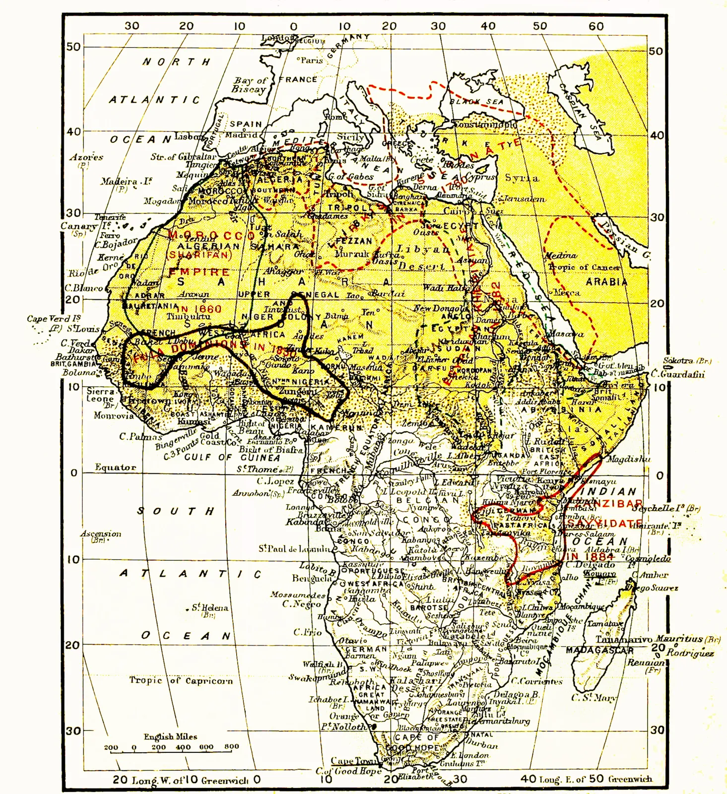
According to Arab tradition they came into Senegambia
originally from the Adrar country, far south of Morocco.
Some of their own traditions derive them from Fezzan, south
of Tripoli. Other slight indications lead us to suppose that they
formerly dwelt in Morocco and Algeria as—quite possibly—the
predecessors of the Libyans or Berbers, who will be dealt
with presently. The nearest affinities of the Fulde or Fula
speech at the present day are with the group of Mosi-Gurunsi
negro tongues spoken at the back of Ashanti and of Togoland.
There are also faint resemblances to Wolof, the language
of the handsome black-skinned Jolofs of Senegal, a mixed
race with an ancient Caucasian strain in their blood. In any
case the pure Fula is a handsome hybrid type, obviously
an early cross (in North Africa most likely) between the
13invading Caucasian of Europe and some ancient negro stock
of North Africa. The purer types of Fula have a skin no
darker than the average Berber, the face-features of a European,
and hair that is in curly ringlets. Their gradual invasion of the
Western Sahara, Nigeria, and Senegambia—in the south they
reached down to the Lower Niger and Yoruba-land, to
Baghirmi, and across the Benue to within a few days’ journey
of the Cameroons coast—may have been caused by the
peopling of North Africa some ten or more thousand years
ago by the Libyans or Berbers, a Caucasian people related
in speech and origin to the Gala and other Hamites of
N.E. Africa, and to the ancient Egyptians.
Four other negroid peoples require to be considered in
their effect on the colonization of Africa before we can deal
with the more clearly alien races. These are the Songhai of
Central Nigeria, the Mandingo of Western Nigeria, the Hausa,
and the Tibus or Teda.
The Songhai (Sughai, Songhoi—the gh is like the French
r grasséyé) are something like the Wolofs in appearance, in
that, though black-skinned and woolly-haired, their features
are often of Caucasian cast, and their characteristics generally
those of negroids rather than negroes. Their language (the
common speech of Timbuktu) is at present an unsolved
mystery, its affinities are unguessed at. The Songhai seem
to have dwelt first (where they still live under Tuareg influence)
in the Oasis of Agades, a country on the southern verge of the
Sahara, due east of the great Niger bend. Here they appear
to have received immigrants from Ptolemaic or Roman Egypt,
who brought with them Egyptian domestic animals and the
Egyptian style of architecture. This last they applied to
building in mud instead of stone. But, although much
modified since by Berber or Arab (Saracenic) influence from
the north, this massive Egyptian style of mud-built walls,
palaces, and mosques still prevails throughout northern Nigeria
from the Upper Niger to the vicinity of the Shari River.
14While the Songhai were extending their influence to the
northern bend of the Niger, the Mandingo peoples, from some
unknown place of origin, were fighting their way westwards
along the Upper Niger towards Senegambia. The Mandingos
and the Songhai met somewhere about the junction of the
Niger and the Bani, near the celebrated Jenné, which became
a great Songhai city in the 8th century. The Mandingo
negroids, who may have been connected with the ancient
N.W. African Kingdom of Ghana, early attained wealth and
power by opening up the salt and gold mines of the arid
country bordering on or within the Western Sahara. They
possibly carried on a trade thence with Romanized North
Africa. Southwards they got into touch with the gold-bearing
country of Ashanti; and it was perhaps through them that
Roman and Byzantine beads first found their way to Ashanti
and the Gold Coast. Sometimes the Mandingo empire prevailed
over the Songhai; latterly the Songhai dominated the
northern Mandingos, until both were swamped by the Moorish
invasion of the sixteenth century. Both alike showed themselves
very ready to receive Arab traders and the Muhammadan
religion.
The Hausa people are much more negro in their physical
appearance than the Mandingos or Songhai. But their
language, on the other hand, is imprinted with the white
man’s influence. Not only is it sex-denoting, but in pronouns
and in the peculiarity of indicating the feminine gender
by the consonant t it offers so many indications of ancient
Hamitic influence that we are entitled to assume that it arose
through an early invasion of Eastern Nigeria by people speaking
a Hamitic language. If there is any veracity in Hausa legends,
these Hamitic civilisers of the regions between the Niger and
Lake Chad came from Egypt; apparently they likewise penetrated
as far south as Baghirmi on the Shari and westward to
the Logone, where they assisted to create the sex-denoting
Musgu tongue. At one time it was thought that the evident
15“Libyan” element in Hausa came from the invasion of Central
Nigeria by the Berbers or Tuaregs[6]; but it now seems much
more probable that it was a Hamitic rather than a Berber
influence, and more probably came from the regions of Nubia
and Dongola where at one time a Hamitic language was spoken.
The Hausa people were probably already in existence, and their
“compromise” trading language had already been formed before
the Tuaregs or desert Berbers of North Africa had found their
way to the regions east of the Niger.
Indeed this region south of the Tripolitaine, from Fezzan
across the Tibesti mountains and the eastern Sahara to Lake
Chad, had become the domain of another remarkable negroid
race which has had much to do with the opening up and the
closing of negro Africa, the Tibu or Teda. Physically they
are an exact hybrid between Hamite and negro, and resemble
very much the more negro-like types of Somali; but their
language, which is cognate with the Kanuri of Bornu, a
kingdom first semi-civilized by the Tibu, offers no indications
of affinity with other African forms of speech; like
Songhai it is (so far as our existing knowledge goes) quite
isolated. The Tibu had much to do with the introduction
of iron weapons and implements and iron-working into negro
Africa. They seem to have reproduced the boomerang or
throwing-stick in iron, and thus to have originated those wonderful
throwing-knives which attained their highest development
in the north-central basin of the Congo. A notable stream of
Tibu culture (no doubt largely derived from ancient Egypt)
entered Congoland about 1500 to 2000 years ago, finding its
way up the Shari from Lake Chad, across the Mubangi and
16main Congo, and so down into the Bushongo country of
central Congoland. The old Bushongo language (now extinct)
was not a Bantu speech, but an unclassified tongue
with relationships to the forms of speech still current on the
Upper Shari.
Other civilizing negroid immigrants, Tibu or Hamite in
origin, appear to have drifted from the north-east into the
Bahr-al-Ghazal region and thence into N.E. Congoland,
where by mixture with the negroes they formed the remarkable
Nyamnyam and Mañbettu peoples, or at any rate
the aristocracies of those tribes. Farther east still we
have the remarkable Hima aristocracies of cattle-keeping
semi-nomads, very like the Fula in appearance and customs,
but always speaking pure Bantu languages. They would
seem to have been derived from an ancient Egyptian or
Gala origin.
Putting together the slender evidence we have as to the
prehistoric past of Africa at a period of, let us say, 10,000
years ago—evidence represented by stone implements, a few
skulls of ancient date, rock engravings in Mauretania, the
earliest archaeological remains in Lower Egypt—we may
hazard the following conclusions. At that period the coastal
fringe of North Africa from Morocco to Egypt was inhabited
by Caucasian or semi-Caucasian races allied in the west,
perhaps, to the Fula type, and in the east (Cyrenaica and
Egypt) to the Libyan or Berber. There may even then have
been the beginning of Semitic settlements on the Isthmus of
Suez and the Suez coast of the Red Sea. These same Libyans
or Hamites, at that period not strongly differentiated from the
Proto-Semites in race and language, and emphatically “white
men,” had probably also penetrated to the highlands of Abyssinia,
and by mixture with the precedent negroes and bushmen
were forming the modern Hamitic races. Some of these white
men (besides the more negroid Galas) had found their way
down the more open, less densely-forested east coast of Africa
17to Zambezia and South Africa[7]. But beyond this white fringe
of Northern and North-eastern Africa, the rest of the Dark
continent was then the domain of the negro in his Bushman
and black-skinned types. The Sahara desert was not such a
rainless region then as now, but was more habitable and
inhabited. On the other hand, much of Central and some
of Southern Africa was still under water, covered with as yet
undrained, unevaporated shallow lakes. The vast forests of
the centre and parts of the west may have been uninhabited
by man, afraid to encounter the chimpanzees and gorillas, the
leopards, pythons, and elephants which tenanted them. Then,
10,000 years ago, more or less, there came into the Nile
valley from the direction of Abyssinia the wonderful race of
the Dynastic Egyptians[8], whose original home seems to have
been, first, South-West Arabia, and next, the Danákil country,
the coast-line of Abyssinia. The Dynastic Egyptians were
apparently a composite type, mainly of Hamitic stock, impregnated
with an ancient negroid strain and tinged to some
extent with Mongol blood from the early Mongolian invaders
of Mesopotamia. Their language remains an unsolved problem
to this day. It offers decided affinities with both Hamitic and
Proto-Semitic, and yet contains puzzling elements of its own
which may be due both to negro and to Mongolian influence.
In the main it is an aberrant Hamitic tongue; but with no
very close resemblance to Gala or Somali, or to the Bisharin
dialects of Eastern Nubia. These (be it remarked) seem to
have been spoken for an enormously long period of time;
and possibly the Bisharin (Hamitic) natives of the Red Sea
coast-lands—Rudyard Kipling’s “Fuzzie-wuzzies”—were living
18where they now are when the dynastic Egyptians poured as a
Neolithic conquering host into the Nile valley in Lower Nubia
and made their way along the narrow ribbon of habitable
Egypt on either side of the Desert Nile.
The dynastic Egyptians found the Delta occupied by a
Libyan people, akin to the modern Berbers of North Africa.
At that period the distinction already existed between the
Libyan or Berber and the Ethiopian or Gala branches of
the Hamitic family. Amongst these Berbers of the Nile
Delta were still lingering Bushman or negro serfs. The
dynastic Egyptians mingled much with these Libyans of
North Egypt; indeed occasionally, in the early days of organized
Egypt, the Libyan race from the Western Desert
(which still lingers little altered in the Oasis of Siwah) invaded
Egypt and gave dynasties to that country. The dynastic
Egyptians ruled and populated the narrow valley of the Desert
Nile as far south as the first cataract, and also its broad delta
to the shores of the Mediterranean. South of the First
Cataract there was a mixed population of Egyptians, Hamites
and negroes of the Nubian race. Above the Second Cataract
the country of the Nile valley was, whilst dynastic Egyptian
rule lasted, entirely negro in population. It was not invaded
and settled by Hamites of the Bisharin stock until about the
period of Ptolemaic rule.
The dynastic Egyptians governed a small portion only of
the Red Sea coast, between the Gulf of Suez and Ras Benās
(Berenike). From ports at Kosseir and Berenike they sent
their fleets of galleys down the Red Sea and out into the
Gulf of Aden; and at a relatively late period of their long
(perhaps 6000 years) rule over Egypt, in about 1500 B.C.,
they despatched the first of several expeditions to the Danákil
coast and to Somaliland, in search of incense trees. Whether
Egyptian influence in unrecorded voyages proceeded further
down the east coast of Africa is doubtful; at any rate it is not,
so far, supported by any evidence. The Egyptians seem to
19have been somewhat timid navigators. Their sea-going galleys
depended more on oarsmen than on lateen sails; and, although
they may have found it comparatively safe to coast along the
Red Sea, they would be perturbed by the much rougher,
stormier waters of the Gulf of Aden; while the Indian Ocean,
with its strong monsoon winds and big billows, would prove
very unsafe for their unseaworthy ships. Their civilizing,
“Caucasianizing” influence over negro Africa was however
considerable, though probably not exercised with any effect
until the real Egyptian dynasties were passing away and the
land of Egypt was becoming a region doomed to be ruled by
foreigners—Assyrians, Persians, Greeks, Romans, Byzantines[9].
Egyptian trade, even as far back as 3000 or 4000 years before
the Christian era, was penetrating through Nubia to Kordofan
and Darfur, Bornu, Tibesti, Agadés and the Niger; or down
into the Bahr-al-ghazal and the countries of the Mountain Nile
where the pygmies still dwelt. Hamitic peoples and Semitic
colonists in Abyssinia and Northern Galaland were in touch
with the Egypt of the last dynasties and the Egypt of the
Ptolemies, and pushed a trade in Egyptian goods inland as
far as Mt Elgon and the shores of the Victoria Nyanza. Their
ancient, blue, Egyptian beads are dug up occasionally in the
sub-soil of Kavirondo. Egyptian or Gala adventurers appeared
(outcasts, criminals, or mutinous soldiers in origin, it may be)
in the lands of savage negroes about the sources of the Nile.
They were looked upon as demi-gods; and their descendants
to this day (with a strikingly Pharaonic physiognomy) are often
called by a name which means “spirits,” “white men,” or
“gods.” They, or traders whom they attracted, brought with
them the domestic animals of Egypt and the cultivated plants,
besides a knowledge of metal working.
Is it generally realized that the whole of negro Africa,
20south of the Northern Sahara, received its first and its principal
domestic animals and cultivated plants from Egypt, and
Egypt only? The ox, long-horned and straight-backed, or
shorter-horned and humped, an Asiatic, and not a European
ordanese goat (not the long-eared, polled, fleecy Nubian goat
of after-development); one or more breeds of dog; the domesticated
Nubian ass; the domestic fowl—all came from Egypt.
In vegetable food-stuffs there were the jowari or sorghum grain
(Andropogon), the eleusine, the Pennisetum millets, the taro
“yam” (Colocasia aroid), various peas and beans, and gourds
and pumpkins. From Egypt came ideas as to boat-building
which penetrated as far south and west as the Victoria Nyanza,
Lake Chad, and the Northern Niger; also methods of hut-building
and the ambitious mud-architecture of the Nigerian
Sudan, a hint or reflection of which penetrated even to the
Niger delta, the Northern Cameroons and Congo. Simple
articles of furniture, such as carved stools, head-rest pillows,
musical instruments (lyres, drums, harps, xylophones, zithers),
games of the cat’s-cradle and backgammon type, weapons
(shields, improved bows, slings, lances and battle-axes), found
their way into the heart of negroland; though many of these
inventions got no farther south than Uganda and the central
basin of the Congo, or south of the northern Niger.
Two other elements in the pre-historic colonization of
Africa require mention at this stage—the Semitic and the
Malay. “Semitic” and “Hamitic” are useful terms which apply
exactly to two distinct types of sex-denoting languages; languages
which conceivably had a common origin very far back
in time—12,000 years ago or more?—somewhere in southwest
Asia, perhaps not far from Caucasia or Armenia. But
in a looser sense we apply Semitic and Hamitic to physical
types, and speak of a Semitic profile and the dark Hamitic
complexion and curly hair. “Hamite”—or, more correctly,
Kushite—applies without much inconsistency to the physical
21type which speaks the Eastern Hamitic languages[10]—yellow or
brown in skin colour, with the handsome features and straight,
thin noses of the better-looking Caucasian, and bushy, black
hair which betrays the ancient negro intermixture by its curliness.
The Kushites are in fact descended from Libyans
(Berbers) who have mingled in North-East Africa with negro
races. The whiter Libyans passed on westwards to colonize
the southern and north-western shores of the Mediterranean,
while the Hamites populated Middle and Eastern Egypt,
Abyssinia, and Galaland; from which direction their nomad
wanderers as hunters and herdsmen permeated all Eastern
Africa in ancient times. The Hamitic languages are akin to
the Libyan, though the two groups are widely separated in
affinities of vocabulary, and must have diverged from a
common origin in North-Western Arabia ten or more thousand
years ago.
It is far less easy in the case of the Semites to define a
physical type associated with the speaking of Semitic languages;
as difficult, indeed, as to postulate the corporeal form of the
men who originated the Aryan tongues. The Aramaic type so
familiar to us in the typical Jew is akin to the old Assyrian;
and the Assyrian was probably a compound of Armenian and
22Mediterranean man mixed with the old negroid peoples of
Southern Persia. The Arabs of Arabia are in the north very
“Nordic” in appearance, and evidently exhibit the results of
ancient invasions of Syria by peoples akin to the Teutonic or
blond Aryan type; others again show the hooked “Semitic”
nose of the Armenian or the long nasal organ of the average
Persian; while in the natives of Southern Arabia there is a
Hamitic, Gala-like strain, besides the general underlying stratum
of that hypothetical small-bodied, big-nosed white Neolithic
race which is associated with stone-worship and megalithic
stone-building, and is perhaps the basis of the Mediterranean
type of man. Curiously enough, there is not any evidence as
yet of an ancient negro peopling of Arabia, such as exists in
regard to Algeria and Egypt, and Southern (Elamite) Persia.
These varying and composite races speaking Semitic tongues
appear to have travelled south and west from Syria and Arabia
on the heels of both Libyans (Amorites) and Hamites, and
even to have settled on the Red Sea coast of Egypt at a very
early period before the dynastic Egyptians had conquered the
Nile valley. Much later they invaded Lower Egypt in force
as the Haqshu (Hikushahu) or Shepherd kings—if these are
rightfully identified as speaking a Semitic tongue. Still later
they began to cross the Red Sea farther south and colonized
Abyssinia and even Somaliland. In these regions (Abyssinia
and Harrar) their Semitic tongues remain to this day. Perhaps
as early as 1000 years before the time of Christ (at a guess)
their ships, more seaworthy than those of the Egyptians, found
their way from the ports of the Sabaean, Minaean and Himyarite
kingdoms to India, to the Zanzibar coast of Africa, and to the
north end of Madagascar and the Comoro Islands. Later, in
all probability, than the first Minaean ventures along the East
African coast was a more authentic voyage of the Phoenicians,
which will be mentioned in the next chapter.
Attention should be given at this stage in our survey of
the ancient colonization of Africa to the unsolved mystery of
23the Rhodesian ruins—the stone-built forts, the aqueducts,
round towers, stone-embanked hill-terraces, stone-lined pits,
rock-mines, and buildings which suggest the name of “temple.”
These ruins (in and under which have been found beautiful gold
ornaments, ingot-moulds, strange, sculptured birds—eagles or
vultures—at the ends of long soap-stone monoliths, and stone
phalli) dot the surface of Southern Rhodesia somewhat thickly.
They seem to radiate, as it were, from the head streams of
the Sabi River, in fact from where the most wonderful of all
these ruins, Great Zimbabwe, is situated. The northernmost
of the clusters of ruins of stone buildings is to the north of
Mt Hampden and the modern town of Salisbury; but none
of these strange remains of an unexplained civilization are
found anywhere near the Zambezi. It would seem that the
unknown people to whom the really antique and skilfully
built among these towers, temples, and labyrinthine fortifications
(and not their more modern, negro-made clumsy imitations)
are to be ascribed, entered south-east Africa at or near the
old Arab port of Sofala and made their way up the Sabi river.
The ruins are all situated on lofty tablelands or mountain
ridges, in healthy, cool country. Their existence was noted
by Arab writers so early as the 10th century A.C.; and they
were described as old and partly in decay when first seen by
the Portuguese in the 16th century. The name “Zimbaoe,”—like
the modern Zimbabwe—applied to them in Portuguese
writings is simply a local Bantu plural word meaning
“stones”; but these Zimba or Zimbabwe came to be specially
associated with the remarkable negro kingdom or empire of
Monomotapa[11] which existed in this part of south-east Africa
from the time the Islamite Arabs settled anew at Sofala in
the 10th century A.C. down to the early 19th century, when it
24was apparently finally extinguished by the invading Zulus from
the south. From this region may have come the conquering
hordes of the “Ba-zimba” who are thought to have crossed
over into west Madagascar, and who passed ravaging and
slaying up the east coast of Africa—very much after the style
of the later Angoni-Zulu raids—in the late 16th century,
temporarily effacing the Portuguese hold over Mombasa.
The Rhodesian stone buildings are obviously associated
with gold-mining; but they must have been centres of somewhat
elaborate agriculture, and of a phallic worship (the phallus
being, together with the associated cylinder or lingam, a sacred
symbol of a religious belief which prevailed once in Egypt,
India, and ancient Arabia and Syria). Phallic worship, for
example, was carried by the Phoenicians to southern Tunis—no
doubt to Carthage and elsewhere; but its symbols happen to
have survived in actual use in southern Tunis to the present
day. The masonry of the Zimbabwe type of building (the real
old kind, not the modern negro imitation) displays remarkable
skill in the shaping and placing of stones in courses, all much
of the same size. The masonry is without mortar, but the
stones fit fairly closely in their horizontal, accurately-laid
courses; and in the round buildings the symmetry is
remarkable.
What race raised such monuments and was gifted with so
much civilization at a period which is certainly antecedent
(in the really ancient types of building) to the 10th century A.C.?
Was it the Arabs from southern Arabia, who were settled on
the East African coast before the Christian era? This seems
probable. The Zimbabwe ruins yield no ornament, no detail
whatever of the Saracenic style, and (so far) no inscription of
any kind in any language. There is nothing whatever about
them to suggest their having been built by Islamic Arabs;
everything to the contrary, as certainly these Arabs would not
have carved either birds or phalli. There are suggestions here
and there of Indian influence. The buildings of the true
25Zimbabwe style are certainly pre-Islamic or have been associated
with a people which ignored Islam. They resemble most
nearly the works of the Phoenicians and the southern Arabians,
from any date between 1000 B.C. and the early part of the
Christian era. The round conical towers are like those of
Sardinia and Ireland and other ancient haunts of the enterprising
Phoenicians. Yet there is nowhere any inscription in
the Phoenician, Hebrew, Sabaean or Kufic or other ancient
eastern alphabets, though according to Portuguese traditions
inscriptions in unknown characters did exist at Zimbabwe;
and no skull has so far been dug up from beneath the ruins
or in close association with them or the ancient gold-workings
which is not of the ordinary Bantu negro type. No ancient coin
has been found; all the pottery, porcelain, and glass fragments
indicate comparatively modern oriental ware which might have
been introduced at any date between the 15th and the 17th
centuries. Yet most of these last discoveries, though made
at a considerable depth below the surface under the oldest
ruins, come from places where they might have been buried
in recent times, and do not really militate against the theory
that the finest masonry work of Zimbabwe and kindred
establishments dates from a period of 2000 years ago or
earlier.
No one who really knows the negro of Africa, south of
the Sahara desert, can easily believe that the hundreds of
stone-built towns, villages and forts of ancient appearance in
southern Rhodesia were built, unaided and uninspired, by a
pure negro race, or doubt even that these works (I am
referring to those of perfect construction) were the outcome
of some foreign invasion of south-east Africa at a period of
unfixed history prior to the 7th century of the Christian era.
We know of no negro, scarcely any negroid, race of Africa
which, left to itself and of its own inspiration, has taken to
building in stone. The great metal-working tribes of the Congo
basin which developed a really remarkable native art—the
26Bushongo, for example, a race more negroid than negro—nevertheless
ignored stone as a building material or an object
of worship. Between southern Congoland or Nyasaland on
the north and Mashonaland on the south nothing has ever
been discovered hitherto which indicates the existence in
former times of a stone-building race of negroes or negroids,
or of the path followed through the, until recently, barbarous
regions of Zambezia and Moçambique by the possible ancestors
of the people who built the Zimbabwe and similar monuments.
The resemblance between the round towers of Rhodesia
and the primitive, conical, round minarets of the old mosques
at Lamu, Malindi, Mombasa, and other places on the East
African coast (dominated by Arabs for at least 2000 years)
is very striking. Both may date from the pre-Islamic period.
There are other analogies between the Rhodesian ruins and
the ancient buildings of pre-Islamic Arabia which suggest, as
the most probable explanation of this mystery in African
colonization, that the ancient gold-miners, phallus- and sun-worshippers,
irrigators, terrace-cultivators of Matebele- and
Mashonaland, were likewise Arabs from some part of western
or southern Arabia who penetrated inland from Sofala attracted
by the signs of gold. After a century or so of profitable
gold-mining in a land which had only then a spare Bushman
population, the Bantu hordes from the north descended on
these Semitic colonies and eventually exterminated or drove
away the Arabs, taking their place clumsily as gold-miners
and builders. Although the Arabs never regained their position
in the interior, they continued or resumed their occupancy of
the south-east African coast-line down to the arrival of the
Portuguese. Probably also the Tsetse fly, by its interference
with the means of transport, was another deterrent factor in
the history of this colonization which failed to spread. It is
possible, nevertheless, that Madagascar and Bantu East Africa
owe to these hypothetical, unnamed, prehistoric Arab colonizers
not only the introduction (indirectly from India) of the edible
27banana or plantain, which afterwards spread right across the
continent, but also the long-horned, straight-backed Egyptian
ox, and the domestic fowl; hemp perhaps likewise, a “smoking
mixture” which preceded tobacco by many centuries.
One of the greatest mysteries in the prehistoric past of
Man is the Malayan colonization of the large island of
Madagascar. Madagascar lies off the east coast of Africa at
a minimum distance of 300 miles. Between the north-west
corner of the island and the East African mainland lies the
archipelago of the Comoro islands, which assist to some extent
to bridge the interval. So far as our researches go, there is no
evidence in Madagascar of ancient human inhabitants. The
island was probably uninhabited by man until the arrival of
the Malagasy from Sumatra or Java, though, more or less
simultaneously, negroes from eastern Africa were arriving on
the west coast of Madagascar, either in their own canoes, or
more probably in the sailing vessels of the Arabs who were
trading up and down the east coast of Africa from perhaps
as early as 1000 B.C. But the unsolved problem is,
How did the Malagasy tribes reach this island at different
periods between an approximate 500 B.C. and 500 A.C.? Their
language affinities[12] show that they must have come from
Sumatra or Java. Physically the Malagasy of pure race—like
the Hova tribes—unmixed (as so many of them are along
the eastern side of the central plateau) with negro, Indian, or
Arab blood, resemble pretty closely the Malay types of Sumatra
and Java. We can understand the Malay and Indonesian
conquest of Oceania. In the relatively calm, island-studded
Pacific Ocean it is not an impossible task for men to sail on
28from island to island in large canoes with outriggers and decks,
and with masts and sails, and thus to reach in their migrations
to within 2000 or 3000 miles of North or South America, and
5000 or 6000 miles from their starting-point. But it is a
different matter to cross in a direct line the whole breadth of
the Indian Ocean from Java or Sumatra to Madagascar, with
no convenient islands to halt at by the way. It is true that
there is the little Chagos group, leading to the Mascarene
archipelago of Mauritius, Réunion and Rodriguez; but on no
one of these islands has there been found any trace of the
former presence of human inhabitants before the arrival of the
Portuguese, Dutch, and French. It seems more probable
therefore that the excursions and adventures of the Sumatran
and Javan Malays (inspired to some extent as they may have
been by the mysterious Indonesians coming from Indo-China,
who settled at some unknown date in Sumatra and the more
eastern islands of the Malay archipelago, and were the progenitors
of the Polynesians) first took a western direction in
crossing the Bay of Bengal to Ceylon and southern India;
thence passing on to the Maldiv archipelago, and so to the
Seychelles and farther to the Almirante Islands and the north
end of Madagascar. But there is very little evidence of a
positive nature to support this theory, except it be the slightly
“Malay” look about the people of the Maldiv group and the
scanty remains of ancient human settlement which are undoubtedly
to be found in the larger Seychelles Islands; though
these had long been uninhabited when rediscoveredrediscovered by the
Portuguese and French. It seems, however, almost impossible,
that repeated colonizations of Madagascar should have taken
place by direct voyages from Sumatra or Java (at a period
from 2500 to 1500 years ago) by adventurous Malays starting
forth in outrigger canoes for an ocean journey of about
4000 miles. How did they know Madagascar awaited them
on the other side of that tremendous interval? It is much
more likely that they passed on by degrees from point to
29point in their western migrations; first to Ceylon, then to
the Maldiv Islands (this name, like some other place and
tribal names in South India, suggests affinity with “Malay,”
“Malagasy”), and so on to the Seychelles, Almirante, Aldabra
and the Comoros. But, if so adventurous, why did not these
Malagasy Malays also colonize the east coast of Africa? If
they ever did so, there remains not the slightest trace of their
presence in either the physique or the languages of the present
inhabitants. There are, it is true, outrigger canoes in use at
Zanzibar which may derive from some occupation of that
island by Malagasies on their way to Madagascar; but
Zanzibar, though only twenty miles from the mainland, is
very distinct from East Africa. Its original inhabitants, when
it was first examined by Europeans, belonged to only three
types—negroes, Arabs, and Indians. There is evidence,
however, of a scattered and varied character, that intercourse
for trading purposes between China, India and Persia on the
one hand, and South Arabia and Zanzibar on the other is as
old as the beginning of the Christian era. Himyaritic-Arab
intercourse with the Malagasy of north Madagascar must be
at least as old as that; to judge by a variety of indications,
it is certainly pre-Islamic.
The west coast of Madagascar may have been already
peopled by negroes from East Africa who had crossed over
by the route of the Comoro archipelago[13]. But, if so, these
last must have been assisted or compelled to make the attempt
30by some superior seafaring race coming from the north, Arab
or Phoenician, because there is no evidence that the East
African negroes have ever been great navigators or have
possessed in earlier times any means of embarkation better
than dug-out canoes propelled by paddles; and it is difficult
to believe that in such unstable vessels they could cross a
broad strait of rough sea between East Africa and the Comoro
Islands. It is easier to suppose that the large negro element
of Bantu origin which exists in north-west Madagascar was
brought there within the last 2000 years by Arab ships, before
and after the days of Islam. The negro colonization of this
large island could not have been helped by the persistence
of some land-bridge, some Comoro isthmus which has since
broken down; for along such an isthmus would have come
many African beasts, birds, and snakes, which are totally
absent from Madagascar[14]. With only a narrow strait to cross,
negroes or Bushmen might have passed over to Madagascar
in canoes or on rafts. The Comoro Islands, when first discovered
by Europeans, were (as now) inhabited by Arabs and
a race of Bantu negroes, speaking dialects related to the
Swahili of Zanzibar. But these may have been brought there
centuries before by the Arab ships. It is probable that there
was no Malagasy settlement of the Comoro archipelago until
the 19th century.
Another curious feature in this Malay colonization of
Madagascar is that, once having reached this great island, the
Malagasy immigrants appear to have completely renounced
their seafaring life, to have maintained no sea-going vessels
of any size (though they had and have still neatly made
31outrigger boats), and never to have voyaged anywhere from the
coasts of their new home. Otherwise they could not have
failed to discover and colonize Mauritius or Réunion. In
many of its aspects the colonization of Madagascar in prehistoric
times by a race coming obviously from Sumatra or
Java and allied in physical type and language less to the
Malays than to the Malayo-Polynesians and even to the
darker Melanesians is perhaps the most puzzling of the unsolved
enigmas to be found in the study of the peopling of
Africa by foreign immigrants. Judging from local traditions,
from time to time fleets of canoes containing Malays were
blown right across the Indian Ocean to the east coast of
Madagascar. Such was—it is said—the history of the Imérina
or Hova tribes who originated mainly from the last accidental
Malay colonization of Madagascar. These Hovas found the
coast belt so unhealthy that they made their way inland to
the high plateaus of Imérina. Here, after long isolation, they
acquired strength from their invigorating climate and, obtaining
arms from the Europeans in the 17th and 18th centuries, spread
over Madagascar as conquerors and brought nearly the whole
island under their rule. Yet the Sakalavas, the dark-skinned
remnant of a far earlier Malaysian invasion, spoke a dialect
nearer to the actual Malay than that of the Hova. It remains
to be said that the strong negroid element of Madagascar is
attributed by some authorities to Melanesian colonists from
Malaysia of a relatively ancient date and not to negroes from
Africa. There are numerous Melanesian words in the Malagasy
language.
CHAPTER II THE MEDITERRANEAN COLONIZATION OF AFRICA
32
The historical colonization of Africa by alien peoples (if we
regard the dynastic Egyptians as autochthonous) commences
with the exploits of the Phoenicians in Mauretania. This remarkable
Semitic people, no doubt akin to the ancestors of the
Jews in race and language, is believed to have originated on
the S.W. shores of the Persian Gulf, and at a period of some
remoteness—perhaps four thousand years ago—to have made
its way up the Euphrates and across the Syrian Desert to the
coast of the Mediterranean, where eventually the great trading
cities of Tyre (Tsur or Ṣor), Akko, Saida or Sidon, Sarepta,
Arvad or Ruad, Biruta or Biruna (Beirūt), etc., were established
mostly on islets off the Syrian coast which eventually grew into
peninsulas. From these strongholds their galleys ranged the
Mediterranean and reached the North African coast, the
Straits of Gibraltar, and the open Atlantic Ocean. By about
the twelfth century before Christ the Phoenicians from Sidon
had established trading stations at Utica (Atiqa) at the mouth of
the Majerda River in North-East Tunisia, and at Lixus on the
coast of Morocco (perhaps mouth of River Draa, opposite to the
Canary Islands). At the same period—perhaps earliest of all—Gades
(Cadiz) was founded as a Sidonian colony at the mouth
of the Guadalquivir in Southern Spain. Carthage (Kart-hadshat
or Kart-hadasht = the New City), afterwards the Phoenician
metropolis in North Africa, did not come into existence till
33about 822 B.C. It was a settlement of the Tyrians on the west
side of the Gulf of Tunis not far from Utica on the Majerda
River, and was called the New City in contrast to Utica the
“Ancient” (Atiqa). The Tyrians and perhaps the Phoenicians
from other sea-cities also created trading depôts on the Cyrenaic
and Tripolitan coast, thus coming into contact with the
Egyptians. But from the seventeenth to the twelfth century
before Christ the Phoenicians had been under the overlordship
of Egypt; and it was only when the Egyptian power began to
weaken that the great ships built at Sidon and at Tyre from
the timber of Cyprus and the Lebanon dared to found African
colonies immediately to the westward of Egypt.
Long afterwards, in the days when the strength of the Phoenicians
was itself to decline in the grip of the Assyrian kings,
these bold navigators hired themselves and their ships to the
rulers of Egypt for naval transport and geographical discovery.
In about 600 B.C., according to the story of Herodotos, the
last but three of the native Egyptian Pharaohs, Niku (Necho) II,
summoned a captain of the Phoenicians whose ships were
stationed in the Gulf of Suez (perhaps conveyed thither from
the Mediterranean through some canal between the Nile and
the Bitter Lakes), and despatched him in command of an
expedition of two or three vessels, with the order to attempt to
sail round the peninsular continent of Africa and through the
Straits of Gibraltar back to the Nile Delta. Very likely the
ship-masters from South Arabia had already spread the news
that the east coast of Africa trended steadily westwards beyond
the equator, and had guessed that Africa was circumnavigable
from the land of the negroes on the east back to that land of
black men on the west of which the Carthaginians were beginning
to spread some dim foreknowledge from their journeys
southward along the Morocco and Sahara coasts.
This Phoenician expedition accordingly set out, and in
about three years’ time had circumnavigated Africa and re-entered
the Mediterranean through the strait which separates
34Morocco from Spain. Somewhere off the southern coast of
Africa they had landed, sown grain and waited in the southern
summer (our winter) till it matured and ripened. Then they
reaped their harvest and continued the voyage, not willingly
losing sight of the coast, no doubt, yet landing as seldom as
possible (we may imagine) in their justifiable terror of savage
tribes and fierce wild beasts. The account given in Herodotos
is very bare. Only one experience of these Phoenician pioneers
is given, other than the corn-growing; they are said during the
(northern) summer season to have had the sun on their right
hand—that is to say, in the north of the sky at mid-day. This
observation shows at any rate that these Phoenicians had
sailed far enough south to have reached the south temperate
zone wherein the sun would always be in the northern sky at
mid-day; while the ship’s general east-to-west course round
the southern extremity of Africa would place the sun on the
right hand of a spectator facing the west.
All the minor geographical discoveries of this expedition
have been lost to us, if any were recorded. No mention is made
of the gold of south-east Africa, of any Arab settlements along
the east coast, of the negro inhabitants of these wild regions,
or the means by which the Phoenician mariners supplied themselves
with food to supplement the corn which they grew and
reaped. It would not have been difficult for them, coming
from the east, to reach the southern extremity of Africa, and
still less difficult if there really were Arab stations at which
they could recruit in the vicinity of Sofala and Inyambane.
The story, by no means an incredible one, rests almost entirely
on a statement of Herodotos, but was thought to have received
fresh support from records of the events of the reign of Niku II
which were said to have been discovered in the collection of
a French Egyptologist. These inscribed scarabs are however
now believed to be clear forgeries[15]. There is nothing
35improbable about this legend of the Phoenician east-to-west
circumnavigation of Africa. The winds and currents, be
it observed, would make it much easier for sailing ships to
circumnavigate Africa from the east coast round to the west
coast, and then north, than in the reverse direction; and it
is curious to note, among other shreds of historical record,
that a Persian nobleman of Egypt in the sixth century B.C.
and the Carthaginians of the same period both tried to sail
round Africa from Morocco past the West coast, and gave up
the enterprise as too difficult and tedious.
There has been transmitted to us through the diligence
of ancient Greek geographers the Greek version of what is
supposed to be the original description in Punic of the voyage
of Hanno the Carthaginian. This Punic explorer started from
Carthage some time in the sixth century before Christ (perhaps
about 520 B.C.) with a fleet of 60 ships, and a multitude of men
and women (said to have been 30,000 in number), on a voyage
of discovery mainly, but also for the purpose of replenishing with
settlers the Carthaginian stations along the coast of Morocco.
In the account given of the journey it is stated that, after passing
the Straits of Hercules and stopping at the site of the modern
Sebu, they rounded Cape Cantin and came to a marsh in which
a large number of elephants were disporting themselves[16].
36They then continued their journey along the coast till they
came to the river Lixus, which has been identified with the
river Draa. From here they coasted the desert till they
reached what we now call the Rio de Oro, and on an islet
at the head of this inlet they founded the commercial station
of Kerne. From Kerne they made an expedition as far south
as a river which has been identified as the river Senegal,
having first visited the Lagoon of Teniahir. Once more
setting out from Kerne, they passed Cape Verde, the river
Gambia, and the Sierra Leone coast as far as the Sherboro
inlet, which was the limit of their voyage of discovery. Here
they encountered “wild men and women covered with hair”—probably
the chimpanzees, which are found there to this day,
and not the gorilla, which is an ape, restricted in its westward
range to the Cameroons. As Hanno’s interpreter called
these creatures “gorilla,” that name was fancifully given in the
nineteenth century to the huge anthropoid ape discovered by
American missionaries in the Gaboon. When Hanno’s expedition
visited the neighbourhood of the Senegal river they
were attacked by the natives, who were described as “wild
men wearing the skins of beasts and defending themselves
with stones.” So far as we know, this was the first sight that
civilized man had of his wild Palaeolithic brother since the
two had parted company in Neolithic times, except for glimpses
of the Troglodytes, whom the Carthaginians appear to have
met with in the valley of the river Draa[17].
37At Kerne and other trading stations on the coast to the
south of Morocco, the Carthaginians did no doubt a little trade
with the Berber natives in the produce of the Sudan, south of
the Sahara, but after a time the weakening of the power of
Carthage and the attacks of the natives must have destroyed
most of these West African settlements; for the Romans in
replacing the Carthaginians do not seem to have gone further
south than the river Draa.
During the eighth century before the Christian era the
Tyrian and Sidonian colonies in North Africa and Spain began
to detach themselves from any political submission to the
Phoenician State in Syria, a kingdom then much harassed by
the Assyrians and henceforth doomed to lose its independence
under the alternate sway of Egypt, Assyria, Chaldaea, Persia,
and Macedonia. Carthage became the metropolis of Western
Phoenicia, of the Canaanite[18] settlements in Berberland and
Iberia. The North African coast was dotted at frequent intervals,
from Leptis (Lebda) in Tripoli to the mouth of the Draa
on the Atlantic coast of Morocco, with Canaanite trading or
governing cities. More especially was the Tunisian or African[19]
38coast under their domination, from the Island of Meninx-Jerba
(the land of date-palms and Lotos-eaters) to what
is now called Bona in Algeria; this last being one of the
several towns anciently named Ubbo or Hippo. One such
was the modern Benzert (Bizerta), the Hippo-Diarrhytos of the
Greeks and the Hippon-Zaryt of late Roman and Byzantine
times.
From Carthage, the metropolis, there ran a causeway, of
which traces still remain, up the valley of the Majerda river
(the Bagradas of old times) to the date-palm country, the
fruitful land of the shallow salt-lakes and the hot springs—a
region which is some day going to be of the greatest importance
in North Africa for its medicinal waters, its never-failing
springs of sweet water, its fertile soil and genial climate. The
Carthaginians also held from time to time desert cities of
commanding position in what is termed the Matmata country,
between the land of the “Shatts” or lakes and the Tripolitan
frontier. But it is doubtful even here if Carthaginian rule
extended as much as 100 miles inland; and elsewhere in North
Africa, away from Tunisia, the Carthaginians only held what
they occupied. At the least weakening of their power the
Berber tribes were ready to revolt and take part with their
enemies. The Carthaginian troops were mainly recruited in
Barbary, and were mercenaries. They frequently mutinied
and turned against their Syrian employers. Yet occasionally
Carthage produced a man like Hannibal who could win the
confidence of these Berber soldiers and lead them to fight the
battles of Carthage in Spain, Sicily, and Italy. But in the
outlying districts of North Africa, especially in Morocco,
tradition states that the Berbers occasionally rose as a nation
and destroyed the Carthaginian settlements.
The Phoenicians introduced Syrian ideas of religion into
North Africa, more especially the worship of Baal-hammana
(the Lord Ammon) or Milk (Moloch, the “King”), to whom
human sacrifices were offered; Tanit, the “Face of Baal,” the
39virgin goddess of the moon, a variant of the Syrian Astarte;
Ashmun, the God of Healing (Æsculapius); Rashūf, the
Flame, Fire, or Lightning God (= Apollo); Baal Milkkart,
the “King of the City” identified with Hercules; Tammuz
or Adonis (a beautiful young man); Pateχ, a hideous dwarf
god; Rabbat Amma, the “Lady Mother,” a goddess like
the Greek Cybele. These religious ideas became associated
in southern Tunis and Tripoli with the worship of the
phallus as a symbol of life-giving, creative power, and so
powerfully tinged the mentality of the indigenes of this region
that down to the present day there are schismatics in Islam
(especially in the Island of Jerba) that erect small phallic
temples and shrines, or crown with a phallic symbol every
minaret. It is here, as well as in the fifth- and sixth-century
buildings of south-eastern Syria, dating from the early days of
Byzantine architecture, that one may trace the evolution of
the mahrab (mihrab) or holy shrine of the Muhammadan
mosque from the hollow phallus, into which the country people
of Jerba enter to say their prayers. This cult once existed in
western Arabia, and it is remarkable to find such distinct
traces of it in the ruins of Zimbabwe in south-east Africa.
The Phoenicians being used to the tamed “Indian” elephant
in Syria—a region in which there were wild Indian elephants
down to about the time of the Phoenician settlement of the
Syrian coast—brought about the taming of the smaller African
elephant in North Africa. Probably they also introduced Syrian
breeds of horses, cattle, and pigs, though the sheep and goats
of Mauretania seem rather to have been derived from Spain.
They brought thither the Syrian greyhound and perhaps
some other breeds of dogs; but not the white, wolfish dog of
the Berber nomads, which came from Europe. To these
beauty-loving Tyrian mariner-merchants is due the early introduction
of the peacock into North Africa. It is still a common
domestic bird in Tunisia, and figures on old inscribed stones,
even far away in the desert, which date, seemingly, back to
40Carthaginian times. The Phoenicians probably brought with
them, likewise from Syria, the cultivated vine, olive, fig, and
pomegranate.
Compared with the Romans, the Carthaginians did little to
open up the interior of North Africa, except in what is now
called Tunisia. Trade with the outer world was restricted by
jealous monopolies; but the Phoenician language was nevertheless
much impressed on North Africa, and became the accepted
means of intercommunication among the more civilized
tribes between Tripoli and Western Morocco. Indeed the
Phoenician tongue, closely akin to Hebrew and not very far
removed from Arabic, is believed to have lingered all through
the subsequent Roman occupation of Africa and only to have
disappeared completely under the invasion of Arabic, the
immediate consequence of the Arab conquest in the seventh
century of our era. Even then it is considered that some
Phoenician words remain incorporated in the Arabic dialects
of Tripoli and Tunis and especially in Maltese; Malta having
also been occupied by the Carthaginians. The Jews, who
settled so abundantly in North Africa both before and after
the fall of Jerusalem, brought thither the influence of Hebrew
and of Aramaic, and contributed to Semiticise North Africa in
language and religion. So that Carthaginian rule paved the
way for the Judaizing of certain tribes, before and after the
Roman empire ousted Syria for a time as a colonizing agency;
and the use of the Phoenician tongue down to the seventh
century A.C. in the villages and smaller towns of the Tunisian
coast-belt undoubtedly prepared the way for the rapid and
wide-spread acceptance of Arabic a hundred years later. Amid
all their wrangles, throughout all the recorded history of
North Africa, Berber and Semite seem unconsciously to have
recognized that by descent and language they had more kinship
with each other than with the Aryan peoples.
The Jews, after the first century of the Christian era,
settled numerously in North Africa from Cyrenaica to Western
41Morocco. They are believed to have preceded the Berbers
in settling the oasis of Twat in mid-Sahara, and other oases
of the desert also; though they probably found these habitable
regions still retaining a negroid population.
The earliest historical connection between Aryan Europe
and Africa was brought about by the Greeks, commencing
some 600 years B.C.[20], who settled in the country of Kurene
(Cyrene), the modern province of Barka. After the repulse of
the Persians there was a great expansion of Greece. Prior to
the historical establishment of settlements in the Ionian
Islands, in Sicily, at Marseilles and on the east coast of Spain,
Greek seamen had no doubt ranged the coasts of the Mediterranean;
and from their adventures were evolved the fascinating
stories of the Argonauts and Ulysses. Prehistoric settlements
of Greeks on the coast of Tunis are believed by modern
French ethnologists to have taken place, on the strength of the
well-marked Greek type to be found amongst the present
population, for instance, in the Cape Bon peninsula; but
these Greek types may also be descended from the Byzantine
occupation of the country in the Christian era. The
Island of Lotos-Eaters, of Greek mythology, would seem
with likelihood to take its origin in the island of Jerba,
where the date palm is indigenous[21]. But about 631 B.C. an
expedition of Dorians from the island of Thera[22] founded the
colony of Kurene on the north coast of Africa, where that
continent approaches closest to the Greek Archipelago. The
settlement of Kurene was situated about ten miles from the
42sea at an altitude of nearly 1800 ft. on the forest-clad Aχdar
mountains. Around Kurene (a name corrupted to Grenna by
the Arabs) were grouped four other cities—Barke, Teuχeira,
Euesperides, and Apollonia. This Greek colony continued to
exist with varying fortunes—threatened at times with dissolution
through the civil wars of the colonists and the intermittent
attacks of the Berbers—till it came under the control of Rome
100 years before Christ. It was occasionally dominated by
the Greek dynasty of the Ptolemies in Egypt. Though the
civilization of the Cyrenaica was finally extinguished by the
disastrous Arab invasion in the seventh century of the Christian
era, it had nevertheless received a death-blow in 117 A.C. by
an uprising of the Jewish settlers, who attacked the Graeco-Roman
colonists with the help of the native Libyans and slew
more than 200,000 of the descendants of the Greek and
Italian invaders. The Jews in their turn were massacred, and
after that most of the Cyrenaic cities fell into decay.
In the adjoining country of Egypt the Greeks began to
appear as merchants and travellers in the seventh century B.C.
A Pharaoh, Psammetik I, the father of the Niku who sent
Phoenician ships to circumnavigate Africa, had employed
Greek mercenaries to assist him in establishing his claims to
the throne of Egypt. He rewarded their services by allowing
their countrymen to trade with the ports of the Nile delta.
The city of Naukratis was founded not far from the modern
Rosetta, and became almost a Greek colony. Nearly 200
years later Herodotos, a native of Halikarnassos (a Greek
settlement in Asia Minor), visited Egypt and Kurene. It is
probable that he ascended the Nile as far as the First Cataract.
He found his fellow-countrymen settled as merchants and
mechanics and also as soldiers in the delta of the Nile, and he
records that the whole coast of Cyrenaica between Dernah,
near the borders of Egypt, and Benghazi (Euesperides) was
wholly occupied by Greek settlements.
Through Herodotos and even earlier Greek writers, like
43Hekataios (who derived his information from the Phoenicians),
vague rumours reached the Greek world of the Niger River, of
ostriches[23], the dwarf races of Central Africa (then perhaps
lingering about the Bahr-al-Ghazal and Nigeria), and baboons,
described as “men with dogs’ heads[24].”
The great development of the Persian Empire under
Cyrus brought that power into eventual conflict with Egypt; and
under Kambujiya (Cambyses) the Persians conquered Egypt
(in 525 B.C.), besides then and subsequently dominating the
western and southern parts of Arabia, from which they occasionally
meddled with Ethiopia. The Persians were followed
more than two hundred years later by their great conqueror,
Alexander of Macedonia, who added Egypt to his empire in
332 B.C., and founded in that year in the westernmost reach of
the Nile delta the great city which bears his name, and which
has been at times the capital of Egypt. Alexander’s conquest
was succeeded in 323 by the rule of his general, Ptolemaios
Soter, who founded in 308 the famous Greek monarchy of the
Ptolemies over Egypt, which lasted till near the commencement
of the Christian era, when it was replaced by the
domination of Rome.
Subsequently the sceptre passed from Rome to Byzantium,
and Egypt again became subject to Greek influence. During
the Ptolemies’ rule Abyssinia was Egyptianized, and much
Greek influence penetrated that country of Hamites ruled by
Semites, resulting in the foundation of the semi-civilized
kingdom of Axum in north-eastern Abyssinia with a port
(Adulis) on Annesley Bay. This Hellenized and, later on,
Christian State flourished for about six centuries from the
commencement of the Christian era, and conquered in the
6th century the opposite Arab country of Yaman. Under
the Roman and Byzantine Empire the Red Sea, the coast of
44Somaliland, and Equatorial East Africa were much more
carefully explored and even charted; and it is said that the
Greeks settled on the island of Sokotra. The extent of knowledge
which the Roman world possessed at the beginning of
the Christian era is displayed by the celebrated Periplus of the
Red Sea, written by a Greek merchant of Alexandria about
80 A.C. This work shows that Greek commerce extended
to Zanzibar and Dar-es-Salaam; for by Rhapta is obviously
indicated a port on the east coast of Africa which can only
be Dar-es-Salaam, the modern capital of German East Africa.
Opposite to this was the Island of Menouthias, intended
(as described in the Periplus) for Zanzibar, and mentioned even
then as being a region under the suzerainty of the Kings of
Yaman, and much resorted to by Arab merchants from the
port of Muza, no doubt the abandoned harbour of Uda, some
distance north of Mokha. Beyond this the knowledge of
the Greek writer of the Periplus did not extend; but further
allusions to Menouthias or other islands near the east coast of
Africa, to be found in later Greek and Latin writers on
geography, seem to apply much more to Madagascar than to
Zanzibar.
Among the Greek merchants of the first century trading
with India was a certain Diogenes, who may have supplied the
unknown Alexandrian author of the Periplus with some of his
information. Diogenes, returning from a voyage to India in
about 50 A.C., landed at Rhapta or Rhaptum. From some such
point—Rhaptum in this instance may be distinct from Rhapta
and equivalent to Pangani, a trading-post at the mouth of the
Rufu River, opposite Pemba Island—Diogenes travelled inland
for twenty-five days—so, at least, he stated—and arrived in
the vicinity of two great lakes and a snowy range of mountains
whence the Nile drew its twin sources. Twenty-five days’
journey might have brought a Greek traveller easily within
sight of Kilimanjaro, but certainly not of the Victoria Nyanza.
It is more likely that Diogenes saw Kilimanjaro and added
45to his impressions, of that mighty dome of snow and ice the
statements of the Arab traders who may at that period have
penetrated inland as far as the Victoria Nyanza and even
ascertained the existence of Ruwenzori and the Albert Nyanza.
If pre-historic Arab trade permeated these countries at that
time, it was no doubt afterwards driven back to the coast by
the tumultuous movements of the Bantu and Nilotic negroes.
Though the information of Diogenes may have reached
the author of the Periplus, it was, so far as the semi-legendary
history goes, told to a Syrian geographer, Marinus of Tyre,
who published it at Alexandria about the same time that the
Periplus was being written. The writings of Marinus disappeared
with the dispersal of the Alexandrian Library. But
that portion dealing with the sources of the Nile was quoted
almost word for word by a later writer, Claudius Ptolemaeus,
a latinized Egyptian-Greek who resided in Alexandria. Ptolemy
(as he is commonly called in English) wrote his works about
the year 150 A.C.; and to him is commonly attributed the first
clearly expressed theory as to the main origin of the White
Nile. He believed that this mysterious river found its ultimate
source in two great lakes, the waters of which were derived
from a great snowy range called the Mountains of the Moon.
It is, however, clear from the writings of Eratosthenes (an
African Greek who published his geographical works about
200 B.C.) and Pliny the Elder (Caius Plinius Secundus, whose
principal book was published in 77 A.C.) that before the
Christian era a glimmering of the geography of the Upper
Nile basin had already reached Greek Egypt. Perhaps earlier
still it had come to the knowledge of the Persian rulers of
Egypt, and may have been brought to them by Ethiopian
slave and ivory traders, akin to the modern Abyssinians and
Galas, who at that period seem to have freely penetrated
through the lands of the negro savages.
Not long after the Romans had annexed Egypt to their
Empire, they had begun to push their control of the Nile
46beyond the First to the Second Cataract. Ahead of them
went Greek explorers, mainly from Kurene or Asia Minor,
who traced the Nile upstream about as far as Khartum,
perhaps even beyond. All this region beyond the Second
Cataract was known either as the Nubian Kingdom of Napata
(which was then peopled by Ethiopians speaking Hamitic
languages) or as Meroe (Merawi). The term Meroe applied
not only to a city but also to the supposed island, a considerable
tract of land nearly enclosed by the courses and
tributaries of the Blue Nile, White Nile, and Atbara, a region
formerly of great fertility which played a considerable part
in the civilizing of Inner Africa, especially westwards towards
Lake Chad. The Emperor Nero was temporarily interested in
the mystery of the Nile sources and despatched an expedition
under two centurions about the year 66 A.C., to discover the
origin of the White Nile. This Roman expedition was
organized in the principality of Meroe and furnished with
boats and men by the Nubian or the Ethiopian chiefs. These
boats were subsequently exchanged higher up the Nile for
dug-out canoes; and in these the two centurions apparently
travelled as far south as the confluence of the Bahr-el-Ghazal
and the Kir or White Nile. Their further explorations seem
to have been stopped by the accumulation of water vegetation
called the sudd. Discouraged by the natural obstacles to their
penetration of this desolate region, by the hostility of the
naked Nile negroes, and no doubt also by the unendurable
attacks of the mosquitoes, the two centurions returned to
Egypt; and their discouraging reports apparently put an end
to further Roman enterprise in this direction.
The wars with Carthage in the second century before the
Christian era drew the Romans into the occupation of Tunisia.
They were enabled finally to conquer and destroy Carthage by
allying themselves with the Numidian and Mauretanian kings,
who, in their desire to establish complete home rule in North
Africa, were anxious to destroy the Carthaginian power. But
47after the destruction of Carthage in 146 B.C. Rome picked
quarrels, first with the Kings of Numidia, and next with those
farther west in what are now called Algeria and Morocco, with
the result that between 104 and 50 B.C. the region equivalent to
Tunisia and western Tripoli became the Roman province of
Africa; while all the coast region of Algeria and Morocco
was annexed to the Roman Empire in 46 B.C. and 42 A.C. respectively.
Some time previous to this, in 96 B.C., the Romans
had annexed the old Greek colonies in Cyrenaica, to which—as
a Roman province—was added Egypt in 30 B.C.; while Roman
armies established Roman influence in Fezzan by 19 B.C.
Consequently, by the middle of the first century of the
Christian era, the Roman power was predominant over the
whole coast-belt of North Africa. Roman explorers even
penetrated far into Morocco, examined the High Atlas range,
and crossed it into the Sahara Desert near Figuig; in fact,
a Roman general, Suetonius Paulinus, afterwards a conqueror
of Britain, penetrated in 50 A.C. to the palm-fringed river
valleys south of the Atlas range, which would seem to have
been in Pliocene times the head-waters of streams flowing
far south into the Niger basin. One such stream was called
by Roman geographers the Ger, and is still known as Gir by
the Berbers.
Even before the Christian era began—if we may place any
reliance on the stories collected by Marinus Tyrius and cited
in the works of Ptolemy the Alexandrian—the Romans had
despatched in 19 B.C. an expedition from Fezzan (then a
semi-civilized kingdom of the Tibus or Garamantes, far to
the south of Tripoli) to reach the country of the Blacks,
reports of which, together with some of its products, had
come under Roman notice even before the conquest of
Carthage. Setting out from Garama (Jerma, in Fezzan) and
escorted by Tibu chieftains and their men, a Roman general
named Septimus Flaccus is said to have reached the black
man’s country across the Desert in three months’ marching.
48It is possible that camels were already employed on this
expedition, but horses would also have been available; and
even oxen seem to have been used as late as this period by
the desert peoples to draw carts. It is very probable that
1800 years ago this portion of the Sahara was much less arid,
and that there were more numerous wells and sources of
water supply and a greater amount of forage. What happened
to Septimus Flaccus, and whether he really reached the land
of the negroes, afterwards to be known by an Arab name,
Sudan, we are not told; but about the beginning of the
Christian era another Roman explorer, Julius Maternus, also
started from Garama and reached a land which he named
Agisymba, after a march of four months. This was possibly
Kanem, or even Bornu near Lake Chad, and is described
as a country swarming with rhinoceroses—beasts still to be
found there, though in much reduced numbers.
These are the only recorded attempts of the Romans to
reach the Sudan across the Sahara Desert; but that intercourse
had been going on for hundreds, if not thousands, of
years between the Libyans and Hamites of Northern and
North-Eastern Africa on the one hand, and the negroids and
negroes of the Lake Chad and Benue regions and of the
whole Niger basin on the other, there can be little doubt,
from a variety of evidence[25]. Roman beads are dug up in
Hausaland and are obtained even from the graves of Ashanti
chiefs; and some of these differ but little from Roman beads
found in the mud of the Thames or amidst the ashes of
Pompeii. Even ideas of Roman and Greek Christianity
filtered through the Libyan and Sahara Deserts and reached
countries beyond the Niger.
49The Niger River had been vaguely known to classical
geographers for two or three centuries before and two centuries
after the commencement of the Christian era. These writers,
as far back as the time of Herodotos, recorded legends of
Libyan adventurers from southern Tunisia who penetrated
through the Sahara Desert to lands of running rivers, open
waters, and tropical vegetation. The Senegal River, under
the name of Bambotus, is described by Polybius (about
140 B.C.) as a great stream far beyond the Sahara Desert
which contained crocodiles and hippopotami. To such a
river, or even, it may be, to this dimly realized Niger, was
applied a Berber name for a stream, Gir, or Ni-gir. I have
already mentioned the Gir River which rises to the south of
the Great Atlas range in Morocco, and which was discovered
by the Roman general Suetonius Paulinus about the year
50 A.C. This was confused with the real Nigir or Niger, of
which it may have been a million years ago one of the ultimate
tributaries. Lamps of Roman design in metal penetrated as
far into the interior of Africa as the Northern Cameroons, as
did also imitations in clay architecture of Greek or Roman
fortresses. But the remarkable clay architecture now associated
with the Fulas and which is ascribed in its origins to the
Songhai of Agades, would seem rather to have come from
Egypt than across the Sahara Desert from Roman Africa.
Actual posts erected and even garrisoned by Roman
soldiers may have extended as far south as Ghadames
(Cydames) or Murzuk (Phazania). Direct Roman rule, however,
was chiefly notable in what is now the Regency of
Tunis and in Egypt. Tunisia and western Tripoli almost
surpass Italy in the number and magnificence of their Roman
remains. All along the actual coast of Algeria and Northern
Morocco existing ruins testify to the great number of Roman
cities which once flourished there. Eastern Algeria shared
with Western Tunisia a most notable degree of Roman civilization.
The present writer has been much impressed with the
50fact that from Gafsa in the south of Tunis to Tebessa in
Algeria the traveller can ride along about a hundred miles of
ancient Roman road scarcely ever out of sight of the ruins
of former cities, some of which must have been of great
magnificence, though their culmination of splendour was not
attained until the rule of Byzantium had replaced that of Rome.
AFRICA AS KNOWN TO THE ANCIENTS
BEFORE THE MUHAMMADAN INVASION OF THE SEVENTH CENTURY, B. C.
Plate I.
Sir H.H. Johnston delt W. & A.K. Johnston Limited Edinburgh & London
 |
Probable site of Bantu mother country |
 |
” area of distribution of Black Negroes 2000 years ago |
 |
” ” ” Pygmies, Bushmen, and Hottentots |
 |
” ” ” Hamites and Semites |
 |
” ” ” Malay races |
This map shows also the probable distribution of races about the commencement of the Christian Era and the lines of Bantu invasion
The Blue lines give the directions of the principal Bantu invasions
The mingling of race tints indicates mixture of races
A Red line indicates the limits of more or less certainly known country; a red dotted line gives the
limits of vaguely known regions. Red shading indicates the approximate area of country well
known to Europe or civilised Asia
Nevertheless, all through the period between 146 B.C. and
415 A.C., when the Vandals invaded Roman Africa[26], the
Romans were constantly warring with the Berbers, who no
doubt to a great extent were pushed out of Tunisia by
colonists more or less of Italian origin. The most prosperous
and brilliant period of Roman rule was between 50 A.C. and
297 A.C. In 297 A.C. began the establishment of definite
Christianity. Between about 50 and 530 A.C., Latin replaced
Punic as the tongue most commonly spoken in the Roman
province of Africa and even in the coast-lands of Algeria and
Morocco. Still the Berbers were there all the time. Only
a few became Christianized, the bulk of the indigenous tribes
showing disgust at the way in which the different Christian sects
attacked and slew each other. The Jews, having settled numerously
in North Africa, won over a number of Berber chieftains
to the Jewish religion. Hatred of Roman rule and of Roman
Christianity impelled the Berbers of Morocco and Algeria to
51make common cause with the invading Vandals, and led to the
rapid overthrow of Roman rule and Roman civilization. But in
531 A.C. Byzantine generals from Constantinople conquered the
Vandals and established the rule of the Eastern Empire over
Roman North Africa from Tangier (Tingis) to Egypt. There was
once again a revival of Mediterranean civilization throughout all
this region, though the Berber tribes still remained recalcitrant.
Abyssinia between 350 and 500 A.C. accepted Christianity
from the teaching of Egyptian Greek missionaries, and developed
a considerable degree of strength from the civilization which
followed in the track of the Christian faith. Not only did
Abyssinian kings rule over the opposite parts of Western
Arabia, but their armies and slave raids penetrated far south
from Galaland towards Equatorial Africa. A debased edition
of the Christian faith was carried almost to the shores of
Lake Rudolf; while the kingdom of Merawi, before the Arab
invasions of this stronghold of the Ethiopian negroids, became
a Christian state, which retained its Christianity well into the
12th century of our era. Through the Abyssinian traders,
Graeco-Roman commerce began again to get indirectly into
touch with the Upper Nile and East Africa. But the
Christian-Abyssinian conquest of South-west Arabia seems to
have arrested for a time the Arab trade with Madagascar and
the East African coast, and may have contributed to the
overthrow (by the invading hordes of Bantu negroes) of the
Zimbabwe civilization of South-east Africa. It was however
just as Graeco Roman rule in northern Africa was coming to
an end that its effects on Negro Africa became apparent.
The great racial movements in the northern Sudan, which led
to the creation of the Mandingo, Songhai, and Bornu kingdoms
of the 8th century, were undoubtedly due to impulses coming
across the desert from Greek or Roman Egypt, Tripoli, or
Tunis. Christianized Berbers from North Africa even carried
Jewish and Christian ideas of religion as far into the Dark
Continent as Borgu, to the west of the Lower Niger.
CHAPTER III THE ARAB CONQUEST OF AFRICA
52
At the beginning of the 7th century of our era the condition
of affairs in North Africa stood thus. In Egypt, which continued
to be governed from Greek Alexandria, the semblance
of Roman rule was wielded, in things temporal as well as
spiritual, by the Greek Orthodox Patriarch, who was usually
appointed by the Emperor at Byzantium to be Prefect as well.
He occupied himself chiefly in persecuting non-orthodox
Christian churches, such as the Monophysite or Jacobite
Church, which, arising first in Syria, had become the national
church of the Egyptians or Copts, as contrasted with the
people of Greek race. The outposts of Upper Egypt were
abandoned or left but feebly garrisoned; the Hamitic
Blemmyes or Bisharin, the “Fuzzie-wuzzies” of the Red Sea
coast-lands, and the negroid Nubians overwhelmed the Nabatæan
kingdom of Ethiopia and burst into Upper Egypt,
and, although they were once or twice severely chastised,
remained, and barbarized a land which at the beginning of
the Roman empire over Egypt had attained a high degree
of culture.
In 616 A.C. the Persian armies once more entered Egypt,
assisted in their easy conquest by the disaffection of the Copts;
at the same period they drove the Abyssinians out of western
Arabia and even followed them up into eastern Abyssinia.
53Then the Persian power became paralysed in its turn. In 626
Heraclius sent an army into Egypt which drove out the
Persians; and for a few years Egypt was fairly well governed
by a Greek governor sent from Byzantium. Then once more
the rule passed into ecclesiastical hands; and Kuros, the last
Greek patriarch, ruled Egypt from 630 till the invasion of the
Arabs, excepting for one short period of exile due to his fierce
persecution of the Jacobite Copts. Cyrenaica had been practically
abandoned to the Libyans after the terrible Jewish
uprising and the massacre of Greek colonists in 117 A.C.
Along the rest of the littoral of North Africa there were still
flourishing Roman colonies and cities under Byzantine rulers
or Berber chiefs, from Leptis Magna and Tripolis (Oea) on the
east to Tangis (Tangier) on the west; while other Roman or
Byzantine towns still persisted far inland in Tunisia and
Algeria, notably Gafsa, Thala, Tebessa, and Timgad. Elsewhere,
beyond the walls of the Roman cities, the Berber tribes
had regained their independence and ruled over Romans and
Berbers alike.
At this period the great Libyan or Berber race of North
Africa, which inhabited the whole region between the western
frontiers of Egypt (Siwa) on the east and the Atlantic coast
of Morocco on the west (practically but one language, the
Libyan, being spoken throughout this vast breadth of Africa)
were divided into three main branches: (1) the Berbers of
the East or Libyans proper (Luata, Huara, Aurigha, Nefusa)
occupying the Cyrenaica, Tripolitaine, Tunisia and a portion
of eastern Algeria; (2) the Berbers of the West, or Sanhaga
(Sanhaja), who peopled the Algerian coast-lands and western
Algeria and all Morocco as far down as the limits of the
Sahara; and (3) the Zeneta, a darker race, the descendants of
the Getulians, perhaps in origin akin to the Fula, who in the
7th century A.C. peopled the more or less desert regions at
the back of eastern Algeria, southern Tunis and Tripoli.
From these Zeneta are descended the modern Mzab Berbers,
54the Wargli people, and the Beni-Merīn who founded one of
the ruling dynasties of mediaeval Barbary. Several of these
Zeneta dark-skinned Berber peoples pushed down to the
Mediterranean coast in later times. On the other hand, many
of the Eastern Berbers or Libyans were thrust back into the
desert by the Arab invaders; and some of them have become
the semi nomad “Tuareg” (Tawareq)[27] of to-day. Sections of
the Western Berbers of the Sanhaga group also passed down
into the Sahara from the 7th century onwards (though no
doubt Berber invasions of Negro Africa had occurred in previous
times), and settled on or near the northern Niger and
the northern Senegal coast. In fact from Sanhaga comes no
doubt the Berber tribal name of “Zenaga” which the Portuguese
corrupted into “Senegal.”
In the 7th century, also, the negroid Garamantes, who
shared Phazania with the incoming Berbers and were no doubt
identical with the modern Tibu or Teda (whose language is
utterly unlike Libyan, and belongs to an unclassified negro
speech-group), carried on a good deal of trading intercourse
south and eastward across the Libyan Desert with Kanem and
Lake Chad, Darfur and Kordofan, and no doubt in this way
facilitated the subsequent Arab penetration of the Sudan and
the Tripolitaine. The domesticated camel had been introduced
into North Africa before this period, and greatly facilitated these
race movements across the Desert.
In the year 623 A.C. an Arab of the Quraish Tribe of
Western Arabia, probably born in Mecca (anciently known as
Bakka and really called Makka at the present day), and named
Muhammad or the Praiser, attracted attention by establishing
himself at the Palm Oasis of Yathrib or Medina, not only
as a bandit who led masterless men to the attack of trading
caravans, but also as a mystic who was conceiving and promulgating
a new form of religion, one which was largely based on
Jewish teaching and the Jewish Scriptures and yet incorporated
55a few ideas from Christianity and perhaps even from the Zoroastrian
faiths of Persia. Muhammad opposed the degraded
beliefs in a variety of gods and goddesses which still lingered
in Western Arabia and, above all, at Mecca itself, where a
wonderful fetish stone—the remains of an immense meteorite—was
exhibited for reverence, and where, together with the rude
representations of old Semitic gods and a goddess named
Allat[28], existed—as in Coelo-Syria and Ancient Phoenicia—the
idea of the Mahrab or Sacred Shrine. This last was a sexual
symbol and a relic of the nature-worship of Phoenicia. It has
also been the parent of the horseshoe arch. The Sacred
Shrine is an essential feature in all Muhammadan mosques,
though its original purport has long since been forgotten.
Muhammad prevailed partly by his successes in warfare
and the rich booty they brought to his Arab adherents, partly
by his sweetness of disposition, the magnetism of his appearance
and manner, and his gift for pouring out conceptions
of God and religion and garbled versions of the Jewish
Scriptures and Christian beliefs in rhyming couplets easily
committed to memory. He united gradually under his sceptre,
as a religious teacher and legist, all the clans of fighting men in
Western Arabia; and, in search of greater spoil than the poverty-stricken
peninsula of that day could afford, he marched northwards
to convert the Roman world and the great kingdom of
Persia to his new faith. Almost like another Moses, he died
on the threshold of the promised land; for within a few years
of his death (632 A.C.) the Arab armies had not only smashed
the Byzantine rule over Syria but were pouring into Byzantine
Egypt and were rapidly conquering for the Muhammadan
faith the states of South-west, South and East Arabia, and the
whole kingdom of Persia, to the very heart of Asia.
In 640-2 Amr-bin-al-As (an early opponent and a later
56convert of Muhammad) invaded Egypt from Arabia; and he or
his lieutenants pushed thence into Tripoli, and even into
Fezzan. A little later (647-8), under Abdallah-bin-Abu-Sarh
and Abdallah-bin-Zubeir, the Arabs invaded Tripoli, and fought
with a Byzantine governor known as Gregory the Patrician,
who had just before rebelled from Byzantium, and proclaimed
himself Emperor of Africa, with his seat of government in
central Tunisia. The battle lasted for days, but Gregory was
overmastered by a ruse and killed. The Arabs pursued his
defeated army into the heart of Tunisia, and even into Algeria.
For a payment of 300 quintals of gold they agreed to evacuate
Tunisia, but they left behind an agent or representative at
Suffetula (the modern Sbeitla), which had been Gregory’s
capital.
In 661 the first dissenting sect of Islam arose, the Khariji.
These schismatics preached the equality of all good Muslims—a
kind of communism—the need for a Puritan life and the
cessation of the hereditary Khalifat (Caliphate) with the death
of Ali. As they were much persecuted, some of the Khariji
fled at this period to the coast of Tunis, and in the island of
Jerba their descendants remain to this day; while their doctrines
were adopted by the bulk of the Berber population of that
island[29], and spread thence right across inner North Africa to
the Atlantic coast of Morocco, becoming after 720 almost a
national religion of the Berbers as contrasted with the orthodox
Sunni Muhammadanism of the Arab governors or the Omaiyad
dynasties of Spain, or the Shia faith of the Fatimites of
Tunis and Egypt. The industrious Mzab Berbers of south
central Algeria and the Nefusa tribes of western Tripoli are
also Khariji still at the present day.
In 669 the Arab invasions of North Africa were resumed.
Oqba-bin-Nafa overran Fezzan, and was appointed by the
Omaiyad Khalif governor of “Ifriqiah” (modern Tunis). The
57Byzantines were defeated in several battles, and Kairwan[30] was
founded as a Muhammadan capital about 673. Oqba was
replaced for a time by Dinar Bu’l-Muhajr, who pushed his
conquests as far west as Tlemsan, on the borders of modern
Morocco. Oqba resumed command in 681, and advanced
with his victorious army to the Sūs country and shore of
the Atlantic Ocean, afterwards receiving a somewhat friendly
reception from Count Julian at Ceuta[31] (Septa).
But now the Berbers began to turn against the Arab
invaders, finding them worse for rapacity than Roman or
Greek. A quondam ally, the Berber prince Kuseila, united
his forces with the Greek and Roman settlers, and inflicted
such a severe defeat on Oqba near Biskra that he was enabled
afterwards to rule in peace as king over Mauretania for five
years, being accepted as ruler by the European settlers.
Kuseila, however, was defeated and killed by other Arab
invaders in 688, though the victors subsequently retired and
suffered a defeat at the hands of the Byzantines in Barka.
Queen Dahia-al-Kahina[32] succeeded her relative Kuseila. The
Arab general, Hassan-bin-Numan, was successful in taking
Carthage (698), but afterwards was defeated and driven out of
58Tunisia by Queen Kahina. Unfortunately this brave woman
ordered a terrible devastation of the fertile district or sub-province
of Byzacene, so that the want of food supply might
deter the Arabs from returning; and this action on her part
was the beginning of the marked deterioration of this magnificent
country, the southern half of Tunisia. Kahina was
finally defeated and slain by the Arabs under Hassan-bin-Numan
in 705. Arab conquests then once more surged ahead
under Musa-bin-Nusseir. The whole of Morocco was conquered
except Ceuta, where the Arabs were repelled by Count
Julian. To some extent also Morocco was Muhammadanized;
and no doubt through all these invasions the Arabs experienced
little difficulty in converting the Berbers to Islam, even though
they might subsequently enrage them by their depredations.
Before the arrival of the Arabs the Berbers in many districts
had strong leanings towards Judaism[33]. Amongst the Berber
chiefs converted to Muhammadanism by the invasion of
Morocco was a man of great gallantry known as Tarik, who
became a general in the Arab army. Tarik was left in charge
of Tangiers by Musa, and entered into friendly relations with
Count Julian at Ceuta. Count Julian, having quarrelled with
the last Gothic king of Spain, urged Tarik to invade that country.
After a reconnaissance near the modern Tarifa, Tarik invaded
Spain at or near Gibraltar[34] with 13,000 Berbers officered by
300 Arabs, and was shortly afterwards followed by Musa with
reinforcements; and Spain was thus conquered.
For a few years longer all North Africa remained loosely
connected with the Khalifs (Caliphs) of Baghdad; then Idris, a
59descendant of Ali, and consequently of Muhammad, established
himself in Morocco as an independent sultan, afterwards asserting
his claim to be Khalif and Imam, though he and his successors
were of the Sunni, not the Shia faith. At his death he was
succeeded by his son Idris II; and his blood is supposed to
have filtered down through many generations and devious ways
to the present ruling family in Morocco. Until about 800 A.C.
Eastern Barbary, at any rate, was ruled by an Arab governor
from Baghdad; but soon after that date Harun-al-Rashid
appointed a brave Berber-Arab soldier, Ibrahim-bin-Aghlab, to
be his viceroy in Ifriqiah (as the Arabs called “Africa,” i.e.
Tunisia). Ibrahim-bin-Aghlab founded a dynasty which ruled
over Tunis and Tripoli for a hundred and ten years. Concurrently
with the Aghlabite viceroys or sultans in Roman
“Africa,” there was the independent Moorish kingdom of the
Idrisites with its capital at Fez (near the Roman Volubilis);
a Berber principality of the Beni-Midrar at Sigilmessa in
Tafilalt (S.E. Morocco); and another of the Beni Rustam
at Tiaret (Western Algeria). These two last were Khariji
or heretic states.
Spain had remained from 715 till about 760 an appanage
of the Abbaside Khalif of Baghdad. But in 758 there arrived
in southern Spain a refugee prince of the rival house of Omar,
Abd-ar-rahman bin Mūawiya, who after thirty years of almost
incessant warfare wrested all Spain from the Baghdad Caliphate
and founded the most splendid of the Arab dynasties in Spain,
that of the Omaiyads, which lasted till about 1020. The
Omaiyad Amirs or Khalifs frequently invaded Morocco and
derived thence numbers of negro slaves, who, together with
Slav prisoners bought in Germany through the Jews, made
up their powerful mercenary armies. As Mamluks or slave-soldiers,
quite a number of Slavs from Germany and Austria—made
prisoners and sold to the Moslems of Spain by
Charlemagne and his successors—settled in North Africa
from the 8th to the 10th century.
60In the ninth century numerous Shia Arabs, who were advocates
of the caliphate of the descendants of Ali and Fatima
(Muhammad’s daughter), had converted to the Shia faith the
powerful Berber tribe of the Ketama (of the Sanhaga group
dwelling in Eastern Algeria); and an emissary of the “hidden”
Khalif of the Alide family—Obeid-Allah—arrived in North
Africa about 890 and preached the Shia faith and the
coming of a Madhi or Divine messenger. Having by the
aid of the Berbers overthrown the Aghlabite dynasty of
Kairwan, this emissary, who was named Abu-AbdAllah, sent
for the Mahdi, Obeid-Allah, the descendant of Ali and Fatima.
Obeid-Allah came and founded the great Fatimite dynasty
which played such a part in Tunisia, Sicily and Egypt; but
ungratefully enough he caused Abu-AbdAllah to be slain and
the Ketama tribe to be massacred. He then moved his capital
from Kairwan to Mahdia, or Mehdia, on the coast of Tunisia,
a city which he founded on the ruins of a Roman town. His
son and successor, who nicknamed himself “The sustainer of
God’s orders” (Al-Kaïm bi Amr Allah), instituted the practice
of never appearing in the open in public without a sunshade
being held over his head—the Royal Umbrella which still
figures in Moroccan court ceremonial. Under the third sovereign,
Al Mu’izz, the dynasty of Fatimite Caliphs reigned over all
North Africa, from Morocco to Egypt, and thence to Damascus.
The Fatimite general commanding the army in Egypt, Jauhar-al-Kaid,
founded the citadel and town of Cairo (Al Kahirah)
in 969-71[35], more or less on the sites of the previous Arab
capitals of Al-Masr, Al-’Askar, and Al-Katai; and here the
61Fatimite Caliph transferred his capital and his presence from
Kairwan, giving up the rule over Tripoli, Tunis, Algeria and
Morocco to Berber viceroys.
From the 7th to the middle of the 11th century, the Arab
element in North Africa was small and represented chiefly
by a few thousand warriors, statesmen and religious teachers,
who had in a marvellous manner, difficult to explain, forced
their religion, and to some extent their language and rule,
on several millions of Berbers, on some 300,000 Christians
of Roman, Greek and Gothic origin, and 100,000 Jews.
But in the 11th century took place those Arab invasions
of North Africa which have been the main source of the
Arab element in the northern part of the continent, and
without which Muhammadanism might in time have faded
away; and a series of independent Berber states have been
formed once more under Christian rule.
About 1045 two Arab tribes, the Beni-Hilal and the Beni-Soleim
(originally from Central Arabia, and deported thence
to Upper Egypt), left the right bank of the Nile to invade
Barbary. They had made themselves troublesome in Upper
Egypt; and the weakened rulers of that country, to get rid of
them, had urged them to invade north-western Africa. About
two or three hundred thousand crossed the desert and reached
the frontiers of Tunis and Tripoli. They defeated the Berbers
at the battle of Haiderān, and then settled in southern Tunis
and western Tripoli. During their raids they destroyed the
city of Kairwan, which never regained its former importance.
Eventually some portion of them was unseated by the Berbers
and driven westward into Morocco. They were succeeded by
fresh drafts from Egypt and Arabia, but many of these later
invaders settled in Barka and eastern Tripoli[36]. Later on
other Arab tribes left the west coast of Arabia, and settled on
62the central Nile, avoiding the Abyssinian highlands, where
they were kept at bay by their Christianized relatives of far
earlier immigrations; and on the Blue Nile (Sennār), where
they founded the powerful Funj empire which lasted from the
14th to the early 19th century. From the upper Nile they
directed many and repeated invasions of Central and Western
Africa. To this day tribes of more or less pure Arab descent
are found in the districts round Lake Chad, in Darfur, Wadai,
and in the western Sahara north of the Senegal and Niger rivers.
In the 11th century began the real revival of the Roman
Empire from the onslaught of Arabia and the prior Teutonic
invasions. The Normans recovered Sicily and Malta from the
Berbers; earlier still, the Pisans drove the Berbers out of
Sardinia and crushed them in Majorca. The cities of Italy,
forming themselves into republics, were tempted by their
extending commerce to interfere with North Africa. The
Venetians, in spite of the hare-brained crusades and the
damage that they did by reviving Muhammadan fanaticism,
began to open up those commercial relations with Egypt,
which for four and a half centuries gave them the monopoly
of the Levant and Indian trade. The Normans, after founding
the kingdom of Naples and Sicily, commenced a series of
bold attacks on the coasts of Algeria, Tunis and Tripoli,
which did not however lead to an occupation of more than
forty years (about 1123 to 1163). The Pisan and Genoese
natives in the 11th and 12th centuries carried out a series
of such sharp reprisals against the Moorish pirates, that they
inspired some respect for Italy in the minds of Tunisians and
Algerians. Afterwards they were enabled to open up commercial
relations, especially with the north coast of Tunis;
and these, to the advantage of both Italy and Barbary,
continued, with fitful interruptions, until the 16th century.
In the 11th century another great Berber movement took
place—the rise of the “Almoravides.” The name of this
sect of Muhammadan reformers is a Spanish corruption of
63Al-Murabitin, which is the plural of Marabut; and Marabut is
derived from the place-name Ribat (a monastery or school),
meaning “the people living at the Ribat,” though the word
has since come to mean in North Africa and elsewhere a
Muhammadan saint. The Almoravides owed their origin
to one of the early African Mahdis or Messiahs, of whom
the tale has subsequently been repeated and repeated with
such servile imitation of detail that one can only imagine the
mass of African Muhammadans to have been without any
philosophical reflections on history or any sense of humour;
since Mahdi after Mahdi arises as an ascetic saint, and dies a
licentious monarch, whose power passes into the hands of a
lieutenant, who is the first in the line of a slowly crumbling
dynasty. Far away across the Sahara Desert, and near the
Upper Niger, was a tribe of Tawareq Berbers known as the
Lamta or Lemtuna, who had been in the 10th century converted
to Muhammadanism. The chief of this tribe, returning from
a pilgrimage to Mecca, met a Berber of South Morocco known
as Ibn Yaṣin, who on his Meccan pilgrimage had acquired
a great reputation for austere holiness. The chief of the
Lemtuna invited Ibn Yaṣin to his court; and the latter, after
arriving in the Niger countries, established himself on an
island named Ribat, on the upper Niger, where he collected
adherents round him and promulgated his puritanical reforms.
Gradually Ibn Yaṣin’s influence extended over the whole Lamta
or Lemtuna tribe, and he urged these Berbers towards the conversion
of Senegambia. It was mainly through his influence
that the Berbers were carried by their conquests into Senegambia
and Nigeria. Then he led them (about 1050) north-west
across the Sahara Desert; and they conquered Morocco, and
from thence invaded Muhammadan Spain. By this time Ibn
Yaṣin, the teacher, was dead, but the warrior chief of the Lamta
tribe—Yussuf-bin-Tashfin—had become sovereign of Morocco
and Spain, and had assumed the title of Amir-al-Mumenin[37].
64A hundred years later another Berber Mahdi arose in the
person of Ibn Tumert, who was “run” by Abd-al-Mumin of
Tlemsan (West Algeria), and whose fighting force was the
great Berber tribe of the Masmuda from the High Atlas
Mountains. The programme was the same—to start with
puritanical reform, afterwards degenerating rapidly into mere
lust of conquest. This small sect known by us as the “Almohades”
(from Al-Muāḥadim or Muaḥidūn, meaning “(Disciples
of) the Unity of God[38]”) attacked the decaying power of the
Almoravides. Ibn Tumert—an exact parallel of all the Mahdis—died
early in the struggle, but was succeeded as “Khalifa”
by his warlike lieutenant, Abd-al-Mumin, who pursued his
conquests until he had brought under his power all North
Africa and Muhammadan Spain, and had founded the greatest
Berber empire that ever existed. Concurrently, however, with
the sway of his overlordship, the Ziri and Hamadi dynasties
of Berber sultans continued to exist at Tunis and in eastern
Algeria. After ruling for a century the Almohade empire
broke up, and was succeeded by independent Berber rulers in
Tunis and Tripoli (the Hafsides), in Algeria (the Abd-al-Wadite
or Zeyanite kings of Tlemsan), and in Morocco (the
Marinide or Beni-Marin). Remarkable among these was the
Hafs dynasty, which governed Tunis and part of Tripoli for
300 years, and proved the most beneficent of all Muhammadan
rulers in North Africa. Abu Muhammad Hafsi was a Berber
governor of Tunis under one of the last of the Almohade
emperors, and eventually became the independent sovereign of
Tunisia. The Almohade rulers, towards the end of the 12th
century, had transported most of the turbulent Arabs of
southern and central Tunisia to Morocco, where for the first
time the Arabs began to form an appreciable element in the
population. About this time Kurdish and Turkish mercenaries
began to find employment in Tunisia and in Tripoli
under chiefs who rebelled against the Almohade empire.
65During the period between 1250 and 1500 the Moorish civilization,
art, architecture, letters, and industries reached their
highest development: especially at Kairwan, Tlemsan, and
Fas (Fez).
In 1270 that truly good but erratic monarch, St Louis of
France, deflected a crusade intended for the Levant to Tunis
as being a Muhammadan country much nearer at hand and
more accessible. Moreover his brother, Charles of Anjou,
claimed the sovereignty of Sicily and Naples, and thought
the possession of Tunis would better establish his precarious
kingdom. Louis IX landed at Carthage, but owing to failing
health his imposing invasion was followed by military inaction.
He died at Carthage, and a capitulation subsequently took
place by which the Crusaders retired from Tunisia. After their
departure the Muhammadans entirely destroyed all that remained
of Roman Carthage, as the buildings had afforded to
the invaders the protection of fortresses. Up till that time a
good deal of Roman civilization had lingered in Tunisia, but
now the country became more and more Arabized. Christian
bishops probably ceased to exist in the 13th century, but
Christians were not persecuted for another two or three
hundred years, until the attacks of the Spaniards and the
intervention of the Turks roused Muhammadan fanaticism to
a high degree which is only beginning to abate with the opening
of the 20th century and the spread of education.
In the 13th century the Spanish and Portuguese kings
reduced the area of Muhammadan rule in the Iberian Peninsula
to the kingdom of Granada in S.E. Spain; and early in
the 15th century the kingdom of Portugal felt itself sufficiently
strong to carry the war into the enemy’s country. In
1415 the Portuguese army, to which was attached Prince
Henry, afterwards known as the Navigator, captured the
Moorish citadel of Ceuta on the Moroccan coast; and from
this episode started the magnificent Portuguese discoveries
initiated by Prince Henry which will be described in the next
66chapter. The Portuguese subsequently acquired Tangier,
Tetwan, and most of the ports along the Atlantic coast of
Morocco. Castile-Aragon, bursting out a little later, when
her monarchs had conquered the last Moorish kingdom on
Spanish soil (Granada), seized Melilla in 1490, and, on one
pretext or another, port after port along the coasts of Algeria and
Tunis, until by 1540 the Spanish empire had established garrisons
at Oran, Bugia, Bona, Hunein, and Goletta[39]. They also
instigated the Knights of Malta—an outcome of the crusades—to
hold for a time the town of Tripoli in Barbary, and the
Tunisian island of Jerba. The Portuguese kings by the middle
of the 16th century were practically suzerains of Morocco.
The penultimate ruler of the brilliant House of Avis—young
Dom Sebastião—determined in 1578, soon after his accession
to the throne of Portugal at the age of 23, thoroughly to
conquer Morocco. He landed with 100,000 men at Acila[40],
then marched inland and took up a position behind the Wad-al-Makhazen
on the fatal field of Kasr-al-Kabir. But he was
utterly defeated by the Moors under Mulai Abd-al-Malek (who
died during the battle) and Abu’l Abbas Ahmad-al-Mansur.
The latter became Sultan of all Morocco after the defeat and
death of the unfortunate Dom Sebastião. Al-Mansur belonged
to a family of Sa’adi Sharifs[41] (noblemen—descended
from Fatima and Ali and therefore from Muhammad) from the
upper valley of the river Draa in South Morocco. His ancestor,
Muhammad-al-Mahdi, had overturned the Marinide Sultan
and founded the second Sharifian (Arab) or Saadian dynasty.
67Nevertheless, the Portuguese retained most of their fortified
ports on the Atlantic coast of Morocco, and also Ceuta. During
the 60 years of the abeyance of the Portuguese monarchy
(1580-1640) these places became nominally Spanish, but
returned to Portugal with the restoration of the House of
Bragança, though Ceuta and Melilla were subsequently ceded
to Spain, and Tangier to England. Thus ended what might
very well have been, but for the battle of Kasr-al-Kabīr, the
Portuguese Empire of Morocco.
At the end of the 12th century, other Sharifs of Yanbu,
the coast port of the holy city of Medina in Arabia, following
returning Moorish pilgrims, established themselves at Sijilmassa
in Tafilalt, or Filal, a country of Southern Morocco.
One of them, Hassan-bin-Kassim, increasing greatly in power,
became in the 15th century the founder of the present
Sharifian dynasty of Morocco; though some centuries elapsed
before these Filali chiefs succeeded in becoming supreme
rulers over both Fez and Marrakesh. The Filali Sultans did
not displace the Saadian Sharifs till 1658.
But during the reign of the sixth Saadian monarch—Al-Mansur,
also surnamed “the Golden”—Morocco reached the
acme of her power and acquired a vast Nigerian dominion.
At the close of the 15th century a Muhammadan negro
dynasty had arisen on the upper Niger, and in the western
Sudan. One of these negro kings, who made a pilgrimage to
Mecca, obtained from the descendant of the Abbaside khalifs
residing at Cairo the title of “Lieutenant of the Prince of
Believers in the Sudan.” He made Timbuktu[42] his capital,
and it became a place of great learning and flourishing
commerce. His grandson, Ishak-bin-Sokya[43], became rich
and powerful, and attracted the rapacity of the Saadian Sharifian
Khalif of Morocco (Abu’l Abbas al-Mansur, who had
68distinguished himself by wiping out the Portuguese under Dom
Sebastião at the battle of Kasr-al-Kabīr), and had recently
extended his rule across the Sahara to the oasis of Twat[44].
The Moorish emperor attempted to pick a quarrel by disputing
this negro king’s right to the title of Lieutenant of
the Khalifs in the Sudan, demanded his vassalage, and a tax
on the Sahara salt mines along the route to Timbuktu. Ishak-bin-Sokya
refused, whereupon a Moorish army under Juder
Basha was despatched by Abu’l Abbas-al-Mansur in 1590 to
conquer the Sudan. This army crossed the Sahara, defeated
Ishak-bin-Sokya, and captured Timbuktu, but raised the siege
of Gaghu or Gao, lower down the Niger, whither Ishak had fled.
A more vigorous commander, Mahmud Basha, completed the
Moorish conquest of the Sudan, a conquest which extended
in its effects to Bornu on the one hand and to Senegambia on
the other, and only faded away in the 18th century, mainly
owing to the uprise of the Fula and the attacks of the Tawareq.
Gradually all Morocco was brought under Sharifian rule; all
European hold over the country was eradicated; and the reign
of culminating glory was that of the Filali emperor Mulai
Ismail, the “Bloodthirsty,” who ruled for 57 years, and is said
to have left living children to the number of 548 boys and 340
girls. Mulai Ismail died in 1727. He had attained to and
maintained himself in supreme power by the introduction of
regiments of well-drilled Sudan Negroes; but the “nigrification”
of Morocco—the importation on a large scale of negro
slaves and soldiers—had begun much earlier in the conquest
of North Africa by the Lamtuna Berbers from the northern
Niger, the “Almoravides.” But the civilization and the conquering
power of Morocco were largely due to the “Ruma”
or “Rumi” element, the Spanish Moors emigrating from
Spain and bringing into North-West Africa a powerful “White
Man” element—for they were often the descendants of the
Roman-Iberian people of Gothic Spain. They were remarkable
69for their knowledge of firearms and their skill as artisans; and
their descendants are everywhere the “aristocracy” of Muhammadan
North Africa.
Morocco might have conquered and ruled all North Africa
in the 16th century but for the arrival of the Turks. The
Turks, who had replaced the Arabs of Mesopotamia, Syria,
and Asia Minor as Muhammadan rulers, had captured Constantinople
in 1453, had seized Egypt in 1517, and were
becoming the backbone of the Muhammadan power. When
the Algerians and Tunisians appealed to Turkish pirates for
help against the attacks of the Christian Spaniards in the
16th century, the Sultan of Constantinople took advantage of
their intervention to establish, through the Turkish Corsairs,
Turkish regencies in Algeria (1519), Tunis (1573), and Tripoli
(1551)[45]. Morocco, however, always remained independent;
and indeed, after the extinction of the line of Abbasid
Baghdad Khalifs at Cairo in 1538, the great Sharifian sovereign,
Al-Mansur, after his victory over the Portuguese,
declared himself Khalif over the Muhammadan world in right
of his descent from Fatima and Ali, and refused to recognize
the claim of the Ottoman Emperor of Constantinople to have
acquired the transfer of the Caliphate from Motawakkiq the
last of the Abbasids in 1517. Nevertheless, though Morocco
remained a great independent Muhammadan power, her princes
borrowed many customs from Turkey, such as the Turkish
style of clothing, the Turkish method of arranging troops in
battle, and the title of Pasha (Basha).
Except in Morocco, Turkish control replaced Arab influence
in northern Africa, and extended by degrees far into the
70old Garamantan kingdom of Fezzan, and across the Libyan
Desert to the Red Sea. But no matter whether Turk,
Circassian, Greek, Albanian, Slav, or Arabized Negro ruled
in Berber North Africa, Muhammadan influence and Arab
culture continued to spread over all the northern half of Africa.
Somaliland, Sennār, Nubia, Kordofan, Darfur, Wadai, Bornu,
Hausa-land and the Sahara, much of Senegambia, and most
of the country within the bend of the Niger and along the
banks of the upper Volta were converted to Muhammadanism,
and became familiar with the Arab tongue as the religious
language, and with some degree of Arab civilization.
Egypt after the Arab invasion of 640-2 was governed from
the Delta of the Nile to the First Cataract by Arab governors
deputed by the Khalif of Baghdad. The Christian Copts
and Greeks were not materially interfered with, provided they
paid their taxes regularly. In 706 Arabic finally displaced
Greek as the official language of the country, and never subsequently
lost its hold over Egypt. Coptic (the degenerate
form of Ancient Egyptian) gradually sank into the position
of a ritual language only connected with religious exercises
and literature; and Arabic since the 8th century has been
the universal speech of all Egypt, except in the Oasis of Siwa,
where a Berber dialect is still spoken, and among the tribes
inhabiting the lands between the Cataract Nile and the Red
Sea, who preserve their Hamitic (Gala-like) languages. A
good deal of Arab colonization of Upper and Lower Egypt,
and of Nubia and Dongola, took place between the 8th and
the 12th centuries. In 828-32 a serious rebellion of Copts
and of malcontent Arabs was only suppressed by the Baghdad
Khalif introducing an army of 2000 Turks; and from this
time onwards the Turks had much to do with Egypt, as they
had with Syria and Mesopotamia, because the Arabs were
losing their energy and fighting capacity. After 856 most of
the functionaries in Egypt were Turks; and in 875 a Turkish
governor, Ahmad bin Tulūn, turned his governorship into a
71hereditary sovereignty. The Tulunid dynasty of sultans governed
Egypt till 905, when the direct rule of the Baghdad Khalifs
was resumed. Then, once more, a Turkish governor was
appointed to rule Egypt for the Khalif, in 935, to whom
was granted the kingly title of Ikshid. The Ikshids governed
until 969, when they were supplanted by the establishment
of the Fatimite Khalif Mu’izz-li-din-Allah already referred to,
who left Tunisia in 973 to take up his residence first in Alexandria
and then in newly-founded Cairo.
This revolution was really effected by a Jewish official,
Yakub bin Killis, and a Slav or Greek general, Jauhar, both
of them converts to Islam. The Fatimite Khalifs of Egypt
rose for a short time to be the greatest power in Islam, their
empire extending from Tangier to Aleppo, and nearly always
including Syria. But the Khalifs soon became puppet sovereigns,
the rule being carried on in their name by Jewish,
Syrian, Negro, Turkish, or Kurd ministers. Between 1163
and 1170 the French and German crusaders invaded Egypt
and for a short time garrisoned Cairo. They were driven out
by a Kurdish prefect of Alexandria, Salah-ad-din Yusaf bin
Ayub (“Joseph the son of Job”—the famous “Saladin”),
who at last swept away the fiction of these Shia Khalifs,
restored the Sunni form of Muhammadanism and proclaimed
the Abbasid Khalifs of Baghdad as spiritual leaders. Egypt
has remained Sunni ever since. Saladin however made himself
“Malik” or King of Egypt and Syria. His descendants ruled
Egypt, Western Arabia and such parts of Palestine as were
not occupied by the Crusaders until 1260, when this Ayubite
dynasty was replaced by that of the Turkish slave, Bibars.
The Ayubite kings of Egypt purchased large numbers of boy
slaves (Mamluk) and trained them as soldiers. They were
European Slavs, Greeks and Italians, Asiatic Turks, Circassians,
Kurds and Mongols. These dynasties of slave
sultans recognized and kept in their midst a puppet Abbasid
Khalif, who after the capture of Baghdad by the Mongols
72in 1260 resided in Cairo. The Mamluk Kings governed
Egypt until 1517, when this land was conquered by the
Ottoman Turks and the last of the Abbasid Khalifs was
compelled to confer the Muhammadan Caliphate (most illegally)
on the Ottoman Emperor of Rūm (Rome, i.e. Constantinople).
But the Mamluk or slave soldiers, derived from the races above
mentioned, continued to exist and to some extent to administer
Egypt even under Turkish governors till the invasion of the
French in 1798; they revived again after the French quitted
Egypt (1801), till the last of them were massacred by a Turkish
(Macedonian-Albanian) major of artillery, Muhammad Ali,
who became the almost independent Pasha of Egypt and
founded the present dynasty of the Khedives.
During all this period of twelve hundred and twenty years
(between, let us say, 690 and 1910) while Northern Africa lay
under Islamic control, enormous numbers of Asiatics and
Europeans colonized Egypt and Mauretania—Arabs, Jews,
Syrians; Turks, Kurds and some Persians; Greeks, Slavs (sold
by the conquering Germans to Jewish dealers who resold these
Poles, Chekhs, Wends, Croats and Serbs to the Spanish
Arabs, the Berbers, Egyptians and Turks); Italians, Spaniards,
Germans; French; and even English and Irish. One is also
struck with the power wielded over the Muhammadan world
of North Africa by the Jew, which was not displaced till the
modern Christian European conquest of North Africa.
Arabs completely displaced the Hamitic tribes on the
Desert Nile in Nubia, Dongola and Sennār after the 11th
and 12th centuries, and in the last-named country, Sennār,
founded the Funj dynasty of kings which powerfully affected
North-East Africa from the 13th to the 18th centuries. In the
12th century, Somaliland was converted to Islam and from
that period onwards permeated by Arabs. From the middle
of the 8th century, the pre-Islamic settlements of southern
Arabs along the East coast of Africa were revived by
fresh bands of militant traders and missionaries of Islam.
73Arabs established themselves once more at Sofala, at Sena
and Quelimane on the lower Zambezi, at Moçambique,
Kilwa, Zanzibar, Mombasa, and various ports on the Somali
coast. A colony of Muhammadanized Persians joined them
in the 10th century at Lamu; and Persian as well as
Muhammadan Indian influence began to be very apparent
in architecture on the East coast of Africa. The powerful
Sultanate of Kilwa was founded in the 10th century, and
exercised for some time a dominating influence over all the
other Arab settlements on the East coast of Africa. Arabs, as
already related, had discovered the island of Madagascar, which
they first made clearly known to history. In Islamic times they
again settled as traders on its north and north-west coasts, while
the adjoining Comoro Islands or Islands of the “Full Moon”
(Komr) became little Arab sultanates practically in the hands
of Arabized Negroes. Until the coming of the Portuguese in
the 16th century these Arab East African states were sparsely
colonized by Himyaritic or South Arabian Arabs from the
Hadhramaut, Yaman, and Aden. But a development of power
and enterprise amongst the Arabs of Maskat, which led to their
driving away the Portuguese from the Persian Gulf and subsequently
attacking them on the East coast of Africa, caused the
Maskat[46] Arab to become the dominant type. The Maskat
Arabs founded the modern Zanzibar sultanate, which quite late
in the 19th century was separated by the intervention of the
British Government from the parent state of ’Oman.
As the result of the Muhammadan invasion of Africa
from Arabia—only brought to a close at the end of the 19th
74century—it may be stated that Arabized Berbers ruled in
North and North-West Africa; Arabized Turks ruled in North
and North-East Africa; Arabized Negroes ruled on the Niger,
and in the Central Sudan; Arabs ruled more directly on the
Nile, and on the Nubian coast; and the Arabs of south Arabia
and of ’Oman governed the East African coast, and eventually
carried their influence, and to some extent their rule, inland
to the great Central African lakes, and even to the Upper
Congo.
The Muhammadan colonization of Africa was the first
event which brought that part of the continent beyond the
Sahara and Upper Egypt within the cognizance of the world
of civilization and history. The Arabs introduced from Syria
and Mesopotamia an architecture—“Saracenic”—which was
an offshoot of the Byzantine[47], with a dash of Persian or Indian
influence. This architecture received at the hands of the Berbers
and Egyptians an extraordinarily beautiful development,
which penetrated northwards into Spain and Sicily and in a
modified type into Italy, and southwards reached the Lower
Niger, the Upper Nile, the vicinity of the Zambezi, and the
north coast of Madagascar. They gave to all the northern
third of Africa a lingua franca in Arabic, and besides spreading
certain ideas of Greek medicine and philosophy, they taught
the Koran, which admitted all those Berber and Negro populations
into that circle of civilized nations which has founded
so much of its hopes, philosophy and culture on the Semitic
Scriptures. The Arabs, especially of Yaman and ’Oman, were
the means, more or less direct (especially through their seafaring
trade with India), of enlarging the food supply and
75means of transport of the negro and negroid, and of conveying
to Europe a few useful African products, such as
coffee. They had much to do with the introduction of the
Indian buffalo into Egypt, and the camel into the Sahara and
Libyan deserts, Nigeria and Somaliland. Similarly they extended
the range of the domestic horse and ass, of goats, and
sheep and poultry in Negro Africa. They certainly introduced
the lime and orange, and the sugar cane, and possibly the
banana; though this last may date back to pre-Islamic times,
like wheat and rice.
Plate II.
Sir H.H. Johnston delt. W.&A.K. Johnston Limited. Edinburgh & London
EXPLANATORY NOTE
Indicates approximate area over which Islam is the dominating religion at the present day
(N.B.—The present area is larger than it has ever been in the past)
Dotted spots of colour illustrate sporadic establishments of Muhammadanism
The Boundaries of most important Muhammadan Empires when at their greatest
extent are shown in coloured lines
Through their contact with Europeans, Arabs and Arabized
Berbers first sketched out with some approach to correctness
the geography of Inner Africa, and of the African coasts and
islands. The direct and immediate result of this Muhammadan
conquest of Africa was the drawing into that continent of
the Portuguese—themselves but recently emancipated from
Muhammadan rule, and still retaining some conversance with
Arabic, a language already used in African and Eastern
commerce from Tangier and the Senegal to Ternate and the
Spice Islands off the coasts of New Guinea. Thanks to
this intimate acquaintance with Muhammadans, and their
lingua franca, the Portuguese were now to advance considerably
the colonization of Africa by the Caucasian race.
CHAPTER IV THE PORTUGUESE IN AFRICA
76
The mother of Portugal was Galicia, that north-western
province of the present Kingdom of Spain. It was here at
any rate that the Portuguese language developed from a dialect
of provincial Latin, and hence that the first expeditions started
to drive the Moors out of that territory which subsequently
became the Kingdom of Portugal. A large element in the
populations of Galicia and of the northern parts of Portugal
was Gothic. The Suevi settled here in considerable numbers;
and their descendants at the present day show the fine tall
figures, flaxen or red hair, and blue eyes so characteristic of
the northern Teuton. Central Portugal is mainly of Latinized
Iberian stock, while southern Portugal retains to this day a
large element of Moorish blood. The northern part of
Portugal was first wrested from the Moors in the 11th century
by the bravery of Alfonso V, Ferdinand I and Alfonso VI,
Kings of Leon. Alfonso VI placed it (as a tributary
county) in charge of Henric of Besançon or Burgundy, a
French prince of the Capetian house, who married the illegitimate
daughter of Alfonso VI, and extended the conquered area
nearly to the banks of the Tagus. He became known to the
Moors as Errik; and his warrior son Alfonso I was styled in
Moorish history “ibn Errik,” the “son of Henry.” Alfonso I
became the first king of Portugal in 1143, though it is doubtful
77whether the kingly title was assumed or recognized till the
reign of Henric’s great-great grandson Alfonso III, by whom
in 1250 the southernmost province of Algarve[48] was conquered.
By the middle of the 13th century the Moors had ceased to
rule in the Roman Lusitania. Lisbon, the capital, had been
wrested from the Muhammadans in 1147, thanks to the cooperation
of a crusading force of English, Dutch and Germans,
who volunteered the aid of their ships and fighting men. Most
of these Saxon crusaders settled in Portugal, which at that
period even imported Anglo-Saxon or English architects and
craftsmen; and not a few of the later conquistadores and bold
sea-captains of the Lusitanian kingdom could trace their descent
from Teutonic adventurers of the 12th century.
In course of time the Portuguese, not content with ridding
the western part of the Peninsula of the Moorish invaders,
attempted to carry the war into the enemy’s country, urged
thereto by the irritating attacks of Moorish pirates. In 1415,
as already mentioned, a Portuguese army landed on the coast
of Morocco, and captured the citadel of Ceuta, the Roman
Septa. One by one the Portuguese captured the coast towns
of north-west Morocco, till in the second half of the 16th
century the king of Portugal was almost entitled to that claim
over the Empire of Morocco which asserted itself down to 1910
in the formal setting-forth of his dignities. Most of these
posts were either abandoned some years before or just after
the defeat of the young king “Sebastião o Desejado”—Sebastian
the desired—who at the age of only 23 was defeated and
slain by the founder of the Sharifian dynasty of Morocco on
the fatal field of Al Kasr-al-Kabīr in 1578[49]. Ceuta was taken
over by Spain in 1580—was garrisoned, that is, by Spanish
78soldiers[50]; the two or three other Moroccan towns which
remained in Portuguese hands after the battle of Kasr-al-Kabīr,
being garrisoned by Portuguese soldiers, reverted to the
separated crown of Portugal in 1640. Of these Tangier was
ceded to England in 1662, Saffi was given up to the Moors in
1641, other points were snatched by the Moors in 1689, and
Mazagan was finally lost in 1770.
The second son of the king Dom João I (who reigned
from 1385 to 1433) and Philippa, daughter of the English
John of Gaunt, was named Henry (Henrique), and was
subsequently known to all time as “Henry the Navigator”
from the interest he took in maritime exploration. He was
present at the siege of Ceuta in 1415, and after its capture was
said to have inquired with much interest as to the condition of
Morocco and of the unknown African interior, and to have
heard from the Moors of Timbuktu.
On his return to Portugal he established himself on the
rocky promontory of Sagres, and devoted himself to the
encouragement of the exploration of the coasts of Africa.
Under his direction expedition after expedition set out. First
Cape Bojador to the south of the Moroccan coast was doubled
by Gil Eannes in 1434[51]. In 1441-2 Antonio Gonsalvez and
Nuno Tristam passed Cape Blanco on the Sahara coast, and
on the return journey called at the Rio d’Ouro or River of
79Gold[52], whence they brought back some gold dust and ten
slaves. These slaves having been sent by Prince Henry to
Pope Martin V, the latter conferred upon Portugal the right of
possession and sovereignty over all countries that might be
discovered between Cape Blanco and India. In 1445 a
Portuguese named João Fernandez made the first over-land
exploration, starting alone from the mouth of the Rio d’Ouro,
and travelling over seven months in the interior. In the
following year the river Senegal was reached, and Cape Verde
was doubled by Diniz Diaz; and in 1448 the coast was explored
as far as the Gambia river. In 1455-6 Ca’ da Mosto (a
Venetian in Portuguese service) and Uso di Mare (a Genoese)
discovered the Cape Verde Islands, and visited the rivers
Senegal and Gambia, bringing back much information in regard
to Timbuktu, the trade in gold and ivory with the coast,
and the over-land trade routes from the Niger to the Mediterranean.
It is asserted by the Portuguese that some years later
two Portuguese envoys actually reached Timbuktu; but the
truth of this assertion is somewhat problematical, since, had they
done so, they would probably have dissipated to some extent
the excessive exaggerations regarding the wealth and importance
of the Songhai capital. In 1460 Diego Gomes reached
the river and mountain peninsula of Sierra Leone; the last
named from the incessant rumble of thunderstorms making the
mountain range roar like a lion. In 1462, two years after the
death of Prince Henry, Pedro de Sintra explored the coast as
far as Cape Palmas in modern Liberia. By 1471 the whole
Guinea coast had been followed to the Gold Coast and on past
the Niger delta, to the Cameroons and as far south as the
Ogowe.
In 1448, under Prince Henry’s directions, a fort had been
built on the Bay of Arguin, to the south of Cape Blanco; and
80a few years later a Portuguese company was formed for carrying
on a trade with the Guinea coast in slaves and gold. The
first expedition sent out by this company resulted in the
despatch of 200 Negro slaves to Portugal, and thenceforward
the slave trade grew and prospered. It at first resulted in
but little misery for the slaves, who exchanged a hunted,
hand-to-mouth existence among savage tribes in Africa for
relatively kind treatment and comfortable living in beautiful
Portugal, where they were much in favour as house servants.
In 1481 the Portuguese, who had been for some years examining
the Gold Coast, decided to build a fort to protect
their trade there. In 1482 the fort was completed and the
Portuguese flag raised in token of sovereignty. This strong
place, for more than a hundred years in possession of the
Portuguese, was called Saõ Jorge da Mina[53]. In the same year
in which this first Portuguese post was established on the Gold
Coast[54], exploration of the African coast was carried on beyond
the mouth of the Ogowe by Diogo Cam, who discovered the
mouth of the Congo in 1482, and sailed up that river about as
far as Boma. In 1485 Diogo Cam returned with a stronger
expedition which sailed and rowed up the Congo to the mouth
of the Mpozo river, just below the Yellala Falls[55]. Diogo Cam’s
discoveries were continued by Bartolomeu Diaz de Novaes,
who, passing along the south-west coast of Africa, rounded the
81Cape of Good Hope in stormy weather without knowing it, and
touched land on February 3, 1488, at Mossel Bay, then again at
Algoa Bay, Cape Padrone and the mouth of the Great Fish
river. Here the timorous officers and crew insisted on a return
westwards. On the homeward voyage Diaz beheld and named
Cape Agulhas, and also “Cabo Tormentoso,” the terminal
point of South Africa, which was afterwards christened by Diaz,
or by his monarch, King Joaõ II, “the Cape of Good Hope.”
At this stage in the relation of the founding of the
Portuguese dominion and influence over Africa some mention
must be made of the part played during the 15th century
by the Jews settled in Portugal. Badly as the Christians of
Portugal treated the Jews, their existence in this western
kingdom was not unbearable compared with the ferocious
cruelty of the Spaniards; consequently during the 15th century
the Jewish colonies in Portuguese cities increased considerably,
and Jews even rose to a high position in the state. In return
they established printing-presses, advanced education, and spread
a knowledge of geography, astronomy, mathematics, classical
history and medicine which was directly useful to the new
school of Portuguese seamen-explorers, who mostly obtained
their nautical instruments from the Jews. In short the Jews
did much to create a Portuguese Empire beyond the seas; but
they were subsequently treated with the grossest ingratitude and
expelled from Portugal in the early 16th century, thousands of
them being deported to Saõ Thomé in the Gulf of Guinea where
they died of malarial fever.
Before the rounding of the Cape of Good Hope by Diaz,
the King of Portugal was convinced of the circumnavigability
of Africa from the Atlantic into the Indian Ocean. Through
enterprising Portuguese Jews (Abraham of Beja and Joseph of
Lamego) who had travelled overland via Egypt and Syria to
the Persian Gulf, he had heard that this was possible[56], and
82resolved to send two Portuguese officers, Pero de Covilham
and Alfonso de Paiva, to travel to India by way of the Red
Sea, and to find out all they could about the Christian King of
Ethiopia and the Arab settlements on the East coast of Africa,
and whether the King of Portugal might look for allies or
friendly neutrals in this direction. Accordingly, in 1487, de
Covilham and Paiva reached Egypt; and the former journeyed
by the Red Sea to India, while the latter made for Abyssinia,
but was killed on the way, near Suakin. Pero de Covilham,
on his return journey from Southern India, visited the north
coast of Madagascar and the settlement of Sofala, near the
modern Beira (S.E. Africa). Thence he proceeded northwards,
calling at all the Arab ports of East Africa till he once more
re-entered the Red Sea. Returning to Cairo he learnt that
his companion, Paiva, had been killed, but he met the two
Jews, Abraham and Joseph. By the last-named he sent back
word of his discoveries to King John II, and then starting off
with Abraham of Beja he visited Mecca and Medina and
finally landed at Zeila (N. Somaliland) and travelled to Abyssinia.
The information sent back by de Covilham decided
the despatch of an expedition under Vasco da Gama to pass
round the Cape of Good Hope to the Arab colonies, and
thence to India. Vasco da Gama set out in 1497, and made
his famous voyage round the Cape (calling at and naming
Natal on the way) to Sofala, where he picked up an Arab pilot
who took him to Malindi, and thence to India. On his return
journey Vasco da Gama took cognizance of the island of
Mozambique, and visited the Quelimane river near the mouth
of the Zambezi. Numerous well-equipped expeditions sailed
for India within the years following Vasco da Gama’s discoveries.
While India was the main goal before the eyes of
their commanders, considerable attention was bestowed upon
the founding of forts along the East coast of Africa, both to
83protect the Cape route to India, and to further Portuguese
trade with the interior of Africa. In nearly every case the
Portuguese merely supplanted the Muhammadan Arabs, who—possibly
succeeding Phoenicians or Sabaeans—had established
themselves at Sofala, Quelimane, Sena (on the Zambezi),
Moçambique, Kilwa, Zanzibar, Mombasa, Malindi, Lamu, and
Magdishu. Sofala was taken by Pedro de Anhaya in 1505.
Tristan d’Acunha hoisted the Portuguese flag on Sokotra
Island and at Lamu in 1507, in which year also Duarte de
Mello captured and fortified Moçambique. Kilwa and the
surrounding Arab establishments were seized between 1506
and 1508; and a little later the remaining places already
mentioned on the East coast of Africa were in possession of
the Portuguese, who had also Aden on the south coast of
Arabia, the island of Ormuz on the Persian Gulf, and various
places on the coast of ’Oman, including Maskat. Meantime,
for thirty years, Pero de Covilham remained a prisoner at
the Court of the Emperor of Abyssinia, though treated with
the utmost distinction.
Before this period of the world’s history, and from the time
of the earlier crusades, a legend had grown up of the existence
of Prester (priest) Johannes—some Christian monarch of the
name of John, who ruled in the heart of Asia or of Africa, a
bright spot in the midst of Heathenry and Islam. The court
of Prester John was located anywhere between Senegambia
and China; but the legend had its origin probably in the
continued existence of Greek Christianity in Dongola and Abyssinia.
Pero de Covilham having at last located Abyssinia, and an
Abyssinian envoy having proceeded to Lisbon in 1507 to invite
an alliance, a Portuguese embassy sailed round the Cape of
Good Hope to the Red Sea and landed (apparently at Masawa)
in 1520. With this embassy were two priests, one of whom
(Alvarez) thirty years afterwards wrote an interesting account
of Northern Abyssinia. The priest-missionaries remained for
a long time in Ethiopia; but the lay-members of the mission
84returned after a residence of five years, bringing Covilham away
with them. But he died on the way back.
The Turks meanwhile had taken possession of Egypt and
Western Arabia, and became very jealous of Portuguese interference
with Abyssinia and the Red Sea. They stirred up a
Somali warrior, Muhammad Granye, furnished him with artillery,
and urged him to conquer Abyssinia. This Muhammadan
Somali from the Danákil country commenced invading and
raiding Abyssinia from 1528. A Portuguese priest, Bermudez,
was sent to Lisbon to beg for assistance. This was sent by
way of India, whence came in 1541 a strong Portuguese fleet
to Masawa. Six months afterwards the fleet landed at
Masawa a force of 450 Portuguese soldiers under Christoforo
da Gama. But after carrying all before them the Portuguese
unwisely split their forces. Muhammad Granye, having received
Turkish and Arab reinforcements, captured Christoforo
da Gama’s camp, and put that gallant Portuguese to death.
Ultimately, however, with the help of the remaining Portuguese,
the Abyssinian Emperor defeated Muhammad Granye, who
was himself slain by da Gama’s attendant, Pedro Leon (1542).
Portuguese Jesuit missionaries remained in Abyssinia until
1633 and penetrated into countries which have only been since
revisited by Europeans within the last few decades. Father
Pedro Paez discovered the source of the Blue Nile in 1615;
and Father Lobo visited the same region and much of
S.W. Abyssinia in 1626. Portuguese civilization distinctly left
its mark on Abyssinia in architecture and in other ways. The
very name which we apply to this Empire of Ethiopia is a
Portuguese rendering of the Arab and Indian cant term for
“negro”—Habesh—a word of uncertain origin.
From the beginning of the 16th century the Portuguese
visited the coasts of Madagascar, as will be related in the
chapter dealing with that island. They had also discovered
in 1507 the Mascarene islands (named after a sea-captain,
Mascarenhas) now known by the names of Réunion and
85Mauritius, though they made no permanent settlements on
either. Madagascar, which was first sighted by Diogo Diaz
in 1500, was named the Island of St Laurence.
On the West coast of Africa geographical discovery was
soon followed by something like colonization. The island of
Madeira, which had been known to the Portuguese in the
14th century, was occupied by them in the 15th, and a
hundred years afterwards was already producing a supply of
that wine which has made it so justly famous[57]. The island of
St Helena—afterwards to be seized by the Dutch and taken
from them by the English East India Company—was discovered
by the Portuguese in 1502; and this island also, at
the end of a century of intermittent use by the Portuguese,
possessed orange groves and fig trees which they had planted.
When Diogo Cam returned from the Congo in 1485 he
brought back with him a few Congo natives, who were baptized,
and who returned some years later to the Congo with
Diogo Cam and a large number of proselytizing priests. This
Portuguese expedition arrived at the mouth of the Congo in
1491 and there encountered a vassal chief of the king of
Kongo[58] who ruled the riverain province of Sonyo. This chief
received them with a respect due to demi-gods, and allowed
himself to be at once converted to Christianity—a conversion
86which was sincere and durable. The Portuguese proceeded
under his guidance to the king’s capital about 200 miles from
the coast, which they named São Salvador. Here the king and
queen were baptized with the names of the then king and queen
of Portugal, João and Leonora, while the Crown Prince was
called Affonso. Christianity made surprising progress amongst
these fetish worshippers, who readily transferred their adoration
to the Virgin Mary and the saints, and discarded their indigenous
male and female gods. Early in the 16th century the
Kongo kingdom was visited by the Bishop of São Thomé, an
island off the Guinea coast, which, together with the adjoining
Prince’s Island, had been settled by the Portuguese soon after
their discovery of the West coast of Africa. The Bishop of São
Thomé, being unable to take up his residence in the kingdom
of Kongo, procured the consecration of a native negro as
Bishop of the Congo. This man, who was a member of the
Kongo royal family, had been educated in Lisbon, and was,
I believe, the first negro bishop known to history. But he was
not a great success, nor was the next bishop, in whose reign
in the middle of the 16th century great dissensions arose in
the Kongo church among the native priesthood, which led to a
considerable lessening of Christian fervour. After the death of
the King, Dom Diego, a civil war broke out; and one by one the
males of the royal house were all killed except “Dom Henrique,”
the king’s brother. This latter also died soon after succeeding
to the throne, and left the state to his son, “Dom Alvares.”
During this civil war many of the Portuguese, whom the kings
of Kongo had invited to settle in the country as teachers,
mechanics and craftsmen, were killed or expelled as the cause
of the troubles which European intervention had brought
on the Kongo kingdom; but Dom Alvares, who was an
87enlightened man, gathered together all that remained, and for
a time Portuguese civilization continued to advance over the
country. But a great stumbling-block had arisen in the way of
Christianity being accepted by the bulk of the people—that
stumbling-block which is still discussed at every Missionary
conference, polygamy. A relation of the king Dom Alvares
renounced Christianity and headed a reactionary party. Curiously
enough he has been handed down to history as Bula
Matadi, “the Breaker of Stones,” the name which more than
three hundred years afterwards was applied to the explorer
Stanley by the Congo peoples, and has since become the
native name for the whole of the government of the Belgian
Congo.
In the middle of the 16th century Portuguese influence
over Kongo received a deadly blow. That kingdom, which
must be taken to include the coast-lands on either side of the
lower Congo, was invaded by a savage tribe from the interior
known as the “Jagga” people, probably the same tribe as the
Ba-Kioko or Ba-jok of Upper Kwango river[59]. The Jaga or
Imbangola were powerful men and ferocious cannibals, and
they carried all before them, the king and his court taking
refuge on an island on the broad Congo, not far from Boma.
The king of Kongo appealed to Portugal for help; and that
ill-fated but brilliant young monarch, Dom Sebastião, sent him
Franciso de Gova with 600 soldiers. With the aid of these
Portuguese and their guns the Jaga were driven out. The
king, who had hitherto led a very irregular life for a Christian,
now formally married, but was not rewarded by a legal heir,
and had to indicate as his successor a natural son by a concubine.
About this time the king of Portugal pressed his brother
88of Kongo to reveal the existence of mines of precious metals.
Whether there are such in the Kongo country—except as
regards copper—has not been made known even at the present
day, but they were supposed to exist at that time; and certain
Portuguese at the Kongo court dissuaded the prince whom
they served from giving any information on the subject, no
doubt desiring to keep such knowledge to themselves. The
king of Kongo, Dom Alvares, when the Jaga had retired,
made repeated appeals for more Portuguese priests, and sent
several embassies to Portugal; but Dom Sebastião had been
killed in Morocco, and his uncle, the Cardinal Henrique, who
had succeeded him and who was the last Portuguese king of
the House of Avis, was too much occupied by the affairs of
his tottering kingdom to reply to these appeals. But when
Philip II of Spain had seized the throne of Portugal he
despatched a Portuguese named Duarte Lopes to report on the
countries of the Congo basin. After spending some time in
Congoland, Duarte Lopes started to return to Portugal with a
great amount of information about the country, and messages
from the king of Kongo. Unfortunately he was driven by
storms to Central America, and when he reached Spain the
king was too busy preparing the Great Armada to listen to him.
Therefore Lopes went on a pilgrimage to Rome to appeal to
the Pope. Whilst staying in Italy, Lopes allowed a papal
official named Filippo Pigafetta to take down and publish in
1591 his account of the Kongo kingdom, together with a
recital of the Portuguese explorations and conquests in East
Africa.
Although Portuguese priests—Jesuits probably—continued
for a little while longer to visit the kingdom of Kongo, from the
end of the 16th century both Christian and Portuguese influence
slowly faded, and the country relapsed into heathenism, in
spite of the strenuous efforts made by the Popes of the 17th
and 18th centuries, who sent thither Italian, Flemish, and
French missionaries. The Portuguese appear to have excited
89the animosity of a somewhat proud people by their overbearing
demeanour and rapacity. They held intermittently Kabinda, on
the coast to the north of the Congo estuary, and occasionally
sent missions of investiture to São Salvador to represent the
king of Portugal at the crowning of some new king of Kongo;
and the king of Kongo was usually given a Portuguese name
and occasionally an honorary rank in the Portuguese army.
But it was not till after the middle of the 19th century that
Portugal began to assert her dominion over the Congo
countries. France and Britain during the 18th and nearly
all the 19th centuries steadily refused to recognize Portuguese
rule anywhere north of the Loge river in Angola (south of
the Congo Estuary); but Britain in 1884 proposed to do so
under sufficient guarantees for freedom of trade set forth
in a treaty which was rendered abortive by the opposition of
the House of Commons. If this treaty had been ratified it
would have brought under joint English and Portuguese influence
the lower Congo, besides settling amicably Portuguese
and British claims in Nyasaland. The opposition of a knot
of unpractical philanthropists in the House of Commons
wrecked the treaty, and gave to the other powers of Europe an
opportunity for interfering in the affairs of the Congo. The
result to Portugal, nevertheless, was that she secured the
territory of Kabinda north of the Congo, and the ancient
kingdom of Kongo south of that river.
Although the Portuguese discovered the coast of Angola in
1490, they did not attempt to settle in that country until 1574,
when, in answer to an appeal of the chief of Angola (a vassal
of the king of Kongo), an expedition was sent thither under
the command of Paulo Diaz[60]. This expedition landed at the
mouth of the Kwanza river, and found that the chief of Angola
who had appealed to the king of Portugal was dead. His
successor received Diaz with politeness, but compelled him to
assist the Angolese in local wars which had not much interest
90for the Portuguese. Diaz found in the interior of Angola
many evidences of Christian worship, which showed that
missionaries from the Congo had preceded his own expedition.
When Diaz was at last allowed to return to Portugal, the king
(Dom Sebastião) sent him back as “Conqueror, Colonizer,
and Governor of Angola” with seven ships and 700 men.
His passage out from Lisbon in the year 1574 occupied three
and a half months—not a long time at that period for sailing-vessels.
Diaz took possession of a sandy island in front of
the bay which is now known as the harbour of São Paulo de
Loanda. Here he was joined by 40 Portuguese refugees from
the Kongo kingdom. Eventually he built on the mainland of
Loanda the fort of São Miguel, and founded the city of São
Paulo, which became and remains the capital of the Portuguese
possessions in South-west Africa.
For six years perfect peace subsisted between the Portuguese
and the natives; then, afraid that the Portuguese would
eventually seize the whole country, the king of Angola enticed
500 Portuguese soldiers into a war in the interior where he
massacred them. But this massacre only served to show the
splendid quality of Paulo Diaz, who was a magnificent representative
of the old Portuguese type of Conquistador. Leaving
Loanda with 150 soldiers—nearly all that remained—he
marched against the king’s forces near the Kwanza river, and
routed them with great loss, being of course greatly helped in
securing this victory by the possession of muskets and cannon.
The Angolese were defeated repeatedly before they gave up
the struggle; but at length in 1597 the Portuguese had established
themselves strongly on both banks of the river Kwanza.
In that year 200 Flemish colonists were sent out by the king
of Spain and Portugal. In a very short time all were dead
from fever. In spite of many reverses, however, the Portuguese
slowly mastered the country south of the Kwanza nearly as far
as Benguela. Portuguese traders and missionaries probably
travelled inland up the Congo as far as the Bateke country or
91Stanley Pool. In 1606 an interesting but unsuccessful attempt
was made to open up communication across south-central
Africa between the Kwanza and the Zambezi settlements. But
the explorer never got beyond the King of Kongo’s capital,
that potentate refusing him permission to proceed further into
the interior. Nevertheless, from Portuguese annals it is clear
that numerous venturesome priests and soldiers attempted at
this period to penetrate Darkest Africa, and were never heard
of again. What a subject for romance would be their
experiences in these lands, at that time absolutely free
from the influence of the European—a condition which no
longer applied to the natives of Darkest Africa when Stanley
first made known the geography of those regions. For in the
three and a half centuries which had elapsed, even those
savages in the heart of Africa, who possibly knew nothing of
the existence of white men, had nevertheless adopted many
of the white man’s products as necessities or luxuries of their
lives, such as maize, tobacco, sweet potatoes, manioc, papaws,
chillies, the pine-apple, and the sugar cane.
We may here fitly consider the greatest and most beneficial
results of the Portuguese colonization of Africa. These
wonderful old Conquistadores may have been relentless and
cruel in imposing their rule on the African and in enslaving
him or in Christianizing him, but they added enormously to
his food-supply and his comfort. So early in the history of
their African and Indian explorations as about 1510 they
brought from China, India, and Malacca the orange tree, the
lemon and the lime, which, besides introducing into Europe
(and Europe had hitherto only known the sour wild orange
and the lime, brought by the Arabs), they planted in every part
of East and West Africa where they touched. They likewise
brought the sugar cane from the Mediterranean and the East
Indies and introduced it into various parts of Brazil and West
Africa, especially into the Islands of São Thomé and Principe
and the Congo and Angola countries. Madeira they had
92planted with vines in the 15th century; the Açores, the Cape
Verde Islands and St Helena with orange trees in the 16th
century. The cacao tree was introduced into São Thomé in
1822. From their great possession of Brazil, overrun and
organized with astounding rapidity, they brought to East and
West Africa the Musk duck (which has penetrated far and
wide into the interior of Africa), chili peppers, maize (now
grown all over Africa, and cultivated by many tribes who have
lost all tradition of its foreign origin), wheat (into Zambezia)[61],
tobacco, the tomato, pine-apple, sweet potato (a convolvulus
tuber), manioc (from which tapioca is made), rice (into West
Africa), haricot beans and lentils, onions, guavas, jackfruit,
papaws, small bananas, ginger and other less widely known
forms of vegetable food. The Portuguese also introduced the
domestic pig into West Africa, and the domestic cat, possibly
also certain breeds of dogs; in East tropical Africa the horse
is known in the north by an Arab name, in the centre by the
Portuguese word, and in the extreme south by a corruption of
the English. Take away from the African’s dietary of today
the products that the Portuguese brought to him from the far
East and far West, and he will remain very insufficiently provided
with necessities and simple luxuries. I may add one or
two dates concerning these introductions by the Portuguese:—the
sugar cane and ginger were first planted in the island of
Principe, off the coast of Lower Guinea about 1520; maize
was introduced into the Congo (where it was called maza
manputo) about 1560[62].
93In 1621 a chieftainess, apparently of the Kongo royal family,
known as Jinga Bandi, came to Loanda, made friends with the
Portuguese, was baptized, and then returned to the interior,
where she poisoned her brother (the chief or king of Angola),
and succeeded him. Having attained this object of her ambitions,
she headed the national party, and attempted to drive
the Portuguese out of Angola. For 30 years she warred against
them without seriously shaking their power, though on the
other hand they could do little more than hold their own. But
a much more serious enemy now appeared on the scene. The
Dutch, who took advantage of the union between the Spanish
and Portuguese thrones in 1580[63] to include the Portuguese
empire as a theatre for their reprisals against Spain, made
several determined attempts during the first half of the 17th
century to wrest Angola from the Portuguese. They captured
São Paulo de Loanda in 1641, one year after Portugal had
recovered her independence under the first Bragança king.
The Portuguese concentrated on the Kwanza. The Dutch
attempted by several treacherous actions to oust them from
their fortresses on that river. At last, however, following on
the reorganization of the Portuguese empire after 1640,
94reinforcements were sent from Brazil to Angola, and a siege of
São Miguel took place. The Portuguese imitated with advantage
the Dutch game of bluff, and by deceiving the besieged as to
the extent of their army they secured the surrender of 1100
Dutch to under 750 Portuguese. In the preliminary assault
on the Dutch at São Paulo de Loanda the Portuguese lost
163 men. After the recapture of this place they proceeded
methodically to destroy all the Dutch establishments on the
Lower Guinea coast as far north as Loango. In the concluding
years of the 17th century nearly all the remaining Portuguese
missionaries in the kingdom of Kongo[64] migrated to the more
settled and prosperous Angola. In 1694 Portugal introduced
a copper coinage into her now flourishing West African colony—flourishing,
thanks to the slave trade, which was mightily
influencing the European settlement of West Africa.
In 1758 the Portuguese extended their rule northwards
from São Paulo de Loanda into the Ambriz country, where
however their authority continued very uncertain till about
1885. About the same time Benguela was definitely occupied;
and Portuguese influence continued extending slowly southward
until, in 1840, it reached its present limits by the establishment
of a settlement (now very prosperous) called Mossamedes,
almost exactly on the fifteenth parallel of south latitude[65].
Between 1807 and 1810 attempts were made to open up
intercourse with the Lunda kingdom of the Mwata Yanvo, and
thence across to the colony of Moçambique, but they proved
95only partially successful. In 1813 and in the succeeding years
a renewed vigour of colonization began to make itself felt in
the creation of public works in Angola. Amongst other 19th
century improvements was the bringing of the waters of the
Kwanza by canal to São Paulo de Loanda, which until then
had no supply of good drinking water. The Dutch had
attempted to carry out this, but were interrupted. The
Portuguese efforts in the early part of the last century proved
unsuccessful, but in 1887 the canal was at last completed,
and it made a great difference to the health of the town.
Portuguese rule inland from Angola waxed and waned during
the 19th century, but on the whole was greatly extended.
Livingstone found Portuguese in 1855 established to some
extent on the upper Kwango, an affluent of the Congo, and
for long the eastern boundary of Angola. From this, however,
they had to retire owing to native insurrections; though now
their power and their influence have been pushed far to the
east, to the river Kasai.
In 1875 a party of recalcitrant Boers quitted the Transvaal
owing to some quarrel with the local government, trekked
over the desert in a north-westerly direction, and eventually
blundered across the Kunene river (the southern limit of
Portuguese West Africa) on to the healthy plateau behind the
Shela Mountains. It was feared at one time that they would
set the Portuguese at defiance and carve out a little Boer state
in south-west Africa. About this time, also, Hottentots much
under Boer influence and speaking Dutch invaded the district
of Mossamedes from the coast region; but by liberal concessions
and astute diplomacy, joined with the carrying out of
several important works, like the waggon road (now the railway)
across the Shela Mountains, the Portuguese won over the
Boers to a recognition of their sovereignty, though they have
since left the country and returned to German or British
South Africa.
Slavery was not abolished in the Portuguese West African
96dominions until 1878; but the slave trade had been ostensibly
forbidden in the first quarter of the 19th century. Prior to
that time the slave trade had brought extraordinary prosperity
to the islands of São Thomé and Principe, to the Portuguese
fort on the coast of Dahomé, and to Angola, all of which
countries were more or less under one government. The
abolition of the slave trade however caused the absolute
ruin of Principe (which has not yet recovered), the temporary
ruin of São Thomé (the fortunes of this island have since
revived owing to the cultivation of cinchona and the
enormous extention of the planting of cacao), and the partial
ruin of Angola, which began to be regarded as a possession
scarcely worth maintaining. Brazil (though it had been severed
from the crown of Portugal) did almost more than the Mother
Country to revive trade in these dominions. Enterprising
Brazilians such as Silva Americano came over to Angola in
the sixties and seventies of the 19th century, started steam
navigation on the river Kwanza, and developed many industries.
Through Brazilian, United States, and British influence a
railway was commenced in the eighties to connect São
Paulo de Loanda with the rich interior, especially with the
coffee districts on the water-shed of the Congo. Another
railway of even greater importance has been begun by a
British company in the Benguela district south of the Kwanza
River. This line starts from Lobito Bay, near Benguela, and
is destined to cross Angola at its broadest and ultimately
reach the copper and gold mines of Katanga in the Belgian
Congo. American and Swiss protestant missionaries have
formed important settlements on the Bailundo uplands. The
magnificent island of São Thomé, just under the Equator,
possesses mountains which rise high into a temperate climate.
On these, as already related, flourishing plantations of cacao,
cinchona and coffee have been established. Public works in
the shape of good roads and bridges have been carried out in
many parts of Angola, and this country is certainly the most
97successful of the Portuguese attempts at the colonization of
Africa. Unfortunately the “boom” in cacao (cocoa, chocolate)
and the fact that it is a capricious tree, not easy to acclimatize
and only growing to perfection in a few parts of tropical America
and the west coast of Africa, notably São Thomé, induced
the Portuguese government from 1880 onwards to push the
interests of São Thomé at the expense of Angola. A kind of
slave trade under the guise of “apprenticeships” was revived in
South and East Angola, which made its effects felt on the Congo
populations as far inland as the Kasai and Lomami. These
apprentices, once landed in São Thomé (they were regularly
bought and sold) never, or hardly ever, obtained their liberty
or received regular pay for their work. In all other respects
they were kindly treated. But this policy led to native wars
and insurrections in the Angola hinterland, and attracted
attention and condemnation in Europe.
In the autumn of 1904 the Portuguese forces in Southern
Angola sustained a disastrous defeat near the Kunene river
from the Kuanyama (Cuanhama) people, a tribe connected
linguistically with the Ovambo and the Ovaherero (Damara).
Bantu negroes, speaking dialects of this Ondonga or Herero
group and distantly allied in racial origin with the Zulu-Kafir
stock, inhabit the south of Angola and are formidable warriors.
These disturbances in Southern Angola have died down since
the hinterland of Benguela was opened up to profitable
commerce by the Anglo-Portuguese railway concessionaires
who are building a line from Lobito Bay eastwards to Katanga.
Portuguese rule was extended in 1885 northwards to the
southern shore of the Congo, and over the small territory of
Kabinda, which is separated by a narrow strip of Belgian
territory from the Congo estuary. On the other hand the
Portuguese protectorate over Dahomé—a protectorate which
never had any real existence—was abandoned to France together
with its only foothold, São João d’Ajudá[66]. The
98Portuguese forts on the Gold Coast had not been held very
long before they were captured by the Dutch at the beginning
of the 17th century. Portugal, in spite of discovering and
naming Sierra Leone, never occupied it; but in varying degree
she continued to maintain certain fortified posts amid that
extraordinary labyrinth of rivers and islands in Senegambia,
between the Gambia and Sierra Leone. This is a district of
some 14,000 square miles in extent, to-day carefully defined,
and known as Portuguese Guinea. But in the seventies of the
19th century it was doubtful whether Portuguese sovereignty
over this country had not been abandoned. England, which
exercised exclusive influence in these waters, attempted to
establish herself in the place of Portugal, but the Portuguese
protested and proclaimed their sovereignty. The matter was
submitted to arbitration, and the verdict was given against
England. Consequently the Portuguese reorganized their
colony of Guinea, which in time was separated from the
governorship of the Cape Verde islands. There was a serious
native rising in 1908, but it was suppressed. In the present
condition of Portuguese Guinea, however, the native tribes
are practically independent.
The Cape Verde Islands are a very important Portuguese
asset three hundred miles off the north-west coast of Africa.
They have been continuously occupied and administered since
their discovery in the 15th century. They possessed then no
population, but are now peopled by a blackish race descended
from Portuguese, Negroes and Moors. In one or two of the
healthier islands are white settlers of Portuguese blood. Owing
to the magnificent harbours which these islands offer to shipping,
99especially São Vicente, and their use as a coaling station, they
may yet figure prominently in the world’s history.
Both Ascension and St Helena were discovered and named
by the Portuguese. The first-named was never continuously
occupied until England took possession of it as an outpost of
Napoleon’s prison in 1815. St Helena was taken in the early
part of the 16th century by the Dutch, and passed into the
hands of the English in the middle of that century. Another
Portuguese discovery was the most southern of those isolated
oceanic islets, Tristan d’Acunha, which bears the name of its
discoverer, but which, so far as occupation goes, has always
been a British possession[67].
On the East coast of Africa Portuguese colonization did
not commence until the 16th century had begun, and Vasco
da Gama, after rounding the Cape, had revealed the existence
of old Arab trading settlements and sultanates between Sofala
and Somaliland.
The need of ports of call on the long voyage to India
caused the Portuguese to decide soon after Vasco da Gama’s
famous voyage to possess themselves of these Arab settlements,
the more so because hostilities against the “Moors” were a
never-ending vendetta on the part of Spaniard and Portuguese,
while the conquest was at that date an easy one, as the
Portuguese had artillery and the East African Arabs had none.
By 1520, the Portuguese had ousted the Arabs and had
100occupied in their stead Kilwa, Zanzibar, Pemba, Mombasa,
Lamu, Malindi, Brava (Barawa), and Magdishu (Magadoxo),
all north of the Ruvuma river. South of that river they had
taken Sofala and Moçambique. Here they had, it is said,
established a trading station in 1503; but Moçambique island[68]
was not finally occupied by them till 1507, when the existing
fortress was commenced and built by Duarte de Mello. The
fort was then and is still known as “the Praça de São
Sebastião.” It had been decided before this that Moçambique
should be the principal place of call, after leaving the Cape of
Good Hope, for Portuguese ships on their way to India; but,
when in 1505 the Portuguese deliberately sanctioned the idea
of a Portuguese East African colony, they turned their attention
rather to Sofala as its centre than to Moçambique. Sofala,
which is near the modern Beira, was an old Arab port and
sultanate, and had been for some 1500 years the principal port
on the south-east coast of Africa, from which the gold obtained
in the mines of Manika (Monomotapa, i.e. Southern Rhodesia)
was shipped to the Red Sea and the Persian Gulf. Consequently
the first proposed Portuguese settlement on the East
coast of Africa was entitled “the Captaincy of Sofala.” But
later on Moçambique grew in importance, and eventually gave
its name to the Portuguese possessions in East Africa.
The Quelimane river, taken to be the principal exit of
the Zambezi by the Portuguese, was discovered and entered
by Vasco da Gama in the early part of 1498, and was by him
called the “River of Good Indications.” He stayed a month
on this river, where there seems to have been, on the site of the
101present town of Quelimane, a trading station resorted to by the
Arabs, who were even then settled in Zambezia. The name
Quelimane (pronounced in English Kehmane) is stated by the
early Portuguese to have been the name of the friendly chief
who acted as intermediary between them and the natives, but
it would rather appear to have been a corruption of the
Swahili-Arabic word “Kaliman,” which means “interpreter.”
The first “factory” or Portuguese trading station at Quelimane
was established about the year 1544; and by this time
the Portuguese had heard of the River of Sena (as they called
the Zambezi) and of the large Arab settlement of Sena on its
banks. They had further heard both from Quelimane and
from Sofala of the powerful empire of Mohomotapa[69], and
especially of the province of Manika, which was reported to
be full of gold. Having found it too difficult to reach Manika
from Sofala, owing to the opposition of the natives, they resolved
to enter the country from the north by way of Sena, on the
Zambezi; consequently, in 1569, an exceptionally powerful
expedition left Lisbon under the command of the Governor
and Captain-General Francisco Barreto. After a preliminary
tour up and down the East coast of Africa as far as Lamu, and
a rapid journey to India and back, Francisco Barreto with his
force, which included cavalry and camels, landed at Quelimane,
and set out for Sena. The expedition was accompanied, and,
to a certain extent, guided by a mischief-making Jesuit priest
named Monclaros, who wished to avenge the assassination of
his fellow-priest, Gonçalo de Silveira, martyred not long previously
in the Monomotapa territories. Francisco Barreto
found on arriving at Sena that there was already a small
102Portuguese settlement built alongside an Arab town. These
Arabs appear to have got on very well with the first Portuguese
traders, but they evidently took umbrage at Barreto’s powerful
expedition, and are accused of having poisoned the horses and
camels. What really took place, however, seems to have been
that the horses and camels were exposed to the bite of the
Tsetse fly, and died in consequence of the attacks of this
venomous insect. From Sena, Barreto sent an embassy to the
Emperor of Monomotapa, whom he offered to help against a
revolted vassal, Mongase. After receiving an invitation to
visit the emperor, a portion of the Portuguese force commenced
to ascend the right bank of the river Zambezi, but apparently
never reached its destination, because it was so repeatedly
attacked by the hostile natives that it was compelled to return
to Sena. Shortly afterwards there arrived the news of a revolt
at Moçambique, and consequently Barreto, together with the
priest Monclaros, having handed over the command of the
expedition to a lieutenant, entered a canoe, descended the
Zambezi to the Luabo mouth, and from there took passage in
a dau to Moçambique. He and Monclaros subsequently returned
to Sena, but Barreto died soon after his arrival. The
Portuguese chroniclers of this expedition write with considerable
bitterness of the Jesuit Monclaros, to whose counsels most
of the misfortunes and mistakes are attributed. The expedition
after Barreto’s death returned to Moçambique, and attempted
later on to enter Monomotapa by way of Sofala, but was
repulsed.
For some time to come further exploration of the Zambezi
or of the interior of Moçambique was put a stop to by the
struggle which ensued with the Turks. Towards the end of
the 16th century (in 1584), following on the conquest of
Egypt and at the instigation of Venice, the Turkish Sultan
sent a powerful fleet out of the Red Sea, which descended the
East coast of Africa as far as Mombasa, and prepared to dispute
with Portugal the dominion of the Indian Ocean. The
103Turks, however, were defeated with considerable loss by the
Admiral Thomé de Sousa Coutinho; and Portuguese domination
was not only strengthened at Zanzibar and along the Zanzibar
coast, but was also affirmed along the south coast of Arabia
and in the Persian Gulf.
At the end of the 16th century the Portuguese had
terrific struggles with the natives in the interior of Monomotapa,
behind Kilwa, on the mainland of Moçambique[70], and in the
vicinity of Tete on the Zambezi; and shortly afterwards
appeared the first Dutch pirates in East African waters, some
of whom actually laid siege to Moçambique. In 1609 there
arrived at Moçambique the first Portuguese Governor of the
East coast of Africa, this province having been separated from
the Portuguese possessions in India, and withdrawn at the
same time from the spiritual jurisdiction of the Archbishop of
Goa, and placed under the Prelate of Moçambique. Meantime
the efforts to reach the gold-mines to the south of the
Zambezi had been so far successful that a considerable quantity
of gold was obtained not only by the officers, but even by the
private soldiers of the different expeditions; but the expectations
of the Portuguese as to the wealth of gold and silver (for
they were in search of reported silver-mines on the Zambezi)
were considerably disappointed; and later on, in the 17th century,
their interest in these East African possessions waned,
largely on account of the poor results of their mining operations.
The Dutch in 1604-7 twice attacked Moçambique, and
again in 1662 sought to obtain possession of the little fortress
island. In the middle of the 17th century, however, a new
source of wealth was discovered—the Slave Trade—which
104for two hundred years following gave a flickering prosperity
to these costly establishments on the East coast of Africa.
In 1645 the first slaves were exported from Moçambique to
Brazil. This action was brought about by the fact that the
province of Angola had fallen for a time into the hands of the
Dutch, and, therefore, the supply of slaves to Brazil was temporarily
stopped.
In consequence of this, Moçambique and the Zambezi for
some years replaced West Africa as a slave market. In 1649
the English first made their appearance on this coast; and two
years afterwards the Portuguese were perturbed by the definite
establishment of a Dutch colony at the Cape, and by the
establishment of French factories on the coast of Madagascar—events
which are prophetically described by a contemporary
writer as “Quantos passos para a ruina de Moçambique!”—“So
many steps towards the ruin of Moçambique!” At the
same time the Arabs in the Persian Gulf drove the Portuguese
out of Maskat, and towards the end of the 17th century
began to attack their possessions on the Zanzibar coast. By
1698 Portugal had lost every fortress north of Moçambique;
and in that year this, their last stronghold, was besieged straitly
by the Arabs and very nearly captured. In fact it was only
saved by the friendly treachery of an Indian trader who warned
the Portuguese of an intended night attack. All of these posts
on the Zanzibar coast were finally abandoned[71] by the Portuguese
in the early part of the 18th century by agreement with
the Imam of Maskat, who founded the present dynasty of
Zanzibar. In 1752 this fact was recognized by the formal
delimitation of the Portuguese possessions in East Africa at the
time when they were also again removed from any dependency
on the Governor of Goa. In this decree of the 19th of April,
1752, the government of Moçambique was described as extending
over “Moçambique, Sofala, Rio de Sena (Zambezi), and
all the coast of Africa and its continent between Cape Delgado
105and the Bay of Lourenço Marquez (Delagoa Bay).” Hitherto
commerce in Portuguese East Africa had been singularly
restricted, and after being first confined to the Governors and
officials of the state, was then delegated to certain companies
to whom monopolies were sold. In 1687 there was a fresh
arrival, after a considerable interval, of Indian traders, who
established themselves on the Island of Moçambique; and by
degrees the whole of the commerce of Portuguese East Africa
was thrown open freely to all Portuguese subjects, though it
was absolutely forbidden to the subjects of any other European
power, and considerable anger was displayed when French and
Dutch endeavoured to trade on the islands or on the coast in
the province of Moçambique. In the middle of the 18th
century the practice of sending the worst stamp of Portuguese
convicts to Moçambique was unhappily adopted in spite of the
many protests of its governors. About this same time also
there occurred a series of disasters attributable to the deplorable
mismanagement of the Portuguese officials. The fortresses
of the gold-mining country of Manika had to be abandoned,
like Zumbo[72] on the upper Zambezi. The forts on the mainland
opposite Moçambique were captured by an army of Makua;
and the Island of Moçambique itself very nearly fell into the
hands of the negroes of the mainland.
Towards the close of the 18th century, however, occurred a
great revival. In fact, the period which then ensued was the
only bright, and to some extent glorious phase of Portuguese
dominion in South-east Africa. A remarkable man, Dr Francisco
Jose Maria de Lacerda e Almeida (a Brazilian), was made
Governor of Zambezia at his own request, and commenced the
first scientific exploration of southern Central Africa. His
journey resulted in the discovery of the Kazembe’s division of
the Lunda empire, a country on the Luapula and Lake Mweru.
It is interesting to note that in 1796, only one year after the
106British had seized Cape Town, Dr Lacerda predicted that this
action would lead to the creation of a great British Empire in
Africa, which would stretch up northwards like a wedge between
the Portuguese colonies of Angola and Moçambique. But
Dr Lacerda in time fell a victim to the fatigues of his explorations; and
Portuguese interest in East Africa waned before the
life-and-death struggle which was taking place with France in
Portugal itself. Long prior to this also, in the middle of the
18th century, the Jesuits had been expelled from all Portuguese
East Africa; and with them had fallen what little civilization
had been created on the upper Zambezi. In fact, it may be
said that after Lacerda’s journey the province of Moçambique
fell into a state of inertia and decay, until Livingstone, by his
marvellous journeys, not only discovered the true course of
the Zambezi river, but drew the attention and interest of the
whole world to the development of tropical Africa.
On all old Portuguese maps, indeed on all Portuguese
maps issued prior to Livingstone’s journeys, there was but
scanty recognition of the Zambezi as a great river. It was
usually referred to as the “rivers of Sena,” the general impression
being that it consisted of a series of parallel streams.
No doubt this idea arose from its large delta; on one or two
maps, however, the course of the Zambezi is laid down pretty
correctly from its confluence with the Kafue to the sea; but
the fact cannot be denied that its importance as a waterway
was quite unknown to the Portuguese, who usually reached
it overland from Quelimane and travelled by land along its
banks in preference to navigating its uncertain waters. The
Shire was literally unknown, except at its junction with the
Zambezi. The name of this river was usually spelt Cherim,
but its etymology lies in the Mañanja word chiri, which means
“a steep bank.” Admiral W. F. W. Owen, who conducted a most
remarkable series of surveying cruises along the West and East
coasts of Africa in the early part of the 19th century, was
the first to make the fact clearly known that a ship of light
107draught might enter the mouth of the Zambezi from the sea
and travel up as far as Sena.
Livingstone’s great journey across the African continent in
the earlier fifties attracted the attention of the British nation
and Government to the possibilities of this region, so highly
favoured by nature in its rich soil and valuable productions.
Livingstone was appointed Consul at Quelimane, and placed
at the head of a well-equipped expedition intended to explore
the Zambezi river and its tributaries. Prior to this the Portuguese
had abolished the slave trade by law, though slavery did
not cease as a legal status till 1878, and had thrown open
Portuguese East Africa to the commerce of all nations; and
undoubtedly these two actions were an encouragement to the
British Government to participate in the development of Southeast
Africa, especially as Livingstone’s journeys had shown
conclusively that the rule of the Portuguese did not extend
very far inland, nor to any great distance from the banks of
the lower Zambezi. The second Livingstone expedition may,
therefore, be regarded as the first indirect step towards the
foundation of the present Protectorate over British Central
Africa (Nyasaland and Northern Rhodesia), which dependencies
follow to a great extent in their frontiers the delimitations
suggested by Dr Livingstone at the close of his second
expedition.
A jealous feeling, however, arose at the time of Livingstone’s
explorations between Portuguese and British; and
considerable pressure was brought to bear on the British
Government to abandon the results of Livingstone’s discovery.
These representations, together with other discouraging results
of British enterprise in East and West Africa, induced the
British Government during the later sixties and earlier
seventies to hold aloof from any idea of British rule in the
interior of the continent. Meantime the Portuguese were
making praiseworthy efforts to develop these long-neglected
possessions. Great improvements were effected, and a wholly
108modern aspect of neatness and order was given to the towns
of Quelimane and Moçambique, which in many respects
compared a few years ago favourably with other European
settlements on the East coast of Africa. Large sums were
spent on public works; indeed, in the year 1880, not less
than £157,000 was provided by the mother-country for the
erection of public buildings in Portuguese East and West
Africa; and at this period the handsome hospital in the town
of Moçambique was erected, together with a good deal of
substantial road and bridge making. A good many more
military posts were founded; and Zumbo, on the central
Zambezi, at the confluence with the Luangwa, was reoccupied.
Nevertheless, Livingstone’s work, and especially his death,
inevitably drew the British to Zambezia. In 1875 the first
pioneers of the present missionary societies travelled up the
Zambezi and arrived in the Shire highlands. In 1876 the
settlement of Blantyre was commenced, and the foundations of
British Central Africa were laid. These actions impelled the
Portuguese to greater and greater efforts to secure the dominion
to which they aspired—a continuous belt of empire stretching
across the continent from Angola to Moçambique; and an
expenditure exhausting for the mother-country was laid out on
costly expeditions productive not always of definite or satisfactory
results. This policy culminated in the effort of Serpa
Pinto to seize by force the Shire highlands, despite the
resistance offered by the Makololo chiefs[73], who had declared
themselves under British protection. Thence arose the intervention
of the British Government and a long discussion
between the two powers, which eventually bore results in a fair
delimitation of the Portuguese and British spheres of influence,
and the annulling of any inimical feeling between England and
Portugal in their African enterprises. Moçambique proper
109(i.e. the provinces N.E. of the Zambezi) has proved a costly
dependency to the mother-country. From the year 1508 to
1893 there was always annually an excess of expenditure over
revenue, sometimes as much as an annual deficit of £50,000.
In the year 1893, for the first time since the creation of the
colony, a small surplus was remitted to Lisbon. It is questionable
whether this possession will ever prove profitable to
Portugal. At the present day nearly two-thirds of the trade
is in the hands of non-Portuguese (Indians and Europeans).
The bulk of the wholesale commerce between Ibo and
Quelimane is carried on by German, Dutch, and French firms;
and the retail trade is conducted by British Indians, or by
natives of Goa and other Portuguese Indian possessions.
The Chartered Company of “Nyassa” has a virtual monopoly
of the hinterland trade between Lake Nyasa and the Ibo
coast, and administers the country between the Lurio river
on the south and the Ruvuma on the north. In Portuguese
Zambezia exists the Zambezia company with a number of
minor concessionaires; and most of these hold prazos or leases
of prescribed areas, in which they have exclusive trading rights
and a virtual mastery over the natives, who are consequently
at times rebellious when exactions of labour in lieu of or in
addition to taxes are levied on them. There is and has been
very little real Portuguese colonization of the Moςambique
and Zambezia provinces. The vicious spirit of the old slave
trade days still taints the local administration. The Angoshe
region between Moςambique Island and the northern vicinity
of the Quelimane river is almost independent of Portuguese
authority under powerful Arab-Negro Muhammadan “Sultans,”
who until quite recently shipped over many dau-loads of slaves
to Madagascar.
The chief article of trade in the Moςambique province is
ground-nuts—the oily seeds of the Arachis hypogæa, a species
of leguminous plant, the seed-pods of which grow downwards
into the soil. These ground-nuts produce an excellent and
110palatable oil which is hardly distinguishable in taste from
olive oil, and indeed furnishes a considerable part of the so-called
olive oil exported from France. This, perhaps, is the
reason why the ground-nuts find their way finally to Marseilles.
The india-rubber of Moçambique is of good quality and fetches
a high price in the market. Other exports are oil-seeds derived
from a species of sesamum, copra, wax, ivory and sugar.
Some copper and malachite are exported from the Nyassa
company’s territories north of the Lurio. A few enterprising
people started coffee plantations on the mainland near Moçambique
some years ago; but the local Portuguese authorities
immediately put on heavy duties and taxes, so that the coffee-planting
industry was soon killed. The same thing may be
said about the coco-nut palm. At one time it was intended to
plant this useful tree in large numbers along a coast singularly
adapted for its growth; but, owing to the fact that the local
Portuguese Government imposed a yearly tax on each palm,
the cultivation of the coco-nut was given up. The ivory
comes chiefly from Ibo and Cape Delgado, and also from
Quelimane, and is derived from elephants still existing in the
Zambezi basin and in the eastern parts of Nyasaland. Nevertheless,
most of the products above alluded to, with the
exception of ivory, are only furnished by the fertile coast belt;
for beyond the twenty-mile strip of cultivated land which
extends more or less down the whole coast of Moçambique,
the interior of the country is dry and arid except in certain
favoured river valleys, and in the splendid mountain region of
Namuli, between Angoshe and the upper Shire river.
Portuguese influence, though not always Portuguese rule,
was carried southward to the northern shore of Delagoa Bay at
the end of the 17th century. Here the settlement of Lourenςo
Marquez was founded as a trading station. At the beginning
of the 18th century this Portuguese station was abandoned; and
the Cape Dutch came and built a factory there, which however
was destroyed by the English in 1727. Nevertheless Portugal
111continued to assert her claims to Lourenço Marquez; and
when, in 1776, an Englishman named Bolts (formerly in the
employ of the English East India Company), who had entered
the service of Maria Theresa in order to found an Austrian
Company to trade with the East Indies from Flanders, came
thither with a large following composed of Austrian-Italian
subjects, and made treaties with the chiefs of Delagoa Bay,
the Portuguese protested and addressed representations to the
Austrian Government. These protestations would have been
of but little avail had not a terrible outbreak of fever carried
off almost all the European settlers. The Austrian claim
was therefore abandoned; and the Portuguese continued at
intervals to make their presence felt there by a quasi-military
commandant or a Government trading establishment. When
Admiral Owen’s expedition visited Delagoa Bay between 1822
and 1824, they found a small Portuguese establishment on the
site of the present town of Lourenço Marquez[74]. Realizing
the importance of this harbour, and finding no evidence of
Portuguese claims to its southern shore, Captain Owen concluded
treaties with the King of Tembe by which the southern
part of Delagoa Bay was ceded to Great Britain. The Portuguese
made an indirect protest by removing the British flag
during Captain Owen’s absence, but the flag was rehoisted in
1824. Owen’s action, however, was not followed up by effective
occupation, though on the other hand the Portuguese did
nothing to reassert their authority over the south shore of
the bay until, in the sixties, the growing importance of
South Africa led the British to reassert their claims. The
matter was submitted to arbitration, and Marshal MacMahon,
the President of the French Republic, was chosen as arbitrator.
His verdict—a notoriously biassed one—not only gave the
Portuguese the south shore of Delagoa Bay, but even more
112territory than they actually laid claim to. Britain had to
some extent prepared herself for an unfavourable verdict by a
prior agreement providing that whichever of the two disputing
powers came to possess the whole or part of Delagoa Bay
should give the other the right of pre-emption.
Reading the vast mass of evidence brought forward and
preserved in Blue Books, it seems to the present writer that
any dispassionate judge would arrive at these conclusions:
That the Portuguese claim to the northern shore of Delagoa
Bay was valid; but that over the southern shore of this
important inlet they had exercised no occupation and raised
no claim until the arrival of Admiral Owen and his treaty-making;
and that even after the action taken by Admiral
Owen, they did nothing beyond removing the flag he had
raised, and effected nothing in the way of occupation or
treaty-making on their own account. Owen’s procedure was
not repudiated by the British Government, who besides had
other rights over the territory in question inherited from the
Dutch. Owen’s intervention was not, it is true, succeeded
by immediate occupation; and the British case would
have been a very weak one judged by the severe rules of
the Berlin Convention of 1884. But then, if Portuguese
territory in East Africa had been delimited by the same
severe rules, it would have been reduced to a few fortified
settlements. Great Britain had a fair claim to the south shore
of Delagoa Bay; and the award of Marshal MacMahon was a
prejudiced one, said to have been mainly due to the influence
of his wife, who was ardently in favour of the Portuguese for a
variety of reasons.
In 1887-9 a railway was constructed under a concession
by the Portuguese between Lourenço Marquez (Delagoa Bay)
and the Transvaal border by a group of English and American
capitalists, with results which are set forth in Chapter VII.
This railway was seized and extended by the Portuguese
in 1889.
113Subsequently to the Delagoa Bay award, the Portuguese
made determined efforts to explore and conquer the South-east
coast of Africa and the countries along the lower Zambezi.
To the extreme north of their Moçambique possessions they
had a dispute with the Sultan of Zanzibar as to the possession
of Tungi Bay and the south shore of the mouth of the river
Ruvuma. After their disastrous struggle with the Arabs in
the 17th and 18th centuries, the Portuguese had defined the
northern limit of their East African possessions as Cape
Delgado; and Cape Delgado would have given them the whole
of Tungi Bay, though not the mouth of the Ruvuma. It is
evident that the Sultan of Zanzibar was trespassing as a ruler
when he claimed Tungi Bay, though not when he claimed the
mouth of the Ruvuma. Portugal, losing patience at the time
of the division of the Zanzibar Sultanate between England and
Germany, made an armed descent on Tungi Bay in 1889, and
has since held it, though the Germans withdrew from her
control the Ruvuma mouth, which they claimed as an inheritance
of the Sultan of Zanzibar.
The establishment of the British South African Company
in 1889 and the consequent development of Mashonaland and
Matebeleland subjected the Portuguese territories south of
the Zambezi to a searching scrutiny on the part of these
merchant adventurers, who laid hands on behalf of Great
Britain on all territory where the Portuguese could not prove
claims supported by occupation or ruling influence. The
strongest temptation existed to ignore Portuguese claims on
the Pungwe river and to push a way down to the sea at Beira;
but a spirit of justice prevailed, and no real transgression of
Portuguese rights was sanctioned by the British Government,
or indeed attempted by the Company. In June, 1891, after
several unsuccessful attempts, a convention was arrived at
between England and Portugal, which defined tolerably clearly
the boundaries of British and Portuguese territories in South-east,
South-west, and South-central Africa. Rights of way were
114obtained under fair conditions both at Beira and at Chinde
(Zambezi Delta[75]). Since 1891 a friendly feeling has been
growing up between the British and the Portuguese.
The Portuguese have been making steady efforts to bring
under control their richly endowed East African province.
For some time after their settlement with Great Britain they
were menaced in the south by the power of Gungunyama,
a Zulu king who ruled over the Gaza country, and had been
in the habit of raiding the interior behind the Portuguese settlements
of Lourenço Marquez and Inhambane. The Portuguese
warred against him for three years without satisfactory results,
until Major Mouzinho de Albuquerque, by a bold stroke of
much bravery, marched into Gungunyama’s camp with a handful
of Portuguese soldiers and took the king prisoner. For this
gallant action he was eventually promoted to be Governor-General
of Portuguese East Africa, and then did something
towards bringing under subjection the turbulent Makua tribes
opposite Moçambique.
The greater portion of their trans-Zambezian possessions
along the East coast and immediately south of the lower
Zambezi and north of Inhambane and the Sabi River was in
1891 handed over to the administration of a Chartered Company,—which
although theoretically Portuguese derives its capital
mainly from English, French and Belgian sources, and is
mainly managed by Englishmen. This “Moçambique Company”
since its institution has done much to open up the
country; the railway construction however is chiefly due to the
British South African Company, who have constructed a line
of railway from the capital, Beira, to the eastern frontier of
Southern Rhodesia. In addition, under the auspices of the
Moçambique Company, a northern line is being constructed to
the Zambezi and across that river to join the Shire Highlands
115railway at Port Herald. When this is finished, Beira, instead
of Chinde or Quelimane, will become the seaport of British
Nyasaland.
South of the Sabi River and up to the frontiers of British
South Africa the country is directly ruled by Portugal, the
large town of Lourenço Marquez (Delagoa Bay) being now the
supreme capital of the State of East Africa, as the Moçambique
provinces are called. Here resides the Governor-General,
with subordinate officials at Moçambique, Quelimane, Sena,
Zumbo, Tete, Chinde and Inhambane.
The recent revolution in Portugal (1910), and the change
from a monarchy to a republic, have slightly affected the Portuguese
African possessions for the better. Long-standing abuses
are being enquired into, and some remedies are being applied.
Yet the resources of little Portugal are grievously strained in
men and money to maintain rule, law, and order in these vast
African possessions—possessions which stretch from North-west
to South-east Africa and include an area of 794,000 square
miles. In 1898, when the unsettled state of Africa and the
rivalry between Britain, Germany, and France made it advisable
to forecast an allotment of the Portuguese colonies, should they
slip from the grasp of Portugal or be offered for sale, an
agreement was entered into between Britain and Germany
partitioning the Portuguese African possessions into spheres
of influence. But it is understood that at a later date Great
Britain, on renewing her old alliance with Portugal, guaranteed
her the undisturbed possession of her colonial dominions.
CHAPTER V SPANISH AFRICA
116
The enterprise of Spain in Africa was relatively small,
the greater part of Spanish energy being devoted to founding
an empire in the New World, in the far East, in Italy and
Flanders. It was also knit up politically at first with the
Portuguese colonial empire. Nevertheless Spain has left
very distinct marks of her influence on North-western Africa
in both language and culture. This in past times arose from
the Spanish Moors expelled from Spain, but bringing much
Spanish valour, ingeniousness, art, and pride into the life of
Morocco, Algeria, Tunis, and Timbuktu.
When Portugal was commencing to acquire oversea
dominions in the Açores (1437-66), Madeira (1430), and on
the coast of Morocco, Christian Spain was still divided into three
kingdoms—Castile, Aragon and Navarre—and the two former
were concentrating their energies on the destruction of the
Moorish kingdom of Granada (not accomplished till 1492).
But the monarchs of Castile and Aragon became jealous of the
oversea expansion of Portugal; and that power deemed it wise
to surrender to Castile in 1479 the Portuguese claim to the
Canary Islands.
The Canary Islands had been partially conquered by a
Norman adventurer, Jean de Béthencourt, in 1402-6, more or
less under the suzerainty of Castile; and the Canary kingdom
passed into the hands of Ferdinand and Isabella in 1476.
Prior to the final occupation of the Spaniards the islands were
117inhabited by a Berber race of some antiquity known as the
Guanches. These were partly exterminated and partly absorbed
by the Spanish settlers, to whom they were so much
akin in blood that complete race fusion was rendered easy,
especially as the Guanches had not been reached by Muhammadanism.
The Canary Islands were an invaluable stepping-stone
for the trans-Atlantic ventures of the Spanish ships during
the first fifty years of American discovery and colonization. Many
Spanish and Guanche colonists—the Isleños or Islanders—proceeded
from this archipelago of seven islands to the greater
Antilles; and there are plantations and villages to-day in Cuba
and Porto Rico which possess Berber names derived from those
of the Guanche prisoners or colonists who founded them. It
took Spain however fifteen years to conquer the brave and
warlike Guanches, a task not accomplished until 1495. The
wonderful scenery, genial climate, and fertile soil attracted the
attention of the British in the 18th century; and one or two
attempts were made to acquire this archipelago, but in face of
the gallant resistance offered by the islanders (it was at Tenerife
that Nelson lost his arm in an attempted landing) British
cupidity was foiled. In 1833 the archipelago was made a
separate government—a province of Spain by itself; but in
1902 a movement for home rule was severely repressed. The
Canary Islands now form politically part of Spain. They are
thoroughly civilized, well governed and prosperous. The
two principal islands, Tenerife and Grand Canary, are favourite
health resorts; and the whole group owes much to British
capital, enterprise and shipping for its industrial and agricultural
development.
At the close of the 15th century the Spaniards followed up
their expulsion of the Moors from Spain by attacking them on
the North coast of Africa. They established themselves at
Melilla[76], Oran, Algiers[77], Bugia, Bona, Hunein, Susa, Monastir,
118Mehedia, Sfax, and Goletta[78]. The apogee of Spanish power
in North Africa was reached about 1535, at which time the
Spaniards alternately with the Turks dominated the Barbary
States. Then, owing to victory inclining to the Turkish
corsairs[79], the Spaniards’ hold over the country began to
decline. A resolute attempt was made by Charles V in 1541
to take and hold the town of Algiers, the Spanish having lost
Peñon, a rock fortress overlooking part of the town. This
attempt of 1541 (only less serious than the French expedition
of 1880) would probably have succeeded but for a torrential
downpour of rain, which made the surrounding country impassable
to the Spanish guns and cavalry, and led to a terrible rout.
Had Algiers fallen at this time, its capture might have resulted
in a Spanish empire over North Africa. As it was, this twenty-four
hours’ downpour of rain changed the future of the northern
part of the continent, or rather prevented a change which
might have had very far-reaching results. Charles V had
invaded Tunis in 1535 at the appeal of the last sovereign but
one of the House of Hafs, who had been dispossessed by the
Turkish pirate, Khaireddin. Although his intervention was
ultimately unsuccessful, and his protégé was killed and
119succeeded by his son, who more or less intrigued with the
Turkish corsairs, the Spaniards retained their hold on Goletta
till 1574, the Turks having then definitely intervened in the
affairs of Tunis. The Spaniards surrendered Goletta to the
renegade pirate, Ochiali; and with it went all their influence
over Tunis. An expedition which they had sent to the island
of Jerba, under the Duke de Medina-Cœli and the younger
Doria, ended in a great disaster—a defeat at the hands of the
Moorish pirates who massacred, it is said, not less than 18,000
Spaniards (May, 1560). Their skulls were built into a tower,
which remained visible near the town of Humt Suk till 1840,
when the kindly Maltese settlers on this island obtained
permission from the Bey of Tunis to give Christian burial
to the Spanish skulls, which now are interred in the Christian
cemetery at Humt Suk. For brief intervals the Spaniards held
other coast towns[80] of Tunis, but in retiring from Goletta they
withdrew from all further hold over the Regency.
They finally quitted Oran in 1791, after a terrible earthquake.
They had been turned out of this place in 1708,
but recaptured it after a period of 24 years, and held it for
59 years longer. Spain only retained down to the present
day on the north coast of Morocco the little island of Melilla[81],
the island of Alhucemas, the rock of Velez de la Gomera, and
the rocky promontory of Ceuta. Ceuta (and Tetwan, which
she once possessed) she inherited from Portugal after a
separation had once more taken place between the two
monarchies in 1640.
Awakened from the torpor which followed the Napoleonic
wars and the home struggles for constitutional government by
the French activities in Algeria, Spain suddenly seized the
Chafarinas Islands[82] in 1849 so as to forestall the French. On
120the strength of some clause in a treaty concluded after the war
with the Moors (1859-60), Spain secured from Morocco the
town of Ifni, near Cape Nun on the Atlantic coast and nearly
opposite the Canary Islands, but made no attempt to occupy it.
From the middle of the 19th century onwards an increasing
number of Spaniards, chiefly of the artisan and peasant class,
emigrated from Andalucia to the Oran coast of Algeria, with
the result that Western Algeria to-day contains a Spanish-speaking
population of about 150,000. Yet prior to the
20th century, Spain, distracted by home affairs and troubles
in Cuba, seemed willing to let Morocco drift beyond her
control to that of England or Germany, until the revival of
Spanish industries and trade and the loss of her colonies in
America and the Pacific decided her to plead with Britain
and France that a sphere of influence should be reserved
for Spain on the North Morocco coast. In 1910-11 the
region between Melilla and the Muluya mouth was brought
under Spanish control; and in 1911 Spanish troops occupied
all the important towns on or near the coast between Melilla
and Kasr al Kabīr on the Atlantic, except Tangier (which will
probably be internationalized). Spain in fact will sooner or
later annex all the Rif country of North Morocco. In the
south she claims a very large area between Cape Jubi and
the Anti-Atlas mountains.
Spain had allowed her influence over the coast opposite the
Canary Islands (“Santa Cruz de Mar Pequena”) to lapse between
the end of the 16th century and the scramble for Africa
which commenced in 1884. At this period an English trading
firm with agencies in the Canary Islands had been established
at Cape Jubi, south of the Morocco border; and British influence
for a time dominated the coast immediately opposite the
Canary Islands, and arrested Spanish action in that neighbourhood.
After the scramble for Africa commenced, however,
the Spanish, who were greatly interested in the north-west
coast (for its valuable fisheries in which the Canarian fishermen
121were employed), raised their flag in 1885 at an inlet called the
Rio d’Ouro[83], and declared a Protectorate over the Sahara
coast between Cape Blanco and Cape Bojador and for a varying
distance inland. This Protectorate has since been extended
farther to the north beyond Cape Bojador; but the
Empire of Morocco theoretically extends to the south of Cape
Jubi to meet the Spanish frontier, the Moorish Government
having bought up the claims of the English company. The
inland boundary of this Spanish Protectorate has recently been
settled as between France and Spain, and comprises an
approximate area of 73,000 square miles, mainly desert, but
extending inland to the Adrar hills. The only establishment
of any importance or size is on the Rio de Oro inlet, not
far from the islet which the Carthaginians once frequented.
No doubt before long the Rio de Oro Protectorate will be
fused with the territory which Spain claims in South-west
Morocco.
In 1778 Spain, which had become deeply interested in the
slave trade on the West coast of Africa, on account of the
need for a regular supply of slaves to her South American
possessions, obtained from Portugal the cession of the island
of Fernando Pô, and also took over the island of Anno Bom—the
last of this series of equatorial volcanic islands and the
smallest. About the same time the Spaniards made a settlement
at Corisco Bay[84]. The Spanish claims extend some
distance up the river Muni. The boundaries of Spanish
Guinea (as it is called) were settled with the French in 1900-2
and resulted in a territory of 9800 square miles being allotted
to Spain. This very interesting patch of Equatorial West
African Coast is emphatically the home of the gorilla. It is
122populated by Bantu negroes, more especially belonging to the
Fang group.
At the end of the 18th century the Spanish island of
Fernando Pô was almost abandoned. When the British undertook
to put down the slave trade off the West African Coast,
Fernando Pô became their head-quarters (in 1829); and for
a time they were allowed to administer it by the Spanish
Government, the British representative or “Superintendent”
being made at the same time a Governor with a Spanish
commission. But in 1844 the Spanish decided to resume the
direct administration, and refused to sell their rights to Great
Britain, though overtures were made to that end. Until about
1890 nothing was done to develop the resources of this densely
forested, very fertile, but unhealthy island. From that time
onwards, however, some encouragement was given to negro and
European planters. From the island having been for so long
under British control, there is a large population of English-speaking
negroes, and English is understood in Fernando
Pô much better than Spanish. These negroes are descended
from a number of freed slaves from Sierra Leone. The indigenous
inhabitants are a Bantu tribe of short stature and very
lowly culture known as the Bube[85]. This tribe is distantly
related to the people of the northern part of the Cameroons,
and speaks an isolated Bantu dialect. Much development of
cacao planting has recently taken place in Fernando Pô, involving
the importation of foreign negro labourers from Liberia;
but the interests of the Bube natives have been well protected
by Spanish Dominican and British Primitive Methodist
missionaries.
CHAPTER VI THE DUTCH IN AFRICA
123
Although, as will be seen in a succeeding chapter, British
seamen were the first adventurers of other nationalities to follow
the Portuguese in the exploration of the African coasts, the
Dutch, as settlers and colonists, are almost entitled to rank
chronologically next to the Portuguese and Spanish. The
Dutch made their first trading voyage to the Guinea Coast
in 1595, 16 years after throwing off the yoke of Spain. On the
plea of warring with the Spanish Empire, which then included
Portugal, they displaced the latter power at various places along
the West coast of Africa—at Arguin, at Goree (off Dakar,
purchased from the natives 1621), Elmina (1637), and at
Saõ Paulo de Loanda about the same time; while they three
times threatened Moçambique on the East coast (1604, 1607,
1662), and possessed themselves of the island of Mauritius
(1598), which had been a place of call for Portuguese ships.
Mauritius, discovered in 1505 by the Portuguese sea-captain,
Mascarenhas (after whom the “Mascarene” Islands—the
Mauritius-Réunion-Rodriguez groups—have been named),
was uninhabited at the time and possessed enormous quantities
of a large and monstrous ground fruit-pigeon, the Dodo, which
the Dutch sailors and their imported herds of swine exterminated
in the course of about a hundred years. On the West
coast of Africa, besides supplanting the Portuguese, the Dutch
124established themselves strongly on the Gold Coast by means
of 16 new forts of their own[86], in most cases alongside British
settlements, which were regarded by the Dutch with the keenest
jealousy.
Dutch hold on the Gold Coast was responsible for an
enormous increase of the Slave Trade between West Africa
and America and is the reason why such a large proportion
of the United States, West Indian, and Guiana negroes are of
Ashanti (Coromanti, Kormantyn) and Fanti descent; as is
evident from their folk-lore, legends and the linguistic evidence
of their dialects. The Dutch were not loath to mingle their
blood with that of the Gold Coast negroes; and their long
occupancy of these forts produced an impression in the shape
of a race of Dutch half-castes, which endures to this day, and
furnishes useful employés to the British Government in many
minor capacities. But after the abolition of the slave trade
Dutch commerce with the Guinea Coast began to wane, and
their political influence disappeared also; so that by 1872
the last of the Dutch ports had been transferred to Great
Britain in return for the cession on our part of rights we
possessed over Sumatra. Meantime Dutch trade had begun
to take firm hold over the Congo and Angola Coast; and it is
125possible that, had the cession of the Gold Coast forts been
delayed a few years longer, it would never have been made, for
Holland possesses a considerable trade with Africa, and there
has been a strong feeling of regret in the Netherlands for some
time past at the exclusion of that country’s flag from the African
continent.
But a far more important colonization than a foothold on
the Slave-trade Coast was made indirectly for Holland in the
middle of the 17th century; the Dutch East India Company,
desirous of making the Cape of Good Hope something more
than a port of call, which might fall into the hands of Portugal,
France, England, or any other rival, decided to occupy that
important station. The Dutch had taken possession of St
Helena in 1645; but a Dutch ship having been wrecked at
Table Bay in 1648, the crew landed, and encamped where
Cape Town now stands. Here they were obliged to live for
five months, until picked up by other Dutch ships; but during
this period they sowed and reaped grain, and obtained plenty
of meat from the natives, with whom they were on good terms.
The favourable report they gave of this country on their return
to Holland decided the Dutch Company, after years of hesitation,
to take possession of Table Bay. An expedition was
sent out under Jan van Riebeek, a ship’s surgeon, who had
already visited South Africa. The three ships of Van Riebeek’s
expedition reached Table Bay on the 6th of April, 1652[87].
At different periods in the early part of the 16th century
the Dutch had consolidated their sea-going ventures into two
great chartered companies—the Dutch Company of the West
Indies, and the Dutch Company of the East Indies. The
West Indian Company took over all the settlements on the
West Coast of Africa, and had the monopoly of trade or rule
along all the Atlantic Coast of tropical America. The East
126India Company was to possess the like monopoly from the
Pacific Coast of South America across the Indian Ocean to
the Cape of Good Hope. The head-quarters of the East
India Company, where their Governor-General and Council
were established, was at Batavia, in the island of Java. It was
not at first intended to establish anything like a colony in
South Africa—merely a secure place of call for the ships
engaged in the East Indian trade. But circumstances proved
too strong for this modest reserve. The inevitable quarrel
arose between the Dutch garrison at Table Bay and the
surrounding Hottentots. At the time of the Dutch settlement
of the Cape all the south-west corner of Africa was inhabited
only and sparsely by Hottentots and Bushmen; the
prolific Bantu Negroes not coming nearer to the Dutch than
the vicinity of Algoa Bay. A little war occurred with the
Hottentots in 1659, as a result of which the Dutch first won
by fighting, and subsequently bought, a small coast strip of
land from Saldanha Bay on the north to False Bay on the
south, thus securing the peninsula which terminates at the
Cape of Good Hope. French sailing vessels were in the habit
of calling at Saldanha Bay; and in 1666 and 1670 desultory
attempts were made by the French to establish a footing there.
Holland also about this time was alternately at war with
England or France or both powers. Therefore the Dutch resolved
to build forts more capable of resisting European attack
than those which were sufficient to defend the colony against
Hottentots. Still, in spite of occasional unprovoked hostilities
on the part of the Dutch, they were left in undisturbed possession
of the Cape of Good Hope for more than a hundred
years. The English had St Helena as a place of call (which
they took from the Dutch in 1655); and the French had
settlements in Madagascar and at Mauritius, where they
succeeded a former Dutch occupation. On the other hand,
the officials of the Dutch Company were instructed to show
civility to all comers without undue generosity; they might
127supply them with water for their ships, but they were to give
as little as possible in the way of provisions and ships’ stores.
It was to the interest of both France and England that some
European settlement should exist at the Cape of Good Hope
for the refreshment of vessels and the refuge of storm-driven
ships. After several attempts, which continued down to 1673,
to dispossess the English of St Helena, the Dutch finally
surrendered the island to them. They had also in 1598
taken the Island of Mauritius, and commenced a definite
occupation in 1640. But this island was abandoned in 1710,
and became soon afterwards a French possession. So that the
French at Mauritius on the one hand (and also on the Island
of Bourbon, now called Réunion) and the English on the other
at St Helena, had places of call where they could break the
long voyage to and from India, and were therefore content to
leave the Dutch East India Company in full possession of
South Africa.
The Government of the Netherlands East India Company
was thoroughly despotic. It was administered by a Chamber
of 17 directors at Amsterdam, with deputies at Batavia. The
Commandant at the Cape, who was under the orders of
Amsterdam and Batavia alternately and might be overruled
by any officer of superior rank who called at his station in
passing, was the slave of the Company and had to carry
out its orders implicitly. He was advised in his local legislation
by an executive council, consisting of a number of
officers who assisted him in the administration, and legislating
by means of proclamations and orders-in-council without any
representation of popular opinion among the colonists, who,
however, in time were allowed to elect members of the Council
of Justice or High Court.
After the first three years’ hesitation, strenuous efforts were
directed to the development of agriculture, especially the
cultivation of grain. Wheat was sown in suitable localities,
and vines and willows were planted by the banks of streams
128on the hillsides at the back of Cape Town. Nevertheless the
colonists were terribly hampered by restrictions, which made
them almost slaves to the Company. White labour proving
expensive and somewhat rebellious, an attempt was made to
introduce negro slaves from Angola and Moçambique, but
they were not a success as field labourers. The Dutch therefore
turned towards Madagascar, and above all, to the Malay
Archipelago; and from the latter especially workers were introduced
who have in time grown into a separate population
of Muhammadan freemen of considerable prosperity[88]. As
Dutch immigrants still held back from settling the Cape with
an abundant population (owing to the greed and despotic
meddlesomeness of the Company), it became more and more
necessary to introduce black labour; and in the first half of the
18th century many negro slaves were imported from the Gold
Coast and from Moçambique. The Cape became a slave-worked
colony, but on the whole the slaves were treated with
kindness; their children were sent to school, and some attempt
was made to introduce Christianity amongst them. The people
really to be pitied, however, were not the imported slaves, but
the Hottentots, who had become a nation of serfs to the Dutch
farmers, and whose numbers began greatly to diminish under the
influence of drink and syphilis, and through their being driven
away from the fertile, well-watered lands back into the inhospitable
deserts. In 1682, after the colony had been established 30
years, a census showed a total of 663 Dutch settlers, of whom
162 were under age or children. For about the same period
few if any attempts were made to explore the country 100 miles
from Cape Town; but the coast from Little Namakwaland on
the west to Zululand on the east had been examined by the
end of the 17th century. Indeed the Bay of Natal was purchased
by a representative of the Netherlands Company in
1689; but the ship bringing back the purchase deed was lost,
and no further attempt was made to push the claim. In 1684
129the first export of grain to the Indies took place, and in 1688
some Cape wine was sent to Ceylon. In 1685 and in subsequent
years representations were made to the directors in
Amsterdam that the colony consisted mainly of bachelors, and
that good marriageable girls should be sent out. The result
of this appeal was that in 1687 many of the free Burghers
(namely, persons more or less independent of the Company)
had been furnished with wives; and they and their families
amounted to nearly 600, in addition to 439 other Europeans,
who were mainly employés of the Company.
In 1685, Louis XIV unwittingly dealt a fearful blow to
France in the revocation of the Edict of Nantes, which resulted
in thousands of French Protestants emigrating to other countries
where they might enjoy freedom of religion. The Protestant
Dutch sympathized with the homeless Huguenots; and the
Netherlands Company decided to give free passages and grants
of land to a number of these refugees. By 1689 nearly
200 French emigrants had been landed at the Cape and
settled in the mountain country behind Cape Town. Here,
however, they were not allowed to form a separate community.
They were scattered amongst the Dutch settlers, their children
were taught Dutch, and in a few years they were thoroughly
absorbed in the Dutch community; though they have left
ineffaceable traces of their presence in the many French surnames
to be met with amongst the South African Dutch at
the present day (always pronounced however in the Dutch
way), and in the dark eyes, dark hair, and handsome features
so often seen in the best-looking type of Boer. Handsomer
men and women than are some of the Afrikanders it would be
impossible to meet with; but this personal beauty is usually
traceable to Huguenot ancestry. The French settlers taught
the Dutch improved methods of growing corn and wine, and
altogether more scientific agriculture. Towards the latter end
of the 17th century the Dutch introduced the oak tree into the
Cape Peninsula and the suburbs of Cape Town, where it is
130now such a handsome and prominent feature. All this time
the Hottentots gave almost no trouble. They were employed
here and there as servants; but they attempted no insurrection
against the European settlers, though they quarrelled very
much amongst themselves. In 1713 large numbers of them
were exterminated by an epidemic of smallpox. The Dutch
had not yet come into contact with the so-called Kaffirs[89].
Towards the middle of the 18th century the Dutch Company
ceased to prosper, suffering from French and English
competition. Already, at the beginning of the 18th century,
its oppressive rule, and the abuse of power on the part of its
governors, who used its authority and its servants to enrich
themselves, resulted in an uprising amongst the settlers; and
although some of these were arrested, imprisoned, and exiled,
the Company gave some redress to their grievances by forbidding
its officials in future to own land or to trade. Even
before this the Company had found it necessary to place a
special official, answering to an Auditor-General and an independent
judge combined, alongside the Commandant or
Governor, directly responsible to the Directors and independent
of the Governor’s authority; but this institution only led to
quarrels and divided loyalty. Amongst the governors there
were some able and upright men; and special mention may be
made of Governor Tulbagh, who ruled without reproach and
with great ability for twenty years (1751-71)[90].
In spite of licences and monopolies, tithes, taxes, and
rents, the Company could not pay its way in Cape Colony.
In 1779, it was more closely associated with the State in
Holland by the appointment of the Stadhouder (or Head of
131the State) as perpetual Chief Director. With this change, the
Company, partly supported by the State, managed to continue
the direction of its affairs; and there was possibly some lessening
of restrictions, which enabled settlers to live further afield.
Until the beginning of the 18th century a standing order had
forbidden trading between the settlers and the natives; but
this order being abolished, the farmers commenced to buy
cattle from the Hottentots, and the population became more
scattered. In leasing land to the farmers the Company laid
down the rule that clear spaces of three miles should intervene
between one homestead and the next; and this rule brought
about a wider distribution of European settlers than was contemplated
in the Company’s policy.
By the beginning of the 18th century the Dutch settlers
had begun to cross the mountains which lie behind the narrow
belt of coast land that forms a projection into the ocean on
either side of the Cape of Good Hope. Seventy years later
the boundaries of Cape Colony on the north and west were
the Berg River and the Zwartebergen Mountains, and on the
east the Gamtoos River. A few years later the pioneers of
colonization had crossed the Berg River, and had established
themselves as far north as the Olifants River, so named because
earlier explorers had seen on its banks herds of hundreds
of elephants. The Orange River was first discovered in 1760;
and in 1779 Captain Gordon, a Scotchman in the service of
the Dutch Company, had traced it for some distance down to
its mouth, and had named it after the head of the Dutch State.
Hitherto, the Dutch Government was confined to a narrow
coast strip; but in 1785 the district of Graaf Reinet[91] was formed,
and the same name was given to the village which formed its
capital. Then the Dutch boundary crept up to the Great Fish
132River, which rises far away to the north, near the course of the
Orange River. This Great Fish River remained the easternmost
boundary of the Colony in Dutch times. To the north
its limits were vague, and in one direction reached nearly to
the Orange River, beyond the second great range of South
African mountains—the Sneeubergen. But beyond the immediate
limits of Cape Colony the Dutch displayed some interest
in the fate of South-East Africa. They opened up a furtive
and occasional trade with the Portuguese coast of East Africa,
which at first began for slaves (numbers of Makua were brought
from Moçambique to Cape Town), was continued for tropical
products, and, with many interruptions, resulted in the establishment
at the present day of important Dutch commercial firms
along the Mozambique coast. In 1720, after the evacuation
of Mauritius, an expedition was sent from Cape Colony to
Delagoa Bay, which, though claimed by the Portuguese, had
been abandoned by them at the beginning of the 18th century,
so far as actual occupation was concerned (see p. 110). A
fort was built by the Dutch which was named Lydzaamheid;
and tentative explorations were made in the direction of the
Zambezi, from which gold dust was procured. During ten
years of occupation, however, the deaths from fever were so
numerous that the settlement was given up in 1730.
In 1770 the total European population in Cape Colony
was nearly 10,000, of whom more than 8000 were free colonists,
and the remainder “servants” and employés of the Company.
All this time, although the prosperity of the Cape increased and
its export of wheat, wine, and live-stock progressed satisfactorily,
the revenue invariably failed to meet the expenditure; and, if
other events had not occurred, the Dutch Company must soon
have been compelled by bankruptcy to transfer the administration
of the Cape to other hands. But towards the close of the
18th century, the Dutch, too weak to resist the influence of
France and Russia, were showing veiled hostility towards
England, with the result that England—which on the other
133hand was secretly longing to possess the Cape, owing to the
development of the British Empire in India—declared war
against the Netherlands at the end of 1780. In 1781 a British
fleet under Commodore Johnstone left England for the Cape
of Good Hope with 3000 troops on board. Johnstone, however,
from storms and other reasons not so apparent, but
possibly due to a certain indecision of mind, delayed his fleet
at Porto Praya, in the Cape Verde Islands; and news of the
expedition having been treacherously imparted to France by
persons in England who were in her pay, Admiral Suffren—one
of the greatest of sea-fighters—surprised the British fleet
at the Cape Verde Islands with a squadron of inferior strength,
and gave it such a sound drubbing that Johnstone was delayed
for several months in reaching Cape Town, where the French
had preceded him, and had landed sufficient men to make a
British attack on Cape Town of doubtful success. Johnstone
therefore contented himself in a not very creditable way with
destroying the unarmed Dutch shipping in the port, and then
left Cape Town without effecting a landing. The result was the
garrisoning of Cape Town by a French regiment for two more
years, during which time however another attempt was made
by the British to seize the Cape, which was nearly successful.
In the course of this war, however, England apparently made
up her mind that the possession of the Cape of Good Hope
and of Trinkomali in Ceylon was necessary to the welfare
of her Indian possessions, and did not lose sight of this policy
when the next legitimate opportunity presented itself to make
war upon Holland. On the other hand, the French, though
they withdrew their troops in 1783, were equally alive to the
importance of the Cape; and in the great duel which was to
take place between the two nations it is tolerably certain that
South Africa would never have remained in the hands of the
Dutch; if it had not become English it would have been taken
and kept by the French.
About this time the Dutch came into conflict with the
134Kafirs. This vanguard of the great Bantu race had been
invading southern Africa almost concurrently with the white
people. Coming from the north-east and north they had—we
may guess—crossed the Zambezi about the 6th century of the
Christian Era; and their invasion had brought about the
partial destruction and abandonment of the Sabaean and Arab
settlements in the gold-mining districts of south-east Africa.
The Semitic inhabitants of Zimbabwe and other mining centres
had been driven back to the coast at Sofala. The progress of
the black Bantu against the now more concentrated Hottentots
and Bushmen was then somewhat slower, delayed no doubt by
natural obstacles, by the desperate defence of the Hottentots,
the tracts of waterless country on the west, and internecine warfare
amongst themselves. Overlying the first three divisions
of Bantu invaders there came down across the Zambezi from
the districts of Tanganyika the great Zulu race, akin to the
Bechuana-Basuto people who had preceded them, but less
mixed with Hottentot blood, and speaking a peculiar Bantu
language[92]. By the beginning of the 18th century this seventh
wave—as one may call it—of Bantu invasion had swept as far
south as the Great Kei River, and some years later had pushed
the Hottentots back to the Great Fish River. In 1778 they
came into direct contact with the Dutch; and the Governor of
the Cape entered into an agreement with the Kafir chiefs that
the Great Fish River should be the boundary between Dutch
rule and Kafir settlement. Nevertheless, this agreement was
135soon transgressed by the Kafirs, who commenced raiding the
Dutch settlers. In 1781 the first Kafir war ended disastrously
for the Bantu invaders, who were driven back for a time to the
Kei River. Eight years later they again invaded Cape Colony.
A policy of conciliation was adopted, which ended by the
Kafirs being allowed to settle on the Dutch side of the Great
Fish River in 1789.
In 1790 the Netherlands East India Company was practically
bankrupt; and in the following year (when it was computed
that the European population of the Cape numbered
14,600 persons, owning 17,000 slaves) the Dutch Governor was
recalled to Europe, and the country was for a year left in a
state of administrative chaos, until two Commissioners, sent out
by the States General, arrived and took over the government.
But the next year these Commissioners went on to Batavia;
and the Burghers of the interior districts became so dissatisfied
with the mismanagement of affairs that they expelled their
magistrates and took the administration of their district into
their own hands, calling themselves “Nationals,” and becoming
to some degree infected with the spirit of the French Revolution.
Meantime, in the same year, 1793, the Dutch Government
had joined England and Prussia in making war upon France.
Two years afterwards, in 1795, the French troops occupied
Holland, and turned it into the Batavian Republic, a state
in alliance with France. The Prince of Orange, hereditary
Stadhouder of the Netherlands, fled to England; and in
the spring of 1795 he authorized the British Government to
occupy Cape Colony on behalf of the States General in order
to obviate its seizure by the French. In June 1795 a British
fleet carrying troops commanded by General Craig arrived at
False Bay. The Dutch were not very willing to surrender
Cape Town at the first demand, even though the interior of
the country was in revolt against the Company. Both the
officer administering the Company’s Government and the
dissatisfied Burghers sank their differences in opposition to
136the landing of the British. The latter were anxious to avoid
hostilities, and therefore spent a month in negotiations; but
on the 14th of July the British forcibly occupied Simons Town,
and three weeks later drove the Dutch from a position they
had taken up near Cape Town. In September 3000 more
troops arrived under General Clarke, and in the middle of that
month marched on Cape Town from the south-east. A capitulation
was finally arranged after an attack and a defence
which had been half-hearted. Thenceforth for eight years the
English occupied Cape Town and administered the adjoining
colony. At first their rule was military, just, and satisfactory;
afterwards, when a civilian governor was sent out, a system of
corruption and favouritism was introduced which caused much
dissatisfaction. The British also had made it known that they
only held the colony in trust for the Stadhouder; and this made
the Dutch settlers uncertain as to their allegiance. Meantime,
however, the British administration gave some satisfaction to
the settlers by its policy of free trade and open markets, and
by certain reliefs in taxation; also by the institution of a
Burgher Senate of six members. But the Boers of the interior
remained for some time recalcitrant. The Dutch, moreover,
made an attempt to regain possession of the Cape by dispatching
a fleet of nine ships with 2000 men on board, which,
however, was made to surrender at Saldanha Bay by Admiral
Elphinstone and General Craig without firing a shot. Kafir
raids recommenced; and the British having organized a
Hottentot corps of police, the other Hottentots who were
serfs to the Dutch rose in insurrection against their former
masters. When in 1803 the British evacuated Cape Town,
they did not leave the colony in a sufficiently satisfactory
condition to encourage the Dutch settlers to opt for British
rule. From 1803 to 1806 the Dutch Government ruled Cape
Colony as a colony, and not as the appendage of a Chartered
company, which had now disappeared. The Cape ceased to
be subordinate to Batavia, and possessed a Governor and
137Council of its own. A check was placed on the importation
of slaves, and European immigration was encouraged. Postal
communication and the administration of justice were organized
or improved. In fact, the Commissioner-General De Mist and
Governor Janssens, in the two years and nine months of their
rule, laid the foundations of an excellent system of colonial
government. But the march of events was too strong for
them. The great minister Pitt, in the summer of 1805, secretly
organized an expedition which should carry nearly 7000 troops
to seize the Cape. In spite of delays and storms, this fleet
reached Table Bay at the beginning of January, 1806. Six
British regiments were landed 18 miles north of Cape Town.
Governor Janssens went out to meet them with such poor
forces as he could gather together—2000 in all against 4000
British. The result of course was disastrous to the Dutch,
whose soldiers mainly consisted of half-hearted German mercenaries.
On the 16th of January, Cape Town surrendered;
and after some futile resistance by Janssens in the interior,
a capitulation was signed on January 18, and Janssens and
the Dutch soldiers were sent back to the Netherlands by the
British Government.
By a Convention dated August 13, 1814, the Dutch
Government with the Prince of Orange at its head ceded Cape
Colony and the American possession of Demerara to Great
Britain against the payment of £6,000,000, which was made
either by the actual tendering of money to the Dutch Government,
or the wiping off of Dutch debts.
On the other hand, the surrender of the Cape to Great
Britain induced the latter power to give back to Holland most
of the Dutch possessions in the East Indies, which we had
seized and administered during the Napoleonic wars. If
Holland lost South Africa—which she had only directly ruled
for three years—she was enabled by the British attitude of self-denial
to build up an empire in the East only second in wealth
and population to the Asiatic dominions of Great Britain.
138Yet, in an indirect fashion, Dutch Africa exists still, though
the flag of Holland no longer waves over any portion of
African soil as a ruling power. The old rivalry between the
English and the Dutch, which had begun almost as soon as
the Dutch were a free people, and competitors with us for the
trade of the East and West Indies, had created a feeling of
enmity between the two races, which ought never to have
existed, seeing how nearly they are of the same stock, and how
closely allied in language, religion, and to some extent in
history—also how nearly matched they are in physical and
mental worth. Curiously enough, there is far greater affinity
in thought and character between the Scotch and the Dutch
than between the Dutch and the English. The same thriftiness,
bordering at times on parsimony, oddly combined with
the largest-hearted hospitality, the same tendency to strike a
hard bargain, even to overreach in matters of business, and
the same dogged perseverance, characterize both Dutch and
Scotch; while in matters of religion, almost precisely the same
form of Protestant Christianity appeals to both; so much so,
that there is practically a fusion between the Dutch Reformed
Church and the Presbyterians. Had Scotchmen been sent
out to administer Cape Colony in its early days, it is probable
that something like a fusion of races might have taken place,
and there would have been no Dutch question to cause
dissension in South African politics in the 19th century. The
Scotch would have understood the Boer settlers and their
idiosyncracies, and would not have made fun of them or been
so deliberately unsympathetic as were some of the earlier
English governors. Slavery would have been abolished all the
same, but it would have been abolished more cautiously, in a
way that would not have left behind the sting of a grievance.
But after Cape Colony had been definitely ceded to Great
Britain, its governors in the early days were mostly Englishmen,
who, though often able and just men, were at little pains to
understand the peculiarities of the Boer character, and to
139conciliate these suspicious, uneducated farmers. Another
source of trouble was the influx of British missionaries, who
found much to condemn in the Dutch treatment of the
natives, which resembled that in vogue amongst Britons of the
previous century, before the spirit of philanthropy was abroad.
Some of these missionaries, it is true, were Scotchmen, though
belonging to Protestant sects of more distinctly English
character. At any rate, the missionaries no doubt had so
much right on their side in condemning the Boers for their
conduct towards the natives, that their feelings in this respect
overcame their national affinity for the Dutch. The Boer
settler at no time showed that fiendish cruelty to the natives
he was dispossessing which was, and is, so terribly characteristic
of the Spanish colonization of Mexico or northern South
America, or of some of the English, French, and Portuguese
adventurers on the West coast of Africa in the 17th century;
but he was determined to make of the native a serf, and denied
him the rights of a man like unto himself. If the native revolted
against this attitude he was exterminated in a businesslike
fashion; but if he submitted, as did most of the Hottentots,
he was treated with patriarchal kindness and leniency. The
Dutch settlers appear from the first to have dissociated their
dealings with the Hottentots from their ordinary code of morals.
It was not thought dishonest to cheat them, not thought illegal
to rob them, not thought immoral to use their women as concubines.
So entirely without scruples were the Dutch on this
last point, that whole races arose, and have since become
nations likely to survive and prosper, whose origin was the
illicit union of Dutch men and Hottentot women. These
“bastards,” as they were frankly called, were well treated by
the Dutch; they were not disowned, were usually converted to
Christianity, and were taught to lead a more or less civilized life
and to talk the Dutch language, which they speak in a corrupt
form at the present day. In short, the morals of the South
African Dutch were the morals of the Old Testament, as were
140those of Cromwell’s soldiers; and in this and many other
modes of thought the Dutch Afrikanders lived still in the
17th century, whereas the British missionaries were of the
early 19th, in the red-hot glow of its as yet disillusioned and
somewhat frothy philanthropy. The Dutch settlers were denounced
at Exeter Hall and on every missionary platform;
and the fact that many of the accusations were true in great
measure did not make them more palatable to the accused.
As the Government policy at the Cape was for the first
half of the century greatly influenced by the missionary
societies, the Dutch with some justice regarded these attacks
and recriminations as directly emanating from the British
Government, and hence withdrew from or rebelled against
our rule. The dissentient, dissatisfied Boers began to trek
away from the settled portion of Cape Colony into the
wilderness behind, where they might still lead the pleasant,
unfettered, patriarchal life they had grown to love. They
travelled beyond the Orange River, which had come to be
the northern limit of British influence, and, avoiding the
deserts of Bechuanaland, passed north-eastwards into the
better-watered territories now known as the Orange Free
State and the Transvaal. They also sought a way out
towards the sea in what is now the colony of Natal. Here
they came into conflict first with the Kafirs and Basuto on
the west, and then with the Zulus on the east. The former
were to some extent under British protection; therefore the
British Government was ready to espouse their cause if they
were unjustly dealt with. The Zulus, on the other hand, were
strong enough and numerous enough to prevent a Boer settlement
on their land. Nevertheless, the Boer invasion of Natal
from the north was at that time a transgression into territory
recently conquered and depopulated by one of the most
abominable shedders of blood that ever arose amongst Negro
tyrants—Chaka, the second[93] king of the Zulus. This latter
141saw the danger, and lured the pioneers of the Boers into a
position where he was able to massacre them at his ease.
With splendid gallantry—one’s blood tingles with admiration
as one reads the record of it—the few remaining Boers
mustered their forces and avenged this dastardly murder by a
drastic defeat of the Zulus. But this was in the early forties,
when British adventurers, more or less discouraged or unencouraged
by the Home Government, had founded a coast
settlement in Natal, on the site of what is now the town of
Durban. The usual shilly-shally on the part of the British
Government misled the Boers into thinking that they could
maintain themselves in Natal against our wishes. As they had
further broken an agreement with us by attacking the Basuto
and the Kafirs, a British force was despatched against them in
1842, which, after a brief struggle, induced them to capitulate.
Natal was then secured as a British colony, and the Boers with
bitter disappointment had to seek their independent state to
the north of the Orange River. But here also they were
followed up; and, had the Governor of the Cape—Sir George
Grey—been supported from Downing Street, the Orange River
sovereignty would never have become the Orange Free State,
and it is probable that even the territory beyond the Vaal
River might in like manner have been subjected to British
control.
But Downing Street for eighty years after the cession of
the Cape of Good Hope persistently mismanaged South African
affairs, now blowing hot with undue heat, now blowing cold, and
nipping wise enterprise in the bud. The action of the Governor
was repudiated, and the Sand River Convention unratified. In
the most formal manner the Boers north of the Orange River
142were accorded absolute independence, subject to certain provisions
about slavery; and the like privilege had been previously
accorded to those who had further trekked across the Vaal
River at a time when the Orange River State was likely to
become a British Colony. So, from 1852 and 1854 respectively[94],
the South African Dutch formed two states entirely independent
of British rule in their internal affairs, and very
slightly in their external relations. The Orange Free State,
which contained a considerable British element dating from
the period of British sovereignty, had latterly an uneventful
career of steady prosperity[95], due in large measure to the
wisdom of its chief magistrates. When the diamond fields
were discovered on its borders towards the end of the
“sixties” it had some cause for complaint against the British
Government, since, taking advantage of the undefined rights
of a Grikwa (Bastard Hottentot) chief, the British extended
their rule over this arid territory north of the Orange River,
which was suddenly found to be worth untold millions of
pounds. But the amount of territory under dispute was
relatively small; and, if the British had transgressed their
rightful borderland to some slight degree, they atoned for
it by paying the Orange State an indemnity of £90,000.
Great Britain also intervened several times to prevent the
warlike Basuto (who dwell in that little African Switzerland
between the Orange Free State and Natal) either from raiding
the Orange Free State, or from being themselves raided and
conquered by Boer reprisals. Eventually (1882) Basutoland,
143whose affairs had been somewhat mismanaged by the Cape
Parliament, was taken under direct imperial control; and ever
since there has been a complete cessation of trouble in that
quarter with the Orange Free State.
The career of the Transvaal Republic was much less
successful in its early days. The territory was vaster, in many
places not so healthy; and the native population, especially in
the eastern districts[96], was turbulent, and strongly averse to
accepting Boer rule. The existence of gold, though occasionally
hinted at by unheeded pioneers, was unknown to the world
at large, and absolutely ignored by the Boers; there was little
or no trade, and the European population was scanty. By
1877 the condition of this state had become so hopeless, with a
bankrupt treasury and the menace of a Zulu invasion, that it
was annexed, somewhat abruptly, by the Imperial representative,
Sir Theophilus Shepstone. No doubt this step was
consonant with the enlightened policy then favoured by the
Imperial Government and subsequently by Sir Bartle Frere,
who was to become Governor of the Cape during the latter
part of the late Earl Carnarvon’s tenancy of the Colonial
Office. Lord Carnarvon himself was resolutely intent on
carrying out in Africa south of the Zambezi a scheme of
federation similar to that which had in 1866 consolidated the
Dominion of Canada. But the actual method by which the
Transvaal was taken over was not a well considered one; and
unhappily it was followed by the appointment of an officer to
rule over that country whose demeanour was wholly unsympathetic
to the Boer nature. At the end of 1880 the Boers
revolted. After a short military campaign, conspicuous for its
utter lack of generalship on the part of the English, and for
the disastrous defeats inflicted on our forces by the Boers at
Lang’s Nek and Majuba Hill, the British Government of the
day (which a few months before had absolutely refused the
144Boers’ appeal for the reversal of the annexation) concluded a
hurried armistice, and gave back (1881) its independence to
the Transvaal, subject to a vague suzerainty on the part of
the British Crown, and later on to a British veto which might
be exercised on treaties with foreign powers. The best plea
that can be urged on behalf of this surrender, which subsequent
British Governments have had such cause to regret,
was the belief that a stern prosecution of the war, and
the eventual Boer defeat, would lead to the uprising of the
Dutch settlers in Cape Colony and the intervention of the
Orange Free State. It is doubtful whether there was much
foundation for this fear, or whether it would not have been
much easier at that time to settle British supremacy once and
for all over all Africa south of the Zambezi, even if it led to
some degree of internecine fighting; the more so as there
would have been no danger of European intervention at that
date. But the chance was let slip, and the Boers acquired an
independence the more justly won and the less easily disturbed
since it was the result of their sturdy valour.
The restraining conditions of the 1881 Convention were
still further attenuated by the London Convention of February
27, 1884, in which with further fatuity the Government of the
day accorded unnecessarily to the Transvaal state the extravagant
title of “The South African Republic.” Perhaps this is
the most remarkable act of abnegation which has ever occurred
in the history of the British Empire; and it must have
seemed to the inhabitants of British South Africa like the
admission of a rival ruling power into the British sphere south
of the Zambezi. By this 1884 Convention (worthless for that
purpose, as are all treaties and conventions when the force to
maintain them is not apparent) the geographical limits of the
Transvaal state were clearly defined, and the Boers engaged to
keep within them.
Encouraged by this diplomatic success, and the feeble
manner in which the Imperial Government had permitted them
145to carve out a fresh state in the heart of Zululand, the Boers
of the Transvaal now determined to add Bechuanaland to their
dominions; thus possibly to cut off British expansion towards
the Zambezi, and to make their western frontier coincident with
the natural limits of that Protectorate which Germany had just
established, north of the Orange River. But public opinion in
Great Britain was becoming intolerant of any further sacrifices
of British aspirations in South Africa or of breaches of faith
on the part of the Boers, and forced the Government of the
day to assert itself. A strong expedition was sent out under
Sir Charles Warren at the end of 1884, which finally secured
for Great Britain the Protectorate of Bechuanaland, and the
restraining of the Transvaal within its proper limits. Nevertheless,
in 1894 a fresh concession was made to that state by
the withdrawal of British opposition to its absorption of a little
enclave of Zulu country known as Swaziland. In excuse for the
British Government it must be pointed out that the Swazi chiefs
had previously made over to Transvaal subjects so many rights
and concessions that any other solution than the further cession
of the administration was rendered difficult under the existing
conditions. [The detachment of Swaziland as a small native
state, administered by Imperial officials, was effected in 1902.]
Soon after the conclusion of the London Convention of
1884, the vast wealth in gold, which for more than ten years
back had been asserted by uneducated pioneers, and denied
by mining experts, began to be made known. The development
of the marvellous Witwatersrand brought about the
foundation of Johannesburg, and directed to the Transvaal
an enormous influx of outsiders, mainly English, at any rate
mainly British subjects, though many of them were Jews from
England, or from France and Germany, who had become
naturalized British subjects[97]. Mines were also opened in the
146east and in the north of the Transvaal. On the other hand,
to counteract the influence of this British element, the Transvaal
Government had almost ever since its establishment in
1881 been strengthening the Dutch element by inviting the
settlement of Hollanders from the Netherlands, who were
employed in its Government offices, in its schools, its churches,
and on the construction of its railways. These natives of
147Holland showed themselves very hostile to British influence;
and through their efforts a great deal of sympathy with the
South African Dutch was aroused in Holland and Germany.
On the other hand, the Outlanders, who settled round
Johannesburg and other mining centres and who soon came
to outnumber the Boer element in the Transvaal population to
the extent of five to one, became dissatisfied with their position
under the Boer Government, who ruled them autocratically,
without giving them any voice in the administration or in the
spending of the heavy taxes levied on their industries. It
should be noted that the Boer Government had attempted to
wall itself in from contact with the surrounding British and
Portuguese states by an exceedingly high tariff of import
duties, which rendered many articles of necessity or luxury
extremely expensive, and made civilized life five times dearer
than in the adjoining Cape Colony. It was again the contrast
between the very end of the 19th century and the manners,
customs, language, and puritanical religion of the 17th century.
To some extent this recalcitrant attitude of the Boers was
condemned and deprecated by their much more enlightened
brethren, the Cape Dutch. In time, probably, these latter
might have encouraged and supported the intervention of the
Imperial Government in securing fair terms to the Outlanders;
and as these fair terms must have given the Outlanders a
preponderating voice in the Government, the Transvaal might
have been brought within the South African Federation under
the British ægis. But the Right Hon. Cecil John Rhodes,
then Prime Minister of the Cape and Managing Director of
the British South Africa Chartered Company, saw in this discontent
at Johannesburg the means and excuse for his personal
intervention in the Transvaal. He hurried on the movement,
and even carried it beyond the limits indicated by the more
disinterested Reformers. The administrator of the Chartered
Company’s territories, Dr Jameson, invaded the Transvaal
(Dec. 29, 1895) with a small force of between 500 and 600
148mounted police, and endeavoured to reach Johannesburg, the
centre of unrest, with a half-avowed intention of subsequently
marching on Pretoria, and upsetting the Boer Government.
But the Boer forces intercepted Dr Jameson at Doornkop
before he could reach Johannesburg; and after an engagement
in which a few of his men were killed, and when further
progress would have meant annihilation, he surrendered. The
High Commissioner of South Africa hurried to Johannesburg;
Dr Jameson and his officers were handed over to the British
Government to be dealt with, and afterwards underwent a short
term of imprisonment. On the other hand, the reformers of
Johannesburg were treated by the Pretoria Courts with inexcusable
harshness, seeing that they had not taken an active
part in Dr Jameson’s inroad, and had surrendered their city to
the Boer Government. Enormous fines, amounting eventually
to nearly half a million sterling, were inflicted on them, after
a somewhat burlesque trial in which they were condemned
to death, only to be subsequently imprisoned or expelled.
For the time being this wanton aggression on the part of
Mr Rhodes alienated all sympathy with the grievances of the
Outlanders, and provoked strong expressions of opinion in
certain European states, who, until they were assured that the
British Government was dissociated with Mr Rhodes’ scheme,
were not unnaturally prone to imagine that their own territories
in Africa might some day be exposed to a British raid. The
immediate outcome, therefore, of this ill-advised action on the
part of the Cape Premier (though that official was admittedly
actuated by the same desire which has inspired some British
statesmen, to bring about the Britannicizing of all Africa south
of the Zambezi) was the strengthening and intensifying of the
separatist character of the two Dutch republics still existing in
South Africa. The Orange Free State concluded (1896) an
offensive and defensive alliance with the South African Republic
(Transvaal); and enormous quantities of arms, ammunition,
and modern artillery were imported into Dutch South Africa
149via Lourenço Marquez (Delagoa Bay) and the new railway[98].
It was believed that eventually war must break out with Great
Britain, but that probably one or more European powers would
intervene and attack Great Britain, thus paralysing her striking
force in South Africa; that the Cape Dutch would rise and
contribute a quota of 30,000 men to the 80,000 to 90,000
of the Boer States; in short that the future of South Africa
lay with the Dutch element. War was declared on Great
Britain on October 11, 1899. Amazing victories at first fell to
the Boer generals, but Europe did not intervene, nor did more
than 8000 Cape Dutch join their Boer brothers. The tide of
victory having turned in favour of the British, Bloemfontein,
Pretoria and Komatipoort (the frontier station of the Delagoa
Bay railway) were occupied between May and September 1900.
President Kruger fled to Holland, and the two republics were
annexed to British South Africa. Though the war did not end
till the peace of Vereeniging in May, 1902, the last year of the
nineteenth century saw the extinction of any independent Dutch
State in Africa. Yet soon after the conclusion of this peace
responsible government was once more granted to the reconstituted
states of the Orange River and the Transvaal in
1906-7. The last-named, however, was deprived of Swaziland
and of its province of northern Zululand, which last was added
to Natal. The Union of South Africa (Cape Colony, Orange
Free State, Transvaal and Natal) followed in 1910; and the
150first Prime Minister of Dutch and English-speaking South Africa
was General Louis Botha, a leading general of the disbanded
Boer army. These brave, sturdy Boers have played a great
part in Africa, a part of which, Holland—the country which
first colonized South Africa—may well be proud. The South
African Dutch are so near to our own blood and tongue, and
history, that we may, without any more sting of bitterness than
that with which we recall the revolt of the American Colonies,
take pride in their achievements and smile grimly at the stout
blows they have dealt us in their own defence.
CHAPTER VII THE SLAVE TRADE
151
Man had not long attained full humanity before he conceived
the idea of enslaving instead of, or as well as, eating
his enemies or his inferiors. Slavery and the slave trade,
however—mere servitude—need not excite great horror or pity
when it occurs among people of the same race or the same
religion, or in countries which are not far from the home of
the enslaved. It is where the state of servitude exists between
widely divergent races that it gives rise to abuses, which are
obvious even to those who are not sensitive philanthropists.
The Negro, more than any other human type, has been
marked out by his mental and physical characteristics as the
servant of other races. There are, of course, exceptions to the
general rule. There are tribes like the Kruboys of the West
African coast, the Mandingo, the Wolof, and the Zulu, who
have always shown themselves so recalcitrant to slavery that
they have generally been let alone; while the least divergence
from the negro stock in an upward direction—such as in the
case of the Fula, Gala and Somali—appears to produce an
unconquerable love of freedom. But the Negro in a primitive
state is a born slave. He is possessed of great physical strength,
docility, cheerfulness of disposition, a short memory for sorrows
and cruelties, and an easily aroused gratitude for kindness and
just dealing. He does not suffer from home-sickness to the
over-bearing extent that afflicts other peoples torn from their
152homes, and, provided he is well fed, he is easily made happy.
Above all, he can toil hard under the hot sun and in the
unhealthy climates of the torrid zone. He has little or no
race-fellowships—that is to say, he has no sympathy for other
negroes; he recognizes, follows and imitates his master independently
of any race affinities, and, as he is usually a strong
man and a good fighter, he has come into request not only as
a labourer but as a soldier.
Negro slaves were imported into Lower Egypt as servants
in the earliest dynastic times. A few reached Carthage from
time to time and many were brought to Imperial Rome; but
the determined exploitation of the black races did not begin on
a large scale till the Muhammadan conquest of Africa. The
Arabs had swept across Northern Africa, and become directly
acquainted with the Sudan[99]. Before the promulgation of Islam
they traded with the East coast of Africa, and after the Islamic
outburst they ruled there as sultans. The secluding of women
in harims guarded by eunuchs had come into vogue during the
Byzantine Empire; but it was probably a custom of Syrian,
Mesopotamian, or Egyptian origin. It was adopted with
emphasis among the civilized Mussulmans, and the negro
eunuch proved the most efficient and faithful guardian of the
gynæceum. So the slave trade developed mightily in the
Muhammadan world. Household slaves and eunuchs were
imported into North Africa, Arabia, Turkey, and Persia from
the Sudan; while in a later century the Emperors of Morocco
established their power firmly by importing fighting negroes
from Nigeria. Arabia, Persia, and India obtained negroes from
the Egyptian Sudan, Abyssinia, and the Zanzibar coast. Into
the West coast of India negro slaves were imported from East
Africa to become the guards of palaces and the fighting seamen
of navies. In the Bombay Presidency these negroes became
so useful or powerful that they carved out states for themselves,
one or more of which, still ruled by negro princes, are in
153existence at the present day as dependencies of the Government
of India[100].
The final impetus was given to this traffic by the European.
When the Spanish, Portuguese and English discovered and
settled America they found the native races too few in numbers,
too fierce, or too weakly to be suited for compulsory agricultural
work; and so early as 1503 African slaves were working in the
mines of Hispaniola, brought thither by the Spaniards[101]. A few
years later they were being imported into Mexico, Panama and
Peru. In 1517 the slave trade between Africa and America
was regularly established, Charles V of Spain having granted
to a Flemish merchant the exclusive privilege of importing into
America 4000 slaves a year. This monopoly was subsequently
sold by the concessionaire to a company of Genoese merchants,
who struck a bargain with the Portuguese government to supply
the slaves from Guinea.
English adventurers, who had first found their way out in
Portuguese ships to investigate the spice trade, soon determined
to take up the traffic in negro labourers for the plantations
in America as being more profitable. John Hawkins,
one of the famous seamen of the Elizabethan era, in 1562
took over to the West Indies the first cargo of slaves transported
under the British flag. Afterwards made Sir John
Hawkins (and adopting a “demi-Moor in his proper colour,
bound with a cord” as his crest) he made two other voyages
(1564, 1567) to the West coast of Africa, conveying some
eight hundred kidnapped or purchased negroes to the West
154Indies. England did not engage largely in the slave trade on
her own account until in the 17th century she commenced
to possess Jamaica and other West Indian islands, and to
develop the tobacco plantations of Virginia. Then she almost
outdid rival nations. The late Dr Robert Brown, in his
interesting work, “The Story of Africa,” computed that in a
little more than a century, from 1680 to 1786, 2,130,000 negro
slaves were imported into the British-American colonies,
Jamaica in the course of 80 years absorbing 610,000. Towards
the latter end of the 18th century the various European
powers interested in America imported on an average over
70,000 slaves a year, the British bringing more than one half,
and sometimes a still greater proportion. At first the slaves
came chiefly from the Gambia and the other rivers southward
to Sierra Leone, and from the Gold Coast, where they were
supplied to the Dutch through the incessant wars of the
Ashanti people. Later they were brought from Dahomé and
Benin, and from the Portuguese possessions of Angola and the
Zambezi. Then, as the demand grew, a rich field was tapped
in the 18th century in that network of swampy rivers, which
we now know as the delta of the Niger river. But slowly there
grew up in England, in Denmark, and in the United States
a feeling that there was something wrong in this system which
imposed so much misery on beings, who, though in some
degree inferior to white men, were yet of the same species,
since they could interbreed with us and learn to talk our
language. That such feelings must have existed at all times
was evident from the desire of good men when dying to grant
freedom to their slaves. But the feeling as a national one
remained dormant, and was not general in England until the
close of the 18th century. Here and there cases of a negro
prince being sold into slavery attracted attention and sympathy
and caused a searching of consciences among enlightened men.
In 1768-72 a great-minded Englishman, Granville Sharp,
succeeded by pushing a test case in getting a judicial decision
155that slavery could not exist in England, and that therefore any
slave landing in England became free, and could not be taken
back into slavery. In 1787 Wilberforce, Clarkson, and other
philanthropists formed themselves into an association to secure
the abolition of slavery, and by their exertions in Great Britain
a bill was passed in 1807 which did not go to the lengths they
desired, but which subjected the slave trade under the British
flag to severe disabilities. In 1811 this measure was completed
and enforced by another bill declaring the Slave Trade to be
a felony punishable by penal servitude. Yet it is doubtful
whether, before these acts were passed, the hardships of the
slaves transported by sea were so terrible as they became after
the restrictions placed on the trade rendered it necessary to
carry large numbers of human beings on a single voyage more
or less concealed from sight in the hold of the vessel with an
utter disregard for sanitary conditions[102]. In these later days,
when it was necessary to evade tiresome regulations or to carry
on the trade in the face of direct prohibition, the sufferings of
the slaves were so appalling that they almost transcend belief.
It would seem as though the inhuman traffic had created in
Arabs, Negroes and white men a deliberate love of cruelty,
amounting often to a neglect of commercial interest; for it
would obviously have been more to the interest of the slave
raider and the slave trader and transporter that the slaves
should be landed at their ultimate destination in good condition—certainly
with the least possible loss of life. Yet, as the
present writer can testify from what he has himself seen in the
eighties and nineties of the last century, a slave gang on its
march to the coast was loaded with unnecessarily heavy collars
or slave-sticks, with chains and irons that chafed and cut
into the flesh, and caused virulent ulcers. The slaves were
half starved, over-driven, insufficiently provided with drinking
water, and recklessly exposed to death from sunstroke. If
156they threw themselves down for a brief rest or collapsed from
exhaustion they were shot or speared or had their throats cut
with fiendish brutality. I have seen at Taveita (now a civilized
settlement in British East Africa) boys and youths left in the
bush to die by degrees from mortification and protrusion of
the intestines owing to the unskilful way in which they had
been castrated by the Arabs, who had attempted to make
eunuchs of them for sale to Turkish and Arab harims.
Children whom their mothers could not carry, and who
could not keep up with the caravan, had their brains dashed
out. Many slaves (I again write from personal knowledge)
committed suicide because they could not bear to be separated
from their homes and children. They were branded and
flogged, and, needless to say, received not the slightest
medical treatment for the injuries resulting from this usage.
So much for the overland journey which brought them to
the depôt or factory of the European slave trader on the
coast; then began the horrors of the sea passage, the description
of which, it must be admitted, refers almost entirely to the
ships of civilized nations, like the English, Dutch, Spanish,
Portuguese, and Americans, and not to the Arabs and Indians,
who carried slaves across from the East coast of Africa to
Arabia or India. In the latter case the sailing vessels were
not often overcrowded, and the slaves were allowed a fair
degree of liberty. In the slave trade with America, especially
when it was placed under restrictions and finally penalized, it
was the aim of the masters to pack as many slaves as possible
on board the vessel, the peril of making one run being only
half of what was entailed in making two. Very often the
slaves were sent on board stark naked. They were packed
like herrings in the hold or on the middle deck, and in
times of bad weather, or for reasons of security, were kept
under hatches. The stench they produced then was appalling,
and many died asphyxiated. On some ships, and where the
captain was a humane man, the slaves were occasionally
157allowed to go on deck, and were watered with a hose; and
where the skipper’s commission made it profitable to him to
land the slaves in good condition, they received better food,
and occasional luxuries like tobacco; but if the slaver were
chased by a British cruiser, no scruple was shown in throwing
the slaves overboard to drown.
Denmark has the credit of being the first European power
to forbid the slave trade to her subjects (1792). Two years
later the United States of America forbade their subjects to
“participate in the exportation of negroes to foreign countries”;
and in 1804 an act (first promulgated in 1794) was
revived, which prohibited the introduction of any more slaves
into the United States. A long struggle had taken place in
Great Britain (many of the Liverpool and Bristol merchants
being deeply interested in the slave trade) before, in 1807, an
act of Parliament was passed (intensified in 1811) abolishing
the slave trade so far as British subjects were concerned. At
the Congress of Vienna (1814) France agreed in principle that
the slave trade should be done away with, and even signed a
treaty providing that whilst the slave trade continued with
French colonies it should only be carried on by French subjects.
During Napoleon’s hundred days of rule in 1815 a decree was
issued ending the slave trade for good and all. In the same year
Portugal subjected the slave trade to certain restrictions, but did
not finally abolish it till 1830. In 1836 Britain paid Portugal
the sum of £300,000 in order to get the export of slaves from
any Portuguese possession prohibited. Great Britain had also
in 1820 paid £400,000 to Spain to purchase a promise from
the Spaniards that they would cease to buy negroes in Africa.
Both contracts, though ostensibly agreed to by the Governments
concerned, were frequently violated by individuals. In
1814 and 1815 the Dutch and Swedes respectively prohibited
the slave trade to their subjects, and a few years later most of
the Spanish South American states abolished the slave trade
on attaining their independence. Slavery was abolished as
158a legal condition in all parts of the British dominions by
1840; in Jamaica and the West Indies in 1833, in South
Africa 1834-1840, and in India about the same time[103].
Besides the sums mentioned which Britain paid to Spain and
Portugal to induce them to give up the traffic in slaves, she
distributed twenty millions of pounds amongst slave owners of
the West Indies as compensation for the abolition of slavery,
and £1,250,000 to those who possessed slaves in Cape
Colony when they were emancipated. Add to these sums the
millions of money she has spent in founding Sierra Leone as
a slave settlement, in helping Liberia[104] (from the same motive),
in patrolling the East and West coasts of Africa and the
Persian Gulf, and it will be admitted that we have here a rare
case of a nation doing penance for its sins, and making that
real reparation which is evidenced by a monetary sacrifice.
By 1848 the French had abolished slavery in all their
possessions. The Dutch did not do so till 1863; in which
year also the status of slavery ceased in the United States.
Slavery lingered in some of the South American states until
1840-5. In the Portuguese African possessions slavery was
abolished in 1878 and in Spanish Cuba and Porto Rico in
1886; while Brazil remained a slave-holding country until 1888,
the final and somewhat abrupt abolition of slavery being one
of the causes which led to the downfall of the Emperor.
However, long after British or French possessions had ceased
to offer inducements to the slave trader to run illegal
cargoes, there were sufficient countries in the Western Hemisphere
to provide an excellent market for negroes, while the
159Muhammadan world in the East continued to make greater
demands than ever on the Central African slave preserves[105].
To counteract the attempts to evade the law a powerful
British squadron swept the West coast of Africa; but in spite of
British efforts to intercept slave-trading vessels, these latter
continued to run cargoes across to the United States, Cuba
and Brazil, and it was not possible for this traffic to be wholly
vanquished until the abolition of slavery in those countries
closed the last markets to the slave trader. A most interesting
light is thrown on the vastness of the area covered by these
slave-trading operations in a work by the Rev. S. W. Koelle
(a missionary of the Church Missionary Society) published in
1854, entitled “Polyglotta Africana.” Mr Koelle established
himself at Sierra Leone for some years and busied himself in
collecting from the slaves who were landed there from British
cruisers vocabularies of the languages they spoke in their own
homes. In this way he took down over 200 languages, which
represented most of the tongues of the West coast of Africa,
of the upper Niger, of Senegal, of Lake Chad, the South-west
African coast as far as Benguela, Nyasaland, the Zambezi delta
and the South-east coast of Africa, and even Wadai.
When, at the close of the 18th century, British philanthropists
were desirous of repatriating loyalist negroes in North
America who wished to return to Africa, the Sierra Leone
Company was started, which purchased from native chiefs the
nucleus of the present colony of Sierra Leone. Here, for
three-quarters of a century, British cruisers landed and set free
the slaves that were captured off the West coast of Africa.
Zanzibar, on the other side of the continent, became about
twenty years ago the eastern analogue of Sierra Leone. Since
the British occupation of Egypt, slavery has practically ceased
160to exist in that country; and owing to the French occupation
of Algeria and Tunis, and the influence brought to bear by
Britain on Turkey in regard to Tripoli, there is not much
traffic in slaves across the Sahara Desert to those countries;
though anybody visiting the south of Tunis will be surprised at
the large number of negroes in all the villages, showing that
quite recently constant supplies must have been received from
Bornu and the Hausa states. The devastating slave raids of the
Matebele Zulus have been abolished by the British South Africa
Company; and similar raids of the Angoni have been put an
end to by the British and German Governments in East and
Central Africa.
The Arabs of Zanzibar had acquired an evil fame for their
gigantic slave raids in East-central Africa. Great Britain, who
had assisted to separate Zanzibar from Maskat as an independent
state in 1862, began to concern herself a few years
later with the slave trade which flourished in those dominions.
By 1873 the Sultan of Zanzibar had, after considerable
pressure, been induced to make the slave trade illegal in
his Sultanate, though it continued to flourish in an illegal
manner until the administration of his territories by the
British and Germans.
Arabs from ’Oman in South-west Arabia and from Zanzibar
pushed ever farther and farther into Central Africa from the
East coast until they reached the Upper Congo, where they
established themselves as sultans amongst the negroes, and
enslaved millions. Here and there they Muhammadanized a
tribe like the Wa-yao, Manyema, or Wa-nyamwezi, whom they
provided with muskets and made worse slave raiders than
themselves. These slave raids in the districts of Lakes Nyasa
and Tanganyika, revealed to the world by Livingstone, greatly
concentrated the attention of Great Britain on these regions;
and one of the intentions of the British Government in establishing
a protectorate in South-central Africa was the abolition
of the slave trade, which was brought about in 1896, after
161six years’ campaigns with a small force of Indian soldiers[106],
and the placing of two gunboats on Lake Nyasa. At the
same time the Belgian officers of the Congo State had attacked
and broken up the Arabs, the principal slave-hunters amongst
whom were slain or expelled from the Congo. The Germans
under the brilliant Major von Wissmann hanged several Arab
slave-raiders in East-central Africa, and had completely
abolished the traffic of the others. The slave-raiding states
of Dahomé and Ashanti, of the Mandingo conqueror Samori,
and of the Fula and Nupe Sultans and Vicegerents in Eastern
Nigeria had been conquered by France or Britain between
1893 and 1903. Finally between 1904 and 1911, France
conquered and occupied Wadai, the most powerful Muhammadan
state of the Central Sudan and thus put an end
to the slave-raiding of the Maba power which was fast depopulating
the heart of Africa; while this action was fortified
by the Italian occupation of Tripoli and Cyrenaica (1911).
So long as any Muhammadan power held under its direct and
uncontrolled sway any part of the African coast, there was bound
to be slave-raiding and slave-trading in the interior.
In short, though slavery still exists, avowed or disguised, in
many parts of Africa, the slave trade is almost at an end, and
slave raids are confined to such parts of Nigeria, S.W. Congoland
and Abyssinian Galaland as are not under complete
European control.
Abominable as the slave trade has been in filling Tropical
Africa with incessant warfare and rapine, it has added much to
our knowledge of that continent, and has furnished the excuse
or cause of European intervention in many cases, resulting
sometimes in a vastly improved condition of the natives when
European rule has taken the place of that of Negro or Arab
sultans. Its ravages will soon be repaired by a few decades of
162peace and security during which this prolific, unextinguishable
negro race will rapidly increase its numbers. Yet about the
African slave trade, as with most other instinctive human
procedure, and the movements of one race against another,
there is an underlying sense of justice. The White and Yellow
peoples have been the unconscious agents of the Power behind
Nature in punishing the negro for his lazy backwardness. In
this world Natural Law ordains that all mankind must work to
a reasonable extent, must wrest from its environment sustenance
for body and mind, and a bit over to start the children from a
higher level than the parents. The races that will not work
persistently and doggedly are trampled on, and in time displaced,
by those who do. Let the Negro take this to heart;
let him devote his fine muscular development in the first place
to the setting of his own rank, untidy continent in order. If
he will not work of his own free will, now that freedom of
action is temporarily restored to him; if he will not till and
manure and drain and irrigate the soil of his country in a
steady, laborious way as do the Oriental and the European;
if he will not apply himself zealously under European tuition
to the development of the vast resources of Tropical Africa,
where hitherto he has in many of his tribes led a wasteful
unproductive life; then force of circumstances, the pressure
of eager, hungry, impatient, outside humanity, the converging
energies of Europe and Asia will once more relegate the
Negro to a servitude which will be the alternative—in the
continued struggle for existence—to extinction. The Negro
in some parts of Africa has been given back his freedom that
he may use it with a man’s sense of responsibility for the
waste of time and opportunities. In not a few European
“colonies” or protectorates in Africa the over-ruling white
man, or more often the irresponsible trader, planter, prospector
and labour recruiter, stills looks upon the Negro race as
a people doomed to perpetual serfage. But this mental outlook
is fast being modified—under British influence, mainly—into
163an honest appreciation of native rights to land and
produce.
An episode in the history of African colonization which
may be most fitly mentioned here, in relation to the effects
of the slave trade on West Africa, is the foundation of the
negro Republic of Liberia by private agencies in the United
States.
When the Napoleonic wars were over and the great
western expansion of the United States was beginning, the
question—not yet wholly solved—arose: what was to be done
with the Negro or Mulatto as citizen, as a free man with every
right to a vote? There were already many manumitted negroes
in North America and in the West Indies, and their position
in the first half of the 19th century was an indeterminate one.
As it commenced to be irksome, from the social and ethical
problems it involved, an attempt was made (1816-20) by
certain benevolent and political societies to solve it by deporting
all discontented free negroes and negroids back to Africa,
where they might make a new home for themselves and even
enjoy the privileged position that the one-eyed man occupies
amongst the blind. Great Britain, as we have already seen,
had much the same problem to face at an earlier date and
answered it by the foundation of Sierra Leone. At first it
seemed simplest for the various missionary and philanthropic
societies to dump their free negroes on the coast of Sierra
Leone (in 1820); but the Governor of that colony seems to
have received the proposal rather coldly. The fact was that
at Sierra Leone (almost a failure from the “repatriation” point
of view) we were beginning to find that it is scarcely easier to
plant a Black colony in any part of inhabited Africa than to
found a White one; you have to displace some other people,
and such indigenes, if asked to choose, would rather make way
for an intrusive white element than a band of foreign negroes.
And when such negroes or negroids come from America or
Asia they resist the African climate, or rather its germ diseases,
164not much better than Europeans. Probably the Sierra Leone
Government had begun by 1820 to think more of the interests
of the really indigenous, native tribes of that “colony,” than of
the woes and welfare of American ex-slaves.
Being thus rebuffed, the promoters of the expatriation of
American free negroes made a hasty compact with the chiefs
of the Dē tribe at Cape Mesurado, on the Grain Coast, just
beyond the Sierra Leone influence; and in 1821 sent out a
large batch of negro and mulatto colonists under the tutelage
of American white men. The white men all died of fever or
abandoned the enterprise in severe ill-health; but amongst the
future colonists was a courageous negro, Elijah Johnson, who
by his indomitable courage and resourcefulness kept the infant
colony from perishing at the hands of the natives, who had
not really understood the transaction by which they were supposed
to have sold for a few pounds’ worth of trade goods a
considerable tract of coast land. In 1823 however there came
out a white man of high character and great abilities, the
Rev. Jehudi Ashmun; and he it was who practically founded
“Liberia” (as the new settlements were called by the Rev.
Robert Gurley of the American Colonization Society, in 1824).
The town which American negroes built on Cape Mesurado
was named “Monrovia,” after the President of the United
States who formulated the “Monroe” doctrine. Other settlements
were made on Cape Mount (Robertsport), at Cape
Palmas (Maryland), at Sinô (Greenville), and at Grand Basa.
In course of time these grew into two separate republics,
“Liberia” and “Maryland.” The existence of the former
as a sovereign and independent State was first recognized by
Great Britain in 1847; indeed the British Government had not
only been very benevolent all through to the struggling Liberian
communities, and several times come to their assistance when
they were attacked by native forces, but had urged on the
American negroes the advisability of their forming a State that
European Powers could recognize as a valid government on
165the Grain Coast. Britain was the first Power to recognize
Liberia as a sovereign State. The first President of Liberia,
an octoroon American named Joseph Jenkins Roberts, went
to England in 1847, was very kindly received by Queen
Victoria, and made a treaty with Lord Palmerston and the
Colonial Office. He afterwards visited the principal countries
of western Europe. In 1857 Maryland was united with
Liberia; and this negro republic then (in the eyes of Europe)
ruled the West African coast from near Sherbro on the west to
the river San Pedro on the east—about 400 miles, an extent
of littoral since reduced by about 90 miles.
Yet this State has not so far been a success. American
immigration on any large scale ceased with the outbreak of the
American Civil War and the emancipation of American slaves.
The natives of the Kru coast and of the Muhammadan interior
spurned any idea of being governed or taxed by foreign
Europeanized negroes; and the Americo-Liberians lacked
either the courage or the monetary means to effect a conquest
of the regions outside the portions of the coast belt on which
they had built their towns and established their plantations.
As the more vigorous among the American negroes and
mulattoes, who had started the settlement, died out, the
younger generation failed to bring a similar degree of energy
into the development of their native country. All had their
faces far too much turned towards either America or England.
English, of course, was and remained the official language of
Liberia, its adoption being facilitated by the close connection
between the Kru population and British West Coast trade
(many Krumen also served, and serve still, in the British
Navy); the constitution of the Republic was closely, too
closely, modelled on that of the United States; very little
interest was taken in the languages, history, manners and
customs of the million and a half of Liberian aborigines, or
in the wonderful native flora and fauna[107]. With the exception
166of the journeys of Benjamin Anderson in the sixties of the last
century, there arose no Liberian explorer of any note who
revealed anything about the geography or natural history of
the hinterland. This indeed remained (geographically) a
closed book down to 1903, when a series of explorations by
British, French, Swiss, German and Dutch explorers at last
brought to light by 1910 the main features of Liberian geography
and ethnology. British and German traders and pioneers
(not Americo-Liberians) alone discovered and worked the gold
and diamonds of western Liberia and the rubber forests of the
centre and east.
Meantime, from the beginning of the seventies onwards
Liberia got into financial difficulties. Attempts to open up
the interior were costly in a country of dense forests and
unnavigable rivers. A loan was contracted in England in
1871, the proceeds of which were vaguely squandered without
results. Another loan in 1906 enabled the Liberian Government
to pay off some of its German, Dutch and British creditors;
but, although this loan brought about the installation of a
British official as head of the Liberian customs, and consequently
a vast improvement in the revenue, the disorder in
the country’s finances continued. France took occasion to
press for a settlement of the inland frontier on terms not
favourable to Liberia, though as favourable perhaps as the
circumstances warranted. Great Britain had greater vested
interests in the country than any other foreign nation, but
forbore to press them out of regard for American feelings and
a wish not to seem to impinge too much on the French sphere.
Germany had trading interests in the country scarcely inferior
to those of Great Britain, and but for the American factor
167would probably have pressed for a German protectorate, an
intervention which might have been displeasing to Britain and
France, the two limitrophe Powers. In these circumstances
the Liberians were encouraged to appeal to their mother-country,
the United States; and, after considerable deliberation,
an American proposal was made for taking over the
control of Liberian finances and a general supervision of
Liberian affairs on somewhat the same lines as have been
followed by American intervention in Santo Domingo. This
was accomplished in the year 1912. What the results will be
it is difficult to say.
But for international jealousies, the preferable solution of
the Liberian problem would have been fusion with the adjoining
colony of Sierra Leone, the coast settlements of which had
an origin very similar to that of Liberia, while the use of the
English language, laws, forms of Christianity, were common
to both. Not a few among the Sierra Leone citizens have
attained local eminence in administrative capacities; one or
two even have become “world-citizens”; and several have
received marks of distinction from British sovereigns. Liberia
has produced her noteworthy personalities, men like Dr Edward
Wilmot Blyden (a great writer on Africa), and Arthur Barclay,
President of Liberia from 1904 to 1911; but they have been
men of a European culture and class of mind, and have contributed
little to the solution of African problems.
CHAPTER VIII THE BRITISH IN AFRICA, I ( West Coast, Morocco, North-Central .)
168
From very early days in the history of the Portuguese
monarchy close and friendly relations had been established
between England and Portugal. A large body of English
(together with German and Flemish) troops on their way out
to the Crusades had assisted the first king of Portugal to
capture Lisbon from the Moors in the 12th century. A later
king of Portugal married a daughter of John of Gaunt, Duke
of Lancaster; and his sons, among them the great Prince
Henry the Navigator, were half English in blood. These
friendly relations were no doubt partly to be accounted for by
the French origin of both ruling houses.
Therefore, when the effect of Portuguese discoveries in
West Africa began to be felt in England by the extension of the
spice trade (hitherto a monopoly of Venice), and the dawning
idea that negro slaves from Africa would be an excellent commodity
for American plantations, British seamen-adventurers
were prompt to follow in the path of the Portuguese. The
trade in spices seems to have been the first inducement,
more powerful than gold or slaves. Englishmen had previously
shipped on board Portuguese vessels before they
ventured to sail to West Africa in craft of their own. Quite
early in the 16th century several Englishmen thus found their
169way to Benin in company with the Portuguese. But their
proceedings were looked upon with suspicion, and friendly
relations between the two nationalities soon cooled under the
influence of rivalry in what the Portuguese would have liked to
make their monopoly of West African trade. At the end
of the reign of Edward VI (1553), and during that of Mary
(1554-5), English ships ventured to cruise to the Gambia,
the Grain Coast, and even the Gold Coast and Benin river,
bringing back gold, ivory, Guinea pepper[108] and “grains of
Paradise[109]” for spice making. In 1562-4-7 Captain (Sir)
John Hawkins visited the West African coast with a ship of
his own, and later one or more ships of Queen Elizabeth. He
piratically attacked the Portuguese ships and robbed them of
their negro slaves; he bought and kidnapped slaves on his own
account and conveyed them to the West Indies. But actual
trading ventures of a peaceful or honest nature were rendered
very hazardous by the hostility of the Portuguese. When,
however, in the latter part of the 16th century, Portugal was
absorbed by Spain and Spain went to war with England, Queen
Elizabeth had no hesitation in granting charters to two companies
of merchant adventurers to trade with the West coast of
Africa. In 1585 the first charter was granted to a body of
London adventurers for the carrying on of commerce with
Morocco and the Barbary States; in 1588 another charter was
given to Devonshire merchants, who had been for some time
previously endeavouring to trade on the Senegambia coast.
Thus in 1588 were laid the foundations of the British settlement
of the Gambia. This river, which was at first, and
probably more accurately, known as the “Gambra,” is remarkable
among African rivers in that it has a mouth with a deep
170bar, which can be crossed by big ships at any time of the tide.
Next to the Congo, it is probably the safest river to enter on all
the West African coast; and as its navigability extends for over
200 miles into the interior of Senegambia, it is a very valuable
means of access to the heart of the fertile regions of North-west
Africa. When the British arrived on the Gambia, and for two
centuries afterwards, the banks of the river were thickly studded
with Portuguese trading settlements. The Portuguese, however,
never seem to have raised any difficulties about its
passing under British control. It was the French from Senegal
who made the most determined attempts to oust the British
from the Gambia.
In 1592 Queen Elizabeth chartered a further association
for trading on the coast between the Gambia and Sierra Leone.
As regards the subsequent history of the Gambia, it may be
mentioned that the first consolidated company formed to work
the trade and administer the British settlements was incorporated
in 1618, but it was not successful and the association
following it also failed[110]. In 1664 a fort, subsequently called
Fort James, was built on the island of St Mary, off the south
bank of the mouth of the Gambia. This was the nucleus of
the present capital of Bathurst, named a century and a half
afterwards from the same Colonial Secretary whose name was
given to the Australian town. In the 17th century the French
made determined attacks on the Gambia, and in 1696 succeeded
in destroying the British settlement, which however was reoccupied
and restored four or five years later. In spite of
171the dissipation of the rumours of gold in the country of the
Upper Gambia (the result of the mission of enquiry conducted
in 1723 by Captain Bartholomew Stibbs), the Gambia settlement
became rich and prosperous in the 18th century owing to
the slave trade. The Gambia River became the starting place
of the first serious British explorations in Western Africa and
Nigeria. In 1783 the intermittent struggle with France was
concluded by the French recognition of exclusive British
trading rights on the Gambia, with the exception of the French
factory at Albreda, in return for a similar concession to themselves
of the commercial monopoly of the river Senegal; but
as a set-off against the French factory on the Gambia the
British retained the exclusive right to trade with the Moors of
Portendik (near Cape Blanco) for gum. In 1857 these two
rights were exchanged. During the Napoleonic wars England
seized the French settlements at the mouth of the river
Senegal, and British merchants went thither to trade. Upon the
surrender of Senegal to France in 1817 these British merchants
left the Senegal and founded the town of Bathurst, now the
capital of the Gambia colony. In 1807, the tiny Gambia colony,
now much impoverished by the abolition of the slave trade, had
been subjected to the newly-founded government of Sierra Leone.
In 1843, its prosperity having somewhat revived owing to the
growing trade in ground-nuts, and its area having been increased
by various additions of territory along the banks of
the river, it was rendered independent of Sierra Leone; but
again in 1866 was attached to that colony until once more it
was given a separate administration in 1888. In the early
seventies attempts had been made to assert British claims
to the coast separating the Gambia and Sierra Leone, where
Portuguese rule had lapsed; but Portugal having succeeded in
asserting her claims (p. 98), the project was dropped, and
during the period of discouragement which followed France was
allowed to extend her sway over all the country on either side
of the lower Gambia. Several times during the 19th century
172the project was mooted of exchanging the Gambia with France,
first for her possessions on the Gaboon coast, and later on for
Porto Novo, and Grand Bassam. The first project, which
would have ultimately given us French Congo, was opposed
and defeated by the British merchants on the Gambia; and
the second, which would have eventually led to a continuous
British coast line from Sierra Leone to the Niger, was upset
by the opposition of Marseilles trading houses at Porto Novo.
In 1891 the best was made of a bad position, and a delimitation
agreement was come to with France, which at any rate
secured to Great Britain both banks of the river Gambia to
the limits of its seaward navigability. After this settlement with
the French there was a certain amount of friction amongst the
Muhammadan (Mandingo and Fula) natives due to interference
with their slave-raiding. A chief named Fodi Kabba had to
be expelled for this reason from British territory. Two years
afterwards another slave-raider, Fodi Silah, inflicted severe
losses on a punitive expedition sent against him, but eventually
was driven into French territory where he died. Meantime
Fodi Kabba, having fixed his residence in French Senegambia
at Medina, the celebrated town in Wuli associated with Mungo
Park, directed thence an insurgent movement against the
British which resulted in the death of two British officials.
But the French forces cooperated in 1901 with those of Great
Britain; Medina was captured and occupied; and Fodi Kabba
was killed. Since then the Gambia region—once a great
recruiting ground for slaves—has been peaceful and prosperous.
A hut tax has increased its revenues since 1894. In 1906
domestic slavery was extinguished by an ordinance, the slave
trade having been extirpated by joint British and French occupation
of the trade routes a few years previously.
The words “Sierra Leone” are a kind of compromise
between Spanish and Portuguese due to the dull hearing and
careless spelling of foreign names so characteristic of the
English until the present generation. Projecting into the sea
173on this part of the coast (a coast otherwise flat and swampy) is
a mountainous peninsula with bold hills facing the sea front.
If these mountains are not sufficiently high[111] to be the “Theion
Oχema” of the Greek translators of Hanno’s journal, they
were at any rate sufficiently striking to make an impression on
the early Portuguese explorers, who dubbed them “Serra Leoa”
or the “Lion-like Mountain Range” because the reverberating
thunder from the frequent storms booms and echoes between
these forested peaks and valleys exactly like the roar of many
lions. (The Spanish form would be Sierra Leona, and it was
apparently the Spanish name that the English navigators
adopted.) The British first frequented this coast in 1562 when
(Sir) John Hawkins came to the Sierra Leone (Rokel) river to
get slaves. From that time onwards British ships called at
Sierra Leone whenever they could elude the warships of the
angry Portuguese. A British trading station was established
here in the latter part of the 17th century and did not wholly
disappear (though usually tenanted as the slave depôt of some
English-speaking mulatto) till it was merged in the definite
occupation of 1787. Towards the end of the 18th century
the fine harbour—the best harbour on the West coast of
Africa—attracted the attention of Dr Henry Smeathman; and
inspired by his writings the British Government obtained the
cession of the Sierra Leone peninsula in 1788. Four years
later a charter was granted and the territory was transferred to
a philanthropic association known as the “St George’s Bay
Company,” which decided to establish in that part of West
Africa a settlement for freed negro slaves from the West Indies
and Canada.
Upon the granting of the charter the name was changed to
the “Sierra Leone Company.” To Sierra Leone had been
brought in 1787 loyal free negroes, who had fought on the
British side during the American War of Independence, and
were therefore given their liberty, but whom it was thought
174better to deport to a climate more suitable to Africans than
that of Nova Scotia, where they were at first disbanded. Then
were sent out about 400 masterless negroes picked up in
England after the judicial decision obtained by Granville
Sharp as to the illegality of slavery in England. These were
known as the “Granvilles.” To them were added later the
“Maroons[112]”—Jamaica negroes mixed in a slight degree with
the blood of the extinct West Indian natives, who had taken
to the bush in Jamaica, and were making themselves troublesome.
Further, as soon as Sierra Leone was adopted as the
dumping ground of the slaves set free from the captured slave-trading
ships, there were added to these ex-slaves of America
and England the heterogeneous sweepings of West, Central,
and South-east Africa, generally known as “Willyfoss Niggers,”
because their freedom was originally due to the exertions of
Mr Wilberforce. Then of course there were the original
Timne, Bullom, Mendi, and Susu inhabitants; so that
altogether the negro population of modern Sierra Leone is an
extraordinarily mixed stock, to which a large colony of Kruboys
from the Liberian coast has since been added.
The philanthropic company which started this settlement
in 1787 had some quaint notions in its inception. Sixty
London prostitutes were sent out to Sierra Leone to marry
with the negroes and become honest women, while numbers of
English, Dutch, and Swedes were invited to go there as free
settlers, under the belief that West Africa was as suited for
European colonization as Cape Colony. The result was of
course that nearly all these European immigrants died a few
years after their arrival, though not before they had left their
impression upon the strangely mixed population of Sierra
Leone. The whole settlement had to be begun over again
in 1791.
In 1807 the rule of the colony was transferred to the
175Crown; and in 1821 Sierra Leone was for the first time joined
with the Gold Coast and the Gambia into the “Colony of the
West African Settlements.” In 1843 the Gambia was detached,
in 1866 joined again; and in 1874 the Gold Coast
and Lagos were separated from the supreme control of Sierra
Leone. Finally in 1888, the Gambia having been made a
separate administration, Sierra Leone became an isolated
colony. Between 1862 and 1864 its territory was considerably
extended along the coast; and a treaty of delimitation
with France in 1894, though it cut off the access of Sierra
Leone to the Niger, still extended the influence of the colony
a considerable distance inland. During the eighties of the
19th century there were considerable difficulties with turbulent
tribes, especially the ‘Yonnis,’ who were subdued by an
expedition under Sir Francis de Winton. In 1898 an uprising
of the natives of the interior in opposition to the suppression
of the slave trade and the levying of a hut tax seriously disturbed
the colony, and led to some months’ obstinate bush fighting
mainly against the Timne, Kisi, and Mendi peoples, and a
massacre of American missionaries. But this little war
produced excellent results. The turbulent, slave-trading, and—in
the south-east—fetish-governed, cannibalistic natives were
for the first time effectively conquered by the white man.
A resettlement of the territory of 30,000 square miles took
place. The old colonial nucleus of Sierra Leone was limited
to the peninsula of that name and the coast strip. All the
interior was declared a protectorate and divided into districts
wherein the rule of the native chiefs was maintained or revived,
under the control of British resident commissioners. The
hut tax was firmly instituted, but the natives’ exclusive rights to
the land were carefully respected. Finally a railway was built
for some 230 miles across the south-east half of the Protectorate
to the Liberian frontier. Other railways or tramways are being
constructed to the French frontier on the north. A short but
very important mountain railway now carries passengers to the
176healthy summit of the beautiful mountain range above the hot
and unhealthy capital (Freetown). Here the European residents
can reside, can pass the night in a comparatively cool climate.
Sierra Leone has ceased to be the white man’s grave. From
many points of view it has become the model West African
colony.
Although British traders in gold and in slaves came to
the Gold Coast in the wake of the Portuguese in the 16th
century, they established no form of administration there
until 1672, when Charles II gave a charter to the Royal
African Company and the monopoly of trade between
Morocco and Cape Colony. The Royal African Company
built forts at various places on the Gold Coast, and at
Whyda[113] on the coast of Dahomé. It was succeeded in
1750 by the African Company of merchants, a company
subsidized by the Government, which continued to exist until
1821, at which date the British forts on the Gold Coast were
placed under the Sierra Leone government of the West African
settlements, and the fort at Whyda was abandoned. In 1807,
the powerful Ashanti tribe thrust itself anew on the attention
of European nations (already acquainted with it as a great
provider of slaves and a diligent worker of the alluvial gold
deposits) by forcing its way to the coast, and attacking and
destroying the British fort of Anamabu and the Dutch fort of
Kormantyn. They even besieged Cape Coast Castle. In 1817
a mission, eventually under the charge of Thomas Edward
Bowdich, was sent to Ashanti to bring about more friendly
relations with the King of Kumasi. It succeeded, but the
terms of the treaty then made were not carried into effect by
the British Government, out of pity for the harassed Fanti
coast tribe; consequently the relations between Cape Coast
Castle (then the head-quarters of British administration in the
Gold Coast) and Ashanti once more became strained[114]. In 1824,
177while on a tour of inspection, the Governor of Sierra Leone, Sir
Charles Macarthy, landed at Cape Coast Castle, and unfortunately
embarked on a war with the Ashanti without properly
organized forces. He was defeated and killed. The Imperial
Government carried on the war for three years, finally inflicting
a defeat on the Ashanti near Accra, which led three years later
to a peace. But this lengthy campaign had disgusted the
Imperial Government with rule on the Gold Coast, and as
soon as peace was concluded with the Ashanti they handed
over these settlements to a committee of London merchants.
This committee selected and sent out an excellent man as
Governor—Mr Charles Maclean. This administrator contrived
with a yearly subsidy of £4000 and a force of 100 police to
extend British influence over an area nearly coincident with
the present Gold Coast Colony. But in 1843 the rule of the
merchants was replaced once more by that of the Crown,
though Maclean was taken into the service of the new Imperial
administration.
The Danes and Swedes on account of the slave trade
had established forts on the Gold Coast in the 17th and
18th centuries, respectively, to supply the West Indian
islands with slaves. The Swedes soon abandoned their
trading forts, but Denmark still retained four down to the
middle of the 19th century, all of which she then sold to
England in 1850 for £10,000. For the same modest payment
Denmark transferred to England the protectorate over a
considerable area to the east of the Gold Coast Colony, along
the river Volta. The Dutch during the 17th and 18th centuries
had planted forts on the Gold Coast in rivalry with the
English, and in most cases alongside of them. After the
abolition of the slave trade Holland lost interest in her West
African possessions. Their existence was very awkward to the
English, as it prevented the collection of customs duties. In
1781868 a partition of the coast was negotiated between England
and Holland, the Dutch taking over all the forts west of a
certain line, and the English those which lay to the east of this
boundary. In this manner the English acquired at last the
whole of the town of Accra, which is now the capital of the
Gold Coast. In 1871-2 the Dutch agreed to abandon to
the English all their remaining possessions on the Gold
Coast in return for the cession of certain British claims over
Sumatra. Unfortunately, the transfer of territory from the
Dutch entailed a quarrel with the powerful negro kingdom of
Ashanti, situated behind the coast tribes of this region but
striving always to reach the sea. The Ashanti kingdom was
rather a confederacy of small negro states, with the King of
Kumasi at its head, than a homogeneous monarchy. In 1872
this paramount King of Kumasi despatched an army of 40,000
men to invade the British Protectorate and assert his claim to
domination over the Fanti tribes of the colony. A large force
of Fantis was to some extent armed and organized by the
British Government, but the Ashantis defeated them twice
with great slaughter, and then attacked the British fort of
Elmina, where the Ashanti army sustained such a serious
repulse that it avoided any further attacks on British fortified
settlements. A year afterwards, Sir John Glover (as he subsequently
became) marched with Hausa levies to attack the
Ashanti from the east, while Sir Garnet Wolseley[115], arriving in
the winter of 1873 with a strong expedition composed of
British soldiers, contingents of the West Indian regiments,
British seamen, and marines, drove the enemy back into their
country, reached the capital, Kumasi, and captured and burned
that place. A somewhat dubious peace was arrived at, the
king never afterwards fulfilling the terms of the treaty, which
he was supposed to have signed with a pencil cross; and for
the following twenty-one years British relations with Ashanti
(which was also devastated by civil war) were unsatisfactory.
179At last, in 1895, another strong expedition marched on the
capital without firing a shot, and took the king prisoner. But
the Ashanti people bided their time; and when, in 1900, the
British forces seemed fully occupied with the South African
trouble, three tribes of the Ashanti confederation (40,000 fighting
men) rose in rebellion just at the time when the Governor
of the Gold Coast and his wife were visiting Kumasi Fort. The
rebellion broke out on April 1, and the Governor and his wife
remained shut up till June 23, only a slender relief of negro
soldiers and British officers arriving. On June 23 the Governor
and his wife (Sir F. Hodgson and Lady Hodgson) left Kumasi
with an escort of 600 Hausa soldiers, cut their way through the
Ashanti besiegers (with the loss of two British officers killed),
and safely reached the Gold Coast Colony. A slender garrison
of 100 Hausa soldiers and three white officers was left to defend
Kumasi. Colonel (Sir) James Willcocks arriving from Nigeria
with a few hundred Yoruba and Hausa troops marched through
incredible difficulties of flooded lands, impenetrable forest and
lack of transport to the relief of Kumasi. In the course of a
few weeks he was reinforced by negro and Indian troops from
British Central Africa and a number of British officers and
non-commissioned officers, till at length he had a force of
3500 officers and men, besides the allied friendly tribes of
Ashanti. Kumasi was effectually relieved on July 15 (the garrison
was too weak to stand); and by the end of the year the
whole of Ashanti had been effectually conquered and annexed.
A railway from Kumasi to Sekondi on the coast, completed in
1903, sealed the pacification of the country. Ashanti now
forms a large province (some 23,000 square miles) of the
government of the Gold Coast. Beyond the forests of
Ashanti, to the north, is the considerable area (33,000 square
miles) known as the Northern Territories. This is separated
from Ashanti mainly by the course of the Volta and of its
great tributary the Black Volta. Unlike Ashanti, it contains
no great area of dense forest, but is a grassy park-like
180country, dry and even treeless in the south-east. The negro
population belongs mainly to the Dagomba-Moshi group, and
is largely Muhammadan in religion. These northern territories
were practically part of unknown Africa until the eighties of
the last century. They were revealed to us by the journey of
English, French, and educated negro explorers, and became a
British protectorate between 1892 and 1899. The principal
products are cattle and shea-butter (a vegetable oil).
The oldest possession in this region and the southernmost
of the three great provinces of this important British territory
is the Gold Coast Colony proper, which lies between Ashanti
and the sea and covers an area of 24,200 square miles. Celebrated
for its alluvial gold from prehistoric times onwards, it
has of late become more remarkable for its rock gold from
reefs of quartz and auriferous conglomerates. To work these
more efficiently a railway was constructed from Sekondi to the
interior by 1908, with a branch line. The average value of
the gold exported annually since 1907 is about one million
sterling. Since the beginning of the 20th century there has
been a great development of cacao planting amongst the
natives, on their own land; and the importance of this
movement and its profitable results has quite changed the
European conception of African colonization. It is now
realized that the native proprietor works far harder on his
own land if there is a market for his produce than he does
as a paid servant on a European-owned estate.
Although the Gold Coast is perhaps the most unhealthy of
the British West African possessions, it is prosperous in its
finances, and has made great progress in trade. In the last
ten years the total value of its trade has quadrupled, and stands
now at £6,000,000 in approximate yearly value.
The colony of Lagos came into existence in 1863[116]. It
was afterwards added to the government of the West African
Settlements, then attached to the Gold Coast; and finally in
1811886 made an independent colony. Lagos, as its name shows,
was originally a discovery of the Portuguese, who so named it
from the large lagoon, which until recently was a harbour of
very doubtful value, even on this harbourless coast, but is now
by a vast expenditure of money rendered safe for the exit and
entrance of steamers at high tide. In the days of the early
Portuguese adventurers the modern territory of Lagos was
partly under the influence of Dahomé, partly under the rule of
Benin; and the Portuguese and subsequently the British came
there to buy slaves which native warfare rendered so abundant.
In prosecuting the crusade against the slave trade in the middle
of the last century the British Government came into contact
with the king of Lagos, who had become one of the most
truculent slave traders on the coast. This king, Kosoko,
was expelled by a British naval expedition in 1851, and his
cousin was placed on the throne, after having made a treaty
with the British binding himself to put down the slave trade.
A British consul was appointed to superintend the execution of
this treaty, but neither the king who signed it nor the son who
succeeded him kept faithfully to its provisions. At length, in
1861, the king of Lagos ceded his state to the British Government
in return for a pension of £1000 a year, which he drew
until his death twenty-four years later. Under British rule
Lagos attained remarkable prosperity, though unhappily its
extremely unhealthy climate caused great loss of life amongst
the officials appointed to administer the colony. Owing to
the great commercial movement in its port (the adaptation of
which to ocean-going steamers proved very difficult and very
expensive) it was called, with some justice, the “Liverpool of
West Africa.”
At any time between the annexation of Lagos and, say,
1880, the small strip of coast which separates Lagos from the
Gold Coast might easily have been taken under British
protection, the only power with any intervening rights being
Portugal with one fort on the coast of Dahomé; but the
182Home Government would never agree to this procedure until
it was too late and France and Germany had intervened.
Subsequently, until about 1898, there was growing trouble with
France owing to her extending her protection or colonization
over the little kingdom of Porto Novo, the large negro state of
Dahomé, and the adjoining country of Borgu. These disputes
as to delimitation of the frontier were settled in 1889 as far
north as the 9th parallel. Then ensued in 1897 and 1898
a strenuous attempt on the part of the French to cut across
the Lagos hinterland up to the Niger, but this difference was
again happily solved by the Convention signed between the
two countries in the summer of 1898.
Beyond Lagos, and indeed connected with it by half
choked-up creeks, begins the great delta of the Niger, which
extends along an elbow of the coast about 200 miles to the
eastward, and ends—so far as direct connection with the Niger
is concerned—at the mouth of the river Kwo-ibo, though there
are probably creeks inside the coast-line which would carry
on the connection of the delta to the Old Calabar estuary.
These innumerable branches of the Niger stream were taken
to be independent rivers (which indeed they are to some
extent, receiving as they do many streams rising independently
of the main Niger) until well into the present century, when it
was at last made clear that they constituted the outlets of the
third greatest river of Africa. Together with the adjoining
rivers of Old Calabar and the Cameroons, they became known
as the “Oil Rivers,” because they produced the greater part
and the best quality of the palm oil sent to the European
market. The Portuguese first came here in the 17th and 18th
centuries (after falling out with the king of Benin) to trade in
slaves; and the English followed them at the end of the 18th
century and displaced them altogether. Evidence of former
Portuguese interest in the Niger Delta is sufficiently shown by
the fact that some of these rivers have Portuguese names, or
Portuguese corruptions of native names. The remaining names
183are chiefly those of naval officers or ships that surveyed them,
or occasionally a native designation more or less corrupted.
By the time the slave trade was rendered illegal, the
wonderful virtues of palm oil had been discovered, chiefly
in connection with its value as a lubricant for machinery
(especially locomotives) and as a material for making candles
and soap. Therefore the development of railways in Britain
and other European countries, the new cleanliness, which
coincidently was preached as a British gospel, and the spread
of education and love of reading made the fortune of the Oil
Rivers and those merchants who settled there at imminent risk
of death from fever. Already in the forties of the last century
British trading interests had become so important in the Niger
Delta that a consul was appointed. The first consul, Captain
John Beecroft, was a most notable personality, as an explorer
and peacemaker. To him Great Britain owes the definite
establishment of her influence on the Cross River and at Old
Calabar. The British Government, for the purpose of putting
down the slave trade, had, with the consent of Spain, occupied
during the first half of the 19th century the Spanish island of
Fernando Pô; and the administration of this island was for
some time connected with the consular post for the Bights of
Biafra and Benin[117]. Afterwards, when Spain resumed the
possession of Fernando Pô, the British consul for the Bights
was also consul for the Spanish island; but little by little his
duties obliged him to reside more on the “Oil Rivers” than
on the adjoining island. With the exception of the brilliant
Richard Burton, who for four years was consul for the Bights
of Biafra and Benin, the post was usually held by a gentleman
184who had been to some extent previously connected with
African trade, and whose purview was not much extended
politically; but in 1880 Mr E. H. Hewett, formerly Vice-Consul
in Angola, and a man of some distinction, was appointed
to the post. He took up his residence at Old Calabar, and his
reports aroused great interest in the Government of that period,
which was disposed to accede to the petitions of the chiefs and
to take all the coast under British protection from Lagos to
the Gaboon. But the plans of the Ministry were not fully settled
until the end of 1883; and when Mr Hewett returned to the
coast with full powers he was delayed by ill-health and still
more so by the beginning of the Niger Question, and the
importance of securing a hold over the lower Niger. Consequently
he left the Cameroons region to a later visit; and
the German representative at Duala, the celebrated traveller,
Dr Nachtigal, taking advantage of this omission, suddenly
concluded a treaty with a chief at the mouth of the Cameroons
estuary. The British flag was erected over all the remaining
territories in South Nigeria, the Cross River district and the
north-west Cameroons. But Germany was determined to have
a fair slice of West Africa, and the British Government
thought it wiser to deal with German aspirations liberally.
The British flag was therefore withdrawn from the vicinity
of the Cameroons river and mountain. The last patch of
Cameroons territory which was given up to Germany was the
interesting little settlement of Ambas Bay, on the flanks of the
mighty Cameroons mountain, founded in 1858 by the English
Baptist Mission when expelled from Fernando Pô. Mr Hewett
annexed this territory in 1884, and (Sir) H. H. Johnston
administered it from 1885 until the time of its surrender to
Germany in 1887.
The limits of the “Oil Rivers Protectorate” were then
drawn at the Rio del Rey on the east, and the boundary of
Lagos Colony on the west. The eastern boundary was subsequently
extended by agreement with Germany to the upper
185waters of the river Benue. This acquisition—now known as
the Protectorate of Southern Nigeria and merged into the
one great government, almost an Empire, of British Nigeria—was
at first administered by consular authority, amongst others
by the author of this book; and these consular administrators
were obliged to face a serious difficulty in the determined
opposition of certain coast chiefs to the carrying on of
direct trade with the interior. These were the “middle
men,” who had for several centuries prevented the penetration
of Africa from the West coast by Europeans, in
the dread that they would lose their lucrative commission
on the products of the interior which they retailed on
the coast. Some of these chiefs were of long established
ruling families; others again had commenced life as slaves
and had risen to be wealthy merchant-kings with incomes of
£10,000 to £20,000 a year, derived from their profits on the
goods from the interior which passed through their hands.
Foremost among these obstructive individuals was Jaja, a slave
from the Ibo country, who as servant, trader and counsellor
to chiefs of Bonny had risen to such a position of wealth and
influence that he had armed a large force of fighting men and a
flotilla of war canoes, and made himself the most powerful
chief in the Niger Delta. He resided on the river Opobo, and
was very jealous of his independence, only signing a qualified
treaty of protection with the British Government, from the
well-grounded fear that, if he did not do so, the French
would take his country as an access to the Niger. As
Jaja at last went to the length of forcibly opposing trade
between the British merchants and the natives of the
interior, Mr H. H. Johnston, then acting consul for the
Oil Rivers, removed him to the Gold Coast to be tried
before a commissioner. As a result of the trial he was
deposed and sentenced to five years’ banishment in the
West Indies. With the exile of Jaja the principal resistance
of the middle-men was broken, though at Benin and
186behind Old Calabar similar action had to be taken to
secure free trade.
In 1893, under Sir Claude Macdonald, a regular administration
was established over Southern Nigeria (the Niger Coast
Protectorate, as it was called until 1906). In 1896-7 a
peaceful mission to the King of Benin in the western part of the
Protectorate was attacked by the soldiers of that chieftain and
the leader (J. R. Phillips) and seven other British officials were
slain, together with many of the native porters.
Benin had been in relations with British traders since 1553.
The Dutch traded there in the 17th and 18th centuries for
slaves, but were ousted by the French, and the French (in
1792) by the British. In 1823, Giovanni Belzoni, the Italian
Egyptologist, died near Benin city when starting from this part
of the Niger Delta to reach Timbuktu. In 1863 (Sir) Richard
Burton came to Benin as British consul to try (in vain) to
persuade the king to renounce his devastating human sacrifices,
performed once a year for the king’s “customs” of ancestor
worship. (Sir) H. H. Johnston, after making an agreement
with the king’s viceroy, Nana, on the coast, explored the Benin
river in a gun-boat, but was refused permission to proceed to
the capital. This was accorded to (Sir) H. L. Gallwey in 1892;
and a treaty was then made.
After the massacre of Mr J. R. Phillips and his companions
on January 1, 1897 (only two Englishmen escaped) a British
punitive expedition was rapidly organized by Admiral Sir
Harry Rawson; and a month afterwards the city of Benin was
taken, its king was exiled, and the worst offenders among his
chiefs were executed. A second punitive expedition ranged
through the Benin country in 1899, since when this ancient
kingdom has been peaceful. The Benin expedition revealed
to us, in a far more extensive degree than had hitherto been
realized, the marvellous art which had sprung up in that blood-guilty
city, an art chiefly manifested by bronze castings in the
cire perdue process. A splendid series of examples of this
187work has since been exhibited at the British Museum. In all
probability this art of working brass and bronze reached the
Lower Niger and parts of the Niger Delta, such as Benin on
the one hand and Old Calabar on the other, from the central
Sudan, where it was introduced by Arab craftsmen, teachers
and traders from Egypt and Tripoli; though some writers of late
have argued an even earlier introduction of copper, bronze, and
brass work emanating from Egypt prior to the Arab conquest,
and extending from east to west across the central Sudan to
the Upper Niger. In any case, this art had taken root in
Benin, where it had acquired a special and national development.
Concurrently with this had arisen an exquisite taste in
the carving of ivory, almost oriental in its grace and finish.
In 1906 the Niger Coast Protectorate which had come
under the Colonial Office in 1900, was fused with the contiguous
colony of Lagos under the name of Southern Nigeria.
It had previously (1900) united its east and west halves by
acquiring the whole deltaic course of the Niger from Idda
to the sea, after the Royal Niger Companies’ territories had
been taken over by the British Government. Several small
native wars were necessary between 1900 and 1910 for the
subdual of the Arõ tribe (whose cruel fetish rites—the “long
juju”—demanded constant victims) in the north-eastern part
of the delta, and the Ibo people in the north; but the prosperity
of Southern Nigeria has been notable. Its total trade
averages in the year a value of £11,000,000. A railway now
proceeds inland from Lagos to the Niger and from the Niger
to Kano, about 850 miles. In 1912, the government of
Southern and Northern Nigeria were united under a joint
Governor-General.
Lagos, the delta of the Niger and the lands of the Cross
river (Old Calabar), have thus been united at last in peaceful
and prosperous development under the British flag. But
strong as were the British claims to control the lands along
the main stream of the Niger, they were vigorously contested
188by France in the second half of the 19th century. The Niger
had been discovered from its source to the last rapid at the
head of its seaward navigability by Mungo Park, one of the
greatest of British explorers, and by later travellers from Sierra
Leone. The rest of the exploration from Busa to the sea had
been completed by other British adventurers and officials;
from the point of view of discovery the whole Niger was British
from source to mouth. The navigation of the river from the
sea to above its confluence with the Benue was first organized
in 1832 by a Scotchman, MacGregor Laird, who has been
rightly called “the father of British trade on the Niger.”
Laird between 1832 and 1859 spent about £60,000 vainly
in developing Nigerian commerce. In 1841, 1854 and 1857
the British Government despatched or supported various
expeditions to explore and make treaties; they also established
a consulate at Lokoja, where the Benue meets the Niger, but
the loss of life from the effects of the climate was so great in
those days that the British Government became discouraged.
The most distinguished of their consuls at Lokoja was
Dr W. B. Baikie, who between 1854 and 1864 established
the beginnings of British Nigeria[118]. But the consulate at
Lokoja was abolished in 1868; and in another direction no
attempt whatever was made to attach to the interior of
Sierra Leone the rich countries lying beyond the sources of
the Niger. But for independent action on the part of British
traders the Niger would have become either entirely French,
or in the main a French river with a German estuary. During
the eighties the French Government of Senegal pushed forward
189to the Upper Niger. Earlier still, by the influence of Gambetta,
two powerful French politico-commercial companies were
formed to establish trading houses all along the Lower Niger.
In spite of much discouragement, however, the numerous
British firms that traded with the Niger had stuck to the
river; but although they were, doing a great deal of trade
their profits were reduced by excessive competition. From the
British point of view, the hour had come to strike for the Niger;
but where was the man? Captain George Goldie-Taubman[119]
(a Royal Engineers’ officer) had been left several thousand
pounds’ worth of shares in one of these small Niger Companies.
Having spent some time in Egypt, he resolved to go to the
Niger (1877) and see whether his shares were worth retaining.
Like an analogous great man in South Africa, he decided on
working for amalgamation. With untiring energy and great
tact he brought about the consolidation of all the British
companies trading on the Niger. Then he bought out the
French company, discouraged as they were by Gambetta’s
death, and boldly applied to the Imperial Government for a
charter, being able to show them that no other trading firm
but his own existed on the Niger. Britain was just about to
take part at that time in the Conference of Berlin. She lost
the Congo but won the eastern Niger. When the British claim
to a protectorate was acceded to in principle at the Berlin
Conference, a charter was granted to the National African
Company founded by Captain Goldie-Taubman, who changed
the name of his association to that of the Royal Niger Company.
The main course of the river Niger down to the sea was
placed under the administration of this chartered company,
but the Benin district to the west, and the Brass, Bonny,
Opobo, and Old Calabar districts to the east were, as already
related, eventually organized as the Niger Coast Protectorate
under direct Imperial administration, because in these countries
the Niger Company had no predominating interests.
190When Sir George Goldie’s Company had expended nearly
all its available capital in buying out the French and purchasing
governing rights from the native chiefs, a fresh obstacle had to
be overcome: German rivalry came into play. The Germans
had just taken the Cameroons but had failed to secure the Oil
Rivers, on which in 1884-5 they made several attempts. Herr
Flegel was sent to obtain concessions beyond the limits of the
Royal Niger Company’s immediate jurisdiction in the Nigerian
Sudan. But Flegel was forestalled in his principal object by
the explorer Joseph Thomson, who most ably conducted a
mission to the court of Fula Sultan or the Emperor of Sokoto,
and secured a treaty with that important potentate which
brought his territories under British influence. In 1890 the
British claims to a vast Niger empire were recognized by
France and Germany. But the French recognition was allowed
to remain too vague in regard to the northern, western, and
eastern boundaries of British Nigeria; thus rendering it possible
for France in the ensuing eight years to strive to cut into the
British sphere from two directions, if not three. On the north
it was sought to push back the boundary of the empire of
Sokoto, so as to bring the French sphere as far as possible to
the south, though this assertion went little beyond map-making.
On the south, the Benue basin, Lieutenant Mizon made the most
persistent, and, as it would seem, unpractical attempts to secure
for France a large sphere of influence on the river Benue, which
could hardly be approached from French territory because the
German sphere would stand in the way. Finally as the delimitation
in the Anglo-French agreement of 1890 merely carried
the British boundary from Lake Chad to Say on the middle
Niger, and did not provide a western boundary, the French
(though unofficially according the British in 1890 a straight
line drawn from Say due south to the boundary between Lagos
and Dahomé) gradually pushed their acquisitions eastward
from Senegambia until they had secured all the right bank of
the Middle and Lower Niger as far as Busa, which is at the
191end of the Niger cataracts and at the commencement of its
navigability seawards. A British protectorate over Busa having
been announced to France in 1894, this act on the part of the
French was considered a distinct trespass on British rights and
caused considerable excitement at the time; but, as may be
seen by the 1898 convention, the French finally yielded to
British claims. They had some time before tacitly disowned
the enterprise of Lieutenant Mizon, which had been rendered
the more hopeless, firstly by the agreement between England
and Germany in 1893 (which provided for a continuous Anglo-German
boundary from the Rio del Rey on the coast to the
southern shores of Lake Chad), and secondly by the subsequent
Franco-German agreement of 1894 by which a wedge of German
territory was interposed between the French claims in Congoland
and on the river Shari, and the British sphere on the
Benue; though nevertheless the Germans admitted the French
to a point on the extreme upper waters of the Benue in return
for German access to the Sanga, one of the Congo tributaries.
Besides being hampered by the conflicting ambitions of
other European powers, the Niger Company had to conduct
a difficult campaign against the Amir of Nupe. Like most
great Muhammadan empires, Sokoto consisted of a bundle
of vassal states owing a varying degree of allegiance to the
dominant power. British Nigeria then contained four important
civilized negro peoples, and an indefinite number of
savage tribes who were politically of no account whatever.
These four great peoples are the Songhai on the north-west,
the Hausa occupying all the centre, the Bornu or Kanuri on
the north-east, and the Nupe on the south-west. Over three
of these (excepting the Kanuri) the Fula conquests of a century
ago had established Fula rule with its head-quarters in the
Hausa States. But the kingdom of Nupe, though ruled by a
Fula dynasty, held its allegiance to the court of Sokoto but
cheaply, and requested at the hands of the Niger Company a
recognition of its complete independence, which for political
192reasons the Company could not give. This powerful kingdom,
however, stood in the way of all access to Sokoto, and in its
defiance of the Niger Company raided for slaves far down on
the Lower Niger. Unless a way was to be opened for successful
foreign intrigue by allowing Nupe to assert its independence of
Sokoto and the Royal Niger Company, it was necessary to
subdue its pretensions. Therefore Sir George Goldie, with
the aid of a staff of British officers, of Hausa troops and
machine guns, inflicted a crushing defeat on the forces of
Nupe (mainly Fula), captured their capital, and successfully
asserted the sovereign rights of the Company as conferred on
them by the Sultan of Sokoto. Subsequently other turbulent
and slave-raiding tribes were dealt with, and the Company
gradually rendered itself master of a great riverain dominion
in west-central Africa.
But the whole position was a false one so far as Great
Britain was concerned. The British Government at the Berlin
Conference on the affairs of Africa had pleaded everywhere the
cause of Free Trade; yet here, in the British Nigerian sphere,
a chartered company had secured the virtual monopoly of
trade. Above Abo on the deltaic Niger it was practically
impossible for anyone to carry on commerce except the natives
and the Royal Niger Company. Yet the British Government
was already called upon to protest against King Leopold’s
monopoly of trade in the interior of the Congo State and the
French exclusion of British merchants from French Congo.
So the step was taken in 1899 of buying out the administrative
rights of the Royal Niger Company; and on January 1,
1900, the British Government commenced the direct rule of
“Northern Nigeria,” a territory of approximately 256,400
square miles (as delimited by the 1890-1898-1902 conventions
with France and Germany—338,000 square miles with
Southern Nigeria) which stretched from the confines of the
Sahara Desert and Lake Chad to the Upper Benue, the
Central Niger, Borgu, and the Cameroons frontier. In three
193and a half years’ time (1900-04) practically the whole of
this enormous area had been brought under effective British
control—thanks to the courage and indomitable energy of
its first Governor, Sir Frederick Lugard (who had won Borgu
and Illórin for the Niger Company in 1897-99). Colonel
T. L. N. Morland commanded a force of 800 negro soldiers
with British officers and non-commissioned officers, which
with its light pieces of artillery and maxim guns defeated the
large forces of cavalry brought against it by the Fula princes.
In a campaign which lasted from the autumn of 1902 to the
early summer of 1903 Colonel Thomas Morland marched
from Nupe to Bornu, and Bornu to Sokoto, capturing the
great Hausa city of Kano by the way. The inimical Fula
Sultan of Sokoto was deposed, and a relative raised to the
throne, who could be more depended on to work loyally with
the British in suppressing the slave-trade and in discouraging
those slave raids which were fast depopulating Northern
Nigeria. It is pleasant to record that in the course of these
operations the dynasty of the Kanemi Sheikhs of Bornu (the
founder of which had been so good to the trans-Saharan
expeditions sent out from England in the first half of the 19th
century) was restored to the headship of that country. They
had been driven out of Bornu in an extraordinary invasion of
the Central Sudan by Rabah, a former slave of Zobeir Pasha
in the Egyptian Sudan. Rabah, deserting the crumbling Dervish
power of Omdurman, had marched to the west and entered
Bornu in 1895 at the head of a large army. Rapidly he
made himself master of the regions between Hausaland
and the Congo basin. Ultimately he and his son, Fadl-Allah,
fell in battle with the French; and the British,
when they took over Bornu as the result of Colonel
Morland’s victories, replaced as Sheikh or native ruler of
that ancient kingdom the great-grandson of Muhammad-al-Amin-al-Kanemi,
the man who so befriended Denham and
Clapperton in 1822-4.
194The Fula power[120] is not extinct in Nigeria. Far from it.
The more intelligent Fula princes and aristocracy now assist
the British as great chiefs, and in minor administrative posts.
The trade of Hausaland is reviving, and a considerable mining
development (mainly tin) is going on in the hilly country of
Bauchi. A railway now links up Kano with Lagos on the Gulf
of Guinea, and a branch of this great trunk line turns southward
into Bauchi and may some day reach the upper Benue;
just as the Kano line will in the future, far or near, join the
French Trans-Saharan line and carry passengers from the
Central Sudan and the eastern Niger to the Mediterranean ports
of French North Africa.
An interest in the trading possibilities of the Central
Sudan was evinced by the British Government early in the
19th century, quite apart from the Niger problem; and it was
at the expense of Great Britain that expeditions set out from
Tripoli across the Sahara Desert in 1818 and 1822 to discover
Lake Chad. This move was partly occasioned by the successes
of a remarkable man, Muhammad-al-Amin-al-Kanemi[121], who
had become the virtual ruler of Bornu and had opened up
relations with Tripoli. Clapperton, a member of the 1822-25
195expedition, traversed Hausaland and reached the court of the
Fula Emperor at Sokoto. Denham nearly lost his life in
joining a Bornu army which went to attack the Fulas of
Mandara. Another expedition sent out from Tripoli in 1849
under Consul Richardson was mainly carried through to its
ultimate purposes by one of its members, a German, Dr Heinrich
Barth, who reached Timbuktu on the west and the Upper
Benue on the south-east. So that Great Britain laid the
foundations of her future Nigerian Empire both from the
direction of the Mediterranean and by ascending the Niger
and Benue from the Gulf of Guinea.
At one time British influence was so strong with the semi-independent
Basha of Tripoli, that it seemed possible British
protection might be accorded to this Barbary state, seeing that
France in a similar manner had ignored equally valid Turkish
claims to the suzerainty of Algiers. But the uprising of
Muhammad Ali in Egypt awakened the Turks to the necessity
of reinforcing their claims to Tripoli, and British projects in
that direction were abandoned.
As regards Morocco, the Portuguese fortress of Tangier
had been ceded to England in 1662, the British having desired
it as giving them a port of call close to the Straits of Gibraltar.
It was found difficult however to maintain it against the continual
attacks of the Moors, and it was therefore surrendered
to the Emperor of Morocco in 1684. It is not impossible that
it may return one day to British keeping.
CHAPTER IX THE FRENCH IN WEST AND NORTH AFRICA
196
It has been asserted with some degree of probability that
certain seamen-adventurers of Dieppe found their way along
the West coast of Africa as far as the Gold Coast in the
14th century, a hundred years before the Portuguese; and
that they established themselves on the Senegal river, built
two or more settlements (Little Paris, and Little Dieppe) on
the Liberian coast, and established trading stations at “La
Mine d’Or” (Elmina), at Accra, and at Kormantin, on the
Gold Coast. The Dieppois station at Elmina was said to have
been founded in 1382; and the legend runs that forty years
later, owing to the wars in France having distracted Norman
commerce from over-sea enterprise, these settlements were
abandoned. There may have been some truth in these
accounts of Norman discoveries on the West coast of Africa
set forth in the second half of the 17th century. A Norman
adventurer undoubtedly rediscovered the Canary Islands in
the 14th century; and it is probable that the Rio d’Ouro and
even the whole coast of West Africa as far as the Gulf of
Guinea were known to Italian seamen before these features
were placed on the map by the Portuguese. When, three
centuries later, the French founded a settlement at the mouth
of the Senegal, they are said to have discovered the remains
of a Norman fort (built by adventurers from Dieppe) and to
have made it the nucleus of the modern town of St Louis.
197At any rate, soon after the Portuguese had laid bare the
coast of Guinea, ships began to sail from the Norman ports to
resume or to commence the West African trade, though no
attempt was made to establish any political settlements; for in
the matter of founding colonies in Africa, France was considerably
behind Portugal, Holland, and England. However,
in 1637, a young Frenchman named Claude Jannequin de
Rochefort was pacing the quays at Dieppe with vague aspirations
to be “another Cortes.” Happening to ask where a
certain ship was going, and being told in reply that she was
bound for the “Senaga” river in Africa, near Cape de Verde,
he instantly resolved to go, and before many hours were over
was entered on the ship’s book as a soldier; he afterwards
performed the duties of clerk to the captain. It would seem
that this vessel, which had not only soldiers but monks on
board, must have been despatched by some far-seeing authority,
since before the Sieur de Rochefort joined its company it had
been determined to stop on the West African coast north of
the Senegal river, cut down trees, build a small boat, and use
it to explore the Senegal. This plan had been formulated in
complete ignorance of the fact that the coast north of the
Senegal and south of Morocco contains no timber for boat-building.
Finding this to be the case, the Dieppe expedition,
under the command of Captain Lambert, with the Sieur de
Rochefort among its soldiers, went on to the Senegal and put
together a small boat out of timber which had been brought
from France. Into this small vessel was transferred a portion
of the crew, including De Rochefort; and the Senegal river was
explored for 110 miles from its mouth. Although the Dieppe
adventurers were said to have built a fort on the site of St Louis
in 1360, and the Portuguese had a few trading posts on its
lower reaches in the 15th century, there were no Europeans
on the river when it was visited by De Rochefort, though the
Dutch had established stations on the coast not far off. After
obtaining concessions from the natives, Captain Lambert’s
198expedition returned to France, experiencing many delays and
adventures on the way; and six years after he had started
from Dieppe De Rochefort published an interesting account
of their adventures.
But this pioneer expedition was not soon followed up,
owing to the hostility of the Dutch. The Norman Company
sold its rights to the French West India Company, and the
latter again transferred them to a subsidiary association afterwards
called the “Royal Senegal Company.” In 1677, the
French navy (France being at war with Holland) captured the
Dutch ports on the Senegal coast—Rufisque, Portudal, Joal,
and Goree Island—this last, famous in the history of West
Africa, being named after a little island on the Dutch coast,
and commanding the now important harbour and capital of
Senegal, Dakar. In 1717, Portendik, south of Cape Blanco,
and in 1724, Arguin, an islet north of Cape Blanco, were also
taken from the Dutch, who had earlier still acquired them from
the Portuguese.
The Royal Senegal Company sent out in 1697 a very able
man to attend to its affairs—André de Brüe—who made his
head-quarters at Fort St Louis, which had been founded by
De Rochefort’s party. This remarkable person, Brüe, combined
the qualities of a man of science and a far-sighted trader,
and may be said to have really laid the foundations of the
French empire in West Africa. Brüe made two important
journeys up the Senegal and into the interior. He remained
eighteen years on the coast of Senegal, and visited the Gambia
in 1700, finding English, Portuguese, and Spanish there, the
first-named trading at the mouth of the river, and the two last
settled some distance up its course as flourishing slave-traders.
According to Brüe, the Portuguese slave-trading settlements
exhibited some degree of civilization, but also of rowdiness
among the European element, not unlike the proceedings of
the “Mohocks” in the streets of London. In his writings
Brüe expresses his amazement at the enormous number of bees
199inhabiting the mangrove swamps and coast-lands of Guinea.
In 1716 Brüe sent out agents to extend French influence up
the Senegal and towards the “Gold” country of Bambuk,
the mountainous region on the upper Senegal. Brüe finally
returned to France in 1715 and lived quietly for a long time
afterwards on the large fortune he had accumulated. His is
a name to be well remembered in the annals of the French
Empire. He was a far-sighted, cultivated man, who had also
the gift of choosing and employing good associates. Among
these may be mentioned the Sieur Campagnon, the beau-idéal
of a good-tempered, good-looking, supple, kind-hearted,
valorous Frenchman. Only the charm of Campagnon’s winning
ways enabled him to penetrate the recesses of Bambuk,
whose secrets as a gold-bearing country were jealously guarded
by the natives. One little incident of Campagnon’s life on the
Senegal depicts his disposition. Walking round the outskirts
of St Louis he came across an unfortunate lioness that had
belonged to an inhabitant of the town, but had been thrown
out on the rubbish heaps to die. The unfortunate beast had
been suffering from some malady of the jaw which would not
permit mastication, and was therefore nearly dead from hunger.
When Campagnon saw the lioness, her eyes were glazing and
her mouth was full of ants and dirt. He took pity on the
unfortunate creature, washed her mouth and throat clean, and
fed her with milk. This saved her life, and the grateful animal
conceived a warm affection for him, and would afterwards
follow him about like a dog and take food from no one else.
Dr Robert Brown, who unearthed this charming anecdote,
further informs us that after his romantic career in Africa
Campagnon returned to France, and died, after a long and
prosperous life, a master-mason and undertaker in Paris.
The French continued to develop their Senegal settlements
with some prosperity until 1758, when they were captured by
the British, who held them until 1778, and acquired them
again for a time by the peace of 1783; after this they were in
200British hands a few years longer, but were French again by
1790. In 1800 the British took the island of Goree, which
the French had acquired from the Dutch in 1677. By the
peace of 1783 the English had secured from the French the
exclusive right to trade with the Arabs or Moors of Portendik
for gum. Portendik was a place on the Sahara coast about
120 miles north of St Louis. All the French possessions in
Senegal which were held by the British from time to time
during the Napoleonic wars were given back to France two
years after the peace of 1815, though at that time the British
hold over the Gambia was more clearly defined, the French
only retaining one post on that river, given up in 1857 in
return for the British trade monopoly with Portendik. The
French had already resumed their explorations of Senegambia
at the end of the 18th century; and after the final recovery of
the Senegal river in 1817 these researches were pushed with
some degree of ardour. In 1818 Mollien discovered the
sources of the Gambia, and De Beaufort explored the country
of Kaarta. In 1827 René Caillié started from the river Nunez
with help derived from the colony of Sierra Leone (for which
he was subsequently ungrateful) and descended the Niger to
Timbuktu, thence making his way across the desert to Morocco.
His journey, however, did not do much to lure the French
Nigerwards at that time, especially as a great Fula conqueror
had arisen, Al Hajji ’Omaru, whose conquests not only blocked
the way to the Niger, but later on threatened the very existence
of the French settlements on the Senegal. But after a long
period of inaction and lack of interest, the French colony of
the Senegal was to receive great extension. General Faidherbe,
who for political reasons was rather distrusted by the newly-formed
Second Empire, was exiled to Senegal in 1854 in the
guise of an appointment as Governor-General. He was a man
of great enterprise and intelligence, and immediately began to
study the resources and extension of the Senegal colony. He
first punished severely the Moorish tribes to the north of the
201river Senegal, who had again and again raided the settled
country. Before he had been a year in Senegambia, Faidherbe
had annexed the Wuli country, and had built the fort of
Medina to oppose the progress of Al Hajji ’Omaru. ’Omaru
sent an army of 20,000 men against Medina, but they were
repulsed by the officer in command, and finally had to retreat
before Faidherbe’s advance. Following on the repulse of the
Fulas came the annexation of many countries along the Upper
Senegal, and in the direction of the Gambia. A year later the
country between St Louis and the mouth of the Gambia, past
Cape Verde, had been annexed. Then the Casamanse river,
between the Gambia and Portuguese Guinea, was taken; then,
in the sixties, the coast between Portuguese Guinea and Sierra
Leone was added to the French possessions, under the name
of “Rivières du Sud.” In 1864, a French expedition under
the gifted Lieutenant E. Mage (who was drowned off Brest in
1869) reached Segu on the Upper Niger and was detained
there for two years by the suspicious Fula Sultan—Tidiani,
nephew of the Emperor Al Hajji ’Omaru[122].
202A suspension of French activity occurred after the disastrous
Franco-German war, but it was resumed again in 1880.
Captain Galliéni surveyed the route for a railway to connect
the navigable Senegal with the Upper Niger, which he reached
in that year at Bamaku. By 1883 the post of Bamaku on the
Upper Niger had been definitely founded and fortified. But
General Borgnis-Desbordes, Galliéni, and other French officers
had to contend with the imposing forces of king Ahmadu bin
Tidiani, the grand-nephew and successor of Al Hajji ’Omaru,
who ruled over the country between the upper Senegal and
Jenné on the Niger. However Ahmadu was constrained by
General Borgnis-Desbordes to make a treaty in 1887 which
placed his territory under French protection. Nevertheless
war with the Toucouleur (Takrur) Fulas followed in 1890 (and
203also with a vestige of the Masina Fulas under Ahmadu Abdulei);
and the French occupied the great country of Kaarta (where
Mungo Park suffered so greatly) in 1891, Segu on the Niger
(also associated with Mungo Park) in 1892, Jenné and
Timbuktu in 1893. The French as early as 1881 had taken
under their protection the ancient Fula kingdom of Timbo or
Futa Jallon. Their activities in this direction brought them
into conflict with the forces of Samori, a negro (probably Mandingo)
king who had risen from a very humble position to that
of conqueror and ruler of the countries about the source of the
Niger. Samori, like Al Hajji ’Omaru, commanded hordes of
Mandingo negroes, whose conquests were often undertaken
from propagandist motives, and who were to some extent in
sympathy with the Muhammadan tribes of the Upper Niger.
Samori’s forces were mainly recruited from among the Mandingo
tribes between the Upper Niger and the hinterland of Sierra
Leone, Liberia and the Ivory Coast. In 1885-6 a campaign
had been undertaken by Colonel Frey against Samori, which
did something to check the power of that raiding chief; but
after the destruction of the Fula power in 1892 the attacks of
Samori on the French outposts redoubled and nearly embroiled
France with Britain over the affair of Waima. By 1888, a
railway had been constructed which facilitated access to the
Niger; and a small armed steamer having been put on that
river at Bamaku, the Niger was for the first time since the
last voyage of Mungo Park navigated beyond Segu. In 1887
this gunboat (named Le Niger) actually reached Kabara, the
port of Timbuktu, but the hostility of the natives prevented
its commander, Lieutenant Caron, from visiting the city. The
gunboat returned without effecting more than an ominous
reconnaissance.
In 1888 Captain Louis G. Binger commenced an exploring
journey for France which had the most remarkable results.
He was the first to enter the unknown country included within
the great northern bend of the Niger. He secured by treaty
204for French influence Tieba, Kong, and other countries lying
between the Niger and the Ivory Coast. Colonel Archinard,
by his brilliantly conducted campaigns against Ahmadu bin
Tidiani, added to the French West African dominions Kaarta,
Bakhunu, Segu and Jenné, and thus freed from obstruction
the road to Timbuktu. Later on Colonel Archinard defeated
the raider-king Samori and occupied his capital, Bisandugu,
near the frontiers of Liberia. An attempt was made in 1894-5
to attack him in the new kingdom which he soon conquered
in the lands between the main Upper Niger and the Black
Volta; and Colonel P. L. Monteil (who had previously, 1891-2,
journeyed from Senegal to the Niger, and from the Niger to
Bornu, and thence overland to Tripoli) led a military expedition
against him from the Ivory Coast. Colonel Monteil was
very unsuccessful, and was recalled by the French Government.
Samori then attempted to advance northwards to the central
Niger, as the last hope of breaking through the ring of French
power with which he was being surrounded. Colonel Bonnier
cut him off from that direction, however, in 1895; and Captain
Marchand (of Fashoda fame) wrested from him the important
town of Kong. In 1897 Samori had pushed eastwards, so that
he was hovering about the northern boundary of the British
Protectorate of Ashanti; and here his force attacked a small
British surveying party, killed the native escort, and carried off
the officer, Lieutenant Henderson. After a compulsory visit
to Samori, Lieutenant Henderson was released; and the chief
relieved himself from all responsibility for the wanton attack
on the British party by saying, “It was the will of God.”
At length, in October 1898, the French military authorities
on the Upper Niger made a determined attempt to abolish
the power of this bandit king, who had begun his career as
a religious mystic and who ended by organizing his disciples—“Sofas”
or Sufis—into a tremendous slave-raiding army. They
also determined to break the fighting strength of the Mandingos,
as they had previously crushed that of the Fula and the
205Tawareq. By a brilliant feat of arms Samori was brought
to bay and his forces routed by Lieutenant Woelfel. The
Mandingo king was taken prisoner by Lieutenant Jacquin
and Sergeant Bratières, and was exiled to the Gaboon.
During the reign of Louis Philippe a somewhat feeble
revival of colonial enterprise had taken place, in which France
made half-hearted attempts to establish herself in New Zealand,
and secured New Caledonia and Tahiti in the Pacific. At
this time also she thought of extending her possessions in
unoccupied districts along the West Coast of Africa, and had
acquired rights over Grand Bassam and Assini to the west
of the British Gold Coast. During the sixties some efforts
were made by Napoleon III to develop French trading and
political influence in the Bight of Benin in Africa; and Porto
Novo, near Lagos, was accorded French protection in 1868.
These claims, however, had been allowed to lapse to some
degree; and the places acquired would at one time have been
willingly handed over to England for a small compensation.
But in the scramble for Africa that commenced in 1884 they
suddenly acquired immense value in the eyes of the French as
footholds upon which to commence an expansion northwards
from the Gulf of Guinea to the Niger empire of which France
had begun to dream. In 1884 therefore Grand Bassam and
Assini, on the Gold Coast, and Porto Novo, a tiny vassal
kingdom of Dahomé, were effectively occupied. The journeys
of Colonel Binger between the Niger and the Gold Coast in
1888-91 gave Grand Bassam a hinterland; and the consequence
was that the Ivory Coast between Grand Bassam and Liberia
(including the Rio Pedro district of Liberia) was annexed by
France in 1891. Hitherto this coast, the interior of which
was then and till the close of the 19th century one of
the least known parts of Africa, had been of great importance
to British trade, which was carried on chiefly by Bristol
sailing ships. Moreover, from the Ivory Coast came the
bulk of the celebrated Kruboys, who are the best labour-force
206obtainable along the West Coast of Africa from the Gambia to
the Orange River. Nevertheless, although the petty chiefs
of the Ivory Coast had often offered their friendship and
vassalage to Great Britain, no steps were taken on the part of
the British Government, and therefore no protest was offered
when France annexed the Ivory Coast and became next
neighbour to Liberia. In 1892 a somewhat stringent treaty
was concluded between France and Liberia, by which, in the
event of the latter coming under the influence or protection of
any other power, France would have the reversion of much
of her hinterland. The occupation of Porto Novo soon led
to a quarrel with Dahomé, a kingdom of singular bloodthirstiness,
which had defied both England and Portugal at different
times, and had laughed at our futile blockades of its coast.
After a preliminary occupation of the Dahomean coast towns
and the imposition of a somewhat doubtful French suzerainty,
the king, Behanzin, compelled the French to make their action
more effective. A well-equipped expedition was sent out in
1893 under General Dodds, who had conducted the first
operations in 1891. For the first time Dahomé was invaded
by a well-organized European force; and after a fierce struggle
the entire kingdom was overrun and conquered, and the king
was captured and sent to the West Indies.
In the meantime, the French forces marching step by step
along the upper Niger had captured the important town of
Jenné in 1893—Jenné, the focus of Nigerian civilization, and
the mother of Timbuktu. From Jenné at the close of 1893
Colonel Archinard directed a march to be made to Timbuktu—it
is said, without or contrary to orders from the Governor
of Senegal. Two squadrons marched overland, and a river
flotilla of gunboats under Commandant Boiteux steamed to
the port of Timbuktu, Kabara. The flotilla of gunboats and
lighters arrived at Kabara in advance of the military forces, and
caused considerable perturbation in Timbuktu. The civilized
inhabitants of the town were willing to surrender it to the
207French, only fearing their hated masters—the Tawareq. The
Tawareq, hearing of the coming of the land expedition,
left the town to meet it; but the Niger being remarkably
high, Lieutenant Boiteux was actually able to take two lighters
armed with machine guns up the back-water, which in seasons
of flood reaches the walls of Timbuktu. After a little deliberation
the town surrendered to the French. Shortly afterwards
the Tawareq attacked the naval station formed at Kabara
on the Niger, killing a midshipman. Lieutenant Boiteux,
hearing that firing was going on, rode out of Timbuktu with
one other European, accompanied by his little garrison on
foot, arrived at Kabara and routed the Tawareq. This was
a truly gallant action, worthy to be recorded. After standing
a short siege in Timbuktu and making a successful sortie, the
little naval expedition was relieved from the anxiety of its
position by the arrival of the first column under Colonel
Bonnier on the 14th of January, 1894. Timbuktu was thus
captured by the French with nineteen men, seven of whom
were French, and the remainder Senegalese negroes. But a
slight reverse was to follow. Over-rash, Colonel Bonnier started
with a small force to reconnoitre the country round Timbuktu
and rid the neighbourhood of the Tawareq. Too confident,
they marched into a trap. Their camp was surprised by the
Tawareq at early dawn, and almost all the French troops were
massacred, only three French officers and a handful of men
escaping to tell the tale. Twenty-five days afterwards, a second
column under Colonel Jouffre arrived on the scene, and collected
the remains of the unfortunate Frenchmen for interment
at Timbuktu. It then set out to follow up the Tawareq, whom
the French surprised in turn at night in their encampment, and
of whom Colonel Jouffre believed his soldiers to have slain
many. From that time the French have had no serious
fighting near Timbuktu. French merchants are established
there already and French missionaries—the White Fathers—from
Algeria. A curious episode in the French conquest was
208an appeal, when hearing of the French approach, by the
notables of Timbuktu to the Emperor of Morocco to intervene.
After a year’s delay the Moroccan Sultan replied that upon
receiving proofs of the vassalage of Timbuktu he would march
upon the French and drive them away.
Subsequently the French patrolled the Niger far to the
south of Timbuktu, and found it much more navigable than
was at first believed. They established a post at Say, and
Lieutenant Hourst explored that small portion of the river
between Say and Gomba which till then had remained marked
by dotted lines on the map. Numerous expeditions came across
the bend of the Niger from its upper waters to its middle
course, incessantly making treaties and extending the rule of
France. Again, following on the conquest of Dahomé, the
French marched northwards across the 9th parallel, which had
hitherto marked the limitation between the French and British
possessions, and occupied the country of Nikki, which had
previously been acquired for the Royal Niger Company by
Major, now Colonel Sir Frederick, Lugard. A bolder step still
was taken by the occupation of Busa (already declared to be
in the British protectorate), at a time when Sir George Goldie
and his little army were winning victories over the forces of
Nupe in the vicinity. This step however roused such a strong
expression of popular feeling in England that a conference was
formed in Paris to negotiate a settlement between England
and France; and eventually France gave way on the point of
Busa, though she kept Nikki, and was able to extend her
control of the west bank of the Niger to Ilo, a considerable
distance below Say. She thus united her Dahomean conquest
to the rest of her Nigerian dominions. There is now no great
native monarch or independent people existing in the vast
area of French West Africa, though there are many kings and
chiefs ruling their people peaceably and humanely under the
eyes of French resident officers. There has been no serious
breach of the peace in the Senegambian and Nigerian
209territories since 1900, with the exception of the fighting in the
region to the north of the Senegal which is rather ineptly
styled “Mauretania.” Here France had concluded treaties of
protection with the chiefs of the Moorish and Arab tribes in
1903-5; but in 1905 the French Commissioner, Coppolani,
was murdered in the far interior. Between 1908 and 1909 a
force under Colonel Gouraud conquered all Mauretania and
especially the hilly country of Adrar Temmur. The oasis of
Air and Asben (which contains the old Songhai town of
Agades) came under French control in 1905-6, and Bilma—farther
east, in the Tibu country—at the same time.
In 1902-4 an administrative reorganisation of French West
Africa took place, in which (and in the additional acts of 1909)
the following divisions were recognised: Mauretania (344,967
sq. miles), bounded on the north by the Spanish protectorate
of Rio de Oro and the 22° N. latitude and on the south by
the river Senegal; Senegal colony and protectorate (74,000
sq. miles), bounded by the Senegal and Faleme rivers and
Portuguese Guinea; French Guinea (95,000 sq. miles), bounded
by Portuguese Guinea, Sierra Leone, and Liberia; the Ivory
Coast (130,000 sq. miles), between Liberia and the British
Gold Coast; Dahomé (about 40,000 sq. miles), a narrow strip
between Borgu, the Niger, and the Gulf of Guinea; and
lastly the enormous “Colony of Upper Senegal and Niger,”
which, with its military territories, has an area of something
like 1,268,400 sq. miles. It is bounded on the west and south
by the other divisions and by foreign possessions, and on the
north by the Algerian and Moroccan protectorates. This last
division of French West Africa stretches eastwards from the
Faleme branch of the Senegal River to Lake Chad.
In Senegal and French Guinea, the ports of Dakar and
Konakri have received a remarkable development, and are
admitted to be the most splendid and civilized towns on the
West Coast of Africa, far superior in sanitary arrangements
and outward aspect to anything which as yet exists in the
210somewhat sluggish British West African possessions. From
Konakri a railway has been constructed on to the healthy
uplands of Futa Jallon and to the Upper Niger at Kankan.
Nearly in front of Konakri is the little archipelago of the Isles
de Los[123]. These islands until the beginning of 1904 belonged
to Great Britain, but under the Anglo-French Convention of
1904 they were very properly ceded to France, as they no
longer commanded a coast which could become British.
The development of Senegal since the commencement of
the 20th century has not been limited to the making of Dakar
(now the residence of the Governor-General and the metropolis
of French West Africa) a first-class port, but a great advance
has also been made in railway construction. Landing at Dakar,
which is only eight days’ steam from Bordeaux or Marseilles,
the traveller journeys 165 miles by rail to St Louis (the old
capital), there embarks in a river steamer on the Senegal and
journeys to Kayès, enters the train again at Kayès and travels
on 344 miles to Kulikoro on the Niger, whence he can
proceed by river steamer to Timbuktu, the whole journey from
Timbuktu to Paris being reduced to a possible nineteen days.
Timbuktu the inaccessible, twenty to thirty years ago, is now
only a ten days’ journey from an Atlantic seaport. Timbuktu
is connected with Algeria (as well as with Dakar) by overland
telegraph.
Dahomé and the Ivory Coast Colony have both shared in
the development of French Africa. Dahomé is contented,
peaceful, and prosperous under French rule. A railway due
north from Kotonu to the Niger, beyond Borgu, is under
construction, about half the line (200 miles) having been
finished in 1910. On the Ivory Coast there has been a certain
amount of financial depression owing to the failure to discover
gold or other minerals in profitable quantities. A number of
211companies, mostly British, had been formed for developing the
mineral resources of the Ivory Coast; but, in spite of the
vigorous work of the French in opening up communications
with the interior, no great degree of commercial prosperity has
as yet come to that portion of French Africa. A serious
native rising had to be suppressed in 1910. In 1910-11 the
contiguous frontiers of Liberia and the French possessions in
Guinea and on the Ivory Coast were settled, greatly to the
advantage of the French possessions.
The total area of French West Africa to-day (1912) is
approximately 1,952,000 square miles, with a negro and negroid
population of about 12,000,000, and some 8000 whites. It
does an annual trade of about £16,000,000, mainly with
France; for France in her colonial policy still pursues the
selfish policy of protection. But unlike what has happened
in French Congo, the territories of Senegal, Guinea, Nigeria,
the Sahara and Dahomé have enormously benefited from the
imposition of French rule at the close of the 19th century.
For the first time in their long, blood-stained history the
industrious negro and Fula agriculturists and herdsmen of
these tropical regions, and the semi-nomads of the Great
Desert, know what it is to experience continual tranquillity,
safety and commercial prosperity.
During the three centuries following the Turkish conquest
of Algiers, Tunis, and Tripoli, France, like most other Christian
nations in the Mediterranean, suffered greatly at the hands of
Moorish corsairs—suffered so much that, not being able to
defend her own coasts sufficiently, it probably never entered
into her head to conquer and possess the corsairs’ country;
though under Francis I she tried, in rivalry with the Genoese,
to obtain a trading and fishing station off the east Algerian
coast, “Bastion de France,” near La Calle (about 1544). So
far as political aspirations went, her eyes were turned fitfully
towards Egypt. At the end of the 17th century Louis XIV
212not only attempted to enter into political relations with
Abyssinia (his envoy was murdered in Sennar, 1704), but was
advised by Leibnitz to make a descent on Egypt, and to hold
it as a station on the way to India. The idea was not adopted,
yet it lay dormant in the French archives, and was probably
discovered there by the ministers of the Directory after the
French Revolution. Either it was communicated to Napoleon
Bonaparte with the idea of sending him off on a fool’s errand,
or the notion had occurred to him independently as a means
of striking a blow at the English. At any rate, with a suddenness
that startled incredulous Europe, the Corsican General,
fresh from the triumphs of his first Italian campaign, eluded
the British fleet, and landed in Alexandria in 1798 with a force
of 40,000 men. He met and defeated the Mamluk Beys, who
ruled Egypt under Turkish suzerainty, and eventually chased
them into Upper Egypt. He then established himself at
Cairo, and sought to win over the Muhammadan population
by professing more or less Muhammadan views of religion.
But Nelson destroyed his fleet at Abukir Bay. A Turkish
army landed in Egypt, but was cut to pieces and driven into
the sea by the infuriated Napoleon, who then endeavoured to
conquer Syria, with the stupendous idea that he might carry
his arms to Constantinople, and possibly proclaim a revival in
his own person of the Eastern Empire. He was foiled again by
the British, who assisted the Turks to hold Acre. Napoleon,
though victorious elsewhere in Syria, eventually drew back
shattered by the unsuccessful siege of this fortress. He then
abandoned his eastern conquests with disgust, and sailed for
France. His able lieutenant, Kleber, was assassinated. A
British and Turkish army settled the fate of the remaining
French forces in Egypt, which after a capitulation were sent
back to France. But this daring inroad on the East by
Napoleon had far-reaching effects. It brought Egypt violently
into contact with European civilization, and prepared the way
for its detachment from the Turkish Empire. Moreover, it
213caused France to take henceforth an acute interest in the valley
of the Nile, an interest which on several occasions brought her
dangerously near rupture with a Power even more earnestly
concerned with the Egyptian Question.
In 1827 the Dey of Algiers (a country which remained
under nominal Turkish suzerainty), insolent beyond measure
in his treatment of Europeans, because hitherto all European
states had failed to subdue his pretensions, signalised some
difference of opinion with the French Consul by striking him
in the face with a fly-whisk. France brooded over the insult
for three years, when the tottering government of Charles X
sought to prop up the Bourbon dynasty by a successful military
expedition, and in June 1830 landed 37,000 infantry, and a
force of cavalry and artillery at Sidi Ferruj, near Algiers.
Considering their renown as fierce fighters, the Algerians do
not seem to have made a very sturdy resistance; though perhaps
in the lapse of time since their last war with a European
power the superiority of European artillery began to be felt.
At any rate, three weeks after the French landed they had taken
the town of Algiers and the Dey had surrendered. A week
afterwards the Dey was banished to Naples. Great Britain
then asked for information as to French projects, and was
assured that within a very short time the French forces would
be withdrawn when reparation had been made. But these
assurances were as well meant and as valueless as Russian
assurances in Central Asia, and our own repeated and unsolicited
declarations that we hoped to be able to leave Egypt
in six months. The government of Charles X fell, and the
new Orleanist dynasty could hardly draw down on itself the
odium of a withdrawal. But an unwise policy nevertheless was
pursued towards the Arabs, a policy dictated by ignorance.
The inhabitants of Algeria had not taken a very strong part
in the defence of the Dey, who in their eyes was a Turk and a
foreigner; but when they began to realize that their country
was about to be taken possession of by Christians, and
214Christians who at that time did nothing to soothe their
religious susceptibilities, they found a leader in a princely
man, Abd al Kader[124]. From 1835 to 1837 the French sustained
defeat after defeat at his hands. In 1837 however a truce was
made, by which Abd al Kader was recognized by the French
as Sultan over a large part of western and central Algeria.
Two years after war broke out again between the French and
Abd al Kader. An army under Marshal Bugeaud attacked
Abd al Kader with unwavering energy—perhaps with some
cruelty. In 1841 the national hero had lost nearly every
point of his kingdom, and fled into Morocco, from which
country he afterwards returned with a large army, only to be
again and again defeated, though he occasionally inflicted
great losses on the French. Finally, to save his own special
district from ruin, he came to terms with the French Governor-General,
who gave him permission to retire to Alexandria or
Naples. But the French Government repudiated the terms
granted to Abd al Kader, and kept him a close prisoner for
some years in a French fortress. When Louis Napoleon
became Emperor he released him and allowed him to live at
Damascus, where he died in 1883.
At the time when the French invaded Algeria that country
was by no means under a homogeneous government. There
were the Dey of Algiers, the Dey of Oran, and on the east the
Bey of Constantine (who ruled over much of eastern Algeria);
whilst the Berber tribes in the mountains and on the verge of
the desert were practically independent. Constantine was an
extremely strong place, and in their first wars with its Bey the
French failed to take it. It was not finally captured till 1847.
By this time France had warred against Morocco, and had
crushed any attempt on the part of the “Emperor of the West”
to interfere in the affairs of Algeria. They had overrun and to
some degree conquered all Algeria north of the Sahara desert.
Therefore, in 1848, the Government felt justified in declaring
215the new African acquisition to be French territory, divided
into three departments, to be ruled as part of France, and to
possess the right of representation in the French parliament.
Under the Second Empire this constitutional government,
which was quite unsuited to what Napoleon III fitly termed
‘an Arab kingdom,’ was set aside in favour of military government.
But this was not organized on suitable lines, and
proved a failure. In 1858 an attempt was made to imitate
the change then taking place in the government of British
India. An Algerian ministry was formed in Paris with Prince
Napoleon as Minister; but this form of administration also
was a failure, and was abolished by the Emperor when he
returned from his visit to Algeria in 1863. The country was
then governed by a military governor, generally with absolute
powers, and attempts were made to conciliate the Kabail or
Hill Berbers, whom utter mismanagement had driven into
revolt. The country nevertheless continued to be afflicted
with unrest; and in 1870, as the Empire was dying, a commission
sat to enquire into the state of the colony, and to
suggest remedies which might be applied to its misgovernment.
By a vote of the Chamber military government was again
abolished in favour of civil rule, but owing to an insurrection
in Eastern Algeria which followed on the Franco-German War,
the recommendations of this commission were not fully carried
out till 1879, when the first civil governor was appointed. One
of the first acts of the new French Republic at the end of 1870
was to bestow the franchise on the Jews of Algeria, an action,
which by discriminating between the Jews and Arabs has since
caused a great deal of trouble.
From 1848 to 1880 numerous attempts were made to
induce French people to settle in Algeria, nor were the
colonists of other nations discouraged. At one time young
soldiers would be selected from the army, would be married
to poor girls dowered by the State, and sent off to settle in
Algeria, where they were given grants of land; but often as
216soon as the dowry was spent the newly-wedded wife was
deserted by her husband, who made the best of his way back
to France. In 1871 nearly 11,000 natives of Alsace and
Lorraine were granted land in Algeria, and subsequently some
25,000 other French colonists were settled in the country at a
cost of 15,000,000 francs. But despite failures, frauds and
fickleness, the French settlers in Algeria increased in numbers
by immigration and births, so that by the beginning of the
20th century there was a French element in the European
population of Algeria of more than a quarter of a million
(298,000 in 1910). Meantime, the peace and security of
trade introduced by the French had attracted large numbers
of Italians and Maltese to the eastern part of Algeria, and still
larger numbers of Spaniards to the western department of
Oran—so much so, that even at the present day Spanish is
the common language of Oran, and Italian is as often heard
as French at Bona, Constantine, and even inland as far as
Tebessa. Several thousands of Maltese also settled in eastern
Algeria, and became naturalized as French subjects. It is
probable that in this way Algeria will be eventually colonized
by Europe, not by the nations of the north, but by those
Mediterranean peoples who are so nearly akin in blood to
the Berber races of North Africa. The French type that
prospers most is that drawn from the south of France; yet
the fair-haired Alsatians are doing very well[125]. There has been
a certain intermixture between the French and the native races,
and between these again and other European settlers. It is
the present writer’s opinion, based on recent visits to Algeria,
217that a remarkable degree of fusion between these elements is
being brought about. The Arabs and Berbers in the settled
parts of the country are approximating more and more in
their costume and their mode of life to the Europeans, while
the latter are becoming to some extent Arabised. There is
scarcely an Algerian in any town who cannot talk French,
and there is scarcely a French settler in Algeria who cannot
talk Arabic, while among the lower classes an ugly jargon
is springing up, in which both languages are represented,
mixed with Italian and Spanish words.
In 1863 the Emperor Napoleon brought about the passing
of a law which exchanged for a tribal holding of land the
recognition of the indigenes as individual proprietors of the
soil. This law has to some extent broken up the tribal system,
has corrected nomad tendencies, and has done much to settle
the Berbers on the soil with loyalty to the existing government.
Of course, outside the relatively well-watered, fertile districts
the nature of the country induces a wandering, pastoral life
amongst the sparse population; and here a warlike spirit still
shows itself from time to time in revolts of ever diminishing
extent. During the eighties of the 19th century the French
were obliged to bring large forces into the field to suppress
a serious insurrection under Bu Amama, a leader who represented
the more-or-less Arab tribes inhabiting the steppe
country, far to the south of Oran, on the borders of Morocco.
Their turbulence was only finally subdued by the building
of a railway into the heart of their country—a railway now
reaching to south-eastern Morocco and destined to be prolonged
across the Sahara to Timbuktu.
At the close of the 19th century the Jewish question gave
rise to disturbances. The Jews, equally with the Christians
in Algeria, are electors, while this privilege is granted to only
a few Arab proprietors. As in Tunis, the Jews are greatly
given to usury, and they were formerly disliked in Algeria
with an intensity which is but little understood in England,
218where the Jews are scarcely to be distinguished from other
subjects of the Crown in their demeanour or practices. But
the fact is that parliamentary government, so far as Algeria
and its connection with France are concerned is somewhat
of a farce. Algeria will demand in future fuller measures of
self-government, and less dependence on the selfish policy of
French manufacturers and distillers. But the country nevertheless
owes an immense debt of gratitude to France for its
noble public works, its security, tranquillity and its successful
battles against the forces of nature—drought, locusts and
desert sands.
An example of a successful retention of native forms of
government is to be seen in the adjoining country of Tunis,
which under the ægis of a Turkish prince is governed despotically,
ably, wisely, and well by a single Frenchman. Tunis,
which, like Algeria and Tripoli, had since the close of the
16th century been more or less a Turkish dependency—that
is to say, a country governed at first by Turkish officers, who
finally became quasi-independent rulers, with a recognized
hereditary descent—soon began to feel the results of the conquest
of Algeria in an increase of interest felt by the French
regarding its condition. At first the relations between France
and Tunis were flattering to the latter country. The relatively
enlightened character of the Husseinite Beys[126] was recognized,
and when France was in difficulties with Abd al Kader and
the Bey of Constantine, proposals were even made to Tunis to
supply from its ruling family two or three princes who should
be made Beys of Constantine and Oran under French protection;
but the idea was not carried out. In 1863 the Bey of
Tunis went in state to visit the Emperor Napoleon at Algiers.
Nevertheless, during the ’50’s and ’60’s Great Britain firmly
maintained the independence of Tunis, at whose court she was
219represented for many years by a sage diplomatist, Sir Richard
Wood. The disenchantment which Algeria caused in the
early sixties diminished the interest which France felt in
Tunis; and during this time, under the fostering care of Sir
Richard Wood, British enterprise had acquired so large a hold
over the Regency, that at the beginning of the seventies it would
have been reasonable to have extended British protection
to the Bey. But another factor had come into play—the
newly-formed Power of United Italy. The finances of Tunis
had from the time of the Crimean War onwards got into a
disarray resembling in a minor degree the condition of Egypt
under Ismail. Not only was the Bey extravagant, but still
worse, his ministers, mostly of servile origin, robbed the
country shamelessly, and loans were obtained over and over
again merely to swell their ill-gotten gains. At last the Powers
had to intervene, and in 1869 the finances of Tunis were brought
under the control of a tripartite commission with representatives
of England, France, and Italy. During the early ’70’s,
however, British commercial interest waned, and the enterprise
of France increased, with the result that France obtained permission
to erect telegraphs, and took over an important railway
concession which had been accepted and then abandoned by a
British firm. It was becoming obvious that the native government
of Tunis could not continue much longer without a
definite European protector. Whatever right England may
have had to assume such a position, she quietly surrendered
it to France through her official representatives at the Congress
of Berlin. The only other rival then was Italy; and
Italy, though she would have dearly liked to resume control
in the name of Rome over the Roman province of Africa,
shrank from the danger of thus defying France. A small
British railway which had been made from the town of Tunis
to the port of Goletta was sold to an Italian company in
1881[127]. At the same time, a British subject, really acting as a
220representative of the Tunisian Government, attempted on a point
of law to prevent a very large estate in the interior of Tunis
from falling into French hands. The French Government
determined to delay action no longer. Taking advantage of
the very insufficient plea, that a Tunisian tribe (the Khmirs
or “Kroumirs”) had committed small robberies across the
Algerian frontier, a strong force invaded Tunis, and wrung
from the Bey in his suburban palace the treaty of Kasr-es-Said,
by which he placed his territories under French protection.
When the news spread into outlying districts there were
uprisings against the French or against the Bey’s government
which had placed the country under French control. The
French troops had practically to conquer much of the south
of Tunis, but in a year’s time tranquillity had been restored.
In 1883 the treaty of Kasr-es-Said was replaced by another
agreement which brought the Tunisian Government under
complete French control. In this year the other Powers
surrendered their consular jurisdiction, and recognized that
of the French courts. By 1897 all former commercial treaties
with the Bey were abandoned in favour of fresh conventions
made with France. From the commencement of 1898,
Tunis became emphatically an integral portion of the French
Empire.
Through accident or design—let us hope the latter—a
succession of able men was appointed to direct the affairs of
France in Tunis. Several of these had a relatively long tenure
of power, and were therefore able to carry out a continuous
policy. Ablest amongst these French residents have been
M. Jules Cambon, and M. René Millet. Tunis has been
an example of almost unqualified success in French colonial
administration. Of late, however, the protectionist policy
which finds favour with the French Government has to some
extent striven to secure the commerce of the Regency for
221France, a policy which may tend to qualify the praise which
otherwise would be bestowed on a remarkable development
of the country under French direction.
The extension of Senegal under General Faidherbe, and
the occupation by the French of oases in the Sahara, such as
Wargla and Golea, early suggested an overland connection
between the two French possessions, and the “Chemin de fer
Trans-Saharien” was hinted at, half in joke, during the sixties
and became a subject of serious consideration in the seventies.
But in 1881 the massacre of the Flatters expedition in the
Sahara Desert, and the obvious hostility of the Tawareq to
any further advance of the French across the desert temporarily
discouraged the idea; though the main discouragement
no doubt arose from the thought of the enormous cost of
such a railway, and the unfruitful character of the country it
would traverse. Still France, when the word “hinterland”
was creeping into political terminology, began to feel anxious
that no other European Power should intervene between her
North African possessions and her empire on the Niger; and
in 1890 she secured from the British Government a recognition
of this important point, the British recognition carrying the
French sphere of influence to the north-western coast of Lake
Chad as well as to the Niger. In 1898 it was resolved to take
effective possession of all this portion of the north-central
Sudan, and three great expeditions converged on it; one from
Algeria under Commandant Lamy with Mons. F. Foureau as
political officer, one from French Congo (as to which more
will be written when that region is considered), and the third
from Senegal, under Captains Voulet and Chanoine. Unfortunately
these last-named officers belonged to a type which
in the closing years of the 19th century came into prominent
notice in the French and Belgian operations in Central Africa,
while it was not entirely unknown in the British and German
records of that period, as colonial and “Congo Atrocity”
222scandals testified—a type which became recklessly cruel and
immoral through the possession of unlimited power and the
belief that its doings would never be heard of in Europe. But
the mistreatment of the natives in the Niger Bend did come
to the knowledge of the French authorities in Senegal, and
Lieut.-Colonel Klobb was sent eastward to catch up with the
Voulet-Chanoine column and take command. Klobb overtook
these officers in the Sokoto country. Voulet ordered his men
to fire on the officer sent to supersede him. Klobb fell dead.
Then Voulet and Chanoine marched away with most of their
troops to found an independent state in the heart of Africa,
leaving their junior officers and the remnant of the negro
soldiers to do as they pleased. But their own Senegalese
troops, on reflection, objected to outlawry and permanent banishment
from their homes. They held a rough court martial,
sentenced Voulet and Chanoine to die, shot them, and then
returned to the command of Lieut. Pallier, who had succeeded
Klobb in command of this mis-managed expedition. Pallier
bravely and adroitly (for the tragedy took place nominally on
British territory and the natives were arming to punish these
marauders) led the reorganized expedition to Zinder in northern
Hausaland (July, 1899) where four months afterwards Foureau
and Lamy arrived. From this time onwards the Sahara desert
was occupied and pacified and is now traversed by several lines
of telegraph wires. The Tawareq and Tibu have ceased to
raid and devastate peaceful agriculturists in the oases, or the
long caravans of traders. Between 1899 and 1903 French
forces (chiefly native cavalry under French officers, and the
Foreign Legion) had occupied all the prominent oases and
centres of population in the Moroccan Sahara, from Figig and
Beshar on the north to Tuāt, Tidikelt, Gurara and Insalah in
the south.
The work of the 1890 and 1898 conventions between
Britain and France was completed by the Agreement of 1904,
223in which the British Government acknowledged Morocco to be
a sphere of exclusively French political influence, with the exception
of Tangier and the portions which might be claimed by
Spain on the Riff coast. But in 1905 the German Government
showed its displeasure at this agreement by an ostentatious
recognition of Moroccan independence. European diplomacy
arranged the compromise of the Algeciras Conference in the
spring of 1906, at which the thirteen assembled delegates drew
up some regulations of a stop-gap nature for the policing of the
Moroccan Atlantic ports, the re-establishment of Moroccan
finances, the position of foreigners, etc. In 1907 however the
disorder in Morocco became acute and French and English
officials were captured or killed by the natives. To mark her
displeasure, France occupied Ujda (Oudjda), a border town of
north-east Morocco and advanced her troops to the Muluya
river (which will probably be fixed as the theoretical boundary
of “Morocco” in the north-east). Soon afterwards the tribesmen
round Casablanca (Dar-al-baida) attacked and slew some
European masons engaged on the harbour works. France
(after the plunder of the town by the Shawia tribesmen) finally
landed a force of 15,000 men and forcibly occupied the Shawia
country all round Casablanca. More fighting took place in
South Morocco (1907-8) and French expeditions traversed
and occupied the regions south of the High Atlas. In 1908
occurred the civil war between the Sultans Abd-al-aziz and
Mulai Hafid, which resulted in the defeat of the former, in
spite of his English military advisers and non-commissioned
officers[128]. Germany seemed rather to espouse the cause of
Mulai Hafid, but in any case the complication was unravelled
by the abdication of Abd-al-aziz and the recognition of Mulai
Hafid by France and the other signatory powers of the Algeciras
conference.
But in 1909 the temporary peace in Morocco was again
224rudely broken by Spanish activity round Melilla—the building
of a railway to secure a new post, La Mar Chica, and to
reach and work mineral deposits. The Riff tribes attacked
the Spaniards with results already described in Chapter V.
The ferment among the Moors against European intervention
next took the shape of attacking the Sultan Mulai Hafid at
Fez (1910). To save the Sultan and the Sultan’s Government
(the “Makhzen”) and the European residents from possible
destruction, the French Government sent an expeditionary
force from the Shawia coast region to reach and relieve Fez.
This was accomplished after some difficulty in the spring of
1911, and a small army or government guard was organized
for the Sultan under French officers.
This and other actions once more aroused German resentment
and intervention on the grounds that France was creating
a virtual protectorate over Morocco without Germany’s consent,
and without compensation to Germany for the possible loss of
a profitable field of commercial development. So the German
war vessel, the Panther, was sent to Agadir in the Bay of Sūs
to “protect German interests”; these interests being the
mineralogical researches and acquisition of concessions of the
firm of Mannesmann. If we brush aside diplomatic fictions,
the kernel of the matter was this. Germany had long fixed
her desires on the Bay of Sūs or Agadir, that semi-circular bight
of the Moroccan coast south of the Atlas range and opposite
the River and Country of Sūs which is the nearest approach
on the whole Atlantic coast of Morocco to a large and good
harbour protected from the north wind. It was believed in
Germany that Great Britain was too much involved in domestic
agitation to be prepared to go to war over Morocco; and that
France would be willing to stave off trouble with Germany
and obtain her consent to the acquisition of nearly all
Morocco by agreeing to a German protectorate over the Sūs
country and Anti-Atlas, thus admitting Germany as a territorial
power in North Africa.
225Spain gave Germany some encouragement in this intervention,
having already found the French very grudging in
their allotment of Spanish spheres of influence in the north of
Morocco and opposite the Canary Islands. But had Germany
succeeded in her demand for the Sūs country Spain would have
been the first to suffer. The Cape-Jubi-Bojador region and
the Canary Islands might ere long have become German also.
An attempt was made in Germany to enlist European
sympathy on her side by advancing the plea that this intervention
at Agadir stood for free trade in Morocco. But this
important principle had already been secured by the Anglo-French
Convention of 1904 and the Algeciras Act of 1906;
moreover the whole of the bargaining between France and
Germany, since 1906, bore reference to the selfish advantages
which German concessionaires and traders were to obtain in
Morocco to the detriment of (let us say) British, American, or
Belgian competitors. Of course France, in the use she has
made of North, West, and Central Africa and of Madagascar,
has been inexcusably protectionist. She has adopted the
thoroughly selfish policy of colonial exploitation characteristic
of Spain and Portugal in the 16th-18th centuries and of
Britain in the 17th to early 19th centuries. Nevertheless she
has spent blood and treasure without stint in the redemption
of North Africa; and in spite of her protectionist tariff the non-French,
European trade with Algeria and Tunis is very considerable.
But a question of even greater importance than
a selfish French use of Morocco rose before Great Britain in
1911. Not to support France in this diplomatic struggle meant
the establishment of Germany on the Atlantic coast of Morocco,
meant that the Emperor Wilhelm’s half jesting description of
himself at that period as “Admiral of the Atlantic” would
become a reality, with all the consequences which might flow
from such a position.
Germany realizing her false position shifted her ground,
asked for reasonable “compensations in Central Africa,” got
226them, and in return recognized definitely a French Protectorate
over Morocco. With the exception of the Riff Coast, of
Tangier, and of the region opposite the Canary Islands (which
with the exception of Tangier will become Spanish) France
will soon be mistress of Morocco in name, but probably not
in actuality and entirety till many years have passed. No
sensible person need regret this. The condition of Algeria
and Tunis under French direction are a sufficient guarantee
for the future prosperity and happiness of the most interesting
country in Africa—Morocco—under French guidance.
As already related, France, or rather—the State being then
but the king—Louis XIV, had become interested in the affairs
of Abyssinia early in the 18th century. This interest was reawakened
in the middle of the next century by the remarkable
researches of the brothers Antoine and Arnaud d’Abbadie,
who though of partly Irish origin were French subjects. The
elder brother had explored Brazil, the younger, Algeria; but
both were attracted by the little-known civilization of Ethiopia
and started together in 1838 for Abyssinia. Between 1838
and 1853 their researches were carried on from Masawa in the
north to the little-known country of Kaffa in the far south;
and, though the results were not entirely published until 1890
(the publication began in 1860), they gave to France a legitimate
claim (together with the subsidized travels of Borelli in 1890)
to an interest in the affairs and the future of Abyssinia.
In 1857, jealous of the British establishment at Aden,
France had intended to seize the island of Perim, at the mouth
of the Red Sea, but was forestalled by the British. She therefore
turned her attention to the coast opposite Aden, and there
purchased from a native chief (in 1862) the Bay of Obok.
This place was not effectively occupied till 1883, after the
break-up of the Egyptian Sudan empire. France then rapidly
pushed her possessions southward to curtail as much as possible
similar British operations in Somaliland. She thus secured the
227important bay of Tajurra, French territory now stretches
inland to the vicinity of Harrar. On the north it is bounded
by the Italian colony of Eritrea and in the interior by Abyssinia
and British Somaliland. French Somaliland, as this possession
is called, is about 5,790 sq. miles in extent and is chiefly
important for the comparatively good harbour of Jibuti and
for the fact that it controls the easiest access to Abyssinia.
Indeed the only existing railway which enters Abyssinia and
connects that country with the sea coast starts from Jibuti and is
constructed to the Abyssinian capital, Adis Ababa (275 miles),
with a branch to the old Semitic city of Harrar (altogether
about 192 miles of rail on French territory). It was an unfulfilled
aspiration of France in the last decade of the 19th century
that a French Empire should extend across broadest Africa
from Senegal to Abyssinia and the Red Sea or the Gulf of
Aden. This project was to be essayed in a tentative manner
by an expedition organized in the French Congo in 1894-5
(despite warnings from Great Britain that such action would
be regarded as unfriendly) and led by an officer who had been
very successful in the wars of Upper Nigeria, the brave Major
J. B. Marchand, who advanced (mainly along the course of the
Djur River) with a force of about 150 Senegalese and nine
French officers to Fashoda, on the White Nile. Here they
were saved from possible destruction at the hands of a large
force of Dervishes by Lord Kitchener’s victory at Omdurman.
In consequence of the protests of the British Government,
Major Marchand in November 1898 was instructed to leave
Fashoda and retire through Abyssinia to French Somaliland.
This journey up the valley of the Sobat River was successfully
accomplished; and at the end of May 1899 Marchand and his
officers reached Paris, where they received a great ovation.
French interest in the Congo region began in the 18th
century, mainly because of the importance of the servile
labour of Congoland to the French West Indies and the
desirability of preventing the Portuguese from regaining their
228monopolist hold over the Kongo kingdom and its commerce.
The French Government contrived moreover to have French
Catholic missionaries sent to the Congo and Loango in place
of the Italian Capuchins. The Napoleonic Wars and the
abolition of the slave trade suspended further action; but
the idea of a French control over “Lower Guinea” revived
in 1839, at the time when the government of Louis Philippe
was making half-hearted efforts to found French settlements
on the West Coast of Africa. At this date King ‘Denis’ of
the Gaboon, who had shown favour to Roman Catholic missionaries
and to French traders, was induced to transfer his
kingdom to France. The Gaboon, or country of the Mpongwe
tribes, lies to the south of the Cameroon region. Effective
possession was not however taken till 1844, and Libreville, the
present capital, was not founded till 1848, when a cargo of
slaves was landed there from a captured slaving vessel and set
free to commence the population of the new town. Attention
was drawn to this French settlement by the remarkable journeys
of a French-American, Paul du Chaillu, and his making
definitely known the characteristics of the largest known anthropoid
ape, the gorilla. The existence of this ape had been
to some extent established by the American naturalist, Dr
Savage, from skulls sent home by American missionaries settled
on the Gaboon estuary; but the gorilla was scarcely made
familiar to the general public, until Du Chaillu came to
England with his specimens[129]. In the early sixties French
explorers established the lower half of the course of the
important river Ogowé; and in the seventies these explorations
were extended by other travellers, who carried the knowledge
of the Ogowé to the limits of its watershed, and passed beyond—unknowingly—to
affluents of the Congo. Among these
explorers was the celebrated Savorgnan de Brazza, of Dalmatian
origin but born on a French ship off the coast of Brazil.
229Political interest in the Gaboon languished so much on
the part of France that the country was once or twice offered
to England in exchange for the Gambia. However in 1880,
the awakening desire to found a great colonial empire urged
France to extend her Gaboon possessions up the coast, towards
the Cameroons, and southward in the direction of the mouth
of that great river, the Congo, the course of which the explorer
H. M. Stanley had just succeeded in tracing. Even before
Stanley’s return, the King of the Belgians had summoned a
number of geographers to Brussels to discuss the possibility of
civilizing Africa by an International African association. This
conference brought about the creation of national committees,
which were to undertake on behalf of each participating nation
a section of African exploration. The French committee sent
De Brazza to explore the hinterland of the Gaboon. While
Stanley was commencing his second Congo expedition for the
King of the Belgians and slowly working his way up the lower
river, De Brazza had made a rapid journey overland to Stanley
Pool and the upper Congo, making treaties for France and
planting the French flag wherever he went. Soon afterwards
an English missionary, George Grenfell, discovered the lower
course of the great Mubangi, and French explorers promptly
directed their steps thither. For some years there was keen
and even bitter rivalry between Stanley’s expedition, which
gradually became a Belgian enterprise, and the French explorers
under De Brazza; and when, at the Conference of
Berlin in 1884-5, it was sought to create the Congo Independent
State under the sovereignty of the King of the
Belgians, the adhesion of France to this scheme could only
be obtained by handing over to her much of the western and
northern watershed of the Congo, besides giving her a promise
that, if the Congo State were ever to be transferred from the
Belgian sovereign to another Power, France should have the
right of preemption. Before the French had been many years
on the Mubangi River (which is one of the few means of
230communication between the southern, Bantu part of Africa, and
the northern regions, the “Sudan,” populated by non-Bantu
Negroes, Negroids, Hamites, and Semites[130]), they had very naturally
conceived the idea of pushing northwards to the Shari river
and Lake Chad. In 1890 Paul Crampel was the first European
to cross this mysterious Bantu boundary, to leave the forest
regions of the Congo and lower Mubangi, and enter the more
open park-lands of the central Sudan. But he was attacked and
killed (1891) by suspicious Muhammadan raiders on the river
Shari. Another Frenchman, of Polish descent, M. Dybowski,
succeeded in chastising the murderers of Crampel, and further
exploring the Shari. A further mission under Lieutenant
Maistre continued the work of Dybowski, and was in turn
followed by a well-equipped expedition under the command
of the explorer Emile Gentil; which last succeeded in placing
a small armed steamer on the river Shari, and thence reached
the waters of Lake Chad.
By an agreement with Germany in 1892, France secured
German recognition of her sphere of influence over the river
Shari, over the Bagirmi country, and the southern shores of
Lake Chad; while, by a treaty made with the King of the
Belgians in 1894, the Belgian boundary line was drawn at the
Mubangi, the Mbomu, and the Nile watershed. Lastly, by
the Anglo-French convention of June 1898, Great Britain
recognized the French sphere to the south and east of Lake
Chad. Thus France obtained European recognition for a continuous
empire stretching from Algiers to the Congo Coast, and
Oran to Dakar—a remarkable outcome of the landing of 37,000
troops at the Bay of Sidi Ferruj, near Algiers, in the summer
of 1830.
In the last decade of the 19th century, the French method
of administering the territories of the Gaboon, Loango and
231Congo-Mubangi (grouped since 1888 in one government as
“French Congo”) was infected by the “concessionaire”
spirit, which had unhappily inspired King Leopold II about
the same time in his attitude towards the development of the
Congo Independent State. These monopolist, protectionist
ideas were a heritage from the older style of colonization in the
16th, 17th and 18th centuries. The great Berlin Conference
of 1884 on the Congo question was supposed to have vetoed
them and rendered their recurrence impossible. But no sooner
was this conference over than this monopolist policy was
revived by the Royal Niger Company on the Niger-Benue, by
the infant Congo State on the Congo above Stanley Pool,
by the French in Loango, and (though much more faintly) by
the British South Africa Company in Rhodesia. But it was
mainly in the case of the Royal Niger Company that the
monopoly was one which completely crushed out other trade.
That association did not theoretically forbid the natives to
trade with any foreign merchants but itself; it merely said
to outside traders: “Sorry! but this place is ours, and so
is that—in fact the whole river-bank—and we cannot have
you trading on our private land.” The King of the Belgians
copied this policy pretty faithfully on the Congo, and so did
the French. The whole of French Congo, except two or three
old-established towns on the coast, was divided up into concessions,
varying from 20 square miles in extent to 54,000
square miles. The villages and plantations actually occupied
by the natives at the time were recognized as native property,
but this recognition did not necessarily confer on the natives
the right to trade with whom they pleased.
All the coast ports of the Gaboon and Loango had long
been frequented by British merchants doing a big trade with
Liverpool; and great was the indignation when they found
their commerce with the interior cut off by French concessionaires
who, it may be, had done nothing to develop the
trade of the country. In spirit, of course, this policy was
232in flagrant contradiction with the commercial stipulations of
the Berlin and Brussels Acts which followed the Congo Conference
of 1884-5. But the French government, in reply to
remonstrances, pointed to the monopoly of the Royal Niger
Company[131]; and the French courts of law gave decisions
adverse to British appellants.
It is only fair to quote the justification for this policy of
concessions, charters, and other documents conferring special
privileges. It is desired—in the interests of the native as well
as of the overruling European government—to attract capital
to the opening-up and the exploiting of the natural riches of
Africa, riches of which the native has remained in utter
ignorance for millenniums of years. To invite investments
of capital some security must be given that the immediate
fruits of the investors’ labours and expenditure will not be
unfairly garnered by others who have not run the like risks.
No one questions the right of the native, in a varying degree,
to a fair proportion of the land; the area being determined by
his numbers, degree of civilization, energy, intellectual capacity,
and the extent to which he has already developed its resources.
It would be, for example, a ridiculous proposition that the
322,450 square miles of German South-West Africa should
be the exclusive heritage of a few thousand nomad Hottentot
and Bushman hunters, or even of sixty thousand Bantu cattle-keepers;
that some Congo forest of ten thousand to thirty
thousand square miles should be assigned in perpetuity to
a few thousand wandering pygmies prowling over it in search
of game and wild bees’ nests; or that the whole of the
Sahara with its phosphates and salt-mines be allotted to the
raiding Tawareq and Tibu. On the other hand, to say in
connection with a well-populated, fairly well-known region like
the Niger banks, the Gaboon and Loango coasts, or the lower
233Ogowé river, that the natives shall only trade with concessionaires
or with the Government itself, or that one nation
shall be specially favoured in its commerce or trading relations,
is to impose a tyranny which the world at large and the subject
races will no longer tolerate quietly. It does not follow from
this that there is to be no interference with “native” rights,
that “freedom should be free to slay herself,” as has often
been the case in wild countries, where the unthinking inhabitants
destroy the resources of the country without thought
for the morrow. It is quite permissible ethically for the French,
the British or any other government to take possession of some
thoroughly backward or very sparsely populated country in a
more or less savage condition, and rule that country impartially
for its own benefit and for its general usefulness to humanity
at large. Under such conditions they certainly are not obliged
by any moral law to attribute to the nearest native community
of savages some large area of uninhabited forest or metalliferous
rock. Such a source of future wealth they are entitled to administer
as a trustee might deal with an estate for the benefit
of a minor or of an imbecile; but only on the condition of
putting the profits derived therefrom into the treasury of the
state or country thus administered, not into the funds, private
or public, of a distant European nation. King Leopold II
or the French Republic were quite justified in declaring the
uninhabited, unexploited, uncultivated forests of French and
Belgian Congo to be “State domains”; but not with the sole
purpose in the one case of swelling the revenues of his own
privy purse, and in the other of enriching political partisans
or public servants. The wealth of these regions need not have
gone to some native chief or tribe dwelling in the vicinity who
had had nothing whatever to do with the getting of the wealth,
but should have been attributed to the whole community of
the state or colony in which these forest or mining areas were
situated.
Another grave defect in the earlier administration of French
234Congo was the handing over of thousands of natives as veritable
serfs of the glebe to these European concessionaires. This
was a wicked return for the trust they had placed in envoys
of France like De Brazza, who had obtained their adherence
to French dominion by treaty. The result of this policy was
that gross abuses ensued, followed by native risings. At length
the French Government was constrained by European opinion
(largely awakened by Mr E. D. Morel) to look into the affairs
of French Congo; and in 1905 the virtual creator of this
dominion, De Brazza, was sent out as a commissioner to investigate
the charges brought against the officials and the
concessionaires. It is believed that De Brazza was horrified
at much of the devastation and depopulation which he saw, as
were some other high-minded French officials who had the
courage to publish their impressions. But De Brazza died at
Dakar on his way home, and his report was never published,
though the French Government made afterwards some changes
in matters of administration.
In 1911 Germany, in return for acknowledging a French
Protectorate over Morocco, obtained from France important
territorial advantages in French Congo—about 107,000 square
miles—giving Germany (1) a strip on the south of Corisco Bay
and a large piece of the Osheba country, which permits her to
surround the Spanish possession of Rio Muni (she also acquired
from France rights of pre-emption over the Rio Muni);
(2) a long strip down the valley of the river Sanga to the main
Congo River opposite Lukolela; (3) the Laka and Baya
countries east of the Cameroons watershed; and (4) a strip
of land communicating with the Mubangi river. In return,
Germany ceded to France a piece of land (6450 sq. miles)
along the left bank of the lower Shari. It was generally
rumoured that Germany had asked for the whole left bank
of the Mubangi from Libenge down to the Congo, and the
whole of French Congo between the Mubangi, the Congo and
the Atlantic coast. If she did so, other circumstances caused
235her to modify her demands. In any case she has succeeded
in cutting off French Congo from the Mubangi-Shari-Chad
territories, so far as uninterrupted land communication is
concerned. She has ringed the tree in the hope that it may
some day fall to her. But if it does, it will only be in return
for an equivalent in some other direction, perhaps a rectification
of the Lorraine frontier.
Even with the loss of her Gaboon-West Congo territory,
France would still possess a magnificent and compact African
Empire exceeding in extent that of any other European Power,
or at any rate superior in continuous area—an empire of something
like 3,100,000 square miles, stretching from Senegal and
Morocco to the frontiers of Egypt and the Egyptian Sudan,
from Algiers and Carthage to the Belgian Congo and the
vicinity of Uganda; besides her valuable foothold on the Gulf
of Aden, and the possession of Madagascar (presently to be
described), which compensates her for the want of colonies in
South and East Africa. In the regions north of the Mubangi-Wele—a
river which Germans, Englishmen and Belgians
were the first to discover, but the whole of the north
bank of which from the Mbomu confluence to the Congo
confluence is now owned by France—Frenchmen have reason
to be proud of their country’s record. As already related,
it was French explorers who first solved the mystery of the
passage from the Congo watershed to that of the Shari-Chad;
and several French explorers paid with their lives for
their temerity. To enquire into and avenge the death of Paul
Crampel, a French commissioner, Emile Gentil (subsequently,
until 1908, Governor of French Congo) had penetrated down
the Shari River, from the Congo basin, till he had reached the
far-famed country of Bagirmi. Here he induced the much-harried
native sultan to accept French protection, and placed
a French resident at his court. Bagirmi was then invaded by
Rabah Zobeir, who had made himself Sultan of Bornu. The
Bagirmi sultan and the French resident had to flee before the
236army of Rabah; but after two years’ fighting, in which at first
the French met with several reverses, Rabah was defeated and
slain in a great battle in which the Foureau-Lamy[132] expedition,
which had come from Algiers, were joined by the remnant of the
Voulet-Chanoine column from Senegal, and a river flotilla from
the Mubangi-Congo. For two years more, however, the French
forces in Bagirmi had to fight Rabah’s sons and successors;
but the last of these was defeated and slain (on the borders of
Bornu) in the early part of 1902.
The next enemy to be grappled with and overcome—the
last, so far as one can foresee, of the strong Mussulman states
of Central Africa—was the country of Wadai, situated to the
north-east of Bagirmi and a region which had been for a
century or more the chief focus of slave-raiding and trading in
Central Africa, besides being singular in that region for its secular
hatred and distrust of the white man, in whom the Arabized
ruling classes of Wadai saw not only the hated Christian infidel
but the eventual opponent of the slave trade, out of which
Wadai had amassed wealth since the seventeenth century.
The French entered into relations with Wadai in 1900, and
interfered in its civil wars. But incited by the agents of the
Senussi sheikh[133], the Wadai ruler attacked the French outposts
237on the Shari in 1904 and carried off many negro prisoners.
Another motive for their hostility was that France had given
refuge to a claimant for the Wadai throne—Asil, subsequently
Sultan of Wadai. Between 1904 and 1911 fighting between
the French and a section of the Wadaian peoples—mostly the
Maba negroids and the Massalit Arabs—continued until the
French had conquered the whole country and installed Asil on
the throne of Wadai under the guidance of a French resident
who has since (1912) deposed him for cruelty. They themselves
took over the direct government of the southern provinces,
the negro countries of Dar Runga and Dar Sila, so long the
hunting-grounds for the slave-raiders; so much so, that their
once abundant negro population was reduced to a few thousand
miserable savages. In this long warfare against the strongest
and most fanatical of Muhammadan negro states, the French
lost numerous officers of note and displayed qualities of resource
and heroism that promise well for a nation which can produce
at the present day such officers and non-commissioned officers.
As in the case of the British, the rank and file of their armies
on these campaigns were Africans, mainly Senegalese.
The conquest of Bagirmi and Wadai naturally secured to
the French the more sparsely populated country of Kanem,
inhabited mainly by those Tibu negroids whose race extends
238right across the Sahara to the hinterland of Tripoli. Now that
Italy is in occupation of Cyrenaica, and Turkey can no longer
supply arms and ammunition to Wadai for the campaign against
the interfering white man, it is unlikely that French rule will be
seriously contested any more in the heart of the Central Sudan;
so long, that is, as Britain rules to the eastward. Quite possibly
a great strategic future may lie before Kanem and Wadai, and
the lands of the French Mubangi province; for through these
regions may pass the trunk line of Trans-African railways,
the route which will connect South Africa with Tangier and
with Alexandria. The conquest of Wadai by the French has
been the final and the most crushing blow directed at the
African slave trade of Islam, and it has been carried out with
a lavish expenditure of money and bravery at a distance of
something like 1,500 miles from the nearest civilized base, a
feat almost without parallel in African history. It may well
serve as a pendant and an effacement to that brief lapse from
the policy of a civilized Power during which something like
a new form of slavery was established by France in Western
Congoland.
Plate IV.
W. & A.K. Johnston, Limited, Edinburgh & London.
 |
Area of French Possessions in 1880 |
|
” ” ” Colonies and Protectorates in 1912 |
CHAPTER X CHRISTIAN MISSIONS
239
If I were writing this book for dramatic effect and less
with a view to historical sequence, I should have been disposed
to put this chapter next to the one dealing with the
slave trade, as an effective pendant; for if Europe has dealt
wickedly in enslaving Africa, she has sent thither a high-minded
army of men and women, who, acting nearly always from noble
and unselfish motives, have raised the African from a callous
ignorance to a distinctly higher stage of civilization. And
whether or not Britain was a greater sinner than other white
peoples in the thoroughness with which she prosecuted the slave
trade, she at any rate deserves credit for a degree of missionary
effort far surpassing that attributable to any other nation.
The Portuguese were the first European nation to send
missionaries to Africa. Their zeal was great, and, with one or
two exceptions, wholly praiseworthy. Portuguese priests and
Jesuit fathers accompanied most of the early expeditions to
Africa; in fact hardly any explorer or conquistador sailed
without chaplains in his company, who raised the cross and
preached Christianity as soon as they set foot on shore. In
the chapter on the Portuguese in Africa I have touched upon
the introduction of Christianity into Congoland in 1491. But
any race of purely negro blood accepts and loses Christianity
with great facility. The Negro (unless he be Muhammadanized)
240is easily converted, and as easily relapses into gross superstition
or a negation of all religion, including his former simple
but sound ideas of right and wrong. In order that Christianity
may become permanently rooted in a negro race it is necessary
for it to be maintained by a European power for a long period
as the religion of the State. If the negro kingdoms which
remained independent retained their Christianity it was in an
unrecognizable form. It is not so with Muhammadanism,
the explanation being that Muhammadanism as taught to the
Negro demands no sacrifice of his bodily lusts, whereas
Christianity with its restrictions ends by boring him, unless
and until his general mental condition, by individual genius or
generations of transmitted culture, reaches the average level of
the European. As instances of the former, one might mention
some ten or a dozen individuals living at the present time,
who are priests and deacons of Christianity in Africa; while
for examples of permanently rooted Christianity as the result
of inheritance it is only necessary to point to the two or three
millions of really good negro men and women to be found
in the United States, the West Indies and Cape Colony.
Portugal, however, never attempted to rule the Kingdom of
the Congo till the last quarter of the 19th century; so after
more than three centuries of propaganda[134] the Ba-kongo fell
away from Christianity, and in less than a hundred years had
absolutely relapsed into Heathenism, when once more, against
their wishes, missionaries returned to Western Congoland.
Jesuit priests also accompanied Portuguese conquerors to
the Zambezi and the south-east of Africa. Here they met
with relatively little success, though they left their traces on
Zambezia in the most marked manner by founding a settlement
at Zumbo high up the Zambezi and even establishing stations
beyond in the little known Batoka country, where their presence
241is attested to this day by the groves of fruit trees descended
from those they introduced. Tete, the modern capital of
Portuguese Zambezi, also began as a missionary station.
Elsewhere, in Portuguese East Africa, the priests had very
little success, as Muhammadanism had already got a hold.
Indeed the first missionary explorer of Zambezia, who visited
the court of the King of Monomotapa, was martyred there at
the instigation of the Arabs[135].
Portuguese priests also travelled over Abyssinia during two
centuries after the Portuguese discovery of that country at the
end of the 15th century. Christian Abyssinia—the most
probable origin of the myth of the Kingdom of Prester John—attracted
a good deal of attention from Portugal since she
commenced her exploration of the outer world. But the
Portuguese priests were quite unsuccessful in converting the
Abyssinians from their debased form of Greek Christianity to
the Roman Catholic Church; and after bitter quarrels with
the native clergy these missionaries had been either killed or
expelled from the country by 1633.
The French traders who frequented the Senegal coast
between 1550 and 1650 nearly always took a missionary
chaplain with them.
Spanish, Portuguese, and Italian priests vainly attempted
at different times to convert the Moors of North Africa.
Finding this a hopeless task, they directed their efforts towards
relieving the sufferings of the unfortunate Christian captives of
the Barbary pirates, and practically continued this work down
to the French occupation of Algeria.
The Protestant peoples did little in the way of missionary
work in Africa till quite the end of the 18th century; though
the good Huguenots, who went out to South Africa, endeavoured,
somewhat to the surprise of the Dutch, to treat
the Hottentots as fellow men fitted for baptism; and the
242Moravians, attracted by the Hottentots, began evangelizing
work at the Cape of Good Hope in 1732, but were soon
checked in their efforts by the Dutch Company.
Wesleyan missionary work was begun at Sierra Leone coincidently
with the establishment of that place as a settlement
for freed slaves in 1787. The London Missionary Society was
founded in 1795, and the Edinburgh Missionary Society in
1796; the Glasgow Missionary Society soon afterwards. By
the end of the 18th century these three bodies had sent out
missionaries to Sierra Leone and the adjoining Susu country.
In 1821 the Glasgow Missionary Society sent the first Presbyterian
missionaries to South Africa. The Church Missionary
Society was founded in 1799. It furnished missionaries for
Sierra Leone, and after a long interval extended its operations
to Lagos and the Niger Delta, where it is still the leading
Christian mission. In 1830 this mission sent its first agents
to teach Protestant Christianity in Abyssinia, and began to
consider the possibility of evangelizing East Africa. In common
with other English missionary societies at that time, and
for reasons not altogether clear, it preferred to employ German
evangelists, though from the results achieved few can find fault
with the choice made. The Church Missionary Society introduced
to us men of the stamp of Krapf and Rebmann.
Dr Ludwig Krapf is justly a great name in African exploration,
African philology, and African Christianity. Despatched by
the Church Missionary Society to prospect Abyssinia in 1834,
he was obliged to decide in 1842 (in Shoa), after disappointing
experiences, that there was no field there for Protestant Christianity,
and therefore directed his steps to the Zanzibar coast.
Being a tactful man, and meeting with kindness at the hands
of Sayyid Sa’id, the ‘Sultan’ of Zanzibar[136], he established
himself at Rabai, near Mombasa, and there founded the
work of the Church Missionary Society, which endures and
243prospers to this day. Dr Krapf will also be referred to in
the chapter on explorers. The Church Missionary Society
educated the first Protestant negro bishop[137] in the person of
Samuel Crowther of the Niger. Its work met with some
success on the West Coast of Africa as regards the number
of adherents; but, like most Christian missions, it has not
achieved rapid progress in more or less Muhammadanized
East Africa. This mission stands out conspicuous for the
magnificent philological work done by its agents in Africa;
especially notable among whom have been Dr S. W. Koelle,
Mr Reichardt, the Rev. James Frederic Schön, Bishop Crowther,
Krapf, Rebmann, and J. T. Last.
The Wesleyan Methodist Missionary Society was founded
in 1813, and devoted its first efforts to South Africa, Namakwaland,
and Kaffraria. The Primitive Methodist Society was
started in 1843, and continued the evangelization of Fernando
Pô, which had been carried on by the (British) Baptist mission
from 1844 to 1859. They also went at the same time to South
Africa. The prospects of this mission in Fernando Pô were
affected by the resumption of the administration of that island
by the Spanish Government, which at that time discountenanced
Protestant missions in its territory. Some arrangement
was come to, however, and the mission still continues to work
there, and to work at the present time without any very
marked restriction.
The Society for the Propagation of the Gospel became a
distinctly missionary body in 1821, and worked chiefly in
South Africa.
244The British Baptists organized a missionary society early in
the 19th century, and sent out missionaries as far back as 1840
to Fernando Pô. Owing to their expulsion from the island by
the Spanish Government, they moved across to the Cameroons,
where they established the flourishing settlement of Ambas
Bay, and made English almost the second language of the
Cameroons people. The splendid work of this mission in the
Cameroons was chiefly done under the late Edward Saker,
whose name is still venerated on the Cameroons river for the
great good that he did to the country by spreading the knowledge
of many useful arts and industries and educating the
Duala people to a remarkable degree. From the Cameroons
the mission, under the guidance of the Rev. Thomas Comber
and the Rev. Holman Bentley, moved on to the Congo[138], where
this Baptist mission now has numerous stations. One of its
missionaries, the Rev. George Grenfell, made himself famous by
discovering the great Mubangi river, the most important of the
Congo tributaries, and known in its upper waters as the Wele,
besides making a remarkable survey of the main Congo and
several of its leading tributaries, thus earning the Gold Medal
of the Royal Geographical Society and a number of other
distinctions. Though several times offered posts of responsibility
under the Congo Government he preferred remaining
a missionary till his death in 1906. The linguistic work done
by this Baptist mission was important, and included an illustration
of the language of Fernando Pô by Mr John Clarke,
a like service rendered to the Duala language of the Cameroons
by Mr Saker, a valuable Congo dictionary and grammar by
the Rev. Dr H. Bentley, and work of far-reaching interest
and importance by the Rev. W. H. Stapleton.
Roman Catholic missions entered North Africa soon after
the conquest of Algeria. Lyons, in France, became a great
245centre of missionary activity. It is the head-quarters at the
present day of a powerful French Roman Catholic Missionary
Society—that of the Holy Ghost and of the Sacred Heart
of Mary—which of recent years has been doing a good
work in Portuguese Angola and on the coast region of the
Congo, and also in Senegambia and German East Africa.
In 1846 missionary enterprise in Roman Catholic Austria
decided to take advantage of Muhammad Ali’s conquest of
the Sudan to push its way into the heart of Africa through
Egypt. In 1846 these Austrian Catholic missionaries chose
Cairo as their starting point, and this mission continued to
work in the Egyptian Sudan until the uprising of the Mahdists.
Most of the readers of this book have heard of the adventures
of Father Ohrwalder and the nuns who escaped from the
clutches of the Khalifa in 1896. This mission, amongst other
philological studies, illustrated the interesting Bari language
of the upper White Nile, and did excellent work in countries
so remote as Kordofan and Sennār. Italian priests—before
the disasters which befell the colonial enterprise of Italy in
1896—worked amongst the Galas of Abyssinia. Roman
Catholic missions (French) had been begun in Tigré (N.
Abyssinia) about 1830. In 1847, at the request of the Prince
of Shoa, Pope Pius IX sent a Roman bishop-missionary,
Monsignor Massaia, to Shoa, who remained there some
years, and may be said to have started Italian mission work
in that field.
In 1878 the late Cardinal Lavigerie having created the
Mission of the White Fathers, which was to convert the Sudan
and all Congoland to Christianity, Pope Leo XIII gave them a
rescript directing them to evangelize all Central Africa. They
had settled in Tunis (as well as in Algeria), on the Congo, on
Tanganyika, and in West Africa (Senegambia), and finally they
directed their energies towards Uganda shortly after the
Church Missionary Society had established itself in that
country. Cardinal Lavigerie was a type of prelate somewhat
246characteristic of the last quarter of the 19th century, given to
sonorous declamation, who posed as the denunciator of slavery
and the slave trade without ever making personal acquaintance
with its horrors. He endeavoured to obtain in the Roman
Catholic world the glory of a Livingstone without going
through Livingstone’s hardships. Moreover, hand in hand
with his desire to spread religion amongst Arabs, Berbers
and Negroes was an equally ardent desire to make them
at the same time French or French-protected subjects.subjects. His
strong political bias has somewhat discoloured his strenuous
efforts for the evangelization of Africa, since his work is now
seen to have been by no means disinterested. No doubt—as
foreign critics point out—British missionaries often come
as precursors to British rule; but they do so unconsciously,
and indeed frequently prove inconvenient champions of native
independence. But the missionaries of Cardinal Lavigerie’s
order aimed in earlier days at advancing the political interests
of France almost before they had secured the conversion of
their pupils; and this somewhat detracted from their value
as missionaries of Christianity. The determined hostility
shown by these men to the British protectorate over Uganda
provoked a terrible civil war; though since 1898 (when a
section of their work was taken up by a British Roman Catholic
mission) this political aspect of their work has entirely ceased
and they have won hearty commendation from British, German
and Belgian administrators. The White Fathers wear an
Arab costume—a red fez and a long white cassock tied
round the waist with a girdle. Their churches and schools
were formerly built in a Moorish style of architecture.
It was Cardinal Lavigerie’s idea that an approximation in
dress and architecture to the Arabs might induce that people
to give a hearing to his propagandists.
About eighteen years ago the Jesuits decided to resume
their work on the Zambezi, which had been interrupted
for more than a century by native troubles and by the
247expulsion of the Jesuits from the Portuguese dominions by
the orders of the Marquez de Pombal. At first the efforts
of the Jesuits resulted in utter disaster. They established
themselves on the upper Zambezi, in the Batoka country,
near the Victoria Falls, and all those who did not die of
fever were massacred by the Batoka. Then they restricted
their efforts to the vicinity of the Portuguese settlements
at Zumbo and Tete and at Boroma. Near the last-named
place they have a most prosperous and well-conducted
establishment where a good technical education is given to
the negroes of the Zambezi. At the invitation of the Portuguese
Government they directed their attention to Nyasaland,
but their establishment there being sacked and burned by
Muhammadan Yaos, they retired from work in that direction.
They have subsequently established mission stations in
Mashonaland, besides resuming work in Madagascar.
Roman Catholic missionaries met with but poor success in
Madagascar until French influence became dominant there
a few years ago. The priests who attempted repeatedly to
establish themselves on the coast of Madagascar in the early
days of French colonial experiments either died from fever or
were killed by the natives. The Jesuits who proceeded to the
Hova Plateau during the sixties of the 19th century, and who
were maintained there by subsidies granted by the French
Imperial Government, met with so little success that they
almost abandoned their work. At the present time, however,
being strongly supported by the government of this French
colony, they are obtaining an ascendancy over the Protestants.
Protestant missionary work, chiefly conducted by the London
Missionary Society, and subsequently by the Quakers and the
Norwegians, began in Madagascar in 1818. The missionaries
of the London Missionary Society met with great success in
converting the natives of Madagascar to an undenominational
form of Protestant Christianity; but their efforts were suddenly
checked by the reactionary policy of Queen Ranavalona I,
248who persecuted and killed the native Christians, and compelled
the missionaries to leave the island in 1836. After
various attempts—which proved futile—to come to an understanding
with the old heathen queen, the Protestant missionaries
returned in full force at her death, and since that
time until the French annexation of the island they may be
said to have converted the mass of the Hovas to Christianity,
and to have established a strong Protestant native Church in
friendly co-operation with the Anglicans, who, under a Bishop
of Madagascar, became established in the island from 1863
onwards.
The London Missionary Society, which has done such
striking work in Madagascar, and was indeed the pioneer
missionary society in South Africa, was attracted to the open
field of Tanganyika at the time when the Church Missionary
Society, stirred up by Stanley’s appeal, sent its emissaries to
Uganda. The first missionaries of the London Missionary
Society, crossing Tanganyika from east to west, made their
first establishment on the Kavala islet on the west coast. By
means of the African Lakes Company of Nyasa, they conveyed
a steamer in sections to the waters of Tanganyika, a steamer
which has plied successfully on the lake since it was launched
in 1885. Subsequently, however, the London Missionary
Society retired from those parts of Tanganyika which were
under foreign flags, and directed their attention to the south
shore of the lake, which was placed under British protection
by the author of this book in 1889.
A Swiss Protestant mission was founded at Basel in 1815,
and soon afterwards commenced work on the Gold Coast, a
work which produced the most remarkable and beneficial
results in the industrial training of thousands of Gold Coast
natives, enabling them thus to earn good wages and to fulfil
many of the tasks hitherto assigned to Europeans. The
Basel mission is now also established in the adjoining German
territories of Togoland. The Moravian Protestant Missionary
249Society was founded as far back as 1732, and sent out the
first trained Christian missionaries to South Africa. At the
present day this mission has flourishing establishments in that
part of the continent. The Berlin Missionary Society was
founded in 1823, the Rhenish Missionary Society in 1829, and
the North German (Bremen) Society in 1836. The two first-named
German Protestant missions directed their attentions
to Damaraland, and to the Hottentot country in South-West
Africa; the Bremen Mission sent its agents chiefly to West
Africa. Several of these societies, together with the Moravians,
have established mission stations in German Nyasaland, to the
north of Lake Nyasa. A Bavarian Roman Catholic mission has
commenced work in the coast regions of German East Africa.
The French Evangelical Church began its important
missionary work in Africa as far back as 1829. Its agents—noted
almost universally for their single-minded earnestness
and dissociation from all attempts to procure political influence—have
made remarkable progress in Christianizing
Basutoland and the adjoining Bechuana peoples in South
Africa. Following the Bechuana race movements, they were
gradually directed to the Upper Zambezi, and to the Barotse
Kingdom. Here, under the distinguished leadership of M. Coillard,
they have carried out a work of civilization amongst
the Barotse deserving of the highest praise, though they
have suffered severe losses among their agents by ill-health.
Sweden, not to be behind other Protestant states, founded a
missionary society in the early part of this century, which
devoted itself to the still unoccupied field of Galaland,
attacking this country both from the Abyssinian side and from
British territory on the East Coast of Africa, whence it is easier
penetrated at the present day. Though the work of this society
has resulted in important additions to our philological knowledge,
its efforts to propagate Christianity amongst the Galas—who
were either obstinate Muhammadans or equally obstinate
Pagans—have been unsuccessful. The Swiss Calvinist Church
250has sent missionaries among the Basuto in South Africa, and
at a later date into Angola. The Dutch Reformed Church
has done a good deal of missionary work in South Africa, and
of late in Nyasaland. The American Presbyterian Church
started an African missionary society in 1831 and sent its
emissaries to Liberia, where it has many adherents.
British Presbyterians have established several important
missionary bodies. The earliest (among existing societies) to
commence work was the United Presbyterian Church of Scotland,
which established a mission at Old Calabar, on the West
Coast of Africa, in 1846, and has since made great progress in
converting the natives of Old Calabar and the Cross River to
Christianity and a certain degree of civilization. It is mainly
owing to the work of this mission that Old Calabar has become
an important centre for European enterprise, and the capital of
the eastern half of Southern Nigeria. The Edinburgh and
Glasgow Missionary Societies of the early part of this century,
which sent out missionaries to South Africa, were dissolved,
and took shape in other forms as the foreign missions of the
Free Church of Scotland and the Established Church of
Scotland. The former, which was organized in the fifties,
established strong missions in South Africa, and there founded
the educational establishment of Lovedale, whence many
hundreds of South African negroes have gone out into the
world with a practical education. When Livingstone had
directed attention to the Zambezi, the Free Church of Scotland
thought of establishing a mission there, but after the report of
its commissioner decided that the time was not come for such
an enterprise. But in 1875, after Livingstone’s death, the
Free Kirk sent out an expedition to Nyasaland for the establishment
of a mission, which now has stations all along the
west coast of that lake[139]. The Established Church of Scotland
251followed suit in 1876, when a settlement was made on the
Shiré Highlands, to the south of Lake Nyasa; and the headquarters
of the mission was styled “Blantyre” after the little
town in Lanarkshire were Livingstone was born. Blantyre is
now in many respects the principal town in the Nyasaland
Protectorate. The Norwegian Church sent out missionaries
to Zululand (1842) and to Madagascar in later years.
Besides the American Presbyterian mission in Liberia,
other American missionaries (Baptists, Episcopal Methodists,
and undenominational) settled in the Gaboon and on the
coast between the Cameroons and the French colony, on the
Congo, in Angola, and, above all, on the highlands of Bihé,
behind Benguela. Among the agents of these American
missions, remarkable for the linguistic work they have done in
African languages, were the Rev. J. L. Wilson, who, together
with Preston and Best, wrote on the languages of the Gaboon
coast; Dr Sims, who compiled valuable vocabularies of Congo
languages; Mr Héli Chatelain, whose work in connection with
the Angola language was of exceptional value; and lastly, the
Rev. W. M. Stover, who ably illustrated the Bihé language.
Besides the Church Missionary Society, the Anglican
Church has been represented in Africa by the well-known
“Universities’ Mission,” founded in 1856 as the result of an
appeal by Livingstone to the universities of Oxford and
Cambridge. While the Church Missionary Society is mainly
supported by the Evangelical side of the English Church,
the Universities’ Mission is the outcome of the missionary
enterprise of the High Church party. Its first establishment
in Nyasaland under Livingstone was unfortunate, and resulted
in the death of Bishop Mackenzie (the first missionary bishop
of Central Africa) and most of the missionaries with him.
His successor, Bishop Tozer, resolved to suspend work in
Nyasaland, and concentrate the efforts of the mission upon
Zanzibar, which thenceforward became its principal seat in
Africa; but later on, when he was succeeded by Bishop Steere,
252another and a successful effort was made to reach Nyasa. From
the beginning of the eighties to the present day, though at
times much harassed by the Muhammadan Yaos, this mission
has taken a firm hold in Nyasaland, besides establishing and
maintaining a number of mission stations in German East
Africa. In Nyasaland it occupies chiefly the east coast of the
Lake, and has one station on the west coast, having chosen to
work mainly among those populations which have been to some
degree under Arab or Yao influence. To this mission is due
the erection of a fine cathedral at Zanzibar; and much valuable
linguistic work has been done by the late Bishop Steere,
Mr Madan, and the late Bishop of Likoma (better known
as Archdeacon Chauncey Maples[140]).
The Plymouth Brethren have established a mission in
South-Central Africa, across the Zambezi-Congo water-parting.
The Scotch Baptists began a mission to S.W. Nyasaland
and also on the Zambezi in 1895. There, also, is the
Zambezi Industrial Mission (undenominational), which was
founded in 1893, and endeavours to be self-supporting by its
industrial work. A few American missionaries, mostly under
Bishop Hartzell of the American Episcopal Church, have
attempted settlement in the Portuguese possessions on the
West and the South-east coasts of Africa; and there are also
unattached American missionaries in the Congo basin carrying
on work on their own account, without being connected
with any special society. Finally, Plymouth Brethren and
other English Protestants of different denominations organized
a Protestant missionary, enterprise in North Africa as the
“North African Mission,” established in 1886. This mission
has numerous representatives in Morocco, Algeria, Tunis,
Tripoli, and Egypt. As it devotes itself mainly to the conversion
of Muhammadans, it has had but slight success at
present from the propagandist’s point of view, but it has
253achieved more than any other a preparation of the Moslem
mind for the consideration of Christian ethics, and its educational
work of late has been warmly appreciated by the French
authorities. This mission has numerous women members who
visit the harims for educational and for medical purposes. Its
agents have been remarkable for their thorough acquaintance
with Arabic and even with the Berber dialects of Morocco
and Algeria.
The only Christian state which existed in Africa before the
beginning of European colonization was Abyssinia, which is to
some degree dependent on the Coptic Church in Egypt, and
is in communion with the Greek Church. Christianity is said
to have been introduced here in the 4th century. The
Abyssinians have usually resented the arrival of Roman
Catholic missionaries, and have not shown much greater
encouragement to emissaries from Protestant Churches. Abyssinian
Christianity is, as might be imagined, so degraded and
mixed up with fetishism that it is difficult to recognise it as a
branch of the Christian faith which is the religion of so much
of Europe and America. Russia in the latter part of the
19th century was much concerned at the spiritual darkness
prevailing in Abyssinia, and endeavoured to send thither
missionaries from the Greek Church, the domain of which
she identifies with her own empire. But these have been
propagandists of a singularly military type—wolves in sheep’s
clothing, if one may commit oneself to rather a strong metaphor—and
hardly to be classed with the unarmed emissaries
of Christianity, who, on behalf of the Roman Catholic and
Protestant Churches of Europe and America, have striven
usually with single-minded motives, almost always with deep
personal unselfishness, ever with zeal, sometimes with indiscretion,
and not unfrequently with bitter disappointments and
cruel sufferings to evangelize Africa. The ultimate effect of
their work on the history of Africa will prove to be far-reaching,
important, and (I believe) highly beneficial.
CHAPTER XI THE BRITISH IN AFRICA, II ( South and South-Central. )
254
Towards the close of the 18th century Great Britain cast
longing eyes at the Cape of Good Hope, as a victualling
station for her ships on the way to India which could not
remain much longer in the weak grasp of a Dutch company
and must not fall into the hands of France. In 1795 the
British Government despatched a strong expedition with the
authority of the Prince of Orange and took possession of
Cape Town, after a brief struggle with the local authorities.
Free trade, with some preference for British goods, at once took
the place of the grinding monopoly and vexatious restrictions of
the old Dutch company; and various other liberal measures were
enacted, which would have done much to reconcile the Dutch
colonists to British rule were it not that, when England at the
Peace of Amiens in 1803 restored the Cape of Good Hope to
the Dutch Republic, there followed three years of direct Dutch
rule under two most enlightened men, De Mist and Janssens,
who did much to efface from the settlers’ remembrance the
justly hated selfishness of the old Dutch East India Company.
Therefore, when Great Britain resumed, in a manner intended
to be permanent, the administration of Cape Colony in 1805,
a still more decided opposition was shown to her forces than
before; and even after the cession of this colony by Holland
in 1814 there remained among the Dutch settlers a certain
255lukewarmness, and a disposition to find fault with the actions
and motives of the Colonial Government and of the British
people. In 1806, when Cape Colony passed definitely under
British control, it had an area of about 125,000 square miles[141].
The boundary on the East was the Great Fish river, and thence
a curving line which ended at Plettenberg’s Beacon, about fifty
miles south of the Orange river. The boundary on the north
was an irregular line from Plettenberg’s Beacon (dipping far
south in the middle) to the mouth of the Buffalo river (Little
Namakwaland) on the Atlantic Ocean. The population of the
colony (not counting the military forces) was about 26,000
Europeans (of whom 6,000 lived in Cape Town), about 30,000
Malay and negro slaves, some hundred thousand Hottentots
and half-breeds, perhaps another hundred thousand Kafirs
and a few thousand Bushmen. The industries and pursuits
of the European settlers were limited to vine-growing, the
raising of grain, and the care of large herds of cattle and sheep.
The cattle were mostly the long-horned native cattle of the
Hottentots, and the sheep the hairy, fat-tailed, domestic sheep
of Africa. Ostrich farming was unknown, and although the
Dutch commissioners, De Mist and Janssens, had begun to
introduce merino sheep just before the expiration of their
administration, wool had not yet figured amongst the exports.
The first beneficial effect of British rule was felt in the
stemming of the tide of Kafir invasion. This race of Bantu
negroes had during the previous century been pressing closer
and closer on the extremity of South Africa from the northeast.
The earliest branch of the Bantu to reach South Africa
were the Herero, who invaded what is now known as Damaraland.
But the desert and the Hottentots kept them from
either reaching the Atlantic coast or penetrating any further
south. Then came the Bechuana, who barely crossed the
256Orange river; and then, overriding these latter, latest of all in
the field, the Zulu-Kafirs, who attempted to enter Cape Colony
from the coast region bordering on the Indian Ocean. The
first British-Kafir war took place in 1811-12, and ended in
the Kafirs being driven eastward of the Sunday River, and
further led to their expulsion from the Zuurveld (the modern
district of Albany), to the west of the Great Fish river, which
was then fixed as the Kafir boundary. In 1817 Lord Charles
Somerset, the Governor of the Cape, visited the Zuurveld,
and decided that the best obstacle in the way of repeated
Kafir invasions would be to settle that district with a stout
race of colonists. He therefore obtained a grant from the
British Government of £5,000 to promote emigration to the
Cape; and in 1820-21, 5,000 British emigrants landed in
South Africa, 4,000 of whom were settled in the eastern
districts, principally in the county of Albany. This settlement
was at first a failure. Few if any of the settlers were skilled
agriculturists; they were without any experience of life in a
semi-tropical country; the cost of land transport pressed heavily
on them; and the grants of land made to each individual were
too small. The first few years Nature played her usual
tricks; for Nature seems to hate the movement of species and
the upsetting of her arrangements. Therefore she sent blight
during three years, then floods for another season. The
settlers fell into great distress, but in time things righted themselves.
Some immigrants moved to the towns of the colony
and obtained high wages as artisans; and others who held on to
the Zuurveld at last attained prosperity by extending the area
of land they occupied, and going in for sheep and cattle runs
in preference to corn-growing. The Kafirs however had poured
over the frontier in hordes under the leadership of Makana in
1817-18. They raided the Boer flocks and herds and attacked
Grahamstown; and the second Kafir war which ensued ended
in these warlike negroes being driven back to the east of the
Chumi or Keiskamma river.
257The immigrants of 1820 and 1821 created for the first
time a strong British element in the population of Cape
Colony. They were principally English in origin, but also
included Scotch, Irish, and Welsh, though the Irish immigrants,
who had settled in the western part of Cape Colony,
did not prosper. Gradually, owing to the distribution of the
new settlers, the eastern part of Cape Colony became English
in race and language, as compared to the western and central
parts, which remained principally Dutch. The X̓osa[142] Kafir
boundary having been shifted to the Keiskamma, the frontier
district between that stream and the Great Fish river was at
first regarded as a neutral land to be possessed by neither
Kafir nor white man. Gradually, however, this system became
impossible, and at last, in 1831, the Colonial Office gave its
assent to grants of land being made in the ceded territory to
respectable settlers. Unfortunately in this despatch a distinction
was drawn between Englishmen and Hottentots on the
one hand and the Dutch Boers on the other, and the latter
were not permitted to obtain land in the new frontier district.
This tactless and unjustified announcement, together with the
attacks made on the Boers by the British missionaries, and the
knowledge that the abolition of slavery was near at hand, made
many of the Dutch settlers profoundly dissatisfied with the
British Government and anxious to move beyond its control.
An unhappy incident had occurred sixteen years previously
which left bitter memories behind. The British Governor had
enrolled about 1811 a regiment of Hottentot soldiers under
British officers. The Hottentots had many grievances to
avenge, dating from the former rule of the Dutchmen; and
these soldiers comported themselves with arrogance towards
their former masters. Most unwisely they were used as
policemen and sent now and again to arrest Dutch settlers
258who had broken the law. From one such incident arose in
1815 the riot over the arrest and death of the Bezuidenhout
brothers in northern Albany, and the hanging at “Slagter’s
Nek” of five of the rioters—an excessively severe punishment
for which some writers have condemned Lord Charles Somerset
as the originator of a race quarrel which lasted nearly a
hundred years.
Till 1825 the Cape had been governed despotically by the
Governor, but in that year an executive council of six members,
all Government officials, was appointed to advise the Governor
in his legislation. In 1828 two colonists were introduced into
this council in place of two official members. But in 1833 the
Cape received a regular constitution as a Crown colony with
a legislative council in which the unofficial element was fairly
represented. In 1827 the English language had been substituted
for Dutch in courts of law (an additional cause of
dissatisfaction to the Boers); but the administration of justice
in that year was greatly improved by the appointment of a
supreme court with judges appointed directly by the Crown,
while the lower courts were entirely remodelled, and civil
commissioners and resident magistrates were appointed. In
1822 the number of Europeans settled in South Africa was
about 60,000. In 1828, owing to the growing importance of
the Albany settlement, Cape Colony was divided into two
provinces, the western and the eastern; and the latter was for
a time governed with some degree of independence. By 1824
Cape Colony had taken what is now the southern limit of the
Orange Free State as its northern boundary.
At this time there was a slave population in British South
Africa of about 60,000, of whom less than half were Hottentots
(who were rather serfs than slaves), and the remainder Malays
introduced by the Dutch, and black negroes brought from
Moçambique and from Angola. The British Government
having abolished the slave trade in 1807, the further importation
of slaves ceased; but there came into the colony a
259certain number of free negroes, who were rescued from the
slave ships by cruisers, and landed in South Africa. In 1833
slavery was abolished. It was however enacted that, although
the emancipation should come into effect on December 1st,
1834[143], complete freedom should not be given to the slaves till
December 1st, 1838; further, that the Imperial Government
should pay compensation to the extent of 1¼ million pounds.
As this compensation was saddled with various deductions and
drawbacks, the slave-owners—chiefly Dutchmen—did not get
fair value for their slaves, and therefore had further cause for
grumbling.
At the end of 1834, shortly after one of the most distinguished
of South African Governors, Sir Benjamin d’Urban,
had arrived to take up his appointment, 12,000 armed Kafirs
crossed the eastern border into the colony with a determined
resolve to oust the Europeans from the newly settled districts.
For nearly a fortnight the X̓osa clans under Makoma and
Chali had it all their own way from Somerset East to
Algoa Bay, killing many of the white men, burning their
houses, destroying or carrying off their property, and turning
a beautiful province into a desert. This raid was absolutely
unprovoked, except in so far that for years the Kafirs had
been nursing a grievance on account of their expulsion
from the country west of the Keiskamma, which they
themselves had not long before taken from the Hottentots.
Prompt measures (the third Kafir war) were taken to repel
this invasion and punish the X̓osa tribe. Colonel Smith—afterwards
Governor Sir Harry Smith—mustered what forces
were available, and drove the X̓osa Kafirs beyond the
Keiskamma. Early in 1835 the British forces had reached
the Kei river on a counter invasion of Kafirland. Sir Benjamin
D’Urban dealt mercifully with the conquered Kafirs;
very few even of the enemy were dispossessed of their homes,
260while those natives who had remained friendly were rewarded
by grants of land. Beyond the Kei river Kareli the son and
heir of Hintsa, chief of the Galeka clan (who had been killed
while attempting to escape from imprisonment), was recognized
as ruler over a section of the X̓osas; while in the new province,
afterwards to be known as British Kaffraria, British residents
were placed with the Kafir chiefs to advise them, and missionaries
were encouraged to return to their work. Yet this
settlement (statesmanlike and far-sighted in its details—which
there is not space to give—as in its general outlines) was
upset, and the prosperity of South Africa seriously damaged
by the Secretary of War and the Colonies, Lord Glenelg[144]; a
sentimental doctrinaire, who had evolved from his inner consciousness
an unreal South Africa in which Kafir raiders of
oxen were noble-minded black kings, whom a harsh pro-consul
was dispossessing from their ancestral territories. He not
only upset all that was new in Sir Benjamin D’Urban’s arrangement,
but even compelled the retrocession to the Kafirs of
land which had long been occupied by white settlers, and
further damaged the authority of the popular Governor of
the Cape by erecting the eastern province into a separate
governorship, over which he placed a Boer named Andries
Stockenstrom. The immediate result of this reversal of Sir
Benjamin D’Urban’s policy was ten years of intermittent war
with the Kafirs (who took generosity of treatment for weakness),
and grave dissatisfaction among those colonists of Dutch
origin who had suffered from the Kafir raids. In fact, Lord
Glenelg’s blunder proved the last straw that broke the back of
261Dutch tolerance of British rule; and in 1836 a number of the
Dutch colonists (who had come to be known as the “Boers,” or
farmers) trekked away from the limits of Cape Colony across
the Orange river and the Vaal river, and south-eastwards into
Natal. So far back as 1815 the Dutch farmers, as already
related, had risen against the government of Lord Charles
Somerset because it interfered with their summary treatment
of the natives, and their rising had ended in the hanging of
five of the rioters at Slagter’s Nek; but in modern historical
works dealing with Cape Colony it is reiterated that the main
cause of the shaking-off of British citizenship by so many Boer
farmers was not the resentment over the Slagter’s Nek execution
so much as Lord Glenelg’s reversal of D’Urban’s frontier
settlement. The adventures of these Boers after leaving
British territory I have dealt with in the chapter on Dutch
Africa.
In 1823 a small enterprise under the leadership of Farewell
and King, officers in the Royal Navy, started from Cape Town
to explore the coast of Natal. They landed at Port Natal
(now Durban), visited the Zulu king Chaka, and obtained from
him in 1824 a grant of the port of Natal with 100 square miles
of territory inland, and a coast-line of 35 miles. Other territories
in what is now the modern colony of Natal were also
obtained later on from the Zulu chief. The purchasers of
these lands proclaimed them to be British territory. Although
these adventurers were occasionally driven away by the violent
wars and disturbances going on amongst the Zulus and Kafirs,
they held on to their possessions; and in June 1834 Sir
Benjamin D’Urban forwarded to the Colonial Office a petition
from Cape Colony for the establishment of a definite government
in Natal. This petition the fatuous Lord Glenelg declined
on the score of expense. In 1835 the white element
in Natal was increased by missionaries from America, and by
Captain Allen Gardiner, a pioneer of missionary enterprise on
behalf of the Church of England. These settlers drew up the
262plans of a regular township, built a church, christened their
territory Victoria (in honour of the heir to the British throne),
and proposed to call the town they were laying out Durban,
after the energetic Governor of Cape Colony. In 1835 they
petitioned that their territory might be made a colony, but
again the Imperial Government refused, then, as for many
years afterwards, preferring to postpone action until it was
costly and fraught with bloodshed. The Dutch immigrants
were allowed to form a republic in the interior of Natal. In
July 1838 General Napier, acting no doubt on instructions
from home, invited the British settlers in Natal to return to
Cape Colony; but a few months afterwards he sent a small
detachment of troops to keep order at the port, and again
pressed the Home Government to declare Natal a British
colony, though the following year the soldiers were withdrawn.
This was taken by the Boers to be a tacit consent to the
establishment of a vassal republic under British suzerainty.
They would probably have had their way but for imprudent
dealings on their part with natives placed under British protection.
At the same time, a feeling began to grow that the
United States of America were going to have political dealings
with the territory of Natal (as another “Liberia”); while a
vessel had come out from Holland, sent, it is true, by private
persons, but seeming to convey a promise of Dutch alliance
to the Burghers of Natal. British troops had again occupied
Durban. In 1842 they were attacked by the Boers, who were
eventually repulsed, and afterwards tendered their submission
to the Queen’s authority. At length, in 1843, a Conservative
ministry being in power, it was intimated that the settlers on
the coast of Natal might be taken under British protection,
with the eventual object of constituting Natal a self-governing
colony, in which the Boers were to have a share proportionate
to their numbers. After much negotiation, Natal became a
British colony with a legislative council in 1843. The fighting
Boers left the country and retired beyond the Orange river
263under a somewhat indefinite assurance that British rule would
not follow them. The king of the Zulus received a recognition
of his independence, and in return recognized the Tugela as
the boundary of the British colony on the north-east. To the
south, the territory of Natal was somewhat restricted, and the
portion cut off from it became known as Pondoland, which
remained an independent Kafir state till 1884; it was finally
annexed to Cape Colony in 1894. In 1847 the mistake of Lord
Glenelg was to some extent repaired under Governor Sir Harry
Smith; and the eastern boundary of Cape Colony was once
more advanced to the Kei river. This step was taken after
a very serious Kafir war (the fourth, or “War of the Axe”)
which broke out in 1846. In 1850, however, a war began again
(the fifth, or “Sandile” war) with the restless X̓osa Kafirs. It
extended far and wide, and was marked by not a few disasters;
one being the loss at sea off Simon’s Bay of the troopship
Birkenhead, which foundered with large reinforcements of
troops on board, 400 soldiers and seamen being drowned. At
length, in 1853, General Cathcart, who had succeeded Sir
Harry Smith, captured all the strongholds of the Kafirs in the
Amatola Mountains, and deported the Kafirs from that district,
which subsequently became (from its settlement by
Hottentot half-breeds) Grikwaland East[145]. In this native uprising
the Kafirs had been joined by over a thousand pure-blood
Hottentots, dissatisfied with British treatment and wanting to
create a “Hottentot republic.”
In 1852 the Sand River Convention was concluded, by
which the independence of the Transvaal Boers was recognized;
but the Orange River Sovereignty still remained under
British control, and its difficulties with the Basuto compelled
an intervention of the British forces. The invasion of mountainous
Basutoland began with a drawn battle in which the
264Basuto held their own. They afterwards secured favourable
terms of peace by sending in their submission. This incident
discouraged the British Government, who decided to abandon
the Orange River Sovereignty rather than be under any
responsibility for its defence. Accordingly, independence was
forced on the settlers, many of whom were Englishmen.
Basutoland, after having frequently engaged in wars with the
Orange Free State, and having to cede a portion of its territory
to them, was finally taken under British protection in 1868.
In 1871 it was annexed to the Cape, but, owing to the
turbulence of its people and the mismanagement of the
Colonial Government, it was transferred to direct Imperial
administration in 1883.
During several years prior to 1849 the Imperial Government
had been endeavouring to arrange for the despatch of
British convicts to South Africa, as it was becoming inconvenient
to maintain the penal establishments in Australia.
Whenever the question came up the Cape Colonists protested
against the idea. Nevertheless, in September 1849, a ship
brought over from Bermuda a number of ticket-of-leave men to
be landed at the Cape. The ship anchored in Simon’s Bay,
but the colonists took strong measures to prevent the landing
of the convicts. All were united to this end. The Governor
met the dangerous situation with great wisdom. He kept the
convicts on board ship until the order could be reconsidered in
England. The Home Government, for a wonder, did not
push the point to the raising of rebellion; the convicts were
sent on to Van Diemen’s Land, while an Order-in-Council
authorizing transportation to the Cape was revoked. By 1850
the prosperity of Cape Colony had become established. Its
population, white and coloured, at that time reached a total of
220,000. The revenue at the same period stood at about
£220,000 per annum, while the value of the colonial produce
exported during that year was approximately £800,000.
Wine was no longer the principal export, and even the export
265of grain had diminished; wool had taken the first place. In
1850 it represented 53 per cent. of the total exports. Hair
from Angora goats, which had been introduced during the
thirties, was beginning to take an important place in the list
of exported products; and ostrich feathers (chiefly derived from
the wild bird, however) were also an important item. Ostrich
farming, which has now placed the ostrich—happily—on the
list of inextinguishable domestic birds, did not come into
vogue till the sixties, though the emigrant Boers at a much
earlier date had been accustomed to hatch and rear young
ostriches about their farms.
On the 23rd of May, 1850, the Government and Council
of Cape Colony were authorized to prepare for the establishment
of a representative government; and three years later
this was established, a Colonial legislature being formed; but
the ministry was to be responsible only to the Governor.
Responsible government, similar in many respects to that which
obtains in the daughter nations of Canada and Australasia, was
brought into force in 1872.
In 1854 the great Sir George Grey became Governor of
the Cape. He, even more than his predecessors, was anxious
to build up against Kafir invasion on the East a wall of
military colonists, who should be able to defend their flocks
from raids without continually calling on the Colonial Government
for intervention. After the Crimean War a means
presented itself in the disbanding of the Foreign Legion,
which Great Britain had recruited, and which consisted of
German, Swiss, and Italian soldiers. After the conclusion of
peace it was necessary to disband this force, and they were
invited to volunteer for African colonization. The result was
that 2300 Germans accepted the terms offered, and started for
South Africa. They were settled in the Eastern Province.
But trouble then began to arise from their being unmarried
men, and Sir George Grey sought to remedy the defect by
importing a large number of German women. The Imperial
266Government, however, thought that this would not be a politic
step to take, to create a little Germany in British Africa.
Finally the Cape Government sent on 1000 of the German
bachelors to India, and the 1300 who remained behind found
wives in the colony, and merged their own nationality in that
of British subjects. Nevertheless, the introduction of these
German settlers led to the going out of many emigrants from
Germany for some years afterwards, and these settled in such
numbers in independent Kaffraria that there seemed a danger
at one time of their invoking German intervention.
In 1856 a terrible delusion took hold on the X̓osa Kafirs.
They had endured a good deal of misery from the destruction
of much of their cattle by an epidemic of rinderpest, and were
in a mood to be influenced by the wild sayings of their witch
doctors. One of these wizards, Umhlakazi, who had received
a smattering of education at a mission school, arose and proclaimed
a strange gospel. He announced that the dead and
gone Kafir chiefs would return to earth with their followers,
and bring with them a new race of cattle exempt from disease,
and that following on this resurrection would come the triumph
of the black man over the white. The prophet had heard of
the Crimean War, and announced that the dead Kafir chiefs
would bring with them many Russian soldiers and attack the
British. But one thing was necessary to secure this millennium—the
existing cattle and crops must be destroyed. A
portion of the Kafir tribes believed this rubbish. Some of
the chiefs even who knew better, and who smiled at the
imposture, encouraged it, thinking that after taking these
desperate measures their men would stick at nothing, and
would really break down the British power. Therefore, most
of the X̓osa Kafirs of the Galeka and Gaika clans, set to work
to slaughter their oxen and cut down their corn; and all
looked forward eagerly to the dawning of February 18, 1857,
on which date the resurrection was to take place. Nothing
happened, however; and the consequences of this hateful
267imposture were terrible. It is stated that 25,000 Kafirs died
of starvation, and nearly 100,000 others left British Kaffraria
and the territories beyond the Kei to seek another home.
Some 40,000 of these Kafirs settled in Cape Colony, being
taken into service there through the intervention of the Government;
and from them, mixed with Hottentots and emancipated
slaves, are descended the “Cape Boys,” who have since attracted
attention by their value as soldiers in suppressing the Matebele
revolt. Sir George Grey in 1858 was obliged to send a
military force (the sixth Kafir war) against some of the Kafir
tribes rendered desperate by destitution, and they were driven
for a time into Pondoland; British Kaffraria being annexed to
Cape Colony, and the Transkei being taken under British protection.
This Transkei territory was subsequently repeopled,
partly with Fingo[146] Kafirs, and partly by the descendants of the
Kafir tribes who were ruined by the teaching of the false
prophets. In 1877 the Galeka, a clan of the X̓osa tribe,
commenced fighting the Fingos. They were joined later by
the Gaika, another X̕osa people, who had long been dwelling
peaceably in the Eastern province, and during 1877 and 1878
the seventh and last Kafir war raged, ending inevitably in
conquest and submission.
The British had taken from the Dutch in 1651 the little
island of St Helena[147] (in the Atlantic Ocean), the Dutch
having previously occupied it in 1645. This island became
of some value as a place of call for ships passing to and
from India round the Cape. In 1815 it was selected as the
268place of banishment for the deposed Napoleon Bonaparte;
and to make security doubly sure, the islands of Ascension, to
the north, and Tristan d’Acunha, to the extreme south[148], were
occupied also about the same time, and have remained British
ever since. Whereas Ascension has always been managed
directly by the British Admiralty, St Helena was from 1673
until 1815, and from 1821 to 1834, governed by the East India
Company. In 1834 it became a Crown Colony. Tristan
d’Acunha was occupied by a British garrison from 1815 to
1821, of which three men remained behind voluntarily and
with some shipwrecked sailors started the existing colony,
which is a self-governing community.
St Helena was profoundly affected by the opening of the
Suez Canal in 1869. She lost nearly all the shipping which
formerly sought her harbour, and three-quarters of her trade;
but she is now beginning to recover prosperity to some degree
as a valuable health resort, especially for the ships of the West
African Squadron, and as a possible coaling station in time
of war.
Cape Colony might also have suffered from the opening of
the Suez Canal but that she was already beginning to build up
an importance of her own, due to her exports of wool, hides,
wine, and ostrich feathers. Moreover a happy discovery
intervened which effectually guarded against any waning of
interest in South Africa. In 1867 the first diamond was discovered
near the Orange river, but it was not until 1870 that a
large find of these precious stones was made near the site of
modern Kimberley. This discovery of diamonds to the north
of the Orange river, and in country of doubtful ownership, but
claimed by the Orange Free State, drove the now awakened
British Government to rather sharp practice. The diamond-bearing
269land was claimed by a Grikwa (Hottentot half-caste)
chief named Waterboer. On the other hand, the Orange Free
State asserted that it had acquired the greater part of the
country from the original Grikwa owners; and the northern part
of Diamondland was claimed by the Transvaal. This last claim
was submitted to the arbitration of the Lieutenant-Governor of
Natal, who awarded most of the diamond country to the Grikwa
and Bechuana chiefs. These latter had really become the men
of straw hiding the hand of the British Government. Finally,
in 1871 Waterboer and other Grikwa chiefs ceded their rights
to the British Government, who promptly erected the diamond
country into a province under the name of Grikwaland West.
The Orange Free State protested, and no doubt the action of
the British Government was rather high-handed, and in rare
contrast to the abnegatory policy usually pursued. Finally,
the claims of the Orange Free State were settled by Lord
Carnarvon, who in 1876 awarded to its government the sum
of £90,000 in consideration of the abandonment of their
contention.
In 1845 Natal had been annexed to Cape Colony, but
later on in the same year it was given a separate administration,
consisting of a Lieutenant-Governor and an executive
Council; though in legal matters it still remained dependent
on Cape Town. In 1848 a local Legislative Council was
created, and finally in 1856 the colony was entirely severed
from the Cape, and was endowed with a partially representative
government. Some years previously the Governor of Cape
Colony had been also created H.M. High Commissioner in
South Africa, so that he might have power to represent the
British Government outside the limits of Cape Colony. In this
capacity therefore he continued to retain some authority over
the government of Natal and its relations with the adjoining
states. (The influence of the High Commissioner now extends
over all South and Central Africa under the British flag, except,
at present, the Protectorate of Nyasaland; in other words, over
270Rhodesia, the South African Union, Bechuanaland, Basutoland,
and Swaziland.) The territory of Natal was not capable
for some time of any great extension, being girt about with
Boer states and negro tribes whose independence was to some
extent guaranteed by the Imperial Government. But in 1866
it received back a small territory on the south (the county of
Alfred), which was within the original limits claimed by the
founders of Natal, but had been for a time handed over to a
Pondo chief. The settled government of Natal and the
kindly attitude of the British Colonial Government brought
about the repeopling of that fertile country by Kafir tribes.
This “Garden of South Africa” had been almost depopulated
by the Zulu kings, who had slaughtered something
like 1,000,000 natives from first to last. Before the rise of the
Zulu tribe, Natal or “Embo[149]” had been a thickly populated
country. Under white rule the native immigration and population
increased so rapidly that when the colony was only nine
years old it contained 113,000 Kafirs. The white colonists
were of mixed origin, about one-third being the original Dutch
settlers, while the remainder were either emigrants from Great
Britain, Cape Colonials, or Germans. The German families
mainly came from Bremen. At first the principal article of
export was ivory, obtained from Zululand, where elephants
still rioted in great numbers; but this was not to last long, for
what with British sportsmen and Dutch hunters and the introduction
of firearms amongst the natives, big game was rapidly
exterminated. Then, during the fifties, the sugar cane and the
cotton plant were introduced[150], the export of sugar rising in
1872 to an annual value of £154,000. These semi-tropical
plantations brought about a fresh want—that of patient, cheap,
271agricultural labourers. Unhappily, the black man, though so
strong in body and so unaspiring in ideals, has as a rule a
strong objection to continuous agricultural labour. His own
needs are amply supplied by a few weeks’ tillage scattered
throughout the year; and even this is generally performed by
the women of the tribe, the men being free to fight, hunt, fish,
tend cattle, and loaf. Therefore, the 100,000 odd black men
of Natal[151], though they made useful domestic servants and police,
were of but little use in the plantations. As sugar cultivation
was introduced from Mauritius, so with this introduction came
naturally the idea of employing Indian kulis, already taking
the place in the Mascarene Islands which was formerly occupied
by negro slaves. In 1860 the first indentured kulis reached
Natal from India, and by the end of 1875 12,000 natives of
British India were established in Natal. A number of these
had passed out of their indentures, and had become free settlers
and petty traders. Nowadays the Indian population of Natal
has risen to something like 142,000. From Natal these British
Indians have crept into the Transvaal, into the Orange Free
State, and even into Bechuanaland and Rhodesia. Many of
them are employed on the Natal railways, and in the towns
they form a thriving class of petty traders. Here and there
they have mingled with the Kafirs, producing a rather fine-looking
hybrid, similar in appearance to the black Portuguese
on the Zambezi, who are descended from a cross between
natives of Goa, in Portuguese India, and Zambezi Negroes.
Added to the ordinary Kuli class are traders who belong
partly to Tamul and other Dravidian races of South India and
partly to coast tribes from Western India, mostly professing
the Khoja faith. The Khojas are in a far-off way Muhammadans.
The inhabitants of Natal have with great inaccuracy
taken to calling these West Coast Indians “Arabs.”
This Indian element—already about 150,000 in number—is
likely to have its effect on the history of Natal. It is
272strongly unpopular amongst the white colonists for selfish
reasons. On the whole, it is not unpopular among the blacks,
but the idea of an eventual fusion between Negro and Indian
is not an agreeable one to contemplate from the colonist’s
point of view, as it would create a race strong both mentally
and physically, far outnumbering the whites, and likely
to make a dangerous struggle for supremacy. On the other
hand, from the Imperial point of view,—from what may be
called the policy of the Black, White, and Yellow—it seems
unjust that the King-Emperor’s Indian subjects should not
be allowed to circulate as freely as those of his lieges who
can claim European descent. Perhaps on the whole the
solution which has been initiated in the British protectorates
north of the Zambezi is the best—namely, that Indian immigration
should be drawn rather to those countries which are
administered on the same lines as India, than to the temperate
regions south of the Zambezi, where the white man might
be allowed to expand without let or hindrance.
The first railway worked in South Africa is said to have
been a line connecting the town of Durban with the landing-place
of its harbour, which was opened in 1860. But soon
afterwards a railway began to start northwards from Cape
Town to Paarl; and this was directed, with many zigzags and
with a seeming aimlessness, towards the Karoo. The discovery
of the diamond fields gave railway extension an objective, and
Kimberley became the goal which was finally reached in 1885[152].
In 1872 the Cape Government by Act of Parliament took over
the existing railways in Cape Colony, which then only consisted
of a total length of 64 miles. Soon afterwards an expenditure
on railway extension of £5,000,000 was authorized. In Natal
a Government railway was commenced in 1876 connecting
Durban with the capital, Pietermaritzburg. This line now
273traverses the Colony to the Transvaal border and in another
direction enters the Orange Free State.
The history of Natal has been comparatively peaceful and
prosperous, as compared with the weary Kafir warfare of the
Eastern Province of Cape Colony. But in 1873 the natives of
Natal required a lesson. On its north-western frontier the
Hlubi refugees from Zululand had been allowed to establish
themselves under a chief of great importance, Langalibalele.
His young men had gone to work in the Diamond fields of
Kimberley, and had returned with guns, the introduction of
which into the colony without registration was prohibited.
Langalibalele, taking no notice of a summons to answer for
this breach of the law, fled into Basutoland. Fortunately the
Basuto gave him no support, and he was eventually captured
and exiled for a time to Cape Colony. But this outbreak
called attention to the great increase of the native population
of Natal, and the unwisdom of allowing it any longer to remain
under the government of irresponsible Kafir chiefs. Accordingly
in 1875 Sir Garnet, afterwards Viscount, Wolseley was sent to
Natal to report on the native question, and initiated changes
which had the effect of bringing the natives more completely
under the control of the Executive, and approximating them
more towards the position of citizens of the colony.
All this time diamonds had been attracting many emigrants
to South Africa, chiefly from Great Britain, but also from
France and Germany. Among these emigrants were numerous
Jews[153] belonging to all three nationalities, who were naturally
274attracted to the diamond trade. The growing interest taken
in South Africa owing to the discovery of diamonds had not
only tended to make the British Government very particular as
to the exact rights it possessed in the vicinity of the Dutch
republics, but also led it to revive its claims to the south shore
of Delagoa Bay. The Portuguese Government, foreseeing this,
had commenced to reassert its right to that harbour in its
boundary treaty with the Transvaal in 1869. In 1870-71
the British Government raised its claim in the manner I have
already described in the chapter on Portuguese Africa. In
1872 Great Britain agreed to submit the question at issue to
the arbitration of Marshal MacMahon, whose award, delivered
in 1875, was wholly in favour of the Portuguese. But Great
Britain had already secured from Portugal a promise, confirmed
by a more recent convention, that she should be allowed the
right of pre-emption over Delagoa Bay[154]. During the fifties and
sixties missionaries and traders had pushed due north across
the Orange river, through Bechuanaland, to the Zambezi,
and westward to Lake Ngami and Damaraland. In the
sixties a good deal of trade was done in the last-mentioned
country in ostrich feathers and ivory; and the Damara, who
should more properly be known as the Ova-herero[155], came under
275European influence. Wars arising between the Damara and
the Hottentot Namakwa, and the complaints of the German
missionaries at work in these countries, brought about the
despatch of a commissioner (Mr W. C. Palgrave) to Damaraland
by the Cape Government. He reported in 1876 in favour of
extending British protection over Damaraland; but all that
Downing Street would concede was the annexation of Walfish
Bay. (Twelve little islets off the S. W. coast had been annexed
in 1867, because they were leased to a guano-collecting company.)
A little later another commissioner was despatched
from the Cape to settle the intertribal quarrels north of the
Orange river, and a further recommendation was sent home by
the Governor; but Lord Kimberley, the new Colonial Secretary,
definitely forbade the extension of any British influence
over Namakwaland or Damaraland. In 1883 Germany directly
questioned England as to whether she laid claim to territory
north of the Orange river. An evasive reply was sent, in which
delay was asked for so that the Cape Government could be
consulted. Eventually the Germans were told that England
laid claim to Walfish Bay and the Guano Islands only, but
that the intervention of another Power between the Portuguese
frontier and the Orange river would infringe legitimate British
rights. The inaction of the British Government on this occasion
seems in the present day, and by our modern lights,
inconceivable. Literally the only reason they had in not
politely declaring that South-West Africa was under British
protection was the remote dread that they would have to
protect German missionaries and traders.
Yet not only Downing Street in the greater degree but
the Cape Government in the lesser was to blame for this
inactivity. The Cape Government at that time was directed
by ministers who were much under purely colonial influence,
and who, discouraged by their failure to administer Basutoland,
had no very strong desire to spend the money of the colony
in annexing and administering a vast territory mainly desert.
276Besides, the idea of Germany becoming a colonial power was
laughed at in those days in Government circles as an impossibility.
At length all doubts were ended by the declaration
of a German protectorate over South-West Africa in 1884.
In 1882 measures were passed in the Cape Parliament
which gave equal rights throughout Cape Colony to the Dutch
language. In the same year the “Afrikander Bond” was
established, an institution with the avowed object of building
up an Afrikander Dutch-speaking nation which should eventually
be independent of the British flag. Its principal creators and
supporters were Mr J. H. Hofmeyr of Cape Town, Mr Borckenhager
of the Orange State, and Mr Reitz of the Transvaal.
Measures for bringing about a federation of the British and
Dutch states had failed (as will be subsequently narrated), and
an annexation of the Transvaal had been reversed. British
influence in South Africa seemed on the wane and the Dutch
element in the ascendant.
British missionaries during the thirties and forties had
crossed the Orange river and settled in Bechuanaland, a sterile
plateau between the Namakwa and Kalahari deserts on the
one hand, and the relatively well-watered regions of the
Transvaal and Matebeleland on the other. By 1851, British
sportsmen, roving afield after big game, and the great missionary-explorer
Livingstone had reached the Zambezi, which till then
was only known from the sea upwards for about 500 miles
inland. Livingstone’s exploration of the Zambezi attracted the
attention of the British Government, which at that time was
more interested (from philanthropic motives) in acquiring territories
in Tropical Africa than in extending its influence over
more valuable regions enjoying a temperate climate. Livingstone
was sent back as a consul to the mouth of the Zambezi
in 1858 with a well-equipped expedition to explore Zambezia
and discover the reported Lake Nyasa, then known as Lake
Maravi. For five years his expedition traversed these countries,
adding immensely to our geographical knowledge; but its
277members suffered terribly from ill-health. Although the Portuguese
treated them with kindness and put no obstacle in
their way, still Portuguese political susceptibilities were aroused.
For this and other reasons, Livingstone was recalled, and his
proposals in regard to Lake Nyasa quashed. Nevertheless,
the seed had been sown, and produced a sparse crop of adventurers,
elephant hunters, missionaries and traders, who found
their way to Nyasaland. Livingstone himself resumed his
explorations there (in 1866); and an expedition, under Lieutenant
Edward Young, R.N., which was sent to obtain news
of him (1868), kept the British in favourable remembrance
amongst the natives. Finally, Livingstone’s death revived
missionary enthusiasm; and two strong Scotch missions in
1875-6 occupied the Shiré Highlands and the west coast of
Lake Nyasa, putting a steamer on that lake. Two years later
the African Lakes Trading Company sprang from missionary
loins, and the Universities’ Mission in 1881 advanced overland
from Zanzibar to the east shore of Lake Nyasa.
In consequence of the increase of British interests in
this quarter the British Government decided to establish a
consulate for Lake Nyasa in 1883. Portuguese susceptibilities
again became ruffled. Although no attempt had ever been
made by Portugal to establish herself anywhere near Lake
Nyasa, or even on the river Shiré, which connects that lake
with the Zambezi and the sea, it was felt in Portugal that the
growing British settlements in Nyasaland should be made to
contribute to the revenue of Portuguese East Africa; and
that, since through further extension they might force a way
to the coast, it would be better that they should be brought
under Portuguese control. Although the British Government
was absolutely determined if possible not to assume direct
responsibilities in Nyasaland, it was equally anxious that its
subjects should be left a free hand, and not be fettered by
Portuguese control. Therefore an attempt was made by Lord
Granville (in the projected Congo Treaty of 1884) to define
278the sphere of Portuguese influence on the Shiré, so as to
leave the greater part of that river and all Nyasaland outside
the Portuguese dominions. Had that Congo Treaty been
ratified, there would probably never have arisen the Nyasa
Question with the Portuguese. But it was not ratified, and
therefore Portugal was equally free with Great Britain to make
the best use of her opportunities, which she did by means of
several expeditions in the manner already described in Chapter
IV. But nevertheless Nyasaland, including the Shiré
Highlands, was declared to be a British Protectorate, based on
treaties with native chiefs concluded by two consuls, (Sir) H. H.
Johnston and John Buchanan; and the former, assisted by
(Sir) Alfred Sharpe, further brought within the British sphere
of influence the rest of “British Central Africa” from the
central Zambezi to Lakes Tanganyika and Mweru and the
frontier of the Congo Independent State. To this sphere of
influence was shortly afterwards added the Barotse Kingdom,
made known to us by Dr Livingstone and by the French
Protestant missionaries. Treaties with Germany (1890) and
Portugal (1891) having sanctioned these acquisitions north of
the Zambezi, the administration of the new territory was
divided between the Imperial Government—which decided to
control the more organized territories round Lake Nyasa—and
the newly-founded British South Africa Chartered Company.
After 1895 the Chartered Company assumed the direct administration
of its North Zambezian territories which are now
known as Northern Rhodesia.
Since 1890 much has been effected in developing and
making known these territories of British Central Africa, which
are perhaps not sufficiently healthy in all parts or void of an
indigenous population to permit of more than a restricted European
colonization, though they are already becoming of great
value as tropical “plantation” colonies and as mining districts,
and will support an abundant native population. During the
seven years of the existence of this British sphere north of
279the Zambezi the slave trade had to be met and conquered.
Numerous Arabs from Zanzibar had established themselves in
Nyasaland as sultans, and had Muhammadanized some of the
tribes and infused into them a dislike to European domination.
The countries west of Lake Nyasa were ravaged by the Angoni,
a people of more or less Zulu descent, the remains of former
Zulu invasions of Central Zambezia. In seven years, however,
these enemies were all subdued by means of Sikh soldiers lent
by the Indian Government, by the native levies that were
drilled by the Sikhs, and by five gunboats, which were placed on
the Zambezi, the Shiré, and on Lake Nyasa. The Right Hon.
Cecil Rhodes began in 1893 his great scheme of connecting
Cape Town with Cairo by a telegraph line. In five years he had
at any rate connected Cape Town with Tanganyika through
British Central Africa. The Shiré Highlands and much else of
Nyasaland and Eastern Northern Rhodesia proved moderately
favourable to the cultivation of coffee (which was originally
introduced by Scottish missionaries and planters); but the
product which will probably make the fortune of this part
of Africa is cotton—as Livingstone predicted more than half
a century ago. These countries possess other valuable resources
in tobacco, maize, and timber, in minerals, and in ivory; and
are well adapted for the growth of certain kinds of rubber.
Through the middle of Northern Rhodesia the “Cape to Cairo”
railway is now built with several branch lines; and regions
unmapped and unknown when the first edition of this work
was published are now familiar to many a sightseer and tourist,
brought within a few days’ railway journey (across the Victoria
Falls of the Zambezi) of Cape Town. The Shiré Highlands
are connected by a railway with the Lower Zambezi, a line
which will before long terminate at the port of Beira in South-East
Africa and be extended northwards to Lake Nyasa.
Large towns have sprung into existence in Nyasaland and
Northern Rhodesia; the native population has nearly doubled
in numbers since 1890; and “British Central Africa” is well
280on the way to becoming one of the most prosperous portions
of the British Empire.
During the 4th Earl of Carnarvon’s presence at the Colonial
Office between 1874 and 1878 that statesman endeavoured to
repeat in South Africa the success which had attended his
consolidation of the North American colonies into one confederated
Dominion. He sent out the historian Froude to
represent him at the proposed conference of South African
states. Already, Sir George Grey had tried hard to bring
about this unification of South Africa under the British flag
during the fifties; and in 1858 had pressed strongly upon the
Imperial Parliament a scheme which would have well effected
this desired end. For his pains he was recalled and sharply
reprimanded, but, mainly owing to the influence of Queen
Victoria, he was sent back to his governorship, though he
was not allowed to carry out the far-reaching policy he had
formulated. In Cape Colony the Federation Commission was
appointed in 1872. But the always present, more or less bitter
divergence of sympathies between the English and the Dutch-speaking
settlers—a discord constantly discernible in the debates
of the Cape Parliament—prevented any ripening of the federation
idea; and Lord Carnarvon’s commissioner, Mr J. A. Froude,
was snubbed for his pains by the Cape Dutch. Foiled in one
direction, Lord Carnarvon sought to effect his end in another
way. He sent out Sir Bartle Frere to be Governor and High
Commissioner at the Cape. He had been chosen by Lord
Carnarvon six months before as the statesman most capable
of consolidating the South African Empire; “within two years
it was hoped that he would be the first Governor-General of
the South African Dominion.” The second step in what
seemed to Lord Carnarvon to be the right direction was the
annexation of the Transvaal. With this territory of about
120,000 square miles in extent, in British hands, there would
only remain the Orange Free State as an obstacle to the unification
of South Africa. The Transvaal as an independent
281state had between 1853 and 1877 come to grief. It was
bankrupt, and it was powerless to subdue the powerful native
tribes within its borders, some of whom had real wrongs to
avenge. Moreover, it was threatened by Zulu invasion. It
was therefore annexed by the British Commissioner, Sir Theophilus
Shepstone, in the beginning of 1877.
Unfortunately, Sir Bartle Frere’s administration, after two
and a half years of excellent work, was clouded by unmerited
misfortune. The Zulu power to the east of Natal had been
growing threateningly strong. At the beginning of the 19th
century an obscure tribe of Kafirs known as the Ama-zulu
rose into prominence under a chief named Chaka, who
became a kind of negro Napoleon, and a bloodthirsty slaughterer
of all who stood in his way[156]. He and his chiefs included
in their conquests all modern Natal and Zululand, much of the
Transvaal and the Orange Free State, and Amatongaland up
to Delagoa Bay[157]. Chaka’s son, Dingane, though he most
treacherously attacked the Boers, was fairly friendly in his
relations with the British, and tolerated their establishment in
Natal. In fact he seems to have allowed them to reorganize
the territory of Natal which his father had almost depopulated.
Owing to the founding of the Transvaal Republic and the
Orange River Sovereignty in addition to the colony of Natal,
the Zulus were henceforth shut up in a relatively small
tract of South-east Africa represented by modern Zululand
and Amatongaland; though the Amatonga were practically
282another people. Dingane was succeeded by Panda, and Panda
by C̓echwayo (Cetewayo). The last-named chief perfected the
system of a standing army of well-drilled bachelors. Anxious
to find an outlet for his energies, he openly menaced the
Transvaal, and was one of the causes of British intervention
in the affairs of that republic. Shut off from this outlet, he
seemed becoming dangerous; and, thinking it best to prick
the boil before it burst, Sir Bartle Frere forced war on him
by an ultimatum. The invasion of Zululand at the outset was
not very wisely conducted, and led to a terrible disaster in
which 800 British and over 400 native soldiers were cut to
pieces at Isandhlwana; and subsequently, through mismanagement,
the Prince Imperial of France, who had come out as a
volunteer, was allowed to stray into danger, and be killed by
the Zulus. After a time, however, Lord Chelmsford succeeded
in completely conquering the country, and C̓echwayo was
taken prisoner. Although Sir Bartle Frere was in no way
answerable for these mistakes in a campaign which was
eventually successful, his prestige was dimmed; and as the
Liberal Government of 1880 was inclined to pursue a reactionary
policy in Africa, Sir Bartle Frere was recalled.
The Boers, taking advantage of British discouragement and
the change of government in England, rose and demanded
their independence. It was refused by Mr Gladstone’s Administration,
and troops were hastily sent out to subdue them,
with the results detailed in Chapter VI. As to the after-history
of Zululand, it may be briefly summarized as follows.
The Boers were allowed to add a large slice of the country
(“Vryheid” or the New Republic) to their reorganized State.
C̓echwayo was reinstated as king, but soon died. The country
was then divided into various native principalities; but Dinizulu,
C̓echwayo’s son, fomented an insurrection and was exiled to
St Helena. The country was then governed more or less as a
British protectorate by Sir Marshall Clarke and in connection
with the colony of Natal, the Governor of which was also
283made Governor of Zululand. In 1897 Zululand was incorporated
with the colony of Natal. In 1887 British protection was
extended over Amatongaland up to the Portuguese boundary,
and in 1895 this strip of coast territory was taken under more
direct administration. In 1902 the Vryheid territory of northern
Zululand was withdrawn from the Transvaal and united once
more with Zululand.
As was related in Chapter VI, the Dutch South African
Republic, soon after recovering its independence, sought to
invade and absorb Bechuanaland; but the expedition under
Sir Charles Warren (1884-5) put an end to their hopes in that
direction, and a clear path was made for the British northwards
to the Zambezi. In the early seventies, explorations of men
like Thomas Baines and Karl Mauch (a German explorer) had
revealed the existence of gold in the countries between the
Limpopo and the Zambezi, countries which had come under the
sway of a Zulu king, Lobengula, son of Umsilikazi[158]. Mr Cecil
John Rhodes, an Englishman who had brought about the consolidation
of the mines of Kimberley and had acquired great
wealth and a position of political importance at the Cape,
had interested himself firstly in the settlement of the Bechuana
question with the Boers; and when Bechuanaland had been
declared a British protectorate, his thoughts turned to the
possibility of gold beyond; for the gold discoveries in the
Transvaal were beginning to make a golden South Africa
dawn on men’s imaginations. He despatched envoys to
Lobengula, and secured from him the right to mine. Other
individuals or syndicates had secured mining rights in that
direction, but Mr Rhodes with patience and fair dealing bought
up or absorbed these rights, and in 1888 began to think of
obtaining a charter from the Imperial Government which
would enable the Company he intended forming to govern
284South-Central Africa. At one time he seems to have thought
that the De Beers diamond mining company should receive
this charter and perform these functions; for, when he had
framed the articles of association of the De Beers shareholders,
he had inserted clauses enabling the Company to take up
such an enterprise. But there were many reasons why this
would not have worked well; and it was resolved to constitute
an independent company to work Lobengula’s concession first,
and to create another South African state afterwards. Already
in 1888 the High Commissioner, Sir Hercules Robinson, had
somewhat reluctantly extended a vague form of protection
over Lobengula’s country; and it had been made clear to
Germany that Great Britain would not submit to be cut off
from the Zambezi. In the early summer of 1889 a charter
was granted to the British South Africa Company, of which
Mr Rhodes became and remained the practical administrator.
Mr Rhodes’ ambitions then crossed the Zambezi, and he
co-operated with Sir Harry Johnston in establishing British
influence up to Tanganyika. For several years his Company
afforded a subsidy to the administration of the British Central
Africa Protectorate as well as to the territories under the
Chartered Company’s own control. The African Lakes Trading
Company[159] was given financial support, and enabled to extend
its operations to Tanganyika.
285In 1891 Mr Rhodes commenced the organization of the
East coast route from Mashonaland to the sea, and he and
his friends practically subscribed the capital for the Beira
Railway. Fort Salisbury and other settlements in Mashonaland
and on the east of Matebeleland were founded between
1891 and 1893. In the last-named year the Matebele made
an entirely unprovoked attack on the Company’s forces, but
a counter-invasion, most ably directed by Dr (afterwards Sir
Starr) Jameson, achieved a complete victory over the Matebele.
King Lobengula fled, and died soon after he had crossed the
Zambezi. His capital, Buluwayo, became the administrative
capital of the Company’s possessions, to which the inclusive
name of Rhodesia (Northern and Southern) was subsequently
given. The development of Rhodesia proceeded apace.
Mr Rhodes had since 1890 been Premier of Cape Colony;
he was high in favour with the Dutch Party in South Africa;
and he was fast becoming the actual, if not nominal Dictator
of Africa, south of the Zambezi, when he made the fatal mistake
of organizing a raid into the Transvaal (see page 287).
In the general disturbance which followed, the government
of Southern Rhodesia became disorganized by a revolt of the
Matebele in the spring of 1896. They were soon joined by
their former slaves, the Mashona. The revolt was suppressed
partly by hard fighting, and partly by direct negotiation between
Mr Rhodes and the Matebele chiefs, Rhodes and a few companions
going unarmed to meet the induna in the Matopo
hills. But the Mashona continued fighting until 1897. Rhodes
286did much to atone for his one mistake by the enormous pecuniary
sacrifices he made in pushing on the railways from
Southern Rhodesia to Beira and the Zambezi, and in constructing
the telegraph line from Mafeking to Tanganyika.
There were signs that he was recovering to a considerable
extent his influence in Cape Colony, and that he might yet
play a great part in South Africa; but the terrible events
of the great South African War of 1899-1902 interrupted
the great work of development on which he had set his
heart and ultimately caused his death.
In British South Africa momentous events took place
after the summer of 1899. The trouble engendered between
the British and Boers in South Africa by the policy of
Paul Kruger and the Jameson Raid culminated in the great
South African War of 1899-1902. As these episodes recede
into history it has become clear to most seekers after truth that
the Jameson Raid was brought about by the following trend of
circumstances. Ever since 1884 there had been a revulsion of
feeling on the part of even Liberal and liberal-minded politicians
in Great Britain against the Boers of South Africa.
Mr Gladstone’s restoration of their independence after the
brief struggle of 1881 was esteemed a generous act. It gave
the Boers of the Transvaal an opportunity to show what they
could do in wise self-government under but the slightest
control of their foreign relations by Great Britain. Three
years afterwards the Boers of the Transvaal, in spite of treaty
and other obligations, were invading Bechuanaland and attempting
to cut off the British colonies to the south from any
advance towards the Zambezi. It then began to be realized
by the British public that the Boers, besides fighting very
legitimately for their own independence in the Transvaal
territory as well as in the Orange Free State, were aiming at
something much greater—a domination over the whole of
Africa south of the Zambezi. Both Liberal and Conservative
administrations set themselves to resist this movement. At
287the close of the eighties Cecil Rhodes arose as an advocate
for union between Boer and Briton in the common interests of
the white man in South Africa. For a time he secured the
suffrages of both; but the gold-mining industry became more
and more powerful in the Transvaal and found the rule of
a Boer Government irksome and obstructive. The mining
industry set itself to influence public opinion in Britain and to
organize in South Africa a movement against Boer independence.
President Kruger played into the hands of the mining magnates
by occasional breaches of his agreements with Britain. Among
these was the famous “Drifts” question, by which Kruger in the
summer of 1895 attempted to close access to the Transvaal
from the rest of South Africa by any other routes than those
of the Netherlands Railway, which was a privileged corporation.
Mr Joseph Chamberlain, who had become Secretary of State
for the Colonies in 1895, took up this question with vigour and
found himself fully supported by the Dutch colonists in Cape
Colony and Natal. It seemed as though there was to be war
with the Transvaal, in which case, on this question of the
Drifts, Great Britain would have been thoroughly supported by
her Dutch-speaking subjects in South Africa. As part of the
plan of campaign conceived in the case of war, was a movement
from the British South Africa Company’s territory through
Bechuanaland into the western and northern parts of the
Transvaal; this in fact was the germ of the Jameson Raid.
Kruger gave way on the subject of the Drifts when he saw
how united was the rest of South Africa against him; and
it seemed to persons in authority in Great Britain as well as in
South Africa that the great opportunity for solving the Boer
question in South Africa had gone by. Insufficient measures
were taken, or no measures at all were taken, to restrain the
preparations of Dr Jameson (the Administrator of Rhodesia)
for a descent on the Transvaal. Consequently the Jameson
Raid took place—a most unfortunate occurrence, since
it put Great Britain entirely in the wrong on a question
288where otherwise she could plead legitimate griefs and
annoyances.
Sir Alfred (afterwards Viscount) Milner had been appointed
in 1897 to succeed Lord Rosmead (Sir Hercules Robinson) as
Governor of Cape Colony and High Commissioner of South
Africa. Attempts were made between 1897 and the spring of
1899 to solve the South African problem peacefully by inducing
the Boer Government of the South African Republic to grant
the franchise to the “Outlanders” (foreigners) after a term of
residence of a few years’ duration; but Kruger would accept no
sufficiently short term to enfranchise those most agitating for a
voice in the Transvaal administration. But the war that broke
out in October 1899 was due immediately to an ultimatum
from the Transvaal Government requiring Great Britain to
cease any preparations for offence or defence on the Transvaal
frontiers. The Orange Free State immediately made common
cause with the Boers of the South African Republic, and a
Boer invasion of Natal took place, to be followed by similar
invasions of the eastern part of Cape Colony. The British
were taken unprepared. Disaster followed disaster. Had the
Boer leaders been wider in their knowledge and more daring,
they might have taken possession of Natal and have gone far
to wreck the British Empire in South Africa. But they delayed
over the siege of Ladysmith, ably defended by Sir George
White. British reinforcements on a large scale were sent to
South Africa under the leadership of Lord (afterwards Earl)
Roberts and Lord Kitchener. The British marched through
the Orange Free State to Bloemfontein and Pretoria, and the
Boers were finally expelled from Natal and Bechuanaland.
It seemed as though, by the summer of 1900, the war was
at an end; but after the flight of President Kruger, Boer
activities revived in such a marvellous way that the world
wondered at the tenacity of the struggle, and for nearly two
years longer the Boer forces held out against the British,
and made an effective occupation of the Orange Free State
289and the Transvaal impossible. The Boers in their turn, however,
were worn out by the persistency of Viscount Kitchener
and his ‘sweeping’ movements. In the summer of 1902 the
Boer leaders asked for peace, and obtained it on terms highly
honourable to themselves.
Cecil John Rhodes, the promoter of so much that was
adventurous and history-making in British South Africa, died
in March, 1902, the immediate cause of his death being, not
political heart-break (though that was the cause of his weakened
constitution), but vexation resulting from a law-suit affecting his
private affairs. Dr Jameson, however, recovered from the
check to his career which followed his unsuccessful raid. He
set himself in a spirit of moderation and tolerance to grapple
with the local questions and general interests of Cape Colony, of
which country he became Premier in 1904, remaining for four
years afterwards at the head of the Cape Ministry. In 1908-9
he was one of the representatives who discussed and settled
the conditions of the South African Union. In 1911 he was
knighted as Sir Starr Jameson, and in 1912 he retired from
South African politics. President Kruger died in Holland in
July 1904. In the same year his political opponent, Lord
Milner—whose seven years’ work in South Africa, though it
inspired many fierce contentions, yet cut through several
Gordian knots—retired from the control of South African
affairs to enter political life at home.
But the prosperity of South Africa did not at once revive
with the conclusion of peace in 1902. It was found that the
devastations of the three years’ war had reduced much of
the Orange Free State, the eastern parts of Cape Colony, and
above all, of the Transvaal to a desert, and time was required
to repair the ravages to crops and agriculture and bring about
the re-establishment of homes. So many of the inhabitants—Boers
and Britons alike—had drifted towards the towns and
there found it hard to maintain themselves under the extravagant
cost of living; which seems to be at present an
290irremediable evil in South Africa, due to unwise fiscal laws,
shipping combines, and railway rates. It was hoped that
prosperity would return so soon as mining operations on the
Rand could be resumed. But the local supply of unskilled
labour proved to be insufficient for the enormous development
of mining enterprise projected by individuals and companies.
The labour problem is not yet completely solved. Some
propose to meet it by drafts on the abundant negro population
north of the Zambezi, these labourers being conveyed to and
from South Africa under proper guarantees.guarantees. Others urge the
throwing open of the land and the mines to white labour,
so as to increase the European population of temperate South
Africa. Many reasons have been put forward to combat the
practicability of each scheme, either the increase of the black
labour supply or the introduction of the white man in considerable
numbers. Those in power in the period 1904-6 preferred
to redress the balance by the importation under special restrictions
of the Chinaman. This step was adversely criticized
by the Liberal party in Great Britain, not because that party
was inclined to deny that a share of African development
might be allowed to the Asiatic, but on the ground that the
conditions under which the indentured Chinamen were to
serve in the South African mines were not only opposed to
British ideas of freedom but were detrimental to health and
morality. Their anticipations of the bad results which might
accrue from the employment of Chinese labourers in compounds
were fulfilled; and in 1906-8 the Chinese were
gradually repatriated from the Rand (as the mining area of
the Southern Transvaal is called). The great question of the
participation of the Asiatic in the development of South Africa
and East Africa depends on the determination of the white
man and the black man to be self-sufficing for the development
respectively of the tropical and temperate districts of that
continent. The black man must be less lazy and the white
man likewise, as well as less proud, if both together are to be
291justified in denying to the yellow man a share of the Dark
Continent, either as a settler or a merchant. It is interesting,
however, to note that the white population of Cape Colony
showed a considerable increase between 1891 and 1904. In
1891 the population of European descent numbered 366,608.
In 1904 it was stated at 579,741. In the Transvaal the white
population rose to 300,225; in Natal to 97,109; in the Orange
Free State to 143,419; in Rhodesia to 12,623; and in Basuto-
and Bechuanaland to 1899. In British South Africa the
coloured (mainly negro) population was nearly 5,500,000. In
1912, the total white population in British Africa, south of the
Zambezi, was about 1,306,400, and the negro and negroid
about 5,800,000. There were also about 192,000 Asiatics,
chiefly in Natal; and these Asiatics consisted mainly of natives
of Southern India (some 172,000), together with 15,000 Malays
in Cape Colony, a few Chinese, Japanese, Arabs, and Syrians.
North of the Zambezi, in Northern Rhodesia and Nyasaland,
there are about 2200 whites, 1000 Asiatics and nearly
2,000,000 negroes: a total population of about 9,300,000.
The area of all British South and South Central Africa (including
Walfish Bay and the islets off the south-west coast) is
1,148,619 square miles, extending from the frontiers of Angola
and the Belgian Congo, Tanganyika and German East Africa
to the coasts of Cape Colony and Natal—an Empire which is
barely 100 years old, and which began in 1814[160] with an area
of 125,000 square miles, with a population of about 150,000,
of whom some 26,000 were whites and the remainder Negroes,
Hottentots, half-breeds, and Malays.
On May 31, 1902, the Peace of Vereeniging had brought
the fratricidal South African war to a conclusion. Only four
years afterwards the Liberal administration in Great Britain
tried the bold experiment of granting responsible government
to the Transvaal State by passing an act to that effect which
292came into force on January 1st, 1907. In the following year
similar powers of self-government were bestowed on the Orange
Free State (as it was eventually re-named). These concessions
to the sturdy nationalism of the Boers were intended to pave
the way for that long desired Union of South Africa. Negotiations
were conducted between the statesmen of Cape Colony,
Natal, the Orange Free State, and the Transvaal, which resulted
in 1909 in an agreement and an Act of Union. This Act was
ratified by the British Parliament and received the sanction of
King Edward VII (who ever since his coming to the throne
had striven earnestly to bring about peace in South Africa) on
September 21, 1909. The Union of South Africa includes
under one, central, South African Parliament at Pretoria, and
one Governor-General, the states of Cape Colony (with British
Bechuanaland and Walfish Bay), Natal, the Orange Free State,
and the Transvaal. The native states of Basutoland, Swaziland,
and Bechuanaland, and the territories of Southern and
Northern Rhodesia and the Nyasaland Protectorate remain
outside the Union for a variety of reasons most of which may
not have a permanent value. But one of these reasons is the
distrust which is felt in Great Britain as to the ability and fair-mindedness
of the white population to act as the governors of
the states above mentioned in which the negro population
very greatly preponderates over the white, or which, as in
Basutoland, Bechuanaland and Swaziland, have been more or
less reserved for negro colonization and expansion. Cape
Colony, it is true, has a negro population of nearly 1,700,000,
contented and admirably governed for the most part, possessing
a large proportion of the good land, and holding the
franchise to the Cape Legislature on the same terms as white
men. But the liberal-minded Cape Colony, in which one
scarcely ever hears of native troubles or “Black perils,” is only
one of the states composing the Union; and the others,
notably the Transvaal, have shown themselves—the Transvaal
still keeps up this evil reputation—unfair and harsh in their
293treatment of the black man. When the provisions of the Act
of Union were laid before the British Parliament they were
found to exclude any man of colour from the franchise[161].
British ministers expressed regret at this illiberality, but passed
the measure to end strife in other directions. Nevertheless
the “Native question” will long continue to bar the way to a
Greater South Africa, a vast confederation which shall extend
from the Belgian Congo to the Southern Ocean. It is a
question that is very complex, and one from which sentimentality,
rash legislation, arbitrary pronouncements, and race
prejudice must be carefully excluded. Had it been dealt with
by far-sighted men like Sir George Grey in earlier times when
the foundations of British South Africa were being laid, many
causes of future trouble might have been eliminated. For
instance some other solution of the Basuto claims might have
been found than the handing over (fifty years ago) to the
Basuto negroes 11,000 square miles of the finest mountain
country of South Africa, a region intended by nature to have
been the Empire state of that region. Basutoland is a beautiful
mountain country, well watered, with fertile valleys and snow-crowned
peaks. Owing to its cold climate it was rather
shunned by the South African negroes until the ancestors of
the Basuto were driven thither in the early 19th century to take
refuge from the raiding Zulus. Had we offered the original
ten to twenty thousand Basutos good locations on fertile land
at lower levels when we first intervened to save them from
Boer attacks (the Boers having intervened earlier still to save
them from the Zulu hordes) they would have accepted. Now
they are a well-armed people of nearly half a-million, no longer
294grateful to the white man, but the possible nucleus of a Black
confederation. Their influence can only be stayed by the fair
treatment of the Black man outside Basutoland, by the policy
of Cape Town and not that of Johannesburg. The contentment
of and the hold which education is getting over the
million and a half of Kafirs in Cape Colony are valuable counter-agents
to Basuto presumption and ambition, and a proof that
our oldest colony in South Africa possesses statecraft.
After dealing with such striking events, such potent personages
and vast territories, it is rather an anti-climax to have to
treat of the little island of Mauritius, which is not as large as
the county of Surrey, and which, except under its first Governor,
Sir Robert Farquhar (who tried from this vantage ground to
annex Madagascar), has had no stirring connection with events
of great importance. Mauritius was taken by the British from
the French in 1810. The French had known it by the name
of Île de France, but the British revived the older Dutch
name of Mauritius. The French had introduced the sugar
cane and other valuable plants; and these plantations were
half-heartedly cultivated by means of slave labour until the
slave trade was abolished. Then, in the fifties, Indian kuli
labour was introduced with great success; and now the
inhabitants of Indian descent in the colony number nearly
40,000, while Indian half-breeds are also numerous. The total
population in 1912 was about 370,500. The negro, negroid
and Malagasy element was important—over 50,000. Deducting
the Asiatics (20,000, mainly Indian, a few Chinese and
Arabs) there remain about 120,000 white and 160,000 half-castes
and Eurasians. The European population is almost
entirely of French descent; and the marked French sympathies
of the white inhabitants have sometimes caused a dissonance
between the Governor and the governed, though ample concessions
have been made to the Mauritians by the equal
recognition afforded to French laws and the French language.
295Nevertheless, in spite of these political questions, and the
occasional hurricanes which visit the island with disaster, it
is a prosperous colony in ordinary years (doing a trade with
an annual value of about £5,000,000), and only has to appeal
to the Treasury of Great Britain for assistance on such rare
occasions as when unusually great damage has been done by
cyclones.
Numerous small islands in the Indian Ocean are dependent
on the Government of Mauritius. All had much the same
history—discovered by Portugal, they were eventually utilized
by France, and finally captured and annexed by England. The
most important among these Mauritian dependencies are the
Island of Rodriguez, and the Oil Islands Group (Diego Garcia).
The Seychelles were formerly associated with Mauritius, but
since 1897 have been an independent colony under a full
Governor. They consist of 90 small islands in the Seychelles
group, the Almirante, Aldabra, Cosmoledo, and other tiny
archipelagoes; the total land area being only 160 square miles,
with a population white and coloured of 26,000. The Seychelles
were taken possession of by the French in 1743. Prior to that
date they were uninhabited, though there are on them the
traces of ancient habitation which may represent the halting
places of Malagasy sea-wanderers on their way from Sumatra
to Madagascar. Their name of Seychelles is a misspelling of
“de Séchelles,” the surname of a French minister of finance in
1756. The British fleet captured the principal island (Mahé)
in 1794, but allowed the French Governor to continue to rule
the islands until 1810, when they were taken possession of
definitely; partly for the reason that the French in Mauritius
and Réunion had abused the tolerance shown to them, by
directing constant privateering attacks on British shipping. It
was in Mauritius that one of the noblest heroes of British
colonial pioneering—Matthew Flinders, of the Royal Navy—was
imprisoned for six years, eating his heart out, losing all the
advantages he might have gained from his truly wonderful
296circumnavigating survey of the Australian coasts[162]. To remove
from the French all possible base of operations in the Indian
Ocean, Bourbon (Réunion), an island slightly larger than
Mauritius, and the most southern member of the Mascarene
group, was also occupied by the British, who on this occupation
and that of Mauritius, of Tamatave and other points on the
coast of Madagascar, founded claims to a protectorate over the
large island of Madagascar, as will be related in greater detail
in a later chapter. Bourbon, however, was restored to the
French in 1816 and renamed at a later date Réunion.
CHAPTER XII GREAT EXPLORERS
297
The colonization of Africa in all its earlier stages is so
closely akin to exploration, that in several of the preceding
chapters I have seemed to deal rather with geographical discoveries
than with political settlement. But as there is much
exploring work which has not been directly connected with
colonization (just as all missionary work has not resulted in
the foundation of European states in Africa, nor have measures
for the suppression of the slave trade invariably been followed
by annexation) I think it better to devote a chapter to the
enumeration of great explorers whose work has proved to be an
indirect cause of the ultimate European control now established
over nearly all Africa.
The first explorers known to history, though not, unfortunately,
mentioned by name, were those Phoenicians despatched
by the Egyptian Pharaoh, Niku II (son of Psammetik), about
600 (603-599) B.C. to circumnavigate Africa. We receive our
knowledge of them through Herodotos, who derived his information
from Egypt; but the account given of the voyage
bears the stamp of veracity and probability, and seemed to be
confirmed by some remarkable inscriptions on scarabs discovered
by French explorers of Egyptian monuments. These,
however, have been declared to be forgeries[163].
298Cambyses, the Persian king who invaded Egypt in 525 B.C.,
is said to have lost his life in endeavouring to trace the
course of the Nile, he and his army having disappeared in
the deserts of Upper Nubia. About 520 B.C. Hanno the
Carthaginian, as already related in Chapter II, conducted an
expedition round the West coast of Africa, which penetrated
about as far south as the confines of Liberia.
The Greek Herodotos journeyed in Egypt and in the
Cyrenaica about 450 B.C. Eratosthenes, a Greek, born at
Kurene in 276 B.C., became the librarian of one of the Ptolemies
at Alexandria, and, although he derived much of his information
about the valley of the Nile from other travellers, still he
conducted a certain amount of exploration himself. Polybius,
a Greek, born in 204 B.C., explored much of the North coast
of Africa in the service of the Romans about 140 years before
the Christian Era.
The celebrated Strabo flourished during the reign of
Augustus Cæsar, and wrote a great work on geography about
the year 19 A.C. He accompanied the Roman governor
Ælius Gallus on a journey up the Nile as far as Philæ, though
his knowledge of the Cyrenaica was limited to a voyage along
the coast. Nero sent two centurions (according to Pliny) with
orders to ascend the Nile and discover its course. Thanks to
recommendations from the king of Ethiopia, they were passed
on from tribe to tribe, and apparently ascended the Nile as far
as its junction with the Sobat, where they were stopped by
immense masses of floating vegetation (the sudd).
Though Pliny the Elder[164] does not appear to have visited
Africa, or at any rate to have carried his explorations farther
than a trip to Alexandria and visits to the ports along the
Barbary coast, he nevertheless did much to collect and
edit the geographical knowledge of the day; and has thus
299transmitted to our knowledge the slender information which the
Romans possessed of interior Africa during the early years of
the Empire. Pliny is remarkable for having handed down to
us the first mention of the Niger, which he calls Nigir or Nigris
and somewhat confounds with the humbler river Draa to the
south of Morocco.
About the middle of the second century of the Christian
Era there flourished in Egypt the famous geographer called
Claudius Ptolemæus, better known to us as ‘Ptolemy.’ Though
he also was mainly a compiler and owed much of his information
to the works on geography published by his predecessor
or contemporary, Marinus of Tyre, yet it seems probable that
he travelled up the Nile for a certain distance, and visited the
African coasts along the Red Sea and the Mediterranean. At
any rate he published the most extended account of African
geography given by any classical writer. His accounts of the
Nile lakes, of the East African coast and of the Sahara Desert
are the nearest approach to actuality of any geographer before
the Muhammadan epoch.
With the decline of the Roman Empire came a cessation of
geographical exploration, and there was no revival until the
Muhammadan invaders of Africa had attained sufficient civilization
to record their journeys and observations. Masudi and
Ibn Haukal in the 10th century, and other Arab travellers
whose wanderings have not been recorded, furnished from
their journeys information embodied in the map of Idris or
Edrisi drawn up by a Sicilian Muhammadan geographer for
Count Robert of Sicily in the 12th century. By these journeys
the first definite and reliable information about the geography of
Africa south of the Sahara, and along the East coast to Zanzibar
and Sofala was brought to European knowledge. Ibn Batuta,
a native of Morocco, in the 14th century[165], and Leo Africanus
(a Spanish Moor who afterwards turned Christian), in the
16th century, reached the Niger and the regions round Lake
300Chad. The geographical enterprise of the Moors communicated
itself to their conquerors, the Portuguese. Besides their
great navigators, the Portuguese sent out overland explorers,
the first, named João Fernandez, having in 1445 explored the
Sahara Desert inland from the Rio d’Ouro. It is stated that
Pero d’Evora and Gonçalvez Eannes actually travelled overland
in 1487 from Senegambia to Timbuktu; but doubt has been
thrown on their having reached this distant city; they may
possibly have got as far as Jenné. Much more real and
important were the explorations of Pero de Covilhão; who
travelled in Sofala and reached Abyssinia in 1490 on his return
from India, and remained in that country for the rest of his life.
Passing over Francisco Barreto, who explored Zambezia more
for immediate political purposes in 1569 and subsequent years,
we may next note the exploration of a Portuguese gentleman
named Jaspar Bocarro, who in 1616 made a journey overland
from the central Zambezi, across the river Shiré, near Lake
Nyasa and the Ruvuma river, and thence to the east coast
at Mikindani. From Mikindani he continued his journey to
Malindi by sea. In 1613-18 two Portuguese Jesuit missionaries,
Pedro Paez and Jeronimo Lobo, explored Abyssinia, even far
to the south. Paez visited the source of the Blue Nile, and
Lobo directed his travels to the quasi-Christian states to the
south of Abyssinia. In 1622, Lobo and other Portuguese
missionaries attempted to enter Abyssinia by way of Zeila
(Somaliland). They met with great misfortunes and much
cruelty at the hands of the Somalis and the Egyptian Turks.
Six missionaries died or were murdered. Lobo found his way
from Mombasa to India, and, nothing daunted, returned to the
Danákil coast in 1625 and landed at Bailul, opposite Mokha.
His clothes tattered and his feet bleeding, he passed through
the rough Danákil country, climbed the Abyssinian mountains,
and reached the Jesuit mission centre at Fremona, near Axum.
He then made a really remarkable exploration of Abyssinia,
and visited the source of the Blue Nile; but the jealous
301Abyssinians expelled him and the other Jesuits from Abyssinia
in 1633 by handing them over as prisoners to the Turks at
Masawa[166]. It was thanks to the travels of Paez and Lobo that
Abyssinian geography became so well known in Europe when
all the rest of interior Africa was a blank. Numbers of unnamed,
unremembered Portuguese soldiers and missionaries
must have plunged into the interior of Africa between 1445
and the end of the 17th century, bringing back jumbled
information of lakes and rivers and negro states; but their
information has perished—except in an indirect form—and
their names are lost to history.
In 1588 Andrew Battel, a fisherman of Leigh in Essex, was
wrecked on the coast of Brazil, seized by the Indians as a
“pirate,” and handed over to the Portuguese at Rio de Janeiro.
The Portuguese decided to deport him to Angola. The vessel
in which he travelled reached Benguela at a time when it was
being ravaged by the predatory “Jagas[167].” The Portuguese
being obliged to leave a hostage with the Jagas, left Battel
behind; and in the company of these wild people he seems to
have traversed much of the Congo country behind Angola and
Loango before he eventually reached the coast again (north of
the Congo) near a Portuguese fort, where he was allowed by
the Jagas to leave them and whence the Portuguese permitted
him to return to England in 1607. He appears to have
roamed over South-West Africa for nearly 18 years, and he
brought back with him fairly truthful accounts of the pygmy
races, the anthropoid apes, and some of the big game which
penetrates the interior of Benguela from the south.
At the commencement of the 17th century, William Lithgow,
a Scottish traveller, visited Tunis and Algeria. In 1618
the London Company of Adventurers despatched George
302Thompson, who had already travelled in Barbary, to explore
the river Gambia. During his absence up the river the ship
by which he had come from England was seized and the
crew murdered by Portuguese and half-caste slave traders, who
resented this invasion of their special domain. Thompson
managed to send back word of his difficulties, and the Company
of Adventurers despatched another small ship. After sending
her back with letters, Thompson continued his journeys for a
distance of about 80 miles above the mouth of the Gambia.
Thompson, however, lost his head, became fantastic in his
notions, and is supposed to have been killed by his own English
seamen, who afterwards boldly walked to the Senegal coast
and were sent home in a Dutch ship. A third vessel sailed
from London, commanded by Richard Jobson, to enquire
after Thompson’s fate. Jobson’s first voyage, though he
reached the point where Thompson had disappeared, was not
very successful. On his return from Gravesend with two
ships in 1620, he sailed up the Gambia to a place called
Kasson, where dwelt an influential Portuguese who had been
the instigator of the destruction of his predecessor’s ship. This
man fled at Jobson’s approach, and the latter continued on his
way till he reached Tenda, where Thompson had disappeared.
He then travelled in boats far above the Barrakonda Rapids[168].
Then followed the journey of Jannequin de Rochefort and
his companions in Senegal, and the still more important explorations
of Brüe and Campagnon in the same region, journeys
which have been referred to in Chapter IX. During the
reign of king Charles II a Dutch or Anglicized Dutch merchant,
named Vermuyden, asserted that he had ascended the Gambia
and reached a country beyond, full of gold, but the truth of
this story is open to considerable suspicion. In 1723 Captain
Bartholomew Stibbs, and later still a man named Harrison,
repeated Jobson’s explorations of the Gambia. In 1720-30
303Dr Shaw, an Englishman, travelled in Egypt, Algeria[169] and
Tunis, and gave the first fairly accurate account of the Barbary
States which had been received since they became Muhammadanized.
A little later (1737-40) an English clergyman,
Doctor of Laws and Fellow of the Royal Society, Richard
Pococke, travelled in Egypt and explored the Nile as far as the
first cataract. In about 1780, Sonnini, an Italian, born in
Alsace, explored Egypt, and gave a really circumstantial
account of that country which did much to incite the
French Revolutionary Government to invade it. In 1768-73
James Bruce, a Scotchman of good family, who had been
educated at Harrow, and had spent two-and-a-half years as
Consul at Algiers, travelled first in Tunis, Tripoli, and Syria.
He then entered Egypt, and, becoming interested in the
Nile question, he voyaged down the Red Sea to Masawa,
and journeyed to Gondar, the capital of Abyssinia. Having
some knowledge of medicine, he found favour with the
authorities, and was given a command in the Abyssinian cavalry.
After many disappointments, his ardent wish was granted; and
he arrived at what he believed to be the sources of the Nile,
but which really were the head-waters of the Blue Nile, to the
south of Abyssinia. He journeyed back by way of Sennār
and the Nubian Desert to Cairo. In 1793 William George
Browne, a Londoner, and a member of Oriel College, Oxford,
attracted by the accounts of Bruce’s travels, entered Egypt,
and crossed the Libyan Desert from Asiut to Darfur in 1793.
There he was treated extremely badly by the sultan of the
country, and practically endured a captivity of three years
before he succeeded in returning to Egypt.
During the 18th century rumours had gradually been taking
the shape of a belief that there was a great river in Western
Africa on the banks of which stood the famous city of Timbuktu.
This river was identified with Pliny’s Nigris or Nigir[170]. At
304first it was thought that the Niger was the Gambia or Senegal,
but at last it was believed that the Niger must rise southward,
beyond the sources of these rivers, and flow to the eastward.
Sir Joseph Banks, President of the Royal Society, who had
accompanied Cook on his journey round the world, joined
with other persons of distinction, and formed the African
Association on the 19th of June, 1788, with the special object
of exploring the Niger. At first they resolved to try from the
North coast of Africa or from Egypt; but these expeditions
proving unsuccessful, an attempt was made to march into
the unknown from Sierra Leone. Major Houghton, who
had been Consul in Morocco, was employed amongst other
travellers, and he succeeded in passing through Bambuk on
his way to Timbuktu; but he was intercepted by the Moors of
the Sahara, robbed, and left to die naked in the desert. From
Egypt a German traveller named Friedrich Hornemann was
despatched by the same association. He reached Fezzan, set
out on a journey to Bornu, and was never heard of afterwards,
though it is practically certain that he reached the Niger in
the country of Nupe[171] about 1800. In 1795 the zealous
Association accepted the services of a young Scotch surgeon
named Mungo Park, and sent him out to discover the Niger
from the West coast. Mungo Park started at the age of 24,
having had a previous experience in scientific exploration as
assistant surgeon on an East Indiaman, which had made a
voyage to Sumatra. Park reached Pisania, a station high up
the Gambia River, in 1795. He started at the end of that
year, and after crossing the Senegal river and going through
many adventures, he entered the Moorish countries of Kaarta
and Ludamar to the north-east. Hence, after enduring captivity
and great hardships, he escaped, and gradually found his way
305to the Niger at Sego, and struggled along the river bank for
a short distance farther east. His return journey along the
Niger was attended by such hardships that one marvels at the
physical strength which brought him through alive. However,
at last he reached Bamaku, and thence after almost incredible
difficulties regained Pisania on the Gambia, about a year and
a quarter after setting out thence to discover the Niger. Owing
to his return voyage taking him to the West Indies, he did not
reach England till the 22nd of December, 1797, after performing
a journey which, even if he had not subsequently
become the Stanley of the Niger, would have made him
lastingly famous. London received him with enthusiasm, but
after the first novelty had worn off a period of forgetfulness set
in. Park married, and settled down in Peebles as a medical
practitioner. But in process of time the influence of the
African Association filtered even into the stony heart of a
Government department; and it was resolved by the Colonial
Office (then a branch of the War Office) to send Mungo Park
back to continue his exploration of the Niger. He was given
£5000 for his expenses, and an ample outfit of stores and
arms and other equipment. He held a Captain’s commission,
and was allowed to select soldiers from the garrison of Goree.
He took his brother-in-law with him as second in command,
a draughtsman named Scott, and several boatbuilders and
carpenters. At Goree he selected one officer, 35 privates, and
two seamen. The party left the Gambia in 1805. They were
soon attacked with fever, and by the time they had reached
the Niger only seven out of the 38 soldiers and seamen who
had left Goree were living. Descending the Niger past Sego,
Mungo Park built a rough and ready kind of boat at Sansanding,
which he named the Joliba. By this time his party
had been reduced to five, including himself. On the 12th of
November, 1805, they set out from Sansanding (whence they
sent back to the Gambia their letters and journals) to trace
the Niger to its mouth. Mungo Park was never heard from
306any more. It was ascertained, by the information subsequently
gathered from native traders and chiefs, that his party met with
constant opposition from the natives in its descent of the river,
with the result that he and his companions were continually
fighting. After Mungo Park entered the Hausa-speaking
countries of Sokoto the enmity of the natives increased, apparently
because he was unable to pay his way with presents.
At last, at Busa, where further navigation was obstructed by
rocks, the natives closed in on him. Finding no way of
escape, Park jumped into the river with Lieutenant Martyn
(a Royal Artillery Officer), and was drowned. After Park’s
death, Major Peddie, Captain Campbell, Major Gray, and
Dr Dochard all strove to follow in Park’s footsteps from the
direction of the Gambia, but all died untimely deaths from
fever, though Dr Dochard succeeded in reaching Sego on the
Niger.
The presence of the Dutch in South Africa did not lead to
great explorations. Such journeys as were made were chiefly
parallel to the coast. In 1685 Commander Van der Stel
explored Namakwaland to within a very short distance of the
Orange river; but it was some 60 years later before that
river was actually discovered by a Boer elephant hunter. Its
discovery was made known scientifically by an expedition under
Captain Hop in 1761. This expedition obtained several
giraffes, which were sent home by Governor Tulbagh, and
were the first to reach Europe. In 1777 Captain Robert
Jacob Gordon, a Scotchman in the service of the Dutch East
India Company, discovered the Orange river at its junction
with the Vaal. Subsequently Captain Gordon, with Lieutenant
William Patterson, an Englishman, made a journey overland
from the Namakwa country to the mouth of the Orange river,
which they ascended for 30 or 40 miles. They christened
what the Dutch had hitherto called the “Great (Groote) river”
the “Orange river,” out of compliment to the Stadhouder.
There is also a rumour that two Dutch commissioners, Truster
307and Sommervill, went on a cattle-purchasing expedition in
1801 beyond the Orange river, and penetrated through the
Bechuana country to the vicinity of Lake Ngami.
Fired by the news of African discoveries, Portugal awoke
from one of her secular slumbers in 1798—as she similarly
awoke in 1877—and despatched a Brazilian, Dr Francisco José
Maria de Lacerda, to the Zambezi, to attempt a journey
across Africa from East to West. The results of this first
scientific exploration of Central Africa have been touched on
in Chapter IV. It may be sufficient to mention here that
Dr de Lacerda travelled up the Zambezi to Tete, and from
Tete north-westwards to the vicinity of Lake Mweru, near the
shores of which he died. He had been preceded along this
route by two Goanese of the name of Pereira. In the beginning
of the 19th century two half-caste Portuguese named
Baptista and Amaro José crossed Africa from the Kwango
river, behind Angola, to Tete on the Zambezi. In 1831 Major
Monteiro and Captain Gamitto repeated Dr de Lacerda’s
journey from Tete to the Kazembe’s country, near Lake
Mweru; and in 1846 a Portuguese merchant at Tete named
Candido de Costa Cardoso, claimed to have sighted the southwest
corner of Lake Maravi (Nyasa).
To return again to South Africa—British rule brought
about a great development in exploration. Campbell, a Scotch
missionary, in 1812 laid down the course of the Orange
river on the map and discovered the source of the Limpopo.
Captain (afterwards General Sir J. E.) Alexander made an
interesting journey overland from Cape Town to Walfish Bay;
Dr William Burchell and Captain William Cornwallis Harris[172]
explored Bechuanaland and the Transvaal, and added much
to our knowledge of the great African fauna. Robert
Moffat and other missionaries extended our knowledge of
308Bechuanaland; Angas investigated Zululand; Major Vardon
explored the Limpopo.
In the first decade of the 19th century Henry Salt (formerly
British Consul-General in Egypt) explored Abyssinia and
the Zanzibar Coast. In 1822 Captain (afterwards Admiral)
W. F. W. Owen left England with two ships, and spent four
years exploring the East and West coasts of Africa, and the
island of Madagascar. He especially added to our knowledge
of Delagoa Bay and its vicinity. He despatched vessels on
the first voyage of discovery up the Zambezi, which unhappily
ended in the death of all the British officers. The limit
reached was Sena. The East and West coasts of Africa were
charted by Captain Owen with the first approach to real
accuracy. Although he was not an overland explorer, his
voyage marks a most important epoch in African discovery,
and many of his surveys are still in use.
Mungo Park and others having entertained the idea that
the Niger might find its ultimate outlet to the sea in the river
Congo, an expedition was sent out in 1816 to explore the
lower Congo. It was a naval expedition, of course, and the
command was given to Captain Tuckey. He surveyed the
river to the Yelala Falls, and carried his expedition inland to
above these rapids near the modern station of Isangila. Unfortunately,
he and nearly all the officers of his expedition died
of fever; but his journey, being conducted on scientific lines,
resulted in considerable additions to our knowledge of Bantu
Africa, its peoples, languages, and flora.
Major Laing, a Scotchman, who had already, in 1823,
distinguished himself by exploring the source of the Rokel river
of Sierra Leone (practically locating the source of the Niger
and ascertaining its approximate altitude), determined in 1825
to strike out a new departure in the search for Timbuktu. He
started from Tripoli, journeyed to Ghadames and the oasis of
Twat, and thence rode across the desert to the Niger over a route
which may some day be followed by a French trans-Saharan
309railway. He was attacked on the way by the detestable
Tawareq, who left him for dead, bleeding from twenty-four
wounds. Still, he recovered, and actually entered Timbuktu
on the 18th of August, 1826. Being advised by the people to
leave because of their dislike to the presence of a Christian,
he started to return across the desert, but was killed at El
Arwan, a few marches north of Timbuktu, at the instigation
of the Fula king Ahmadu of Masina.
French names were scarce in the roll of explorers after
the journeys of Brüe and Campagnon at the beginning of the
18th century; though Le Vaillant, as a naturalist, made small
but very interesting explorations in South Africa. But in the
early part of the 19th century, after the recovery of their
Senegalese possessions, Frenchmen resumed the exploration
of the Dark Continent. Already, in 1804, Rubault, an official
of the Senegal Company, had explored the desert country
between the Senegal and the Gambia, and the upper waters of
the Senegal. In 1818 Gaspard Mollien discovered the source
of the Gambia, and explored Portuguese Guinea. In 1824
and 1825 De Beaufort visited the country of Kaarta to the
north-east of the Senegal. Then came René Caillé, who
reached Timbuktu and returned thence to Morocco in 1827,
a journey discussed for its political importance in Chapter IX.
In 1817 a British mission was sent to Ashanti, under the
eventual leadership of Thomas Edward Bowdich. Bowdich,
who made a treaty with the king of Ashanti, employed the
opportunities of intercourse with Hausa, Mandingo, and Moorish
merchants at the court of this monarch to collect a quantity
of most valuable information as to the course of the Niger, the
fate of Mungo Park, the geography, ethnology and languages
of the heart of West Africa within the Niger bend. His book,
published in 1820, is a valuable work in African anthropology
and history.
The British Government, still pegging away at the Niger
problem, was roused to fresh exertions by the information
310collected. Impressed by the success with which Laing had
penetrated Central Africa from Tripoli, it resolved to try that
Regency[173] as a basis of discovery. Mr Ritchie and Captain
George Lyon started from Tripoli in 1818, and reached the
country of Fezzan. Here Ritchie died, and Lyon did not get
beyond the southernmost limit of Fezzan. On his return a second
expedition was organized under Dr Walter Oudney (who was
actually appointed Political Agent to Bornu before that
country had been discovered by Europeans!), Lieutenant
Hugh Clapperton, R.N., and Lieutenant Dixon Denham.
Starting from Tripoli in the spring of 1822, they were compelled
to halt there by the obstacles that were placed in their
way. Denham, an impulsive, energetic man, rushed back to
Tripoli to remonstrate with the Basha, and receiving nothing
but empty verbal assurances, started for Marseilles with the
intention of proceeding to England, but was recalled by the
Basha of Tripoli, who henceforth placed no obstacles in his
way. During his absence the expedition had visited the town
of Ghat, far down in the Sahara. In 1823 this expedition
reached the Sudan, and its members were the first Europeans
to discover Lake Chad. They then visited Bornu and the
Hausa state of Kano, where Dr Oudney died. After Oudney’s
death, Clapperton proceeded to Sokoto, and very nearly reached
the Niger, but was prevented from doing so by the jealousy of
the Fula sultan of Sokoto. Whilst Major Denham was remaining
behind in Bornu, there arrived with a supply of stores
a young officer named Toole, who had traversed the long route
from Tripoli to Bornu almost alone, and had made the journey
from London in four months. Denham and Toole explored
the eastern and southern shores of Lake Chad, and discovered
the Shari river, after which the unfortunate Toole died.
Denham and Clapperton then returned to Tripoli[174]. The
311British Government sent Clapperton back to discover the
outlet of the Niger. He landed at Badagri, in what is now
the British colony of Lagos. He lost his companions one by
one, with the exception of his invaluable servant Richard
Lander. Clapperton passed through Yorubaland, and actually
struck the Niger at the Busa Rapids, near where Park and
his company perished. From Busa Clapperton and his party
travelled through Nupe and the Hausa states of Kano and
Sokoto; but he arrived at an unfortunate time, when Sokoto
was at war with Bornu, and the Fula sultan was much too
suspicious of Clapperton’s motives to help him in the exploration
of the Niger. From fever and disappointment Clapperton
died at Sokoto on the 13th of April, 1827. It was a great
pity that he went there at all. What he should have done on
reaching Busa was to work his way down from Busa to the sea.
All his companions, except his servant Lander, had predeceased
him. Lander now endeavoured to trace the Niger
to the sea, but the Fula sultan still opposed him, and he was
stripped of nearly all the property of the expedition before he
could leave Sokoto. Eventually he made his way back to
Badagri by much the same route that Clapperton had followed.
Lander was a Cornishman, a man of short stature, but pleasing
appearance and manners. He had had a slight education as
a boy, but learned a good deal more in going out to service as
page, footman, and valet. In this last-named capacity he had
journeyed on the continent of Europe and in South Africa
before accompanying Clapperton. When he returned to
England his story did not arouse much interest, as Arctic
explorations had replaced Africa in the mind of the public.
Moreover, the ultimate course of the Niger had by a process
of exhaustion almost come to be guessed aright.
So far back as 1808 Dr Reichardt of Weimar had suggested
312that the Niger reached the Atlantic in the Gulf of Guinea through
the Oil rivers. Later, James McQueen, who as a West Indian
planter had cross-examined many slaves on the subject of the
Niger, not only showed that this river obviously entered the
sea in the Bight of Benin, but predicted that this great stream
would some day become a highway of British commerce.
Somewhat grudgingly, the Government agreed to send Lander
and his brother back to Africa, poorly endowed with funds.
Not discouraged, however, the Landers arrived at Badagri in
March, 1830, and reached the Niger at Busa after an overland
journey of three months. Meeting with no opposition from
the natives, they paddled down stream for two months in
canoes. At length they reached the delta, but there unfortunately
fell into the power of a large fleet of Ibo war canoes.
By the Ibos they were likely to have been killed but for the
remonstrances of some Muhammadan teachers, who, oddly
enough, were found with this fleet. Moreover, a native trader
of Brass, an Ijō settlement near the coast of the delta,
happened to be visiting the Ibo chief, and agreed to ransom
the Lander brothers on condition of receiving from them
a ‘bill’ agreeing to repay to the ‘king’ of Brass the value
of the goods which his son had furnished for their redemption.
They reached the sea at the mouth of the Brass river, one of
the outlets of the Niger, but not the main stream. An English
merchant ship being anchored there, the Landers went delightedly
on board, thinking the end of their troubles had come.
They asked the captain to honour their bill, the amount of which
the Government would repay him. To their amazement he
refused, and altogether behaved in such a disgraceful manner
that it is a pity his name has not been preserved for infamy.
However, they managed on this ship to get a passage across
to Fernando Pô, where they landed. The vessel by which
they travelled, and the master of which treated them so badly,
was afterwards captured by a pirate and never heard of again.
It may be mentioned here that Richard Lander ultimately
313repaid the chief’s son of Brass the whole amount of the goods
which he had spent in redeeming the two explorers from
the Ibo king’s clutches.
No great fuss was made over the Landers when they
returned in 1831. John Lander remained at home. Richard
Lander afterwards joined the MacGregor Laird expedition for
opening up the Niger. This commercial undertaking met with
the most awful disasters from sickness, but James MacGregor
Laird nevertheless succeeded in discovering the Benue, and
ascended it for some distance. In 1833 Richard Lander and
Dr Oldfield ascended the Niger from the Nun mouth as far as
Rabba, and explored the Benue for 140 miles above its junction
with the Niger. After returning from a third trip up the Niger
Lander was attacked by savages in the delta, was severely
wounded, and died from his wounds at Fernando Pô on the
6th of February, 1834.
In 1840-41 Mr John Beecroft, superintendent of Fernando
Pô, and afterwards first consul for the Bights of Biafra and
Benin, not only explored the Niger, but made known for the
first time the Cross river, to the east, which he ascended from
Old Calabar to the rapids. In 1841 the British Government
sent out an important surveying expedition to the Niger under
four naval officers. This expedition was despatched at the
instigation of Sir Thomas Fowell Buxton, the philanthropist,
who had thrown himself heart and soul into the anti-slavery
movement. At this period philanthropy reigned supreme in
England, and a sense of humour was in abeyance, though it
was beginning to bubble up in the pages of Dickens, who has
so deliciously satirized this Niger expedition in “Bleak House”
with its inimitable Mrs Jellyby and her industrial mission of
Borriaboola-Gha. The ghastly unhealthiness of the lower
Niger was ignored, and an item in the programme of the expedition
was the establishment of a model farm at the junction of
the Benue and the Niger. The other aims of the expedition
were nicely balanced between the spreading of Christian
314civilization and the suppression of the slave trade on the one
hand and the zealous pushing of Manchester goods on the
other. Numerous treaties were made, but the results of the
expedition were disappointment and disaster, occasioned by
utter ignorance of the conditions under which some degree
of health might be retained, and a muddle-headed indecision
as to the practical results which were to be secured by the
opening up of the Niger. The loss of life was enormous.
Still, in spite of this check, British traders gradually crept into
and up the Niger, with the results detailed in Chapter VIII.
In 1836 John Davidson, an Englishman of considerable
attainments, started from the Atlantic coast of Morocco for
Timbuktu, but was murdered at Tenduf, in the Sahara Desert.
In 1849 the British Government determined to make
another effort to open up commercial relations with the Niger
and Central Africa, but resolved again to try the overland
route from Tripoli. After the Napoleonic wars were finished,
the British Government had sent out various surveying parties
to map the coasts of Africa; and a well-equipped expedition
under Admiral Beechey made a thorough investigation of the
coasts of Tripoli and Barka in 1821 and 1822, and sent back
the first trustworthy accounts of the Greek ruins of the
Cyrenaica. Since that time several consular representatives
of Great Britain in Tripoli had carried on explorations in
the interior. Among these was James Richardson, who had
originally accompanied Admiral Beechey, and who further
made most important explorations of the Tripolitan Sahara,
discovering many interesting rock paintings and inscriptions.
He was appointed to be the head of this overland expedition
of 1849, and associated with him were two Germans, Barth
and Overweg. Dr Heinrich Barth was born at Hamburg in
the year 1821. He had travelled extensively in Asia Minor,
in Mediterranean Africa, and up the Nile.
This expedition left Tripoli in the spring of 1850, and
reached Bornu without any difficulty. Here its members
315separated. Richardson died soon afterwards and was buried
near Lake Chad; Overweg died in 1852, having been the
first European to navigate Lake Chad[175]. He was buried on
the shores of that lake. For the next four years Barth carried
on gigantic explorations on his own account. He journeyed
from Lake Chad along the river Komadugu, and thence across
northern Hausaland to the Niger at Say. From Say he cut
across the bend of the Niger to Timbuktu, and descended the
river back to Say, and thence to Sokoto, from which he made
his way to Kukawa in Bornu, where he met Dr Eduard Vogel
and two non-commissioned officers of the Royal Engineers,
who had been sent by the British Government to reinforce his
expedition. Barth had previously in 1851 made a journey due
south, and had struck the river Benue very high up in its course.
Vogel started to complete the discoveries in this direction,
and eventually to make his way to the Nile. He was accompanied
by Corporal MacGuire, but the two quarrelled and
parted, and both were murdered in the vicinity of Wadai.
Dr Barth and the other non-commissioned officer made their
way back across the desert to Tripoli and England. Barth’s
journey was productive of almost more solid information than
that of any of the great African explorers, excepting Stanley,
and possibly Nachtigal, Schweinfurth and Emin Pasha. Besides
the geographical information given, Barth’s book in five volumes
and his various linguistic works on the Central Sudan languages
represent an amount of information that has not been sufficiently
digested yet. Heinrich Barth stands in the first rank
of the very great explorers, a class which should perhaps include
Mungo Park, Livingstone, Stanley, Speke and Grant, Burton,
Baker, Schweinfurth, Nachtigal, Rohlfs, Grenfell, Binger and
Joseph Thomson; men who have not only made great geographical
discoveries but who have enriched us as well with that
information which clothes the dry bones of the mere delineation
of rivers, lakes, and mountains. Barth received a somewhat
316grudging reward for his services in England. After some
delay he was created a C.B., and then his existence was
ignored by the Government, to whom still, and for many years
to come, an African explorer, laying bare to our knowledge
hundreds of thousands of square miles of valuable territory,
was less worthy of remembrance than a Chargé d’Affaires at
the court of the Grand Duke of Pumpernickel.
In 1846 a Portuguese trader named Graça reached the
court of the Mwata Yanvo in southern Congoland, from
Angola; and between 1847 and 1851 the hinterland of Angola
was thoroughly explored by a Hungarian, Ladislas Magyar.
In 1853 a Portuguese trader, Silva Porto, actually crossed
Africa, from Benguela to the mouth of the Ruvuma, passing
to the south of Lake Nyasa, but not sighting it.
In 1858 a Moroccan Jew named Mordokhai[176] Abi-Serūr
made a journey from the south of Morocco to Timbuktu and
afterwards resided in that city till 1862, thenceforward repeating
his journeys thither until 1869. In 1830 the Church
Missionary Society had sent emissaries to Abyssinia, who
included among them latterly such men as Dr Ludwig Krapf[177].
But these agents were expelled in 1842, and Krapf settled on
the east coast of Africa two years afterwards. Here he was
joined by Johann Rebmann, also in the service of the Church
Missionary Society. Making Mombasa their head-quarters,
Krapf and Rebmann executed some remarkable journeys into
the interior of what was then an utterly unknown country.
Rebmann in 1848 saw for the first time Kilima-njaro, the
highest mountain in Africa, nearly 20,000 feet high. In 1849
Krapf not only sighted Kilima-njaro, but pushed his way much
further north, and caught a glimpse of Mt Kenya. Besides
these remarkable discoveries (the truth of which was strongly
317doubted by arm-chair geographers in England) they brought
back with them such circumstantial accounts of the great
Central African lakes as to lure others on to the exploration
of these regions.
During the thirties Abyssinia and Shoa were explored by
Dr E. Rüppel (a German traveller who added greatly to our
knowledge of African natural history); during the forties and
fifties by the Irish-French brothers, Antoine and Arnaud d’Abbadie
(who made the most elaborate surveys), and by Sir W.
Cornwallis Harris; and subsequently by Théophile Le Fébvre,
Mansfield Parkyns, H. Dufton, and the geographer, Dr C. T.
Beke. In 1856 Mr James Hamilton made a most interesting
journey of exploration in the Cyrenaica, and thence travelled
overland through the oasis of Siwa to Egypt.
Meantime, in South Africa Livingstone had arisen. He
had settled in Bechuanaland in 1841, and had gradually extended
his journeys further and further north, until, in company
with William Oswell and Murray, two English sportsmen, he
discovered Lake Ngami. Mr Francis Galton had attempted
to reach this lake in 1851 by an interesting but very difficult
journey through Damaraland; but he did not succeed in getting
nearer to Ngami than the bed of a dried-up watercourse,
the Omuramba. Andersson, a Swede, however, in 1851 left
Walfish Bay, and travelling through Ovamboland, managed
to arrive at the shores of Ngami. Green explored the lower
course of the Okabango-Teoge in 1856. In 1851 Livingstone,
accompanied by his wife and family, and by Mr Oswell,
reached the Zambezi at Sesheke. Feeling himself on the
threshold of vast discoveries, Livingstone despatched his wife
and family to England, with the monetary help of Mr Oswell,
and placed himself under the tuition of Sir Thomas McClear,
the Astronomer Royal at Cape Town. Turning his face northward
in June 1852, he reached the Zambezi again in that year,
traced it along its upper course, near to its source, and then
travelled across to Angola, which he reached in May 1854.
318Returning again from Angola to the Zambezi, he followed
that river more or less closely to near its mouth, and then
made his way to Quelimane by the route always followed until
the recent discovery of the Chinde mouth of the Zambezi.
From Quelimane he was conveyed by a British gunboat to
Mauritius, and arrived in London on the 12th of December,
1856.
Somaliland had been explored in 1854 by Richard Francis
Burton and John Hanning Speke. Burton was an officer in
the Indian army, and had previously made a remarkable
journey to the holy places of the Hedjaz. In 1856 the Royal
Geographical Society (which had developed from out of the
African Association in 1830) despatched an expedition under
the command of Burton, who chose Speke for his lieutenant, to
search for the great lakes which the Württemberg missionaries
reported to exist. As the result of this epoch-making exploration
Burton discovered Tanganyika (though he only mapped
out the northern half), and Speke discovered the south shore
of the Victoria Nyanza. Hurrying home before Burton, Speke
got the ear of the Geographical Society, and was at once sent
back (with Captain J. A. Grant as his companion) to discover
the sources of the Nile. Burton was rather hardly treated
in the matter, but he was a man too clever for his times,
and one who made many enemies amongst those who directed
geographical exploration in the middle of the 19th century.
Speke and Grant reached the northern end of the Victoria
Nyanza and the outlet of the Victoria Nile at the Ripon Falls,
journeyed northwards and missed the Albert Nyanza; then,
met and relieved by Sir Samuel Baker, travelled down the
Nile to Egypt. It was a most remarkable journey, but in
some senses a blundering one, remarkable as much for what
was missed as for what was gained in exploration. Through not
having made any survey of the vast lake they had undoubtedly
discovered and often seen, and not being able to give much
idea of its shape or area, its very existence came afterwards to be
319doubted until it was conclusively established by Stanley in
1875. Speke and Grant had left England in April 1860, and
reached Khartum on the 30th of March, 1864, and England
soon afterwards. Speke died from a gun-accident in September
1864. Grant, afterwards made a Colonel and a C.B.,
accompanied the British expedition to Abyssinia, and lived
till 1892.
Prior to the journey of Speke and Grant down the Nile,
that river had been already made known up to the vicinity
of the great lakes by explorers following in the footsteps of
the military expeditions sent by Muhammad Ali to conquer
the Sudan[178]. A Catholic mission had established itself on the
Upper Nile in 1848, mainly supported by the Austrian Government.
Amongst the missionaries was Dr Ignatius Knoblecher,
who in 1849 explored the White Nile beyond Gondokoro to
Mount Logwek. Other explorations were carried out by Giovanni
Beltrame, another missionary. A Maltese ivory merchant
named Andrea Debono and a Venetian named Giovanni Miani
had also explored the White Nile; and the latter was the first
European to visit the Nyam-nyam country. An English (or,
rather, Welsh) ivory trader named John Petherick had started
from Khartum in November 1853, and had ascended the Bahr-al-Ghazal
River for some distance. He made other journeys
into the unknown, more or less in the region of the Bahr-al-Ghazal
and the Nyam-nyam country. Petherick, who became
British consul at Khartum, was entrusted with the mission of
meeting and relieving Speke and Grant, but by some accident
320failed to do so. On one of his later journeys he was accompanied
by Dr Murie, a naturalist, as far as Gondokoro.
Theodor von Heuglin, Kiezelbach, Munzinger, and Dr Steudner
were among the methodical German explorers who travelled in
the Egyptian Sudan and in Abyssinia in 1861 and 1862. The
greatest explorer of these regions, however, next to Speke and
Grant, was Mr, afterwards Sir Samuel, Baker, who with his wife
conducted an exploration of the Upper Nile on his own account
with the intention of meeting and if possible succouring Speke
and Grant. Baker had previously explored the Abyssinian tributaries
of the Nile. After leaving Speke and Grant to continue
their homeward journey, he started off for the south to fill up
the blanks in their discoveries. The Nile was reached in the
Bunyoro country; and after a long detention at the court of
the scoundrelly Nyoro king, and enduring incredible sufferings,
Baker and his wife discovered the Albert Nyanza, which from
various causes he took to be much larger than it really is.
The entrance and the exit of the Nile into and out from the
Albert Nyanza were visited. The Bakers reached Gondokoro,
and then returned homewards in March 1865. Their journey
down the White Nile was blocked by the obstruction of a
vegetable growth (the sudd). At last this was cut through,
and Egypt was eventually reached. When Baker returned to
London he was knighted for the discoveries he had made.
The Albert Nyanza was afterwards circumnavigated by Gessi
Pasha, a Levantine Italian in the service of the Egyptian
Government, and by Colonel Mason Bey, neither of whom,
curiously enough, noticed the Semliki flowing into the lake,
nor did they catch sight of the snow-covered Ruwenzori.
A romantic figure in Nile and Sahara exploration was
Alexandrine Tinne. “Young and beautiful (she was only 33
at the time of her death), remarkably accomplished, a daring
horsewoman, a charming Diana; mistress of many tongues,
including Arabic, and generous to a fault, it is little wonder
that she lingered as a beautiful and gracious demi-goddess
321in the remembrance of such Arabs and Nile Negroes of the
Egyptian Sudan as were not exterminated by the Mahdi’s
revolt[179].” Alexandrine Tinne, between 1858 and 1864, devoted
herself to the exploration of the Nile and the Bahr-al-Ghazal.
She was accompanied on these journeys by her mother and
aunt, both of whom died of blackwater fever. In 1868 Miss
Tinne determined to cross the Sahara from Tripoli to Lake
Chad, and then travel from Chad to the Upper Nile; but on
the way to Ghat, an ancient town inhabited by very fanatical
Berbers, she was killed by the orders of a treacherous Tawareq
chief, as also were her Dutch attendants.
Livingstone’s first great journey resulted in his being sent
back with a strong expedition to pursue his discoveries in
Zambezia. During these journeys between 1858 and 1864 the
river Shiré was explored, and Lake Nyasa was discovered and
partially mapped. Livingstone was accompanied by Dr (afterwards
Sir John) Kirk, who made most valuable natural history
collections, and whose subsequent long career as Political
Agent at Zanzibar and many explorations along the East
coast of Africa have caused his name to be imperishably
connected with that part of the continent.
The French occupation of Algeria and their conquests in
Senegambia had naturally produced considerable exploring
work, though, as much of this was done piece by piece, it
has not resulted in the handing down of notable names, with
some few exceptions. Panet, a Frenchman, in 1850 travelled
overland along the Sahara coast from St Louis, at the mouth
of the Senegal, to Morocco. Vincent, another Frenchman, in
1860 explored the country from St Louis to the Adrar district
of the Sahara, up to what is nowadays the Spanish Protectorate
of the Rio de Oro. Paul Soleillet described the Algerian
Sahara; and Duveyrier, a really scientific traveller, made important
journeys from Algeria southward and south-eastward,
322adding much to our knowledge of the Northern Sahara. Duveyrier
visited the interior of western Tripoli, and brought
back considerable information about the Tawareq and their
dialects.
In 1866 Livingstone resumed his explorations of East-Central
Africa. He travelled overland south-westwards from
the Ruvuma River to the south end of Lake Nyasa, then north-west
and north to the south end of Tanganyika, thence from
Tanganyika to Lake Mweru, to the mighty Luapula River, and
to Bangweulu, which lakes and river he discovered in 1868.
Again reaching Tanganyika, he joined some Arabs and crossed
the Manyema country eastward to Nyangwe, on the Lualaba-Congo.
From here he returned to Ujiji, where he was met by
Mr H. M. Stanley, who had been sent out by the New York
Herald to relieve the great explorer. After travelling with
Stanley half-way back to Zanzibar, Livingstone returned to Lake
Bangweulu, and died there in 1873. Various expeditions had
been despatched to his relief. One under Lieutenant Grandy
was sent out in 1873 to ascend the Congo, but the expedition
was most unfortunate, and the explorer died near São Salvador[180].
After many changes and withdrawals, a great expedition, organized
by the Royal Geographical Society, started from
Zanzibar in 1873 to find and relieve Livingstone. It was under
the leadership of Lieutenant (afterwards Commander) Verney
Lovett Cameron. Cameron soon heard of Livingstone’s death,
but pushed on to Tanganyika, and mapped that lake for the
first time accurately. He then travelled across to the Lualaba,
which his altitudes practically determined to be none other
than the Upper Congo; but, deterred from descending it by
the tremendous difficulties that offered themselves, he struck
south-westwards across a country not very difficult to traverse—the
slightly civilized Mwata Yanvo’s empire (impregnated with
323Portuguese influence), and reached Benguela in November
1875, the first Englishman to cross Africa.
At the beginning of the sixties Dr Gerhard Rohlfs, one of the
greatest of African travellers, began to explore Morocco. He had
enlisted in the Foreign Legion serving in Algeria, was a doctor
of medicine, a renegade, and had a great knowledge of Arabic.
He subsequently travelled about the southern part of Morocco,
and penetrated to the oases of Twat and Ghadames in the
Sahara (1864), and in 1865 reached Fezzan and Tibesti. In
1866 he started on a journey to Bornu, and eventually penetrated
across the Niger to Lagos, on the Guinea coast, thus
being the first European to make a complete journey from the
Mediterranean to the Gulf of Guinea. In 1873 he explored
the oases of the Libyan Desert; and in 1878 he conducted an
expedition, despatched by the German Government, to Wadai,
but got no further than the oasis of Kufra. Subsequently
two Italians, Dr Pellegrino Matteucci and Lieutenant Alfonso
Maria Massari, accompanied as far as Darfur by Prince Giovanni
Borghese, travelled across Africa from east to west by
way of Suakin, Kordofan, Wadai, Bornu, Kano, and Nupe to
the Niger, whence they returned to England, where Matteucci
unfortunately died (1882). They were the first Europeans to
cross Africa from east to west north of the Equator, but their
journey was not productive of much geographical knowledge.
From the point of view of knowledge acquired and transmitted,
one of the most remarkable journeys ever made in Africa was
that of Dr Gustav Nachtigal, who, after having served as physician
to the Bey of Tunis, was appointed in 1868 by the Prussian
Government to take presents to the Sultan of Bornu. Leaving
Tripoli in February 1869, Nachtigal halted at first in Fezzan, and
from that country made a very interesting journey to Tibesti,
a mountainous region in the very middle of the Sahara Desert.
He was the first and only European who has really examined
this remarkable mountainous region. Returning to Murzuk,
he resumed his journey to Bornu, where he arrived in 1870.
324He thoroughly explored Lake Chad and much of the Shari
River, and visited Bagirmi, Wadai (where an earlier German
traveller, Moritz von Beurmann, had been murdered in 1863,
when searching for Vogel), Somrai, Darfur, Dar Runga, and
Kordofan, thence returning home through Egypt. He brought
back with him an enormous mass of geographical and linguistic
information. In his journey from Tripoli to Fezzan Nachtigal
was accompanied for a portion of the way by Miss Tinne.
Sir Joseph Hooker, the great botanist, already famous for
his botanical exploration of the Himalayas, of Australia and
New Zealand, and Palestine, in 1871 set out with Mr John
Ball on a journey to the Atlas Mountains of Morocco. This
resulted in a very great addition to our knowledge of the North
African flora and fauna, and of that still imperfectly known and
appreciated range of mountains, the highest summits of which
may prove to be but little inferior in altitude to the loftiest
African peaks. G. Schaudt, a German, explored the Moroccan
Sahara in 1879-82.
On the West coast of Africa the most remarkable journeys
made in the fifties and sixties were those of Paul du Chaillu,
who travelled in the Gaboon country, and whose natural history
collections almost surpass those of any other traveller for their
richness and the remarkable forms they revealed. He will
always be remembered as the man who practically discovered the
gorilla. Winwood Reade, the first modern African traveller who
was at the same time a literary man, visited the West coast of
Africa in the sixties, and travelled inland to the source of the
Niger. His exploring journeys were of small account, but his
descriptions of West Africa are the most vivid, the most truthful,
and will perhaps prove to be the most enduring, of any that we
possess. (Sir) Richard Burton of Tanganyika fame, who had
been appointed Consul at Fernando Pô, ascended the peak of
the Cameroons, and visited Dahomé and the falls of the Congo
between 1860 and 1864. The Marquis de Compiégne and
Herr Oskar Lenz explored the Ogowé River, in French West
325Africa, in 1873; and later Mr George Grenfell, a member of the
Baptist Mission who was afterwards to become still more famous,
considerably increased our knowledge of the Cameroons.
In 1876, Mons. M. J. Bonnat, a French trader, travelled up
the Volta River and reached the Muhammadan town of Salagá
in the Gold Coast hinterland; thus for the first time, since the
vaguely recorded Portuguese embassies to the king of Mosi in
the 15th century, bringing Europeans into touch with the
Muhammadan lands beyond the forest belt of Central Guinea.
Livingstone’s death and Cameron’s successful crossing of
Africa did a great deal to arouse European interest in that
continent. H. M. Stanley was despatched by the New York
Herald and the Daily Telegraph to complete Livingstone’s explorations
of the Unknown River. In 1875 he started on that
journey which in its discoveries and its results is the greatest
feat to be found in the annals of African exploration. He
circumnavigated the Victoria Nyanza and Tanganyika, marched
across to the Lualaba, and followed its course resolutely and
in the teeth of fearful obstacles until he proved it to be
the Congo, and emerged on the Atlantic Ocean in 1877.
Cameron’s journeys had aroused the Portuguese from their
lethargy. Three explorers, Serpa Pinto, Brito Capello, and
Roberto Ivens, were despatched to Angola. Leaving São
Paulo de Loanda in 1877, Serpa Pinto journeyed in zigzags to
the Zambezi, and descended that river to the Barotse country,
whence he accompanied M. Coillard, the French missionary,
across the Kalahari Desert to the Transvaal. Capello and
Ivens explored the northern part of Angola and the River
Kwango. Two or three years later they started on a journey
remarkable for the importance of the geographical results obtained.
They explored much of the Upper Zambezi, tracing
that river to its source, travelled along the water-parting between
the Zambezi and the Congo, and then turned southwards again
to the Zambezi, and so out to the Indian Ocean.
In the Nile regions explorations were steadily continuing.
326One of the great African travellers, Georg August Schweinfurth,
a native of German Russia (Riga), first visited the Nile
valley as a botanist. In 1868 he started on a journey of exploration
up the White Nile and the Bahr-al-Ghazal, accompanying
Nubian ivory merchants. With these he penetrated far to the
southwards through the Nyam-nyam country till he reached
the Mañbettu country, and there he discovered the Wele River,
flowing to the west, which ultimately turned out to be one
of the principal feeders of the Mubangi, the great northern
confluent of the Congo. Schweinfurth returned to Egypt in
1872, and for a long time devoted himself to the botanical
exploration of Egypt, Arabia and Abyssinia. His journeys,
from the enormous amount of material gathered together, were
surpassed in importance by few African explorations. Sir
Samuel Baker (1868-73) and later General Gordon became
Governors-General of the Egyptian Sudan, a vast dependency
of the half-European state of Egypt, which naturally, whether
under European or Egyptian governors, employed large numbers
of Europeans. Amongst those who added to our geographical
knowledge were Colonel Purdy-Bey, Colonel Colston, the great
General Gordon, and Marno (a Viennese); Colonel Chaillé Long
(an American), who visited Uganda, discovered Lake Ibrahim,
and actually proved that the Nile flowed out of the Victoria
Nyanza, and then into the Albert Nyanza; and Linant de
Bellefonds, a Belgian, who also visited Uganda whilst Stanley
was there in 1875, Stanley giving him a famous letter to be
posted in Egypt[181]. There were also Colonel Mason Bey and
Gessi Pasha, who circumnavigated the Albert Nyanza; poor
Lupton Bey, who explored the Bahr-al-Ghazal and Nyam-nyam
327country and died after long captivity in the Mahdi’s hands; and
Slatin Pasha, once Governor of Darfur, who had a happier fate.
The establishment of missions in Nyasaland drew explorers
thither. Captain Frederic Elton, who had been appointed
Consul at Moçambique, journeyed to Lake Nyasa with several
companions, explored the northern extremity of the lake, and
started to return overland to Zanzibar, but died on the way.
His successor as Consul, Lieutenant H. E. O’Neill, crossed
backwards and forwards over utterly unknown ground between
Moçambique and Nyasa, fixed many positions at the south
end of the lake and in the Shiré Highlands, and explored
many parts of Portuguese East Africa north of the Zambezi.
Bishop Steere, Bishop Chauncey Maples, Bishop Smythies,
and other missionaries of the Universities’ Mission also explored
the country between Lake Nyasa and the River Ruvuma and
the Moçambique coast. South of the Zambezi, explorations
had been carried out by Baldwin, Baines, Andersson, Eriksson,
and other sportsmen-travellers. Karl Mauch and Edward
Mohr (Germans) had explored Mashonaland (1866-9); and
Mauch had discovered gold in the stream valleys, and the
remarkable ruins of Zimbabwe. In 1875 Dr Paul Pogge
made a journey from Angola to the court of the Mwata Yanvo.
Two other Germans, named Reichard and Böhm, had in the
later seventies crossed Tanganyika from Zanzibar, and explored
the country to the north of Lake Mweru.
In 1877, Dr Erwin von Bary, a German explorer, travelled
far into the Sahara from Tripoli and Southern Tunis, discovering
some remarkable recently extinct volcanoes in the country of
Air. He was however killed by the fanatical people of Ghat.
In 1877 also a notable journey was made into the Bahr-al-Ghazal
province of the Egyptian Sudan by a Greek doctor in
the Egyptian service, P. Potagos, who thus crossed into the
Congo basin and reached the Mbomu affluent of the Wele-Mubangi.
A remarkable journey was made in 1878-9 by Dr
328R. W. Felkin, who with one or more missionary companions
of the Church Missionary Society journeyed overland from
Suakin up the Nile to Uganda. They came back again (with
the Rev. C. T. Wilson) in 1881 from Uganda via the White
Nile, Bahr-al-Ghazal and Darfur to Egypt.
Between 1880 and 1887, Professor J. Büttikofer, a Swiss
(afterwards a naturalized Dutchman), conducted a very careful
exploration of the coast-lands of Liberia, revealing much that
was new and curious in the remarkable fauna of that still little-known
part of West Africa.
The return of Cameron and the subsequent success of
Stanley had caused the King of the Belgians to become
intensely interested in the exploration of Africa; at first, no
doubt, from a disinterested love of knowledge, but soon afterwards
with the definite idea of creating in the unoccupied parts
of that continent a huge native confederation or state which
should become dependent on Belgium. The king summoned
to Brussels distinguished ‘Africans’ from most European
countries, with the desire of forming an International Committee
which should bring about the complete exploration of Africa.
But this international enterprise soon split up into national
sections; and what the King of the Belgians had intended
should be entirely disinterested geographical work ultimately
developed into the “Scramble for Africa.” Still, it did lead
considerably to the increase of geographical knowledge. The
Royal Geographical Society sent out a well-equipped expedition
to Zanzibar to explore the country between Tanganyika and
Nyasa. It was under the orders of Keith Johnston, who
died soon after starting, leaving his task to be fulfilled by
Joseph Thomson. Mr Thomson was completely successful,
and covered much new ground between Nyasa and Tanganyika
to the west of Tanganyika, and to the south, where he discovered
the north end of Lake Rukwa[182]. On the West coast
329the French Section despatched De Brazza to explore what is
now French Congo. His geographical discoveries led to
annexation. Antonelli and other Italians directed their efforts
to the exploration of Shoa, to the south of Abyssinia. But
the main outcome of this action on the part of the King of
the Belgians was the founding of the Congo Free State.
H. M. Stanley was sent back to the Congo at the expense
of a small committee—eventually at the sole charge of the
King of the Belgians. While he was by degrees reascending
the Congo and making many geographical discoveries, such
as the Lakes Leopold and Mantumba, a Baptist missionary
already referred to, the Rev. George Grenfell, made known the
Mubangi River, the great northern affluent of the Congo, which
Colonel A. Vangèle and other Belgian explorers afterwards
determined to be the Wele. Lieutenant Hermann Wissmann[183]
(afterwards Major von Wissmann) mapped out the course of the
Kasai and other southern affluents of the Congo, and crossed
and recrossed Africa, coming out the first time at Zanzibar and
the second at the Zambezi. Dr Ludwig Wolf was the main
agent in tracing the course of the great Sankuru affluent of
the Kasai. Other companions of Wissmann were Major von
François and Dr Hans Mueller. Together they discovered
the leading southern affluents of the Congo between 1880
and 1886; but it must not be forgotten how much they were
helped in this respect by the Rev. George Grenfell of the
English Baptist mission and his mission steamer the Peace.
Grenfell stands second only to Stanley as a Congo explorer.
Besides his notable discovery of the Mubangi, he explored
the Kwango (also mapped in the middle of its course in 1880
by the Austrian, Major von Mechow), the Kasai, Busira,
Lulongo, Lomami, Aruwimi, and Ruki rivers. W. H. Stapleton,
Thomas Comber, Dr Holman Bentley, and William Forfeitt,
other members of the Baptist mission, and S. P. Verner, an
330American, also explored the Congo basin in the last quarter
of the 19th century. J. R. Werner (an English engineer)
contributed some surveys of the Mongalla and the Northern
Congo; and Capt. Sidney Hinde (afterwards an English official
in East Africa) explored the Lualaba in 1892-3. The Belgian
explorers who cooperated with English and Germans in the
great work of laying bare the intricate mysteries of the Congo
basin were, besides the estimable Vangèle, Georges le Marinel,
L. van Kerckhoven, A. Hodister, Paul le Marinel, Dr Cornet,
Alexandre Delcommune, Captain Baert, and Baron Dhanis.
In 1879 Dr Oskar Lenz, an Austrian who had previously
explored the Ogowé, journeyed from Morocco to Timbuktu,
and from Timbuktu to Senegambia. Subsequently Dr Lenz
ascended the Congo, and crossed over to Tanganyika, returning
to Europe by the Zambezi, on a more or less futile attempt
to discover the whereabouts of Emin Pasha. In the
earlier eighties another Austrian explorer, Dr Holub, travelled
in South Africa and made a journey into Central Zambezia.
The celebrated hunter of big game, Mr F. C. Selous, not only
added much to our knowledge of South-Central Africa (the
Rhodesia of to-day), but penetrated north of the Zambezi into
the valley of the Kafue river, his explorations in that direction
having only been “caught up with” quite recently. Mr F. S.
Arnot, a missionary, made a remarkable journey from South to
Central Africa, exploring the southern part of the Congo basin
(Katanga) and reaching the west coast at Benguela. In 1884
Lieutenant Giraud, a Frenchman, carried out an interesting
exploration of the Tanganyika plateau and Lake Bangweulu,
which he was the first European to map with any degree of
accuracy. In 1882 the Earl of Mayo, accompanied by (Sir)
Harry Johnston, explored the River Kunene, in South-West
Africa. Subsequently Johnston travelled through Angola and
up the River Congo, and on his return journey to England
visited that little known part of Africa, Portuguese Guinea. He
was subsequently sent on an expedition to Mt Kilima-njaro,
331in East Africa. Amongst other geographical work he visited
little known parts of Tunis in 1880 and 1897; discovered
(with Dr Cross) the southern end of Lake Rukwa, in East-Central
Africa, in 1889; in 1886-88 explored the Cameroons
and the Niger Delta; made numerous journeys in “British
Central Africa” (Nyasaland and Northern Rhodesia) in 1889-95;
and added a little to geographical knowledge in East
Africa, Uganda, and on Mt Ruwenzori in 1899-1901.
In 1883, Joseph Thomson, already famous as an African
explorer, was sent on a most important mission by the Royal
Geographical Society. He was to cross the nearly unknown
country separating the Mombasa littoral from the east coast of
the Victoria Nyanza, between the two great snow mountains
of Kenya and Kilima-njaro (Kilima-njaro since Krapf’s and
Rebmann’s reports had been thoroughly mapped by Baron von
der Decken; it had also been ascended nearly to the snow level
by Mr Charles New). Joseph Thomson practically rediscovered
Kenya (Krapf’s account being so vague that it had become
regarded as semi-mythical), and photographed this second
loftiest snow mountain of Africa. After some difficulties he
succeeded in penetrating the Masai country, and described
the great Rift valley of Lake Naivasha (reached a year or so
earlier by the German explorer, Fischer); discovered Lake
Baringo and Mount Elgon, and finally reached the northeast
coast of Victoria Nyanza—a most remarkable expedition,
resulting in great additions to our geographical knowledge.
Thomson subsequently made a journey from the mouth
of the Niger to Sokoto, explored the Atlas Mountains of
Morocco, mapped much fresh country in Central Zambezia,
and died, still a young man and much regretted, in 1895.
The Hungarian, Count Samuel Teleki, who followed in
Thomson’s footsteps, discovered Lakes Rudolf and Stephanie.
Lieutenant Höhnel, who went with him, conducted other
expeditions in the same direction and accomplished admirable
surveying work.
332Then came the last epoch-making journey of Stanley—the
search for Emin Pasha. After the British occupation of Egypt
and the loss of the Sudan, Emin Pasha had retreated to the
Equatorial Province. Through Dr William Junker (a Russian
traveller, who had made journeys in the western watershed of
the Nile, reached the Nepoko affluent of the Aruwimi, and
brought back great additions to our geographical knowledge
of the Nile-Congo water-parting) he managed to communicate
with Europe by way of Uganda, making known his condition,
and appealing for help. Stanley was placed at the head of a
great British expedition which was to go to his relief. He
travelled by way of the Congo, and at the junction of the
Congo and the Aruwimi entered the unknown. He crossed
that always difficult barrier, the Bantu borderland—in this case
an almost impenetrable forest. After overcoming innumerable
obstacles, Stanley met Emin Pasha on the Albert Nyanza,
and eventually escorted him to the coast at Zanzibar. In the
course of this journey Stanley discovered Ruwenzori, the third
highest mountain in Africa, the Edward Nyanza (one of the
ultimate lake sources of the Nile), and the Semliki River,
which connects the Edward with the Albert Nyanza.
Stanley’s explorations were much assisted in this journey by
his excellent lieutenant, Captain Stairs, who was the first to
attempt Ruwenzori and who subsequently explored Zambezia
and Katanga.
In West Africa, which had for some time been neglected
as a field for exploration, there still remained gaps to be filled
up—in the great bend of the Niger and behind the Cameroons.
In the last-named country German travellers—Dr Zintgraft,
Lieutenants Morgen, Kund and Tappenbeck, Von Stettin,
Uechtritz and Dr Passarge—explored the mountainous country
between the Cameroons and the Benue watershed, or traced
the course of the great and hitherto quite unknown rivers of
Lom and Mbam, which unite and form the Sanagá, a river
which enters the sea on the south side of the Cameroons
333estuary. Dr Oskar Baumann[184] also explored the neglected island
of Fernando Pô. In the bend of the Niger various French
explorers and one or two Germans and Englishmen filled up
the blanks. Notable among these was Captain (afterwards
Colonel) L. G. Binger, who was the first to make known much
of the country between the Upper Niger and the Gold Coast;
and Colonel P. Monteil, who travelled across from the Upper
Niger to the Central Niger, and thence to Lake Chad and
Tripoli (1890-1). Colonel Binger’s journeys may be placed
in the first rank of African explorations. They were undertaken
between 1886 and 1889, and the results were published
in 1892 (Du Niger au Golfe de Guinée). Together with the
work of Colonel Monteil, of Commandant Georges Toutée,
and of the German G. A. Krause, the English Captains R. L.
Lonsdale and Brandon Kirby, the Gold Coast native explorer
G. E. Ferguson, and Colonel H. P. Northcott, Binger’s surveys
showed the comparative narrowness of the Niger basin in the
great bend of the Niger. Much of the enclosed land is drained
southwards into the Gulf of Guinea by the Black and the White
Volta, two streams uniting after very long courses to form
the main Volta. This is an important river constituting the
boundary (except at its estuary) between German Togoland
and the British Gold Coast. Binger did for this region what
Grenfell and Wissmann did for the secondary mysteries of the
Congo basin. The eastern half of the Niger course, from its
mouth upward to Sokoto, had been carefully explored in
1880-1 by the German E. R. Flegel; and this last most noteworthy
explorer in 1882-4 traversed the unknown southern
basin of the Benue, and traced that river to its ultimate
source near Ngaundéré. The gap between the basin of
the Congo and Lake Chad was filled up between 1890
and 1900 by the explorations of Paul Crampel, Dybowski,
334C. Maistre, E. Gentil, A. Bernard, F. J. Clozel and other
French travellers.
Between 1889 and 1895, Sir Alfred Sharpe (afterwards
Governor of Nyasaland) gradually mapped Lake Mweru,
discovered the large salt marsh between that lake and Tanganyika,
explored the Luapula and the Luangwa, and made
other interesting additions to the map in South-Central Africa,
discoveries supplemented by the survey of Lake Bangweulu by
Mr Poulett Weatherley. Captain Hore, an agent of the London
Missionary Society, made a survey of Lake Tanganyika between
1878 and 1889; and his discoveries in its water fauna were so
remarkable that Mr J. E. Moore (a scientific zoologist) was sent
out in 1896 to study the prawns, jelly-fish and water molluscs of
Tanganyika, the remarkable character of which had first been
noted by Böhm (1879) and Hore. Moore afterwards explored
the snow-crowned volcanoes of Mfumbiro (Virunga) and thence
proceeded to Ruwenzori (Mubuku valley) and Uganda. He
had previously explored the water fauna of Lakes Shirwa and
Nyasa. Count Goetzen explored the unknown country between
Lake Edward Nyanza and Tanganyika, discovering the lofty
volcanoes of Virunga and Lake Kivu; and Mr Scott Elliott
journeyed from the east coast to Mt Ruwenzori, and thence
to British Central Africa for botanical purposes.
The great eastern horn of Africa, Somaliland and Galaland,
was long left unexplored after Burton and Speke’s journey to
Harrar in the fifties. At the beginning of the eighties its
exploration was again attempted. Messrs F. L. and W. D.
James, with three companions, penetrated Somaliland as far
south as the Webbe Shebeili River. They were succeeded in
exploration by Révoil (a Frenchman), by Ruspoli, Bricchetti-Robecchi
and Bottego (Italians), and by Borelli (a Frenchman).
The last-named made a most important journey south from
Abyssinia, and discovered the Omo River. His account of
his travels, published by the French Government, is an almost
perfect exemplar of what such a work should be. Mr W. Astor
335Chanler, an American, afterwards made an important rough
survey of Galaland, north of the Tana River. Dr J. W. Gregory,
of the British Museum, travelled to Lake Baringo and Kenya,
which mountain he ascended higher than any preceding explorer.
Dr Gregory’s journey was productive of much information
regarding the geology of the countries traversed. Dr
Donaldson Smith (an American) travelled in 1894-5 over
these countries between Somaliland and Bantu East Africa,
bringing back much new material for geography. Captain (now
Colonel) H. G. C. Swayne explored the interior of Somaliland;
Colonel Seymour Vandeleur surveyed Uganda and Unyoro;
Colonel Sir J. R. L. Macdonald in 1897-9[185] conducted a most
important expedition, which for the first time traversed the
mountainous country between Mt Elgon, Lake Rudolf and the
Mountain Nile, revealing much new geography and ethnology;
and Mr H. S. H. Cavendish in 1897-8 made a remarkable
journey across the eastern horn of Africa from the Gulf of
Aden to Lake Rudolf and Mombasa.
In 1899, Mr H. Mackinder ascended the snow peak of
Kenya to its highest summit. Nine years previously the great
extinct volcano of Elgon (Equatorial East Africa) had been
climbed to its highest point (14,000 ft.) by an expedition under
Messrs F. J. Jackson and Ernest Gedge. C. W. Hobley also
added a great deal of detail to our knowledge (geographical
and ethnological) of inner East Africa, from Elgon to the
German frontier in the south, between 1896 and 1912.
The main features of German East Africa had already been
discovered before Germany took possession politically of the
region between the Zanzibar Coast and the great Lakes; but
in 1889, Dr Hans Meyer achieved the great feat of ascending
the highest mountain in Africa—Kilima-njaro—to its summit
336(19,321 feet). Oskar Baumann (a Viennese) examined in
some detail the northern parts of German East Africa between
1888 and 1893, visiting the ultimate sources of the Nile (the
headwaters of the Kagera river) near the north-east coast of
Tanganyika and discovering or describing for the first time
tribes with puzzling linguistic affinities, such as the Sandawi.
The journeys of Dr Franz Stuhlmann both alone and with
Emin Pasha, especially in regard to the Tanganyika-Congo-Nile
water-partings were of great interest both to geography
and ethnology. Honourable mention must also be made of
Captain Paul Kollmann, whose travels round the south shores
of the Victoria Nyanza and its islands resulted in an admirable
book on the people and languages of that district.
Between 1884 and 1900, much important exploring work
was done in German South-west Africa by H. Schnitz, Dr von
Passarge, Drs A. Schenk and Stromer von Reichenbach.
Togoland in West Africa was explored during the early nineties
by Dr R. Büttner (already known for his journeys in West
Congoland), by L. von Bunnon and N. Seidel.
Renewed interest in Morocco was shown during the last
quarter of the 19th century. Besides the bold journey of
Joseph Thomson to the Atlas mountains in 1888, there was
the really remarkable exploration of nearly the whole Moorish
empire in 1883-6 by Charles de Foucauld, a Frenchman
travelling in disguise. Walter B. Harris crossed the Atlas into
Tafilalt in 1895. In Central Africa Colonel J. B. Marchand
and his companions performed a wonderful journey in 1895-9.
Entering French Congo from the Loango coast, Marchand
travelled up the Congo and Mubangi Rivers till he paused for
a further organization of his mission near the Congo-Nile water-parting.
Then he transported his little steamer in sections to
the Suë, a confluent of the Bahr-al-Ghazal, and thence navigated
the western confluents of the Nile till he reached the
main stream. Pursuing his journey east and north, he reached
the old Egyptian station of Fashoda on the White Nile, where
337he established himself, and where he defeated a small body of
Dervishes sent against him by the Khalifa of Omdurman. The
advent of the British and Egyptians under Lord Kitchener
rendered the evacuation of Fashoda by Marchand necessary.
The gallant French explorer therefore continued his journey
eastward by following up the Sobat River as far as it was navigable,
and thence struck across hitherto unknown countries,
and travelled through Shoa and Somaliland to the French port
of Jibuti, on the Gulf of Aden. From the point of view of
distance traversed, without great loss of men or material,
Marchand deserves to rank as a hero of African adventure.
The only travellers in Madagascar who achieved important
results in geography and physical science were the English
missionary, the Rev. J. Sibree (1868-85), and above all
Dr Alfred Grandidier (1875-1900), E. F. Gautier (1892-9),
and Dr G. Grandidier (1898-1902). To the last-named is
mainly due the recent discoveries of semi-fossil extinct lemurs
described in the publications of the Zoological Society of
London. To Alfred Grandidier we owe the magnificent work
in 28 volumes which completely describes this strange island.
At the close of the 19th century France began to take
definite possession of the Sahara; and several expeditions, scientific
and political, traversed this desolate region and revealed all
its leading physical characteristics. Prominent among French
explorers was Fernand Foureau, who concluded ten years of
varied explorations by a magnificent journey in 1898-9 from
Algeria to Zinder and Lake Chad by way of Ahaggar, Air and
Damerghu. G. B. M. Flamand explored the important oasis of
Tuat in 1900. Much exploring work went on in the Niger Bend
and the Ivory Coast hinterland; and the expedition (1898-1900)
of M. Hostains and Captain d’Ollone revealed great mountains
and the courses of numerous rivers in north-east Liberia.
This record brings us down to the beginning of the 20th
century. The least-explored parts of Africa that then remained
338were: (1) the interior of Liberia; (2) the region between the
Benue and Cameroons watersheds; (3) Lake Chad and the
country between Lake Chad, the Shari, and the Nile; (4) the
Western Sahara; (5) the Libyan Desert and Tibesti; (6) Wadai;
(7) the region between the Shari, the Benue, and the Mubangi;
(8) that between the Cameroons, the Sanga river, and the
Mubangi; (9) South-west Congoland; (10) South-east Angola;
(11) the Moςambique hinterland, between Moςambique and
Lake Nyasa; (12) South-west Galaland and the region between
the Sobat River and Lake Rudolf.
In regard to the first-named area, a good deal has been
added to our knowledge by the Dutch survey officers, Naber
and Moret, by Mr John Parkinson and Messieurs A. Chevalier
and Maurice Delafosse; the last-named having accomplished a
remarkable language survey of West Africa. In No. (2), must
be recorded the journeys of Captain E. Lenfant (who proved
the connection between the Upper Benue and the Shari system
by way of the Tuburi marshes); of Colonel L. Jackson; of
P. Amaury Talbot (Benue, Cross River, and Ekoi country);
and of the German explorers F. Hutter, F. Bauer, and
O. Zimmermann. As regards No. (3)—Lake Chad—this first-discovered
of all African lakes was never properly investigated
and mapped until the beginning of the 20th century, when this
work was accomplished by the expeditions of Captain Lenfant,
Colonel Destenave, Mons. A. Chevalier, and Captain Tilho.
It was also examined with much minuteness by Lieutenant
Boyd Alexander, whose Niger-Benue-Mubangi-Nile journey in
1905 greatly added to our knowledge of the Chad region. In
No. (4), the Western Sahara and Southern Morocco, we have
had the important explorations of the French officers or
civilians, La Perrone, Arnaud, Paul Blanchet, Edmond Doutté,
Cortier, Niéger, and Gautier (this last specially studied the
rock-engravings and archaeology); and the noteworthy journey
of the Englishman, Captain A. H. Haywood, who travelled from
Sierra Leone to Algiers. No. (5), still remains one of the
339blankest parts of Africa, though the Eastern Sahara from Tripoli
to Bilma was crossed by Mr Hanns Vischer of British Nigeria in
1906. The Libyan Desert is also being explored by W. Harding
King and other British explorers coming from Egypt. In
Wadai, which was traversed by Lieutenant Boyd Alexander
in 1910 (he was killed on the Darfur border), the French
military occupation will soon produce a detailed survey. In
No. (7), there have been the detailed explorations of Captain
E. Lenfant, and Messrs E. F. Gautier and R. Chudeau, on
behalf of the French Government. The principal blanks in
No. (8) have been filled up by an English traveller, Mr G. L.
Bates (a remarkable field naturalist who has made very important
discoveries of new vertebrates in West Equatorial
Africa), by O. Zimmermann and other German explorers. In
South-west Congoland a great explorer and anthropologist has
come to the front, Mr Emil Torday, a Hungarian, whose
admirable works on the Bushongo and the tribes of the Kwango,
Kwilu, Kasai, and Sankuru rivers, have been published in
English and French. Mention should also be made of the
journeys through central and northern Congoland of an Austrian,
Franz Thonner, which have been of great value in determining
the intricate distribution of language families in that
region. South-west Angola still remains very little known,
though the work of the Lobito Bay-Katanga railway is gradually
casting a light on the geography of this region; while in
Barotseland and Northern Rhodesia there have been the first-class
surveys of Major A. St Hill Gibbons, Frank Melland,
and other officials of the British South Africa Company. A
good deal of accurate surveying and geological investigation is
needed in No. (11). In No. (12) (Southern Galaland and
the Sobat to Lake Rudolf), there have been since 1900 the
remarkable explorations and surveys of Oskar Neumann (a
German), Captain M. S. Wellby, Captain H. H. Austen and
Captain P. Maud—English officers travelling on their own
behalf or on that of the British Government.
340Dr Richard Kandt, a German, between 1901 and 1906,
made a thorough and careful survey of Lake Kivu, of the
plateaus at the northern end of Tanganyika, and of the Kagera
(the ultimate Nile source) and its tributaries. Between 1900
and 1904, Commander B. Whitehouse mapped the entire coastline
of the Victoria Nyanza Lake, making many new discoveries
and remedying many old errors of delineation.
The long-talked-of journey from the Cape to Cairo was
accomplished first in 1900 by Mr Ewart Grogan, followed soon
afterwards by Mons. Lionel Décle. Many tourists and officials
subsequently have repeated this feat, rendered comparatively
easy now by the development of railways and river-steamboat
navigation. A noteworthy journey however was that in 1911
of Mr Frank Melland and a companion on bicycles, from
Rhodesia to Egypt. German officers have motored across
Africa, from German East to German South-west Africa.
Noteworthy feats in exploration, though they may not have
revealed much that was new in cartography, have been the journeys
and studies of Lieut. P. H. G. Powell Cotton (Abyssinia,
East Africa, Congoland and Portuguese Guinea—1900-11);
Auguste Chevalier, the French botanist (Central Sudan, Upper
Niger, West Congoland and Liberia—1898-1910); Alexander
Whyte, a Scottish botanical collector (British Central Africa,
East Africa, Uganda, and Liberia—1891-1904); Dr W. A.
Cunnington (Tanganyika, 1904-5); H.R.H. the Duke of the
Abruzzi, who in 1906 made the first complete survey of the
Ruwenzori range and ascended all the highest peaks; A. Savage
Landor, who crossed Africa at its broadest, mainly on foot,
from Somaliland to Senegal (1906); Theodore Roosevelt (East
Africa and Egyptian Sudan, 1909-10); and Sir David and
Lady Bruce (Uganda, Nyasaland, and Northern Rhodesia—1903-11).
The heroic stage of African exploration finished with the
19th century; and it is impossible to record the names of all
the military and civil officials who have since been quietly,
341painstakingly, and usefully filling in the details between the
broad outlines drawn (at the cost of terrible fatigue, severe ill-health,
and danger from savage natives) by the great explorers of
the past. There are still many high mountains to be ascended—in
the Atlas, in Tibesti, on the north Liberian border, on the
south-eastern limits of the Niger basin, in the Cameroons,
south-west Moçambique, south-east Angola and northern Galaland;
there are lakes to be plumbed, geological formations to
be determined, zones of vegetation and distribution of the
rapidly-disappearing fauna to be defined. Archaeology in
South-east Africa, in the Sahara, in Morocco and Somaliland,
still has some surprises in store for us. The palaeontological
exploration of Africa is merely beginning; and already in Algeria,
Egypt, East and South Africa, and Madagascar research has
produced evidence of an amazing vanished fauna of giant
buffaloes, giant dinosaurs, giant birds, big horses, small dinotheriums,
of the remote ancestors of the elephants, whales,
sirenians, hippopotami, giraffes, monkeys, and anthropoid apes.
A more careful search after living types has already revealed
since 1900 the okapi in the north-east Congo forests, the big
black pig of Equatorial Africa, and several new antelopes and
monkeys. Botanical research has, since 1900, shown the existence
in Africa of some thirty sources of good rubber, and of
many valuable gums and oil-nuts. Gold has been found in the
north-east Congo basin, tin in Nigeria, and diamonds in German
South-west Africa, in south-west Congoland, and in Liberia.
Africa will probably remain in the future, what it has seemed
to the Caucasian since he began his historical colonization—the
most interesting and mysterious of the continents, always
producing something new.
CHAPTER XIII BELGIAN AFRICA
342
It has been already related in the preceding chapter how
the geographical ardour of the King of the Belgians resulted
in the sending of Stanley with an important expedition to
explore the Congo. Previous to this enterprise, however, King
Leopold II had shown himself deeply interested in the fate of
Central Africa. Following on the successful crossing of the
continent from the Zanzibar to the Benguela coast by Commander
V. L. Cameron, R.N., and his revelation of the richly
endowed territories of the Southern Congo basin, King Leopold
had summoned to Brussels under his own presidency a conference
of geographers, which created an International Association
for the Exploration and Civilization of Central Africa and for
the abolition of the Slave Trade which then was really ravaging
that region. This International Association soon separated
into a number of National Committees; that of Belgium was
founded in November, 1876, and in 1877-79 Belgian Expeditions
were sent out via Zanzibar to Tanganyika. By August,
1879, Capitaine Cambier (an excellent pioneer), had founded
the station of Karema on the south-east Coast of Tanganyika.
Captain E. Storms established himself here (together with the
White Fathers’ Catholic Mission) in 1880, and set to work to
unite the Tanganyika tribes in self-defence against the Arab
slave raiders. Storms became quite a hero after beating off
the Arab forces with merely native material, hastily drilled as
343soldiers. By 1885, he had become recognized as the great
White Chief and Protector of southern Tanganyika.
In 1879 from out of the Belgian branch of the African
International Association there grew the Comité d’Études du
Haut Congo, which projected the idea of Stanley’s concluding
in its name treaties with the paramount chiefs of the Congo
region, treaties by means of which these chiefs should agree to
join in a sort of confederation for purposes of mutual support,
while at the same time they admitted into their territories the
traders who would be sent out by the Committee, which was in
some sort to become the suzerain of this Congo Federation.
Mr Stanley appears to have been under the impression that
the final protectorate over the central Congo would be a
British one; until 1884 few people seemed to think that the
King of the Belgians would make himself the sovereign of the
Congo. In the early eighties a kind of Anglo-French duel
had taken place on the Congo, De Brazza representing the
French cause and Stanley the British. When it began to
dawn on the British Government that the King of the Belgians
was working for purely Belgian interests, it occurred to them
that there was no reason why England and Portugal might not
come to terms, at any rate about the Lower Congo. So the
abortive treaty of 1884 was drawn up, but not ratified. Believing
that this was a preliminary to a British Protectorate of the
Congo, France and Germany joined hands; and a Conference
on African affairs was convened at Berlin, the first of a long
series of actions taken jointly by the other states of Europe
to check the extension of British influence.
At the Berlin Conference of 1884-5 the Congo Independent
State[186] was recognized by all the leading powers of Europe as a
344sovereign state with the King of the Belgians at its head. The
boundaries were not definitely fixed, but the west coast of
Tanganyika was made the eastern limit; and Captain Storms, to
his great chagrin, was recalled. Before giving her consent, however,
France reserved to herself the right of preemption over
these Congo territories, besides securing by an agreement with
the King of the Belgians a large portion of western Congoland.
Mr (afterwards Sir Henry) Stanley then ceased to administer
the Congo State, and was succeeded first by Sir Frederick
Goldsmid, and then by Sir Francis De Winton, who governed
for the King of the Belgians, but gave a distinctly English
tone to the administration. Mons. Camille Janssen, however,
succeeded Sir Francis De Winton in 1886; the international
character of the state was dropped; and the British, French,
Portuguese, Swedish and German officials were gradually replaced
by Belgians, so that by 1891 the entire administration
was Belgian. Stanley, however, had once more intervened (in
1887) in the affairs of the Free State, which had got into great
difficulties owing to the attacks of the Zanzibar Arabs on the
Upper Congo. Stanley temporized, seeking to gain time for
the young state, and recognized Tipu Tipu[187], the leading Arab,
as Governor for the King of the Belgians over the Upper
Congo. Tipu Tipu withdrew about 1890, when the Arab
revolt against the Germans had caused grave tension between
the Arabs and Europeans in Central Africa. After his withdrawal,
the Arabs, who had now become extremely powerful
on the Upper Congo, attacked the Belgians in 1892, murdering
a trader, Hodister, and the unoffending Emin Pasha, and imprisoning
and eventually killing the Belgian resident and his
assistant at the Arab capital (Kasongo), besides massacring the
men at several outposts. The forces of the State—largely
composed of Congo natives with a few Hausas from Nigeria
and one or two noteworthy Liberian negroes—were ably led
345by nineteen Belgian and one English officers, and commanded
by Commandant (afterwards created Baron) Dhanis. The
English officer referred to was Captain (originally Surgeon)
Sidney L. Hinde, afterwards a British official in East Africa.
Dhanis commenced, in July 1892, a most noteworthy campaign
from a base—Lusambo—on the Sankuru river. His little
army marched through forest paths to the Lomami and thus
took the Arabs in flank. From the Lomami the Belgian force
gained the banks of the great Lualaba-Congo, and, victory succeeding
victory, they captured Nyangwe (the great Slave City
of Livingstone’s day) on March 4, 1893, and carried Kasongo
(the Arab stronghold) by assault on April 22, 1893. The story,
as told by Captain Sidney Hinde[188], of the capture of Nyangwe
and Kasongo reads like episodes in an impossible Rider
Haggard romance. It was one of the greatest feats of arms,
of endurance and splendid courage that the history of Africa
can show. By the beginning of 1894, the Belgians had achieved
the conquest of the whole of the country up to the west shores
of Tanganyika, and the death or expulsion from Congoland of
all the Arab leaders. This brilliant episode in Belgian Congo
history was however sullied by the judicial murder, in September,
1893, of Gongo Lutete, the great Manyema chief who at
the commencement of the struggle with the Arabs had come
over to the Belgian side and whose alliance alone made victory
possible to the Belgian force. The execution of this warrior
chief—without respite or appeal, on no credible evidence of
treachery—following a drumhead court-martial presided over
by a young Belgian lieutenant, is as painful to read as the
preceding campaign of Baron Dhanis against the Arab slave-traders
is a source of satisfaction to all interested in the welfare
of Africa. The Belgians were eventually to pay dearly for this
miscarriage of justice. The remembrance of the death of
Gongo Lutete smouldered amongst the negro soldiery he had
346raised for service with the Belgians; and in 1895 they broke
out into open mutiny at Luluabourg and killed their Belgian
commanding officer. Baron Dhanis composed this mutiny
by punishment and negotiations; but in 1897 the mutiny
broke out again amongst those Manyema and Batetela soldiers
who had been transferred to the Lado enclave of the Nile
basin. The revolt spread far and wide and was not at an end
till 1900.
In 1892, King Leopold II, alarmed by the progress of the
British South Africa Company, sent out an expedition under
Captain Stairs (Stanley’s former Lieutenant—a Nova-Scotian)
to occupy in his name the territory of Katanga, which was a
debateable land, to some extent under British missionary
influence, but claimed as lying within the boundaries of
the Congo State. Its king (Msidi) was an Mnyamwezi
adventurer and slave trader; nevertheless he had ruled his
country with a certain degree of wisdom, and had permitted
British missionaries to settle there and British travellers to
explore; therefore it was learned with some regret that he had
been summarily shot for refusing to hand over his territory to
the Belgians. Not content with the gigantic dominion already
under his control, the King of the Belgians aspired to extend it
to the banks of the White Nile. In 1894 an agreement was
concluded with the British Government by which, in exchange
for a strip of territory which would enable the latter to connect
the northern end of Tanganyika with Uganda, the King of the
Belgians took over on lease the administration of territories as
far north as the Bahr-al-Ghazal and the White Nile. But this
settlement was practically annulled by the subsequent Belgian
convention with France, which restricted the northern boundary
of the Congo Independent State to the Mbomu affluent of the
Wele River, while the King of the Belgians retained for a time
the lease of a small patch of territory on the west bank of
the White Nile, opposite Lado.
Another event in the recent history of the Congo State,
347which has caused some anger in England, was the summary
execution of the unfortunate Charles Stokes by a Belgian
officer named Lothaire. Mr Stokes (who was an Ulster Irishman)
had once been a missionary, and used to travel backwards
and forwards to Uganda. He then set up for himself as a
trader, and, although a British subject, he was sufficiently international
in his sympathies to work for the Germans in helping
to found their East African colony. In the course of his
ivory-trading expeditions he entered the Congo State. It was
suspected by Lothaire that he was furnishing the Arabs with
powder; he therefore sent a messenger to Stokes, summoning
him to his camp. Stokes came unsuspecting. He was put
through a cross-examination over-night, and in the early morning
taken out of his hut and hanged. In plain language, he
was murdered; for not only did he receive no trial, but at
that time British consular jurisdiction was maintained in the
Congo State, and no sufficient evidence was brought forward
to show that Stokes had sold any powder to the Arabs, or
done anything worthy of death. Major Lothaire was tried for
the murder of Stokes both at Boma and again at Brussels, but
was pronounced not guilty at each trial, and was regarded by a
portion of the Belgian press as having been a national hero.
He was, however, eventually dismissed from the service of the
Congo Free State, and an indemnity of £6000 was paid to
the child of Stokes.
In July 1898, there was opened for public use (largely through
the enterprise of Colonel Thys) a railway from Matadi to Stanley
Pool, about 250 miles long, which had taken about 8½ years to
construct, but which, once finished, was of enormous aid in the
development of the natural resources of Congoland. Matadi
is a port on the lower Congo (110 miles from the sea), up to
which ocean-going steamers are able to ascend. From Léopoldville
on Stanley Pool there are between 4000 and 5000 miles of
navigable waterways along which steamers and steam-launches
can penetrate into the hinterland of French Congo and the
348Cameroons, to within a few days’ journey of the Central Sudan
(Shari basin) and the Egyptian Sudan, German East Africa and
Rhodesia.
But the effects which followed the opening of this railway
were different from King Leopold’s anticipations. It was discovered—slowly—by
European public opinion that one of the
boldest outrages on international law and equity known to
history had been perpetrated by the man who had posed before
Europe in 1876 as a disinterested philanthropist desirous of
devoting his spare funds to the realization of Livingstone’s
ideals, and to the regeneration of Negro Africa. By means of
Stanley he had between 1879 and 1885 founded his Congo
Independent State, basing his right to call himself “Roi-Souverain”
of this vast dominion on a number of treaties made
by his agents in the region now known as French Congo, and
also along both banks of the main Congo river from the sea
upwards to the Kwa-Kasai confluence; that is to say, over
only one-fortieth part of the area he claimed to govern by
the assent of its native chiefs as well as of Europe.
Two of the numerous conditions imposed on his government
of the Congo were freedom of trade throughout the Congo
basin, and the right of missionaries to travel, to settle, and to
build where they would, without hindrance. Yet no sooner
was King Leopold II acknowledged internationally as King-Sovereign
of the Congo State than he began to set on one side all
such stipulations of the Act of Berlin as fettered his intentions
of self-enrichment and unquestionable autocracy. Freedom
of trade, except at the mouth and along the estuarine Congo,
became an impossibility. By 1890, in the Congo basin above
Stanley Pool, ivory had been constituted a State monopoly; and
rubber was soon placed in much the same category. Commerce
was chiefly restricted to the State, and to one Dutch
and various Belgian firms, though commercial agencies on the
Lower Congo were still maintained by merchants of other
nations. This policy on the part of the Congo State, which on
349the strength of its philanthropic assurances had obtained permission
in 1891 to levy import duties, was much criticized, and
led to some alienation of sympathy in England. Added to this
were the extraordinary stories of atrocities which began to be
spread by British, American, and Swedish missionaries. It was
said that, to enforce the payment of tribute in ivory and rubber,
the Belgian officials ordered their negro subordinates to cut off
the hands of all who refused payment. It was stated that the
natives were plunged into a slavery worse than anything the
Arabs had introduced, that they were shot down for trifling
causes, and that the negro police and soldiers of the State
were allowed without hindrance to devour the bodies of the
slain in battle. These charges in some cases were scarcely
credible as applied to the actions of civilized human beings;
King Leopold in 1896 instituted a committee of missionaries to
enquire into them, and to offer suggestions for better methods
of administration. But the committee was fettered in many
ways and prevented from obtaining evidence. The charge of
permitting cannibalism has been substantiated by the accounts
of Captain S. L. Hinde, already referred to, and by other
British officers in the Congo service. The fact was, that a
territory nearly as large as Brazil had been handed over to
be governed by a number of young Belgian officers and the
employés of a few concessionaire companies. The subordinates
whom they employed in their administration and
warfare were savages barely reclaimed from the most barbarous
practices; and just as, in a far less degree, the Matebele
police of the British South Africa Company were guilty
of malpractices that the Company would never knowingly
have allowed to be perpetrated, so the negro soldiers of the
Congo State committed appalling outrages before their officers
could become cognizant of their intended actions and prevent
them. But nothing can be said in excuse or mitigation of the
behaviour of certain agents of privileged companies and even
persons employed on the private domain of King Leopold,
350whose actions as recorded in undisputed evidence were almost
those of devils.
In July 1885 the King-Sovereign of the Congo State issued
a decree that all vacant land within the boundaries of the State
were the “private property” (the Domaine privé) of the Government;
the Government being then and for twenty-five years
afterwards the despotic King-Sovereign. Little objection was
raised to this measure at first, the general idea (very similar to
announcements made then and later by other European Powers
in their African possessions) being that King Leopold wished
to protect the rights of the natives from being hurriedly and
foolishly sold to private speculators in land, or concession-hunters.
But in 1891 a “secret decree” was sent out from
the King’s cabinet, reserving to the State all elephants and
their ivory and all wild rubber and forest-produce on the
“vacant lands” of the Domaine privé. The officers of the
State were enjoined to organize the collection (as a form of
taxes) of all the ivory and rubber procurable; and the natives
of Congoland (except the small western strip near the Atlantic)
were obliged to sell all their produce to the State only. By
a later decree they were actually forbidden to leave their
villages without a special permit. In short, so far as the King-Sovereign’s
writ ran, the whole population of Belgian Congo—nearly
a million square miles—was virtually enslaved, and
this by the man who in 1876 stood up before Europe and
announced that he was going to devote such of his time and
money as he could spare from Belgium to the abolition of
slavery in Central Africa and the raising of the Negro to a
condition of freedom and enlightenment.
In 1896 another “secret decree” created the Domaine de
la Couronne, and carved out for King Leopold II an area of
112,000 square miles in the very heart of Congoland, between
the Sankuru and the Busira rivers. This region, amazingly
rich in wild rubber, was to be privately administered by Leopold
II without rendering any account to the State exchequer,
351and of course without laying its enormous revenues (wrung
from the inhabitants by cruelties and stress scarcely surpassed
by the recently-revealed horrors of the Putumayo) under any
contribution towards the annual expenses of public administration
in the Congo State. In addition, the whole rest of the
Domaine privé (except always the exhausted strip along the
Congo banks between Stanley Pool and the sea) was divided
up into regions strictly reserved for a State monopoly of
products, and others which were farmed out to concessionaire
companies, in which either the State, or King Leopold, or both,
were partners in profits. To these concessionaire companies
were at first given almost unlimited powers over the natives,
from which resulted the frightful abuses that shocked the
conscience of Europe and Anglo-Saxon America. One foreign
trading-house which might have protested was squared by
being given part of the plunder; most other old-established
trading houses on the Lower River were prevented from trading
inland; influential Englishmen (not forgetting several connected
with the press) were admitted to this profit-taking; and
for some twelve years these truly iniquitous proceedings were
ignored, in spite of the missionary protests which began in
1898, and of Mr Fox-Bourne’s trenchant attack[189] on King Leopold’s
policy published in 1903—ignored, that is to say, by the
governments of the States which had taken part in the Berlin
Conference of 1884. Statesmen of probity found it impossible
at first to believe that Leopold II, King of the Belgians,
grandson of Louis Philippe, cousin of Queen Victoria, husband
of an Austrian Archduchess, a devoted upholder of the Roman
Church, and a very rich man, could for a moment lend himself
to a policy at once infamous, flagrantly unjust, exceedingly
cruel, and incredibly mean[190]. The gallant actions of many a
352Belgian pioneer on Tanganyika and on the Lualaba—even on
the fringe of that Egyptian Sudan which Great Britain then
lacked the resolution to enter—were pointed to. The great
record of Storms was unearthed from missionary records, and
public opinion was asked “Is it possible that the man who
sent out such officers as these, who quenched the slave traffic
which Livingstone abhorred but was powerless to arrest, who
brought relief from Dervish tyranny to the harassed natives of
the Bahr-al-Ghazal, could wish to enrich himself, and himself
alone, with the produce of all Congoland, could tolerate the
collection of rubber or the obtaining of ivory by methods of
compulsion only to be parallelled in the worst records of Spain
in the New World?” Yet it was true. Side by side with this
devastation of the Congo basin—a devastation which has left
Arab slave-raids far, far behind, which has reduced the native
population in fifteen years (sleeping sickness aiding) from an
approximate twenty millions to a bare nine millions—a work
of civilization as good in its way as anything that Britain or
France has done in Uganda or Nigeria was going on. Wherever
Belgian officers could get a free hand, and were not the mere
agents of this singularly heartless man, they built up native
communities anew, and were even loved and honoured by the
natives. It was not the Belgian nation, so much, that was to
blame, or Belgian men who failed in those great administrative
qualities which are possessed by so many other European
nations; it was the system imposed on them by a being born
out of due time, a personality that had stepped unaltered from
the 16th century into the 19th. Yet, to be just, this conception
of “African colonization” was not peculiar to Leopold
II. It was the ideal of some English minds and was
still more the vogue with a certain type of French Colonial
administrator or minister. As we have seen, French Congo
had a history very like that of the Belgian Congo.
King Leopold preserved himself long from attack and
warded off many a blow from the British Parliament by
353pointing to British companies and British monopolies in
Africa. And we had—it seems—no statesman sufficiently
adroit to indicate to him the cardinal difference. In none
of her permanent arrangements and at no time even in theory
did Great Britain tolerate in her African dominions or spheres
of influence monopolies which limited the trade of the country
to one or more privileged organizations, or which obliged the
natives to confine their commerce to any particular firm or
individual trader. Great Britain did acknowledge (usually
where it was impossible to do otherwise) that certain pioneer
companies or persons held by purchase under fair conditions
large areas of land in “new” Africa; but the natives’ rights to
the land they occupied and used were respected, provision was
always made for their expansion, and in most cases the whole
of the vacant land was vested in the British Government. But
not on lines parallel to those which were followed by Leopold
II, not with the result of enriching the private revenues
of Queen Victoria or King Edward, or of endowing Margate
with a bandstand, Bournemouth with an opera house, or
London with a new museum. The British Government has
regarded itself as holding the vacant lands in trust for the
infant state and for all its future inhabitants, without distinction
of colour, except it be that a more liberal treatment is to be
shown to black than white. All the revenues derived from the
state lands in British Africa are accounted for annually and are
applied to the service and for the benefit of the country from
which they are derived. Therein lies the radical difference
between the spoliations of King Leopold (or of the old Spanish
Colonial Empire) and the policy of Great Britain and most
other modern European powers in Asia and Africa. It may
or may not be a good thing that one half of the land in
Uganda or in Nigeria is the property of the State, a state
mainly administered at present by Europeans. But at any
rate all the revenue derived from the land can be ascertained
by any native sufficiently educated to read annual reports; and
354all this revenue is spent—usually with the knowledge and
advice of native counsellors—on Nigeria or Uganda, as the
case may be, and not on any other land. King Leopold, it is
true, while he took unto himself all the revenues, direct and
indirect, derived from the Congo State, had, prior to 1890,
supported out of his privy purse the cost of creating and maintaining
the Congo State (a total amount about £500,000 in
value) and probably spent in addition up till 1901 another
£400,000. But even after allowing him interest at 4 per cent,
(in theory) on this outlay of £900,000 and adding to that a
theoretical Civil List at £20,000 a year as King-Sovereign, he
was still owing the Congo State an amount understated at
£4,000,000, when that State was annexed by Belgium in 1909.
That is to say, he profited by his intervention in Congo affairs
at least to that amount, and probably to an extent much greater.
And his great riches were obtained at a cruel cost in human
lives and human misery.
I desire to present all aspects of this astounding episode in
the history of the colonization of Africa. Therefore I would
state that King Leopold employed a small percentage of the
profits above computed—say £100,000—in promoting the
scientific investigation of his territories and subject peoples,
with the result that our knowledge of the fauna, flora, meteorology
and above all ethnology of the Congo basin were
immensely increased. Also, however unfair in regard to
solemn treaty stipulations were his concessions and his monopolies,
these did much to enrich Belgium and Antwerp in
particular. It can well be imagined that, when so many of the
king’s subjects were raking in large and small fortunes out of
Congo rubber, ivory, and palm oil, when churches were rising
from Congo donations, museums were endowed, kiosques and
public gardens were being presented to Belgian towns from
out of the fringe of this profit-taking, Belgians (very ignorant
as a rule about Africa or Colonial policy or subjects outside
Belgian life) should have been enthusiastic about their monarch,
355his “slimness,” and his Congo milch-cow. And notable
English potentates in shipping and finance were partners with
King Leopold, whose press department further stifled criticism
in the journals of America, France, and Germany. Few
stories therefore are at once more romantic—and will seem
more incredible to posterity—than that which relates how this
Goliath was overcome by a David in the person of a poor
shipping clerk in the office of a Liverpool shipping firm which
was amongst the partners of King Leopold.
This shipping clerk—E. D. Morel—was sent over to
Antwerp, and Belgium generally, because he could speak
French, and could therefore arrange all the minutiae of steamer
fares and passenger accommodation, and the scales of freights
for goods and produce, with the Congo State officials. In the
course of his work he became acquainted with some of the
grisly facts of Congo maladministration. He drew his employers’
attention to these stories and their verification. The
result was his dismissal.
Almost penniless, he set to work with pen and paper to
enlighten the world through the British press and British
publishers on the state of affairs on the Congo. From African
merchants, not quite so callous as his late employers, he
received support, which also came slowly and at first grudgingly
from the public. He succeeded in interesting the Government
of the day; for his charges were amply borne out by the
British consuls sent to Congoland to report (the best-known
of whom was Sir Roger Casement). Morel had to face the
insults and even the personal assaults of paid opponents at his
meetings, and the calumnies of King Leopold’s subsidized press;
but he roused public opinion in Britain, Belgium, the United
States, Switzerland, France and Germany. The first notice
Goliath took of David was—very reluctantly—to appoint a
Commission of enquiry consisting of a Belgian, an Italian,
and a Swiss jurist of distinction and honesty. Their report,
though its publication was only partial, was a virtual admission
356of the truth of the allegations made by Morel and the British
consuls and missionaries. King Leopold, in fact, had no defence
to offer; and although, exerting his powers as King, as the
relation of Kings and Emperors, as a rich man, to the utmost,
he managed to prolong discussions and negotiations as long as
possible, the end was inevitable. The Congo was taken from
him and was annexed by Belgium on November 14, 1908.
On December 17, 1909, King Leopold died. Stanley, “Bula
Matadi,” the real creator of the Congo State, had predeceased
him by five years, dying in 1904, the last few years of his life
saddened by the disheartening conviction that the immediate
effect of his life’s work had been a sordid scandal and the
most monstrous piece of hypocrisy ever perpetrated by Europe
in Africa[191].
Leopold II found many champions in England and the
United States, even among men and women travellers of good
repute, incapable of being bribed or cajoled. But the explanation
of this seeming anomaly, in contrast to the withering
denunciations of Morel, of British, American, Swedish, and
Belgian missionaries and publicists, lies in the fact that these
apologists or eulogists of the King or of his Belgian officers
never entered the vast Domaine de la Couronne (a territory
larger in area than the United Kingdom) or penetrated far
into the jealously-closed concessions of the Belgian companies;
and also from the strange ignorance many of such travellers
showed in the elementary ethics of native rights. They saw—as
the present writer did—order taking the place of disorder,
357improved cultivation, handsome buildings, Arab slavery at an
end, education spreading among and through the native
soldiery, and many other beneficent signs of civilization, and
they never examined into what was going on away from the
stereotyped travel routes. Or if they were of the Emil Torday
class of scientific explorer, they penetrated at great risk into
remote parts of south-west, north, and north-east Congoland
wherein the native tribes were too powerful to be enslaved and
constrained to gather rubber or to confine their trade to the
King’s agents and concessionaires. Fortunately such districts
escaped the Leopoldian ravages and are now ripe for a well-ordered
civilization to be imparted to their peoples through
Belgian agency.
Any historian who omitted to dwell on the devoted and
usually poorly paid work of many a Belgian officer and civilian
in Congoland amongst quarrelsome or cruel native tribes, the
achievements for the good of the natives of many a Belgian
engineer, doctor, planter, road-maker, stockman, and schoolmaster,
would indeed be unjust. The destruction of Arab
tyranny will always remain a feat of extraordinary courage and
of lasting good to Central Africa; and fortunately it was not
in the regions rescued from Arab sway that the wrong-doing
of the King and his concessionaires took place. The Arab-conquered
portions of the Congo basin have never gone
back in prosperity and well-being of the natives since they
became Belgian provinces; and much the same might be said
about Katanga, which under its usurping Wa-nyamwezi chiefs
had been soaked in blood. But the Congo basin is still
governed by Belgium under a régime which fails to conform
precisely to the conditions laid down by the Act of Berlin or
to satisfy those who desire justice of treatment for native races
leading a settled agricultural life.
The present King of the Belgians (Albert I) visited the
Congo territories in 1907, traversed Congoland from Katanga
to the mouth of the Congo, and resolved that his policy
358as King-Sovereign should be on lines radically different from
those of his predecessor. Already a current of free trade is
permeating the dominion and bringing with it freedom in other
directions. The greater native chiefs are now encouraged
to work with the Belgian Government and to look after
the immediate interests of their own subjects. Railways have
been rapidly pushed forward in eastern Congoland, which will
some day link up Northern Rhodesia with Uganda, with the
Anglo-Egyptian Sudan and the French Sudan.
There should be a great future, commercially at any rate,
before the Belgian Congo, which in wealth of vegetable and
mineral products and length of navigable waterways resembles
Brazil and Guiana; and, theoretically, there should be no
reason why Flemings and Walloons as guardians of this rich
Central African state should not play as great a rôle in the
Dark Continent as they have done in the industrial and artistic
history of Europe. Yet little Belgium has a tremendous task
before her in raising this immense territory to the condition of
Brazil or Java; and the regret naturally felt by English, German,
and French writers that this wealthy territory was more
or less disdained by their Governments in the days of Cameron’s
and Stanley’s earlier journeys and advertisements of its capabilities,
no doubt stimulates on their part a destructive criticism
of Belgian efforts and capabilities. It is sometimes hinted
that this unwieldy state will not long outlive as a political
entity the monarch who founded it, and that its southern
provinces will fall to England, its northern to France, and its
western to Germany. But predictions in regard to the evolution
of African history are very uncertain of fulfilment, and the
Congo State may yet become and remain a Belgian India.
CHAPTER XIV THE BRITISH IN AFRICA, III ( Egypt and Eastern Africa. )
359
Ever since the first year of the 19th century, when Britain
expelled the French from Egypt, she herself had longings to
assume the control of that country. One reason for this desire
was very clear: across Egypt lay the shortest sea route to India.
Even without the Suez Canal, a day’s journey on a railway or
three days’ journey by canal and carriage would transfer one
from Alexandria on the Mediterranean to Suez on the Red
Sea. Two hundred and thirty-four years ago, in the reign of
Louis XIV, and one hundred and fourteen years ago, in the
dawning empire of Napoleon Bonaparte, when steam was unknown
as a motive power, the idea was conceived and born
that Egypt controlled the back door, the garden gate of India.
But when steam came into vogue on the sea, and later on the
land, and people contrasted the saving of time the Egyptian
route offered, compared with the weary three months’ voyage
round the Cape, it became apparent to British statesmen, that
British influence must have full play if not exclusive control in
Egypt.
Subsequent on the withdrawal of the French, a simple
major of artillery from European Turkey—Muhammad Ali—had
suddenly risen to power by procedure which was faithfully
360copied 80 years afterwards by Arābi Pasha. He had inspired
such energy and bravery into the military forces of Egypt that
in 1806-7 his soldiers defeated a British force which landed at
Alexandria and Rosetta, and attempted to take possession of
the country. Thus was staved off for 76 years the British
occupation of Egypt, an occupation which in 1806 would have
been far more rapidly converted into annexation than it could
possibly be at the present day[192].
Britain respected Muhammad Ali’s sturdy resistance, and
although she opposed his attempt to conquer the Turkish
Empire, and—in opposition to the foolish encouragement he
received from France—seemed at one time his enemy, she
nevertheless saved him from downfall, and assisted him to
establish a dynasty in Egypt which has ruled, directly or
indirectly, for a century. Still, knowing British hankerings,
the Tsar Nicholas I offered Egypt and Crete to Britain a
short time prior to the Crimean War in return for a free
hand at Constantinople. Great Britain declined, dreading
to see Russia, with a new base at Constantinople and the
locked Black Sea behind her, becoming the strongest Power
361in the Eastern Mediterranean. Then came the making of the
Suez Canal by Ferdinand de Lesseps, the influence of which,
however, was somewhat counteracted by the fact that all the
Egyptian railways were British. Nevertheless, British influence
never stood so low in Egypt as at the opening of the Canal,
when the heir to the British Crown was lost amid a galaxy of
reigning sovereigns headed by the effulgence of the Empress
of the French. But although French influence had grown so
strong in Egypt, the French Government did not—overtly at
any rate—strive for more than an equal voice with England in
the affairs of Egypt, partly owing to a feeling of loyalty to the
British alliance, which Napoleon III displayed whenever he
could, and, later, to the enfeeblement of France after the
German War. In 1871 something like a thousand British
steamers passed through the Suez Canal, the enormous importance
of which became so apparent that in 1875 the British
Government purchased the Canal Shares held by the Khedive
of Egypt, and thus became a controlling factor in the Canal
Company.
For between 1862 and 1877, Egypt had been ruined and
reduced to bankruptcy by a reckless borrowing of money
on the part of her native ruler, the Khedive Ismail. This
prince at great cost purchased his country’s practical freedom
from Turkish control; indeed, by 1873, he was virtually
an independent sovereign. He extended Egyptian rule into
Equatorial Africa, reorganized his customs’ service, carried
through important public works; but he also built palaces in
profusion, and was guilty of needless extravagance and waste.
As the result of Egyptian bankruptcy, there came into existence
in 1877 the Dual Control of Britain and France over
Egyptian finances. Ismail instigated a rebellion against this
interference with his government and was deposed in 1879 by
the Sultan of Turkey. The Dual Control was re-established
(Lord Cromer, then Major Evelyn Baring, being one of the
controllers) under the new Khedive Taufik; but in 1881
362occurred the revolt of the army headed by Colonel Ahmed
Arābi. France under the influence of Gambetta pursued the
same policy as Britain, namely, the delivering of verbal
warnings at intervals without the display of force. At last,
in June 1882, there was a riot and a massacre of Christians at
Alexandria. When the British fleet prepared to take action
the French withdrew, a hostile vote of the Chamber having
dissolved the Dual Control. Britain then intervened in
Egypt against Arābi’s revolt, bombarded the port of Alexandria
(July 11, 1882), and seized the Suez Canal. Lord
Wolseley, of Ashanti fame, fought the battle of Tel-el-Kebir,
occupied Cairo (September 15), and reconquered the country
for the Khedive. When this had been done, the British
Government was in a dilemma. Had it, say some, on the
capture of Cairo, declared Egypt to be a British protectorate
outright, it would have only done what all the Powers of
Europe expected. On the other hand, this bold step would
have meant the tearing up of treaties and the partitioning
of the Turkish Empire. Perhaps this might have been got
over by direct negotiation with the Sultan and assurances of
the continuance or composition of the tribute.
From about 1853 an interest was taken in the development
of the Sudan by the British Government. A Glamorganshire
mining engineer, John Petherick, after his contract of service
with the Egyptian Government was over, established himself
at Khartum as an ivory trader and was made British Consular
Agent. In the sixties the journeys and explorations of Speke
and Grant, and of Sir Samuel and Lady Baker, brought the
Egyptian Sudan prominently into notice. In 1869 Sir Samuel
Baker was made Egyptian Governor of the Equatorial Province
(Gondokoro to the Albert Nyanza). In 1874 he was succeeded
by Colonel Charles George Gordon, who became Governor-General
over the entire Egyptian Sudan in 1877. Between
1877 and 1879 Gordon devoted himself, with the Italian
Romolo Gessi as lieutenant, to the defeat and suppression of the
363“Nubian” or “Bazinger” slave-traders and raiders on the Bahr-al-Ghazal
and Darfur. Unsuccessful wars of conquest against
Abyssinia took place during the seventies, and equally unsuccessful
attempts to secure the Mombasa coast and the kingdom
of Uganda—attempts opposed by the British Government.
Gordon was replaced by a Turk as Governor-General in 1880;
and civilized rule over the Egyptian Sudan began to decline,
though Emin Pasha (Eduard Schnitzer, a German of Silesia) ruled
well and wisely over the Equatorial Provinces till about 1886.
In the autumn of 1882, the British Government was
probably sincere in declaring its intention presently to evacuate
Egypt; but it seemed as though fate had ordained
that the British garrison should remain in that country. In
1881 the Mahdi’s revolt had broken out in the Sudan[193]. In
November 1883 Hicks Pasha’s force was cut to pieces in the
wilds of Kordofan. General C. G. Gordon was sent to relieve
and remove the garrisons, instead of doing which he remained
364at Khartum in the vain hope of restoring before he left it
some kind of order to the country that he loved. An army
under Viscount Wolseley was sent to rescue him. It arrived
a few days too late, yet might even then have retaken
Khartum and put down the revolt; but Russia was threatening
to impinge on the borders of India, and Great Britain
could not afford to lock up many soldiers in Central Africa.
Not being able, therefore, to settle the Sudan question,
the British were forced to remain in Egypt to prevent that
country from being overrun by the Mahdists. An attempt
was made in 1885-6 to negotiate terms of withdrawal with
the Sultan, but the proposed convention was not ratified,
owing to the opposition of France and Russia. Gradually,
owing to the ability and truly British calm of the British
Agent and Consul-General, Sir Evelyn Baring (who became
Lord Cromer in 1892), the situation grew into a possible one.
A moderate British garrison was retained. The Exchequer
was placed under British control, as were public works, the
administration of justice, the organization of the army, posts
and telegraphs, and other departments where an infusion of
order, honesty, and economy was necessary. The Khedive
of Egypt continued to reign with British support and under
British advice. In 1890 the conclusion of the Anglo-German
agreement for delimiting the British and German spheres of
influence in East, West, and Central Africa had secured from
one European Power, at least, recognition of an eventual
British control over the former Equatorial provinces of Egypt.
From this event and from the contemplation of maps arose
the idea of “the Cape to Cairo[194]”; and British ministries began
slowly to contemplate the reconquest of the Sudan. The
Mahdists aided the growth of this resolve by their fatuous
hostility and constant attacks on Suakin and on the Wadi
365Halfa boundary to the south of Egypt proper, behind which
the Egyptian forces withdrew in 1885. In 1886 the Mahdists
attempted to invade Egypt by following the Nile, but sustained
a crushing defeat at the battle of Sarras. Three years later,
again led by Wad-an-Nejumi the conqueror of Hicks Pasha
and of Khartum, they were completely routed at Toski by
Lord Grenfell, and Wad-an-Nejumi was killed. In 1894-5
the vicinity of Suakin was freed from these marauders and the
eastern Sudan reconquered, Italy greatly aiding by her gallant
capture of Kasalá[195]. The terrible disaster which befell the
Italian arms in Abyssinia in 1896 caused the British Government
to press forward the conquest of the Sudan in order
to distract the Dervishes from attacking the Italians. The
Egyptian commander-in-chief—Sir Herbert Kitchener, now
Lord Kitchener of Khartum—had thoroughly reorganized the
native Egyptian army under British officers; and with this
material and a small contingent of British troops he reconquered
the province of Dongola during the summer of 1896.
In 1897 (Battle of the Atbara) and the early part of 1898 the
advance up the Nile valley was continued; and on the 2nd of
September, 1898, occurred the decisive battle of Omdurman,
in which a mixed army of British and Egyptian regiments, under
Sir Herbert Kitchener, finally shattered the Khalifa’s power and
avenged Gordon’s death. Anglo-Egyptian control was rapidly
extended eastward to the Abyssinian frontier and southward to
the Sobat river, but a half-expected obstacle came to light which
imposed a temporary check on the southward advance towards
Uganda. Major Marchand had reached Fashoda, near the
confluence of the White Nile and the Bahr-al-Ghazal, and had
hoisted the French flag over that abandoned Egyptian post.
Before the determined attitude of Great Britain, France, after
two months’ delay, withdrew Major Marchand, and later on in
1899 concluded with Great Britain a supplement to the Niger
366Convention (p. 222), by which, broadly speaking, the whole
western Nile basin and Darfur were admitted to be an exclusively
British “sphere of influence.” Although France had
not yet specifically recognized the peculiar position of Great
Britain in Egypt, she had prepared the way for the Convention
of 1904, in which this recognition was given in return for a
similar acknowledgement of French interest in Morocco. This
1904 Convention definitely closed the long era of Anglo-French
rivalry and diplomatic conflict in Egypt; and thenceforth the
British met with no obstacle from any outside nation but
Turkey in their task of reforming and rehabilitating the country
of the Pharaohs. Turkey in 1906 attempted to withdraw the
greater part of the Sinai peninsula from Egyptian rule, to bring
Turkish posts down to the vicinity of the east bank of the
Suez Canal, and to hold both shores of the Gulf of Akaba. It
required a virtual ultimatum from Great Britain before Turkey
would give way; and this crisis (which ended by the definite
inclusion of all the Sinai Peninsula within the Egyptian dominions,
while the Turks as definitely regained those former
Egyptian posts in the land of Midian held by Egypt since
1832) gave occasion to the British Government to assign to the
British occupation of Egypt a more definite and permanent
character than it had hitherto been accorded in diplomatic
documents.
But from this period (1906) onwards there was much
“national” unrest in the towns of the Nile Delta, chiefly
Cairo and Alexandria. The prosperity which Egypt was enjoying,
the spread of a modern, European type of education,
the downfall of Sultan Abd-al-Hamid in 1908, and the promise
of a constitutionally governed, modernized Turkey, were conditions
which caused the Muhammadan Egyptian townsfolk—mostly
the professional classes—to think the time had come for
the establishment of a completely constitutional régime in Egypt,
coupled with a removal of British control and military occupancy.
This movement had begun in 1892 with the accession of the
367young Khedive, Abbas Hilmi; but of late years the Khedive has
dissociated himself from attacks on, or even coldness towards,
the British occupation. His approximation to the British point
of view was more apparent after the Earl of Cromer’s retirement
in 1907. Sir John Gorst, Lord Cromer’s successor, sympathized
to some extent with “nationalist” ideals, but he regarded
the Christian Copt as being just as much an Egyptian as the
Muhammadan Arab, Egyptian or Turk. Copts were enabled
to rise high in the public service of Egypt. In 1908 a Copt—Boutros
Pasha—became Prime Minister of the Khedive’s
Government. Christian ministers of state—Armenians, Copts,
Levantines—were no novelty in Egypt; but the idea was
most repellent to the aggressive “Pan-Islamism” of the
Muhammadan “nationalists,” and the excitations of the
Nationalist Press excited a student, Al Wardani, to murder
Boutros Pasha in February 1910—an event which so deeply
affected Sir John Gorst (a sincere friend towards real “nationalism”
in Egypt) that he contracted an illness which caused
his death a year later. Viscount Kitchener of Khartum succeeded
him as British representative in Egypt. In 1911-12
the “nationalist” agitation was resumed, and a plot was
arranged for the nearly simultaneous assassination of the
Khedive, Lord Kitchener, and the Egyptian Premier. It
must be remembered by all who are disposed to sympathize
with the growth and achievement of nationalism that Egypt
contains, in addition to some 10,500,000 Muhammadans (only
about 5 per cent. of whom are literates), a million Christians
of Egyptian and of European race, who represent—for the
most part—the brains and wealth of the country. Until this
important minority is regarded by the Nationalist party as
equally entitled to full Egyptian citizenship, until the Muhammadanism
of Egypt sheds its intense fanaticism and its
contempt for science, sanitation, for ancient history and modern
learning, the British Government in its capacity of guardian
over the land of the Pharaohs, the land of deathless history
368which the Arab, Turk, and Circassian have done so much to
destroy and deface, is right in withstanding a movement which
is not strictly national, in the Egyptian sense, but a revival of
Islamic intolerance and civic dishonesty.
The Anglo-French Convention of 1904 having accorded a
limited but distinct recognition on the part of France to the
British control over the Egyptian Khediviate, various important
reforms in finance and administration followed, and the way
was paved for the abolition of the capitulations, of the last
vestiges of mistrust felt by Europe for the tribunals of a
Muhammadan nation. Since 1876, the separate consular
courts in Egypt had been done away with in favour of the
mixed tribunals on which were conferred the powers formerly
attributed to the consular courts and which now try all civil
and criminal cases in which foreigners are concerned. These
foreign tribunals may be succeeded in time by national Egyptian
courts. At any rate, the Anglo-French agreement of 1904 tends
in that direction. Owing to this agreement Egypt is now
allowed to apply her surplus, after the service of the Funded
Debt has been provided for, to any purposes she may deem
advisable in the interests of the country, either for the extension
of public works or the diminution of taxation. Prior to
the facilities accorded by this agreement, however, the Earl of
Cromer (the creator of modern Egypt) had, with the financial
assistance of Sir Ernest Cassel and the engineering skill of
Sir William Willcocks and others, commenced those great
irrigation works above Assuan which will triple the productive
capabilities of Lower Egypt and proportionately increase the
prosperity of the Khedive’s country. Under the British control
(since 1882) the Funded Debt has been diminished by 12
millions sterling; taxation has been greatly reduced, yet the
revenue has increased by 4 millions of pounds; the total trade
of Egypt has more than doubled; and the population has risen
from 6,832,000 in 1882 to nearly 12,000,000 in 1912. Forced
labour has been abolished; the position of the peasantry has
369been enormously improved; twice the former area of land is
cultivated and under cultivation; and the boundaries of the
country have been definitely extended to the frontier of Syria
and to the Cyrenaica.
In the Sudan great changes followed the victories of Lord
Kitchener in 1898. A convention with Egypt in January 1899
determined the constitution of the, henceforth, Anglo-Egyptian-Sudan
south of Wadi Halfa. This was to be a joint dominion
of Britain and Egypt. The Governor-General was to be selected
by the British Government and appointed by the Khedive. By
a stroke of the pen the cumbersome system of Consular or
Mixed Tribunal Courts which had formerly existed in the
Egyptian Sudan was abolished and the direct jurisdiction
of the Anglo-Egyptian Government substituted. By 1900,
the reconquest of the Egyptian Sudan, begun in 1896, had
been effectually completed. In November 1899, after Lord
Kitchener had been despatched to South Africa, his successor
in the Sudan, Sir Reginald Wingate, pursued the fugitive
Khalifa into the recesses of Kordofan; and this successor
of the Mahdi lost his life on the field of battle of Om Dubreikat,
on November 25, 1899. Osman Digna, the other
great Dervish leader, was taken prisoner in the Tokar hills
near Suakin on January 19, 1900. Gradually in the succeeding
years the boundaries of the Anglo-Egyptian Sudan were
adjusted with Abyssinia. Darfur remains a semi-independent
kingdom, accepting somewhat grudgingly an Anglo-Egyptian
suzerainty. The region of the Bahr-al-Ghazal was occupied by
the Sudan Government in pursuance of the claims of Egypt
over this region and in opposition to the aspirations of the
King-Sovereign of the Congo State, who at one period (1894)
had received permission from the British, without prejudice
to the dormant claims of Egypt, to exercise control over this
region. The King did not take immediate advantage of
this opportunity; and in the interval Egypt had revived her
claims to the original dominions of the Egyptian Sudan after
370the shattering of the Khalifa’s forces at Omdurman. But,
although the Congo State was not allowed to exercise authority
over the Bahr-al-Ghazal, it maintained its sway in
the smaller Lado enclave between the Congo frontier and the
western bank of the White or Mountain Nile by a lease which
terminated at the death of Leopold II in 1909, when the Lado
enclave passed under the control of the Anglo-Egyptian Sudan
Government in 1910.
Apart from the Arabs, the British have had but little
trouble in imposing their supervising rule over the natives
of the Sudan, the government of which is directed from
Khartum. The only tribe that adopted a hostile attitude
towards the British, prior to 1904, was a section of the Dinka
people between the Mountain or White Nile on the west and
the affluents of the Sobat on the east. But in the autumn of
1904 a strong expedition had to be directed against the powerful
Nyamnyam tribes of the Western Bahr-al-Ghazal. This
people, armed with about 20,000 modern rifles obtained by
purchase or pillage from the Belgian stations, was disposed to
question the “Pax Sudanica” and to resume its former slave
raids. In 1903, another Mahdi—a Tunisian Arab—arose in
Kordofan, but he was promptly captured and executed. In
1908, yet another fanatic, an Arab of the Halawi tribe in Sennar,
declared himself to be Jesus Christ, returning to earth to expel
the European from the Sudan. He murdered a British official
but was caught soon afterwards and hanged for his crimes.
In 1911-12 two expeditions were rendered necessary against
the Annaks, a Nilotic negro tribe on the Sobat river. The
Annaks had armed themselves with thousands of French
rifles sold by French merchants on the frontiers of Abyssinia
and passed on to the Annaks in trade by the Abyssinians.
From this direction much more trouble may occur eventually.
A good deal of commercial development has taken place
in the northern regions of the Egyptian Sudan and in Southern
Egypt owing to the resumption of gold-mining operations
371which had been dormant since ancient Egyptian days, or at
any rate since the Muhammadan conquest, and the great
increase in cotton planting. The advance of the Sudan
towards prosperity is only hampered by the present dearth
of indigenous population. It has been computed that the
Mahdi’s revolt and the Khalifa’s massacres must have cost
the Sudan something like three millions of lives, this loss
being entailed by direct massacre (at some places on the Nile
70,000 people—men, women, and children—were killed in the
course of two or three days), by the unchecked spread of disease,
by starvation owing to the destruction of crops and the neglect
of agriculture, and by loss in battle against the Anglo-Egyptian
forces. Efforts are being made by the enlightened administration
which rules from Khartum to encourage agriculture and
to educate the people. The Gordon College was founded at
Khartum in 1899 with the special purpose of giving a practical
and secular education to the Arabs and negroes of that dominion.
One splendid feat, among others, due to British
courage and tenacity of purpose was the cutting through the
Sadd (as it is pronounced, or Sudd as it is ordinarily written),
the dense growth of floating water vegetation which from time
immemorial has blocked the courses of the Mountain Nile and
its tributaries between Boz and the 6th degree of latitude, and
the confluence of the Sobat. At intervals between 1871 and
1882 this sadd had completely barred the way to steamer or
boat journeys between Khartum and the Equatorial provinces.
The great work of cutting through the sadd was finally achieved
under the direction of Sir William Garstin between 1899 and
1904 by Major Malcom Peake, Lieut. Drury, R.N., and Major
G. E. Matthews. Since that time the Anglo-Egyptian Sudan
has been completely linked up by a steamer mail service with
the British Protectorate of Uganda.
The area of this vast dominion, between Wadi Halfa on
the north, Gondokoro and the 5th degree of latitude and
the Nile-Congo-Shari waterparting on the south, is 984,520
372square miles; yet the population is still only estimated at
2,600,000, though it is capable of supporting 50,000,000 black
or brown men and is healthy in a few parts for Europeans.
Aden, at the south-west extremity of Arabia, was occupied
by the Indian Government in 1839 in view of the opening
up to steam-ships of the Egyptian route to India. To Aden
were added in 1840, by treaties of purchase or exclusive influence,
Zeila and Musha Island on the Somali coast, the island
of Perim in 1858, and the island of Sokotra in 1876[196]. Egypt
in 1875 had annexed the coast of Somaliland opposite Aden,
with the exception of the French post of Obok. When the
Egyptian dominion of the Sudan collapsed, it was necessary to
our interests that the Somali coast opposite Aden should not
come under the influence of another European power; so a
British protectorate was established there (1884-89) by accord
with France and Italy, France extending her Obok territory to
meet the British Somali Protectorate, while the town of Harrar
in the interior, which was likely to be a bone of contention,
was transferred to Abyssinia together with a small adjoining
piece of territory in 1897.
In 1898, a considerable slice off the south-west portion of
British Somaliland was surrendered to the Empire of Ethiopia
(Abyssinia) by the Rennell Rodd agreement made in 1897.
The Italians between 1889 and 1892 had acquired rights over
all the sea-board east and south of British Somaliland, but, as
time went on, the interior—never well disposed towards Europeans—became
disturbed. The eastern and southern parts
of this Protectorate were ravaged between 1899 and 1904, and
again between 1908 and 1910, by a Somali leader, Muhammad
bin Abdallah, called most inappropriately the Mad Mullah. This
man—a native of southern Ogadein Somaliland—appears at
first to have been the exponent of legitimate grievances on the
part of some of the coast Somalis. The British administration
373of Somaliland during the close of the 19th century was not
fortunate in its dealings with a turbulent and fickle people.
Some of the earlier officials seemed to be more interested in
the hunting of big game than in acquiring knowledge as to the
predilections, traditions, and general affairs of the Somali tribes
under their government. Gradually Somali opinion grew restless
under restrictions which were seemingly not backed by
adequate force, and leant towards the side of their national
leader, the Mullah. The latter attacked successfully those
tribes on the coast which remained faithful to the British rule.
A succession of expeditions against the Mullah culminated in
an elaborate and expensive campaign conducted by the British
War Office in 1903-4. The Mullah was repeatedly driven
into Italian territory, and the permission of Italy was obtained
to use the coast of Italian Somaliland as a fresh base of operations
against the Somalis. Somewhat dubious and half-hearted
assistance was also supposed to be rendered by Abyssinia.
As the result of these operations, the Mullah and his forces
were repeatedly defeated (after more than one disaster had
happened to the British troops), and he was driven out of
British territory into the no-man’s-land in dispute between
Italy and Ethiopia. Between 1905 and 1908, there was peace,
the Mullah being content to settle down under Italian supervision.
Then he broke out again and finally attacked the
tribes under British protection. Previous Somali wars (1900-4)
having cost the British government the lives of many
British officers and negro and Indian soldiers, besides over
two million sterling expended in maintaining armies of 7000
men, it was decided to leave the interior of British Somaliland—a
barren and sparsely inhabited region—alone, and confine
the British occupation to the coast towns. This decision was
carried into effect in 1910. The Mullah Muhammad bin
Abdallah is still at large, but the interior tribes are gradually
asserting themselves against him. The area of the Protectorate
is about 68,000 square miles. Prior to 1902, this territory,
374alone amongst the British Protectorates in Africa (excepting
Zanzibar), paid its own way without a subsidy, the revenue
being derived from the considerable receipts at the Customs
Houses. Unfortunately, the war destroyed so much in the
way of live-stock as to make it difficult for years to come for
Somaliland to recover the partial prosperity it enjoyed in earlier
days. But nevertheless considerable towns are springing up
on the coast-line, where they can be easily defended by garrisons
of Indian troops and Somali police.
After the Portuguese had been expelled by the Arabs from
Zanzibar and Mombasa, all the East coast of Africa from
Somaliland to the Ruvuma river came under the control of
the Imam of Maskat, who usually deputed a brother or some
other relation to be his viceroy at Zanzibar. Owing to internecine
quarrels which arose in the princely family of Maskat,
the British Government intervened in 1861, and definitely
separated the Sultanate of Zanzibar from the Imamate of
’Oman or Maskat. As the French were beginning to take a
keen interest in the affairs of Zanzibar and Maskat, the British
Government at that time (1863) concluded a treaty with the
French Empire by which both powers bound themselves to
respect the independence of Zanzibar and Maskat. Many
years previously, in 1824, a Lieutenant Reitz, by the orders
of Captain W. F. W. Owen, had hoisted the British flag at
Mombasa, and had endeavoured to occupy that town for the
East India Company, but his action was disallowed. Nevertheless,
British influence at Zanzibar grew very strong through
the Political Agent whom we established at the court of the
Sayyid or representative of the Imam of Maskat (known later
as the Sultan of Zanzibar)[197], and the powerful squadron of
cruisers which were maintained in Zanzibar waters to put
down the slave trade. In 1866 Dr, afterwards Sir John, Kirk,
375who had been Livingstone’s second in command on the Zambezi,
was appointed Vice-Consul and gradually rose to be
Consul and then Political Agent and Consul-General. He
threw himself zealously into the task of suppressing the Zanzibar
slave trade, which had become an outrage on humanity. The
British Government supported him; and in 1873 Sir Bartle
Frere was sent to Zanzibar to negotiate a treaty with the
Sultan.
The Sultan (Barghash) was recalcitrant, and even went to
the length of offering his territory to France. Finally, however,
before a threatened British bombardment could take place or
the French squadron arrive, Sir John Kirk had persuaded the
Sultan to sign the treaty, after which Sayyid Barghash bin Said
resolved to visit England, which he did in 1874. It is said
that even at that date he had some idea of invoking German
protection, provided he were allowed to tear up the slave-trade
treaty. However, the wisdom and tact of Sir John Kirk did
wonders for British influence at Zanzibar; and in 1876 the
Sultan offered the lease of nearly all his continental territories
to Mr, afterwards Sir William, Mackinnon, the chairman
of the British India Steam Navigation Company. But Mr
Mackinnon was an over-cautious man. Instead of accepting,
and then forcing the hand of the British Government, he
refused to take the Sultan’s concession unless he could first
obtain a British guarantee, an action to which the Government
was naturally unwilling to commit itself. In 1881 Sir John Kirk
thought of another plan, that of inducing the Sultan to employ
capable Britons, who would develop his territories as governors
or commissioners. He secured the services of Mr Joseph
Thomson to develop the resources of the Ruvuma Province,
an appointment which might have effectually prevented any
future German intervention; but Mr Joseph Thomson was too
pessimistic and perhaps shortsighted. The country seemed to
him poor in resources, though it has long since been shown
to be more productive than he thought. He bluntly told the
376Sultan so and therefore was relieved of his appointment. In
1883 Sir John Kirk returned from England, having induced
the Government to appoint a number of salaried vice-consuls
at various points in the Sultan’s territories. It must be noted
that at this period a very large proportion of the Zanzibar trade
was in the hands of British subjects, natives of British India.
In 1882-4 took place the remarkable exploring journey
of Mr Joseph Thomson under the auspices of the Royal Geographical
Society. Thomson travelled from Mombasa to the
verge of Busoga, on the north coast of the Victoria Nyanza,
and revealed all the most striking features of British East Africa.
Sir John Kirk had also about the same time entered into
friendly relations with Mandara, a chief on Mt Kilima-njaro,
and had urged the sending out of a scientific expedition, to the
leadership of which Mr H. H. Johnston was appointed in 1884,
in order to explore that mountain. After some months’ stay
on Kilima-njaro Mr Johnston reported the great advantages
this region possessed as a sanatorium, and, while waiting for
instructions from Sir John Kirk, concluded treaties with several
chiefs. The response of the British government was favourable
to the establishment of British interests in this direction; but
various obstacles arose which required consideration, amongst
others the remembrance of the 1862 agreement with France.
Another European power, however, was bound by no such
agreement, and had no such scruples, as will be related in
Chapter XIV. Although Mr Johnston’s treaties with Chaga
(South Kilima-njaro) and Taveita (the eastern slopes) proved
the basis on which the British East Africa Company was
eventually founded, the actual mountain district of Kilima-njaro
finally fell to Germany. By 1885, the British Government
had more or less indicated to Germany that portion of
the Zanzibar dominions which must come under British influence
if there was to be a division of those territories; and
after several years of diplomatic conflict, the whole question
was settled with fairness to both parties by the 1890 Convention
377between Great Britain and Germany, and by a secondary
agreement with France, which definitely allotted to Great
Britain the northern half of the Sultan of Zanzibar’s dominions,
the islands of Zanzibar and Pemba, and a sphere of influence
in the interior which included Uganda and Lake Albert Nyanza.
The British East Africa Company, organized in 1886,
was chartered in 1888, and undertook the government of
the vast territories lying between the Mombasa coast and
the Victoria Nyanza. For the first two years things went
smoothly. The company possessed a capable administrator,
Mr (afterwards Sir) George Mackenzie, who solved the slavery
difficulty by redeeming the slaves of the Arab gentry and then
setting them free. This no doubt prevented the coast Arabs
from attacking the British régime at a time when they had
nearly destroyed that of Germany in the regions farther south.
But the Imperial British East Africa company had undertaken
a task far too great for its resources in capital. It was
expected by the people and government of Great Britain to
maintain and defend British interests over a vast hinterland.
The country of Uganda[198], on the north-west of this greatest of
African lakes, had been allotted to the British sphere by the
German Convention; but unfortunately for British interests
the country had been entered by French Roman Catholic
missionaries of Cardinal Lavigerie’s White Fathers’ mission (cf.
pp. 245-6), who were such ardent Frenchmen that they rather
forgot the religious purpose for which they had come, and
fomented serious quarrels between the king and the Protestant
missionaries who had preceded them. The great King Mtesa
died in 1884, peevish and disgusted with the missionary disputes
and religious recriminations that buzzed in his ears,
378and longing for the old, easy, pagan life he had led before
pressing Stanley (p. 326) to send him Christian teachers. After
his death, the Arab party prejudiced his son Mwanga against
the Christian foreigners and native converts. Bishop Hannington,
of the Church Missionary Society, newly appointed to
East Equatorial Africa, persisted in entering Uganda along
Mr Thomson’s route by what the king called the “back way.”
Frightened lest the bishop might be coming to take the country
by the methods which the Germans had employed farther south,
the king ordered him to be murdered in Busoga, not far from
the Victoria Nile. Soon after this, the missionaries, Protestants
and Catholics, were expelled from Uganda. Then later on
there was a Muhammadan revolt, which drove Mwanga flying.
He took refuge with the Catholic missionaries at the south
end of the lake, and became a Christian. He was restored
to his throne by the aid of Mr Stokes, who was afterwards
hanged by Major Lothaire (p. 347). Then the French missionaries
got control over the king, and attempted to prevent the
country from becoming a British protectorate—if it could not
be French, at any rate let it be German; and Dr Peters arriving
on the scene strove to make it German; but his efforts were
annulled by the 1890 Convention. After this, to prevent the
country from falling under the sway of the Muhammadans,
who might have joined the Mahdists or become French, the
British East Africa Company was obliged by public opinion
to intervene, although it did not possess sufficient funds to
administer such an expensive empire. Captain, now General
Sir Frederick, Lugard not long returned from the Arab war in
Nyasaland, was sent there as their agent in 1890-1, and in an
exceedingly able and courageous manner restored order, obtaining
from the king a treaty with the Company, and putting down
revolts of the Roman Catholic Christians and of the Muhammadans.
But the East Africa Company was obliged to appeal
to the British Government to come to its assistance lest Uganda
should swallow up all its resources. The late Sir Gerald Portal,
379Agent and Consul-General at Zanzibar, was sent to Uganda
to report on the advisability and the means of retaining this
country under British influence. Unhappily, he died soon
after his return to England in 1894, but his report led to the
establishment of a British protectorate. Through the intervention
of the Pope, some appeasement of bitterness was
obtained in regard to the White Fathers’ mission, whose field
of work was bounded on the east by the Victoria Nile. A new
Roman Catholic mission under Bishop Hanlon, an Irishman,
supported by English, Irish and Dutch priests, has since carried
on the conversion and teaching of the natives in the eastern
half of the protectorate on harmonious terms with the British
administration; though indeed since 1900 all bitterness of
feeling between the White Fathers’ mission and the British
officials or the native chiefs is completely at an end. The
French missionaries were compensated in 1895 for the destruction
of some of their stations in the civil war by a payment
of £10,000.
After the withdrawal of Emin Pasha from his Equatorial
province a number of his former Sudanese soldiers volunteered
for employment in Uganda, and were eagerly recruited as a
capable fighting force. But they were Muhammadans, and
always inclined to intrigue against a Christian power. Added
to this, Mwanga, the Kabaka or King of Buganda, was the most
unstable of men, and an exceedingly bad character to boot.
His vices and his cruelty had made him so hateful in the eyes
of his subjects, that without British support he would probably
have been deposed or killed. As it was, the presence of the
British prevented this, but did not arrest his intrigues with
that section of the populace which disliked European intervention.
After an undecided behaviour which lasted several
years he finally attempted to massacre a few of the British
officers and missionaries, but was defeated, and fled across
the German border. Then the Sudanese troops revolted,
seized a fortress and some guns, and for nearly a year set the
380British and the loyal Baganda at defiance. Finally, a detachment
of 450 Sikhs reached the country (a handful of these
splendid soldiers had already enabled the European officers to
face the Muhammadan mutineers), order was to some extent
restored, and a determined effort was made to capture the
truant king Mwanga and that aged scoundrel Kabarega, the
King of Bunyoro, who has been justly hated by Europeans
since Speke and Baker’s time[199]. This capture was achieved
by Colonel John Evatt in June, 1899. The British Government
having decided that the military and civil organization
of Uganda should now be settled definitely, decided in the
same year to dispatch Sir Harry Johnston as a Special
Commissioner to frame and inaugurate a suitable scheme of
administration in these countries round the Nyanzas and
the Upper Nile[200].
Prior to these troubles, continual warfare was carried on
for some years with the Bunyoro kingdom to the north, which
was finally conquered and eventually annexed to the Protectorate.
In these wars with Bunyoro (commencing with unprovoked
hostilities on the part of Kabarega) Major A. B. Thurston
greatly distinguished himself. This gallant officer and able
linguist was afterwards killed by the mutineer Sudanese
soldiers (1897). Major ‘Roddy’ Owen had hoisted the
British flag at Wadelai, on the White Nile (in 1894), but this
action was not confirmed by the British Government. Nevertheless,
with the movement towards Khartum in prospect, and
the eventual reconquest of the Sudan, it was decided to send
381out a well-equipped surveying expedition under Colonel (Sir)
J. R. L. Macdonald which should explore thoroughly the lands
between the Victoria Nyanza and the Mountain Nile. It was
partly the demand that this expedition should be escorted by
a Sudanese battalion which precipitated the mutiny of these
discontented soldiers. Sir James Macdonald cooperated in
breaking the chief resistance of these mutineers and then
proceeded on an epoch-making survey which revealed new
mountains, new lakes, new peoples and new languages, and
laid the foundations of British influence on the northern part
of the Uganda Protectorate.
The Special Commission of Sir Harry Johnston arrived in
Uganda at the close of 1899, when the Sudanese mutiny and
other troubles were nearly over. As the results of this Special
Commission the boundaries of the Uganda Protectorate were
carried northward to Gondokoro on the Mountain Nile, to the
5th degree of N. latitude and to Lake Rudolf; the state of
Ankole on the south-west was also included up to the German
frontier. A definite constitution was given to the kingdom of
Buganda. The native ruler of Buganda received the title of
His Highness the Kabaka[201]; the native Parliament or Lukiko
was recognized; and the kingdom was divided into a number
of administrative counties. A land settlement was arrived at,
by which at least half of the land of the kingdom of Buganda
was secured to native owners. Settlements somewhat similar
to that effected in the province or kingdom of Buganda have
been carried out in the adjoining provinces of Ankole, Toro,
and Bunyoro. In 1903, the Eastern (Masai) province was
transferred to the administration of the adjoining East African
Protectorate, thus reducing the total area of the Uganda
382Protectorate at the present day to 117,681 square miles, with
a population—almost entirely negroes—of about 2,900,000
(650 Europeans).
In the summer of 1901 a new portent appeared in Uganda—the
terrible disease known as sleeping sickness. This is a
malady caused by the injection into the human system through
the proboscis of a Tsetse fly of trypanosome animalcules
which after swarming in the blood reach the spinal marrow
and then kill the patient—negro or European. This terrible
disease, which has existed for centuries in West Africa,
penetrated from the Congo forest into Uganda in 1901-2
and killed many thousands of the natives year after year along
the shores and islands of the Victoria Nyanza. It is being
carefully studied with a view to its extirpation.
After the Zanzibar Sultanate had been placed under British
protection it was necessary to reorganize its administration.
The islands of Zanzibar and Pemba remained under the more
or less direct rule of the Sultan, who, however, appointed
English ministers to control the various departments of state,
and was at the same time subject to the advice and financial
control of the British Agent and Consul-General. Several
Sultans succeeded one another and died in a few years; and on
the occasion of the death of Sultan Hamid bin Thwain (1896)
a palace revolt occurred, occasioned by a disappointed claimant
to the throne. This revolt, however, was really a premature
outbreak on the part of the Arab party, who frankly disliked
British interference which entailed the abolition of the slave
trade and even the disappearance of slavery, and were sufficiently
foolish to imagine that they were strong enough to
resist a European nation. A few hours’ bombardment of the
Sultan’s head-quarters quelled this rebellion. Since that time,
by degrees, and with a wise system of gradation, slavery is
being abolished, and will soon cease to exist as a recognized
status. In 1911 the young Sultan of Zanzibar (Ali bin Hamūd)
abdicated for reasons of health; and his son, Sū’id bin Ali, was
383proclaimed under a regency, the Regent-and-First Minister being
a British official. Between 1903-5 there was considerable
local dissatisfaction with the methods of government employed
in Zanzibar, and a deputation of Zanzibaris came to London
to make representations on the subject; but since reforms were
instituted in 1906 the people of Zanzibar and Pemba have
been quiet and prosperous. The total area of these two
islands is 1020 square miles and the population (200,000)
mainly negro, with about 10,000 Arabs, 10,000 Indians, and
300 Europeans. Zanzibar Island is a great rendezvous for
shipping and is the head-quarters of a great ocean cable company;
apart from this, it produces cloves and other tropical
vegetable products, and Pemba is rich in cattle.
On the mainland between the Umba river and Mombasa
on the south and the Juba river and Somaliland on the north,
the Imperial British East Africa Company continued to rule
until 1894. But as soon as the British Government had
undertaken to govern Uganda as a Protectorate (1894) it was
evident that the company’s rule over the intervening district
from Kikuyu to the coast could not continue. Accordingly
in 1894 the company’s charter was annulled and they were
compensated with £450,000. On July 1, 1895, Sir Arthur
Hardinge took over the administration of the British East
Africa Protectorate.
The new administration had scarcely been installed on the
Mombasa coast than it found itself obliged to deal with the
question of the Mazrui Arabs. It has been mentioned elsewhere
in this work that early in the 18th century the Arab
power on the coast between the Rufu River on the south and
Malindi on the north was exercised nominally on behalf of
the Imam of Maskat by an Arab family known as the Mazrui.
Various explanations are given of this name and of the origin
of this clan, some deriving them from an old colony of Egyptian
Arabs (Masr is the Arab name for Egypt); but more probably
384they came from Southern Arabia, or even from Oman, prior
to the arrival of the Portuguese, who dispossessed them for
a time. In the 17th century they had made common cause
with the Arabs of Oman in attacking and expelling the Portuguese,
but, when it came to their accepting the Imam of Maskat
as their sovereign lord, they usually evaded the direct issue by
partial compliance. In the early part of the 19th century they
had defied the representative of the Imam at Zanzibar and had
attempted to place Mombasa under British protection. During
the latter part of the 19th century the Sultan of Zanzibar, backed
by Sir John Kirk, had asserted Zanzibar rule over the coast
strip as far north as Somaliland. He held, indeed, all the
principal ports of what is now Italian Somaliland, as well as
Lamu, Malindi, and Mombasa. In the hinterland of Lamu
was another semi-independent Arab Sultanate, that of Vitu, on
the Ozi River; while the Mazrui clan between Mombasa and
the German frontier was represented by a line of Sultans
usually called Sidi Mubarak or Mbaruk (Sidi means lord, the
rest of the name is a varying form of the Arab word for
blessing). The Germans in their dealings with East Africa had
early appreciated the dissidence between the Sultan of Zanzibar
and the independent Arab powers on the mainland; and, when
Germany and Britain were striving in the eighties for an East
African dominion, Germany had recognized the independence
of the Sultanate of Vitu. By the 1890 agreement Vitu was
transferred to the protectorate of Great Britain, much against
its will. It was a country rendered inaccessible by an
extravagant growth of forest nourished by the delta of the
Rivers Ozi and Tana, but was nevertheless captured in the
late autumn of 1890 by a naval expedition under Admiral
Sir E. Fremantle, to punish the Sultan for resuming the
trade in slaves and ordering a party of German timber-cutters
to be massacred. A little further action on behalf of British
officials resulted in the tranquillity of this small state being
re-established with a reasonable degree of self-government.
385Sir Arthur Hardinge, on assuming the control of British
East Africa, found that he had first of all to fight a long
war of skirmishes, ambushes, and repelled raids, against the
Sultan Mubarak, whose strongholds were a series of small
Arab towns in the hinterland regions, south-west of Mombasa.
This difficulty was not finally disposed of till the following
year, 1896, when Mubarak after several defeats inflicted on
him by the negro and Indian troops of the British, took
refuge on German territory. Since that time there has
been no further difficulty with the Arabs in this part of
East Africa.
The Masai of the East African hinterland, who, it was
thought, would give the most serious trouble to any overruling
power, very soon acquiesced in the idea of a British
protectorate and have really been the allies of the British in
many of their difficulties with recalcitrant tribes. In the
Kikuyu forest country, which was once the western borderland
of the East African Protectorate, a few police operations
had to be carried out, as the industrious Kikuyu people,
suspicious after many years of raiding by the Masai, at first
looked upon the white man as another enemy, and attacked
British settlers or big-game hunters in the neighbourhood of
their country.
In 1902-3, as already mentioned, the Protectorate of East
Africa was extended over the eastern province of Uganda up
to the shores of the Victoria Nyanza, the slopes of Mount
Elgon, and the south-west coast of Lake Rudolf. On the
south it was of course bounded by the Anglo-German frontier,
which last was accurately defined between 1903-5. On the
north, after long negotiations with Abyssinia, its boundaries
were so drawn as to admit the Abyssinian Empire to the north-east
corner of Lake Rudolf. From this point the East African
boundary is drawn along the Goro escarpment to the Juba
River, which it then follows down to the sea. The total area
of the Protectorate is about 200,000 square miles, and the total
386population at the present day is guessed at 4,040,000[202]. It
consists mainly of negroes and negroids, the negroids being
the result of ancient or modern intermixture between the
Hamitic tribes of Ethiopia and Somaliland and the negroes
of Equatorial Africa. The Gala, a handsome and interesting
Hamitic people, displaying their kinship with the white man
by their use of the plough, by their possession of a sex-denoting
language, and by many other features, inhabit a portion of the
northern parts of the Protectorate, coming as far south as the
Tana River. In the north-east, on either side of the Jub or
Juba River, are the Somali clans chiefly belonging to the group
known as Ogadein. These southern Somalis are much mixed
with negro blood, and are not such a handsome or Caucasian
people as those of Northern Somaliland. Alike to the Italians
and to the British—and perhaps even more markedly towards
the British—they have shown themselves inimical from the
very first. It will be remembered how cruelly they treated in
older times the Portuguese Catholic missionaries who attempted
to travel through their country into Abyssinia. Since 1896
they have murdered several British officials stationed at
Kismayu, or other places in their territory; and punitory
expeditions have been directed against them in 1898 and
in 1901. This last expedition ended somewhat disastrously
for the British arms, but was wisely not followed up by an
expensive avenging campaign, as the country is not at present
worth conquering, and is only inhabited by semi-nomad, warlike
Somalis, who are, however, by the lure of commerce
gradually settling down into a peaceable condition. In the
Borān Gala country in the northernmost parts of the Protectorate,
raids of Abyssinian soldiers take place from time to
time and are particularly exasperating by the reckless damage
387which is done to the big game of the country. In this portion
of East Africa the big game is being rapidly exterminated by
the Abyssinians.
Big game, indeed, has been found to be one of the assets
of this East African Protectorate. The writings of Joseph
Thomson, H. H. Johnston, F. G. Jackson, Count Teleki, and
Lieutenant Höhnel—explorers of this region between 1882
and 1888—revealed to the world the amazing wealth of
mammalian life in this region, formerly so abundant as to rival
in this respect the South Africa of the early 19th century. Not
long after the definite establishment of a British administration,
measures were taken to preserve this wonderful fauna from a
too rapid extinction at the hands both of European and of
native hunters; and game reserves were established.
But perhaps the most important feat performed by the
British Government, and one which has irradiated good as
an exemplar and as a transport agency over all East and
Central Africa, was the building of the Uganda railway between
1897 and 1903. The railway commences at Mombasa,
with another station at the great harbour of Kilindini on the
south side of Mombasa Island, and pursues a course of 585
miles till it reaches the head of Kavirondo Gulf on the north-east
of the Victoria Nyanza. Before long it will no doubt be
extended through Kavirondo and Busoga till it attains the
Victoria Nile and links up with railways which are being made
from the birthplace of that river to the Albert Nyanza and
Gondokoro. The Uganda railway, so early as the commencement
of the 20th century, enabled European tourists and
settlers to penetrate far into Eastern Africa, and thus brought
to public notice what had for some time past been realised by
a few individuals—the fact that a good deal of the interior of
British East Africa is a high and healthy plateau, possessing
a very good climate, a kind of mild, perpetual summer,
but invigorating, genial, and sufficiently rainy to support an
abundant vegetation, In British East Africa there are, in
388fact, scattered areas of relatively-uninhabited, healthy upland
amounting in all to about 30,000 square miles, uninhabited
at the beginning of the 20th century because the native
population had either been dispersed or exterminated by
intertribal wars and famines, or found the climate too cold
and preferred the lower-lying lands. At one time there was
a project of offering a region about the size of Wales, carved
out of these plateaus, to the distressed Russian, Rumanian,
and Galician Jews through the Jewish Territorial Organization
Committee. But the offer was foolishly declined by that body,
and it is most unlikely it will ever be renewed, for, no sooner
was the South African War over, than Boer settlers to the
number of 600 or 700 with their wives and families proceeded
to this interior part of East Africa and began to take up land
from the British Government. Before and subsequent to their
arrival there came not a few British for the same purpose, and
at the present day there is a settled white population in British
East Africa numbering at least 2000. Without injustice to the
indigenous peoples, there is no reason why some 30,000 square
miles of East Africa should not be set aside for white settlement
and nourish in course of time a sturdy population of three
or four millions, which might prove to be a very potent factor
in the politics of Equatorial Africa. It is not to be supposed
that this region is without disease, but the disease arises not
from the climate, but from the co-existence of black men with
germs in their blood, and mosquitoes, ticks, and tsetse flies,
whose odious purpose in life is to transfer these germs from
the blood of one man to that of another. But the mosquito
is often absent from both the high and the dry parts of East
Africa, and in that case germ-diseases cannot be spread, or it
is possible by cultivating the land to get rid of this and other
pests. No doubt also in the plans which will be adopted for
the eventual settlement of the whole country, some policy of
segregation will be adopted, separating to a certain extent the
colonies of the white man and of the British Indian. For,
389amongst other things which are happening as the result of the
British development of East Africa, is the in-pouring of a
number of British Indian colonists, and even of Persians;
and this Asiatic population shows every sign of prospering.
It would be more reasonable, however, to reserve for Asiatic
colonization the vacant lands near the coast and in the more
northern parts of the Protectorate, which are hot and low-lying,
and therefore unsuited to European settlement, but
which would be well adapted for the cultivation of cotton and
grain crops and the rearing of cattle by agricultural colonies
of Asiatics.
Plate V.
| |
Colonies, Protectorates, Spheres of Influence or Control |
 |
In 1815 (This darker colour in Cape Colony represents the extreme extent of Dutch South Africa when taken over by the British) |
|
In 1912 (Pink bars imply uncertainty of possession) |
CHAPTER XV THE ITALIANS IN AFRICA
390
The part played by Italy in the colonization of Africa after
the submergence of Roman civilization in that continent under
the Arab invasion was remarkable; it was not, however, a part
attributable to Italy as a whole, but to some of her component
states. The little principality of Amalfi had early dealings with
the Saracens, and imported from them some knowledge of the
new navigation, and of that newly-introduced group of fruit trees—the
orange family—which was to find a second home in Italy.
Pisa, Genoa, and Venice alternately warred and traded with
the north of Africa. Naples obtained from Egypt the domestic
Indian buffalo so early as the 13th century. Sicily was finally
conquered by the Saracens in 832 A.C.; and Sardinia from 712
became intermittently a Saracen possession for more than three
centuries until it was definitely rescued by the Pisans after
1015 A.C. Consequently Sicilian and Sardinian renegades
figure in the early Muhammadan history of Tunis, Tripoli, and
Algeria. But the two states which before the Portuguese era
shared most prominently in the commerce of North Africa
were Genoa and Venice. Genoa had most to do with the
Tunis littoral; she had intermittent establishments at Tabarka
and Bona, besides occasionally holding Mehdia on the coast of
Tunis. Genoa sent several noteworthy seamen to explore the
Atlantic, the north-west coast of Africa, the Azores and Canary
391Islands; and it is believed that Genoese ships may even have
found their way along the west coast of Africa to the Gulf of
Guinea as early as the 14th century; for in a volume of eight
maps—the famous Laurentian Portulano, executed by a
Genoese about 1351 (and subsequently acquired for the
Laurentian Library at Florence), Africa for the first time in
history is delineated as a continent with a great western projection,
a tapering southern extremity and its bold eastern horn
of Somaliland. (This information, however, may have been
derived from Arabs during the Crusades.) Venice cultivated
a friendship with Egypt during and after the Crusades, and in
this way obtained control over the Indian trade, until the
Portuguese discovered and utilized the Cape route. Even then
the interest of Italy in Africa did not slacken. It was displayed
chiefly in Rome during the 16th and 17th centuries,
when the Roman pontiffs took up geographical research into
the problems and possibilities of Africa with some eagerness,
especially with regard to the Congo, Abyssinia, and the northern
Sudan. Noteworthy amongst the Popes who promoted African
studies were Leo X, who encouraged the Italianized Moor,
Johannes Leo (“Leo Africanus”), to write in Italian a description
of his travels through the Nigeria and Northern Sudan[203];
Sixtus V, who caused his chamberlain Filippo Pigafetta to
publish much valuable information from Portuguese travellers
and missionaries concerning the Congo and Abyssinia; Paul V,
392who sent a mission to the King of Kongo in 1621 to report on
that West African kingdom; and Urban VIII, who in 1640
erected the Kongo Kingdom into an Apostolic prefecture
dependent on the Roman See and despatched many Italian
missionaries thither. His efforts were revived in 1652 by his
successor, Innocent X.
During the 15th, 16th, 17th and 18th centuries, Abyssinian
Christian students frequently journeyed to Rome and lived in
Italy more or less as pensioners of the Popes. Similarly,
during the 17th and 18th centuries so many Italian craftsmen,
surgeons, physicians, naturalists, and botanists, travelled in
and through Tunisia and Egypt, and stayed there permanently,
that (besides the innumerable Italian slaves captured by the
pirates and absorbed into the Muhammadan community) there
grew up the great Levantine communities in the principal
towns of Egypt and Barbary. In 1600, an Italian surgeon
named Federigo Zeringhi killed two hippopotamuses at
Damietta, at the eastern mouth of the Nile; and in 1658 other
Italian travellers noted the extinction of the hippopotamus in
the Nile Delta. Italian influence sank to its lowest ebb in the
late 18th century, but after Napoleon’s invasion of Egypt many
Italians were employed in the service of that country, under
Muhammad Ali. Thousands of Italians (many of them
Jews) also emigrated to Eastern Algeria and Tunis in the
first half of the 19th century and financed the sponge
fisheries off Tripoli. United Italy, in 1862, began to assert
herself at first in Tunis. During the sixties of the 19th
century the affairs of Tunis, instead of being debated only
between France and Britain, were submitted to the consideration
of a third power, the Kingdom of Italy; and in 1869
a triple control of these three powers had been established
over its finances. Then Britain ceased to claim a consultative
voice in the control of this tottering Turkish regency, and
France and Italy were left face to face. Italy had to give way
in 1881. She had, however, for some time been cultivating
393an interest in Tripoli, where she had established, as in Tunis
and Egypt, “Royal schools” for the gratuitous teaching of
Italian; but a too vivid display of her interest in the affairs of
Tripoli after the French occupation of Tunis caused the
Sultan of Turkey to reinforce his garrison there by 10,000
soldiers, and Italy decided that the time was not then. Italian
influence of a more or less Levantine, denationalized stamp
had become well established in Egypt before the British
occupation, and had to a great extent replaced that of France,
the Italian language being employed as a kind of Lingua
Franca. The present writer can remember, when first visiting
Egypt in 1884, that most of the letter-boxes at the post-offices
had on them “Buca per le lettere,” while Italian was much
better understood in the towns than French, English of course
not being understood at all at that time. So that, if it be true
that Mr Gladstone in 1882 invited Italy to take the place of
France in a dual control with England over Egypt, the proposal
was not, at the time when it was made, such a preposterous one
as it might now appear.
So far back as 1873 Italy had cast an eye over Abyssinia;
and one of her great steamship companies had purchased
a small site on Assab Bay as a coaling station. Assab Bay,
in the Red Sea, was on the inhospitable, ownerless Danákil
coast, not far from the Straits of Bab-al-Mandib. In 1875 the
suspicious movements of Italian ships about Sokotra obliged
England to take that island under her protection. From 1870
onwards Italian missionaries and Italian travellers had begun
to move about this coast, and to explore the south of Abyssinia.
In 1880 the Italian Government revived the Italian claim to
Assab Bay, but did not take actual possession of it until
July 1882, when the bombardment of Alexandria had awakened
Europe to the apprehension of a great change in Egyptian
affairs. An acrimonious correspondence took place between
Italy, Egypt, and Turkey regarding this claim to Assab Bay;
but Italy received the tacit support of England, and when the
394Egyptian hold over the Sudan crumbled, the Italians rapidly
extended their occupation north and south, until Italian
influence was conterminous on the south with the French
Somaliland territory of Obok (and consequently opposite the
Straits of Bab-al-Mandib), and on the north reached to Ras
Kasar, 110 miles south-east of Suakin. In this manner Italy
acquired about 670 miles of Red Sea coast, including the
ancient and important port of Masawa. This coast in its
partial condition of sterility and its terribly hot climate would
be of little value did it not possess a cool, mountainous hinterland,
considerable areas of gum forest, and fertile river-valleys,
besides having much grazing ground for camels and other
livestock, and commanding the easiest and nearest approaches
to Abyssinia. In one part of the coast the natives are
practically of Abyssinian stock, and Abyssinia has constantly
striven through centuries to maintain her hold on the seaboard,
but has always been driven back to her mountains by maritime
races, such as the Greeks, Romans, Arabs, and Turks. Seeing
Italy step in, after the downfall of Egypt, to replace that power
in Masawa and elsewhere, King John of Abyssinia soon fell
out with the Italians. The Italians had occupied an inland
town called Sahati, formerly an Egyptian stronghold. Ras
Alula, an Abyssinian general, with 10,000 men attacked 450
Italian troops on their way to Sahati, and, as may be imagined,
massacred nearly all of them. Italy felt her honour at stake,
and in spite of the expense, would have been obliged to
commence an Abyssinian war but for the good offices of the
British Government. Lord Salisbury sent Mr, afterwards
Sir Gerald, Portal on a mission to Abyssinia, which had the
effect of arranging a temporary peace between the Italians and
King John. Shortly afterwards King John of Abyssinia
advanced against the Mahdists, and was killed in battle. Italy
then occupied the posts of Keren and Asmara, which gave her
control over the mountain passes leading, on the north-east,
into Abyssinia. She had previously maintained a great
395friendliness with Menelik, the vassal king of Shoa in the south.
(Abyssinia proper may be said to be divided into three principal
districts, which sometimes become semi-independent satrapies
or kingdoms—Tigre on the north, Amhara in the centre, and
Shoa to the south.) When King John of Abyssinia died,
Menelik, as the strongest of his vassals, seized somewhat
illegally the Abyssinian Empire. Although now viewing the
Italians in a more suspicious manner, he nevertheless concluded
a treaty with them, which enabled him to negotiate
a loan and to obtain a large quantity of war material, but
contained a clause dealing vaguely with the “mutual protection”
of the contracting parties. The Italian protectorate
over Abyssinia was recognized by England and by Germany,
but not by France or Russia. In order to annoy Italy as a
member of the Triple Alliance, France and Russia commenced
encouraging Menelik to a repudiation of the Italian protectorate,
and supplied him with quantities of arms and ammunition.
Russia, indeed, for years past had shown a disposition to
concern herself about Abyssinia on the pretext that the Greek
Christianity of that country linked it specially to Russia. She
sent numerous “scientific” expeditions thither, and also a
party of Cossack-monks to stimulate Abyssinian Christianity.
On one occasion these Cossack-monks even went to the length
of seizing a port on the French coast, near Obok. This was
too much, even for the French; and force was used to expel
these truculent missionaries.
In March 1891, with a view to regulating future action on
the part of Italy, England had entered into an agreement
delimiting the respective spheres of British and Italian interests
in East Africa; and by this agreement Italy was permitted, if
she found it necessary for military purposes, to occupy the
abandoned post of Kasala (then in the hands of the Dervishes),
on the frontiers of the Egyptian Sudan. Accordingly this post
was occupied by Italy in 1894. In the beginning of 1895, the
Italian forces being again attacked by the Abyssinians, the
396war was carried into the enemy’s country, and after several
sanguinary defeats had been inflicted on the Abyssinians, the
greater part of the Tigre Province was occupied. Menelik,
whose administrative capital still remained at Adis Ababa in
Shoa, organized a vast army, and prepared to defend his
kingdom. In the early spring of 1896 General Baratieri (in
fear lest he might be superseded, and without waiting for
sufficient reinforcements) assumed the offensive against the
Abyssinians in the vicinity of Adua, with the result that he
sustained a terrible reverse. Nearly half the Italian army
(13,000 men—7,000 only Italians, the rest natives of the coast—against
90,000 Abyssinians), was killed, and of the remainder
many prisoners were taken. This was a terrible blow to Italy,
and its effects on European politics were far-reaching. General
Baldissera somewhat retrieved the position; but all thought of
an Italian protectorate over Abyssinia was at an end, a position
frankly recognized by Italy in her subsequent treaty of peace
with Menelik. She lost but little of her original colony of
“Eritrea,” but Eritrea seemed then of small value except as
the stepping-stone to Abyssinia. The French and Russians
were triumphant; and French adulation of the Emperor
Menelik was scarcely worthy of a nation in the high position
of France.
A British mission was sent in 1897 to open up friendly
relations with Abyssinia, and to establish a political agency at
the king’s court. The treaty concluded seemed at first sight
not wholly satisfactory to British interests, as it yielded a portion
of Somaliland to Abyssinia, and did not provide for any delimitation
of Abyssinian boundaries on the west; but apparently
there were other clauses not made public which subsequently
ensured the friendly neutrality of Menelik during the Khartum
campaign.
Since 1897, or rather since the institution of civil government
in 1900, the colony of Eritrea has made a quiet progress
towards well-being and commercial prosperity insufficiently
397appreciated by historians of Africa. “Colony” remains an
inaccurate designation, since the excessive heat of the lowlands
makes Italian settlement in large numbers impossible (there are
only 3000 settlers in the whole colony), while the uplands are
either barren or sufficiently well populated by a sturdy race of
negroids—a mixture of Hamites, Semites, and Nilotic negroes.
But this native population (275,000) has prospered and
increased under Italian rule. A considerable trade is being
developed in the nuts of the hyphæne palms, exported to the
approximate annual value of £50,000. Hides and cattle, wax,
gum, coffee, ivory, and salt are also exported; and the annual
trade—imports and exports—now (1912) averages £1,000,000
in value. The area of Eritrea, which extends southward to
Cape Dameirah on the Straits of Bab-al-Mandib, is 45,800
square miles.
Finding that Germany did not intend to push claims, half-developed,
to the Somali coast, Italy in 1889 began to make
treaties in that direction, and by the end of that year had
established a protectorate over the whole Somali coast from the
west side of Cape Guardafui to the mouth of the river Jub,
a claim subsequently confirmed by agreements with Britain and
with the Sultan of Zanzibar. Italian enterprise has led to a
great deal of geographical discovery near the Jub River and the
Webi Shebeili, an eccentric stream, which after arriving within
a few miles of the sea and meandering along parallel with
the coast, loses itself in a sandy desert near the mouth of the
Jub River. Several Italian expeditions came to grief in these
Somali and Gala countries, but Italy held on, and deserves to
succeed in the long run. An Italian commercial company was
founded to deal with the exploitation of the Benadir coast—once
in the hands of the Sultan of Zanzibar—where there was
still some lucrative trade to be done in products of the interior.
But complaints were made as to mistreatment of the natives by
the Chartered Company; and in 1900 the Italian Government
bought from the Sultan of Zanzibar, for £144,000, the ports
398(Benadir: plural of Bandar, a sea port) of Magdishu, Brawa,
Marka, and Warsheikh which had long been appanages of the
Sultan of Zanzibar. The name of the “colony” is now
“Somalía Italiana,” Italian Somaliland, and the capital is at
Magdishu—the “Mogadoxo” of the 16th century Portuguese.
Inland, Italian rule stretches along the Jub or Juba river as far
as the Gala towns of Bardera and Lugh. Farther north, along
the coast, there is the native Somali sultanate of Obbia and
then the Somali tribal territory of Nogal. The total area of
Italian Somaliland is about 140,000 square miles, and the
population (Gala, Somali, Swahili negroes, Arabs, and helot
tribes) is 400,000.
About the year 1904 a rapprochement took place between
France and Italy relative to a settlement of colonial “aspirations,”
coincidently with agreements, secret or avowed, entered
into between France and Britain. It was then laid down that,
should Italy at any time establish herself in place of Turkey in
the Tripolitaine, the boundaries of her sphere of influence
there should practically be conterminous with those then
recognized by France as being the Turkish limits, comprising
Tripoli (as far west as Ghadamés and Ghat), Fezzan, and
Cyrenaica. It is probable also that a similar understanding
was come to with Great Britain in the early part of the 20th
century. In fact it was openly stated in the literature of the
period that Italy had “ear-marked” the Tripolitaine as her
share of the Turkish Empire should any further curtailment of
the Turkish dominions take place. No official repudiation of
such an idea emanated from Germany or Austria. Nevertheless,
when Italy did move in this direction in 1911, it was from
Germany and Austria that she received the bitterest reproaches.
The explanation of this changed attitude was no doubt that
between 1909 and 1911 an idea had grown up both in
Germany and Austria that Tripoli was now considered by Italy
as practically worthless from the point of view of a future field
for Italian colonization; and that it might be possible, through
399some scheme of concessions and chartered companies, for the
Teutonic allies to effect a settlement and control over the
Tripolitaine (under the Turkish flag, possibly). Thence they
might build a trans-Saharan railway which would connect this
German foothold on the south Mediterranean coast with the
future Congolese Empire which Germany was resolving to
shape in course of time out of French, Belgian, and Portuguese
possessions, by purchase, exchange, and it may be some
pressure. This idea bore fruit in an attenuated form in the
concessions made to Germany by France in north-west Congoland
in 1911 (see p. 234).
Italy had nearly gone to war with Turkey in 1910 over
a dispute regarding the Italian Post Offices in the Turkish
Empire, and, as her principal means of punishing Turkey, was
preparing an expedition to land in Tripoli. But the Turks
gave way before a practical ultimatum, and Italy was left
without an excuse. Then followed the announcement that
a well-equipped Austrian “scientific” mission would start for
the thorough exploration of the Tripolitaine in the winter
of 1910-1911. Italy appealed to Turkey to grant similar
facilities for an Italian expedition, but received an evasive reply.
In July 1911 came the startling incident of Agadir, with all
that it implied, both as to North African and as to Central
African aims on the part of Germany. It was felt soon afterwards
that Germany, being baulked of a foothold in Morocco,
would be more than ever anxious to establish herself on the
Tripoli coast. A quarrel was therefore picked with Turkey on
somewhat vague grievances; and a declaration of war was
followed by the immediate landing of an Italian army at the
town of Tripoli on September 20, 1911. Soon afterwards, in
the autumn and winter of 1911, all the other towns on the
coast of Tripoli and Cyrenaica were occupied by the Italians,
whose Senate, on February 23, 1912, ratified a decree annexing
these provinces to Italy, as far to the west, south, and east as
the spheres of France, Britain, and Egypt. The whole of the
400port of Solum and its vicinity was given over to Egypt—a
solatium accepted without hesitation by the Anglo-Egyptian
government.
The European conscience of course was outraged, and
much sympathy was expressed with Turkey, but no assistance
furnished. No doubt the action of Italy in theory was a
political crime. In a time of perfect peace, she delivered an
ultimatum to a neighbouring European power based on ostensible
grievances of a trifling kind; and before that power could
discuss any rectification of the said grievance, two large
provinces of its territory were forcibly annexed. In theory the
action of Italy was indefensible; in practice it was probably
a matter of stern necessity. The coast of Tripoli is immediately
opposite Italy, and it is far away from Turkey.
A little hesitancy, and this littoral might have first been assigned
commercially to German and Austrian subjects and subsequently
have passed for ever beyond the scope of Italian
sea-power. Italy would then have had the ironical punishment
which Fate so often allots to those who let “I dare not wait
upon I would.” As to any regret being felt for Turkey, let us
consider for a moment what were her moral claims to these
two provinces. Their coast ports were seized by Turkish
pirates in the middle of the 16th century. Eventually there
grew up a Turco-Arab dynasty of the Karamanli Pashas to
whom was delegated by Turkey in the early 18th century
the government of Tripoli and Barka (Cyrenaica). The
Karamanli Pashas, though they sent out piratical fleets into the
Mediterranean to attack the ships of powers not in treaty
relations with them, nevertheless did much to open up Fezzan
and the northern Sudan to European commerce; and their
friendship with Britain made it possible for the British
expeditions to Lake Chad and Bornu to take place in 1821-3.
In 1835 the Turkish Government at Constantinople, alarmed
by the spreading power of Muhammad Ali and the French
seizure of Algiers, intervened in the affairs of Tripoli and
401annexed it; a guerilla warfare continued for ten years afterwards.
From 1850 onwards, a great revival of the Sudan slave-trade
took place through the Tripolitan ports; and this was still more
marked after Egypt, governed by the Khedive Ismail, ceased to
export slaves. Under direct Turkish rule, the Tripolitaine
became almost impenetrable by European travellers, several of
whom were assassinated within its limits. Nothing was done
for the improvement of Fezzan, of the oases, or even of the
Tripolitan coast towns. Locusts ravaged the crops unchecked;
and the desert sands steadily advanced on the cultivable
regions. No public works worth mentioning exist to testify to
any benefits derived from Turkish rule. Turkey has been
tried in the balances of Tripolitan history and found to be
utterly wanting.
By the summer of 1912, the Italians had fought many
battles and skirmishes with the Turks and Arabs of the
Tripolitaine. They had been accused of the usual inhumanities
of war by the usual Anglo-Saxon journalist, but they
were in possession of all the coast towns, and in several of
their lavish public works began to reconcile the much-tried
Moorish population to the dominance of the “Rumi”—in this
case a singularly truthful term, for it really was the “Roman”
come back to rule a land which fourteen hundred years before
(prior to the Vandal descent) he had raised to a position of
considerable fertility and prosperity. In July, 1912 the chief
of the great Senussi brotherhood (see page 236) made terms
of peace and amity with the Italians; and, as this edition goes
to press, peace has been concluded (Oct. 15, 1912) between
Italy and Turkey on the basis of the retrocession to the eldest
daughter of Rome of two among the North African provinces
torn from her Mother State, first by the Vandals and next by
the Arab invasion of the 7th century A.C.
When Italy is enabled to take complete possession of this
area of 400,000 square miles, she will find that barely one-third
is cultivable, and that the remainder consists of naked plateaus,
402mountains of sun-baked rock, and vast “seas” of drifting sand.
The sand is a less hopeless proposition than the rock, for
under it often lie layers of imprisoned water, releasable by
artesian wells. But when the claims and requirements of the
natives of “Libya” (as the Italians call their scarcely-won
possession) are duly provided for, there will not remain much
agricultural land for Italian settlement. Yet there may arise
many promising industries which will provide employment for
Italians in the towns on the coast. Moreover, with time,
patience, sympathy and understanding, the Italians will find
the million of Arabs, Jews, Berbers, Tibus, negroids and
negroes who make up the Tripolitan and Cyrenaic population
a people possessing many fine qualities of physique and
endurance, who under a wise and fraternal government may
cooperate with the European in making the desert blossom
as the rose.
Whether Italy will be required to halt on the verge of the
Sahara and Libyan Deserts, or whether France and Britain,
declining to play the dog-in-the-manger, will withdraw on either
side the skirts of their spheres of influence so as to admit the
Italian to direct access to the Northern Sudan, on the borders
of Darfur and Kanem, is an eventuality on the knees of the
gods, and likely to remain for long among unborn events until
the sands of the Libyan Desert prove to be valuable enough to
be worth claiming and crossing.
CHAPTER XVI GERMAN AFRICA
403
German settlement in Africa is not altogether the outcome
of the scramble for Africa in 1884; German settlements on
the West coast of Africa date back to 1683, and Prussian or
German protectorates in Africa were discussed during the
sixties of the 19th century. Ships from Emden[204] and Gretsyl,
belonging to the Friesland possessions of the Electorate of
Brandenburg (the mother of the Prussian monarchy), stole out
of the North Sea and took a part in the West African trade in
slaves and gold. These ships were much harassed by the
French, Portuguese, and Dutch, but the Brandenburgers,
together with the Prussian Company of Emden, managed to
establish a foothold at the close of the 17th century on the
Gold Coast, where they held for a time Grossfriedrichsburg
and Takrana. The little island of Arguin near Cape Blanco,
off the Senegal coast, was bought by Frederic William (the
Great Elector of Brandenburg) from the Dutch, and was held
for some years. The Brandenburg Africa Company was
definitely founded in 1681, but by 1720 these North Germans,
distracted by quarrels at home, had abandoned their West
African enterprise.
During the forties of the 19th century some consideration
was given in Germany to the question of colonization, but
attention was directed to unoccupied territories in America,
and nothing was said about Africa. About 1850 German
steamships (under the Hamburg flag) began to trade along
404the West Coast of Africa; and in that year the celebrated
House of Woermann opened its first agencies at Monrovia
(Liberia) and elsewhere on the West Coast.
Many German missionaries and colonists between 1845
and 1865 went out to South Africa to settle chiefly in Cape
Colony, Namakwaland and Natal. Between 1860 and 1865,
a Hanoverian Baron, von der Decken, was exploring Kilima-njaro
and the East coast of Africa. It began to dawn on him
that Zanzibar and the Zanzibar coast would form a legitimate
field for German enterprise, settlement, and colonization,
“especially after the opening of the Suez Canal.” Although
von der Decken was killed on the Jub River in 1865, he
transmitted his opinions to Otto Kersten, who wrote an article
in 1867, stating that von der Decken had had ideas of buying
Mombasa from the Sultan of Zanzibar in order to found a
German settlement. By this time Hamburg merchants had
established a flourishing trade at Zanzibar, and until 1885 the
German representative at that place was almost invariably a
Hamburg man; indeed before the unification of the German
Empire there was a Hamburg (Hanseatic) consul at Zanzibar,
rather than a German representative. Until the deliberate
intervention of Germany on the East coast of Africa, these
Hanseatic merchants practically placed themselves under
British protection.
In 1878 the German African Society of Berlin was founded as
a branch of the International African Association. It absorbed
two similar societies dealing with Africa, more from a geographical
than political point of view. German “international”
stations were founded between Zanzibar and Tanganyika, and
German explorers made a careful examination of the country
round Lake Mweru and of the river Lualaba. Other German
explorers (Wissmann amongst their number) traversed and
mapped the southern half of the Congo basin; and, when the
present writer visited the Congo in 1882-3, the German explorers,
nominally in the service of the King of the Belgians,
405made no secret of the desire of Germany to acquire control
over the Western Congo. This, no doubt, was one reason why
Bismarck opposed the Anglo-Portuguese treaty of 1883-4
(pp. 89-343). But, when the conference he had negotiated
was brought about, he felt that French and Belgian opposition,
united, and the absence of German treaty claims, made a
German Congo State impossible. The energies of Germany
were then directed towards the Niger, but here they were
thwarted by the National African, afterwards the Royal Niger
Company.
Several emissaries were, however, sent out to Nigeria by the
German Colonial Society. This institution was founded at
Frankfort-on-the-Main in 1882, and at once met with enthusiastic
support.
In the fifties, sixties, and seventies, German Protestant
missionaries had established themselves in Damaraland and
Namakwaland, in South-West Africa. In 1864 some of these
missionaries bought the estates of the Walfish Bay Copper
Company, to the north-east of Walfish Bay, and here they
hoisted the German flag. So early as 1877 Sir Bartle Frere
began to regard the proceedings of the German missionaries
with suspicion, and, to combat their action, proposed adding
Damaraland to the South African Empire. But the British
Government would only permit the annexation of Walfish
Bay. About 1880 the German missionaries renewed their
complaints as to the treatment they suffered at the hands of
the natives and the lack of protection they received from the
British authorities. Prince Bismarck took up these claims,
and asked the British Government whether it was prepared to
protect Europeans in Damaraland and the Namakwa country.
Lord Granville repudiated any responsibility outside Walfish
Bay, and informed the Governor of the Cape that the Orange
River was the north-western boundary of Cape Colony. In
1881 the German missionaries asked for a gunboat to protect
their interests on the Namakwa coast. The Foreign Office
406was consulted, and again repudiated any British claims to this
territory outside Walfish Bay. At the beginning of 1883 Herr
Lüderitz of Bremen, acting possibly under the inspiration of
the German Colonial Society, asked the German Government
whether he would receive German protection if he acquired
territories in South-West Africa. He received a guarded consent
(after the German Foreign Office had again consulted the
British Government and received a vague reply). In April
1883 the agents of Herr Lüderitz went with a German ship to
the Bay of Angra Pequena, 150 miles north of the Orange
River. The Germans landed there, and marched inland
100 miles to the German mission station of Bethany. The
Hottentot chief of that district sold to these agents of Herr
Lüderitz a piece of land 24 miles long and 10 miles broad,
with that breadth of frontage on the Bay of Angra Pequena,
including all sovereign rights. On the 2nd of May, 1883,
the German flag was hoisted on the shore of Angra Pequena
Bay over the first German colony. When the news reached
the Cape, an English gunboat, the Boadicea, went to Angra
Pequena, and was met at that place by a German gunboat,
whose commander informed the captain of the Boadicea that
he was in German waters, and could exercise no authority
there. Nearly five months had apparently elapsed between
the hoisting of the German flag at Angra Pequena and this
visit of the British warship, and during that period no action
had been taken in England. Nor, indeed, could any action
have been taken after the explicit manner in which both
Lord Beaconsfield’s and Mr Gladstone’s Administrations had
disavowed any British claims to the coast of South-West
Africa. Too late, Lord Granville informed Prince Bismarck
that “any claim of sovereignty or jurisdiction on the part of a
foreign power over any part of the coast between the Portuguese
boundary and the Orange River would be regarded as
an encroachment on the legitimate rights of Cape Colony.”
Even then Germany did not proceed to immediate action, but
407repeatedly pressed the question whether England did or did
not intend to take upon herself the administration of this
Damara coast. The British Government sought to evade a
direct reply by consulting the Cape Government. No answer
was returned by the latter till May 1884, when the Cape
offered to take over the control of the whole coast up to
Walfish Bay. But in April Germany had made a statement
that she would not recognize British protection over this coast,
and on the 21st of June she secured from England a recognition
of a German protectorate. If the action of the British
authorities was blameworthy (from a national point of view) in
refusing to take Germany seriously, and in puzzling her by
declining to proclaim a British protectorate between the Orange
River and the Portuguese possessions, the blame falls equally
upon the Cape Parliament. It was the parsimony of Cape
Colony which feared to be led into expense, coupled with the
shortsightedness of the English Ministry of the day which
refused to believe in the possibility of Germany desiring
colonies, that permitted Germany to establish herself as a
South African power. As to the German Government, it
behaved throughout with perfect “correctness.” It gave the
British Government ample time and opportunity to make good
any preceding rights.
Germany did not act here as she did in the Cameroons,
where she merely informed the British Government that Dr
Nachtigal had been commissioned by the German Government
to visit the West coast of Africa in order to report on the state
of German commerce, and asked that he might be furnished
with recommendations to the British authorities in West Africa.
Her ambassador did, it is true, mention that Dr Nachtigal
would conduct negotiations connected with certain questions,
but the context implied that these questions were commercial
matters. Therefore the British Government, which had already
made arrangements for establishing a protectorate over the whole
coast between Lagos and the Cameroons, did not cause Consul
408E. H. Hewett to return to his post with any undue hurry. Dr
Nachtigal arrived at the Isles de Los, on the Sierra Leone coast
of Africa, on the 1st of June, 1884, with the intention of taking
under German protection the River Dubreka, situated in the
district which the French call Rivières du Sud; but, as there
was some doubt as to French claims, nothing further was done
at the time; and, when afterwards the German flag was hoisted,
it was at once removed on the receipt of a French protest.
On the 5th of July Nachtigal reached a district on the east
of the English Gold Coast colony, now known as Togoland.
Here arrangements were made with the native chiefs and the
country was declared a German protectorate. Then Dr Nachtigal
steamed right across to the Cameroons. Here he was just in
time. The principal chief, King Bell, had been won over by
the gift of £1000 to sign a treaty with Germany. The other
chiefs refused to do so, and Bell himself waited for a week to
see if Consul Hewett would arrive. However, when the Consul
did come on the 19th of July, King Bell had signed the treaty,
and the German flag had been hoisted over the Cameroons
River. Consul Hewett was in time to carry out the rest of his
programme, and, so far as actual treaty-signing went, the
British had only lost a small piece of the coast-line they had
determined to secure; but, in order that a grudging spirit might
not be shown to Germany, she was finally allowed to take over
all the Cameroons district[205].
In East Africa Germany’s procedure may be summarized
thus. Count Pfeil, Dr Carl Peters, and Dr Jühlke arrived at
Zanzibar on the 4th of November, 1884, as deck passengers,
dressed like mechanics. Officially discountenanced by the
German Consul, they nevertheless left at once for the interior;
and on the 19th of November the first treaty was signed with
409a native chief, and the German flag was hoisted in Uzeguha.
Eventually other treaties were concluded in Nguru, Usagara,
Ukami, and other adjoining countries, which resulted in a
solid block of 60,000 square miles being ostensibly secured on
paper. Dr Peters hastened back to Berlin, and on the 12th
of February, 1885, he had already founded a German East
African Company, to whom he transferred his treaty rights.
On the 27th of February following, the German Emperor
issued an official notice of the extension of his protection to
the territories acquired, or which might be further acquired.
In vain the Sultan of Zanzibar protested. The British representative
was instructed to support German claims, and eventually
it was decided that the Sultan of Zanzibar’s authority
was to be limited to a strip ten miles broad along the coast
between Cape Delgado and Somaliland.
In May 1885 the Foreign Office informed Germany that
a British company desired to develop the country between
the Mombasa coast and the Victoria Nyanza. The foundation
for this scheme was the treaties which the present writer
had concluded on or near Kilima-njaro in the preceding
year, and which at the suggestion of the Foreign Office had
been transferred to the late Mr James Hutton of Manchester.
The Sultan of Zanzibar, however, refused to give in, even to
British representations, and made strenuous efforts to support
his claims to the hinterland of the East African coast. On the
7th of August, 1885, a German squadron hove to in front of
Zanzibar and delivered an ultimatum. The Sultan bowed to
the inevitable, and recognized the German territorial claims,
including a protectorate over Vitu[206], a little patch of territory
near the Tana River. Gradually, however, matters settled
down. An agreement was come to in 1885 between the
British and German Governments for a recognition with France
410of the independence of the Sultan of Zanzibar, and the definition
of his exact dominions by a joint commission. Eventually, in
1886, the respective British and German spheres in East Africa
were defined. In the same forceful manner the Germans had
taken Kilima-njaro. Except for the bulge of Kilima-njaro, a
line drawn from Wanga on the coast (near the river Umba)
straight to the north-east shore of Lake Victoria Nyanza is the
Anglo-German frontier in East Africa. The limit of the British
sphere on the north was the Tana River, Germany maintaining
her hold on Vitu. The German Government then came to
terms with Portugal, and agreed that the territories of the two
powers in East Africa should march together as far as the east
coast of Lake Nyasa. Germany also concluded treaties along
the Somali coast.
The German Colonization Society and the German Colonial
Society subsequently united under the latter title, while the
German East African Association had been incorporated by
Imperial charter. Further subsidiary companies were organized;
and by 1888 numerous plantations had been established in the
north of German East Africa, near the coast. In 1888 the
German East Africa Company obtained from the Sultan of
Zanzibar the lease for 50 years of the whole of the Sultan’s
coast territory from the Ruvuma River to the Umba. A great
development then took place in the Company’s operations, which
were more and more identified with the German Government.
A staff of over 60 officials was sent out to carry on the
new administration. Sir Charles Euan Smith, who had
succeeded Sir John Kirk as British Agent at Zanzibar,
warned the German administration in a friendly manner
that, unless greater care for Arab susceptibilities was shown in
replacing the Sultan of Zanzibar’s government on the coast,
troubles with the Arabs might ensue. His warning was only
too well founded. Five days after taking over the administration
of the country—on the 21st of August, 1888—disturbances
fomented by the Arab and Swahili population broke out,
411and in another month the Germans held very few posts on
the coast or in the interior. An animosity also began to
be directed not only against the Germans, but against all
Europeans, and the situation became very serious. In 1889,
the resources of the Company having broken down, Captain
Hermann Wissmann (afterwards Major von Wissmann) was
appointed Imperial Commissioner for East Africa. With
1000 native troops, mainly Sudanese recruited with the help
of the British Government, 200 German sailors, and 60 German
officers and non-commissioned officers, von Wissmann carried
on a vigorous campaign against the Arabs and Swahili, and by
the end of 1889 he had put down the revolt and captured
and executed the leader of it, Bushiri. It took six months
longer, however, to quiet some of the interior districts and
those near the River Ruvuma.
In the middle of 1890 Germany concluded a very wise
arrangement with England, by which, as has already been
described in another chapter, all German possessions to the
north of the British boundary at the Umba River were given
up, and a British protectorate over Zanzibar was recognized,
while the German boundaries were carried inland to the frontier
of the Congo State. On the south, Great Britain was admitted
to the south end of Tanganyika, and secured all the west coast
of Lake Nyasa. From 1890 to the present time German
settlement and the development of German East Africa have
gone on without any disagreeable check so far as the Arabs or
the European powers are concerned. In 1893 a large and
well-appointed steamer, the Hermann von Wissmann, was
placed on Lake Nyasa; and the British authorities round that
lake were amply rewarded for any help they might have contributed
towards its conveyance thither by the services which
the German steamer afterwards rendered in acting as a transport
for a portion of the British forces in the last war against
the Lake Nyasa Arabs. At the beginning of the 20th century
the Germans had placed a fine war-steamer on Lake Tanganyika.
412On the Zanzibar coast new quarters in the old Arab towns
sprang up like magic, the streets being widened, kept clean,
and well lit. Flourishing plantations covered many acres of
what was formerly waste land. There was fair security for
life and property, even in the distant interior. The Arabs
became reconciled to German rule, while on the other hand
the German officials slowly learnt the art of dealing tactfully
with subject races. Since 1890, when the coast strip leased
from the Sultan of Zanzibar was finally purchased from him,
the whole of German East Africa has been under direct
Imperial administration. This German possession has now
an area of about 384,000 square miles, with a population—mainly
Bantu negroes—estimated at 10,000,000. The Asiatic
settlers are stated at only 7000, and the Europeans (mainly
Germans) at 3800. It is likely to turn out in course of time
a flourishing tropical settlement; not a country which Germans
could colonize in the sense that Australia or Canada are
colonizable, but a Ceylon, a Java, a Southern India, where
the German planter may make a competence, where the goods
of Germany may find unrestricted markets, and where the
Teuton may educate and raise into a higher state of civilization
a vigorous negro people—some tribes of which, like the Wanyamwezi
and the Waswahili, possess fine qualities. The plateau
region to the north and north-east of Tanganyika may support
here and there small but flourishing colonies of white men.
British Indians are already settling somewhat thickly in the
coast towns and are exchanging their nationality for that of
German subjects.
In 1891, scarcely two years after Wissmann had broken
the power of the Arabs, the Germans found themselves fighting
a more difficult, brave and unaccountable enemy, the Wa-hehe
of the plateau region south of the Rufiji river. These people
seem to have some distant affinity with the Zulu in appearance,
character, and mode of warfare. This may be due to their
having been influenced by the Wa-ngoni further south (partly
413in Portuguese, partly in German East Africa), the Wa-ngoni
(under various tribal names) being derived from Zulu clans
which left South-east Africa early in the 19th century and
crossed the Zambezi, reaching northwards nearly to the Victoria
Nyanza. The German war with the Wa-hehe lasted till about
1893. Then ensued a period of comparative peace till the year
1905, when a most serious native rising took place in the
southern districts of the colony, between North Nyasa and
the Kilwa coast. Nearly all the tribes, Muhammadan and
Pagan, joined in attempting to oust the Germans. Officials,
Catholic missionaries (male and female), planters, and traders
were murdered. It took nearly a year and a half to subdue
this rebellion completely, and something like 120,000 natives
(adults and children) died during this struggle, or from its
immediate results; they were killed in battle, by famine resulting
from the destruction of crops or neglect of agriculture, or by
disease. The effects of this depopulation are still to be seen in
the coast belt of Kilwa and in the Ruvuma watershed. The
Wa-ngoni (or Magwangwara as they are sometimes called)
were almost exterminated—an achievement by no means to
be greatly mourned, since they had kept East Africa (Lake
Nyasa to the Indian Ocean) unsettled by their raids, sparsely
populated, and scarcely cultivated for some fifty years previously.
The Germans subdued this native rising with a small army of
German officers and non-commissioned officers, and Masai and
Sudanese soldiers, and even brought the Oceanic negro of
New Guinea face to face with his African brother for the first
time for something like three hundred thousand years! But
these Papuan and Melanesian soldiers were not altogether a
success.
It was alleged that this great rising was caused by misgovernment,
and by imposing on the people labour taxes which
were most unpopular, especially when this forced labour was
leased out to conscienceless European planters. Herr Dernburg—then
German Colonial minister—came out to investigate the
414cause of this revolt in 1907. Since his recommendations
were adopted the whole of German East Africa has been
peaceful.
In 1890 railway construction began, firstly in a line from
Tanga (a northern port) to Usambara and eventually Kilimanjaro.
This at present (1912) has a length of 108 miles.
In the early years of the 20th century a Dar-es-Salaam[207]-Tanganyika
line was begun which already reaches Kilimatinde,
240 miles inland. Another line, starting from Kilwa on the
southern coast, aims at the northern end of Lake Nyasa.
The later history of the Cameroons has been much like
that of German East Africa—revolts, “sharp lessons,” then
attacks by hostile tribes inland, which are quelled by expeditions
and the building of forts, followed by other revolts
still further in the interior, to be succeeded by still further
victories and advances; but on the whole increasing peace
and order throughout the country, and a great development
of trade. Unfortunately, as amongst some officials of the East
Africa Company and Administration, so among a few of the
Government servants in the Cameroons, there were instances
of great cruelties committed between 1887 and 1896, cruelties
which led to a serious revolt among the negro soldiery (1895).
Germany wisely did not hush up these affairs, but investigated
them in an open court and punished the guilty. It will be
seen, I fancy, when history takes a review of the foundation of
these African states, that the unmixed Teuton—Dutchman or
German—is on first contact with subject races apt to be harsh
and even brutal, but that he is no fool and wins the respect of
the negro or the Asiatic, who admire rude strength; while his
own good nature in time induces a softening of manners when
the native has ceased to rebel and begun to submit. There is
this that is hopeful and wholesome about the Germans. They
are quick to realise their own defects, and equally quick to
415amend them. As in commerce so in government, they observe,
learn and master the best principles. The politician would be
very shortsighted who underrated the greatness of the German
character, or reckoned on the evanescence of German dominion
in strange lands.
In 1904-5 there were risings of the Bantu negroes against
German authority in the western part of the Cameroons[208]
colony. These were suppressed after much bush fighting, but
the cause of them being oppressive legislation, the Governor
of the Cameroons was changed in 1906, since which time the
whole country has been peaceful. In the far interior German
influence was established over the banks of the Shari and of
Lake Chad by 1902; and about the same time Germans began
to open up relations with the “Fang” country in the western
part of the Congo watershed. Railways were begun in the
first decade of the 20th century. One from Victoria (Ambas
Bay—the original settlement of the Baptist mission—see p. 244)
runs round the southern flanks of Cameroons Mountain to
Buëa, the German capital (3000 ft. above sea-level); another
from the Cameroons river (Duala) to the Manenguba mountains
and Bayoñ (this will eventually link up with the Victoria-Buëa
line and be built northwards towards the Shari river);
and a third from Duala south-eastward to the Nyanza
river.
In 1911-12, Germany obtained from France additional
territory on the south and west of the Cameroons Colony to
the extent of 100,000 square miles, bringing this African
dominion eastwards into the Central Sudan, to the Mubangi
river, main Congo, and north coast of the Gaboon. Germany
thus secures the whole basin of the Sanga river (a valuable
waterway into the Fang country) and now possesses in the
Cameroons—or as it is spelt in the German fashion, Kamerun—an
Empire in Western Equatorial Africa of some 292,000
416square miles, with a population of negroes and negroids numbering
about 4,000,000. The country is rich in valuable
products, and already the annual trade amounts to about
£2,200,000 in value.
In South-west Africa Germany, by arrangement with
Portugal and eventually with England, secured a protectorate
or sphere of influence over a very large stretch of country—322,450
square miles—bounded on the north by Portuguese
West Africa, on the south by the Orange River, and on the
east by British Bechuanaland, with, in addition, a long, narrow
strip, which reached the Zambezi at its confluence with the
Chobe. This country along the coast-line is very barren; it
is, in fact, a hopeless desert, most hopeless of all between the
Orange River and Walfish Bay. But the interior is mountainous,
and in these mountains there are stretches of well-watered
country where cattle are kept in enormous herds. Moreover,
this mountainous country is very healthy. With the Bantu
Herero, who inhabit the northern part of German South-west
Africa, the Germans at first got on very well, thanks to the
influence exerted by the German missionaries; but with the
pure-blood and half-caste Hottentots, who inhabit the southern
section of the colony and almost all the coast-belt, the Germans
have been constantly at war. These Hottentots, many of whom
have some slight infusion of Dutch blood which renders them
more warlike than their relations in Cape Colony, are Christians
of a kind, wear clothes, and bear Dutch names. They at first
found a leader in a certain Hendrik Witbooi, who again and
again inflicted defeats on small parties of German soldiers, made
treaties and broke them, and from first to last gave the Germans
a great deal of trouble. Although he could boast of but a
paltry number of followers, he fought in a waterless, mountainous
country, where concealment was easy and pursuit difficult.
In 1894 he made peace with the Germans and remained more
or less their ally till 1904. As he spoke Cape Dutch fluently
he soon mastered German, and for a time seemed really
417reconciled to the Germanization of his people—already
Calvinist or Lutheran Christians.
But in 1903, the Hottentots living on the north of the
Orange River and largely mixed with Boer blood—the Bondelzwarts—rose
against the Germans; and, although they only
numbered some five thousand fighting men at most, they
occupied the German forces for four years before they were
conquered, mainly by extermination. The deserts in which
they lived (yet from which they were being dispossessed) were
remote and inaccessible except from the British possessions.
Whilst the German forces were attacking the Bondelzwarts,
the Bantu Damara or Ova-herero in the far north broke out
into rebellion, attacked the German settlers and traders without
warning, and murdered some of them, destroying all the homesteads
they could find. The excuse they gave for this furious
outburst was that, when they signed the original treaties of
friendship and acceptance of protection, they had no idea they
were signing away their native land; and that subsequently
much vacant land in the Damara country had been given or
sold by the German Chartered Company[209] or government to
white settlers, some of whom also on unfair pretexts had taken
away native cattle. Reinforcements came out from Germany
under General von Trotha, and the mass of the Herero
army was attacked in its stronghold, the Waterberg range of
mountains in about Lat. S. 21°. The Herero warriors were
slaughtered in numbers; nevertheless, the larger proportion of
the fighting men succeeded in evading the encircling movement
of the Germans and escaped under the leadership of a chief,
Samuel Maherero, and fought against the Germans for months
418after their great defeat in the Waterberg mountains in August
1904[210].
In the early autumn of that year the Hottentots broke out
again with renewed vigour, first under the leadership of a
Herero half-caste, Morenga, and a few days later under the
renowned Hendrik Witbooi. The Nama Hottentots, as a
signal of their defiance of the German power, assassinated
about sixty German settlers in the south-east part of the Colony,
scrupulously distinguishing between them and the Boers or
British residing in or travelling through the country. These
(as the Herero had done, far to the north) they left uninjured
in any way. General von Trotha was baffled by the double
enemy—Hottentots and Bastards in the south, Herero in the
north. He issued proclamations of a somewhat savage tone
in his exasperation, and these being annulled by the Imperial
Government he resigned and returned to Germany in 1905.
In the autumn of that year a new governor—von Lindequist—arrived,
and by reasonable measures of conciliation and by the
allotment of definite native reserves made peace with the Ovaherero.
Samuel Maherero however preferred to remain on
British territory, where he had taken refuge. Since the close
of 1906, however, there has been no more trouble between the
Germans and the Herero, who are slowly recovering from the
awful loss of life and diminution of their notable nation during
this terrible war of fierce hatred on either side[210]. The Ovambo
farther north have given signs of unrest, but are believed now
to have become reconciled to German rule.
Hendrik Witbooi died in 1905; and Morenga was finally
419killed by a British police patrol, in August 1907, in the
Kalahari desert. He had fled to British territory in 1906,
but had not been surrendered to the Germans. On the contrary,
he was treated as a political refugee and given every
chance of settling down peacefully. He only abused this
kindness, however, in order to organize attacks on the Germans
from the secure basis of the British frontier. Therefore his
death in a skirmish with British mounted police was entirely
his own fault.
By 1908 all these troubles were at an end, and German
South-west Africa was free from native foes. But the long
war in these deserts and bare, rocky mountains had cost the
Germans the lives of over five thousand soldiers and settlers,
and an expenditure of 15 millions sterling! So that it would
have been cheaper at the commencement of this colony’s
history to have carried out a fair land-settlement which would
have contented the natives and still have left more than half
the area of South-west Africa at the disposal of the white man.
In 1908 diamonds were discovered in the sandy desert
country at the back of Luderitz Bay. Their quality was that
of the Brazilian or Liberian diamond, rather than of the type
of Cape Colony or Transvaal stone. Though as yet not large
in size they were of good “water,” and in 1909 the total value
of the diamonds exported was £771,776 in value. In succeeding
years the supply fell off somewhat. In the northern part
of the Colony, at Otavi and Tsumeb, copper mining is carried
on; and the output of copper is sufficient to warrant the construction
of railways of considerable length. Cotton cultivation
has been begun, and the keeping of cattle, sheep, and Angora
goats has revived once more with the cessation of warfare.
The amount of sheep indeed is beginning to approach a total
of half a million. Cattle thrive well in the interior, especially
in the northern half. So also do horses, camels, asses and
pigs. Camels have proved most useful for the desert regions
of the coast-belt and the south.
420The guano islands along the coast all belong to British
subjects and are part of Cape Colony. So also is the only
really good harbour on the coast—Walfish Bay. This little
enclave of 430 square miles belongs to Cape Colony and is
British territory. It would be an act of not wasted generosity
some day to transfer this little patch to Germany for the benefit
of German South-west Africa. Its retention by the British
Empire is of the dog-in-the-manger type of policy. It is no
longer of any use to us, nor does the want of it cripple German
South-west Africa; yet its possession by Germany would relieve
her of the continued heavy expenditure needed to maintain
the adjoining Swakopmund as a landing-place for passengers
and goods.
A railway of over two hundred miles now connects the
southern port, Luderitzhafen (Angra Pequena) with the inland
settlement of Keetmanshoop, and will be extended some day
to the Orange River and the Cape railway system. Another
and longer railway (359 miles) goes from Swakopmund to the
Tsumeb copper mines. A third railway (237 miles) of small
gauge—the first constructed—connects Swakopmund with the
administrative capital, Windhoek. There is also a short line
between the Otavi copper mines and Groot Fontein. So that,
between 1900 and 1912, Germany has constructed over 1000
miles of railway in her colony of South-west Africa.
This indeed comes nearer to being a real colony than any
other possession of Germany in Africa. Out of a total population
of not quite 100,000, nearly 11,000 are Germans, the rest
of the twelve to thirteen thousand whites being Boers and
British. (The negro population—Bantu, Hottentot, Bushman,
and half-castes—only numbers about 85,000 since the wars of
1903-7.) The climate is nearly everywhere healthy for the
white man, and the tsetse fly is almost completely absent from
the entire colony of 322,450 square miles. Only in the extreme
north, near the Kunene River, the Kubango, and Kwando is
there malarial fever. In the interior, more or less parallel
421with the coast, are mountain ranges rising to considerable
altitudes—8972 feet is the highest point. They enclose fertile
valleys, and their mists and rains nourish perennial streams,
which however do not send their waters to the sea except in
flood time. Indeed over much of this central and northern
mountain region the average yearly rainfall, between October
and April, is only 20 inches.
Germany has made far from a bad bargain with Fate in
investing in what was thought at the time by ignorant statesmen
in England and Cape Colony to be a derelict portion of
South Africa. Like parts of the French Sahara, German South-west
Africa may turn out to be a singularly healthy and wealthy
tract of land. But can it remain long a German Colony? Will
not the attraction of the South African Union be more powerful
than the fiat of governments five thousand miles away in London
and Berlin? The parallel instances of Texas, Florida, and the
United States may be quoted some day, very appositely. But
such a movement, if it ever does come about, will be a peaceful
one because it will be irresistible; and it may be coeval with
a very close alliance in Europe, Asia, and Tropical Africa
between Germany and her oldest Colony—Britain.
Togoland, between the Gold Coast and Dahomé, became
a German protectorate in 1884. It has an area of 33,700
square miles and a negro population of about 1,000,000. Its
boundaries were finally settled with France and Britain in 1899,
and the neutral sphere, which contained the towns of Yendi
and Salagá, was divided between Germany and Britain. Togoland
stretches northward to the 11th degree of N. Lat. (its
boundary with France) and includes the important Muhammadan
towns of Yendi and Sansanne Mangu, in which the
trading population is mainly Hausa. The administrative
capital is Lome on the very narrow coast-belt. High and
less unhealthy land for European settlement has been discovered
in the interior; there have been no disturbances with
the natives, and German trade has prospered. The annual
422total of imports and exports is now (1912) about £900,000.
There is a railway, in all of about 130 miles, which links up
Lome with other coast stations and with the hill stations in
the interior. Togoland is the only German colonial possession
which is self-supporting and does not require an annual subsidy
towards its upkeep. The land has not been taken from the
natives, and the native “Kings” and chiefs not only remain
in power but are much consulted by the German government.
Consequently there has never been any native rising or discontent
with the white man’s over-rule.
Germany now possesses an African Empire of 1,032,000
square miles with a population of about 14,500,000 negroes
and 30,700 whites—mainly Germans.
Plate VI.
|
Area of German Possessions in 1885 |
|
” ” ” 1912 |
CHAPTER XVII THE FRENCH IN MADAGASCAR
423
The Island of Madagascar is possibly alluded to by the
Alexandrian Greek geographer, Ptolemy, who wrote during the
2nd century after the birth of Christ, as “Menouthias[211],” and
by other classical geographers as Monouthis or Menoutheseas;
though it is more probable that at most Pemba, Zanzibar or
one of the Komoros was meant both by Ptolemy’s informants
and the unknown authors of the Periplus of the Erythræan Sea
who first used the term “Menouthias” a century earlier (about
50 A.C.). Then comes a break, and when the study of
geography is resumed in Europe the allusions to this island
are more obvious, and evidently come through post-Islamic
Arabs; a large island in the Indian Ocean is alluded to as
“Albargoa,” and “Manutia-Alphil.” Older Arab names were
rendered in medieval European geography as Serandab,
Phenbalon, Quambalon. Later an allusion is made to it in
Arab writings as “Jazirat-al-Komr”—“Island of the Full
Moon”; but this name more probably applies to what are still
called the Komoro Islands, an adjoining archipelago. On the
maps of the Venetian geographers Fra Mauro and Andrea
424Bianco, between 1457 and 1459, wherein use has been made of
Arab information, the Cape of Good Hope is indicated (forty
years before the discovery of Diaz) as Cavo di Diab(olo), and
Madagascar is given as a triangular island to the north-east,
and has on it the names of Sofala and Xengibar. From Arab
sources we learn that an Indian dau in 1420 rounded the
southernmost point of Africa—“Cape Diab”—and, turning
again eastward, sailed back past Madagascar, on the shore
of which island they discovered a rukh’s egg[212]. Madagascar
was mentioned and described in much fuller detail and
with allusions to the gigantic bird (whose fossil remains
were discovered in the 19th century) by Marco Polo the
Venetian explorer at the beginning of the 14th century.
Polo obtained his information from Arab sea-captains of the
Persian Gulf. More authentic news of Madagascar was sent
to Portugal near the end of the 15th century by Pedro de
Covilham, whose journeys overland to India have been alluded
to in Chapter IV. On the 1st of February, 1506, a Portuguese
fleet sent out by King Manoel, under Francisco de Almeida,
discovered the east coast of Madagascar; but the island had
already been sighted by a Portuguese sea-captain on the
10th August, 1500, and named “São Lourenço,” because the
discovery was made on St Laurence’s Day. In 1507 its west
coast was visited and its shape more clearly defined by
Gomez d’Abreu. The name “Madagascar,” like the adjective
“Malagasy,” is probably of native origin, the former having
been introduced in its present form by Marco Polo and the
Portuguese, and the latter by the French.
It was not until 1540 that any Portuguese actually settled
on the island, and those who made this venture at its south-east
425extremity were nearly all massacred in 1548. At the end of
the 16th century the Dutch visited Madagascar, and about
the same time Dominican, Ignatian, and Lazarist monk-missionaries
made an unsuccessful attempt to obtain a hearing for
Christianity. Between 1618 and 1640 English and Dutch
adventurers nibbled at Madagascar, but the hostile and
treacherous attitude of the natives and the unhealthy climate
of the island coasts caused these attempts to end invariably in
disaster. In 1642, however, the French “Company of the
East” was formed under the patronage of Cardinal Richelieu
with the main object of colonizing Madagascar. Pronis, a
French Protestant of dissolute habits, was sent out as Governor.
Two years later a rival project for the same purpose was started
in England under the presidency of Prince Rupert, and a small
station was founded at St Augustine’s Bay; but this was soon
after abandoned, and the Company broken up on account of
the Civil War in England.
The name of the first French settlement at the south-east
extremity of Madagascar was “Fort Dauphin.” Pronis, whose
immoral life shocked the French settlers, was replaced as
Governor by Flacourt, but the fortunes of the settlement were
chequered. The parent Company got into trouble, and its
charter was abolished. The royal concession of Madagascar
was then bandied about from nobleman to nobleman, and was
finally sold to Louis XIV, who, having reassumed these rights
on behalf of the crown, sent out the Duc de la Meilleraye.
One of the officers of the staff of the Duc de la Meilleraye was
Vacher de Rochelle, who explored the country, and acquired
the rare advantage of winning the friendship of the Malagasy.
Vacher de Rochelle, for some unknown reason nicknamed and
ordinarily known as La Case[213], was admired by the natives for
his courage, and was invited to marry the heiress of a powerful
native chief. He did so, and becoming dissatisfied with the
mismanagement of the French settlement retired into the
426interior, and became King-Consort of the state of Ambole at
the death of his father-in-law. Nevertheless, when the French
got into difficulties with the natives and were hard pressed,
Vacher de la Rochelle came to their assistance with great
bravery. This remarkable person, whose life should be written
by some framer of romances, died about 1671, assassinated by
a native.
In 1664 the French East India Company was founded,
and took over Madagascar amongst other concessions under
the pretentious title of Gallia Orientalis. As if to punish them
for this overweening assumption, a great massacre occurred eight
years afterwards, leading to the almost entire extinction of the
French settlers round Fort Dauphin. The few survivors fled
to the Island of Bourbon, which the French had taken in
1638-43. Nevertheless, in spite of this disaster, the French
Government calmly annexed Madagascar by an Order in
Council of 1686, which was confirmed in 1719, 1720, and
1725.
At the end of the 17th and the beginning of the 18th
century, European pirates—English, French, and Dutch—who
had begun to infest the eastern seas, and to trade in defiance
of the commercial monopolies given to various Chartered East
Indian companies, gradually made Madagascar their headquarters,
and formed several strongly fortified settlements hidden
away up creeks or inlets or the mouths of rivers. Some of
these pirates founded a cosmopolitan city of freedom which
they called “Libertatia,” on the island of St Marie, off the
east coast of Madagascar. They were swept away by British
and French war vessels in 1722-23. Numerous half-caste
offspring—known as Malata by the Malagasies—arose from
these unions with the native women; and men of this hybrid
type sometimes became powerful chiefs.
In 1750 the French East India Company created a settlement
on the island of St Marie de Madagascar, which underwent
violent vicissitudes of fortune for the first few years of its life.
427In 1768 Fort Dauphin was for a short time reoccupied. In
that year a man of superior scientific attainments, M. Poivre,
was appointed Governor of Mauritius and initiated a scientific
investigation of Madagascar by sending thither a French
naturalist, Philibert Commerson, who, as the result of his brief
examination of the flora and fauna, pointed out the isolated
character of Madagascar. In 1774 the French naturalist
Sonnerat[214] visited Madagascar, and discovered the Ravenala or
“Traveller’s Tree,” and that extraordinary aberrant lemur, the
Ayeaye (Chiromys).
In 1772 Madagascar was visited by a type of adventurer
then very uncommon, an Austrian Pole, called Benyowski,
who alternately offered his allegiance to France and England,
and ultimately tried to carve out for himself a native Malagasy
principality, as the result of which he was killed by the French
in 1786.
Allusions were made in the first two chapters of this book
to the Malay invasion of Madagascar. This great island seems
to have at first been peopled by negro or negroid races from
East Africa, while Arabs had from very early days settled for
trading purposes in the adjoining Komoro Islands[215] and in the
north of Madagascar. But at a period of time probably
antecedent to the Christian era Madagascar was invaded by
a people of Malay stock, coming thither from the Malay
Archipelago. Despite the vast distance which separates Java
and Madagascar, there is a current always streaming from the
Sunda Islands towards the east coast of Madagascar and the
428Komoro Islands; another flows more towards Ceylon, the
Maldivs, and the Seychelles. Aided by the east Trade Winds,
Malay outrigger canoes with sails might conceivably be driven
across the Indian Ocean to Madagascar in a few weeks. Even
of recent years cases have been known of Javanese junks being
stranded on the Komoro Islands, in one case with a Javanese
crew on board. However, numbers of Malays or rather
Polynesians must have invaded Madagascar simultaneously in
order to be able to overcome and absorb the previous negro
inhabitants. It would almost seem as though we had here an
instance of deliberate over-sea colonization on the part of this
interesting race, which at the same time was pushing eastward,
almost further from its base, to the Hawaii Islands. When the
term “Malay” is used to describe these Asiatic invaders of
Madagascar it does not necessarily imply the direct descendants
of the Malays of the Malay Archipelago, but those of an older
race, from which Malays, Polynesians, and other non-Papuan
peoples of the Pacific are descended—a divergent branch of
the Mongol stock intermixed with an Indonesian (Caucasian)
element, perhaps also tinged with the Melanesian[216].
About the middle of the 18th century there was a tribe
dwelling on the high plateau of East-central Madagascar,
known as the Hovas but really bearing the name of Merina
(Imerina) or even calling themselves “Malagasy.” They were
more recent colonizers of Madagascar from across the sea,
who, having landed on the coast of the great island, some
hundreds or even a thousand years ago, left as quickly as
possible the malarial coast region and forced their way through
the forests to the cool and open plateaus of Imerina. Here
they were much harried by the more mixed races around
429them, who were of stronger physique. At last, driven into
a corner, they turned at bay, and from being the persecuted
became the persecutors; by means of much better military
organization they pursued and conquered the tribes which
had harassed them; and their conquests, spreading to the
east coast and the south, brought them into contact with
European traders and settlers.
In 1792 the National Assembly of France sent M. Lescallier
to visit Madagascar. In 1801 Bory de St Vincent went thither
and announced that the colonization of Madagascar would
atone to France for the loss of San Domingo. In the following
year Mr Inverarity, of the Honourable East India Company’s
service, made a survey of Bembatoka Bay, a harbour on the
west coast, since better known by the name of its principal
town, Mojanga. Lord Keith, a British admiral cruising in
these waters, visited the place in 1791, and directed the attention
of the Indian Government to the worth of Madagascar.
In 1807 the French, in spite of British hostilities, made a
determined attempt to settle at Foule Point[217]. In the following
year, Impoina, the most powerful Hova chief on the Imerina
plateau, died, leaving the supreme Hova chieftainship to his
second son, Radama.
When the British had seized Mauritius, Bourbon, and
the Seychelles Islands, it was determined to finish the work
of clearing the French out of the Indian Ocean by taking
the trading stations which still remained in their possession
on the east coast of Madagascar, namely, Tamatave and
Foule Point. In 1811 this was effected, and Tamatave was
occupied by British soldiers. This capture was ratified by
the definite treaty signed at Paris on May 30, 1814, which
ceded the settlements in Madagascar as “one of the dependencies
of Mauritius[218].” The Island of Bourbon was,
however, restored to France by this treaty. (In 1848 it was
430re-christened Réunion.) Sir Robert Farquhar, a very enterprising
governor of Mauritius, obtained soon afterwards a large
concession from the native chiefs of the north-east of
Madagascar, which included Diego Suarez Bay. Various
proclamations were issued in the Mauritius Gazette claiming
Madagascar as a British possession. On the other hand, it
had been agreed that all French possessions in Madagascar
which were in existence in 1792 were to be restored to
France by England; but as a matter of fact, in 1792 France
held no post in Madagascar, all places having been abandoned.
Tamatave was not founded till 1804. All this confusion was
due to the ignorance of local geography, then most characteristic
of both British and French Government offices. Nevertheless,
it is clear that France imagined that she still had
rights over Madagascar, because in 1817 the French Governor
of Bourbon protested against the British proclamation declaring
Madagascar an appendage of Mauritius, and the
French protest was further supported by the reoccupation
of the island of St Marie de Madagascar. While Sir Robert
Farquhar was in England on leave of absence, the Acting-Commissioner,
a military officer named Hall, deliberately
undid much of Sir Robert Farquhar’s work, and thereby
prejudiced any further insistence on British claims over Madagascar.
Subsequently, when Sir Robert Farquhar returned,
he deemed it the better policy to back up the efforts of the
Hova king Radama to conquer the whole of the island, and
proclaim himself king of all Madagascar, in spite of a protest
from the French, which was absolutely disregarded.
In 1818 the first missionaries of the London Missionary
Society arrived, and established themselves on the Hova
Plateau. Radama was much helped in his conquests by the
loan of several English soldiers and non-commissioned officers,
amongst whom one made himself specially prominent, a
Mr Hastie. By degrees Radama took possession of Tamatave
(held for some years by a French mulatto, Jean René), and
431of all other French posts on the mainland of Madagascar,
including Fort Dauphin. Here he cut down the French flag
and deported the small French garrison to the island of St
Marie de Madagascar. Radama died in 1828, and was
succeeded in a very irregular, Catherine-the-Great manner by
his senior wife, Ranaválona. But her policy was not that of
her great prototype in Russia, for it was a reactionary return
to barbarism. She persecuted the native Christians and the
missionaries, showed the greatest enmity to any foreign influence,
and so flouted the French that the latter were
compelled to take some notice of her hostility. In 1829 the
Government of Charles X decided to send a small expedition
against Madagascar, which was to be largely composed of
Yolof soldiers from Senegambia—a new departure in European
warfare in Africa to be afterwards largely followed. The
French bombarded Tamatave successfully, but were repulsed
at Foule Point, though they made a successful attack on
another Hova post. Still, the results of the expedition were
ineffective, though the Prince de Polignac wrote to the Queen
of Madagascar proposing a French protectorate, with French
stations at Diego Suarez, St Augustine’s Bay, and other
places on the coast. But the Government of July reversed
this policy, and evacuated all French posts on the mainland
of Madagascar, after which there was not for years a Frenchman
on Madagascar soil, with the exception of a remarkable
personage named Laborde, originally a French shipwrecked
sailor, who had been sent up to the Queen of Madagascar
for her to decide on his fate. From his comely appearance
he found great favour in her eyes, and was the only European
tolerated at her court, where he attained a very influential
position. In 1833 a French surveying party had pronounced
Diego Suarez Bay to be a very suitable place for a settlement.
During the thirties of the last century Queen Ranaválona
had made herself infamous by her persecution of the native
Christians and by forcing all European missionaries to leave
432the island; in addition to which her soldiers, in exacting
tribute and in emphasizing their conquests over the Sakalavas,
committed the most atrocious cruelties and wholesale
slaughters. The Queen of Madagascar, feeling at last even
in her remoteness that she was banned by Europe, sent an
embassy in 1836 to William IV of England, but the envoys
effected nothing in the way of renewing friendly relations.
In 1840 the Sakalavas[219], driven to desperation by the
Hova attacks, placed themselves under French protection,
with the result that France, to enforce her protectorate,
occupied the islands of Nosi Mitsiu, Nosi Bé, and Nosi
Komba, as well as the island of Mayotta, in the Komoro
Archipelago. In 1845 the Hova Government intensified its
unfriendliness to Europeans by expelling all foreign traders
from Tamatave. This action roused the French and English
Governments, who replied by a joint bombardment of Tamatave.
Unhappily, the bombardment was followed by a landing party,
which met with a most disastrous repulse, which neither France
nor England thought fit to revenge otherwise than by breaking
off all political and commercial relations with Madagascar.
Between 1847 and 1849 the French had abolished slavery in
Réunion and in their Madagascar possessions; but this
philanthropic action subsequently caused outbreaks among the
Sakalavas, who were angry at having their slave-trading operations
interfered with by the French.
Between 1847 and 1852 the queen’s son, Rakoto, heir-apparent
to the throne, applied at intervals for French
protection, in order that he might depose his mother and
put an end to her ferocious policy. No very definite answer
was made to these appeals (which possibly were not genuine,
but fabricated for their own purposes by the Frenchman
Laborde, who still lived at the Malagasy capital, and by a
433M. Lambert, who visited Madagascar as a slave-trader); nor
were they followed up by any action on the part of the French
Government. In 1853 the merchants of Mauritius, finding
that the Madagascar Government continued to refuse to pay
the indemnity demanded by the British Government for the
disaster of Tamatave (in consequence of which refusal trade
with Tamatave was forbidden), subscribed amongst themselves
and paid up the indemnity to the extent of £3125. Trade
was then reopened. In 1855 the French adventurer and
ex-slave-trader, Lambert, visited Tanánarivo, the Hova capital,
and after an interview with Prince Rakoto, conveyed from him
to the French Government fresh proposals for a French protectorate;
but these were rejected by the Emperor Napoleon III,
because he was loyal to the British alliance and would do
nothing in Madagascar which might seem unfriendly to Great
Britain.
In 1856 Mr Ellis, one of the pioneers of the London
Missionary Society’s agents, who, after many years of work had
left Madagascar in despair in 1836, was invited to return
thither to confer with the Queen, and went out as an informal
messenger of the British Government. His mission resulted
in nothing, however. Lambert, the French adventurer, returned
to Madagascar in that year, and escorted to the capital
Mme Ida Pfeiffer (one of the earliest of women travellers, the
Mrs Isabella Bird of her day). Lambert plotted a coup d’état
which should place Rakoto on the throne under French influence,
with Lambert himself as Prime Minister. But Rakoto
was frightened, and kept his mother informed of the conspiracy.
It was therefore nipped in the bud, and Lambert and Laborde
were promptly expelled from the country, the latter after many
years’ residence losing in one day all his property in lands and
slaves. But in 1861 this ferocious old Queen, who had ruled
Madagascar with a rod of iron for 33 years, and had successfully
set Europe at defiance, died, and was succeeded by her
son Rakoto, who took the title of Radama II.
434If Ranaválona, his mother, was like Catherine of Russia,
Radama II resembled in his brief career Catherine’s predecessor,
the unhappy Peter III. He reversed the Queen’s
anti-Christian policy, abolished customs’ duties, and was such
an enthusiastic reformer as almost to suggest flightiness. He
invited and received an English envoy in 1861. Laborde and
Lambert returned, and were received by him with almost
extravagant affection. The foolish King signed without hesitating
a deed presented to him by M. Lambert which gave the
latter the most extravagant concessions in Madagascar. He is
also supposed to have created Lambert “Duc d’Emirne,” a
title, however, which the ex-slave-trader soon found it wiser to
drop owing to the ridicule it entailed. At this time also Roman
Catholic missionaries[220] came out to settle in the Hova country.
Mr Ellis also returned, and brought letters of congratulation
from the British Government. The English missionaries re-established
themselves, and in 1862 British and French Consuls
were established at Tanánarivo. The French Consul was
Laborde, who had resided for so many years in Madagascar.
But the Hovas were profoundly dissatisfied with their King’s
reforms and extraordinary generosity to Europeans. A palace
revolution took place in 1862, and the unhappy Radama was
strangled. A female cousin, Rabodo (Rasohérina), was proclaimed
Queen, but was dominated by the Prime Minister, as
have been subsequently all the remaining queens of Madagascar.
The French treaty was denounced on account of Lambert’s
claims. These last were compounded for finally by the payment
of £36,247. 7s. in silver. The concession was returned to the
Malagasy envoys, and solemnly burned at Tamatave.
The whole procedure of the French Government in
supporting Lambert’s unfair claim profoundly affected the
Hova people, and caused them to be suspicious in future of all
European enterprise. Queen Rasohérina died in 1868, and
435was succeeded by her cousin, Ranaválona II, who established
Christianity as the state religion. In her reign arose a very
powerful Prime Minister, afterwards to be famous as the
opponent of the French, Rainilaiarivóny. In 1872 the French
Government again allowed its influence in Madagascar to
wane, and withdrew its subsidy from the Jesuit missionaries;
but with returning energy, and in the dawn of the new
phase of colonial activity, it resumed a more active policy
at the beginning of the eighties. Laborde, the French Consul,
died in 1878, but the Malagasy Government opposed his
landed property passing to his heir on the plea that he was
only a life tenant, and that no land could be alienated in
Madagascar. The French Government supported the claims
of Laborde’s heirs, and disputed the matter between 1880
and 1882, at the same time reviving the idea of a French
protectorate over the Sakalava of North-west Madagascar.
The situation becoming strained, the Madagascar Government
sent a mission to Europe, but it was unsuccessful in
obtaining assurances of support. The Malagasy argued with
some justice that the French treaty of 1868 recognized
the Queen’s rule over the whole mainland of Madagascar,
and made no mention of any French protectorate over the
Sakalavas. But we know in the fable that the lamb’s arguments
availed but little with the wolf. The French had
endeavoured in 1881 to find cause for a quarrel in the murder
by the Sakalavas of four French subjects on the west coast of
Madagascar, and claimed an indemnity from the Hova Government;
which, logically, they could not have done if the country
had been under a French protectorate. The Malagasy Government
promptly paid the indemnity demanded; but, when later
on they endeavoured to strengthen their authority over the
Sakalavas, they were forbidden to do so by the French. In
the following year, 1882, a French protectorate over the
northern coast was distinctly asserted, and the demand was
made that the Hova flag should be withdrawn from those
436territories. The demand was refused, and the French
Commissioner left Tanánarivo. Lord Granville in 1882 protested
against the assertion of French claims to the North-west
coast of Madagascar, but received no immediate reply,
nor was the opposition of the British Government deemed
an obstacle worth taking into account, seeing that we had
already tied our hands with the occupation of Egypt. It
was, however, asserted by the French with some degree of
truth that a certain Sakalava chief opposite Nosi Bé had
concluded protectorate treaties with France in 1840 and 1843.
Another cause of complaint which France urged against
Madagascar was the passing of a law in 1881 forbidding the
Malagasy to sell their land to foreigners; but in 1883 this
complaint was somewhat obviated by other edicts facilitating
the transfer of land on perpetual leases[221]. Nevertheless in May
1883 war broke out between France and Madagascar, and the
French fleet under Admiral Pierre captured Mojanga. Subsequently
Admiral Pierre steamed round the island, and
anchored in the roadstead of Tamatave, where he found
H.M.S. Dryad, Commander Johnstone, already watching
events. The French admiral, after delivering an ultimatum,
which was rejected, bombarded and occupied Tamatave, and
destroyed other Hova establishments on the East coast.
Mr Shaw, an English medical missionary, was established at
Tamatave, and, beyond rendering medical assistance to the
wounded natives, took no part in the struggle. Nevertheless,
his dispensary was broken into, and he was arrested, accused
of poisoning French soldiers[222], and closely confined as a
prisoner on the French flag-ship. The British Consul,
Pakenham, who had gone down to Tamatave and was very ill,
was ordered to quit the town in 24 hours, but died before this
437time elapsed. Anglo-French relations were severely strained
by the attempt of the French to intercept Captain Johnstone’s
mails. When the news of French action reached England
Mr Gladstone made a very serious speech in the House of
Commons regarding Mr Shaw’s arrest. The French Government,
feeling its agents had gone too far, made a conciliatory
reply. Mr Shaw was released, and given an indemnity of
£1000. In the meantime the Queen of Madagascar died,
and was succeeded by another Queen, Ranaválona III.
Admiral Pierre also fell ill, and died just as he reached
Marseilles. His successor, Admiral Galiber, did much to
restore cordial relations between the British and French
officials by his courteous manner. In 1884 an Englishman
named Digby Willoughby, who had been a volunteer in the
Zulu war, succeeded in running a cargo of arms and ammunition
across to the south coast of Madagascar, and in reward
for his energy was taken into the service of the Malagasy
Government, made an officer in their army, and finally rose to
be their Commander-in-Chief. The war dragged on through
1885, causing some dissatisfaction and lassitude in France.
It is probable that the French Government would not have
insisted on the protectorate but for German action on the
adjoining coast of Africa, which caused the French to feel that
in the African scramble they should be fairly represented. At
last a treaty of peace was negotiated, and finally concluded in
January, 1886. General Willoughby represented the Malagasy
Government at Tamatave, and concluded a treaty in their
name. This agreement gave France a virtual protectorate
over Madagascar—at any rate, a control over her foreign
relations—an establishment at Diego Suarez Bay, and an
indemnity of £,400,000.
A few months later, in June 1886, France declared her
protectorate over all the Komoro Islands, of which she had
already annexed Mayotta in 1840.
In 1890, England, in return for the waiving of French
438opposition to a British protectorate over Zanzibar, recognized
a French protectorate over Madagascar. But the Malagasy
themselves had been sullenly refusing their recognition of any
such protectorate and endeavouring to shake themselves free
of the trammels of the 1886 treaty. It was believed in
England and in France that the conquest of Madagascar
would be an extremely difficult undertaking, that the opposition
of the Hovas would be a determined one, and that their
warlike energy combined with the terribly unhealthy climate
would make success doubtful or dearly purchased. For some
nine years, therefore, the French Government put up with
many a rebuff from the powerful Prime Minister of Madagascar.
But at last the French were obliged either to let their
protectorate become a dead letter or enforce their right to a
predominant influence at the Malagasy court. Their ultimatum
in 1895 was rejected. A powerful French expedition was sent—over
10,000 French soldiers, and an equal number of
Senegalese. The idea of landing at Tamatave and forcing
a way up to the capital through dense forests and across steep
mountain terraces was wisely abandoned, and in preference
the forces entered Bembatoka Bay (Mojanga), on the west
coast, and were transported up the Ikopa river. From the
point where its navigability came to an end they started overland
for Tanánarivo, which was captured after the feeblest
resistance on the part of the Hovas[223].
At first an attempt was made to continue the government
of the Queen of Madagascar under French protection, but this
only led to treachery and intrigue on the part of the Hovas.
439The Prime Minister was exiled, the Queen was deposed, and
exiled first to Réunion and subsequently to Algiers. In 1896
the island was annexed to France, and became a French
colony. At the same time, and by this act of annexation, the
commercial treaties of other nations with Madagascar were
annulled; the coasting trade was confined to vessels flying the
French flag; and the fiscal policy adopted was that of the
severest Protectionist type, the commerce and enterprise of
other nations being practically excluded from Madagascar.
These actions gradually came to be apprehended and resented
in England, where in the previous recognition of the French
protectorate no intention whatever had existed of abandoning
British commercial rights.
The Hova rule was bloody and barbarous, and more
recent by quite a hundred years than the first establishment of
European influence. But it at least established freedom of
religion[224], and complete freedom of commerce and enterprise
for all civilized nations. By pursuing this retrograde policy in
commerce and religion France has somewhat alienated the
sympathy and interest with which one might otherwise have
watched her resolute intention to civilize Madagascar. But
from all accounts—British and French—the persistent efforts
of the first great administrator of Madagascar (General Galliéni)
to restore law and order and to open up this island of
228,000 square miles to cultivation and civilization produced
favourable results between 1897 and 1905[225]. The slaves have
been emancipated (in 1896); Tanánarive (the French, as it
was the Hova capital) has been transformed into a fine town of
440European aspect. Roads are being rapidly made, canals have
been dug to connect the coast lagoons with the sea and the
mouths of rivers, and railways into the interior are in course of
construction[226]. Already the connection of Tamatave, the
principal port on the East coast, by railway with Tanánarivo
the capital is nearly complete. Gold, iron, copper, lead, silver,
zinc, and many other metals and minerals are being worked.
Agriculture has not been neglected, and of late Madagascar
has begun to export rice. Rubber, wild and cultivated, is
entering into the list of exported products, of which the
principal are gold, cattle, hides, coffee, vanilla, cloves, and
silks. The land has not been taken from the natives, and the
native population, said to have at first decreased under French
rule, has of late shown a distinct increase. In 1911 it was
found by census to number 3,054,658; of whom only 13,539
were of European race (7606 being French). Forced labour
in the public service was abolished in 1901. The natives are
a good deal governed by their own elected chiefs and notables,
and of late years very little local legislation has been enacted
without taking the leading native authorities into consultation.
The mass of the Malagasy people are growing in contentment
and well-being under the paternal rule of a French
governor-general, but the volume of trade has not markedly
increased and remains at about an annual value of £3,000,000.
And nearly the entirety (£2,300,000) of this is done with France
or French possessions, differential duties and other forms of
protection having greatly hampered foreign trade with Madagascar
since 1896.
As already mentioned, France had annexed the Mascarene
Islands of Mauritius (Ile de France) in 1715 and Réunion
(called Bourbon from 1649 to 1848) in 1643. Both were taken
441from her by Britain in the Napoleonic wars; but, though
Mauritius was kept by the British, Réunion was restored to
France in 1815. (Both islands had been held by the French
East India Company till 1767, when they became appanages of
the Crown.) Réunion has an area of 965 square miles and
a population—nearly all white—of about 174,000.
The Komoro Islands to the north-west of Madagascar (area,
about 760 square miles, population of Muhammadan negroids
about 100,000) were finally annexed to France in 1910 and are
now under the Madagascar government.
CHAPTER XVIII CONCLUSIONS AND FORECASTS
442
We have now seen the result of these race movements
during three or four thousand years, which have caused nations
superior in physical or mental development to the Negro, the
Negroid, and the Hamite to move down on Africa as a field
for their colonization, cultivation, and commerce. The great
rush, however, has only been made since 1881, and may be
said to have begun with the French invasion of Tunis. Now
there remain but two small portions of the map of Africa
which are uncoloured, that is, attributed to the independent
possession of a native state. These tracts, theoretically independent,
or the overlordship of which is international, are
the Negro Republic of Liberia on the West coast and the
Ethiopian Empire in North-east Africa. The whole remainder
of the continent is now allotted to the dominion, overlordship
or exclusive political direction of some one European, Christian
power: Britain, France, Germany, Portugal, Belgium, Italy, or
Spain. Morocco, on the extreme north-west of the continent,
the bulk of whose trade was formerly with England, and whose
principal seaport was once in English hands, has now France
for a protector, educator and disciplinarian, and Spain for
recolonizer. There is Egypt, in the occupation and under the
control of Britain, though still nominally a tributary state of
the Turkish Empire. Since this book was first published in
4431898, the truculent Muhammadan state of Wadai has been
annexed and conquered by France, together with Baghirmi
and Kanem, Aïr and the Saharan oases. Darfur is under
Anglo-Egyptian suzerainty; Tripoli, Cyrenaica, and Fezzan are
annexed to Italy as the future “Colony” of Libya; and British
rule has been made very real over the eastern Fula States of
Nigeria and Bornu. The South African Republic and Orange
Free State are part of the Union of South Africa. Even
Liberia has recently entrusted its finances to the indirect
control of its original parent, the United States. Only
Abyssinia—now the Empire of Ethiopia in very fact, since
1900—remains theoretically independent; and even Abyssinia
is aware that three European powers—Britain, France, and
Italy—while guaranteeing her independence, have in a sense
agreed to take joint action if she should abuse that independence
to the commercial or political injury of their interests.
Abyssinia, for many reasons connected with her history, her
religion, and her sturdy assertion of independence deserves
more than any other state of Africa to preserve her national
self-respect and her sovereign status, provided she will
abstain from offence, and recognize her geographical and
racial limitations. But if through ambition she should attempt
to arm and to lead the peoples of the Sudan against the new
order of things which is being patiently introduced by Great
Britain, she will find herself restricted once more to the
African Switzerland which has been the nucleus and the last
refuge of this Semitico-Hamitic people. Liberia by studiously
following American advice and educating herself on the right
lines to be an African Negro State and not an African parody
on a tiny scale of the vast United States of North America,
may play an important part some day in the political development
of West Africa.
What is Europe going to do with Africa? It seems as
though there were three courses to be pursued, corresponding
with the three classes of territory into which Africa falls when
444considered geographically. There is, to begin with, that much
restricted healthy area lying outside the tropics (or in rare
instances, at great altitudes inside the tropics), where the
climate is salubrious and Europeans can support existence under
much the same conditions as in their native lands. Here they
can freely rear children to form in time a native European race;
and in these regions (except in parts of South Africa) there is
no dense native population to dispute by force or by an appeal
to common fairness the possession of the soil. These lands of
the first category are of relatively small extent compared to the
mass of Africa. They are confined to the districts south of
the Zambezi and the Kunene (with the exception of the neighbourhood
of the Zambezi and the eastern coast-belt); to the
fifty thousand square miles on the mountain plateaus of
Northern Rhodesia, and about a hundred and thirty thousand
on the highlands of Nyasaland, Katanga, South and Central
Angola, Uganda and British East Africa; to the northern half of
Tunisia, a few districts of north-east and north-west Algeria and
the Cyrenaica (northern projection of Barka); and to parts of
the northern projection of Morocco. The second category consists
of countries like much of Morocco, Algeria, southern
Tunis, and Tripoli; Barka, Egypt, Abyssinia and parts of Somaliland;
where climatic conditions and soil are not wholly opposed[227]
to the healthful settlement of Europeans, but where the competition
or numerical strength or martial spirit of the natives
already in possession are factors opposed to the substitution of
a large European population for the present owners of the soil.
The third category consists of the remainder of Africa, mainly
tropical, where the climatic conditions make it impossible for
Europeans to cultivate the soil with their own hands, to settle for
445many years, or to bring up healthy families. Countries lying
under the first category I should characterize as being suitable
for European colonies, a conclusion somewhat belated, since
they have nearly all become such. The second description of
territory I should qualify as “tributary states,” countries where
good and settled government cannot be maintained by the
natives without the control of a European power, the European
power retaining in return for the expense and trouble of such
control the gratification of performing a good and interesting
work, and a field of employment and profitable enterprise for a
few of her choicer sons and daughters. The third category
consists of “plantation colonies”—vast territories to be governed
as India is governed, autocratically but wisely and as far as
possible through native chiefs and councils, with the first aim of
securing good government and a reasonable degree of civilization
to a large population of races at present inferior in culture and
mentality to the European. Here, however, the European may
come, in small numbers, with his capital, his energy, and his
knowledge to develop a most lucrative commerce, and obtain
products necessary to the use of his advanced civilization.
It is possible that these distinctions may be rudely set
aside by the pressure of natural laws one hundred, two
hundred years hence, if the other healthy quarters of the
globe become over-populated, and science is able to annul the
unhealthy effects of a tropical climate. A rush may then be
made by Europeans for settlement on the lands of tropical
Africa, which in its violence may sweep away contemptuously
the pre-existing rights of inferior races. But until such a
contingency comes about, and whilst there is so much healthy
land still unoccupied in America and temperate Africa, it is
safer to direct our efforts along the lines laid down in these
three categories I have quoted. Until Frenchmen have
peopled the north of Tunis and the Aures Mountains of
Algeria, it would be foolish for their Government to lure
French emigrants to make their homes in Senegambia or
446on the Congo; until Cape Colony, Natal, the Orange Free
State, the Transvaal, and Rhodesia south and north of the
Zambezi are as thickly populated with whites as the resources
of the country permit, it would be most unwise to force on
the peopling by Europeans of Sokoto or the coast lands of
British East Africa. On the other hand, however healthy the
climate of Egypt may be, it is a country for the Egyptians,
and not for Englishmen, except as administrators, instructors,
capitalists, or winter tourists. Since we have begun to control
the political affairs of parts of West Africa and the Niger
basin our annual trade with those countries, rendered secure,
has risen from a few hundred thousand pounds a year to about
£10,000,000. This is sufficient justification for our continued
government of these regions and their occasional cost to us in
men and money.
In the north of Africa the white Berber race will tend in
course of time to weaken in its Muhammadan fanaticism, and
to mingle with the European immigrants as it mingled with
them in ancient times and in the middle ages, when it invaded
Spain and southern Europe. The Arab will gradually draw
aloof, and side with those darker Berbers, who will long range
the Sahara wastes unenvied; or else he will betake himself to
the Sudan, and lead a life there freer from European restrictions,
even though it be under a loose form of European rule.
The Egyptians will probably continue to remain the Egyptians
they have been for untold centuries, no matter what waves of
Syrian, Libyan, Hittite, Persian, Greek, Roman, Arab, Turkish,
French or English invaders swept over the land; but they will
probably come within that circle of confederated nations which
will form the future British Empire—nations of every origin,
colour, race, religion, united only by one supreme ruler, and
the one supreme bond of peace, mutual defence, and unfettered
interchanging commerce. The Negro or Negroid races of
all Africa between the Sahara Desert, the Red Sea, and the
Zambezi will remain negro or negroid, even though here and
447there they are slightly lightened with European blood, and on
the east are raised to a finer human type by the immigration
of the Hamites, the interbreeding of Arabs, and the settlement
of Indians. It is possible that there may be a considerable
overflow of India into those insufficiently inhabited, uncultivated
parts of East Africa now ruled by Britain and Germany.
Indians will make their way as traders into British Central
Africa, but these territories north of the Zambezi will be
governed also in the interests of an abundant and powerful
negro population, which before many years have elapsed
will be as civilized and educated as are at least a million
of the negro inhabitants south of the Zambezi at the present
day. South of the Zambezi great changes will take place.
The black man may continue to increase and multiply
and live at peace with the white man, content to perform for
the latter many services which his bodily strength and indifference
to health permit him to render advantageously. But
as the white population increases from one to twenty millions
it will tend to reserve to itself all the healthy country in the
south of Africa, and inland on that great central plateau which
stretches up to and beyond the Zambezi; and the black man
will be pushed by degrees into the low-lying, tropical coast
regions of the south-east and of the Zambezi valley—regions
which with much of Bechuanaland and Nyasaland must for
an indefinite period be regarded as a Black Man’s Reserve.
The European nations or national types which will predominate
in the New Africa are the British (with whom perhaps
Dutch will fuse), the French and the French-speaking Belgian,
the German, the Italian, the Greek, and the Portuguese.
The Spaniard may be met with on the North-west coast and
in Morocco and Western Algeria; the Portuguese may have in
Angola a second Brazil, but this dream will dissolve disenchantingly
unless this nation can soon recover national energy
and divert her thousands of emigrants annually to Portuguese
Africa rather than to Portuguese- or English-speaking America.
448Portugal itself requires colonists and ought to be able to support
not a discontented six but a prosperous fifteen millions of
people. Italy’s share of colonizable territory may be comparatively
small under her own flag, and Greece may have none at
all, but the north, the north-east, and north-central parts of
Africa will teem with busy, thrifty, enterprising Italian and
Greek settlers, colonists, merchants and employés[229].
The great languages of New Africa will be English, French,
Italian, Portuguese, Arabic, Hausa, Swahili, and Zulu. It is
doubtful whether German will ever become implanted as an
African language any more than Dutch has taken root in the
Malay Archipelago. It is true that Dutch in a corrupted jargon
has become a second language to the Hottentots and a few
Bantu tribes. But Dutch is simpler in construction, and
easier of pronunciation to a negro than German. I have
observed that in the Cameroons the Germans make use of the
“pigeon” English of the coast as a means of communication
with the people when they do not speak in the easily acquired
Duala tongue. In East Africa, on the other hand, they use
Swahili universally, just as the Dutch use Malay throughout
their Asiatic possessions. English may not become the
dominant language in all countries under British influence in
Africa. It will certainly become the universal tongue of
Africa south of the Zambezi, and possibly, but not so certainly,
in British Central Africa, where, however, it will have the
influence of Swahili to contend with. In British East Africa,
in Zanzibar, and in Uganda the prevailing speech will be the
easy, simple, expressive, harmonious Swahili language, a happy
compromise between Arabic and Bantu. In Somaliland,
Egypt, the Sahara, and the Sudan Arabic will be the dominating
language; but Italian, French, and English will be
much used in Lower Egypt. Italian, Arabic, and French will
remain coequal in use in Barka, Tripoli, Tunis, and Eastern
449Algeria; French and Arabic (French perhaps prevailing) in
Algeria; and French will make its influence felt in Morocco
(though it will contend there with Arabic and Spanish), and
right across the Western Sahara to Senegambia and the upper
Niger. English will be, as it is now—either in jargon or
correctly spoken—the language of intercommunication on the
West coast of Africa from the Gambia to the Gaboon. French,
Swahili and Portuguese will prevail in the Congo basin;
Portuguese in Angola; and Hausa in Nigeria and around
Lake Chad. In Madagascar French will predominate, mingling
in the Komoro Islands with Swahili.
Paganism will disappear. The continent will soon be
divided between nominal Christians and nominal Muhammadans,
with a strong tendency on the part of the Muhammadans
towards an easy-going rationalism, such as is fast
making way in Algeria, where the townspeople and the cultivators
in the more settled districts, constantly coming into
contact with Europeans, are becoming indifferent to the more
inconvenient among their Muhammadan observances, and are
content to live with little more religion than an observance
of the laws, and a desire to get on well with their neighbours.
Yet before Muhammadanism loses its savour, there will
probably be many uprisings against Christian rule among
Muhammadan peoples who have been newly subjected to
control. The Arab and the Hamite for religious reasons may
strive again and again to shake off the Christian yoke, but I
strongly doubt whether there will be any universal mutiny of
the black man against the white. The negro has no idea of
racial affinity. He will equally ally himself to the white or to
the yellow races in order to subdue his fellow black, or to
regain his freedom from the domination of another negro tribe.
There may be, here and there, a revolt against the white rule
in such and such a state; but the diverse civilizations under
which the African will be trained, and the different languages
he will be taught to talk, will be sufficient to make him as
450dissimilar in each national development as the white man has
become in Europe. And just as it would need some amazing
and stupendous event to cause all Asia to rise as one man
against the invasion of Europe, so it is difficult to conceive
that the black man will eventually form one united negro
people demanding autonomy, and putting an end to the
control of the white man, and to the immigration, settlement,
and intercourse of superior races from Europe and Asia.
Difficult, this conception may be, in the light of past history,
and because language counts for so much, but not impossible.
Any repetition of Leopoldian tactics on a large scale, any
gross oppression of the negro in South, East, West or Central
Africa might fuse all culture differences, blend black and
yellow men of diverse religious beliefs and superstitions in
one blazing rebellion against the white race which might avail
to wreck the new and the growing European civilization now
spreading so fast over Africa. But otherwise the indigenous
races of Africa will grow up into being black or brown British
subjects (unless we deny them all suffrage), Frenchmen,
Portuguese or Germans. Great white nations will populate in
course of time South Africa, North Africa, and Egypt; and
rills of Caucasian blood will continue, as in the recent and
the remote past, to circulate through Negro Africa, leavening
the many millions of black men with that element of the
white-skinned sub-species which alone has evolved beauty of
facial features and originality of invention in thought and
deed. But the black—or, as it will be in the future, the brown—race
will, through bowing to many an influence and submerged
by many an invasion, in the long run hold its own within
limits, and secure for itself a large proportion of the soil of
Africa. All predictions as to the future of the Dark Continent
seem futile in face of the unexpected, the strange, the unlooked-for
which arises in Africa itself. A new disease may break out
which destroys the negro and leaves the white man standing;
or unconquerable maladies may be evolved which sweep the
451white man away or make it too dangerous and unprofitable for
him to settle on the soil of tropical Africa. On the other
hand, remedies for all African diseases may be found, and it
may be no more dangerous to the white man’s health to reside
at Sierra Leone or on the Upper Congo than it is for the
indigenous black man. No doubt, as in Asia and South
America, the eventual outcome of the colonization of Africa
by alien peoples will be a compromise—a dark-skinned race
with a white man’s features and a white man’s brain.
APPENDIX II BIBLIOGRAPHY OF THE HISTORY OF COLONIZATION OF AFRICA. BOOKS SPECIALLY USEFUL
467
All Blue books published by Foreign Office and Colonial Office
dealing with Africa and the Slave Trade from 1830 to
the present day—especially for the years between 1876 and
1898, and 1903-11.
A History of Ancient Geography; by (Sir) E. H. Bunbury.
2 vols. 2nd edition. John Murray. 1883.
The Gold of Ophir; by Professor A. H. Keane. Edward Stanford. 1901.
Les Civilisations de l'Afrique du Nord (Berbères, Arabes,
Turcs); par Victor Piquet. Paris: Armand Colin. 1909.
Histoire de l'Afrique Septentrionale (Berbérie); par Ernest
Mercier. 3 vols. Paris: Ernest Leroux. 1891.
(An excellent and trustworthy compilation.)
Histoire de l'Établissement des Arabes dans l'Afrique
Septentrionale selon les auteurs Arabes. By the same
author. 1 vol.
Paris: Challamel. 1875.
The Dawn of Modern Geography. Vols. II. and III.;
by C. Raymond Beazley.
Oxford. 1906.
Prince Henry the Navigator; by Professor C. Raymond
Beazley.
Putnam. 1895.
Also by same author:
Prince Henry of Portugal, etc. (Gives much interesting
detail as to early Portuguese colonizing work.) American
Historical Review. Vol. XVII. 1912.
468The Chronicle of the Discovery and Conquest of Guinea.
G. de Azurara. Translated from the Portuguese by C. R.
Beazley and E. Prestage. Hakluyt Society. 2 vols. 1899.
History of the Kingdom of Congo; by Duarte Lopes—rendered
into Italian by Filippo Pigafetta. English translation: John Murray. 1881.
Historia da Africa Oriental Portugueza; por José Joaquim
Lopes de Lima.
Lisbon. 1862.
Travels of the Jesuits in Ethiopia; by B. Tellez. London. 1710.
The Barbary Corsairs (Story of the Nations); by Stanley Lane Poole.
T. Fisher Unwin. 1890.
Documents sur l'Histoire, etc., de l'Afrique Orientale;
par le Capitaine M. Guillain. 3 vols. Paris. 1856.
The Early Chartered Companies: by George Cawston and
A. H. Keane.
Edward Arnold. 1896.
Mungo Park and the Niger; by Joseph Thomson. George Phillips. 1890.
Pioneers in West Africa; by Sir Harry Johnston. Blackie. 1911.
The Lands of Cazembe (Lacerda’s journey to Cazembe in 1798);
a compilation by Captain R. F. Burton. Royal Geographical Society. 1873.
Zanzibar; by the same author. London. 1871.
The Maps of Africa by Treaty; by Sir Edward Hertslet,
K.C.B. 2 vols.
Harrison & Sons. 1894-5.
Egypt in the Nineteenth Century; by D. A. Cameron.
Smith, Elder & Co. 1898.
England in Egypt; by Viscount Milner, G.C.B.
London: Arnold. 1892-1910.
Uganda and the Egyptian Sudan; by Dr R. W. Felkin and
C. T. Wilson. 2 vols. Sampson Low. 1882.
Martyrdom of Man; by Winwood Reade. Kegan Paul. (Ed. of 1910.)
Savage Africa; same author. Smith, Elder & Co. 1864.
The Heart of Africa; by Dr Georg Schweinfurth. Sampson Low. 1873.
Our Sudan; its pyramids and progress; by John Ward. John Murray. 1905.
469A History and Description of the British Empire in
Africa; by Sir Harry Johnston. National Society. 1911.
Historical Geography of the British Colonies. Vol. IV.
Parts 1 & 2 (dealing with South and East Africa); by Sir
C. P. Lucas, B.A.
Clarendon Press. 1897.
Do. Do. Vol. III. West Africa. Clarendon Press. 1894.
History of South Africa; by G. McCall Theal. 5 vols.
Juta & Co., Cape Town. 1888-93.
Angola and the River Congo; by J. J. Monteiro. 2 vols.
Macmillan & Co. 1875.
Africa. 2 vols. By Professor A. H. Keane. Edward Stanford. 1902.
Travels and Discoveries in North and Central Africa;
by Dr Henry Barth. 5 vols. Longman, Brown, Green. 1857.
The Story of Africa; by Dr Robert Brown. 4 vols.
Cassell and Company. 1894-5.
(A most valuable book of reference.)
The Partition of Africa; by (Dr) J. Scott Keltie. 2nd Edition.
Edward Stanford. 1895.
How I found Livingstone. Through the Dark Continent.
2 vols. The Congo: and the founding of its Free
State. 2 vols. In Darkest Africa. 2 vols. By H. M.
Stanley. Sampson Low.
Du Niger au Golfe de Guinée; par le Capitaine Binger. Paris 1892.
The Fall of the Congo Arabs; by Captain S. L. Hinde. Methuen. 1897.
British Central Africa; by Sir H. H. Johnston. 2nd Edition.
Methuen. 1899.
Fighting the Slave Hunters in Central Africa; by Alfred
J. Swann.
Seeley & Co. 1910.
Adventures in Nyasaland; by Low Monteith Fotheringham.
Sampson Low. 1891.
Timbuctoo the Mysterious; by Félix Dubois. William Heinemann. 1897.
The Rise of our East African Empire; by Captain F. D.
Lugard, D.S.O. 2 vols. Blackwood, Edinburgh. 1893.
British East Africa; by P. McDermott. Chapman & Hall. 1895.
470Fire and Sword in the Sudan; by Sir Rudolf Slatin Pasha.
Edward Arnold. 1896.
L'Omo: Viaggio di Esplorazione nell' Africa Orientale;
da Vannutelli e Citerni. Milan. 1899.
(Deals with Italian Somaliland, Galaland, etc.)
À travers l'Afrique Centrale: du Congo au Niger; by
C. Maistre.
Paris. 1895.
The Uganda Protectorate; by Sir H. H. Johnston. 2 vols.
2nd Edition.
Hutchinson. 1904.
Madagascar; by Captain S. Pasfield Oliver. 2 vols. Macmillan. 1886.
The Rise of our West African Empire (Sierra Leone); by
Captain C. Braithwaite Wallis. London. 1903.
The History of Sierra Leone; by Major J. J. Crooks.
Simpkin Marshall. 1903.
Times History of the South African War. 5 vols.
Times Office. 1903-5.
Civilization in Congoland; by H. R. Fox-Bourne. London. 1903.
King Leopold’s Rule in Africa; by E. D. Morel. Heinemann. 1904.
British Nigeria; by Lieut.-Colonel A. F. Mockler-Ferryman.
London. 1902.
Liberia. 2 vols. By Sir H. H. Johnston. Hutchinson. 1906.
Madagascar: Essai de Géographie Physique (gives much history,
also); par E. F. Gautier. Paris. 1902.
The Negro in the New World (gives history of Slave
Trade); by Sir H. H. Johnston. Methuen. 1910.
Nyasaland under the Foreign Office; by H. L. Duff.
George Bell. 1903.
A Tropical Dependency; by Lady Lugard. London. 1904.
Uganda and its Peoples; by J. F. Cunningham.
Hutchinson. 1904.
Seventeen Trips through Somaliland, etc.; by Colonel
H. G. C. Swayne. R.E. 3rd Edition. Rowland Ward. 1903.
The Nile Quest; by Sir H. H. Johnston. Lawrence & Butler. 1904.
471George Grenfell and the Congo; by Sir H. H. Johnston.
2 vols.
Hutchinson. 1908.
The Garden Colony: the Story of Natal and its neighbours;
by Robert Russell. J. M. Dent. 1903.
The Great Plateau of Northern Rhodesia; by C. Gouldsbury
and H. Streane.
Edward Arnold. 1911.
A History of Geographical Discovery in the Seventeenth
and Eighteenth Centuries (treats of early history of
South Africa); by Edward Heawood, M.A. Cambridge University Press, 1912.
Dawn in Darkest Africa; by John H. Harris. Smith, Elder & Co., 1912.
Morocco in Diplomacy; by E. D. Morel. Smith, Elder & Co., 1912.
The Statesman’s Year-book; by Dr J. Scott Keltie.
(Annual publication.) Macmillan.
Colonial Office List; by W. H. Mercer and A. E. Collins.
Harrison & Sons. 1898-1912.
Also the works of Livingstone, W. Flinders Petrie, Sir
Richard Burton, Capt. J. H. Speke, Sir Samuel Baker;
Journals of Charles George Gordon, and 11th Edition,
Encyclopaedia Britannica.