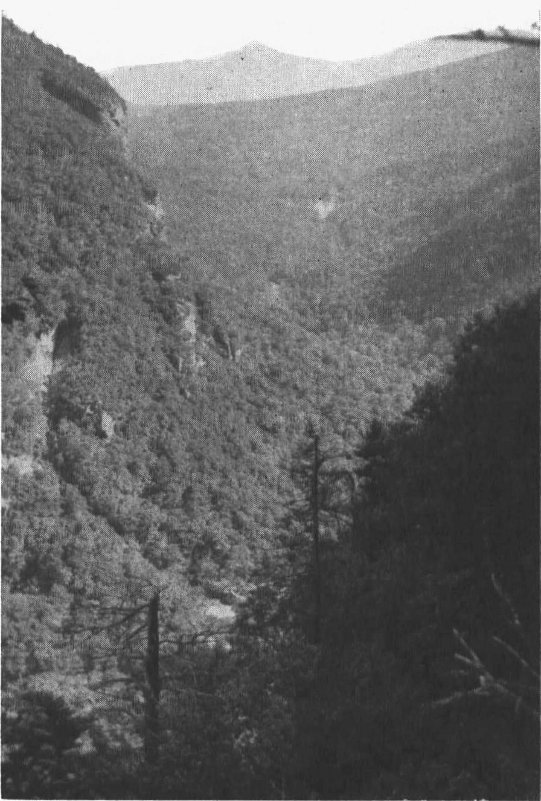
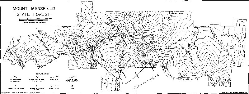
With a few exceptions, the rock found in Mount Mansfield State Forest
is a mica-albite-quartz schist. This name indicates that it is a metamorphic
4
rock[1] of a particular composition and texture as described in
the following paragraphs. The schist forms the cliffs at Smugglers Notch
and the bare-rock faces exposed along the crests of the mountains and
elsewhere. It varies slightly in appearance because of variation in the
proportions of the different mineral constituents.
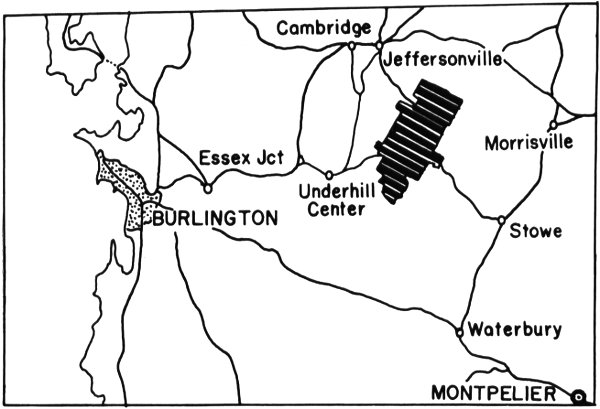
Figure 1. Index mapping showing location of Mount Mansfield State Forest.
An understanding of the origin of the schist is fundamental to understanding
the geology of the Mount Mansfield area. Many million years
before the formation of the Green Mountains, northwestern Vermont
was covered by a shallow sea into which fine-grained sediments were
transported by the ancient rivers. As these sandy and shaly deposits
accumulated on the bottom of the sea, they were buried by progressively
younger sediments of different types. Many of these sedimentary layers
5
contained shells of the animals that lived and died in these seas, with the
shell remains of the older generations occurring in the bottom layers.
By the time the sea had retreated, the older sediments were deeply buried
beneath the younger sediments. During a period of mountain-making,
these materials were subjected to high pressures and high temperatures.
Physical-chemical changes took place within the sediments causing
recrystallization to form the mica-albite-quartz schist. In other words,
under conditions of heat and pressure the rocks became plastic and the
elements which were dispersed through the sediments as sand and clay
minerals reorganized into different and larger mineral grains. It is probable
that some material was added to the rocks and some was removed
by hot solutions migrating through the rocks. The overlying younger
sediments were also converted to metamorphic rocks. Because the
crystallization of the minerals occurred under the influence of pressure,
platy minerals developed with their long dimensions at right angles to
the pressure. Thus, the resulting rock developed a layered appearance
by the parallel arrangement of the minerals. Where this layering or banding,
which is called foliation, is coarse, the metamorphic rock is a gneiss;
where it is fine but pronounced, the rock is called a schist. If the original
rock was a limestone or sandstone, the metamorphic product is marble
or quartzite, respectively. In the process of, or following the formation
of the schists, the rocks were crumpled and folded by continued pressure.
During the 380 million years following the metamorphism and folding,
this area has been above sea level and has been subjected to erosion. At
various times the area was uplifted vertically which resulted in continued
erosion of progressively older rocks until the present day when the
overlying rocks have been removed to expose the mica-albite-quartz
schist.
Some readers may wonder how the age of metamorphism can be stated
so specifically—380 million years seems like a long period to be determined
beyond a guess. Such a determination is based on a number of
different factors. Sedimentary rocks can be placed in their general age
sequence by their physical relationships—the rocks deposited on top
must be the youngest. A study of the fossils of successive layers shows
that they occur in a definite sequence with the simpler forms in the oldest
layers and generally the more complex ones in the youngest layers. On
the basis of the fossil evidence and the physical relations, the geologic
6
sequence of the layers can be established for any given area and their
relative age can thus be indicated on the geologic time scale. Usually
such sequences are established for rather large areas as, for example,
northern Vermont or eastern New York State. In addition, actual age
determinations can be made for some rocks. Many igneous rocks contain
traces of uranium which has been decomposing at a known rate since its
formation. By comparing the remnants of uranium with the decomposition
products, one can assign an approximate age in terms of years to the
igneous rock. By observing the relationship between the dated igneous
rock and any sedimentary rocks in contact with it to determine their
relative ages, it may be possible to assign an approximate age to the
sedimentary rock and the fossils contained within it.
The general age of the original constituents of the mica-albite-quartz
schist of the Green Mountains can be determined only by comparison to
other rocks that can be dated. Any fossils present originally were destroyed
during metamorphism. Igneous rocks containing uranium do not occur
with the schist. However, elsewhere in Vermont, one can determine
that the schist lies beneath rocks containing fossils of Ordovician age
and lies above pre-Cambrian rocks known to be more than 500 million
years old. The Cambrian and Ordovician periods on the geologic time
scale are the oldest periods containing abundant fossils. The period of
the metamorphism is based on evidence at other localities where unfolded
rocks of known age lie over folded rocks. On the geologic time scale the
mica-albite-quartz schist on Mount Mansfield is said to be Cambro-Ordovician
in age, which may be from 380 to 500 million years ago.
In order that the geologist can talk about the sequences of rocks, layers
having a similar age and appearance are assigned a formation name. The
schists on Mount Mansfield closely resemble schists in southern Vermont
which belong to the Pinney Hollow formation. However, because they
can not be traced directly, it is possible that the two sequences are not
exactly equivalent. For this reason some geologists assign the rocks in
this area to the Camels Hump formation which has been named after
their abundant occurrence on Camels Hump Mountain, south of the
Mount Mansfield State Forest. Although it would be geologically correct
to use these formational names, they will be omitted in favor of continued
use of the name “mica-albite-quartz schist.”
The formation which lies over the mica-albite-quartz schist may be
seen in the vicinity of the village of Stowe where the rocks are either a
black, shiny schist or a fine-grained green schist. The formation which
7
lies under the mica-albite-quartz schist is not exposed in the Mount
Mansfield area.
As the name implies, the mica-albite-quartz schist contains the
minerals mica, albite, and quartz. These mineral constituents are found
in all the schists in the area. Other minerals may be locally abundant or
present in small amounts.
When the schist is examined without a hand lens or microscope, mica
appears to be the most abundant mineral. It occurs as small colorless to
white flakes which sparkle and shine in the sunlight. You may recognize
this mineral as the one that is sometimes sold as artificial snow at
Christmas time. Its species name is muscovite, and it has a chemical composition
of KAl₂(AlSi₃)O₁₀(OH)₂. Muscovite is found in various proportions
in most of the rocks in the area. It is a deceptive mineral upon which
to make a percentage estimate because it appears to be more abundant
than it actually is. In most of the rocks it comprises less than 50 per cent
of the minerals. Biotite is the other important member of the mica group
and is distinguished from muscovite by its black or dark brown color.
Biotite occurs in minor proportions in the rocks of the area, being most
abundant on the western slope of Mount Mansfield. Like muscovite,
biotite occurs as small flakes with smooth flat surfaces.
The orientation of the mica flakes accounts for the pronounced layering
of most schists. All of the flakes are parallel and when folded and
crumpled they give the rock its structure. Where the muscovite is most
abundant, breakage along planes rich in mica produces smooth, shiny
surfaces which may give the rock a slippery appearance. The layers rich
in mica may show in a rather perfect manner the small-scale folding of
the schist.
Albite and quartz are also important constituents of the schists.
Together they are more abundant than mica in the average schist on
Mount Mansfield but because they are not so “showy” they are more
easily overlooked. Both minerals are white and granular. Quartz, which
consists of silica or SiO₂, is the principal constituent of most beach sands.
In the typical mica schist, quartz is glassy in appearance and occurs as
small rounded or irregular grains without plane surfaces. Albite is a
variety of plagioclase feldspar having the composition of NaAlSi₃O₈. It
has a white chalky appearance and occurs in small equidimensional
grains bounded by flat surfaces which break along plane surfaces that
8
reflect light in certain positions. On the west side of Mount Mansfield
some of the rocks contain so much albite and so little mica that the rock
is granular in appearance.
Chlorite, variety pennine, is an important mineral constituent of some
of the schist. Chlorite is characterized by its green color and small
amounts are responsible for giving a greenish cast to much of the schist.
Like mica it occurs as thin sheets which reflect the folding of the schist.
Garnet and magnetite are locally abundant minerals in the schist.
Garnet occurs as pink to red grains ranging from pin point to pea size.
Most of the grains are rounded although a few occur as equidimensional
crystals which have twelve equally developed faces. Garnet has a semitransparent,
glassy appearance and is harder than a knife blade. Magnetite
occurs as bluish-black metallic masses with about the same size range
as the garnet. Although most are rounded masses, crystal faces are
developed on some. Perfectly developed crystals occur as octahedrons
which is the form consisting of eight faces, as two four-sided pyramids
with their bases together. The larger grains of magnetite have sufficient
magnetic power to attract or deflect a compass needle. The garnet and
magnetite usually do not occur together, but each may form localized
concentrations as lenses or layers in the schist.
In smaller amounts, usually visible only with a hand lens or microscope,
the schist also contains a green mineral called epidote, a white
mineral apatite, and an elongated black mineral called tourmaline. Locally,
as on the Nose Dive ski run above the Toll Road on Mount Mansfield,
slender needles of tourmaline are visible in the schist.
When a piece of rock is sawed and ground to a thickness of 0.03 millimeters,
many of the minerals that appear opaque are found to be transparent.
By their color and their optical properties the minerals can be
accurately identified. On the basis of the amount of each present the
mineral and chemical composition of the rock can be determined. Figure 2
shows the appearance of a thin section of the mica-albite-quartz schist
from the Forehead of Mount Mansfield. The parallel orientation of the
mineral grains is apparent even though the photomicrograph represents
a very small area of the schist.
9
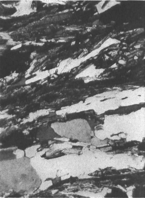
Figure 2. Photograph taken through a microscope at a thin section of the schist. The
white and gray grains are quartz and albite and the dark colored elongate grains are
either muscovite or chlorite. The magnification is about one hundred times normal
size. Even at this scale, the layering of the minerals is clearly visible.
Other varieties of the schist occur less abundantly in the area. These
contain the same minerals as the mica-albite-quartz schist but in different
proportions. If the mica is most abundant, as it is locally on Mount
Mansfield, the schist may be smooth or highly crinkled and have a very
shiny appearance. If the albite is most abundant the schist is more
uniform and granular in appearance and the rocks are more massive.
Small scale folding is usually absent. Such albite schists occur on the
west side of Mount Mansfield, particularly along the lower part of the
Maple Ridge Trail and in the cliffs south of the Forehead along the Long
Trail.
If the quartz is most abundant, but mica and albite are present in
considerable quantities, the rock may have a granular, layered appearance.
Locally some of the rocks consist almost entirely of quartz and are
classified as quartzite. These rocks have a dense, fine-grained, sugary
appearance and generally are gray to bluish gray in color. They are hard
rocks and often form minor ledges in cliff exposures or are the resistant
10
rock at the top of small waterfalls in some of the creeks. Most of the
quartzite in the area occurs in narrow layers less than a foot thick.
Although these layers cannot be traced, they are most abundant on the
east side of Mount Mansfield at various localities about one-third of the
way up the mountain.
At places, vein-like masses of glassy, milky white quartz occur in the
schist. In these, the quartz is massive and without evidence of individual
grains and is often fractured unevenly. The quartz occurs as localized
lenses in the schist, particularly at the noses of the folds. The small,
white boulders of quartz of this type are conspicuous along some of the
trails.
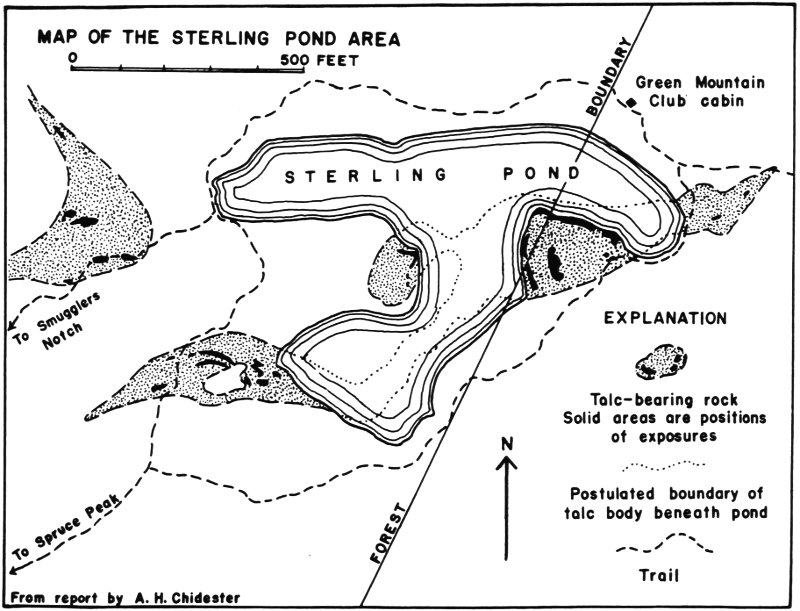
A special and somewhat unique type of rock occurring at Sterling Pond
is described in the description of Spruce Peak and Sterling Pond.
The position of the Green Mountains is a function of the structure of
the rocks and their resistance to erosion. At the same time that the mica-albite-quartz
schist was being developed under conditions of heat and
pressure the region was tightly folded by the same forces. It is likely
that this folding continued after the metamorphism during the declining
stages of mountain-making. This period of mountain-building probably
raised the rocks to a higher level but it was the later repeated uplifts and
erosion of the overlying rocks which finally produced the present mountain
topography.
It is postulated that the folding and crumpling of the schists were
accompanied by a westward movement of large masses of rock. That is,
segments of the earth’s crust are believed to have been pushed westward
by pressure from the east. Thus, it is believed by many geologists that
the rock which now occurs in the Green Mountains may have been
derived in early times from an area ten to forty miles to the east.
The basic structure of the Green Mountains is an anticlinorium, a
large complex fold. An anticline is an upward fold in which individual
rock layers if traced through the structure have a shape similar to that
of an arch; the opposite structure is a syncline in which the individual
layers are shaped like a trough or basin. An anticlinorium is a large
anticline upon which are superimposed many smaller anticlines and synclines.
Figure 3 is a diagrammatic sketch showing the relation of the
topography to the structure of the rocks in the Mount Mansfield area.
The structure of the rocks is reflected in the topography of Mount
Mansfield, but such correspondence is not necessary, for the form of any
hill or mountain is a function of its erosional history and resistance of
the rock to erosion. In some folded areas, the rock in the trough of a
syncline is so resistant to erosion, that it persists in hills or mountains
after neighboring anticlines have been more deeply eroded to form
valleys.
11
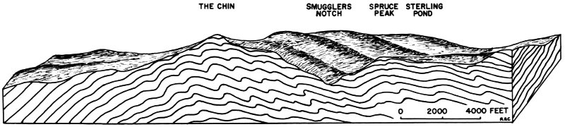
Figure 3. Diagrammatic sketch showing the relation between the topography and the structure of the Green Mountains in the
Mount Mansfield area. The section has been drawn to approximately pass through The Chin, Smugglers Notch, Spruce Peak
and Sterling Pond, and looking N 20° W.
- THE CHIN
- SMUGGLERS NOTCH
- SPRUCE PEAK
- STERLING POND
12
The smaller folds are like “little fleas on bigger fleas on bigger fleas”
in that many little folds may be superimposed on larger ones. These
anticlines and synclines range in amplitude from fractions of an inch to
thousands of feet. Many are miniature anticlinoria themselves and could
be used as scale models of the structure of the entire mountain range.
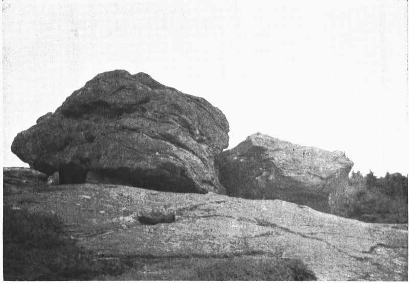
The small folds, or crenulations, in the schist have weathered differentially
so that the more resistant layers stand out in relief, emphasizing the
shape of the folds. The photograph in Figure 4 shows the small-scale
folding. It will be noted that the anticlinal folds are asymmetrical with
the west side dipping more steeply than the east side.
If a comparison is made between the structure of the mountain and
that of an asymmetrical arch, to carry the simile one step further, it
may be imagined that the axis of the arch may be either horizontal or
inclined. The chances that it is inclined are much greater than the
chance that it is exactly horizontal. Thus, most anticlines or anticlinoria
are inclined along their axes and the amount of the dip of the
line connecting the points along the crest of the fold is called the plunge.
Most of the folds in the Mount Mansfield area plunge about ten
degrees to the south. This plunge is expressed in the dip of the crests of
the minor folds, particularly in the crenulation of the mica layers.
Viewed at a distance the trace of the fold-crests form a series of parallel
lines on the smooth mica-rich surfaces. This type of structure is called
the lineation and is expressed on the geologic map by small arrows. The
dominant lineation is north-south. Although Figure 5 is a sketch of a
small fold showing the different structural elements, it might be taken as
a diagrammatic sketch of the regional structure.
Evidence that the structure of the rocks is even more complex is shown
locally by the presence of east-west lineations. The intersection of this
secondary lineation with the dominant south lineation produces a
checker board appearance on some rock surfaces. A system of east-west
trending folds is traced by some of the quartz lenses. The significance
of the east-west structures is hypothetical, but they are believed to
have been mostly obscured by the younger structural features.
13
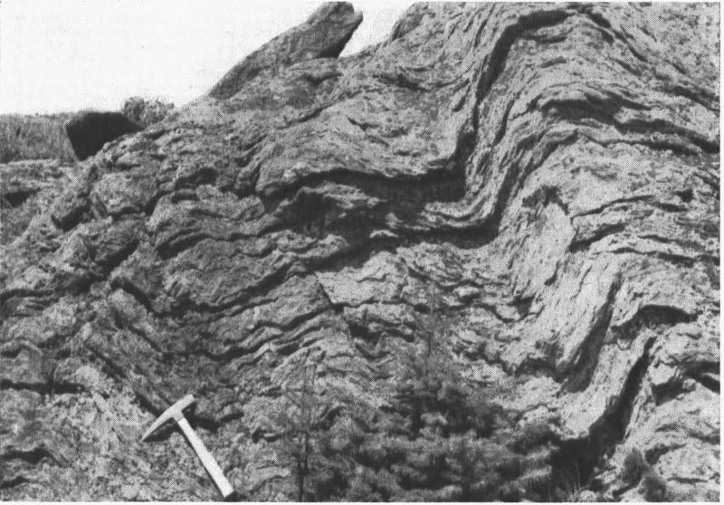
Figure 4. Folding and crenulations in the mica-albite-quartz schist near the Chin on
Mount Mansfield. As the photograph is looking to the north, it may be noted that
the folds are asymmetrical with axial plane of the folding dipping east.
With the description of the rocks completed, the question which arises
next is how to represent these three-dimensional contortions on the map.
Figure 6 illustrates how the attitude of a particular layer may be expressed
in terms of dip and strike. It is apparent that the dip of the rock
layer may vary from 0° to 90° and is measured as the angle between its
plane and a horizontal plane. Also, it is apparent that the trend of the
bed, or the strike, may correspond to any direction of the compass and
can be measured as the intersection of that plane and a horizontal plane.
The maximum dip is always at right angles to the direction of the strike.
14
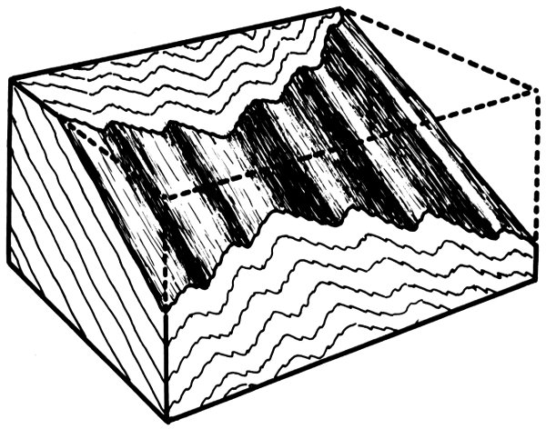
Figure 5. Diagrammatic three dimensional sketch illustrating the relations between
outcrop patterns of folds on vertical planes perpendicular and parallel to the trend
of the folding (front and sides of the block) and on a horizontal surface (top of block).
Cut-away section of the block shows the folds and lineation lines on a given foliation
surface. These folds can be more clearly visualized if the upper portion of the diagram
is covered.
The dip and strike are used to measure the position and attitude of
the layers of the rocks. In the case of the mica-albite-quartz schists these
planes are called foliation planes. If the structure of the rock is an anticline,
most of the strikes of the foliation are parallel, but the dips are in
different directions on either side of the crest. At the crest of the fold the
foliation is horizontal if the fold is not plunging. On Mount Mansfield
where the plunge is about ten degrees to the south, foliation along the
crest strikes about east-west and dips about 10° south. Away from the
crest, the dip of the sides of the anticline begin to be expressed in the
readings so that the strike directions “swing back” toward the north-south
direction. The majority of the layers on the east side of the mountain
strike northeast and dip to the east with the angle of dip increasing
away from the crest of the anticlinorium. On the west side of the mountain
they trend to the northwest and dip to the west with the dips becoming
steeper away from the crest. In addition to these variations in the dip
and strike over the anticlinal crest, the smaller folds give local abnormal
readings. For these reasons many of the dips and strikes shown on the
geologic map represent the averages of a number of readings, and those
of the minor folds and crinkles have been omitted in order to simplify
the picture.
15
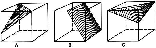
Figure 6. Three dimensional diagrams showing
variations in dip and strike. Plane in A strikes N 45° W and dips 45° SW; B
strikes north-south and dips 60° east; and the plane in C strikes N 45° E and dips 30° SE.
16
Another structural feature of the schists is the breakage of the rocks
along definite plane surfaces called joints. These usually occur in systems
formed by a number of parallel joints. The joints formed as a result of
stress and strain operating on the rocks during periods of mountain-making
and vertical uplifts. Information as to the nature of these forces
might be obtained if all the joints were carefully recorded and plotted on
a map.
On Mount Mansfield some of the prominent topographic features
appear to be controlled by joints. Much of the north-facing cliff on the
Nose is controlled by a joint trending N. 65° W., and a similar face on the
Lower Lip is controlled by a joint trending N. 60° W. Along the crest of
Mount Mansfield a number of joints trend about north-south. Joints of
this system in the steep cliffs on either side of the crest of Mount Mansfield
have been separated further by the tendency of the rocks to creep
down slope under the force of gravity. These joints form the canyons or
narrow passageways which are traversed by some of the trails. On Maple
Ridge at about 3300 foot elevation the trail crosses a joint trending
N. 50° E. which is conspicuous for its four-foot width and the extent and
the straightness of the break. A number of joints belonging to this system
are found along Maple Ridge.