The most conspicuous rock found in the park is granite.[1] Along the
road which winds to the summit of Burke Mountain you will see several
outcrops of the white or pinkish biotite granite (Fig. 4). This granite is
well displayed in the summit parking area and along the trail to the
observation tower (Figs. 3 and 5). A walk down the Bear Den Ski Trail
also shows an abundance of granite outcrops (Figs. 6, 7, and 8).
6
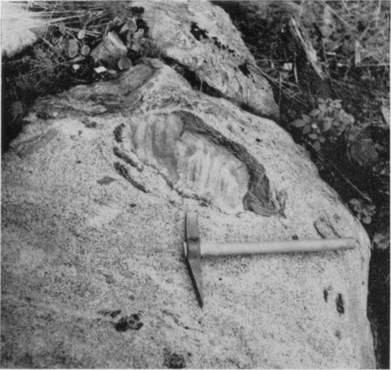
Figure 3. Speckled granite with inclusion of metamorphic rock. Black specks in
granite are flakes of black biotite mica. Metamorphic inclusion, located just above the
hammer head shows some reaction with the invading granite. Pieces of metamorphic
rock were undermined by and dropped into the granite as it worked its way upward
into these rocks. Picture taken a few yards west of the tower on top of Burke Mt.
While looking at some of the above-mentioned photographs, a second
family of rocks is discovered (Figs. 3, 5, 6, 7, and 8; also, Figs. 9, 10, 11,
and 16). In many places these rocks have a layered or banded appearance
and in other places large lath-like crystals are common in some of the
layers. In some areas these rocks are very heterogeneous in appearance
and display distorted layers and profuse development of lath-like crystals
(Figs. 12 and 13). These rocks belong to the second major family of rocks,
the Metamorphic rocks. The metamorphic rocks[2] seen in the park were
originally sedimentary[3]
rocks. These rocks belong to the Gile Mountain
Formation[4]
which was deposited during the Devonian Period some 300
million years ago (see Geologic Time Scale[5], Fig. 14). So much for the two
major families of rocks present in the park, the igneous and metamorphic
rocks, and how to distinguish one from the other. Let us assume that you
can now distinguish between the granite and the metamorphic rocks.
7
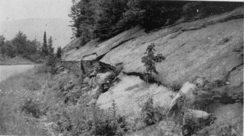
Figure 4. Outcrop of biotite granite located on the summit road between the second
and third turns from the summit of Burke Mountain and on the right side of the road
if descending. Note the “sheeting structure” or flat joint surface which slopes or dips
into the road. This flat break in the rock was probably caused by the release in pressure
of the overlying glacial ice when it melted from this region.
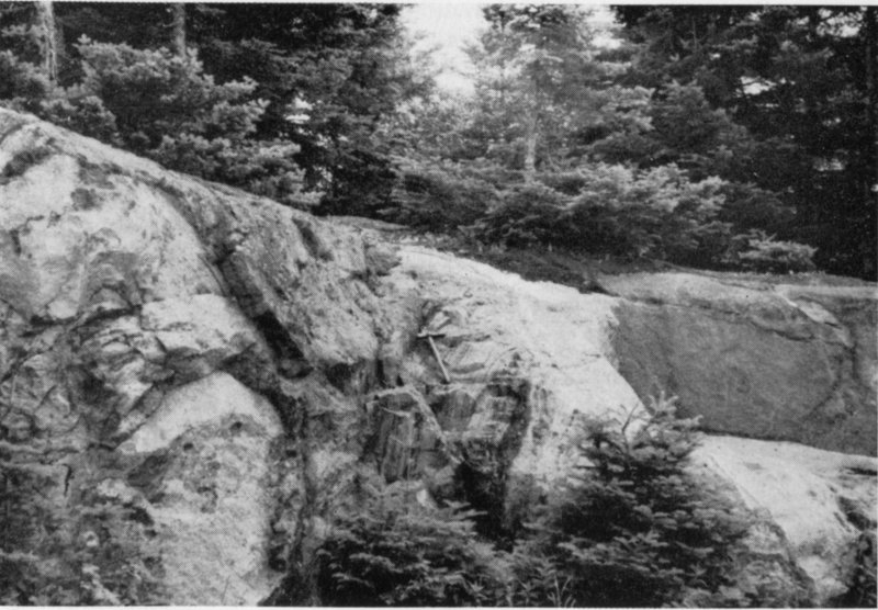
Figure 5. East side of parking area, summit of Burke Mountain. Outcrop of granite
with many metamorphic rock inclusions (hammer, center of picture, rests on large
inclusion). Layering or banding in the inclusions is almost vertical.
8
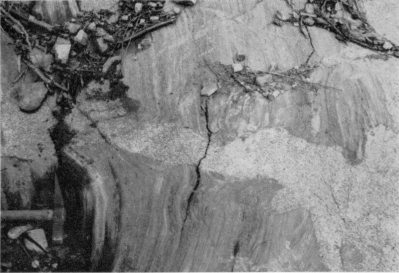
Figure 6. Outcrop located about midway down the Bear Den Ski Trail. Alternating
metamorphic quartzite and phyllite invaded by lighter colored and speckled biotite
granite. Note how the granite cross-cuts the layered or banded metamorphic rocks.
This cross-cutting points out the fact that the layering or banding was present prior
to the invasion of the granite.
9
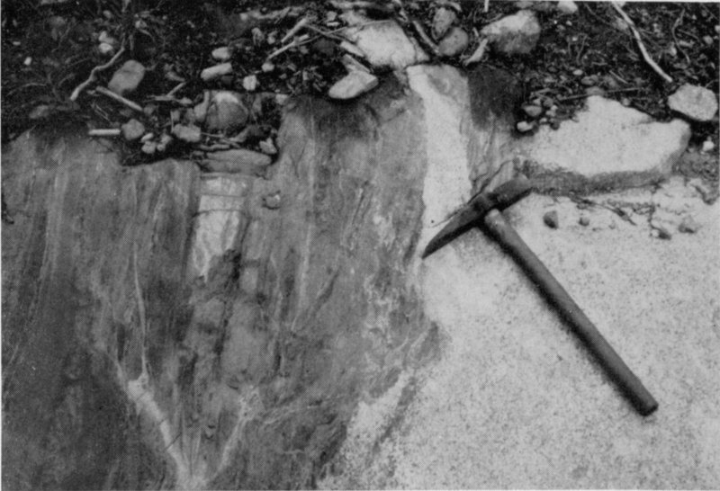
Figure 7. Outcrop located about midway down the Bear Den Ski Trail. Metamorphic
quartzite and phyllite (darker color) and invading biotite granite (light
speckled appearance). Here the granite has a more or less conformable relationship
to the layers or bands in the metamorphic rock. Compare this relationship with the
cross-cutting relationship in Fig. 6. For scale, the handle of the geologic hammer or
pick is about 12 inches long.
Now, what is the relationship of one to the other? That is, where you
can see both of these rock types exposed together in one outcrop, can
you describe the physical contact of one with the other? For instance,
look at Figure 6, which was taken about midway down the Bear Den
Trail, here you see the granite (the white speckled igneous rock which
cuts horizontally across the picture) cutting across the distinctly layered
or banded metamorphic rocks. The granite is said to have a cross-cutting
relationship to the metamorphic rocks. In some outcrops the granite is
more or less parallel to the layers of metamorphic rock (Fig. 7). Here,
the granite is said to have a conformable relationship with the metamorphic
rocks. Still another relationship between the granite and the
metamorphic rock is seen in Figure 8. Here, blocks of metamorphic rocks
are inclosed by granite. These inclosed blocks are called inclusions and
are pieces of invaded rock which fell into or were encircled by the invading
granite.
10
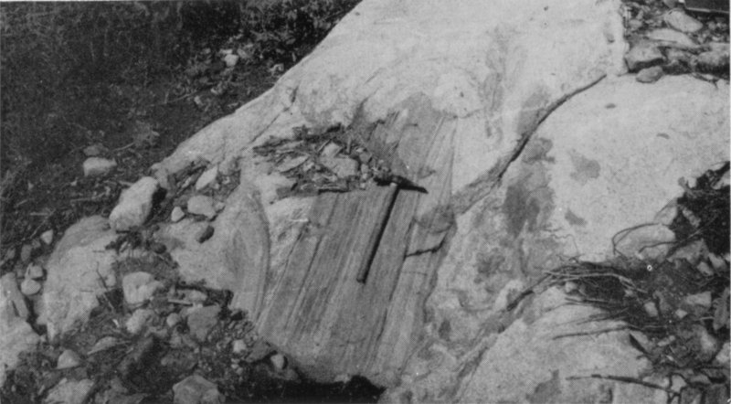
Figure 8. Inclusion of layered or banded metamorphic rock (hammer is resting on
this inclusion) in lighter colored biotite granite as seen along the Bear Den Ski Trail.
The metamorphic rocks were invaded and undermined by the granitic rocks, with
the result that pieces of the metamorphic rock were surrounded by granite. For scale,
the handle of the geologic hammer or pick is about 12 inches long.
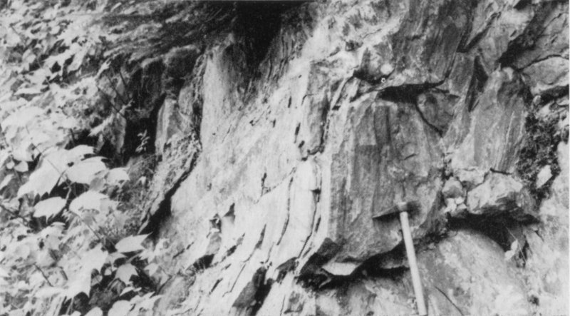
Figure 9. Picture taken along the Burke Mountain summit road of typical Gile
Mountain metamorphic rock. Here the rocks dip almost vertically. For those more advanced
in geology, note the pillow-like segments or boudinage structure about one
foot to the left of the chisel point of the hammer. This structure is due to a stretching
of the rock. For scale, the hammer handle is about 12 inches long.
11
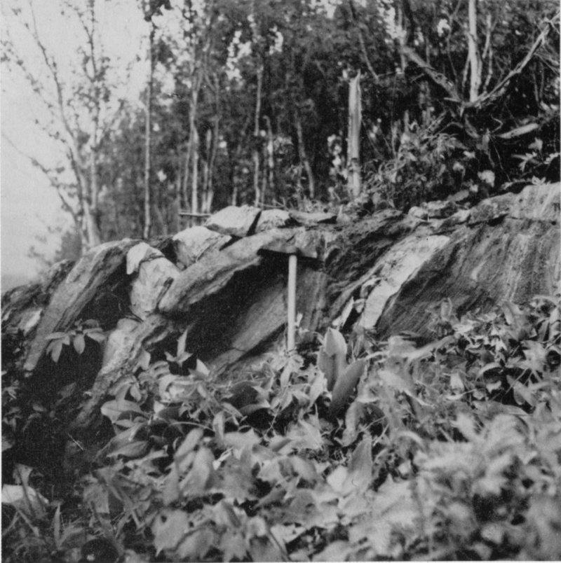
Figure 10. Banded or layered metamorphic rocks with inter-squeezed granite
(lighter colored material). This outcrop is located on east side of the Bear Den Ski
Trail and quite close to the Burke Mountain summit road. The hammer handle,
center of picture, is about one foot long.
12
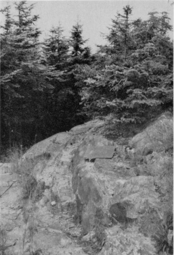
Figure 11. Picture taken only a few yards from the Burke Mountain observation
tower, along the path to the summit parking lot, looking northwest. Here you see
metamorphic rocks (quartzite and phyllite) with some inter-squeezed granite. Note
how the nearly vertical metamorphic rock layers bend or “wrap-around” to the right.
The highly resistant inter-squeezed granite actually holds Burke Mountain up, or to
be more scientific, it prevents these rocks from being worn down as fast as the surrounding
rocks. For scale, see the clip board in the center of the picture.
From these relationships, what can be said about the relative ages of
the two rock types? Which is the older, or first formed? Which is the last
formed? If you study the above relationships for a minute or so, it will
become obvious that the layered rock had to be formed prior to the emplacement
of the granite. Some of the minerals now seen in the layered
or banded metamorphic rocks were formed at the time of granite intrusion,
but the basic “stuff” or partially metamorphosed sedimentary rock
was present before the granite entered the area from beneath. So, the
13
knowledge of the two rock types present and an understanding of their
relationship to one another tells us a story of at least two events which
occurred in the park area hundreds of millions of years ago.
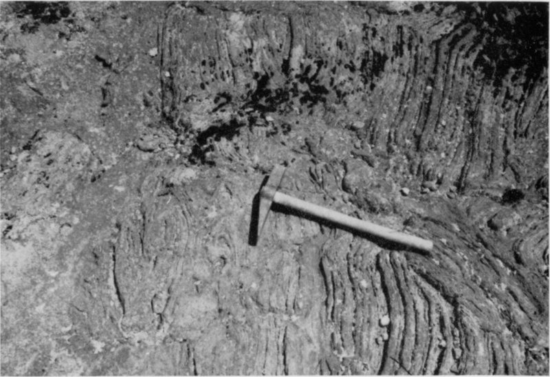
Figure 12. Outcrop on south Lookout, summit of Burke Mountain. Distorted
layers of Gile Mountain metamorphic rock. Lath-like crystals developed along some of
these layers during the second period of metamorphism, that is, when the granite
invaded the metamorphic rocks. For scale, the hammer handle is about one foot long.
Can we find other facts in these rocks which might add to the above-mentioned
events? The answer to this question is, yes! The types of
minerals found in the metamorphic rocks coupled with the inherited
layered structure so common in these rocks, tells us that they were once
sedimentary rocks. There is other evidence which indicates that these
sedimentary rocks were slightly metamorphosed and folded prior to the
invasion of the granite. Added information indicates that these same
rocks were subjected to increasing temperatures with the invasion of the
granite and another metamorphic mineral change took place. Thus far,
the rocks have told us about four distinct events; the deposition and
hardening of the Gile Mountain Formation of sedimentary rocks, the
first period of wide-spread metamorphism, accompanied by broad folding,
the invasion of the granite, and a second phase of metamorphism
14
with the increased temperatures produced by this invasion (see cross-sections
illustrating the geologic history of the park area, Fig. 17).
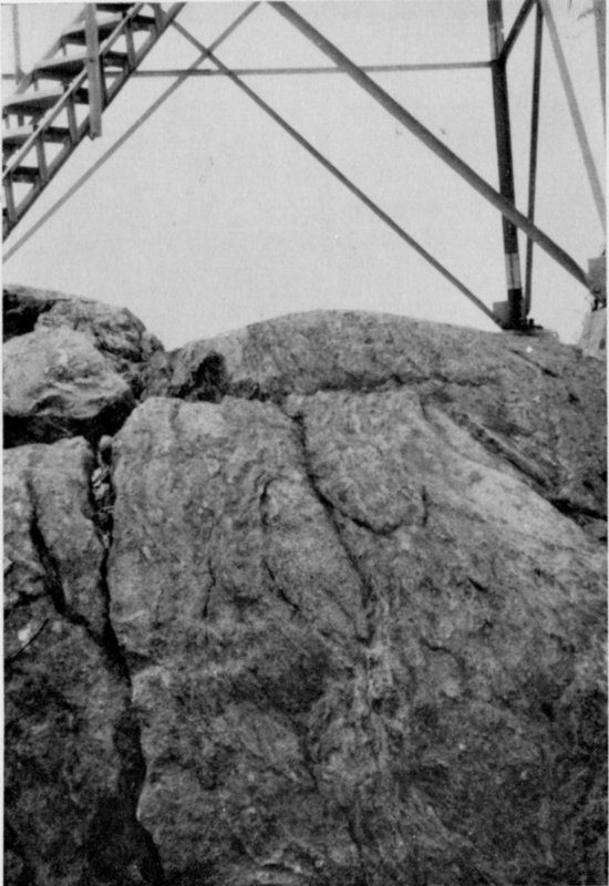
Figure 13. Photograph of the outcrop beneath the observation tower, summit of
Burke Mountain. Note the heterogeneous appearance of the granite-infiltrated
metamorphic rock. Here the metamorphic rock approaches granite itself in composition
and if the process had progressed a bit more, it would be said to be granitized
rock. Large lath-like crystals are very prominent in the rocks of this outcrop.
The four events which are mentioned in the preceding paragraph took
place hundreds of millions of years ago. What has happened in the park
since these events? Take a look at Figure 15, which was taken along the
road to the summit of Burke Mountain (coming down from the summit,
this outcrop is located on your right, midway between the second and
third turns in the road). Here the granite exhibits linear scratches or striations
which trend about 40 degrees east of south (general direction in
which the hammer handle points). Again, just down the road from the
midway picnic and camping area, and on your right, striations can be
seen. Here they trend about 45 degrees east of south or approximately in
the same direction as the first series of striations mentioned. These
scratches or striations occur in many places throughout the park, and in
most cases their orientation is about the same. What caused these
numerous striations?
15
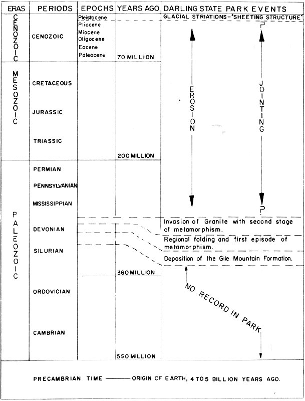
Figure 14. Geologic Time Scale. The main Darling State Park geologic events are
noted on the right, opposite the approximate geologic time when each occurred.
| ERAS | PERIODS—YEARS AGO | DARLING STATE PARK EVENTS |
|---|
| | | EPOCHS |
|---|
| CENOZOIC | CENOZOIC | GLACIAL STRIATIONS—“SHEETING STRUCTURE” |
| | | Pleistocene |
| | | Pliocene | EROSION, JOINTING |
| | | Miocene |
| | | Oligocene |
| | | Eocene |
| | | Paleocene |
| | | 70 MILLION |
| MESOZOIC | CRETACEOUS |
| | JURASSIC |
| | TRIASSIC |
| | | 200 MILLION |
| PALEOZOIC | PERMIAN |
| | PENNSYLVANIAN |
| | MISSISSIPPIAN | EROSION, JOINTING |
| | | | Invasion of Granite with second stage of metamorphism. |
| | DEVONIAN | Regional folding and first episode of metamorphism. |
| | SILURIAN |
| | | | Deposition of the Gile Mountain Formation. |
| | | 360 MILLION |
| | | | NO RECORD IN PARK |
| | ORDOVICIAN |
| | CAMBRIAN |
| | | 550 MILLION |
| PRECAMBRIAN TIME——ORIGIN OF EARTH, 4 TO 5 BILLION YEARS AGO. |
16
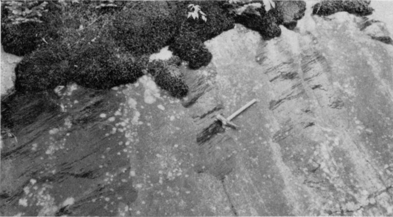
Figure 15. Glacial striations or scratches on outcrop midway between the second
and third turns in the road down from the summit area of Burke Mountain. Striations
trend about 40 degrees east of south or in approximately the same direction that the
hammer handle is pointing. Hammer handle is about one foot long.
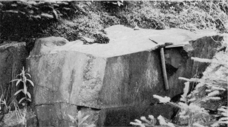
Figure 16. Midway between the second and third turns, descending on the Burke
Mountain summit road. Metamorphic quartzite and phyllite showing at least two
prominent joints. Layers are vertical and parallel to the front joint (one which hammer
handle touches). For the more advanced student of geology, note the lineations
parallel to the hammer handle and on the front surface. For scale, hammer handle is
about one foot long.
17
Since they are still preserved in the rocks for us to see, they must have
been formed quite recently, that is, geologically speaking. What can
explain these striations and their common orientation? Did you ever
hear about the Great Ice Age, or the Pleistocene Epoch? Less than one
million years ago, in fact, some 12,000 years ago, an ice sheet many
thousands of feet thick rode over Burke Mountain in a southeastward
direction. The many boulders frozen to the underside of the ice sheet
tended to scratch the rocks over which they rode. The scratches or
striations seen in the park rocks were caused by these attached boulders.
The ice sheet also plucked and rounded Burke Mountain into the shape
it possesses today.
A look at Figure 4 shows still another event which occurred during
recent geological time. The prominent smooth fracture-surface seen to
slope or dip toward the road is called “sheeting structure” which has its
origin in post-glacial time. It is thought by many geologists that these
flat surfaces or joints[6],
which are generally parallel to the ground surface,
were formed with the release of the weight of the overlying glacial ice
when the glacier retreated northward. So, here we have evidence displayed
in the rocks which tells of still another event in the park’s history.
It should be mentioned here, while still on the subject of joints, that
other joints do occur in the park rocks. Figure 16 shows joints which
were formed earlier than the “sheeting” and which are not parallel to the
surface of the ground. These joints were probably formed as a result of
the removal of the overlying rocks through erosion, thus releasing long-continued
pressures produced by the weight of the overlying rocks, and
movement of the earth’s crust. We now have the story of two main
episodes in the park’s geological history; one took place many millions
of years ago, the other within the last 12,000 years. What happened
between these two rock-documented episodes?
18
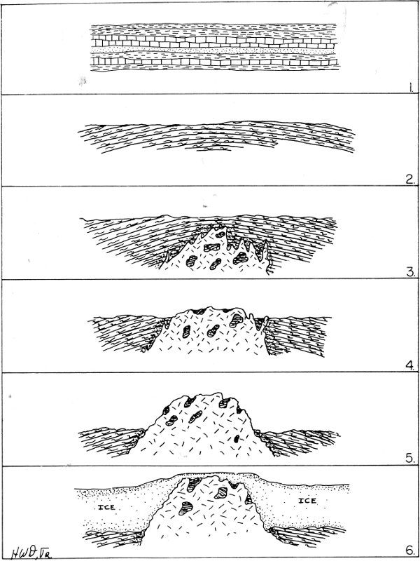
Figure 17. Geologic cross-sections illustrating the geologic history of Darling State
park. (For explanation of cross-sections see top of page 19.)
19
1. Deposition and hardening of the Gile Mountain Formation. At this stage the
layers of rock were more or less horizontal.
2. The horizontal and parallel layers of the Gile Mountain Formation were gently
and broadly folded and regionally metamorphosed. This is the first stage of
metamorphism in the park area.
3. Invasion by granite. This invasion was accompanied by local metamorphism of the
invaded rocks. This is the second stage of metamorphism in the park area. Note
the inclusions of first stage metamorphosed Gile Mountain rocks in the granite.
4. Many millions of years of erosion took place, the forces of nature finally exposing
the granitic rocks at the surface of the earth.
5. Continued erosion caused the metamorphically reenforced Gile Mountain rocks
to wear down more slowly than the surrounding weaker rocks. For this reason,
these strengthened rocks stand higher than the weaker rocks.
6. Less than one million years ago the glaciers advanced over the park area. The
glacial ice plucked and scratched (striated) the underlying rocks as it slowly
advanced southward. During the retreat (northward) certain deposits were left.
Present-day Burke Mountain is much the same as it was when the glaciers left,
but, some added erosion has taken place and, because of uplift, the Mountain
stands a bit higher than it did some 10,000 years ago. Some soil, much of which was
removed by the glaciers, has since formed on the mountain.
There are no rocks present in the park which were deposited during
this interval of time, therefore, no rock record. If no rocks representing
this time interval are present, one of two reasons must be responsible.
Either the park area was undergoing active erosion (wearing down)
during this period, or sediments were deposited during part or all of this
time interval and subsequently completely removed by erosion. Most
probably, the intervening time found the park area above the depositional
environment of the sea, when its rocks were being worn away by
the erosional forces of nature. Again, see Figure 17 for a diagrammatic
representation of the geologic history of the park.