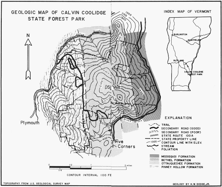
The rocks of Calvin Coolidge State Forest Park can be divided into
four distinct units or formations[4]. The geologic map shows these formations
as distinct bands, each band representing a different formation and
its intersection with the ground surface. Each formation is, so to speak,
stacked upon the next older with the oldest forming the western band
and the youngest on the east. Remember that these metamorphic rock
formations were originally sedimentary in nature and were deposited
in a nearly horizontal position on the floor on an ancient sea. The fact
that they are now tilted indicates that earth movements have taken place
sometime after the sedimentary rocks hardened but before the present
time.
The Pinney Hollow formation, the oldest formation of rocks seen in
the Forest Park, was named for the excellent exposures of this formation
in Pinney Hollow, a valley located along the western border of Coolidge
Forest. You can readily see this formation, in its most typical development,
along State Highway 100A about three-tenths of a mile south
of the Park entrance road. Here, a historical monument which commemorates
the naming of Pinney Hollow, is embedded in this formation
(See photograph, Fig. 3). The lean-to, tent platform and picnic
areas are situated on this formation and its rocks are easily observed.
It is interesting to note that some of the Pinney Hollow rocks seen
in these camping and picnicking spots differ from the typical rocks
seen along State Highway 100A. In fact, some of the rocks which are
dark and are classed as phyllites, can be confused with the overlying
Ottauquechee rocks. A transition zone, several hundred feet wide, exists
between these two formations and in which the two distinct rock types
are intermingled. This “mixture” zone indicates that there was no break
in the original deposition of these two formations and therefore the rock
record during this time is complete.
10
GEOLOGIC MAP OF CALVIN COOLIDGE STATE FOREST PARK
INDEX MAP OF VERMONT
- EXPLANATION
- TRAIL
- SECONDARY ROAD (GOOD)
- SECONDARY ROAD (POOR)
- STATE ROUTE 100A
- STATE PROPERTY LINE
- CONTOUR LINE WITH ELEV.
- STREAM
- FOLIATION
- {FORMATIONS}
- MISSISQUOI FORMATION
- BETHEL FORMATION
- OTTAUQUECHEE FORMATION
- PINNEY HOLLOW FORMATION
- TOPOGRAPHY FROM U.S. GEOLOGICAL SURVEY MAP
- GEOLOGY BY H. W. DODGE, JR.
12
The Pinney Hollow formation, which is an estimated 2,300 or more
feet thick, is primarily composed of pale-green schist[5] with abundant
white quartz layers and lenses sandwiched between the dominantly
greenish colored rock. Originally these metamorphic rocks were sand,
mud and sandy mud deposited on a relatively shallow sea floor. After
burial these sediments hardened into thin layers and lenses of sandstone,
shale, and sandy shale. Metamorphism has since converted many of the
shale minerals into mica flakes and some of the sandy shales produced
crystals of the mineral garnet. The pale-green color of the Pinney Hollow
schist is caused by the presence of the green mica-like mineral, chlorite,
which developed during the process of metamorphism.
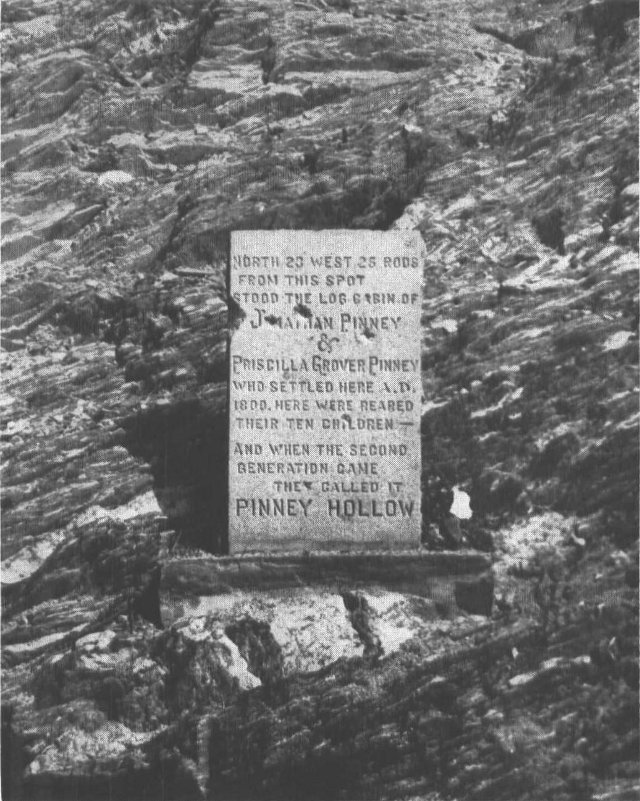
Figure 3. The Pinney Hollow Historical Monument embedded in the Pinney Hollow
formation. The darker rock consists of pale-green schist and the white areas are
quartz layers and lenses.
NORTH 20 WEST 25 RODS
FROM THIS SPOT
STOOD THE LOG CABIN OF
Jonathan Pinney
&
Priscilla Grover Pinney
WHO SETTLED HERE A.D.
1800. HERE WERE REARED
THEIR TEN CHILDREN—
AND WHEN THE SECOND
GENERATION CAME
THEY CALLED IT
PINNEY HOLLOW
No fossils have been found in the Pinney Hollow formation of this
region: however, evidence from other parts of Vermont indicate that
13
these rocks are of Cambrian or perhaps Ordovician[6] age. This dates these
rocks as approximately 500 million years old.
The Ottauquechee formation, next above the Pinney Hollow formation
and therefore younger in age, was named for the Ottauquechee River
along which this formation is well exposed and was first studied in detail.
The Ottauquechee River is located just north of Calvin Coolidge State
Forest Park where it flows through the towns of Bridgewater and Bridgewater
Corners. You can see this formation along State Highway 100A
approximately nine-tenths of a mile north of the Park entrance road.
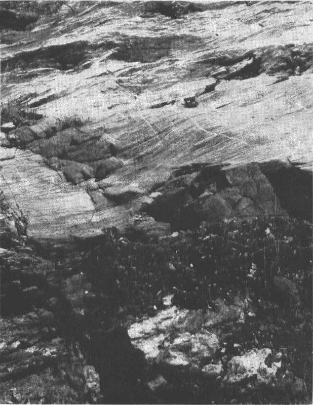
Here, the formation crops out on the west side of the road, or on your
left if traveling toward Bridgewater Corners (See photograph, Fig. 4). A
hike along the recently diamond-blazed Coolidge Forest trail, which leads
from behind the Ranger’s cabin to the Picnic area, affords an almost
continuous view of this formation. The highly resistant quartzite layers
within the Ottauquechee formation are very conspicuous features along
this trail as they form several ridges trending across the footpath.
The Ottauquechee formation, estimated to be 3,000 feet thick, contains
rocks which contrast sharply with the underlying pale-green schists. The
formation consists of alternating black phyllite and layers, up to several
feet thick, of dark- to light-colored quartzite. The black carbonaceous
color of the phyllites and dark quartzites indicate the presence of life,
either animal or plant, during the original deposition of the sediments
forming these rocks. The phyllite was, before metamorphism, a black
shale which formed from black muds rich in organic matter. From studies
done in areas where black muds are accumulating today it seems quite
probable that the ocean waters of Ottauquechee time were of a restricted
nature, that is to say, the waters were stagnant due to the lack of oxygen.
Pinney Hollow shallow marine water conditions remained, but for some
reason, such as a barrier of islands or shallow water sand bars, the
circulation of ocean waters was hindered, leading to the accumulation
of stagnant organic matter on the ocean bottom. This organic matter
gives the Ottauquechee phyllite and some quartzites a dark to black
color.
No fossils have been found in the Ottauquechee formation of the
14
Coolidge Forest Park, but, as with the Pinney Hollow formation,
evidence from other areas indicates a Cambrian or perhaps Ordovician
age for this formation.
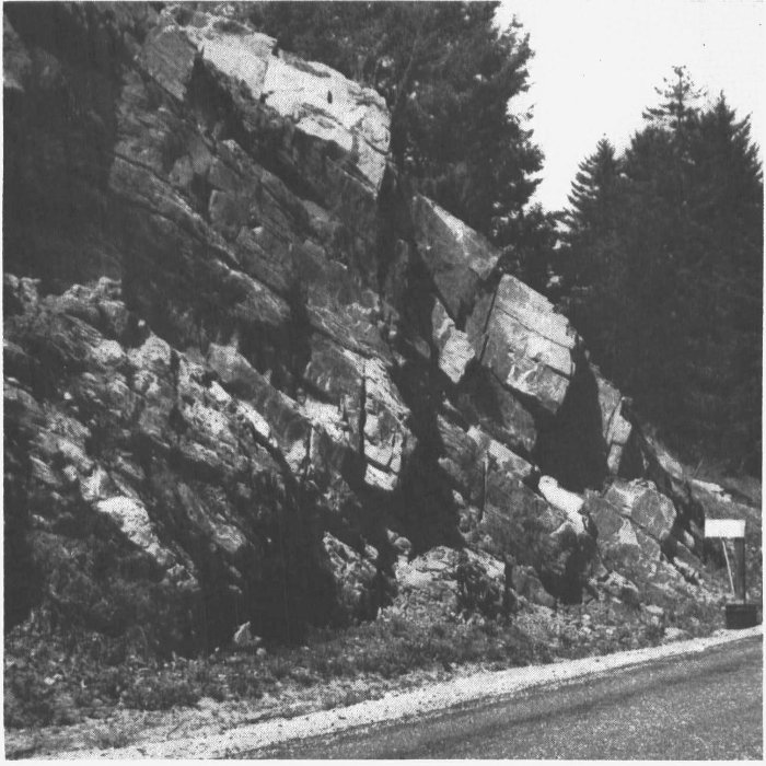
Figure 4. The Ottauquechee formation as exposed approximately nine-tenths of a
mile north of the Park entrance road and on the west side of State Highway 100A.
Note the massive quartzite layers above, the black phyllite below.
Above the Ottauquechee rocks lie those of the Bethel formation.
Approximately 2,000 feet thick, this formation is composed mainly of
pale-green schist with interlaminated thin layers of white to greenish
quartzite. The rock presents a distinct banded appearance and contains
conspicuous crystals of garnet and the black mica, biotite. The best
view of this schist is found along State Highway 100A and slightly over
two miles north of the Park entrance road. The relatively steep rock
cliffs which line the west side of this road are composed of the resistant
Bethel formation. In the northeast portion of Coolidge Forest Park
several excellent exposures of this formation in contact with the underlying
Ottauquechee formation can be seen, but, to reach these areas you
would have to leave the beaten trail. If you are interested in visiting
these contact locations it would be best to consult the geologic map for
approximate directions.
15
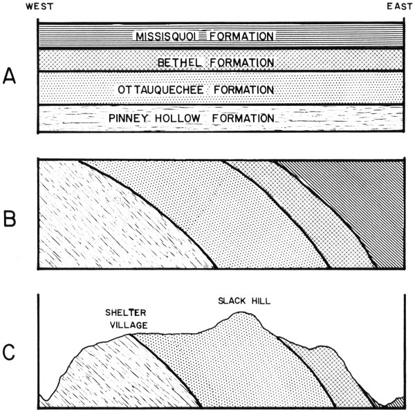
Figure 5. Diagrammatic cross sections illustrating the geologic history of the Calvin
Coolidge State Forest Park. Vertical scale greatly exaggerated. Patterns to designate
formations in cross section A are repeated in cross sections B and C.
A. Horizontal layers of early paleozoic sedimentary rocks were formed. This cross
section extends beyond the limits of the Park area. Thicknesses of rock formations
are approximately proportional.
B. During late Ordovician or Devonian time these sedimentary layers were folded
and the rocks metamorphosed.
C. Calvin Coolidge State Forest Park as it appears today.
- A
- MISSISQUOI FORMATION
- BETHEL FORMATION
- OTTAUQUECHEE FORMATION
- PINNEY HOLLOW FORMATION
- B
- C
- SHELTER VILLAGE
- SLACK HILL
16
The conditions under which the Bethel formation was originally
deposited are similar to those which existed during Pinney Hollow time.
Shale, sandy shale and thin-bedded sandstones formed under shallow
water marine conditions; however, restriction with accompanied organic
accumulation did not occur. This formation is thought to be of either
Cambrian or Ordovician age.
The easternmost, and therefore youngest formation to be found in
the Park area is known as the Missisquoi formation. This formation,
which is only partially represented here, is made up of dark phyllite,
light blue-gray schist with conspicuous crystals of garnet and biotite,
and gray quartzite. The rocks of this formation can be seen along Broad
Brook which flows north along the eastern border of Coolidge State
Forest Park.
This formation is considered Ordovician in age with the conditions of
deposition being quite similar to those which existed during Ottauquechee
time. Once again the ocean waters were restricted and organic-rich black
muds accumulated in quantity on the ocean floor.