Holliday Rest Area. The main John Day fault, which here is
buried under river gravel, is believed to be just south of the rest
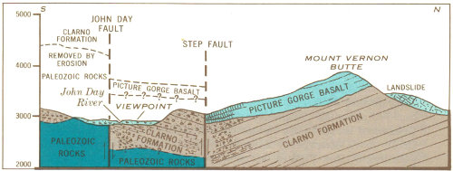
area. A parallel step fault (Fig. 2) cuts from left to right across the
southern slope of Mt. Vernon Butte about where the juniper trees
thin out. Flows of Picture Gorge Basalt in the upper part of the
butte slope down to valley level on your left. Rocks in the foreground
and to the right are rudely bedded volcanic breccias of
the Clarno Formation. The Clarno Formation has been raised as
much as 250 feet by movement along the fault to position it
against the basalt as indicated in the diagram. The fault can be
seen best in afternoon light in the ravine to the right, just south
of some brick-red layers in the basalt.
Movement on the main John Day fault to the south appears to
have raised the rocks at least 1,000 feet, so the two faults have
stairstepped the rock layers. The main John Day fault has been
traced about 80 miles.
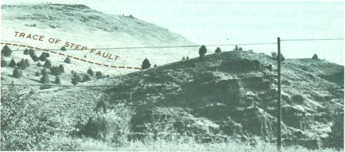
Fig. 2.—View of Mount Vernon Butte and diagram of faulting along its south slope.
[9]
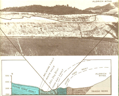
Fig. 3.—View of the John Day fault in Mascall Formation at the mouth of Fields Creek, and its relation to the structure of the John Day River valley.
Fields Creek Road. In the road cuts just south of the highway,
the John Day fault (Fig. 3) passes through the Mascall Formation
where the slope or dip of the beds changes abruptly from gently
southward to steeply northward. The fault continues westward
under the floor of the valley. Fossil leaves and snails can be found
in the beds south of the fault, and 1,000 feet farther south vertical
Picture Gorge Basalt flows are exposed.
To the north across the valley at the White Hills, beds of the
Mascall Formation have been dropped down against the Picture
Gorge Basalt along the Belshaw fault. The White Hills are a well-known
locality for collecting fossil leaves.
Vertical Ribs. The prominent vertical ribs, visible south of the
river in steep slopes below the high bench (pediment), are flows
of Picture Gorge Basalt tilted vertically in the north limb of the
Aldrich Mountain anticline. The John Day fault follows the base
of the steep front in which the ribs are exposed.
[10]
Volcanic Ash Flow. The rimrock north of the John Day River
between here and Dayville is a volcanic ash flow that erupted
about five million years ago as red hot pumice highly charged
with gas. A rapidly moving incandescent cloud probably filled
the ancient John Day River valley and deposited ash to a depth of
more than 100 feet over a distance of 60 to 70 miles. As shown in
Figure 4, the ash flow blankets about 200 feet of gravels that had
been deposited in the valley. The rimrock and the gravels above
and below it constitute the Rattlesnake Formation.
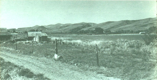
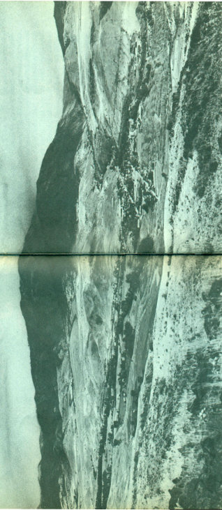
Fig. 4.—View northwest across the John Day River valley toward Picture Gorge.
[11]
Picture Gorge. Visible to the left of Picture Gorge, from north
around to west, in order of their deposition and geologic age from
oldest to youngest, are the Picture Gorge Basalt, Mascall Formation,
and Rattlesnake Formation (Fig. 5). The Picture Gorge Basalt
flows and ashy beds of the Mascall Formation were tilted southward
together and eroded before the Rattlesnake Formation was
laid down horizontally across them. Picture Gorge and the present
valley were then cut by the John Day River after the Rattlesnake
Formation had been tilted in its turn. The five benches or terraces
on the basalt just east of Picture Gorge mark temporary halts in
downcutting of the John Day River.
Thomas Condon Viewpoint, John Day Fossil Beds State Park.
From Picture Gorge to the cliffs opposite, the Picture Gorge
Basalts and varicolored ash beds of the John Day Formation rise
together nearly 2000 feet. The basalt that caps Sheep Rock is an
erosional remnant. The lower beds in the John Day Formation are
colored red by clay eroded from thick soil on the Clarno Formation,
which is exposed in the farthest red hill. The soil was formed
by tropical weathering some 30-35 million years ago, before the
John Day Formation was laid down. Faulting on a small scale is
illustrated in Sheep Rock, where the thick olive-drab ash flow in
the middle of the John Day Formation is offset 75-100 feet (Fig. 6).
The fault slopes about 45° eastward. About two miles downstream,
large-scale movement on two faults has dropped the basalt
flows in Middle Mountain 2000-2500 feet. One of the faults follows
along the upstream base of Middle Mountain (Fig. 6).
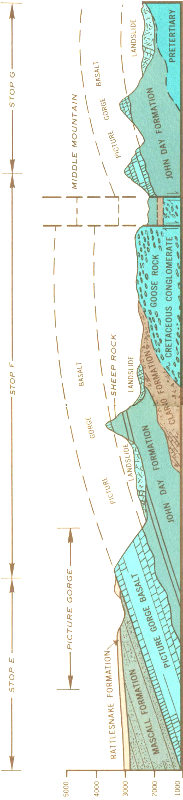
Fig. 5—North-south section along the John Day River through Picture Gorge and Middle Mountain.
[12]
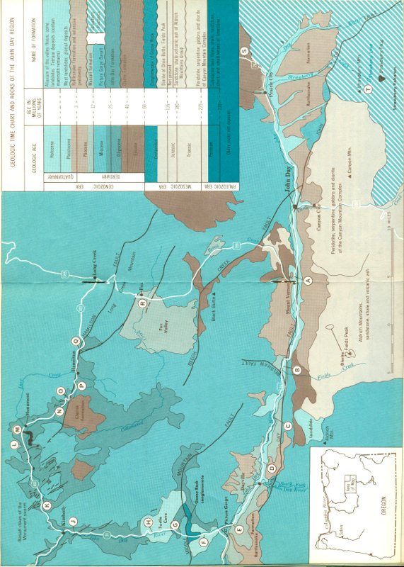
Fig. 1.—Geologic map of the John Day Country showing log route.
[Higher-Resolution Map]
[14]
Munro Area, John Day Fossil Beds State Park. The valley of the
John Day River has been widened to nearly five miles by erosion
in the John Day Formation. Large tilted slide blocks of the John
Day Formation and basalts jumbled together show how important
landsliding of soft beds under hard rocks can be in widening
valleys.
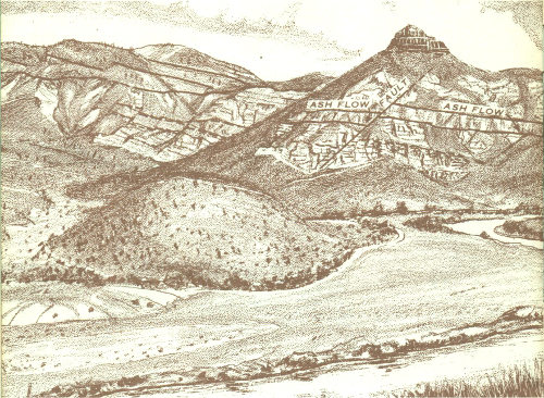
Fig. 6.—Sheep Rock from Thomas Condon viewpoint.
Here one can appreciate the regularity and extent of basalt
flows of the flood or plateau type, which form the Columbia
Plateau. Individual flows have been traced 100 miles. Travelers
will see few other rocks between here and The Dalles, Wenatchee,
Pendleton, or Spokane as they cross parts of the Columbia Plateau.
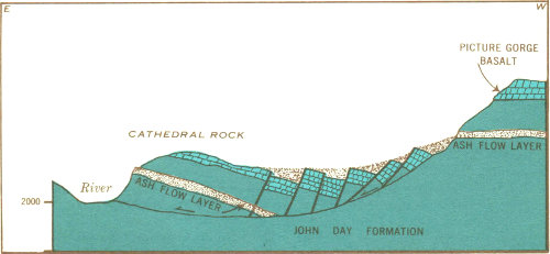
Cathedral Rock. The bluff called Cathedral Rock is the front
face of a large block of the John Day Formation that has slid from
the west (Fig. 7). Inside the next horseshoe bend downstream a
large mass of basalt is tilted down against Cathedral Rock. From
the highway 1.1 miles farther north one can see the side of the
tilted block along the river, and the same two prominent red and
olive-drab ash layers in the high bluff from which the block slid.
The horseshoe bend was formed as the river was pushed eastward
by the nose of the landslide.
[15]
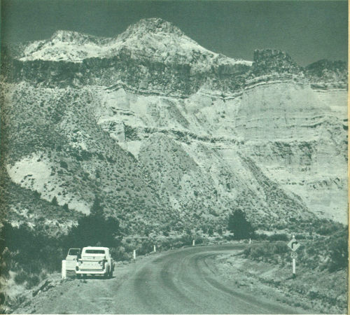
Fig. 7.—View of Cathedral Rock and diagram of landsliding.
[16]
Kimberly Dike. The low bluff across the river is formed by a
vertical dike of basalt which is about 60 feet wide. This dike cuts
through the John Day Formation and, farther north, the Picture
Gorge Basalt (Fig. 8). It crosses the river valley diagonally and can
be traced nearly four miles. The dike is formed of once-molten
rock that “froze” in a fissure which was a channelway for lava
that fed a flow on the earth’s surface. Many similar dikes are
visible along the road east of Kimberly. The basaltic magma is
believed to have originated at depths of 40 miles or more within
the part of the earth called the mantle.
(At 105.3 turn east on State Highway 402 along the North Fork
of the John Day River)
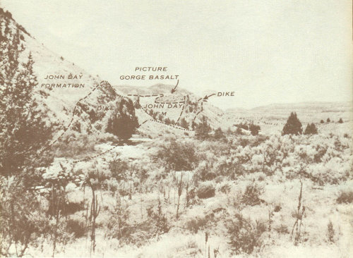
Fig. 8.—Basalt dike two miles south of Kimberly.
Basalt Dike. A basalt dike 15 feet wide cuts basalt flows in
bluffs north of the road and forms a wall 20 feet high in places;
it is visible also across the river.
Parallel Dikes. Two prominent parallel dikes, among others,
form crests of hogbacks south of the river. A small tapering dike
cuts pink and white beds of the John Day Formation in the river
bluff. This dike is the southwest end of an irregular intrusive mass
of basalt in which the river has cut a steep-walled gorge.
[17]
Basalt Intrusion. The road is cut through 300 feet of basalt intruded
into the John Day Formation. Both contacts are well
exposed. The basalt—when molten—baked and reddened 3 to 6
inches of the adjacent beds.
(At 13.9 the highway crosses the North Fork of the John Day River
and follows the Cottonwood Creek Valley.)
Irregular Dikes. Above the highway several small irregular
basalt dikes cut the white beds of the John Day Formation. Parts
of the largest dike are 10 to 15 feet high.
Cottonwood Creek Valley. The view northwestward down Cottonwood
Creek toward Monument (Fig. 9) exemplifies the development
of broad valleys by erosion in soft beds of the John Day
Formation under the gently warped Picture Gorge Basalt. To the
south, the valley ends against massive rocks of the Clarno Formation
which were raised as a block by movement along the Hamilton
fault. The red beds are in the lower part of the John Day
Formation. Note the contrast between the irregular massive intrusion
in the valley bottom west of Monument and the thin
regular basalt flows.
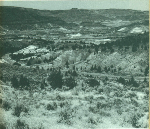
Fig. 9.—Northwest view down Cottonwood Creek toward Monument.
[18]
On your right, the irregular contact between the John Day Formation
and Picture Gorge Basalt reveals an ancient landscape
buried under lava flows (Fig. 10). Some of the flows wedge out
against former hillsides and one, marked by the dry falls, fills an
old valley.
For the next two miles, to the Sunken Mountain viewpoint, the
road winds through landslides in the John Day Formation and
Picture Gorge Basalt.
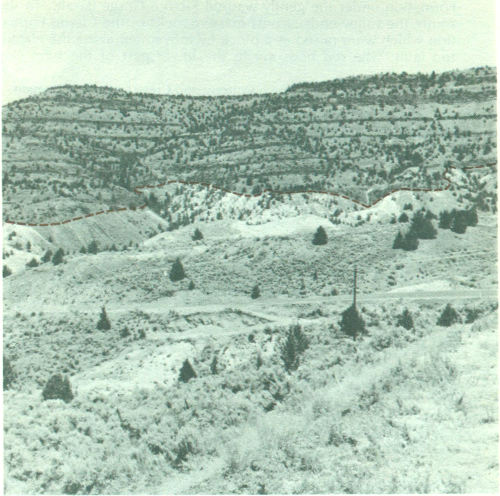
Fig. 10.—Ancient landscape on John Day Formation buried under Picture Gorge Basalt.
Sunken Mountain. A small landslide in the lower part of the
John Day Formation is called Sunken Mountain. When the valley
wall was over-steepened by normal stream erosion, the jumbled
material in the lower part broke away and slid down from the
steep bare slopes above. Absence of tilted trees indicates that the
slide is not very active now. The bare “badland” slopes are
being eroded by rain wash.
[19]
The cliffs of the John Day Formation, which the road climbs half
a mile farther east, are the result of rapid but normal headward
erosion by the creek. Eventually, because of its lower elevation
and steeper gradient, this branch of Cottonwood Creek will intercept
and behead Deer Creek just east of Hamilton. A photogenic
perspective view of the future stream piracy can be seen from the
road on the ridge just south of Sunken Mountain, about a mile and
a half from the highway.
Long Creek Mountain. An uplifted block of Picture Gorge
Basalt 1400-1500 feet thick forms Long Creek Mountain; Round
Basin is eroded in the John Day Formation on which the basalt
rests (Fig. 11). The base of the basalt can be seen in road cuts
on either side of Basin Creek. The Hamilton fault follows the
gulch to the left just below the parking area, goes up the tree-filled
gulch across Basin Creek, along the low ridge at the northeast
edge of Round Basin, and then along the northern foot of
the mountain. The small slab of basalt south of the fault in Basin
Creek has been tilted about 10° north by downward drag along
the fault. The Hamilton fault system extends about 15 miles
farther east.
(In Long Creek turn right—south—on U. S. Highway 395).
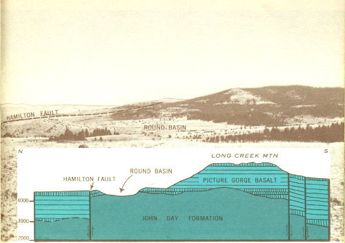
Fig. 11.—View of Long Creek Mountain and Round Basin, and diagram of the geologic structure.
[20]
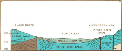
Fig. 12.—North-south section across Fox Valley, showing the faulted basin structure.
Fox Valley. Down-warped flows of Picture Gorge Basalt dip
toward Fox Valley from all sides to form a basin (Fig. 12). The
valley is eroded out of ashy beds and gravels of the Mascall Formation
which fill the center of the basin to an estimated depth of
1000-1200 feet. Faults form parts of the northern and southern
borders of the basin. The straight, timbered, northward-facing
steep slope less than a mile southeast of the viewpoint marks a
fault.
[21]
Strawberry Range. This range and the Aldrich Mountains form
a mountain range 50 miles long; Strawberry Mountain, altitude
9038 feet above sea level, is its highest peak. The eastern two-thirds
of the Strawberry Range (Fig. 13) was raised as a great block
by uplift on the John Day fault, which follows the northern base
of the mountains. The rocks in Strawberry Mountain and to the
east are mostly lavas which poured out over the land, whereas
the Canyon Mountain part of the range consists of gabbro and
peridotite which were intruded at great depth, like granite.
The valleys in the higher parts of the range, above about 5000
feet, were widened from narrow V’s to their broad U profiles by
glaciers during the Pleistocene Epoch, or Great Ice Age. The
alluvial fans (Rattlesnake Formation) in front of the mountains
were built up of bouldery gravels and finer sediments. These
materials were eroded from the mountains, carried by streams
down the steep narrow canyons, and spread out on the valley
floor. Because much more material came into the John Day River
from the Strawberry Mountains than from the lower mountains to
the north, the river was pushed to the north side of its wide valley.
Faulting and erosion have completely destroyed the cones of the
volcanoes from which the volcanic rocks were erupted in Miocene
and Pliocene time.
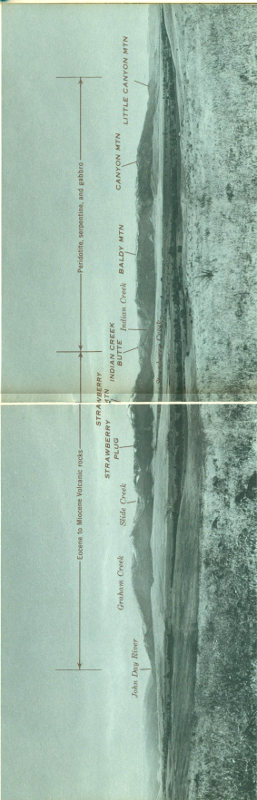
Fig. 13.—Panorama of the Strawberry Range and the John Day River valley from the north.
[22]

Fig. 14.—Section through the Strawberry Mountain, along Strawberry Creek.
[This image in higher resolution]
Strawberry Lake and Vicinity. At Strawberry Camp, about 12
miles south of Prairie City, the broad floor and steep walls of
Strawberry Creek valley indicate that the valley has been glaciated.
The precipitous cliffs and rounded valley bottom above Strawberry
Lake are characteristic of glaciated mountains (Fig. 15). Strawberry
Lake is dammed by landslides which probably came from
the west wall of the valley after the glacier melted and left the
valley wall over-steepened. The hummocky surface and blocky
material in the slide are well shown along the last half mile of the
trail to Strawberry Lake. Strawberry Falls mark the front of a
glacial step over a massive flow of platy andesite. Little Strawberry
Lake is dammed by a low glacial moraine.
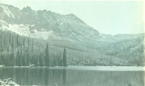
Fig. 15.—Strawberry Lake, the glaciated valley of Strawberry Creek, and cirque walls formed by the Strawberry volcanic plug.
[23]
Most of the lavas in the Strawberry Mountains were erupted
from a central vent about 4000 feet in diameter which is exposed
in the cliffs above Little Strawberry Lake. The pinnacles known
as “Rabbit Ears,” above the prominent talus in figure 15, are of
vent breccias that consist mostly of welded blocks of scoriaceous
basalt, but also contain volcanic bombs which were blown out as
blobs of fluid lava. Huge blocks of the breccia have fallen onto a
gentle bare slope west of Little Strawberry Lake. The massive,
vertically-jointed cliffs are formed of basalt which cooled slowly
and formed a plug in the throat of the volcano after the eruptions
ceased. The thin irregular scoriaceous andesite flows, which are
exposed in the cliffs east of Little Strawberry Lake adjoining the
plug, contrast strikingly with the massive even flows of the Picture
Gorge Basalt.
Tilting of the Strawberry Mountain block is shown by the southward
dip of all the flows in the area. The flows in the cliffs west
of Strawberry Lake, for example, originally must have sloped
northward away from the vent where they erupted. Their present
southward dip of about 15° therefore indicates that they have
been rotated more than 15° by faulting, partly along the northern
edge of the mountain range. (Fig. 14).