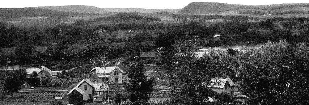
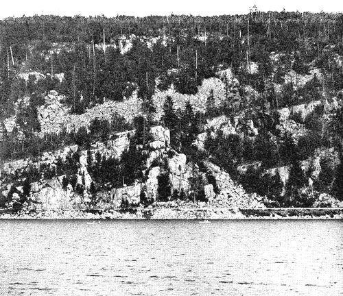
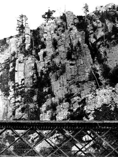
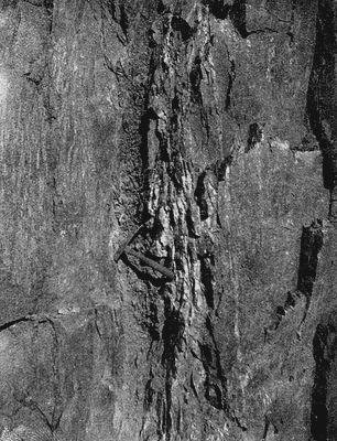
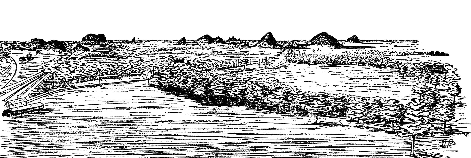
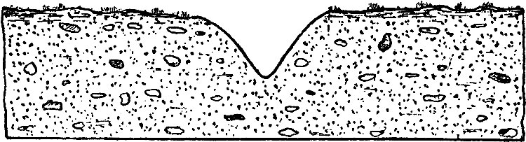
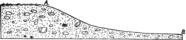
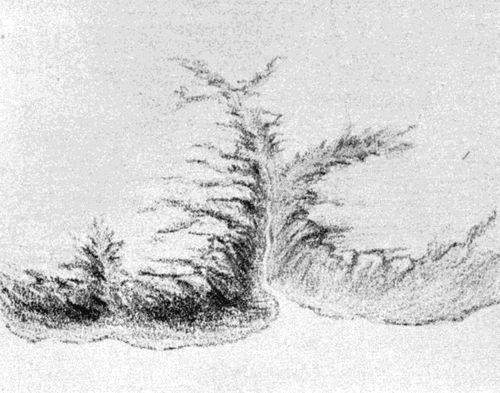
The eastern part of the area with which this report deals, is covered
with a mantle of drift which, as already pointed out, has greatly
modified the details of its topography. To the consideration of the
drift and its history attention is now turned.
The drift.—The drift consists of a body of clay, sand, gravel and
bowlders, spread out as a cover of unequal thickness over the rock
formations beneath. These various classes of material may be confusedly
commingled, or they may be more or less distinctly separated from one
another. When commingled, all may be in approximately equal proportions,
or any one may predominate over any or all the others to any extent.
It was long since recognized that the materials of the drift did not
originate where they now lie, and that, in consequence, they sustain no
genetic relationship to the strata on which they rest. Long before the
drift received any special attention from geologists, it was well known
that it had been transported from some other locality to that where it
now occurs. The early conception was that it had been drifted into its
present position from some outside source by water. It was this
conception of its origin which gave it the name of drift. It is now
known that the drift was deposited by glacier ice and the waters which
arose from its melting, but the old name is still retained.
Clearly to understand the origin of the drift, and the method by which
it attained its present distribution, it may be well to consider some
elementary facts and principles concerning climate and its effects, even
at the risk of repeating what is already familiar.
Snow fields and ice sheets.—The temperature and the snowfall of a
region may stand in such a relation to each other that the summer's heat
may barely suffice to melt the winter's snow. If under these
circumstances the annual temperature were to be reduced, or the fall of
snow increased, the summer's heat would fail to melt all the winter's
snow, and some portion of it would endure through the summer, and
through successive summers, constituting a perennial snow-field. Were
this process once inaugurated, the depth of the snow would increase from
year to year. The area of the snow-field would be extended at the same
time, since the snow-field would so far reduce the surrounding
temperature as to increase the proportion of the annual precipitation
which fell as snow. In the course of time, and under favorable
conditions, the area of the snow-field would attain great dimensions,
and the depth of the snow would become very great.
As in the case of existing snow fields the lower part of the snow mass
would eventually be converted into ice. Several factors would conspire
to this end. 1. The pressure of the overlying snow would tend to
compress the lower portion, and snow rendered sufficiently compact by
compression would be regarded as ice. 2. Water arising from the melting
of the surface snow by the sun's heat, would percolate through the
superficial layers of snow, and, freezing below, take the form of ice.
3. On standing, even without pressure or partial melting, snow appears
to undergo changes of crystallization which render it more compact. In
these and perhaps other ways, a snow-field becomes an ice-field, the
snow being restricted to its surface.
Eventually the increase in the depth of the snow and ice in a snow-field
will give rise to new phenomena. Let a snow and ice field be assumed in
which the depth of snow and ice is greatest at the center, with
diminution toward its edges. The field of snow, if resting on a level
base, would have some such cross-section as that represented in the
diagram, Fig. 27.
When the thickness of the ice has become considerable, it is evident
that the pressure upon its lower and marginal parts will be great. We
are wont to think of ice as a brittle solid. If in its place there were
some plastic substance which would yield to pressure, the weight of the
ice would cause the marginal parts to extend themselves in all
directions by a sort of flowing motion.
Fig. 27. -- Diagrammatic cross-section of a field of ice
and snow (C) resting on a level base A-B.
See larger image
Under great pressure, many substances which otherwise appear to be
solid, exhibit the characteristics of plastic bodies. Among the
substances exhibiting this property, ice is perhaps best known. Brittle
and resistant as it seems, it may yet be molded into almost any
desirable form if subjected to sufficient pressure, steadily applied
through long intervals of time. The changes of form thus produced in ice
are brought about without visible fracture. Concerning the exact nature
of the movement, physicists are not agreed; but the result appears to be
essentially such as would be brought about if the ice were capable of
flowing, with extreme slowness, under great pressure continuously
applied.
In the assumed ice-field, there are the conditions for great pressure
and for its continuous application. If the ice be capable of moving as a
plastic body, the weight of the ice would induce gradual movement
outward from the center of the field, so that the area surrounding the
region where the snow accumulated would gradually be encroached upon by
the spreading of the ice. Observation shows that this is what takes
place in every snow-field of sufficient depth. Motion thus brought about
is glacier motion, and ice thus moving is glacier ice.
Once in motion, two factors would determine the limit to which the ice
would extend itself: (1) the rate at which it advances; and (2) the rate
at which the advancing edge is wasted. The rate of advance would depend
upon several conditions, one of which, in all cases, would be the
pressure of the ice which started and which perpetuates the motion. If
the pressure be increased the ice will advance more rapidly, and if it
advance more rapidly, it will advance farther before it is melted. Other
things remaining constant, therefore, increase of pressure will cause
the ice-sheet to extend itself farther from the center of motion.
Increase of snowfall will increase the pressure of the snow and ice
field by increasing its mass. If, therefore, the precipitation over a
given snow-field be increased for a period of years, the ice-sheet's
marginal motion will be accelerated, and its area enlarged. A decrease
of precipitation, taken in connection with unchanged wastage would
decrease the pressure of the ice and retard its movement. If, while the
rate of advance diminished, the rate of wastage remained constant, the
edge of the ice would recede, and the snow and ice field be contracted.
The rate at which the edge of the advancing ice is wasted depends
largely on the climate. If, while the rate of advance remains constant,
the climate becomes warmer, melting will be more rapid, and the ratio
between melting and advance will be increased. The edge of the ice will
therefore recede. The same result will follow, if, while temperature
remains constant, the atmosphere becomes drier, since this will increase
wastage by evaporation. Were the climate to become warmer and drier at
the same time, the rate of recession of the ice would be greater than if
but one of these changes occurred.
If, on the other hand, the temperature over and about the ice field be
lowered, melting will be diminished, and if the rate of movement be
constant, the edge of the ice will advance farther than under the
earlier conditions of temperature, since it has more time to advance
before it is melted. An increase in the humidity of the atmosphere,
while the temperature remains constant, will produce the same result,
since increased humidity of the atmosphere diminishes evaporation. A
decrease of temperature, decreasing the melting, and an increase of
humidity, decreasing the evaporation, would cause the ice to advance
farther than either change alone, since both changes decrease the
wastage. If, at the same time that conditions so change as to increase
the rate of movement of the ice, climatic conditions so change as to
reduce the rate of waste, the advance of the ice before it is melted
will be greater than where only one set of conditions is altered. If,
instead of favoring advance, the two series of conditions conspire to
cause the ice to recede, the recession will likewise be greater than
when but one set of conditions is favorable thereto.
Greenland affords an example of the conditions here described. A large
part of the half million or more square miles which this body of land is
estimated to contain, is covered by a vast sheet of snow and ice,
thousands of feet in thickness. In this field of snow and ice, there is
continuous though slow movement. The ice creeps slowly toward the
borders of the island, advancing until it reaches a position where the
climate is such as to waste (melt and evaporate) it as rapidly as it
advances.
The edge of the ice does not remain fixed in position. There is reason
to believe that it alternately advances and retreats as the ratio
between movement and waste increases or decreases. These oscillations in
position are doubtless connected with climatic changes. When the ice
edge retreats, it may be because the waste is increased, or because the
snowfall is decreased, or both. In any case, when the ice edge recedes
from the coast, it tends to recede until its edge reaches a position
where the melting is less rapid than in its former position, and where
the advance is counterbalanced by the waste. This represents a condition
of equilibrium so far as the edge of the ice is concerned, and here the
edge of the ice would remain so long as the conditions were unchanged.
When for a period of years the rate of melting of the ice is diminished,
or the snowfall increased, or both, the ice edge advances to a new line
where melting is more rapid than at its former edge. The edge of the ice
would tend to reach a position where waste and advance balance. Here its
advance would cease, and here its edge would remain so long as climatic
conditions were unchanged.
If the conditions determining melting and flowage be continually
changing, the ice edge will not find a position of equilibrium, but will
advance when the conditions are favorable for advance, and retreat when
the conditions are reversed.
Not only the edge of the ice in Greenland, but the ends of existing
mountain glaciers as well, are subject to fluctuation, and are delicate
indices of variations in the climate of the regions where they occur.
The North American ice sheet.—In an area north of the eastern part of
the United States and in another west of Hudson Bay it is believed that
ice sheets similar to that which now covers Greenland began to
accumulate at the beginning of the glacial period. From these areas as
centers, the ice spread in all directions, partly as the result of
accumulation, and partly as the result of movement induced by the weight
of the ice itself.
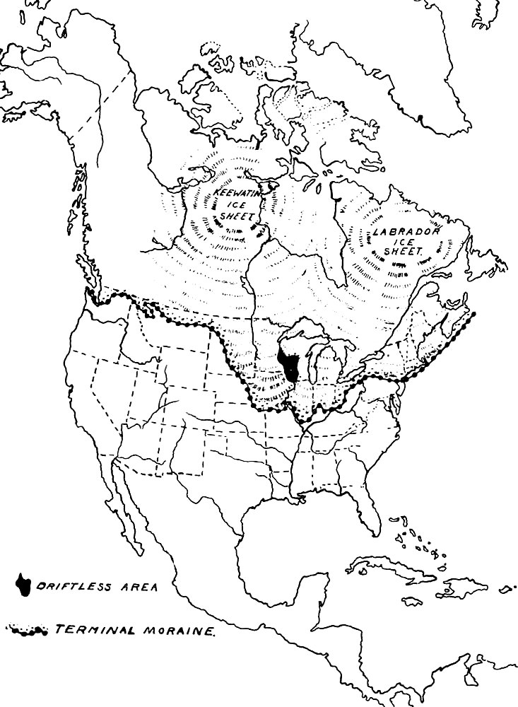
The ice sheets spreading from these centers came together south of
Hudson's bay, and invaded the territory of the United States as a single
sheet, which, at the time of its greatest development, covered a large
part of our country (Plate XXXIII), its
area being known by the extent of the drift which it left behind when it
was melted. In the east, it buried the whole of New England, most of New
York, and the northern parts of New Jersey and Pennsylvania. Farther west,
the southern margin of the ice crossed the Ohio river in the vicinity of
Cincinnati, and pushed out over the uplands a few miles south of the river.
In Indiana, except at the extreme east, its margin fell considerably short
of the Ohio; in Illinois it reached well toward that river, attaining here its
most southerly latitude. West of the Mississippi, the line which marks
the limit of its advance curves to the northward, and follows, in a
general way, the course of the Missouri river. The total area of the
North American ice sheet, at the time of its maximum development, has
been estimated to have been about 4,000,000 square miles, or about ten
times the estimated area of the present ice-field of Greenland.
Within the general area covered by the ice, there is an area of several
thousand square miles, mainly in southwestern Wisconsin, where there is
no drift. The ice, for some reason, failed to cover this driftless
area though it overwhelmed the territory on all sides.
WISCONSIN GEOL. AND NAT. HIST. SURVEY. BULLETIN NO. V.,
PL. XXXIII.
The North American Ice Sheet, at the time of maximum development.
See larger image
WISCONSIN GEOL. AND NAT. HIST. SURVEY. BULLETIN NO. V.,
PL. XXXIV.
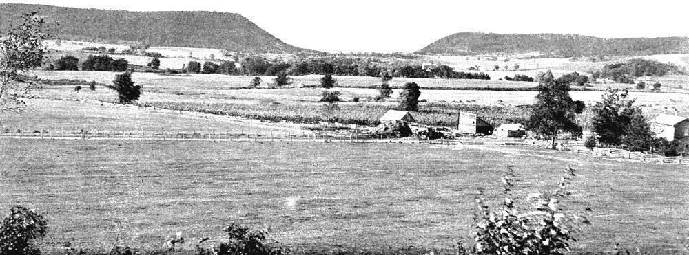
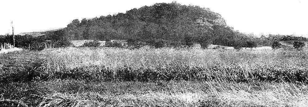
View from the north of the Owl's Head, a hill two miles north of east of
Merrimac, which has been shaped by the ice. The side to the left is the
stone side.
See larger image
Plate II shows the limit of ice advance in the area here described. The
region may have been affected by the ice of more than one glacial epoch,
but the chief results now observable were effected during the last, and
the others need not be considered.
As the edge of an ice sheet, or as the end of a glacier, retreats, the
land which it has previously covered is laid bare, and the effects which
the passage of the ice produced may be seen. In some cases one may
actually go back a short distance beneath the ice now in motion, and see
its mode of work and the results it is effecting. The beds of living
glaciers, and the beds which glaciers have recently abandoned, are found
to present identical features. Because of their greater accessibility,
the latter offer the better facilities for determining the effects of
glaciation.
The conspicuous phenomena of abandoned glacier beds fall into two
classes, (1) those which pertain to the bed rock over which the ice
moved, and (2) those which pertain to the drift left by the ice.
Erosive work of the ice.—Effect on topography.—The leading
features of the rock bed over which glacier ice has moved, are easily
recognized. Its surface is generally smoothed and polished, and
frequently marked by lines (striæ) or grooves, parallel to one another.
An examination of the bottom of an active glacier discloses the method
by which the polishing and scoring are accomplished.
The lower surface of the ice is thickly set with a quantity of clay,
sand, and stony material of various grades of coarseness. These earthy
and stony materials in the base of the ice are the tools with which it
works. Thus armed, the glacier ice moves slowly forward, resting down
upon the surfaces over which it passes with the whole weight of its
mass, and the grinding action between the stony layer at the base of the
ice and the rock bed over which it moves, is effective. If the material
in the bottom of the ice be fine, like clay, the rock bed is polished.
If coarser materials, harder than the bed-rock, be mingled with the
fine, the rock bed of the glacier will be scratched as well as polished.
If there are bowlders in the bottom of the ice they may cut grooves or
gorges in the underlying rock. The grooves may subsequently be polished
by the passage over and through them of ice carrying clay or other fine,
earthy matter.
All these phases of rock wear may be seen about the termini of receding
glaciers, on territory which they have but recently abandoned. There can
thus be no possible doubt as to the origin of the polishing, planing and
scoring.
There are other peculiarities, less easily defined, which characterize
the surface of glacier beds. The wear effected is not confined to the
mere marking of the surface over which it passes. If prominences of rock
exist in its path, as is often the case, they oppose the movement of the
ice, and receive a corresponding measure of abrasion from it. If they be
sufficiently resistant they may force the ice to yield by passing over
or around them; but if they be weak, they are likely to be destroyed.
As the ice of the North American ice sheet advanced, seemingly more
rigid when it encountered yielding bodies, and more yielding when it
encountered resistant ones, it denuded the surface of its loose and
movable materials, and carried them forward. This accumulation of earthy
and stony debris in the bottom of the ice, gave it a rough and grinding
lower surface, which enabled it to abrade the land over which it passed
much more effectively than ice alone could have done. Every hill and
every mound which the ice encountered contested its advance. Every
sufficiently resistant elevation compelled the ice to pass around or
over it; but even in these cases the ice left its marks upon the surface
to which it yielded. The powerful pressure of pure ice, which is
relatively soft, upon firm hills of rock, which are relatively hard,
would effect little. The hills would wear the ice, but the effect of the
ice on the hills would be slight. But where the ice is supplied with
earthy and stony material derived from the rock itself, the case is
different. Under these conditions, the ice, yielding only under great
pressure and as little as may be, rubs its rock-shod base over every
opposing surface, and with greatest severity where it meets with
greatest resistance. Its action may be compared to that of a huge
"flexible-rasp" fitting down snugly over hills and valleys alike, and
working under enormous pressure.
The abrasion effected by a moving body of ice under such conditions
would be great. Every inch of ice advance would be likely to be attended
by loss to the surface of any obstacle over or around which it is
compelled to move. The sharp summits of the hills, and all the angular
rugosities of their surfaces would be filed off, and the hills smoothed
down to such forms as will offer progressively less and less resistance.
If the process of abrasion be continued long enough, the forms, even of
the large hills, may be greatly altered, and their dimensions greatly
reduced. Among the results of ice wear, therefore, will be a lowering of
the hills, and a smoothing and softening of their contours, while their
surfaces will bear the marks of the tools which fashioned them, and will
be polished, striated or grooved, according to the nature of the
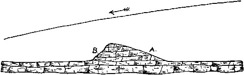
material which the ice pressed down upon them during its passage. Figs.
28 and 29
show the topographic effects which ice is likely to produce by
erosion. Plate XXXIV is a hill two miles northeast of Merrimac, which
shows how perfectly the wear actually performed corresponds to that
which might be inferred.

Fig. 28. -- A hill before the ice passes over it.
A rock hill was sometimes left without covering of drift after having
been severely worn by the ice. Such a hill is known as a roche
moutonnée. An example of this type of hill occurs three miles north of
east of Baraboo at the point marked z on Plate XXXVII.
This hill, composed of quartzite, is less symmetrical than those shown
in Figs. 28 and 29.
Its whole surface, not its stoss side only, has been
smoothed and polished by the ice. This hill is the most accessible, the
most easily designated, and, on the whole, the best example of a roche
moutonnée in the region, though many other hills show something of the
same form.
Fig. 29. -- The same hill after it has been eroded by the
ice. A the stoss side. B the lee side.
It was not the hills alone which the moving ice affected. Where it
encountered valleys in its course they likewise suffered modification.
Where the course of a valley was parallel to the direction of the ice
movement, the ice moved through it. The depth of moving ice is one of
the determinants of its velocity, and because of the greater depth of
ice in valleys, its motion here was more rapid than on the uplands
above, and its abrading action more powerful. Under these conditions the
valleys were deepened and widened.
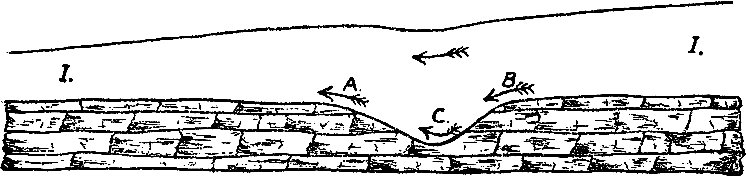
Where the courses of the valleys were transverse to the direction of ice
movement, the case was different. The ice was too viscous to span the
valleys, and therefore filled them. In this case it is evident that the
greater depth of the ice in the valley will not accelerate its motion,
since the ice in the valley-trough and that above it are in a measure
opposed. If left to itself, the ice in the valley would tend to flow in
the direction of the axis of the valley. But in the case under
consideration, the ice which lies above the valley depression is in
motion at right angles to the axis of the valley. Under these
circumstances three cases might arise:
1. If the movement of the ice sheet over the valley were able to push
the valley ice up the farther slope, and out on the opposite highland,
this work would retard the movement of the upper ice, since the
resistance to movement would be great. In this case, the thickness of
the ice is not directly and simply a determinant of its velocity. Under
these conditions the bottom of the valley would not suffer great
erosion, since ice did not move along it; but that slope of the valley
against which the ice movement was projected would suffer great wear
(Fig. 30). The valley would therefore be widened, and the slope
suffering greatest wear would be reduced to a lower angle. Shallow
valleys, and those possessing gentle slopes, favor this phase of ice
movement and valley wear.
Fig. 30. -- Diagram showing effect on valley of ice moving
transversely across it.
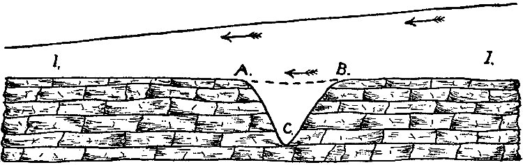
2. The ice in the valley might become stationary, in which case it
might serve as a bridge for the upper ice to cross on (Fig. 31). In this
case also the total thickness of ice will not be a determinant of its
velocity, for it is the thickness of the moving ice only, which
influences the velocity. In this case the valley would not suffer much
wear, so long as this condition of things continued. Valleys which have
great depth relative to the thickness of the ice, and valleys whose
slopes are steep, favor this phase of movement.
3. In valleys whose courses are transverse to the direction of ice
movement, transverse currents of ice may exist, following the direction
of the valleys. If the thickness of the ice be much greater than the
depth of the valley, if the valley be capacious, and if one end of it be
open and much lower than the other, the ice filling it may move along
its axis, while the upper ice continues in its original course at right
angles to the valley. In this case the valley would be deepened and
widened, but this effect would be due to the movement along its course,
rather than to that transverse to it.
Fig. 31. -- Diagram to illustrate case where ice fills a
valley (C) and the upper ice then moves on over the filling.
If the course of a valley were oblique to the direction of ice movement,
its effect on the movement of ice would be intermediate between that of
valleys parallel to the direction of movement, and those at right angles
to it.
It follows from the foregoing that the corrasive effects of ice upon the
surface over which it passed, were locally dependent on pre-existent
topography, and its relation to the direction of ice movement. In
general, the effort was to cut down prominences, thus tending to level
the surface. But when it encountered valleys parallel to its movement
they were deepened, thus locally increasing relief. Whether the
reduction of the hills exceeded the deepening of the valleys, or whether
the reverse was true, so far as corrasion alone is concerned, is
uncertain. But whatever the effect of the erosive effect of ice action
upon the total amount of relief, the effect upon the contours was to
make them more gentle. Not only were the sharp hills rounded off, but
even the valleys which were deepened were widened as well, and in the
process their slopes became more gentle. A river-erosion topography,
modified by the wearing (not the depositing) action of the ice, would be
notably different from the original, by reason of its gentler slopes and
softer contours (Figs. 28 and
29).
Deposition by the ice. Effect on topography.—On melting, glacier ice
leaves its bed covered with the debris which it gathered during its
movement. Had this debris been equally distributed on and in and beneath
the ice during its movement, and had the conditions of deposition been
everywhere the same, the drift would constitute a mantle of uniform
thickness over the underlying rock. Such a mantle of drift would not
greatly alter the topography; it would simply raise the surface by an
amount equal to the thickness of the drift, leaving elevations and
depressions of the same magnitude as before, and sustaining the same
relations to one another. But the drift carried by the ice, in whatever
position, was not equally distributed during transportation, and the
conditions under which it was deposited were not uniform, so that it
produced more or less notable changes in the topography of the surface
on which it was deposited.
The unequal distribution of the drift is readily understood. The larger
part of the drift transported by the ice was carried in its basal
portion; but since the surface over which the ice passed was variable,
it yielded a variable amount of debris to the ice. Where it was hilly,
the friction between it and the ice was greater than where it was plain,
and the ice carried away more load. From areas where the surface was
overspread by a great depth of loose material favorably disposed for
removal, more debris was taken than from areas where material in a
condition to be readily transported was meager. Because of the
topographic diversity and lithological heterogeneity of the surface of
the country over which it passed, some portions of the ice carried much
more drift than others, and when the ice finally melted, greater depths
of drift were left in some places than in others. Not all of the
material transported by the ice was carried forward until the ice
melted. Some of it was probably carried but a short distance from its
original position before it lodged. Drift was thus accumulating at some
points beneath the ice during its onward motion. At such points the
surface was being built up; at other points, abrasion was taking place,
and the surface was being cut down. The drift mantle of any region does
not, therefore, represent simply the material which was on and in and
beneath the ice of that place at the time of its melting, but it
represents, in addition, all that lodged beneath the ice during its
movement.
The constant tendency was for the ice to carry a considerable part of
its load forward toward its thinned edge, and there to leave it. It
follows that if the edge of the ice remained constant in position for
any considerable period of time, large quantities of drift would have
accumulated under its marginal portion, giving rise to a belt of
relatively thick drift. Other things being equal, the longer the time
during which the position of the edge was stationary, the greater the
accumulation of drift. Certain ridge-like belts where the drift is
thicker than on either hand, are confidently believed to mark the
position where the edge of the ice-sheet stood for considerable periods
of time.
Because of the unequal amounts of material carried by different parts of
the ice, and because of the unequal and inconstant conditions of
deposition under the body of the ice and its edge, the mantle of drift
has a very variable thickness; and a mantle of drift of variable
thickness cannot fail to modify the topography of the region it covers.
The extent of the modification will depend on the extent of the
variation. This amounts in the aggregate, to hundreds of feet. The
continental ice sheet, therefore, modified the topography of the region
it covered, not only by the wear it effected, but also by the deposits
it made.
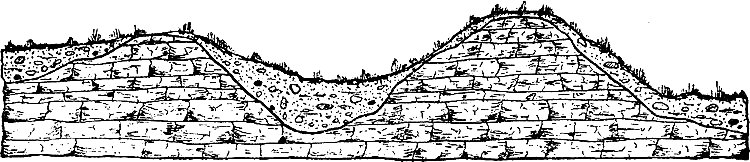
In some places it chanced that the greater thicknesses of drift were
left in the positions formerly marked by valleys. Locally the body of
drift was so great that valleys were completely filled, and therefore
completely obliterated as surface features. Less frequently, drift not
only filled the valleys but rose even higher over their former positions
than on either side. In other places the greater depths of drift,
instead of being deposited in the valleys, were left on pre-glacial
elevations, building them up to still greater heights. In short, the
mantle of drift of unequal thickness was laid down upon the rock
surface in such a manner that the thicker parts sometimes rest on hills
and ridges, sometimes on slopes, sometimes on plains, and sometimes in
valleys.
Fig. 32. -- Diagrammatic section showing relation of drift
to underlying rock, where the drift is thick relative to the relief of
the rock. a and b represent the location of post-glacial valleys.
These relations are suggested by Figs. 32
and 33. From them it will be
seen that in regions where the thickness of the drift is great, relative
to the relief of the underlying rock, the topography may be completely
changed. Not only may some of the valleys be obliterated by being
filled, but some of the hills may be obliterated by having the lower
land between them built up to their level. In regions where the
thickness of the drift is slight, relative to the relief of the rock
beneath, the hills cannot be buried, and the valleys cannot be
completely filled, so that the relative positions of the principal
topographic features will remain much the same after the deposition of
the drift, as before (Fig. 33).
Fig. 33. -- Diagrammatic section showing relation of drift
to underlying rock where the drift is thin relative to the relief of the
underlying rock.
In case the pre-glacial valleys were filled and the hills buried, the
new valleys which the surface waters will in time cut in the drift
surface will have but little correspondence in position with those
which existed before the ice incursion. A new system of valleys, and
therefore a new system of ridges and hills, will be developed, in some
measure independent of the old. These relations are illustrated by Fig.
32.
Inequalities in the thickness of drift lead to a still further
modification of the surface. It frequently happened that in a plane or
nearly plane region a slight thickness of drift was deposited at one
point, while all about it much greater thicknesses were left. The area
of thin drift would then constitute a depression, surrounded by a higher
surface built up by the thicker deposits. Such depressions would at
first have no outlets, and are therefore unlike the depressions shaped
by rain and river erosion. The presence of depressions without outlets
is one of the marks of a drift-covered (glaciated) country. In these
depressions water may collect, forming lakes or ponds, or in some cases
only marshes and bogs.
The direction in which glacier ice moved may be determined in various
ways, even after the ice has disappeared. The shapes of the rock hills
over which the ice passed (p. 81), the direction from which the
materials of the drift came, and the course of the margin of the drift,
all show that the ice of south central Wisconsin was moving in a general
southwest direction. In the rock hills, this is shown by the greater
wear of their northeast ("stoss") sides (Plate XXXIV). From the
course of the drift margin, the general direction of movement may be
inferred when it is remembered that the tendency of glacier ice on a
plane surface is to move at right angles to its margin.
For the exact determination of the direction of ice movement, recourse
must be had to the striæ on the bed-rock. Were the striated rock surface
perfectly plane, and were the striæ even lines, they would only tell
that the ice was moving in one of two directions. But the rock surface
is not usually perfectly plane, nor the striæ even lines, and between
the two directions which lines alone might suggest, it is usually
possible to decide. The minor prominences and depressions in the rock
surface were shaped according to the same principles that govern the
shaping of hills (Fig. 29) and valleys
(Fig. 30); that is, the stoss
sides of the minor prominences, and the distal sides of small
depressions suffered the more wear. With a good compass, the direction
of the striæ may be measured to within a fraction of a degree, and thus
the direction of ice movement in a particular place be definitely
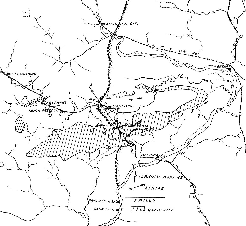
determined. The striæ which have been determined about Baraboo are shown
on Plate II.
Effect of topography on movement.—The effect of glaciation on
topography has been sketched, but the topography in turn exerted an
important influence on the direction of ice movement. The extreme degree
of topographic influence is seen in mountain regions like the Alps,
where most of the glaciers are confined strictly to the valleys.
As an ice sheet invades a region, it advances first and farthest along
the lines of least resistance. In a rough country with great relief,
tongues or lobes of ice would push forward in the valleys, while the
hills or other prominences would tend to hold back or divide the onward
moving mass. The edge of an ice sheet in such a region would be
irregular. The marginal lobes of ice occupying the valleys would be
separated by re-entrant angles marking the sites of hills and ridges.
If the ice crossed a plane surface above which rose a notable ridge or
hill, the first effect of the hill would be to indent the ice. The ice
would move forward on either side, and if its thickness became
sufficiently great, the parts moving forward on either side would again
unite beyond it. A hill thus surrounded by ice is a nunatak. Later, as
the advancing mass of ice became thicker, it might completely cover the
hill; but the thickness of ice passing over the hill would be less than
that passing on either side by an amount equal to the height of the
hill. It follows that as ice encounters an isolated elevation, three
stages in its contest with the obstruction may be recognized: (1) the
stage when the ridge or hill acts as a wedge, dividing the moving ice
into lobes, Fig. 34; (2) the nunatak stage, when the ice has pushed
forward and reunited beyond the hill, Fig. 35; (3) the stage when the ice
has become sufficiently deep to cover the hill.
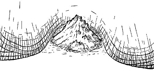
Fig. 34. -- Diagrammatic representation of the effect of a
hill on the edge of the ice.
After the ice has disappeared, the influence of the obstruction might be
found in the disposition of the drift. If recession began during the
first stage, that is, when the ice edge was separated into lobes, the
margin of the drift should be lobate, and would loop back around the
ridge from its advanced position on either side. If recession began
during the second stage, that is, when the lobes had become confluent
and completely surrounded the hill, a driftless area would appear in
the midst of drift. If recession began during the third stage, that is,
after the ice had moved on over the obstruction, the evidence of the
sequence might be obliterated; but if the ice moved but a short distance
beyond the hill, the thinner ice over the hill would have advanced less
far than the thicker ice on either side (Fig. 35), and the margin of
the drift would show a re-entrant pointing back toward the hill, though
not reaching it. All these conditions are illustrated in the Devil's
lake region.
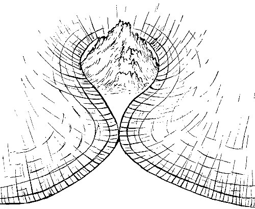
Fig. 35. -- Same as Fig. 34,
when the ice has advanced farther.
The region under description is partly covered with drift, and partly
free from it. The limit of the ice, at the time of its maximum expansion
is well defined at many points, and the nature and position of the drift
limit are so unique as to merit attention (see Plates II and
XXXVII). They illustrate many of the principles already
discussed.
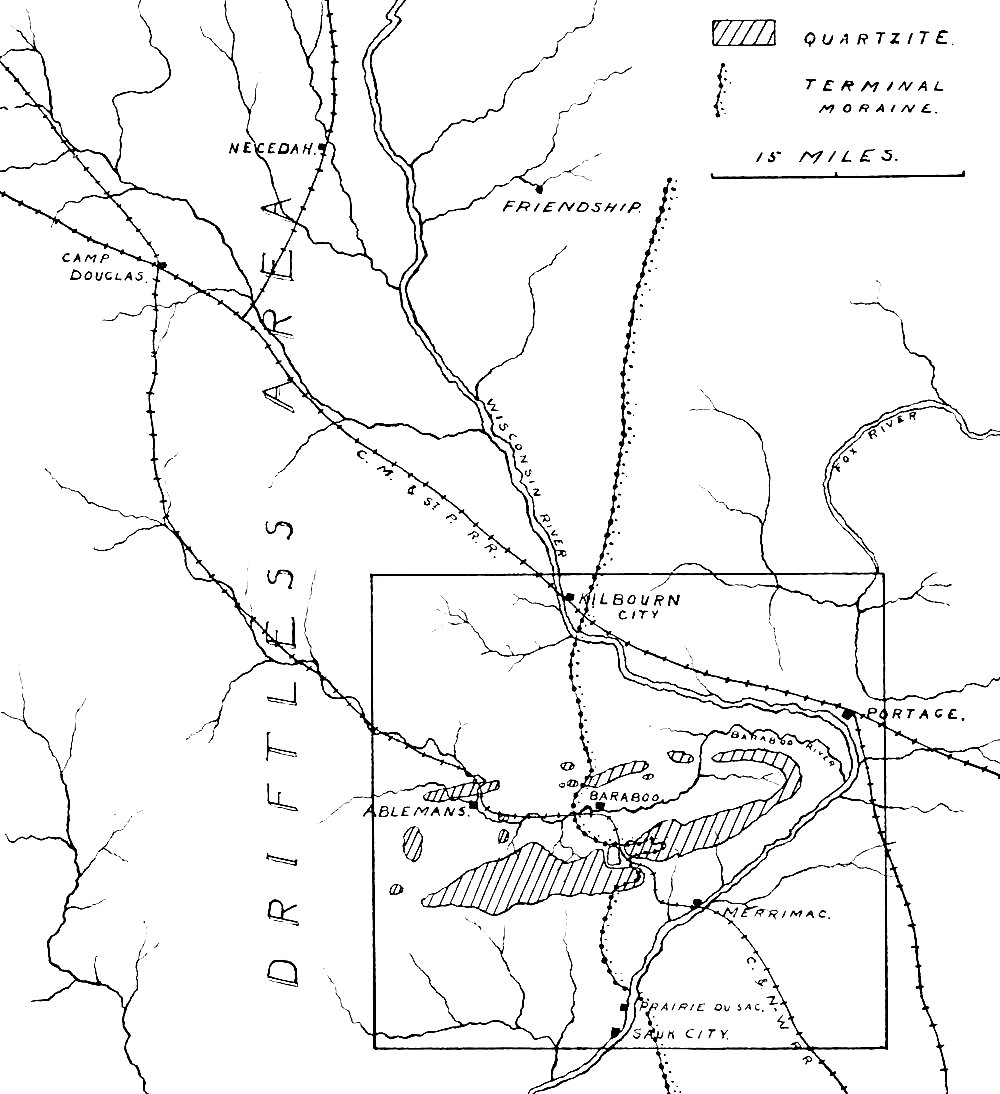
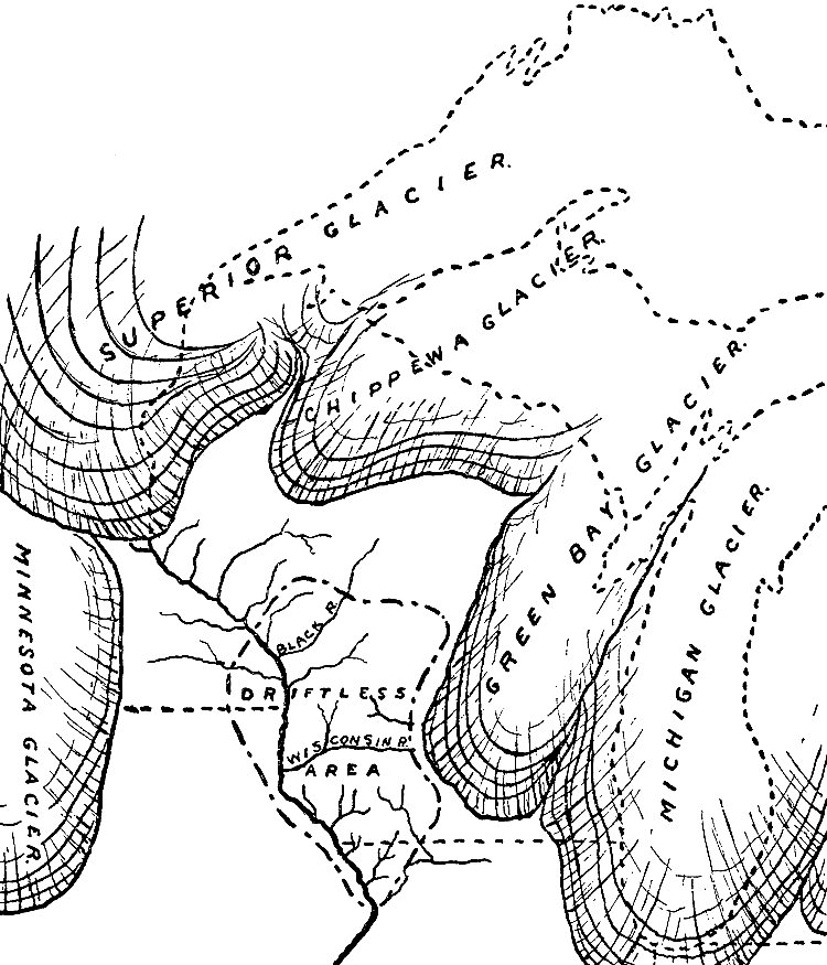
The ice which covered the region was the western margin of the Green Bay
lobe (Fig. 36) of the last continental ice sheet. Its limit in this
region is marked by a ridge-like accumulation of drift, the terminal
moraine, which here has a general north-south direction. The region
may have been affected by the ice of more than one epoch, but since the
ice of the last epoch advanced as far to the west in this region as that
of any earlier epoch, the moraine is on the border between the
Fig. 36. -- Map showing relations of lobes of ice during
the Wisconsin ice epoch, to the driftless area.
See larger image
glaciated country to the east, and the driftless area to the west
(Plates I and
II). That part of the moraine which lies west of the
Wisconsin river follows a somewhat sinuous course from Kilbourn City to
a point a short distance north of Prairie du Sac. The departures from
this general course are especially significant of the behavior of
glacier ice.
In the great depression between the quartzite ranges, the moraine bends
westward, showing that the ice advanced farther on the lowlands than on
the ridges. As the moraine of this low area approaches the south range,
it curves to the east. At the point southwest of Baraboo where the
easterly curve begins to show itself, the moraine lies at the north base
of the quartzite range; but as it is traced eastward, it is found to lie
higher and higher on the slope of the range, until it reaches the crest
nearly seven miles from the point where the eastward course was assumed.
At this point it crosses the range, and, once across the crest, it turns
promptly to the westward on the lower land to the south. Here the ice
advanced up the valley between the East bluff (east of the lake) and the
Devil's nose (Plate XXXVII), again illustrating the fact that lowlands
favor ice advance. The valley between the Devil's nose and the East
bluff is a narrow one, and the ice advanced through it nearly to the
present site of the lake. Meanwhile the restraining influence of the
"nose" was making itself felt, and the margin of the ice curved back
from the bottom of the bluff near Kirkland, to the top of the bluff at
the end of the nose. Here the edge of the ice crossed the point of the
nose, and after rounding it, turned abruptly to the west. Thence its
edge lay along the south slope of the ridge, descending from the crest
of the ridge at the nose, to the base of the ridge two miles farther
west. Here the ice reached its limit on the lowland, and its edge, as
marked by the moraine, turned southward, reaching the Wisconsin river
about a mile and a half above Prairie du Sac.
The course of the terminal moraine across the ridges is such as the
margin of the ice would normally have when it advanced into a region of
great relief. The great loop in the moraine with its eastern extremity
at k, Plate XXXVII, is explained by the presence of the quartzite
ridge which retarded the advancing ice while it moved forward on either
side. The minor loop around the Devil's nose is explained in the same
way. Both the
main loop, and the smaller one on the nose, illustrate
the point made on p. 89.
The narrow and curious loop at m, is of a slightly different origin,
though in principle the same. It is in the lee of a high point in the
quartzite ridge. The ice surmounted this point, and descended its
western slope; but the thickness of the ice passing over the summit was
so slight that it advanced but a short distance down the slope before
its force was exhausted, while the thicker ice on either side advanced
farther before it was melted.
Before especial reference is made to the drift of this particular
region, it will be well to consider the character of drift deposits in
general. When the ice of the continental glacier began its motion, it
carried none of the stony and earthy debris which constitute the drift.
These materials were derived from the surface over which the ice moved.
From the method by which it was gathered, it is evident that the drift
of any locality may contain fragments of rock of every variety which
occurs along the route followed by the ice which reached that locality.
Where the ice had moved far, and where there were frequent changes in
the character of the rock constituting its bed, the variety of materials
in the drift is great. The heterogeneity of the drift arising from the
diverse nature of the rocks which contributed to it is lithological
heterogeneity—a term which implies the commingling of materials
derived from different rock formations. Thus it is common to find pieces
of sandstone, limestone, quartzite, granite, gneiss, schist, etc.,
intimately commingled in the drift, wherever the ice which produced it
passed over formations of these several sorts of rock. Lithological
heterogeneity is one of the notable characteristics of glacial
formations.
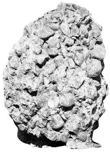
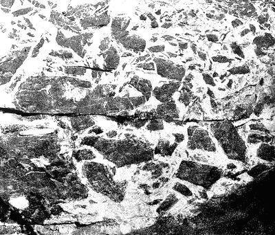
Another characteristic of the drift is its physical heterogeneity. As
first gathered from the bed of moving ice, some of the
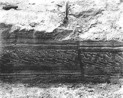
WISCONSIN GEOL. AND NAT. HIST. SURVEY. BULLETIN NO. V.,
PL. XXXV.
Cut in drift, showing its physical heterogeneity.
See larger image
materials of the drift were fine and some coarse. The tendency of the
ice in all cases was to reduce its load to a still finer condition. Some
of the softer materials, such as soft shale, were crushed or ground to
powder, forming what is known in common parlance as clay. Clayey (fine)
material is likewise produced by the grinding action of ice-carried
bowlders upon the rock-bed, and upon one another. Other sorts of rock,
such as soft sandstone, were reduced to the physical condition of sand,
instead of clay, and from sand to bowlders all grades of coarseness and
fineness are represented in the glacial drift.
Since the ice does not assort the material which it carries, as water
does, the clay, sand, gravel and bowlders will not, by the action of the
ice, be separated from one another. They are therefore not stratified.
As left by the ice, these physically heterogeneous materials are
confusedly commingled. The finer parts constitute a matrix in which the
coarser are embedded.
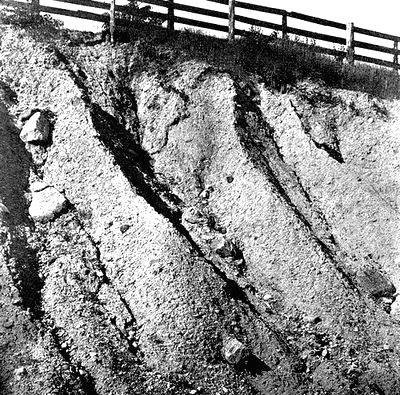
Physical heterogeneity (Plate XXXV), therefore, is another
characteristic of glacial drift. It is not to be understood that the
proportions of these various physical elements, clay, sand, gravel, and
bowlders, are constant. Locally any one of them may predominate over any
or all the others to any extent.
Since lithological and physical heterogeneity are characteristics of
glacial drift, they together afford a criterion which is often of
service in distinguishing glacial drift from other surface formations.
It follows that this double heterogeneity constitutes a feature which
can be utilized in determining the former extension of existing
glaciers, as well as the former existence of glaciers where glaciers do
not now exist.
Another characteristic of glacial drift, and one which clearly
distinguishes it from all other formations with which it might be
confounded, is easily understood from its method of formation. If the
ice in its motion holds down rock debris upon the rock surface over
which it passes with such pressure as to polish and striate the
bed-rock, the material carried will itself suffer wear comparable to
that which it inflicts. Thus the stones, large and small, of glacial
drift, will be smoothed and striated.
This sort of wear on the transported blocks of rock, is effected both by
the bed-rock reacting on the bowlders transported over it, and by
bowlders acting on one another in and under the ice. The wear of
bowlders by bowlders is effected wherever adjacent ones are carried
along at different rates. Since the rate of motion of the ice is
different in different parts of the glacier, the mutual abrasion of
transported materials is a process constantly in operation. A large
proportion of the transported stone and blocks of rock may thus
eventually become striated.
From the nature of the wear to which the stones are subjected when
carried in the base of the ice, it is easy to understand that their
shapes must be different from those of water-worn materials. The latter
are rolled over and over, and thus lose all their angles and assume a
more or less rounded form. The former, held more or less firmly in the
ice, and pressed against the underlying rock or rock debris as they are
carried slowly forward, have their faces planed and striated. The
planation and striation of a stone need not be confined to its under
surface. On either side or above it other stones, moving at different
rates, are made to abrade it, so that its top and sides may be planed
and scored. If the ice-carried stones shift their positions, as they may
under various circumstances, new faces will be worn. The new face thus
planed off may meet those developed at an earlier time at sharp angles,
altogether unlike anything which water-wear is capable of producing. The
stone thus acted upon shows a surface bounded by planes and more or less
beveled, instead of a rounded surface such as water wear produces. We
find, then, in the shape of the bowlders and smaller stones of the
drift, and in the markings upon their surfaces, additional criteria for
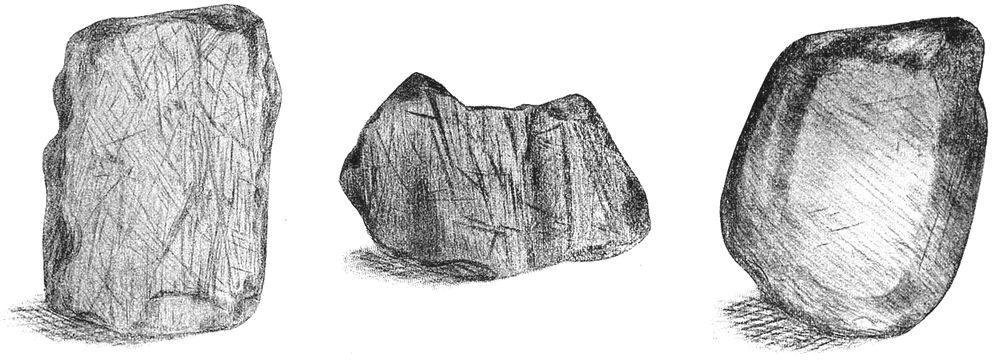
the identification of glacier drift (Plate XXXVI).
The characteristics of glacial drift, so far as concerns its
constitution, may then be enumerated as, (1) its lithological, and (2)
physical heterogeneity; (3) the shapes, and (4) the markings of the stones
of the drift. In structure, the drift which is strictly glacial, is
unstratified.
In the broadest sense of the term, all deposits made by glacier
WISCONSIN GEOL. AND NAT. HIST. SURVEY. BULLETIN NO. V.,
PL. XXXVI.
Glaciated stones, showing both form and striae. (Matz.)
See larger image
ice are moraines. Those made beneath the ice and back from its edge
constitute the ground moraine, and are distinguished from the
considerable marginal accumulations which, under certain conditions, are
accumulated at or near the margin. These marginal accumulations are
terminal moraines. Associated with the moraines which are the deposits
of the ice directly, there are considerable bodies of stratified gravel
and sand, the structure of which shows that they were laid down by
water. This is to be especially noted, since lack of stratification is
popularly supposed to be the especial mark of the formations to which
the ice gave rise.
These deposits of stratified drift lie partly beyond the terminal
moraine, and partly within it. They often sustain very complicated
relations both to the ground and terminal moraines.
The drift as a whole is therefore partly stratified and partly
unstratified. Structurally the two types are thoroughly distinct, but
their relations are often most complex, both horizontally and
vertically. A fuller consideration of these relations will be found on a
later page.
The ground moraine constitutes the great body of the glacial drift.
Bowlder clay, a term descriptive of its constitution in some places,
and till, are other terms often applied to the ground moraine. The
ground moraine consists of all the drift which lodged beneath the ice
during its advance, all that was deposited back from its edge while its
margin was farthest south, and most of that which was deposited while
the ice was retreating. From this mode of origin it is readily seen that
the ground moraine should be essentially as widespread as the ice
itself. Locally, however, it failed of deposition. Since it constitutes
the larger part of the drift, the characteristics already enumerated (p.
95) as belonging to drift in general are the
characteristics of the till. Wherever obstacles to the progress of the ice
lay in its path, there was a chance that these obstacles, rising somewhat into the
lower part of the ice, would constitute barriers against which debris in
the lower part of the ice would lodge. It might happen also that the
ice, under a given set of conditions favoring erosion, would gather a
greater load of rock-debris than could be transported under the changed
conditions into which its advance brought it. In this case, some part of
the load would be dropped and over-ridden. Especially near the margin of
the ice where its thickness was slight and diminishing, the ice must
have found itself unable to carry forward the loads of debris which it
had gathered farther back where its action was more vigorous. It will be
readily seen that if not earlier deposited, all material gathered by the
under surface of the ice would ultimately find itself at the edge of the
glacier, for given time enough, ablation will waste all that part of the
ice occupying the space between the original position of the debris, and
the margin of the ice. Under the thinned margin of the ice, therefore,
considerable accumulations of drift must have been taking place while
the ice was advancing. While the edge of the ice sheet was advancing
into territory before uninvaded, the material accumulated beneath its
edge at one time, found itself much farther from the margin at another
and later time. Under the more forcible ice action back from the margin,
the earlier accumulations, made under the thin edge, were partially or
wholly removed by the thicker ice of a later time, and carried down to
or toward the new and more advanced margin. Here they were deposited, to
be in turn disturbed and transported still farther by the farther
advance of the ice.
Since in its final retreat the margin of the ice must have stood at all
points once covered by it, these submarginal accumulations of drift must
have been made over the whole country once covered by the ice. The
deposits of drift made beneath the marginal part of the ice during its
retreat, would either cover the deposits made under the body of the ice
at an earlier time, or be left alongside them. The constitution of the
two phases of till, that deposited during the advance of the ice, and
that deposited during its retreat, is essentially the same, and there
is nothing in their relative positions to sharply differentiate them.
They are classed together as subglacial till.
Subglacial till was under the pressure of the overlying ice. In keeping
with these conditions of accumulation, the till often possesses a
firmness suggestive of great compression. Where its constitution is
clayey it is often remarkably tough. Where this is the case, the quality
here referred to has given rise to the suggestive name "hard pan." Where
the constitution of the till is sandy, rather than clayey, this firmness
and toughness are less developed, or may be altogether wanting, since
sand cannot be compressed into coherent masses like clay.
Constitution.—The till is composed of the more or less comminuted
materials derived from the land across which the ice passed. The soil
and all the loose materials which covered the rock entered into its
composition. Where the ice was thick and its action vigorous, it not
only carried away the loose material which it found in its path, but,
armed with this material, it abraded the underlying rock, wearing down
its surface and detaching large and small blocks of rock from it. It
follows that the constitution of the till at any point is dependent upon
the nature of the soil and rock from which it was derived.
If sandstone be the formation which has contributed most largely to the
till, the matrix of the till will be sandy. Where limestone instead of
sandstone made the leading contribution to it, the till has a more
earthy or clayey matrix. Any sort of rock which may be very generally
reduced to a fine state of division under the mechanical action of the
ice, will give rise to clayey till.
The nature and the number of the bowlders in the till, no less than the
finer parts, depend on the character of the rock overridden. A hard and
resistant rock, such as quartzite, will give rise to more bowlders in
proportion to the total amount of material furnished to the ice, than
will softer rock. Shale or soft sandstone, possessing relatively slight
resistance, will be much more completely crushed. They will, therefore,
yield proportionately fewer bowlders than harder formations, and more
of the finer constituents of till.
The bowlders taken up by the ice as it advanced over one sort of rock
and another, possessed different degrees of resistance. The softer ones
were worn to smaller dimensions or crushed with relative ease and speed.
Bowlders of soft rock are, therefore, not commonly found in any
abundance at great distances from their sources. The harder ones yielded
less readily to abrasion, and were carried much farther before being
destroyed, though even such must have suffered constant reduction in
size during their subglacial journey. In general it is true that
bowlders in the till, near their parent formations, are larger and less
worn than those which have been transported great distances.
The ice which covered this region had come a great distance and had
passed over rock formations of many kinds. The till therefore contains
elements derived from various formations; that is, it is lithologically
heterogeneous. This heterogeneity cannot fail to attract the attention
of one examining any of the many exposures of drift about Baraboo at
road gradings, or in the cuts along the railway. Among the stones in the
drift at these exposures are limestone, sandstone, quartzite, diabase,
gabbro, gneiss, granite, schist, and porphyry, together with pieces of
flint and chert.
Such an array may be found at any of the exposures within the immediate
vicinity of Devil's lake. To the north, and a few miles to the south of
the Baraboo ranges, the quartzite from these bluffs, and the porphyry
from the point marked h in Plate II are
wanting, though other varieties of porphyry are present. The ice moved in a general
west-southwest direction in this region, and the quartzite in the drift,
so far as derived from the local formation, is therefore restricted to a
narrow belt.
The physical heterogeneity may be seen at all exposures, and is
illustrated in Plate XXXV. The larger stones of the drift are
usually of some hard variety of rock. Near the Baraboo ranges, the local
quartzite often predominates among the bowlders, and since such
bowlders have not been carried far, they are often little worn. Away
from the ranges, the bowlders are generally of some crystalline rock,
such as granite and diabase. Bowlders of these sorts of rock are from a
much more distant source, and are usually well worn.
In general the till of any locality is made up largely of material
derived from the formations close at hand. This fact seems to afford
sufficient warrant for the conclusion that a considerable amount of
deposition must have gone on beneath the ice during its movement, even
back from its margin. To take a concrete illustration, it would seem
that the drift of southeastern Wisconsin should have had a larger
contribution than it has of material derived from Canadian territory, if
material once taken up by the ice was all or chiefly carried down to its
thinned edge before deposition. The fact that so little of the drift
came from these distant sources would seem to prove that a large part of
the material moved by the ice, is moved a relatively short distance
only. The ice must be conceived of as continually depositing parts of
its load, and parts which it has carried but a short distance, as it
takes up new material from the territory newly invaded.
In keeping with the character of till in general, that about Devil's
lake was derived largely from the sandstone, limestone and quartzite of
the immediate vicinity, while a much smaller part of it came from more
distant sources. This is especially noticeable in the fine material,
which is made up mostly of the comminuted products of the local rock.
Topography.—The topography of the ground moraine is in general the
topography already described (p. 85) in considering the modification of
preglacial topography effected by ice deposition. As left by the ice,
its surface was undulating. The undulations did not take the form of
hills and ridges with intervening valleys, but of swells and depressions
standing in no orderly relationship to one another. Undrained
depressions are found in the ground moraine, but they are, as a rule,
broader and shallower than the "kettles" common to terminal moraines.
It is in the broad, shallow depressions of the ground moraine that many
of the lakes and more of the marshes of southeastern Wisconsin are
located.
The rolling, undulating topography characteristic of ground moraines is
well shown about the City of Baraboo and between that point and the
lake, and at many less easily designated points about Merrimac.
In thickness the ground moraine reaches at least 160 feet, though its
average is much less—too little to obliterate the greater topographic
features of the rock beneath. It is, however, responsible for many of
the details of the surface.
The marginal portion of the ice sheet was more heavily loaded—certainly
more heavily loaded relative to its thickness—than any other. Toward
its margin the thinned ice was constantly losing its transportive power,
and at its edge this power was altogether gone. Since the ice was
continually bringing drift down to this position and leaving it there,
the rate of drift accumulation must have been greater, on the average,
beneath the edge of the ice than elsewhere.
Whenever, at any stage in its history, the edge of the ice remained
essentially constant in position for a long period of time, the
corresponding submarginal accumulation of drift was great, and when the
ice melted, the former site of the stationary edge would be marked by a
broad ridge or belt of drift, thicker than that on either side. Such
thickened belts of drift are terminal moraines. It will be seen that a
terminal moraine does not necessarily mark the terminus of the ice at
the time of its greatest advance, but rather its terminus at any time
when its edge was stationary or nearly so.
From the conditions of their development it will be seen that these
submarginal moraines may be made up of materials identical with those
which constitute the ground moraine, and such is often the case. But
water arising from the melting of the ice, played a much more
important role at its margin than farther back beneath it. One result of
its greater activity may be seen in the greater coarseness which
generally characterizes the material of the terminal moraine as compared
with that of the adjacent ground moraine. This is partly because the
water carried away such of the finer constituents as it was able to
transport, leaving the coarser behind. Further evidence of the great
activity of water near the margin of the ice is to be seen in the
relatively large amount of assorted and stratified sand and gravel
associated with the terminal moraine.
Such materials as were carried on the ice were dropped at its edge when
the ice which bore them melted from beneath. If the surface of the ice
carried many bowlders, many would be dropped along the line of its edge
wherever it remained stationary for any considerable period of time. A
terminal moraine therefore embraces (1) the thick belt of drift
accumulated beneath the edge of the ice while it was stationary, or
nearly so; and (2) such debris as was carried on the surface of the ice
and dumped at its margin. In general the latter is relatively
unimportant.
At various stages in its final retreat, the ice made more or less
protracted halts. These halting places are marked by marginal moraines
of greater or less size, depending on the duration of the stop, and the
amount of load carried.
A terminal moraine is not the sharp and continuous ridge we are wont to
think it. It is a belt of thick drift, rather than a ridge, though it is
often somewhat ridge-like. In width, it varies from a fraction of a mile
to several miles. In the region under consideration it is rarely more
than fifty feet high, and rarely less than a half mile wide, and a ridge
of this height and width is not a conspicuous topographic feature in a
region where the relief is so great as that of the Devil's lake region.
Topography of terminal moraines.—The most distinctive feature of a
terminal moraine is not its ridge-like character, but its peculiar
topography. In general, it is marked by depressions without outlets,
associated with hillocks and short ridges comparable in dimensions to
the depressions. Both elevations and depressions are, as a rule, more
abrupt than in the ground moraine. In the depressions there are many
marshes, bogs, ponds and small lakes. The shapes and the abundance of
round and roundish hills have locally given rise to such names as "The
Knobs," "Short Hills," etc. Elsewhere the moraine has been named the
"Kettle Range" from the number of kettle-like depressions in its
surface. It is to be kept in mind that it is the association of the
"knobs" and "kettles," rather than either feature alone, which is the
distinctive mark of terminal moraine topography.
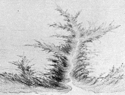
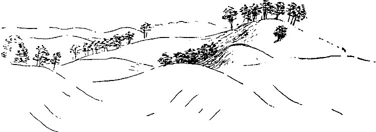
Fig. 37. -- Sketch of terminal moraine topography, on the
quartzite ridge east of Devil's lake. (Matz.)
The manner in which the topography of terminal moraines was developed is
worthy of note. In the first place, the various parts of the ice margin
carried unequal amounts of debris. This alone would have caused the
moraine of any region to have been of unequal height and width at
different points. In the second place, the margin of the ice, while
maintaining the same general position during the making of a moraine,
was yet subject to many minor oscillations. It doubtless receded to some
slight extent because of increased melting during the summer, to advance
again during the winter. In its recession, the ice margin probably did
not remain exactly parallel to its former position. If some parts
receded more than others, the details of the line of its margin may have
been much changed during a temporary retreat. When the ice again
advanced, its margin may have again changed its form in some slight
measure, so as to be parallel neither with its former advanced position,
nor with its position after its temporary retreat. With each successive
oscillation of the edge, the details of the margin may have altered, and
at each stage the marginal deposits corresponded with the edge. There
might even be considerable changes in the edge of the ice without any
general recession or advance, as existing glaciers show.
It was probably true of the margin of the American ice sheet, as of
existing glaciers, that there were periods of years when the edge of the
ice receded, followed by like periods when it remained stationary or
nearly so, and these in turn followed by periods of advance. During any
advance, the deposits made during the period of recession would be
overridden and disturbed or destroyed.
If the ice were to retreat and advance repeatedly during a considerable
period of time, always within narrow limits, and if during this
oscillation the details of its margin were frequently changing, the
result would be a complex or "tangle" of minor morainic ridges of
variable heights and widths. Between and among the minor ridges there
would be depressions of various sizes and shapes. Thus, it is conceived,
many of the peculiar hillocks and hollows which characterize terminal
moraines may have arisen.
Some of the depressions probably arose in another way. When the edge of
the ice retreated, considerable detached masses of ice might be left
beyond the main body. This might be buried by gravel and sand washed out
from the moraine. On melting, the former sites of such blocks of ice
would be marked by "kettles." In the marginal accumulations of drift as
first deposited, considerable quantities of ice were doubtless left.
When this melted, the drift settled and the unequal settling may have
given rise to some of the topographic irregularities of the drift.
The terminal moraine about Devil's lake.—On the lower lands, the
terminal moraine of the Devil's lake region has the features
characteristic of terminal moraines in general. It is a belt of thick
drift varying in width from half a mile or less to three-quarters of a
mile or more. Its surface is marked by numerous hills and short ridges,
with intervening depressions or "kettles." Some of the depressions among
the hills contain water, making ponds or marshes, though the rather
loose texture of the drift of this region is not favorable to the
retention of water. The moraine belt, as a whole, is higher than the
land on either side. It is therefore somewhat ridge-like, and the small,
short hills and ridges which mark its surface, are but constituent parts
of the larger, broader ridge.
Approached from the west, that is from the driftless side, the moraine
on the lower lands is a somewhat prominent topographic feature, often
appearing as a ridge thirty, forty or even fifty feet in height.
Approached from the opposite direction, that is, from the ground
moraine, it is notably less prominent, and its inner limit wherever
located, is more or less arbitrary.
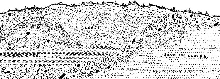
Fig. 38. -- Cut through the terminal moraine just east of
Kirkland, partially diagrammatic.
See larger image
A deep, fresh railway cut in the moraine southeast of Devil's lake
illustrates its complexity of structure, a complexity which is probably
no greater than that at many other points where exposures are not seen.
The section is represented in Fig. 38.
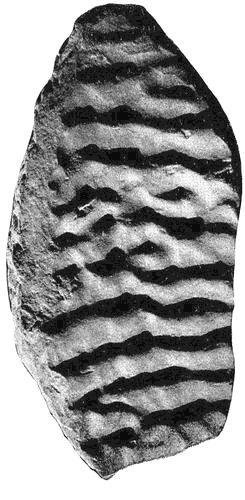
The stratified sand to the right retains even the ripple-marks which were developed when it was
deposited. To the left, at the same level, there is a body of till
(unstratified drift), over which is a bed of stoneless and apparently
structureless clay. In a depression just above the clay with till both
to the right and left, is a body of loam which possesses the
characteristics of normal loess. It also contains calcareous
concretions, though no shells have been found. This occurrence of loess
is the more noteworthy, since loess is rarely found in association with
drift of the last glacial epoch.
[7]
The moraine on the main quartzite range.—In tracing the moraine over
the greater quartzite range, it is found to possess a unique feature in
the form of a narrow but sharply defined ridge of drift, formed at the
extreme margin of the ice at the time of its maximum advance. For fully
eleven miles, with but one decided break, and two short stretches where
its development is not strong, this unique marginal ridge separates the
drift-covered country on the one hand, from the driftless area on the
other. In its course the ridge lies now on slopes, and now on summits,
but in both situations preserves its identity. Where it rests on a
plain, or nearly plain surface, its width at base varies from six to
fifteen rods, and its average height is from twenty to thirty feet. Its
crest is narrow, often no more than a single rod. Where it lies on a
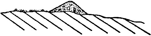
slope, it is asymmetrical in cross section (see Fig. 39),
the shorter slope having a vertical
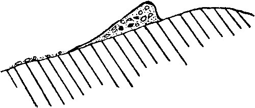
Fig. 39. -- Diagrammatic cross-section of the marginal
ridge as it occurs on the south slope of the Devil's Nose. The slope
below, though glaciated, is nearly free from drift.
range of ten to thirty-five feet, and its longer
a range of forty to one hundred feet. This asymmetrical form persists
throughout all that portion of the ridge which lies on an inclined
surface, the slope of which does not correspond with the direction of
the moraine. Where it lies on a flat surface, or an inclined surface
the slope of which corresponds in direction with the course of the ridge
itself, its cross section is more nearly symmetrical (see Fig. 40). In
all essential characteristics this marginal ridge corresponds with the
End-Moräne of the Germans.
Fig. 40. -- Diagrammatic cross-section of the marginal
ridge as it appears when its base is not a sloping surface.
For the sake of bringing out some of its especially significant
features, the ridge may be traced in detail, commencing on the south
side of the west range. Where the moraine leaves the lowlands south of
the Devil's nose, and begins the ascent of the prominence, the marginal
ridge first appears at about the 940-foot contour (f, Plate XXXVII).
Though at first its development is not strong, few rods have been passed
before its crest is fifteen to twenty feet above the driftless area
immediately to the north (see Fig. 39) and from forty to one hundred
feet above its base to the south, down the slope. In general the ridge
becomes more distinct with increasing elevation, and except for two or
three narrow post-glacial erosion breaks, is continuous to the very
summit at the end of the nose (g). The ridge in fact constitutes the
uppermost forty or forty-five feet of the crest of the nose, which is
the highest point of the west range within the area shown on the map.
Throughout the whole of this course the marginal ridge lies on the south
slope of the nose, and has the asymmetrical cross section shown in Fig.
39. Above (north of) the ridge at most points not a bowlder of drift
occurs. So sharply is its outer (north) margin defined, that at many
points it is possible to locate it within the space of less than a yard.
At the crest of the nose (g) the marginal ridge, without a break,
swings northward, and in less than a quarter of a mile turns again to
the west. Bearing to the north it presently reaches (at h) the edge of
the precipitous bluff, bordering the
WISCONSIN GEOL. AND NAT. HIST. SURVEY. BULLETIN NO. V.,
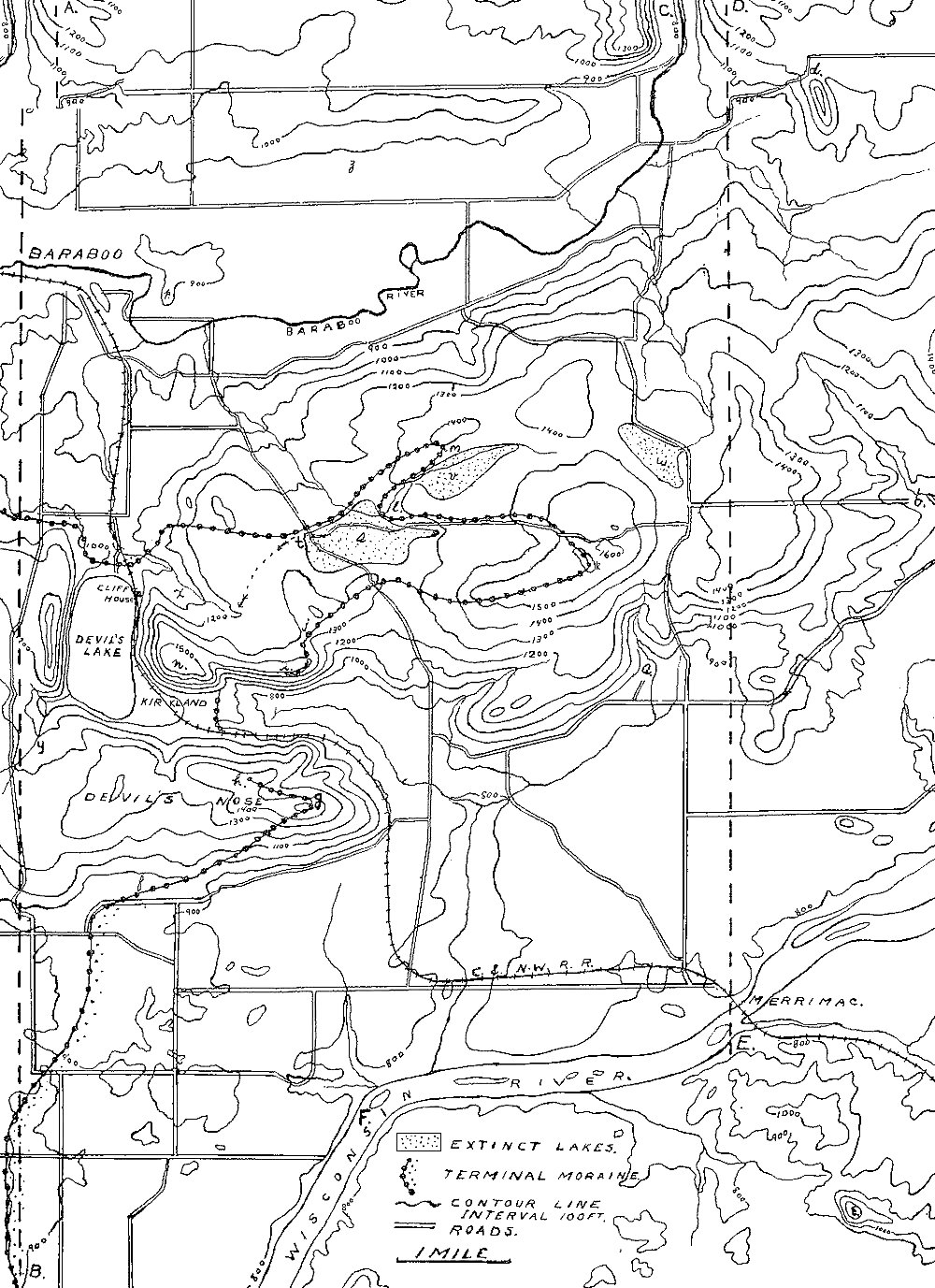
PL. XXXVII.
Topographic map (contour interval 100 feet) of a small area about
Devil's lake, taken from the Baraboo sheet of the United States
Geological Survey. Each contour line connects points of the same
elevation, and the figures upon them give the heights above sea level.
Where contour lines lie close together, they indicate steep slopes.
See larger image
great valley at the south end of the lake. Between the two arms of the
loop thus formed, the surface of the nose is so nearly level that it
could have offered no notable opposition to the progress of the ice, and
yet it failed to be covered by it.
In the great valley between the nose and the east bluff, the marginal
ridge does not appear. In the bottom of the valley the moraine takes on
its normal form, and the slopes of the quartzite ridges on either hand
are much too steep to allow any body of drift, or loose material of any
sort, to lodge on them.
Ascending the east bluff a little east of the point where the drift
ridge drops off the west bluff, the ridge is again found (at i) in
characteristic development. For some distance it is located at the edge
of the precipitous south face of the bluff. Farther on it bears to the
north, and soon crosses a col (j) in the ridge, building it up many
feet above the level of the bed-rock. From this point eastward for about
three miles the marginal ridge is clearly defined, the slopes about
equal on either side, and the crest as nearly even as the topography of
the underlying surface permits. The topographic relations in this part
of the course are shown in Fig. 40.
At k, this marginal ridge attains its maximum elevation, 1,620 feet.
At this great elevation, the ridge turns sharply to the northwest at an
angle of more than 90°. Following this direction for little more than
half a mile, it turns to the west. At some points in this vicinity the
ridge assumes the normal morainic habit, but this is true for short
distances only. Farther west, at l, it turns abruptly to the northeast
and is sharply defined. It here loops about a narrow area less than
sixty rods wide, and over half a mile in length, the sharpest loop in
its whole course. The driftless tract enclosed by the arms of this loop
is lower than the drift ridge on either hand. The ice on either side
would need to have advanced no more than thirty rods to have covered the
whole of it.
From the minor loop just mentioned, the marginal ridge is continued
westward, being well developed for about a mile and a half. At this
point the moraine swings south to the north end of Devil's lake, loses
the unique marginal ridge which has characterized its outer edge
across the quartzite range for so many miles, and assumes the topography
normal to terminal moraines. At no other point in the United States, so
far as known to the writers, is there so sharply marked a marginal ridge
associated with the terminal moraine, for so long a distance.
From Plate II it will be seen that the moraine as a whole makes a
great loop to the eastward in crossing the quartzite range. From the
detailed description just given of the course of the marginal ridge, it
will be seen that it has three distinct loops; one on the Devil's nose
(west of g, Plate XXXVII); one on the main ridge (west of k)
and a minor one on the north side of the last (southwest of m). The
first and third are but minor irregularities on the sides of the great
loop, the head of which is at k.
The significant fact in connection with these irregularities in the
margin of the moraine is that each loop stands in a definite relation to
a prominence. The meaning of this relation is at once patent. The great
quartzite range was a barrier to the advance of the ice. Acting as a
wedge, it caused a re-entrant in the advancing margin of the glacier.
The extent and position of the re-entrant is shown by the course of the
moraine in Plate II. Thus the great loop in the moraine, the head of
which is at k, Plate XXXVII, was caused by the quartzite range itself.
The minor loops on the sides of the major are to be explained on the
same principle. Northeast of the minor loop on the north side of the
larger one (m) there are two considerable hills, reaching an elevation
of nearly 1,500 feet. Though the ice advancing from the east-northeast
overrode them, they must have acted like a wedge, to divide it into
lobes. The ice which reached their summits had spent its energy in so
doing, and was unable to move forward down the slope ahead, and the
thicker bodies of ice which passed on either side of them, failed to
unite in their lee (compare Figs. 34
and 35). The application of the
same principle to the loop on the Devil's nose is evident.
Constitution of the marginal ridge.—The material in the marginal
ridge, as seen where erosion has exposed it, is till, abnormal, if at
all, only in the large percentage of widely transported bowlders which
it contains. This is especially true of the surface, where in some
places 90 per cent. of the large bowlders are of very distant origin,
and that in spite of the fact that the ice which deposited them had just
risen up over a steep slope of quartzite, which could easily have
yielded abundant bowlders. In other places the proportion of foreign
bowlders is small, no more than one in ten. In general, however,
bowlders of distant origin predominate over those derived close at hand.
The slope of the upper surface of the ice at the margin.—The marginal
ridge on the south slope of Devil's nose leads to an inference of
especial interest. Its course lies along the south slope of the nose,
from its summit on the east to its base on the west. Throughout this
course the ridge marks with exactness the position of the edge of the
ice at the time of its maximum advance, and its crest must therefore
represent the slope of the upper surface of the ice at its margin.
The western end of the ridge (f, Plate XXXVII) has an altitude of 940
feet, and its eastern end (g) is just above the 1,500-foot contour.
The distance from the one point to the other is one and three-fourths
miles, and the difference in elevation, 560 feet. These figures show
that the slope of the ice along the south face of this bluff was about
320 feet per mile. This, so far as known, is the first determination of
the slope of the edge of the continental ice sheet at its extreme
margin. It is to be especially noted that these figures are for the
extreme edge of the ice only. The angle of slope back from the edge was
doubtless much less.
While it is true that glacier ice does not distinctly stratify the
deposits which it makes, it is still true that a very large part of the
drift for which the ice of the glacial period was directly or indirectly
responsible is stratified. That this should be so is not strange when it
is remembered that most of the ice was ultimately converted into running
water, just as the glaciers of today are. The relatively small portion
which disappeared by evaporation was probably more than counterbalanced,
at least near the margin of the ice, by the rain which fell upon it.
It cannot be considered an exaggeration, therefore, to say that the
total amount of water which operated on the drift, first and last, was
hardly less than the total amount of the ice itself. The drift deposited
by the marginal part of the ice was affected during its deposition, not
only by the water which arose from the melting of the ice which did the
depositing, but by much water which arose from the melting of the ice
far back from the margin. The general mobility of the water, as
contrasted with ice, allowed it to concentrate its activities along
those lines which favored its motion, so that different portions of the
drift were not affected equally by the water of the melting ice.
All in all it will be seen that the water must have been a very
important factor in the deposition of the drift, especially near the
margin of the ice. But the ice sheet had a marginal belt throughout its
whole history, and water must have been active and effective along this
belt, not only during the decadence of the ice sheet, but during its
growth as well. It is further to be noted that any region of drift stood
good chance of being operated upon by the water after the ice had
departed from it, so that in regions over which topography directed
drainage after the withdrawal of the ice, the water had the last chance
at the drift, and modified it in such a way and to such an extent as
circumstances permitted.
Its origin.—There are various ways in which stratified drift may
arise in connection with glacier deposits. It may come into existence by
the operation of water alone; or by the co-operation of ice and water.
Where water alone was immediately responsible for the deposition of
stratified drift, the water concerned may have owed its origin to the
melting ice, or it may have existed independently of the ice in the form
of lakes. When the source of the water was the melting ice, the water
may have been running, when it was actively concerned in the deposition
of stratified drift; or it may have been standing (glacial lakes and
ponds), when it was passively concerned. When ice co-operated with water
in the development of stratified drift the ice was generally a passive
partner.
Glacial drainage.—The body of an ice sheet during any glacial period
is probably melting more or less at some horizons all the time, and at
all horizons some of the time. Most of the water which is produced at
the surface during the summer sinks beneath it. Some of it may congeal
before it sinks far, but much of it reaches the bottom of the ice
without refreezing. It is probable that melting is much more nearly
continuous in the body of a moving ice sheet than at its surface, and
that some of the water thus produced sinks to the bottom of the ice
without refreezing. At the base of the ice, so long as it is in
movement, there is doubtless more or less melting, due both to friction
and to the heat received by conduction from the earth below. Thus in the
ice and under the ice there must have been more or less water in motion
throughout essentially all the history of an ice sheet.
If it be safe to base conclusions on the phenomena of existing glaciers,
it may be assumed that the waters beneath the ice, and to a less extent
the waters in the ice, organized themselves to a greater or less degree
into streams. For longer or shorter distances these streams flowed in
the ice or beneath it. Ultimately they escaped from its edge. The
subglacial streams doubtless flowed, in part, in the valleys which
affected the land surface beneath the ice, but they were probably not
all in such positions.
The courses of well-defined subglacial streams were tunnels. The bases
of the tunnels were of rock or drift, while the sides and tops were of
ice. It will be seen, therefore, that their courses need not have
corresponded with the courses of the valleys beneath the ice. They may
sometimes have followed lines more or less independent of topography,
much as water may be forced over elevations in closed tubes. It is not
to be inferred, however, that the subglacial streams were altogether
independent of the sub-ice topography. The tunnels in which the water
ran probably had too many leaks to allow the water to be forced up over
great elevations. This, at least, must have been the case where the ice
was thin or affected by crevasses. Under such circumstances the
topography of the land surface must have been the controlling element
in determining the course of the subglacial drainage.
When the streams issued from beneath the ice the conditions of flow were
more or less radically changed, and from their point of issue they
followed the usual laws governing river flow. If the streams entered
static water as they issued from the ice, and this was true where the
ice edge reached the sea or a lake, the static water modified the
results which the flowing waters would otherwise have produced.
Stages in the history of an ice sheet.—The history of an ice sheet
which no longer exists involves at least two distinct stages. These are
(1) the period of growth, and (2) the period of decadence. If the latter
does not begin as soon as the former is complete, an intervening stage,
representing the period of maximum ice extension, must be recognized. In
the case of the ice sheets of the glacial period, each of these stages
was probably more or less complex. The general period of growth of each
ice sheet is believed to have been marked by temporary, but by more or
less extensive intervals of decadence, while during the general period
of decadence, it is probable that the ice was subject to temporary, but
to more or less extensive intervals of recrudescence. For the sake of
simplicity, the effects of these oscillations of the edge of the ice
will be neglected at the outset, and the work of the water accompanying
the two or three principal stages of an ice sheet's history will be
outlined as if interruptions in the advance and in the retreat,
respectively, had not occurred.
As they now exist, the deposits of stratified drift made at the edge of
the ice or beyond it during the period of its maximum extension present
the simplest, and at the same time most sharply defined phenomena, and
are therefore considered first.
The deposits made by the water at the time of the maximum extension of
the ice and during its final retreat, were never disturbed by subsequent
glacier action. So far as not destroyed by subsequent erosion, they
still retain the form and structure which they had at the outset. Such
drift deposits, because they lie at the surface, and because they are
more or less distinct topographically as well as structurally, are
better known than the stratified drift of other stages of an ice sheet's
history. Of stratified drift made during the maximum extension of the
ice, and during its final retreat, there are several types.
A. At the edge of ice, on land.—If the subglacial streams flowed
under "head," the pressure was relieved when they escaped from the ice.
With this relief, there was diminution of velocity. With the diminution
of velocity, deposition of load would be likely to take place. Since
these changes would be likely to occur at the immediate edge of the ice,
one class of stratified drift deposits would be made in this position,
in immediate contact with the edge of the ice, and their form would be
influenced by it. At the stationary margin of an ice sheet, therefore,
at the time of its maximum advance, ice and water must have co-operated
to bring into existence considerable quantities of stratified drift.
The edge of the ice was probably ragged, as the ends of glaciers are
today, and as the waters issued from beneath it, they must frequently
have left considerable quantities of such debris as they were carrying,
against its irregular margin, and in its re-entrant angles and marginal
crevasses. When the ice against which this debris was first lodged
melted, the marginal accumulations of gravel and sand often assumed the
form of kames. A typical kame is a hill, hillock, or less commonly a
short ridge of stratified drift; but several or many are often
associated, giving rise to groups and areas of kames. Kames are often
associated with terminal moraines, a relation which emphasizes the fact
of their marginal origin.
So far as the superficial streams which flowed to the edge of the ice
carried debris, this was subject to deposition as the streams descended
from the ice. Such drift would tend to increase the body of marginal
stratified drift from subglacial sources.
Marginal accumulations of stratified drift, made by the co-operation of
running water and ice, must have had their most extensive development,
other things being equal, where the margin of the ice was longest in one
position, and where the streams were heavily loaded. The deposits made
by water at the edge of the ice differ from those of the next
class—made beyond the edge of the ice—in that they were influenced in
their disposition and present topography, by the presence of ice.
In the Devil's lake region isolated and well-defined kames are not of
common occurrence. There are, however, at many points hills which have
something of a kame-like character. There is such a hill a mile
southeast of the Court house at Baraboo, at the point marked p, Plate
XXXVII. In this hill there are good exposures which show its structure.
There are many hillocks of a general kame-like habit associated with the
terminal moraine south of the main quartzite range, and north of the
Wisconsin river. Many of them occur somewhat within the terminal moraine
a few miles northwest of Merrimac.
B. Beyond the edge of the ice, on land.—As the waters escaping from
the ice flowed farther, deposits of stratified drift were made quite
beyond the edge of the ice. The forms assumed by such deposits are
various, and depended on various conditions. Where the waters issuing
from the edge of the ice found themselves concentrated in valleys, and
where they possessed sufficient load, and not too great velocity, they
aggraded the valleys through which they flowed, developing fluvial
plains of gravel and sand, which often extended far beyond the ice. Such
fluvial plains of gravel and sand constitute the valley trains which
extend beyond the unstratified glacial drift in many of the valleys of
the United States. They are found especially in the valleys leading out
from the stouter terminal moraines of late glacial age. From these
moraines, the more extensive valley trains take their origin, thus
emphasizing the fact that they are deposits made by water beyond a
stationary ice margin. Valley trains have all the characteristics of
alluvial plains built by rapid waters carrying heavy loads of detritus.
Now and then their surfaces present slight variations from planeness,
but they are minor. Like all plains of similar origin they decline
gradually, and with diminishing gradient, down stream. They are of
coarser material near their sources, and of finer material farther away.
Valley trains constitute a distinct topographic as well as genetic type.
A perfect example of a valley train does not occur within the region
here discussed. There is such a train starting at the moraine where it
crosses the Wisconsin river above Prairie du Sac, and extending down
that valley to the Mississippi, but at its head this valley train is
wide and has the appearance of an overwash plain, rather than a valley
train. Farther from the moraine, however, it narrows, and assumes the
normal characteristics of a valley train. It is the gravel and sand of
this formation which underlies Sauk Prairie, and its topographic
continuation to the westward.
Where the subglacial streams did not follow subglacial valleys, they did
not always find valleys when they issued from the ice. Under such
circumstances, each heavily loaded stream coming out from beneath the
ice must have tended to develop a plain of stratified material near its
point of issue—a sort of alluvial fan. Where several such streams came
out from beneath the ice near one another, their several plains, or
fans, were likely to become continuous by lateral growth. Such border
plains of stratified drift differ from valley trains particularly (1) in
being much less elongate in the direction of drainage; (2) in being much
more extended parallel to the margin of the ice; and (3) in not being
confined to valleys. Such plains stood an especially good chance of
development where the edge of the ice remained constant for a
considerable period of time, for it was under such conditions that the
issuing waters had opportunity to do much work. Thus arose the type of
stratified drift variously known as overwash plains, outwash plains,
morainic plains, and morainic aprons. These plains sometimes skirt
the moraine for many miles at a stretch.
Overwash plains may sometimes depart from planeness by taking on some
measure of undulation, of the sag and swell (kame) type, especially near
their moraine edges. The same is often true of the heads of valley
trains. The heads of valley trains and the inner edges of overwash
plains, it is to be noted, occupy the general position in which kames
are likely to be formed, and the undulations which often affect these
parts of the trains and plains, respectively, are probably to be
attributed to the influence of the ice itself. Valley trains and
overwash plains, therefore, at their upper ends and edges respectively,
may take on some of the features of kames. Indeed, either may head in a
kame area.
Good examples of overwash or outwash plains may be seen at various
points in the vicinity of Baraboo. The plain west of the moraine just
south of the main quartzite ridge has been referred to under valley
trains. In Sauk Prairie, however, its characteristics are those of an
outwash plain, rather than those of a valley train.
Fig. 41. -- The morainic or outwash plain bordering the
terminal moraine. The figure is diagrammatic, but represents, in cross
section, the normal relation as seen south of the quartzite range at the
east edge of Sauk Prairie, north of the Baraboo river and at some points
between the South range and the Baraboo.
A good example of an outwash plain occurs southwest of Baraboo, flanking
the moraine on the west (Fig. 41). Seen from the west, the moraine just
north of the south quartzite range stands up as a conspicuous ridge
twenty to forty feet above the morainic plain which abuts against it.
Traced northward, the edge of the outwash plain, as it abuts against
the moraine, becomes higher, and in Section 4, Township 11 N., Range 6
E., the moraine edge of the plain reaches the crest of the moraine (Fig.
42). From this point north to the Baraboo river the moraine scarcely
rises above the edge of the outwash beyond.
Fig. 42. -- The outwash plain is built up to the crest of
the moraine. The figure is diagrammatic, but this relation is seen at
the point marked W, Plate II.
North of the Baraboo river the moraine is again distinct and the
overwash plain to the west well developed much of the way from the
Baraboo to Kilbourn City. A portion of it is known as Webster's Prairie.
Locally, the outwash plains of this region have been much dissected by
erosion since their deposition, and are now affected by many small
valleys. In composition these plains are nearly everywhere gravel and
sand, the coarser material being nearer the moraine. The loose material
is in places covered by a layer of loam several feet deep, which greatly
improves the character of the soil. This is especially true of Sauk
Prairie, one of the richest agricultural tracts in the state.
When the waters issuing from the edge of the ice were sluggish, whether
they were in valleys or not, the materials which they carried and
deposited were fine instead of coarse, giving rise to deposits of silt,
or clay, instead of sand or gravel.
At many points near the edge of the ice during its maximum stage of
advance, there probably issued small quantities of water not in the form
of well-defined streams, bearing small quantities of detritus. These
small quantities of water, with their correspondingly small loads, were
unable to develop considerable plains of stratified drift, but produced
small patches instead. Such patches have received no special
designation.
In the deposition of stratified drift beyond the edge of the ice, the
latter was concerned only in so far as its activity helped to supply the
water with the necessary materials.
C. Deposits at and beyond the edge of the ice in standing water.—The
waters which issued from the edge of the ice sometimes met a different
fate. The ice in its advance often moved up river valleys. When at the
time of its maximum extension, it filled the lower part of a valley,
leaving the upper part free, drainage through the valley stood good
chance of being blocked. Where this happened a marginal valley lake was
formed. Such a lake was formed in the valley of the Baraboo when the
edge of the ice lay where the moraine now is (Plate II). The waters
which were held back by the ice dam, reinforced by the drainage from the
ice itself, soon developed a lake above the point of obstruction. This
extinct lake may be named Baraboo lake. In this lake deposits of
laminated clay were made. They are now exposed in the brick yards west
of Baraboo, and in occasional gullies and road cuts in the flat
bordering the river.
At the point marked s (Plate XXXVII) there was, in glacial
times, a small lake having an origin somewhat different from that of
Baraboo lake (see p. 133). The former site of the lake is now marked by
a notable flat. Excavations in the flat show that it is made up of
stratified clay, silt, sand and gravel, to the depth of many
feet,—locally more than sixty. These lacustrine deposits are well
exposed in the road cuts near the northwest corner of the flat, and in
washes at some other points. Plate XXXVIII shows some of the silt and
clay, the laminæ of which are much distorted.
Deltas must have been formed where well-defined streams entered the
lakes, and subaqueous overwash plains where deltas became continuous
by lateral growth. The accumulation of stratified drift along the
ice-ward shores of such lakes must have been rapid, because of the
abundant supply of detritus. These materials were probably shifted about
more or less by waves and shore currents, and some of them may have been
widely distributed. Out from the borders of such lakes, fine silts and
clays must have been in process of deposition, at the same time that the
coarse materials were being laid down nearer shore.
WISCONSIN GEOL. AND NAT. HIST. SURVEY. BULLETIN NO. V.,
PL. XXXVIII.
Distorted laminae of silt and clay.
See larger image
Good examples of deltas and subaqueous overwash plains do not appear to
exist in the region, although conditions for their development seem to
have been present. Thus in the lake which occupied the valley of the
Baraboo, conditions would seem to have been ideal for the development of
such features; that is, the overwash plains previously described should,
theoretically, have been subaqueous overwash plains; but if this be
their character, their distinctive marks have been destroyed by
subsequent erosion.
During the maximum extension of an ice sheet, therefore, there was
chance for the development, at its edge or beyond it, of the following
types of stratified drift: (1) kames and kame belts, at the edge of the
ice; (2) fluvial plains or valley trains, in virtual contact with the
ice at their heads; (3) border plains or overwash plains, in virtual
contact with the ice at their upper edges; (4) ill-defined patches of
stratified drift, coarse or fine near the ice; (5) subaqueous overwash
plains and deltas, formed either in the sea or lakes at or near the edge
of the ice; (6) lacustrine and marine deposits of other sorts, the
materials for which were furnished by the waters arising from the ice.
So far as this region is concerned, all the deposits made in standing
water were made in lakes.
During the retreat of any ice sheet, disregarding oscillations of its
edge, its margin withdrew step by step from the position of extreme
advance to its center. When the process of dissolution was complete,
each portion of the territory once covered by the ice, had at some stage
in the dissolution, found itself in a marginal position. At all stages
in its retreat the waters issuing from the edge of the ice were working
in the manner already outlined in the preceding paragraphs. Two points
of difference only need be especially noted. In the first place the
deposits made by waters issuing from the retreating ice were laid down
on territory which the ice had occupied, and their subjacent stratum was
often glacial drift. So far as this was the case, the stratified drift
was super-morainic, not extra-morainic. In the second place the edge of
the ice in retreat did not give rise to such sharply marked formations
as the edge of the ice which was stationary. The processes which had
given rise to valley trains, overwash plains, kames, etc., while the ice
edge was stationary, were still in operation, but the line or zone of
their activity (the edge of the ice) was continually retreating, so that
the foregoing types, more or less dependent on a stationary edge, were
rarely well developed. As the ice withdrew, therefore, it allowed to be
spread over the surface it had earlier occupied, many incipient valley
trains, overwash plains, and kames, and a multitude of ill-defined
patches of stratified drift, thick and thin, coarse and fine. Wherever
the ice halted in its retreat, these various types stood chance of
better development.
Such deposits did not cover all the surface discovered by the ice in its
retreat, since the issuing waters, thanks to their great mobility,
concentrated their activities along those lines which favored their
motion. Nevertheless the aggregate area of the deposits made by water
outside the ice as it retreated, was great.
It is to be noted that it was not streams alone which were operative as
the ice retreated. As its edge withdrew, lakes and ponds were
continually being drained, as their outlets, hitherto choked by the ice,
were opened, while others were coming into existence as the depressions
in the surface just freed from ice, filled with water. Lacustrine
deposits at the edge of the ice during its retreat were in all essential
respects identical with those made in similar situations during its
maximum extension.
Disregarding oscillations of the ice edge at these stages, the deposits
made by extraglacial waters during the maximum extension of an ice
sheet, and during its retreat, were always left at the surface, so far
as the work of that ice sheet was concerned. The stratified drift laid
down by extraglacial waters in these stages of the last ice sheet which
affected any region of our continent still remain at the surface in much
the condition in which they were deposited, except for the erosion they
have since suffered. It is because of their position at the surface that
the deposits referable to these stages of the last ice sheet of any
given region have received most attention and are therefore most
familiar.
During the advance of an ice sheet, if its edge forged steadily forward,
the waters issuing from it, and flowing beyond, were effecting similar
results. They were starting valley trains, overwash plains, kames, and
small ill-defined patches of stratified drift which the ice did not
allow them to complete before pushing over them, thus moving forward the
zone of activity of extraglacial waters. Unlike the deposits made by the
waters of the retreating ice, those made by the waters of the advancing
stage were laid down on territory which had not been glaciated, or at
least not by the ice sheet concerned in their deposition. If the ice
halted in its advance, there was at such time and place opportunity for
the better development of extraglacial stratified drift.
Lakes as well as streams were concerned in the making of stratified beds
of drift, during the advance of the ice. Marginal lakes were obliterated
by having their basins filled with the advancing ice, which displaced
the water. But new ones were formed, on the whole, as rapidly as their
predecessors became extinct, so that lacustrine deposits were being made at
intervals along the margin of the advancing ice.
Deposits made in advance of a growing ice sheet, by waters issuing from
it, were subsequently overridden by the ice, to the limit of its
advance, and in the process, suffered destruction, modification, or
burial, in whole or in part, so that now they rarely appear at the
surface.
Before their issuance from beneath the ice, subglacial waters were not
idle. Their activity was sometimes erosive, and at such times stratified
deposits were not made. But where the sub-glacial streams found
themselves overloaded, as seems frequently to have been the case, they
made deposits along their lines of flow. Where such waters were not
confined to definite channels, their deposits probably took on the form
of irregular patches of silt, sand, or gravel; but where depositing
streams were confined to definite channels, their deposits were
correspondingly concentrated.
When subglacial streams were confined to definite channels, the same may
have been constant in position, or may have shifted more or less from
side to side. Where the latter happened there was a tendency to the
development of a belt or strip of stratified drift having a width equal
to the extent of the lateral migrations of the under-ice stream. Where
the channel of the subglacial stream remained fixed in position, the
deposition was more concentrated, and the bed was built up. If the
stream held its course for a long period of time, the measure of
building may have been considerable. In so far as these channel deposits
were made near the edge of the ice, during the time of its maximum
extension or retreat, they were likely to remain undisturbed during its
melting. The aggraded channels then came to stand out as ridges. These
ridges of gravel and sand are known as osars or eskers. It is not to
be inferred that eskers never originated in other ways, but it seems
clear that this is one method, and probably the principal one, by which
they came into existence. Eskers early attracted attention, partly
because they are relatively rare, and partly because they are often
rather striking topographic features. The essential conditions,
therefore, for their formations, so far as they are the product of
subglacial drainage, are (1) the confining of the subglacial streams to
definite channels; and (2) a sufficient supply of detritus. One esker
only has been found in the region under consideration. It is located at
the point marked j, Plate II, seven and one-half miles northeast of
Merrimac and one and one-half miles south of Alloa (g, Plate II). The
esker is fully a quarter of a mile long, about thirty feet high, and
four rods wide at its base.
Subglacial deposits of stratified drift were sometimes made on
unstratified drift (till) already deposited by the ice before the
location of the stream, and sometimes on the rock surfaces on which no
covering of glacier drift had been spread.
It is to be kept in mind that subglacial drainage was operative during
the advance of an ice sheet, during its maximum extension, and during
its retreat, and that during all these stages it was effecting its
appropriate results. It will be readily seen, however, that all deposits
made by subglacial waters, were subject to modification or destruction
or burial, through the agency of the ice, and that those made during the
advance of the ice were less likely to escape than those made during its
maximum extension or retreat.
When it is remembered that extraglacial and subglacial waters were
active at all stages of an ice sheet's history, giving rise, or tending
to give rise to all the phases of stratified drift enumerated above;
when it is remembered that the ice of several epochs affected much of
the drift-covered country; and when it is remembered further that the
edge of the ice both during advance and retreat was subject to
oscillation, and that each advance was likely to bury the stratified
drift last deposited, beneath unstratified, it will be seen that the
stratified drift and the unstratified had abundant opportunity to be
associated in all relationships and in all degrees of intimacy, and that
the relations of the one class of drift to the other may come to be very
complex.
As a result of edge oscillation, it is evident that stratified drift may
alternate with unstratified many times in a formation of drift
deposited during a single ice epoch, and that two beds of till,
separated by a bed of stratified drift, do not necessarily represent two
distinct glacial epochs. The extent of individual beds of stratified
drift, either beneath the till or inter-bedded with it, may not be
great, though their aggregate area and their aggregate volume is very
considerable. It is to be borne in mind that the ice, in many places,
doubtless destroyed all the stratified drift deposited in advance on the
territory which it occupied later, and that in others it may have left
only patches of once extensive sheets. This may help to explain why it
so frequently happens that a section of drift at one point shows many
layers of stratified drift, while another section close by, of equal
depth, and in similar relationships, shows no stratified material
whatsoever.
Such deposits as were made by superglacial streams during the advance of
the ice must likewise have been delivered on the land surface, but would
have been subsequently destroyed or buried, becoming in the latter case,
submorainic. This would be likely to be the fate of all such
superglacial gravels as reached the edge of the ice up to the time of
its maximum advance.
Streams descending from the surface of the ice into crevasses also must
have carried down sand and gravel where such materials existed on the
ice. These deposits may have been made on the rock which underlies the
drift, or they may have been made on stratified or unstratified drift
already deposited. In either case they were liable to be covered by
till, thus reaching an inter-till or sub-till position.
Englacial streams probably do little depositing, but it is altogether
conceivable that they might accumulate such trivial pockets of sand and
gravel as are found not infrequently in the midst of till. The
inter-till position would be the result of subsequent burial after the
stratified material reached a resting place.
Complexity of relations.—From the foregoing it becomes clear that
there are diverse ways by which stratified drift, arising in connection
with an ice sheet, may come to be interbedded with till, when due
recognition is made of all the halts and oscillations to which the edge
of a continental glacier may have been subject during both its advance
and retreat.
In general the conditions and relations which theoretically should
prevail are those which are actually found.
On the basis of position stratified drift deposits may be classified as
follows:
1. Extraglacial deposits, made by the waters of any glacial epoch if
they flowed and deposited beyond the farthest limit of the ice.
2. Supermorainic deposits, made chiefly during the final retreat of
the ice from the locality where they occur, but sometimes by
extraglacial streams or lakes of a much later time. Locally too,
stratified deposits of an early stage of a glacial epoch, lying on till,
may have failed to be buried by the subsequent passage of the ice over
them, and so remain at the surface. In origin, supermorainic deposits
were for the most part extraglacial (including marginal), so far as the
ice sheet calling them into existence was concerned. Less commonly they
were subglacial, and failed to be covered, and less commonly still
superglacial.
3. The submorainic (basal) deposits were made chiefly by extraglacial
waters in advance of the first ice which affected the region where they
occur. They were subsequently overridden by the ice and buried by its
deposits. Submorainic deposits, however, may have arisen in other ways.
Subglacial waters may have made deposits of stratified drift on surfaces
which had been covered by ice, but not by till, and such deposits may
have been subsequently buried. The retreat of an ice sheet may have left
rock surfaces free from till covering, on which the marginal waters of
the ice may have made deposits of stratified drift. These may have been
subsequently covered by till during a re-advance of the ice in the same
epoch or in a succeeding one. Still again, the till left by one ice
sheet may have been exposed to erosion to such an extent as to have been
completely worn away before the next ice advance, so that stratified
deposits connected with a second or later advance may have been made on
a driftless surface, and subsequently buried.
4. Intermorainic stratified drift may have originated at the outset in
all the ways in which supermorainic drift may originate. It may have
become intermorainic by being buried in any one of the various ways in
which the stratified drift may become submorainic.
As the continental ice sheet invaded a region, the valleys were filled
and drainage was thereby seriously disturbed. Different streams were
affected in different ways. Where the entire basin of a stream was
covered by ice, the streams of that basin were, for the time being,
obliterated. Where the valley of a stream was partially filled with ice,
the valley depression was only partially obliterated, and the remaining
portion became the scene of various activities. Where the ice covered
the lower course of a stream but not the upper, the ice blocked the
drainage, giving rise to a lake. Where the ice covered the upper course
of a stream, but not its lower, the lower portion was flooded, and
though the river held its position, it assumed a new phase of activity.
Streams issuing from the ice usually carry great quantities of gravel
and sand, and make deposits along their lower courses. Long continued
glacial drainage usually results in a large measure of aggradation. This
was true of the streams of the glacial period.
Where a stream flowed parallel or approximately parallel to the edge of
the advancing ice it was sometimes shifted in the direction in which the
ice was moving, keeping parallel to the front of the ice. All of these
classes of changes took place in this region.
Wisconsin lake.—Reference has already been made to certain lakes
which existed in the region when the ice was there. The largest of these
lakes was that which resulted from the blocking of the Wisconsin river.
The ice crossed its present course at Kilbourn City, and its edge lay to
the west of the river from that point to Prairie du Sac (see Plate I).
The waters from the area now draining into the Wisconsin must either
have found an avenue of escape beneath the ice, or have accumulated in a
lake west of the edge of the ice. There is reason to believe that the
latter was what happened, and that a great lake covered much of the low
land west of the Wisconsin river above and below Kilbourn City. The
extensive gravel beds on the north flank of the quartzite bluff at
Necedah, and the water-worn pebbles of local origin on the slope of
Petenwell peak (Plate XXXII), as well as the gravels at other points,
are presumably the work of that lake. The waters in this lake, as in
that in the Baraboo valley, probably rose until the lowest point in the
rim of the basin was reached, and there they had their outlet. The
position of this outlet has not been definitely determined, but it has
been thought to be over the divide of the Black river.
[8]
It is possible, so far as now known, that this lake was connected with that of
the Baraboo valley. Until topographic maps of this region are made, the
connections will not be easily determined.
Even after the ice had retreated past the Wisconsin, opening up the
present line of drainage, the lakes did not disappear at once, for the
ice had left considerable deposits of drift in the Wisconsin valley.
Thus at f, Plates II
and XXXVII, and perhaps at other
points, the Wisconsin has made cuts of considerable depth in the drift.
Were these cuts filled, as they must have been when the ice melted, the
drainage would be ponded, the waters standing at the level of the dam.
This drift obstruction at f would therefore have prolonged the history
of the lake which had come into existence when the ice blocked the
drainage of the Wisconsin. As the drift of the valley was removed the
level of the lake sank and finally disappeared.
Baraboo lake.—Another lake which existed in this region when the ice
was here, occupied the valley of the Baraboo and its tributaries when
the ice blocked the valley at Baraboo. This lake occupied not only the
valley of the Baraboo, but extended up the lower course of every
tributary, presumably rising until it found the lowest point in the rim
of the drainage basin. The location of this point, and therefore the
height of the lake when at its maximum, are not certainly known, though
meager data on this point have been collected. At a point three miles
southeast of Ablemans on the surface of a sandstone slope, water-worn
gravel occurs, the pebbles of which were derived from the local rock. On
the slope below the gravel, the surface is covered with loam which has a
suggestion of stratification, while above it, the soil and subsoil
appear to be the product of local rock decomposition. This water-worn
gravel of local origin on a steep slope facing the valley, probably
represents the work of the waves of this lake, perhaps when it stood at
its maximum height. This gravel is about 125 feet (aneroid measurement)
above the Baraboo river to the north.
Further evidence of a shore line has been found at the point marked t,
Plate II. At this place water-worn gravel of the local rock occurs in
much the same relationship as that already mentioned, and at the same
elevation above the Baraboo river. At a point two and one-half miles
southwest of Ablemans there is local water-worn gravel, with which is
mingled glacial material (pieces of porphyry and diabase) which could
have reached this point only by being carried thither by floating ice
from the glacier. The level of this mixed local and glacial material is
(according to aneroid measurement) approximately the same as that of the
other localities.
When the ice melted, an outlet was opened via the Lower narrows, and
the water of the lake drained off to the Wisconsin by this route. Had
the ice left no drift, the lake would have been promptly drained when
the ice melted; but the lake did not entirely disappear immediately
after the ice retreated, for the drift which the ice left obstructed
drainage to the east. The moraine, however, was not so high as the
outlet of the lake while the ice was on, so that, as the ice retreated,
the water flowed over the moraine to the east, and drew down the level
of the lake to the level of the lowest point in the moraine. The
postglacial cut through the moraine is about ninety feet deep.
Besides being obstructed where crossed by the terminal moraine, the
valley of the Baraboo was clogged to a less extent by drift deposits
between the moraine and the Lower narrows. At one or two places near the
City of Baraboo, such obstructions, now removed, appear to have existed.
Just above the Lower narrows (c, Plate XXXVII) there is positive
evidence that the valley was choked with drift. Here in subsequent time,
the river has cut through the drift-filling of the preglacial valley,
developing a passage about twenty rods wide and thirty-five feet deep.
If this passage were filled with drift, reproducing the surface left by
the ice, the broad valley above it would be flooded, producing a shallow
lake.
The retreat of the ice therefore left two well defined drift dams in the
valley, one low one just above the Lower narrows, and a higher one, the
moraine dam, just west of Baraboo. Disregarding the influence of the
ice, and considering the Baraboo valley only, these two dams would have
given rise to two lakes, the upper one behind the higher dam being
deeper and broader, and covering a much larger area; the lower one
behind the lower dam, being both small and shallow.
Up to the time that the ice retreated past the Lower narrows, the waters
of the upper and lower lakes were united, held up to a common level by
the ice which blocked this pass. After the ice retreated past the Lower
narrows, the level of the Baraboo lake did not sink promptly, for not
until the ice had retreated past the site of the Wisconsin was the
present drainage established. Meantime the waters of the Baraboo lake
joined
those of Wisconsin lake (p. 129) through the Lower narrows. If
the lakes had been before connected at some point farther west, this
connection through the narrows would not have changed the level of
either. If they were not before connected, and if the Wisconsin lake was
lower than the Baraboo, this connection would have drawn down the level
of the latter.
Since the drainage from the Baraboo went to the Wisconsin, the Baraboo
lake was not at first lowered below the level of the highest obstruction
in the valley of the Wisconsin even after the ice had retreated beyond
that stream. As the drift obstructions of the Wisconsin valley were
lowered, the levels of all the lakes above were correspondingly brought
down. When the level of the waters in these lakes was brought down to
the level of the moraine dam above Baraboo, the one Baraboo lake of
earlier times became two. The level of the upper of these two lakes was
determined by the moraine above Baraboo, that of the lower by the
highest obstruction below the moraine in either the Baraboo or Wisconsin
valley. The drift obstructions in the Baraboo valley were probably
removed about as fast as those in the Wisconsin, and since the
obstructions were of drift, and the streams strong, the removal of the
dams was probably rapid. Both the upper and lower Baraboo lakes, as well
as the Wisconsin, had probably been reduced to small proportions, if not
been completely drained, before the glacial period was at an end.
Devil's lake in glacial times.—While the ice edge was stationary in
its position of maximum advance, its position on the north side of the
main quartzite range was just north of Devil's lake (Plate XXXVII).
The high ridge of drift a few rods north of the shore is a well
defined moraine, and is here more clearly marked than farther east or
west, because it stands between lower lands on either side, instead of
being banked against the quartzite ridge. North of the lake it rises
about 75 feet above the water. When the ice edge lay in this position on
the north side of the range, its front between the East bluff and the
Devil's nose lay a half mile or so from the south end of the lake. In
this position also there is a well defined moraine.
While the ice was at its maximum stand, it rose above these moraine
ridges at either end of the lake. Between the ice at these two points
there was then a notable basin, comparable to that of the present lake
except that the barriers to the north and southeast were higher than
now. The melting of the ice supplied abundant water, and the lake rose
above its present level. The height which it attained is not known, but
it is known to have risen at least 90 feet above its present level. This
is indicated by the presence of a few drift bowlders on the West bluff
of the lake at this height. They represent the work of a berg or bergs
which at some stage floated out into the lake with bowlders attached.
Bowlders dropped by bergs might be dropped at any level lower than the
highest stand of the lake.
Other lakes.—Another glacial lake on the East quartzite bluff has
already (p. 120) been referred to. Like the Devil's lake in glacial
time, its basin was an enclosure between the ice on the one hand, and
the quartzite ridge on the other. The location of this lake is shown on
Plate XXXVII (s). Here the edge of the ice, as shown by the position
of the moraine, was affected by a re-entrant curve, the two ends of
which rested against the quartzite ridge. Between the ice on the one
hand and the quartzite ridge on the other, a small lake was formed. Its
position is marked by a notable flat.
With the exception of the north side, and a narrow opening at the
northwest corner, the flat is surrounded by high lands. When the ice
occupied the region, its edge held the position shown by the line
marking the limit of its advance, and constituted an ice barrier to the north.
[9]
The area of the flat was, therefore, almost shut in, the only
outlet being a narrow one at t, Plate XXXVII. If the filling of
stratified drift which underlies the flat were removed, the bottom of
the area would be much lower than at present, and much lower than the
outlet at t. It is therefore evident that when the ice had taken its
position along the north side of the flat, an enclosed basin must have
existed, properly situated for receiving and holding water. Since this
lake had but a short life and became extinct before the ice retreated,
its history is here given.
At first the lake had no outlet and the water rose to the level of the
lowest point (t) in the rim of the basin, and thence overflowed to the
west. Meanwhile the sediments borne in by the glacial drainage were
being deposited in the lake in the form of a subaqueous overwash plain,
the coarser parts being left near the shore, while the finer were
carried further out. Continued drainage from the ice continued to bring
sediment into the lake, and the subaqueous overwash plain extended its
delta-like front farther and farther into the lake, until its basin was
completely filled. With the filling of the basin the lake became
extinct. The later drainage from the ice followed the line of the
outlet, the level of which corresponds with the level of the filled lake
basin. This little extinct lake is of interest as an example of a
glacial lake which became extinct by having its basin filled during
glacial times, by sediments washed out from the ice.
Near the northwest corner of this flat, an exposure in the sediments of
the old lake bed shows the curiously contorted layers of sand, silt, and
clay represented in Plate XXXVIII. The layers shown in the
figure are but a few feet below the level of the flat which marks the
site of the lake. It will be seen that the contorted layers are between
two series of horizontal ones. The material throughout the section is
made up of fine-grained sands and clays, well assorted. That these
particular layers should have been so much disturbed, while those below
and above remained horizontal, is strange enough. The grounding of an
iceberg on the surface before the overlying layers were deposited, the
action of lake ice, or the effect of expansion and contraction due to
freezing and thawing, may have been responsible for the singular
phenomenon. Contorted laminæ are rather characteristic of the deposits
of stratified drift.
As has already been indicated (p. 101), the irregular deposition of
glacial drift gave rise to many depressions without outlets in which
surface waters collected after the ice had disappeared, forming ponds or
lakes. So abundant are lakes and ponds and marshes in recently glaciated
regions and so rare elsewhere, that they constitute one of the more
easily recognized characteristics of a glaciated region.
After the ice had melted, the mantle of drift which it left was
sometimes so disposed as to completely obliterate preglacial valleys.
More commonly it filled preglacial valleys at certain points only. In
still other cases a valley was not filled completely at any point,
though partially at many. In this last case, the partial fillings at
various points constituted dams above which drainage was ponded, making
lakes. If the dams were not high enough to throw the drainage out of the
valley, the lakes would have their outlets over them. The drift dam
being unconsolidated would be quickly cut down by the out-flowing water,
and the lake level lowered. When the dam was removed or cut to its base,
the lake disappeared and drainage followed its preglacial course.
In case the valley was completely filled, or completely filled at
points, the case was very different. The drainage on the drift surface
was established with reference to the topography which obtained when the
ice departed, and not with reference to the preglacial valleys. Wherever
the preglacial valleys were completely filled, the postglacial drainage
followed lines which were altogether independent of them. When
preglacial valleys were filled by the drift in spots only, the
postglacial streams followed them where they were not filled, only to
leave them where the blocking occurred. In the former case the present
drainage is through valleys which are preglacial in some places, and
postglacial in others.
Thus the drainage changes effected by the drift after the ice was gone,
concerned both lakes and rivers. In this region there are several
illustrations of these changes.
Lakes.—The lake basins of drift-covered regions are of various types.
Some of them are altogether in drift, some partly in drift and partly in
rock, and some wholly in rock. Basins in the drift were likely to be
developed whenever heavy deposits surrounded thin ones. They are
especially common in the depressions of terminal moraines.
Another class of lake basins occurs in valleys, the basins being partly
rock and partly drift. If a thick deposit of drift be made at one point
in a valley, while above there is little or none, the thick deposit will
form a dam, above which waters may accumulate, forming a pond or lake.
Again, a ridge of drift may be deposited in the form of a curve with its
ends against a rock-ridge, thus giving rise to a basin.
In the course of time, the lakes and ponds in the depressions made or
occasioned by the drift will be destroyed by drainage. Remembering how
valleys develop (p. 46) it is readily understood that the heads of the
valleys will sooner or later find the lakes, and drain them if their
bottoms be not too low.
Drainage is hostile to lakes in another way. Every stream which flows
into a lake brings in more or less sediment. In the standing water this
sediment is deposited, thus tending to fill the lake basin. Both by
filling their basins and by lowering their outlets, rivers tend to the
destruction of lakes, and given time enough, they will accomplish this
result. In view of this double hostility of streams, it is not too much
to say that "rivers are the mortal enemies of lakes."
The destruction of lakes by streams is commonly a gradual process, and
so it comes about that the abundance and the condition of the undrained
areas in a drift-covered region is in some sense an index of the length
of time, reckoned in terms of erosion, which has elapsed since the drift
was deposited.
In this region there were few lakes which lasted long after the ice
disappeared. The basins of the Baraboo and Wisconsin lakes (p. 129) were
partly of ice, and so soon as the ice disappeared, the basins were so
nearly destroyed, and the drift dams that remained so easily eroded,
that the lakes had but a brief history,—a history that was glacial,
rather than postglacial.
The history of the little lake on the East quartzite bluff (p. 133) as
already pointed out, came to an end while the ice was still present.
The beds of at least two other extinct ponds or small lakes above the
level of the Baraboo are known. These are at v and w, Plate XXXVII.
They owed their origin to depressions in the drift, but the outflowing
waters have lowered their outlets sufficiently to bring them to the
condition of marshes. Both were small in area and neither was deep.
Existing lakes.—Relatively few lakes now remain in this immediate
region, though they are common in most of the country covered by the ice
sheet which overspread this region. Devil's lake only is well known. The
lake which stood in this position while the ice was on, has already been
referred to (p. 132). After the ice had melted away, the drift which it
had deposited still left an enclosure suitable for holding water. The
history of this basin calls for special mention.
At the north end of the lake, and again in the capacious valley leading
east from its south end, there are massive terminal moraines. Followed
southward, this valley though blocked by the moraine a half mile below
the lake, leads off towards the Wisconsin river, and is probably the
course of a large preglacial stream. Beyond the moraine, this valley is
occupied by a small tributary to the Wisconsin which heads at the
moraine. To the north of the lake, the head of a tributary of the
Baraboo comes within eighty rods of the lake, but again the terminal
moraine intervenes. From data derived from wells it is known that the
drift both at the north and south ends of the lake extends many feet
below the level of its water, and at the north end, the base of the
drift is known to be at least fifty feet below the level of the bottom
of the lake. The draining of Devil's lake to the Baraboo river is
therefore prevented only by the drift dam at its northern end. It is
nearly certain also, that, were the moraine dam at the south end of the
lake removed, all the water would flow out to the Wisconsin, though the
data for the demonstration of this conclusion are not to be had, as
already stated (p. 132).
There can be no doubt that the gorge between the East and West bluffs
was originally the work of a pre-Cambrian stream, though the depth of
the pre-Cambrian valley may not have been so great as that of the
present. Later, the valley, so far as then excavated, was filled with
the Cambrian (Potsdam) sandstone, and re-excavated in post-Cambrian and
preglacial time. Devil's lake then occupies an unfilled portion of an
old river valley, isolated by great morainic dams from its surface
continuations on either hand. Between the dams, water has accumulated
and formed the lake.
In almost every region covered by the ice, the streams which established
themselves after its departure follow more or less anomalous courses.
This region is no exception. Illustrations of changes which the
deposition of the drift effected have already been given in one
connection or another in this report.
Skillett creek.—An illustration of the sort of change which drift
effects is furnished by Skillett creek, a small stream tributary to the
Baraboo, southwest of the city of that name. For some distance from its
head (a to b, Fig. 43) its course is through a capacious preglacial
valley. The lower part of this valley was filled with the water-laid
drift of the overwash plain. On reaching the overwash plain the creek
therefore shifted its course so as to follow the border of that plain,
and along this route, irrespective of material, it has cut a new channel
to the Baraboo. The postglacial portion of the valley (b to c) is
everywhere narrow, and especially so where cut in sandstone.
The course and relations of this stream suggest the following
explanation: Before the ice came into the region, Skillett creek
probably flowed in a general northeasterly direction to the Baraboo,
through a valley comparable in size to the preglacial part of the
present valley. As the ice advanced, the lower part of this valley was
occupied by it, and the creek was compelled to seek a new course. The
only course open to it was to the north, just west of the advancing ice,
and, shifting westward as fast as the ice advanced, it abandoned
altogether its former lower course. Drainage from the ice then carried
out and deposited beyond the same, great quantities of gravel and sand,
making the overwash plain. This forced the stream still farther west,
until it finally reached its present position across a sandstone ridge
or plain, much higher than its former course. Into this sandstone it has
since cut a notable gorge, a good illustration of a postglacial valley.
The series of changes shown by this creek is illustrative of the changes
undergone by streams in similar situations and relations all along the
margin of the ice.
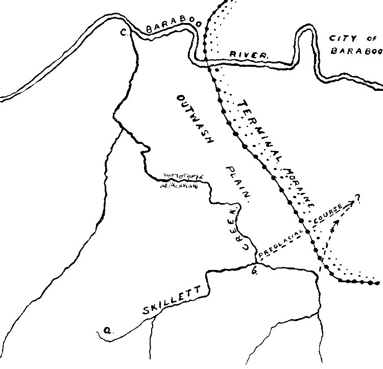
Fig. 43. -- Skillett Creek, illustrating the points
mentioned in the text.
See larger image
The picturesque glens (Parfrey's and Dorward's) on the south face of the
East bluff are the work of post-glacial streams. The preglacial valleys
of this slope were obliterated by being filled during the glacial epoch.
The Wisconsin.—The preglacial course of the Wisconsin river is not
known in detail, but it was certainly different from the course which
the stream now follows. On Plate I the relations of the present
stream to the moraine (and former ice-front) may be seen.
[10]
As the ice approached it from the east, the preglacial valley within the area
here under consideration was affected first by the overwash from the
moraine, and later by the ice itself, from the latitude of Kilbourn City
to Prairie du Sac.
It has already been stated that the ice probably dammed the river, and
that a lake was formed above Kilbourn City, reaching east to the ice and
west over the lowland tributary to the river, the water rising till it
found an outlet, perhaps down to the Black river valley.
When the ice retreated, the old valley had been partly filled, and the
lowest line of drainage did not everywhere correspond with it. Where the
stream follows its old course, it flows through a wide capacious valley,
but where it was displaced, it found a new course on the broad flat
which bordered its preglacial course. Displacement of the stream
occurred in the vicinity of Kilbourn City, and, forced to find a new
line of flow west of its former course, the stream has cut a new channel
in the sandstone. To this displacement of the river, and its subsequent
cutting, we are indebted for the far-famed Dalles of the Wisconsin (p.
69). But not all the present route of the river through the dalles has
been followed throughout the entire postglacial history of the stream.
In Fig. 44, the depression a, b,
c, was formerly the course of the
stream. The present course between d and
e is therefore the youngest
portion of the valley, and from its lesser width is known as the
"narrows." During high water in the spring, the river still sends part
of its waters southward by the older and longer route.
The preglacial course of the Wisconsin south of the dalles has never
been determined with certainty, but rational conjectures as to its
position have been made.
The great gap in the main quartzite range, a part of which is occupied
by Devil's lake, was a narrows in a preglacial valley. The only streams
in the region sufficiently large to be thought of as competent to
produce such a gorge are the Baraboo and the Wisconsin. If the Baraboo
was the stream which flowed through this gorge in preglacial time, the
comparable narrows in the north quartzite range—the Lower narrows of
the Baraboo—is to be accounted for. The stream which occupied one of
these gorges probably occupied the other, for they are in every way
comparable except in that one has been modified by glacial action, while
the other has not.
Fig. 44. -- The Wisconsin valley near Kilbourn City.
See larger image
The Baraboo river flows through a gorge—the Upper narrows—in the north
quartzite range at Ablemans, nine miles west of Baraboo. This gorge is
much narrower than either the Lower narrows or the Devil's lake gorge,
suggesting the work of a lesser stream. It seems on the whole
probable, as suggested by Irving,
[11]
that in preglacial time the
Wisconsin river flowed south through what is now the Lower narrows of
the Baraboo, thence through the Devil's lake gorge to its present valley
to the south. If this be true, the Baraboo must at that time have joined
this larger stream at some point east of the city of the same name.
Reference has already been made to the fact that the western part of the
area here described is driftless, and the line marking the limit of ice
advance has been defined. Beyond this line, gravel and sand, carried
beyond the ice by water, extends some distance to the west. But a large
area in the southwestern part of the state is essentially free from
drift, though it is crossed by two belts of valley drift (valley trains)
along the Wisconsin and Mississippi rivers.
The "driftless area" includes, besides the southwestern portion of
Wisconsin, the adjoining corners of Minnesota, Iowa and Illinois. In the
earlier epochs of the glacial period this area was completely surrounded
by the ice, but in the last or Wisconsin epoch it was not surrounded,
since the lobes did not come together south of it as in earlier times.
(Compare Plate XXXVIII and Fig.
36.)
Various suggestions have been made in the attempt to explain the
driftless area. The following is perhaps the most satisfactory:
[12]
The adjacent highlands of the upper peninsula of Michigan, are bordered
on the north by the capacious valley of Lake Superior leading off to the
west, while to the east lies the valley of Lake Michigan leading to the
south. These lake valleys were presumably not so broad and deep in
preglacial times as now, though perhaps even then considerable valleys.
When the ice sheet, moving in a general southward direction from the
Canadian territory, reached these valleys, they led off two great
tongues or lobes of ice, the one to the south through the Lake Michigan
depression, the other to the south of west through the Lake Superior
trough. (Fig. 36) The highland between the lake valleys conspired with
the valleys to the same end. It acted as a wedge, diverting the ice to
either side. It offered such resistance to the ice, that the thin and
relatively feeble sheet which succeeded in surmounting it, did not
advance far to the south before it was exhausted. On the other hand, the
ice following the valleys of Lakes Superior and Michigan respectively,
failed to come together south of the highland until the latitude of
northern Iowa and Illinois was reached. The driftless area therefore
lies south of the highlands, beyond the limit of the ice which
surmounted it, and between the Superior and Michigan glacial lobes above
their point of union. The great depressions, together with the
intervening highland, are therefore believed to be responsible for the
absence of glaciation in the driftless area.
The glaciated and unglaciated areas differ notably in (1) topography, (2)
drainage, and (3) mantle rock.
1. Topography.—The driftless area has long been exposed to the
processes of degradation. It has been cut into valleys and ridges by
streams, and the ridges have been dissected into hills. The
characteristic features of a topography fashioned by running water are
such as to mark it clearly from surfaces fashioned by other agencies.
Rivers end at the sea (or in lakes). Generally speaking, every point at
the bottom of a river valley is higher than any other point in the
bottom of the same valley nearer the sea, and lower than any other point
correspondingly situated farther from the sea. This follows from the
fact that rivers make their own valleys for the most part, and a river's
course is necessarily downward. In a region of erosion topography
therefore, tributary valleys lead down to their mains, secondary
tributaries lead down to the first, and so on; or, to state the same
thing in reverse order, in every region where the surface configuration
has been determined by rain and river erosion, every gully and every
ravine descends to a valley. The smaller valleys descend to larger and
lower ones, which in turn lead to those still larger and lower. The
lowest valley of a system ends at the sea, so that the valley which
joins the sea is the last member of the series of erosion channels of
which the ravines and gullies are the first. It will thus be seen that
all depressions in the surface, worn by rivers, lead to lower ones. The
surface of a region sculptured by rivers is therefore marked by valleys,
with intervening ridges and hills, the slopes of which descend to them.
All topographic features are here determined by the water courses.
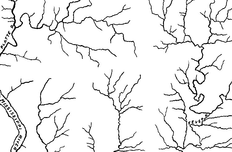
Fig. 45. -- Drainage in the driftless area. The absence of
ponds and marshes is to be noted.
See larger image
The relief features of the glaciated area, on the other hand, lack the
systematic arrangement of those of the unglaciated territory, and stream
valleys are not the controlling elements in the topography.
2. Drainage.—The surface of the driftless area is well drained. Ponds
and lakes are essentially absent, except where streams have been
obstructed by human agency. The drainage of the drift-covered area, on
the other hand, is usually imperfect. Marshes, ponds and lakes are of
common occurrence. These types are shown by the accompanying maps, Figs.
45 and
46, the one from the driftless area, the other from the
drift-covered.
Fig. 46. -- Drainage in a glaciated region. Walworth and
Waukesha counties, Wisconsin, showing abundance of marshes and lakes.
See larger image
3. Mantle rock.—The unglaciated surface is overspread to an average
depth of several feet by a mantle of soil and earth which has resulted
from the decomposition of the underlying rock. This earthy material
sometimes contains fragments and even large masses of rock like that
beneath. These fragments and masses escaped disintegration because of
their greater resistance while the surrounding rock was destroyed. This
mantle rock grades from fine material at the surface down through
coarser, until the solid rock is reached, the upper surface of the rock
being often ill-defined (Fig. 47). The thickness of the mantle is
approximately constant in like topographic situations where the
underlying rock is uniform.
The residual soils are made up chiefly of the insoluble parts of the
rock from which they are derived, the soluble parts having been removed
in the process of disintegration.
Fig. 47. -- Section in a driftless area, showing relation
of the mantle rock to the solid rock beneath.
See larger image
With these residuary soils of the driftless area, the mantle rock of
glaciated tracts is in sharp contrast. Here, as already pointed out, the
material is diverse, having come from various formations and from widely
separated sources. It contains the soluble as well as the insoluble
parts of the rock from which it was derived. In it there is no
suggestion of uniformity in thickness, no regular gradation from fine to
coarse from the surface downward. The average thickness of the drift is
also much greater than that of the residual earths. Further, the contact
between the drift and the underlying rock surface is usually a definite
surface. (Compare Figs. 32 and
47.)
Since the ice melted from the region, the changes in its geography have
been slight. Small lakes and ponds have been drained, the streams whose
valleys had been partly filled, have been re-excavating them, and
erosion has been going on at all points in the slow way in which it
normally proceeds. The most striking example of postglacial erosion is
the dalles of the Wisconsin, and even this is but a small gorge for so
large a stream. The slight amount of erosion which has been accomplished
since the drift was deposited, indicates that the last retreat of the
ice, measured in terms of geology and geography, was very recent. It has
been estimated at 7,000 to 10,000 years, though too great confidence is
not to be placed in this, or any other numerical estimate of
post-glacial time.