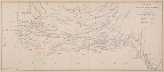
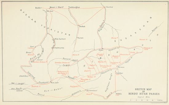
MEDIÆVAL GEOGRAPHY—SEISTAN AND AFGHANISTAN
It was about eight centuries before Buddhism,
debased and corrupted, tainted with Siva worship
and loaded with all the ghastly paraphernalia of a
savage demonology, had been driven from India
across the Himalayas, that the Star of Bethlehem
had guided men from the East to the cradle of the
Christian faith—a faith so like Buddhism in its
ethical teaching and so unlike in its spiritual
conceptions,—and during those eight centuries
Christianity had already been spread by Apostles
and missionaries through the broad extent of High
Asia. Thereupon arose a new propaganda which,
spreading outwards from a centre in south-west
Arabia, finally set all humanity into movement,
impelling men to call the wide world to a recognition
of Allah and his one Prophet by methods
which eventually included the use of fire and sword.
The rise of the faith of Islam was nearly coincident
(so far as India was concerned) with the fall of
Buddhism. Thenceforward the gentle life-saving
precepts of Gautama were to be taught in the
south, and east, and north; in Ceylon, Burma,
China, and Mongolia after being first firmly rooted
in Tibet and Turkistan, but never again in the
sacred groves of the land of their birth. And this
raging religious hurricane of Islam swept all before
it for century after century until, checked at last in
Western Europe, it left the world ennobled by
many a magnificent monument, and, by adding to
the enlightenment of the dark places of the earth,
fulfilled a mission in the development of mankind.
With it there arose a new race of explorers who
travelled into India from the west and north-west,
searching out new ways for their commerce, and it
is with them now and their marvellous records of
restless commercial activity that we have to deal.
Masters of the sea, even as of the land, no military
and naval supremacy which has ever directed the
destinies of nations was so widespread in its
geographical field of enterprise as that of the Arabs.
The whole world was theirs to explore. Their
ships furrowed new paths across the seas, even as
their khafilas trod out new highways over the land;
and at the root of all their movement was the commercial
instinct of the Semite. After all it was the
eternal question of what would pay. Their progenitors
had been builders of cities, of roads, of
huge dams for water storage and irrigation, and
directors for public works in Europe, Asia, and
Africa. The might of the sword of Islam but
carved the way for the slave-owner and the
merchant to follow. Thus it is that mediæval
records of exploration in Afghanistan and Baluchistan
are mostly Arab records; and it is from
them that we learn the "open sesame" of India's
landward gates, long ere the seaports of her coasts
were visited by European ships.
Nothing in the history of the world is more surprising
than the rapid spread of Arab conquests in
Asia, Africa, and Western Europe at the close of
the seventh century of our era, excepting, perhaps,
the thoroughness of the subsequent disappearance
of Arab influence, and the absolute effacement of
the Arabic language in those countries which Arabs
ruled and robbed. In Persia, Makran, Central
Asia, or the Indus valley, hardly a word of Arabic
is now to be recognized. Geographical terms
may here and there be found near the coast, surviving
only because Arab ships still skirt those shores
and the sailor calls the landmarks by old-world
names. Even in the English language the sea
terms of the Arab sailor still live. What is our
"Admiral" but the "Al mir ul bahr" of the
Arabian Sea, or our "Barge" but his "Barija," or
warship! But in Sind, where Arab supremacy lasted
for at least three centuries, there is nothing left to
indicate that the Arab ever was there.
The effacement of the Arab in India is chiefly
due to the Afghan, the Turk, and the Mongol.
Mahmud of Ghazni put the finishing blow to Arab
supremacy in the Indus valley, when he sacked
Multan about the beginning of the eleventh
century; and subsequently the destroying hordes
of Chenghiz Khan and Tamerlane completed the
final downfall of the Empire of the Khalifs.
Between the beginning of the eighth century
and that of the eleventh the whole world of the
Indian north-west frontier and its broad hinterland,
extending to the Tigris and the Oxus, was much
traversed and thoroughly well known to the Arab
trader. In Makran we have seen how they shaped
out for themselves overland routes to India, establishing
big trade centres in flourishing towns, burying
their dead in layers on the hill-sides, cultivating
their national fruit, the date, in Makran valleys, and
surrounding themselves with the wealth and beauty
of irrigated agriculture. The chief impulse to Arab
exploration emanated from the seat of the Khalifs in
Mesopotamia, and the schools of Western Persia
and Bagdad appear to have educated the best of
those practical geographers who have left us their
records of travel in the East; but there are indications
of an occasional influx of Arabs from the
coasts of Southern Arabia about whom we learn
nothing whatever from mediæval histories. It will
be at any rate interesting to discuss the general
trend of exploration and travel, associated either
with pilgrimage or commerce, which distinguished
the days of Arab supremacy, and which throws
considerable light on the geography of the Indian
borderland before its political features were rearranged
by the hand of Chenghiz Khan and his
successors. This has never yet been attempted by
the light of recent investigations, and even now it
can only be done partially and indifferently from
the want of completed maps. The borderland
which touches the Arabian Sea—Southern Baluchistan—has
been completely explored and mapped,
and the more obvious inferences to be derived from
that mapping have already been made. But
Seistan, Karmania, the highways and cities of
Turkistan (Tocharistan) and Badakshan have not,
so far as I know, been outlined in any modern
work based on Arab writings and collated with
the geographical surveys of the Russo-Afghan
Boundary Commission and their reports. It was
after all but a cursory examination of a huge area
of most interesting country that was possible within
the limited time devoted to boundary demarcation
labours in 1883-85; but the physical features of this
part of Asia being now fairly well defined, there is
a good deal to be inferred with reasonable probability
from the circumstance that highways and
cities must ever be dependent for their location on
the distributions of topography.
The first impression produced by the general
overlook of all the historic area which lies between
Eastern Persia and the sources on the Oxus, is one
of surprise. There is so little left of this great
busy world of Arab commerce. It seems to have
dropped out of the world's economy, and certain
regions to have reverted to a phase of pristine
freedom from sordid competition, which argues
much for a decreased population and a desiccated
area of once flourishing lands.
There are no forests and jungles in Western
Afghanistan, or at least only in restricted spaces
on the mountain-slopes, so that there is no wild
undergrowth uprooting and covering the evidences
of man's busy habitation such as we find in Ceylon
and the Nepal Tarai; where may be seen strange
staring stone witnesses of the faith of former
centuries, half hidden amidst the wild beauty and
luxuriance of tropical forest growth. There is
nothing indeed quite so interesting. Nature has
spread out smooth grass slopes carpeted with
sweet flowers in summer, but frozen and windswept
in winter; and beneath the surface we know
for a surety that the buried remains of centuries of
busy traffic and marketing lie hidden, but there is
frequently no sign whatever above ground. It is
difficult to account for the utter want of visible
evidence. In the processes of clearing a field for
military action, when it becomes essential to remove
some obstructive mud-built village and trace
a clear and free zone for artillery fire, it is often
found that the work of destruction is exceedingly
difficult. Only with the most careful management
can the debris be so dispersed that it affords no
better cover to the enemy than the village which it
once represented. As for effacing it altogether, only
time, with the assistance of wind and weather, can
accomplish that. But it is remarkable with what
completeness time succeeds. I have stood on the
site of a buried city in Sind—a city, too, of the
mediæval era of Arab ascendency—and have recognized
no trace of it but what appeared to be the
turbaned effigies of a multitude of faithful mourners
in various expressive attitudes of grief and despair,
who represented the ancient cemetery of the city.
The city had been wiped off the land as clean as if
it had been swept into the sea, but the burying
places remained, and the stone mourners continue
mourning through the centuries.
The architectural order of these Khalmat tombs
is quite Saracenic, and the vestiges of geometrical
design which relieve the plain surface of the stone
work and accentuate the lines of arch and moulding,
are all clean cut and clear. At the end of each
tomb, set up on a pedestal, the folded turban testifies
in hard stone to the faith of the occupant beneath.
The sharp edges of the slabs and the clearness of
the ornamental carving are sufficient to prove that
the age of these tombs and monuments cannot be
so very remote, although remote enough to have
led to the effacement of the township to which they
belong. Sometimes a mound, where no mound
would naturally occur, indicates the base of one
of the larger buildings. Sometimes in the slanting
rays of the evening sun certain shadows, unobserved
before, take shape and pattern themselves
into the form of a basement; and almost always
after heavy rain strange little ornaments, beads,
and coins, glass bangles, rings, etc., are washed out
on the surface which tell their own tale as surely as
does the widespread and infinitely varied remnants
of household crockery. This last feature is sometimes
quite amazing in its variety and extent, and
the quality of the local finds is not a bad indication
of the quality of the local household which made
use of it. "Celadon" ware is abundant from
Karachi to Babylon, and some of it is of extraordinary
fineness and beauty of glaze. Pale sage
green is invariably the colour of it, and the tradition
of luck which attaches to it is common from
China to Arabia.
In places where vanished towns were in existence
as late as the eighteenth century (for instance,
in the Helmund valley below Rudbar), debris of
pottery may be found literally in tons. In other
places, still living, where generations of cities
have gradually waxed and waned in successive
stages, each in turn forming the foundation of a
new growth, it is very difficult to derive any true
historical indication from the debris which is to be
found near the surface. Nothing but systematic
and extensive excavation will suffice to prove that
the existing conglomeration of rubbishy bazaars
and ruined mosques is only the last and most unworthy
phase of the existence of a city the glory of
whose history is to be found in the world-wide
tradition of past centuries. And so it happens
that, moving in the footsteps of these old mediæval
commercial travellers, with the story of their travels
in one's hand, and the indications of hill and plain
and river to testify to the way they went, and a
fair possibility of estimating distances according to
their slipshod reckoning of a "day's journey," one
may possess the moral certainty that one has
reached a position where once there stood a
flourishing market-town without the faintest outward
indication of it. Without facilities for
digging and delving, and the time for careful examination,
there must necessarily be a certain
amount of conjecture about the exact locality of
some even of the most famous towns which were
centres of Arab trade through High Asia. Some
indeed are to be found still under their ancient
names, but others (and amongst them many of
great importance) are no longer recognizable in
the place where once they palpitated with vigorous
Eastern life.
The area of Asia which for three or four centuries
witnessed the monopoly of Arab trade
included very nearly the whole continent. Asia
Minor may be omitted from that area, and the
remoter parts of China; but all the Indian borderland
was literally at their feet; and we can now
proceed to trace out some of their principal lines
of route and their chief halting-places in those
districts of which the mediæval geography has
lately become known.
It is not at all necessary, even if it were possible,
to follow the records of all the eminent Arab
travellers who at intervals trod these weary roads.
In the first place they often copied their records
from one another, so that there is much vain repetition
in them. In the second place they are not all
equally trustworthy, and their writing and spelling,
especially in place-names, wants that attention to
diacritical marks which in Eastern orthography is
essential to correct transliteration. It is perhaps
unfortunate that the most eminent geographer
amongst them should not have been a traveller,
but simply a compiler.
Abu Abdulla Mohamed was born at Ceuta in
Morocco towards the end of the eleventh century.
Being descended from a family named Idris, he
came to be known as Al Idrisi. The branch of the
family from which Idrisi sprang ruled over the city
of Magala. He travelled in Europe and eventually
settled at the Court of Roger II. in Sicily. Here
he wrote his book on geography. He quotes the
various authors whom he consulted in its compilation,
and derived further information from travellers
whose accounts he compared and tested. The title
of his work is The Delight of those who seek to
wander through the Regions of the World, and it
is from the French translation of this work by
Jaubert that the following notes on the countries
lying beyond the western borders of India are
taken. This account may be accepted as representing
the condition of political and commercial
geography throughout those regions at the end of
the eleventh century, some eighty years or so after
the borders of India had been periodically harried
by Mahmud of Ghazni, and not very long before
the Mongol host appeared on the horizon and made
a clean sweep of Asiatic civilization.
To the west of the Indian frontier in those
early days lay the Persian provinces of Makran
and Sejistan (Seistan), which two provinces between
them appear to represent a great part of modern
Baluchistan. The "Belous" were not yet in
Baluchistan; they lived north of the mountains
occupied by the "Kufs," with whom they are
invariably associated in Arab geography. "The
Kufs," says Idrisi, "are the only people who do
not speak Persian in the province of Kerman.
Their mountains reach to the Persian Gulf,
being bordered on the north by the country
of Najirman (?Nakirman), on the south and east
by the sea and the Makran deserts, on the
west by the sea and the 'Belous' country and the
districts of Matiban and Hormuz." These are
doubtless the "Bashkird" mountains, and the
"species of Kurd, brave and savage" which
inhabited them under the name of Kufs probably
represent the progenitors of the present inhabitants.
The "Bolous" or "Belous" lived in the plains
to the north "right up to the foot of the mountains,"
and these are the people (according to Mr.
Longworth Dames) who, hailing originally from
the Caspian provinces, are the typical Baluch
tribespeople of to-day.
These mountains, which Idrisi calls the "cold
mountains," extend to the north-west of Jirift and
are "fertile, productive, and wooded." "It is
a country where snow falls every year," and of
which "the inhabitants are virtuous and innocent."
There have been changes since Idrisi's time,
both moral and physical, but here is a strong
item of evidence in favour of the theory of the
gradual desiccation which has enveloped Southern
Baluchistan and dried up the water-springs of
Makran. What Idrisi called the "Great Desert"
is comprehensive. All the great central wastes of
Persia, including the Kerman desert as well as the
basin of the Helmund south of the hills, the frontier
hills of the Sind border up to Multan, were a part
of it, and they were inhabited by nomadic tribes of
"thieves and brigands."
Modern Seistan is a flat, unwholesome country,
distributed geographically on either side of the
Helmund between Persia and Afghanistan. It
owes its place in history and its reputation for
enormous productiveness to the fact that it is
the great central basin of Afghanistan, where
the Helmund and other Afghan rivers run to a
finish in vast swamps, or lagoons. Surrounded by
deserts, Seistan is never waterless, and there was,
in days which can hardly be called ancient, a really
fine system of irrigation, which fertilized a fairly
large tract of now unproductive land on the Persian
side of the river. The amount of land thus brought
under cultivation was considerable, but not considerable
enough to justify the historic reputation
which Seistan has always enjoyed as the "Granary
of Asia." This traditional wealth was no doubt
exaggerated from the fact that the fertility of
Seistan (like that of the Herat valley, which is after
all but an insignificant item in Afghan territory)
was in direct contrast to the vast expanse of profitless
desert with which it was surrounded—a green
oasis in the midst of an Asiatic wilderness.
The Helmund has taken to itself many channels
in the course of measurable time. Its ancient beds
have been traced and mapped, and with them have
been found evidences of closely-packed townships
and villages, where the shifting waters and consequent
encroachment of sand-waves leave no sign
of life at present.
Century after century the same eternal process
of obliteration and renovation has proceeded.
Millions of tons of silt have been deposited in this
great alluvial basin. Levels have changed and the
waters have wandered irresponsibly into a network
of channels westward. Then the howling, desiccating
winds of the north-west have carried back
sand-waves and silt, burying villages and filling the
atmosphere for hundreds of miles southward with
impalpable dust, crossing the Helmund deserts
even to the frontier of India. There is no measurable
scale for the force of the Seistan winds. They
scoop up the sand and sweep clean the surface of
the earth, polishing the rounded edges of the ragged
walls of the Helmund valley ruins. It is a notable
fact that no part of these ruins face the wind. All
that is left of palaces and citadels stands "end on"
to the north-west. For a few short months in the
year the wind is modified, and then there instantly
arises the plague of insects which render life a
burden to every living thing. And yet Seistan has
played a most important part in the history of Asia,
and may play an important rôle again.
Arab records are very full of Seistan. The
earliest of them that give any serious geographical
information are the records of Ibn Haukel, but
there are certainly indications in his account which
engender a suspicion that he never really visited
the country. He mentions the capital Zarinje (of
which the ruins cover an enormous area to the east
of Nasratabad, the present capital) and writes of it
as a very large town with five gates, one of which
"leads to Bist." There were extensive fortifications,
and a bazaar of which he reckons the annual
revenue to be 1000 direms.
There were canals innumerable, and always the
wind and the windmills. It is curious that he
traces the Helmund as running to Seistan first and
then to the Darya-i-Zarah. This is in fact correct,
only the Darya-i-Zarah (or Gaod-i-Zireh, as we
know it) receives no water from the Helmund until
the great Hamún (lagoons) to the north of Nasratabad
are filled to overflow. He also mentions
two rivers as flowing into the Zarah—one from
Farah (an important place in his time), which is
impossible, as it would have to cross the Helmund;
and one from Ghur. This indicates almost certainly
that the name Zarah was not confined, as it
is now, to the great salt swamp south of Rudbar on
the Helmund, but it included the Hamúns north
of Nasratabad, into which the Farah River and
the Ghur River do actually empty themselves. At
present these two great lake systems are separated
by about 120 miles of Helmund River basin, and are
only connected occasionally in flood time by means
of the overflow (called Shelag) already referred to.
The mention of Bist, and of the bridge of boats
across the river at that point, is important, for it is
clear that about the year A.D. 950 one high-road
for trade eastward was across the desert, i.e. via
the Khash Rud valley from Zarinje to about the
meridian of 63 E.L. and then straight over the
desert to Bist (Kala Bist of modern mapping).
The further mention of robats (or resting-places)
en route, indicates that it was well kept up and a
much traversed high-road. Subsequently Girishk
appears to have become the popular crossing-place
of the river, but it is well to remember that the
earlier route still exists, and could readily be made
available for a flank march on Kandahar.
From Idrisi's writings we learn that a century
later, i.e. about the end of the eleventh century, the
Seistan province extended far beyond its present
limits. Bamian and Ghur (i.e. the central hills of
Afghanistan) were vis-à-vis to that province; Farah
was included; and probably the whole line of the
frontier hills from the Sulimanis, opposite Multan,
to Sibi and Kalat. It was an enormous province,
and a new light breaks on its traditional wealth in
grain and agricultural produce when we understand
its vast extent.
The regions of Ghur and Dawar bordered it to
the north, and there is a word or two to be said
about both hereafter. Ghur in the eleventh century
included the valley of Herat and all the wedge of
mountainous country south of it to Dawar, but how
far Seistan extended into the heart of the mountain
system which culminates to the south-west of Kabul
it is difficult to say. It is difficult to understand
the statement that Bamian, for instance, bordered
Seistan, with Ghur in between, unless, indeed, in
these early days of Ghur's history (for Ghur was
only conquered by the Arabs in A.D. 1020, and was
still far from intertwining its history with that of
Ghazni when Idrisi wrote) the greatness of Bamian
overshadowed the light of the lesser valleys of
Ghur, and Bamian was the ruling province of
Central Afghanistan. This, indeed, seems possible.
The district of Dawar to the south of Ghur has
always been something of a mystery to geographers.
Described by Idrisi as "vast, rich, and fertile," and
"the line of defence on the side of Ghur, Baghnein,
and Khilkh," it would be impossible to place it without
a knowledge of the towns mentioned, were it
not that we are told that Derthel, one of the chief
towns of Dawar, is on the Helmund, and that one
crosses the river there "in order to reach Sarwan."
This at once indicates the traditional ford at Girishk
as the crossing-place, and Zamindawar as the Dawar
of Idrisi. Khilkh then becomes intelligible also
as a town of the Khilkhi (the people who then
occupied Dawar, described as Turkish by Idrisi,
and probably identified with the modern Ghilzai),
and finds its modern representative in the Kalat-i-Ghilzai
which crowns the well-known rock on the
road from Kandahar to Kabul. "The country is
inhabited by a people called Khilkh," says Idrisi.
"The Khilkhs are of a Turkish race, who from a
remote period have inhabited this country, and
whose habitations are spread to the north of India
on the flank of Ghur and in western Seistan."
Thus the position of the Ghilzai in the ethnography
of Central Afghanistan appears to have been established
long before the days of Mongol irruption.
Then as now they formed a very important tribal
community.
It is, however, sometimes difficult to reconcile
Idrisi's account of the routes followed by his
countrymen in this part of Asia with existing
geographical features. Deserts and mountains
must have been much the same as they are now,
and the best, if not the only, way to unravel the
geographical tangle is to take his itinerary and see
where it leads us. Of Baghnein on the southern
borders of Seistan, he says it is an "agreeable
country, fertile and abundant in fruits." From
there (i.e. the country, not the town) to Derthel one
reckons one day's journey through the nomad tribes
of Bechinks, Derthel being "situated on the banks
of the Helmund and one of the chief towns of
Dawar."
So we have to cross an open uncultivated region
for 40 miles or so from Baghnein to reach Derthel,
on the Helmund. Again, "one crosses the Helmund
at Derthel to reach Sarwan—a town
situated about one day's journey off," on which
depends a territory which produces everything in
abundance. "Sarwan is bigger than Fars, and
more rich in fruit and all sorts of productions.
Grapes are transported to Bost (or Bist), a town
two days distant passing by Firozand, which
possesses a big market, and is on the traveller's
right as he travels to Benjawai, which is vis-à-vis
to Derthel." "Rudhan (?Rudbar) is a small town
south of the Helmund."
The Helmund valley has been surveyed from
Zamindawar to its final exit into the Seistan
lagoons, and we know that at Girishk there is a
very ancient ford, which now marks, and has always
marked, the great highway from Kandahar to Herat.
South of Girishk, at the junction of the Arghandab
with the Helmund, we find extensive and ancient
ruins at Kala Bist; and south of that again there
are many ruins at intervals in the Helmund valley;
but these latter are comparatively recent, dating
from the time of the Kaiani Maliks of the eighteenth
century.
Assuming that the Helmund fords have remained
constant, and placing Derthel on one side of the
river at Girishk and Benjawai on the other, we find
on our modern maps that from the ford it is a
possible day's journey to Kala Sarwan, higher up
the Helmund, where "fruit and grapes are to be
had in abundance," and from whence they might
certainly have been sent to Bist, where grapes do
not grow. Baghnein, separated from Derthel by a
strip of nomad country, one day's journey wide,
might thus be on either side the Helmund; but its
contiguity to Ghur seems to favour a position to the
west, rather than to the east, of the river, somewhere
east of the plains of Bukwa about Washir.
Now it is certain that no Arab traveller, crossing
the Helmund desert from the west by the direct
route recently exploited in British Indian interests
below Kala Bist and south of the river, could by
any possibility have reached a grape-growing and
highly-cultivated country in one day's journey. The
inference, then, is tolerably clear. Arab traders
and travellers never made use of this southern
route. Nor should we ourselves make use of such
a route as that via Nushki and the Koh-i-Malik
Siah, were we not forced into it by Afghan policy.
The natural high-road from the east of Persia and
Herat to India is via the plains of Kandahar
and the ford of Girishk, and the Arabs, with all
Khorasan at their feet, were not likely to travel
any other way.
Undoubtedly the system of approach to the Indus
valley, open to Arab traffic from Syria and Bagdad,
most generally used and most widely recognized
was that through the Makran valleys to Karachi
and Sind, whilst the inland route, via Persia and
Seistan, made the well-known ford of the Helmund
at Girishk, or the boat bridge at Kala Bist, its objective,
and passed over the river to the plains about
Kandahar. But it is a very remarkable, and possibly
a significant, fact that the continuation of the
route to Sind and the Indus valley from the plains
about Kandahar is not mentioned by any Arab
writer. Did the Arabs descend through any of the
well-known passes of the frontier—the Mulla, Bolan,
Saki-Sarwar, or Gomul—into the plains of India?
Possibly they did so; but in that case it is difficult
to account for so important a geographical feature
as the frontier passes of Sind being ignored by the
greatest geographer of his day.
Following Idrisi's description of the Helmund
province we have a brief itinerary from the Helmund
ford (Derthel or Benjawai) to Ghazni, said to
be nine days' journey inland. None of the places
mentioned are to be identified in modern maps
except Cariat, which is more than probably Kariut,
a rich and fertile district in the Arghandab valley
in the direct line to Kalat-i-Ghilzai. This route
passes well to the north-east of Kandahar, which
was apparently of little account in Idrisi's days.
Although there are extensive ruins at Kushk-i-Nakhud,
indicated by a huge artificial mound half-way
between Girishk and Kandahar, there is
nothing in Idrisi's writings by which they can be
identified.
Ghazni was then a large town "surrounded by
mud walls and a ditch. There are many houses
and permanent markets in Ghazni; much business
is done there. It is one of the 'entrepots' of
India. Kabul is nine days' journey from it." This
is not much to say of the city which had been
enriched by the spoils carried away from Muttra
and Somnath, and by the treasures amassed during
seventeen fierce raids of that Mahmud who, by
repeated conquests, made all Northern and Western
India contribute to his treasury.
Later, in 1332, the Arab traveller, Ibn Batuta,
writes of Ghazni as a small town set in a waste
of ruins—a description which fits it not inaptly at
the present day; but in Idrisi's time, before the
wars with Ghur led to its destruction, whilst still
the wealth of a great part of India supported its
magnificence, and whilst it was still the theme of
glowing panegyric by contemporary historians, one
would expect a rather more enthusiastic notice.
But even Kabul (nine days' journey distant from
Ghazni) is only recognized as "L'une des grandes
villes de l'Inde, entourée de murs," with a "bonne
citadelle et au dehors divers faubourgs."[5]
There is little to interest us, however, in tracing
out the routes that linked up Ghazni and Kabul
with the Helmund. They have been the same
through all time, with just the difference of place-names.
Towns and villages, caravanserais and
posts, have come and gone, but that historic road
has been marked out by Nature as one of the
grandest high-roads in Asia, from the days of
Alexander to those of Roberts. Two minars tapering
to the sky on the plain before Ghazni are all
that are left of its ancient glories, and one cannot
but contrast the scattered debris of that once so
famous city with the solid endurance of the far
greater and older architectural efforts in Egypt and
Assyria. Southern Afghanistan is indeed singularly
poor and empty of historic monuments. Even now
were Kabul, Kandahar, and Herat, its three great
cities, to be flattened out by a widespread earthquake
there would be little that was not of Buddhist origin
left for the future archæologist to make a stir about.
Idrisi writes of the Kingdom of Ghur as apart
from Herat, although a great part of the long Herat
valley was certainly included. He calls it a country
"mountainous and well inhabited, where one finds
springs, rivers, and gardens—easy to defend and
very fertile. There are many cultivated fields and
flocks. The inhabitants speak a language which
is not that of the people of Khorasan, and they
are not Mohammedans." Who were they? The
Khilkhis or Ghilzais we know at that time overspread
the southern hills of Dawar; but who were
the people speaking a strange language in the
land of the Chahar Aimak where now dwell the
Taimanis, unless they were the Taimanis themselves
whose traditions date from the time of
Moses?
More recently the Ghilzais have left Zamindawar,
and the Taimanis have been pressed backward and
upward into the central hills by the Afghan Durani
clans, who circle round westward, forming a fringe
on the foothills between Herat and Kandahar, and
who have now completely monopolized Zamindawar.
Here, indeed, the truculent Nurzai and Achakzai,
and other elements of the Durani section of Afghan
ethnography, flourish exceedingly, and it is in this
corner of Afghanistan, bordering on the Herat highway
to India, that nearly all the fanatics and ghazis
of the country are bred. They presented so turbulent
and uncompromising a front to strangers in
1882 that there was great difficulty in getting a
fair survey of the land of the Chahar Aimak or
of Zamindawar.
The mediæval provinces of Ghur and Bamain
figure so largely in the records of Arab geography,
and appear to have been so fully open to commerce
during the centuries succeeding the Arab conquests,
that one naturally wonders whether there can have
been any remarkable change in the physical configuration
of those regions which, in these later
days, has rendered them more inaccessible and
unapproachable. The Arab accounts of trade routes
flit easily from point to point, taking little reckoning
of long distances and gigantic ice-bound passes, or
the perils of a treacherous climate. An itinerary
which deals with stupendous mountains and extreme
altitudes has little more of descriptive illustration
in these Arab records than such as would
apply to camel tracks across the sandy desert or over
the flat plain. Nor is the distance which figures as
a "day's journey" sensibly changed to suit the
route. Forty miles or so across the backbone of
the Hindu Kush is written of in much the same
terms as if it were forty miles over the plains.
Giving the Arab travellers all credit for far greater
powers of endurance and determination than we
moderns possess, we must still believe that there
is a great deal of exaggeration (or forgetfulness) in
these heroic records of the past. It is unlikely that
the physical conditions of the country have materially
changed.
So little has been written of this central region
of modern Afghanistan (within which lie the ruins
of more than one kingdom), so little has it been
traversed by modern explorers, that it may be
useful to give some slight general description of
the country with which these records deal, including
Bamain and Kabul and the mountain system occupied
by the Taimani and Hazara tribes as well as
the prolific region of Zamindawar with the routes
which traverse it.
No part of Afghanistan has been subject to more
speculative theories, or requires more practical
elucidation, than this mountain region in which so
large a share of the drama of Afghan history has
been played. Before the days of the Anglo-Russian
agreement on the subject of the northern boundaries
of Afghanistan nothing was known of its geography,
beyond what might be gathered from the doubtful
records of Ferrier's journey—and that was very
little. The geography of a country shapes its
history just as surely in the East as in the West,
and we have consequently much new light thrown
on the interesting story of the rise and fall of the
Ghur dynasties by the fairly comprehensive surveys
of the region of their turbulent activities which were
carried out in 1882-83.
From these sources we obtain a very fair idea
of the general conformation of Central Afghanistan,
i.e. that part of Afghanistan which is occupied by
the tribes known as the Chahar Aimak, i.e. the Jamshidis,
the Hazaras, Firozkohis, and Taimanis. It
consists in the first place of a huge irregular tableland—or
uplift—which has been deeply scored and
eroded by centuries of river action, the rivers
radiating from the central mass of the Koh-i-Babar
to the west of Kabul and flowing in deep valleys
either directly northward towards the Oxus, due
west towards Herat (eventually to turn northward),
or south-west in irregular but more or less parallel
lines to the Helmund lagoons in Seistan.
The Kabul River basin also finds its head near the
same group of river sources. The central mountain
mass, the Koh-i-Babar, is high, rocky, generally
snow-capped and impassable. To the north it
sends down long, barren, and comparatively gentle
spurs to the main plateau level, which is deeply cut
into by the northern system of rivers, including the
Murghab and the Balkh Ab. But the strangest
feature in this network of hydrography is the long,
deep, narrow valley (almost ditch-like in its regularity)
which has been eroded by the Hari Rud
River as it makes its way due west, cutting off the
sources of the northern group from those of the
Helmund or south-western group. It is a most
remarkable valley, depressed to a depth of 1000 to
2000 feet below the general plateau level, bounded
on the north by a comparatively level line of red-faced
cliffs, and on the south by another straight
flat-backed range called the Band-i-Baian (or
farther west, the Sufed Koh), which has been carved
into the semblance of a range by the parallel valleys
of the Hari Rud on the north and the Tagao
Ishlan on the south, which hug the range between
them.
No affluents of any consequence join either
stream. Either separate or together they make
their way with straight determination westward
towards Herat. South of this curious ditch rise
the many streamlets which work their way, sometimes
through comparatively open valleys where
the floor level has been raised by the centuries of
detritus, sometimes through steep and narrow gorges
where the harder rock of the plateau formation
presents more difficulties to erosion, into the great
Helmund basin. These are affluents of the Adraskand,
the Farah Rud, and the Helmund, all of
which have the same bourne in the Seistan depression.
High up between the Farah Rud and the
Helmund affluents isolated rugged peaks and short
ranges crease and crumple the surface of the inhospitable
land of the Hazaras, who occupy all the
highest of the uplands and all the sources of the
streams, a hardy, handy race of Mongols, living in
wild seclusion, but proving themselves to be one
of the most useful communities amongst the many
in Afghanistan. We have some of them as sepoys
in the Indian Army. Lower down in the same
river basins, where the gentle grass-covered valleys
sweep up to the crests of the hills, cultivation
becomes possible. Here flocks of sheep dot the
hill-sides, and the land is open and free; but there
are still isolated and detached ribs of rocky eminence
rising to 11,000 and 12,000 feet, maintaining the
mountainous character of the scenery, and rivers are
still locked in the embrace of occasional gorges
which admit of no passing by. This is the land of
that very ancient people, the Taimanis.
The fierce and lawless Firozkohis live in the
Murghab basin on the plateau north of the Hari
Rud, the Jamshidis to the west of them in the
milder climate of the lower hills, into which the
plateau subsides.
Whilst we are chiefly concerned in tracing out
the mediæval commercial routes of Afghanistan, we
may briefly summarize the events which prove that
those traversed between Herat and the central
kingdoms were important routes, worn smooth by
the feet of armies as well as by the tread of pack-laden
khafilas. They are still very rough and they
present solid difficulties here and there, but in the
main they are passable commercial roads, although
little commerce wends its way about them now.
In the Middle Ages the Kingdom of Ghur included
the Herat valley as far as Khwaja Chist
above Obeh in the valley of the Hari Rud, as well
as all the hill country to the south-east. About the
earliest mention of Ghur by any traveller is that of
Ibn Haukel, who speaks of Jebel al Ghur, and
talks of plains, ring-fenced with mountains, fruitful
in cattle and crops, and inhabited by infidels (i.e.
non-Mussulmans). The later history of Ghur is
inextricably intertwined with that of Ghazni.
Mahmud of Ghazni frequently invaded the hills
of Ghur which lay to the west of him, but never
made any practical impression on the Ghuri tribespeople.
In 1020, however, Mahomedans conquered
Ghur effectually from Herat. About a
century later (this is after the time of Idrisi, whose
records we are following) a member of the ruling
Ghuri family (Shansabi) was recognized as lord of
Ghur, and it was one of his sons (Alauddin) who
inflicted such terrible reprisals on Ghazni when he
sacked and destroyed that city and its people. It
was about this time (according to some authorities)
that the kingdom of Bamian was founded by another
member of the same family; but we find Bamian
distinctly recognized as a separate kingdom by
Idrisi a century or so earlier. From 1174 to 1214
Bamian was the seat of government of a branch of
this family ruling all Tokharistan (Turkistan), during
which period Seistan and Herat were certainly
tributary to Ghur. Ghur then became so powerful,
that it was said that prayers in the name of the
Ghuri were read from uttermost India to Persia, and
from the Oxus to Hormuz.
In 1214 Ghur was reduced first by Mahomedans
from Khwarezm (Khiva), and shortly afterwards by
Chenghis Khan and his Mongol hosts. About the
middle of the thirteenth century, however, a recrudescence
of power appeared under the Kurt (or
Tajik) dynasty subject to the supreme government
of the Mongols. Seistan, Kabul, and Tirah were
then ruled from Herat as the capital of Ghur.
Timur finally broke up Herat and Ghur in 1383,
since which time its history has been as obscure as
the geography of the region which surrounded it.
Such in brief is the stormy tale of Ghur, and it
leads to one or two interesting deductions. There
was evidently constant and ready communication
with Herat, Bamian, and Ghazni. The capital of
Ghur must have been an important town, situated
in a fertile and fairly populous district, which,
although it was mountainous, yet enjoyed an excellent
climate. It must have been a military centre
too, with fortresses and places of defence. During
its later history it is clear that Ghur was often
governed from Herat, but in earlier mediæval days
Ghur possessed a distinct capital and a separate
entity amongst Afghan kingdoms, and was able to
hold its own against even so powerful an adversary
as Mahmud of Ghazni, whilst its communications
were with Bamian on the north-east rather than
with Kabul, which was then regarded as an "Indian"
city. We can at any rate trace no record of a
direct route between Ghur and Kabul.
In the twelfth century we read that the capital
of Ghur was known as Firozkohi, which name (says
Yule) was probably appropriated by the nomad
Aimak tribe now called Firozkohi; but within the
limits of what is now recognized as the habitat of
the Firozkohi (i.e. the plateau which forms the basin
of the Upper Murghab), it is impossible to find any
place which would answer to what we know of the
general condition of the surroundings and climate
of the capital of Ghur, and which would justify a
claim to be considered a position of commanding
eminence. The altitude of the Upper Murghab
branches is not more than 6000 to 7000 feet above
sea-level, at which height the climate certainly
admits of agriculture, but no place that has been
visited, nor indeed any position in the valleys of
the Upper Murghab affluents, corresponds in any
way to what we are told of this capital.
If we look for the best modern lines of communication
through Central Afghanistan we shall certainly
find that they correspond with mediæval routes,
fitting themselves to the conformation of the country.
Central Afghanistan is open to invasion from the
north, west, and south, but not directly from the
east. The invasion of Ghur from Ghazni, for instance,
must have been directed by Kalat-i-Gilzai,
Kariut, and Musa Kila (in Zamindawar), to Yaman,
which lies a little to the east of Ghur (or Taiwara).
So far as we know there are no passes leading due
west from Ghazni to the heart of the Taimani
country.
From the south the Helmund and its affluents
offer several openings into the heart of the Hazara
highlands to the east of Taimani land, amidst the
great rocky peaks of which the positions were fixed
from stations on the Band-i-Baian. But there is
no certain information about the inhabited centres
of Hazara population; and from what we know of
that desolate region of winter snow and wind, there
never could have been anything to tempt an invader,
nor would any sound commercial traveller have
dreamt of passing that way from Seistan to Bamian
and Kabul. The idea that Alexander ever took an
army up the Helmund valley, and over the Bamian
passes, must be regarded as most improbable in
spite of the description of Quintus Curtius, who
undoubtedly describes a route which presented more
difficulties than are quite appropriate to the regular
Kandahar to Kabul road. On the other hand, from
Seistan by the Farah Rud there is a route which
is open to wheeled traffic all the way to Daolatyar
on the upper Hari Rud. Daolatyar may be regarded
as the focus of several routes trending north-eastward
from Seistan, with the ultimate objective of Bamian
and the populous valleys of Ghur.
One of the chief affluents of the Farah Rud is now
known as the Ghur, and we need look no farther than
this valley for the central interest of the Ghur kingdom,
although the exact position of the capital may
still be open to discussion. Between the Tagao
Ghur and the Farah Rud are the Park Mountains,
which are almost Himalayan in general characteristics
and beauty, with delightful valleys and open
spaces, terraced fields, well-built two-storied wooden
houses, pretty villages, orchards with an abundance of
walnuts and vines trailing over the trees; the Ghur
valley itself being broad and open with a clear river
of sweet water in its midst. This is near its junction
with the Farah Rud. Above this, for a space, the
valley narrows to a gorge and there is no passing
along it, whilst above the gorge again it becomes
wide, cultivated, and well populated, and this is
where the Taimani headquarters of Taiwara are
found. Taiwara is locally known as Ghur, and may
be absolutely on the site of the ancient capital, for
there are ruins enough to support the theory.
Beyond an intervening band of hills to the south
are two valleys full of cultivation and trees, wherein
are two important places, Nili and Zarni, which likewise
boast of extensive ruins, whilst at Jam Kala,
hard by, there is perched on a high spur above the
road with only one approach, a remarkable stone-built
fort. Yaman, to the east of Taiwara, in the
Helmund drainage, is a permanent Taimani village.
Here also are very ancient ruins, and the people
say that they date from the time of Moses. At that
time they say that cups were buried with the dead,
one at the head and one at the foot of the corpse.
Our native surveyor Imám Sharif saw one of these
cups with an inscription on it, but was unable to
secure the relic.
Nili and Zarni are in direct connection with
Farah, with no inconvenient break in the comparatively
easy line of communication; and they all
(including Taiwara) are in direct communication
with Herat, by a good khafila route (i.e. good for
camels). But the routes differ widely, that from
Herat to Taiwara by Farsi being more direct,
whilst the route from Herat to Zarni by Parjuman
(which is well kept up between these two places)
passes well to the south. All these places, again,
are connected with the Hari Rud valley at Khwaja
Chist (the Ghur frontier) by a good passable high-road,
which first crosses the hills between Zarni
and Taiwara, then passes under the shadow of a
remarkable mountain called Chalapdalan, or Chahil
Abdal (12,700 feet high—about which many mysterious
traditions still hover), over the Burma Pass
into the Farah Rud drainage, thence over another
pass into the valleys of the Tagao Ishlan, and
finally over the Band-i-Baian into the Hari Rud
valley at Khwaja Chist.
This is the route described by Idrisi as connecting
Ghur with Herat, as we shall see. The Ghur
district is linked up with Daolatyar and Bamian
by the Farah Rud line of approach, or by a route,
described as good, which runs east into the Hazara
highlands, and then follows the Helmund. The
latter is very high. There is therefore absolutely
no difficulty in traversing these Taimani mountain
regions in almost any direction, and the facility for
movement, combined with the beauty and fertility
of the country, all point unmistakably to Taiwara
and its neighbourhood as the seat of the Ghuri
dynasty of the Afghan kings.
The picturesque characteristics of Ghur extend
southward to Zamindawar on its southern frontier,
the valleys of the Helmund, the Arghandab, the
Tarnak, and Arghastan—this is a land of open,
rolling watersheds, treeless, but covered with grass
and flowers in spring, and crowned with rocky
peaks and ridges of rugged grandeur alternating
with the rich beauty of pastoral fields. The
summer of their existence is in curious contrast
to the stern winter of the storm-swept highlands
above them, or the dreary expanse of drab sand-dusted
desert below. The route upstream to the
backbone of the mountains, and so over the divide
to the kingdom of Bamian, was once a well-trodden
route.
Since so many routes converge on Daolatyar
at the head of the Hari Rud valley, one would
naturally look for Daolatyar to figure in mediæval
geography as an important centre. It is not easy,
however, to identify any of the places mentioned
by Idrisi as representing this particular focus of
highland routes. Between Ghur and Herat, or
between Ghur and Ghazni, the difficulty lies
in the number and extent of populous towns,
any one of which may represent an ancient site,
to say nothing of ruins innumerable. Between
Taiwara and Herat we get no information from
Idrisi till we reach Khwaja Chist on the frontier.
He merely mentions the existence of a khafila
road, and then he counts seven days' journey
between Khwaja Chist and Herat, reckoning the
first as "short."
The names of the halting-places between Khwaja
Chist and Herat are Housab, Auca, Marabad,
Astarabad, Bajitan (or Najitan), and Nachan. Auca
I have no hesitation in identifying with Obeh. There
is a large village at Marwa which might possibly
represent Marabad, and Naisan would correspond in
distance with Nachan, but this is mere guesswork;
to identify the others is impossible, without further
examination than was undertaken when surveying
the ground.
The story of the commerce of Central Asia,
which centred itself in Herat in the days of Arab
supremacy, has a strong claim on the student of
Eastern geography, for it is only through the
itineraries of these wandering Semetic merchants
and travellers that we can arrive at any estimation
of the peculiar phase of civilization which existed in
Asia in the mediæval centuries of our era; a period
at which there is good reason to suppose that civilization
was as much advanced in the East as in the
West. It is not the professional explorers, nor yet
the missionaries (great as are their services to geography),
who have opened up to us a knowledge of
the world's highways and byways sufficient to lead
to general map illustration of its ancient continents,
so much as the everlasting pushing out of trade
investigations in order to obtain the mastery of the
road to wealth.
India and its glittering fame has much to answer
for, but India (that is to say, the India we know,
the peninsula of India) was so much more get-at-able
by sea than by land even in the early days of
navigation, that we do not learn so much about the
passes through the mountains into India as the
way of the ships at sea, and the coast ports which
they visited. According to certain Arab writers
large companies of Arabs settled in the borderland
and coasts of India from the very earliest days.
Indeed, there are evidences of their existence in
Makran long before the days of Alexander; but
there is very little evidence of any overland
approach to India across the Indus. Hindustan,
to the mediæval Arab, commenced at the Hindu
Kush, and Kabul and Ghazni were "Indian"
frontier towns; and the invasions and conquests
of India dating back to Assyrian times include no
more than the Indus basin, and were not concerned
with anything farther south. The Indus, with its
flanking line of waterless desert, was ever a most
effectual geographical barrier.
The Arabs entered India and occupied the
Indus valley through Makran, and throughout their
writings we find, strangely, little reference to any
of the Indian frontier passes which we now know
so well. But in the north and north-west of
Afghanistan, in the Seistan and the Oxus regions,
they were thoroughly at home both as traders and
travellers; and with the assistance of their records
we can make out a very fair idea of the general
network of traffic which covered High Asia. The
destroying hordes of the subsequent Mongol invasions,
and the everlasting raids of Turkmans
and Persians on the border, have clean wiped
out the greater number of the towns and cities
mentioned by them, and the map is now full of
comparatively modern Turkish and Persian names
which give no indication whatever of ancient occupation.
There are, nevertheless, some points of
unmistakable identity, and from these we can work
round to conclusions which justify us in piecing
together the old route-map of Northern Afghanistan
to a certain extent. This is not unimportant even
to modern geographers. The roads of the old
khafila travellers may again be the roads of
modern progress. We know, at any rate, that the
Arabs of 1000 years ago were much the same as
the Arabs of to-day in their manners and methods.
Their routes were camel routes, not horse routes,
and their day's journey was as far as a camel could
go in a day, which was far in the wider and more
waterless spaces of desert or uninhabited country,
and very much shorter when convenient halting-places
occurred. These Arab itineraries are bare
enumeration of place-names and approximate distances.
As for any description of the nature of the
road or the scenery, or any indication of altitude
(which they possibly had no means of judging),
there is not a trace of it; and the difficulties of
transliteration in place-names are so great as to leave
identification generally a matter of mere guesswork.
One of the most interesting geographical centres
from which to take off is Herat, and it may be
instructive to note what is said about Herat itself
and its connections with the Oxus and Seistan.
Herat, says Idrisi, is "great and flourishing, it
is defended inside by a citadel, and is surrounded
outside by 'faubourgs.' It has many gates of
wood clamped with iron, with the exception of the
Babsari gate, which is entirely of iron. The Grand
Mosque of the town is in the midst of the bazaars....
Herat is the central point between Khorasan,
Seistan, and Fars." Ibn Haukel (tenth century)
mentions a gate called the Darwaza Kushk, which
is evidence that Kushk was of importance in those
days, though no separate mention is made of that
place; and he adds that the iron gate was the
Balkh gate, and was in the midst of the city.
The strategical value of the position was clearly
recognized.
That grand edifice, the Mosalla, with its mosques
and minars, which stood outside the walls of Herat
and was the glory of the town in 1883 (when it was
destroyed in the interests of military defence), had
no previous existence in any other form than that
which was given it when it was built in the twelfth
century.
Both Ibn Haukel and Idrisi mention a mountain
about six miles from Herat, from which stone was
taken for paving (or mill-stones), where there was
neither grass nor wood, but where was a place (in
Ibn Haukel's time, but not mentioned by Idrisi)
"inhabited, called Sakah, with a temple or Church
of Christians." Idrisi says this mountain was "on
the road to Balkh, in the direction of Asfaran."
This would seem to indicate that Asfaran, "on the
road to Balkh," must be Parana (or Parwana), an
important position about a day's march north of
Herat. Ibn Haukel says nothing about the road
to Balkh, which can only be northward from Herat,
but merely mentions that the mountain was on the
desert or uncultivated side of Herat, where was a
river which had to be crossed by a bridge. This
could only be south of Herat. Asfaran is also
stated to be on the road to Seistan and to have
had four places dependent on it, one of which was
Adraskand; and the route to Asfaran from Herat
is further described as three days' journey (Idrisi).
Ibn Haukel also describes Asfaran as possessing
four dependent towns, and places it between Farah
and Herat, or south of Herat. As Adraskand[6] is a
well-known place between Herat and Farah, we
must assume that this is either another Asfaran, or
that Idrisi has made a mistake in copying Ibn
Haukel. It might possibly be represented by
Parah, twenty-five miles south-west of Herat, although
the limited area of cultivable ground around
renders this unlikely. Subzawar would indicate a
far more promising position for an important trade
centre such as Asfaran must have been, and would
accord better with the three days' journey from
Herat of Idrisi, or the itinerary from Farah given
by Ibn Haukel, while the extensive ruins around
testify to its antiquity. Asfaran was almost certainly
Subzawar.
Considering the interest which may once again
surround the question of communications from
Herat to India, it may be useful to point out
that the route connecting Farah with Herat 1000
years ago remains apparently unchanged. The
bridge called the Pul-i-Malun, over the Hari Rud,
must have been in existence then, and there was
another bridge over the Farah River one day's
march below Farah, on the highway between
Herat and Seistan. To the west of Herat, on
the ruin-strewn road to Sarakhs, we have one or
two interesting geographical propositions.
Idrisi mentions a place possessing considerable
local importance "before Herat had become what
it is now," about 9 miles west of Herat, called
Kharachanabad. This can easily be recognized
in the modern Khardozan, a walled but very
ancient town, which is about 8½ miles distant.
Between it and the walls of the city there is
now no place of importance, nor does it appear
likely, for local reasons, that there ever could
have been any. Another place, called Bousik, or
Boushinj (Pousheng, according to Ibn Haukel), is
said to be half the size of Sarakhs, built on the
flat plain 6 miles distant from the mountains,
surrounded with walls and a ditch, with brick
houses, and inhabitants who were commercial, rich,
and prosperous, and "who drink the water of the
river that runs to Sarakhs." This indicates a site
on the banks of the Hari Rud. The only modern
place of importance which answers this description
is the ancient town of Zindajan, which is about
6 miles from the mountains, and which (according
to Ferrier) still bears the name of Foosheng. This
name, however, was not recognized by the Afghan
Boundary Commission. "To the west of Bousik
are Kharkerde and Jerkere. One reckons two
days' journey to this last town, which is well populated,
smaller than Kuseri, but where there is
plenty of water and cultivation. From Jerkere
to Kharkerde is two days' journey." These two
places are obviously on the road to Nishapur.
There is an ancient "haoz," or tank, below the
isolated hill of Sangiduktar, near the Persian
frontier, which might well represent what is left
of Jerkere, and Kharkerde lies beyond it, on the
road to Rue Khaf (itself a very ancient site, probably
representing Rudan), near Karat. Another
place which has a very ancient and troubled history
is Ghurian, about thirteen miles west of Zindajan.
This is readily identified as the Koure of Idrisi,
which is described as twelve miles from Bousik,
on the left of the high-road westward, and about
three miles from it.
This corresponds exactly with Ghurian, and
proves that the high-road has retained its position
through ages. Koure is described as an important
town, but there is no mention of walls or defences.
Another place, second only in importance to Bousik,
is Kouseri. It is in fact said to be equal to Bousik,
and to possess "running water and gardens." There
can be little doubt that this is Kuhsan (or Kusan),
one of the most important towns of the Herat
valley.
This great high-road, intersecting the plain from
the north-west gate of the city, is a pleasant enough
road in the spring and summer months. For a
space it runs singularly free from crowded villages
and close cultivation, and the tread of a horse's
hoof is amongst low-growing flowers of the plain,
a dwarf yellow rose with maroon centre being the
most prominent. Then, as one skirts the Kaibar
River as it runs to a junction with the Hari Rud
from the northern hills, cultivation thickens and
villages increase.
The road next hugs the Hari Rud, and, passing
the high-walled town of Zindajan to the south,
runs, white and even and hard, with the scarlet
and purple of poppies and thistles fringing it,
between long gravel slopes of open dasht and
the twin-peaked ridge of Doshak, to Rozanak and
Kuhsan. Kuhsan is a little to the south of the
Kaman-i-Bihist. It was here that the British
Commission of the Russo-Afghan Boundary
gathered in the late autumn of 1884, one half
from England and the other half from India. The
drab squares of the cultivated plain were bare then,
in November, and the poplars on the banks of the
river were scattering yellow leaves to the blasts of
the bitter north-west winds of autumn which sweep
through Khorasan and Seistan, making of life a
daily burden. But there came a marvellous change
in the spring-time, when the world was scarlet and
green below and blue above; when the sand-grouse
began to chatter through the clear sky; then
Kaman-i-Bihist (the bow of Paradise) justified its
name. The old Arab of the trading days who
wandered northward to Sarakhs must have loved
this place.
Stretching Sarakhs-ward are the hills, rocky and
broken along the river edge, but gradually giving
place eastward to easy rounded slopes, softened by
rain and snow, and washed into smooth spurs with
treacherous waterways between which become quagmires
under the influence of a north-western "shamshir."
The extraordinary effect of denudation which
yearly results from the heavy rain-storms which are
so frequent in spring and early summer in these
hills must have absolutely changed their outlines
during the centuries which have elapsed since the
Semitic trader trod them. A summer storm-cloud
charged with electricity may burst on their summits,
and the whole surface of the slopes at once
becomes soft and pulpy. Mud avalanches start on
the steeper grades and carry down thousands of
tons of slimy detritus in a crawling mass, and
spread it out in fans at their feet. It is not safe
to say that the modern passes of the Paropamisus
north of Herat—the Ardewan and the Babar—were
the passes of mediæval commerce, although the
Ardewan is marked by certain wells and ruined
caravanserais which show that it has long been
used. It seems possible that these passes may
have shifted their positions more than once. There
was undoubtedly a well-trodden route from Bousik,
which carried the traveller more directly to Sarakhs
than would the Ardewan or even the Chashma
Sabz Pass. This road followed the river more
closely than any railway ever will. It turned the
river gorge to the east, and probably passed
through the hills by the Karez Ilias route, which
runs almost due north to Sarakhs. The only
certain indication which we can find in Idrisi is
the statement that the "silver hill" (i.e. the hill of
the silver mine) is on the road from Herat to
Sarakhs. The Simkoh (silver hill) is still a
well-known feature in the broken range of the
Paropamisus, near that route. But it is difficult
after centuries of disturbing forces, natural and
artificial, to identify the sites of many of the towns
and markets mentioned by Idrisi, who places
Badghis to the west of Bousik, and gives the
"silver hill" as one of its "dependencies." There
were two considerable towns, Kua (or Kau) and
Kawakir, said to have been near the silver hill,
and there is mention of a place called Kilrin in
this neighbourhood. Probably the ruins at Gulran
represent the latter, but Kua and Kawakir are
not identified. Gulran was one of the most
fascinating camps of the Afghan Boundary Commission.
On the open grass slopes stretching in
gentle grades northward, bordered by the line of
red Paropamisan cliffs to the south and west and by
the open desert stretching to Merv on the north, it
was, during one or two early months of the year,
quite an ideal camping-ground.
It was here that the wild asses of the mountains
made a raid on the humble four-footed followers of
the Commission, and signified their extreme disgust
at the free use which was made of their feeding-grounds;
thus witnessing to the condition of
primeval simplicity into which that once populous
district had subsided after centuries of border raid
and insecurity. The remains of an old karez, or
underground irrigation channel, not far north of
Gulran, testified to a former condition of cultivation
and prosperity.
From Gulran (which is connected with the Herat
plains directly by the pass called Chashma Sabz)
roads stretch northwards and north-eastwards,
without obstacle, to the open Turkistan plains,
where ancient sites abound. Idrisi's indications,
however, are but a very uncertain foundation for
identifying most of them. The "dependencies"
of Badghis are said to be Kua, Kughanabad, Bast,
Jadwa, Kalawun, and Dehertan, the last place
being built on a hill having neither vegetation
nor gardens; but "lead is found there, and a small
stream."
The great trade centres of Turkistan, north
of the Paropamisus, in mediæval days were undoubtedly
near Panjdeh, at the confluence of the
Kushk and Murghab rivers, and at Merv-el-Rud,
or Maruchak. Two or three obvious routes lead
from the passes above Kaman-i-Bihist, or above
Herat, to Panjdeh and Maruchak. One is indicated
by the drainage of the Kushk River, and the
other by that of the Kashan, which is more or less
parallel to the Kushk to the east of it, with desolate
Chol country in between. From Herat the most
direct route to Panjdeh and Merv is by the Babar
Pass, or by Korokh, the Zirmast Pass, and Naratu.
Korokh (Karuj) is mentioned both by Ibn Haukel
and Idrisi as being situated three marches from
Herat, surrounded by entrenchments, and in the
"gorge of mountains," with gardens and orchards and
vines. The Korokh of to-day is between the mountains,
but only some twenty-five miles from Herat.
This modern Korokh has, however, many evidences
of great antiquity, and it is on the high-road to an
important group of passes leading past Naratu to
Bala Murghab and Maruchak. The most remarkable
feature about Korokh is a grove of pine trees
closely resembling the "stone" pine of Italy, which
mass themselves into a dark blotch on the landscape
and mark Korokh in this treeless country
most conspicuously. There are no other trees of
the same sort to be found now in this part of Asia,
but I was told that they once were abundant in the
Herat valley, which renders it possible that the
"arar" trees, mentioned by Ibn Haukel as a
peculiar source of revenue to Bousik, may have
been of this species. Naratu, again, is very
ancient, and its position among the hills (for it is
a hill-fortress) seems to identify it with Dahertan.
Undoubtedly this was one of the most important
of the old routes northward, and it is a route of
which account should be taken to-day.
In the Kuskh River more than one ancient site
was observed, Kila Maur being obviously one of
the most important, whilst in the Kashan stream
there were evidences of former occupation at Torashekh
and at Robat-i-Kashan. Whilst there is a
general vague resemblance between the names of
certain old Arab towns and places yet to be found
in the Herat valley and Badghis, it is only here
and there that it has been possible to identify
the precise position of a mediæval site. The
dependencies of Badghis, enumerated by Idrisi,
require the patient and careful researches of a Stein
to place them accurately on the basis of such
vague definitions as are given. We are merely
told that Kanowar and Kalawun are situated at a
distance of three miles one from the other, and that
between them there is neither running water nor
gardens. "The people drink from wells and from
rain-water. They possess cultivated fields, sheep,
and cattle." Such a description would apply excellently
well to any two contiguous villages in the
Chol country anywhere between the Kushk and the
Kashan. Those rolling, wave-like hills, with their
marvellous spread of grass and flowers in summer,
and their dreary, wind-scoured bareness in winter,
are excellent for sheep and cattle at certain seasons
of the year; but water is only to be found at intervals,
and there are much wider distances than three
miles where not even wells are to be found.
Writing again of Herat, Idrisi says that, starting
towards the east in the direction of Balkh, one
encounters three towns in the district of Kenef:
Tir, Kenef, and Lakshur; and that they are all
about equally distant, it being one day's journey
to Tir, one more to Kenef, and another to Lakshur
(Lacschour). Tir is a rich town where the
"prince of the country" resides, larger than Bousik,
full of commerce and people, with brick-built
houses, etc. Kenef is as large, but more visited
by foreigners; and Lakshur is equal to either.
They are all of them big towns of commercial
importance, Lakshur being bounded on the west
by the Merv-el-Rud province, of which the capital
is Merv-el-Rud.
Assuming for the present that Maruchak, on the
Murghab, represents Merv-el-Rud (Merv of the
River), where are we to place these three important
sites, so that the last shall be east of the Maruchak
province and only three days' journey from Herat?
The distance from Herat to Maruchak is not less
than 150 miles, and it is called by Idrisi a six days'
journey. Starting towards the east can only refer
to the Balkh route already referred to, i.e. via
Korokh and the Zirmast Pass. It cannot mean
the Hari Rud valley, for that leads to Bamian
rather than Balkh. By the Korokh route, however,
it is possible to follow a more direct line to
Balkh than any which would pass by Maruchak or
Bamian. There is on this route, east of Naratu
and south-east of Maruchak, a place called Langar
which might possibly correspond to Lakshur, and it
is not more than 70 to 80 miles from Herat. From
Langar there is an easy pass leading over the
Band-i-Turkistan more or less directly to Maimana
and Balkh, and it seems probable that this
was a recognized khafila route. Tir is an oft-repeated
name in the Herat district. The river
itself was called Tir west of Herat, and there is
the bridge of Tir (Tir-pul) just above Kuhsan.
The mountains, again, to the north-east are known
as Tir Band-i-Turkistan, and the Tir mentioned as
on the road to Balkh must certainly have been east
of Herat. Of Kenef I can trace no evidence. It
must have been close to Korokh.
That this route, through the Korokh valley and
across the water-parting by the Zirmast Pass to
Naratu, was the high road between Herat and
Balkh I have very little doubt. It was the route
selected for mail service during the winter when
the Afghan Boundary Commission camp was at
Bala Murghab, on the Murghab River, and it was
seldom closed by snow, although the Zirmast
heights rise to over 7000 feet, and the Tir Band-i-Turkistan
(which represents the northern rebord or
revetment of the uplands which contain the Murghab
drainage) cannot be much less. The intense
bitterness of a Northern Afghan winter is more or
less spasmodic. It is only the dreaded shamshir (the
"scimitar" of the north-west) which is dangerous,
and travelling is possible at almost every season of
the year. The condition of the mountain ways and
passes immediately above Bala Murghab is not that
of steep and difficult tracks across a rugged and
rocky divide. In most cases it is possible to ride
over them, or, indeed, off them, in almost any
direction; but as these mountains extend eastward
they alter the character of their crests.
From Herat to Maruchak this is not, however,
the direct road; the Kushk River, or the Kashan,
offering a much easier line of approach.
All our investigations in 1884 tended to prove
beyond dispute that Maruchak represents the famous
old city of Merv-el-Rud, the "Merv of the River,"
to which every Arab geographer refers. Sir Henry
Rawlinson sums up the position in the Royal
Geographical Society's Proceedings (vol. viii.), when
he points out that there were two Mervs known to
the ancient geographer. One is the well-known
Russian capital in trans-Caspia, the "Merv of the
Oasis," a city which, in conjunction with Herat
and Balkh, formed the tripolis of primitive Aryan
civilization. It was to this place that Orodis,
the Parthian king, transported the Roman soldiers
whom he had taken prisoners in his victory over
Crassus, and here they seemed to have formed a
flourishing colony.
Merv was in early ages a Christian city, and
Christian congregations, both Jacobite and Nestorian,
flourished at Merv from about A.D. 200
till the conquest of Persia by the Mahomedans.
Merv the greater has as stirring a history as any in
Asia, but Merv-el-Rud, which was 140 miles south
of the older Merv, is altogether of later date. This
city is said to have been built by architects from
Babylonia in the fifth century A.D., and was flourishing
at the time of the Arab invasion. All this
Oxus region (Tokharistan) was then held by a race
of Skytho-Aryans (white Huns) called Tokhari or
Kushan, and their capital, Talikhan, was not far
from Maruchak. Now, Merv-el-Rud is the only
great city named in history on the Upper Murghab,
above Panjdeh, before the end of the fourteenth
century A.D. After that date, in the time of
Shah Rokh (Timur's son), the name Merv-el-Rud
disappears, and Maruchak takes its place in
all geographical works, the inference being that,
Merv-el-Rud being destroyed in Timur's wars,
Maruchak was built in its immediate neighbourhood.
This surmise of Rawlinson's is confirmed
by the appearance of Maruchak, which is but an
insignificant collection of inferior buildings surrounded
by a mud wall, with a labyrinth of deep
canal cuttings in front of it and a rough irregular
stretch of untilled country around. Merv-el-Rud
must have been a much greater place.
There are, however, abundant evidences of grass-covered
ruins, both near Maruchak and at the junction
of the Chaharshamba River with the Murghab
some 10 miles above Maruchak. Sir Henry Rawlinson
points out the strategic value of this point,
as the Chaharshamba route leads nearly straight
into the Oxus plains and to Balkh. At the point
of the junction of the two rivers the valley of
the Murghab hardly affords room enough for a
town of such importance as we are led to believe
Merv-el-Rud to have been, even after making
all due allowance for Oriental exaggeration. It
is only about Maruchak that the valley widens
out sufficiently to admit of a large town. It seems
probable, therefore, that the site of Maruchak
must be near the site of Merv-el-Rud, although
it does not actually command the entrance to
the Chaharshamba valley and the road to Afghan
Turkistan.
On this road, some 30 miles from the junction
of the rivers, there is to be seen on the slopes
which flank the southern hills, the jagged tooth-edged
remains of a very old town (long deserted)
which goes by the name of Kila Wali. It is here,
or close by, that the Tochari planted their capital
Talikan, at one time the seat of government of a
vast area of the Oxus basin. There is, however,
another Talikan[7] in Badakshan to the east of Balkh,
and there are symptoms that some confusion existed
between the two in the minds of our mediæval
geographers. Ibn Haukel writes of Talikan as
possessing more wholesome air than Merv-el-Rud,
and he refers to the river running between the
two. This is evidently in reference to the capital
of Tocharistan at Kila Wali. Again when he writes
of Talikan as the largest city in Tocharistan,
"situated on a plain, near mountains," he is correct
enough as applied to Kila Wali, but this has
nothing to do with Andarab and Badakshan with
which we find it directly associated in the context.
On the other hand the Talikan in Badakshan
was one of a group of important cities whose connection
with India lay through Andarab and the
northern passes of the Hindu Kush. Between
Maruchak and Panjdeh, along the banks of the
Murghab, are ruins innumerable, the sites of other
towns which it is impossible to identify with precision.
There can be little doubt, however, that
the remains of the bridge which once spanned the
river at a point between Maruchak and Panjdeh
marked the site of Dizek (or Derak, according to
Idrisi), which we know to have been built on both
sides of the river, and that Khuzan existed near
where Aktapa now is (i.e. near Panjdeh). The
name Dizek is still to be recognized, but it is
applied to a curious sequence of ancient Buddhist
caves which have been carved out of the cliffs at
Panjdeh, and not to any site on the river banks.
The confusion which occasionally exists between
places bearing the same name in mediæval geographical
annals is very obvious in Idrisi's description
of Merv. The greater Merv (the Russian
provincial capital) is clearly mixed up in his mind
with the lesser Merv when, in describing the latter,
he says that Merv-el-Rud is situated in a plain
at a great distance from mountains, and that its
territory is fertile but sandy; three grand mosques
and a citadel adorn an eminence and water is
brought to it by innumerable canals, all of which
is applicable to Merv but not to Merv-el-Rud. He
then continues with a description of the greater
Merv, which is quite apropos to that locality, and
makes it clear incidentally that Khiva (not Merv)
represents the ancient Khwarezm. Again, he
enumerates towns and places of Mahomedan origin
which are "dependent" on "Merv." Amongst
them we find Mesiha, a pretty, well-cultivated place
one day's journey to the west of Merv; Jirena
(Behvana), a market-town 9 miles from Merv,
and 3 from Dorak (? Dizek), a place situated on
the banks of the river; then Dendalkan, an
important town two days from Merv on the road
to Sarakhs; Sarmakan, a large town to the left
of Dorak and 3 miles farther, Dorak being situated
on the banks of the river at 12 miles from Merv in
the direction of Sarakhs; Kasr Akhif (or Ahnef),
a little town at one day's distance from Merv on
the road to Balkh; Derah, a small town 12 miles
from Kasr Ahnef where grapes were abundant.
Here, says Idrisi, the river divides the town in two
parts which are connected by a bridge. It is quite
impossible to straighten out this geographical
enumeration, unless we assume that it refers to
Merv-el-Rud and not to Merv. Then Mesiha
becomes a possibility, and might be looked for
among the ruined sites on the Kushk River—possibly
at Kila Maur. Dorak, at 12 miles from Merv in
the direction of Sarakhs, and Dendalkan at two
days' journey in the same direction, would still be
on the river banks. Kasr Ahnef we know to have
been built after the Arab invasion in the valley
of the Murghab, about 12 miles from Khuzan
(identified by Rawlinson with Ak Tepe) and 15
from Merv-el-Rud, and must have been situated
near the Band-i-Nadir, where the desert road to
Balkh enters the hills. Ak Tepe must once have
been a place of great importance, both strategically
(as it commands the position of the two important
highways southward to Herat, the Kushk and the
Murghab valleys) and commercially. But apparently
its importance did not survive to Arab
times. Dendalkan was certainly near Ak Tepe.
In making our surveys of this historic district
it was exceedingly difficult to associate the drab
and dreary landscape of this Chol (loess) country
and its intersecting rivers with such a scene of
busy commercial life as the valleys must have presented
in Arab times. The Kushk is at best a
"dry" river, as its name betokens, an unsatisfactory
driblet in a world of sandy desolation. Reeds and
thickets hide its narrow ways, and it is only where
its low banks recede on either hand as it emerges
into the flat plains above Panjdeh that there is
room for anything that could by courtesy be called a
town. The Murghab River shows better promise.
Below Maruchak, where towns once crowded,
it widens into green spaces, and the multiplicity and
depth of the astonishing system of canals which
distribute the waters of the river on its left bank
leave no room to doubt the strength of the former
population that constructed them. Where the
pheasants breed now in myriads, in reedy swamps
and scrubby thickets, there may lie hidden the
foundations of many an old town with its caravanserais,
its mosques, and its baths. The economic
value of the Murghab River is still great in Northern
Afghanistan. No one watching the sullen flood
pouring past Bala Murghab in the winter time and
looking up to the dark doors of the mountains from
whence it seems to emerge, could have any idea of
the wealth and fertility and the spread of its usefulness
which is to be found on the far side of those
doors. From its many cradles in the Firozkohi
uplands to its many streamlets reaching out round
Merv and turning the desert into a glorious field of
fertility, the Murghab does its duty bravely in the
world of rivers, and well deserves all that has ever
been written in its praise by past generations of
geographers.
Amongst the many high-roads of Northern
Afghanistan which are mentioned by the Arab
writers, none is more frequently referred to than
the road from Herat to Balkh, i.e. to Afghan
Turkistan. Intervening between Herat and Afghan
Turkistan there is immediately north the easy
round-backed range called by various names which
have been lumped under the term Paropamisus,
down the northern slopes of which the Kushk and
Kashan made a fairly straight way through the sea
of rounded slopes and smooth steep-sided hills which
constitute the Chol. But this range is but an
extension of the southern rampart of the Firozkohi
upland, which forms the upper basin of the Murghab
and overlooks the narrow valley of the Hari Rud.
The northern rampart or buttress of that upland
is the Tir Band-i-Turkistan, the western flank of
which is turned by the Murghab River as it makes
its way northward. So that there are several ways
by which Afghan Turkistan may be reached from
Herat. Setting aside the Hari Rud route to Bamian
or Kabul, which would be a difficult and lengthy
detour for the purpose of reaching Balkh, there is
the route we have already mentioned via Korokh,
Naratu, and Langar, and thence over the Band-i-Turkistan,
or down the Murghab. But there is
another and probably the most trodden way, via
the Kashan to the Murghab valley at the junction
of the Chaharshamba River, and up that river to
the divide at its head, passing over into the Kaisar
drainage, and so, either to Andkhui and the Oxus,
or to Maimana and Balkh. This was the route made
use of generally by the Russo-Afghan Boundary
Commission, and the existence of ancient tanks
(called "Haoz") and of "robats" (or halting-places)
at regular intervals in the Kashan valley, testifies
to its use at no very ancient date.
The entrance to the Chaharshamba valley is
very narrow, so narrow as to preclude the possibility
of any large town ever having occupied this
position; but it opens out as one passes the old
Kila Wali ruins where there is ample space for the
old capital of Tocharistan to have existed. On the
north, trailing streams descend from the Kara Bel
plateau (a magnificent grass country in summer
and a cold scene of windy desolation in winter), and
their descent is frequently through treacherous
marshes and shining salt pitfalls, making it exceedingly
difficult to follow them to the plateau edge.
To the south are the harder features of the Band-i-Turkistan
foothills, the crest of the long black ridge
of this Band being featureless and flat, as is generally
the case with the boundary ridges and revetments of
a plateau country. Over the Chaharshamba divide
(at about 2800 feet) and into the Kaisar drainage
is an introduction to a country that is beautiful with
the varied beauty of low hill-tops and gentle slopes,
until one either by turning north, debouches into
the flat desert plains of the Oxus at Daolatabad, or
continuing more easterly, arrives at Maimana, the
capital of the little province of Almar, the centre
of a small world of highly cultivated and populous
country, and a town which must from its position
represent one or other of the ancient trade centres
mentioned by Idrisi. Here we leave behind the
long lines of Turkman kibitkas looking like rows
of black bee-hives in the snow-spread distance, and
find the flat-roofed substantial houses of a settled
Uzbek population, with flourishing bazaars and a
general appearance of well-being inside the mud
walls of the town.
Idrisi writes that Talikan is built at the foot of
a mountain which is part of the Jurkan range
(Band-i-Turkistan), and that it is on the "paved"
route between Merv and Balkh. This at once
indicates that route as an important one compared
with other routes (there being a desert route
across the Karabel plateau from near Panjdeh in
addition to those already mentioned), although there
is no sign of any serious road-making to be detected
at present. Sixty miles from Talikan, on the road
to Balkh, Idrisi places Karbat, a town not so large
as Talikan but more flourishing and better populated.
The distance reckoned along the one possible
route here points to Maimana, which is just 60
miles from Talikan, but there is no other indication
of identity. Karbat was a dependency of the
province of Juzjan (or Jurkan, probably Guzwan),
and 54 miles to the east of it was the town of
Aspurkan, a small town, itself 54 miles from Balkh.
Now Balkh, by any possible route, is at least 130 to
140 miles from Maimana, but if we assume Aspurkan
to have been just half-way (as Idrisi makes it)
between Maimana and Balkh, we find Sar-i-pul
(a small place indifferently supplied with water, and
thus answering Idrisi's description of Aspurkan)
almost exactly in that position. In support of this
identification of Aspurkan with Sar-i-pul there is
the name Aspardeh close to Sar-i-pul. Other places
are mentioned by Idrisi as flourishing centres of
trade and industry in this singularly favoured part
of Afghanistan, where the low spurs and offshoots
of the Band-i-Turkistan break gently into the Oxus
plains. He says that Anbar, one day's march to
the south-west of Aspurkan, was a larger place than
Merv-el-Rud, with vineyards and gardens surrounding
it and a fair trade in cloth. There, both in
summer and winter, the chief of the country resided.
Two days from Aspurkan, and one from Karbat,
was the Jewish colony of Yahudia, a walled town
with a good commercial business. This colony is
also mentioned by Ibn Haukel as situated in the
district of Jurkan. From Yahudia to Shar (a small
town in the hills) was one day's march. The main
road south-west from Sar-i-pul has probably remained
unchanged through the centuries. It runs
to Balangur (? Bala Angur) and Kurchi, the former
being 10 miles and the latter 30 from Sar-i-pul.
Either might represent the site of Anbar. Twenty
miles from Kurchi is Belchirag, and Belchirag is
about 25 from Maimana. It would thus represent
the site of the ancient Yahudia fairly well, whilst
25 to 30 miles from Belchirag we find Kala Shahar,
a small town in the mountains, still existing. Jurkan
is described as a town by Idrisi (and as a district
by Ibn Haukel), built between two mountains, three
short marches from Aspurkan, and Zakar is another
commercial town two marches to the south-east.
I should identify Jirghan of our maps with Jurkan,
and Takzar with Zakar.
All this part of Afghan Turkistan is rich in
agricultural possibilities. The Uzbek population
of the towns and the Ersari Turkmans of the
deserts beyond Shibarghan are all agriculturists,
and the land is great in fruit. They are a peaceful
people, hating the Afghan rule and praying for
British or any other alternative. Shibarghan is an
insignificant walled town with a small garrison of
Afghan Kasidars; always in straits for water in the
dry season. The road between Shibarghan and
Sar-i-pul is flat, skirting the edge of the rolling
Chol to the east of it. Sar-i-pul itself is but a
small walled town in rotten repair, sheltering a few
Kasidars and two guns, but no regular Afghan
troops. There are a few Jews there who make and
sell wine, and a few Peshawur bunniahs (shopkeepers).
From Sar-i-pul a direct road runs to Bamian and
Kabul via Takzar to the south-east, and strikes the
hill country almost at once after leaving Sar-i-pul.
It surmounts a high divide (about 11,000 feet), and
crosses the Balkh Ab valley to reach Bamian.
There is another route up the Astarab stream
leading to Chiras at the head of the Murghab River
and into the Hazara highlands; but these were
never trade routes except for local purposes. The
Hazaras send down to the plain their camel hair-cloth
and receive many of the necessities of life in
exchange, but there is no through traffic.
The characteristics of the Astarab road are
typical of this part of Afghanistan. After passing
Jirghan the valley is shut in by magnificent cliffs
from 700 to 1000 feet high. The vista is closed
by snow peaks to the south, which, with the
brilliancy of up-springing crops on the banks of
the river, form a picture of almost Alpine beauty.
There is, curiously enough, an entire absence
of forest in the valley, but blocks of a soft white
clay mixed with mica lend a weird whiteness to
its walls, dazzling the eye, and making patchwork
of Nature's colouring. Snakes abound in great
numbers, mostly harmless, but the deadly "asp-i-mar"
is amongst them. There is a yellow variety
which is freely handled by the Uzbeks, who call
this snake Kamchin-i-Shah-i-Murdan. About eight
miles beyond Jirghan the Uzbek population ceases.
From this point there are only Firozkohis and some
few Taimanis who have been ejected from the Hari
Rud valley for their misdeeds. They are all robbers
by profession, supporting existence by slave trading.
They kidnap girls and boys from the Hazara villages
of the highlands and trade them to the Uzbeks in
exchange for guns, ammunition, and horses. These
Taimani robbers are by no means the only slave
dealers. Nearly every well-to-do establishment in
Afghan Turkistan has one or two Hazara slaves.
The prices paid, of course, vary, but 300 krans each
was paid for two girls bought in 1883. Expert
native authorities have a very high opinion of the
handiness of Hazara slave girls. They are good at
needlework, turning out most exquisite embroidery,
and they are never idle.
The narrowness of the Astarab gorge renders it
impossible to follow the river along the whole of
its course. The road finally leaves the valley
and strikes up to the plateau on its left bank.
One remarkably persistent feature in these valley
formations is the existence of two plateau levels,
or terraces; that immediately overlooking the valley
being sometimes 100 feet lower than the second
platform which is thrown back for a considerable
distance, leaving a broad terrace formation between
the line of its cliff edge and that bordering the
stream. Occasionally there is more than one such
terrace indicating former geologic floors of the
valley.
On gaining the plateau level a very remarkable
scene opens out—a broad green dasht, or plain, slopes
away to a sharp line westwards bordered by glittering
cliffs and intersected by the white line of the
road. In the midst of this setting of white and
green are the remains of what must once have been
a town of considerable importance, which goes by the
name locally of the Shahar-i-Wairan, or ancient
city. Such buildings as remain are of sun-dried
brick; there appears to be no indication of the
usual wall or moat surrounding this city, and nothing
suggestive of a canal or "karez"; nothing,
in short, but scattered ruins covering about one and
a half square miles. The kabristan (or graveyard)
was easily recognizable, and its vast size furnished
some clue to the size of the city. All history, all
tradition even, about this remarkable place seems
lost in oblivion; but a city of such pretensions must
have had a fair place in geography from very early
times. It seems improbable, however, that it could
have been more than a summer residence in its
palmy days, for winter at this elevation (nearly 7000
feet) and in such an exposed locality would be very
severe indeed. The only indication which can be
derived from Idrisi's writings is the reference to the
small town in the mountains called Shah (Shahar)
one day's march from the Jewish colony of Yahudia.
As already explained there is a Kila Shahar some
25 to 30 miles from Yahudia (if we accept the
position of Belchirag as more or less representing
that place), but the Shahar-i-Wairan is nearer by
some 10 miles, and fits better into the geographical
scheme. I should be inclined to identify the
Shahar-i-Wairan with the ancient Shahar (or Shah)
and the Kila Shahar as a later development of the
same place. The point, however, to be specially
noted about this geographical theory is that there
is no route by which camels can pass either over
the Band-i-Turkistan or the mountains enclosing
the Balkh Ab from the district of Sangcharak
southward. The province of Sangcharak, which
corresponds roughly to the ancient district of Jurkan
(or Gurkan), is rich throughout, with highly cultivated
valleys and a dense population, but it is a sort
of geographical cul-de-sac.
Communication with the plains of the Oxus and
with Balkh (by the lower reaches of the Balkh Ab)
is easy and frequent, but there never could have
been a khafila road over the rugged plateau land
and mountains which divide it from the basin of the
Helmund.
From time immemorial efforts have been made
to reach Kabul by the direct route from Herat
which is indicated by the remarkable lie of the Hari
Rud valley. It was never recognized as a trade
route, although military expeditions have passed
that way; and it has always presented a geographical
problem of great interest. From Herat eastwards,
past Obeh as far as Daolatyar, there is no great
difficulty to be overcome by the traveller, although
the route diverges from the main valley for a space.
Between Daolatyar and the head of Sar-i-jangal
stream (which is the source and easternmost affluent
of the Hari Rud) the valley is well populated and
well cultivated, with abundant pasturage on the hills.
But the winter here is severe. From the middle of
November to the middle of February snow closes all
the roads, and even after its disappearance the deep
clayey tracks are impassable even for foot travellers.
In the neighbourhood of a small fort called Kila
Sofarak, about 40 miles from Daolatyar, there is a
parting of the ways. Over the water-parting at the
head of the stream by the Bakkak Pass a route
leads into the Yakulang valley, a continuation of
the Band-i-Amir, or river of Balkh, which, in the
course of its passage through the gorges of the
mountains, here forms a series of natural aqueducts
uniting seven narrow and deep lakes. Inexpressibly
wild and impressive is the character of the scenery
surrounding those deep-set lakes in the depths of
the Afghan hills.
Near the lakes are the ruins of two important
towns or fortresses, Chahilburj, and Khana Yahudi.
On a high rock between them are the ruins of
Shahr-i-Babar the capital of kings who ruled over
a country most of which must have been included
in the Hazara highlands, and was probably more
or less conterminous with the Bamian of Idrisi.
Between the Yakulang and the Bamian valley is
a high flat watershed. Looking north-west a vast
broken plateau, wrinkled and corrugated by minor
ranges, and scored by deep valleys and ravines, fills
up the whole space from the mountains standing
about the source of the Murghab and Hari Rud
to the Kunduz River of Badakshan.
So little is this part of modern Afghanistan
known, that it may be as well to give a short
description of the existing lines of communication
connecting the Oxus plains and Herat with Bamian
and Kabul, before attempting to follow out their
mediæval adaptation to commercial intercourse.
From Balkh, or Mazar-i-Sharif, or from Deh
Dadi (the new fortified position near Mazar) the
most direct routes southward either follow the
Balkh Ab valley to Kupruk and the Zari affluent,
and then crossing the Alakah ridge pass into the
river valley again, and so reach the Band-i-Amir
and the head of the river at Yakulang; or passing
by the Darra Yusuf (a most important affluent of
the Balkh River) attain more directly to Bamian.
Balkh and Mazar lie close together on the open
plain, and about 10 miles to the south of them rises
the northern wall of the plateau called Elburz,
through which the Balkh River, and other drainage
of the plateau, forces its passage. Thus the whole
course of the Balkh River, from its head to within
a mile or two of Balkh, lies within a deep and
narrow ditch cut out from the plateau which fills
up the space from the Elburz to the great divide
of Central Afghanistan. East and west of the
Balkh River the plateau increases in elevation as it
reaches southward, culminating in knolls or peaks
12,000 and 13,000 feet high about the latitude 35°
30', and falling gently where it encloses the actual
sources of the river. It is this plateau, or uplift,
which forms the dominant topographical feature
of Northern Afghanistan.
West of the Balkh Ab it is represented by the
Firozkohi uplands, which contain the head valleys
of the Murghab, bordered on the north by the
Tirband-i-Turkistan from the foot of which stretch
away towards the Oxus the endless sand-waves
of the Chol, and by the highlands of Maimana and
Sangcharak, and which trend northward to within
a few miles of Balkh. At Balkh its northern edge
is well defined by the Elburz, but between Balkh
and Maimana it is more or less merged into the
great loess sand sea, and its limitations become
indefinite. East of the longitude of Balkh it is
lost in a distance whither our surveyors have not
traced its outlines, but where without doubt it fills
a wide area north of the Hindu Kush, determining
the nature of the Badakshan River sources and
shaping itself into a vast upland region of mountain
and deep sunk gully, and generally preserving the
same characteristics throughout, till it overlooks
the valley of the Oxus. That part of it which
embraces the affluents of the Balkh Ab and the
Kunduz is described as intensely wild and dreary,
traversed by irregular folds and ridges which rise
in more or less rounded slopes to great altitudes,
hiding amongst them deep-seated valleys and
gulches, wherein is to be found all that there is of
cultivation and beauty. From above it presents
the aspect of a huge drab-coloured, hill-encumbered
desert where man's habitation is not, and Nature
has sunk her brightest efforts out of sight. These
efforts are to be found in the valleys, which are
excavated by ages of erosion, steep sided, with
precipitous cliffs overhanging, and a narrow green
ribbon of fertility winding through the flat floor
of them.
Across those dreary uplands, or else wandering
blindfold along the bottom of the river troughs,
run the roads and tracks of the country; some of
them being the roads of centuries of busy traffic.
A little apart from the obvious route supplied by
the lower course of the Balkh Ab, and more
important as leading more directly to the crest of
the main divide, is the road from Mazar to the
Band-i-Amir district which is practically the best
road to Kabul. This strikes on to the plateau and
crosses several minor passes over spurs dividing
the heads of certain eastern affluents of the Balkh
Ab before it drops into the trough of the Darra
Yusuf. Following the course of this river, and
skirting the towns of Kala Sarkari and Sadmurda, it
strikes off from its head over a pass called Dandan
Shikan (the "tooth-breaker") into the Kamard
valley which runs eastwards into the big river of
Badakshan—the Kunduz. From Kamard over
three passes into the Saigan—another valley draining
deeply eastwards into the Kunduz. From this
again, two parallel routes and passes southward
connect Saigan with the Bamian depression. Here
the river of Bamian also runs east, parallel to Saigan
and Kamard (the three forming three parallel
depressions in the general plateau land), but meeting
an affluent draining from the east, the two join
and curve northward into the Kunduz.
This new affluent from the east is important, for
it leads over the easy Shibar Pass into the head
of the Ghorband valley and to Charikar. Finally,
there is the well-travelled route from Bamian, leading
southward over the Hajigak Pass into the
Helmund valley at Gardandiwal, where it crosses
the river and then proceeds via the Unai Pass and
Maidan to Kabul. Such is the general system of
the Balkh communications with Kabul.
From Tashkurghan, east of Mazar, there are
other routes equally important. There is a direct
road southward, which starts through an extraordinary
defile, where perpendicular walls of slippery
rock enclose a narrow cleft which hardly admits the
passing of a loaded mule to Ghaznigak and Haibak.
From Haibak you may follow up the Tashkurgan
River to its head and then drop over the Kara Pass
into Kamard at Bajgah, and so to Bamian again; or
you may avoid Bamian altogether and striking off
south-east from Haibak over the plateau, slip down
into the Kunduz drainage at Baghlan, and then
follow it to its junction with the Andarab at Dosh.
This position at Dosh gives practical command of
all the passes over the Hindu Kush into the Kabul
basin, for the Andarab drains along the northern
foot of the Hindu Kush, and commands the back
doors of all passes between the Chapdara (or
Chahardar) and the Khawak.
The most trodden route to-day is that which is
the most direct between Kabul and Mazar, i.e. the
route via Bamian and the Darra Yusuf. This is
the route taken by the late Amir when he met his
cousin Ishak Khan in the field of Afghan Turkistan
and defeated him. It is not the route taken by the
Afghan Boundary Commission in returning from
the same field in 1885. They returned by Haibak
and Dosh and deploying along the northern foot of
the Hindu Kush, crossed by nearly every available
pass either into the Ghorband valley or that of the
Panjshir.
It would almost appear from mediæval geographical
record that there was no way between
Herat and Kabul that did not lead to the Bamian
valley. This is very far from accurately representing
the actual position, for Bamian lies obviously to the
north of the direct line of communication. Bamian
was undoubtedly a place of great significance,
probably more important as a Buddhist centre than
Kabul, more valuable as a centre trade-market subsequently
than the Indian city, as Kabul was called.
But its significance has disappeared, and it is now
far more important for us to know how to reach
Kabul directly from the west than how to pass
through Bamian. The route to Bamian and Kabul
from Herat diverges at the small deserted fort of
Sofarak, and follows the Lal and the Kerman valleys
at the head of the Hari Rud. Crossing the Ak
Zarat Pass southward there is little difficulty in
traversing the Besud route to the Helmund, from
whence the road to Kabul over the Unai Pass
is open. The Bakkak Pass northward is the only
real difficulty between Herat and Bamian; much
worse, indeed, than anything on the route between
Herat and Kabul direct; so that we have determined
the existence of a fairly easy route by
the Hari Rud from Herat to Kabul, and another
route, with but one severe pass, between Herat
and Bamian. We must, however, remember that
we are dealing with Alpine altitudes. Overlooking
the Yakulang head of the Balkh River are magnificent
peaks of 13,000 and 14,000 feet, and the passes
are but a few thousand feet lower. The valley of
the Bamian, deep sunk in the great plateau level, is
between 8000 and 9000 feet above sea-level, and
the passes leading out of it are over 10,000 feet.
To the south is the magnificent snow-capped array
of the Koh-i-Baba (or probably Babar, from the
name of the ancient people who occupied Bamian),
the culminating group of the central water-parting
of Afghanistan running to 16,000 and 17,000 feet.
It is altitude, nothing but sheer altitude, which is
the effectual barrier to approach through the
mountains which divide the Oxus and Kabul basins.
Rocky and "tooth-breaking" as may be the passes
of these northern hills they are all practicable at
certain times and seasons, but for months they are
closed by the depth of winter snows and the fierce
terror of the Asiatic blizzard. The deep valleys
traversing the storm-ridden plateau are often beautiful
exceedingly, and form a strange contrast to the
dull grey expanse of rocky ridge and treeless plain
of the weird plateau land; but in order to reach
them, or to pass from one to the other, high altitudes
and rugged pathways must always be negotiated.
In the days before the Mahomedan conquest,
the pilgrim days of devout Chinese searchers after
truth, the footsteps of the Buddhist devotees can be
very plainly traced. Balkh was a specially sacred
centre; and the magnificence of the Bamian relics
are also celebrated. We should not have known
precisely the route followed by the pilgrims had
they not left their traces half-way between Balkh
and Bamian at Haibak. Here in the heart of this
stony and rugged wilderness is an open cultivated
plain, green with summer crops and streaked with
the dark lines of orchard foliage. Little white
houses peep out from amongst the greenery, and
there is a kind of Swiss summer holiday air encompassing
this mountain oasis which must have enchanted
the votaries of Buddha in their time. The
Buddhist architects of old were unsurpassed, even
by the Roman Catholic Monks of later ages in the
selection of sites for their monasteries and temples.
The sweet seductions which Nature has to offer in
her mountain retreats were as a thanksgiving to
the pilgrim, weary footed and sore with the terrible
experiences of travel which was far rougher than
anything which even the most devoted Hajji can
place to the credit of his account with the recording
angel of the present day, and they were appreciated
accordingly. Haibak, although not quite on the
straight line to Bamian, was not to be overlooked as
a resting-place, and here one of the quaintest of all
these northern religious relics was literally unearthed
by Captain Talbot[8] during the progress of
the Russo-Afghan surveys. A small circular stupa
was discovered cut out of solid rock below the
ground level. It was surrounded by a ditch, and
crowned by a small square-built chamber which was
also cut out of the rock in situ. There was nothing
to indicate the origin or meaning of a stupa in such
a position, and time was wanting for anything more
than a superficial examination; but here we had
the evidence of Buddhist occupation and Buddhist
worship forming a distinct link between Balkh and
Bamian, and marking one resting-place for the
weary pilgrim. As for caves, the country round
Haibak appears to be studded with them.
So long must this strange region of ditch-like
valleys, carved out of the wrinkled central highlands
of Afghanistan, have existed as the focus of devout
pilgrimage, if not of commercial activity, under the
Bamian kings, that the absence of any record
descriptive of the routes across it is rather surprising.
Above the surface of the plateau the
long grey folds of the hills follow each other
in monotonous succession, with little relief from
vegetation and unmarked by forest growth. It is
generally a scene of weary, stony desolation through
which narrow, white worn tracks thread their way.
In the valleys it is different. Cut squarely out of
the plateau these intersecting valleys, cliff bound
on either side with reddish walls such as border
the valley of Bamian, offer fair opportunity for
colonization. Where the valleys open out there
is space enough for cultivation, which in early
summer makes pretty contrast with the ruddy
hills that hedge it. Where it spreads out from the
mouth of the gorges nourished by hundreds of small
channels which carry the water far afield, it is in
most charming contrast to the gaunt ruggedness
of the hills from whence it emerges. Such is the
general outlook from the Firozkohi plateau, looking
northward into the Oxus plains when the yellow
dust haze, driven southward by the north-western
winds, lifts sufficiently from athwart the plains to
render it possible to see towards Maimana or into
the valley of Astarab.
The valley of Bamian stands at a level of about
8500 feet; the passes out of it northward to Balkh
or southward to Kabul rise to 11,000 and 12,000
feet. It is the mystery of its unrecorded history
and the local evidences of the departed glory of
Buddhism, which render Bamian the most interesting
valley in Afghanistan. Massive ruins still look
down from the bordering cliffs, and for six or seven
miles these cliffs are pierced by an infinity of cave
dwellings. Little is left of the ancient city but its
acropolis (known as Ghulghula), which crowns an
isolated rock in the middle of the valley. Enormous
figures (170 and 120 feet high) are carved out of
the conglomerate rock on the sides of the Bamian
gorge. Once coated with cement, and possibly
coloured, or gilt, these images must have appealed
strongly to the imagination of the weary pilgrim
who prostrated himself at their feet. "Their
golden lines sparkle on every side," says Huen
Tsang, who saw them in the year A.D. 630, when he
counted ten convents and 1000 monks of the
"Little Vehicle" in the valley of Bamian.
Twelve hundred and fifty years later the great
idols were measured by theodolite and tape, and
duly catalogued as curiosities of the world's museum.
We know very little of the later history of Bamian.
The city was swept off the face of the valley by
Chengiz Khan; and Nadir Shah, in later times,
left the marks of his artillery on the face of cliffs
and images. Moslem destroyers and iconoclasts
have worked their wicked will on these ancient
monuments, but they witness to the strength and
tenacity of a faith that still survives to sway a third
of the human race.
Chahilburj and Shahr-i-Babar (31 miles above
Chahilburj at the junction of the Sarikoh stream
with the Band-i-Amir) with the ruined fortresses of
Gawargar and Zohak, wonderful for the multiplicity
of its lines of defence, all attest to the former
position of Bamian in Afghan history and explain its
prominence in mediæval annals. And yet there is
not much said about the road thither from Balkh, or
onward to the "Indian city" of Kabul.
Idrisi just mentions the road connecting Balkh
with Bamian, which he describes as follows: "From
Balkh to Meder (a small town in a plain not far
from mountains) three days' journey. From Meder
to Kah (well-populated town with bazaar and
mosque) one day's journey. From Kah to Bamian
three days." Bamian he describes as of about the
same extent as Balkh, built on the summit of a
mountain called Bamian, from which issue several
rivers which join the Andarab, possessing a palace,
a grand mosque, and a vast "faubourg"; and he
enumerates Kabul, Ghazni, and Karwan (which we
find elsewhere to be near Charikar) amongst others
as dependencies of Bamian.
It is not easy to identify Meder and Kah. The
total distance from Balkh to Bamian is at least 200
miles by the most direct route via the Darra Yusuf.
Forty miles a day through such a country must be
regarded as a fine performance, even for Arab
travellers who would think little of 50 or 60 miles
over the flats of Turkistan. However, we must take
the record as we find it, and assume that the camels
of those days (for the Arabs never rode horses on
their journeys) were better adapted for work in the
hills than they are at present.
The inference, however, is strong that not very
much was really known about this mountain region
south of the Balkh plain. To the pilgrim it offered
no terrors; but to the merchant, with his heavily
laden caravan, it is difficult to conceive that 800 or
900 years ago it could have been much easier to
negotiate than it is to the Bokhara merchants of
to-day, who take a much longer route between the
Oxus and Kabul than that which carries them past
Bamian.
The province of Badakshan to the east (the
ancient Baktria) is still but indifferently explored.
It is true that certain native explorers of the Indian
Survey have made tracks through the country,
passing from the Pamir region to the Oxus plains;
but no English traveller has recently done more
than touch the fringe of that section of the Hindu
Kush system which includes Kafiristan and its
extension northwards, encircled by the great bend
of the Oxus River. Kafiristan has ever been an
unexplored region—a mountain wilderness into
which no call of Buddhism ever lured the pilgrim,
no Moslem conqueror (excepting perhaps Timur)
ever set his foot, until the late Amir Abdurrahmon
essayed to reduce that region and make it part of
civilized Afghanistan. Even he was content to leave
it alone after a year or two of vain hammering at
its southern gates. Kafiristan formed part of the
mediæval province, or kingdom, of Bolor; but it is
always written of as the home of an uncouth and
savage race of people, with whom it was difficult to
establish intercourse. Kafiristan is, however, in
these modern days very much curtailed as the home
of the Kafir. Undoubtedly many of the border
tribes fringing the country (Dehgans, Nimchas, etc.),
who are now to be numbered amongst the most
fanatical of Moslem clans, are comparatively new
recruits to the faith, and therefore handle the new
broom with traditional ardour; but they were not so
long ago members of the great mixed community
of Kafirs who, driven from many directions into
the most inaccessible fastnesses of the hills by
the advance of stronger races north and south,
have occupied remote valleys, preserving their own
dialects, mixing up in strange confusion Brahman,
Zoroastian, and Buddhist tenets with classical
mythology, each valley with apparently a law and
a language of its own, until it is impossible to
unravel the threads of their complicated relationship.
Here we should expect to find (and we do find) the
last relics of the Greek occupation of Baktria, and
here are certainly remnants of a yet more ancient
Persian stock, with all the flotsam and jetsam of
High Asia intermingled. They are, from the point
of view of the Kabul Court, all lumped together
as Kafirs under two denominations, Siahposh and
Lalposh; and not till scientific investigation, such
as has not yet reached Afghanistan, can touch
them shall we know more than we do now. No
commercial road ever ran through the heart of
Kafiristan, but there were two routes touching its
eastern and western limits, viz. that on the east
passing by Jirm, and that on the west by Anjuman,
both joining the Kokcha River, which are vaguely
referred to by our Arab authorities. That by Jirm
is certainly impracticable for any but travellers on
foot.
Badakshan (i.e. the province) was apparently full
of well-populated and flourishing towns 1000 years
ago. The names of many of them are given by
Idrisi, but it is not possible to identify more than
a few. The ancient Khulm (50 miles east of Balkh)
was included in Badakshan. In Idrisi's day it was
a place "of which the productions and resources
were very abundant: there is running water,
cultivated fields, and all sorts of vegetable productions."
From thence to Semenjan "a pretty town,
in every way comparable to Khulm, commercial,
populated, and encircled with mud walls," two days'
journey. Then we have "from Balkh to Warwalin"
(a town agreeable and commercial with others
dependent on it), two days. From Warwalin to
Talekan, two days. Talekan is described as only
one-fourth the size of Balkh, on the banks of a big
river in a plain where there are vineyards. And
then, strangely enough, we find "from Balkh to
Khulm west of Warwalin is a two-days' journey.
From Semenjan to Talekan, two days."
This is a puzzle which requires some adjustment.
From Balkh to Khulm is about 50 miles and may
well pass as two days' journey. But from Balkh to
Warwalin is also said to be a two-days' journey, and
from Warwalin to Talekan two days, whilst Khulm
is two days west of Warwalin. The difficulty lies
in the fact that all these places must be on a line
running almost due east from Balkh. It was and
is the great high-road of Badakshan in the Oxus
plains. Moreover, Talekan has been fixed by native
surveyors at a point about 150 miles east of Balkh
which fully corresponds in its physical features to
the description given of that place above. If, however,
we assume 150 miles to represent six days'
journey instead of four, the difficulty vanishes. We
then have Balkh to Khulm, two days; Khulm to
Warwalin, two days; and Warwalin to Talekan, two
days. This would place Warwalin somewhere about
Kunduz, which is, indeed, a very probable position
for it.
Semenjan is important. Two days from Talekan;
two days from Khulm; five days from Andarab.
Andarab is fortunately a fixed position. The
description given of it by Idrisi places it at the
junction of the Kaisan (or Kasan) stream with the
Andarab, both of which retain their ancient names.
Andarab is a very old and a very important position
in all itineraries, from Greek times till now, and it
may be important again. But seeing that Khulm
is separated from Talekan by four days, it is difficult
to distinguish between Semenjan and Warwalin
which is also two days from each of those places.
This illustrates the problems which beset the unravelling
of Arab itineraries. Seeing, however, that
Talekan and Warwalin have already been confused
once, it is, I think, justifiable to assume that the
same mistake has occurred again. Such an assumption
would place Semenjan about where Haibak is,
and where some central town of importance must
have always been, judging from its important geographical
position. Haibak is rather more than a
hundred miles from Andarab by the only practicable
khafila route, which is a very fair five-days' journey.
This would indicate that the route followed by the
English Commission for the settlement of the
Russo-Afghan frontier from Balkh to Kabul was
one of those recognized as trade routes in the tenth
and eleventh centuries. The location of one other
town in Badakshan is of interest, and that is a town
called by Idrisi "Badakshan," which gave its name
to the province. The first assumption to make is
that the modern capital Faizabad is on or near the
site of the ancient one. Let us see how it fits
Idrisi's itinerary. The information is most meagre.
From Talekan to Badakshan, seven days. From
Andarab to the same town (going east), four days.
Badakshan is described as a town "not very large
but possessing many dependencies and a most fertile
soil. The vine and other trees grow freely, and the
country is watered by running streams. The town
is defended by strong walls, and it possesses markets,
caravanserais, and baths. It is a commercial centre.
It is built on the west bank of the Khariab, the largest
river of those which flow to the Oxus." It is elsewhere
stated that the Khariab is another name for
the Oxus or Jihun. It is added that horses are bred
there and mules; and rubies and lapis lazuli found
in the neighbourhood and distributed through the
world. Musk from Wakhan is brought to Badakshan.
Also Badakshan adjoins Canouj, a dependency
of India. The two provinces which are found
immediately beyond the Oxus (under one government)
are Djil and Waksh, which lie between the
Khariab (? Oxus) and Wakshab rivers, of which the
first bathes the eastern part of Djil and the other
the country of Waksh. The Waksh joins the Oxus
from the north near the junction of the latter with
the Kunduz. Then follow the names of places
dependent on Waksh, of which Helawerd and
Menk seem to be the chief.
Now Faizabad is about 70 miles from Talekan,
and about 160 at least from Andarab. From
Andarab the route strikes east at first, but after
crossing the Nawak Pass, over a spur of the Hindu
Kush (which is itself crossed near this point by the
Khawak), it turns and passes down the valley of
Anjuman to Jirm and Faizabad. Jirm is on the
left bank of the Kokcha or Khariab—Faizabad
being on the right,—and its altitude (4800 feet)
would certainly admit of vine-growing and may be
suitable for horse-breeding; but it must be admitted
that in both these particulars Faizabad has the
advantage, although Jirm is the centre of the mining
industry in lapis lazuli, if not in rubies. Jirm is
about 130 miles from Andarab, and 80 (with a well-marked
road between) to Talekan. To fit Idrisi's
itinerary we should have to select a spot in the
Anjuman valley some sixty miles south of Jirm.
This would involve an impossible altitude for either
wine or horses (in that latitude), so we are forced
to conclude that the itinerary is wrong. If it were
exactly reversed and made seven days from Andarab
and four from Talekan, Jirm would represent the
site of the ancient capital exactly. Some such
adjustment as this is necessary in order to meet the
requirements, and Idrisi's indications of the climate.
On the whole, I am inclined to believe that Jirm
represents the ancient capital. However that may
be, it is important to note that the Anjuman route
from the pass at the head of the Panjshir valley
was a recognized route in the Middle Ages, and
emphasizes the importance of the Andarab position
in Afghanistan. We have seen that from the very
earliest times, prior to the Greek invasion of India,
this was probably the region of western settlements
in Baktria. It is about here that we find the
greatest number of indications (if place-names are
to be trusted) of Greek colonization. It is one of
the districts which are to be recognized as distinctly
the theatres of Alexander's military movements
during his famous expedition. It commands four,
if not five, of the most important passes across the
Hindu Kush. The surveyor who carried his traverse
up to the head of the Andarab and over the Khawak
Pass into the Panjshir found a depression in the
Hindu Kush range which admitted of two crossings
(the Til and Khawak) at an elevation of about
11,650 feet, neither of which presented any great
physical difficulty apart from that of altitude, both
leading by comparatively easy grades into the upper
Panjshir valley.
It is reported that since the Russo-Afghan Commission
surveyors passed that way, the late Amir
has constructed a passable road for commercial
purposes, which can be kept open by the employment
of coolie labour in removing the snow, and that
khafilas pass freely between Kabul and Badakshan
all the year round. In the tenth century there is
ample evidence that it was a well-trodden route,
for we find it stated that from Andarab to Hariana
(travelling southward) is three days' journey.
"Hariana is a small town built at the foot of a
mountain and on the banks of a river, which, taking
its source near Panjshir (Banjohir) traverses that
town without being utilized for irrigation until,
reaching Karwan, it enters into the territory of
India and joins its waters to the Nahrwara (Kabul)
River. The inhabitants of Hariana possess neither
trees nor orchards. They only cultivate vegetables,
but they live by mining. It is impossible to see
anything more perfect than the metal which is
extracted from the mines of Panjshir, a small town
built on a hill at one day's distance from Hariana
and of which the inhabitants are remarkable for
violence and wickedness (mechanceté) of their
character. The river, which issues from Panjshir,
runs to Hariana as we have said." ... "From
there (? Hariana) to Karwan, southward, two days'
journey." "The town of Karwan is small but
pretty, its environs are agreeable, bazaars frequent,
inhabitants well-off. The houses are built of mud
and bricks. Situated on the banks of a river which
comes from Panjshir, this town is one of the principal
markets of India."
From this account it is clear that the village
of Panjshir must have been somewhere near the
modern Khawak, and Hariana about 20 miles lower
down the stream. But the site is not identified.
Karwan was obviously near the site of the modern
Charikar, and might possibly be Parwan, a very
ancient site. It is worthy of note that in the tenth
century all the Kabul province was "India." Of
all the passes traversing the Hindu Kush we have
mention only of this, the Khawak, and (indirectly)
of the group which connect Kabul with Bamian;
and it may be doubted whether in the Middle Ages
any use was made of the Shibar, Chapdara, or others
that lie between the Kaoshan and Irak for commercial
purposes.
There is, however, strong inference that the
Greeks made use of the Kaoshan, or Parwan, which
is also commanded from Andarab. The excellent
military road constructed by the late Amir from
Charikar, up the Ghorband valley and over the
Chapdara Pass, is a modern development.
Here, however, we must take leave of the routes
to India, which are sufficiently dealt with elsewhere,
and returning to Badakshan see if we can unravel
some of the mediæval geography of the region
which stretches eastward to the Oxus affluents and
the Pamirs. We know that between Khotan and
Balkh there was a very well-trodden pilgrim route
in the earlier days of our era (from the first century
to the tenth), when both these places were full of
the high-priests of Buddhism. Was it also a commercial
route? The shortest way to determine
its position is to examine the map and see which way
it must have run at a time when (if we are to believe
Mr. Ellsworthy Huntington's theories of periodic
fluctuations of climate in High Asia) all that vastly
elevated region was colder, less desiccated, and
possibly more fertile than now, whilst its glaciers
and lakes were larger and more extensive.
Before turning eastward into the highlands and
plateau of Asia it is interesting to note that north of
the Oxus the districts of Jil (which was the region
of mountains) and Waksh were both well known,
and boasted many important commercial centres.
The two districts (under one government) lay
between the Wakshab which joins the Oxus from
the north to the north-east of Khulm, and the
Khariab, which is clearly another river than the
Khariab (now the Kokcha) of Badakshan, and which
is probably the Oxus itself (see preceding note).
These trans-Oxus regions take us afield into the
Khanates of Central Asia beyond Afghanistan, and
we can only note in passing that 1000 years ago
Termez was the most important town on the Oxus,
commanding as it did the main river crossing from
Bokhara to Khulm and Balkh; Kabadian also being
very ancient. Termez may yet again become significant
in history.
References to the Pamir region are very scanty,
and indicate that not much was known about them.
The most direct road from Khotan in Chinese
Turkistan to Balkh, a well-worn pilgrim route of
the early centuries of our era, is that which first
strikes north-west to Yarkand, and then passing by
the stone fort of Tashkurghan (one of the ancient
landmarks of Central Asian travel) follows the
Tashkurghan River to its head, passes over the
Wakhjir Pass from the Tagdumbash Pamir into
the valley of the Wakhab (or Panja) River and
follows that river to Zebak in Badakshan. So far
it is a long, difficult, and toilsome route rising to an
altitude of 15,000 to 16,000 feet, but after passing
Zebak to Faizabad and so on through Badakshan
to Balkh, it is a delightful road, full of picturesque
beauty and incident. At certain seasons of the
year no part of it would appear formidable to such
earnest and determined devotees as the Chinese
Buddhist pilgrims. From Huen Tsang's account,
however, it would seem that a still more northerly
route was usually preferred, one which involved
crossing the Oxus at Termez or Kilif. It is a
curious feature in connection with Buddhist records
of travel (even the Arab records) that no account
whatever seems to be taken of abstract altitude, i.e.
the altitude of the plains. So long as the mountains
towered above the pilgrims' heads they were content
to assume that they were traversing lowlands.
Never does it seem to have occurred to them that
on the flat plains they might be at a higher elevation
than on the summits of the Chinese or Arabian
hills. The explanation undoubtedly lies in the fact
that they had no means of determining elevation.
Hypsometers and aneroids were not for them. The
gradual ascents leading to the Pamir valleys did not
impress them, and so long as they ascended one
side of a range to descend on the other, the fact
that the descent did not balance the ascent was
more or less unobserved. Wandering over the
varied face of the earth they were content to accept
it as God made it, and ask no questions. Recent
investigations would lead us to suppose that in the
palmy days of Buddhist occupation of Chinese
Turkistan, when Lop Nor spread out its wide lake
expanse to reflect a vista of towns and villages on
its banks, refreshing the earth by a thousand rivulets
not then impregnated with noxious salts; when high-roads
traversed that which is now but a moving
procession of sand-waves following each other in
silent order at the bidding of the eternal wind;
when men made their arrangements for posting from
point to point, and forgot to pay their bills made
out in the Karosthi language, the climate was very
different from what it is now.
It was colder, moister, and the zones of cultivation
far more extensive, but it may also be that
these regions were not so highly elevated; indeed,
there is good reason for believing that the eternal
processes of expansion and contraction of the earth's
crust, never altogether quiescent, is more marked
in Central Asia than elsewhere, and that the gradual
elevation, which is undoubtedly in operation now,
may have also affected the levels of river-beds and
intervening divides, and thrown out of gear much
of the original natural possibilities for irrigation.
However that may be, it is fairly certain that no
great amount of trade ever crossed the Pamirs.
Marco Polo crossed them, passing by Tashkurghan
and making his way eastwards to Cathay, and has
very little to say about them except in admiration
of the magnificent pasturage which is just as
abundant and as nutritious now as it was in his
time. Idrisi's information beyond the regions of
the Central Asian Khanates and the Oxus was very
vague. He says that on the borders of Waksh and
of Jil are Wakhan and Sacnia, dependencies of the
country of the Turks. From Wakhan to Tibet is
eighteen journeys. "Wakhan possesses silver mines,
and gold is taken from the rivers. Musk and
slaves are also taken from this country. Sacnia
town, which belongs to the Khizilji Turks, is five
days from Wakhan, and its territory adjoins China."
Wakhan probably included the province of the
same name that now forms the extreme north-eastern
extension of Afghanistan, but the Tibet,
which was eighteen days' journey distant, in nowise
corresponds with the modern Tibet. Assuming
that it was "Little Tibet" (or Ladakh), which
might perhaps correspond in the matter of distance,
we should still have some difficulty in reconciling
Idrisi's description of the "Ville de Tibet" with any
place in Ladakh. He says "the town of Tibet is
large, and the country of which it is the capital carries
the name." This country belongs to the "Turks
Tibetians." Its inhabitants entertain relations with
Ferghana, Botm,[9] and with the subjects of the
Wakhan; they travel over most of these countries,
and they take from them their iron, silver, precious
stones, leopard skins, and Tibetan musk. This town
is built on a hill, at the foot of which runs a river
which discharges into the lake Berwan, situated
towards the east. It is surrounded with walls, and
serves as the residence of a prince, who has many
troops and much cavalry, who wear coats of mail
and are armed de pied en cap. They make
many things there, and export robes and stuff
of which the tissue is thick, rough, and durable.
These robes cost much, and one gets slaves and
musk destined for Ferghana and India. There
does not exist in the world creatures endowed with
more beautiful complexions, with more charming
figures, more perfect features, and more agreeable
shape than these Turk slaves. They are disrobed
and sold to merchants, and it is this class of girl
who fetches 300 dinars. The country of Bagnarghar
lies between Tibet and China, bounded on the north
by the country of the Kirkhirs (Kiziljis in another
MS.), possibly Kirghiz.
The course of the river on which the town is
built, no less than the name of the lake into which
that river falls and the description of the Turk
slave girls (as of the cavalry), is quite inapplicable
to anything to be found in modern Tibet. I have
little doubt that the Tibet of Idrisi was a town on
the high-road to China, which followed the Tarim
River eastward to its bourne in Lake Burhan. Lake
Burhan is now a swamp distinct from Lob, but
1000 years ago it may have been a part of the
Lob system, and Bagnarghar a part of Mongolia.
The description of the slave girls would apply
equally well to the Turkman women or to the
Kirghiz, but certainly not to the flat-featured, squat-shaped
Tibetan, although there are not wanting
good looks amongst them. Then follows, in Idrisi's
account, a list of the dependencies of Tibet and
some travellers' tales about the musk-deer. It is
impossible to place the ancient town of Tibet
accurately. There are ruined sites in numbers on
the Tarim banks, and amongst them a place called
Tippak, but it would be dangerous to assume a
connection between Tibet and Tippak. This is
interesting (and the interest must be the excuse for
the digression from Afghanistan), because it indicates
that modern Chinese Turkistan was included in
Tibet a thousand years ago, and it further throws
a certain amount of light on the origin of the
remarkable concentration of Buddhist centres in
the Takla Makan.