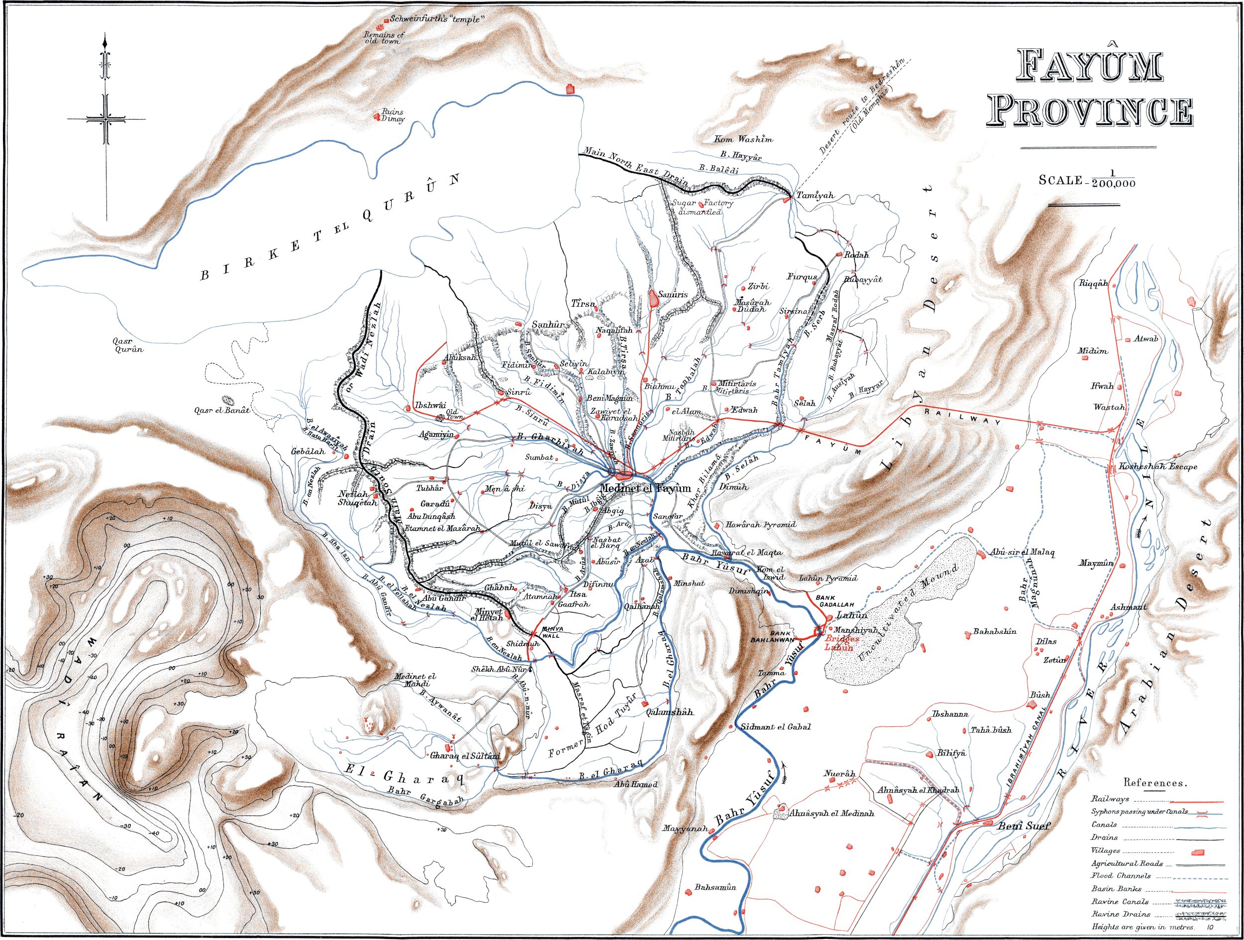
Large-size versions of diagram and map
illustrations are available by clicking on them.
THE
FAYÛM
AND LAKE MŒRIS.
FRONTISPIECE.
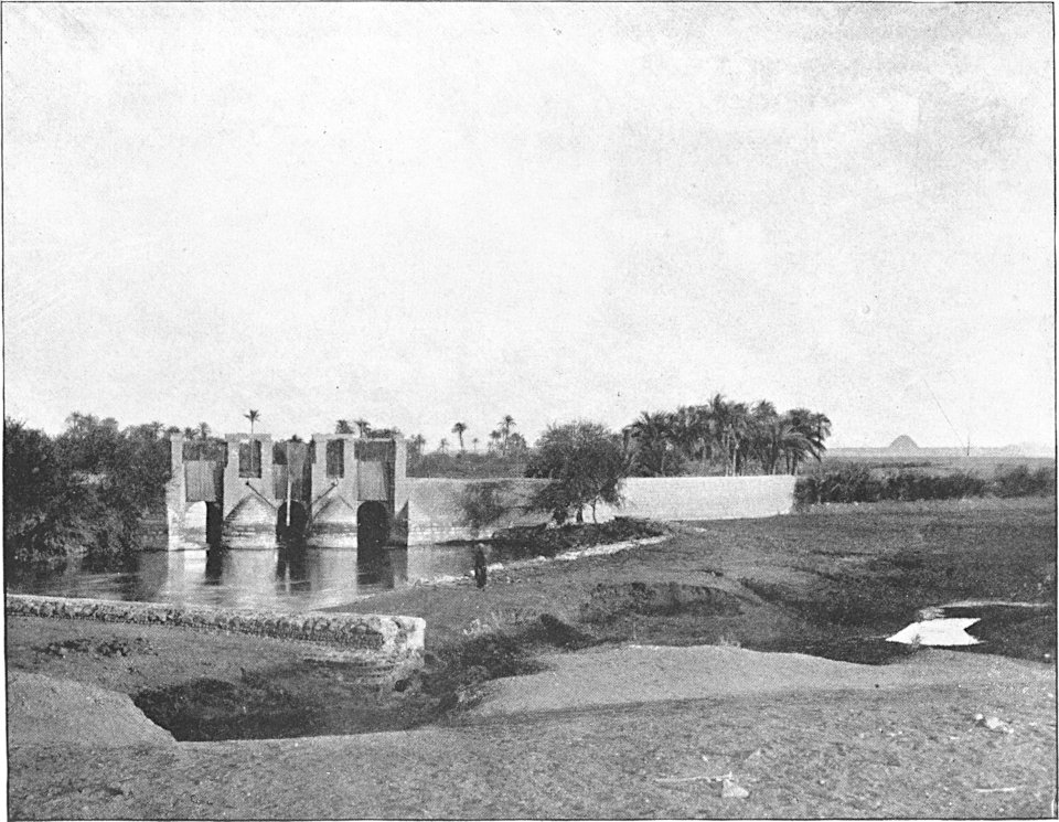
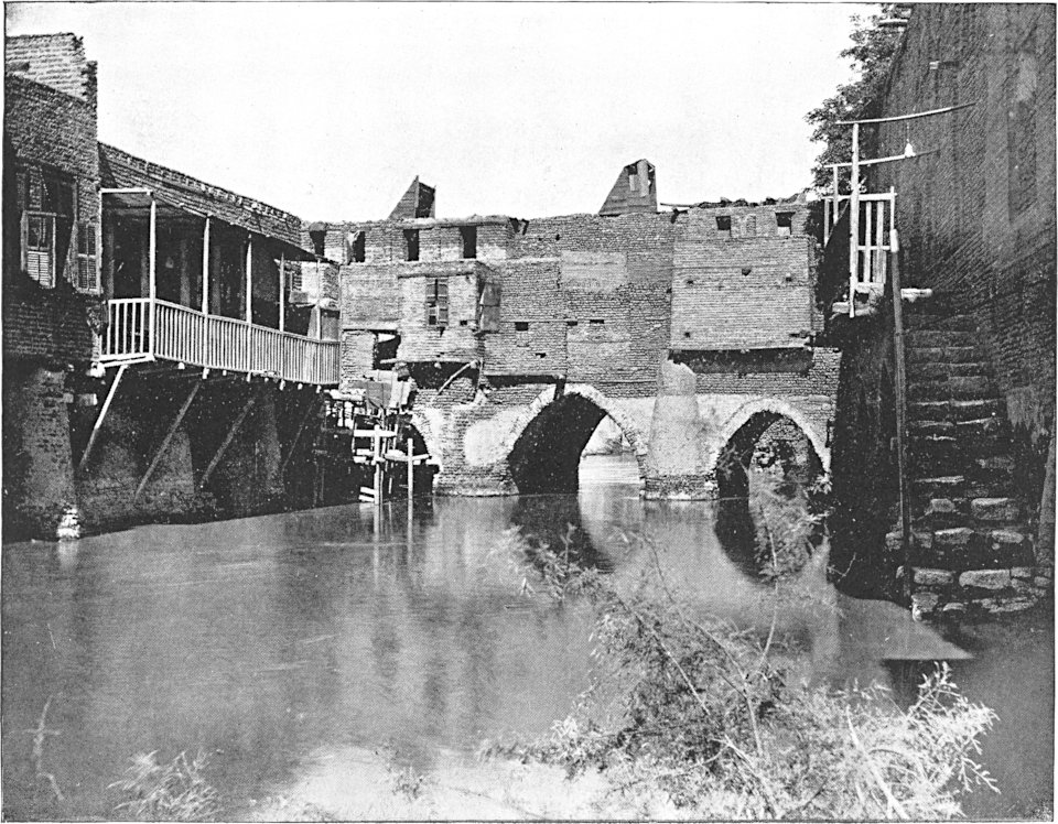
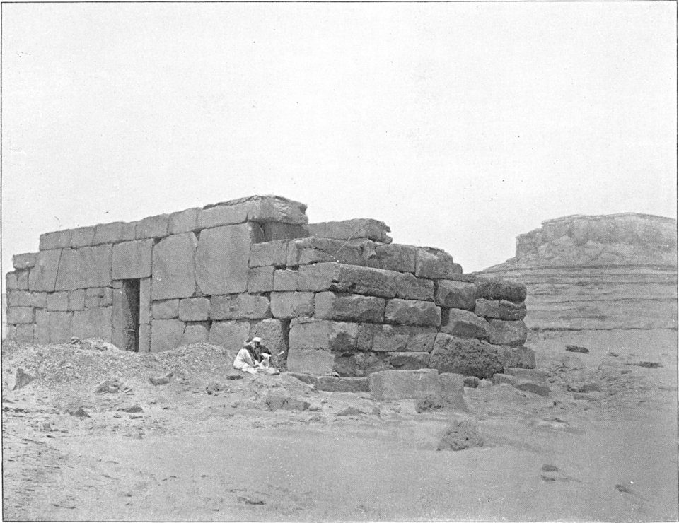
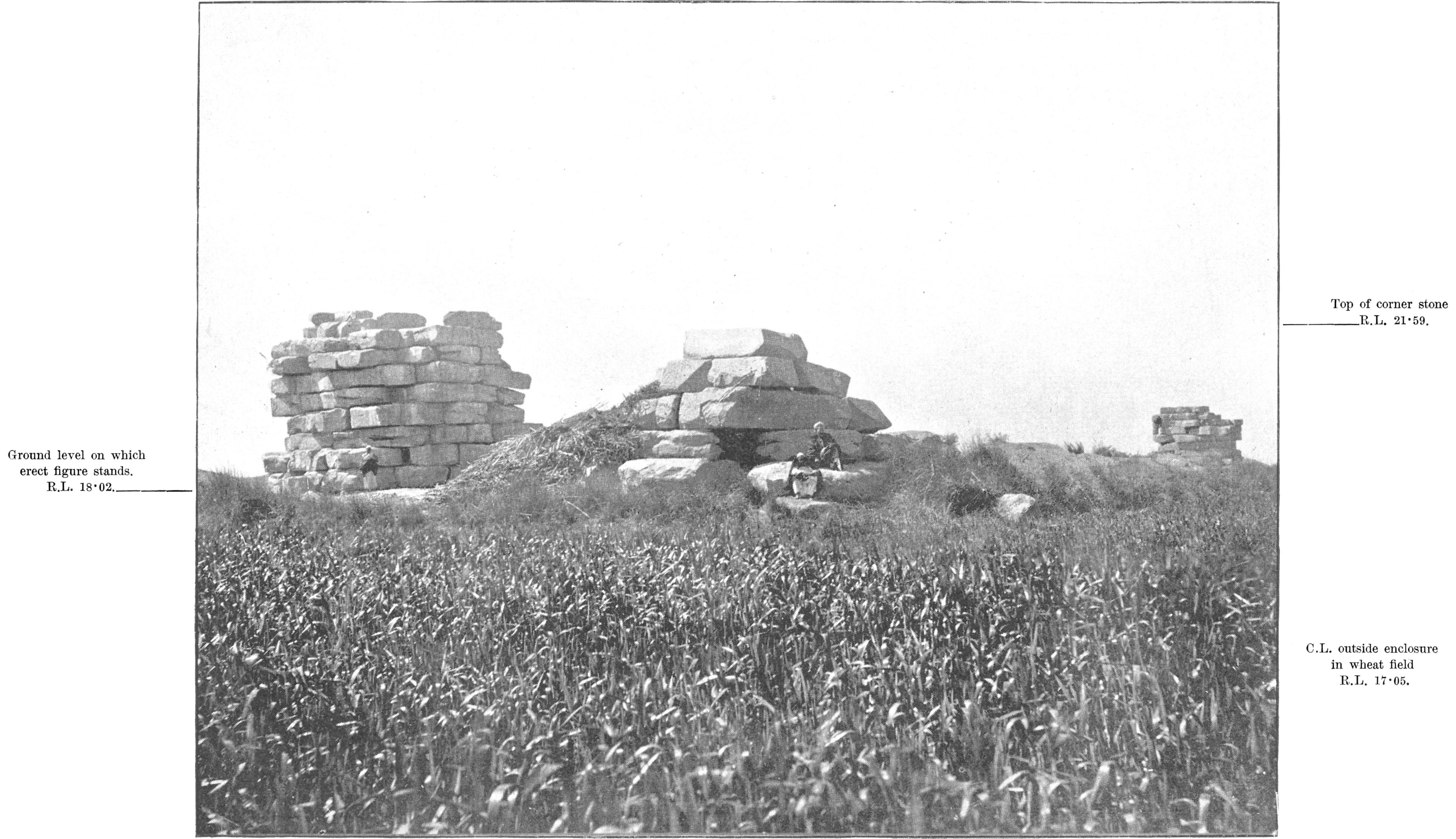
OLD LAHÛN REGULATOR.
AT THE POINT WHERE THE BAHR YÛSUF TURNS WESTWARDS
INTO THE FAYÛM.
The down-stream wing of the upper regulator is seen
projecting into the foreground on the left-hand side, and the Lahûn
Pyramid is visible in the distance.
BY
MAJOR R. H. BROWN,
Royal Engineers, INSPECTOR GENERAL OF IRRIGATION, UPPER
EGYPT.
WITH A
PREFATORY NOTE BY
COL. SIR COLIN SCOTT-MONCRIEFF, K.C.M.G., C.S.I.,
During the last nine years
it has fallen to the honourable lot of a small band of English
engineers, most of them trained in India, to effect a revolution in
the irrigation system of old Egypt, and thereby materially to
improve the wealth and agricultural prosperity of the country. This
is not the place, nor would it be becoming on my part to tell what
has been effected. We had the happy fortune to find things at their
lowest ebb. We could hardly make a change without making an
improvement. In all these improvements Major Robert Hanbury Brown,
R.E., has from the first occupied a conspicuous place. Few
Englishmen have gone through so many summer seasons as he has, in
the blazing heat of Upper Egypt. For that has been his field of
labour, and of that field the fertile, abnormal, neglected, quaint
old Province of the Fayûm forms a part. Truly, an old world
province! whose historical roll carries us back to very early days,
before that venerable Sheikh Abraham had made his emigration from
Assyrian Haran—a province abundantly watered, and therefore rich,
and highly prized by Pharaoh and Ptolemy, Cæsar and Arab Khalif,
until Mameluke misrule and Turkish brutish ignorance let it fall
into decay.
It has fallen to Major Brown to help to restore the Fayûm, and
he has thus obtained a very intimate knowledge of it. He is not the
first author on this subject. Learned Germans and brilliant
Frenchmen have already written on the Fayûm. Major Brown pretends
neither to the learning of the one, nor to the brilliancy of the
other, but he has, what neither one nor the other ever had, an
accurate knowledge of the levels of the country. This information
is quite indispensable to the hydraulic engineer, and it is strange
that that distinguished Frenchman M. Linant de Bellefonds, who
devoted so many years to the physical improvement of Egypt, should
have been evidently without it.
Of course Major
Brown could not write of the Fayûm without introducing the mystic
Lake Mœris. Herodotus does not lie when he tells of the things he
has actually seen, and he says he saw Lake Mœris. So it must have
existed. But where was it? That is the question that has been asked
from one generation to another.
In the following pages Major Brown, in simple, straightforward
language, gives his opinion, and the reader may be sure that he
does not talk of what he does not know. Whether his conclusions are
correct or not, this account of the Fayûm is an important addition
to our knowledge of the subject.
Colin Scott-Moncrieff, Late Under-Secretary of State, Public Works
Ministry, Cairo.
I commenced this paper with
the sole object of giving a technical description of irrigation in
the Fayûm Province as practised to-day, for the information of my
brother officers in the Royal Engineers.
But let any one turn his face towards the Fayûm, he is sure to
see the speculator’s will-o’-the-wisp of Lake Mœris, which must
needs be followed over the marshy borders through a tangle of
theories left high and dry, until the pursuer is submerged deep
beneath the waters of the lake, and has to find his way out again
as best he can with a theory of his own begetting or adopting.
The question of where and what Lake Mœris was has been guessed
at by many, and some of the guesses have been rather wild and
regardless of the attributes which the lake of the theory must be
demonstrated to have, before it can be recognised as Lake
Mœris.
In the time of the early Nile tourist and historian Herodotus,
about 450 B.C., there existed in Egypt an
extensive lake, known as Lake Mœris, of such dimensions, levels,
and geographical position, that it absorbed the surplus waters of
the overflowing Nile, and afterwards gave back to the dwindling
river the water it had received from it, thus becoming a regulator
to diminish the excesses of the Nile floods, and to supply the
shortcomings of the shrunken summer flow. The benefits resulting to
the land of Egypt from such a moderator of high and low Niles were
supposed to have been
great, and the idea of the possibility of restoring the boon to
Egypt by the discovery of the true position of the ancient Lake
Mœris has helped to increase the interest in the subject, which
curiosity about one of the lost wonders of the world in the once
glorious kingdom of the Pharaohs would alone have been sufficient
to excite.
At the end of a long letter to Mr. Paul Ascherson about a
journey in the Fayûm, Dr. Schweinfurth writes:—“It must have
already occurred to you, that I, in these already much too
comprehensive remarks, have kept going round about the Mœris
question, like a cat round hot broth. I must guard myself from
pulling unripe fruit, which in a not far future will be ripe for
judgment.” This was written in January 1886. Dr. Schweinfurth
seemed to expect that discoveries of papyri in the ruins of Arsinoë
would be made, and the riddle by them be solved. We are still
waiting for the papyri.
Though the fear of picking unripe fruit may produce an
unfavourable state of mind for assisting to promote discussion, it
is far preferable to M. Linant’s attitude with reference to this
question, when he stated that “J’ai retrouvé la véritable situation
de cet ancien lac ou réservoir d’eau,” and caused or allowed to be
printed on the “Carte Hydrographique de la moyenne Égypte, par M.
Linant de Bellefonds, Paris, 1854,” the following presumptuous and
decidedly untrue statement: “Le mémoire publié par M. Linant, sur
le lac Mœris, donne tous les éclaircissements désirables sur ce
point de l’histoire ancienne de l’Égypte”!
Though more illumination has been thrown on the subject since
this unfounded claim to finality was made, there still remains much
information to collect about doubtful points of levels,
identification of old ruined towns, and so forth, but I do not on
that account consider that the fear of “too hastily confusing” the
question should forbid the publication of fresh facts and
speculations thereon, so long as the door is not slammed in the
face of those who prefer to give their support to other
theories.
I will briefly state the order, and reasons for the order, in
which I have arranged the different parts into which this paper is
divided.
I have described the “Fayûm of To-day” first, as a conception of
its condition in the past must of necessity be founded on a
knowledge of its condition in the present.
Next I give the statements made by the ancient travellers, as it
is upon them that the ideas, of what Lake Mœris was, are based.
I then proceed to
try and dispose of theories which I consider erroneous, so as to
clear the way for a more correct view; or at least to expose some
of the errors of statement which might mislead others into
accepting or forming wrong notions on the subject. Next I give the
views that I have adopted, and point out what support they have
from others, and discuss M. Linant’s objections to the views
favoured.
Then I have endeavoured to sketch the history of the Fayûm—
(1)
Before it became Lake Mœris.
(2)
As Lake Mœris.
(3)
While it was undergoing the process of being
transformed from Lake Mœris to what it is to-day.
And lastly, I have added a few remarks about the possible future
of the Wadi Raiân, and the effect upon the Fayûm of a more abundant
supply of water in consequence of the construction of storage
reservoirs now under consideration.
I have made use of all previous writings on the subject that I
could lay hands on. Mr. Cope Whitehouse kindly lent me his papers
and showed me where to get others. Mr. Flinders Petrie has also
given me what information I applied to him for. The maps and
levelling of the Fayûm, made under the direction of Lieut.-Col. J.
C. Ross, C.M.G., late Inspector-General of Irrigation in Egypt,
have naturally been invaluable aids to the study of the subject.
Sir Colin Scott-Moncrieff, late Under-Secretary of State for Public
Works, Egypt, has also given me his views on some points raised in
this paper, and I have taken advantage of them. Miss M. Brodrick
has most kindly assisted me in the correction of the proofs, and in
other matters connected with the publication of this paper. Ali Bey
Borhan, Chief Engineer of the Fayûm, and Monsieur A. Pini, in
charge of works, have assisted me by collecting information and
obtaining levels that were wanting.
Finally, I wish to lay claim to no originality in the views
adopted. What I have aimed at in this paper is to work those views
out, and to go more thoroughly into them than has hitherto been
done, thereby making a contribution to the discussion of an
unsolved problem, interesting alike to Engineers, Archæologists,
and Classical Scholars.
As the metrical system is in use in Egypt, all dimensions and
quantities are given
throughout this paper in metres and cubic metres, and distances in
kilometres.
1 metre
= 3·2809 feet.
1 square metre
= 10·7643 square feet.
1 cubic metre
= 35·3166 cubic feet.
= 220·097 gallons.
8 kilometres
= 5 miles (approximately).
Discharges are given as so many cubic metres per day of 24
hours.
1,000,000 cubic metres a day
= 11·5741 cubic metres per second.
= 408·9775 cubic feet per second.
Areas are given in feddans, which is the Egyptian acre.
1 feddan
= 4200·8333 square metres.
= 1·038 acre.
R.L. signifies “reduced level,” or the level referred to mean
sea-level:—e.g. “at R.L. 25·00” means that the spot, to which the
figure relates, is 25 metres above mean sea-level; and “R.L. -
40·00” means 40 metres below mean sea-level.
A contour is the line running through all the points which are
at the same level above or below mean sea-level.
An Egyptian pound, L.E., = 1¹⁄₃₉ English pound, £.
CHAPTER I.
THE FAYÛM OF TO-DAY.
Position of the Fayûm with reference to the Nile
Valley.—About 50 miles south of Cairo, a branch line leaves
the Upper Egypt line of railway and goes west. After crossing the
Basin land of the Nile Valley, it enters the western desert, and
after a short ascent and somewhat longer descent, it reaches the
station of Edwah in the Province of The Fayûm.
This province is the most remarkable and interesting of all the
provinces of Egypt. It is an oasis surrounded by desert, being
separated from the Nile Valley by four to twelve kilometres width
of the Libyan Desert, and being connected with it by a narrow neck
of cultivation marking the gap in the Libyan Hills, by which the
Bahr Yûsuf enters the Fayûm.
Depressions connected with the Fayûm.—Forming part of
this province, and included in it administratively, is the Gharaq
Basin or depression, which is partly cultivated, but surrounded by
desert lands above the present limits of irrigation, and in
communication with the Fayûm by a narrow neck at R.L. 16·00 (16
metres above mean sea-level).
Adjacent to the Gharaq Basin is another more considerable
depression with an area of about one-quarter that of the Fayûm (at
contour R.L. 25·00). This depression, known as the Wadi Raiân, had
attention drawn to it by Mr. Cope Whitehouse, who proposed its
utilisation as a reservoir for controlling the Nile floods, and
supplementing the low summer Nile. This Wadi is now bare desert.
Its lowest point is 40 metres below sea-level, and the depression
thus corresponds, as a geological formation, with the Fayûm
depression, the lowest point of which (the bed of Lake Qurûn), is
known to be not less than 48, and is perhaps as much as 60 metres
below mean sea-level, but soundings are required to establish the
actuality of the greater depth.
The Wadi Raiân is surrounded by hills, on all sides rising above
the level of + 36,
except at two gaps in the hills separating it from the Gharaq
Basin, which have their sills at R.L. 27·00 and 26·00
respectively.
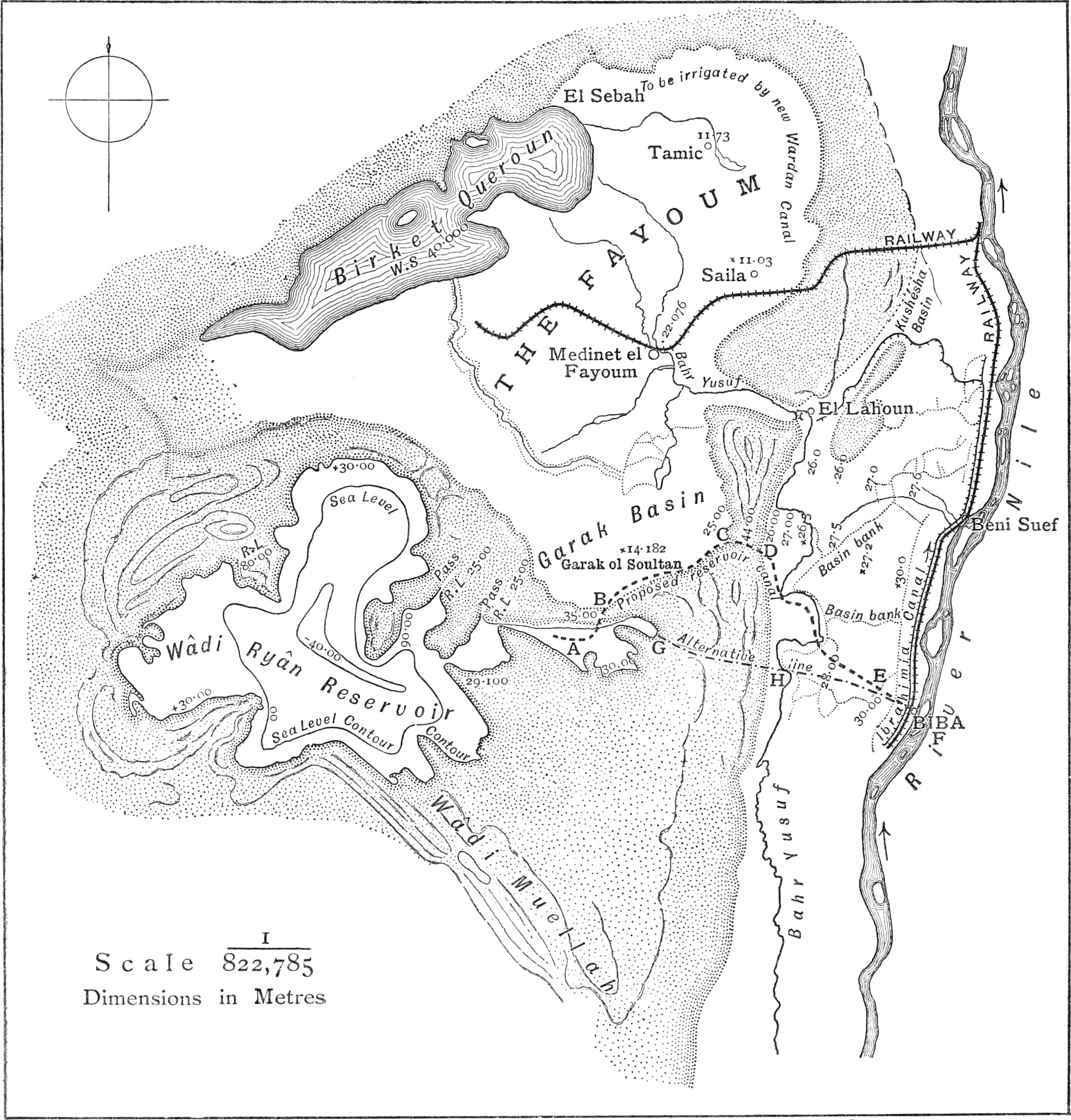
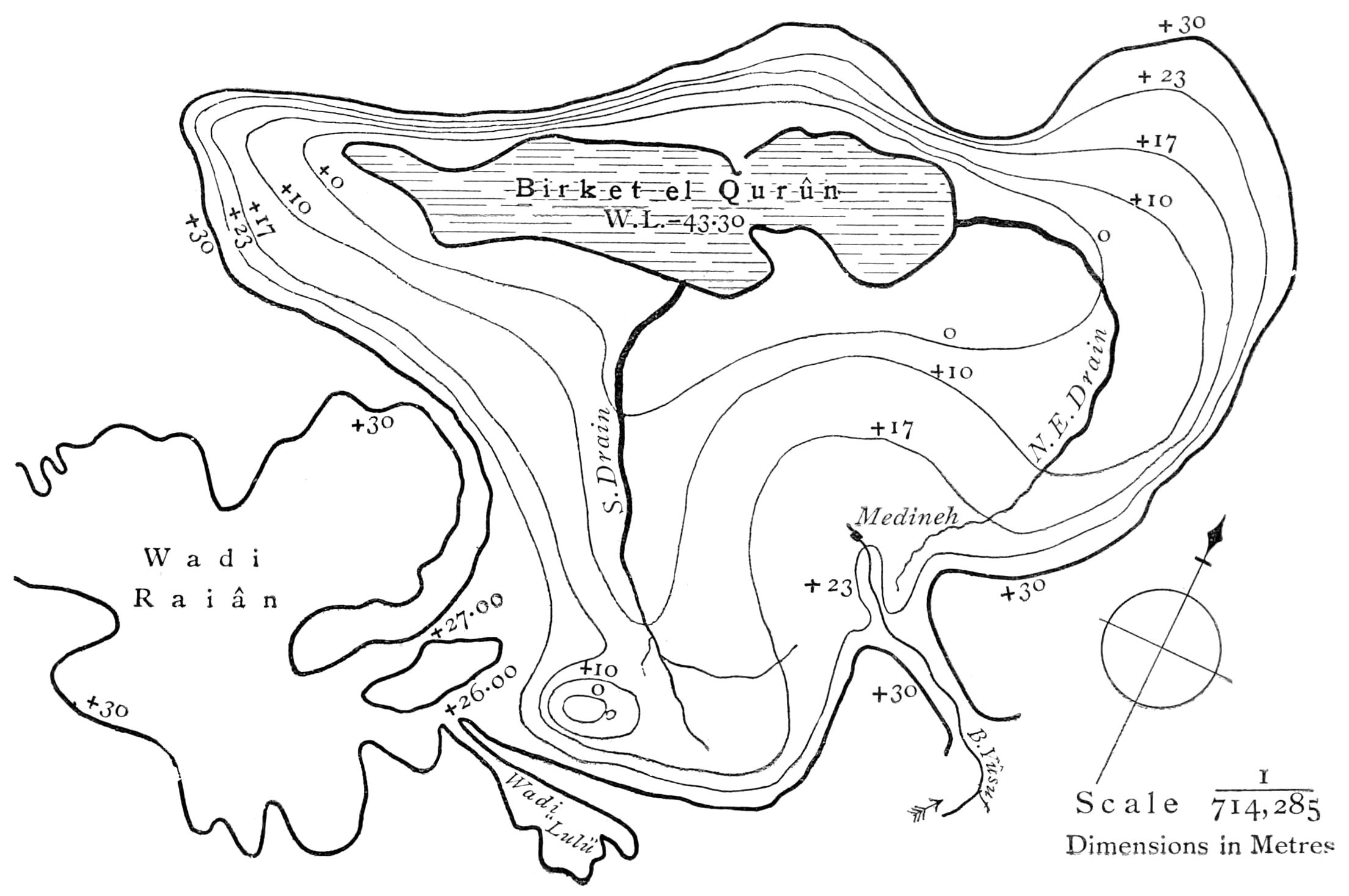
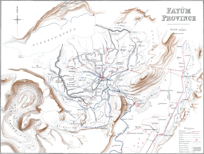
The Fayûm Depression.—The Fayûm Province has the shape
of a leaf, (see Plate XIX.) of which the Bahr
Yûsuf, from its entrance at Lahûn to its end at Medineh, forms the
stalk, and the different canals, branching from Medineh, the veins.
The province is generally described as being formed of three
plateaux, but this description can only properly be applied to that
part of the Fayûm, most rich in Nile deposit, which lies between
the main south drain (Wadi Nezlah) and the main north-east drain
(the Bahr Bilamâ or Wadi Tamîyah).
The lower section given on Plate XI., which
is typical of this part of the Fayûm, shows the three plateaux, and
gives the different surface inclinations. The contoured diagram,
Plate XIX., also shows the conformation of the
Fayûm Province.
The two strips of land outside the main drainage lines have a
different character, and considerably less Nile deposit (see
Map).
Medineh, the chief town of the Fayûm, from which most of its
canals and roads radiate, stands on ground (R.L. 22·50) three to
four metres lower than the land of the Nile Valley in the
neighbourhood of Lahûn, where the Bahr Yûsuf turns westward to
enter the Fayûm.
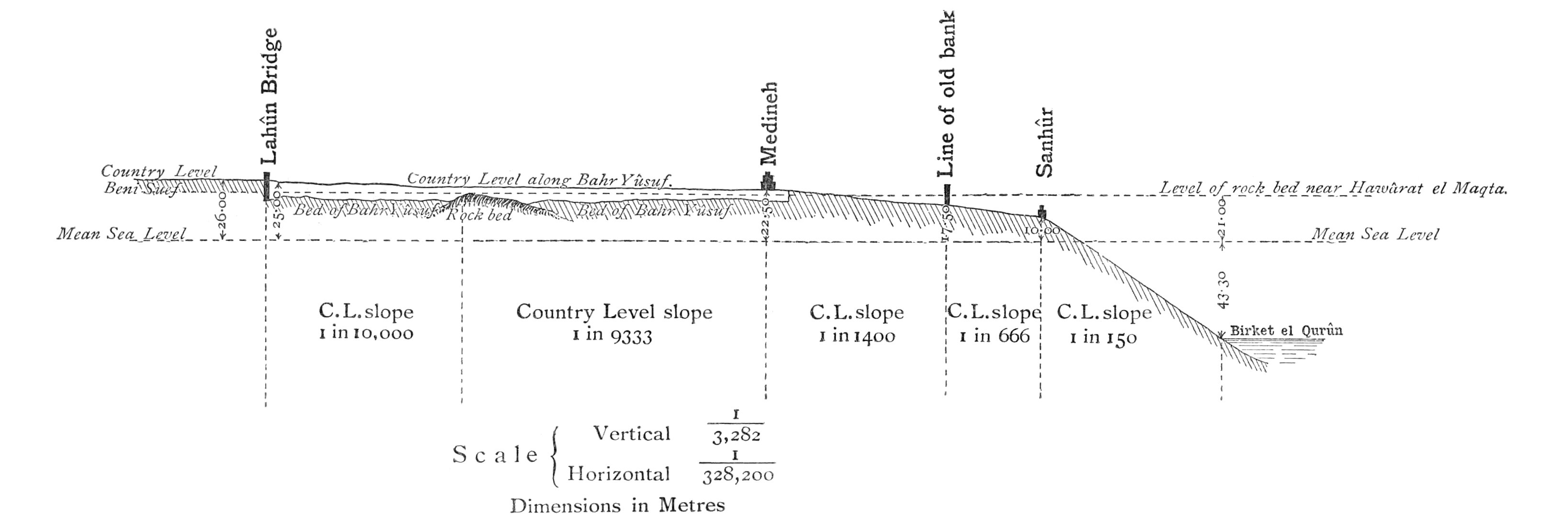
From Medineh for 8 kilometres the country surface slope is 1 in
1400, for the next 4 kilometres 1 in 666, and then 1 in 150, till
the Birket-el-Qurûn (Lake of the Horns) is reached. This lake
occupies the lowest part of the Fayûm, and at the beginning of 1892
its water surface level was 43·30 metres below mean sea; while the
bed of the lake is 5 metres lower at least.[1]
The Fayûm and Wadi Raiân together are everywhere encircled by a
continuous range of hills, except where the Bahr Yûsuf enters
through the gap in the Libyan Hills, and also towards the north of
the Fayûm, where the height of the hills becomes less, but where
there is probably no gap lower than R.L. 30, though this has not
been actually established by levelling.
The Birket-el-Qurûn and Evaporation.—Such being the
physical features of
the Fayûm, it is evident that there is no outflow for the drainage
of the province. All the drainage (except that of the Gharaq Basin)
finds its way into the Birket-el-Qurûn and there evaporates. The
present surface area of the lake is not accurately known, but being
about 40 kilometres long by 5 broad, the area is about 200 square
kilometres (78 square miles).
Notwithstanding the considerable quantity of water that drains
into the lake during the twelve months of the year, its level has
fallen steadily of late years. The following table gives the
measure of the fall from the first of March of one year to the
first of March of the next.
Level on 1st
March.
Year.
Metres below Sea.
Fall.
1885
39·80
1886
40·00
·20
1887
40·38
·38
1888
40·73
·35
1889
41·17
·44
1890
42·00
·83
1891
42·78
·78
1892
43·32
·54
Total fall from 1st
March, 1885, to 1st March, 1892
3·52
metres
Yearly average
·50
nearly.
There are no records of the level of the lake previous to 1885.
Linant Pasha states in his ‘Mémoires’ that Vansleb, who was in the
Fayûm in 1673, said that one embarked at Sanhûr to pass to the
other side of the lake. Dead tamarisk bushes standing in the water
seem to prove that the lake has in the past been lower by a metre
or more than it is at present, for these tamarisks grow along the
margin of the lake above the water edge, but not in it.
The fall of the lake is not continuous throughout the year, but
generally takes place from the 1st March to the 31st October; the
level rises from the 1st November to the end of January, and
remains stationary during February.
If the area of the lake were more accurately determined, there
are several problems of interest connected with evaporation and the
“duty” of water which might be calculated out from the facts known
about the fall of this lake, the level of which is recorded daily.
The discharge entering the Fayûm throughout the year is known, as
also approximately the areas under crop; but while the area of the lake
remains so vaguely guessed at, the results of the calculation would
be of little value, as the figure representing the lake area is an
important factor in the calculations.
But the following figures give a measure of what the daily
evaporation is in June and July, at least approximately:—
In 1889 and 1890, when there were exceptionally short summer
supplies, and the drainage into Lake Qurûn must have been as little
as it ever is, the lake levels were as follow:—
Date.
Level of Lake.
R.L.
Fall in 30 Days.
Daily Average.
1st June, 1889
- 41·63
1st July„
- 41·87
·24
·008
31st July„
- 42·11
·24
·008
1st June, 1890
- 42·38
1st July„
- 42·66
·28
·0093
31st July„
- 42·89
·24
·008
The evaporation, then, could not have been less than ·0093 of a
metre per diem in June 1890; or less than ·008 per diem in June and
July 1889 and July 1890.
Allowing for a slight amount of drainage finding its way into
the lake, an estimate of 1 centimetre a day for evaporation during
the three hottest months of the summer would seem to be nearly
correct.
We have also the following figures:—
R.L.
On 14th March, 1890, the lake level was
- 42·00
On 18th September, 1890„
- 43·13
The fall in 188 days was therefore
1·13
Giving a daily average of
·006
As, for half this period, the flow of water into the lake must
have been considerable, the average fall per diem due to
evaporation for these six months must have been certainly over 6
millimetres.
Observations on evaporation made in the Abassieh Observatory in
Cairo give the
following figures as the measure of the average evaporation for
each month of the year:—
Metres.
January
·071
February
·074
March
·172
April
·193
May
·252
June
·299
⎫
⎬
⎭
Average per diem for three
hottest months, ·0107.
July
·370
August
·310
September
·226
October
·179
November
·120
December
·098
Total
2·364
metres per annum.
The average per diem for the three hottest months of the year,
according to these observations, is ·0107, as against ·01 deduced
from observations of the levels of Lake Qurûn. The figure given for
July in the above list is higher than I should have expected, as
the evaporation of that month I should estimate to be very slightly
in excess of that of June or August; that is, about 1 centimetre a
day.
Plate I.
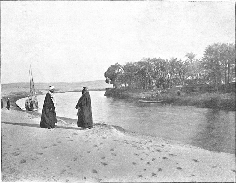
THE BAHR YÛSUF, SKIRTING THE LIBYAN DESERT, IN THE
NILE VALLEY.
The Bahr Yûsuf outside the Fayûm.—The Bahr
Yûsuf (Canal of Joseph) is the watercourse that carries the Fayûm
supply. It is not an artificial canal, but a naturally formed
sinuous channel, resulting from the Nile flood water draining off
the lands and following the line of least resistance along the
low-lying part of the Nile Valley on the side of the Libyan Desert.
Plate I. shows where the Bahr Yûsuf touches the
desert and forms a line of separation between the fertile land of
the Nile Valley with its grateful shade of trees and the barren
desert sands under a scorching sun.
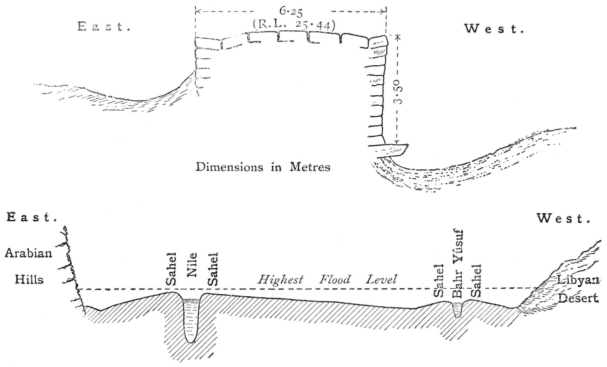
As is usual in the case of rivers which periodically overflow
their banks, the land is highest alongside the Nile, and slopes
away from it to the hills on either side. The high margins of the
Nile are known in Egypt as the “Sahel.” As the Bahr Yûsuf has for a
great many years been given an artificial connection with the Nile,
and been used as a channel to carry flood water to inundate the
lands along its course on both sides, it has imitated the Nile in
its action on its borders, and raised a “Sahel” of its own on a
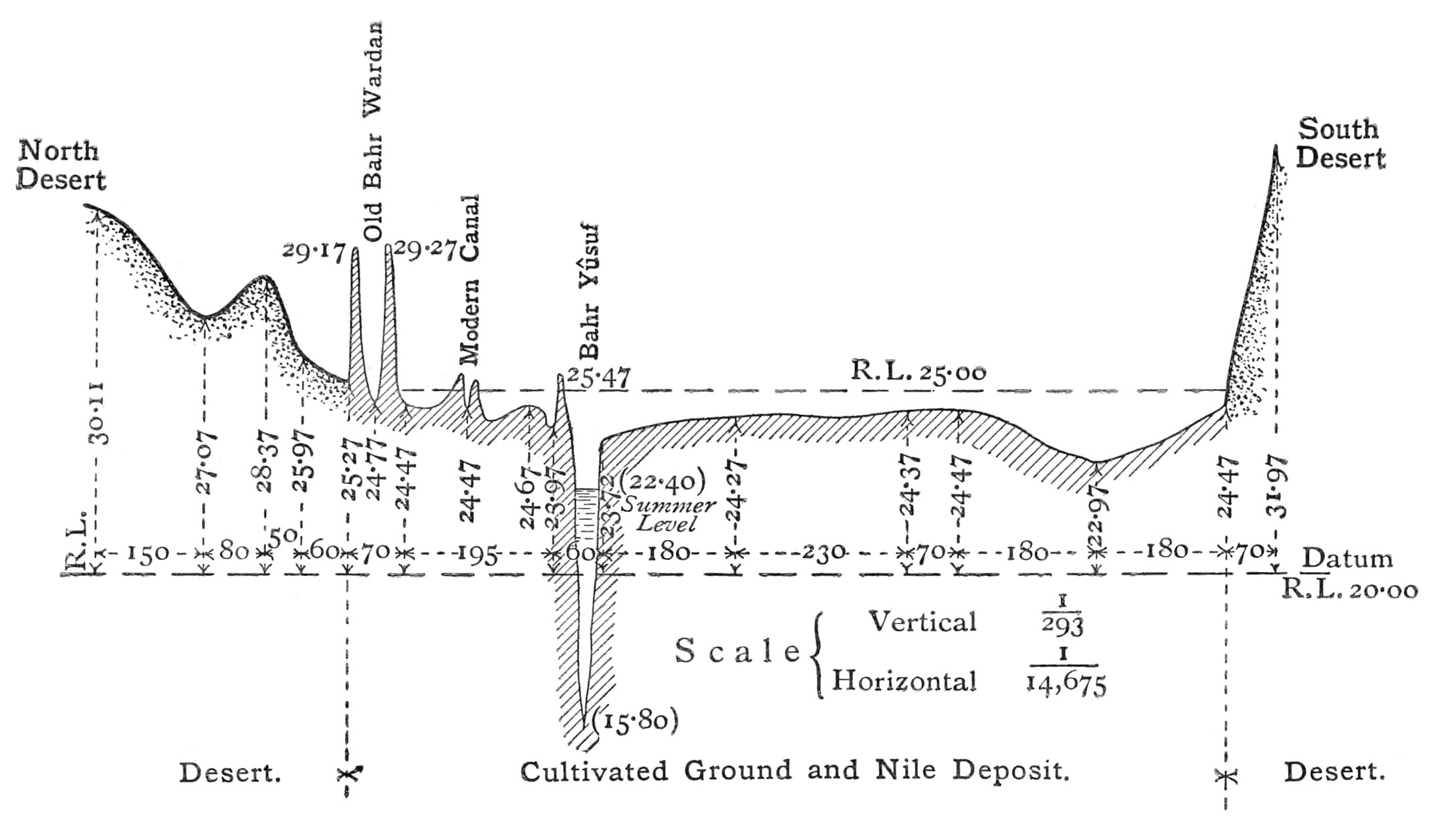
smaller scale. The cross-section of the Nile Valley is thus roughly
represented in the following diagram.
A former
artificial connection of the Bahr Yûsuf with the Nile is plainly
visible at Derût, 200 kilometres farther up the Nile Valley than
Lahûn, the point at which the Bahr Yûsuf turns westward into the
Fayûm. The artificial part is easily distinguished from the natural
channel, as the former is straight with high spoil banks, resulting
from the earth excavated to form the channel, whereas the latter is
sinuous without any signs of spoil banks. The length of the channel
from Derût to Lahûn, measured along its windings, is 270
kilometres, as against 200 kilometres measured as the crow
flies.
A second artificial connection with the Nile farther south was
made at Manfalût by the excavation of a channel 30 kilometres in
length. The part of this that remains now is called the
“Manfalûtîyah” or “old Bahr Yûsuf.” About twenty years ago a large
canal, called the Ibrahimîyah, was made for the irrigation of the
Khedive Ismail Pasha’s large sugar-cane plantations. It was made to
take off from the Nile at Asyût, 30 kilometres above Manfalût and
61 kilometres above Derût. It absorbed part of the Manfalûtîyah
Canal from Beni Qora to Derût. At Derût, regulators of a fine
description were constructed for the distribution of the water, and
a regulator of five openings of three metres’ span, with a lock
8·50 metres wide, was made as the head work of the Bahr Yûsuf,
which under the new nomenclature became a branch of the Ibrahimîyah
Canal. When the Ibrahimîyah Canal was first opened, it appears from the Mémoires on
Public Works, published by Linant de Bellefonds Bey in 1872-73,
that its discharge was small compared with its present discharge,
and the Fayûm summer irrigation must have been limited. M. Linant
states that the bed width of the main Ibrahimîyah was 35 metres,
and its reputed depth in summer 1·50 metres; but, in consequence of
the inefficient means of dredging, a depth of one metre at most was
all that could be obtained at the lowest level of the Nile; and he
calculates that the minimum discharge, which theoretically should
have reached Derût, was 666,840 cubic metres per 24 hours (273
cubic feet a second), but, in consequence of the inefficient
dredging, no more than 369,624 cubic metres per 24 hours (151 cubic
feet a second) were delivered. Under present conditions in the
worst years the minimum has never fallen below two million cubic
metres per 24 hours (818 cubic feet a second) since, at any rate,
1883.
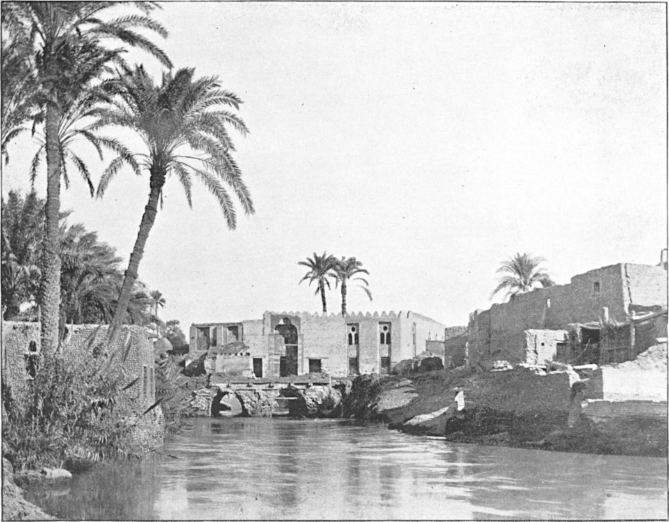
Plate II.
BRIDGE CARRYING THE BAZAAR STREET, MEDINET EL
FAYÛM, OVER THE BAHR YÛSUF.
Of the Bahr Yûsuf before the Ibrahimîyah Canal was
made, M. Linant remarks in the same Mémoires, that “it is the only
canal in Egypt which, without receiving water from the river during
the summer, nevertheless has enough to serve for the irrigation of
the Fayûm from the springs in its bed.” These springs still
supplement the summer supply of the Fayûm by adding to the
discharge, which is apportioned to the Bahr Yûsuf at Derût, about a
quarter of a million cubic metres a day (102 cubic feet a
second).
During the summer and winter the water of the Bahr Yûsuf is
(with the exception of an insignificant quantity lifted for the
irrigation of small areas at different points along its course)
reserved for the Fayûm, but during the flood season its channel is
used to carry water for the inundation of the lands on both sides
of it, and later it is made use of as the channel of discharge for
the basins which it has filled, or helped to fill.
At Lahûn, where the Bahr Yûsuf turns into the Fayûm, the
quantity of water admitted is controlled by two regulators. The
lower bridge is a very ancient one (frontispiece), of what date is unknown. Its floor in
Linant Pasha’s time had already partly given way, but from his
description it would seem to be now in the same state in which it
was more than twenty years ago. The upstream half has evidently
been added to the downstream half, as there is a clean line of
separation in the middle of the length of the present archway. This
is only to be seen by entering the passage below the arches, as the
junction is not visible from above.
In 1838 Linant Pasha caused the second regulator of three
openings (two of three metres’ and one of four metres’ span) to be
constructed as a
precaution 80 metres above the old one, and it was a very wise
precaution to take. The head of water is now divided between the
two bridges so that the action is less severe than it was before
the second bridge was constructed.
The present discharges passed by these regulators into the Fayûm
are:—
During the flood season 6½ to 7 million cubic metres per day
(2658 to 2863 cubic feet per second).
During the winter season 3 million cubic metres per day (1227
cubic feet per second).
During the summer season 1½ to 1 million cubic metres per day
(713 to 409 cubic feet per second).
The ordinary and maximum and minimum levels of the Bahr Yûsuf
are given in the list below:—
Below Derût.
Above New Bridge, Lahûn.
Below Old Bridge on Fayûm Side.
Flood season
46·75
26·50
23·90
Winter
43·00
24·14
23·15
Summer
42·15
22·90
22·50
Maximum
46·95
27·80
23·90
Minimum
41·67
22·50
22·27
The Bahr Yûsuf inside the Fayûm.—At the end of the Bahr
Yûsuf at Medineh the water-level is now kept constantly at R.L.
21·70 to 21·80. In Nile time any increase on this tail level is
forbidden by the effect of the heading-up caused by the
obstructions met with by the large flood discharge in its passage
through the town between the houses which line its edges. The Bahr
Yûsuf is bridged in this length twice, first by a three-arched
bridge, Plate II., which carries the main street
and bazaar of Medineh; and again by a two-tubed tunnel, over which
the mosque of Kait Bey is built, Plate III.
In passing through the bazaar with shops on either side the Bahr
Yûsuf is crossed without its being noticed, and a stranger to the
town is presently surprised to find himself on the other side of
the canal to which he imagined himself to be.
Plate III.
TUNNEL ON BAHR YÛSUF,
OVER WHICH THE KAIT BEY MOSQUE IN MEDINET EL FAYÛM
IS BUILT.
The
waterways of these two constructions are sufficient to pass the
winter discharge with but slight heading-up, but when the flood
supply is flowing, they (assisted perhaps by old blocks of masonry
and débris of fallen houses in the channel) cause a backing-up of
the water of from 50 to 60 centimetres and thereby (with the level
at the tail below the town fixed at R.L. 21·80) produce the maximum
level above the town, which it is safe to allow.
The distance from Lahûn to the end of the Bahr Yûsuf at Medineh
along the canal is 24 kilometres (15 miles). Between kilometre 11
and 14 the bed is rock, the highest point of the bed being at R.L.
21·00 and between kilometre 12 and 13. The bed elsewhere is
generally between R.L. 17 and 19.
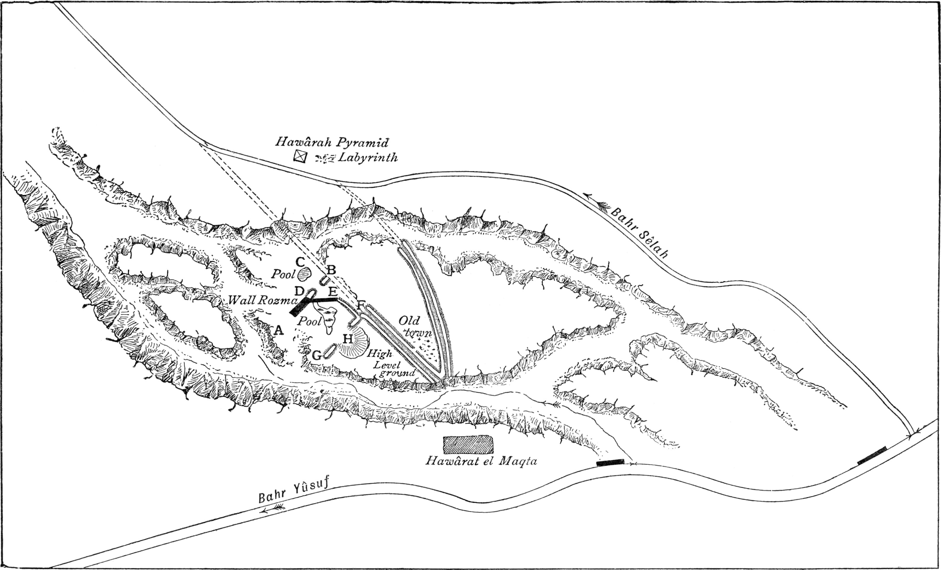
At kilometre 10·130, the Bahr (canal) Sêlah takes off on the
right, and after flowing by the Hawârah pyramid and passing under
the Fayûm railway, its water surface comes level with the soil and
irrigates the strip of land bordering the Fayûm depression on the
right of the main drainage line on this side.
Similarly at kilometre 15·5 the Bahr Gharaq takes off on the
left of the Bahr Yûsuf, and, aided by the Bahr Qalamshah, irrigates
the east slope of the Fayûm and the whole of the Gharaq Basin. The
strip on the left of the south main drainage line, forming the
sloping side of the Fayûm Basin on the south, is irrigated by the
Bahr Nezlah, which takes off from the main canal at kilometre
16·370.
With the exception of the Bahr Tamîyah, which flows in the
channel of the north-east main drain itself and irrigates the
distant north corner of the province on the right of the drain, all
the other canals irrigate the central part of the Fayûm, which lies
between the two main drainage lines. These canals may be divided
into three classes corresponding to the three plateaux:—
1. The short and high level canals irrigating the high land on
both sides of the Bahr Yûsuf and round Medineh, roughly speaking
all lands down to contour R.L. 18·00.
2. The medium canals, which irrigate between R.L. 18·00 and
10·00 or thereabouts.
3. The long ravine canals, which carry water to the distant
parts of the Fayûm below contour R.L. 10·00.
In a lawless province like the Fayûm, such an arrangement of
canals is of great assistance in the equal distribution of water to
all parts of the province. The long canals of class 3 are, in their
upper reaches, so far
below the cultivated surface of the soil, that no crop-owner of the
first and second plateaux would attempt to irrigate from them
except by means of water-wheels, which have to be regularly
licensed. The canals of the 2nd class are intermediate in level and
length between the first and third, and do not conveniently
irrigate, except at some considerable distance from their
heads.
There is a further advantage gained by the water of the long
canals falling at once to low levels at their commencement. Along
the margins of the Bahr Yûsuf and round about Medineh is a
considerable area of valuable land above the highest level reached
by the water in the parent canal. To irrigate this, water is lifted
in pitchers fastened to the side of the outer edge of undershot
wheels, which are turned by the force of the water descending to
the low-level beds of the ravine canals. These wheels turn day and
night without ceasing, so long as there is sufficient water. A head
of 25 centimetres is sufficient to turn an ordinary wheel which
lifts the water about 2 metres, but when greater heads are
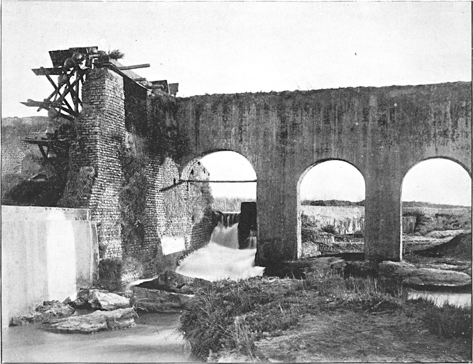
obtainable, water is lifted in this way as much as from 4 to 6
metres (Plate IV.) A fall of 80 centimetres will
work two wheels, one behind the other, which lift the water 5
metres.
The channel, carried by the imposing looking aqueduct of
Plate IV., is only 40 centimetres wide by 30
centimetres high, the whole thickness of the aqueduct being only 85
centimetres. The expense, incurred in building it, points to the
value of a constant stream of water raised in this manner.
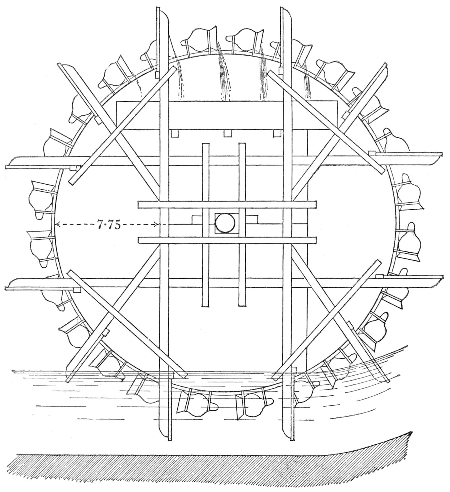
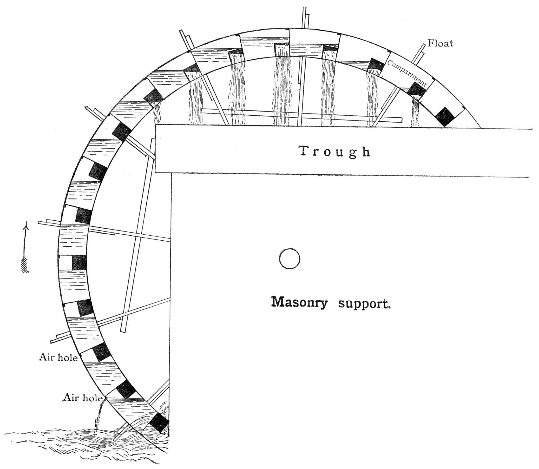
There are two kinds of wheels used, one in which the water
lifted is contained in earthenware jars fastened to the side of the
wheel near its outer edge, the arrangement of which is shown by the
drawing, reproduced from Willcocks’ ‘Egyptian Irrigation’ (Plate V.) The other kind of wheel, called a
tabût, has a hollow chambered tube of square cross-section
forming its circumference, the holes to admit water into each
chamber being made in such a position that the water, which enters
the chamber when submerged, does not commence to flow out again,
till the chamber approaches the highest point of its path. Below
the point, at which the flow out commences, a trough is placed to
catch the water.
It will be seen that in both these arrangements there is a loss
of work in lifting the greater part of the water rather higher than
the level at which it is utilised. The principle of the tabût will
be understood from the drawing given on the same plate No. V., as the other arrangement with pitchers.
Either kind is known as a saqya hedêr.
Plate IV.
HIGH-LIFT WATER-WHEELS ON THE TAMÎYAH CANAL.
The pair of wheels shown on this Plate raise the
water 4·50 metres, and are worked by a total fall of water of 0·55
metres.
As a means of estimating the heights and widths in the Plate, the
widths of the arches are given.
Left-hand arch, 3 metres span; next arch on its right, 2½ metres
span.
Plate V.
UNDERSHOT WHEEL FOR RAISING WATER.
Scale ¹⁄₅₀. From Willcocks’ ‘Egyptian
Irrigation.’
SKETCH DIAGRAM OF TABÛT.
Drawn with side as if transparent, to show water in
compartment, and principle.
The
saqya mawâshi (saqya worked by cattle) and the
shadûf are also employed to a small extent, as elsewhere
in Egypt, but only for small areas.
There are 205 saqya hedêrs in the province. To obtain a license
to erect one, the applicant has to pay L.E. 1 to get his
application accepted, and L.E. 5 more, if the license is
granted.
Water-mills.—The fall of the water is also used to turn
mills for grinding corn, of which there are 243 in the province,
which paid as tax in 1891 a total of 810l. (L.E. 791).
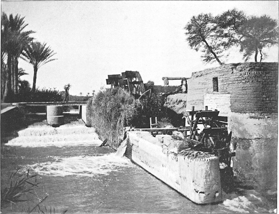
Plate VI. is from a photograph of one of the
falls, below which are first a pair of tabût wheels, one behind the
other, for lifting water to high-level lands, and, below these in
the same mill-race, an undershot wheel working a mill for grinding
corn.
The mills are worked either by turbines (panchakkis) of
a pattern introduced from India thirty years ago, according to Mr.
Willcocks, or by undershot wheels. The latter method is used, where
the fall available to work the mill is small, but not less than 60
centimetres. The former system requires a fall of at least 1·60
metres.
Falls and Regulators.—For purposes of irrigation the
fall of the country surface is excessive, and works have to be
built at intervals along a canal, after the point where it begins
to irrigate, to hold up the water-surface to a sufficient height to
flow over the fields. These works are generally placed where the
canal splits up into branches, and they take the form of a
collection of small weirs. Where the maximum water-levels below all
the weirs of such a group never rise above the level of their
weir-sills we have a “free fall” in the case of each weir, and the
discharge over each sill is directly proportional at all seasons to
the length of the sill, which in each weir is made proportional to
the area irrigated from the canal below the weir. Thus the
collection of weirs not only holds up the water for the irrigation
from the canal above it, but acts automatically as a just
distributor of water to the canals below it. Such a group of weirs
is called a nasbah, an Arabic word signifying
“proportion.” The arrangement is thoroughly understood and
appreciated by the Fayûm cultivators, and is useful in rendering
unnecessary the employment of a numerous establishment of low-paid
agents—a great end to gain in a country where the inferior employés
are so easily corrupted.
There are, besides the nasbahs, a large number of small masonry
works, as head regulators, sluice heads to branch canals, syphons,
aqueducts, and pipe
heads scattered all over the province, but there is nothing
peculiar in them as irrigation works.
Plate VI.
NASBAH MITERTARIS.
The upper bridge at Lahûn has hitherto been closed by
vertical needles, but in 1892 it has been altered, and will in
future be regulated by horizontal planks. The openings have also
all been made one width, namely, 3 metres.
Crops.—The area on which land tax was paid in 1891
was
Ushuri lands
131,155
feddans.
Kharagi„
102,146
„
Total
233,301
„
The total amount received into the Government treasury on this
area was L.E. 132,668, which gives an average of 57 piastres a
feddan, or 11s. 2¾d. an acre.
The actually cultivated area of the Fayûm is said to be about
280,000 feddans. Almost the whole of this area is under crop during
the flood season and winter, and about 50,000 to 60,000 feddans are
planted with summer crops, chiefly cotton.
If cotton is grown, it is followed by a winter crop of wheat,
clover, or beans, and this is followed by a flood crop of millet.
The cotton is sown in March of one year, and the flood millet is
harvested in November of the following year, so that three crops
are obtained in twenty months. After the flood millet, clover will
be sown, and this will be cleared off the ground in time to plant
cotton, which will be picked and finished with in October. This
makes five crops in thirty-one months. I believe that sometimes
even this record is beaten, and three crops are got out of fifteen
months.
Everything which is sent out of the Fayûm, with the exception of
an insignificant quantity which is carried out by camels, is shown
in the railway books, from which the following figures, in kantars,
have been obtained. (A kantar = 98·09 lbs.)
Exports from the Fayûm
Province.
1889.
1890.
1891.
Cotton
39,433
56,334
86,638
Cotton-seed
82,010
104,608
185,917
Cereals
418,935
797,363
1,109,070
The value of the
exports in 1891 was not less than that given in the following
calculation:—
Kantars.
Piastres.
L.E.
Cotton
86,638
at
170
=
147,284
Cotton-seed
185,917
at
55
=
102,254
Cereals
1,109,070
at
70
=
776,349
Total
=
1,025,887
The area on which an average land tax of 57 piastres a feddan
was paid has been given before as 233,301 feddans (242,166 acres).
Hence the value of cotton, cotton-seed, and cereals exported from
the Fayûm in 1891 was at the rate of L.E. 4·397 a feddan
(4l. 6s. 10d. an acre).
Clover, which is extensively cultivated, is all consumed in the
province.
Besides the above, the Fayûm exports also figs, grapes, olives,
quail, fish, mats, baskets, and a few other things.
The province is justly famed for its excellent figs, but the
grapes are not of superior quality to those of other parts of
Egypt, though they have the reputation of being so.
In 1891 Government farmed out the fisheries for a sum of L.E.
2000. Every day large numbers of fish, chiefly bulti (Nile
carp) are sent in crates to Cairo. The bulti is excellent eating.
Another common fish is the armûd, or Nile shad-fish
alias sheath-fish or cat-fish (Silurus). It is
considered by the natives to be good to eat, but according to
others it is not fit for food.
Another handsome fish, called by the fishermen lâl, and
also a fine species of the perch family, known to them as
lafâsh, both from their appearance good table fish, are
not uncommon, except by comparison with the abundant carp. The
lafâsh grows to a great size, one that I photographed,
measured, and weighed being 1·32 metres long, of 1 metre girth, and
92 lbs. weight.
The fishermen move about the lake in the most primitive kind of
boats, propelled by the clumsiest possible oars, and without any
sails. How long they will continue to be satisfied with their craft
it is hard to say, but they show no signs of desiring anything
better.
CHAPTER II.
ANCIENT TESTIMONY ABOUT LAKE MŒRIS.
Evidence concerning the
existence of Lake Mœris, which has been briefly referred to in the
Introduction, is to be gained from the following sources:—
The Egyptian monuments, in which are found inscriptions on stone
and records on papyri.
The writings of Herodotus, who visited Egypt B.C. 450.
The writings of Diodorus Siculus, a Sicilian, and of Strabo, a
Greek geographer and contemporary with Diodorus, about B.C. 25.
Lastly Pliny, A.D. 50 to 70.
It must be borne in mind, while reading their accounts, that, in
attempting to give information as to the origin of Lake Mœris, they
were undertaking a task beyond their powers, since, according to
the scanty revelations of the monuments, which on this point are
the only witnesses worthy of credence, the Lake Mœris
existed 2000 years before Herodotus visited Egypt, and
therefore must have been formed at a more remote date.
What then these ancients may have been told as to the
origin of Lake Mœris may well be classed with tradition,
and be assigned its true value as such, but what they state, that
they themselves saw, is as worthy of belief as statements
found in the descriptions of any other sober historian’s personal
experiences.
I am indebted to the Rev. Edwin Meyrick, M.A., for the
translations of the passages from Herodotus, and to Mr. Edward
Meyrick, of Marlborough College, for those from the other
classics.
Translations from Ancient
Authors, who have referred to Lake Mœris, and Arabic
Tradition.
Herodotus, Book II.
(B.C. 454).
“These twelve kings (who were governing Egypt at the time of
which Herodotus was writing) agreed to leave a work which should
make their names
remembered, and, uniting all their powers, they built the
Labyrinth, a little above the Lake Mœris, and situated as nearly as
possible opposite the city called Crocodilopolis. (Here follows a
description of the Labyrinth, in which it is stated to surpass the
pyramids as a wonder of construction.)
“Adjoining the angle where the Labyrinth ends, is a pyramid, 240
feet high, on which large figures of animals are engraved. The
entrance into this is subterranean.
“Now, the Labyrinth being such as I have described, the lake,
named that of Mœris, causes still greater astonishment, on the bank
of which this Labyrinth was built. The perimeter of this lake
measures 3600 stadii, which is the same thing as 60 schœni. This
measure is nearly equal to the entire seaboard of the whole of
Egypt.
“This lake lies oblong north and south, being in its deepest
part 50 fathoms deep. It tells its own story that it is
artificially made, for about the middle of the lake stand two
pyramids, out-topping the water 50 fathoms each, and that part of
them which is built under water is as much more. On the top of each
is a colossal figure in stone, seated on a throne. So these
pyramids are 100 fathoms high. Now, 100 fathoms are exactly equal
to a stadius, consisting of six plethra, seeing that the fathom is
equal to 6 feet, or four cubits, a foot measuring four palms, a
cubit six palms.
“The water in the lake is not derived from local sources, for
the earth in that part is naturally excessively dry and waterless,
but it is brought in from the Nile by a canal. It takes six months
filling and six months flowing back. During the six months of the
return flow, it yields a talent of silver each day to the Treasury,
and during the flow in, twenty minæ from the fish.
“The people of the country also told me that this lake on its
western face, inland along the mountain which is over Memphis, has
an underground outlet into the Syrtis, which is in Libya. But when
I nowhere saw the earth-mounds which came from this excavation (for
this was much upon my mind) I questioned those who lived in the
neighbourhood of the lake as to where the excavated material could
be. They told me that it had been carried out, and without
difficulty they led me to believe it. For I knew by report that a
similar thing had taken place in Nineveh, the city of the
Assyrians. For burglars contrived a plan to carry off the treasures
of King Sardanapalus, son of Ninus, which were valuable and guarded
in subterranean treasuries. These burglars then, starting from
their own dwellings, and calculating the distance, tunnelled to the
palace. And when night came on they carried out the material, which was
removed from the excavation into the river Tigris, which flows past
Nineveh, until they accomplished what they wished. In a similar way
to this I heard that the excavation also of the lake in Egypt had
been carried out (except that it was done by daylight, not by
night), inasmuch as the excavators carried the material to the
Nile, and the Nile, receiving it, would disperse it. In this way
the lake is said to have been excavated.”
Strabo,
Book XVII. (B.C. 24).
Writing of the Arsinoïte Nome he says, “This province is the
most remarkable of all in appearance, natural properties, and
embellishment. It grows olive-trees which bear fruit. It produces
wine in abundance, corn, pulse, and a great variety of other
grains. . . .
“It has also a remarkable lake called the Lake of Mœris, large
enough to be called a sea, and resembling the open sea in colour;
its shores are also similar in appearance to sea-beaches, whence we
may suspect a community of nature between them and the district
about Ammon. For they are in fact not far distant from one another
or from Parætonium, and as there is good reason to suppose that the
latter temple formerly stood on the sea-shore, so also this
district must formerly have been littoral. Lower Egypt and the
parts towards the Serbonian Lake were then covered by the sea,
perhaps connected with the Red Sea by Heroöpolis and the Elanitic
Gulf. . . .
“Thus, the Lake of Mœris is, from its size and depth, capable of
receiving the overflow of the Nile at its rising, and preventing
the flooding of houses and gardens; when the river falls, the lake
again discharges the water by a canal at both orifices, and it is
available for irrigation. There are regulators at both ends of the
canal for controlling the inflow and outflow. Near these is an
immense stone Labyrinth, a work comparable with the Pyramids; and
the tomb of the king who constructed it. . . .
“Sailing 100 furlongs further one comes to the city Arsinoë,
formerly called Crocodilopolis.”
Diodorus
Siculus, Book I. Chap. LI. (about B.C. 20).
“He (King Mœris) dug a lake 600 furlongs above the city
(Memphis), which is amazingly useful and incredibly large. Its
circumference is said
to be 3600 furlongs, and its depth in most parts 50 fathoms. . . .
For as the rising of the Nile is irregular, and the fertility of
the country depends on its uniformity, he dug the lake for the
reception of the superfluous water. And he constructed a canal from
the river to the lake 80 furlongs in length and 300 feet in
breadth. Through this he admitted or let out water as required, the
mouth being opened or closed by an elaborate and costly process
(for it cost not less than 50 talents whenever any one wished to
open or close the mechanism). This lake has continued to serve the
Egyptians for this purpose down to our own times, and is called the
Lake of Mœris after its constructor. When the king dug it he left
in the centre a place on which he built a tomb and two pyramids,
one for himself and the other for his wife, a furlong in height,
expecting thus to leave an immortal reputation for his
benefactions. The revenue of the fisheries in the lake he gave to
his wife for her allowance for perfumes and cosmetics generally;
they brought in a sum of a talent of silver daily; for there are
said to be twenty-two kinds of fish in it, and the quantity taken
is so large that the numerous hands engaged in the salt-curing
industry can hardly keep pace with the work.”
Pliny, Nat.
Hist., Book V. Chap. 9 (A.D. 50-70).
“Between the nomes of Arsinoë and Memphis was a lake, 250 miles
(i.e. Roman miles) in circumference; or, as Mucianus tells us, 450
miles in circumference and 50 paces in depth, artificially
constructed, called the Lake of Mœris, from the king who made it.
Seventy-two miles distant from this is Memphis, formerly the
capital of Egypt.”
Pliny, Nat.
Hist., Book XXXVI. Chap. 16.
“There were two other pyramids near the Lake of Mœris, which is
a large excavation.”
Arabic
Tradition,
as given by Mr. Cope Whitehouse in his article
entitled “The Expansion of Egypt” in the Contemporary
Review, September 1887, translated from an Arabic manuscript
which once belonged to Cardinal Mazarin:—
“Joseph, to whom may Allah show mercy and grant peace, when he
was Prime Minister of Egypt and high in favour with Raiyan,
his sovereign, after
that he was more than a hundred years old, became an object of envy
to the favourites of the king and the puissant seigneurs of the
Court of Memphis, on account of the great power which he wielded
and the affection entertained for him by his monarch. They
accordingly thus addressed the king: ‘Great king, Joseph is now
very old; his knowledge has diminished; his beauty has faded; his
judgment is unsound; his sagacity has failed.’ The king said: ‘Set
him a task which shall serve as a test.’ At that time el-Fayoum was
called el-Hun, or the Marsh. It served as a waste basin for the
waters of Upper Egypt, which flowed in and out unrestrained. The
courtiers having taken counsel together what to propose to the
king, gave this reply to Pharaoh: ‘Lay the royal commands upon
Joseph that he shall divert the water of the Nile from el-Hun and
drain it, so as to give you a new province and an additional source
of revenue.’ The king assented, and summoning Joseph to his
presence, said: ‘You know how dearly I love my daughter, and you
see that the time has arrived in which I ought to carve out an
estate for her out of the crown lands, and give her a separate
establishment, of which she would be the mistress. I have, however,
no territory available for this purpose except the submerged land
of el-Hun. It is in many respects favourably situated. It is a
convenient distance from my capital. It is surrounded by desert. My
daughter will thus be independent and protected.’ ‘Quite true,
great king,’ responded Joseph, ‘when would you wish it done? for
accomplished it shall be by the aid of Allah, the all-powerful.’
‘The sooner, the better,’ said the king. Then Allah inspired Joseph
with a plan. He directed him to make three canals; one from Upper
Egypt, a canal on the east, and a canal on the west. Joseph
collected workmen and dug the canal of Menhi from Ashmunîn to
el-Lahûn. Then he excavated the canal of el-Fayoum, and the eastern
canal, with another canal near it called Ben-Hamed to the west. In
this way the water was drained from el-Hun; then he set an army of
labourers at work. They cut down the tamarisks and bushes which
grew there and carried them away. At the season when the Nile
begins to rise the marsh had been converted into good cultivable
land. The Nile rose; the water entered the mouth of the Menhi canal
and flowed down the Nile Valley to el-Lahûn; thence it turned
towards el-Fayoum, and entered that canal in such volume that it
filled it, and converted the land into a region irrigated by the
Nile. King Raiyan thereupon came to see his new province with the
courtiers who had advised him to set Joseph this task. When they saw
the result they greatly marvelled at the skill and inventive genius
of Joseph, and exclaimed: ‘We do not know which most to admire, the
draining of the marsh and the destruction of the noxious plants, or
the conversion of its surface into fertile and well-watered
fields.’ Then the King said to Joseph, ‘How long did it take you to
bring this district into the excellent state in which I find it?’
‘Seventy days,’ responded Joseph. Then Pharaoh turned to his
courtiers and said: ‘Apparently one could not have done it in a
thousand days.’ Thus the name was changed from el-Hun, or the
Marsh, to el-Fayoum, ‘the land of a thousand days.’”
This pun is not to be appreciated in the translation without a
knowledge of Arabic. Elf is the Arabic for a thousand, and
yôm for a day; elf-yôm being a thousand days. As
the work took seventy days to complete, according to the tradition,
it does not appear clear why it should have been called “the land
of a thousand days” instead of “the land of seventy days.” But the
tradition must not be criticised, as it will not stand it.
The name Fayûm is derived from an old Coptic word phiûm
signifying a sea or lake; el is simply the definite
article.
CHAPTER III. — LINANT THEORY. — COPE WHITEHOUSE THEORY. — LINANT’S OBJECTIONS TO THEORY FAVOURED.
THEORIES AS TO WHERE AND WHAT LAKE MŒRIS WAS.
Postulates.—There seems to be a general agreement that
Lake Mœris was in the Fayûm, the evidence being conclusive. There
is, further, no disposition shown to question the fact, that the
Labyrinth and the pyramid alongside it, were on the borders of Lake
Mœris, and that the present capital of the Fayûm, Medineh or
Medinet-el-Fayûm, occupies part of the site of the ancient town of
Crocodilopolis, or, as it was called afterwards, Arsinoë.
There seems also to be sufficient evidence for accepting the
conclusion, that the site of the Labyrinth was at the foot of the
Hawârah pyramid.
It also seems to be agreed to accept the testimony of Herodotus,
Strabo, and Diodorus, when they describe the uses which Lake Mœris
served, namely, to receive part of the Nile waters when the river
was in flood, and so to moderate its excesses, and also to return
the stored-up water to the Nile, when its discharge had fallen low
in summer, and so to supplement its deficiencies.
Statements not accepted as postulates.—These same
witnesses made other statements, which have been accepted or
rejected according to the individual views of different theorists.
If Herodotus and others after him are rightly interpreted as
stating that the Lake Mœris was artificially dug out by human
labour, I too must claim the privilege of assuming that they were
mistaken. As pointed out at the commencement of Chapter II. of this
paper, Herodotus was trying to give an account of what took place
more than, at least, 2000 years before, with no records to help
him. Under such circumstances, accuracy as to the origin of Lake
Mœris was not to be expected in his accounts. Being no engineer,
and having a large belief in the marvellous, he might well have
supposed the whole oasis artificially dug out. The absence of all
signs of the earth resulting from this immense excavation puzzled
him, and he asked what had become of it. He was told that it had been carried to the
Nile, whose waters dispersed it, and this he readily
believed, because he had heard of a similar proceeding in
another country, where some thieves excavated an underground
passage to a king’s treasury, and got rid of the earth resulting
from the excavation by throwing it into a river at the outer end of
their shaft. This is comparing small and great with a vengeance.
The distance of the centre of the Lake Mœris excavation to the Nile
would have been 50 kilometres (31 miles), and the quantity of earth
to be carried and dispersed by the Nile would have been at least
50,000 million cubic metres. Such a task can scarcely be called
similar to a simple mining operation.
The Egyptian of to-day, if asked to account for any assumed
fact, will not pause to consider whether the assumed fact is really
fact, but will at once invent some more or less plausible
explanation to account for it. I will give a remarkable instance of
a very generally believed explanation of an annual Egyptian
phenomenon, though it has nothing to do with the Fayûm or Lake
Mœris. In the summer the land surface of the inundation basins of
Upper Egypt is split up into mazes of deep cracks, into which
innumerable rats are seen to disappear when disturbed. On the
waters entering the basins all this cracked area becomes submerged,
and the question is, what becomes of the rats? Again, when the
water is discharged from the basins after remaining in them two
months, the rats are found (or appear) to be in as great numbers as
before. Again the question is, where have the rats come from? The
accepted explanation is that when the water comes the rats turn
into mud, and when it retires the mud changes back again into rats.
I could scarcely credit that so childish a belief was general, so I
submitted the question to a large Assembly of Notables (collected
for a different purpose), and several members came forward and
declared they had seen the rats in the state of semi-transition,
when half mud and half rat, and offered to catch and deliver one to
me. I accepted the offer, but the matter has not yet gone any
further.
Returning to the discussion of the statement that Lake Mœris was
artificially excavated, it strikes one as being a senseless
operation to dig out a basin to the depth given as being that of
the deepest part of Lake Mœris, viz. 92 metres, as all the water
lying below half the depth stated could have served no useful
purpose, except from the point of view of aquatic animals that have
a liking for deep water.
Theorists lay stress on some features testified to by the
ancients, and explain
away or discredit other points of their testimony according as they
support or are hostile to their adopted theories; or else they give
strained interpretations to other statements from the same motives.
Such statements, for instance, as the following are subject to this
varied treatment.
Herodotus, and others after him, state that the circumference of
Lake Mœris was 720 kilometres (450 miles), or, as some interpret,
360 kilometres, according to the value of the stadius adopted.
Depth, 92 metres.
The length of the lake lies north and south. It was artificially
made. There were two pyramids, crowned by colossal statues,
centrally situated in the lake, as viewed from the Labyrinth or
Arsinoë.
The water in the lake was not derived from local sources, but
was brought in from the Nile by a canal. The lake was between the
Arsinoïte and Memphite nomes.
Crocodilopolis was on or near the borders of the lake, and 9400
metres from the Labyrinth.
Lake Mœris formed an elbow to the west, was oblong, and situate
in the middle of the lands along the mountains above Memphis.
These statements are not in the original language in which they
were made, and may be inaccurately translated, where accurate
rendering is important. I have found for instance in different
publications the two following translations of the same passage in
Diodorus:—
(a) “A little south of Memphis a canal was cut for a
lake, brought down in length from the city 40 miles.”
(b) “And a little above the city he cut a dyke for a
pond, bringing it down in length from the city 320 furlongs.”
(Translation by G. Booth.)
A canal and dyke are not synonymous terms, in all parts of
England at any rate; nor are lake and pond.
Some of the statements are founded also on hearsay when they
were first made, and the ancestors of the present inhabitants of
the Fayûm may, for all that is known, have had as great a tendency
to the widest possible departure from scientific accuracy of
statement in their verbal representation of facts, as it is
notorious that their modern successors have. Hence it is not
surprising that human nature, which has a parental prejudice in
favour of any theory to which it may have given birth, should take
advantage of these weak points to the benefit of its offspring.
We will then proceed to discuss the present generation of
theories, which exemplify this principle.
The most important of these theories is that of Linant de
Bellefonds Pasha, once Minister of Public Works in Egypt.
His views will be found in Chapter II. of his ‘Mémoires sur les
Principaux Travaux d’utilité publique exécutés en Egypte depuis la
plus haute antiquité jusqu’à nos jours, 1872-1873.’
His theory, which defines the form and limits of Lake Mœris,
appears to have been generally accepted after being propounded, and
still to be the accepted theory with many, who have not, by a
personal acquaintance with the Fayûm and its actual conformation
and levels, corrected the ideas which they had accepted on the
authority of Linant Pasha.
(For the names of places quoted from M. Linant’s writings I have
adopted the more modern way of spelling, as otherwise the places
might not be recognised. For instance, had it not been for the
context, I should not have been able to recognise the village known
as Abûksah in “Bogça.”)
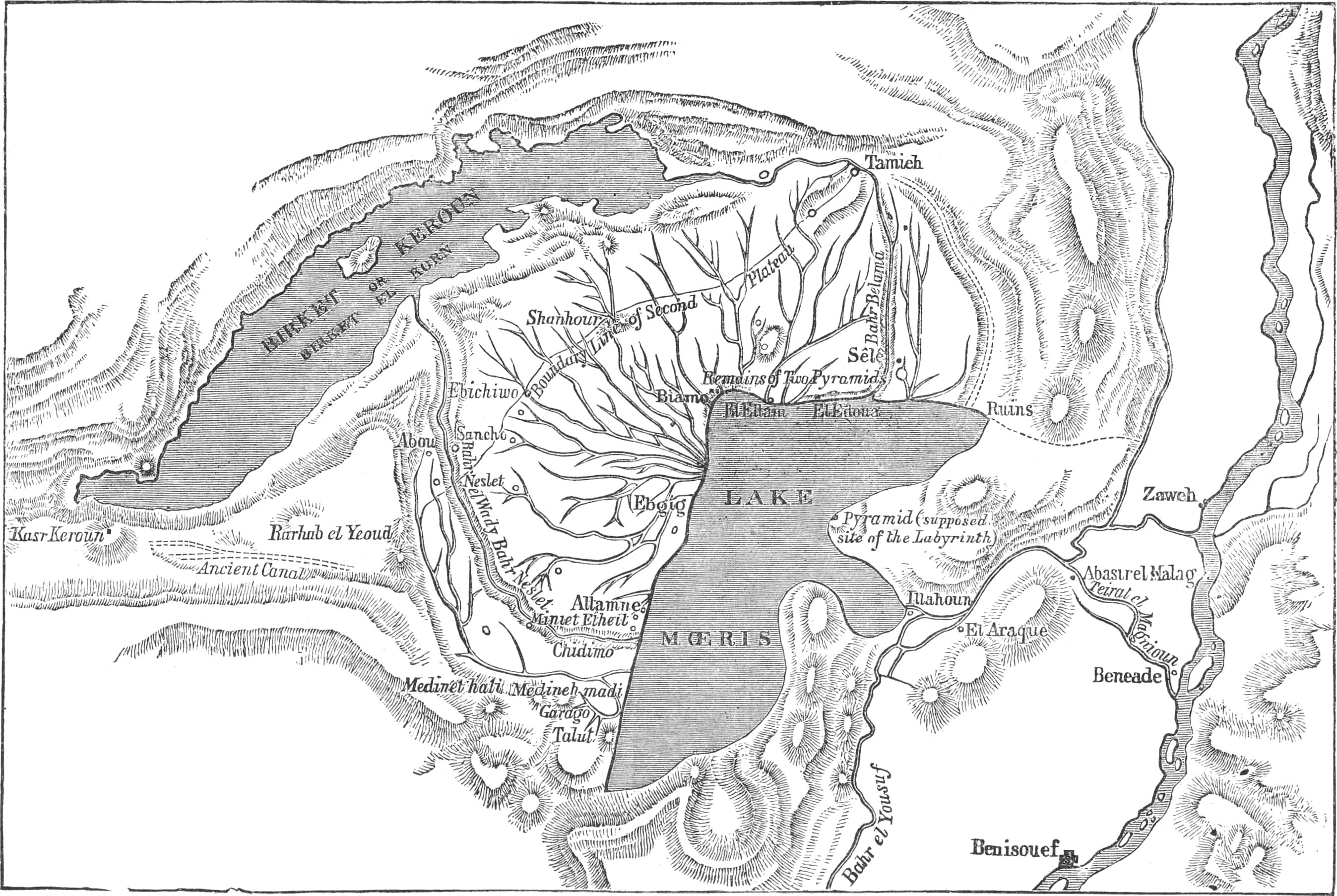
Linant’s Theory stated.—M. Linant maintains that Lake
Mœris occupied the gap in the hills by which the Bahr Yûsuf enters
the Fayûm, and covered the so-called “plateau” on the south-east of
Medineh, the encircling bank commencing at its north-east end at
Edwah, and being continued through el-Alam, Biahmu,
Zowyet-el-Karatsah, to Medineh. See Plate
VII.
The remains of this bank he traced throughout this length, and
saw evidences of it again to the S.S.E. of Medineh.
Thence he supposed that it must have passed on to Abgig
(“je suppose qu’elle a dû passer à Ebgig”), el Sawafnah, Atamnah,
and Gaafrah. Then he found it again constructed in masonry over a
great length not far from the village of Miniet-el-Hêt. It
continues afterwards (according to Linant Pasha) up to Shêkh Abu
Nûr, and then takes the direction of “el Gharak in the plain,”
where it is no longer well defined (“où elle n’est plus bien
marquée”). He notes that at Bahr Nezlah its height (that is, the
wall’s,) is 12 metres.[2] He then makes the bank pass on from the
south-east of Sélé (?) to between Shêkh Danial and Tutûn, in an
easterly direction, and turn to the north by Kalamshah, El Nedlé
(?), to the Bahr Yûsuf, then following the Bahr Yûsuf up to
Dimishkîn, turning along the banks at Lahûn (Bahlawân and
Gedallah), it again returns to the west near Hawârat-el-Maqta, and,
following the old
canal Wardan, passes the Hawârah pyramid at the village of Dimu and
joins the commencement of the bank at the south-east of Sêlah
(Sélé).
Plate VII.
MAP SHOWING LINANT’S SUPPOSED LAKE MŒRIS.
From Rawlinson’s ‘Egypt,’ 1881.
All the land enclosed by this bank represents the site of Lake
Mœris according to the theory of Linant de Bellefonds Pasha.
I give here a map,
Plate VII., copied from one of Mr. Cope
Whitehouse’s papers on the Wadi Raiân, being a reproduction from
the ‘Egypt’ of Canon Rawlinson, as it is a convenient one for
demonstrating what this theory is. Linant’s Lake Mœris is shown on
this map as a dark patch occupying what M. Linant calls the high
plateau. The part where “LAKE” is printed
is actually the highest part of the Fayûm, at R.L. 22 to 25, if we
except the narrow pass by which the Bahr Yûsuf flows in. This
latter has its land surface at from R.L. 24 to 26. But the word
“MŒRIS” on the shaded area lies over a
depression whose bed is at R.L. 12·00, that is, 11 to 12 metres
lower than the land surface covered by the word “LAKE” on the same shaded area.
The north boundary of this area through el Edwah and el Alam
runs generally along contour R.L. 17·50, 5 to 7 metres below the
high plateau. It is therefore incorrect to speak of the ground
represented by the shaded area as a plateau.
M. Linant’s depth of water in his supposed lake was fixed at
9·60 metres. Its bed must have been at R.L. 21·00, the level of the
rock-bed at Hawârah, and its maximum water surface at R.L. 30·60.
The height of the surrounding bank would have had to be, on the
Edwah-el-Alam line, 15 metres, and at the Wadi Nezlah (at the
initial letter of “MŒRIS” on the map) 20
metres.
Now the country lying between the Linant Lake Mœris and the
Birket-el-Qurûn was said to be irrigated from this lake. Imagine
the state of insecurity for this tract of sloping land, with a huge
reservoir of water standing 13 metres above that part which lies
along the north face of the lake, and more than this above the part
along the west face. When one considers, too, that there must have
been passages for irrigation through this bank, and how dangerous
such an arrangement would be, it is scarcely credible that the
collection of thriving towns included in the Arsinoïte nome would
have grown in such a perilous situation. Imagine, also, the
infiltration that would result on the lands along the faces of this
lake. According to the theory, the Lake Linant, not being of
sufficient dimensions itself to regulate the Nile, was to pass on
the surplus into Birket-el-Qurûn by escapes on the two main
drainage lines. Thus the poor fools, who had settled themselves on
the strip between the two lakes, would be in danger of inundation,
both from above and below, and would be in as bad a plight as
Pharaoh’s horsemen in the Red Sea.
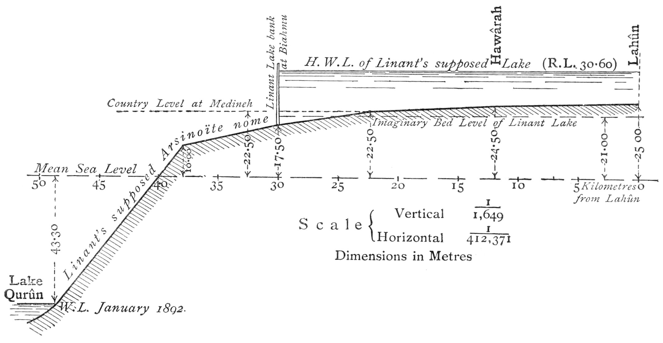
A diagrammatic
section of the Fayûm (Plate VIII.), as it would
have been when in this unhappy state (fortunately imaginary), will
make the situation perhaps plainer. The diagram, by exaggerating
the vertical dimensions with reference to the horizontals,
emphasises the danger of the situation and shows how improbable it
is that such a theory could be true.
Plate VIII.
SKETCH OF THE FAYÛM
From Lahûn through Biahmu to Lake Qurûn through the
highest plateau, showing Linant’s supposed Lake.
It should be noted that the Linant Lake itself covers the
richest land of the Fayûm, namely, that which, being near the first
point of expansion of the inflow into the depression, had received
the richest deposit during the time that the Fayûm was forming
previous to the creation of Lake Mœris; and, further, it should be
remarked that the remainder of the best land round the margins and
for a considerable distance from the Linant lake banks would have
been probably ruined by infiltration. Where, then, should we find
the rich lands of the Arsinoïte Nome, so famous for their
produce?
M. Linant objects (and there is, doubtless, weight in this
objection) to the theory of the submergence of the Fayûm by a
sufficient elevation of the waters of the Birket-el-Qurûn, that
there would be no place for the Arsinoïte Nome; and he thinks that
by his theory he has found a place for it between the two rival
lakes. The ancient Egyptians, who lived before our era,
must have had
prodigious faith in their protecting deities, or in their
department of public works, if they took up their abode behind
Linant’s bank.
Such a peculiar arrangement of land and water as that supposed,
would scarcely have been passed without notice by those who visited
and described Lake Mœris. The Arsinoïte Nome would have been in
some way described as being between two lakes, with a mass of water
impending over it. The danger of such an arrangement in case of a
breach would have been surely noted. Imagine also the condition of
Arsinoë from its sanitary aspect in the hot months of summer, when
by reason of all the water in the Linant lake being utilised, the
bed of the lake would be laid bare at a time when no crops could be
sown on it. But this objection may be met by supposing the lake to
have been excavated to a sufficient depth for water to remain in it
at lowest Nile. But if originally so excavated, a lake such as this
was supposed to be, would rapidly silt up, and M. Linant supposes
it silted up 8 metres, as is shown by his section and description.
Could such a lake have continued in working order for over 2000
years, as it was supposed to have done? It would only have done so
by means of periodical silt clearances of such magnitude, that the
population of Egypt alone would not have been equal to the task.
Suppose only a metre to be cleared over the whole area (assuming it
a plateau according to M. Linant’s view of it), the quantity to be
cleared would have been 250 million cubic metres, which would have
to have been removed to a mean distance of at least 2000 metres!
What would have happened to Linant’s supposed Arsinoïte Nome, and
the west bank of the Nile irrigated by his Lake Mœris, while these
clearances were going on?
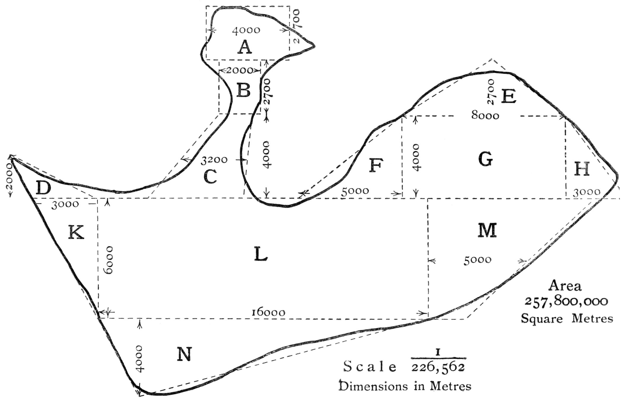
The perimeter of Linant’s supposed lake is 96 kilometres (60
miles) measured on the map published in the atlas accompanying the
book containing M. Linant’s theory. Its correct area is
257,800,000 square metres. But M. Linant himself gives the area as
405,479,000 square metres, which is 57 per cent. in excess of the
true area as taken from his own map (see diagram, Plate IX). The paragraph in which this figure is given
concludes: “Mais nous avons vu quelle foi on devait avoir dans les
dimensions données par les auteurs anciens.” Need he have added
“anciens”? M. Linant himself is the greatest argument for placing
no faith in reported dimensions of lake areas, since, with his own
map before him, and the limits of his lake definitely determined,
he was unable to avoid so large an error.
The author of this theory states that it satisfies all the
conditions required
for its recognition as Lake Mœris. I think it will be found to
satisfy very few, and obviously not the two following, regarding
its size and depth.
It is generally stated that Herodotus gave the circuit of Lake
Mœris as 450 miles, or 720 kilometres. The perimeter of M. Linant’s
lake is about 110 kilometres, but he makes the difference less by
adopting M. Jomard’s opinion, that Herodotus’ “stade” was “le petit
stade,” whereby the circuit of the lake, according to Herodotus,
would be 360 kilometres. Even thus we can scarcely admit this
condition to be satisfied. But M. Linant, as we have seen, has no
faith in the dimensions given by “les auteurs anciens,” but though
his want of faith may be justified, his statement that this
condition is satisfied is not.
Plate IX.
OUTLINE OF THE LINANT “LAKE MŒRIS.”
Taken from Linant’s own Map.
Another condition which M. Linant’s lake is far from satisfying,
is the depth, which Herodotus gives as 92 metres. Linant makes his
lake depth 9·60 metres, assuming that his lake area occupies a
plateau, which it does not. The greatest depth of his lake,
according to the actual levels of the ground included in it, would be 18·60 metres,
against the 92 metres of Herodotus. This condition therefore is not
satisfied.
Faulty Foundations on which the Linant Theory was
built.—Had Linant Pasha had before him a contoured map of the
Fayûm, I believe he would never have enunciated his theory. The
Minia wall made an undue impression on him and has been his
stumbling-block. He clearly traced the remains of a large bank from
Edwah to Biahmu, and less plainly to Medineh, but after Medineh he
found no traces of a bank, but being desirous of
connecting up with the big wall, supposed that it must
have passed through certain villages leading to it. This wall,
closing a valley encircled by contour R.L. 15·00, was probably
constructed at a much later date, or at any rate independently of
the bank of which the remains are found on the other side of
Medineh, and for a different purpose. If this wall had been
originally higher there would be remains of the high parts at each
end, where breaches had not carried away the original wall. This we
do not find, but on the contrary, the crest of the wall is at one
uniform level from end to end, and appears to have been added to,
instead of taken from. From an examination of the abutments of the
bridge, built in the line of the wall, the original wall appears to
have been constructed of stone, and to have been widened
subsequently by an addition of coarse brick masonry of rough
bricks, in mortar made of lime and clay, probably with the view of
obtaining width enough to carry an aqueduct along the top of the
wall. None of the masonry is sufficiently good for this purpose,
and so, no doubt, the water, leaking from the aqueduct channel,
gave rise to breaches in the wall, of which the signs are evident
in the blocks of masonry lying scattered about on its down-stream
side.
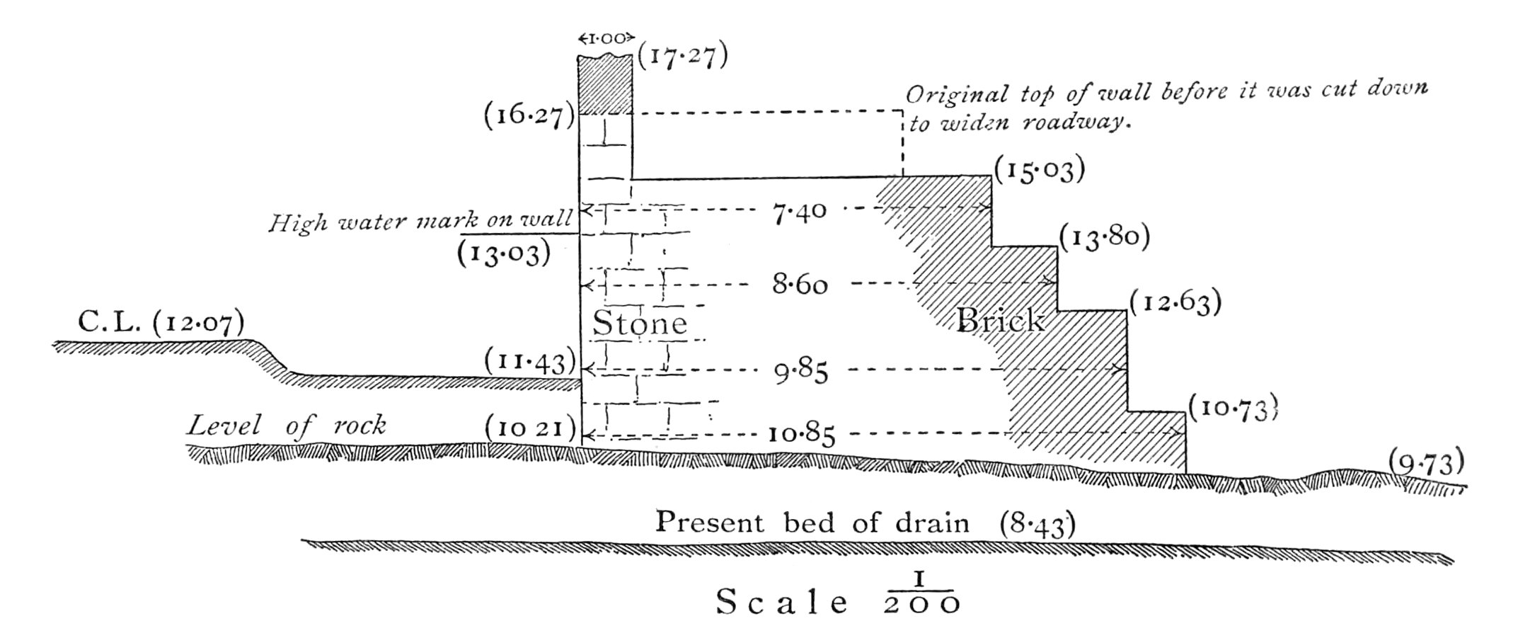
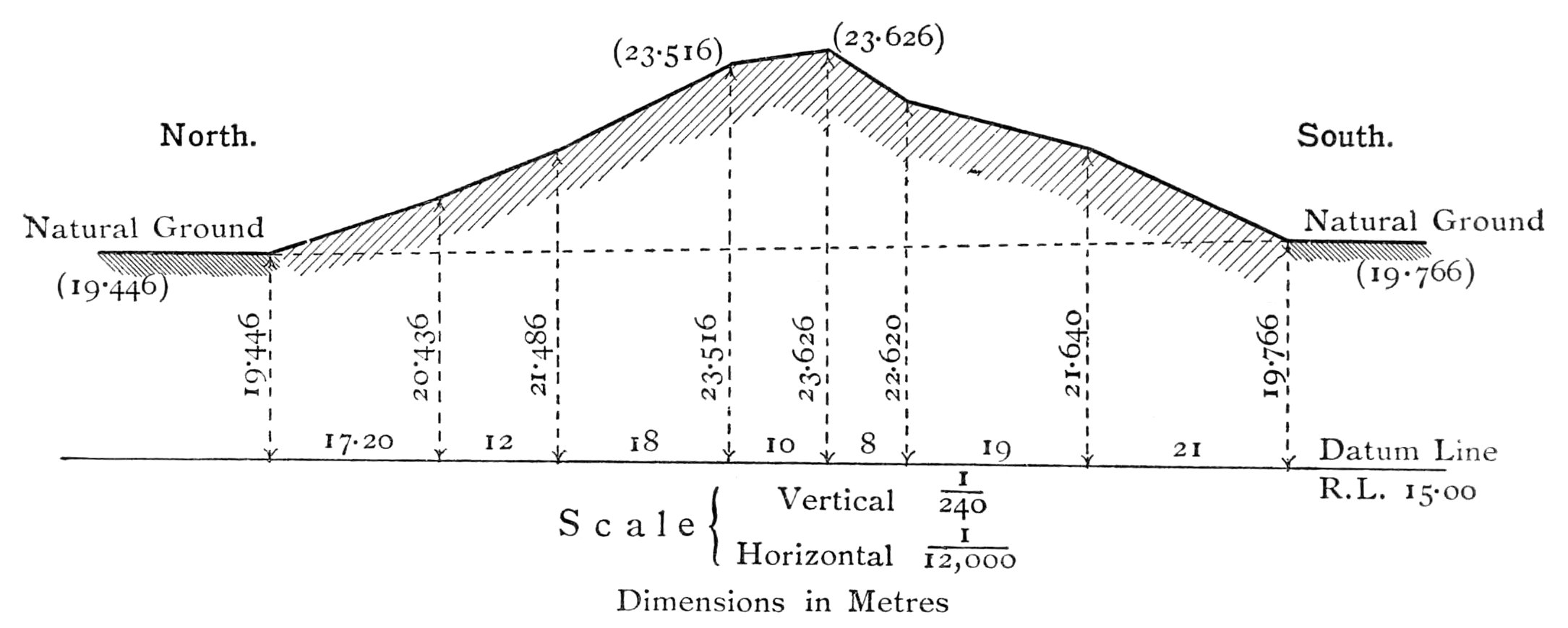
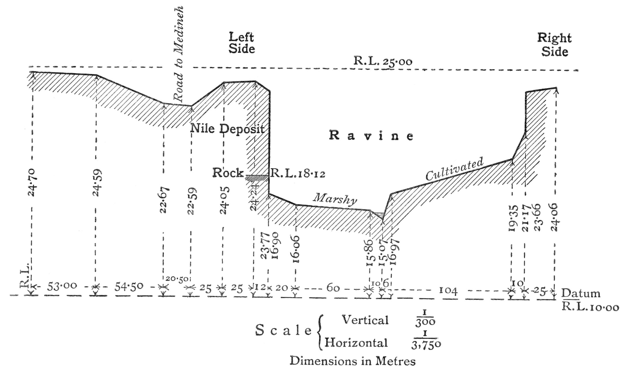
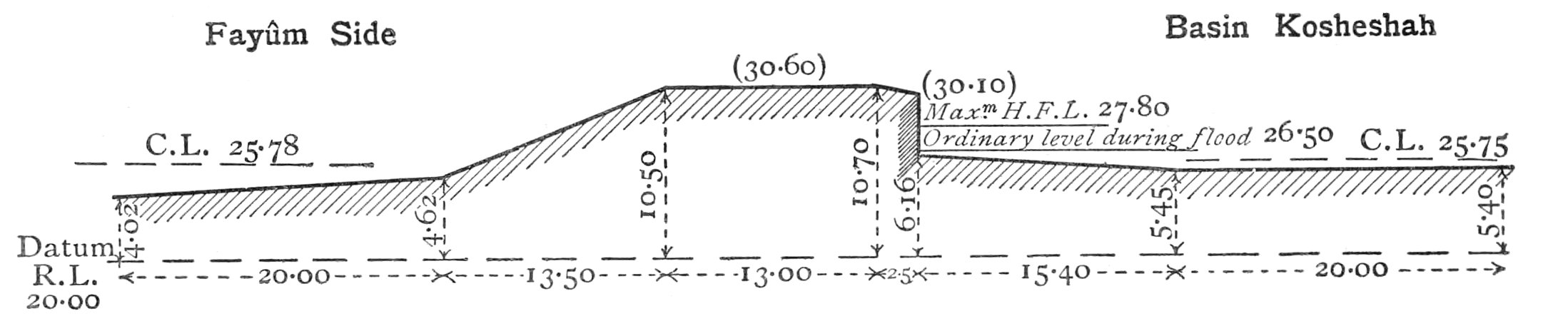
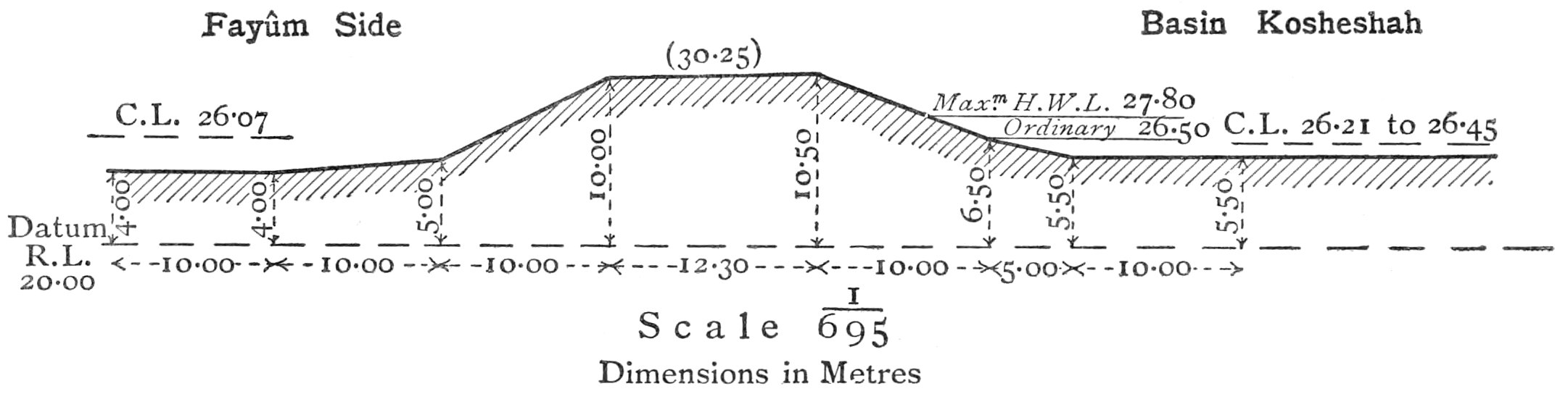
The cross-section of the wall, Plate X.,
gives its dimensions at a point near the bridge, where its height
is greatest. Below this cross-section another of the Edwah-Biahmu
bank is given for a comparison of the levels of wall and
bank.[3]
Erroneous Data employed by Linant.—In Linant Pasha’s
Atlas, published with his Mémoires, is to be found an extraordinary
section of the Fayûm from Lahûn to Birket-el-Qurûn, in which the
land from Lahûn to Medineh is shown as being higher than the land of
Beni Suef on the Nile Valley side of Lahûn.
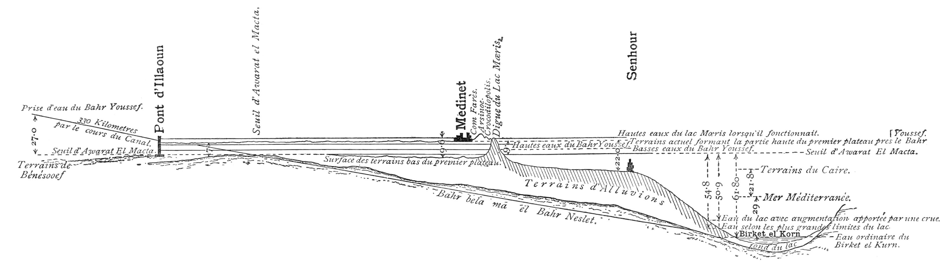
I reproduce his section on Plate XI., and
below it I give a section showing the actual levels. As Linant
appears to refer all his levels to the rock bed at
Hawârat-el-Maqta, which he makes 32·80 metres above sea, whereas it
is really 21·00, it is necessary before comparison to apply a
correction of - 11·80 to all his levels.
Plate X.
CROSS SECTION OF THE MINIA WALL.
CROSS SECTION OF THE EDWAH-BIAHMU BANK AT A POINT
WEST OF EDWAH.
Comparing the figures after correction with those of the “actual
section,” it will be found that Linant puts the level of the Beni
Suef lands 5½ to 7 metres too low, and that of his first plateau 6
to 8 metres too high, with reference to the rock bed at
Hawârat-el-Maqta. According to the corrected figures his Lake Mœris level would
be + 32·00, but how he gets it to that level it is difficult to
understand, inasmuch as he says that his lake is filled by the Bahr
Yûsuf, whose high-water level is shown 4½ metres lower. (The
Birket-el-Qurûn level, after applying the correction, becomes
40·80, which must have been about its correct level in Linant’s
time.)
Plate XI.
SECTION OF THE FAYÛM THROUGH LAHÛN-MEDINEH-SANHUR.
By M. LINANT.
ACTUAL SECTION ON THE SAME LINE.
Note.—The water-level of the Bahr Yûsuf
from Lahûn to Medineh is a little below country level
throughout.
I give another instance of error with reference to Linant’s
conception of the first plateau. Writing of the bank from Edwah to
el Alam, he states that the land to the south of this bank was
about 2 metres below its crest, and to the north of it from 8 to 9
metres, which difference, he says, is explained by the deposition
of silt in the interior of the basin formed by the bank, as is
always seen elsewhere at all the banks of the inundation basins of
Egypt. This great difference of level of the country surface on
either side of the bank would have been very suggestive in a sense
favourable to M. Linant’s theory had the difference of level been a
fact instead of a fiction. The cross-section of the bank given on
Plate X. shows its actual state with reference
to the land on each side of it.
It seems scarcely necessary to discuss further a theory that was
based on such erroneous data, but as the data were not known to be
erroneous, and Linant propounded his theory with an air of
authority, it has had considerable success in getting itself
accepted. Guide-books, and even books used as school text-books on
Egyptian history, show that his theory has been hitherto judged the
correct one.
It is, however, satisfactory to find that in the fifth edition
(1890) of ‘Ancient Egypt’ by George Rawlinson (The Story of the
Nations Series) the exact size and position of “Amenemhat’s
reservoir” is admitted to be sub judice, and it would
appear that this desirable attitude is the result of a challenge of
Linant’s theory by Mr. Cope Whitehouse, who is reported as
believing that the water was freely admitted into the whole of the
depression (i.e. the Fayûm), which it filled, with the exception of
certain parts, which stood up out of the water as islands from 150
to 200 feet high. Nevertheless, in spite of this new attitude
towards the Linant theory, the map representing Linant’s Lake Mœris
is to be found at the end of the book, without any remark to
prevent readers from being misled by it, the map being described as
“Map of the Fayoum, showing the Birket-el-Keroun and the artificial
Lake Mœris.” (Plate VII. is from an earlier
edition.)
The Linant theory, examined in the light of the more accurate
knowledge gained of the physical features of the Fayûm, and tested
by the application of
figures to determine its possible performances, can no longer
stand, but falls to pieces; and the wonder is that, based as it was
upon erroneous data and propped up by no solid support of facts, it
stood so long. It may be said of it, to the credit of its author,
that it was ingenious, but not that it was true.
Since writing the foregoing concerning the Linant theory, Mr.
Cope Whitehouse has kindly lent me his first papers on the subject,
the earliest paper, that I had previously seen of his writings,
being that which was read by him at the Manchester meeting of the
British Association, September 2nd, 1887. I now find that he has
been before me in stating many of the arguments I have used against
the Linant lake theory, but it is satisfactory to find that we have
independently arrived at the same conclusions, though by no means
surprising, as I believe that any one, with the same amount of
personal acquaintance with the Fayûm, would be naturally led to
hold the same views of this fantastic theory. As early as 1882, Mr.
Cope Whitehouse pointed out that the Linant lake satisfied none of
the conditions which a lake professing to be Lake Mœris must
satisfy, and he concluded one of his papers with a remark
expressing his conviction that, when Lake Mœris shall be recognised
by the light of discoveries yet to be made through further
research, the site of the ancient lake will in no case be found to
be that of the reservoir of M. Linant de Bellefonds Pasha.
Mr. Whitehouse, at the same time as he lent me his papers of
1882, also lent me a copy of Dr. G. Schweinfurth’s letter to Paul
Ascherson on a journey undertaken in the depression of the Fayûm in
January 1886, in which letter I find I am anticipated again in a
footnote on this theory, which gives an argument not given by Mr.
Cope Whitehouse, and runs as follows:—
“Here it must be mentioned that one of the most important points
on which Linant grounds his Mœris theory is the Dams[4]
which has proved quite fallacious. The dam at Adwa (Edwah) geology
shows to be layers of gravel; the stone dam at Minia is, on the
other hand, a weir for the Bahr-el-Wady, and is evidently
throughout its whole length of later date. Besides, it fills up
only the deep curves of the ground, and has no continuation on the
rising grounds.”
Dr. Schweinfurth, as well as Mr. Whitehouse, had thus pointed
out the weakness of
the Linant theory, but still we find it living and taught
as a true theory so late as 1890; and this is my excuse for
repeating the arguments which have not yet succeeded in
overwhelming it, notwithstanding its feebleness, so much support
does it derive from its parent being a reputed authority.
But we have public acceptance of the Linant theory so late as
1892, and by so eminent an Egyptologist as Brugsch Pasha, who
communicated his views to the Société Khédiviale de Géographie in a
paper read in Cairo, on the 8th April, 1892, the title of the paper
being “Le Lac Mœris d’après les monuments.” A quotation from this
will show that he accepts the Linant theory.
“De nos jours, les traces visibles de cet immense bassin d’eau
(le lac Mœris) ont disparu et les savants les plus distingués se
sont en vain efforcés pendant longtemps de retrouver ses anciennes
limites sur le sol moderne de la province du Fayoum.
“L’opinion la plus généralement acceptée au sujet de sa position
a Linant pacha pour auteur. C’est lui qui, le premier, a rejeté
l’idée de reconnaître le bassin du lac Mœris dans le
Birket-el-Kouroun de nos jours, c’est-à-dire ‘le lac des Cornes,’
situé comme on sait, à l’ouest du Fayoum. Suivant les recherches
très minutieuses de l’illustre savant, il faudrait, au contraire,
se diriger vers le côté oriental de la province susnommée, et,
notamment, vers les plateaux bien connus de Hawara et de El Lahoun,
où deux pyramides construites à l’époque de la XIIme
dynastie (vers 2500 a. J.C.) excitent encore la curiosité des
voyageurs.
“H. Lepsius, mon savant compatriote qui, il y a presque
cinquante ans, a eu l’occasion d’examiner sur les lieux les
résultats obtenus par Linant pacha, n’a pas hésité à déclarer dans
un Mémoire spécial que le savant français avait fait la découverte
la plus brillante et la plus indubitable quant à la véritable
position topographique du fameux lac Mœris. Les doutes qu’il
exprima à la même occasion ne s’appliquaient qu’à l’extension du
lac vers le nord.
“Depuis Linant et Lepsius, aucun savant sérieux, du nombre des
géographes et des Égyptologues, ne s’est opposé à l’opinion émise
par ces deux illustres auteurs.”
Apparently Brugsch Pasha does not class Dr. G. Schweinfurth, Mr.
Flinders Petrie, and Mr. Cope Whitehouse as “savants sérieux,” for
they have expressed themselves as opposed to the Linant theory.
Lieut.-Colonel J. C.
Ross, C.M.G., late Inspector-General of Irrigation, Egypt, justly
renowned for his power of comprehension of the levels of any part
of the country, which he studied professionally, at one time gave
much of his attention to the Fayûm, and especially to that part
which was known as Hod-el-Tuyûr, and which is the depression
embraced in the area which Linant calls a plateau and in which he
localised his supposed Lake Mœris. I think I may say, without fear
of contradiction, that Colonel Ross’s examination of the ground in
question was much more thorough and more prolonged than that of M.
Lepsius; but whereas the latter did not hesitate to accept Linant’s
theory and to style it the most brilliant and certain discovery as
regards the position of Lake Mœris, Colonel Ross on the contrary
rejects Linant’s theory and thinks that the lake was north of the
Edwah bank and not south of it.
Mr. Petrie has also clearly expressed the same views as Colonel
Ross on this point.
I too have had advantages of studying the ground itself and the
way the water runs, such as few have had, and have come in for the
legacy of Colonel Ross’s levellings and maps.
The names of Linant and Lepsius do not therefore carry with them
sufficient authority to override the facts, which are ascertained
to be such by a more thorough examination of the country and a
better knowledge of the physical features of the province.
Irrigation officers may, perhaps, not be classed as “savants,”
but they have at least as much right to be heard as any other body
of experts on such a subject as Lake Mœris, which is more than
anything else an irrigation question, and one that has especial
interest of a more or less practical nature at this time, when the
question of the construction of Nile reservoirs for the storage of
the surplus waters of the Nile is under consideration.
Mr. Cope Whitehouse, who has a personal acquaintance with the
Fayûm, and has studied the question of Lake Mœris, though with a
prejudice in favour of giving the Wadi Raiân a leading part, would
possibly have been inclined to hold the same views as I do, had it
not been for his anxiety to recommend the Wadi Raiân for future use
by magnifying its imaginary past performances. But as his views about the
Wadi Raiân are the essential and distinctive part of his theory, we
do not agree.
For ten years Mr. Whitehouse has been brooding, as the
faithfullest of mothers, over his theory, looking for a practical
project to be hatched therefrom, but, as time passes, he begins to
show signs of impatience, and fears lest his egg be addled. The
possibilities as to what the chick may be when it appears, are set
forth in Chapter V. of this paper, for I cannot but think that the
egg is a good one.
Mr. Whitehouse believes that in prehistoric times, before
artificial works of control were made, the Nile flowed into and
submerged the whole Fayûm, which was filled at high Nile, and that
when the flood subsided, the return flow, that took place from the
Fayûm to the Nile, prolonged the period of inundation by at least
two months. He also believes that the river flowed in a single
channel along the eastern desert.
So far most of us who have our theories about the Fayûm travel
together, with but small differences on the way. But after this our
roads diverge, and each thinks the road he has selected leads to
Lake Mœris. But they cannot all go there.
Leaving prehistoric times, and coming to the period of ancient
history, Mr. Whitehouse holds that there were two lakes. At first
the northern lake, the Fayûm, was a lake and marsh serving as a
backwater to the Nile, while the southern, the Wadi Raiân, was dry.
So far I agree with him, but now we part company. Subsequently, he
imagines, engineers of an alien race diverted the flood waters into
the dry Wadi Raiân to the south-west and evaporation dried up the
Fayûm, which was then irrigated by a system of canals. The Wadi
Raiân basin becoming, full served as a reservoir, and was,
according to Mr. Whitehouse, the “Mœridis Lacus” of Ptolemy.
Later on, in 1890, Mr. Whitehouse explains his views in terms
which are not quite in agreement with the foregoing, for he then
supposes that the natural backwater of the Nile included the Fayûm
and Wadi Raiân (with its minor basins Wadis “Safir” and “Lulu”) at
one and the same time, and that these combined basins were filled
to the level of high Nile, which he puts at R.L. 30·00.
I think, however, his present views are, that at first the Wadi
Raiân formed part of the Lake Mœris of Herodotus, of which the
Fayûm was the main part; and that afterwards the Wadi Raiân alone
formed the “Mœridis
Lacus” of the Ptolemaic maps, the Fayûm having been brought under
cultivation, after its waters had been dried up by evaporation.
As the Wadi Raiân is the prominent feature of this theory, I
will give here in full Colonel Western’s official description of
it:—
Description of the Wadi Raiân.—“This valley or
depression in the Libyan Desert, discovered by Mr. Cope Whitehouse
in 1886 (really three or four years earlier), lies immediately to
the south-west of the Fayoum Province, but separated from it by a
range of low hills, 2 kilometres in width and with heights of about
40 metres above sea-level. Two passes, however, leading from the
Gharak basin, with level of + 26 metres, have been found in this
dividing range and, except for these two passes or entrances, the
Wadi is everywhere bounded by hills of at least + 36 metres.
“The soil of the Wadi is for the most part composed of desert
sand and pebbles overlying in places a yellow clay, but this desert
sand is for about one-sixth of the area hidden by drifting
sand-hills or ridges rising some 5 to 10 metres above the general
plain.
“Towards the south of the Wadi there are two fresh-water
springs; and near these a few date-trees and some brushwood
grow.
“The deepest level of the Wadi Raian reaches 40 metres below
sea-level.
“To the east of the Wadi, and connected at a level of + 55, is
the Wadi Muellah, a valley about 1½ kilometres wide and 7 long. Its
lowest depression is at + 25.
“In the Wadi Muellah there are ruins of ancient buildings, and a
fair amount of coarse vegetation near them.
“Another small depression, also connected with the Wadi Raian,
has been found lying to the south of the Gharak basin of the
Fayoum, and only separated by a ridge at level + 35, and 1
kilometre in width. This depression is some 10 kilometres in length
by 4 mean width, and has a bottom at about + 15 metres.”
Now, there is no evidence whatever that the Wadi Raiân had ever
any possible communication with the Nile except by way of the Fayûm
depression through the two gaps in the encircling walls of the
Wadi, the sills of which are stated by Colonel Western to be at
R.L. 26·00, but which later surveys, not yet published, show to be
one at R.L. 26·00, and the other at R.L. 27·00. The Wadi Muellah,
on first inspection of the map, appears to offer the most likely
line of communication with the Nile Valley, but an examination of this Wadi at
its upper end towards the Nile Valley gives no evidence of any such
communication having ever existed.
What seems a conclusive proof that the Wadi Raiân was never in
direct communication with the Nile Valley, is the total
absence of all trace of Nile deposit within the limits of the
depression.
If the muddy waters of the Nile in flood entered a lake 60 to 70
metres deep, the silt would be deposited and remain, for the return
flow from the uppermost stratum back into the Nile would disturb
none of the Nile mud brought in. After a long succession of such
annual deposits, the depth of deposit would be considerable. In the
Fayûm entrance we find such a deposit up to R.L. 25·00, and it is
to be noted that the Wadi Raiân was supposed by Mr. Cope Whitehouse
to have been in working order, as Lake Mœris, after the Fayûm
ceased to be so, and therefore there would have been less time for
the disappearance of the Nile deposit of the Wadi Raiân than of
that of the Fayûm.
In the Wadi Raiân, Nile deposit has not been found,
though eagerly looked for. I think this fact is fatal to Mr. Cope
Whitehouse’s theory of a direct communication between the
Wadi Raiân and the Nile or Bahr Yûsuf.
Dr. Schweinfurth thus expresses his views as regards fresh-water
deposit in the Wadi Raiân:—“The basin (Wadi Raiân) exists, but it
comes from geological time, does not belong to the Nile, and offers
nowhere in its tracts at some distance from the Fayûm any trace of
a fresh-water formation. . . .
“The traces of a settlement of water and layers of Nile earth
which are said to exist in some parts of the depression are
certainly absent. The grey clay-layers of the old sea with shells
of fresh water, innumerable fish vertebras, bones of tortoises,
&c., are not to be overlooked where they exist. I could prove
such fresh-water formations on the road from Talît over Raiân and
Medinet-el-Bahrl (27 kilometres to the west of the actual lake)
only at a distance of 8 kilometres from the lake (Birket-el-Qurûn).
The yellow Eocene marls with stripes of erosion, results of the
wind, moving sand, and of periodical rains, are not to be
confounded with these lake formations. A man who does that will
find traces of old water and Nile earth everywhere in the deserts
of Egypt.”
Later on in the same letter he says that the question, whether
fresh-water formations exist in the basin of Raiân or not, is to be
answered in the negative.
But supposing an
indirect communication with the Nile by way of the Fayûm
Lake, it is easy to understand that no Nile deposit would be found
in the Wadi Raiân, even if it had been thus repeatedly filled,
because the top water only would begin to spill over into it after
the Fayûm Lake level had risen above R.L. 26·00, and after the
water had travelled at an extremely low velocity to a long distance
from the point, at which it first spread itself out in the Fayûm
Basin.
But I regret, for the sake of Mr. Cope Whitehouse’s feelings,
that even this cannot be admitted to have taken place, for in every
situation where Nile water has been, fresh-water shells of distinct
species are always found, and their total absence in the Wadi Raiân
is sufficient proof to geologists that Nile water has never been
there.
To the conclusion that the Wadi Raiân was never in
direct communication with the Nile must therefore be added
this further conclusion, that the Nile water never entered
the Wadi Raiân at all, even by the only possible entrances
over the sills on the side of the Fayûm Lake.
Mr. Cope Whitehouse has not distinctly stated how he supposes
the Wadi Raiân was put into direct communication with the Nile, but
I believe there are only three possible theories, each one without
a particle of evidence to support it. One theory supposes a
connection along the bed of the Wadi Muellah, another a tunnel
through the hills dividing the depression from the Nile Valley, and
the third a hill-side canal fed from the Nile waters entering at
Lahûn and carried along the south slopes of the Fayûm.
In the absence of any evidence witnessing to the previous
existence of such connections, and in the face of the fact that the
Wadi Raiân contains no Nile deposit, I do not think that Cope
Whitehouse’s Raiân-Mœris or Ptolemaic-Mœridis-Lacus theory can
stand.
Failing better support to his theory, Mr. Whitehouse has called
the Ptolemaic maps to his aid, and in his pamphlet on the subject
he has reproduced the map of Egypt from the Atlas of Cl. Ptolemy,
of which I here repeat the copy, with an outline map of the Fayûm,
Wadi Raiân, and part of the Nile Valley, taken from ‘Egyptian
Irrigation,’ by Willcocks, and which was compiled from the latest
surveys in 1888 (Plates XII. and XIII.)
Mr. Whitehouse considers that the Ptolemaic map has been most
accurate in giving the exact shape of a lake in the desert, whereas
the representation of the features of the much better known Nile
and Nile Valley is
evidently most incorrect, and much distorted in longitudinal and
transverse dimensions.
If, however, any argument can be based on the shape of the
“Mœridis Lacus” of Ptolemy, as compared with existing depressions,
it seems to me that its shape resembles much more closely the
outline of the Fayûm
Province, with the Bahr Yûsuf indicated, than it does that of the
much indented Wadi Raiân.
Plate XII.
EGYPT FROM THE ATLAS OF Cl. Ptolemy.
Mr. Petrie has furnished me with the following observations on
the Ptolemaic maps.
Plate XIII.
Stanford’s Geogl. Estabt.
London
PROPOSED WADI RAIÂN RESERVOIR.
From Willcocks’ ‘Egyptian Irrigation,’ 1889.
The Ptolemaic maps are built up from itineraries and ship
routes, checked by a few latitudes. Now we know this much from
Ptolemy, that
Skiathis, Bakkhis, Dionysias, the Small Oasis and the Great Oasis
were on one route, and that on this route Lake Mœris was passed.
This was the desert itinerary from Alexandria to the Great
Oasis.
Using another distinct itinerary from the Nile Valley, the route
passes to Arsinoë (the modern Medinet-el-Fayûm) and Ptolemais (the
modern Talît), and then on to Behnesa, without any connection being
made with the Bakkhis-Dionysias route. Hence it is presumed that
these two routes did not cross each other. It is therefore
concluded that Dionysias can be identified neither with the ruins
on the Wadi Muellah (as Cope Whitehouse identifies it), nor with
Lahûn, and that it was probably on the west of Lake Mœris. Mr.
Petrie (to whom I am indebted for the whole of this reasoning)
supposes Bakkhis to have been at Dimeh (Dimay), and Dionysias
somewhere at the extreme south-west of the Raiân valley.
If this conclusion is right, and if the Fayûm, or the Wadi
Raiân, was the Lake Mœris of Ptolemy, the Lake has been placed too
much to the west on the map, and should have been shown on the east
of the line joining Bakkhis and Dionysias. In any case the
Ptolemaic evidence, when sifted, does not support Cope Whitehouse’s
theory, that the Wadi Raiân was the “Mœridis Lacus” of Ptolemy.
To show what little faith can be put in the identification of
some of the ancient towns with modern remains, I may mention that
Dr. Schweinfurth says of the monastery in the Wadi Raiân, that it
is “evidently the Bakkhis of Ptolemy.” Thus we have this monastery
identified as Dionysias by Cope Whitehouse, as Bakkhis by Dr.
Schweinfurth, whereas Flinders Petrie places both Dionysias and
Bakkhis on the far side of the Fayûm depression. Who shall decide
when savants disagree?
In his papers on Lake Mœris, Mr. Whitehouse makes reference to
two lakes, and I believe his theory of two lakes is based
on some ancient maps.[5] I have not seen the map or maps, but I
should expect the lakes represented to be intended for Lake Qurûn
in the Fayûm, and a corresponding lake in the Gharaq basin. The
Gharaq basin is the Fayûm depression repeated on a small scale, and
at some period of its development towards total reclamation from
the waters that covered it, it must have had a lake at its south
and lowest end, corresponding to the Birket-el-Qurûn, but of
smaller dimensions.
The Gharaq basin
is connected with the Fayûm depression by a gap in its surrounding
higher lands with sill at R.L. 16·00. Consequently the basin would
not have begun to dry up from evaporation till the Fayûm Lake had
fallen below R.L. 16·00, and probably the fall was not continuous,
but, through some accident at Hawârah or elsewhere, the Fayûm Lake,
after falling below R.L. 16·00, may have risen again and re-drowned
the reclaimed land in the Gharaq. This may have occurred more than
once, and have given rise to the name “Gharaq,” or the
“Flooded.”
Mr. Whitehouse, in his latest expression of views, supposes the
Fayûm and the Wadi Raiân were filled to R.L. 30·00. I have given
reasons for concluding there was never any Nile water in the Wadi
Raiân. The evidence furnished also by Nile deposit and fresh-water
shells on the Fayûm side of the entrance at Lahûn shows that the
level of 30 was never reached.
The highest Nile deposit near and on the Fayûm side of Lahûn is
at about R.L. 26·00. The highest in the Fayûm near the Hawârah
pyramid, which is on the edge of the Fayûm basin, is at R.L. 24·50
or thereabouts. The highest level of the lake was probably never
more than one metre above this level, and it is therefore almost
certain that the water-level was never sufficiently high to flow
into the Wadi Raiân; and if it ever did, it must have been
but rarely, when extraordinarily high and prolonged Niles occurred;
so that it must be concluded, if my views are correct, that the
normal condition of the Wadi Raiân was then, as now, that of a dry
waterless depression in the desert, and it cannot therefore be
considered as having been Lake Mœris, or a part of it even, at
any time.
Author’s Views of Lake Mœris generally stated.—I myself
agree with those who are of opinion that the Fayûm Province, or
depression, (including the Gharaq Basin and the neck from Lahûn to
Hawârah), was by itself Lake Mœris, and that within its limits and
along its borders was to be found the inhabited and cultivated
region known as the Arsinoïte Nome, which possibly also extended
into the Nile Valley along the course of the canal connecting the
Nile with the lake.
The Fayûm then in its submerged state was, I believe, the Lake
Mœris of Herodotus,
Strabo, Diodorus, and Pliny, the modern Lake Qurûn being the
persistent rudiment of this lake, and all that now remains of its
formerly extensive sheet of water. (See Plate
XX.)
Objections urged by Linant against these views.—This is
no new theory. It is found passim before Linant Pasha in
1842 took great pains to point out its absurdity, but it was his
own assumptions regarding the maximum height which the water
surface of Lake Qurûn could have reached, that created the
absurdity. Assuming without evidence that the villages on the
second plateau were all in existence at the time of Lake Mœris, he
limits the level of Lake Qurûn to the edge of the second plateau,
which is the same thing as laying down that its water surface never
rose above R.L. + 10·00.
Having come to this conclusion, he might have spared himself all
his arguments against the theory, other than that which pointed out
that a reservoir in the Fayûm at this level could have been of no
utility in supplementing the low waters of the Nile.
It is, however, instructive to note how he deals with the
arguments against this lake, which his imagination set bounds to,
being Lake Mœris. After a separate review of each condition which
Lake Mœris should fulfil and which the limited Lake Qurûn did not,
he closes his reviews with the remark that “we may then conclude
that Birket-el-Qurûn is not the Lake Mœris.” But he does not do so
always. Should the condition be one with which his own
theory is not in agreement, he explains it away or discredits it.
The dimensions assigned to Lake Mœris by the ancient historians
evidently trouble him, and he does his best to discredit their
testimony on this point. After discussing this condition, he does
not end his argument with the usual conclusion that “the present
Lake Qurûn cannot be Lake Mœris,” but he says “an absolute
importance must not be attached to all these measures in order to
draw from them conclusions either positive or negative as to the
identity of the position of Birket-el-Qurûn with that of the
ancient Lake Mœris.”
The depth assigned to Lake Mœris also gives rise to the
following remarks, which will afford the means of judging of the
value of M. Linant’s arguments. He states that Herodotus gives the
depth of the lake at 92 metres, and remarks that if the whole Fayûm
had been filled to form the lake, its dimensions would have
surpassed by ten times the greatest given for it.
But as a matter of fact, they do not even come up to
the greatest
dimensions given, which are, for the depth 92 metres, and for the
perimeter of the lake 720 kilometres (450 miles), or, assuming as
he does that Herodotus made use of the small stadius, 360
kilometres. Now the perimeter of the Fayûm is 220 kilometres, and
if that of the Wadi Raiân is added, namely 200 kilometres, the
total perimeter becomes 420 and that figure is only obtained by
measuring the indentations of the Wadi Raiân, which is of a
peculiar shape.
The depth of the Fayûm Lake, if filled to say R.L. + 25·00,
would be not less than (25·00 + 43·50 + 5·00 =) 73·50 metres, nor
more than 88·00 at the highest estimate.
These dimensions agree approximately with those given by
Herodotus, and are not, as rashly stated by Linant, ten times in
excess.
To show with what unfairness Linant deals with statements made
by Herodotus, his arguments about the bricks made for the pyramid
built by Asychis may be noted. It was stated that the bricks were
made from mud brought up from the bottom of the lake. Linant claims
this statement as supporting his theory, as his lake was a shallow
one, and as opposing the enlarged Lake Qurûn theory, as this latter
would be a deep one. It does not seem to strike him that the
workmen could have sought their mud along the shallow margins of
the larger lake. He further argues that one could not reach down
more than 4 metres with poles, and therefore the lake could not
have been so deep as stated by Herodotus, and hence Herodotus
contradicts himself! But Herodotus did not say that the lake was 92
metres deep all over, and that its shores were not shallow, but
that its greatest depth was 92 metres.
Linant Pasha discussed the possibility of the submerged Fayûm
being the Lake Mœris, but rejected the idea, because, to fulfil the
condition of supplementing the low Nile, the water must have
covered the second plateau, and risen to a level above the rock
sill at Hawârah (R.L. 21·00). “Then,” he points out, “the whole
Fayûm would have been only a vast lake and with a height of water
impossible to reconcile with the existence of large towns, which
formed the rich Crocodilopolite or Arsinoïte nomes. The great
quantity of ruined towns, abandoned like Medinet-el-Mahdi,
Medinet-el-Hêb, Medinet Nemroud, Kasr Keroun, indicate, as well as
those which still exist, as Sanuris, Sanhur and all the others,
that this part has never been under water, and they date from the
time of Lake Mœris and of Crocodilopolis.” (Earlier in his book he
states about Kasr Keroun, “Kasr Keroun is a little monument, quite modern as
compared with the epoch of the Labyrinth.” Mr. Petrie and Dr.
Schweinfurth both state that Qasr Qurûn is a Roman temple or town.)
M. Linant continues, “If ever the Fayûm has been under water, as we
have supposed it, it was long before it was habitable and before
the Lake Mœris existed.”
Plate XIV.
OLD BUILDING ON NORTH SIDE OF LAKE QURÛN,
DISCOVERED BY DR. SCHWEINFURTH IN 1884. EXTERIOR
FROM NORTH-EAST.
Now as regards the modern villages of Sanûris,
Sanhûr, and others, I am not aware on what evidence M. Linant
states that they existed at the same time as Lake Mœris. As regards
the old abandoned towns mentioned, some of them are on elevated
spots, and probably were on the shores of Lake Mœris. When Lake
Mœris declined and the water had receded to a distance from them,
they were abandoned for more favourable sites, less remote from a
water supply and water transport. Probably Sanûris and Sanhûr, and
the other villages on the edge of the second plateau, are the
successors in time of the ancient elevated towns mentioned as
ruined and abandoned.
Thus, instead of considering the remains of the old high-level
abandoned towns as evidence destructive of the theory that the
whole Fayûm was filled with water, I consider their testimony
distinctly favours such a theory.
Those towns especially, whose ruins are found on the
north side of Lake Qurûn, would certainly have been built
near the then borders of the lake, as they could have had no
possible source of water supply other than the lake itself. It,
therefore, is a matter of great interest to determine the levels of
any ancient towns that may be found on the north of the lake; and
the more ancient the town and the more remote from the present
lake, the more suggestive will be the facts that may be ascertained
with reference to its levels.
Now there are two monuments of antiquity known in such a
situation, namely, the ruins of Dimay (Dimeh or Dimé) and an
ancient temple (if it is a temple) discovered by Dr. Schweinfurth 7
or 8 kilometres north of Dimay.[6] Dimay itself is 3 kilometres
from the nearest point of the present Lake Qurûn, and the surface
of its causeway or quay at its upper end, near the old town, is 69
metres above the water surface of the lake (May 2nd, 1892), or at
R.L. + 25·44. The south end of the quay is now about 2·85 metres
lower, but it was doubtless originally somewhat higher than this,
as its present is not apparently its original surface, some of the
layers of stone having disappeared.
I had a trench dug against this quay or causeway, at about the
middle of its length,
to determine the depth to which the masonry was carried down.
If this had been merely a causeway, it is not easy to understand
the necessity for so great a depth of masonry. It was therefore
more probably a quay projecting into the water. This quay is 400
metres long, and its direction is due north and south. The level of
the plateau sloping up to the end of the causeway on the south of
Dimay is from R.L. 13·00 to 17·00; the plateau on the north side of
the ruins is at R.L. 21·45.
The ruins of Dimay are Roman on the surface, but I do not know
if it has been established that below the Roman remains there do
not exist more ancient ones. Dr. Schweinfurth thus expresses his
opinion about this old town: “Dimé seems to have filled the
position of ‘tête-de-pont’ in relation to the Fayûm, as in
consequence of its strong position, it afforded a secure outlet and
final station for the caravan road opening out towards the Oasis.
That the tribes of the Libyan Desert must even in the times of the
Romans have been very restless and enterprising, is testified by
the numerous similar fortifications, which in the day of the
so-called good emperor, were erected on all the principal exits and
entrances to the Oasis roads.”
Seven or eight kilometres north of Dimay (magnetic bearing from
north entrance in Dimay enclosure wall 12° east of north) is found
the ancient so-called temple, discovered by Dr. Schweinfurth in
1884. I give here photographs of the exterior and interior of the
building, as well as its ground plan, that those who are capable of
judging may have the means of estimating from them its probable
age. (Plates XIV.,XV., and
XVI.) The important level, so far as the subject
of this paper is concerned, of the old town, marked by mounds of
ancient pottery on the south of the “temple,” was determined on the
occasion of my visit. The level of the upper parts of these mounds
was found to be R.L. + 24·58. The pottery was, of course, spread
out to lower levels, but probably the ancient town was built
between the levels of 23·00 and 26·00.
Dr. Schweinfurth remarks that the buildings dating from the
XIIIth Dynasty are all distinguished by the same kind of
four-cornered arrangement as this temple and generally scorn every
kind of ornament; and he notes that the great size of the blocks
and peculiar method of fitting the stones together give it a
resemblance in style to other old buildings. Instead of giving his
further description, I refer to the ground plan and photographs. It
is worth noticing that the north-west room has no visible means
of communication
either with the exterior or with the other chambers of the
building; also that the displacement of the stones, forming the
upper half of the chambers on the raised floor, is suggestive of an
earthquake, the upper stones having slid on the lower to a
measurable extent in a north-easterly direction. Cracks in the
roofing stones corresponding with the displacement seem to confirm
the theory of earthquake action.
Plate XV.
INTERIOR OF DR. SCHWEINFURTH’S “TEMPLE,”
FROM WEST END OF OPEN ROOM.
Plate XVI.
PLAN OF OLD BUILDING DISCOVERED BY DR. G.
SCHWEINFURTH IN 1884.
Height of chambers from surface of raised floor to
ceiling 2·65. Scale ¹⁄₁₀₀. Dimensions in metres.
The object of the building is a riddle. Each of the
raised cells has a recess for a door. “In the thickness of the
south wall, on the east side of the principal entrance, runs a
passage half a metre wide, leading to which, at the south-east
corner of the temple, a door of equally narrow proportions is
attached. This passage leads downwards to the chambers below”
(Schweinfurth). Dr. Schweinfurth came to the conclusion “that the
old temple, as well as the original settlement or formation, is one
of the monuments belonging to the oldest times.”
Concerning the old town he writes:—“In the neighbourhood of the
temple, from south-east to south-west, at a distance of about 500
paces, that is, on the edge of the rising ground, there are
quantities of potsherds lying in heaps here and there. They are of
the most weather-worn appearance, and have formed portions of
coarse, thick vessels. No such things as fragments approaching the
pottery work of the Greek or Roman period are found. The eye of the
seeker sought in vain for remnants of that blue glazed pottery
ordinarily so common, or the long amphoræ of the Greek shape.
“The amphoræ points or ends, which I picked up, were all stumps,
and of an almost cylindrical shape. The corresponding pottery
showed no sign of rings. They were almost entirely coarse, red clay
fragments, with here and there a yellow or black bit, and all
distinctly showed the work of the potter’s wheel.
“Below the scarp of the lowest rising ground no more pottery was
to be found, neither did the marl mounds display on examination any
admixture of manufactured pieces. The heaps of pottery formerly
existing appear to have been flattened down and spread out over a
much wider space by the disintegration and sweeping down of the
marl bed. A similar occurrence may be observed on the few stone
walls yet remaining of the old temple settlement.”
For Schweinfurth’s further remarks see pp. 101 to 107 of his
veloci-graphed letter to Paul Ascherson on his journey in the
depression of the Fayûm, 1886.
The line of
levels, which I had taken between this old building (temple) and
Dimay, followed a direct line between the two, crossing the
elevations and depressions given in the list below:—
From Schweinfurth’s “Temple” to
Dimay.
R.L.
Floor surface of raised chamber on left of central chamber
35·506
Pottery mound of old settlement
24·580
First depression on line of levels
9·611
Following elevation
16·521
Second depression
6·096
Following elevation
14·461
Third depression
7·716
Plateau north of Dimay
21·448
On ruined mounds in Dimay enclosure
28·368
Causeway at undamaged upper end
25·438
From Dimay to Lake
Qurûn.
Causeway
25·438
Plateau north of Dimay, upper end
17·000
„ „ lower
end
13·270
Fossils plentiful between
- 3·500
and
- 13·000
Water surface, Lake Qurûn, May 2nd, 1892
- 43·540
These levels I am convinced are correct, as they were taken with
the utmost care, as I myself saw, by Messrs. W. O. Joseph and A.
Pini, who had been in constant practice at levelling. The levels
between Lake Qurûn and Dimay were taken twice over; the first
levels, taken by Monsieur Pini alone, giving a difference of level
between the lake and causeway of 68·952 metres, while the
difference found, when both read, was 68·978.
The levels for the old town near Schweinfurth’s “temple” having
been found to be from R.L. 23 to 26, the theory that Lake Mœris was
a little below the level of R.L. 23·00 is favoured by the
determination of this level. The presence and peculiarities of the
quay at Dimay, if it is such, and the existence of an old town on
the heights where the Dimay ruins stand, if they can be used as
evidence of what the lake level used to be, point to high levels
rather than to low ones, and do not answer to Linant’s appeal to
the old abandoned towns to bear witness in his favour.
In connection with the levels of Dimay and Schweinfurth’s
“temple” the levels of the ruins of Biahmu should be studied. These
are given on Plates XXII. and XXIII.
The top of the
highest corner-stone of the enclosure wall, now in situ,
is at R.L. 21·59, and, accepting Mr. Petrie’s restoration of these
ruins, the top of this wall, when complete, would have been at R.L.
23·00, which would seem to indicate that the maximum water-level of
the lake was below R.L. 23·00, but higher than R.L. 17·00, the
level of the ground outside the enclosure. These ruins are referred
to more fully on p. 83et seq.
Mr. Flinders Petrie’s Views of Lake Mœris.—Having
discussed the theories of Linant Pasha and Mr. Cope Whitehouse, the
only two that I can find stated with any distinctness, and the only
ones that have been put forward by travellers having a personal
acquaintance with the Fayûm, I will, before setting forth my own
reading of the past history of the province and my theory as to its
connection or identity with Lake Mœris, first give Mr. Petrie’s
views, who should be included with the two foregoing theorists, as
a traveller having a personal acquaintance with the Fayûm, and, in
a special line, a very intimate one. I do not think that he would
claim that the expression of his views constitutes the enunciation
of a new theory of Lake Mœris, but only his way of viewing an old
theory with some side-lights of his own added by way of
illumination.
The views, that I have adopted, are in general agreement with
those favoured by Mr. Petrie, and as he, an Egyptologist and
archæologist, has thrown light on the subject from his standpoint,
I propose to make the same attempt from my point of view as the
Public Works officer in charge of the irrigation of the Fayûm. The
working out of the problem of Lake Mœris would seem to require an
alliance between a palæontologist, an archæologist, an
Egyptologist, a geologist, and a hydraulic engineer.
The following is copied from ‘Hawara, Biahmu, and Arsinoë,’ by
W. M. Flinders Petrie, published in 1889:—
“Medinet el Fayûm (Plate XVII.) is the modern
town which represents the ancient Arsinoë, so named by Ptolemy
Philadelphos in honour of his sister-wife; it lies at the extreme
south of the old site, which covers a space of over a mile long and
half a mile wide, a vast wilderness of mounds strewn with pottery.
At the opposite end of the ruins, toward the north, is the great
temple enclosure of the old Egyptian town. Before its name of
Arsinoë, the city had obtained the name of Crocodilopolis, from the
worship of the sacred crocodiles maintained there; and still
earlier it was known as Shed, meaning, apparently, that which is
saved, cut out, delivered, or extracted, referring to the district
being reclaimed from the great lake. The whole province was known as Ta-she, ‘the land of
the lake’; and, whatever may have been the mistakes of historians
about Lake Moiris, there is no doubt that the lake was the main
feature of the district.
Plate XVII.
VIEW OF MEDINET EL FAYÛM,
WHICH OCCUPIES PART OF THE SITE OF THE ANCIENT TOWN
CALLED SUCCESSIVELY “SHED,” “CROCODILOPOLIS,” AND “ARSINOË.”
“So many opinions have been broached about Lake
Moiris that an account of antiquities in the Fayûm without
mentioning it would seem impossible. So, although my work has not
been in that line, yet it will be well to state what seems to be
the truth about it, in order that some collateral questions should
be the better understood. For the following view of the use of the
great dyke I am indebted to Colonel Ross, R.E., C.M.G., who has
professionally considered the subject. The Fayûm is one of the
oases of the Libyan Desert, lying close to the Nile Valley; and the
intervening ground is low enough for the Nile to pour into the
basin. The fall from the Nile Valley to where the channel widens
out into the Fayûm is about 12 feet; and the water flows over the
province by canals and ravines, worn through the rock and its
superincumbent mud, until the streams finally collect in the Birket
Kurûn at more than 200 feet below the Nile level, and, indeed, 130
feet below the sea. The present area of cultivation is about 20
miles in each direction; but the whole basin, geographically
speaking, is about 40 miles across on an average. This does not
include the secondary basin of the Wadi Raian to the south, which
never had any connection with the Fayûm basin in historic times,
the ground rising over 100 feet above Nile level between the two
depressions.
“In pre-historic times the Nile Valley was full of water to a
far greater depth than at present, probably 100 to 200 feet deep of
water filled it right across. A river of such a size seems almost
incredible, and we naturally should suppose it to have been an
estuary; but this must not be too hastily assumed, as there are
evidences over the whole country of an enormous rainfall, which
ploughed up the cliffs with great ravines; while the bare bed of
the old Nile in the eastern desert at Silsileh is some miles in
width, showing what a large volume of water has filled it; a lesser
stream would have cut down a deep channel in the old bed, and would
never have filled that and topped the rocks to force its present
cut. This pre-historic high Nile is not, however, pre-human, as I
found a palæolithic flint high up on the hills to the west of
Esneh, clearly river-worn. The geologic conditions, then, in the
pre-historic time prove that the Fayûm Basin must have been a vast
lake, connected by a broad arm with the Nile Valley. Thick beds of
Nile mud exist beneath 10 to 20 feet of deposits washed down from
the desert hills; and
even this desert detritus is strewn with felspar and quartz pebbles
brought in by the Nile from Assuan, and now lying high above the
present Nile level. As the rainfall ceased, and the Nile fell, the
neck of water was reduced, but it still sufficed as a channel for
the filling of the Fayûm, in all probability, in the time of the
earliest dynasties. The Nile bed has risen, it is true, 4 inches a
century by its deposits; and hence at the time of the XIIth
dynasty, when it was down to its present volume of water, it
probably stood about 14 feet lower than it does now in the Nile
Valley; but as the drop to the point of flow into the Fayûm is at
present 12 feet below high Nile, and the water-level has risen
somewhat there, it is pretty well certain that the Fayûm Basin
continued during the early dynasties to receive the inflow of the
Nile as it had done for ages before. This, then, was the state in
which the great engineering monarchs of Egypt found the province; a
basin full of overflow Nile water, replenished at each inundation
through a marshy shallow inlet, and with much of its bottom so
raised by deposits as to have become almost marsh ground, like the
present lakes about the coast.
“Amenemhat I. is the earliest king of whom we have any evidence
in the Fayûm. He appears to have reclaimed the site of the capital,
Shed, ‘the separated’ or ‘extracted,’ and thus he established ‘the
land of the lake.’ The dyke of Amenemhat I. may perhaps be seen in
a fragment of an enormous bank which remains on the north of the
temple area at Medinet. It cannot be part of the temenos wall, as
it is far too thick in proportion; and no king later than Amenemhat
I. would need to place a dam so near to the capital. The great dyke
noticed by Linant—if indeed it be ancient, which some have
doubted—is probably the further reclamation of Amenemhat III.,
signalised by his erecting at Biahmu two great statues of himself
at the projecting corner of it looking over the lake, and flanking
the road on either side. That the water was on the lower and not
the upper side of the dyke, as Linant supposed, is proved by the
levels. For if the area within the dyke had been covered with water
as a reservoir, the Biahmu structures would have been submerged
some 12 feet; whereas there is no trace of deposited mud on any of
the upper stones, nor is the building such that it is likely to
have been placed in a depth of water. (See Plates
22 and 23.) The work of Amenemhat III.
consisted in reclaiming more land, and damming back the lake to
narrower limits, while improving the canals which led
in and out of it, so
as to render it more effective in co-operating with the Nile. He
thus established Lake Mœris, and his works gave him the credit of
being its founder in later ages. In the time of Herodotos the lake
still seems to have been kept up to its high level, and if this
view be correct, we ought not to find any pre-Greek remains in the
Fayûm below Nile level outside of the great dyke; so far as is at
present known this is the case. The circumference mentioned by
Herodotos as equal to the coast of Egypt, would have been about 130
miles, against 180 length of the coast-line; so this statement is
but little exaggerated. The length in stadia is, however, evidently
wrong. Apparently under the Persians or Ptolemies the desire to
acquire more land in the Fayûm at the expense of the irrigation of
the Nile Valley, led to restricting the inflow, and gradually
drying up the lake. It was reduced greatly during the Greek period,
as the temple of Kasr Kerûn, of Roman age, on the shore of the
Birket Kurûn, is 72 feet below Nile level; and Dimeh, a Roman town,
is at 69 feet, and has a quay, I am informed, at about 87 feet
below the Nile.[7] The shrinkage of the lake, however, went on
until it has now left the Roman quay 130 feet high in the air, and
the Nile falls over 200 feet before its waters evaporate from the
lake. The present problem is how just to let in enough for
cultivation without any surplus, and so still further reduce the
lake, and increase the area for crops.
“The general level of cultivated land in the Fayûm has not risen
by deposits as in the Nile Valley; the denudation by the rapid
drainage into the lake just compensating the rise by deposit which
would otherwise take place. The evidence for this is seen on the
east side of Arsinoë, where the Bahr Tirseh has cut a clean section
of the mounds, and the undisturbed bed of Nile mud beneath the
ruins is seen to be at just the same level as the fields at
present. Also at Biahmu it is certain that the ground has never
been much below its present level, or the foundations would have
been washed out; nor has it risen much above the level apparently,
as the highest mud on the stones is only three feet over the
present soil. The fact seems to be that it slowly rose while the
lake was at a high level, until it was about two feet higher; and
then it has denuded since the lake was reduced, and drainage set in, until it is
now perhaps a foot below the ancient level of the XIIth
dynasty.”
I have quoted Mr. Petrie in full, as he is reputed to be
accurate in his statement of facts, and undoubtedly is so as
regards his own discoveries and excavations.
I must now pass on to my own views, and set them forth in more
detail.
CHAPTER IV. — THE FAYÛM AS LAKE MŒRIS. — TRANSFORMATION OF LAKE MŒRIS INTO THE FAYÛM OF TO-DAY.
HISTORY OF THE FAYÛM PROVINCE — THE FAYÛM BEFORE
LAKE MŒRIS.
The past history of the
Fayûm Province was probably the following.
In the beginning, the sea covered the whole of the area which
afterwards became the Nile Valley and its bordering hills. By a
slow process of upheaval the dry land appeared above the level of
the waters, but, in the process, what was formerly the uniform bed
of the sea became an uneven surface with heights and depressions
and faults.
The Nile Valley, the Fayûm and Wadi Raiân depressions were the
ultimate result of this action, the formation of the Nile Valley
being completed by the flow of water. At first the upper reaches of
the Nile Valley held its waters at a high level by barriers of
rock, but in process of time these barriers were cut through, the
bed scoured out by the constant flow of water, and the water
surface lowered beyond its present levels, to be again gradually
raised to the levels of to-day. The lower reaches of the Nile
Valley were probably at first occupied by the sea, until the yearly
deposit of the floods formed the Delta, and pushed the land thus
formed further and further out, forcing the sea to retire. As the
surface of the Delta became raised and prolonged by successive
annual deposits, the bed and water-surface of the Nile also would
have risen with it, until the levels at which the Nile flowed in
its lower reaches became those of the present day.
At a point in the hills dividing the Nile Valley and the Fayûm,
about 10 kilometres south of Lahûn, near Sidment-el-Gebel, Dr.
Schweinfurth found “the indubitable witnesses of a Pliocene sea”
preserved in the form of oysters (Ostrea cucullata and
Pecten) in the white sand at about R.L. 60 to 70. (See
map and Plate XXI.) The
Pliocene sea, he maintains, intruded up the Nile Valley and
extended on both sides of it as far as the contours of 60 to 70
metres above sea-level allowed. The place, where the oysters in the
white sand were
found, is situated in a flat depression on the plateau of the
narrowest part of the hills separating the Nile Valley and the
Fayûm. The Pliocene sea flowed here from one depression into the
other, and would have succeeded in scouring away the barrier
between the two depressions, if it had not been interrupted by a
later upheaval or a withdrawal of the sea. In a similar manner
there seems to have been made from Lahûn to Hawârah, the present
communication between the Nile Valley and the Fayûm by which the
Bahr Yûsuf entered to form Lake Mœris, either as an old Nile-arm or
as an artificial branch of the natural arm.
Besides this passage, the desert tract on the north of it
offers, as breaks in the higher ridge, several depressions, which
must have been accessible to the Pliocene sea. The present railway
line to the Fayûm crosses the hills at one of these
depressions.
On account of the regularity of the limestone strata in the
Fayûm and Wadi Raiân, a violent upheaval cannot be supposed to have
been the cause that produced these two depressions, and it is more
likely that they are the results of erosion and scour.
In a passage I have already quoted from Mr. Petrie’s writings,
he states that in prehistoric times the Nile was a vastly greater
river than it is now, due to an enormous rainfall. Let us then
assume the Pliocene sea-level at R.L. 60 to 70, according to Dr.
Schweinfurth, and an enormous volume of water coming down from the
Upper Nile Valley according to Mr. Petrie. The sea which then
invaded the Nile Valley would have been in communication with the
Red Sea, and may have had a tide of 5 metres range, which would
have complicated the currents, and added to the scouring action.
Below Wâstah, the channel of the Nile Valley, contained between the
Libyan and Arabian Hills, is much contracted. Under these
conditions the floods from the Upper Nile would escape sideways
through the depressions in the Libyan Hills into the Fayûm and the
Wadi Raiân; into the latter by way of the Wadi Muellah, and
possibly by other connections with the Nile Valley of a low enough
level.
A large volume of water would thus be forced westwards out of
the Nile Valley, and would find its way towards the sea to the west
of Alexandria. In its endeavours to dig out a channel for itself it
would erode laterally, or scour down vertically according as the
softer material was found in one direction or the other. The
different points of delivery and volumes of the water contributing
to the flow, and the nature of the rock met with in its path would determine the form
the channel would take at the various stages of its development.
Tremendous eddies would be produced by projections of hard rock and
contractions of the irregular channels, which would lift material
from the bed and produce deep holes.
Had this action not been arrested by the further upheaval of the
land, perhaps a second Nile Valley would have been formed branching
from the main valley at Behnesa, passing through the Wadi Raiân and
Fayûm depression, and continuing through the Wadis Fadhi and
Faragh, west of Memphis and Cairo, to the Natron Lakes, and thence
to the sea west of Alexandria; or returning to the Nile Valley, or
side of what is now the Delta, but was then sea, at some point
south of Alexandria.
If this theory is a sound one, the remarkable depressions of the
Fayûm and Wadi Raiân are paralleled on a small scale by the deep
holes (bayarât) scoured out below the bridges or cuts in
the Upper Egypt Basin embankments, or outside a breach in a Nile
bank.
The section, given on Plate XVIII., of 50
miles of the Nile Valley and desert opposite Cairo, is taken from
Mr. Cope Whitehouse’s article, entitled “The Pyramid Hill of
Gizeh,” which appeared in the ‘Quarterly’ some time ago. It shows
(assuming it on Mr. Whitehouse’s authority to be a correct
representation of the ground) the channels, that I have named, in
the arrested state of development which they had reached, when the
flow of water, which was digging them out, was cut off.
Plate XVIII.
SECTION OF 50 MILES ON LAT. 30°.
Borrowed from Cope Whitehouse.
Note.—The dotted line represents
the level of the Pliocene Sea, but is not in Cope Whitehouse’s
section, which was drawn for another purpose.
After the upheaval had raised their borders above sea-level, the
sea would be henceforward excluded from the depressions and be
replaced by the waters of the Nile, which would have entered by the
gap in the Libyan
Hills at Lahûn. The upheaval continuing and the Nile at the same
time scouring out its bed, a condition of levels would have come
about, under which there would have been an annual inflow during
the floods and outflow into the Nile on the floods subsiding.
In a long series of years there would result a thick deposit of
Nile mud in the Fayûm, the richest deposit being found near the
point where the waters first spread themselves out after passing
through the comparatively narrow defile in the Libyan Hills. The
tendency of the entrance of the waters, heavily charged with silt,
into an extended basin filled with water would be to form a delta
of Nile deposit similar to that which the Nile itself has formed in
entering the sea, modified by the form of the basin bed, which
would not have been uniform like that of the sea. On account of the
momentum of the body of water leaving the defile and entering the
lake, there would be formed a projecting ridge (contour R.L. 23) of
deposit in the direction of the flow, while the deposit, resulting
from the end and side spills, would form in gentle slopes with
approximately parallel and rounded contours (R.L. 17 to 10) on both
sides, and at the end of the projecting ridge as shown in Plate XIX.
Thus, in consequence of the former action of rain on the
surrounding hills, greater or less at different points along the
borders according as the inclination of the adjacent watersheds was
towards or away from the depression, and in consequence also of the
deposition of Nile mud by the annual entry of the river flood, the
bed of the lake formed in the depression would take the shape shown
by the contours on the diagram of the Fayûm, Plate
XIX. The former of these processes of change of the bed and
borders of the depression may have ceased before the latter
commenced to operate, or both may have acted simultaneously or
alternately, which would account for layers of Nile mud being found
near the Hawârah pyramid lying below the water-borne detritus of
the hills.
From a knowledge of the rules which govern the formation of a
Delta, and the consequent raising of the level of the river which
forms it, we might conclude that the Nile floods in past times were
not as high as they are nowadays, though on the other hand we do
not know that the floods were not greater in volume, and the
probability is that they were. But whatever may be the truth about
former Nile levels, the levels, at which Nile deposits are found in
the Fayûm, furnish evidence of the maximum height to which the
flood waters rose in the Lake.
At the
commencement of the passage by which the waters entered the Fayûm,
the highest Nile deposit is at R.L. 26·00. At Hawârah it is at R.L.
24·50, and along the ridge reaching out towards Medineh, R.L.
23·50. Probably, therefore, the water in the Lake reached about
R.L. 26·50 at the commencement of the gorge, but the level of the
Lake itself rarely, if ever, exceeded R.L. 25·00.
Plate XIX.
CONTOURED DIAGRAM OF THE FAYÛM DEPRESSION.
Note.—This being a diagram only,
all minor folds and indentations of contours have been suppressed,
so as to show more clearly the general shape.
The upper contours along the north-west
side of the Lake must not be considered to be accurately
represented, as no surveys of this side have been made.
It will be as well to determine, before going further, whether
the present volumes of the Nile flood would suffice to fill the
Lake Fayûm to the level of R.L. 25·00, which I have assumed it must
have reached to account for the Nile deposits on its borders at
R.L. 24·50.
At the time we are considering, no artificial works existed for
controlling the inflow and outflow of the Lake.
We have first to determine the lowest level to which the Lake
would have been lowered by the outflow and evaporation at the end
of the summer, and
before the next rise of the river commenced. The Nile may have
flowed at a lower level then (that is, in very early prehistoric
times) than now, the summer volume was probably greater then than
now, as the unbreached barriers in the upper reaches would have
ponded up the water into reservoirs, which, slowly emptying
themselves, would have helped to raise the summer level; the
flow-out also from the Fayûm Lake would have raised at its exit the
level of the summer Nile, at least during the winter months, but
not necessarily during the summer months, as it may have expended
itself sooner. There are thus three unknown elements in the
problem, and nothing to witness to the former minimum
levels in the same way that the Nile deposit does to the maximum
levels. We are therefore forced to base the calculations on
existing levels, and to suppose that the effect on the water
surface of the former lower level of the Nile bed was
counterbalanced by the increased volume of water flowing in the
river bed. At any rate at some period sooner or later the present
minimum level of the Nile must have been reached.
The probability is that the exit channel of the lake joined the
Nile at or near Wâstah. Up to the end of April the rate of fall of
the river exceeds the rate at which evaporation would lower a lake
surface, but in May the river falls about 15 centimetres, and not
at all on an average in June. Hence, up to the end of April the
fall of the river would determine the rate of fall of the lake, but
in May and June the fall due to evaporation would rule the
rate.
R.L.
The level of the Nile at Wâstah
at the end of April may be taken to be
18·75
The distance from Wâstah to Lahûn is
30
kilometres.
„ Lahûn to Hawârah
15
„
Total
45
„
Allowing a water surface slope
for the outflow of ¹⁄₂₅₀₀₀, the difference in water surface level
between the lake at Hawârah and the Nile at Wâstah would be
1·80
Hence the water surface
of the lake at the end of April would be at
20·55
Evaporation would still further
lower the surface in May by
·25
„ „ „ June „
·30
0·55
The water surface in the lake
would thus become
20·00
Probably the commencement of the
flow into the lake would not take place till a few days after the
middle of July, which may be taken as the time when the lake
reaches its lowest level for the year. Evaporation for this period
of July must therefore also be allowed for, say
0·20
The lowest level of the
lake would therefore be
19·80
The mean surface
area of the Lake Fayûm between R.L. 19·80 and 25·00 may be taken as
2000 million square metres.
Evaporation during the ninety days of flood would tend to lower
the level 70 centimetres.
The quantity of water required to raise the lake from R.L. 19·80
to 25·00 would therefore be 2,000,000,000 × (5·20 + 0·70) = 11,800
million cubic metres, or a daily average for ninety days of
131,111,111 cubic metres.
At the commencement of these ninety days the inflow would be
small, increasing rapidly to the maximum; and again, as the lake
level rose and the Nile began to fall in October, the inflow would
gradually decrease to nothing by the end of the ninety days. Hence
it would probably be necessary to suppose a maximum daily discharge
into the lake of about 200 million cubic metres a day for part of
the time.
1
2
3
4
5
Date.
Number of Years out of 16 in which the Supply given in Col. 3
would be available for abstraction.
Balance available after allowing for Lower
Egypt.
Corresponding Gauge, Beni Suef.
Corresponding Gauge, Magnûnah Mouth on Nile.
million cubic metres per day.
metres.
metres.
Sept.
1
11
67
⎫
⎬
⎭
Average
112
28·08
26·64
„
11
11
108
28·11
26·67
„
21
11
162
28·14
26·70
Oct.
1
13
157
⎫
⎬
⎭
Average
192
28·14
26·70
„
11
12
174
28·15
26·71
„
21
14
245
28·12
26·68
Nov.
1
15
372
28·05
26·61
„
11
11
372
27·05
25·61
„
21
11
67
26·40
24·98
Dec.
1
12
63
25·88
24·40
Colonel Western, in a note on the Wadi Raiân, shows that for a
certain number of years out of sixteen years (1872 to 1887, of
which he had the statistics to work with) there is a surplus
discharge in the Nile which might be abstracted without in any way
interfering with the ordinary irrigation of the Delta. In his calculations he takes
565 million cubic metres in twenty-four hours as the discharge
required by the Delta during September and the first half of
October. He is, of course, referring to the conditions of the Delta
at the present time. He gives the table which appears on the
preceding page, to which I have added the corresponding gauge
levels at Beni Suef and Magnûnah mouth for reference further
on.
The month of August has not been given, as the conclusion was
come to that there was no water to spare in August under present
conditions.
The calculation, giving these figures, is made assuming that
regulation on the Barrage below Cairo is not called in to assist;
the discharges allowed to Lower Egypt, after abstracting the above
quantities, being sufficient to give a water surface at the level
required for irrigation without any heading-up. Now, the quantity
required to fill the lake to R.L. 25·00, as found before, is 11,800
million cubic metres. This, let us suppose, would be made up
thus:—
September
30
days at
112
millions
=
3,360
millions.
October
31
„
192
„
=
5,952
„
Parts of August and November
29
„
86
„
=
2,494
„
Total
11,806
„
These discharges could be abstracted without affecting Lower
Egypt irrigation, as it exists now, for eleven years out of
sixteen. This, however, is not a quite correct statement as applied
to each of the eleven years, since the discharges given in the
table are the averages of those years in which a surplus
discharge is available. Among these would be some very high years,
in which it would be possible to fill the lake to a higher level
than 25·00, and years when this level would not be reached.
Besides the years, for which the averages of surplus discharges
are taken, there would be five years out of sixteen when the supply
would fall short in September, the month of highest level.
There is no necessity in this stage to seek for a connection
between the lake and the Nile for filling the lake, as the water
would find its way in large volumes across all the low parts of the
valley into the drainage depression along the edge of the Libyan
Desert, now known as the Bahr Yûsuf.
The levels at which the Nile deposits are found in the Fayûm,
the discharges which might be drawn off from the Nile, and the area
of the Fayûm Lake are
thus all in agreement with the supposition that the level of the
Fayûm lake was yearly raised from about R.L. 20·00 to 25·00, and
that the level attained was never sufficiently high to cause an
overflow into the Wadi Raiân.
Judging then from the evidence furnished by Nile deposit and
fresh-water shells, there is nothing to support the theory that
there has been any great change in the Nile levels since
the waters first found their way into the Fayûm. But whatever
conditions of levels and volumes of Nile discharges we start with,
we must at some date arrive at the period of present conditions.
According to Mr. Petrie, however, there is good evidence (which I
will give later on) to support the theory that in Herodotus’ time
the Nile levels were 2 metres lower than now, and it is further
probable that, at the time of the transformation of the Lake Fayûm
into Lake Mœris, the Nile volumes were what they are now. I shall,
however, discuss the subject, assuming that present conditions as
to Nile levels also existed at the formation of Lake Mœris, and
point out afterwards how the difference of 2 metres in the level at
the time of Herodotus affects the conclusions.
The formation of Lake Mœris is credited to Amenemhat III. of the
XIIth Dynasty, who gained a reputation for making great
improvements in the Irrigation Department, and carrying out
hydraulic works of immense benefit to the country, about 2500
B.C., or within 5000 years of to-day. Now,
5000 years, geologically estimated, is a very short time, and we
may assume, without much chance of error, that he had practically
the same general conditions to work with as regards
relative levels of land and water and Nile discharges as
we have to-day.
The Fayûm Lake would, in his time, have filled and emptied
itself, and low Niles would now and then have occurred. But even
without the occurrence of a low Nile it would have been observed
that during the summer, when the surface of the lake in the Fayûm
had reached its lowest level, there was a considerable area of
land, formed of Nile deposit, laid bare. A shining light among the
king’s subjects may have conceived a project for reclaiming this
land from the annual inundation, submitted his project to the king
and obtained his approval to its execution.
The problem would
be that, while reclaiming the land, the advantages to be derived
from a natural regulator to the Nile should not be lost. The return
flow which took place from the lake would, while it was
uncontrolled by artificial works, be greatest when there was least
benefit to be derived from a raising of the Nile water-surface; and
least in the summer months, when an addition to the Nile discharge
would have been most needed. The effect of the uncontrolled early
return-flow might even have acted disadvantageously in checking the
fall of the Nile level in December and the following winter months,
and thereby delaying the draining of the lands which had been
inundated by the preceding flood.
Now, although the amount of water stored in the lake might,
according to the project we are considering, become less in
quantity than it was before control was introduced, still by
husbanding the water till the season of low Nile, when an addition
to the Nile was most required, the same benefits might be obtained
from the reservoir during the summer months as were felt when the
lake acted under nature’s guidance only; and in addition to this,
the flood water would be more quickly drained off the inundated
lands, and crops be sown earlier, than would have been the case
when the return-flow from the lake commenced with the fall of the
Nile.
The project would then consist of works for admitting water into
the lake until it rose to a certain height and then excluding any
more, with the exception of about 10 to 15 million cubic metres a
day, which would be required to make good the loss by evaporation
over an area of about 1500 million square metres. The same work
could be adapted to hold in the water on the fall of the river, and
let it flow back when required; or this duty might be performed by
a separate regulator. Some point between Lahûn and Hawârah would be
chosen to make a bank and regulator to bar the Bahr Yûsuf passage
through the hills. Probably a convenient place was found near
Hawârah pyramid, close to which the Labyrinth was built.
By limiting the level of the lake to R.L. 22·50, all the area
above that level, which is that of the highest plateau in the
Fayûm, would be left uncovered, and fitted for cultivation and
habitations.
The regulator established and the level of the water in the lake
being thereby brought under control, it would be safe to commence
the occupation of the reclaimed land.
All this is speculation as to how the natural Fayûm Lake became
transformed into the artificially controlled Lake Mœris of
Herodotus. There is
little to base speculation upon, and therefore the transformation
process may be varied within certain limits at the choice of the
speculator.
Mr. Petrie’s views, already given at length, suggest a
modification of the foregoing, which I will give as an alternative
idea.
The natural drainage channel for carrying off the overflow of
the Nile, now the Bahr Yûsuf, being situate in the lowest lying
lands, would of necessity be kept clear by the annual discharge of
the waters from the inundated lands. On reaching the south end of
the isolated piece of desert in front of Lahûn, part of its
discharge would go east of this island, part to the west. The
western discharge would, at Lahûn, either enter the Fayûm, or part
would do so and part continue northwards. At the north end of the
isolated piece of desert, the discharge, going northwards, would
again divide up, some of it continuing to flow in the channel under
the Libyan Desert, some finding its way back to the Nile near
Wâstah. Under these circumstances the channel north of Lahûn would
not be so likely to keep itself clear as the channel to the south
of Lahûn. Thus the channel conducting the water to the Fayûm would
remain clear, while that carrying the outflow would be less likely
to do so. The outflow would also be more within soil (i.e. below
the land surface) than the inflow and therefore under worse
conditions for keeping its channel open. The outflow channel might
therefore deteriorate, and, as there would be water flowing in it
during the hot season at a low velocity, reeds might grow and
obstruct the water-way. The draining of the Fayûm Lake would
therefore be unsatisfactorily done, and the water would stand in it
at a comparatively high level till the end of the summer. This
would encourage the growth of rushes also in the Lahûn-Hawârah
passage, which would check the inflow, and, while preventing the
rise of the lake, would favour silt deposit. “This then,” in Mr.
Petrie’s words, “was the state in which the great engineering
monarchs found the province:—a basin full of overflow Nile water,
replenished at each inundation through a marshy shallow inlet and
with much of its bottom so raised by deposits as to have become
almost marsh ground, like the present lakes about the coast.”
A channel to drain off the water at low Nile and reclaim the
marshes would have been the first work to suggest itself, and the
necessity for regulators, to prevent any excess of water from
entering by the cleared channel, would then have been felt. The
flow of water in the drain leading back to the Nile may have
suggested the grand idea of utilising the lake as a regulator for
the excesses and shortcomings of the Nile.
Amenemhat I., who
was a sportsman, and prided himself on “hunting the lion and
bringing back the crocodile a prisoner,” may have chosen the point
which projected farthest into the Lake (now Medinet-el-Fayûm and
Kom-Faris) for the site of his palace and garden. Here he would
escape from the pestilential odours that he probably kept about him
in his original home, and at the same time enjoy the desert air,
cooled by the immense surface of the lake, on which he could
indulge his taste for crocodile hunting. The natural attractions
which so rare a combination of desert air and open space of water
would afford, would probably, under the royal favour, have made the
new watering place and sanatorium a fashionable resort for the
aristocracy, who would soon have built villas on the borders of the
lake along the esplanade of Crocodilopolis, or Shed, as its first
name appears to have been.
The modern Helouan, a dry treeless spot on the eastern desert a
few miles south of Cairo, found favour in the eyes of the late
Khedive, Tewfik Pasha, and became a sanatorium for the Cairenes, to
whom a good draught of pure desert air must be a real treat after
living in the tainted air of Egypt’s unsavoury capital. Helouan has
sulphur springs to boast of, but Crocodilopolis had a fine expanse
of sweet water to look out upon, instead of a dry, blinding and
scorching desert.
The area above R.L. 22·50, at first reclaimed from the lake
between Lahûn and Medineh, would have been about 10,000 acres; and
the king and his favourites would, according to nature, have taken
possession of it. But there would have been an extensive shore of
habitable ground round the margins of the lake and on each side of
the canal connecting the lake with the Nile, which would be within
reach of a perpetual water supply and with the means of water
transport at the door almost of the habitations.
When the attractions of Crocodilopolis and its suburbs became
more appreciated and the population increased, the want of a larger
area of cultivable land would be felt. There would also be another
inconvenience, besides scarcity of arable land, felt by the
dwellers in Crocodilopolis, arising from the yearly fall of the
water surface. At high water, when the lake was filled up to R.L.
22·50, embarkation and disembarkation from boats might take place
at Crocodilopolis itself, but, as the waters of the lake were
allowed to flow back to the Nile, and the water level fell to R.L.
20·00 or 19·50, there would be laid bare a muddy margin of 2
kilometres breadth between the city and the water, which could with
difficulty be crossed, and if crossed, the depth of water along the edge of the lake
would be found too shallow to allow boats to get close to the land.
One or both of these wants probably was the cause that led to the
construction of the bank from the high land, east of Edwah to
Biahmu, and thence, it appears probable, to Medineh. (See Plate XX.) The bank from Edwah to Biahmu runs generally
along contour R.L.
17·50, and therefore would have been formed in water, probably with
material transported from the high lands on the east and south-east
of Edwah. This may account for the material of which the bank is
formed being different from the land on either side of it, and for
the absence of any trace of a borrow pit from which the bank was
made. Such a bank, connected with the high land east of Edwah,
running along contour R.L. 17·50 and joined from Biahmu to the high
land at Crocodilopolis, would have enclosed an area, from which the
lake water would have been excluded, the other two sides of the
enclosure being formed by the natural ridge at the end of which
Crocodilopolis was built, and by the high land connecting this
ridge near Hawârat-el-Maqta with the commencement of the artificial
bank at Edwah. From the levels of the rock underlying the Nile
deposit at Hawârah it seems probable that the entering waters
flowed in greatest volume past the Hawârah pyramid, separating the
reclaimed tract from the desert on which the pyramid stands.
Possibly this was the only channel by which the waters were
admitted to the lake, and across which the regulator was built in
the immediate neighbourhood of the Labyrinth and pyramid. The
present course of the Bahr Yûsuf beyond Hawârah may have been
closed and the Medineh ridge connected with the high desert on the
left of the Bahr Yûsuf, near the modern head of the Gharaq canal.
At present it is so connected, and the connection is only broken by
artificial canals cut through it.
Plate XX.
DIAGRAM SHOWING THE LIMITS OF LAKE MŒRIS ACCORDING
TO THE THEORY FAVOURED IN THIS PAPER.
Note.—The contours along the N.W.
side of the lake are not accurately shown as this side has not been
surveyed.
Outside the contour of R.L. 25·00 the
dotted surface represents uncultivated desert. Within the contour
of R.L. 21·00 the area crossed by parallel lines represents the
water-surface of Lake Mœris.
The unshaded and undotted area represents
the cultivable land in and around Lake Mœris.
Thus would the second reclamation have been contrived, and it
would have added about 7000 feddans of good land to the 10,000
feddans included in the first reclamation.
The Edwah bank, however, does not stop at Biahmu, but (a fact
Linant did not remark) continues in its first alignment to
Kalabiîn, past Saliîn and Fidimîn, to a point a little to the north
of Sinrû. (See Plate XXI.) Thence it curves
round towards the south, and crosses the Abûksah Railway at a point
half-way between Agamiîn and Abshiwâî (Abû Ginshû). At this
crossing are extensive remains of an old town on the line of the
bank. The remains of several smaller towns are also to be found
between the railway and the point in the bank north of Sinrû, all
on the line of the bank. From this length of bank other banks at
different angles to the main bank seem to have existed; some
appeared to go towards Medineh, others towards Abûksah in the
direction of Lake Qurûn.
Following the main bank on the other side of the railway along
contour R.L. 17·50 or thereabouts, a ravine is crossed, on the far
edge of which, in the
line of the bank, is a peculiar black mound, formed of layers of
cinders or some material that has been blackened by fire. The bank
is thence traceable for about a thousand metres more, continuing in
a due southerly direction, and then it is lost among the thick
plantations of date-trees which commence at this point and extend
to Tobhâr.
Plate XXI.
Stanford’s Geogl. Estabt.
London
MAP TO SHOW POSITION OF SUPPOSED REGULATORS OF
LAKE MŒRIS.
Does it double back to Medineh through Talat and
Sinbat; or continue along its contour through Tobhâr, Manâshi,
Disyâ, Abgig, and to the desert near Azab? (See Map at end.) There were found no traces to show. A
further examination of the ground on both sides of the Abûksah
Railway has thrown no light on the matter. It would appear that the
traces of the bank end somewhere in the triangle formed by joining
the villages of Abû Ginshû, Agamiîn, and Sinrû.
I thought it might be possible that, either from near Sinrû or
west of Agamiîn, the bank was carried up the slope, at right angles
to the contours, to Medineh to close the side of the new area to be
reclaimed, but I looked for its traces in vain. But,
supposing the existence of this side-bank, the new area,
enclosed by the bank joining Medineh, Sinrû (or Agamiîn), and
Biahmu, and bounded also by the former bank from Biahmu to Medineh,
would add about 10,000 feddans to that already reclaimed, bringing
up the total to 27,000 feddans.
The want of a larger cultivable area would thus by these
reclamations be partly met.
Now, as the artificial bank was formed along contour R.L. 17·50
(under the conditions assumed), and the water of the lake, as will
be shown afterwards, never fell below R.L. 19·50, there would at
lowest water be 2 metres depth of water up against the bank, and
the most convenient point of embarkation and disembarkation for the
inhabitants of Crocodilopolis on their way to Memphis would be at
Biahmu, which they would reach by the road running along the top of
the artificial bank formed between Crocodilopolis and Biahmu. They
would take ship at Biahmu for the north-east corner of the lake,
whence the desert route runs direct to Memphis. This is the direct
road used to-day by the natives, who journey between Medineh
(Crocodilopolis) and Bedreshên (Memphis), the road passing through
Tamîyah, the site of which was, at the time that we are
considering, 30 metres below water. (See Map at
end.) It was therefore strictly correct to say that Lake Mœris lay
between the Memphite and Arsinoïte Nomes.
The ruins at Biahmu, of which Plate XXII.
shows the present condition, are not in the line of the main bank from
Edwah to Kalabiîn, but about 300 metres to the north of it. It is
probable, therefore, that they were placed at the end of a
projecting bank, in connection with the main bank, alongside which
boats could lie. The two colossal figures (Plate
XXIV.) mounted on their pedestals would have formed splendid
landmarks for ships crossing from the north shore of the lake.
Thus we have a vast lake of about 1600 million square
metres of water surface, and an area of 27,000 feddans (acres)
reclaimed from it, with Crocodilopolis in the reclaimed area, and
the Hawârah pyramid and the Labyrinth on the shores of the lake at
the point where the waters entering the lake were controlled.
(Plates XX. and XXI.) This, I
believe, was the Lake Mœris of Herodotus and of those who confirmed
his testimony, and Mr. Petrie, as I have shown before, holds the
same general views.
But his theory, that the two pyramids, which Herodotus stated
stood about the middle of the lake, were identical with the two
colossi of Biahmu, of which the present ruins are all that is left,
does not appear to me a satisfactory explanation of the account of
them given by Herodotus, though to what Herodotus said he was
told I think no importance need be attached, as statements
in a foreign language are apt to be misunderstood or
misinterpreted. Arab traditions also may be curious and
interesting, but they are of little value as a record of the
past.
It will be worth while to calculate the inflow and outflow of
the lake in the condition, in which I have supposed it to be, as
Lake Mœris, and to see if the existing features of the Nile Valley
throw any light on the statements of the first historical witnesses
to its existence.
In my former calculations of the volumes of water required to
fill the Fayûm depression to higher levels, I have taken the area
of the depression at 2000 million square metres. But our mean water
level is now R.L. 21·00, and the area of the lake will be
reduced.
Now let us suppose that the exit channel joins the Nile at the
point where Kosheshah Escape has been built, a little above Wâstah
(Plate XXI.)
The lowest summer levels at Wâstah were in 1887, 18·82; 1888,
18·12; 1889, 18·26.
Let us then call the mean L.W.L. of Wâstah 18·50.
As the exit channel would be of considerable dimensions, we may
suppose a water-surface slope, at the final date of
outflow, of ¹⁄₅₀₀₀₀. The distance from Wâstah to Lahûn is 25
kilometres, and from Lahûn to Hawârah 10 kilometres; total 35
kilometres. The fall in this distance would then be 0·70, which
would make the level at Hawârah, or the level of the lake (18·50 +
0·70 =) 19·20. But the outflow, even at the date of the lowest
level of the Nile, before the rise commenced, may be assumed to
have raised the Nile 30 centimetres, which would make the lowest
level of the lake R.L. 19·50.
The water surface of Lake Mœris would therefore oscillate
between the level of 22·50, beyond which the regulator would be
used to prevent its rising, and R.L. 19·50, below which it could
not fall on account of the level which the Nile maintains at its
point of union with it.
On the map of Linant Pasha’s, published in 1854, before the
railway and Ibrahimîyah Canal were made, the channels in the Nile
Valley shown in connection with the Lahûn entrance are the Bahr
Yûsuf, coming from the south, and the Magnûnah Canal going north.
The latter, after going north for 13 kilometres, is joined by three
channels, the first taking off from the Nile at Beni Suef, and the
second and third a little south of Ashment. The third is the old
Magnûnah. These channels unite in the neighbourhood of
Abûsir-el-Malaq, the second passing by the village of Bûsh, the
immense heap, on which the modern village stands, witnessing to the
existence of an ancient town on that spot. Abûsir-el-Malaq also was
evidently in the far past a place of importance. North of
Abûsir-el-Malaq the channel of the Magnûnah is continued as a single channel
along the west desert for 4 or 5 kilometres when it bifurcates, one
branch continuing under the western desert, and the second going
east to join the Nile at the point where Kosheshah Escape now
stands. Some of these channels are shown on Plate
XXI.
Having evidence of no other channels, let us suppose that the
Magnûnah Canal with its mouth near Ashment was the feeder, the
branch to Kosheshah Escape the exit channel, and the eastern branch
under the western desert a canal of supply to Memphis. (The Bahr
Yûsuf I do not consider as in those times a channel in
direct communication with the Nile.)
With R.L. 22·50 and 19·50 as the maximum and minimum levels of
Lake Mœris, there would, under these circumstances and unless
prevented by the use of a regulator, have been a flow into the lake
from about the 15th July to the 15th January, and a return flow
from the 15th January to the 15th July.
The levels of the Nile and lake would have been approximately as
follows:—
R.L.
Lowest water levels, when lake
ceases to flow out and the flow-in is about to commence.
⎧
⎪
⎨
⎪
⎩
Lake
19·50
Junction at Abûsir-el-Malaq
19·40
Magnûnah Nile mouth at Ashment
20·00
Outlet into Nile at Kosheshah Escape
19·00
Water levels on 15th
January, when flow-in would cease and lake return-flow would
commence.
⎧
⎪
⎨
⎪
⎩
Lake
22·50
Abûsir-el-Malaq
22·00
Magnûnah mouth
23·00
Outlet, Kosheshah
21·00
Ordinary flood maximum
levels at end of September.
⎧
⎪
⎨
⎪
⎩
Lake
21·50 to 22·50
Abûsir-el-Malaq
25·30 to 27·40
Magnûnah mouth
26·00 to 28·00
Outlet, Kosheshah
24·80 to 27·00
The year 1888 was one of very low Nile flood, but even in that
year, from about 20th July to 15th November, the Nile level at
Magnûnah mouth was above R.L. 23·00, and reached R.L. 26·00 at the
top of the flood.
The quantity of water required to fill the lake from R.L. 19·50
to 22·50, and to allow for its evaporation for six months, is
calculated as follows:—
Million cubic metres.
Volume required to raise lake 3 metres =
1600 million square metres × 3
4800
Volume required to make good 6 months’
evaporation = 1600 million square metres × 1·30
2080
Volume required for irrigation of 25,000
feddans reclaimed, for 6 months
100
Total volume required
7580
The greater part
of this would be poured in during the three months of flood, say
5000 million cubic metres in 100 days, or an average of 50 million
cubic metres a day.
There now remains to be calculated the discharge that this
reservoir would give back to the Nile during the low water
months.
Million cubic metres.
The content of the stratum of water
between R.L. 22·50 and 19·50 is 1600 million square metres × 3
4800
Of this there would be lost by
evaporation during the 6 months 1600 million square metres × 1
1600
There would thus remain available
for purposes of irrigation
3200
The reclaimed land round Arsinoë (about
25,000 feddans) would require about 50 million cubic metres for its
irrigation during the 6 months of winter and summer
50
The balance available for the
Nile Valley would be
3150
If we suppose this water husbanded and made use of only during
the 100 days of summer, when its want is most felt, the lake would
give an average daily discharge to the Nile of 31½ million cubic
metres, that is, the low Nile discharges would be doubled and
raised from 30 millions to 60 millions. But by a careful
distribution of this stored-up water between the months of April,
May, and June, and ten days of July, it would have been possible to
keep up the discharges constantly to seventy millions, as shown in
the table below:—
Month.
Average Nile Discharge, without reservoir.
Supplied by reservoir.
Total Increased Discharge.
March
70,000,000
Nil
70,000,000
April
45,000,000
25,000,000
70,000,000
May
34,000,000
36,000,000
70,000,000
June
34,000,000
36,000,000
70,000,000
July 1 to 8
45,000,000
25,000,000
70,000,000
The supply from the reservoir will thus be
(36 million × 61 days) + (25 million × 38 days) =
3146 million cubic metres.
Such an increase of the summer supply would probably have the
effect of doubling the area under summer crops in the Delta, if it
could be obtained
now, but it is not clear how it could have been utilised without a
barrage to raise the water-level, and without, as far as we know,
any Sêfi (summer) canals.
It is not, however, imagined that in the days of Lake Mœris
there was any such scientifically economical control of the Nile
waters, as supposed in the foregoing calculations, but they are
given to show what the possibilities of a lake under the
conditions assumed would be. My aim has been to establish its
utility, in answer to Linant’s argument against the developed Lake
Qurûn theory, which consisted in a demonstration that this lake
could have served no useful purpose, such as the historians
credited it with.
Possibly the needs of navigation were a more important
consideration in those days than summer irrigation, though not
given the first place now. An increased volume supplied at low
water to the shallowing water-routes would even for this object
have been a gain.
The disappearance of all trace of the regulators is felt by some
to be a difficulty in the way of the admission of their former
existence, inasmuch as the ancients built on such a colossal scale.
But the Labyrinth, which was built out of the reach of water, has
disappeared, and its traces were only of late years identified in a
mass of stone chips and trenches filled with sand, which underlay
the foundations. Such being the fate of the Labyrinth, which must
have surpassed the regulators as a structure of colossal
dimensions, it is only natural to suppose that the stones forming
the superstructure of the regulators should also have been removed
for the same objects as the stones of the Labyrinth, and, if the
materials of the floors were spared, it would only be on account of
their situation being unfavourable to their removal. But, if
spared, the action of running water would in time cause their
disappearance, either by undermining them and burying them to
depths below their original position, or by depositing a layer of
mud above them. In the latter case they may still exist in a
situation where some future excavation may chance to bring them to
light again.
Hence I hold that, in the face of Strabo’s explicit statement
that there were regulators at each end of the canal for controlling
the inflow and outflow of the lake, the objection of want of
evidence of the former existence of regulators is not sufficiently
strong to be allowed to have much weight against the theory, that
the submerged Fayûm, with the entry and exit of its waters kept
under control by regulators, and its water-levels ranging between
R.L. 22·50 and 19·50, was the Lake Mœris of Herodotus;
the Arsinoïte Nome,
in connection with it, consisting of the reclaimed high lands
within the limits of the lake and along the borders of the lake
itself and margins of the feeder canal. It is admitted, as a weak
point in this theory, that unless the Arsinoïte Nome can be
imagined as extending into the Nile Valley, the area of cultivable
land comprised in the nome is very limited. Let us see how far such
a conception of Lake Mœris is in accord with the testimony of the
ancient records which relate to it.
Strabo remarks, that “the Lake Mœris, by its magnitude and
depth, is able to receive the superabundance of water which flows
into it at the time of the rise of the river, without overflowing
the inhabited and cultivated parts of the province.” This could not
be made to accord with M. Linant’s theory, and can only be
understood by supposing that the high lands in the Fayûm
were reclaimed, and that the flood waters filled the rest of the
Fayûm without rising so high as to inundate them. At the same time
the area of the lake must have been great to fit it, under this
limitation, to receive a sufficient volume to moderate the Nile
floods and to be able to return to the Nile a sufficiently large
supply to supplement the low Nile discharge in an efficient manner.
The figures representing the possible performances of the lake have
been given.
Diodorus also says, “Accordingly the king dug a canal from the
Nile to the basin 10 miles in length and 300 feet in breadth.” This
would seem to show that the canal took off from the Nile
immediately opposite Lahûn, for, if its mouth had been carried
further south up the Nile, its length would have exceeded 10 miles.
The breadth of 300 feet equals 91½ metres. This also agrees with
the size of the inflow and outflow canals which would have been
necessary to discharge the calculated volumes.
A canal with bed width 90 metres, depth 8 metres, and water
surface slope ¹⁄₂₀₀₀₀, will discharge about 69½ million cubic
metres per 24 hours, which agrees with the calculation for the
inflow.
A canal with bed width of 90 metres, depth 6½ metres, and water
surface slope of ¹⁄₂₅₀₀₀, would discharge 34 million cubic metres
per 24 hours, which agrees with the calculations for the
outflow.
Diodorus remarks also that “a little south of Memphis a canal
was cut for a lake, brought down in length from the city 40 miles.”
This is somewhat obscure, but may mean that a canal 40 miles in
length was dug to connect Memphis with the lake. Supposing the
canal that fed the lake from the Nile passed Abûsir-el-Malaq as
already described, the canal to connect the lake and Memphis would have taken off
from the feeder canal at or near Abûsir-el-Malaq. The distance from
that point to the modern Bedreshên, the station at which tourists
alight for viewing the ruins of Memphis, is 47 miles, and it is
quite possible that what was known as Memphis extended several
miles to the south, and that the canal was only 40 miles in length
between Abûsir-el-Malaq and Memphis.
Herodotus states that the lake is six months filling and six
months emptying. With the surface level of the lake limited to R.L.
22·50, and with the mouth of the feeder canal near Ashment and the
outflow at Kosheshah Escape, such would be the case, for though the
lake might be filled during the months of flood to R.L. 22·50,
there would still be a flow into the lake for the remainder of the
six months to meet loss by evaporation.
On the shores of the Lake Mœris would stand the Labyrinth with
its pyramid (Hawârah), and within the lake area Crocodilopolis or
Arsinoë (Medinet-el-Fayûm). The lake would serve as a moderator for
the Nile in flood, and would supplement the short supply of the
river in summer. It would have had a perimeter of 220 kilometres
against Herodotus’ perimeter of 360 kilometres, assuming that
Jomard and others were right in supposing that Herodotus made use
of the little stadius. The greatest depth of the lake, when filled
to R.L. 22·50, would have been at least 70 metres against
Herodotus’ depth of 92 metres.
The lake itself was not artificially made, as supposed by
Herodotus, but was brought under control by the works of man.
The water in the lake came from the Nile and not from local
sources.
The lake lay between the Arsinoïte and Memphite Nomes.
Herodotus and others after him state that there existed two
pyramids, crowned by colossal statues, centrally situated in the
lake, and Herodotus thus describes them:—“The lake lies oblong
north and south, being, in its deepest part, 50 fathoms deep. It
tells its own story that it is artificially made, for about the
middle of the lake stand two pyramids, each rising above the
surface of the water 50 fathoms, and that part of them which is
built under water being as much more. On the top of each (or
against each, according to Cope Whitehouse’s translating)
is a colossal figure seated on a throne. So these pyramids are 100
fathoms high.”
It is supposed by some that the ruins at Biahmu (Plate XXII.) are the remains of what Herodotus described
as pyramids. Possibly they are, but it seems a somewhat feebly
supported supposition. Though a colossus on the top of a pyramid is not what one
would expect to find there, and the dimensions of the pyramids
given by Herodotus are, of course, obtained second-hand and may be
worthy of little reliance, still the evidence, that the Biahmu
ruins are the remains of what he referred to, does not seem to me
convincing.
Plate XXIII.
RESTORATION OF A COLOSSUS, BIAHMU, FAYÛM.
Reproduced from Petrie’s ‘Hawara, Biahmu, and
Arsinoë.’
Mr. Flinders Petrie considers that these ruins are
the remains of what was once a place of embarkation and
disembarkation on the lake, consisting of a flight of steps,
flanked by two colossi raised on high pedestals. In one of his
publications he has pictorially reproduced these colossi, their
pedestals and enclosure walls, in a most complete manner (Plate XXIII.), his only personal acquaintance with the
figures consisting of a broken nose and fragments of stone drapery,
discovered among the débris of their ruins. To one of the
uninitiated, even after studying the evidence adduced by Mr.
Petrie, there appears to be a great deal of esoteric ingenuity or
imagination in the process of reproduction, but one or the other of
these gifts is a necessity in dealing with anything Egyptological
on account of the incompleteness of the historical records.
Plate XXIII. gives a reproduction of Mr.
Petrie’s restoration, and Plate XXII. is from a
photograph of the ruins as they exist now. The reduced levels have
been added by me.
In Mr. Petrie’s restoration he has shown the worshipper down
below, standing on the general country level. My idea is that the
interior of the courtyard was filled up to the level of the
surrounding wall and formed a landing-place, as I have indicated in
Plate XXIV. by the upper figure and the boats.
If the water stood up against the courtyard wall, as I have shown,
since there is no mortar in the joints of the masonry, the man
below (as shown in Mr. Petrie’s unmodified representation) would
have been drowned out.
This landing-place was probably connected at the back by a bank
with the main bank running through Biahmu.
It appears that some say that the lake
waters flowed into and out of the lake by one and the same channel,
and that others say there were two canals, one for the inflow and
another for the outflow. These two accounts may be reconciled by
supposing that the former referred to the canal south of
Abûsir-el-Malaq, which is a single canal, Plate
XXI., and that the latter referred to the channels, one of
which was for the inflow from the Nile near Ashment, to
Abûsir-el-Malaq, and the other for the outflow from
Abûsir-el-Malaq to
Memphis or perhaps to the point on the Nile where Kosheshah Escape
stands. Strabo is obscure on this point. He writes:—“Then follows
the Heracleöte Nome, in a large island, near which is the canal on
the right hand, which leads into Libya, in the direction of the
Arsinoïte Nome; so that the canal has two entrances, a part of the
island on one side being interposed between them.” Possibly this
refers to the isolated bit of desert in front of and to the east of
Lahûn, which is “a part of the island” interposed between the Bahr
Yûsuf coming from the south and passing to Lahûn on the left of the
island, and the Magnûnah canal or special lake-feeder, which passes
on the right of the island, turns south towards Lahûn and leads
into Libya in the direction of the Arsinoïte Nome.
Plate XXIV.
MODIFIED REPRESENTATION OF THE BIAHMU RUINS
RESTORED.
I have consulted Smith’s ‘Dictionary of Greek and Roman
Geography,’ to find out what the editor considered to be the
accepted views about Lake Mœris in 1868. Under “Mœris Lacus” I find
that the views stated agree in the main with those favoured in this
paper. Linant’s theory is not referred to, and probably had not
been heard of by the editor. The following passage about the
connecting canal occurs in the Dictionary, which can hardly be made
to refer to the Bahr Yûsuf as the main lake-feeder, though assumed
to do so in the passage itself:—“There are grounds for supposing
that ancient travellers did not always distinguish between the
connecting canal, the Bahr Yûsuf, and Mœris itself. The canal was
unquestionably constructed by man’s labour, nor would it present
any insuperable difficulties to a people so laborious as the
Egyptians. If, then,
we distinguished, as Strabo did, the canal from the lake, the
ancient narratives may be easily reconciled with one another and
with modern surveys. Even the words of Herodotus may apply to the
canal, which was of considerable extent, beginning at Hermopolis
(Ashmunîn) and running four leagues west, and then turning from
north to south for three leagues more, until it reaches the
lake.”
Now the old Magnûnah Canal, with its mouth on the river near
Ashment, goes west for a little over three leagues to
Abûsir-el-Malaq, and then turns from north to south for
three leagues till it reaches Lahûn. (Plate
XXI.) As it is a remarkable thing to find a canal in the Nile
Valley which runs from north to south, the near agreement of these
figures and directions is a remarkable coincidence, if it is
nothing more.
There is another coincidence which may well be accidental, but
is worth noticing. Arab tradition is, I believe, the authority for
placing the mouth of the connecting canal at Ashmunîn. “Joseph
collected workmen and dug the canal of Menhi from Ashmunîn to
el-Lahûn.”
Now the mouth of the old Magnûnah Canal, which I have been
supposing may have been the canal of inflow, had one of its mouths
near “Ashment.” Can a misprint have been responsible for “Ashment”
being changed into “Ashmunîn,” or may it not have been changed
during the process of handing down the tradition orally, the name
of the larger town Ashmunîn being substituted when the lesser
Ashment lost its importance and its notoriety after Lake Mœris
ceased to be?
But all these speculations must be
modified, but not more than modified, if what follows is a
more correct view of the conditions of the Nile at the time of
Herodotus.
Hitherto I have assumed that the levels of maximum and minimum
Nile were the same in his time as they are now.
But it is supposed that the Nile levels at that time were about
2 metres lower than they are now, and it is necessary to consider
in what way such a change of conditions would modify the views of
what Lake Mœris was and did, as given in the foregoing arguments
and calculations.
The supposition, or certainty, that the Nile in the time of
Herodotus was about 2 metres lower in level than it is now, is
based on the following observations, which Mr. Petrie has given me.
He estimates that the rate of rise has been about 4 inches a
century. This, he states, is shown by a Roman wall at Tanis and by the town-level of
Naukratis, both old towns in Lower Egypt. The old tombs at Memphis
are now under water. At Edfu the High Nile rises shoulder high on
the walls, which shows a rise of 4 inches or more per century. At
Aswân (Assouan) the records of High Niles on the Roman Nilometer
show that they were lower than now by an amount calculated at a
rate of 4 inches per century.
There is also, Mr. Petrie adds, other evidence of the same sort,
but less definite, giving the same general result.
If now we suppose the Fayûm (Lake Mœris) filled to R.L. 20·50
and emptied to R.L. 17·50, there is nothing to be changed in the
calculations, except the maximum and minimum surface levels of the
lake. Thus there would be a rather, but not much, larger area
reclaimed and the Edwah-Biahmu bank would have been formed along
the edge of the lake at lowest water, instead of in two metres of
water. This modified view of its formation would seem to be more
probable than that which supposed it to have been formed in
water.
If, however, we suppose the lake still filled to R.L. 22·50 as a
maximum, while its lowest level reached R.L. 17·50, the discharges
found to have been necessary to fill the lake (under the conditions
previously assumed excepting as regards minimum level), must be
increased by 50 per cent., and the figures representing the
return-flow be doubled.
In all probability the maximum level of the lake was somewhere
between R.L. 22·50 and 20·50, and may be taken as varying from R.L.
22·00 to 21·00.
The lake may have been chiefly filled by the Bahr Yûsuf and the
flood waters inundating the Nile Valley, but, to fulfil the
conditions of a six months’ flow-in and six months flow-out of the
lake, under the new conditions supposed, and retaining a maximum
lake-level of R.L. 22·50, the canal of supply would have to have
its off-take from the Nile moved to a point about half-way between
Beni Suef and Biba. Supposing the Bahr Yûsuf and the flood water of
the Nile Valley filled this lake during the flood months and the
Bahr Yûsuf ceased to flow with the end of the flood, the canal from
between Beni Suef and Biba would have had to supply only about 10
million cubic metres a day to make good the loss by evaporation, if
the lake-level was not to be allowed to fall below R.L. 22·50 till
the return-flow to the Nile was required. But there is no reason to
suppose this to have been a necessity. With a lowest level of 17·50
instead of 19·50, the
problem of the lake as a relieving and supplementing reservoir to
the Nile, with houses and cultivation above its highest levels, is
much simplified, and a large margin is given between R.L. 20·50 and
22·50 for increasing the volumes given in my former calculations,
to render the lake a more efficient safety-valve for excessive
floods, and for moderating the fall of the Nile to low discharges
by giving back to it a more abundant outflow.
Accepting this view of the range of the lake-levels, we shall
have to look upon the Magnûnah Canal and its branches as channels
of return-flow to the Nile for the commencement of the period of
outflow, which would afterwards cease to carry any discharge in
summer, when the lake-level had fallen below about R.L. 19·00. For
the remaining period of outflow the Kosheshah Escape branch from
Abûsir-el-Malaq to the Nile and the branch to Memphis skirting the
Libyan Hills, would have carried all the discharge returning to the
Nile Valley.
The peculiar isolated piece of Nile desert opposite Lahûn and
the cultivated strip of land between it and the main desert,
through which the Bahr Yûsuf flows into the Fayûm, seems to lend
itself to the regulation of the entry and exit of the Nile waters.
To control the entry of the waters a regulator A and cross bank
a b from the island desert across the Bahr Yûsuf to the
main desert on the west could have been made. (See map, Plate XXI.)
The excess water, excluded from the lake by regulation on A,
would have found its way along the east of the patch of desert as
it does to-day.
To retain and to control the exit of the water, a regulator B
and its bank c d might have been added, where shown on the
map, or anywhere between B and the end of the narrow band of
cultivation at C. There is, however, no evidence to show that such
works did exist, but Strabo’s statement, the presence of the Lahûn
pyramid and the situation of the villages Lahûn and Manshîyah make
it perhaps probable that there were some important works connected
with the lake in their neighbourhood.
The reason for the peculiar alignment of the present bank
g D B c which closes the gap into the Fayûm, is
difficult to imagine, as the bank is at least three times the
length it would have been, if it had been formed in a direct line
across the gap. But it has suggested itself to me, that the length
B c may be part of the original bank d B
c, that may have crossed from side to side of the valley
of exit, and on which the villages of Lahûn and Manshîyah were
built.
Trying to find
some explanation for the alignment of the existing bank, it had
also occurred to me, that the line of the bank may have followed
the ridge of the bar, that would have been formed across the wider
part of the entrance to the Fayûm by the high level water flowing
in. This bar would, if it had existed, have been the first land to
show above water on the subsidence of the floods, and may have been
chosen, on the occasion of one of the repeated breaches at
Hawârat-el-Maqta, as the most convenient line for forming a bank to
shut out the Nile flood. But this would have been at a later date,
after Lake Mœris had ceased to perform its functions of a Nile
regulator.
However, I think the former supposition, that the bank B
c was part of an old bank, formed for quite another than
its present purpose, and that the bank g B was
subsequently made between Lahûn and the desert (perhaps when the
existing old Lahûn regulator was made), a more likely explanation.
The length B d would have disappeared after it ceased to
perform any useful function.
There may have been both, or one, or neither of the regulators A
and B, but if there was a regulator at Hawârah at the head of the
lake at F, there would have been little to be gained except
additional security from the regulator A.
If then we suppose that the bank c B d and the
regulator B only existed to collect the flood waters, and turn them
into the lake, and that a regulator at Hawârah at F also existed to
keep excess water out of the lake, such an arrangement would agree
with Strabo’s statement that “when the river falls, the lake again
discharges the water by a canal at both orifices, and it is
available for irrigation. There are regulators at both ends of the
canal for regulating the inflow and outflow.”
The part A b of one of these suggested banks exists
to-day, as a lately abandoned basin bank, with regulators in it,
but there is nothing, that I know of, to show that it existed in
the time of Lake Mœris. At the western desert end, a, of
the supposed bank, stands the village Tamma. Dr. Schweinfurth says
this is certainly an ancient Egyptian name, and he describes some
remarkable mounds of pure black Nile earth, containing no trace of
bricks, sherds, stones from buildings, or other things, which lie
just to the south of the modern village in four symmetrically
placed hills, containing about 300,000 cubic metres.
Possibly the ancient Tamma was in some way connected with
Lake Mœris, but the
riddle of the mounds has not yet been solved. They appeared to me
to be the remains of the mouth of a canal taking off from a bend of
the Bahr Yûsuf, but the great height and contour of the mounds and
the abruptness with which they commence and terminate are not to be
easily accounted for. The alignment of the canal, if such it was,
points towards the entrance valley to the Fayûm.
On the east of Lahûn village there are also some mounds of
moderate height, but of short length, which are evidently the
remains of two old parallel canals, both pointing in the direction
of the Fayûm. The abruptness with which these banks begin and end
is also remarkable.
Supposing then, that the Nile levels in the time of Herodotus
were 2 metres lower than those of to-day, the conception of Lake
Mœris must be modified as follows:—
The lowest level to which Lake Mœris fell in summer was R.L.
17·50 above mean sea, and it was filled to levels ranging between
R.L. 20·50 and 22·50, but its level was never allowed to exceed the
latter level. Probably there was a regulator and bank passing
through Lahûn from west to east between the main and detached
desert preventing the flow of the Bahr Yûsuf waters to the north,
and so diverting them into Lake Mœris; and also another regulator
at Hawârah to forbid the admission of an excessive volume into the
lake (Plate XXI.). On each side of this latter
regulator may have been sluices, on the right to feed a canal to
irrigate during flood time the high land, between Hawârah pyramid
and the present railway line, along the course of the old Bahr
Wardan; and on the left to admit water into the reclaimed tract
round about Crocodilopolis, perhaps along the present course of the
Bahr Yûsuf, for irrigation and navigation.
The old Edwah-Biahmu-Sinrû bank, instead of having been formed
in water, would have been thrown up along the edge of the water
when at its lowest level. The Biahmu landing-place would have been
projected into the lake to obtain a quay for embarkation and
disembarkation and possibly a channel would have been dug between
the two colossi, so that boats might come alongside even at low
water; a channel about 2 metres deep being sufficient.
The Edwah-Sinrû bank would have been subjected to most severe
wave action, and could not have stood, unless we suppose it to have
been well revetted with stone on the lake face. Probably it was,
but the stone has entirely disappeared, a thing not incredible,
when one considers how little has been left of the wonderful Labyrinth
described by Herodotus and others after him.
But if the conclusion, that the Nile water-levels have risen at
the rate of 4 inches a century, be a correct one, and if it may be
assumed that the rise has been continuous and uniform in historic
times, the levels at the time of the XIIth dynasty (B.C. 2500), when Lake Mœris is supposed to have been
formed, would have been about 4½ metres lower than at present.
Under such conditions R.L. 23·50 would have been the highest level
reached by the floods at the Lahûn entrance; and therefore, at the
site of the modern Medineh, the water-level would have been
somewhat lower. Such a state of things would have permitted the
establishment of the town “Shad” without the necessity of any
arrangements for controlling the admission of the water. To what
minimum levels the Nile fell, after it had first flowed at higher
levels, and how far back the change from a deepening of its bed by
scour to a raising of it by deposit took place is a geological
question; but if the Nile flood maximum ever fell as low as about
R.L. 18·00 at the Lahûn entrance, no water would have entered the
Fayûm, since the rock bed at Hawârah is somewhere about this level.
(Linant’s Hawârah sill at R.L. 21·00 is known to be higher than the
bed of the natural channel, which runs between the village of
Hawârat-el-Maqta and the Hawârah pyramid.)
Imagination thus may draw another picture of a time when, after
the Fayûm deposit had been laid down by the Nile flowing at high
levels, the gradual scouring of the Nile bed lowered the flood
water surface to such an extent that the supply, which kept the
Fayûm Lake full, was gradually shut off, until, at last, the
maximum flood level falling below that of the lowest rock surface
between Lahûn and Hawârah, no water would have flowed into the
Fayûm, and the lake would have dried up and left the land barren
for want of a water supply.
After the opposite action set in and the Nile levels rose again,
the flow into the Fayûm would recommence and gradually increase
century by century, until at last levels would be reached
favourable to the establishment of the town “Shad” on the site of
the modern Medineh.
The Nile continuing to rise, protecting banks to keep the waters
of the lake, when at flood levels, from the cultivation and
habitations would have been found necessary, and at last the
capital itself would have been threatened by the gradually
increasing level reached by the highest floods. Then, if not before, measures to
regulate the inflow and to facilitate the outflow would be taken to
protect the highest parts of the province from submersion, and
means such as those suggested before would be resorted to to
reclaim some of the invaded lands.
Since the foregoing was written, Brugsch
Pasha, a leading Egyptologist, has delivered a lecture in Cairo to
the Khedivial Geographical Society on the 8th April, 1892, from
which I quote the following passage, showing that the Pasha’s
conclusions, drawn from a study of the monuments, agree with the
conclusions I have arrived at from a study of the levels and
features of the ground in the neighbourhood of Hawârah.
“Nul doute que le vaste gouffre de 20-30 mètres de hauteur qui
s’ouvre entre les bords occidentaux du désert de Hawara et les
terrains cultivés du côté opposé est, qui, maintenant, porte le nom
de “la Mer sans eau” (Bahr-bela-ma) formait anciennement
une partie du lac Mœris. C’est ainsi que ce dernier avait acquis
fortuitement une signification funéraire en rapport avec le culte
des morts, qui, d’après la tradition en vogue chez les anciens
Égyptiens, devaient passer en bateau le Nil ou un lac pour aborder
au port de la nécropole et à l’entrée du monde souterrain. Hawara
représentait depuis les temps de la XIIme dynastie le
cimetière de la ville Crocodilopolis-Arsinoë, près de
Medinet-el-Fayoum; les défunts étaient transportés sur les canaux
jusqu’au lac, qu’ils traversaient pour arriver au port de la
nécropole. Les textes que j’ai consultés lors de mon dernier séjour
à Hawara, ne parlent de la terre du lac qu’en la mettant en rapport
avec l’Osiris de la nécropole de Hawara.
“Un canal principal (ou si l’on veut plusieurs peut-être)
conduisait l’eau du lac au pied du plateau de Hawara vers la
métropole qui, à l’époque des Pharaons, s’appelait “Shad” et dont
l’existence remonte au moins jusqu’au règne d’Amenemhê
Ier, le fondateur de la XIIme dynastie. Les
dernières fouilles que j’ai exécutées à Médineh, mettent ce fait
hors de doute. Il paraît même que l’ancienne ville de Shad formait
la résidence des rois de cette dynastie, dont les pyramides
s’élèvent sur le sol de la terre du lac.”
This statement about the principal canal (or several canals),
leading from the lake at the foot of Hawârah towards “Shad,”
accords with my conceptions of the lake, but not with Linant’s; as
in his theory all this plateau between Hawârah and the
modern Medineh, or ancient Shad, was lake, and a canal or canals
could not have been made in the lake itself. If then this fact about a canal
leading from the lake at the foot of Hawârah to Shad is proved
beyond a doubt, Linant’s theory is disproved by Brugsch Pasha
himself, though he previously states that no “savant sérieux” is
opposed to it.
In this same paper, from which I am quoting, this further
passage also occurs, which agrees with what I have imagined to have
been the early history of the town, on part of the ruins of which
Medineh now stands.
“La terre du lac, ainsi que je l’ai déjà fait remarquer, a dû
exister au commencement de la XIIme dynastie, dont le
premier roi, Amenemhè Ier, avait fondé au bord de la
ville Médineh un sanctuaire au Dieu Sobk. Au delà de cette époque
je ne trouve aucune trace de sa mention dans les textes de l’ancien
empire: l’œuvre de l’arrosement du Fayoum par un canal du Nil doit
donc être reportée au moins jusqu’à l’époque du roi que je viens de
citer. Également à cette époque, la fondation d’un sanctuaire et
d’un palais royal fait supposer l’existence d’une résidence,
c’est-à-dire d’une grande ville à laquelle le canal Hounet
fournissait ses eaux.
“Tout porte à croire que le canal fut creusé longtemps avant le
XIIme dynastie, car une résidence ne s’établit pas dans
un pays inhabitable ou qui venait à peine d’être arrosé. L’opinion
que les rois de la XIIme dynastie doivent être regardés
comme les créateurs du canal Hounet n’est plus à soutenir, le
Fayoum ‘la terre du lac’ date certainement d’une époque de beaucoup
antérieure à la XIIme dynastie, et les rois de cette
maison royale, pour des raisons que nous ignorons, ont seulement
choisi cette terre pour y transférer leur résidence et les temples
de leurs divinités.”
How this view is made to accord with the Linant Lake conception
is not clear, but it is not opposed to the idea that a natural
lake, connected by a natural channel with the Nile Valley, existed
and made the growth of the town “Shad” a possibility before the
canal was remodelled, and control of the entry and exit of the
waters introduced by the engineering monarchs of the XIIth
dynasty.
Assuming that the conception of Lake Mœris, as given in this
paper, is a true one, we have now to consider how the change to
present conditions in the Fayûm came about.
In the passage quoted from ‘Hawara, Biahmu, and Arsinoë,’ Mr.
Petrie states that
“apparently under the Persians or Ptolemies the desire to acquire
more land in the Fayûm at the expense of the irrigation of the Nile
valley, led to restricting the inflow, and gradually drying up the
lake.”
Mr. Cope Whitehouse, in one of his papers, points out that
Mœris, in its character of regulator and reservoir, existed chiefly
for remote provinces, and therefore required for its maintenance a
strong central government with sufficient administrative skill and
energy to take the necessary steps and to expend the necessary
amount of money to secure the maintenance of the reservoir, canal,
and regulators in working order. Under a careless government, or
while anarchy, or internal or external troubles weakened
administration, the private interests of individuals who were on
the spot to assert themselves, would have prevailed over the public
claims of the Northerners, powerless to keep watch over and to
insist upon their rights from the distant towns of the Delta. A
corrupt Public Works Department, uncontrolled by a chief with broad
views of what was desirable in the general interests of Egypt, may
have permitted each chief engineer of a nome to do what seemed good
in his own eyes for the profit of the particular part of Egypt in
which he was the Public Works officer. If we imagine that he had
scruples, there have not been absent, in the modern history of the
Irrigation Department of Egypt, instances of the application of
means for overcoming scruples, and, as so much else in the customs
of the country can be traced back to that far past time when Lake
Mœris must have been languishing towards extinction, we may also
suppose that the Eastern salve for tender consciences was applied
and the scruples overcome.
But whatever the cause (and there is nothing but speculation,
which can help us to imagine it), at some time or other, either by
a gradual or sudden process, Lake Mœris ceased to perform its
offices of regulator and reservoir, which had won for it the
admiration of all who visited it. Having once reached the stage
when it ceased to be useful in supplementing the low Nile, there
would be nothing to prevent measures being taken to exclude all
water, but such as was necessary for the irrigation of the
reclaimed areas. Evaporation would lower the Lake level year by
year, and leave more land uncovered. Year by year the Lake would
contract itself, and retire to lower levels, until it had reached
the present dimensions of the modern Lake Qurûn, whose water
surface at the commencement of May 1892 was 43·50 metres below mean
sea-level. The rate of the lake’s retreat was doubtless not uniform
and continuous, but was retarded by accidents and breaches of
the barrier, raised
against the Nile floods, causing a return of the water over
reclaimed lands. The deep ravines of the Fayûm are nature’s bold
strokes on the face of the province, which record some of the
victories of the water, in its efforts to fulfil the law imposed on
it to find its own level, over man’s endeavours to control this
law.
Evaporation by itself, had its results not been vitiated by
other causes, would have lowered the lake surface by about 2 metres
a year, but the drainage and waste from the reclaimed area under
irrigation would have retarded the fall, and breaches would
probably have occasionally converted the fall into a rise. It is
therefore difficult to assign dates for different levels of the
lake surface, but probably the old towns at different levels around
the borders of the Fayûm, so far as their dates can be fixed, will,
when their levels have been correctly ascertained, throw some light
on this subject.
The former manner of conducting the irrigation of parts of the
province would have caused a much larger proportionate discharge
into the lake, than finds its way to it at present. Considerable
areas were enclosed by banks, and inundated under the Basin system,
known in the Fayûm as “Malaq,” in contradistinction to irrigation
by small field channels, a system called “Misqâwi.” The contents of
these small basins, when emptied, flowed into the lake. On the
south side of the Fayûm there was, until late years, a large basin
known as “Hod-el-Tuyûr” (the Basin of the Birds), which was formed
by building an immense wall across a fold of contour R.L. 15·00.
The top of this wall is about R.L. 16·00. The bed of the basin is
at R.L. 12·00, so we may conclude that, when this wall was built,
the lake levels must have been at any rate below R.L. 12·00. This
basin was abolished in 1886, and ordinary perennial irrigation
introduced over the area formerly included within the basin limits.
Since then the fall of the lake surface has been more rapid, in
spite of its annually diminishing evaporating area.
The existing lake, which is the rudiment of the large lake that
once filled the whole of the Fayûm depression, is called Lake
Qurûn, or el-Qurn, the Lake of the Horns, or the Horn, apparently
so named from a rock that projects into the lake from its west side
and called “el-Qurn.”
It is evident, from the levels of the rock bed underlying the
Nile deposit near Hawârah, that the original course of the waters
flowing into Lake Mœris (after it became Lake Mœris by introducing
means of controlling its waters) must have been along the ravine which
runs to the north of the modern village of Hawârat-el-Maqta. The
bed of the present Bahr Yûsuf, at a point about a kilometre below
that village, is rock at R.L. 21·00, and this rock joins the high
desert on the south of the Bahr Yûsuf. But on the north it dips
down, and close under Hawârat-el-Maqta has been found to have its
original surface at R.L. 19·17, dipping still lower towards the
north-east. Plate XXV. gives cross-sections of
the entrance valley of the Fayûm, and also of the ravine behind
Hawârat-el-Maqta.
“Hawârat-el-Maqta” signifies “Hawârah of the Breach,” and round
about this village lay the battlefields where many a struggle was
made by man to get the mastery of the water, until he at last
prevailed. Massive walls and solid banks, retaining the Bahr Yûsuf
in its high level channel, and barring the passage into ravines,
scoured out by previous torrents of water bursting away from
control, mark the sites of many a breach, and suggest sleepless and
anxious nights of hard labour for the wretched irrigation officer
in charge in the days when the water seemed to have asserted its
rights to flow where it pleased.
On the left of the Bahr Yûsuf are the remains of a channel,
which was clearly a temporary one for carrying the water, while a
breach near Hawârat-el-Maqta was being repaired. Linant Pasha tells
of the occurrence of one of these breaches on the west of
Hawârat-el-Maqta as late as the commencement of this century (in
1819 or 1820). He states that this breach caused much damage. An
attempt was made to close it during the floods, but in spite of all
that could be done, and in spite of the energy of the people
employed by Mehemet Ali, it was not till after six months at the
time of low water that the closure was effected. It appears that
the old bridge at Lahûn (the only one existing at the time) could
not be closed, when the breach occurred, probably for want of
suitable closing apparatus. This breach was down-stream of the rock
bed in the Bahr Yûsuf.
When the level of Lake Mœris was kept up to levels above R.L.
17·50, the regulator at Hawârah near the Labyrinth, which I have
supposed controlled the entry of the water into the lake, would
have admitted the flood waters freely until the lake rose to the
maximum allowable, say R.L. 22·00. If then closed, and supposing
the Nile levels to have been 2 metres lower then than now, the
regulator would probably have been subjected to a head of about 3
metres as a maximum, but afterwards when Lake Mœris ceased its
functions and the lake fell to low levels, the regulator would have
had to hold up a head
of water equal to the depth of water on its floor, in order to
exclude the water from the lake. The right and left side channels
would have taken in water from above the regulator for irrigating
the reclaimed tracts. The drainage of the irrigated areas would
have commenced to form drainage channels, the right drainage
following the bed of the original inflow channel into Lake Mœris.
As the lake level continued to fall, the drains would have scoured
themselves out to lower levels, and cut back. The canals too would
then have breached into the deepening ravines.
Plate XXV.
CROSS SECTION OF THE ENTRANCE VALLEY TO THE FAYÛM
AT THE OLD BAHR WARDAN MOUTH, 3 KILOMETRES ABOVE
HAWÂRAT-EL-MAQTA.
CROSS SECTION OF RAVINE BEHIND
HAWÂRAT-EL-MAQTA.
On the opposite sides of the ravine and in face of
the village of Hawârat-el-Maqta, during one of my inspections, I
came across the remains of two ancient canals, shown on the sketch
map, Plate XXVI. Starting from the present edge
of the ravine are two old canals, clearly distinguishable as such
by the existing banks, which are of considerable height. In the
angle between the two are the remains of an ancient town, and
fragments of granite pillars. One of these fragments was part of
the shaft of a large pillar of the clustered-stalk design.
Both these canals, after a few hundred yards, lose themselves in
broken ground sloping down and tailing into the main ravine.
Probably the left canal was the first made, and, when it
breached into the ravine on its left, the right canal was made to
take its place, which in its turn also breached and found its way
into the ravine. The take-off was then shifted farther up the Bahr
Yûsuf to the position of the present head of the Bahr Sêlah. The
dotted lines show the supposed continuations of the two old canals.
To feed them, either the ravine must have been dammed below their
present take-off from it, or else they must have been continued
across the head of the ravine to the banks of the Bahr Yûsuf. The
fact that the second diversion diverges from the old canal just
where it leaves the ravine, suggests the former alternative, but
more probably this was made the point of departure from the first
channel so as to utilise the banks, which already existed, for
crossing the ravine and avoid the necessity for making a new
crossing.
Joined on to the breached end of the left canal there exist some
curious vestiges of irrigation works, which have failed. It appears
that there was originally an earth dam A B joining the banks of one
or other of these two old canals with a point in the direction of
or across the ravine. In the line of this bank where the height was
greatest, was a thick masonry wall, now known as “Hêt Rozma.” This
wall is made of brick and rubble stone of a very inferior quality, built in mortar
made of lime and mud; it is 90 metres in length, 5 metres thick,
and 6·70 metres high. (The top of this wall is at R.L. 21·35.) The
bare end of the wall is evidently the original masonry end, as it
was built, no part of the wall having been carried away when the
bank, which must have joined its outer end, disappeared. The bank,
of which this wall formed the centre, evidently breached and
scoured out a hole, marked by the pool C below the breach. This
breach was repaired by adding an inclined wall D E to the Hêt
Rozma, continued by an earth bank E F to the bank of the old left
canal. Again another bank G F seems to have been formed above this,
and to have breached. The violent action of the water is shown by
the circular hollow H, which has been scooped out of the level
ground upstream of this breach.
Plate XXVI.
Stanford Geog. Estab. London
SKETCH MAP OF THE GROUND BETWEEN HAWÂRAT-EL-MAQTA
AND HAWÂRAH PYRAMID.
Note.—The ravines are not correctly
mapped, but only sketched in to show generally how the ground is
broken up.
I give this description to indicate what interesting
problems there are to solve, or lose oneself in conjectures about,
in various parts of the Fayûm Province, and especially in the
neighbourhood of Hawârat-el-Maqta and the wonderful Labyrinth.
Given then the actual conditions of a
considerable difference of level, continually increasing, between
the water at its entrance to the Fayûm, and the lake surface, and,
from an irrigation point of view, a steep surface slope to the
country under irrigation, ravines would commence to form along the
lines where drainage and the water, discharged by canal breaches,
would collect to flow towards the lake. Wherever also an inundated
area, surrounded by banks, effected the discharge of the water
contained in the basin, there would be made the beginning of a
ravine, which may afterwards have been utilised as an irrigation or
drainage channel.
The main drainage lines of the north and south were naturally
formed along the lines, where the rounded concentric contours of
the central part of the Fayûm double back to run along the north
and south sides of the depression, as shown in the diagram
(Plate XIX.). At many points the rock being
reached, further deepening of the channel was checked. The rock
being close to the surface along the upper part of the course of
the south main drainage line, a deep ravine has not been formed,
until after the village of Miniet-el-Hêt is passed.
But the north drainage line has been scoured out and cut back to
the banks of the Bahr Yûsuf itself, so that deep ravines exist
within a short distance of and parallel to its present watercourse.
Into these ravines a breach would precipitate all the main canal
supply, if such were to occur from negligence or from rashly
permitting irrigation to be conducted from heads roughly
constructed by the fellahîn in the Bahr Yûsuf banks.
Probably some small village channel, allowed to take off
directly from the Bahr Yûsuf without a proper head, and used to
irrigate some low lands along the slopes of the main ravine, caused
a minor ravine to commence and grow, until, cutting back as far as
its head, it eventually gave rise to the breach of 1820, which
resulted in a widening out of the branch ravine until it attained
its present dimensions.
It is, I think, evident that, when Lake Mœris ceased to be,
Hawârat-el-Maqta was the key to the position and the point where
the problem of the Fayûm irrigation had to be solved. It was
necessary for the irrigation of the whole province, that the
water-level should be held up at this point, so as to flow along
the ridge between Hawârat-el-Maqta and Medineh, from which the
whole province, with the exception of the land on the right of the
north drainage line, was commanded. For the irrigation from the
Bahr Sêlah or from the ancient canals, of which the Bahr Sêlah is
the modern representative, it was necessary also that the water
should not be allowed to run to low levels down the ravine at the
back of Hawârat-el-Maqta. The principal operation then to be
performed was to bar this ravine to the passage of the water, and
to make the water flow forward along the ridge to Medineh at a high
enough level at least to pass over the rocky bed, which is now
found in the modern Bahr Yûsuf about a kilometre beyond Hawârah.
This end being attained, the water would flow along the ridge, from
the sides and end of which it would be distributed into the
different branch canals covering the face of the province. Works to
control the quantity of water given to each branch, and weirs to
head-up the water at intervals along the canals of too rapid a
slope would have been added as the want of them made itself
felt.
The lake level would become lower year by year, and more land
would be reclaimed and brought under cultivation.
At some period of this process, probably after a breach at
Hawârat-el-Maqta, or on the failure of the regulator supposed to
have formerly existed at Hawârah, the Lahûn bank and its old
regulator would have been formed to exclude the excess of water and
to control the discharge admitted into the Fayûm. (For sections of
these banks, see Plate XXVII.)
I have suggested before that the part of the Lahûn bank which
runs east and west
was made in the time of Lake Mœris, and that the part from Lahûn to
the south side of the gap, which crosses the Bahr Yûsuf at the old
Lahûn Bridge, was subsequently made to shut out the Nile floods,
when for some reason the means of regulation within the Fayûm at
Hawârah ceased to be efficient.
The old Lahûn Bridge has three openings of 2·67 width, the floor
level of two of them being at R.L. 21·97 and of the third at R.L.
20·72, so that this bridge could only have been constructed
after the discharge required by the Fayûm had fallen to
the amount of its present requirements, or to even less, as the
waterway is somewhat under what is desirable for the passage of 7
million cubic metres a day, the maximum discharge utilised in the
Fayûm at the present day during floods.
Plate XXVII.
Bank Right of Lahûn Bridge, or
Gisr Gadallah.
Bank Left of Lahûn Bridge, or
Gisr Bahlawân.
CROSS SECTIONS OF LAHÛN BANKS.
It is evident, from the remains of canals along the north and
south sides of the Fayûm, that at some time or other these slopes
of the province were irrigated to higher levels than the limit of
the present cultivation. On the right the old Bahr Wardan is
traceable from its old mouth on the Bahr Yûsuf (Kom-el-Iswid) above
the present Sêlah Head as far as the north-west corner of the Fayûm
depression. It would appear that the water surface level of the
Bahr Yûsuf at Hawârah must be lower now than when this
canal was under
conditions favourable for irrigation. Perhaps it worked when the
regulator was, as supposed, at Hawârah, and before the Lahûn bank
and old bridge shut out the high-level waters of the Nile
flood.
On the south side of the Fayûm there are similarly the remains
of an old canal within the limits of what is now desert. This was
probably fed by an aqueduct formed along the top of the Minia wall,
which held up the waters in Hod-el-Tuyûr. This wall and aqueduct
were breached, and though the wall was restored, the aqueduct was
not, and the supply was cut off from the high-level canal. The land
depending on it consequently returned to desert. Large blocks of
old masonry lying prone on the ground at some distance from the
present wall show with what force the escaping waters must have
rushed through the breaches to have been able to transport such
massive blocks to so great a distance from their original
position.
CHAPTER V.
THE FAYÛM IN THE FUTURE, AND POSSIBLE UTILISATION OF
THE WADI RAIÂN.
The subject of storage
reservoirs for husbanding the flood or winter surplus waters of the
Nile with the object of supplementing the Low Nile is now under
consideration and sub judice. Mr. W. Willcocks, M.I.C.E.,
has been appointed Director-General of Works for the study of this
subject, and his final report has not yet been made.
It has been calculated that the total of the Nile discharges for
even a minimum year is more than sufficient for all the needs of
Egypt, developed to its fullest extent, and the main question to
decide is where the reservoir is to be made and what form it is to
take.
Portions of the Nile Valley itself could be made to store the
water by forming one or several masonry dams across the Nile, and
the Wadi Raiân could also be made to serve the same purpose by
putting it into communication with the Nile by means of a channel
cut in the range of hills which divides the depression from the
Nile Valley.
The discussion of the advantages of the different methods of
forming Nile reservoirs does not belong to this paper, but there is
a probability that a reservoir in some form will be made, and that
the Fayûm will receive its share of the resulting increase of the
summer water supply. Its present summer supply would probably be
doubled, which would enable the province to increase the area under
cotton from about 50,000 to 100,000 feddans, but would otherwise
have no great effect on the province. The expansion of the present
area under cultivation in the Fayûm to the lands along the
north-east and south borders of the province does not depend so
much on an increase to the present supply as on the construction of
canals designed to carry sufficient water at a high enough level to
command the lands above the present limits of cultivation. There is
no want of water during Nile flood time outside the intake of the Fayûm, but
its present canals will not carry more than a total discharge of
7,000,000 cubic metres a day, and therefore that is the maximum
allowed to pass through the Lahûn bridges.
If, however, the Wadi Raiân were to be made a reservoir, the
reclamation of the lands along the south and south-west borders of
the Fayûm would be made comparatively easy. What this area amounts
to is rather uncertain.
In Chapter III. the conclusion was arrived at, that the Wadi
Raiân depression had never hitherto acted as a regulator to control
the Nile floods and supplement the Low Nile, and that its past
history shows no record of useful work, so far as the irrigation of
Egypt is concerned. But this fact does not affect the question of
its possible uses in the future, for which its physical features
and geographical position may fit it. It is a depression, separated
by a short width of hill from the Nile Valley, and if filled with
water up to R.L. 24·00, would become a lake, having a surface area
of about 600 million square metres, and a greatest depth of 64
metres. There is no doubt that the communication could be made; the
only question is, would it be worth the expense, and could not
better results be obtained for the same expenditure by the adoption
of other rival projects. This question is now being considered by
the Ministry of Public Works.
There are four uses which the Wadi Raiân depression might be
made to serve, if a communication with the Nile Valley were
established.
It might be used,
(1)
As a reservoir of control for the Nile
floods.
(2)
As a reservoir of storage to supplement the
Low Nile.
(3)
As an area to be brought under
cultivation.
(4)
As a receptacle for the drainage of the Nile
Valley during the flood season.
(1) It would not make an efficient regulator for the control of
the Nile floods, unless it were to be expressly reserved for this
object, and its level kept low until all fear of the necessity of
relief arising had passed. If it were considered necessary to
provide for the relief of the Nile to the extent of 100 million
cubic metres per day for 30 days, the lake, having an area (at R.L.
24·00) of 600 million square metres, should be kept at such a level
as would allow of its receiving the 3000 million cubic metres
without checking the inflow in consequence of its surface level
becoming too high. An addition of 3000 million cubic metres to the
reservoir would raise it about 4¾ metres, allowing for evaporation for 30 days. This
is about the extreme duty the Wadi could perform as a reservoir of
control, if it were expressly reserved as such; but, if it is to
serve this object alone, the expenditure, which would be incurred
in fitting it to do so, would certainly be considered out of
proportion to the benefits to be obtained. An attempt to combine
the two duties of controller of Nile floods, and feeder to Low
Niles would probably result in failure, as the necessity of keeping
the reservoir level low to fit it to act as an escape-valve during
September might make it impossible to raise the level afterwards to
a sufficient height to render it an efficient feeder to the Low
Nile.
(2) It would, however, make an efficient feeder for
supplementing the Low Nile, if the control of the flood Nile were
neglected. If connected with the Nile about Beni Suef, and also
with the Bahr Yûsuf (which could continue to flow into it after the
Nile ceased to do so), the reservoir could easily be filled to R.L.
+ 26·00. Assuming R.L. 21·00 as the level to which the water in the
reservoir would fall in summer, and allowing one metre for
evaporation for six months, the volume required to fill the lake
from R.L. 21 to 26 would be 600,000,000 square metres × (5 + 1) =
3600 million cubic metres. From November to January, say 90 days,
the Bahr Yûsuf could supply an average of 12 million cubic metres a
day at least, or 1080 million cubic metres, leaving 2520 million
cubic metres for the direct Nile feeder during the 90 days of
flood, or an average of 28 million cubic metres a day.
The reservoir would return to the Nile Valley 600,000,000 × (5 -
1) = 2400 million cubic metres. Allowing for a loss of 10 per cent.
in the distributing canals outside the reservoir, we get a supply
of (2400 - 240 =) 2160 million cubic metres available for
irrigation.
Now 60 days is given as the critical period in Lower Egypt, when
the Nile supply is generally insufficient. Subtracting 160 million
cubic metres for the Fayûm, the 2000 million cubic metres remaining
would therefore give an average discharge of 33 million cubic
metres a day to supplement the Low Nile, and, if distributed in
increasing quantities in proportion as the Nile fell, it might be
so arranged as to prevent the Nile minimum discharge ever falling
below 50 million cubic metres a day in the very lowest years of
summer Nile.
But calculating with a period of 100 days, which is the length
of the critical period for Upper Egypt, we obtain a mean discharge
of 20 million cubic metres a day, which might be so distributed as
to prevent the
minimum Nile falling at any rate below 45 million cubic metres a
day, as for instance below:—
Month.
Minimum Nile Discharge without Reservoir. Monthly Average.
Supplied by Reservoir.
Total Increased Discharge.
March
40,000,000
5,000,000
45,000,000
April
35,000,000
10,000,000
45,000,000
May
25,000,000
20,000,000
45,000,000
June
20,000,000
25,000,000
45,000,000
10 days of July
30,000,000
15,000,000
45,000,000
This disposes of 1975 millions, whereas 2000 millions was the
quantity calculated as being available after loss by evaporation in
the lake, and by absorption and evaporation in the distributing
canals outside the lake. I think, therefore, I have not overstated
the capabilities of the reservoir as a feeder to supplement the Low
Nile.
I have said nothing about the first filling of the lake, which
is a question of no small difficulty. To fill it to R.L. 21·00, its
low summer level when once in working order, would require a volume
of 15,000 million cubic metres plus the quantity required to meet
loss by evaporation during the time of filling.
(3) The idea that the depression might be converted into a
cultivated basin is, I think, not likely to get beyond the stage of
suggestion, as, with the object only of extending cultivation, the
expense of connecting the Wadi Raiân with the Nile will not be
incurred, since there are so many other projects of reclamation,
which would need less expenditure and give a better return.
(4) The last use to which the Wadi Raiân might be put, and which
has lately been suggested, is to adapt it for the reception of the
drainage waters of the Nile Valley, after the basin area of at
least Middle Egypt has been converted into Sêfi (summer) irrigation
by means of the increased supply provided by the assumed existence
of reservoirs in the Upper Nile Valley and a regulating dam at
Asyût.
When all these basin lands are converted into tracts under
perennial irrigation, there will be a great difficulty in the
disposal of their drainage water during the time of high flood, and
the Wadi Raiân affords a possible means of solving this problem.
Even though the drainage might gain on evaporation and the Wadi
Raiân become eventually full, its water surface could be annually
so far lowered by allowing a flow out into the Nile during the
summer months, as to prepare the basin for the reception of all the
drainage it would be called upon to receive during the next flood
season.
It would further be possible to combine the uses Nos. 2 and 4,
and make the depression serve both as a receptacle of the drainage
during the floods and a reservoir to supplement the Low Nile during
summer. But it might be objected that the admixture of drainage
with the reservoir waters, returned to the Nile in summer, might
render the river water unfit for irrigation. Supposing the drainage
discharge, which must be received into the reservoir, amounts to 15
million cubic metres a day for 80 days (probably a high estimate),
the total volume of drainage water would amount to 1200 million
cubic metres, or one-third of the quantity of water (3600 million
cubic metres) required to fill the lake from R.L. 21 to 26, or half
of the 2400 million cubic metres returned to the Nile Valley. This
would be further diluted by the summer discharge of the Nile
itself, to which it would be added.
If the reservoir were filled to R.L. 25 during the flood months
by the drainage and flood waters together, the remaining metre
could be added by a canal discharging 7 million cubic metres a day
for 100 days in winter, and fed from the Ibrahimîyah Canal, or a
new branch of it, which would replace the Bahr Yûsuf, when the
latter was converted into the main drainage line consequent on the
basin lands being brought under perennial irrigation.
If then the drainage water should not be found salt enough to
seriously affect the quality of the reservoir water, the Wadi Raiân
might be made to serve both the purposes stated.
It has been assumed in previous notes on the subject, that such
a reservoir alongside the Fayûm would be capable of giving that
province its summer supply, but there would be a difficulty in the
way of doing this. Under present arrangements the water-level at
the end of the Bahr Yûsuf at Medineh is maintained throughout the
summer at R.L. 21·70. If the level were to be lowered, lands now
commanded by the water would cease to be so. The Wadi Raiân
reservoir, whose level has been assumed to fall to R.L. 21·00,
while a length of canal of at least 40 kilometres would be required
to convey the water to Medineh, could not, during part of
the summer (after
its water surface had fallen below R.L. 23·50) deliver water at the
level at present maintained.
It would, probably, therefore be necessary, in spite of the
adjacent reservoir, to supply the Fayûm during summer by a branch
from the Ibrahimîyah Canal, but the reservoir could assist by
providing for the irrigation of all the lands, now cultivated or
capable of being reclaimed, on the left of the main south drainage
line, and the part of the province watered by the Qalamshah Canal;
that is, it would feed the Gharaq, Qalamshah, and Nezlah Canals,
and so far assist in the summer irrigation of the province.
No doubt the proximity of a lake of 600 million square metres
(280 square miles), filled to a high level with reference to the
greater part of the Fayûm, would affect the climate of the
province, and at any rate take some of the heat out of the south
winds, which blow at intervals in March and April.
Levels:—Lowest summer levels at Wâstah, 78; between Dimay and
Schweinfurth’s Temple, 55
Reduced Levels:—Bahr Yûsuf, 12; Birket-el-Qurûn, 7; the Fayûm, 30; Gharaq Basin, 5; “Hêt Rozma,” 101; Lake Mœris (max. and min.)
79, 88; Lahûn Bridge, 103; Medineh, 6, 65;
of Nile deposit at Hawârah, 48, 65;
Nile deposit at Lahûn, 48; at Wâstah in April, 66; rock sill at Hawârah, 48; ruins of Dimay, 51; Temple of Schweinfurth, 52; Wadi Raiân, 5, 42
Linant Pasha, theories of, 28et seq.; difficulties of his
theory, 30; inaccuracies
of his theory, 34
Mœris, the Lake, 19et seq.; Arabic tradition concerning,
22; identical with Fayûm
depression, 48; in the
time of Herodotus, 88;
decline of, 95; inflow
and outflow of, 77;
levels of Nile and lake, 79; supposed regulators of, 73, 89; supposed maker of, 69; volume of water required to fill, 79; Cope Whitehouse’s theory
concerning, 5, 37, 40; objections to his theory, 42et seq.; Petrie’s theory,
56-60
Nile, the, gradual rise of water-level, 87, 92; the river in the days of Herodotus, 87
[1]A maximum of 20 metres is obtained from
statements made by the fishermen. Crossing to Dimay, the greatest
depth I obtained was 4·85 metres, but the fishermen said that at a
point towards the south-west four times that depth was to be found,
but I have not yet been able to verify this statement.
[2]Its actual height is under 6 metres as a
maximum.
[3]I believe the ridge east of Edwah and running
parallel to the railway along its south side is natural. Its crest
has a decided inclination downwards from the hills on the east of
Edwah. The artificial bank begins at Edwah and runs west, but it is
joined at Edwah to this natural ridge.
[4]Dr. Schweinfurth includes the Edwah-Biahmu
bank and the Minia wall under the expression “dams.”
[5]Probably that of Fra Mauro, of 1459
A.D., which, as Mr. Cope Whitehouse
states, in a paper published in Paris, represents two small lakes
unnamed, of which that on the south is larger than that on the
north.
[7]Mr. Petrie’s information is incorrect on this
point. The quay at its upper end is at R.L. 25·438, as ascertained
by careful levelling and check-levelling in May 1892, made by Mr.
W. O. Joseph and M. Pini, under my directions.