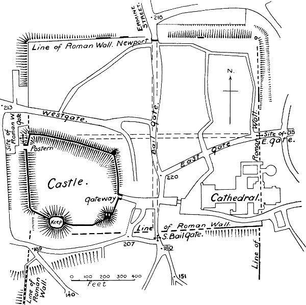
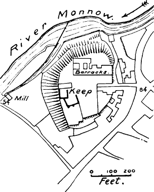
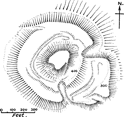
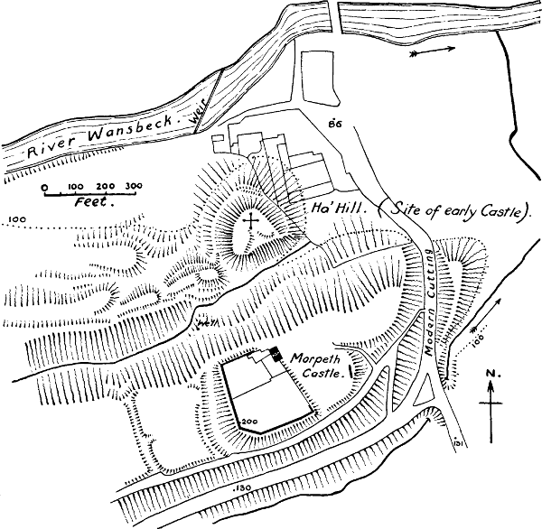
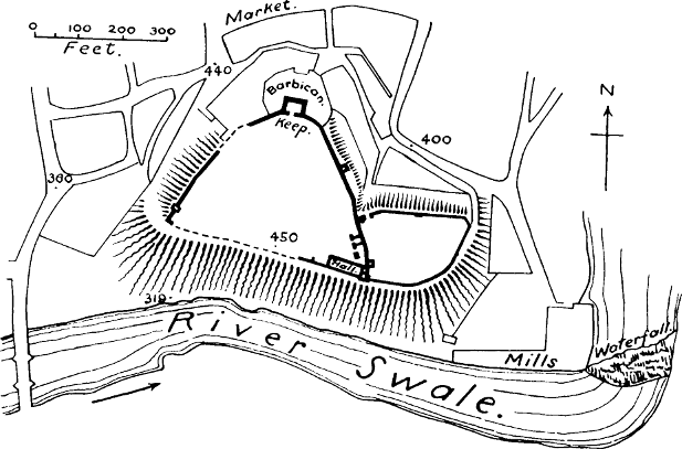
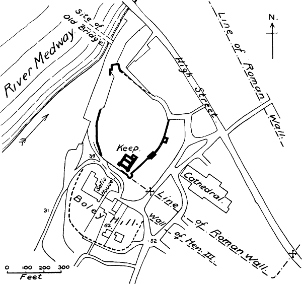
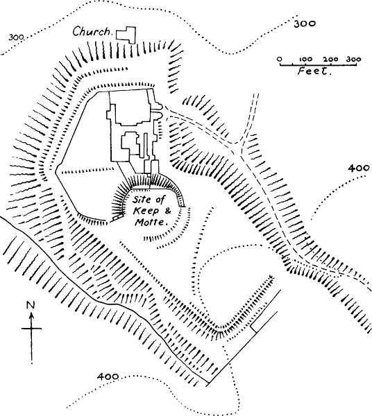
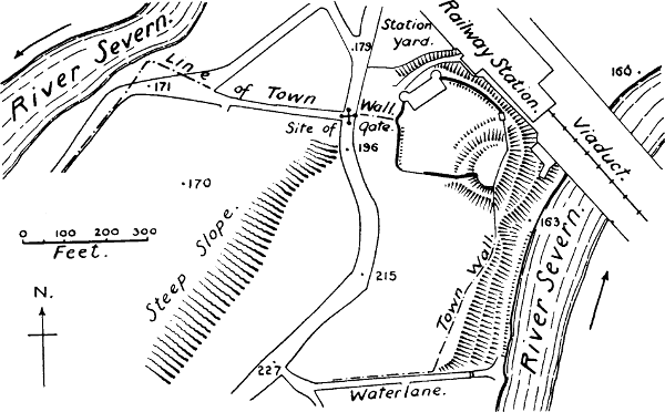
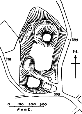
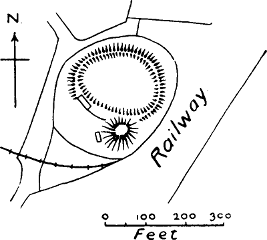
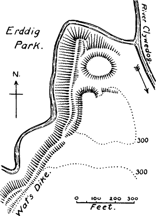
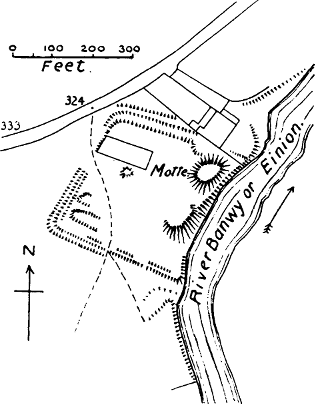
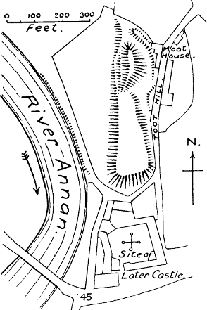
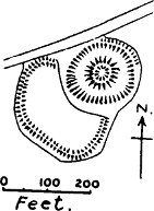
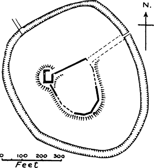
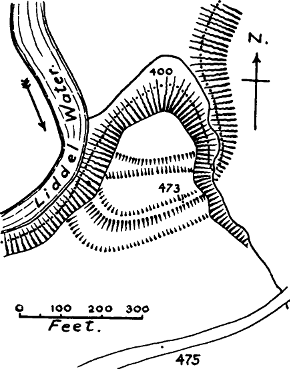
In this chapter we propose to give a list, in alphabetical
order for convenience of reference, of the castles which
are known to have existed in England in the 11th century,
because they are mentioned either in Domesday Book,
or in charters of the period, or in some contemporary
chronicle.[241] We do not for a moment suppose that this
catalogue of eighty-four castles is a complete list of those
which were built in England in the reigns of William I. and
William II. We have little doubt that all the castles in
the county towns, such as Leicester, Northampton, and
Guildford, and those which we hear of first as the seats
of important nobles in the reign of Henry II., such as
Marlborough, Groby, Bungay, Ongar, were castles built
shortly after the Conquest, nearly all of them being
places which have (or had) mottes. Domesday Book
only mentions fifty castles in England and Wales,[242] but
it is well known that the Survey is as capricious in its
mention of castles as in its mention of churches. It is
possible that further research in charters which the
writer has been unable to examine may furnish additional
castles, but the list now given may be regarded as
complete as far as materials generally accessible will
allow.[243] One of the castles mentioned (Richard’s Castle)
and probably two others (Hereford and Ewias) existed
before the Conquest; they were the work of those
Norman friends of Edward the Confessor whom he
endowed with lands in England.
Out of this list of eighty-four castles we shall find
that no less than seventy-one have or had mottes. The
exceptions are the Tower of London, Colchester,
Pevensey, and Chepstow, where a stone keep was part
of the original design, and a motte was therefore
unnecessary: Bamborough, Peak, and Tynemouth,
where the site was sufficiently defended by precipices:
Carlisle and Richmond, whose original design is unknown
to us: Belvoir, Dover, Exeter, and Monmouth,
which might on many grounds be counted as motte-castles,
but as the evidence is not conclusive, we do
not mark them as such; but even if we leave them out,
with the other exceptions, we shall find that nearly 86
per cent. of our list of castles of the 11th century are of
the motte-and-bailey type.
About forty-three of these castles are attached to
towns. Of these, less than a third are placed inside
the Roman walls or the Saxon or Danish earthworks
of the towns, while at least two-thirds are wholly or
partly outside these enclosures.[244] This circumstance is
important, because the position outside the town indicates
the mistrust of an invader, not the confidence of a
native prince. In the only two cases where we know
anything of the position of the residence of the Saxon
kings we find it in the middle of the city.[245] Even when
the castle is inside the town walls it is almost invariably
close to the walls, so that an escape into the country
might always be possible.[246]
Of the towns or manors in which these castles were
situated, Domesday Book gives us the value in King
Edward’s and King William’s time in sixty-two instances.
In forty-five cases the value has risen; in twelve it has
fallen; in five it is stationary. Evidently something has
caused a great increase of prosperity in these cases, and
it can hardly be anything else than the impetus given to
trade through the security afforded by a Norman castle.
Our list shows that Mr Clark’s confident statement,
that the moated mounds were the centres of large and
important estates in Saxon times, was a dream. Out
of forty-one mottes in country districts, thirty-six are
found in places which were quite insignificant in King
Edward’s day, and only five can be said to occupy the
centres of important Saxon manors.[247]
In the table in the Appendix, the area occupied by
the original baileys of the castles in this list has
been measured accurately by a planimeter, from the
25-in. Ordnance maps, in all cases in which that was
possible.[248] This table proves that the early Norman
castles were very small in area, suitable only for the
personal defence of a chieftain who had only a small
force at his disposal, and absolutely unsuited for a
people in the tribal state of development, like the
ancient Britons, or for the scheme of national defence
inaugurated by Alfred and Edward. We may remark
here that in not a single case is any masonry which
is certainly early Norman to be found on one of these
mottes; where the date can be ascertained, the stonework
is invariably later than the 11th century.
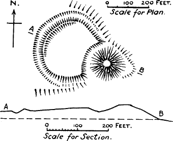
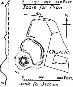
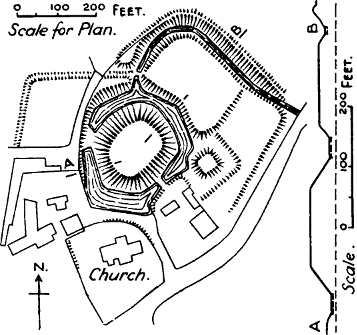
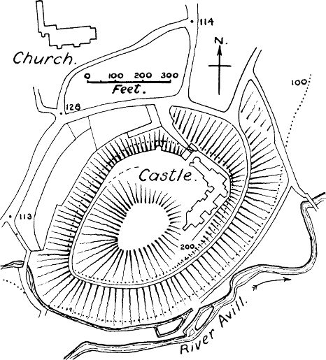
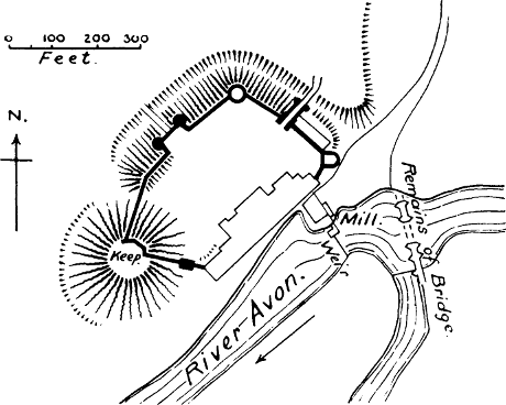
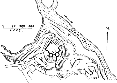
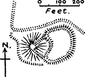
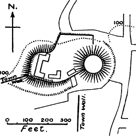
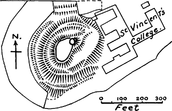
Abergavenny (Fig. 8).—This castle, being in
Monmouthshire, must be included in our list. The
earliest notice of it is a document stating that Hamelin
de Ballon gave the church and chapel of the castle of
Abergavenny, and the land for making a bourg, and an
oven of their own, to the Abbey of St Vincent at
Le Mans.[249]
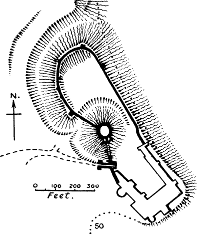
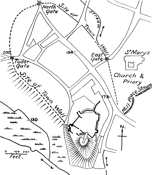
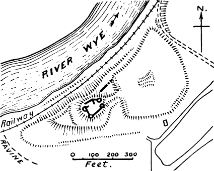
The castle occupies a pointed spur at the S. end
of the town, whose walls converge so as to include the
castle as part of the defence. The motte has been
much altered during recent years, and is crowned by
a modern building; but a plan in Coxe’s Tour in
Monmouthshire, 1800, shows it in its original round
form. The bailey is roughly of a pentagonal shape,
covering 1 acre, and is defended by a curtain wall with
mural towers and a gatehouse. The ditch on the W.
and N. is much filled in and obscured by the
encroachment of the town. On the E. the ground
descends in a steep scarp, which merges into those of
the headland on which the motte is placed.[250]
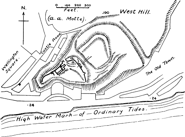
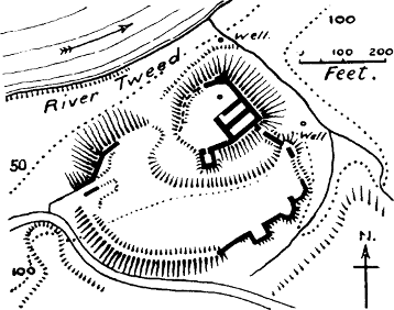
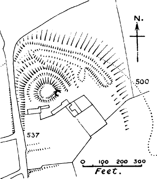
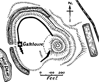
Fig. 8.
Arundel (Fig. 8).—“The castrum of Arundel,”
says Domesday Book, “paid 40s. in King Edward’s
time from a certain mill, and 20s. from three boardlands
(or feorm-lands), and 2s. from one pasture. Now,
between the town feorm and the water-gate and the
ships’ dues, it pays 12l.”[251] Castrum in Domesday nearly
always means a castle; yet the description here given
is certainly that of a town and not of a castle.
We must therefore regard it as an instance of the
fluctuating meaning which both castrum and castellum
had in the 11th century.[252] Arundel is one of the towns
mentioned in the “Burghal Hidage.”[253] But even accepting
that the description in Domesday refers to the town,
we can have very little doubt that the original earthen
castle was reared by Roger de Montgomeri, to whom
William I. gave the Rapes of Arundel and Chichester,
and whom he afterwards made Earl of Shrewsbury.[254]
Roger had contributed sixty ships to William’s fleet,
and both he and his sons were highly favoured and
trusted by William, until the sons forfeited that
confidence. We shall see afterwards that their names
are connected with several important castles of the
early Norman settlement. We shall see also that the
Rapes into which Sussex was divided—Chichester,
Arundel, Bramber, Lewes, Pevensey, and Hastings—were
all furnished with Norman castles, each with the
characteristic motte, except Pevensey, which had a
stone keep. Each of these castles, at the time of the
Survey, defended a port by which direct access could
be had to Normandy. It was to protect his base
that William fortified these important estuaries, and
committed them to the keeping of some of the most
prominent of the Norman leaders.
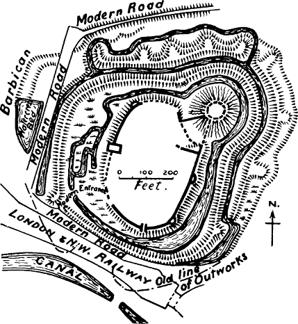
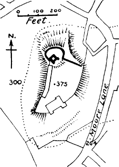
The castle stands on the end of a high and narrow
ridge of the South Downs, above the town of Arundel.
It consists of an oblong ward, covering 4½ acres, in the
middle of which, but on the line of the west wall, is a
large motte, about 70 feet high, surrounded by its own
ditch. The lower and perhaps original bailey is only
2 acres in extent. Round the top of the motte is a
slightly oval wall, of the kind called by Mr Clark a
shell keep. We have elsewhere expressed our doubts of
the correctness of this term.[255] In all the more important
castles we find that the keep on top of the motte has a
small ward attached to it, and Arundel is no exception
to this rule; it has the remains of a tower, as well as
the wall round the motte. The tower is a small one,
but it is large enough for the king’s chamber in times
which were not extravagant in domestic architecture.
It is probable that this tower, and the stone wall round
the motte are the work of Henry II., as he spent nearly
340l. on this castle between the years 1170 and 1187.
His work consisted chiefly of a wall, a king’s chamber,
a chapel, and a tower.[256] The wall of the motte corresponds
in style to the work of the middle of his reign;
it is built of flints, but cased with Caen stone brought
from Normandy, and has Norman buttresses. The
original Norman doorway on the south side (now walled
up) has the chevron moulding, which shows that it is
not earlier than the 12th century. The tower, which we
may assume to be the tower of Henry II.’s records, has
a round arched entrance, and contains a chapel and a
chamber (now ruined) besides a well chamber.
There is earlier Norman work still remaining in the
bailey, namely, the fine gateway, which though of plain
and severe Norman, is larger and loftier than the early
work of that style, and of superior masonry.[257] The one
Pipe Roll of Henry I. which we possess shows that he
spent 78l. 6s. 2d. on the castle in 1130, and possibly
this refers to this gatehouse.[258] We know that Henry
was a great builder, but so was the former owner of this
castle, Robert Belesme, son of Roger de Montgomeri.
The value of the town of Arundel had greatly
increased since the Conquest, at the time of the
Domesday Survey.[259]
Bamborough, Northumberland.—We first hear of
this castle in the reign of Rufus, when it was defended
against the king by Robert Mowbray, the rebel Earl of
Northumberland; but there can be little doubt that the
earliest castle on this natural bastion was built in the
Conqueror’s reign. In the 13th century certain lands
were held by the tenure of supplying wood to the castle
of Bamborough, and it was declared that this obligation
had existed ever since the time of William I.[260] William
certainly found no castle there, for Bamborough had
fallen into utter ruin and desolation by the middle of
the 11th century.[261] William’s hold on Northumberland
was too precarious to give opportunity for so long and
costly a work as the building of a stone keep. It is
more probable that a strong wooden castle was the
fortress of the governors of Northumberland under the
first Norman kings, and that the present stone keep was
built in Henry II.’s reign.[262] There is no motte at
Bamborough, nor was one needed on a site which is
itself a natural motte, more precipitous and defensible
than any artificial hill.[263] As the Domesday Survey does
not extend to Northumberland, we have no statement
of the value of Bamborough. The area of the castle is
4¾ acres.
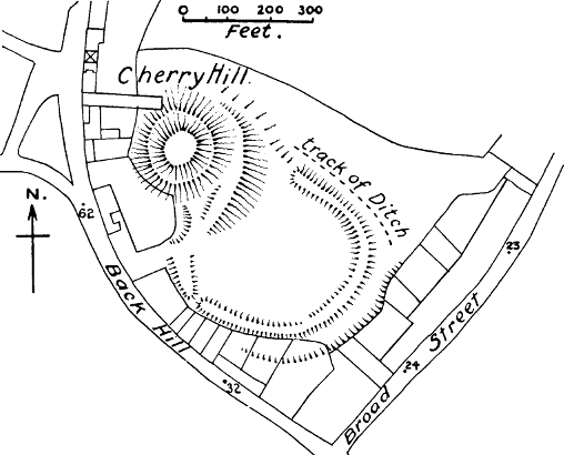
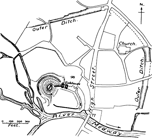
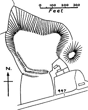
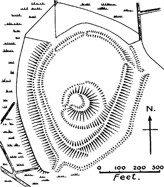
Barnstaple, Devon (Fig. 9).—This castle is not
mentioned in Domesday, but the town belonged to
Judhael, one of the followers of the Conqueror, whose
name suggests a Breton origin. William gave him
large estates in Devon and Cornwall. A charter of
Judhael’s to the priory which he founded at Barnstaple
makes mention of the castle.[264] Barnstaple, at the head
of the estuary of the Taw, was a borough at Domesday,
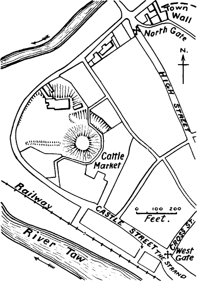
and the castle was placed inside the town walls.[265] The
motte remains in good condition; the winding walks
which now lead to the top are certainly no part of the
original plan, but are generally found in cases where the
motte has been incorporated in a garden. There was
formerly a stone keep, of which no vestige remains.[266]
The castle seems to have formed the apex of a town
of roughly triangular shape. The bailey can just be
traced, and must have covered 1⅓ acres.
The former value of Barnstaple is not given in the
Survey, so we cannot tell whether it had risen or not.
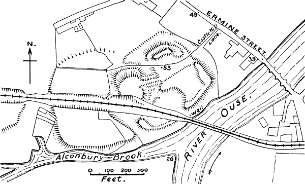
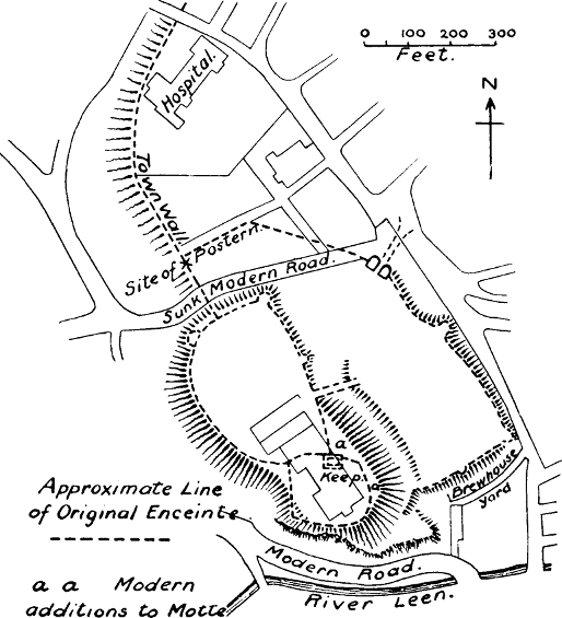
Fig. 9.
Belvoir, Leicester.—This castle was founded by
the Norman Robert de Todeni, who died in 1088.[267] It
stands on a natural hill, so steep and isolated that it
might be called a natural motte. The first castle was
destroyed by King John, and the modernising of the
site has entirely destroyed any earthworks which
may have existed on the hill. There appears to have
been a shell wall, from the descriptions given by
Nicholls and Leland.[268] It was situated in the manor of
Bottesdene, a manor of no great importance, but which
had risen in value at the date of the Survey.[269]
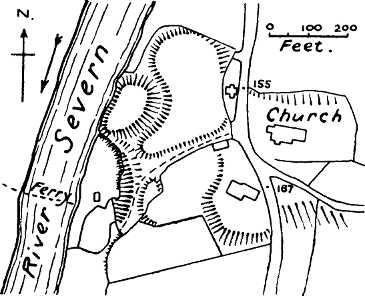
Berkeley, or Ness.—The identity of Berkeley Castle
with the Ness castle of Domesday may be regarded as
certain. All that the Survey says about it is: “In
Ness there are five hides belonging to Berkeley, which
Earl William put out to make a little castle.”[270] Earl
William is William FitzOsbern, the trusty friend and
counsellor of the Conqueror, who had made him Earl
of Herefordshire. He had also authority over the north
and west of England during William’s first absence in
Normandy, and part of the commission he received from
William was to build castles where they were needed.[271]
Berkeley was a royal manor with a large number of
berewicks, and the probable meaning of the passage in
Domesday is that Earl William removed the geldability
of the five hides occupying the peninsula or ness which
stretches from Berkeley to the Severn, bounded on the
south by the Little Avon, and appropriated these lands
to the upkeep of a small castle. This castle can hardly
have been placed anywhere but at Berkeley, for there is
no trace of any other castle in the district.[272] Earl
Godwin had sometimes resided at Berkeley, but probably
his residence there was the monastery which by
evil means had come into his hands;[273] for we never hear
of any castle in connection with Godwin. But a
Norman motte exists at Berkeley, though buried in the
stone shell built by Henry II. Mr Clark remarks: “If
the masonry of Berkeley Castle were removed, its
remains would show a mound of earth, and attached to
three sides of it a platform, the whole encircled with a
ditch or scarp.”[274] The motte raised by Earl William
has, in fact, been revetted with a stone shell of the 12th
century, whose bold chevron ornament over the entrance
gives evidence of its epoch. What is still more remarkable
is that documentary evidence exists to fix the date
of this transformation. A charter of Henry II. is
preserved at Berkeley Castle, in which he grants the
manor to Robert Fitzhardinge, pledging himself at the
same time to fortify a castle there, according to Robert’s
wish.[275] Robert’s wish probably was to possess a stone
keep, like those which had been rising in so many
places during the 12th century. But there had been a
Norman lord at Berkeley before Fitzhardinge, Roger
de Berkeley, whose representatives only lost the manor
through having taken sides with Stephen in the civil
war.[276] This Roger no doubt occupied the wooden castle
on the motte built by William FitzOsbern. Henry II.’s
shell was probably the first masonry connected with
the castle. This remarkable keep is nearly circular,
and has three round turrets and one oblong. As the
latter, Thorpe’s Tower, was rebuilt in Edward III.’s
reign, it probably took the place of a round tower. The
keep is built of rubble, and its Norman buttresses (it
has several later ones) project about a foot. The cross
loopholes in the walls are undoubtedly insertions of the
time of Edward III. The buildings in the bailey are
chiefly of the time of Edward III., but the bailey walls
have some Norman buttresses, and are probably of the
same date as the keep.[277] This bailey is nearly square,
and the motte, which is in one corner, encroaches upon
about a quarter of it. The small size of the area
which it encloses, not much more than half an
acre, corresponds to the statement of Domesday
Book that it was “a little castle.” There is no trace
of the usual ditch surrounding the motte, and the
smallness of the bailey makes it unlikely that there
ever was one. A second bailey has been added
to the first,[278] and the whole is surrounded on three
sides by a moat, the fourth side having formerly had
a steep descent into swamps, which formed sufficient
protection.[279]
There is no statement in the Survey of the value of
Ness, but the whole manor of Berkeley had risen since
the Conquest.[280]
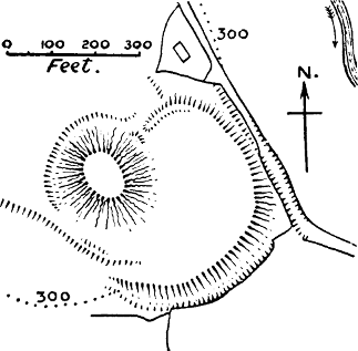
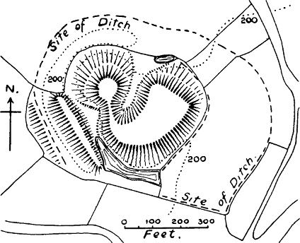
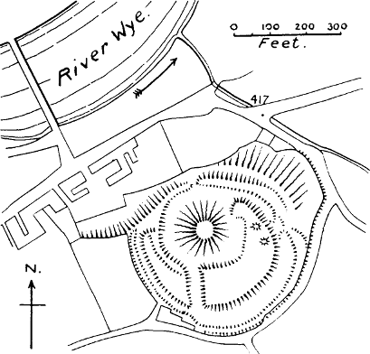
Berkhampstead, Herts (Fig. 9).—Mr D. H.
Montgomerie rightly calls this a magnificent example of
an earthwork fortress.[281] It is first mentioned in a
charter of Richard I., which recapitulates the original
charter of William, son of Robert, Count of Mortain, in
which he gives the chapel of this castle to the Abbey of
Grestein in Normandy.[282] We may, therefore, with all
probability look upon this as one of the castles built by
the Conqueror’s half-brother. And this will account for
the exceptional strength of the work, which comprises a
motte 40 feet high, ditched round (formerly), and a
bailey of 2⅔ acres, surrounded not only with the usual
ditch and banks, but with a second ditch outside the
counterscarp bank, which encircles both motte and
bailey. At two important points in its line, this counterscarp
bank is enlarged into mounds which have evidently
once carried wooden towers;[283] if this arrangement
belonged to the original plan, as it most probably did,
it confirms a remark which we have made elsewhere
as to the early use of wooden mural towers. Works
in masonry were added to the motte and the bailey
banks in the 12th, 13th, and 14th centuries. There
are traces of a semicircular earthwork outside the
second ditch on the west, which appears to have
formed a barbican. But the most exceptional thing
about this castle is the series of earthen platforms
on the north and east, connected by a bank, and
closely investing the external ditch, which were formerly
supposed to form part of the castle works. Mr
W. St John Hope has suggested the far more plausible
theory that they were the siege platforms erected
by Louis, the Dauphin of France, in 1216. We are
told that his engines kept up a most destructive fire
of stones.[284]
The value of the manor of Berkhampstead had considerably
decreased, even since the Count of Mortain
received it.[285]
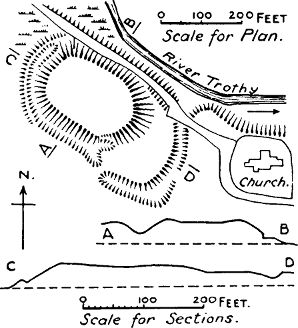
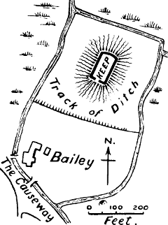
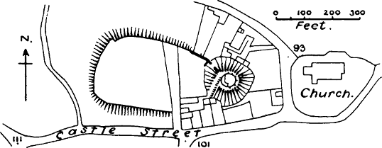
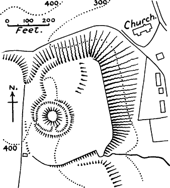
Bishop’s Stortford, Herts (Fig. 9).—Waytemore
Castle is the name given to the large oval motte at this
place, which is evidently the site of the castle of
“Estorteford,” given by William the Conqueror to
Maurice, Bishop of London.[286] The manor of Stortford
had been bought from King William by Maurice’s
predecessor, William, who had been one of the Norman
favourites of Edward the Confessor.[287] He may have
built this castle, but he cannot have built it till after the
Conquest, as the land did not belong to his see till then.
“The castle consists of a large oval motte, 250 × 200
feet at its base, rising 40 feet above the marshes of the
river Stort, and crowned by a keep with walls of flint
rubble, 12 feet thick. On the S. of the motte there
are traces of a pentagonal bailey, covering 2½ acres. It
is enclosed on four sides by the narrow streams which
intersect the marshes. The dry ditch on the fifth side,
facing the motte, is discernible. The castle abuts on
the road called The Causeway, which crosses the valley;
it is in a good position to command both road and
river.”[288] The value of the manor had gone down at
Domesday.[289]
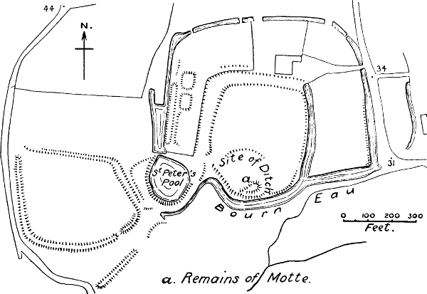
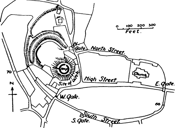
Bourn, Lincolnshire (Fig. 10).—The manor of Bourn
or Brune appears to have been much split up amongst
various owners at the time of Domesday. A Breton
named Oger held the demesne.[290] A charter of Picot,
the Sheriff of Cambridgeshire, a person often mentioned
in Domesday Book, gives the church of Brune and the
chapel of the castle to the priory which he had founded
near the castle of Cambridge—afterwards removed to
Barnwell.[291] Bourn was the centre of a large soke in
Anglo-Saxon times. Leland mentions the “Grete
Diches, and the Dungeon Hill of the ancient Castel,”[292]
but very little of the remains is now visible, and the
motte has been almost removed.
“The castle lies in flat ground, well watered by
springs and streams. The motte was placed at the
southern apex of a roughly oval bailey, from which it
was separated by its own wet ditch, access being
obtained through a gatehouse which stood on the narrow
neck by which this innermost enclosure, at its N.W.
end, joined the principal bailey, which, in its turn,
was embraced on all sides but the S. by a second
and concentric bailey, also defended by a wet ditch,
which broadens out at the S.W. corner into St
Peter’s Pool. There is another enclosure beyond this
which may be of later date. The inner bailey covers
3 acres. Very little is now left of the motte, but a plan
made in 1861 showed it to be fairly perfect,[293] and some
slight remains of the gatehouse were excavated in that
year. The castle is on the line of the Roman road from
Peterborough to Sleaford, and close to the Roman Car-Dyke.”[294]
The value of Bourn had risen at Domesday.
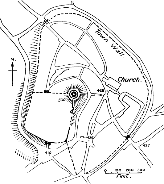
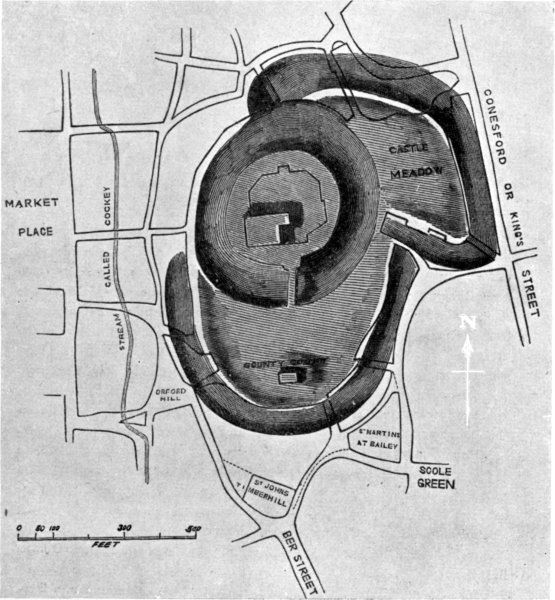
Fig. 10.
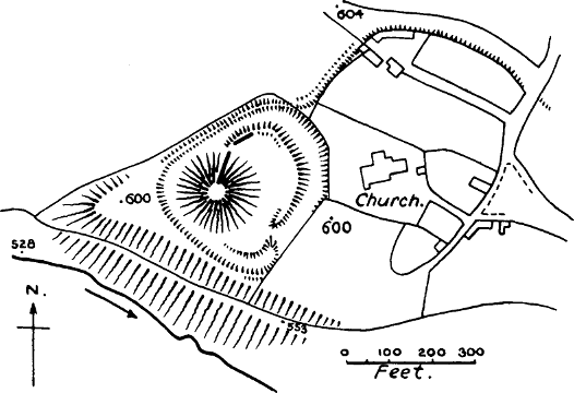
Bramber, Sussex (Fig. 10).—Of the manor of
Washington, in which Bramber is situated, the
Survey says that it formerly paid geld for fifty-nine
hides; and in one of these hides sits the castle of
Bramber.[295] It must not be imagined that the castle
occupied a whole hide, which according to the latest
computations would average about 120 acres. It is
evident that there had been some special arrangement
between the King and William de Braose, the Norman
tenant-in-chief, by which the whole geld of the manor
had been remitted. The Domesday scribe waxes almost
pathetic over the loss to the fisc of this valuable prey.
“It used to be ad firmam for 100l.,” he says. The
manor of Washington belonged to Gurth, the brother of
Harold, before the Conquest, but it is clear that
Bramber was not the caput of the manor in Saxon times;
nor was Washington the centre of a large soke.
Bramber Castle was constructed to defend the estuary
of the river, now known as the Adur, one of the waterways
to Normandy already alluded to.
The castle occupies a natural hill which forms on the
top a pear-shaped area of 3 acres. Towards the middle
rises an artificial motte about 30 feet high; there is no
sign of a special ditch around it, except that the ground
sinks slightly at its base. The bailey is surrounded by
a very neatly built wall of pebbles and flints, laid
herring-bone-wise in places, which does not stand on
an earthen bank. The absence of this bank makes it
likely, though of course not certain, that this wall was
the original work of De Braose; the stones of which it
is composed would be almost as easily obtained as the
earth for a bank. On the line of the wall, just east of
the entrance, stands a tall fragment of an early Norman
tower. The workmanship of this tower, which is also of
flints laid herring-bone-wise, with quoins of ashlar, so
strongly resembles that of the neighbouring church that
it seems obvious that both were built at about the same
time.[296] The church is dedicated to St Nicholas, who was
worshipped in Normandy as early as 1067;[297] it was
probably the Normans who introduced his worship into
England. Both church and tower are undoubtedly early
Norman. The motte shows no sign of masonry.
The value of the manor of Washington had slightly
risen since the Conquest.
Bristol.—Robert, Earl of Gloucester, the Empress
Matilda’s half-brother and great champion, is always
credited with the building of Bristol Castle; but this is
one of the many instances in which the man who first
rebuilds a castle in stone receives the credit of being the
original founder.[298] For it is certain that there was a
castle at Bristol long before the days of Earl Robert, as
the Anglo-Saxon Chronicle mentions it in 1088, when it
was held by Geoffrey, Bishop of Coutances, and Robert
Curthose against William II.; and Symeon of Durham,
in the same year, speaks of it as a “castrum fortissimum.”
Bishop Geoffrey held Bristol at the date of
the Domesday Survey, and he probably built the castle
by William’s orders.[299] It was completely destroyed in
1655 (only a few 13th century arches in a private
house now remain), and no trustworthy plan has been
preserved, but there is clear evidence that it was a
motte-and-bailey castle of the usual Norman type.[300] In
Stephen’s reign it was described as standing on a very
great agger.[301] An agger does not necessarily mean a
motte, but it is often used for one, and there is other
evidence which shows that this is its meaning here. A
Perambulation of the bounds of Bristol in 1373 shows
that the south-western part of the castle ditch, which
enclosed the site of the keep, was called le Mot-dich;
which should certainly be translated the ditch of the
motte, and not, as Seyer translates it, the moat ditch.[302]
Finally, the description of the castle in 1642 by Major
Wood, says: “The castle stood upon a lofty steep mount,
that was not minable, as Lieutenant Clifton informed
me, for he said the mount whereon the castle stood was
of an earthy substance for a certain depth, but below
that a firm strong rock, and that he had searched
purposely with an auger and found it so in all parts.”[303]
He goes on to describe the wall of the bailey as resting
on an earthen rampart, testifying to the wooden
stockade of the first castle. The great tower of Earl
Robert appears to have been placed on the motte, which
must have been of considerable size, as it held not only
the keep, but a courtyard, a chapel, and the constable’s
house, besides several towers on its walls. The whole
area of the castle was very nearly 4 acres.[304]
Bristol Castle was no doubt originally a royal castle,
though Earl Robert of Gloucester held it in right of his
wife, who had inherited it from her father, Robert Fitz
Hamon; but the crown did not abdicate its claim upon
it, and after the troubles of 1174, Henry II. caused the
son of Earl Robert to surrender the keep into his
hands.[305]
Seyer very pertinently remarks that Bristol Castle
“was erected with a design hostile to the town; for it
occupies the peninsula between two rivers, along which
was the direct and original communication between the
town and the main part of Gloucestershire.”[306] It was
outside the city, and was not under its jurisdiction till
James I. granted this authority by charter.[307] The value
T. R. E. is not given in Domesday Book.
Buckingham.—The only mention of this castle as
existing in the 11th century is in the Gesta Herewardi,[308]
an undated work which is certainly in great part a
romance, but as it is written by some one who evidently
had local knowledge, we may probably trust him for the
existence of Buckingham Castle at that date; especially
as Buckingham was a county town, and one of the
boroughs of the Burghal Hidage, the very place which
we should expect to find occupied by a Norman castle.
This writer speaks of the castle as belonging to Ivo de
Taillebois; this is not inconsistent with the fact shown
by Domesday Book, that the borough belonged to the
king. That it was a motte-and-bailey castle is indicated
by Speed’s map of Buckingham in 1611; he speaks of
the “high hill,” though he only indicates it slightly in
his plan, with a shield-shaped bailey. Brayley states
that the present church is “proudly exalted on the
summit of an artificial mount, anciently occupied by a
castle.”[309]
The castle hill occupies a strong position on the
neck of land made by a bend of the river; it extends
nearly half-way across it, and commands both town and
river. The original earthworks of the castle were
destroyed and levelled for the erection of a church in
1777, but the large oval hill remains, having a flat
summit about 2 acres in extent, and about 30 feet above
the town below. Its sides descend in steep scarps
behind the houses on all sides but the north-east.
There can be no doubt that the motte has been
lowered, and thus enlarged, in order to build the church.
The foundations of a stone castle were found in digging
a cellar on the slope of the motte.[310]
The value of Buckingham had considerably risen at
the date of Domesday.[311]
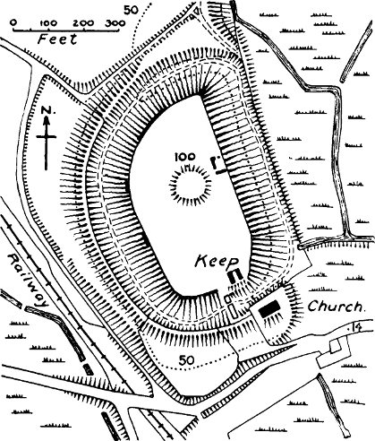
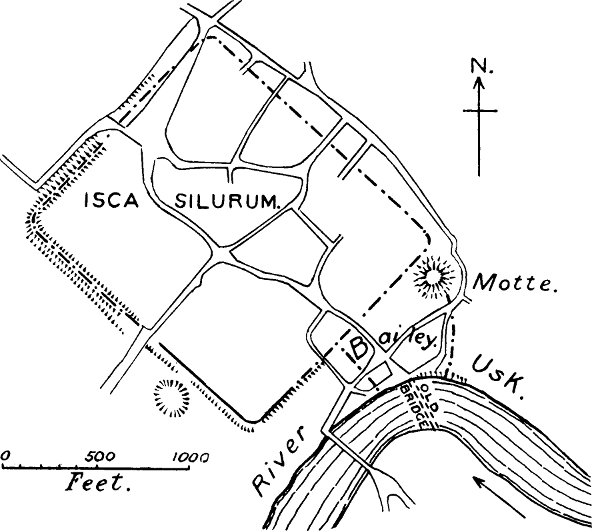
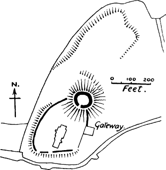
Caerleon, Monmouthshire (Fig. 11).—Domesday
Book speaks of the castellaria of Caerleon.[312] A castellaria
appears to have meant a district in which the land
was held by the service of castle-guard in a neighbouring
castle. The Survey goes on to say that this
land was waste in the time of King Edward, and when
William de Scohies, the Domesday tenant, received it;
now it is worth 40s. Wasta, Mr Round has remarked,
is one of the pitfalls of the Survey. Perhaps we shall
not be far wrong if we say that in a general way it
means that there was nobody there to pay geld. When
this occurs in a town it may point to the devastations
committed at the Conquest; but when it occurs in the
country, and when it is accompanied by so clear a statement
that the land which was wasta in King Edward’s
time and at the Conquest is now producing revenue, the
inference would seem to be clear that the castle of
Caerleon was built on uninhabited land. Caerleon, however,
had been a great city in Roman times, and had
kept up its importance at least till the days of Edgar,
when it is twice mentioned in Welsh history.[313] It must
therefore have gone downhill very rapidly. Giraldus
mentions among the ruins of Roman greatness which
were to be seen in his day, a gigantic tower, and this is
commonly supposed to have belonged to the castle.[314] It
certainly did not, for Giraldus is clearly speaking of a
Roman tower, and the motte of the Norman castle not
only has no signs of masonry, but has been thrown up
over the ruins of a Roman villa which had been burnt.[315]
The motte and other remains of the castle are outside
the Roman castrum, between it and the river. The
bailey is roughly pentagonal, and covers 4¾ acres.
The manor of Caerleon was waste T. R. E. and had
risen to 40s. T. R. W.[316]
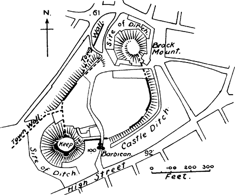
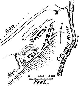
Fig. 11.
Cambridge.—Ordericus tells us that William built
this castle on his return from his first visit to Yorkshire
in 1068,[317] and Domesday Book states that twenty-seven
houses were destroyed to make room for the castle.[318]
There can hardly be a clearer statement that the castle
was entirely new. We have already seen that there is
some probability that Cambridge was first fortified by
the Danes; for though it has been assumed to be a
Roman castrum, no Roman remains have ever been
found there, and the names which suggest Roman
occupation, Chesterton and Grantchester, are at some
distance from Cambridge. The castle, according to Mr
St John Hope’s plan,[319] was placed inside this enclosure,
and the destruction of the houses to make room for it is
thus explained. The motte and a portion of the bank of
the bailey are all that now remain of the castle, but the
valuable ancient maps republished by Mr Hope show
that the motte had its own ditch, and that the bailey was
rectangular. There was formerly a round tower on the
motte, which, if it had the cross-loop-holes and machicolations
represented in the print published in 1575, was
certainly not of Norman date. The area of the bailey
was 4¼ acres.[320] The castle was a royal one, and like
many royal castles, went early to ruin. Henry IV. gave
the materials of the hall to the master and wardens of
King’s Hall for building their chapel.
The value of Cambridge T. R. W. is not given in
Domesday Book.
Canterbury.—Domesday Book only mentions this
castle incidentally in connection with an exchange of
land: “The archbishop has seven houses and the
abbot of St Augustine fourteen for the exchange of
the castle.”[321] It has been too hastily assumed
that it was a pre-Conquest castle which was thus
exchanged for twenty-one houses; but anyone who
knows the kind of relations which existed chronically
between the archbishop of Canterbury and the abbot
of St Augustine’s will perceive that it was an impossibility
that these two potentates should have held
a castle in common. It was the land for the castle,
not the castle itself, which the king got from these
ecclesiastics. This is rendered clear by a passage in
the Chartulary of St Augustine’s, which tells us that
the king, who was mesne lord of the city of Canterbury,
had lost the rent of thirty-two houses through
the exchange of the castle: seven having gone to the
archbishop, fourteen to the abbot, and eleven having
been destroyed in making the ditch of the castle.[322]
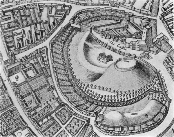
There can scarcely be any doubt that the hillock now
known by the ridiculous name of Dane John is the motte
of this original castle of the Conqueror. Its proper
name, the Dungeon Hill, which it bore till the 16th and
even the 18th century,[323] shows what its origin was; it was
the hill on which stood the dungeon or donjon of a
Norman castle.[324] The name Dane John is not so much a
corruption as a deliberate perversion introduced by the
antiquary Somner about 1640, under the idea that the
Danes threw up the hill—an idea for which there is not
the slightest historical evidence.[325] We have seen that
there is no reason to think that the Danes ever
constructed fortifications of this kind, and their connection
with this earthwork is due to one of those guesses,
too common in English archæology, which have no
scientific basis whatever.
Somner makes the important statement that this
earthwork was originally outside the city walls. His
words are:—
“I am persuaded (and so may easily, I think, anyone be that well
observes the place) that the works both within and without the present wall
of the city were not counterworks one against the other, as the vulgar
opinion goes, but were sometimes all one entire plot containing about 3
acres of ground, of a triangular form (the outwork) with a mount or hill
entrenched round within it; and that when first made or cast up it lay
wholly without the city wall; and hath been (the hill or mount, and most
part also of the outwork), for the city’s more security, taken in and walled
since; that side of the trench encompassing the mound now lying without
and under the wall fitly meeting with the rest of the city ditch, after either
side of the earthwork was cut through to make way for it, at the time of the
city’s inditching.”[326]
It is not often we are so fortunate as to have so clear
a description of an earthwork which has almost entirely
disappeared; but the description is confirmed by
Stukeley and Hasted, and down to the making of the
Chatham and Dover railway in 1860 the earthworks of
the part of the bailey which was left outside the city wall
were still to be seen, and were noticed by Mr G. T.
Clark.[327] It is clear that Somner’s description corresponds
exactly, even in the detail of size, to the type of a motte-and-bailey
castle.
There are certain facts, which have not been put
together before, which enable us to make a very probable
guess as to the date at which this ancient castle was cut
through by the newer city bank. The walls of Canterbury
have never yet received so careful an examination
as those of Rochester have had from the Rev. Greville
Livett;[328] but the researches of Mr Pilbrow about thirty
years ago showed that the original Roman walls included
a very small area, which would leave both the motte and
the Plantagenet castle outside.[329] Certain entries in the
Close Rolls show that the fortification of the town of
Canterbury was going on in the years 1215-1225.[330] But
it is too often forgotten that where a wall stands on an
earthen bank it is a clear proof that before the wall was
built there was a wooden stockade in its place. Now
the portion of the city wall which encloses the Dane John
stands on an earthen bank; so, indeed, does the whole
wall from the Northgate to the castle. It is clear that
this piece of bank cannot have been made till the first
Norman castle, represented by the earthwork, was
abandoned; and fortunately we have some evidence
which suggests a date for the change. In the Pipe Rolls
of Henry II.’s reign there are yearly entries, beginning
in 1168, of 5s. paid to Adeliza Fitzsimon “for
the exchange of her land which is in the castle of
Canterbury.” There can be little doubt that this land
was purchased to build the great Plantagenet castle
whose splendid keep was once one of the finest in
England.[331] The portion of the castle wall which can
still be seen does not stand on an earthen bank, an
indication (though not a proof) that the castle was on a
new site. Henry II. was a great builder of stone keeps,
but he seldom placed them on artificial mottes. It is no
uncommon thing to find an old motte-and-bailey castle
abandoned for a better or larger site close at hand.[332]
The bailey of the second castle, according to
Hasted, extended almost to the Dane John, which is
about 800 feet from the present keep. The part of the
older castle which lay outside the new city bank was
possessed by a family of the name of Chiche from the
time of Henry II. to that of Edward IV., while the
Dungeon Hill itself remained royal property.[333] That
the new bank was Henry II.’s work we may conjecture
from the passages in the Pipe Rolls, which show that
between the years 1166 and 1173 he spent about £30
in enclosing the city of Canterbury and making a gate.
We are therefore not without grounds for concluding
that Henry II. was the first to enlarge the city by
taking in the Dane John, cutting through the ancient
bailey, and at the same time enclosing a piece of land
for a new stone castle.[334] The very small sum paid for the
city gate (11s., equal to about £11 of our money)
suggests that the gate put up by Henry II. was a
wooden gateway in the new stockaded bank. The
stone walls and towers which were afterwards placed
on the bank are of much later date than his reign.[335]
The Dungeon Hill appears to have been used for
the last time as a fortification in 1643, when ordnance
was placed upon it, and it was ordered to be guarded
by the householders.[336] In 1790 it was converted into
a pleasure-ground for the city; the wide and deep
ditch which had surrounded it was filled up, and
serpentine walks cut to lead up to the summit.
Brayley says that “the ancient and venerable character
of this eminence was wholly destroyed by incongruous
additions.” Still, enough remains to show that it was
once a very fine motte, such as we might expect the
Conqueror to raise to hold in check one of the most
important cities of his new realm.
The value of Canterbury had increased from 51l. to
54l. since the days of King Edward.[337]
Carisbrooke, Isle of Wight (Fig. 11).—There can
be no doubt that this is the castle spoken of in Domesday
Book under the manor of Alwinestone. Carisbrooke
is in the immediate neighbourhood of Alvington. The
language in which the Survey speaks of this manor is
worthy of note. “The king holds Alwinestone: Donnus
held it. It then paid geld as two and a half hides: now
as two hides, because the castle sits in one virgate.”[338]
Certain entries similar to this in other places seem to
indicate that there was some remission of geld granted
on the building of a castle;[339] but as here the king was
himself the owner, the remission must have been
granted to his tenants.
The original castle of Carisbrooke consists of a high
motte, ditched round, placed at the corner of a parallelogram
with rounded corners. This bailey, covering 2¾
acres, is surrounded by high banks, which testify to the
former presence of a wooden stockade. There is
another bailey on the eastern side, called the Tilt-yard.
The excellent little local guide-book compiled by
Mr Stone calls this a British camp, but there is no
reason to believe that it was anything else than what
it appears to be—a second bailey added as the castle
grew in importance. On the motte is a shell of
polygonal form, of rubble masonry, but having quoins
of well-dressed ashlar. It is believed to be of the time
of Henry I., since the author of the Gesta Stephani
states that Baldwin de Redvers, son of Richard de
Redvers, to whom Henry granted the lordship of the
Isle of Wight, had a castle there splendidly built of
stone, defended by a strong fortification.[340] This would
indicate that, besides the stone keep, stone walls were
added to the earthworks of the Domesday castle. The
keep is of peculiar interest, as it still retains the remains
of the old arrangements in keeps of this style, though
of much later date. The motte was opened in 1893,
and was found to be composed of alternate layers of
large and small chalk rubble.[341] Little attention has
hitherto been paid to the construction of these Norman
mottes, but other instances have been noted which show
that they were often built with great care. The whole
castle, including the Tilt-yard, was surrounded with an
elaborate polygonal fortification in Elizabeth’s reign,
when the Spanish invasion was expected.
The value of the manor of Alvington had increased
at the time of the Survey, though the number of ploughs
employed had actually decreased. This increase must
have been owing to the erection of the castle, which
provided security for trade and agriculture. Alvington
was not the centre of a large soke in the Confessor’s
time, so it is unlikely that there was any fortification
there in Saxon days.[342]
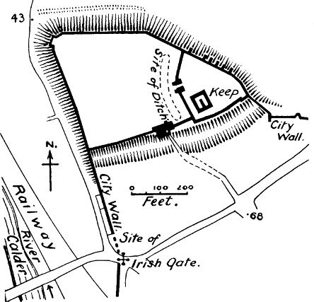
Carlisle, Cumberland (Fig. 12).—This castle was built
by William Rufus in 1092, when for the first time Cumberland
was brought under Norman sway. The Anglo-Saxon
Chronicle says, “he repaired the burh, and reared
the castle,” a passage which is sufficient of itself to show
that burh and castle were two quite different things.
Carlisle of course was a Roman fortress, and needed only
the repairing of its walls. The castle was a new thing,
and was placed outside the city. Its plan, which is
roughly a triangle, with the apex formed into a small
court by a ditch which (formerly) separated it from the
bailey, looks very suggestive of a previous motte and
bailey, such as we might expect the Norman king to
have thrown up. The keep is known to have been built
by David, king of Scotland, in Stephen’s reign,[343] and
it is possible that he may have removed the motte. The
castle appears to have had a wooden pelum or palicium
on its outer banks as late as 1319.[344] The whole area
covers 4 acres.
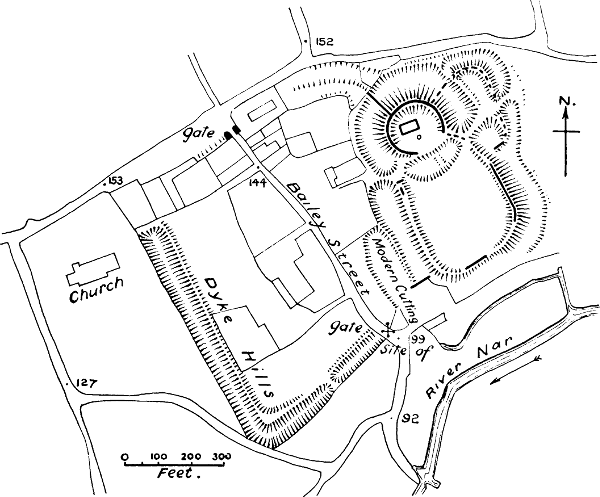
Castle Acre, Norfolk (Fig. 12).—There can be no
doubt that this castle existed in the 11th century, as
William de Warenne mentions it in the charter of
foundation of Lewes Priory, one of the most interesting
and human of monastic charters.[345] The earthworks still
remaining of this castle are perhaps the finest castle
earthworks in England; the banks enclosing the bailey
are vast. The large and high motte carries a wall
of flint rubble, built outside and thus revetting the earthen
bank which formed its first defence. In the small court
thus enclosed (about 100 feet in diameter) the foundations
of an oblong keep can be discerned. A very wide ditch
surrounds the motte, and below it is a horse-shoe bailey,
about 2 acres in extent, stretching down to the former
swamps of the river Nar. On the east side of the motte
is a small half-moon annexe, with its own ditch; this
curious addition is to be found in several other motte
castles,[346] and is believed to have been a work intended
to defend the approach, of the nature of a barbican. On
the west side of the motte is the village of Castle Acre,
enclosed in an oblong earthwork with an area of 10
acres. This work now goes by the name of the
Barbican, but probably this name has been extended
to it from a barbican covering the castle entrance (of
which entrance the ruins still remain). It is most likely
that this enclosure was a burgus attached to the castle.
Mr Harrod, who excavated the banks, found quantities
of Roman pottery, which led him to think that the work
was Roman; but as the pottery was all broken, it is
more likely that the banks were thrown up on the site
of some Roman villa.[347] This earthwork has a northern
entrance in masonry, evidently of 13th century date;
and as the scanty masonry remaining of the castle is
similar in character, it is probably all of the same date.
The area covered by the motte and the two original
baileys is 3½ acres; that of the whole series of earthworks,
15 acres.
Acre was only a small manor in Saxon times; its
value at the time of the Survey had risen from 5l. to 9l.[348]
Fig. 12.
Chepstow (Estrighoel or Strigul), Monmouthshire.—Notwithstanding
the fact that there is another castle of
the name of Strigul about 9 miles from Chepstow (known
also as Troggy Castle), it is clear that Chepstow is the
castle meant by Domesday, as the entry speaks of ships
going up the river, a thing impossible at Strigul.[349] The
castle occupies a narrow ridge, well defended by the
river on one side, and on the other by a valley which
separates it from the town. There are four wards, and
the last and smallest of all seemed to the writer, when
visiting the castle, to mark the site of a lowered motte.
This opinion, however, is not shared by two competent
observers, Mr Harold Sands and Mr Duncan Montgomerie,
who had much ampler opportunities for
studying the remains. This ward is now a barbican,
and the masonry upon it belongs clearly to the 13th
century; it occupies the highest ground in the castle,
and is separated from the other wards, and from the
ridge beyond it, by two ditches cut across the headland.
The adjoining court must have belonged to the earliest
part of the castle, as it contains a very remarkable early
Norman building (splendidly restored in the 13th century)
which is regarded by most authorities as the original
hall of William FitzOsbern. It must, however, have
combined both hall and keep, otherwise the castle was
not provided with any citadel, if there was no motte.[350]
What is now the second ward has a Norman postern in
the south wall, and may have been the bailey to the keep.
All the other masonry is of the late Early English or
the Perpendicular period, and the entrance ward is
probably an addition of the 13th century. The shape
of all the baileys is roughly quadrangular, except that
of the fourth, which would be semicircular but for the
towers which make corners to it. The whole area of
the castle is 1⅔ acres.
We are not told what the value of the manor was
before William FitzOsbern built his castle there, but
from the absence of this mention we may infer that the
site was waste. It paid 40s. in his time from ships’
dues, 16l. in his son Earl Roger’s time, and at the date
of the Survey it paid the king 12l.[351] Chepstow was not
the centre of a large soke, and it appears to have owed
all its importance to the creation of William FitzOsbern’s
castle.
Chester.—The statement of Ordericus, that
William I. founded this castle on his return from
his third visit to York, is sufficiently clear.[352] The very
valuable paper of Mr E. W. Cox on Chester Castle[353]
answers most of the questions which pertain to our
present inquiry. The original castle of Chester consisted
of the motte, which still remains, though much
built over, and the small ward on the edge of which
it stands, a polygonal enclosure scarcely an acre in
extent. On the motte the vaulted basement of a tower
still remains, but the style is so obscured by whitewash
and modern accretions that it is impossible to say
whether the vaulting is not modern. The first buildings
were certainly of wood, but Mr Cox regarded some of
the existing masonry on the motte as belonging to the
12th century; and this would correspond with the entry
in the Pipe Rolls of 102l. 7s. 0d. spent on the castle by
Henry II. in 1159.[354] The tower, nicknamed Cæsar’s
Tower, and frequently mistaken for the keep, is shown in
Mr Cox’s paper to be only a mural tower of the 13th
century, probably built when the first ward was
surrounded with walls and towers in masonry.[355] The
large outer bailey was first added in the reign of Henry
III.[356] It is further proved by Mr Cox that Chester
Castle stood outside the walls of the Roman city. The
manor of Gloverstone lay between it and the city, and
was not under the jurisdiction of the city until quite
recent times.[357] This disposes of the ball set rolling by
Brompton at the end of the 13th century, and sent on
by most Chester topographers ever since, that Ethelfleda,
when she restored the Roman walls of Chester,
enlarged their circuit so as to take in the castle. We
have already referred to this in Chapter III.
Chester, as we have seen, was originally a royal
castle. And though it was naturally committed to the
keeping of the Norman earls of Chester, and under weak
kings may have been regarded by the earls as their own
property, no such claim was allowed under a strong
ruler. After the insurrection of the younger Henry,
Hugh, Earl of Chester, forfeited his lands; Henry II.
restored them to him in 1177, but was careful to keep
the castle in his own hands.[358]
The city of Chester, Domesday Book tells us, had
greatly gone down in value when the earl received it,
probably in 1070; twenty-five houses had been destroyed.
But it had already recovered its prosperity at the date
of the Survey; there were as many houses as before, and
the ferm of the city was now let by the earl at a sum
greatly exceeding the ferm paid in King Edward’s time.[359]
This prosperity must have been due to the security
provided for the trade of Chester by the Norman castle
and Norman rule.
Fig. 13.
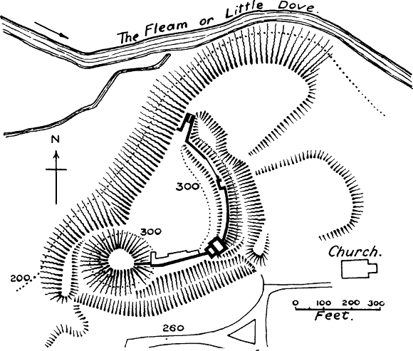
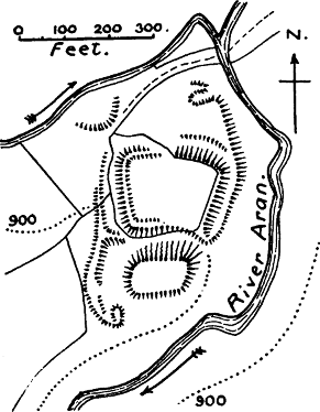
Clifford, Herefordshire (Fig. 13).—It is clearly
stated by Domesday Book that William FitzOsbern
built this castle on waste land.[360] At the date of the
Survey it was held by Ralph de Todeni, who had sub-let
it to the sheriff. In the many castles attributed to
William FitzOsbern, who built them as the king’s
vicegerent, we may see an indication that the building
of castles, even on the marches of Wales, was not
undertaken without royal license. In the reign of
Henry I. Clifford Castle had already passed into the
hands of Richard Fitz Pons, the ancestor of the
celebrated house of Clifford, and one of the barons of
Bernard de Neufmarché, the Norman conqueror of
Brecon.[361]
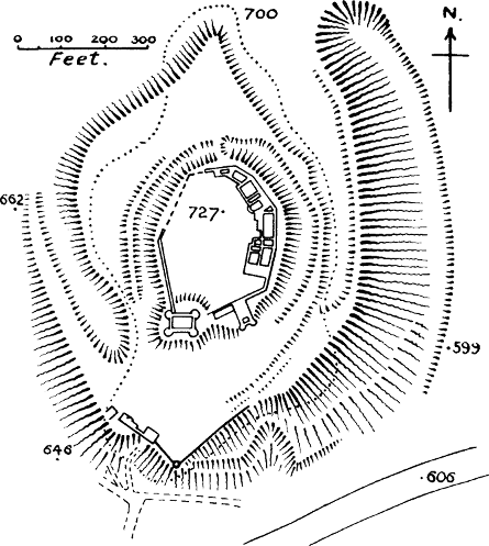
The castle has a large motte, roughly square in
shape, which must be in part artificial.[362] Attached to it
on the south-west is a curious triangular ward, included
in the ditch which surrounds the motte. The masonry
on the motte is entirely of the “Edwardian” style, when
keepless castles were built; it consists of the remains of
a hall, and a mural tower which is too small to be called
a keep. There is also a small court, with a wall which
stands on a low bank. Below the motte is an irregular
bailey of about 2⅓ acres, with earthen banks which do
not appear to have ever carried any masonry, though in
the middle of the court there is a small mound which
evidently covers the remains of buildings. The whole
area of the castle, including the motte and the two
baileys, is about 3½ acres.
The value of the manor had apparently risen from
nothing to 8l. 5s. Clifford was not the centre of a
large soke.
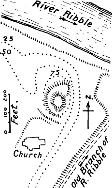
Clitheroe, Lancashire (Fig. 13).—There is no
express mention of this castle in Domesday Book, but
of two places in Yorkshire, Barnoldswick and Calton, it
is said that they are in the castellate of Roger the
Poitevin.[363] A castellate implies a castle, and as there is
no other castle in the Craven district (to which the
words of the Survey relate) except Skipton, which did
not form part of Roger’s property, there is no reason to
doubt that this castle was Clitheroe, which for centuries
was the centre of the Honour of that name. The whole
land between the Ribble and the Mersey had been given
by William I. to this Roger, the third son of his trusted
supporter, Earl Roger of Shrewsbury. One can understand
why William gave important frontier posts to the
energetic and unscrupulous young men of the house of
Montgomeri, one of whom was the adviser and architect
of William Rufus, another a notable warrior in
North Wales, another the conqueror of Pembrokeshire.
As it appears from the Survey that Roger’s possessions
stretched far beyond the Ribble into Yorkshire and
Cumberland, it seems quite possible—though here we
are in the region of conjecture—that just as his father
and brothers had a free hand to conquer as they listed
from the North and South Welsh, so Roger had a
similar commission for the hilly districts still unconquered
in the north-west of England. But fortune did
not favour the Montgomeri family for long. They were
exiled from England in 1102 for siding with Robert
Curthose, and in the same year we find the castle of
Clitheroe in the hands of Robert de Lacy, lord of the
great Yorkshire fief of Pontefract.[364]
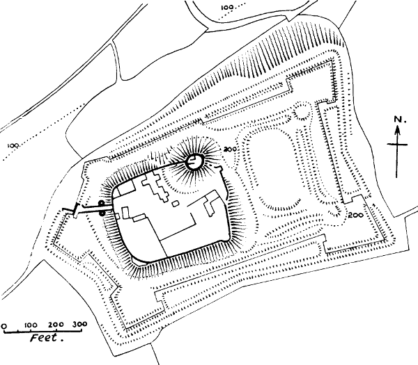
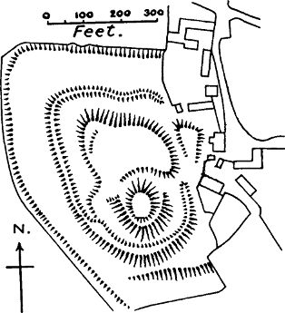
The castle of Clitheroe stands on a lofty motte of
natural rock.[365] There are no earthworks on the summit,
but a stout wall of limestone rubble without buttresses
encloses a small court, on whose south-west side stands
the keep. It is just possible that the outer wall may be
the original work of Roger, as limestone rubble would be
easier to get than earth on this rocky hill. The keep is
small, rudely built of rubble, and has neither fireplace
nor garde-robe, nor the slightest ornamental detail—not
even a string course. But in spite of the entire absence
of ornament, a decorative effect has been sought and
obtained by making the quoins, voussoirs, and lintels of
a dressed yellow sandstone. The care with which this
has been done is inconsistent with the haste with which
Roger must inevitably have constructed his first fortification,
if we suppose, as is probable, that he received the
first grant of his northern lands on William’s return
in 1070 from his third visit to the north, when he made
that remarkable march through Lancashire to Chester
which is described by Ordericus. It seems more likely
that even if the outer wall or shell were the work of
Roger, he had only wooden buildings inside its circuit.
Dugdale attributes the building of the keep to the
second Robert de Lacy, between 1187 and 1194, and it
is probable that this date is correct.[366] The bailey of
Clitheroe lay considerably below the keep, and is now
overbuilt with a modern house, offices, and garden. It
covers one acre. A Roman road up the valley of the
Ribble passes near the foot of the rock.[367]
As the very name of Clitheroe is not mentioned in
Domesday Book, it clearly was not an important centre
in Saxon times. The value of Blackburn Hundred, in
which Clitheroe is situated, had fallen between the
Confessor’s time and the time when Roger received it.
It is quite possible that he never lived at Clitheroe, as
he sub-infeoffed the manor and Hundred of Blackburn
to Roger de Busli and Albert Greslet before 1086.[368]
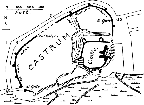
Colchester, Essex.—The remarkable keep of this
castle has been the subject of antiquarian legend for
many centuries, and Mr Clark has the merit of having
proved its early Norman origin, by its plan and architecture.
A charter of Henry I. is preserved in the
cartulary of St John’s Abbey at Colchester, which
grants to Eudes the Dapifer “the city of Colchester,
and the tower and the castle, and all the fortifications of
the castle, just as my father had them and my brother
and myself.”[369] This proves that the keep and castle
were in existence in the Conqueror’s time; the Norman
character of the architecture proves that the keep was
not in existence earlier. We see, then, that the reason
there is no motte at Colchester is that there was a stone
keep built when first the castle was founded. As far as
we are aware, Colchester, the Tower of London, and the
recently discovered keep of Pevensey are the only certain
instances of stone keeps of the 11th century in England.
That one of the most important of the Conqueror’s
castles, second only to the Tower of London, and
actually exceeding it in the area it covers, should be
found in Colchester, is not surprising, because the
Eastern counties at the time of the Conquest were not
only the wealthiest part of the kingdom (as Domesday
Book clearly shows[370]), but they also needed special
protection from the attacks of Scandinavian enemies.
Mr Round has conjectured that the castle was built at
the time of the invasion of St Cnut, between 1080 and
1085.[371]
The castle is built of Roman stones used over again,
with rows of tiles introduced between the courses with
much decorative effect.[372] The original doorway was on
the first floor, as in most Norman keeps; but at some
after time, probably in the reign of Henry I.,[373] the present
doorway was inserted; and most likely the handsome
stairway which now leads up from this basement
entrance was added, as it shows clear marks of insertion.
Henry II. was working on the walls of the castle in
1182, and it may be strongly suspected that the repairs
in ashlar, and the casing of the buttresses with ashlar,
were his work.[374] One item in the accounts of Henry II.
is £50 “for making the bailey round the castle.”[375]
There were two baileys to the castle of Colchester—the
inner one, which scarcely covered 2 acres, and the outer
one, which contained about 11. The inner bailey was
enclosed at first with an earthwork and stockade, the
earthwork being thrown up over the remains of some
Roman walls, whose line it does not follow. Afterwards
a stone wall was built on the earthwork, the foundations
of which can still be traced in the west rampart.[376] The
outer bailey, which lay to the north, extended on two
sides to the Roman walls of the town; on the west side
it had a rampart and stockade. If the £50 spent by
Henry II. represents the cost of a stone wall round the
inner bailey, then the palicium blown down by the wind
in 1219 must have been the wooden stockade on the
west side of the outer bailey.[377] The question is difficult
to decide, but at any rate the entry proves that as late
as Henry III.’s reign, some part of the outer defences
of Colchester Castle was still of timber.
The position of Colchester Castle is exceptional in
one respect, that the castle is almost in the middle of
the town. But this very unusual position is explained
by Mr Round’s statement that the land forming the
castle baileys, as well as that afterwards given to the
Grey Friars on the east, was crown demesne before the
Conquest, and consequently had been cultivated land, so
that we do not hear of any houses in Colchester being
destroyed for the site of the castle.[378] But by keeping
this land as the inalienable appendage of the royal castle
William secured that communication between the castle
and the outside country which was so essential to the
invaders.
The value of the city of Colchester had risen enormously
at the date of the Survey.[379]
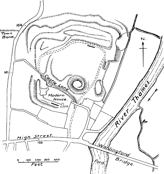
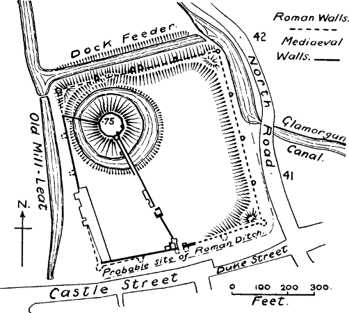
Corfe, Dorset (Fig. 13).—Mr Eyton has shown that
for the castellum Warham of Domesday Book we ought
to read Corfe, because the castle was built in the manor
of Kingston, four miles from Wareham.[380] And this is
made clear by the Testa de Nevill, which says that the
church of Gillingham was given to the nunnery of
Shaftesbury in exchange for the land on which the
castle of Corfe is placed.[381] Because King Edward the
Martyr was murdered at Corfe, at some place where his
stepmother Elfrida was residing, it has been inferred
that there was a Saxon castle at Corfe; and because
there is a building with some herring-bone work among
the present ruins, it has been assumed that this building
is the remains of that castle or palace. But the Anglo-Saxon
Chronicle, the only contemporary authority for
the event, says nothing of any castle at Corfe, but simply
tells us that Edward was slain at Corfe Geat, a name
which evidently alludes to a gap or passage through the
chalk hills, such as there is at Corfe.[382] Nor is there any
mention of Corfe as a fortress in Anglo-Saxon times;
it is not named in the Burghal Hidage, and we do not
hear of any sieges of it by the Danes. Nor is it likely
that the Saxons would have had a fortress at Corfe,
when they had a fortified town so near as Wareham.[383]
Kingston, the manor in which Corfe is situated, was not
an important place, as it had no dependent soke. The
language of Domesday absolutely upsets the idea of any
Saxon castle or palace at Corfe, as it tells us that
William obtained the land for his castle from the nuns
of Shaftesbury, and we may be quite sure they had no
castle there.[384]
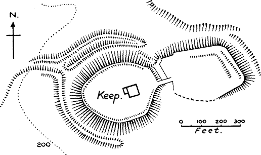
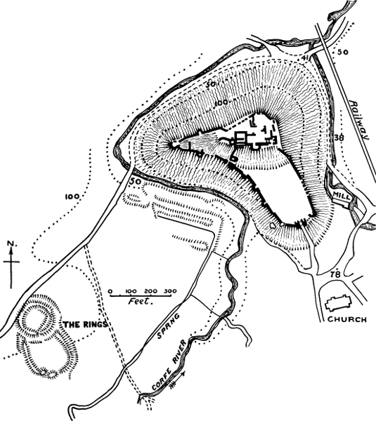
Corfe Castle stands on a natural hill, which has been
so scarped artificially that the highest part now forms a
large motte. Three wards exist—the eastern or motte
ward, the western, and the southern. The two former
probably formed the original castle. On the motte
(which possibly is not artificial, but formed by scarping)
stands the lofty keep, of splendid workmanship,
probably of the time of Henry I. In the ward
pertaining to it are buildings of the time of John and
Henry III.[385] The western ward has towers of the 13th
century, but it also contains the interesting remains of
an early Norman building, probably a hall or chapel,
built largely of herring-bone work; this is the building
which has been so positively asserted to be a Saxon
palace. But herring-bone masonry, which used to be
thought an infallible sign of Saxon work, is now found
to be more often Norman.[386] The building is certainly
an ancient one, and may possibly have been contemporary
with the first Norman castle; its details are
unmistakably Norman. But very likely it was the only
Norman masonry of the 11th century at Corfe Castle.[387]
It is clear that the stone wall which at present surrounds
the western bailey did not exist when the hall (or
chapel) was built, as it blocks up its southern windows.
Probably there was a palisade at first on the edge of
the scarp. Palisades still formed part of the defences of
the castle in the time of Henry III., when 62l. was
paid “for making two good walls in place of the
palisades at Corfe between the old bailey of the said
castle and the middle bailey towards the west, and
between the keep of the said castle and the outer bailey
towards the south.”[388] This shows that the present
wing-walls down from the motte were previously represented
by stockades. The ditch between the keep and
the southern bailey has been attributed to King John,
on the strength of an entry in the Close Rolls which
orders fifteen miners and stone-masons to work on the
banks of the ditch in 1214.[389] But we may be quite
certain that this ditch below the motte belonged to the
original plan of the castle; John’s work would be either
to line it with masonry, or to enlarge it. It is not
without significance for the early history of the castle
that Durandus the carpenter held the manor of
Mouldham near Corfe, by the service of finding a
carpenter to work at the keep whenever required.[390]
The area of Corfe Castle, if we include the large
southern bailey, is 3¾ acres; without it, 1½ acres. This
bailey was certainly in existence in the reign of Henry
III. (as the extract from the Close Rolls proves) before
the towers of superb masonry were added to it by
Edward I.
The value of Kingston Manor had considerably
increased at the date of the Survey. After the Count
of Mortain forfeited his lands (in 1105), the castle of
Corfe was kept in the hands of the crown, and this
increases the probability that the keep was built by
Henry I.
About 400 yards S.W. of Corfe Castle is an
earthwork which might be called a “Ring and Bailey.”
Instead of the usual motte there is a circular enclosure,
defended by a bank and ditch of about the same height
as those of its bailey, but having in addition an interior
platform or berm. This work is probably the remains
of a camp thrown up by Stephen during his unsuccessful
siege of Corfe Castle in 1139.
Fig. 14.
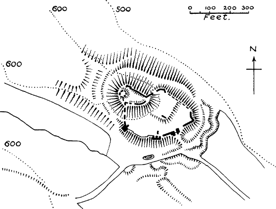
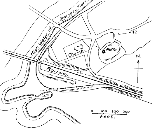
Dover, Kent (Fig. 14).—The Norman historian,
William of Poitiers, tells us that the castrum of Dover
was built by Harold at his own expense.[391] This comes
from the celebrated story of the oath of Harold to
William, a story of which Mr Freeman says that there
is no portion of our history more entangled in the mazes
of contradictory and often impossible statements.[392] But
let us assume the statement about the castrum to be
true; the question then to be answered is this: of what
nature was that castrum? We never are told by
English chroniclers that Harold built any castles,
though we do hear of his fortifying towns. The present
writer would answer this question, tentatively indeed,
and under correction, by the theory that the castrum
constructed or repaired by Harold was the present outer
rampart of Dover Castle, which encloses an area of
about 34 acres, and may have enclosed more, if it was
formerly complete on the side towards the sea.[393] The
evidence in support of this theory is as follows:—
1. There certainly was a burh on the top of the cliff
at Dover in Saxon times, as the Anglo-Saxon Chronicle
tells us that in 1048 Eustace of Boulogne, after coming
to Dover, and slaying householders there, went up to
the burh, and slew people both within and without, but
was repulsed by the burh-men.[394] There was then a
burh, and valiant burh-men on the cliff at Dover in
Edward the Confessor’s reign. But the whole analogy
of the word burh makes it certain that by the time of
Edward it meant a fortified town.[395]
2. That the burh at Dover was of the nature of a
town, with houses in it, is confirmed by the poem of Guy
of Amiens, who says that when King William entered
the castrum, he ordered the English to evacuate their
houses.[396] William of Poitiers also states that there was an
innumerable multitude of people in the castle,[397] though
he may refer to a multitude gathered there for safety.
3. Though the whole of the outer enceinte is
generally credited to Hubert de Burgh in Henry III.’s
reign, the truth probably is that he built the first stone
walls and towers on the outer rampart; but the existence
of this earthen rampart shows that there was a wooden
wall upon it previously. It is not improbable that it
was for the repair of this wooden wall that so much
timber was sent to Dover in the reigns of Richard I.
and John.[398] Dering, who was lieutenant of the castle in
1629, records the tradition that the tower in the outer
enceinte, called Canons’ Gate, dates from Saxon times
(of course this could only be true of a wooden predecessor
of the stone tower), and that Godwin’s Tower, on
the east side of the outer vallum, existed as a postern
before the Conquest.[399] Nearly all the towers on this
wall were supported by certain manors held on the
tenure of castle-guard, and eight of them still retain the
names of eight knights to whom William is said to have
given lands on this tenure. Mr Round has shown that
the Warda Constabularii of Dover Castle can be traced
back to the Conquest, and that it is a mere legend that
it was given as a fief to a Fienes. He remarks that the
nine wards of the castle named in the Red Book of the
Exchequer are all reproduced in the names still attached
to the towers. “This coincidence of testimony leads us
to believe that the names must have been attached at a
very early period; and looking at the history of the
families named, it cannot have been later than that of
Henry II.”[400] May it not have been even earlier?
Eight of these names are attached to towers on the
outer circuit,[401] and five of them are found as landholders
in Kent in Domesday Book.
4. William of Poitiers further tells us that when the
duke had taken the castle, he remained there eight days,
to add the fortifications which were wanting.[402] What
was wanting to a Norman eye in Anglo-Saxon fortifications,
as far as we know them, was a citadel; and
without laying too much stress on the chronicler’s eight
days, we may assume that the short time spent by
William at Dover was just enough for the construction
of a motte and bailey, inside the castrum of Harold, but
crowned by wooden buildings only.
Taking these things together, we venture to assume
that the inner court in which the keep of Dover stands,
represents an original motte, or at any rate an original
citadel, added to the castle by William I. Whether
what now remains of this motte is in part artificial, we
do not pretend to say; it may be that it was formed
simply by digging a deep ditch round the highest knoll
of ground within the ancient ramparts.[403] Anyhow, it
is still in effect a motte, and a large one, containing not
only the magnificent keep, but a small ward as well.
That this keep was the work of Henry II. there can
be no manner of doubt; the Pipe Rolls show that he
spent more than £2000 on the turris or keep of Dover
Castle between the years 1181 and 1187, and Benedict
of Peterborough mentions the building of the keep at
this date.[404] The curtain around the motte may also be
reckoned to be his work originally, as the cingulum is
spoken of along with the turris in the accounts.
Modern alterations have left little of Norman character
in this curtain which shows at a glance, and the gateways
(one of which remains) belong to a later period.
Attached to this keep ward is another ward, whose
rampart is generally attributed to Saxon times. We
are not in a position positively to deny that the Saxons
had an inner earthwork on the highest part of the
ground within their burh. But considering that small
citadels are unusual in Saxon earthworks: considering
also that this bailey is attached to the motte in the
usual manner of a Norman bailey, and that its size
corresponds to the usual size of an original Norman
bailey in an important place, it does not seem unreasonable
to suppose that this was the original bailey attached
to the Conqueror’s motte. Its shape is singular, part
of it being nearly square, while at the S.E. corner a
large oval loop is thrown out, so as to enclose the
Roman Pharos and the Saxon church. The outline of
the bailey certainly suggests that it was built after the
Pharos and the church, and was built with reference
primarily to the keep or motte ward. The nature of
the ground, and the necessity of enclosing the church
and the Roman tower within the immediate bailey of
the castle, which would otherwise have been commanded
by them, were the other factors which decided the
unusual shape of the bailey.
On this earthwork the foundations of a rubble wall
were formerly to be traced,[405] probably built by Henry
II., as considerable sums for “the wall of the castle”
are mentioned in his accounts.[406] Whether there are still
any remains of this curtain we are unable to say, but so
many of the features of the middle ward have been
swept away by modern alterations, and the difficulty of
examining what remains, owing to military restrictions,
is so great, that little can be said about it, and we find
that most authorities observe a judicious silence on the
subject. But as the carriage of stone is expressly
mentioned in Henry II.’s accounts, we may with great
probability assign to him the transformation of the
original wooden castle of William into a castle of stone;
while the transformation of the Anglo-Saxon borough
into a stone enceinte was the work of Henry III.’s
reign.
We think the evidence suggests that this burh or
outer rampart was in existence when the Conqueror
came to Dover, crowned in all probability with a
stockade and towers of wood. It may possibly have
been a British or even a Roman earthwork originally
(though its outline does not suggest Roman work); or
it may have been built by Harold as a city of refuge
for the inhabitants of the port.[407] The Saxon church
which it encloses, and which has long been attributed
to the earliest days of Saxon Christianity, is now
pronounced by the best authorities to be comparatively
late in the style.[408]
The size of the inner castle of Dover appears to be
about 6 acres, reckoning the keep ward at 2, and
the bailey at about 4.
The value of the town of Dover had trebled at the
time of the Survey, in spite of the burning of the town
at William’s first advent.[409]
Fig. 15.
Dudley, Staffordshire (Fig. 15).—William Fitz
Ansculf held Dudley at the time of the Survey, “and
there is his castle.”[410] Mr Clark appears to accept the
dubious tradition of a Saxon Dodda, who first built this
castle in the 8th century, since he speaks of Dudley as
“a great English residence.”[411] This tradition, however,
is not supported by Domesday Book, which shows
Dudley to have been only a small and unimportant
manor before the Conquest. The strong position of the
hill was no doubt the reason why the Norman placed
his castle there. There is no Norman masonry in the
present ruins. The earliest work is that of the keep
on the motte, a rectangular tower with round corner
turrets, attributed by Mr W. St John Hope to about
1320. The first castle was demolished by Henry II. in
1175,[412] and an attempt to restore it in 1218 was stringently
countermanded.[413] The case of Dudley is one of
those which proves that Henry II. destroyed some
lawful castles in 1175 as well as the unlawful ones. In
1264 a license to restore it was granted to Roger de
Somery, in consideration of his devotion to the king’s
cause in the Barons’ War.[414] The whole area of the
castle, including the motte, but not including the works
at the base of the hill on which it stands, is 1¾ acres.
The bailey is an irregular oval, following the hill top.
Dudley is an instance in which the value of the manor
has gone down instead of up since the erection of the
castle; this may perhaps be laid to the account of the
devastation caused through the Staffordshire insurrection
of 1069.
Dunster, Somerset (Fig. 15).—Called Torre in
Domesday Book. “There William de Moion has his
castle.”[415] The motte here appears to be a natural rock
or tor, whose summit has been levelled and its sides
scarped by art. About 80 feet below the top is a
(roughly) half-moon bailey, itself a shelf on the side
of the hill; there is another and much smaller shelf
at the opposite end.[416] Some foundations found in the
S.W. corner of the upper ward appear to indicate a
former stone keep.[417] Dunster was only a small manor of
half a hide before the Conquest, but afterwards its value
tripled. There was a borough as well as a castle.[418]
The castle became the caput baroniæ of the De Moions,
to whom the Conqueror gave fifty-six manors in
different parts of the county. There is not the slightest
reason to suppose that the site was fortified before the
Conquest. Mr Clark remarks that “it is remarkable
that no mouldings or fragments of Norman ornament
have been dug up in or about the site, although there is
original Norman work in the parish church.” The
simple explanation, probably, is that the first castle of
De Moion was of wood, although on a site where it
would have been possible to build in stone from the
first, as it does not appear that any part of the motte is
artificial. The area of the bailey is 1¾ acres. The
value of Dunster had risen at the date of Domesday.[419]
Fig. 16.
Durham (Fig. 16).—The castle here was first
built by the Conqueror, on his return from his expedition
against Scotland in 1072.[420] It was intended as a
strong residence for the bishop, through whom William
hoped to govern this turbulent part of the country.
He placed it on the neck of the lofty peninsula on which
the cathedral stands. The motte of the Conqueror still
remains, and so does the chapel[421] which he built in the
bailey; probably the present court of the castle, though
crowded now with buildings, represents the outline of
the original bailey.[422] The present shell keep on the
motte was built by Bishop Hatfield in Edward III.’s
reign,[423] but has been extensively modernised. There
can be little doubt that up to 1345 there were only
wooden buildings on the motte, as the writer was
informed by Canon Greenwell that no remains of older
stone-work than the 14th century had been found there.
It is so seldom that we get any contemporary description
of a castle of this kind, that it seems worth while
to translate the bombastic verse in which Laurence,
Prior of Durham, described that of Durham in
Stephen’s reign:[424]
“Not far hence [from the north road into the city]
a tumulus of rising earth explains the flatness of the
excavated summit, explains the narrow field on the
flattened vertex, which the apex of the castle occupies
with very pleasing art. On this open space the castle
is seated like a queen; from its threatening height, it
holds all that it sees as its own. From its gate, the
stubborn wall rises with the rising mound,[425] and rising
still further, makes towards the comfort (amæna) of the
keep. But the keep, compacted together, rises again
into thin air, strong within and without, well fitted for
its work, for within the ground rises higher by three
cubits than without—ground made sound by solid earth.
Above this, a stalwart house[426] springs yet higher than
the [shell] keep, glittering with splendid beauty in
every part; four posts are plain, on which it rests, one
post at each strong corner.[427] Each face is girded by a
beautiful gallery, which is fixed into the warlike wall.[428]
A bridge, rising from the chapel [in the bailey] gives
a ready ascent to the ramparts, easy to climb; starting
from them, a broad way makes the round of the top of
the wall, and this is the usual way to the top of the
citadel.... The bridge is divided into easy steps, no
headlong drop, but an easy slope from the top to the
bottom. Near the [head of the] bridge, a wall descends
from the citadel, turning its face westward towards the
river.[429] From the river’s lofty bank it turns away in a
broad curve to meet the field [i.e., Palace Green]. It
is no bare plot empty of buildings that this high wall
surrounds with its sweep, but one containing goodly
habitations.[430] There you will find two vast palaces built
with porches, the skill of whose builders the building
well reveals. There, too, the chapel stands out beautifully
raised on six pillars, not over vast, but fair enough
to view. Here chambers are joined to chambers, house
to house, each suited to the purpose that it serves....
There is a building in the middle of the castle which
has a deep well of abundant water.... The frowning
gate faces the rainy south, a gate that is strong, high-reaching,
easily held by the hand of a weakling or a
woman. The bridge is let down for egress,[431] and thus
the way goes across the broad moat. It goes to the
plain which is protected on all sides by a wall, where the
youth often held their joyous games. Thus the
castellan, and the castle artfully placed on the high
ridge, defend the northern side of the cathedral. And
from this castle a strong wall goes down southwards,
continued to the end of the church.”[432]
The original bailey of this castle covers 1 acre.
Ely, Cambridgeshire (Fig. 17).—This castle was
built by William I. in 1070, when he was repressing the
last struggle of the English under the heroic Hereward.
The monks of Ely felt it a sore grievance that he placed
the castle within their own bounds.[433] Both this castle
and the one built by William at Aldreth, to defend the
passage into the Isle of Ely, had a continuous existence,
as they were both refortified by Nigel, Bishop of Ely in
Stephen’s reign, and Ely Castle was besieged and taken
by Stephen.[434] The earthworks of this castle still exist,
to the south of the Minster. There is a fine motte with
an oval bailey, of which the banks and ditches are
traceable in parts. The area of the bailey is 2½ acres.
Of Aldreth or Aldrey there appear to be no remains.
The value of the manor of Ely was £33 in the
Confessor’s reign; it fell to £20 after the devastations
of the Conquest, but had risen again to £30 at the time
of the Survey.[435]
Fig. 17.
Ewias, Herefordshire (Fig. 17).—The brief notice of
this castle in Domesday Book throws some light on the
general theory of castle-building in England.[436] William
FitzOsbern, as the king’s vicegerent, rebuilt this march
castle, and committed it to the keeping of another
Norman noble, and the king confirmed the arrangement.
But in theory the castle would always be the king’s.
This is the only case in the Survey where we hear of a
castle being rebuilt by the Normans. We naturally look
to one of King Edward’s Norman favourites as the first
founder, for they alone are said by history to have built
castles on the Welsh marches before the Conquest.
Dr Round conjectures that Ewias was the “Pentecost’s
castle” spoken of in the (Peterborough) Anglo-Saxon
Chronicle in 1052.[437] No masonry is now to be seen
on the motte at Ewias, but Mr Clark states that the
outline of a circular or polygonal shell keep is shown by
a trench out of which the foundations have been removed.
The bailey is roughly of half-moon shape and the mound
oval. The whole area of the castle, including the motte
and banks, is 2-⅓ acres.
Exeter.—This castle is not mentioned in Domesday
Book, but Ordericus tells us that William chose a
site for the castle within the walls, and left Baldwin
de Molis, son of Count Gilbert, and other distinguished
knights, to finish the work, and remain as
a garrison.[438] In spite of this clear indication that the
castle was a new thing, it has been obstinately held that
it only occupied the site of some former castle, Roman
or Saxon.[439] Exeter, of course, was a Roman castrum,
and its walls had been restored by Athelstan. In this
case William placed his castle inside instead of outside
the city walls, because, owing to the natural situation of
Exeter, he found in the north-west corner a site which
commanded the whole city. Although Domesday Book
is silent about the castle, it tells us that forty-eight
houses in Exeter had been destroyed since William
came to England,[440] and Freeman remarks that “we may
assume that these houses were destroyed to make room
for the castle, though it is not expressly said that they
were.”[441]
Exeter Castle stands on a natural knoll, occupying
the north-west corner of the city, which has been
converted into a sort of square motte by digging a great
ditch round the two sides of its base towards the town.[442]
That this ditch is no pre-Roman work is shown by the
fact that it stops short at the Roman wall, and begins
again on the outside of it, where, however, the greater
part has been levelled to form the promenade of the
Northernhay or north rampart of the city. On top of
this hill, banks 30 feet high were thrown up, which still
remain, and give to the courtyard which they enclose
the appearance of a pit.[443] On top of these banks there
are now stone walls; but these were certainly no part
of the work of Baldwin de Molis, who must have placed
a wooden stockade on the banks which he constructed.
One piece of stonework he probably did set up, the
gatehouse, which by its triangle-headed windows and
its long-and-short work is almost certainly of the 11th
century. It has frequently been called Saxon, but
more careful critics now regard it as “work that must
have been done, if not by Norman hands, at Norman
bidding and on Norman design.”[444] It was no uncommon
thing at this early period to have gatehouses of stone
to walls of earth and wood. Of these gatehouses
Exeter is the most perfect and the most clearly stamped
with antiquity.
One thing we look for in vain at Exeter, and that is
a citadel. There is no keep, and there is no record that
there ever was one, though a chapel, hall, and other
houses are mentioned in ancient accounts. Mr Clark
says that probably the Normans regarded the whole
court as a shell keep. It certainly was, in effect, a
motte; but it was altogether exceptional among Norman
castles of importance if it had no bailey. And in fact a
bailey is mentioned in the Pipe Roll of 1 Richard I.,
where there is an entry for the cost of making a gaol in
the bailey of the castle.[445] Now Norden, who published
a plan of Exeter in 1619, says that the prison which
formerly existed at the bottom of Castle Lane (on the
south or city front of the present castle) was “built upon
Castle grounde,” and he states that the buildings and
gardens which have been made on this ground are
intrusions on the king’s rights.[446] The remarkably full
account of the siege of Exeter in the Gesta Stephani
speaks of an outer promurale which was taken by
Stephen, as well as the inner bridge leading from the
town to the castle, before the attack on the castle itself.
Unfortunately the word promurale has the same uncertainty
about it that attaches to so many mediæval
terms, and the description given of it would apply
either to the banks of a bailey, or to the heriçon
on the counterscarp of the ditch of the motte. We
must, therefore, leave it to the reader’s judgment
whether the evidence given above is sufficient to
establish the former existence of a bailey at Exeter,
and to place Exeter among the castles of the motte-and-bailey
type.
The description of the castle given by the writer of
the Gesta has many points of interest.[447] He describes
the castle as standing on a very high mound (editissimo
aggere) hedged in by an insurmountable wall, which
was defended by “Cæsarian” towers built with the very
hardest mortar. This must refer to Roman towers
which may have existed on the Roman part of the wall.
Whether there was a stone wall on the other two sides,
facing the city, may be doubted, as the expenditure
entered to Henry II. in the Pipe Rolls suggests that he
was the first to put stone walls on the banks, and the
two ancient towers which still exist appear to be of his
time.[448] The chronicler goes on to say that after Stephen
had taken the promurale and broken down the bridge,
there were several days and nights of fighting before he
could win the castle, which was eventually forced to
surrender by the drying-up of the wells. The mining
operations which he describes were no doubt undertaken
with the view of shaking down the Roman wall at the
angle where it joins the artificial bank of Baldwin de
Molis. Possibly the chamber in the rock with the
mysterious passages leading from it, which is still to be
seen in the garden of Miss Owthwaite, at the point
where the ditch ends, is the work of Stephen’s miners.[449]
The description of his soldiers scrambling up the agger
on their hands and knees (quadrupede incessu) will be
well understood by those who have seen the castle bank
as it still rises from that ditch.
The present ward of Exeter Castle, which is rudely
square in plan, covers an area of 2 acres, which is as
large as the whole area of many of the smaller Norman
castles. The castle was allowed to fall into decay as
early as 1549,[450] and since then it has been devastated by
the building of a Sessions House and a gaol. No plan
has been preserved of the former buildings in this court,
though the site of the chapel is known.
There is no statement in Domesday Book as to the
value of Exeter.
Eye, Suffolk (Fig. 17).—This castle was built by
William Malet, one of the companions of the Conqueror,
who is described as having been half Norman and half
English.[451] Eye, as its name implies, seems to have
been an island in a marsh in Norman times, and therefore
a naturally defensible situation. The references in
the Pipe Rolls to the palicium and the bretasches of Eye
Castle show that the outer defences of the castle at any
rate were of wood in the days of Henry II.[452] That
there were works in masonry at some subsequent period
is shown by a solitary vestige of a wing wall of flints
which runs up the motte. A modern tower now
occupies the summit. The bailey of the castle, the
outline of which can still be traced, though the area is
covered with buildings and gardens, was oval in shape,
and covered 2 acres.
The value of the manor of Eye had gone up since the
Conquest from £15 to £21. This must have been due to
the castle and to the market which Robert Malet or his
son William established close to the castle; for the stock
on the manor and the number of ploughs had actually
decreased.[453] A proof that there is no deliberate register
of castles in Domesday Book is furnished by the very
careful inventory of the manor of Eye, where there is no
mention of a castle, though it is noticed that there are
now a park and a market; and it is only in the account
of the lands of the bishop of Thetford, in mentioning
the injury which William Malet’s market at Eye had
done to the bishop’s market at Hoxne, that the castle of
Eye is named.
Gloucester.—“There were sixteen houses where
the castle sits, but now they are gone, and fourteen have
been destroyed in the burgus of the city,” says Domesday
Book.[454] Gloucester was undoubtedly a Roman
chester, and Roman pavements have been found there.[455]
The description in the Survey would lead us to think
that the castle was outside the ancient walls,[456] though
Speed’s map places it on the line of the wall of his time,
which may have been a mediæval extension. The castle
of Gloucester is now entirely destroyed, but there is
sufficient evidence to show that it was of the usual
Norman type. There was a motte, which was standing
in 1819, and which was then called the Barbican Hill;[457]
it appears to have been utilised as part of the works of
the barbican. This motte must originally have
supported a wooden keep, and Henry I. must have been
the builder of the stone keep which Leland saw “in the
middle of the area;”[458] for in 1100 Henry gave lands to
Gloucester Abbey “in exchange for the site where now
the keep of Gloucester stands.”[459] The bailey had
previously been enlarged by William Rufus.[460] Possibly
the framea turris or framework tower spoken of in
Henry II.’s reign may refer to the wooden keep which
had been left standing on the motte.[461] The walls of
Gloucester Castle were frequently repaired by Henry II.,[462]
but the word murus by no means implies always a stone
wall, and it is certain that the castle was at that time
surrounded by a wooden stockade, as a writ of a much
later period (1225) says that the stockade which is
around our castle of Gloucester has been blown down
and broken by the wind, and must be repaired.[463]
Wooden bretasches on the walls are spoken of in the
Pipe Rolls of 1193, and even as late as 1222.[464]
The value of the city of Gloucester had apparently
risen at the time of the Survey, though the entry being
largely in kind, T. R. E., it is not easy to calculate.
Fig. 18.
Hastings, Sussex (Fig. 18).—In this case we have
positive contemporary evidence that the earthen mound
of the castle was thrown up by the Normans at the time
of the Conquest, for there is a picture in the Bayeux
Tapestry which shows them doing it. A number of
men with spades are at work raising a circular mound,
on the top of which, with the usual all-inclusiveness of
mediæval picturing, a stockade is already erected. A
man with a pick seems to be working at the ditch. The
inscription attached is: “He commands that a castle
be dug at Hestengaceastra.”[465] There is no need to
comment on the significance of this drawing and its
inscription for the history of early Norman castles;
what is extraordinary is that it should have been entirely
overlooked for so long. In no case is our information
more complete than about Hastings. Not only does
Domesday Book mention the castellaria of Hastings,[466]
but the Anglo-Saxon Chronicle also tells us that
William built a castle there, while the chronicle of Battle
Abbey makes the evidence complete by telling us that
“having taken possession of a suitable site, he built
a wooden castle there.”[467] This of course means the
stockade on top of the motte, with the wooden tower or
towers which would certainly be added to it. Wace
states that this wooden castle was brought over in
pieces in the ships of the Count of Eu.[468]
The masonry now existing at the castle is probably
none of it older than the reign of Henry II. at the
earliest, and most of it is certainly much later.[469] The
Pipe Rolls show that Henry II. spent £235 on the
castle of Hastings between the years 1160 and 1181, and
it is indicated that some of this money was for stone,
and some was for a keep (turrim).[470] There is no tower
large enough for a keep at Hastings now, nor have any
stone foundations been found on the motte, and Mr
Harold Sands, who has paid particular attention to this
castle, concludes that Henry II.’s keep has been carried
away by the sea, which has probably torn away at least
2 acres from the area of the castle.[471] The beautiful
fragment of the Chapel of St Mary is probably of
Henry II.’s reign; the walls and towers on the
east side of the castle appear to be of the 13th century.
The ditch does not run round the motte, but is
cut through the peninsular rock on which the castle
stands, the motte and its ward being thus isolated.
The form of this bailey is now triangular, but it
may have been square originally. Beyond the ditch
is another bailey, defended by earthen banks and by
a second ditch cut through the peninsula.[472] No exact
estimate can be given of the original area of the
castle, as so much of the cliff has been carried away
by the sea.
Hastings itself had been a fortified town before the
Norman Conquest, and is one of those mentioned in the
Burghal Hidage. The name Hæstingaceaster, given to
it in the Anglo-Saxon Chronicle (1050), is a proof that
the Saxons used the name chester for constructions of
their own, as no Roman remains have been found at
Hastings. But the Norman castle is outside the town,
on a cliff which overlooks it. As in the case of the other
ports of Sussex, the castle was committed to an
important noble, in this case the Count of Eu.
The manor of Bexley, in which Hastings Castle
stood, had been laid waste at the Conquest; at the date
of the Survey it was again rising in value, though it had
not reached the figure of King Edward’s days.[473]
Hereford.—There can be little doubt that the castle
of Hereford was built by the Norman Ralph, Earl of
Hereford, Edward the Confessor’s nephew, about the
year 1048.[474] It was burnt by the Welsh in 1055, after
which Harold fortified the town with a dyke and ditch;
but as Mr Freeman remarks, it is not said that he
restored the castle.[475] The motte of Earl Ralph is now
completely levelled, but it is mentioned several times in
documents of the 12th century,[476] and is described in a
survey of 1652, from which it appears that it had a stone
keep tower, as well as a stone breastwork enclosing a
small ward.[477] It stood outside the N.W. corner of
the bailey, surrounded by its own ditch; the site is still
called Castle Hill. If the castle was not restored before
the Norman Conquest it was certainly restored afterwards,
as in 1067 we find the “men of the castle”
fighting with Edric Child and the Welsh. The castle
appears to have had stone walls by the time of Henry II.,
as the mention of a kiln for their repair proves.[478] But
these walls had wooden towers.[479] The timber ordered in
1213 “ad hordiandum castellum nostrum de Hereford”[480]
refers to the wooden alures or machicolations which
were placed on the tops of walls for the purpose of
defending the bases.
Though Hereford was a private castle in the
Confessor’s reign, it was claimed for the crown by
Archbishop Hubert, the Justiciary, in 1197, and
continued to be a royal castle throughout the 13th
century.[481]
The bailey of Hereford Castle still exists, with its fine
banks; it is kite-shaped and encloses 5½ acres. The
castle stood within the city walls, in the south-east
angle.
The value of Hereford appears to have greatly
increased at the date of the Survey.[482]
Huntingdon (Fig. 18).—“There were twenty houses
on the site of the castle, which are now gone.”[483]
Ordericus tells us that the castle of Huntingdon was
built by William on his return from his second visit to
York in 1068.[484] Huntingdon had been a walled town in
Anglo-Saxon times, and was very likely first fortified by
the Danes, but was repaired by Edward the Elder. As
in the case of so many other towns, the houses outside
the walls had to pay geld along with those of the city,
and it was some of the former which were displaced by
the new Norman castle. Huntingdon was part of the
patrimony of Earl Waltheof, and came to the Norman,
Simon de Senlis, through his marriage with Waltheof’s
daughter and heiress. The line of Senlis ended in
another heiress, who married David, afterwards the
famous king of Scotland; David thus became Earl of
Huntingdon. In the insurrection of the younger Henry
in 1174, William the Lion, grandson of David, took
sides with the young king, and consequently his castle
was besieged and taken by the forces of Henry II.,[485] and
the king ordered it to be destroyed. The Pipe Rolls
show that this order was carried out, as they contain a
bill for “hooks for pulling down the stockade of
Huntingdon Castle,” and “for the work of the new
castle at Huntingdon, and for hiring carpenters, and
crooks, and axes.”[486] We learn from these entries that
the original castle of the Conquest had just been replaced
by a new one, very likely a new fortification of the old
mounds by William, in anticipation of the insurrection.
We also learn that the new castle was a wooden one;
for a castle which has to be pulled down by carpenters
with hooks and axes is certainly not of stone. It does
not appear that the castle was ever restored, though
“the chapel of the castle” is spoken of as late as the
reign of Henry III.[487]
The motte of Huntingdon still exists, and has not
the slightest sign of masonry. The bailey is roughly
square, with the usual rounded corners; the motte was
inside this enclosure, but had its own ditch. The whole
area was 2½ acres, but another bailey was subsequently
added.
The value of Huntingdon appears to have been
stationary at the time of the Survey, the loss of the
twenty houses causing a diminution of revenue which
must have been made up from the new feudal dues of
the castle.
Launceston, or Dunheved,[488] Cornwall (Fig. 19).—There,
says Domesday Book, is the castle of the Earl
of Mortain.[489] In another place it tells us that the earl
gave two manors to the bishop of Exeter “for the
exchange of the castle of Cornwall,” another name for
Dunheved Castle. We have already had occasion to
note that the “exchange of the castle,” in Domesday
language, is an abbreviation for the exchange of the site
of the castle. The fact that the land was obtained from
the church is a proof that the castle was new, for it was
not the custom of Saxon prelates thus to fortify themselves.
The motte of Launceston is a knoll of natural
rock, which has been scarped and heightened by art.
This motte now carries a circular keep, which cannot be
earlier than the 13th century.[490] There is no early
Norman work whatever about the masonry of the castle,
and the remarkably elaborate fortifications on the motte
belong to a much later period.[491] The motte rises in one
corner of a roughly rectangular bailey, which covers
3 acres. It stands outside the town walls, which still
exist, and join those of the castle, as at Totnes.
Launceston was only a small manor of ten ploughs in
the time of the Confessor. In spite of the building of
the castle, the value of the manor had greatly gone down
in William’s time.[492] The ten ploughs had been reduced
to five.
Fig. 19.
Lewes, Sussex (Fig. 19).—The castle of Lewes is
not mentioned in its proper place in Sussex by
Domesday Book, and this is another proof that the
Survey contains no inventory of castles; for that the
castle was existing at that date is rendered certain by
the numerous allusions in the Norfolk portion to “the
exchange of the castle of Lewes.”[493] It is clear that at
some period, possibly during the revolt of Robert
Curthose in 1079, William I. gave large estates in
Norfolk to his trusty servant, William de Warenne, in
exchange for the important castle of Lewes, which he
may have preferred to keep in his own hands at that
critical period. This bargain cannot have held long, at
least as regards the castle, which continued to belong to
the Warenne family for many generations. We cannot
even guess now how the matter was settled, but the
lands in Norfolk certainly remained in the hands of the
Warennes.
Lewes is one of the very few castles in England
which have two mottes.[494] They were placed at each end
of an oval bailey, each surrounded by its own ditch, and
each projecting about three-fourths beyond the line of
the bailey. On the northern motte only the foundations
of a wall round the top remain; on the other, part of
the wall which enclosed a small ward, and two mural
towers. These towers have signs of the early Perpendicular
period, and are very likely of the reign of Edward
III., when the castle passed into the hands of the Fitz
Alans. The bailey, which enclosed an area of about
3 acres, is now covered with houses and gardens,
but parts of the curtain wall on the S.E. and E. stand
on banks, bearing witness to the original wooden fortifications.
The great interest of this bailey is its ancient
Norman gateway. The entrance was regarded by
mediæval architects as the weakest part of the fortress,
and we frequently find that it was the first part to
receive stone defences.[495] It is not surprising that at
such an important place as Lewes, which was then a
port leading to Normandy, and at the castle of so
powerful a noble, we should find an early case of stone
architecture supplementing the wooden defences. But
the two artificial mottes have no masonry that can be
called early Norman.
Lewes is one of the boroughs mentioned in the
Burghal Hidage, and was a burgus at the time of the
Survey.[496] The value of the town had increased by
£1, 18s. from what it had been in King Edward’s
time.
Fig. 20.
Lincoln (Fig. 20).—Domesday Book tells us that
166 houses were destroyed to furnish the site of the
castle.[497] The Anglo-Saxon Chronicle says that William
built a castle here on his return from his first visit to
York in 1068, and Ordericus makes the same statement.[498]
Lincoln, like Exeter, was a Roman castrum, and the
Norman castle in both cases was placed in one corner
of the castrum; but the old Roman wall of Lincoln,
which stands on the natural ground, was not considered
to be a sufficient defence on the two exterior sides,
probably on account of its ruinous condition. It was
therefore buried in a very high and steep bank, which
was carried all round the new castle.[499] This circumstance
seems to point to the haste with which the castle was
built, Lincoln being then for the first time subdued. The
fact that it was inside the probably closely packed Roman
walls explains why so many houses were destroyed for
the castle.[500] Lincoln, like Lewes, has two mottes:
both are of about the same height, but the one in the
middle of the southern line of defence is the larger and
more important; it was originally surrounded with its
own ditch. It is now crowned with a polygonal shell
wall, which may have been built by the mother of
Ralph Gernon, Earl of Chester, in the reign of Henry I.[501]
The tower on the other motte, at the south-east corner,
has been largely rebuilt in the 14th century and added
to in modern times, but its lower storey still retains work
of Norman character. There is good reason to suppose
that this bailey was first walled with stone in Richard
I.’s reign, as there is an entry in the Pipe Rolls of 1193-1194
“for the cost of fortifying the bailey, £82, 16s. 4d.”[502]
The present wall contains a good deal of herring-bone
work, and this circumstance led Mr Clark, who was
looking for something which he could put down to
William I.’s time, to believe that the walls were of that
date. But the herring-bone work is all in patches, as
though for repairs, and herring-bone work was used
for repairs at all epochs of mediæval building. The
two gateways (that is the Norman portions of them) are
probably of about the same date as the castle wall. The
whole area is 5¾ acres.
The total revenue which the city of Lincoln paid
to the king and the earl had gone up from 30l. T. R. E.
to 100l. T. R. W. For the sake of those who imagine
that Saxon halls had anything to do with mottes, it is
worth noting that the hall which was the residence of
the chief landholder in Lincoln before the Conquest was
still in existence after the building of the castle, but
evidently had no connection with it.[503]
Fig. 21.
Monmouth (Fig. 21).—Domesday Book says that
the king has four ploughs in demesne in the castle of
Monmouth.[504] Dr Round regards this as one of the
cases where castellum is to be interpreted as a town and
not as a castle. However this may be, the existence
of a Norman castle at Monmouth is rendered certain
by a passage in the Book of Llandaff, in which it is
said that this castle was built by William FitzOsbern,
and a short history of it is given, which brings it up to
the days of William Fitz Baderun.[505] Speed speaks of
this castle as “standing mounted round in compasse,
and within her walls another mount, whereon a Towre
of great height and strength is built.”[506] This sounds
like the description of a motte and bailey; but the motte
cannot be traced now. It is possible that it may have been
swept away to build the present barracks; the whole
castle is now on a flat-topped hill. The area is 1¾ acres.[507]
The value of the manor before the Conquest is
not given.
Montacute, Somerset (Fig. 21).—This is another
instance of a site for a castle obtained by exchange
from the church. Count Robert of Mortain gave the
manor of Candel to the priory of Athelney in exchange
for the manor of Bishopstowe, “and there is his castle,
which is called Montagud.”[508] The English name for
the village at the foot of the hill was Ludgarsburh,
which does not point to any fortification on the hill
itself, the spot where the wonder-working crucifix of
Waltham was found in Saxon times. Robert of
Mortain’s son William gave the castle of Montacute,
with its chapel, orchard, and other appurtenances, to a
priory of Cluniac monks which he founded close to it.
The gift may have had something compulsory in it, for
William of Mortain was banished by Henry I. in 1104
as a partisan of Robert Curthose. Thus, as Leland
says, “the notable castle partly fell to ruin, and partly was
taken down to make the priory, so that many years
since no building of it remained; only a chapel was set
upon the very top of the dungeon, and that yet standeth
there.”[509] There is still a high oval motte, having a
ditch between its base and the bailey; the latter is
semilunar in shape. The hill has been much terraced
on the eastern side, but this may have been the work
of the monks, for purposes of cultivation.[510] There is no
masonry except a quite modern tower. According to
Mr Clark, the motte is of natural rock. The French
name of the castle was of course imported from
Normandy, and we generally find that an English
castle with a Norman-French name of this kind has a
motte.[511]
Bishopstowe, in which the castle was placed, was
not a large manor in Saxon times. Its value T. R. E.
is not given in the Survey, but we are told that it is
worth 6l. to the earl, and 3l. 3s. to the knights who
hold under him.
Morpeth, Northumberland (Fig. 21).—There is
only one mention known to us of Morpeth Castle in the
11th century, and that is in the poem of Geoffrey Gaimar.[512]
He says that William Rufus, when marching to
Bamborough, to repress the rebellion of Mowbray, Earl
of Northumberland, “took the strong castle of Morpeth,
which was seated on a little mount,” and belonged to
William de Morlei. Thus there can be no doubt that
the Ha’ Hill, about 100 yards to the N. of the present
castle, was the motte of the first castle of Morpeth,
though the remains of the motte, which are mentioned
by Hodgson, have been destroyed.[513] A natural ridge
has been used to form a castle by cutting off its higher
end to form a motte, and making a court on the lower
part of the ridge. The great steepness of the slopes
rendered ordinary ditches unnecessary, nor are there
any traces now of banks or foundations. In the court
some Norman capitals and carved stones were found in
1830. This early castle was admirably placed for commanding
the river and the bridge.[514] The present castle
of Morpeth was built in 1342-1349.[515]
Newcastle, Northumberland.—The first castle here
was built by Robert, son of William I., on his return
from his expedition to Scotland in 1080.[516] It was of the
usual motte-and-bailey kind, the motte standing in a
small bailey which was rectilinear and roughly oblong.[517]
This motte was in existence when Brand wrote his
History of Newcastle, but was removed in 1811. The
castle was placed outside the Roman station at Monkchester,
and commanded a Roman bridge over the
Tyne, “and to the north-east overlooked a ravine that
under the name of The Side formed for centuries a main
artery of communication between England and Scotland.”[518]
Henry II., when he built the fine keep of this
castle, did not place it on the motte, but in the outer
and larger ward, which was roughly triangular. The
outer curtain appears to have stood on the banks of the
former earthen castle, as the Parliamentary Survey of
1649 speaks of the castle as “bounded with strong works
of stone and mud.”[519] The area of the whole castle was
3 acres and 1 rood.
Fig. 22.
Norham, Northumberland (Fig. 22).—The first
castle here was built by Ranulf Flambard, Bishop of
Durham, in the reign of William Rufus. It was built
to defend Northumberland against the incursions of the
Scots, and we are expressly told that no castle had
existed there previously.[520] This first castle, which we
may certainly assume to have been of earth and wood,
was destroyed by the Scots in 1138, and there does not
seem to have been any stone castle until the time of
Bishop Puiset or Pudsey, who built the present keep by
command of King Henry II.[521] Mr Clark tried hard to
find some work of Flambard’s in this tower, but found
it difficult, and was driven back on the rather lame
assumption that “the lapse of forty [really fifty at least]
years had not materially changed the style of architecture
then in use.”[522] In fact, the Norman parts of
this keep show no work so early as the 11th century,
but are advanced in style, for not only was the basement
vaulted, but the first floor also. The simple explanation
is that Flambard threw up the large square motte on
which the keep now stands, and provided it with the
usual wooden defences. It also had a strong tower, but
almost certainly a wooden one; hence it was easily
destroyed by the Scots when once taken.[523] The motte
was probably lowered to some extent when the stone
keep was built. It stands on a high bank overlooking
the Tweed, and is separated from its bailey by a deep
ditch. The bailey may be described as a segment of a
circle; its area is about 2 acres.
Norwich (Fig. 23).—We find from Domesday
Book that no less than 113 houses were destroyed for
the site of this castle, a certain proof that the castle was
new.[524] It is highly probable that it was outside the
primitive defences of the town, at any rate in part.
Norwich was built, partly on a peninsula formed by a
double bend of the river Wensum, partly in a district
lying south-west of this peninsula, and defended by a
ridge of rising ground running in a north-easterly
direction. The castle was placed on the edge of this
ridge, and all the oldest part of the town, including the
most ancient churches, lies to the east of it.[525] In the
conjectural map of Norwich in 1100, given in Woodward’s
History of Norwich Castle,[526] the street called
Burg Street divides the Old Burg on the east from the
New Burg on the west; this street runs along a ridge
which traverses the neck of the peninsula from south-west
to north-east, and on the northern end of this
ridge the castle stands.[527] There can be little doubt that
this street marks the line of the burh or enclosing bank
by which the primitive town of Norwich was defended.[528]
A clear proof of this lies in the fact that the castle of
Norwich was anciently not in the jurisdiction of the
city, but in that of the county; the citizens had no
authority over the houses lying beyond the castle ditches
until it was expressly granted to them by Edward III.[529]
The mediæval walls of Norwich, vastly extending the
borders of the city, were not built till Henry III.’s reign.[530]
Fig. 23.
The motte of Norwich Castle, according to recent
investigations, is entirely artificial;[531] it was originally
square, and had “a prodigious large and deep ditch
around it.”[532] The fancy of the antiquary Wilkins that
the motte was the centre of two concentric outworks[533]
was completely disproved by Mr Harrod, who showed
that the original castle was a motte with one of the
ordinary half-moon baileys attached. Another ward,
called the Castle Meadow, was probably added at a
later date. The magnificent keep which now stands
on the motte is undoubtedly a work of the 12th
century.[534] The castle which Emma, wife of Earl Ralf
Guader, defended against the Conqueror after the
celebrated bride-ale of Norwich was almost certainly a
wooden structure. As late as the year 1172 the bailey
was still defended by a wooden stockade and wooden
bretasches;[535] and even in 1225 the stockade had not
been replaced by a stone wall.[536]
Norwich was a royal castle, and consequently always
in the hands of the sheriff; it was never the property
of the Bigods.[537] As the fable that extensive lands
belonging to the monastery of Ely were held on the
tenure of castle guard at Norwich before the Conquest
is repeated by all the local historians,[538] it is worth while
to note that the charters of Henry I. setting the convent
free from this service, make no allusion to any such
ancient date for it,[539] and that the tenure of castle guard
is completely unknown to the Anglo-Saxon laws. The
area of the inner bailey is 3¼ acres, and that of the
outer, 4½ acres. The value of Norwich had greatly
risen since the Conquest.[540]
Nottingham (Fig. 22).—This important castle is
not mentioned in Domesday Book, but the Anglo-Saxon
Chronicle says that William I. built the castle at
Nottingham in 1067, on his way to repress the first
insurrection in Yorkshire. Ordericus, repeating this
statement, adds that he committed it to the keeping of
William Peverel.[541] The castle was placed on a lofty
headland at some distance from the Danish borough,
and between the two arose the Norman borough which
is mentioned in Domesday Book as the novus burgus.
The two upper wards of the present castle probably
represent William’s plan. The upper ward forms a
natural motte of rock, as it is 15 feet higher than the
bailey attached to it, and has been separated from
it by a ditch cut across the rocky headland, which
can still be traced below the modern house which
now stands on the motte. Such a site was not
only treated as a motte, but was actually called by
that name, as we read of the mota of Nottingham
Castle in the Pipe Rolls of both John’s and Richard I.’s
reigns.
Mr Clark published a bird’s-eye view of Nottingham
Castle in his Mediæval Military Architecture, about
which he only stated that it was taken from the
Illustrated London News. It does not agree with the
plan made by Simpson in 1617,[542] and is therefore not
quite trustworthy; the position of the keep, for example,
is quite different. The keep, which Hutchison in his
Memoirs speaks of as “the strong tower called the Old
Tower on the top of the rock,” seems clearly Norman,
from the buttresses. It was placed (according to
Simpson’s plan), on the north side of the small ward
which formed the top of the motte, and was enclosed in
a yet older shell wall which has now disappeared. The
height of this motte is indicated in the bird’s-eye view
by the ascending wall which leads up it from the bailey.
It had its own ditch, as appears by several mentions in
the accounts of “the drawbridge of the keep,” and “the
bridge leading up to the dongeon.”[543] It is highly
probable that this keep was built by King John, as in
a Mise Roll of 1212 there is a payment entered
“towards making the tower which the king commanded
to be built on the motte of Nottingham.”[544] But the
first masonry in the castle was probably the work of
Henry II., who spent £1737, 9s. 5d. on the castle and
houses, the gaol, the king’s chamber, the hall, and in
raising the walls and enclosing the bailey.[545] The castle
has been so devastated by the 17th century spoiler, that
the work of Henry and John has been almost entirely
swept away, but the one round tower which still remains
as part of the defences of the inner bailey, looks as
though it might be of the time of Henry II. This
bailey is semicircular; the whole original castle covers
only 1⅔ acres. A very much larger bailey was added
afterwards, probably in John’s reign.[546] Probably this
later bailey was at first enclosed with a bank and
stockade, and this stockade may be the palitium of
which there are notices in the records of Henry III.
and Edward I.[547] The main gateway of this bailey,
which still remains, is probably of Edward I. or
Edward II.’s reign.[548]
The castle of Nottingham was the most important
one in the Midlands, and William of Newburgh speaks
of it as “so well defended by nature and art that it
appears impregnable.”[549] The value of the town had
risen from £18 to £30 at the time of the Survey.[550]
Fig. 24.
Okehampton, Devon (Fig. 24).—Baldwin de Molis,
Sheriff of Devon, held the manor of Okehampton
at the time of the Survey, and had a castle there.[551]
On a hill in the valley of the Okement River
stand the remains of a castle of the motte-and-bailey
pattern. On the motte, which is high and steep, are the
ruins of a keep of late character, probably of the 14th
century.[552] The oval bailey covers ½ an acre, and the
whole castle is surrounded with a very deep ditch (filled
up now on the east side) which is in part a natural
ravine. The usual ditch between the motte and the
bailey is absent here. This castle appears to have
continued always in private hands, and therefore there
is little to be learned about it from the public records.
The value of Okehampton manor had increased since
the Conquest from £8 to £10. As there is no burgus
mentioned T. R. E., but four burgenses and a market
T. R. W., Baldwin the Sheriff must have built a
borough as well as a castle. Otherwise it was a small
manor of thirty ploughs.
Oswestry, Shropshire.—Mr Eyton’s identification
of the Domesday castle of Louvre, in the manor of
Meresberie, Shropshire, with Oswestry, seems to be
decisive.[553] The name is simply L’Œuvre, the Work, a
name very frequently given to castles in the early
Norman period. Domesday Book says that Rainald
de Bailleul built a castle at this place.[554] He had married
the widow of Warin, Sheriff of Shropshire, who died
in 1085. The castle afterwards passed into the hands
of the Fitz Alans, great lords-marcher on the Welsh
border. As the Welsh annals give the credit of building
the castle to Madoc ap Meredith, into whose hands it fell
during the reign of Stephen, it is not impossible that
some of the masonry still existing on the motte, which
consists of large cobbles bedded in very thick mortar,
may be his work, and probably the first stonework in
the castle. A sketch made in the 18th century, however,
which is the only drawing preserved of the castle, seems
to show architecture of the Perpendicular period.[555] But
probably the keep alone was of masonry in the 12th
century, as in 1166, when the castle was in royal
custody, the repair of the stockade is referred to in the
Pipe Rolls.[556] No plan has been preserved of Oswestry
Castle, so that it is impossible to recover the shape or
area of the bailey, which is now built over. The manor
of Meresberie had been unoccupied (wasta) in the days
of King Edward, but it yielded 40s. at the date of
the Survey. Eyton gives reasons for thinking that
the town of Oswestry was founded by the Normans.
Fig. 25.
Oxford (Fig. 25).—This castle was built in 1071 by
Robert d’Oilgi (or d’Oilly), a Norman who received large
estates in Oxfordshire.[557] Oxford was a burgus in Saxon
times, and is one of those mentioned in the Burghal
Hidage. Domesday tells us that the king has twenty
mural mansions there, which had belonged to Algar,
Earl of Mercia, and that they were called mural mansions
because their owners had to repair the city wall at
the king’s behest, a regulation probably as old as the
days of Alfred. The Norman castle was placed outside
the town walls, but near the river, from which its
trenches were fed.[558] It was without doubt a motte-and-bailey
castle; the motte still remains, and the accompanying
bird’s-eye view by David Loggan, 1675, shows
that the later stone walls of the bailey stood on the
earthen banks of D’Oilly’s castle. The site is now
occupied by a gaol. On the line of the walls rises the
ancient tower of St George’s Church, which so much
resembles an early Norman keep that we might think it
was intended for one, if the Osney chronicler had not
expressly told us that the church was founded two years
after the castle.[559] It is evident that the design was to
make the church tower work as a mural tower, a
combination of piety and worldly wisdom quite in accord
with what the chronicler tells us of the character of
Roger d’Oilly.
Henry II. spent some £260 on this castle between
the years 1165 and 1173, the houses in the keep, and
the well being specially mentioned. We may presume
that he built with stone the decagonal [shell?] keep on
the motte, whose foundations were discovered at the end
of the 18th century.[560] There is still in the heart of the
motte a well in a very remarkable well chamber, the
masonry of which may be of his time. The area of the
bailey appears to have been 3 acres.
The value of the city of Oxford had trebled at the
time of the Domesday Survey.[561]
In the treaty between Stephen and Henry in 1153
the whole castle of Oxford is spoken of as the “Mota”
of Oxford.[562]
Peak Castle, Derbyshire.—The Survey simply calls
this castle the Castle of William Peverel, but tells us that
two Saxons had formerly held the land.[563] There is no
motte here, but the strong position, defended on two
sides by frightful precipices, rendered very little fortification
necessary. It is possible that the wall on the N.
and W. sides of the area may be, in part at least,
the work of William Peverel; the W. wall contains
a great deal of herring-bone work, and the tower at
the N.W. angle does not flank at all, while the other
one in the N. wall only projects a few feet; the poor
remains of the gatehouse also appear to be Norman.
It would probably be easier to build a wall than to
raise an earthbank in this stony country; nevertheless,
behind the modern wall which runs up from the gatehouse
to the keep, something like an earthbank may
be observed on the edge of the precipice, which ought
to be examined before any conclusions are determined
as to the first fortifications of this castle. The keep,
which is of different stone to the other towers and the
walls, stands on the highest ground in the area,
apparently on the natural rock, which crops up in the
basement. It is undoubtedly the work of Henry II.,
as the accounts for it remain in the Pipe Rolls, and the
slight indications of style which it displays, such as the
nook-shafts at the angles, correspond to the Transition
Norman period.[564] The shape of the bailey is a quadrant;
its area scarcely exceeds 1 acre.
The value of the manor had risen since the Conquest,
and William Peverel had doubled the number of ploughs
in the demesne. The castle only remained in the hands
of the Peverels for two generations, and was then
forfeited to the crown. The manor was only a small
one; and the site of the castle was probably chosen for
its natural advantages and for the facility of hunting in
the Peak Forest.
Penwortham, Lancashire (Fig. 24).—“King Edward
held Peneverdant. There are two carucates of land
there, and they used to pay ten pence. Now there is a
castle there, and there are two ploughs in the demesne,
and six burghers, and three radmen, and eight villeins,
and four cowherds. Amongst them all they have four
ploughs. There is half a fishery there. There is wood
and hawk’s eyries, as in King Edward’s time. It is
worth £3.”[565] The very great rise in value in this manor
shows that some great change had taken place since the
Norman Conquest. This change was the building of a
castle. The modo of Domesday always expresses a
contrast with King Edward’s time, and clearly tells us
here that Penwortham Castle was new.[566] It lay in the
extensive lands between the Ribble and the Mersey,
which were part of the Conqueror’s enfeoffment of Roger
the Poitevin, third son of Earl Roger de Montgomeri.[567]
Since Penwortham is mentioned as demesne, and no
under-tenant is spoken of, we may perhaps assume that
this castle, which was the head of a barony, was built by
Roger himself. He did not hold it long, as he forfeited
all his estates in 1102. At a later period, though we
have not been able to trace when, the manor of
Penwortham passed into the hands of the monks of
Evesham, to whom the church had already been granted,
at the end of the Conqueror’s reign.[568] Probably it is
because the castle thus passed into the hands of the
church that it never developed into a stone castle, like
Clitheroe. The seat of the barony was transferred elsewhere,
and probably the timbers of the castle were used
in the monastic buildings of Penwortham Priory.
The excavations which were made here in 1856
proved conclusively that there were no stone foundations
on the Castle Hill at Penwortham.[569] These excavations
revealed the singular fact that the Norman had thrown
up his motte on the site of a British or Romano-British
hut, without even being aware of it, since the ruins of
the hut were buried 5 feet deep and covered by a
grass-grown surface, on which the Norman had laid a
rude pavement of boulders before piling his motte.[570]
Among the objects found in the excavations was a
Norman prick spur, a conclusive proof of the Norman
origin of the motte.[571] No remains appear to have been
found of the Norman wooden keep; but this would be
accounted for by the theory suggested above.
Penwortham is a double motte, the artificial hill
rising on the back of a natural hill, which has been
isolated from its continuing ridge by an artificial ditch
cut through it. The double hill rises out of a bailey
court which is rudely square, but whose shape is
determined by the ground, which forms a headland
running out into the Ribble. The whole area cannot
certainly be ascertained. There was a ferry at this
point in Norman times.[572] The castle defends the mouth
of the Ribble and overlooks the town of Preston.
Penwortham was certainly not the caput of a large
soke in Saxon times, as it was only a berewick of
Blackburn, in which hundred it lay. It was the Norman
who first made it the seat of a barony.
Peterborough.—The chronicler, Hugh Candidus,
tells us that Abbot Thorold, the Norman abbot whom
William I. appointed to the ancient minster of Peterborough,
built a castle close to the church, “which in
these days is called Mount Torold.”[573] This mount is
still existing, but it has lost its ancient name, and is
now called Tout Hill. It stands in the Deanery garden,
and has probably been largely ransacked for garden
soil, as it has a decayed and shapeless look. Still, it is a
venerable relic of Norman aggression, well authenticated.
Pevensey, Sussex (Fig. 24).—The Roman castrum
of Pevensey (still so striking in its remains) was an
inhabited town at the date of the Norman Conquest,
and was an important port.[574] After taking possession
of the castrum, William I. drew a strong bank across its
eastern end, and placed a castle in the area thus isolated.
This first castle was probably entirely of wood, as there
was a wooden palicium on the bank as late as the reign
of Henry II.[575] But if a wooden keep was built at first,
it was very soon superseded by one of stone.[576] The
remains of this keep have recently been excavated by
Mr Harold Sands and Mr Montgomerie, and show
it to have been a most remarkable building[577] (see
Chapter XII., p. 355)—in all probability one of the few
11th century keeps in England. We may perhaps
attribute this distinction to the fact that no less a man
than the Conqueror’s half-brother, the Count of Mortain,
was made the guardian of this important port.
Pevensey is mentioned as a port in the Close Rolls
of Henry III.’s reign, and was one of the important
waterways to the Continent.[578] As has been already noted,
the establishment of the castle was followed by the usual
rise in the value of the burgus.[579] The area of the castle
covers 1 acre.
Pontefract, Yorkshire (Fig. 26).—This castle is
not spoken of in Domesday by its French name, but
there can be no doubt that it is “the Castle of Ilbert”
which is twice mentioned and several times alluded to in
the Clamores, or disputed claims, which are enrolled at
the end of the list of lands in Yorkshire belonging to
the tenants-in-chief.[580] The existence of Ilbert’s castle at
Pontefract in the 11th century is made certain by a
charter (only an early copy of which is now extant) in
the archives of the Duchy of Lancaster, in which
William Rufus at his accession regrants to Ilbert de
Lacy “the custom of the castelry of his castle, as he had
it in the Conqueror’s days and in those of the bishop of
Bayeux.”[581] As Mr Holmes remarks, this carries us
back to four years before the compilation of Domesday
Book, since Odo, Bishop of Bayeux, whom William had
left as regent during his absence in Normandy, was
arrested and imprisoned in 1082.[582]
Pontefract is called Kirkby in some of the earlier
charters, and this was evidently the English (or rather
the Danish) name of the place. It lay within the manor
of Tateshall, which is supposed to be the same as
Tanshelf, a name still preserved in the neighbourhood
of, but not exactly at, Pontefract.[583] Tanshelf claims to
be the Taddenescylf mentioned in the Anglo-Saxon
Chronicle, where King Edgar received the submission of
the Yorkshire Danes in 947. There is no proof that
the hill at Kirkby was fortified before the Conquest. It
was a steep headland rising out of the plain of the Aire,
and needing only to be scarped by art and to have a
ditch cut across its neck to be almost impregnable. It
lay scarcely a mile east of the Roman road from
Doncaster to Castleford and the north.
Fig. 26.
It is no part of our task to trace the fortunes of this
famous castle, which was considered in the Middle Ages
to be the key of Yorkshire.[584] In spite of the labels
affixed to the walls we venture to assert with confidence
that none of the masonry now visible belongs to the
days of Ilbert. The structural history of the castle was
probably this: Ilbert de Lacy, one of the greatest of the
Norman tenants-in-chief in Yorkshire,[585] built in this
naturally defensive situation a castle of earth and wood,
like other Norman castles. Whether he found the place
already defended by earthen banks we do not attempt to
decide, but analogy makes it fairly certain that the
motte was his work, and was crowned by a wooden
tower. This motte, which was at least partially scarped
out of the soft sandstone rock, is now disguised by the
remarkable keep which has been built up around it,
consisting at present of two enormous round towers and
the ruins of a third. As a fourth side is vacant, it may
reasonably be conjectured that there was a fourth
roundel.[586] If the plan was a quatrefoil it resembled that
of the keep of York, which is now ascertained to belong
to the reign of Henry III.; and the very little detail
that is left supports the view that Pontefract keep was
copied from the royal experiment at York, though it
differed from it in that it actually revetted the motte
itself. There is no ditch now round the motte, but we
venture to think that its inner ditch is indicated by the
position of the postern in Piper’s Tower, which seems to
mark its outlet. It appears to have been partly filled up
during the great siege of Pontefract in 1648.[587] The
platform which is attached to the motte on the side
facing the bailey is probably an addition of the same
date, intended for artillery; its retaining wall shows
signs of hasty construction. A well chamber and a
passage leading both to it and to a postern opening
towards the outer ditch appear to have been made in
the rocky base of the motte in the 13th century.
The area of the inner and probably original bailey of
this castle, including the motte, is 2⅓ acres. The Main
Guard, and another bailey covering the approach on the
S. side, were probably later additions, bringing up the
castle area to 7 acres. The shape of the first bailey is
an irregular oval, determined by the hill on which it
stands.
The value of the manor of Tateshall had fallen at
the time of the Survey from £20 to £15, an unusual
circumstance in the case of a manor which had become
the seat of an important castle; but the number of
ploughs had decreased by half, and we may infer that
Tateshall had not recovered from the great devastation
of Yorkshire in 1068.[588]
Preston Capes, Northants (Fig. 26).—That a
castle of the 11th century stood here is only proved by
a casual mention in the Historia Fundationis of the
Cluniac priory of Daventry, which tells us that this
priory was first founded by Hugh de Leycestre,
Seneschal of Matilda de Senlis, close to his own castle
of Preston Capes, about 1090. Want of water and the
proximity of the castle proving inconvenient, the priory
was removed to Daventry.[589] The work lies about 3
miles from the Watling Street. The castle stands on a
spur of high land projecting northwards towards a feeder
of the river Nesse, about 3 miles W. of the Watling
Street. The works consist of a motte, having a flat top
80 to 90 feet in diameter, and remains of a slight breastwork.
This motte is placed on the edge of the plateau,
and the ground falls steeply round its northern half.
About 16 feet down this slope, a ditch with an outer
bank has been dug, embracing half the mound. Lower
down, near the foot of the slope, is another and longer
ditch and rampart. It is probable that the bailey
occupied the flatter ground S.E. of the motte, but the
site is occupied by a farm, and no traces are visible.[590]
The value of the manor of Preston Capes had risen
from 6s. to 40s. at the time of the Survey. It was held
by Nigel of the Count of Mellent.[591]
Quatford, Shropshire (Fig. 26).—There can hardly
be any doubt that the nova domus at Quatford
mentioned in the Survey was the new castle built by
Roger de Montgomeri, Earl of Shrewsbury. We have
already suggested that the burgus which also existed
there may have been his work, and not that of the
Danes.[592] The manor belonged to the church before the
Conquest.[593] The oval motte, which still remains, is
described as placed on a bold rocky promontory jutting
into the Severn; it is not quite 30 feet high, and about
60 feet by 120 in diameter on top, and has a small
bean-shaped bailey of 1 acre. It is near the church,
which has Norman remains.[594] Robert Belesme, son of
Earl Roger, removed the castle to Bridgenorth, and so
the Quatford castle is heard of no more.[595] The manor
of Quatford was paying nothing at the date of the
Survey.
Rayleigh, Essex (Fig. 27).—“In this manor Sweyn
has made his castle.”[596] Sweyn was the son of Robert
Fitz-Wymarc, a half English, half Norman favourite of
Edward the Confessor. Robert was Sheriff of Essex
under Edward and William, and Sweyn appears to have
succeeded his father in this office.[597] Sweyn built his
castle on land which had not belonged to his father, so
Rayleigh cannot be the “Robert’s Castle” of the Anglo-Saxon
Chronicle, to which some of the Norman
adventurers fled on the triumph of Earl Godwin.[598] There
is a fine motte at Rayleigh, and a semicircular bailey
attached; the ditch round the whole is still well marked.
There is not a vestige of masonry on the surface, but
some excavations made in 1910 revealed stone foundations.
The inner bailey covers ¾ of an acre. The
value of the manor had risen since the Conquest, but it
was only a small one, with no villages in its soke.
Richard’s Castle, Herefordshire (Fig. 27).—There
can be little doubt that this is the castle referred to in
Domesday Book under the name of Avreton, as it is
not far from Overton, on the northern border of
Hereford.[599] Richard’s Castle is almost certainly the
castle of Richard, son of Scrob, one of the Normans to
whom Edward the Confessor had granted large estates,
and who probably fortified himself on this site. At the
time of the Survey Richard was dead, and the castle
was held by his son Osbern, and it is noted that he
pays 10s., but the castle is worth 20s. to him. Its value
was the same as in King Edward’s time, a fact worth
noting, as it coincides with the assumption that this
was a pre-Conquest castle. There is a high and steep
motte at Richard’s Castle, and a small half-moon shaped
bailey.[600] There are remains of a stone wing wall running
down the motte, and on the top there is a straight piece
of masonry which must be part of a tower keep. The
area of the inner bailey is ⅔ of an acre. Avreton was
not the centre of a soke, but appears to have lain in the
manor of Ludeford.
Fig. 27.
Richmond, Yorks (Fig. 28).—As in the case of
Pontefract, this other great Yorkshire castle is not
mentioned by name in Domesday Book, nor is there
any allusion to it except a casual mention in the
Recapitulation that Earl Alan has 199 manors in his
castelry, and that besides the castelry he has 43
manors.[601] The castle must have been built at the date
of the Survey, which was completed only a year before
William I.’s death; for during William’s lifetime Earl
Alan, the first holder of the fief, gave the chapel in the
castle of Richmond to the abbey of St Mary at York,
which he had founded.[602] The name, of course, is French,
and it seems impossible now to discover what English
manor-name it has displaced.[603] It is certainly a case in
which the Norman castle was not placed in the seat of
the former Saxon proprietor, but in the site which
seemed most defensible to the Norman lord. The
lands of Earl Alan in the wapentake of Gilling had
belonged to the Saxon Earl Edwin, and thus cannot
have fallen to Alan’s share before Edwin’s death in 1071.
The Genealogia published by Dodsworth (from an MS.
compiled in the reign of Edward III.), says that Earl
Alan first built Richmond Castle near his chief manor
of Gilling, to defend his people against the attacks of
the disinherited English and Danes.[604] The passage has
been enlarged by Camden, who says that Alan
“thought himself not safe enough in Gilling”; and
this has been interpreted to mean that Alan originally
built his castle at Gilling, and afterwards removed it to
Richmond; but the original words have no such
meaning.[605]
Richmond Castle differs from most of the castles
mentioned in Domesday in that it has no motte. The
ground plan indeed was very like that of a motte-and-bailey
castle, in that old maps show a small roundish
enclosure at the apex of the large triangular bailey.[606]
But a recent examination of the keep by Messrs Hope
and Brakespear has confirmed the theory first enunciated
by Mr Loftus Brock,[607] that the keep is built over the
original gateway of the castle, and that the lower stage
of its front wall is the ancient wall of the castle. The
small ward indicated in the old maps is therefore most
likely a barbican, of later date than the 12th century
keep, which is probably rightly attributed by the
Genealogia cited above to Earl Conan, who reigned
from 1148-1171.[608] Some entries in the Pipe Rolls
make it almost certain that it was finished by Henry II.,
who kept the castle in his own hands for some time after
the death of Conan.[609] There are some indications at
Richmond that the first castle was of stone and not of
earth and wood. The walls do not stand on earthen
banks; the Norman curtain can still be traced on two
sides of the castle, and on the west side it seems of
early construction, containing a great deal of herringbone
work, and might possibly be the work of Earl
Alan.
Fig. 28.
The whole area of the castle is 2½ acres, including
the annexe known as the Cockpit. This was certainly
enclosed during the Norman period, as it has a Norman
gateway in its wall.
As we do not know the name of the site of
Richmond before the Conquest, and as the name of
Richmond is not mentioned in Domesday Book, we
cannot tell whether the value of the manor had risen or
fallen. But no part of Yorkshire was more flourishing
at the time of the Survey than this wapentake of
Gilling, which belonged to Earl Alan; in no district,
except in the immediate neighbourhood of York, are
there so many places where the value has risen. Yet
the greater part of it was let out to under-tenants.
Rochester, Kent (Fig. 28).—Under the heading
of Aylsford, Kent, the Survey tells us that “the bishop
of Rochester holds as much of this land as is worth
17s. 4d. in exchange for the land in which the castle
sits.”[610] Rochester was a Roman castrum, and portions
of its Roman wall have recently been found.[611] The fact
that various old charters speak of the castellum of
Rochester has led some authorities to believe that there
was a castle there in Saxon times, but the context of
these charters shows plainly that the words castellum
Roffense were equivalent to Castrum Roffense or
Hrofesceastre.[612] Otherwise there is not a particle of
evidence for the existence of a castle at Rochester in
pre-Norman times, and the passage in Domesday
quoted above shows that William’s castle was a new
erection, built on land obtained by exchange from the
church.
Outside the line of the Roman wall, to the south of
the city, and west of the south gate, there is a district
called Boley or Bullie Hill, which at one time was
included in the fortifications of the present castle. It
is a continuation of the ridge on which that castle
stands, and has been separated from it by a ditch.
This ditch once entirely surrounded it, and though it was
partly filled up in the 18th century its line can still be
traced. The area enclosed by this ditch was about 3
acres; the form appears to have been oblong. In the
grounds of Satis House, one of the villas which have been
built on this site, there still remains a conical artificial
mound, much reduced in size, as it has been converted
into a pleasure-ground with winding walks, but the
retaining walls of these walks are composed of old
materials; and towards the riverside there are still
vestiges of an ancient wall.[613] We venture to think that
this Boley Hill and its motte formed the original site
of the (probably) wooden castle of William the Conqueror.
Its nature, position, and size correspond to what we
have already observed as characteristic of the first
castles of the Conquest. It stands on land which
originally belonged to the church of St Andrew, as
Domesday Book tells us William’s castle did.[614] The
very name may be interpreted in favour of this theory.[615]
And that there was no Roman or Saxon fortification
on the spot is proved by excavations, which have shown
that both a Roman and a Saxon cemetery occupied
portions of the area.[616]
It is well known that between the years 1087 and
1089 the celebrated architect, Gundulf, Bishop of
Rochester, built a new stone castle for William Rufus,
“in the best part of the city of Rochester.”[617] This
castle, of course, was on the same site as the present
one, though the splendid keep was not built till the next
reign.[618] But if what we have maintained above be
correct the castle of Gundulf was built on a different
site from that of the castle of William. Nor are we
without evidence in support of this. What remains of
the original Norman wall of Gundulf’s castle (and
enough remains to show that the circuit was complete
in Norman times) does not stand on earthen banks;
and this, though not a proof, is a strong suggestion that
there was no earthen bank belonging to some previous
castle when Gundulf began his building.[619] But further,
Mr Livett has shown in his paper on Mediæval Rochester[620]
that in order to form a level plateau for the court of the
castle the ground had to be artificially made up on the
north and east sides, and in these places the wall rests
on a foundation of gravel, which has been forcibly
rammed to make it solid, and which goes through the
artificial soil to the natural chalk below. Now what
can this rammed gravel mean but an expedient to avoid
the danger of building in stone on freshly heaped soil?
Had the artificial platform been in existence ever since
the Conquest, it would have been solid enough to build
upon without this expense. It is therefore at least
probable that Bishop Gundulf’s castle was built on an
entirely new site.
It seems also to be clear that the Boley Hill was
included as an outwork in Bishop Gundulf’s plan, for
the castle ditch is cut through the Roman wall near the
south gate of the city.[621] Mr Livett remarks that
King John appears to have used the hill as a point of
vantage when he attacked the city in 1215, and he
thinks this was probably the reason why Henry III.’s
engineers enclosed it with a stone wall when they
restored the walls of the city.[622] Henry III.’s wall has
been traced all round the city, and at the second south
gate it turns at right angles, or nearly so, so as to
enclose Boley Hill.[623] It is probable, as Mr Livett
suggests, that the drawbridge and bretasche, or wooden
tower, ordered in 1226 for the southern side of
Rochester Castle,[624] were intended to connect the Boley
Hill court with the main castle. In 1722 the owner
of the castle (which had then fallen into private hands)
conveyed to one Philip Brooke, “that part of the castle
ditch and ground, as it then lay unenclosed, on Bully
Hill, being the whole breadth of the hill and ditch
without the walls of the castle, extending from thence
to the river Medway.”[625]
The general opinion about the Boley Hill is that
it is a Danish earthwork, thrown up by the Danes when
they besieged the city in 885. But if our contention
in Chapter IV. is just, the Danish fortifications were
not mottes, nor anything like them; and (as has already
been pointed out) the Anglo-Saxon Chronicle indicates
the nature of the fortress in this case by its expression,
“they made a work around themselves”;[626] that is, it
was a circumvallation. Moreover, at Rochester the
Danes would have had to pass under the bridge (which
is known to have existed both in Roman and Saxon
times) in order to get to the Boley Hill; and even if
their ships were small enough to do this they would
hardly have been so foolish as to leave a bridge in their
possible line of retreat. It is therefore far more likely
that their fastness was somewhere to the north or east
of the city.[627]
It is a noteworthy fact that up till very recently the
Boley Hill had a special jurisdiction of its own, under an
officer called the Baron of the Bully, appointed by the
Recorder of the city. This appears to date from a
charter of Edward IV. in 1460, which confirms the
former liberties of the citizens of Rochester, and ordains
that they should keep two courts’ leet and a court of pie-powder
annually on the Bullie Hill. The anonymous
historian of Rochester remarks that it was thought
that the baron represented the first officer under the
governor of the castle before the court leet was
instituted, to whose care the security of the Bullie
Hill was entrusted.[628] This is probably much nearer
the truth than the theory which would assign such
thoroughly feudal courts as those of court leet and
pie-powder to an imaginary community of Danes residing
on the Boley Hill. When we compare the case
of the Boley Hill with the somewhat similar cases
of Chester and Norwich castles we shall see that what
took place in Edward IV.’s reign was probably this:
the separate jurisdiction which had once belonged
to an abandoned castle site was transferred to the
citizens of Rochester, but with the usual conservatism of
mediæval legislation, it was not absorbed in the jurisdiction
of the city.
The value of Rochester at the time of the Survey
had risen from 100s. to 20l.[629] The increase of trade,
arising from the security of traffic which was provided
by William’s castles on this important route, no doubt
accounts in great measure for this remarkable rise in
value.
Rockingham, Northants (Fig. 29).—Here, also,
the castle was clearly new in William’s reign, as the
manor was uninhabited (wasta) until a castle was built
there by his orders, in consequence of which the manor
produced a small revenue at the time of the Survey.[630]
The motte, now in great part destroyed, was a large
one, being about 80 feet in diameter at the top;
attached to it is a bailey of irregular but rectilateral
shape (determined by the ground) covering about 3
acres. There is another large bailey to the S.
covering 4 acres, formed by cutting a ditch across the
spur of the hill on which the castle stands, which is
probably later. The first castle would undoubtedly be
of wood, and it is probable that King John was the
builder of the “exceeding fair and strong” keep which
stood on the motte in Leland’s time,[631] as there is an entry
in the Pipe Roll of the thirteenth year of his reign for
126l. 18s. 6d. for the work of the new tower.[632] This
keep, if Mr Clark is correct, was polygonal, with a
timber stockade surrounding it.
Rockingham was only a small manor of one hide in
Saxon times, though its Saxon owner had sac and soke.
It stands in a forest district, not near any of the great
ancient lines of road, and was probably built for a
hunting seat.
The value of the manor had risen at the time of the
Survey.[633]
During the Civil War, the motte of Rockingham was
fortified in an elaborate manner by the Parliamentarians,
part of the defences being two wooden stockades:[634] an
interesting instance of the use both of mottes and of
wooden fortifications in comparatively modern warfare.
Only the north and west sides of this mount now
remain.
Fig. 29.
Old Sarum, Wilts (Fig. 30).—Sir Richard Colt
Hoare printed in his Ancient Wiltshire a document
purporting to be an order from Alfred, “King of the
English,” to Leofric, “Earl of Wiltunshire,” to maintain
the castle of Sarum, and add another ditch to it.[635] The
phraseology of the document suggests some doubts of
its genuineness, and though there would be nothing
improbable in the theory that Alfred reared the outer
bank of the fortress, recent excavations have shown that
the place was occupied by the Romans, and therefore
make it certain that its origin was very much earlier than
Alfred’s time. Moreover, the convergence of several
Roman roads at this spot suggests the probability of a
Roman station,[636] while the form of the enclosure renders
an earlier origin likely. Domesday Book does not speak
of Salisbury as a burgus, and when the burgus of Old
Sarum is mentioned in later documents it appears to
refer to a district lying at the foot of the Castle Hill, and
formerly enclosed with a wall.[637] Nor is it one of the
boroughs of the Burghal Hidage. But that Sarum was
an important place in Saxon times is clear from the fact
that there was a mint there; and there is evidence of
the existence of at least four Saxon churches, as well as
a hospital for lepers.[638]
For more exact knowledge as to the history of this
ancient fortress we must wait till the excavations now
going on are finished, but in the meanwhile it seems
probable that the theory adopted by General Pitt-Rivers
is correct. He regarded Old Sarum as a British earthwork,
with an inner castle and outer barbicans added by
the Normans. After building this castle in the midst of
it the Normans appear to have considered the outer and
larger fortification too valuable to be given up to the
public, but retained it under the government of the
castellan, and treated it as part of the castle.
There is no mention of the castle of Salisbury in
Domesday Book, but the bishop is named as the owner
of the manor.[639] The episcopal see of Sherborne was
transferred to Sarum in 1076 by Bishop Hermann, in
accordance with the policy adopted by William I. that
episcopal sees should be removed from villages to
towns:[640] a measure which in itself is a testimony to the
importance of Salisbury at that time. The first mention
of the castle is in the charter of Bishop Osmund, 1091.[641]
The bishop was allowed to lay the foundations of his
new cathedral within the ancient fortress. As might be
expected, friction soon arose between the castellans and
the ecclesiastics; the castellans claimed the custody of
the gates, and sometimes barred the canons, whose
houses seem to have been outside the fortress, from
access to the church. These quarrels were ended
eventually by the removal of the cathedral to the new
town of Salisbury at the foot of the hill.
Fig. 30.
The position of the motte of Old Sarum is exceptional,
as it stands in the centre of the outer fortress.
This must be owing to the position of the ancient
vallum, encircling the summit of one of those round,
gradually sloping hills so common in the chalk ranges,
which made it necessary to place the motte in the centre,
because it was the highest part of the ground. The
present excavations have shown that it is in part
artificial. But though the citadel was thus exceptionally
placed, the principle that communication with the
outside must be maintained was carried out; the motte
had its own bailey, reaching to the outer vallum. The
remains of three cross banks still exist, two of which
must have enclosed the magnum ballium which is spoken
of in the Pipe Rolls of Henry II. Probably this bailey
occupied the south-eastern third of the circle, which
included the main gateway and the road to the citadel.
In the ditch on the north side of this enclosure, an
arched passage, apparently of Norman construction, was
found in 1795; it was doubtless a postern or sallyport.[642]
The main entrance is defended by a separate mount
with its own ditch, which is conjectured to be of later
date than the vallum itself. The area of the top of the
motte is about 1¾ acres, a larger size than usual, but not
larger than that of several other important castles.[643] In
Leland’s time there was “much notable ruinous building”
still remaining of this fortress, and the excavations
have already revealed the lower portions of some
splendid walls and gateways, and the basement of a
late Norman keep which presents some unusual
features.[644] The earthworks, however, bear witness to
a former wooden stockade both to the citadel and the
outer enclosure. The top of the motte is still surrounded
by high earthen banks.
As that great building bishop, Roger of Salisbury
(1099-1139), is said to have environed the castle with a
new wall,[645] it would seem likely that he was the first to
transform the castle from wood to stone. But in Henry
II.’s reign, we find an entry in the Pipe Rolls for
materials for enclosing the great bailey. An order
for the destruction of the castle had been issued by
Stephen,[646] but it is doubtful whether it was carried out.
The sums spent by Henry II. on the castle do not
amount to more than £266, 12s. 5d., but the work
recently excavated which appears to be of his date is
very extensive indeed.
The mention of a small wooden tower in Richard I.’s
reign shows that some parts of the defences were still
of wood at that date.[647] Timber and rods for hoarding
the castle, that is, for the wooden machicolations placed
at the tops of towers and walls, were ordered at the end
of John’s reign.[648]
It is not known when the castle was abandoned, but
the list of castellans ceases in the reign of Henry VI.,
when it was granted to the Stourton family.[649] Though
the earls of Salisbury were generally the custodians of
Sarum Castle, except in the time of Bishop Roger, it
was always considered a royal castle, while the manor
belonged to the bishop.[650] It is remarked in the Hundred
Rolls of Henry III., that no one holds fiefs for ward in
this castle, and that nothing belonged to the castle
outside the gate.[651]
The value of the manor of Salisbury appears to have
risen very greatly since the Conquest.[652]
Shrewsbury (Fig. 31).—The passage in Domesday
Book relating to this town has been called by Mr
Round one of the most important in the Survey, and it
is of special importance for our present purpose. “The
English burghers of Shrewsbury say that it is very
grievous to them that they have to pay all the geld
which they paid in King Edward’s time, although the
castle of the earl occupies [the site of] 51 houses, and
another 50 are uninhabited.”[653] It is incomprehensible
how in the face of such a clear statement as this, that
the new castle occupied the site of fifty-one houses, anyone
should be found gravely to maintain that the motte
at Shrewsbury was an English work; for if the
motte stood there before, what was the clearance of
houses made for? The only answer could be to
enlarge the bailey. But this is exactly what the
Norman would not wish to do; he would want only
a small area for the small force at his disposal for
defence. Shrewsbury was certainly a borough (that
is, a fortified town) in Anglo-Saxon times; probably
it was one of the towns fortified by Ethelfleda, though
it is not mentioned by name in the list of those
towns furnished by the Anglo-Saxon Chronicle.[654] Its
ancient walls were certainly only of earth and wood,
for a writ of 1231 says that the old stockade and the
old bretasche of the old ditch of the town of Shrewsbury
are to be granted to the burghers for strengthening
the new ditch.[655]
The castle of Shrewsbury was built on the neck of
the peninsula on which the town stands, and on the line
of the town walls. The oval motte, which still remains,
stands, as usual, on the line of the castle banks, and
slopes steeply down to the Severn on one side. Its
nearness to the river made it liable to damage by floods.
Thus we find Henry II. spending 5l. on the repair of
the motte,[656] and in Edward I.’s reign the abbot’s mill is
accused of having caused damage to the extent of 60
marks to the motte. But the men of the hundred
exonerate the mill, and from another passage the blame
appears to lie on the fall of a great wooden tower.[657]
This can hardly have been other than the wooden keep
on the motte, and thus we learn the interesting fact that
as late as Edward I.’s reign the castle of Shrewsbury
had only a wooden keep. The present tower on the
motte is the work of Telford.
Fig. 31.
The bailey of Shrewsbury Castle is roughly semilunar
and covers nearly an acre. The walls stand on
banks, which shows that the first wall was of timber.
The Norman entrance arch seems to render it probable
that it was in Henry II.’s reign that stone walls were
first substituted for a wooden stockade, and the Pipe
Rolls contain several entries of sums spent by Henry on
this castle.[658] But the first mention of stone in connection
with the castle is in the reign of Henry III.[659] In
the reign of Edward I., a jarola or wooden wall, which
had been raised above the outer ditch in the time of
the Barons’ War, was replaced by a stone wall.[660] This
perhaps refers to the second bailey, now destroyed,
which lay to the south of the castle. In the time of
Charles I. the castle still had a wooden palisade on the
counterscarp of the ditch.[661] The two large drum towers
on the walls, and the building between them, now
converted into a modern house, belong to a much later
period than the walls. The area of the present castle,
including the motte, is ⅘ of an acre.
The value of the town of Shrewsbury had risen
since the Conquest.
Skipsea, Yorks (Fig. 31).—There is no mention
of this castle in Domesday Book, but the chronicle of
Meaux Abbey tells us that it was built by Drogo de
Bevrère in the reign of William I.[662] This chronicle is
not indeed contemporary, but its most recent editor
regards it as based on some much earlier document.
It was the key of the great manor of Holderness, which
the Conqueror had given to Drogo, but which Drogo
forfeited by murdering his wife, probably on this very
site. The situation of Skipsea is remarkable, but the
original plan of Kenilworth Castle presented a close
parallel to it. The motte, which is 46 feet high, and
⅕ of an acre in space on top, is separated from
the bailey by a level space, which was formerly the
Mere of Skipsea, mentioned in documents of the 13th
century, which reckon the take of eels in this mere as a
source of revenue.[663] The motte thus formed an island in
the mere, but as an additional defence—perhaps when
the mere began to get shallow—it was surrounded by a
bank and ditch of its own. No masonry is to be seen
on the motte now, except a portion of a wing wall going
down it. It is connected with its bailey on the other
side of the mere by a causeway which still exists. This
bailey is of very unusual size, covering 8¼ acres; its
banks still retain the name of the Baile Welts, and
one of the entrances is called the Baile Gate.
Skipsea Brough, which no doubt represents the former
burgus of Skipsea, is outside this enclosure, and has
no defences of its own remaining. A mandate of
Henry III. in 1221, ordered the complete destruction
of this castle,[664] and it was no doubt after this
that the earls of Albemarle, who had succeeded
to Drogo’s estates, removed their caput baroniæ to
Burstwick.[665]
The value of the manor of Cleeton, in which Skipsea
lies, had fallen at Domesday.[666]
Stafford (Fig. 32).—The Anglo-Saxon Chronicle
says that Ethelfleda of Mercia built the burh of Stafford;
and consequently we find that both in King Edward
and King William’s time Stafford was a burgus, or
fortified town. Florence of Worcester, who is considered
to have used a superior copy of the Chronicle as
the foundation of his work, says that Ethelfleda built an
arx on the north bank of the Sowe in 914. Arx, in
our earlier chronicles, is often only a bombastic expression
for a walled town, as, for example, when Ethelwerd
says that Ethelfleda’s body was buried in St Peter’s
porch in the arx of Gloucester.[667] But the statement led
many later writers, such as Camden, to imagine that
Ethelfleda built a tower in the town of Stafford; and
these imaginings have created such a tangled skein of
mistake that we must bespeak our readers’ patience
while we attempt to unravel it.
Domesday Book only mentions Stafford Castle under
the manor of Chebsey, a possession of Henry de Ferrers.
Its words are: “To this manor belonged the land of
Stafford, in which the king commanded a castle to be
built, which is now destroyed.”[668] Ordericus also says
that the king placed a castle at Stafford, on his return
from his third visit to the north, in 1070.[669] Now the
language of Domesday appears to us to say very plainly
that in the manorial rearrangement which followed the
Conquest some land was taken out of the manor of
Chebsey, which lies immediately to the south of the
borough of Stafford, to furnish a site for a royal castle.[670]
It is exactly in this position that we now find a large
oblong motte, similar to the other mottes of the
Conquest, and having the usual bailey attached to it.
It lies about a mile and a half south-west of the town,
near the main road leading into Shropshire.
The position was an important one, as the castles of
Staffordshire formed a second line of defence against the
North Welsh, as well as a check to the great palatinate
earls of Shropshire.[671] The motte itself stood on high
ground, commanding a view of twenty or thirty miles
round, and both Tutbury and Caus castles could
be seen from it. Between it and the town lies a stretch
of flat ground which has evidently been a swamp
formerly, and which explains the distance of the castle
from the town; while the fact that it lies to the south of
the Sowe shows that it has no connection with Ethelfleda’s
work. There is no dispute that this motte was
the site of the later baronial castle of Stafford, the castle
besieged and taken in the Civil War; the point we have
to prove is that it was also the castle of Domesday
Book.[672]
Fig. 32.
If the first castle of Stafford was of earth and wood,
like most of William’s castles, there would be nothing
wonderful in its having many destructions and many
resurrections. This castle was clearly a royal castle,
from the language of Domesday Book. As a royal
castle it would be committed to the custody of the sheriff,
who appears to have been Robert de Stafford,[673] ancestor
of the later barons of Stafford, and brother of Ralph de
Todeni, one of the great nobles of the Conquest. Ralph
joined the party of Robert Curthose against Henry I. in
1101, and it is conjectured that his brother Robert was
involved in the same rebellion, for in that year we find
the castle held for the king by William Pantolf, a trusty
companion of the Conqueror.[674] It is very unlikely that
this second castle of Stafford was on a different site from
the one which had been destroyed; and an ingenious
conjecture of Mr Mazzinghi’s helps us to identify it with
the castle on the motte. In that castle, when it again
emerges into light in the reign of Henry II., we find a
chapel dedicated to St Nicholas, which Robert de
Stafford gives to the abbey of Stone, and the king
confirms the gift.[675] The worship of St Nicholas came
greatly into fashion after the translation of his remains
from Asia Minor to Bari, in Italy, in 1087. William
Pantolf visited the shrine at Bari, got possession of
some of the relics of St Nicholas, and with great
reverence deposited them in his own church of Noron,
in Normandy.[676] It is therefore extremely probable that
Pantolf founded the chapel of St Nicholas in Stafford
Castle during the time that the castle was in his custody.[677]
But about the situation of the chapel of St Nicholas
there is no doubt, as its history is traceable down to the
16th century. It stood in the bailey of the castle
outside the town. This castle was therefore certainly
identical with that of Henry II., and most probably
with that of Henry I. and William I.
So far, as we have seen, Stafford Castle was a royal
castle. It is true that in the reign of Henry II.’s
predecessor, Stephen, we find the castle again in the
hands of a Robert de Stafford, who speaks of it as
“castellum meum.”[678] Apparently the troubles of
Stephen’s reign afforded an opportunity to the family of
the first Norman sheriff to get the castle again into their
hands. But under the stronger rule of Henry II. the
crown recovered its rights, and the gift of the chapel in
the castle evidently could not be made without the
consent of the king. The gaol which Henry II. caused
to be made in Stafford was doubtless in this castle.[679]
John repaired the castle,[680] and ordered bretasches, or
wooden towers, to be made in the forest of Arundel,
and sent to Stafford:[681] a statement which gives us an
insight into the nature of the castle in John’s reign.
But it was the tendency of sheriffdoms to become
hereditary, as Dr Stubbs has pointed out,[682] and this
seems to have been the case at Stafford. In the reign
of Edward I. a local jury decided that Nicholas, Baron
of Stafford, held the castle of Stafford from the king in
capite, by the service of three and a half knights’ fees;[683]
and in 1348, Ralph, Baron of Stafford, obtained a
license from Edward III. “to fortify and crenellate his
manses of Stafford and Madlee with a wall of stone and
lime, and to make castles thereof.”[684] The indenture
made with the mason a year previously is still extant,
and states that the castle is to be built upon the moële
in the manor, whereby the motte is evidently meant.[685]
Besides, the deed is dated “at the Chastel of Stafford,”
showing that the new castle of stone and lime was on
the site of an already existing castle.
We might spin out further evidence of the identity
of the site of William’s castle with that of the present
one, from the name of the manor of Castel, which grew
up around it, displacing the equally suggestive name of
Montville, which we find in Domesday Book.[686] Against
the existence of another castle in the town we have the
absence of any such castle in William Smith’s plan of
1588; the silence of Speed and Leland, who only
mention the present castle;[687] and the statement of Plot,
who wrote about the end of the 17th century, that “he
could not hear any footsteps remaining” of a castle in
Stafford.[688] We may therefore safely conclude that it was
only due to the fancy of some Elizabethan antiquary
that in an old map of that time a spot to the south-west
of the town is marked with the inscription, “The
old castle, built by Edward the Elder, and in memorie
fortified with reel walls.”[689]
The value of Stafford town had risen at the time of
the Survey, as the king had 7l. for his share, which
would make the whole revenue to king and earl 10l. 10s.,
as against 9l. before the Conquest. The property of
the canons of Stafford had risen from £1 to £3.[690]
The area of the bailey is 1⅗ acres.
Stamford, Lincoln and Northants.—This was one
of the boroughs fortified by Edward the Elder, and
consequently we find it a royal burgus at the time of the
Survey. But Edward’s borough, the Chronicle tells us,
was on the south side of the Welland; the northern
borough, on the other side, may have been the work of
the Danes, as Stamford was one of the towns of the
Danish confederacy of the Five Boroughs. The
Norman castle and its motte are on the north side, and
five mansiones were destroyed for the site.[691] There is at
present no appearance of masonry on the motte, which
is partly cut away, and what remains of the castle wall
is of the 13th century. It is therefore probable that the
turris, or keep, which surrendered to Henry II. in 1153,
was of wood.[692] Henry gave the castle to Richard
Humet, constable of Normandy, in 1155.[693] It was a
very exceptional thing that Henry should thus alienate
a royal castle, and special circumstances must have
moved him to this act. The castle was destroyed in
Richard III.’s time, and the materials given to the
convent of the Carmelite Friars. It appears to have
been within the town walls, with a bailey stretching
down to the river; this bailey is quadrangular. An
inquisition of 1341 states that “the site of the castle
contains 2 acres.”[694]
Stamford had risen enormously in value since the
Conquest. “In King Edward’s time it paid 15l.; now,
it pays for feorm 50l., and for the whole of the king’s
dues it now pays 28l.”[695]
Stanton, Stanton Long, in Shropshire (Fig. 32).—At
the time of the Survey, the Norman Helgot was Lord
of Corve Dale, and had his castle at Stanton.[696] The
castle was afterwards known as Helgot’s Castle, corrupted
into Castle Holdgate. The site has been much altered
by the building of a farmhouse in the bailey, but the
motte still exists, high and steep, with a ditch round
about half its circumference; there are some traces of
masonry on the top. One side of the bailey ditch is
still visible, and a mural tower of Edwardian style has
been incorporated with the farmhouse. The exact area
cannot now be calculated, but it can hardly have
exceeded 2½ acres. The manor of Stanton was an
agglomeration of four small manors which had been
held by different proprietors in Saxon times, so it was
not the centre of a soke. The value of the manor had
risen.
Tamworth, Stafford (Fig. 32).—Although Tamworth
Castle is not mentioned in Domesday Book, it
must have been in existence in the 11th century, as a
charter of the Empress Matilda mentions that Robert
le Despenser, brother of Urso d’Abetot, had formerly
held this castle;[697] now Urso d’Abetot was a contemporary
of the Conqueror, and so must his brother
have been. Tamworth Castle stands on a motte 50 feet
high, and 100 feet in diameter across the top, according
to Mr Clark. It is an interesting instance of what is
commonly called a shell keep, with a stone tower; one
of the instances which suggest that the shell did not
belong to a different type of castle to the tower, but was
simply a ward wall, which probably at first enclosed a
wooden tower. The tower and wall (or chemise) are
probably late Norman, but the remarkable wing wall
(there is only one, instead of the usual two) which runs
down the motte is entirely of herring-bone work, and
may be as old as Henry I.’s time.[698] A bailey court,
which cannot have been large, lay between the motte
and the river Tame, but its outline cannot now be
determined, owing to the encroachments of buildings.
Tamworth is about a mile from the great Roman road
known as Watling Street. We have already referred
to the fortification of the burh here by Ethelfleda;[699]
probably she only restored walls or banks which had
existed before round this ancient capital of Mercia.
The value of the manor of Tamworth is not given
in Domesday Book.
Tickhill, Yorks (Fig. 32).—The name Tickhill does
not occur in Domesday, but it is covered by that of
Dadesley, the manor in which this castle was built: a
name which appears to have gone out of use when the
hill was thrown up. There can be no doubt that it was
the castle of Roger de Busli, one of the most richly
endowed of William’s tenants-in-chief, as it is mentioned
as such by Ordericus.[700] He calls it the castle of Blythe,
a name which it probably received because Blythe was
the most important place near, and Dadesley was so
insignificant. Florence of Worcester, when describing
the same events, calls the castle Tykehill. The remains
furnish an excellent specimen of the earthworks of this
class. The motte is 75 feet high, and its area on top
about 80 feet in diameter; about a third of it is natural,
the rest artificial. Only a slight trace remains of the
ditch separating it from the oval bailey, which covers
2 acres. The foundations of a decagonal tower, built
in the reign of Henry II., are still to be seen on the top.[701]
The bailey retains its banks on the scarp, surmounted
now by a stone curtain, which, along with the older part
of the gatehouse, is possibly of the time of Henry I.[702]
The outer ditch is about 30 feet broad, and is still full
of water in parts. On the counterscarp a portion of the
bank remains. This bank carried a wooden palisade
when the castle was besieged by Cromwell.[703] The site
is not naturally defensible; it is about three and a half
miles from the northern Roman road.
The value of the manor of Dadesley had risen at the
time of the Survey.[704] The stone buildings which once
stood in the bailey have been transformed into a modern
house.
Tonbridge, Kent (Fig. 33).—This notable castle, the
first English seat of the powerful family who afterwards
took their name from Clare in Suffolk, is first mentioned
in 1088, when it was stormed by William Rufus and his
English subjects, who had adopted his cause against the
supporters of his brother Robert.[705] The castle was one
of great importance at several crises in English history;
but it began as a wooden keep on a motte, and the
stone shell which now crowns this motte cannot be
earlier than the 12th century, and judging by its
buttresses, is much later. The castle stands outside the
town of Tonbridge, separated from it by moats which
were fed from the river. The smaller bailey of 1½ acres,
probably the original one, is square, with rounded
corners. The palatial gatehouse, of the 13th or 14th
century, is a marked feature of this castle. There
appears to have been only one wing wall down the
motte to the bailey, but a second one was not needed,
owing to the position of the motte with regard to the
river.
The value of the manor of Hadlow, in which
Tonbridge lay, was stationary at Domesday.[706] It
belonged to the see of Canterbury, and was held by
Richard de Bienfaite, ancestor of the House of Clare,
as a tenant of the see.
Fig. 33.
Totnes, Devonshire (Fig. 33).—The castle of
Totnes belonged to Judhael, one of King William’s
men, who has been already mentioned under Barnstaple.
This castle is not noticed in Domesday Book, but its
existence in the 11th century is made certain by a
charter of Judhael’s giving land below his castle to the
Benedictine priory which he had founded at Totnes:
a charter certainly of the Conqueror’s reign, as it
contains a prayer for the health of King William.[707] The
site was an important one; Totnes had been one of the
boroughs of the Burghal Hidage; it was at the head of
a navigable river, and was the point where the ancient
Roman (?) road from Devonshire to Bath and the North
began its course.[708] The motte of the castle is very high
and precipitous, and has a shell on top, which is perfect
up to the battlements, and appears to be rather late
Norman. This keep is entered in a very unusual way,
by a flight of steps leading up from the bailey, deeply
sunk in the upper part into the face of the motte, so as
to form a highly defensible passage. Two wing walls
run down to the walls of the bailey. There is at present
no ditch between the motte and the bailey. The whole
area of the work is ¾ acre. It stands in a very defensible
situation on a spur of hill overlooking the town, and lies
just outside the ancient walls.
The value of the town of Totnes had risen at
Domesday.[709]
The Tower of London.—Here, as at Colchester,
there is no motte, because the original design was that
there should be a stone keep. Ordericus tells us that
after the submission of London to William the Conqueror
he stayed for a few days in Barking while certain
fortifications in the city were being finished, to curb the
excitability of the huge and fierce population.[710] What
these fortifications were we shall never know, but we
may imagine they were earthworks of the usual Norman
kind.[711] Certainly the great keep familiarly known as the
White Tower was not built in a few days; it does not
appear to have been even begun till some eleven years
later, when Gundulf, a monk celebrated for his architectural
skill, was appointed to the see of Rochester.
Gundulf was the architect of the Tower,[712] and it must
therefore have been built during his episcopate, which
lasted from 1077-1108.[713] In 1097 we read that
“many shires which owe works to London were greatly
oppressed in making the wall (weall) round the Tower.”[714]
This does not necessarily mean a stone wall, but
probably it does, as Gundulf’s tower can hardly have
been without a bank and palisade to its bailey.
As the Tower in its general plan represents the
type of keep which was the model for all succeeding
stone keeps up to the end of the 12th century, it seems
appropriate here to give some description of its main
features. Its resemblance to the keep of Colchester,
which also was a work of William I.’s reign, is very
striking.[715] Colchester is the larger of the two, but
the Tower exceeds in size all other English keeps,
measuring 118 × 98 feet at its base.[716] As it has
been altered or added to in every century, its details
are peculiarly difficult to trace, especially as the
ordinary visitor is not allowed to make a thorough
examination.[717] Thus much, however, is certain: neither
of the two present entrances on the ground floor is
original; the first entrance was on the first floor, some
25 feet above the ground, at the S.W. angle of the
south side, and has been transformed into a window.
There was no entrance to the basement, but it was
only reached by the grand staircase, which is enclosed
in a round turret at the N.E. angle. There were
two other stairs at the N.W. and S.W. angles, but
these only began on the first floor. The basement
is divided by a cross wall, which is carried up to
the third storey. There are at present three storeys
above the basement. The basement, which is now
vaulted in brick, was not originally vaulted at all,
except the south-eastern chamber, under the crypt of
the chapel.
The first floor, like the basement, is divided into
three rooms, as, in addition to the usual cross wall, the
Tower has a branch cross wall to its eastern section,
which is carried up to the top. This floor was formerly
only lit by loopholes; Clark states that there were two
fireplaces in the east wall, but there is some doubt
about this. The S.E. room contained the crypt
of the chapel, which was vaulted. It is commonly
supposed that the rooms on the first floor were
occupied by the guards of the keep. In the account
which we have quoted from Lambert of Ardres, the
first floor is said to be the lord’s habitation, and
the upper storey that of the guards; so that there
seems to have been no invariable rule.[718] No special
room was allotted to the kitchen, as in time of
peace at any rate, the lord of the castle and all his
retainers took their meals in a great hall in the bailey
of the castle.[719] The ceilings of the two larger rooms
of this floor are now supported by posts, an arrangement
which is probably modern, as the present posts
certainly are.[720]
The second floor contains the chapel, which in many
keeps is merely an oratory, but is here of unusual size.
Its eastern end is carried out in a round apse, a feature
which is also found at Colchester, but is not usual in
Norman keeps.[721] It is a singularly fine specimen of an
early Norman chapel. This floor probably contained
the royal apartments; it was lighted by windows, not
loops. Both the eastern and western rooms had fireplaces;
the eastern room goes by the name of the
Banqueting Chamber.
The third storey is on a level with the triforium of
the chapel.[722] This triforium is continued all round the
keep as a mural passage, and it has windows only
slightly smaller than those of the floor below. These
mural galleries are found in most important keeps. As
their windows were of larger size than the loops which
lit the lower floors, it is possible that they may have
been used for defence, either for throwing down missiles
or for shooting with bows and arrows. But no near aim
could be taken without a downward splay to the window,
and the bows of the 11th and 12th centuries were
incapable of a long aim. A plausible theory is that
they were intended for the march of sentinels.[723]
The masonry of the Tower is of Kentish rag, with
ashlar quoins. In mediæval times it had a forebuilding,
with a round stair turret, which is shown in some old
views; but it may reasonably be doubted whether this
was an original feature.
As regards the ground plan of the castle as a whole,
it is now concentric, but was not so originally. The
Tower was certainly placed in the S.E. angle of the
Roman walls of London, and very near the east wall,
portions of which have been discovered.[724] The conversion
of the castle into one of the concentric type was the
work of later centuries, and the history of its development
has still to be traced.[725]
Trematon, Cornwall (Fig. 34).—“The Count [of
Mortain] has a castle there and a market, rendering 101
shillings.”[726] Two Cornish castles are mentioned in
Domesday, and both of them are only on the borders
of that wild Keltic country; but while Launceston is
inland, Trematon guards an inlet on the south coast.
The position of this castle is extremely strong by nature,
at the end of a high headland; on the extreme point of
this promontory the motte is placed. It carries a well-preserved
shell wall, which may be of Norman date,
from the plain round arch of the entrance.[727] It has been
separated by a ditch from the bailey, but the steepness
of the hill rendered it unnecessary to carry this ditch all
round. The bailey, 1 acre in extent, in which a modern
house is situated, still has an entrance gate of the 13th
century, and part of a mediæval wall. A second bailey,
now a rose-garden, has been added at a later period.
In spite of the establishment of a castle and a market
the value of the manor of Trematon had gone down
at the time of the Survey, which may be accounted for
by the fact that there were only ten ploughs where there
ought to have been twenty-four. It was only a small
manor, and no burgus is mentioned.
Fig. 34.
Tutbury, Staffordshire (Fig. 34).—In the magnificent
earthworks of this castle, and the strength of its
site, we probably see a testimony to the ability of Hugh
d’Avranches; for we learn from Ordericus that in 1070
William I. gave to Henry de Ferrers the castle of
Tutbury, which had belonged to Hugh d’Avranches,[728]
to whom the king then gave the more dangerous but
more honourable post of the earldom of Chester.
Domesday Book simply states that Henry de Ferrers
has the castle of Tutbury, and that there are forty-two
men living by their merchandise alone in the borough
round the castle.[729]
At Tutbury the keep was placed on an artificial
motte, which itself stood on a hill of natural rock,
defended on the N.W. side by precipices. There is no
trace of any ditch between the motte and bailey. At
present there is only the ruin of a comparatively modern
tower on the motte, but Shaw states that there was
formerly a stone keep.[730] A description of Elizabeth’s
reign says, “The castle is situated upon a round hill, and
is circumvironed with a strong wall of astilar [ashlar]
stone.... The king’s lodging therein is fair and strong,
bounded and knit to the wall. And a fair stage hall of
timber, of a great length. Four chambers of timber,
and other houses well upholden, within the walls of the
castle.”[731] The king’s lodging will no doubt be the
closed gatehouse; the custom of erecting gatehouse
palaces arose as early as the 13th century. This account
shows how many of the castle buildings were still of
timber in Elizabeth’s reign.
The bailey is quadrant-shaped, and has the motte at
its apex. Its area is 2½ acres. Its most remarkable
feature is that it still retains its ancient banks on the
east side and part of the south, and the more recent
curtain is carried on top of them. This curtain is of the
same masonry as the three remaining towers, which are
of excellent Perpendicular work, and are generally
attributed to John of Gaunt, who held this castle after
his marriage with Blanche of Lancaster. The first
castle was undoubtedly of wood; it was pulled down
by order of Henry I. in 1175,[732] nor does there seem to
have been any resurrection till the time of Earl Thomas
of Lancaster at the earliest.
Though Tutbury was the centre of the Honour of
Ferrers, it does not seem to have been even a manor in
Saxon times. The borough was probably the creation
of the castellan, who also founded the Priory.[733] There is
no statement in the Survey from which we can learn the
value T. R. E., but T. R. W. it was 4l. 10s.
Tynemouth, Northumberland.—Besieged and taken
by William Rufus in 1095.[734] There is no motte there,
and probably never was one, as the situation is defended
by precipitous cliffs on all sides but one, where a deep
ditch has been cut across the neck of the headland.
Fig. 35.
Wallingford, Berkshire (Fig. 35).—There is good
reason to suppose that in the vallum of the town of
Wallingford we have an interesting relic of Saxon
times. Wallingford is one of the boroughs enumerated
in the Burghal Hidage; it was undoubtedly a fortified
town at the time of the Conquest,[735] and is called a burgus
in Domesday Book; but there appears to be no evidence
to connect it with Roman times except the discovery of
a number of Roman coins in the town and its neighbourhood.
No Roman buildings or pavements have ever
been found.[736] The Saxon borough was built on the
model of a Roman chester: a square with rounded
corners. The rampart of Wallingford, which still exists
in great part, is entirely of earth, and must have been
crowned with a wooden wall, such as was still existing
at Portsmouth in Leland’s time.[737] The accounts of
Wallingford in the great Survey are very full and
important. “King Edward had eight virgates in the
borough of Wallingford, and in these there were 276
haughs paying 11l. of rent. Eight have been destroyed
for the castle.”[738] This Norman castle was placed in the
N.E. corner of the borough. At present its precincts
cover 30 acres,[739] but this includes garden grounds, and
no doubt represents later enclosures. No ancient plan
of the castle has been preserved, but from Leland’s
description there appear to have been three wards in his
time, each defended by banks and ditches. The inner
ward, which was doubtless the original one, is rudely
oblong in shape; it covers 4½ acres. Leland says,
“All the goodly buildings, with the towers and dungeon,
be within the third dyke.” The motte, which still
exists, was on the south-eastern edge of this ward; that
is, it was so placed as to overlook both the borough and
the ford over the Thames.[740] It was ditched around,
and is said to have had a stone keep on the top; but
no foundations were found when it was recently
excavated. It was found to rest on a foundation of
solid masonry several feet thick, sloping upwards towards
the outside, so that it must have stood in a kind of
stone saucer.[741] The masonry which remains in the
other parts of the castle is evidently none of it of the
early Norman period, unless we accept a fragment of
wall which contains courses of tiles. Numerous buildings
were added in Henry III.’s reign; the walls and
battlements were repaired, and the hurdicium, which
had been blown down by a high wind, was renewed.[742]
But the motte and the high banks show clearly that
the first Norman castle was of wood.
The value of the royal borough of Wallingford had
considerably risen since the Conquest.[743]
Warwick (Fig. 36).—Here again we have a castle
built on land which the Conqueror obtained from a
Saxon convent, a positive proof that there was no castle
there previously. Only a small number of houses was
destroyed for the castle,[744] and this points to the probability,
which is supported by some other evidence,
that the castle was built outside the town. Warwick, of
course, was one of the boroughs fortified by Ethelfleda,
and it was doubtless erected to protect the Roman road
from Bath to Lincoln, the Foss Way, against the Danes.
Domesday Book, after mentioning that the king’s
barons have 112 houses in the borough, and the abbot
of Coventry 36, goes on to say that these houses
belong to the lands which the barons hold outside the
city, and are rated there.[745] This is one of the passages
from which Professor Maitland has concluded that the
boroughs planted by Ethelfleda and her brother were
organised on a system of military defence, whereby the
magnates in the country were bound to keep houses in
the towns.[746] Ordericus, after the well-known passage in
which he states that the lack of castles in England was
one great cause of its easy conquest by the Normans,
says: “The king therefore founded a castle at Warwick,
and gave it in custody to Henry, son of Roger de
Beaumont.”[747] Putting these various facts together, we
may fairly assert that the motte which still forms part
of the castle of Warwick was the work of the Conqueror,
and not, as Mr Freeman believed, “a monument of
the wisdom and energy of the mighty daughter of
Alfred,”[748] whose energy was very much better employed
in the protection of her people. Dugdale, who also put
the motte down to Ethelfleda, was only copying Rous, a
very imaginative writer of the 15th century.
The motte of Warwick is mentioned several times in
the Pipe Rolls of Henry II.; it then carried wooden
structures on its top.[749] In Leland’s time there were still
standing on this motte the ruins of a keep, which he
calls by its Norman name of the Dungeon. A fragment
of a polygonal shell wall still remains.[750] But there is not
a scrap of masonry of Norman date about the castle.
The motte, and the earthen bank which still runs along
one side of the court, show that the first castle was a
wooden one. The bailey is oblong in shape, the motte
being outside it; its area is about 2½ acres.
The value of Warwick had doubled since the
Conquest.
Fig. 36.
Wigmore, Herefordshire (Fig. 36).—We have
already referred to the absurdity of identifying
this place with the Wigingamere of the Anglo-Saxon
Chronicle.[751] We have the strongest indication that the
Norman castle at Wigmore was a new erection, since
Domesday Book tells us that William FitzOsbern
built it on waste land called Mereston.[752] This express
statement disposes of the fable in the Fundationis
Historia of Wigmore Priory, that the castle of
Wigmore had belonged to Edric the Wild, and was
rebuilt by Ralph Mortimer.[753] Wigmore had only been
a small manor of two taxable hides in Saxon times.
Whereas it had then been unproductive, at the date of
the Survey there were two ploughs in the demesne, and
the borough attached to the castle yielded 7l. Here we
have another instance of the planting of a borough close
to a castle, and of the revenue which was thus obtained.
There is a very large and high motte at Wigmore
Castle, of oval shape, on a headland which has been cut
off by a deep ditch. The earthen banks of its first
fortification still remain, enclosing a small ward, but on
top of them is a wall in masonry, and the ruins of a
polygonal keep;[754] also the remains of two mural towers.
Half-way down the end of the headland, below the motte,
is a small square court, which may have been the
original bailey; below it, again, is a larger half-moon
bailey furnished with walls and towers. But the whole
area covered is only 1 acre. The masonry is none of
it earlier than the Decorated period, except one tower
in the bailey wall which may be late Norman.
Fig. 37.
Winchester, Hants.—We include Winchester
among the castles mentioned or alluded to in
Domesday Book, because we think it can be proved
that the domus regis mentioned under Alton and Clere
is the castle built by William outside the west gate of
the city, where the present County Hall is now almost
the only remaining relic of any castle at all.[755] Under
the head of “Aulton” we are told that the abbot of
Hyde had unjustly gotten the manor in exchange for
the king’s house, because by the testimony of the jurors
it was already the king’s house.[756] That excambio domus
regis should read excambio terræ domus regis is clear
from the corresponding entry under Clere, where the
words are pro excambio terræ in qua domus regis est in
civitate.[757] The matter is put beyond a doubt by the
confirmatory charter of Henry I. to Hyde Abbey, where
the king states that his father gave Aulton and Clere to
Hyde Abbey in exchange for the land on which he built
his hall in the city of Winchester.[758] Where, then, was
this hall, which was clearly new, since fresh land was
obtained for it, and which must not therefore be sought
on the site of the palace of the Saxon kings? The
Liber Winton, a roll of Henry I.’s time, says that twelve
burgesses’ houses had been destroyed and the land was
now occupied by the king’s house.[759] Another passage
says that a whole street outside the west gate was
destroyed when the king made his ditch.[760] These
passages justify the conclusion of Mr Smirke that the
king’s house at Winchester was neither more nor less
than the castle which existed until the 17th century
outside the west gate.[761] Probably the reason why it is
spoken of so frequently in the earliest documents as the
king’s house or hall, instead of the castle, is that in this
important city, the ancient capital of Wessex, where the
king “wore his crown” once a year, William built,
besides the usual wooden keep on the motte, a stone
hall in the bailey, of size and dignity corresponding to
the new royalty.[762] In fact, the hall so magnificently
transformed by Henry III., and known to be the old
hall of the castle, can be seen on careful examination to
have still its original Norman walls and other traces of
early Norman work.[763] The palace of the Saxon kings
stood, where we might expect to find the palace of
native princes, in the middle of the city; according to
Milner it was on the site of the present Square.[764]
William may have repaired this palace, but that he
constructed two royal houses, a palace and a castle, is
highly improbable. The castle became the residence of
the Norman kings, and the Saxon palace appears to
have been neglected.[765] We see with what caution the
Conqueror placed his castle at the royal city of Wessex
without the walls. Milner tells us that there was no
access to it from the city without passing through the
west gate.[766] The motte of the castle appears to have
been standing in his time, as he speaks of “the artificial
mount on which the keep stands.”[767] It is frequently
mentioned in mediæval documents as the beumont or
beau mont. It was surrounded by its own ditch.[768] The
bailey, if Speed’s map is correct, was triangular in shape.
With its ditches and banks the castle covered 6 acres,
according to the commissioners who reported on it in
Elizabeth’s reign; but the inner area cannot have been
more than 4½ acres. We may infer from the sums
spent on this castle by Henry II., that he was the first
to give it walls and towers of stone; the Pipe Rolls
show entries to the amount of 1150l. during the course
of his reign; the work of the walls is frequently specified,
and stone is mentioned.
Domesday Book does not inform us whether the
value of Winchester had risen or fallen since the
Conquest.
Fig. 38.
Windsor (Fig. 38).—Here we have another of the
interesting cases in which the geld due from the tenant
of a manor is lessened on account of a castle having
occupied a portion of the land.[769] The Survey tells us
that the castle of Windsor sits in half a hide belonging
to the manor of Clewer, which had become William’s
property as part of the spoils of Harold. It was now
held of the king by a Norman tenant-in-chief, but
whereas it was formerly rated as five hides it was now
(that is, probably, since the castle was built) rated as
four and a half hides. Of course we are not to suppose
that the castle occupied the whole half hide, which
might be some 60 acres; but it extinguished the
liability of that portion. At Windsor, however, we
have no occasion to press this argument as a proof that
the castle was new, since it is well established that the
palace of the Saxon kings was at least 2 miles from the
present castle and town, in the village long known as
Old Windsor, which fell into decay as the town of
Windsor sprang up under the Norman castle.[770] The
manor of Windsor was given by Edward the Confessor
to the convent of Westminster, but recovered by the
Conqueror.[771] But as the Survey shows us, he did not
build his castle in the manor of Windsor, but in that of
Clewer. He built it for a hunting-seat,[772] and it may
have been for the purpose of recovering forest rights
that he resumed possession of Old Windsor; but he
placed his castle in the situation which he thought best
for defence. For even a hunting-seat in Norman
times was virtually a castle, as many other instances
show.
It is needless to state that there is no masonry at
Windsor of the time of the Conqueror, or even of the
time of his son Henry I., in spite of the statement of
Stowe that Henry “new builded the castle of Windsor.”
This statement may perhaps be founded on a passage
in the Anglo-Saxon Chronicle which says that Henry
held his court for the first time in the New Windsor in
1110. Perhaps the Chronicle here refers to the borough
of New Windsor, as an entry in the Pipe Roll of
Henry I. seems to show that he was the first to enclose
the burgus of Windsor.[773] For it is probable that the
first stone castle at Windsor was built by Henry II.,
who spent £1670 on it in the course of his reign. One
of his first acts after his accession was an exchange of
land at Windsor, which seems to have been for the
purpose of a vineyard, and was possibly the origin of
the second bailey.[774] At present the position of the
motte is central to the rest of the castle, but this is so
unusual that it suggests the idea that the upper ward
is the oldest, and that the motte stood on its outer edge.
Henry II. surrounded the castle with a wall, at a cost
of about 128l.[775] The other entries in the Pipe Rolls
probably refer to the first stone shell on the motte, and
there is little doubt that the present Round Tower,
though its height has been raised in modern times, and
its masonry re-dressed and re-pointed so as to destroy
all appearance of antiquity, is in the main of Henry II.’s
building. The frequent payments for stone show the
nature of Henry’s work.
Although so much masonry was put up in Henry II.’s
reign, the greater part of what is now visible is not
older than the time of Henry III. The lower bailey
seems to have been enlarged in his reign, as the castle
ditch was extended towards the town, and compensation
given for houses taken down.[776] The upper (probably
the original) ward is rectangular in shape, and with the
motte and its ditches covers about 6½ acres.[777] The state
apartments, a chapel, and the Hall of St George, are in
the upper ward, showing that this was the site of the
original hall and chapel of the castle. The charter of
agreement between Stephen and Henry in 1153 speaks
of the motte of Windsor as equivalent to the castle.[778]
Repairs of the motte are mentioned in the Pipe Rolls of
Henry II.[779]
The value of the manor of Clewer had fallen since
the Conquest; that of Windsor, which was worth 15l.
T. R. E., but after the Conquest fell to 7l., was again
worth 15l. at the date of the Survey.[780]
Wisbeach, Cambridgeshire.—William I. built a
castle here in 1072, after suppressing the revolt of
Hereward, in order to hold in check the Cambridgeshire
fen country.[781] There is an early mention of it in the
Register of Thorney Abbey. This castle, after being
several times rebuilt, is now completely destroyed, and
“several rows of elegant houses built on the site.”
Nevertheless, there still remain distinct traces of the
motte-and-bailey pattern in the gardens which now
occupy the site of the original castle of King William;
the present Crescent probably follows the line of the
ditch. The meagre indications preserved in casual
accounts confirm this. There was an inner castle of
about 2 acres, just the area of the present garden
enclosure, and an outer court, probably an addition, of
some 4 acres.[782] Both areas were moated. Weston, a
prisoner who was confined in the keep of this castle in
the 17th century, has left an account of his captivity, in
which he casually mentions that the keep or dungeon
stood upon a high terrace, from which he could overlook
the outer bailey, and was surrounded by a moat filled
with water.[783]
The castle is not mentioned in Domesday, but as
might be expected in a district which had been so
ravaged by war, the value of the manor had fallen.
Worcester.—This borough, as we have seen, was
fortified by Ethelfleda and her husband Ethelred in the
9th century. That the fortifications thus erected were
those of a city and not of a castle is shown with
sufficient clearness by the remarkable charter of this
remarkable pair, in which they declare that they have
built the burh at Worcester to shelter all the people,
and the churches, and the bishop.[784] The castle is first
mentioned in the Anglo-Saxon Chronicle in 1088, and
it is to be noted that it is styled the king’s castle. Urse
d’Abitot, the Norman sheriff of Worcester, has the
credit of having built the first castle, and Malmesbury
relates that he seized part of the monks’ cemetery for
the bailey.[785] The monks, however, held on to their right,
and in the first year of Henry III. the bailey was
restored to them by the guardians of the young king,
the motte being reserved for the king’s use.[786] The first
wooden castle was burnt in 1113.[787] The tower or keep
which succeeded it, and which was repaired by Henry
II.,[788] may have been either of stone or wood; but in the
order of John, that the gateway of the castle, which is
of wood, is to be made of stone, we get a hint of the
gradual transformation of the castle from a wooden to a
stone fortress.[789]
Worcester Castle was outside the town, from
Speed’s map, and was near the Severn. The area now
called College Green was no doubt the outer ward of
the castle, which was restored to the convent by Henry
III. The tower called Edgar’s Tower was built by the
monks as the gatehouse to their newly conceded close.[790]
From the map given by Green, this outer bailey appears
to have been roughly square; but there was also a small
oblong inner ward, retained by the king, where the gaol
was afterwards built. The area of the castle is said
to have been between 3 and 4 acres.[791] The motte,
which is mentioned several times in mediæval documents,[792]
was completely levelled in 1848; it was then
found out that it had been thrown up over some
previous buildings, which were believed to be Roman,
though this seems doubtful.[793]
The value of Worcester had risen since the
Conquest.[794]
York (Fig. 39).—William the Conqueror built two
castles at York, and the mottes of both these castles
remain, one underneath Clifford’s Tower, the keep of
York Castle, the other, on the south side of the Ouse,
still bearing the name of the Baile Hill, or the Old
Baile.[795] The Anglo-Saxon Chronicle implies, though it
does not directly state, that both these castles were
built in 1068, on the occasion of William’s first visit to
York. The more detailed narrative of Ordericus shows
that one was built in 1068, and the other at the
beginning of 1069, on William’s second visit.[796] Both
were destroyed in September 1069, when the English
and Danes captured York, and both were rebuilt before
Christmas of the same year, when William held his
triumphant Christmas feast at York.
This speedy erection, destruction, and re-erection is
enough to prove that the castles of William in York
were, like most other Norman castles, hills of earth with
buildings and stockades of wood, especially as we find
these hills of earth still remaining on the known sites of
the castles. And we may be quite sure that the
Norman masonry, which Mr Freeman pictures as so
eagerly destroyed by the English, never existed.[797] But
the obstinate tendency of the human mind to make
things out older than they are has led to these earthen
hills being assigned to Britons, Romans, Saxons, Danes,
anybody rather than Normans. A single passage of
William of Malmesbury, in which he refers to the
castrum which the Danes had built at York in the
reign of Athelstan, is the sole vestige of basis for the
theory that the motte of Clifford’s Tower is of Danish
origin.[798] The other theories have absolutely no foundation
but conjecture. If Malmesbury was quoting from
some older source which is now lost, it is extremely
probable that the word castrum which he copied, did
not mean a castle in our sense of the word at all, but
was a translation of the word burh, which almost
certainly referred to a vallum or wall constructed round
the Danish suburb outside the walls of York. Such a
suburb there was, for there in 1055 stood the Danish
church of St Olave, in which Earl Siward was buried,
and the suburb was long known as the Earlsburgh or
Earl’s Burh, probably because it contained the residence
of the Danish earls of Northumbria.[799] This suburb
was not anywhere near Clifford’s Tower, but in quite a
different part of the city. To prove that both the
mottes were on entirely new sites, we have the assurance
of Domesday Book that out of the seven shires or wards
into which the city was divided, one was laid waste for
the castles; so that there was clearly a great destruction
of houses to make room for the new castles.[800]
Fig. 39.
What has been assumed above receives striking
confirmation from excavations made recently (1903) in
the motte of Clifford’s Tower. At the depth of 13 feet
were found remains of a wooden structure, surmounted
by a quantity of charred wood.[801] Now the accounts of
the destruction of the castles in 1069 do not tell us that
they were burned, but thrown down and broken to
pieces.[802] But the keep which was restored by William,
and on the repair of which Henry II. spent 15l. in
1172,[803] was burnt down in the frightful massacre of the
Jews at York Castle in 1190.[804] The excavations disclosed
the interesting fact that this castle stood on a
lower motte than the present one, and that when the
burnt keep was replaced by a new one the motte was
raised to its present height, “an outer crust of firmer
and more clayey material being made round the older
summit, and a lighter material placed inside this crater
to bring it up to the necessary level.” This restoration
must have taken place in the third year of Richard I.,
when 28l. was spent “on the work of the castle.”[805]
This small sum shows that the new keep also was of
wood; and remains of timber work were in fact found
on the top of the motte during the excavations, though
unfortunately they were not sufficiently followed up to
determine whether they belonged to a wooden tower or
to a platform intended to consolidate the motte.[806] It is
extremely likely that this third keep was blown down by
the high wind of 1228, when 2s. was paid “for collecting
the timber of York Castle blown down by the wind.”[807]
In its place arose the present keep, one of the most
remarkable achievements of the reign of Henry III.[808]
The old ground-plan of the square Norman keep was
now abandoned, and replaced by a quatrefoil. The
work occupied thirteen years, from the 30th to
the 43rd Henry III., and the total sum expended
was 1927l. 8s. 7d., equal to about 40,000l. of our
money. This remarkable fact has slumbered in the
unpublished Pipe Rolls for 700 years, never having
been unearthed by any of the numerous historians of
York.
The keep was probably the first work in stone at
York Castle, and for a long time it was probably the
only defensive masonry. The banks certainly had only
a wooden stockade in the early part of Henry III.’s
reign, as timber from the forest of Galtres was ordered
for the repair of breaches in the palicium in 1225.[809] As
late as Edward II.’s reign there was a pelum, or
stockade, round the keep, on top of a murus, which was
undoubtedly an earthen bank.[810] At present the keep
occupies the whole top of the motte except a small
chemin de ronde, but the fact so frequently alluded to in
the writs, that a stockade ran round the keep, proves
that a small courtyard existed there formerly, as was
usually the case with important keeps. Another writ of
Edward II.’s reign shows that the motte was liable to
injury from the floods of the River Fosse,[811] and probably
its size has thus been reduced.
The present bailey of York Castle does not follow the
lines of the original one, but is an enlargement made in
1825. A plan made in 1750, and reproduced here,
shows that the motte was surrounded by its own ditch,
which is now filled up, and that the bailey, around
which a branch of the Fosse was carried, was of the
very common bean-shaped form; it was about 3 acres
in extent. The motte and bailey were both considerably
outside what is believed to have been the Anglo-Saxon
rampart of York,[812] but the motte was so placed as to
overlook the city.
The value of the city of York, in spite of the sieges
and sacks which it had undergone, and in spite of there
being 540 houses “so empty that they pay nothing at
all,” had risen at the date of the Survey from 53l. in
King Edward’s time to 100l. in King William’s.[813] This
extraordinary rise in value can only be attributed to
increased trade and increased exactions, the former
being promoted by the greater security given to the
roads by the castles, the latter due to the tolls on the
high-roads and waterways, which belonged to the king,
and the various “customs” belonging to the castles,
which, though new, were henceforth equally part of his
rights.
The Baile Hill, York (Fig. 39).—There can be
no doubt whatever that this still existing motte was the
site of one of William’s castles at York, and it is even
probable that it was the older of the two, as Mr Cooper
conjectures from its position on the south side of the
river.[814] The castle bore the name of the Old Baile at
least as early as the 14th century, perhaps even in the
12th.[815] In 1326 a dispute arose between the citizens of
York and Archbishop William de Melton as to which
of them ought to repair the wall around the Old Baile.
The mayor alleged that the district was under the
express jurisdiction of the archbishop, exempt from that
of the city; the archbishop pleaded that it stood within
the ditches of the city.[816] The meaning of this dispute
can only be understood in the light of facts which have
recently been unearthed by the industry and observation
of Mr T. P. Cooper, of York.[817] The Old Baile, like so
many of William’s castles, originally stood outside the
ramparts of the city. The original Roman walls of
York (it is believed) enclosed only a small space on the
eastern shore of the Ouse, and before the Norman
Conquest the city had far outgrown these bounds, and
therefore had been enlarged in Anglo-Saxon times. It
appears that the Micklegate suburb was then for the
first time enclosed with a wall, and as this district is
spoken of in Domesday Book as “the shire of the
archbishop,” it was evidently under his jurisdiction.
At a later period this wall was buried in an earthen
bank, which probably carried a palisade on top, until the
palisade was replaced by stone walls in the reign of
Henry III.[818]
The evidence of the actual remains renders it more
than probable that this rampart turned towards the
river at a point 500 feet short of its present angle, so that
the Old Baile, when first built, was quite outside the
city walls.[819] This is exactly how we should expect to
find a castle of William the Norman’s in relation to one
of the most turbulent cities of the realm; and, as we
have seen, the other castle at York was similarly placed.
By the time of Archbishop Melton the south-western
suburb was already enclosed in the new stone walls
built in the 13th century, and these walls had been
carried along the west and south banks of the Old Baile,
so as to enclose that castle within the city. This was
the archbishop’s pretext for trying to lay upon the
citizens the duty of maintaining the Old Baile. But
probably on account of his ancient authority in this part
of the city, the cause went against him; though he
stipulated that whatever he did in the way of fortification
was of his own option, and was not to be accounted
a precedent. A contemporary chronicler says that he
enclosed the Old Baile first with stout planks 18 feet
long, afterwards with a stone wall:[820] an interesting proof
that wooden fortifications were still used in the reign of
Edward III.
Though the base court of the Old Baile is now built
over, its area and ditches were visible in Leland’s time,[821]
and can still be guessed at by the indications Mr Cooper
has noted. The area of the bailey must have been
nearly 3 acres, and its shape nearly square. This
measurement includes the motte, which was placed in
the south-west corner on the line of the banks; it
thus overlooked the river as well as the city.[822]