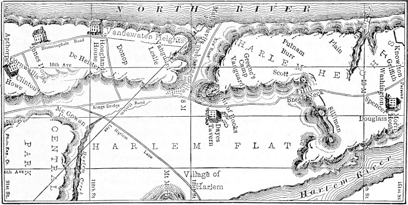
THE BATTLE OF HARLEM HEIGHTS — DR. EMMET’S REPLY. — POSTSCRIPT, 4
[Dr. Emmet’s article was written in reply to the following article which appeared some
time ago in the New York Evening Post. The whereabouts of the Richards letter, quoted
from, we have been unable to ascertain.—Ed].
Since the publication of Prof. H. P. Johnston’s monograph on the
battle of Harlem Heights, not more than one or two letters or
documents have come to light to be added to the very complete list
of authorities given in the appendix. One of these which has recently
been brought to notice is interesting and important as confirming certain
views advanced by Professor Johnston respecting the location of the
battlefield and other particulars of the action. It is in the form of an
extract from the diary of a Revolutionary officer, Lieut. Samuel Richards
of a Connecticut regiment, who, after describing the retreat from Long
Island in August, 1776, continues his narrative as follows:
We then marched and took possession of the heights of Harlem and immediately
flung up lines for our defence.... We were employed the succeeding
night (September 15, 1776) in throwing up a slight entrenchment on the brow of
the hill at Harlem Heights in full expectation of being attacked by the enemy in
the morning. When the sun arose I saw the enemy in the plain below us, at the
distance of about a mile, forming in a line. By accounts afterwards, their number
was said to exceed twenty thousand, and they indeed made a brilliant display by
the reflection of the sun’s rays on their arms.
The sharp action which took place that day under Col. Knowlton is so well
detailed by the historian, I need not repeat it. The enemy sent a detachment of
about five thousand along the bank of the North River, which our people attacked
with spirit and about an equal number, and drove them back to their main body.
The loss on our side was about thirty killed and sixty or seventy wounded. The
loss to the enemy must have been more than that, as we repulsed them after a warm
fire of three-quarters of an hour. Here I first saw Lieut. Munro; he had volunteered
to go to the attack on our right under the command of Col. Knowlton.
The next day I had a mournful duty assigned to me—the command of a
covering party over the fatigue men who buried the dead which had fallen in the
action the previous day. I placed myself and party on a small eminence so as to
see the men at their work, and to discover the enemy should they approach to
interrupt them. There were thirty-three bodies found on the field; they were drawn
to a large hole which was prepared for the purpose and buried together. One body
of a fine-limbed young man had been brought into the camp with a bullet hole in
the breast near the heart. I was struck with reflections on the force of habit to
see those fatigue men performing this duty with as little apparent concern as they
would have performed any duty.
The diary, though written some years after the close of the war,
furnishes a narrative which is apparently based upon an accurate recollection
of the events described. Lieut. Richards supports Professor Johnston’s
assertion, already corroborated by a mass of evidence, that the battle
was fought on the western side and slope of Morningside Heights.
These authorities, and the maps published in the history, trace the advance
of the British from what is now One Hundred and Seventh Street along
the bank of the North River to the “buckwheat field” lying between
Broadway and Riverside Drive, One Hundred and Sixteenth Street and
One Hundred and Twentieth Street, as they now exist, where they were
met by Col. Knowlton’s Rangers and where the battle occurred.
The statement of Lieut. Richards that the American loss was about
thirty killed confirms the estimate made by Professor Johnston, while the
third statement as to the burial of those killed furnishes a new item to be
added to the account of the battle, and lends increased interest to an
historic site. The plan of the battle and Lieut. Richards’s description
when studied in connection with the natural topography of the Heights
leave no doubt that either upon or immediately to the west of the Columbia
University grounds lies the burial place of the men who fell “in the first
battle of the Revolution in which the American troops faced and routed
the British.”
In the Post of Feb. 10th, an editorial on the battle of Harlem
Heights interested me extremely, as the locality is there described as
though there existed no longer a doubt as to the exact place where the
battle was fought. I am aware that this view is held by many, but beyond
the fact that the present site of Columbia University must necessarily be
nearer the locality where the battle was fought, it has no greater claim,
I believe, to that honor than has Union Square, or any other locality. I
have given no thought to the subject for many years and I am writing
away from home, without a book of reference, but fortunately I have
retained a recollection of the details. I am not actuated by a spirit of
controversy in raising this issue, nor do I intend to take any further part
in discussion. I simply wish to offer a protest, in consequence of my
knowledge that the history of our country is being constantly perverted
and misstated.
There exists no question that the battle of Harlem was fought, either
to the north or the south of the western portion of Harlem flats; that the
Americans occupied certain heights; and that the assault of the English
was made by one body and that the larger portion, from the plain below
along these heights; at the same time a smaller body gained the top of
these heights by ascending a ravine from the Hudson river bank at some
distance from the main line of attack. The whole question then relates
to the locality of Harlem Heights, and at this late date, in the absence of
positive proof, the locality must either continue to remain in doubt, or
must be decided by circumstantial evidence, which is often the most
reliable. Before presenting the evidence on which I propose to base my
argument it will be necessary to make a digression.
Grant’s tomb occupies the site of Mt. Alto, the country place of my
uncle, the late Mr. Bache McEvers, with whom for many years I spent
a portion of every summer. As a boy I became as familiar with every
foot of this neighborhood as I am now with the sidewalk in front of my
Madison Avenue city residence, where I have lived for nearly fifty years.
I generally accompanied my uncle when he took his Sunday afternoon
walks and through his knowledge I became familiar with the history and
traditions of this neighborhood, and of Westchester. On one occasion,
during the summer, I think of 1838, I had pointed out to me the site of
the battle of Harlem Heights, with the ravine on the North river, or
west side, where a portion of the British troops came up to make the
attack, and beyond that the road on Breakneck Hill, to the east side, down
which the English were driven after being routed. The surrounding
country was then under cultivation and divided up in small fields with
scarcely any trees standing, but along the river bank and on the brow of
the heights to the eastward. This locality and ravine was near the site
and possibly forms a portion of the present Trinity Cemetery. I was
also told that the main part of the battle was fought below, to the south,
and I went over the ground about the locality of the present Convent of
the Sacred Heart, which neighborhood was too hilly to be termed “a
rolling country.” From my earliest knowledge in connection with this
battle until recent years, no doubt seems to have existed as to where
the battle was fought and the accepted belief was the fight took place
on the ground I have described. The fact that the attack was made at
distant points and covered quite an area would explain, I should think,
the difficulty and the vague manner in which the battle is described or
located by those who possessed a contemporaneous knowledge of the
locality of the Harlem Heights.
Along the south side of Harlem Commons or Flats, there extended
a precipitous ridge of rock and débris, from the Hudson river at Grant’s
tomb to the East river at Hell gate. At the time of the Revolution the
chief exit from the city of New York to the north, was by way of
McGowan’s Pass, and in addition there were several footpaths to reach
the plain below. I have always heard that the Bloomingdale road was
not extended along the hill by Grant’s tomb and Claremount to the
valley below until many years after the Revolution, and there was only
a private road in addition to the one by McGowan’s Pass, which crossed
this line about the course of the present Third Avenue. When I was a
boy there were two or three footpaths to the west of McGowan’s Pass,
and at no other place was the descent possible save to a goat, or an active
boy. Across the Bloomingdale road in front of my uncle’s gate and
along the top of the hill, there was at that time the remains of the British
line of earthworks, which originally extended along the crest of this
ridge across the island to the East river. The trench was about two feet
deep at that time and I have frequently followed without difficulty the
line well on to McGowan’s Pass. In the war of 1812 this line was
fortified for the protection of the city by a series of blockhouses, one of
which still stands. I believe the remains of the British line of earthworks
was undisturbed until the opening of the streets. McGowan’s
Pass was formerly considered as forming part of the Yorkville Heights,
and no part of this line, to the south of the Harlem Commons, was ever
termed Harlem Heights until within recent years. If the portion of these
heights nearest Harlem was always called the Yorkville Heights, it is
inexplicable why the most distant portion of the line should be in any
way associated by name with Harlem. On the other hand I have often
heard the heights on the south side of the Harlem river termed Harlem
Heights, and these extend westward to the Hudson river bank. The
settlement at Harlem with its Commons, or land in common, and the one
at Yorkville represented two distinct interests, and for one familiar with
the circumstances it is difficult to understand how any confusion, from
accident, should exist between Harlem and Yorkville Heights.
That section of the island to the north of the Harlem Commons,
between the Hudson river and the Boston road, which passed from McGowan’s
Pass to King’s Bridge, and from the northern end of the island to
the Point of Rocks to the south, then situated below the present site of
the convent, included the fortress of Fort Washington and its outworks.
I had at one time in my possession the draft of a letter written by
Mr. George Pollock, a linen merchant of New York, and the father of
the child whose grave is near the Grant tomb. In this letter Pollock states
he purchased after the Revolution a tract of land and cleared off the
primitive forest which still covered this portion of Manhattan Island, and
it is not likely therefore that the buckwheat field existed in this neighborhood
in which it is claimed a part of the battle of Harlem was fought.
Mr. Pollock built here a house, where he lived for a number of years,
until the death of his wife and the loss of his child from drowning. He
then sold the place to Gulian Verplanck, of Verplanck’s Point. My uncle
leased for many years this place from his cousin, Gulian C. Verplanck,
the Shakespearean scholar, and the son of him who purchased it from
Pollock. All this portion of the island, west of McGowan’s Pass along
the river bank to about 65th or 70th street, was heavily timbered until
after the Revolution. To the existence of this timbered section the portion
of the American army left in New York after the battle and evacuation
of Long Island, owed its escape, for the retreat was made in disorder
and the troops were in a demoralized condition. The sudden flight of
the army from the city was rendered necessary by the English landing in
force at Kipp’s Bay, just above the present Bellevue Hospital, where they
met with little resistance from the portion of the Connecticut troops, and
some other colony, I do not recollect, which were placed there to oppose
the landing.
This occasion is adduced as one of the few instances where Washington
lost his temper and swore as an expert in his effort to avert the
flight of his troops, who were demoralized from fatigue, loss of sleep,
with probably insufficient food and discouraged after the defeat at Long
Island. The day was an excessively hot one, and Mrs. Robert Murray,
of Murray Hill, whose husband was a Tory, but she in sympathy with
the American cause, invited the British officers to rest during the heat of
the day in her house. She exerted herself to such an extent to make them
comfortable, that just time enough, and no more, was gained for the
retreat of the American army past this point, along the wooded banks of
the Hudson river. The English were so close in pursuit that Washington,
in the rear with a portion of his staff, passed in the neighborhood of 70th
street, through the hall of the old Apthorp House to the woods in the
rear, under the guidance of Col. Aaron Burr, as those in pursuit entered
the front gate. From a military standpoint it is clear that these troops
must necessarily have made their way in the most expeditious manner to
McGowan’s Pass and across the Harlem flats to gain protection within
their own lines below Fort Washington, and that no halt was likely made
unless to hold McGowan’s Pass for a short time to protect the rear end
stragglers. And yet a memorial tablet, I am informed, has been placed
on one of the buildings of Columbia University to commemorate the halt
of these troops along the brow of a continuous declivity, from fifty to one
hundred feet in height, as it was at that time; there to await the attack of
a victorious and superior force, after all possibility of retreat as a body
was cut off, and with a certainty that these troops were without a commissariat!
If it were possible to assign any rational reason or purpose,
under the circumstances why the American troops should hold any portion
of this untenable line, it is certain that no body of troops, under the
most perfect state of discipline, would have risked the fortune of a battle
in this place, without artillery and with a precipice in their rear. There is
no evidence that additional troops were landed on Harlem flats from either
the Hudson or the East river, and it would be absurd to suppose that the
English deserted an advantageous position in front of the American forces,
in order to go by McGowan’s Pass to the plain below with the purpose
of making an attack by attempting to scale an almost inaccessible height!
An attack by the ravine near this point as claimed, I know from my own
knowledge of the locality would have been impossible, unless the troops
to make the attack were landed at the ravine from boats. They could
not have passed, before the railroad was built, along this shore for
any distance on either side of the ravine. When I was a boy this point
was a noted place for fishing, as the water was deep, with a steep bank,
so that it was difficult for anyone to pass except at low tide and the
passage was then further obstructed by a number of boulders or rocks.
I have never seen the diary of Lieut. Sam. Richards, of a Connecticut
regiment, from which you quote, but the Point of Rocks in front of the
convent was then held by a Connecticut brigade, under Gen. Parsons, if
my memory serves me, and a portion of this brigade we have stated was at
Kipp’s Bay, where the English landed. It would then seem that this
portion of the army from New York had followed the course which, I
claim, the whole army must have followed by retreating within their own
lines, to the north of Harlem Commons.
The following portion of Lieut. Richards’s diary, as quoted by you,
will I think show that the attack on the American line of entrenchments
was to the north of the Harlem flats, and by the ravine near Trinity
Cemetery, as stated:—“We then marched [from what point?] and took
possession of the Heights of Harlem and immediately flung up lines for
our defence.... We were employed the succeeding night in throwing
up a slight entrenchment on the brow of the hill at Harlem Heights in
full expectation of being attacked by the enemy in the morning. When
the sun arose I saw the enemy in the plain below us, at the distance of
about a mile, forming in a line. By account afterwards, their number
was said to exceed twenty thousand, and they indeed made a brilliant display
by the reflection of the sun’s rays on their arms. The sharp action
which took place that day under Col. Knowlton is so well detailed by the
historian I need not repeat it. The enemy sent a detachment of about
five thousand along the bank of the North river, which our people attacked
with spirit and about in equal numbers and drove them back to their main
body.... The next day I had a mournful duty assigned to me—the
command of a covering party over the fatigue men who buried the
dead which had fallen in the action the previous day. I placed myself
and party on a small eminence so as to see the men at their work, and to
discover the enemy should they approach to interrupt them.” If the
battle was fought above on the “University Heights,” it might be asked
on what small eminence did Lieut. Richards take his position, and by
what route did his men reach the plain below to bury the dead?
To the south and southeast of the high land on which Fort Washington
was situated, there were a number of step-like hills, with more or
less of a level or plateau space between them, and these extended around
towards the Harlem river. I recollect distinctly seeing the remains of old
earthworks at different points, and the line was to the north and somewhat
above the Point of Rocks. In connection with the defense of the
Point of Rocks, the Connecticut troops were entrenched on one of these
eminences, and if Lieut. Richards was with his command he must first
have seen the advance of the enemy in line directly across the plain at
the distance he states and at the foot of McGowan’s Pass. From the
same side as McGowan’s Pass, the view would have been a limited
one with all the timber removed about the foot of the Pass and there is
no portion along the heights, in the neighborhood of the University, from
which the front of the line of the British troops could have been seen
while forming, moreover the distance would have been much less than
that stated by Lieut. Richards.
The main attack was an extended one along the line of entrenchments,
including the Point of Rocks, on what I believe was termed the
Harlem Heights at the time the battle was fought. In consequence of
the extended line and the varied fortune of the day, it has never been
known at what spot Col. Knowlton lost his life. The British troops were
very severely handled and failed to gain a foothold on any of these
eminences, from which they could not have been dislodged and everything
south of the ravine would then have been captured. There exists no
authority for supposing that any portion of the battle was fought on the
plain below, but from Lieut. Richards’s diary, as quoted by you, it would
seem the dead were buried there under his supervision, but the spot is
unknown.
To the north of Manhattanville and for some distance beyond the
ravine at Trinity Cemetery, the water was shallow with a shelving beach,
along which the British troops could have passed at any state of the tide.
It is however doubtful that five thousand men ascended the ravine, because,
before a foothold could have been gained, it is said that a bugle call was
sounded as though for a fox hunt, which at once brought upon the enemy
an overpowering number of Americans. While it lasted this fight at the
top of the ravine was doubtless the best contested hand-to-hand struggle
of the Revolution. It is probable that before the whole number of the
English reached the top they were divided so that those ascending were
driven back to the west, and the portion already on top who were not
killed, were driven down on the east side. As I have understood the plan
of the battle, the object of those attacking by the ravine was a flank
movement to finally get in the rear of the earthworks towards the southeast
where the Americans were being assaulted from the plain below, and
but for the arrogance of the enemy in giving timely notice of their presence
in this quarter, which would have been unexpected, the result would have
been a brilliant one for the English.
When I first heard of the battle of Harlem and talked to the old
people I met, relics of the battle were to be found in almost every small
farmer’s house in the neighborhood. From my recollection more particularly
of some sword hilts and portions of sword blades which were
found on this spot I am led to believe that the clubbed musket of the
American soldier at close quarters, played an important part in the
struggle.
In conclusion let me state that nowhere on Manhattan Island, to my
knowledge, beyond the limit of the city, have there been found the
remains of so many English and Hessian soldiers, as shown by buttons,
cross-belt buckles, bayonets and portions of other arms, as have been
excavated from time to time in the neighborhood of the Trinity Cemetery.
There could have been no fight at this point unless it was at the battle of
Harlem, while the neighborhood about Columbia University, where it is
claimed the battle was fought, has been particularly free from all such
evidence.
Thos. Addis Emmet, M. D.
In looking through the Journals of Congress, edited by Mr. Worthington
C. Ford, I found by accident the following (Vol. 6, p. 851):
“Monday, Oct. 7, 1776—
“Resolved, That Gen’l Lee be directed to repair to the camp on the
heights of Harlem, with leave, if he thinks it proper, to visit the posts in
New Jersey.”
This proves that I am correct in saying that all north of Harlem
Flats was called Harlem Heights at the time and after the Revolution.
When the change was made I do not know, but at some time it became
desirable to locate the “Buckwheat Field” for the battle of Harlem
Heights somewhere in the neighborhood of Columbia University; which
region, at the time of the encounter was, I believe, heavily timbered, not-withstanding
the alleged existence of the buckwheat field. It was not
until after the battle of White Plains, and early in November, that any
portion of the outworks of Fort Washington was abandoned by the
Americans. These works were near King’s Bridge, and were at once
taken possession of by Knyphausen with his German battalions, which
crossed the Flats from McGowan’s Pass, and for the first time the
English got a foothold on Harlem Heights. We are all thankful to the
Sons of the Revolution for their well-meaning efforts through the erection
of these various tablets to establish for the people a knowledge of the
truth. But in this instance at least, I think the tablet will have to be
moved, and replaced somewhere between the “Point of Rocks” and
Trinity Cemetery. And while this is doing, the propriety may be considered
of moving the statue of Nathan Hale to the neighborhood of 56th
or 57th Street, between Second and Third Avenues; if its present position
is meant to mark the place of his execution. Hale was taken across Long
Island Sound to the headquarters of Howe, then at the Beekman House,
near 61st street and the East river. He was likely confined over night at
old Cato’s house, which was on the Boston Post Road, (where Howe’s
bodyguard was stationed), and hung early next morning from one of
the apple trees of the orchard just across the road, where I, as a boy,
often looked upon the one nearest the road and decided as to the very
limb from which he was most likely hung.
There was no necessity for taking him to the “Old Provost” for the
night, nor have I found any evidence that he was ever within five or six
miles of where his statue now stands, in City Hall Park.
T. A. E.