The limits of the prairie—The rains—The wind
and the formation of the clay of the Pampas—The
wind and the contour—The zones of colonization
on the Pampas—Hunting wild cattle and primitive
breeding—The sheep-farms—The ranches—The
region of "colonies"—The region of lucerne,
maize, and wheat—The combination of agriculture
and breeding—The economic mechanism of
colonization—The exchanges between the different zones
of the Pampas.
The Pampean landscape is doubtless one of the most uniform in the
world. Its monotony is tiring to the eye; it is partly responsible for
the mediocrity of most of the descriptions of the Pampas. But this
uniformity is an advantage for the purpose of colonization. Attention
has often been drawn to the rapidity with which plants and animals
introduced by Europeans spread in the Buenos Aires district, and,
pushing ahead of the breeders and farmers, colonized the Pampas. In the
second half of the nineteenth century, when the whole extent of the
plain beyond the ancient Indian frontier was occupied, the development
of it was so much easier because it was possible to use simpler and
more uniform methods of exploitation. It needed neither large capital
nor long personal experience on the part of the immigrant. Basques
and Italians who had only just landed could take an active part in
it almost without apprenticeship. The primitive groups of population
could advance from one zone of the plain to another and take with them
their own methods of farming and breeding, their own form of rural
economy.
A close study will, however, enable us to detect appreciable
physical differences in the Pampean plain. Neither climate nor soil is
the same all over it.
The name "Pampa" chiefly means a vegetal growth, a prairie. Its
limits are the frontier of the scrub (monte),
and strange as it may seem, it is still difficult to trace them
exactly. North of Santa Fé, between the Salado and the
Paraná, the Pampa stretches as far as Fives-Lille, a little
beyond 30° S. lat.76 On the Central Norte and the Central Argentine
lines the fringe of the monte reaches to Fuertin
Inca and Malbran, about 170 miles north-west of Santa Fé. It
then turns south-east and south, passing round the entire depression
of Los Porongos and Mar Chiquita; and the line from Santa Fé to
Córdoba crosses it at Francia and approaches the Rio Secundo.
South of the Rio Secundo it goes westward and joins the foot of the
Sierra de Córdoba south of the Rio Tercero (at the stream
Tequia). From this point to La Cambre, some sixteen miles east of
San Luis, the prairie extends as far as the edge of the sierras, and
penetrates into the southern half of the Conlara depression, between
the hills of Córdoba and of San Luis (Pampa de Naschel). The
mimosa forest enters the steppe in narrow belts along the Rio Quinto
to within a few leagues below Villa Mercedes, along the Rio Tercero
as far as the confluence of the Saladillo, and along the Salado to
the south of Santa Fé. There are, in addition, many isolated
clumps of chañares and more extensive
patches of wood in the north-west corner of the prairie (Santa
Fé province). The monte along the Salado
is continued south of Santa Fé along the Paraná, as
far as the point where the chief arm of the river reaches the cliffs
on the right bank, at San Lorenzo. This is the domain of the ombu, a tree with thick trunk and naked roots which is
found scattered over the prairie in the Paraná region as far as
south of Buenos Aires.
In the west, between San Luis and the mouth of the Colorado, the
transition from the Pampa to the monte is gradual. Just as at Santa
Fé, the approach of the monte is announced by the appearance
of chañares, in the south-west corner of the Córdoba
province and on the southern slope of the Sierra de la Ventana. The
monte, properly so called, though impoverished, invaded by the
jarilla, and mainly composed (as in northern Patagonia) of dwarf
mimosas, covers the area of the Pampean sierras on the left bank of
the Chadi Leuvu and the Colorado. Between this area and a line passing
through Rancul, Anguil, Atreuco, and Bernasconi, where the naked
prairie begins, there is a mixed zone which one may call the calden
zone. This mimosa, a near relative of the algarroba, which has a
wider range than the other plants of the monte in this latitude,
forms woods at intervals in the south of the San Luis province and
on the flanks of the parallel valleys of the central Pampa. Between
these woods the tableland is generally covered by the prairie, with
occasional patches of chañares. About twenty-five miles east
of Buena Esperanza the line from San Rafael touches the far corner of a
forest of caldenes, which stretches south-westward, and reaches the
Rio Salado about 35° 30′ S. lat. Beyond Buena Esperanza it keeps
on the prairie as far as the crossing of the Salado, which here marks
the limit of the monte. The Rio Negro line passes directly from the
prairie to the Patagonian scrub mid-way between Bahía Blanca and
the Colorado.
Within these limits the prairie extends without a break. The sierras
of the Buenos Aires province have no arborescent vegetation.
The zone of the prairie, intermediate between tropical Argentina and
the sub-desert regions of western
Patagonia, has a medium rainfall. It decreases gradually from
north-east to south-west. There is a rainfall of 1,200 to 1,000
millimetres on the lower Paraná, and only 400 to 600 millimetres
on the western edge of the Pampa. The zone which lies between the 800
millimetres and 600 millimetres average is more than 270 miles in
breadth. But what is most characteristic of the climate of the Pampa is
the equal distribution of the rain throughout the year, and the absence
of a real dry season. In this the Pampa differs from the surrounding
regions, both in the south-west and the north. At Buenos Aires the
six months of the (relatively) dry season yield, nevertheless, 44
per cent. of the total rainfall, and at Bahía Blanca 40 per
cent. This regularity diminishes in proportion as one approaches the
coast. At Rosario the six months of the dry season only yield 30 per
cent. of the year's rain; at Villa Mercedes (San Luis province) 25
per cent. When one goes beyond the limits of the prairies the ratio
of rain in the dry season decreases rapidly; it is only 20 per cent.
at Córdoba and 18 per cent. at San Luis. At Córdoba,
the curve of the rainfall indicates a typical tropical regime, with a
summer maximum and a very low minimum in winter. Passing south-eastward
from Córdoba, at Bellville, Villa Maria and especially Rosario,
the dryness of the winter diminishes, and at the same time a secondary
minimum appears in the middle of summer (January-February). At Buenos
Aires, the form of the curve changes completely. The summer minimum
is almost as low as the winter minimum, and most of the rainfall is
in the spring (September) and the beginning of the autumn (March).77
These various shades of the Pampean climate are of essential
importance in the history of colonization and the spread of
cultivation. The belt of summer rain is the belt of maize-growing,
whereas the cultivation of wheat requires spring rain and a
comparatively dry summer.
While the isohyetic curves, which represent the precipitation for
the whole year, are orientated from north-west to south-east, the
curves of rainfall during the cold season, from April to September
(dry season in the north), cut diagonally across the preceding, and
are oriented directly north and south. Bahía Blanca receives
in winter as much rain as Rosario, and General Acha (in the district
of the central Pampa) as much as Córdoba. Unless one attends
to this, one cannot explain the extension of wheat-growing, in the
south-west, as far as the 400 millimetre curve, and even beyond it on
the Atlantic coast.
The relief of the Pampean plain is known fairly accurately, thanks
to the observations made along the railways. The ground rises slowly
toward the west. The 100-metre curve describes a deep gulf some 300
miles west-south-west of Buenos Aires. The belt comprised between 100
and 150 metres above sea-level is more than sixty miles broad in the
latitude of Santa Fé, and 130 miles in the latitude of Buenos
Aires. Beyond the 150-metre curve the land rises rapidly toward the
west and north-west, and reaches 400 metres in the Córdoba
district and 500 in the Villa Mercedes district. It is at the altitude
of 150 metres, and the break in the inclination which this marks, that
the Rio Quinto is lost, near Amarga, south of General Lavalle.
The ridge between the Pampa and the basin of the Salado in the south
of the San Luis province is about 450 metres above sea-level. South of
the province of Buenos Aires the Sierras de Tandil and de la Ventana
are joined together by a ridge which does not fall below 200 metres.
Certain irregularities of the surface, such as the depression of Mar
Chiquita to the east of Córdoba, the thrust of the plateau on
the right bank of the Paraná, south of Villa Constitución
and San Nicolas, can, apparently, only be explained by recent tectonic
movements.
The Pampean deposits which cover the plain rest upon a rocky
base of which the salient representatives are the sierras of
the province of Buenos Aires and the hills at Córdoba
and San Luis. This base also appears east of the Pampean basin
in the granite island of Martin Garcia, in the middle of the
estuary of the Plata, and in the hills on the coast of Uruguay.78
Underneath the even sheet of the alluvial deposits the surface
of the sub-Pampean platform is very irregular. Its shape has
been discovered by deep borings in search of arterial waters. It
has been warped and cut up by faults, some of these deformations
being probably synchronous with the formation of the Pampean
deposits which have concealed them as they have been produced. A
subterranean rocky ridge continues the Sierra de Córdoba
southward and joins it with the sierras of the Colorado. The granite
emerges at Chamaico, on the western railway, and on both sides
the borings have passed through great depths of clay and sand.79 This ridge isolates the eastern Pampa from
the sub-Andean chains, and marks the limit of the area with sheets of
underground water. In the north of the Pampean region, between the
Sierra de Córdoba and the Paraná, the loose continental
formations are more than 2,000 feet thick at Bellville, and more than
3,500 feet north-west of Santa Fé (fodder farms of San Cristobal
and El Tostado). At Buenos Aires the granite has been found 985 feet
below the surface.
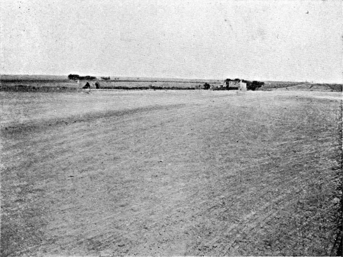
THE PAMPEAN PLAIN. TRES ARROYES (BUENOS AIRES
PRAIRIE BETWEEN THE SIERRA DE TANDIL AND THE SIERRA DE LA VENTANA).
Zone of wheat and oats on large scale. The
Pampa is a tableland here (400 feet above sea-level), with
clay overlying the limestone of the Tosca. The valleys are
well marked.
Photograph by the Author.
Click to view larger image.
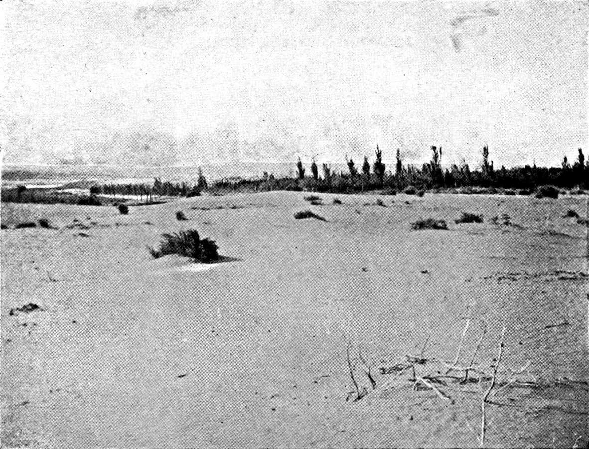
THE PAMPEAN PLAIN. TOAY, ON THE CENTRAL PAMPA (590 FEET).
The tableland, with a strong framework of limestone
Tosca, is cut across by well-marked dry valleys which sink
lower toward the east. At the edges of the valleys the sand
is the prey of the winds. Here we are near the limit of the
wheat belt.
Photograph by the Author.
Plate XV.
Click to view larger image.
The Pampean formation consists almost entirely of loose
deposits, sand and clays of various sorts. There is no gravel.80 Even in the vicinity of the sierras the beds
of gravel, with round or angular pebbles, are almost always covered
by clay, and are exposed only in the banks of the streams. Olascoaga
mentions the surprise of the gauchos of General Roca's army when they
found Patagonian pebbles on the ground during their stay at Choele
Choel on the Colorado, in the course of the compaign campaign on the Rio Negro.
Officers and soldiers dismounted to pick them up. Sand and clay form a
thick bed of continental alluvia. The Tertiary maritime transgressions,
which have left their mark in the clays and limestones of the left bank
of the lower Paraná, and the layers of shells at San Pedro on
the right bank, never penetrated far into the interior of the Pampean
region, and one finds no trace of them when one leaves the coast or the
river.
The source of the elements which compose the Pampean alluvia is
very uncertain. Their composition does not clearly show their origin.
The clays are comparatively rich in calcareous matter, which seems to
indicate that they do not come from tropical America or the upper basin
of the Paraná. Wright and Fenner insist upon the high proportion
of siliceous glass of volcanic origin which they contain, which points
to an intense eruptive activity during or before their formation.81 Doering had already noticed in the
Córdoba region the prevalence of beds of volcanic ash, which
become thicker as one approaches the sierra. It is certain that the
Pampean sierras have had their share in the formation of the Pampean
beds. But the main mass is probably of Andean origin. However that may
be, as soon as one gets away from the fringe of the mountains, the only
variety noticeable in the lands of the Pampa is that which they owe to
the conditions in which they have been deposited.
River deposits strictly so called, estuary deposits,
lagoon deposits, æolian deposits, æolian deposits
redistributed by water, river deposits redistributed by
wind—all these different types are represented in the Pampean
formation, but their relative importance is still disputed.82
When we confine ourselves to studying the actual conditions in which
the deposits were formed, we are first struck by the poverty of the
hydrographic network of the Pampa. It is slight except in the vicinity
of the sierras, where the slope of the ground is pronounced, and in
the eastern area, on the right bank of the Paraná and Entre
Rios, where the climate is more humid, and the streams flowing over an
impermeable soil more numerous. The only one of the streams born in the
Pampean sierras that reaches the Paraná is the Rio Tercero or
Carcaraña. All the others dwindle as they descend, and disappear
in a low-lying district marked by lagoons which they only reach in time
of flood. The floods themselves never bring the Rio Cuarto and the Rio
Quinto and the Salado de Buenos Aires into touch with each other. The
waters of the northern slope of the Sierra de Tandil, and even those of
the Sierra de Curumalal, on the other hand, reach the Salado after the
rains, either by way of streams which drain the strings of lagoons, or
by flood-sheets, which spread over large areas.
The watercourses of the plain are unstable in their direction.
The traces of their wanderings remain in the form of stretches of
alluvial sand crossing the fine æolian clays. These river sands
sometimes spread over extensive areas, the distribution depending upon
a hydrographic scheme which is now partially effaced. The sands of the
departments of General Lopez (south of the Santa Fé province)
and General Arenales (Buenos Aires province), where the Salado is now
developed, were probably brought by the Rio Cuarto, and mark an earlier
junction of the Cuarto and the Salado. These sands run along the Salado
as far as the confluence of the Saladillo, and the contrast between the
light soil and the clay of the bank of the Paraná is so
striking that the sand has long been regarded as a marine deposit,
indicating an ancient shore. Along the Saladillo also, north-west of
the Guamini lagoons, there is a sandy belt which corresponds with an
important direction taken by the actual flow of the river, crossing the
Bolivar and Veinte Cinco de Mayo departments.
While the agency of running water in transporting alluvia is
confined to certain sections of the plain, the action of the wind
is seen over its entire surface. The wind everywhere supplements or
replaces running water. Like running water, it classifies the elements
it conveys, and selects them according to their weight and size, the
finest clays being deposited in the moist eastern zone and the coarsest
sands in the sub-desert zone of the west. The mechanism of erosion
explains this contrast. The grains of sand that are driven by the wind
travel at the surface of the ground as long as the vegetation is too
sparse to fix them. If one goes further east, to a moister district
with a thicker vegetal carpet, the grains of sand no longer move at
the surface of the ground, but the wind still carries fine particles
of clay, which it bears to a great height. The bed of clay does not
at all imply an arid climate, as is said sometimes, but corresponds
to the region of the steppes, with moderate rainfall. It is, however,
during dry seasons that the deposition of clay is at its greatest.
Darwin mentions that after the droughts of 1827-1830 in the area round
the Paraná, the marks were buried under dust to such an extent
that one could no longer recognize the limits of the various lands.
Apart, however, from these sorts of floods or storms of dust caused by
the pampero, the summer atmosphere is clearly laden with dust, which
colours the skies in the east of the Buenos Aires province, as far as
Entre Rios.
The contour of the plain bears, like the soil, the double marks of
erosion by running water and æolian erosion. The rivers of the
Pampa, when they leave the sierras,
flow between high cliffs, the height diminishing as one goes downward.
Presently these barrancas become low, approach each other, and at
last merely mark the banks of a larger bed which the floods fill. There
is no trace of valleys. Bailey Willis, surprised at this weakness of
watercourses that have, nevertheless, an appreciable fall, attributes
it to the fact that the cycle of erosion opened by the last upheaval
of the Pampa has not yet had time to penetrate into the interior. In
reality, it means that here we are at the limit of the zone of erosion
by running water, and that in this climate the essential factor in
shaping the landscape is the wind.
The region of the right bank of the Paraná (east of the
Salado), which alone has a complete hydrographic network, must be
considered apart. From the latitude of Rosario to that of Buenos Aires
it is cut by flat-bottomed valleys which are sometimes a hundred feet
deep. The excavation of these valleys is due to an upheaval which
raised this part of the Pampa above the base-level. The rapids of
the lower Carcaraña also bear witness to this resumption of
excavation. Farther on an inverse movement has put the bottom of the
valleys below this level, and led to their being filled up (lagoon
deposits of the Lujanense of Ameghino). South of Buenos Aires the
upheaval has been less important, and the valleys are not so deep.
Some of them (middle Salado and its tributaries on the left bank) are
now occupied by long lagoons with steep banks, branching along the
side-valleys, and these owe their origin to the same negative movement,
subsequent to the excavation of the valleys. The upheaval did not
extend to the eastern part of the province of Buenos Aires south of
the Salado, a low-lying flat area, badly drained, exposed to floods,
the contour of which has been minutely studied in connection with the
construction of a great network of drainage-canals. North of Rosario,
on the only slightly permeable clay, the water circulates, after rain,
not by means of valleys in the proper sense,
but along broad and almost imperceptible depressions (cañadas)
where the current is slow, and the water dries up in the dry season.
Their general relations are not yet known.
The loose deposits of the Pampean offer little resistance to
erosion. The cycles are run through rapidly, and the traces of earlier
cycles are faint, and are soon effaced.83
An ancient erosion-surface, dissected by the existing valleys,
has survived in the south-west of the Pampean plain, thanks to the
presence on the surface of a sheet of hard limestone, the tosca.
The tosca is the result of the concentration of calcareous elements
contained in clay at the surface in a dry climate. The formation
of it implies a prolonged stability of the surface on which it has
accumulated. Like the deep decomposition-soils in moister regions, it
indicates a peneplain on which erosion has ceased. The bed of tosca
covers the whole district between the Sierra de Tandil and the Sierra
de la Ventana, the south-western slope of the Ventana, and most of
the area of the central Pampa. In the north it does not go beyond the
line from Buenos Aires to San Rafael. Its eastern limit goes almost
by Ingeniero Malmen, Monte Nievas, and Atreuco, where it joins the
southern bank of the lagoons of Carhue and Guamini in the east.84 In some places the tosca is about forty feet
thick.
To-day the region of the tosca forms a plateau cut by narrow
valleys, sometimes 200 feet deep, west of the Sierra de la Ventana and
in the central Pampa. These parallel valleys, with few ramifications,
generally lying south-west to north-east, open to the east upon the
Pampean plain about the frontier of the Buenos Aires province. On
the other hand, the southernmost of them begin at the foot of the
Ventana, and seem to blend in the south-west with a general depression
that is still little known, though it appears to end at the bottom
of the estuary of Bahía Blanca. None of them has permanent
running water.85 The origin of the dry
valleys of the tosca is one of the most obscure problems of the
morphology of the Pampean plain. Perhaps they are due to æolian
erosion, like the depressions which are found on the plateau of the
Colorado and the Rio Negro further south.
The action of the wind in shaping the landscape is more clearly
seen in the formation of the dunes. When one starts from Buenos Aires
or Rosario, and gets beyond the region of the level Pampas, the dunes
are the first feature to meet the eye on the surface of the plain. The
first fresh dunes are encountered at Carlota, on the line from the Rio
Cuarto; at Lavalle on the line from Villa Mercedes; and at Trenque
Lauquen on the line from Toay. The dunes spread northward as far as the
latitude of Mar Chiquita, but do not enter the Chaco. They are also
found in parts of the scrub on the west, but their proper domain is the
western border of the steppe, the upper part of the plain at the foot
of the Sierra de Córdoba, the south of the San Luis province,
and the central Pampa.
Any accident that causes the vegetal covering to disappear, such as
the tread of cattle near a drinking place or an enclosure, is enough to
set æolian erosion at work. The wind raises the sand in a sort
of tossing sea. Then the dune assumes a circular shape. A depression
appears in the centre, and it deepens until it reaches the average
level of the plain. Frequently there is a little lake in it. From this
point onward the deformations are less rapid. The vegetation again
creeps over the ground, and the dune falls a prey to the rains, which
slowly reduce its mass.
In the central Pampa, where the elevation is considerable, the dunes
do not form separate circular patches, but stretch in lines parallel to
the valleys—sometimes in the heart of the valley, at other times
backing against one of its slopes.
Far to the east of the zone of the quick dunes, in the south of the
Córdoba province and the centre of the Buenos Aires province,
there are certain soft undulations, covered with vegetation, with
a sandier soil than that of the plain around them. These are dead
dunes. The district of the dead dunes is characterized by the extreme
irregularity of the surface-soil, the humus, which gains in richness
and depth, as a general rule, as one goes eastward, because there it is
in some places covered by recent æolian deposits.
The distribution of the dead dunes is connected with the stretches
of river sand across the Pampa, which have offered an easy victim to
the winds. A line of dead dunes follows the upper course of the Salado
in the district of Junin and Bragado. On the line from Buenos Aires to
San Luis one crosses it between Chacabuco and Vedia, and then one comes
again upon the horizontal plain, which has fresh dunes, only further
west, at 120 miles from Villa Mercedes. Its elevation is so conspicuous
on the level plain that the first breeders who used its pasturage gave
it the emphatic name of the cerillada. D'Azara correctly appreciated
the nature of it. "It is," he says, "only a dune of very fine sand."
It is only a few yards high. The dead dunes of the Bolivar and Veinte
Cinco de Mayo departments, which Parchappe described, have a more
conspicuous relief, and in their disposition sometimes
remind us of the fresh circular dunes with a central lagoon. The lines
of coastal dunes in the eastern part of the Buenos Aires province
obstruct the proper flow of the water there, and form a group apart,
which must be clearly distinguished from the dunes on the plain.86
Thus the impression of monotony which the Pampa makes in us is
corrected to some extent by close observation. High and low land
alternate on it. Parchappe himself had noticed the contrast between
the area that stretches from Buenos Aires to the Salado, with its soft
undulations and its well-developed hydrographic network, the horizontal
plains on the right bank of the Salado, with their irregular dunes, and
the southern plateau of the tosca between the Sierra de Tandil and
the Sierra de la Ventana.
We may now distinguish the following regions in the Pampa as a
whole:
1. The central part of the Santa Fé province forms what is
called the district of the "colonies": that is to say, the domain
of the colonies established two generations ago, and the zone in
which the type of cultivation introduced by them took root. The chief
crops here are wheat and flax. Hedges of service trees (paraisos)
surround the fields. In contrast with the parts of the Pampa which have
remained naked, the region of the colonies seems a veritable grove. It
stretches westward beyond the frontier of the Córdoba province,
and it reaches the fringe of the monte between San Francisco and Mar
Chiquita. For the north, Miatello gives 30° S. lat. as the normal
limit of the wheat-growing area; beyond this it suffers both from the
low rainfall of winter and the excessive rainfall in summer. As a
matter of fact, the large estates only reach this latitude on the line
from San Francisco to Ceres. On the Resistencia line, north of Santa
Fé, they stop at 30° 30′ S. lat. In the intervening district
the limit of the region of the colonies almost coincides with that of
the department of Castellanos, about 30° 45′ S. lat. The area lying
between this line and the northern edge of the Pampa is given up to
breeding. In the south the region of the colonies stretches as far as
Las Bandurias and Irigoyen.
2. South of the region of the colonies, the tableland on the right
bank of the Paraná, west of Rosario and San Nicolas, is the
maize region, the corn belt of Argentina. Flax is generally cultivated
as well as maize. It is the agricultural country par excellence of
Argentina. The soil, of fine clay, dark red in colour and retentive
of moisture, and the abundant summer rains, are very suitable for
maize. The limits of the maize region describe an arc of a circle round
Rosario with a radius of 60 to 100 miles. They do not quite reach the
frontier of Córdoba in the west, and they leave out the entire
south-western corner of the Santa Fé province. The maize belt
touches the Paraná between 32° S. lat. and the Baradero.
In the north it passes suddenly into the region of the colonies. In
the south, on the other hand, there is at the edge of the corn belt an
extensive transition-area, where maize and wheat occupy pretty much the
same surface; it stretches as far as the Rio Salado de Buenos Aires.
3. The region of the lucerne farms is much larger. It comprises the
whole north-west corner of the Buenos Aires province, from the Salado,
in the district of Junin,
to the southern limit of the Nueve de Julio and Pehuajo departments,
and as far as the latitude of Guamini. The limit of the lucerne farms
does not include the lands of the central Pampa, but advances westward
and takes in part of the Pedernera department in the San Luis province.
The lucerne farms run along the San Rafael line to Batavia, and at this
point they reach the limits of the colonized zone. In addition, the
zone of the lucerne farms includes the whole south-eastern part of the
Córdoba province, as high up as the line from Villa Mercedes to
Villa Maria, and the southern part of the Santa Fé province. In
the whole of this area, fifteen to twenty-five per cent. of the surface
is planted with lucerne. The conditions required for its cultivation
are a moderate depth of the underground water and a light soil that
allows the roots to penetrate easily. The eastern belt of clays is not
good for lucerne, which survives there for much less time than in the
west, where it may live fifteen or twenty years.
The lucerne belt is above all a great breeding area for horned
cattle, as sheep-pasturage injures the lucerne. It is not nearly so
monotonous, however, as the preceding regions. In the south-east,
in the Buenos Aires province, the creation of the lucerne farms was
undertaken at a time when agricultural colonization had already
begun. We therefore find two types of exploitation side by side. The
cultivation of maize enters it in the south-west, in spite of the
comparatively unfavourable climatic conditions. The centre of the
lucerne area in the south of the Córdoba province is also a
great agricultural zone; but there agriculture is directly connected
with the creation of the lucerne estates. It is, in fact, entrusted to
colonists who till the ground for four or five years, and restore it
to the owners sown with lucerne at the expiration of their lease. The
crops consist almost exclusively of wheat and flax. Lastly, in the west
(San Luis province
and extreme south-west of Córdoba province) the soil gets
increasingly more sandy, and the climate drier. A single tillage
suffices to destroy the natural vegetation and clear the place
for lucerne. The lucerne fields have been created by the breeders
themselves, the sole masters of the region, without the aid of the
colonists.
4. Beyond the lucerne belt, at the point where the plain rises
toward the Sierra de San Luis and the Sierra de Córdoba, the
subterranean water sinks deeper. This zone at the foot of the ranges,
unsuitable for lucerne, yet with a soil comparatively rich in humus,
has been taken up by agricultural workers. The wheat area extends, in
the San Luis province, as far as Fraga and Naschel, in the Conlara
depression. The maize area extends to Oncativo, in the Córdoba
province, between the Tercero and Secundo rivers, where the summer
rainfall is heavier. Thanks to the nearness of the mountains, this area
has a water-supply for irrigation, and this sustains several small
centres of good farms.
5. The south of the Buenos Aires province and the central Pampa are
the wheat zone. The bed of tosca, which is not far below the soil,
does no harm to the wheat except in years of drought. The valleys,
where the tosca is interrupted, and the dunes, where the soil is
deep, are very carefully used for lucerne fields of limited extent.
Wheat-growing seems now, both in this and the preceding zone, to have
reached its limit, as the dryness makes it improbable that there will
be any extension westward.
6. Lastly, the east of the Buenos Aires province, the centre of
which is fairly indicated by the little town of Dolores, is the only
part of the Pampean plain which has not been reached by agricultural
colonization. The land lies low, and is badly drained. The only change
that has taken place in the vegetation is a progressive improvement due
to the hoofs of the cattle during their long stays there. This pastoral
area is
clearly limited in the south by the Sierra de Tandil. In the north
it is continued in the more varied region that lies between Buenos
Aires and the lower Salado, where the alternation of winter pasture
on the dry lands and summer pasture in the valleys, encourages the
best methods of breeding, and has made it the region of the dairy
industry.
In the Entre Rios province the limit of the large estates of wheat
and flax is marked by 32° S. lat. The part of Entre Rios which
extends north of 32° and the Corrientes province do not strictly
belong to the Pampean region.
Extensive breeding was the first form taken by white colonization on
the Pampa. The word breeding is, in fact, hardly the correct name for
an industry that mainly consisted of hunting, and was wholly distinct
from the patient and advanced methods used at the same time in the
northern provinces.
"The real wealth of the province of Buenos Aires," says
Dean Funes, "was, and always will be, the trade in hides" (la
pellejería).87 A good part of
the hides exported came from the hunting of the wild cattle and
horses which had grown numerous on the area of the Pampa beyond
the Rio Salado.88 It was mainly after
1778, when trade with Spain had been authorized and there was an
increased demand for hides, that the hunting of these ownerless beasts
was taken up. Two thousand Spaniards from Buenos Aires, Santa Fé
and Mendoza hunted every day, says D'Azara, killing an animal for each
of their meals in addition to those they killed for hides. From 1775
to the Revolution, the Spanish Government made continuous efforts to
regulate and reduce the massacre of the herds. It laid down penalties
for every person selling hides that did not bear his own mark; it
farmed out the right to hunt animals with no mark, and organized the
destruction of wild dogs, etc. The ranches developed under shelter of
this legislation. Still, the Revolution did not witness the end of this
cattle-hunting. D'Orbigny took part in 1828 in two hunts of wild horses
(baguales) in Entre Rios. The Argentine gaucho long retained the
ways of a hunter rather than those of a breeder in the strict sense;
witness Urquiza's soldiers who, says Demersay, during the campaign of
1846, when they could not find trees to which they could fasten their
horses, killed cattle and tied the reins to their horns.
Passing from the hunting country to the zone of ranches, one notices
that the main work of the breeder is to prevent his cattle from running
wild. "The ranches of this country," said Dean Funes, "having been set
up on immense plains, on which it was not easy to confine the herds
within fixed limits, it sometimes happened that the animals went vast
distances in search of water or pasture, and ended by being regarded
as wild and ownerless," When D'Azara wants to show that the ranches
of Paraguay are superior to those of Buenos Aires, he is content to
say that there the animals are tamer (mansos). With the wild animal
(alzado) is contrasted the de rodeo animal: that is to say, the
cattle which are rounded up periodically in the centre of the ranch to
be taken to the pasture where they must live (aquerenciar). It is the
difficulty of preventing the dispersal of the herd that fixes the price
of the rincones (surrounded by inundated areas) of Corrientes, in
which the animals are captives.
MacKann's description of pastoral life in the Buenos
Aires province in the middle of the nineteenth century give us a very
clear impression of the stage of transition between exploiting the
natural increase of a herd that multiplies without man's intervention,
and breeding in the strict sense. The value of a horse in the former
case is almost exclusively the cost of breaking it in. The breeder is
actually anxious when he sees his horses increase, as he fears he
may not have the resources for breaking them in. The most formidable
of the dangers that threatened the feeble discipline of the herd
was drought. That in the year 1827 was a disaster. The animals
left the ranches in a body to go southward, where they mixed.89
Revolutions and wars interrupted the work of taming the cattle.
When Galvez went from the Córdoba province to Buenos Aires
at the end of the Rosas Government, he was struck by the condition
of the ranches.90 Many of them had
been confiscated, or their owners driven into exile. Cattle were
no longer marked, and they had become wild. The troubles of the
emancipation-period were much less injurious to the Buenos Aires
breeders than to those of Entre Rios. The Entre Rios herd was almost
annihilated during the revolution, and some of the ranchers of the left
bank crossed to the right bank of the Paraná. After 1823 the
pastoral wealth of Entre Rios was rapidly restored, thanks to raids on
Brazilian territory. They were so profitable that the whole population
took part in them. In 1827 the inhabitants of Bajada went there in such
numbers that the town was half deserted. Every day thousands of cattle
were collected on the bank of the Uruguay, and crossed the river.
Some of them were even taken beyond the Paraná, to the Santa
Fé province. Woodbine Parish confirms this rapid restoration
of Entre Rios, of which D'Orbigny was a witness. But this period of
prosperity did not last long. The war with Uruguay, under Rosas, again
ruined the Entre Rios ranches, and the drought of 1846 helped to
scatter the remaining herds. Extensive breeding is only lightly rooted
in the soil. The chief centres of production change their locality, as
the political circumstances change, from one part of the Pampean plain
to another.
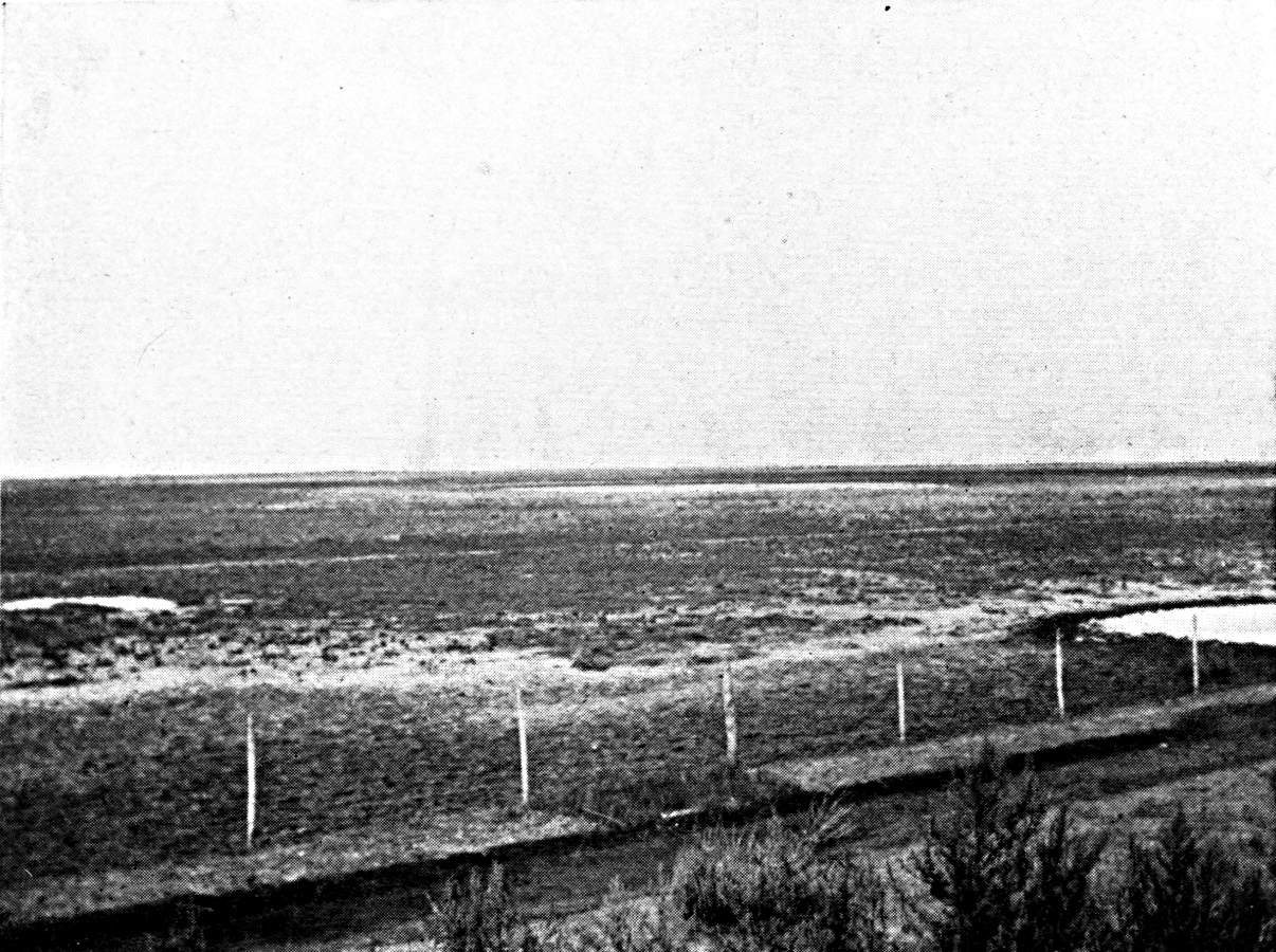
THE PAMPEAN PLAIN. THE RIO BAMBA (IN THE
SOUTH OF THE CÓRDOBA PROVINCE, 500 FEET ABOVE SEA-LEVEL).
Small circular lagoons. The underground water,
which comes from the Sierras to the north-west, here reaches
the surface. Zone of lucerne farms.
Photograph by the Author.
Click to view larger image.
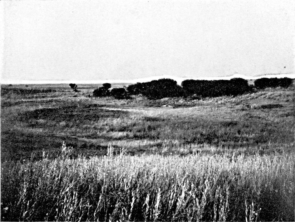
THE PAMPEAN PLAIN. BUENA ESPERANZA (SAN LUIS
PROVINCE, 1,166 FEET ELEVATION).
The plain is sown with quick and dead dunes,
often shaped in a circle round a lagoon. A dune invaded by
vegetation.
Photograph by the Author.
Plate XVI.
Click to view larger image.
Primitive breeding affords few examples of periodical migration
for the better use of pasturage. In 1822, in the course of a journey
amongst the Sierras de Tandil and de la Ventana, Colonel Garcia
noticed that the Indians kept their cattle round the temporary lagoons
of the plain in the winter, and went up to the mountain-streams in
summer. Transhumation movements of this kind were difficult for the
creole ranchers, whose fairly large herds could not be handled easily.
The Chascomus breeders, however, at the close of the eighteenth
century, drove their cattle to the low banks of the Salado during
the dry season.91 Garcia also notices
the importance of the Salado pastures for the ranches of Salto,
Areco, and Lujan.92 The need to remove
the herds in the dry season, and to find invernadas within reach of
the former ranches, was due to the change brought about in the natural
vegetation of the Pampa and the spread of the pasto dulce. The
annual herbs which compose the pasto dulce die and disappear after
fertilization. Until the autumn rain they leave the ground quite naked,
whereas the tough grasses of the pasto duro afforded a thin but
permanent pasture.
The first improvements of the pastoral industry of the Pampa are
connected with the development of sheep-breeding. Exports of wool
began about 1840, and made great progress after 1855 (17,000 tons
in 1860, 65,000 tons in 1870). From 1850 to about 1890 the economic
returns on sheep-breeding were far better than on cattle-breeding.
During the whole of this period the multiplication of sheep farms was
only restricted by the supply of workers. The first shepherds had been
Basques, in the south of the Buenos Aires province, and Irish, in the
north. The owner settled them as small farmers in the puestos on the
edge of the ranch, the central part of which was devoted to cattle.
They could thus, while they guarded their sheep, see that the limits of
the estate were respected, and prevent the cattle from roaming.
Wool was for a long time the only product of the sheep-rearing
industry. From 1866 onward it was decided to use the hides and tallow
also. As the material of the grease-works was cheap, they spread all
over the sheep zone. Many ranches had works of their own. From 1867
to 1877 the saladeros that had been built long before for killing
cattle undertook the slaughter of sheep on a large scale. The number
of sheep sold to the saladeros rose to 3,000,000 a year. In 1880 the
first cargoes of frozen mutton were sent abroad. The creation of the
grease-works had made no difference to the breeding, but the building
of the refrigerators brought about a rapid transformation of the flock.
The Lincoln breed, heavier and more meaty, displaced the fine-wool
Merinos. This substitution of Lincolns for Merinos is now complete
throughout the Pampean region.
Until 1880 sheep-rearing was concentrated east of the Salado, north
and south of Buenos Aires, beginning with a line that passes through
Quilmes, San Vicente, Pilar, and Campana, which marks the limit of the
suburban zone. In addition it had spread on the right bank of the lower
Salado as far as the foot of the Sierra de Tandil, in an area where the
first stations date from 1823, though the population did not make much
progress until after 1855. About 1880, after the pacification of the
Pampa, the sheep-farms began to expand westward. It was then that the
wool of the pasto fuerte appeared on the Buenos Aires market. It came
from the Azal district in 1870, from Olavarria in 1880, from Bolivar in
1885, and from Villegas in 1890. The Census of 1889 ascribes 51,000,000
sheep to the province of Buenos Aires; that of 1895 gives much the same
figure (52,000,000). Detailed comparison of the two enumerations shows
that the expansive movement to the west continued, and was completed
during this period. The flocks in the north-west zone of the province
(Lincoln, Villegas, Trenque, Lauquen) more than doubled; the flocks of
the south-west area
(Alsina, Puan, Bahía Blanca, Villarino) continued to grow, and
increased by a third. Those on the lands of the central Pampa increased
threefold. On the other hand, in the departments north and south of
the Sierra de Tandil, where colonization is older, sheep-breeding
is stationary. The north-east and south-east areas, between the
Paraná and the Salado, have diminished: one losing a fifth, and
the other a half, of its flocks.
From 1895 onward the number of flocks of sheep on the Pampean
plain decreased rapidly. The number of sheep had sunk from 34,000,000
in 1908 to 18,000,000 in 1915 for the Buenos Aires province; from
2,800,000 in 1908 to 2,300,000 in 1914 for the central Pampa. The
reduction was general, and found in every district; but it was not
equally great everywhere, and did not begin at the same date in every
district. Sheep-breeding has almost entirely disappeared from the
eastern belt, east of the Salado, which was its cradle. South of Buenos
Aires the sheep are giving place to horned cattle, and they had almost
disappeared by 1908. North of Buenos Aires they survived long, but
the reduction of the flocks has only been the more rapid since 1908.
This corresponds with the advance of maize-growing. In six years the
Bartolome Mitre and Pergamino departments have lost, respectively,
four-fifths and five-sixths of their sheep. In the north-west of the
Buenos Aires province the sheep began to be reduced at the time when
the lucerne farms were founded, about 1900. The decrease has since
gone on uninterruptedly. The actual flocks represent one-fourth of
the flocks of 1895. In the south-west (wheat belt) there was a rapid
shrinkage before 1908, but it seems to have almost been arrested since
then, thanks to the combining of sheep-rearing with wheat and oats. The
actual flocks are about one-half the flocks of 1895. Finally, in the
area north of the Sierra de Tandil the sheep retreat before the cattle,
as they do
further north, but they are not so completely wiped out as in the
lucerne belt, and the flocks are still two fifths of the flocks of
twenty years ago.
In the province of Entre Rios and south of Corrientes the number
of sheep continued to rise until 1908, but the increase is only in
the northern departments, outside the agricultural belt. The southern
departments, which are large growers of wheat and flax, lost one-third
of their flocks between 1895 and 1908.
Cattle-breeding was restricted for a long time by the difficulty
of disposing of its products. The hides alone found ready buyers. The
making and export of salt beef dates from the eighteenth century, and
it was to help this industry that the expeditions to the salt-beds of
the Pampa and the journeys of salters to the Patagonian coast were
organized. From 1792 to 1796 no less than 39,000 quintals of jerked
beef were sent from the Rio de la Plata to Havana. But the market for
salt meat (tasajo) was always limited. It consisted only of the
Antilles and Brazil, and the saladeros never fully exploited the
meat-producing capacity of the Argentine herds. The crisis of the
saladeros occurred before the time when the refrigerators began to
compete with them. By 1889 there were only three left in the province
of Buenos Aires.
Although the price of cattle was not very remunerative, and provided
no incentive to improve the breeding; although the saladero was not
at all exorbitant, merely asking for animals in good condition, the
improvement of the herd by introducing selected pedigree-breeders had
begun about the middle of the nineteenth century. The Basque dairies
established in the district near Buenos Aires sold pedigree-calves
to the ranches, and these were used for breeding purposes.93 About 1880 the advance of sheep-breeding
pressed the cattle-ranches back and disputed the space with them
more and more, within the ancient Indian frontier. The smallness of
the market for cattle and their slight mercantile value were very
favourable circumstances for the occupation of the new lands, thrown
open at this date by the submission of the Indians. The herds which
found no buyers were sent to the campos de afuera. The ranches
developed very rapidly. Daireaux has very accurately described this
period of pastoral colonization, and the starting of convoys that
were intended to give a population to the west of the Pampa. Cattle
were there several years before sheep. As a matter of fact, breeders
do not regard cattle as having a value of their own. They are merely
auxiliaries that must improve the pasture and prepare the ground for
sheep. The cattle themselves are preceded by troops of half-wild
horses which first take possession of the virgin field and begin the
transformation of it.
The number of cattle increases rapidly. In 1875 it was
estimated that there were 5,000,000 head of cattle in the province
of Buenos Aires. In 1889 there were 8,500,000. Since that date
the variations have been comparatively slight. The Census of
1895 gives 7,700,000; that of 1908 gives 10,300,000; that of
1914 gives 9,000,000; and that of 1915 gives 11,300,000.94 But the value of the cattle has gone up
rapidly. The exports of live meat, which lasted from 1889 to 1900, were
the beginning of the rise. It was strengthened when the refrigerators
ceased to confine themselves to killing sheep and began to buy cattle.
The exports of chilled or frozen beef increased after 1898. The value
of them rose to 10,000,000 gold piastres in 1904, double that in 1909,
and more than quadruple in 1914.
The difference between the price paid by the refrigerators for
pedigree-cattle and the price of animals of creole blood, which the
local market takes, hurries up the transformation of the herd. In
order to watch reproduction and nurse the pasture, the ranches put
up wire-fences. But the breeding methods are especially modified by
the introduction of lucerne. It spread in the south of Córdoba
and west of the Buenos Aires province from 1895 onward, and from 1905
onward in part of the San Luis province. There were already small
lucerne farms in the Buenos Aires province. A description that was
written at the end of the eighteenth century speaks of lucerne farms
round the town which were reserved for feeding draught cattle.95 But the area from which the cultivation
of lucerne started at the close of the nineteenth century is the
district of the Córdoba province that is crossed by the line
from Rosario to Córdoba, completed about 1870 to Bellville
and Villa Marina. The lucerne farms there were not created by the
breeders, and the lucerne was at first intended for export to Rosario
and Buenos Aires in the form of dry fodder. The trade in dry fodder
has remained good there. The 1908 Census gives 128 square kilometres
of lucerne for cutting in the Tercero Abajo department (Villa Maria)
and 267 square kilometres in the Union department (Bellville).96
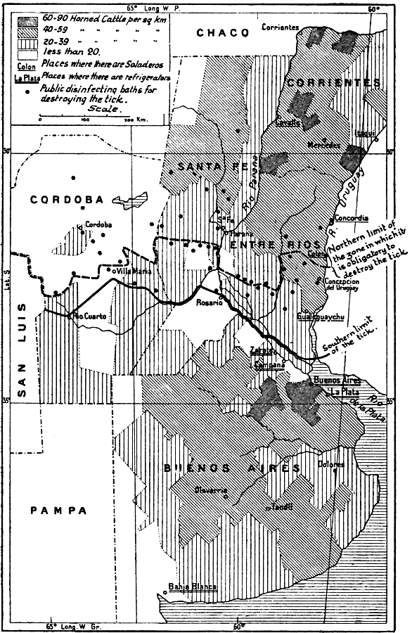
MAP III.—THE CATTLE-BREEDING AREAS.
The density of the herd is slight in the
maize belt. It is considerable in the centre and east of the
Pampean region, which supply the refrigerators with pedigree
stock of good weight. The density is considerable also in the
north of Mesopotamia, but the cattle there are less valuable
and are taken by the saladeros of the Uruguay. The presence
of the tick, which inoculates cattle with Texas fever, is the
chief obstacle to the improvement of the herd in the north of
Argentina.
Click to view larger image.
The lucerne spread southward and south-westward from this point; and
the improvement of the herds kept pace with it. I have shown elsewhere
how this improvement was checked north of a line along the course of
the Paraná, the northern frontier of the Constitución and
General Lopez departments, in the province of Santa Fé and on
the Rio Cuarto, and in the Córdoba province, by the presence of
the garrapate, which inoculates the cattle with a dreaded disease,
Texas fever. The creole cattle are immunized against the garrapate,
but pedigree cattle quickly succumb to it. In order to protect the
southern zone, where the garrapate does not reproduce, the Argentine
Government imposes severe restrictions on the transport of cattle
from north to south; the cattle have to have disinfectant baths at
the frontier-stations. This cuts pastoral Argentina in two. While the
Durham cattle of the south are intended for the refrigerators, the
creole cattle of the north still supply the saladeros, which have
disappeared from Buenos Aires, but survive on the Uruguay. Yet the
advantages of crossing with European breeds are such that the northern
breeders, in spite of the risk and the expense, have not given up all
hope of accomplishing it. The transformation of the herd, however, is
bound to be very slow. Pedigree breeders are brought from the south and
kept in the stable. Their progeny, born on the spot, resist Texas fever
better and can be put out to pasture. There has been more progress in
the contaminated zone on the right bank of the Paraná than in
Entre Rios and Corrientes. Pedigree animals have been introduced at
Santa Fé, not only in the region of the colonies, but further
north, in the extreme northern corner of the Pampa (San Cristobal
department), colonized by ranchers from the north of Buenos Aires and
the south of Santa Fé, who were ousted by the progress of maize.
They have brought with them to the new lands the cultivation of lucerne
and the methods they followed on their former property. At Corrientes,
on the other hand, breeding is an historic industry. The staff of the
ranches is indigenous. The pastoral traditions are unchanged.
When we study the variations in the numbers of cattle in different
parts of the Pampa, by comparing
the results of recent Censuses we find that the number has risen
rapidly since 1895 in the whole of the eastern area, north of the
Sierra de Tandil. The increase is particularly conspicuous north of
the Rio Salado, in the dairy district. (Mean density in 1915, 40 to 60
horned cattle per square kilometre.) In the south-west region (wheat
belt) the density has always been low (12 per square kilometre), and
it shows no tendency to increase. In the north and western region of
Buenos Aires (lucerne belt) there has been a rapid increase, especially
between 1895 and 1908 (creation of the lucerne farms), and it has not
been interrupted since (density 50 to the square kilometre). There
is the same increase in the whole area of the lucerne farms in the
Córdoba, Santa Fé, and San Luis provinces, where the
herds doubled between 1895 and 1908. Only two regions have suffered a
reduction: the agricultural area of the centre (Chacabuco, Chivilcoy),
where there has been a decrease since 1895, and the maize district
(north of Buenos Aires), where cattle-rearing did not diminish until
after 1908.
Agriculture had begun to develop by the end of the eighteenth
century in the district round Buenos Aires. D'Azara admits the enormous
preponderance of breeding, but mentions that the right bank of the
Paraná exported flour to the left bank, which was exclusively
pastoral. Barrero also observes that between the belt of orchards
and lucerne fields, about a league in width, which surrounded Buenos
Aires, and the area of the ranches, which did not begin for six or
eight leagues, there was an agricultural belt, the district of the
chacras de pan llevar. The main crop was wheat, and the tillage was
chiefly done in the rich soils at the bottom of the valleys, which are
called cañadas in the local dialect (cañada de Moron,
cañada de Rio Lujan, etc.).
It was, however, not at Buenos Aires, but in the Santa Fé
province, that modern agricultural colonization
began in the nineteenth century. It goes back to the foundation (in
1854) of the colony of Esperanza, west of Santa Fé, from
which it was separated by the strip of forest which follows the
course of the Salado. European immigrants—Swiss, French, and
Piedmontese—had settled there. The early years of colonization
at Santa Fé were difficult, and the colonies did not begin to
develop rapidly until after 1870. About that date we can distinguish
three nuclei of agricultural colonization at Santa Fé. The
first group of colonies was settled in the north, on the bank of the
Paraná. In the centre the Esperanza group advanced steadily
westward. A third group of colonies lay along the Central Argentine
railway from Rosario to Córdoba.
The Esperanza colonists had at first grown maize, but the
prosperity of the colonies was mainly due to wheat. Zeballos, who
visited the colonies in 1882, describes them as a vast lake of wheat.
Wheat predominates, not only in the department of Las Colonias,
west of Santa Fé, where it survives in full strength, but
further north, at Garay, whence it has since been displaced by flax
and earth-nuts, and in the south, round Rosario, in the belt which
is now given up to maize. It is for the wheat that the mills of
Carcaraña and the granaries of Rosario have been built. The
land sown with wheat at Santa Fé rose in 1882 to 102,000
hectares out of a total of 127,000 hectares of cultivated land.97 By 1889 the area of wheat was quadrupled. It
spread like a drop of oil, reaching Rafäela and Castellanos on
the west. In 1895 the advance was still more rapid. Wheat-growing has
crossed the Córdoba frontier, and spread round San Francisco and
east of Mar Chiquita (departments of San Justo and Marcos Juarez). The
agricultural regions in the centre of the Santa Fé province
and those of the Central Argentine have met, and the wheat has invaded
the whole of the San Martin department. It extends even south of the
old colonies of the Central Argentine toward the south-west of Santa
Fé, in the General Lopez department.
The 1908 Census shows a very different state of things. The density
of the wheat-cultivation has continued to grow appreciably in the whole
of the northern region, and also in the south-west of the province, at
some distance from the Paraná (General Lopez department). On the
other hand, it has been reduced in the adjoining district of Rosario
(departments of Iriondo, Belgrana, Caseros, and Constitución),
where maize-growing has developed. Maize has won part of the wheat
belt.
| Departments.98 |
Wheat Area (in kilometres). |
Maize Area (in kilometers). |
| 1889 |
1895 |
1908 |
1889 |
1895 |
1908 |
| Las Colonias |
} 1,623 { |
1,307 |
1,621 |
} 82 { |
24 |
31 |
| Castillanos |
1,845 |
3,425 |
4 |
7 |
| S. Jeronimo |
} 664 { |
854 |
849 |
} 65 { |
15 |
264 |
| S. Martin |
964 |
1,884 |
22 |
35 |
| Iriondo |
} 971 { |
929 |
442 |
} 65 { |
81 |
641 |
| Belgrano |
1,137 |
638 |
37 |
296 |
| S. Lorenzo |
} 652 { |
387 |
1,390 |
} 178 { |
150 |
1,169 |
| Caseros |
1,139 |
468 |
83 |
970 |
| Gal. Lopez |
} 12 { |
888 |
1,370 |
} 51 { |
373 |
1,558 |
| Constitución |
227 |
165 |
575 |
736 |
| S. Justo |
} 12 { |
732 |
2,345 |
} 48 { |
7 |
34 |
| M. Juarez |
1,504 |
1,442 |
53 |
92 |
Restricted in the south by the extension of the maize belt, the
region of the colonies has now a very distinctive character amongst
the agricultural areas of the Pampa.
This originality is not so much in virtue of its crops (hard wheat
and flax) as on account of the age of colonization and the division of
property. Most of the colonists are owners, and estates of 50 to 200
hectares are the rule. The houses are comfortable; they are surrounded
by orchards and kitchen-gardens. Moreover, the rural economy has been
complicated, and it has assumed a familiar aspect for the European
observer, owing to the introduction of cattle-rearing on a small scale
by the farmers. The number of horned cattle doubled between 1908 and
1914 in the Castellanos department, and increased by a third in Las
Colonias. The area of lucerne has extended in proportion. The farms
have been multiplied on the low lands (cañadas), unsuitable
for wheat, which the older colonists had disdained; but they are
now regarded as the best bits of land. The recent rise in the value
of land in the region of the colonies is connected, not with an
increase of agricultural production, but a development of breeding. A
few co-operative diary dairy societies have been established. In general,
however, breeding is solely for the meat-market. The cattle-trade
goes on very different lines from those of the large estates and
ranches. It has remained in the hands of small dealers (Jews of
Moïsesville).
Agricultural colonization in the Buenos Aires province was at first
entirely independent of the Santa Fé colonization. The crops
of the adjoining region of Buenos Aires never disappeared altogether.
In the period to which Daireaux's description of the economic life of
the Pampa refers (1880-89), the farmers disputed with the breeders a
belt some ten leagues broad round the capital. But sheep-breeding left
no place for agriculture in the next belt, which enclosed the first
on every side, and extended almost as far as the Salado. Agricultural
colonization had found free land only beyond the sheep-farm area, 170
miles west of Buenos Aires, round Chivilcoy, Chacabuco, and
Bragado. As early as 1872 the Chivilcoy district produced 130,000
hectolitres of wheat; or nearly half the total production of the Buenos
Aires province. In 1889 it formed a comparatively dense agricultural
patch, the cultivated area being devoted half to wheat and half to
maize.
| Wheat. | Maize. |
|---|
| Chivilcoy | 307 | kms. | 399 | kms. |
| Chacabuco | 155 | " | 164 | " |
| Bragado | 147 | " | 261 | " |
At that date the whole west and south of the Buenos Aires
province was exclusively pastoral. There were only two isolated
nuclei of agricultural colonization. The first was round Olavarria,
on the old Indian frontier, where Russo-German colonies had been
established in 1878. The second was in the Suarez department,
at the extreme north of the Sierra de la Ventana, where a group
of French colonists settled five years later, at Pigüe.99 The opening of the line from Buenos Aires
to Bahía Blanca ought, one would think, to have prepared the
way for agricultural colonization in this section. However, the 1895
Census shows a check to these first attempts at tillage in the south.
It fell by one half at Suarez, and by three-fourths at Olavarria. The
Pigüe colonists have succeeded in keeping to their lands, but
those of Olavarria have abandoned them, and most of them have emigrated
to the Entre Rios province.
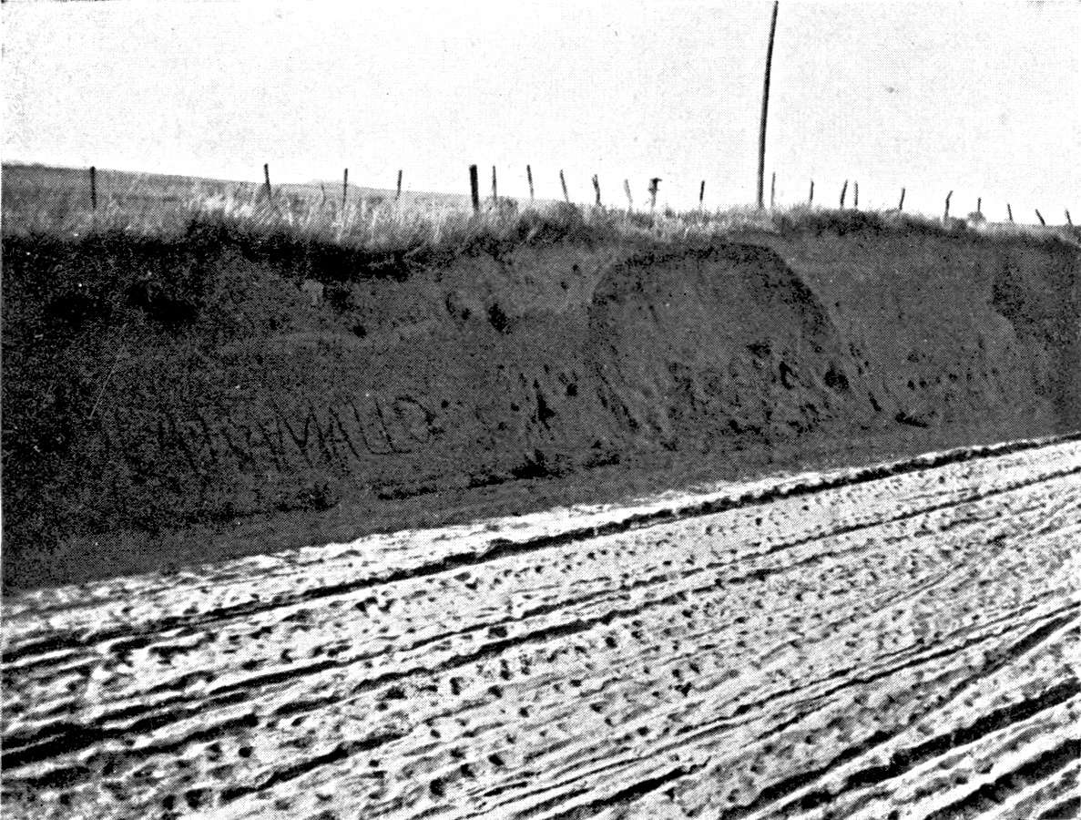
THE PAMPEAN PLAIN. JUNIN (150 MILES WEST OF BUENOS
AIRES, 330 FEET ELEVATION).
The clays. A line of dead dunes crosses the
Junin district, following the course of the Salado. They are
indicated by light, sandy soil, very different from the clays
of the north of Buenos Aires province.
Photograph by the Author.
Plate XVII.
Click to view larger image.
On the other hand, colonization has kept the land won in the
district of the middle Salado, and it extends in a sporadic way toward
the south-west and west. (Nueve de Julio, 252 square kilometres of
wheat and 400 of maize: Veinte Cinco de Mayo, 84 square kilometres
of wheat and 218 of maize: Junin, 197 square kilometres of wheat
and 204 of maize in 1895). It has been maintained ever since, with
slow progress, but without being ousted by breeding. This is one of
the regions of the Pampa where the most different types of rural
exploitation are mingled together. Agricultural colonization has
been carried on both by small proprietors and farmers or tenants.
Wheat and maize seem to be permanently associated, and the climate
is equally good for both; the maize crop being the better if the
summer is wet, and the wheat crop when the summer is dry. The two
cereals follow each other on the same land, in rotation, the wheat
being helped by the constant weeding and clearing which the maize
requires. The colonists use oxen in the work, and fatten them
afterwards.100
Agricultural colonization in the lucerne region dates
from 1895 to 1905:
|
Wheat Area (in kilometres). |
Flax Area (in kilometres). |
| 1895 |
1908 |
1895 |
1908 |
| Buenos Aires: | | | | |
| Lincoln | 152 | 819 | | 100 |
| Pehuajo | 106 | 727 | | |
| Guamini | 20 | 528 | | |
| Trenque Lauquen | 100 | 1,439 | | 59 |
| Villegas | 4 | 812 | 1 | 84 |
| Pinto | | 469 | | 60 |
| Córdoba: | | | | |
| Gal. Roca | | 1,009 | | 89 |
| Rio Quarto | 5 | 1,156 | | 172 |
| Juarez Celman | 144 | 1,679 | | 183 |
| Union | 373 | 2,548 | 12 | 316 |
I have shown how this was bound up with the development of the
lucerne farms themselves. The extreme west of the lucerne belt
(Pedernera department and San Luis) is the only place where the
cultivated area was reduced. The contracts by which the ranchers
entrust their lands to the colonists, on condition of returning
them sown with lucerne, were gradually modified as the stream of
colonization developed. The land was at first left to the colonist rent
free, the rancher being paid by the creation of the lucerne fields. But
in proportion to the increasing volume of the stream of immigrants,
and the keener competition of the colonists, the rancher asked better
terms. There are similar contracts in regard to the restoration of
lucerne fields which have been worn out by pasturage, so that the land
has to be ploughed up periodically. The men who clear the land in the
lucerne belt have mostly been recruited in the district of the old
colonies of Santa Fé, where the new generation had begun to feel
the pinch. The crops which they raise during the four or five years of
their lease are chosen without any idea of sparing lands which they are
not to keep. Wheat succeeds wheat, and the first and last crop is often
flax. The proportion of flax is lower only in the southern part of the
lucerne belt. In the Buenos Aires province the colonist grows lucerne
on his own account, either to sell as dry fodder or for breeding or
fattening.
Colonization does not in these parts correspond with the division
of property. Not only does the farmer not become the owner of the soil,
but he does not live on it permanently; he is a veritable nomad. His
house has a temporary look that strikes one at the first glance. The
area cultivated is almost stable, if the region is considered as a
whole. But cultivation passes periodically from one section to another,
and its removals cause sudden alterations or crises in the railway
traffic and the development of the urban centres.
The lucerne belt has been peopled by Santafecinos, and it has in
turn sent colonists to the western agricultural
belt at the foot of the Sierras de San Luis and de Córdoba.
They have less suitable climatological conditions, but they have the
advantage of greater stability, as the breeders do not dispute the land
with them.
While agricultural colonization has been an aid to pastoral
colonization in the north-west of Buenos Aires, it tends to displace
breeding, or restrict its sphere, in the north-east and the south.
Maize-growing started on the banks of the Paraná, where it was
already paramount in 1889, between Campana (north of Buenos Aires) and
San Nicolas. In 1895 it advanced up the Paraná as far as the
Santa Fé province (Constitución) and spread over the
interior for some sixty miles in the Salto department. In the next few
years it made rapid progress toward the west and north-west, covering
the departments of Pergamino, Rojas, and Colon, and part of General
Lopez, San Lorenzo, and Constitución in the province of Santa
Fé.
|
Maize Area. |
Flax Area. |
| 1889 |
1895 |
1908 |
1889 |
1895 |
1908 |
| Campana |
67 |
45 |
22 |
15 |
31 |
17 |
| Baradero |
339 |
260 |
291 |
26 |
78 |
173 |
| S. Pedro |
398 |
353 |
420 |
5 |
73 |
235 |
| Arrecifes |
124 |
126 |
155 |
15 |
50 |
265 |
| Salto |
16 |
326 |
236 |
13 |
3 |
75 |
| Gal. Lopez |
} 51 { |
373 |
1,538 |
|
70 |
752 |
| Constitución |
575 |
736 |
|
270 |
404 |
| Pergamino |
168 |
160 |
340 |
50 |
30 |
275 |
| Rojas |
86 |
81 |
247 |
4 |
23 |
275 |
| Colon |
|
44 |
126 |
|
14 |
78 |
| S. Lorenzo |
178 |
150 |
1,169 |
11 |
36 |
450 |
| Caseros |
|
83 |
990 |
|
13 |
319 |
Export of Argentine maize on a large scale began in 1895.
Flax-growing was not added to maize until 1900.
The heavy land requires a good deal of harrowing,
and the weeding and harvesting of the maize give employment to a
comparatively large staff. The estates are of moderate size, often only
50 hectares. Ownership was not divided at the period of colonization,
the land, thanks to the breeders, having already acquired so high a
value that the colonists could not buy it. On the lands which have been
farmed out there has developed a rural, and often far from docile,
proletariat. It is in the maize region that the worst agricultural
strikes have taken place. The struggles of the owners and the colonists
are the more prolonged because the sowing of the maize can be put back
to the end of the spring without much harm being done. The adjoining
zone of the Paraná produced some of the maiseros who have
scattered over the north-west. But the modern colonies include,
in addition, a large proportion of immigrants who have recently
landed from Italy and Spain. The maize growers do not mix with the
wheat-growers. Each group has its own area.
The increase of wheat-growing in the south dates only from 1898:
| Wheat Area (in kilometres). |
|---|
| 1895 | 1908 |
|---|
| Alsina | 45 | 1,296 |
| Puan | 52 | 1,321 |
| Suarez | 104 | 978 |
| La Madrid | 75 | 249 |
| Pringles | 13 | 724 |
| Darrego | | 885 |
| Terr. de la Pampa | | 1,731 |
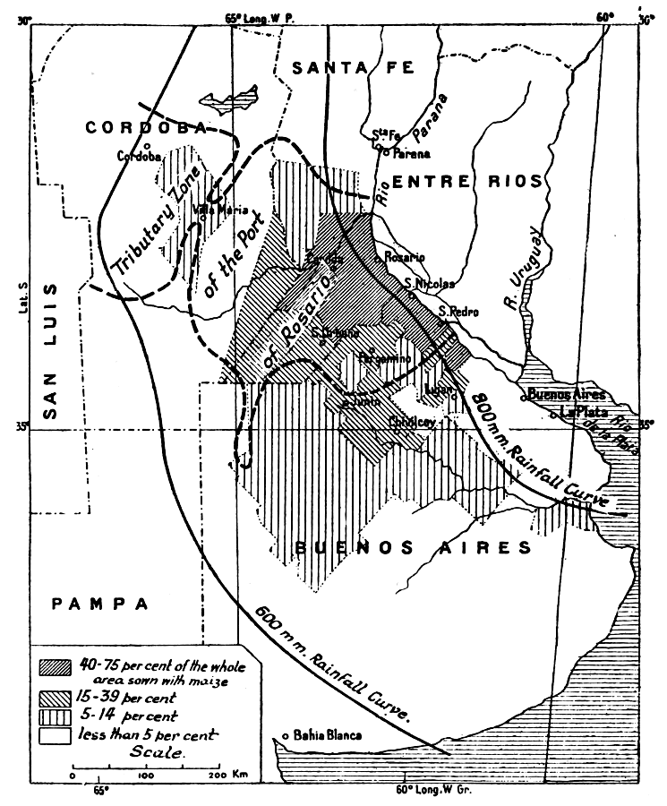
MAP IV.—DENSITY OF THE MAIZE CROP.
As it needs more heat and moisture than wheat, the maize
does not go so far to the west and south. It is concentrated
for export at the ports of the Rio de la Plata and the
Paraná, especially at Rosario. The Argentine "corn
belt," the chief maize area, extends back of Rosario and San
Nicolas to beyond Casilda and Pergamino.
Click to view larger image.
Wheat first spread along the line from Buenos Aires to Bahía
Blanca, west of the Sierra de la Ventana, then in the coastal district,
east of Bahía Blanca. These two wheat-areas became connected
after 1904, when the opening of the direct line from Olavarria to
Buenos Aires facilitated the development of the intermediate region
(Pringles-Laprida). From Bahía Blanca it spread to the west and
north-west along the Toay line, and southward as far as Colorado on
the coast. In the whole area of the Central Pampa it is still possible
to distinguish two strata of immigrants, of different dates, one
superimposed upon the other: the sheep-breeders and the farmers. Round
Toay the contrast between the two elements of the population is even
more striking, because the first pastoral colonization, which dates
from 1890, was to a great extent the work of creole puntanos (from
the San Luis province). The actual agricultural colonies, on the other
hand, include recent European immigrants and colonists from other parts
of the provinces of Buenos Aires and Entre Rios.
The yield of the wheat grows less and less as one goes westward. The
harvest may be injured either by late frost or drought, or, especially,
by hot winds which scorch the plants and blight the half-realized hopes
of the farmers in the weeks just before the harvest. But the relative
poorness of the return is compensated by the extent of the farms and
the cheapness of labour. The harvest is often done with machines that
peel and pack the wheat, and the workers are not compelled, as they are
at Santa Fé, to wait for the threshing machine. The aridity does
not permit flax-growing, but oats can be grown, especially between the
Sierra de la Ventana and the Sierra de Tandil; and it is good to sow
oats when the land has been impoverished by consecutive crops of wheat.
Exports of oats through Bahía Blanca began in 1906.
The displacement of breeding by farming is less thorough than in
the maize belt. Oats, sown about the beginning of autumn, serve for
fodder. The animals are kept in the fields during the winter, and
the oats are cut and put into the mill, without being threshed, as a
reserve fodder. Moreover, the wheat
farmers have themselves taken to rearing sheep, and the sheep feed in
the stubble and fallow.
From this short account of the history of colonization we draw
certain important conclusions. At the time when agricultural
colonization began, it was admitted that farming was the best way
to exploit the soil, and that the Pampa would sooner or later pass
from the pastoral to the agricultural cycle; or, to use the local
phraseology, that the "colony" would replace the ranch everywhere. This
idea was wrong. The only area in which the facts seem to give it any
support is the corn belt. The general rule is, on the contrary, that
in its progress colonization develops a mixed type of exploitation,
combining farming and breeding; either one alternates with the other in
a sort of periodic rotation, as in the lucerne area, or both proceed
together, the farmers including breeding amongst their occupations, as
in the district of the Santa Fé colonies or in the wheat area in
the south of the Buenos Aires province.
It seems, moreover, that the development of colonization depends not
only upon physical conditions, but upon factors of a purely economic or
social character, which the geographer must not overlook. It will be
enough here to indicate the chief of these.
We have seen the part that has been played in the exploitation of
the soil by groups of colonists who swarm from one area to another.
Whether we think of the ranchers of the eastern part of Buenos Aires
transplanting themselves to Córdoba or north of Santa Fé,
the sheep-breeders moving westward, or the Santa Fé colonists
settling in the lucerne area, they all take with them their own habits
and methods of work, and they take time to adjust them to a new
environment.
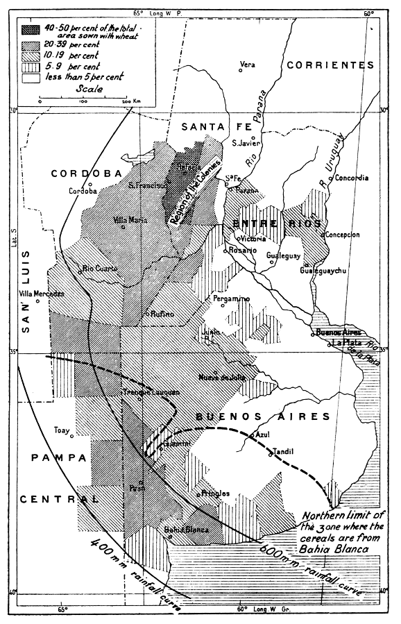
MAP V.—DENSITY OF THE WHEAT CROP.
The wheat belt stretches in a broad
section of a circle from Bahía Blanca to Santa
Fé, which is now reached by maritime vessels. The
cultivation of wheat crosses the line of 600 millimetres of
rainfall and even the 400-millimetre line, in proportion as
one passes from the area of summer rain to that of spring and
autumn rain.
Click to view larger image.
The colonist, whether breeder or farmer, is not left to himself.
Colonization is sustained and directed by speculation in land, and
is influenced by it. Speculation discounts the work of the colonist,
and attaches to the land a value which is not based upon the revenue
it has produced, but upon that which the speculator calculates that
it may produce in the future. If the speculator is audacious, he does
not let himself be discouraged by initial bad experiences; it takes
repeated checks to exhaust his optimism. The colonist, even if his
farming accounts do not show a profit, may nevertheless gain something
if the value of his land goes up. The increase of his capital conceals
from him the smallness of his returns, especially as he can easily get
advances on the value of his property from the banks, and this enables
him to draw upon his wealth every year.
Speculation is concerned with new lands on the fringe of the area
already colonized, where the soil is, as a general rule, already in the
hands of the exploiters themselves. The speculators, having paid a high
price for these lands, try to organize the development of them. It is
partly owing to their influence that colonization continuously enlarges
its domain, instead of concentrating its labour in the older districts
where it might sometimes be more productive. In fine, speculation in
land has a profound influence on the conditions of colonization, making
it more difficult for the colonist to buy the land he is developing.
The owner who grants him the use of the land means to keep for himself
any increment of its value. He rents, but he will not sell.
Thus the history of colonization cannot be separated from the
traffic in land. The special features of this traffic in the Pampean
region—its concentration at Buenos Aires; the creation of a
land-market resembling a stock market; the practice of selling on the
instalment plan, which enables small capitalists to enter the market;
the repeated transfers of pieces of land which the buyers have never
seen and which they know only from plans—are one of the most
original aspects of modern Argentina. They are partly due to a fact of
a geographical nature—the
uniformity of the Pampean plain, on which every piece of land is worth
about as much as the adjoining piece.
Colonization is easy and rapid in proportion as it requires less
capital and labour. The expansion of breeding in the west between 1880
and 1890 was facilitated by the low market price of cattle at that
time. Breeding has the advantage over farming of not needing so large
a staff, but it requires a larger capital. Of the crops, assuming that
the conditions of soil and climate are equally favourable, wheat is
better than maize for colonization, because the preparing of the soil
and the harvest can be done more speedily, and the same number of hands
can plant a larger area with wheat than with maize.
The action of the Argentine Government and the provincial
authorities has been restrained, apart from the earliest period
of the establishment of the Santa Fé colonies, both as
regards the securing of immigrants, the distribution of lands,
and the administration of the colonies.101
Colonization has been, on the whole, a private affair. The work
of organizing colonization has at times been undertaken by the
proprietors themselves; they leased pieces of land and got a good price
for them, at the same time increasing the surplus value of the plots
they kept for themselves by promoting the increase of population.
Sometimes it was undertaken by Colonization Companies, which bought
land to divide and sell. More frequently it was undertaken by merchants
who advanced credit to the colonists they settled, on condition that
the colonists bought what they needed of the merchants, and entrusted
them with the sale of their crops. The migration of the Santa Fé
colonists was partly due to, and sustained by, a corresponding
migration of merchants who had acquired wealth in the older colonies,
and who thus got a larger body of customers. The merchant who organizes
colonization often acts as the intermediary between the owner and
the colonist, guaranteeing the owner a fixed rent for his land and
receiving so much per cent. of his harvest from the farmer. This system
is very widespread in the corn belt, but it is found all over the plain
of the Pampas. It tends to disappear when the colony is older and
deeper-rooted, as the colonist gradually earns his independence; he
buys his lease, his equipment, and his furniture, and controls the sale
of his own crops. In the districts where he has not become owner, the
leases are generally variations of two types: farming leases, where the
colonist has capital enough for working, and renting leases, where the
capital is provided by the owner or the middleman.
Lastly, colonization can make no progress unless it finds markets
on which it can put its produce. Up to the present western Europe has
been the chief market for the wool, leather, meat, and cereals of the
Pampean region; tropical America absorbs part of the output of the
saladeros, flour, and dry fodder; and North America has recently
begun to compete with Europe for wool, leather, and frozen meat. The
facility with which the products of the Pampa have found their way into
the world's markets, as is seen in the comparative stability of the
returns, explains the continuous advance of colonization and the short
duration of the crises which have disturbed it.
The home market, however, has had an importance in connection with
colonization that must not be overlooked. When wheat-growing spread at
Santa Fé the crop was at first devoted to supplying Buenos
Aires, and as late as 1883 Zeballos thought that the essential result
of agricultural colonization was the fact that Chilean flour was beaten
off the Argentine market. Even to-day the districts on the outskirts of
the cereal area depend upon the home market. The Villa Mercedes mill
supplies Mendoza. Córdoba and Santa Fé send their flour
to Tucumán. The price of cereals still shows slight fluctuations
in these parts as compared with prices in Buenos Aires.
Table of Exports of the Chief Products of the Pampean region
(in thousands of tons):
| 1901 | 1905 | 1910 | 1913 | 1914 |
|---|
| Wheat | 904 | 2,868 | 1,883 | 2,812 | 980 |
| Maize | 1,112 | 2,222 | 2,660 | 4,806 | 3,542 |
| Flax | 338 | 654 | 604 | 1,016 | 841 |
| Flour | 71 | 144 | 115 | 124 | 67 |
| Wool | 228 | 191 | 150 | 120 | 117 |
| Salted hides | 28 | 40 | 61 | 65 | 63 |
| Dried hides | 26 | 24 | 29 | 21 | 14 |
| Chilled beef | 44 | 152 | 253 | 306 | 368 |
| Chilled mutton | 63 | 78 | 75 | 45 | 58 |
The heading "cereals" appears in the statistics of
Argentine exports in 1882. In 1900 the value of the
agricultural produce exported is equal to that of the products
of breeding. In 1904 it is higher.
Pastoral colonization, again, has not been entirely independent of
the home market. Martin de Moussy says, it is true, that the area which
sent the products of breeding to Europe in 1865 extended as far as the
Sierra de Córdoba. But this statement needs correction. The
hides from the whole of this zone were, in point of fact, sent down to
the ports on the Rio de la Plata, but live animals were sent to Chile
from the whole of the north-west of the Pampean region. It was for the
purpose of selling cattle to Chile that ranches were multiplied about
1860 in the neighbourhood of Villa Mercedes and lower down, on the Rio
Quinto. Jegou's
description shows that even in 1883 the breeders of the San Luis
province devoted themselves exclusively to supplying the Chilean
market.102 Buyers from Chile
and the Andean provinces still visit Villa Mercedes, and until a recent
date they came to Villa Maria, in the province of Córdoba. The
Santa Fé ranches found their customers, until the opening of the
Córdoba line (1870) amongst the troperos, who bought draught
oxen for their waggons. The loss of these customers and the crisis that
followed are one of the reasons why agricultural colonization met with
so little resistance on the part of the breeders, and was able to take
root so easily at Santa Fé. In the San Cristobal department
the breeders who settled there after 1890 found their first market in
the obrajes of the neighbouring forest. The opening of the railway
to Tucumán afterwards enabled them to send their cattle to the
provinces of the north-west. The Buenos Aires buyers were late in this
remote canton of the Pampean plain. They did not arrive until 1911.
The importance of the Pampean region itself as a market of
consumption grew in proportion to the increase of its population. The
extent to which it absorbs the products of breeding and agriculture
varies a good deal. For some of them it is paramount. Horse-breeding,
for instance, which is still one of the great industries of the Pampa,
has never contributed to the export trade. It is the same with regard
to potatoes, which are concentrated in two strictly limited districts,
round Rosario and north of the Sierra de Tandil. Only a small part of
the dry fodder is exported. As regards cereals, a comparison of the
statistics of production with the statistics of export shows that the
home consumption is about one-third of the production. It is almost nil
for flax, and nearly fifty per cent for wheat.
The average of production and export for the years 1912, 1913,
and 1914, in thousands of tons, is:
|
Wheat. |
Maize. |
Flax. |
Total (including Oats). |
| Production | 4,241 | 6,398 | 931 | 12,662 |
| Export | 2,140 | 4,227 | 790 | 8,038 |
As the chief centres of consumption are the ports themselves, it
follows that the commercial currents that have to supply them are
confused with the currents which maintain the exports. The exchanges
between the various regions of the Pampa are more interesting to the
geographer. In their tendency to specialize, these regions have ceased
to be self-contained, and they have to look to adjoining regions. The
feeding of the mills necessitates the transport of wheat in different
directions. The chief mills are at Buenos Aires, where they are
suitably located to work both for the home market and for export; and
the mills in the interior have some difficulty in competing with them.
Some of these, however, are still active. They mix hard wheat, bought
in the district of the Santa Fé colonies, with the soft wheat
that is grown in the middle and south of Buenos Aires province.
But this inter-regional transport of cereals is a small thing in
comparison with the transport of cattle. The extension of the lucerne
farms has developed the fattening industry in many districts, while
others still confine themselves to breeding in the ordinary sense, and
they feed the other centres. The most specialized fattening district is
that of Villa Mercedes and the western part of the lucerne belt, while
the eastern part of the province of Buenos Aires and Entre Rios are
still areas of production. The differentiation of the pastoral zones
can be gathered from a study of the statistics. According to the 1908
Census, milch
cows represent 53 per cent. of the whole of the cattle in all the
departments which form the heart of the breeding area east of Buenos
Aires, and only 45 per cent. in the departments of the north-west
of Buenos Aires and south of Córdoba and in the Pedernera
department of San Luis, where fattening is common.
According to the 1914 Census oxen are 24 per cent. of the herd in
the same departments of eastern Buenos Aires; 24 per cent. also in
Entre Rios; and the proportion rises to 31 per cent. in the lucerne
area. Dolores department (eastern Buenos Aires) has 64 per cent. milch
cows and 21 per cent. oxen. Pedernera department (San Luis, in the
lucerne area) has 49 per cent. cows and 38 per cent. oxen. General
Roca department (Córdoba) has 48 per cent. cows and 34 per
cent. oxen. Arenales (Buenos Aires) has 39 per cent. cows and 46 per
cent. oxen.103
Oxen intended for the refrigerators are bought either on the ranches
or at Buenos Aires, where beasts in good condition are consigned to
buyers, but oxen for fattening are bought at fairs which are held
periodically in the towns of the interior. Another transaction at
these fairs is the trade in pedigree breeders. The best known of them
is held at Villa Mercedes (province of San Luis), where 8,000 oxen
are sold every month. At the Mercedes fairs one may see Durham steers
from the east of Buenos Aires which are to be fattened and sent back
to the refrigerators or the slaughter-houses of Buenos Aires. There
are also creole cattle from the north of the San Luis province and
Rioja which will later be eaten in Mendoza or in Chile. There is, in
fact, on the western frontier of the Pampa no line of demarcation
corresponding to that set up in the north by the limit of the area
contaminated by the garrapate, separating the district of creole
breeding from that of selective breeding. There is free communication
here between the two zones, and the lucerne fields for fattening at
Villa Mercedes are used in common by the breeders of the Pampa and
of the bush.104
Cultivated Areas in the Argentine Republic (in
square kilometres, almost exclusively in the Pampean
region).
|
Wheat. |
Maize. |
Oats. |
Flax. |
Lucerne. |
| 1896 |
25,000 |
14,000 |
— |
5,600 |
8,000 |
| 1900 |
33,000 |
12,000 |
— |
6,000 |
15,000 |
| 1902 |
36,000 |
18,000 |
— |
15,000 |
17,000 |
| 1905 |
56,000 |
22,000 |
700 |
10,000 |
29,000 |
| 1910 |
62,000 |
32,000 |
8,000 |
15,000 |
54,000 |
| 1912 |
69,000 |
38,000 |
12,000 |
17,000 |
59,000 |
| 1913 |
65,000 |
41,000 |
11,600 |
17,000 |
66,000 |
| 1914 |
62,000 |
42,000 |
11,400 |
17,000 |
— |
Exports for 1913, 1914, and 1915 at each port.
|
Wheat. |
Maize. |
Flax. |
Oats. |
Totals. |
Average. |
| Rosario |
782 |
1,757 |
275 |
13 |
2,829 |
2,716 |
| 242 |
1,952 |
248 |
1 |
2,445 |
| 717 |
1,790 |
366 |
— |
2,875 |
|
| Buenos Aires |
441 |
1,389 |
246 |
240 |
2,318 |
2,051 |
| 297 |
906 |
55 |
78 |
1,537 |
| 511 |
1,349 |
342 |
96 |
2,299 |
|
| Bahía Blanca |
927 |
2 |
— |
462 |
1,393 |
1,075 |
| 241 |
— |
— |
222 |
463 |
| 921 |
— |
— |
442 |
1,364 |
|
| S. Nicolas |
5 |
910 |
74 |
— |
989 |
651 |
| 1 |
430 |
60 |
— |
492 |
| 5 |
420 |
48 |
— |
474 |
|
| La Plata |
333 |
358 |
14 |
170 |
876 |
459 |
| 160 |
51 |
16 |
49 |
278 |
| 152 |
45 |
6 |
16 |
222 |
|
| Santa Fé |
265 |
51 |
158 |
— |
476 |
278 |
| 7 |
23 |
128 |
— |
159 |
| 114 |
7 |
77 |
— |
199 |


