BY
JOHN HENRY PARKER, C.B. Hon. M.A. Oxon., F.S.A. Lond.;
KEEPER OF THE ASHMOLEAN MUSEUM OF HISTORY AND ARCHÆOLOGY, OXFORD;
VICE-PRESIDENT OF THE OXFORD ARCHITECTURAL AND HISTORICAL SOCIETY,
AND OF THE BRITISH AND AMERICAN ARCHÆOLOGICAL SOCIETY OF ROME;
MEMBER OF THE ROYAL ARCHÆOLOGICAL INSTITUTE,
MEMBRE DE LA SOCIETÉ FRANÇAISE D’ARCHÉOLOGIE,
HONORARY MEMBER OF THE ROYAL INSTITUTE OF BRITISH ARCHITECTS,
AND OF VARIOUS ARCHÆOLOGICAL SOCIETIES, ENGLISH AND FOREIGN.
THE AQUEDUCTS.
OXFORD:
JAMES PARKER AND CO. LONDON:
JOHN MURRAY, ALBEMARLE-STREET. 1876.
THE AQUEDUCTS.
PREFACE TO THE AQUEDUCTS.
It is impossible to understand the archæology of Rome without
studying the Aqueducts. In every part of the City, and of the
country round it, there are remains of them; they are frequently
mistaken for something else, and called by other names, misleading
those who have not given attention to the subject. They are necessarily
mixed up with the Thermæ, for most of the aqueducts were
made to bring water to those great establishments. There was also
a reservoir of water supplied by the aqueducts under each of the
palaces, larger houses and villas, as may be seen in many parts of
the Palatine, under the palaces of the Cæsars. In their original state
the Aqueducts must have been among the grandest objects in
Rome, and the most conspicuous in all directions. The principal
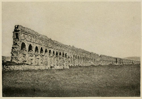
approach from the east passed between two fine arcades of the
aqueducts, one carrying three of them, the other two. These two
fine arcades were not more than a hundred yards apart; all the great
roads from the eastern side were brought into this space, and certainly,
for the last mile into Rome, must have had one of these
arcades on either hand: to the left, or south, the Claudian arcade,
fifty feet high; to the right, the Marcian, thirty feet high.
For the last half-mile, the Claudian arcade was also the boundary of
the palace gardens of the Sessorium, the residence first of the Kings
and afterwards of one branch of the imperial family (that of Verus or
Varius), who resided there for more than a century. That portion
of the arcade still exists for a considerable extent, forming the
northern wall of that garden, and at the same time part of the wall
of the city, Aurelian having adopted it, and incorporated it with his
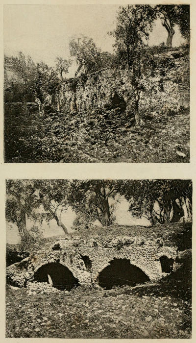
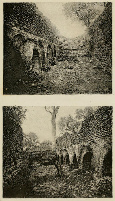
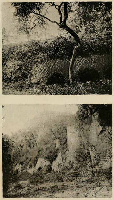
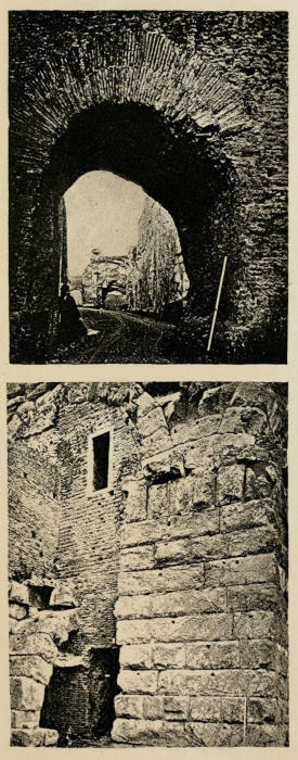
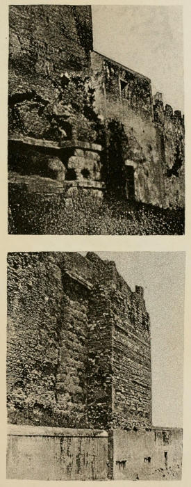
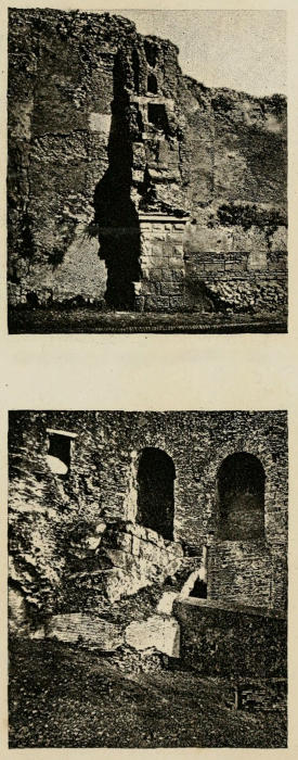
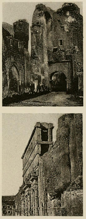
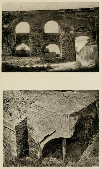
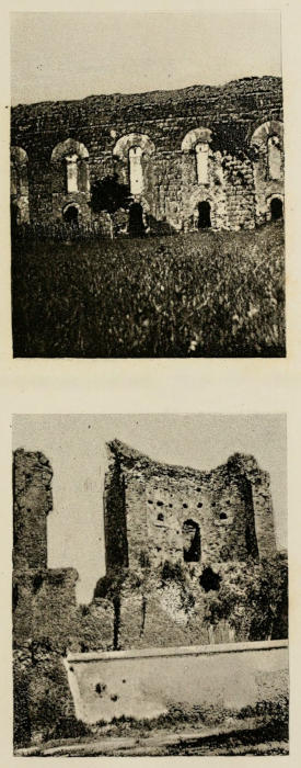
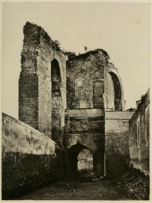
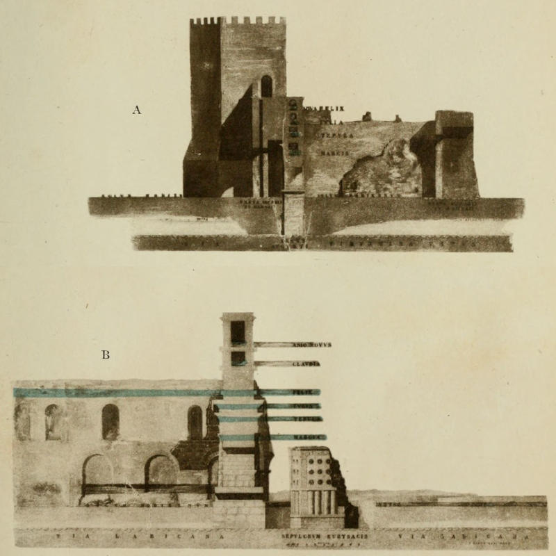
great wall. This portion is thoroughly shewn in my Photographs,
as it is a very important part of the antiquities of Rome, and illustrates
many points. It was the place where the principal aqueducts
entered Rome, and the whole ground is full of remains of them with
their reservoirs and filtering-places. The inner side of the wall is
the part necessarily shewn, because the outer side is concealed by
the arcade of the Aqua Felice, excepting in places where the specus
of the Claudia and the Anio Novus appear above it. Just outside
of this garden, at the west end of it, is the great foss which
separated the Sessorium, or fortified palace, from the other fortifications
of the City, and in it are remains of the two great
reservoirs that were probably the Gemelli or Twins of Frontinus,
made originally for the Appia and the Anio Vetus side by side,
and used afterwards to receive the surplus water of the later
aqueducts on a higher level. We then have a considerable number
of the Arches of Nero, following a straight line for another mile
to the west end of the Cœlian Hill; where remains of the great
reservoir are on a level with the specus carried on the top of this
arcade, fifty feet above the ground in that high situation, from which
the water was distributed in all directions, first on other arcades,
three of which branched off from this point, and afterwards in metal
pipes when it was sub-divided; but for the main supply no metal
pipes then to be had were large and strong enough to bear the
pressure of a stream of water four feet deep and two feet wide,
running at the rate of five or six miles an hour, if not more. The
direct line went on over the Palatine to the Capitol, passing over
the Forum Romanum on the bridge of Caligula, of which, also,
some remains are shewn in my Photographs; the other two branches
from the great reservoir over the Arch of Dolabella, went one to
the right to the Colosseum (to supply the Stagna there), the other
to the left to the Aventine, to supply the private house of Trajan
and the Thermæ of Sura.
The Porta Maggiore stood at the end of the long vista between
the two great aqueducts, and was itself made out of two of the arches
of the Claudian arcade, in the last of the angles that occurred at
every half-mile. The penultimate one was at the eastern end of
the Sessorium palace gardens, where this water entered Rome,
and then, after passing the angle to the north, with the usual
piscina and castellum aquæ, or reservoir and filtering-place, turned
again to the west, as far as that gate where the Claudian arcade
terminated. From this point the Marcian turned to the north
upon the great bank of earth which formed the outer defence of
Rome in that part, and continued along it for another half-mile,
as far as the Porta di S. Lorenzo, and beyond it to the Prætorian
Camp; then turning again to the west, it went across the great inner
foss between the outer bank, the great agger of Servius Tullius, which
formed the inner line, where remains of it were found near the railway
station in 1871, with inscriptions on two of the cippi, stating that
the three aqueducts passed there. It is not quite correct to say
that the arcades were carried there, because where the ground is
high the specus are carried underground. This is the case between
the Porta Maggiore (the Porta Esquilina of Frontinus) and the Porta
di S. Lorenzo (the Porta Viminalis of the same). The specus is seen
on arches close to each of the gates; but, between the two, it passed
underground through a sort of hillock, about midway between the
two gates, as is mentioned by Frontinus. The ground is high again
near the Porta Chiusa at the Prætorian Camp, and in the great bank
or agger of Servius Tullius.
These two great arcades are those chiefly known to visitors to
Rome as The Aqueducts; but the underground aqueducts are at
least equally interesting when understood. The Anio Vetus being near
the surface can be traced all over Rome; the Appia being very deep,
is not so easily traced, and can only be seen with certainty near
its source and its mouth. There are other arcades nearly as fine as
these; but, as they do not come so near Rome, they are less known;
in the parts nearest to the City they are either underground or destroyed.
One of them is that called Alexandrina by Fabretti; but
the original parts of it are of the time of Hadrian and Trajan. This
runs from the source near Gabii and Labicum, now la Colonna, to
the place called Cento-Celle. Possibly some of the hundred cells
or vaults found there and supposed to have been all tombs, were
really reservoirs of water. At every great villa there are always
remains of these great cisterns for the supply of water, and this
is about three miles from Rome, where a great villa of Hadrian
was situated. This arcade extends for miles across the country
between the two great roads, one from Gabii, the other from Preneste
(now Palestrina). Another fine arcade is seen on the road
to Albano, at the Tor di Mezza Via (or half-way house). This has
been ascertained to be the Aqua Aurelia, which goes to the villa
of the Quintilii on the Via Appia, and from thence into Rome to
supply the Thermæ of Commodus and Severus, of which also
remains have been found; the latter part of its course is chiefly
underground.
It was very difficult at first to ascertain to which of the aqueducts
each of the remains belonged that were seen on all sides; and I
found it necessary to follow each aqueduct up to its source, and then
down to its mouth, in order to ascertain this. This work has taken
me some years, in connection with the other branches of the general
subject of the Archæology of Rome. It has now been done, with
one exception,—the aqueduct made to bring water to the Thermæ of
Diocletian on the Viminal,—which has not been traced; but there is
great probability that it was a branch from one of the older aqueducts,
probably brought across from the great reservoir where the
Nymphæum of Alexander Severus was situated, on which the
Trophies of Marius were hung. This is on high ground, and at
a short distance only, so that it would be very convenient for the
purpose. We see that there are several branches from that point,
and one of them probably supplied these great Thermæ, for which
purpose more than one aqueduct would be tapped. It may be that
the curious sort of tower reservoir—long supposed to have been
a tomb, a short distance to the south of the Trophies of Marius—was
the one for these Thermæ; in either case, these reservoirs were
supplied from the great old aqueducts.
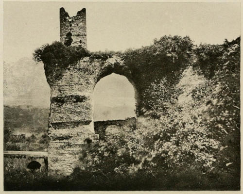
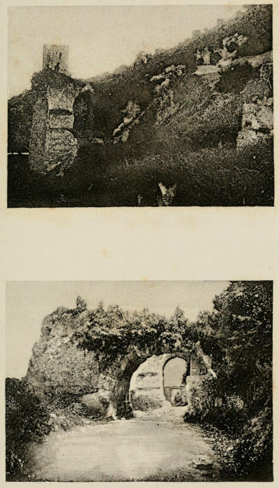
I may almost say that wherever the aqueducts are visible, they
can now be seen in my Photographs, and in some places the remains
have been destroyed since these were taken, during what
is called the Restoration of the City Walls. Perhaps the finest and
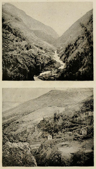
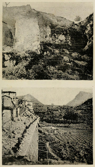
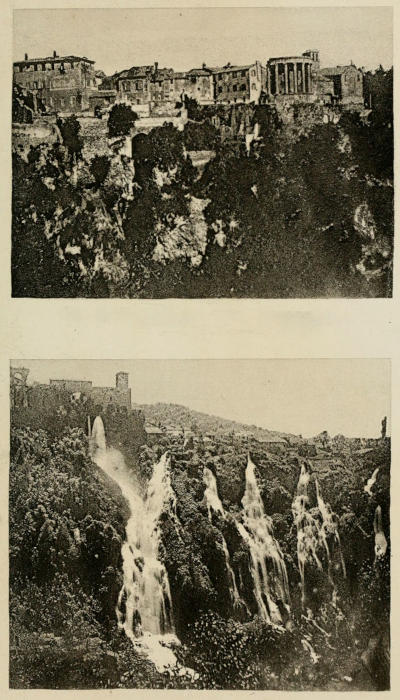
most interesting part of the Aqueducts are the great cascades at the
source of the Anio Novus above Subiaco, in the bed of that river,
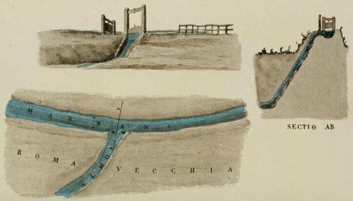
situated in some of the finest scenery in the world. Among later
works the ingenious manner in which the bed of the small river
Almo is made use of to carry the water of two other mountain
streams, the Aqua Crabra and the Marrana, the water of which never
fails; and the manner in which the tunnel of the Aqua Julia has
been used again in the twelfth century, are the most curious and
interesting. This had hitherto escaped observation, and was not
easily traced. The Aqua Felice was unfortunately carried out in
a very rude manner; the plan of the Pope was a good one, but
was spoiled by the ignorance of the engineer.
The new aqueduct, the Aqua Marcia-Pia, restoring the celebrated
Aqua Marcia to use in Rome, is a work deserving of high commendation.
It is much to be regretted that my lamented friend the late
Mr. Shepherd, to whose energy and perseverance we are chiefly indebted
for this, did not live to see the completion of his work.
Much credit is also due to Signor Moraldi, the originator of the
scheme, to whom the Company still pay a premium, which he well
deserves. His map[1] of the Aqua Marcia, of which he kindly gave
me a photograph, was of great service to me, as far as it went; but
I saw it was necessary to go further, and include all the Aqueducts
on the eastern side of Rome. I was fortunate in meeting with
Dr. Fabio Gori, who is a native of Subiaco, and has been interested
in the Aqueducts from his boyhood. He shewed me that Signor
Moraldi had not gone quite far enough, and that the real spring of
the Marcia is about a mile further from Rome than the one he supposed
to be so, which was a subsidiary spring, though of equally good
water. At the original source the stone specus was found, having
been long concealed by being a foot or two under water. I saw it,
and stood upon it, and had a photograph made, so that there could
be no mistake, and the engineer of the company also saw it, and
carried his aqueduct to that point; so that the real ancient Aqua
Marcia now comes into Rome again, and is getting rapidly into
general use, being much the best drinking water. The water supply
of ancient Rome has long been a subject of interest, and can now
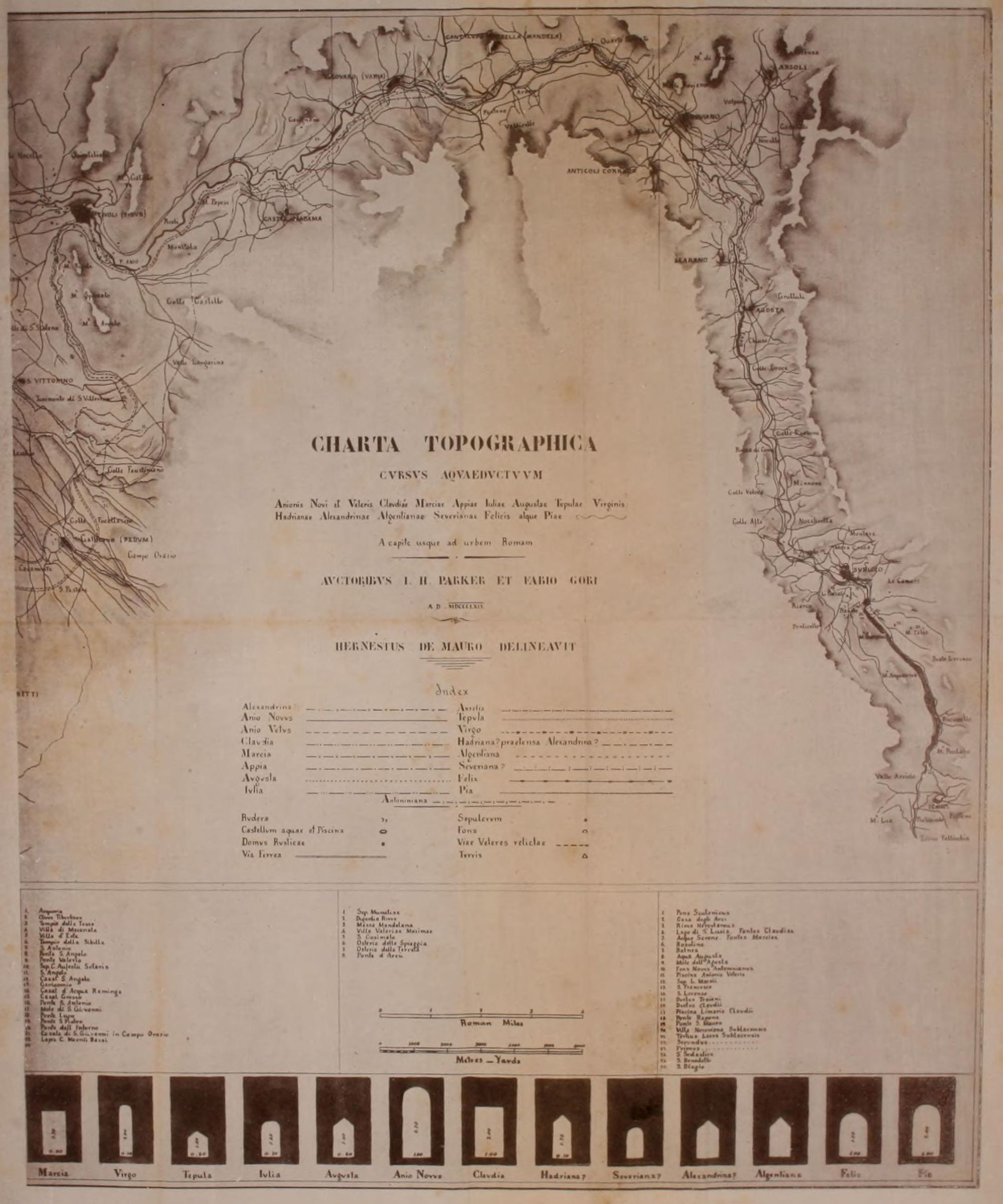
be more perfectly understood than it ever could before. The series
of Photographs of them are a thorough illustration of their history,
such as could not have been made before that art was invented.
The Nymphæum of Alexander Severus, where the Trophies of Marius were hung, was not
for the Aqua Julia, though usually called so. It is at too high a level for that, and was for the Claudia and Anio Novus united
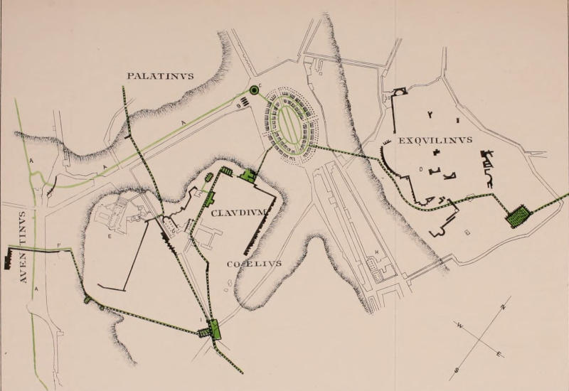
Three branches from that high reservoir: 1. to the Claudium and the Colosseum; 2. to the Palatine and Capitol; 3. to the Aventine, over the Porta Capena
Others say it came from Mons Algidus, near Tusculum, and was brought underground, with reservoirs on the tops of hills in the Campagna, supplied by syphons
Another branch of it is carried by the side of the other branch of the river Almo, in the valley of the Caffarella, and the other specus,
which is open on the top, has lochs in it there
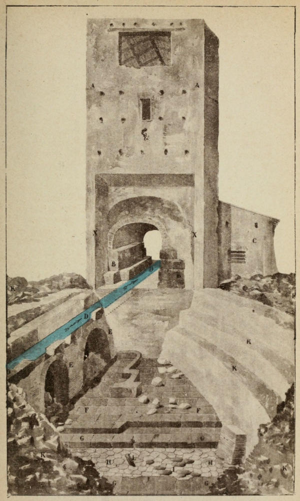
Aqua Appia, or Appian Aqueduct, crossing the valley from the Cœlian
to the Aventine upon the short Agger of Servius Tullius, and over the
Porta Capena.
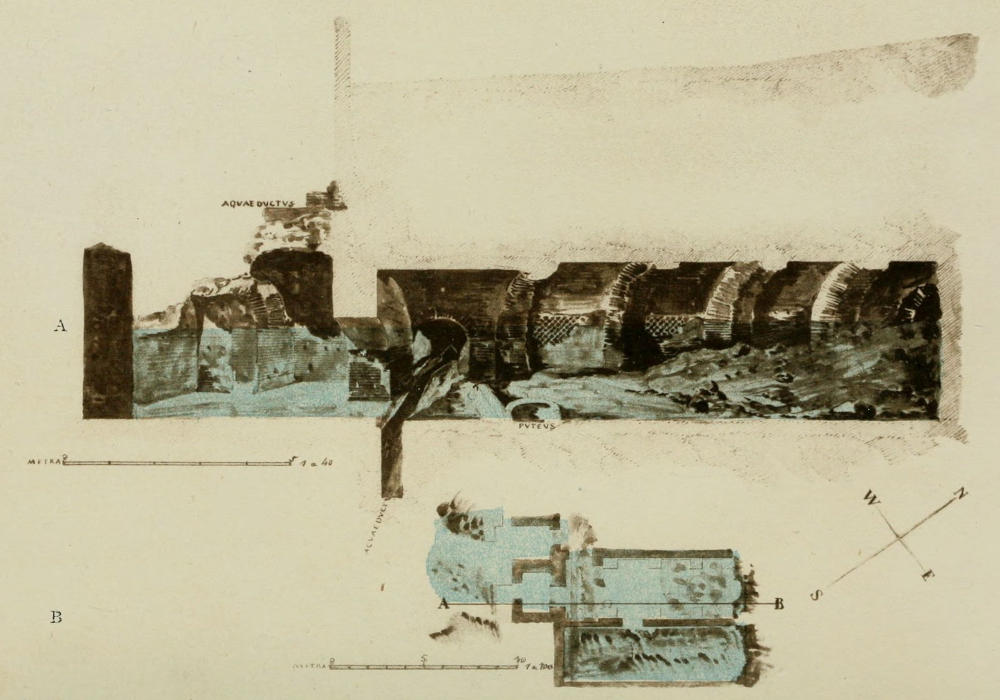
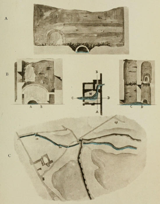
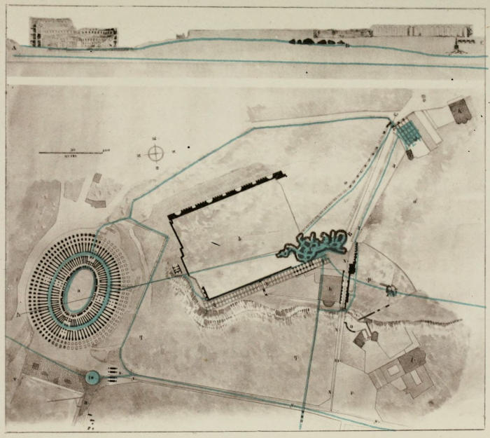
Plan and Section of the Aqueducts, from the great Reservoirs on the
Cœlian Hill, near the Arch of Dolabella and the Claudium, to the Colosseum,
and to the Drain under the road from the Arch of Constantine to the Clivus
Scauri.
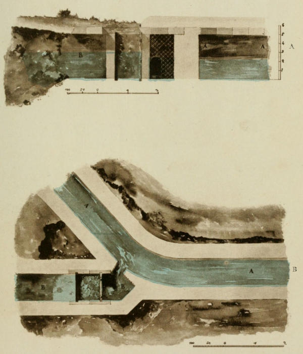
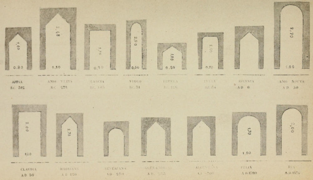
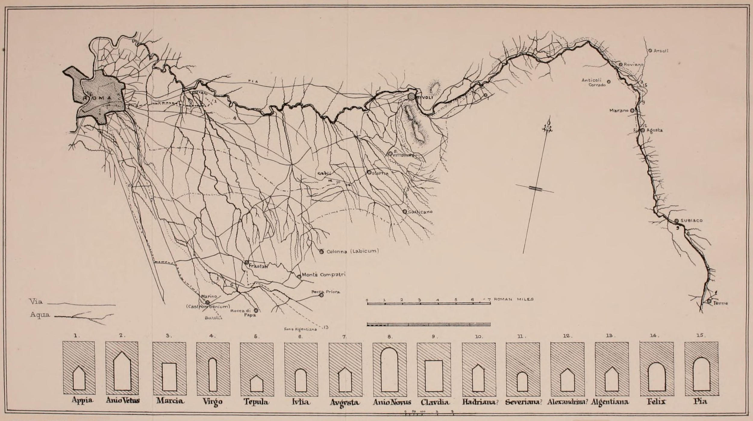
Sections of the Specus or Conduits of fifteen different Aqueducts.
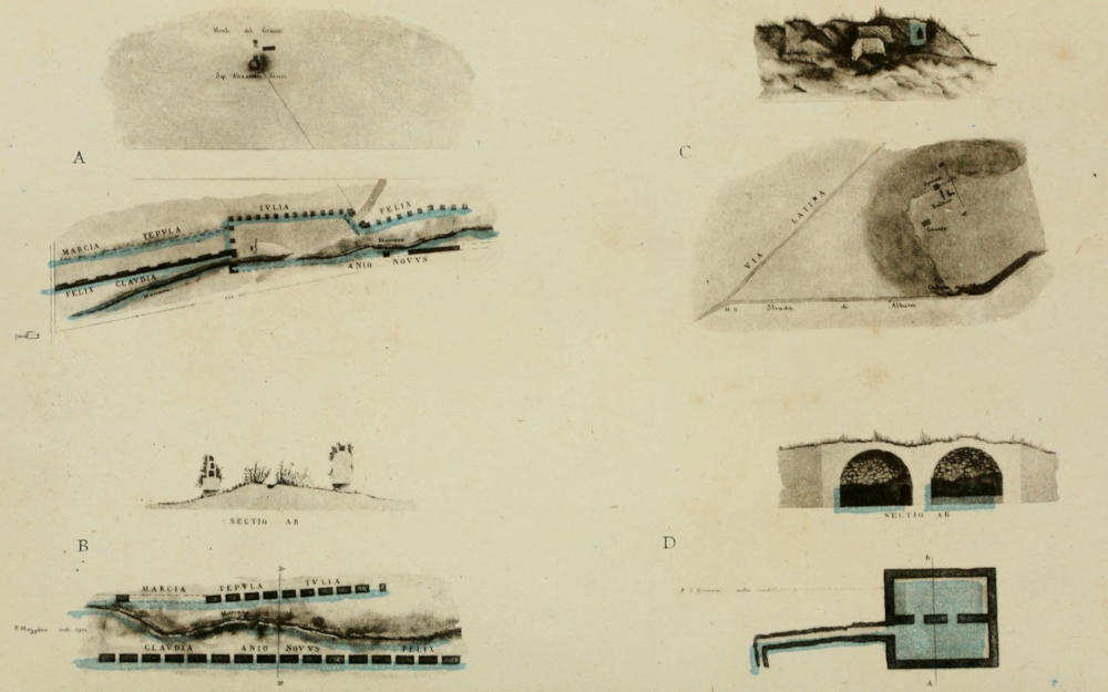
Plan of the Aqueducts on parts of the Cœlian
and the Esquiline Hills, from the great Reservoirs and Piscinæ called
Sette Sale, on the Esquiline, to the Colosseum; and the Three Branches
from the great Reservoir on the Cœlian, and over the Arch of Dolabella,
and the Piazza della Navicella, to the Aventine, the Palatine, and the
Colosseum.
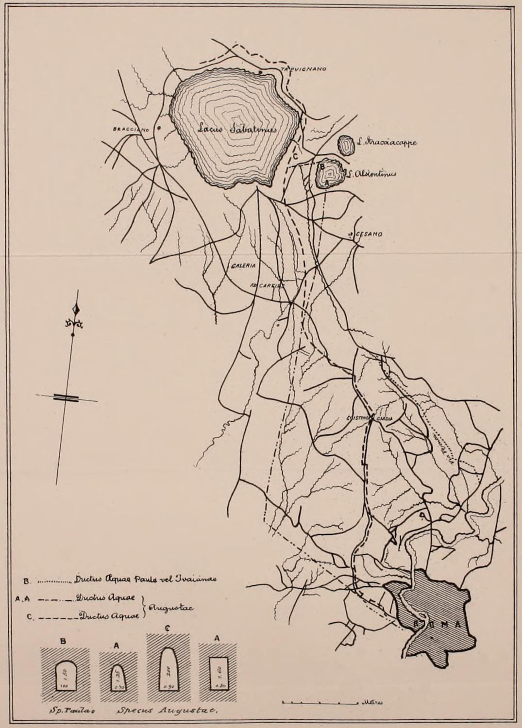
—— Western side of Rome, from their Sources
in the lakes on the hills, called Alseatina and Sabatina, or Anguillara.
CHAPTER IV. PART I. THE AQUEDUCTS. — I. The Aqua Appia ( A.U.C. 441, B.C. 312). — II. The Anio Vetus ( B.C. 272). — APPENDIX. On Spē or Spc̄. — FRONTINUS DE AQUÆDUCTIBUS. EXTRACTS REFERRING TO THE ABBREVIATION SPE̅S̅ FOR SPECUS. — Translation of the Extracts from the Treatise of Frontinus on the Aqueducts, containing all the passages in which the abbreviation Spē occurs. — Passages in which the Temple of Spes occurs in Livy. — III. The Aqua Marcia ( B.C. 145). — IV. The Aqua Tepula ( B.C. 126). — V. The Aqua Julia ( B.C. 34). — III., IV., V. The Aquæ Marcia, Tepula, and Julia. — The Piscinæ. — III. Marcia. — IV. Tepula. — V. Julia. — VI. Aqua Virgo ( B.C. 21). — VII. The Alsietina ( A.D. 10), Afterwards made the Aqua Paola. — VIII., IX. The Claudia and Anio Novus ( A.D. 52). — VIII. The Claudia. — IX. The Anio Novus. — The Neronian Arches. — The River Anio. — The Neronian Arcade.
In treating of the Aqueducts we have a trustworthy guide in
a writer who flourished in the time of the Emperors Nerva and
Trajan, namely, Sextus Julius Frontinus[2]. While he informs us
of what improvements he made during the time he had the charge
of these important public works, he also gives in his treatise a historical
account of the several changes which had been from time to
time made in the means of supply of water to the Imperial City,
which kept pace with the growing wealth and population of Rome.
When he died they had probably reached perfection, and were
justly the admiration and surprise of all travellers[3].
His treatise is well worth examination, not only from an archæological
point of view, but as suggesting also many curious enquiries
as to the engineering abilities which the Romans possessed, compared
with those exhibited at the present day. In elucidating, however,
the architectural antiquities of the city of Rome, it will be
necessary, as far as possible, to limit the extracts from his treatise
De Aquæductibus, to those portions which refer either directly to existing
remains, or which indirectly explain them, by pointing out the
principle on which the several Roman aqueducts seem to have succeeded
each other.
Frontinus tells us in his fourth chapter, that for 441 years after
the building of the city, or until B.C. 312, the people were content
with the water which they could draw from the Tiber, or from wells[4]
or from springs, of some of which the memory was in his time still
held sacred and honoured, for they were thought to afford health
to the sick[5].
Passing to his own time, he says, “there now flow into the
city:”—
Frontinus describes the above nine aqueducts in order, giving
details as to the source of the water in each, the quantity, and the
distribution. Such extracts as are calculated to throw light upon
the existing remains, are given in the course of the following
remarks. Seven other Aqueducts were added after the time of
Frontinus at different periods, of which an account will also be
found in the second part of this Chapter.
“The Aqua Appia was brought into Rome by the censor Appius Claudius
Crassus, afterwards called Cæcus (the blind), who also caused the Via Appia to
be constructed from the Porta Capena to the city of Capua[7].”
“The Appian stream rises in the Lucullan fields on the Via Prænestina,
between the seventh and eighth milestone, and about 780 paces (or about ¾ of
a mile) off on the left-hand side. The channel from its source to the ‘Salinæ,’
which is a spot near the Porta Trigemina, measures 11 miles, 190 paces (about
300 yards) in length. For 11 miles, 130 paces, (about 200 yards,) the channel
runs underground, and for 60 paces (about 100 yards) it is carried above ground
on a substructure and arcade (in the part) nearest to the Porta Capena[8]. At the
‘Spes (Specus) Vetus,’ (the old specus or conduit,) on the confines of the Torquatian
and Pallantian gardens, a branch called the Augustan was added to it by
Augustus as supplementary, whence it received the name of ‘Gemelli[9]’....”
“The distribution of the Appian water begins at the bottom of the Clivus
Publicii at the Porta Trigemina[10]; the stream having passed beneath the Cœlian
and Aventine Hills.”
“... The measure at the head of this could not be obtained because it
consists of two channels. At the Gemelli, however, which is under[11] the Spem
(Specum) Veterem, (the old conduit,) where it joined with the Augustan branch,
I found the height or depth of the water to be 5 ft., the width 1 ft. 9 in., which
makes the area 8 ft. 9 in.: ... it should be noticed that the water in many parts
of the City was observed to be lost, that is, by trickling away. Moreover we
found some of it intercepted by illegal pipes within the City; without the City,
owing to the pressure, that which was underground (at the head 50 ft.), received
no injury[12].”
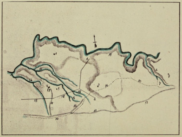
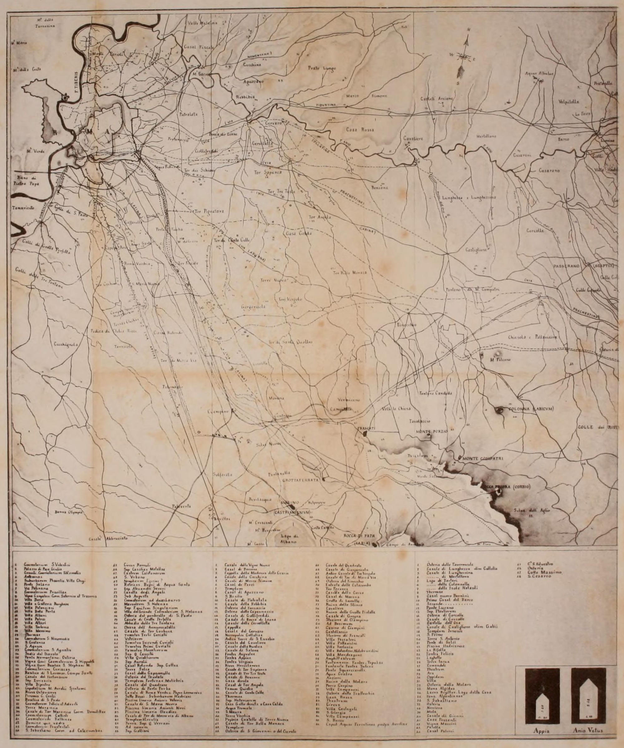
The Lucullan fields, in which are the sources of the Aqua Appia,
are nearly due east from Rome, on the bank of the river Anio, at
about six miles from the present gates of Rome, and three quarters
of a mile off the Via Collatina, now a cart-road. This is the old Via
Prænestina, which went through Collatia, now called Lunghezza, about
two miles higher up the river Anio, at the point where the smaller
river Osa falls into it. In this part the old paved road remains for
some distance in use, both before and after the entrance to Collatia,
and was the more direct road; the present carriage-road, now called
Prænestina, was the Via Gabina, and went through or near to Gabii,
but was not so direct a line to Præneste or Palestrina as the one
through Collatia. The old road passes close in front of the ancient
stone quarries, on the bank of the Anio, in which one of the springs
or reservoirs of the Aqua Appia is situated; the pavement of it
remains, and is now used as a foot-path only.
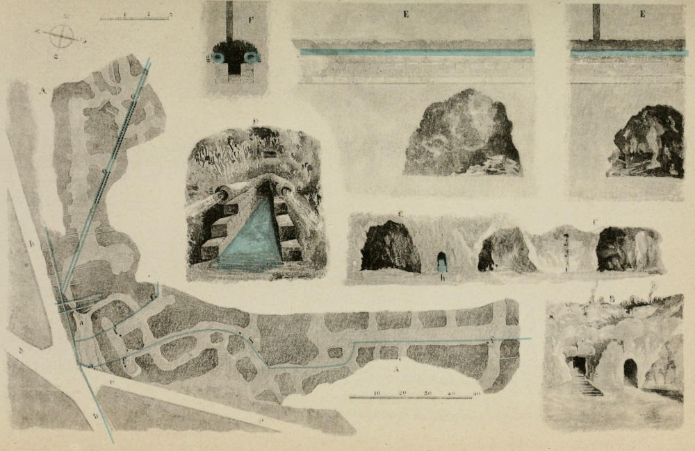
There are several springs or sources for this aqueduct, and also
several ponds to collect the rain-water, made in the clay, the water
from all of which was collected into a central reservoir cut in the rock,
with a large well over it. There are also seventeen wells visible in
two lines, eight in one and nine in the other, converging and meeting
in the central reservoir. The soil is clay upon stone. The
specus is here a large tunnel cut in the rock, and the wells descend
into it. They may be distinguished from above by the bramble-bushes
which grow over and cover each of the openings, and do
not grow on the other part of the field; each well is also protected
by a wooden rail, to hinder cattle from falling into it. The
water still runs through in some parts. Near to this reservoir is
a tomb of very early character, similar to what are usually called
Etruscan[13] tombs, cut out of the rock.
As the length of its course was rather more than eleven miles,
while the distance by the Via Prænestina direct was only between
seven and eight, it is clear that it did not follow that road. It was
carried to the south towards the Via Labicana by a winding course,
according to the levels of the ground. The Aqua Virgo, whose
source is in the same Lucullan fields as the Appia, is carried to the
north by another winding course of a greater length, to supply the
northern parts of the city.
The course of the old Via Prænestina[14] has undergone but little
change, and the 7th milestone is soon measured. A little beyond
it, and 780 paces off on the left of the road (i.e. on the northern
side), we are brought to a point[15] where the sources of the Aqua
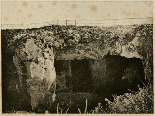
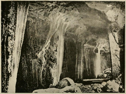
Appia are still to be seen in caves formed by ancient stone quarries,
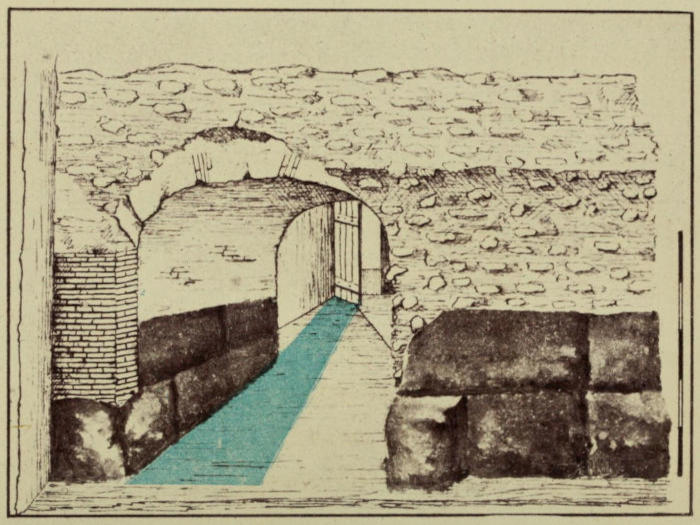
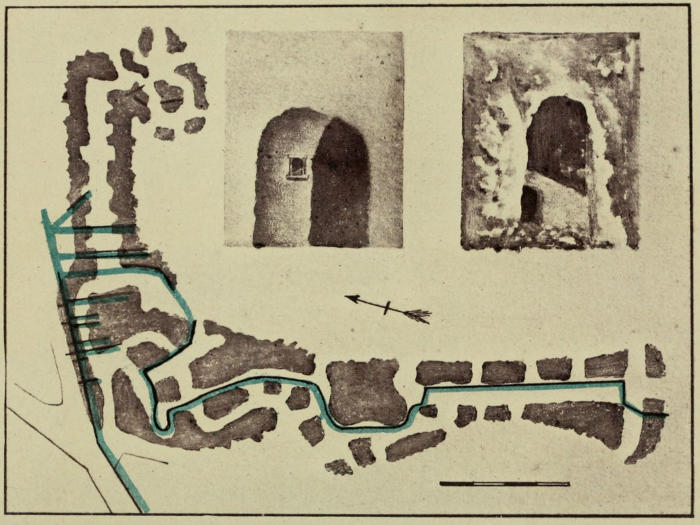
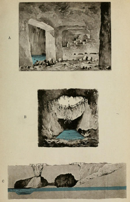
near a tenement called La Rustica. One cave is of a triple
form, with three springs, and the soil above the stone is much mixed
with clay. These three springs meet at the mouth of the cave in
one stream, which runs in the old specus cut in the rock, but open
at the top, and having the appearance of a mere country ditch, half
hid by the grass and weeds in the winter, and in the summer months
entirely concealed by them. This specus runs across a low meadow
for about a quarter of a mile. It crosses the line of the Aqua Virgo,
the respirators of which cross this meadow in an opposite direction;
the sources of the Virgo are about a mile further from Rome, on
the same road. It then enters the rock again in a tunnel, and at
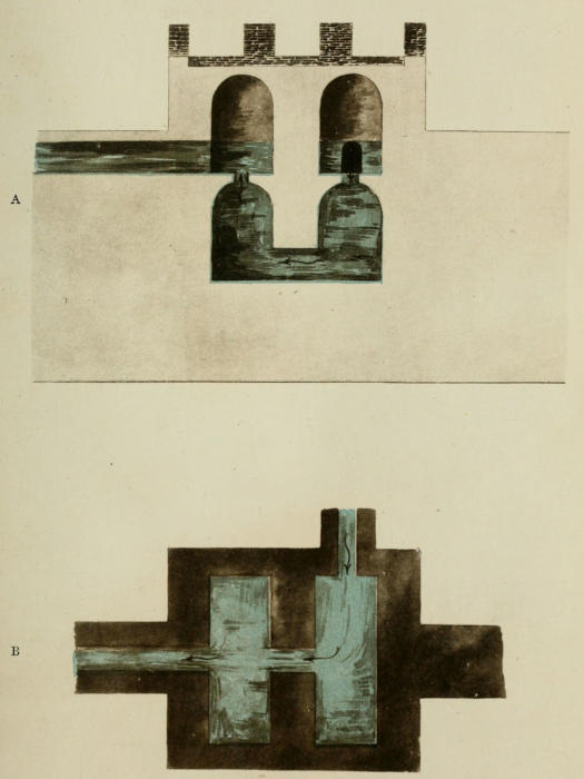
this point is the first castellum or reservoir, with a large circular well
cut out of the rock, which forms the vault over it. There are the
grooves for sluices at each end of the reservoir, and an opening has
been made into the tunnel a little beyond this reservoir. The course
of the aqueduct is then in a tunnel entirely underground, in the
direction of a series of ancient caves, through which, or by which,
it must pass, but being underground it cannot be seen. These caves
are evidently an ancient stone quarry, but of later character than the
one first mentioned. In the earliest one, at the source, the stone has
been split off the rock, not cut; in the other caves, the stone has
been well cut, and of these many are to be seen, the openings being
large square apertures like doorways, but side by side in the face of
the scarped cliff, not following each other: a practice common in
quarrying, where the circumstances require it, down to the present
day. Between the chambers are massive square or oblong piers,
left to support the vault and the earth above. At the bottom of one
of these chambers is water running from another spring, and the
shepherds state that there is an opening from it to the specus of the
aqueduct; but as the bottom is filled up to the depth of several feet
with broken stone, it cannot be seen. Some of the chambers of
this ancient quarry have been used as a burying-place, probably for
the neighbouring town of Collatia. The graves are cut out in the
side of the walls, like the loculi, and there are also chambers like
the cubicula of a catacomb. The tombs of this necropolis of Collatia
are very ancient, perhaps anterior to the Kings of Rome, and certainly
not posterior to the Republic. This stone has been cut out in large
square or oblong blocks, such as are usual in work of the time of the
Kings; it is probable that Appius Claudius made use of a quarry
which he found, and that the ground was not excavated for the
purpose of the aqueduct only.
From this point the course was entirely underground, therefore no
traces are visible without some difficulty. Incidentally, as we have
seen, Frontinus notes, that at the head the water ran as much as fifty
feet below the surface, and was thus protected from being fraudulently
diverted. It could not have taken a very direct line, as the levels of
the crossing valleys must have necessitated here and there a circuitous
course; and moreover this is clearly implied by Frontinus, who says
that the total length from the source to the “Salinæ” was more than
eleven miles, while the distance in a direct line is less than nine
miles. As it had no piscina[16], it flowed on in an uninterrupted course
to the spot where it was distributed for the public service.
One branch seems to have entered Rome under the line of the
Claudian arcade, near the Porta Maggiore[17], and its course within
the city is not difficult to follow, since for certain purposes access
has been made in more than one place into the old specus, part of
which is used to carry the lead pipes of the Aqua Felice to the
Hospital of the Lateran and other places. From the surface where
one of the shafts is situated to the bottom of the channel, is a depth
of twenty-five feet. No water runs along it at present, except in the
metal pipes from the Aqua Felice, belonging to the modern system.
The direction of this channel, after it enters Rome, happens to
be easily seen above, as it is marked throughout its course, from
the eastern end of the Cœlian to the Arch of Dolabella, by the
fine arches of the Neronian branch from the Claudian Aqueduct
erected almost over it. It is very probable that one of the laws
(referred to by Frontinus as having been in existence long before
his time) respecting aqueducts was in force from the commencement,
namely, that there should be no buildings of any kind
within ten feet on either side of the aqueducts; thus an open
space was probably existing at the time when Nero wished to
carry water to his magnificent reservoir at the north-western end
of the Cœlian, and of this he availed himself in rearing the splendid
arcade which is called by his name. It will be remarked, however,
that the brick buttresses actually came down to the flat roof of the
original specus of the Appian. The top of that specus was raised to
a greater height by the engineers of Sixtus V., and in this enlargement
the underground supports of the Neronian arches are cut
through to give headway to the aquarii passing along the channel.
They have however to stoop their heads as they pass under each
buttress.
The old tunnel specus was discovered in the time of Sixtus V.,
(Felice Peretti), filled up by clay deposit to the depth of three
feet, or half the height of the specus, as in other places, and the
builders found it easier to raise it, for the aquarii to go along it,
than to clear it out. They therefore knocked away the flat tile-covering
of the time of Nero, and raised a vault of rubble-stone
three feet higher.
From the great subterranean reservoir, still in use for the water
of a spring, near the Arch of Dolabella, to the edge of the western
cliff of the Cœlian is but a short distance, and here the specus
seems to run in a bank dividing the vineyard or garden of the
Villa Mattei from that of the monks of S. Gregory, on which a wall
has been built. At this point subsequent alterations, and especially
those under the Emperors Nerva and Trajan, have buried to a great
depth the actual remains of the original aqueduct; but this later work
occupies the same line, and must be described. We first come to
a large piscina or filtering-place on the cliff of the Cœlian, immediately
above the Porta Capena. This piscina is divided into two parts,
one above the other; but both are below the top of the cliff, and
are faced with brick and reticulated work of the time of Trajan.
There are remains of two specus running along against the face of
the cliff; of the upper one the lower part, or pavement, of Opus Signinum,
only remains, and this runs down in a sloping direction from
the upper reservoir to a lower one, a little to the south of it, which
is very extensive. This lower reservoir consists of several parallel
chambers, through which, or rather in front of which, another specus
runs at a lower level; this appears to be horizontal. This specus
goes on in the direction of the ruins of a building of various periods,
possibly the remains of the Ædes Camenarum, and passes then to
the south in the direction of the Thermæ of Severus and Commodus.
Another branch was evidently afterwards made from the upper reservoir
going towards the north for a very short distance, merely for
one of the usual angles; then, turning again to the west, in the valley
below, there is another large castellum aquæ, or reservoir of five chambers,
all as usual oblong and side by side. This is on lower ground,
and is built upon the wall of Servius Tullius, where it crosses the
valley; the upper part of this reservoir has been made into a house
for the gardener. The underground part of the chamber nearest
to the Cœlian is built of the large square blocks of tufa usual in
the time of the Kings, and belongs to the fortifications of the Porta
Capena, over the Via Appia, which here passed close under the
Cœlian; the other chambers appear, from the bricks, to be of the
time of Trajan. From this point to the Piscina Publica, the line
of tall brick piers of Trajan can be distinctly traced by the existing
remains, passing across to the other side of the road and of the
stream here close to it[18]. The ruins of the Piscina Publica, as rebuilt
by Trajan, remain visible under the corner of the Pseudo-Aventine,
near S. Balbina, and from this the water was again distributed in
different branches. At this point, let it be observed, and only at
this point, is the valley which divides the Cœlian from the Aventine
sufficiently narrow to admit of agreement with the direct and
clear assertion of Frontinus, that here alone, throughout the whole
course, was it carried on a substructure and on arches for a distance
of one hundred yards.
Although there are no remains of the specus now visible at this
spot, because the gate has been destroyed, there can be little doubt
that the channel for the water was carried over the southern gate of
the city according to its extent at that time. This gate was called
the Porta Capena; and as the Appian aqueduct was allowed to fall
into decay, it gave rise to the descriptions both of Martial and
Juvenal, who describe it as wet or moist[19].
The excavations made in 1868 and 1869 under the direction of
Mr. Parker, with the help of the British Archæological Society of
Rome and the Roman Exploration Fund, have clearly shewn the
specus of the Aqua Appia and those of two other aqueducts carried
upon the agger of Servius Tullius across the valley from the Cœlian
to the Aventine, with branches to the left running into the subterranean
chambers of the Piscina Publica. These underground
chambers are of the time of the Republic, the walls are built of
rubble stone as usual at that period, and there are small openings
through these walls for the circulation of the water, although the
upper part has been rebuilt in the time of Trajan, as the remains
of the wall are faced with the brickwork usual in his time. The
lowest specus is cut out of tufa rock under the wall of Servius Tullius,
which is built of the usual large blocks of tufa.
The principal branch went underground to the cave reservoir at
its mouth, on the level of the quay of the Marmorata between
that and the Salaria, just outside of the old Porta Trigemina; the
old agger in which that gate was situated still forms the southern or
lower boundary of the wharf of the Salaria. Part of the course of
this earliest specus, that of the Appia, can be traced and seen in
a subterranean stone quarry nearly under S. Sabba. The specus is
six feet high and two feet wide, and it is filled up to nearly half
its height by solid clay, evidently the deposit left by the water.
The old specus, long after it had been out of use, seems to have
been employed by the quarrymen: as it was a tunnel in the tufa
rock just high and wide enough for a man to walk in, by cutting
away one side they made it wide enough for a horse and cart
to carry the stone, and they raised the vault as high as was convenient
for the purpose of making an entrance into the quarry.
The series of wells descending into the old specus from the gardens
above remain at intervals, with notches for steps cut in the rock
to enable a man to go up and down when required. The course
of the specus is cut off by the road to the Porta Ostiensis, but
probably that road was originally carried over it[20] at the crossing;
it then passed through another large subterranean quarry nearly
under S. Prisca, to the cave reservoir at its mouth[21].
Before arriving at the two large reservoirs just outside of the
garden of the Sessorium, now Sante Croce, the specus of the Appia
must have passed by another smaller reservoir at the same low level,
near the ruins of the apse of a hall, miscalled the temple of Venus
and Cupid. This seems likely to have been the point at which
the branch specus, coming from the north, entered Rome, and it
was then carried on to the two large reservoirs outside this garden,
supposed to have been the Gemelli[22].
Below the “Salinæ” or salt warehouses on the bank of the Tiber,
and near the “Porta Trigemina,” the water was “distributed.” This
was also close under the Clivus Publicii, or the slanting zig-zag
road leading up from the wharf to the top of the hill.
So far the general course can be traced; but the exact point of
entrance into Rome could not be fixed without excavations, which
have not as yet been made. There are, however, some data given
by Frontinus which should not be overlooked, as they bear incidentally
upon the course of some other of the aqueducts.
First, it should be remarked, that the water of the Appia was
augmented by an additional stream. This was not accomplished
till the time of Augustus. The source of this latter[23] was on the
same side of the Via Prænestina, but a little nearer to Rome (near
the sixth milestone) we are told, and its course was, like the main
stream, entirely underground. It was more direct, as its length was
less than six miles and a-half, while the original stream, by its windings,
required about eleven miles to complete the same distance[24].
It joined, however, the Appia at the “Spes (Specus) Vetus,” and at
the Gemelli[25], which was under (infra) the “Old Specus,” it could be
measured. This is an important landmark; it is well at once to
observe that the usual interpretation of the passage as referring to
a “Temple of Spes,” and the statement that a temple occupied the
site of some ruins which are marked thus in a few maps, (in most,
Templum Veneris et Cupidinis) does not seem to fit the circumstances.
It is proposed to read in both these two instances “Specus
Vetus.” The expression occurs, altogether, five times in Frontinus,
and it will be most satisfactory therefore to consider the passages
together, which will be done more conveniently in connection with
the next aqueduct described.
The Torquatian and Plautian, or Pallantian gardens, seem by the
context to have occupied a spot on either side of the point of junction
of the two streams. The Torquatian gardens are not mentioned
elsewhere, and with respect to the Plautian[26] (which is only conjectural,
and has the authority of neither of the early MSS.), it has
been suggested to read Pallantian, which gardens are mentioned
twice elsewhere by Frontinus in connection with the Specus Vetus,
besides once in such a way as to imply the same[27].
The Torquatian gardens probably occupied the space between the
outer wall and the modern “Via di Porta Maggiore,” and were
probably those of Titus Manlius Torquatus, a member of an important
patrician family; Livy mentions at least three generations
of that name. This ground shews numerous remains of aqueducts
and reservoirs, and here also is the fine building of the third century
called the Minerva Medica, which was probably the nymphæum of
some thermæ of that period[28]. The Pallantian gardens is a natural
name for those belonging to the Sessorium, or the Sessorian fortified
Camp and Palace[29], and occupied the low ground near it. They
would therefore be to the south of, but adjoining to, the Torquatian
gardens.
“Forty years after the Appian aqueduct had been completed, and in the year
A.U.C. 481 (B.C. 272), Marcus Curius Dentatus, who bore the office of censor with
Lucius Papirius Cursor, contracted to bring into the city the water of the Anio,
which is now called the Anio Vetus, from the spoils taken of Pyrrhus[30].
“The Anio Vetus takes its rise beyond Tibur (now called Tivoli), outside the
gate, at the twentieth milestone, where it parts with some of its water for the use
of Tibur. Its course has in length, in consequence of the difficulties caused by
the levels, 43 miles. Of this for 42 miles and 779 paces, the stream is underground,
and for 221 paces (about 350 yards) on a substructure above ground.
“Near the fourth milestone within the new road (infra novum) the Anio Vetus
crosses between the arches from the Via Latina into the Via Lavicana, and has
(there?) a reservoir (or piscina). Thence just within the second milestone it gives
a part of its water into the specus, which is called the Octavian, and this comes in
the direction of the New Road to the Asinian Gardens, whence it is distributed
through that neighbourhood; but its direct channel, following the specus (or conduit)
coming within the Porta Esquilina, along the Spes (Specus?) Vetus, is drawn
off for distribution in the city, through the high channels[31].
“It held the sixth place in height, but would have been sufficient for even
the higher parts of the city, if it had been carried across the valleys and the low
ground, where requisite, upon substructure, arches, and buttresses[32].”
Passing on to the second aqueduct, namely, the stream taken
from the River Anio (and which was called the Anio Vetus to
distinguish it from a later diversion from the same river), we find
that Frontinus is also very distinct in many of his details; a few
only he leaves to conjecture.
The point where a branch was taken from the river Anio can be
traced[33]. There was a reservoir by the side of the river, of which
some ruins remain; but it was nearly destroyed a few years since by
some peasants in their ignorant and too eager search after hidden
treasure which they expected to find there. The specus is cut in the
rock as a tunnel in the cliff of the valley of the Anio, just below the
level of the road; it follows the line of the cliff, of the river, and
of the road: for they are all the same, the only opening through
the rocky mountains of limestone in this part, obviously made by the
river itself. It follows this line as far as the valley called the “Valle
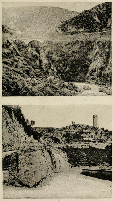
degli Arci,” or of the Arches, where three later aqueducts cross
the river on arcades about two miles above Tivoli. At this point
several aqueducts are visible crossing the valley on arcades, each on
a separate arcade, not three on one arcade and two on another,
as near Rome. The one nearest to Tivoli is the Marcian, and at
the foot of one of the piers of the arch, which here crosses the
road, the specus of the Anio Vetus is visible, partly underground,
but the upper part above ground, on the right-hand side of the
road in going from Tivoli. It then is carried in a tunnel through
the hill, but appears again on the other side with a large reservoir,
and runs gradually downwards in a winding course round part of
the hill.
It is not easy to distinguish to which of the aqueducts belongs any
one of the numerous reservoirs, the ruins of which are conspicuous
objects on the roads up to Tivoli on the other side towards Rome,
especially along both sides of that called the “Promenade of Carciano,”
for the distance of about three miles from Tivoli. The
specus and reservoir of the Anio Novus are on a natural terrace
above that road, and the Marcia below it; these have passed through
Tivoli, winding round that end of the hill. The Claudia passed
upon a great arcade the valley of the Arci, and another valley in
the direction of Gerocomio. The Anio Vetus was carried in a tunnel
through the hill, and appears on the other side near Tivoli, at a considerably
lower level than the others. The road passes across the
specus, and is made upon the surface of the vault, which is visible
about four miles and a-half from Tivoli. A little further on there
are two large reservoirs belonging to it, near a modern villa called
Gerocomio, built by the Cardinal Santacroce in the year 1579, now
a farm-house only, but on the site of an ancient villa, of which some
remains are built into the walls. One of these reservoirs or piscinæ (?)
appears to be unaltered, the buttresses remain and apparently the
vault; but it is covered with herbage and shrubs, which conceal it.
The other has been turned into a cottage or an out-house of the
villa, and this is of later date than the other. The Anio Vetus,
the Marcian, the Claudian, and the Anio Novus, all have to be
conveyed down this lofty hill from the high ground on which the
remains above mentioned are situated, to the valley below. The
river Anio itself rushes straight down the celebrated cascades by
a fall of about a hundred feet; but the channels of the aqueducts
follow a winding course, which allowed of the descent towards
Rome being very gradual.
This road or promenade of Carciano is rather high on the side
of the hill above the villa of Hadrian, looking towards Rome. The
dome of S. Peter’s is distinctly visible from it. The road is on
a ledge on the side of the cliff, and the aqueducts run along the
steep side of the hill or cliff, until they come to the valley of a small
stream winding down to the Anio; along the cliff of this they are
then carried. The Anio Vetus being at a considerably lower level,
is more difficult to trace than the others; but it seems clear that
after the later aqueducts had arrived at the point where the Anio
Vetus emerges from the hill, they all followed the same line, winding
along with the small stream, and their specus or channels cut
in the cliffs as far as they could be made available. The Anio Vetus
has been discovered at the left hand of the modern road to Rome,
and to the right of the promenade of Carciano. It passed, upon
a lofty bridge called the Ponte di S. Antonio, over a torrent, with the
Marcia. Afterwards upon another bridge called Ponte delle Mole
di S. Giovanni, and over the Ponte Lupo it went with the others.
Near Gallicano (or the ancient Pedum) are two cippi of Augustus
in two wells of his specus; one is in the country called Le Sette,
and another at Obrego[34] dell’ Ermito. The others have all been
followed, and an account of them will be found under their respective
heads.
In order to avoid the many small valleys occupied by streams
which run parallel to each other from the hilly ground on the south,
down to the river Anio on the north, (the general course of which
river is west and east,) the course was kept along the higher ground,
and in fact wound round the heads of those valleys in order to retain
a level, gradually becoming more and more depressed, till, by
the time it reached Rome, the base of the specus (according to the
computation of Piranesi), was 55 ft. above that of the Appian[35].
The whole course is underground, as has been said, except for 221
paces (about 360 yards); for this short distance it was carried on
a substructure above ground. It is reasonable to suppose that this
exception to the subterranean course was, as in the case of the
Appian, within the present boundary of the city.
Before it reached Rome, two circumstances have especially to be
noted. Just within the fourth milestone we are told it had a reservoir
and piscina or filtering-place, and at the second milestone it
parted[36] with some of its water, which was conveyed to Rome in
a separate channel.
This fourth milestone was clearly on the Via Latina, as Frontinus
in the previous paragraph had referred to some piscinæ at the seventh
milestone on the same road; and it appears, although the sentence
is exceedingly corrupt, that the course of the Aqueduct left the Via
Latina at this point, and crossed towards the Via Labicana “amongst
the arches[37]” at the fourth milestone. The specus is here visible, and
appears to be perfect; it is very near to the Torre Fiscale[38], between
that and the Osteria, called the Tavolato (which itself appears to
be made out of another, but a later, reservoir belonging to the aqueducts,
as many of the houses in the Campagna have been). The
vault of the old castellum aquæ or piscina is now covered with turf,
but the side of it forms a sort of cliff like the edge of a quarry.
This place, where the Anio Vetus leaves the Via Latina, is near
the great junction and crossing of the aqueducts, over which the
tall medieval tower called the Torre Fiscale has been built. Here
six aqueducts meet and cross each other. The Marcian arcade,
with three of these, makes one of its many angles, and the lofty
Claudian arcade, with two more, is carried over it. The expression
that it passed amongst the arches is a very natural one, to any
person who knows the locality, as there are many arches at this point.
It then goes on to another angle and crossing of the great aqueducts,
where there is a gate called Porta Furba, about two miles and a-half
from the Porta Maggiore. There is a castellum aquæ of the time of
Nero, with an ancient piscina under it, and a fountain of Sixtus V. by
the side of it. At the second milestone it parted with some of its
water into the specus called the Octavian, which enters Rome at
the Asinian gardens, following the direction of the new road.
By referring to the maps it will be seen that the original line of
the Via Latina united with the Via Appia within the outer wall and
before reaching the old southern entrance of the city (the Porta
Capena); but, in joining this latter road (the most convenient course
to pursue in the then state of the fortifications), the Via Latina
swerved rapidly to the south-west. Had it been continued in a direct
line, it would have reached the Cœlian Hill, near the Porta Asinaria,
as the Via Appia Nova still does, following the line of the old Via
Asinaria.
At this second milestone also is another castellum aquæ[39], mentioned
by Frontinus as two miles from Rome. This is near the
Porta Furba; it is entirely buried, but the vault of it is not many
feet underground. In the spring of 1871, some excavations were
made under my direction in a large vineyard hard by, and another
subterranean reservoir was found near the road to Tusculum and
Frascati, with a specus cut in the rock going in the direction of
that road, and apparently passing under it, on the line of a cross-way
to the Via Appia Nova, a short distance only. On the other
side of that is the “Albergo dei Spiriti,” near the junction with the
Via Latina; and, in the garden at the back of that house, a specus
was found in a stone quarry, the vault of which had fallen in and
brought the specus to view. It seems to have passed underground
along the southern side of that ancient Via for a short distance, and
then crossed it to a piscina, of which there are remains at the foot of
the bank on which the road runs in that part. It then goes along
the edge of some higher ground, and for a short distance underground
again towards a by-lane (diverticulum), parallel to the
Via Latina; remains of a brick arcade can be seen on the bank of
that lane, which is a deep foss-way, and goes on to Rome about
a mile distant. It is cut by the railway before it arrives at the
wall of Rome. It then passes through that wall and underground
again as far as the arch of Drusus, over which it passes; and thence
on an arcade, part of which only remains, to the great piscinæ at
the back of the thermæ of Caracalla[40].
The Via Appia Nova was probably made in the time of Frontinus,
and is the road which he calls Via Nova. The part nearest to
Rome was previously called the Via Asinaria, and extended from
the Porta Asinaria to the junction with the Via Latina, at three
miles from Rome, which name was then dropped. The new road
continues parallel to the Via Appia Antiqua as far as the eleventh
milestone, and there forms a junction with it. Both of these roads
are now open. The railway to Capua and Naples passes near to
this point of junction. The short Via Lateranensis, going out of
the Porta Lateranensis (excavated in 1868), ran into the Via Asinaria,
and so joined the Via Appia Nova, which has tombs of the
first century along the line, and none of any other period. Those
which were of stone have been used as a quarry by the farmers to
build the low walls that line the road on both sides, the foundations
only being left in the banks; but those which were built of concrete
faced with brick, would not pay for the trouble of destroying them,
and have therefore been left standing in their places. One of these,
a very fine one, faced with brick of the time of Trajan, with moulded
pilasters, remains nearly perfect near the seventh mile, just where
a path turns off to the left across the fields to the piscinæ, which
are near the line of the old Via Latina in this part, about half-a-mile
from the Via Appia Nova, and forming the carriage-road to
Albano through Marino. It left Rome by the Porta Asinaria as it
now does by the modern Porta S. Giovanni, which is close to the
old gate, but at a much higher level. The Via Latina crosses it
in a diagonal line, and runs nearly parallel to it as far as the Torre
Fiscale, that is, for about a mile gradually diverging from it.
Wherever the exterior of the specus of the Anio Vetus is visible,
it is faced with Opus Reticulatum. The reservoirs of this Aqueduct
are of the same construction, and this may serve to distinguish
those on the slope of the hill at Tivoli from the other aqueducts
there.
“The water of this straight branch,” says Frontinus, “coming
within the Porta Esquilina along the Spes [specus] Vetus, was carried
down into the city in the high streams[41].”
This specus is on the high bank of the Tarquins, the outer and
lofty line of defence on the eastern side of Rome. On this the
wall of Aurelian was afterwards built. After its entry into Rome,
the Anio Vetus was divided into several branches, in the same
manner as the later aqueducts were.
The right-hand branch, in crossing the Campagna, appears to
have run nearly under the Marcian arcade, which was afterwards
built on the same line and nearly over it. As we approach near to
Rome, there are remains of a reservoir built of large stones a little
way down the road, about a hundred yards from the Porta Maggiore.
It enters Rome under the wall, almost on the level of the
ground; the upper part of the specus was visible in 1868, but in
1869 was studiously concealed by a modern brick wall. It is visible
again inside the wall, on the other side of the road, going into the
vineyard in which the Minerva Medica stands, while one branch
went to the great reservoir near to it, westward of the gate.
Another branch passes along the bank under the wall of Aurelian,
and is not visible again until it reaches the Prætorian Camp, where
a portion of it was excavated in May, 1868, built of large stones of
tufa, under the Porta Chiusa. It may then be traced all round the
three sides of the Prætorian Camp, and near the north-east corner
there was, in 1868, an opening into it, now closed by a modern
wall. It is distinctly visible in several places, especially on the north
side of the Camp, where the wall of Tiberius remains perfect, faced
with the fine brickwork of his period, whereas the specus under it is
faced with Opus Reticulatum, probably of the time of the Republic.
The wall of Tiberius distinctly stands on the old specus. There
was an opening into it here also in 1868; but this was also carefully
walled up in 1869 under the influence of the Garibaldian panic,
which had a bad effect upon the Roman authorities at that period.
Remains of a reservoir or castellum aquæ were also found on the
surface of the ground on the bank near the Porta Chiusa, with
the present wall of Rome built right across it, but this part of the
wall has been rebuilt of old materials, and is not exactly in the
same line. There are remains of several other reservoirs on the
bank at intervals outside the wall in the modern road, and in many
places all along the eastern and southern sides of Rome.
Beyond this, near the Porta Nomentana, are the ruins of another
reservoir or piscina on the surface of the ground, against the wall.
From near the Porta Chiusa another branch went along the old
road, which passed through that gate across the inner foss to the
Thermæ of Diocletian, where a part of the specus and two cippi,
with two inscriptions upon them, naming this aqueduct the Anio
Vetus, were found in the year 1861, when the railway was made[42].
These cippi are now in the Vatican Museum.
Another branch went from the reservoir near the Porta Maggiore
before mentioned, across the road into the bank on which the arches
of Nero stand, near the Lateran, and passed under them apparently
into the old specus of the Appia, which runs parallel to and nearly
under the arches on the other side. Two small specus or stone
pipes can be still seen (in 1872) passing obliquely into that bank;
and, as they came from this large reservoir and piscina, (or from this
direction,) they seem to have belonged to two aqueducts at different
levels. A branch of the Marcian may have been brought to the
same filtering-place for distribution, and the surplus water carried
into the old specus at the lowest level, which was evidently used
for receiving and carrying off the surplus water of all the other
aqueducts in the same line.
The fifty yards outside the wall added to the three hundred
yards between the Cœlian and the Aventine, make up the three-hundred-and-fifty
yards above ground, mentioned by Frontinus.
In this valley we found it again, in 1869, parallel to the Appia,
sometimes on the agger or bank of Servius Tullius, which was used
as a substructure for it, in other places on an arcade built up against
the tufa wall of Servius Tullius, and faced with reticulated-work.
For the supposed Temple of Spes, the ruins of an apse in the
gardens of S. Croce, of “Venus and Cupid,” (as it is marked in most
maps, and as “Speranza Vecchia” in others,) was fixed upon by
Piranesi, who carefully examined all that he could with a view of
mapping out his aqueducts, according to the knowledge possessed
in his time. This building was no doubt a hall belonging to the
Sessorian Palace. Others, again, have suggested the so-called temple
of Minerva Medica, but this again is a nymphæum, or pantheum, and
not a temple at all. Besides, a further difficulty lies in one being
too far south, while the other is too far north.
Canina, in his account of the results of the excavations at the
Porta Maggiore[43], and of the tomb of Eurysaces the baker there discovered,
just outside of the gate, gives a plan in which he inserts
a temple just inside the gate on the southern side, which he calls
the Temple of Spes[44]. It is quite possible that this was a Temple
of Spes. There certainly was a temple on the site indicated, where
the modern guard-house stands; and during excavations carried on
there, fragments of a temple of the time of the early Empire were
found, consisting chiefly of a fine cornice of travertine.
When, however, the words of Frontinus have to be applied, the
difficulties of the theory of his referring to a temple are increased.
In the case of the expression last referred to, “following the specus
(spes), or, according to one manuscript, the old specus, which is obviously
the sense,” it is very difficult to imagine what circumstances
there were in connection with a temple which could warrant the use of
such words; and even in the instance mentioned, where we were
noticing the Appian aqueduct, “the expression, the Gemelli, which
is a place under the old specus (Spe̅s̅ Vetus),” is somewhat singular.
Granting that a temple once existed just within the wall of the
city (which, from the context, must have been its position if any)
it is singular that he should use it as a landmark when describing
the junction of two streams of water. The remaining three expressions
are simply “at the old specus (Spe̅s̅ Vetus[45]).”
With these difficulties to contend with, it has been thought well
to seek a different solution, and this is found in the reading of
“Specum Veterem” for “Spe̅m̅ Veterem,” i.e., the “old specus.”
With this reading, it naturally follows that it would refer to the
old specus, or the specus of the Appia and the Anio Vetus; and it is
singular that the first time it occurs in Frontinus, the Codex Urbinas[46],
only second in authority to the Codex Cassinensis, has the
reading “Anienem Veterem,” instead of “Spem Veterem.” What
was the true reading of the Codex or Codices from which these
two copies were made, it is impossible to say; they are the earliest
we have, and it is clear from several other instances that the scribes
did not copy with much knowledge of the matter in question: then
it was easy to mistake Spc̄ for Spē. That it was the Specus Vetus
which was meant, must rest therefore upon the circumstances which
allow of its application to the passages named, and it remains to
shew that this is the case.
In the instance under discussion, the water of the Anio is said
to flow along its own specus, and therefore it would not be probably
possible to find an interpretation more suitable as far as this case
is concerned. The conduit of the water of the Anio Vetus had
“emerged,” as the other aqueducts emerge, near the Porta S. Lorenzo,
from the higher ground between the Porta Maggiore and that gate:
it must consequently have been carried on a substructure from that
point on the outer bank of the original fortifications of Rome,
that is, on the high bank on which the aqueducts were carried, and
on which the wall of Aurelian was afterwards built, to the inner
bank, on lower ground faced with the tufa wall of Servius Tullius.
The names of the gates are matters of dispute, and are quite immaterial;
the levels of the ground decide the question[47].
In another place, Frontinus says[48] that several streams of water,
and first the Marcia, were carried to the Aventine from the specus
(a spe-cu), that is from the old specus he had before mentioned on
the Cœlian, and obviously from the west end of the Cœlian. The
Temple of Spes of Canina and others at the Porta Maggiore, is at
least a mile from the Aventine. The only way of giving an intelligible
meaning of the passage is that the author refers to the old
specus he had before mentioned, as leading along the Cœlian to the
Porta Capena. In the excavations made in 1868 and 1869, on the
line of the wall of Servius Tullius from the Cœlian to the Aventine,
the conduits of three specus were found, two of which must have
passed over the arch of the Porta Capena, in order to cross the Via
Appia, there a deep foss-way. Two conduits were seen in each of
the pits that were dug at intervals along the line, and at the junction
with the Piscina Publica under the Aventine they were all three
perfect; the lowest one is there cut in the tufa rock under the wall,
the other two are on the wall, and partly cut out of it.
Piranesi has preserved a sketch of the specus of the aqueduct,
which he supposed to be the Anio Vetus upon its substructure; but
he gives no clue as to the exact spot whence that sketch was taken[49].
In its character the masonry is very similar to that of the Marcian,
but there are minor differences sufficient to shew that it belongs to
an earlier age.
Those who have paid attention to the manner in which ancient
books have been transmitted to modern times before the invention
of printing, and who are familiar with the use of records and of other
medieval manuscripts or transcripts, well know how full of abbreviations
they are, and how difficult it often is for the editor to fill up
these abbreviations, if he does not happen to know the word intended.
The name of specus for the conduit of an aqueduct was
essentially a technical word. The first transcribers of the text of
Frontinus were not Romans, and did not know the term: hence
they filled up the abbreviation spē, or perhaps originally spc̄, with
spem or spei, instead of specum or specûs. The same thing may
have occurred in the text of Lampridius (as mentioned in a note
on a preceding page).
The Abbot of the monastery on Monte Cassino (now a public
school and public library) has kindly given me tracings of all the
passages in that manuscript in which this abbreviation occurs, and
I have had them reproduced by photography and phototype on the
page annexed. Opposite to this the same passages are given in the
Italic characters, and a few words that are necessary to complete
the sense in Roman characters. This is followed by an English
translation of these passages, and by some extracts from Livy and
other authors in explanation.
FACSIMILE FROM THE MANUSCRIPT AT MONTE CASSINO[50].
I.
iungitur ei ad s .. em ueterem[51] in confinio ortorum torquatianorum
et ... novum ramus Augustae, hac tres ... ad Viminalem usque
portam deveniunt.
I. 5.
II.
ibi rursus emer
gunt prius tamen pars julie ad spē ... veterem excepta, castelli celii
montis diffunditur.
I. 19.
III.
partem tamen sui claudia prius
in arcus que vocantur neroniani ad spē ueterem transfert hi directe per
Caelium montem juxta templum divi Claudii terminantur.
I. 20.
IV.
rectus vero ductus secundum
spē veniens intra portam exquelinam in altos rivos per urbem diducitur.
I. 21.
V.
ad gemellos tamen que locus infra spē ueterem, ubi jungitur
cum ramo Augustae.
II. 64.
VI.
sed postquam nero im
perator claudiam opere arcuato ascus[52] (?) excepta usque ad templum
divi claudii perduxit, ut inde distribuetur.
II. 76.
VII.
quibus nunc plures aque et imprimis
marcia reddita amplo opere a spē in auentinum usque perducitur.
II. 87.
I. [The Augustan branch] is joined to it [the Aqua Appia] at the
old Specus [or old Spes (?), temple of Hope], in the border of the
Torquatian gardens[53]. I. 5.
II. [The three, Marcia, Tepula, Julia] there emerge again; first,
however, part (of the water) intercepted from the Julia is poured at the
old Specus (or at the old temple of Spes[54]), and so into the reservoirs
on the Cœlian Hill, near the temple of the divine Claudius. I. 19.
III. First, however, the Claudia transfers part of its [water] into
the old Specus [or at the temple of Spes], on the arches called
Neronian[55]. I. 20.
IV. But the direct conduit [of the Marcia, &c.], passing by the
old Specus (?) of the Appia (at a higher level, or following the old
Hope?)[56], coming within the Porta Esquilina, [the water] is drawn
off in the high streams through the City. I. 21.
V. [The Aqua Appia], however, at the Gemelli[57], which place is
below the old Specus [or below the old temple of Hope (?)], is joined
with the Augustan branch. II. 64.
VI. But after the Emperor Nero had carried the Claudian (water),
which he diverted, on arched work to the temple of Claudius [or the
Claudium], at the specus[58] (or at the Temple of Hope?), that it might
be distributed thence. II. 76.
VII. By which many waters, especially the Marcia, being supplied
in great abundance, are conducted from the specus[59] (or from
the temple of Hope?) on to the Aventine. II. 87.
“At the time when this disaster happened, Caius Horatius and
Titus Menenius were in the Consulship. Menenius was immediately
sent against the Etruscans, elated with their victory. He also was
worsted in battle, and the enemy took possession of the Janiculum;
nor would the City, which besides the war was distressed also by
scarcity, have escaped a siege (the Etruscans having passed the Tiber),
had not the Consul Horatius been recalled from the country of the
Volscians. So near indeed did the enemy approach to the walls,
that first the engagement was at the temple of Spes, in which little
was gained on either side; again at the Porta Collina, in which
the Romans gained some small advantage, and this, though far from
decisive, yet by restoring to the soldiers their former courage, qualified
them the better to contend with the enemy in future[60].”
“At Rome a dreadful fire raged during two nights and one day;
everything between the Salinæ (or salt wharf) and the Porta Carmentalis
was levelled to the ground, as were the Æquimælian and
the Jugarian streets. The fire catching the temples of Fortuna, of
mater Matuta and of Spes, on the outside of the gate, and spreading
to a vast extent, consumed a great number of buildings, both religious
and private[61].”
“After this, in pursuance of a decree of the Senate, and an order
of the people, an assembly of election was held by the city prætor,
in which were created five commissioners for repairing the walls and
towers, and two sets of triumvirs: one to search for the effects belonging
to the temples, to register the offerings; the other to repair
the temples of Fortuna and mater Matuta within the Porta Carmentalis,
and likewise that of Spes on the outside of the gate, which had
been consumed by fire the year before[62].”
“He agreed with contractors for building a theatre near the Temple
of Apollo, and for embellishing the Temple of Jupiter in the Capitol,
and the columns around it; he also removed from those columns
the statues that stood incommodiously before them, and took down
the shields and military ensigns of all sorts which were hung upon
them. Marcus Fulvius made contracts for more numerous and
more useful works—a haven on the Tiber, and piers for a bridge
across it, on which piers Publius Scipio Africanus and Lucius Mummius,
censors, many years after, caused the arches to be erected;
a court of justice behind the new bankers’ houses, and a fish-market,
surrounded with shops for private sales; also a forum and porticus,
on the outside of the Porta Trigemina; another porticus behind the
dockyard, and one at the Temple of Hercules; also a temple of
Apollo Medicus, behind that of Spes, near the bank of the Tiber[63].”
It will be observed that all these passages apply to the well-known
Temple of Spes near the bank of the Tiber, of which there
are considerable remains now in the church of S. Nicolas in Carcere,
and do not apply to a Temple of Spes at the Porta Maggiore.
The word specus is used by Vitruvius in the sense of a covered
water-course:—
“But if there should be mounds in the middle between the walls
and the fountain-head, it must be so contrived that the water-channel
(specus) be dug under the earth, and poised on the top[64].”
And at a later period by Hirtius:—
“Alexandria is almost wholly undermined with water-courses, and
has a specus extending to the Nile, by which water is conveyed into
private houses[65].”
“127 years afterwards, that is, from the building of Rome 608 years, when
Servius Sulpicius Galba and Aurelius Cotta were consuls, as the aqueducts or
conduits (ductus) of the Appian and Anio were much decayed by age, (and also
intercepted fraudulently for private purposes,) the business of repairing and reclaiming
the said aqueducts was entrusted by the senate to Marcius, who was
then acting as Prætor. And because the increase of the population of the city
seemed to demand a more ample supply of water, instructions were given to him
by the senate that he should carefully examine how far there were other streams
which he might be able to bring into the city[66].
“He therefore restored the two old conduits, and introduced a third, which he
caused to be erected with ‘squared stones,’ and larger aqueducts, and carried through
them the water which he had obtained for the public service[67]. Hence it received
the name of the ‘Marcian’ from himself, as the author of it.
“The Aqua Marcia has its origin on the Via Valeria at the thirty-sixth
milestone, three miles off in the diverticulum (or cross-road), on the right-hand
to those going from Rome. On the road to Sublacum, now called Subiaco (Via
Sublacensis) also (which was paved for the first time under the Emperor Nero),
at the thirty-eighth milestone, for the space of two hundred paces on the left-hand
side the water lies like a pond, bubbling up in innumerable springs from
beneath the stony hollows, and is very green in colour.
“The length of the course from its head to the city is 61 miles, 710 paces;—by
an underground channel 54 miles, 247½ paces, on structure above ground
7 miles, 463 paces. Out of this, in many parts away from the city, in the upper
part of the valleys, it is carried on arched substructure for 473 paces; nearer the
city, from the seventh milestone, on a substructure for 528 paces. In the rest
of the work it is carried on an arcade for 6 miles, 472 paces[68].”
“The Marcian ranks fifth in height, and is at its head even in level with the
Claudian[69].”
“In the year of the building of the city, 719 (i.e. B.C. 44), Agrippa repaired
the three aqueducts—the Appian, the Anio Vetus, and Marcian—and took care
to supply the city with many fountains[70].”
“[Temp. Nervæ, (A.D. 96)] the Marcian having been enlarged was carried
across from the Cœlian [i.e. its specus] to the Aventine[71].”
“In the year 627,” writes Frontinus, “after the building of the city, when
Plautius Hypsæus and Fulvius Flaccus were consuls, the censors, Cneius Servilius
Cæpio and Lucius Cassius Longinus, took care to bring into Rome and the
Capitol the stream called the Tepulan, from the Lucullan Fields (which some call
the Tusculan[72]).
“The Tepula has its source on the Via Latina at the tenth milestone, two
miles off on the right of those going from Rome. Thence it was brought by
a separate channel into the city[73].”
“Afterwards Marcus Agrippa collected the natural waters of another stream,
at 12 miles from the city on the Via Latina, (2 miles off on the right of those
going from Rome,) and so intercepted the stream of the Tepula. To the newly-acquired
water the name of Julia was given, from the finder of it; nevertheless
the distribution was so divided that the name of Tepula was retained[74].
“The course of the Julia runs for the length of 15 miles, 426½ yards. In
work above ground 7 miles; out of this in parts nearest to the city from the
seventh milestone (it is carried) on a substructure for 528 yards; the rest on
arched work for 6 miles, 472 yards[75].”
“Of these [Aquæ], six within the seventh mile, on the Via Latina, are taken
up into covered piscinæ, where, as though breathing again after their course, they
deposit mud. The Julia, the Marcia, and the Tepula, are joined there; of these,
the Tepula, (which had been intercepted, and joined to the stream of the Julia,)
now receives from the reservoir of the same Julia its proper quantity, and flows
out in its own channel, and under its own name.
“These three are carried from the reservoirs on the same arcade.
“The highest of them is the Julia, lower the Tepula, then the Marcia. These
come down towards the Viminal, running together beneath the ground, on the
same level as the Collis Viminalis, as far as the gate. There they again emerge.
“First, however, a part of the Julia is, at the Spes Vetus, taken out and
distributed in the castella on the Cœlian Hill; but the Marcia, after the Pallantian
Gardens, throws off part of its water into a stream called the Herculanean.
This conduit through the Cœlian, being of no use for the houses on the hill because
at too low a level, comes to an end above the Porta Capena[76].”
To this point, Frontinus tells us, the three aqueducts tend[77], while
from this they are carried on the same arcade into Rome. The
ruins of these remain visible. Some of them are situated a little way
off the south side of the Via Latina, others on the east side of the
Via Appia Nova. Of these, two belonging to the Claudia and Anio
Novus are subterranean, and are now only to be distinguished as
mounds of earth, looking like tumuli. Others are above ground,
near that part of the Via Latina [now the road to Frascati and Tusculum],
and close to the Torre di mezza via, or half-way house from
Rome to Frascati, just beyond the sixth milestone of the modern
road. Others are at or near the Villa of the time of Hadrian,
called Sette Bassi (which is supposed to be a corruption of Septimius
Bassus), near the same point. All of these are between seven and
eight miles from the City; they are the chief landmarks in tracing
the course of the three aqueducts now to be explained, and each
of the three comes from its own separate source. The Marcia, the
lowest on the arcade, has its origin at the greatest distance from
Rome. The Tepula and Julia have their sources comparatively
close to the city. The Marcia takes its rise from the Simbrivine
Hills, as far removed beyond Tibur to the east as Tibur is from
the city, while the latter two find their way from springs in the
volcanic region around the lake of Albano.
The source of the Marcia is plainly visible, the exact description
of Frontinus pointing to the spot without leaving room for doubt.
In one of the numerous little valleys which run down on the north
side of the River Anio, feeding this stream with their rivulets, the
Marcian has its rise. The lake of S. Lucia[78] in that valley is so called
from a small village situated some distance up the slope; along the
bottom of this valley the Via Valeria passes. This lake is usually,
but erroneously, considered as the source of the Aqua Marcia.
The exact position of the source is about two miles from the
village of Marano, but on the other side of the river, on the right of
the valley to one looking towards the mountains, and there are still
at times pools of water forming here from the springs which emanate
from the overhanging hills. The water now falls into two or three
rivulets, which run at the bottom of the valley into the river Anio.
The aqueduct, however, when it reached the high road from
Rome to Subiaco, along the north bank of the Anio, turned
abruptly to the west, followed the course of the road back towards
the city, chiefly passing the further or hill side of it, but winding
somewhat according to the nature of the ground. After following
the road for some seven or eight miles, it crossed the river
(close to the monastery of S. Cosimato) and then pursued for some
six or seven miles the southern or right bank of the river Anio.
Here, at a spot scarcely more than a mile from Tivoli (Tibur),
the course of the aqueduct left the line of the river, and wound its
way in a south-westerly direction towards the piscinæ before referred
to; at times on a substructure, and in a few places, where the
valleys were deep, on arches, but for by far the greater distance
beneath the surface.
The line of the Marcia can be clearly traced along its whole
length. The principal source, called Acqua Serena, is a beautiful
spring gushing out from the mountain under the present carriage-road,
about seven miles and a-half before arriving at Subiaco, clear
as crystal and very abundant; it forms a small lake in the valley,
and fully realizes the description of Martial. The old specus, which
had long been concealed by being a foot or two under water and
overgrown with weeds, was brought to light in 1869 by the engineer of
the Aqua Marcia Pia, in making his new works for the restoration of
this beautiful water to use in Rome. He drained the lake a little,
and by that means made the specus visible[79]: this specus is then carried
to the cliff of the valley of the Anio (into which the water from the
small lake falls), and then follows the course of the valley and the
river, until it comes to the monastery of S. Cosimato, a mile from
Vico-Varo: here it crosses the river on an arcade of brick. It
there leaves the present road, and then is carried in the cliff on the
other side of the river until it arrives within two miles of Tivoli,
where it again crosses the river (here a deep ravine) on a fine
arcade parallel to that of the Anio Novus, and at a very short
distance from it. There are very fine and picturesque ruins of both
these arcades in the valley called the Valley of the Arches. It then
continued in the cliff by the side of the present road, which is on
a ledge of the rock or hill overlooking the Anio, as far as the old
town of Tibur and the Cascades, behind the present town of Tivoli:
to avoid these it follows a serpentine course, winding round the
end of the hill, and has a fine reservoir about half a mile beyond
the town, on the side towards Rome, below the level of the
Promenade of Carciano, by the side of which are considerable remains
of a large reservoir or piscina, with the specus running into it
and from it. This large building is divided down the middle by an
arcade, into two nearly equal parts. Some of it is faced with Opus
Reticulatum of a peculiar pattern. On the exterior, there are remains
of niches and fountains, a villa of some importance having been
built at this spot to take advantage of the abundant supply of excellent
water[80]. The specus then runs near the cliff below the level
of the road to another extensive reservoir and piscina about a mile
further on. There are considerable remains of a large building
erected on a steep slope just under the cliff, with no upper wall, as
the cliff itself supplied its place; but there is on the lower side
a fine wall of considerable extent and height, built of large square
or oblong stones of the construction called Cyclopean Masonry[81],
in this instance differing little from that of the Walls of the Kings
in Rome, except that the stones are rather larger, the building-material
being not tufa, but a kind of calcareous stone of the
country, dug on the spot. This wall has been supposed to be a portion
of the fortifications of the ancient city of Tibur, but for this
there does not appear to be the slightest evidence or probability.
It is simply the natural construction of the material at hand, and
therefore the cheapest wall that could be built for the purpose. No
cement is used, because none was required; these large blocks of
stone require none, and some chippings are used to fill up interstices,
as usual when no cement is used. Again the wall turns the
corner at both ends; it is not part of a large wall but is complete in
itself, as the facing of one side of the reservoir and filtering-place,
the interior of which is built of the usual concrete of rough stone
and mortar, and lined with cement of the kind which holds water,
Opus Signinum, used for all the aqueducts. The end is faced with
Opus Reticulatum, and there are remains of niches against the wall
at intervals. It was also more ornamented, because it was intended
to be the one seen chiefly; the other side, being near the edge of
a precipice, would only appear from a distance, and the large stones
were therefore more effective in that situation. There is no reason
to doubt that the whole was built together at the time that the
Marcian Aqueduct was made, and it was probably restored by
Augustus. It may be doubtful whether some caves in the cliff,
which formed part of the reservoir, were natural or were cut, and
the stone dug out from them. It is altogether a very picturesque
and interesting structure. There may be a question also whether
there was not a branch from this reservoir to the Villa of Hadrian
at the foot of the hill, perhaps a mile lower down.
The specus of the Marcia is visible at the Ponte di S. Antonio over
that of the Anio Vetus; and again, but alone, at the Ponte di S.
Pietro, and it passes the Ponte Lupo with the Anio Novus, Claudia
and Anio Vetus. It then continues, chiefly underground, to the great
piscinæ before mentioned, and thence on the arcade into Rome.
After reaching the City, the branch mentioned by Frontinus, c. 87,
as being carried across the valley from the Cœlian to the Aventine
in the time of Nerva, seems to be the one found during the excavation
in 1868, passing over the Porta Capena at a higher level
than the Appia, but still at a much lower level than the lofty arcade
of Trajan, of which only the bases of the series of piers crossing the
valley now remain. The aqueducts following this line had all to
cross the Via Appia, here a foss-way, on the arch of the Porta Capena.
This southern branch of the Aqua Marcia is probably the one that
can be traced along the side of the cliff of the Pseudo-Aventine,
after it had been repaired and brought again into use, for it must be
remembered that at one time, as Frontinus says, it ended at the
Porta Capena.
The conduit and arcade were rebuilt by Augustus, as recorded on
the inscription on his arch at the Porta S. Lorenzo, and in the sixth
decree of the Senate, on the subject of the aqueducts. This branch
arcade of Augustus is there expressly named as distinct from the
others, all needing repairs at the time of this edict. The consuls
are charged to see to “the repairs, at the expense of the city, of
the streams, conduits, and arches, of the Julia, Marcia, Tepula,
Anio; also of those streams and arcades which Augustus Cæsar
had rebuilt.”
A branch of the Marcian aqueduct was carried along the agger
into the Prætorian Camp. Some leaden pipes were found there in
1742, with an inscription upon them, recording that they were of the
time of the Emperor Macrinus (A.D. 217). This probably indicates
either a renewal of the pipes, or an additional supply of water. The
garrison in that camp was twelve thousand men, and a large supply
of water must have been required for their use[82].
The excellent qualities of the Marcian water are mentioned by
several of the classical authors, and were celebrated for a long
period; they were known in England in the time of Shakespeare,
as appears from the following passage in Coriolanus, Act ii. Sc. 3—
Brutus loquitur.—“What stock he springs of,
The noble house of the Marcians; from whence came
That Ancus Marcius, Numa’s daughter’s son,
Who, after great Hostilius, here was king:
Of the same house Publius and Quintus were,
That our best water brought by conduits hither;
And Censorinus, darling of the people,
And nobly named so, being censor twice,
Was his great ancestor.”
There is a slight anachronism here. Coriolanus lived in B.C. 489,
and the Marcian aqueduct was constructed in B.C. 145, more than
three hundred years after his death. Marcius Censorinus also, who
was twice Censor (the only Roman who filled that office twice),
lived B.C. 294.
In the thirteenth century, the church of S. Bibiana is incidentally
mentioned as being near the arcade of the Marcian aqueduct[83]. In
some excavations made in the year 1871, a portion of the Marcian
arcade, built of the usual large squared stones, was shewn, passing
under some high ground to the north of the Porta Maggiore, within
the wall of Aurelian, in a direction to join the bank on which that
wall is built, and passing between the Minerva Medica and the wall
in that part. This is very near the church of S. Bibiana.
The sources of the Tepula and the Julia are in the valleys on
either side of the promontory on which the modern town of Marino
stands, the ancient Castrimœnium (under the village of Rocca di
Papa). That of the Julia is on the south side, and almost close
under the crater now the Alban Lake. The Tepula rises near the
bottom of the valley which comes down from the hills in the neighbourhood
of Grottaferrata, and along which the Via Latina passes.
This lies somewhat nearer to Rome than the source of the Julia;
but the Julia joined it before it had advanced far, and thus the expression
of Frontinus, “Marcus Agrippa intercepted the Tepula[84],”
is explained. The waters, therefore, flow into the same series
of reservoirs and cisterns which received the Marcian after they
enter Rome.
Under the account of the Julia, the Aqua Crabra is mentioned.
This is the little stream into which the water of the Julia and
Tepula falls; which is united at the foot of the hill on which the
town of Marino stands, to another stream called the Marrana, and
the united water is now generally called by the latter name only[85].
Frontinus mentions several reasons why it was not made use of for
supplying the city with water; but it was brought into Rome in the
twelfth century as a small mill-stream.
Frontinus also says that the Tepula had its source at ten miles
from Rome on the Via Latina, with two more miles to the right on
a cross-road[86]. Ten miles on the Via Latina brings us near to
Tusculum, at the tenth mile is the Casino de Ciampino, from
which starts a cross-road to the right; and at two miles from that
point we arrive at the springs called Fontanaccio, before reaching
Grotta Ferrata, but close under that village. It follows that the
source of the Tepula was at this place, now called Fontanaccio.
The spring comes out under a cliff of the rock of lava near the
road, and has a modern washing-cistern in front of it; but behind
this the ancient work can be seen, with openings into a reservoir
in the cliff. This is probably contemporaneous with the time that
the conduit of the Tepula was made. The supply of water is small,
but of good quality.
As the Aqua Tepula supplied only the Regiones in the northern
part of the city, it seems to have passed into the castellum, the
remains of which may still be seen in the city wall near the Porta
S. Lorenzo, evidently built upon an old agger before the Aurelian
wall was erected[87]. It, however, has been a house as well, the lower
part only being used as the reservoir for the water, and the upper
part, which is large and important, for chambers. The front of this
house, or castellum aquæ, still forms part of the city wall. It has
been much disfigured, and the old drains walled up during the
restorations (!) of 1869.
On the level of the first floor, in which is part of the reservoir, is
a row of corbels to carry a wooden gallery or hourd, probably an external
passage for the use of the Aquarii, behind which the specus
runs at the same level. Immediately above the line of the corbels
which carried the floor of the gallery or balcony, is a row of large
arches; but these are merely the arches of construction found in most
walls of the period. At the south end of this line of corbels, which
mark the extent of the castellum in that direction, there is an angle,
and the wall recedes a few feet. In this angle is the specus, corresponding
in form and dimensions with that of the Aqua Tepula in other
parts; it can be seen entering into the reservoir behind the line of
corbels. Within the wall are the usual marks of a reservoir of water:
the tartar deposit remains visible in the corners of the chambers cut
through by the wall of Aurelian, or by the engineers of the Acqua
Felice, whose specus runs behind it on the bank within the wall
which formed the front of the house. The specus of the Acqua Felice
is here at rather a higher level than the Marcian arcade, with the
three specus upon it, although at the “Sette Bassi,” five miles from
Rome, and near the piscinæ, it is at a lower level. On the bank just
above the level of the ground are the water-drains (hidden by the
restorers in 1869) for carrying off the superfluous water into a large
subterranean drain which runs under the gateway, and which is still
in use for purposes of irrigation.
Frontinus states that the source of the Julia was at twelve miles
on the Via Latina, with two more miles added on a cross-road
to the right[88]. The twelfth mile is at Frascati; from thence, by
a cross-road to the right, we arrive at the bridge of the Squaricarelli,
and at the copious springs called the Fontanile, exactly two
miles from the starting-point at Frascati. This must, therefore, be
the source of the Aqua Julia.
The swampy ground in which the source of the Angelosa or
Aqua Julia is found, is full of springs, like the Lucullan fields, from
which flow the Appia and the Virgo, and from it run also the
streams called di Monte Fiore and la Marrana di Marino.
This ground is on a high level on the Monte Fiore e dell Aglio
(the Mons Algidus of the ancients), or “The hill of flowers or of
garlic;” and the springs come from the gardens of the modern Villa
Aldobrandini, at Frascati. Canina cleared out the ancient specus,
which had a curved vault, almost oval (a capanna).
This source of the Julia is on the left-hand side of the road from
Grotta Ferrata to Marino, about a mile above the former, and nearly
the same distance below the latter. The water gushes out from the
foot of the rock and passes under the road to a lavacrum, or
washing-place, at a lower level on the opposite side of the road, and
then falls into the Aqua Crabra, which passes at the foot of the cliff
many feet lower down. A part of the water of the Julia, before it
goes into the lavacrum, is carried to the right in a specus to Grotta
Ferrata. This is ancient, but has been restored to use, so that it
looks modern. Below Grotta Ferrata, the specus has been destroyed
in many parts; but remains of it may be seen close to the ancient
fortified villages called Pagus Lemonius (on the maps Castellaccio,
a small castle). It is ten miles on a branch of the ancient Via
Latina, and between the present roads to Frascati and Grotta
Ferrata. In a part of the fortifications of this village is a castellum
aquæ, or reservoir of the Julia, and near it part of the specus, on an
arcade on the brow of the hill. This specus is built of rough stone,
and faced with a rude early kind of Opus Reticulatum, more rude
indeed than might have been expected at its date (B.C. 34), and not
nearly such good work as the Muro Torto, but more like the Emporium.
The reservoir is of the same character, but part of the
specus in the fortifications is carried on brick arches which agree
with that date; the brickwork is not of the time of Nero, to whom
it has been attributed. A specus of rough stone follows the line
of the hill to the Marrana, after the junction of that stream with
the Aqua Crabra, close to the point where the water from that
stream enters a tunnel of the Aqua Julia. After it emerges from
this tunnel, it arrives at the castellum or piscina in which the water
of the Julia was received before it was carried on the Marcian
arcade. This piscina is about two miles nearer to Rome, close to
the point of junction between the roads to Frascati and Marino,
through Grotta Ferrata, and near to the other piscinæ.
Frontinus says that the Aqua Crabra flowed past the head of
the Julia, but was excluded from it by Agrippa[89]. We find this
stream coming from that part of the hill on which the village called
Rocca di Papa is situated, passing near the head of the Julia at
Fontanile, now Angelosa, and sometimes mixing with the springs
there. It has one of its sources in the grounds of the Villa
Torlonia, at Frascati. All these three streams now fall into the
river Anio.
Near Rocca di Papa an arcade, or bridge of ten arches, of silex
or flint, covered with brick, passes over the Aqua Crabra to carry
some aqueduct, probably a part of the Julia. This arcade is called
Arcioni, [‘the arches.’]
There are some remains of another reservoir within the wall of
Rome, on the bank between this and the Porta di S. Lorenzo, which
seems to have belonged to the Julia: the specus of the Marcia,
with that of the Tepula and remains of that of the Julia over it, are
visible on an arcade a little beyond, close to the gate. The lower
part of a fine brick wall with bold buttresses, of the usual character of
a piscina or castellum aquæ, are visible, and this faces the present
Wall of Rome, almost touching it, so that this has been built since
the piscina, but that not being exactly in the same line it could not
be used. The piscina of the Tepula being on the outer side of the
bank or mœnia came into the line of defence of Aurelian, and was
used as part of his wall; that of the Julia, being on the inner side
of the bank, was too much within the line to be used.
The Castellum Aquæ Juliæ, or chief reservoir of the Julian Aqueduct,
is usually, but erroneously, said to have been the one situated
on high ground near the church of S. Maria Maggiore, where the
picturesque ruins stand, usually called the “Trophies of Marius,” because
those trophies were hung under two of the arches there, until
they were removed to the Capitol. A lofty arcade carrying a specus
at a high level passes across the valley, from the reservoir near the
Porta S. Lorenzo to this point. This arcade is of the first century,
built of the fine brickwork usual at that period, and agrees with the
time of Frontinus; but the only aqueduct that was high enough to
have carried water to that spot was the Anio Novus.
This great reservoir was rebuilt by Alexander Severus, and called
a Nymphæum, being given as such on one of his coins. This
name is rather a vague one; but it is evident, from some excavations
made in 1871, that there were extensive thermæ of the
Emperors of the third century near this place.
From this lofty reservoir the distributing channels may be seen
branching off in different directions, one going to the Thermæ of
Titus, towards the reservoir called the Sette Sale, another going in
a different direction.
This Nymphæum (?) is on lower ground than the outer wall,
though still on ground so high that the only water that could reach
it was that of the Claudia and Anio Novus, of which part of the
arcade remains between it and the reservoir on the high bank. From
that point the ground descends gradually and gently along the line
of the agger of Servius Tullius either way, and still more towards the
interior of the city. The aqueduct, therefore, could not pass underground
and then emerge in this part. The Porta Esquilina of the
inner wall was on the same level, or nearly so. The Porta Tiburtina
of the inner wall was near the thermæ of Diocletian, with a gradual
and gentle descent to it along the line of the agger. The only
possible explanation of the text of Frontinus is that the same names
of the gates in the inner wall were applied to those in the outer wall
on the same roads.
A piece of leaden pipe, with an inscription upon it, was found
at the Porta S. Lorenzo, which gives the names of Dolabella and
Silanus as Consuls; this fixes the date at A.D. 10, and shews that
the Marcian water was conveyed in leaden pipes at that point
in the time of Augustus. The stone specus was carried over the gate,
as we see by the remains of it in the wall, and the inscription upon
it recording repairs by Augustus. The one upon the leaden pipe
is given by Gruter[90].
Another leaden pipe was found by Panvinius on the site of the
Prætorian Camp, with an inscription, given by Gruter[91], which records
that it conveyed the Marcian water to that point.
Three aqueducts are mentioned in other inscriptions found during
the excavations near the railway station in 1869[92]; the three aqueducts
intended can hardly be other than the Marcia, Tepula, and
Julia. The upper one only was excavated; but if the noble Roman
princes who conducted this excavation had dug a little deeper, they
would probably have found the other two under the one that they
had discovered. These three specus must have been carried along
and in the agger of Servius Tullius.
To reach that part of it on the side of which these cippi are
found, they probably went along the side of the road that passed
on the south side of the Prætorian Camp, on which was the gate
called Porta Chiusa. Close to this gate remains of a large reservoir
were found in the researches of 1869 on the bank, with the Wall of
Rome carried right across it; but this part of the wall is medieval,
built of old materials, and it is probable that, originally, the front
wall of this reservoir was included as part of the wall of the city, in
the same manner as that of the Tepula near the Porta S. Lorenzo.
This reservoir, with the Porta Chiusa by the side of it, and the road
from it to the agger, at the place where the cippi were found, is now
in the garden of the Baron Grazioli.
This Aqueduct was made by Marcus Vipsanius Agrippa to supply
water to his Thermæ, on the south side of the Pantheon, which was
the hall of entrance to them.
Frontinus writes:—
“The same (M. Agrippa) when he had been consul for the third time, and
when C. Sentius and Quintus Lucretius were consuls, that is, thirteen years
after he had brought down the Julia, he brought the ‘Virgo’ also, the water of
which was collected in the Lucullan fields[93].
“The Virgo begins on the Via Collatia, at the eighth milestone, in some
marshy places: a cemented wall [signino[94] circumjecto] being placed round it,
to retain the bubbling waters; the source was increased by many other additional
supplies. It comes for a length of 14 miles and 105 paces. Out of this,—by
a subterranean stream 12 miles, 865 paces; above ground for 1 mile, 240
paces, of which it runs on a substructure in several places for a distance altogether
of 540 paces; on arched work 700 paces. The channels of the additional supplies
of the subterranean stream make 1 mile, 405 paces[95].”
The Virgo has no reservoir, i.e. Piscina ... “The arches of the Virgo have their
commencement beneath the Lucilian (or Lucullan?) gardens. They end in the
Campus Martius, along the front of the Septa[96].”
The Virgo was the seventh in height as to level (c. 18).
The road now called Via Collatia, or Collatina, where the Aqua
Virgo has its origin, is between the present roads to Tivoli and
Palestrina; it turns off to the left or north of the highway now
called Via Prænestina, just beyond the ruins called Torre de’ Scavi
or de’ Schiavi, about three miles from the city. But this is an
alteration; the old road from Rome to this point in a foss-way may
be traced behind the tower in the meadows, with the subterranean
aqueduct running under and in the southern bank of it, as traced
by the respirators or ventilating shafts. There are remains of very
ancient tombs at intervals all along the line of this old road, which
goes straight towards a postern-gate midway between the Porta Maggiore
and the Porta di S. Lorenzo. This must be the Via Collatia
of Frontinus.
Close to this road, at eight miles from Rome, near the ruins of
Collatia, there are several springs in marshy ground, from which
the water is collected in a series of reservoirs, just below the level of
the ground, the vaults over them being sometimes above ground;
from these small reservoirs separate short conduits run to the same
point, the great central castellum aquæ, part of which is a cave in
a rock, with a larger semicircular basin built out in front of it,
over which passes the cross-road from the Via Collatia to Salone.
The line of the specus can be distinctly traced from this reservoir
near its source to the city by the respirators over the wells. The
smaller castella, or cisterns, at the sources are also still in use.
About four miles from Rome, on the road now called Via Collatia,
or Collatina, a portion of the Aqueduct was rebuilt under Benedict
XIV. in 1753, as stated on an inscription upon it. It is here carried
across a shallow valley, on an agger built of rough concrete
faced with brick, for about a quarter of a mile. At the further end
is a conduit-head, or a modern castellum aquæ. This is a small
oblong building with a semicircular head erected under Pius VI.
in 1788, by Joseph Vai; and the conduit was continued by him for
the length of 175 feet, also stated in an inscription upon it[97].
From this point there is a branch to the south for a short distance,
with two respirators visible in the field; but this, though
appearing like an additional source, is only a branch leading to an
old fountain of a villa.
The main line comes from the north along the bank of the
Via Collatia, as shewn by the respirators, at regular intervals of
about a hundred yards. These are mostly round masses of concrete
with round heads; but some are dwarf pyramids, one of which,
numbered “40,” has been rebuilt in 1866. The surplus water is
carried into a brook which runs by it, and receives its chief
supply from it.
The specus or conduit of the Aqua Virgo passes along the line of
the old road in a direct line west, towards the Porta Maggiore, until
within about half a mile from that gate; then it makes a great detour
to the north, passing under the modern Via Tiburtina, and eventually
enters Rome through the Pincian Hill a little to the north of the
Spanish steps, and there is a reservoir for it at the end of a short
street called the Via del Bottino. It then goes to the present fountain
of Trevi, passing at the back of the houses in the Via del Nazareno,
where it may be seen in several of the courtyards. In one of
these, on the left hand of the street, is an inscription recording its
repair by Claudius[98]; in another, on the right, is an ancient lavatory
below the level of the street. A branch passes under the Via dei
Condotti carried in leaden pipes, enclosed in a brick specus; this
branch is the one that led to the Thermæ of Alexander Severus,
which were situated to the north of the Pantheon. The main line
supplied those of Agrippa, for which this aqueduct was made. The
Aqua Virgo chiefly supplies the fountains and houses in the Campus
Martius, or lower city, and the main stream terminated originally in
front of the Septa[99], considerably to the south-west of that fountain.
In some excavations made in the summer of 1871, a portion of it was
found in the Piazza di S. Ignazio. This original termination was at
the north end of the Septa, very near the Pantheon.
This aqueduct was restored by Pope Hadrian I., A.D. 772-795,
after it had been damaged by the Goths. It was afterwards repaired
by several subsequent pontiffs, especially by Boniface IX., A.D. 1389,
and by Nicholas V. in the fifteenth century. It now supplies the
fountains in the Piazza Colonna, erected in 1574; at the Pantheon,
restored in 1711; several others of the seventeenth century; and
that of the Trevi, erected by Benedict XIV. in 1730.
Near the source of the Virgo passes an abundant stream, also
called Marrana; but this has mineral properties, and was therefore
carefully avoided in forming the aqueduct for the Virgo. Pliny says[100]
that there was a stream which was abhorred by the Virgo, and for
that reason the water was called the Virgin. This stream was called
by him Rivus Herculaneus, some say for its salubrious qualities, because
Hercules was the god of health; others because it was a strong
stream. There is little doubt that this is the stream here described.
The same name of Herculanean is given by Frontinus to the stream
now called Marrana[101] in two places, because it was also a strong
stream.
Frontinus says of this water, “What could have induced Augustus, that most
careful of emperors, to bring in the water of the Alsietina (which is called
Augusta) I do not well know; for it is not pleasant to the taste, and therefore of
no use for the people. It may be, however, that when the work of the Naumachia
approached completion, in order not to divert the more wholesome water,
he introduced this for the special purpose, and gave the surplus to the adjacent
gardens and territories.
“It is the custom, however, in the Transtiberine Regio, when the bridges
require mending, and there is no water forthcoming from the city side, to make
use of this for supplying the public springs, as a matter of necessity.
“It begins in the Alsietine lake on the Via Claudia, at the fourteenth milestone,
about six miles and a-half off on the right hand. Its course is in length 22 miles,
172 paces, and over arched work 358 paces[102].”
“It is the lowest of all as regards the level, supplying only the Transtiberine
Regio, and the places adjacent[103].”
“The manner of beginning the Alsietine aqueduct is not described in the commentaries,
nor can it now be found with certainty; it begins from the Alsietine
lake, and then about the Cariæ receives water from the Sabatine lake also, as
the Aquarii regulate. The Alsietine gives 392 quinariæ[104].”
The lake formerly called “Lacus Alsietina,” now called Lago di
Martignano, is situated on the hills on the western side of Rome,
between the Via Aurelia and the Via Claudia, (not far from the old
carriage-road from Florence to Rome). It is about 679 ft. above
the level of the sea; and as Rome is only 204 ft. at the Porta
Maggiore, the lake is 475 ft. above the level of Rome at that
high point. There is another small lake about a quarter of
a mile from, and a little above the level of, the Alsietina, called
Strachia Capra, which has recently been drained by a tunnel in
imitation of the emissario from the lake of Albano. The water in
the Lacus Alsietina has also been very much lowered in the same
manner[105]. In consequence of this reducing of the level of the water,
the specus of the aqueducts are now brought to view, being on the
bank and above the present level of the water, so that they can distinctly
be seen and entered into[106].
To begin with the highest, the specus of the Aqua Paola begins in
the upper lake, and forms a junction with the water from the Alsietina
Lake, near the bank of the latter, at the south end of that lake.
The specus of the Alsietina of Augustus is a tunnel cut in the
rock[107]. The Lacus Sabatina[108] is at the elevation of about 523 ft.,
and therefore 156 ft. below the Alsietina. Augustus drew an additional
supply of water from this lake, and this portion only
of the aqueduct of Augustus was restored by Trajan. The water
for this was not drawn from the lake itself, but from the springs
that supply the lake on the western shore, the side most distant
from Rome. Some of the work of the time of Trajan is visible
there. The specus of the Alsietina has been traced to the point
of junction with the Aqua Paola (this water having been restored
to use by Pope Paul III., A.D. 1540), and it still supplies the district
of the Trastevere. It does not appear that Trajan used the water
of the Alsietina at all, but the engineers of Pope Paul evidently
did so; a tunnel, or specus, from that lake having been made in the
time of Pope Paul, the entrance to which remains, with the grooves
for a flood-gate[109]. After the junction with the Aqua Paola, the old wells
can no longer be traced; their place is supplied by the constructions
called respirators, each of which is a small square structure surmounted
by a pyramid. These are evidently built over the wells, and
very rudely constructed of the stone of the country, worked rough.
When we arrive at the Osteria Nuova,—which is near the site of the
ancient city of Cariæ[110], mentioned by Frontinus, and the old village
of S. Maria in Celsano, the point of junction of the Alsietina and
Sabatina,—there are evident marks of another junction of aqueducts
there. The house itself, now used as an osteria or hostelry (auberge),
is made out of an ancient Castellum Aquæ, as is frequently the
case with similar houses in the country round Rome, and sometimes
even within the walls. At about half a mile from this osteria,
in a hollow, is a white house called Casale Bianco; and close to this
is a fountain, supplied by a spring which runs into a specus. This
water, being one of the sources of the Aqua Paola, passes through
the hill at a considerable depth. At about half the distance between
this and the osteria is a remarkable passage for the Aquarii into
the tunnel by a very steep descent, passing sideways across the
specus of the Aqua Paola, and going on to a much greater depth
to the Aqua Alsietina[111]. This passage is 150 ft. in length from
the surface of the hill, and 70 ft. in perpendicular depth, with
ninety steps, of which only a few at the top are visible; the
others are covered with earth. The water still runs through the
upper specus, and is still in use, but not through the lower one[112].
From the valley beneath the sloping passage for the Aquarii,
near the Osteria Nuova, Nibby[113] traced the Alsietina as a tunnel
cut in the tufa rock, a part of which he saw near an oil mill. The
specus then followed the low ground from the tenements of S. Niccola,
Porcareccina, Maglianella, and from the Villa Panfili, to the principal
gate of the monastery of S. Cosimato (or SS. Cosmas and Damian
in the Trastevere), where it is stated by Cassio[114] that the specus
was found in 1720, about thirty feet underground. The Naumachia
of Augustus is said to have been near this monastery.
The complaints of Frontinus appear to have been listened to by
the Emperor, and great changes and improvements were made in
this aqueduct under his direction, in the time of Trajan; this is in
fact the same as the Aqua Trajana (see X.), and the water still comes
from the Lacus Sabatina, but not from the Alsietina. In going from
Rome, the respirators can be followed across Monte Mario, and
near the high road that passes over Ponte Molli, to the point of
junction about ten miles on the road to the Cariæ [now Osteria
Nuova]. Here the respirators cease; but their place is
supplied by a line of old wells descending into the subterranean
specus, which follows the line of the old road. This is not always
the same as the new one. The other branch, which supplied
the Naumachia, was the only one made in the time of Augustus.
Paul V. repaired this aqueduct along the whole line, restored it
to use, and put up in various places inscriptions recording this, in
which he calls it the Aqua Alsietina[115]. The last of these is on his
fountain at the mouth of the aqueduct, where the water still gushes
out in great abundance, as it did in the sixth century, when it was
observed by Procopius; this is on the Janiculum, above S. Pietro in
Montorio, the highest ground in Rome.
“Afterwards Caius Cæsar, (Caligula,) who succeeded Tiberius, considered seven
aqueducts scarcely sufficient for public purposes and private amusements, and began
two new aqueducts in the second year of his rule as Emperor, when Aquilius
Julianus and P. Nonius Asprenas were consuls (i.e. A.D. 38), in the year of Rome
789, which work Claudius in a most splendid manner finished and dedicated, on
the calends of August, in the year of the city 803 (i.e. A.D. 52), when Sulla
and Titianus were consuls[116].
“To one, which was brought from the springs of Cæruleus and Curtius, the
name of Claudia was given. This one is next in order of excellence to the
Marcian.
“The other, because two streams of the Anio had begun to flow into the city,
so that they should be more easily distinguished by their names, began to be
called Anio Novus. It ruins all the others[117]. To the former Anio the cognomen
of Vetus was added[118].
“The Anio Novus and Claudia are carried from the piscinæ upon higher[119]
arches, so that the Anio is the highest of the two. Their arches come to an end
after the Pallantian Gardens, and thence they are carried down in pipes for the
use of the city.
“But first of all the Claudia transfers a part of its water on to the arches
which are called the Neronian, at the Spes (Specus) Vetus. These, being continued
in a direct line along the Mons Cœlius, are terminated close to the temple
of Claudius. They disperse the quantity which they had received either about
the ‘Mons Cœlius’ itself, or in the Palatine, in the Aventine and the Transtiberine
Region[120].”
“The Claudia begins on the Via Sublacensis[121], at the thirty-eighth milestone,
about 300 yards off the road towards the left. There are two very large and
beautiful springs, one called Cæruleus, from its blue appearance, the other Curtius[122].
It receives also the spring which is called Albudinus, of such excellence,
that when there is need of adding it to the Marcia, the latter loses none of its
quality by the addition. The spring of the Aqua Augusta, because the Marcian
seemed to be sufficient for itself, was turned aside into the Claudian; nevertheless
it was retained as a protection for the Marcian, but so that the Augustan might be
added to the Claudian, if the channel of the Marcian was not capable of receiving
it[123].
“The channel of the Claudia is 46 miles, 406 paces in length; of this, 36 miles,
230 paces is by a subterranean course: on work above ground 10 miles, 176
paces, and out of this on arched work, in many places in the upper part, 3 miles,
76 paces; and near the city from the seventh milestone, by a substructure of
channels for 609 paces, on arched work 6 miles, 491 paces[124].
“The Claudian was the second in height as to level[125].”
“The Anio Novus, at the forty-second milestone, on the Via Sublacensis, at
Simbruinum[126], is taken out of the river, which, since it has about it cultivated
land in a rich territory, and so very loose banks, flows muddy and turbid even
when uninfluenced by violent rains; and therefore at the very entrance of the
channel is placed a cistern for the mud (piscina limaria), so that the water on its
way from the river to the specus should settle and become clear. From this
cause also when heavy showers come down, the water flows into the city in
a muddy state.
“There is joined to it the Rivus Herculaneus[127] which rises on the same road at
the thirty-eighth milestone, in the same neighbourhood as the springs of the
Claudian, on the other side of the river and the road. This is very pure by
nature, but when mixed it loses the advantage of its freshness.
“The channel of the Anio Novus is in length 58 miles, 700 paces. Out of this
49 miles, 300 paces is by a subterranean channel;—on work above ground 9 miles,
400 paces; out of this on substructure or on arched work in several places in the
upper part 2 miles, 300 paces, and nearer the city, from the seventh milestone, on
a substructure of channels 609 paces, on arched work 6 miles, 491 paces. These
are the highest arches, elevated in some places 109 feet[128].
“Nor was it enough for our Emperor [Nerva] to have restored an abundant and
pleasant supply of water in the other aqueducts; he thought he saw his way
to getting rid of the bad qualities even of the Anio Novus, he therefore ordered the
source to be changed from the river, which was now left alone, and taken instead
from the lock in which the water was most pure, and which is situated above
Nero’s villa on the lake (super villam Neronianam Sublaquensem[129]);” i.e. at Subiaco,
now a medieval castle and a modern town.
“But the water of the Anio Novus often spoilt the rest, for since it was the
highest as to level, and held the first rank as to abundance, it was most often
made use of to help the others when they failed. The stupidity, indeed, of the
Aquarii was such that they introduced this water into the channels of several
others where there was no need, and spoilt water which was flowing in abundance
without it. This was the case especially as regards the Claudia, which came all
the way for many miles in its own channel perfectly pure, but when it reached
Rome, and was mixed with the Anio, lost all its purity. And thus it happened
that most of the streams were not in fact helped at all by the addition of the
extra water, through the want of care on the part of those who distributed it[130].”
“Amongst those abuses which seemed to require reform, may be mentioned
what took place regarding the supply to the Cœlian and Aventine hills. These
hills, before the Claudian was supplied to them, were accustomed to use the
Marcian and Julian; nevertheless, when the Emperor Nero gave them the Claudian
raised to a greater height on the series of arches extending to the Temple of Claudius,
where it was distributed, the older streams, instead of yielding an increased supply,
were lost altogether. He made no new castella [for the Claudian], but used those
which were there, and which retained their names, although the water brought to
them was different[131].”
The highest source of the river Anio, or Aniene, is in a gorge
in the highest part of Mount Cantaro, about 63 miles from Rome.
This spring never fails in the hottest and driest weather, and is
always cool; it is situated in the close or (serra) of St. Antonio, and
is called La Canala, or the canal at the gate of the small castle or
fortified village of Filettino. Pliny says[132] that it rises in the territory
of Treba[133]. In going from Filettino towards Trevi the road has an
ancient pavement, and on the left-hand side is a magnificent substructure
of Cyclopean character called Mura Saracine, against the
cliff. In 1857 Signor Gori saw some of the large stones of this fine
ancient substructure thrown down to the banks of the stream, to
make the foundations of a small bridge across it. The stream receives
several accessions from other springs in its course, two from
a cave called Pertusu, the small limpid stream called Suria, on the
hill of Trevi, and another called Capo d’Acqua. The Anio thus
augmented falls in two cataracts, or cascades, near Pertusu, and
passes under the Ponte delle Tartare with much violence. This
bridge is a natural arch of rock formed by the force of the water
piercing it. The river then passes on through a gorge in the
mountain-pass in small waterfalls, especially at a place called Pendema,
where in 1855 an ancient mosaic pavement and a wall of
reticulated masonry were found.
At the two bridges of Communacchio (comune acqua), where an
amphitheatre of mountains and the castle of Valle-pietra are situated,
another stream coming from the mountains of the Trinitá and
Autore, the highest in that district, joins the Anio.
In the basin of Valle-Pietra, two fine cascades fall over the
massive rocks and unite in a single stream. From the bridge of
Communacchio a road leads to Arcinazzo, situated in a large
plain, surrounded by the mountains, with several roads leading
into it. One of these from Palestrina, passing by Piglio, is an
ancient paved road, and some persons consider that an arcade of
Cyclopean masonry, near Guarcino, carried an aqueduct to the
thermæ there. On the south-west side of this plain are the ruins
of an imperial villa, commonly called of Nero; but two inscriptions
found there upon leaden pipes in 1860, shew that it was of
Trajan[134]. Great quantities of marble were dug up here in the time
of Pius VI., A.D. 1795.
The river passes below the monastery of S. Benedict, called the
Sacro Speco, and a little lower down, the monastery of S. Scholastica,
both of which stand on the brink of a precipice, over which the
Anio makes a large and picturesque waterfall, and passes under the
bridge of S. Mauro or Piedilago, where the rocks approach so closely
as to leave only a narrow passage, which was formerly closed by
a gigantic wall, forming a long lake or lock. The stream now passes
through the ruins of the wall, the demolition of which was caused
in 1305 by two ignorant monks, who pierced a hole at the foot of
the wall, the result being that the whole country was inundated up
to the walls of Rome, and serious mischief done, as recorded in the
anonymous chronicle of the monastery[135].
On the banks of the lake are the ruins of a villa of early character,
called Casa de’ Saraceni and Carceri, with a nymphæum
and baths. At Pianigliu, are other ruins on an enormous scale.
Subiaco is more than two thousand feet above the level of Rome,
and all the foregoing description applies to the part of the river
above Subiaco. In all this upper part of the stream, the river Anio
has very much the character of a large mountain-torrent rushing
through the rocks with great violence. It usually appears to be
a clear stream of beautiful water, excepting in time of floods, when
the clayey soil is brought down into the stream and makes it muddy.
To guard against this evil, Nero made his great lakes, which do not
correspond at all to the usual English idea of a lake, by which is
commonly understood a considerable sheet of water, like the Swiss
lakes or the lakes of Westmoreland, Scotland, and Wales. The
Roman word lacus, and the modern Italian lago, may mean a lake
of this description also; but it includes a reservoir of water of any
kind. We are expressly told in the Breviarium, at the end of the
Catalogue of the Regionaries, that a lacus is a well, puteus, and the
numerous lacus of that Catalogue are the same as the castella aquarum
of Frontinus, within the walls of Rome. These justly-celebrated
lakes of Nero are in fact portions of the river Anio, intercepted
in a gorge of the rocks about a mile above Subiaco, and are formed
by cutting away some large pieces of the rock on each side in large
masses, and with these building a great high and massive wall across
the stream, forming an effectual barricade or dam to stop the
water and raise it to the level of the top of this great wall. There
were three of these walls across the stream, over each of which the
river fell in tremendous cascades. The first loch (lacus) commenced
at the Mola di Ienne, where the first great wall of enclosure is
situated. The second at the cascade of the river, under the great
monastery of S. Benedict, and called “the Sacred Specus,” from
a cave in which the saint is said to have lived, extends to the
bridge called Ponte di S. Mauro, where the specus of Trajan commenced.
The third is from the Ponte di S. Mauro, through a gorge,
where the wall of enclosure is visible. Here was the Piscina Limaria
of Claudius, and the specus of the Anio Novus originally commenced
at the Emissarium, restored by Cardinal Barberini. This was made
by Claudius, but was abandoned by Trajan, because the earth from
the adjoining fields had fallen between the river and the specus.
The Villa Sublacensis of Nero was below the level of the upper
lake or loch, as mentioned by Frontinus. This was just above the
present bridge called S. Mauro or Piè-di-lago, which seems to be
made upon the two ends of the dam. This dam, wall, or barricade,
was quite 150 feet above the surface of the water in ordinary
times. The bridge is still 144 feet above the water by measurement,
and the specus is nearly ten feet higher. This specus or conduit
is cut in the rock of the cliff on the side of the valley, at
the level at which the water originally stood in this lake or loch;
the wall was a few feet higher, in order to force a portion of the water
to pass through the specus before the rest fell over the cascade.
There are ruins of the piscinæ on the bank where the specus began,
and of the villa of Trajan on both sides of the loch, with the well-known
brickwork and Opus Reticulatum as facings for the walls.
These magnificent cascades still remain, being a natural formation;
but as the bed of the river is very deep, they are much concealed by
the banks, and the shrubs upon them. The great walls or dams of
Nero and Trajan being brought out to the edge, the cascades falling
over them must have had a much finer effect, although the natural
site is extremely grand and most picturesque; in fact it is celebrated
among all the landscape painters of Italy, the scenery about Subiaco
being among the finest of its kind of river and mountain scenery that
is known. The enormous reservoirs or lakes, or lochs of Caligula
and Claudius (commonly called of Nero), cover the space between
the natural cascade and the outer wall of rock artificially constructed,
over which the water was made to fall. When the ignorant monks
in the fourteenth century made an aperture in the great wall or dam,
the force of the water soon enlarged it, and washed the whole structure
away, leaving the great masses of stone or rock, of which it
had been built, scattered in the stream below as if they were natural
rocks, where they still remain. The object of the monks was to
release their fields adjoining to the monastery above the falls from
a temporary flood.
The specus is nearly six feet high, and only sixteen inches wide;
the men must have cut it standing sideways. There are apertures
into it at intervals now open, and there probably always were such
openings for the use of the aquarii to keep the course clear. The
specus which Frontinus calls subterraneus, although that is literally
true, does not mean exactly what we now call a tunnel; but this
specus is cut in the rock of the cliff, with a few feet of stone only
as an outer wall to it, and in this manner it is continued along the
edge of the valley of the river Anio for many miles, always on the
left side of the river in going towards Rome. An old road runs by
the side of it, not now used for carriages, but remaining as a cart-road
only; this must be the Via Sublacensis of Frontinus. Another
road runs along the right-hand side of the valley, and is the one
now in use: this is the Via Sublacensis Neroniana of the time of the
Empire. The valley varies in width very much, in some parts it is
three or four miles wide; this is the case where the springs of the
Marcia and the Cerulean Lake gush out from the rock under the
diverticulum of the Via Valeria or present carriage-road, on the right-hand
side of the valley.
The lowest of the three lakes of Claudius above Subiaco was circular,
the rock being cut away to a half circle on each side of the
stream; into this great basin the grand cascade fell from the second
lake. The lowest lake or loch was comparatively not very deep.
It seems most probable that the lowest reservoir was intended to
serve for the Aqua Claudia. The specus has not at present been
traced quite so far; but it is found a little lower down, above the
modern paper-mill. This is more than a hundred feet below the
level of the Anio Novus. It may be that this was one of the springs
that fell into the Anio, and was intercepted for the aqueduct. It
is probable that the same was the case with the Anio Vetus, as
we know it was with the Marcia; but as the water from the springs
sometimes ran short in dry seasons, the Anio Novus was taken
from the river itself, a part of which was turned into it from the
great lake or loch. For this reason that water was always more
abundant than all the rest, and was used to supply the deficiency
in case of need, as Frontinus tells us. This specus can be entered
and examined; it is here a tunnel made in a rock of soft
stone, with fissures filled with clay. The specus is lined with brick,
and covered with large flat tiles, placed at an angle, so as to form
a roof sloping down to the two sides from the ridge in the middle.
There are inscriptions recording repairs by Cardinal Barberini,
nephew of Urban VIII. This specus is that of the Anio Novus,
constructed by Claudius; that of Trajan is about half-a-mile above
the town of Subiaco, and on the right-hand side of the river Anio,
not on the left, as the Anio Novus is.
The thirty-eighth milestone on the Via Sublacensis was found by
Fabretti in situ, and the thirty-eighth milestone in the Via Valeria,
now at Arsoli, is said by Gruter[136] to have been formerly at La Sonnoletta,
or ad fontem Somnulæ: so that the two sources of the
Claudian water, called Cæruleus and Curtius, were at the lake now
called S. Lucia, in the territory of Arsoli; and the source called
Albudinus is the first of the four springs now called Acque Serene,
while the other springs of the same name formed the Aqua Marcia.
The Piscina Limaria, referred to by Frontinus as erected by
Claudius for filtering the stream, at the entrance of the Anio Novus,
at the forty-second mile[137] on the Via Sublacensis, is visible at the
Parata della Cartiera of Subiaco. This piscina is not covered over,
but open at the top, and is excavated in the rock of the bed of the
river Anio, with a great declivity and with four cascades to throw
down the sand, wood, and weeds brought down the river, and so
to purify the water; but as it was still liable to become muddy in
the time of floods, Trajan, according to Frontinus, excavated another
specus in the rock of the mountain near the Ponte di S. Mauro,
where the great wall of the lake was situated[138].
The specus of the Claudia seems to have been carried on the
right-hand side of the valley as far as Vicovaro, about half-way to
Tivoli, and then across the valley on an arcade, and carried on
under the Anio Novus, and above the Marcia and Anio Vetus.
All of these seem to be at different elevations on the side of the
hill to the left of the valley, until they arrive at another valley
crossing this, called the Valley of the Arches, about two miles from
Tivoli, where they were carried across upon arcades. On these
ancient arcades, or out of the materials of them, modern bridges
have been made, both at Vicovaro and in the Valley of the Arches.
The ruins of these splendid arcades are among the finest and most
picturesque ruins of the Roman empire.
After passing the bridges across the valley of the Anio, the Anio
Novus, Marcia, and Anio Vetus are continued along the side of
the hill in what may still be called the cliff of the valley of the
Anio, to near the cascades at Tivoli, at different levels, the Anio
Novus considerably higher than the others. To avoid the cascades
here the aqueducts wind round the end of the hill. In going out
of Tivoli to the promenade of Carciano, on the side towards Rome,
there is a large college of the Jesuits on the left hand, the specus of
the Anio Novus passing under this, and through a wine-cellar. About
a quarter of a mile out of the town, two specus are visible on the side
of the hill above the road or promenade, and these may be traced
at short intervals for miles, with openings into them in several places.
The lower one is the Marcian, passing in a more direct line, and
further from Tivoli, and is generally cut in the rock as a tunnel;
the upper one is the Anio Novus, and is in some places faced with
brick or with Opus Reticulatum, where it has to cross an opening.
The Aqua Marcia here passes at a lower level below the road,
with reservoirs at intervals, as already described.
At about three miles below Tivoli, and half-a-mile after passing
one of the great reservoirs of the Marcia at the lower level, the Anio
Novus is carried on an arcade across a valley and a small stream, at
a place called after the arcade Arcinelli. The great Villa of
Hadrian is nearly under this at the foot of the hill, perhaps a mile
lower down. This was supplied with water by branches from the
aqueducts, but without interfering with the main streams, which
went on at the high level still at least five hundred feet above
the level of Rome. From this high level the aqueducts led gradually
down in a serpentine course, crossing several narrow valleys
or gullies through the hills, along which some mountain-stream flows
far below. At two important points, the aqueducts have to be carried
across such valleys or gullies on fine arcades or bridges. The
one nearest to Tivoli is called the bridge of S. Antony, from a small
chapel made in the Middle Ages, probably in the fourteenth century,
out of a portion of the specus of the Marcia, in one of the chambers
of a castellum aquæ belonging to it, the rest of which has been
destroyed. The specus of the Anio Vetus under it has also been destroyed,
but the arcade is preserved for the use of horses and foot-passengers.
This bridge is about eight miles from Tivoli. There is
no carriage-road to it, but a tolerable path for horses or donkeys; it
is one of the finest and most picturesque objects on the whole line
of the Aqueducts, and is about 100 ft. above the water in the stream
below which is called the fosse of S. Antony. This valley or gorge
in the mountain, with the bridge across it, is not easily seen from
any distance; but the site may be indicated by a medieval castle
with a tall square brick tower, which is a conspicuous object for
miles. This is distinctly seen from the bridge, and as it stands at
the mouth of the valley, that object must be seen from thence on
looking up the valley. This bridge is a really grand work; it is
373 ft. long, 16 ft. wide, and about 104 English feet high. The dome
of S. Peter’s at Rome is visible at a long distance from the hill above
the medieval castle.
Following the direction of the aqueducts towards Rome for about
a mile, along a very rough cross-country path, we arrive at a good
carriage-road from Rome to Poli, and about a mile beyond that is
another magnificent structure, as fine and more perfect than the last,
called Ponte Lupo, one of the greatest works of all the Roman
aqueducts. There are not so many open arches as at the bridge
of S. Antony, but a greater extent of substructure and wall at each
end, and the height above the mountain-stream is even greater.
Several of the arches seem to have been filled up for greater strength,
at an early period; it is all work of the first century. Here the
two specus of the Claudian and the Anio Novus are perfect, one
upon the other, and serve as a lofty parapet to the road for horses,
which passes across the valley along the side of them, the specus
occupying about one-third of the width of the bridge. The two
specus seem to have been first brought together at this point, and
afterwards continue one upon the other for the rest of their course
into Rome, interrupted only by the piscinæ and castella aquarum
at intervals.
There are ruins of another arcade across the valley at a lower
level by the side of this grand bridge, only a few yards from it,
which can only be that of the Marcia. The Anio Vetus appears
to be carried across under the Claudia and Anio Novus at a much
lower level, and it is probably for this reason that the arches are
closed instead of being left open. They pass upon four other bridges
over the streams of S. Gregory and of the Inferno, before they arrive
at the piscinæ. They all four meet at this point, and then diverge
again for miles. This splendid work is about ten miles from
Tivoli, half-a-mile from the carriage-road, five or six miles from
the Villa of Hadrian, and out of the line of the direct road to
Rome, but very near the road from Rome to Poli. After passing
these great works, the aqueducts are continued at their respective
levels in the direction of La Colonna and of the piscinæ, and are
carried in tunnels through the hill, but these tunnels do not appear
to be of any great length; they merely pass through part of one side
of the hill. They bring us to the piscinæ, which are about six
miles from Rome, where the arcades begin, and from this point
the Marrana follows the same direction in the bed of the Almo,
winding about but never very distant from the arcades, and always
receiving the surplus water. This stream is here divided into two
branches, one of which goes through Rome and into the Tiber at
the Pulchrum Littus; the other passes through the valley of the
Caffarella, and falls into the Tiber near the church of S. Paul beyond
the walls, as is explained under the head of the Aqua Crabra and
the Marrana.
The specus of the Anio Novus is always faced with brick or with
Opus Reticulatum; it is carried upon the Claudian arcade, and the
one specus always rests upon the other: what applies to one applies
to both after the first junction. The aqueduct of Claudius has a
stone specus carried on a stone arcade for the last five miles into
the city. It was begun by Caligula, and carried on by his successor;
this portion was completed in fourteen years, a very short
period for so enormous an undertaking. The Anio Novus was the
most abundant of all the aqueducts, as stated by Frontinus[139].
The arches of aqueducts, stretching for miles across the open
country and entering Rome at the eastern angle, are the first objects
to attract the attention of strangers on approaching the city. These
are the arches of the Claudian aqueduct, built of large square stones,
with the angles chamfered off, and carrying the streams of the Aqua
Claudia and of the Anio Novus.
Of the Piscinæ mentioned by Frontinus, the ruins of one remain
at the place now called Porta Furba, where the aqueducts just
mentioned meet again about two miles from the city. The lofty
Claudian arcade passes over the Marcian arcade at this point, at
one of the numerous angles, as it had previously done at the Torre
Fiscale. From the Porta Furba to Rome, the Aqua Felice is
carried against the side of the Claudian, or on the piers of the
Marcian, as most convenient, frequently crossing from one to the
other on arches over the road. The specus of the Felice is built
in the roughest manner of old materials taken from the other two
arcades. The Anio Vetus also passes underground at the Porta
Furba. Immediately after the entrance of the Claudian specus into
Rome at the extreme east end, in the gardens of the Sessorian
Palace (now S. Croce), there are remains of at least four reservoirs
or castella aquarum before it reaches the Porta Maggiore[140].
Nero was the immediate successor of Claudius, A.D. 54-69,
and carried on the conduit into the city, on what are still called
the arches of Nero, which are faced entirely with brick, and some
of the most beautiful brickwork in the world. So gigantic a work
as these aqueducts could not have been completed in the lifetime
of a single emperor, however large the number of slaves he may
have employed upon it.
The arcade of Caligula and Claudius, which is entirely of stone,
terminates at the Porta Maggiore, the Esquilina of Frontinus. The
work of Nero includes the arches within the city from the wall
close to the Porta Maggiore to the great castellum on the Cœlian,
over the arch of Dolabella. The specus of the Anio Novus is
easily distinguished from the specus of the Claudia, as the latter is
of squared stone.
The arcade of the Claudia has been considerably repaired with
brick, and the arches filled up in several places with brickwork of
the time of Septimius Severus and Caracalla, A.D. 193-217. This
may be distinctly seen in that part of the arcade which is between
two and three miles from the city, near the Porta Furba. It was
again repaired by Pope Hadrian I. in 780, and several times by
other Popes.
The remains of these two aqueducts, one above the other, are
admirably seen in their course along the top of the Porta Maggiore;
and at this spot their relative levels with regard to the Marcia,
Tepula, and Julia, are also clearly exhibited, the latter entering
the wall close to the gate, and almost at right angles to it. Thus,
at one view, we are able to see the specus of five out of the nine
aqueducts, mentioned by Frontinus, actually remaining. A sixth,
the Anio Vetus, also passes under the Walls of Rome at the same
point; the specus is half underground, and now concealed by the
restorations made in 1869.
An inscription upon the face of the specus itself in the wall of
the city over the archway, records that Claudius the son of Drusus,
caused to be brought into the city the water of the Claudian conduit,
from the springs called Cæruleus and Curtius, from 45 miles
distance; also the water of the Anio Novus, from 62 miles, at his
own expense[141]. These dates here given correspond with the year
798 of Rome, or A.D. 45. Great repairs were made by Vespasian
and Titus to the Claudian aqueduct. The distance from which the
Anio Novus is brought, according to this inscription[142], is 62 miles,
which agrees with Frontinus[143].
The architect of the Claudian is believed to have been Claudius
Annius Bassus, mentioned by Tacitus as chief engineer at Carthage
under Marcus Silanus, the father-in-law of Caligula. The remains of
the tomb of Bassus may be seen near Vicovaro. The tomb of another
architect and his family, on the side of the agger upon which
the arcade of Nero stands, near the Porta Maggiore, was excavated
in 1865. From its situation immediately under the Neronian Arcade
against the bank on which it stands, there seems no doubt that this
Tiberius Claudius Vitalis, whose name is inserted on the front of
the tomb, was the architect of the arcade; and it does infinite credit
to him, for it is one of the finest pieces of brickwork in the world.
This arcade, commonly called the Arches of Nero, carried the
specus of the Claudia[144] and Anio Novus combined. It first crosses
the foss on a double arcade, one upon the other, to give more height
across this wide and deep inner trench; it is then carried on a high
bank, and therefore on a single arcade only to the Lateran, and on
another bank across the foss between the Lateran and the City to the
Cœlian, and along the north side of S. Stefano Rotondo to the reservoir
and piscina over the arch of Dolabella. This arch was the
principal entrance to that part of the Cœlian in which the Claudium,
or courts and temple of Claudius, were situated. There are magnificent
ruins of a large castellum aquæ over this arch, faced with the
beautiful brickwork of Nero; in part of this the small church of
S. Thomas in Formis has been made.
Another large subterranean reservoir remains perfect on the west
side of this lofty brick castellum of Nero. This consists of three
large vaulted chambers under the garden between the church of the
twelfth century and the small monastery of the Redemptorists, now
(1872) all belonging to the Villa Mattei, or Celimontana. There is,
through the crown of each of the vaults, a circular opening, or well,
closed by a stone, which can be moved at pleasure for letting down
buckets into the water; it is still used for the purpose of irrigation.
From the low level of this reservoir, it must have belonged
to the Aqua Appia. By the side of the garden over this, and above
ground, in a line with the Arch of Dolabella, is a wall of the first
century, faced with reticulated masonry, probably part of the castellum
of that period, as new reservoirs have been built there for each
successive aqueduct that came to this point. The highest, being
that of Nero, was 50 feet above the level of the ground.
Thence the water was distributed in different directions, one
branch to the Claudium[145], and thence again to the stagnum or pool
originally of Nero, but afterwards retained under the Colosseum;
a second to the Palatine, passing down the western side of the
Clivus Scauri opposite to the church of SS. John and Paul. Then,
after making one of the usual angles, it was carried across the valley
on the arches attributed to Nero, but in this part really after his time,
the lower portions of some of which remain. The third branch was
to the Aventine. The plan for this was not carried out until the
time of Trajan, when a lofty arcade was made across the valley
from the Cœlian to the Aventine, passing over the Porta Capena
above the Aqua Appia, which had previously been made in the
same line, and with new reservoirs for it, generally by the side
of the old subterranean ones. One great reservoir under the Cœlian
occupies a considerable part of the space between the cliff and the
present road, and is now turned into a gardener’s house. The excavations
made there in 1868 have been described in the account of the
Appia; the piers of the tall brick arcade of Trajan remain on both
sides of the road leading direct to the north end of the ruins of the
Piscina Publica, on the other side of the Marrana, under S. Balbina;
the upper part of this great building is of the time of Trajan. On
the side of the Cœlian are remains of another large castellum, of
two stories, of the same period. There are also remains of this
aqueduct on the brow of the Aventine Hill, near the church of
S. Prisca, in front of the monastery, now in a vineyard opposite to
the Palatine, and overlooking the Circus Maximus.
The water both of the Anio Vetus and of the Anio Novus was
of inferior quality, and was used chiefly for watering gardens, and
for the more common purposes in the city; the Anio Novus, being
higher than any of the others, and the water very abundant, assisted
all the rest. Trajan endeavoured to improve the quality of the
water by excluding the more turbid sources, and using only the
most pure, as we learn from Frontinus, who was the person charged
with the execution of the work[146]; and this inscription was put up,
IMPERATOR CAESAR NERVA TRAJANVS AVGVSTVS.
The waters of the Claudian and Anio Novus are stated by Frontinus[147]
to have been united after their entrance into the city, and
then distributed to all the fourteen Regiones. Several subdivisions
must therefore have been made at different points, and, wherever
a division or a junction took place, a castellum aquæ was required.
The union of the two streams was probably made in the large
reservoir at the angle of the Sessorian gardens and City wall near
the Porta Maggiore. Another great division was over the Arch of
Dolabella; one branch was afterwards carried on by Domitian to
the Palatine upon the lofty arches, some of which still remain, and
into his reservoir at the south-west corner of the Palatine Hill, part of
the baths or thermæ of his palace. The branch over the Via Appia
to the Piscina Publica and the Aventine was not made until the
time of Trajan and Hadrian. A great deal of work was done to
the aqueducts at that period. The amazement of the people at
seeing copious streams of water pouring over the arid heights and
slopes of the Aventine, is recorded by a contemporary author. This
was the branch of which a portion remains near Santa Prisca. The
branch from the Palatine to the Capitol, of which two of the tall
piers remain[148], was made by Caligula; this is sometimes called a
bridge across the Forum. To convey the water to the other Regiones,
the older conduits or specus were probably used.
In the fourth century, there were great complaints of the stealing
of the Aqua Claudia by the farmers through whose lands it passed,
and several strenuous decrees against this practice were issued by
the Emperors Arcadius and Honorius, A.D. 400. Similar edicts
were issued repeatedly by these Emperors, and by Constantine[149].
The springs called Cæruleus and Curtius, to which (when united
in this aqueduct) the name of Claudia[150] was given, as Frontinus tells
us, are situated in a valley on the south side of the river Anio, thirty-eight
miles from Rome, and eight miles below Subiaco (which is
forty-six miles from Rome), and not more than half a mile from
the source of the Marcia. Several streams issue from the rock under
the present carriage-road, a diverticulum or branch of the ancient Via
Valeria, and form a beautiful small lake of very clear water having
a distinctly bluish tint. Another of these springs, the Albudinus,
is still considered as equally good with the Marcia, or nearly so.
The Anio here flows at the opposite end of this small valley, and
both the lakes are now emptied into it. This valley is in the territory
of Arsoli, so called from a neighbouring village on a height
overlooking it, and the lake of S. Lucia. The spring called Curtius
is another of these streams.
This valley is admirably calculated for the sources of aqueducts;
the ground is full of springs of beautiful water, and the watery
meadows have only to be dammed up a little to form lakes or reservoirs.
Probably the water from these springs, which now runs into
the river, was entirely intercepted and carried into Rome in the
aqueducts. The Anio is in general such an abundant stream, that
these additional springs would scarcely be missed, although in time
of severe drought the water did sometimes run short[151].
The piscinæ, mentioned by Frontinus, were large subterranean
reservoirs and filtering-places, at seven miles from the old City or
from the inner gates, and six from the outer gates: the portion of
Rome outside of the walls of the city was considered as the suburbs
only, until the time of Aurelian, when the City was made to extend to
the outer wall, then newly raised and fortified, but this was long after
the aqueducts were made. The present appearance of these two
piscinæ of the Claudia and the Anio Novus is merely that of earthen
mounds or tumuli. They are situated about midway between the
old Via Latina, which now in this part is made into a carriage-road
to Frascati, and the Via Appia Nova. The distance from one road
to the other is about a mile, and the piscinæ are about half-a-mile
from each. The stream, which was originally a branch of the Almo,
and now conveys the water of the Marrana and the Aqua Crabra
united, runs near them, and received the surplus water from all
the aqueducts on this line. It is divided into two parts near the
piscinæ, one branch going through the valley called the Caffarella,
and falling into the Tiber near the church of S. Paul’s outside of the
walls; the other keeps near the arcades and reservoirs, and coming
through Rome, passes on the south side of the Cœlian. This
branch had come from the piscinæ nearly parallel to the aqueducts;
it winds about a good deal, but is never distant from the line of
the latter, now on one side and then on the other. A further account
of this will be found under the head of the Marrana, in the
second part of this chapter.
APPENDIX TO CHAPTER IV. PART I. THE NINE AQUEDUCTS IN THE TIME OF FRONTINUS. — The Curator Aquarum.
Having sketched the general history of each one of these aqueducts,
and the circumstances under which they were erected, it remains to
refer briefly to some of those details which Frontinus has handed
down to us, of the mode of management of the water. These details
apply equally to the whole series. First of all, the position
which he and his predecessors in office held was a very important
and honourable one. He had the entire responsibility of the water
supply, and the absolute control of seven hundred men employed
to attend to their proper working, to clean the piscinæ, and to repair
the channels and pipes when needed. Of these, 240 were appointed
by the City, and the remaining 460 by the Emperor. The
channels in which the main stream of water was carried, and the
reservoirs (castella), and the piscinæ, were always lined with a particular
kind of cement, called Opus Signinum.
It has also been observed that the base of the channel is constantly
broken up by inequalities, or dips, if they may be termed so,
as if purposely introduced to agitate the water in its course, and, consequently,
to aërate it. No doubt also the inequalities, provided they
were rugged, would tend to check the passage of any earthen matter
held in solution by the water. Of most importance, however, and
shewing still more remarkably the engineering qualities of the builders
of the Aqueducts, were the ventilating-shafts which were introduced
at proper intervals. Such shafts were often used as wells also, to
let buckets down for water, and steps were cut on the sides for the
aquarii to descend and remove obstructions. At about every half-mile
the specus forms an angle to break the force of the water, and at
such points there is usually a reservoir also. Advantage was taken
of these angles for the later aqueducts to be carried over the older
ones, as at the Torre Fiscale and the Porta Maggiore. These precautions,
combined with the system of Piscinæ, rendered the water
constantly fresh, pure, and wholesome.
From some considerable remains of the Piscinæ, the system can
be clearly made out. The building consisted of four chambers, two
beneath and two above. Supposing, for the sake of illustration, in the
annexed diagram, the letters represent the four chambers.
The channel of the aqueduct, coming at a tolerably high level,
enters the chamber A. Thence the water passed (possibly over
a large waste-pipe) into the chamber beneath, B. Between B. and
C. there were small holes communicating through the wall (possibly
provided with fine grating). Through the roof of C. there
was a hole, and the water passed upwards, of course finding the
same level in D. at its exit, as in A. at its entrance; on leaving
the piscina the water was carried off into another specus. By the
aid of sluice-gates the water could be transferred direct from chamber
A. to chamber D. Access was obtained by an opening to the
chambers beneath, and the mud was from time to time cleaned out.
Curious details of the sluices, &c., have been found; but it is not easy
to determine their age, as the aqueducts have undergone so many
repeated alterations.
As a typical example of the size of the specus, or channel of the
Aqueducts, the Marcian may be taken, which measures in the opening
five Roman feet in height, two and a-half in breadth, and the
thickness of the wall on each of the two sides one foot. The roof of
the Marcian being surmounted by the Tepulan and Julian, no great
solidity was needed; but so far as can be ascertained, the roofs
were generally of considerable thickness, to prevent, as much as possible,
the heat of the sun spoiling the coolness of the water. The
channels and general structure of the Anio Novus and Claudian
were larger in every respect, those of the Tepulan and Julian somewhat
smaller, as shewn by the accompanying diagrams.
It will be seen that the period of the construction of the nine
aqueducts which have been described, embraces some four centuries,
as Frontinus was employed in surveying them towards the
close of the first century after Christ, and the first aqueduct was
commenced more than three centuries before the Christian era.
If we omit the Alsietina, which was on the other side of the river, and
which ought scarcely therefore to be taken into account, the order
of level follows almost exactly the order of construction, the only
exception being that of the Virgo. This increase of height of level
as each new aqueduct was added, is pointed out by Frontinus in
his eighteenth chapter.
It will be perhaps convenient to have the several aqueducts
already described represented in a tabular form, shewing the dates
when they were made, and the order as to level, together with the
distances which they traversed.
The aqueducts, especially those which were mostly underground,
it will be observed, made long detours, as compared with the
direct line of road; as, for instance, in the first on the list, the
distance by road was but eight Roman miles, but that by the channel
of the aqueduct was eleven miles. The total length of all the
channels of the aqueducts, constructed in less than four centuries,
was upwards of 285.610 Roman miles, of which 242.697 miles were
cut beneath the surface, and 42.918 miles carried on substructure,
arched or not, as the case required, above the surface of the ground.
Of the above, six are carried to Piscinæ on the Via Latina.
The three
{
V.
Julia
}
carried from the same reservoir on the
same series of arches.
{
IV.
Tepula
}
{
III.
Marcia
}
The two
{
IX.
Anio Novus
}
carried on higher arches, which end after
the Pallantian gardens.
VIII.
Aqua Claudia
The one
II.
Anio Vetus, has a reservoir on the Via Latina.—(Fron., c. 19.)
SUPPLY.
SUMMARY OF DISTRIBUTION.
No.
As given in the Commentaries.
Measured at the head.
Outside City.
Inside the City.
Regiones served.
No. of Castella.
quin.
quin.
quin.
quin.
I.
Appian
841
1825
5
699
II. VIII. IX. XI. XII. XIII. XIV.
20
II.
Anio Vet.
1541
4398
573
1508½
I. III. IV. V. VI. VII. VIII. IX. XII. XIV.
35
III.
Marcian
2162
4690
261½
1472
I. III. IV. V. VI. VII. VIII. IX. X. XII. XIV.
51
IV.
Tepulan
400
445
114
331
IV. V. VI. VII.
14
V.
Julian
649
1206
206
548
II. III. V. VI. VIII. X. XII.
17
VI.
Virgo
652
2504
200
2304
VII. IX. XIV.
18
VII.
Alsietine
——
——
392
——
Outside the city and the XIV. in the Naumachia.
—
VIII.
Claudian
2855
4607
685 }
3498
United within the city, and distributed
throughout the XIV. Regiones.
92
IX.
Anio Nov.
3263
4738
728 }
12,363
24,413
3164½
10,360½
247
DETAILS OF DISTRIBUTION.
DETAILS OF THE PUBLIC SERVICE.
Imperial.
Private.
Public.
Castra.
Public Works.
Munera.
Laous.
quin.
quin.
quin.
quin.
quin.
quin.
quin.
I.
151
194
354
1
4
14
123
1
2
92
226
II.
66½
490
503
1
50
19
196
9
88
94
218
III.
116
543
439
4
41
15
41
12
104
113
253
IV.
42
237
50
1
12
3
7
—
—
13
32
V.
18
196
383
3
69
10
181
3
67
28
65
VI.
509
338
1167
—
—
16
1380
2
26
25
51
VII.
354
138
—
—
—
—
—
—
—
—
—
VIII.
} 1793
1506
1012
9
149
18
384
12
107
226
482
IX.
3049½
3642
3908
19
325
95
2312
39
394
591
1327
Buecheler, in his edition of Frontinus, pp. xi., xii., xiii., explains the mathematical
part of chap. 78 differently from Poleni and Dederich[153].
In order to regulate these several aqueducts, so that deflection in
any part should be easily ascertained, means were provided for
estimating the abundance of the water, and in this respect for its
minuteness and clearness the treatise of Frontinus stands unrivalled,
when compared with any work of ancient or even modern times.
The mode of measurement is to take the area of a vertical section
of the water flowing along the specus,—the object being to test each
aqueduct by itself, and to see whether its proper supply was given
or not. Had he been called upon to estimate the actual supply of the
water, and not the relative, other points would have had to be taken
into account, namely, the average fall of the aqueduct, from which
to gather its velocity. On this, however, he does not touch. It
must be borne in mind, also, that when Frontinus was appointed, the
system had been long in force, and he had to follow the traditions
and rules of his office. He made no revolution, he was simply
a reformer. He tells us that in examining the books belonging to the
office, he found certain measures given to certain aqueducts; these
he had to verify, and a great part of his work is taken up in the
account of his operations. To begin with, he is much troubled as
to the measures employed. The digitorum modulus (i.e. a pipe with
a given measured orifice) is uncertain. There is the square digit
and the round digit (in other words, a square pipe of which each
side is one digit, and the round pipe of which the diameter is one
digit). As an instance of his accurate and clear expression, it may
be worth while to quote his words on this point[154]:—
“The measurement of the Moduli is taken either by digits or inches. In Campania
and in many places in Italy, the digit is used; in Apulia, the inch[155]. The
digit, as all agree, is the sixteenth part of a foot; the inch, a twelfth part. But
just as there is a different usage of inches and digits, so also there is no uniformity
in the simple computation of the digit itself. There is one which is called the
square digit, another the round digit. The square digit is three-fourteenths greater
than the round; the round is three-elevenths smaller than the square, because the
angles are taken off.”
In this we obtain a key to most of his calculations[156], because they
depend throughout upon the computation of the area of the circle.
The base measure chosen was the “quinary,” so called (according
to the most natural derivation) because its diameter was five quarter-digits.
And to this basis are reduced some twenty different moduli,
to which the names were given of senary, septenary, octonary, denary,
duodenary, and so on up to centenary. The reduction of these
seems to be tolerably accurate according to the system which he
pursues, and making allowance for transcribers’ errors. But either
the relation of the circumference to the diameter of a circle had not
been worked out to the same extent to which it has been in later
times, or Frontinus considered the ratio adopted sufficient for his
purpose. One of his calculations stands thus: he is measuring the
Appian at a point where it is joined by a later branch; it had been
assigned in the register as giving 841 quinaries: he says—
“I found the depth of the water five feet, and its breadth one foot and three
quarters, which gives an area of eight feet and three quarters. This is equal to
twenty-two centenaries and a quadragenary, which make 1,825 quinaries, or 984
quinaries more than is given in the Commentaries[157].”
Each centenary is shewn elsewhere to contain 81 quinaries and
a fraction, and therefore 22 would give 1,792 in quinaries and a fraction.
The quadragenary is marked to contain 32 quinaries and
a fraction. Together, therefore, the 1,825. Now the area of each
quinary, according to the system of Frontinus, would be the square
of its diameter (i.e. 1¼ digit), multiplied by ¹¹⁄₁₄ (the ratio already
ascertained). This equals ²⁷⁵⁄₂₂₄, which, multiplied by 1,825, produces
2,240½ digits (nearly). Finally, the area of 8¾ square feet, reduced
to square digits, gives 2,240[158].
This calculation illustrates his mode of computation from absolute
measure of the water; but the ordinary way was to affix the moduli,
which were of brass, or rather of bronze, to certain openings. Provided
the modulus was placed perfectly level, the water flowed at its
ordinary rate; and when the moduli were sufficient to prevent the
water rising in the reservoir or channel, and, on the other hand, not
too numerous or too large to reduce the mean level of the water, the
sum of them represented the amount of water.
We next come to the question of distribution. On examining the
registers, Frontinus says that he found that there were assigned to
the nine aqueducts 12,755 quinaries; but it appeared that the distribution
amounted to 13,470 quinaries. To account for this discrepancy,
the whole were re-measured. In the annexed table the
measures of each aqueduct are given separately, and by adding
together the results of each, as calculated from the data which Frontinus
gives of the water measured at the head, the total, as the table
shews, comes to 24,413 quinaries. The fact was that in process of
time some of the channels had fallen into decay, and the water was
wasted. In other and more numerous cases, it had been abstracted
by persons for their own use without authority; in addition to
which there were no doubt errors in the computation, which had
crept into the books, and if we are to believe Frontinus, these errors
had been turned to the profit of his predecessors.
In the table of distribution will be seen the number of quinaries
distributed outside the wall of the city; next, the Regiones which
they serve within the city; thirdly, the measure of water so distributed
within the city, and the number of castella, or reservoirs, used for
that purpose. These reservoirs, at least such as remain, will be described
in the several Regiones in which they occur. That over the
arch of Dolabella on the Cœlian Hill, and the so-called Castellum
Aquæ Juliæ on the Esquiline, are the most prominent. Many, no
doubt, were of much smaller size, and merely large cisterns, as the
total number was 247.
The supply of 13,470 quinaries is thus accounted for. Outside
Rome 3,164 quinaries were distributed, inside 10,306; of that outside
Rome 1,718 quinaries were used “in the name of the Emperor,”
that is, to supply the imperial villas and gardens, &c., while
2,345 were charged to private persons. Inside Rome 1,707 were
charged to the Emperor for his palaces, &c., while private persons
used 3,847 quinaries, leaving 4,401 quinaries, which were for the
“Public Service.” These, together, account for the 9,955 distributed
within Rome.
In the details of the distribution, we learn how much water was
employed in the palaces, &c., in the service of the Emperor and his
household (nomine Cæsaris), how much was carried into houses for the
use of private persons, and how much was used in public buildings
and the public reservoirs or fountains which were established in all
convenient positions, and generally accessible to the population.
It may, perhaps, be interesting to examine more carefully the distribution
for the “Public Service.” We have four classes of recipients,
and we know from Frontinus how much was served to each
class from each aqueduct. There were first of all 19 castra or barracks,
in which the army were kept when not out on service, and in
which also the guards were stationed. These required in all 279
quinaries. There were next, 95 different Public Establishments
which used 2,401 quinaries, and 39 theatres and places of entertainment
(munera) which used 386 more. Lastly, there were 591 open
reservoirs (lacus) for the service of all comers, using 1,335 quinaries.
These reservoirs were what we usually speak of as fountains, and
some hundreds are in use to this day, many probably on the site of
the older ones. There were very stringent laws respecting their use.
Heavy penalties were inflicted upon anyone dipping a dirty bucket
or other vessel into the reservoir; there were also laws respecting
the “overflow,” as the fountains of course were constantly running.
These were the most important to keep in order, as all the poorer
classes depended entirely upon them for their supply of water.
The more wealthy had water brought into their own private reservoir
in the court, with buckets and windlasses for drawing the water
to the upper story, and this is the case to the present day[159].
These details, while giving us an insight into the social state of
the city, go to shew how thoroughly the supply of the water was
under control. The pipes supplying every one of these 744 points
of distribution were all registered, and their sizes being known, the
system of computation, as explained by Frontinus, was brought into
play: thus every part was checked, and any irregularity could be
traced to its source.
It may be asked what amount of supply, in gallons, would the
water represent, in order that a comparison can be made between
the supply of towns at the present time, and that of Rome at the
time at which Frontinus wrote. The answer is not easy. As said
before, we have not sufficient data for an accurate determination;
still we may attempt an approximate estimate. It is easy to compute
the section of water given by the 24,805 quinaries. This being
just upon 120 square feet, we can form some notion of the vast
quantity, if we picture to ourselves a stream twenty feet wide by
six feet deep, constantly pouring into Rome at a fall six times as
rapid as that of the river Thames. It has been computed by a
French engineer that, together with one or two additional aqueducts
which were added between the time of Trajan and Aurelian, the
supply of water to Rome was 332,306,624 gallons daily. If we
assume the population to have been a million souls—and it is
scarcely probable that there were more—we find that the rate was
332 gallons per diem for each person. In our own day we consider
40 gallons sufficient, and many think this excessive, including the
use of water in manufactures, &c. No wonder, with the facilities for
drainage which the rapid Tiber afforded, and with this plentiful
supply of really good water, the great city was rendered, in spite of
overcrowding and an unhealthy situation as regards its neighbourhood,
comparatively free from those epidemics which are so fatal in
all densely-populated towns.
One part of the system which Frontinus seems to have been the
first to adopt was this: he had 247 castella, or main reservoirs,
from which the pipes were carried to the smaller cisterns and fountains,
and he so arranged the supply of water to these that the several
aqueducts could be interchanged. A net-work was established,
so that when one channel, from whatever cause, failed, whether from
requiring to be cleansed or repaired, another could supply its place.
But this was not all. He tells us, cap. 87, that many of the parts
of the city which were dependent on one source for their supply,
were, by careful distribution of the water, able to avail themselves
of a second in case of need; and he gives as an instance that the
Marcian was made available in the Aventine, by being carried
across from the Cœlian[160]. He also speaks of the improvements
which were made in keeping the water pure. Hitherto a very slight
shower had made many of the streams muddy, although at their
source they were pure[161].
The least pure, however, before the time of Trajan, were the Anio
Vetus and Anio Novus. This arose from the banks which, being
soft, gave way, and the stream, even in fair weather, thus became
muddy. He points out that hitherto, by the mixture of the waters
which had been adopted to prevent failure in supply, proper skill
had not been shewn, and these new streams were allowed to destroy
the purity of others[162]. His object, therefore, was to keep the pure
streams separate, and in addition to that, arrange that they should
be used for drinking purposes only; while the water which was less
grateful to the taste, and which was subject to be at times muddy,
should be used for cleansing the city, or watering the gardens, or
other ordinary purposes, which it might fulfil equally with the fresher
and purer water. In considering the supply of water to our large
towns, which is one of the great problems which at the present time
has to be solved, it is not too much to say that—the plan adopted
by the Emperor Trajan, by the advice of Frontinus, the head of the
aquarii, and of that department of the government of Rome which
had charge of the aqueducts, the importance of which in that climate
can hardly be over-estimated—is worthy of more attention than it
has received[163].
The care of the aqueducts was assigned by Augustus to a Curator
Aquarum, of whom Marcus Agrippa was the first, and held the office
for life. Frontinus, to whom we are indebted (as we have seen)
for nearly all that we know respecting the early history of the
aqueducts, held this office under Domitian, A.D. 94; he remained
in office under Nerva, wrote his treatise at that time, and died
under Trajan, A.D. 107. The office continued to exist till the third
century, in the time of Diocletian, when it was superseded by
the magistrates called Consulares Aquarum, a title changed in the
fifth century into Comes Formarum Urbis. These several magistrates
had 700 servants, charged with the superintendence, repair,
and distribution of the water from the aqueducts, divided into familia
publica and familia Cæsaris; the former, comprising 240 persons
paid by the State; the latter, 460 paid by the Emperor.
Agrippa supplied the city with 700 lacus, 105 fountains, 130 castella
for distributing waters, and 170 gratuitous baths for public use.
These structures were adorned with 400 marble columns, and 300
statues of marble or bronze. After the devastations caused in the
Gothic wars, under Vitiges and Totila, only the most important
aqueducts were restored, either by Belisarius or Narses. Ruin and
neglect again undid much of what had then been restored to use.
At the beginning of the ninth century, the only aqueducts supplying
water were the Appian [I.], and Marcian [XII.], then called
Jobia or Iopia, by corruption from “Jovius,” the name assumed
by Diocletian.
During both the eighth and ninth centuries, indeed, various repairs
for maintaining the aqueduct of Trajan [X.], which carried water from
the lake Sabatinus (di Bracciano, Acqua Paola), are mentioned by
Anastasius; and in 786 the “Jovia” aqueduct was restored by
Hadrian I. In the twelfth century, the Aqua Lateranensis is mentioned
as still in use, being that part of the Claudian aqueduct
carried upon the arcade called the Arches of Nero near the Lateran,
where the specus is very conspicuous. The aqueduct of Trajan [X.],
and that of Agrippa [VI.], continued to supply water, though but
scantily, for about two centuries later. The Appia [I.] has long
been supposed to have been gradually stopped up by the deposit
of clay, and thus rendered useless[164]; and so total was the failure
of all these waters in the fourteenth century, that the population
(said to have been not more than 17,000 during the absence of the
Papal Court at Avignon) were without any supply of running water,
except from the Tiber[165]. The first restoration, in the fifteenth century,
was that of Agrippa [VI.], by Nicholas V., whose aims and
efforts were renewed by Sixtus IV., and by later Pontiffs. Sixtus V.
[Felice Peretti] determined to restore to Rome the water then supposed
to be the Marcia, but really of Hadrian [XIII.] The arcade
of the Claudian [VIII.] and Anio Novus [IX.], was the most magnificent
of all, and conveyed its several streams along a distance of
forty-six miles. This had been restored by Vespasian and Titus,
by Trajan, Septimius Severus and Constantine; but, in the greater
part, especially within the first few miles from Rome, the existing
stone arcade is of the time of Claudius, with repairs in the brickwork
of the Flavian emperors. At the beginning of the ninth century,
it was certainly still serviceable, and was known by the name
Forma Claudiana. The piers of this arcade were used by the
engineers of Felice to carry that specus on the part near Rome;
but the greater part of the Marcian arcade, and considerable parts
of the Claudian, near Rome, were used as a stone-quarry by them.
The channels through which the Anio and the other streams flowed,
were the first, 9 ft. in height and nearly 3 in breadth, the second
6 ft. by 3, as seen in their ruins at the Porta Maggiore. The more
ancient portion is not in brickwork, but of enormous squared blocks
of tufa and peperino.
The popular notion that all these aqueducts were a mere waste
of money, arising from the ignorance of the ancient Romans of the
simple fact that water will rise to its level, is altogether erroneous.
Vitruvius gives directions for taking the levels for carrying water
through valleys, where, he says, there should be standing or upright
pipes (columnaria,), now called respirators, to let off the confined air
(spiritus[166]), and explains how to bring the water on by earthenware,
lead, and even leather pipes.
Within the last few years a large leaden pipe of great antiquity,
not less than two feet in diameter, was found under the Via de’
Condotti, encased in ancient brickwork, evidently shewing that they
were afraid to trust to the strength of the lead. The force of the
water running in a strong current from such great distances, required
to be broken at frequent intervals, by being turned at a sharp angle,
and then allowed to return again to its course by another angle.
This arrangement occurs continually along the line of the aqueducts,
generally at each half mile, with a piscina or a castellum, or both
filtering-place and reservoir, at each of these angles. The great
object of constructing these magnificent aqueducts was to bring the
water to the highest levels in the city, from which it descended by
a succession of reservoirs (castella aquarum), some with piscinæ or
filters, others with fountains, each one below the level of the preceding
one. The lower town along the valley, or Campus Martius, was
also supplied by other aqueducts at a much lower level. The ancient
Romans had abundance of leaden pipes to convey the water to the
baths or thermæ, and bronze stop-cocks, as may be seen at Pompeii,
and silver ones for the emperor; but they had no pumps. From
each castellum there were pipes to supply the neighbouring baths or
palaces, with moderate pressure; also wells or cisterns in the courtyard
of each house, which had frequently a fountain. On the Janiculum,
the water of the aqueduct passing from one castellum to another,
has sufficient force to turn several mill-wheels.
A letter of King Theodoric, printed in Cassiodorus[167], addressed to
the Roman Senate, enjoins them to assist Joannes in his enquiries
after those who have diverted the water from the aqueducts for their
own uses, and those who have stolen the brass and lead, or those
who have helped them. This proves that they were not destroyed
by the Goths, and that they were in use in the sixth century.
CHAPTER IV., PART II. THE LATER AQUEDUCTS. — X. Sabatina, A.D. 110; Trajana and Paola, A.D. 1540. — XI. Trajana or Hadriana [172] (?), ( A.D. 120). — The Branch of Trajan on the Aventine. — XII. Aurelia, A.D. 185, and XIII. Severiana, A.D. 190. — XIV. Antoniniana, A.D. 215. — XV. Alexandrina, A.D. 225. — XVI. The Algentiana, A.D. 300. — XVII. Aqua Crabra, and Marrana, A.D. 1124. — XVIII. Aqua Felice, A.D. 1587. — SUMMARY.
The Aqua Sabatina came from the springs which supply the lake
Sabatinus, now called di Bracciano (in the Middle Ages it was,
and is still often called, Anguillara), on the side opposite to Rome,
about twenty-four miles from the city, in a tunnel at a considerable
depth. It arrives at the line of the tunnel of the Aqua Alsietina
in about three miles. (See Aqueduct VII.)
The line of this aqueduct, which is chiefly subterranean, can be
traced backwards by the respirators of Paul V., who repaired it, from
his fountain on the Janiculum in Rome across Monte Mario to
La Storta, and a little beyond it to the junction of the roads from
Viterbo and Bracciano. Here the present road follows a winding
course for the sake of better gradients, but the old one (Clodia)
followed a more direct line in a cutting through the hill, to the
left of the present road, as may be seen by the old paving-stones
at intervals; and here, instead of the clumsy respirators of Paul V.,
are wells only, one of which is near the present road at the junction.
The respirators are built over old wells, and serve to shew that
Paul V. restored the specus from La Storta to Rome only in this part.
There are no respirators beyond that point for some distance, but
the specus may still be traced by the wells descending into it. About
two miles further on, this specus is carried on an arcade across
a valley, and it may be traced from thence to the point where Nibby
explored it in 1826, near the lake of Bracciano. From the Osteria
Nuova (fifteen miles from Rome) to La Storta (ten miles from
Rome), the rough pyramids continue along the line of the aqueduct,
and at the Osteria itself there are two of different dimensions close
together at the end of the house or castellum aquæ; one is nearly
double the size of the other, and both are of very rough construction.
Probably one of these is of the time of Trajan, the other of the time
of Pope Paul; these wells, with the smaller pyramids over them,
are continued to near La Storta; here a change takes place, and the
respirators are modern, as has been said.
Procopius expresses his amazement at the quantity of water thus
brought to the top of the Janiculum, and poured in torrents over the
whole of the region of the Trastevere. This is still the case, and
the fountains in front of St. Peter’s and in the gardens of the Vatican,
are also supplied from this aqueduct. The water is so abundant
that it is even brought over the bridge and supplies a fountain on
the other side.
Paul V. also mentions (in his inscription at the fountain above
S. Pietro in Montorio) that it had been previously restored by
one of his predecessors, Hadrian I., A.D. 774. This was after
it had been damaged by the Lombards under Astulfus, as recorded
in the Pontifical Registers of Stephen III., Hadrian I., and Gregory
IV., in whose time (A.D. 830) the work was completed. The
Saracens again destroyed it in 846, and it was again restored by
Nicholas I. (A.D. 860). It continued in use in the fifteenth century;
but in the sixteenth it was much out of repair, and the branch
to the Janiculum almost entirely failed. That to the Vatican continued
to flow in 1561, and was repaired by Pius IV., as recorded
on an inscription in the garden of the Vatican. In 1618, it had
become almost entirely ruined, and was restored in a more thorough
manner at great expense by Paul V., a member of the wealthy Borghese
family, from whom it is now commonly called the Aqua Paola.
The Orsini family, to whom the lake Bracciano belonged, contributed
2,000 ounces of water daily from that lake. Hadrian I.,
who had made the first great restoration of this water-course, was
a Colonna, so that three of the greatest medieval families of Rome
have contributed towards it.
The cascade which now falls down the face of the Janiculum, in
a specus, turns the water-wheels of three mills in its course; this is
mentioned by Procopius, they having been destroyed by the Goths,
and their place supplied by other mills made in the Tiber by Belisarius,
which continued in use for a long period. The ruins still
visible in the river, opposite the mouth of the Cloaca Maxima, are
supposed by some to have belonged to these mills. They were of
wood only[168], and may have been built on the stone foundations;
but these ruins in the river more probably belonged to the fortifications
at the head of the Port of Rome, where there was a chain
across the river to prevent boats from being carried down by the
rapid stream into the Port[169].
Immediately outside of the Porta S. Pancrazio the specus forms the
boundary of the beautiful garden of the Villa Pamphili-Doria, on
the northern side, for about a mile. It is faced with fine reticulated
work of the time of Trajan, excepting where it has been clumsily repaired
with brick in the time of Paul V., and it has a wall built upon
it. Shortly after passing the limits of the garden, it arrives at the
old junction or fork where the stream was divided into two branches,
one going to the fountains in front of S. Peter’s and the Vatican, the
other to the great fountain rebuilt by Paul V. above S. Pietro in
Montorio, as before mentioned. In this part the specus, being above
ground, had been much mutilated, and the engineers of Paul V.
found it more convenient to change its course and make a new
specus for a short distance, than to repair the old one. The ancient
reservoir and the fork in the specus were abandoned, and new ones
made about a hundred yards off, on rather a higher level. The
old reservoir or castellum aquæ was turned into a farm-house, by
piercing the walls with windows and doors, and putting on a new
roof. The original arrangement for the separation of the great
stream into two smaller ones may still be seen in the farm-yard.
The old specus is here just below the level of the ground, with its
reservoir, but there is an opening into it. A portion of it can also
be seen under the Villa Spada, just within the Porta di S. Pancrazio.
From the point of junction, or rather of division, to La Storta, and
nearly all the way to the lakes, the specus is underground; but the
line of the branch added by Trajan can be traced by the respirators
as far as the junction, ten miles from Rome, where, in the year 1830,
an inscription[170] was found on the Via Claudia, near the tavern of
La Storta, stating that Trajan had carried this water into the city
at his own expense in A.D. 109. In the inscriptions put up by
Paul V. after his repairs, A.D. 1611[171], the Alsietina, Sabatina, and
Trajana are all considered as the same.
“In the time of the Emperor Nerva the health of the eternal city was sensibly
improved by the increased number of castella, public works and buildings,
and cisterns. Nor was his generosity less for the benefit of private individuals,
so that those who had previously timidly obtained water in an unlawful manner
were now allowed to do so by his favour. Lest some of the waters should
perish uselessly great cleanliness was adopted, and there was better ventilation,
and the causes of the bad climate for which the city was formerly infamous
were removed. I must not pass by the necessity for a new distribution of the
waters; but this, with the increased quantity we have added, can easily be
arranged, that is, when the work is completed[173].”
These and other passages in the work of Frontinus shew that great
works were carrying on under his direction, not then completed,
their object being to improve the quality of the water, and to supply
an additional quantity in case any of the existing aqueducts should
fail, as they did occasionally, and to increase the power of distributing
it, with a view to improving the climate. This is a proof that
Malaria existed at that time[174], and that the best remedy for it was
an abundant supply of water in the hot weather, for which the subterranean
aqueducts were most useful. The improvement of the
Aqua Alsietina, and the addition of the Sabatina, were not sufficient
for both these purposes; and, as they supplied the district of
the Trastevere only, this could not be all that was intended by
Frontinus in describing the great works begun by him under Nerva,
carried on by Trajan, and completed by Hadrian. The only work
which will correspond to this account is the great aqueduct called
by modern writers the Aqua Alexandrina, and erroneously attributed
to Alexander Severus only.
The sources of this aqueduct are about three miles from Gabii
in a watery meadow, nearly under La Colonna, the ancient Labicum.
The reservoir of the Aqua Felice is in the same meadow, very
near that of Hadrian. Several of the springs that supplied that
of Hadrian were intercepted by the engineers of the Aqua Felice,
who mistook these springs for those of the Aqua Marcia, shewing
their ignorance of the line of the aqueducts. One of the streams,
which is rapid and has a considerable body of water, is not used,
because the water is of bad quality, and is so full of chalk that
it is a petrifying stream. The first central castellum and piscina of
Hadrian remains nearly intact, lined with the usual brickwork of that
period, but much disguised in outward appearance. It is divided in
the inside by a rough stone wall, as was frequently the case; the
upper chamber to it has an external staircase added, and windows
pierced in it, giving it now the appearance of a mere farm-house.
Here the specus is perfect, and from hence it goes at first on a substructure,
then on an arcade across the fields, and along the line of
arcade to the Cento Celle. The part near the reservoir is destroyed,
as is the opposite end near that place, but great part of the arcade
in the intervening portion remains nearly perfect, and is one of the
finest arcades of the aqueducts, extending for miles across the country
between the Via Gabina and the Via Labicana. In some places it
is double, one arcade over another, to cross a low valley or a stream.
At about a quarter of a mile from the source, the specus is open in
two places, so that a man can walk along it, being nearly six feet
high and three wide. Small openings have been left on the sides
of the specus at regular intervals to let the chalky water escape;
and in falling from above it has left the marks of a small cascade in
each place, in the form of stalactite, a solid deposit of chalk or lime
or tartar against the side of the piers, down which it ran. These
petrifactions continue all along the line as far as Cento Celle, and
near that point there is a part where the stones and bricks of the
arcade have been carried away for building-materials, and the masses
of hard chalk remain standing up from the ground, in small pyramids,
having very much the appearance of concrete respirators
belonging to a subterranean aqueduct; but this appearance is deceitful.
There is no pipe in them; they are merely petrifactions
formed by the deposit of the chalk from the water.
By the side of the line there are some fine piscinæ and reservoirs,
of Opus Reticulatum, at intervals, belonging to the time of Trajan
or Hadrian. Some of the arches near the sources seem to be earlier.
The brickwork is so fine that it appears more like the work of Nero;
but most of the work agrees well with the time of Hadrian, and
Visconti states that an inscription of Hadrian[175] was found at the reservoir
in his time, towards the end of the eighteenth century, and
given up to the Borghese family, the proprietors of the ground,
who also drained the lake of Gabii, with the aid of Canina the
architect. This inscription is believed to have been sold to the
French, with other things.
The character of the construction of the castella, or reservoirs,
does not agree with the time of Alexander Severus, but suits perfectly
well with those of Nerva, Trajan, and Hadrian, whose works
are so well known. It is work of the first or second century, not
of the third. It does not follow the line of the Via Gabina, but
is carried at once to the south of it, towards the Via Labicana,
and passes nearly parallel to it between those two roads until it
crosses the Via Labicana at five miles from Rome, at the place
called Cento Celle.
The bad effect of the petrifying stream was noticed by the engineers
of the Aqua Felice, and, as that stream was carefully excluded
by them, it now runs to waste through the meadows. This discovery
was probably made before the third century, and the specus being
then found to be choked up with stalactite, was restored to use on a
higher level by Alexander Severus. Although the castella, or reservoirs,
are all of the time of Trajan and Hadrian, the specus and the
arcade to carry it is of two periods, the later portion of it being of
the third century. The principal intention of this aqueduct has
been originally to supply the great villa of Hadrian at Cento-Celle,
but a branch of it does appear to have been brought into Rome.
Although it is very difficult to trace it for the last two miles, this
may arise from the general use of all the aqueducts near Rome as
quarries, by the engineers of the Aqua Felice. In the excavations
made in 1871, in the high ground near the Minerva Medica, between
the Porta Maggiore and the Porta di San Lorenzo, by the
side of that portion of the Marcian arcade that has been mentioned
as found there, was also part of another arcade of an aqueduct of
the third century, which may have belonged to this, and it was in
that neighbourhood that the inscription belonging to the aqueduct
of Severus was found.
About a mile nearer to Rome, at the Torre Pignattara[176], or Mausoleum
of S. Helena, there is a branch from the Marrana, passing
under the Aqua Marcia, apparently to convey water to an imperial
villa. The construction of the arcade of this branch to the south of
the road is not of the same period as that of the other arcade on
the other side to the north. It is usual for modern topographers,
following Fabretti, to consider this branch a continuation of the
Aqua Alexandrina; but as the water from the Marrana, which is
at a considerably lower level than the Aqua Marcia, runs down
the gentle incline of this arcade towards the road and the Mausoleum
of S. Helena called Torre Pignattara, this is impossible. The
construction is chiefly of the fourth century. The Mausoleum of
S. Helena is on lower ground than this part of the Marrana.
Constantine is said to have built a villa for his mother near
her tomb; but there are no remains of an imperial villa nearer
than those called the Cento Celle, a mile further along the road,
or the one called “Torre de’ Schiavi[177],” i.e. Tower of the Slaves,
about a mile across country, on another road, but on the same
level. A milestone for the third mile, found opposite this mausoleum,
with an inscription of the time of Maxentius, has been published
by Ciampini. This indicates that some works were going
on there at the end of the third century, and the arcade may be
of that period.
A large and a very remarkable reservoir of the time of Trajan or
Hadrian remains a little to the west of the mausoleum, and on
rather higher ground. This was probably to receive the water for
a branch to the imperial villa, afterwards taken possession of by
the Gordiani, who built at that place their great family mausoleum,
on which a tall medieval tower was afterwards erected; of this,
very picturesque ruins remain, under the title of Torre de’ Schiavi.
There are at the same place other large reservoirs of the time of
the Gordiani, shewing that the great imperial villa was still supplied
with water from the Marcian aqueduct in the third century.
No water under the name of Hadrian is mentioned in the Regionary
Catalogue of the fourth century, it is therefore evident that
this great aqueduct was not called then after that emperor, although
we are told in his life by Spartianus, that many were made in his
time, and were at first called after him (as we have said[178]). At the
first reservoir, the starting-point, there was an inscription of Hadrian,
and the other reservoirs belonging to it are also constructions of the
same period. It may be that this water did not come into Rome at
all, but that the aqueduct was made to supply the great villa in the
place now called “Cento-Celle,” to which it leads in a direct line,
and where it appears to terminate. If any alterations were made,
these may have been done in the time of Alexander Severus, and
this may now represent the so-called Aqua Alexandrina, as Fabretti
thought, although he was certainly mistaken in one part of his account
of it. The branch which went by the Mausoleum of S. Helena,
and which apparently ran underground to the Villa of the Gordiani,
was not a branch of the aqueduct to convey water into Rome, but
a branch from the great aqueduct for the villa or villas, as it now
does from the Marrana at a lower level. This short arcade is of
the time of Constantine. The great and long one that leads to
the Cento-Celle is of two periods, the earlier part of the time of
Hadrian, the latter of the third century. It is quite possible that
the original specus had become choked up with stalactite in the
course of a century, and that it was restored to use for a time by
Alexander Severus, and so called after him.
It has been mentioned in the account of the Anio Novus (IX.)
that, after the main conduit reached the great reservoir at the arch
of Dolabella, it was divided into three branches, and that one of
these was not completed until the time of Trajan and Hadrian.
This important branch was carried over the valley between the
Cœlian and the Aventine on a lofty arcade, built upon the agger
of Servius Tullius, and over the Aqua Appia, also passing over the
Via Appia upon the arch of the Porta Capena to the Piscina Publica.
It then ran along the edge of the cliff to the north of
S. Balbina, and crossed again the valley between the Pseudo-Aventine
and the Aventine itself, a little further to the west, by the
side of the road which goes down the hill towards S. Prisca. In
the vineyard of S. Prisca a portion of the specus remains perfect,
at a very high level[179]. From thence it was carried across the hill
to the cliff above the Tiber, where the monastery and garden of
S. Sabina are now placed. These are on the site of a palace of the
time of the early Empire. Some extensive and important excavations
were made there in 1855-57, by the Dominican monks of
S. Sabina, and among the discoveries then made were an extensive
series of conduits, with a piscina and a nymphæum of the same
period,—of the end of the first and the beginning of the second century
of the Christian era. A cascade specus served to conduct the
surplus water down to the more ancient cave reservoir at the mouth
of the Aqua Appia, at the Salaria. An account of these excavations
was drawn up by M. Descemet[180], and published in the Memoirs of
the Institute of France, with an excellent plan and section. Several
brick-stamps, of which the words are given in that work, with the
names of the consuls, and some terra cotta water-pipes, with the name
of Trajan, were also found here. Others were discovered on the Aventine
and near the same spot by Fabretti, who was puzzled by them,
because they did not agree with his theories about the aqueducts.
Donatus also mentions some of the same facts as known in his
time. Some of the bricks were made at the kiln (figlina) of Annius
Verus, said to have been on the Aventine, near the Salaria; and, if
this is correct, that was the spot where they were found. Others
have the stamp of Trajan himself. Another is the work of an
Arabian servant of Q. Servilius Pudens, A.D. 139, when the Emperor
Antoninus Pius and C. Bruttius Præsens were consuls. A piece of
leaden pipe, with an inscription upon it, AQVA TRAIANA, was also
found on the Aventine.
The Aqua Aurelia of the Regionary Catalogue must be the one
made by Marcus Aurelius to convey water to his villa on the Via
Appia, usually called the Villa de’ Quintilii, where a brick-stamp of
the time of Marcus Aurelius (A.D. 162) was found on the aqueduct
itself by Fea in the eighteenth century[181]. This water was afterwards
conveyed to Rome by his successors, Ælius Aurelius Commodus
and Septimius Severus, to supply the great thermæ begun by Commodus
and finished by Septimius Severus, which were in the first
Regio just inside of the Porta Latina, and must have been begun
about A.D. 185[182].
The Aurelia was an important aqueduct, and there are slight
remains of its piscina just outside of the Porta Latina on the
southern side: its specus was traced nearly to that point in the
excavations made in 1871. The modern road is cut through this
old piscina, forming a foss-way in this portion: the aqueduct there
passes underground, and has been destroyed or is not visible in
this part; but, about a mile from Rome, it can be seen on the
bank in the western cliff of the valley of the Caffarella. The specus
remains as a tunnel for a short distance, and this was laid open at
both ends in 1872 under my direction; it had been concealed and
covered over with Pozzolana sand, which had fallen over it from
the cliff above, but it can now be seen again. The greater part
of the specus has been destroyed, and used for building the large
modern farm-house on the opposite side of the valley, the building
material having been good brick. As it would not pay to destroy
the tunnel, that was let alone.
These remains of the specus are near the well-known tomb called
Dio Ridicolo. To this point it runs along the bottom of the valley
at the foot of the hill on the side of the small stream or Marrana,
here artificial, and parallel to that branch of the river Almo. This
open conduit was probably made in the twelfth century, at the same
time that the other branch of the Almo, which runs through Rome,
was altered and made into a canal or mill-stream where necessary, in
order to keep up a constant supply of water, and to avoid its being
wasted in floods.
Let us now trace this aqueduct backwards from Rome, in that
part near the city. At the Nymphæum, called the fountain of
Egeria, it turns at a sharp angle up to another small castellum
aquæ, close to the church of S. Urbano, which is usually mistaken
for a tomb; but the walls are lined with opus signinum or coccio pisto,
the invariable test of an aqueduct. At this point it turns
again towards another fine castellum aquæ, at the end of the Circus
of Maxentius and of his son Romulus. It comes on there from
the head of the valley of the Caffarella, and to that point from the
villa of the Quintilii in the Via Appia Antiqua. Thus far we have
traced its course backwards from the thermæ; in order to identify
it more clearly, we will now go to the sources, and bring it down
to the same point to which we have traced it from the thermæ.
The sources or springs are on the side of the hill of Marino,
below Grotta Ferrata, in the same swampy district as those of
the river Almo, and of the old aqueducts of the Tepula and the
Julia. Several springs are collected into a central reservoir; and, as
is usual with other aqueducts, they are then brought into a specus, at
first underground to the foot of the hill, then upon an arcade,
of which there are considerable remains at the Torre di Mezza,
Via di Albano, about seven miles from Rome. This fine arcade
of the third century goes on to the villa of the Quintilii, and was
no doubt built under Aurelius Commodus, after he had obtained
possession of that great and fine villa. In various parts of that
great building are remains of reservoirs for this aqueduct, and of
baths connected with them[183]. About half-a-mile nearer to Rome is,
at an angle, as usual, another large reservoir, which has been turned
into a farm-house; and the appearance of a medieval chapel or
church has been given to it, by building a tower at one end.
Possibly it was used for that purpose in the Middle Ages. From
thence to the head of the valley of the Caffarella is but a short
distance. Where the specus has been carried on an arcade above
ground, it has been destroyed as a quarry for the good old bricks;
where the ground is higher and the specus is underground, it has
been traced in parts only.
The Thermæ of Septimius Severus and Commodus were close to
each other, and probably connected. They are mentioned together
in the Regionary Catalogue as in the first Regio, and there are remains
of them under the small hill, called Monte d’Oro, probably,
from the golden colour of the sand in its original state, which is
situated just within the Porta Latina, between that and the Porta
Metronia. Some excavations were made there in 1870 by the
Archæological Society, and large subterranean chambers and corridors
were found similar to those under the Thermæ of Antoninus
Caracalla. The specus of an aqueduct was also followed
for a considerable distance in the direction of the Porta Latina.
This must have been for the Aqua Severiana. Just outside of that
gate are remains of two piscinæ or castella aquarum, one on either
side, and on different levels. One of these belonged to the Aqua
Aurelia, the other to the Severiana. The course of this latter is more
doubtful, but it was probably only a branch from one of the great
aqueducts, and would appear to have come in the bank on which
that part of the wall of Aurelian was built, from the Porta Metronia
to the Porta Latina. It arrived at the bridge over the Almo
(on which the gateway-arch of the Porta Metronia is built), from the
great piscina and castellum aquæ, on the cliff of the Cœlian, near the
Porta Capena and the Camenæ, where two aqueducts are now
visible, having been brought to light by the excavations of the Archæological
Society. The construction of one of these aqueducts agrees
with the time of Septimius Severus.
This aqueduct enters Rome at the south-east corner near the
Porta di S. Sebastiano, and passes over the arch of Drusus; a part
of the arcade is visible by the side of it. The specus can be seen
both in the wall of the city, through which it passes, and over that
arch, and one of the arches of the arcade remains on the east side
of it. It was carried in that manner for some distance across the
valley or foss, until it reached the high bank of earth on which
the Wall of Aurelian is built, near the Porta di S. Sebastiano, and
then along the edge of that bank, which is the great agger of the
ancient earthworks, against the outer side of which the Wall of
Aurelian is built. The inner side of the bank is supported by a low
wall here as in many other parts, and upon or against that inner
wall the specus of the aqueduct is carried. It is sometimes on an
arcade, in other parts it is carried on the wall to the Thermæ of
Antoninus Caracalla. The demolition of part of this arcade in
modern times is recorded by contemporary authors.
The specus passed upon an arch over the road in the old foss outside
the wall into a garden on the opposite side, where it can be seen
on the level of the ground; thence it can be traced through that
large garden or vineyard as far as the railway, which passes on the
outer side of it in a deep cutting. The remains of the brick arcade
here form a wall between this garden and another. It is covered
with shrubs, and looks like a hedge, from which circumstance it
has hitherto escaped observation. The wall is cut through by the
railway, but can be traced on the other side of it along the bank of
a narrow deep lane, like what we call in England a Devonshire lane.
This lane goes parallel to the Via Latina, on the southern side of it,
for about a mile; the aqueduct then leaves it, turning short to the left.
Near to this angle, at about half-a-mile outside of the Porta Latina,
is a large reservoir belonging to this aqueduct. It is built against the
western cliff of the valley of the Caffarella, the top of it level with
the summit of the cliff, and therefore is not visible from above,
as a person standing on the higher ground looks over it. It is also
hidden by a clump of trees; but it is very distinctly visible from the
valley below, and from some parts of the Via Appia, and is readily
seen to be a castellum aquæ by the boldly-projecting buttresses to
support the wall with the weight of water behind it. The Aqua
Antoniniana ran along the edge of the cliff, and supplied this large
reservoir, which is oblong as usual, and divided down the middle by
an arcade, similar to the fine one of the Marcian near Tivoli, and
many others. This has been plastered over, and made into a cow-house.
It is far above the level of the Aqua Aurelia, which runs
below along the side of the valley of the Caffarella. The Aqua
Antoniniana clearly came from the higher aqueducts in the main
line; and, according to the Einsiedlen Itinerary, it was a branch
of the Marcian which went to supply the Thermæ of the Antonines
called that of Caracalla. Part of the brick arcade, with the specus
upon it, is here visible in another garden against a cliff; it then passes
underground for a short distance, but soon emerges again, and can
be traced against another cliff as far as the Via Latina, which is here
upon a bank, or rather on the edge of higher ground, with the remains
of a piscina by the side of it. The specus then again passes
underground for some distance, and the next point where we have
been able to find it is an old stone quarry, the vault of which fell
down in 1870, and revealed this specus, which was not visible before.
This is in the garden behind the Albergo de’ Spiriti, on the Via
Appia Nova, about two miles from Rome, and near the point where
it crosses the old Via Latina[184].
A large reservoir remains near the Porta Furba, about a quarter
of a mile nearer to Rome, and just two miles from the Porta Maggiore.
Here we excavated (in 1871) this large subterranean reservoir,
near the Claudian arcade on the southern side, but not very close
to it, rather nearer to the road to Tusculum (Frascati), which passes
near the Porta Furba. This reservoir appears to have belonged to
the Anio Vetus, which agrees with the account in Frontinus, of
a branch of the Anio Vetus at two miles from Rome, going in the
direction of a new road. The specus crosses the Via Appia Nova
near the Albergo de’ Spiriti, and the Via Appia Nova was probably
a new road in the time of Frontinus, as indicated by the tombs of
the first century along the side of it.
The Aqua Alexandrina is distinctly mentioned by Lampridius in
his life of Alexander Severus (c. 25), as made to bring water to his
thermæ, which were near those of Nero, and therefore near the
Campus Martius and the Pantheon in Regio IX. This could only
have been a branch from the Virgo[185], as there is no aqueduct of the
third century along the Cœlian, and no trace of a branch from
the Palatine or the Capitol.
There is no probability in the theory of Fabretti, that the great
aqueduct coming from Gabii, on the eastern side of Rome[186], was
the one mentioned in the life of Alexander Severus as made by him
to carry water to his thermæ, near those of Agrippa, in the Campus
Martius, on the northern side of Rome. A branch from the Virgo
on the Pincian, or from one of the great reservoirs on the eastern
side of Rome, could be made at a tenth part of the cost. There
is some reason to believe that there was such a branch passing
near the Barberini palace.
Another branch may very well have been made from the great
aqueducts between the Porta Maggiore and the Porta S. Lorenzo, to
the Nymphæum of Alexander Severus, on the Esquiline in Regio V.
An inscription relating to this is said to have been found at the
piscina in the garden of S. Croce[187]. It is far more probable that
this inscription was found on the wall of the great reservoir, on
the other side of the Via di S. Maria Maggiore, near the Minerva
Medica, where other reservoirs of extensive thermæ of the third
century are visible[188]. These were supplied with water from other
reservoirs just within the Porta Maggiore belonging to the different
aqueducts; the Anio Vetus, the Marcian, and the Claudian,
all appear to have contributed their share. The one specially
called Alexandrina was probably the lofty one carried upon a tall
arcade, from the reservoir of the Claudia near the Baker’s tomb,—forming
part of the present city wall. The lower part of the piers of
the arcade of this period may be seen built up in the wall; the
arches lead to another reservoir between that and the building called
the Temple of Minerva Medica, and are there brought to an end,
just on the south side of the new arches made for the railway.
The specus or conduit, and the arches for it, on these brick piers
of the third century, have been rebuilt for the Aqua Felice, in the
same rough way as that specus is usually built; but, as that conduit
is carried on to the Porta S. Lorenzo in the wall, and as these piers
of the third century cease exactly at the point where the conduit of
that period would naturally turn off, there seems every probability
that this was the Aqua Alexandrina, which was merely a branch from
the Claudia and Anio Novus united to supply these thermæ, just as
the Aqua Antoniniana was a branch from the Marcia to supply the
thermæ of Antoninus Caracalla.
The specus of this branch was carried over the Julia on the
Marcian arcade to the point where it terminates, which is exactly
in a line with a lofty piscina and castellum aquæ, now a gardener’s
house, between the wall and the Minerva Medica, and there are
remains of the tall arcade from one to the other; the last pier
which joins to that building looks like a large tall buttress to it.
The Temple of Minerva Medica is a brick building of the third
century, agreeing with the time of Alexander Severus, and there has
evidently been a fountain of importance in the middle of it, with
an aqueduct to carry water to it from the large castellum near to
it. Upon this castellum aquæ a villa of the sixteenth century has
been built; but the vaulted chambers, with the tartar deposit of
water, remain in the lower part of this building, and there is a tomb
or columbarium of the third century at one end of it.
The dedication of a temple to Minerva Medica, in connection
with an aqueduct, is natural, and that this was not an isolated example
is shewn by an inscription found near Subiaco[189], and published
in 1830 by Martelli, in his work on the Antiquities of Sicily[190]. The
Regionary catalogue of the fourth century gives, in the fifth Regio,
which contains the Esquiliæ, the Nymphæum of Alexander and the
Minerva Medica, all which agrees with the existing remains of this
Nymphæum. In the same vineyard, to the north-west or opposite
side of the Minerva Medica, and very near to it, are the ruins of
another building, called by some “a nymphæum,” now also a gardener’s
house, under which the marble pavement remains very evident,
the construction belonging to the period of Alexander Severus[191].
Both the Pantheum or hall for the men, and the Nymphæum or
hall for the women, had images in the niches round them, and frequently
an altar also, so that they were temples at the same time
that they were used as waiting-rooms for the baths. The Pantheum
of Agrippa was the entrance to his thermæ[192]; the building
usually called the Temple of Minerva Medica, from an image found
there, is called in the Regionary Catalogue Minerva Medica only.
A Nymphæum and a Pantheum equally required a castellum aquæ to
supply it with water for the fountains and the stream that ran round
it, and there are remains of bath-chambers and niches outside of
many of the larger reservoirs, as in this instance.
During some extensive excavations, which were carried on in the
spring of 1871 by a company, with a view to building new streets
in the eastern part of Rome, considerable remains of the lower
part of the walls of these great thermæ of the third century were
found on both sides of the road made in the sixteenth century,
from S. Maria Maggiore to S. Croce. The company bought two
large vineyards, in one of which stands the fine ruin called Minerva
Medica, which was evidently one of the halls of the thermæ; the
ground is full of ancient reservoirs for water at different levels, some
underground, others at a considerable elevation, turned into houses;
they may be traced at intervals all along the line within the Wall of
Aurelian, from the Porta Maggiore to the Porta S. Lorenzo, which
is itself here built against the Marcian arcade, and in one part
the outer wall of the large piscina and castellum aquæ of the Tepula
is incorporated with the wall, of which it now forms part. This
ground had been at one period the Esquiliæ or great burial-ground,
and afterwards the garden of Mæcenas, so that remains of great
works for the supply of water at different periods were likely to be
found there, as was the case.
This aqueduct is said by some to be only a branch from the Aqua
Marcia from the castellum or piscina at the Porta S. Lorenzo, to the
Thermæ of Diocletian, and to have been made by him. Considerable
remains of the large piscina for these Thermæ were found when
the railway station was built, a plan and section of it was preserved
by Visconti; it was not destroyed, but was built over and effectually
hidden. The aqueduct was continued, A.D. 330, by Constantine
to his Thermæ on the Quirinal, now in the Colonna gardens.
Others say that the Algentiana comes from the Mount Algidus, near
Tusculum. In the Campagna between Frascati and Rome, there are
remains of large reservoirs or castella aquarum of the third century,
which do not appear to belong to any of the aqueducts hitherto described.
They are usually said to be only reservoirs for the supply
of the adjacent fields; but they are all on the highest points, and
it is difficult to see how the water was conveyed to them. There
appears to be a regular line of them, not indeed a straight line, (the
nature of the country would not admit of that,) but still a line of
them at comparatively short intervals, always within sight of one
another. It seems probable that the Aqua Algentiana was brought
in a subterranean channel or specus from the great reservoir at Tusculum,
which is on very high ground, and that the water was permitted
to run into these reservoirs at frequent intervals, instead of
being carried on an arcade across the country, as had been done in
the case of the earlier aqueducts. It is beyond dispute that the
ancient Romans were well acquainted with the principle of the
syphon, and that they were quite aware that water will rise to its
level after a very considerable distance: they may have therefore
thought it expedient in this aqueduct to avail themselves of that
principle. It is difficult to explain how water could be supplied to
these numerous high reservoirs in any other manner.
This stream was brought into Rome in the bed or foss of the river
Almo (Flumen Almonis), mentioned in the Regionary Catalogue as
in Regio I., and not otherwise accounted for in this enumeration.
The water now comes from the Marrana, which has its source
near Marino, and from the Aqua Crabra, which comes from Rocca
di Papa, near the lake of Albano, some miles further up the hill;
the waters of these two streams are united before a part of them
is carried through the tunnel of the Aqua Julia to a point of junction
with the bed of one of the many branches of the small river
Almo. The Almo itself comes also from the hill of Marino, but
from a different part of it, and is divided into many branches when
it arrives on the low ground of the Campagna. One of these was
made use of for this mill-stream, a canal being carried in banks of
clay in straight lines, where the old bed of the river passed through
low ground, and had been therefore liable to floods; but this old
bed or foss was used, to save expense, where it passed through
higher ground in its old winding course.
Originally that part of the branch which passes through Rome
was alternately wet and dry, as many of the other branches are,
and was liable to floods after heavy rains. The main branch of
the Almo turns off to the south near the Torre Fiscale, following
nearly the same line as the cross-road from the Via Appia
Nova to the Via Appia Antiqua, and passing under this road twice.
In this part of its course it is generally dry in dry weather; but
when it arrives at the head of the valley of the Caffarella, several
other springs that never fail run into this old deep foss. One comes
from near the villa of the Quintilii, another is called the fountain
of Egeria, a third the Aqua Santa, from its medicinal qualities.
There is a bath-house built over that spring. The original springs
on the hill of Marino bring little water in dry weather, not more
than sufficient to supply ponds near to them for the cattle; but, in
wet weather, the water runs off in the old deep winding foss, which
also drains all that part of the country.
The sources of the Marrana are about a mile above Marino,
and nearly three miles from Albano; they are in a long, narrow,
deep valley in the rocks, and the water gushes out in several places
at short intervals on both sides of this valley, which continues on
under the rock on which the small town of Marino is built. Close
under the town is a tall medieval tower, and at the foot of this
is a piscina of rude early character, the lower chamber of which
is still full of water. A specus cut in the rock as a tunnel is also
visible at this point. On the side of the valley opposite to the
town are the splendid ancient quarries of peperino, called by Vitruvius
lapis Albanus, because Marino was in the district of Alba Longa.
The stream flows on in the same deep valley, winding down the hill,
and, at the foot of it, the Aqua Crabra, coming from Rocca di Papa,
is united with it shortly before it is crossed by the bridge on the
road to Grotta Ferrata, ten miles from Rome and near the tunnel
through which flows part of the united water, the main body going
on straight to the river Anio; the part which is carried through
the tunnel turns at a sharp angle to the left, or west, towards Rome.
At each end of the tunnel is a loch of early character, partly cut in
the rock and partly built of travertine, with the grooves of flood-gates.
Over the exit from the tunnel is a piece of old wall faced
with Opus Reticulatum, of the same rude early character as that of
the Aqua Julia.
After the water emerges from the tunnel, it passes in a deep
bed to a bridge over the stream of the Marrana, near the piscinæ,
six miles from Rome. At this point the deep foss of the river
Almo is close to it. This is dry in dry weather, but has abundance
of water in wet weather, and here the foss is dammed across;
this appears to have been done originally to effect a junction
with the water of the Marrana, which from this point flows in
the foss of one of the many branches of the Almo that intersect
the Campagna in this part. This mountain-stream is a very
uncertain one; sometimes the deep foss is full of water, flowing
at the rate of five or six miles an hour, at other times it is
dry. Numerous winding streams are collected into one at the
head of the valley of the Caffarella, near the church of S. Urbano.
Here it passes through swampy ground at a place called Aqua Santa,
on the cross-road from the Via Appia Nova to the Via Appia
Antiqua; here also several springs fall into the deep bed, one of
which is miscalled the fountain of Egeria[193]. In dry weather this
branch of the river Almo appears to begin here, and from thence to
the mouth of this branch near S. Paul’s, mentioned by S. Gregory as
the Almo, the water never fails. All the other branches are deep,
dry fosses after dry weather, and the branch that now flows through
Rome must originally have been frequently dry, and at other times
liable to floods[194].
To remedy this evil, a branch was made from the stream, consisting
of the Marrana and Aqua Crabra united, which never fails;
and, in those parts where the water passes over low ground liable
to be flooded, it is carried in a bank of clay covered with sand,
and planted with canes. In such a bank it is carried from near
the ford in the natural bed of the river at Roma Vecchia to the
Torre Fiscale. Between these two points there is a loch with
a flood-gate and a lasher, over which the water falls into one of
the deep beds or fosses of the Almo; but this deep bed of
a mountain-stream has no other beginning than this same stream,
here raised in a bank of clay, into which the water of the Marrana
has been turned. In other parts where the ground is high, and consequently
the water is below the level of the ground, it follows its
ancient, natural, winding course in a deep foss. This is the case
both near the original point of junction before reaching the ford
at Roma Vecchia, again after passing the Porta Furba, and again
under the walls of Rome near the Lateran. From Roma Vecchia,
passing by the Torre Fiscale to the Porta Furba, it is carried in
a bank of clay many feet above the level of the meadows; but after
passing the Porta Furba, it again falls into the old deep foss for about
a mile at the foot of the Claudian arcade, winding about sometimes
on one side, sometimes on the other, then near to a part of the road
to Frascati. For the last half-mile to the Porta S. Giovanni, this
road is modern on a large bank of earth across the valley or great
foss outside the Wall of Aurelian, and for most part of this line
the Marrana is carried in a small bank of clay against the side
of the larger bank of the road; but before it reaches Rome it
falls again, that is, the earth rises on the terrace under the wall,
and the Marrana falls into the old deep bed near the Porta
Asinaria, after passing through two mills built on bridges, one
on the line of the old Via Asinaria, the other of the old Via
Lateranensis.
This small stream enters Rome under the Porta Metronia, which
is built on a bridge over it[195]. This bridge has a brick arch of the
time of the early Empire, partly concealed by a medieval arch in
front of it. Shortly after entering Rome the stream passes at the
north end of what is now the nursery-ground of the city, called Orto
Botanico, and under a bridge on which another mill is built; by the
side of it is the road into that large garden, known to have been
that of Crassipes, the son-in-law of Cicero, who mentions in one
of his letters a flood of this stream carrying wooden shops from the
bank in front of it to the Piscina Publica[196].
This is exactly the direction that the stream takes, as it turns at
a sharp angle to the north directly after crossing the Via Appia,
and passes close to the Piscina Publica; while the Tiber flows
from north to south, and a flood of that river would have carried
the shops the other way (if it reached that level at all). There is
another mill near the angle on the Via Appia. The stream then
passes along a curve at the southern end of the Circus Maximus,
(washing the foot of a lime-kiln,) then under the slope of the Aventine
and through the gas-works on the site of the Carceres of the
Circus, then underground and through another mill in the Via della
Marrana near the Bocca della Verità. The eighth and last mill is
on the bank of the Tiber, and is built over the mouth of the stream,
the back of the building resting on the old tufa wall, called the
Pulchrum Littus of the Kings, in which an aperture was left for the
Almo when that wall was built. The front of the mill is built on
medieval arches standing in the bed of the Tiber.
This alteration of the bed of the Almo may have been made at
an early period, of which we have no record, and restored to use in
1124, under Pope Calixtus II., or it may have been entirely made
out of the remains of the old aqueducts at that time. We have distinct
records of the work done then; but in one of these the expression
used is reduxit, that is, he “led again” the water from the old
arches. In any case, a great benefit to the city was made at that
time, and the account of it fairly belongs to the history of the aqueducts,
from which it was made. The following account of it is
given by the Cardinal of Arragon, in the time of Pope Calixtus II.,
A.D. 1124:—
“He (the Pope) also brought water from the ancient arches, and conducted it
to the Porta Lateranensis, where he formed a lake to receive it, for watering
horses. He also built several mills on the line of the same stream of water,
and planted many vines and fruit-trees round the borders of this lake with
great care[197].”
Another writer of the same period, called Pandolph of Pisa,
relates the same thing:—
“He reconducted a stream of water into the city, and made mills, with vines
near a lake[198].”
The ancient aqueduct which was made use of for the purpose
was the Julia (V.), (which see,) and the ancient arches mentioned
probably mean the tunnel through which the water of the Aqua
Crabra and the Marrana united is brought. Its course has been
already described, the great reservoir or lake (lacus) opposite to the
Porta Lateranensis is very distinctly visible in the vineyard by the
side of the stream, between that and the Aurelian wall. It is still
swampy ground, and is planted with canes; when these are cut
at the end of the month of January, it can be clearly seen, and
the remains of the lake intercept the path on the bank of the stream.
This reservoir might be restored to use with great advantage to the
neighbourhood, and at little expense.
There are two mills on bridges across the stream on the side
of this lake, and several other mills on the line of the stream,
as has been mentioned. The water must always have flowed out of
the lake in the old deep bed of the small river Almo, and passed
under the bridge on which the Porta Metronia is built, into Regio I.,
and then under the foot of the Aventine by the side of the Circus
Maximus into the Tiber, as before described. The tower built in
the twelfth century, against the inside of the gate and the bridge,
conceals this from view.
This aqueduct is named after the Pope, Felice Peretti, whose
title was Sixtus V.; he brought it from a place near La Colonna,
the ancient Labicum, about twelve miles from the city, to the
fountain of Moses (now so called from a statue) at the Termini
on the Esquiline, as recorded on an inscription[199]. It is still in
use, supplying the fountains at the Termini, near the Thermæ of
Diocletian, of Monte Cavallo, near those of Constantine, and the
whole of the upper town. The waters of the Aqua Hadriana were
united with some others in the territory called Pantano, at about
twelve miles from Rome, where they emerged from the mountains.
All these sources or springs of water were collected during the
pontificate of Gregory XIII., A.D. 1572-1585, in an immense reservoir,
repaired in 1869, with several other smaller ones subservient
to it for purification. The aqueduct was built in the time of
Sixtus V. (A.D. 1585-1590), but the reservoirs were not completed
until the time of Urban VII. or VIII. [1623-44]. From this point
the water is carried into the canal or channel through an opening
called the fistula Urbana, made in a piece of marble. According to
Fontana, this water was brought to the Porta Maggiore on a new
arcade made out of the materials of the old aqueducts in a very
clumsy manner. It was the intention of the Pope to have made use
of the canal or conduit of the Aqua Marcia, but that was found to
be at too high a level, and his clumsy engineers were obliged to
make a new arcade at immense expense. He availed himself, however,
of the old arcades as far as he could, by building his new conduit
up against the side of the piers of the old ones, sometimes
on the Marcian, as may be seen at the place called Sette Bassi, and
near the Porta Furba, sometimes against the Claudian as near Rome.
After bringing it into the city in this canal of rough stone, the water
was carried in leaden pipes into the old subterranean channels, as
may still be seen in the deep specus on the Cœlian, and the metal
pipes pass through the tall brick piers of the arcade of Nero,
and are supported on flat arches across from one pier to the other,
with a rapid descent over the first or ancient road from S. Croce to
the Porta Maggiore, and into the Specus Vetus underground, before
arriving at the second or modern one from S. Croce to S. Maria
Maggiore. The point of descent is marked by a respirator.
Pantano is about two miles from Gabii, and this reservoir is still
in use. It is very near to the ancient castellum aquæ, which was
made originally by Hadrian[200] for his aqueduct, as is shewn by an
inscription found there. The other streams coming from Tivoli are
said to have emerged also near this point, and the first engineer
of the Felice, Matteo da Castello, considering the Claudian and
Marcian lines as the best, followed those to the piscinæ; but
having made a mistake in the levels, instead of using the Marcian
specus and arcade from the piscinæ into Rome, and merely
repairing it as the Pope had intended, Fontana was obliged to rebuild
it entirely of the materials of the old Marcian arcade, with the
help also of those of the Claudian, all the way to Rome. This was
done in great haste and in a very clumsy manner[201].
From the Porta Maggiore one branch of the Aqua Felice is carried
across the great foss to the Lateran, through the piers of the arches of
Nero, and down a cascade-pipe into the old specus of the Appia,
and along that to the fountains and reservoirs at the Lateran. This
is the branch that goes straight on from the corner of the Sessorium
to the west. Another more important branch of the Aqua Felice
turns short to the north from the same angle and over the Porta
Maggiore, along the city wall to the Porta S. Lorenzo, in a new
channel very badly and clumsily built of rough stone from the
materials of the old aqueducts, making use of the piers of the
Claudian arcade as far as they go, and then of the inside of
the wall of Aurelian over the Marcian arcade. The Aqua Felice
having here been brought to a higher level, that is to say, the
descent from the piscinæ being less rapid than that of the Marcia,
after passing the Porta Maggiore, goes over the Marcia upon the
Arch of Augustus at the Porta S. Lorenzo. There is a castellum aquæ
for it in the wall just to the south of the Porta S. Lorenzo, where
the water may be heard rushing through, and the surplus water runs
off into an ancient drain on the outside of the wall. With the
rapidity of all the public works under that energetic Pope, the undertaking,
a decree for which he had signed in April, 1585, was completed
in two years, by the labours of from 2,000 to 3,000 men, and
the waters were seen to gush from their sculptured fountain in the
Piazza di Termini, on the 15th of June, 1587. The Aqua Felice
was conducted for fifteen miles underground, and for seven miles
upon arcades. Besides the Aqua Felice, the Via Felice and the
Via Sistina (Sixtus) in continuation of it, and many other great
works were inaugurated by the same Pope, who has been called the
real founder of modern Rome. Other old subterranean conduits
are employed to carry the pipes of the Felice where convenient for
the purpose of conveying water to different parts of the town.
Junctions of the arcade of Sixtus V., or Aqua Felice, with that
of the Claudia, take place at an angle where the Torre Fiscale has
been built, and again at another angle where there is an archway
called the Porta Furba, about two miles from Rome, and a most picturesque
ruin of a piscina, with a tall tower by the side of it, in
which is the ventilating-shaft of the conduit. The difference of
construction and of level is very evident, and the three conduits
carried on the same arches may be seen distinctly. The construction
of the Claudia (VIII.) is of large square blocks of stone. The
Anio Novus (IX.) is merely an additional brick conduit, the work
is part of that of Claudius and Nero, and is carried over the original
one at a great height from the ground. Near the city only small
portions of this upper conduit remain here and there, as, for instance,
over the Porta Maggiore, and in a few places on the wall. In some
places, the arcade of the Aqua Felice runs parallel to the Claudian
for a considerable distance, and is joined to it at both ends, as
near the Porta Furba. This lower arcade carried part of the conduits
of the Aqua Marcia, Tepula, and Julia, which ran from the
Porta Furba into the city parallel to the later one of Claudius, at
a lower level.
Where the Aqua Felice enters the city, it is carried on the piers of
the arcade of Claudius, from the junction with the arches of Nero,
over the Porta Maggiore to the old castellum at the corner of the
wall, where it turns at a sharp angle. Here the arches of Claudius
cease; but the conduit of the Aqua Felice is continued along the city
wall, of which it forms part, upon the ancient embankment as far as
the Porta S. Lorenzo, and over the archway of Augustus there, using
one of the older conduits. It then makes a sharp turn to the west,
and after being carried along the north side of the road for a short
distance, crosses it again on an archway built for the purpose by
Sixtus V., as recorded by an inscription upon it; then it turns sharply
to the west again, and is carried on an arcade between the road on
the north and the railway on the south, to the great inner agger,
which it reaches at a point near the Thermæ of Diocletian and the
railway station. It is then carried in an old specus in that bank
along the east side of the Thermæ, and turns at an angle to the
north, at the Via Nomentana, near the Porta Nomentana, a little
to the south of the modern Via di Porta Pia; then along the north
side of the Thermæ till it arrives at the great reservoir behind the
fountain of Termini. The specus is three feet wide, and the water
in it is usually from three to four feet deep, running with a rapid
current about five miles an hour, and constantly flowing day and
night. Thence it is carried in pipes to the different reservoirs and
fountains of the upper town. It also supplies the lower part of
the city from the Ghetto to the Marmorata, along the bank of
the Tiber.
Frontinus, who wrote in the time of Nerva and Trajan, mentions
(as we have seen) nine aqueducts[202], reckoning as distinct several
branches, or additional channels, subordinate to others more important.
There is one more important record to which reference has
not hitherto been made, namely, the summary at the end of the
Curiosum and Notitia, in which nineteen are enumerated.
The entry in the Summary of the Regionary Catalogue is as
follows:—
Aquæ XIX.
I.
Traiana [X.]
II.
Annia (or Anio Vetus?) [II.]
III.
Attica (Anio Novus) [IX.]
IV.
Marcia [III.]
V.
Claudia [VIII.]
VI.
Herculea [XVII. Almo?]
VII.
Cerulea [IX.]
VIII.
Julia [V.]
IX.
Augustea [I.]
X.
Appia [I.]
XI.
Alseatina [VII.]
XII.
Ciminia (?).
XIII.
Aurelia [XII.]
XIV.
Damnata (Cloaca Maxima?).
XV.
Virgo [VI.]
XVI.
Tepula [IV.]
XVII.
Severiana [XIII.]
XVIII.
Antoniana [XIV.]
XIX.
Alexandrina [XV.]
Those not previously mentioned are (1.) Attica, (2.) Herculea,
(3.) Cerulea, (4.) Augustea, (5.) Ciminia, (6.) Damnata.
1. Attica is supposed by Fabretti to be the same as Alseatina
[VII.], but then how is the number of nineteen to be made up?
It was probably the Anio Novus, as already described. [See IX.]
2. Herculea. This is mentioned by Frontinus[203] as receiving a part
of the Aqua Marcia after its entrance into the city[204]. Another stream
of the same name, thirty-eight miles from the city, was added to the
Anio Novus[205]; but it seems most probable that the stream here
intended is the Almo, which enters Rome under the Porta Metronia,
and conveys the water of the Marrana, or Aqua Crabra, coming from
these two mountain-streams united, as already described. This is
always a very strong stream. It follows the line of the aqueducts
for miles towards Rome, and received the surplus water in many
places, where there were piscinæ; it passes very near to the point
where the aqueducts enter Rome at the Porta Maggiore, and may
very well have received the surplus water there also of the Marcia,
as stated by Frontinus.
3. Cerulea. This is the name of one of the branches of the
Claudia, among its sources, and is mentioned in the inscription at
the Porta Maggiore; but again, this does not account for one of
the nineteen Aquæ.
4. Augustea. A stream was added to the Aqua Marcia by Augustus,
and called after him[206]; but that would not account for another
stream in Rome here indicated as one of the nineteen Aquæ.
It is more probable that the water here intended is the Augustan
branch of the Aqua Appia, which was united at the Gemelli within
the outer wall of Rome. Frontinus (c. 4), indeed, mentions that
the Alseatina was also called Augustea, but that would not account
for another of the nineteen streams[207].
5. Ciminia, another name for the Sabbatina [X.], according to
Onuphrius Panvinius; but the sources of the Sabbatina are very
distant from the Monte Cimino. Ciminia is perhaps written for
Curtia, another source of the Claudia; but again, this does not account
for another of the nineteen streams.
6. Damnata. This may be the stream that comes from the
Quirinal and the Palatine, and which formed the lake of Curtius,
whence it was conveyed into the Cloaca Maxima, as it still is. It
was therefore condemned to serve for washing out a drain only.
There is reason to believe that some of these nineteen streams
are the natural watercourses, and others merely branches from the
great aqueducts, as has been said.
There were 1,452 lacus, that is wells, or cisterns of water, supplied
by the aqueducts in Rome, according to the Horum Breviarium of
the Notitia, or Catalogue of the fourth century, and they must in
many instances have been very near together. A reservoir for the
distribution of the water was almost a necessary termination of an
aqueduct, and at a junction it was equally necessary.
Rutilius describes the aqueducts about A.D. 417, in such terms
as shew that they were not destroyed in the first siege of the Goths[208].
Cassiodorus represents them as perfect, about twenty years before
the siege carried on by Vitiges[209]. At the time of the siege by that
king, Procopius (i. 19), writing in the sixth century, records only the
fourteen aqueducts already mentioned[210].
APPENDIX.—AQUEDUCTS. — Another Aqua Augusta.
Since this chapter was printed, the great excavations that have
been carried on in Rome have brought to light many remains of
the old Aqueducts in places where they were not previously known
or thought of. These are so numerous that we can do little more
than mention them, beginning at the Sessorium, where the principal
aqueducts entered Rome. In the Sessorian or Palatian gardens,
now those of Santa Croce in Gerusalemme, a pit was dug in
the reservoir which was used for the Thermæ of S. Helena, which
is a large cistern of two narrow chambers, with others similar under
them; this was ascertained by digging this pit. Remains of other
reservoirs along the line of the north wall of the garden, which is
made out of the old aqueduct, were brought to light more clearly.
Just outside of this garden is the road from the church of Santa
Croce to the Porta Maggiore[211], which is carried on a bank of earth
that was the boundary of the Sessorian garden, and on the outer
side of it, this bank is supported by a wall of the time of Constantine,
no doubt built when his mother, S. Helena, resided there. Just
beyond this bank, and in the great foss of the ancient fortress, are
two large reservoirs close together, one on either side of the foss.
These appear to correspond with the Gemelli, or twin reservoirs
of Frontinus; an excavation made here was stopped by water,
but enough was seen to make it evident that there were other
chambers under them, and that they were very deep, but have
probably been used for one of the later aqueducts, at a higher
level also. It was very usual to carry one aqueduct nearly over
another, in order that the older subterranean reservoir might receive
the surplus water of the later and higher ones. It is probable
that in this instance the Claudia and Anio Novus had each a reservoir
here on the higher level, and that the water of the two was
here united and carried on along the Cœlian Hill in one specus, on
the arches of Nero, to the middle of the city.
The inscriptions on the Porta Maggiore record the distances from
the sources of the aqueducts to this point, clearly shewing that this
was the entrance into Rome in the outer wall, though not into the
City, until the boundary of the city was extended to this outer wall
by Aurelian, in the third century. On the northern side of this
great gate remains of the Marcian arcade were found going from
this point, where the three aqueducts pass through the outer wall
at one of the angles, and go straight on to the high bank on which
the wall of Aurelian was afterwards carried, to the Porta Tiburtina
(now di S. Lorenzo), and the reservoirs there. The specus passes
underground for some distance, about half-way between the two
gates, and is carried on arches near the gates. The fine building
called Minerva Medica was full of fountains, as was all the great
public garden in which it stands, and all the fountains in Rome
were supplied by the aqueducts. Between this building, of the
third century, and the wall, is another large reservoir, turned into
a house, where considerable excavations have been made. The
later aqueduct, called Aqua Alexandrina, was carried in the wall
over the earlier ones, to a point just opposite, to the remains of the
Minerva Medica. The piers of the arches that supported the specus
can be seen in the wall, both outside and inside, as far as this, but
they go no farther. This point, where they cease, is close to the
place where the railway passes through the wall. Beyond these
arches other excavations were made by the archæologists near the
Porta di S. Lorenzo, and the arches that carried the Marcia, etc.,
were shewn. There are remains of two reservoirs near this point;
the outer wall of one now forms part of the city wall, and is foolishly
called “the house of Cicero;” the other is just within the line, but
still on the bank, with the wall of Aurelian built close against it on
the outer side. There are remains of another reservoir on the other
side of the gate, and one branch goes on from thence to the Prætorian
Camp, passing by the Porta Chiusa, where the specus was
shewn in some other excavations of the archæologists; and near to
it, on the south side, is a large reservoir on the bank, cut through
the middle by the wall of Aurelian. This proves that the great
bank of earth was there, and had the aqueducts carried upon it,
before the time that the wall of Aurelian was built. The specus then
goes upon the bank round this camp, but is for the most part concealed;
it is visible again on the northern side, which is the only
perfect part of the fortification of the camp by Tiberius, and his wall
stands upon the earlier specus of the aqueduct; the latter is faced with
opus reticulatum where perfect; the wall is of fine brickwork.
The branch that goes from the Porta di S. Lorenzo to the other
reservoir, under the Trophies of Marius, is carried on a fine arcade
of the first century; this has been brought out far more clearly than
it had been for many centuries. The remains of the reservoir at
this very high level are also made visible. Signor Ernest de Mauro,
the surveyor who took the levels, considers this branch so high, that
the only water that could reach it was that of the Claudia and
Anio Novus united, which we know from Frontinus was carried into
all the fourteen Regiones of Rome, but it was considered by
Fabretti to have belonged to the Aqua Julia; the difference of
level between the two aqueducts is only ten feet. At this high
point the water was divided, and carried in different directions; one
branch, of which part of the specus is visible, went to the other great
reservoir called the Sette Sale, which supplied the Thermæ of Titus
and Trajan on the Esquiline, and the surplus water passed on to
the Colosseum and to the fountain called the Meta Sudans. From
the other great division of the aqueducts, at the corner of the Sessorian
gardens, near the Porta Maggiore, the well-known arches of
Nero go along the bank to the Lateran, and from thence along the
Cœlian Hill to the great central reservoir of Nero, over the Arch of
Dolabella. At that point it has been already shewn that several
of the aqueducts met, and were divided into three branches, one
straight on to the Palatine, on a double arcade across the valley
from the Cœlian, of which there are considerable remains of the
lower tier of arches, and one arch of the upper tier, which forms a sort
of back gate to the palaces of the Cæsars. A second branch passed
over the Porta Capena to the Aventine, at different levels; the
earliest and lowest, the Aqua Appia, is the one that can now be the
most distinctly traced. After passing over the short agger of Servius
Tullius it goes underground under the cliff, at the north end of the
Pseudo-Aventine, and at the further end under the hill on which
S. Sabba now stands; a series of stone-quarries have been made
by cutting away one side of the specus, leaving the wells to give air
to the quarry.
At this point excavations have repeatedly been made by the
archæologists, and as often filled up again by the workmen in
the summer months, until 1876, when an arrangement was made
with the proprietor to make a more complete excavation, and put
up a door to protect it. In this part, which is just before the specus
crosses the last road on its way to the Tiber, seven different
branches of other aqueducts cast their surplus water into this earliest
and lowest; in many parts this was only a tunnel cut in the bed
of tufa, and generally half full of a deposit of clay, left by the
water which comes from the clayey fields of Lucullus, but in one
part it is built of large blocks of tufa, like the walls of the Kings; it
is here six feet high and two feet wide; on each side of it is a terra-cotta
water-pipe of very early character, and bringing different water
in the same tunnel[212].
Near this point it crossed over the road on a bridge (?), or perhaps
from the low level under it, at the site of a gate where the four roads
meet, to another old stone-quarry of the same kind nearly under
Santa Prisca, where the specus was visible in 1874, but is now concealed
by some of the vault having fallen in; and from that it has
been traced through another series of old stone-quarries to the
mouth on the bank of the Tiber, in the very curious cave called
that of Picus and Faunus, and Hercules—having previously passed
through another reservoir, with water still in it knee-deep, remaining
at a considerable distance under the hill, with a specus from thence
to the cave at the mouth, partly a natural channel for the water to
escape, and partly cut when the aqueduct was made.
The third great branch from the Arch of Dolabella went direct
to the Colosseum, and two subsidiary springs still flow there, one
under the garden of the Villa Celi-Montana, the other under the
garden of the monastery of SS. John and Paul, near to the Colosseum,
the latter a very abundant stream, bubbling up copiously; and
there are three small pools supplied by it in that quarry, which was
formerly called the Vivarium, and supposed to have been the place
where the wild beasts were kept, but this was a mistake[213]. From that
reservoir another branch went in a specus at a considerable depth
under the garden of the Marchese Rappellini, behind the monastery
of S. Gregory. In this garden there was a landslip in the spring of
1876, and the Marchese thought it probable that the palace of Scaurus
had stood there, as it is close by the sloping road called the Clivus
Scauri; I thought it more likely to have been the aqueduct which
had fallen in, but agreed that the archæologists should excavate it,
which was done in May. It turned out to be an old stone-quarry
that had fallen in, at the depth of more than 20 ft., but the specus
of the aqueduct had passed through the quarry, and remained visible
in the pit coming from the cave called the Vivarium, and going over
the Porta Capena. There is, however, so little of interest left, that
the pit was filled up again, after a plan and sketch had been made
by Signor Cicconetti.
Another branch of the three aqueducts (Marcia, Tepula, and
Julia) went from the Porta di S. Lorenzo along the side of the road
or via, so called, partly in the bank, by the side of it; the upper
specus is now visible, the other two are under it. The whole were
underground until the levels were altered in the arrangements for
the new city. This branch led straight to the Mons Justitiæ, in the
centre of the great agger of Servius Tullius. Near this point the
four young princes found in their excavation, in 1870, two cippi near
together, with inscriptions upon them, stating that the three aqueducts
passed between them, and the specus of the upper one, the Julia,
was brought to light; the other two, Tepula and Marcia, remained
underground. Not much more than a hundred yards from this,
another cippus had previously been found, on the top of a well,
recording that it descended into the Anio Vetus, which therefore
ran under the others, at a great depth in this part, on account of
the different levels of the ground, and was then carried along the
inner side of this great bank both right and left. The one to the
right, or north, going to the gardens of Sallust, or at least a branch
from one of the three, went along the horn-work at that corner of
the old city, and had a reservoir under the house (now rebuilt by
Mr. Spithœver), and then to the nymphæum at the end, and (to the
east) of the Porticus Milliarius of Aurelian. In the opposite direction,
the left, or south, it went along the inside of the agger, on
which a row of houses of the first century had been built. It has
been found at intervals in several places, one of which is close to
the house of Mæcenas. Another branch of an early aqueduct has
been found in the tufa rock behind the houses, near the great
church of S. Maria Maggiore, on a high level, at the south end of
some great building of the first century, or earlier, which was
formerly called the Porticus Liviæ and an account of it was published
under that name, but the fragment of the Marble Plan of
Rome, with the plan of that building and the name upon it, clearly
shews this to have been an error. The Macellum Livianum, or
meat-market of Livia, was found in these excavations near the arch
of Gallienus, but there is no connection between the Macellum and
the porticus, which is represented as an oblong platform, with steps
up to it at one end, and with a grand double colonnade all round it.
Nothing like this was found near the Macellum, and as the earth
was carried away to the depth of several feet, if it had been there it
must have been found.
In the third century, when nearly all the temples in the Forum
were rebuilt, the great public building which forms the north end
of that Forum (by whatever name it may be called), was also very
much altered in many ways; the main fabric, at the west end, is
still original, as it was in the time of Varro, when it was justly mentioned
as one of the oldest buildings in Rome. But in the interior
great alterations were made, and amongst these, at the west end of
the Ærarium (or bank-vaults as they might have been called), the
arrangement was entirely altered; the public treasury was transferred
to the imperial offices on the Palatine, in what are called the
palaces of the Cæsars, and at the west end of the Ærarium an
aqueduct was introduced, with a reservoir and a well. A specus of
brickwork of the third century is visible, but to which aqueduct it
belonged is not easily ascertained; from its level it would agree
with the Marcia; it is not high enough for the Anio Novus carried
over the bridge of Caligula, though that must have passed near this
point; and it is too high for the Anio Vetus, although remains of
this have been found also at a short distance; but on lower ground,
under, and at the back of a wine-shop in the Via del Consolazione,
but quite at the east end of it, and near the corner of the steps that
ascend from it to the door of the Municipio, on the level of the
Tabularium, a reservoir that must have belonged to that aqueduct
has been found, and the specus traced at the back, parallel to the
street, apparently cut out of the tufa rock. Two doors further from
the steps the specus is again visible at the back of the shop; and at
the same point, but going in an opposite direction, a subterranean
passage, which also appears to be cut in the tufa rock, going in the
direction of the Piazza del Campidoglio, and said to go as far as
the statue of Marcus Aurelius. Whether this had any connection
with the aqueduct, or what its object was, is at present not known.
The Plan and Section of the Aqueducts at the Claudium which is
also at the end of the arches of Nero, on the Cœlian Hill, the point
from which the water was divided into three branches, have been
partially shewn in this work, but this could not be done completely
until the explorations were made in 1875 and 1876. Subsidiary
springs were continually used for the old aqueducts, that no water
might be lost that could be used. Of these springs two were found
in the space indicated in this Plan, one under part of the garden of
Baron Hoffman, near the Navicella, the other under the garden
of the monks of SS. John and Paul, in the cave or old stone-quarry
which was formerly called a vivarium, but which really was a reservoir
of the old aqueducts, and this is the most copious spring
of the two. It seems almost certain that the water from both
these springs found its way into the Colosseum, after the great
excavations were made there in 1874-75. To get rid of this water
is now (in 1876) a great object. The Government and the Municipality
propose, at an enormous expense, to make a new drain
from the Colosseum to the Tiber at a great depth. Careful enquiries
have been made of the workmen employed in repairing the
original drain of the time of Sylla and Scaurus; it was found in
a very bad state, and the workmen were afraid to go along it without
putting a wooden centering under the old vault, as they were
made to fear lest the earth should fall in behind them. This was
done for the whole length of the Colosseum, nearly as far as the
Arch of Constantine, but the men were then obliged to give up this
examination of it for want of air. They state that the main body of
the water appeared to come in from under the road from the Navicella,
and to run in a continuous stream as if from an aqueduct, and
not to bubble up out of the earth as in a spring. This led to the exploration
shewn in Plate XXXVI., to ascertain where the water came
from[214]. The two springs above mentioned are both on a much higher
level than the Colosseum, as will be seen by the Section; and as
both are good drinking water, always fresh, it is certain that they
must each have some outlet, or they would soon be stagnant and
putrid. Every probability seems in favour of these being the springs
that supply the inundation of the Colosseum, and if they could be
turned off in another direction, as suggested in this Plan, the chief
difficulty would be removed. A steam-engine would soon pump the
water out, if it did not come in again. The so-called vivarium,
under the Claudium, is marked on the excellent map of Nolli, in
the eighteenth century, as a reservoir for water, which probably had
been true; there are three small reservoirs there now which might
easily have been united, and the whole be filled by closing the
outlet.
Frontinus tells us that the aqueduct of Nero terminated at the
temple of Claudius, which was in the centre of the Claudium; this
was in fact the sacred enclosure round his temple. A fragment of
the Marble Plan of Rome also confirms this, but it is equally clear
that soon after the time of Claudius and Nero the water was carried
on in three branches, one to the Aventine, another to the Palatine,
and the third to the Colosseum, as has been before stated,
and there are remains of the arcades of each in all three directions.
The specus found in April, 1876, under the garden of the Marchese
Rappini, must have come from the reservoir mis-called the vivarium,
but it had been long out of use.
Many other remains of the aqueducts within the walls of Rome
have been found during the great excavations of 1874-1876, in
different parts of the city. Some of these have been already
mentioned.
Dr. Fabio Gori has sent me an important notice of some excavations
recently made between Subiaco and Vico Varo, which throw
new light on the line of the specus, or channels of the aqueducts,
in several places.
On p. 13, note h, it is stated that “the Anio Vetus has its source in
the district called La Connotta, and passes under the hill of Marano;”
but it now appears that the aqueduct in La Connotta belongs to the
Anio Novus, because they have discovered at the sources of the
Aqua Marcia another aqueduct on a lower level, which must be
the Anio Vetus. This is on the opposite side of the river Anio,
and passed over the river on the bridge at Vico Varo, of which the
great stone piers remain in the bed of the river. He could not
find the sources of the Anio Vetus at the fortieth mile, near the
bridge of Agosta (twenty miles above Tivoli), because the torrents,
in time of flood, have brought down such a quantity of stone in the
bed of the river Anio, and the valley through which it flows, that
the level of the ground, and of the bottom of the river in this
part, is now nearly twenty feet higher than it was when that aqueduct
was made.
At p. 60, it is said that Dr. Gori had found the Piscina Limaria
of the Anio Novus, made by Claudius, “at the Prata della Cartiera
of Subiaco;” that was written when they had found a large aqueduct
by the side of the Emissarium Barberini; but the recent
excavations have shewn that the water for that aqueduct came from
the third loch, near the bridge of S. Mauro, where the opening at
the entrance to the specus was found, covered with an iron grating.
From this it was inferred that there was a special aqueduct with
a private specus to supply the baths and thermæ of the Villa Neronis
Sublacensis. A quantity of marble of very rare kinds, from this
villa, on the margin of the river, has been found, and in the bed
of the river the foot of a colossal bronze statue.
The question of the true site of the Piscina Limaria, of Frontinus,
still remains to be settled, and with it the beginning or source of
the great Aqueduct of Claudius, called the Aqua Claudia. After
carefully examining the bank of the river at a quay at the forty-second
ancient mile of the Via Sublacensis, that is to say, between
three and four modern miles below Subiaco (which is forty-five miles
from Rome), they found the remains of an aqueduct called the
Muraccio, almost always washed by the water of the river, which
enters into it, and then turns at an angle.
On entering into the Muraccio, Dr. Gori became convinced that
it was the Piscina Limaria of Claudius, as described by Frontinus,
c. 15, because the water enters freely into the lower chamber, and
to the right the specus of the Anio Novus is seen. The water, according
to Frontinus, between the entrance from the river and the
specus (inter amnem et specum), was stopped and purified in the same
chamber, before it entered into the conduit. Considering also that
between the three lochs, where the water is now pure, and this
piscina, there is a considerable distance. In the rainy season the
floods bring down a considerable quantity of earth from the neighbouring
fields, which makes the water of the Anio Novus muddy;
for which reason the Emperor Trajan began, as Frontinus states,
to lengthen that aqueduct to the second upper loch, above the
Villa Neroniana Sublacensis. Dr. Gori has found that this work of
Trajan was completed, by tracing the whole line of it along the
left bank of the river Anio.
At a meeting of the “Institut de Correspondance Archéologique,”
in 1873, the Commendatore G. B. D. Rossi gave an account[215] of
another Aqua Augusta, the springs and source of which have been
found with that inscription, in the district called Le Macchie di
Rocca di Papa. This aqueduct appears not to have gone to Rome,
but descending into the meadow called the Camp of Hannibal, it
went on to the imperial villa at Tusculum, where the magnificent
piscina of the time of Trajan or Hadrian is miscalled the House
of Cicero.
ERRATA ET CORRIGENDA. THE AQUEDUCTS. — LEVELS OF THE AQUEDUCTS, TAKEN BY ERNEST DE MAURO, 1871.
Transcriber’s Note: The errata have not been corrected. Since all
notes were reindexed as part of producing this e-text, the note
references below have been updated to match the new numbers.
Another erratum not mentioned here is that the page numbering
restarts from 114 after this table....
Errata.
Corrigenda.
p. x. Julia (v.) Sources on Mons Algidus (near Tusculum),
Frascati, and Grotta Ferrata.
The Sources are near Grotta Ferrata, not Tusculum:
see p. 42.
p. xii. (xvi.) (Algentiana). The water is said to
have been brought by a branch from the Marcia at the Porta di S. Lorenzo.
That opinion is not correct (?). The name of Algentiana
given to the water is from the Mons Algidus, near Tusculum. This
water now supplies the Villa Aldobrandini at Frascati.
HISTORICAL PHOTOGRAPHS OF THE AQUEDUCTS. — II. Anio Vetus, made in the year of Rome 481, B.C. 272. [221] — III. Marcia, made in the year of Rome, 608, B.C. 145. [223] — V. Julia. — VI. The Virgo (now called Aqua di Trevi) was made in the year of Rome 732, B.C. 21. — VII. The Alseatina. — VIII. The Claudia, and IX. The Anio Novus, A.D. 38-52. — Arches of Nero. — X. Sabatina Trajana. — XI. Hadriana (?), Trajana (?) or Alexandrina (?). — XII. Aurelia, A.D. 185, and XIII. Severiana, A.D. 190. — XIV. Antoniniana, A.D. 215. — XV. Alexandrina, A.D. 225. — XVI. Algentiana, A.D. 300. — XVII. The Aqua Crabra, the Marrana, A.D. 1124, and the River Almo. — XVIII. Aqua Felice , made A.D. 1587 by Pope Sixtus V. (Felice Peretti).
[The numbers refer to Mr. Parker’s Catalogue.]
Those marked with * are from drawings, valuable for historical purposes,
but not as photographs.
In his admirable treatise on the Aqueducts,
Frontinus mentions in his first
book, as an introduction, that before
they were made, the Roman people,
for the space of 441 years after the
foundation of the City, were content
with the water from the Tiber and
from certain natural springs which
from their salubrity were supposed
to be sanctified.
One of the springs, called Aqua Argentina,
deserves special attention; it
comes out of the rock in a considerable
body, and with much force,
under the north-west corner of the
Palatine Hill, at a great depth,
in the cave called the Lupercal,
which from its situation may very
well have been a wolf’s cave at the
time of the foundation of Rome.
(702* is the plan and section of this).
It falls into the larger stream that
comes from the Quirinal and Capitoline
Hills, and now runs in the Cloaca
Maxima (690*). The point of junction
of these two streams can be seen in an
opening where the vault has been
destroyed (158), near the arch of Janus
and the church of S. Georgio in
Velabro, which was the silversmiths’
quarter in Rome, as is shewn by the
arch they erected in honour of Septimius
Severus near this spot, the inscription
on which remains.
The stream that comes from the
foot of the Quirinal, and now runs
through the Cloaca Maxima, emerges
in a cellar under a house at the back
of the church of S. Hadrian, and
a great body of water rises with considerable
force. Such a spring is no
doubt in its original place. Another
spring that runs into this stream is
the one that rises in the crypt under
the church of the Crucifixion, at the
foot of the Capitoline Hill, called the
Prison of S. Peter, which is another
natural source.
Of the wells or reservoirs of rain-water,
we have one remarkable example
still preserved; it is on the
Palatine Hill, at the north-west corner,
just behind the most perfect part
of the Wall of Romulus, and at one
corner of his arx or citadel, called
Roma Quadrata, and there are certain
peculiarities about it. It has
specus, or subterranean conduits, to
carry water to it from different parts
of the hill. The cistern itself is
seven feet high, of about the same
width, and of considerable length.
Into this reservoir descend certain
wells of a peculiar and unusual form,
like a hollow cone with the wide
mouth downwards. This form of
well is said to be common in the
east; but the only examples known
in this part of Italy are this one on
the Palatine under the arx of Romulus,
and one at Alba Longa, under the
corner of the arx or citadel of that
ancient city, from which the Romans
are said to have been originally a
colony. This is certainly a remarkable
coincidence, if it is nothing more.
One of these wells is shewn in 764
and 765 from nature, and in 366*,
384*, from a drawing. 1630 is a view
of the reservoir at Alba Longa (mis-called
the Prison). 1940* is from
a drawing of the two compared.
The remains of the aqueduct and reservoir
at Tusculum (shewn in 1903)
are of opus quadratum, of very early
character, and seem to shew that
the inhabitants there had aqueducts
before the Romans. Frontinus, indeed,
makes no claim to invention,
nor were the Romans generally inventors,
they rather turned to useful
account the inventions of other people
whom they had conquered.
I. The Appia—was made by the Censor,
Appius Claudius Crassus (Cæcus[219]),
in the year of Rome 441, B.C. 312,
and has its origin in and near to the
Latomiæ or Stone Quarries of the
time of the Kings of Rome, on
the bank of the river Anio, in which
one of the sources of this aqueduct
is found.
865, 866, 867
The Caves of Cervaro are a continuation
of these Quarries, shewn in
1557.
1155* and 1968* are plans of the sources
of the Aqua Appia and Aqua Virgo,
in the Meadows of Lucullus, near
Collatia.
These meadows are now known by
the medieval towers called La Rustica,
Sapienza (1551), and Cervaro
(1552), and the lines of the aqueduct,
crossing them from different springs
and meeting in a central reservoir,
can be traced by the clumps of shrubs
over each well. The aqueduct itself
being at a great depth, but still having
water in it for the greater part of the
year, and moisture always, the line
of these wells is thus distinguished.
From the central reservoir, in which
the water was collected, the Specus
or Conduit was carried into Rome,
always at a great depth.
The spring of the Augustan branch
(added A.D. 10) is found under a cottage (1550),
near the town or castle
of Cervelletta.
The Specus, or Conduit of each of
the aqueducts, is distinguished by
a slight change of form, and often of
size also. Sections of fifteen of these
are given in the map, and shewn in
the photographs of it, 1982*. That
of the Appia being the lowest, and
always at a great depth, has been the
most difficult to distinguish; but within
the walls of Rome it passed along
the Cœlian Hill[220] (691*, 890*), and
then across the short space between
the Cœlian and the Aventine, upon
the bank or Agger of Servius Tullius
(1100, 1136, 1164, 1165, 1289, 1288,
1166), and very near to (proxima) the
Porta Capena (1138*). After passing
the Piscina Publica, and serving as
a drain for the surplus water, it is continued
at the foot of the cliff of the
Pseudo-Aventine, under S. Balbina
and S. Sabba, to the mouth of it (84*)
on the bank of the Tiber, under the
Priorato near the Marmorata and
the Porta Trigemina. The specus is
here distinctly visible, filled up with
the clay deposit to one-third of its
height (1116); the view in the stone
quarry and a section of one of the
wells is shewn in 889*. A Plan of the
stone quarry under S. Sabba shews
several aqueducts meeting in it, and
throwing their surplus water into the
Appia, as the lowest (this is given in
834*, 1941*).
The Reservoirs of this most ancient and
very deep aqueduct were first in the
quarries before mentioned, and even
in Rome were chiefly also in quarries,
as at the mouth; but just within the
Porta Maggiore, and close to the
gardens of S. Croce, formerly the
Sessorian Palace, are two large reservoirs
very near together, supposed to
have been the Gemelli or twin reservoirs
mentioned by Frontinus, and
these are so deep that they appear to
have belonged to the Aqua Appia.
Some excavations attempted in them
in 1867 were stopped by water (410,
411, 695*). This aqueduct is believed
to have entered Rome on the northern
side of these gardens, and to have
been first received in the reservoir
afterwards called after S. Helena,
which is very deep, and in this
situation (546).
The Anio Vetus and the Anio Novus
are in fact branches of the river Anio,
which falls into the Tiber a short distance
above Rome. The water is
there seen to be much more pure than
that of the Tiber, and after it falls
into the muddy Tiber its clear water
can be distinguished for a long distance.
Several of the aqueducts, as
the Appia and the Virgo, are springs,
that fell into that river; but part of the
water was intercepted and brought
into Rome, each in its own distinct
specus. This was the case with the
Anio Vetus, at a much higher level
above Tivoli, but below Subiaco.
The river itself may be considered to
belong to the system of the Aqueducts,
and the series of magnificent
cascades by which it falls from
its high level, are partly artificial,
are connected with them, and illustrate
their history. Those in Tivoli
(1545, 1546, 1547, 1548), the engineers
had great difficulty in avoiding.
The one near Vico-Varo
(1544), above Tivoli, is near the point
from which the aqueduct was taken,
which is near the valley called Arsoli
(1549). It can be seen in the valley
of the Arches, two miles above Tivoli,
at the foot of one of the piers of the
Marcian Arcade (1054), and the one
seems to have followed the other all
the way into Rome. It passes along
with it over the Ponte di S. Antonio,
which is one of the finest bridges on
the whole line of the Aqueducts,
eight miles below Tivoli, across the
valley and mountain stream called
S. Antonio (1530). This aqueduct
can generally be distinguished by
being half-underground, or very near
the surface. It was repaired or restored
by Augustus and Trajan[222],
and most of the remains now visible
are of their time, and both the specus
and the castella can generally be
known by being faced with opus reticulatum,
so much used at that time.
There is a fine reservoir or castellum
for it near Tivoli, with very peculiar
work of this description, and extremely
picturesque (950). Another
is against a bank, and half underground,
near the Torre Fiscale, three
miles from Rome, and close to the
foot of the Claudian Arcade (896,
1028, 1029). Remains of others may
still be seen at the foot of the Wall
of Rome in several places, they were
distinctly visible in 1870, when these
photographs were taken; but have
been almost obliterated since in the
restoration (?) of the wall by the municipal
architect. One is near the
Porta Metronia (983), and another
at the Porta Latina (985). Remains
of other piscinæ are visible near the
Amphitheatrum Castrense, on the rock
at the foot of the wall (868, 969, 970);
at this point one branch of it seems to
have been brought into Rome along
the line of the Via Appia Nova,
which runs near the spot, and entered
Rome just beyond, by the Porta Asinaria.
It can also be seen at the
foot of a wall by the side of the Via
Labicana, near the Porta Maggiore,
and readily distinguished by the usual
reticulated work (1337). One branch
enters Rome at the foot of the Marcian
Arcade, close to the Porta
Maggiore (59), and the specus was
visible at that gate, until it was concealed
by a brick wall by the modern
builders. It passes through the City
Wall there, and is visible on the
other side in the inner road, in the
wall of the garden still under the
level of the Marcian Arcade (1876).
Here it forked off, one branch went
to the left, along the line of the wall
of the garden, to a great reservoir
for it at an angle close to the junction
of two roads, one called the
Via Labicana the other the Via di
Porta Maggiore, coming from the
church of S. Maria Maggiore. At
this spot there is a very large and
fine reservoir in several chambers at
a considerable depth, corresponding
to the level of the Anio Vetus; 538
is a view of it, and 700* is a section
of it. From this great reservoir two
small specus in this part appear to
have gone into the specus of the
Appia in the Cœlian, under the
Arches of Nero, and are visible
going into the bank on which this
fine arcade stands (854).
Another important branch turns to
the north upon the high bank of the
Kings, on which the Wall of Aurelian
was afterwards built. There are remains
of castella for it near the Porta
S. Lorenzo (869), and further to the
south near the Porta Nomentana
(871), after passing the Prætorian
Camp. It had previously gone under
the Porta Chiusa, which was
shewn in the excavation of 1868,
and in the photograph 1057. The
specus runs under the wall of the
Camp all round. It is still visible on
the north side, faced with the reticulated
work under the fine brickwork
of Tiberius (870). There was an
opening into it at the north-east corner
of the camp, into which a dog
or a boy might be sent (981, 982),
until it was closed in the recent restoration.
Remains of it may still
be seen at the foot of the wall in
several places by experienced eyes.
The general plan of this aqueduct is
shewn in Nos. 1970*, 1971*, 1976*,
1977*, and 1967*.
This aqueduct was made in the year
B.C. 145, and has its source a few
miles below Subiaco; the springs are
collected in a small lake called Aqua
Serena (1537), the water from which
flows into the river Anio; but a portion
of it was intercepted for this
aqueduct, and is now again taken
from the same spot and brought into
Rome. It has always been celebrated
for its extreme coldness and great
purity. The old specus or viaduct
was found in 1870 in this lake, having
long been concealed by being under
water; but by drawing off some of
the water it was brought to light,
and the engineer of the new company
decided on carrying his new
specus up to this point. The previous
plan had been to draw the water
from another lake nearer to Rome,
which is nearly equally good water,
but not the real Aqua Marcia so
much prized, and this is now again
brought into Rome. The source of
the old aqueduct is celebrated for its
extremely picturesque character, as
well as for the fine construction of
the arcade of large square stones,
and the scientific arrangement of the
reservoirs (castella aquarum) and filtering-places
(piscinæ). The sources
in the Aqua Serena are shewn in
Nos. 1538, 1539. Another source
for an additional supply was on the
lake of the Mole d’Agosta, 1543.
In the earlier part of its course the
specus is underground; but on arriving
at the valley called the Valley of
the Arches, about two miles above
Tivoli, it emerges upon the fine
arches which give the name to the
valley, and is here carried across the
river Anio. These arches are in two
series, and are among the most
picturesque objects in the neighbourhood
of Rome; the effect is improved
by a medieval tower built upon the
first pier of the bridge. This is shewn
in Nos. 1053, 1054.
It then appears again on the other
side of Tivoli, on the road called the
Promenade of Garciano, which is on
the edge of the hill looking towards
Rome, and above the winding road
up the hill; S. Peter’s is visible from
this point. On this platform there
are a number of fine remains of the
specus and of the castella of the Aqueducts,
some of the finest of which are
of the Marcia. The Plan and Section
of a very fine Reservoir and Piscina
here is given in No. 535*.
Another very fine one has a wall
on the edge of the cliff of the character
called Cyclopean (Nos. 1513
and 1528). Chambers of this remarkable
early reservoir are shewn
in Nos. 1520 and 1521.
A considerable part of this aqueduct
was rebuilt by Augustus[224] (B.C.
11), and again about a century afterwards
by Trajan[225], and of the specus
of that time we have examples in
1524 and 1525, shewing a very peculiar
kind of the ornamental construction
called Opus Reticulatum. Another
reservoir of this time is shewn
in 1526, and an earlier one belonging
to the original construction of
the kind called Opus Incertum, which
probably belongs to the earlier period,
is shewn in 1527.
From Tivoli the Aqueducts again
pass underground for some miles,
gradually winding down the hill from
the high level to that of Rome on
the Campagna, at about seven miles
distance. They were carried upon
bridges, some of which are very fine
and picturesque, across the gorges of
the hills and the mountain streams.
At the place where they arrive at the
lower ground, there are large reservoirs
and filtering-places for them,
and the locality is called from them
the Piscinæ.
From thence they are carried on
the fine and celebrated arcades across
the Campagna, presenting some of
the finest pictures in the neighbourhood
of Rome.
At the Piscinæ, the Tepula and
Julia, from the Alban Hills near Marino,
were added to the Marcia, and
carried on the same arcade. The
greater part of them was destroyed,
and used for building materials by
the engineers of the Aqua Felice in
the sixteenth century; but there are
some very remarkable and picturesque
remains of the arcade at intervals,
the more interesting because so little
is left of it. One fine piece remains
at a locality called Sette Bassi and
Roma Vecchia, five miles from Rome
(1435), where a small portion of
each of the three Aqueducts on an
arcade can be seen in Nos. 1006 and
536, and the Piscinæ near to it, 534,
1434, 1438.
This arcade is seen again at the
Torre Fiscale, a medieval tower built
upon the aqueducts at one of the points
of junction, and at one of the angles,
which they made at every half mile.
Here the more lofty arcade of the Claudia
and Anio Novus is carried over
that of the Marcia, Tepula, and Julia;
while the Anio Vetus runs underground
at the foot of it, and the Felice
is built up against it; so that at this
point seven aqueducts cross each
other, and have a tall medieval tower
built on the top of them[226]. The Torre
Fiscale, with this remarkable junction,
is shewn in Nos. 528, 529, 530,
531, 532. A plan and section of it
are given in 689*.
There is another angle and crossing
at the Porta Furba, half-a-mile
nearer to Rome, which makes another
very picturesque point of view (shewn
in Nos. 551, 552). A small portion
of it remains built into a gardener’s
cottage at another angle, about a
mile from Rome, and a fine large
reservoir near to it. The ground then
rises, and the arcade is buried for
some distance; the upper part of the
arches of brick, as rebuilt by Trajan,
are then visible by the side of the old
road that runs close to the northern
side of the great Claudian arcade,
on the line of the Marcian, which
was parallel to the Claudian for some
miles into Rome.
It then occurs again very conspicuously
at the last angle, close to the
Porta Maggiore, where the Claudia
was again carried over it, and afterwards
incorporated in the City Wall
of Aurelian. Here the last pier of the
arcade remains with the three specus
of the Marcia, Tepula, and Julia
passing through the wall at a right
angle (31, 59). Inside the wall a part
of the first arch remains with the
specus upon it (60); on the other side
of the road, the pier of the same arch
remains built into the wall of the
garden; and a little further on in
the garden or vineyard, a gardener’s
house is made out of another reservoir
or castellum aquæ (538; section,
700*).
It then passes again underground
parallel to the city wall for a short distance,
and near the Minerva Medica
it runs into the bank on which that
great wall is carried. A portion of
this underground arcade was brought
to light in some excavations in 1871,
but is now covered up again (2320).
After passing underground in the
bank on which the wall stands for
some distance, it emerges near the
Porta Tiburtina, now called Porta
di S. Lorenzo (see a plan and section
of this in No. 1938*). As the ground
here is lower it is on an arcade, one
arch of which is made into the gate
(21, 1870), and a portion of the specus
is very distinctly visible on the southern
side of the gate, with an opening
into it by which persons can go inside
of it (shewn in Nos. 69, 572*, and
1487).
After passing the Porta Tiburtina,
it went on upon the bank or outer
mœnia of Rome to the Prætorian
Camp, and there was a large reservoir
for it near the Porta Chiusa,
remains of which were visible in the
excavations of 1868, with the wall of
Rome built across it (shewn in 1059).
From this reservoir the three aqueducts,
Marcia, Tepula, and Julia,
were carried along the side of the
old road to the inner gate in the
great agger of Servius Tullius on the
Viminal, where the railway station has
now been made, and where the three
Roman princes carried on excavations
in 1869, in which they found
the upper specus; that of the Julia,
which was left open for a time, passing
between the cippi or boundary-stones,
with inscriptions upon them,
recording that the three aqueducts
passed there between them.
Another division of the Marcia
went along the same line as the
Arches of Nero to the Cœlian, and
along that hill as far as the great
reservoir over the arch of Dolabella;
then turning to the left or south, it
came to an end above or over the
Porta Capena[227]. These words may
mean—either, in the reservoir on the
cliff of the Cœlian Hill just above
the gate, rebuilt in the time of Trajan,
of which the remains are shewn in
1147*;—or, in the reservoir in the
valley close to the west side of
that gate (also rebuilt in the time
of Trajan, and now a gardener’s
house, as before mentioned). In that
case it must have passed over the
gate, and the specus that is cut in
the wall of the western tower belonged
to it (710*).
The general plan of the Aqua
Marcia near its source is shewn in
1972*, and the line of its course in
1981*, 1982*; the bridge for it in
1983*.
In the early part of its course, above
Tivoli, the new aqueduct for this
water, called the Aqua Marcia Pia,
is carried on a stone specus upon an
arcade, after the same fashion as the
old one (a portion of this new arcade
is shewn in No. 1553).
IV. The Tepula, and V. The Julia,
being carried on the same arcade as
the Marcia for the seven miles into
Rome, have left remains visible in
some places, especially at the Gates of
Rome, the Porta Maggiore (31), and
the Porta Tiburtina (21, 572*); in
other places, they have generally been
destroyed. Near the Sette Bassi,
there is a portion of the specus of the
Julia visible just at the surface of
the ground, the other two being
then subterranean, as the level is
rather higher in this part than usual.
This portion has been examined by
Signor Moraldi, at a junction whence
a branch was carried to supply a
reservoir at the great villa called
Sette Bassi, and there are remains
of the loch in the channel to turn
off the water, shewing the same
arrangement as in a modern canal.
(A plan and section of this is given
in 696*.) The specus near this
point, built of concrete faced with
brick, is also shewn in 1006. The
specus of the Marcia is always of
squared stone, so that one is readily
distinguished from the other. There
are remains of a castellum aquæ or
reservoir for the Tepula, near the
Porta Tiburtina, or Porta Viminalis
of Frontinus, now called Porta di
S. Lorenzo. This is shewn in the
Plan of that Gate, Nos. 1111* and
1238*, and a view of it in No. 25.
It is a remarkable building of brick
of the first century, and has on a
level with the specus a series of small
corbels projecting from it, evidently
intended to carry a hourd, or wooden
balcony as a passage for the Aquarii,
and perhaps for defence also. It is incorporated
in the great Wall of Aurelian.
It projects slightly from the line
of that wall, and the end of the specus,
with its triangular head, is visible in
the angle.
Between this building and the gate,
but within the wall, though on
the bank on which it stands, are
slight remains of another castellum
aquæ, supposed to have been for the
Julia (Nos. 26, 869, 1873), which has
its external face in the direction of
the wall, and must have been concealed
by it when that was built.
This is also of the first century, as is
shewn by the brickwork, and it seems
to have been a castellum aquæ by the
disproportional size of the buttresses
used to support the weight of the
water, one of the invariable marks of
such a structure. The other mark is
the peculiar cement with which the
wall is lined, called Opus Signinum in
Latin, Coccio Pesto in Italian, which
is made of broken pottery, and is
the hardest cement that is known; it
is often impossible to break it, even
after it has been exposed to the
weather for centuries.
A plan and section of the ground
between the two gates, called by
Frontinus Esquilina (S. Lorenzo)
and Viminalis (Maggiore), shew the
difference of level, and the three
aqueducts passing underground in
the middle between the two gates,
and carried on arches at both ends
near the gates (see No. 1938*).
The plan of the ground at the
sources of the Tepula and Julia is
given in 1980*.
This aqueduct has its sources in the
meadows of Lucullus, on the banks of
the river Anio, on the old Via Collatia,
eight miles from Rome, about a
mile further than the Aqua Appia, not
at the same level, but comparatively
near the surface. There are several
springs, each of which has its own
separate reservoir just below the
surface of the ground; in some of
them the vault is scarcely perceived.
These are also called conduit-heads
(864, 863, 862). From each of these
small reservoirs a conduit runs into
the central reservoir (860, 861), which
is considerably larger, circular in form,
surrounded by a wall, lined with the
cement called coccio pesto, and one
part of this central reservoir under
the road now remains. This is near
Salone, with its medieval tower. (See
the Plan, 1155*.)
From this large central reservoir
the surplus water is carried off by
short conduits into the country
ditches, and so into the river Anio.
The main specus into Rome begins at
the central reservoir, and runs generally
underground along the line of
the old Via Collatina, now called
Lunghezza. The course of the aqueduct
can be clearly traced by the
small pyramidal or conical structures
over the wells at regular intervals,
called Respirators (660*), or which
might have been called Ventilators,
as they give air to the specus below.
It runs in the high bank of the old
road for two or three miles, behind
the ruin called Torre d’ Scavi,
supposed to be the Thermæ of the
Gordiani, in a direct line towards the
Porta Maggiore; but about half-a-mile
before arriving there, it turns
sharp to the north along the bank
of the great foss or valley, and
being underground is traced by the
Respirators. Further to the north,
beyond S. Agnes, at some little distance,
the old line can be traced
in the catacomb of S. Priscilla on the
Via Salaria, where the specus is visible,
half filled up with the deposit of clay
(1109*, 1466). In the road on the
bank on which the Wall of Aurelian
is built, near the Porta Salaria, it can
be traced by the low arcade at the
foot of the wall which is built upon
it (5).
But when the line was altered, it
was carried still further to the north,
and it enters Rome under the garden
of the French Academy (the Villa
Medici); it here is marked by two
cippi (2088, 2089), with inscriptions
upon them, and under the garden
is a large reservoir very deep, level
with the ground in the great foss on
the outside, and with the Campus
Martius inside the walls. It was
then divided into two branches, one
of which went along the Via de Condotti,
the other along the Via del Nazzareno
(83, 1108*) to the Fountain
of Trevi, rebuilt in A.D. 1735 (1356);
originally, it went to the north end
of the Septa, near the Pantheon.
Some remains of this were shewn
in 1871 in the Piazza di S. Ignazio
(2326). The specus can be seen,
with an inscription upon it recording
repairs by the Emperor Claudius (82),
in the yard behind a house near the
Palazzo del Buffalo.
The plan of the ground at the
sources of the Aqua Virgo (or de
Trevi), is given in 1968*, and Sections
of it in 1979*.
This aqueduct was made by Augustus
in the year of Rome 763, A.D. 10, to
bring water for his great Naumachia,
or sham naval battles in the
Trastevere; the water was not good
for drinking[228]. It was brought from
the lake called Alseatina, in the hills
on the western side of Rome. It
is altogether distinct from the great
series of aqueducts on the eastern
side. The source can be seen in
the bank of the lake, and the specus
or subterranean conduit can now be
entered, the water of the lake having
recently been drained, and reduced
to a much lower level.
To these was added from another
lake about three miles distant from
the Alseatina, another branch called
the Sabatina. The two conduits were
united after a few miles near the old
city of Cariæ, at a castellum aquæ or
reservoir, now made into a house,
and called the Osteria Nuova. The
Alseatina was at the lowest level of
all the aqueducts, and it is now very
difficult to see any remains of it, except
the specus in the lake at its
source.
Trajan afterwards adopted the
Aqua Sabatina, but omitted the Alseatina,
and carried the Sabatina
at the highest level instead of the
lowest (see Aqua Sabatina, Aqueduct
X.) Pope Paul V., who restored
these aqueducts to use, went back to
the Alseatina lake, and his specus can
be seen there on a different side of
the lake to that of Augustus; both
are now left dry. There is, near the
junction at the Osteria Nuova, a
remarkable flight of steps for the
use of the aquarii, or the men who
had charge of the aqueducts. It
passes through the upper specus, and
goes down to the lower one (No.
2959*). The respirators of these two
lines can be seen and traced; they
are of a different size and form. The
two can be seen close together at the
Osteria Nuova (No. 2960*). The
specus is also seen in No. 2961*.
These two aqueducts were made together,
or were so closely connected
that we cannot separate their history,
although they were not the same
water; the Anio Novus came from
some miles higher up the river Anio
than the Claudia. The latter was,
like the previous aqueducts, taken
from springs, that were intercepted
before they fell into the river Anio;
but the Anio Novus was part of the
river itself, in which a gigantic loch
was made by building a great wall
across it, about a hundred yards in
front of a natural waterfall, and forcing
the water to flow over it, forming
a magnificent cascade, and at the
same time causing some of the water
to flow through the specus which was
cut in the cliff by the side of the
river, at a rather lower level than
the top of the wall. The sources of
the Claudia are below this cascade,
those of the Anio Novus are above
it. The line of each of these aqueducts
is distinct in all the early part
of its course; but after they come
down to the valley of the Campagna
of Rome, at the Piscinæ, the two are
carried on the same fine lofty arcade
into Rome.
These were the highest, and passed
over the Marcian arcade with the
three aqueducts upon it. They form
the finest feature in the landscape
on the eastern side of Rome. The
sources are above Subiaco, and in
what is considered by artists as some
of the most picturesque scenery in
the world. The photographs illustrating
this are very numerous, the
subjects being some of the best that
can be imagined for this purpose.
The history of these two most important
aqueducts can now be better
seen in this series of photographs
than in any other manner, and better
understood than by any written description
of them, after the outline of
their history is once given.
They were begun in the year of Rome
789, A.D. 38, under the Emperor
Caius Cæsar, or Caligula; carried on
and completed by his successor, Claudius,
in the year of Rome 803, A.D.
52. They were therefore fourteen
years in construction, according to
Frontinus[229]; but Nero was then married
to Octavia, he was the actual
governor of Rome, and he carried on
the great work upon what are called
the Arches of Nero, along the Cœlian
Hill, as far as the arch of Dolabella,
where a large reservoir for this water
was built. This work was afterwards
carried on by his successors in three
branches, one to the Colosseum, a
second to the Palatine, and over it to
the Capitol, and a third to the Aventine.
Frontinus himself, who has left
us his admirable treatise on the subject,
had the direction of these works
for many years; he was Curator
Aquarum under the Emperors Nerva
and Trajan, and some of the greatest
works were done in his time,—at
his suggestion, and according to his
plans.
Some of the sources of the Claudia were
in the lake of S. Lucia, below Subiaco,
between that and Vico Varo
(see 1536). In its course through the
hills the specus is almost entirely underground,
and cannot be shewn in
photographs; but the line of its course
is shewn in the map of the aqueducts
from Rome to Subiaco, reduced by
photography in Nos. 1967* to 1984*,
especially in Nos. 1976*, 1978*,
1979*, 1981*. It crosses mountain
streams on the bridges called Ponte
Lupo (1532) and Ponte di S. Antonio
(1530); and an inscription relating to
it, of A.D. 88, is given in No. 1976*.
When it reaches the level ground
of the Campagna, nearly on the same
level as the hills of Rome, the piscina
for it is subterranean, and only the
summit of this is visible, looking like
a tumulus only (688); but from this
the specus is seen to emerge, at first
only just above ground, but gradually
getting higher (or the soil,
in fact, is getting lower), until it
is carried on the grand series of
arches or arcades across the country,
which remain nearly perfect for some
miles, as far as the Sette Bassi and
Roma Vecchia. In 1002, a long
line of this arcade is shewn with
the Claudian specus upon it, and the
Anio Novus over that in many places;
the two can readily be distinguished,
by the Claudian being built of large
blocks of stone (with the edges chamfered
off), and the Anio Novus being
faced generally with brick, occasionally
with opus reticulatum. Nearer
to Rome, this fine arcade has been
very much damaged, or carried off
altogether as building material by the
farmers, and by the engineers of Pope
Sixtus V. to build the Aqua Felice;
but some portions of the old arcade
remain, and are shewn in No. 1006,
where the distinction between the two
specus comes out very clearly. In
1005, two of the brick arches with
which it had been strengthened by
Trajan are shewn, the stone-work
having all been carried away.
In 689*, a plan and section of the
Torre Fiscale is shewn, with the
crossing of six aqueducts. 528 is a
view of this tower and of the arches
of the aqueducts crossing each other
under it, with the Aqua Felice in the
background. 529 shews the arch of
the Claudia separately, and the construction
of it, with the Aqua Felice
passing under this arch of the Claudia.
530 gives very distinctly the arch of
the Marcia, Tepula, and Julia, with
that of the Claudia passing over it.
531 and 532 are more distant and
general views of that tower, and the
aqueducts passing under it. 1439
is a side view of it, and of the old
tombs on the Via Latina in that part.
1004 shews the arches of the Claudia
and Anio Novus in perspective, and
the opening into the specus of the
Claudia. In 550, another fine portion
of the arcade is shewn, with brickwork
of Trajan. The Porta Furba
and a long line of the arcade is seen
in the distance. 548 shews the Porta
Furba at another crossing, with the
fountain, and a portion of the arcade
of the Felice; with the Marrana in
the bed of the river Almo passing
under it.
62 is a portion of the Claudian arcade,
about half a mile nearer to Rome,
with the arches filled up with brickwork
of the time of Trajan; at this
point there is another crossing. 63
shews a portion of the brickwork of
Trajan, originally built to strengthen
the stone arcade; but the latter has
been carried away by the engineers
of the Felice. 549 shews some interesting
repairs of the time of Nero,
with massive square buttresses faced
with reticulated work. 70 is a medieval
tower at the angle of the garden
of the Sessorian Palace, now of the
monastery of S. Croce, near the point
where the aqueduct enters the wall.
547 shews the interior of the Tower
and a piscina, at the entrance into
Rome, the four chambers of which are
visible, the inner wall of this tower
having been destroyed; and into the
interior of this the water of the Claudia
entered in the first chamber and
went out at the fourth. This photograph
also shews the remains of a large
castellum aquæ, now forming part of
the Wall of Rome, on the north side
of the garden, with a continuation
of the arcade in the Wall of Rome
in this part. In 544 the specus
of the Claudia is plainly visible on
the top of the wall, and remains
of the Anio Novus over it. In
the distance are seen some of the
arches of Nero, across the valley and
foss (?), from the angle near the Porta
Maggiore to the Cœlian Hill. This
garden might very naturally be called
by Lampridius “The Garden of the
Specus,” for the specus in the time
of the Emperors must have been
the most conspicuous object in it,
or visible from it (542).
412 shews another of these reservoirs in
the same garden, with repairs in brick
by Trajan. The arcade of the Aqua
Felice, built against the outside of
the Wall, is also seen through the
arches of the Claudia.
31. The exterior of the Porta Maggiore,
with the specus over it, the lower one
the Claudia, the upper one the Anio
Novus. (The inscription of A.D. 404
is given in 1872.) Under these, but
still on the top of the wall, the specus
of the Aqua Felice may be seen, built
as usual of rough stone concrete. To
the right or north of this may be seen
the three specus of the Marcia, Tepula,
and Julia, passing through the wall
in the opposite direction, now under
the Felice, and originally under the
Claudia and Anio Novus. These three
specus are carried upon one of the
piers of the Marcian arcade, built into
the great wall. Just beyond these,
further to the right, is part of the last
tower of the Claudian arcade.
32. The Porta Maggiore, with the specus
on it, seen sideways, and the north
side of the Baker’s tomb.
The last tower and piscina of the Aqua
Claudia; it stands at an angle of the
wall projecting from it, and shews
clearly that it stood there when the
wall was built by Aurelian, and then
incorporated into it. When the fortifications
of Honorius at this gate
were destroyed in 1833, the inscription
relating to the aqueduct was
preserved and built up to the right
or south of the gate (shewn in 1872).
Within the wall, behind the tower,
is a large reservoir or castellum aquæ,
of which there are slight remains,
shewn in 967 and 968.
A panoramic view of the line of the
Claudian arcade, on the north side
of the Sessorian gardens, taken from
the extreme end of them at the west,
is shewn in Nos. 542 and 543. On
the left hand is the beginning of
the arches of Nero, going across the
foss towards the Cœlian; then the
Porta Maggiore is seen sideways,
with the two specus on the top of it.
Under this is part of one of the two
great reservoirs believed to have been
the Gemelli of Frontinus. Then
comes the western wall of the Sessorian
gardens, rebuilt by S. Helena, the
construction being of the time of Constantine.
To the extreme right is the
ruin of the Basilica or Great Hall of
the Sessorian Palace, repaired by
him. This is miscalled a temple
of Venus and Cupid on some of
the maps.
Having thus traced the Aqua
Claudia from its sources into Rome,
we must now do the same for
The Anio Novus,
which in its early part is distinct from
it, as we have said.
1514. Sources of the Anio Novus above
Subiaco. The river Anio in the
highest point, with which the aqueducts
are connected, is seen winding
through a gorge in the rocky mountain,
with remains of the bars or
dams, across the river, forming the
two upper lakes or lochs. The celebrated
monasteries of S. Scholastica
and S. Benedict are visible on the
hill to the left.
1515. The River Anio, a little lower
down, with remains of the second
barrage or dam across it, forming
the third loch or lake, with the
modern bridge built upon the ruins
of the old wall that formed the bar.
Chapels of the monks of S. Benedict
are visible on the hill to the right.
1534. The Bridge of S. Francis, over
one of the branches of the Anio that
meet near the rocks before mentioned,
above Subiaco.
1517. Remains of a great reservoir or
castellum aquæ, of the time of Trajan,
on the bank of the lake or loch before
mentioned. The wall is faced with
opus reticulatum, with layers of brick
at intervals, the usual construction
of the time of Trajan.
1518. The modern bridge, far below,
and remains of the old high wall on
which it is built, are seen under it;
below are the cliffs of the third lake
or loch, cut into a circular form. In
the bed of the stream are large stones
fallen from the wall or bar across
the river.
1519. Remains of another castellum
aquæ above Subiaco, and the mouth
of a cave connected with the aqueduct.
1555. Specus of the Anio Novus cut in
the cliff of the valley of the Anio. This
is below the level of the great bar,
and the water was forced to go
through the specus into Rome by
the bar being higher than the specus.
A modern winding road has now
been cut here, and the rock has
been in part cut away, shewing an
opening into the specus, which is six
feet high and two feet wide. Above
is seen a tower and an embattled
wall of the modern Villa Gori.
1516. Part of the specus of Trajan, who
repaired this aqueduct. The specus is
cut as a tunnel in the cliff, with a
reservoir by the side of it.
1556. A view of the gorge in the mountains
above Subiaco, where the three
lakes are situated.
1536. A small lake at the source of the
spring called Fons Novus Antoninianus,
one of the sources of the Anio
Novus.
1558. Cascade at the Paper Mill, on the
site of a piscina of the Anio Novus,
above Subiaco.
1057. Arches of the bridges of the
Marcia and Anio Novus, in the Valley
of the Arches above Tivoli.
1052. Arch of the bridge on the Anio
Novus, in the Valley of the Arches
above Tivoli, with a medieval tower
built upon it, forming one of the most
picturesque objects in the neighbourhood
of Rome.
1522. Specus of the Anio Novus below
Tivoli, on the road to Garciano,
called the Promenade, with openings
into it, and an old tomb in front
of it. This promenade is through an
olive wood, and the roots of the olive
trees run into many of the ruins.
1523. One side of a castellum aquæ
of the aqueduct above the road to
Garciano, faced with opus reticulatum.
1529. A bridge across a valley that
passes the road to Garciano. This
bridge is above the road on the left,
in the valley called the Arcinelli.
1531. Ponte de S. Antonio, a fine bridge
for the aqueduct below Tivoli, across
a gorge. It is seen from above looking
down upon it, with the chapel
of S. Antony at the end of it, and
a medieval castle in the distance.
The road for horses, and the remains
of the specus by the side of it, are
here visible.
1532. Ponte Lupo, near Poli, west side,
below Tivoli, the finest of all the
bridges of the aqueducts. It crosses
a valley from one cliff to the other,
and is a solid wall for part of the
way, the rest on arches. The two
specus are here visible, as seen from
below on the west side.
687. Arrived in the valley of the Campagna,
the great piscina of the Anio
Novus and that of the Claudia, which
is near to it, is underground, and the
summit of it only is visible, appearing
like a tumulus. It is near the old
Via Latina, and below the present
roads to Albano, Frascati and Marino.
74 and 75. After leaving the great
piscinæ, the two specus are carried on
the fine arcade, of which a panoramic
view is here given, shewing its general
effect for some miles.
554. Passing by the remains of Roma
Vecchia to the Torre Fiscale and the
Porta Furba (given under the head
of the Aqua Claudia), the specus rises
to a remarkable reservoir, which from
its great elevation must have belonged
to the highest of the aqueducts. It
is a most picturesque one, near the
Mausoleum of S. Helena, but is earlier
than her time; it belongs rather to
that of Trajan, being faced with fine
reticulated work, with layers of bricks
on the exterior. The interior is distinguished
by remarkably solid central
buttresses, to support the wall
against the pressure of the water (553).
926. Another large reservoir of the same
period and style, and at nearly the
same level; it occurs about a mile further
from the main line of the aqueducts,
at the place called Torre de’
Scavi, where the Thermæ of the
Gordiani were afterwards made. This
appears also to have belonged to the
Anio Novus, as no other aqueduct
is high enough for the water to have
reached it.
At the great reservoir inside the Porta
Maggiore (the Porta Esquilina of
Frontinus), the water of the Claudia
and the Anio Novus was united for
the general use of the City. This
aqueduct entered on the highest
ground in Rome, and the water
supplied the deficiencies of any of
the other aqueducts in case of need.
Being a part of the river Anio,
it never failed. It was forced to
come through Rome, as has been
shewn by the arrangements in the
bed of the Anio above Subiaco. This
united water was carried to all the
fourteen Regiones of Rome, and in
order to ensure an abundant supply,
it was conveyed in the great stone
specus, on the fine arches of Nero
along the whole length of the Cœlian
Hill for more than a mile; at the
west end of the Cœlian an enormous
reservoir was built for it on the level
of the specus at the top of these arches,
so that the base of the reservoir was
fifty feet from the ground, and the
road passed under it. From this
great central reservoir, at a very high
level, the water was distributed in
various directions.
Before arriving at the Cœlian Hill,
it had to be conveyed to and along
the Cœliolum (now the Lateran
Hill). It had come through the
gardens of the Sessorium, as we have
seen, in the two separate specus, after
it had entered Rome at the extreme
eastern corner, on the north side of
these gardens, which are nearly half
a mile long. These are the palace
gardens mentioned by Frontinus.
The Sessorium with its gardens (now
the monastery of S. Croce in Gerusalemme)
had been one of the two
Prætorian camps, this one being at
the south end of the great agger of
the Tarquins, which formed the outer
mœnia of Rome on the eastern side.
The one, called the Prætorian Camp,
is at the north end of the same great
bank.
Each of these fortified camps was
surrounded by a great wide and
deep foss or trench. These great
banks and trenches are usually mistaken
for natural hills and valleys;
but natural hills and valleys are
not merely high banks fifty feet high
and perhaps a hundred feet wide,
nor are natural valleys long narrow
trenches of the same dimensions, running
on each side of the great banks,
being in fact the trenches from which
the earth has been thrown to form
the banks. Such a bank with such
trenches can be clearly traced all
round Rome by eyes that are accustomed
to examine such things,
although modern buildings have disguised
them so much that an ordinary
observer does not see them.
People cannot see over modern walls
of twelve feet high, still less over the
great Wall of Aurelian fifty feet high,
and they do not think of comparing
the level of the ground on each side
of that wall, nor can they easily do
so. These great ancient earthworks
were extremely convenient for the
engineers of the Aqueducts, which
were brought upon the high banks
at the farthest corner. They were
carried along the bank on the north
side of the Sessorium, from its north-east
corner to the south-west angle,
where the great bank of the Tarquins
joins on to it. Some branches of the
Aqueducts, perhaps the main stream
in some cases, were then carried
along this high bank of the Tarquins
to the north, as far as the other
Prætorian Camp, and beyond it along
the outer wall of Rome, as we have
seen in the case of the Anio Vetus,
the Marcia, Tepula, and Julia. These
did not pass through the Sessorium,
but parallel to it about a hundred
yards on the north of it. The Claudian
arcade had been at about that
distance on the north of it, all the
way from the Piscinæ into Rome.
The Marcian arcade was made nearly
over the Anio Vetus, which ran between
that arcade and the Claudian,
but much nearer to the Marcian.
On entering Rome, this main stream
went straight on through the great
bank to the large reservoir on the inner
side. The reservoirs for the Tepula
and Julia were much to the north, near
the Porta di S. Lorenzo (the Porta
Viminalis of Frontinus), as we have
seen; that of the Marcia was much
closer to the Porta Esquilina. The
two great reservoirs, called by Frontinus
the Gemelli, were made in the
great foss between the Sessorium (S.
Croce) and the Cœliolum (the Lateran).
They had probably been originally
made for the Aqua Appia and the
Anio Vetus, being both at a low level,
though one was much deeper than the
other. Advantage was taken of these
ancient reservoirs to erect the higher
one required for the reception of
the waters of the Claudia and Anio
Novus over it, or by the side of it,
as was very usual throughout Rome.
The later reservoirs are always made
nearly over the old ones. This is
equally the case here at the entrance
into Rome and at the other end of
the Cœlian. The great high reservoir
of Nero is close by the side of,
and really over, the great subterranean
reservoir of the Aqua Appia
(now under the garden of the Villa
Cœlimontiana, as described in the
account of the Appia).
The foregoing explanation seems
necessary to explain the photographs
that now follow, belonging to the
Arches of Nero. The first of these
(No. 77) shews the junction with the
Porta Maggiore; the two specus that
pass over that great gate are visible
to the right of the photograph. The
beginning of the Arches of Nero is
then seen, where they have to cross
the great wide and deep foss of
the Sessorium, and were therefore
strengthened by sub-arches, as seen in
No. 76. A more close view of these
arches, nearly at the same point, is
seen in 66.
These arches were used by the engineers
of the Aqua Felice whenever
they suited their purpose, and cut
about or destroyed without mercy;
they also made use of an old specus
to carry their metal pipes whenever
it was convenient to do so, and
the old specus that ran along the
Cœlian was very convenient for that
purpose. 1295* is from a drawing
made to shew this. The specus
of the Aqua Felice was first carried
on the lower arches of the double
arcade of Nero, the upper part
of the arcade being destroyed. The
metal pipes were then carried down
into the old subterranean specus (the
Specus Vetus of Frontinus). This
is in the same garden or vineyard
as the Gemelli, in the great foss
between the Sessorium and the end
of one of the banks of the Tarquins,
(on which the garden of the
Villa Volkonski has been made, and
along which the Arches of Nero run.)
A portion of the grand arcade, with
the specus very visible on the top of
it, is shewn in 759. This is close to
the Scala Santa of the Lateran; the
arcade carrying the aqueduct passed
along the bank on the north side of
the Lateran fortress on the Cœliolum,
and supplied that with water.
On the western side of the Lateran
fortress is another great foss, between
the Cœliolum and the east end
of the Cœlian Hill. It was either
thought more convenient to make a
bank across that great foss for the
aqueduct to rest upon, or this bank
which traverses that great foss had
been made before for an upper road,
and was used first for the Aqua Appia
and the Anio Vetus, and afterwards
by Nero. The existence of such a
foss between the east end of the Cœlian
Hill and the Cœliolum is denied by
those who have not paid attention to
the subject, and have not been into
the gardens and vineyards to examine
it; but the fact is a matter of demonstration.
The tomb of the first century
(miscalled the House of Verus,
probably a tomb of the great Lateran
family), being on the western
bank of that fortress and the eastern
bank of the foss, and the other tomb
of the first century also, in the garden
of what was the Museum of Campana
(under an arch that carries the
modern road), on the western side of
that great foss, are a demonstration
that there was such a foss on the
east side of the City of Servius Tullius,
i.e. that the Cœliolum and
Lateran did not form part of the
City at that time. (See my chapter
on the Tombs, and the photographs
of these two tombs, 174 and 1942).
The Arches of Nero remain on the
Cœlian in many parts of the line, by
the side of the road from the Lateran
to S. Stefano Rotondo and the Navicella,
with the arch of Dolabella,
which was under the great reservoir
of Nero, and formed the entrance of
the Claudium. The Arches of Nero
are faced with the finest brickwork
in the world (ten bricks to the foot, as
usual at that period, and are chosen as
typical examples). This is well shewn
in 78, and the internal construction of
rubble, faced only with the fine brickwork,
in 358. A line of these, shewing
the picturesque effect, is shewn in
131 and 357. The aqueduct formed
one of the usual angles between the
Lateran and the arch at the west end
of the Cœlian. It has been destroyed
in this part; but this accounts for
the arches being sometimes on one
side of the road and sometimes on
the other.
We have now arrived at the arch of
Dolabella, built when he was consul,
A.D. 10, as an entrance to that part
of the Cœlian Hill which had been
the keep when it was a separate fortress,
and was afterwards made the
Claudium. This arch is of very simple
construction, of travertine, the same
construction as the early part of the
Basilica Julia, built by Julius Cæsar
and Augustus. It was used by the
engineers of Nero as a foundation for
their great reservoir, or rather for
one corner of it, as we clearly see
in 72. The work of the time of Nero
terminated here, but the design was
carried on by his immediate successors.
The water was then divided
into three branches; the one on the
right hand, to the north, went to the
great reservoir between the Cœlian
and the Esquiline, called the Stagna
Neronis, and was used for the sham
naval battles. Around these Stagna
the Colosseum was afterwards built.
A portion of the arcade on which
the specus was carried is visible in
the garden of the monks called the
Passionists of SS. John and Paul,
and is well shewn in No. 1773, looking
towards the east, with the ruins
of the reservoir over the arch of
Dolabella, and the church of S. Stefano
Rotondo in the distance. There
are remains of a reservoir for this,
of the third century, in the garden
of the monks on the terrace of the
Claudium, opposite to the Palatine,
shewn in No. 1765. The ruins of
the fine arcade of the Claudium stand
on this terrace; the specus also is in
a wall here, behind the arcade. A portion
of another reservoir or piscina for
them can be seen at the foot of the
cliff of the Claudium, at its north-east
corner, opposite that part of the Colosseum
near the Meta Sudans; this
is also shewn in No. 1743, with opus
reticulatum of the time of Nero. This
branch continued in use in the third
century; for there are remains of
another reservoir for it, again at the
foot of the Claudium opposite to the
Colosseum, but more to the east, near
the north-east corner of the Claudium,
and near to the eastern end
of the Colosseum. The remains of
this reservoir are shewn in No. 1735.
A colonnade carrying the specus from
this reservoir to the second story of
the Colosseum, is shewn on one of
the coins of Septimius Severus, who
probably built this reservoir. In the
corridors of the Colosseum are open
stone troughs lined with the cement
for water. These carried water from
this aqueduct in a constant running
stream to cool the air. They are
work of the third century, with old
inscriptions on some of them, shewing
that they were made of old
materials.
Another branch from the great reservoir
went straight across to the
Palatine, and from thence to the
Capitol; it first follows the line of the
road down the Clivus Scauri, on the
left or southern side, and a fragment
of it is visible opposite to the church
of SS. John and Paul, as seen in
No. 305. At the foot of the Clivus
Scauri it formed an angle, and passed
against the cliff on which the apse of
the church was afterwards built; it
now forms the lowest and last of the
series of arches that are carried across
the road to support the side of the
church. Then, after this angle to the
north, it resumes its course to the
west upon the arches across the valley
to the Palatine, which was a double
arcade; but the lowest tier of it only
remains, as is shewn in 116. A portion
of the upper tier is also visible at the
end of it; an arch of this upper tier
remains, which, having been made
into a back gate of the Palatine, has
been suffered to remain, and is shewn
in No. 72. A large reservoir for it
was made at the south-west corner
of the Palatine, on which the palace
of Commodus was afterwards built;
part of this reservoir and specus is
shewn in 683 (made from a drawing).
The specus went across the
middle of the Palatine, and has
been found more than once in some
of the recent excavations, but not
understood. It was then carried on
the bridge of Caligula to the Capitol,
a small portion of which remains
connected with his palace, as is shewn
in Nos. 1447 and 1451.
The third branch from the great reservoir
over the arch of Dolabella
on the Cœlian was made in the
time of Trajan, to carry water to
supply the thermæ on the Aventine,
called after Sura, the cousin of the
Emperor; these thermæ were closely
connected with the private house of
his family, rebuilt in his time, and
called in the Regionary Catalogue
“Privata Trajani,” of which there are
considerable remains, now subterranean.
The first place where this
branch of the aqueduct is visible is in
another reservoir (1147) against the cliff
of the Cœlian, opposite to S. Balbina.
This is partly above the level of the
hill, and has been thought part of
the Palace of Commodus, on the
Cœlian (which may possibly have
been built over it, but the existing
remains are of the time of Trajan).
The lower part is under this, and is
excavated in the cliff. These were
brought to light in the excavations of
A.D. 1868 (559, 1008, 1009, 1010,
1011). The plan and section of it are
to be seen in 1150*, 692*. Against the
cliff the aqueduct formed one of the
usual angles towards the north, and
this was carried across the valley on
the agger or bank of Servius Tullius,
first passing over the arch of the
gate of the Porta Capena, above the
Aqua Appia, on a much higher level,
and on an arcade, probably a double
arcade, like the Arches of Nero near
the Porta Maggiore, on account of
the great height at which the water
had to be carried from one hill to the
other. All that remains of this lofty
arcade is a line of brick piers passing
across from the Cœlian to the Aventine,
over the Aqua Appia, before
described, and passing by the north
end of the Piscina Publica, as rebuilt
in the time of Trajan over the
old one, which had belonged to the
older aqueducts. There are considerable
remains of the walls of this
period, that divided the chambers
shewn in 557, 558, 1288.
This arcade can then be traced against
the cliff of the Pseudo-Aventine,
on the north side of S. Balbina,
though partly concealed by the filling
up of the space against the
cliff before mentioned. The tall
arcade then crosses the valley from
the Pseudo-Aventine to the other
part of the Aventine, and from
the garden of S. Balbina to that of
S. Prisca, and, in the latter garden,
there are considerable remains of it
on the cliff opposite to the Palatine.
At the north end is the specus upon
the arcade (the top is open, and
there is a walk upon it), 79. A small
portion of the Thermæ of Sura is
also shewn, with the specus in front
of the ancient wall of tufa, called the
Wall of the Latins (833).
From the piscina and reservoir on the
cliff of the Cœlian another branch
went to the south, over the spring
of the Camenæ (?) 692, and near that
of Egeria (?); it was carried over
the Porta Metronia, and on the bank
of the City Wall as far as the Porta
Latina.
Another fine arcade of the time of Nero
(No. 1317) leads to the Nymphæum
before mentioned, where the Trophies
of Marius were hung. The elevation
shews that this water must have come
from the highest of the aqueducts,
the Anio Novus; and the remains of
the reservoir near the Porta di S.
Lorenzo, supposed to have been for
the Aqua Julia, being on high ground,
may have been for this branch, which
conveyed water to the Thermæ of
Titus.
Great works for the aqueducts were
carried on in the time of Trajan.
One great work of his time was to
bring water from the lake Sabatina
to the top of the Janiculum. Augustus
had previously brought water
from that lake, supplementary to his
aqueduct, from the lake Alseatina
(VII.), to supply his Naumachia in
the Trastevere; but the Aqueduct of
Augustus was on the lowest level,
that of Trajan on the highest. It
does not appear that Trajan made
use of the old specus of Augustus;
but his aqueduct was afterwards made
use of by the engineers of Pope
Paul V. for the Aqua Paola, although
they also brought a branch to it
from the Alseatina, as Augustus
had done.
That of Trajan is chiefly subterranean,
and has been described under the head
of the Alseatina (VII.), but nearer
Rome it is above ground, and is
carried on an arcade against the wall
of the Villa Pamphili-Doria, near
the Porta di S. Pancratio. Both the
arcade and the specus are faced with
the opus reticulatum of that period.
(664* is from a drawing, 1065 from
nature.) In some parts, one side of
the specus has been cut away (1063).
Just on the outside of that garden
a large castellum aquæ of this aqueduct
has been made into a farm-house,
and in the yard of that house
a branch from it can be seen (665*),
apparently for the purpose of irrigation;
or, as some think, this was formerly
the point of division, one
branch going to the Vatican, the
other to the great fountain on the
Janiculum (960), above S. Pietro in
Montorio. The division now takes
place at a short distance from this
point. Procopius, writing in the
sixth century, admires the enormous
quantity of water brought by this
aqueduct to the highest point in
Rome; as it descends the hill, it
turns the wheels of the flour-mills.
After it arrived at the low level of
the ground in the Trastevere, the
respirators of the pipes for this aqueduct
are carried in tall pyramids resembling
chimneys (540). Part of the
arcade and specus rebuilt by Paul V.,
near the garden before mentioned,
is shewn in 1064, with the inscription
of A.D. 1609 above it.
The next great work of the period of
Trajan or of Hadrian, on the eastern
side of Rome, was probably
begun in the time of Trajan. It
brought water from springs under
Labicum, now La Colonna, the same
that is now brought for the Aqua
Felice. The water from several
springs was collected in a central
reservoir, on which an inscription
of Hadrian was found by E. Q. Visconti
in the eighteenth century. This
is between Pantana and Gabii, in
the valley under La Colonna (1540).
There are several other reservoirs
of the time of Trajan or Hadrian
along the line (1637, 1638). This
aqueduct was considered by Fabretti
to be of the time of Alexander Severus,
and since his time it has usually
been called the Aqua Alexandrina.
It may have been partly rebuilt and
brought into use again in his time,
after having been choked up with
stalactite, one of the springs used
proving to be a petrifying spring.
Near the sources this arcade is
low and much damaged, and the specus
where it remains is nearly filled
up with stalactite (1541, 1542). In
some parts of the line the stalactite
has all the appearance of a petrified
cascade, and is evidently formed by
the water oozing out and dripping
and petrifying as it fell (1436). Further
on there is a fine arcade for it
across the country in the direction of
Cento-Celle; and in some places the
arcade is double to raise the specus
to the necessary level, as in the
Arches of Nero (1428, 1429). A portion
of the arcade, where it is broken
off, is seen in 1427, with the tower of
Cento-Celle in the distance. Another
portion of this fine arcade is shewn
in 1640. It is of two periods; the
upper part is of the third century,
and may have been rebuilt by Alexander
Severus (as has been said).
At Cento-Celle the ground is high,
and the aqueduct passes underground
for some distance, along the side of
the road towards Rome.
About a mile nearer to Rome, there
is a branch aqueduct from the foot
of the Marcian arcade, in the direction
of the Mausoleum of S. Helena,
which Fabretti considers as part of
the same aqueduct; but it is difficult
to see upon what grounds. There
is a fine arcade here also for about
a quarter of a mile; but it is of the
time of Constantine, and I have not
been able to trace any connection
between this and the other. This
arcade has been originally double,
and the lower one only now remains,
with a modern specus made upon it
(555 and 556); but the water now
flows from the Marrana, at the foot
of the arcade of the great aqueducts,
which were here on higher ground,
and runs down upon this arcade to
the garden and small monastery of
S. Peter and Marcellinus, at the Mausoleum
of S. Helena, called the Torre
Pignattara, from the earthenware pots
of which the vault was made.
These two aqueducts were made to
convey water to the Thermæ of Commodus
and Severus in Regio I., of
which the remains were found in the
excavations of 1870, just within the
Porta Latina. The first part was
originally made by Marcus Aurelius,
for the use of his great villa on
the Via Appia, called the Villa dei
Quintilii, and the great reservoir and
thermæ connected with it remain
(2346, 2349, 2350, 2351, 2352). From
thence it was brought into Rome by
his successor, Ælius Aurelius Commodus.
The water came from the
Alban hills, near Marino (2358, 2359,
2360, 2361, 2362, 2363), at first underground,
and then on an arcade,
of which there are considerable remains
near the Torre di Mezza Via
di Albano (1626 and 1627).
From the Villa dei Quintilii it went
parallel to the Via Appia. One of
the reservoirs of it nearer to Rome is
made into a farm-house, with a tower
to it, and has the appearance of a
church at a little distance; it is called
the Casale di S. Maria Nuova (2348);
it then passed again underground.
Near the head of the valley of the
Caffarella there remains a piscina for
it nearly perfect (1372); this is very
near also to the Circus of Maxentius
and his son Romulus. There is another
piscina or small reservoir for it
near the church of S. Urbano, often
mistaken for a tomb; here it again
forms an angle, and the specus descends
(plan and drawing, 831*) to the Nymphæum,
or so-called Fountain of Egeria
(262). The specus is then continued
in the cliff of the valley of the
Caffarella, from that fountain towards
the tomb of the first century called
Dio Ridicolo. Nearly opposite to
that tomb the specus is visible in the
cliff, with large openings into it, between
which it passes underground.
Wherever it was above ground it has
been carried off as building materials
and destroyed, so that it has not
again been found until it arrives at
the remains of a piscina, just to the
south of the Porta Latina (984). It
then entered the city of Aurelian
through the bank on which his wall
is built, and supplied the Thermæ of
Commodus within that gate (as has
been said), 1485, 1486.
This aqueduct was used to supply the
great Thermæ of the Antonines, now
called after Antoninus Caracalla. It
is more easily traced backwards,
passing along the inner side of the
bank on which the Wall of Aurelian
is built, then upon an arcade which
has been destroyed in this part, but
of which remains are visible inside of
the Porta Ardeatina (986), by the side
of the Arch of Drusus, just within
the Porta di S. Sebastiano (73, 1772,
1202). It then passes underground
through the bank, and emerges in
the city wall at the angle between
the Porta di S. Sebastiano and the
Porta Latina (539, 883). It here
crosses the road, and is visible in the
garden on the opposite side (884).
The Aqua Alexandrina is mentioned by
Lampridius in his life of Alexander
Severus, but it was probably a branch
from the Anio Novus only, as the
Nymphæum engraved on one of his
coins[230] has been identified with the
ruins near S. Maria Maggiore (2126,
2127). This stands on very high
ground, and the only aqueduct that
could reach it was that of the Anio
Novus. This branch can be traced
in the wall by the piers of the
arcade, which have been built into
the Wall of Aurelian near the Porta
Maggiore (80 A, B). The specus and
the arches were destroyed by the engineers
of the Aqua Felice; the piers
only remain, and these cease just before
we arrive at the point where the
railway now enters Rome through the
wall (99). They come to an end directly
in a line with a large reservoir, now
a gardener’s house, near the Minerva
Medica, almost between that and the
wall, but a little to the south of it;
one pier, however, of the tall arcade
of the third century remains, as a sort
of buttress, against that side of the
fine building of the same period called
the Temple of Minerva Medica (537).
There are great remains of thermæ
and fountains in the large vineyard
in which this building stands. Some
of these are of an earlier period; but
a considerable part of them are of
the third century, and of the time of
Alexander Severus. The Nymphæum
before mentioned was at the north
end, and is a fine picturesque ruin,
with very evident remains of the
aqueduct in it (61, 963, 964). The
water was here divided into several
branches, of which we see portions
of the specus going in different directions.
One of the most important of
these goes to the great reservoir of
the Thermæ of Titus and Trajan,
called the Sette Sale. This was
made long before the time of Alexander
Severus, who only rebuilt the
Nymphæum; and there is an arcade
of the first century leading to this
Nymphæum from a reservoir near
the Porta di S. Lorenzo.
At a short distance to the south
of this celebrated Nymphæum is
another very curious reservoir, now
in a very bad state, having been
turned into a gardener’s house, but
which must have been of considerable
importance, and probably belonged
to the thermæ of the third century
(2322, 2323). There is a cippus with
an inscription, which indicates that
the building was a castellum aquæ
(2324).
This aqueduct was made to supply the
great Thermæ of Diocletian on the
Viminal Hill, but is believed to have
been entirely subterranean, so that
little is known about it. There was
a reservoir for it on the eastern side
of the Thermæ, under the present
railway station. Drawings and a
plan of this were preserved by Visconti[231].
These three may all be treated as one
aqueduct for the supply of Rome,
partly natural and partly artificial.
They all come from the Alban Hills;
the first from near Rocca di Papa
on very high ground, the second
from about a mile above the small
and very picturesque town of Marino;
the third lower down the
same hill. They are all mountain
streams, and partake of the usual
character of such streams; in dry
weather the springs that supply the
Almo bring so little water, that it is
only sufficient to fill some ponds for
cattle at the foot of the hill. The
deep bed of the river, which winds
about the Campagna for miles, is
therefore dry for a great part of the
year, but the other two streams never
fail; they are united at the foot of
the hill, not far from the place where
the Aqua Aurelia came from. The
greater part of their united waters runs
into the river Anio, but a portion of
it is diverted near the ruins of the
ancient fortified village or pagus,
called Centroni (2315, 2316, 2317, 2318,
2319), on the road to Tusculum, (now
Frascati,) about eight miles from Rome.
This branch to supply Rome is first
brought through an ancient tunnel of
the Aqua Julia, at each end of which
remains can be seen of the stone
specus and the flood-gates (2310,
2311, 2312, 2313). The water is
then conveyed in a bank of clay
for about a mile, and then in the
bed of one of the many branches
of the mountain stream called the
river Almo, and so brought into
Rome (1309, 1318), under the Porta
Metronia, which is built upon a bridge
over it. The stream passes under
some other bridges with mills upon
them, and eventually falls into the
Tiber through an aperture left for
it in the Pulchrum Littus, or fine
tufa wall of the Kings (drawing,
1235*; plans, 368*, 1234*; views,
77, 166, 157).
Another branch from it is carried
from the junction or separation between
the Torre Fiscale and Roma
Vecchia (1937*) by the side of the
cross road from the Via Appia Nova
to the Via Appia Antiqua. Sometimes
in the bed of the Almo, and in
other parts, where the ground is low
and the stream is liable to floods, an
artificial canal is made for it, which
may be seen in the valley of the
Caffarella. This excellent plan was
carried out in the most economical
but effectual manner by a company
in the twelfth century. This is really
an aqueduct, though not usually so
called; it is kept in repair by the
present Water-Company, and is of
great importance for Rome; as the
floods to which the Almo was always
liable along its whole line, and within
the walls of Rome, (as is mentioned
by Cicero,) are effectually kept out of
Rome, and a constant, regular supply
of water is obtained.
The sources of it are the springs
under the hill on which La Colonna
stands. The same water had been
used long before, and brought into
Rome by the aqueduct (XI.) of
Hadrian and Trajan before mentioned.
The large reservoir for the
water now in use is very near to the
remains of the old one of Hadrian.
The construction of this aqueduct is
very rude and rough, of concrete and
rubble-stone only, and this stone consists
entirely of old materials; still the
large scale of the work, and the height
at which the specus is carried upon
the arcade, give it a grand effect. At
a little distance, the inferior construction
is not seen, and this almost modern
aqueduct is frequently mistaken
by strangers for one of the old ones
of the time of the Empire, of which
it is only an imitation. It is seen
in several of the views of the older
aqueducts in the Campagna, especially
those at the Torre Fiscale
(531, 1028, 1029) and the Porta
Furba (68, 1437). Here it crosses
the road to Frascati on an arch,
with an inscription upon it. In the
latter part of its course it is made on
the piers of the Claudian arcade, and
it enters Rome at the same point,
the north-east corner of the gardens
of S. Croce. After passing along
the north side of them, it is divided
into different branches by a reservoir
at the angle, close to the south
side of the Porta Maggiore (30). The
principal stream then passes along
upon the Wall of Aurelian (80 A, B,
81), on the same high bank as the
earlier aqueducts had done; it was
cut through in making the railway,
but a new bridge over that road was
built for it (29). Near this it can
be seen that it is carried on the piers
of an older aqueduct for some distance
(28). See Alexandrina (XV.)
Further on towards the Porta di S.
Lorenzo the ground is higher, and in
order to keep the level necessary for
the specus, it is brought within the
wall, and built up against the inside
of it (1871). The Marcia, Tepula,
and Julia, over which it is carried, as
is seen at the two gates where their
arcade is visible under the specus of
the Aqua Felice, are here still under
it, but underground also, owing to
the higher level of the ground. It
passes over the Porta di S. Lorenzo
to a reservoir on the north side of it,
and then turns to the west by the
side of the road, which it crosses
upon an arch, with an inscription
upon it, at a short distance within
that gate (81). The principal termination
of it is at the Fountain
of the Termini (called of Moses,)
71. Behind the fountain is a reservoir
after the old fashion, which
is illustrated by a plan and section
(704*). The celebrated Fountain of
the Triton (1196), in the Piazza Barberini,
is also supplied by this aqueduct,
as well as all the upper terraces
upon the hills. The lower
range, on the Campus Martius, is
chiefly supplied by the Virgo. Another
branch goes from the reservoir
at the Porta Maggiore along the
bank on which the Arches of Nero
are carried, to the Lateran, where
the fountains are supplied by this
water. The old aqueduct was used
according to the custom of the time,
and there is a cascade specus from
the level of the Marcia to that of the
Appia (shewn in 541).
The specus of each of these old aqueducts
was used to carry the metal pipes of
the Aqua Felice, when it was convenient
to do so (1295*), as has been
previously mentioned.
The Aqua Marcia Pia was made by
a Company between 1860 and 1870,
and has been mentioned under the
head of the Marcia (a part of it is
shewn in 1553).
THE AQUEDUCTS. ANIO NOVUS.—THE RIVER ANIO. DESCRIPTION OF THE PHOTO-ENGRAVINGS. — Plate I. — Plate II. — Plate III. — Plate IV. — Plate V. — Plate VI. — Plate VII. — Plate VIII. — Plate IX. — Plate X. — Plate XI. — Plate XII. — Plate XIII. — Plate XIV. — Plate XV. — Plate XVI. — Plate XVII. — Plate XVIII. — Plate XIX.
AQUEDUCTS—SOURCE OF AQUA APPIA.
ANCIENT QUARRY OF THE KINGS.
Source of the Aqua Appia, in a very ancient Stone-quarry
of the time of the Kings, in the meadows on the bank of the river
Anio, formerly called the meadows of Lucullus. They are not far
from Lunghezza, the site of the ancient city of Collatium. This cave
has two springs of water in it, and the two streams meet at the
mouth of the cave in a channel, which is at first open at the top,
and crosses the low meadow with the appearance of a ditch only,
to a central reservoir, also in a cave, from which the tunnel specus
begins that runs on, into and through Rome. Three streams meet
at the same central reservoir, and their united water goes through
the specus. Each specus can be traced by the line of bushes in
the meadows, each bush being over one of the wells; these descend
at regular intervals into the specus. These wells are also
called respirators or ventilators, as they give air to the current of
water, or as the people say, enable it to breathe. This cave is
easily overlooked, and any person passing on the higher ground
over it, is almost sure not to see it. It is scarcely visible until
close to it. The ancient quarry from which it comes is earlier than
others in the neighbourhood. The celebrated Caves of Cervaro
are also ancient quarries; they are about a mile from this point, and
although very early, are not quite so early as this, which is more
distant from the river Anio. It seems probable that this was one
of the quarries for the city of Collatium, before the time of Servius
Tullius.
AQUEDUCTS—SOURCE OF AQUA APPIA.
ANCIENT QUARRY OF THE KINGS.
Source of another Spring of the Aqua Appia, in another
ancient stone quarry on the bank of the river Anio. This is one of
a fine series of ancient quarries, now caves, about a mile higher up
the river than the Caves of Cervaro. These are believed to have
been the quarries from which the large blocks of tufa for the walls
of the Kings of Rome were taken, especially the great wall of Servius
Tullius, which was a mile long, fifty feet high, and in some
parts twelve feet thick, and which would require an enormous quantity
of stone. This was probably floated down the Anio on wooden
rafts, which served for timber also. The pool at the source of this
spring appears as if it came from the water dripping through the
rock above, which serves for a roof; but the old shepherds, who have
watched it for years, say that the water never fails, and that it is
a natural spring, although the quantity of stone refuse thrown into
it makes it impossible to see exactly where it rises. These caves are
extremely picturesque, more so even than the Caves of Cervaro,
though these are the favourite resort of the German artists in their
annual festival.
1. The Aqueducts above Subiaco.
2. River Anio, the Upper Lochs.
—— the third Loch and the Bridge.
AQUEDUCTS ABOVE SUBIACO
RIVER ANIO THE UPPER LOCHS
THE THIRD LOCH AND THE BRIDGE
The water for the aqueducts of Rome was chiefly drawn from the
river Anio, or from springs or tributary streams that fell into that
river. It rises in the high mountains above Subiaco, which are
generally covered with snow for the greater part of the year, and the
supply of water never fails entirely, though it is not always equally
abundant. It is generally a clear, bright mountain stream, coming
through rocks, but it is liable to sudden and violent floods, which
bring down a great deal of mud, and therefore great precautions are
taken for filtering it. The latest and most important of the great
aqueducts were the Claudia and Anio Novus; the latter was the
most abundant of all, being in fact a branch of the river compelled
to pass through Rome by clever engineering. A series of great lochs
was made by building dams across the river, with cascades from one
to another. There were three of these about two miles above
Subiaco, and about forty-two miles from Rome. The uppermost
one of them is seen in the upper part of the plate, but in the third
loch, the lowest of the three (shewn in the lower part of the plate),
the bed of the river is so deep, that the water is not seen. The
country through which it passes is celebrated as among the most
beautiful in Italy.
AQUEDUCTS ABOVE SUBIACO
ANIO NOVUS, THE THIRD LOCH
ANIO NOVUS, SPECUS CUT IN THE CLIFF
1. Anio Novus, the third Loch, as seen from below, where the
dam, that formerly kept up the water and formed a great cascade,
has been thrown down, and appears only as rocks in the stream;
the modern bridge seen in this view is built upon the two ends of
the old dam.
2. Anio Novus, Specus. The specus is here a tunnel cut in the
cliff, on the side of the valley on which the town of Subiaco stands;
it is six feet high, and only eighteen inches wide (an opening into it
may be seen in the cliff, on the left-hand side of the view). The
round tower, seen on the right, is that of the Villa Gori, about
a mile above Subiaco.
Aqueducts above Subiaco—Anio Novus, Castellum.
AQUEDUCTS ABOVE SUBIACO
ANIO NOVUS, CASTELLUM
LINE OF THE SPECUS OF ANIO NOVUS
Photogravure Dujardin, Paris
This is the loch below the modern bridge, which is made upon
the remains of the old dam across the river, destroyed in the fourteenth
century by making a hole at the bottom to let the water
escape from a flood in the upper country. The force of the water
once let loose soon destroyed the dam, and the large stones of
which it was built are still lying as rocks in the river, and are seen
in the photograph and the photo-engraving.
Line of the Specus of the Anio Novus. It is here carried in
the cliff of the valley of the river Anio, seen on the left of the
picture. Both of these views are continuations of those seen in
Plate IV., and one helps to explain the other. The specus continued
in this way for many miles underground, in one sense, when seen
from above, but not underground when seen from below. When
it has to cross the mouths of the small subsidiary streams that fall
into the Anio, it has to be carried over bridges or arches, at other
times it is cut in the rock or cliff.
The Claudia, Anio Vetus, and Novus, and Marcia in
the Valley of the Arches above Tivoli.
AQUEDUCTS—CLAUDIA AND ANIO-NOVUS.
IN THE VALLEY OF THE ARCHES, NEAR TIVOLI.
This valley is about two miles above Tivoli, where there is
a junction of another stream with the Anio, in rather a wider valley
than the usual valley of the Anio only. One arch of the lofty
Claudian arcade is left on the side of the valley next Tivoli, and on
the top of this a medieval tower has been built, which has an extremely
picturesque effect. Through the arch may be seen a small
portion of the Marcian arcade, and at a few yards to the left the
Anio Vetus, which there passes half-underground at the foot of the
tall arcade of the Anio Novus.
AQUEDUCTS ABOVE TIVOLI
ANIO NOVUS. MEDIEVAL TOWER
IN THE VALLEY OF THE ARCHES
Photogravure Dujardin, Paris
Two other Views of the Ruins of the Arcades of the
Claudia and Anio Novus, in the Valley of the Arches above
Tivoli. In the foreground, the Marcian seen through the arch, and
the Anio Vetus again through the arch of the Marcian. These
views are celebrated for their picturesque character, as indeed is all
the country about Tivoli and Subiaco.
Aqueducts at Tivoli. Cascades of the Anio, with the
Round Temple of the Sibyl at the top.
AQUEDUCTS AT TIVOLI
TEMPLE OF THE SIBYL AND CASCADES
CASCADES OF THE ANIO
This cascade shews the character of the country through which
the aqueducts had to be carried, but the waters of the aqueducts
taken out of the river Anio were necessarily confined each within
its own specus, here in tunnels, which are carried in a zig-zag course
gradually down the hill to the level of the Villa of Hadrian in the
valley below.
Aqueducts below Tivoli.
AQUEDUCTS BELOW TIVOLI
MARCIA ON THE VIA DI CARCIANO
MARCIA CASTELLUM. B. C. 145
The Marcia, a great Castellum Aquæ or Reservoir on the
Via di Carciano. This is sometimes called the “Promenade” of
Carciano, being a favourite walk on the brow of the hill, from which
there is a distant view of S. Peter’s at Rome. This fine reservoir
(of which two sides are here shewn) is of the time that this aqueduct
was made, B.C. 145. It was probably from this reservoir that a
branch specus descended to the Villa of Hadrian below, to which
there is a bridle-road from near this point.
Aqueducts below Tivoli. Aqua Marcia, Reservoir.
AQUEDUCTS BELOW TIVOLI
AQUA MARCIA RESERVOIR
RESERVOIR OF AQUA MARCIA INTERIOR
This is another of the great reservoirs to receive and retain
a supply of water on the edge of the hill, both as one of the many
such reservoirs for the supply of water to Rome, and for the purpose
of local irrigation. It consists of two large chambers, divided by
an arcade, which is the usual plan, and is probably part of the
original construction of B.C. 145. These reservoirs are remarkably
picturesque and finely situated.
Aqueducts below Tivoli. Anio Novus, Castellum.
AQUEDUCTS BELOW TIVOLI
ANIO NOVUS, CASTELLUM
MARCIA, CASTELLUM OF TRAJAN
This is another of these fine reservoirs, about a mile further on;
it is faced with the reticulated-work of the first century, and is part
of the original work of the time of Nero.
Marcia, Castellum of Trajan, who repaired the aqueducts in
several places, as is recorded by inscriptions. The reticulated-work
with which this is faced is very peculiar, and is believed to be unique,
at least it has not been observed elsewhere.
The Claudia and Anio Novus in the Campagna of Rome, near Roma Vecchia.
THE AQUEDUCTS. CLAUDIA AND ANIO NOVUS
IN THE CAMPAGNA NEAR THE PISCINAE AND ROMA VECCHIA.
This grand arcade is the most perfect part of this finest of the
aqueducts, and extends for about a mile, from near the farm-house
called Roma Vecchia, about four miles from Rome, to the piscinæ
where the arcade becomes gradually lower as the ground rises
towards the foot of the hills. The two specus are clearly seen with
their usual characteristics, the Claudia built of large squared stones;
the Anio Novus is visible, faced with brick in most parts, but here
is faced with reticulated-work. In the first part of this view are seen
the ruins of one of the enormous reservoirs, or Castella Aquarum,
at one of the angles which occur at each half mile along its course.
The object of these very numerous reservoirs probably was two-fold,
one for local irrigation, the other for keeping up a constant and
never-failing supply for Rome, even in the hot season, when many
springs cease to flow.
AQUEDUCTS ON THE VIA LATINA.
NEAR PORTA FURBA
UNDER THE TOR FISCALE MARCIA & CLAUDIA
Photogravure Dujardin, Paris
The Marcia, Tepula and Julia passing under one of the arches
of the Claudia and Anio Novus, now under the Tor Fiscale.
A medieval tower built upon the celebrated crossing of the aqueducts,
where seven aqueducts crossed each other at different levels.
The Anio Vetus passes under it just underground, and the Aqua
Felice by the side of it. The specus of the Aqua Marcia, built as
usual of squared stone, is seen upon the arch that carried it; the
others are concealed by a modern wall, but can be traced passing
under the stone arch of the Claudian. The other view in the upper
part of the plate shews another crossing, at one of the angles made
to break the force of the water. The Marcian and the Claudian
arcades running parallel to each other at a short distance only, the
angle of this goes across the intervening space, and then changes
sides for a time. The road which here runs between the two arcades
passes under the arches at both ends of this junction, near the Porta
Furba, which is seen in the distance. The character of the brickwork
of the arch in the foreground indicates the time of Trajan, with
later repairs, which were made at all periods in this arcade.
AQUEDUCTS
MARCIA AT PORTA TIBURTINA
CLAUDIA AND ANIO NOVUS AT ANGLE OF THE SESSORIUM
The upper view represents the stone specus of the Aqua Marcia at
the Porta Tiburtina, now of S. Lorenzo, just within the gate, and
in the wall on the southern side, with an opening by the side of it,
through which a man can now walk into the specus and along it.
To the right of this, still in the wall, is a Castellum of the Aqua
Felice, which is here, as at the Porta Maggiore, above the Marcia,
Tepula and Julia, and below the Claudia and Anio Novus.
In the lower view is the Claudia and Anio Novus, at the north-east
angle of the gardens of the Sessorian Palace (now of S. Croce
in Gerusalemme). One of the stone piers of the Aqua Claudia is
seen just within the projection of the tower at the angle, which is an
addition of a later period. Within this portion of the City wall is
a great Castellum Aquæ, extending from the corner to the tower,
through which the aqueducts entered Rome. The interior of the
tower is a piscina, which is shewn in another plate.
Aqueducts at the Porta Maggiore. The Marcia, Tepula,
and Julia entering Rome.
AQUEDUCTS AT THE PORTA MAGGIORE.
MARCIA TEPULA JULIA ENTERING ROME
MARCIA ETC. WITHIN THE WALL.
The upper view shews the exterior of the wall, with the three
specus passing through it, under an arch of the Claudian arcade, now
destroyed. These are carried upon one of the piers of the Marcian
arcade, built of squared stone, as the part near Rome always was.
In the left lower corner of this view may be seen the Anio Vetus,
half underground, as usual for this aqueduct. [This opening has
been built up since the photograph was taken. The demolition of
all traces of the old aqueduct as far as possible was part of the plan
of the architect, who directed what were miscalled the restorations
of the City wall.]
The lower view represents the specus of the Aqua Marcia, of
squared stone, carried on one of the arches of the Marcian arcade
through the wall, within it at the same point as that of the exterior
shewn above.
Claudia and Anio Novus.
AQUEDUCTS
ANIO NOVUS ON THE CAELIAN
CLAUDIA AND ANIO NOVUS OVER THE PORTA MAGGIORE
I. Over the Porta Maggiore. In the lower view the two specus
are seen endways, built of squared stone, as part of the gateway.
The point of view for this is nearly the same as that of Plate XV.,
looking south instead of west. The curious tomb of the Baker
Eurysaces is seen on the left, with the stone kneading-troughs of
which it is built.
II. The upper view is one corner of the great reservoir of Nero
on the Cœlian, near the west end, over the Arch of Dolabella, which
is seen built of well-cut stone, and perfectly plain. This has an
inscription, with the names of the Consuls of the time of Augustus
(A.D. 10), forty years afterwards; the arch, which was the eastern
entrance into the Claudium, was used by the engineers of Nero as
a substructure for the corner of the great reservoir of water for the
supply of that part of Rome, which was carried at the height of
thirty feet from the ground. Some small square windows are seen
in the wall, which belonged to the chapel of S. Thomas in formis (or
in the arches), made in the remains of the arcade in the eighth century,
and removed in the twelfth for a larger chapel, now in the garden
of the Villa Celi-montana near to it. At the left-hand corner of this
view is seen the gateway of the small monastery of the Redemptorists,
with the celebrated mosaic picture over it, representing Christ between
a black and a white slave, shewn in another plate of this work.
Arches of Nero within the Porta Maggiore.
AQUEDUCTS. ARCHES OF NERO.
WITHIN THE PORTA MAGGIORE.
AQUA MARCIA, WITHIN THE PORTA MAGG: 1871.
This double arcade crosses the valley or inner foss of the Sessorian
Palace. It was built on this plan for greater strength, as the piers
are of a great height. This arcade is a continuation of the one that
forms the northern wall of the Sessorian gardens, in a direct line to
the west, over the Cœlian to the great reservoir over the Arch of
Dolabella (shewn in the last plate). The specus was carried at the
top, and conveyed the water of the Claudian and Anio Novus,
united at the Gemelli (a great twin reservoir which was close to that
point, and at the north-west angle of the Sessorian gardens). The
Claudian as a separate water turns at a sharp angle, and goes on to
the Porta Maggiore, with the Anio Novus over it, and terminated at
another tower just to the north of the place where the Marcia,
Tepula, and Julia pass through the wall. But they left a considerable
part of their water at that angle to be united to that of the
Anio Novus at the Gemelli.
The lower view represents a fragment of the Aqua Marcia, as
repaired and restored by Trajan, to the north of, and near the Porta
Maggiore, in the vineyard in which the Minerva Medica stands,
which has been the Exquiliæ, and afterwards the gardens of Mæcenas.
This, which is parallel to the City wall, is joined to it
a little further on. It was accidentally brought to light by some
excavations in 1871, and is now buried again.
The Claudian and the Anio Novus, in the North Wall of
the Sessorian Gardens, near the Porta Maggiore.
AQUEDUCTS NEAR PORTA MAGGIORE.
CLAUDIA AND ANIO NOVUS IN THE WALL OF THE SESSORIUM.
NYMPHAEUM OF ALEXANDER SEVERUS WHERE THE TROPHIES OF MARIUS WERE HUNG.
The wall for about a quarter of a mile is entirely made out of this
arcade, with the arches filled up, but it is built upon the old earthwork
of the Sessorium, probably of the time of the Kings. The
arcade extends from the angle at the north-east corner, where the
aqueduct entered Rome, to the north-west angle near the Porta
Maggiore, which was called Porta Sessoriana, because it entered
into the Sessorian gardens.
The lower view represents the Nymphæum of Alexander Severus,
where the Trophies of Marius were hung.
This is identified by a representation of it on one of the coins of
that Emperor. It is commonly miscalled a Castellum of the Aqua
Julia, but it is on too high a level for that water, and there is no
other but the Anio Novus which is high enough; this was brought
along the wall to another reservoir near the Porta Tiburtina, and
then by a branch arcade to this point, where there is another
large reservoir on high ground, from which the water was dispersed
in different directions. One branch went to supply the great reservoir
called the Sette Sale, which supplied the Thermæ of Titus and
Trajan on the Exquiliæ, and from thence went on to the Colosseum
and to the Tiber. Another branch supplied the Thermæ of Constantine,
on the Quirinal.
Reservoir on the Arches of Nero over the Arch of Dolabella.
AQUEDUCTS—ON ARCHES OF NERO.
OVER THE ARCH OF DOLABELLA
This Plate is almost a repetition of Plate XV., but from a different
point of view, and this great reservoir is of so much importance for
the history of the aqueducts in Rome, that it was necessary to shew
it as clearly as possible. Without repeating what has been said
before, we may add that the arch seen to the right in this view is
the beginning of an arcade which led to the Colosseum. Another
branch in a more direct line led to the Palatine, after passing first
along the north wall of the garden of the Villa Celimontana, then
by the western side of the Clivus Scauri, parallel to the church of
SS. John and Paul, and at the foot of the hill passing across the
road, and under the apse of the church; then turning again southwards
on an arcade across the valley to the Palatine, of which there
are remains; afterwards passing along the whole length of the
Palatine underground, it is visible at the mouth of a tunnel on
the platform opposite to the Capitoline Hill, and went across the
Forum Romanum over the bridge of Caligula. The work of Nero
stopped at the Arch of Dolabella, but it was taken up and completed
by his successors.
Another branch went also to the left, on the west wall of the
garden of the Villa Celimontana, to the valley between the Cœlian
and the Aventine. There is a large reservoir for it on the cliff of
the Cœlian, partly below and partly above it, and in the garden
of the monks of S. Gregory. It then went on a tall arcade, over the
Porta Capena and the agger of Servius Tullius, to the Piscina Publica,
and from thence, again crossing the valley between the two parts
of the Aventine, to the Thermæ of Sura, and the private house of
Trajan, and the temples on the edge of the Aventine, and to the
mouth of the aqueducts in the cave under the Priorato at the Porta
Trigemina, and so to the Tiber.
THE AQUEDUCTS. DESCRIPTION OF THE DIAGRAMS. — Plate I. — Plate II. — Plate III. — Plate IV. — Plate V. — Plate VI. — Plate VII. — Plate VIII. — Plate IX. — Plate X. — Plate XI. — Plate XII. — Plate XIII. — Plate XIV. — Plate XV. — Plate XVI. — THE AQUEDUCTS. PLATE XVII. — Description of Plate XVII. — THE AQUEDUCTS. PLATE XVIII. — Description of Plate XVIII. — THE AQUEDUCTS. PLATE XIX. — Description of Plate XIX. — THE AQUEDUCTS. PLATE XX. — Description of Plate XX. — THE AQUEDUCTS. PLATE XXI. — Description of Plate XXI. — PLAN OF THE AQUEDUCTS. ON THE CŒLIAN. — PLAN OF THE AQUEDUCTS. — MAP OF THE AQUEDUCTS ON THE EASTERN SIDE OF ROME. — MAP OF THE AQUEDUCTS ON THE WESTERN SIDE OF ROME [253] .
Plan of the Sources of the Appia (I.) and Virgo[232] (VI.)
I.
AQUEDUCTS—AQUA APPIA AND VIRGO.
Plan of the Springs at the Sources in the Meadows
of Lucullus, on the Bank of the River Anio, Excavated in 1868
1. Farm-house of Cervaro.
2. —— Cervelletta.
3. —— La Rustica.
4. —— Salone.
5. Church.
6. Sources of the Aqua Appia.
7. —— Virgo.
8. —— Augusta.
9. Tombs.
10. Aqueduct of the Virgo.
11. Road of Cervaro.
12. —— La Rustica.
13. —— Prænestina (?).
14. —— Collatia.
15. Bed of the stream of the Fontanille.
16. —— of Tor Sapienza.
17. —— of Ponte Nono, the Rivus Herculaneus.
18. Direction of the Aqueduct of the Appia.
19. Stone-quarry of Collatium and Necropolis.
II.
AQUEDUCTS—AQUA APPIA, SPECUS.
In a Tower of the Porta Capena, under the Cœlian,
now a Gardener’s Cottage, Excavated in 1868.
The Appia (I.) at the Porta Capena, in the eastern tower of the
gate, now in the house of the gardener of the monks of S. Gregory.
The specus is built of large blocks of tufa, and the lower part of it
cut in the tufa wall of Servius Tullius; it was distinctly visible in
the excavations of 1870, when this drawing was made. The line
of the aqueduct upon the short agger between the Cœlian and the
Aventine was also visible for several yards, and in three different
places, where pits were dug fifteen feet deep, the last was where
a branch was carried into the Piscina Publica. The middle pit was
in waste land on the western side of the present south road through
the gate of S. Sebastian, or the modern line of the Porta Appia. It
was to this pit that his holiness Pius IX. was taken to see it by the
Cavaliere Guidi, and he said there was no denying that this was
part of the wall of Servius Tullius, but he was surprised that his
Roman friends had not discovered this. The greater part of the
pits that he opened might have been left open, if it had not been for
the prejudices of the subordinate officers of the Government. The
particular pit in question was in waste ground by the side of the
road, and might have been left open without any inconvenience.
III.
AQUEDUCTS—AQUA APPIA, SPECUS.
In a Stone Quarry under S. Sabba, on the Aventine,
where Seven Branches of Later Aqueducts cast their surplus water into the
Appia, Excavated in 1868.
The Appia (I.) under S. Sabba, in an old subterranean stone
quarry. Several branches of other and later aqueducts here cast
their surplus water into the specus of the Appia, the earliest and the
lowest (as shewn in the plan). The specus is also visible in several
places, filled up to one-third of its depth by the deposit of clay left
by the water, which comes from swampy meadows on the bank of
the river Anio, in which the soil is clay, upon tufa rock, called the
“Meadows of Lucullus.”
Over the plan in this plate are two sections of the specus; in the
one to the right the clay deposit left by the water is shewn, in
the one to the left a small pipe coming into the specus, probably part
of the system of irrigation, which was one great use of the aqueducts;
the green lines winding through the quarry represent the
lines of the various streams of water coming at different levels, sometimes
with a very rapid descent, and all falling into the old deep
specus of the Appia, before that was carried across the last road that
it had to pass. In this instance it was probably carried under the
road, and not over the arch of the gate. At this point four roads
meet, which is almost a certain indication of the site of a gate. In
most cases the specus was carried over the gate, but here the level
seems too low, unless the old foss-way has been filled up even more
than the usual fifteen feet. The specus is visible again in another subterranean
stone quarry under S. Prisca, in the same large vineyard
formerly of the Jesuits, now of Prince Torlonia, in which, at a higher
level, are also the remains of the Wall of the Latins on the Aventine,
and of the Thermæ of Sura and the private house of Trajan.
Another aqueduct passed over this to supply the Thermæ; this
is on a very high level, and was carried on a tall arcade across the
valley, from the Cœlian to the Aventine, passing over the Porta
Capena and on the old agger. There are remains of the tall brick
piers in several places, and of the arcade and specus on the hill
near S. Prisca, visible from the Palatine.
IV.
AQUEDUCTS—AQUA APPIA, MOUTH.
In a Cave of the Aventine, under S. Alexio, at
the Porta Trigemina, near the Marmorata, Excavated in 1868.
Mouth of the Appia (I.), in a cave under the Priorato or Priory
of the knights of Malta on the Aventine, near the Marmorata and the
Porta Trigemina. At the back of the cave, and connected with it
by a natural tunnel, is a large reservoir of water in the heart of the
hill, supplied by a natural spring, which was added to the water
brought by the aqueduct for distribution. The latter part of this
cave, behind the part here shewn, is under the garden of the monastery
of S. Alessio, and the cave belonged to those monks. A plan
and section of it is given in another plate. In the inner part of the
cave is the natural spring, so that it is always knee-deep in water.
This seems a likely place to have driven cattle into for concealment;
there is no other natural cave under the Aventine, and this is close
to the Porta Trigemina. The idea that there was a cave near the
Forum Boarium seems to have arisen from a misunderstanding as to
the exact site of the Porta Trigemina, which was supposed to be
close to that Forum, instead of being a quarter of a mile from it,
and close to the Sublician, or wooden bridge, where some remains
of it have been found. The specus of the Aqua Appia leads directly
into this cave, and other aqueducts also meet there. The surplus
water of the Trajan, far above this level, descends into it by a vertical
pipe of terra cotta. Piranesi, in the last century, recognised the
cave as the mouth of the Aqua Appia, and gives one of his admirable
etchings of this part of the Aventine, with the cave at its foot. He
was in advance of his time, but a great deal of fresh evidence has
come to light since that period.
I. Aqua Appia.
V.
THE AQUEDUCTS.—APPIA.
Reservoir in the Garden of the Sessorium, now of
S. Croce, called Thermæ of S. Helena.
A. Section. B. Plan.
The Aqua Appia (I.) is at so great a depth near the Porta Maggiore
(which stands on very high ground), that it is difficult to trace
it, but the specus was found in making the railway in a deep cutting
about half-a-mile outside of that gate, and was described in the
Bulletino di Correspondenza Archæoligia at the time it was found.
There is reason to believe that it entered Rome under the wall
on the north side of the Sessorian Gardens, and was received in
a reservoir, of which there are remains at a considerable depth, especially
the lower story. This is near the reservoir of the great Basilica
or Hall of the Palace, of which the apse remains. The plan and
section of this reservoir are shewn in this diagram. The specus from
this point turned to the west, and passed along the Cœlian Hill at
a low level, nearly under the arches of Nero; but before arriving at
these, it passed through another large and deep reservoir to the
south of the Porta Maggiore, now in a vineyard, with another large
reservoir close to it. These two are believed from the situation to
be the Gemelli of Frontinus. An inscription was found on the one
in the garden of the Sessorium relating to the Thermæ of S. Helena,
who resided in that palace, and probably the water for her bath-chambers
was taken from this reservoir.
II. Anio Vetus.
VI.
THE AQUEDUCTS.—ANIO VETUS. RESERVOIR NEAR THE PORTA FURBA.
A. Section, shewing the depth underground.
B. Plan of the two Chambers and the Entrance.
The reservoir, of which the plan and section are given in this
plate, is situated at about a quarter of a mile from the Porta Furba,
near the junction of the old Via Latina with the Via Appia Nova.
It is just two miles from Rome, and so agrees with the text of
Frontinus. It seems clear that at this point part of its water was
carried by the Octavian specus to the Porta Maggiore, while the main
stream went on along the side of the Via Appia Nova to the Asinian
Gardens, just within the Porta Asinaria. It was shewn in some
excavations made under my direction in 1871. We had long been
looking for it, and the gardener informed us that there was a vaulted
chamber under part of that garden or vineyard, where we found it,
a few feet underground, and about a hundred yards from the arcade
of the great aqueduct on the southern side, nearer to the present
road than the reservoir.
Loch in the Aqua Julia, near the Imperial Villa, called
the Sette Bassi (Septimius Bassus?).
VII.
THE AQUEDUCTS.
A Loch in the Aqua Julia, near the Villa called
Sette Bassi. Plan and Section.
A. Section of the Branch.
B. The Specus.
B. Plan, shewing the Division and the Loch.
A. A. The Specus.
B. The Loch for the Branch.
The Aqua Julia at this point, which is about four miles from
Rome, is just underground, and this loch and branch to supply the
Villa was discovered about 1850 by Signor Moraldi, when he was
making a map of the Aqua Marcia, with a view to having it brought
again into use; which has since been done, but by a different line.—To
save carrying it so far round as the old aqueduct was carried (in
order to avoid the mouths of the many streams that run into the
river Anio), the modern engineers used metal pipes in this part.
Above Tivoli they built a stone specus after the old fashion, as in
that stone country they found it the cheapest and the best plan.
They now say they regret that they did not continue the stone specus
over the level Campagna also, as the metal pipes are continually
bursting from the force of the water. Previous to this discovery of
Signor Moraldi, it was not known that there were lochs in the aqueducts,
though it is obvious that when branches had to be taken
from them, such an arrangement would be required. The Tepula
and the Marcia are underground in this part. The Julia, being the
uppermost of the three, was close to the surface. This was also the
case on the side of the great agger of Servius Tullius near the railway
station, where the Julia only was excavated, with two cippi, on which
were inscriptions stating that the three aqueducts passed there.
Aqueducts and River Almo, near the Porta Furba.
VIII.
THE AQUEDUCTS AND RIVER ALMO, NEAR THE PORTA FURBA.
A. Plan at a Crossing.
B. Plan and Section at another point.
C. Plan and Section in the Quarry at the Albergo de’ Spiriti.
D. Plan and Section of Reservoir near the same.
A. Arcades of the Marcia, Tepula, and Julia; the Claudia and
Anio Novus at one of the angles and crossings; and the Aqua Felice,
which is carried first on one and then on the other of the old
arcades. Also, there is an indication of the situation of the great
tumulus and tomb called “Monte del Grano,” in which the fine
sarcophagus was found which is now in the Capitoline Museum,
and was long supposed to be that of the Emperor Alexander Severus
and his wife Mammea. This is given to indicate the situation. The
river Almo is seen crossing the two arcades near the gate or arch
over the road.
B. The same two arcades, at about a quarter of a mile nearer to
Rome, or just two miles, with the river Almo winding between them;
and a Section to shew the elevations.
C. Plan of the junction of the old Via Latina, with the modern
road to Albano, at two miles from Rome, shewing the situation of
the aqueduct in a stone-quarry at the back of the “Albergo dei
Spiriti,” near C.
D. Plan and Section of the reservoir, at two miles from Rome,
near the Porta Furba.
The Seven Aqueducts at the Tor Fiscale.
IX.
THE AQUEDUCTS AT THE TOR FISCALE.
A. Section.
B. Plan, shewing the crossing of Five Aqueducts
in the Tower, and two under it.
At this important junction and crossing of the aqueducts the
Marcian arcade originally made one of the usual angles. The more
lofty arcade of the Claudia and Anio Novus was then carried over it,
with the Anio Vetus half underground, nearly on the same line; and
the modern aqueduct, called the Felice, is here carried against and
partly upon the old Marcian arcade. The medieval architects took
advantage of this crossing to build a tall tower upon it; the five
conduits or specus can be seen inside the tower, and half arches
abutting against it in a very picturesque manner, all of which are
shewn in the Section in the upper part of the plate, and in the
Photo engravings.
The Plan in the lower part of the plate shews the arrangement,
and also the small river Almo, now called the Marrana, winding
round it.
X.
THE AQUEDUCTS.—CLAUDIA AND ANIO NOVUS.
Entering Rome in a Tower of the Sessorium.
A. Section.
B. Plan, of the Piscina made in the Tower.
Piscina of the Anio Novus at the entrance into Rome, in
a tower of the Wall of Aurelian, and of the gardens of the Sessorian
Palace, now of S. Croce in Gerusalemme.
A. The Section.
B. The Plan.
By a singular coincidence it happens that the inner wall of this
tower has been destroyed, so that the whole of the interior is displayed,
and shews exactly what an ancient piscina was. The water
comes into the right-hand upper chamber, it then descends into the
chamber under it, as is marked by the arrow in the drawing, it then
passes through small holes in the partition wall into the left-hand
lower chamber. [The artist has represented a large opening through
this wall, but this must be a mistake, owing to the wall being
partially broken away; there are always small holes through this
partition wall.] The space between this tower and the corner of
the wall in the Sessorian gardens, where it turns sharp to the west,
was a large reservoir, or Castellum Aquæ, for the Claudia; it is not
at a sufficiently high level for the Anio Novus.
The Aqueducts at the Porta Maggiore and the Porta Tiburtina.
XI.
THE AQUEDUCTS.—AT THE PORTA TIBURTINA.
A. Marcia, Tepula, Julia, and Felice.
THE AQUEDUCTS.—AT THE PORTA MAGGIORE.
B. Marcia, Tepula, Julia, and Felice; Claudia
and Anio Novus crossing over them.
In the lower part of this plate is seen the Wall of Rome on the
northern side of the Porta Maggiore, with the tomb of Eurysaces
the Baker in front of it. The wall here makes an angle, and the
section of it is shewn just beyond the gate; the Claudia and
Anio Novus (which here passed over it) are shewn in section, the
specus of the Claudia being nearly square, that of the Anio Novus
over it considerably higher in its proportions. The Marcia, Tepula,
and Julia here pass under these at a right angle, and through the
wall, which in that part is made by filling up the arches of the
Claudian arcade of the aqueducts. A pier of the Marcian arcade is
shewn in the lower part of the section. The Aqua Felice is carried
between the Julia and the Claudia, and it continues on to the Porta
Tiburtina, always at the same level, over the Marcian arcade, but
between the gates it passes through higher ground, and is therefore
in that part underground, but emerges on arches at the two ends,
near the gates, as Frontinus mentions. The Claudian arcade terminated
at a tower in an angle of the wall, just to the north of this
view, and with a great reservoir within the wall. In the upper view
the Porta Tiburtina is shewn, with the Marcia, Tepula, and Julia
passing over it. The different levels of the old road and the new
one are also shewn. The arch on which the aqueducts are carried
has inscriptions upon it of the time of Augustus, A.D. 10, and is of
his time; it is buried up to the springing of the actual arch; the
jambs are entirely buried by the filling up of the foss-way, but the
two arches of the time of Honorius, A.D. 405, are tall arches, standing
on the ground at its present level; the raising of the level of the
road, therefore, took place between A.D. 10 and A.D. 400.
Anio Novus—Nymphæum, where the Trophies of Marius were hung.
A. Section of the Tower and Arches.
B, C. Plans of the Three Stories.
XII.
THE AQUEDUCTS.—ANIO NOVUS.
At the Nymphæum, where the Trophies of Marius were hung.
A. Section of the Tower and Arches.
B. C. Plans of the three Stories.
This Nymphæum is represented on one of the coins of Alexander
Severus, and belonged to the great Thermæ of the third century on
the eastern side of Rome, which, having been long in progress, are
called by the names of different emperors of that period. The
ground had been originally the Exquiliæ, the great burial-ground
of the time of the Republic, afterwards the garden of Mæcenas; it
is full of aqueducts of different periods, and at different levels, and
there are several reservoirs for them, some underground, others at
a higher level. This one was formerly considered to have belonged
to the Aqua Julia, but on taking the levels it appears that the only
water in Rome that is high enough to reach it is the Anio Novus,
the highest of the aqueducts, and the water has been brought from
a reservoir belonging to that, near the Porta Tiburtina; having just
been brought along the high bank on which the Wall of Rome
stands, part of an arcade of an aqueduct leading to it remains,
coming from that gate. Near the Porta Maggiore there are also
remains of an aqueduct at a very high level, coming from the Anio
Novus, but the construction of the arcade is of the third century.
It is now part of the wall.
This Nymphæum or reservoir at that high level has several
branches leading from it, one of which goes in the direction of the
other great reservoir on the Esquiline Hill, called the Sette Sale,
and this, from the high level, probably supplied the Sette Sale
and the Thermæ of Titus and Trajan.
River Almo. Division into two Branches, now a Loch of the Marrana.
XIII.
RIVER ALMO, NOW THE MARRANA.
Division into two Branches, now at a Loch of the Marrana.
Plan, View, and Section.
This loch is situated about half-way between the Tor Fiscale and
the farm-house called Roma Vecchia, rather more than three miles
from Rome, and a quarter of a mile to the left of the Via Appia
Nova. The Almo is a mountain stream coming down from the
Alban hills, often flooded in the rainy season and dry in the hot
season, with a very deep bed called a foss. This bed was convenient
for the engineers who made the mill-stream, now called the
Marrana, in the twelfth century, and they used it when the ground
was high and the foss deep; but in other parts, when the ground was
low and liable to be flooded, they banked up the stream, or made
a new channel for it on a raised bank, for sometimes half a mile
together, then joined the old winding bed again for perhaps another
mile. At the point where the division into two streams takes place,
one branch is banked up and comes through Rome, the other remains
in the deep bed and receives the surplus water from the loch,
made at this point, and this second stream runs through the valley
of the Caffarella, and has its mouth near the church of S. Paul f. m.
The Plate shews the plan at the division, one section of the loch,
and the lasher. The second stream has no other beginning than
this division, and the deep bed or foss can be traced in its winding
course by the side of the cross-road from the Via Appia Nova to
S. Urban, at the head of the valley of the Caffarella.
River Almo, now the Marrana.
Entrance into Rome under the Porta Metronia.
XIV.
RIVER ALMO, NOW THE MARRANA.
Entrance into Rome under the Porta Metronia.
A. Elevation, with the Bridge under the Gate.
B. Plan and Sections—A. B.The Bridge; C. D.Sections.
C. Plan of the Ground without and within the Wall
of Rome.
A. Elevation, with the bridge under the gate.
The lower bridge under the modern road is of the time of the
Early Empire, and can be seen, though not without some little difficulty,
by climbing upon the bank of the mill-stream, which now
runs in the deep winding foss of the Almo, and makes a bend under
the gate, as is seen in the small plan in the centre, marked M.
B. Plan and sections, longitudinal and transverse, of the bridge,
with the gate upon it. The longitudinal section A B has the line of
it, marked on the small plan M; the transverse section is marked
C D.
C. Map of the corner of the Wall of Rome, shewing the great
bend that it makes to the south at this point. The wall is indicated
by the towers at short intervals, and the stream of water
by its winding course. The roads within the walls, and the road
on the outside under the wall are also indicated. The house shewn
in the lower part, to the left in the plan, is believed to be on
the site of that of Crassipes, the father-in-law of Cicero, near the
Via Appia. The stream after passing the road turns sharply round
to the north, under the cliffs of the Aventine, and runs through the
Vallis Murcia, in which the Circus Maximus was made, first having
passed by the Piscina Publica, under that part of the Aventine on
which the Reformatory of S. Balbina now stands.
River Almo. Mouth in the Pulchrum Littus. View.
XV.
RIVER ALMO, NOW THE MARRANA.
Mouth in the Pulchrum Littus. View.
This is the mouth within the Walls of Rome from the earliest
period, and it was here in all probability that the priests washed the
blood off their knives, and not at S. Paul’s, a mile outside the town.
The remains of the early wall of tufa in this part are well shewn in
the drawing, and the mouth for the stream to pass through, left
when the wall was built. This was part of the second Wall of Rome,
built when the peace was made between the Romans and the
Sabines. The construction of that period, of the usual large blocks
of tufa with very fine joints, is clearly shewn in the drawing.
River Almo. Mouth in the Pulchrum Littus. Plan.
XVI.
RIVER ALMO, NOW THE MARRANA.
Plan of the Mouth in the Pulchrum Littus.
In the Plan the old arrangement is clearly shewn, and the division
of the stream into two branches, one of which now turns a mill-wheel,
and is probably part of the alterations in the twelfth century,—this
is the straight line. The other is probably the original end of
the stream, or at least of this branch of it. The frequent change of
the sand-banks by the great floods of the Tiber sometimes obscure
this part. Advantage was taken of the water being low in the Tiber
to get this plan and the view in Plate XV.
A. Spring in a very ancient stone-quarry on the bank of the
river Anio, probably one of those from which Servius Tullius had
obtained the stones for his great wall, which had been floated
down the river on rafts. The spring is so filled up with broken
stones that it looks like merely a pond formed by drippings
from the roof and the earth above, but the shepherds are certain
that it is a spring, and the water never fails.
B. Central reservoir where two streams meet and are united in
one specus, which conveyed the water into Rome. The aperture
in the rock above is not original, or it has been greatly enlarged.
This was probably a well to draw water for the cattle, and to give
air to the specus.
C. Two streams coming out of a sort of double cave, and meeting
at the mouth of it, from whence they are carried across the
meadow in a specus open at the top for a certain distance, and
having the appearance of a ditch only; but the water from this
spring also never fails, and these two streams united gave a certain
steady supply to the aqueduct. The meadow through which these
streams flow has a clay soil, and the water is always liable to be
muddy after rain, and left a large deposit of clay in the specus, as
is shewn in other plates.
AQUA APPIA, OR APPIAN AQUEDUCT.
XVIII.
THE APPIAN AQUEDUCT PASSING OVER THE PORTA CAPENA AND THROUGH THE TOWER.
AQUA APPIA, OR APPIAN AQUEDUCT.
Crossing the valley from the Cœlian to the Aventine upon the
agger of Servius Tullius and over the Porta Capena, this was the
only part that was above ground, as we are told by Frontinus[234].
In this view the pavement of the Via Appia is seen in the foreground,
then the wall of Servius Tullius, twelve feet thick, (as usual
with the walls of the Kings;) by the side of this, to the left, is
seen the arcade that carried the specus of the aqueduct; this goes as
far as the branch of the river Almo (now called the Marrana), which
runs through the valley. On the further side of the stream the land
is high, and the aqueduct is again underground, but it has been
traced not only across the valley, but under the cliff on the northern
side of the Pseudo-Aventine, with a branch to the left to supply the
Piscina Publica, which was an enormous swimming-bath for the
whole population of Rome at that period, extending as far as
the north end of the Thermæ of Caracalla, where the hollow with
the bank round it can still be seen, and where a great reservoir
remains, lined with the cement called opus signinum (or coccio pisto).
The ruins of another great reservoir rebuilt in the time of Trajan
are at the north-west corner, nearly under the Aventine, and are
called the Piscina Publica.
PLAN AND SECTION IN A CAVE IN THE AVENTINE.
XIX.
AQUEDUCTS—PLAN AND SECTIONS IN A CAVE IN THE AVENTINE
PLAN AND SECTION IN A CAVE IN THE AVENTINE.
This is the same cave on the Pseudo-Aventine, nearly under the
church and monastery of Santa Sabba, which has been before described
when partially excavated (Plate III.[235]), but which has now,
in 1875-6, been more thoroughly examined and made accessible.
A A. General Plan of this part of the specus of the Aqua Appia,
made into a stone-quarry for many years, and part of it still in use
for that purpose, but another large part has been long out of use[236].
B. Entrances to the two parts, the steps distinguish that leading
to the part excavated.
C C. Section of part of the cave-quarry.
D. View of that part of the specus of the Aqua Appia which is
built of squared stones, and has a terra-cotta water-pipe on each
side of it.
E E. Longitudinal Section of this part.
F. Transverse Section of the same.
Details of the Plan A.
a a. Entrance to the cave or quarry.
b b. Via di San Paolo, the carriage-road to that gate.
c c. Via di Santa Sabba, the carriage-road up the hill to the south.
d. Via di Santa Prisca, the road up the hill to the north.
e e. The most perfect part of the specus where it is built, and not
merely a tunnel cut in the bed of tufa, as in other parts.
f f f f. Windings of the tunnels for the Aqueducts.
g g. Water-pipes of terra-cotta, by the side of the specus in the
part where it is built, and not merely cut out of the tufa.
h. The specus half filled up with the deposit of clay.
i. Steps made to give access to the cave.
THE JUNCTION AT THE WEST END OF THE CŒLIAN, NEAR THE CLAUDIUM. Plan and Section.
XX.
AQUEDUCTS AT THE WEST END OF THE CELIAN
THE JUNCTION AT THE WEST END OF THE CŒLIAN, NEAR THE CLAUDIUM. Plan and Section.
A B C. Line of the Section.
a. Colosseum.
b. Claudium.
c. Arch of Dolabella.
d. Reservoir and Spring of water.
e. Aqueduct of Nero.
f. Cave-reservoir and Spring, with
ten wells down into it, erroneously
called a vivarium.
g g g. Porticus of the Claudium.
h. Church of SS. John and Paul.
i. —— S. John of Mata.
k. —— S. Maria in Domnica.
l. —— S. Gregory.
m. Clivus Scauri.
n. House of the family of S. Gregory
the Great.
o. Villa Celi-Montana (formerly
called Villa Mattei).
p. Vineyard of Marchese Rappini.
q. Ground called Orto Botanico.
r. Place of S. Gregory.
s. Arch of Constantine.
t. Meta Sudans.
u. Via Sacra.
v. Summa Sacra Via.
x. Proposed Drain, for turning off
the water of this spring from
the Colosseum.
y. Branch of an existing subterranean
drain under the Via
di S. Gregorio, between the
Cœlian and the Palatine.
z. Excavation made in 1876 in
the Vigna Rappini, in consequence
of a land-slip; but
nothing was found beyond
an old quarry of tufa, at a
great depth, and a branch
of an aqueduct at nearly the
same depth, the water having
come originally from the
spring in the cave (?) or
quarry (?) called a vivarium.
SECTIONS OF THE SPECUS OF EACH OF THE
FIFTEEN AQUEDUCTS OF ROME.
XXI.
SECTIONS OF THE SPECUS OF EACH OF THE 15 AQUEDUCTS OF ROME
SECTIONS OF THE SPECUS OF EACH OF THE
FIFTEEN AQUEDUCTS OF ROME.
The names of each are given under the section of it, and it will
be observed that no two are alike; this was no doubt done in order
that the workmen might always know which aqueduct each belonged
to, at the points where they cross each other, so that if there was
any obstacle in one of them it might be readily removed. Some of
those which came from a clay soil, as the Appia and the Virgo,
were liable to get choked up by the quantity of deposit left by the
water, and it was necessary to have them cleared out from time to
time, as is still the case with the Virgo, now called the Aqua di
Trevi. One of the small streams that were collected to form the
Aqua Hadriana, which comes from near Gabii, was a petrifying
spring, which quite choked up the specus in the course of a century.
It was restored by Alexander Severus, but the same water seems still
to have been used. The Aqua Felice comes from the same sources,
but the petrifying spring was carefully excluded, and now runs in
a ditch, giving a coat of stone to the sticks and the weeds.
AQUEDUCTS ON THE CŒLIAN AND ESQUILINE LEADING TO THE COLOSSEUM.
Three branches diverge from the great central reservoir at the
Arch of Dolabella,—one goes straight on, nearly due north to the
Palatine, the second north-east to the Colosseum, and the third
west to the Aventine.
And on the Esquiline.
From the other great reservoir called the Sette Sale, or the
Thermæ, and from thence to the Colosseum.
A.A.A. The drain under the road between the Cœlian and the
Palatine, now called Via di S. Gregorio, leading to the Via Appia.
B. Arch of Constantine.
C. Meta Sudans.
D. Thermæ of Titus on the Esquiline, with the great piscina called
Sette Sale, and the aqueduct leading from it to the Colosseum.
E. Monastery and Church of S. Gregory.
F. Site of the Porta Capena, with the aqueduct over it, leading
to the Piscina Publica under the Aventine: and on to the mouth
at the Porta Trigemina, in the bank of the Tiber.
G. Church and monastery of SS. John and Paul.
H. Church and monastery of S. Clement.
I. The great reservoir and Piscina of Nero over the Arch of
Dolabella, and reservoir of the Aqua Appia to the left of it; this
is underground in the garden of the Villa Celimontana, and from
thence the specus goes underground to the cliff of the Cœlian, where
another piscina is shewn, near the bottom of the plan, to the left.
Under that part of the Cœlian Hill on which the Claudium stood
are seen four piscinæ, two on the western side opposite to the Palatine,
and two on the northern side opposite to the Colosseum; of
these latter the one at the corner is of the time of Nero, that in the
middle of the northern front is of the time of Alexander Severus,
when the upper storey of the Colosseum was building of stone.
Map of the Aqueducts on
the Eastern Side of Rome
Whiteman & Bass, Photo-Litho’ to the Queen, 236, Holborn
This map is reduced by photography from one made for this
work on a very large scale, which was thought necessary in order
to shew the line of the course of each aqueduct, which, being to
a large extent subterranean, are not shewn in the usual maps of the
country. In the immediate neighbourhood of Rome the lines are
so complicated that they could only be shewn on this large scale.
(At the Tor Fiscale, for instance, they remind English travellers of
the railways at Clapham Junction near London. There are many
coincidences between the aqueducts and the railways; both are
carried at different levels in order to cross each other; both are
in some parts in tunnels, and in other parts carried on embankments,
or on arches). This map was made by Signor De Mauro,
an engineer and surveyor, who took much interest in the work,
and is generally very careful and accurate, under the direction
chiefly of Dr. Fabio Gori, who is a native of Subiaco, near which
the principal aqueducts have their sources. The author of this
work went with them from time to time to verify what they had
done, but as it was a work of several months, and necessarily done
in the summer, it was not practicable for him to do more than to
go to the source of each aqueduct and follow it down to its mouth.
The large map, which covers one side of a room, being 135 ft. long
and 90 ft. wide, has been reduced by photography to three different
sizes; the first makes eighteen photographs of the usual size, called
the “normal size,” and the whole on this scale is about 15 ft. long
and 10 ft. wide; this again has been reduced to two sheets[238],
21 ins. long and 14 ins. wide; and then to the same size as this
outline; but on this small scale the lettering requires a powerful
magnifying-glass, and therefore the bare outline has been taken
from it to shew the general features of the line of the great aqueducts.
The reservoir at the source of each is marked by a dark
circle, and from each of them the line can be traced into Rome.
Within the walls a separate and careful examination was required,
as so much of the work is subterranean; this examination has
been made, and the line of each of the aqueducts has been traced
to its mouth. It will be observed that the specus or conduit of each
aqueduct is of a separate form, and this was no doubt necessary to
distinguish one from the other, as they frequently intersect and cross
one another in a very singular manner, and in case of repair being
necessary, it would have been very difficult for the workmen to
know which aqueduct was at fault, or how to find the part that
wanted repair, without this arrangement.
1. The earliest aqueduct, the Appia[239] (B.C. 312), being entirely
underground at a considerable depth, is marked by a dotted line.
It comes from old stone quarries on the bank of the river Anio, just
beyond the Caves of Cervaro, about eight miles from Rome, near
the ancient Via Collatina, called by Frontinus Prænestina, because
in his time the road to Præneste went through Collatia.
2. Anio Vetus[240] (B.C. 272), comes also from the bank of the
river Anio, but at a much higher level than the Appia, between
Tivoli and Subiaco, near the village of Agosta, twenty miles from
Rome, but the winding course makes the whole length of the aqueduct
42 miles, 779 paces underground, and 221 paces (about 350
yards) above ground on a substructure. It is brought at a considerably
higher level than the Appia, but still underground for the
most part, though near the surface, and sometimes only half underground.
It was not legal to build over an aqueduct anything but
another aqueduct, consequently the later aqueducts are all brought
on the same line, each on a higher level, so that the line of the
Anio Novus, carried on the arches of Nero, shews at the same time
the line of the Anio Vetus nearly under it.
3. Marcia[241] (B.C. 145). This stream also comes from near Subiaco,
39 miles from Rome, 36 on the Via Valeria, and 3 off it on a cross-road,
near the village of Arsoli. There is a small lake 38 miles
from Rome on the same road (which is another source of this aqueduct),
into which the water gushes out from under the limestone
rock; it is intensely cold in all weathers, and the water is of a light
green colour in the lake. “The length of the course is 61 miles
710 paces, of which 54 miles 247 paces are underground, 7 miles
463 paces above ground, on an arcade for 6 miles 472 paces, on
a substructure for 528 paces,” and in several places on bridges
across the gorges in the hills. This water was brought into Rome
again in 1860-70 by a new line, and was then called Aqua Marcia
Pia, from Pius IX.; the name of Pia has since been dropped.
4. Virgo[242] (B.C. 21), made by Agrippa for his Thermæ, restored
to use by the popes in the eighth century, and frequently repaired;
now called the Aqua di Trevi, from the fountain so named. The
source is on the Via Collatina, 8 miles from Rome and 1 mile beyond
the source of the Appia. There are several springs, each with
a separate small reservoir, collected in one large reservoir, now
under the road. “The length of the course is 14 miles 105 paces.”
5. Tepula[243] (B.C. 126). The sources of this are 12 miles from
Rome, near Grotta Ferrata and Marino, 2 miles from the old
Via Latina.
6. Julia[244] (B.C. 34). This source is on the cross-road from Grotta
Ferrata to Marino, on the old Via Latina, 14 miles from Rome, and
also 2 from the Via Latina (there are still washing-places at each of
these two sources). The two streams, when they arrived on the
level ground at the foot of the hill, were carried on the same
arcade as the Marcia for 6 miles into Rome.
7. Augusta[245]. This name is a mistake of the artist for Aurelia;
it is the aqueduct made by Marcus Aurelius for the Villa de Quintilii
on the old Via Appia, and united with the Severiana to supply
the Thermæ Aurelianæ et Severianæ in Rome.
8. Anio Novus[246] (A.D. 52). “The source of this is 42 miles
from Rome, on the Via Sublacensis; the length of the channel
is 58 miles 700 paces, of which 49 miles 300 paces are underground,
9 miles 400 paces above ground, 2 miles 3 paces in the upper part
and near the City, 609 paces on substructure, 6 miles 491 paces on
an arcade of the highest arches, in some places 109 ft. high.” This
stream was part of the river Anio itself; a great dam was made
across the river in a rocky part, about 2 miles above Subiaco.
A great loch (lacus) was formed between this dam and a natural
cascade about a hundred yards higher up the river, and a specus
was cut in the rock by the side of it at rather a lower level than
the top of the dam, so that the water of the river must go into the
specus and so into Rome, before any of it could fall over the artificial
cascade made by the dam. From this cause the water of this
aqueduct never failed in the hottest and driest weather, but it was
sometimes muddy after a flood in the upper country, and had many
piscinæ or filtering-places for that reason; there is usually one at
each half mile in the arcades near Rome, and a castellum aquæ, or
reservoir along with it, at each of the angles, made to break the
force of the water.
9. Claudia[247] (A.D. 38). The source of this is 38 miles on the
Via Sublacensis, just above Subiaco, about 2 miles nearer to Rome
than the Anio Novus. They are carried in two distinct specus as
far as Tivoli and to the foot of the hill, but on the level ground;
both specus are carried on a lofty arcade, which turns at an angle at
every half-mile, and there has a piscina, and at each of these points
it was carried across the lower arcade, which served for the Marcia,
Tepula, and Julia.
10. Hadriana or Trajana[248] (A.D.
120), and Alexandrina (?). The
sources of this are under La Colonna, about three miles from Gabii.
The specus is carried on a fine arcade for two or three miles between
the two great roads. The same water was afterwards used
for the Felice, with the exception of one of the springs, which was
found to be of a petrifying quality, and had choked up the specus
of the old aqueduct. It seems probable that the stalactite produced
by the petrifying spring had choked up the specus of Trajan
and Hadrian before the time of Alexander Severus, that he restored
it to use, and it was then called by his name. The construction of
the Piscina and Castella Aquæ near the source is distinctly of the
time of Hadrian, but in some parts the arcade which carries the
specus is of the time of Alexander Severus.
11. Severiana[249] (A.D. 190). The sources of this are in a swampy
ground on the lower part of one of the Alban Hills, under Marino
and Grotta Ferrata, nearly the same as those of the small river
Almo, and the Tepula and Julia. The course is at first underground
as far as the Torre di Mezza Via di Albano; from thence it is carried
on a fine arcade of the third century to the Villa de Quintilii,
and from thence into Rome for the Thermæ of Aurelius Commodus
and Septimius Severus, near the Porta Latina.
12. Alexandrina (?)[250]. There is some doubt about the source
and the line of this aqueduct.
13. Algentiana[251]. This aqueduct went to the Thermæ of Diocletian,
where the specus has been found, but it is almost the same
as the last. Both were probably branches from the great early
aqueducts.
14. Aqua Felice[252], A.D. 1587. Made by the Pope, Felice Peretti,
or Sixtus V. Its source is the same as that of the Hadriana, which
was mistaken in his time for the celebrated Aqua Marcia.
15. Aqua Marcia Pia. The real old Marcian water was brought
into Rome by a Company in 1860-70. The course as far as
Tivoli is in a stone specus, like the old aqueduct, but after it reaches
the level ground it is carried in cast-iron pipes on the other side of
the river Anio, and passes under it by a great syphon. This was to
avoid repeating the great circuit made by the old aqueduct, and was
also done to escape the necessity of crossing the mouths of the number
of small streams that fall into the river Anio and drain the
Campagna; these are often flooded in the wet season, and would
have been likely to injure the bridges of the aqueducts where they
crossed the stream; the iron pipes avoid them by being on the
other side of the river.
Map of the Aqueducts on the
Western Side of Rome
Whiteman & Bass, Photo-Litho’ to the Queen, 236, Holborn
The account given of the map of the eastern side of Rome applies
almost equally to this, but the difficulty to be surmounted was here
greater. Neither Dr. Gori, nor Signor De Mauro, nor the author
knew the ground; we had only Frontinus and Fabretti to help us,
and the course is much more subterranean on this side than on
the other. There are none of the great arcades to carry the specus
for five or six miles; the only portion where they are carried on
an arcade for any distance is on the side and upon the wall of
the garden of the villa Pamphili-Doria, and there the arcade as
seen is the work of Pope Paul V. (Borghese), who restored them
to use in the sixteenth century, making use of the old subterranean
specus and the ruins of the old arches, which can be seen against
the wall of that garden. From this point they are mostly subterranean,
we traced them to the three lakes which served as reservoirs
for them. The first specus on this side of the Lacus Alsietinus has
been kept separate from the one on the other side. In the time of
Augustus the water came from the two upper lakes, but it was
brought at a very low level, and the water from these being always
muddy and bad, Frontinus, under Trajan, rejected it, and brought
the water only from the Sabatina; Pope Paul returned to the use
of the upper lake, Alsietina.
This map is also reduced by photography from one on a much
larger scale, though not so large as the one for the eastern side, as
that was found inconveniently large, and on this side there was less
complication to examine and explain. Great credit is due to Signor
de Mauro for the tact with which he traced the subterranean lines.
He found that there are wells and air-holes at intervals, not always
regular, but nearly so, and that when they are in grass-land or barren
land, shrubs have always grown over the top of each well on account
of the moisture that remained in it, and by means of these
shrubs he was able to follow the line.
These aqueducts, which supplied the fountains in the Trastevere,
all come from the lakes on the hills. The Alsietina of Augustus
comes from the lake of that name (now called Martignano), between
the Via Claudia and the Via Aurelia, but not very near to either,
being 6½ miles from the Via Claudia at the fourteenth milestone,
as Frontinus states. This was made to supply the Naumachia of
Augustus, which were near the present monastery of S. Cosimato in
Trastevere; the water was very abundant, but not fit for drinking.
It entered Rome at a lower level than any of the other aqueducts,
because the Naumachia were very little above the level of the Tiber.
At the small town called the Cariæ (near the present Osteria Nuova),
about fifteen miles from Rome, it received an additional supply of
water from the Lacus Sabatinus. Trajan restored to use that part
which came from the latter lake; this is better water than the Alsietina.
Pope Paul III., A.D. 1540, again restored this to use, and it is
now called Aqua Paola. His engineers brought the water from three
lakes, the two before mentioned, and a smaller one above the Alsietina,
called Stracciacappe. The object of bringing the water from
this very high level, 500 ft. above Rome, was to supply the splendid
fountains in front of S. Peter’s, the water of which rises to a great
height. This lake was drained in 1870, and at the same time the
water in the Alsietina was also much lowered, by which means the
three specus were brought to light on the bank, and the sites are
shewn on this map. The Aqueduct of Trajan was carried at a much
higher level than that of Augustus, and entered Rome on the top
of the Janiculum. Procopius, in the sixth century, admired the
profuse supply of water at that point; and the water was then, as
it is now, used for a series of mills on the slope of the hill. The
engineers of Pope Paul made use of the water of all the three lakes,
and a most abundant supply still flows into Rome through the
Fountain, above the Church of S. Pietro in Montorio. How far
the old specus was used it is difficult to tell, but most probably that
of Trajan was used for a large part of the distance; it is almost
entirely underground until the last mile into Rome, where it was
carried on an arcade of the time of Trajan. The Aqua Paola is
there also carried on an arcade, parallel to it and near to it, but not
the same.
FOOTNOTES
[1] During the first season that I was resident in Rome, it
was my habit to go with my friend Mr. William Long, of Balliol College,
Oxford, then resident in Rome, into the Catacombs every Monday morning,
and along the line of the Aqueducts also once or twice a-week, when the
weather permitted. We procured all the best maps of the Campagna that
were to be had, but could find none that would enable us to trace the
course of the Aqueducts. Moltke’s map is the best as far as it goes;
but, being intended as a military map only, he paid no attention to the
antiquities. The one known in England by the name of Gell, and in Rome
by the name of Nibby, is made especially for the Antiquities; but it is
on a small scale, and we found it impossible to trace the Aqueducts upon
it. Eventually I have had one made on a large scale, to make it clear,
have added the other Antiquities, and then had it reduced by photography
to two smaller sizes: one very small, to give the general lines only; the
other on a size convenient for the pocket; and, by using the portion near
Rome separately, it makes a good and convenient map for the purpose.
[2] Frontinus is usually said to have died A.D. 106.
[3] See notably Plutarch, Vita Anci Marcii; Dionys., Hal. Ant.
Rom., lib. iii. c. 679, sect. 9; Strabo, lib. v.; Cassiodorus, lib. vii.
cap. 6, &c.
[4] These wells may have included the cisterns for holding
rain-water, one of which exists on the Palatine.
[5] In the best text, that of the MS. at Monte Cassino, and in
the best printed edition of the text, that of Buecheler (Lipsiæ, 1858),
the passage runs “Salubritatem enim ægris corporibus afferre creduntur,
sicut Camænarum, et Apollinis, et Juturnæ.” The spring of the
Camænæ or Muses referred to, is that which existed in the grove outside
the Porta Capena, and beneath the western slope of the Cœlian. There was
an Area Apollinis in the same Regio, and possibly there was a spring
there; but no writer refers to it. A stream, now subterranean, still
exists, and is very copious, running into and through the Cloaca Maxima;
it may be seen in the excavations of the Forum Romanum. This subterranean
stream comes from three different springs; the source of one is near
the Arch of Titus, or more immediately in front of the usual entrance
to the Palatine;—a second has its source near the foot of that part
of the Quirinal Hill on which the Torre de’ Conti and the Torre delle
Milizie are situated; it now emerges in a cellar under a shop behind the
church of S. Hadriana;—a third comes from the prison of S. Peter, at
the foot of the Capitol. These streams meet near the church of S. Maria
Liberatrice and the celebrated three columns of the temple of Castor and
Pollux; by their union they formed the lake usually called after Curtius,
but by Ovid the Lacus Juturnæ (Ovid. Fasti, l. i. ver. 708). This is not
the same as the stream so called on Nolli’s Map. The lake was between
that part of the Velabrum of the Palatine on which the church of S. Maria
Liberatrice and S. Teodoro are situated, which formed the southern side
of the lake, and the Forum Romanum the northern side.
The Aqua Juturnæ, marked 1056 in Nolli’s Map, is the stream that gushes
out in great volume from the rock at the foot of the Palatine in the
Lupercal of Augustus, which is now in a very ruinous state, the cave
being used as a mill-head to a modern mill, between that point and the
Cloaca Maxima. This cave is close to the Carceres of the Circus Maximus.
The authority for the name of this stream is doubtful; it is now usually
called Aqua Argentina, and falls into the Cloaca Maxima, near the church
of S. Giorgio in Velabro and the arch erected by the silver-smiths in
honour of Septimius Severus.
[6] The Augustan is a name applied also to a branch of the
Marcian close to its source, as well as to one supplementary to the
Appian within the city.
[9] “Jungitur ei ad Spem [Specum] veterem in confinio
hortorum Torquatianorum et Pallantianorum ramus Augustæ, ab Augusto
in supplementum ejus additus, ... loco nomen respondenti Gemellarum.”
(Ibid.)
And again: “Rivus Appiæ, sub Cœlio monte et Aventino actus, emergit, ut
diximus, infra clivum Publicii.” (Ibid., c. 22.) The cave reservoir which
formed the mouth of this stream, where it was distributed, has been found
near the Marmorata, or marble-wharf. The Porta Trigemina was between that
and the Salaria, or salt-wharf. Both of the wharves are still in use.
Some good antiquaries consider that the Porta Trigemina consisted of
three double gates, at intervals along the narrow strip of ground between
the Aventine and the Tiber, and that the one of which remains have been
found near the Sublician bridge was the middle one of the three: if so,
this cave would be literally in the Porta Trigemina. In any case,
it must have been close to it.
[11] That is, in the reservoir, or castellum aquæ,
through which the conduit or specus passed. This reservoir
exists, or rather considerable remains of it, just within the Porta
Maggiore, between that and the church of S. Croce, and just outside the
agger of the Sessorium, on which the road from S. Croce to this
gate now runs.
[12] “... Cujus aquæ ad caput inveniri mensura non potuit,
quoniam ex duobus rivis constat. Ad Gemellos tamen, qui locus est infra
Spem (Specum) veterem, ubi jungitur cum ramo Augustæ, inveni
altitudinem aquæ pedum quinque, latitudinem pedis unius, dodrantis: fiunt
areæ pedes octo, dodrans: ... quas esse ex eo adparet quod in plerisque
urbis partibus perdita aqua observatur, id est quæ ex ea manat, sed
et quasdam fistulas intra urbem illicitas deprehendimus, extra urbem
autem propter pressuram libræ, quam vidi infra terram ad caput pedibus
quinquaginta, nullam accipit injuriam.” (Frontinus, c. 65.)
[13] There is good reason to believe that such tombs were not
exclusively Etruscan, but were also used by the Latins and other
nations at the same period, and this one may very well be early Roman.
[14] The modern carriage-road, so called, was called Via Gabina
in the time of Frontinus. The old Via Prænestina is now a bridle-road
only for the first three miles out of Rome, to the Torre de’ Scavi; it is
then a cart-road, called Via Collatina, with a branch road into it from
the present carriage-road.
[15] In the Map of Gell and Nibby, along the Via Prænestina
will be seen the name Pupinia. The spot is just north of this,
and not far off from the piece of road marked in the same map as the Via
Collatina.
[17] In the Bullettino dell’ Instituto Archeologico,
and the Civiltà Cattolica, for the year 1861, it is stated that
for the works of the iron railroad between the Via Labicana and the Via
Gabina the specus of the Aqua Appia was found, 450 yards (metres)
from the Porta Maggiore. It was constructed of square stone of tufa, and
was incrusted with tartar, had an acute vault, which was 5 ft. 9
in. high, and 2½ ft. wide.
[18] This is on the line of the wall of Servius Tullius.
It appears that Trajan made a reservoir here over the old one. The
specus of the Appia passes through the present gardener’s house
lengthwise, from east to west. This specus was found again in
another excavation to the west of it, by the side of the present road.
[19] “Substitit ad veteres arcus madidamque Capenam.”
(Juvenal, sat. iii. ver. 11.) “Capena grandi porta qua pluit
gutta.” (Martial, lib. iii. epigr. 47.) The distance from the foot
of the Cœlian to the Marrana is just a hundred yards along the line of
the wall of Servius Tullius, across this part of the valley or great
primitive foss. The ground on the side of the wall is all made earth and
rubbish, and two aqueducts are carried on arcades against the wall, one
on either side. These arcades have not been traced beyond the Marrana,
the ground there being higher. At the Piscina Publica, where another pit
was dug 20 ft. deep, the wall is built against the tufa rock, and there
is a third specus in a tunnel in the rock under the wall.
[20] Or perhaps the road was a deep foss-way, and the
specus passed over the arch of the gate at this point, where four
roads meet.
[21] In the spring of the year 1870, another excavation
was made close to this point, and a way was found into another old
subterranean stone-quarry long out of use. Through this cave, or quarry,
the specus of five different aqueducts pass on their way to the
Tiber. Some of these come down at a steep decline, and the water of
the whole seems to have been carried into the lowest one, the Appia,
at this point. This specus must have been carried over the deep
foss-way upon or under the arch of the gate of the old wall of the
city, where four roads meet. It is also visible again in another old
subterranean stone-quarry on the other side of the road, nearly under
S. Prisca, and from thence it must have gone to the old cave, used as a
reservoir near the Marmorata, and the Porta Trigemina, immediately under
the monastery of S. Maria del Trinita di Malta, where the specus
is again visible, and where the wells of other aqueducts run into the
same cave reservoir at the mouth of the aqueducts in this part of Rome.
One of these runs down a vertical pipe from the reservoir nearly over
this cave, but under S. Sabina on the hill above, excavated in 1865, and
described by M. Descemet (Sect. xi.) There is another large reservoir
in the interior of the hill, still full of water, supplied by a spring
rising there; the water from this still passes through the same passage
to the Tiber. This is also said to have been called the cave of Faunus
by the poets. It is probably also the same as that of Cacus, being a
large natural cave, with a spring of water, and a natural reservoir of
considerable size in it about knee-deep, the entrance to which is by a
narrow passage made into the specus of the aqueduct. Such a cave
might very well have been used to drive cattle into for concealment,
and a resolute, well-armed man standing at the entrance might defend it
against any number. Solinus (i. 7) says that the cave of Cacus was at
the Porta Trigemina, and that he dwelt in the Salinæ, which are close by
this spot. “Qui Cacus habitavit locum cui Salinæ nomen est, ubi Trigemina
porta.”
[22] On the wall of the smaller reservoir, the fragment of an
inscription, relating to the Thermæ of S. Helena, now in the Vatican
Museum, is said to have been found:—
D. N. HELENA ... VEN. ... AVG. MAT.
AVIA ... BEATIS ...
THERMA ... SI ... ESTRV ...
[23] Frontinus says, c. 5, at the sixth milestone on the Via
Prænestina, about nine hundred and eighty paces off to the left, and near
the Via Collatina, this stream has its source. The sources both of the
Aqua Appia and of the Augusta were traced by Signor Fabio Gori and Mr.
J. H. Parker, in March, 1868, and were afterwards shewn to the British
Archæological Society of Rome.
[24] The source of the Appia was 780 paces off the
road, between the 7th and 8th milestone. That of the Augustan
880 paces off, and by the 6th milestone. The former was measured to its
termination, giving 11⅛ miles. The latter went only to the “Specus
Vetus” (which is two miles less) and gave 6⅓ miles. Two miles is the
distance from the Porta Maggiore to the Porta Trigemina and the Salaria.
In all probability the Augustan branch was carried for the six miles
into Rome along the bank of the Via Prænestina, here a deep foss-way
between two high banks; and at a later period the Aqua Virgo was carried
over it at a higher level, till within about half a mile of Rome, where
it arrives at the outer bank of the great foss, and is carried at a
sharp angle to the north to the Pincian. The Appia, being much deeper,
was carried straight on at the bottom of the great foss into Rome, and
entered at the extreme eastern corner, under the line afterwards taken by
the Claudian arcade, to the two great reservoirs or gemelli before
mentioned; the main line running here parallel to it, a little to the
south, till it reached the Piscina of S. Helena, the two lines converging
at the gemelli.
[25] There are considerable remains of two large reservoirs
in a garden just outside of the boundary-wall of the Sessorium, which
wall is of the time of S. Helena, on its western side. Some excavations
made in them in 1869 under my direction shewed that they went to a great
depth, the workmen being stopped by water. These two great reservoirs,
so close together in the line of the Aqua Appia, seem to have been the
Gemelli mentioned by Frontinus. From this point the specus can be
traced along the Cœlian, and the reservoirs are below the level of that
specus (infra specum veterem).—F. ii. 65.
[26] If the “Plautian” be the better reading, they may have been
the gardens of Plautius Lateranus, which were near those of the Sessorian
Palace.
[27] Frontinus, cap. 19: “Marcia autem partem sui post
hortos Pallantianos in rivum qui vocatur Herculaneus, dejicit.” Cap.
20: “Finiuntur arcus earum (Anionis Novi, et Claudiæ), post hortos
Pallantianos.” Cap. 69: “Præterea (Julia) accepit prope urbem, post
hortos Pallantianos.” In the Notitia and the Curiosum Urbis
the “Horti Pallantiani” are given as being in the Regio V. or the
“Esquiliæ.”
[28] Remains of these thermæ were accidentally brought
to light in 1871, during some excavations made by a building company,
who had bought the ground on speculation. They are of great extent, and
on both sides of the present road from S. Maria Maggiore to S. Croce in
Gerusalemme, which was made in the sixteenth century by Sixtus V.
[29] “Exquiliæ locus in quo sepeliebantur corpora extra portam
illam in qua est Sessorium.” (Acron ad Horat., lib. i. Sat. viii.)
“Eodem tempore fecit Constantinus Augustus basilicam in palatio
Sessoriano, ubi etiam de ligno S. crucis D. N. Jesu Christi posuit.”
(Anastasius in vita S. Silvestri papæ, xxxiv. § 41.)
[30] Frontinus, c. 6. Pyrrhus was king of Epirus, and came to
the aid of the Samnites against the Romans; he was conquered c.B.C. 272.
[31] The passage is corrupt, as will be explained. The following
is the reading, as given by Buecheler, whose text is an exact copy
of the best manuscript, that of Monte Cassino:—“Anio Vetus citra quartum
milliarium infra Novum, qui a via Latina in Lavicanam
inter arcus trajicit, et ibi piscinam habet. Inde intra secundum
milliarium partem dat in specum, qui vocatur Octavianus, et pervenit in
regionem viæ Novæ ad hortos Asinianos, unde per illum tractum
distribuitur. Rectus vero ductus, secundum Spem (Specum)
veniens intra portam Exquilinam, in altos rivos per urbem deducitur.”
(Frontin., c. 21.) Infra Novum, therefore, signifies within the
fourth mile on the Via Nova, the New Road of the time of Frontinus, the
Via Appia Nova (?).
[33] Signor F. Gori, who is a native of Subiaco, and has
followed the line of the aqueducts on foot from Subiaco to Rome, says
that he has found the source of the Anio Vetus in the river Anio, at
three miles from Subiaco, on the Via Sublacensis vetus, twenty
miles from the old gate of Tibur or Tivoli, in the district called Le
Connotta, where he finds two specus, the higher one the Anio
Novus, the lower one the Anio Vetus. He traces the same specus
near Marano, a village thirty-eight miles from Rome, on the Via
Sublacensis Neroniana, near Vico-varo; and again near Tivoli, on
the bank of the Valle degli Arci. “Delle vere Sorgenti dell’ Acqua
Marcia e delle altre acque allacciate dai Romani presso le Vie Valeria e
Sublacense,” per F. Gori. Roma, 1866, 8vo., pp. 53, 54.
IMP. CAESAR
DIVI. F. AVGVST. EX . S.C.
dclix. P. CCXL.
IMP. CAESAR .
DIVI. F. AVGVST. EX . S.C.
dclxix. P. CCXL.
[35] By the side of a plan of Rome in the first volume of his
magnificent work (pl. xxxviii.), Piranesi gives a section of the relative
heights of the Aqueducts, as compared with each other. The figures
refer to the base of each specus above that of the Appian, and
the following is the result, according to his measurements, reduced to
English feet:—
Above Specus of Appian.
Palmi.
Feet.
Anio Novus
173.8
127
Claudian
163.2
119
Julian
145.1
106
Tepulan
138.7
101½
Marcian
128.7
92½
Anio Vetus
75.4½
55½
Virgo
9.3
7
Appian
—
—
At a lower level than Specus of the Appian.
Alsietina in the Trastevere
37.6½
27½
He gives as the total full range, i.e. from the specus of the
Alsietina (the lowest), to that of the Anio Novus (the highest), as
211.2½ palmi, or 154½ English feet. The height of the
Appian, he shews by his diagram to be about 24 English feet above
the Quay of the Tiber. The points at which Piranesi obtained his
measurements, and the mode employed, are not recorded. It seems hardly
possible that the Appia is 55 ft. under the Anio Vetus in Rome.
[37] The passage, as it stands in the Codex Cassinensis, is,
“Anio Vetus citra quartum miliarium infra novum qui
a Via Latina in Lavicanam inter arcus trajicit, et ipse piscinam
habet.” This piscina is visible at the third modern milestone on the Via
d’Albano, and at the fourth on the Via Latina. The Codex Vaticanus is an
inferior copy of the Codex Cassinensis; but the Codex Urbinas, now also
in the Vatican Library, is distinct. No other MS. is of any authority.
[38] Remains of the tombs on the Via Latina are distinctly
visible and rather prominent objects, close to the Torre Fiscale. The
Marrana, or Almo, the small stream that received the surplus water of the
aqueducts, also washes the foot of the tower.
[39] This castellum aquæ is exactly two miles from the
Porta Maggiore, another proof that the entrance to Rome (though
not to the City) was considered by Frontinus to have been at that gate.
All the aqueducts on the eastern side of Rome are measured by him from
this gate, and the inscriptions put over that gate as the entrance into
Rome indicate the same thing. The level of this castellum above
the sea is about 153 ft.; at the Porta Maggiore, where the Anio Vetus
enters Rome, it is about 146 ft., allowing a descent of about 3 ft. 4
in. for the two miles, which is natural. The Via Appia Nova, in the part
near Rome, was made out of the old Via Asinaria. Frontinus says that
this branch “was conveyed to the Asinian gardens,” which were between
the Lateran and the Sessorium, and to which the Porta Asinaria (or gate
of the Asinii) was the entrance. Between that gate and the Amphitheatrum
Castrense are remains of an ancient reservoir or castellum aquæ,
cut in the rock at the foot of the wall and half underground, as was very
usual with the Anio Vetus. The branch that goes along the Via Latina
appears to have gone from the same reservoir, but to be distinct from the
one mentioned by Frontinus, and to have been made after his time. This
last branch seems to be the same as the Aqua Antoniniana of the Regionary
Catalogue, having been made in the third century to supply the great
Thermæ of the Antonines. In the Middle Ages, this was considered to have
been a branch of the Aqua Marcia; but if this had been the case, there
must have been some remains of the arcade for it across the valley.
[40] This branch is believed to have been called Aqua
Antoniniana, as it conveyed water to supply the great Thermæ of
the Antonines, called after Antoninus Caracalla. But it seems doubtful
whether it may not be the Severiana, which conveyed water to
the Thermæ of Septimius Severus. There appear to have been two aqueducts
along this point of the Via Latina at different levels, and the higher
one, passing over the Arch of Drusus, is said to have been a branch from
the Marcia.
[41] Frontinus, c. 21.
On the subject of the word Spes (?) or Specus (?), see the Appendix
to this Chapter.
ANIo IMP . CAESAR divI . f . avgvsT . ex . sc VII PCCXL
iMP . CAESAR divI . f . avgvsT . ex . sc VIiPCCXL
C
[43] “Descrizione del luogo denominato anticamente Speranza
Vecchia, del monumento delle Acque Claudia ed Aniene Nuova, e del
Sepolcro di Marco Virgilio Eurisace, dell’ architetto cav. Luigi Canina.”
8vo., Roma, 1839, with six Plates; extracted from the Annali dell’
Instituto Archeologico.
[44] There are two other temples known to have been dedicated
to Spes, and the one near the Porta Carmentalis is thus entered in
the Notitia and Curiosum Urbis: “Fortunæ et Spei Templa
Nova.” We know that there had been a great fire here, and that
these temples were rebuilt, and therefore the Nova has reference
only to the new structure. Besides, to be analogous, it should have
been “Spes Nova,” or “Templum Spei Novæ.” According to Dionysius,
another Temple of Spes was a mile or eight stadia from the City.
(Dion. Hal., ix. 24.) “Having in the first battle, which was fought at
the distance of eight stadia from the City, near the temple of
Hope, overcome the enemy and beaten them out of the field, and after
that fought them again near the gate called Collina,” &c. The Porta
Maggiore, in the outer wall of enceinte, is just a mile from the
Porta Esquilina, in the inner wall of the City, and the Arch
of Gallienus. On the other hand, the line of the specus, with
the foss-way by the side of it, must have been important ground for a
battle. The modern theory that the whole of the eastern side of Rome was
called after Spes, has no ancient authority. Another instance is on all
accounts very puzzling. It is a passage in Lampridius, in the life of
Heliogabalus: “Ipse secessit ad hortos Spei Veteris, quasi contra novum
juvenem.” (Lampridius, Antoninus Heliogabalus, 13.) It would almost
appear that there were some gardens called by the name of Spes, unless
indeed in transcribing some such error should have been made as in the
case of the transcriber of Frontinus, and “Spei” written for “Specus,” by
a scribe to whom the former word was familiar but the latter not, who had
mistaken Spc̄ for Spē. It is a strong passage in favour of
the temple theory; but still there is strong evidence on the other side.
This garden was that of the Sessorium, one side of which was enclosed by
the arcade carrying the specus of the Claudian aqueduct.
[45] The seven places where the abbreviation of spem
or specum occurs in Frontinus are given in another page, with
tracings of these passages from the best manuscript.
[46] Polenus and Buecheler have demonstrated that the Codex
Cassinensis is the earliest and best. It was discovered at Monte Cassino
by Poggio in the fourteenth century. The Codex Vaticanus is a copy of the
above; but the Codex Urbinas, though of later date, is not a copy from
that manuscript. Probably both are copies from an earlier one, not now
extant. Some of the various readings in the Codex Urbinas are better than
those of the Codex Cassinensis. See the edition of Frontinus by Polenus,
Prolegomena, p. 20. Patavii, 1722, 4to.
[47] Other excavations, made in 1871 in the large vineyard near
the Porta Maggiore, near the building called Minerva Medica, shewed the
aqueducts very distinctly passing through the higher ground and going
along the line of the wall towards the Porta di S. Lorenzo.
[49] Piranesi, Le Antichità Romane, vol. i. pl. x.
[50] I am indebted to the kindness of the abbot of the monastery
at Monte Cassino, for the tracings of these passages here reproduced by
the process of photo-engraving.
[51] The manuscript called Codex Urbinas reads,
jungitur ei ad anionem veterem. In the present instance, the true
reading is evidently specum. Frontinus is describing the Aqua
Appia, the oldest of the aqueducts, and the junction of the Augusta with
the old specus. This could have nothing to do with the Anio Vetus.
[53] The Torquatian Gardens were near the Porta Maggiore, and
probably the same as those of the Sessorium, now those of Santa Croce in
Gerusalemme.
[54] Canina published a volume on what he considered to be the
Temple of Spes, by the side of the Porta Maggiore (as before mentioned);
but a few years afterwards those ruins were pulled down to make room for
a modern guard-house. In doing so, the inscription of the dedication to
Hercules was found by the architect, Felice Cicconetti, and sent
to the Vatican Museum. This statement was made to me some years since
by Signor Cicconetti himself, and was confirmed by his friend, Signor
Simelli, the photographer, who said he had seen it.
The fact is now denied by the Roman archæologists, and when challenged by
the Cavaliere Visconti to shew him the inscription in the Vatican Museum,
they say they cannot now remember anything about it; and the stone with
the inscription upon it has not been found. It is printed by Dr. Henzen
in his collection of Inscriptions as then in the warehouse of the
Vatican Museum; but he considers it to have belonged to a wayside altar
only, not to a temple.
The twin reservoirs are very near the same spot; but the place where the
Aqua Appia enters Rome is in the gardens of the Sessorium, some distance
from the gate, to the east of it. An old specus certainly runs
along the Cœlian Hill, nearly under the Neronian Arcade, and part of it
is now used for the Aqua Felice. I have been along it for more than a
quarter of a mile, from near the Porta Maggiore to the Lateran. The Aqua
Felice is carried down a sharp incline into that old specus, and
the metal pipes on the slope are still supported on brickwork of the
first century, probably part of the Marcian Arcade, when rebuilt in that
part by Frontinus. The old specus runs on (or ran on, it is said
to be now interrupted,) to the reservoir on the Cœlian Hill, at the Arch
of Dolabella.
That a part of the eastern side of Rome went by the name of Spes
Vetus, is said to be proved by a curious graffito upon the bottom of
an amphora, found in 1871 in the excavations in the Exquiliæ, near the
Porta Maggiore, of a cobbler’s stall, in that district:—
TYCHICI
SVTORIS
A. SPEM VE
TERE.
This piece of terra-cotta is of the first century of the Roman
Empire; but at what period the name and address of the cobbler was
scratched upon it, is a question not so easily answered.
[55] The Aqua Claudia and Anio Novus enter Rome at the extreme
eastern point on a lofty arcade, which formed the northern boundary of
the Sessorian gardens, and was incorporated in the Wall of Aurelian.
This extends for about a quarter of a mile; it then turns at a sharp
angle to the north, and passes over the Porta Maggiore, to its final
reservoir in a tower at an angle to the north of that gate. But part of
the water of the Claudia and the Anio Novus united, was carried straight
on along the bank on which the arches of Nero stand, to the Cœlian Hill
and the reservoirs at the west end of it. The temple, called by Canina
Spes, stood near the angle where the water was divided into two
distinct channels, between that point and the Porta Maggiore.
[56] The name of Porta Esquilina is here given to the
Porta Maggiore, the outer gate on the road to the Esquiline. The same
name was also given to the inner gate in the agger of Servius
Tullius; but there must always have been an outer gate also in the outer
mœnia, or bank and wall for enclosure, which was a necessary
part of every fortified city. (The same name, Porta Angelica, is
still given to both the inner and the outer gate of the Leonine City,
near the Vatican.) The high streams were carried on this bank to the
Porta Viminalis of Frontinus, now called the Porta di S. Lorenzo.
The remains of these three aqueducts can be plainly seen on entering
through the city wall close to the Porta Maggiore, on the north side, and
going along on this bank to the Porta di S. Lorenzo. The specus
is visible at both ends, carried on arches. In the middle the ground
is higher, and the specus pass through it underground, and then
emerge and are carried again upon arches, exactly as described by
Frontinus. The Aqua Felice is carried over the three aqueducts of
the Marcian arcade; it is on arches twenty feet from the ground at each
end, and in the middle, where these three are underground. The lower part
of the specus of the Aqua Felice almost touches the ground, while
the other three are underground.
[57] The gemelli are, in all probability, the large twin
reservoirs just outside the western wall of the Sessorium, now in a large
vineyard near the Porta Maggiore, through which the Neronian arches pass.
These reservoirs are below the level of the specus of the Anio
Vetus, as was shewn by some excavations made in them under my direction
in 1869.
[58] Some of the water had been thrown into the old
specus at the junction of the Claudian with the Neronian arches.
[59] There are remains of more than one specus crossing
the valley from the Cœlian to the Aventine upon the agger of
Servius Tullius, and passing over the Porta Capena at the foot of the
Cœlian. One of these was the Marcia, from the reservoir over the Arch
of Dolabella, which is near the site of the Claudium and Temple of
Claudius. There were great reservoirs for the aqueducts at this point on
different levels; one of them underground is still in use, the remains of
the others are among the most picturesque objects in Rome. This passage
cannot apply to the temple of Hope, which is full a mile away from the
Aventine.
[60] “Quum hæc accepta clades esset, jam C. Horatius et T.
Menenius consules erant. Menenius adversus Tuscos, victoria elatos,
confestim missus. Tum quoque male pugnatum est, et Janiculum hostes
occupavere: obsessaque urbs foret, super bellum annona premente,
(transierant enim Etrusci Tiberim) ni Horatius consul e Volscis esset
revocatus: adeoque id bellum ipsis institit mœnibus, ut primo pugnatum
ad Spei sit æquo Marte, iterum ad Portam Collinam. Ibi quanquam parvo
momento superior Romana res fuit, meliorem tamen militem, recepto
pristino animo, in futura prœlia id certamen fecit.” (Livii Hist., lib.
ii. c. 51.)
[61] “Romæ fœdum incendium per duas noctes ac diem unum tenuit:
solo æquata omnia inter Salinas ac Portam Carmentalem cum Æquimælio
Jugarioque vico. In templo Fortunæ ac matris Matutæ et Spei extra portam
late vagans ignis, sacra profanaque multa absumpsit.” (Ibid., lib. xxiv.
c. 47.)
[62] “Comitia deinde a prætore urbano de senatus sententia
plebisque scito sunt habita: quibus creati sunt quinqueviri muris
turribusque reficiendis: et triumviri bini; uni sacris conquirendis
donisque persignandis; alteri reficiendis ædibus Fortunæ et matris Matutæ
intra Portam Carmentalem, sed et Spei extra portam, quæ priore anno
incendio consumptæ fuerant.” (Livii Hist., lib. xxv. c. 7.)
[63] “Theatrum et proscenium ad Apollinis, ædem Jovis in
Capitolio, columnasque circa poliendas albo locavit: et ab his columnis,
quæ incommode opposita videbantur, signa amovit: clipeaque de columnis,
et signa militaria affixa omnis generis dempsit. M. Fulvius plura et
majoris locavit usus: portum et pilas pontis in Tiberim; quibus pilis
fornices post aliquot annos P. Scipio Africanus et L. Mummius censores
locaverunt imponendos; basilicam post argentarias novas et forum
piscatorium, circumdatis tabernis, quas vendidit in privatum; et forum,
et porticum extra Portam Trigeminam, et aliam post navalia, et ad fanum
Herculis, et post Spei ad Tiberim ædem Apollinis Medici.” (Ibid., lib.
xl. c. 51.)
[64] “Sive autem medii montes erunt inter mœnia et caput fontis,
sic erit faciendum, uti specus fodiantur sub terra librenturque ad
fastigium,” &c. (Vitruv., De Architectura, lib. viii. c. 6. § 3.)
[65] “Alexandria est fere tota suffossa, specusque habet ad
Nilum pertinentes, quibus aqua in privatas domos inducitur.” (Aulus
Hirtius, De Bello Cæsaris Alexandrino, cap. 4.)
[66] Frontinus, lib. i. c. 7. He also quotes from Fenestella
concerning the delays which occurred, and speaks of the Decemvirs
consulting the Sybilline books, and being supposed to have found that it
was not the Marcian but rather the Anio which should be brought into the
Capitol: (“Invenisse dicuntur, non esse aquam Marciam, sed potius Anionem
in Capitolium perducendam.”) Eventually, however, Marcius prevailed, and
his plan was carried out.
Pliny also refers to the work of Marcius: “Sed dicantur vera æstimatione
invicta miracula; Q. Marcius Rex jussus a senatu aquarum Appiæ, Anienis,
Tepulæ ductus reficere, novam a nomine suo appellatam cuniculis
per montes actis intra præturæ suæ tempus adduxit.” (Nat. Hist., lib.
xxxvi. c. 121; see also further details in Plin., xxxi. 41, and ibid.)
[67] “Qui lapide quadrato ampliores ductus excitavit, perque
illos aquam quam acquisiverit rei publicæ commodo, trium millium opera
fabrorum duxit cui ab auctore,” &c. These words are wanting in the
best manuscript, that of Monte Cassino. In place of them we have “( ...
priores ductus restituit et tertiam illam aquarum in urbem perduxit) cui
ab auctore,” &c. This does not agree with the opinion of the learned,
that the Urbinas Manuscript is a copy of the one at Monte Cassino,
unless great liberties were taken with it. The fact that the arcade
with the specus of the aqueduct is always built of large squared
stones, is strongly in favour of the Codex Urbinas. It is also certain
from the nature of the work, that a large number of men must have been
employed upon it. This passage seems to have been omitted in the Codex
Cassinensis, which is a proof that the Codex Urbinas is not a copy
from it. Dederich, p. 15, suggests after “commodo,” the words “trium
millium opera fabrorum.”
Frontinus states in another chapter (c. 12) that Augustus brought
underground another stream, which should be supplementary to the Marcian
whenever the dryness of the season rendered extra supply necessary. It
was called from the name of the contriver, Augusta, and had its rise
above the spring of the Marcian. This additional ductus, or Specus
Augusta, was 800 paces long.
[77] ‘The three aqueducts’ in this passage may mean either
the Anio Vetus, the Marcia, and the Claudia, all of which come from
the neighbourhood of Subiaco, and follow the same line on the bank of
the river Anio, and the cliffs above it as far as Tivoli, but diverge
considerably between Tivoli and the Piscinæ; or it may mean that the
Tepula and the Julia coming from near Marino, and the Marcia coming
from Tivoli, meet at this point—both are true. The piscinæ of
the Claudia, the Anio Novus, the Marcia, the Tepula, the Julia, are all
within half-a-mile of each other.
[78] Dr. F. Gori says that the lake of S. Lucia, in the
territory of Arsoli, near Subiaco, is not the source of the Aqua
Marcia, but of the Aqua Claudia only, and that the sources of the Aqua
Marcia are nearer to Subiaco, and are called by the people Acque
Serene. He also considers that the branch of the Aqua Augusta
added to the Marcian by Augustus, now called Le Rosoline, comes
from near the village of Agosta, and that the spring, now called La
Fonte (Fons novus Antoninianus), added to the Marcian by
Antoninus Caracalla, is under the same village of Agosta. One of the
inscriptions on the Porta S. Lorenzo records this.
See Delle varie Sorgenti dell’ Acqua Marcia, &c., pp. 56,
57.
[79] The new company had at first proposed to draw their chief
supply of water from the small lake called the Lago di S. Lucia, which is
nearer to Rome, and which they had been misinformed was the Aqua Marcia.
Dr. Fabio Gori, from his great local knowledge and his archæological
researches, was able to shew that this was a mistake, and wrote to
that effect a letter in the Roman newspaper called the Osservatore
Romano. This letter at first gave great offence, and a very warm
controversy was carried on for some time on that subject. Eventually,
however, a new engineer of the company thought it better to examine the
ground himself, and the result was to establish that Gori’s views were
perfectly correct. He then became a warm advocate for the company, which
he thinks entitled to great praise for the admirable manner in which its
works in the valley of the Anio have been carried out as far as Tivoli.
Their works almost equal those of the time of the Empire, and are carried
out on the same principles; but from Tivoli to Rome the water is carried
in metal pipes, and not in a stone specus as it is above Tivoli.
This enables the company to carry it in a more direct line.
[81] A great deal too much importance has been attached to
this Cyclopean Masonry, Opus Cyclopæum. See the Chapter on the
Construction of Walls.
[82] It is probably the case that part of this supply was
brought in metal pipes only, from the evidence of this inscription. A
stone specus passes under the wall on the bank round three sides
of the camp on the exterior of the walls, and is plainly visible at the
north-east corner; but this agrees with the general character of the Anio
Vetus, and was probably a branch from that aqueduct.
The inscription is as follows:—
IMP. CAES. M. OPELLI . SEVERI . MACRINI
. AVG
M. OPELLI . SEVERI . DIADVMENIANI .
CAES. PRINC. IV
CASTRIS . PRAETORI
TERENTIVS . CASSANDER . FECIT
[83] “[Honorius, Papa III.] Ecclesiam Sanctæ Bibianæ juxta
formas aquæ Martiæ cum Monasterio Monialium restituit.” (Ciaconi, Vitæ
Pontif. Roman., &c., vol. ii. col. 46, C.)
[84] An inscription recording repairs by Agrippa is said by
Ligorio to have been found on a cippus of travertine at the third
mile on the Via Latina. The genuineness of this is doubted by Fabretti,
because the number of miles does not agree; but it seems more probable
that this was an error in transcribing, than that the inscription should
be forged without any motive for doing so:—
AQVAE . IVLIAE . TEPVLAE.
IMP. CAES. DIVI . IVLI . F.
AVGVSTVS . PONTIF.
MAX. COS. X̅I̅I̅. TRIB. POT.
X̅I̅X̅. IMP. X̅I̅I̅I̅. CVRANTE
M. VIPSAN . AGRIPPA .
AEDIL . CVRVL . L. C. C.
P. MILL. X.
Another inscription, also recording repairs of the time of Augustus, was
found by Fabretti himself, in the Vinea Bartholomæi Virginii, two miles
from the Porta Maggiore, between the ruins of the arcades of the Marcian
and Claudian, and was preserved in a private museum:
IVL. TEP. MAR.
IMP. CAESAR.
DIVI . F.
AVGVSTVS.
EX. S. C.
LXIII.
P. CCXI.
[85]Marrana is a general name for a running stream in
the Campagna round Rome, probably a provincial word; but it is also the
special name of this particular stream coming from Marino.
[86] “Tepula concipitur via Latina ad decimum milliarium,
diverticulo euntibus ab Roma dextrorsus millium passuum duum ... inde suo
rivo in urbem perducebatur.” (Frontinus, c. 8.)
[87] It is the building pointed out in guide-books as “The House
of Cicero,” although there does not appear to be any historical ground
for this name.
[88] “... ad milliarium ab urbe duo-decimum via Latina,
diverticulo euntibus ab Roma dextrorsus millium passuum duum
alterius aquæ proprias vires collegit et Tepulæ rivum intercepit.
Acquisitæ aquæ ab inventore nomen Juliæ datum est, ita tamen divisa
erogatione, ut maneret Tepulæ appellatio.”—(Frontinus, c. 9.)
[89] “Præter caput Juliæ transfluit aqua quæ vocatur Crabra.
Hanc Agrippa omisit.”—(Frontinus, c. 9.)
[90] Pag. clxxxii. 8, “In tubulo plumbeo reperto ad portam S.
Laurentii,”—
P. CORNELIO . DOLABELLA . C . IVN . SILANO . COS—AQVA . MAR
[94] “Concipitur Virgo via Collatia ad milliarium octavum
palustribus locis, signino circumjecto continendarum scaturiginum
causâ.” Signinum is the particular kind of cement to hold water,
always used to line the walls of the Aqueducts. It was not used after the
time of the Empire, and the art of making it is said to be lost. It is
the usual characteristic of the remains of an aqueduct.
[97] This water is now usually called Acqua di Trevi, because
its terminus is at the great fountain of Trevi. The sources are in the
estate of Salone, as above described. It is still in use, and was long
considered as the best water brought into Rome. The line now used is
the one repaired and restored by the Popes; but, near Rome, it has been
altered, probably after it had been damaged by the Goths or the Lombards.
The old specus passed through the Catacomb of S. Priscilla, in
the Via Salaria, where it may be seen. This is demonstrated by the
cippus of the aqueduct of Virgo, discovered in the Via Salaria,
and so recorded by Muratori, Thes. Vet. Inscr., ccccxlii. 7, “Romæ in Via
Salaria:”—
VIRG.
TI . CÆSAR . AVG.
PONTIF . MAXIM.
TRIB. POT. XXXVIII.
COS . V̅. IMP. V̅I̅I̅I̅.
I.
P. CXL.
This inscription is A.D. 36.
It was then brought to the bank or mœnia on which the wall of
Aurelian was afterwards built near the Porta Salaria, and may be traced
upon or in that bank under the present wall of Rome for about a mile.
For a short distance, where this ground is low, it was carried on an
arcade, of which there are remains under the wall built upon it. After
this it goes on as far as the garden of the Villa Borghese and the French
Academy, under which it now passes through the Pincian Hill.
TI . CLAVDIVS . DRVSI . F. AVG. GERMAN. PONT.
MAX. TRIBVNIC. POT. V. IMP. IX. P.P. COS. III.
DESIG. IIII. ARCVS . DVCTVS . AQVÆ . VIRGI
NIS . DISTVRBATOS . PER . C. CÆSAREM . A. FVN
DAMENTIS . NOVOS . FECIT . AC . RESTITVIT
This inscription was erected A.D. 46.
[99] There are remains of the Septa in the cellars under the
houses on the west side of the Corso, in its lower part. These remains of
the arcade are now chiefly underground, owing to the filling up of the
great foss, called in this part Via Lata, because the wide foss under
part of the Quirinal and of the Capitol had at one time been made into a
wide street or place, on the eastern side of which is situated the Church
of the “SS. Apostoli in Via Lata” and that of S. Maria in Via Lata on the
western side, at the north-west corner. The great public building called
the Septa went down the western side of this wide place from S. Maria to
the Venetian Palace, with an arcade towards the street or place, of which
many of the arches remain in the cellars. These arches under the church
of S. Maria are absurdly called the house of S. Paul. They are visible
also under the Palazzo Doria to the south of that church, and in other
cellars.
[100] “Idem et Virginem adduxit ab octavi lapidis diverticulo
duobus millibus pass. Prænestina Via.
“Juxta est Herculaneus rivus quem refugiens Virginis nomen obtinuit.”
(Plinii Nat. Hist., lib. xxxi. c. iii. § 25.)
[101] Of this stream and its introduction into Rome in the
twelfth century, an account will be found in the second part of this
chapter.
[105] The draining of the lakes in the hills round Rome is a
great mistake, and very injurious to the health of the city. Such lakes
are a wise provision of nature for collecting some of the surplus water
in the rainy season, and preserving it for use in the hot and dry season,
when the evaporation from the lakes helps to cool the air. The water also
drawn from these lakes was most useful for the irrigation of the country
round Rome, and watering the gardens in Rome itself, thereby promoting
vegetation, which is essential for health in a hot and dry climate. It
is well known that the leaves of plants and trees (more especially of
deciduous trees) absorb nitrogen, which is the part injurious to
human life, and give out oxygen, that portion which is beneficial
to, and necessary for, human life. Where there is no vegetation,
therefore, the climate cannot be healthy, and without water there can be
no vegetation; for water is the necessary food of plants.
[106] The line of this subterranean aqueduct can also be traced
by the wells descending into the specus, in the same manner as
the Aqua Appia was traced in 1870, that is, by the bushes growing at the
top of each of the wells, and generally enclosed by a wooden railing to
prevent animals from falling into them.
[107] The rock in which the tunnel is cut is a sort of peperino,
hard and rough, covered with a bed of clay.
[108] This lake, called Sabatina in the time of Frontinus,
was called Anguillara in the Middle Ages, and is now called Bracciano,
in both cases from the names of the proprietors. The great family of
Anguillara had their origin from this village, of which they were the
proprietors, and where they had a castle on the bank of the lake. The
present proprietors are the Dukes of Bracciano. The lake produces a great
abundance of fish, especially a small fish much resembling the white-bait
of London, at least when cooked.
[109] There is a small construction over this flood-gate, and at
the back of it is this inscription:—
ACQVA PAOLA
ALLA PRESA DELL’ ACQVA
ALSEATINA
[110] There are interesting remains of the Necropolis of this
ancient city close to the fountain before mentioned, on each side of a
deep ravine. On one side, there are nine chambers cut out of the rock
on the edge of the cliff, the entrance being in the central chamber,
with four others on either side of it. All are full of small square
columbaria, of very early character. On the opposite side of the
ravine, is a similar series of tombs, but in a less perfect state.
[111] There is Opus Reticulatum of rude and early
character (more like the Opus Incertum of the Emporium than
the mausoleum of Augustus) at the entrance of this passage, which is
mentioned by Nibby. There is a stone-quarry also at the entrance, of
the hard, dark-coloured stone used for making roads, and excellent for
that purpose. This is the same stone that is called selce or
silex in Rome, and seems to be similar to the hard lava under
which Herculaneum is buried, and of which there are quarries near the
tomb of Cecilia Metella.
[112] The persons employed by Mr. Parker went down to the bottom
of this steep tunnel-passage to ascertain this.
[113] Nibby, Analisi storico-topografico-antiquaria della carta
de’ Dintorni di Roma, tom. i. Roma, 1837, 8vo. art. Alsietina.
[115] Nibby considers this a mistake, and is of opinion that
the water was the Sabatina, not the Alsietina; but the mistake is made
by Nibby himself, not by the engineers of Pope Paul, who certainly
brought the water from the Lacus Alsietina and the other small lake
above it (as mentioned on p. 50). By the draining of these lakes, the
aqueduct is now made to depend on the Lacus Alsietina only. The
sources of the Alsietina are very different from those of the Sabatina.
The former was taken by Augustus from the lake Alsietinus, now called
Lago di Martignano, and the latter by Trajan from the sources between
the lake Sabatinus and the villages of Vicarello, Bassano, and Oriolo.
The Alsietina was at the lowest level of all the aqueducts, and the
Sabatina at the highest. The first specus was for the most part
subterranean, and the other was carried upon arcades for part of its
course.
[116] By the more usually received computation, the second year
of Caligula would be A.U.C. 791; and the year of the consulship
of Sulla and Titian, A.U.C. 805.
[117] It surpassed all the others in quantity, and being
the highest, was used to supply the others when the water fell short; but
the water was not so good for drinking.
[126]In Subruino is the reading given in the text by
Dederich. In suo rivo is the reading adopted by Polenus, Jocundus,
and other editors. A third reading has been suggested, “In Simbrivio,”
or in Simbruino, that is, referring to the Simbruine hills. This is the
reading of Buecheler (1868), who follows verbatim the manuscript of Monte
Cassino. The reading, however, bears little upon the evidence.
[127]Herculaneus Rivus. This is not the same
Herculaneus Rivus as the one mentioned by Frontinus in connection
with the Anio Vetus, in ch. 19. The same name is given in these places to
different streams, all strong and rapid.
[132] “At ex alia parte Anio in monte Trebanorum ortus lacus
tres amœnitate nobiles, qui nomen dedere Sublaqueo defert in Tiberim.”
(Plinii Nat. Hist., iii. 109.)
[133] The inhabitants of Filettino probably belonged to
the tribe of the Trebani, or of Trebula, who were located in the
neighbourhood of Trevi, where was a Roman colony and principality.
Inscriptions giving the names and titles of Augustus, Septimius Severus,
and Commodus, were found here, and are published by Signor Gori in his
Trattato dell’ Acqua Marcia, &c., 12mo., 1866, p. 37. Another inscription
at Anagni, on the front of the Governor’s palace, gives the name of
Publius Vecellius, curator of the Republic of the Trebani.
Martial mentions the Treba Augusta of Frontinus, under the name of
Trebula:
“Trebula nos genuit, commendat gratia duplex Sive levi flamma, sive
domamur aqua.” (Lib. v. epigr. 65, and lib. xiii. epigr. 33.)
Livy also mentions it: “Eodem anno Arpinatibus Trebulanisque civitas
data.” (Livii Hist., x. 1.)
[134]IMP CAESARIS NERVAE TRAIA(ni) ...
OP(T)IMI AVG GERMANIC DACICI.
[135] “Lacus monasterii ad nihilum redactus, quia duo monachi
levaverunt duo lapides, qui fuerunt firmati cum aliis petris; et sic aqua
destruxit.” (Chronicon Sublacense, apud Muratori, Rer. Ital. Script.,
tom. xxiv. col. 962, D.) The author of this Chronicle was living in the
year 1390.
[137] Probably the text of Frontinus here is corrupt, because
the Piscina Limaria and the specus of Claudius are at the
forty-sixth mile on the Via Sublacensis, “ad milliarium quadragesimum
secundum,” for “Ad milliarium quadragesimum sextum.”
[138] Dr. Fabio Gori, who is a native of Subiaco, claims the
credit of being the first person to point out what this great work of
Trajan really was. He also states that the Rivus Herculaneus, rising at
thirty-eight miles on the Via Sublacensis, must have been a clear stream,
which he finds on the left side of the river, opposite to the lake of S.
Lucia and to this source of the aqueduct of the Claudia, called Acqua
dell’ Arco, or water of the aqueduct.
[140] The piscina made in one of the towers in the wall
at the point where it enters Rome, has the four chambers visible, the
inner wall of the tower having been destroyed.
TI . CLAVDIVS DRVSI F. CAISAR AVGVSTVS
GERMANICVS PONTIF MAXIM
TRIBVNICIA POTESTATE X̅I̅I̅. COS. V.
IMPERATOR X̅X̅V̅I̅I̅. PATER PATRIÆ
AQVAS . CLAVDIAM EX FONTIBVS . QVI
VOCABANTVR CAERVLEVS ET CVRTIVS
. A MILLIARIO X̅X̅X̅X̅V̅.
ITEM ANIENEM NOVAM A. MILLIARIO
L̅X̅I̅I̅. SVA IMPENSA IN VRBEM PERDVCENDAS
CVRAVIT.
AQVAS CVRTIAM ET CAERVLEAM PERDVCTAS
A DIVO CLAVDIO . ET POSTEA
INTERMISSAS DILAPSASQVE
PER ANNOS NOVEM . SVA IMPENSA
VRBI RESTITVIT.
IMP . T. CAESAR DIVI F. VESPASIANVS
AVGVSTVS PONTIFEX MAXIMVS . TRIBVNIC
POTESTATE X. IMPERATOR X̅V̅I̅I̅. PATER
PATRIAE . CENSOR . COS . V̅I̅I̅I̅.
AQVAS CVRTIAM ET CAERVLEAM PERDVCTAS
A DIVO CLAVDIO ET POSTEA
A DIVO VESPASIANO PATRE SVO VRBI
RESTITVTAS . CVM A CAPITE AQVARVM
A SOLO VETVSTATE DILAPSAE
ESSENT . NOVA FORMA REDVCENDAS
SVA IMPENSA CVARVIT. (Orelli, vol.
i. p. 77, Nos. 54-56.)
These inscriptions shew that considerable repairs were made by Vespasian
and Titus to the Claudian aqueducts; and these repairs were continued by
their successors, Nerva, Trajan, and Hadrian. Many parts and branches
belong to the time of these Emperors.
[142] Vide “Delle vere Sorgenti dell’ Acqua Marcia,” &c.,
“trattato di Fabio Gori.” Roma, 1866. An admirable map shewing the
sources and the line of each of the Aqueducts, has been made for me under
the direction of the author.
[143] Frontinus (c. 15) gives the length of the specus of
the Anio Novus as 58 miles and 700 passus; add to this the length
of the Piscina Limaria and of the three lakes, and we have the distance
of 62 miles from Rome for this aqueduct.
[144] “Qui colles, (mons Cœlius et Aventinus,) priusquam Claudia
perduceretur, utebantur Marcia et Julia. Sed postquam Nero Imperator
Claudiam, opere arcuato altius exceptam, usque ad templum Divi Claudii
perduxit, ut inde distribueretur, priores non ampliatæ, sed omissæ sunt:
nulla enim castella adjecit, sed iisdem usus est, quorum, quamvis mutata
aqua, vetus appellatio permansit.” (Frontinus, c. 76)
[145] The large square part of the Cœlian Hill, with scarped
cliffs round three sides of it and part of the fourth, which had
probably been originally the arx or citadel of the Cœlian when
that was a separate fortress, and on which Claudius erected some great
public building with a temple, is marked on the modern maps of Rome as
a castellum aquæ: this is an exaggeration. A specus runs
along the western side opposite to the Palatine in the wall, and goes
straight towards the Colosseum, and there are remains of a piscina of
the first century at the north-west corner of the Claudium, near the
Colosseum, and the Meta Sudans; but this is at a low level, and does not
agree with there being a large reservoir under the whole of that space.
[146] Frontinus did not live to see this completed.
[148] These are at present almost hid by modern houses built up
against them, but it is expected that these modern erections will shortly
be removed. The remains of the bridge project at a right angle from the
palace of Domitian. It had the aqueduct at the top at a very high level,
and a road for horses by the side of it at a lower level, as at the Ponte
Lupo, Ponte S. Antonio, and other bridges of the aqueducts.
[149] These imperial “Edicts” or “Decrees,” or Laws and
Constitutions, have been published in various works. The later ones
relating to this subject are published by Polenus, in the Appendix to
his edition of Frontinus, 4to. Pataviæ, 1722; and by Rondelet, as a
supplement to Frontinus, who had published those issued up to his time.
See Commentaire de Frontin sur les aqueducs de Rome, 2 parts, 4to. and
atlas folio, Paris, 1802; and Rondelet, Opere, 6 vols. 4to. Mantova,
1841, tom. vi. p. 117, &c.
[150] This water was celebrated for its coolness, as mentioned
in the life of Alexander Severus by Lampridius, c. 30.
[151] The new company for bringing these springs into Rome
again, under the name of the Aqua Marcia-Pia, has been obliged to make
compensation to the town of Tivoli for the possible injury to the
manufactories established there, which depend upon the force of the
water, although the damage was in a great degree imaginary. This new
aqueduct brings the water of the Marcia only. The water is nearly of the
same quality as that of the Claudia, and is still found as cool as it
was in the time of the early Empire, notwithstanding that it is brought
into Rome in metal pipes for the last ten miles. A number of shops for
the sale of this cool water have been opened in different parts of Rome.
Nature never changes, and the same qualities of particular springs which
prevailed two thousand years ago, prevail still. It is said by persons
who have witnessed the experiment tried, that in the hot summer weather
of Italy, when the thermometer of Fahrenheit stands above 100, the
contrast between the heat of the air and the coldness of the water is so
great that if a glass tumbler is suddenly put into the water near its
source, the glass will break in the same manner as a glass tumbler will
break in England if boiling water is poured into it in frosty weather.
[155] Dederich reads “unciæ in popularibus rationibus adhuc
observantur,” which seems better. The uncia was an Italian, the
digitus a Greek measure.
[156] It is evident from his making the square of the diameter
³⁄₁₄ greater than the area of the circle drawn upon the same diameter,
that he takes the ratio of the area to the diameter as ¹¹⁄₁₄ to diameter
1. This is very near to the truth. The converse as given by him also
agrees, as is seen by ¹¹⁄₁₄ + ³⁄₁₁ of ¹¹⁄₁₄ = 1.
[158] It is of little consequence, but perhaps it may be
interesting to know more accurately the result of the calculation. If we
take 1.25 as the diameter of the quinary, and multiply the square of this
by 0.7854 (the corrected ratio), we obtain the result in square digits,
1.22718. This multiplied by the 1825 gives 2239.6, that is, the result
within one digit as given by Frontinus.
[159] An Anglo-Roman company has now (1872) brought the Aqua
Marcia (III.) again into Rome at so high a level, that it will supply
cisterns at the tops of the houses. At present a number of ingenious
contrivances are in use for sliding small buckets of water from the
well or reservoir in the courtyard, to the upper windows and galleries
round the central courts of the old houses or palaces. These reservoirs,
whether large or small, are called lacus by Frontinus and in the
Regionary Catalogue.
[160] The expression reddita would imply that originally
the Marcian had supplied the Aventine, and that, it having been
superseded by the Claudian, it was now restored and used in addition to
the other. See the extract—Frontinus, c. 76.
[163] The division of the surface water from the sewerage, in
the question of the drainage of large towns, is meeting with much favour,
as it appeals to reason that what is good for the purposes of manure,
is destructive to the healthy condition of the river, while the surface
water, which finds its proper place in the river, interferes with the
proper distribution of sewage. In Rome, there is frequently a small
specus or channel for pure water, contrived in the vault or upper
part of the great cloacæ or drains for the refuse water. Could
not the same plan be adopted in London with advantage? But while this is
canvassed, it seems singular that we hear little of the division of the
supply, which, on the same principle, should certainly be divided.
There are several towns so situated, that a fair supply of pure water
might be brought very acceptable for drinking, but not in sufficient
quantities to be applicable to other offices. The words of Frontinus are
very concise and pointed:—
“Marciam ut ipsam, splendore et frigore gratissimam, balneis ac
fullonibus et relatu quoque fœdis ministeriis deprehenderimus servientem.
Omnes ergo discerni placuit, tum singulas ita ordinari, ut in primis
Marcia potui tota serviret, et deinceps reliquæ secundum suam quæque
qualitatem aptis usibus assignarentur, sicut Anio Vetus pluribus ex
causis, quo inferior excipitur minus salubris, in hortorum rigationem
atque in ipsius urbis sordidiora exiret ministeria.” (Frontinus, c. 91,
92.)
[164] See C. C. J. Bunsen’s Beschreibung der Stadt Rom.
Stuttgart und Tübingen, 1830, 8vo.
[165] The mother of Cola di Rienzi was one of those who gained a
livelihood by selling water in the streets.
[166] The ruined castellum at the Porta Furba, two
miles from Rome, (previously mentioned,) seems to have been of this
description; it rises considerably above the level of the conduits,
vertically, as if either for water or air to rush up it.
[169] This is shewn by the large corbels in the wall on the bank
of the river at this point, opposite to the Cloaca Maxima, which are
pierced with holes through them, in which a pole was placed to attach the
chain. These corbels remain perfect on the western side; on the eastern
side, they have been destroyed, or covered over by medieval houses. Those
which remain are carved into the form of gigantic lions’ heads, of the
character called Etruscan, but are of the time when the Port of Rome was
made in the Tiber, B.C. 180.
IMP. CAESAR DIVI
NERVAE F. NERVA
TRAIANVS AVG
GERM. DACICVS
PONT. MAX. TR. POT. XIII
IMP. VI. COS. V. P.P
AQVAM TRAIANAM
PECVNIA. SVA
IN VRBEM PERDVXIT
EMPTIS LOCIS
PER LATITVD. P. XXX
PAVLVS V. PONT. OPT. MAX
FORMIS AQVAE ALSIETINAE
OLIM AB AVG. CAES. EXSTRVCTIS
MOX COLLAPSIS. AB. ADRIANO I. P.M
INSTAVRATIS
IISDEM RVRSVS OB VETVSTATEM
DIRVTIS. OPERE SVBTERRANEO. ET
ARCVATO AQVAM EX AGRO
BRACHIANENSI DITIONIS VRSINORVM
SALVBRIORIBVS FONTIBVS DERIVATAM
IN VRBEM PERDVXIT
ANN. SAL. MDCXI. PONT. SVI VII.
[172] In the life of Hadrian by Spartianus
(c. 20), we are told that a number
of aqueducts were made in his time
and called after him. But his name is
not retained in the Regionary Catalogue.
[174] We have seen before that Eadmer mentions the malaria
in Rome as early as the twelfth century. (Historiæ Novor., lib. ii.
ad calcem S. Anselmi operum, p. 51, D. Lut. Par. 1675, fol.) In the
following century, the author of “Sir Bevis of Southampton” gives a
strange account of the fevers arising from the Pontine Marshes into the
Campagna di Roma. There were, says he, two dragons there; one having fled
to Toscan [Tusculum?],—
“That other dragoun ’is flight nome (took)
To Seinte Peter ’is brige of Rome:
Thar he schel leggen ai (lay for ever)
Til hit come domesdai;
And everi seve yer ones,
Whan the dragoun moweth (moves) ’is bones,
Thanne cometh a roke (reke, smoke) & a stink
Out of the water, under the brink,
Than men therof taketh the fevere,
That never after mai he kever (recover);
And who that n’el nought leve (believe) me,
Wite (know, inquire) al pilgrimes that ther hath be;
For thai can tell yow, I wis,
Of that dragoun how it is.”
(Weber, “Metrical Romances,” &c., vol. iii.
p. 315. Edinburgh, 1810, 12mo.)
[175] The fragment of an inscription relating to this aqueduct
was found near Gabii, and is described by E. Q. Visconti in his
Monumenti Gabini, Roma, 1797, 8vo. maj., p. 14.
IMP. CAESAR DIVI TRAiani
(Parthici filius Trajanus Hadrianus) AVG. PONTIF[ex Maximus] AQVAE DVCTVM GABINIS . . .
QVAM . . . . .
The second line appears to be an interpolation of the editor, but this
is not material. The aqueduct begun by Nerva was not finished till the
time of Hadrian. The aqueduct of Gregory XIII. and Sixtus V. (Felice)
(A.D. 1572-1590) receives the water of this aqueduct, but at
Colonna other springs are collected and added to it; this was the work of
Fontana.
[176] The Torre Pignattara is so called from the earthenware
pots (pignatte) of which the vault was built. Other remains of
buildings of importance have been found near the Mausoleum of S. Helena,
and there is some reason to believe that another imperial villa was
situated there during the first three centuries.
[177] Some say the popular name is Torre de Scavi, or of
the excavations from some great works of excavation made there in the
twelfth century.
[178]Note f, p. 88. “Aquarum ductus etiam infinitas hoc nomine
(Hadriani) nuncupavit.” (Spartianus in Hadriano, c. 20.)
[179] It is immediately opposite to the Palatine, and there is a
remarkably fine view from the portion of the specus that remains,
the vault of which has been removed, and it is used as a terrace.
[180] Mémoire sur les fouilles exécutées à Santa Sabina. Paris,
Imprimerie Impériale, 1868, 4to.
[181]EX . FIG . . . . AEAM . . AUGVS . RUST . IT . ET
. AQVI . . (Ap. Fea, Fasti Consul., p. cxviii. No. 62.) Junius
Rusticus et Aquilinus were Consuls, temp. Marci Aurelii, A.D.
162.
[182] Commodus was emperor from 180 to 192, but was slain at
the early age of 31; and it is probable that this great work was left
unfinished, and was completed by his successor, Septimius Severus. In the
Regionary Catalogue they are mentioned together, and there was probably
no division between them.
[183] It was usual to take advantage of the castella aquæ
of the great aqueducts to construct bath-chambers of various kinds, both
for hot and cold and swimming baths.
[184] This is also mentioned in our account of the Anio Vetus
(II.), as the branch at the second mile from Rome according to Frontinus.
From the low level, it is more probable that this branch came from the
Anio Vetus than from the Marcia, and an itinerant pilgrim of the eighth
or ninth century may have been mistaken on this point.
[185] This was probably the branch that now runs under the Via
dei Condotti. The main line to supply the Thermæ of Agrippa has been
traced beyond the fountain of Trevi to the Piazza di S. Ignazio, very
near the Pantheon, which was the entrance-hall to these thermæ.
Those of Nero and Alexander Severus were more to the north.
HERCVLI . CONSERVATORI
INVICTO . COMITI
D. N. SEVERI . ALEXANDRI
PII . VICTORIS . SEMPER
AVG. AC. OPTIMI . PRINCIPIS
M. AVRELIVS . PRISCILLIANVS
V. C. CVRATOR . NYMPHAEI
DEVOT . NVM . M. Q. E.
[188] The great Thermæ of the third century in the Esquiliæ,
where the building known as the Minerva Medica stands, and to which the
other building, called after the Trophies of Marius, is supposed to have
been the entrance; this has been identified as a Nymphæum of Alexander
Severus, by the representation of it on one of his coins.
[189]SOPRA TREBIA (TREVI) VICINO ARCINAZZO (upon
Trevi, near Arcinazzo).
MINERVAE . MEMORI
COELIA . IVLIANA
INDVLGENTIA . MEDICI
NARVM . INFIRMITATE . EIVS
GRAVI . SANATA . D. P
[191] There is a subterranean reservoir under it, and there are
several other subterranean reservoirs in this ground.
[192] This great Pantheum was a temple of all divinities, and
also a hall for the men, being connected by a large vaulted passage at
the back with the thermæ, of both of which there are visible
remains.
[193] This spring is considered by some authors as the one
source of the river Almo; but it is only one of many, and it falls into
the deep bed of the river, coming from some miles beyond that point.
[194] In the valley of the Caffarella, a stone specus
has been made by the side of the natural bed of this branch; it is open
at the top, has lochs in it, and is on a higher level than the natural
stream. The object of this was obviously to keep a supply of water from
the springs in dry weather.
[195] The two arches of the Porta Metronia remain, both built
of brick of the time of Aurelian. The outer arch is visible in the city
wall; the inner one is concealed by a medieval tower built up against
it. In the year 1871, Signor Rosa made a new gate on the east side of
the Porta Metronia for his carts to pass through, in which the earth,
excavated from the Palatine, is carried out into the meadow beyond,
outside of the walls. This is certainly better than continuing to fill
up the valley between the Aventine and the Pseudo-Aventine, and thereby
concealing more of the Wall of the Kings under S. Balbina and burying
more of the Aqua Appia, than has already been done under his orders.
[196] Cicero, Epist. ad Q. Fratrem, lib. iii. ep. 7.
[197] “Hic etiam derivavit aquam de antiquis Formis, et ad
Portam Lateranensem conduxit, ibique lacum pro adaquandis equis fieri
fecit. Plurima quoque molendina in eadem aqua construxit, et multas
vineas cum fructiferis arboribus secus ipsum lacum plantari studiosissimè
fecit.” (Muratori, Rerum Italic. Script., tom. iii. p. 420, col. 2, E.)
[198] “Aquam ad Urbem reduxit, molendina cum vineis juxta lacum
aptavit,” &c. (Pandolphus Pisanus, ibid., p. 419, col. 1, E.)
SIXT. V. PONT. MAX. PICENVS.
AQVAM . EX . AGRO . COLVMNAE.
VIA . PRAENEST . SINISTRORSVM.
MVLTARVM . COLLECTIONE . VENARVM.
DVCTV . SINVOSO . A. RECEPTACVLO . MIL. XX.
A. CAPITE XXII. ADDVXIT.
FELICEMQVE . DE . NOMINE. ANTE PONT. DIXIT.
COEPIT . ANNO. PRIMO. ABSOLVIT III. M.D. L. XXXVII.
[201] The Pope insisted on the work being completed at the time
originally fixed, notwithstanding that the blunder of his engineer made
it necessary to rebuild the whole arcade for seven miles.
[202] “Nunc autem in urbem influunt: 1. Aqua Appia, 2. Anio
Vetus, 3. Marcia, 4. Tepula, 5. Julia, 6. Virgo, 7. Alsietina (quæ eadem
vocatur Augusta), 8. Claudia, 9. Anio Novus.” (Frontinus, 4.)
(Cl. Rutilii Itiner., l. 1, v. 97. and following.)
[209] “In formis autem Romanis utrumque præcipuum est ut
fabrica sit mirabilis et aquarum salubritas singularis. Quod enim illuc
flumina quasi constructis montibus perducuntur, naturales credas alveos
soliditates saxorum, quando tantus impetus fluminis tot sæculis firmiter
potuit sustineri. Cavati montes plerunque subruunt, meatus torrentium
dissipantur, et opus illud veterum non destruitur, si industria
suffragante servetur.”—(Cassiodori Variar., l. vii. c. 6.)
[210] It is possible that the number of nineteen was made up
by adding the different branches that supplied the Thermæ of the later
Emperors, (Septimius) Severus, Antoninus, Alexander (Severus), (Aurelius)
Commodus, Constantinus.
To these must now be added the two modern aqueducts, the Marrana and Aqua
Crabra [XVII.], united and brought through Rome in the twelfth century in
the bed of that branch of the river Almo, and the Aqua Felice [XVIII.],
made in the sixteenth; also the Aqua Marcia-Pia, made between 1860 and
1870, which now brings the water of the Aqua Marcia into Rome by a
different line.
[211] This was also the principal gate of the Sessorian Palace,
and was sometimes called the Porta Sessoriana.
[214] The water pumped out by the steam-engine employed by
Signor Rosa was always good clear drinking water, and had all the
appearance of coming from an aqueduct; it was sent along an open channel
the whole length of the Colosseum, and made a great swamp round the arch
of Constantine for several months in the spring of 1875, the outlet for
it being made on the outer side of the drain under that arch, which had
been constructed by the Municipality about 1866. At last it was observed
that an aperture into that drain might easily be made on the inner side,
and so avoid the swamp in the road, and washing the foot of the arch.
Soon after this the steam-engine was stopped on account of the enormous
expense of it, after it had gone on for more than a year, always pumping
out good drinking water, and sending it to waste.
[215] This article will be found in the Annales de l’Institut
de Correspondance Archéologique, 1873.
[216] Near the Porta Maggiore, and under the arches of Nero.
There are two large reservoirs close together in this vineyard, probably
the Gemelli of Frontinus.
[217]Descending from the reservoir into the old
specus under the arches of Nero.
[218] The Aqua Marcia was brought again into Rome by a new water
company in the year 1870, after several years of very arduous work, and
overcoming many difficulties. The company who made this great aqueduct
consisted chiefly of English shareholders, with a mixture of French and
Italian. It was long under the direction of the late Mr. Shepherd, an
Englishman, whose loss was much regretted in Rome, and latterly under a
Belgian engineer.
[220] There is a large and deep reservoir for it near the arch
of Dolabella, under the garden of the Villa Mattei, now called the
Villa Cœlimontana, and from thence it passed, still underground, to the
cliff of the Cœlian, opposite to the Aventine. A short tunnel was made
from this deep reservoir to a Nymphæum under the Cœlian, now S. Stefano
Rotondo, called of Septimius Severus. The ruins of it are shewn in 895; a
specus has been traced from one to the other.
[226] They remind English people of the Clapham Junction of
the railways near London, where trains crossing each other at different
levels can be seen.
[231] This water is not mentioned in the Regionary Catalogue,
and its whole history appears doubtful. Some think the name is a
corruption of Argentina, the short stream that rises in the Lupercal
or Wolf’s Cave, under the north-west corner of the Palatine, as before
mentioned.
[232] These sources are on the cliffs above the river Anio, at
from five seven miles from Rome, and two miles from Ponte Nono, in swampy
meadows called “the meadows of Lucullus,” and some in old stone quarries.
[233] See also the Photo-engravings, Plates I. and II.; and
Historical Photographs, Nos. 865, 866, 867.
[234] See page 3, and Historical Photographs, Nos. 632, 710,
1138, 1139, 1140, 1141, 1142, 1253; and Plates X. and XI. of the
Supplement to Part I.
[236] This is now, in 1876, taken possession of by the British
and American Archæological Society, with the consent of the owner of the
ground, who has allowed a door to be put up at the entrance.

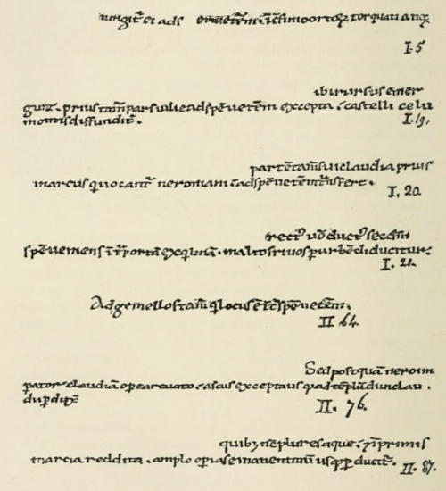
 represent the four chambers.
The channel of the aqueduct, coming at a tolerably high level,
enters the chamber A. Thence the water passed (possibly over
a large waste-pipe) into the chamber beneath, B. Between B. and
C. there were small holes communicating through the wall (possibly
provided with fine grating). Through the roof of C. there
was a hole, and the water passed upwards, of course finding the
same level in D. at its exit, as in A. at its entrance; on leaving
the piscina the water was carried off into another specus. By the
aid of sluice-gates the water could be transferred direct from chamber
A. to chamber D. Access was obtained by an opening to the
chambers beneath, and the mud was from time to time cleaned out.
Curious details of the sluices, &c., have been found; but it is not easy
to determine their age, as the aqueducts have undergone so many
repeated alterations.