FROM the west coast the great Andean Cordillera appears to have little
of the regularity suggested by our relief maps. Steep and high cliffs in
many places form the border of the land and obstruct the view; beyond
them appear distant summits rising into the zone of clouds. Where the
cliffs are absent or low, one may look across a sun-baked, yellow
landscape, generally broken by irregular foothills that in turn merge
into the massive outer spurs and ranges of the mountain zone. The plain
is interrupted by widely separated valleys whose green lowland meadows
form a brilliant contrast to the monotonous browns and yellows of the
shimmering desert. In rare situations the valley trenches enable one to
look far into the Cordillera and to catch memorable glimpses of lofty
peaks capped with snow.
If the traveler come to the west-coast landscape from the well-molded
English hills or the subdued mountains of Vermont and New Hampshire with
their artistic blending of moderate profiles, he will at first see
nothing but disorder. The scenery will be impressive and, in places,
extraordinary, but it is apparently composed of elements of the greatest
diversity. All the conceivable variations of form and color are
expressed, with a predominance of bold rugged aspects that give a
majestic appearance to the mountain-bordered shore. One looks in vain
for some sign of a quiet view, for some uniformity of features, for some
landscape that will remind him of the familiar hills of home. The Andes
are aggressive mountains that front the sea in formidable spurs or
desert ranges. Could we see in one view their entire elevation from
depths of over 20,000 feet beneath sea level to snowy summits, a total
altitude of 40,000 feet (12,200 m.), their excessive boldness would be
more apparent. No other mountains in the world are at once so
continuously lofty and so near a coast which drops off to abyssal
depths.
The view from the shore is, however, but one of many which the Andes
exhibit. Seen from the base the towering ranges display a stern aspect,
but, like all mountains, their highest slopes and spurs must be crossed
and re-crossed before the student is aware of other aspects of a quite
different nature. The Andes must be observed from at least three
situations: from the floors of the deep intermontane valleys, from the
intermediate slopes and summits, and from the uppermost levels as along
the range crests and the highest passes. Strangely enough it is in the
summit views that one sees the softest forms. At elevations of 14,000 to
16,000 feet (4,270 to 4,880 m.), where one would expect rugged spurs,
serrate chains, and sharp needles and horns, one comes frequently upon
slopes as well graded as those of a city park—grass-covered,
waste-cloaked, and with gentle declivity (Figs. 121-124).
The graded, waste-cloaked slopes of the higher levels are interpreted as
the result of prolonged denudation in an erosion cycle which persisted
through the greater part of the Tertiary period, and which was closed by
uplifts aggregating at least several thousands of feet. Above the level
of the mature slopes rise the ragged profiles and steep, naked
declivities of the snow-capped mountains which bear residual relations
to the softer forms at their bases. They are formed upon rock masses of
greater original elevation and of higher resistance to denudation.
Though they are dominating topographic features, they are much less
extensive and significant than the tame landscape which they surmount.

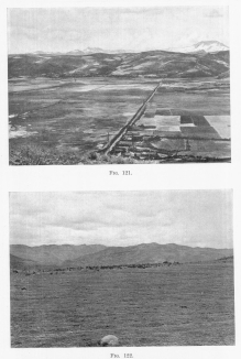
Fig. 121—Looking north from the hill near Anta in the
Anta basin north of Cuzco. Typical composition of slopes and intermont
basins in the Central Andes. Alluvial fill in the foreground; mature
slopes in the background; in the extreme background the snow-capped
crests of the Cordillera Vilcapampa.
Fig. 122—Showing topographic conditions before the
formation of the deep canyons in the Maritime Cordillera. The view,
looking across a tributary canyon of the Antabamba river, shows in the
background the main canyon above Huadquirca. Compare with Fig. 60.
Below the level of the mature slopes are topographic features of equal
prominence: gorges and canyons up to 7,000 feet deep. The deeply
intrenched streams are broken by waterfalls and almost continuous
rapids, the valley walls are so abrupt that one may, in places, roll
stones down a 4,000 foot incline to the river bed, and the tortuous
trail now follows a stream in the depths of a profound abyss, now scales
the walls of a labyrinthine canyon.
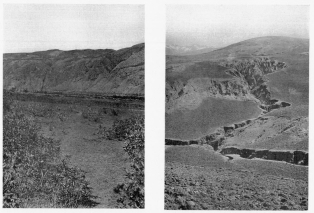
Fig. 123—Mature slopes between Ollantaytambo and
Urubamba. |
Fig. 124—Dissected mature slopes north of Anta in the
Anta basin north of Cuzco. |
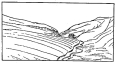
Fig. 125—Mature upper and young lower slopes at the
outlet of the Cuzco basin.
The most striking elements of scenery are not commonly the most
important in physiography. The oldest and most significant surface may
be at the top of the country, where it is not seen by the traveler or
where it cannot impress him, except in contrast to features of greater
height or color. The layman frequently seizes on a piece of bad-land
erosion or an outcrop of bright-colored sandstone or a cliff of
variegated clays or a snow-covered mountain as of most interest. All we
can see of a beautiful snow-clad peak is mere entertainment compared
with what subdued waste-cloaked hill-slopes may show. We do not wish to
imply that everywhere the tops of the Andes are meadows, that there are
no great scenic features in the Peruvian mountains, or that they are not
worth while. But we do wish to say that the bold features are far less
important in the interpretation of the landscape.
Amid all the variable forms of the Peruvian Cordillera certain strongly
developed types recur persistently. That their importance and relation
may be appreciated we shall at once name them categorically and
represent them in the form of a block diagram (Fig. 126). The principal
topographic types are as follows:
1. An extensive system of high-level, well-graded, mature slopes,
below which are:
2. Deep canyons with steep, and in places, cliffed sides and narrow
floors, and above which are:
3. Lofty residual mountains composed of resistant, highly deformed
rock, now sculptured into a maze of serrate ridges and sharp
commanding peaks.
4. Among the forms of high importance, yet causally unrelated to
the other closely associated types, are the volcanic cones and
plateaus of the western Cordillera.
5. At the valley heads are a full complement of glacial features,
such as cirques, hanging valleys, reversed slopes, terminal
moraines, and valley trains.
6. Finally there is in all the valley bottoms a deep alluvial fill
formed during the glacial period and now in process of dissection.
Though there are in many places special features either remotely related
or quite unrelated to the principal enumerated types, they belong to the
class of minor forms to which relatively small attention will be paid,
since they are in general of small extent and of purely local interest.
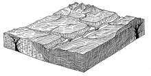
Fig. 126—Block diagram of the typical physiographic
features of the Peruvian Andes.
The block diagram represents all of these features, though of necessity
somewhat more closely associated than they occur in nature. Reference to
the photographs, Figs. 121-124, will make it clear that the diagram is
somewhat ideal: on the other hand the photographs together include all
the features which the diagram displays. In descending from any of the
higher passes to the valley floor one passes in succession down a steep,
well-like cirque at a glaciated valley head, across a rocky terminal
moraine, then down a stair-like trail cut into the steep scarps which
everywhere mark the descent to the main valley floors, over one after
another of the confluent alluvial fans that together constitute a large
part of the valley fill, and finally down the steep sides of the inner
valley to the boulder-strewn bed of the ungraded river.
We shall now turn to each group of features for description and
explanation, selecting for first consideration the forms of widest
development and greatest significance—the high-level mature slopes
lying between the lofty mountains which rise above them and the deep,
steep-walled valleys sunk far below them. These are the great pasture
lands of the Cordillera; their higher portions constitute the typical
puna of the Indian shepherds. In many sections it is possible to
pasture the vagrant flocks almost anywhere upon the graded slopes,
confident that the ichu, a tufted forage grass, will not fail and that
scattered brooks and springs will supply the necessary water. At
nightfall the flocks are driven down between the sheltering walls of a
canyon or in the lee of a cliff near the base of a mountain, or, failing
to reach either of these camps, the shepherd confines his charge within
the stone walls of an isolated corral.
In those places where the graded soil-covered slopes lie within the zone
of agriculture—below 14,000 feet—they are cultivated, and if the soil
be deep and fertile they are very intensively cultivated. Between Anta
and Urubamba, a day’s march north of Cuzco, the hill slopes are covered
with wheat and barley fields which extend right up to the summits (Fig.
134). In contrast are the uncultivated soil-less slopes of the mountains
and the bare valley walls of the deeply intrenched streams. The
distribution of the fields thus brings out strongly the principal
topographic relations. Where the softer slopes are at too high a level,
the climatic conditions are extreme and man is confined to the valley
floors and lower slopes where a laborious system of terracing is the
first requirement of agriculture.
The appearance of the country after the mature slopes had been formed is
brought out in 122 . The camera is placed on the floor of a still
undissected, mature valley which shows in the foreground of the
photograph. In the middle distance is a valley whose great depth and
steepness are purposely hidden; beyond the valley are the smoothly
graded, catenary curves, and interlocking spurs of the mature upland. In
imagination one sees the valleys filled and the valley slopes confluent
on the former (now imaginary) valley floor which extends without
important change of expression to the border of the Cordillera. No
extensive cliffs occur on the restored surface, and none now occur on
large tracts of the still undissected upland. Since the mature slopes
represent a long period of weathering and erosion, their surfaces were
covered with a deep layer of soil. Where glaciation at the higher levels
and vigorous erosion along the canyons have taken place, the former soil
cover has been removed; elsewhere it is an important feature. Its
presence lends a marked softness and beauty to these lofty though
subdued landscapes.
The graded mountain slopes were not all developed (1) at the same
elevation, nor (2) upon rock of the same resistance to denudation, nor
(3) at the same distance from the major streams, nor (4) upon rock of
the same structure. It follows that they will not all display precisely
the same form. Upon the softer rocks at the lowest levels near the
largest streams the surface was worn down to extremely moderate slopes
with a local relief of not more than several hundred feet. Conversely,
there are quite unreduced portions whose irregularities have mountainous
proportions, and between these extremes are almost all possible
variations. Though the term mature in a broad way expresses the stage
of development which the land had reached, post mature should be
applied to those portions which suffered the maximum reduction and now
exhibit the softest profiles. At no place along the 73rd meridian was
denudation carried to the point of even local peneplanation. All of the
major and some of the minor divides bear residual elevations and even
approximately plane surfaces do not exist.
Among the most important features of the mature slopes are (1) their
great areal extent—they are exhibited throughout the whole Central
Andes, (2) their persistent development upon rocks of whatever structure
or degree of hardness, and (3) their present great elevation in spite of
moderate grades indicative of their development at a much lower
altitude. Mature slopes of equivalent form are developed in widely
separated localities in the Central Andes: in every valley about
Cochabamba, Bolivia, at 10,000 feet (3,050 m.); at Crucero Alto in
southern Peru at 14,600 feet (4,450 m.); several hundred miles farther
north at Anta near Cuzco, 11,000 feet to 12,000 feet (3,600 to 3,940
m.), and 129 shows typical conditions in the Vilcabamba Valley
along the route of the Yale Peruvian Expedition of 1911. The
characteristic slopes so clearly represented in these four photographs
are the most persistent topographic elements in the physiography of the
Central Andes.
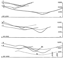
Fig. 127—Topographic profiles across typical valleys of
southern Peru. They are drawn to scale and the equality of gradient of
the gentler upper slopes is so close that almost any curve would serve
as a composite of the whole. These curves form the basis of the diagram,
Fig. 128, whereby the amount of elevation of the Andes in late geologic
time may be determined. The approximate locations of the profiles are as
follows: 1, Antabamba; 2, Chuquibambilla; 3, upland south of Antabamba;
4, Apurimac Canyon above Pasaje; 5, Abancay; 6, Arma (Cordillera
Vilcapampa); 7, divide above Huancarama; 8, Huascatay; 9, Huasentay,
farther downstream; 10, Rio Pampas. The upper valley in 8 is still
undissected; 7 is practically the same; 8a is at the level which 8 must
reach before its side slopes are as gentle as at the end of the
preceding interrupted cycle.
The rock masses upon which the mature slopes were formed range from soft
to hard, from stratified shales, slates, sandstones, conglomerates, and
limestones to volcanics and intrusive granites. While these variations
impose corresponding differences of form, the graded quality of the
slopes is rarely absent. In some places the highly inclined strata are
shown thinly veiled with surface débris, yet so even as to appear
artificially graded. The rock in one place is hard granite, in another a
moderately hard series of lava flows, and again rather weak shales and
sandstones.
Proof of the rapid and great uplift of certain now lofty mountain ranges
in late geologic time is one of the largest contributions of
physiography to geologic history. Its validity now rests upon a large
body of diversified evidence. In 1907 I crossed the Cordillera Sillilica
of Bolivia and northern Chile and came upon clear evidences of recent
and great uplift. The conclusions presented at that time were tested in
the region studied in 1911, 500 miles farther north, with the result
that it is now possible to state more precisely the dates of origin of
certain prominent topographic forms, and to reconstruct the conditions
which existed before the last great uplift in which the Central Andes
were born. The relation to this general problem of the forms under
discussion will now be considered.
The gradients of the mature slopes, as we have already seen, are
distinctly moderate. In the Anta region, over an area several hundred
square miles in extent, they run from several degrees to 20° or 30°.
Ten-degree slopes are perhaps most common. If the now dissected slopes
be reconstructed on the basis of many clinometer readings, photographs,
and topographic maps, the result is a series of profiles as in 127 .
If, further, the restored slopes be coördinated over an extensive area
the gradients of the resulting valley floors will run from 3° to 10°.
Finally, if these valley floors be extended westward to the Pacific and
eastward to the Amazon basin, they will be found about 5,000 feet above
sea level and 4,000 feet above the eastern plains. (For explanation of
method and data employed, see the accompanying figures 127-128). It is,
therefore, a justifiable conclusion that since the formation of the
slopes the Andes have been uplifted at least a mile, or, to put it in
another way, the Andes at the time of formation of the mature slopes
were at least a mile lower than they are at present.
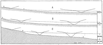
Fig. 128—Composition of slopes and profiles in the
Peruvian Andes. By superimposing the cross profiles of typical valleys
as shown in 127 a restoration is possible of the longitudinal
profiles of the earlier cycle of erosion. The difference in elevation of
the two profiles gives less than the minimum amount of uplift that must
have occurred. Case A represents a valley in which recent cutting has
not yet reached the valley head. Below the point 1 the profile has been
steepened and lowered by erosion in the current cycle. Above point 1 the
profile is still in the stage it reached in the preceding cycle. In case
B the renewed erosion of the current cycle has reached to the valley
head. Case C represents conditions similar to those in the preceding
cases save that the stream is typical of those that lie nearest the
steep flexed or faulted margins of the Cordillera and discharge to the
low levels of the desert pampa on the west or the tropical plains on the
east.
Further proof of recent and great uplift is afforded by the deeply
intrenched streams. After descending the long graded slopes one comes
upon the cliffed canyons with a feeling of consternation. The effect of
powerful erosion, incident upon uplift, is heightened by the ungraded
character of the river bed. Falls and rapids abound, the river profiles
suggest tumultuous descents, and much time will elapse before the river
beds have the regular and moderate gradients of the streams draining the
mature surface before uplift as shown in the profiles by the dotted
lines representing the restored valley floors of the older cycle. Since
the smooth-contoured landscape was formed great changes have taken
place. The streams have changed from completely graded to almost
completely ungraded profiles; in place of a subdued landscape we now
have upland slopes intersected by mile-deep canyons; the high-level
slopes could not have been formed under existing conditions, for they
are being dissected by the present streams.
Since the slopes of the land in general undergo progressive changes in
the direction of flatter gradients during a given geographical cycle, it
follows that with the termination of one cycle and the beginning of
another, two sets of slopes will exist and that the gradients of the two
will be unlike. The result is a break in the descent of the slopes from
high to low levels to which the name “topographic unconformity” is now
applied. It will be a prominent feature of the landscape if the higher,
older, and flatter gradients have but little declivity, and the
gradients of the lower younger slopes are very steep. In those places
where the relief of the first cycle was still great at the time of
uplift, the erosion forms of the second cycle may not be differentiated
from those of the first, since both are marked by steep gradients. In
the Central Andes the change in gradient between the higher and lower
slopes is generally well marked. It occurs at variable heights above
the valley floors, though rarely more than 3,000 feet above them. In the
more central tracts, far from the main streams and their associated
canyons, dissection in the present erosion cycle has not yet been
initiated, the mature slopes are still intact, and a topographic
unconformity has not yet been developed. The higher slopes are faced
with rock and topped with slowly moving waste. Ascent of the spur end is
by steep zigzag trails; once the top is gained the trail runs along the
gentler slopes without special difficulties.
It is worth noting at this point that the surface of erosion still older
than the mature slopes herewith described appears not to have been
developed along the seventy-third meridian of Peru, or if developed at
one time, fragments of it no longer remain. The last well-developed
remnant is southwest of Cuzco, 130 . I have elsewhere described the
character and geographic distribution of this oldest recognizable
surface of the Central Andes.[41] Southern Peru and Bolivia and northern
Chile display its features in what seems an unmistakable manner. The
best locality yet found is in the Desaguadero Valley between Ancoaqui
and Concordia. There one may see thousands of feet of strongly inclined
sediments of varying resistance beveled by a well-developed surface of
erosion whose preserval is owing to a moderate rainfall and to location
in an interior basin.[42]
The highest surface of a region, if formed during a prolonged period of
erosion, becomes a surface of reference in the determination of the
character and amount of later crustal deformations, having somewhat the
same functions as a key bed in stratigraphic geology. Indeed, concrete
physiographic facts may be the only basis for arguments as to both
epeirogenic and orogenic movements. The following considerations may
show in condensed form the relative value of physiographic evidence:
1. If movements in the earth’s crust are predominantly downward,
sedimentation may be carried on continuously, and a clear geologic
record may be made.
2. Even if crustal movements are alternately downward and upward,
satisfactory conclusions may be drawn from both (a) the nature of the
buried surfaces of erosion, and (b) the alternating character of the
sediments.
3. If, however, the deformative processes effect steady or intermittent
uplifts, there may be no sediments, at least within the limits of the
positive crustal units, and a geologic record must be derived not from
sedimentary deposits but from topographic forms. We speak of the lost
intervals represented by stratigraphic breaks or unconformities and
commonly emphasize our ignorance concerning them. The longest, and, from
the human standpoint, the most important, break in the sedimentary
record is that of the present wherever degradation is the predominant
physiographic process. Unlike the others the lost interval of the
present is not lost, if we may so put it, but is in our possession, and
may be definitely described as a concrete thing. It is the physiography
of today.
Even where long-buried surfaces of erosion are exposed to view, as in
northern Wisconsin, where the Pre-Cambrian paleo-plain projects from
beneath the Paleozoic sediments, or, as in New Jersey and southeastern
Pennsylvania, where the surface developed on the crystalline rocks
became by depression the floor of the Triassic and by more recent uplift
and erosion has been exposed to view,—even in such cases the exposures
are of small extent and give us at best but meager records. In short,
many of the breaks in the geologic record are of such long duration as
to make imperative the use of physiographic principles and methods. The
great Appalachian System of eastern North America has been a land area
practically since the end of the Paleozoic. In the Central Andes the
“lost interval,” from the standpoint of the sedimentary, record, dates
from the close of the Cretaceous, except in a few local intermont basins
partially filled with Tertiary or Pleistocene deposits. Physiographic
interpretations, therefore, serve the double purpose of supplying a part
of the geologic record while at the same time forming a basis for the
scientific study of the surface distribution of living forms.
The geologic dates of origin of the principal topographic forms of the
Central Andes may be determined with a fair degree of accuracy. Geologic
studies in Peru and Bolivia have emphasized the wide distribution of the
Cretaceous formations. They consist principally of thick limestones
above and sandstones and conglomerates below, and thus represent
extensive marine submergence of the earth’s crust in the Cretaceous
where now there are very lofty mountains. The Cretaceous deposits are
everywhere strongly deformed or uplifted to a great height, and all have
been deeply eroded. They were involved, together with other and much
older sediments, in the erosion cycle which resulted in the development
of the widely extended series of mature slopes already described. From
low scattered island elevations projecting above sea level, as in the
Cretaceous period, the Andes were transformed by compression and uplift
to a rugged mountain belt subjected to deep and powerful erosion. The
products of erosion were in part swept into the adjacent seas, in part
accumulated on the floors of intermont basins, as in the great interior
basins of Titicaca and Poopó.
Since the early Tertiary strata are themselves deformed from once simple
and approximately horizontal structures and subjected to moderate
tilting and faulting, it follows that mountain-making movements again
affected the region during later Tertiary. They did not, however,
produce extreme effects. They did stimulate erosion and bring about a
reorganization of all the slopes with respect to the new levels.
This agrees closely with a second line of evidence which rests upon an
independent basis. The alluvial fill which lies upon all the canyon and
valley floors is of glacial origin, as shown by its interlocking
relations with morainal deposits at the valley heads. It is now in
process of dissection and since its deposition in the Pleistocene had
been eroded on the average about 200 feet. Clearly, to form a 3,000-foot
canyon in hard rock requires much more time than to deposit and again
partially to excavate an alluvial fill several hundred feet deep.
Moreover, the glacial material is coarse throughout, and was built up
rapidly and dissected rapidly. In most cases, furthermore, coarse
material at the bottom of the glacial series rests directly upon the
rock of a narrow and ungraded valley floor. From these and allied facts
it is concluded that there is no long time interval represented by the
transitions from degrading to aggrading processes and back again. The
early Pleistocene, therefore, seems quite too short a period in which to
produce the bold forms and effect the deep erosion which marks the
period between the close of the mature cycle and the beginnings of
deposition in the Pleistocene.
The alternative conclusion is that the greater part of the canyon
cutting was effected in the late Tertiary, and that it continued into
the early Pleistocene until further erosion was halted by changed
climatic conditions and the augmented delivery of land waste to all the
streams. The final development of the well-graded high-level slopes is,
therefore, closely confined to a small portion of the Tertiary. The
closest estimate which the facts support appears to be Miocene or early
Pliocene. It is clear, however, that only the culmination of the period
can be definitely assigned. Erosion was in full progress at the close of
the Cretaceous and by middle Tertiary had effected vast changes in the
landscape. The Tertiary strata are marked by coarse basal deposit and by
thin and very fine top deposits. Though their deformed condition
indicates a period of crustal disturbance, the Tertiary beds give no
indication of wholesale transformations. They indicate chiefly tilting
and moderate and normal faulting. The previously developed effects of
erosion were, therefore, not radically modified. The surface was thus in
large measure prepared by erosion in the early Tertiary for its final
condition of maturity reached during the early Pliocene.
It seems appropriate, in concluding this chapter, to summarize in its
main outlines the physiography of southern Peru, partly to condense the
extended discussion of the preceding paragraphs, and partly to supply a
background for the three chapters that follow. The outstanding features
are broad plateau areas separated by well-defined “Cordilleras.” The
plateau divisions are not everywhere of the same origin. Those southwest
of Cuzco (Fig. 130), and in the Anta Basin (Fig. 124), northwest of
Cuzco, are due to prolonged erosion and may be defined as peneplane
surfaces uplifted to a great height. They are now bordered on the one
hand by deep valleys and troughs and basins of erosion and deformation;
and, on the other hand, by residual elevations that owe their present
topography to glacial erosion superimposed upon the normal erosion of
the peneplane cycle. The residuals form true mountain chains like the
Cordillera Vilcanota and Cordillera Vilcapampa; the depressions due to
erosion or deformation or both are either basins like those of Anta and
Cuzco or valleys of the canyon type like the Urubamba canyon; the
plateaus are broad rolling surfaces, the punas of the Peruvian Andes.
There are two other types of plateaus. The one represents a mature stage
in the erosion cycle instead of an ultimate stage; the other is volcanic
in origin. The former is best developed about Antabamba (Figs. 122 and
123), where again deep canyons and residual ranges form the borders of
the plateau remnants. The latter is well developed above Cotahuasi and
in its simplest form is represented in 133 . Its surface is the top
of a vast accumulation of lavas in places over a mile thick. While rough
in detail it is astonishingly smooth in a broad view (Fig. 29). Above it
rise two types of elevations: first, isolated volcanic cones of great
extent surrounded by huge lava flows of considerable relief; and second,
discontinuous lines of peaks where volcanic cones of less extent are
crowded closely together. The former type is displayed on the Coropuna
Quadrangle, the latter on the Cotahuasi and La Cumbre Quadrangles.
So high is the elevation of the lava plateau, so porous its soil, so dry
the climate, that a few through-flowing streams gather the drainage of a
vast territory and, as in the Grand Canyon country of our West, they
have at long intervals cut profound canyons. The Arma has cut a deep
gorge at Salamanca; the Cotahuasi runs in a canyon in places 7,000 feet
deep; the Majes heads at the edge of the volcanic field in a steep
amphitheatre of majestic proportions.
Finally, we have the plateaus of the coastal zone. These are plains with
surfaces several thousand feet in elevation separated by gorges several
thousand feet deep. The Pampa de Sihuas is an illustration. The
post-maturely dissected Coast Range separates it from the sea. The
pampas are in general an aggradational product formed in a past age
before uplift initiated the present canyon cycle of erosion. Other
plateaus of the coastal zone are erosion surfaces. The Tablazo de Ica
appears to be of this type. That at Arica, Chile, near the southern
boundary of Peru, is demonstrably of this type with a border on which
marine planation has in places given rise to a broad terrace
effect.[43]
THE Western or Maritime Cordillera of Peru forms part of the great
volcanic field of South America which extends from Argentina to Ecuador.
On the walls of the Cotahuasi Canyon (Fig. 131), there are exposed over
one hundred separate lava flows piled 7,000 feet deep. They overflowed a
mountainous relief, completely burying a limestone range from 2,000 to
4,000 feet high. Finally, upon the surface of the lava plateau new
mountains were formed, a belt of volcanoes 5,000 feet (1,520 m.) high
and from 15,000 to 20,000 feet (4,570 to 6,100 m.) above the sea. There
were vast mud flows, great showers of lapilli, dust, and ashes, and with
these violent disturbances also came many changes in the drainage. Sixty
miles northeast of Cotahuasi the outlet of an unnamed deep valley was
blocked, a lake was formed, and several hundred feet of sediments were
deposited. They are now wasting rapidly, for they lie in the zone of
alternate freezing and thawing, a thousand feet and more below the
snowline. Some of their bad-land forms look like the solid bastions of
an ancient fortress, while others have the delicate beauty of a Japanese
temple.
Not all the striking effects of vulcanism belong to the remote geologic
past. A day’s journey northeast of Huaynacotas are a group of lakes only
recently hemmed in by flows from the small craters thereabouts. The
fires in some volcanic craters of the Peruvian Andes are still active,
and there is no assurance that devastating flows may not again inundate
the valleys. In the great Pacific zone or girdle of volcanoes the
earth’s crust is yet so unstable that earthquakes occur every year, and
at intervals of a few years they have destructive force. Cotahuasi was
greatly damaged in 1912; Abancay is shaken every few years; and the
violent earthquakes of Cuzco and Arequipa are historic.
On the eastern margin of the volcanic country the flows thin out and
terminate on the summit of a limestone (Cretaceous) plateau. On the
western margin they descend steeply to the narrow west-coast desert. The
greater part of the lava dips beneath the desert deposits; there are a
few intercalated flows in the deposits themselves, and the youngest
flows—limited in number—have extended down over the inner edge of the
desert.
The immediate coast of southern Peru is not volcanic. It is composed of
a very hard and ancient granite-gneiss which forms a narrow coastal
range (Fig. 171). It has been subjected to very long and continued
erosion and now exhibits mature erosion forms of great uniformity of
profile and declivity.
From the outcrops of older rocks beneath the lavas it is possible to
restore in a measure the pre-volcanic topography of the Maritime
Cordillera, In its present altitude it ranges from several thousand to
15,000 feet above sea level. The unburied topography has been smoothed
out; the buried topography is rough (Figs. 29 and 166). The contact
lines between lavas and buried surfaces in the deep Majes and Cotahuasi
valleys are in places excessively serrate. From this, it seems safe to
conclude that the period of vulcanism was so prolonged that great
changes in the unburied relief were effected by the agents of erosion.
Thus, while the dominant process of volcanic upbuilding smoothed the
former rough topography of the Maritime Cordillera, erosion likewise
measurably smoothed the present high extra-volcanic relief in the
central and eastern sections. The effect has been to develop a broad and
sufficiently smooth aspect to the summit topography of the entire Andes
to give them a plateau character. Afterward the whole mountain region
was uplifted about a mile above its former level so that at present it
is also continuously lofty.
The zone of most intense volcanic action does not coincide with the
highest part of the pre-volcanic topography. If the pre-volcanic relief
were even in a very general way like that which would be exhibited if
the lavas were now removed, we should have to say that the chief
volcanic outbursts took place on the western flank of an old and deeply
dissected limestone range.
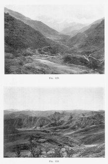
Fig. 129—Composition of slopes at Puquiura, Vilcabamba
Valley, elevation 9,000 feet (2,740 m.). The second prominent spur
entering the valley on the left has a flattish top unrelated to the rock
structure. Like the spurs on the right its blunt end and flat top
indicate an earlier erosion cycle at a lower elevation.
Fig. 130—Inclined Paleozoic strata truncated by an
undulating surface of erosion at 15,000 feet, southwest of Cuzco.
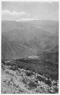
Fig. 131—Terraced valley slopes at Huaynacotas,
Cotahuasi Valley, at 11,500 feet (3,500 m.). Solimana is in the
background. On the floor of the Cotahuasi Canyon fruit trees grow. At
Huaynacotas corn and potatoes are the chief products. The section is
composed almost entirely of lava. There are over a hundred major flows
aggregating 5,000 to 7,000 feet thick.
The volume of the lavas is enormous. They are a mile and a half thick,
nearly a hundred miles wide, and of indefinite extent north and south.
Their addition to the Andes, therefore, has greatly broadened the zone
of lofty mountains. Their passes are from 2,000 to 3,000 feet higher
than the passes of the eastern Andes. They have a much smaller number of
valleys sufficiently deep to enjoy a mild climate. Their soil is far
more porous and dry. Their vegetation is more scanty. They more than
double the difficulties of transportation. And, finally, their all but
unpopulated loftier expanses are a great vacant barrier between farms in
the warm valleys of eastern Peru and the ports on the west coast.
The upbuilding process was not, of course, continuous. There were at
times intervals of quiet, and some of them were long enough to enable
streams to become established. Buried valleys may be observed in a
number of places on the canyon walls, where subsequently lava flows
displaced the streams and initiated new drainage systems. In these quiet
intervals the weathering agents attacked the rock surfaces and formed
soil. There were at least three or four such prolonged periods of
weathering and erosion wherein a land surface was exposed for many
thousands of years, stream systems organized, and a cultivable soil
formed. No evidence has been found, however, that man was there to
cultivate the soil.
The older valleys cut in the quiet period are mere pygmies beside the
giant canyons of today. The present is the time of dominant erosion. The
forces of vulcanism are at last relatively quiet. Recent flows have
occurred, but they are limited in extent and in effects. They alter only
the minor details of topography and drainage. Were it not for the oases
set in the now deep-cut canyon floors, the lava plateau of the Maritime
Cordillera would probably be the greatest single tract of unoccupied
volcanic country in the world.
The lava plateau has been dissected to a variable degree. Its high
eastern margin is almost in its original condition. Its western margin
is only a hundred miles from the sea, so that the streams have steep
gradients. In addition, it is lofty enough to have a moderate rainfall.
It is, therefore, deeply and generally dissected. Within the borders of
the plateau the degree of dissection depends chiefly upon position with
respect to the large streams. These were in turn located in an
accidental manner. The repeated upbuilding of the surface by the
extensive outflow of liquid rock obliterated all traces of the earlier
drainage. In the Cotahuasi Canyon the existing stream, working down
through a mile of lavas, at last uncovered and cut straight across a
mountain spur 2,000 feet high. Its course is at right angles to that
pursued by the stream that once drained the spur. It is noteworthy that
the Cotahuasi and adjacent streams take northerly courses and join
Atlantic rivers. The older drainage was directly west to the Pacific.
Thus, vulcanism not only broadened the Andes and increased their height,
but also moved the continental divide still nearer the west coast.
The glacial features of the western or Maritime Cordillera are of small
extent, partly because vulcanism has added a considerable amount of
material in post-glacial time, partly because the climate is so
exceedingly dry that the snowline lies near the top of the country. The
slopes of the volcanic cones are for the most part deeply recessed on
the southern or shady sides. Above 17,500 feet (5,330 m.) the process of
snow and ice excavation still continues, but the tracts that exceed this
elevation are confined to the loftiest peaks or their immediate
neighborhood. There is a distinct difference between the glacial forms
of the eastern or moister and the western or dryer flanks of this
Cordillera. Only peaks like Coropuna and Solimana near the western
border now bear or ever bore snowfields and glaciers. By contrast the
eastern aspect is heavily glaciated. On La Cumbre Quadrangle, there is a
huge glacial trough at 16,000 feet (4,876 m.), and this extends with
ramifications up into the snowfields that formerly included the highest
country. Prolonged glacial erosion produced a full set of topographic
forms characteristic of the work of Alpine glaciers. Thus, each of the
main mountain chains that make up the Andean system has, like the system
as a whole, a relatively more-dry and a relatively less-dry aspect. The
snowline is, therefore, canted from west to east on each chain as well
as on the system. However, this effect is combined with a solar effect
in an unequal way. In the driest places the solar factor is the more
efficient and the snowline is there canted from north to south.
THE culminating range of the eastern Andes is the so-called Cordillera
Vilcapampa. Its numerous, sharp, snow-covered peaks are visible in every
summit view from the central portion of the Andean system almost to the
western border of the Amazon basin. Though the range forms a water
parting nearly five hundred miles long, it is crossed in several places
by large streams that flow through deep canyons bordered by precipitous
cliffs. The Urubamba between Torontoy and Colpani is the finest
illustration. For height and ruggedness the Vilcapampa mountains are
among the most noteworthy in Peru. Furthermore, they display glacial
features on a scale unequaled elsewhere in South America north of the
ice fields of Patagonia.
One of the most impressive sights in South America is a tropical forest
growing upon a glacial moraine. In many places in eastern Bolivia and
Peru the glaciers of the Ice Age were from 5 to 10 miles long—almost
the size of the Mer de Glace or the famous Rhone glacier. In the Juntas
Valley in eastern Bolivia the tree line is at 10,000 feet (3,050 m.),
but the terminal moraines lie several thousand feet lower. In eastern
Peru the glaciers in many places extended down nearly to the tree line
and in a few places well below it. In the Cordillera Vilcapampa vast
snowfields and glacier systems were spread out over a summit area as
broad as the Southern Appalachians. The snowfields have since shrunk to
the higher mountain recesses; the glaciers have retreated for the most
part to the valley heads or the cirque floors; and the lower limit of
perpetual snow has been raised to 15,500 feet.
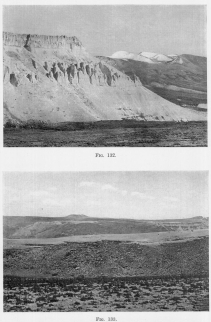
Fig. 132—Recessed volcanoes in the right background and
eroded tuffs, ash beds, and lava flows on the left. Maritime Cordillera
above Cotahuasi.
Fig. 133—The summit of the great lava plateau above
Cotahuasi on the trail to Antabamba. The lavas are a mile and a half in
thickness. The elevation is 16,000 feet. Hence the volcanoes in the
background, 17,000 feet above sea level, are mere hills on the surface
of the lofty plateau.
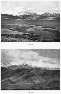
Fig. 134—Southwestern aspect of the Cordillera
Vilcapampa between Anta and Urubamba from Lake Huaipo. Rugged summit
topography in the background, graded post-mature slopes in the middle
distance, and solution lake in limestone in the foreground.
Fig. 135—Summit view, Cordillera Vilcapampa. There are
fifteen glaciers represented in this photograph. The camera stands on
the summit of a minor divide in the zone of nivation.
These features are surprising because neither Whymper[44] nor Wolf[45]
mentions the former greater extent of the ice on the volcanoes of
Ecuador, only ten or twelve degrees farther north. Moreover, Reiss[46]
denies that the hypothesis of universal climatic change is supported by
the facts of a limited glaciation in the High Andes of Ecuador; and J.
W. Gregory[47] completely overlooks published proof of the existence of
former more extensive glaciers elsewhere in the Andes:
“... the absence not only of any traces of former more extensive
glaciation from the tropics, as in the Andes and Kilimandjaro, but also
from the Cape.” He says further: “In spite of the extensive glaciers now
in existence on the higher peaks of the Andes, there is practically no
evidence of their former greater extension.”(!)
Whymper spent most of his time in exploring recent volcanoes or those
recently in eruption, hence did not have the most favorable
opportunities for gathering significant data. Reiss was carried off his
feet by the attractiveness of the hypothesis[48] relating to the effect
of glacial denudation on the elevation of the snowline. Gregory appeared
not to have recognized the work of Hettner on the Cordillera of Bogotá
and of Sievers[49] and Acosta on the Sierra Nevada de Santa Marta in
northern Colombia.
The importance of the glacial features of the Cordillera Vilcapampa
developed on a great scale in very low latitudes in the southern
hemisphere is twofold: first, it bears on the still unsettled problem of
the universality of a colder climate in the Pleistocene, and, second, it
supplies additional data on the relative depression of the snowline in
glacial times in the tropics. Snow-clad mountains near the equator are
really quite rare. Mount Kenia rising from a great jungle on the
equator, Kilimandjaro with its two peaks, Kibo and Mawenzi, two hundred
miles farther south, and Ingomwimbi in the Ruwenzori group thirty miles
north of the equator, are the chief African examples. A few mountains
from the East Indies, such as Kinibalu in Borneo, latitude 6° north,
have been found glaciated, though now without a snow cover. In higher
latitudes evidences of an earlier extensive glaciation have been
gathered chiefly from South America, whose extension 13° north and 56°
south of the equator, combined with the great height of its dominating
Cordillera, give it unrivaled distinction in the study of mountain
glaciation in the tropics.
Furthermore, mountain summits in tropical lands are delicate climatic
registers. In this respect they compare favorably with the inclosed
basins of arid regions, where changes in climate are clearly recorded in
shoreline phenomena of a familiar kind. Lofty mountains in the tropics
are in a sense inverted basins, the lower snowline of the past is like
the higher shoreline of an interior basin; the terminal moraines and the
alluvial fans in front of them are like the alluvial fans above the
highest strandline; the present snow cover is restricted to mountain
summits of small areal extent, just as the present water bodies are
restricted to the lowest portions of the interior basin; and successive
retreatal stages are marked by terminal moraines in the one case as they
are marked in the other by flights of terraces and beach ridges.
I made only a rapid reconnaissance across the Cordillera Vilcapampa in
the winter season, and cannot pretend from my limited observations to
solve many of the problems of the field. The data are incorporated
chiefly in the chapter on Glacial Features. In this place it is proposed
to describe only the more prominent glacial features, leaving to later
expeditions the detailed descriptions upon which the solution of some of
the larger problems must depend.
At Choquetira three prominent stages in the retreat of the ice are
recorded. The lowermost stage is represented by the great fill of
morainic and outwash material at the junction of the Choquetira, and an
unnamed valley farther south at an elevation of 11,500 feet (3,500 m.).
A mile below Choquetira a second moraine appears, elevation 12,000 feet
(3,658 m.), and immediately above the village a third at 12,800 (3,900
m.). The lowermost moraine is well dissected, the second is ravined and
broken but topographically distinct, the third is sharp-crested and
regular. A fourth though minor stage is represented by the moraine at
the snout of the living glacier and still less important phases are
represented in some valleys—possibly the record of post-glacial changes
of climate. Each main moraine is marked by an important amount of
outwash, the first and third moraines being associated with the greatest
masses. The material in the moraines represents only a part of that
removed to form the successive steps in the valley profile. The
lowermost one has an enormous volume, since it is the oldest and was
built at a time when the valley was full of waste. It is fronted by a
deep fill, over the dissected edge of which one may descend 800 feet in
half an hour. It is chiefly alluvial in character, whereas the next
higher one is composed chiefly of bowlders and is fronted by a
pronounced bowlder train, which includes a remarkable perched bowlder of
huge size. Once the valley became cleaned out the ice would derive its
material chiefly by the slower process of plucking and abrasion, hence
would build much smaller moraines during later recessional stages, even
though the stages were of equivalent length.
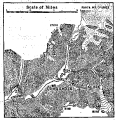
Fig. 136—Glacial sculpture on the southwestern flank of
the Cordillera Vilcapampa. Flat-floored valleys and looped terminal
moraines below and glacial steps and hanging valleys are characteristic.
The present snowfields and glaciers are shown by dotted contours.
There is a marked difference in the degree of dissection of the
moraines. The lowermost and oldest is so thoroughly dissected as to
exhibit but little of its original surface. The second has been greatly
modified, but still possesses a ridge-like quality and marks the
beginning of a noteworthy flattening of the valley gradient. The third
is as sharp-crested as a roof, and yet was built so long ago that the
flat valley floor behind it has been modified by the meandering stream.
From this point the glacier retreated up-valley several miles
(estimated) without leaving more than the thinnest veneer on the valley
floor. The retreat must, therefore, have been rapid and without even
temporary halts until the glacier reached a position near that occupied
today. Both the present ice tongues and snowfields and those of a past
age are emphasized by the presence of a patch of scrub and woodland that
extends on the north side of the valley from near the snowline down over
the glacial forms to the lower valley levels.
The retreatal stages sketched above would call for no special comment if
they were encountered in mountains in northern latitudes. They would be
recognized at once as evidence of successive periodic retreats of the
ice, due to successive changes in temperature. To understand their
importance when encountered in very low latitudes it is necessary to
turn aside for a moment and consider two rival hypotheses of glacial
retreat. First we have the hypothesis of periodic retreat, so generally
applied to terminal moraines and associated outwash in glaciated
mountain valleys. This implies also an advance of the ice from a higher
position, the whole taking place as a result of a climatic change from
warmer to colder and back again to warmer.
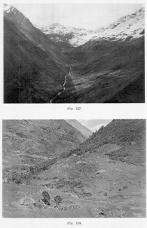
Fig. 137—Looking up a spurless flat-floored glacial
trough near the Chucuito pass in the Cordillera Vilcapampa from 14,200
feet (4,330 m.). Note the looped terminal and lateral moraines on the
steep valley wall on the left. A stone fence from wall to wall serves to
inclose the flock of the mountain shepherd.
Fig. 138—Terminal moraine in the glaciated Choquetira
Valley below Choquetira. The people who live here have an abundance of
stones for building corrals and stone houses. The upper edge of the
timber belt (cold timber line) is visible beyond the houses. Elevation
12,100 feet (3,690 m.).
But evidences of more extensive mountain glaciation in the past do not
in themselves prove a change in climate over the whole earth. In an
epoch of fixed climate a glacier system may so deeply and thoroughly
erode a mountain mass, that the former glaciers may either diminish in
size or disappear altogether. As the work of excavation proceeds, the
catchment basins are sunk to, and at last below, the snowline; broad
tributary spurs whose snows nourish the glaciers, may be reduced to
narrow or skeleton ridges with little snow to contribute to the valleys
on either hand; the glaciers retreat and at last disappear. There
would be evidences of glaciation all about the ruins of the former
loftier mountain, but there would be no living glaciers. And yet the
climate might remain the same throughout.
It is this “topographic” hypothesis that Reiss and Stübel accept for the
Ecuadorean volcanoes. Moreover, the volcanoes of Ecuador are practically
on the equator—a very critical situation when we wish to use the facts
they exhibit in the solution of such large problems as the
contemporaneous glaciation of the two hemispheres, or the periodic
advance and retreat of the ice over the whole earth. This is not the
place to scrutinize either their facts or their hypothesis, but I am
under obligations to state very emphatically that the glacial features
of the Cordillera Vilcapampa require the climatic and not the
topographic hypothesis. Let us see why.
The differences in degree of dissection and the flattening gradient
up-valley that we noted in a preceding paragraph leave no doubt that
each moraine of the bordering valleys in the Vilcapampa region,
represents a prolonged period of stability in the conditions of
topography as well as of temperature and precipitation. If change in
topographic conditions is invoked to explain retreat from one position
to the other there is left no explanation of the periodicity of retreat
which has just been established. If a period of cold is inaugurated and
glaciers advance to an ultimate position, they can retreat only through
change of climate effected either by general causes or by topographic
development to the point where the snowfields become restricted in size.
In the case of climatic change the ice changes are periodic. In the case
of retreat due to topographic change there should be a steady or
non-periodic falling back of the ice front as the catchment basins
decrease in elevation and the snow-gathering ridges tributary to them
are reduced in height.
Further, the matterhorns of the Cordillera Vilcapampa are not bare but
snow-covered, vigorous glaciers several miles in length and large
snowfields still survive and the divides are not arêtes but broad
ridges. In addition, the last two moraines, composed of very loose
material, are well preserved. They indicate clearly that the time since
their formation has witnessed no wholesale topographic change. If (1) no
important topographic changes have taken place, and (2) a vigorous
glacier lay for a long period back of a given moraine, and (3) suddenly
retreated several miles and again became stable, we are left without
confidence in the application of the topographic hypothesis to the
glacial features of the Vilcapampa region. Glacial retreat may be
suddenly begun in the case of a late stage of topographic development,
but it should be an orderly retreat marked by a large number of small
moraines, or at least a plentiful strewing of the valley floor with
débris.
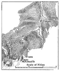
Fig. 139—Glacial features on the eastern slopes of the
Cordillera Vilcapampa.
The number of moraines in the various glaciated valleys of the
Cordillera Vilcapampa differ, owing to differences in elevation and to
the variable size of the catchment basins. All valleys, however, display
the same sudden change from moraine to moraine and the same
characteristics of gradient. In all of them the lowermost moraine is
always more deeply eroded than the higher moraines, in all of them
glacial erosion was sufficiently prolonged greatly to modify the valley
walls, scour out lake basins, or broad flat valley floors, develop
cirques, arêtes, and pinnacled ridges in limited number. In some,
glaciation was carried to the point where only skeleton divides
remained, in most places broad massive ridges or mountain knots persist.
In spite of all these differences successive moraines were formed,
separated by long stretches either thinly covered with till or exposing
bare rock.
In examining this group of features it is important to recognize the
essential fact that though the number of moraines varies from valley to
valley, the differences in character between the moraines at low and at
high elevations in a single valley are constant. It is also clear that
everywhere the ice retreated and advanced periodically, no matter with
what topographic features it was associated, whether those of maturity
or of youth in the glacial cycle. We, therefore, conclude that
topographic changes had no significant part to play in the glacial
variations in the Cordillera Vilcapampa.
The country west of the Cordillera Vilcapampa had been reduced to early
topographic maturity before the Ice Age, and then uplifted with only
moderate erosion of the masses of the interfluves. That on the east had
passed through the same sequence of events, but erosion had been carried
much farther. The reason for this is found in a strong climatic
contrast. The eastern is the windward aspect and receives much more rain
than the western. Therefore, it has more streams and more rapid
dissection. The result was that the eastern slopes were cut to pieces
rapidly after the last great regional uplift; the broad interfluves were
narrowed to ridges. The region eastward from the crest of the Cordillera
to the Pongo de Mainique looks very much like the western half of the
Cascade Mountains in Oregon—the summit tracts of moderate declivity are
almost all consumed.
The effect of these climatic and topographic contrasts is manifested in
strong contrasts in the position and character of the glacial forms on
the opposite slopes of the range. At Pampaconas on the east the
lowermost terminal moraine is at least a thousand feet below timber
line. Between Vilcabamba pueblo and Puquiura the terminal moraine lies
at 11,200 feet (3,414 m.). By contrast the largest Pleistocene glacier
on the western slope, nearly twelve miles long, and the largest along
the traverse, ended several miles below Choquetira at 11,500 feet (3,504
m.) elevation, or just at the timber line. Thus, the steeper descents of
the eastern side of the range appear to have carried short glaciers to
levels far lower than those attained by the glaciers of the western
slope.
It seems at first strange that the largest glaciers were west of the
divide between the Urubamba and the Apurimac, that is, on the relatively
dry side of the range. The reason lies in a striking combination of
topographic and climatic conditions. Snow is a mobile form of
precipitation that is shifted about by the wind like a sand dune in the
desert. It is not required, like water, to begin a downhill movement as
soon as it strikes the earth. Thus, it is a noteworthy fact that snow
drifting across the divides may ultimately cause the largest snowfields
to lie where the least snow actually falls. This is illustrated in the
Bighorns of Wyoming and others of our western ranges. It is, however,
not the wet snow near the snowline, but chiefly the dry snow of higher
altitudes that is affected. What is now the dry or leeward side of the
Cordillera appears in glacial times to have actually received more snow
than the wet windward side.
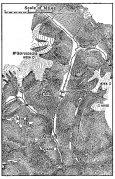
Fig. 140—Glacial sculpture in the heart of the
Cordillera Vilcapampa. In places the topography has so high a relief
that the glaciers seem almost to overhang the valleys. See Figs. 96 and
179 for photographs.
The topography conspired to increase this contrast. In place of many
streams, direct descents, a dispersion of snow in many valleys, as on
the east, the western slopes had indirect descents, gentler valley
profiles, and that higher degree of concentration of drainage which
naturally goes with topographic maturity. For example, there is nothing
in the east to compare with the big spurless valley near the pass above
Arma. The side walls were so extensively trimmed that the valley was
turned into a trough. The floor was smoothed and deepened and all the
tributary glaciers were either left high up on the bordering slopes or
entered the main valley with very steep profiles; their lateral and
terminal moraines now hang in festoons on the steep side walls.
Moreover, the range crest is trimmed from the west so that the serrate
skyline is a feature rarely seen from eastern viewpoints. This may not
hold true for more than a small part of the Cordillera. It was probably
emphasized here less by the contrasts already noted than by the geologic
structure. The eastward-flowing glaciers descended over dip slopes on
highly inclined sandstones, as at Pampaconas. Those flowing westward
worked either in a jointed granite or on the outcropping edges of the
sandstones, where the quarrying process known as glacial plucking
permitted the development of excessively steep slopes.
There are few glacial steps in the eastern valleys. The western valleys
have a marvelous display of this striking glacial feature. The
accompanying hachure maps show them so well that little description is
needed. They are from 50 to 200 feet high. Each one has a lake at its
foot into which the divided stream trickles over charming waterfalls.
All of them are clearly associated with a change in the volume of the
glacier that carved the valley. Wherever a tributary glacier entered, or
the side slopes increased notably in area, a step was formed. By retreat
some of them became divided, for the process once begun would push the
step far up valley after the manner of an extinguishing waterfall.
The retreat of the steps, the abrasion of the rock, and the sapping of
the cirques at the valley heads excavated the upper valleys so deeply
that they are nearly all, as W. D. Johnson has put it, “down at the
heel.” Thus, above Arma, one plunges suddenly from the smooth, grassy
glades of the strongly glaciated valley head down over the outer slopes
of the lowermost terminal moraine to the steep lower valley. Above the
moraine are fine pastures, in the steep valley below are thickets and
rocky defiles. There are long quiet reaches in the streams of the
glaciated valley heads besides pretty lakes and marshes. Below, the
stream is swift, almost torrential. Arma itself is built upon alluvial
deposits of glacial origin. A mile farther down the valley is
constricted and steep-walled—really a canyon.
Though the glaciers have retreated to the summit region, they are by no
means nearing extinction. The clear blue ice of the glacier descending
from Mt. Soiroccocha in the Arma Valley seems almost to hang over the
precipitous valley border. In curious contrast to its suggestion of cold
and storm is the patch of dark green woodland which extends right up to
its border. An earthquake might easily cause the glacier to invade the
woodland. Some of the glaciers between Choquetira and Arma rest on
terminal moraines whose distal faces are from 200 to 300 feet high. The
ice descending southeasterly from Panta Mt. is a good illustration.
Earlier positions of the ice front are marked by equally large moraines.
The one nearest that engaged by the living glacier confines a large lake
that discharges through a gap in the moraine and over a waterfall to the
marshy floor of the valley.
Retreat has gone so far, however, that there are only a few large
glacier systems. Most of the tributaries have withdrawn toward their
snowfields. In place of the twenty distinct glaciers now lying between
the pass and the terminal moraine below Choquetira, there was in glacial
times one great glacier with twenty minor tributaries. The cirques now
partly filled with damp snow must then have been overflowing with dry
snow above and ice below. Some of the glaciers were over a thousand feet
thick; a few were nearly two thousand feet thick, and the cirques that
fed them held snow and ice at least a half mile deep. Such a remarkably
complete set of glacial features only 700 miles from the equator is
striking evidence of the moist climate on the windward eastern part of
the great Andean Cordillera, of the universal change in climate in the
glacial period, and of the powerful dominating effects of ice erosion in
this region of unsurpassed Alpine relief.
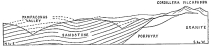
Fig. 141—Composite geologic section on the northeastern
border of the Cordillera Vilcapampa, in the vicinity of Pampaconas, to
show the deformative effects of the granite intrusion. There is a
limited amount of limestone near the border of the Cordillera. Both
limestone and sandstone are Carboniferous. See Appendix B. See also
Figs. 142 and 146. The section is about 15 miles long.
The main axis of the Cordillera Vilcapampa consists of granite in the
form of a batholith between crystalline schists on the one hand
(southwest), and Carboniferous limestones and sandstones and Silurian
shales and slates on the other (northeast). It is not a domal uplift in
the region in which it was observed in 1911, but an axial intrusion, in
places restricted to a narrow belt not more than a score of miles
across. As we should expect from the variable nature of the invaded
material, the granite belt is not uniform in width nor in the character
of its marginal features. In places the intrusion has produced
strikingly little alteration of the country rock; in other localities
the granite has been injected into the original material in so intimate
a manner as almost completely to alter it, and to give rise to a very
broad zone of highly metamorphosed rock. Furthermore, branches were
developed so that here and there tributary belts of granite extend from
the main mass to a distance of many miles. Outlying batholiths occur
whose common petrographic character and similar manner of occurrence
leave little doubt that they are related abyssally to a common plutonic
mass.
The Vilcapampa batholith has two highly contrasted borders, whether we
consider the degree of metamorphism of the country rock, the definition
of the border, or the resulting topographic forms. On the northeastern
ridge at Colpani the contact is so sharp that the outstretched arms in
some places embrace typical granite on the one hand and almost
unaltered shales and slates on the other. Inclusions or xenoliths of
shale are common, however, ten and fifteen miles distant, though they
are prominent features in a belt only a few miles wide. The lack of more
intense contact effects is a little remarkable in view of the altered
character of the inclusions, all of which are crystalline in contrast to
the fissile shales from which they are chiefly derived. Inclusions
within a few inches of the border fall into a separate class, since they
show in general but trifling alteration and preserve their original
cleavage plains. It appears that the depth of the intrusion must have
been relatively slight or the intrusion sudden, or both shallow and
sudden, conditions which produce a narrow zone of metamorphosed material
and a sharp contact.
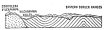
Fig. 142—The deformative effects of the Vilcapampa
intrusion on the northeastern border of the Cordillera. The deformed
strata are heavy-bedded sandstones and shales and the igneous rocks are
chiefly granites with bordering porphyries. Looking northwest near
Puquiura. For conditions near Pampaconas, looking in the opposite
direction, see Fig. 141. For conditions on the other side of the
Cordillera, see Fig. 146.
The relation between shale and granite at Colpani is shown in 143 .
Projections of granite extend several feet into the shale and slate and
generally end in blunt barbs or knobs. In a few places there is an
intimate mixture of irregular slivers and blocks of crystallized
sediments in a granitic groundmass, with sharp lines of demarcation
between igneous and included material. The contact is vertical for at
least several miles. It is probable that other localities on the contact
exhibit much greater modification and invasion of the weak shales and
slates, but at Colpani the phenomena are both simple and restricted in
development.
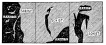
Fig. 143—Relation of granite intrusion to schist on the
northeastern border of the Vilcapampa batholith near the bridge of
Colpani, lower end of the granite Canyon of Torontoy. The sections are
from 15 to 25 feet high and represent conditions at different levels
along the well-defined contact.
The highly mineralized character of the bordering sedimentary strata,
and the presence of numbers of complementary dikes, nearly identical in
character to those in the parent granite now exposed by erosion over a
broad belt roughly parallel to the contact, supplies a basis for the
inference that the granite may underlie the former at a slight depth, or
may have had far greater metamorphic effects upon its sedimentary roof
than the intruded granite has had upon its sedimentary rim.
The physiographic features of the contact belt are of special interest.
No available physiographic interpretation of the topography of a
batholith includes a discussion of those topographic and drainage
features that are related to the lithologic character of the intruded
rock, the manner of its intrusion, or the depth of erosion since
intrusion. Yet each one of these factors has a distinct topographic
effect. We shall, therefore, turn aside for a moment from the detailed
discussion of the Vilcapampa region to an examination of several
physiographic principles and then return to the main theme for
applications.
It is recognized that igneous intrusions are of many varieties and that
even batholithic invasions may take place in rather widely different
ways. Highly heated magmas deeply buried beneath the earth’s surface
produce maximum contact effects, those nearer the surface may force the
strata apart without extreme lithologic alterations of the displaced
beds, while through the stoping process a sedimentary cover may be
largely absorbed and the magmas may even break forth at the surface as
in ordinary vulcanism. If the sedimentary beds have great vertical
variation in resistance, in attitude, and in composition, there may be
afforded an opportunity for the display of quite different effects at
different levels along a given contact, so that a great variety of
physical conditions will be passed by the descending levels of erosion.
At one place erosion may have exposed only the summit of the batholith,
at another the associated dikes and sheets and ramifying branches may be
exposed as in the zone of fracture, at a third point the original zone
of flowage may be reached with characteristic marginal schistosity,
while at still greater depths there may be uncovered a highly
metamorphosed rim of resistant sedimentary rock.
The mere enumeration of these variable structural features is sufficient
to show how variable we should expect the associated land forms to be.
Were the forms of small extent, or had they but slight distinction upon
comparison with other erosional effects, they would be of little
concern. They are, on the contrary, very extensively developed; they
affect large numbers of lofty mountain ranges besides still larger areas
of old land masses subjected to extensive and deep erosion, thus laying
bare many batholiths long concealed by a thick sedimentary roof.
The differences between intruded and country rock dependent upon these
diversified conditions of occurrence are increased or diminished
according to the history of the region after batholithic invasion takes
place. Regional metamorphism may subsequently induce new structures or
minimize the effects of the old. Joint systems may be developed, the
planes widely spaced in one group of rocks giving rise to monolithic
masses very resistant to the agents of weathering, while those of an
adjacent group may be so closely spaced as greatly to hasten the rate of
denudation. There may be developed so great a degree of schistosity in
one rock as to give rise (with vigorous erosion) to a serrate
topography; on the other hand the forms developed on the rocks of a
batholith may be massive and coarse-textured.
To these diversifying conditions may be added many others involving a
large part of the field of dynamic geology. It will perhaps suffice to
mention two others: the stage of erosion and the special features
related to climate. If a given intrusion has been accompanied by an
important amount of uplift or marginal compression, vigorous erosion may
follow, whereupon a chance will be offered for the development of the
greatest contrast in the degree of boldness of topographic forms
developed upon rocks of unequal resistance. Ultimately these contrasts
will diminish in intensity, as in the case of all regional differences
of relief, with progress toward the end of the normal cycle of erosion.
If peneplanation ensue, only feeble topographic differences may mark
the line of contact which was once a prominent topographic feature. With
reference to the effects of climate it may be said simply that a granite
core of batholithic origin may extend above the snowline or above timber
line or into the timbered belt, whereas the invaded rock may occur
largely below these levels with obvious differences in both the rate and
the kind of erosion affecting the intruded mass.
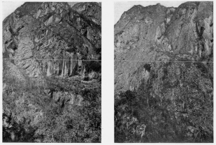
Fig. 144—Cliffed canyon wall in the Urubamba Valley
between Huadquiña and Torontoy. There is a descent of nearly 2,000 feet
shown in the photograph and it is developed almost wholly along
successive joint planes. |
Fig. 145—Another aspect of the canyon wall of 144 .
The almost sheer descents are in contrast with the cliff and platform
type of topography characteristic of the Grand Canyon of Colorado. |
If we apply the foregoing considerations to the Cordillera Vilcapampa,
we shall find some striking illustrations of the principles involved.
The invasion of the granite was accompanied by moderate absorption of
the displaced rock, and more especially by the marginal pushing aside of
the sedimentary rim. The immediate effect must have been to give both
intruded rock and country rock greater height and marked ruggedness.
There followed a period of regional compression and torsion, and the
development of widespread joint systems with strikingly regular
features. In the Silurian shales and slates these joints are closely
spaced; in the granites they are in many places twenty to thirty feet
apart. The shales, therefore, offer many more points of attack and have
weathered down into a smooth-contoured topography boldly overlooked
along the contact by walls and peaks of granite. In some cases a canyon
wall a mile high is developed entirely on two or three joint planes
inclined at an angle no greater than 15°. The effect in the granite is
to give a marked boldness of relief, nowhere more strikingly exhibited
than at Huadquiña, below Colpani, where the foot-hill slopes developed
on shales and slates suddenly become moderate. The river flows from a
steep and all but uninhabited canyon into a broad valley whose slopes
are dotted with the terraced chacras, or farms, of the mountain
Indians.
The Torontoy granite is also homogeneous while the shales and slates
together with their more arenaceous associates occur in alternating
belts, a diversity which increases the points of attack and the
complexity of the forms. Tending toward the same result is the greater
hardness of the granite. The tendency of the granite to develop bold
forms is accelerated in lofty valleys disposed about snow-clad peaks,
where glaciers of great size once existed, and where small glaciers
still linger. The plucking action of ice has an excellent chance for
expression, since the granite may be quarried cleanly without the
production of a large amount of spoil which would load the ice and
diminish the intensity of its plucking action.
As a whole the Central Andes passed through a cycle of erosion in late
Tertiary time which was interrupted by uplift after the general surface
had been reduced to a condition of topographic maturity. Upon the
granites mature slopes are not developed except under special conditions
(1) of elevation as in the small batholith above Chuquibambilla, and (2)
where the granite is itself bordered by resistant schists which have
upheld the surface over a broad transitional belt. Elsewhere the granite
is marked by exceedingly rugged forms: deep steep-walled canyons,
precipitous cirques, matterhorns, and bold and extended escarpments of
erosion. In the shale belt the trails run from valley to valley in every
direction without special difficulties, but in the granite they follow
the rivers closely or cross the axis of the range by carefully selected
routes which generally reach the limit of perpetual snow. Added interest
attaches to these bold topographic forms because of the ruins now found
along the canyon walls, as at Torontoy, or high up on the summit of a
precipitous spur, as at Machu Picchu near the bridge of San Miguel.
The Vilcapampa batholith is bordered on the southwest by a series of
ancient schists with which the granite sustains quite different
relations. No sharp dividing line is visible, the granite extending
along the planes of foliation for such long distances as in places to
appear almost interbedded with the schists. The relation is all the more
striking in view of the trifling intrusions effected in the case of the
seemingly much weaker shales on the opposite contact. Nor is the
metamorphism of the invaded rock limited to simple intrusion. For
several miles beyond the zone of intenser effects the schists have been
enriched with quartz to such an extent that their original darker color
has been changed to light gray or dull white. At a distance they may
even appear as homogeneous and light-colored as the granite. At distant
points the schists assume a darker hue and take on the characters of a
rather typical mica schist.
It is probable that the Vilcapampa intrusion is one of a family of
batholiths which further study may show to extend over a much larger
territory. The trail west of Abancay was followed quite closely and
accidentally crosses two small batholiths of peculiar interest. Their
limits were not closely followed out, but were accurately determined at
a number of points and the remaining portion of the contact inferred
from the topography. In the case of the larger area there may indeed be
a connection westward with a larger mass which probably constitutes the
ranges distant some five to ten miles from the line of traverse.
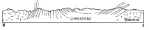
Fig. 146—Deformative effects on limestone strata of the
granite intrusion on the southwestern border of the Vilcapampa batholith
above Chuquibambilla. Fig. 147 is on the same border of the batholith
several miles farther northwest. The granite mass on the right is a
small outlier of the main batholith looking south. The limestone is
Cretaceous. See Appendix C for locations.
These smaller intrusions are remarkable in that they appear to have been
attended by little alteration of either invading or invaded rock, though
the granites were observed to become distinctly more acid in the contact
zone. Space was made for them by displacing the sedimentary cover and by
a marked shortening of the sedimentary rim through such structures as
overthrust faults and folds. The contact is observable in a highly
metamorphosed belt about twenty feet wide, and for several hundred feet
more the granite has absorbed the limestone in small amounts with the
production of new minerals and the development of a distinctly lighter
color. The deformative effects of the batholithic invasion are shown in
their gross details in Figs. 141, 142, and 146; the finer details of
structure are represented in 147 , which is drawn from a measured
outcrop above Chuquibambilla.
It will be seen that we have here more than a mere crinkling, such as
the mica schists of the Cordillera Vilcapampa display. The diversified
sedimentary series is folded and faulted on a large scale with broad
structural undulations visible for miles along the abrupt valley walls.
Here and there, however, the strata become weaker generally through the
thinning of the beds and the more rapid alternation of hard and soft
layers, and for short distances they have absorbed notable amounts of
the stresses induced by the igneous intrusions. In such places not only
the structure but the composition of the rock shows the effects of the
intrusion. Certain shales in the section are carbonaceous and in all
observed cases the organic matter has been transformed to anthracite, a
condition generally associated with a certain amount of minute mashing
and a cementation of both limestone and sandstone.
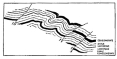
Fig. 147—Overthrust folds in detail on the southwestern
border of the Vilcapampa batholith near Chuquibambilla. The section is
fifteen feet high. Elevation, 13,100 feet (4,000 m.). For comparison
with the structural effects of the Vilcapampa intrusion on the northeast
see Fig. 142.
The granite becomes notably darker on approach to the northeastern
contact near Colpani; the proportion of ferro-magnesian minerals in some
cases is so large as to give a distinctly black color in sharp contrast
to the nearly white granite typical of the central portion of the mass.
Large masses of shale foundered in the invading magma, and upon fusion
gave rise to huge black masses impregnated with quartz and in places
smeared or injected with granite magma. Everywhere the granite is marked
by numbers of black masses which appear at first sight to be
aggregations of dark minerals normal to the granite and due to
differentiation processes at the time of crystallization. It is,
however, noteworthy that these increase rapidly in number on approach to
the contact, until in the last half-mile they appear to grade into the
shale inclusions. It may, therefore, be doubted that they are
aggregations. From their universal distribution, their uniform
character, and their marked increase in numbers on approach to lateral
contacts, it may reasonably be inferred that they represent foundered
masses of country rock. Those distant from present contacts are in
almost all cases from a few inches to a foot in diameter, while on
approach to lateral contacts they are in places ten to twenty feet in
width, as if the smaller areas represented the last remnants of large
inclusions engulfed in the magma near the upper or roof contact. They
are so thoroughly injected with silica and also with typical granite
magma as to make their reference to the country rock less secure on
petrographical than on purely distributional grounds.
A parallel line of evidence relates to the distribution of complementary
dikes throughout the granite. In the main mass of the batholith the
dikes are rather evenly distributed as to kind with a slight
preponderance of the dark-colored group. Near the contact, however,
aplitic dikes cease altogether and great numbers of melanocratic dikes
appear. It may be inferred that we have in this pronounced condition
suggestions of strong influence upon the final processes of invasion and
cooling of the granite magma, on the part of the country rock detached
and absorbed by the invading mass. It might be supposed that the
indicated change in the character of the complementary dikes could be
ascribed to possible differentiation of the granite magma whereby a
darker facies would be developed toward the Colpani contact. It has,
however, been pointed out already that the darkening of the granite in
this direction is intimately related to a marked increase in the number
of inclusions, leaving little doubt that the thorough digestion of the
smaller masses of detached shales is responsible for the marked increase
in the number and variety of the ferro-magnesian and special contact
minerals.
Upon the southwestern border of the batholith the number of aplitic
dikes greatly increases. They form prominent features, not only of the
granite, but also of the schists, adding greatly to the strong contrast
between the schist of the border zone and that outside the zone of
metamorphism. In places in the border schists, these are so numerous
that one may count up to twenty in a single view, and they range in size
from a few inches to ten or fifteen feet. The greater fissility of the
schists as contrasted with the shales on the opposite or eastern margin
of the batholith caused them to be relatively much more passive in
relation to the granite magma. They were not so much torn off and
incorporated in the magma, as they were thoroughly injected and
metamorphosed. Added to this is the fact that they are petrographically
more closely allied to the granite than are the shales upon the
northeastern contact.
ALONG the entire coast of Peru are upraised and dissected terraces of
marine origin. They extend from sea level to 1,500 feet above it, and
are best displayed north of Mollendo and in the desert south of Payta.
The following discussion relates to that portion of the coast between
Mollendo and Camaná.
At the time of the development of the coastal terraces the land was in a
state of temporary equilibrium, for the terraces were cut to a mature
stage as indicated by the following facts: (1) the terraces have great
width—from one to five and more miles; (2) their inner border is
straight, or, where curves exist, they are broad and regular; (3) the
terrace tops are planed off smoothly so that they now have an even
gradient and an almost total absence of rock stacks or unreduced spurs;
(4) the mature slopes of the Coast Range, strikingly uniform in gradient
and stage of development (Fig. 148), are perfectly organized with
respect to the inner edge of the terrace. They descend gradually to the
terrace margin, showing that they were graded with respect to sea level
when the sea stood at the inner edge of the highest terrace.
From the composition and even distribution of the thick-bedded Tertiary
deposits of the desert east of the Coast Range, it is concluded that the
precipitation of Tertiary time was greater than that of today (see p.
261). Therefore, if the present major streams reach the sea, it may also
be concluded that those of an earlier period reached the sea, provided
the topography indicates the perfect adjustment of streams to structure.
Lacustrine sediments are absent throughout the Tertiary section. Such
through-flowing streams, discharging on a stable coast, would also have
mature valleys as a consequence of long uninterrupted erosion at a fixed
level. The Majes river must have cut through the Coast Range at Camaná
then as now. Likewise the Vitor at Quilca must have cut straight across
the Coast Range. An examination of the surface leading down from the
Coast Range to the upper edge of these valleys fully confirms this
deduction. Flowing and well-graded slopes descend to the brink of the
inner valley in each case, where they give way to the gorge walls that
continue the descent to the valley floor.
Confirmatory evidence is found in the wide Majes Valley at Cantas and
Aplao. (See the Aplao Quadrangle for details.) Though the observer is
first impressed with the depth of the valley, its width is more
impressive still. It is also clear that two periods of erosion are
represented on its walls. Above Aplao the valley walls swing off to the
west in a great embayment quite inexplicable on structural grounds; in
fact the floor of the embayment is developed across the structure, which
is here more disordered than usual. The same is true below Cantas, as
seen from the trail, which drops over two scarps to get to the valley
floor. The upper, widely opened valley is correlated with the latter
part of the period in which were formed the mature terraces of the coast
and the mature slopes bordering the larger valleys where they cross the
Coast Range.
After its mature development the well-graded marine terrace was upraised
and dissected. The deepest and broadest incisions in it were made where
the largest streams crossed it. Shallower and narrower valleys were
formed where the smaller streams that headed in the Coast Range flowed
across it. Their depth and breadth was in general proportional to the
height of that part of the Coast Range in which their headwaters lay and
to the size of their catchment basins.
When the dissection of the terrace had progressed to the point where
about one-third of it had been destroyed, there came depression and the
deposition of Pliocene or early Pleistocene sands, gravels, and local
clay beds. Everywhere the valleys were partly or wholly filled and over
broad stretches, as in the vicinity of stream mouths and upon lower
portions of the terrace, extensive deposits were laid down. The largest
deposits lie several hours’ ride south of Camaná, where locally they
attain a thickness of several hundred feet. Their upper surface was well
graded and they show a prolonged period of deposition in which the
former coastal terrace was all but concealed.
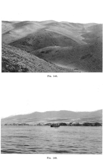
Fig. 148—The Coast Range between Mollendo and Arequipa
at the end of June, 1911. There is practically no grass and only a few
dry shrubs. The fine network over the hill slopes is composed of
interlacing cattle tracks. The cattle roam over these hills after the
rains which come at long intervals. (See page 141 for description of the
rains and the transformations they effect. For example, in October,
1911, these hills were covered with grass.)
Fig. 149—The great marine terrace at Mollendo. See Fig.
150 for profile.
The uplift of the coast terrace and its subsequent dissection bring the
physical history down to the present. The uplift was not uniform; three
notches in the terrace show more faintly upon the granite-gneiss where
the buried rock terrace has been swept clean again, more strongly upon
the softer superimposed sands. They lie below the 700-foot contour and
are insignificant in appearance beside the slopes of the Coast Range or
the ragged bluff of the present coast.
The effect of the last uplift of the coast was to impel the Majes River
again to cut down its lower course nearly to sea level. The Pliocene
terrace deposits are here entirely removed over an area several leagues
wide. In their place an extensive delta and alluvial fan have been
formed. At first the river undoubtedly cut down to base level at its
mouth and deposited the cut material on the sea floor, now shoal, for a
considerable distance from shore. We should still find the river in that
position had other agents not intervened. But in the Pleistocene a great
quantity of waste was swept into the Majes Valley, whereupon aggradation
began; and in the middle and lower valley it has continued down to the
present.

Fig. 150—Profile of the coastal terraces at Mollendo. At
1, in a tributary gorge, fossiliferous clay occurs at 800 feet elevation
above the sea. At 2 is a characteristic change of profile marking a drop
from a higher to a lower terrace. On the extreme left is the highest
terrace, just under 1,500 feet (460 m.).
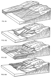
Figs. 151-154—These four diagrams represent the physical
history and the corresponding physiographic development of the coastal
region of Peru between Camaná and Mollendo. The sedimentary beds in the
background of the first diagram are hypothetical and are supposed to
correspond to the quartzites of the Majes Valley at Aplao.
The effect has been not only the general aggradation of the valley
floor, but also the development of a combined delta and superimposed
alluvial fan at the valley mouth. The seaward extension of the delta has
been hastened by the gradation of the shore between the bounding
headlands, thus giving rise to marine marshes in which every particle of
contributed waste is firmly held. The plain of Camaná, therefore,
includes parts of each of the following: a delta, a superposed alluvial
fan, a salt-water marsh, a fresh-water marsh, a series of beaches, small
amounts of piedmont fringe at the foot of Pliocene deposits once trimmed
by the river and by waves, and extensive tracts of indefinite fill. (See
the Camaná Quadrangle for details.)
With the coastal conditions now before us it will be possible to attempt
a correlation between the erosion features and the deposits of the coast
and those of the interior. An understanding of the comparisons will be
facilitated by the use of diagrams, Figs. 151-154, and by a series of
concise summary statements. From the relations of the figure it appears
that:
1. The Tertiary deposits bordering the Majes Valley east of the Coast
Range were in process of deposition when the sea planed the coastal
terrace (Fig. 151).
2. A broad mature marine terrace without stacks or sharply alternating
spurs and reëntrants (though the rock is a very resistant granite) is
correlated with the mature grades of the Coast Range, with which they
are integrated and with the mature profiles of the main Cordillera.
3. Such a high degree of topographic organization requires the
dissection in the late stages of the erosion cycle of at least the
inner or eastern border of the piedmont deposits of the desert, largely
accumulated during the early stages of the cycle.
4. Since the graded slopes of the Coast Range on the one side descend to
a former shore whose elevation is now but 1,500 feet above sea level,
and since only ten to twenty miles inland on the other side of the
range, the same kind of slope extends beneath Tertiary deposits 4,000
feet above sea level, it appears that aggradation of the outer (or
western) part of the Tertiary deposits on the eastern border of the
Coast Range continued down to the end of the cycle of erosion, though
5. There must have been an outlet to the sea, since, as we have already
seen, the water supply of the Tertiary was greater than that of today
and the present streams reach the sea. Moreover, the mature upper slopes
and the steep lower slopes of the large valleys make a pronounced
topographic unconformity, showing two cycles of valley development.
6. Upon uplift of the coast and dissection of the marine terraces at the
foot of the Coast Range, the streams cut deep trenches on the floors of
their former valleys (Fig. 152) and removed (a) large portions of the
coast terrace, and (b) large portions of the Tertiary deposits east of
the Coast Range.
7. Depression of the coastal terrace and its partial burial meant the
drowning of the lower Majes Valley and its partial filling with marine
and later with terrestrial deposits. It also brought about the partial
filling by stream aggradation of the middle portion of the valley,
causing the valley fill to abut sharply against the steep valley walls.
(See 155 .)
8. Uplift and dissection of both the terrace and its overlying sediments
would be accompanied by dissection of the former valley fill, provided
that the waste supply was not increased and that the uplift was regional
and approximately equal throughout—not a bowing up of the coast on the
one hand, or an excessive bowing up of the mountains on the other. But
the waste supply has not remained constant, and the uplift has been
greater in the Cordillera than on the coast. Let us proceed to the proof
of these two conclusions, since upon them depends the interpretation of
the later physical history of the coastal valleys.
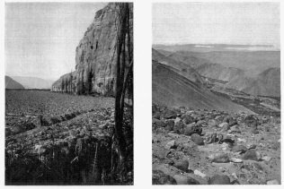
Fig. 155—Steep walls in the Majes Valley below Cantas
and the abrupt termination against them of a deep alluvial fill. |
Fig. 156—Canyon of the Majes River through the Coast
Range north of Camaná. The rock is a granite-gneiss capped by rather
flat-lying sedimentaries. |
It is known that the Pleistocene was a time of augmented waste delivery.
At the head of the broadly opened Majes Valley there was deposited a
huge mass of extremely coarse waste several hundred feet deep and
several miles long. Forward from it, interstratified with its outer
margin, and continuing the same alluvial grade, is a still greater mass
of finer material which descends to lower levels. The fine material is
deposited on the floor of a valley cut into Tertiary strata, hence it
is younger than the Tertiary. It is now, and has been for some time
past, in process of dissection, hence it was not formed under present
conditions of climate and relief. It is confidently assigned to the
Pleistocene, since this is definitely known to have been a time of
greater precipitation and waste removal on the mountains, and deposition
on the plains and the floors of mountain valleys. Such a conclusion
appears, even on general grounds, to be but a shade less reliable than
if we were able to find in the upper Majes Valley, as in so many other
Andean valleys, similar alluvial deposits interlocked with glacial
moraines and valley trains.
In regard to the second consideration—the upbowing of the
Cordillera—it may be noted that the valley and slope profiles of the
main Cordillera shown on p. 191, when extended toward the margin of the
mountain belt, lie nearly a mile above the level of the sea on the west
and the Amazon plains on the east. The evidence of regional bowing thus
afforded is checked by the depths of the mountain valleys and the stream
profiles in them. The streams are now sunk from one to three thousand
feet below their former level. Even in the case of three thousand feet
of erosion the stream profiles are still ungraded, the streams
themselves are almost torrential, and from one thousand to three
thousand feet of vertical cutting must still be accomplished before the
profiles will be as gentle and regular as those of the preceding cycle
of erosion, in which were formed the mature slopes now lying high above
the valley floors.
Further evidence of bowing is afforded by the attitude of the Tertiary
strata themselves, more highly inclined in the case of the older
Tertiary, less highly inclined in the case of the younger Tertiary. It
is noteworthy that the gradient of the present valley floor is
distinctly less than that of the least highly inclined strata. This is
true even where aggradation is now just able to continue, as near the
nodal point of the valley, above Aplao, where cutting ceases and
aggradation begins. (See the Aplao Quadrangle for change of function on
the part of the stream a half mile above Cosos). Such a progressive
steepening of gradients in the direction of the oldest deposits, shows
very clearly a corresponding progression in the growth of the Andes at
intervals throughout the Tertiary.
Thus we have aggradation in the Tertiary at the foot of the growing
Andes; aggradation in the Pliocene or early Pleistocene on the floor of
a deep valley cut in earlier deposits; aggradation in the glacial epoch;
and aggradation now in progress. Basin deposits within the borders of
the Peruvian Andes are relatively rare. The profound erosion implied by
the development, first of a mature topography across this great
Cordillera, and second of many deep canyons, calls for deposition on an
equally great scale on the mountain borders. The deposits of the western
border are a mile thick, but they are confined to a narrow zone between
the Coast Range and the Cordillera. Whatever material is swept beyond
the immediate coast is deposited in deep ocean water, for the bottom
falls off rapidly. The deposits of the eastern border of the Andes are
carried far out over the Amazon lowland. Those of earlier geologic
periods were largely confined to the mountain border, where they are now
upturned to form the front range of the Andes. The Tertiary deposits of
the eastern border are less restricted, though they appear to have
gathered chiefly in a belt from fifty to one hundred miles wide.
The deposits of the western border were laid down by short streams
rising on a divide only 100 to 200 miles from the Pacific. Furthermore,
they drain the dry leeward slopes of the Andes. The deposits of the wet
eastern border were made by far larger streams that carry the waste of
nearly the whole Cordillera. Their shoaling effect upon the Amazon
depression must have been a large factor in its steady growth from an
inland sea to a river lowland.
In the preceding chapter we employed geologic facts in the determination
of the age of the principal topographic forms. These facts require
further discussion in connection with their closest physiographic allies
if we wish to show how the topography of today originated. There are
many topographic details that have a fundamental relation to structure;
indeed, without a somewhat detailed knowledge of geology only the
broader and more general features of the landscape can be interpreted.
In this chapter we shall therefore refer not to the scenic features as
in a purely topographic description, but to the rock structure and the
fossils. A complete and technical geologic discussion is not desirable,
first, because it should be based upon much more detailed geologic field
work, and second because after all our main purpose is not to discuss
the geologic features per se, but the physiographic background which
the geologic facts afford. I make this preliminary observation partly to
indicate the point of view and partly to emphasize the necessity, in a
broad, geographic study, for the reconstruction of the landscapes of the
past.
The two dominating ranges of the Peruvian Andes, called the Maritime
Cordillera and the Cordillera Vilcapampa, are composed of igneous
rock—the one volcanic lava, the other intrusive granite. The chief rock
belts of the Andes of southern Peru are shown in 157 . The Maritime
Cordillera is bordered on the west by Tertiary strata that rest
unconformably upon Palaeozoic quartzites. It is bordered on the east by
Cretaceous limestones that grade downward into sandstones, shales, and
basal conglomerates. At some places the Cretaceous deposits rest upon
old schists, at others upon Carboniferous limestones and related
strata, upon small granite intrusives and upon old and greatly altered
volcanic rock.
The Cordillera Vilcapampa has an axis of granitic rock which was thrust
upward through schists that now border it on the west and slates that
now border it on the east. The slate series forms a broad belt which
terminates near the eastern border of the Andes, where the mountains
break down abruptly to the river plains of the Amazon Basin. The
immediate border on the east is formed of vertical Carboniferous
limestones. The narrow foothill belt is composed of Tertiary sandstones
that grade into loose sands and conglomerates. The inclined Tertiary
strata were leveled by erosion and in part overlain by coarse and now
dissected river gravels, probably of Pleistocene age. Well east of the
main border are low ranges that have never been described. They could
not be reached by the present expedition on account of lack of time. On
the extreme western border of that portion of the Peruvian Andes herein
described, there is a second distinct border chain, the Coast Range. It
is composed of granite and once had considerable relief, but erosion has
reduced its former bold forms to gentle slopes and graded profiles.
The continued and extreme growth of the Andes in later geologic periods
has greatly favored structural and physiographic studies. Successive
uplifts have raised earlier deposits once buried on the mountain flanks
and erosion has opened canyons on whose walls and floors are the clearly
exposed records of the past. In addition there have been igneous
intrusions of great extent that have thrust aside and upturned the
invaded strata exposing still further the internal structures of the
mountains. From sections thus revealed it is possible to outline the
chief events in the history of the Peruvian Andes, though the outline is
still necessarily broad and general because based on rapid
reconnaissance. However, it shows clearly that the landscape of the
present represents but a temporary stage in the evolution of a great
mountain belt. At the dawn of geologic history there were chains of
mountains where the Andes now stand. They were swept away and even their
roots deeply submerged under invading seas. Repeated uplifts of the
earth’s crust reformed the ancient chains or created new ones out of the
rock waste derived from them. Each new set of forms, therefore, exhibits
some features transmitted from the past. Indeed, the landscape of today
is like the human race—inheriting much of its character from past
generations. For this reason the philosophical study of topographic
forms requires at least a broad knowledge of related geologic
structures.
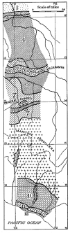
Fig. 157—Outline sketch showing the principal rock belts
of Peru along the seventy-third meridian. They are: 1, Pleistocene and
Recent gravels and sands, the former partly indurated and slightly
deformed, with the degree of deformation increasing toward the mountain
border (south). 2, Tertiary sandstones, inclined from 15° to 30°
toward the north and unconformably overlain by Pleistocene gravels. 3,
fossil-bearing Carboniferous limestones with vertical dip. 4,
non-fossiliferous slates, shales, and slaty schists (Silurian) with
great variation in degree of induration and in type of structure. South
of the parallel of 13° is a belt of Carboniferous limestones and
sandstones bordering (5), the granite axis of the Cordillera
Vilcapampa. For its structural relations to the Cordillera see Figs. 141
and 142. 6, old and greatly disturbed volcanic agglomerates, tuffs and
porphyries, and quartzitic schists and granite-gneiss. 7, principally
Carboniferous limestones north of the axis of the Central Ranges and
Cretaceous limestones south of it. Local granite batholiths in the axis
of the Central Ranges. 8, quartzites and slates predominating with
thin limestones locally. South of 8 is a belt of shale, sandstone, and
limestone with a basement quartzite appearing on the valley floors. 9,
a portion of the great volcanic field of the Central Andes and
characteristically developed in the Western or Maritime Cordillera,
throughout northern Chile, western Bolivia, and Peru. At Cotahuasi (see
also Fig. 20) Cretaceous limestones appear beneath the lavas. 10,
Tertiary sandstones of the coastal desert with a basement of old
volcanics and quartzites appearing on the valley walls. The valley floor
is aggraded with Pleistocene and Recent alluvium. 11, granite-gneiss
of the Coast Range. 12, late Tertiary or Pleistocene sands and gravels
deposited on broad coastal terraces. For rock structure and character
see the other figures in this chapter. For a brief designation of index
fossils and related forms see Appendix B. For the names of the drainage
lines and the locations of the principal towns see Figs. 20 and 204.
The oldest series of rocks along the seventy-third meridian of Peru
extends eastward from the Vilcapampa batholith nearly to the border of
the Cordillera, 157 . It consists of (1) a great mass of slates and
shales with remarkable uniformity of composition and structure over
great areas, and (2) older schists and siliceous members in restricted
belts. They are everywhere thoroughly jointed; near the batholith they
are also mineralized and altered from their original condition; in a few
places they have been intruded with dikes and other form of igneous
rock.
The slates and shales underlie known Carboniferous strata on their
eastern border and appear to be a physical continuation of the
fossiliferous slates of Bolivia; hence they are provisionally referred
to the Silurian, though they may possibly be Devonian. Certainly the
known Devonian exceeds in extent the known Silurian in the Central Andes
but its lithological character is generally quite unlike the character
of the slates here referred to the Silurian. The schists are of great
but unknown age. They are unconformably overlain by known Carboniferous
at Puquiura in the Vilcapampa Valley (Fig. 158), and near Chuquibambilla
on the opposite side of the Cordillera Vilcapampa. The deeply weathered
fissile mica schists east of Pasaje (see Appendix C for all locations)
are also unconformably overlain by conglomerate and sandstone of
Carboniferous age. While the schists vary considerably in lithological
appearance and also in structure, they are everywhere the lowest rocks
in the series and may with confidence be referred to the early
Palaeozoic, while some of them may date from the Proteriozoic.
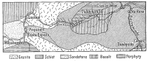
Fig. 158—Geologic sketch map of the lower Urubamba
Valley. A single traverse was made along the valley, hence the
boundaries are not accurate in detail. They were sketched in along a few
lateral traverses and also inferred from the topography. The country
rock is schist and the granite intruded in it is an arm of the main
granite mass that constitutes the axis of the Cordillera Vilcapampa. The
structure and to some degree the extent of the sandstone on the left are
represented in Figs. 141 and 142.
The Silurian beds are composed of shale, sandstone, shaly sandstone,
limestone, and slate with some slaty schist, among which the shales are
predominent and the limestones least important. Near their contact with
the granite the slate series is composed of alternating beds of
sandstone and shale arranged in beds from one to three feet thick. At
Santa Ana they become more fissile and slaty in character and in several
places are quarried and used for roofing. At Rosalina they consist of
almost uniform beds of shale so soft and so minutely and thoroughly
jointed as to weather easily. Under prolonged erosion they have,
therefore, given rise to a well-rounded and soft-featured landscape.
Farther down the Urubamba Valley they again take on the character of
alternating beds of sandstone and shale from a few feet to fifteen and
more feet thick. In places the metamorphism of the series has been
carried further—the shales have become slates and the sandstones have
been altered to extremely resistant quartzites. The result is again
clearly shown in the topography of the valley wall which becomes bold,
inclosing the river in narrow “pongos” or canyons filled with huge
bowlders and dangerous rapids. The hills become mountains, ledges
appear, and even the heavy forest cover fails to smooth out the natural
ruggedness of the landscape.
It is only upon their eastern border that the Silurian series includes
calcareous beds, and all of these lie within a few thousand yards of the
contact with the Carboniferous limestones and shales. At first they are
thin paper-like layers; nearer the top they are a few inches wide and
finally attain a thickness of ten or twelve feet. The available
limestone outcrops were rigorously examined for fossils but none were
found, although they are lavishly distributed throughout the younger
Carboniferous beds just above them. It is also remarkable that though
the Silurian age of these beds is reasonably inferred they are not
separated from the Carboniferous by an unconformity, at least we could
find none in this locality. The later beds disconformably overlie the
earlier beds, although the sharp differences in lithology and fossils
make it easy to locate the line of separation. The limestone beds of the
Silurian series are extremely compact and unfossiliferous. At least in
this region those of Carboniferous age are friable and the fossils
varied and abundant. The Silurian beds are everywhere strongly inclined
and throughout the eastern half or third of their outcrop in the
Urubamba Valley they are nearly vertical.
In view of the enormous thickness of the repeated layers of shale and
sandstone this series is of great interest. Added importance attaches to
their occurrence in a long belt from the eastern edge of the Bolivian
highlands northward through Peru and possibly farther. From the fact
that their disturbance has been on broad lines over wide areas with
extreme metamorphism, they are to be separated from the older
mica-schists and the crumpled chlorite schists of Puquiura and Pasaje.
Further reasons for this distinction lie in their lithologic difference
and, to a more important degree, in the strong unconformity between the
Carboniferous and the schists in contrast to the disconformable
relations shown between the Carboniferous and Silurian fifty miles away
at Pongo de Mainique. The mashing and crumpling that the schists have
experienced at Puquiura is so intense, that were they a part of the
Silurian series the latter should exhibit at least a slight unconformity
in relation to the Carboniferous limestones deposited upon them.
If our interpretation of the relation of the schists to the slates and
shales be correct, we should have a mountain-making period introduced in
pre-Silurian time, affecting the accumulated sediments and bringing
about their metamorphism and crumpling on a large scale. From the
mountains and uplands thus created on the schists, sediments were washed
into adjacent waters and accumulated as even-bedded and extensive sheets
of sands and muds (the present slates, shales, quartzites, etc.).
Nowhere do the sediments of the slate series show a conglomeratic phase;
they are remarkably well-sorted and consist of material disposed with
great regularity. Though they are coarsest at the bottom the lower beds
do not show cross-bedding, ripple marking, or other signs of
shallow-water conditions. Toward the upper part of the series these
features, especially the ripple-marking, make their appearance. During
the deposition of the last third of the series, and again just before
the deposition of the limestone, the beds took on a predominantly
arenaceous character associated with ripple marks and cross-bedding
characteristic of shallow-water deposits.
In the persistence of arenaceous sediments throughout the series and the
distribution of the ripple marks through the upper third of the beds, we
have a clear indication that the degree of shallowness was sufficient to
bring the bottom on which the sediments accumulated into the zone of
current action and possibly wave action. It is also worth considering
whether the currents involved were not of similar origin to those now a
part of the great counter-clockwise movements in the southern seas. If
so, their action would be peculiarly effective in the wide distribution
of the sediment derived from a land mass on the eastern edge of a
continental coast, since they would spread out the material to a greater
and greater degree as they flowed into more southerly latitudes. Among
geologic agents a broad ocean current of relatively uniform flow would
produce the most uniform effects throughout a geologic period, in which
many thousand feet of clastic sediments were being accumulated. A
powerful ocean current would also work on flats (in contrast to the
gradient required by near-shore processes), and at the same time be of
such deep and steady flow as to result in neither ripple marks nor
cross-bedding.
The increasing volume of shallow-water sediments of uniform character
near the end of the Silurian, indicates great crustal stability at a
level which brought about neither a marked gain nor loss of material to
the region. At any rate we have here no Devonian sediments, a
characteristic shared by almost all the great sedimentary formations of
Peru. At the beginning of the Carboniferous the water deepened, and
great heavy-bedded limestones appear with only thin shale partings
through a vertical distance of several hundreds of feet. The enormous
volume of Silurian sediments indicates the deep and prolonged erosion of
the land masses then existing, a conclusion further supported (1) by the
extensive development of the Silurian throughout Bolivia as well as
Peru, (2) by the entire absence of coarse material whether at the top or
bottom of the section, and (3) by the very limited extent of older rock
now exposed even after repeated and irregular uplift and deep
dissection. Indeed, from the latter very striking fact, it may be
reasonably argued that in a general way the relief of the country was
reduced to sea level at the close of the Silurian. Over the perfected
grades of that time there would then be afforded an opportunity for the
effective transportation of waste to the extreme limits of the land.
Further evidence of the great reduction of surface during the Silurian
and Devonian is supplied by the extensive development of the
Carboniferous strata. Their outcrops are now scattered across the higher
portions of the Andean Cordillera and are prevailingly calcareous in
their upper portions. Upon the eastern border of the Silurian they
indicate marine conditions from the opening of the period, but at Pasaje
in the Apurimac Valley they are marked by heavy beds of basal
conglomerate and sandstone, and an abundance of ripple marking and other
features associated with shallow-water and possibly near-shore
conditions.
Carboniferous strata are distributed along the seventy-third meridian
and rival in extent the volcanic material that forms the western border
of the Andes. They range in character from basal conglomerates,
sandstones, and shales of limited development, to enormous beds of
extremely resistant blue limestone, in general well supplied with
fossils. On the eastern border of the Andes they are abruptly terminated
by a great fault, the continuation northward of the marginal fault
recognized in eastern Bolivia by Minchin[51] and farther north by the
writer.[52] Coarse red sandstones with conglomeratic phase abut sharply
and with moderate inclination against almost vertical sandstones and
limestones of Carboniferous age. The break between the vertical
limestones and the gently inclined sandstones is marked by a prominent
scarp nearly four thousand feet high (Fig. 159), and the limestone
itself forms a high ridge through which the Urubamba has cut a narrow
gateway, the celebrated Pongo de Mainique.
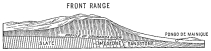
Fig. 159—Topographic and structural section at the
northeastern border of the Peruvian Andes. The slates are probably
Silurian, the fossiliferous limestones are known Carboniferous, and the
sandstones are Tertiary grading up to Pleistocene.
At Pasaje, on the western side of the Apurimac, the Carboniferous again
appears resting upon the old schists described on p. 236. It is steeply
upturned, in places vertical, is highly conglomeratic, and in a belt a
half-mile wide it forms true badlands topography. It is succeeded by
evenly bedded sandstones of fine and coarse composition in alternate
beds, then follow shales and sandstones and finally the enormous beds of
limestone that characterize the series. The structure is on the whole
relatively simple in this region, the character and attitude of the beds
indicating their accumulation in a nearly horizontal position. Since the
basal conglomerate contains only pebbles and stones derived from the
subjacent schists and does not contain granites like those in the
Cordillera Vilcapampa batholith on the east it is concluded that the
batholithic invasion was accompanied by the compression and tilting of
the Carboniferous beds and that the batholith itself is
post-Carboniferous. From the ridge summits above Huascatay and in the
deep valleys thereabouts the Carboniferous strata may be seen to extend
far toward the west, and also to have great extent north and south.
Because of their dissected, bare, and, therefore, well-exposed condition
they present exceptional opportunities for the study of Carboniferous
geology in central Peru.
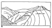
Fig. 160—The deformative effects of the granite
intrusion of the Cordillera Vilcapampa are here shown as transmitted
through ancient schists to the overlying conglomerates, sandstones, and
limestones of Carboniferous age, in the Apurimac Valley at Pasaje.
Carboniferous strata again appear at Puquiura, Vilcapampa, and
Pampaconas. They are sharply upturned against the Vilcapampa batholith
and associated volcanic material, chiefly basalt, porphyry, and various
tuffs and related breccias. The Carboniferous beds are here more
arenaceous, consisting chiefly of alternating beds of sandstone and
shale. The lowermost beds, as at Pongo de Mainique, are dominantly
marine, fossiliferous limestone beds having a thickness estimated to be
over two miles.
From Huascatay westward and southward the Carboniferous is in part
displaced by secondary batholiths of granite, in part cut off or crowded
aside by igneous intrusions of later date, and in still larger part
buried under great masses of Tertiary volcanic material. Nevertheless,
it remains the dominating rock type over the whole stretch of country
from Huascatay to Huancarama. In the northwestern part of the Abancay
sheet its effect on the landscape may be observed in the knife-like
ridge extending from west to east just above Huambo. Above
Chuquibambilla it again outcrops, resting upon a thick resistant
quartzite of unknown age, 162 . It is strongly developed about
Huadquirca and Antabamba and, still associated with a quartzite floor,
it finally disappears under the lavas of the great volcanic field on the
western border of the Andes. Figs. 141 and 142 show its relation to the
invading granite batholiths and 162 shows further structural
features as developed about Antabamba where the great volcanic field of
the Maritime Cordillera begins.

Fig. 161—Types of deformation north of Lambrama near
Sotospampa. A dark basaltic rock has invaded both granite-gneiss and
slate. Sills and dikes occur in great numbers. The topographic
depression in the profile is the Lambrama Valley. See the Lambrama
Quadrangle.
Both the enormous thickness of the Carboniferous limestone series and
the absence of clastic members over great areas in the upper portion of
the series prove the widespread extent of the Carboniferous seas and
their former occurrence in large interlimestone tracts from which they
have since been eroded. At Puquiura they extend far over the schist, in
fact almost completely conceal it; at Pasaje they formerly covered the
mica-schists extensively, their erosion in both cases being conditioned
by the pronounced uplift and marginal deformation which accompanied the
development of the Vilcapampa batholith.
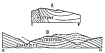
Fig. 162—Sketch sections at Antabamba to show (a)
deformed limestones on the upper edge of the geologic map, 163 A;
and (b) the structural relations of limestone and quartzite. See also
Fig. 163.
The degree of deformation of the Carboniferous sediments varies between
simple uplift through moderate folding and complex disturbances
resulting in nearly vertical attitudes. The simplest structures are
represented at Pasaje, where the uplift of the intruded schists,
marginal to the Vilcapampa batholith, has produced an enormous
monoclinal fold exposing the entire section from basal conglomerates and
sandstones to the thickest limestone. Above Chuquibambilla the
limestones have been uplifted and very gently folded by the invasion of
granite associated with the main batholith and several satellitic
batholiths of limited extent. A higher degree of complexity is shown at
Pampaconas (Fig. 141), where the main monoclinal fold is traversed
almost at right angles by secondary folds of great amplitude. The
limestones are there carried to the limit of the winter snows almost at
the summit of the Cordillera. The crest of each secondary anticline
rises to form a group of conspicuous peaks and tabular ridges. Higher in
the section, as at Puquiura, the sandstones are thrown into a series of
huge anticlines and synclines, apparently by the marginal compression
brought about at the time of the intrusion of the granite core of the
range. At Pongo de Mainique the whole of the visible Carboniferous is
practically vertical, and is cut off by a great fault marking the abrupt
eastern border of the Cordillera.
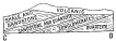
Fig. 163—Geologic sketch section to show the relation of
the volcanic flows of Fig. 164 to the sandstones and quartzites
beneath.
It is noteworthy that the farther east the Carboniferous extends the
more dominantly marine it becomes, though marine beds of great thickness
constitute a large part of the series in whatever location. From
Huascatay westward the limestones become more and more argillaceous, and
finally give way altogether to an enormous thickness of shales,
sandstones, and thin conglomerates. These were observed to extend with
strong inclination westward out of the region studied and into and under
the volcanoes crowning the western border of the Cordillera. Along the
line of traverse opportunity was not afforded for further study of this
aspect of the series, since our route led generally along the strike
rather than along the dip of the beds. It is interesting to note,
however, that these observations as to the increasing amounts of clastic
material in a westward direction were afterwards confirmed by Señor José
Bravo, the Director of the Bureau of Mines at Lima, who had found
Carboniferous land plants in shales at Pacasmayo, the only fossils of
their kind found in Peru. Formerly it had been supposed that non-marine
Carboniferous was not represented in Peru. From the varied nature of the
flora, the great thickness of the shales in which the specimens were
collected, and the fact that the dominantly marine Carboniferous
elsewhere in Peru is of great extent, it is concluded that the land upon
which the plants grew had a considerable area and probably extended far
west of the present coast line. Since its emergence it has passed
through several orogenic movements. These have resulted in the uplift of
the marine portion of the Carboniferous, while the terrestrial deposits
seem to have all but disappeared in the down-sunken blocks of the ocean
floor, west of the great fault developed along the margin of the
Cordillera. The following figures are graphic representations of this
hypothesis.
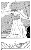
Fig. 164—Geologic sketch map and section, Antabamba
region. The Antabamba River has cut through almost the entire series of
bedded strata.
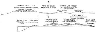
Fig. 165—The upper diagram (A) represents the
hypothetical distribution of land and sea during the Carboniferous
Period, as inferred from the present distribution and character of
Carboniferous limestones and slates. The lower diagram (B) represents
the present relief. The dotted line at the left of the two diagrams
connects identical points. The fragmentation of the former continental
border is believed to have left only a small portion of a former coastal
chain and to have been contemporaneous with the development of ocean
abysses near the present shore.
The wide distribution of the Carboniferous sediments and especially the
limestones, together with the uniformity of the fossil faunas, makes it
certain that the sea extended entirely across the region now occupied
by the Andes. However, from the relation of the Carboniferous to the
basal schists, and the most conservative extension of the known
Carboniferous, it may be inferred that the Carboniferous sea did not
completely cover the entire area but was broken here and there by island
masses in the form of an elongated archipelago. The presence of land
plants in the Carboniferous of Pisco warrants the conclusion that a
second island mass, possibly an island chain parallel to the first,
extended along and west of the present shore.
The Cretaceous formations are of very limited extent in the belt of
country under consideration, in spite of their generally wide
distribution in Peru. They are exposed distinctly only on the western
border of the Cordillera and in special relations. In the gorge of
Cotahuasi, over seven thousand feet deep, about two thousand feet of
Cretaceous limestones are exposed. The series includes only a very
resistant blue limestone and terminates abruptly along a well-marked and
highly irregular erosion surface covered by almost a mile of volcanic
material, chiefly lava flows. The character of the bottom of the section
is likewise unknown, since it lies apparently far below the present
level of erosion.
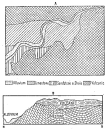
Fig. 166—Geologic sketch map and cross-section in the
Cotahuasi Canyon at Cotahuasi. With a slight gap this figure continues
Fig. 167 to the left. The section represents a spur of the main plateau
about 1,500 feet high in the center of the map.
The Cretaceous limestones of the Cotahuasi Canyon are everywhere greatly
and irregularly disturbed. Typical conditions are represented in the
maps and sections, Figs. 166 and 167. They are penetrated and tilted by
igneous masses, apparently the feeders of the great lava sheets that
form the western summit of the Cordillera. From the restricted
development of the limestones along a western border zone it might be
inferred that they represent a very limited marine invasion. It is
certainly clear that great deformative movements were in progress from
at least late Palæozoic time since all the Palæozoic deposits are broken
abruptly down in this direction, and, except for such isolated
occurrences as the land Carboniferous at Pacasmayo, are not found
anywhere in the coastal region today. The Cretaceous is not only limited
within a relatively narrow shore zone, but also, like the Palæozoic, it
is broken down toward the west, not reappearing from beneath the
Tertiary cover of the desert region or upon the granite-gneisses that
form the foundation for all the known sedimentary strata of the
immediate coast.
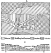
Fig. 167—Geologic sketch map and cross-section in the
Cotahuasi Canyon at Taurisma, above Cotahuasi. The relations of
limestone and lava flows in the center of the map and on a spur top near
the canyon floor. Thousands of feet of lava extend upward from the flows
that cap the limestone.
From these considerations I think we have a strong suggestion of the
geologic date assignable to the development of the great fault that is
the most strongly marked structural and physiographic feature of the
west coast of South America. Since the development of this fault is so
intimately related to the origin of the Pacific Ocean basin its study is
of special importance. The points of chief interest may be summarized as
follows:
(1) The character of the land Carboniferous implies a much greater
extent of the land than is now visible.
(2) The progressive coarsening of the Carboniferous deposits westward
and their land derivation, together with the great thickness of the
series, point to an elevated land mass in process of erosion west of
the series as a whole, that is west of the present coast.
(3) The restricted development of the Cretaceous seas upon the western
border of the Carboniferous, and the still more restricted development
of the Tertiary deposits between the mountains and the present coast,
point to increasing definition of the submarine scarp through the
Mesozoic and the Tertiary.
(4) The Tertiary deposits are all clearly derived from the present
mountains and have been washed seaward down slopes with geographic
relations approximately like those of the present.
(5) From the great width, deep dissection, and subsequent burial of the
Tertiary terraces of the coast, it is clear that the greater part of the
adjustment of the crust to which the bordering ocean basin is due was
accomplished at least by mid-Tertiary time.
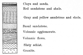
Fig. 168—Composite structure section representing the
succession of rocks in the Urubamba Valley from Urubamba to Torontoy.
Aside from the fossiliferous limestones of known Cretaceous age there
have been referred to the Cretaceous certain red sandstones and shales
marked, especially in the central portions of the Cordillera, by the
presence of large amounts of salt and gypsum. These beds were at first
considered Permian, but Steinmann has since found at Potosí related and
similar formations with Cretaceous fossils. In this connection it is
also necessary to add that the great red sandstone series forming the
eastern border of the Andes in Bolivia is of uncertain age and has
likewise been referred to the Cretaceous, though the matter of its age
has not yet been definitely determined. In 1913 I found it appearing in
northwestern Argentina in the Calchaquí Valley in a relation to the main
Andean mass, similar to that displayed farther north. It contains
fossils and its age was, therefore, readily determinable there.[53]
In the Peruvian field the red beds of questionable age were not examined
in sufficient detail to make possible a definite age determination. They
occur in a great and only moderately disturbed series in the Anta basin
north of Cuzco, but are there not fossiliferous. The northeastern side
of the hill back of Puqura (of the Anta basin: to be distinguished from
Puquiura in the Vilcabamba Valley) is composed largely of rocks of this
class. In a few places their calcareous members have been weathered out
in such a manner as to show karst topography. Where they occur on the
well-drained brow of a bluff the caves are used in place of houses by
Indian farmers. The large and strikingly beautiful Lake Huaipo, ten
miles north of Anta, and several smaller, neighboring lakes, appear to
have originated in solution depressions formed in these beds.
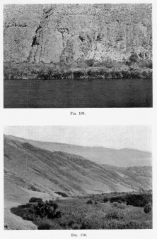
Fig. 169—The line of unconformity between the igneous
basement rocks (agglomerates at this point) and the quartzites and
sandstones of the Urubamba Valley, between the town of Urubamba and
Ollantaytambo.
Fig. 170—The inclined lower and horizontal upper
sandstone on the southeastern wall of the Majes Valley at Hacienda
Cantas. The section is a half-mile high.
The structural relation of the red sandstone series to the older rocks
is well displayed about half-way between Urubamba and Ollantaytambo in
the deep Urubamba Valley. The basal rocks are slaty schist and granite
succeeded by agglomerates and basalt porphyries upon whose eroded
surfaces (Fig. 169) are gray to yellow cross-bedded sandstones. Within a
few hundred feet of the unconformity gypsum deposits begin to appear and
increase in number to such an extent that the resulting soil is in
places rendered worthless. Copper-stained bands are also common near the
bottom of the series, but these are confined to the lower beds. Higher
up in the section, for example, just above the gorge between Urubamba
and Ollantaytambo, even-bedded sandstones occur whose most prominent
characteristic is the regular succession of coarse and fine sandstone
beds. Such alternations of character in sedimentary rocks are commonly
marked by alternating shales and sandstones, but in this locality shales
are practically absent. Toward the top of the section gypsum deposits
again appear first as beds and later, as in the case of the hill-slope
on the southern shore of Lake Huaipo, as veins and irregular masses of
gypsum. The top of the deformed Cretaceous (?) is eroded and again
covered unconformably by practically flat-lying Tertiary deposits.
The Tertiary deposits of the region under discussion are limited to
three regions: (1) the extreme eastern border of the main Cordillera,
(2) intermontane basins, the largest and most important of which are (a)
the Cuzco basin and (b) the Titicaca-Poopó basin on the
Peruvian-Bolivian frontier, and (3) in the west-coast desert and in
places upon the huge terraces that form a striking feature of the
topography of the coast of Peru.
It has already been pointed out that the eastern border of the
Cordillera is marked by a fault of great but undetermined throw, whose
topographic importance may be estimated from the fact that even after
prolonged erosion it stands nearly four thousand feet high. Cross-bedded
and ripple-marked features and small lenses of conglomerate are common.
The beds now dip at an angle approximately 20° to 50° northward at the
base of the scarp, but have decreasing dip as they extend farther north
and east. It is noteworthy that the deposits become distinctly
conglomeratic as flatter dips are attained, and that there seems to have
been a steady accumulation of detrital material from the mountains for a
long period, since the deposits pass in unbroken succession from the
highly indurated and massive beds of the mountain base to loose
conglomerates that now weather down much like an ordinary gravel bank.
In a few places just below the mouth of the Ticumpinea, logs about six
inches in diameter were observed embeded in the deposits, but these
belong distinctly to the upper horizons.
The border deposits, though they vary in dip from nearly flat to 50°,
are everywhere somewhat inclined and now lie up to several hundred feet
above the level of the Urubamba River. Their upper surface is moderately
dissected, the degree of dissection being most pronounced where the dips
are steepest and the height greatest. In fact, the attitude of the
deposits and their progressive change in character point toward, if they
do not actually prove, the steady and progressive character of the beds
first deposited and their erosion and redeposition in beds now higher in
the series.
Upon the eroded upper surfaces of the inclined border deposits, gravel
beds have been laid which, from evidence discussed in a later paragraph,
are without doubt referable to the Pleistocene. These in turn are now
dissected. They do not extend to the highest summits of the deformed
beds but are confined, so far as observations have gone, to elevations
about one hundred feet above the river. From the evidence that the
overlying horizontal beds are Pleistocene, the thick, inclined beds are
referred to Tertiary age, though they are nowhere fossiliferous.
Observations along the Urubamba River were extended as far northward as
the mouth of the Timpia, one of the larger tributaries. Upon returning
from this point by land a wide view of the country was gained from the
four-thousand-foot ridge of vertical Carboniferous limestone, in which
it appeared that low and irregular strike ridges continue the features
of the Tertiary displayed along the mountain front far northward as well
as eastward, to a point where the higher ridges and low mountains of
older rock again appear—the last outliers of the Andean system in Peru.
Unfortunately time enough was not available for an extension of the trip
to these localities whose geologic characters still remain entirely
unknown. From the topographic aspects of the country, it is, however,
reasonably certain that the whole intervening depression between these
outlying ranges and the border of the main Cordillera, is filled with
inclined and now dissected and partly covered Tertiary strata. The
elevation of the upper surface does not, however, remain the same; it
appears to decrease steadily and the youngest Tertiary strata disappear
from view below the sediments of either the Pleistocene or the present
river gravels. In the more central parts of the depression occupied by
the Urubamba Valley, only knobs or ridges project here and there above
the general level.
The Tertiary deposits of the Peruvian desert region southwest of the
Andes have many special features related to coastal deformation, changes
of climate, and great Andean uplifts. They lie between the west coast of
Peru at Camaná and the high, lava-covered country that forms the western
border of the Andes and in places are over a mile thick. They are
non-fossiliferous, cross-bedded, ripple-marked, and have abundant lenses
of conglomerate of all sizes. The beds rest upon an irregular floor
developed upon a varied mass of rocks. In some places the basement
consists of old strata, strongly deformed and eroded. In other places it
consists of a granite allied in character and probably in origin with
the old granite-gneiss of the Coast Range toward the west. Elsewhere the
rock is lava, evidently the earliest in the great series of volcanic
flows that form this portion of the Andes.
The deposits on the western border of the Andes are excellently exposed
in the Majes Valley, one of the most famous in Peru, though its fame
rests rather upon the excellence and abundance of its vineyards and
wines than its splendid geologic sections. Its head lies near the base
of the snow-capped peaks of Coropuna; its mouth is at Camaná on the
Pacific, a hundred miles north of Mollendo. It is both narrow and deep;
one may ride across its floor anywhere in a half hour. In places it is a
narrow canyon. Above Cantas it is sunk nearly a mile below the level of
the desert upland through which it flows. Along its borders are exposed
basal granites, old sedimentaries, and lavas; inter-bedded with it are
other lavas that lie near the base of the great volcanic series; through
it still project the old granites of the Coast Range; and upon it have
been accumulated additional volcanic rocks, wind-blown deposits, and,
finally, coarse wash formed during the glacial period. From both the
variety of the formations, the small amount of marginal dissection, and
the excellent exposures made possible by the deep erosion and desert
climate, the Majes Valley is one of the most profitable places in Peru
for physiographic and geologic study.
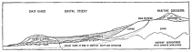
Fig. 171—Generalized sketch section to show the
structural relations of the Maritime Cordillera, the desert pampas, and
the Coast Range.
The most complete succession of strata (Tertiary) occurs just below
Cantas on the trail to Jaguey (Fig. 171). Upon a floor of
granite-gneiss, and alternating beds of quartzite and shale belonging to
an older series, are deposited heavy beds of red sandstone with many
conglomerate lenses. The sandstone strata are measurably deformed and
their upper surfaces moderately dissected. Upon them have been deposited
unconformably a thicker series of deposits, conglomerates, sandstones,
and finer wind-blown material. The basal conglomerate is very
coarse—much like beach material in both structure and composition, and
similar to that along and south of the present coast at Camaná. Higher
in the section the material is prevailingly sandy and is deposited in
regular beds from a few inches to a few feet in thickness. Near the top
of the section are a few hundred feet of strata chiefly wind deposited.
Unconformably overlying the whole series and in sharp contrast to the
fine wind-blown stuff below it, is a third series of coarse deposits
about five hundred feet thick. The topmost material, that forming the
surface of the desert upland, consists of wind-blown sand now shifted by
the wind and gathered into sand dunes or irregular drifts, banks of
white earth, “tierra blanca,” and a pebble pavement a few inches thick.
If the main facts of the above section are now summarized they will
facilitate an understanding of other sections about to be described,
inasmuch as the summary will in a measure anticipate our conclusions
concerning the origin of the deposits and their subsequent history. The
sediments in the Majes Valley between Cantas and Jaguey consist of three
series separated by two unconformities. The lowermost series is evenly
bedded and rather uniform in composition and topographic expression,
standing forth in huge cliffs several hundred feet high on the eastern
side of the valley. This lower series is overlain by a second series,
which consists of coarse conglomerate grading into sand and ultimately
into very fine fluffy wind-deposited sands and silts. The lower series
is much more deformed than the upper, showing that the deforming
movements of later geologic times have been much less intense than the
earlier, as if there had been a fading out or weakening of the deforming
agents. Finally there is a third series several hundred feet thick which
forms the top of the section.
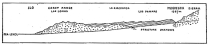
Fig. 172—Geologic relations of Coast Range, desert
deposits, and Maritime Cordillera at Moquegua, Peru. After G. I. Adams;
Bol. de Minas del Perú, Vol. 2, No. 4, 1906, p. 20.

Fig. 173—Sketch section to show structural details on
the walls of the Majes Valley near Aplao, looking south.
Three other sections may now be examined, one immediately below Cantas,
one just above, and one opposite Aplao. The section below Cantas is
shown in 173 , and indicates a lower series of red sandstones
crossed by vertical faults and unconformably overlain by nearly
horizontal conglomerates, sandstones, etc., and the whole faulted again
with an inclined fault having a throw of nearly 25°. A white to gray
sandstone unconformably overlying the red sandstone is shown
interpolated between the lowermost and uppermost series, the only
example of its kind, however. No important differences in
lithographical character may be noted between these and the beds of the
preceding section.
Again just above Cantas on the east side of the valley is a clean
section exposing about two thousand feet of strata in a half mile of
distance. The foundation rocks are old quartzites and shales in
regularly alternating beds. Upon their uneven upper surfaces are several
thousand feet of red sandstones and conglomerates, which are both folded
and faulted with the underlying quartzites. Above the red sandstones is
a thick series of gray sandstones and silts which makes the top of the
section and unconformably overlies the earlier series.
A similar succession of strata was observed at Aplao, still farther up
the Majes Valley, 174 . A greatly deformed and metamorphosed older
series is unconformably overlaid by a great thickness of younger strata.
The younger strata may be again divided into two series, a lower series
consisting chiefly of red sandstones and an upper consisting of gray to
yellow, and only locally red sands of finer texture and more uniform
composition. The two are separated by an erosion surface and only the
upper series is tilted regionally seaward with faint local deformation;
the lower series is both folded and faulted with overthrusts aggregating
several thousand feet of vertical and a half mile of horizontal
displacement.

Fig. 174—The structural relations of the strata on the
border of the Majes Valley at Aplao, looking west. Field sketch from
opposite side of valley. Height of section about 3,000 feet; length
about ten miles.
The above sections all lie on the eastern side of the Majes Valley. From
the upper edge of the valley extensive views were gained of the strata
on the opposite side, and two sections, though they were not examined at
close range, are at least worth comparing with those already given. From
the narrows below Cantas the structure appears as in Figs. 175-176, and
shows a deforming movement succeeded by erosion in a lower series. The
upper series of sedimentary rock has suffered but slight deformation. A
still more highly deformed basal series occurs on the right of the
section, presumably the older quartzites. At Huancarqui, opposite Aplao,
an extensive view was gained of the western side of the valley, but the
lower Tertiary seems not to be represented here, as the upper undeformed
series rests unconformably upon a tilted series of quartzites and
slates. Farther up the Cantas valley (an hour’s ride above Aplao) the
Tertiary rests upon volcanic flows or older quartzites or the
granite-gneiss exposed here and there along the valley floor.

Fig. 175—Sketch section to show the structural details
of the strata on the south wall of the Majes Valley near Cantas. The
section is two miles long.

Fig. 176—Composite geologic section to show the
structural relations of the rocks on the western border of the Maritime
Cordillera. The inclined strata at the right bottom represent older
rocks; in places igneous, in other places sedimentary.
In no part of the sedimentaries in the Majes Valley were fossils found,
save in the now uplifted and dissected sands that overlie the upraised
terraces along the coast immediately south of Camaná and also back of
Mollendo. Like similar coastal deposits elsewhere along the Peruvian
littoral, the terrace sands are of Pliocene or early Pleistocene age.
The age of the deposits back of the Coast Range is clearly greater than
that of the coastal deposits, (1) since they involve two unconformities,
a mile or more of sediments, and now stand at least a thousand feet
above the highest Pliocene (or Pleistocene) in the Camaná Valley, and
(2) because the erosion history of the interior sediments may be
correlated with the physiographic history of the coastal terraces and
the correlation shows that uplift and dissection of the terraces and of
the interior deposits went hand in hand, and that the deposits on the
terraces may similarly be correlated with alluvial deposits in the
valley.
We shall now see what further ground there is for the determination of
the age of these sediments. Just below Chuquibamba, where they first
appear, the sediments rest upon a floor of volcanic and older rock
belonging to the great field now known from evidence in many localities
to have been formed in the early Tertiary, and here known to be
post-Cretaceous from the relations between Cretaceous limestones and
volcanics in the Cotahuasi Valley (see p. 247). Although volcanic flows
were noted interbedded with the desert deposits, these are few in
number, insignificant in volume, and belong to the top of the volcanic
series. The same may be said of the volcanic flows that locally overlie
the desert deposits. We have then definite proof that the sandstones,
conglomerates, and related formations of the Majes Valley and bordering
uplands are older than the Pliocene or early Pleistocene and younger
than the Cretaceous and the older Tertiary lavas. Hence it can scarcely
be doubted that they represent a considerable part of the Tertiary
period, especially in view of the long periods of accumulation which the
thick sediments represent, and the additional long periods represented
by the two well-marked unconformities between the three principal groups
of strata.
If we now trace the physical history of the region we have first of all
a deep depression between the granite range along the coast and the
western flank of the Andes. Here and there, as in the Vitor, the Majes,
and other valleys, there were gaps through the Coast Range. Nowhere did
the relief of the coastal chain exceed 5,000 feet. The depression had
been partly filled in early geologic (probably early Paleozoic) time by
sediments later deformed and metamorphosed so that they are now
quartzites and shales. The greater resistance of the granite of the
Coast Range resulted in superior relief, while the older deformed
sedimentaries were deeply eroded, with the result that by the beginning
of the Tertiary the basin quality of the depression was again
emphasized. All these facts are expressed graphically in 171 . On
the western flanks of the granite range no corresponding sedimentary
deposits are found in this latitude. The sea thus appears to have stood
farther west of the Coast Range in Paleozoic times than at present.
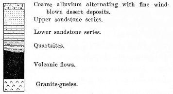
Fig. 177—Composite structure section at Aplao.
For the later history it is necessary to assemble the various Tertiary
sections described on the preceding pages. First of all we recognize
three quite distinct types of accumulations, for which we shall have to
postulate three sets of conditions and possibly three separate agents.
The first or lowermost consists of even-bedded deposits of red and gray
sandstones, the former color predominating. The material is in general
well-sorted save locally, where lenses and even thin beds of
conglomerate have been developed. There is, however, about the whole
series a uniformity and an orderliness in striking contrast to the
coarse, cross-bedded, and irregular material above the unconformity. On
their northeastern or inner margin the sandstones are notably coarser
and thicker, a natural result of proximity to the mountains, the source
of the material. The general absence of wind-blown deposits is marked;
these occur entirely along the eastern and northern portions of the
deposits and are recognized (1) by their peculiar cross-bedding, and (2)
by the fact that the cross-bedding is directed northeastward in a
direction contrary to the regional dip of the series, a condition
attributable to the strong sea breezes that prevail every afternoon in
this latitude.
The main body of the material is such as might be deposited on the wide
flood plains of piedmont streams during a period of prolonged erosion
on surrounding highlands that served as the feeding grounds of the
streams. The alternations in the character of the deposits, alternations
which, in a general view, give a banded appearance to the rock, are
produced by successions of beds of fine and coarse material, though all
of it is sandstone. Such successions are probably to be correlated with
seasonal changes in the volume and load of the depositing streams.
To gain an idea of the conditions of deposition we may take the
character of the sediments as described above, and from them draw
deductions as to the agents concerned and the manner of their action.
We may also apply to the area the conclusions drawn from the study of
similar deposits now in process of formation. We have between the coast
ranges of northern Chile and the western flanks of the Cordillera
Sillilica, probably the best example of piedmont accumulation in a dry
climate that the west coast of South America affords.
Along the inner edge of the Desert of Tarapacá, roughly between the
towns of Tarapacá and Quillagua, Chile, the piedmont gravels, sands,
silts, and muds extend for over a hundred miles, flanking the western
Andes and forming a transition belt between these mountains and the
interior basins of the coast desert. The silts and muds constitute the
outer fringe of the piedmont and are interrupted here and there where
sands are blown upon them from the higher portions of the piedmont, or
from the desert mountains and plains on the seaward side. Practically no
rain falls upon the greater part of the desert and the only water it
receives is that borne to it by the piedmont streams in the early
summer, from the rains and melted snows of the high plateau and
mountains to the eastward. These temporary streams spread upon the outer
edge of the piedmont a wide sheet of mud and silt which then dries and
becomes cracked, the curled and warped plates retaining their character
until the next wet season or until covered with wind-blown sand. The
wind-driven sand fills the cracks in the muds and is even drifted under
the edges of the upcurled plates, filling the spaces completely. Over
this combined fluvial and æolian deposit is spread the next layer of
mud, which frequently is less extensive than the earlier deposits, thus
giving abundant opportunity for the observation of the exact manner of
burial of the older sand-covered stratum.
Now while the alternations are as marked in Peru as in Chile, it is
noteworthy that the Tertiary material in Peru is not only coarse
throughout, even to the farthest limits of the piedmont, but also that
the alternating beds are thick. Moreover, there are only the most feeble
evidences of wind action in the lowermost Tertiary series. I was
prepared to find curled plates, wind-blown sands, and muds and silts,
but they are almost wholly absent. It is, therefore, concluded that the
dryness was far less extreme than it is today and that full streams of
great competency flowed vigorously down from the mountains and carried
their loads to the inner border of the Coast Range and in places to the
sea.
The fact that the finer material is sandy, not clayey or silty, that
it almost equals in thickness the coarser layers, and that its
distribution appears to be co-extensive with the coarser, warrants the
conclusion that it too was deposited by competent streams of a type far
different from the withering streams associated with piedmont deposits
in a thoroughly arid climate like that of today. Both in the second
Tertiary series and on the present surface are such clear examples of
deposits made in a drier climate as to leave little doubt that the
earliest of the Tertiary strata of the Majes Valley were deposited in a
time of far greater rainfall than the present. It is further concluded
that there was increasing dryness, as shown by hundreds of feet of
wind-blown sand near the top of the section. But the growing dryness was
interrupted by at least one period of greater precipitation. Since that
time there has been a return to the dry climate of a former epoch.
Uplift and erosion of the earliest of the Tertiary deposits of the Majes
Valley is indicated in two ways: (1) by the deformed character of the
beds, and (2) by the ensuing coarse deposits which were derived from the
invigorated streams. Without strong deformations it would not be
possible to assign the increased erosion so confidently to uplift; with
the coarse deposits that succeed the unconformity we have evidence of
accumulation under conditions of renewed uplift in the mountains and of
full streams competent to remove the increasing load.
It is in the character of the sediments toward the top of the Tertiary
that we have the clearest evidence of progressive desiccation of the
climate of the region. The amount of wind-blown material steadily
increases and the uppermost five hundred feet is composed predominantly,
and in places exclusively, of this material. The evidences of wind
action lie chiefly in the fine (in places fluffy) nature of the
deposits, their uniform character, and in the tangency of the layers
with respect to the surface on which they were deposited. There are
three diagnostic structural features of great importance: the very steep
dip of the fine laminae; the peculiar and harmonious blending of their
contacts; the manner in which the highly inclined laminae cut off and
succeed each other, whereby quite bewildering changes in the direction
of dip of the inclined beds are brought about on any exposed plane. Some
of these features require further discussion.
It is well known that the front of a sand dune generally consists of
sand deposited on a slope inclined at the angle of repose, say between
30° and 35°, and rolled into place up the long back slope of the dune by
the wind. It has not, however, been generally recognized that the angle
of repose may be exceeded (a) when there exists a strong back eddy or
(b) when the wind blows violently and for a short time in the opposite
direction. In either case sand is carried up the short steep slope of
the dune front and accumulated at an angle not infrequently running up
to 43° and 48° and locally, and under the most favorable circumstances,
in excess of 50°. The conditions under which these steep angles are
attained are undoubtedly not universal, but they can be found in some
parts of almost any desert in the world. They appear not to be present
where the sand grains are of uniform size throughout, since that leads
to rolling. They are found rather where there is a certain limited
variation in size that promotes packing. Packing and the development of
steep slopes are also facilitated in parts of the coastal desert of Peru
by a cloud canopy that hangs over the desert in the early morning, that
in the most favorable places moistens even the dune surfaces and that
has least penetration on the steep semi-protected dune fronts. Sand
later blown up the dune front or rolled down from the dune crest is
encouraged to remain near the cornice on an abnormally steep slope by
the attraction which the slightly moister sand has for the dry grains
blown against it. Since dunes travel and since their front layers,
formed on steep slopes, are cut off to the level of the surface in the
rear of the dune, it follows that the steepest dips in exposed sections
are almost always less than those in existing dunes. Exceptions to the
rule will be noted in filled hollows not re-excavated until deeply
covered by wind-blown material. These, re-exposed at the end of a long
period of wind accumulation, may exhibit even the maximum dips of the
dune cornices. Such will be conspicuously the case in sections in
aggraded desert deposits. On the border of the Majes Valley, from 400 to
500 feet of wind-accumulated deposits may be observed, representing a
long period of successive dune burials.
The peculiar blending of the contact lines of dune laminae, related to
the tangency commonly noted in dune accumulations, is apparently due to
the fact that the wind does not require a graded surface to work on, but
blows uphill as well as down. It is present on both the back-slope and
the front-slope deposits. Its finest expression appears to be in
districts where the dune material was accumulated by a violent wind
whose effects the less powerful winds could not destroy.
It is to the ability of the wind to transport material against, as well
as with, gravity, that we owe the third distinct quality of dune
material, the succession of flowing lines, in contrast to the succession
of now flat-lying now steeply inclined beds characteristic of
cross-bedded material deposited by water. One dune travels across the
face of the country only to be succeeded by another.[54] Even if wind
aggradation is in progress, the plain-like surface in the rear of a dune
may be excavated to the level of steeply inclined beds upon whose
truncated outcrop other inclined beds are laid, 178 . The contrast
to these conditions in the case of aggradation by water is so clearly
and easily inferred that space will not be taken to point them out. It
is also true as a corollary to the above that the greater part of a body
of wind-drifted material will consist of cross-bedded layers, and not a
series of evenly divided and alternating flat-lying and cross-bedded
layers which result from deposition in active and variable currents of
water.
The caution must of course be observed that wind action and water action
may alternate in a desert region, as already described in Tarapacá in
northern Chile, so that the whole of a deposit may exhibit an
alternation of cross-bedded and flat-lying layers; but the former only
are due to wind action, the latter to water action.
Finally it may be noted that the sudden, frequent, and diversified dips
in the cross-bedding are peculiarly characteristic of wind action.
Although one sees in a given cross-section dips apparently directed only
toward the left or the right, excavation will supply a third dimension
from which the true dips may be either observed or calculated. These
show an almost infinite variety of directions of dip, even in restricted
areas, a condition due to the following causes:
(1) the curved fronts of sand dunes, which produce dips concentric with
respect to a point and ranging through 180° of arc; (2) the irregular
character of sand dunes in many places, a condition due in turn to (a)
the changeful character of the strong wind (often not the prevailing
wind) to which the formation of the dunes is due, and (b) the influence
of the local topography upon wind directions within short distances or
upon winds of different directions in which a slight change in wind
direction is followed by a large change in the local currents; (3) the
fact that all combinations are possible between the erosion levels of
the wind in successive generations of dunes blown across a given area,
hence any condition at a given level in a dune may be combined with
any other condition of a succeeding dune; (4) variations in the sizes
of successive dunes will lead to further contrasts not only in the
scale of the features but also in the direction and amount of the dips.
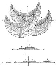
Fig. 178—Plan and cross-sections of superimposed sand
dunes of conventional outline. In the sections, dune A is supposed to
have left only a small basal portion to be covered by dune B. In the
same way dune C has advanced to cover both A and B. The basal
portions that have remained are exaggerated vertically in order to
display the stratification. It is obviously not necessary that the dunes
should all be of the same size and shape and advancing in the same
direction in order to have the tangential relations here displayed. Nor
need the aggrading material be derived from true dunes. The results
would be the same in the case of sand drifts with their associated
wind eddies. All bedded wind-blown deposits would have the same general
relations. No two successive deposits, no matter from what direction the
successive drifts or dunes travel, would exactly correspond in direction
and amount of dip.
Finally, we may note that a section of dune deposits has a distinctive
feature not exhibited by water deposits. If the foreset beds of a
cross-bedded water deposit be exposed in a plane parallel to the strike
of the beds, the beds will appear to be horizontal. They could not then
be distinguished from the truly horizontal beds above and below them.
But the conditions of wind deposition we have just noted, and chiefly
the facts expressed by 178 , make it impossible to select a position
in which both tangency and irregular dips are not well developed in a
wind deposit. I believe that we have in the foregoing facts and
inferences a means for the definite separation of these two classes of
deposits. Difficulties will arise only when there is a quick succession
of wind and water action in time, or where the wind produces powerful
and persistent effects without the actual formation of dunes.
The latest known deposits in the coastal region are found surmounting
the terrace tops along the coast between Camaná and Quilca, where they
form deposits several hundred feet thick in places. The age of these
deposits is determined by fossil evidence, and is of extraordinary
interest in the determination of the age of the great terraces upon
which they lie. They consist of alternating beds of coarse and fine
material, the coarser increasing in thickness and frequency toward the
bottom of the section. It is also near the bottom of the section that
fossils are now found; the higher members are locally saline and
throughout there is a marked inclination of the beds toward the present
shore. The deposits appear not to have been derived from the underlying
granite-gneiss. They are distributed most abundantly near the mouths of
the larger streams, as near the Vitor at Quilca, and the Majes at
Camaná. Elsewhere the terrace summit is swept clean of waste, except
where local clay deposits lie in the ravines, as back of Mollendo and
where “tierras blancas” have been accumulated by the wind.
These coastal deposits were laid down upon a dissected terrace up to
five miles in width. The degree of dissection is variable, and depends
upon the relation of the through-flowing streams to the Coast Range. The
Vitor and the Majes have cut down through the Coast Range, and locally
removed the terrace; smaller streams rising on the flanks of the Coast
Range either die out near the foot of the range or cross it in deep and
narrow valleys. The present drainage on the seaward slopes of the Coast
Range is entirely ineffective in reaching the sea, as was seen in 1911,
the wettest season known on the coast in years and one of the wettest
probably ever observed on this coast by man.
In consequence of their deposition on a terrace that ranges in elevation
from zero to 1,500 feet above sea level, the deposits of the coast are
very irregularly disposed. But in consequence of their great bulk they
have a rather smooth upper surface, gradation having been carried to the
point where the irregularities of the dissected terrace were smoothed
out. Their general uniformity is broken where streams cross them, or
where streams crossed them during the wetter Pleistocene. Their
elevation, several hundred feet above sea level, is responsible for the
deep dissection of their coastal margin, where great cliffs have been
cut.
The broad regional uplift of the Peruvian Andes in late Tertiary and in
Pleistocene times carried their summits above the level of perpetual
snow. It is still an open question whether or not uplift was
sufficiently great in the early Pleistocene to be influenced by the
first glaciations of that period. As yet, there are evidences of only
two glacial invasions, and both are considered late events on account of
the freshness of their deposits and the related topographic forms. The
coarse deposits—nearly 500 feet thick—that form the top of the desert
section described above clearly indicate a wetter climate than prevailed
during the deposition of the several hundred feet of wind-blown deposits
beneath them. But if our interpretation be correct these deposits are of
late Tertiary age, and their character and position are taken to
indicate climatic changes in the Tertiary. They may have been the mild
precursors of the greater climatic changes of glacial times. Certain it
is that they are quite unlike the mass of the Tertiary deposits. On the
other hand they are separated from the deposits of known glacial age by
a time interval of great length—an epoch in which was cut a benched
canyon nearly a mile deep and three miles wide. They must, therefore,
have been formed when the Andes were thousands of feet lower and unable
to nourish glaciers. It was only after the succeeding uplifts had raised
the mountain crests well above the frost line that the records of
oscillating climates were left in erratic deposits, troughed valleys,
cliffed cirques and pinnacled divides.
The glacial forms are chiefly at the top of the country; the glacial
deposits are chiefly in the deep valleys that were carved before the
colder climate set in. The rock waste ground up by the ice was only a
small part of that delivered to the streams in glacial times. Everywhere
the wetter climate resulted in the partial stripping of the residual
soil gathered upon the smooth mature slopes formed during the long
Tertiary cycle of erosion. This moving sheet of waste as well as the
rock fragments carried away from the glacier ends were strewn along the
valley floors, forming a deep alluvial fill. Thereby the canyon floors
were rendered habitable.
In the chapters on human geography we have already called attention to
the importance of the U-shaped valleys carved by the glaciers. Their
floors are broad and relatively smooth. Their walls restrain the live
stock. They are sheltered though lofty. But all the human benefits
conferred by ice action are insignificant beside those due to the
general shedding of waste from the cold upper surfaces to the warm
levels of the valley floors. The alluvium-filled valleys are the seats
of dense populations. In the lowest of them tropical and sub-tropical
products are raised, like sugar-cane and cotton, in a soil that once lay
on the smooth upper slopes of mountain spurs or that was ground fine on
the bed of an Alpine glacier.
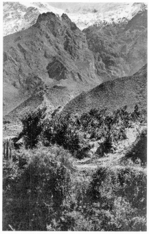
Fig. 179—Snow fields on the summit of the Cordillera
Vilcapampa near Ollantaytambo. A huge glacier once lay in the steep
canyon in the background and descended to the notched terminal moraine
at the canyon mouth. In places the glacier was over a thousand feet
thick. From the terminal moraine an enormous alluvial fan extends
forward to the camera and to the opposite wall of the Urubamba Valley.
It is confluent with other fans of the same origin. See Fig. 180. In the
foreground are flowers, shrubs, and cacti. A few miles below Urubamba at
11,500 feet.
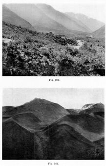
Fig. 180—Urubamba Valley between Ollantaytambo and
Torontoy, showing (1) more moderate upper slopes and steeper lower
slopes of the two-cycle mountain spurs; (2) the extensive alluvial
deposits of the valley, consisting chiefly of confluent alluvial fans
heading in the glaciated mountains on the left. See Fig. 179.
Fig. 181—Glacial features of the Central Ranges (see
Fig. 204). Huge lateral moraines built by ice streams tributary to the
main valley north of Chuquibambilla. That the tributaries persisted long
after the main valley became free of ice is shown by the descent of the
lateral moraines over the steep border of the main valley and down to
the floor of it.
The Pleistocene deposits fall into three well-defined groups: (1)
glacial accumulations at the valley heads, (2) alluvial deposits in
the valleys, and (3) lacustrine deposits formed on the floors of
temporary lakes in inclosed basins. Among these the most variable in
form and composition are the true glacier-laid deposits at the valley
heads. The most extensive are the fluvial deposits accumulated as valley
fill throughout the entire Andean realm. Though important enough in some
respects the lacustrine deposits are of small extent and of rather local
significance. Practically none of them fall within the field of the
present expedition; hence we shall describe only the first two classes.
The most important glacial deposits were accumulated in the eastern part
of the Andes as a result of greater precipitation, a lower snowline, and
catchment basins of larger area. In the Cordillera Vilcapampa glaciers
once existed up to twelve and fifteen miles in length, and those several
miles long were numerous both here and throughout the higher portions of
the entire Cordillera, save in the belt of most intense volcanic action,
which coincides with the driest part of the Andes, where the glaciers
were either very short or wanting altogether.
Since vigorous glacial action results in general in the cleaning out of
the valley heads, no deposits of consequence occur in these locations.
Down valley, however, glacial deposits occur in the form of terminal
moraines of recession and ground moraines. The general nature of these
deposits is now so well known that detailed description seems quite
unnecessary except in the case of unusual features.
It is noteworthy that the moraines decrease in size up valley since each
valley had been largely cleaned out by ice action before the retreat of
the glacier began. Each lowermost terminal moraine is fronted by a great
mass of unsorted coarse bowldery material forming a fill in places
several hundred feet thick, as below Choquetira and in the Vilcapampa
Valley between Vilcabamba and Puquiura. This bowldery fill is quite
distinct from the long, gently inclined, and stratified valley train
below it, or the marked ridge-like moraine above it. It is in places a
good half mile in length. Its origin is believed to be due to an
overriding action beyond the last terminal moraine at a time when the
ice was well charged with débris, an overriding not marked by morainal
accumulations, chiefly because the ice did not maintain an extreme
position for a long period.
In the vicinity of the terminal moraines the alluvial valley fill is
often so coarse and so unorganized as to look like till in the cut banks
along the streams, though its alluvial origin is always shown by the
topographic form. This characteristic is of special geologic interest
since the form may be concealed through deposition or destroyed by
erosion, and no condition but the structure remain to indicate the
manner of origin of the deposit. In such an event it would not be
possible to distinguish between alluvium and till. The gravity of the
distinction appears when it is known that such apparently unsorted
alluvium may extend for several miles forward of a terminal moraine, in
the shape of a widespreading alluvial fan apparently formed under
conditions of extremely rapid aggradation. I suppose it would not be
doubted in general that a section of such stony, bowldery, unsorted
material two miles long would have other than a glacial origin, yet such
may be the case. Indeed, if, as in the Urubamba Valley, a future section
should run parallel to the valley across the heads of a great series of
fans of similar composition, topographic form, and origin, it would be
possible to see many miles of such material.
The depth of the alluvial valley fill due to tributary fan accumulation
depends upon both the amount of the material and the form of the valley.
Below Urubamba in the Urubamba Valley a fine series is displayed, as
shown in 180 . The fans head in valleys extending up to snow-covered
summits upon whose flanks living glaciers are at work today. Their heads
are now crowned by terminal moraines and both moraines and alluvial fans
are in process of dissection. The height and extent of the moraines and
the alluvial fans are in rough proportion and in turn reflect the
height, elevation, and extent of the valley heads which served as fields
of nourishment for the Pleistocene glaciers. Where the fans were
deposited in narrow valleys the effect was to increase the thickness of
the deposits at the expense of their area, to dam the drainage lines or
displace them, and to so load the streams that they have not yet
cleared their beds after thousands of years of work under torrential
conditions.
Below Urubamba the alluvial fans entering the main valley from the east
have pushed the river against its western valley wall, so that the river
flows on one side against rock and on the other against a hundred feet
of stratified material. In places, as at the head of the narrows on the
valley trail to Ollantaytambo, a flood plain has been formed in front of
the scarp cut into the alluvium, while the edge of the dissected
alluvial fans has been sculptured into erosion forms resembling
bad-lands topography. On the western side of the valley the alluvial
fans are very small, since they are due to purely local accumulations of
waste from the edge of the plateau. Glaciation has here displaced the
river. Its effects will long be felt in the disproportionate erosion of
the western wall of the valley.
By far the most interesting of the deposits of glacial time are those
laid down on the valley floors in the form of an alluvial fill. Though
such deposits have greater thickness as a rule near the nourishing
moraines or bordering alluvial fans at the lower ends of the valleys,
they are everywhere important in amount, distinctive in topographic
form, and of amazingly wide extent. They reach far into and possibly
across the Amazon basin, they form a distinct though small piedmont
fringe along the eastern base of the Andes, and they are universal
throughout the Andean valleys. That a deposit of such volume—many times
greater than all the material accumulated in the form of high-level
alluvial fans or terminal moraines—should originate in a tropical land
in a region that suffered but limited Alpine glaciation vastly increases
its importance.
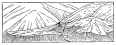
Fig. 182—Dissected alluvial fans on the border of the
Urubamba Valley near Hacienda Chinche. A Characteristic feature of the
valleys of the Peruvian Andes below the zone of glaciation but within
the limits of its aggraditional effects. Through alluviation the valleys
and basins of the Andean Cordillera, and vast areas of the great Amazon
plains east of it, felt the effects of the glacial conditions of a past
age.
The fill is composed of both fine and coarse material laid down by water
in steep valley floors to a depth of many feet. It breaks the steep
slope of each valley, forming terraces with pronounced frontal scarps
facing the river. On the raw bluffs at the scarps made by the
encroaching stream good exposures are afforded. At Chinche in the
Urubamba Valley above Santa Ana, the material is both sand and clay with
an important amount of gravel laid down with steep valleyward
inclination and under torrential conditions; so that within a given bed
there may be an apparent absence of lamination. Almost identical
conditions are exhibited frequently along the railway to Cuzco in the
Vilcanota Valley. The material is mixed sand and gravel, here and there
running to a bowldery or stony mass where accessions have been received
from some source nearby. It is modified along its margin not only in
topographic form but also in composition by small tributary alluvial
fans, though these in general constitute but a small part of the total
mass. At Cotahuasi, 29 , there is a remarkable fill at least four
hundred feet deep in many places where the river has exposed fine
sections. The depth of the fill is, however, not determined by the
height of the erosion bluffs cut into it, since the bed of the river is
made of the same material. The rock floor of the valley is probably at
least an additional hundred feet below the present level of the river.
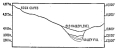
Fig. 183—Two-cycle slopes and alluvial fill between
Iluichihua and Chuquibambilla. The steep slopes on the inner valley
border are in many places vertical and rock cliffs are everywhere
abundant. Mature slopes have their greatest development here between
13,500 and 15,000 feet (4,110 to 4,570 m.). Steepest mature slopes run
from 15° to 21°. Least steep are the almost level spur summits. The
depths of the valley fill must be at least 300, and may possibly be 500
feet. The break between valley fill and steep slopes is most pronounced
where the river runs along the valley wall or undercuts it; least
pronounced where alluvial fans spread out from the head of some ravine.
It is a bowldery, stony fill almost everywhere terraced and cultivated.
Similar conditions are well displayed at Huadquiña, where a fine series
of terraces at the lower end of the Torontoy Canyon break the descent of
the environing slopes; also in the Urubamba Valley below Rosalina, and
again at the edge of the mountains at the Pongo de Mainique. It is
exhibited most impressively in the Majes Valley, where the bordering
slopes appear to be buried knee-deep in waste, and where from any
reasonable downward extension of rock walls of the valley there would
appear to be at least a half mile of it. It is doubtful and indeed
improbable that the entire fill of the Majes Valley is glacial, for
during the Pliocene or early Pleistocene there was a submergence which
gave opportunity for the partial filling of the valley with non-glacial
alluvium, upon which the glacial deposits were laid as upon a flat and
extensive floor that gives an exaggerated impression of their depth.
However, the head of the Majes Valley contains at least six hundred feet
and probably as much as eight hundred feet of alluvium now in process of
dissection, whose coarse texture and position indicates an origin under
glacial conditions. The fact argues for the great thickness of the
alluvial material of the lower valley, even granting a floor of Pliocene
or early Pleistocene sediments. The best sections are to be found just
below Chuquibamba and again about halfway between that city and Aplao,
whereas the best display of the still even-floored parts of the valley
are between Aplao and Cantas, where the braided river still deposits
coarse gravels upon its wide flood plain.
South America is classical ground in the study of tropical snowlines.
The African mountains that reach above the snowline in the equatorial
belt—Ruwenzori, Kibo, and Kenia—have only been studied recently
because they are remote from the sea and surrounded by bamboo jungle and
heavy tropical forest. On the other hand, many of the tropical mountains
of South America lie so near the west coast as to be visible from it and
have been studied for over a hundred years. From the days of Humboldt
(1800) and Boussingault (1825) down to the present, observations in the
Andes have been made by an increasing number of scientific travelers.
The result is a large body of data upon which comparative studies may
now be profitably undertaken.
Like scattered geographic observations of many other kinds, the earlier
studies on the snowline have increased in value with time, because the
snowline is a function of climatic elements that are subject to periodic
changes in intensity and cannot be understood by reference to a single
observation. Since the discovery of physical proofs of climatic changes
in short cycles, studies have been made to determine the direction and
rate of change of the snowline the world over, with some very striking
results.
It has been found[55] that the changes run in cycles of from thirty to
thirty-five years in length and that the northern and southern
hemispheres appear to be in opposite phase. For example, since 1885 the
snowline in the southern hemisphere has been decreasing in elevation in
nine out of twelve cases by the average amount of nine hundred feet.
With but a single exception, the snowline in the northern hemisphere
has been rising since 1890 with an average increase of five hundred feet
in sixteen cases. To be sure, we must recognize that the observations
upon which these conclusions rest have unequal value, due both to
personal factors and to differences in instrumental methods, but that in
spite of these tendencies toward inequality they should agree in
establishing a general rise of the snowline in the northern hemisphere
and an opposite effect in the southern is of the highest significance.
It must also be realized that snowline observations are altogether too
meager and scattered in view of the abundant opportunities for making
them, that they should be standardized, and that they must extend over a
much longer period before they attain their full value in problems in
climatic variations. Once the possible significance of snowline changes
is appreciated the number and accuracy of observations on the elevation
and local climatic relations of the snowline should rapidly increase.
In 1907 I made a number of observations on the height of the snowline in
the Bolivian and Chilean Andes between latitudes 17° and 20° south, and
in 1911 extended the work northward into the Peruvian Andes along the
seventy-third meridian. It is proposed here to assemble these
observations and, upon comparison with published data, to make a few
interpretations.
From Central Lagunas, Chile, I went northeastward via Pica and the
Huasco Basin to Llica, Bolivia, crossing the Sillilica Pass in May,
1907, at 15,750 feet (4,800 m.). Perpetual snow lay at an estimated
height of 2,000-2,500 feet above the pass or 18,000 feet (5,490 m.)
above the sea. Two weeks later the Huasco Basin, 14,050 feet (4,280 m.),
was covered a half-foot deep with snow and a continuous snow mantle
extended down to 13,000 feet. Light snows are reported from 12,000 feet,
but they remain a few hours only and are restricted to the height of
exceptionally severe winter seasons (June and early July). Three or four
distant snow-capped peaks were observed and estimates made of the
elevation of the snowline between the Cordillera Sillilica and Llica on
the eastern border of the Maritime Cordillera. All observations agreed
in giving an elevation much in excess of 17,000 feet. In general the
values run from 18,000 to 19,000 feet (5,490 to 5,790 m.). Though the
bases of these figures are estimates, it should be noted that a large
part of the trail lies between 14,000 and 16,000 feet, passing mountains
snow-free at least 2,000 to 3,000 feet higher, and that for general
comparisons they have a distinct value.
In the Eastern Cordillera of Bolivia, snow was observed on the summit of
the Tunari group of peaks northwest of Cochabamba. Steinmann, who
visited the region in 1904, but did not reach the summit of the Tunari
group of peaks, concludes that the limit of perpetual snow should be
placed above the highest point, 17,300 (5,270 m.); but in July and
August, 1907, I saw a rather extensive snow cover over at least the
upper 1,000 feet, and what appeared to be a very small glacier. Certain
it is that the Cochabamba Indians bring clear blue ice from the Tunari
to the principal hotels, just as ice is brought to Cliza from the peaks
above Arani. On these grounds I am inclined to place the snowline at
17,000 feet (5,180 m.) near the eastern border of the Eastern
Cordillera, latitude 17° S. At 13,000 feet, in July, 1907, snow occurred
in patches only on the pass called Abre de Malaga, northeast of Colomi,
13,000 feet, and fell thickly while we were descending the northern
slopes toward Corral, so that in the early morning it extended to the
cold timber line at 10,000 feet. In a few hours, however, it had
vanished from all but the higher and the shadier situations.
In the Vilcanota knot above the divide between the Titicaca and
Vilcanota hydrographic systems, the elevation of the snowline was
16,300+ feet (4,970 m.) in September, 1907. On the Cordillera Real of
Bolivia it is 17,000 to 17,500 feet on the northeast, but falls to
16,000 feet on the southwest above La Paz. In the first week of July,
1911, snow fell on the streets of Cuzco (11,000 feet) and remained for
over an hour. The heights north of San Geronimo (16,000 feet) miss the
limit of perpetual snow and are snow-covered only a few months each
year.
In taking observations on the snowline along the seventy-third meridian
I was fortunate enough to have a topographer the heights of whose
stations enabled me to correct the readings of my aneroid barometer
whenever these were taken off the line of traverse. Furthermore, the
greater height of the passes—15,000 to 17,600 feet—brought me more
frequently above the snowline than had been the case in Bolivia and
Chile. More detailed observations were made, therefore, not only upon
the elevation of the snowline from range to range, but also upon the
degree of canting of the snowline on a given range. Studies were also
made on the effect of the outline of the valleys upon the extent of the
glaciers, the influence on the position of the snowline of mass
elevation, precipitation, and cloudiness.
Snow first appears at 14,500 feet (4,320 m.) on the eastern flanks of
the Cordillera Vilcapampa, in 13° south latitude. East of this group of
ridges and peaks as far as the extreme eastern border of the mountain
belt, fifty miles distant, the elevations decrease rapidly to 10,000
feet and lower, with snow remaining on exceptionally high peaks from a
few hours to a few months. In the winter season snow falls now and then
as low as 11,500 feet, as in the valley below Vilcabamba pueblo in early
September, 1911, though it vanishes like mist with the appearance of the
sun or the warm up-valley winds from the forest. Storms gather daily
about the mountain summits and replenish the perpetual snow above 15,000
feet. In the first pass above Puquiura we encountered heavy snow banks
on the northeastern side a hundred feet below the pass (14,500 feet),
but on the southwestern or leeward side it is five hundred feet lower.
This distribution is explained by the lesser insolation on the
southwestern side, the immediate drifting of the clouds from the
windward to the leeward slopes, and to the mutual intensification of
cause and effect by topographic changes such as the extension of
collecting basins and the steeping of the slopes overlooking them with a
corresponding increase in the duration of shade.
It is well known that with increase of elevation and therefore of the
rarity of the air there is less absorption of the sun’s radiant energy,
and a corresponding increase in the degree of insolation. It follows,
therefore, that at high altitudes the contrasts between sun and shade
temperatures will increase. Frankland[56] has shown that the increase
may run as high as 500 per cent between 100 to 10,000 feet above the
sea. I have noted a fall of temperature of 15° F. in six minutes, due to
the obscuring of the sun by cloud at an elevation of 16,000 feet above
Huichihua in the Central Ranges of Peru. Since the sun shines
approximately half the time in the snow-covered portions of the
mountains and since the tropical Andes are of necessity snow-covered
only at lofty elevations, this contrast between shade and sun
temperatures is by far the most powerful factor influencing differences
in elevation of the snowline in Peru.
To the drifting of the fallen snow is commonly ascribed a large portion
of this contrast. I have yet to see any evidence of its action near the
snowline, though I have often observed it, especially under a high wind
in the early morning hours at considerable elevations above the
snowline, as at the summits of lofty peaks. It appears that the lower
ranges bearing but a limited amount of snow are not subject to drifting
because of the wetness of the snow, and the fact that it is compacted by
occasional rains and hail storms. Only the drier snow at higher
elevations and under stronger winds can be effectively dislodged.
The effect of unequal distribution of precipitation on the windward and
leeward slopes of a mountain range is in general to depress the snowline
on the windward slopes where the greater amount falls, but this may be
offset in high altitudes by temperature contrasts as in the westward
trending Cordillera Vilcapampa, where north and south slopes are in
opposition. If the Cordillera Vilcapampa ran north and south we should
have the windward and leeward slopes equally exposed to the sun and the
snowline would lie at a lower elevation on the eastern side. Among all
the ranges the slopes have decreasing precipitation to the leeward, that
is, westerly. The second and third passes, between Arma and Choquetira,
are snow-free (though their elevations equal those of the first pass)
because they are to leeward of the border range, hence receive less
precipitation. The depressive effect of increased precipitation on the
snowline is represented by A-B, 184 ; in an individual range the
effect of heavier precipitation may be offset by temperature contrasts
between shady and sunny slopes, as shown by the line a-b in the same
figure.
The degree of canting of the snowline on opposite slopes of the
Cordillera Vilcapampa varies between 5° and 12°, the higher value being
represented four hours southwest of Arma on the Choquetira trail,
looking northeast. A general view of the Cordillera looking east at this
point (Fig. 186), shows the appearance of the snowline as one looks
along the flanks of the range. In detail the snowline is further
complicated by topography and varying insolation, each spur having a
snow-clad and snow-free aspect as shown in the last figure. The degree
of difference on these minor slopes may even exceed the difference
between opposite aspects of the range in which they occur.
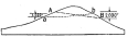
Fig. 184—To illustrate the canting of the snowline.
A-B is the snowline depressed toward the north (right) in response to
heavier precipitation. The line a-b represents a depression in the
opposite direction due to the different degree of insolation on the
northern (sunny) and southern (shady) slopes.
To these diversifying influences must be added the effect of warm
up-valley winds that precede the regular afternoon snow squalls and that
melt the latest fall of snow to exceptionally high elevations on both
the valley floor and the spurs against which they impinge. The influence
of the warmer air current is notably confined to the heads of those
master valleys that run down the wind, as in the valley heading at the
first pass, Cordillera Vilcapampa, and at the heads of the many valleys
terminating at the passes of the Maritime Cordillera. Elsewhere the
winds are dissipated in complex systems of minor valleys and their
effect is too well distributed to be recognized.
It is clear from the conditions of the problem as outlined on preceding
pages that the amount of canting may be expressed in feet of difference
of the snowline on opposite sides of a range or in degrees. The former
method has, heretofore, been employed. It is proposed that this method
should be abolished and degrees substituted, on the following grounds:
Let A and B, 190 , represent two mountain masses of unequal area
and unequal elevation. Let the opposite ends of the snowlines of both
figures lie 1,000 feet apart as between the windward and leeward sides
of a broad cordillera (A), or as between the relatively sunnier and
relatively shadier slopes of individual mountains or narrow ranges in
high latitudes or high altitudes (B). With increasing elevation there is
increasing contrast between temperatures in sunshine and in shade, hence
a greater degree of canting (B). Tending toward a still greater degree
of contrast is the effect of the differences in the amounts of snowy
precipitation, which are always more marked on an isolated and lofty
mountain summit than upon a broad mountain mass (1) because in the
former there is a very restricted area where snow may accumulate, and
(2) because with increase of elevation there is a rapid and differential
decrease in both the rate of adiabatic cooling and the amount of water
vapor; hence the snow-producing forces are more quickly dissipated.
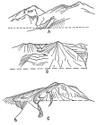
Fig. 185—Glacial features in the Peruvian Andes near
Arequipa. Sketched from a railway train, July, 1911. The horizontal
broken lines represent the lower limit of light snow during late June,
1911. There is a fine succession of moraines in U-shaped valleys in all
the mountains of the Arequipa region. A represents a part of Chacchani
northwest of Arequipa; B is looking south by east at the northwest end
of Chacchani near Pampa de Arrieros; C also shows the northwest end of
Chacchani from a more distant point.
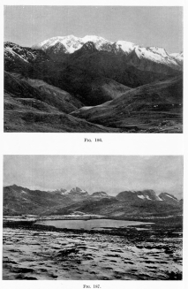
Fig. 186—Canted snowline in the Cordillera Vilcapampa
between Arma and Choquetira. Looking east from 13,500 feet.
Fig. 187—Glacial topography between Lambrama and
Antabamba in the Central Ranges. A recent fall of snow covers the
foreground. The glaciers are now almost extinct and their action is
confined to the deepening and steepening of the cirques at the valley
heads.
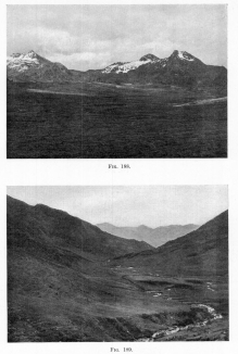
Fig. 188—Asymmetrical peaks in the Central Ranges
between Antabamba and Lambrama. The snow-filled hollows in the
photograph face away from the sun—that is, south—and have retained
snow since the glacial epoch; while the northern slopes are snow-free.
There is no true glacial ice and the continued cirque recession is due
to nivation.
Fig. 189—Glacial topography north of the divide on the
seventy-third meridian. Maritime Cordillera. Looking downstream at an
elevation of 16,500 feet (5,030 m.).
Furthermore, the leeward side of a lofty mountain not only receives much
less snow proportionally than the leeward side of a lower mountain,
but also loses it faster on account of the smaller extent of surface
upon which it is disposed and the proportionally larger extent of
counteractive, snow-free surface about it. Among the volcanoes of
Ecuador are many that show differences of 500 feet in snowline elevation
on windward and leeward (east) slopes and some, as for example
Chimborazo, that exhibit differences of 1,000 feet. The latter figure
also expresses the differences in the broad Cordillera Vilcapampa and in
the Maritime Cordillera, though the rate of canting as expressed in
degrees is much greater in the case of the western mountains.
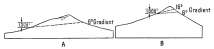
Fig. 190—To illustrate the difference in the degree of
canting of the snowline on large and on small mountain masses.
The advantages of the proposed method of indicating the degree of
canting of the snowline lie in the possibility thus afforded of
ultimately separating and expressing quantitatively the various factors
that affect the position of the line. In the Cordillera Vilcapampa, for
example, the dominant canting force is the difference between sun and
shade temperatures, while in the volcanoes of Ecuador, where
symmetrical volcanoes, almost on the equator, have equal insolation on
all aspects and the temperature contrasts are reduced to a minimum—the
differences are owing chiefly to varying exposure to the winds. The
elusive factors in the comparison are related to the differences in area
and in elevation.
The value of arriving finally at close snowline analyses grows out of
(1) the possibility of snowline changes in short cycles and (2)
uncertainty of arriving by existing methods at the snowline of the
glacial period, whose importance is fundamental in refined physiographic
studies in glaciated regions with a complex topography. To show the
application of the latter point we shall now attempt to determine the
snowline of the glacial period in the belt of country along the route of
the Expedition.
In the group of peaks shown in 188 between Lambrama and Antabamba,
the elevation of the snowline varies from 16,000 to 17,000 feet
(4,880-5,180 m.), depending on the topography and the exposure. The
determination of the limit of perpetual snow was here, as elsewhere
along the seventy-third meridian, based upon evidences of nivation. It
will be observed in 191 that just under the snow banks to the left
of the center are streams of rock waste which head in the snow. Their
size is roughly proportional to the size of the snow banks, and,
furthermore, they are not found on snow-free slopes. From these facts it
is concluded that they represent the waste products of snow erosion or
nivation, just as the hollows in which the snow lies represent the
topographic products of nivation. On account of the seasonal and annual
variation in precipitation and temperature—hence in the elevation of
the snowline—it is often difficult to make a correct snowline
observation based upon depth and apparent permanence. Different
observers report great changes in the snowline in short intervals,
changes not explained by instrumental variations, since they are
referred to topographic features. It appears to be impossible to rely
upon present records for small changes possibly related to minor
climatic cycles because of a lack of standardization of observations.
Nothing in the world seems simpler at first sight than an observation on
the elevation of the snowline. Yet it can be demonstrated that large
numbers of observers have merely noted the position of temporary snow.
It is strongly urged that evidences of nivation serve henceforth as
proof of permanent snow and that photographic records be kept for
comparison. In this way measurements of changes in the level of the
snowline may be accurately made and the snow cover used as a climatic
gauge.
Farther west in the Maritime Cordillera, the snowline rises to 18,000
feet on the northern slopes of the mountains and to 17,000 feet on the
southern slopes. The top of the pass above Cotahuasi, 17,600 feet (5,360
m.), was snow-free in October, 1911, but the snow extended 500 feet
lower on the southern slope. The degree of canting is extraordinary at
this point, single volcanoes only 1,500 to 2,000 feet above the general
level and with bases but a few miles in circumference exhibit a thousand
feet of difference in the snowline upon northern and southern aspects.
This is to be attributed no less to the extreme elevation of the snow
(and, therefore, stronger contrasts of shade and sun temperatures) than
to the extreme aridity of the region and the high daytime temperatures.
The aridity is a factor, since heavy snowfall means a lengthening of the
period of precipitation in which a cloud cover shuts out the sun and a
shortening of the period of insolation and melting.
Contrasts between shade and sun temperatures increase with altitude but
their effects also increase in time. Of two volcanoes of equal size
and both 20,000 feet above sea level, that one will show the greater
degree of canting that is longer exposed to the sun. The high daytime
temperature is a factor, since it tends to remove the thinnest snow,
which also falls in this case on the side receiving the greatest amount
of heat from the sun. The high daytime temperature is phenomenal in this
region, and is owing to the great extent of snow-free land at high
elevations and yet below the snowline, and to the general absence of
clouds and the thinness of vegetation.
On approach to the western coast the snowline descends again to 17,500
feet on Coropuna. There are three chief reasons for this condition.
First, the well-watered Majes Valley is deeply incised almost to the
foot of Coropuna, above Chuquibamba, and gives the daily strong sea
breeze easy access to the mountain. Second, the Coast Range is not only
low at the mouth of the Majes Valley, but also is cut squarely across by
the valley itself, so that heavy fogs and cloud sweep inland nightly and
at times completely cover both valley and desert for an hour after
sunrise. Although these yield no moisture to the desert or the valley
floor except such as is mechanically collected, yet they do increase the
precipitation upon the higher elevations at the valley head.
A third factor is the size of Coropuna itself. The mountain is not a
simple volcano but a composite cone with five main summits reaching well
above the snowline, the highest to an elevation of 21,703 feet (6,615
m.). It measures about 20 miles (32 km.) in circumference at the
snowline and 45 miles (72 km.) at its base (measuring at the foot of the
steeper portion), and stands upon a great tributary lava plateau from
15,000 to 17,000 feet above sea level. Compared with El Misti, at
Arequipa, its volume is three times as great, its height two thousand
feet more, and its access to ocean winds at least thirty per cent more
favorable. El Misti, 19,200 feet (5,855 m.) has snow down as far as
16,000 feet in the wet season and rarely to 14,000 feet, though by
sunset a fall of snow may almost disappear whose lower limit at sunrise
was 16,000 feet. Snow may accumulate several thousand feet below the
summit during the wet season, and in such quantities as to require
almost the whole of the ensuing dry season (March to December) for its
melting. Northward of El Misti is the massive and extended range,
Chachani, 20,000 feet (6,100 m.) high; on the opposite side is the
shorter range called Pichu-Pichu. Snow lies throughout the year on both
these ranges, but in exceptional seasons it nearly disappears from
Chachani and wholly disappears from Pichu-Pichu, so that the snowline
then rises to 20,000 feet. It is considered that the mean of a series of
years would give a value between 17,000 and 18,000 feet for the snowline
on all the great mountains of the Arequipa region.[57] This would,
however, include what is known to be temporary snow; the limit of
“perpetual” snow, or the true snowline, appears to lie about 19,000 feet
on Chachani and above El Misti, say 19,500 feet. It is also above the
crest of Pichu-Pichu. The snowline, therefore, appears to rise a
thousand feet from Coropuna to El Misti, owing chiefly to the poorer
exposure of the latter to the sources of snowy precipitation.
It may also be noted that the effect of the easy access of the ocean
winds in the Coropuna region is also seen in the increasing amount of
vegetation which appears in the most favorable situations. Thus, along
the Salamanca trail only a few miles from the base of Coropuna are a few
square kilometers of quenigo woodland generally found in the cloud
belt at high altitudes; for example, at 14,000 feet above Lambrama and
at 9,000 feet on the slope below Incahuasi, east of Pasaje. The greater
part of the growth is disposed over hill slopes and on low ridges and
valley walls. It is, therefore, clearly unrelated as a whole to the
greater amount of ground-water with which a part is associated, as along
the valley floors of the streams that head in the belt of perpetual
snow. The appearance of this growth is striking after days of travel
over the barren, clinkery lava plateau to eastward that has a less
favorable exposure. The quenigo forest, so-called, is of the greatest
economic value in a land so desolate as the vast arid and semi-arid
mountain of western Peru. Every passing traveler lays in a stock of
fire-wood as he rests his beasts at noonday; and long journeys are made
to these curious woodlands from both Salamanca and Chuquibamba to gather
fuel for the people of the towns.
The process of nivation, or snow erosion, does not always produce
visible effects. It may be so feeble as to make no impression upon very
resistant rock where the snow-fall is light and the declivity low.
Ablation may in such a case account for almost the whole of the snow
removed. On strong and topographically varied slopes where the snow is
concentrated in headwater alcoves, there is a more pronounced downward
movement of the snow masses with more prominent effects both of erosion
beneath the snow and of accumulation at the border of the snow. In such
cases the limit of perpetual snow may be almost as definitely known as
the limit of a glacier. Like glaciers these more powerful snow masses
change their limits in response to regional changes in precipitation,
temperature, or both. It would at first sight appear impossible to
distinguish between these changes through the results of nivation. Yet
in at least a few cases it may be as readily determined as the past
limits of glaciers are inferred from the terminal moraines, still
intact, that cross the valley floors far below the present limits of the
ice.
In discussing the process of nivation it is necessary to assume a
sliding movement on the part of the snow, though it is a condition in
Matthes’ original problem in which the nivation idea was introduced that
the snow masses remain stationary. It is believed, however, that
Matthes’ valuable observations and conclusions really involve but half
the problem of nivation; or at the most but one of two phases of it. He
has adequately shown the manner in which that phase of nivation is
expressed which we find at the border of the snow. Of the action
beneath the snow he says merely: “Owing to the frequent oscillations
of the edge and the successive exposure of the different parts of the
site to frost action, the area thus affected will have no well-defined
boundaries. The more accentuated slopes will pass insensibly into the
flatter ones, and the general tendency will be to give the drift site a
cross section of smoothly curved outline and ordinarily concave.”[58]
From observations on the effects of nivation in valleys, Matthes further
concludes that “on a grade of about 12 per cent ... névé must attain a
thickness of at least 125 feet in order that it may have motion,”[59]
though as a result of the different line of observations Hobbs
concludes[60] that a somewhat greater thickness is required.
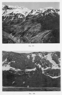
Fig. 191—The “pocked” surface characteristically
developed in the zone of light nivation. Compare with Fig. 194, showing
the effects of heavy nivation.
Fig. 192—Steep cirque walls and valleys head in the
Central Ranges between Lambrama and Chuquibambilla. The snow is here a
vigorous agent in transporting talus material and soil from all the
upper slopes down to the foot of the cirque wall.
The snow cover in tropical mountains offers a number of solid advantages
in this connection. Its limits, especially on the Cordillera Vilcapampa,
on the eastern border of the Andes, are subject to small seasonal
oscillations and the edge of the “perpetual” snow is easily determined.
Furthermore, it is known from the comparatively “fixed quality of
tropical climate,” as Humboldt put it, that the variations of the
snowline in a period of years do not exceed rather narrow limits. In
mid-latitudes on the contrary there is an extraordinary shifting of the
margin of the snow cover, and a correspondingly wide distribution of
the feeble effects of nivation.
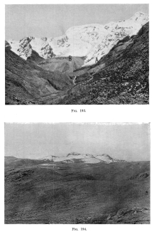
Fig. 193—Panta Mountain and its glacier system. The
talus-covered mass in the center (B) is a terminal moraine topped by the
dirt-stained glacier that descends from the crest. The separate glaciers
were formerly united to form a huge ice tongue that truncated the
lateral spurs and flattened the valley floor. One of its former stages
is shown by the terminal moraine in the middle distance, breached by a
stream, and impounding a lake not visible from this point of view.
Fig. 194—Recessed southern slopes of volcanoes whose
northern slopes are practically without glacial modifications. Summit of
the lava plateau, Maritime Cordillera, western Peru, between Antabamba
and Cotahuasi.
Test cases are presented in Figs. 191, 192, and 193, Cordillera
Vilcapampa, for the determination of the fact of the movement of the
snow long before it has reached the thickness Matthes or Hobbs believes
necessary for a movement of translation to begin. 191 shows snow
masses occupying pockets on the slope of a ridge that was never covered
with ice. Past glacial action with its complicating effects is,
therefore, excluded and we have to deal with snow action pure and
simple. The pre-glacial surface with smoothly contoured slopes is
recessed in a noteworthy way from the ridge crest to the snowline of the
glacial period at least a thousand feet lower. The recesses of the
figure are peculiar in that not even the largest of them involve the
entire surface from top to bottom; they are of small size and are
scattered over the entire slope. This is believed to be due to the fact
that they represent the limits of variations of the snowline in short
cycles. Below them as far as the snowline of the glacial period are
larger recesses, some of which are terminated by masses of waste as
extensive as the neighboring moraines, but disposed in irregular
scallops along the borders of the ridges or mountain slopes in which the
recesses have been found.
The material accumulated at the lower limit of the snow cover of the
glacial period was derived from two sources: (1) from slopes and cliffs
overlooking the snow, (2) from beneath the snow by a process akin to ice
plucking and abrasion. The first process is well known and resembles the
shedding of waste upon a valley glacier or a névé field from the
bordering cliffs and slopes. Material derived in this manner in many
places rolls down a long incline of snow and comes to rest at the foot
of it as a fringe of talus. The snow is in this case but a substitute
for a normal mass of talus. The second process produces its most clearly
recognizable effects on slopes exceeding a declivity of 20°; and upon
30° and 40° slopes its action is as well-defined as true glacial action
which it imitates. It appears to operate in its simplest form as if
independent of the mass of the snow, small and large snow patches
showing essentially the same results. This is the reverse of Matthes’
conclusion, since he says that though the minimum thickness “must vary
inversely with the percentage of the grade,” “the influence of the grade
is inconsiderable,” and that the law of variation must depend upon
additional observation.[61]
Let us examine a number of details and the argument based upon them and
see if it is not possible to frame a satisfactory law of variation.
In 193 the chief conditions of the problem are set forth. Forward
from the right-hand peak are snow masses descending to the head of a
talus (A) whose outlines are clearly defined by freshly fallen snow.
At (B) is a glacier whose tributaries descend the middle and left
slopes of the picture after making a descent from slopes several
thousand feet higher and not visible in this view. The line beneath the
glacier marks the top of the moraine it has built up. Moraines farther
down valley show a former greater extent of the glacier. Clearly the
talus material at (A) was accumulated after the ice had retreated to
its present position. It will be readily seen from an inspection of the
photograph that the total amount of material at (A) is an appreciable
fraction of that in the moraine. The ratio appears to be about 1:8 or
1:10. I have estimated that the total area of snow-free surface about
the snowfields of the one is to that of the other as 2:3. The gradients
are roughly equivalent, but the volume of snow in the one case is but a
small fraction of that in the other. It will be seen that the snow
masses have recessed the mountain slopes at A and formed deep hollows
and that the hollowing action appears to be most effective where the
snow is thickest.
Summarizing, we note first, that the roughly equivalent factors are
gradient and amount of snow-free surface; second, that the unequal
factors are (a) accumulated waste, (b) degree of recessing, and (c) the
degree of compacting of snow into ice and a corresponding difference in
the character of the glacial agent, and (d) the extent of the snow
cover. The direct and important relation of the first two unequal
factors to the third scarcely need be pointed out.
We have then an inequality in amount of accumulated material to be
explained by either an inequality in the extent of the snow and
therefore an inequality of snow action, or an inequality due to the
presence of ice in one valley and not in the other, or by both. It is at
once clear that if ice is absent above (A) and the mountain slopes are
recessed that snow action is responsible for it. It is also recognized
that whatever rate of denudation be assigned to the snow-free surfaces
this rate must be exceeded by the rate of snow action, else the
inequalities of slope would be decreased rather than increased. The
accumulated material at (A) is, therefore, partly but not chiefly due
to denudation of snow-free surfaces. It is due chiefly to erosion
beneath the snow. Nor can it be argued that the hollows now occupied by
snow were formed at some past time when ice not snow lay in them. They
are not ice-made hollows for they are on a steep spur above the limits
of ice action even in the glacial period. Any past action is, therefore,
represented here in kind by present action, though there would be
differences in degree because the heavier snows of the past were
displaced by the lighter snows of today.
While it appears that the case presents clear proof of degradation by
snow it is not so clear how these results were accomplished. Real
abrasion on a large scale as in bowlder-shod glaciers is ruled out,
since glacial striæ are wholly absent from nivated surfaces according to
both Matthes’ observations and my own. Yet all nivated surfaces have
very distinctive qualities, delicately organized slopes which show a
marked change from any original condition related to water-carving. In
the absence of striæ, the general absence of all but a thin coating of
waste even in rock hollows, and the accumulation of waste up to
bowlders in size at the lower edge of the nivated zone, I conclude that
compacted snow or névé of sufficient thickness and gradient may actually
pluck rock outcrops in the same manner though not at the rate which ice
exhibits. That the products of nivation may be bowlders as well as fine
mud would seem clearly to follow increase in effectiveness, due to
increase in amount of the accumulated snow; that bowlders are actually
transported by snow is also shown by their presence on the lower margins
of nivated tracts.
Our argument may be made clearer by reference to the observed action of
snow in a particular valley. Snow is shed from the higher, steeper
slopes to the lower slopes and eventually accumulates to a marked degree
on the bottoms of the depressions, whence it is avalanched down valley
over a series of irregular steps on the valley floor. An avalanche takes
place through the breaking of a section of snow just as an iceberg
breaks off the end of a tide-water glacier. Evidently there must be
pressure from behind which crowds the snow forward and precipitates it
to a lower level.
As a snow mass falls it not only becomes more consolidated, beginning at
the plane of impact, but also gives a shock to the mass upon which it
falls that either starts it in motion or accelerates its rate of motion.
The action must therefore be accompanied by a drag upon the floor and if
the rock be close-jointed and the blocks, defined by the joint planes,
small enough, they will be transported. Since snow is not so compact as
ice and permits included blocks easily to adjust themselves to new
resistances, we should expect the detached blocks included in the snow
to change their position constantly and to form irregular scratches, but
not parallel striæ of the sort confidently attributed to stone-shod ice.
It is to the plasticity of snow that we may look for an explanation of
the smooth-contoured appearance of the landscape in the foreground of
Fig. 135. The smoothly curved lines are best developed where the entire
surface was covered with snow, as in mid-elevations in the larger
snowfields. At higher elevations, where the relief is sharper, the snow
is shed from the steeper declivities and collected in the minor basins
and valley heads, where its action tends to smooth a floor of limited
area, while snow-free surfaces retain all their original irregularities
of form or are actually sharpened.
The degree of effectiveness of snow and névé action may be estimated
from the reversed slopes now marked by ponds or small marshy tracts
scattered throughout the former névé fields, and the many niched
hollows. They are developed above Pampaconas in an admirable manner,
though their most perfect and general development is in the summit belt
of the Cordillera Vilcapampa between Arma and Choquetira, 135 . It
is notable in all cases where nivation was associated with the work of
valley glaciers that the rounded nivated slopes break rather sharply
with the steep slopes that define an inner valley, whose form takes on
the flat floor and under-cut marginal walls normal to valley glaciation.
A classification of numerous observations in the Cordillera Vilcapampa
and in the Maritime Cordillera between Lambrama and Antabamba may now be
presented as the basis for a tentative expression of the law of
variation respecting snow motion. The statement of the law should be
prefaced by the remark that thorough checking is required under a wider
range of conditions before we accept the law as final. Near the lower
border of the snow where rain and hail and alternate freezing and
thawing take place, the snow is compacted even though but fifteen to
twenty feet thick, and appears to have a down-grade movement and to
exercise a slight drag upon its floor when the gradient does not fall
below 20°. Distinct evidences of nivation were observed on slopes with a
declivity of 5° near summit areas of past glacial action, where the snow
did not have an opportunity to be alternately frozen and thawed.
The thickness of the former snow cover could, however, not be
accurately determined, but was estimated from the topographic
surroundings to have been at least several hundred feet. Upon a 40°
slope a snow mass 50 feet thick was observed to be breaking off at a
cliff-face along the entire cross-section as if impelled forward by
thrust, and to be carrying a small amount of waste—enough distinctly to
discolor the lowermost layers—which was shed upon the snowy masses
below. With increase in the degree of compactness of the snow at
successively lower elevations along a line of snow discharge, gradients
down to 25° were still observed to carry strongly crevassed, waste-laden
snow down to the melting border. It appeared from the clear evidences of
vigorous action—the accumulation of waste, the strong crevassing, the
stream-like character of the discharging snow, and the pronounced
topographic depression in which it lay—that much flatter gradients
would serve, possibly not more than 15°, for a snow mass 150 feet wide,
30 to 40 feet thick, and serving as the outlet for a set of tributary
slopes about a square mile in area and with declivities ranging from
small precipices to slopes of 30°.
We may say, therefore, that the factors affecting the rate of motion are
(1) thickness, (2) degree of compactness, (3) diurnal temperature
changes, and (4) gradient. Among these, diurnal temperature changes
operate indirectly by making the snow more compact and also by inducing
motion directly. At higher elevations above the snowline, temperature
changes play a decreasingly important part. The thickness required
varies inversely as the gradient, and upon a 20° slope is 20 feet for
wet and compact snow subjected to alternate freezing and thawing. For
dry snow masses above the zone of effective diurnal temperature changes,
an increasing gradient is required. With a gradient of 40°, less than 50
feet of snow will move en masse if moderately compacted under its own
weight; if further compacted by impact of falling masses from above, the
required thickness may diminish to 40 feet and the required declivity to
15°. The gradient may decrease to 0° or actually be reversed and motion
still continue provided the compacting snow approach true névé or even
glacier ice as a limit.
From the sharp topographic break between the truly glaciated portions of
the valley in regions subjected to temporary glaciation, it is concluded
that the eroding power of the moving mass is suddenly increased at the
point where névé is finally transformed into true ice. This
transformation must be assumed to take place suddenly to account for so
sudden a change of function as the topographic break requires. Below the
point at which the transformation occurs the motion takes place under a
new set of conditions whose laws have already been formulated by
students of glaciology.
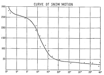
Fig. 195—Curve of snow motion. Based on many
observations of snow motion to show minimum thickness of snow required
to move on a given gradient. Figures on the left represent thickness of
snow in feet. The degrees represent the gradient of the surface. The
gradients have been run in sequence down to 0° for the sake of
completing the accompanying discussion. Obviously no glacially
unmodified valley in a region of mountainous relief would start with so
low a gradient, though glacial action would soon bring it into
existence. Between +5° and -5° the curve is based on the gradients of
nivated surfaces.
The foregoing readings of gradient and depth of snow are typical of a
large number which were made in the Peruvian Andes and which have served
as the basis of 195 . It will be observed that between 15° and 20°
there is a marked change of function and again between +5° and -5°
declivity, giving a double reversed curve. The meaning of the change
between 15° and 20° is inferred to be that, with gradients over 20°,
snow cannot wholly resist gravity in the presence of diurnal temperature
changes across the freezing point and occasional snow or hail storms.
With increase of thickness compacting appears to progress so rapidly as
to permit the transfer of thrust for short distances before absorption
of thrust takes place in the displaced snow. At 250 feet thorough
compacting appears to take place, enabling the snow to move out under
its own weight on even the faintest slopes; while, with a thickness
still greater, the resulting névé may actually be forced up slight
inclines whose declivity appears to approach 5° as a limit. I have
nowhere been able to find in truly nivated areas reversed curves
exceeding 5°, though it should be added that depressions whose leeward
slopes were reversed to 2° and 3° are fairly common. If the curve were
continued we should undoubtedly find it again turning to the left at the
point where the thickness of the snow results in the transformation of
snow to ice. From the sharp topographic break observed to occur in a
narrow belt between the névé and the ice, it is inferred that the
erosive power of the névé is to that of the ice as 2:4 or 1:5 for equal
areas; and that reversed slopes of a declivity of 10° to 15° may be
formed by glaciers is well known. Precisely what thickness of snow or
névé is necessary and what physical conditions effect its transformation
into ice are problems not included in the main theme of this chapter.
It is important that the proposed curve of snow motion under minimum
conditions be tested under a large variety of circumstances. It may
possibly be found that each climatic region requires its special
modifications. In tropical mountains the sudden alternations of freezing
and thawing may effect such a high degree of compactness in the snow
that lower minimum gradients are required than in the case of
mid-latitude mountains where the perpetual snow of the high and cold
situations is compacted through its own weight. Observations of the
character introduced here are still unattainable, however. It is hoped
that they will rapidly increase as their significance becomes apparent;
and that they have high significance the striking nature of the curve of
motion seems clearly to establish.
The facts brought out by the curve of snow-motion (Fig. 195) have an
immediate bearing on the development of cirques, whose precise mode of
origin and development have long been in doubt. Without reviewing the
arguments upon which the various hypotheses rest, we shall begin at once
with the strongest explanation—W. D. Johnson’s famous bergschrund
hypothesis. The critical condition of this hypothesis is the diurnal
migration across the freezing point of the air temperature at the bottom
of the schrund. Alternate freezing and thawing of the water in the
joints of the rock to which the schrund leads, exercise a quarrying
effect upon the rock and, since this effect is assumed to take place at
the foot of the cirque, the result is a steady retreat of the steep
cirque wall through basal sapping.
While Johnson’s hypothesis has gained wide acceptance and is by many
regarded as the final solution of the cirque problem it has several
weaknesses in its present form. In fact, I believe it is but one of two
factors of equal importance. In the first place, as A. C. Andrews[62]
has pointed out, it is extremely improbable that the bergschrund of
glacial times under the conditions of a greater volume of snow could
have penetrated to bedrock at the base of the cirque where the present
change of slope takes place. In the second place, the assumption is
untenable that the bergschrund in all cases reaches to or anywhere near
the foot of the cirque wall. A third condition outside the hypothesis
and contradictory to it is the absence of a bergschrund in snowfields at
many valleys heads where cirques are well developed!
Johnson himself called attention to the slender basis of observation
upon which his conclusions rest. In spite of his own caution with
respect to the use of his meager data, his hypothesis has been applied
in an entirely too confident manner to all kinds of cirques under all
kinds of conditions. Though Johnson descended an open bergschrund to a
rock floor upon which ice rested, his observations raise a number of
proper questions as to the application of these valuable data: How long
are bergschrunds open? How often are they open? Do they everywhere open
to the foot of the cirque wall? Are they present for even a part of the
year in all well-developed cirques? Let us suppose that it is possible
to find many cirques filled with snow, not ice, surrounded by truly
precipitous walls and with an absence of bergschrunds, how shall we
explain the topographic depressions excavated underneath the snow? If
cirque formation can be shown to take place without concentrated frost
action at the foot of the bergschrund, then is the bergschrund not a
secondary rather than a primary factor? And must we not further conclude
that when present it but hastens an action which is common to all
snow-covered recesses?
It is a pleasure to say that we may soon have a restatement of the
cirque problem from the father of the bergschrund idea. The argument in
this chapter was presented orally to him after he had remarked that he
was glad to know that some one was finding fault with his hypothesis.
“For,” he said, with admirable spirit, “I am about to make a most
violent attack upon the so-called Johnson hypothesis.” I wish to say
frankly that while he regards the following argument as a valid addition
to the problem, he does not think that it solves the problem. There are
many of us who will read his new explanation with the deepest interest.

Fig. 196—Relation of cirque wall to trough’s end at the
head of a glaciated valley. The ratio of the inner to the outer radius
is 1:4.
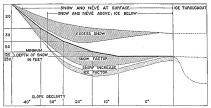
Fig. 197—Mode of cirque formation. Taking the facts of
snow depth represented in the curve, Fig. 195 , and transposing them over
a profile (the heavy line) which ranges from 0° declivity to 50°, we
find that the greatest excess of snow occurs roughly in the center. Here
ice will first form at the bottom of the snow in the advancing hemicycle
of glaciation, and here it will linger longest in the hemicycle of
retreat. Here also there will be the greatest mass of névé. All of these
factors are self-stimulating and will increase in time until the floor
of the cirque is flattened or depressed sufficiently to offset through
uphill ice-flow the augmented forces of erosion. The effects of
self-stimulation are shown by “snow increase”; the ice shoe at the
bottom of the cirque is expressed by “ice factor.” The form accompanying
both these terms is merely suggestive. The top of “excess snow” has a
gradient characteristic of the surface of snow fields. A preglacial
gradient of 0° is not permissible, but I have introduced it to complete
the discussion in the text and to illustrate the flat floor of a cirque.
A bergschrund is not required for any stage of this process, though the
process is hastened wherever bergschrunds exist.
We shall begin with the familiar fact that many valleys, now without
perpetual snow, formerly contained glaciers from 500 to 1,000 feet thick
and that their snowfields were of wide extent and great depth. At the
head of a given valley where the snow is crowded into a small
cross-section it is compacted and suffers a reduction in its volume. At
first nine times the volume of ice, the gradually compacting névé
approaches the volume of ice as a limit. At the foot of the cirque wall
we may fairly assume in the absence of direct observations, a volume
reduction of one-half due to compacting. But this is offset in the case
of a well-developed cirque by volume increases due to the convergence of
the snow from the surrounding slopes, as shown in 196 . Taking a
typical cirque from a point above Vilcabamba pueblo I find that the
radius of the trough’s end is to the radius of the upper wall of the
cirque as 1:4; and since the corresponding surfaces are to one another
as the squares of their similar dimensions we have 1:4 or 1:16 as the
ratio of their snow areas. If no compacting took place, then to
accommodate all the snow in the glacial trough would require an increase
in thickness in the ratio of 1:4. If the snow were compacted to half its
original volume then the ratio would be 1:2. Now, since the volume ratio
of ice to snow is 1:9 and the thickness of the ice down valley is, say
400 feet, the equivalent of loose snow at the foot of the cirque must be
more than 1:4 over 1:9 or more than two and one-quarter times thicker,
or 400 feet thick; and would give a pressure of (900 ÷ 10) × 62.5
pounds, or 5,625 pounds, or a little less than three tons per square
foot. Since a pressure of 2,500 pounds per square foot will convert snow
into ice at freezing temperature, it is clear that ice and not snow was
the state at the bottom of the mass in glacial times. Further, between
the surface of the snow and the surface of the bottom layer of the ice
there must have been every gradation between loose snow and firm ice,
with the result that a thickness much less than 900 feet must be
assumed. Precisely what thickness would be found at the foot of the
cirque wall is unknown. But granting a thickness of 400 feet of ice an
additional 300 feet for névé and snow would raise the total to 700 feet.
The application of the facts in the above paragraph is clearly seen when
we refer to 197 . The curve of snow motion of 195 is applied to
an unglaciated mountain valley. Taking a normal snow surface and filling
the valley head it is seen that the excess of snow depth over the amount
required to give motion is a measure at various points in the valley
head and at different gradients of the erosive force of the snow. It is
strikingly concentrated on the 15°-20° gradient which is precisely where
the so-called process of basal sapping is most marked. If long continued
the process will lead to the developing of a typical cirque for it is a
process that is self-stimulating. The more the valley is changed in form
the more it tends to change still further in form because of deepening
snowfields until cliffed pinnacles and matterhorns result.
By further reference to the figure it is clear that a schrund 350 feet
deep could not exist on a cirque wall with a declivity of even 20°
without being closed by flow, unless we grant more rapid flow below
the crevasse. In the case of a glacier flowing over a nearly flat bed
away from the cirque it is difficult to conceive of a rate of flow
greater than that of snow and névé on the steep lower portion of the
cirque wall, when movement on that gradient begins with snow but 20
feet thick.
In contrast to this is the view that the schrund line should lie well up
the cirque wall where the snow is comparatively thin and where there is
an approach to the lower limits of movement. The schrund would appear to
open where the bottom material changes its form, i.e., where it first
has its motion accelerated by transformation into névé. In this view
the schrund opens not at the foot of the cirque wall but well above it
as in 198 , in which C represents snow from top to bottom; B,
névé; and A, ice. The required conditions are then (1) that the
steepening of the cirque wall from x to y should be effected by
sapping originated at y through the agencies outlined by Johnson; (2)
that the steepening from x to y should be effected by sapping
originated at x through the change of the agent from névé to ice with
a sudden change of function; (3) and that the essential unity of the
wall x-y-z be maintained through the erosive power of the névé, which
would tend to offset the formation of a shelf along a horizontal plane
passed through y. The last-named process not only appears entirely
reasonable from the conditions of gradient and depth outlined on pp. 296
to 298, but also meets the actual field conditions in all the cases
examined in the Peruvian Andes. This brings up the second and third of
our main considerations, that the bergschrund does not always or even in
many cases reach the foot of the cirque wall, and that cirques exist in
many cases where bergschrunds are totally absent.
It is a striking fact that frost action at the bottom of the bergschrund
has been assumed to be the only effective sapping force, in spite of the
common observation that bergschrunds lie in general well toward the
upper limits of snowfields—so far, in fact, that their bottoms in
general occur several hundred feet above the cirque floors. Is the
cirque under these circumstances a result of the schrund or is the
schrund a result of the cirque? In what class of cirques do schrunds
develop? If cirque development in its early stages is not marked by the
development of bergschrunds, then are bergschrunds an essential
feature of cirques in their later stages, however much the sapping
process may be hastened by schrund formation?
Our questions are answered at once by the indisputable facts that many
schrunds occur well toward the upper limit of snow, and that many
cirques exist whose snowfields are not at all broken by schrunds. It was
with great surprise that I first noted the bergschrunds of the Central
Andes, especially after becoming familiar with Johnson’s apparently
complete proof of their genetic relation to the cirques. But it was less
surprising to discover the position of the few observed—high up on the
cirque walls and always near the upper limit of the snowfields.
A third fact from regions once glaciated but now snow-free also combined
with the two preceding facts in weakening the wholesale application of
Johnson’s hypothesis. In many headwater basins the cirque whose wall at
a distance seemed a unit was really broken into two unequal portions; a
lower, much grooved and rounded portion and an upper unglaciated,
steep-walled portion. This condition was most puzzling in view of the
accepted explanation of cirque formation, and it was not until the two
first-named facts and the applications of the curves of snow motion were
noted that the meaning of the break on the cirque became clear.
Referring to 198 we see at once that the break occurs at y and
means that under favorable topographic and geologic conditions sapping
at y takes place faster than at x and that the retreat of y-z is
faster than x-y. It will be clear that when these conditions are
reversed or sapping at x and at y are equal a single wall will
result. On reference to the literature I find that Gilbert recently
noted this feature and called it the schrundline.[63] He believes that
it marks the base of the bergschrund at a late stage in the excavation
of the cirque basin. He notes further that the lower less-steep slope
is glacially scoured and that it forms “a sort of shoulder or terrace.”
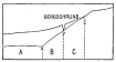
Fig. 198—The development of cirques. See text, p. 209,
and 199 .
If all the structural and topographic conditions were known in a great
variety of gathering basins we should undoubtedly find in them, and not
in special forms of ice erosion, an explanation of the various forms
assumed by cirques. The limitations inherent in a high-altitude field
and a limited snow cover prevented me from solving the problem, but it
offered sufficient evidence at least to indicate the probable lines of
approach to a solution. For example it is noteworthy that in all the
cases examined the schrundline was better developed the further glacial
erosion had advanced. So constantly did this generalization check up,
that if at a distance a short valley was observed to end in a cirque, I
knew at once and long before I came to the valley head that a shoulder
below the schrundline did not exist. At the time this observation was
made its significance was a mystery, but it represents a condition so
constant that it forms one of the striking features of the glacial forms
in the headwater region.
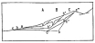
Fig. 199—Further stages in the development of cirques.
See p. 299 and 198 .
The meaning of this feature is represented in 199 , in which three
successive stages in cirque development are shown. In A, as displayed
in small valleys or mountainside alcoves which were but temporarily
occupied by snow and ice, or as in all higher valleys during the earlier
stages of the advancing hemicycle of glaciation, snow collects, a short
glacier forms, and a bergschrund develops. As a result of the
concentrated frost action at the base of the bergschrund a rapid
deepening and steepening takes place at a. As long as the depth of
snow (or snow and névé) is slight the bergschrund may remain open. But
its existence at this particular point is endangered as the cirque
grows, since the increasing steepness of the slope results in more rapid
snow movement. Greater depth of snow goes hand in hand with increasing
steepness and thus favors the formation of névé and even ice at the
bottom of the moving mass and a constantly accelerated rate of motion.
At the same time the bergschrund should appear higher up for an
independent reason, namely, that it tends to form between a mass of
slight movement and one of greater movement, which change of function,
as already pointed out, would appear to be controlled by change from
snow to névé or ice on the part of the bottom material.
The first stages in the upward migration of the bergschrund will not
effect a marked change from the original profile, since the converging
slopes, the great thickness of névé and ice at this point, and the steep
gradient all favor powerful erosion. When, however, stage C is
reached, and the bergschrund has retreated to c″, a broader terrace
results below the schrundline, the gradient is decreased, the ice and
névé (since they represent a constant discharge) are spread over a
greater area, hence are thinner, and we have the cirque taking on a
compound character with a lower, less steep and an upper, precipitous
section.
It is clear that a closely jointed and fragile rock might be quarried by
moving ice at c′-c″ and the cirque wall extended unbroken to x; it
is equally clear that a homogeneous, unjointed granite would offer no
opportunities for glacial plucking and would powerfully resist the much
slower process of abrasion. Thus Gilbert[64] observed the schrundline in
the granites of the Sierra Nevada, which are “in large part
structureless” and my own observations show the schrundline well
developed in the open-jointed granites of the Cordillera Vilcapampa and
wholly absent in the volcanoes of the Maritime Cordillera, where ashes
and cinders, the late products of volcanic action, form the easily
eroded walls of the steep cones. Somewhere between these extremes—lack
of a variety of observations prevents our saying where—the resistance
and the internal structure of the rock will just permit a cirque wall to
extend from x to c′ ″ of 199 .
A common feature of cirques that finds an explanation in the proposed
hypothesis is the notch that commonly occurs at some point where a
convergence of slopes above the main cirque wall concentrates snow
discharge. It is proposed to call this type the notched cirque. It is
highly significant that these notches are commonly marked by even
steeper descents at the point of discharge into the main cirque than the
remaining portion of the cirque wall, even when the discharge was from a
very small basin and in the form of snow or at the most névé. The excess
of discharge at a point on the basin rim ought to produce the form we
find there under the conditions of snow motion outlined in earlier
paragraphs. It is also noteworthy that it is at such a point of
concentrated discharge that crevasses no sooner open than they are
closed by the advancing snow masses. To my mind the whole action is
eminently representative of the action taking place elsewhere along the
cirque wall on a smaller scale.
What seems a good test of the explanation of cirques here proposed was
made in those localities in the Maritime Cordillera, where large
snowbanks but not glaciers affect the form of the catchment basins. A
typical case is shown in 201 . As in many other cases we have here a
great lava plateau broken frequently by volcanic cones of variable
composition. Some are of lava, others consist of ashes, still others of
tuff and lava and ashes. At lower elevations on the east, as at 16,000
feet between Antabamba and Huancarama, evidences of long and powerful
glaciers are both numerous and convincing. But as we rise still higher
the glaciated topography is buried progressively deeper under the
varying products of volcanic action, until finally at the summit of the
lava fields all evidences of glaciation disappear in the greater part of
the country between Huancarama and the main divide. Nevertheless, the
summit forms are in many cases as significantly altered as if they had
been molded by ice. Precipitous cirque walls surround a snow-filled
amphitheater, and the process of deepening goes forward under one’s
eyes. No moraines block the basin outlets, no U-shaped valleys lead
forward from them. We have here to do with post-glacial action pure and
simple, the volcanoes having been formed since the close of the
Pleistocene.
Likewise in the pass on the main divide, the perpetual snow has begun
the recessing of the very recent volcanoes bordering the pass. The
products of snow action, muds and sands up to very coarse gravel,
glaciated in texture with an intermingling of blocks up to six inches in
diameter in the steeper places, are collected into considerable masses
at the snowline, where they form broad sheets of waste so boggy as to be
impassable except by carefully selected routes. No ice action whatever
is visible below the snowline and the snow itself, though wet and
compact, is not underlain by ice. Yet the process of hollowing goes
forward visibly and in time will produce serrate forms. In neither case
is there the faintest sign of a bergschrund; the gradients seem so well
adjusted to the thickness and rate of movement of the snow from point to
point that the marginal crack found in many snowfields is absent.
The absence of bergschrunds is also noteworthy in many localities where
formerly glaciation took place. This is notoriously the case in the
summit zone of the Cordillera Vilcapampa, where the accumulating snows
of the steep cirque walls tumble down hundreds of feet to gather into
prodigious snowbanks or to form névé fields or glaciers. From the
converging walls the snowfalls keep up an intermittent bombardment of
the lower central snow masses. It is safe to say that if by magic a
bergschrund could be opened on the instant, it would be closed almost
immediately by the impetus supplied by the falling snow masses. The
explanation appears to be that the thicker snow and névé concentrated at
the bottom of the cirque results in a corresponding concentration of
action and effect; and cirque development goes on without reference to a
bergschrund. The chief attraction of the bergschrund hypothesis lies in
the concentration of action at the foot of the cirque wall. But in the
thickening of the snow far beyond the minimum thickness required for
motion at the base of the cirque wall and its change of function with
transformation into névé, we need invoke no other agent. If a
bergschrund forms, its action may take place at the foot of the cirque
wall or high up on the wall, and yet sapping at the foot of the wall
continue.
From which we conclude (1) that where frost action occurs at the bottom
of a bergschrund opening to the foot of the cirque wall it aids in the
retreat of the wall; (2) that a sapping action takes place at this point
whether or not a bergschrund exists and that bergschrund action is not a
necessary part of cirque formation; (3) that when a more or less
persistent bergschrund opens on the cirque wall above its foot it tends
to develop a schrundline with a marked terrace below it; (4) that
schrundlines are best developed in the mature stages of topographic
development in the glacial cycle; (5) that the varying rates of snow,
névé, and ice motion at a valley head are the persistent features to
which we must look for topographic variations; (6) that the hypothesis
here proposed is applicable to all cases whether they involve the
presence of snow or névé or ice or any combination of these, and whether
bergschrunds are present or not; and (7) at the same time affords a
reasonable explanation for such variations in forms as the compound
cirque with its schrundline and terrace, the unbroken cirque wall, the
notched cirque, and the recessed, snow-covered mountain slopes
unaffected by ice.
To prove that under similar conditions glacial erosion may be greater
than subaërial denudation quantitative terms must be sought. Only these
will carry conviction to the minds of many opponents of the theory that
ice is a vigorous agent of erosion. Gilbert first showed in the Sierra
Nevada that headwater glaciers eroded more rapidly than nonglacial
agents under comparable topographic and structural conditions.[65] Oddly
enough none of the supporters of opposing theories have replied to his
arguments; instead they have sought evidence from other regions to show
that ice cannot erode rock to an important degree. In this chapter
evidence from the Central Andes, obtained in 1907 and 1911, will be
given to show the correctness of Gilbert’s proposition.
The data will be more easily understood if Gilbert’s argument is first
outlined. On the lower slopes of the glaciated Sierra Nevada asymmetry
of form resulted from the presence of ice on one side of each ridge and
its absence on the other (Fig. 200). The glaciers of these lower ridges
were the feeblest in the entire region and were formed on slopes of
small extent; they were also short-lived, since they could have existed
only when glacial conditions had reached a maximum. Let the broken line
in the upper part of the figure represent the preglacial surface and
the solid line beneath it the present surface. It will not matter what
value we give the space between the two lines on the left to express
nonglacial erosion, since had there been no glaciers it would be the
same on both sides of the ridge. The feeble glacier occupying the
right-hand slope was able in a very brief period to erode a depression
far deeper than the normal agents of denudation were able to erode in a
much longer period, i.e., during all of interglacial and postglacial
time. Gilbert concludes: “The visible ice-made hollows, therefore,
represent the local excess of glacial over nonglacial conditions.”

Fig. 200—Diagrammatic cross-section of a ridge glaciated
on one side only; with hypothetical profile (broken line) of preglacial
surface. |
Fig. 201—Postglacial volcano recessed on shady southern
side by the process of nivation. Absolute elevation 18,000 feet (5,490
m.), latitude 14° S., Maritime Cordillera, Peru. |
In the Central Andes are many volcanic peaks and ridges formed since the
last glacial epoch and upon them a remarkable asymmetry has been
developed. Looking southward one may see a smoothly curved, snow-free,
northward-facing slope rising to a crest line which appears as regular
as the slope leading to it. Looking northward one may see by contrast
(Fig. 194) sharp ridges, whose lower crests are serrate, separated by
deeply recessed, snow-filled mountain hollows. Below this highly
dissected zone the slopes are smooth. The smooth slope represents the
work of water; the irregular slopes are the work of snow and ice. The
relation of the north and south slopes is diagrammatically shown in Fig.
201.
To demonstrate the erosive effects of snow and ice it must be shown: (1)
that the initial slopes of the volcanoes are of postglacial age; (2)
that the asymmetry is not structural; (3) that the snow-free slopes have
not had special protection, as through a more abundant plant cover, more
favorable soil texture, or otherwise.
Proof of the postglacial origin of the volcanoes studied in this
connection is afforded: (1) by the relation of the flows and the ash and
cinder beds about the bases of the cones to the glacial topography; (2)
by the complete absence of glacial phenomena below the present snowline.
Ascending a marginal valley (Fig. 202), one comes to its head, where two
tributaries, with hanging relations to the main valley, come down from a
maze of lesser valleys and irregular slopes. Glacial features of a
familiar sort are everywhere in evidence until we come to the valley
heads. Cirques, reversed grades, lakes, and striæ are on every hand. But
at altitudes above 17,200 feet, recent volcanic deposits have over large
areas entirely obscured the older glacial topography. The glacier which
occupied the valley of 202 was more than one-quarter of a mile
wide, the visible portion of its valley is now over six miles long, but
the extreme head of its left-hand tributary is so concealed by volcanic
material that the original length of the glacier cannot be determined.
It was at least ten miles long. From this point southward to the border
of the Maritime Cordillera no evidence of past glaciation was observed,
save at Solimana and Coropuna, where slight changes in the positions of
the glaciers have resulted in the development of terminal moraines a
little below the present limits of the ice.
From the wide distribution of glacial features along the northeastern
border of the Maritime Cordillera and the general absence of such
features in the higher country farther south, it is concluded that the
last stages of volcanic activity were completed in postglacial time. It
is equally certain, however, that the earlier and greater part of the
volcanic material was ejected before glaciation set in, as shown by the
great depth of the canyons (over 5,000 feet) cut into the lava flows, as
contrasted with the relatively slight filling of coarse material which
was accumulated on their floors in the glacial period and is now in
process of dissection. Physiographic studies throughout the Central
Andes demonstrate both the general distribution of this fill and its
glacial origin.
So recent are some of the smaller peaks set upon the lava plateau that
forms the greater part of the Maritime Cordillera, that the snows massed
on their shadier slopes have not yet effected any important topographic
changes. The symmetrical peaks of this class are in a few cases so very
recent that they are entirely uneroded. Lava flows and beds of tuff
appear to have originated but yesterday, and shallow lava-dammed lakes
retain their original shore relations. In a few places an older
topography, glacially modified, may still be seen showing through a
veneer of recent ash and cinder deposits, clear evidence that the
loftier parts of the lava plateau were glaciated before the last
volcanic eruption.
The asymmetry of the peaks and ridges in the Maritime Cordillera cannot
be ascribed to the manner of eruption, since the contrast in declivity
and form is persistently between northern and southern slopes. Strong
and persistent winds from a given direction undoubtedly influence the
form of volcanoes to at least a perceptible degree. In the case in hand
the ejectamenta are ashes, cinders, and the like, which are blown into
the air and have at least a small component of motion down the wind
during both their ascent and descent. The prevailing winds of the high
plateaus are, however, easterly and the strongest winds are from the
west and blow daily, generally in the late afternoon. Both wind
directions are at right angles to the line of asymmetry, and we must,
therefore, rule out the winds as a factor in effecting the slope
contrasts which these mountains display.
It remains to be seen what influence a covering of vegetation on the
northern slopes might have in protecting them from erosion. The northern
slopes in this latitude (14° S.) receive a much greater quantity of heat
than the southern slopes. Above 18,000 feet (5,490 m.) snow occurs on
the shady southern slopes, but is at least a thousand feet higher on the
northern slopes. It is therefore absent from the northern side of all
but the highest peaks. Thus vegetation on the northern slopes is not
limited by snow. Bunch grass—the characteristic ichu of the mountain
shepherds—scattered spears of smaller grasses, large ground mosses
called yareta, and lichens extend to the snowline. This vegetation,
however, is so scattered and thin above 17,500 feet (5,330 m.) that it
exercises no retarding influence on the run-off. Far more important is
the porous nature of the volcanic material, which allows the rainfall to
be absorbed rapidly and to appear in springs on the lower slopes, where
sheets of lava direct it to the surface.
The asymmetry of the north and south slopes is not, then, the result of
preglacial erosion, of structural conditions, or of special protection
of the northern slopes from erosion. It must be concluded, therefore,
that it is due to the only remaining factor—snow distribution. The
southern slopes are snow-clad, the northern are snow-free—in harmony
with the line of asymmetry. The distribution of the snow is due to the
contrasts between shade and sun temperatures, which find their best
expression in high altitudes and on single peaks of small extent.
Frankland’s observations with a black-bulb thermometer in vacuo show
an increase in shade and sun temperatures contrasts of over 40° between
sea level and an elevation of 10,000 feet. Violle’s experiments show an
increase of 26 per cent in the intensity of solar radiation between 200
feet and 16,000 feet elevation. Many other observations up to 16,000
feet show a rapid increase in the difference between sun and shade
temperatures with increasing elevation. In the region herein described
where the snowline is between 18,000 and 19,000 feet (5,490 to 5,790 m.)
these contrasts are still further heightened, especially since the
semi-arid climate and the consequent long duration of sunshine and low
relative humidity afford the fullest play to the contrasting forces. The
coefficient of absorption of radiant energy by water vapor is 1,900
times that of air, hence the lower the humidity the more the radiant
energy expended upon the exposed surface and the greater the sun and
shade contrasts. The effect of these temperature contrasts is seen in a
canting of the snowline on individual volcanoes amounting to 1,500 feet
in extreme instances. The average may be placed at 1,000 feet.
The minimum conditions of snow motion and the bearing of the conclusions
upon the formation of cirques have been described in the chapters
immediately preceding. It is concluded that snow moves upon 20° slopes
if the snow is at least forty feet deep, and that through its motion
under more favorable conditions of greater depth and gradient and the
indirect effects of border melting there is developed a hollow occupied
by the snow. Actual ice is not considered to be a necessary condition of
either movement or erosion. We may at once accept the conclusion that
the invariable association of the cirques and steepened profiles with
snowfields proves that snow is the predominant modifying agent.
An argument for glacial erosion based on profiles and steep cirque walls
in a volcanic region has peculiar appropriateness in view of the
well-known symmetrical form of the typical volcano. Instead of varied
forms in a region of complex structure long eroded before the appearance
of the ice, we have here simple forms which immediately after their
development were occupied by snow. Ever since their completion these
cones have been eroded by snow on one side and by water on the other.
If snow cannot move and if it protects the surface it covers, then this
surface should be uneroded. All such surfaces should stand higher than
the slopes on the opposite aspect eroded by water. But these assumptions
are contrary to fact. The slopes underneath the snow are deeply
recessed; so deeply eroded indeed, that they are bordered by steep
cliffs or cirque walls. The products of erosion also are to some extent
displayed about the border of the snow cover. In strong contrast the
snow-free slopes are so slightly modified that little of their original
symmetry is lost—only a few low hills and shallow valleys have been
formed.
The measure of the excess of snow erosion over water erosion is
therefore the difference between a northern or water-formed and a
southern or snow-formed profile, 200 . This difference is also shown
in 201 and from it and the restored initial profiles we conclude
that the rate of water erosion is to that of nivation as 1:3. This ratio
has been derived from numerous observations on cones so recently formed
that the interfluves without question are still intact.
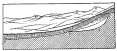
Fig. 202—Graphic representation of amount of glacial
erosion during the glacial period. In the background are mature slopes
surmounted by recessed asymmetrical peaks. The river entrenched itself
below the mature slopes before it began to aggrade, and, when
aggradation set in, had cut its valley floor to a′-b′-c. By aggradation
the valley floor was raised to a-b while ice occupied the valley head.
By degradation the river has again barely lowered its channel to a′-b′,
the ice has disappeared, and the depression of the profile represents
the amount of glacial erosion.
a′-b′-c = preglacial profile.
a-b-d-c = present profile.
b′-d-c-b = total ice erosion in the glacial period.
a-b = surface of an alluvial valley fill due to excessive erosion at valley head.
b-b′ = terminal moraine.
d-c = cirque wall.
e, e′ e″ = asymmetrical summits.
Thus far only those volcanoes have been considered which have been
modified by nivation. There are, however, many volcanoes which have been
eroded by ice as well as by snow and water. It will be seen at once that
where a great area of snow is tributary to a single valley, the snow
becomes compacted into névé and ice, and that it then erodes at a much
faster rate. Also a new force—plucking—is called into action when ice
is present, and this greatly accelerates the rate of erosion. While it
lies outside the limits of my subject to determine quantitatively the
ratio between water and ice action, it is worth pointing out that by
this method a ratio much in excess of 1:3 is determined, which even in
this rough form is of considerable interest in view of the arguments
based on the protecting influence of both ice and snow. I have, indeed,
avoided the question of ice erosion up to this point and limited myself
to those volcanoes which have been modified by nivation only, since the
result is more striking in view of the all but general absence of data
relating to this form of erosion.
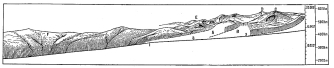
Fig. 203—A composite sketch to represent general
conditions in the Peruvian Andes. In order to have the actual facts
represented the profiles of this figure were taken from the accompanying
topographic sheets. The main depression on the right and the
corresponding depression of the tributary profiles bear out most
strikingly the conclusions concerning the erosive power of the ice. At
A and B the spurs have been cut off to exhibit the profiles of
tributary valleys. At 2 and 3 were tributary glaciers of such size
that they entered the main valley at grade. Lesser tributaries had
floors elevated above those they joined and now have a hanging
character, as just above 2. D is a matterhorn; C is deeply
recessed by cirques; E represents a peak just below the limit of
glaciation. At F are the undissected post-mature slopes of an earlier
cycle of erosion. G lies on the steep lower slopes formed during the
canyon cycle of erosion. The down-cutting of the stream in the canyon
cycle was generally checked by glaciation and was superseded by
aggradation.
If we now turn to the valley profiles of the glaciated portions of the
Peruvian Andes, we shall see the excess of ice over water erosion
expressed in a manner equally convincing. To a thoughtful person it is
one of the most remarkable features of any glaciated region that the
flattest profiles, the marshiest valley flats, and the most strongly
meandering stretches of the streams should occur near the heads of the
valleys. The mountain shepherds recognize this condition and drive
their flocks up from the warmer valley into the mountain recesses,
confident that both distance and elevation will be offset by the
extensive pastures of the finest ichu grass. Indeed, to be near the
grazing grounds of sheep and llamas which are their principal means of
subsistence, the Indians have built their huts at the extraordinarily
lofty elevations of 16,000 to 17,000 feet.
An examination of a large number of these valleys and the plotting of
their gradients discloses the striking fact that the heads of the
valleys were deeply sunk into the mountains. It is thus possible by
restoring the preglacial profiles to measure with considerable certainty
the excess of ice over water erosion.
The results are graphically expressed in 202 . It will be seen that
until glacial conditions intervened the stream was flowing on a rock
floor. During the whole of glacial time it was aggrading its rock floor
below b′ and forming a deep valley fill. A return to warmer and drier
conditions led to the dissection of the fill and this is now in
progress. The stream has not yet reached its preglacial profile, but it
has almost reached it. We may, therefore, say that the preglacial valley
profile below b′ fixes the position of the present profile just as
surely as if the stream had been magically halted in its work at the
beginning of the period of glaciation. There, b′-d-c-b represents the
amount of ice erosion. To be sure the line b-c is inference, but it is
reasonable inference and, whatever position is assigned to it, it cannot
be coincident with b′-d, nor can it be anywhere near it. The break in
the valley profile at b′ is always marked by a terminal moraine,
regardless of the character of the rock. This is not an accidental but a
causal association. It proves the power of the ice to erode. In glacial
times it eroded the quantity b-c-d-b′. This is not an excess of ice
over water erosion, but an absolute measure of ice erosion, since
a′-b′ has remained intact. The only possible error arises from the
position assigned b-c, and even if we lower it to b-c′ (for which we
have no warrant but extreme conservatism) we shall still have left
b′-c′-d-b as a striking value for rock erosion (plucking and abrasion)
by a valley glacier.
A larger diagram, 203 , represents in fuller detail the topographic
history of the Andes of southern Peru and the relative importance of
glaciation. The broad spurs with grass-covered tops that end in steep
scarps are in wonderful contrast to the serrate profiles and truncated
spurs that lie within the zone of past glaciation. In the one case we
have minute irregularities on a canyon wall of great dimensions; in the
other, more even walls that define a glacial trough with a flat floor.
Before glaciation on a larger scale had set in the right-hand section of
the diagram had a greater relief. It was a residual portion of the
mountain and therefore had greater height also. Glaciers formed upon it
in the Ice Age and glaciation intensified the contrast between it and
the left-hand section; not so much by intensifying the relief as by
diversifying the topographic forms.
By Kai Hendriksen, Topographer
The main part of the topographical outfit consisted of (1) a 4-inch
theodolite, Buff and Buff, the upper part detachable, (2) an 18 x 24
inch plane-table with Johnson tripod and micro-meteralidade. These
instruments were courteously loaned the expedition by the U. S. Coast
and Geodetic Survey and the U. S. Geological Survey respectively.
The method of survey planned was a combination of graphic triangulation
and traverse with the micro-meteralidade. All directions were plotted on
the plane-table which was oriented by backsight; distances were
determined by the micro-meteralidade or triangulation, or both combined;
and elevations were obtained by vertical angles. Finally, astronomical
observations, usually to the sun, were taken at intervals of about 60
miles for latitude and azimuth to check the triangulation. No
observations were made for differences in longitude because this would
probably not have given any reliable result, considering the time and
instruments at our disposal. Because the survey was to follow very
closely the seventy-third meridian west of Greenwich, directions and
distances, checked by latitude and azimuth observations, undoubtedly
afforded far better means of determining the longitude than time
observations. In other words, the time observations made in connection
with azimuth observations were not used for computing longitudinal
differences. Absolute longitude was taken from existing observations of
principal places.
Principal topographical points were located by from two to four
intersections from the triangulation and plane-table stations; and
elevations were determined by vertical angle measurements. Whenever
practicable, the contours were sketched in the field; the details of the
topography otherwise depend upon a great number of photographs taken by
Professor Bowman from critical stations or other points which it was
possible to locate on the maps.
Seven sheets. Scale, 1:125,000; contour interval, 200 feet. Datum is
mean sea level. Astronomical control: 5 latitude and 5 azimuth
observations as indicated on the accompanying topographic sheets.
On September 10th, returning from a reconnaissance survey of the
Pampaconas River, I joined Professor Bowman’s party, Dr. Erving acting
as my assistant. We crossed the Cordillera Vilcapampa and the Canyon of
the Apurimac and after a week’s rest at Abancay started the topographic
work near Hacienda San Gabriel south of Abancay. Working up the deep
valley of Lambrama, observations for latitude and azimuth were made
midway between Hacienda Matara and Caypi.
On October 4th we made our camp in newly fallen snow surrounded by
beautiful glacial scenery. The next day on the high plateau, we passed
sharp-crested glaciated peaks; a heavy thunder and hail storm broke out
while I occupied the station at the pass, the storm continuing all the
afternoon—a frequent occurrence. The camp was made 6 miles farther on,
and the next morning I returned to finish the latter station. I
succeeded in sketching the detailed topography just south of the pass,
but shortly after noon, a furious storm arose similar to the one the day
before, and made further topographic work impossible; to get connection
farther on I patiently kept my eye to the eye-piece for more than an
hour after the storm had started, and was fortunate to catch the station
ahead in a single glimpse. I had a similar experience some days later at
station 16,079, Antabamba Quadrangle, on the rim of the high-level puna,
the storm preventing all topographic work and barely allowing a single
moment in which to catch a dim sight of the signals ahead while I kept
my eye steadily at the telescope to be ready for a favorable break in
the heavy clouds and hail.
At Antabamba we got a new set of Indian carriers, who had orders to
accompany us to Cotahuasi, the next sub-prefectura. Raimondi’s map
indicates the distance between the two cities to be 35 miles, but
although nothing definite was stated, we found out in Antabamba that the
distance was considerably longer, and moreover that the entire route lay
at a high altitude.
From the second day out of Antabamba until Huaynacotas was in sight in
the Cotahuasi Canyon, a distance of 50 miles, the route lay at an
altitude of from 16,000 to 17,630 feet, taking in 5 successive camps at
an altitude from 15,500 to 17,000 feet; 12 successive stations had the
following altitudes:
| 16,379 | feet | |
| 16,852 | " | |
| 17,104 | " | |
| 17,559 | " | |
| 17,675 | " | —highest station occupied. |
| 17,608 | " | |
| 17,633 | " | |
| 16,305 | " | |
| 17,630 | " | |
| 17,128 | " | |
| 16,794 | " | |
| 16,260 | " | |
The occupation of these high stations necessitated a great deal of
climbing, doubly hard in this rarefied air, and often on volcanoes with
a surface consisting of bowlders and ash and in the face of violent
hailstorms that made extremely difficult the task of connecting up
observations at successive stations.
At Cotahuasi a new pack-train was organized, and on October 25th I
ventured to return alone to the high altitudes in order to continue the
topography at the station at 17,633 feet on the summit of the Maritime
Cordillera. Dr. Erving was obliged to leave on October 18th and
Professor Bowman left a week later in order to carry out his plans for a
physiographic study of the coast between Camaná and Mollendo. Philippi
Angulo, a native of Taurisma, a town above Cotahuasi, acted as majordomo
on this journey. Knowing the trail and the camp sites, I was able to
pick out the stations ahead myself, and made good progress, returning to
Cotahuasi on October 29th, three or four days earlier than planned. From
Cotahuasi to the coast I had the assistance of Mr. Watkins. The most
trying part of the last section of high altitude country was the great
Pampa Colorada, crowned by the snow-capped peaks of Solimana and
Coropuna, reaching heights of 20,730 and 21,703 feet respectively. The
passing of this pampa took seven days and we arrived at Chuquibamba on
November 9th. Two circumstances made the work on this stretch peculiarly
difficult—the scarcity of camping places and the high temperature in
the middle of the day, which heated the rarefied air to a degree that
made long-distance shots very strenuous work for the eyes. Although our
base signals were stone piles higher than a man, I was often forced to
keep my eye to the telescope for hours to catch a glimpse of the
signals; lack of time did not allow me to stop the telescope work in the
hottest part of the day.
The top of Coropuna was intersected from the four stations: 16,344,
15,545, 16,168, and 16,664 feet elevation, the intersections giving a
very small triangular error. The elevation of Mount Coropuna’s high peak
as computed from these 4 stations is:
| | 21,696 feet |
| 21,746 " |
| 21,714 " |
|
21,657 " |
| Mean elevation 21,703 feet above sea level. |
The elevation of Coropuna as derived from these four stations has thus a
mean error of 18 feet (method of least squares) while the elevation of
each of the four stations as carried up from mean sea level through 25
stations—vertical angles being observed in both directions—has an
estimated mean error of 30 feet. The result of this is a mean error of
35 feet in Coropuna’s elevation above mean sea level.
The latitude is 15° 31′ 00″ S.; the longitude is 72° 42′ 40″ W. of
Greenwich, the checking of these two determinations giving a result
unexpectedly close.
On November 11th azimuth and latitude observations were taken at
Chuquibamba and two days later we arrived at Aplao in the bottom of the
splendid Majes Valley. In the northern part of this valley I was
prevented from doing any plane-table work in the afternoons of four
successive days. A strong gale set in each noon raising a regular
sandstorm, that made seeing almost impossible, and blowing with such a
velocity that it was impossible to set up the plane-table.
From Hacienda Cantas to Camaná we had to pass the western desert for a
distance of 45 miles. We were told that on the entire distance there was
only one camping place. This was at Jaguey de Majes, where there was a
brook with just enough water for the animals but no fodder. Thus we
faced the necessity of carrying water for ten men and fodder for 14
animals in excess of the usual cargo; and we were unable to foretell how
many days the topography over the hot desert would require.
Although plane-table work in the desert was impossible at all except in
the earliest and latest hours of the day, we made regular progress. We
camped three nights at Jaguey and arrived on the fourth day at Las
Lomas.
The next morning, on November 23rd, at an elevation of 2178 feet near
the crest of the Coast Range, we were repaid for two months of laborious
work by a glorious view of the Pacific Ocean and of the city of Camaná
with her olive gardens in the midst of the desert sand.
The next day I observed latitude and azimuth at Camaná and in the night
my companion and assistant Mr. Watkins and I returned across the desert
to the railroad at Vitor.
The planned methods were followed very closely. In two cases only the
plane-table had to be oriented by the magnetic needle, the backsights
not being obtainable because of the impossibility of locating the last
station, passing Indians having removed the signals.
In one case only the distance between two stations had to be determined
by graphic triangulation exclusively, the base signals having been
destroyed. Otherwise graphic triangulation was used as a check on
distances.
Vertical angles were always measured in both directions with the
exception of the above-mentioned cases.
Observations for azimuth were always taken to the sun before and after
noon. The direction used in the azimuth observation was also taken with
the prismatic compass. The mean of the magnetic declination thus found
is: East 8° 30′ plus.
Observations for latitude were taken to the sun by the method of
circum-meridian altitudes, except at the town of Vilcabamba where star
observations were taken.
As a matter of course, observations to the sun are not so exact as star
observations, especially in low latitudes where one can expect to
observe the near zenith. However, working in high altitudes for long
periods, moving camp every day and often arriving at camp 2 to 4 hours
after sunset, I found it essential to have undisturbed rest at night. It
was beyond my capacity to spend an hour or two of the night in finding
the meridian and in making the observation. Furthermore, the astronomic
observations were to check the topography mainly, the latter being the
most exact method with the outfit at hand.
The following table contains the comparisons between the latitude
stations as located on the map and by observation:
| | Map | Observation |
| Camaná Quadrangle S | 16° 37′ 34″ | 16° 37′ 34″[66] |
| Coropuna, station 9,691S | 15° 48′ 30″ | (15° 51′ 44″) |
| Cotahuasi, " 12,588S | 15° 11′ 40″ | 15° 12′ 30″ |
| La Cumbre, " 16,852S | 14° 28′ 10″ | 14° 29′ 46″ |
| Lambrama, " 8,341S | 13° 43′ 18″ | 13° 43′ 14″ |
The other observations, with the exception of the one on the Coropuna
Quadrangle, check probably as well as can be expected with the small and
light outfit which we used, and under the exceptionally hard conditions
of work. The observation on the Coropuna Quadrangle just south of
Chuquibamba is, however, too much out. An explanation for this is that
the meridian zenith distance was 1° 23′ 12″ only (in this case the exact
formula was used in computing). Of course, an error or an accumulation
of errors might have been made in the distances taken by the
micrometer-alidade, but the first cause of error mentioned is the more
probable, and this is indicated also by the fact that the location on
the top of Mount Coropuna checks closely with the one determined in an
entirely independent way by the railroad engineers.
For the cross-section map from Abancay to Camaná, the following
statistics are desirable:
Micrometer traverse and graphic triangulation, with contours, field
scale 1:90,000.
| Total time required, days | 40.5 |
| Average distance per days in miles | 7.5 |
| Average number of plane-table stations occupied per day | 1.5 |
| Average area per day in square miles | 38. |
| Located points per square mile | 0.25 |
| Approximate elevations in excess of above, per square mile | 0.25 |
| Highest station occupied, feet above sea level | 17,675. |
| Highest point located, feet above sea level | 21,703. |
A few fossil collections were gathered in order that age determinations
might be made. With the following identifications I have included a few
fossils (I and II) collected by W. R. Rumbold and put into my hands in
1907. The Silurian is from a Bolivian locality south of La Paz but in
the great belt of shales, slates, and schists which forms one of the
oldest sedimentary series in the Eastern Andes of Peru as well as
Bolivia. While no fossils were found in this series in Peru the rocks
are provisionally referred to the Silurian. Fossil-bearing Carboniferous
overlies them but no other indication of their age was obtained save
their general position in the belt of schists already mentioned. I am
indebted to Professor Charles Schuchert of Yale University for the
following determinations.
San Roque Mine, southwest slope of Santa Vela Cruz, Canton Ichocu, Province
Inquisivi, Bolivia.
Sent by William R. Rumbold in 1907.
- Climacograptus?
- Pholidops trombetana Clarke?
- Chonetes striatellus (Dalman).
- Atrypa marginalis (Dalman)?
- Cœlospira n. sp.
- Ctenodonta, 2 or more species.
- Hyolithes.
- Klœdenia.
- Calymene?
- Dalmanites, a large species with a terminal tail spine.
- Acidaspis.
These fossils indicate unmistakably Silurian and probably Middle
Silurian. As all are from blue-black shales, brachiopods are the rarer
fossils, while bivalves and trilobites are the common forms. The faunal
aspect does not suggest relationship with that of Brazil as described by
J. M. Clarke and not at all with that of North America. I believe this
is the first time that Silurian fossils have been discovered in the high
Andes.
Near north end of Lake Titicaca.
- Leptocœlia flabellites (Conrad), very common.
- Atrypa reticularis (Linnæus)?
This is a part of the well-known and widely distributed Lower Devonian
fauna of the southern hemisphere.
All of the Upper Carboniferous lots of fossils represent the well-known
South American fauna first noted by d’Orbigny in 1842, and later added
to by Orville Derby. The time represented is the equivalent of the
Pennsylvanian of North America.
Huascatay between Pasaje and Huancarama.
- Crinoidal limestone.
- Trepostomata Bryozoa.
- Polypora. Common.
- Streptorhynchus hallianus Derby. Common.
- Chonetes glaber Geinitz. Rare.
- Productus humboldti d’Orb. Rare.
- " cora d’Orb. Rare.
- " chandlessii Derby.
- " sp. undet. Common.
- " sp. undet. "
- Spirifer condor d’Orb. Common.
- Hustedia mormoni (Marcou). Rare.
- Seminula argentea (Shepard). "
Pampaconas, Pampaconas valley near Vilcabamba.
- Lophophyllum?
- Rhombopora, etc.
- Productus.
- Camarophoria. Common.
- Spirifer condor d’Orb.
- Hustedia mormoni (Marcou).
- Euomphalus. Large form.
Pongo de Mainique. Extreme eastern edge of Peruvian Cordillera.
- Lophophyllum.
- Productus chandlessii Derby.
- " cora d’Orb.
- Orthotetes correanus (Derby).
- Spirifer condor d’Orb.
River bowlders and stones of Urubamba river, just beyond eastern edge of
Cordillera at mouth of Ticumpinea river. (Detached and transported by stream
action from the Upper Carboniferous at Pongo de Mainique.)
- Mostly Trepostomata Bryozoa.
- Many Productus spines.
- Productus cora d’Orb.
- Camarophoria. Same as at Pampaconas.
- Productus sp. undet.
Cotahuasi A.
- Lophophyllum.
- Productus peruvianus d’Orb.
- " sp. undet.
- Camarophoria.
- Pugnax near utah (Marcou).
- Seminula argentea (Shepard)?
Cotahuasi B.
- Productus cora d’Orb.
- " near semireticulatus (Martin).
Near Chuquibambilla.
- Pecten near quadricostatus Sowerby.
- Undet. bivalves and gastropods.
- The echinid Laganum? colombianum d’Orb. A clypeasterid.
This Lower Cretaceous locality is evidently of the same horizon as that
of Colombia illustrated by d’Orbigny in 1842 and described on pages
63-105.
A,
C,
E,
H,
J,
L,
M,
O,
P,
Q,
R,
S,
T,
U,
V,
Y
Abancay, town, lat. 12° 35′, Figs. 20, 204.
Abra Tocate, pass, between Yavero and Urubamba valleys, leaving latter at Rosalina, (Fig. 8).
See also Fig. 55.
Anta, town, lat. 13° 30′, Fig. 20.
Antabamba, town, lat. 14° 20′, Figs. 20, 204.
Aplao, town, lat. 16°, Figs. 20, 204.
Apurimac, river, Fig. 20.
Arequipa, town, lat. 16° 30′, Fig. 66.
Arica, town, northern Chile, lat. 18° 30′.
Arma, river, tributary of Apurimac, lat. 13° 25′, (Fig. 20);
tributary of Ocoña, lat. 15° 30′, (Fig. 20).
Arma, village, lat. 13° 15′, Fig. 20.
See also Fig. 140.
Auquibamba, hacienda, lat. 13° 40′, Fig. 204.
Callao, town, lat. 12°, Fig. 66.
Camaná, town, lat. 16° 40′, Figs. 20, 66, 204.
Camisea, river, tributary of Urubamba entering from right, lat. 11° 15′.
Camp 13, lat. 14° 30′.
Cantas, hacienda, lat. 16° 15′, Fig. 204.
Caraveli, town, lat. 16°, Fig. 66.
Catacaos, town, lat. 5° 30′, Fig. 66.
Caylloma, town and mines, lat. 15° 30′, Fig. 66.
Caypi, village, lat. 13° 45′.
Central Ranges, lat. 14°, Fig. 20.
See also Fig. 157.
Cerro Azul, town, lat. 13°, Fig. 66.
Chachani, mt., overlooking Arequipa, lat. 16° 30′, (Fig. 66).
Chaupimayu, river, tributary of Urubamba entering at Sahuayaco, q.v.
Chili, river, tributary of Vitor River, lat. 16° 30′, (Fig. 66).
Chinche, hacienda, Urubamba Valley above Santa Ana, lat. 13°, (Fig. 20).
Chira, river, lat. 5°, Fig. 66.
Choclococha, lake, lat. 13° 30′, Figs. 66, 68.
Choqquequirau, ruins, canyon of Apurimac above junction of Pachachaca River, lat. 13° 25′, (Fig. 20).
Choquetira, village, lat. 13° 20′, Fig. 20.
See also Fig. 136.
Chosica, village, lat. 12°, Fig. 66.
Chuquibamba, town, lat. 15° 50′, Figs. 20, 204.
Chuquibambilla, village, lat. 14°, Figs. 20, 204.
Chuquito, pass, Cordillera Vilcapampa between Arma and Vilcabamba valleys, lat. 13° 10′, (Fig. 20).
See also Fig. 139.
Coast Range, Figs. 66, 204.
Cochabamba, city, Bolivia, lat. 17° 20′, long. 66° 20′.
Colorada, pampa, lat. 15° 30′, Fig. 204.
Colpani, village, lower end of Canyon of Torontoy (Urubamba River), lat. 13° 10′. See Fig. 158.
Copacavana, village, Bolivia, lat. 16° 10′, long. 69° 10′.
Coribeni, river, lat. 12° 40′, Fig. 8.
Coropuna, mt., lat. 15° 30′, Figs. 20, 204.
Corralpata, village, Apurimac Valley near Incahuasi.
Cosos, village, lat. 16°, Fig. 204.
Cotabambas, town, Apurimac Valley, lat. 13° 45′, (Fig. 20).
Cotahuasi, town, lat. 15° 10′, Figs. 20, 204.
Cuzco, city, lat. 13° 30′, Fig. 20.
Echarati, hacienda, on the Urubamba River between Santa Ana and Rosalina, lat. 12° 40′.
See inset map, Fig. 8, and also Fig. 54.
Huadquiña, hacienda, Urubamba River above junction with Vilcabamba, lat. 13° 10′, (Fig. 20).
See also Fig. 158.
Huadquirca, village, lat. 14° 15′, Figs. 20, 204.
Huaipo, lake, north of Anta, lat. 13° 25′, (Fig. 20).
Huambo, village, left bank Pachachaca River between Huancarama and Pasaje, lat. 13° 35′, (Fig. 20).
Huancarama, town, lat. 13° 40′, Fig. 20.
Huancarqui, village, lat. 16° 5′, Fig. 204.
Huascatay, village, left bank of Apurimac above Pasaje, lat. 13° 30′, (Fig. 20).
Huaynacotas, village, lat. 15° 10′, Fig. 204.
Huichihua, village, lat. 14° 10′, Fig. 204.
(Tablazo de) Ica, plateau, lat. 14°-15° 30′, Fig. 66.
Ica, town, lat. 14°, Figs. 66, 67.
Incahuasi, village, lat. 13° 20′, Fig. 20.
Iquique, town, northern Chile, lat. 20° 15′.
(Pampa de) Islay, south of Vitor River, (Fig. 66).
Jaguey, village, Pampa de Sihuas, q.v.
La Joya, pampa, station on Mollendo-Puno R.R., 16° 40′, (Fig. 66).
Lambrama, village, lat. 12° 50′, Fig. 20.
Lima, city, lat. 12°, Fig. 66.
Machu Picchu, ruins, gorge of Torontoy, q.v., lat. 13° 10′.
Majes, river, Fig. 204.
Manugali, river, tributary of Urubamba entering from left above Puviriari River, lat. 12° 20′, (Fig. 8).
Maritime Cordillera, Fig. 204.
Matara, village, lat. 14° 20′, Fig. 204.
(El) Misti, mt., lat. 16° 30′, Fig. 66.
Mollendo, town, lat. 17°, Fig. 66.
Moquegua, town, lat. 17°, Fig. 66.
Morococha, mines, lat. 11° 45′, Fig. 66.
Mulanquiato, settlement, lat. 12° 10′, Fig. 8.
Occobamba, river, uniting with Yanatili, q.v.
Ocoña, river, lat. 15°-16° 30′, Figs. 20, 66.
Ollantaytambo, village. Urubamba River below Urubamba town, lat. 13° 15′, (Fig. 20), and see inset map, Fig. 8.
Pabellon, hacienda, Urubamba River above Rosalina, (Fig. 20).
See also Fig. 55.
Pacasmayo, town, lat. 7° 30′, Fig. 66.
Pachatusca (Pachatusun), mt., overlooking Cuzco to northeast, lat. 13° 30′.
Pachitea, river, tributary of Ucayali entering from left, lat. 8° 50′.
Paita, town, lat. 5°, Fig. 66.
Pampacolea, village, south of Coropuna, q.v.
Pampaconas, river, known in lower course as Cosireni, tributary of Urubamba River, (Fig. 8).
Source in Cordillera Vilcapampa west of Vilcabamba.
Pampas, river, tributary of Apurimac entering from left, lat. 13° 20′.
Panta, mt., Cordillera Vilcapampa, northwest of Arma, lat. 13° 15′, (Fig. 20).
See also Fig. 136.
Panticalla, pass, Urubamba Valley above Torontoy, lat. 13° 10′.
Pasaje, hacienda and ferry, lat. 13° 30′, Fig. 20.
Paucartambo (Yavero), river, q.v.
Paucartambo, town, head of Paucartambo (Yavero) River, lat. 13° 20′, long. 71° 40′. Inset map, Fig. 8.
Pichu-Pichu, mt., overlooking Arequipa, lat. 16°, (Fig. 66).
Pilcopata, river, tributary of Upper Madre de Dios east of Paucartambo, lat. 13°.
Piñi-piñi, river, tributary of Upper Madre de Dios east of Paucartambo, lat. 13°.
Pisco, town, lat. 14°, Fig. 66.
Piura, river, lat. 5°-6°, Fig. 66.
Piura, town, lat. 5° 30′, Fig. 66.
Pomareni, river, lat. 12°, Fig. 8.
Pongo de Mainique, rapids, lat. 12°, Fig. 8.
Pucamoco, hacienda, Urubamba River, between Santa Ana and Rosalina, (Fig. 20).
Puquiura, village, lat. 13° 5′, Fig. 20.
See also Fig. 158. Distinguish Puqura in Anta basin near Cuzco.
Puqura, village, Anta basin, east of Anta, lat. 13° 30′, (Fig. 20).
Quilca, town, lat. 16° 40′, Fig. 66.
Quillagua, village, northern Chile, lat. 21° 30′, long. 69° 35′.
Rosalina, settlement, lat. 12° 35′, Fig. 8.
See also Fig. 20.
Sahuayaco, hacienda, Urubamba Valley above Rosalina, (Fig. 20).
See also Fig. 55.
Salamanca, town, lat. 15° 30′, Fig. 20.
Salaverry, town, lat. 8°, Fig. 66.
Salcantay, mt., lat. 13° 20′, Fig. 20.
San Miguel, bridge, canyon of Torontoy near Machu Picchu, lat. 13° 10′.
Santa Ana, hacienda, lat. 12° 50′, Fig. 20.
Santa Ana, river, name applied to the Urubamba in the region about hacienda Santa Ana.
Santa Lucia, mines, lat. 16°, Fig. 66.
Santo Anato, hacienda, La Sama’s hut, 12° 35′, Fig. 8.
Sihuas, Pampa de, lat. 16° 30′, Fig. 204.
Sillilica, Cordillera, east of Iquique, northern Chile.
Sintulini, rapids of Urubamba River above junction of Pomareni, lat. 12° 10′, (Fig. 8).
Sirialo, river, lat. 12° 40′, Fig. 8.
Soiroccocha, mt., Cordillera Vilcapampa north of Arma, lat. 13° 15′, (Fig. 20).
Solimana, mt., lat. 15° 20′, Fig. 204.
Soray, mt., Cordillera Vilcapampa, southeast of Mt. Salcantay, lat. 13° 20′, (Fig. 20).
Sotospampa, village, near Lambrama, lat. 13° 50′, (Fig. 204).
Sullana, town, Chira River, lat. 5°, (Fig. 66).
Taurisma, village, lat. 15° 10′, Fig. 204.
Ticumpinea, river, tributary of Urubamba entering from right below Pongo de Mainique, lat. 11° 50′, (Fig. 8).
Timpia, river, tributary of Urubamba entering from right, lat. 11° 45′.
Tono, river, tributary of Upper Madre de Dios, east of Paucartambo, lat. 13°.
Torontoy, canyon of the Urubamba between the villages of Torontoy and Colpani, lat. 13° 10′-13° 15′.
Torontoy, village at the head of the canyon of the same name, lat. 13° 15′.
See inset map, Fig. 8.
Tumbez, town, lat. 4° 30′, Fig. 66.
Tunari, Cerro de, mt., northwest of Cochabamba, q.v.
Urubamba, river, Fig. 20.
Urubamba, town, lat. 13° 20′, Fig. 20.
Vilcabamba, river, tributary of Urubamba River entering from left above Santa Ana, lat. 13°, Fig. 8.
See also Fig. 158.
Vilcabamba, village, lat. 13° 5′, Fig. 20.
See also Fig. 158.
Vilcanota, Cordillera, southern Peru.
Vilcanota, river, name applied to Urubamba above lat. of Cuzco, 13° 30′, (Fig. 20).
Vilcapampa, Cordillera, lat. 13° 20′, Fig. 20.
Vilque, town, southern Peru, lat. 15° 50′, long. 70° 30′.
Vitor, pampa, lat. 16° 30′, Fig. 66.
Vitor, river, Fig. 66.
Yanahuara, pass, between Urubamba and Yanatili valleys, lat. 13° 10′.
Yanatili, river, tributary of Urubamba entering from right above Rosalina, (Fig. 20).
See also Fig. 65.
Yavero (Paucartambo), river, tributary of Urubamba entering from right, lat. 12° 10′, Fig. 8.
Yavero, settlement, at junction of Yavero and Urubamba rivers, lat. 12° 10′, Fig. 8.
Yunguyo, town, southern Peru, lat. 16° 20′, long. 69° 10′.
Yuyato, river, lat. 12° 5′, Fig. 8.
A,
B,
C,
D,
E,
F,
G,
H,
I,
J,
K,
L,
M,
N,
O,
P,
Q,
R,
S,
T,
U,
V,
W,
Y
Abancay, 32, 62, 64, 78, 92, 93, 181, 189, 221, 243;
suppressing a revolution, 89-91;
temperature curve (diagr.), opp. p. 180
Abancay basin, 154
Abancay to Camaná cross-section map, work, observation and statistics, 315
Abra Tocate, 73, 80, 81;
topography and vegetation from (ill.), opp. p. 19
Abra de Malaga, 276
Acosta, 205
Adams, G. I., 255
Agriculture, 74-76, 152
Aguardiente, 74. See Brandy
Alcohol, 5, 6
Alluvial fans, 60-63, 70, 270
Alluvial fill, 270-273;
view in Majes Valley (ill.), opp. p. 230
Alpacas, 5, 52
Alto de los Huesos (ill.), opp. p. 7
Amazon basin, Humboldt’s dream of conquest, 33-35;
Indian tribes, 36
Amazonia, 20, 26
Ancachs, 171
Andahuaylas, 89
Andrews, A, C., 295
Angulo, Philippi, 317
Anta, 187, 189, 190
Anta basin, 62, 108, 197;
geology, 250;
view looking north from hill near Anta (ill.), opp. p. 184
Antabamba, 52, 53, 95, 96, 99, 101, 189, 197, 243, 303, 316;
Governor, 95-99, 100-101;
Lieutenant Governor, 96-99, 101;
sketch section, 243
Antabamba Canyon, view across (ill.), opp. p. 106
Antabamba Quadrangle, 316, opp. p. 282 (topog. sheet)
Antabamba region, geologic sketch map and section, 245
Antabamba Valley, 96
“Antis,” 39
Aplao, 106, 115, 116, 181, 226, 231, 255, 256, 257, 273, 318;
composite structure section (diagr.), 259;
temperature curve (diagr.), 181
Aplao Quadrangle (topog. sheet), opp. p. 120
Appendix A, 315
Appendix B, 321
Appendix C, 324
Apurimac, 51, 57, 60, 94, 153, 154;
crossing at Pasaje (ills.), opp. p. 91;
regional diagram of canyoned country, 58
Apurimac Canyon, 189;
cloud belt (ill.), opp. p. 150
Arequipa, 52, 89, 92, 117, 120, 137, 284;
glacial features near (sketches), 280
Argentina, 93
Arica, 130, 132, 198
Arma, 67, 189, 212-214
Arrieros, Pampa de, 280
Asymmetrical peaks (ill.), opp. p. 281
Asymmetry, 305-313;
cross-section of ridge (diagr.), 306;
postglacial volcano (diagr.), 306
Auquibamba, 93
Avalanches, 290
Bailey, S. I., 284
Bandits, 95
Basins, 60, 154;
regional diagram, 61;
climatic cross-section (diagr.), 62
Batholith, Vilcapampa, 215-224
Belaunde brothers, 116
Bergschrunds, 294-305
Bingham, Hiram, ix, 104, 157
Block diagram of physiography of Andes, 186
Boatmen, Indian, 13
Bogotá, Cordillera of, 205
Bolivia, 93, 176, 190, 193, 195, 240, 241, 249, 322;
snowline, 275-277
Bolivian boundary, 68
Border valleys of the Eastern Andes, 68-87
Borneo, 206
Bowman, Isaiah, 8, 316
Brandy, 74, 75, 76, 82-83
Bravo, José, 245
Bumstead, A. H., ix
Cacao, 74, 83
Cacti, 150;
arboreal (ill.), opp. p. 90
Calchaquí Valley, 250
Callao, 118;
cloudiness (with diagr.), 133;
temperature (with diagr.), 126-129;
wind roses (diagrs.), 128
Camaná, 21, 112, 115, 116, 117, 118, 140-141, 147, 181, 225, 226, 227, 266, 318;
coastal Tertiary, 253, 254;
plain of, 229;
temperature curve (diagr.), 181
Camaná Quadrangle (topog. sheet), opp. p. 114
Camaná Valley, 257
Camaná-Vitor region, 117
Camino del Peñon, 110
Camisea, 36
Camp 13, 100, 180, 181;
temperature curve (diagr.), 180
Campas, 37
Canals for bringing water, 59, 60, 155;
projected, Maritime Cordillera (diagr.), 118
Cantas, 115, 116, 226, 253, 257, 273, 318
Canyon walls (ills.), opp. p. 218
Canyoned country, regional diagram, 58;
valley climates (diagr.), 59
Canyons, 60, 72, 73, 197, 219;
Majes River (ill.), opp. p. 230;
topographic conditions before formation of deep canyons in Maritime Cordillera (ill.), opp. p. 184
Caraveli, climate data, 134-136;
wind roses (diagrs.), 136
Carboniferous fossils, 323
Carboniferous strata, 241-247;
hypothetical distribution of land and sea (diagr.), 246
Cashibos, 37
Catacaos, 119
Cattle tracks (ill.), opp. p. 226
Caucho, 29
Caylloma, 164, 165
Caypi, 316
Central Ranges, asymmetrical peaks (ill.), opp. p. 281;
glacial features with lateral moraines (ill.), opp. p. 269;
glacial topography between Lambrama and Antabamba (ill.), opp. p. 280;
steep cirque walls (ill.), opp. p. 286
Cerro Azul, 118
Cerro de Tunari, 176
Chachani, 280, 284
Chanchamayo, 77
Character. See Human character
Chaupimayu Valley, 77
Chicha, 86
Chile, 130, 132, 193, 260
Chili River, 120
Chili Valley, opp. p. 7 (ill.), 117
Chimborazo, 281
Chinche, 271, 272
Chira River, depth diagram, 119, 120
Chirumbia, 12
Choclococha, Lake, 120
Chonta Campas, 37
Choqquequirau, 154
Choquetira, 66, 67, 211;
bowldery fill below, 269;
glacial features, 206-207
Choquetira Valley, moraine, (ill.), opp. p. 208
Chosica, 136, 137;
cloudiness (diagr.), 138
Chuño, 57
Chuntaguirus, 41
Chuquibamba, 54, 72, 107, 110, 111, 112, 115, 116, 273, 317-319;
sediments, 258
Chuquibambilla, 53, 189, 220, 221, 222, 236, 243;
alluvial fill (diagr.), 272;
Carboniferous, 244;
fossils, 323
Chuquito pass, crossing (ill.), opp. p. 7;
glacial trough (ill.), opp. p. 205
Cirque walls, steep (ill.), opp. p. 286
Cirques, 294-305;
development (diagr.), 300;
development, further stages (diagr.), 301;
mode of formation (diagr.), 297
Clarke, J. M., 321
Clearing in forest (ill.), opp. p. 25
Climate, coast, 125-147;
eastern border, 147-153;
Inter-Andean valleys, 153-155;
see also Meteorological records
Climatic belts, 121-122;
map, 123
Climatology, 121-156
Cliza, 276
Cloud-banners, 16
Cloud belt, 143, opp. p. 150 (ill.)
Cloudiness, 132;
Callao (with diagr.), 133;
desert station near Caraveli (diagrs.), 137;
Machu Picchu, 160;
Santa Lucia (diagr.), 169
Clouds, Inter-Andean Valley, 155;
Santa Ana (ill.), opp. p. 180;
Santa Lucia, 168;
types on eastern border of Andes (diagrs.), 148;
see also Fog
Coast Range, 111, 113, 114, 116, 118, 225-232;
climate, 122-147;
direction, 267;
diagram to show progressive lowering of saturation temperature in a desert, 127;
geology, 258;
view between Mollendo and Arequipa in June (ill.), opp. p. 226;
wet and dry seasons (diagrs.), 132
Coastal belt, map of irrigated and irrigable land, 113
Coastal desert, 110-120;
regional diagram of physical relations, 112;
see also Deserts
Coastal planter, 6
Coastal region, topographic and climatic provinces (diagr.), 125
Coastal terraces, 225-232
Coca, 74, 77, 82-83
Coca seed beds (ill.), opp. p. 74
Cochabamba, 93;
temperature (diagrs. of ranges), insert opp. p. 178;
weather data, 176-178
Cochabamba Indians, 276
Colombia, 205
Colorada, Pampa de, 114, 317
Colpani, 72, 215, 216, 222, 223;
from ice to sugar cane (ill.), opp. p. 3
Comanchian fossils, 323
Cómas, 155
Compañia Gomera de Mainique, 29, 31, 32
Concession plan, 29
Conibos, 44
Contador, 84-85
Copacavana, 176
Cordilleras, 4, 6, 20, 197
Coribeni, 15
Corn, 57, 59, 62
Coropuna, 109, 110, 112, 202, 253, 317, 319;
elevation, 317;
glaciation, 307;
snowline, 283-285
Coropuna expedition, 104
Coropuna Quadrangle, 197, opp. p. 188 (topog. sheet), 319
Corralpata, 51, 59
Cosos, 231
Cotabambas, 78
Cotahuasi, 4, 5, 52, 54, 60, 97, 101, 103, 104, 180, 197, 199, 316, 317;
alluvial fill, 272;
fossils, 322;
geologic sketch maps and cross-section, 247;
rug weaver (ill.), opp. p. 68;
snowline above, 282-283;
temperature curve (diagr.), 180;
view (ill.), opp. p. 57
Cotahuasi Canyon, 247, 248, 316
Cotahuasi Quadrangle (topog. sheet), opp. p. 192
Cotahuasi Valley, geology, 258
Cotton, 76, 116, 117
Crest lines, asymmetrical, 305-313
Cretaceous formations, 247-251
Cretaceous fossils, 323
Crucero Alto, 188
Cuzco, 8, 10, 21, 52, 62, 63, 92, 102, 107, 193, 197;
railroad to Santa Ana, 69-70;
snow, 276;
view (ill.), opp. p. 66
Cuzco basin, 61, 62, 154, 251;
slopes at outlet (diagr.), 185
Deformations. See Intrusions
Derby, Orville, 322
Desaguadero Valley, 193
Deserts, cloudiness (diagrs.), 137;
rain, 138-140;
sea-breeze in, 132;
tropical forest, 36-37;
wind roses (diagrs.), 136
Diagrams. See Regional diagrams
Dikes, 223
Drunkenness, 103, 105-106, 108
Dry valleys, 114-115
Dunes, 114, 254;
Majes Valley, 262-267;
movement, 132;
superimposed (diagrs.), 265
Duque, Señor, 78
Eastern Andes, 204-224;
regional diagram, 22
Eastern border, climate, 147-153
Eastern valley planter, 3
Eastern valleys, 68-87;
climate cross-section (diagr.), 79
Echarati, 10, 77, 78, 80, 82;
plantation scene (ill.), opp. p. 75
Ecuador volcanoes, 281
Epiphyte (ill.), opp. p. 78
Erdis, E. C., 158
Erosion, 192-195, 210, 211, 305;
see also Glacial erosion; Nivation
Erving, Dr. W. G., 13, 101, 316, 317
Faena Indians, 75, 83-87
Feasts and fairs, 175-176
Ferries, 147
Fig tree (ill.), opp. p. 75
Floods, 151
Fog, 132, 139, 143;
conditions along coast from Camaná to Mollendo, 144-145;
see also Clouds
Forest dweller, 1
Forest Indians. See Machigangas
Forests, clearing (ill.), opp. p. 25;
dense ground cover, trees, epiphytes, and parasites (ill.), opp. p. 155;
moss-draped trees (ill.), opp. p. 24;
mountain, 148-153;
mule trail (ill.), opp. p. 18;
tropical, near Pabellon (ill.), opp. p. 150;
tropical vegetation (ill.), opp. p. 18;
type at Sahuayaco (ill.), opp. p. 90
Fossils, 245, 321;
list of, by geologic periods and localities, 321
Frankland, 278, 309
Frost line, 56-57
Garua, 132
Geographical basis of revolutions and of human character, 88-109
Geologic dates, 195-196;
Majes Valley, 258, 261;
west coast fault, 248-249
Geologic development. See Physiographic and geologic development
Gilbert, G. K., 300, 302, 305
Glacial deposits, 268
Glacial erosion, Central Andes, 305-313;
composite sketch of general conditions, 312;
graphic representation of amount during glacial period, 311
Glacial features, 274-313;
Arequipa (sketches), 280;
Central Ranges; lateral moraines (ill.), opp. p. 269;
eastern slopes of Cordillera Vilcapampa (map), 210
Glacial retreat, 208-214
Glacial sculpture, heart of the Cordillera Vilcapampa (map), 212;
southwestern flank of Cordillera Vilcapampa (map), 207
Glacial topography between Lambrama and Antabamba (ill.), opp. p. 280;
Maritime Cordillera, north of divide on 73d meridian (ill.), opp. p. 281
Glacial trough, view near Chuquito pass (ill.), opp. p. 208
Glaciation, 64, 271;
Sierra Nevada, 305;
Vilcapampa, 204-214;
Western Andes, 202
Glaciers, Panta Mountain (ill.), opp. p. 287;
view (ill.), opp. p. 205
Gomara, 34
Gonzales, Señor, 78
Government, bad, 95
Gran Pajonal, 37
Granite, 215-224;
see also Intrusions
Grass (ill.), opp. p. 154
Gregory, J. W., 205
Hacendado, 55, 60
Haciendas, 78, 83, 86
Hann, J., 126, 176, 278
Hendriksen, Kai, 98, 315
Hettner, 205
Hevea, 29
Highest habitations in the world, 52, 96;
regional diagram of, 50;
stone hut (ill.), opp. p. 48
Highland shepherd, 4
Highlands, 46
Hobbs, W. H., 286, 287
Horses, 66, opp. p. 91 (ill.)
Huadquiña, 70, 71, 72, 75, 82, 86, 219;
hacienda (ill.), opp. p. 73;
terraces, 272
Huadquirca, 243
Huaipo, Lake, 250, 251
Huallaga basin, 153
Huambo, 243
Huancarama, 64, 87, 189, 243, 303;
view (ill.), opp. p. 106
Huancarqui, 257
Huari, 176
Huascatay, 189, 242, 243;
Carboniferous, 244;
fossils, 322
Huasco basin, 275
Huaynacotas, 103, 316;
terraced valley slope (ill.), opp. p. 56;
terraced valley slopes (ill.), opp. p. 199
Huichihua, 278; alluvial fill (diagr.), 272;
(ill.), opp. p. 67
Human character, geographic basis, 88-109
Humboldt, 33-35, 286
Humboldt Current, 126, 143
Huts, 103;
highest in Peru (ill.), opp. p. 48;
shepherds’, 47, 48, 52, 55
Ica Valley, 120;
irrigated and irrigable land (diagr.), 118
Ice erosion. See Glacial erosion
Incahuasi, 51, 155, 285
Incas, 39, 44, 46, 62, 63, 68, 77, 109, 175
Incharate, 78
Indian boatmen, 13
Indians, as laborers, 26-28, 31-32;
basin type, 63-64;
forest, see Machigangas;
life and tastes, 107-108;
mountain, 46-67, 101-102;
plateau, 40-41, 44-45, 100, 106-109;
troops, 90, 91;
wrongs, 14, 102
Ingomwimbi, 206
Instruments, surveying, 315
Inter-Andean valleys, climate, 153-155
Intermont basin. See Basins
Intrusions, deformations north of Lambrama (diagr.), 243;
deformative effects on limestone strata near Chuquibambilla (diagr.), 221;
lower Urubamba Valley (geologic sketch map), 237;
overthrust folds in detail near Chuquibambilla (diagr.), 222;
principles, 217-219
Intrusions, Vilcapampa, deformative effects near Puquiura (diagr.), 216;
relation of granite to schist near Colpani (with diagr.), 216
Iquique, wind roses (diagrs.), 131
Irrigation, 72, 76, 80, 82;
coastal belt (map), 113;
coastal desert, 119-120;
Ica Valley (diagr.), 118
Islay, Pampa de, 114
Italians, 18, 81
Jaguey, 254, 255, 318
Jesuits, 68
Johnson, W. D., 213, 295, 296, 299, 300
Kenia, Mt., 206, 274
Kerbey, Major, 8, 10
Kibo, 206, 274
Kilimandjaro, 205, 206
Kinibalu, 206
Krüger, Herr, 157
Labor, 26-28, 31-32, 42-43, 74-75, 83-84
La Cumbre Quadrangle, 197, 202, opp. p. 202 (topog. sheet)
La Joya, 132, 133;
cloudiness (diagr.), 134;
temperature curves (diagr.), 134;
wind roses (diagrs.), 135
Lambrama, 90, 92, 285, 316;
camp near (ill.), opp. p. 6
Lambrama Quadrangle (topog. sheet), opp. p. 304
Lambrama Valley, deformation types (diagr.), 243
Land and sea, Carboniferous hypothetical distribution compared with present (diagr.), 246
Landscape, 183-198
Lanius, P. B., 13
La Paz, 93, 109, 276, 321
La Sama, 12, 13, 40
Las Lomas, 318
Lava flows, 199
Lava plateau, 197, 199, 307-308;
regional diagram of physical conditions, 55;
summit above Cotahuasi (ill.), opp. p. 204
Lavas, volume, 201
Lima, 92, 93, 118, 137, 138;
cloud, 132, 143;
temperature, 126
Limestone, sketch to show deformed, 243
Little, J. P., 135, 157
Llica, 275
Lower Cretaceous fossils, 323
Lower Devonian fossils, 321
Machigangas, 10, 11, 12, 14, 18, 19, 31, 36-45, 81;
ornaments and fabrics (ill.), opp. p. 27;
trading with (ill.), opp. p. 26
Machu Picchu, 72, 220;
weather data (with diagr.), 158-160
Madeira-Mamoré railroad, 33
Madre de Dios, 1, 2, 33
Majes River, 147, 225, 227, 266, 267;
Canyon (ill.), opp. p. 230
Majes Valley, 106, 111, 116, 117, 120, 226, 227, 229-231, 318;
alluvial fill, 273;
date of formation, 258, 261;
desert coast (ill.), opp. p. 110;
dunes, 262-267;
erosion and uplift, 261;
lower and upper sandstones (ill.), opp. p. 250;
sediments, 255;
snowline, 283;
steep walls and alluvial fill (ill.), opp. p. 230;
structural details near Aplao (sketch section), 255;
structural details on south wall near Cantas (sketch section), 257;
structural relations at Aplao (field sketch), 256;
Tertiary deposits, 253-254;
wind, 130;
view below Cantas (ill.), opp. p. 110;
view down canyon (ill.), opp. p. 144
Malaria, 14, 38
Marañon, 41, 59
Marcoy, 79
Marine terrace at Mollendo (ill.), opp. p. 226
Maritime Cordillera, 52, 199-203, 233;
asymmetry of ridges, 308-309;
glacial features, 307;
glacial topography north of divide on 73d meridian (ill.), opp. p. 281;
pre-volcanic topography, 200;
post-glacial volcano, asymmetrical (diagr.), 306;
regional diagrams, 50, 52;
test of explanation of cirques, 303;
volcanoes, tuffs, lava flows (ill.), opp. p. 204;
western border rocks (geologic section), 257;
see also Lava plateau
Matara, 99, 316
Matthes, F. E., 286, 287, 289
Mature slopes, 185-193; between Ollantaytambo and Urubamba (ill.), opp. p. 185;
dissected, north of Anta (ill.), opp. p. 185
Mawenzi, 206
Meanders, 16, 17
Médanos, 114
Mendoza, Padre, 11
Mer de Glace, 203
Meteorological records, 157-181
Mexican revolutions, 93
Middendorf, 143
Miller, General, 41, 78, 147
Minchin, 241
Misti, El, opp. p. 7 (ill.), 284
Molina, Christoval de, 175
Mollendo, 93, 105, 117;
cloud belt, 143;
cloudiness (diagr.), 134;
coastal terraces, 225;
humidity, 133;
marine terrace (ill.), opp. p. 226;
profile of coastal terraces (diagr.), 227;
temperature curves (diagr.), 134;
wind roses (diagrs.), 129
Mollendo-Arequipa railroad, 117
Mollendo rubber, 32
Montaña, 148, 149, 153
Moquegua, 117;
geologic relations (diagr.), 255
Moraines, 207, 210-211;
Choquetira Valley (ill.), opp. p. 208;
view (ill.), opp. p. 208
Morales, Señor, 11
Morococha, temperature (diagrs. of ranges), insert opp. p. 172;
weather data (with diagrs.), 171-176
Morococha Mining Co., 157, 171
Morro de Arica, 132
Moss, large ground. See Yareta
Moss-draped trees (ill.), opp. p. 24
Mountain-side trail (ill.), opp. p. 78
Mountains, tropical, as climate registers, 206
Mulanquiato, 10, 18, 19
Mule trail (ill.), opp. p. 18
Mules, 23, 24, 94, opp. p. 91 (ill.)
Névé, 286-305
Niño, El, 137-138
Nivation, 285-294;
“pocked” surface (ill.), opp. p. 286
Northeastern border, topographic and structural section (diagr.), 241
Occobamba Valley, 79
Ocean currents of adjacent waters, 121-122 (map), 123
Ollantaytambo, 70, 73, 75, 250, 271;
terraced valley floor (ill.), opp. p. 56
d’Orbigny, 322
Oruro, 93
Pabellon, 80, 82, opp. p. 150
Pacasmayo, Carboniferous land plants, 245
Pachitea, 37, 38
Pacific Ocean basin, 248
Paleozoic strata (ill.), opp. p. 198
Palma carmona, 29
Palmer, H. S., 250
Paltaybamba, opp. p. 74
Pampacolca, 109
Pampaconas, 69, 211, 213, 215;
rounded slopes near Vilcabamba (ill.), opp. p. 72;
Carboniferous, 244;
fossils, 322;
snow action, 291
Pampaconas River, 316
Pampas, 114, 198;
climate data, 134-136
Pampas, river, 189
Panta, mt., 214;
view, with glacier system (ill.), opp. p. 287
Pará rubber, 32
Pasaje, 51, 57, 59, 60, 236, 238, 240, 241, 243;
Carboniferous, 244;
crossing the Apurimac (ills.), opp. p. 91
Paschinger, 274
Pastures, 141, 187;
Alpine (ill.), opp. p. 58
Paucartambo, 42, 77
Paucartambo River. See Yavero River
Payta, 225
Penck, A., 205
Peonage, 25, 27, 28
Pereira, Señor, 10, 18
Perene, 155
Physiographic and geologic development, 233-273
Physiographic evidence, value, 193-195
Physiographic principles, 217
Physiography, 183-186;
Southern Peru, summary, 197-198
Pichu-Pichu, 284
Piedmont accumulations, 260
Pilcopata, 36
Piñi-piñi, 36
Pisco, 130;
Carboniferous land plants, 247
Piura, 119
Piura River, depth diagram, 119, 120
Piura Valley, 48
Place names, key to, 324
Plantations, 86;
see also Haciendas
Planter, coastal, 6
Planters, valley, 3, 75, 76
Plateau Indians, 40-41, 44-45, 100, 106-109
Plateaus, 196-197
Pleistocene deposits, 267-273
Pomareni, 19
Pongo de Mainique, 8, 9, 11, 15-20, 40, 71, 179, 239, 241, 242, 273;
canoe in rapid above (ill.), opp. p. 11;
Carboniferous, 244;
dugout in rapids below (ill.), opp. p. 2;
fossils, 322;
temperature curve (diagr.), 178;
upper entrance (ill.), opp. p. 10;
vegetation, clearing, and rubber station (ill.), opp. p. 2
Poopó, 195
Potato field (ill.), opp p. 67
Potatoes, 57, 59, 62
Potosí, 249
Precipitation. See Rain
Profiles, composition of slopes and profiles (diagr.), 191
Pucamoco, 78
Pucapacures, 42
Puerto Mainique, 29, 30
Punas, 6, 197
Puquiura, 67, 87, 211, 216, 236, 238, 239, 243, 277;
Carboniferous, 244;
composition of slopes (ill.), opp. p. 198
Puqura, 250
Quebradas, 145, 155
Quechuas, 44, 45, 77, 83
Quenigo, 285
Quilca, 105, 117, 226, 266
Quillabamba, opp. p. 74
Quillagua, 260
Railroads, 74, 75, 76, 93, 101-102, 149;
Bolivia, 93;
Cuzco to Santa Ana, 69-70
Raimondi, 77, 78, 109, 110, 135, 155, 170, 316
Rain, 115, 119, 120, 122, 124-125;
coast region seasonal variation, 131-137;
eastern border of Andes, belts (diagrs.), 148;
effect of heavy, 138-140;
effect of sea-breeze, 131-132;
heaviest, 147-148;
Morococha (with diagrs.), 173-176;
periodic variations, 137;
Santa Lucia (with diagrs.), 164-166;
unequal distribution in western Peru, 145-147
Regional diagrams, 50;
index map, 23;
note on, 51
Regions of Peru, 1, 7
Reiss, 205, 208
Revolutions, geographic basis, 88-109
Rhone glacier, 205
Rice, 76
Robledo, L. M., 9, 30, opp. p. 78
Rock belts, outline sketch along 73d meridian, 235
Rocks, Maritime Cordillera, pampas and Coast Range structural relations (sketch section), 254;
Maritime Cordillera, western border (geologic section), 257;
Moquegua, structural relations (diagr.), 255;
Urubamba Valley, succession (diagr.), 249
Rosalina, 8, 9, 10, 11, 37, 42, 71, 73, 80, 82, 153, 237
Rubber, 18;
price, 32, 33
Rubber forests, 22-35
Rubber gatherers, Italian, 18, 81
Rubber plant (ill.), opp. p. 75
Rubber trees, 152
Rueda, José, 78
Rug weaver (ill.), opp. p. 68
Rumbold, W. R., 321
Russell, I. C., 205
Ruwenzori, 206, 274
Sacramento, Pampa del, 37
Sahuayaco, 77, 78, 80, 83, 179;
forests (ills.), opp. p. 90;
temperature curve (diagr.), 178
Salamanca, 54, 56, 105, 106, 180, 181;
forest, 285;
temperature curve (diagr.), 180;
terraced hill slopes (ill.), opp. p. 58;
view (ill.), opp. p. 107
Salaverry, 119
Salcantay, 64, 72, opp. p. 3 (ill.)
San Geronimo, 276
Sand. See Dunes
“Sandy matico” (ill.), opp. p. 90
San Gabriel, Hacienda, 316
Santa Ana, 69, 72, 78, 79, 80, 82, 93, 153, 179, 237;
clouds (ill.), opp. p. 180;
temperature curve (diagr.), 178
Santa Ana Valley, 10, 82
Santa Lucia, temperature ranges (diagrs.), insert opp. p. 162;
unusual weather conditions, 169-170;
weather data (with diagrs.), 161-171
Santo Anato, 40, 42, 82, 179;
temperature curve (diagr.), 178
Schists and Silurian slates, 236-241
Schrund. See Bergschrunds
Schrundline, 300-305
Schuchert, Chas., 321
Sea and land. See Land and sea
Sea-breeze, 129-132
Shepherd, highland, 4
Shepherds, country of, 46-67
Shirineiri, 36, 38
Sierra Nevada, 305
Sierra Nevada de Santa Marta, 205
Sievers, W., 143, 176, 205, 263
Sihuas, Pampa de, 114, 198
Sillilica, Cordillera, 190, 260
Sillilica Pass, 275
Silurian fossils, 321
Silurian slates, 236-241
Sintulini rapids, 19
Sirialo, 8, 15
Slave raiders, 14
Slavery, 24, 25
Slopes, composition at Puquiura (ill.), opp. p. 198;
composition of slopes and profiles (diagr.), 191;
smooth grassy (ill.), opp. p. 79;
see also Mature slopes
Smallpox, 14, 38
Snow, 212;
drifting, 278;
fields on summit of Cordillera Vilcapampa (ill.), opp. p. 268
Snow erosion. See Nivation
Snow motion, curve of (diagr.), 293;
law of variation, 291
Snowline, 52, 53, 66, 122, 148, 203, 205-206, 274-285;
canting (with diagr.), 279;
determination, 282;
difference in degree of canting (diagr.), 281;
glacial period, 282;
view of canted, Cordillera Vilcapampa (ill.), opp. p. 280
Snowstorm, 170
Soiroccocha, 64, 72, 214;
view (ill.), opp. p. 154
Solimana, 4, 202, 317;
glaciation, 307
Soray, 64
Sotospampa, 243
South Pacific Ocean, 125
Spanish Conquest, 62, 63, 77
Spruce (botanist), 153
Steinmann, 249, 276
Streams, Coast Range, 145-147;
physiography, 192;
see also Water
Structure. See Rocks
Stübel, 209
Sucre, 93
Sugar, 73, 74, 75, 76, 82-83, 92
Sullana, 119
Survey methods employed in topographic sheets, 315
Tablazo de Ica, 198
Tarai. See Urubamba Valley
Tarapacá, Desert of, 260
Tarapoto, 153
Taurisma, 317;
geologic sketch map and cross-section, 248
Taylor, Capt. A., 126, 128
Temperature, Abancay curve (diagr.), opp. p. 180;
Callao (with diagr.), 126-129;
Cochabamba, 176-178;
Cochabamba (diagrs. of ranges), insert opp. p. 178;
curves at various points along 73d meridian, 178-181;
La Joya curves (diagr.), 134;
Mollendo curves (diagr.), 134;
Morococha, 171-173;
Morococha (diagrs. of ranges), insert opp. p. 172;
progressive lowering of saturation, in a desert (diagr.), 127;
Santa Lucia, 161-164;
Santa Lucia (diagrs. of ranges), insert opp. p. 162
Tempests, 169-170
Terraces, coastal, 225-232;
physical history and physiographic development (with diagrs.), 228-230;
profile at Mollendo (diagr.), 227
Terraces, hill slopes (ill.), opp. p. 58
Terraces, marine (ill.), opp. p. 226
Terraces, valley (ills.), opp. p. 56, opp. p. 57, opp. p. 66;
Huaynacotas (ill.), opp. p. 199
Terral, 130
Tertiary deposits, 249, 251-267;
coastal, 253
Ticumpinea, 36, 38, 251
Tierra blanca, 254, 266
Timber line, 69, 71, 79, 148
Timpia, 36, 38, 252;
canoe at mouth (ill.), opp. p. 19
Titicaca, 161, 176, 195, 321
Titicaca basin, 107
Titicaca-Poopó basin, 251
Tocate. See Abra Tocate
Tola bush (ill.), opp. p. 6
Tono, 36
Topographic and climatic cross-section (diagr.), opp. p. 144
Topographic and structural section of northeastern border of Andes (diagr.), 241
Topographic map of the Andes between Abancay and the Pacific Coast at Camaná, insert opp. p. 312
Topographic profiles across typical valleys (diagrs.), 189
Topographic regions, 121-122;
map, 123
Topographic sheets, survey method employed, 315;
list of, with page references, xi
Topographical outfit, 315
Torontoy, 10, 70, 71, 72, 82, 158, 220
Torontoy Canyon, 272, opp. p. 3 (ill.);
cliff (ill.), opp. p. 10
Trail (mountain-side) (ill.), opp. p. 78
Transportation, 73-74, 93, 152;
rains and, 142
Trees, 150;
see also Forests
Tucapelle (ship), 117
Tucker, H. L., ix
Tumbez, 119
Tunari peaks, 276
Ucayali, 42, 44
Uplift, recent, 190
Upper Carboniferous fossils, 322
Urubamba, 1, 41, 42, 62, 187;
village, 70, 73
Urubamba River, 72;
fossils, 322;
physiographic observations, 252-253;
rapids and canyons, 8-21;
shelter hut (ill.), opp. p. 11
Urubamba Valley, 72, 153, 238;
alluvial fans, 270;
alluvial fill, 272-273;
below Paltaybamba (ill.), opp. p. 74;
canyon walls (ill.), opp. p. 218;
dissected alluvial fans (sketch), 271;
floor from Tarai (ill.), opp. p. 70;
from ice to sugar cane (ill.), opp. p. 3;
geologic sketch map of the lower, 237;
line of unconformity of geologic structure (ill.), opp. p. 250;
rocks, 250;
rocks, succession (diagr.), 249;
sketch map, 9;
slopes and alluvial deposits between Ollantaytambo and Torontoy (ill.), opp. p. 269;
temperature curves (diagrs.), 178-179;
terraced valley slopes and floor (ill.), opp. p. 66;
vegetation, distribution (ill.), opp. p. 79;
view below Santa Ana (ill.), opp. p. 155;
wheat and bread, 71
Valdivia, Señor, 161
Vallenar, 49
Valley climates in canyoned region (diagr.), 59
Valley planters. See Planters
Valley profiles, abnormal, 305-313
Valleys, eastern;
see Border valleys of the Eastern Andes;
see also Dry valleys, Inter-Andean valleys;
topographic profiles across, typical in Southern Peru (diagrs.), 189
Vegetation, 141;
belts (map), 123;
distribution in Urubamba Valley (ill.), opp. p. 79;
shrubbery, mixed with grass (ill.), opp. p. 154;
Tocate pass (ill.), opp. p. 19;
see also Forests
Vicuña, 54
Vilcabamba, 66;
rounded slopes (ill.), opp. p. 72
Vilcabamba pueblo, 211, 277, 296
Vilcabamba Valley, 189
Vilcanota knot, 276
Vilcanota Valley, alluvial fill, 272
Vilcapampa, Cordillera, 15, 16, 22, 51, 53, 64, 66, 67, 197, 204-224, 233;
batholith and topographic effects, 215-224;
canted snowline (ill.), opp. p. 280;
climatic barrier, 73;
composite geologic section (diagr.), 215;
glacial features, 204-214;
glaciers, 304;
highest pass, crossing (ill.), opp. p. 7;
regional diagram, 65;
regional diagram of the eastern aspect, 68;
schrundline, 302;
snow movement, 287-289;
snow fields on summit (ill.), opp. p. 268;
snow peaks (ill.), opp. p. 72;
snowline, 277, 279;
southwestern aspect (ill.), opp. p. 205;
summit view (ill.), opp. p. 205
Vilcapampa Province, 77
Vilcapampa Valley, bowldery fill, 269
Vilque, 176
Violle, 309
Virazon, 130
Vitor, Pampa de, 114, 318
Vitor River, 92, 117, 226, 266, 267
Volcanic country, 199
Volcanic flows, geologic sketch, 244
Volcanoes, glacial erosion, 311;
post-glacial, 306-307;
recessed southern slopes (ill.), opp. p. 287;
snowline, 281;
typical form, 310;
views (ills.), opp. p. 204
Von Boeck, 176
Vulcanism, 199;
see also Volcanoes
Ward, R. De C., 126, 143
Water, 59, 60, 116, 139;
projected canal from Atlantic to Pacific slope of the
Maritime Cordillera (diagr.), 118;
streams of coastal desert, intermittent and perennial, diagrams of depth, 119
Water skippers, 17
Watkins, Mr., 317, 318
Weather. See Meteorological records
Western Andes, 199-203
Whymper, 205
Wind belts, 122;
map, 123
Wind roses, Callao (diagrs.), 128;
Caraveli (diagrs.), 136;
Iquique (diagrs.), 131;
La Joya (diagrs.), 135;
Machu Picchu (diagrs.), 159;
Mollendo (diagrs.), 129;
Santa Lucia (diagrs.), 167;
summer and winter of 1911-1913 (diagrs.), 130
Winds, 114, 116;
directions at Machu Picchu, 158-159;
geologic action, 262-267;
prevailing, 125;
Santa Lucia (with diagrs.), 166-168;
trade, 122, 124;
sea-breeze, 129-132
Wine, 116, 117
Wolf, 205
Yanahuara pass, 170
Yanatili, 41, 42, 44;
slopes at junction with Urubamba River (ill.), opp. p. 79
Yareta (ill.), opp. p. 6
Yavero, 30, 31, 36, 38, 42, 179;
temperature curve (diagr.), 178
Yavero (Paucartambo) River, rubber station (ill.), opp. p. 24
Yuca, growing (ill.), opp. p. 75
Yunguyo, 176
Yuyato, 36, 38