BEING
A NARRATIVE OF TRAVELS IN THE CRIMEA
AND BORDERING PROVINCES;
WITH
NOTICES OF THE NAVAL, MILITARY, AND COMMERCIAL
RESOURCES OF THOSE COUNTRIES.
By H. D. SEYMOUR, M.P.
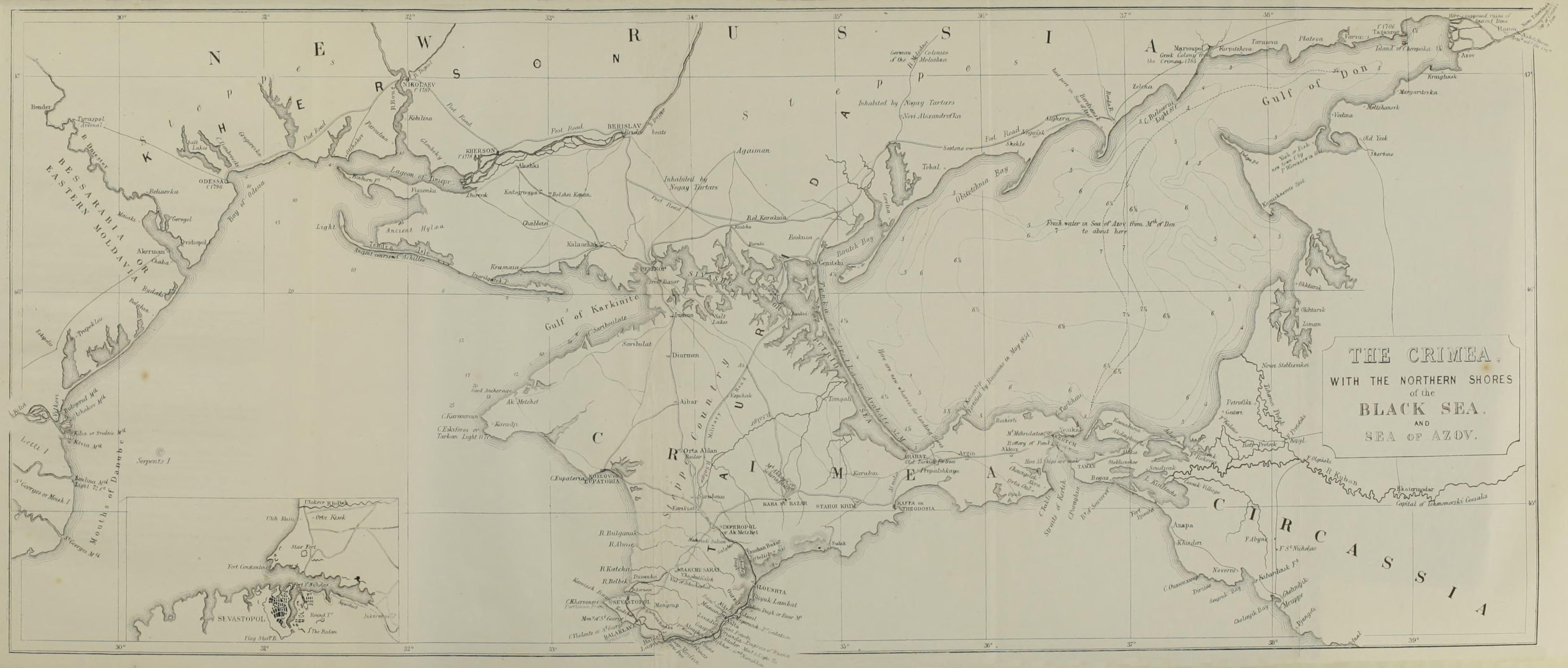
WITH MAP, &c.
LONDON:
JOHN MURRAY, ALBEMARLE STREET.
1855.
The right of Translation is reserved.
LONDON: PRINTED BY WILLIAM CLOWES AND SONS, STAMFORD STREET,
AND CHARING CROSS.
PREFACE.
The following work is partly the result of my own
personal observation, and partly a compilation from
some of the most approved authors who have written
on the Crimea and the resources of Russia. It was
prepared for the press during last winter, and the publication
of it has been retarded by the attention which,
for the last few months, I have been obliged to bestow
on other matters. As the Crimea is still an object of
deep interest, and as I am not aware that the notices
I have collected have yet been presented to the public in
a succinct form, I hope by the following pages that I
may help to satisfy public curiosity and add something
to the stock of information which we possess respecting
the Southern parts of European Russia.
Having paid one visit to the Crimea in the year 1844,
and two visits to Southern Russia in 1844 and 1846, I
have been able to correct and verify the descriptive parts
of the book by my own experience. The careful work
of M. Dubois de Montpereux[1] has been my principal
guide on geology, archæology, and ancient history, and
from his magnificent atlas I have borrowed a few illustrations.
I have abstracted from the ‘Études sur la
Russie’ of M. Haxthausen an account of the Russian
navy and army, adding matter acquired from other
trustworthy sources. To the above-named book and
that by M. Tegoborski,[2] both standard works on the
internal economy of the Russian empire, I am much
indebted; and although I think their accomplished
authors write under a strong bias, yet their works are
indispensable to those foreigners who wish to study the
resources and organization of the Russian empire.
M. Tegoborski has not been allowed to state his whole
opinions upon some subjects, and the Censor has obliged
him to make material alterations, particularly where he
speaks of the condition of the peasantry. I have likewise
alluded to a discussion which took place last year in the
‘Revue des Deux Mondes,’ in which this gentleman
took a part. In the course of last summer a very able
article appeared in the French ‘Moniteur,’ on the
subject of Russian Finance, in which it was attempted
to be proved that Russia was very weak on this point,
and could not hold out for any lengthened period against
the Western Powers. The subject was followed up by
M. Léon Faucher in the ‘Revue des Deux Mondes,’ in
a damaging article on Russian resources and finance.
Soon afterwards an answer to this was sent from Petersburg,
written by M. Tegoborski, who is an employé in
the Bureau des Finances, and it appeared in the November
number of the Revue, with a rejoinder by M. Léon Faucher,
written just before his lamented decease. Notwithstanding
the truth of M. Tegoborski’s observation, that
Russia cannot be judged by the same rules as other
European nations in matters of finance, owing to her
totally different state of civilization, I think he fails to
prove the main object of his article, that Russia can stand
many more such campaigns as that of 1854. Russia
must have little hope of persuading us of her power by
other means, when she is obliged to have recourse to an
article in a foreign periodical in the midst of a deadly
struggle.
I have borrowed much from the work of M. and
Madame Hommaire de Hell,[3] and would refer any reader
who wishes for vivid descriptions of Southern Russia, full
historical information, and accurate scientific knowledge,
to the original French work of this distinguished engineer
and his accomplished wife. M. H. de Hell spent five
years in the country to ascertain the difference of the
levels between the Black Sea and the Caspian, and his
work is accompanied by an atlas of rare merit.
I am indebted to many friends, and, among others, to
Mr. Yeames, late Consul-General at Odessa, Mr. Crawfurd,
and Mr. Blackmore, late chaplain at Cronstadt, for
many valuable suggestions and corrections; and Mr.
Lander has been good enough to revise the chapters
on the shores of the Sea of Azof, with which no man
is better acquainted. This accomplished gentleman was
born in New Russia, and for many years has conducted
the house of Yeames and Co. at Taganrok; and I may
say with truth, that the eighteenth chapter is rather his
than mine.
In Chapter V. I have especially to acknowledge several
pages of valuable matter relating to the Asiatic races of
mankind, for which I am indebted to a note by Dr. William
Smith, inserted in his recent admirable edition of the
great work of Gibbon. My little book pretends to be
scarcely more than a compilation, and if I have anywhere
else omitted to acknowledge assistance, it has not been
from the wish unfairly to appropriate the labours of others.
I have also to thank the Rev. Walter Sneyd for the
sight of a translation of a curious Italian MS. in his
possession, describing the travels in the Crimea of one
Nicholo Barti of Lucca in the seventeenth century.
My notice on the Russian Budget in Chapter VIII. is
not so full as I could wish it to have been, and perhaps
I may have made too high an estimate of the military
expenditure. The other facts relating to it are taken
principally from M. Tegoborski’s writings.
I have endeavoured, in the following pages, to be as
accurate as possible, but more leisure than I have enjoyed
would have enabled me to go over the ground still more
carefully than I have done, and verify my statements
upon various subjects by information gathered from other
scattered sources.
I am fully alive to the defects and incomplete character
of the sketches which I now venture to present to the
public; and I ask, therefore, for indulgence if I have not
contributed as much as I might have done to the instruction
or amusement of my readers.
INTRODUCTION.
My original intention was to have compiled a summary
of the history of the Caucasus, where I spent nearly
three years, and to which a short account of the
Crimea would only have served as an introduction. The
increasing interest attaching to the latter subject, however,
made me pay more attention to it; so that I now
offer to the public some notices on that country and the
shores of the Sea of Azof, without being able to add
anything upon what I hoped to make the main subject
of my inquiry. Some chapters upon the Caucasus are
already partly written, but I have not had sufficient time
to prepare them for insertion in the present volume,
although intimately connected with it. They relate to
a country replete with the deepest interest, and I hope
that, ere long, some more competent hand than mine
may vindicate the character of those heroic mountaineers,
whom many are accustomed unjustly to stigmatize as
barbarians. Though unlettered, they possess equal claims
to our admiration with our own Saxon and Norman ancestors,
or with the Swiss in the days of Tell, for they
possess that stubborn love of independence and that
“spirit of divinest liberty,” which is the root of all good.
When peace shall be made, it will be most fortunate
should we be able to secure the freedom of the Eastern
coast of the Black Sea by treaty, for the independence
of that country would form one of the best securities
against Russian aggression. At the Caucasus Russia may
be said to end, and a new class of nationalities to begin,
and she can only desire to possess that mountain range
with the intention of extending her conquests beyond it.
The Caucasus, that is, the mountain range itself, and
the countries that lie at the foot of them, to the north
and south, are the most convenient entrance to the heart
of the great table-land of Asia, which, when once
thoroughly subdued, might constitute an impregnable
citadel whence Russia would be enabled to extend her
influence and dominion in every direction. The Caucasus
is the real citadel of Russian power in the South and East,
although as yet beleaguered by the nations from which it
has been partially wrested. Russia has surrounded it by
an army of 170,000[4] men, and carefully keeps its inhabitants
from communication with civilized Europe. We
have never acknowledged the sovereignty of the Russians
over this territory, nor over the Christian provinces to
the south of the Caucasus. If her blockade were permanently
removed from the eastern coast of the Black Sea,
and the brave inhabitants of the mountains allowed to
carry on a liberal commerce with Europe, their energies
would be quickly turned from war to peaceful arts.
Those who designate the Circassians as mere warlike
barbarians should remember that we ourselves were but
warlike semi-barbarians in the early ages of our history,
and that the manly character which made us so formidable
in the days of the Plantagenets enabled us ultimately,
with better directed energies, to raise our great
commercial empire in the eighteenth century. The
Circassians and the other mountain tribes resemble us
in many particulars: they debate every great affair in a
national council; they venerate the ancient usages and
ordinances which form their constitution; and they have
the same gradation of ranks and aristocratic feelings which
distinguish ourselves.
Above all points of resemblance to us, they have clung
to their independence with Anglo-Saxon tenacity; and
shall we, when peace shall be made, allow their rude and
gigantic enemy again to surround them with her liberated
forces, till she exterminate them by brute power, and no
memorial be left of unsuccessful virtue save that which
history will assuredly record in their favour?
We acknowledged the independence of the Colonies
of Spanish America while they were still struggling
with the mother country; we went still further with
Greece, for we gave them active assistance, having not
only the French, but the very Russians themselves
for our allies. Surely, then, there exist far more
cogent reasons for assisting the Circassians, who have
never been conquered by the Russians. Up to the
breaking out of the present war the Russians had only
an ever-disputed possession of the actual ground occupied
by their fortifications and protected by their cannon,
and they have been constantly resisted by the mountaineers,
who have ever refused to acknowledge the
sovereignty of the Emperor.
The coast of Circassia is now free, and all that is
required is that it should be kept so, without being
again subjected to a barbarous blockade. If a consul
were placed there, and merchants encouraged to frequent
it, its gallant inhabitants would soon yield to the civilizing
influences of Europe, and engage themselves in
developing its boundless resources.
We may rest satisfied that the freedom of the Caucasus
will form an important element towards the
diminution of Russian influence in the East.
I agree with Mr. Gladstone in thinking we must
look for future security not only by reducing the power
of Russia, but by raising that of Turkey and the other
independent peoples bordering on the Black Sea. Free
communication and free trade once firmly established
there, the question might be considered as in a great
measure settled. It is true that you cannot impose free
trade upon Russia, who occupies half the coasts of the Black
Sea; but you may claim your right to traffic with the
Circassians on the east coast of that sea, and protect your
commerce there by an authorized agent. So great are
the advantages of unrestricted trade—so much does commerce
strengthen and civilize, that the liberal tariff of
Turkey, and the opening of the Principalities (as stated in
App. E), have been, in an indirect manner, the cause of
the present war; for, with freedom of trade, the Christian
subjects of the Porte, for some years before the commencement
of hostilities, had so much increased in importance
and wealth, that they excited the jealousy of
Russia, and she feared that if she did not claim in time
a closer protectorate over them, they might escape her
altogether. I say this, assuming it to have always been
a cardinal point in the politics of Russia, in due time,
to advance her empire to Constantinople and Athens.
Although I believe the whole Russian nation to be
bent upon certain measures of territorial aggrandizement,
I have not failed to acknowledge in my notices the
general pacific character of the people. They are not a
martial nation; that is, they are not a nation which
takes delight in war for the sake of braving its dangers
and revelling in its excitement; but theirs is the patient,
enduring, indomitable courage which will face
any dangers to compass certain ends. The Russian
nation has been misdirected by its rulers as to the true
objects of national glory, and by an exorbitant tariff and
other measures has been kept from mixing with other
European nations, lest it should learn juster ideas of the
points in which true glory and prosperity consist, and
become impatient of a military organization, the object
of which is to carry out indefinite schemes of conquest.
I have lived among the Russians, and I have learnt to
respect them as a strong, earnest, unprejudiced people,
with a great principle of growth in them, and who will
work out the defects of their character, and become some
day an honour to civilization. They were the only
nation in the world, I believe, with whom we had never
been at war.[5] None can more deeply regret than I do
that we have been obliged now to try their mettle.
We must remember that we have a Court to deal with
which combines the deep calculation of Europe with the
wiles of Asiatic intrigue, and that we shall assuredly be
over-reached, if we do not insist upon sufficient guarantees.
We must also remember that the conquest of
Constantinople is the settled determination of Russia,
and has been the prime object of ambition to that country
ever since the ninth century, when the Russian fleets
first appeared before its walls; and that, if we are determined
(as I hope is the case) that they shall never
possess it, we must take care, whenever peace shall be
made, that it be rendered perfectly secure, and the
approaches to it guarded with the greatest possible
care.
If we yield, as Mr. Gladstone and his friends wish us
to do, to the first offers of Russia, we shall fail in our
paramount object, and become the laughing-stock of the
world. The lives of the brave will have been wasted,
and the successes we have gained will be of no avail;
Russia, at the first favourable opportunity, will renew
the struggle, with the advantages of railroads and all
modern inventions. In dealing with so subtle an enemy
it will be wise not to hesitate, but push on, and, treating
Russia as she wished to treat Turkey, require from her
effectual guarantees that she will not again disturb by
her ambition the peace of Europe.
The supineness and indecision of the European
Powers for the last thirty years have enabled Russia
to take up an insolent position towards Europe; and
the fears of our own imaginations have contributed to
swell the prestige of the Colossus of the North, and to
render his intrigues successful. Our statesmen are now
fully convinced of the gravity of our position, and the
extent of Russian intrigue both in Asia and in Germany.
I had myself personal experience of it last year in the latter
country. In returning from India in March, 1854, I
spent a day at the little German state of ———— ——
——, to visit a German friend well versed in the secret
politics of his country. He told me how ashamed he
was of his countrymen, who were false to their true
interests, and cowered beneath the power of Russia.
In the morning, when he came to breakfast with me
in my hotel, an officer took him aside to speak to
him. When my friend returned to me, he said, “You
would not believe yesterday the degree of influence
which Russia exercises in Germany; you have here a
proof of it. That officer who took me aside commands
the —— troops, and he called me aside to show me a
diamond ring and an autograph letter from the Emperor
of Russia, flattering him, and conferring upon
him an order. That man is henceforward the devoted
servant of Russia.” My friend, who is himself a
distinguished littérateur, assured me that there were
nearly two thousand literary persons in Germany who
openly received their quarterly pensions at the Russian
embassies to uphold Russian interests. He even authorized
me to authenticate these statements by the use
of his name, which nevertheless I refrain from doing.
As so much is now said by some parties respecting
the supposed fairness and moderation of Russia, I will
relate two anecdotes of what happened under my own
cognizance in the East. When the Russians seized,
about the year 1840, the island of Ashtoráda, near
Asterabad, at the south-east corner of the Caspian Sea,
which they have since fortified and garrisoned, and when
they explored with steamers the Gourgan and Atrak,
rivers flowing exclusively through the Persian territory,
but leading in the direction of the best road to India,
there was one Turcoman Chief resolutely hostile to them,
whom they could neither frighten nor seduce. One
night, therefore, troops were disembarked, his house was
surrounded, and he and all his sons were carried off and
conveyed into the interior of Russia, whence, at the prayer
of a very influential personage, his place of exile was
changed to Tiflis, where I knew him.
The second is a more daring violation of the territory
of the same power, with whom, be it remembered, we
have a treaty of alliance, and at the court of which
we have long had a minister constantly residing. A
certain member of the Georgian royal family, Suleiman
Khan,[6] lived in the Persian provinces ceded to Russia
in 1828, and having an inveterate enmity to that power,
he refused to remain there when they became Russian,
and fled into a remote part of Persia. After many years
he thought he might venture to come and live at Tabreez,
the capital of Azerbiján, and near his own country. He
had sounded the Russian consulate, and found them
apparently favourable, and when he arrived he was invited
to dinner by the Russian Consul-General. Everything
passed off very agreeably until after dinner, when, as he was
sitting on a sofa with the Consul, drinking his coffee, the
latter begged to be excused for an instant, and left the
room. Immediately upon his quitting, a file of Russians
appeared at the door, with their pieces levelled at the
Khan, and the Consul, from behind them, told him he
was extremely sorry that he was obliged to treat a guest
in so uncourteous a manner, but that he must execute
his orders, that Suleiman Khan must consider himself
a prisoner, and prepare instantly to be conveyed into
the interior of Russia.
This fact was told me by the English Consul at Tabreez,
when I arrived at that city some short time after this
event had occurred, and I dined with the Russian Consul
in question, now holding a high post in Russian diplomacy,
in the very room where it happened. Of course,
when proceedings of this sort were overlooked by
our Government, there is no wonder that Russia grew
emboldened, and believed that no European power dared
to interfere with her.
We have begun at last, after thousands of lives and
millions of treasure have been expended in attacking the
only strong position of Russia in the Black Sea, to
attack some of the long line of vulnerable points which
she presents. Our successes at Kertch, Berdiansk, Mariopol,
Taganrok, and Soujuk Caleh have been as easy as
they have been important, and we have now only to
continue the same course of action.
I can state, on the authority of persons intimately
acquainted with those countries, in answer to what Mr.
Cobden said in the House of Commons, that the blow
we struck in the Sea of Azof has been the severest which
we have dealt to Russian power—that all the stores we
destroyed at Kertch belonged to the Government, and
not to private individuals, and that the same was the
case with every bag of flour and oats destroyed at Berdiansk,
Mariopol, and Taganrok. The Russian Government,
as is well known, has always supplied Sevastopol
and their other fortresses on the coast of the Black Sea
with stores and ammunition from the interior of the
country by means of the Sea of Azof, as is explained in
my work. It is known that they had just completed large
purchases of stores for Sevastopol which we intercepted in
our late expedition, so that the merchants had received
their money, and the loss wholly fell on the Government.[7]
If our fleet had penetrated to Rostof, we should probably
have destroyed a still larger amount of stores, and at the
latter place the shot and shells which are brought down
there from the foundry at Lugan, and from Siberia, for
transmission to the Russian fortresses in the Black Sea.
Perhaps this may be reserved for another expedition;
for close to Rostof are Novo Tcherkask, the capital
of the Don Cossacks, and Naketchiván, an Armenian
town, and the head-quarters of many Armenian houses
deeply engaged in supplying the commissariat of the
Russian army. From the eastern coast of the Sea of
Azof may also be obtained large herds of fine horses for
our cavalry, and fat beasts for the subsistence of our
army.
The taking of Anapa will allow the Circassians to
overspread the country as far as the Bosphorus, and even
to cross it and assist us in the Crimea, a part of which
they formerly occupied, and from which some of their
noblest families make it their boast to have come.
From Soujuk Caleb it is now friendly country to
Ekaterinodár on the Kuban, the capital of the Black Sea
Cossacks; and if judicious persons be sent to treat with
the Circassians, a long line of easy and important victories
will be opened to us. But in the East, still more than
in the West, everything depends upon a judicious selection
of agents; and it is especially necessary, among
free mountaineers, to gain their confidence by kind,
considerate conduct, and to persuade them that you
have no projects for your own aggrandizement, but wish,
by confirming their independence and adding to their
strength, to render them a strong bulwark against
Russian aggression.
Note.—In the Map, Cape Kazantip is represented as fortified by the
Russians. This is an error; the fortifications were meant to have been
marked near Arabat.
CONTENTS.
CHAPTER I. THE CRIMEA.
General description of the Crimea—Mountains—Rivers—Ancient name—Boundaries—The
Steppes to the north connected with it—The roads—Bereslaf—Kherson;
its foundation and importance—Gloubóky—Perversion
of names by the Russians—Nicolaief, head-quarters of Black Sea
fleet, described—Odessa—Definition of New Russia—Limits of ancient
Scythia—The dominions of the Khans of the Crimea—The Zaporogue
Cossacks
Extent and boundaries of the Steppes—The Tchorno-ziemé—Soil and
aspect—Their productions—Appearance of the Steppes in spring, summer,
and winter—Snow-storms, called “Metel” and “Boura”—“Balkas,”
or ravines—Roads, their state in spring—Tumuli or “Kourgans”—False
tumuli—The mirage—Tchernomore Steppes—From Don to Moloshna—Moloshna
to Dniepr—German colonies—Inhabitants of Steppes—Game—Soroke
or Marmot—Biroke—Suslic—The Steppes occupy
two-thirds of the Crimea
The isthmus of Perecop—Its defences—History—Its capture by Marshal
Munich in 1736—The Crimea and Kilboroún conquered by him—His
cruelty and atrocities—The Armenian Bazar—The salt lakes—General
view of the sea-coast on each side of the isthmus—The Black Sea and Gulf
of Karkiníte—Anchorage of Akméshed—Cape Karamroún—The Lagoon
of the Dniepr and Boug defended by Kilboroún and Otchákow—The
river Boug—Gloubóky—Kherson—The Shiváshe, or Putrid Sea—The
Tonka, or Strelka, or Arabate—The road from Perecop to Sympherópol—Sympherópol
Description of Baktchéserai—The palace of the Khans—Pouschkin’s fountain—The
great council-room—The hareem—The cemetery—The
tomb of Dilara Bikéh—The gorge of Tchoufout Kaleh—Acheláma—Tchoufout
Kaleh—The Karaim Jews, or those who reject the Talmud—Their
very ancient origin—Probable descendants of Sadducees—Their
high character—Tomb of the beautiful Nenekedjàn—The crypt town of
Kirkor
Origin of the Tatars—Original common stock of the Mongol, Toungous,
Turk, and Ugrian groups of nations—Short account of each of these—The
Tatars belong to the Turk race—Their royal race, the Gerays, descendants
of Zingis Khan, through Tóktamish—Discord in the kingdom
of Kiptchak for one hundred years—Kingdom of Crimea founded by
Mahomet II.—Held tributary to Constantinople till conquest by the
Russians—The conditions—Popular notion that the Gerays are next
heirs to the throne of Constantinople—Selim Geray—Constitution of
Crimea—Power of the Khans with the Grand Sultan—The Sultans, or
royal family, of the Gerays—The wives of the Khans—Character of the
Tatars—Their manner of living—Their fidelity
Road to Sevastopol from Baktchéserai—Conquest and foundation of Sevastopol
in 1783-84—Description of town and fortress—“The Dvoretz”—Engineer
buildings—Fort Alexander and Fort Constantine—South Bay—The
Hulks—Bay of Vessels, now the Docks—Description of the barracks—Hospitals,
Slobodes—Colonel Upton and anecdotes of Russian
workmen—Sevastopol in 1834—Reservoir of Sevastopol—Sievarna
fort—The citadel—Observations of Sir Howard Douglas on the siege—Military
stores—Arsenals of Russia—Manufactories of fire-arms—Cannon
foundries—Stores come to Sevastopol by the Don and the Azof—The
road by the Arabate and Perecop—Fortifying of Cape Kazantip—Undefended
state of Kertch up to May last—Public gardens—Haxthausen
on the object of Sevastopol and the Black Sea Fleet—Chopin on
the Anglo-French alliance—Conclusion
Its origin under Peter the Great—Early victories of the Varangians, or
Normans, and Cossacks—Row-boats more useful in the Baltic than large
vessels—The navy under Catherine II.—English instructors—Difficulty
in manning the fleet—No mercantile navy—Organization of the
Russian fleet—No marines—Oak for navy—Food of sailors—Russian
vessels on foreign stations—Only one Russian foreign merchant—Greek
influence diminished in 1844—“The Twelve Apostles”—“The Teredo
Navalis”—The Affair of Sinope—The Paixhans shell system—General
observations
Large proportion of Russian population in the army—Military organization—Peaceable
natural disposition of Russian people—Strong feelings when
roused—Obedience to orders—Anecdotes—Commercial disposition of
the Russian people—Their wish to mix with European nations—Education
checked by the Government—Military system of Peter the Great—His
great objects—Faults of our Government with respect to Russian
policy—The army, whence recruited—Great Russians—Poles—Little
Russians—Finns, Jews, &c.—Name “Ruski” or Russian—Its origin—The
conscription—Soldiers’ marriages—The Cantonists—Emperor’s
efforts to improve condition of common soldier generally unsuccessful—Corporal
punishment—Labour—“Indefinite leave”—Division of
empire for conscription—Amount of population per cent. taken from
1840-1855—Expense of the Russian soldier—Democratic system of
army—The cross of St. George—Classification of Russian army—Into
1st, Corps d’Armée, or complete armies—2nd, Local Regular Troops—3rd,
Irregulars—Don, Black Sea, and Ural Cossacks—Value and number
of Cossack troops—Various Asiatic irregulars—General observations
CHAPTER IX. INKERMAN, MANGOUP, AND THE HILLY COUNTRY OF THE CRIMEA.
The Bay of Sevastopol to Inkerman—Aktiar—Inkerman Castle—Its
history—Crypts—Fuller’s earth, or natural soap—Tchorgouna—Tchouli,
residence of Pallas—Crypts at Karakoba—Mount Aithodor—Mangoup—Description
and history—Gothic architecture—Position of
Mangoup—Interesting character of surrounding country—The Tchatyr-Dagh
and the Yailas
The Heracleotic Chersonese—Origin of name—Defended by a wall—Kherson—Its
history and remains—House of Lamachus—The predecessors of
Vladimir and their relations with Constantinople—Account of the siege by
Vladimir, taken out of Nestor—Vladimir’s Baptism—Springs of water—Kherson
destroyed by Lithuanians—The bays between Sevastopol and
Cape Chersonese—Cape Partheniké—The Tauric Diana—The monastery
of St. George—Bustards on the Chersonese
CHAPTER XI. ON THE ANCIENT INHABITANTS OF THE CRIMEA.
The Cimmerii—The Tauri—Connexion of Greece with the Black Sea—Digression
on the Crypts of the Crimea—B.C. 600: the Scythians—The
Greek colonies, B.C. 650—Milesian emigration—Dorian emigration—Trade
of these early times—Mithridates, reigned B.C. 120-63—A.D. 62:
The Alans—A.D. 100-200: The Goths—A.D. 376: The Huns—Second
attack of the Huns—Justinian reigned, A.D. 527-565—A.D. 679: The
Khazars—A.D. 900-1000: The Petchenegues—About 1204: The Comans—1226:
The Tatars—The Genoese—1473: Kaffa taken by the Turks—The
Black Sea then shut up to European nations—Mixture of races in
present inhabitants of Crimea
Balaclava—Karl Ritter’s views of the importance of the Black Sea in very
early times—Homer’s account of Balaclava—The Cembalo of the Genoese—Tatar
occupation of it—Arnaouts—Tchorgouna—Mackenzie’s Farm—Valley
of Baidar—Manners of the Tatars—Woronzof road
CHAPTER XIII. THE SOUTHERN COAST, AS FAR AS ALOUCHTA.
Pass of Phoros—First view of the Southern Coast—The climate—Valley
of Laspi—Mount Aia, or Cape Saritch—Modern Laspi—Phoros to
Kíkineis—Land slips—Liméne—Singular appearance of Tatars—Aloupka—Prince
Woronzof’s palace—Gardens—Luxuriant vegetation—Craters—Account
of Prince Woronzof—Miskhor—Koureis, seat of
Princess Galitzin—Madame de Krudener and Comtesse Lamothe—Gaspra—Mount
A’ithodor—Imperial Oriánda—Ouchansóu—Yalta—The
mountain pass to Baktchéserai—Marsánda—Cyclopean remains—Magaratch—Nikita—Botanical
gardens—St. Daniel—Oursouf—Ancient
castle of Justinian—Cyclopean remains—Mount Aioudágh, the ancient
Kriumetôpon Prom—Village of Partheníte—Great and Little Lambat—The
Chaos—Numberless ancient remains—The pass of Mount Castéle—The
descent to Alouchta
Alouchta—The Eastern and Western Coasts—Oulou Ouzéne, the property of
Mrs. Lang—Mdlle. Jacquemart—The Bay of Soudak—Ruins of the triple
fortress—The Kiz Koullé, or Girl’s Tower—Ancient Soldaya—Its history—Remains—Vandalism
of the Russians—Ruined barracks—The Crimean
Wine Company—The wines of the Crimea—Prices of land in the Crimea—Road
to Theodosia—Tatar hospitality—Koktebel
CHAPTER XV. FROM ALOUCHTA TO SIMPHERÓPOL, KARASOUBAZAR, ESKI KRIM, AND THEODOSIA.
Valley of Alouchta—Obelisk—Valley of the Angar—Tavshan Bazar—Fortified
Gorge—Yenisála, a Greek Colony—Aian and the source of the
Salghír—Ascent of the Tchatyr-Dagh—Yaila—Snow reservoirs—From
Tchafki to Simpherópol—Excursion up valley of Little Salghír to caves of
Kisilkoba—Caverns—Simpherópol to Karasóubazar—The Shireen family—Eski
Krim—Theodosia, or Kaffa—B.C. 700, Theodosia founded by Milesians—A.D.
250, totally destroyed by the Huns—Desert for 1000 years—A.D.
1280, Kaffa founded by Genoese on site of Theodosia—Short history
of it—A.D. 1475, taken by Turks—Its decline—Revival in seventeenth
century—1781, taken by Russians—Description of ruins—Their destruction
by the Russians—Position of Kaffa in commercial point of view—Arabat—The
wall of Asander—The approach to Kertch
Approach to Kertch—The Cimmerian Bosphorus—Russian conquest of
Kertch in 1771—Its rise since 1833—Its chance of becoming the emporium
of trade for the Sea of Azof—Russian authorities—Ancient church—Kertch,
the ancient Panticapæum—Acropolis—Arm-chair of Mithridates—Allée
of Tumuli on Theodosian road—The Tumulus a sign of Milesian
occupation—Contents of Tumuli on Theodosian road—Etruscan vases at
Kertch—Burial-places of the poor—Tomb of the Pigmies—The Catacombs—The
Tombs of the Kings—The Golden Mountain—The rich
discoveries at Kouloba—Description of the contents of the Tomb—Pillaged
by the people—Probably that of Leucon I., or Paerisádes I.—The
Museum—Myrmékium—Mud volcanoes—Naphtha springs—Cape Akboroun—Nymphæum—Herring
fishery—Opouk, the ancient Kimmericum
The Sea of Azof—Its extent and boundaries—Its depth continually
diminishes—Its sweet water—Its rivers—Currents—The Straits of
Kertch—The Russian defences of it—The eastern shores—Temróuk—Okhtor—Cape
Obriv—The fishing-huts—Bay and new town of Yeisk—Cape
Tchimborsk—Mouths of Don—Bars of the Don—Old town
of Azof—Rostof—Its commercial importance—Shallowness of water in
Gulf of the Don—The Azof frozen in winter—Ruins of ancient Tana—Taganrok
founded by Peter the Great—Its history—Its importance—Mariopol—Cape
Bielo-Serái—Berdiansk—Its foundation—Port is
filling up—Lake Moloshenska—Peninsula of Berútchi—Straits of
Yénitchi
CHAPTER XVIII. ON THE COMMERCE OF THE SEA OF AZOF.
Rostof, key to commercial system—A district of the Government of Ekaterinoslaf—Its
gradual rise since 1835—Articles of export—Wheat—Linseed—Rye—Military
stores sent by the Azof to Sevastopol, &c.—Iron
foundries of Lugan—Tallow—Breeds of cattle—System of advances—Agencies
of foreign merchants, chiefly at Pavlosk—Advantages of
Free Trade—Passage of goods by the Don and the Volga—Dubofka and
Katchálin—Hardships of the military system—Intelligence of Russian
merchants—True policy of Russia
SOME ACCOUNT OF THE CRIMEA, AND THE SHORES OF THE SEA OF AZOF. — CHAPTER I. THE CRIMEA.
General description of the Crimea—Mountains—Rivers—Ancient name—Boundaries—The
Steppes to the north connected with it—The roads—Bereslaf—Kherson;
its foundation and importance—Gloubóky—Perversion
of names by the Russians—Nicolaief, head-quarters of Black Sea
fleet, described—Odessa—Definition of New Russia—Limits of ancient
Scythia—The dominions of the Khans of the Crimea—The Zaporogue
Cossacks.
The peninsula of the Crimea is a southern portion of the
Steppes of Russia, raised by volcanic action out of nearly
the centre of the Black Sea. It is about 200 miles across
in a direct line from Cape Karamroún on the western side
above Eupatoria to Cape Fanar, the furthest point eastward
on the Straits of Kertch, and 125 miles from Perecop
to Cape Kíkineis on the southern coast. It contains
a population of about 200,000 inhabitants, and covers an
area of 10,050 English square miles.
The Tauric range of mountains runs east and west along
the southern coast from Balaclava to Theodosia, and generally
within a few hundred yards of the shore, which, being
protected by them from the northern winds, enjoys a delicious
climate, like that of southern Italy. But this mild
temperature is confined to the narrow strip of land along
the coast which is shut in by the mountains, and to the
north of them the weather shows severe alternations of
heat and cold, and the snow in some seasons covers the
ground for a considerable time in winter. The mountains
themselves occupy a large space, and rise to a height
of from 1000 to 5000 feet. They are generally flat-topped
or dome-shaped, and hold within their range high
elevated plains called Yailas. Their summits reveal
granite and other primitive rocks, and on their northern
sides lie, like a mantle, the Steppes, which constitute all
the northern portion, and nearly two-thirds of the area,
of the whole peninsula.
These steppes gradually incline downwards towards
the north, and hence received from the later Greeks the
name of “ta climata,” or the inclines.[8] The following are
the principal rivers:—Eastward, the Salghír, the Bulganak,
the three Andols, the Tchoroksou, the Soubashi, and
the Karagos, which flow into the Shiváshe or great lagoon
on the east, improperly called the Putrid Sea; and on the
westward, the western Bulganak, the Alma, the Katcha,
and the Belbek, which discharge their waters into the long
open bay at the head of which stands Eupatoria.
The peninsula of the Crimea was known to the Greeks
under the name of the Taurica Chersonesus, and in the
middle ages was called Gothia. It is now called either
the Tauride (a version of its first appellation), or more
commonly Crimea, from the famous city of Eski Krim,
near Theodosia, which was built by the Tatars in the
thirteenth century, and is now a ruin.
The Crimea is joined to the main land by the narrow
isthmus of Perecop, on each side of which there is a very
shallow sea. To the north of it the dreary plains of
Russia extend interminably, on the west to Bessarabia
and the Ukraine, and on the east to Tatary and Siberia.
There has in all times been a connexion between the
Steppes to the north of Perecop and the peninsula of the
Crimea itself, and they have both generally been in the
possession of the same people. A portion of the Steppes,
bounded by Bereslaf, Alexandropol, and Mariopol, are
now included in the Russian government of the Tauride.
As the character of the Steppes is very peculiar, and they
form, as I have said, about two-thirds even of the whole
peninsula of the Crimea, I have thrown together in the
next chapter some general observations upon them.
I will now say a few words about the road between
Perecop and Odessa, and the principal towns through
which it passes. The whole distance is 352 miles,[9] and
there are post-horses along the road, which runs entirely
through the Steppes. Road, however, properly speaking,
there is none; for even outside the gates of Odessa the
traveller follows the track of those that have preceded
him, and in dry weather bowls rapidly along, but is
arrested by the slightest fall of rain. I left Odessa, in
the year 1843, in the commencement of August, in a
light britska drawn by three horses, and in consequence
of a slight shower of rain in the morning I was stopped
half-way in the rich loam of the Steppes, and was obliged
to pass the night there, and send on to the next station
for three fresh horses to pull my carriage through the
heavy ground.
The road from Perecop to Bereslaf, on the banks of
the Dniepr, runs 52½ miles across a perfectly flat country,
where the soil is not fertile. The latter town is situated
on the right bank of the Dniepr, which is precipitous and
very much higher than the left bank, which is shelving,
and this peculiarity is found in all the rivers of the south
of Russia.
Bereslaf owes its importance to its situation at a point
where the Dniepr is crossed by a wooden bridge. In
the Greek period it was called Miletopol, and in later
times it belonged to the Zaporogue Cossacks till their
conquest by the Russians.[10]
From Bereslaf to Kherson is 47 miles, and the road
runs along the bank of the Dniepr. The town of Kherson
is the capital of the government of the same name,
which is bounded by the governments of the Tauride,
Ekaterinoslaf, Kief, and Podolia, touching also at some
points on Moldavia, Bessarabia, and the Black Sea. The
north and north-west parts of the government of Kherson
are very fertile, and produce great quantities of wheat;
although the soil becomes dry and sandy on approaching
the Black Sea. Before its conquest by the Russians
this was the country of the Nogai Tatars, who were
also called Precopian Tatars, but none of their tribes
now remain to the westward of the Dniepr. The
population of the government of Kherson now amounts
to between 300,000 and 400,000, and is composed of
Russians, Armenians, Jews, Germans, and Bulgarians.
The town of Kherson is situated on the north bank of
the Dniepr,[11] which here spreads out into a wide kind of
lagoon, 11 miles in breadth. This is filled with low
islands, which are often covered with water, and render
the passage difficult and dangerous. The town was
founded in the desert in 1778, by Catherine II., and was
the first commercial port which the Russians established
on the Black Sea. This was four years after the Treaty
of Kainardji, by which the Black Sea was opened for the
first time to any European nation, after having been shut
up for 300 years, since the conquest of Constantinople.[12]
Kherson is situated at about 50 miles from the sea,
and the water is too shallow to allow large vessels to
approach it. These load and discharge their cargoes at
Gloubóky, which is many miles below Kherson and the
mouths of the Dniepr. Kherson continued to increase
till the foundation of Odessa, eighteen years afterwards,
in 1796. It was both the commercial and naval centre of
the Russians when they first reached the Black Sea in their
conquests; but, as the commercial affairs were transplanted
to Odessa, so their naval arsenal, with the admiralty and
the dockyards, were removed to Nicolaief a few years
earlier.[13] The name of Kherson was given to the new town
because it was erroneously supposed to stand on the site
of the ancient Greek colony of that name, the ruins of
which are to be seen close to Sevastopol, and similar
mistakes are common in the case of many other Russian
towns founded about the same time. Thus
Sevastopol itself bears the name of the old Greek city
on the shores of Abkhazia; the ruins of the real Eupatoria
are at a long distance from the place which now
bears its name; and nothing but a Tatar village of the
name of Hadjibey ever stood on those steppes where
Odessa is supposed to renew the memory of the ancient
Odessus.
Nicolaief is the only town of the slightest importance
on the dreary road from Kherson to Odessa, and is 40
miles from the former, and 77 miles from the latter
place.[14] It stands in the open Steppe, at the confluence
of the Boug and the Ingoul, on the left bank of the
former river, and 22 miles from its mouth. The Boug is
here a noble stream, a mile and a half broad,[15] and so deep
that the largest men-of-war can ascend and descend after
taking out their guns. Its right bank is deep and precipitous,
and the left bank low and shelving, a peculiarity,
as I have before remarked, of all the rivers of
Southern Russia. This was likewise found to be the case
at the Alma. This town was founded in 1791, and intended
to replace Kherson as the head-quarters of the
Russian fleet in the Black Sea. It is simply a naval
arsenal, and contains a population of 10,000 or 12,000
persons, entirely occupied in the government establishments.
There are here immense storehouses and dockyards,
in which all the Russian fleet in the Black Sea is
built.[16] The timber for ship-building comes chiefly down
the Dniepr to Kherson, and from thence to Nicolaief.
All the vessels constructed here are transported empty
down the river to Gloubóky or Otchákow, and proceed from
thence to the Black Sea on wooden frames called camels,
because of a sandbank near Kilboroún, and they take
in their cannon and tackle at Sevastopol. The town
is quite undefended except by a wall, which has been
built not for military but police purposes, to prevent
peculation and smuggling, by allowing no ingress or
egress without permission. There is no good water[17] at
Nicolaief, as that of the rivers is often brackish, as is
also that which is obtained from wells, but an excellent
spring has been found at some distance from
the town, the water of which has now been introduced
and fills a large reservoir, which holds a sufficient quantity
for a much larger population than now inhabits
Nicolaief.[18]
From Nicolaief to Odessa the country is very desert
and uncultivated; for the old Tatar population has disappeared,
and new settlers have not arrived in sufficient
numbers to occupy their place. It is only at the last
stage from Odessa that the country bears at all the aspect
of civilization.
Odessa, situated on a barren Steppe, is the second commercial
port in the Russian empire. It was the last town
founded by the Empress Catherine II. in 1796, a few
months before her death; and although its situation
is not the best that could have been chosen, still its
position as a débouché for the Polish provinces, and
its privileges as a free port, have made it rapidly increase
up to the present time. Odessa is the residence
of the Governor-General of New Russia, and the real
capital of all Southern Russia—that is to say, the
largest money centre, and the town to which all look
up as the richest and most refined in the empire after
Petersburg and Moscow. New Russia comprehends
the governments of Kherson, Ekaterinoslaf, and the
Tauride, or the vast territory which has been conquered
from nomade nations within the last century,
and is as yet thinly peopled with fixed inhabitants.
All these countries have the same interests,
and require special attention, and for these reasons the
governors of them do not correspond with the ministers
at Petersburg, as is the case with the other governments
of the Russian empire, but are referred to the Governor-General
of New Russia,[19] who resides among them at
Odessa, and can naturally pay a more immediate attention
to their wants than distant ministers.
New Russia, as the name denotes, has been recently
acquired. This country, with Bessarabia, nearly agrees
with the limits of ancient Scythia in the time of Herodotus,
who describes it as extending from the Ister
(Danube) to the Tanais (Don), and as being watered
by eight rivers, of which the Tanais was the last.
Scythia, then, appears to have been bounded by the
Danube on the south-west. To the north the whole
of the Boug ran through Scythia; and beyond the Don,
to the east, the Scythian population ended, and the
Sauromatæ occupied the Steppes between the Caspian
and Black Sea. The latter people are supposed by
some to be the same as the Sarmatæ, or Sarmatians,
the ancestors of the Poles. The southern part of Scythia,
between Kherson and Perecop, was inhabited by a fixed
population, called the Agricultural Scythians; and the
Royal Scythians were to the east, near the Don; and the
Nomade Scythians along the whole country to the north.
From the third to the sixth century, when the barbarians
pressed forwards to occupy the defenceless provinces of
the Roman empire, these plains were the high road of
nations, and were occupied by a succession of nomade
peoples during the whole period of the Byzantine empire,
until they fell into the hands of the Tatars and
the Ukraine Cossacks, called Zaporogues, from whom
the Russians conquered them in the latter half of the
last century. Several Nogai Tatar tribes regularly
divided the whole of the southern portion of it, from
the Dniestr to the Don, and all were under the dominion
of the Khan of the Crimea, and constituted the largest
portion of his territory. At the end of the seventeenth
century these Tatars were known in Europe by the name
of the Precopian Tatars, or the Tatars of Perecop.[20]
The nearest regular nations to these on the north were
the Poles and the Russians, of which the Poles were three
centuries ago the more important and powerful people; but
both were then much smaller nations and occupied far
less territory than they now do. Between them and the
Tatars there was an immense tract of waste land called
the Ukraine, which in Russian means the march, or
border land. Upon this a fugitive population of all sorts
settled themselves, and took as their head-quarters the
rapids of the Dniepr, where that river for about 70 miles
falls over a succession of vast granite blocks, which impede
the navigation of the river, and have caused the
formation of numerous islands, difficult of access. From
this cause the mixed population who took refuge there
were called Zaporogues, or the people who lived at the
falls, from two Russian words, “za,” at, “porohi,” the
falls; and they were also called Cossacks, or Kazaks, as
the word is pronounced in Russian and Tatar. This
is an appellation of uncertain origin, and known over a
vast extent of country on the confines of Europe and
Asia. The Zaporogues were called Kazak, and so were
the people who lived on the Don, and these two communities
were of decided Russian origin. This name was
also well known among Asiatic nations, for the Tcherkess
in early times were called Kazaks, and Wood found it
in use as far as the banks of the Oxus. It is not considered
as a complimentary term, and the Cossacks of the
Don call themselves the Donskoi, or the people of the
Don, and consider the other as a reproach.
The Zaporogue Cossacks then inhabited the march
between the Tatars and the Poles and Russians, and thus
resembled the border people of England and Scotland.
In the reign of Sigismund I., King of Poland, the last
of the race of Jagellon, who died in 1572, the Cossacks
were first taken into pay and armed against the Tatars,
and a Polish officer was appointed their governor; and
in the reign of Stephen Batory, which began three years
after the death of Sigismund, they were regularly
brought under military discipline. Much that is fabulous
has been related of this people, and they have
been described as a nation who admitted no women
to live among them, as the Amazons near the Sea of
Azof banished all men; and imagination had embellished
their history as early as the seventeenth century.[21]
“They were, however,” says Chevalier, who wrote a
history of the Cossack war, which was published at Paris
in 1663, “only a military body, and not a nation,
as some have imagined. We cannot compare them
better than to the Franc archers established in France
by Charles VII. They made periodical naval expeditions
against the Turks, and have even advanced within
two leagues of Constantinople. Their rendezvous was
the islands of the Dniepr, and when winter approached
they returned to their homes. They generally mustered
5000 or 6000 men: their boats were sixty feet long,
with ten or twelve oars on each side, but this must be
understood only of their war-boats.”
In short, they were pirates after the manner of our
forefathers, the Jutes, Angles, Saxons, and Danes.
The father of John Sobieski commanded the Cossacks,
and gives the following account of them:—
“They are chiefly of Russian origin, though many
criminal refugees from Poland, Germany, and other
countries are to be found among them. They profess
the religion of the Greek Church; and have their fixed
residence in their naturally fortified places, watered by
the Dniepr. Their business is war, and when they are
shut up, as it were, in their nest,[22] they consider it illegal
to neglect athletic sports for any other pursuits. They
live sparingly by hunting and fishing, and they support
their wives and families by plunder. They are governed
by a prefect, whose sceptre is a reed, and who is chosen
in a tumultuous manner. He has absolute power of life
and death, and has four counsellors to assist him. The
Poles have given them the town of Trychtymirow in
Kiovia. Long habit has fitted them for maritime warfare.
They use boats, in the side of which they can
occasionally fasten flat bundles of reeds to buoy them
up and resist the violence of the waves and winds. With
these boats they sail with great rapidity, and very often
take the laden Turkish vessels. Not many of them use
lances (framlis), but they are all furnished with arquebuses
(sclopetis); and in this kind of warfare the kings
of Poland can match the infantry of all the monarchs of
the world. They fortify their camp with waggons
ranged in several rows; this they call ‘tabor,’ and make
them their last refuge from an overbearing enemy. The
Poles were obliged to furnish them with arms, provisions,
and forage for their horses.”
Such were the men whom Batory enlisted in the Polish
service. In the year 1556 he divided them into six
regiments, and appointed superior and subordinate officers
over them. They were then only infantry, says Chevalier,
but Batory joined to them 2000 horse, and in a
short time they consisted chiefly of cavalry. Their chief
was called the hetman, or ataman; and the king presented
him with a flag, a horse-tail, a staff, and a mirror,
as ensigns of authority.[23] The Cossacks played an important
part in all the wars that desolated these countries till
they were subdued, in the last century, by Catherine II.,
and transplanted to the banks of the Kuban to keep
in check the Circassians. They then lost the name of
Zaporogues, and took that of Tchernomorski[24] Cossacks,
or Cossacks of the Black Sea, under which they are now
fighting in the Russian armies before Sevastopol.
The authority of the khans of Crimea[25] extended beyond
Odessa to the Dniestr,[26] which was in former times
the limits of Moldavia, whose prince paid them tribute.
To the north the Tatars were separated from the kingdom
of Poland by the country of the Ukraine; and
the Zaporogue Cossacks were organized by the Polish
monarchs as a kind of military colonists to check their
depredations. The Tatar sway was also extended along
all the Steppes as far as the Don Cossacks, and then
again beyond them to Circassia, and the power of the
khans of Crimea long survived that of their brethren in
Great Tatary. But when once the Russian people
had begun to shake off their shameful servitude to the
Tatars, which it is doubtful whether any other European
nation placed in their position could have avoided, each
generation saw them increase in power, till they had
conquered Zaporogues, Poles, Don Cossacks, and Tatars,
and turned these nations into obedient subjects and instruments
for the further extension of their enormous
empire.
CHAPTER II. THE STEPPES OF RUSSIA.
Extent and boundaries of the Steppes—The Tchorno-ziemé—Soil and
aspect—Their productions—Appearance of the Steppes in spring, summer,
and winter—Snow-storms, called “Metel” and “Boura”—“Balkas,”
or ravines—Roads, their state in spring—Tumuli or “Kourgans”—False
tumuli—The mirage—Tchernomore Steppes—From Don to Moloshna—Moloshna
to Dniepr—German colonies—Inhabitants of Steppes—Game—Soroke
or Marmot—Biroke—Suslic—The Steppes occupy
two-thirds of Crimea.
The vast plains which extend over one-fifth of the whole
Russian empire in Europe,[27] or more than twice the size
of France, are known both to natives and foreigners by
the name of the “Steppes,” and present a monotonous
level from the confines of Moldavia to the high plateau
of Central Asia.[28] An imaginary line drawn through
Krementchouk and the northern part of Tambof forms
their limit to the north, and to the south they are
bounded by the Black Sea and the Azof; they also extend
over all the northern parts of the Crimean peninsula.
After passing the Sea of Azof they expand to the south
and occupy the space between the Azof and Caspian as
far south as the Terek and the Kuban, which are the
boundaries of Circassia, and very distinctly mark their
limits in that direction. On the north they reach the
Oural Mountains, and then crossing the river of that
name they join the deserts of Tatary, and increase in
breadth to the north and south as they approach the
great Asiatic table-land. They are totally devoid of trees
or shrubs, have a soil of varying fertility, and a very
scanty population.
In the north of Russia the ground is naturally covered
with trees and shrubs, and produces immense forests, but
where the Steppes begin, the forests end. Much has
been written on the causes of the treeless aspect of the
Steppes, and on the possibility of covering them with
forests by planting. Some consider that they were in
ancient times covered with wood, which has been destroyed
by the nomade peoples who in all ages have
inhabited them. The authority of Strabo is used, who
mentions the country between Perecop and the Dniepr
under the name of Hylæa,[29] because of its dense forests,
although there is not now a shrub to be seen there; and
Haxthausen says he observed in the government of
Saratof, which belongs to the region of the Steppes,
that the rivers Irguiss, Jároslaw, and Aktóuba were still
bordered by splendid forests of oaks, beech, poplars, and
willows, although pines were never to be met with.[30]
Murchison, however, with reason I venture to think,
utterly disbelieves in the former existence of forests that
have been destroyed, and thinks that the total absence
of trees in Southern Russia results from general conditions
of climate, and from the want of dew, which is
the cause commonly assigned for it by the inhabitants
of the country itself.
But if there be no trees or shrubs, the southern provinces
of Russia enjoy a herbaceous vegetation of extreme
richness, which occupies the soil with a vigour of
growth which is rarely met with in Europe, and grasses,
which in other places scarcely attain the height of a foot,
are met with in the Steppes reaching upwards of six
feet. The reason of this prolific vegetation is that the
Steppes are mostly within the region of the celebrated
tchorno-ziemé, or black earth, which is a deposit of
amazing fertility, peculiar to the southern part of
Russia. “The tchorno-zèm,” says Murchison,[31] “has
its northernmost limit defined by a waving line, which
passing from near Kief and Tchérnigof, a little to the
south of Líchvia, appears in 54° of north latitude in that
tract, then advances in its course eastward to 57°, and
occupies the left bank of the Volga west of Tcheboksar,
between Nijny Novgorod and Kazan. In approaching
the Ural chain we saw no black earth to the north of
Kazan, but it was plentiful on the Kama and around
Ufa. Again, on the Asiatic or Siberian side of the Ural
Mountains, we travelled through one large mass of it
near Kamensk, south of the Issetz river, in latitude
56° north, and through another between Miask and
Troitsk. In the great Siberian plains we heard that it
spreads over considerable spaces in the eastern, central,
and southern parts of that region. Although we met
with it occasionally in the low gorges of the Ural
chain, and in the Bashkír country on both flanks of the
southern Ural (in plateaux more than 1000 feet above
the level of the sea), and also in the Steppes of the
Kirguiss; we did not see it in the plains near Orenburg,
nor to the south of that city. There is none to the
south of Tzáritzin on the Volga, in the Steppes of the
Kalmucks between that place and the mouth of the Don;
and it is only in very limited patches along the Sea of
Azof, or, in other words, on the southern face of that
elevation between the Dniepr and the Don which constitutes
what is commonly called the granitic Steppe. It
occurs, however, in great thickness on the plateaux on
the northern side of that axis, where it surmounts the
carboniferous limestone with many seams of coal, so that
it might at first sight be supposed to be produced by the
decomposition of the subjacent carbonaceous strata. It
lies, however, upon rocks of all ages, and occupies the
centre of a trough, large as an European empire, having
the detritus of the crystalline and older rocks for its
northern, and the low granite Steppes and Caspian
deposits for its southern limits.” It occupies an area
of about 180 millions of acres in European Russia,
and varies from a few feet to fifteen and twenty feet
in thickness. “In travelling over these black tracts in
a dry summer we were often,” says Murchison, “during
a whole day, more or less surrounded by a cloud of black
dust, arising from the dried up tchorno-zèm, which is of
so subtile a nature as to rise up through the sod in rich
grass countries under the stamp of the horses’ feet, and
forms so dense a cloud that the traveller is often begrimed
like a working collier.”
It is not the humus arising from decayed forests or
vegetables during the present period of the world’s
history, as no trace of trees, roots, or vegetable fibre is
found in it in any part of the empire. In the northern
parts of Russia, where the forests have been lately
cleared, no vestige of it exists, while it abounds south of
a certain line, or exactly in those extensive and steppe-like
undulations which have been devoid of trees
throughout all known time. Its extreme fertility is
attributed to the unusually large quantity of nitrogen
which it contains; and its origin is referred to the period
when the Russian continent was still submerged, and
the tchorno-ziemé (which Russian economists justly consider
as one of the most precious treasures of the empire)
was the mud at the bottom of a great internal sea.
This union of the black earth with a temperate climate
in the Steppes between the Dniestr and the Don already
enables the inhabitants of those countries to send, as
from Mariopol, the finest wheat to the European markets,
and justifies economists in looking forward to this region
as one destined to a brilliant future. On the shores of
the Black Sea and the Sea of Azof and eastward of the
Don the Steppes become less fertile, until, wearing a more
and more barren aspect, they gradually get blended with
the sandy deserts of Tatary. On the eastern shore of the
Sea of Azof, in the countries of the Don and Tchernomorsky
Cossacks,[32] there is, however, some splendid land,
and large quantities of corn and linseed are sent thence,
northwards to Taganrok for exportation, and southwards
to supply the army of the Caucasus. The Steppes
are in parts covered with a rich herbage, on which
feed large herds of horses, cattle, sheep, and camels.
The upper layer of the soil of the Steppes presents a
great variety in its composition, from lands impregnated
with saline substances, and moving sands, to the mixtures
most favourable to vegetation. As this upper layer
rests upon a subsoil which does not easily permit infiltration,
it is upon its thickness that depends its fertility;
for, where it is not deep enough to retain humidity, the
land becomes easily saturated by rain, and dried by evaporation.
This circumstance is a great check to cultivation,
because long droughts are common in these countries.
All the Steppes are not in this disadvantageous
position, although such is their predominant character
in several governments to the south and east of the
empire. This want of rain, and absence of natural means
for retaining moisture, such as hills or trees, is one of
the greatest calamities of the country; but the vegetation
of that part of the Steppes which is only used for
pasturage has a particular character which modifies the
influence of the droughts. Nature here shows a wonderful
variety of resources.
The vegetation of the spring lasts about three months,
and if this period passes without abundant rains, the grass
does not reach its natural height. It dries in a moment,
when the stalk has all its richness, and thus forming a
natural kind of hay, it offers to the cattle during nine
months a very substantial food, and these pastures are
in consequence particularly favourable to sheep. When,
on the contrary, the rains of spring are very abundant, the
vegetation becomes rank, and the grass sometimes reaches
four times its natural height. In such seasons the “stipa
capillata” springs up, the prickly fruit of which proves
injurious to sheep by penetrating their flesh, and often
causing their death. The pasture at the same time is
less wholesome and nourishing: in short, by a singular
contrast in this country, which is generally condemned
for its droughts, the proprietors of the Steppes often
prefer a dry season to one too rainy. The vegetation
of the pasturing Steppes also presents another peculiarity,
that the grass is not spread in an even manner
over it, but in isolated spots, which form a kind of oases.
The even turf is only found in very low valleys.
The Steppes are divided by one writer into “eternal
Steppes” and “accidental Steppes:” the first are those
where the layer of soil is so thin that they never can be
cultivated, and trees will never be able to grow; while
the others are highly favourable to agriculture, and some
remains of ancient forests are found in the low valleys.
In the Steppes near Taganrok, as long as they are uncultivated,
there is a kind of natural rotation of crops.
To the herbage, which sometimes is as high as a
man’s waist, succeeds the next year a coarse weed called
“bourian,” which rises to the height of three or four
feet, and is cut to use as fuel. Though it burns very
quickly, it serves for Russian stoves, which, heated for a
quarter of an hour, will keep an apartment warm during
the whole day. To the bourian succeeds a thin kind
of grass, and then about the third year the pasture is
again excellent. A considerable portion of the Steppes
is cultivated, and, without any artificial means, produces
some of the finest wheat known. A rest of one or
two years suffices to restore to the ground its original
fertility, and the enormous tracts of uncultivated land
make it never necessary to overtax its powers. In other
parts the cultivation of the Steppes differs from that of
all other countries. Certain kinds of grain are sown for
several years in succession, and then the ground is left
fallow, and becomes covered with grass. The first year
weeds spring up in abundance, and then in the second
and third years the pasturage becomes excellent. When
the soil seems sufficiently recovered, it is again ploughed.
This agricultural cycle occupies from ten to fifteen years,
according to the fertility of the soil.[33]
M. Haxthausen divides the Steppes into five classes:
1. The tertiary calcareous formation predominates in
Bessarabia, Kaddia, and a small part of the government
of Kherson.
2. The chalk forms the base of the soil in the
north, and embraces the Steppes of the governments of
Kharkof, Woroneje, Tambof, a part of the country
of the Cossacks of the Don, and the government of
Saratof.
3. The granitic base, which is a spur from the Carpathians,
extends along the Black Sea and the Sea of Azof
to the Caucasus.
4. The Steppes of alluvial deposit extend to the south-east
along the Kuban and Terek, which run east and
west at the foot of the northern slopes of the Caucasus.
5. The Steppes of saline base extend to the east as far
as the river Jaik, which runs into the Caspian Sea on the
north, and on which is situated Orenbourg.
The Steppes of the three first formations have a situation
much higher above the level of the sea than the
alluvial and saline steppes, which Pallas thinks evidently
formed the bottom of the waters when the Caspian was
united to the Black Sea. They are everywhere covered
by a rich layer of humus, more or less thick. The
alluvial Steppes are of extraordinary fertility wherever
the soil is not covered with marshes.
The granitic Steppes are mostly covered with a thick
short grass, while the chalky and calcareous Steppes produce
herbage which reaches six or seven feet in height,
and a profusion of beautiful varieties of wild flowers.
The banks of the rivers are covered with reeds, which
reach in the alluvial Steppes an enormous height. The
cynarocephalus, a kind of reed, in German “kletten,”
which is used as fuel, is found from thirty to forty feet
in height. That portion of the country of the Steppes
which is likely to be of great future importance is the
one situated above the Black Sea and the Sea of Azof,
between the Carpathian Mountains and the Don.
For a short period, in April and May, the Steppes
present a beautiful appearance. The brilliant green of
the rising crops of corn, and the fresh grass, intermingled
with flowers of the most lively colours, are
pleasing to the eye, and give a charm to the monotony
of the scenery. A hot scorching sun, however, soon
withers the grass, which assumes a brownish hue, and
clouds of dust increase the dreariness and parched appearance
of the Steppes. During the winter the ground
is covered with snow, which at times lies several feet
deep. Unimpeded by mountains, forests, or rising
ground, the winds from the north-east, passing over
many hundred miles of frozen ground, blow with resistless
violence, and often uninterruptedly for several weeks.
When the frost is severe, and the snow in a dry powdery
state, the wind drifts it about and obscures the air.
These snow-storms are called by the inhabitants “metel”
or “boura,” and have often proved fatal to the half-frozen,
blinded, and bewildered traveller, who, having
lost his way, is wandering over the dreary icy Steppes
in search of a place of refuge. Detached houses and
whole villages are sometimes buried by the drifting
snow, through which the inmates are obliged to cut
their way. At times the traveller looks in vain for the
solitary post-house at which he is always anxious to
arrive, and learns only that he has reached his temporary
resting-place by a slight rise in the snow, and by his
sledge being overturned into a hole, through which he
creeps down into the snug cottage, which is sometimes
thus buried for several weeks. When the wind blows
with violence, and the snow is drifted about in eddies,
the storm has a singularly bewildering and stunning
effect. The inhabitants themselves lose their way, and
the herds of horses, cattle, and sheep, that happen to be
surprised by it, become seized with a panic, and, rushing
headlong before the gale, defy every obstacle that presents
itself to their wild career. They are then inevitably
lost, and, overcome by fatigue, they either perish in the
snow, or meet their death by falling down the precipitous
sides of some ravine. These ravines are called “Balkas,”
and occur frequently in the Steppes that lie between the
Dniestr and the Don. To the north of the Crimea
they are most frequent, and in some parts follow each
other in quick succession, and always in the direction
from north to south.
The roads in Southern Russia are mere tracks, and those
on which post communications are established have earth
thrown up at their sides, and at intervals conical mounds
of earth or stone to indicate the way. The bridges
across the ravines are generally in such a dilapidated
condition, that but few of them can be trusted.
The melting of the snow in the months of March and
April changes the ravines into torrents, the waters of
which, rushing with incredible violence, form an insurmountable
obstacle to travellers. The ground, saturated
with the melted snow, becomes so soft that light-laden
waggons sink in it to the axletrees, and during this
season it is not uncommon to meet the wrecks of many
of them that could not be dragged through the mud,
and have been abandoned. Post-carts,[34] that convey but
one or two persons besides the driver, of the lightest
and smallest description, dragged by five horses, proceed
only at a foot’s pace.
One of the few characteristic features of the Steppes is
the number of tumuli or artificial mounds that are
scattered over their surface, and in some localities,
especially towards the Azof, they are found lying together
in great numbers.[35] These tumuli, or “kourgans”
as they are called by the natives, are often found to
contain valuable relics of early ages. There are other
artificial mounds, similar to tumuli, in certain directions,
at intervals of from one to three versts, extending
over long lines of country, which are supposed
to have served as watch-posts and beacons to the roving
hordes who used to inhabit these plains. On each
mound a watch-tower was probably erected, and a
beacon prepared, which, when lighted at proper seasons,
would serve either to guide them home from a predatory
excursion, or give them timely notice of the approach of
an enemy. During the summer months the well-known
phenomenon called the “mirage” is often seen, and its
effects are as beautiful and deceitful as those described
in Africa. That part of the Steppes, called the Tchernomore,
between the Kuban and the Don, with the
exception of the districts in the immediate vicinity of
the sea, is almost exclusively devoted to the rearing of
horses, horned cattle, and sheep. From the Don westwards
to the river Moloshna, the land is mostly used
for tillage. From the Moloshna, again westwards to
the Dniepr, the Steppes, principally inhabited by the
Tatar Nogai tribes, are but little cultivated, and might
afford pasturage to a far larger quantity of cattle and
horses than now graze upon them.
The German colonies of the Moloshna, and others
of less importance in the vicinity of Mariopol, may
be well compared to oases in the desert. Their neat
cottages, with well-built barns and out-houses, surrounded
by trees and gardens, and by highly cultivated
fields, bear the signs of wealth and comfort, and
of the care bestowed upon them by an industrious and
intelligent population. The German colonies form a
striking contrast to the dreary country in which they
are situated, and to the miserable Russian villages, and
the still more wretched Tatar aouls, around them. Their
situation is always well chosen on some sloping ground,
on the border of one of the few rivulets that water the
country. The population of the Steppes is of a mixed
character, and is composed of Little Russians, Tatars,
Greeks, Cossacks, German colonists, Kalmucks, and
Armenians. Although living in the immediate vicinity
of each other, they neither intermarry nor associate much
with one another. They differ in religion and character
and features and manners, and retain the distinctive
stamp of their origin.
Game abounds on the Steppes. The large and small
bustard are seen in flocks in the districts to the north
of Crimea. The “streppet,” of a larger size and lighter
hue than the grouse, the only English bird to which it
can be compared, partridges, quails, hares, snipe, and
woodcocks, are to be met with in great numbers, and are
remarkable for their fine flavour. Wolves are scarce,
and are never seen in packs as in Central and Northern
Russia.
“Innumerable inhabitants of a smaller race people these
immense plains. Among these is the suroke, or marmot
of the Alps, which is seen in all parts of the Steppes,
sitting erect near its burrow, and on the slightest alarm
whistling very loud, and observing all around. It makes
such extensive subterraneous chambers, that the ground
is perforated in all directions, and the land destroyed,
wherever the animal is found. The peasants universally
give them the name of ‘Wastie.’
“The biroke is a grey animal, something like a wolf,
very ferocious, and daring enough to attack a man. The
Cossack peasants, armed with their lances, sally forth and
chase it over their plains.
“The most numerous of all the animals of the Steppes
are the suslics,[36] which absolutely swarm in all the
Steppes. They make a whistling noise like the suroke,
but are much smaller, not being larger than a small
weasel. They construct their habitations under ground
with incredible quickness, excavating first of all a small
cylindrical hole or well perpendicularly to the depth
of three feet; thence, like a correct miner, shooting out
levels, although rather in an ascending direction, to prevent
being incommoded by water. At the extremity of
his little gallery the suslic forms a very spacious chamber,
to which, as to a granary, he brings every morning
and evening all he can collect of favourite herbage, of
corn, if it can be found, and roots, and other food. Nothing
is more amusing than to observe the habits of this
little animal. If any one approaches, it is seen sitting at
the entrance of its little dwelling, erect upon its hind-feet,
like the suroke, carefully watching all that is going
on around it. Nothing annoys it so much as water; and
if some be poured into its hole, it comes out and is easily
caught.”[37]
Such is a brief account of the Steppes which occupy a
considerable portion of the Russian empire, and as they
likewise form nearly two-thirds of the whole Crimea, and
approach within a short distance of Sevastopol in the
direction of Inkerman, this description in the main features
will also apply to that peninsula.
CHAPTER III. FROM PERECOP TO SYMPHERÓPOL.
The isthmus of Perecop—Its defences—History—Its capture by Marshal
Munich in 1736—The Crimea and Kilboroún conquered by him—His
cruelty and atrocities—The Armenian Bazar—The salt lakes—General
view of the sea-coast on each side of the isthmus—The Black Sea and Gulf
of Karkiníte—Anchorage of Akméshed—Cape Karamroún—The Lagoon
of the Dniepr and Boug defended by Kilboroún and Otchákow—The
river Boug—Gloubóky—Kherson—The Shiváshe, or Putrid Sea—The
Tonka, or Strelka, or Arabate—The road from Perecop to Sympherópol—Sympherópol.
The isthmus of Perecop is about five miles broad, and
stretches from the Bay of Karkiníte on the side of the
Black Sea to the large lake called the Shiváshe, which is
connected with the Sea of Azof by the strait of Yénitchi.
The isthmus is defended by an irregular fortress erected
on the south side of a deep ditch, and protected by a
high wall built of freestone, stretching right across the
isthmus, which rises slightly in the middle. The fosse
and the wall are said to have been formed in ancient
times by the inhabitants of the peninsula to defend themselves
against the incursions of the nomades of the
Steppes. The taphros or ditch of the more ancient geographers,
and the “new wall” of Ptolemy, lie about a
mile and a half south of Perecop. According to Pliny,[38]
the Crimea was originally an island; and natural appearances
which meet the eye seem to make this statement
probable. It is related by one historian that in the tenth
century the wall was razed to the ground, and a thick wood
planted from sea to sea, through which ran two roads,
one leading to the Cimmerian Bosphorus on the east, and
the other to the ancient town of Kherson, near the south-west
corner of the peninsula. The fosse was cleared out,
and a stone wall, defended by towers, built by the Tatar
khans of Crimea, about the end of the fifteenth century.
The Russian name “Perecop” properly signifies a ditch or
fosse cut across the road to prevent any further passage,
and has been substituted for the Tatar name “Orkapou,”
which denotes the gate of the isthmus.[39]
The fortress, together with the whole line of fortification,
was first taken in 1736, when Marshal Munich
appeared before the lines with 54,000 men and 8000
waggons for munitions and baggage. The ditch was
then 72 feet wide and 42 feet deep, and behind it rose a
galionade 70 feet high. Six towers, built in stone, flanked
the line, and served as bastions to the fortress of Orkapou,
which rose behind them. A thousand Janissaries and
100,000 Tatars here opposed an obstinate but vain
resistance to Munich, who after two days took the
lines by assault, and, forty-eight hours afterwards, the
town of Orkapou. Immediately afterwards General
Leontief was sent with 10,000 infantry and 300 Cossacks
to take the fortress of Kilboroún (Kinborn),
which, situated on the mainland, rises at the extremity
of the promontory of the same name, and commands
the entrance of the lagoon into which the Dniepr and
the Boug discharge their waters.[40] Munich immediately
pursued his march to Koslof (now Eupatoria), the
second commercial town in Crimea, situated on the
western coast of the peninsula, and, having taken it,
its riches became a prey to the soldiers.
Exactly one month after their arrival at Perecop the
Russian army appeared before the gates of Baktchéserai,
which they utterly destroyed. Two thousand
houses and the vast palace of the khans were burnt,
and the rich library which had been collected by Selim
Geray Khan, and that of the Jesuits, were reduced to
ashes. The same fate awaited Akméshed (Sympherópol),
where the palaces of the Kalga Sultan, and of the principal
Mirzas to the number of 1800, were mercilessly
given to the flames. Munich had intended also to seize
Kaffa (Theodosia), the most important fortress of Crimea,
when an illness obliged him to return to Perecop, where
he received the news of the taking of Kilboroún. The
town of Azof had been taken a short time before. The
march of Munich across the beautiful plains of Crimea
was marked by the burning of towns and ravages of all
sorts, and the cruelties of which he was guilty have
placed his name beside those of Louvois and Catinat, the
devastators of the Palatinate. Before he left Crimea he
razed the lines of Perecop and blew up the fortifications
of the town.[41]
At the present time there is a bridge across the fosse,
and a stone gateway, which presents rather an interesting
appearance as seen from the north. On either side
are a few straggling houses, inhabited by Tatars, Jews,
and Russians, most of whom derive their support from
the salt-lakes in the vicinity. The principal part of the
town is at a distance of about two miles further south,
and goes by the name of the Armenian Bazar, from the
country of its most numerous population. It contains a
custom-house, and comptoirs for the brandy distilleries,
and salt magazines, within it, a number of shops, and
about 900 inhabitants. Here is a mosque with two
minarets, and a Russian and an Armenian church. The
quantity of salt exported by this route to Russia is immense.
According to Vsevolovski more than 20,000
waggons are annually employed in the trade. They are
drawn by oxen, and generally form large caravans, the
sight of which affords an agreeable relief to the eye of
the traveller when wearied by the continuous monotony
of the Steppe. The salt is produced by evaporation on
the surface of the lakes, some of which have a circumference
of upwards of 20 versts, and are in general shallow,
and have formerly had a communication with the sea.
The soil is also strongly impregnated with saline properties,
which it necessarily communicates to the vegetation;
the Tatar cattle are, however, fond of it, and the
sheep fatten equally with those fed on the produce of
common earth.
Now, standing on the isthmus of Perecop, let us look
first to the right, and follow the indentures of the coasts
and the channel of the shallow sea that leads to it from
Odessa; and then turn to the left, where equally shallow
lagoons are interposed between the isthmus and the little
strait of Yénitchi. The want of water on each side of
the isthmus forms its strength, as it makes it equally
difficult of approach for a land or a naval force. On the
left side no vessels can approach it within a long distance,
but on the side of the Black Sea there is deep water and
good anchoring ground at a distance of about 20 miles.
The gulf which runs up from the Black Sea to Perecop
is called the Gulf of Karkiníte. It separates Crimea from
the mainland, is open to the west and south-west, and
42 miles in width at its entrance. Its length, from Cape
Karamroún, the most westerly point of Crimea, to the
isthmus of Djaril Agátch, at the head of which there is
30 feet of water, is 60 miles. Up to this point, which is
two-thirds of its total length to Perecop, it is navigable,
and beyond it and the opposite promontory of Saribouláte,
40 miles from Cape Karamroún, vessels cannot
pass. The depth round the promontory of Saribouláte
is three fathoms, and beyond it only a few feet.
The south coast of the Gulf of Karkiníte is formed of
elevated plains, which are distinguished at a great distance,
and its shore is bold and steep. The port of
Akméshed in this gulf, at 12 miles from Cape Karamroún,
is a great resort for navigators who run between Odessa
and the Crimea. This anchorage is distinguished by a
white tower erected on a cape to starboard on entering,
and again by several buildings situated in the interior of
the port, which is three-quarters of a mile in length, and
its entrance between the capes is two-thirds of a mile
broad.[42] This anchorage offers four, three, and two
fathoms, sandy bottom, and good holding-ground. A
quarantine establishment is situated here; and to the
east of this anchorage, along the beach which lines
the south of the port, there is a picturesque village.
On entering the port you can at once make the village,
and the anchorage is at an equal distance from the two
shores, at two and a half cables’ length from the beach,
in five or six fathoms depth, and sandy bottom, exposed
to the north and north-west. The creek described above
is quite safe, and to the west of the village vessels are
secure.
Cape Karamroún, the westernmost point of the Crimea,
lies 12 miles south-west of Akméshed, and all along this
interval the coast is safe, bold, and bordered by steep white
rocks. At 3½ miles before arriving at Cape Karamroún is
Cape Eskíforos, and in the interval the fertile little valley
of Karadja. It is remarkable on account of its beach, its
trees, and a little village, immediately opposite to which
there is an anchorage in five and a half fathoms, sandy
and muddy bottom. Here there is a lighthouse, 117½
feet above the level of the sea. The light is fixed, and
can be seen at sea at a distance of 17 miles. A strong
current runs here with the wind; and the sea at
Eskíforos changes from a bright blue to a dirty and dark
green colour, which increases in depth as Odessa is
approached.[43]
A long low spit of land runs along the northern side
of the Gulf of Karkiníte, and terminates in a point, on
which is placed the fortress of Kilboroún at the entrance
of another gulf running parallel with that of Karkiníte.
The promontory on which the fortress is placed is very
low, almost on a level with the sea, and subject to inundations.
The fortress of Otchákow commands the entrance
of the lagoon of the Dniepr on the opposite side, and the
distance between it and Kilboroún is only about 2¼ miles.
This passage is very important, as into this gulf flow the
great rivers of the Boug and Dniepr, and on the latter
is situated the important town of Kherson, and on the
former the great naval arsenal of Nicolaief, and the
safety of both depends upon the passage of Kilboroún.
The country between the Gulf of the Dniepr and the
Gulf of Karkiníte was called Hylæa by the ancients,
because of the woods by which it was then covered;
these have entirely disappeared, and the whole country
is now a bare and almost uninhabited Steppe.
The two great rivers of the Boug and the Dniepr,
falling into the Gulf of the Dniepr, by their united
currents flowing to the west, make a channel, the
maximum depth of which is seventy-three feet.[44] At
sixteen miles to the east of Otchákow, and nine miles
north-west of Cape Stanislas, the Boug discharges its
water into the lagoon, which it shares with the Dniepr.
This river, as far as Nicolaief, is from twenty to sixty
feet in depth, and its width varies from one to three
miles. The city of Nicolaief, which is the Russian
arsenal for the Black Sea, is twenty miles from the
mouth of the Boug, and at the junction of that river
with the Ingoul.[45] The delta of the Dniepr is composed
of a number of small islands, covered with reeds and
mostly uninhabited, and it runs into its lagoon by nine
mouths, three of which are much more important than the
others. The course now followed by coasters who wish to
approach the mouths of the Dniepr is to keep close in
to the shore, along the north side of the bay, passing
the town of Gloubóky,[46] which may be called the port
of Kherson. Gloubóky is four miles from the Kizim
mouth of the Dniepr, which was not navigable thirty
years ago, but is now the one which is principally used.
It is at Gloubóky that vessels of a large draught of
water load and discharge their cargoes, and there is here
a depth of nineteen feet at a good cable’s length from the
shore. This port has greatly increased of late years, and
is now the place where most of the linseed grown in the
countries watered by the Dniepr is shipped for exportation.
The entrance to it is marked out by buoys, and
in the channel there is from twenty-five to thirty-seven
feet of water.
The city of Kherson is situated on the right bank of
the Dniepr, which is there half a mile broad and fifty
feet deep. Looking westward from the promontory of
Kilboroún, we find Odessa lying at a distance of thirty
miles, and a channel for ships the whole way to it, of
from twenty to sixty feet in depth. A long sandbank,
called in the Russian maps the sandbank of Odessa,
stretches out in the direction of that town from Kilboroún
for twenty-four miles. Following the line of
the shore of the mainland, we find Cape Berezane
jutting out eight miles from Cape Otchákow, and between
them is the island of Berezane, with steep bold
reddish cliffs. At twenty-two miles further on is Cape
Dembrowski, very near the town of Odessa, with some
rocks near it, which render it unsafe. The greatest depth
of the bay of Odessa is eight fathoms.
Having thus traced the line of the coast to the west
of Perecop, and shown what important places lie there,
and how far it may be navigated by vessels of very
considerable size, a point of great importance in the
present state of the war, let us return to Perecop, and
see whether it is equally approachable on the eastern
side, on which it is bounded by the Shiváshe, or, as it is
called, the Putrid Sea. This is simply a shallow fresh-water
lake, into which are discharged the principal
rivers of the eastern side of Crimea, the Salghír, the
Karasou, the Bulganak, the two Yandols, and the
Sóubachi. The Shiváshe discharges these accumulated
waters, at its northern extremity, into the Sea of Azof,
by the canal of Yénitchi. There seems no good reason
for calling it the Putrid Sea, as there is neither an
unpleasant smell issuing from it, nor are its banks unhealthy.
The Shiváshe is separated from the Sea of Azof
by a narrow tongue of land, fifty-two miles long and
about half a mile wide, covered with reeds and coarse
grass, on which a few flocks of sheep are seen to graze.
There are three post stations upon it, and it is used
as the high road for persons coming from the towns on
the north shores of the Sea of Azof to Kertch and the
eastern parts of the Crimea.
This curious tongue of land is called by the Tatars
the Arabate, and by the Russians Strelka (or Arrow), or
the Tonka. Where the Strelka detaches itself from the
mainland, in the direction of Kertch, are the remains of
an old ruined fort of an octagon shape, and surrounded
by a deep moat, which is called the fortress of Arabat.
There is about twenty-four feet water near the shore of
the Strelka, on the side of the Sea of Azof, and here its
beach is high and precipitous, while it slopes off on the
side of the Shiváshe.[47]
From Perecop the first stage is Terekli Tchousoun,
and near it a road strikes off to the right leading
to Kozlof or Eupatoria, a place of considerable trade,
and containing 5000 inhabitants, principally Tatars and
Jews. The latter are of the sect of the Karaites, and
number 700 souls. Many of them are rich, and carry
on an extensive commerce with Odessa, Constantinople,
and other parts of the Levant.
The first view the traveller obtains of Crimea but
ill accords with the ideas which are generally formed
of its romantic beauty, the country being simply a
Steppe, without either tree, streamlet, or hill to diversify
the prospect. After passing the next stage, where there
is a large well for watering the flocks of the Tatars, a
gentle rise is perceptible in the surface of the ground,
and the soil loses its saline and sandy character, and
assumes the appearance of a fine mould, with here and
there considerable quantities of marl. On reaching the
summit of the elevation, which here stretches across
the peninsula, there is a delightful view of the Tchatirdagh
and the range of mountains on the southern coast.
Hence there is a gradual descent over the undulating
surface into the plains to the north of Sympherópol,
and after passing through a beautiful Tatar village, with
a mosque and minaret, situated on the left bank of the
Salghír, and beautifully adorned with poplars and fruit-trees,
the traveller arrives at the capital of the Crimea,
since its occupation by the Russians.
At Sympherópol the Steppes have disappeared, the
climate is milder, and the scene changes. The mountains
now are near, gardens appear on every side, and
the slopes around are clothed with trees. Sympherópol
has quite the aspect of a Russian town. The streets
are enormously wide; the greater number of the houses
are no better than white-washed cottages, and those of
the rich part of the population are built in a bad kind
of bastard Italian style.
Here reside the principal Russian authorities of the
Crimea, and the town has a population of 8000 souls—5000
Tatars, 1700 Russians, 900 gipsies, and 400
strangers.[48] Before the time of the Russians, Sympherópol,
under the name of Akméshed, which means, in
Turkish, the White Mosque, was the residence of the
Kalga Sultan, or Viceroy of the Khan of the Tatars,
who himself resided at Baktchéserai. This personage
filled the second place in the Khanate, and, when the
Khan died, he held the reins of government until the
arrival of the new Khan, who was named by the Sultan
of Constantinople. He had a court like the Khan
himself, and had his Vizir, his Defterdar, his Divan
Effendi, and also the female dignitaries of Anabei and
Ouloukháni, which were conferred on his nearest female
relations, and to which were attached important privileges.
The Kalga also held a court of justice, to which
there was an appeal from all the courts of the Kadis, or
judges, in Crimea;[49] he was vested with all powers, except
those of life and death, and from him there was no
appeal except to the Great Divan of the Khan himself.
His authority extended as far as the limits of the town
of Kaffa, and, in the absence of the Khan, he led the
armies of Little Tartary to battle.[50]
The most delightful sites in the environs of Sympherópol
are the banks of the river Salghír, and here,
opposite to the old Tartar capital, was the palace of
the Kalga. The ruins show that it was a vast irregular
mass of buildings, and we can judge of its
style by the still existing palace at Baktchéserai. It
had, doubtless, numberless halls and corridors, ornamented
with rich woodwork, and fountains, and looking-glasses,
and its gardens were celebrated for their beauty,
and for the pieces of water within their precincts, on
which were several boats for the amusement of the
Kalga. No trace now remains of its former glories.
A brewery and a brandy manufactory now use the pure
stream that once fed the fountains, and a public garden,
for smoking and drinking, desecrates the spot which
was once set apart for the use of the hareem.[51] There are
no mosques of any beauty, but there is a large Greek
church, built, in 1832, in the Grecian style of architecture,
with a portico in front. There is also here a large
market-place and an important market, which supplies
the southern coast of Crimea, by way of Alouchta,
and to this town there is an excellent road, leading
through a pretty valley, with villa residences of Russian
nobles by the side of it, some of which are situated in
richly wooded parks, and form an agreeable contrast to
the vast Steppes that lie on the north of Sympherópol.
In the environs are to be seen the ruins of very
ancient times, for Sympherópol was a capital before the
time of the Tatars, and Kermentchíck is the name of
the fortress cut in the rocks, which was the residence
of Skilouros, the king of the Tauro-Scythians, and the
enemy of the great Mithridates, when he reigned at
Kertch.
CHAPTER IV. BAKTCHÉSERAI AND TCHOUFOUT KALEH.
Description of Baktchéserai—The palace of the Khans—Pouschkin’s fountain—The
great council-room—The hareem—The cemetery—The
tomb of Dilara Bikéh—The gorge of Tchoufout Kaleh—Acheláma—Tchoufout
Kaleh—The Karaim Jews, or those who reject the Talmud—Their
very ancient origin—Probable descendants of Sadducees—Their
high character—Tomb of the beautiful Nenekedjàn—The crypt town of
Kirkor.
A good road leads from Sympherópol to the town of
Baktchéserai, which is half-way from the former place to
Sevastopol. Baktchéserai was the capital of the Tatars
during their occupation of Crimea, and like Karasóubazar
retains much of its Eastern character, owing to the
ukase of Catherine II., which is still in force, and by
which the Tatars are allowed to retain exclusive possession
of these two cities.
The distance from Sympherópol to Baktchéserai is 30
versts,[52] and the road runs along a waste Steppe, with
the exception of a mile and a half of the distance, during
which it passes through the pretty valley of the upper
Alma. The town is situated in a deep gorge in the
chalk formation, and the traveller does not see it till he
has arrived at the end of his journey, and suddenly looks
down upon it snugly ensconced at his feet between two
walls of rock. There he sees the irregular Tatar habitations,
interspersed with delicate minarets and tall poplar-trees
stretching in two long lines on each side of the
muddy stream of the Djourouk Sou. A steep road leads
down to it, which passes the modest triumphal arch
erected in honour of the visit of the Empress Catherine
II. to the capital of her new conquest in the last
century, and which bears the simple inscription, “1787.”
The town has completely retained its Oriental character,
and in passing down the long street, nearly three-quarters
of a mile in length, the little open shops of the tailors,
the shoemakers, the bakers, the locksmiths, and the
kalpac-makers, are seen, with their proprietors sitting
cross-legged, in Eastern fashion, and working and selling
at the same time.
Baktchéserai is celebrated for the number of its fountains
and the purity of its water, which one writer pretends
is the lightest in all Tatary and Turkey.[53] There
are no less than 119 fountains for a population of 9547
inhabitants. At the end of the long street, just across
the little river, is the great sight of Baktchéserai, the
ancient palace of the khans, which all travellers stop
to visit.
Now that Turkey is becoming so much Europeanized,
this palace, as a specimen of the old architecture of the
Turk race, goes on increasing in interest. The great
men at Constantinople are sacrificing the ancient peculiarities
of their palaces to modern conveniences, but this
venerable monument is kept up by the sovereigns of
Russia precisely in its ancient condition. I was much
struck with it when the brightly painted gateway first
opened upon me. This divides in two a long line of
buildings, of only one story in height, with all the windows
filled up with carved woodwork, and ornamented
with rude arabesques painted in bright colours.
Right and left on entering are ranges of apartments,
which all open on a long gallery, whence there is a good
view of the interior court and the groups of fantastic
buildings raised irregularly around it.
At the entrance of the second court on the left is the
gate called the Iron Gate, leading to the principal apartments,
on which is an inscription declaring it to have
been built by Mengli Geray Khan, who conquered the
Crimea in 1480, and was acknowledged as its sovereign
by the Turks.
A staircase leads into the richly-ornamented hall, in
which there are two fountains, one of which is called
Selsibíl, or the fountain of Mary, on which the Russian
poet Pouschkin has written some beautiful verses.[54]
Beyond this hall is that of the divan, the great council-room,
placed in the midst of a terraced garden. This
is one of those magic buildings in which the climate of
the East can really be enjoyed. Its floor is of marble,
and its fretted ceiling tastefully gilt, while the centre is
occupied by a marble basin, into which the water is perpetually
trickling from a fountain with fifteen jets. The
only light that is admitted is toned down through painted
glass, and the softest divans invite repose from the heats
of summer. The terraces of the garden outside are
planted with roses; and the clearest streams of water
fall in small cascades from one marble basin to another.
From the first hall is a doorway leading to the principal
apartments of the khan himself, where is the hall
of audience and a long suite of rooms leading down to the
banks of the river, whence the great man, behind a lattice,
could, unperceived, see what was passing in the town.
Behind the Pavilion of the Waters, carefully hidden by
high trees, is a little secluded court, where the sacred
precincts of the hareem terminated with a high tower or
kiosk, whence the ladies used to witness the fêtes and
martial games that were celebrated in the great court,
and whence there is a most charming view of the town
and all the surrounding country.
While the right side of the palace was devoted to all
that could contribute to the sensual enjoyment of life, on
the left rose the mosque and the cemetery; the former
built in a good style, and completed by two tall minarets
of fine workmanship. The khan ascended to his tribune
by a staircase shaded by a poplar-tree, and here strangers
are taken to witness the Mussulman service and the
dance of the dervishes. The cemetery adjoins it, in
which two large domes contain the monuments of nearly
all the khans since 1654.[55]
The gardens, and the reservoirs that feed the fountains
of the palace, extend behind it, and above these, on one of
the sides of the narrow valley, is seen a part of the town,
and an immense cemetery, which is approached from the
court of the palace by an allée of monuments. One
graceful dome, placed just without the precincts of the
palace-garden, immediately attracts attention. Below,
an octagonal building, with interlacing arches and slender
pilasters, supports it, and rich arabesques decorate every
part, in the midst of which the cross is seen most conspicuous.
This is the tomb of a beautiful Georgian,
called Dilara Bikéh, who was the wife of Krim Geray,
and greatly beloved by her husband, who was one of the
best khans that ever governed Crimea.[56]
The Georgians are all Christians of the Greek Church,
and Dilara Bikéh steadily refused to change her religion,
and reposes here on sufferance, at the edge of the Mussulman
cemetery, as she was not admitted into the burial-ground
of the house of Geray.
Many a pilgrimage is made to this tomb, as to that of
Marie Potocka, another beautiful Christian who gained
the heart of a Mussulman prince. She was a Pole, of an
illustrious family, and inspired one of the last khans of
Crimea with so violent a passion, that he carried her off
and married her. Neither the splendour of her position,
nor the tenderness of her husband, could, however,
reconcile her to being the wife of an infidel, and she died
prematurely, worn out by remorse.
The pleasure of a visit to Baktchéserai depends upon
the frame of mind of the traveller. It is true there is
something grotesque, irregular, and barbarous, about the
whole: that the workmanship of the palace is rough, the
joints ill fitted, and the colouring what some would call
gaudy; but there is at the same time originality in the
design, vivid fancy in the colouring, and a sense of the
picturesque in the grouping together of the parts. As
an accomplished French lady has remarked, in her interesting
Travels in the Crimea, “It is no easy task to
describe the charms of a mysterious and splendid abode,
in which the voluptuous khans forgot all the cares of life;
it is not to be done, as in the case of one of our palaces,
by analysing the style, arrangement, and details of the
rich architecture, and reading the artist’s thoughts in the
regularity, grace, and noble simplicity of the edifice,—one
must be something of a poet to appreciate a Turkish
palace; its charms must be sought not in what one sees,
but in what one feels. The positive cast of minds are
disabled from seeing beauty in anything but rich materials,
well-defined forms, and highly-finished workmanship,
and Baktchéserai must be to them only a group of
shabby houses, adorned with paltry ornaments, fit only
for the habitations of miserable Tatars.”[57]
The entrance into the gorge of Baktchéserai from
the side of the Tauric chain of mountains on the south
is much grander than the approach from the steppe.
The rocks open like an immense portal gate into the
narrow valley, and on every side ruins are scattered, even
to the summits of the mountains. This gorge, like the
others in the neighbourhood, was originally closed by a
wall, a fort, and a crypt town, which faced the interior of
the mountains, and therefore evidently belonged to the
inhabitants of the hills, who defended themselves against
the nomades of the steppes.[58]
These remains of the most ancient times of the Tauro-Scythians
are mingled with ruins of recent date. The
garden and palace of Acheláma, built by the Khan Krim
Geray, occupied all the valley, and in the midst was a
lake, where the ladies of the hareem used to bathe, and a
kiosk, where the khan used to repose himself. The
word “Acheláma” means “a graft” in Turkish, and the
name was given because of the many kinds of fruit-trees
which were grafted in these gardens, of which no vestige
now remains.
To the left of this ruined garden, perched on an isolated
rock, with houses overlooking the precipice, is the
little town of Tchoufout Kaleh, which has been inhabited
for centuries by a colony of Jews. A road cut in the
rock, and joining the one which leads to the southern
coast, is the only communication to this singular little
establishment, which is surrounded by a strong wall,
entered by gates, which are carefully closed every
evening.
These Keraim Jews are all merchants, who have their
shops in Baktchéserai, and bear the highest character for
honesty. They reject the superstitious fables of the
Talmud, and their separation from its followers dates,
according to some learned men, several centuries before
the birth of Christ, although the Rabbinists pretend that
they did not form a separate sect until the eighth century.[59]
Peyssonel relates that they claim an origin from
Bokhara, and says that they followed the Mongols and
Tatars from Asia in the thirteenth century, and as
these latter gradually left Tchoufout Kaleh for Baktchéserai,
the Jews established themselves in their place.
They always enjoyed special privileges, and were exempt
from some contributions that were imposed on the Greeks
and Armenians; as, for instance, the obligation to find a
certain quantity of labour for fortifications, mosques, fountains,
and other public buildings.
The Jews pretend that their privileges were granted
them for services rendered in ancient times to the Khans
of the Tatars; but Peyssonel attributes the real origin
of them to the services of a Jewish doctor, who,
having been fortunate enough to cure an Ouloukháneh,
or one of the great female dignitaries, as his reward
obtained for his countrymen the exemptions noticed
above. The capitation-tax of the Jews was henceforward
attached to the dignity of Ouloukháneh, and the
Jews, in gratitude, always supplied the palace of the
Princess with wood, coal, coffee, and other necessaries.
Their houses are very clean, and they dress like the
Tatars, and use a dialect of the Tatar language, to
which they give the name of Djagaltai.[60]
Mr. Henderson, who visited them in company with
Mr. Glen, the well-known Oriental scholar and missionary
in Persia, questioned them closely as to the
tradition of their Eastern origin, and even corresponded
with them upon the subject, and from their accounts it
appears that they have no written documents to prove
at what time they occupied this fort, or whence they
came before arriving in the Crimea. They also stated
that they had no tradition of any bond of union ever
having existed between their ancestors and the Jews
of Bokhara, in which country there are no Karaim.
The only traditionary account current among them is
that their ancestors came from Damascus and settled here
about five hundred years ago, under the protection of
the Khans of Crimea.
Their language also, as exhibited in their ancient
books, approximates more to the Osmanli than to the
Oriental Turkish, and it appears from the Travels of
Rabbi Petachia, that there were Karaites in the Crimea
about the year 1180, which was considerably prior to the
arrival of the Tatars.
With respect to the sect in general, it claims a very
high antiquity, and seems originally to have been the
same with that of the Sadducees, one of the three principal
sects which divided the Jewish nation about two
hundred years before the birth of our Lord. One of the
distinguishing tenets of the Sadducees was their strict
adherence to the letter of the law, to the entire exclusion
of traditional interpretation; and some authors of note
have conjectured that the errors which that sect taught
in the time of our Lord formed no part of their primitive
creed, and that it was the adoption of them by Sadok
which made the sect divide into Sadducees and those
afterwards called Karaim, whom Prideaux[61] takes to be the
Scribes so frequently mentioned in the New Testament.
According to Mordecai, one of their own writers, they
are sprung from Judah Ben Tabbai, and were originally
denominated, after him, the Society of J. B. T., but
afterwards changed their name to that of Karaim,[62] or
Karaites. If the accounts that obtain among themselves
may be credited, the first place where a Karaim
synagogue was established, after the destruction of Jerusalem,
was Grand Cairo, in which city they have always
kept up a separate community, and where, according to
the most recent accounts, they still exist. They are
also found in most of the countries between India and
Poland.
The principal point of difference between them and
the Rabbinical or Pharisaical Jews consists in their
rejection of the oral law, and their rigid appeal to the
text of Scripture, as the exclusive and only infallible
source and test of religious truth. They therefore
glory in the name of Karaites, or Scripturists, although,
as is the case with the epithets by which most sects
and systems of opinion have been characterized, it was
at first given them by their enemies. They, however,
consult the Talmud and other Jewish writings, and the
answer of the principal Rabbi in Tchoufout Kaleh to
Mr. Henderson was singularly marked by good sense and
moderation: “We do not admit,” said he, “that the
Talmud has any binding authority over our consciences,
and there are many things in it which we cannot approve,
but shall we on this account reject what is good
in it, and not avail ourselves of such statements as are
consonant with the text of Scripture?”
In the middle of the town, near the ancient gate, is a
mausoleum, with an elegant portico, in which are said to
repose the remains of Nenekedjàn Khánum, daughter of
the famous Tóktamish Khan, the successor of Tamerlane.[63]
She fell in love with a handsome Genoese nobleman
according to some, or a Tatar Mirza according to
others. As her father would not consent to the marriage,
she fled with her lover to the impregnable walls of
Tchoufout Kaleh. He was treacherously inveigled out
of his place of safety, and Nenekedjàn, knowing the
fate that would await him, threw herself down the
precipice. Her father, repentant when too late, built this
beautiful tomb to her memory, which is covered with Arab
inscriptions from the Koran.
Tchoufout Kaleh[64] means, in Turkish, “the fortress
of the Jews,” and this name is not found applied to it
till two hundred years ago. The ancient name was
Kirkor, which was the capital of the Khans, before they
removed to Baktchéserai.[65] From the earliest times this
spot must have been a residence of men, for there is
a crypt town built at the entrance of the gorge, in the
strata of the chalk, with the isolated hill of Tchoufout
Kaleh behind it, which served as a place of refuge,
fortified by nature. All the other crypt towns in
Crimea, as those at Inkerman, Mangoup, Katchikaléw,
and Tepekerman, are built in similar localities, and date
from the time of the Tauro-Scythians, many centuries
before Christ.[66]
This subterranean town is cut under the fortress, in
the sides of the little valley. There are in one place alone
as many as fifty of these grottoes, and a path with steps
is cut in the rocks leading from them up to the fortress.
On the opposite side one of them is converted into the
Monastery of the Assumption, and inhabited by the
monks, and a visit to it enables the traveller to judge
how the old crypt towns looked before they were deserted.
Many white crosses mark the tombs of rich
Greeks, whose bodies have been brought from various
parts, to be buried in this sacred ground.
All the higher part of the valley, beyond a magnificent
group of oaks, has been used for ages as a burying-ground
by the Jews, and is called the Valley of Jehoshaphat.
The tombs, great numbers of which are cut
in the white chalk, are ranged under fine trees, and
along the sides of the paths. The effect of it is very
striking, as the extent is enormous, and the whole
place is carefully kept up. Some of the monuments go
as far back as the middle of the thirteenth century, and
the most ancient are also the simplest, and resemble long
stone coffins.[67]
CHAPTER V. WHO ARE THE TATARS?
Origin of the Tatars—Original common stock of the Mongol, Toungous,
Turk, and Ugrian groups of nations—Short account of each of these—The
Tatars belong to the Turk race—Their royal race, the Gerays, descendants
of Zingis Khan, through Tóktamish—Discord in the kingdom
of Kiptchak for one hundred years—Kingdom of Crimea founded by
Mahomet II.—Held tributary to Constantinople till conquest by the
Russians—The conditions—Popular notion that the Gerays are next
heirs to the throne of Constantinople—Selim Geray—Constitution of
Crimea—Power of the Khans with the Grand Sultan—The Sultans, or
royal family, of the Gerays—The wives of the Khans—Character of the
Tatars—Their manner of living—Their fidelity.
After the account given in the last chapter of the
capital of the Tatars, it will be perhaps interesting to
inquire a little into the history of this people, who
have established themselves for so many hundred years
in the Crimea, who still form the bulk of its population,
and, although their former warlike spirit seems quite
to have disappeared, are now rendering our army important
assistance by bringing it provisions.
To gain a clear idea of their antecedents, we must for
a few moments travel back into very early times.
There seems to have been in a prehistoric period of
time some common stock from which four great groups
of nations have descended, the Mongol, the Tungousian,
the Turk, and the Ugrian, called also the Finn, or Tchud.
The Mongols occupied a comparatively small territory
till the time of their national hero Zingis Khan, when
they first occur in history. Even in his armies and
those of his successors, most of his soldiers were Turks,
while the captains were Mongolians.
They are now confined principally to the country
northward of the Great Wall of China, and westward of
the Mandshu country.
The Tungusians extend on the east from the Yenisei
to the Sea of Okhotsk, and on the north from the coast
of the Icy Sea, between the Yenisei and the Lena, to
the Yellow Sea on the south-east. Of this race, the
only division which has exercised an influence on the
history of the world is that of the Mandshus, the present
rulers of China.
The Turks, the most widely extended of the four
races, and one of the most considerable of the families
of the world, occupy as a continuous population the
vast extent of country from the neighbourhood of Lake
Baikal, in Siberia, near the northern frontier of China,
to the eastern boundaries of the Greek and Slavonic
countries in Europe, and along the northern coast of
Africa to the vicinity of the Pillars of Hercules. One
isolated tribe, that of the Yakuts, dwell in the remote
east, upon the river Lena, and the coasts of the Icy
Sea.
The Ugrians left the great eastern plateau of Asia,
and settled in the north-west of Asia and the north of
Europe, at a period long antecedent to all historical
documents. They extend as a continuous population
from the Yenisei on the east to Norway on the west.
The eastern branches of this race are the Voguls and the
Ostiacks, between the Ural Mountains and the Yenisei,
inhabiting the country formerly called Ugrien, Jugrien,
or Jugoria, and the most important of the western
portions of them are the Finns and the Lappes. The
Magyars of Hungary are also members of the Ugrian
race, and, in the ninth century of the Christian era, descended
from the southern part of the Uralian Mountains,
and settled on the plains of the Lower Danube. They
called themselves Magyars, but the Russians gave them
the name of Ugri, and this is the name which has been
corrupted into Ungri and Hungary. The Magyars are
the only people of the Ugrian race who have exercised
any influence upon the history of the world.
From the third of these races (viz., the Turkish) are
sprung the Tatars[68] of Crimea, who are a remnant of the
great nation which overran a large part of Asia and
Europe in the thirteenth century; and the princes of the
House of Geray, who ruled the Crimea down to the time
of the Russian conquest, and several branches of which
still exist in Russia and Circassia, are the lineal descendants
of the great conqueror, Zingis or Gengis
Khan. This mighty potentate, who, at the age of
thirteen, was left as the chief of a small tribe dependent
on the kingdom of the Niu Tchè Tatars in the
northern portion of China, and whose name was then
Temouchin, commenced his career by defeating the
rebellious nobles of his tribe, and boiling the principal
malcontents in seventy cauldrons filled with hot water.
By his large views, and his skilful use of the superstitious
tendencies of his people, he induced the chiefs of
the neighbouring tribes to obey him, and a holy hermit
saluted him as the master of the world, by the name of
Zingis Khan.[69] He conquered China, upset the flourishing
kingdom of the Seljuk Turks in Khaurism, and
then his generals advanced by Derbend and the shores
of the Caspian, and defeated the Russian princes at
the battle of the Kalka, near Mariopol, on the Sea
of Azof (1224). They pursued the flying Russians to
the Dniepr, and then returned to Zingis Khan in Great
Bukharía.
Ten years after the death of Zingis Khan in 1227,
Batou Khan, his nephew, conquered the whole of Russia
(1237), and the country remained subject to the Tatars
for about 150 years, till at the celebrated battle of
Koulikof on the Don (1380) the Russians made the first
step towards throwing off their subjection, and the black
standard of Dmitri Donskoi waved over the slaughtered
hosts of the Khan Mamai.[70]
The empire of Zingis Khan had been divided at his
death, and Tamerlane now ruled over the two Bukharías.
Russia depended on the kingdom of Kiptchak, which,
soon after the battle of Koulikof, fell to the lot of
Tóktamish, a general of Tamerlane,[71] who gained it by
defeating Mamai, at another famous battle in the vicinity
of Mariopol. The celebrated kingdom of Kiptchak comprehended
the Steppes which extend between the Caspian
and Black Seas, between the Caucasus and the Don in
one part, and between the Volga and the Emba in
another.
Tóktamish was conquered afterwards by the Ouzbeg
Idekou (1395), another general of the great Tamerlane,
against whom the khan of Kiptchak had revolted, and
from Tóktamish descend the Gerays of Crimea, and from
Idekou the khans of the Nogai Tatars. Nearly a
hundred years of civil war followed in Kiptchak after the
victory of Idekou, and at the end of it we find Mengli
Geray seated on the throne of Crimea (1478), which he
consented to hold tributary to Mahomet II., the conqueror
of Constantinople. The kingdom of Crimea was therefore
the remnant of the kingdom of Kiptchak, as this latter
was only a small portion of the vast empire of Zingis
Khan. At the time of the interference of Mahomet II.
there was terrible disorder in the affairs of Little Tatary,
and the state was on the verge of ruin. Three khans
reigned at once, and Mengli Geray, who had the best
right to the throne, was dispossessed and obliged to
retire to Mangoup, which at that time was in the
possession of the Goths and the Genoese. Mahomet
fearing lest the latter people, who were masters of the
greater portion of the Crimea, and the Muscovites, who
had already seized several provinces of the empire of
Kiptchak, should unite to divide the rest of it, wished to
assist the Tatar princes, and to put an end to the dissensions
which must have brought about the total
destruction of the monarchy. He, therefore, drove the
Genoese from the Crimea, took from them the cities of
Mangoup and Caffa, and brought prisoner to Constantinople
the dethroned khan, Mengli Geray, whom he
afterwards restored on the following conditions:
1st. The khan swore for himself and his descendants
submission and inviolable fidelity to the Porte; and he
consented that the khans should be placed on the throne
and removed by the Grand Sultan at his pleasure, and
that they should make peace and war for the interests of
the Ottoman empire.
On the other hand, the Sultan conceded—1st. That
only a prince of the race of Zingis Khan should be placed
on the throne of Little Tatary.
2nd. That he would never, under any circumstances,
put to death any prince of the house of Geray.
3rd. That the Gerays should never be obliged to deliver
up refugees who took shelter in any of their dominions.
4th. That the khutbah or prayer of the khan should
be read in the mosques after that offered up for the Grand
Sultan.
5th. That, if the khan made a particular request to the
Porte, it should not be refused.
6th. That the khan should carry five tails on his
standard when he went to battle, which was one less
than the Grand Sultan himself, and two more than the
highest rank of pashas.
Lastly. That in time of war the Porte should allow
120 purses, or about 12,000l., for each campaign, towards
the expenses of the khan’s guard; and 80 purses, or
nearly 10,000l., for the Kapikouli Mirzas, or the immediate
vassals of the khan, who were not of noble birth.
There was a fixed opinion in Peyssonel’s time, and it
exists down to the present hour, that the family of Geray
are the next heirs to the throne of Constantinople, should
the family of the Sultan become extinct; but Peyssonel
questioned upon this point the khan himself, and his
ministers, and the learned men, and they all agreed in
saying that no such right existed, and that the opinion
took its rise in a vulgar error.
It is probable that it originated in the following manner:—Hadji
Selim Geray Khan reigned at the end of the
seventeenth century, and was a great prince—great as a
king, a general, a soldier, and a man. This prince, having
beaten in a single campaign the Germans, the Poles, and
the Muscovites, saved the standard of the faith when it
was on the point of being taken, and supported the falling
fortunes of the Ottoman empire.
Upon this the Janissaries wished to raise him to the
throne, but he thanked them, and declared himself incapable
of violating the engagements to the Porte, which
his ancestors had contracted for him, and that he should
consider himself unworthy of them if he mounted the
throne of Turkey by treachery. Having appeased the
seditious Janissaries, he asked but one favour, and
that was to be allowed to visit Mecca. He was the first
Tatar prince to whom this favour was accorded, for their
birth was considered so illustrious, that the Sultans were
afraid of their rousing the people of Arabia, and declaring
themselves the successors of the Khalifs.
Selim Geray[72] was so much respected in Turkey, that
the Sultan called him his father, and, in gratitude, declared
that the throne of Tatary should be filled by
princes of his branch of the Geray family alone. The
khans of Crimea used to feel the irksomeness of their
dependence on the Porte, which kept its ascendant by
the favour of the nobles, who were very powerful in
Crimea, and by the religious feeling of the people, who
recognised the Grand Sultan as the successor of the
Khalifs and the depositary of the keys of Mecca.
The power of the khans of Crimea was by no means
unlimited, and rather resembled a constitutional monarchy
than a despotism. They drew no revenue from the land
nor from their subjects, and could not alter the privileges
of the nobles; and, by the fundamental constitution of
the monarchy, no noble could be punished without the
participation of the beys, or heads of the great houses assembled
in council. Bengly Geray, after having punished
the nobles who were concerned in the revolt of Shireen
Bey, and contributed to the expulsion of Seadet Geray,
wished to diminish the power of the nobles, and formed
a plan for removing the Beys from their great hereditary
offices, and making his vizir chief of all the nobility.
The nobles of the Crimea and of the Nogais all opposed
this proposition, and the khan seeing his danger, abandoned
his intentions.
The influence of the khan with the Porte was very
great, particularly in time of war. When Devlet Geray
was at Adrianople, and had taken leave of the Grand
Sultan, and was preparing to mount his horse, he suddenly
stopped, with one foot in the stirrup and the
other on the stone that helped him to mount, and the
Sultan in surprise asked him what delayed his departure.
He received for answer, that the khan would not mount
his horse till the head of Baltagi Mehemet Pasha, the
grand vizir, with whom he was greatly displeased on
account of the treaty he had made on the Pruth, was
brought to him. The minister, as well as the reis effendi,
were executed, and their heads sent to the khan.
The khan was sometimes sent for to Constantinople to
consult with on affairs of state, and he was then received
like a king. The vizir and all the grandees went out to
receive him, he sat down and took his coffee with the
Sultan, and, like him, wore the aigrette, and received the
homage of the Janissaries.
His forces were very considerable, and he could easily
raise an army of 200,000 men. This he could do,
although his revenues were very small, and did not exceed
160,000l. a year, because as the nobles marched with their
vassals, and each soldier carried with him provisions for
three months, the support of his army cost him very
little.
His style in writing to foreign powers, except the
Sultan, was—Geray, by the grace of God, Emperor of
the Tatars, the Circassians, and the Daghestan.
All the princes of the reigning house had the title of
Sultan, and were not shut up, but enjoyed complete
liberty. Some held great charges in the kingdom, and
others lived in Roumelia on lands granted to them by
the Porte. There were generally some in Circassia,
which was the country to which they often fled when
they had any cause for discontent, and where, by raising
the warlike population of the mountains, and marching
against the khan, or making excursions on the Russian
territory, they sometimes caused the khan much annoyance.
They all received pensions from the Porte, and
were greatly respected by the whole nation of the Tatars.
The family was divided into two branches, of which
the one are the descendants of the good prince Hadji
Selim, and the other are a distant branch, called Tchoban
Gerays, or the Shepherd Gerays. It used to be the
custom of the khan, and of all the princes of the house
of Tatary, always to choose as their wives Circassian
slaves, and on this account the mothers of the khans
were little respected, even by the prince himself, and
after the death of their husbands they lived in the
hareems of their sons, and were not admitted to their table,
and even remained standing till they received permission
to sit down.
The Tatars in the days when they were a formidable
people are described by a French officer who served in
Poland against them, as of middle stature, strong, with
thick limbs, short neck, broad face, their eyes small, but
very black, and opening wide, their complexion tawny,
hardened to all sort of labour and pains from their very
infancy. They were dressed in sheepskins, and carried
with them on their journey a steel to strike fire, and a
mariner’s compass and a sun-dial to guide them through
the desert plains where there is no beaten way or path.
“They ride very short,” says the officer, “like all the
Eastern nations, and their horses, which they call bac-mates,
were long, lean, and ugly, with the hair of their
neck thick, and great tails, which hang down to the
ground; but they are swift and indefatigable in travelling,
being able to carry their riders whole days’ journeys
without drawing bit; and they will feed at all
times, and when in winter the earth is covered with
snow, which is the time when the Tatars make their
incursions, they live either upon what is under the snow,
or upon the branches or sprouts of trees, pine tops, straw,
or anything they can find.”
The Tatars hardly ever used bread, but made a pottage
of millet, and ordinarily ate horse-flesh, boiled when they
were at leisure, but just heated under their saddles and
eaten raw when on a march, and the only sauce they had
was the froth of the flesh from this primitive way of
cooking it. They always had extra horses with them
for food.
They had the highest character for integrity, and very
few nations were to be found less vicious. Besides their
continence, they were extremely sincere and faithful, and
had no thieves or false witnesses amongst them; they
did little injustice or violence, and lived in union and
great tranquillity. The marvellous fidelity of the captive
Tatars in Poland was celebrated. They never failed to
return when they were released on their parole, and the
Polish gentlemen rather trusted the young Tatars in their
service with the keys of their money and jewels than any
others of their household.[73]
The Tatars can hardly now be said to form a nation.
After the conquest of Crimea by the Russians, all those
who did not wish to stay under the Russian sceptre were
allowed to emigrate, and many availed themselves of the
permission and retired into Turkey, so that there are
now scarcely any remaining in the country west of the
Dniepr, and their number has much diminished in the
Crimea.
The influx of fashionable people to the southern coast
of the Crimea, and the wealth they have brought there,
has corrupted the lower orders of the Tatars, and made the
nobles shrink in haughty seclusion to the mountains.
There the poorer classes, unlike the Tatars of the southern
coast and the plains, retain their rough and primitive
independence, and the rich can peaceably pass their lives
without being shocked by the sight of their masters.
I will conclude this chapter by borrowing the account
given by Madame Hommaire de Hell of her visit to the
Princess Adel Bey, a celebrated Tatar beauty, who still
lives near Baktchéserai. She rode for several hours from
the latter place through a lovely country, intersected with
streams, valleys, and numerous orchards, to Karolez,
the village of the princess, lost in the mountains, in the
valley of the same name. It is situated near Mangoup,
whence there is a glorious view of the mountainous
parts of the Crimea and Sevastopol, and Balaclava, and
the sea shining beyond them; and the abundance of its
waters, and the mountains that encompass the valley
with a line of battlemented walls, make it a favourite
spot with the lovers of natural beauty.
Here Madame de Hell and her husband were received
at the guest-house of the princess by a double line of
richly-dressed servants, drawn up in the vestibule to
receive them, and they were conducted into a saloon
arranged in the fashion of the East, with gaily painted
walls and red silk divans.
Thus far an ungrudging hospitality received every distinguished
guest alike, but Madame de Hell was allowed
an interview with the princess in her own apartments,
a favour which has been permitted to very few ladies.
From her account it appears that Eastern beauty still
deserves its reputation, and that the ancient manners and
dress are still to be found unaltered in the mountains of
the Crimea. Admitted into a fairy apartment looking out
on a terraced garden, “a curtain was suddenly raised at
the end of the room, and a woman of striking beauty
entered,” says Madame de Hell, “dressed in a rich costume.
She advanced to me with an air of remarkable
dignity, took both my hands, kissed me on the two
cheeks, and sat down beside me, making many demonstrations
of friendship. She wore a great deal of
rouge; her eyelids were painted black, and met over the
nose, giving her countenance a certain sternness, which
nevertheless did not destroy its pleasing effect. A furred
velvet vest fitted tight to her still elegant figure, and
altogether her appearance surpassed what I had conceived
of her beauty. After some time, when I offered to go,
she checked me with a very graceful gesture, and said
eagerly, ‘Pastoi, pastoi,’ which is Russian for ‘Stay, stay,’
and clapped her hands several times. A young girl
entered at the signal, and by her mistress’s order threw
open a folding-door, and immediately I was struck dumb
with surprise and admiration by a most brilliant apparition.
Imagine, reader, the most exquisite sultanas of
whom poetry and painting have ever tried to convey an
idea, and still your conception will fall far short of the
enchanting models I had then before me. There were
three of them, all equally beautiful and graceful. Two
were clad in tunics of crimson brocade, adorned in front
with broad gold lace; the tunics were open, and disclosed
beneath them cashmere robes, with very tight sleeves
terminating in gold fringes. The youngest wore a tunic
of azure blue brocade, with silver ornaments: this was
the only difference between her dress and that of her
sisters. All three had magnificent black hair escaping
in countless tresses from a fez of silver filagree, set like a
diadem over their ivory foreheads; they wore gold embroidered
slippers, and wide trousers drawn close at the
ancle. I had never beheld skins so dazzlingly fair, eyelashes
so long, or so delicate a bloom of youth. The
calm repose that sat on the countenances of these lovely
creatures had never been disturbed by any profane glance.
No look but their mother’s had ever told them they were
beautiful; and this thought gave them an inexpressible
charm in my eyes. It is not in our Europe where women,
exposed to the gaze of crowds, so soon addict themselves
to coquetry, that the imagination could conceive such a
type of beauty. The features of our young girls are too
soon altered by the vivacity of their impressions to allow
the eye of the artist to discover in them that divine charm
of purity and ignorance with which I was so struck in
beholding my Tatar princesses. After embracing me
they retired to the end of the room, where they remained
standing in those graceful Oriental attitudes which no
woman in Europe could imitate. A dozen attendants,
muffled in white muslin, were gathered round the door,
gazing with respectful curiosity. Their profiles, shown
in relief on a dark ground, added to the picturesque character
of the scene. This delightful vision lasted an
hour. When the princess saw that I was decided on
going away, she signified to me by signs that I should
go and see the garden; but though grateful to her for
this further mark of attention, I preferred immediately
rejoining my husband, being impatient to relate to him
all the details of this interview, with which I was completely
dazzled.”[74]
CHAPTER VI. SEVASTOPOL.
Road to Sevastopol from Baktchéserai—Conquest and foundation of Sevastopol
in 1783-84—Description of town and fortress—“The Dvoretz”—Engineer
buildings—Fort Alexander and Fort Constantine—South Bay—The
Hulks—Bay of Vessels, now the Docks—Description of the barracks—Hospitals,
Slobodes—Colonel Upton and anecdotes of Russian
workmen—Sevastopol in 1834—Reservoir of Sevastopol—Sievarna
fort—The citadel—Observations of Sir Howard Douglas on the siege—Military
stores—Arsenals of Russia—Manufactories of fire-arms—Cannon
foundries—Stores come to Sevastopol by the Don and the Azof—The
road by the Arabate and Perecop—Fortifying of Cape Kazantip—Undefended
state of Kertch up to May last—Public gardens—Haxthausen
on the object of Sevastopol and the Black Sea Fleet—Chopin on
the Anglo-French alliance—Conclusion.
The high road from Baktchéserai to Sevastopol is carried
entirely along the terrace which separates the chalk from
the tertiary ridges of the Steppe. It passes along its
whole length over a white clay soil, and in summer is
very dry and dusty, except in the valleys of the Katcha
and the Belbek. Here the eye is refreshed by the verdure
of vineyards and orchards, especially on the banks of the
Belbek, where there are several country houses belonging
to the superior officers in Sevastopol, and the little Tatar
village of Douvankoi offers some charming points of
view. From Douvankoi[75] the road follows the valley of
the Belbek till it crosses the stream near the village of
the same name, and then, after skirting for a moment
the sea, it turns again inland, and passing close to Fort
Constantine, arrives at Sievarna,[76] the citadel of Sevastopol,
on the north of the Great Bay, which must be
crossed to enter the town.
From so important a place as Sevastopol it is a great
inconvenience to be obliged to cross the water to reach
the high road leading to the interior of the Crimea and
Petersburg, but the country is so extremely cut up with
ravines to the east of the town, towards Inkerman, that
no direct communication by this the shortest route has
yet been attempted.
Sevastopol has succeeded the ancient Greek colony of
Kherson, with this difference, that as the latter was a
great commercial mart, so the former is entirely devoted
to warlike purposes, and no considerations of a commercial
or manufacturing nature ever entered into the
mind of those who founded it. It is in consequence
entirely military, and contains nothing but men-of-war,
arsenals, barracks, and batteries.
When the conquest of the Crimea had been assured to
Russia by the treaty of Constantinople, of the 10th of
June, 1783, the Russians found nothing around the magnificent
bay of Sevastopol except the little village of
Aktiar, placed at the extremity of the bay near Inkerman,
under the cliffs of white clay that border its steep
shores. During all the time of the Tatar possession of
Crimea, this basin, which might have been made an incomparable
port, had been neglected. The Tatars called
the Great Bay Kadi Liman, and the more inland portion
of it, including the careening bay, Avlita.[77]
Transcriber’s Note: The image is clickable for a larger version.
POSITIONS OF THE ALLIED ARMIES BEFORE SEVASTOPOL.
No sooner were the Russians in possession of it, than
within a year they had made preparations for turning to
account its natural advantages. Already in the spring
of 1784 they began to build houses for the invalids of
the fleet, placed near a beautiful spring of water at the
extremity of the Bay of Artillery. The fleet at that
time consisted of fourteen ships of war in the port, one
of which had just brought a cargo of colonists.[78] They
were still uncertain where they should place the town,
but even then were inclined to its present position, and
the fanciful name of Sevastopol[79] was fixed upon, as they
could not give it that of Kherson,[80] which had already
been misapplied. The old name of Aktiar had a long
struggle with the new name in public use, and I find that
in the Russian post map, of so late a date as 1825, Aktiar
is engraved and Sevastopol wholly omitted. Ten years
later, in 1794, when Pallas again visited this place, a
great plan had been laid down, which has been followed
out in all its important details down to the present day.
Five batteries, those of Alexander and Constantine, which
commanded the entrance to the Great Bay, a third on
the northern coast, and two others opposite, on the point
between South Bay and Artillery Bay, had been built.
The admiralty and its church, the arsenal, the Greek
church on the hill, the ports, and the quarantine already
existed.
Since that time it has made gigantic progress, as may
be seen by the descriptions of the various travellers mentioned
in the notes.[81] The town is built in the shape of
an amphitheatre, on the rise of a large hill, flattened on
its summit, between the Artillery Bay, which is the merchant
port, on the right of the town to a person looking
at it from the sea, and the South Bay, which is the port
of war on the left.
Several wide unpaved streets, bordered by good houses,
ascend the hill from the water, up a steep incline. They
open on a large empty square, separating them from
the fortifications, which consist of several batteries placed
on the point of the promontory. Here is hoisted the
flag of the admiralty, which is the residence of the commandant
of Sevastopol.
The quay is a fine construction, paved with stone, and
ornamented with pillars of granite, which have been
brought there down the Dniepr from the interior of
Russia.
The street which runs the nearest to the South Bay is
the principal one of the town, and between it and the
bay are the Russian church and the admiralty, with its
tower for a gateway, and the arsenal. A prolongation
of the principal street between the batteries and the
Admiralty leads to the great Stairs which serve as the
landing-place to cross the bay, and here is passed on
one side a house which has now a mean appearance in
Sevastopol, but which is still honoured with the name
of Dvoretz, or the Palace, because in 1787 it was the
residence prepared for the reception of Catherine II.,
who lodged here during her stay in the town, which she
had just founded. In the highest part of the town, the
Greek church is seen in a commanding position, in the
wall of which is an old Greek bas-relief, of no great value,
according to Dubois, although much praised by Clarke.
Farther on, at the height of 240 feet above the level
of the sea, is the telegraph, which naturally commands
the whole town, and fourteen stations establish a communication
in two hours with Nicolaief, the head-quarters
of the fleet of the Black Sea.
Since the siege of the town commenced we have destroyed
some of these stations, and the telegraph is now
carried by a different route through the country in the
possession of the Russians to Perecop.[82] A courier with
despatches would not take much more than a week to
reach Petersburg from Sevastopol in fine weather, as I
remember that one arrived at Prince Woronzof’s palace
of Aloupka, on the southern coast of Crimea, by post, in
eight days from Petersburg, and I think the distance
from Petersburg to Tiflis has also been accomplished in
the same time.
The merchant vessels which come to take in stores at
Sevastopol all enter Artillery Bay, along the furthest
part of which are ranged the principal shops of the
town.
The rocks which border the western side of this bay
were blown up and allowed to fall into the sea in 1834,
in order to form a platform large enough to receive
some important buildings required for the engineers.
On the flanks of the same rock, but looking to the
entrance of the Great Bay and the Quarantine Bay, are
ranged, one above the other, the formidable bastions of
Fort Alexander, intended to cross their fire with those
of Fort Constantine opposite, in order to destroy any
vessels which should attempt to enter the bay. These
two forts are armed with 320 cannon. The passage or
entrance of the bay, narrowed by two reefs, is shown at
night by two lighthouses near Inkerman, at the end of
the Great Bay; and for ships to enter safely, these lights
must be kept exactly on the same line, one above the
other. Behind Fort Alexander, on the top of the hill
to the right on entering, are the barracks of the land-forces;
and this is one of the points in which Sevastopol
does not shine. They are passed in going to the quarantine,
which is at the extremity of the bay of the
same name, and are placed on the spot on which stood
the principal part of the ancient city of Kherson, to
which the Tatars still give the name of Tchortchoun.
The library and reading-rooms for the officers of the
navy, which I visited with one of the Messrs. Upton,
who I think had been the architect of them, were well
furnished with valuable works and scientific instruments.
These stand, or stood, near the church, in the highest
part of the town, and command, from their fine spacious
apartments, a splendid view of the grand harbour and
the open sea.
While the fleet is armed, it remains in the Great Bay,
and when it is laid up it is placed in the South Bay,
which is a branch of the Great Bay, about a mile and
three quarters long, and 400 yards wide. The Tatars
call the South Bay Kartaly Kotche, or the Bay of the
Vulture, and its direction is from north to south. This
interior port is so well defended by the steep hills which
close it in, that the water is never more disturbed than
in a pond, and it is so deep that the largest vessels
can almost lie close to its western shore.
There, in the furthest part of the bay, used to lie the
old men-of-war, used as hulks, in which the greater
number of the convicts, who worked by thousands in the
dockyards, were shut up at night.[83] The continual
passage of these bands of bad characters through the
town used to be the great annoyance of the inhabitants
of Sevastopol, who, like our own colonists, could not see
without dread this great accumulation of criminals among
them. Some, of course, occasionally escaped, and immediately
recommenced their lawless practices in all parts
of the Crimea.
As a ramification of the South Bay, at its entrance
there opens to the south-east a little basin, which is a
kind of inner port, the total length of which is about half
a mile. It is called the Bay of Vessels, because a part of
the laid-up vessels used to be placed here, and remained
in perfect security in all weathers. When the question
was raised about building the docks, no better position
could be found than the extremity of this little bay, in
which a basin has been formed 400 feet broad, 300 feet
long, and 24 feet deep, to receive the vessels which
require to be repaired. For this purpose five docks or
reservoirs, made independent one of the other by locks,
have been made. The one at the furthest extremity is
destined for first rates; the two reservoirs which flank
it on the right and left are for second rates; and the
two last at the entrance of the basin are for frigates:
the three principal locks are 58 feet wide. To feed these
basins, they have fetched the water of the Tchornaia
Retchka[84] (Bouiouk Ouzéne) from Tchorgouna to the
locks, and have conducted it by a canal, overcoming difficulties
which would have seemed insurmountable to
many governments. Although the Tchorgouna, in a
direct line, is only eight miles distant from the entrance
of the docks, it has been necessary, in order to avoid
obstacles, to make a détour, which has lengthened the
canal by four miles, and it is therefore about twelve miles
long.
It passes Inkerman, and thence is carried along the
Great Bay. The deep ravines and the Careening Bay
have here rendered necessary very important works, including
two tunnels, one of 800 feet in length, and
three aqueducts, embracing between them thirty-eight
arches, 1000 feet in length.
The point where the stream has been diverted is
62 feet above the level of the Great Bay. The level of
the docks is 30 feet above the bay; and the fall of the
canal in the twelve miles is 32 feet, or about one in 2000.
Mr. John Upton, the English engineer, who was employed
in the construction of the works, estimated the
expenses at about two millions and a half of roubles
assignat (100,000l.[85]); and calculated that the work
would be completed in five years if 1000 workmen were
constantly employed. But as is always the case, the
estimates of the time and expense were much too low,
and the works, begun on the 17th June, 1832, are not
finished now, and the first ship was admitted into them
in 1853.
Those who have visited these works will not be astonished
at this delay in completing them. Basins of a
great size cut in the living rock, and cased with English
cement, with gigantic locks, and such a length of aqueducts,
tunnels, and other labours, both principal and accessory,
are a justification of the engineer, who received the
full approbation of the Emperor. The docks had only
been completed a short time before the present war began.
To protect the port and basins, there has been erected
at Cape Paul (Pavleski Missok), which commands the
eastern entrance, a work called Fort Nicholas, which has
three ranges of bastions, one above the other, and is
mounted with 260 cannons, the fire of which crosses that
of the batteries of the admiralty.
This fort, which commands the entrance to the South
Bay, had just been completed at the time of my visit.
I walked through the casemates with Mr. Upton, the
architect, who had witnessed their construction, and who
told me that he thought the masonry had been executed
in an unworkmanlike manner, and that he did not believe
the fort would stand the shock of its own fire. Such is
also the opinion of the French engineer, M. Hommaire
de Hell, with regard to the casemated batteries at Sevastopol;
he says that in the first trial of Fort Constantine
the walls cracked. The latter, however, seems to have
withstood the attack by our ships in December last very
successfully.
On the flanks of the hills which enclose the South Bay,
on the eastern side, are the barracks of the sailors, the
hospitals of the fleet, and the barracks of the artillery,
and there extend also a part of the slobodes, or faubourgs,
inhabited by the married sailors, which are composed of
uniform lines of cottages built on a given plan.
I was shown over Sevastopol by Colonel Upton[86] and
his sons, who received me very kindly, and showed me
everything I wished to see. They had found things in
a very barbarous state when they arrived—had had great
difficulty to break in their Russian workmen to European
habits of industry and carefulness, and they found that
the Russian system, by which, like our own in India,
so much writing is required, greatly impeded the prompt
execution of work, and justified the observation of the
French traveller Jacquemont about the latter country,
that a government of stationery is in most things a
stationary government.
The absence of common mechanical contrivances was
so great among the Russians, that almost up to the
period of my visit wheelbarrows were unknown, and the
troops and serfs employed in the great public works used
to pick up the earth with their hands and carry it in
bags upon their shoulders, so that, particularly in wet
weather, vast numbers were always laid up in the hospital
with sore backs, and the works progressed very slowly.
The serfs were said to do so little work, that Colonel
Upton, as well as all other Englishmen that I have known
employed by the Russian Government, were of opinion
that it would be far more economical to pay free labourers
than to feed and keep the serfs for their gratuitous
services. The Russian workmen quickly catch an imperfect
way of doing what they are told, but like
children, want constant watching, and never can be
taught the value of accuracy. They execute their tasks
because they are ordered to do so, and never reason on
the object to which their work is to be applied.
As an instance of this, Colonel Upton said, while he
was building the dock-gates at Sevastopol, when the
stone-work was prepared for the wood, he found to his
astonishment that the parts did not fit, although he was
certain that his calculations were right, and the work
apparently correctly executed. At length he thought of
measuring his gauge, and then he found that his Russian
workmen, having done their work wrong, cut his gauge
to make it appear right, and never thought that there
were other parts of the work which must fit in with
theirs, and consequently make their error appear.
Sevastopol has naturally a very fluctuating population,
almost entirely composed of sailors, soldiers, employés,
and convicts. It was estimated at 15,000 souls in 1834,
although Mr. Tegoborski, writing in 1852, declines to
make any estimate of it, from the want of any reliable
data. The non-official inhabitants are composed of a
mixture of Russian tradesmen, Polish Jews, who are
barely tolerated by the police, and Germans of the colony
of Kronenthal, who are established here as bakers,
brewers, and artisans of different kinds.
Sevastopol in 1834, although so strongly fortified on
the side of the sea, had not the smallest defence on the
land side against a coup-de-main. The town in all
its circumference was completely open, and there was
not even a gate or the smallest rampart. All the
streets debouched on an immense open place in the
upper part of the town, or rather one might say into
the Steppe itself, whence roads and paths led in every
direction to Balaclava, Tchorgouna, and the monastery of
St. George. To one standing in the open place and
looking down on the town, there is to the left the newly-established
reservoir for the fountains of Sevastopol, from
springs which have been already mentioned. This reservoir
is placed against the wall of the public garden, called
the Boulevart, which has been made on the heights which
terminate the South Bay. The view from hence down
upon the bay, filled with men-of-war, is very extraordinary,
as the ships seem to have arrived there by enchantment,
and nobody would conceive that this long
lake could have any communication with the sea.
Opposite the garden, a little to the right, is the vineyard
of Bardac.
At a later period, after the discussions occasioned by
the capture of the Vixen in 1837, when war was supposed
imminent between Russia and England, the Cabinet of
St. Petersburg grew frightened at the possibility of
the English in case of war making a descent upon
some point of the Heracleotic Chersonese, and defences
were then ordered to be constructed on the land side of
Sevastopol.
The ground on the north side of Sevastopol is much
higher than on the south side, and consequently the
citadel of the place, an octagonal fortress, called the
Sievarna, or Northern, Fort, which is erected there, commands
the whole town, bay, and docks. It has been
greatly strengthened of late years, as the most important
position for the defence or attack of the town. For itself
it can only be attacked on the land side, as its height
above the water would render ineffective the fire of ships,
and its precipitous shores both on the side of the Great
Bay and the sea would make a landing very difficult for
troops. This is the fortress which Sir Howard Douglas
calls “the key of Sevastopol,” until we secure which we
can never hope to take the place. “But this taken,” says
Sir Howard Douglas, “the Telegraph and Wasp batteries
on the northern heights, Fort Constantine and the forts
below, being commanded and attacked in reverse, must
soon fall; while the town, docks, arsenal, and barracks
on the south side of the harbour would be at the mercy
of the allies, who, by the fire of their batteries, might
entirely destroy them all. On the contrary, by attacking
the place from the south, the enemy holding the northern
heights, although the works on the crest of the southern
heights should be breached and taken, the town, the body
of the place, with its docks and arsenals, will not be
tenable by the besiegers till the great work on the northern
side, and all its defensive dependencies, shall have
been captured. These, no doubt, will have been greatly
strengthened before the allies are in a condition to direct
their attacks against them.”[87]
The fortifications then which render Sevastopol so very
strong are the important works on the northern side, for
there is no use in taking the town, even if it could be done,
as the strongest part of the fortress would yet remain. At
the same time, if an army were brought sufficiently large
to invest it completely, the place must fall, because the
supplies of food, ammunition, and especially of water,
would quickly fail. In water the place is very deficient,
as there are no springs in the town, and only two sources
out of the town by which it is supplied. One of these is
the river which supplies the docks, through the tunnel
which has been described, as reaching from near Inkerman
to the town. This tunnel was recently (January 26)
stated to be now used, not only as a passage for the water,
but as a safe road by which the Russians introduce supplies
into the town, and this is highly probable, as there
is a foot-path on each side of the conduit. The old
town of Kherson, as will be stated afterwards, was taken
by the Russians in the tenth century by cutting off the
water-pipes which supplied the town, and perhaps this
may be the way in which the modern representative of
old Kherson will ultimately fall.
We have found to our cost how inexhaustible are the
stores of Sevastopol, and yet it is said that a still greater
amount is laid up in the chain of fortresses that have
been erected during the last twenty years on the German,
and particularly on the Prussian, frontier.
As the nations of Europe are fully occupied in their
own affairs, and as Russia is peculiarly inaccessible by
nature, she never could fear an invasion, and her armaments
must therefore be looked upon as threatening her
neighbours. Besides, as will afterwards be seen, her
army for the internal service of the country is totally
distinct from the immense mass of men called the
Grand Army, kept hovering for many years past on the
frontiers of Germany, in a mobilized state, and ready
to pour down its legions upon any point at a moment’s
notice.
Let us shortly inquire where these great military
stores are laid up, and in what establishments they
are prepared. Arsenals in Russia are divided into
permanent and temporary: the first are at Petersburg,
Bransk, Toola, and Kief; and the second at Petersburg,
Tyraspol, and, since the Polish war, at Modlin.
The arsenals of Petersburg, Toola, and Kief, are vast
and elegant edifices, each of which can contain 100,000
small arms, and where carriages and other material for
the artillery are made. The others are only dépôts.
Up to the commencement of the seventeenth century
there were no manufactories of iron or foundries in
Russia, and the Government was obliged to buy all
arms abroad. A Dutchman, named Andrew Vinius,
was the first to establish foundries, which were worked
by water-power. The first establishment of this kind
was founded in the year 1632, on the little river of
Toulitza, at fifteen versts from Toola. Since that time
several others have been formed in the governments of
Toola, Kalouga, and Moscow.
In 1764, a Hamburger raised the first manufactories
of steel at Olonetz. The first hydraulic manufactory for
muskets was built in 1648, at Moscow, on the Taouza;
in 1653, another was established in the village of
Tchentsof, on the Skniga; and in 1700, Nikita Demidoff
Antonief carried the arts of founding and making fire-arms
to the Neva in Siberia.
The principal manufactories of fire-arms are now at
Toola, Votka, Sesterbeck, and Zlatoust. The manufactory
of Toola,[88] founded in 1712, by Peter the Great,
has been much increased; and its flourishing period
dates from 1817, when an Englishman, John Jones,
undertook its management. Some years ago it furnished
each year 50,000 muskets, and 25,000 sabres, besides
carbines, pistols, bayonets, and pikes. Seven thousand
men, and nearly 10,000 women, are employed in it;
besides 3500 peasants, belonging to the establishment.
It costs 124,000 roubles a year, or about 20,000l.;
and it consumes yearly 70,000 pounds of Siberian iron,
and 10,000 of steel. The manufactory of Votka is
situated on the little river Isch, in the district of Sarapoul,
in the government of Viatka; and some years ago
it employed 3000 workmen, and produced annually
about 14,000 muskets.
The manufactory of Sesterbeck is near Petersburg,
and is modelled on that of Toola. It produced some
years ago yearly 12,000 muskets, and the same number
of sabres. Zlatoust, in Siberia, furnishes most of the
sabres for the cavalry and pioneers, to the annual number
of about 50,000.
There are five cannon foundries in Russia, at Petersburg,
Moscow, Riga, Kief, and Kazan. A Scotchman,
Gascoigne, sixty years ago introduced as much improvement
in the founding of cannon as Jones in the manufacture
of fire-arms. There are two powder manufactories,
one at Ochta, near Petersburg, and the other at Tchotersk,
near Gloukhow.[89]
The military stores and provisions for Sevastopol
come from the interior of Great Russia and Siberia,
down the Volga and Don to Rostof, on the Sea of
Azof, whence in peace they were shipped, and passed
through the straits of Kertch, the whole way by sea to
Sevastopol and the other fortresses on the Black Sea.
Since the war began, they have come, as usual, down
the Don and across the Sea of Azof; but instead of
passing through the straits of Kertch they have been
landed near Cape Kazantip, on the coast of Crimea,
within the Sea of Azof, and thence were carried across
Crimea, about 100 miles to Sevastopol, during the whole
time of the siege, till the Sea of Azof froze in November
last. Cape Kazantip was fortified by the Russians last
summer, and wharves erected near it for the landing of
the goods, and a regular transport service arranged across
the peninsula of Crimea.
This is probably the new road to which allusion has
been lately made in ‘The Times.’ The facts I have
stated were communicated to me by Mr. Lander, an
English merchant at Taganrok, and Mr. Carruthers, late
Consul at that place. These gentlemen passed over the strip
of land by the side of the Putrid Sea, called the Arabate,
to Kertch, in May last, and saw the military stores at
Rostof, and the wharves just erected on the Crimean
coast, and the fortifications of Kazantip. The late
English Consul at Kertch, Mr. Cattley, is now interpreter
to Lord Raglan; and he also passed by this route
last summer, and therefore neither Lord Raglan nor the
Ministry ought to have been ignorant of these facts.
Thus continual supplies were poured into Sevastopol
up to last November, the period of the freezing of the
Sea of Azof; and since that time the stores for Sevastopol
have probably been carried across the ice to some
point on the northern shore of the Azof, and thence by
land over the Isthmus of Perecop. Had the latter place
been occupied, it would have been easy to have taken
possession of the Strait of Yénitchi, and to have commanded
the tongue of Arabate. Indeed, as I have mentioned
in another place, there is deep water (24 feet) along
the Arabate, on the side of the Azof, and a few gun-boats
in the Sea of Azof would have rendered the Arabate
impassable to the Russians. The straits of Kertch
were undefended up to May last; and had possession of
them been taken by our Government, and a very small
force of gun-boats been placed in the Sea of Azof, the
supplies might have been stopped, and the Russians in
Sevastopol reduced by this measure alone to great
difficulties.
Not only the military stores but also the rye-flour,
for the troops at Sevastopol, is furnished from Rostof.
M. Hagemeister, in the Russian official report on the
commerce of the Black Sea, says: “All the rye-flour
which annually arrives at Rostof from Voronetz, by the
Don, is purchased by the government for the use of the
army and navy; and thus the navy at Sevastopol and
Nicolaief draw considerable quantities of rye from New
Russia.” These provisions were lying ready for shipment
with the military stores at Rostof in last May, and
yet we made not the slightest efforts to intercept these
supplies, which have been regularly poured into Sevastopol
since that time, and without which the siege could
not have been carried on. Merchants in England have
informed me that the very lead which has formed the bullets
that have killed our brave soldiers has been imported
into Russia since the beginning of the siege, in consequence
of there being no blockade in the Black Sea
and the Azof; and large reinforcements which have
been sent from the Caucasus to Sevastopol would also
have been cut off.
Such is a short account of Sevastopol, which is alone
remarkable for its admirable natural situation, and its
immense fortifications towards the sea. Although so
much labour has been expended upon it, the place is so
vast that the works of man look pigmy. The impression
on the beholder is, how much has nature done for
this place, compared with which the efforts of man appear
as mere specks.
The group of safe and commodious harbours which it
presents, stretching out like the fingers of the human
hand from the wrist, which may be supposed to represent
the entrance to Sevastopol, between Forts Alexander
and Constantine, contain so vast an area that all
the navies of the world might ride securely in them.
They are the only really good harbours in the Black
Sea, with the exception of the adjoining ones between
them and Balaclava, which, however, are greatly inferior
both in size and security to those of Sevastopol.
The latter, since the Russians have possessed them,
have been closed against commercial vessels,[90] and every
effort has for many years been made to accumulate here
a vast amount of warlike stores, and to keep up an enormous
fleet, although Russia has no mercantile marine to
protect, and, as the event has proved, dares not risk a
battle with any of the great naval powers.
The object, therefore, of the fleet, to carry an invading
force to the shores of the Bosphorus, and, under the guise
of religion, to carry out schemes of ambition, has always
been obvious, and, indeed, not denied by the friends of
Russia.
M. Haxthausen, the able author of an admirable work
on Russia, to complete which every facility was given
him by the Russian Government, and who, having
familiar access to the leading statesmen of Russia, probably
echoes the opinions which he has constantly heard
put forth at Petersburg, has the following remarkable
passage upon the real objects of the fleet and arsenals of
Sevastopol: “The object of the fleet,” he says, “is to
secure the dominion of Russia in the Black Sea, and
this is still further assured by the construction at Sevastopol—at
the present moment[91]—of a fortified port of war,
which, according to the accounts of competent persons,
will not have its equal in the world. When Europe
shall have a moment of feebleness—and we may fairly
expect this to come to pass after what we have seen to
happen in 1848, and when she shall think the time arrived
for conquests—then the establishment of Sevastopol
will allow this power to take the offensive against Constantinople
with equal energy and safety, by making
use of the fleet, either to disembark her troops behind
the lines of mountains and rivers which perpendicularly
on the western shore of the Black Sea cut at a right
angle the line of approach on Constantinople, or to
strengthen the base of operations of a grand army, by
supporting it wherever there are ports along the Euxine.
It is impossible that the Turkish fleet, either present or
future, could stop this result, for whatever may be done
to improve it, its best sailors are always Greeks. Up to
the battle of Navarino the case was very different, for
till that event some confidence might still be placed by
the Porte in the Greek sailors.”
Then M. Haxthausen, a Russian in feeling, though a
German by birth, gets quite nettled at what he calls the
low, feeble policy of England and France, in preventing
the extension of Russia. He continues: “Let us remark
now, the strange change which has taken place in
the affairs of the East. Formerly Christian Europe exhausted
herself in efforts to drive back the crescent to
the deserts whence it came. The noblest blood of Christendom
had been shed before the crescent was allowed to
surmount the cross at Jerusalem. But now it is only
the Christians who prevent the fall of the crescent, or at
least the re-appearance of the cross on the domes of
Constantinople. In the same manner as the social
licence of Switzerland is sheltered, not behind impregnable
mountain defiles, but simply behind the rivality of
the great powers, so the anti-Christian empire established
on the borders of the Sea of Marmora depends not on
the force of the Mussulman, enervated by vices which
belong to the country—not on its number, which
in Turkey in Europe has always been inferior to that
of the Rayahs—not on the fortified rocks of the Hellespont,
which the military science of the Christians
would soon have overturned, but solely on the fact that
the Christians of the West find it convenient to preserve
Turkey as a barrier between themselves and the
East.”
“When, in the time of the Crusades, they were fighting
for Jerusalem, the policy of the Byzantine empire led
the Greeks to aid the Saracens against the Roman
Catholic armies. This was a policy as mesquine, as
feeble, as tracassière as that observed for the last eighty
years with regard to the Turks by those Christian
nations who are the inheritors of the Byzantine policy
in the West, namely, the French and the English.
This mesquine policy of to-day, are we to consider it
as one of the quiverings which announce the imminent
dissolution of the Romano-German states, as it formerly
preceded that of the last Roman empire?”[92]
Thus this honest, patriotic German, who hates Switzerland,
as is natural with an admirer of the Czar, is actually
provoked with us for preventing Russian extension not
only over Turkey, but over a part of his own country,
namely, Austria, or the Romano-German states, as he
calls that empire, whose fall he thinks imminent. A
Frenchman, who knew Russia as well as M. Haxthausen,
and whom a long residence in the country had not
deprived either of his common sense or his patriotism,
writing long before the present crisis, thus judiciously
speaks of Russian aggression, and the true policy of the
Western Powers:—
“There are only two independent powers which draw
other states into their sphere of action,” says M. Chopin,
writing in 1838, “and those are Russia and England.
It is plain that of these two rival forces the first has
every chance in its favour: numerical preponderance,
military organization, unity of will without any possible
control in the execution, firm alliances; all these are
on the side of the North. Russia finds in the simplicity
of her government a great compensation for
the vices of her interior administration; a profound
secrecy covers her faults; she knows how to act at an
opportune time, but she knows likewise how to wait.
When Europe has leisure to occupy herself seriously
with the present danger, Russia seems only to be pursuing
plans of interior improvement, but this repose is
but a preparation for other conquests, and thanks to the
little agreement that generally reigns between rival
Cabinets, some new question of difference continually
arises in which the activity of a rival diplomacy is expended,
and then Russia marches some steps in advance—but
they are giant steps which crush empires, and the
effect of which is like an actual seizure. Each of her
successes adds to her resources in diminishing to an
equal extent the resources of rival powers.
“Nevertheless, despite this constant aggressive march,
the position of Russia becomes more difficult than formerly,
as the end and aim of all her efforts, the possession
of the Dardanelles, becomes more clearly defined, and it
is a spectacle full of political instruction to watch all the
springs she puts in action to bring about the great dénouement.
Sometimes she covers Turkey with her protection.
According to her, it is France and England who
meditate the ruin of the Ottoman empire, but thanks to
the treaty of Unkiar Skelessi, Turkey, if she remains
faithful to the stipulations which Muscovite forethought
has imposed upon her, will have nothing to fear from
foreign aggression. In the mean time Russia habituates
the fatalism of the Turks to the sight of her flag and her
uniforms, and the zeal of her alliance even goes so far,
that she distributes her decorations among the Ottoman
soldiers. There is always the same system of dissolving
corruption on one hand, and intimidation on
the other.
“It is always the history of Poland, of Georgia, of Finland,
of the Baltic provinces, of the Crimea, of Moldavia,
of Wallachia, of Greece, of Persia,—and Russia, from the
midst of all these conquered states, dismembered already,
or on the eve of being so, Russia dares to declare to
Europe that she has only views of order, and justice,
and moderation. Europe does not believe this, but is
dependent, egoist, and divided; and she has repeated
for years past, in the official discourses of princes, that
the general peace is not threatened, while this precious
peace is only the result of culpable connivance.
“Russia turns to her profit all these elements of feebleness
and division; she skilfully and resolutely pursues
her work, and, organised for conquest, she will never stop
until her principle of activity, which is the condition of
her existence, shall, from want of other objects, re-act on
herself,—that is, until Europe and Asia become really
Russian (Russe de fait). Mons. de Talleyrand, who had
deeply studied the resources and spirit of Russian policy
in the great phases of the hostility and alliance of that
state with Imperial France, reduced the problem of the
struggle against Muscovite influence to its simplest expression,
when he concluded the treaty of the quadruple
alliance, the vital principle of which was the Anglo-French
alliance. The peril was then great for Russia,
and she hastened, at the first cry of alarm from her diplomatists,
to rouse the national susceptibilities of each
country, and even to range party against party in the
bosom of the two rival states.
“Dynastic interests, constitutional opposition, radical
and legitimist principles,—she employed all these levers;
she exhausted all these combinations of calculations and
politics, to arrive at the result she proposed to herself,
namely, the separation of France and England. She succeeded,
and they avowed that they dared not interfere in
European politics from fear of Russia. These two richest
and most powerful kingdoms of the globe, whose united
population amounts to sixty millions of souls, these two
crowns, which can dispose, the one of the military forces
which have conquered Europe, and the other of a navy
without a rival in the world, accepted an affront, and the
responsibility of showing a humility more dangerous
than war itself.
“In good sooth, can we attribute as a crime to Russia
her skill in profiting by the chances offered her by the
faults of rival cabinets? With her, is not ambition
confounded with the supreme law of her own preservation?
Without the empire of the Mediterranean, which
renders her mistress of the treasures of Asia and the
principal markets of Europe, she must renounce entertaining
an army of 800,000 men, and once disarmed,
once the prestige of her omnipotence destroyed, her
forced alliances will escape her, and in a few years she
will have retrograded two centuries. But if Russia obeys
a necessity in accomplishing her aggressive march, do not
England and France, who possess the means of curbing
the Russian power, commit a more palpable crime in
knowingly running onwards to their discredit, and ultimately
to their ruin?”[93]
The spirit of the English people and the intelligence
of the French Emperor have brought about that very
alliance which the acute and far-seeing French writer
wished without expecting, and which it is to be hoped
will have the effect of putting a stop to Russian conquests,
and rendering useless the enormous aggressive preparations
which she has been making for the last twenty
years at Sevastopol and other fortresses, in order to
increase her own territory at the expense of that of her
neighbours.
CHAPTER VII. THE RUSSIAN NAVY.
Its origin under Peter the Great—Early victories of the Varangians, or
Normans, and Cossacks—Row-boats more useful in the Baltic than large
vessels—The navy under Catherine II.—English instructors—Difficulty
in manning the fleet—No mercantile navy—Organization of the
Russian fleet—No marines—Oak for navy—Food of sailors—Russian
vessels on foreign stations—Only one Russian foreign merchant—Greek
influence diminished in 1844—“The Twelve Apostles”—“The Teredo
Navalis”—The affair of Sinope—The Paixhans shell system—General
observations.
The[94] Russian navy, like the army, was the creation of
Peter the Great, who, when he came to the throne, found
his empire without any port except Archangel, and when
he died, after a reign of sixteen years, left a fleet of sixteen
sail of the line in the Baltic, and his name feared
as a naval hero on the Black Sea and the Caspian. In
the ideas of that great man the army was intended to be
merely supplementary to the navy, and Russia was to be
a great commercial and maritime power instead of a military
one. “It is thus,” he says in his will, “that Russia,
which I found a brook and left a river, must, under my successors,
grow to a mighty sea, destined to fertilize worn-out
Europe, and advance its waves over all obstacles, if
my successors are only capable of guiding the stream.”[95]
The origin of all the numerous naval armaments of
Russia in the present day was the little boat built by
Peter’s own hands, when he returned from his European
travels.
In 1836, after a lapse of 113 years, the anniversary of
the launching of the little boat, was for the first time
celebrated with great pomp at Cronstadt. Twenty-six
ships of the line, twenty-one frigates, ten brigs, and
seven gun-boats, were anchored in the roads of Cronstadt,
and saluted with 2000 cannon the tiny “grandpapa,”
as the little boat was called, which, placed on a steamer,
was carried through the lines. From the earliest times
there has been a slight halo of maritime glory around the
Russian name. The half fabulous Varangians, Northmen,
or Normans, who conquered Russia as they did
France and England, and from whom the Russian nobility
still boast their descent, were victorious by sea as well as
by land, and the glories of Ruric and Vladimir belong to
the Russian nation as much as the victories of Alfred and
the Plantagenets belong to us. The Varangians found
out the road by water along the rivers of Russia from the
Baltic to the Black Sea,—that very road which Peter the
Great improved by employing his Swedish and Cossack
prisoners to cut the canal of Ladoga.
In 886 (shortly after the foundation of the German
empire) the Varangians appeared on the Black Sea with
200 boats, each containing from forty to sixty men, and
advanced to the attack of Constantinople, which was only
saved by a miracle. At the end of the sixteenth century
the Russian fleets were still feared on the Baltic, and even
under the empire of the Tatars, Novgorod had possessed
a flourishing maritime commerce, although in a great
measure it was conducted by strangers. But after the
fall of Novgorod, when the Baltic provinces fell into the
power of the Swedes, the Poles, and the Germans, the
maritime importance of Russia began to decline. The
single outlet that was left her, Archangel, was only
frequented by foreign merchant vessels, chiefly Dutch.
Then, the Russians of that time, like those of the present
day, occupied themselves entirely with internal
commerce, and the spirit of the Varangians disappeared,
or only lingered among the Cossacks of the Dniepr and
the Don.
Peter the Great, in his maritime views, had for a paramount
object the conquest of the débouchés in the south,
leading to the Mediterranean and the southern oceans,
which were then exclusively in the hands of the Turks
and Tatars.
His first dockyards for a fleet of war were placed near
Woroneje, in the country of the Don, and then also for
the first time the Russian flag was seen to triumph in the
Black Sea over the Turks, their national enemies. At a
later period, in the war which Peter the Great had to sustain
against Sweden, he employed a fleet consisting chiefly
of row-boats, which had been constructed on the lakes of
the North, and he found this fleet far more advantageous
in the Baltic than vessels of the line or frigates. Even
up to the present time flotillas of row-boats have always
rendered greater services than large vessels to Russia in
the shallow waters of the Baltic. The first result of any
importance was the victory which Peter gained in the
middle of the Séches, or low reedy islands of the Baltic,
over the Swedish Admiral Ehrenskiold, from whom he
took a frigate and ten row-boats, but at that time his
land army was nearly annihilated on the Pruth, and the
conquest of Azof and the possession of the Black Sea was
in consequence postponed till the end of the last century.
“The condemnation of Admiral Cruys,” I here quote the
words of Haxthausen, “under Peter the Great for having
lost several vessels in an attack which he had risked too
rashly against the enemy, was of bad augury for the
Russian fleet, although he was afterwards pardoned and
restored to all his dignities. In England, Byng was
executed, because near Minorca he had avoided battle
with the French fleet, which was superior to his own.
It is a rule in England always to attack, if the English
fleet equals that of the enemy, and this rule has undoubtedly
been the base of the maritime power of that country.
In 1743 the Russian Admiral Golovine excused himself
to Lascy, who had given him the order to commence the
attack, by saying that the maritime laws of Peter the
Great forbid the Russian fleet ever to engage in battle
with the enemy unless they had three Russian vessels to
two Swedes.”
The Russian fleet has always been rather for show
than use, owing to the want of boldness which the
Russians have in later times shown in maritime enterprises,
although, under Catherine II., Greig, Elphinstone,
and Spiridoff acquired some glory in the Mediterranean.
At the end of the last century the Russian fleet consisted
of sixteen ships of the line and twenty-three
frigates, which was about its force under Peter the
Great. During the war which, after the French Revolution,
devastated Europe, the Russian fleet played only
a secondary part.
When Russia was allied with England, the navy of the
latter power commanded the sea, while Russia was to
employ her forces on the continent. When Russia was
against England her vessels were little worth. The
English, at a later period, undertook to keep the Russian
fleet, and in this uneasy state of relations with
England she lost the excellent instructors of her navy,
which she had before employed in great numbers. The
English officers on board her fleet refused to serve
against their own country, and since that epoch they
have been less favourably viewed in Russia.
The great difficulty of the Russians is to man their
fleet, because they have no mercantile navy, and
scarcely any Great Russians live on the sea-coast.
Archangel furnishes a very few men, and after them
the best sailors are the Finns of the Baltic, the Cossacks,
and the Greeks of the Black Sea. The crews of
the fleet are much more numerous than the whole of
the sailors in the mercantile marine, and for this reason
they are obliged to recruit among landsmen, and to put
in practice the maxim of Peter the Great, that every man
is fit for everything.
A Russian is never allowed to say that he cannot do a
thing, and whatever the order given him may be, he is expected
to set about executing it as well as he can. The
only answer permitted is “Schloushaiou,” “I hear, and will
obey.” But although he attempts to do everything in a
certain kind of way, his work is generally very imperfect,
and the inaccuracy of Russian workmen is proverbial
among the English superintendants employed in that
country. They realise the English saying of “a Jack of
all trades, and master of none;” or as Custine puts the
point, “Le Russe n’est maître de rien, excepté l’art de
feindre;” and this last is an observation which our
Ministers would do well to reflect upon now that they are
asked to open negociations.
Some notion of the paucity of sailors in Russia may be
formed from the fact that the law which obliges every
captain of a merchantman to be of Russian origin is constantly
eluded. The shipowners try to gain the advantages
of sailing under the Russian flag, and at the same time
to avoid the disadvantages of having a Russian captain,
and therefore the individual who is put forward in port
as the legal captain of the vessel, as soon as she puts out
to sea descends to the humble office of the cook.
The Russian fleet is manned from the common conscription
with very little “ethnologic” distinction, excepting
that in the North the Finns are preferred for
that service, and in the South the Jew conscripts are
generally sent to the navy, not on account of their aptitude
for it, but because as soldiers they are considered
worthless.
The Imperial fleet consists of three divisions, two of
which are in the North, and one in the Black Sea. It is
manned by forty-five battalions, called “equipages:”[96] each
equipage is composed of eighty petty officers, twenty-five
musicians, and 1000 seamen, and is officered by one
commander, of the rank of a colonel, two superior officers,
twelve lieutenants, and twelve midshipmen.
An equipage will man one three-decker, and one or
more small vessels, or a two-decker and a frigate, or two
frigates and one or two brigs. A ship of 120 guns is
manned by 812 seamen and 65 petty officers. A ship of
84 guns is manned by 625 seamen and 50 petty officers.
A frigate of 60 guns by 375 seamen, and 30 petty
officers. A frigate of 44 guns by 320 seamen and 20
petty officers. A corvette by 158 seamen and 12 petty
officers. The forty-six equipages are disposed in the
following manner:—From No. 1 to No. 27, inclusive, are
in the Baltic. From No. 28 to 44, inclusive, are in the
Black Sea. No. 45, in the Caspian. No. 46, at Kamstchatka.
There are no marines in the Russian navy, and
the seamen are disciplined like soldiers. The term of
service in the navy is, I believe, similar to that in the army,
namely, from ten to twenty-five years, according to the
provinces of the empire from which the sailors are drawn.
The oak of which the Black Sea fleet is built comes
mostly from Minsk and the neighbouring governments,
and is of quick growth, on low land, in a country which
was an immense lake in ancient times.[97] Herodotus says
that both the Dniestr and the Boug took their origin in
enormous lakes. The great portion of the timber of
Kherson used to come down the river Pripet, which is the
remains of an enormous marsh or lake, and is navigable
for 350 miles to its junction with the Dniepr. The masts
that come down the Dniepr are good, and drawn from
the same forests that supply Riga, but the wood for ship-building
is bad, and the Russian Government hopes to
supply Nicolaief with the oak of Kazan, which is used in
the dockyards of the Baltic, and which might be brought
down to the south by the Volga and the Don to Rostof.
Mr. Upton told me that a cannon-ball, which would
lodge in one side of an English ship, would go right
through both sides of a Russian one. For certain parts
of all the ships they are obliged to import oak from
England. The Crimean oak is very good, but not obtainable
in large quantities. A frigate or two have been
built of it, but none are now afloat. The only ship of
the line built of it was the Raphael, which was taken by
Captain Slade and the Turks in the war of 1828. The
Bulgarian oak is also of a good quality. The timber at
Nicolaief is used green, as soon as brought down the
Dniepr, so that ships become quickly infected with dry-rot,
are unsound in ten years, and quite unfit for service
in fifteen.
The sailors are fed upon rye or black bread, which
they prefer to wheaten bread. They have meat twice
a week, and drink “quass,” a fermented drink, made from
the rye flour, and the Russian “vodka,” or brandy,
which is likewise made from rye. The sailors are all
disciplined and dressed as soldiers, wear helmets, and for
their common dress the same long drab greatcoats as the
army. They are, in fact, more properly sea-soldiers than
sailors. When the Grand Duke Constantine inspected
the Black Sea fleet, its Admiral was obliged to ask permission
for the sailors to take off their proper uniform,
as it was found impossible for them to mount the rigging
in it.
When a Russian vessel is on a foreign station, which
has seldom been the case, except with small vessels having
only picked crews, the dress is changed, both of
officers and men, and they then, for the time, wear shirts
and trousers, like the sailors of maritime nations; and
they also then receive extra allowances, to enable them
to live like the people of the country where they happen
to be. The Russians have a great “amour-propre;”
and I have often watched them on a foreign station,
when they have been moored with French and English
vessels at Constantinople and Athens, constantly exercising
their men, until at last they succeeded in managing
their vessels with great quickness.
The immense majority of their ships, however, are
confined to the Baltic and Black Seas, in which they are
obliged to lay up during more than half the year. The
Black Sea fleet is seldom out for more than one month’s
cruise in summer, and sometimes for even a shorter
period. Besides the short time they are out, the cruizing
in such limited areas with a large fleet of vessels
must be a very uninteresting operation, and there is nothing
in it to call out a spirit of enterprise or adventure.
The sailors are nearly all landsmen, and such they always
remain. There is no mercantile marine, notwithstanding
the great inducements held out by the government; and
although the commerce of Russia is considerable, there
is not a single merchantman manned and sent out by
Russians Proper, by which I mean the Slavonic population,
which forms the real strength of the Russian nation.
The Finns are enterprising shipowners, but they are a
totally different race, and a conquered people. I believe
I am correct in saying that there is only one real-born
Russian merchant who has an establishment in a foreign
country. This gentleman, of considerable wealth, set up
a house at Liverpool a few years ago, more from patriotic
motives than in the regular way of business, and received
great encouragement from his government, who
wished to induce others to follow his example, but without
success. Under all these disadvantages, some of
which are inseparable from the despotic nature of the
government, for commerce like genius requires for its
development complete liberty, it is impossible that the
Russian fleets can ever become formidable by their quality,
although the large number of their vessels may prove a
source of disquietude to a second-rate power.
In the beginning, the Russian navy was formed
entirely by foreigners, and principally by Englishmen,
while the sailors and officers in the Black Sea were generally
Greeks. There were, in particular, five Englishmen,
who had been originally brought up in the English
navy, who rose to be admirals in the Russian service,
and were of great use to their navy,—Admirals Crown,
Hamilton, Elphinstone, Dugdale, and Greig. Admiral
Lazaref, a Russian, who commanded when I visited
Sevastopol, had been brought up in the English navy,
and fought as a midshipman at Trafalgar.
At the period of my visit, in 1844, a great change was
taking place in the Russian navy, which had its origin in
a more general cause. Just about that time there was a
strong national movement throughout the Empire, which
was encouraged by the Court. The nation had been under
the tutelage of foreigners for a century and a half, and
now showed a wish to act for itself. Russian replaced
French as the fashionable language at court, and representations
were constantly made to the Emperor to place
Russians instead of foreigners in places which the latter
had till then exclusively occupied. There was a strong
feeling against the German officers in the army, and the
laws were strictly enforced, forbidding foreigners to hold
land or possess manufactories, unless they made themselves
Russian subjects, a step they were very much
pressed to take by officials as the best way of being
favourably viewed by the Emperor.
At Sevastopol there was an outcry against the English
engineers of the steam-vessels, and the Emperor consented
to appoint a Russian on trial, who took a steamer
out to sea, and damaged her machinery so much after a
few hours, that she was towed into port again by another
steamer sent out to fetch her. The Emperor then said
that he would continue to employ the English until his
own people were really able to undertake their duties.
The great change in Sevastopol about 1844 was the
getting rid of the Greek influence, which had till then
been paramount. Both men and officers were replaced,
as far as possible, by Russians, and the same change
was effected as regarded the civil departments of the
naval administration.
I visited several of the large line-of-battle ships in the
harbour of Sevastopol, with one of the Uptons, and as they
were all built by English shipwrights, to a non-nautical
eye they looked very much like the men-of-war in our
own country. I visited in particular the Twelve Apostles,
the largest ship there, which I have lately heard to be
now quite useless for warlike purposes. No Russian ship
in the Black Sea lasts more than ten years, not only on
account of the bad wood of which it is built, but also
because of the worm (teredo navalis) which infests Sevastopol
and the southern coast of the Crimea, and commits
great ravages among the ships. The project of filling
the new dock with fresh water, by introducing into it
at great expense the Tchornaya Retchka from Inkerman,
was adopted with the view of getting rid of this worm,
but it was found when too late that it was in the very
waters of the Tchornaya that the worm was generated.[98]
The Vixen, the English vessel which we so timorously
gave up in 1837, lay in the harbour at the period of my
visit, and the Russians were very proud of having taken
an English ship, while the English there told me they
never could see her without a feeling of shame. She
had served as a model to the Russians, and I saw several
vessels that had been built after her.
The whole fleet in Sevastopol consisted, in 1853, of
18 first-rates, 7 frigates, 30 steamers, and 36 smaller
vessels. There were besides 28 gun-boats, built for service
in the Danube, and 30 transports measuring 10,000
tons.[99]
The only achievement of the Black Sea navy has
been the destruction of the Turkish fleet in Sinope, which
was characterised by their usual negligence on the part
of the Turks, and by that cruelty in war which has
always stained the Russian name. The Turkish ships
were armed with small ordnance, of which the largest
scarcely reached the calibre of 24-pounders, and they
placed themselves in the roadstead under the protection
of land batteries, which were in a wretched state of defence,
unprovided with guns that would throw shells,
and armed only with cannon of very small calibre.
The Russians, on the contrary, had availed themselves
of the latest discoveries and improvements in naval
gunnery. Many 68 and 42-pounder shot were picked
up at Sinope, and they used with fearful effect the most
terrible instruments of modern warfare, the Paixhans guns.
This attack of the Russians at Sinope has been designated
as iniquitous by both the French and English
military authorities: in the first place, because the attack
ought not to have been made under the political circumstances
then existing, and next, because from their
superiority in number and calibre of guns, instead of
burning the Turkish vessels, and exterminating the crews,
they might have taken the whole squadron prisoners,
and brought away the surviving men as prisoners of war,
while the ships would have served to increase their own
effective force. They preferred, however, to use the new
terrible incendiary shell, and to massacre without mercy
the brave but negligent Turks.
This affair forms an important epoch in the history
of the new system of naval warfare, as that in which the
Paixhans shell system was first used in war. These shells
contain incendiary bodies, which, when ignited by the
bursting of the shell, are scattered about in every direction,
burn with far greater intensity than ‘la roche à feu,’
develope more heat, and give out dense smoke during the
combustion, which must interrupt for a considerable time
the working of the guns. The chances of setting fire to
an antagonist’s ship in action are prodigiously increased,
and if one party uses these dreadful engines, the other
must adopt the same means of warfare, by which one or
both combatants will surely be burnt. “Both France and
England,” says Sir Howard Douglas, “are provided with
these appalling weapons of mutual destruction, and are
prepared, if unhappily there be occasion, to use them à
l’outrance against each other’s ships, in a barbarous and
ignoble strife, in which it seems the only question is
which shall be first burnt. What would Nelson have
said to this incendiary warfare?”[100]
The Russians, with that energy and promptitude which
has been the secret of all their successes, have availed
themselves of every improvement in naval gunnery,
although their fleet is with them a matter of only
secondary importance. It is impossible to read the
history of Russia and her opponents, that is to say her
neighbours, for the last 150 years, since the peace of
Carlowitz, without observing the quickness in seizing
opportunities, the absence of prejudice, the anxious desire
for improvement, and the alacrity in repairing errors
when they have been committed, which are the true
methods by which an individual or a nation can best
attain the object of its desires, be they good or bad.
However, notwithstanding the great care bestowed
upon it, there is no doubt that the Russian fleet is
extremely inefficient, and would be hardly a match for
any of the second-rate powers of Europe. It was not
to be expected that it should come out to fight the
united navies of the two first maritime powers of the
world, and there was little cause for the boast of the late
Ministers, that we performed a great achievement in
forcing it to act on the defensive. Still, on the other
hand, there seems to be good sense in the remarks of
Haxthausen, that the Russians have been too timorous on
the sea, and that the Russian navy will never equal the
high character of their army until they have suffered
defeats, and fought their way to confidence. The natural
“pluck” of the people would probably in the end be as
successful on the sea as on the land.
The Romans hated the sea as much as the Russians,
and in reading of Peter’s little boat, and the Vixen
serving for a model, the mind naturally recurs to the
Carthaginian galley stranded on the coast, which served
as a model for the first Roman vessels, yet, after no very
long period, the Carthaginian state, betrayed by lust of
conquest, was broken up, and the Romans swept the
seas.
CHAPTER VIII. ON THE RUSSIAN ARMY. [101] — Recapitulation of Effective Cossacks. — Recapitulation of the Divisions of Troops composing the Grand Army , according to data of the Year 1852.
Large proportion of Russian population in the army—Military organization—Peaceable
natural disposition of Russian people—Strong feelings when
roused—Obedience to orders—Anecdotes—Commercial disposition of
the Russian people—Their wish to mix with European nations—Education
checked by the government—Military system of Peter the Great—His
great objects—Faults of our government with respect to Russian
policy—The army, whence recruited—Great Russians—Poles—Little
Russians—Finns, Jews, &c.—Name “Ruski” or Russian—Its
origin—The conscription—Soldiers’ marriages—The cantonists—Emperor’s
efforts to improve condition of common soldier generally unsuccessful—Corporal
punishment—Labour—“Indefinite leave”—Division
of empire for conscription—Amount of population per cent. taken from
1840-1855—Expense of the Russian soldier—Democratic system of
army—The cross of St. George—Classification of Russian army—Into
1st, Corps d’Armée, or complete armies—2nd, Local Regular Troops—3rd,
Irregulars—Don, Black Sea, and Ural Cossacks—Value and number
of Cossack troops—Various Asiatic irregulars—General observations.
Having given a sketch of the Russian navy, perhaps
another short digression may be permitted in order to give
my readers a concise account of the organization and disposition
of the army in Russia, which occupies so large
a portion of the population, and consumes so much of
the revenues of that country. Taking the army, with
all the reserves, at a million,[102] and the male population
of Russia at thirty millions, and the able-bodied males
at fifteen millions, it follows that every fifteenth man
is a soldier, either in active service, or liable to be called
out, which is certainly the case at the present moment.
In our own country about one man in fifty is a regular
soldier, and in other European countries the proportion
is greater, but nowhere so large as in Russia.
We, in this industrious and commercial country, can
hardly conceive what it is to have a military organization
such as prevails in Russia, where nothing but
a uniform is respected, and where the highest civil
officers have military titles given them as the only
means of indicating their rank. Indeed there are none
but military titles in Russia with which to reward all
kinds of merit. Professor Pallas relates that the Grand
Mufti, or Chief Priest of the Tatars, was made a general
after the conquest of the Crimea—the Professor himself
was made a major-general; an old Armenian school-master
I used to know at Tiflis, although a very unwarlike
character, was a field officer; and all members of
the civil service have military rank, and are called by
the common people according to their military titles.
The most singular thing is, that the people among
whom this military organization of the whole nation
prevails, is, without exception, the most pacific people
on the face of the earth, and upon this point I believe
no difference of opinion exists among all observers.
Having lived for several years in a position which
enabled me to mix much with the officers and men of
the Russian army, such is my strong conviction of
the Russian character. M. Haxthausen mentions, as a
point admitting of no doubt, “the absence of all warlike
tendency among the Russian people, and their excessive
fear of the profession of a soldier.”[103] The Russian
people have no pleasure in wearing arms, like the Turk
or the Pole: even in their quarrels among themselves,
which are rare, they hardly ever fight, and the duel,
which now often takes place among Russian officers, is
contrary to the national manners, and a custom imported
from the West. The people take no pleasure in the
fighting of beasts or birds, as in bull-fights, or ram-fights,
or cock-fights, which are common amusements
among some Eastern as well as most European nations;
and when the Russian is drunk, which often happens,
he is never quarrelsome, but on the contrary caressing
and given to tears. But, on being roused, he exhibits
a degree of patient endurance which is astonishing, and
a steady enthusiasm which shows great power of feeling,
and which is very deeply seated in the national character.
He meets death and the severest punishment without
fear, and strange anecdotes are told of the impossibility,
as it seems to him, of disobeying the letter of the orders
he has received. I have lately read a story somewhere
which well illustrates this trait of character:—
A soldier on duty at the palace of the Emperor at
Petersburg, which was burnt a few years ago, was
stationed and had been forgotten in one suite of apartments
that was in flames: a Greek priest was the last
person to rush through the burning rooms, at the imminent
risk of his life, to save a crucifix in a chapel, and
returning he was hailed by the sentry, who must in a
few instants more have been suffocated. “What do you
want?” cried the priest, “save yourself or you will be
lost.” “I can’t leave,” replied the sentry, “because
I am unrelieved, but I called to you to give me your
blessing before I die.” The priest blessed him, and
the soldier died at his post.
The late Emperor himself on one occasion attempted
to pass a sentinel in one of the corridors of the palace
at Petersburg, who had orders to let no person pass, but
the man resisted him, and when the Emperor tried to
disarm him, wrestled with him, and flung him back
against the wall.
The patience also of the Russian peasants is astonishing,
in submitting without a murmur to the most cruel
treatment when they happen to belong to a bad master,
until at last they rise in a body, and, armed with their
hatchets, massacre their oppressor. When such instances
occur, the affair is quickly hushed up. The patient
sufferings of the dissenters, of whom it is said that there
are in Russia no less than two hundred sects, prove their
deep feeling on religious matters. I have seen thousands
marched, with their wives and children, from their native
country, into the Caucasus, where they were colonized on
bleak plains in the month of October, and the greater
number perished of cold and starvation.
If the military organization of Russia could be once
broken up, the people would turn to their natural pursuits,
which are decidedly commercial and agricultural.
And again, if free trade were allowed in the empire, and
the commercial spirit could satisfy its natural cravings,
the increased riches, luxuries, and civilization of the
country would show such obvious advantages, that the
military system could not hold its ground. English merchants
in Russia have assured me, that although there are
now few Russian merchants engaged in foreign commerce,
no people show such natural aptitude for commercial
concerns. The high tariff which is in force, and the
absolute prohibition there is against educating their
children in Europe, as no young persons between the
ages of twelve and twenty-five are allowed under any
pretext to be absent from their country, alone repress
for political purposes their natural tendencies.
The Russian people wish for European civilization,
and to mix with the other European nations, but they
are not allowed to do so by their Government; and to
check their desire for civilization and their liberal tendencies,
I have been informed by a German professor, who
had minutely studied their educational system, which is
under the absolute control of the Government throughout
the whole empire, that within the last fifteen years the
course of study has been checked and thrown back in all
the universities and schools of the empire. It is a well-known
fact to all who have lived in Russia, that the Government
grew more and more jealous of education up to the
breaking out of the present war. Foreign tutors and
governesses, who are absolutely essential for all parents
who wish to give their children a good education in
Russia, were as far as possible prevented from entering
the empire, and two years ago the Poles were prohibited
from studying at the university of Odessa. It must
be remembered that this town is the commercial
débouché and the capital of all the southern provinces
of Poland, the nobility of which generally go there to
spend the fashionable season, and that it contains the only
superior educational institutions within their reach.
It is well known that the Russian army which had
served in Europe during the wars of Napoleon, returned
with very liberal tendencies, and preferred the manner
of life of the nations they had left to their own. They
were consequently divided, separated, sent into dangerous
situations, and thus gradually disposed of.
The military system which Peter the Great[104] so
strongly recommended to his successors, was devised,
and has been continued down to the present time, in
order that a great framework of empire might be made,
which should be filled up gradually by successive
generations. He thought he could lay down a plan by
which a stupendous sovereignty might be constructed,
which should overshadow the whole earth.
It is but fair to say, however, that the Tzar is, to a
certain degree, the incarnation of the national will, and
that the whole nation, from the highest to the lowest,
have a vague, but deep-seated notion, that some future
glories are in store for the Slavonic name, and they will
always approve their Tzar, when they think that he is
following out the destiny of the nation. That they do
not grow wiser, however, but continue to attach too
much importance to military glory, and the absorbing and
conquering of all surrounding nations, is the fault of the
Government and not of the people. The Tzars have kept
them back from mixing with civilized nations and from
commercial pursuits, in order that they might not learn
more just notions of the qualities in which consists the
true glory of nations, and might remain a great encamped
people, content with a military despotism, and
ready to be the instruments of restless schemes of ambition.
The possession of India, of the Mediterranean, and of
the Sound, were three principal objects of Peter the Great’s
ambition. The Sound has been prospectively guaranteed
to Russia by the treaty which Lord Palmerston concluded
three years ago, in which the reversion of the
Danish throne is secured to the Czar. Our present
expedition to Sevastopol is to prevent her first step in
the Mediterranean by the possession of Constantinople
and the Dardanelles. With respect to India, Russia has
quietly worked her way as far as the Sea of Aral, by
advancing villages of Cossacks and digging wells every
ten miles. The English Government have for many
years past been remiss in noticing these aggressive measures,
and even now it is to be feared that our agents in
Persia, whence we act upon Central Asia, are not men
fitted to oppose the experienced and able agents of
Russia, or to give us that reasonable probability of
success in our Eastern campaign which proper measures
might command.
There was something vague about the schemes of Peter
and Catherine in the last century; and their successors, if
we had been firm during the last twenty years in resisting
the first symptoms of encroachment, would have
given up many projects as impracticable. In necessary
firmness our Government has throughout been deficient,
and the consequence is, that we are involved in the
present war, and have a gloomy and uncertain future
before us.
The army, the great instrument of Russian aggression,
draws the main body of its recruits from the thirty-four
millions of Great Russians who form a compact body
round Moscow. This population is of pure Slave blood,
and forms the heart and core of the Russian empire.
They give the tone to all the other populations, are superior
to them in energy and grandeur of character, as well
as numbers, and stand with relation to Russia much as
the inhabitants of Britain do to the other nations of the
British empire.
The Great Russians have a natural aptitude for the
infantry, which is almost entirely composed of them, and
they form also the bulk of the corps of officers and non-commissioned
officers.
The Poles are found in every part of the army, and
particularly in the cavalry. They are born soldiers, and
like no trade so well as war. After the Polish revolution,
vast numbers of the Polish gentry were sent as common
soldiers to the Caucasus; and at one fell swoop the whole
University of Wilna, the capital of the Polish country of
Lithuania, professors as well as students, were condemned
to the same hard fate. It has often happened to me
when I have been staying with officers in the Caucasus,
to be called aside by the servant, who has whispered to
me in French, “Sir, I am a Pole, an European, a gentleman
born, but I was degraded and sent here for fighting
for my country.” And the poor fellow was always very
glad to have a little sly chat, and a talk on the forbidden
subject of European politics. The Russian officers are
very kind to these unfortunate men, for they are a
thoroughly good-natured race, and are glad to get men
of intelligence as servants, instead of common drunken
boors.
The Little Russians (Malo Ruski), as the inhabitants
of the Ukraine are called, are reckoned peculiarly fit for
the cavalry, which is not the case with the Slave race
in general. The Great Russians never ride on horseback,
but always travel very fast in carriages, of which they are
remarkably skilful drivers. Even the Cossacks originally
were not horsemen. The Little Russians are small,
strong men, remarkably well conducted, but of very
obstinate temper. The Great Russians are accustomed
to be beaten, and indeed are so used to it at home, that
it is difficult to keep them well behaved in the army
without the free use of the stick. They bear no ill-will
after castigation, and cheerfully amend their faults; but
the Little Russian becomes dogged if corrected, resents his
punishment, and is often totally ruined by its frequency.
The reason for this is obviously that he enjoyed his
freedom later than the others; and he still retains some
sparks of independence, for serfdom was only introduced
into the Ukraine by Paul at the close of the last century,
while the serfs in Great Russia were “ascripti glebæ”
by Boris Godounof about the year 1600. Little Russians
may be known by their names, which generally
end in “enko,” and one or two other well-known terminations.
The Finlanders are on a totally different footing to the
common Russian soldiers: they are enrolled in six battalions
of riflemen, and are all volunteers, and receive
high pay. They are much better educated than the
Russians, and resemble in their ideas and habits the
nations of Western Europe, to whom, in reality, they
belong. The Jews have been subject to the conscription
in Russia since 1827, and in Poland since the revolution
in 1831. It is found almost impossible to make soldiers
of them, and they generally find the means to escape.
The story is told of the late Emperor, that on one
occasion, when he was reviewing some troops, he found
out all the Jews by snapping his fingers in each man’s
face. If they stood immoveable they were Russians,
and if they flinched they were invariably Jews. On
the other hand, the Jews make capital military workmen,
who in Russia are always attached to the fleet
and the army, and they also make very fair sailors, and
are often employed as constables in towns, on the principle,
as it is said, of setting a thief to catch a thief. There
is a Georgian and a Circassian militia, but these are never
removed from their own country, and I do not know, at
the present moment, whether they continue to exist.
The principal nations which compose the Russian army
have been enumerated above, but there are besides various
remnants of ancient nations, such as the Tatars, Mordvins,
Tcheremisses, Tschouvashes, Lettes, and others,
who all furnish a small number of men. There are
indeed no less than eighty-five of these tribes or nations
in the empire, of which forty furnish contingents to the
regular troops.[105]
The soldiers and officers are generally very religious,
and a priest and a moveable tent for divine service always
accompanies each battalion, and often each company, when
on detached duty.
The number of musicians in the army is great, and the
soldiers all sing in parts, and have songs composed on
every event which they think redounds to their honour.
In one of their favourite songs the chorus is, “But the
weapon of the Russian soldier is the bayonet;” and this
notion is in accordance with the advice of Souvárof, a
real genius, to the Russian soldier, given in his celebrated
Catechism, which will be found in the Appendix—“The
bayonet is a hero, the musket a fool: stab; toss the
Turk off your bayonet, and stab again.”
There is often a buffoon attached to each company,
who amuses his comrades by his jests and antics,
and is generally a great favourite. On one occasion in
the Caucasus, when the troops were driven back by the
Circassians, the buffoon was wounded and left behind.
A favourite jest of his had been to crow like a cock, and
as he lay on the ground he thought of the only way to
save himself, and crowed. This had such an effect on
his comrades that they rallied, charged again, and saved
him.
The Russians are extremely proud of the name “Ruski,”
or Russian, and feel the same patriotic pride in it as we
do in the term “British.” Perhaps it may not be out of
place here to give the origin of this name, out of the
Chronicles of old Nestor,[106] who wrote about 200 years
after its first application. He says, “We know that the
Russian language and the Slavonic language are the
same, and this name of ‘Russian’ was given us by the
Varangians (the Normans), and that before that time we
were known under the name of Slaves, and the Polanians
(Poles), who were also among the Slaves, had no other
language. The name of Polanians was given them from
the fields they cultivated, and because they inhabited the
plain, but they were of Slave origin, and had no other
language but the Slavon.”[107]
The greatest part of the army is raised in Russia by
conscription, a system which was introduced among the
other nations of the continent of Europe by the French
at the time of the Revolution, but which has existed in
Russia since the time of Peter the Great.
The conscription is conducted in the following manner.
A certain number per cent. of all persons who are
not noble is demanded, and the number taken each second
year, in time of peace, is generally about five in a
thousand, or one-half per cent. Families which have
only one male member, orphans, and fathers of a family
of more than three children, are exempted, and the
state leaves the choice of the conscripts to the lords,
who generally take this opportunity of getting rid of
troublesome characters. Formerly there were dreadful
scenes when the conscripts were taken, and they frequently
ran away, and were hunted through the woods
like wild beasts; but of late years the condition of the
soldier has been improved, and the dread of the service
is not so great as in former times. The separation of
the conscript from his family is still a heart-rending
spectacle, for he may be marched to any part of the
enormous empire, and his chance of seeing them again is
but small.
Formerly one-half of the recruits died from neglect
within a short time of their joining, and, although ameliorations
have been introduced, it is still asserted that
one-third fall victims.[108] How much the service is still
disliked may be judged of by the fact that in so poor a
country as Russia a substitute in time of peace cannot be
obtained under 100l.,[109] and he is never a Russian, but
generally a Finn or a Pole.
Formerly the conscripts were always chained like malefactors,
and one-half of their heads was at once shaven,
that they might be recognised. This is not now the
case, but the beard, the great glory of the Russian peasant,
is still shorn off.
It must not be forgotten that the army in Russia
answers the purpose of a penitentiary system, that all
malefactors under the age of thirty are condemned to it
as a regular sentence, and that it is viewed by the people
very much as transportation is with us.
As soon as the conscript joins the army his lord loses
all power over him; all his children born after he
enters the service belong to the state, and the males
are trained in Government establishments, to become
soldiers. If a wife does not follow her husband, and has
no news of him for either three or five years, she may
marry again.
The state encourages marriage among the soldiers,
because their children enable it to fill the ranks of the
army, and the wives and children of the soldiers of
Georgia, Siberia, and the military colonies, follow the
troops, and receive certain allowances from the Government.
In other corps the families are often left behind,
but in every case the rule is rigidly adhered to,
that the children of every soldier’s wife, no matter how
long he has been absent, unless she has married again,
are the property of the Emperor. There are no less than
360,000 of these widows in the country. The children are
brought up in special establishments, entirely at the expense
of the Government.
In 1842 there were 36,000 of them who were formed
into a little army, divided into twenty-five battalions of
infantry, twenty squadrons of cavalry, and five batteries
with wooden cannon. When they grow up they fill the
subordinate situations in the army, such as sergeants,
musicians, assistant-surgeons, and a very useful body of
men called the topographers. The separation from home,
however, greatly injures their moral character, and the
Cantonists, as they are called, very often turn out ill.
The late Emperor made great efforts to improve the
condition of the common soldier in Russia, although it
is very doubtful whether he succeeded in doing so. One
great boon, however, granted by him, which has really
bettered the condition of the soldier, is the diminution
of his time of active service, or the introduction of the
system of “indefinite leave,” which will be presently
explained.
There are rules against the too frequent infliction of
punishment, and the most stringent regulations to secure
to the soldier his fair rations; but every officer still inflicts
what punishment he pleases, and nothing is more
common than for every officer and even every foreigner
to send their servant with a little note to the police-master
of the town, requesting him to administer so
many lashes. The officers also, in drilling the men, frequently
strike them in the face with their fist, and over
the body with a stick. Women, also, are constantly
whipped on their bare bodies at the police stations in
certain parts of the empire, and as custom is stronger
than law, it has hitherto been found impossible to prevent
these hateful abuses.
The soldier lives well as long as he is in cantonments,
which is the case with a large portion of the Russian
army, for then he lives upon the peasants, and is a great
charge upon them. He lives badly when he is in barracks,
because he seldom gets the food to which he is
entitled. He ought to have nearly as much food as the
English soldier, according to M. Haxthausen, but I
think there are few people who will say that in the great
majority of instances he ever gets it. He lives in a kind
of mess, and his rations are paid once or twice a month
to those who manage the mess, which is called the
“artel,” of which there is one or more to each company,
and the managers are non-commissioned officers and
privates, chosen among themselves. This artel is a fund
to which all contribute something out of their savings,
to improve their food; and when their time of service is
over, they have a right to a certain portion of the balance
which remains. A proportion of all they earn by
their labour goes to the artel, and the Government recognises
its existence, and by a recent law its funds are
divided into two distinct parts,—one for the mess, and the
other to pay back a certain sum to each man on his
retiring from active service, so that it thus answers the
purpose of a kind of savings-bank.
In the Caucasus, Prince Woronzof very much improved
the condition of the Russian soldier; and no less
than twenty-four field officers were brought to courts-martial,
principally about the soldier’s food, during his
first year of office; but I fear that in the interior of
Russia things remain in much the same state as formerly.
The Russian soldier has been called by high Russian
military authorities the most miserable being in existence;
and certainly a decided difference is apparent between
the sallow, dejected soldier, and the bluff, hearty, well-fed,
off-hand Russian peasant.
Soldiers are always employed as labourers by independent
persons, and soldiers’ labour is to be had in the
market of all towns. The merchants at Odessa always
pay soldiers, even as porters, about 25 per cent. below
other labourers, because they are not so strong. In
Odessa, the common pay of a labourer is forty copecks
silver, or about eighteen pence a-day, and a soldier is
highly paid at a shilling. In harvest-time a good labourer
near Odessa gets as much as seven shillings a-day.
The time of service is still twenty-two years for the
Guards; twenty-five years for the other troops; and
twenty years for conscripts of the military colonies.
Between 1833 and 1840 was introduced the system
mentioned before, by which every man has the right to
what is called “indefinite leave,” after ten or fifteen years’
service, according to the part of the empire from which he
happens to come. During the rest of his time of service
he is always liable to be called upon, in the case of war, to
form part of one of the two armies of reserve, or to assist
at some of the grand reviews that periodically take place.
In the latter case a great injury is inflicted upon him;
for he is sometimes marched two thousand miles for a
mere parade, and of course, if he is a tradesman engaged
in business, his interests suffer very severely.
The system of indefinite leave is said to answer admirably.
The poor soldiers may perhaps see their homes
again after ten years, though they never could hope to
survive twenty-five years’ service; and since this measure
has been adopted, the health of the army, which is in
this case equivalent to its happiness, has much improved.
The empire is now divided into two parts, east and
west, for purposes of the conscription, and regularly each
division can only be called upon for recruits once in
two years, although this rule, as all rules in Russia,
has often been disregarded. The following is the amount
per cent. which has been levied in ten years, from 1840
to 1850:—
1840. Both divisions
5 per 1000
Then till 1848, eight years, the regular
quota of each division of 5 per 1000 every other year, or 2½ per
1000 per annum on both divisions
20 per 1000
1849. On account of the movements of
troops in 1848-49, and the expeditions in Hungary, Wallachia,
and Transylvania
12 per 1000 on both divisions
was levied
Total
37 per 1000
Thus a total of 37 per 1000, or upwards of 3½ per cent.
of the able-bodied male population, were taken for the
military service in ten years. Taking the male population
of Russia, subject to conscription, at twenty millions,
this would make 700,000 able-bodied men who
were drafted into the army in the ten years from 1840
to 1850; but the army in 1840 already consisted of at
least 700,000 men, which, added to the number of the
recruits, would give 1,400,000 men devoted to the
military service during that period, and, as the army
in 1850 was certainly not above 800,000, there would
remain 600,000 men to be accounted for.
It is not too much to suppose that in 1850-51 and 52,
the ordinary number of 2½ per 1000 (7½ per 1000 for
the three years), was levied. In 1853, in the Turkish
campaign, the losses were probably as great as in the
Hungarian, and the army had to be augmented. In
1854 we know that great efforts have been made,
and therefore, in these two years, it is fair to suppose
that 12 per 1000 were levied each year. This would
make, in the five years since 1850, a levy of 31½ per 1000,
or upwards of 3 per cent. on twenty millions, about
700,000 men. But the levy in the last year (1854) has
certainly been more than 12 per 1000, for, besides the
regular recruits, waggons, with men to attend upon them,
have been pressed, and the waggoners have been required
by the Government to be of a certain standard and able-bodied,
and when they are at a distance from home they
have been obliged to serve as soldiers. Including these
peasants, and supposing the conscription in 1854 to have
required a number above the 12 per 1000 which has
been allowed for it, we may perhaps add another 200,000
men as the result of the great efforts that have been
made to get conscripts up to the 1st of January, 1855.
Then in the last fifteen years there will be a total of—
Men.
Regular army, 1840
700,000
Ten years conscripts, 1840-50
700,000
Five years conscripts, 1850-54
600,000
Additional for extra conscription in 1854
200,000
A grand total of
2,200,000
—men who have passed through the Russian service since
1840, and who are represented now, by the very highest
calculation, that of M. Tegoborski, by from 800,000
to 900,000 men, which he says was the number upon
which the military budget was calculated in the year
1854. Consequently 1,350,000 men have disappeared
through the agency of the Russian army since 1840.
This enormous sacrifice of men to the military system
is very severely felt, and must have gone far to neutralize
any increase of the population of late years. Haxthausen
says, “These oukases for levying the conscriptions always
spread mourning and consternation. The nobility suffers
great losses. The Scheremeteff, the Demidoff, and the
Orloffs, are often obliged to furnish several hundred
recruits. Families lose their best workmen, and their
fathers and their brothers; for the number of bad characters,
who possess the physical qualities necessary to
enter the service, is not enough to realize the number
of troops demanded by the Emperor.”
Now as to the expense of the Russian soldier to the
state. It will be seen from the following passage that
M. Tegoborski, the mouthpiece of the Russian Government
on statistical subjects, estimates it at a very low
figure. He says, “the military budget of Russia for
1854, for an effective of from 800,000 to 900,000 men, was
estimated at 84,200,000 silver roubles, and that of the
navy at 14,400,000 silver roubles, or nearly 16,000,000l.
altogether, which would give an average of 100 roubles
or 16l. per head per annum, for the maintenance of the
troops. Admitting that the effective of the army was
carried to 1,250,000 men in the year 1855, which would
suppose an augmentation of 450,000 men, or 50 per cent.,
and adding to the military budget of 84,200,000 silver
roubles, in a round sum 50,000,000 silver roubles, or
8,000,000l., the whole military budget of Russia for the
year 1855 would then only amount to about 24,000,000l.”
In calculating the means of Russia to pay this sum,
we do not know the exact amount of the Russian revenue
beyond the year 1853, when, according to M. Tegoborski,
it amounted to 37,384,660l. But the Russian revenue
in the year 1839, which is the only other year he gives,
is stated to have been upwards of one-third less, so that
in the last fifteen years there is stated to have been the
enormous increase of 36 per cent. without the levying of
any new taxes. As the accounts of the Russian revenue
are not published, we cannot place implicit reliance on a
mere statement of results by an interested party. But
we all know that estimates are generally much below the
real expense, and it is probable that the military budget,
considering the enormous expenses of the transport of
stores and materials, and the movement of troops, and
the losses which have been sustained, must be nearly
the double of M. Tegoborski’s calculation, or, let us say
at least 40,000,000l. instead of 24,000,000l. On the
other hand, considering the great injury to the peasants
from the increased number of recruits and their own
forced services for transport, and an acknowledged diminution
of 20 per cent. in the exports and imports, which
will be much greater next year if an efficient blockade be
kept up, shall we be wrong in considering the Russian
realized revenue of 1854 as very much below that of 1853?
M. Tegoborski calculates the diminution of the revenue
in 1854 at about 2,000,000l. from the falling off of the
customs duties alone. It is probable, therefore, that the
revenue of the country, during the past year, will not have
even sufficed by several millions to pay the expenses of the
army and navy alone, while, besides these expenses, there
is the interest of the debt and the expenditure of the
civil government to be met, which is reckoned at
about 8,000,000l. Thus it may be fairly supposed
that Russia will want at least 48,000,000l. to cover the
expenses of the year 1854, which is eleven millions more
than the total amount of her revenue during the last
year of peace, 1853. Her credit in Europe[110] is indeed
pretty good, but it is notorious that she depends
upon foreign capital for the cultivation of her soil. The
precious metals have almost disappeared from the empire:
paper alone is seen there; and if we press her hard
during the next six months she must be reduced to very
great straits.
Although the Russian soldier has a hard life of it as a
private, yet if he rises to be a non-commissioned officer,
he then, after twelve years’ service, becomes ennobled, and
receives his commission, or retires with a pension. Thus
a considerable number of the officers of the Russian
army have risen from the ranks, and all who obtain
commissions are obliged to serve as non-commissioned
officers for a certain period. Formerly the length of time
was six months, but it has lately been extended to
two years, so that I suppose the system is found to
answer.
None are exempted from this condition except those
who have gone through the military schools, in which
they are allowed to pass their probation as non-commissioned
officers, and then enter the army as officers.
An officer in his probationary state is called a “younker,”
and he wears the drab greatcoat, and regularly performs
the duties of a sergeant. His only privilege is to have his
dress of finer materials than that of the common men,—if
he chooses to pay for it. Off duty he lives among his
equals, and is often seen in his soldier’s coat at the table
of generals. Thus the system of promotion in the army,
and indeed the whole feelings of the Russian people, are
far less aristocratic than among ourselves.
The common soldiers in Russia are also frequently
decorated with the medal which is by far the most prized,
even by the highest ranks of officers, namely, the Soldier’s
Cross of St. George. This is the one given only for
distinguished bravery, and it is very much sought after.
A certain number of these crosses are distributed after
every remarkable achievement. It is given not only
after great battles, but whenever any man has performed
a signal act of valour.
The cross is simply of lead, while other crosses are of
more precious material, and it is alike for soldiers and
officers. The Grand Cross of St. George is given for
having taken the capital of an enemy, or having
fought a battle which has decided the fate of an empire.
The late Emperor himself wore only the Soldier’s Cross
of St. George, which he gained under fire in the Turkish
war. There were only two Grand Crosses in existence a
few years ago, one of which was worn by our own Duke
of Wellington, and the other by Marshal Paskiévitch,
who received his for the taking of Arzeroom, which was
considered as the capital of Armenia.[111]
The order of St. George is universally regarded in
Russia with the same pride and respect as the orders of
“the Iron Cross,” that of “Maria Theresa,” and that
“of Merit” are in other European countries.
Since the last few years also there exists in Russia an
imitation of the distinction accorded to Latour d’Auvergne,
that of being “le premier grenadier de France.” Archippus
Ossipof, in 1840, blew up the fort Michailof,
and himself in it, to prevent its being taken by the Circassians;
and his name is still kept on the lists as the
first grenadier of the first company of the infantry regiment
of Tenginsk. When his name is called, the second
soldier always answers, “Dead for the honour of the
Russian arms in the fort Michailof.”
There also exist in Russia orders and medals of honour
conferred upon regiments, which recall the epoch of their
creation, the names of their founders, and their famous
actions. These formerly existed in the French and all
the German armies, but are now only found in the
Austrian and English armies, and a few Prussian regiments.
In Russia the regiments have continued to exist
since Peter the Great, and keep up by outward signs the
remembrance of their services. The Preobrajenski guards,
the few companies which Peter undertook to drill ostensibly
for his amusement, and which became the nucleus
of the whole Russian army, still wear the original
helmets of his time; and it is a glory among the men to
have those that are the most pierced by bullets and
battered by sabre-cuts.
The regiment of Tchérnigof obtained the privilege of
alone wearing red-stockings (probably gaiters to the knee,
which were then worn all over Europe), because at the
battle of Pultava they marched in blood up to their knees.
The regiment of Novogínsk is allowed to carry the
standard of St. George since the battle of the Trebbia
and the passage of the Alps under Suvórof, in 1799;
and this regiment possesses silver trumpets, given to it in
consequence of the passage of the Gulf of Bothnia upon
the ice, under Bagration in 1807. The Russians have
also copied the system of giving their generals titles
commemorative of the victories they have gained in
foreign countries. Thus in ancient Rome there was
Scipio Africanus; in modern France there are a host of
titles of the time of the Empire, of which Soult, Duke of
Dalmatia, and Ney, Prince of the Moskowa, are examples;
and in our own country, the title of Lord Mahon
perpetuates the victories of Lord Peterborough, and the
Duke of Wellington was made Marquis of Douro, and
Lord Kean Baron of Ghuzni. The Russians keep more
strictly to the Roman style in their titles of honour, and
thus we find a Suvórof Italínski, a Diébitch Sabalkánski,
and a Paskiévitch Erivánski.
The dress of the Russian soldier consists of a dark-green
coatee, which he very seldom wears, except on
parade; a drab greatcoat, which is his constant dress;
two pairs of trousers, one for summer and one for winter;
a cravat; three shirts; three pairs of boots, and a cap.
The whole of these articles cost the Government about
2l., with 1l. 3s. 6d. each year for renewal, and they remain
the property of the soldier.
It will be observed that no stockings are mentioned,
as no soldiers wear them; and many officers cannot
afford such luxuries, and only wear bandages wrapped
round the legs, something like the piferari in Italy.
All articles of clothing are made up by workmen in
each battalion, and these amount to fifty men, who are
constantly employed, and consequently by this system
the effective force of the army is considerably reduced.
Many classifications may be made of the Russian
army, as into,—1st, regular and irregular troops; 2nd,
grand army, always ready for offensive operations, and
troops employed on local services; 3rd, the active army
and the reserve, although all the reserves are on active
service at the present moment; 4th, according to the
system of numbering from each regiment upwards; or,
5th, according to its division into—first, corps or regular
armies, each composed of a certain proportion of infantry,
cavalry, and artillery;—second, battalions not
formed into regiments;—and, third, irregular cavalry
and militia.
This is the classification which I will now follow—1st,
then, as to the regular corps, there is:—
1. The corps of Guards, consisting of 38,000 infantry,
with 60 squadrons of regular and 17½ of irregular cavalry,
one division of mounted engineers, and 116 pieces of
artillery. The station of this corps is at Petersburg in
time of peace; but it has recently been moved into
Poland.
2. The corps of Grenadiers, likewise consisting of
38,000 infantry, but only 32 squadrons of cavalry, and
88 pieces of artillery. Their station is at Novgorod,
ninety miles from Petersburg, where they still remain.
3-8. Six corps of infantry, as they are called, although
they are complete armies like the two that have been
named. They form the bulk of the Russian army, and
have each 50,000 infantry, 32 squadrons of cavalry, and
112 pieces of artillery; making a total for the six corps
of 300,000 infantry; 192 squadrons of lancers and huzzars,
and 672 pieces of artillery.
The following are the stations of these six corps, which
are echelloned in a semicircle round the frontiers of the
Russian Empire, beginning with the Baltic Provinces,
then passing through Poland and Bessarabia, and along
the shores of the Black Sea and the Azof, and upwards
to Moscow, where the 6th corps is stationed.
The first four corps form the Grand Army under
Prince Paskiévitch, whose head-quarters are at Warsaw,
and who is also Viceroy of Poland. The regular
station of the first corps of infantry is in the Baltic Provinces,
where it generally remains more stationary than
the next three corps. It has now recently been moved
to Grodno and Bialostok, in Lithuania, and has been ordered
to advance into the kingdom of Poland. It is
commanded by General Sievers, a German, of Livonia.
The next three corps, the 2nd, 3rd, and 4th, are regularly
stationed in the kingdom of Poland, and revolve
in a certain circle of cantonments, being never allowed,
for obvious reasons, to remain more than three years in
the same place.
The 2nd corps has now been removed to replace
the third corps on the Dniestr and the Pruth, and is
commanded by General Paniútin, a Russian.
The 3rd corps has its usual head-quarters at Kremenetz
in Wolhynia, and has now been moved to the
Crimea. The arrival of one of its divisions, the eighth
in the general system of the army, at Baktchéserai, was
announced in our papers about the 20th of January,
when it was addressed by Prince Gortchakoff. This
corps is commanded by General Riad, who has served in
the Caucasus.
The 4th corps has been moved to the Crimea, and was
commanded by General Dannenberg, who was deprived
of it in consequence of losing the battle of Inkerman,
on November 5th, 1854, and he has been succeeded by
General Osten Sacken, who before that time had all the
recruiting of New Russia under his care. Both these
generals are Germans.
The regular station of the 5th corps is in New Russia,
and its head-quarters are at Odessa. One division is
usually kept in the Crimea, one on the Dniepr and Dniestr,
and one in Bessarabia. Its cavalry station is on the Boug,
at Nemírgorod and other places. Its artillery station is
at Tyraspol on the Dniestr, which is one of the great
arsenals of Russia. It was borrowed to reinforce the
army of Caucasus in 1843, and returned in 1846. One
division of it was again sent there in 1854, and it has
been commanded since about 1840 by General Luders,
a German. He replaced General Mouravióf, a man of
considerable ability, who was then disgraced, but has
been recently restored to favour, and is now governor-general
of the Caucasus. Since this war began, many
able men, obnoxious on account of their liberal opinions,
or from other causes, have been restored to favour and
employed, no doubt because there is felt in the present
crisis a great scarcity of men fitted to fill high appointments.
We, on the contrary, have an “embarras de
richesses” of good men, but our government, unlike that
of Russia, unfortunately appears to have allowed private
considerations and official routine to stand too much in
the way of their appointment. The whole of the 5th
corps has now been moved into the Crimea.
The 6th corps is regularly stationed at Moscow in
time of peace, but it has now been moved to the south.
Of its three divisions, Nos. 16 and 17 are in the Crimea,
and No. 18 in the Caucasus. It is nominally commanded
by Prince Gortchakoff the Third (tretiey), as he is called
in Russia, but the real active commander is General
Tchlodaieff, an officer of great ability. Such have been
the locations and “dislocations” of the six corps of
infantry.
9thly and 10thly, in the general list of corps, come
the two reserve corps of cavalry. The first of these
consists of 80 squadrons and 48 pieces of artillery. Its
regular station is at Nemírgorod, on the Boug, and
it has been moved to the seat of war. The second
corps of cavalry of reserve consists of 82 squadrons, and
a division of light cavalry of reserve of 24 squadrons,
or altogether, 108 squadrons, and 72 pieces of artillery.[112]
This is the corps of the dragoons, or soldiers intended to
act either as infantry or cavalry, according to the ideas
of those who first invented the Dragoon. This notion
of having the same soldier fit for both services was given
up in Europe after the wars of Napoleon, but revived
by the Emperor of Russia, with whom it is a favourite
notion. It is, however, generally disapproved of by
Russian officers, who do not consider that the men gain
in efficiency by having to perform double duties. The
station of the second cavalry reserve corps is at
Kharkof.
11thly, The corps of the Caucasus, which a few years
ago consisted altogether of a very mixed army of 170,000
men, so scattered over the country, that 20,000 men
could with difficulty be got together.
Besides these eleven regular corps, which are most of
them complete armies, there are also in Russia a large
body of regular infantry for the internal service of the
country, which is supplied with the necessary complement
of cavalry and artillery by the Cossacks. This
force of infantry amounts altogether to 200,000 men,
and is divided into separate battalions, called “battalions
of the line,” and not into regiments.
These troops are used as garrisons for fortresses and
towns; they are placed in some turbulent countries on the
frontiers of the empire, and are employed in various ways
in the civil and military administration. Fifty of them
are “the garrison battalions,” and together form what is
called “the guard of the interior,” separated into ten
districts, and the capital of each government in European
Russia has generally one and sometimes two of these
battalions. They count among their ranks many veterans,
and are generally cantoned in open towns, as their
health is then better and the expense of their maintenance
less. In Siberia two battalions and a half form the
interior guard of the country.
Besides the garrison battalions there are 84 battalions
of the line, disposed in various groups:—47 are placed
in the Caucasus, and have already been counted; 12 are
Finnish, and form the 22nd division of infantry, whose
station is in Finland; 10 belong to Orenbourg, and
compose the 23rd division of infantry; 15 are Siberian
battalions, who have also some artillery (12 pieces), and
are stationed in Siberia.
There are besides these the corps of veterans and
invalids, and the corps of military workmen, as follows:—
(1.) 552 companies of veterans of infantry, of about
40 men each, who do duty in district towns, the imperial
palaces, and other places, = 22,080 men.
(2.) 138 companies of invalids, of about 100 men
each, occupied with the same duties, = 13,800 men.
(3.) 115 companies of veterans and artillery workmen,
of 150 to 200 men each, for the service of the artillery of
the fortresses, the workshops of the artillery, and the
manufactories of guns, powder, &c. = say 20,000 men.
(4.) 105 companies of veterans, workmen, and soldiers
belonging to the corps of engineers, likewise of 150 to
200 men each, and = say 20,000 men.
There is besides a corps of police, amounting to 3000
men, scattered over all the towns of the empire. The
Cossacks also partly perform the duties of the police
in the towns, and in the country there is no police
at all.
Thus the corps of veterans and invalids equal altogether—
Men.
Infantry veterans
22,080
Ditto
13,800
Veteran workmen of artillery, &c.
40,000
Total
75,880
Add to these—
Fifty-two battalions and a half of the interior guard
52,500
Eighty-four battalions of the line
84,000
Total of local regular troops
212,380
Haxthausen, adding in the regular troops of the corps
of the Caucasus, makes the local regular troops = 299,800
men, and adding further the reserves of the battalions of
the line, upwards of 15,000 men, makes a grand total for
the local regular troops of 315,000 men.
The total of the “troupes mobiles,” or aggressive army,
being 699,000 men, it follows that in the present military
organization of Russia, in ordinary times of peace, she
can furnish upwards of a million of regular troops.
The irregular troops of the Russian army are also very
numerous, and mostly consist of light cavalry. By far
the most important of these are the Cossacks, who are
mostly of Russian extraction.
There are, however, besides the Cossacks, irregular
troops taken from every tribe or nation which Russia has
conquered, and this system is followed, not so much
because of the value of their services, as to teach them to
expend their military energies in her service, and by
accustoming them to good pay and the luxuries of civilized
life, to wean their affections from their own people.
There is a regular line of Cossacks all the way from the
banks of the Danube along the north of the Caspian, and
all through Tatary and Mongolia, to the extreme verge
of eastern Asia at Kamstchatka.
Along a part of this line, from the Caspian to Kamstchatka,
there is also a chain of tribes, the rightful possessors
of the country, allied together, beginning with
the Kirgúiz, and ending with the pacific population of
Kamstchatka. The Cossacks prevent the Kirgúiz from
levying a tribute on the Russian merchants and colonists,
and force the Kamstchatkans to pay their tribute to the
Russian government.
The following is an enumeration from M. Haxthausen’s
work of the force which the Cossacks, according to their
constitution and ordinances, are bound to furnish, if a levy
of the whole of them were made. In case of urgency,
they would be able to bring into the field at least one-fourth
more of practised warriors, especially if the State
assisted them in their equipment.
At the same time, it must not be forgotten that the
Cossacks are occupied in the labours of agriculture, and
the abstraction of so large a proportion of them as took
place of late years in time of peace has been a material
injury to their interests.[113] If so large a number were
taken as M. Haxthausen supposes, the tillage of the fields
could hardly be effected.
1. The Cossacks of the Don can put on foot 58 regiments
of cavalry, of which two belong to the Guard, and
14 batteries of horse artillery. Each regiment is composed
of 6 sotni[114] or centuries; total = 348 sotni and
112 guns.
2. The Cossacks of the western side of the Sea of
Azof. These are the best sailors of the south of Russia.
They possess 30 gun-boats, and in time of peace are
exclusively occupied in blockading the coasts of Circassia.
They belong properly to the navy.
3. The Cossacks of the Danube. They can put on
foot 2 regiments of cavalry. Each regiment is composed
of 6 sotni, and numbers 870 men.
4. The Cossacks of the Black Sea, or the Tchernomorski
Cossacks, who are the ancient Zaporogues of the
Dniepr. These can furnish 12 regiments of cavalry,
1 division (2 sotni) of Cossacks of the Guard, 9 battalions
of riflemen, 3 batteries of horse artillery, and 1 of foot
artillery.
Each regiment has about 6 sotni, and therefore their
total would be 9 battalions, 74 sotni of cavalry, and
32 guns.
5. The Cossacks of the Line, or of the Caucasus: 18
regiments of cavalry, and 3 batteries of horse artillery.
According to the ordinance of 1845, they were to be
raised to 20 regiments of cavalry, and of 884 men each;
and, in addition, they were to furnish an escort for the
Emperor at Petersburg, and one division (I suppose 2
sotni) for the active Polish army.
Counting upon the old state of things before 1845, the
total was 108 sotni and 24 guns.
6. The Cossacks of the Ural Mountains: 12 regiments
of cavalry, of 5 sotni each, making altogether 60 sotni.
7. The Cossacks of Orenbourg: 10 regiments of cavalry,
of 6 sotni each, and 3 batteries of horse artillery;
total 60 sotni and 24 guns.
8. The Cossacks of the Line of Siberia, who must not
be confounded with the Cossacks of the towns in that
country: 9 regiments of cavalry, and 3 batteries of horse
artillery; total 54 (?) sotni and 24 guns.
9. The Cossacks of the frontiers of China: 8 sotni.
10. The Cossacks of Astrakhan: 3 regiments of cavalry,
and 1 battery of horse artillery; 18 sotni and 8
guns.
11. The town Cossacks of Siberia: 8 regiments of
infantry (? battalions).
The number of the Cossack infantry is very uncertain,
because the force of the Siberian battalions is unknown.
The most important question for Europe to inquire is,
as to how many of these Cossacks are available during
a European war like the present? On this point the
following calculation must of course be only approximative.
1. If Russia continues the war of the Caucasus on its
present footing.—In this case the Cossacks of the Don,
9 or 10 regiments of which are ordinarily employed in
the Caucasus, would only offer of—
Disposable troops
38,000
cavalry
100
pieces of artillery.
Cossacks of Danube
1,700
”
”
Cossacks of Ural
5,000
”
”
Cossacks of Orenbourg
5,000
”
10
”
Total
49,700
”
110
”
2. If Russia restricted herself to a purely defensive
war in the Caucasus, and abandoned her more advanced
posts, without leaving her frontiers undefended, there
might be added 2000 men of the Don, 2000 Tchernomorski
or Black Sea Cossacks, 4000 Cossacks of the Line;
altogether 10,000 additional men.
The total force available would then be 60,000 cavalry
and 110 guns. In each of these cases 20,000 to 30,000
cavalry of the new formation might be drawn from Siberia,
and directed successively to the theatre of war.
There are, besides, a number of irregular troops not of
Russian origin, but organized after the manner of the
Cossacks; and although their military importance is not
great, I will enumerate them.
Many of the tribes that will be mentioned have long
served under the Russian banner, as anciently the Gauls
served in the armies of Cæsar. Their motive has been
not attachment to the Russians, but fear of them. Long
habit and traditions of submission have much modified
their state of feeling, and has at last made these people
pretty faithful servants of the Russian government; as,
for example, the Bashkírs, who used formerly to have
constant sanguinary collisions with the Cossacks of the
Ural Mountains. There are other tribes who now serve the
Russians, because they are forced to do so, and who would
willingly fight against them, if they had not a conviction of
their own inferiority.
Other tribes would suffer the supremacy of Russia
pretty patiently, if that power was not so severe in making
them respect the rights of property, and if she did not
prevent their indulging their old habits of levying blackmail
on their neighbours, and the merchants and travellers
who pass through their territory.
It is therefore evidently not from any great benefits to
be derived from their military organization, but in order
to watch them, that they are brought into close relations
with the Cossack troops charged with the defence of the
Russian authority in the countries inhabited by them.
The following is a concise account of these nations:—
(A.) The Tatars of Crimea. These feeble remains of
the ancient sovereigns of Southern Russia belong to that
horde whose Khans had formerly more than once penetrated
as far as the Oka, and never at the head of less
than 150,000 cavalry. They now furnish to the Imperial
Guard a squadron of fine irregular troops.
(B.) The warlike tribes of the Caucasus and Trans-Caucasia.
They furnish to the Russian government
auxiliary troops for the wars in those countries. These
troops are very useful, although dependence cannot be
always placed on them; but for wars beyond their own
country, any number might be obtained by voluntary
enlistment. They furnish to the Russian army—
1. A squadron of the guard forming the personal
escort of the Emperor, and constituting, with a squadron
of the Cossacks of the Line, “the Tcherkess Guards.”
2. A regiment of 6 squadrons serving in the army
of Poland.
3. An infantry regiment of Georgian militia to reinforce
the military cordon established against the Lesghins,
beyond the Alezan, a river of Kakhetia, in
Georgia. Total of these:—2 battalions and 7 squadrons.
(C.) The Bashkírs and Metschériacks. They inhabit
in part as nomades Perm and Orenbourg, and belong to
the army of the Cossacks of Orenbourg. In 1813 many
of these served in Germany.
(D.) The Buriates and the Toungouses:—5 regiments
of cavalry.
They form part of the Cossack force on the Chinese
frontier.
Russia might march forward a large portion of these
irregular troops, but they are yet so little civilized that
the Russian government does not like to bring them to
the West, because their want of discipline and obedience
in fighting would make them rather an impediment than
an advantage on the field of battle. They are, however,
of some importance, as they might be used to replace the
best corps of Cossacks in the East and in the Caucasus,
while the latter were moved away to the West.
The native cavalry of the Caucasus alone, on account
of their great courage and address, would offer a precious
auxiliary force to the Russian army in wars on her
western frontier, if they could be brought to fight under
her banner.[115]
The regiments of irregular cavalry among the Russians
are principally intended to serve for a war of skirmishers.
Their chief business is to provide for the security of the
Russian army, and its means of communication, by protecting
the baggage and the convoys of prisoners. They
are also very useful in carrying orders, and forming relays
for correspondence; and, lastly, are of the greatest importance
in annoying the enemy with constant skirmishes.
They show great skill and a liking for these various
duties, which are not only in perfect harmony with their
military habits, but which give them frequent opportunities
of plunder. It is said that during the years
1812-1814 they established themselves, privately, a
chain of Cossack posts, from the Seine to the Don, to
pass along their booty; and without some such plan it
is difficult to understand how during those campaigns
they could have sent so many precious objects home from
the West to offer to the image of “the Mother Mary,” or
“the beautiful Minka,” of the Don, as they called their
favourite image of the Virgin.
In most armies the duties of providing for the safety
of the army are regulated in a very precise order, with
vigorous dispositions relative to the organization and
employment of patrols, guards of the camp, and piquets.
The Cossacks know none of these arrangements. They
surround on all sides the corps of troops which they are
told to protect, and by the delicacy of their senses, and
their instinctive quickness, it is possible for the Russian
regular troops to give themselves up to a more complete
security than any Western armies provided with the most
intelligent officers and sergeants. Suvórof called the
Cossacks “the eye of the army;” and he might have
said that they were also its ears and its antennæ.
The irregular troops are of the more utility in the
Russian army, because the regular corps do not show
much aptitude for the minor duties of the military service.
There is therefore in the Russian army the most
rigorous division of labour that was ever seen in any
army; to the regular troops are allotted the labours
of war, and to the irregular troops those of general surveillance.
The Cossack has no equal for surprises and
skirmishes. No cavalry in Europe could make such
marches as they constantly perform, without ruining
their horses. In Europe they often carried with them a
pack-horse; but even without this they performed incredible
feats, and fifty miles is with them an ordinary
day’s journey. Of the 3500 men of regular troops who
were sent on the expedition to Khiva in 1840, only 1000
returned. Of 1200 Cossacks who made part of that same
expedition only 60 perished; and of 2000 or 3000
Kirgúiz who accompanied it the loss was still less. If
on the one hand this was the result of their familiarity
with the steppes and the climate of these countries, on
the other hand it was partly owing to their fitness for
making forced marches.
The Cossack, who is generally a strong man, appears
to be too heavy for his horse, but this is not really the
case. The Cossack horse is a wonderful animal to endure
fatigue. He has a good head, a ewe neck, a large arm,
short legs, broad chest, and a sound hoof. His back often
seems too long; but it is said[116] that he is often found
with two ribs more than ordinary horses. In winter he
seeks his pasture in the snows of the steppes, and thus
learns to be very hardy; and he can do an immense deal
of work when he is fed on oaten bread or barley, wheat,
straw, or good or bad hay, all of which he will eat. He
is very active in climbing mountains, and swimming rivers.
At Marshal Munich’s assault on the lines of Perecop the
Cossacks arrived at the top of the rampart as soon as
the first men of the infantry. The Cossack horse is accustomed
to eat at all hours of the day; and his master continually
feeds him whenever he has an opportunity. If he
stops but for a moment, even under the fire of cannon in
time of war, the Cossack always feeds his horse with something;
and the horse never refuses any food, either on
account of its bad quality or the time at which it is given.
“He alone” (I use the words of Haxthausen) “who
has had the pain to see his fine and faithful horse refuse
his oats after the fatigue of a battle; he who has counted
with anguish the minutes in time of war which have been
allowed him to feed his horse, and which have passed without
the horse being able to eat; he who has seen his beautiful
steed, accustomed to delicate food, become day by day more
thin and feeble from bad nourishment and forced marches,
such a soldier can alone understand how precious in the Cossack
horse are his strong stomach and power of endurance.”[117]
The Cossacks now have trumpets, and under the cover
of cannon spread themselves out like a swarm, dashing
upon the enemy when any one of their number, and not
their officer only, sees a favourable opportunity and gives
the signal. They dislike to face fire-arms, because, M.
Haxthausen says, they only come out to fight for plunder,
but sometimes they will do a daring exploit in hope of a
cross, as they are very vain, and love decorations even
more than the Russians. Their superstition is remarkable;
they believe in all sorts of auguries; which, although
also the case with the Russian soldier, in him is neutralized
by military discipline. The Cossacks, fighting
singly, have no esprit-de-corps to counteract their natural
feelings, and the crossing of a hare with them may
lose an engagement. The meeting of a priest is also
considered very unlucky.
To sum up: it may be said that at present, with
regard at least to the Cossacks of the Don, the horse is
better than his master. They were of great use in the
wars of Napoleon, when they were still a frontier people,
continually exercised in war at home, and possessed of a
democratic constitution, which allowed only merit to raise
its head.
Since that time the advance of the Russian frontiers to
the South has given the Cossacks internal peace and
security, and their old constitution has been either taken
away or made a dead letter. Thus, with the loss of their
liberty, they have become indifferent soldiers and idle
agriculturists.
Russian military men have not, I believe, a high opinion
of the Don Cossacks, and although they still acknowledge
their utility in guarding regular troops, and relieving them
from many laborious duties, are well aware how much
they have lost of their ancient martial spirit. I believe the
opinion of our own military authorities is, that they are
not very formidable in the field, and before Sevastopol
have shown little inclination to run any great risks.
Had they stood at all firmly at the affair of Balaclava,
not a man of our unfortunate light cavalry could have
been saved. When our men were returning from that
fearful ride of death, they saw swarms of Cossacks, several
thousand in number, descend from the hills to intercept
their return. They thought all was over with them,
as they quickened their pace to charge; but the Cossacks
shrank from the encounter, opened to the right and left,
and let them pass in safety.[118]
Names of the Cossack Corps.
ENUMERATION OF THEIR FORCE.
Regiment of Cavalry.
Sotni Cavalry.
Battalions.
Batteries.
Pieces.
Approximative Force, without Artillery.
OBSERVATIONS.
Cavalry.
Infantry.
Total.
1. Army of the Don
58
348
14
112
112
42,000 cavalry
2. ” Azof
The Army of Azof is entirely employed to man the gun-boats
on the Sea of Azof.
3. ” Danube
2
12
1,700 cavalry
4. ” Black Sea
12
74
9
4
24
8
32
{ 9,000 infantry { 9,000 cavalry
5. ” Caucasus
18
108
3
24
24
16,000 cavalry
6. ” Oural
12
60
7,500 cavalry
7. ” Orenburg
10
60
3
24
24
7,500 cavalry
8. ” Siberia
9
54
3
24
24
6,500 cavalry
9. ” frontiers of China
8
1,000 cavalry
10. ” Astrakhan
3
18
1
8
8
2,000 cavalry
11. ” Siberia
24
24,000 infantry
Total
124
742
33
28
216
8
224
126,200 men
93,200 cavalry. 33,000 infantry.
Taken from M. Haxthausen, vol. iii.
I have now given a short account of the forces, regular
and irregular, composing the whole Russian army,
which is, perhaps, the most stupendous military engine
which the world has ever yet seen.
While the nations of Europe have been disarming,
Russia has been augmenting her forces, and spending a
very large proportion of her revenue in storing up
weapons of destruction. Peaceful avocations have been
discouraged by her, and men of peace looked upon with
contempt. She knows no titles but military ones; and
rewards no virtues except those calculated to support her
despotism. She has resisted the natural influence of
Europe upon her people, and kept them in poverty-stricken
isolation; by her stupendous military force she
prevents the further disarming of the nations of Europe.
In proportion as they approach the Russian frontier, they
are obliged to keep up larger armies, and waste more
of their revenues on fortresses and military preparations.
The threatening aspect of the Russian army towards
its neighbours will be more distinctly seen if we look at
it according to its division into the active, mobilized
army, always assembled in Poland, with its reserves
behind it to the eastward, and the local troops, which
have been already mentioned.
Every regiment is divided into a certain number of
battalions for active service, ready immediately to enter
the field, and others which form the reserve or dépôt,
whose duty it is to instruct recruits, and, like the Prussian
landwehr, to form skeleton battalions for veterans, and
those absent on “indefinite leave.” The artillery is
arranged in the same manner. The active troops, distributed
in corps, are completely organized, with staff, engineers,
train-equipage, and parks of artillery; and even all
the necessary horses are kept ready, in time of peace,
for entering instantly upon a campaign. To use the
words of M. Haxthausen, writing before the present war,
“there is no army in the world, with the exception of the
Austrian army in Italy, that up to 1848 was always so
completely ready for war as the great, active army of
Russia in Poland.”
The composition of this army is given in the following
table, taken from M. Haxthausen, and its effective force is
stated by him as follows (see p. 134):—
After a deduction of 50 soldiers for the train, the
musicians, and the superior officers, every battalion of
infantry counts about 1000 combatants, i. e., soldiers and
non-commissioned officers; and the battalions of riflemen,
653 men.[119]
The number of officers is 22 for each battalion; and
the musicians, besides the band, which is very numerous
in many regiments, are generally about 25. As there are
8 battalions of riflemen, the Grand Army counts—
360 battalions of 1050 men each
=
378,000
men.
8 battalions of 700 men each
=
5,600
”
Total of infantry combatants
383,600
men.
Absent on “indefinite leave”
51,500
”
Nominal total
332,100
infantry.
A further deduction must be made for deaths, discharges,
deserters, reducing the battalions to about 700
men, which is believed to be their real numbers, from
which no further deduction need be made. This will
leave 260,000 infantry combatants really under arms.
A squadron of cavalry contains, on an average, 190
combatants in time of war, and therefore—
Men.
460 squadrons of regular cavalry, at 190 men each
=
87,400
10 per squadron on leave
=
4,600
Leaves
82,800
of regular cavalry, always ready to march.
The above deduction will be more than sufficient, if there
be allowed a loss of 27 or 28 men in each squadron before
it can arrive at the frontier. The lowest force, then, of
regular cavalry immediately disposable for the army of
operation is about 70,000 men. No deduction need be made
from the artillery, which, on the contrary, must be increased
by the artillery of the Cossacks. The reserves
are divided into two levies, of which the details are given
in the note.[120] They amount—the first levy, to 98,000
men and 192 guns; and the second levy to 115,000 men
and 280 guns.
Infantry.
Cavalry.
Artillery.
Engineers.
Divisions.
Brigades.
Regiments.
Battalions.
Divisions.
Brigades.
Regiments.
Squads.
Divisions.
Brigades.
Batteries.
Horse Artillery.
Foot Artillery.
Heavy Guns.
Light Guns.
Total.
Battalions of Sappers.
Mounted.
Regulars.
Irregulars.
Corps of the Guard
3
6
12
37
3
6
12
60
17½
1
5
15½
44
72
56
60
116
1
2
Corps of Grenadiers
3
6
12
37
1
2
4
32
1
4
14
16
72
48
40
88
1
6 Corps of Infantry
18
36
72
294
6
12
24
192
?
6
24
84
96
576
192
480
672
6
1st Corps Cavalry in reserve
3
6
12
80
1
6
48
16
32
48
2nd Corps Cavalry in reserve
2
4
8
80
1
6
48
16
32
48
2
With a division of Light Cavalry of reserve
1
2
4
24
1
3
24
24
24
Total Ten Corps
24
48
96
368
16
32
64
468
17½
11
33
128½
276
720
328
668
996
8
4
Taken from M. Haxthausen, vol. iii. p. 288.
There is attached to each corps a “brigade du train,” who are non-combatants. The Engineers attached have their proper place in the
Brigades of Engineers.
The regiments of Cossacks and their batteries were even in time of peace incorporated in the Grand Army; but their number used to vary.
Such were the numbers of the Russian active army in
Poland in 1848; and it was further increased in 1850.
At that time (the end of 1850) the active army of operation,
according to the official account, consisted as follows:—
Men.
Guns.
Disposable army
486,000
996
First levy of reserve
98,000
192
Second levy
115,000
280
Total
699,000
1468
To which must be added the engineers, the train, and
the irregular corps.
Of course, as has been observed, the whole disposition
of the army has been altered since the present war began.
The Moscow corps has been moved to the Caucasus; the
Polish corps have been moved south, and the Grenadiers
have taken their place; and the reserves have, I believe,
been all called out, and probably consumed in replacing
those who have fallen in the last two years.
So that when we look at the Russian forces now assembled
in the Caucasus, the Crimea, and the German and
Baltic frontiers, we see the whole of the Russian army,
including its reserves, which cannot be easily augmented.
Each man that falls now becomes of great importance to
the Emperor; for the conscription is becoming more and
more difficult, and bearing with increased severity upon
all the interests of the empire. The age at which conscripts
are taken is now raised to thirty-seven;[121] and the
sons of aged or widowed parents, who have hitherto been
exempted, are to serve, and be formed into separate corps.
I believe that in the manufacturing establishments in
Russia as many as 25 per cent. of the workmen have
lately been carried off for the conscription.
The difficulties of Russia are increasing every day; and
it is hardly possible for her to carry on the war for
another six months, if with our change of Ministry we
likewise have a change of system, and if at home and in
the Crimea our superior officials, both military and civil,
have anything like that intelligence, activity, intrepidity,
and single-minded love of their country displayed by the
common soldiers and regimental officers of our army,
who have hitherto been the only bulwarks to save us
from national disgrace.
CHAPTER IX. INKERMAN, MANGOUP, AND THE HILLY COUNTRY OF THE CRIMEA.
The Bay of Sevastopol to Inkerman—Aktiar—Inkerman Castle—Its
history—Crypts—Fuller’s earth, or natural soap—Tchorgouna—Tchouli,
residence of Pallas—Crypts at Karakoba—Mount Aithodor—Mangoup—Description
and history—Gothic architecture—Position of
Mangoup—Interesting character of surrounding country—The Tchatyr
Dagh and the Yailas.
From Sevastopol to Inkerman the road by land is either
very long or very fatiguing.[122] In order to avoid the
numberless ravines which cut up the Chersonese, a circuitous
route must be taken, and it is hardly possible
to attempt to cross in a straight line. Scarcely has the
descent been made to the bottom of one ravine by a
very steep declivity, than an equally precipitous ascent
must be made at the other side; and neither the one nor
the other of these routes has anything picturesque or
interesting, except some poor ruins scattered here and
there among the rocks. Nothing was desert here in
the time of ancient Kherson. A laborious population,
sacrificing pleasure in the noble object of possessing a little
corner of ground, then occupied the sides of all the ravines,
and living half in the grottoes, and half in miserable
huts of stone and earth, devoted themselves to the
cultivation of a precious and tolerably fertile soil, by
raising terraces of earth, on which they planted vines
and fruit-trees. Neither the north wind nor the piercing
frost could penetrate these well-protected and sheltered
spots; but during the heats of summer they must have
been hardly supportable, unless some covered shelter was
made on one side or the other under the rock. Although
the land journey from Sevastopol to Inkerman be so
difficult in times of peace, nothing used to be more interesting
than the sea voyage, which might be performed
by hiring a little boat at Sevastopol, and leisurely sailing
or rowing down the Great Bay. It is not that the
country is very attractive in itself by shady groves and
country houses: on the contrary, these are rare on the
shores of this bay, which are rather severe in aspect, from
the abrupt forms and nakedness of the rocks. It is the
bay itself, piercing nearly five miles into the land, which
invests the scene with all its magnificence.
As to the geology of the coasts of the bay, beginning at
the entrance from the sea, the low shores are formed by
beds of the recent tertiary volcanic formation, very much
thrown out of their place. These beds gradually rise
higher up the sides as far as the Careening Bay, and
there appear under them brilliant beds of white clay,
with layers of small stones and cinders, and land and lake
mollusques. This formation is of considerable extent, and
presents high cliffs of so dazzling a white colour, that they
have generally been taken for chalk.
Under the clay, and near the extremity of the bay,
appears in its turn, in thick even layers, the nummulite
limestone, rich in fossils, raised on the back of a new
formation, that of the chalk, which has a great development,
and of which the high walls, principally composed
of green sandstone or chlorited chalk, encase the bottom
of the bay, opening a large entrance at its farthest extremity
for the Bouiouk Oozoun river, or the Tchornaya
Retchka of the Russians, which is lost in a marsh before
it mixes with the salt waves of the bay. Close to the
Careening Bay are the first crypts cut in the rocks, and
the principal ones, the entrance to which is very little
raised above the level of the bay, are large, of a regular
square shape, and cut in the front of the rock. On the
northern shore, opposite the crypts, in a little valley,
are the ruins of the village of Aktiar, which replaced
Kherson, giving its name to the bay. This served as
the first establishment of the Russians after the conquest
of the Crimea. Here is the summer habitation
and the garden of the admiral-commandant of Sevastopol,
and here are the storehouses and bakehouses of the fleet,
a large hospital, now abandoned, and an ancient hermitage
cut in the rock, painted with frescoes.
The extremity of the bay in ancient times was richly
cultivated, but the sea has now been driven back by the
unwholesome marshes of the Tchornaya Retchka, and
high reeds stop the course of all vessels by their inextricable
labyrinths. With the exception of a powder-magazine
and a few sheds, these ravines are naked and
uninhabited, and the villages which crowned the summits
of the cliffs and extended on the plateau of the
northern part of the Chersonese, where the second division
of the British army is now encamped and the
famous two-gun battery was erected, have disappeared.
The ruins of the villages cover a space of two miles,
and end with the great rock in which is cut the first
of the crypt churches of Inkerman. These were all
defended by walls from the Steppe, one of which is still
seen, four feet in thickness. The direct road from Kherson
to Inkerman passed by these villages, and a very
steep road led from the plateau to the bottom of the
ravine, where there is the church. The greater part of
these remains of antiquity have disappeared before the
labours of the engineers, who have blown up the rocks
with the crypts in them to obtain the soft but beautiful
building-stone for the construction of the magnificent
aqueduct which carries the water of the Tchornaya
Retchka to the docks of Sevastopol.
The aqueduct is carried on 10 arches, and measures
200 feet in length; the piles on which it is built are 18
feet deep, as this is the only depth at which a firm
foundation could be found. After it leaves the aqueduct
the water is carried by a tunnel 800 feet in length.
The canal is 4 feet deep and 9 feet broad, and the gallery
through which it is carried is 6 feet high to the top of the
vault, and 12 feet wide.
From this place the road continues to Inkerman,[123] which
is the modern name of the promontory rising at the end
of the Bay of Sevastopol on its northern shore, and
looking down upon the marshes of the Tchornaya Retchka.
The rock is pierced all over with the subterranean
dwellings of the ancient Tauri, and on the top are the
ruins of the castle built by Diophantes, the general of
Mithridates, who was sent to help the Khersonians
against the Tauro-Scythians, a little before the birth of
Christ. This castle was called Eupatorion, a name
which, like many others, has been misapplied by the
Russians, and given to the town of Koslof.
From the castle, Diophantes made a communication
with the other side, by filling up the valley with earth,
and leaving a passage for the river by a bridge with three
arches, of which one remained in 1834, and the bank
itself is perfectly preserved. This was the bridge that was
broken down by Liprandi after the battle of Inkerman,
when he retired to the northern side of the Tchornaya
Retchka, and by this act acknowledged that he had been defeated.
In the rocks near are seen the enormous quarries
for the building-stone, which in all times has been celebrated.
Near here, and cut in the solid rock of the promontory
of Inkerman, is a regularly constructed Greek
church, with all its parts complete, and on the top of
the rock in which it is cut is the fortress of Diophantes,
which in the middle ages was called Theodori,
and was the residence of some Greek princes dependent
on Constantinople. One of them, called Alexis, took
Balaclava from the Genoese, and was again driven out of
it in A.D. 1434.
In 1475 this little Greek principality suffered the
same fate as the Gothic duchy of Mangoup; and the
castle was taken by the Turks, who placed a garrison
here, and allowed the fortress to go to ruin. In the time
of Bronovius (A.D. 1578) Greek inscriptions and heraldic
bearings were to be seen over the gates and public buildings,
but they have now entirely disappeared.
The crypts made by the ancient Tauri are on the south
side of the rock, which was generally the situation they
chose; and from the interior of the fortress there is a
path leading down to numberless rows of them, in six or
seven tiers, one above another. The simplest of these
crypts have only one room, a part of which was raised
one foot high, and two feet broad for a bed; and the holes
may still be seen in front of the kind of niche in which
it was placed, to which a curtain was probably attached.
The more complicated crypts have many rooms, and all of
these, except the principal chamber, have beds. The doors
were of wood; the ceilings rise to a point; and in the
centre of the floor there was a hole one foot and a half
deep, and two feet across, which was the fireplace and
the oven, such as is found in the crypts of Georgia, and
is still used in that country to the present day.
The crypts were innumerable, but are now rapidly
diminishing. In some places, from natural causes, the
rock has given way, and carried down whole stages of
crypts, with the passages and staircases of communication
between the various stories; and Lieutenant Kruse,
who had a contract for stone for the public buildings of
Sevastopol, blew up vast numbers.
As the valley of Inkerman is now extremely unhealthy,
it may be asked how it could ever have been so thickly
populated as the remains would indicate; but its unhealthiness
is caused by the stagnant marshes of the
Tchornaya Retchka, which in ancient times were
flourishing gardens, from which all superfluous water was
drained off.[124]
The same layers of green sandstone, which form one of
the sides of the gorge of Inkerman, then take a more
eastern direction; and here, facing the south, the strata
are so full of subterranean dwellings that they might
almost be called beds of crypts.
Immediately below the second group of crypts further
on, in the direction of Tchorgouna and Mangoup, is a
layer of fuller’s earth, two feet in thickness, and of a grey
colour, accompanied below by talk. This is used as
fossil soap, and is exported to Constantinople, where it
is known in the baths under the name of Keffe Kil, or
clay of Caffa.[125] There is a similar deposit at Sabli,
and on one of the banks of the Alma the greenish
talkous fuller’s earth is mixed with silicious pebbles and
broken ammonites, while on the other bank may be extracted
from wells the best fuller’s earth in the Crimea.
This same bed, again, appears at the foot of Mount
Akhaia, near Karasóubazar, on the western side of the
peninsula. Below these beds are totally different deposits.
At Inkerman is a white or grey clay, more or
less schistous, almost entirely without fossils, and
several hundred feet thick. Its rounded forms start
from the foot of the wall of green sandstone, cover a
part of the valley of Balaclava, and advance as far as
Tchorgouna. Tchorgouna lies in a gorge formed nearly
of the same pudding-stones and marbles as those at
Balaclava.
The Tchornaya Retchka, coming from the valley of
Baidar, here unites its two principal branches, which
escape from wild chasms in the Jurassic rocks. Before
forcing itself between the two last rocks of marble, which
almost stop it, and just as it reaches the chalk valley of
Balaclava, where it is diverted for the docks of Sevastopol,
it receives the rivulet of Tchouli, which has
quite a different course, and which takes its name
from the village of Tchouli, the residence of the famous
traveller Pallas. This little river may be followed up in
a north-eastward direction to Mangoup, and presents the
curious phenomenon of running exactly between the
Jurassic and cretaceous formations. The stream divides
these two formations, the former of which gives its picturesque
beauty to the southern coast of the Crimea, while
the latter is synonymous with the dull level of the
Steppe; so that on its right is seen the Jura, with its
characteristic rounded calcareous domes, well wooded,
and cut into valleys, and on the other side the chalk
presents its high crests and jutting buttresses, covered
with a meagre vegetation, and surmounted by an enormous
naked wall of green sandstone, prolonged without
interruption to Mount Aithodor, which only wants a
sea below it to become the most picturesque of promontories.
Here there is a group of crypts like those at
Inkerman, called Karakoba (the Black Grotto), and the
high promontory which rises above Aithodor is called Elli
Boroun (the Cape of Tempests). This high advanced rock,
crowned with a few marine or littoral pines, forms a side
of one of the great chasms that have been opened in the
chalk; and it can hardly have been by the agency of any
river, as none of the larger streams of the Tauric chain
have condescended to take advantage of its opening to
pass through it, so that there is only a very small current
of water which runs into the Belbek. In the midst of
this chasm stands an immense rock, perpendicular on all
sides, and rising like the isolated pier of some gigantic
bridge, and this bears on its summit the celebrated
fortress of Mangoup.
No position in the Crimea could be stronger, and none
has been more celebrated. Mangoup commanded one of
the gates of the Steppe, and as a wall was built across the
valley of Inkerman, so it seems that this entrance was
also closed in by two walls, separated by an interval of
fifty feet, and of which there are well-preserved traces in
the valley that leads from Koráles to Aithodor.
The rock of Mangoup rises to upwards of a thousand
feet, and every accessible place in its vicinity is fortified
with walls and towers. One valley, called the Tabana
Déréh (Tatar for the Valley of the Tannery), is fortified
by a wall and four towers, and contains several stages of
crypts and a fine spring of water. It was inhabited up
to 1800 by some Karaim Jews, who were tanners, and
when they quitted, no living being was left in the deserted
town of Mangoup.[126]
On mounting the plateau from the valley, there are
the remains of a Byzantine Greek church, with frescoes,
and surrounded by tombs like those at Laspi on
the southern coast. To the left of the church is a
mosque and a Turkish cemetery, and beyond it is another
valley, closed like the other by a wall, with a door in the
middle. The view from hence is magnificent, and extends
over Sevastopol to the sea. In the acropolis of Mangoup
there are the remains of a fine palace, of two stories high,
resting on a terrace, with a handsome flight of steps. On
the first floor of this palace there are placed, in symmetrical
order, and richly decorated, four windows: three bead
ornaments surrounded the two in the middle, which
terminated in a flat arch: those at the end were richly
charged with ornaments, and of larger dimensions. The
workmanship of the arabesques, and of the roses, the
fillets, and the wreaths, are in the Eastern style, very
like that of Armenia. There is some resemblance to
the style of Turkey, but, besides being less regular and
symmetrical, it cannot be supposed that the Turkish
conquerors, who took Mangoup in 1475, and then abandoned
it to a few soldiers, would ever have erected
such edifices. Bronovius proves the contrary; he says,
“Eighteen years after it was taken by the Turks, as
the Christian Greeks relate, Mangoup was almost utterly
destroyed by a horrible and sudden fire. Nothing of
importance was saved except the Acropolis, in which
there was a fine gateway, ornamented with marble, with
Greek inscriptions, and a high palace in stone. It was
in this house that the khans, in their barbarian fury,
have several times shut up the Muscovite ambassadors,
and made them suffer a severe captivity.” The door and
the palace, which have been described, evidently date
before the fire, and consequently before its capture by
the Turks. It is a memento of the Gothic Dukes of
Mangoup; and the Armenian style that predominates
may be explained by the fact that, in the middle of the
fourteenth century, a number of Armenians had quitted
their country, in terror at the great earthquake of Anni,
and had filled the Crimea with their colonies. As
perhaps a solitary memorial of the architecture of the
Goths in the Crimea, this palace possesses considerable
interest.
If the reader will now look at the map, he will see
that at Mangoup we are about one-third of the distance
from Sevastopol to Baktchéserai, and on the confines of
the two formations that cause Steppes to the north and a
romantic scenery to the south. A tributary of the Belbek
leads down a wild valley from Mangoup to Koráles, which
I have already noticed as the residence of the beautiful
Tatar princess, Adel Bey; and a little to the west of Koráles
is Tcherkess Kerman, or the fortress of the Tcherkess,
and Tcherkess Tus, the plain of the Tcherkess, and the
river Kabarda, which mark the spot where a colony
of that noble and chivalrous people, whom we call the
Circassians, dwelt for several centuries, and beyond this
plain the high road is seen running to Sevastopol along
the open Steppe. There is, therefore, little to interest
the traveller to the north; but let him go east, south,
and west of Mangoup, and he may make endless excursions
in a most lovely country. He may wander up the
valleys of the Belbek, the Katcha, and the Alma, and
cross the mountainous country which divides their
channels; and whether he be geologist, archæologist, or
only an admirer of the beauties of nature, he will find
his tastes amply gratified, and every simple want supplied
among the primitive and hospitable Tatars.
The geologist may admire and unravel the intricate
system where endless strata have been forced up and
bent, especially in the Heracleotic Chersonese, into the
most fantastic forms, while jets of igneous rocks may be
traced, giving the key to the wild confusion that reigns
around.
The archæologist will find in every hill top, and in
every rock and valley, traces of the many nations that
have inhabited the Crimea, from the rude crypts of the
savage Tauri, to the graceful fragments of the Grecian
column; and the traveller, who wanders simply to
enjoy his physical existence, will ever find health and
strength in a delicious climate, and the purest enjoyment
of the senses in its exquisite rural beauty. Endless
flocks and herds browze along the valleys, while near
the fresh high plains, raised up in the bosom of the
mountains by stupendous volcanic agency, Tatar villages
are snugly situated in sheltered spots, surrounded by
orchards, which supply even Petersburg with fruit, and
where the vine has flourished from the earliest ages.
Added to all these charms, the sea is always near, and
its glorious expanse is seen from every mountain-top,
and that coast can at all times be readily visited, which
tempted the beauty-loving Greeks to found here some
of their earliest and most flourishing colonies.
The Ai Petri, Mount Babougan (4500 feet), and
the Tchatyr Dagh (5125 feet), the highest mountains
in the Crimea, are seen from all parts, and from the
summit of the latter there is a very beautiful view. All
around it, in the country within the influence of the
Tauric chain of mountains, is a succession of verdant
hills and valleys, which seem, as Dubois says, to be a
great island, surrounded by two oceans, that of the sea
on the south, and of the Steppes on the north, so flat
and uniform do the latter appear to be. Tchatyr Dagh
means tent-mountain in Tatar, and this name has been
given to it because of its form, the last 700 feet of which
rise like a large oblong tent, which in ancient times procured
it the name of Mount Trapezus. There are, all
along the Tauric chain, elevated plains, called in Tatar,
Yailas, such as are also found in the range of the Caucasus,
covered in both countries with excellent herbage,
on which, in summer, large flocks of sheep and goats are
pastured.[127]
CHAPTER X. THE HERACLEOTIC CHERSONESE.
The Heracleotic Chersonese—Origin of name—Defended by a wall—Kherson—Its
history and remains—House of Lamachus—The predecessors of
Vladimir and their relations with Constantinople—Account of the siege
by Vladimir, taken out of Nestor—Vladimir’s Baptism—Springs of water—Kherson
destroyed by Lithuanians—The bays between Sevastopol and
Cape Chersonese—Cape Partheniké—The Tauric Diana—The monastery
of St. George—Bustards on the Chersonese.
After taking a general view of the hill country of Crimea,
there still remains one little corner in the south-west to
be described, which will henceforth have a conspicuous
place in the history of the world, and, as we hope under
Providence, will be famous as the spot where Russian
tyranny was checked, and France and England cemented a
permanent alliance based upon a common civilization, and
fraught with the blessings of freedom and peace to the
whole world.
The submarine volcanoes which raised up the whole
Tauric chain of the southern coast of Crimea, here raged
with the greatest fury, and have torn up the land into a
succession of deep and sheltered bays from Balaclava to
Sevastopol, which, fourteen[128] in number, offer convenient
shelter either to commercial or warlike navies.
The ancient name of the peninsula was the Heracleotic
Chersonese, which is derived from two Greek words—Heracleotic,
signifying of or belonging to the Heracleans,
and Chersonese, a peninsula. It was called Heracleotic,
because the famous city of Kherson, which was built
here, was originally a colony from Heraclea, a town on
the opposite coast of the Black Sea in Bithynia, where
the coal-mines have been lately opened to supply our
fleets, and the city of Kherson, or Khersonesus as it was
sometimes called, received that name because it was
situated on a peninsula.
Transcriber’s Note: The image is clickable for a larger version.
PLAN OF RUINS OCCUPYING THE SITE OF THE
CAMP OF THE ALLIES AT SEVASTOPOL. 1855.
Published by John Murray Albemarle Sᵗ. 1855.Ford & West. Lithʳˢ.
This little peninsula, high and rocky, and on three
sides surrounded by water, is cut off from the rest of the
Crimea by a low valley, running between Inkerman and
Balaclava, above which, upon a line of heights, is now
placed the French and British camp. A wall, which
divided it off from the rest of the Crimea, may
still be traced running from the Tchornaya Retchka,
a little above Inkerman, to Balaclava, for a distance of
five miles,[129] at the foot of the hills running parallel with
the valley, on which the main part of our army, and,
since the affair of Balaclava, a French division under
General Bosquet, have been encamped. The whole of
this enclosure was in ancient times occupied with the
gardens and villas of the inhabitants of Kherson, and
the space within the wall is covered with ruins, among
which the boundary marks of the fields and gardens, and
the plans of many houses, may still be distinctly traced.
The colony of Kherson was founded in the seventh century
before Christ, by the Heracleans and the Delians,
and quickly attained great commercial importance.
The Khersonians, who were Dorians, were great rivals
of the Bosphorians at Panticápœa or Kertch, who were
a colony of Miletus, and consequently Ionians, and the
two cities were continually at war, until both were united
under the sway of Mithridates the Great, king of Pontus,
who, when driven out of his own kingdom by Pompey,
succeeded in obtaining the kingdom of the Bosphorus
in the last century before the Christian era.
Kherson, like all the adjacent countries, afterwards
fell under the sway of the Romans, and continued an
important place during the greatness and decline of the
empire, down to the epoch when the dispersed Slavonic
tribes were united into one nation, called Russians, by
Norman princes, in the ninth century. From that time
Kherson, situated about half-way between Kief and Constantinople,
was constantly a subject of dispute between
the Russians and the Greeks.
There are many remains of the ancient town, the site
of which is on the promontory between the Quarantine
and Streletska bays, where a French battery is now
erected.
The wall which defended it was on the land side, running
at the head of Quarantine Bay, passing across
the plateau of the isthmus, and then descending by
zigzags to the Bay of Soses, now called Streletska Bay.
The wall was nearly two miles in length, and built
of limestone, five or six feet thick. There were three
towers, of which the largest was placed on the top of
the isthmus, and defended the principal gate, a massive
edifice, vaulted, with a guard-house belonging to it. Part
of this was still standing up to the time of the occupation
of this site by the French. An inscription was found in
the ruins, which declared the tower to have been restored
about the year 491 A.D. The traces of the ancient roads
and gardens that covered the little territory of the colony,
and the plan of the town, are distinctly traceable. The
principal street through it was about twenty feet wide,
and on the left in descending was the great market-place,
which is easily recognised by the heaps of earth in the
shape of a great tumulus, of which further mention will
afterwards be made.
The remains of a large palace stand on one side of the
small street leading to the market-place, which is doubtless
one of those which Nestor mentions as being near
the Church of the Virgin.
Lieutenant Kruse was commissioned by the Russian
Government to excavate whatever seemed of interest in
the ruins, and he began by the churches, three of which
he uncovered. One of these, the nearest to the market-place,
is most probably the ancient cathedral of Kherson,
built by the piety of Vladimir, in memory of his taking
the city, and of his own conversion to Christianity; and
this is probably the church which has unfortunately
been injured[130] by the French, and of which such frequent
mention has been made of late in the Russian proclamations.
When it was discovered, the remains of a
semicircular apse were visible; and columns of a fine
white crystalline marble, striped with blue, showed in
the nave of the edifice the position of the transepts and
the dome. Great Byzantine crosses ornamented the
capitals of the columns and many parts of the interior.
The whole exterior wall remained to about the height of
three or four feet, and within its precincts Lieutenant
Kruse collected all the columns and other remains that
were found, the greater part of which were drawn out of
what he called “a great cistern” underneath the dome,
which was probably an ancient crypt.
The second church that was discovered was larger than
the cathedral, built in the form of a Greek cross, and
fifty-three feet each way. The semicircular seats for the
clergy were found entire in the apse, and a coarse mosaic
still existed as the pavement.
This edifice was remarkable, because it was evidently
a beautiful Greek temple metamorphosed into a Christian
church, and bases and capitals of Ionic columns,
and other parts of Greek architecture, were built into its
walls. Perhaps this had been the Parthenon of Kherson,
dedicated to the famous Virgin divinity of the ancient
Tauri. Lieutenant Kruse excavated a third church, and
then discontinued his labours. The positions of a mass
of streets can be traced, tortuous and narrow, like those
of Eastern towns to this day, and as the whole Chersonese
was built over, we may suppose that there existed here
5000 houses and 40,000 or 50,000 inhabitants.
The high level plain was bordered with houses, from
which steps were cut in the rock down to the water’s
edge, and half way between the two bays, where the
rock naturally sloped down, was a landing-place and a
market; and there remains a perfect well and the traces of
an aqueduct. There were only two springs of water in
the Chersonese, both near Balaclava. From one near
Khouter Oukhákof the water was conveyed in pipes, some
of which have been lately found, and it was this conduit
which Vladimir cut when he took the town of Kherson.
The water of the other spring has been carried to Sevastopol,
which for a long time was only supplied by some
wells and small sources of water at the extremity of the
South bay. This principal spring, which used to be
private property, was taken for public use by the Russian
Government, and supplies only thirty-six pints a minute.
Immense reservoirs were constructed in ancient times near
the Quarantine Bay to catch rain-water, but they are now
filled up, and three modern wells have been dug.
The place of one single monument of the ancient
Greek times is clearly marked among the remains of this
ancient city, and that is the house of Lamachus.
At all times I have said there was a great rivalry
between the Bosphorians and the Khersonians, and the
latter were probably, for the first time, subjected to the
former during the reign of Praisades I. Kherson underwent
a second time the same fate when hardly pressed
by the Tauro-Scythians, under their king, Skilouros, and
the city was then obliged to place itself under the protection
of the great Mithridates, to whom and his
successors, kings of Bosphorus, it remained subject, until
it recovered its independence under the Romans.[131] After
this time there was again constant hostility and war between
the two cities, and when one of the kings of the
Bosphorus undertook an expedition into Asia Minor,[132] the
Khersonians took the opportunity of conquering his capital,
Panticápœa (Kertch). Again, in the fourth century, the
grandson of this king was defeated by the Khersonians
at Kaffa, or Theodosia, which then became the boundary
of the two States. In a second war soon afterwards,
Pharnáces, the Stephanóphorus of Kherson, killed this
king in single combat, and carried the boundaries of his
city close to the walls of Panticápœa.
Of course these victories of the Khersonians increased
the hatred of the Bosphorians against them, and in the year
334 or 336 A.D., Assander, the last king of the Bosphorus,
thought he had found an effectual way of meddling in
their affairs. He asked in marriage for one of his sons
the daughter of Lamachus, the Stephanóphorus, or chief
magistrate of Kherson, the most powerful man in the
town, famous for his riches in gold, silver, slaves,
serving-women, horses, and lands. He also possessed a
house with four courts, occupying all one quarter of the
town, lying near the exterior port of the Bay of Soses
(now Streletzka Bay), where he had a private door
pierced in the walls of the town, which is the only one
which now remains entire. Four magnificent gateways
guarded the approaches to his house, and each herd of
oxen and cows, horses and mares, sheep and asses, returning
from pasture, had its own particular entrance and
stables.
The eldest of the sons of Assander married Glycia, the
daughter of Lamachus, under the express condition that he
should never return to Panticápœa, to visit his father, not
even at the hour of his death. After two years Lamachus
died, and Glycia the following year wished, according to the
general custom, on the anniversary of her father’s death,
to give a grand feast to all the people of Kherson, and
her riches were sufficient to provide them all with wine,
bread, oil, meat, poultry, and fish, and she promised to
renew this festival each year. The son of Assander,
deeply vexed at such prodigality, pretended to praise her
filial affection, but secretly determined to revenge himself
by seizing this occasion to hatch a plot against the
town. He wrote to his father to send him from time
to time a dozen young Bosphorians, strong and active,
to be introduced into the town under pretext of a visit.
Disembarking at the port of Symbols (Balaclava), where
they left their vessel, they came on foot to Kherson,
spent some days there, and then, pretending to return,
passed out at the great gate in the evening, and crossed
the Chersonese; but when night came on, they retraced
their steps by circuitous paths, till they reached the
Great Harbour (Sevastopol), where a boat was in readiness
to bring them round to the foot of the Bay of Soses
(Streletzka Bay) on the other side. Here a friend expected
them, and opened for them the little door into
the house of Lamachus. Concealed in the vast palace,
they waited for the next anniversary, in order to seize
the town and massacre the people, overcome by wine and
good cheer.
A lucky accident caused the treachery to be discovered.
On the eve of the feast, one of the servants of Glycia
having disobeyed her mistress, was shut up in a distant
chamber, which happened to be just above that in
which the Bosphorians were concealed. The loss of her
spindle, which rolled into a hole near the wall, induced
the girl to lift up a square of the floor in search of it.
She then saw the Bosphorians assembled, and hastened
to inform her mistress, who forgave her fault, and
told her to keep the secret until she should be prepared
to deal with the traitors. She then in strict confidence
conferred with three delegates from the town,
and having made them swear that in recompense for her
patriotism, they would, contrary to established custom,
bury her inside the town, she communicated to them the
astounding news, and gave them directions how to act.
She made them celebrate the festival gaily as if nothing
was to happen, and only bid each man prepare some
faggots and torches. Then, having drugged her husband’s
wine and escaped from the house with her maids,
carrying her trinkets and gold, she ordered the faggots
to be piled round the house and fired, and thus made all
the traitors perish in the flames.
The citizens of Kherson wished to rebuild the house
of Glycia at the public expense, but this she strongly
opposed, and, on the contrary, caused them to heap up
every kind of filth and refuse on the place stained by
treachery, which was called ever afterwards “the Den of
Lamachus.”
This monument, more indestructible than brass or
marble, is still there, and, without knowing the story of
Glycia, the stranger is astonished to find the rubbish of
all the town piled on the top of the plain, which borders
Streletzka Bay, in one of the finest situations of Kherson.
On passing through the little door which is near the
landing-place outside the walls, the remains of a mole
are still to be seen below the level of the water.
The Khersonians raised two statues of brass on the
public place in honour of Glycia, in one of which she
was represented modestly and carefully attired, receiving
the three deputies of the town, and in the other she was
clothed in warrior garments, in the act of avenging the
betrayed citizens. At the time when Constantine Porphyrogenitus
wrote the account from which this has
been extracted, every citizen considered it his duty to
keep clean and bright the inscription which the gratitude
of the city had caused to be engraven upon her
monument.
Kherson was little distinguished during the time of
the Byzantine Empire, except as occasionally taking part
in the frequent revolutions at Constantinople. As it
stood near the route through the plains of Southern
Russia by which the barbarians invaded the empire, it
was exposed to constant wars, and kept up a close intimacy
with the Greek emperors, who frequently sent it
succours, and sometimes received from it valuable assistance.
At length, in the tenth century, it underwent a
famous siege by Vladimir, Grand Duke of Russia, which,
as it marks the important period of the conversion of the
Russian nation to Christianity, I will shortly narrate
out of the Russian Chronicles, premising a few words
on the early Norman rulers of Russia, to explain the
relations of that people with the Greeks at the period
to which I allude.
Rurik[133] the Norman was called over from Scandinavia
by the Slave nations to govern them about the year
862 A.D., as at that time their chiefs were fighting
among themselves, and the people said, in the words
of the old Chronicler, “Let us seek a foreign prince
who shall govern us, and speak justly to us.” An embassy,
therefore, was sent to the Russ Varangians or
Normans across the Baltic in Scandinavia, and in consequence
Rurik arrived and reigned till 879 A.D.
Already during his reign some Normans had led a
force down the Dniepr against Constantinople, which is
always called in the early chronicles Tzaragrad, or the
city of the Tzar,[134] the title given to the Greek emperor.
Oleg, the successor of Rurik, made another expedition
against Constantinople in 907, which he successfully
attacked according to Nestor by placing his vessels on
wheels and sailing across the narrow strip of land that
intervenes between the upper part of the Golden Horn
and the Black Sea. The city was ransomed, and the
fleet returned with silken sails for the Russian and cotton
ones for the Slaves, and in 912 a treaty was concluded
“to fix the limits of Russia and Greece.”
Under the next prince, Igor, the Russians made two
more attacks against Constantinople, in the first of which
they were defeated by the Greek fire. The second was
successful, and gave rise to a treaty in which Kherson
is mentioned in a way that shows that this city had
always been allied with the Greek emperors, and continually
harassed by the Russians. It is said, “as to
the country of Kherson, the Russian princes are not in
future to have any troops in it, or in any of the towns
that are dependent on it, still less to make war with
this country and to endeavour to conquer it. But if
the Russian prince requires aid, we the Tzar (the Greek
Emperor) promise to furnish it, to replace under his
authority those of the surrounding countries which have
thrown it off. And if the Russians meet at the mouth
the Dniepr Khersonian fishermen, they shall not injure
them, and they shall not have the right to winter at the
mouth of the Dniepr, nor at Bielo Bejie (Berislaf), but
at the approach of autumn they shall return into their
own country, into Russia. If the Black Bulgarians
attack the country of Kherson, we recommend the
Russian prince to drive them back, and not to allow them
to disturb the peace.”[135]
Olga, the widow of Igor, reigned after him till 955.
She visited Constantinople as a guest, and became a
Christian. Indeed many of the Russians were christened
before this epoch, and the Bible had been translated into
Slavonic nearly a hundred years before. The Emperor
Constantine, or Romanus II., wished to marry Olga,
then more than sixty years old, but she refused him.
Sviatoslaw her son (955-963) twice conquered Bulgaria,
and advancing with a victorious army to the walls
of Constantinople, was as usual bought off, and a new
treaty was made, in which Kherson is again mentioned.
Vladimir began to reign in 980, and though in the
beginning a determined idolator, in later times he sent
ambassadors to various countries to see which was the
best religion. They visited the Mahometan Bulgarians,
Roman Catholic Germans, the Jews and the Greeks, and
struck with the splendour of their service, they reported
in favour of the Greeks.
Upon this nothing took place till, in the words of
Nestor, “It happened that in the course of the next year
(988 A.D.) Vladimir with his army invaded Kherson.
The inhabitants shut themselves up in the walls of the
town, and Vladimir established his camp on each side,
near the harbour, just within shot of the said town.
The besieged defended themselves valiantly, yet, as
Vladimir always pressed on the siege, they began to lose
courage, and he said to them, ‘If you do not surrender,
I swear that I will remain here three years.’
“To this threat the besieged paid no attention, and
Vladimir made his soldiers take up their arms, and
ordered the assault, but while they were engaged in it,
the Khersonians, having made a way into the ditches,
took out the earth which the besieged had thrown into
them to fill them up, and brought it into the town, and
the more the Russians threw into the ditches, the more
the besieged took out of them. But while Vladimir was
besieging Kherson, and constraining its inhabitants, a
certain Athanasius shot into the enemy’s camp an arrow
bearing this advice, ‘Thou canst stop or turn aside the
source of the springs which are behind thee, towards the
east: it is thence that the waters of the town are brought
to us.’ At this news Vladimir lifted his eyes to heaven
and cried out, ‘If this be true, I promise to receive
baptism.’ And forthwith he gave the order to stop the
pipes and turn off the water. Soon the besieged, worn
out, and dying of thirst, surrendered, and Vladimir, with
his people, made his entry into the town. Vladimir
then asked the Emperors Basil and Constantine for their
sister Anne in marriage, and she was granted him on
condition of his baptism, and was received into the port
by the Khersonians, who conducted her to the palace.
“The baptism of Vladimir[136] took place in the church
of the Holy Mother of God at Kherson, situated in
the midst of the town on the market-place. It is
here near the church, by the side of the altar, that
is to be seen to this day the palace of Vladimir and
that of the princess. Immediately after the baptism,
the bishop conducted the princess for another ceremony,
that of marriage. Vladimir ordered to be built a church
in Kherson, on the hill made with the earth which the
inhabitants had piled up in the centre of the town
during the siege, which church may still be seen in our
days.”[137]
Nothing can be more simple than this church, the
remains of which have been uncovered by Lieutenant
Kruse, and which is a model of the antique Byzantine
style. Vladimir received from the Greeks, as the dowry
of the princess, the city of Kherson.
When he returned to Kief he determined, in true autocratic
style, that all his people should follow his own
example. So he cast the favourite idol Peroun, the God
of Thunder, into the Dniepr, and then proclaimed that
whoever did not appear on its banks should be treated as
a rebel, and when all the people were assembled, men,
women, and children were sent into the water to be
baptized all together.
There has been a question about two gates of Corinthian
brass, which were said to have been carried from
Kherson to Kiew by Vladimir, and to have been removed
thence by Boleslas II., king of Poland, who
placed them at the entrance of the cathedral of Grodno,
while other authors pretend that they now exist in
the cathedral of St. Sophia at Great Novgorod.[138]
Nestor makes no mention of the doors, but only says
that Vladimir brought back from Kherson the Tzarina
Anastasia, the priests of Kherson, the relics of St. Clement,
and his disciple Phira, and vases and instruments
for burning incense, and that he did all this for the
welfare of his soul. He also says that the prince carried
away with him two images of brass, and four horses in
metal, which in his time stood behind the church of the
Holy Mother of God in Kiew, and were thought by the
ignorant to be made of marble. It is possible that later
writers may have confounded the “images” with the
“gates of brass.”
Kherson was finally destroyed, after 2000 years’
existence, by Olgerd, the nephew of Gedimine the
Lithuanian, the founder of Vilna, the ancestor of the
Jagellons, and the conqueror of Kief and all Southern
Russia.[139]
After its pillage by the Lithuanians, Kherson was
almost deserted, and when the Turks, in 1475, took possession
of the Crimea, they only found in it empty houses
and deserted churches, from which they removed the
finest marbles for their buildings at Constantinople.
Bronovius visited the city at the end of the sixteenth
century, and says that the Turks called it Sari Kerman,
or the Yellow Castle, on account of the yellow colour of
the ground, and it had then been uninhabited for many
centuries. The ruins, however, of what he calls this
“proud, delicate, and illustrious city,” were then wonderful.
The wall and its towers, built of enormous
blocks of hewn stone, were perfect, and a beautiful
aqueduct still brought the purest water. The palace of
the kings, itself as large as a city, with magnificent
entrance gates, continued to exist. The churches were despoiled,
because of their valuable marbles, and the largest
Greek monastery alone remained entire.[140] After three
more centuries, what the Turks and the Tatars had spared
was taken by the Russians, when they built Sevastopol.
Sailors were sent to collect materials, and no ancient
remains respected. The walls and fine gateways which
still existed were pulled down to build the Quarantine,
and when the Emperor Alexander issued orders to stop
this Vandalism, the ruin of every thing precious had
been already consummated. The last remains of works
of art, which Lieutenant Kruse had collected with persevering
industry, disappeared after a detachment of
soldiers had been lodged in the ruins for a few years
at the time of the plague.
Between Sevastopol and Cape Chersonese, at the extremity
of the peninsula, there are no less than six large
bays, which succeed each other in the following order:
the Quarantine Bay and Streletzka Bay, which have
been already mentioned; Krougly Bay, or the Round
Bay; Cosatcha Bay, Bay of Cossacks, and Dvoiny Bay,
or Double Bay, where the Heracleans first settled themselves
before they moved to the Kherson, which has
been described. One branch of Dvoiny Bay is also
called Kamiesch, or the Reedy Bay, and it is here that
the French ships are anchored and the stores for their
army disembarked. The Chersonese is terminated to
the west by Cape Chersonese, called also Cape Fanar,
on account of the lighthouse, and the whole of the promontory
on which it stands is covered with the ruins
of the first Kherson.[141] Crossing then in a south-east
direction for several miles, over a plain covered
with ruins, we arrive at another cape, called in ancient
times Cape Partheniké, or that of the Virgin, and now
Cape Violente or St. George, from the monastery of the
same name which is near it, on a spot interesting for
several reasons.
The cape derived its ancient name from the cruel
Virgin divinity of the Tauri, so famous in early history,
to whom all strangers were sacrificed who suffered shipwreck
on this inhospitable coast. When the Greeks
arrived from Heraclea they brought in the worship of
Hercules and Diana, and, as they always respected the
religion of the countries they visited, and found a great
resemblance between their own Diana and the Virgin of
the Tauri, they probably merged the two into one under
the name of the Tauric Diana, discontinuing the ancient
barbarous custom of offering human victims. At a later
period, Iphigenia was confounded with the other two
divinities, as Herodotus expressly says that in his time
she was worshipped as a goddess.[142] The Tauric goddess
had her parthenon in Kherson, and her chapel on
Cape Partheniké. The road is still visible by which
the worshippers passed from Kherson to the promontory,
crossing a ridge of rocks, on which the traces of the
ancient chariot-wheels are distinctly visible.
The cape is remarkable as being the exact limit between
the most ancient and the most modern geological
formations in the Crimea. Here, on the top of the precipice,
an immense rock of Jurassic limestone juts out
from the coast, on a level with the steppe, and bordered
by sheer precipices on every side, except where it is connected
with the mainland. In the centre are the foundations
of an isolated edifice, almost square, constructed of
hewn stone, like the Donjons of the houses on the Chersonese.
It was placed at the angle of the two walls,
which, advancing one to the west, and the other to the
south, on the edge of the precipice, formed of the rest of
the platform a kind of court, of which the entrance-gate
looked towards the Chersonese and the road. This could
only have been a temple, for here are neither the wells
nor buildings which always characterize a dwelling-house.
This was also the fittest situation for the worship of
the Tauric Virgin, for at this point only could the sea
be reached on this side of the Chersonese, and close to
it is a gorge in the form of an amphitheatre, where
doubtless, in the earliest times, crowds assembled to
witness the precipitation of the unhappy victims into
the sea.
Near it, ensconced in a ledge of the precipice, is the
famous monastery of St. George.[143] From the plateau
above, which has all the aridity and monotony of the
Steppes,[144] its ancient walls are not visible, and it is
not till the traveller approaches the edge of the cliffs,
and looks over, that he sees, instead of a frightful
wave-beaten precipice, a most charming little village,
nestled in the rocks at about fifty feet below him. There
are a church, and houses, and terraces, cut one below the
other, and ancient poplars, and gardens irrigated by a
fine rivulet of water. The spot looks like a little oasis
suspended, as if by enchantment, at several hundred feet
above the sea, in the midst of an amphitheatre of black
basaltic rocks, which rise majestically around, and form
a striking contrast to the rich verdure in which the
monastery is hidden. A door and staircase, cut in
the rock, form the only entrance to this great Hermitage,
which was no doubt first created by the ancient Troglodytes,
or dwellers under ground, whose remains are so
numerous in the Crimea, as all the rocks near the
monastery, which are composed of chalk, are pierced
by ancient grottoes, which are now only used as cellars
and poultry-yards, although they were inhabited by the
monks so lately as the time of Pallas, in 1794. The
monastery consists of many large buildings, several of
which are devoted to the reception of strangers. The
church has unfortunately been rebuilt, and the ancient
chapel that stood here has been totally destroyed. A
rivulet runs in front of the houses, and trickles into a
stone basin, shaded by poplars, while below it are terraced
gardens and small vineyards.
This little nook generally enjoys a most unbroken
quiet, but on the 23rd of April, St. George’s-day—when
crowds arrive, and the plateau above is covered with huts
and tents—the Greeks, from all parts of Crimea, flock
to the place, and the women especially frequent the fête,
and embellish the scene by their picturesque dresses and
traditional beauty. As in most religious festivals, the
world always claims its part, and a kind of fair is held
here in the early part of the day, at which much
business is done. But all at once the scene changes—the
hour of divine service has arrived, the crowd flocks
to the church, and, as soon as the benediction has been
given, there is a rush to the basin containing the water,
which is supposed at this season to be a remedy against
all kinds of diseases.
On a terrace, close to the monastery, there are traces
of several Greek temples. A dreary and barren road
leads past the village of Karany, through a valley, to
Balaklava, at which town terminates the Chersonese.
The Chersonese in winter serves as a refuge to a
great quantity of bustards, that are driven from the
plains by the snow. Thousands may be seen at once,
and the hunters conceal themselves in little cabins and
shoot them as they pass, for the birds, tired and thin
at this season of the year, fly very low, and may be
almost caught by the hand. There are two kinds, a
large and a small; the latter are better eating, and
both are very cheap, and a favourite article of food in
Sevastopol.[145] When the snow covers the Chersonese,
and the cold reaches sometimes 16° Fahrenheit, the
bustards fly to the southern coast, to Laspi, where it is
always warm.
CHAPTER XI. ON THE ANCIENT INHABITANTS OF THE CRIMEA.
The Cimmerii—The Tauri—Connexion of Greece with the Black Sea—Digression
on the Crypts of the Crimea—B.C. 600: The Scythians—The
Greek colonies, B.C. 650—Milesian emigration—Dorian emigration—Trade
of these early times—Mithridates, reigned B.C. 120-63—A.D. 62:
The Alans—A.D. 100-200: The Goths—A.D. 376: The Huns—Second
attack of the Huns—Justinian, reigned A.D. 527-565—A.D. 679: The
Khazars—A.D. 900-1000: The Petchenegues—About 1204: The Comans—1226:
The Tatars—The Genoese—1473: Kaffa taken by the Turks—The
Black Sea then shut up to European nations—Mixture of races in
present inhabitants of Crimea.
Having had occasion to mention various nations who
have occupied the Crimea, it will perhaps be useful to
bring together in one succinct view the numerous revolutions
which the peninsula has undergone, and the order
in which the various races of its inhabitants succeeded
one another from the earliest times.
First of all come the Cimmerians, who belong partly
to history and partly to fable. The story in the ‘Odyssey’
describes them as dwelling beyond the ocean stream,
plunged in darkness, and unblest by the rays of Helios
(the sun). According to Herodotus, they originally occupied
the Steppes of Southern Russia, or the country between
the Borysthenes and the Tanais, and being expelled
from their country by the Scythians, skirted the shores
of the Euxine, and devastated, for a number of years, the
highly civilized countries of Asia Minor. The poets of
that age lament the destruction of every exquisite production
of Greek genius by this barbarian people, who
were nomadic “milkers of mares,” like the Scythians,
and wandered in tents over their grassy Steppes. They
had already disappeared in the time of Herodotus, at
which time the tombs of their kings were shown near
the Dniestr. They left their name in the Cimmerian
Bosphorus, while the darkness in which they were supposed
to have lived has perpetuated their memory down
to our own times—
“In black Cimmerian darkness ever dwell.”
There was another people mentioned as early as the
time of Homer, who, being mountaineers, were able to
preserve their nationality for a very long period of time.
These were the Tauri, who appear to have been a people
of a most savage and unamiable character.
It has been already said that they sacrificed to a cruel
goddess all shipwrecked mariners, and they sometimes
not only made offerings but feasts of human victims.
These habits have procured them an immortal infamy in
the writings of the Greeks and Romans, and, through
the story of Iphigenia, have made the Crimea associated
with one of the most famous legends of the Greek mythology.
Her history and that of her fate-urged family,
connected with great events, abounding in scenes of concentrated
action, laid in mysterious and wild countries—contained
much matter calculated to rouse the passions,
and have made it a favourite subject for poets both in
ancient and modern times.
The works of almost every great poet of antiquity contain
allusions to the tragic history of the Atridæ, and the
fate of Iphigenia has occupied in modern times the pen
of Racine and Göthe. It was also a popular subject
with ancient painters, and Timanthes, having represented
her just about to be sacrificed, after exhausting all his
art in depicting the grief of the other bystanders, drew a
veil over the face of her father as the best means of
representing his inexpressible anguish.
The story of Iphigenia is not an isolated instance of
the attention which the most ancient Greeks seem in
numerous cases to have directed to the East, and the
expeditions of Phrixus and Helle, of the Argonauts, the
long wanderings of Ulysses on the coasts of Colchis, the
Crimea, and the Cimmerian Bosphorus, and the Achæans,
who were said, in returning from Troy, to have settled
on the Circassian coast,—all have the same tendency.
In the time of Herodotus the Tauri occupied the hill-country
of the Crimea, and were in all probability the
people who formed the numberless dwellings and towns
cut in the solid rock, which are found in many parts of
the country. The chalk or green-sandstone formation,
easily wrought, homogeneous, with few fissures, and
horizontal beds, was peculiarly adapted for this purpose;
and wherever it crops out of the soil, there are sure to be
found these subterranean dwellings.
These crypts are the most curious remains of antiquity
in the Crimea, and abound chiefly in the south-western
parts, forming perhaps the only relics of its most ancient
inhabitants. Not that the use of crypts was confined
solely to the most ancient times, for many Christian
churches are found in them, and they must therefore
have been inhabited at least down to the fourth or fifth
centuries of the Christian era, when the inhabitants of the
Crimea were converted to Christianity. Although there
are few countries of the world in which they exist in such
great numbers as in a portion of the Crimea, still this
habit of living in subterranean dwellings was very common
among ancient nations, and instances of it are familiar
to all. The crypts are the only relics of those ages
in the infancy of the world, when, according to mythic
legends, men dwelt in caverns and were nourished on
acorns.
A large portion of the populations of Asia, when they
became fixed, began by burrowing out holes for themselves
in the rocks. Caverns were then used as their
temples and their sepulchres.
The rock temples scattered over various parts of India
are some of them imperishable monuments of times on
which history is silent.
Persia has its crypt tombs and cities, that have called
forth the admiration of all travellers. Egypt, Nubia,
and Abyssinia began by crypts, and the rock temples,
palaces, and immense necropoleis (which were at first
towns for the living) attest the art and industry of one
of the most remarkable of ancient nations. The traditions
of Greece point back to a time when caverns were
common dwellings. In Sicily the rocks are pierced with
crypt towns of very ingenious workmanship. In Magna
Græcia and Etruria crypt tombs are common, and the
labyrinth of Crete was the theatre of some of the earliest
Greek myths. In Asia Minor, and even in Thrace, the
same sort of works may be found.
Notices of them are also frequent in the Bible. The
Kaphtorians or Phœnicians came from the southern
coasts of the Red Sea, and disembarked at its northern
extremity under Edom, who gave his name to the country,
so that it is no wonder that we find the Idumæans
or Edomites dwelling in caves down to a late period.
The antique towns in the valley of the Jordan and the
Dead Sea are crypt towns, like those of the Crimea, but
executed by a people in a higher state of civilization.
The Edomites or Phœnicians played a great part, before
the arrival of the Hebrews in Egypt, and their commerce
embraced the Red Sea and the Persian Gulf. They
extended their mercantile relations as far as Sidon and
Tyre, and carried at the same time to the foot of Mount
Lebanon their custom of excavation. The northern
valley of the Jordan, the Ard el Hule, is pierced with
crypt towns, of which the most remarkable are Hatsor
and Bostra. Their inhabitants were proud of their
dwellings in the rocks, which they regarded as impregnable,
which made the prophet Jeremiah exclaim, ch. xlix.
v. 16, “Thy terribleness hath deceived thee, and the
pride of thine heart, O thou that dwellest in the clefts of
the rock, that boldest the heights of the hill, though
thou shouldest make thy nest as high as the hill, I will
bring thee down, saith the Lord.” Every reader is
familiar with the caves of Makeda, Adullam, and Engeddi,
in the patriarchal history, and Jerusalem itself was surrounded
with crypt tombs. In the country of Tubal, the
modern Georgia, the ancestors of that ancient and chivalrous
people dwelt in subterranean dwellings, such as
are now to be seen at Ouphlitsikhé and Armasi. In
Armenia, which enjoys the high privilege of having been
the first Christian nation, and of having suffered more
than any other for its faith, the art of the crypt has
always been in great favour, and innumerable specimens
are to be seen at Hrachegapert, and at the monasteries
of Airivauk, Kieghart, and other places.[146]
On the banks of the Upper Kour, in Imeritia, a country
adjoining on Georgia, there are many places, such as
Vardsic and others, where these dwellings are to be found,
and the termination “kvabi,” or cavern, in the names of
places always indicates their existence.
In Mingrelia, the ancient Colchis, there are an infinity
of grottoes on the banks of the Upper Phasis (modern
Krivila), and one whole district, Semokvákana (the high
dwellings), takes its name from them.
Lastly, in the centre of the Caucasus, in the valley of
the Kouir, and near Kislavodsk and other places, are to
be found the dwellings of the Troglodytes of Strabo.
Thus it appears how largely the crypt enters into the
early history of mankind, and how much of human
labour has been expended upon a species of dwelling
which is so widely spread over the Crimea.[147]
Even among the modern Tatars in that country their
habitations are seldom wholly detached from the rocks.
They generally choose some shady sloping place for their
villages, and supporting two sides of their houses by
walls of brick or mud, with a little verandah in front,
they let the other parts rest either in a niche cut in the
earth, or against the side of a precipice. In Georgia it
is often dangerous riding from the subterranean villages
formed in the sloping sides of hills, the flat roofs of
which look just like the common earth, and a person
unused to the country might easily sink into the midst of
an astonished family, did not the wreath of smoke generally
prove a warning of the treacherous nature of the soil.
Returning from this digression to the history of the
Tauri, I will only further remark that, from a similarity
of manners, and other causes, they are considered to
belong to the Tchud or Finnish race of nations, and thus
to be related to the Lesghins and Tchetchens of the
Caucasus, and the famous Finnish pirates who infested
the shores of the Baltic down to the tenth and eleventh
centuries.
The resemblance of the Virgin goddess of the Greeks
and the cruel divinity of the Tauri, perhaps may arise
from the fact of the Greek nation itself being composed
of the two elements of an Indo-Germanic graft upon a
primitive Finnish stock. When the Indo-Germanic
wave of population rolled towards the West it drove
the earlier races before it, or forced them aside into the
mountains as the only secure resting-place. Thus the
mountain chain of the Crimea played on a small scale
the part of the Caucasus, and served as a refuge for the
remnant of the Finns against the Indo-Germanic races
who surrounded them, of which the most ancient known
to us were the Kimmerians. The word Tauri probably
means mountaineers.[148]
In B.C. 600 the Scythians, who were also a nation of
Finnish origin, invaded the Crimea, and mixing with the
Tauri formed the nation of the Tauro-Scythians, whose
principal seat was in the valleys to the north of the
Tauric chain.
A short time before the Scythian invasion, about
B.C. 650, the Greeks, who, as I have said, had been before
connected with these countries, began to plant colonies
about which we have definite historical information.
The Milesians first established themselves on the peninsula
of Kertch, an open country of easy cultivation.
Their agricultural prosperity was quickly known in
Greece, and new and important emigrations took place.
Theodosia, Nymphæum, Panticapæum, and Myrmékium
quickly raised their heads on the shores of the little
peninsula, and served as ports for the rich establishments
of the colonists.[149]
Stimulated by the success of the Milesians, the Heracleans
endeavoured on their side to found some colonies
in the Crimea. They turned to the western part of the
peninsula, and disembarked not far from the celebrated
Cape Partheniké, and, having beaten and driven back
into the mountains the savage Tauri, they fixed themselves
in the Heracleotic Chersonese. Thus was founded
the celebrated republic of Kherson, which, conquered for
a moment by a Grand Duke of Russia in the tenth century,
as has been related, became the point of departure
of that great religious revolution which completely
changed the character and destinies of the Russian
Empire.
While the Heracleans were consolidating their power
by their manufactures and commerce, the Milesian establishments
on the Bosphorus were rising with extraordinary
rapidity, and spread to the Asiatic side, where
the towns of Phanagoria, Hermonássa, and Cépos were
founded. At first, independent one of the other, all
these different Milesian colonies were influenced by an
inevitable chain of events, and, 480 B.C., their political
union gave rise to the kingdom of the Bosphorus. As
has been said, agriculture was the essential basis of the
public wealth of the Milesians, and the attention of the
new government was directed specially to this branch of
employment.
As soon as Leucon ascended the throne he released
the Athenians from the thirtieth, which they had hitherto
paid as an export duty on grain. By this liberal measure
the exportation of it increased enormously, and the
Cimmerian or Panticapæan peninsula became the granary
of Greece, and merchants flocked for grain to Theodosia
and Panticapæum, where they also bought woollen cloths,
furs, and the salted fish which still forms one of the
staples of Southern Russia. The imports are little spoken
of in history, but it is evident from the late excavations
at Kertch that they must have consisted of articles of
luxury.
The Bosphorians, then, no doubt received in return
for their productions all the manufactured articles which
luxury and riches had introduced into usage at Athens,
and it is probably to the artists of Greece that are due
the magnificent works of art which are admired in the
Museums of Kertch and Petersburg, which prove that
the agricultural colonists of the Crimea were not behind
their kinsmen of the brilliant metropolis of Athens in
their love for the arts and the refinements of civilised
life. Materials for building must also have formed an important
part of the imports. There is no trace of white
marble in the Crimea, nor on the northern shores of
the Black Sea, although immense quantities of it are
found in the excavations at Kertch, and there is every
reason to believe that the enormous pieces of sculpture
which were employed there in the public and private
buildings were brought ready worked from the quarries
of Greece. Notwithstanding the dangerous neighbourhood
of the Sarmatians, the kingdom of the Bosphorus
enjoyed perfect tranquillity for more than three hundred
years, and, thanks to a policy as firm as it was intelligent,
it increased in riches and prosperity up to the
moment when the conquest of Greece by the Romans
upset all the commercial relations of the East.
At this epoch the Bosphorians attacked by the
Scythians, and too feeble to resist them, threw themselves
into the arms of Mithridates, who made their
state a province of Pontus, and gave it as an appanage
to his son Macharés.
After the defeat and death of her implacable enemy,
Rome preserved to the traitor Pharnáces the crown of
the Bosphorus; but the sovereignty of the new prince
was only nominal, and the successors of the son of
Mithridates, without power, and despoiled of their possessions
on the Asiatic side of the Bosphorus, depended
on the caprice of the Roman emperors.
In the sixty-second year of our era the Alans ravaged
the country, and attacked the Tauri even in their
mountains. They devastated the country, and utterly
destroyed Theodosia, which offered them some resistance.
They continued masters of the country, without changing
their vagabond life, till they were conquered by the Goths
in the middle of the second century.[150] The Goths, although
they have undeservedly gained a bad reputation in Europe,
were the only people who brought the germs of peace
and civilization to this much-disputed peninsula; and
they kept possession of it longer than any other people,
for the remnant of them, and its name of Gothia, remained
to it more than a thousand years—till nearly the
end of the sixteenth century. They mixed intimately
with the vanquished people, founded many colonies in
the vast plains situated to the north of the mountains,
and quickly gave themselves up to their taste for a
sedentary and agricultural life. Then there began for
the Crimea a new period of tranquillity, which might
also have been one of agricultural prosperity; but, unfortunately,
Greece, conquered by the Romans, was at
this period rapidly falling, and Rome, become the capital
of the world, was supplied with grain by Egypt, Sicily,
and Africa. The Crimea, notwithstanding its efforts,
could not rise from the obscurity to which it was condemned
by the great political events which signalized
the first century of the Christian era. In the midst of
the first invasions of the barbarians, the little republic
of Kherson, protected by its remote and inaccessible
situation, preserved its independence. In the reign of
the Emperor Diocletian, the Khersonites, who possessed
nearly all the high country, had centered in themselves
the commerce which existed between the Crimea and
some parts of the shores of the Black Sea, and their
republic was the most powerful state in the Crimea,
until a war broke out between them and the Sarmatians,
who had seized the kingdom of the Bosphorus, in which
they were defeated. The struggle between the rival
nations at the Bosphorus lasted nearly a century, until
the Sarmatians were driven out, and the Bosphorians
again enjoyed some years of liberty and internal prosperity.
This peace, however, was of short duration, and like
a calm before a terrible tempest. After a few years, the
Huns poured down from the interior of Asia, and at
first occupied the Asiatic side of the Bosphorus; then,
crossing the Sea of Azof, they annihilated for ever the
ancient kingdom of the Milesians, A.D. 375. The numerous
colonies of the Goths, united with the Alans,
were overcome, and all their agricultural establishments
were reduced to ruins. Protected by their western
position, the Khersonians alone escaped.
Fortunately for the Goths of the Crimea, the Huns
only passed through the country, for they were attracted
to the banks of the Dniestr and the Danube by the great
events which were there taking place, after the death of
Ermanrich the Ostrogoth, which had just removed the
only obstacle to their progress. The Goths of the
Crimea, who had yielded to the torrent and retired to the
mountains, again spread themselves over the country.
After the death of Attila the Huns again appeared, and
this time Kherson was threatened, and implored the
assistance of the Greek emperor. Justinian hastened to
accede to their demand, and, being also friendly to the
Goths, built long walls to protect their country against
the nomades of the Steppes, and two fortresses, Aloushton
and Gorzubita (Alouchta and Oursouf), on the
southern coast of the Crimea. He built no towns or
fortresses to the north of the mountains, because the
Goths did not like to be shut up within walls, but to
live freely in the open country.
They had at this time the reputation of being excellent
warriors, laborious husbandmen, and the most hospitable
of mankind towards strangers. They then occupied both
sides of the Cimmerian Bosphorus, and, becoming converts
to Christianity, they sent four deputies to Constantinople
to ask the emperor to send them a bishop in the place of
their autistes, who had died.[151]
Near the end of the seventh century, A.D. 679, the
Crimea was invaded by the Khazars, whose hordes at
first accompanied the Huns, and afterwards established
themselves in Lithuania (Bersilia), and constituted a
kingdom independent even of Attila. The apparition of
these new conquerors, already masters of a vast territory,
made such a sensation at Constantinople, that the sovereigns
of the East sought their alliance, and the court
of Byzantium even asked in marriage the daughter of
the Khakan, as the chief of the nation was called, for
the son of the Emperor Leo.
The forebodings of the imperial government about the
Khazars were quickly realized, and in the short space of
150 years, this people, who had given their name to the
peninsula of the Crimea, founded a vast monarchy, the
limits of which reached in Europe to the Danube, and in
Asia to the foot of the Caucasus, while even the Caspian
was known in the middle ages as the Sea of the Khazars.
After the Khazars, whose fall was in part hastened by
the attacks of the Russians, and who then disappeared
completely from history, the Petchenegues, or Patzinates,
their conquerors, who are constantly mentioned in the
annals of Constantinople and the early Russian history,
succeeded to their dominions, with the exception of
Kherson, which was incorporated in the empire of Constantinople.
Under the rule of this people, who also
came from Asia, the commerce and manufactures of the
Crimea revived,—its relations with Constantinople increased,
and its ports furnished to the merchants of
the Greeks, purple, fine stuffs, embroidered cloths, ermines,
and leopard skins, furs of all kinds, pepper and fine
spices, which the Petchenegues bought on the south of
the Kuban, and in the Trans-Caucasian countries, which
extend as far as the Cyrus and the Araxes. Thus
recommenced for this unhappy country, which had been
so often devastated, the new era of a prosperity, which it
had not enjoyed for several centuries. The empire of the
Petchenegues lasted for about 150 years, and then they
had to deplore similar calamities to those which they
had inflicted on the Khazars. Attacked by the Comans,
whom the extension of the Mongol power in Asia had
expelled from their territory, they were vanquished in
the struggle which ensued, and forced to retire into Asia.
The Comans, a warlike people, took possession of the
Crimea, and made Soldaya (Soudak) their capital. They
had, however, hardly consolidated their power, when they
were obliged to yield to other conquerors, and seek a
refuge in more western countries.
With the expulsion of the Comans ceased all those
temporary invasions, which for ten centuries desolated
the Crimea. To all these different hordes, of whom
the greater number have left no trace but their name,
there succeeded two remarkable nations. One of these,
the conqueror of Asia, was just founding the most
gigantic empire of the middle ages; and the other,
issuing from a merchant city of Italy, was destined to
make Khazaria the centre and the point of junction of
the commercial relations between Europe and Asia. In
1226 took place the memorable invasion of the Mongol
Tatars, a notice of which has been already given, and
from that moment the establishment of peace and security
was sufficient to develope the great natural resources
which this celebrated country possessed. Soldaya, taken
from the Comans by the Tatars, and given back to the
Christians, quickly became the most important port on the
Black Sea, and a principal station in the commercial
route between Europe and Asia. Soldaya, however, had
but a short duration, and another people, as intelligent,
and active as the Greeks, and endowed with a still
bolder mercantile instinct, was, at this epoch, destined to
enjoy a greater commercial grandeur than any since the
time when the Milesians founded their first colonies
on the Cimmerian Bosphorus. Already masters of the
important factories at Constantinople, the Genoese had
long been able to appreciate the position of the Black
Sea, and the immense resources which it placed at the
disposition of enterprising men, who might there centralize
the relations of Europe with Russia, Persia and
the Indies.
The rivality which then existed between them and the
Venetians accelerated the execution of their projects,
and in 1280, after having acquired, partly by stratagem
and partly by force, the territory of ancient Theodosia,
they laid the foundation of the celebrated Kaffa, which
secured to the republic the empire of the Black Sea and
the exclusive command of its commerce. With the Genoese,
the Crimea saw revived one of the most brilliant
epochs of its history. Kaffa, by its size, its population,
and its opulence, became the rival of Constantinople, and
soon its consuls of Cerco (Kertch), Soldaya (Soudak),
and Cembalo (Balaclava), rendered themselves masters of
all the southern coast of the Crimea. At a later period,
they gained, beyond the peninsula, other conquests, not
less important. The galleys of the republic penetrated
into the Sea of Azof, and Tana, situated at the mouth of
the Don, was taken from the Tatars; a fortress was
erected at the mouth of the Dniestr, in Modern Bessarabia,
and numerous factories rose in Colchis and the
shore of the Caucasus, while the imperial town of Trebizonde
itself was obliged to allow the establishment
there of one of the largest factories of the republic in the
Black Sea. The Genoese colonies thus became a general
entrepôt for the rich productions of Russia, Asia Minor,
Persia, and the Indies, and during more than two centuries
monopolising to their profit all mercantile exchanges
between Europe and Asia, they presented a wonderful
spectacle of prosperity and riches. The term of
all this glory at last arrived. In 1453 the standard of
Mahomet was displayed on the dome of St. Sophia, and
the relations of the Crimea with the Mediterranean were
broken. The destruction of the Genoese establishments
became inevitable, and the republic itself, despairing
of preserving, decided upon abandoning them
to the bank of St. George on the 15th November,
1453. This cession, by politically detaching the colonies
from the metropolis, naturally led to fatal results. A
general discouragement took place in the colonies, each
man thought only of himself, and the consular government,
formerly so remarkable for its integrity and virtue,
instead of making friends of the Tatars to defend them
from the Porte, completely alienated them by their want
of good faith, and by selling their assistance for gold to
the various parties who at that time were desolating the
Crimea. So many faults were followed by a fatal catastrophe.
On the 6th of June, 1473, Kaffa was obliged
to surrender at discretion to the Turks, and some months
later, all the points occupied by the Genoese fell successively
into the power of the Ottomans. After the disaster
of the Genoese colonies, the great lines of communication
with the Trans-Caucasian countries, the shores of
the Caspian Sea, and those down the Volga, the Don, and
the Kuban, deprived of their support, were broken up,
and all commercial relations with Central Asia were momentarily
suspended. The Venetians, who had obtained
from the Turks the right of navigating the Black Sea,
on the condition of paying 10,000 ducats a-year, endeavoured
without success to take the place of their rivals.
They were in their turn expelled, the passage of the
Bosphorus was interdicted to the nations of the West,
and the Ottomans, with the Greeks of the Archipelago,
subjects of the Porte, had alone the right of navigating
the Black Sea and the Sea of Azof. The commerce of
the East then found for itself new débouchés by way of
Smyrna, and the discovery of Vasco de Gama produced
a complete revolution in the trade.
A slight sketch of the Crimea when it formed the
seat of government of the khans of Little Tatary has
already been given, and during all that period the Black
Sea was unfrequented by the European nations. The
English, however, always had the nominal right of
navigating it; there are some vestiges of our having
had a footing there in the days of Queen Elizabeth or
James I., and when we ceased to frequent it is not ascertained.
In the treaty made in 1675 between England
and Turkey by Sir John Finch, there is an express article
giving a general permission of ingress and egress into
the Black Sea, “to enable English merchants and all
under their banner to go by the way of the Tanais into
Moscovia, and also to and from Persia, and to traffic by
land and by sea through all their confines.” There is
even a provision for the protection of English vessels
should they be forced by stress of weather into Kaffa.[152]
This permission, however, remained a dead letter until
the beginning of the present century, when our right to
navigate the Black Sea having been claimed afresh and
allowed, an active trade sprung up, which has been yearly
increasing in importance.
It might naturally be expected, after so many different
nations had occupied the Crimea, that its population
would be of a very mixed character, and such indeed is
the case. It is not, however, in the plains, which are
inhabited chiefly by Nogai Tatars of late date, nor in
any of the towns, that the remnants of the ancient inhabitants
of the country are to be sought. The mountains
are in every country the refuge of the oppressed,
and it is in the mountains of the Crimea, among the
so-called Tatars, who are, however, a very different race
from those of the plains, that a people is to be found of
very mixed origin.
CHAPTER XII. BALACLAVA AND VALLEY OF BAIDAR.
Balaclava—Karl Ritter’s views of the importance of the Black Sea in very
early times—Homer’s account of Balaclava—The Cembalo of the Genoese—Tatar
occupation of it—Arnaouts—Tchorgouna—Mackenzie’s Farm—Valley
of Baidar—Manners of the Tatars—Woronzof road.
Balaclava is now a busy scene; the little bay is crowded
with transports; thousands of our countrymen disembark
here to exercise their perilous profession, and as many
re-embark, poor wounded soldiers, shattered in constitution,
or with the loss of limbs, but henceforth immortal
heroes, whose deeds will be the theme of the historian
and the poet, whose future welfare will be a subject of
anxious solicitude to their country, and who henceforth,
however humble their rank, in whatever country they
visit, will be marked men; marked for honour, and
distinction, and respect, from all who admire chivalrous
boldness, and that still rarer quality, calm unimpassioned
endurance. Sevastopol is the grandest theatre of events
that has yet been seen. The audience, so to speak, is
the largest, and, for the first time, really comprehends
the whole world. Even the wars of Napoleon were
a subject of little interest in China, or Australia, or
California; but each swaying to and fro of the mighty
combatants at Sevastopol interests literally the whole
globe, and that interest is doubled by the speed with
which the news is carried, and the increased knowledge
which all nations now possess of each other.
When I visited Balaclava before the present war,
nothing could be more quiet than this little port, and
a few Greeks sauntering about, or exercising their
peddling occupations in the village bazar, were the only
persons to be met with. Yet even then, like most out-of-the-way
places in the world, there were some representatives
of the British nation to be found, and I was
asked to go and visit a crew of shipwrecked English
sailors in the lazaretto, who had been saved with difficulty
on the rocks at the entrance of the harbour. The
ship had struck; the poor fellows were thrown on a
ledge of the cliffs, where they remained for nearly a day
and a night before they could be rescued; yet when they
were brought in at last, exhausted, and at death’s door,
nothing could induce them to touch the hot brandy that
was brought them, lest they should break their pledge
as teetotalers. It was impossible not to admire in them
that British firmness of purpose, which was the same
quality which showed itself in the defence of Inkerman,
however mistaken in this application of it.
Balaclava is the only bay on the southern coast
resembling those about Sevastopol, where the land rises
suddenly on each side, and the water is so deep that
the largest ships may anchor close to the shore. On
approaching it from the East, the geological formation is
seen at once to change in its vicinity; the summits of
the rocks are still, like the rest of the Tauric chain,
calcareous; but they have been changed by violent
action into red, blue, and grey marbles, below which
reappears the coarse red pudding-stone of the Tchatyr-Dagh
mountain, while a great rent, which opens on
the sea, and was called the Valley of the Devil (Shaitan
Déréh), shows a black or yellowish schist. I will here
quote the words in which Dubois describes his arrival on
this singular spot: “Each step,” he says, “in approaching
Balaclava is an enigma to me, such an inconceivable
disorder reigns among these masses of pudding-stone
with enormous pebbles, which alternate with layers of
marble and sandstone; and the marble finishes this
strange series, which seems like a world turned topsy-turvy.
When arrived at the top of the sterile mountain
that overhangs Balaclava, I cry out with astonishment,
What are these white antique towers perched on
the top of rocks descending so rapidly to the water?
What is this brilliant lake shut in by the steep mountains?
And that red promontory reflected in the waves
of the sea? Can this be Balaclava? Nothing but ruins
are visible, where then is the town? Contemplating
with admiration this romantic scene, I descended the
mountain, looking continually for the town, of which I
saw no vestige. My guide at last directed me suddenly
to the left, and like magic, I found myself in Balaclava,
which, placed on the narrow strip of land between the
mountain with the ruins and the tranquil bay, is not
seen till it is entered.”[153]
Like many other places in the Crimea, Balaclava has
a very ancient history. Our first notice of it is in the
dim twilight of archaic times. We have the high authority
of Karl Ritter for supposing that it is the port of the
Læstrigons mentioned in the Odyssey; and the extreme
accuracy of Homer’s description of it, as will be presently
more fully shown, seems to make Ritter’s supposition
extremely probable. But before entering into the
particular identification of Balaclava, I will shortly state
what Ritter’s views are as to the part which the shores
of the Black Sea played in very early times.[154] He has
undertaken to prove, from the most ancient monuments
which are offered to us by ancient geography, archæology,
mythology, architecture, and religious systems, that
colonies of Indian priests, having departed with the
ancient worship of Buddha from the centre of Asia, came
directly or indirectly, before the historic times of Greece,
to establish themselves on the banks of the Phasis,
around the Euxine Sea, in Thrace, on the Ister, and in
many countries of Western Europe, and even in Greece;
that these colonies exercised a remarkable religious
influence, and that these facts are proved, not only from
the relations of the Asiatics, but principally from the
study of the most ancient fragments of the historians
of Greece and Asia Minor. We in Europe, receiving
our lights from Greece, are habituated to adopt all
the illusions of the national pride of the Greeks; and,
according to them, Greece was the focus of all light,
whence science, and civilization, and religion had their
origin. But in looking back to their myths, in reading
Homer, and the history of the Argonauts, and
of Phrixus and Helle, and others, it would seem that the
Greeks were always civilized by those whom they called
barbarians. The king and the people who received the
Argonauts, the Tyrians, the Trojans, were all superior
in civilization to the armies of adventurers, who, like the
Normans of the middle ages, came to plunder them, in
violating the laws of hospitality. All the ancient poets
and historians seem to have chosen the Black Sea for the
theatre of the exploits of their heroes. All their relations
look towards it as the point whence civilization and wealth
proceeded. Up to our days the wanderings of Ulysses,
in the 10th, 11th, and 12th Books of the Odyssey, were
supposed to be on the shores of Italy and Sicily. There
were sought the Læstrigons, the Cyclops, and Scylla and
Charybdis; but this is certainly wrong, and the poet
wished to make Ulysses wander on that inhospitable
shore, which appeared to him at the extremity of the
world. The moment that Ulysses reaches the coast of the
Læstrigons, we must recognize ourselves as on the shores
of the Black Sea. Their country can be no other than
the barbarous Crimea, and he evidently called the Tauri
the Læstrigons, from the Greek “lêstês,” meaning pirate
or brigand.
After leaving them, Ulysses was driven on a low coast,
the island of Æa, where the enchantress Circe reigned,
the sister of Æetes. This was evidently Colchis or
Mingrelia, which may be easily recognised by the broad
river (the modern Rion) which received the fleet of
Ulysses, the vast forests which covered its banks, and
the palace hidden in the trees, which exactly represents
the Nikolakévi of our days. The wine there is as tempting
as ever, the honey as fresh, and the women still pass
their time in embroidery as in the time of Homer. From
the beauty of the country and its inhabitants it is still
the land of enchantment.
That there may be no mistake about the position of
Æa, here the poet places the palace of Aurora in which
take place the songs and dances of the Hours, and
where the sun renews its birth. After leaving Colchis
Circe sends Ulysses to consult the oracle of the infernal
gods, and when the hero has crossed the empire of
Neptune, which he thinks the end of the world, he finds
a coast of easy access, shaded with high poplars and
sterile willows, where are the habitations of the Cimmerians
covered with thick clouds and black obscurity.
The Cimmerians, we know from later authors, lived at
Kertch and in the island of Taman, at the extremity of
the Black Sea, which to Ulysses appeared the end of the
kingdom of Neptune. There he is described as finding
one of the entrances to the infernal regions, and there
to this moment exist the springs of black and burning
naphtha, which roll their stinking waters like the Cocytus
and the Acheron; and there also are the mud volcanoes,
belching forth a mixture of fire and water, which have
altered the form of all the country round.
Then Ulysses returns to Circe, and starts for Ithaca,
and leaves the Black Sea by passing through Scylla and
Charybdis, which closed the entrance with their rocks surrounded
by whirlpools. These are the islands of the “blue
Symplegades,” familiar to all who have passed from Constantinople
to the Crimea, standing at the entrance of
the Bosphorus; and Homer cannot mean the straits of
Messina, because he says that the only ship which had
passed these straits was the Argo, when it went to
Colchis on the expedition for the golden fleece.
Thus it seems almost beyond a doubt that the shores
of the Black Sea were the mysterious regions where
some of the scenes of Homer were laid, and in parts of
which in the very earliest times, as in Colchis, were
settled highly civilized communities. Let us now observe
Homer’s description of Balaclava, as Pope has
translated it:—
“Within a long recess a bay there lies
Edged round with cliffs, high pointing to the skies.
The jutting shores, that swell on either side,
Contract its mouth, and break the rushing tide.
Our eager sailors seize the fair retreat,
And bound within the port their crowded fleet;
For here retired the sinking billows sleep,
And smiling calmness silvered o’er the deep.
I only in the bay refused to moor,
And fixed without my hawsers to the shore:
From thence we climbed a point, whose airy brow
Commands the prospect of the plains below;
No tracks of beasts, or signs of men, we found,
But smoky volumes rolling from the ground.”
Od., b. 10, v. 101.
It is impossible to give a truer or clearer picture of
Balaclava than that which was thus drawn by old
Homer nearly three thousand years ago. The two high
rocks which advance into the bosom of the waves, and
seem approaching to embrace one another, are there,
and only leave a narrow passage turned towards the
south, which barely allows two vessels to cross one another.
Its width is eight hundred feet and its greatest depth
one hundred fathoms, and the water of the bay looks
very black. When the narrow passage is passed, the
port enlarges to a width of twelve hundred feet, and its
depth goes on diminishing from ninety to six fathoms,
its entire length being nearly a mile.
This bay is a phenomenon in geology, deeply encased
as it is at its entrance in rocks of calcareous marble and
pudding-stone, and finishing in a black schist, which
opens on a basin of chalk.
Wherever Ulysses landed, whether on the right hand
or the left, terrible rocks border the shore; and after
scaling them, he could only see, as we do now, an unfruitful
rocky soil, with no plants but a few juniper trees,
and no trace of the labour, either of men or oxen. The
smoke could alone show him the town of the Læstrigons
hidden in the rocks.
Homer then continues:—
“Two with our herald thither we command
With speed to learn what men possessed the land.
They went, and kept the wheels’ smooth beaten road,
Which to the city drew the mountain wood.
When, lo! they met beside a crystal spring
The daughter of Antiphates the king;
She to Artacia’s silver streams came down
(Artacia’s streams alone supply the town):
The damsel they approach, and ask what race
The people were? Who monarch of the place?
With joy the maid the unwary strangers heard,
And showed them where the royal dome appeared.
They went, but as they entering saw the queen,
Of size enormous, and terrific mien,
Not yielding to some bulky mountain’s height,
A sudden horror struck their aching sight.
Swift at her call her husband scoured away,
To wreak his hunger on the destined prey.
One for his food the raging glutton slew,
But two rushed out, and to the navy flew.
Balked of his prey, the yelling monster flies
And fills the city with his hideous cries:
A ghastly band of giants hear the roar,
And pouring down the mountains crowd the shore.
Fragments they rend from off the craggy brow
And dash the ruins on the ships below!
The crackling vessels burst; hoarse groans arise,
And mingled horrors echo to the skies:
The men like fish they stuck upon the flood,
And crammed their filthy throats with human blood!”
The herald and the two companions whom Ulysses
sent, whether they went to the right or the left, must
have come out on the chalky valley of Balaclava, where
the people, as is done to this day, export the spoils of
the forests on the neighbouring mountains, while the
environs of Balaclava are quite naked. By following
this road they arrived at the extremity of the port, where
is still the only spring of water, or, as it was then called,
the fountain of the nymph Artacia, which was free to
all the citizens. The younger daughter of Antiphates,
the King of the Læstrigons, showed them the lofty gates
of a palace which touched heaven, which stood no doubt
where now are the ruins of the fortress of Balaclava.
This was the palace of her father, which had been built
by Lamus, an ancient King of the Læstrigons.
The savage Antiphates, faithful to the character which
the ancients always attributed to the Tauri, seized one
of the ambassadors to devour him, while the other two
fled away. Meanwhile the alarm had been given in the
town; the people had seen the fleet of Ulysses enter, and
they rushed to it from all parts.
Balaclava was called the port of Symbols by the
Greeks, and this name was corrupted into Cembalo by
the Genoese, and the place was taken by them from the
Greek dukes of the Crimea in 1365, and they then built
the fortress which now exists, and by their enterprise
greatly increased the commerce of the port. In 1433,
the Greeks, who had remained at Cembalo, having conspired,
drove out the Genoese, and replaced the town
and castle in the hands of a noble Greek, called Alexis,
the lord of Theodori (Inkerman). He was driven out
in the following year by Charles Somellin, who was
sent from Genoa with a fleet of twenty vessels, further
augmented in passing through the Greek islands, so
that he arrived with 6000 men.
In 1475 Balaclava experienced the fate of Soudak,
and was taken by the Turks, who gave it up uninjured
to the Tatars, by whom it was held for several centuries,
till they were driven out by its present inhabitants, the
Arnaout Greeks, in 1780.
When Catherine II. took the Crimea, the Tatars
were still a powerful people, with a strong nationality.
The object of Catherine was to break this up, and to
prepare the country for the future habitation of the
great Slave people. She, therefore, encouraged as many
of the inhabitants of the Crimea, as she could influence,
to emigrate, and appealing to the religious sentiments of
the Greeks, and their hereditary hatred of the Turks,
she called in Greek soldiers to assist her in expelling
the Tatars that were refractory.
A regiment of Albanians was raised, chiefly from the
Greeks who had been in the Russian service in the
Archipelago, and they were first called Arnaouts at
Balaclava. The Tatars having emigrated, or been dispersed,
this town, together with the surrounding country,
extending to the banks of the Bouiouk Ouzéne, including
the villages of Kadikói, Karáni, Kámara, and Alsou
(after removing the rest of the Tatar families to other
places), was given to the Albanians as a settlement.[155] A
few years before the breaking out of the present war they
numbered 600 fighting men, and each colonist was liable
to be called out for four months of active service, and had
the other eight at his disposal for the cultivation of his
lands. Each soldier had twenty-eight roubles yearly pay
(about 4l. 10s.), and found his own equipment.
The town of Balaclava has probably received its
modern name from the strong Greek castle of Pallakium,[156]
which stood here, although some suppose it to have been
taken from “Bella clava,” or “the beautiful port,” a
derivation which every traveller would willingly concede
as probable. It is mentioned by one Italian traveller of
the seventeenth century under the name of Baluchlacca,
and at that time it was inhabited by Turks, Greeks, and
Armenians. “Its unrivalled beauty and security,” he
says, “tempted him to stay there several days, and at
that time its fine Genoese fortifications were entire.”[157]
This old fortress, like all the strong places of the Genoese
and Greeks in the peninsula, is erected on inaccessible
rocks, close to the mouth of the harbour, on the adjoining
eastern hill, and is fortified with high walls and
towers.
When Clarke visited this magnificent fortress, the
arms of Genoa were still upon the walls. “The mountain
on the north-east side,” he says, “is covered with its
mouldering towers, and the rock itself has been excavated,
so as to exhibit stately magazines and chambers,
the sides of which were lined with coloured stucco. It
is surprising,” he continues, “that the inhabitants of
Balaclava do not use these caves, for they are very
habitable, and the stucco is still in the highest preservation.
We entered one, which was a spacious oblong
chamber, lined throughout with stucco, and somewhat
resembling the famous piscina mirabile, near the supposed
villa of Lucullus at Baiæ. We could form no conjecture
for what purpose this place was intended, except as a
granary or storeroom; it bore no marks of any aqueous
deposit on its sides, and was at the same time dry, and
in perfect preservation; it could not, therefore, have
served as a reservoir for water.”[158] Might not some use be
made of these dry caves for the stores of our army, if
they be not situated at too high an elevation?
The port of Balaclava is frequented by fish of passage,
especially by mackerel, by the mugil cephalus, in great
numbers, and also by the red mullet, a most delicate
fish, whether eaten in a fresh or pickled state, which is
also caught in the lakes of the interior. The mackerels
become as tender and savoury as herrings, after being
kept twelve months in brine.[159] The fishermen, when
our army arrived at Balaclava, came with their nets to
Lord Raglan, and offered, if they were allowed protection,
to supply our army with fish, as the season was
just commencing, but, from some mistake, their offer
was neglected.
By the shortest road, Tchorgouna is about four miles
from Balaclava, and occupies a romantic situation, in a
gradually contracting valley, through which the Tchornaya
Retchka discharges itself into the bay of Sevastopol.
Here is, or was, a lofty octagonal tower, which dated
probably from the time of the Genoese, and placed half
way between Balaclava and Mangoup, was intended to
keep open the communication between them, when
Mangoup was an important fortress. At four miles
from Tchorgouna, in a north-east direction, is the
“Muilnaya gora,” or Soap-hill of the Russians, which is
literally burrowed with pits for extracting the fuller’s-earth,
which is found under chalky marl, at a depth of
about forty feet. The soap-hill is a gentle elevation,
in a broad tract of level country, about six miles wide,
at the foot of the steep mountain called Mackenzie’s
Farm. It received this name, because Admiral Mackenzie,
who was commander of the fleet at Sevastopol,
towards the end of the last century, established a farm
on the summit of this mountain, for the erection of
which a considerable portion of the woods was granted
to him, but subsequently repurchased by the Crown for
the use of the navy. The Tatar name for the mountain
is Kok-agatch, from the numerous white beech trees
which once covered it. The oak, Christ’s thorn, and
cornel-tree also grew here, and of the latter the long
pipes were made, in such request among the Turks.
In spring the ground is covered with large-flowered
primroses, bearing white, and yellow, and pale violet
blossoms. Veronicas, euphorbias, hyacinths, broad pionies,
asphodels, and yellow irises, also deck the ground
in spring, and the clematis, wild vine, and wild rose
may be found among the shrubs in the neighbourhood
of Inkerman.[160]
On leaving Balaclava for the southern coast, the traveller
regains the high road, before it enters the celebrated
valley of Baidar, which was much praised by the
first travellers who wrote after the occupation of the
Crimea by the Russians, even before its real beauties were
fully known.
The valley is rather more than ten miles in length
and six in breadth; so beautifully cultivated, that the
eye roams over meadows, woods, and rich corn-fields,
enclosed and intersected by green hedges and garden
plantations. The villages are neat, and the inhabitants
healthy. It is protected on every side from the winds
that blow with great fury on the northern slopes of the
mountains, and is irrigated by clear streams, that fall
imperceptibly through the fields. The mode of enclosure,
and the manner of cultivation, are like those of our own
country, and there is much to remind the traveller of
the vales of Kent and Surrey. The mountains, as well
as the plain, were formerly thick set with oak, wild
pear, crab, and cornelian cherry trees, which shaded the
road, and kept off the scorching rays of the sun, but all
these have now disappeared.
The domestic habits of the Tatars are very simple,
and resemble those of other Oriental nations, except that
they have been to a certain degree modified by contact
with the Russians. When a stranger, says Clarke, arrives
at a Tatar house, they conduct him to the apartment destined
for the men, and present him with a bason, water,
and a clean napkin, to wash his hands. They then place
before him whatever their dwelling affords, of curd, cream,
honey in the comb, poached eggs, roasted fowls, and
fruit. After the meal is over, the bason and water are
brought in as before, because all the Tatars, like the
Turks and other Oriental nations, eat with their fingers,
and use no forks. Then, if in the house of a rich Tatar,
a long pipe is presented, of cherry-wood, which grows in
the mountains, and with amber or ivory. After this,
carpets and cushions are laid for the guests, that they
may repose. All the houses of the Tatars, even the
cottages of the poor, are extremely clean, being often
white-washed. The floor is generally of earth, but
smooth, firm, dry, and covered with mats and carpets.
The meanest Tatar possesses a humble dwelling, one for
himself and his guest, and the other for his women.
They do not allow their most intimate friends to enter
the place allotted for the female part of the family.
With so much cleanliness, it is surprising to find the
itch prevalent. It is also difficult to escape venomous
insects and vermin. The tarantula, the scorpion, cockroach,
lice, bugs, fleas, flies, and ants, are more or less
to be met with everywhere, but, with proper precautions,
the traveller need not be much incommoded by them.
A favourite beverage of sour milk, mixed with water,
the yaourt of the Turks, is found in request with the
Tatars, as among the Laplanders. They all shave their
heads, both young and old, and wear in their houses a
sort of scull-cap, over which, in winter, is placed a kind
of helmet of wool, and in summer a turban. Their legs
in winter are swathed in cloth bandages, like those worn
throughout Russia, and their feet are covered by a kind
of sandal. In summer both legs and feet are naked.
Their shirts, like those of Turkey, are wide and loose
at the sleeves, hanging down below the ends of their
fingers. If they have occasion to use their hands, either
to eat or work, they cast back the sleeve of the shirt
upon the shoulder, and leave the arm bare. The jacket
or waistcoat is generally of silk or cotton, and the
trousers being made very large, full, and loose, though
bound tight below the knee, fall over in thick folds on
the calf of the leg.
They have no chairs in their houses, and a little short
stool, about three inches high, is used for supporting a
tray during their meals. This stool is often ornamented,
either by carved work or inlaid mother-of-pearl. During
the summer months the chief delight of the men consists
in the open air, sleeping at night either beneath the
shed before the door, or under the shade of the fine
spreading trees which they cultivate near their houses.
In the principal part of a Tatar dwelling there is a particular
part which bears the name of Sopha. This is a
platform raised twelve inches from the floor, occupying
the entire side of the apartment, not for the purpose of
a seat, but as a place for their household chests, the
dii domestici, and heaps of carpets, mats, cushions, and
clothes. The same custom may be observed in the tents
of the Kalmucks.
In some things the Tatars display a taste for finery.
Their pillows are covered with coloured linen, and the
napkins for their frequent ablutions, which hang upon
their walls, are embroidered and fringed.
If one of their guests falls asleep, although but for a
few minutes, and by accident, during the day, they bring
him water to wash himself as soon as they perceive he
is awake. In their diet they make great use of honey,
and their mode of keeping and taking bees accords with
the normal simplicity of their lives. From the trunks
of young trees, about six inches in diameter, they form
cylinders, by scooping out almost all except the bark,
and then closing their extremities with plaster or mud,
they place them horizontally, piled one upon another,
in the gardens for hives. They often open these cylinders
to give their guests fresh honey, and the bees are
detached merely by being held over a piece of burning
paper, without any aid of sulphur. The honey of the
Crimea is of a very superior quality; the bees, as in
Greece, feeding on blossoms of the wild thyme of the
mountains, and such flowers as the garden spontaneously
affords. Every Tatar cottage has its garden, in the
cultivation of which the owner finds his principal amusement.
Vegetation is so rapid, that, in two years, vines
not only shoot up so as to form a shade before the
doors, but are actually laden with fruit. They delight
to have their houses as it were buried in foliage. These,
consisting only of one story, with low flat roofs, beneath
trees which spread numerous branches quite over them,
constitute villages, which, at a distance, are only known
by the tufted grove in which they lie concealed. When
the traveller arrives, not a building is to be seen; it is
only after passing between the trees, and beneath their
branches, that he begins to perceive the cottages overshadowed
by an exuberant vegetation of the walnut, the
mulberry, the vine, the fig, the olive, the pomegranate,
the peach, the apricot, the plum, the cherry, and the
tall black poplar; all of which, intermingling their
clustering produce, form the most beautiful and fragrant
canopies that can be imagined.[161]
Through this beautiful valley, now devastated by contending
armies, the high road, called the Woronzof
road, leads past the villages of Miskomia and Arnoutka,
to reach the southern coast, and crosses the mountain
barrier, which shuts out the valley from the sea by the
pass of Phoros, which, till the road was made, was only
accessible by stone stairs cut in the rock, perilous alike
to man and beast.
CHAPTER XIII. THE SOUTHERN COAST, AS FAR AS ALOUCHTA.
Pass of Phoros—First view of the Southern Coast—The climate—Valley
of Laspi—Mount Aia, or Cape Saritch—Modern Laspi—Phoros to
Kíkineis—Land slips—Liméne—Singular appearance of Tatars—Aloupka—Prince
Woronzof’s palace—Gardens—Luxuriant vegetation
Craters—Account of Prince Woronzof—Miskhor—Koureis, seat of
Princess Galitzin—Madame de Krudener and Comtesse La Mothe—Gaspra—Mount
A’ithodor—Imperial Oriánda—Ouchansóu—Yalta—The
mountain pass to Baktchéserai—Marsánda—Cyclopean remains—Magaratch—Nikita—Botanical
gardens—St. Daniel—Oursouf—Ancient
castle of Justinian—Cyclopean remains—Mount Aioudágh, the ancient
Kriumetôpon Prom—Village of Partheníte—Great and Little Lambat—The
Chaos—Numberless ancient remains—The pass of Mount Castéle—The
descent to Alouchta.
From the top of the pass of Phoros, over which a good
macadamised road has been made, the traveller enjoys
his first glimpse of the celebrated southern coast of the
Crimea.
The sea lies at his feet at the distance of a mile, and
the high precipitous mountains, which rise in an amphitheatre
on his left hand, recede a short distance
from the coast, and leave a narrow margin of fertile
country, with a climate like that of Greece or Italy.
The glittering haze of the blue sea, the balmy air, the
lofty mountains, with clear outline drawn against a
cloudless sky, and softened by the delicate tints of a
southern atmosphere, are natural phenomena of which
no description can give an idea, but which once seen
enrich the mind with a new stock of images. To a
traveller who like myself had just left the shores of
Greece, this beautiful region seemed like a continuation
of the same scenery. I felt pleasure at the view stretched
out before me, but not that astonishment which many
travellers from the north have expressed. The country
from here to Alouchta is, however, quite an exceptional
region, and although I think the coast of Italy about
Amalfi, the south of Sicily, Corfu, or the bay of Corinth,
offer spots still more striking and beautiful, there is
nevertheless a great charm in the wildness and richness
of the Crimean coast.
We cannot be astonished at the Russians themselves
being much struck with it, for after a weary journey
over the flat steppes from Petersburg or Moscow, the
total change which it presents to the gloomy and monotonous
aspect of their own country must make it seem
to them like a land of enchantment. The temperament
of the Russians also, like that of all the Slavonic
race, is highly poetical, and it is no wonder that they
should be strongly affected by their first glimpse of a
southern land—that they flock to the only spot in their
empire (except the Caucasus) where they can feel the
genial warmth and admire the beauties of the Mediterranean
region, or that they covet a larger share of those
countries where such charms can always be enjoyed.
The climate of the southern coast is completely different
from that of every other part of the Crimea. To the
north of the mountains, even as far as Balaclava and the
valley of Baidar, there is always a severe winter, and the
ground, as we too well know, is covered with snow. But
when once the pass of Phoros is crossed, the climate
entirely changes. No snow ever falls on the sea region,
but a perpetual spring reigns there. Thus our poor
soldiers, during this lamentable winter, have been within
a few miles of a genial climate, where they would have
wanted no warm clothing and no huts. The call
of duty, the necessity of guarding the trenches and
watching Sevastopol, has kept them at a tantalizing
distance from it. It may indeed be a matter of doubt,
whether, if our army had left Sevastopol in November, and
then entered into winter quarters on the southern coast,
we should not have been as far advanced towards taking
the place as we now are. Its capture depends upon
beating the army in the field; and if the bivouac on the
Chersonese could have been avoided, we should now have
a complete army of veterans, instead of the skeleton
regiments which survive. Unfortunately also the mountains
jut out to the sea between Balaclava and the
southern coast, thus preventing any communication with
it, except through the Valley of Baidar. Were this
not the case, perhaps some warm spot might have been
occupied, where at least the sick and convalescent might
have regained their health and strength.
From Phoros there runs an excellent macadamised
road all the way along the coast for forty miles to
Alouchta, which was made by Mr. Hunt, an English
gentleman, who came over to superintend the building
of the palace of Prince Woronzof, at Aloupka. On descending
from the pass of Phoros, the road leads to the
left, but before we follow it we will visit one beautiful
site to the right, the furthest on the southern coast
before the mountains reach the sea. This secluded
nook, being out of the high road, is seldom visited, although
it was a favourite spot in early Greek times.[162]
The sheltered little valley of Laspi has been created
by an igneous agency, which has detached Mount Ilia
from the principal Tauric chain, to which it is united
by a ridge of schist and sandstone, about six hundred feet
broad. On the top of this ridge arise at intervals about a
dozen enormous aiguilles, forty or fifty feet high, which
look as if, like Stonehenge, they belonged to some gigantic
work of man. Here, however, a close inspection shows
them to be natural, as the strata of the neighbouring mountains
are vertical, and these are débris of rocks of similar
formation, that were raised up in this way at the time of
the convulsion which tore away Mount Ilia.[163] All the
way from Phoros to Laspi, the ground, although a
labyrinth of trees and verdure, is covered by vast blocks
of porphyry, and in some places there are jets of it rising
to the height of a thousand feet.
The ancient village of Laspi was on the side of
the valley, high up on the connecting ridge, touching
the aiguilles, and its inhabitants thus enjoyed a
magnificent view over the valley and the sea, and far
away along the coast on the other side of the bay, which
is terminated by the promontory of Mount Aia. Just
below the village are the ruins of a church of the early
Christian times, surrounded by a cemetery in which are
tombs in the shape of long sarcophagi, with a square
tower at the head, entered by a small door, which is
finished above in a triangle. Over this a cross is
sculptured, and some attribute, as a pastoral staff, or a
Tatar hatchet with two edges, a pick-axe, a spur, a
plough, or a table,[164] emblematic of the occupation of those
who sleep below. These tombs belonged to the Greeks,
who inhabited many places in this part of the Crimea;[165]
but there are no inscriptions remaining here, except one
of the late date of 1772. Around the church of the
cemetery are the ruins of houses and esplanades, with
allées of fruit-trees now become wild, among which one
observer counted not less than five thousand plum-trees.
The village of Laspi, true to the ancient Greek traditions,
according to which they placed their temples on
elevated sites, whence the majesty of the gods might be
recognised from all parts, had on the summit of Mount
Ilia a church which might be recognised from the vast
plains of the sea around it, dedicated to St. Elias, and
still a favourite place of pilgrimage. From the top of
the ridge it is easily approached by a winding path
across the mossy turf, on each side of which are the
ruins of houses. The church, now a ruin, occupied
the highest point of the mountain, and near it is a
sacred cavern, vaulted with the stone of Inkerman, of
which the church itself was built. A sculptured cross
marks this as a Christian construction, and a warm
damp air that escapes from it is the cause of the superstition
attributing to it miraculous powers for the recovery
of health. A sheer precipice is in front, and the
view from it splendid.[166]
From ancient Laspi the road descends through a fine
wooded valley to modern Laspi, an estate belonging to
General Potier,[167] and one of the most beautiful along the
southern coast. It is placed in the centre of the amphitheatre
of mountains, which terminate on each side
respectively in Mount Ilia and Mount Aia; the view all
around is delicious, and the sea advances to the port of
Laspi, which is commodious and safe for the exportation
of the timber of the surrounding forests. The valley in
ancient times was thickly peopled, and the ruins of seven
villages have already been discovered. In the month of
February there was no frost, the yellow crocuses were in
full flower, and, with the exception of two rainy days,
the weather was constantly beautiful. Mr. Rouvier,
the father-in-law of General Potier, introduced the vine
here, and brought his plants from Malaga.[168] On the
summit of Mount Aia there are the remains of an ancient
fortress, and beyond the mountain, between it and
Balaclava, is another little valley, filled with ruins, but
now uninhabited.
Returning to the high road at Phoros we travel to
Kíkineis, over twenty versts of a road comparatively
uninteresting, since it is bounded on the side of the
mountains by a regular precipice of Jurassic limestone,
from five hundred to eight hundred feet high, which,
having as an understratum a crumbling schist, is continually
falling down in huge masses, which sometimes
bury whole villages.[169] Pallas observes that the Tatar
mountaineers of the three villages of Kíkineis, Liméne,
and Simëis, have a strange physiognomy, different from
that of all the other inhabitants of Crim Tatary. Faces
of uncommon length, as well as arched noses exceedingly
long, and a high head compressed with a view to render
them unusually flat, all contribute to produce diversified
caricatures, so that the greater part of these persons
have distorted countenances, and the least deformed
resemble the figures of Satyrs. There was an ancient
habit of the Genoese that may perhaps account for their
peculiarities. They had adopted from their predecessors,
the Moors, the custom of compressing the heads of the
new-born infants about the temples, so that perhaps
these villagers, with their singular faces, are the remaining
descendants of the ancient Genoese who inhabited
the Crimea, and, notwithstanding the lapse of time, have
preserved their extraordinary visages. It is farther remarkable
that the hair and beards of these mountaineers
are almost uniformly light reddish or even flaxen; a circumstance
seldom occurring in the Crimea. It is certain
all the inhabitants who at present occupy the villages
situated on the southern coast, though regarded as
Tatars, are nevertheless the offspring of other nations,
who have either landed here or have been driven thither
from the interior, and who were strangers to the later
race, but especially to that of the Mongols; hence the
original natives of Crim Tatary consider them as aliens,
and point them out by the contemptible name of Tat.[170]
From Kíkineis to Aloupka is twelve versts, or about
eight miles, and between them lie Liméne and Simëis,
with very ancient olive-groves and splendid fig-trees, and
country houses occupying each favourable spot.[171] Liméne
was one of the most important fortresses along the coast,
placed on a high, steep rock, only approachable by one
path, and defended by a strong wall, the construction of
which the Tatars attributed to the Genoese.
Liméne is about three English miles from Kíkineis,
and here the traces of a violent volcanic action are apparent.
The whole space, from the top of the mountains
to the sea below, is covered with stupendous blocks of
stone thrown pell-mell one upon another, some even
half-buried in the sea, whence only their tops are visible
beaten by the waves; one of the largest of these erratic
blocks is called Pánea, and upon it are the ruins of
an ancient castle. The agents of all these convulsions
are to be seen in two jets of porphyry, which, piercing
through the schists underlying the limestone, have struck
against the stupendous walls of the limestone itself,
which forms the flat table-land or yaila of the mountains
above. In one place the yaila is broken, and through
the limestone there appears forced up the schists and the
porphyry mixed together in a paste, which proves that
they were in a liquified state when the jets arose.[172]
Passing on now a few miles further through the same
kind of scenery we come to Aloupka, the seat of Prince
Woronzof, where he has built a magnificent palace on
a spot where the rocks approach very near to the sea, and
are tossed about with great violence. The promontory
of Aithídor is seen to the East jutting out into the sea,
and giving a curve to the coast, which adds greatly to its
beauty; while immediately behind the palace rises Mount
Ai Petri, or Mount St. Peter, to a height of nearly four
thousand feet.[173]
The strata of schist, from the promontory to the
mountain, may be seen rising in a great arch up to
about thirteen hundred feet above the level of the sea,
heaved up by the volcanic rocks which are seen beneath,
and bearing on its stupendous span the limestone
aiguilles which form the mountain.
The palace of Aloupka is built after the design of
Mr. Blore, the English architect, in the Moorish style,
and was at first intended to be a small villa, which afterwards
grew to be a vast palace. The whole exterior is
faced with a green granite, which is extremely difficult
to cut, but takes a beautiful polish. In consequence of
the immense labour required to work it, the green sandstone
from Nikita and Oursouf, which is soft and of the
same colour, has been used for the less important parts
of the buildings. The palace stands at the height of
about one hundred and fifty-five feet above the level of
the sea, and the gardens descend to the shore. Behind
it the mountains rise at once precipitously, so that there
is no room for the stables, which were intended to have
been built on the other side of the public road running
close behind the palace. The gardens and the park
extend to the east of it, where the view is more open, in
the direction of Miskhor, and here cascades, and fountains,
and lawns, and shady thickets succeed one another. The
vegetation is most luxuriant, and the trees grow to an
enormous size. M. de Castelnau measured three walnut
trees, which were respectively sixteen, eighteen, and
twenty-one feet in circumference, and an olive tree, at four
feet from the ground, measured eleven feet round, and
several vines from two to three feet.[174] There are also
two remarkable cypresses, said to have been planted by
Prince Potemkin, when the Empress Catherine visited
the Crimea in 1787. In the midst of all this vegetation
vast masses of granite rock are seen lying about, in some
places piled into grottoes, or bordering the edges of a
beautiful little lake, fed by the purest streams, and
inhabited by a number of trout. Behind the garden the
visitor is led to a very different scene, which is the solution
of the whole enigma of the appearance of the surrounding
country. Here is a large hollow basin, filled
with masses of granite of every conceivable shape, both
angular and rounded, forming the crater of a volcano,
while around rise the perpendicular walls of schist,
through which the fiery agent forced its way. There is
a second crater like this near the village of Aloupka, and
both have a depression on the south side, next the sea.
The explanation of these phenomena appears to be,
that the granite formed a solid bed, which, by a violent
commotion from underneath it, was broken and forced
up to the point of eruption, and some of the blocks
rolling down over the ground as far as the sea-shore, are
scattered over the garden, and give to it so picturesque
an appearance.
Such is the character of this singular spot, which has
been chosen by the venerable Prince Woronzof as his
favourite residence, and in which he hoped to spend the
declining years of his life. No man in Russia holds so
high a position in public estimation as Prince Woronzof,
who is valued equally by the Emperor and the people.
He was born at Petersburg, but educated in England,
where his father was for a long time ambassador, and
afterwards lived till his death as a private individual.
His son, the present Prince Michael Woronzof, remained
here till he was sixteen years old, when he entered the
military service, and from an early age has held high appointments
in the service of his country. When Russia
was pressed for money, at the commencement of the
revolutionary wars, father and son placed a considerable
portion of their immense fortunes at the disposal of the
late Emperor Alexander, and materially assisted in relieving
his financial difficulties. At the age of twenty the
son was “chef d’état-major” to General Tiziánof when
Georgia was taken, and the Russian army narrowly escaped
annihilation before Erivan, by cutting their way during
the night through the Persian force which surrounded
them. He greatly distinguished himself in the wars of
Napoleon, and commanded a division of 12,000 men
at the battle of Borodino, in which he was severely
wounded, and had the whole of his division cut to
pieces, so that I have heard that the next morning a
serjeant-major was left in command of the survivors, all
the officers having been either killed or wounded.[175] He
commanded the Russian cavalry at the battle of Leipsic,
and offered so obstinate a resistance to Napoleon himself
at the battle of Craon, in the campaign of 1814, as to
elicit from the emperor the flattering observation, “Voilà
le bois dont on fait des maréchaux.” He subsequently
commanded the Russian army of occupation in France
after the peace of 1815, and when, on leaving, many
of his officers, seduced by the temptations of that
delightful country, had contracted debts, and left the
country without paying, he, in order to save the honour
of the Russian name, ordered all the bills to be brought
to him, paid them out of his own pocket, and burnt the
whole of them. For the last twenty-five years he has
been Governor-general of New Russia, and governor of
Bessarabia, and in 1844 was made Lieutenant[176] of the
Emperor in the Caucasian provinces, commander-in-chief
of the army of the Caucasus,[177] and admiral of the
Caspian Sea, so that he held the supreme command over
all the country from Poland to Persia.
Since his assumption of the reins of government in the
Caucasus, the whole aspect of the country has changed.
Towns have been built, roads made, peculation checked,
honourable feelings stimulated in the officers, and the condition
of the private soldiers greatly improved. The natives
have been raised to a level with the Russians, and all
have been alike treated with respect and urbanity. He displayed
administrative abilities of the highest order, and
possessed the rare quality of securing the affection and
raising the tone of all around him. The soldiers admired
him for his calm intrepidity, and loved him for his never-failing
generosity and kindness, and the officers feared him
for his inflexible justice. Those who hated the Russian
name made an exception in his favour, and the chivalrous
Georgians would have died to serve him; in short, I
never yet have met an individual in whom the fundamental
virtues of courage, prudence, generosity, and
magnanimity were enhanced by such acute sagacity, such
delicate refinement of sentiment, such simplicity of
manners, and a modesty which when it survives the trial
of power is the surest sign of a superior mind.
A German poet once observed to me that although the
general average of them was low, the most perfect women
he had ever seen for charms both physical and mental
were Russian women, and in the same way, although the
character of the men is often chequered by various failings,
we sometimes find among them wise men like Prince
Woronzof, whom it is no sin to covet for our own country.
Prince Woronzof, although a true Russian patriot, has
always been a great admirer of England, the country of
his education, and he is understood to have been much
opposed to the present war between Russia and England,
believing that the two countries might long have pursued
their glorious careers without clashing. Intemperate
pride in the ruling power on one side, and lamentable
incompetence on the other, have brought about a struggle
which skill and firmness would probably have averted; and
the French and English have lately visited as enemies
the halls of Aloupka, where in years gone by so many
of their countrymen have found the heartiest welcome.
At two or three miles from Aloupka is Miskhor, the
seat of the late General Leon Narishkin, a celebrated
beau, who followed the prevailing fashion of having a
villa on the southern coast, and a vineyard of six hundred
acres, which produces a wine something like hock.
Adjoining it is the estate of the Princess Galitzin, called
Koureis, one of the earliest formed upon the coast.
Princess Galitzin was one of a celebrated trio of ladies
who, under the reign of the impressionable Emperor
Alexander, first exercised a great influence at the Court,
and then, turning from the world to heaven, endeavoured
to form a religious society for the immediate conversion of
the whole world to Christ, which they thought had been
too long delayed. The poor surrounded their doors in
crowds at Petersburg, for they were very charitable of
alms for the body as well as the soul, and their influence
rose so rapidly, that the ministers grew frightened lest
the Emperor himself should join them. He was therefore
induced to sign the order for their banishment to
the Crimea, a sentence which they accepted with joy as a
mission from heaven to evangelize the Tatars.
The other two ladies were the celebrated Madame
de Krudener and a mysterious personage who went under
the name of the Countess Guacher.
After their arrival in the Crimea, the police soon put
an end to all their efforts at conversion, and Madame de
Krudener died within a year, worn out by her strong
religious feelings, which were not permitted to exercise
themselves. The Princess Galitzin renounced the russet
conventual dress which she had adopted, and the mystic
principles of Madame de Krudener, to return to the
free Voltairian ideas in which she had been brought
up. Endowed with a masculine intellect, a prodigious
memory, wonderful powers of conversation, once the admiration
and fear of Paris and Petersburg, and possessing an
immense fortune, she made herself the centre of a little
court of beaux esprits at Koureis, and lived there till her
death in 1839. Her daughter married the Baron de
Berckheim, and is a permanent resident on the coast.
The third of the trio, the Countess Guacher, gave up her
dress as a nun and her religious enthusiasm very soon
after her arrival, and lived at a romantic cottage on the
wild sea-shore, perfectly secluded, and only seen occasionally
in her gallops along the beach. Both she and
Princess Galitzin adopted a kind of male attire suited
to their independent mode of life. When she died,
after a few years, it was discovered that she was the
Countess de la Mothe, who was publicly whipped and
branded on the Place de la Grève as an accomplice in
the scandalous affair of the diamond necklace of Marie
Antoinette.[178]
At each moment from this spot the coast widens, and
leaves a greater space between the overhanging mountains
and the sea. Around the little village of Gaspra
the ground undulates prettily, and every spot is cultivated,
and covered with rich woods, orchards, vineyards,
and gardens, in the midst of which peep out villas
and country houses. It resembles a view in the neighbourhood
of Naples. On the top of a hill not far from
the road and near some old ruined fortresses is an ancient
monument we should little expect to find in Crim Tatary,
namely, rocks piled up exactly like the Celtic remains of
Brittany and Cornwall.[179]
Beyond Gaspra the road winds inwards in order to
pass the high limestone strata of the promontory of
Aithodor. A wild path of two miles leads from the
road to the summit of the promontory, in the midst of
oriental juniper-trees and ruins at every step. On the
top are five columns of white marble, and the remains of
an ancient monastery, which probably occupies the site
of some ancient Greek temple, placed like that at Sunium.
Beyond it is Mourgoudoú or Oriánda de Witt, the palace
of Count de Witt, built on a terrace nine hundred feet
above the sea, and forming a fantastic assemblage of
buildings in a mixed oriental Gothic and Greek style.
Around it is a kind of natural park, in which splendid
trees grow on the broken ground interspersed with
enormous masses of rock at the foot of the precipice of
Mount Megábi, and here the arbutus and juniper-tree
grow to an enormous size.
The width of the plain is here nearly four miles, and
Mount Megábi rises in the midst of it, and close to the
sea-shore is the spot chosen by the Emperor Alexander
to build a retreat, which he called Oriánda. In the
midst of the picturesque chaos peculiar to the coast, he
formed an English garden, and planted a vineyard and
olive-grounds near the modest dwelling-house. The late
emperor, however, erected here a splendid palace, having
the disposition of an old Greek house, and richly ornamented
with wall-painting. The celebrated Schinkel
was the architect, and a beautiful work has been published
upon it at Berlin. Its low situation on the sea-shore,
with high cliffs and tall trees overshadowing it, render it
gloomy, but suited to the health and taste of the Empress
Dowager of Russia, who has spent here several winters.
In the grounds are shown two celebrated fig-trees seventy
feet high. Here the Emperor Alexander intended to retire,
surrounded by his friends, to whom he meant to allot
estates near his own. His sudden death put an end to
these projects, and Marshal Diébitch, who afterwards
commanded in the Turkish and Polish wars, was the only
one who had already received a property of about one
hundred acres adjoining the emperor’s garden. Just where
the two estates meet is a precipitous hill, with many
traces of a settlement of the ancient Tauri, whose acropolis
occupied its summit. At a mile from Oriánda is
the little Greek village of Livadia, which now belongs to
Count Leon Potócki, and near it is the castle of Outchansoú,
in a gloomy gorge of the mountains, which was used
by the Turks as a prison, for which it was well suited.
About three miles further on is the port of Yalta,
which is quite a new town, in an admirable position,
whence in time of peace steamers ply regularly to and
from Odessa. Its proximity to the finest scenery of the
coast, a good port, and a charming situation, make
Yalta the great rendezvous of the tourists, who flock in
great numbers to the Crimea during the summer season.
The quay then presents an animated scene, and small
craft from all parts lie at anchor in the little bay.
Nothing then can be more pleasing than the effect of
the white town placed at the extremity of the bay, surrounded
by rich scenery, with the high crests of the
hills behind, also covered with verdure. The elegant
buildings, the handsome hotels, and the general appearance
of the population, all announce it as a town favoured
by the rich and pleasure-seeking. In fact Yalta depends
entirely upon tourists, who fill the hotels for several
months, and rich people who live in its neighbourhood.
There is here a custom-house and a garrison.
The valley of Yalta is very beautiful, and there is
nothing on the whole coast more grand than to look
down upon it in descending the hill from Magaratch,
stretched out in a noble amphitheatre at the foot of the
precipices of the Tauric chain.
Mount Megábi is then in front, with the village and
vineyards of Aoutka at its foot; and Oriánda and Cape
Aithodor may be seen behind it. On the right looking
down upon Yalta, a great promontory of the Tauric chain,
called Mount Yoprákl, about four thousand feet high,
divides the valley into two parts, and at its foot is the
little village of Derekoi, hidden by the trees. The right
branch of the valley is called Ai Vassili; and a village
whence it takes its name is situated at the foot of Mount
Lapata.[180] To judge by the steep rough aspect of this
mountain one would not imagine that down its sides is
one of the principal roads leading from Baktchéserai to
the coast. The road as far as Ai Vassili follows the
course of a rivulet, and the surrounding country has the
appearance of a natural English park, with magnificent
trees and cascades. At Ai Vassili the gardens are filled
with date plum trees, ash, turpentine trees, figs, and
walnuts. Around the village and above it are seen the
sandstone and the schists, and the oak and the elm cover
the ground, but at the height of one thousand feet the
limestone is reached, and the Tauric pine takes the place
of other trees, and grows to a great size. It lasts over
the first layers of the limestone for about seven hundred
feet, and is succeeded by the beech and wich elm.
Above these is the naked summit of the mountain, and
then on passing a narrow gorge in the rocks, the traveller
emerges on one of the mountain plains, called Yailas.
As far as the crest of the mountain, the sunny landscape
of the valley of Yalta in all its beauty is spread out, with
a glorious expanse of sea beyond it shining through a
warm and clear atmosphere. Upon the Yaila everything
becomes changed in a moment, and to the warm rays of
the sun succeed a cold damp air and the thick icy fog
of a northern region. To mark the road across it, lest
travellers should lose their way, heaps of stones are
placed at distances of twenty yards, as far as the woods on
the northern slope which extend nearly to Baktchéserai.
But to return to Yalta. The road on leaving the
town ascends a hill, and on the left are some Cyclopean
remains, the stones of which have been partly removed
to build the new pier at Yalta. At the top of the hill
is the church of Marsánda, which has been rebuilt by
Prince Woronzof, in the Doric style, on the ruins of an
ancient chapel famous for its spring of water, which
bubbled forth beneath the altar. The spring still follows
its ancient course undisturbed, and escapes from the
church by an arch in the wall, and here the weary
traveller may refresh himself with a cool draught, and
rest under the fine trees which surround the church,
among which is one of the largest and most venerable
oaks on the whole southern coast. Near it is the village
of Magaratch, which the crown has divided among a
number of wealthy colonists, who have planted vineyards
and built houses, and form an agreeable little society of
their own.
About three miles further on is Nikita, where are
the Imperial botanical gardens, a vast establishment for
experiments on acclimatation and practical studies on the
plants and trees which might be profitably introduced
into the Crimea.[181] Here on the public road may be
observed distinctly the three formations of which the
Tauric chain is composed, and which have been raised up
by volcanic action. First the schists from the sea to the
road, then the sandstone, and above that all the strata of
the jurassic limestone.[182]
After passing Cape Nikita and the mountain of St.
Daniel, which belongs to Prince Woronzof, we enter
the valley of Ourzouf, the Gorzubita of ancient times,
where the emperor Justinian built a castle, the walls
and towers of which still crown an immense rock on
one side of the valley. The part built by Justinian
is easily distinguished from a second system of defence
round it, which appears to be Genoese, on the walls
of which Pallas saw embrasures for cannon which have
since disappeared. The country here is still extremely
rich, and the view from the ruins magnificent. Enormous
walnut trees, fig-trees, and poplars, form labyrinths of
verdure, and here is situated the retreat which the Duke
de Richelieu, the second founder of Odessa, created for
himself among the wild Tatar population, when as yet
there was no road along the coast. This was the first of
the modern Russian attempts at colonisation on the coast,
and the Duke bought this estate in 1817, with rights
upon the village of Ourzouf for 120l. Up to 1825, this
and Kutchuk Lambat and Nikita were the only European
establishments in this now fashionable locality.
A mole and a tower are still visible defending the little
bay of Ourzouf. The eastern side of it is formed by the
mountain of Aioudágh which juts out into the sea to the
height of about 1800 feet, presenting a precipice on the
side of Ourzouf, and only to be ascended from the village
of Partheníte, on the opposite side. On the summit are
the remains of an ancient castle, the walls of which are
composed of enormous blocks of stone without cement.
The fortifications are in a large semicircle, the diameter
wall of which is about seven hundred feet in length, and
the thickness of the walls about five feet. Where the
wall can be approached from the land thirteen towers
defend it, but on the side of the precipice there are none.
In looking at the style of this construction, it is
impossible to recognise in it a work of the Byzantine
Greeks, or the Genoese, who always used lime and mortar,
as may be seen in the ruins of Alouchta, Ourzouf, Soudak,
Theodosia, and Balaclava. These ruins are built like
those at little Castéle, Demir Kapou, and other of
the most ancient remains in the Crimea. They resemble
the Cyclopean walls of Kimmericum (Opouk),
and the Tumuli of the Gold Mountain near Kertch, and
Dubois attributes them to the Tauri, and the Tauro-Scythians.[183]
This little fortress has not been inhabited since 1475,
that is to say, since the destruction of the Genoese power
in the Crimea, but there is no reason to think that it
was ever inhabited by the Genoese or the Greeks.
There is no trace of temple or other edifice within it,
and the only remains of such are to be found immediately
on arriving at the top of the mountain, where, nestled
among some large trees, rise the ruins of a monastery dedicated
to St. Constantine and St. Helen. It immediately
overlooked the village of Partheníte; and Dubois, who
imagines that it occupied the site of the ancient temple
of the Tauric Diana, thinks that this would be a most
interesting place to commence some excavations. He
believes that, while the temple at Cape St. George
in the Chersonese was also dedicated to the goddess,
this one of Aioudágh was the particular temple where
Iphigenia exercised her cruel mission; that it was here
that Orestes and Pylades appeared to her; hence the
bodies of the victims were precipitated from the top of
the rock into the sea below; hence she gazed over the
wide horizon, and watched for the vessels of her victims.[184]
There has been much discussion as to the cape which
was really the Kriumetôpon, or “ram face,” promontory
at which Iphigenia arrived.[185] Some have placed it at Ai
Petri near Aloupka, others at Mount Ilia near Laspi,
others at Aithodor; but Clarke, Heber, Mouravief Apostol,
Koeppen, and Dubois, consider it to apply to the
Aioudágh.[186] Its position is very distinctly indicated by Strabo
where he says, “far along the Tauric coast there detaches
itself into the sea a promontory, which looks towards
Paphlagonia and the city of Amastris, and this is called
Kriumetôpon. Opposite to it corresponds Cape Carambis
in Paphlagonia, and they divide the Euxine Sea into
two parts.” “At Kriumetôpon,” says Scymnus,[187] “arrived
Iphigenia, when she disappeared from Aulis. The Tauri
abound here, and their numerous tribes lead a wandering
life in the mountains. Barbarians by their cruelties
and murders, they adore a divinity which resembles them
in its impious crimes.” An additional reason for believing
this to have been the place alluded to by the ancients is
the fact that the Tatar village at the foot of the promontory
is still called Partheníte, or the village of the Virgin.
Partheníte is situated in a beautiful valley, and a sandy
beach enables the inhabitants still, as in the Homeric
times, to draw their barks up on the land. Two little
streams irrigate the orchards and fields, in which are
cultivated flax and the best flavoured tobacco along
the whole coast. Here is a celebrated walnut-tree of
enormous size, surrounded by benches, under the shade
of which the Prince de Ligne wrote the letter to the
Empress Catherine, describing to her his astonishment
at the extraordinary beauty of the southern coast.
Pursuing our road we come to the two Lambats,
Bouiouk and Kutchuk (great and little). The word
Lambat is the old Greek name of the place, and means
the town of the Lamps (Lampadôn). The Little Lambat
is now a village on the shore of the bay, defended
from the East by the promontory Plaka, and there is in
it a good anchorage. Between the two Lambats the
ground is covered with ruins of every age, from the most
early at the Great Lambat to the most recent on the
sea-shore. It is called Halmites by Arrian, and this
name may have its origin in the Greek word to leap, as
rough ground on which one is obliged to leap, and it may
also have some connexion with the river Alma, which
rises on the other side of the Tauric chain exactly opposite
the plateau on which Great Lambat is situated.[188]
After passing Cape Plaka, between Great Lambat and the
sea-shore is one of the most extraordinary spectacles that
can be witnessed.[189] There suddenly appears a place which
is called, by the moderns the Chaos, and by the Tatars
Sunenkáia. It is a vast assemblage of enormous masses
of rock, as large as houses, and as high as towers, composed
of fetid black limestone, thrown together in confusion and
sometimes leaning against one another, somewhat in the
same way as at the Trossachs in Scotland. In one place
they look like aiguilles or pyramids, in another place
like the enormous ruins of some Cyclopean edifice, while
further on they have the wild and broken appearance of
the moraine of a glacier.[190] The shumac, the walnut, the
wild vine, and many different kinds of thorns grow in
the deep crevices, and push their roots down to the
water that filters below. Numbers of these blocks also
have fallen into the sea, and form a chain on which the
waves vent their fury. The Chaos lasts for about half a
mile along the sea-shore, and is terminated by the black
porphyry of Cape Plaka. This great amphitheatre of
confusion goes on widening for a mile and a half inland,
up to Great Lambat, and on crossing the high road, and
going up towards the mountains, a new Chaos is met with,
composed of blocks of ophitic granite instead of the limestone.
From the highest point of the mountain all
through the Chaos down to the sea-shore the ground is
covered with ancient ruins, and the place was evidently
chosen by the barbarous population of ancient times, as
one secure from attack on account of the difficult nature
of the country.
Above the second Chaos may be observed the solution
of the whole scene. There is the enormous mouth of a
crater, whence these vast fragments, broken in the bosom
of the earth, have been vomited forth. The limestone,
situated upon the ophitone, was rolled down to the sea-shore,
while the ophitone itself appears only at the mouth
of the crater, or near it, in a disturbed state. The schist
and the grey limestone, whose beds were broken by
the eruption of the ophitone, have been turned into red
marble at the points of contact with it, which shows it to
have been erupted in a heated state. The best situation
for observing these interesting phenomena, is Mount
Aithodor, or the hill of St. Theodore,[191] so called from the
ruins of a Greek church on the summit. Hence may be
contemplated, as a whole, the mighty agency by which
the Tauric chain, which towers above us, has been raised
up, and the igneous domes of Kastele, Ouraga, and
Aithodor itself are perceived as the immense levers which
have raised up Mount Babougan, and the plains surrounding
it, for several thousand feet.
At a place called Karabagh, near Bouiouk Lambat,
is the country-house of M. Peter de Koeppen, whose
valuable works on the statistics and geography of Russia
are well known.
Further on, Mount Kastele completely bars all passage
along the coast, and the road is carried through a defile
between it and the main chain, which the Tatars call
Demir Kapou, or the gate of iron, and, according to their
usual system, the Tauri had here established one of
their fortresses, in the narrowest part of the gorge, to
defend their settlements at Lambat.
Three walls formed the enceinte; two, about two hundred
paces long, run from the perpendicular flanks of Mount
Kastele, and meet a third nearly at right angles on the
opposite side of the valley.[192] They are composed of great
blocks of granite piled one on the other without cement,
and sometimes as much as six feet in thickness and in
height, and the interior forms a narrow enclosure, in
which are the remains of some rude edifices. Everything
here shows the infancy of art, and recalls the Cyclopean
constructions of Greece, or even the Gaulish camps of
France and Switzerland.
On the eastern side of the Kastele, the only remains
of the Greeks or Genoese, are the foundations of a little
edifice outside the fort in the midst of some trees looking
towards Alouchta. The Tauri are probably the builders
of a second fortress much more considerable than the
first, and occupying a part of the summit of the mountain.
A wall, constructed without cement, here runs from
north to south from one precipice to another, and encloses
numerous traces[193] of habitations, and fragments of pottery.
The traveller, after passing the gorge, soon finds himself
at the top of the descent leading to Alouchta, with the
town placed on the opposite side of the valley, which
here widens out again considerably, presenting its usual
features of wildness and Asiatic luxuriance. Here ends
the really fine scenery of the southern coast, which extends
over a distance of about forty miles from Phoros to
Alouchta.
CHAPTER XIV. THE EASTERN COAST AND SOUDAK.
Alouchta—The Eastern and Western Coast—Oulou Ouzéne, the property of
Mrs. Lang—Mdlle. Jacquemart—The Bay of Soudak—Ruins of the triple
fortress—The Kiz Koullé, or Girl’s Tower—Ancient Soldaya—Its history—Remains—Vandalism
of the Russians—Ruined barracks—The Crimean
Wine Company—The wines of the Crimea—Prices of land in the Crimea—Road
to Theodosia—Tatar hospitality—Koktebel.
Alouchta[194] is beautifully placed on the sloping side of a
gentle elevation, near the sea-shore, and the cultivation
of the vine has made here rapid progress. Its situation,
in a wide and fertile valley, at nearly the centre of the
southern coast, must always have rendered it an important
place, although the only mention of it in ancient times
is with reference to the castle built here by Justinian, the
remains of which are to be seen on a little hill near the
sea-shore. The ancient town of Alouchta was built in
front of the fort on the right bank of the river Oulou
Ouzéne, but the place is now deserted and covered with the
wild vine and tamarisk. Some remains may still be discovered
of houses and of several Greek churches placed
on the most elevated positions. The churches are nearly
as large as those of Kherson; and in the principal one
a semicircular apse shows that either a bishop or at least
a priest of high rank presided over the clergy attached
to it. Alouchta is the limit between the eastern and
western coast, which are great rivals for public favour.
There can, however, be no doubt that in remarkable
scenery and romantic beauty the western coast has greatly
the advantage. The igneous jets of ophitic granite do
not come further east than Alouchta; and while the
granite domes of Kastele, Aioudágh, and Liméne form
promontories and bays, and sublime variations of scenery,
the eastern coast is a monotonous repetition of narrow
ravines, covered with meagre vegetation, of the wich elm
(the commonest tree in the Crimea), the turpentine-tree,
and the oriental juniper, some specimens of which measure
as much as a foot and a half in diameter.
A ride of eight miles along a sterile and desert shore
of the eastern coast brings the traveller to the valley of
another river, called Oulou Ouzéne, the property of Mrs.
Lang, who has planted vineyards and orchards, and converted
it into one of the most agreeable residences
along the coast. Some miles further on is the bay of
Soudak, and the residence of an eccentric French lady,
Mdlle. Jacquemart, who, having originally gone to
Russia as a governess, and then, by her brilliant conversation
and wit having gained a great reputation in
the highest circles, both in Petersburg and Vienna,
suddenly renounced the world, and retired to solitude on
the shores of the Crimea. Marshal Marmont, in his
works, tells a romantic tale about a rejected and despairing
lover, who in a paroxysm of fury attempted her life;
but according to Mdlle. Jacquemart’s own account the
story differs wonderfully from the unpoetic truth, which
was, that a Greek, whom she had never seen before,
brutally attacked and nearly murdered her, as she was
returning home one evening to her solitary dwelling.[195]
The view of the bay of Soudak, on approaching it
from the west, is very striking. Its shores present a
charming rural prospect; and the valley which leads down
to the water is entirely occupied with orchards and vineyards.
Near the extremity of the bay, on the right, the
rocks jut out boldly, and the fortifications of the old
Genoese town crown the heights. Soudak, as will presently
be more fully explained, was in ancient times a very important
place, and its beautiful position attracted here
the population of a town even in time of the ancient
Greeks. The Russians, since they have possessed it,
have done much injury to the ancient remains; but even
the ruins of the fortress and citadel, which alone have
been spared, possess great interest. The traveller threading
his way among the vineyards may approach the
pyramidal rock, on which is built the three stages of the
vast and carefully-constructed fortress, which once protected
the surrounding city of Soldaya,[196] as Soudak was
anciently called. The rock is inaccessible on the side of
the sea, but may easily be approached from the interior
of the valley, where it opens on a broad terrace, defended
by an immense rampart, flanked by ten towers.
The entrance-gate is defended by an exterior work;
and in front of it, where a German colony has lately been
planted, there formerly stood the Genoese part of the
town of Soldaya. Between the colony and the gate is a
beautiful fountain, of ancient workmanship, the water of
which formerly supplied the fortress; and above it is
placed a bas-relief, which has been brought from the
ruins, of St. George killing the Dragon, and the scutcheon
of the Doge Adorno. Over the gate is an inscription,
declaring it to have been built in the year 1385, when
the noble and puissant lord, James Gorsevi, was the
consul and castellan of Soldaya.
On entering the gate the traveller stands within the
lower fortress, and finds the ground covered with ruins.
Here are the immense brick cisterns which contained
enough water to supply the garrison for several years;
and the aqueducts of earthen tubes, which conducted the
rain-water from the rocks above are still visible. Near
them are the remains of some Genoese houses in the Gothic
style, with dates and scutcheons; the only ones which
escaped destruction when the Russians occupied the place.
Here are also the most uninteresting remains of the
huge Russian barracks, to construct which, the beautiful
architectural erections of the Genoese were destroyed.
These barracks were built by Prince Potemkin after the
conquest of the Crimea, when he entertained an idea,
which was afterwards abandoned, of making Soldaya the
Russian capital of the peninsula.
Beyond the ruins of the barracks, in the north-east
corner of the platform, where the rock overhangs the sea
with a sheer precipice, is a curious edifice, which bears
traces of many styles of architecture. It must have been
originally built as a mosque, because it does not look
east and west, like a Christian church, but north and
south, with the altar, formerly the maharab of the
mosque, turned in the direction of Mecca.[197] It was
probably raised by the Tatars, when, in a moment of
fanaticism, they drove the Greek Christians from Soudak
in the beginning of the fourteenth century, as the
arrangement of the parts and the style of the ornaments
are of an earlier date than the Turkish occupation.
In 1323, on the demand of Pope John XXII.,
Soldaya was restored to the Greek Christians; and it
was from them that the Genoese captured it in 1365,
when the Greek churches were turned into Catholic ones.
In 1575 Soudak was taken by the Ottomans, and all
the churches were again turned into mosques; and thus
they remained till, on the conquest of the Crimea by the
Russians, the mosques were once more devoted to the
Greek form of Christianity. Thus this church has undergone
no less than five changes of religious destination,
having first been built as a Tatar-Mongol mosque, then
converted into a Greek Christian church, then changed to a
Latin Catholic church, then once more a mosque, and being
at the present day, for the second time, a Greek church.[198]
A steep path leads from near the church to the middle
fortress, called Katara Koullé, built in a ledge of the
precipitous rock, with the sea chafing round its base.
The principal tower is constructed in the noble style of
the fifteenth century.
A narrow path along the edge of the precipice leads to
the third and highest fortress, called the Kiz Koullé
(The Girl’s Tower), which is the real acropolis on the
summit of the rock, and consists of a simple square
tower, placed like the eyrie of an eagle, commanding a
view of the expanse of the sea, the whole of the fortifications,
the recesses of the valley, and the circuit of the
ancient town of Soudak, in which the smallest details
may be observed.
The eye also follows the windings of the coast as far
as Kastele and Aiondagh, and wanders over the terraces
of the Tauric chain that rise one above another, while
turning round and looking inland, the traveller sees the
Swiss colony which has replaced the Scythians, Greeks,
Komans, Genoese, and Turks, and occupies the entrance
of the beautiful gulf of verdure which stretches inland in
the midst of the dark grey rocks.
As early as the eighth century, Soldaya, or Sougdai,
the origin of which goes back to the remotest times, was
the seat of a bishop, and although then depending on the
empire of the East, had its own sovereign princes. Four
hundred years later the Komans, an Asiatic people,
driven from its seats in Asia towards the West by the
hordes of Zingis Khan, arrived in the Crimea, and were
the precursors of the terrible invasion of the Mongols,
which occurred soon afterwards. The arrival of the
Komans in their flight was fatal to the Greek establishments
in the Crimea, and the princes of Soldaya were
exterminated, and the conquerors seized on their capital.
The Tatars soon followed, and the Komans, after thirty
years’ possession, were obliged to abandon the Crimea,
and seek an asylum in the more western countries of Thrace.
Under the Tatar domination the Greeks re-entered
Soldaya, which again became a Christian city, and the
most important port in the peninsula. Although it was
certainly tributary to the Tatars, it had a bishop, and
governed itself.
In the beginning of the fourteenth century, when the
Tatars of Kiptchak adopted the Mahometan religion,
Musselman fanaticism predominated for a moment in the
Crimea, and the Christians, driven from Soldaya, saw all
their churches converted into mosques. But it is a
remarkable fact, that the remonstrance of the Pope
John XXII. was sufficient in 1323 to procure from
Usbek Khan the restitution of the city to the Christians,
and the restoration of their ancient privileges.
Thirty years had hardly elapsed when a new revolution,
arising from intestine discord, annihilated in Soldaya
the Greek power. On the 18th June, 1365, the
Genoese, already masters of Kaffa for nearly a century,
incorporated in their dominions the ancient capital of the
Komans. It was then that these bold merchants, to
secure the possession of the fertile country of Soudak
and to defend it from the Tatars, constructed on the most
inaccessible part of the rock commanding the entrance to
the town the formidable fortress with three stages, that
has been mentioned, crowned by the gigantic Maiden
Tower (Kiz Koullé), whence sentinels were ever on the
alert to watch over the port, the sea, and the neighbouring
country.
The Genoese remained undisturbed possessors of their
castle for more than a century; but after the taking of
Constantinople by Mahomet II., and the immediate destruction
of Kaffa, the capital of their colonies in the
Crimea, the last hour arrived for unfortunate Soldaya.
In 1475 the Turks besieged the place,—the resistance
was long and obstinate, and famine alone achieved the
triumph of the besiegers over the valour and heroism of
the garrison. With the Genoese possession terminated
the glory and prosperity of Soldaya, which had lasted for
so many centuries. The population of the town was
expelled and dispersed; the port, once so animated, became
desert, and grass grew in the streets, formerly
trodden by the elegant Greeks of Byzantium, the victorious
Komans, and the proud citizens of Genoa. To
all these various populations, so rich or so powerful, succeeded
a feeble Turkish garrison, which witnessed during
three centuries with indifference the degradation and
solitude of one of the most ancient and famous cities on
the shores of the Black Sea.
In 1781 the imperial eagle of the Czar floated on the
towers of Soldaya, and then began, for the monuments of
the Genoese colony, that destruction which everywhere
characterizes the conquests of Russia. All the public
and private buildings, which Pallas in his first voyage
had so much admired for their beautiful architecture,
disappeared, and their precious remains were used by the
Muscovite Vandals to build huge barracks, which were
utterly useless, and which now form themselves the most
uninteresting of ruins. At this day Soldaya, utterly
effaced from the list of towns and fortresses, does not
possess even a guard to watch over its walls and magnificent
towers with their proud inscriptions. Each year
new mutilations take place, and soon there will remain
none of the tablets of marble, with elegant arabesques,
which adorn each tower and gateway, retracing their
origin and history. Certainly the absence of all Russian
authorities is the only thing that can preserve the Genoese
castle from utter destruction.
Unfortunately the government seems now to wish for
its preservation, and no doubt the remains of Soldaya
will be threatened with entire destruction the moment
an employé, having nothing to live upon but his wretched
pay, becomes officially invested with the right of protecting
them from the ravages of time and men.
The best view of the valley of Soudak and the surrounding
country is from the monastery of St. George,
placed on a high mountain, a projection from which runs
into the sea, and forms the eastern side of the bay.
There are few eminences in the Crimea that offer so
vast and varied a landscape. Every detail of the valley
is visible; and the vast fortress is below, a pyramid of
ruins, without a living soul near them, except a stray
traveller, or the children from the neighbouring German
colony, who make it their play-ground. The coast is
visible far beyond Alouchta; and in the interior of the
country the dark and barren mountains are thrown pell-mell;
while among them penetrates, in pleasing contrast,
the bright green valley of Soudak. Here the dark foliage
of the fruit-trees and the tall poplars is mixed with the
pale green of the vineyards; and white houses are dotted
about, each in their own domain. Although there is a
considerable population, there is no town at modern
Soudak; and the only spots where a few houses are placed
together is near the church, where a Greek has built a
hotel.
Near here, also, are the vast establishments of the wine
company of the Crimea, and the house of their manager,
M. Larguier, a French gentleman. As the wine company
have chosen Soudak as their head-quarters, and the
wine of this neighbourhood has always been famous,
this will, perhaps, be a proper place to say a few words
upon the cultivation of the vine in the Crimea.[199] The
Crimean wine company has been established to make
known the different kinds of Crimean wines in the markets
of the world, and to facilitate the sale of them. The
production of wine has received an immense development
in the Crimea since the beginning of the present century,
and especially since Prince Woronzof has been governor-general
of New Russia; but a great difficulty has always
been found in disposing of the produce.
In all times, the Crimea has exported wine into
Southern Russia. Bronevski,[200] in the middle of the sixteenth
century, says that Soudak had large vineyards
which gave the best wine in the Crimea. De la Motraye,
in 1711, speaks of a wine of Soudak, which did not differ
from Burgundy in colour, and was not inferior to it in
taste. He also mentions a wine of Katche (Katchik)
which sparkled in the glass like Burgundy or Champagne,
and was sold at a farthing a bottle. At a later period,
Peyssonel, in 1762, speaks of the wines of the Crimea,
and praises their excellence and abundance. They were
white, light, and wholesome; and the wine of Soudak
was the only one that was strong. The best qualities
then came from Soudak and the banks of the Belbek,
the Alma, and the Katcha. The price was about a
penny a quart for the best wine of Soudak, and the
Cossacks of the Ukraine and the Zaporogues bought a
large quantity every year.
The wines of the Crimea could not, however, compete
with those of France or Greece, and they were consumed
only among the people; while the rich classes, accustomed
to the wines of Sauterne, Bordeaux, Hungary,
and the Rhine, despised the productions of Soudak or
the Katcha, where the vine, cultivated after the Greek
or Tatar method, at the best, produced only a feeble
aqueous beverage, without body, and impossible to keep.
The wines of the Crimea, therefore, had no reputation;
the mode of making them was defective; and it was
necessary that there should be a complete revolution in
the whole system of culture and manufacture before the
vines of this country could enter into competition with
those of foreign ones.
A number of proprietors in the Crimea resolutely
undertook this task, and, with Prince Woronzof at their
head, spared neither money nor encouragement of every
kind. They procured from Spain and France, and the
Rhine, plants from the most celebrated vineyards; and
Prince Woronzof collected 200 sorts, in small quantities,
at Aloupka, for experiments. They also brought over
good vine-dressers, and consulted the best works on the
subject. The most suitable lands on the coast were
carefully prepared and covered with fine plantations.
Experienced persons were brought over to teach the art
of treating the wines; vast cellars were built and fitted up
with immense vases; in short, neither trouble nor expense
were spared to perfect the qualities of the wine. The enterprise,
however, still failed, because the rich continued
to drink Bordeaux and Burgundy, and the common consumers
the cheap wine of Soudak and the Katcha; so
that the bad old kinds of Crimean wines still found a
market, and the good remained unsold in the cellars of
the proprietors. As a remedy, the Crimean wine company
was established, with a considerable capital, managed
by M. Larguier, to buy the choice wines of the proprietors,
and to place itself in relation with the principal
towns of Russia; to make known by their travellers the
best sorts of Crimean wines; and to have dépôts in the
towns; and try, by every means, to remove the prejudices
against them. This was the more necessary, as
the common wine-merchants, by adulteration, continually
depreciated them in the public estimation. The greater
part of the weak wines of Soudak and the Katcha, which
they bought cheap at the time of the vintage, and carried
immediately to their cellars at Moscow, and elsewhere,
were mixed with all kinds of substances, and lost their
reputation as soon as tasted: the pure wine was nowhere
procurable.
The head-quarters of the company were fixed at Soudak,
and cellars and an office were established at Simpherópol.
The commencement was difficult, as relations had to be
established; and only inferior sorts could at first be
bought with any chance of obtaining a profit. As the
proprietors had been at great expense, they asked an
enormous price for the good wines; and, besides this,
their quality could never be depended upon, on account
of the newness of the vineyards, and the consequently
uncertain and variable flavour of the grapes.
The ancient culture of the vine by the Greeks and
Tatars, who looked only to quantity, was carried on
entirely on the flat grounds in the bottom of valleys,
which were easy to irrigate. The valley of Soudak, which
runs in nearly two miles from the sea to Taraktache,
was adapted for this cultivation; and no doubt the vine
was planted here in the early Greek times, when Athenæon
flourished where Soudak was afterwards founded.
At Alouchta, also, there was then much wine made, as
is evident from the immense quantity of amphoræ found
there.
The other vineyards of the Crimea were on the
Katcha, the Belbek, and the Alma; where the clayey
or limestone soil was favourable, and the valleys easy to
irrigate. The climate however was inferior to Soudak,
and so were the wines, with the exception of some parts
of the valley of the Belbek near the sea. The vine is
buried each winter in these valleys; and its culture must
be very ancient, as wine-presses are found cut in the
living rock in the grottoes of Katchi Kalene.
Such were the ancient vineyards of the Crimea.
The new vineyards extend all along the southern coast
from a place near Kertch to Laspi. One of the first plantations
was that of Laspi. M. Rouvier entered into an engagement
with the government to introduce merino sheep,
and plant with vines a certain extent of ground which
should be given him; and, bringing his plants from Malaga,
his wine retains some qualities of the original. In 1826,
Prince Woronzof began the first vineyard of Ai Daniel.
The Princess Galitzin began at the same time; and the
example once set, vineyards quickly sprung up all along
the coast; and already, in 1834, 2,000,000 of vines had
been planted.
The climate of the coast is very like that of Provence.
The winters are mild, the spring early, the summer hot
and stormy, and the autumns long. In winter the thermometer
seldom falls below 6° or 7° Réaumur. The soil is
generally a black decomposed schist, mixed with limestone,
and forms into a grey clay, more or less stony,
very compact, and in dry weather impossible to work, so
that it can only be broken up in winter, when softened
by the rain. The vines are planted in terraces, and in
winter have plenty of water from springs, which disappear
in the dry time of the year. The grapes are
retarded by this cause, and by the great heats of the
coast, so that their development is checked till the rains
of September, and then, being gathered very late, the
fine quality of the wine is injured. Alouchta is the only
place that never suffers from drought.
From wherever the plants come, they all, after a certain
time, have a tendency to the strong qualities of the Spanish
wines. In a new plantation, when the first grapes appear,
they give a wine like that of the country from which
they have been transplanted; but scarcely two more years
pass before there is a change; and from year to year the
difference becomes greater, till at the end of ten years
there is no longer Burgundy or Bordeaux, but a particular
sort of wine, far less delicate and strong.
The vineyards of Prince Woronzof at the Ai Daniel,
and those of the Baron of Berckheim at the same place,
where the plants have been kept totally distinct, give the
results that have been mentioned. In the other vineyards
the plants are much mixed, and Gros Bourgogne,
and Pincan Fleuri, Rissling, Bordeaux, and Kakour,
are all mixed together. The last plant, of uncertain
origin, is said to give a very good flavour, and a bouquet
which would make it sought even in Europe, as it differs
greatly from all known wines. Here is planted also a
certain quantity of Aleatico, and some ancient Crimean
plants from the Katcha. The grape which loses the
most of its primitive qualities by the change of climate
is the Rissling from the banks of the Rhine. It has
been particularly grown in the valley of Alouchta, where
a schistous soil, mixed with calcareous particles and the
detritus of sandstone, lighter, and less exposed to drought
than the rest of the coast, would seem to recall the qualities
of its primitive soil. At Miskhor also, Mr. Leon
Narishkin planted, in 1834, a vineyard of Rissling, which
produced a good wine, of a fine taste, but without the
exquisite qualities of Rhine wine.
Everything then proves that the wines of the coast of
the Crimea are still in a state of transition, and cannot
have a fixed reputation for some time to come. Then
alone can the wines of the Crimea be spoken of as a class,
and their place will probably be between the fine wines
of the north and the strong wines of Spain. The
Crimea has so many different climates, and soils, and
situations, that if the stony lands of the coast will not
give the qualities desired, they may be found elsewhere.
Long experience has shown that the soil and climate
of the Heracleotic Chersonese is as favourable to the cultivation
of the vine as that of the coast of the Crimea,
for already in ancient times this peninsula had vineyards
and cellars and amphoræ. This fact is, besides, proved
by an inscription found in 1794 in the ruins of Kherson,
stating that the people had voted a crown of ivy to
Agazikletos, “who had made the cultivation of the vine
to flourish in the country;”[201] so that this cultivation
was a branch of the industry and commerce of the Khersonians.
Mr. Bardac, captain of the port of Sevastopol in 1803,
again introduced the vine on the soil of the Chersonese,
where the flocks of sheep and goats of the Tatars had
extirpated it. He planted with vines from Smyrna some
land near Sevastopol, on the ravine running into South
Bay, and the successful results encouraged other proprietors.
In 1834 a wine was made at least equal to any
other in the Crimea, and this may perhaps be accounted
for by the nature of the soil, which is a detritus of
limestone, mixed with cinders and volcanic remains, the
whole reposing on the rock as a subsoil.
I will now give some account of the prices of land in
the Crimea. At the beginning of the present century
the coast-lands were worth nothing, and persons were able
to buy large tracts for a trifling sum, which they afterwards
sold for fifty times their value. The Duc de Richelieu
bought in 1817, for 140l., the estate of Oursouf, and
laid out upon it about 800l. In 1834 the Prince Woronzof,
who had become the proprietor, retained 200 acres,
and resold the house and the remaining 80 acres for
4000l. The estate of Khanime, containing 160 acres,
was bought by M. Poniatowski for 240l., and was valued
in 1834 at upwards of 3000l. The lands fit for the vine
in the valley of Alouchta, which were first sold at 15s.
and 1l. an acre, now cost 30l. or 40l., and this is about
the average price along the coast. The valuation of
the new vineyards that have been planted can be only
approximative, as no proprietors of them are inclined to
sell. The valuation of a vineyard is made according to
the number of plants it contains, and not according to
the extent of the ground it covers. The number of plants
varies considerably according to the nature of the soil,
and there are generally 12,000 plants an acre in the
heavy land, and 17,000 in the light land.
There were vineyards sold in 1842 at 600l. an acre,
and afterwards at as much as 1000l. an acre, while on the
gravelly soil they were not worth more than 80l. an
acre.
In 1834 the Crimea possessed in new and ancient
plantations 7,100,000 plants, distributed as follows:—
Vines.
South-east Coast of the Crimea
1,600,000
Soudak, &c.
2,000,000
Valley of the Katcha
2,000,000
” Alma
500,000
” Belbek
500,000
German colonies.
500,000
Since that time the number of vineyards has enormously
increased, but I have not been able to procure
any details upon the subject.
The road from Soldaya to Theodosia is very mountainous,
and the country thinly peopled. The great
calcareous chain of mountains here recede from the sea,
and are barely covered with a meagre vegetation, and
only a few Tatar villages occupy the low valleys. Completely
abandoned by the aristocracy, with impracticable
roads, and none of the luxurious habitations which fashion
has raised about Yalta, the shore between Alouchta and
Theodosia is rarely visited by tourists, and only occasionally
explored by some scientific traveller.
Although the coasts of Soudak are abandoned by the
Russian nobles, although there are there no Italian villas,
or Gothic mansions built in porphyry, there is instead a
hearty welcome to the traveller and real Oriental hospitality.
Far from the centres of civilization which the
Russians have raised in the Crimea in the last twenty
years, the Tatars of these regions have preserved intact
the traditions of the past, and all the remarkable traits of
their primitive character. In every village the traveller,
especially if he be not a Russian, is received with the
most affectionate care. Everywhere the best house, the
most beautiful cushions and carpets, are placed at his
disposal, and he is installed in a good apartment with
coffee and a tchibouk, in a way which can be appreciated
only by those who know the inconveniences as well as
pleasures of travelling in the East. At Toklouk, Kouz,
and Otouz, the Tatar dwellings, with their flat roofs, are
raised against the hills which border the valley, and by
this arrangement the inhabitants communicate generally
by the terraces of their houses. Nothing can be more
picturesque than the appearance of these terraces of an
evening: at that moment the whole population, men,
women, and children, are on the alert, and desert their
dark chambers, where they seek a refuge against the sun
during the heat of the day, to install themselves on the
roofs of the houses.
The most agreeable animation succeeds the silence of
the day, loud conversations are heard on all sides, and a
very picturesque effect is produced by the various groups,
who, still employed in household occupations, thus enjoy
the coolness of the evening.
At Koktebel, a little village situated on the borders
of the sea, about twenty miles from Soudak, near the
sombre Cape Karadagh, are the really mountainous parts
of the Crimea. Beyond it the country possesses no
features of picturesque beauty; vast plains gradually succeed
to the hills, and at a distance the Steppes, which
form all the northern part of the peninsula, extend to
the east of Theodosia as far as the Cimmerian Bosphorus.
On all the line from Soudak to Theodosia there is no
ancient monument or ruin; and the nature of the coast,
sometimes abrupt, sometimes open and undefended,
appears little favourable for the foundations of a town,
or the establishment of either a military or commercial
port.
CHAPTER XV. FROM ALOUCHTA TO SIMPHERÓPOL, KARASOUBAZAR, ESKI KRIM, AND THEODOSIA.
Valley of Alouchta—Obelisk—Valley of the Angar—Tavshan Bazar—Fortified
Gorge—Yenisála, a Greek Colony—Aian and the source of the
Salghír—Ascent of the Tchatyr-Dagh—Yaila—Snow reservoirs—From
Tchafki to Simpherópol—Excursion up valley of Little Salghír to caves of
Kisilkoba—Caverns—Simpherópol to Karasóubazar—The Shireen family—Eski
Krim—Theodosia, or Kaffa—B.C. 700, Theodosia founded by Milesians—A.D.
250, totally destroyed by the Huns—Desert for 1000 years—A.D.
1280, Kaffa founded by Genoese on site of Theodosia—Short history
of it—A.D. 1475, taken by Turks—Its decline—Revival in seventeenth
century—1781, taken by Russians—Description of ruins—Their destruction
by the Russians—Position of Kaffa in commercial point of view—Arabat—The
wall of Asander—The approach to Kertch.
The macadamised road does not extend along the coast
further than Alouchta, and here turns off northwards to
Simpherópol, a distance of about forty miles. It mounts
for the first twelve miles through the rich valley of
Alouchta, till an obelisk marks the highest point, whence
it descends through the cheerful little valley of the Angar,
which runs into the Salghír. Here the Tchatyr-Dagh,
the highest mountain in the Crimea, rises immediately
on the left, and the valley is an enormous rent in the red
pudding stone of which the mountain itself is composed.
A little further on, a shady spot, called Tavshan Bazar
(the Hare market), serves as a resting-place for carriages
coming from Simpherópol, before they encounter the hilly
part of the journey to the coast, and from Tavshan Bazar
to Simpherópol the road is good and even.
Two limestone mountains[202] here rise above the road on
the right, and vast blocks which have rolled down from
them nearly fill up the valley of the Angar, and advantage
has been taken of the narrow passage, called Demirkapou,
or the gates of iron, to erect one of the walls so common
in the Crimea, by which the southern coast was protected
against invasions from the north.
A little beyond Tavshan Bazar,[203] to the right, is the
village of Yenisála, occupying the bottom of the valley.
This was a Greek village, abandoned in 1778, of which
there only remain now the ruins of a chapel and some
tombs. The inhabitants were induced to remove at the
great emigration which took place five years before
the Russian conquest of the Crimea, and were transferred
to the shores of the Sea of Azof, near Mariopol,
where they founded a new Yenisála. They never, however,
forgot their old abodes, and the present possessor of
the village, M. Grot, has seen old men arrive to visit the
scenes of their youth, and find out among the tangled
bushes their ancient home, which they came once to
revisit before their strength failed them. A little beyond
Yenisála the Angar falls into the Salghír, and the high
road follows the banks of the latter river all the way to
Simpherópol. There are no remains of antiquity, except
an old Tatar palace, called Eski Serai; but the country
around is rich and wooded, with fine poplars and aspens,
and Tatar villages are dotted thickly over it, with tiled
houses and white minarets rising among the trees.
It is worth while, however, to stop on the high road at
Tchafki and make an excursion to the source of the Salghír
and the summit of the Tchatyr-Dagh. From Tchafki the
ride is short to the little Tatar village of Aian,[204] which is
close to the sources of the Salghír, to visit which the
traveller must descend from the limestone terrace, on
which the village is situated, into the neighbouring
narrow valley, which is a rent in the red marble rocks,
terminating, at a few hundred yards distance, in a great
chasm in the flank of the mountain. There, under an
enormous rock, surmounted by other broken fragments,
is a large mouth, which vomits forth the Salghír in the
midst of mossy blocks of stone. The wave, scarcely
escaped from its cavern, falls in a cascade over a mass of
marble, and the noise of the waterfall is mingled with the
roaring of the waters in the gulf from which it issues in
the very bowels of the mountain. From a grotto above
it the water may be seen boiling and foaming in the dark
abyss. These subterranean gulfs penetrate into the heart
of the mountain, where they communicate with other
gulfs and abysses, which reach the whole way through
the mountain from near its summit, and, preserving the
snow during the whole year like glaciers, continually feed
the river.
To mount the Tchatyr-Dagh,[205] on its eastern side, the
first part of the ascent is in the direction of Tchafki, over
the schists, which to a considerable height compose the
western side of the valley of the Angar. Then follows
the red marble, and a very steep ascent, which leads to the
table-land or Yaila of the mountain, four or five miles in
length and two miles broad, and upwards of 4000 feet
above the level of the sea. It is very even and covered
with fine pasture, on which feed numerous flocks of sheep;
but strange to say the strata of black limestone which
compose it are not horizontal, as might have been expected
from its even surface, but vertical, at right angles
to the surface of the earth, and planed off by some agency
which nobody has been able to determine. The heads of
the beds may be seen running east and west, and the
harder strata rise slightly above the others, and have
scarcely any vegetation upon them. There are frequent
slight depressions in the soil, from 40 to 100 feet in
diameter, and about 10 feet deep; but sometimes they
sink into the unfathomable abysses which have been
mentioned as forming reservoirs of snow to supply the
rivers which issue from the Tauric chain. From this
lower table rises another, 700 or 800 feet high, which
forms the summit of the mountain, offering the magnificent
view I have already described in a former chapter.
Nothing of interest occurs on the road from Tchafki
to Simpherópol; from which latter place there is an
agreeable excursion up the valley of the Little Salghír,
which runs on the east, parallel to the great river of
the same name.[206] After passing the village of Mamak,
at a short distance from Simpherópol, a vast wall of
porphyry, fifteen miles long, closes the valley to the
east, and extends from Djamatai to Yenisála, which
has been mentioned as being close to the high road to
Alouchta. This wall is the eastern side of the great circular
crater, in the midst of which Mount Tchatyr-Dagh
has been raised up, and along it there are rents, which
form narrow valleys to the east, in many of which villages
are situated. At Terenair is some black schistous
earth, somewhat resembling coal in appearance; but
although it would no more burn than so much granite,
the possessor of it, Mr. Kortchan, always uses his utmost
endeavours to obtain a certificate of its carbonaceous
virtues from geological travellers, that he may enter into
contracts to supply it as coal to the fleet at Sevastopol.
Higher up is the valley of the Kisilkoba, with a
village of the same name at its entrance, and a rivulet
running through it, shaded by high trees. After passing
the village, and following, for a short distance, a
narrow path by the side of the stream, we come to a
very steep ascent among the rocks, where numberless
fragments of pottery mark the spot as once having been
inhabited. Ascending the sombre and narrow glen, we
then arrive at an even terrace, some acres square, covered
with fine trees, and surrounded by high rocks, in which
grottoes have been excavated. It is impossible to conceive
a spot more fitted for a hermitage, where the world
is only seen at a distance through the entrance of the
little valley. At the back of the terrace the stream
bursts forth from subterranean canals, like those under
the Tchatyr-Dagh, and at the time of the melting of
the snows a great body of water issues forth.
The course of the stream appears to have been several
times changed, for above its present place of exit, there
are two other stages of the empty canals, which form
a series of majestic grottoes. The least elevated, but
the most beautiful, rise above the cascade, with a fine
entrance about twenty feet high, and within them the
ground is found to be sandy, and the cavern descends
into the interior of the mountain. At half its depth
there is a passage of rising ground, which leads into
other canals, of such extent, that a French gentleman,
having taken provisions and lights, walked for a
whole day with the guide, Mambet, without reaching
the extremity.[207] In the lower grotto, at sixty paces from
the entrance, there is a basin of limpid water, and
between the strata of the limestone the Tatars of Karasóubazar
collect a red and yellow clay for the manufacture
of pipe bowls. The upper grottoes are two hundred feet
above the terrace, and the access to them is difficult.
Their entrance is low, but the passage rapidly increases
in height and breadth in a north-east direction. It
then turns towards the north-west, and three more
caverns are passed, covered with white stalactites, which,
by the light of the flambeaux, make a beautiful contrast
with the red rocks around. The length of these caverns,
as far as they are generally followed, is seven hundred
feet, and supposing that the dislocation of the strata,
which formed them, dates from the raising up of the
Jurassic island of the Crimea, fossil bones might perhaps
be found here of great importance.
At a mile and a half[208] from Kisilkoba is another
gorge, Koutchouk Yankoi, which much resembles the
one I have described, and here ends the valley of the
Salghír, between the foot of the Tchatyr-Dagh and
the heights of the Samarkaia.[209]
We will now return to Simpherópol, and follow the
post-road thence to Theodosia. From Simpherópol
to Karasóubazar the road is very uninteresting, and runs
over a chalky undulating ground with little cultivation
and few trees. Half way is the post station of Konia,
near which are two large tumuli.
Karasóubazar,[210] or the market of the black water, is
one of the two towns reserved by Catherine II. at the
conquest of the Crimea, for the exclusive occupation of
the Tatars, and it therefore retains a strictly Oriental
character, which has quite disappeared from the towns
inhabited by the Russians.
The only public edifices of any importance here are
the khans or caravanserais, where merchants rest on
their journeys, and of these there are between twenty and
thirty, not equalling in architectural beauty those of
Georgia and Persia. The largest, called the Tachekhan,
was built in 1656 by Sefir Ghazi Atcheiou, minister of
Mehmet Geray, and is an immense square edifice, presenting
outside only four blank walls, but in the inside
there is a large court occupied with rooms for travellers
and a number of shops. One of the last constructed
khans is that of the Armenians, which contrasts favourably
with the others in point of luxury and comfort.
It is built like one of the covered arcades or the “passages”
of Paris, on a much greater scale, with wider
arcades, lighted by large apertures in its lofty roof. The
shops are ranged on each side, and there is a large passage
or street between them always filled with busy groups.
There are also twenty-two mosques in Karasóubazar, but
none of them remarkable for beauty.
The Greek church deserves a visit for its originality;
it is built in the shape of a cross with a dome which
lights the centre. Karasóubazar was in former times
celebrated for its cutlery, and about 1755 it exported to
the Caucasus and Mingrelia as many as 400,000 small
knives or daggers, such as are commonly worn in the
girdle in eastern countries. The cemeteries round the
town are of enormous extent, and from that of the Greeks
there is an admirable view of the town, with its red-tiled
houses, winding streets, and shady gardens.
Between Karasóubazar and Kertch are situated the
vast domains of the Shireen family, which was the
second in rank in the Crimea after that of the Gerays,
and so powerful that they were almost their rivals.
Their importance dated from the time when a certain
Dangey Bey of this family, in a general revolt, saved
the last scion of the Geray family, who was afterwards
raised to the dignity of khan, and showed his gratitude
to the Shireens by conferring upon them many privileges.
They alone could marry the princesses of the
Geray family, and near Karasóubazar is a mountain,
called by the Russians Shireenskaia Gora, or the Hill of
the Shireens, where they used to hold meetings of their
dependents, when, as was often the case, they disapproved
of the conduct of the khans, and wished to influence
their government. According to one tradition, the
ancestor of this family was the companion in arms of
Zingis Khan, and conquered the Crimea for him, so that
they might be even said to have some claims to the
throne itself.[211]
The only point of interest between Karasóubazar
and Theodosia are the ruins of Eski Krim, which was
the most ancient capital of the Tatars after their conquest
of the Crimea. The date of its foundation is
unknown, but already in 1266 it was the appanage of
Oran Timour. Under the Mongols it was one of the
greatest towns in Asia, and a well-mounted horseman
required half a day to ride round it. It is now almost
deserted, and scarce any traces remain of the great city
where the rich caravans of olden times used to come laden
with all the precious products of Asia. The traces of
the pavements of the streets may be observed in the
fields that now occupy its site. The ruins of five
mosques and large vaulted baths remain; and one Greek
church and one mosque are still used for religious purposes.
The Armenians are the only inhabitants who have
remained here, and they still retain their church and a
convent, dedicated to St. George, on the neighbouring
hill of Karasou, which is the object of numerous pilgrimages.
The best view of the town is from the hill
of Aghermiche, which embraces the whole valley, once
occupied by buildings, and on one side may be traced the
remains of the ancient wall, flanked with towers, which
surrounded the city, and included an enormous cemetery,
in which tombs may still be seen of every variety of
form.
Near Eski Krim is the post-station of Krinitski, and beyond
it begins the flat uncultivated peninsula of Kertch.[212]
There is now no sign of a tree or a shrub, although
traces exist in some parts of ancient forests, and there is
so great a want of water that the Tatars are obliged to
dig ponds in the soil to water their flocks.
At fifteen miles from Krinitski is the once famous
town of Theodosia or Kaffa, situated on the shores of the
finest bay on the northern coasts of the Black Sea after
those of Sevastopol.
Twice have the commercial advantages of this situation
been recognised, and twice has a proud city arisen
on the gentle slopes of this bay. The Milesians, at the
time of their first expedition into the Black Sea, founded
here a flourishing colony, which prospered long in an
independent state, and was then incorporated into the
kingdom of the Bosphorus. After an existence of 900
years, from the seventh century before Christ to the
third of our æra, there then intervened a period of ten
centuries, during which the plough passed over the site
of Theodosia, and it is barely mentioned by contemporary
historians. Thus it remained a ruin during the
millennium, from the third to the thirteenth century,
when so many nations in succession made the Crimea
their temporary dwelling-place. Then, in the thirteenth
century, soon after the Tatars had made their first inroad,
there landed on the shores of the Crimea navigators, not
less intelligent and enterprising than the Milesians, and
soon, on the site of the ancient Greek city of Theodosia,
arose Kaffa, the annals of which form undoubtedly one
of the brightest pages in the political and commercial
history of the Black Sea.[213]
In the middle of the thirteenth century, after the
conquest of the Crimea by the Mongols, at the moment
when three powerful republics were disputing the empire
of the seas, the Genoese, landing in the bay of Theodosia,
on the deserted spot, which was then called Kaffa,
obtained from Prince Oran Timour a small territory
on the shore. In 1280 the colony was founded, and
its rise was so rapid, that nine years afterwards it was
enabled, without neglecting its own defence, to send
three galleys to the relief of Tripoli besieged by the
Saracens. The Genoese obtained from the Tatars the
monopoly of wheat and salt, and established themselves at
Kertch (Cerco), Taman (Materca), and Tana at the mouths
of the Don. The foundation of Kaffa increased the hatred
between the Genoese and the Venetians, and in 1295 the
former massacred the latter at Constantinople, and the
next year, in 1296, the Venetians took their revenge,
defeated the Genoese in a great battle on the Bosphorus,
near Constantinople, and, having surprised Kaffa with a
fleet of twenty galleys, utterly destroyed the town. Such
was the energy and vitality of the Italian republics at
that time, however, that the next year the Genoese again
took possession of their territory,—Kaffa arose quickly
from its ruins, and in 1318 Pope John XXII. erected it
into a bishopric. It was then governed by a consul, and
the Podesta, the supreme ruler of all the Genoese establishments
in the Black Sea, resided at Galata.
In 1343 a war having broken out with the Tatars,
Djanibek Khan, the King of Kiptchak, besieged Kaffa,
and a crusade was preached in its favour by Clement VI.
The Genoese were victorious, but the dangers to which
they had been exposed made them feel the necessity of a
formidable system of fortification. The southern ramparts
and palisades of the town were replaced by high and thick
walls, flanked with towers, and surrounded by a deep
ditch, lined with masonry. These magnificent works,
of which even the traveller at the present day may admire
the admirable execution, were commenced in 1353, by
Godefrey de Zoaglio, and finished in 1386 by Benedict
Grimaldi. The most remarkable tower of the enceinte,
the southern one, which commands the whole town, was
consecrated to the memory of Pope Clement VI., with an
inscription relating to the crusade preached by him at
the moment the Tatars were besieging the colony. The
Genoese probably drew the materials for their fortifications
from the ancient Greek city of Kimmericum, now
Opouk. In 1365 they conquered the Greek colonies of
Cembalo (Balaclava), and Soldaya (Soudak), which were
tributary to the khan of the Tatars, and in 1380 obtained
from him a grant of Gothia, or all the sea-coast between
Balaclava and Soudak, which was inhabited by the Christians.[214]
After that time Kaffa went on increasing in
prosperity, and had commercial relations with the most
distant countries of Asia, and soon, according to its
historians, it equalled in size and population the capital
of the Greek empire, and surpassed it in trade and wealth.
The Genoese colony thus arrived, in the middle of the
fifteenth century, at the zenith of its glory and power,
when the capture of Constantinople by Mahomet II.
isolated it from the mother city, and prepared the way
for its entire destruction. On the 1st of June, 1475, four
hundred and eighty-two sail of galleys, commanded by
the grand Admiral Achmet Pasha, appeared before Kaffa,
and some hours afterwards the Genoese town saw its walls
bombarded by the formidable artillery of the Ottomans.
The siege lasted only a short time, and a large portion of
the enceinte, raised at a time when artillery was unknown,
gave way; breaches were multiplied, and on the 6th
of June, 1475, the besieged surrendered at discretion,
after having in vain attempted to obtain a capitulation.
Achmet Pasha entered Kaffa irritated by resistance
and hostile to the Christian name. After taking possession
of the consular palace, he disarmed the population,
levied a large sum of money on the town, and seized half
the property of the inhabitants, as well as all slaves of
both sexes. The Latin Catholics were then embarked
on board the Turkish fleet and carried to Constantinople,
where the Sultan established them by force in the
faubourgs of his new capital, after taking fifteen hundred
of their male children, to incorporate in his guards. Thus
in the space of a few days, after a glorious existence of
two hundred years, was ruined this celebrated city, which
European genius had raised in this remote country, and
which had developed a most important traffic with
Eastern Europe and Asia.
Kaffa, the ruin of which was followed immediately by
that of Soldaya and Cembalo, was directly united to the
Ottoman Empire, and was not, like the rest of the
Crimea, left as a fief in the hands of the Tatars. During
one hundred and fifty years it had no other importance
than that which it derived from being the seat of a
Turkish garrison, and a strong military position on the
borders of a Mussulman state, which the Sultans were
always anxious to conquer. In the middle of the seventeenth
century the ancient Genoese city again became
considerable on account of the great commercial and
manufacturing movement which took place at that time
among the Tatars, and which caused it to become once
more an important commercial port of the Black Sea.
In 1663 Chardin found in the bay of Kaffa more than
400 ships. The town was then called by the Turks
Kutchuk Stamboul (little Constantinople) and had 4000
houses, and more than 80,000 inhabitants. The prosperity
of Kaffa, however, did not last long. Since the
time of Peter the Great, Russia has been continually
advancing towards the Black Sea, and already in the time
of that monarch, she had pushed her victorious armies to
the Danube. In this progressive march towards the
south, the Crimea especially excited the ambition of the
Tzars, and in the reign of Catherine II., was incorporated
into the Russian Empire.
Under the Muscovite dominion Kaffa sunk again. It
lost even officially the name under which it had pursued
so glorious a career in modern times, to resume at the
caprice of the Emperor Alexander its ancient Greek
name, and it now does not possess more than 4500
inhabitants. At Kaffa, as at Soldaya, the erection of
useless barracks was the signal for the destruction of the
ancient Genoese monuments. The revêtements of the
ditches were first carried away, and then, owing to the
indifference of the government, the walls themselves disappeared.
The magnificent towers which defended them
were successively thrown down, and at this day there
only exist three remnants of the remarkable bastion,
christened in honour of Pope Clement VI.
The Genoese fortifications once destroyed, the vandalism
of the administrative authorities next attacked
the civil monuments. When the Russians took possession
of the place, two imposing buildings ornamented
the principal square of Kaffa; the great Turkish baths,
an admirable monument of Oriental architecture, and the
ancient episcopal church of the Genoese, an edifice built
in the fourteenth century, and then converted into a
mosque after the Turkish conquest. Under the reign of
Catherine II., it was decided to restore the mosque to the
Christian faith, and it was given to the established Greek
church of Russia. Unfortunately, instead of preserving it
intact, they entertained the fatal idea of decorating it
with a miserable portico in the quasi Doric style, such as is
seen from one end of Russia to the other. The elegant
domes, which surrounded in a graceful manner the principal
part of the building, were then demolished, and the
bases of the new columns were hardly laid, when money
failed, and the government refused to make further advances.
The beautiful mosque, from which the lead
had been torn off, doubtless to be sold for the profit of
the employés, was thus abandoned to the injuries of the
weather and the public, and soon became a perfect ruin.
In 1833 the civil governor, M. Kasnatcháief, in a most
barbarous and ignorant manner, completed the work of
destruction, by attacking the great baths which had
hitherto remained intact. He asked permission from
Prince Woronzof to enlarge the great square, because it
was too small for a parade ground, and the instant he
obtained it (knowing that he would be stopped when
his intentions were found out), he set about destroying
the mosque and the baths.[215] In the space of a fortnight,
by the aid of the pick-axe and powder, both these admirable
monuments, with which the Genoese and Turkish
occupations had enriched the town, completely disappeared.
In 1840 the great square was filled with their
precious materials, which the local administration were
selling at the price of common stone.
Of all the splendid edifices of the Genoese colony, only
two churches have escaped the Russian vandalism;
having been granted to the Catholics and the Armenians,
and preserved by them. For a long time, these two
foreign communities struggled against the indifference
of the government, and endeavoured to obtain assistance
to repair their churches; and having been unsuccessful,
they in a spirited manner restored them at their
own expense.
If from the interior of the town we cast our eyes to
the environs, the same spectacle of destruction saddens
the view. All the beautiful gardens, and the rich
orchards, which surrounded the town in the time of the
Tatars, have disappeared. One single winter was sufficient
for two Russian regiments to annihilate every trace of
the brilliant cultivation which formerly covered the hills.
From[216] the fort of the tower of Clement VI. there is a
fine view of the town and the bay. In the midst of the
panorama rises the ancient Genoese citadel, now dismantled,
with its walls threatening to fall down. Before
the citadel, a building, remarkable by its two massive
groups of building, but without any exterior ornament,
is the principal Armenian church, which the emigrants
of that nation constructed when they arrived here under
the protection of the Genoese, after the terrible earthquake
of 1319, which destroyed Anni,[217] and so terrified
one portion of the Armenian nation, that they took refuge
with the Tatars of Kiptchak, in the environs of Astrakhan.
Hence they sent colonies into the Crimea and
established themselves, with the consent of the Genoese,
at Kaffa, Eski Krim, and in the environs of Soudak.
Before the Russian conquest, in 1713, Peyssonel relates
that the Armenians had twenty-four churches at
Kaffa, and Levasseur de Beauplan, a century earlier,
counted thirty-two.
The church in question is now converted into a warehouse,
but its interior has preserved the distribution of
the religious edifices of Armenia—a grand oratory as an
entrance, then a nave, a dome, and a choir with lateral
sacristies. The other Armenian church, which has been
already mentioned, deserves a careful study as a good
and well preserved specimen of Armenian architecture,
and is an exact copy of those still to be seen in Armenia.
The portico is the most ornamental part of the edifice,
and the mouldings and roses are as varied as in Gothic
and Byzantine styles. There are two images of St.
George, the saint in which the Georgians and the
Armenians have so much confidence, and the walls of
the church are covered both inside and outside with
funeral crosses, as in Armenia.[218] In every detail it is
interesting to observe how faithfully the Armenians, in
their distant colonizations, preserved the artistic traditions
of their country.[219]
Hommaire de Hell is not the only traveller who deplores
the vandalism of the Russians. Dubois says,
“that he dare not express his feelings at seeing the
noble works of the Genoese so uselessly ruined.”
The “mild and amiable” Pallas was a Russian subject,
and dared not express his indignation at the atrocities he
saw perpetrated. When he first visited Theodosia, the
great mosque was complete, with its noble cupola 54
feet in diameter, surrounded on three sides by eleven
smaller domes. “There were also,” as Pallas says, “two
minarets 96 feet high, furnished with serpentine staircases
leading to the top; though both structures have been
since destroyed.”[220]
Clarke, it appears, was an eye-witness of this last barbarous
proceeding, and describes the painful feelings it
occasioned to all the civilized persons who beheld it.
“The melancholy devastation,” he says,[221] “while it
draws tears down the cheeks of the Tatars, and extorts
many a sigh from the Anatolian Turks who resort to
Kaffa for commercial purposes, cannot fail to excite the
indignation of every enlightened people. At Kaffa, during
the time we remained, the soldiers were allowed to overthrow
the beautiful mosques, or to convert them into
magazines, to pull down the minarets, to tear up the
public fountains, and to destroy all the public aqueducts,
for the sake of a small quantity of lead, which they were
thereby enabled to obtain.
“Such is the true nature of Russian protection; such
the sort of alliance which Russians endeavour to form
with every nation weak enough to submit to their power,
or to become their dupe. While these works of destruction
were going on, the officers were amusing themselves
in beholding the mischief. Tall and stately minarets,
whose lofty spires added such grace and dignity to the
town, were daily levelled with the ground, which, besides
their connection with the religious establishments
for whose maintenance the Russian empire had been
pledged, were of no other value to their destroyers than
to supply a few soldiers with bullets, or their officers
with a dram. I was in a Turkish coffeehouse, at Kaffa,
when the principal minaret, one of the ancient and characteristic
monuments of the country, to which the
Russians had been some days employed in fixing ropes
and blocks, came down with such violence that its fall
shook every house in the place. The Turks, seated on
divans, were all smoking, and when such is the case,
an earthquake will scarcely rouse them; nevertheless,
at this flagrant act of impiety and dishonour, they rose,
breathing out deep and bitter curses against the enemies
of their Prophet. Even the Greeks who were present
testified their anger by similar imprecations. One of
them, turning to me, said, with a countenance of contempt
and indignation, Εκυθαι! Scythians! which I afterwards
found to be a common term of reproach; for though
the Greeks profess the same religion as the Russians,
they detest the latter as cordially as the Turks or Tatars.
The most lamentable part of the injury thus sustained
has been in the destruction of the conduits and public
fountains which conveyed, together with the purest water
from distant mountains, a source of health and comfort
to the people. They first carry off the leaden pipes to
make bullets; they then take down all the marble slabs
and large stones for building materials, which they employ
in the construction of barracks; lastly, they blow
up the channels which convey water, because they say
the water-porters cannot earn a livelihood where there
are public fountains.”
In spite of all the depredations of the authorities, and
the stupid ignorance of the governor, Kaffa has never
been completely metamorphosed into a Russian town.
Its principal monuments have been demolished, its walls
razed to the ground, its later population expelled, but the
general appearance of the town, the private dwellings, the
streets paved with large flags, all announce a different
people. It is to be hoped the town may long preserve
this picturesque aspect, which resembles that of many
little ports on the shores of the Mediterranean.[222]
There is a museum at Theodosia, which is an ancient
Turkish mosque, with two lions at its entrance, which
were brought from Phanagoria. Whatever ancient Greek
monuments are here have been brought from Kertch,
when Theodosia was the capital of this part of the
Crimea; and among them is a griffin of fine workmanship.
But there are no inscriptions or important monuments
of the ancient Theodosia, which, indeed, Clarke
and others suppose to have been at some distance from
the site of Kaffa.[223] There are, however, many Genoese
inscriptions in the museum, and among them an important
one found on the tower of Pope Clement VI.[224]
The peninsula of Kertch was formerly closed by three
ramparts, which were raised for political reasons to defend
it from dangerous enemies. The most ancient is that
of Asander. It starts from the extremity of the Tauric
chain, and finishes at the sea of Azof, near the commencement
of the tongue of Arabat. The Scythian
slaves of Sindic origin raised it to defend themselves
against their masters when they returned from Asia.
Asander, King of the Bosphorus from 49 B.C. to 14 B.C.,
renewed it and fortified it with towers as a defence
against the invasions of the Scythians, and it has ever
since borne his name. It may still be traced with the
places for the towers. The rampart of the Golden
Mountain, at a few miles from Kertch, was the primitive
frontier of the kingdom of the Bosphorus and the colony
of Panticapæum. The success of the Leuconides in the
4th century before Christ had carried it beyond the
peninsula of Kertch, by uniting Nymphæum and Theodosia
to the kingdom. Asander fixed it at the rampart
of the Scythian Slaves, and this was for several centuries
its limit. In the mean time the Chersonians replaced
the Scythians as the predominant people in the Crimea,
and they had taken Panticapæum during the absence of
Sauromates V., who had gone to pillage Asia Minor in
the third century after Christ, notwithstanding the army
which the Emperor Constance opposed to him. In order
to re-enter his capital, Sauromates was obliged to give up
his prisoners and booty. His grandson, Sauromates VI.,
who reigned A.D. 302 to 310, wished to avenge himself
on the Chersonians; he was however beaten by them
near the rampart of Asander, and obliged to swear never
to pass it in arms. Violating his oath, he again appeared
in the field, and consented to terminate the war by a
single combat with Pharnáces, the chief of the Chersonians.
He was killed, and his army, undergoing the
yoke of the conquerors, was obliged to retire half-way
from Theodosia to Kertch, where the Chersonians permitted
the limits of the kingdom to be fixed. Then
was erected the rampart of Akkos, or Cybernicus, which
commences at the salt lake of Itar Altchiek and finishes
at the Sea of Azof. It is very well preserved; the ditch
turned towards the Crimea is still very deep, and the
mounds along the rampart would lead to the belief that
it had been supported by towers. These three ramparts
are almost the only ancient monuments between Theodosia
and Kertch; and the road is most uninteresting and
monotonous, passing through a thinly-peopled steppe,
covered with deserted Tatar villages and vast cemeteries.
The first station from Theodosia is Porpatche, at 22
versts distance. The second is Arghin, at 27 versts; and
between these two is passed the rampart of Asander. At
Arghin travellers turn off who wish to visit or to pass
along the Arabat. The third station is Suftanofka, at
28 versts distance, and in this stage the rampart of Akkos
is passed. At this station there are springs and a well,
and here for the first time the horizon is seen crowned
by the tumuli and coral-rag peaks which characterize the
environs of Kertch. Those who go to Simpherópol from
Kertch, and have their own horses with them, may avoid
the détour by Theodosia, and continue their road straight
across the Isthmus to Krinitski. The road then lies
through Ormeil and Karagos, celebrated for its ancient
mosque in the primitive style of Tatar architecture. This
is one of the four most ancient mosques in the Crimea, in
the architecture of which are to be observed only straight
lines or semicircles.[225]
CHAPTER XVI. KERTCH.
Approach to Kertch—The Cimmerian Bosphorus—Russian Conquest of
Kertch in 1771—Its rise since 1833—Its chance of becoming the emporium
of trade for the Sea of Azof—Russian authorities—Ancient church—Kertch,
the ancient Panticapæum—Acropolis—Arm-chair of Mithridates—Allée
of Tumuli on Theodosian road—The Tumulus a sign of Milesian
occupation—Contents of Tumuli on Theodosian road—Etruscan Vases at
Kertch—Burial-places of the Poor—Tomb of the Pigmies—The Catacombs—The
Tombs of the Kings—The Golden Mountain—The rich
discoveries at Kouloba—Description of the contents of the Tomb—Pillaged
by the people—Probably that of Leucon I., or Paerisádes I.—The
Museum—Myrmékium—Mud Volcanoes—Naphtha Springs—Cape Akboroun—Nymphæum—Herring
fishery—Opouk, the ancient Kimmericum.
After[226] a long journey across an uninterrupted flat
steppe, slight undulations appear above the horizon on
approaching the Cimmerian Bosphorus, and shortly after
this appearance the traveller finds himself in a principal
necropolis of the ancient Milesian city. Immense cones
of earth rise on each side of the road, and ridges of coral
rag lying among these sepulchral monuments, give a
grand aspect to this singular field of death. On arriving
at the extremity of the plateau, the view extends over
the whole Bosphorus. On an evening in summer the
last rays of the setting sun tint the cliffs on the Asiatic side,
and light up the triangular sails of a few fishing boats
lazily floating down the current. The outline of the tumuli
of Phanagoria becomes distinctly traced on the blue sky,
and, as the sheet of water of the straits gradually assumes
the sombre colouring of evening, the shadow of Cape
Akboroun stretches over the water. These fine effects
of light and shade are visible but for a few moments; the
sun descends with tropical quickness below the horizon, and
the uniform tones of the dark twilight envelop the Bosphorus,
its shores, and the solitary barks upon its waters.
Descending from the plateau, the traveller enters the
town of Kertch, which is completely Russianized, of new
construction, occupying the site of the ancient Greek
colony of Panticapæum, once the queen city of the Bosphorus.
The straits on which it stands, called the Cimmerian
Bosphorus, leading from the Black Sea to the
Sea of Azof,[227] and separating Europe from Asia, are about
eight miles wide, and in parts so shallow, that they
do not admit vessels drawing more than twelve feet of
water, although in the time of Peter the Great, at the
taking of Azof, corvettes of forty guns could pass through
them. Kertch is a corruption of the name Gherséti,
which the Turks gave to the fortress erected here by the
Genoese, which was called by the geographers of the
fourteenth and fifteenth centuries Bospro, Vospro, and
Pandico. The Russians took possession of Kertch in
1771, and then 500 or 600 huts surrounded the Turkish
fortress, which was circular. This the Russians at first
strengthened, but afterwards abandoned, because it was
completely commanded from behind.
Yenicáleh, at a few miles distance, was then fortified
for the defence of the straits, and Kertch dwindled away,
until, in 1821, the Emperor Alexander, appreciating its
commercial importance, declared it a port of the empire,
and raised it to the rank of a town, with an independent
municipality.[228] Since that time Kertch has slowly increased,
although it has scarcely now as many inhabitants
as it had during the occupation of the Turks; for Peyssonel
allowed it, in 1787, from 3000 to 4000 souls. It
is now the chief town of a little government, comprising
Yenicáleh and about 13,000 acres of land, which form
the eastern point of the peninsula; and the whole number
of inhabitants in Kertch and Yenicáleh together is only
2800 souls, living in 680 houses.
Transcriber’s Note: The image is clickable for a larger version.
PLAN OF PANTICAPÆUM NOW KERTCH, ANCIENT CAPITAL
OF THE KINGDOM OF THE BOSPHORUS.
Published by John Murray Albemarle Sᵗ. 1855.Ford & West. Lithʳˢ.
On the proposition of Prince Woronzof in 1833, the
suggestion which Pallas[229] had made forty years before
was acted upon, and Kertch was declared the place of
general quarantine for the Sea of Azof, and since that
time no vessel has been allowed to pass the straits without
a clean bill of health obtained here. The object of
the Russian government in this measure was to do away
with all quarantine establishments in the Azof, which has
been effected, and to throw into the hands of natives the
carrying trade between the ports of the Azof and Kertch,
which has not been found so easy of accomplishment.
Kertch has not become, as was expected, the emporium
for all the valuable commerce between the Black Sea and
eastern Russia; this still remains in the ports of the Azof;
and Rostof, notwithstanding the difficulty of reaching it
with large vessels, still goes on increasing in importance
far more rapidly than Kertch. Of all the ships that frequent
the Azof, by far the greater number are content
to pass a long quarantine at Kertch, and to ascend the
sea to load, although, if Kertch were the emporium, and
merchants had large stores there, ships might arrive at
the straits, load at once, and be off with their cargoes
without any quarantine at all.[230] In accounting for the
fact that advantage has not been taken of the great privileges
accorded to Kertch, something is doubtless due
to the difficulty of changing any established course of
trade; and merchants who have laid out capital in establishments
at Taganrok and Rostof have, of course, been
unwilling to remove to a new town. There are, however,
real advantages for commerce at the towns of the
Azof, which Kertch does not possess. The trade of that
sea is almost entirely confined to exports, and the merchants
at the ports on its shores are nearer to the
country which supplies them, and to their agents who
are scattered over it, and with whom they want to maintain
a constant communication, than they would be at
Kertch. At present there is no steam communication in
the Azof, and the means of transit across it must be very
much improved before it will be possible to transfer to
its southern extremity the point of rendezvous between
the internal and external commerce. And, again, if
Kertch should become the emporium of trade, a larger
capital would be required for carrying on business there,
because stocks would be longer on the road, and more
of them would have to be kept in store. The necessity
for a larger capital is a great objection to the change,
because capital is very scarce in Russia, as in all new or
ill-governed countries, so that even that which is required
for the tillage of the ground is supplied by foreigners, as
will afterwards be explained. It is besides doubtful, if
an emporium were established on the Black Sea, whether
Kertch is the most eligible place for it. The merchants
generally are in favour of Theodosia rather than Kertch,
because the anchorage at the former place is better, and
the bay of Theodosia does not freeze in winter, like the
Bosphorus. A glance at the map will also show, that a railway
might be made, or a canal cut across the peninsula of
Kertch, which at Theodosia is only forty miles broad, to
some point between Arabat and Cape Kazantip, where the
Russians landed their stores last autumn for Sevastopol,
and then the difficulties of the navigation of the Bosphorus
would be avoided, the distance shortened, and the
communications would be easier with the western parts
of new Russia.
Kertch, like all Greek colonies, is charmingly situated.
A hill, called the Arm-chair of Mithridates, on the top
of which the rock is scooped out in a peculiar way, rises
at a short distance from the shore, and gently slopes
down to the sea. Around this hill was originally built
the old Greek town, and on its sides were once clustered
a variety of Greek temples, crowned on the top by the
acropolis, which in Greek cities was nothing more than
the walls surrounding the sacred spot in which was
placed the tutelary deity, upon the safe custody of which
the security of the town was supposed to depend. The
Turkish fortress below the hill has now been cleared away
to make room for a handsome open square surrounded by
arcades, from which streets are building in all directions.
I was kindly lodged during my stay here by Mr.
Cattley, the English vice-consul, a son of one of the great
Russian merchants of St. Petersburg, whom I had met
at Sevastopol, and who is now the interpreter to Lord
Raglan in the Crimea.
The civil Governor was Prince Herkheolídze, of
Georgian extraction; and the military Governor, whose
command extends all down the eastern coast of the Black
Sea, and includes all the fortresses erected against the
Circassians as far as Redout-kalè, was General Budberg,
who had been the aide-de-camp of Marshal Diébitch in
the first Turkish and Polish wars, and who was lately
commissioner to the Emperor in the Principalities.
General Budberg was exceedingly polite, but would not
allow me a passage to Redout-kalè, down the eastern
coast of the Black Sea, in one of the Government vessels,
which then occasionally plied there, although as soon as
Prince Woronzof came to the Caucasus he made them
start at stated times, and receive passengers at fixed
charges, to the great convenience of travellers and merchants.
During the ten days I staid in Kertch I spent
the time very agreeably in visiting the numberless
ancient remains in the neighbourhood, and profiting by
the kind hospitality of the society there.
As I was going to visit a country so little known as
the Caucasus, having obtained leave to take the road along
the line of the Kuban, and across the mountains to Tiflis, I
was anxious to obtain every information in my power,
and met with many officers at Kertch who had served in
various parts of the mountains, and were very obliging
in satisfying my curiosity. General Budberg told me
of the anthracite which is found in large quantities on
the banks of the Don, and which was found to be,
he said, better than coal for the steamers. He had just
been superintending the experiments which two new
English engineers had been making with it, and they
found that a ship could be provided with it for one-third
time longer than with coal, although it required a different
arrangement of some parts of the machinery of the
vessels.
I met here several educated Russians, of what I may
call the middle classes, and was pleased to find in the unguarded
moments of familiar conversation a tone of sound
good sense in all their remarks, which I believe fairly
represents the general state of feeling through the country.
Giving generally the fruit of my observations among
many classes of Russians for several years, I believe they
think their government a wise and good one on the whole,
although they are not slow to criticise it in its details.
They believe that an iron hand is necessary to keep the
empire together, and that a great destiny is in store for
it, and as long as progress is made, and the Slavonic name
upheld, it has always seemed to me, and I think my
opinion has been borne out by recent events, that they
would be willing to rally round their Government, and
make every sacrifice required by it.
Great efforts have been made of late years by the
Government to rouse a national feeling in the people,
and for this reason almost insurmountable obstacles are
placed in the way of Russians either leaving Russia, or
having their children educated abroad. As a general
rule, to which very few exceptions are allowed, no Russian
can be absent from his country between the age of twelve
years old and twenty-five, or the whole time during
which the character is supposed to be forming; and after
the age of twenty-five a medical certificate is necessary
in order to obtain permission to travel, and a tax of
one hundred silver roubles, or about 16l., is levied
during each year of absence as the price of a passport.
No Russian can be absent more than five years from his
country without ceasing to be a Russian subject, and
forfeiting all his property. These rules were a good deal
the subject of conversation while I was at Kertch, and
they seemed generally approved of, on the grounds that
young Russians came back with such very absurd notions
after having been to foreign countries, and that, without
understanding what was good in them, they aped everything
that was bad. It was also observed that the revolution
of 1824 originated entirely with the army that had
served in Western Europe, which brought home notions of
freedom that were impracticable in their native country.
A constitution it was said was now impossible in Russia,
and so little was the meaning of the term known by the
people when they called out for it at the revolution of
1824, that they thought “Constitutia”[231] meant the wife
of the Grand Duke Constantine, who resigned his rights
to the throne in favour of the late Emperor Nicholas.
The church of Kertch, which formerly stood in the
fortress, is a curious specimen of Byzantine architecture,
and the date of its erection engraven on one of its columns,
viz. the year of the world 6225 (757 A.D.), proves it to be
the oldest Byzantine temple now remaining in the Crimea.
The plan of the church is that of a cross with very
short transepts, and a cupola rising in the middle, which
lights the centre by eight narrow windows. The cupola
is supported by four short marble columns of the Corinthian
order, and some idea may be formed of the small
dimensions of the church, as the distance between these
columns is only twelve feet.
The appearance of the whole is mean and gloomy, and
resembles the churches which may be seen in various
parts of Greece. Under the Justinians and their successors,
in the sixth and seventh centuries of the Christian
era, architecture had degenerated, and leaving more and
more the beautiful models of Greece, had changed into a
new style suited to the wants of the Christian ritual, and
therefore continually less like the old Greek edifices.
This new style, which took its origin at Constantinople,
was called the Byzantine style, and all the countries which
bordered on the Black Sea adopted it. The cupola was
necessary for the church service, as its light being shed
on the table of the love feast, or the altar, was considered
emblematic of the divine light descending from
heaven.
Such was the origin of the Byzantine style, and it was
natural that the Crimea, which was so near Constantinople,
should be greatly influenced by it, and that the
traces of it should be everywhere found throughout the
peninsula. There are the remains of such churches at
Phanagoria and Taman, and the churches of Kherson,
Aithodor, and Aioudágh, in the Crimea, are built in the
same style. There were several in Kertch, the remains
of which may still be seen.
The marble that was commonly used at this period was
white with large grains, striped with blue bands. Dubois
supposes that there was a quarry of it near Constantinople,
and that it was a great manufactory for church
columns and ornaments, which were exported all round
the Black Sea, because it is in all the principal ports
that traces of churches are found, adorned with this
marble. It is not found in buildings erected before
the foundation of Constantinople, and the two kinds,
then most usual, were the marble of Paros, of which
fragments are found belonging to all ages, and a streaked
marble of blue, or grey, or white, called “cipolino” by
the Italians, the use of which is confined almost exclusively
to the Bosphorus.[232]
The ancient name of Kertch was Panticapæum,[233] and
it was one of the many Milesian colonies founded in the
Black Sea, in the seventh century before Christ. After
about half a century of independent existence, it became
the centre of a kingdom the political limits of which
varied considerably. In its palmiest days the territory
extended as far north as the Tanais, while to the west it
was bounded on the inland side by the mountains of
Theodosia. This fertile and narrow region was the
granary of Greece, especially of Athens, which drew
annually from it a supply of 400,000 medimni of corn.[234]
Although there are no fine buildings, or even fragments
left standing, as at Athens and Rome, to attest
the ancient magnificence of Panticapæum, heaps of brick
and pottery and the foundations of buildings encumber
the soil for a considerable distance round the Hill of
Mithridates, and show how great was the extent of the
ancient city.
The acropolis occupied the summit of the Hill of
Mithridates, in shape an irregular polygon, and the
ditches and some parts of the walls, the last in the coarse
limestone of Kertch, may still be traced. The fortified
town touched the acropolis in the form of a long square,
of which the acropolis occupied the south-east angle. The
wall in its circuit enclosed only the summit and the
northern slope of the Hill of Mithridates. The southern
side seems never to have been fortified, although there
are numerous traces of the foundations of buildings.
It is probable that, in very early times, the bay
advanced much further into the land. Not to speak of
the groups of tumuli which seem to mark the ancient
limits of the water, the alluvial nature of the soil, its
low level, which is almost that of the sea, and the
absence of all buildings on this space, make it probable
that this ground was formerly covered by the water.
This was the case with all the other bays of the
Bosphorus, and particularly of one to the south of Mount
Mithridates, which formed in ancient times a second port,
but is now covered with a salt-lake, separated from the
sea by a bar of sand, which the waves sometimes overleap
in stormy weather.
Thus in ancient times the hill of Panticapæum was
bounded on three sides by the sea. The principal
faubourg extended from the mole, the remains of which
are still visible, along the sea-shore to the foot of the
mountain, and as far as the southern port. In the
midst of the immense heaps of ruins which cover the
surrounding country, may be traced the principal streets
which ended at the gates of the town, and among them
one of the most distinct is that leading from the port
to the acropolis, entering it at what seems to have been
its only gate. This is probably the gate that is seen on
the coins of the king, T. J. Reskóuporis, because it is not
placed in the middle of the wall of the polygon, and the
same peculiarity may be observed on the coins. The
street after entering the acropolis, ascended the hill by a
zigzag, until it reached the peak at the top called the
Arm-chair of Mithridates. The base of the peak is
hidden under a mass of ruins, and the whole rock has
been carefully hewn. This is especially the case on the
western side, where a niche is excavated, eight feet wide
with steps leading up to it, and evidently intended
for a statue, and this is the work which has given rise to
the name of the “Arm-chair” of Mithridates. This
“Arm-chair” is evidently only part of an ancient edifice
in which it was included, the form of which may be
traced by the foundations of the walls.
This edifice had probably a religious destination, as in
the excavations which M. Scassi made at the foot of the
rock, he discovered a fine torso of a colossal statue of
Cybele in white marble, which forms one of the chief
ornaments of the museum. There are also friezes and
cornices which came from the same spot. The head
of Cybele is found on the coins of some of the kings,[235]
although not on those of the town of Panticapæum, and
Cybele is the same divinity as Astarte, or the Eastern
Venus.
The interior of the acropolis, which was 200 yards
square, allowed plenty of room for the erection of two
sanctuaries, one to Cybele and the other to Ceres, and
still left space for the lodgings of the priests, and the
garrison, and for a palace for Mithridates the Great, who
came here to die. The acropolis of Athens had not more
available room than that of Panticapæum. The plateau
of the Hill enclosed in the walls of the town was also
ornamented with palaces and perhaps temples, for several
peaks of rock have been sculptured like the Arm-chair
of Mithridates, and the inscriptions and medals of Panticapæum
show that there was the worship of several other
divinities besides Cybele and Ceres.
There are no signs of aqueducts in the acropolis, but
the lower town was probably supplied with water from
two springs at the bottom of the valley, which now
furnish the two principal fountains of Kertch. One is
within the old fortifications, and has been repaired by
the Turks with the fragments of ancient marbles, on one
of which is an inscription, showing it to have belonged to
a monument which Sauromates III. raised to his father
Mithridates Eupator (A.D. 162).
The principal gate of the town was turned towards the
interior of the peninsula in the centre of the western
wall. It led to Nymphæum and Theodosia, and the
place is easily recognized by the interruption of the deep
ditch which ran along it. At 240 yards from the gate
the road which led to Theodosia reached an allée of
tumuli ranged several rows deep on each side in an
irregular manner, and continuing for two-thirds of a
mile. This long series of tombs seems to date in great
measure from the foundation of the town by the Milesians.
At a later period the dwellings of the dead became
more extended, and occupied the range of hills in continuation
of Mount Mithridates for six or seven miles in
length, and here are found the tombs of the kings.
Tumuli are also found on the other side of the low plain
to the north, where they form three grand groups, the
best known of which is near the modern quarantine.
The gate to the north of the Theodosian gate led to the
Greek city of Dia, near Kamishboroun, and the road
crossed the hill through a gentle dip. Along it were the
tombs of the poorer inhabitants, who buried their urns
and cinders around a coral-rag peak, 245 feet above the
level of the bay.
Such is a short sketch of the Milesian Panticapæum.
Afterwards, as the bay became filled up, and the low
ground between the mountain and the sea increased, the
population descended and left the old site of the town,
until in the fourth century, soon after Kertch became
converted to Christianity, its Kings disappeared, and
barbarous hordes destroyed all the cities of the Bosphorus.
The population then became very much reduced,
and the Panticapæum of the Eastern empire was a
decayed and unimportant town.
As soon as there was space enough on the sea-shore,
the inhabitants fortified themselves there; and the
Milesian acropolis, on the summit of the mountain,
with its temples and palaces, has ever since served as a
cemetery. This was proved by the excavations which
were made for building a mortuary chapel for Mr. Stempkovsky,
who wished to be buried on the highest point.
To the depth of eight or ten feet were found broken
Etruscan pottery, fragments of marble, and building
stones with inscriptions. In the midst of this new soil
were a number of tombs, irregularly placed one on the
other, containing stone coffins made of thin layers of
Kertch limestone, filled simply with bones, which proved
them to be Christian.
The Greeks never allowed the dead to be placed near
the temples of the Gods, as their contact was considered
pollution. Even close to the Arm-chair of Mithridates
was found a sarcophagus, like those of Inkerman and
Tepekerman, 7½ feet long and 1½ feet broad, and the
eastern end, that of the head, cut in the shape of a
semicircle. The tomb was covered with a great slab,
and approached by five steps cut in the southern side of
the rock. The Arm-chair itself was perhaps the apse
of a little Christian chapel.
The enormous quantity of tumuli round Kertch form
one of the distinguishing features of the place—many
of them have been opened, and unfortunately without
sufficient care. The tumulus on the shores of the Bosphorus
is essentially Milesian. This is also remarkable
on the Asiatic side, where the towns of the Sindes have
no monuments of this kind, while Phanogoria, Kepos,
and Kimmericum, which are known Milesian colonies,
are surrounded by them. The same is the case on
the European shore where Panticapæum, Myrmékium,
Porthmium, Nymphæum, Milesian towns, are distinguishable
from a distance by the multitude of their tumuli,
while the other Kimmericum, now Opouk, and Kherson,
colonies of Heraclea, and consequently Dorian, have none.
The same is the case with the towns of the Tauri; except
the residence of Skilouros near Simpherópol, which has a
few tumuli near its walls.
It would be curious to inquire what is the reason of
the tumulus being peculiar to the Ionic race. Does
it arise from their differing with the Dorians in their
religious ideas respecting the dead? and are the same
facts observable in Greece and other Greek colonies?
Must we go back for an explanation to the origin of the
Greek nation, of the Ionians from the Pelasgians, and of
the Dorians from the Hellenes?
The group of tumuli near the Theodosian gate[236] are the
most ancient, as is proved both by the nature of the
objects found in them, and by their worn appearance.
Mr. Blaremberg was the first to excavate them in 1824;
and he has left in the museum of Kertch a list of the
articles which he found in four, which had not been previously
opened.
The head was generally surrounded by leaves of beaten
gold, of which it was the custom to make a crown; and
the following is a list of the articles found in one tomb,
which he calls, without any good reason, that of the
wife of King Eúmeles.
1. A bust of Isis in terra cotta.
2. Two doves in terra cotta.
3. A fragment of a Serapis in plaster.
4. A fragment of a large necklace in carbonated silver,
finished by two heads of lions.
5. Ornaments in a vitreous paste imitating glass.
6. Fragments in oxided iron.
7. Two medals in bronze of King Eúmeles (died
B.C. 304), having on one side a head of Apollo, and on
the reverse a Priapus before a branch of myrtle.
8. A pair of golden bracelets, beautifully worked.
9. Two golden ear-rings, with small cupids, ornamented
with precious stones.
10. Two golden rings, with convex green stones.
11. A golden ring, with an engraved stone of Minerva,
very fine.
12. A golden pin, with a stone, on which is a butterfly.
13. A silver pin, with an engraved stone, with a head.
14. Four chalcedony ear-drops, and some leaves in
beaten gold.
The tumuli near the quarantine are clearly less ancient
than those on the road to Theodosia. They are less worn
by time, of more colossal dimensions, and their interior
construction, and the objects contained in them, show a
more advanced state of civilisation. These tumuli were
also crossed by a public road, which branched off on the
right to Myrmékium, and on the left to Porthmium.
The greater number contain vaults built of masonry, instead
of excavations in the limestone, and their floor is
on the same level as the ground outside. The arch of
the ceiling is formed by each row of stones projecting
more than the one below, until they almost touch at the
top; and there are several tombs in the same tumulus.
On cutting through one, on the new road to Yenicáleh,
three tombs were found. The two first were those of
men, as was proved by two swords and a lance which
were found in them, and in the third was a skeleton of a
woman, crowned with leaves of golden laurel.
There were also the following golden ornaments,
which evidently belonged to a lady of high rank.
Ear-rings two inches long; a necklace in filigree an inch
broad, with ornaments below like the points of lances;
two fibulæ, four inches long, worked with beads; a large
bulla, like the fastening of a belt, with a head of Mercury
upon it. Besides these, there were many plates of gold,
which had fallen from the dress, now disappeared, on
which were embossed vine-leaves and bunches of grapes;
pearls of gold, with little tubes, separated by small enameled
flowers, composed necklaces of various patterns.
There were two rings, one very massive, with a stone
having a head upon it, and the other with a stone cut into
the shape of a lion couchant; and there was another representing
two owls. By the side of the body was a gold
coin of Philip of Macedon, a metal mirror, a clay vase
two feet high, and a shallow covered vessel a foot and a
half in diameter. At the same time another discovery
was made by chance; by the side of the third tomb a
fourth was found, in which were two large Etruscan urns,
and one amphora about the head of the dead, who was
crowned with a crown of golden laurel; with it were two
necklaces, a pair of precious ear-rings, and a coin, all of gold.
It is interesting to find, on the shores of the Cimmerian
Bosphorus, the same vases which in Italy are
called Etruscan, from the place in which they were first
found. They were soon known, however, not to be peculiar
to Etruria, and Magna Græcia was discovered to be
a still more prolific mine of them. Further researches
established the fact, that wherever Greece had carried
her civilisation and her colonies, these vases were found,
and that there was not a spot within those limits, even
as far as the banks of the Kuban and the Sea of Azof,
which did not possess this kind of pottery, manufactured
on the spot.
The number of these vases found at Kertch is small,
but many were broken when the tombs were first opened,
and fragments of them are scattered in great quantities
all over the ruins of the town. The late Empress possessed
two at Petersburg. General Potier and Prince
Volkhonsky each had one, and a fourth was sold by
Count de Betencourt for 160l. The Chevalier Gamba,
in his Atlas, gives a drawing of one found at Kertch.
There is a fine series in the museum there, and many
private persons in the Crimea and Odessa possess others.
The following is a short account of the form and destination
of these vases:—[237]
In the East manners and customs have always remained
in a singular degree unchanged, and this remark
applies to all the objects of exterior life, and even to the
vases. Each form had its particular destination, and, when
manners do not change, forms likewise remain the same.
The Greeks partook with the East of this stability
and uniformity in their vases. This may be observed
from one end of Greece to the other, and both the fine
and coarse vases of Italy are precisely on the same model
as those of the Greek islands and Panticapæum.
They may be divided into two categories—profane and
sacred. First, those for domestic use, or ornaments and
offerings, as the kados, cups, bowls, viols, and lacrymatories;
and secondly, the sacred or funeral vases, which
formed a distinct kind. The latter are always of the shape
of an urn with two handles, more or less large. The forms
of all the vases are Greek, and, with few exceptions, they
are ornamented with designs upon them.
Of the profane vases, or those for common use, the
kados was that one used for drawing water; and for this
all the people of the East, and the Greeks, had a peculiar
form, varying in different countries according as the
pitcher was carried on the head or the shoulder. Rebecca
carried it on her shoulder when she met the servant of
Abraham near the fountain of Charan.[238]
The Greeks gave to this vase the name of kados; and
with them it had three handles, of which the one in the
middle served to hold it while water was poured out
into smaller vessels, and the other two were to balance
it upon the head. The kados of the Tatars of the Crimea
has two handles, because they carry it on the head, like
the Greeks. The Georgian kados is very broad below,
and has only one handle, being carried on the shoulder.
The Armenians use tinned copper vessels ornamented
with designs.
The funeral vases, wide below, with narrow necks, nine
to fifteen inches high, are found in the tombs, always
with two handles, and two compositions painted on them,
one on each side, differing both in execution and the style
of the subject. On comparing them with those found in
Italy, they will be seen to be precisely similar, even to
the singular difference in the two compositions which
ornament them. The one is always some scene in private
or public life; and the design is elegant and the execution
very careful. The other is a coarse sketch, hastily
done in a rough way, and an eternal repetition of the same
personages, with some variations in the pose, the number
of figures, and the emblems which accompany them.
The personages in the long cloaks are the initiated
during some scene of the mysteries of Ceres Thesmophora,
as may be seen by comparing them with the relief on
the altar of that goddess, found in the acropolis of Panticapæum,
where the whole scene is precisely the same.
These vases placed in the tombs must, therefore, be
regarded as a kind of certificate of baptism, to prove
that the dead had been initiated into such or such a
grade of the mysteries. As the principal object of these
mysteries was to teach, that there was an Almighty
Divinity, punishing vice and recompensing virtue, the
presence of these vases would be a proof of their faith in
this doctrine, by which they hoped to reap eternal happiness
after death. Some of the scenes relate to the
mysteries of Bacchus, as well as Ceres, and the two have
an intimate relation with each other, as they both come
from the mysteries of Isis and Osiris. The essential
elements in the mysteries of Ceres are the ample cloak,
or pallium, without sleeves, descending to the feet, and
was the same as was used in the mysteries of Eleusis.
The initiated, on the vases, have the head bare, and with
some the hair is bound by a narrow white fillet, which
seems worn only by those of superior rank. This fillet
has a little ornament in front, which may be the leaf
persea, or the little serpent knouphis, the good demon
so often seen on the images of Isis and Osiris. The
crown of laurel and myrtle belongs only to an important
personage, perhaps an hierophant. There is also a white
stick held in the right hand, and sometimes the strigillum,
or scraper. There is also an altar in the form of
a truncated pyramid, and a large branch, and sacred
cakes, placenta, oval, round, triangular, or square, placed
in baskets, which were not to be seen by profane eyes.
They were generally marked by one of four mystic signs:
1st, — or ꖌ; 2nd, +, or ⁜, or + +; 3rd, Ϲ, or Ͽ
4th, ☉ —. These scenes were so completely considered,
merely as a general emblem, that on some vases the
figures can hardly be made out; and the whole care of
the artist was devoted to the scenes of life on the other
side of the vase. The subjects chosen go far to prove
that they were manufactured at Panticapæum, for the
griffin, which was the emblem of Panticapæum, constantly
appears, and various details of Scythian costume. On one
there is a warrior with the Scythian cap; in front the
crest of his horse; behind him the griffin. On another
is a Scythian on horseback, in his costume, covered with
little plates of gold, fighting the griffin. On a third the
griffin follows in a procession by torchlight, and carries
on its back a personage with a sacred emblem. On another
is the history of the Amazons, evidently a Panticapæan
subject; for the Sauromatæ, governed by women,
were in daily contact with the Bosphorians; and the
Amazons on the vase wear a complete Caucasian dress,
the bachelik, or covering for the head, worn still universally
in the Caucasus, of precisely the same form; the
narrow trousers, the Tcherkess coat, the little morocco
shoes, without soles,—in short, the whole Scythian costume
is represented on this vase in the dress of the
Amazons, but elegant and coquette, as it would be, if
adopted by women. In the Hamilton vases of Naples[239]
there is likewise one scene of three Amazons fighting
three griffins, which may, perhaps, have come from the
Bosphorus.
Three classes of tombs must still be mentioned—those
of the poor, the catacombs, and the tombs of
the kings. On going out of the gate leading to Dia,
along the mountain of Mithridates, there is an eminence,
which a gentleman began to excavate. His labours,
however, seemed to end in the solid rock, below a mass
of amphoræ, which contained the cinders of the poor
population. At last he remarked a sepulchral slab, and,
lifting it up, found the entrance to a funeral cavern. This
was built with an Egyptian roof,[240] and had been despoiled
of everything precious, but was still most interesting, from
a suite of small pictures drawn on the wall below the commencement
of the roof, about a foot high, representing the
war of the cranes and the pigmies. In one place there
is seen a pigmy, armed with lance and shield, struggling
against a crane; in another place he is overthrown by
his desperate adversary; in another he is attacking him
by the tail, and the crane is turning round to punish
him; in another he is running away, or defending himself
with his hands and feet against the terrible pecks of
his enemy; while another pigmy is wrestling with a
crane, and succeeds in vanquishing it by pressing its
neck. The roof was ornamented with garlands and arabesques
to suit the pictures, and at the end of the cavern
are two peacocks drinking from the same vase,[241] and a
winged genius, with a basket of flowers in his hand, is
over the entrance door. Unfortunately, soon after this
tomb was discovered, it was completely defaced by
visitors.
The catacombs are among the tumuli on the road to
Theodosia, and are deep excavations 15 or 20 feet deep,
7 or 8 feet long, and 2½ feet broad, and, on descending
and entering by an arched door, large subterranean chambers
are found, cut in the white calcareous clay, with
niches all around for the bodies. Some remains of coffins
are to be found, and the whole is probably a Christian work.
The last group of tumuli to be mentioned are those
of the kings, at what was called the Golden Mountain.
After following the old road to Theodosia for two
miles, Mount Mithridates is seen to offer a passage across
it by a narrow valley. The mountain rises again directly,
and continues in a north-west direction to the Sea of
Azof. This continuation is called the Golden Mountain.
An enormous tumulus, which rises above the road, where
it passes between the hills, seems to announce a more
powerful race than that which raised the tombs of the
plain. On the crest of the mountain, at 323 feet above
the level of the sea, rises the tumulus, in the form of a
cone, 100 feet high and 150 feet in diameter, different
from those of the neighbourhood, because it is walled
from top to bottom like a Cyclopean monument. It is
cased on its exterior, like the Pyramids, with large blocks
of Kertch stone, cubes of three or four feet, placed without
cement or mortar. This monument, almost unique of
its kind from its size, was a tomb, and from all times had
been the object of a number of mysterious legends. The
Tatar, Turk, and more ancient traditions, spoke of immense
treasures hidden in this tomb, which was known
by the name of Altun Obo, or the Golden Mountain. It
was even added that, on each feast of St. John, a virgin
was seen on the summit of the tumulus, waiting for him
whom she had chosen to share with her the treasures of
the Cyclopean monument. It may be observed that there
is the same style of legend from the north to the south
of Europe, and this of the Golden Mountain is similar
to that, which the Tatars relate of the Kisiltach rock,
the Lithuanians of the golden table buried in the swamps
of Vokroi, and the Rughians of the stone of the Virgin
at Stubenkammer.[242] The tradition existed that there
was an entrance to the tomb, which the Tatars had often
tried to find, without success. It was not until 1832
that Mr. Kareiche carefully sought for it, and employed
thirty-five men for fifteen days in attacking the tumulus
from the south-west. At last he had the good fortune
to find the entrance to a gallery, by which he penetrated
without obstacle to the centre of the tumulus.
The gallery was constructed of layers of worked stone,
without cement, and was 60 feet long, 10 feet high—taking
in the Egyptian roof, and three or four feet broad.
Arrived at the end, M. Kareiche found himself on the
edge of a precipice which opened before him. He saw
with astonishment that the centre of the tomb was
formed of a circular tower 25 feet high and 20 feet in diameter.
The floor of this construction was 10 feet below
the floor of the gallery, and the vaulted roof was composed
of four rows of advancing stones.
At length M. Kareiche perceived that he could descend
into the tomb by stones placed at distances in the side,
and was hastening to reap the treasures promised in the
legend, when to his stupefaction he perceived that the
tomb was empty. On the ground was a large square
stone, on which a sarcophagus might have been deposited,
and half way up the wall was a large empty niche. He
searched in vain to penetrate further, supposing that the
tower was only a well to arrive at other hidden caverns:
nothing indicated any passage, or any loose stone, and
it is still an enigma what was the object of this expensive
and magnificent monument, the rival of the pyramids.
The tower is not in the centre of the tumulus, and it is
possible that there may be other interior chambers. The
distance between the interior tower and the exterior
Cyclopean wall is filled with fragments of stone from the
fine quarries in the neighbourhood.[243]
The modern Greek legend made this the tomb of
Mithridates, although it is well known that he was buried
at Sinope, and Souvorof, deceived by this account, is said
to have made a pilgrimage to this tumulus as the tomb
of the great king, and to have knelt and shed tears here.
This tumulus is placed exactly at the spot where the
two branches of the long rampart meet, which extends
from the Black Sea to the Sea of Azof. It is visible,
extending from the foot of the tumulus to the gorge of
Katerles, which opens in a second range of hills parallel
to the Golden Mountain and Mount Mithridates, and the
peaks above it are covered with ruins. To the south the
rampart is quite effaced, where the road to Theodosia
crosses it, but beyond it its zigzags are seen as far as the
White Cape, where it of course terminates.
This rampart was probably the ancient boundary of
the territory of Panticapæum, and the primitive kingdom
of the Bosphorus, before the conquest of Nymphæum and
Theodosia, which were added to the kingdom, the first
in B.C. 410, and the second about B.C. 390.
Within the rampart, at 150 paces to the east, near
Kertch, there is another monument of the same kind as
the other, but unfinished. It consists of a circular esplanade,
500 paces round and 166 in diameter, with an
exterior covering of Cyclopean masonry, built of worked
stones, 3 feet long and high. There are five layers of these;
but it seems to have been the intention of the builders to
raise a monument like the one before mentioned. Perhaps
a revolution, or the death of the prince who was building
his own monument, like the kings of Egypt, caused the
works to be abandoned. Several ranges of enormous stones
between this and the first monument indicate ancient
walls of houses, and adjoining these are traces of ancient
gardens, while on the slope of the mountain, in the midst
of the ruins near the Khouter Scassi, there is a fine well
in good preservation, cased with wrought stone and full
of water. This seems extraordinary in the midst of a
country now so dry, desert, and devoid of wood; but
proves that in the time of Panticapæum the general
aspect of the land was very different, since country houses
and trees existed where there are now only wild rocks.
The view from the summit of the hill, and still more
so from the top of the tumulus, is magnificent, and
extends as far as the rock of Opouk, the ancient Kimmericum,
which is 24 miles distant. To the north it
extends over several pretty country houses, situated at
the foot of the mountain. That of M. de Scassi is a real
Italian villa, surrounded by gardens and orchards, where
the proprietor has planted 30,000 plants of vines and
more than 2000 fruit-trees, which he imported from
France. There is in the park the ash and the elm, and the
red pine of the Caucasus. There are several small tumuli
around; but a detailed description must now be given of
the great discovery of all, which was made by accident.
There is a spur of the Golden Mountain running south,
called by the Tatars Kouloba,[244] or the hill of cinders,
beyond the ancient rampart, and four miles from Kertch.
Near it is a tumulus 165 feet in diameter, and some
soldiers, carrying away stones from it, discovered an interior
construction. They soon arrived at a vestibule,
6 feet square, turned to the north, covered by an Egyptian
roof of three rows of stones, which they were obliged
to remove in order to penetrate further, because this roof
was supported by beams reduced to dust. At the end of
the vestibule was a door, 8 feet 10 inches high and 5 feet
9 inches wide, closed half way up by large wrought stones,
and above by those of the common size. Large pieces of
wood formed the covering, but the beams were reduced to
dust, and the stones which closed the entrance supported
the upper part, which threatened soon to fall. This difficulty
was soon removed, and two savans, Mr. Dubrux and
Dr. Lang, were commissioned by the governor to enter
alone and take an inventory of the contents. An immense
crowd besieged the approaches, which were guarded by soldiers,
while the commissioners entered the funeral dwelling
of one who had evidently been an important personage.
INTERIOR OF ROYAL TOMB OF KOULOBA, NEAR KERTCH.
From Dubois’ Atlas. 1 archine = 28 inches.
A. Vestibule.
B. Tomb of king.
C. Bones of the King.
D. Bones of the Queen.
1. Heap of sharp flints.
2. Arms and whip of king.
3. Five statuettes in electrum.
4. Attendant of the king.
5. Bones of a horse, with greaves and helmet.
6. Hundreds of arrow-heads.
7. Two large lances.
8. Queen’s golden vase.
9. Crater in silver.
10. Second crater.
11. Amphoræ, containing wine of Thasos.
12. Bronze vase.
13. Silver-gilt plate.
14. Bronze saucepans, with mutton bones.
The tomb was almost square, measuring 15 feet from
east to west, and 14 feet from north to south, and the
entrance-door was not in the centre of the wall. The
walls were built of hewn stones, each 3 feet long and 2 feet
high. Five rows of stones raised it to 7 feet 8 inches,
and then began the spring of the Egyptian arch, formed
by seven rows of advancing stones, the front row advancing
5 inches and the upper rows 6 or 8 inches, so that at
the top there only remained a space 2 feet square, filled
by a single stone: the tomb was thus 16 feet high. At
10 feet 10 inches above the pavement began the wooden
ceiling, which had fallen, when the beams which supported
it gave way. The floor had a stone pavement, and the
principal place was occupied by a sarcophagus formed of
a case of yew wood, 8 feet 9 inches long and 10 inches
high, and was joined by thick beams, on which the outward
planks were fitted. The side facing the interior of
the tomb was open, and the interior was divided into two
parts by a plank. In one of the compartments, larger
than the other and nearest to the wall, was extended the
body of a man of great stature. The thigh bone was
17½ inches long, and the skull extremely thick. On his
brow were the remains of a mitra, or Persian cap, of
which the top is more narrow than the base. Two plates
of gold ornamented the top and the bottom: the one
below was 1½ inches broad, ornamented with festoons and
griffins, the emblem of Panticapæum, and was of less careful
workmanship than the upper plate, ornamented with
figures, leaves, and arabesques. Around the neck was a
grand necklace in massive gold, of beautiful workmanship,
in the form of an open ring, and twisted like a cord,
with the extremities passing one over the other. At each
end was a Scythian on horseback, and the extremities were
for a distance of 2 inches enameled with blue and green.
Similar ones have frequently been found of copper, and
rarely of any other metal, in the tombs of the north, and,
among others, in those of the ancient Lithuanians.
The arms were extended on each side of the body,
and on the right arm, above the elbow, was a circle or
bracelet in gold, an inch broad, and adorned with reliefs.
Below the elbows were two other bracelets in electrum,[245]
1½ inches broad. A third pair of open bracelets in fine
gold encircled the wrists, and finished in Persian winged
sphinxes, the claws of which held the thick thread of gold
which served to close the bracelet when it was passed on
the wrist. The workmanship was very fine, and their
thickness about half an inch. At the feet of the king were
a multitude of little sharp flints piled up. In Scythian
mourning it was a custom to tear the face and the rest of
the body with such instruments, and they were then placed
in the tombs as a mark of grief; some bodies found in
a tumulus near Simpherópol were covered with them.
In the narrower compartment of the sarcophagus were
placed the gods and arms of the king—first there was
his iron sword, the handle of which, covered with leaves
of gold, was adorned with figures of hares and foxes
embossed on the gold. Beside the sword lay the
Tcherkess or Cossack whip (called nogaik), adorned with
a leaf of gold, and above it was the shield in fine
gold. The thickness of the latter was about that of
a five-franc piece, and its shape showed that it was
principally a protection for the shoulder, and fitted to
the arm. It was 8½ inches long and 7½ broad, and
its weight was 1½ lbs. of fine gold. The umbo or
centre of the shield was surrounded by a simple circular
fillet, and one with the egg pattern, leaving an
interval of 3½ lines, on which were chiselled dolphins
and other fishes. The rest of the shield was divided
into twelve compartments by a fillet, and was covered
with masques imitating the head of Medusa, alternating
with faces with pointed beards, and flies and heads of
seahorses.
The bow and its wooden case[246] were reduced to dust,
and there only remained the plate, in electrum, which
ornamented the quiver. It was adorned with embossed
work, representing a wild goat seized by a tiger, and a
deer attacked in front by the griffin of Panticapæum, and
behind by the lion of Phanagoria. The deer was the
emblem of the town of Diana, which was Kherson.
A seahorse filled the wider part of the plate, and a
masque the other extremity. Above the tail of the
tiger was written the Greek word ΠΟΡΝΑΧΟ, engraven
on the metal. Some suppose this to mean Pharnáces
the son of Mithridates, whose tomb this may be, but
Dubois considers it the name of the artist, which, under
the more recent form, ΦΑΡΝΑΚΟϹ, frequently recurs
in the inscriptions of Sindika, now Anapa.
Among these arms was found one boot in bronze, and
the fellow was on the right of the king, opposite the
head. In the same compartment, and near the head of
the king, were found, in the exterior angle, five statuettes
in electrum. One figure represented two Scythians
embracing one another, and tightly holding a horn,
probably filled with hydromel. The horn is like
those which all the statues, or babas, so often found in
one part of Southern Russia, hold with both hands.
Another figure holds a purse in its right hand, and a
strange instrument in the left, and is like a Celtic
Mercury. There was likewise the Scythian Hercules
among these divinities. Their costume recalled the
Slavonic and Tatar dress, and particularly the tunic of
sheepskin, which the Tatars call toun or teretoun, the
Russians touloup, and the Poles kozuch, which was the
Scythian garment found in the most ancient monuments.
The fleece is turned inwards, or the garment
is only edged with fur, and it is found of all lengths,
from the short Tatar tunic, and the Slavonic katskaveika,
to the long sheepskin gown of the Russian peasant. These
different kinds are all visible in the different dresses of
the figures of this tomb, where may be recognized the
real Lithuanian sermedje and the Tcherkess tchok.
1. Ornament found in the Tomb of Kouloba.
2. Electrum Vase for perfumes, found near the Queen’s
remains. See page 282.
3. Embossed Work running round the Vase.
Thus was arranged the sarcophagus of the king, and
around it, on the pavement, were the objects which
completed the furniture of the tomb, in which nothing
had been forgotten which could contribute to the material
wants of life. At his feet a kind hand had placed
three large cauldrons of molten bronze. Two were oval
or oblong, and one was spherical, and all reposed on a
cylindrical foot, of which the base spread out into three
hooks to fix it on the soil. These three vases had been
often on the fire and used for cooking; there was a
thick coat of suet still on them, and the interior was
filled with mutton bones.[247]
There was another oblong vase, near the door, filled
in the same manner. After the kitchen of the king
came his provision of wine, and his drinking-cups. The
wine was contained in four clay amphoræ, placed upright
against the wall on the right. On the handle of one
was inscribed ΘΑΣΙ, and below ΑΡΕΤΩΝ, and in the
midst was a fish. These then were filled with wine of
Thasos, which, to judge by the quantity of amphoræ
found in the tombs, bearing this name, was the favourite
kind of wine. Two large crateres were naturally placed
near the amphoræ, because the Scythians always drank
wine mixed with water. The first, the nearest to the door,
was of silver, nearly eighteen inches in diameter, and contained
four drinking cups in silver, two of which were
of beautiful workmanship, particularly the one which
terminates below in the head of a ram. The second
crater in bronze contained also four silver drinking cups,
the largest of which is ornamented with chiseled work
gilt, on which may be recognised the birds and fish of
the Black Sea and the Cimmerian Bosphorus. On the
right is a duck plunging and seizing a fish; under it
swims a labra and a sturgeon, and further on a cormorant
with extended wings is seizing while flying a small fish.
On another is a combat of a wild boar about to yield
under the claws of a lion.
On the right is a toura[248] of the Caucasus, brought to
the ground by two griffins of Panticapæum. On the
left the deer of Kherson suffers the same fate, being torn
by a lion, while a female leopard, with open mouth, is
about to seize it by the throat. In the part which the
wild-boar, the deer, and the toura play in the midst of
griffins and lions, there is a manifest design. The lion
of Phanagoria and the griffin of Panticapæum are not
always represented as victorious without intention, while
the deer of Kherson, the toura of the Caucasus, and the
wild-boar of the Kuban, are always vanquished by them.
Beyond the drinking-cups were the arsenal of the
king, composed of two lances and several bundles of
arrows, laid along the wall. The last had triangular
points in bronze, with three barbs, to prevent their
being drawn out of the flesh, and are similar to those
found in Scythian monuments in Southern Russia. Between
the arrows and the sarcophagus there appeared a
second skeleton, laid on the pavement, and much covered
with earth, but adorned so richly that it was impossible
not to recognise the wife of the king, who thus accompanied
him to his last resting-place. She was laid in the
same direction as the king, and wore on her forehead a
mitre like him, with a plate in electrum terminating it,
which showed a skilful workman. Four women, in Greek
costume, sit in the midst of garlands of lotuses, the stalks
of which form seats and backs. Four masques of lions
formed on each side the means by which the plate was
attached to the mitre. On the bottom the mitre was
bordered by a diadem of gold, adorned all round with
small enameled rosettes. The queen bore on her neck,
like the king, a grand necklace with the ends moveable,
and, instead of horsemen, the extremities were formed of
couchant lions. She had on besides another necklace of
gold filigree, to which were suspended small chains, supporting
little bottles of fine gold. Five medallions of
exquisite workmanship, and different sizes, descended on
her bosom, and they were fastened together by small
chains and bottles. These were enameled blue and
green, like other objects that have been mentioned. The
two largest of these medallions represented Greek
Minervas, but evidently worked at Panticapæum, because
of the chiseled griffins on the wings of her helmet.
The attributes of Minerva, besides the owl and the
winged Pegasus, are the serpents of Medusa, which
ought to ornament her shield, a winged sphinx like that
on the bracelets of the king, and a row of deer’s heads
on the viser of the helmet. The arabesque which surrounds
the helmet is also enameled.
At the foot of the skeleton was discovered a magnificent
vase in electrum, resembling in form and size those
in the second crater, which stands on a foot. It probably
contained perfumes, particularly as some of the little
bottles usually called lacrymatories were found, as in the
other tombs. The exquisite chiselings upon it are of the
greatest interest for art and history. (See Plate.) Four
groups of figures succeed each other as episodes in the
same history, in which the personage playing the principal
part reappears three times. In the first group,
beginning from left to right, he is seated, the two hands
and the head leaning on the lance, listening attentively
to the report of a warrior. The king is known by the
royal band round his head, perhaps the very one which
is placed in the tomb. His costume is completely Scythian:
he has the narrow trousers, the boots, and the
tchok which has been described. The warrior who makes
the report is also a Scythian, kneeling before him, dressed
as on the Etruscan vases, and armed with lance and
buckler. Neither the one nor the other has the warlike
quiver; their hair is long, and spread over their shoulders;
but the bearer of the despatch has no diadem; he wears
only the bachelik of the Caucasus, or the Phrygian bonnet,
or rather the Lithuanian bonnet, which has for many
centuries remained the same. The next figure turns its
back to the messenger, and, kneeling on one knee, is
much occupied in bending a bow, which may be that of
the king, for this warrior has his own by his side. They
are preparing for war. This war then takes place; and
next are depicted the fruits of it, for the king has been
badly wounded. He is recognised in the half sitting,
half kneeling, figure, from whom the Scythian magus is
extracting a tooth from the left side of the jaw. On
examining the skull of the king, deposited in the museum,
it may be seen that the lower jaw presents the marks of
a wound, with a fracture which has carried away several
teeth; for the two large teeth are wanting, and a third,
shorter than the others, has been attacked by a disease
which has made the jaw swell.
A fourth episode represents the king wounded in the
leg; a warrior is fomenting it with bandages. In this
place the trousers and a part of the tchok are covered
with something that looks like embroidery. These are
the little golden and electrum scales sewn on the garments.
Strabo says that the Aorses, on the banks of
the Tanais, wear gold on their garments.[249] These little
scales are embossed, pierced with holes at the sides to
sew them on, and represent an infinity of subjects. This
tomb furnishes some very rich examples of them.
On attentively examining the interior when it was
first opened, it was perceived that at the foot of the
walls were heaped up an infinity of these little plates.
The walls showed signs of having had pegs of wood
fixed in them, to which were suspended the rich wardrobe
of these great personages. The clothes had fallen,
and nothing was found but a mass of dust, mixed with
these little plates, which were carefully collected. The
greater number were in the form of triangles or roses,
of different sizes, without any relief; on others were fine
heads of women or divinities, and figures of griffins, lions,
hares, foxes, and other animals. One of them, with
the figure of a woman upon it, proves that if the men
of that period wore the Caucasian dress, the same was
the case with the women, whose long veil or tchadra
seems just the same as that which the Caucasian women
still wear. The robe is flowing. One of the women
bears in her hand a goblet, and in the other a key.
Another little plate represents two Scythian archers,
back to back, ready to shoot their arrows. Two others
represent Scythian hunters on horseback, pursuing a
hare. In the left hand they hold the reins, and in the
right the javelin.
By the side of the body of the queen were found two
golden bracelets with bas-reliefs in two ranges, that is
to say, six figures on each bracelet, the breadth of
which is three and half inches. Around the head were
disposed six knives, with handles of ivory, the blades of
which were like surgical instruments. A seventh knife
had a handle of gold, and reliefs upon it. A bronze
mirror, with a handle of gold, ornamented with a griffin
pursuing a deer, in relief, was also one of the objects
which surrounded the queen.
According to the Scythian customs, the queen must
have been strangled before being placed in the tomb of
her husband; and the same cruel laws required the
presence of the king’s servant. He was found accordingly
stretched across the tomb, along the southern
wall, and round him were many plates of gold. His
helmet and greaves, in silver, very much oxidised, were laid
with the bones of a horse in an excavation two feet square,
which occupied the south-east corner of the tomb. Among
the things which were taken out of the cavern were
several highly-worked pieces of wood, which belonged to
musical instruments, the only thing wanting to complete
the whole establishment. Several of the pieces showed
designs executed with an engraver’s point, of exquisite
workmanship. There was a chariot, a woman holding
a helmet in her hand, a slave with a large bowl giving
drink to a horse, some women seated, and other designs.
If all the objects which adorned the inside of the tomb
bear the stamp of Scythian ideas and the customs and
usages of that nation, the same cannot be said of the
ornaments and pictures of the sarcophagus of yew wood,
which presents in perfect preservation paintings on
wood, which have resisted upwards of twenty centuries.
These paintings covered the pannels of the sarcophagus.
The principal subject is entirely Greek, and proves that
if they buried a king surrounded by Scythian luxury,
Greek artists were employed at his interment. Two
Victories, mounted on chariots, turned one against the
other, filled the extremity of the picture, of which seven
Greek figures, in different positions, occupied the centre,
three women and four men. A goose and a swan are
mixed with these figures, all represented as very agitated,
running, gesticulating, with expressions of joy, which is
justified by the approach of the two triumphal cars. The
chariots are drawn by four white horses, two of which
are spotted. On the frieze, which surrounded the pannel
above, the artist has represented warriors drawing the
bow.
When the tomb was opened, the savans deputed for
the purpose were busy in making a plan and putting
down the position of each object which they found.
This occupied the whole day, while two soldiers guarded
the entrance. These gentlemen in the evening thought
their work was finished, but for greater precaution the
sentinels kept at their post, with orders to let no one
pass. The crowd which visited the tomb during the night
from curiosity was so great, that the sentinels could not
keep it back. The people penetrated into the tomb, examined
everything, and then were discovered the little
plates of gold which covered the pavement.
While they were thus occupied in examining and disputing
about the smallest spoils, some persons perceived
that the tomb resounded as if there was something hollow
underneath. Raising the stones of the hollow square
in the corner, they discovered a second tomb below
much richer than the first, and from this the masses
of gold were drawn which for several years afterwards
were in circulation at Kertch. There was not a Greek
woman there who did not retain some relic of this
great discovery, especially in the form of ear-rings. It
was said that no less than 120 lbs. weight of gold jewellery
were extracted from these tombs, of which the Government
obtained about 15 lbs., and the rest was dispersed.
In this pillage the people acted in the most barbarous
manner: they tore the objects from one another, and
chopped up the most precious with the hatchet. Such was
the fate of the golden shield of the lower tomb, part of
which the Government bought back piece by piece for the
weight of the gold. On one of the pieces recovered there
is a Greek woman, like a Fury, with her long hair blown
by a tempest, bearing in her hands a lance and torch:
wolves, of which one carries a labrus in its mouth,
surround her and complete the picture of this terrible
divinity. The tomb is probably anterior in date to the
reign of Mithridates, both from the style of the ornaments
and various minor circumstances. The letter 𐅃
(P) is often repeated on the reliefs, and is written with one
side shorter than the other, a form which quite disappears
before the time of Mithridates the Great. It is so written
on the great vase in electrum, which is of extraordinary
enigmatical shape, representing a deer lying down, while
on its sides are chiselled a griffin, a ram, like the one of
Jupiter Ammon, a lion, and a dog turning its head, all
of which appear on the most ancient medals of Panticapæum.
Again the two medallions of Minerva, with
her attributes, of exquisite workmanship, must have been
made at a time when the kings of the Bosphorus were
proud of their alliance with Athens, and of being citizens
of that city, as were Leucon, Paerisádes I., and Eúmeles.
At a later period the connexion ceased between the
Bosphorus and Athens. There is, besides, no sign of the
influence of Rome in any part of the tomb. Its construction
is very ancient, and the idea of propping the ceiling
with posts is not found in any more recent tombs.
The Scythian costume also was much in vogue under
the Leuconides, as most of the figures on the vases wear
it. We might indeed expect at that period to find the
Scythian manners and costumes by the side of the Greek
worship. The Scythians who had invaded Central Asia,
destroyed by the stratagem of Cyaxares in 605 B.C., returned
in small number, hoping to re-enter upon the territory
which they had abandoned on the shores of the
Bosphorus; but they were opposed by the children of their
wives and their slaves, during the long absence of their
husbands. Repulsed on every side, they renounced the
idea of crossing the Cimmerian Bosphorus; and making
the circuit of the Sea of Azof, they thought to force the
rebels in their retreat in the peninsula of Kertch. They
passed the Isthmus of Perecop and the Crimea; but their
slaves were beforehand with them, and raised a rampart
of earth from the Sea of Azof to the Tauric chain. The
Scythians in despair are said to have then had recourse
to their whips, when from old recollections the slaves
ran away, and the Scythians re-entered on the possession
of their domains, which their Sindic slaves cultivated
for them. The Sindes of the peninsula of Kertch were
then the ancient inhabitants of the peninsula and of the
island of Taman, a race mixed with Mæotes and the remains
of the Kimmerian population, while the aristocrats
of the country were the Scythians, who levied tributes
upon them.
It was among this Sinde people, governed by Scythians,
that the Milesians came to found the colonies
of Panticapæum, Nymphæum, Theodosia, Phanagoria,
Kepos, and others, sixty years after the return of the
Scythians. These colonies depended at first directly on
the metropolis, paying a tribute for their establishment
on foreign soil. Their commerce and industry enriched
them and increased their population, and they then took
up an independent position, and thus Panticapæum was
governed by its proper archianactides, who remained at
the head of the municipality from 480 to 438 B.C. But
by the side of those magistrates there existed in the
Bosphorus of Europe, as well as in that of Asia, an indigenous
Scythian or Mætic power, whose ambition it was
to conquer the Greek towns. In 437 B.C. a certain
Spartocus seized on Panticapæum, and replaced the archianactides.
Not to offend the Greeks, whom a royal title
would have frightened, he called himself archon of the
Bosphorus (i. e. Panticapæum and Phanagoria), while he
took the title of king of the countries which surrounded
the colonies, and which were his patrimony. The colonies
preserved their municipal forms (which resembled the
Swiss municipalities and the imperial towns in Germany)
during 402 years, until Asander took the title of king of
the Bosphorus in 36 B.C. Under the first Archon and
his successor Seleucus, the rampart of the Golden Mountain
was the limit of the territory of Panticapæum and
Nymphæum; and the latter colony was in the power of
Athens. The treachery of a certain Gelo, the maternal
grandfather of Demosthenes, opened the gates of Nymphæum
to Spartocus II., B.C. 410, and the Athenians were
dispossessed.[250]
Satyrus I. (B.C. 407), son of Spartocus II., was nevertheless
a great friend of Athens. He increased the kingdom
on the Asiatic side, and, having been killed at the
siege of Theodosia, Strabo says that the tumulus of
Koukóuoba was raised in his honour.
Leucon I., son of Satyrus (reigned 393-353 B.C.), was
made a citizen of Athens, and took Theodosia, to which
he left its municipal administration.
Paerisádes I. (349 B.C.) son of Leucon, increased the
power of the Bosphorus, by his successful wars in the
Crimea and in Asia; and one part of the Tauric chain
and the valleys of the Caucasus obeyed him. There is
a medal of Kherson, with his effigy on one side and a
Diana on the other, that makes it probable that he also
took Kherson, although there is no mention of this fact
in history.[251]
Diodorus relates the tragic history of three sons of
Paerisádes—Satyrus, Eúmeles, and Prýtanas—who all
died a violent death. Satyrus, the eldest, trying to
appease the revolt of Eúmeles in Asia, was wounded in
the arm, and died the next night. The body, it is said,
was brought to Panticapæum, and buried with magnificence
in the tomb of his ancestors. Thus we have
mention of a family burial-place.
Dubois thinks that the king found in the tomb was
either Leucon or Paerisádes I., on account of the allegories
on the reliefs. Unfortunately the contents of the
lower tomb were never investigated, so that the only
thing that can be considered certain is that they belonged
to the dynasty of the Leuconides, from the emblems, the
allegorical scenes, the form of the letters, and the architecture.
The value and abundance of the remains of antiquity
found at Kertch naturally required a Museum, which has
been built by the government on the Hill of Mithridates.
It is an exact copy of the Temple of Theseus at Athens,
with a flight of steps leading up to it, and has a good
effect overlooking the sea. Situated, as is Kertch, on
the confines of Scythia, the Caucasus, the Sauromatæ,
and other nations little known, it would require a very
experienced antiquarian to arrange the contents of the
museum; but, unfortunately, none such are to be found
there, and its precious contents are thrown pell-mell,
and daily plundered. When Dubois visited the Museum
in 1832, there were three very curious skulls in
it, with remarkably high foreheads, found in a very
ancient tumulus near Yenicáleh, which probably belonged
to the ancient Kimmerians. The only perfect
skull had disappeared a few months afterwards, having
been sold by the conservator for 100 francs to a stranger,
who fortunately destined it for the museum of Munich,
where it will be preserved.
The quarantine is about three miles distant from Kertch,
and within its boundary are the ruins of Myrmékium, the
highest part of which is on a little promontory overlooking
the sea. Here, to hoist a flagstaff, some sailors made
a hole in the rock, and were surprised to find the mast
suddenly run down a considerable distance. On examining
the ground they found that there was a tomb underneath,
which had, however, been opened, and nothing
remained in it but a very fine sarcophagus, ornamented
with bas-reliefs, which had been dragged towards the
entrance, and then left mutilated.
Yenicáleh is at the point of the peninsula, about seven
miles from Kertch to the north-east, and its castle was
built by the Turks to command the passage of the Bosphorus:
it is inhabited by a few Greeks, who are occupied
in the fishery for turbot. Two ranges of hills, with coral-rag
peaks, cross the peninsula of Kertch, and terminate
at the Bosphorus—the one at Yenicáleh, and the other
a little higher up; on one is built the castle of Yenicáleh,
and on the other the lighthouse. Between them
was formerly a bay, which is now a salt lake, closed by a
bar of sand.
Higher up the valley, ranged in an amphitheatre,
are many different kinds of springs, and the celebrated
mud volcanoes. The springs and the mud volcanoes
have their principal seat in the formations of the foliated
clay and the white chalk; and starting from the west,
near the Khouter Khronevi, the series begins by a sulphurous
spring rising at the foot of a limestone peak,
and the sulphur is seen floating on the water. There
are other springs in the neighbourhood, which seem
to take their origin in the midst of a black, bituminous,
brilliant mud, which when stirred sends forth a strong
smell of hydrogenetted sulphur. The cattle are very
fond of this water. To the east are pure springs, which
supply the aqueduct of Yenicáleh; and near the lighthouse
are the springs of naphtha and the mud volcanoes.
These have continually been in activity for a very
long period of time. The principal crater, which seems
the patriarch of all this volcanic formation, is a tumulus
completely isolated, of 500 feet in diameter and 35 feet
in height. Its summit presents a depression of 6 feet,
filled by a pond of mud and water, 70 feet long and 35
feet wide. The mud is grey and thick, and gives out a
strong smell of sulphur and bitumen. Here and there
on the thick mud are liquid spots, whence bubbles of
hydrogen gas rise, of a foot in diameter, and sometimes
they burst into fire, and the volcano is in a blaze. When
this violent commotion happens, the mud flows on all
sides over the borders; but in ordinary times it escapes
in a little steam. Naphtha springs, of 14° temperature,
rise at 150 paces from the crater, in the midst of a fine
black mud, from a stream of water which passes near the
tumulus. They have a very strange appearance, and
seem like the chimneys of the infernal regions, as the
crust of the soil is pierced with black holes surmounted
by little cones, from whence the mud and gas bubble up
together. The whole soil around trembles when walked
upon, and one fears to sink into the bowels of the earth.
To complete our view of the peninsula of Kertch, I
will now follow the coast line to the south of Kertch
by Nymphæum and Kimmericum to Theodosia.
At Cape Akboroun, or the white cape, there are
two groups of tumuli. One group has seven of enormous
size. The other extends along a ridge which joins the
southern spur of the Golden Mountain. Near the last
there is a high cliff, with a depression beyond it, which
has the appearance of an immense theatre overlooking
the sea. This was the site of the old quarantine, and
was originally covered with vineyards, whence it received
its old Greek name of Ambeláki, from ampelos, a vine.
There is here a rich mine of phosphated iron, where the
fossils published by M. de Verneuil are found in great
quantities. From the colour of the soil, this cape is
called Kamish Boroun, the blue cape, in opposition to
Ak Boroun, the white cape.
Between the iron mine and a country house of the
same name as the cape are the ruins of Dia, which occupied
the extreme southern point of the entrance of the
ancient gulf of Nymphæum, now the Lake of Tchourbach,
for the flow of the current of the Bosphorus has
closed the entrance of the gulf, and no less than four
lakes bordered with sand occupy its site. Their formation
is recent, and up to 1830 merchant vessels of Kertch
used to come and winter in the northernmost lake.
Since then a bar of sand has closed the port; for, owing
to the zigzag shape of the Bosphorus, it may be seen that
the long bar of sand, called that of the South, in increasing,
has driven the current to the European coast, and
against the southern point of the bay of Nymphæum,
which presented itself like a spur to catch the sand.
The ancient town of Nymphæum occupied exactly this
southern point; but to visit it, it is necessary to go
round the gulf, at the end of which is the village of
Tchourbach, and the country-house of M. Gourief.
There is salt on the lake, but its naphthous nature
prevents its being used for salting purposes; and in the
whole peninsula there is only the salt of Tchokrak which
is perfectly pure.
Following a little rivulet which runs into the lake
of Tchourbach, the rocks increase in height, and an
ancient road leads to the summit of one of them, on
which are the ruins of a large square castle, surrounded
by a wall almost buried under the turf. There was a
deep ditch outside, and there are no tumuli round it, but
many tombs cut in the rock. It is about eight miles
from Kertch, and may be the Tyrictaca of Ptolemy.
Nymphæum is four miles from Tchourbach, and the
road, which appears to be the ancient Greek road, leads
to it amidst coral-rag peaks and a profusion of tumuli.
On the angle between the ancient gulf and the Bosphorus
was situated the town, built on a kind of platform.
The rampart is easily traced, and the faubourgs
were around the metropolis. There are large masses of
ruins everywhere, and the soil is several feet deep in
broken pottery, much of which is Etruscan. At about
one-third of a mile from the town the tumuli begin, and
encircle it in great numbers; but nothing valuable has
been found here, as at Panticapæum. The excellent port,
of which Strabo speaks, is of course filled up, but three
roads leading down to it from the town may still be seen.
A small colony of Russians is established at the foot of
the Acropolis, on the side of the Bosphorus; and here
are wells of excellent water, which date from the time of
Nymphæum. The colony is employed in the herring
fishery, as masses of these fish come close to the shore: at a
single haul 50,000 have sometimes been caught. In 1833
the government brought here from Holland a master-salter
to teach the art of salting and curing them. According
to his account the herrings of the Black Sea are not
inferior to those of Holland; but those of Kamish Boroun
are fatter and more delicate than those of the Danube.
The fishery lasts from 15th October to the 15th of
March, and as many as two millions of herrings are
yearly caught here.[252] Very possibly the Greeks also
carried on this commerce, for their mother country drew
from the Bosphorus their largest supplies of salt-fish.
Nymphæum was founded at the same time as Panticapæum,
and fell into the power of the Athenians in the
time of Pericles. It was betrayed into the hands of the
Bosphorians in B.C. 410. In the time of Mithridates it
was still a strong place, where he lodged the greater
part of his army which he destined for his grand expedition
by the Danube and the Alps against the Romans.
Nymphæum afterwards rapidly decayed, and in the time
of Pliny existed only as a name.
Takil-boroun, the promontory at the entrance of the
Black Sea, where there is the lighthouse, was probably
the site of Akra, another Greek town, mentioned by
Strabo.
At thirty miles from Kertch, on the coast of the
Black Sea, is Opouk, a Tatar village at the extremity of
the fine roadstead which is defended by Cape Elkenkáleh
from the north and east winds. Here a volcanic effort
has raised the horizontal tertiary limestone of the peninsula
of Kertch, and lifted the fragments to different
heights, without very much disturbing their horizontal
position. The largest is the hill of Opouk, about two-thirds
of a mile long. The surface is raised about fifty
feet above a chaotic mass of rocks below, which descend
like steps to the sea, forming on one side Cape Elkenkáleh,
which closes the western entrance to the bay of Opouk,
and on the other side a similar cape which marks the
entrance of another ancient gulf, now closed by a bar of
sand. Here in very ancient times a numerous population
was established, taking advantage of the strong and
advantageous position, where the rocks advanced like a
magnificent mole between two fine ports. Although the
eastern one is filled up, the western one still affords a safe
and convenient anchorage for vessels of war, which are
here completely sheltered from northern and westerly
winds. At a short distance from the shore are two
rocky islands, called Karavi, and by these the place is
identified as the ancient Kimmericum.[253] Like all the
towns of the peninsula of Kertch, it was almost desert
in the time of Strabo, and at a later period was called
Kibernicus. The south-east extremity of the rock was
the acropolis, cut off from the plain by a wall 200 feet
long and 9 feet thick. The corner of this wall touched on
a construction of extreme solidity. The walls of it, about
50 feet square and 12 feet thick, and a ditch cut in the
living rock, separated it from the exterior town. There are
ruins and grottoes all around, and there is a block cut into
the form of a pedestal, on which stood the statue of a
divinity. There is likewise a well cut in the rock, and a
great deal of pottery. A great gate communicated from
the acropolis to the town. The most populous part was
that to the south-east, and numberless remains of houses
may here be traced. There were also exterior fortifications,
and a polygonal wall defended the whole of the peninsula
between the bay and the gulf, embracing a space of about
four square miles. Thus there were two castles and two
ports, and probably villas and gardens, within the circuit
of the wall. An excellent fountain of water, which never
fails, is the only thing which interrupts the solitude that
reigns in this vast assemblage of ruins. There is not a
single tumulus to be seen, probably because, as has been
observed, Kimmericum was not a Milesian city. The
Genoese are supposed to have carried away the remains
of Kimmericum, in order to build Caffa.[254] Opouk is
twenty miles from the post station of Arghin.
CHAPTER XVII. THE SEA OF AZOF.
The Sea of Azof—Its extent and boundaries—Its depth continually
diminishes—Its sweet water—Its rivers—Currents—The Straits of
Kertch—The Russian defences of it—The eastern shores—Temróuk-Okhtor—Cape
Obriv—The fishing huts—Bay and new town of Yeisk—Cape
Tchimborsk—Mouths of Don—Bars of the Don—Old town
of Azof—Rostof—Its commercial importance—Shallowness of water in
Gulf of the Don—The Azof frozen in winter—Ruins of ancient Tana—Taganrok
founded by Peter the Great—Its history—Its importance—Mariopol—Cape
Bielo-Serái—Berdiansk—Its foundation—Port is
filling up—Lake Moloshenska—Peninsula of Berútchi—Straits of
Yénitchi.
The Sea of Azof[255] is situated from latitude 45° to 47° and
in longitude 32° to 36°. From the straits of Kertch
to the point of Bielo-Serái at the entrance of the gulf
of the Don, is 90 miles, and from Bielo-Serái, to the
mouths of the Don, is 76 miles, so that the total length
of the Sea of Azof is 166 miles. Its breadth from the
extremity of the Tonka, on the west, to the lagoon
of Beislitz on the east, is 142 miles.
The north coast of this sea is from 84 to 132
feet in height, and is generally flat, although in some
parts it is bordered by low hills and reddish cliffs.
Extensive strips of land, bordered by sand banks, have
formed around all the promontories, and, subjected as
they are to the influence of the currents of the
Don, have a tendency to move towards the west.
The east coast of the Sea of Azof is inhabited by the
Tchernomorski Cossacks, and, beginning at Temróuk, it
is very low, often sandy, and cut up by lagoons and
rushy marshes. There are also on the coast many sand
banks, particularly in the gulf of the Don, which, like
those of the opposite shore, incline towards the west.
The Tonka,[256] a low narrow long peninsula (called also
the “Streolka” or arrow, or the Arabate), forms the west
coast of this sea, which by it is separated from the
Shiváshe or mud sea, an immense lagoon, into which
all the rivers of the western side of the Crimea flow.
The Sea of Azof is bounded on the south by the Crimea
and the peninsula of Taman, on the east by the country
of the Tchernomorski Cossacks, and the Don Cossacks,
on the north by the country of the Don Cossacks and
governments of Ekaterinoslaf and the Tauride, and on
the west by the Tonka. Its greatest depth at present
is 46 feet between the straits of Kertch and the point
of Bielo-Serái, where the passage is narrow, on account of
two vast sand banks. A little further on the depth
diminishes to 26 feet and there are but 8 or 10 feet
water in the greater part of the roadstead of Taganrok.
It extends however southwards beyond the Greek bank,
where there is about 18 or 20 feet of water, and where
most vessels finish taking in their cargoes.
It has been remarked that from the year 1706 to the
year 1808, the depth of this sea has diminished 3 feet;
and from this latter date to the year 1833, it has again
diminished 3 feet, so that it has lost 6 feet of depth in 127
years. This diminution in depth is caused by the accumulation
of sand and mud from the Don, and in some
measure likewise by the large quantities of ballast that
are yearly thrown into the sea, by vessels loading in
the roadstead of Taganrok. The sand banks have increased
in extent, and new ones have been formed;
which render the navigation of this sea daily more
difficult and perilous. The bottom is everywhere mud
and shells, and the water is of a dull yellow colour.
The Don sweetens this sea, and the water of it is used
for the provisioning of ships as far as 20 miles to the
west of Taganrok. Besides the Don, several small rivers
run into it on the north and east coasts, beyond the
lagoon of Temróuk.
The current is not so rapid in the Sea of Azof as it is
in the straits of Kertch. In the sea it rarely runs beyond
one knot an hour, even with a violent north-east wind,
and with a south wind it runs in an opposite direction.
From the Don to the point of Bielo-Serái, it runs west,
and then divides into two; the largest portion of the
water runs direct for the straits of Kertch, and the other
portion round the north coast, until it meets the waters
of the Shiváshe, and, uniting with them, flows down the
steep shore of the Tonka, and along the coast of the
Crimea to Kertch. During the winter the ice renders
this sea unnavigable, and it is available to shipping only
from the middle of April to the latter end of October.
When a vessel approaches the straits of Kertch, with a
view of passing them from the Black Sea, she steers at
about equal distances between Cape Panaghia on her right,
and Cape Takli Coolári on her left. The latter cape is
crowned with a lighthouse. The distance between the
two capes is about 8 miles, and the depth of the water
55 feet. The course of the vessel is then nearly due
north for about 8 miles, till she reaches Cape Karaboroun,
which is remarkable for several hillocks and
buildings which precede it. Here there is a sandy beach
at a quarter of a mile distance, and 20 feet of water.
About a mile and a half further on is Cape Kamishboroun,
where there is a good anchorage, and a small
lake near it, which has 12 feet water and communicates
with the sea by a channel 5 or 6 feet deep.
The course of the ship is now nearly due east, and the
narrowest part of the whole straits is approached. In
them the water is 26 feet deep, the passage is very confined,
and ships are obliged to pass near the western
shore. This spot has therefore been chosen for the
defence of the straits, and a battery, called the battery of
Paul, has been placed there. It is a little to the northward
of this narrow passage that thirty-three ships have
been sunk to defend it, in the same mode that has been
adopted at Sevastopol. The ships were only sunk in
May 1854, two months after our declaration of war with
Russia; and while our enormous fleet was inactive in the
Black Sea, this passage was free and undefended, except
by a few hundred invalids, who formed the garrison of
Kertch. Cape Akboroun ends the passage, and immediately
afterwards there opens on the left the snug little
bay of Kertch, around which, as has been related, were
situated the Greek colonies of Nymphæum, Panticapæum,
and Myrmékium. When a vessel has passed Cape Akboroun,
if she wish to continue her course to the Sea of
Azof, without stopping at Kertch, she steers nearly due
east, and having passed in 14 feet water the little town of
Yenicáleh, about six miles from Kertch and further on
the Cape Poritálo, on which there is a lighthouse, the
water deepens to 30 feet, and the muddy expanse of the
Sea of Azof opens before her. It is to be observed that
the very shallow part of the straits does not occur till
after Kertch, which is by far the most important place on
the straits, and which is undefended by any fortifications.
The shores on both sides of the straits are very thinly
inhabited: on the Asiatic side by the Tchernomorski Cossacks,
the descendants of the famous Zaporogues, who
were transplanted here by Catherine II., and on the
European side by remnants of the broken nation of the
Tatars, and a mixed population of Russians, Greeks, and
Levantines, who only occupy the towns.
I will now make a periplus of the Sea of Azof, pointing
out the most important places in the desolate countries
that for the most part surround it. Beginning to the east,
we first come to Temróuk, occupied by the Tchernomorski
Cossacks, which is only a small village, situated on the
border of a lagoon, celebrated for the immense quantities
of fish caught in it. Vessels coming for their
cargoes of fish anchor to the north at the mouth of
the lagoon, in 17 feet water, with a sandy bottom. At
53 miles further up the coast is Okhtor, situated on the
banks of a wide and shallow bay. In its vicinity there
are salt lakes and fisheries. The bay terminates in Cape
Kamishavát,[257]
which is 36½ miles from Bielo-Serái,[258] on the
opposite coast, and 56 miles from Kertch. At 12 miles
further north is Cape Obriv,[259] where there are two extensive
sandbanks jutting out like horns, on the northernmost of
which, that of Dolgoi,[260] there is a beacon. At 9½ miles
hence is seen the lighthouse on Bielo-Serái point, and the
church of Mariopol almost due north.
Fishing-huts are to be found on nearly all the sandy
points of the Sea of Azof. These buildings are raised on
posts in order to preserve them from being carried away
by the inundations, and seen from a distance they have
an extraordinary appearance as if floating on the water.
Beyond Cape Obriv, the coast runs 19 miles to the east
as far as the mouth of the bay of Yeisk, which is 13 miles
in length from east to west, and 6½ from north to south.
This bay would be one of the very best anchorages in the
sea had it a few feet greater depth; but as it is, the lead
marks only 5 feet, and its entrance is five miles wide and
from 13 to 7 feet deep. This is a populous locality, and the
old town of Yeisk is situated to the south-east, near the
river Yé. A new town was founded here in 1848 by
Prince Woronzof, at Yeisk, on the western sandy point
of the bay; but it will probably not answer the expectations
formed of it, as the sea is so shallow that vessels
cannot approach it, and the produce of the surrounding
countries is too small to induce commercial men to settle
there, notwithstanding the privileges accorded to it. One
of these privileges is, that merchants settled here do not
pay the personal tax levied on them, which is very heavy.
Merchants in Russia are divided into three guilds, and
the tax on a merchant of the first guild is about 150l.
a-year, and every partner and clerk who has a power of
attorney to act for the firm must pay the tax. By
being the possessor of a house at Yeisk, exemption is
obtained from it. From the mouth of this bay the coast
runs 6¼ miles to the north, and forms Cape Sazanitskoi,
near which are several fisheries. At 17 miles further east
is Cape Tchimborsk, whence it is about 18 miles to
Kagalnik, situated on the southernmost branch of the
Don, called Staroi[261] Don, and at the commencement of its
delta. The whole country between Yeisk and the Don,
and likewise all around Rostof, is cultivated with wheat.
The land is similar to that on the opposite coast, and very
fertile. It bears a crop of wheat once every three years,
and lies fallow for the intermediate time. The inhabitants
are Don Cossacks and Russian proprietors, who
have bought lands and brought down peasants from the
interior of Russia. There are no Calmucks or Nogais
here.
The Don has several mouths between Kagalnik and
Siniávka, the northernmost point of its delta, which
measures 12 miles across in its widest part. The delta
is uncultivated, and covered with rushes and high reeds,
and the whole forms an immense lake in the month of
June, when the waters rise. The climate of all this
country is very dry, like that of the steppes in general,
and the want of water often occasions severe injury to
the crops. It is not unhealthy, although dysentery prevails
in the hot weather at Rostof, which is to be attributed
to imprudence in eating the melons, cucumbers,
and other fruits, which grow there in wonderful abundance
and perfection. Proceeding from south to north,
the first mouth, called the mouth of the Don, used to be
the principal one, and upon it, at 6 miles inland, is the
town of Azof, which is now only a large village, with
the remains of an old fort. The second mouth is the
Kalántcha; the third the Perevóloki; the fourth the
Kasterna; and the fifth the Donetse,[262] near Siniávka. At
present the only branches available for navigation are
the Kalántcha and the Perevóloki.
The town of Rostof is placed on the north bank of the
Don, 22½ miles from the sea before the commencement
of the delta. Vessels of low draught can alone proceed
to it, because of the bars at the entrance of the river.
The town of Rostof is one of the most important on the
shores of the Sea of Azof, and a great centre for commercial
dealings with eastern Russia. A full account of
it will be given in the next chapter.
In May and June the water of the Don rises to a great
height, and the whole country is flooded. It then suddenly
falls, although it is liable at all times to rise again when
the wind blows up the river. This increases the difficulty
of navigation, and a vessel of 100 tons can only
take in a part of her cargo at the mouth of the river.
She is obliged to take in the rest of it gradually, dropping
down the gulf of the Don, followed by lighters. In
this way she sometimes proceeds for 40 miles before
she is completely loaded, and then she must again
unload a part of her cargo at Yenicáleh if she draws
more than 12 or 13 feet of water, in order to pass the
straits. Shipments through the Azof are, therefore, very
expensive. The bed which the waters of the Kalántcha
have formed has 6 and 8 feet in depth at 2½ miles from
the shore, and 9 at the mouth of the river. There are
three successive bars at the entrance of the Don, but
when these are passed, on nearing Rostof, the river becomes
deep, and continues navigable for many hundred
miles.
Taganrok is by sea about 8½ miles from the Perevóloki
mouth of the Don, and the water may be said to
average 8 feet. The depth of the water is, however, extremely
variable in all the upper part of the gulf of the
Don, and the common question asked by merchants at
Taganrok and Rostof every morning is as to what is the
depth of the water. South and east winds increase the
depth, and north and west winds diminish it to 2 or 3
feet, so that with a strong north-east wind, the small bay
to the eastward of Taganrok is sometimes quite dry. The
water also varies much, according to the season of the year.
When the snows have melted in Russia, and the Don becomes
unfrozen, the whole country is one great lake, and
this lasts for a couple of months, during which time the
water is very deep, and vessels of any tonnage can come
up to Rostof. Messrs. Yeames, at their wool washeries
there, which are constructed on low ground, choose this
season to bring the coals[263] necessary for their establishment.
The lighters, when they get to a certain point,
pitch the coals overboard into the water, and when the
river goes down they find them ready for use. Their
houses, being of wood, are uninjured by remaining under
water, and the stoves are rebuilt every year. The sheep
are sheared in May, the wool comes in in June, and is
washed in July and September. The water of the gulf
of the Don is yearly becoming more shallow, one reason
of which is, the quantity of ballast yearly thrown into
it. As the trade is almost entirely an export trade, and
ships come up to Rostof empty, the masters are in the
habit of throwing their ballast overboard when they
receive their cargoes. This is strictly forbidden by the
government; and every vessel is measured at Kertch,
and again at Taganrok, to see that there has been no
alteration in the lading. A fee, however, to the harbour-master
gets rid of all difficulties; and the constant practice
is to throw the ballast overboard, and it forms nuclei
round which the alluvium of the Don continually accumulates.
Both the Don and the Volga are frozen up in winter,
and this is the case with the greater part of the Sea of
Azof, which is then used as a means of communication
between the opposite shores, considerably further down
than Cape Obriv. The ice is very irregular, and, while
in some places there are smooth plains many miles long,
in others it is what is called “hummocky,” or raised in
ridges as high as a house. The year before last year there
was a regular mountain-chain of ice for many miles in
length, between Cape Obriv and Yeisk; and an English
vessel which was lost there, whose position was accurately
known, was searched for in vain for many weeks, and at
last only discovered by one of her masts that was seen
sticking out of the ridge of ice.
Russians never skate, and communication is carried on
by horses and carts, as on the land. At Medvidovka, on
the Donetse mouth, some ancient ruins have been discovered
on the estate of an enterprising gentleman who
has excavated them; and they are supposed to be those of
the ancient city of Tana, which was formerly considered
to have stood near Azof. A commission of antiquaries
has been appointed at Petersburg to investigate the matter,
but their report, I believe, has not yet been received.
The town of Taganrok is prettily situated on high
ground, on the cape of the same name, and contains
27,000 inhabitants, of whom one-third are Greeks. It
stands in the government of Ekaterinoslaf, and is about
300 miles distant from the town of that name, and 50
miles from Rostof. It forms, however, with a small
territory round it, a separate government of its own, and
pays in taxes of all kinds a total sum of about 360,000l.
Peter the Great laid the first foundations of it in 1706,
after the capture of Azof, on the spot where there was at
that time a lighthouse. The town was demolished in
1711, according to an article in the disastrous treaty of
the Pruth. It was only rebuilt in 1769, at the commencement
of the war between Russia and the Turks.
The port was then deepened, and the place fortified.
The fortress is constructed on the end of the tongue of
land on which the town is built. The Emperor Alexander
died here in 1824, and his bedroom is kept exactly
as he left it, and is lighted with tapers, and shown to
the public.
“The port of Taganrok,” says Vsevolovski, “is an absolute
necessity for the Russians, independent of all commercial
considerations, because this is the only means of
procuring the masts,[264] iron, and all stores which come down
the Don and Volga from Russia and Siberia for Kherson,
Nicolaief, Odessa, and Sevastopol. A coal of good quality
is also exported from here, which comes from the sources
of the Kryneka and Severny Donetse, at a distance of
about 80 miles.”[265]
The greatest depth of the basin of Taganrok is 10, 11,
and 18 feet; but all measurements are very uncertain,
and sometimes there is no water at all in the bay, and
vessels stick in the mud for a length of time. At all
the ports of the Sea of Azof the water is too shallow
to admit loaded vessels to approach near the shore, and
cargoes are, therefore, taken in with the aid of lighters in
the manner that has been described. At the extremity of
Cape Taganrok exist the remains of a port, 570 yards
in length and 220 in breadth, constructed by Peter the
Great: it offers at present but 2 feet water. Near this
port, towards the north, a great quay has been constructed
since 1847, ending in a mole resting on piles,
which now forms the east side of Peter the Great’s
port. The water which runs from the rivulet of Sambek,
four miles beyond, into the bay of Taganrok, gives at its
extremity a depth of 7 feet, and sometimes more, during
high water.
Mariopol is eighty miles from Taganrok, on the
right bank of the river Kalmiousse, and at two miles
from the shore is an anchoring ground, in 15 feet
water, with a muddy bottom. The mouth of the Kalmiousse
forms a port for the lighters, which load and
discharge the vessels in the roads. The port might be
made a few feet deeper, if measures were taken for
dredging the bar which obstructs the mouth of the river,
where the water has only a depth of 3 or 4 feet. Mariopol
is exclusively a Greek town, and was founded for the
Greeks of the Crimea, who were induced to emigrate by
the Russians in 1778, five years before its conquest.
It is difficult to conceive how the Russian Government
could ever have induced them to leave their beautiful
seats for this dreary and comfortless town, or why since
that period they have not made an effort to return
to their old haunts, which they have never ceased to
regret. Commercial considerations probably keep them
at Mariopol, as the town has a good deal of business,
and the wheat exported hence is the finest Russian
wheat that comes to the English market, and bears the
highest price.
Beyond Mariopol the coast for nearly 10 miles is bold,
until it reaches Cape Bielo-Serái,[266] which forms one side
of the entrance to the Gulf of the Don; there is the
whole way about 14 feet water at one mile distance from
the shore. At Cape Bielo-Serái there are a number of
fishing huts, and previous to arriving at the point, there
is a lighthouse 81 feet above the level of the sea, and
72 feet above the level of the ground. Its light is fixed,
and seen at 14¾ miles distance. At 23 miles south-west
of Cape Bielo-Serái, the river Berda empties itself into
the sea, but its mouth is barred by a strip of sand
two miles long, called the tongue of Berdiansk, at the
extremity of which, jutting out into the sea, is a lighthouse
85 feet above the level of the sea, with a light
which is seen from minute to minute, and which is
visible at a distance of 15 miles.
The town of Berdiansk is situated near the right bank
of the Berda, at seven miles from the lighthouse, and
at the foot of the bold table-land which backs it.
It was founded about 1840 by Prince Woronzof, and
has gone on increasing in population and commercial
prosperity. I can find no account of its population, but
its exports were upwards of a million, and its imports
about 7000l., in the year 1853.[267] This is the port where
there is the best anchorage in the Sea of Azof, and
there are 12 or 14 feet of water at a quarter of a
mile from the landing place. The Bay of Obitochnia
close by, with a river of the same name, is still more
favourable for shipping, but no town has been founded
on its shores. The land, however, gains ground every
day in the roadstead of Berdiansk, which fills up, on
account of the sea winds depositing great quantities of
sand. A jetty, which was constructed some five or
six years ago, is now completely useless, from being
surrounded with sand, and a second, that has been constructed
220 yards in length, will evidently be soon
in the same predicament. The commercial community
of Berdiansk proposes to construct a barrier of 700 or
800 yards to protect it, and at the same time shelter
coasting crafts of low draught. This will be useless,
unless they previously concert means for dredging it, as
the sands will accumulate all round it, and form a lagoon.
At four miles to the south of Berdiansk, a large point
running to the north forms a port which is the resort of
coasters for wintering, where there is shelter from all
winds, and 7 or 8 feet of water. Shallows extend to the
west and north, and these are increasing, so that in time
this port will become a salt lake, like many others that
are found in the vicinity. Berdiansk is the port of shipment
for the produce of the flourishing German colonies
of the Moloshna, which are not distant from it.
At 33 miles from the mouth of the Berda, there is a
lagoon, called Lake Moloshenska, into which the waters of
the river Moloshnia Vodi have their issue. Cape Fedotov,
on which several houses and windmills stand, is near
it to the south. Here commences the Isthmus of the
Peninsula of Berútchi, which, intercepted by a small
table-land, detached from the mainland, runs to the
S.S.W. for 12 miles, with a breadth of several yards. The
peninsula of Berútchi, called also the tongue of Yedotov,
turning to the west towards the Tonka, is 11 miles in
length. At three quarters of a mile from the shore of this
isthmus and peninsula, there are 18 feet of water, but
much less towards the extremity of the peninsula opposite
the Tonka. Between Berútchi and Vizariónov is a strong
current running to the east, formed by the waters of the
Shiváshe, which flow into the sea of Azof by the narrow
strait of Yénitchi. This strait is 129 yards wide, and
18 feet deep, but at the entrance there is only 4 feet
water. On its northern shore is the village of Yénitchi,
which is eight miles from Point Berútchi, the last bold
table-land which borders the sea of Azof. There is a very
good roadstead between Berútchi and the Tonka, exposed
only to the S.S.E. wind. The depth between the two
shores at one and two miles is in 18 and 21 feet, muddy
bottom. Behind the peninsula of Berútchi, and commencing
just opposite the straits of Yénitchi, there is a
vast gulf 20 miles long, but of its depth there are no
accounts. At the bottom of the gulf there is a great
lagoon, and on its western shore the Lake of Atsuanai.[268]
CHAPTER XVIII. ON THE COMMERCE OF THE SEA OF AZOF.
Rostof, key to commercial system of Eastern Russia—A district of the
Government of Ekaterinoslaf—Its gradual rise since 1835—Articles
of export—Wheat—Linseed—Rye—Military stores sent hence to
Sevastopol, &c.—Salt-fish—Caviare—Tallow—Wool—Iron—Iron
foundries of Lugan—The system of advances on produce—Made through
agents at Pavlosk—Exports paid for, not by imports, but by cash—Political
reasons for high tariff—Attempt to make Kertch the emporium
for the Sea of Azof—Failure of it—Lighters of the Azof—Passage of
exports from the great producing countries of the North—By the Don and
the Volga—Dubofka and Katchálin—Loss to Russia from high tariff—Commercial
and peaceable disposition of Russian people—Advantages of
free trade to them.
Rostof is the key to all the trade of the Sea of Azof and
the south-eastern parts of the Russian empire.[269] It is a
town of about 12,000 inhabitants, composed of Russians,
Cossacks, Armenians, Greeks, and a few foreigners. The
merchants generally have only their offices here, and
live at Taganrok, which is 50 miles distant. They go
to Rostof once or twice a week, and send there the orders
for their purchases. Rostof is the capital of a district
(Uezd) in the government of Ekaterinoslaf, and is the
station of one of the two brigades of the reserve division
of the army of the Caucasus. In the course of last year
these troops were marched away to the Caucasus, and the
town was left undefended, as it appeared in no danger
of being attacked. Rostof has grown up from a small
fishing village to its present importance, solely on account
of its admirable geographical position with respect to
trade, and so gradual has been its rise, that it would
be difficult to say at what period it was first founded.
It is since the year 1835 that its trade has undergone a
marked yearly increase. Rostof enjoys no special privileges,
and its flourishing state is entirely due to its convenient
site, and to the large amount of foreign capital of
which it is the centre, which has drawn to it the produce
of the interior of the empire, and made it one of the most
important commercial towns.
As Odessa is the outlet for the produce of the southern
Polish provinces, and from this circumstance derives its
importance, so Rostof is one of the principal débouchés for
the agricultural produce of Great Russia, and consequently
likely to become a place still more flourishing than it is
at present. Great Russia, as the governments around
Moscow are called, is the most thickly peopled and most
productive part of the Russian empire, containing an
industrious and active population, and the principal seats
of agriculture and manufactures. It formerly sent its
produce almost entirely to the Baltic for exportation, but
of late years there has been a tendency in growers to
avail themselves of the great arteries of the Don and the
Volga, and shipments from the Azof and the other ports
of southern Russia have consequently much increased.
Rostof from its situation may also compete with the
North of Russia for a portion of the Asiatic trade, for it
has a nearly complete water communication with the
Caspian, and has likewise constant dealings with the
northern parts of the Caucasus. Its great importance,
however, arises from the fact that it stands at the point
of communication between the widely extended river
system of Great Russia and the Southern Seas.
The ports of the Azof are Taganrok, which is so intimately
connected with Rostof, Mariopol, Berdiansk, and
the nominal port of Yeisk. There is no import trade of any
importance carried on in any of them, because of the high
duties of the Russian tariff. The total amount of the imports
at all the ports of the Sea of Azof was only 300,000l.
for the year 1853, while the exports exceeded 3,350,000l.[270]
The imports consisted wholly of articles of luxury chiefly
the produce of the Levant, such as fruits, oil, and wines,
and the largest item was Greek wines, of which there was
a demand for no less than 600,000 gallons. There can
be no doubt that the imports are checked by the high
tariff, for the exports have more than trebled in the last
four years from 1850 to 1854, having increased from
1,100,000l. to 3,350,000l., while the imports in the same
time have only increased 40,000l. It is true that the same
population which finds it more convenient to export their
produce by the Azof, may have the same reason for receiving
their imports by Petersburg, and such to a certain
extent is the case, for while the whole exports[271] from all
Russia amounted in the year 1852 to nearly 18,000,000l.,
the imports in the same year were upwards of 16,000,000l.,
so that the sum which had to be paid in cash was about
1,800,000l., and on looking to the tables of the imports
and exports of bullion, it appears that in the year 1852
there was imported in gold and silver 1,988,000l.[272]
The principal articles of exportation from the Azof
are wheat,[273] linseed, rye, wool, tallow, iron, and military
stores. The stock of wheat, under ordinary circumstances,
is comparatively small, as the vessels which
carry it abroad reach the shipping port about the time
when the chief supplies from the interior, either by
water or by land, arrive. The wheat shipped from Rostof
may be classed as follows:—First, the wheat from the
country of the Line, that is, the districts occupied by the
Line and Tchernomorski Cossacks, which are situated to
the northward of the Terek and Kuban rivers, between
the territory of the Don Cossacks and Circassia, and the
Black and Caspian seas. Secondly, the wheat that is
grown on the lands watered by the Don, which is superior
to the former in quality and condition. Thirdly, the
Volga wheat, which is with justice preferred to the Don
and Line wheats, and is chiefly grown by the wealthy
German colonies situated on both banks of the Volga
and its tributary rivers northwards of Saratof. The bulk
of the wheat shipped from the port of Taganrok consists
of hard wheat which is principally consumed in the Mediterranean,
where it is used for the manufacture of maccaroni,
but a small quantity is imported into this country.
Hard wheat requires a virgin soil, and this accounts for
its being in Europe almost entirely grown in the south of
Russia.[274] It is remarkable for its bright yellow colour,
heavy weight and hard grain. Of late years the proprietors,
whose estates are situated in the vicinity of Taganrok,
have directed their attention to the growth of soft wheat,
and their crops have yielded a wheat whose quality has
been found quite equal to that of Mariopol and Berdiansk.
It is worthy of notice that in some districts, if the same
wheat be sown for three or four consecutive years, it
gradually loses its original character, and finally turns
into hard wheat. The wheat, whilst in this state of
transition, bearing at the same time the character both
of hard and soft wheat, is called by the Russians,
“Pererodka” (from the verb perachadit, to go over).
The wheat shipped from Mariopol and Berdiansk is
grown in the immediate vicinity of those towns by the
German and Greek colonists, and likewise by the
Russians. It is of a reddish colour, weighing on an
average from 60 to 63 lbs. per bushel English, and commands
a higher price than either the hard wheat of
Taganrok, or the soft Polish that is shipped from Odessa.
Most of it was formerly shipped to the Mediterranean,
but of late years the English millers have learnt to
appreciate the peculiar qualities it possesses, which
principally consist in the strength of the flour it produces,
and since 1851 and 1852 large quantities have
been imported into this country.
The linseed, which is shipped from Rostof, is grown
throughout those districts that are watered by the Don
and the Volga, as far as the point where, making a bend
in their course, these two rivers approach for a short
space, within 45 miles of each other. The linseed plant
is cultivated by proprietors, as well as by the peasantry.
The plant is of a coarse kind, and the fibre is thrown
away as useless;[275] but many good authorities consider,
as the demand for flax is so great in Europe, that the
stalk of the plant might be turned to account at least for
the coarser kinds of linen.
Rye is grown over the whole country principally for
home consumption in the shape either of flour or brandy.
Russian brandy, “Vodka,” is extremely strong, measuring
about 30°, which is nearly equal to common spirits of
wine.[276] A small quantity of rye has been lately exported
to Holland, for the manufacture of Schiedam. The
Government are the chief purchasers for the rye brought
to Rostof for exportation. They contract for it in the
shape of flour, which comes down the river packed in
mat bags, of which 500,000 or 600,000 Tchetwerts[277] are
yearly received, and shipped from Rostof to the Crimea,
and the coasts of Circassia. It is ground by windmills,
and watermills high up in Great Russia.
Besides the rye flour, munitions of war, such as anchors,
chains, cables, shells, shot, cannon, and ironware of every
description, are shipped hence for Sevastopol and other
places. The ammunition stores of metallic composition
come firstly from Lugan, at the confluence of that tributary
of the Don called the Donetse,[278] and the river Lugan
about 100 miles from Rostof. Here are iron-works, and
a cannon foundry belonging to the crown, which in the
time of Dr. Clarke were all under the direction of an
Englishman named Gascoigne, formerly superintendent
of the Carron works in Scotland, whose improvements he
betrayed to the Russian Government. “From thence,”
says Dr. Clarke, “the Emperor’s artillery passes by water
to the Black Sea. Mr. Gascoigne found excellent coal
at Lugan, in consequence of which discovery, as well
as its convenient situation for water carriage, the foundry
was there established.” Probably some of the finer articles
required for military use come from Toola, which is
the Birmingham of Russia, and famous for its guns and
pistols, and many articles are now supplied from some
parts of Siberia.
The exports of wool from the Sea of Azof have not
kept pace with the large increase which has taken
place in other articles of export. The amount exported
in 1853 was 5,196,708 lbs., being a decrease of nearly 2
millions of lbs. on the quantity exported in 1852, and an
increase on that of the preceding years, the average
exports of which seem to have been about 4 millions of lbs.
The decrease may be ascribed to the great competition
offered in the western markets by the shipments made
from Australia, and by the increasing home consumption
in Russia. In the trade carried on by caravans through
Siberia, between Russia and China,[279] cloth is the chief
article of barter, and the prices of the wool in the grease
are less influenced by those which the exporter, guided
by the state of the London market, is able to pay, than
by the greater or lesser demand for Russian cloths at
home and in China. There is little or none of the wool
shipped in its original greasy state. It is either brook-washed
previous to the sheep being clipped, which is
accomplished by driving them through a stream, or hand-washed
in warm and then rinsed in cold water. This
latter operation, which cleanses the wool much more
effectually than the former, is generally managed by the
foreign merchants themselves, who for that object have
large wash-houses established at Rostof and Kherson.
The Merino fleeces require particular care, for previous
to their being washed they have to be assorted according
to the fineness of the hair. This process requires some
skill and considerable experience, as a parcel of wool
seldom consists of less than five or six assortments.
The common Russian sheep, which is raised as well by
the rich landed proprietor as by the poorest serf, requires
little care. Its wool is of a long staple, coarse and wiry,
and at all times finds a ready demand in the English
market, where it is particularly well suited for purposes
where a long stapled wool is the chief requisite. The
best wool of this kind is produced in the Cossack
territories, and goes in the trade under the denomination
of Donskoy. The Tatar broad-tailed sheep is generally
of a brown greyish colour, and is found in all the steppes
inhabited by the Nogais Tatars, Kalmuks, Khirgiz, and
other eastern tribes. It produces a wool of considerably
less value than Donskoy, which is used by the natives
in the manufacture of coarse cloths and carpets. The
Merino sheep was introduced into the south of Russia
about forty years ago. The climate is not altogether
favourable for the growth of fine wool, and the losses
incurred during and after long and severe winters are
great. The quality of the wool is generally good, and
there are flocks which produce an article equal in texture
and fineness to the best Silesian wool. The Merino sheep
are spread all over the country, but are principally to be
found in New Russia, and in the government of Saratof
and others adjoining it. They require considerable care,
and as the rearing of them is attended with great expenses
they are only to be found on the lands of the German
colonists and of wealthy Russian proprietors. The Merino
sheep of South Russia is a descendant of the Saxon breed
originally introduced into this country, which it still
closely resembles. The Valachian sheep, otherwise called
Zigay, has been successfully crossed with the Merinos,
and the breed thus produced, which has retained much of
the character of the Spanish sheep, generally goes under
the name of Metis or Schlonsky.
The quantity of fine wool produced in Russia has
not, I believe, increased of late years. Some five or
six years ago, in the governments of Ekaterinoslaf
and Kharkof, it was estimated that upwards of one-third
of the Merino sheep reared in those governments
had perished through disease and want of fodder. On
the whole the proprietor of Merino sheep is exposed
to greater risks and losses than those incurred in any
other branch of husbandry. Cases often occur, when, in
the course of a few days, the toil of many years is irrecoverably
lost. A late spring, with frosty nights in
April, is sometimes the cause of the greatest mischief;
the fodder collected during the autumn proving insufficient
for the maintenance of the sheep, and the frost
killing the lambs the moment they are dropped by their
mother. Most of the flocks are under the care of a
German shepherd, and on many estates no expense has
been spared in introducing in the management of the
sheep every possible amelioration. Amongst the finest
flocks in the south of Russia is that belonging to Don
Baguer, the Spanish Consul-General at Odessa, and his
brother, an establishment which dates from about the
year 1839, and numbering lately 15,000 head of Merino
sheep. In 1844 he shipped a cargo of rams to the
Sultan, some of which were of the value of 40l., which
presents a great contrast to the common price of sheep
in Southern Russia, which is from 4s. to 6s. a-head. In
well-managed flocks a regular register is kept of the rams
and ewes and of the quality of their offsprings. Every
sheep is branded with a number in the ear, and it is the
art of the shepherd to take care that the breed is so
mixed as to keep one uniform average in the wool and
raise the standard. The lambing time is in April, shortly
after the sheep quit the sheepfolds, in which they are
sheltered during the winter.
The exports of tallow from the Sea of Azof in the year
1853 amounted to 35,926 cwt. In the south-east part of
Russia the principal melting establishments are at Bachmut,
Slavansk, and the neighbouring towns. In the early
part of the spring the melters proceed to the various cattle
fairs held in the governments of Ekaterinoslaf, Kharkof,
the Tauride, and the lands of the Cossacks, to effect their
purchases. After they have collected the quantity of cattle
which their means allow them, their next care is to select
and rent tracts of land on either side of the Sea of Azof
for them to feed upon. Considerable experience is required
in the selection of the pasturage grounds, for the
profit which the melter derives, after his cattle have been
converted into tallow, depends less on the price paid for
them and the price he receives for the tallow, than on
the fat state of the cattle and the amount of tallow which
they consequently yield. Thus, in years of drought, when
the cattle can but barely subsist on a scanty vegetation,
and hundreds perish through want of water, the tallow-dealer
incurs losses against which it is impossible to guard.
In the beginning of September the herds of cattle quit their
summer pasturages, and are slowly driven towards the
melting stations, where the process of slaughtering and
melting generally commences about the 10th of October.
The animal, after being killed and stripped of its hide,
and after the head and the legs (at the knees) have been
cut off and the inside taken out, is then divided into four
parts, which are thrown into the cauldron. With the
exception of two strips of flesh taken from off each side
of the spine, the whole of the meat is converted into
tallow. The bones are crushed, and a small quantity of
fine tallow is collected from the marrow contained within
them. Old sheep, especially of the Merino breed, whose
wool deteriorates after they have reached their fourth or
fifth year, are likewise converted into tallow, which may be
valued at about 1l. less per ton than that produced from
cattle. The average price of tallow on the spot is 25l.
to 28l. per ton. There is a large home consumption for
hides, and of late years very few have been shipped
abroad, although the export duty has been considerably
reduced. Oxen being found more valuable when used
for draught, cows are principally used in the manufacture
of tallow. Some twenty years ago there was hardly any
tallow shipped from the Azof; all that was produced in
the districts surrounding it being sent to the fairs
which are held at Belgorod, where it was bought up by
the Petersburg dealers, who sent it over land to the North.
The cattle in the South of Russia are of the same
breed which is found in Bulgaria and the Danubian Principalities,
of a uniform white-greyish colour, long horned
and with large bones. The German colonists have imported
cattle from their own country, and their cows are
found, especially for dairy purposes, much superior to
those of Russia. A Russian cow costs about 9 or
10 R. = about 1l. 10s.; a German cow from 20 to
25 R. = from 3l. to 4l. In the South of Russia no cheese
or butter is made beyond what is required for the wants
of the inhabitants, but a considerable quantity of salt-butter
is brought down the Volga and the Don from
Siberia, and is shipped to Turkey and the Greek Archipelago.
Formerly wheat was the only article of importance
shipped at Rostof for a foreign market. Linseed, wool,
and tallow were first introduced as articles of export by
the house of Messrs. William Yeames and Co., the
only English merchants on the shores of the Sea of
Azof.
The exports of Russia consist almost wholly of articles
of raw produce, which are raised by the assistance of
foreign capital. Of the whole exports of the empire,
which of late years have reached a total of nearly 18
millions sterling, about 7 millions are yearly sent from this
country as an advance upon goods that are to be delivered
afterwards. Thus upwards of one-third of the price of the
whole exports is paid from three to nine months before
the merchant receives his goods.[280] This system is necessary
because there is a great dearth of capital in Russia;
and if money were not advanced to her beforehand by
foreigners, she would not be able to pay the expense of
raising and forwarding so large a quantity of agricultural
produce as she at present exports. From the difficulty
of communication in Russia, and the great distances
that have to be traversed, the expense of carriage frequently
forms a more considerable item in the price of
the article at the port of shipment than the original
cost paid to the producer. Thus a quarter of wheat
which costs at Rostof in store 22s., its average price in
ordinary years, has been bought of the grower of the
wheat for about 10s. The expense of carriage has
amounted to about 8s., so that about 4s. per quarter
remains to the exporter as interest on his money, remuneration
for his labour, and other incidental charges.
Russia is a poor country; she has not had time and
opportunity to lay up, as we have done, a vast amount
of money, always seeking for employment in all parts of
the world. With a rich soil and an industrious population,
she has numberless opportunities of laying out
money so as to bring in large profits, as is proved by the
current rate of interest, which is about 12 per cent.[281]
Most of the purchases of Russian produce are made on
contract during the autumn and winter months, when
two-thirds, three-fourths, and sometimes even more, of
the total amount is paid for in advance in hard cash.
The foreign merchant established on the shores of the
Sea of Azof reimburses himself for the produce he has
shipped abroad by emitting bills at three months’ date;
and as the import trade, as has been shown, is comparatively
insignificant, and hitherto no banks have been
established, he is obliged to send his bills for negotiation
either to St. Petersburg or to Odessa. From thence the
proceeds are remitted to him by post either in gold or
silver. The commission and brokerage on the negotiation
of the bills, and the insurance and postage on the
transmission of the money, amount to about 1 per cent.
Most of the bills drawn at Taganrok are negotiated at St.
Petersburg, because the exchange there is generally more
favourable than at Odessa. It frequently occurs that a
whole month elapses from the time the bill is advised
until the money which it has realised is received. The
heavy stamp-duties now charged on bills are a serious if
not an insurmountable obstacle to any improvement in
the transaction of money operations.
Merchants now deal directly with the producers, through
the agency of confidential clerks settled in various parts
in the interior of the country. Pavlosk, on the Don,
about 400 miles from Rostof, is the principal station for
these agents. The great house of Ralli[282] has, besides their
establishment at Pavlosk, a complete network of agencies
over all the country situated to the east of Moscow,
where such of the linseed and wheat as is shipped at
St. Petersburg is chiefly produced.
I have now given a list of the principal articles of
export from the Sea of Azof, and endeavoured to explain
the manner in which so large an amount of agricultural
produce is raised in so poor a country. The imports, as
I have said, are kept out not because the population are
unwilling to receive them, but solely by the high duties
of the Russian tariff. These were reduced in 1850, but
not low enough to create any sensible benefit. M. Tegoborski,
in his answer to M. Léon Faucher, at once admits
this fact, and says that the finances of the state would
undoubtedly profit by a different policy. The reason for
not relaxing the tariff is probably political. The manufacturers,
whose trade has been created by protection,
would undoubtedly cry out at any change, but the more
powerful body of the consumers would be favourable to
it, so that the Government would have little to fear from
the hostility of the public feeling. It would have, however,
a decidedly liberal political tendency. It would be
impossible to admit foreign goods in large quantities and
at the same time prevent a greater intercourse with foreigners,
who would be chiefly the inhabitants of Western Europe.
These would bring with them their own ideas, the
results of unfettered reason, for which the natives of
Russia, of all people in the world the most unprejudiced,
feel a natural yearning. The Russian Government is too
wise not to see that it would be impossible for it to keep
up its present system under such altered circumstances;
and therefore, although it admits the beneficial effects
of larger foreign importations so far as an increase of
wealth is concerned, yet, considering as indispensable
the maintenance of its present military system, it is
obliged consistently to refuse free trade.
The Don and the Volga are both frozen every year
from about the beginning of December to the middle of
March. When the navigation is no longer possible, very
little produce arrives at Rostof, and the average quantity
brought down by the sledges is insignificant, owing to
the general unsteadiness of the weather. As the shallowness
of the water makes the navigation of the Sea of Azof
very difficult (by the Greeks and Romans it was called
a marsh, and not a sea),[283] it has naturally been felt that
the emporium of goods for exportation should be at some
place to which large ships can have access, after the difficulties
of its navigation in coming from the interior of
Russia have been passed. This led to the establishment
of the quarantine at Kertch, as has been explained in a
former chapter. It was thought that goods would be
brought at leisure down the Azof by lighters, and that
stores would be erected there, as they have been at Odessa,
for the raw staple articles of exportation. For reasons
that have been detailed, this expectation was not realized;
and while in the year 1852 no less than 1606[284] vessels
with an average tonnage of about 250 tons passed the
Straits of Kertch, and entered the Azof to take in their
cargoes at some of its ports, a very small number stopped
to be loaded at Kertch. As ships are obliged to stand
out so far from the shore at the ports of the Azof,
receiving their cargoes by degrees, and cannot be fully
laden till they have passed the Straits of Kertch below
Yenicáleh, there is a great employment of lighters in
the Azof, which are manned chiefly by Cossacks of the
Don and Little Russians. They are an inferior description
of craft, and the rates they charge vary extremely
according to the season.[285]
In years when an unusually large amount of trade has
been carried on, great inconvenience has been felt from
the inadequate means of conveyance by water. The
delays also in the arrival of the lighters, which sometimes
take six weeks to come down the Azof, cause a great
waste of time and capital. A plan has often been set on
foot for having steam-tugs on the Azof, which would
cause a great saving in time and expense, and might
easily be effected, because the anthracite mines are very
near Rostof. The failure of this and other beneficial
projects must be attributed to the extreme scarcity of
capital, and the languor attending all efforts at improvement
under the restrictive regulations necessary in a
despotic monarchy.
Such are a few remarks on the passage of goods
down the Sea of Azof from the great producing countries
of the north. The way in which they reach Rostof
from the interior is by the noble river of the Don,
which rolls its full tide of waters through the governments
of Toola, Tambof, Orel, Woroneje, and the vast
and fertile territory of the Don Cossacks. Toola is only
about 150 miles to the south of Moscow, and there is
therefore water communication with all the seas of the
world within a short distance of the capital of Great
Russia.[286] But this is not the only river that feeds the
commerce of Rostof. At about 125 miles from the
mouth of the Don, by two happy bends in their course,
the Volga and the Don approach within 45 miles of
each other, and thus goods can be transported from the
former to the latter river, and another vast circle of fertile
regions can be drained of their produce for the southern
market. As the Don runs through some of the most
productive governments of Great Russia, so the Volga[287]
sweeps in a larger circle to the north and east, and rising
in the ancient government of Tver, becomes navigable at
about an equal distance from Moscow as the Don, describes
a quarter of a circle round the town, and then, bending
northwards into the government of Jaroslav, passes
through Kostroma and Nijni Novgorod. At this celebrated
place of Oriental traffic it effects its junction with
the Oka, another artery of Great Russia, and then rolling
its increased volume directly eastward to Kazan, the Tatar
capital, it there changes its course to the south till it
nearly meets the Don. The two rivers run for a short
distance parallel to one another, till, suddenly diverging
at right angles, the one falls into the Azof and the other
into the Caspian Sea. At the point where the rivers
nearly meet, Dubofka on the Volga is about 45 miles
from Katchálin on the Don, and vast quantities of merchandise
are yearly carried across by bullock-carts from
one river to the other. The importance of their junction
of course fixed the attention of Peter the Great, and it
was one of his projects which he did not live to execute.
The canal he ordered has never been dug; and thus one
link is wanting in this magnificent system of river communication.
If it were made, a great saving to merchants
in time and money would be effected, and commerce
proportionately increased.[289]
From this short review of the countries which naturally
depend upon Rostof as their port, and from the great
lines of water communications which meet under its
walls, it would appear that its commerce, although it has
greatly increased, is not a twentieth part of what it
ought to be, and that it is capable of an indefinite extension.
The 40,000,000 of Slavonians round Moscow,
which form the real heart and strength of the Russian
Empire, send through it now a continually increasing
portion of the produce of their labour, and would, if they
could, receive through it innumerable articles which
can be more advantageously produced in more civilised
countries than their own. If free trade were allowed,
this natural interchange would go on rapidly increasing
to the benefit of both parties. At present the exports are
great, but the Russian does not get nearly his full share of
profit, owing to the necessity he is under of receiving to a
considerable extent money instead of goods in payment.
With this hard cash which he receives, for which Europe
would gladly substitute manufactured goods, he is obliged
to buy these latter articles made by his own countrymen
of bad quality and high price. Thus a considerable
amount of Russian labour and capital, which are so scarce
in proportion to the opportunities for employing them, are
consumed less profitably than they might be, in manufacturing
these commodities, instead of developing the
dormant resources of a most fertile soil.[290] Still in the face
of all these checks to a natural system of exchange, agricultural
production has greatly increased of late years, and
the beneficial effects of the change in our navigation laws,
and the abolition of the duties on corn, have been very
distinctly felt. English capital flows willingly to Russia,
and, while there is the greatest difficulty in getting a few
hundred thousand pounds for India, millions find their
way to Russia, so that I was informed by the late General
Duplat, who was for many years our Consul-General at
Warsaw, that two years ago he had officially conveyed the
offer of capitalists in London to the Russian Government
to lay out 12,000,000l. for the construction of railways in
Russia upon very moderate terms. The whole of the exports
of Russia are raw produce, consisting of articles of
first necessity in Europe, of which she can never send us
too much. Her people are essentially agricultural and
commercial, and not a martial race, as is generally supposed.
It is a mistaken notion to suppose that the Russians
are a military or warlike nation. To the eyes of
Europe their military despotic government, with its
grasping tendency to increase its territories by conquest,
has given them a character which they do not deserve. The
serfs and the lower classes are forced by the conscription
into the ranks of the army, which experience has taught
them to consider as the hardest fate they can meet
with. Of the higher classes of society few devote themselves
from taste to the military profession, but in order
to maintain their station in the nobility, and to preserve
its privileges to themselves and their heirs, they
are obliged to serve the state for a certain number
of years, until they obtain at least a subordinate rank,
such as that of lieutenant. Thus among the officers
possessed of landed property or independent fortunes, it
is not surprising that there are many who view with
disgust any event, such as war, which obliges them to
remain in the army longer than they otherwise would
have done. Kept in the ranks against their inclination,
it is natural that on the field of battle when facing the
enemy they are not moved by the same martial and
stirring spirit which animates the officers of other armies.
It is not intended by these remarks to impeach the
bravery of the Russian officers and soldiers, which would
be absurd in the face of their former conduct in the
French wars, and recently of their gallant defence of
Sevastopol, but to account for their want of success when
made to face in the open field the soldiers of two free
nations.
The Russian merchant conducts his commercial operations
with intelligence, and amongst them are some, who,
without being able either to read or write, transact with
singular ability and success an amount of business which,
in more civilised countries, would require an experienced
manager, assisted by a staff of experienced clerks.[291] There
is, likewise, no lack of enterprise in him; but the restrictive
laws of the country, the obstacles placed in the way
of intercourse with foreign lands, and the prohibitory
duties charged on imports, prevent this spirit of enterprise
from developing itself to its full extent. In no
country do I believe would the effects of free trade be
so rapidly felt, and tend more to ameliorate the physical
and moral condition of the people.
All customs, all prohibitions, are drawbacks on the
free or natural system of trade between nations; and
it might even be contended that manufactures would be
far more likely to spring up in Russia under such a
system, than under the protective system now in force.
If free trade were established, at first, undoubtedly, the
Russians would buy foreign manufactures, but the price
of all articles of consumption except the common necessaries
of life would be immensely reduced, and an
improved style of living would be possible among all
classes. The agriculturists would get more for their produce,
and be able to let us have it on cheaper terms; manufactures
in our countries and agriculture in theirs would
be much stimulated; roads would be made, the desert tracts
cultivated; the population would be raised both morally
and physically, and wealth gradually accumulated; until
at first the coarser and then the finer manufactures were
attempted in the natural progress of events, and with
undoubted success. The Russian people, patient, laborious,
admirable workmen, have nothing to fear from
foreign competition. I have said elsewhere, that English
masters find them inaccurate; but this I believe to proceed
from no natural incapacity for accuracy, but from
their not understanding the use of their work, from their
want of general education, and the little inducement and
encouragement that exist for improving their condition
in their degraded social position.
It appears, then, from what I have said in this chapter,
that the commerce of the Sea of Azof is rapidly increasing
in importance; that the countries surrounding it are rich
and, as yet, undeveloped; and that, from the fine system
of river communication which reaches the sea at Rostof,
it is constantly drawing towards it for shipment a
larger portion of the productions of Great Russia. There
cannot be a doubt that, when peace is restored, a great
impetus will be given to its trade; that it will benefit by
the increased movement that will probably take place on
all the shores of the Black Sea; and, should the Russian
Government wisely change its military policy, and allow
its stout-hearted and enterprising subjects to pursue their
natural industrious bent, capital and population will flock
to the south, and Rostof and Kertch will rival the Tana
and Panticapæum of ancient days. No restrictions will
then be placed on those who wish to come and learn in
Europe; no passports will be refused to enterprising
young Russians who wish, in France or England, to gain
that knowledge of the arts and sciences which is impossible
in their own country; and no vulgar and ignorant
censors will be placed at the gates of the empire to keep
out books as the most dangerous enemies of the existing
system, because the most valuable of them treat of truth
and liberty. Russia will allow the fraternisation of her
people with us, and admit the imports of more civilised
countries as the surest way to increase her own commerce,
and by these means she, as well as Turkey, will
be really admitted into the European federation. Can it
be said that she has been one of us as yet, when she has
isolated her people, and kept gigantic armies hovering
in what we may call with Ritter her territory of European
Asia, to menace poor down-stricken, corrupted
Germany on one, and the Asiatic nations on the
other side? If she will really, once for all, fix the
limits of her empire, and give up her menacing attitude
and aggressive tendencies, she will not require
a million of bayonets in time of peace; and we ought
not to believe that she has changed her policy unless
she consents to reduce her armies. This we know that
on former occasions she has positively refused to do; let
her be obliged to diminish them when peace shall be
made, as the best guarantee for its future maintenance.
If the peace party in England really wish for peace, they
ought to urge this point, which will be far more useful
than motions for the reduction of our own forces. For
how can we safely reduce, with the enormous standing
armies on the Continent, and how can the continental
Powers reduce their forces, with a million of men always
hovering over them, and ready to fall upon them without
notice? Russia has said by her ambassadors that her
position is exceptional, and for that reason she cannot
reduce like other powers. Why is her position exceptional?
This she has not condescended to tell us. Her
people is the most peaceable in the world, and the troops
cannot be wanted to coerce them. Indeed, it is notorious
that there are hardly any troops in Great Russia,
the most thickly peopled and important part of the
empire. There is only one infantry corps stationed at
Moscow out of ten corps which compose the whole army.
Where are the rest of her forces stationed? There where
she expects to make conquests. They are distributed
fan-shape round the European edge of the Russian
empire, from the Baltic to the Black Sea, that they
may overawe Germany, and advance to support one
another in any move upon Turkey; while 170,000
men are kept in the Caucasus to root out the principles
of liberty and extend Asiatic conquests.[292] Can
any man believe that 400,000 men are kept in Poland
merely to coerce the shattered, prostrate form of that
unfortunate kingdom? Is there not a sufficient guarantee
for Russian possession of it in the share which Austria
and Prussia accepted of the spoil? When Austria and
Prussia offered to reduce their armies, and Russia refused
to reduce hers, was it because she wanted so large a
force for self-defence? This was evidently impossible;
and the army in Poland was required, not to prevent
a rising of the Poles, but to support a Russian influence
in Germany which has been most detrimental to the
best interests of that country. If we wish, then, for
permanent peace, the Russian army ought surely to be
reduced, and who would benefit more by this measure
than the inhabitants of Russia themselves? See how
they hate the army; look at the miseries which the conscription
entails upon them; observe how large a portion
of the resources of the empire is wasted to support it,
and think if those millions of capital created yearly by
human labour were laid out in permanent improvements
instead of being unproductively consumed, how great
would be the increase to Russia in wealth and intelligence!
There is, I believe, no good result from war
which may not better be brought about by peace; but,
as we are engaged in this tremendous contest, let us hope,
when peace shall at length be made, and perhaps the last
great knot in human affairs resolved which prevents the
even progress of the world to its destined termination,
that as many nations will be freed as are able to enjoy a
rational liberty, and that peace may be secured on such
a basis, with such guarantees for its continuance, that
future difficulties may be resolved by some form of
national arbitration.
APPENDIX. — (A.) LIST OF THE RUSSIAN NAVAL FORCE IN THE BLACK SEA IN JANUARY, 1853. — (B.) FIELD MARSHAL COUNT ALEXANDER VASSILIAVITCH SUVÓROF’S DISCOURSE UNDER THE TRIGGER. [294] — (C.) ON THE TIMBER TRADE OF NORTHERN AND SOUTHERN RUSSIA. [313] — (D.) COMMERCE OF PORTS OF CRIMEA, 1852. [314] — I. Port of Eupatoria. — II. Akméshed. —III. Sevastopol. —IV. Balaclava. —V. Yalta. — VI. Theodosia. — VII. Kertch. — Résumé. — I. Foreign Commerce. — II. Coasting Trade. — (E.) ADVANTAGES LIKELY TO ACCRUE TO THE TRADE OF THE DANUBE FROM THE ESTABLISHMENT OF A FREE PORT AT THE ST. GEORGE’S MOUTH OF THE RIVER. — MEMORANDUM.
Line steamers between Odessa, Crimea, and Soukhoum Kalé.
{
From England in 1848.
Yenikale
180
{
{
Taman
180
{
{
Ditto in 1849.
Bayetz
136
}
Employed on the coast of Circassia and for the
forts on the coast.
}
From England in 1839.
Mogutchi
136
}
}
Molodela
136
}
}
Cholchis
120
}
}
Ditto in 1837.
Grozni
120
Built in Nicolaief, 1842.
Sevenain Zvezon
120
Ditto, in 1834.
Peter the Great
100
From England in 1834.
Andi
100
}
From England in 1845. Packet boats.
Dargo
100
}
Danube
100
{
From England in 1851. River boats.
Pruth
100
{
Berdeansk
90
}
From England in 1845. Packet boats.
Taganrog
90
}
Inkerman
90
From England in 1838.
Molni
80
}
Built in Nicolaief. Tug boats.
{ 1840.
Meteor
60
}
{ 1838.
Ordinaretr
60
}
{ 1847.
Skromni
40
}
{ 1842.
Argonaut
40
From England in 1851.
Vogin (Warrior)
250
}
Now building in the Thames; screw steamers.
Vitiaz (Hero)
250
}
Gun-Boats.
Twenty-eight gun-boats built between 1841 and 1852 for service in the Danube.
Transports.
Thirty vessels, measuring 10,627 tons, built from 1837 to 1852.
The Empress Maria, 84 guns, was launched on the 21st of May, but will not be rigged
for some months.
The Bosphorus, 120 guns, has not been advanced since the day her keel was laid
down, nor are the slips made for the two other three-deckers that are to be commenced
this year.
There is no timber grown near Nicolaief; it comes down the Dniepr, and is employed
in its green state.
BEING
A SERIES OF INSTRUCTIONS DRAWN BY HIMSELF, FOR THE USE OF THE ARMY UNDER
HIS COMMAND, AFTER THE TURKISH WAR; AND SINCE TRANSMITTED BY ORDER OF
THE RUSSIAN GOVERNMENT TO EVERY REGIMENT IN THE SERVICE. IT IS COMMONLY
CALLED SUVÓROF’S CATECHISM.
(The General is supposed to be inspecting the Line and addressing the Troops.)
Heels close! Knees straight! A soldier must stand like a
dart! I see the fourth—the fifth I don’t see. A soldier’s step is
an archine[295]—in wheeling, an archine and a half. Keep your
distance well!
Soldiers, join elbows in front! First rank three steps from the
second—in marching, two!
Give the drum room!
Keep your ball three days: it may happen for a whole campaign
when lead[296] cannot be had!
Fire seldom—but fire sure!
Push hard with the bayonet! The ball will lose its way—the
bayonet never! The ball is a fool—the bayonet a hero! Stab
once: and off with the Turk from the bayonet! Even when he’s
dead you may get a scratch from his sabre.
If the sabre is near your neck, dodge back one step, and push
on again. Stab the second! Stab the third! A hero will stab
half-a-dozen.
Be sure your ball’s in your gun! If three attack you, stab the
first, fire on the second, and bayonet the third! This seldom
happens.
In the attack there is no time to load again. When you fire,
take aim at their guts; and fire about twenty balls. Buy lead
from your economy[297]—it costs little! We fire sure—we lose not
one ball in thirty; in the light artillery and heavy artillery not
one in ten.
If you see the match upon a gun, run up to it instantly—the ball
will fly over your head—the guns are yours—the people are yours!
Down with ’em upon the spot! pursue ’em, stab ’em! To the remainder
give quarter—it’s a sin to kill without reason; they are men
like you. Die for the honour of the Virgin Mary—for your mother[298]—for
all the royal family! The Church prays for those that die;
and those who survive have honour and reward. Offend not the
peaceable inhabitant! he gives us meat and drink—the soldier is
not a robber. Booty is a holy thing! If you take a camp, it is all
yours! If you take a fortress, it is all yours! At Ismael, besides
other things, the soldiers shared gold and silver by handsful,
and so in other places; but, without order, never go to booty!
A battle on the field has three modes of attack.
1st. On the Wing
Which is weakest. If a wing is covered by wood, it is nothing;
a soldier will get through. Through a morass, it is more difficult.
Through a river you cannot run. All kind of intrenchment
you may jump over.
2nd. The Attack in the Centre
Is not profitable—except for cavalry, to cut them in pieces—or
else they’ll crush you.
3rd. The Attack behind
Is very good, only for a small corps to get round. Heavy battle
in the field, against regular troops. In squares, against Turks,
and not in columns. It may happen against Turks, that a square
of 500 men will be compelled to force its way through a troop of
6000 or 7000, with the help of small squares on the flank. In
such a case, it will extend in a column. But till now we had no
need of it. There are the God-forgetting, windy, light-headed
Frenchmen—if it should ever happen to us to march against them,
we must beat them in columns.
The Battle, upon Intrenchments in the Field.
The ditch is not deep—the rampart is not high—Down in the
ditch! Jump over the wall! Work with your bayonet! Stab!
Drive! Take them prisoners! Be sure to cut off the cavalry, if
any are at hand! At Prague the infantry cut off the cavalry;
and there were three-fold, and more, intrenchments, and a whole
fortress; therefore, we attacked in columns.
Break down the fence! Throw wattles over the holes! Run
as fast as you can! Jump over the palisades! Cast your faggots
(into the ditch)! Leap into the ditch! Lay on your ladders!
Scour the columns! Fire at their heads! Fly over the walls!
Stab them on the ramparts! Draw out your line! Put a guard
on the powder-cellars! Open one of the gates! The cavalry
will enter on the enemy! Turn his guns against him! Fire down
the streets! Fire briskly! There’s no time to run after them!
When the order is given, enter the town! Kill every enemy in
the streets! Let the cavalry hack them! Enter no houses!
Storm them in the open places where they are gathering! Take
possession of the open places! Put a capital guard! Instantly
put picquets to the gates, to the powder-cellars, and to the magazines!
When the enemy has surrendered, give him quarter!
When the inner wall is occupied, go to plunder!
There are three military talents.
1st. The Coup d’Œil.
How to place a camp. How to march. Where to attack, to
chase, and to beat the enemy.
2nd. Swiftness.
The field-artillery must march half or a whole verst in front,
on the rising ground, that it may not impede the march of the
columns. When the column arrives, it will find its place again.
Down hill, and on even ground, let it go in a trot. Soldiers
march in files, or four abreast, on account of narrow roads, streets,
narrow bridges, and narrow passes, through marshy and swampy
places; and only when ready for attack draw up in platoons, to
shorten the rear. When you march four abreast, leave a space
between the companies. Never slacken your pace! Walk on!
Play! Sing your songs! Beat the drum! When you have
broken off ten versts[300] the first company cast off their load, and lie
down. After them the second company; and so forth, one after
the other. But the first never wait for the rest! A line in columns
will, on the march, always draw out. At four abreast, it will draw
out one and a half more than its length. At two abreast, it will
draw out double. A line one verst in length will draw out two.
Two versts will draw out four; so the first companies would have
to wait for the others half-an-hour, to no purpose. After the first
ten versts, an hour’s rest. The first division that arrived (upon
the coming of the second) takes up its baggage, and moves forward
ten or fifteen paces; and if it passes through defiles on the march,
fifteen or twenty paces. And in this manner division after division,
that the hindmost may get rest. The second ten versts,
another hour’s rest, or more. If the third distance is less than
ten versts, halve it, and rest three-quarters, half, or a quarter of
an hour, that the children[301] may soon get to their kettles. So
much for infantry.
The cavalry marches before. They alight from their horses
and rest a short time, and march more than ten versts in one
stage, that the horses may rest in the camp. The kettle-waggons
and the tent-waggons go on before. When the brothers[301] arrive
the kettle is ready. The master of the mess instantly serves out
the kettle. For breakfast four hours’ rest, and six or eight hours
at night, according as the road proves. When you draw near the
enemy, the kettle-waggons remain with the tent-waggons, and
wood must be prepared beforehand.
By this manner of marching soldiers suffer no fatigue. The
enemy does not expect us; he reckons us at least a hundred versts
distance, and when we come from far, two hundred, or three
hundred, or more. We fall all at once upon him, like snow on the
head. His head turns. Attack instantly with whatever arrives,[302]—with
what God sends. The cavalry instantly fall to work,
hack and slash! Stab and drive! Cut them off! Don’t give
them a moment’s rest!
3rd. Energy.
One leg strengthens the other! One hand fortifies the other!
By firing many men are killed! The enemy has also hands, but
he knows not the Russian bayonet (alluding to the Turks)! Draw
out the line immediately; and instantly attack with cold arms (the
bayonet). If there is not time to draw out in line, attack, from the
defile, the infantry with the bayonet; and the cavalry will be at
hand. If there be a defile for a verst, and cartridges over your
head, the guns will be yours! Commonly the cavalry makes the
first attack, and the infantry follows. In general, cavalry must
attack like infantry, except in swampy ground; and there they
must lead their horses by the bridle. Cossacks will go through
anything. When the battle is gained, the cavalry pursue and
hack the enemy, and the infantry are not to remain behind. In
two files there is strength: in three files, strength and a half.[303]
The first tears, the second throws down, and the third perfects the
work.
Rules for Diet.
Have a dread of the hospital! German physic stinks from afar,
is good for nothing, and rather hurtful. A Russian soldier is not
used to it. Messmates know where to find roots, herbs, and pismires.
A soldier is inestimable. Take care of your health!
Scour the stomach when it is foul! Hunger is the best medicine!
He who neglects his men—if an officer, arrest; if a sub-officer,
lashes;[304] and to the private, lashes, if he neglects himself. If loose
bowels want food, at sunset a little gruel and bread. For costive
bowels, some purging plant in warm water, or the liquorice-root.
Remember, gentlemen, the field physic of Doctor Bellypotski.[305]
In hot fevers eat nothing, even for twelve days,[306] and drink your
soldier’s quas[307]—that’s a soldier’s physic. In intermitting fevers
neither eat nor drink. It’s only a punishment for neglect if death
ensues. In hospitals, the first day the bed seems soft; the
second comes French soup; and the third the brother is laid in
his coffin, and they draw him away! One dies, and ten companions
around him inhale his expiring breath. In camp, the sick
and feeble are kept in huts, and not in villages: there the air is
purer. Even without an hospital you must not stint your money
for medicine, if it can be bought; nor even for other necessaries.
But all this is frivolous: we know how to preserve ourselves.
Where one dies in a hundred with others, we lose not one in
five hundred in the course of a month. For the healthy, drink,
air, and food; for the sick, air, drink, and food. Brothers, the
enemy trembles for you! But there is another enemy, greater
than the hospital,—the damned “I don’t know.”[308]From the
half-confessing, the guessing, lying, deceitful, the palavering, equivocation,
squeamishness, and nonsense of “Don’t know,” many
disasters originate. Stammering, hackering,[309] and so forth; it’s
shameful to relate! A soldier should be sound, brave, firm,
decisive, true, honourable! Pray to God! from Him come
victory and miracles! God conducts us! God is our general!
For the “I don’t know” an officer is put in the guard; a staff-officer
is served with an arrest at home. Instruction is light! Not
instruction is darkness! The work fears its master.[310] If a peasant
knows not how to plough, the corn will not grow! One wise man
is worth three fools! and even three are little, give six! and even
six are little, give ten![311] One clever fellow will beat them all,
overthrow them, and take them prisoners!
In the last campaign the enemy lost 75,000 well counted men—perhaps
not much less than 100,000. He fought desperately
and artfully, and we lost not a full thousand.[312] There, brethren,
you behold the effect of military instruction.
Gentlemen, officers, what a triumph!
N.B. This translation has been rendered perfectly literal, so
that effect is often sacrificed to a strict attention to the real signification
of the words, instead of introducing parallel phrases.
Most people will acknowledge it to be a matter of some difficulty
to turn the habitual course of trade into any new channel. For a
century the forests of Lithuania exported by the Duna from Riga
timber, and more especially masts; supplying thereby all the
dockyards of Europe. The value of this branch of commerce
amounted to about 2,000,000 roubles per annum. Each piece of
timber passed through the hands of two sorters, who are an incorporated
body, and are responsible, by their oath, for the quality of
the article. These qualities varying in different countries, the
merchants are in the habit of sending their orders to the principal
sorters, naming the quantity and the quality which they require.
These men then despatch a cutter to the spot, to select and appropriate
the timber according to the orders which they receive; and
the timber so selected is inspected afresh at Riga previous to
shipment. This sorting or surveying is a joint-stock affair, the
profits upon which go to a general fund, and are divided at the
end of the year. There are two modes of bargaining with the
wood-growers: either by purchasing of them a certain number of
trees, chosen by a competent judge, or by taking an entire wood
on lease, with the right of felling such trees as may from time to
time suit the lessee; in which latter case the price is regulated
according to the quantity of timber removed, charging so much
for masts and so much for planks. The time for felling the trees
is in the months of October and November; and although it
would be better to postpone it until the sap shall have left the
trees, yet, at a further period of the season, the snow would render
the woods almost inaccessible: and it is necessary to avail one’s
self of the drawing or sledging, just in time to bring away the
timber already cut. Nevertheless, the felling sometimes continues
until the month of January, or even February. Despite the care
of the surveyor, 10 per cent. may reasonably be deducted from the
original cost of timber on account of the occasional felling of trees
that are objectionable; which are left on the land. It is commonly
understood that masts of this description shall be left to the
land-owner, and that no more shall be paid for than are taken
away. The timber intended for Riga is all lopped and trimmed
on the spot; and upon the breaking up of the ice in the Dniepr
or in the Beresina (near to which rivers the greater part of the
woods are situated) the timber is launched, in order afterwards
that it may be sent down the Duna to Riga. It is only from the
nearest forests that timber can be delivered at Riga in the same
year in which it is felled; for with reference to the more distant, a
second land-carriage betwixt the Dniepr and the Duna becomes
indispensable. It often happens that, the time to complete the
squaring of the timber during the first winter being insufficient,
advantage is taken of the delay caused by the frost, in the breaking
up of the ice of the Duna, to complete it. By this means the
timber arrives at Riga in the fine season, and is fit for immediate
shipment.
The thinning of the forests of Lithuania has compelled the
fellers to move gradually farther and farther southward. Even
now but few maiden forests are to be found near the river in the
government of Minsk; and the supplies of timber are now chiefly
furnished by the government of Tchérnigof and of Kief. The
timber trade must, therefore, necessarily be driven into the hands
of the Southern Russians. In lieu of transporting the timber, as
before, against the current of the Dniepr, and of a long journey
over land, it is now abandoned to the stream, and thus floats
rapidly down to Kherson, where it arrives between May 15 and
July 1.
The masts and bulks are commonly fastened together in rafts
of 100 pieces each, and are managed by four or five men.
Planks and staves are conveyed by means of large barks, manned
with fifteen or sixteen men. The expense of water-carriage is
about 25 roubles each for large masts. The vessels that are without
decks cost as much as 1200 roubles; those that are decked
are worth double this sum; but owing to their inability to reascend
the river, are usually sold at Kherson for a few hundred
roubles each. The merchants of Odessa have not as yet directed
much of their attention to the timber trade; either because grain
chiefly occupies their attention, or because of the want of proper
experience on the part of the speculators; the first purchases of
masts at Kherson, for the arsenals at Toulon and at Carthagena,
proved disastrous in their results. Nevertheless, as Odessa possesses
some very rich houses, with whom it is become almost a
point of duty to open fresh outlets to the commerce of the country,
and since bad harvests have obliged other houses to direct their
capital to articles till then almost unknown, the timber trade at
Kherson has progressed very rapidly. In 1833 the value of the
timber and wood exported from that place amounted to 1,000,000
roubles, or nearly 180,000l. In 1834 many ships loaded with
masts and staves for France and Spain. The great saving effected
in the charges of transportation to ports of shipment, as well as
on freights, will render it impossible for the trade of Riga, henceforward,
to compete with that of the Black Sea, in supplying the
south of Europe, where the consumption (of staves more particularly)
is very great. Kherson is able to obtain timber from the
very same forests which supply Riga, at from 20 to 30 per cent.
cheaper, owing to the loss of interest on the capital employed,
six months being the intermediate time of its arrival at Kherson,
whilst the passage to Riga occupies at least twenty months.
Besides, on landing the timber from the Dniepr, it remains a long
time exposed to the air before being again launched in the Duna,
which cannot fail to injure it. A sorter, or surveyor, from Riga,
is already established at Kherson, for the purpose of placing the
timber trade on the same footing as in the former city. He is
accompanied by twelve Lithuanian labourers, practised in the
trimming of masts, which are prepared on the spot where they
are felled. A skilful workman will not be able to trim a large
mast in less than a week. Excepting pine planks, which are
sawn in the town, all other sorts of timber are sent to Kherson
ready trimmed. The largest masts shipped hence are not more
than about 20 palms in diameter, and about 85 feet in length.
Those of larger dimensions, being purchased chiefly for Holland,
are sent of course to Riga, but there is no doubt of the possibility
of conveying them to Kherson with as much facility as to the
former place. Even the smaller masts, which are all very cheap,
are very superior in quality to, and much more durable than, those
of Moldavia, Tuscany, and the Adriatic. The Oak, on the contrary,
like that of Moldavia, is too soft for ship-building; nevertheless
for staves it is certainly superior to that of the Romagna.
These staves are cut from six to eight feet in length, and six
inches broad, by two and a half to three inches thick. They are
sold in lots of sixty, called shocks, the cost of one of which shocks,
at Kherson, of six feet, was, in 1834, about 37 roubles. They
can, however, be had of all dimensions, by apprising the seller
beforehand in the months of August and September.
In addition to the timber destined for ship-building, wood of
almost every shape is brought from the greatest part of Southern
Russia for building, and for other purposes. This trade is in the
hands of speculators from Kherson, and is carried on at places
where the timber is felled; it is only the timber intended for
foreign shipment, and certain sorts, that would find but a very
limited sale at home, that are ordered beforehand. Igren and
Kakhóvka, the one above, the other below, the cataracts of the
Dniepr, are important places for the trade in wood. At these places,
the carmen of the environs, who fetch fish and salt from the ports
of the Sea of Azof, load the wood that has come down the Dniepr;
in this manner it comes to the same price as that which is brought
down the Volga and the Don in small quantities. But it is
probable that, in time, the oak of Kasan, which now supplies the
shipyards of the North, will be obtainable by this last-mentioned
route. The forests, with which the mountains of the Crimea are
covered, furnish to the shipyard of Sevastopol excellent building
timber and much firewood; Odessa, in particular, which procures
it from the north of Bessarabia, likewise consumes a great deal of
it; still, as a great part of this latter province is entirely stripped
of wood, it is under the necessity of supplying itself from Moldavia,
especially from the district of Kiatra, which is very woody, and
which exports wood also to Constantinople. Bessarabia derives
from thence only firewood; but building-timber, masts, planks, and
staves, are sent down the Seret (a river which separates Moldavia
from Wallachia), and find a vent at Galatz, whence they are sent
off in great rafts to Constantinople; and, before the Sultan prohibited
it, these articles were sent from thence into Egypt. In
1832 the value of these exports amounted to more than 500,000
francs. The masts of Moldavia are of a very inferior quality
compared with those of Russia; but many vessels buy them at
Constantinople, because they are so very cheap. Neither is the
oak for ship-building so hard as that of Bulgaria, which, on this
account, is generally preferred. In general, a great quantity of
timber is imported from Bulgaria into Ismail and into Reni, as,
for the last five years, that article has not been burthened with any
duty, and it forms one of the most important branches of commerce
at both places. Roumelia likewise exports a considerable quantity
of timber, especially staves, from the port of Bourgas.
There was imported into this port in 1852—
Goods
132,902
S. R.
Coin
2,240
S. R.
Total
135,142
S. R.
Exports—
Russian produce
266,719
S. R.,
and no coin.
31 foreign vessels entered the port of Eupatoria.
The coasting trade presented the following numbers:—Arrivals,
189—of which, 1 from Petersburg. Departures, 188—of which,
5 for Petersburg.
These four ports have only a coasting trade.
Number of Coasters.
Arrivals.
Departures.
Akméshed
5
5
Sevastopol
452
466
Balaclava
7
10
Yalta
66
62
Besides, steamers anchored 49 times in the port of Yalta.
The coasters brought and discharged in these four ports, besides
provisions for the state, goods of the following value:—
Brought.
Took away.
S. R.
S. R.
Akméshed
3,883
Sevastopol
1,051,451
107,793
Balaclava
749
Yalta
137,408
130,315
The imports into the port of Theodosia in 1852 were—
Goods
137,822
S. R.
Coin
10,841
S. R.
Total
144,663
S. R.
Exports—
Goods
57,237
S. R.
Arrivals.
Departures.
Foreign vessels
97
14
Coasters
144
229
The coasters brought goods, 150,823 S. R.; and loaded to a
value of 96,862 S. R.
1852:
Foreign Imports
Goods
40,395
S. R.
Coin
2,900
S. R.
Total
43,275
S. R.
Exports
41,386
S. R.
and no coin.
113 foreign vessels arrived, and 73 left: of these 113 arrivals,
52, after passing quarantine at Kertch, entered the Sea of Azof.
The coasting trade had 1111 arrivals, and 1094 departures.
The coasters brought, in 1852—goods, 834,671 S. R., besides
stores to the account of the state. They loaded goods 359,418 S. R.;
of salt from the Lakes of Kertch, 1,464,140 poods were sent
from the Lakes of Kertch to the ports of the Sea of Azof; 91,435
poods to the Black Sea; and 74,775 poods to Petersburg:—total,
1,630,360 poods; which makes 911,445 poods more than in 1851,
and 576,020 poods more than in 1850. This is the largest exportation
of salt that has ever been made; for even in 1837 the
exports only reached 1,431,975 poods.
The reduction of the excise, and the permission to pay for it in
the ports of the Sea of Azof, are the causes of this increase in the
export of salt to the interior of the empire.
It results, from the accounts given above, that the commerce of
the Crimea was more important in 1852 than in 1851. The reason
was the good harvest of 1852. The export of its production was
on a larger scale, and consequently the import was larger; more
cottons and mixed Turkish silks were imported into Theodosia;
more fruits and tobacco to Eupatoria; more coal to Kertch. The
export of wheat and other grains was also larger; also of walnut-wood
from Theodosia, and more linseed and wool, and tallow and
butter, from Eupatoria. The increase in commercial affairs, of
course, occasioned activity in the shipping.
The coasting trade, always more important in the Crimean
ports than foreign commerce, has continued slowly to improve, as
may be seen from the following tables for 1851 and 1852.
Value of Goods.
Importations.
Exportations.
1851.
1852.
1851.
1852.
Eupatoria
119,289
132,902
126,070
266,719
Balaclava
648
Theodosia
94,832
133,822
44,933
57,237
Kertch
35,353
40,395
21,677
41,386
Total
250,122
307,119
192,689
365,342
Less coin was imported in 1852 than in 1851; it was 15,981 S. R.
More was exported.
Navigation.
Arrivals.
Departures.
1851.
1852.
1851.
1852.
Eupatoria
22
30
14
31
Balaclava
3
Theodosia
56
97
10
14
Kertch
108
113
64
73
Total
189
240
88
108
Value of Merchandise.
Importations.
Exportations.
1851.
1852.
1851.
1852.
Akméshed
380
3,883
Eupatoria
243,097
116,878
199,799
262,410
Sevastopol
757,920
1,051,451
143,522
107,793
Balaclava
4,162
2,190
749
Yalta
177,290
137,408
85,153
130,315
Theodosia
94,832
150,823
44,933
96,862
Kertch
877,285
834,671
266,378
359,419
Total
2,154,586
2,291,231
742,355
961,431
Departures.
Arrivals.
1851.
1852.
1851.
1852.
Akméshed
2
5
1
5
Eupatoria
195
188
187
189
Sevastopol
463
466
483
452
Balaclava
15
10
12
7
Yalta
84
62
96
66
Theodosia
247
229
201
144
Kertch
1,038
1,094
1,053
1,111
Total
2,044
2,054
2,033
1,974
The subject of the opening of the Danube is so intimately
connected with the countries about which I have written, that I
think it will be interesting to the public to read the following
memorandum which has just been sent home by Mr. Cunningham,
the English Consul at Galatz, and a merchant at that port.
As the navigation of the Danube forms one of the Four
Points to be settled between the Allies and Russia, there can be
little doubt that the present war will not terminate without the
navigation of that river being placed on a clear, secure, and lasting
footing, and such as to encourage the investment of capital in
mercantile enterprises in the vicinity of this river. Further, that
those nations interested in the trade and navigation of the river
will adopt proper means not only to remove all material impediments
to the navigation in the first instance, but also that they
will provide a permanent fund, by a tax on vessels frequenting the
river or otherwise, to keep the channels in the best state for the
security and despatch of shipping; and will further make such
arrangements as shall appear most conducive to the extension of
the trade of the countries situate along its banks.
No one measure would conduce more to the facility of the trade
and navigation of the river, to the prosperity of the countries on
the Lower Danube, and to the extension of their agriculture, than
the formation of a free port at the mouth of the river Danube.
In order to understand the advantages which a free port at the
mouth of the Danube would confer on the trade of the river, it is
necessary to state how it is carried on at present, and the difficulties
it has to contend with, particularly in the export trade in
grain.
All the grain of Wallachia is exported from Ibraila.
All the grain of Moldavia is exported from Galatz.
All the grain of Bulgaria which goes out by the Danube is exported
from Matchin.
Note.—In spring, when the water in the Danube is high, some small
sea-going vessels go up to Silistria to load Bulgarian wheat,
and to Giurgevo to load Wallachian wheat.
All the grain of Bessarabia which goes out by the Danube is
shipped from Reni and Ismail.
The grain, the produce of one of these provinces, cannot be
brought to any other province, not even for shipment, but the vessel
must go to the port where the grain is in order to receive it.
This state of things causes much trouble, inconvenience, and
expense to the merchant, as the merchant residing in one of the
towns mentioned (generally in Galatz) may be shipping grain
from all these ports at one time, without being able to ascertain
the quality or condition of the grain he is shipping at any port
excepting at the place where he resides. It is also inconvenient
and expensive to shipmasters, who must first call at Galatz for
orders, and may afterwards be sent to any of the ports mentioned.
Galatz and Ibraila are called free ports by their respective
governments, but most improperly so: first, grain and tallow cannot
be brought from Wallachia into Galatz, nor from Moldavia
into Ibraila; the importation of these two articles into Moldavia or
Wallachia from any quarter whatever, even for exportation, is
prohibited. It follows therefore that the grain of Turkey cannot
be warehoused in Galatz or Ibraila for exportation. As grain
forms nine-tenths of the export trade of the Danube, it follows
that the name of Free Port is altogether illusory.
Excepting the above two articles, and salt, all other articles
may be brought into Galatz and Ibraila, and exported without
payment of duty, provided the following forms be observed. On
introducing the article it must be declared for exportation, and it
must not be sold. If sold, the buyer must pay duty on exporting
the article. But it must be observed that all articles the production
of Moldavia and Wallachia are brought into Galatz and
Ibraila respectively by land without payment of duty, and the
duty is only paid on being exported by water from the so-called
free port.
It is scarcely necessary to add that as in Turkey and Russia
there is no pretension to a free port, the duty on all articles sent
into either of these countries would have to be paid on entering,
and again on being exported. The introduction of grain into
Russia is prohibited.
It must be evident that it would be very advantageous to the
export trade of the Danube, which is at present almost entirely
confined to grain, to have some one point where the grain from
all the different shipping ports could be brought forward in river
craft, and there loaded on board of sea-going vessels. This can
only be effected by having a free port established. But this free
port would be equally advantageous for imports, which, being
brought to one place, could be more conveniently sent forward to
their various ports of destination along the Danube.
As steam power for river navigation has such an evident advantage
over sailing vessels, it is quite behind the age to take sailing
vessels 100 miles up a river for cargo, when the cargo can be
brought down more easily and economically to the mouth of the
river by steam; it is therefore apparent that, in seeking to establish
a free port on the Danube for the first time, it ought to be
placed as near as possible to the sea. For this reason the free
port should be placed either at the Sulina mouth or at the St.
George’s mouth. As, however, Sulina consists only of a narrow
strip of land between the river and a marsh, and as that strip is
subject to be overflowed, Sulina is not suited for the site of a town.
At the St. George’s mouth, on the right bank of the river, the land
is high and well suited for the erection of a town, therefore the
free port should in preference be placed there. It is probable
that, on application being made, the Turkish Government would
grant the rights of a free port to the whole of the island Ruselm
formed by the Danube, the branch called Donnawitza, the lake
Ramsim, and the sea. Even on the left bank, on the island of St.
George, the ground is much higher than at Sulina. At the outset
the St. George’s mouth presents a difficulty in comparison to that of
Sulina, namely, whereas the Sulina mouth has only a single bar of
about 150 yards broad, the St. George’s mouth has banks extending
out fully a mile; but, as the entrance into the St. George’s has never
been carefully surveyed, it is not known whether a channel may
not extend all the way out, which only requires to be marked out
by buoys; but in every case there can be no doubt that a channel
could be opened up and kept open, at an expense which would fall
very light on the number of vessels likely to enter it, in comparison
to the heavy lighterage which they have hitherto had to pay at
Sulina. The St. George’s branch is much finer than the Sulina;
it discharges at least ten times more water than the Sulina does,
and this should render it easy to make a deeper channel than at
Sulina; it is much broader, and therefore would afford more
accommodation for shipping. It may be asked why, when the St.
George presents so many advantages over the Sulina, no attempt
has been made to render these advantages available? but when it
is considered that Russia only held the left bank of this branch,
while Turkey held the right bank, whereas Russia held both sides
of the Sulina branch, it is evident that it was for the advantage of
Russia to keep the St. George closed, and thus have the whole
trade of the Danube under her control.
To show precisely the disadvantage of having to ascend the
river with sailing vessels to receive cargo, it may be stated that
sailing vessels seldom arrive from Sulina at Galatz in less
than fourteen days, and not unfrequently they take a month
to come up. Again, in going down, what between putting part
of their cargo into lighters in order to go over the shoals
in the river, and what by grounding and getting the vessel off
again, three weeks or a month are frequently consumed between
Galatz and Sulina. But the best proof is in the rates of freight,
as a vessel, obtaining 12s. per quarter from Galatz to England,
would take cargo from the mouth of the Danube to England for
8s. per quarter.
No doubt a vessel might save much time by being towed up the
river by a steamer; but there would always be danger of the vessel
grounding, and part of the cargo would always have to be put into
lighters. The steamer could bring down four times more grain in
proper barges than the vessel could carry, and in less time.
The uncertain political position of the Danube, and the difficulties
and delays caused by quarantines, have hitherto prevented
steam navigation from taking any considerable extension in that
river; in fact, there have not yet been any steamers exclusively for
the trade of the Principalities and Bulgaria. The steam navigation
on the Lower Danube at the commencement of the present
war with Russia was as follows:—The Imperial Royal Danube
Steam Navigation Company of Vienna despatch a steamer weekly
from Vienna to Galatz, and vice versâ. A steamer went weekly
both up and down between Galatz and Turno Severin, on the
Wallachian side of the river; and a steamer weekly between
Galatz and Skella Cladova, on the Turkish side of the river.
Besides these steamers, this Company had occasionally tugsteamers
between this place and Calafat; and within the last four
years it has had a number of iron barges, called shlepfs, on the
Lower Danube, to be towed by steamers, for the conveyance of
grain and other merchandise. The Austrian Lloyd’s Steam Company
of Trieste had steamers performing six voyages monthly
between Galatz and Constantinople: this Company also kept a
steamer plying between Galatz and Ibraila. The Russians had a
steamer performing two voyages monthly between Galatz and
Odessa.
When, however, the trade and navigation of the Danube shall
have been placed on a satisfactory and permanent footing, there can
be little doubt that the companies having steamers on the Danube
will increase their number, so as to meet the requirements of trade;
or, should such not be the case, other companies will be established,
as capital cannot be long wanting for an investment which
offers at once security and good returns.
Until the war between Russia and Turkey in 1828, grain and
tallow from the Principalities could only be sent to Constantinople.
Certain Turkish commissioners came yearly to the provinces and
purchased grain, fixing their own price for it, and that price was
so low as not to be remunerative to the cultivator. Consequently,
very little grain was then grown in the Principalities, and it was
harvested and brought to market in a most careless manner, having
a great deal of earth and dirt mixed with it, and the quality was
very bad.
By the Treaty of Adrianople, the Russians gave free trade to the
Principalities and the cultivation of grain was extended. So soon
as the exportation of grain from the Principalities began to take
a certain extension, the Russian Government perceived the double
error it had committed, and endeavoured to correct it: this
double error was, first, the trade of the Principalities was increased,
and the attention of Europe was thereby called to them; secondly,
the grain exported from the Principalities came into competition
and lowered the price of the grain of the Russian ports on the
Black Sea. For this end the Russians prevented the establishment
of a general entrepôt on the Danube; they imposed vexatious
quarantine regulations on shipping and merchandise; and they
prevented the removing of banks and shoals and other impediments
to the navigation of the river.
Notwithstanding all these discouragements and impediments,
the exportation of Moldavia and Wallachia by Galatz and Ibraila
down the Danube in the year 1852 had reached the following
quantities:—
Galatz.
Ibraila.
Total.
Quarters.
Quarters.
Quarters.
Wheat
187,555
343,584
531,139
Indian Corn
329,279
725,259
1,054,538
Rye
96,900
1,296
98,196
Barley
468
80,278
80,746
Millet
—
5,180
5,180
Total
614,202
1,155,597
1,769,799
The exportation of grain from Turkey, and consequently from
Bulgaria, was prohibited until the year 1839, when the exportation
was allowed by the treaty of commerce made between
Turkey and England in that year. The exportation of grain from
Bulgaria by the Danube has made very little progress hitherto,
and not more than 200,000 quarters of grain of all sorts have
been exported by the Danube in any one year.
There are many reasons no doubt for this want of progress;
among which are, the improper interference of the Turkish
Government, which has already forbidden the exportation of grain
four different times, under pretext that there was a scarcity of
grain in Turkey; the interference of pashas and other Turks in
authority, who are always endeavouring to have a monopoly of the
grain trade of their districts; also the insufficient protection of
the cultivators. But another reason, and which had great influence,
was the want of a proper place for shipping on board of sea-going
vessels, as there is no place on the Turkish side of the Danube
with suitable warehouses, and Turkish grain was not allowed to be
warehoused in Wallachia or Moldavia.
Little doubt can be entertained, that inquiry will be made into
the causes which prevent the extension of agriculture in Turkey
for the purpose of removing them, and that, in consequence, the
exportation of grain from Bulgaria will increase rapidly.
Grain of Bessarabia is exported from Reni and Ismail on the
Danube, but by far the larger portion of the produce of that
province goes to Odessa for shipment, being attracted to that
place by the lower rate of freights which prevails there than on
the Danube. Were the freights from the Danube reduced to the
same rates as those from Odessa, there can be little doubt that
nearly the whole of the grain produced in Bessarabia would be
brought to the Danube for shipment. The quantity of grain
exported from Ismail is larger than what is exported from Reni;
in the year 1852 the quantity exported from these two ports may
have amounted, to 400,000 quarters. It is proper to observe,
that although Ismail is situate on the Kilia branch of the Danube,
yet the vessels at present frequenting that port enter and go out
by the Sulina branch, and would consequently go by the St. George’s
were it rendered more commodious.
From what has been stated it results that the quantity of grain
exported from the Danube in 1852 was:—
Imperial Quarters.
From Galatz
614,202
” Ibraila
1,155,597
” Bulgaria (about)
200,000
” Bessarabia
400,000
2,369,799
But the production of Moldavia and Wallachia goes on increasing
at the rate of about five per cent. yearly, and should this free port be
obtained, a further impetus will be given to the exportation by the
reduction of freights. For the same reason it may be expected
that the exportation of Bessarabia by the Danube will be greatly
increased, as produce, in place of being carried to Odessa, will be
brought to the Danube for shipment. Then as regards Bulgaria,
taking into account internal impediments to cultivation, which may
be expected to be removed, and facilities to exportation and lower
freights, it cannot be doubted that the production and exportation
of grain from Bulgaria will increase very rapidly. For these
reasons it may safely be reckoned, that ten years after the
establishment of peace, and a convenient free port near the mouth
of the Danube, the following quantities of grain will be exported
from the Danube:—
Imperial Quarters.
From Wallachia
2,000,000
” Moldavia
1,000,000
” Bulgaria
1,500,000
” Bessarabia
1,000,000
5,500,000
Regarding the present manner of bringing forward grain for
shipment on board of sea-going vessels, it is to be observed that
all the grain shipped from Galatz comes forward to that place by
land. Of that shipped from Ibraila, not over one-fifth comes
forward by land; the rest is brought down the Danube by river
craft, called kerlatze, from Calafat, Islas, Giurgevo, Calarrach,
&c. Latterly, the Vienna Danube Steam Navigation Company
has occasionally brought down grain from Upper Wallachia in
shlepfs or iron barges. Of the grain shipped from Bulgaria, a portion
is shipped from Silistria by small vessels, which go up to that
place in spring when the water is high; the remainder is brought
down, by kerlatze, from Widdin, Sistove, Rustchuk, &c., to
Matchin, for shipment. At Matchin some warehouses have lately
been built. The grain shipped from Bessarabia is all brought forward
to Reni and Ismail by land.
The rate of freight, by kerlatze, from Calafat to Ibraila, in the
course of the last four years, has ranged from P. 60-P. 120 of
the G. S. per 1000 okes, equal per quarter to 2s. 2d. to 4s. 3d.;
but P. 80 per 1000 okes may be taken as the usual freight, or
per quarter 2s. 10d., for conveyance the distance of 300 miles
English. The freight charged by the Austrian Danube Steam
Company for conveying grain in iron barges, towed by steamers
from Calafat to Ibraila, varies according to the season and demand,
but may be taken on an average at 30 kreutzers per 100
funti, 4s. per imperial quarter. The kerlatze, or river craft, perform
a voyage from Ibraila up to Calafat, empty and back with a
cargo of grain, in about two months. A steamer towing shlepfs
can perform the same voyage in ten days.
The freight from Galatz to England may be taken as 50 per
cent. higher than the freight from Odessa to England; thus,
when freight from Odessa is 7s. per quarter, the freight from
Galatz is 10s. 6d.: these are low freights. But were there a port
at the St. George’s mouth, the freight from thence to England
could never be more than from Odessa, but would probably be
10 per cent. less. Thus allowing 1s. or 1s. 6d. per quarter for
freight from Galatz to St. George, there would be a saving, when
freights were low, of at least 2s., and when freights were high
5s. to 6s. per quarter, in favour of bringing grain to the ships, in
place of sending the ships to the grain.
There would also be a great saving on the Insurance, and in
the time of sending the merchandise to market.
Charles Cunningham.
Galatz, April 4, 1855.
LONDON: PRINTED BY WILLIAM CLOWES AND SONS, STAMFORD STREET,
AND CHARING CROSS.
Transcriber’s Note: The image is clickable for a larger version.
THE CRIMEA, WITH THE NORTHERN SHORES OF THE BLACK SEA
AND SEA OF AZOV.
Published by John Murray Albemarle Sᵗ. February 1855.Ford & West. Lithʳˢ.
FOOTNOTES
[1] Voyage autour du Caucase, par Frédéric Dubois de Montpereux. 6 vols.
with an Atlas. Paris, 1839.
[2] Études sur les Forces Productives de Russie, par M. L. de Tegoborski,
Conseiller Privé et Membre du Conseil de l’Empire de Russie. 3 vols. Paris,
1852-54.
[3] Les Steppes de la Mer Caspienne, le Caucase, la Crimée, et la Russie
Méridionale. 3 vols., with an Atlas. Paris, 1845.
[4] This was the strength of the army in 1846, when I left it.
[5] I do not reckon as a war the short period of misunderstanding with them
in the reign of the Emperor Paul.
[6] He was a Mussulman, but all the rest of his family are Christians.
[7] As this is a point of some importance, I think it right to state that my
authority for this statement is Mr. Carruthers, late Consul, and Mr. Lander,
late a merchant, at Taganrok.
[8] This name appears for the first
time in Theophanes, page 316. He
says, “Justinian remembering the
plot against him of the Chersonites, the
Bosphorians, and the inhabitants of
the other Klimata.” Some authors
supposed it to refer to the southern
coast, but Dubois applies it to the
northern slopes of the Tauric chain (the
same country which was called Doru
by the earlier writers), principally
from the following passage in Constantine
Porphyrogenitus:—“One part
of the nation of the Patzinakes is found
next to the Chersonites, of whom they
are the carriers. They always treat
them well, as it would be easy for
them to ravage and destroy Cherson
and the Klimata.” He adds, “From
Cherson to the Bosphorus are the
castles of the Klimata.” Dubois, Voyage
autour du Caucase, chez les
Tcherkess Abkhazes, en Calchide,
en Georgie, en Arménie, en Crimée:
ouvrage qui a remporté le prix de la
Société de Géographie de Paris, 1838:
vol. v. p. 5.
[9] That is, passing through Bereslaf;
for, by going straight from Perecop
to Kherson by Adeski, it is
only 332 miles, but this road is not
always practicable, on account of the
difficulty of crossing the Dniepr.
[10] Its old Russian name was Belaio
Veja, and it was called Kiz Kerman, or
the Girl’s Castle, by the Tatars (Vsevolovski,
Dict. Hist. Géog. de la Russie).
[11] The following is the account
Herodotus gives of this river:—“The
fourth is the river Borysthenes, which
is the largest of these after the Ister,
and, in my opinion, the most productive,
not only of the Scythian
rivers, but of all others, except the
Egyptian Nile; for to this it is impossible
to compare any other river,
but of the rest the Borysthenes is the
most productive. It affords the most
excellent and valuable pasture for
cattle, and fish of the highest excellence
and in great quantities;
it is most sweet to drink; it flows
pure in the midst of turbid rivers;
the sown land near it is of the best
quality; and the herbage, where the
land is not sown, is very tall; at its
mouth abundance of salt is crystallized
spontaneously; and it produces large
whales, without any spiral bones,
which they call Antacæi, fit for salting,
and many other things that
deserve admiration. The Borysthenes
continues flowing near the sea, and
the Hypanis mingles with it, discharging
itself into the same morass.”
Lib. 4.
[12] About 1801 the English, French,
Dutch, and Prussians obtained permission
for their mercantile navy to
pass the Bosphorus.
[16] Strange to say, stores are always
scanty here, perhaps because many
kinds deteriorate by keeping. Even
timber is wanting for ship-building,
and is used green, and never seasoned.
A part of the ‘Twelve Apostles’ was
rotten when she was launched.
[19] There used to be many governor-generals
in Russia, and there is still
one for the Ukraine, which comprehends
the governments of Kharkow,
Tchérnigof, and Pultava.
[20] See Hist. of the Precopian Tatars,
London, 1693; also Peyssonel,
Commerce de la Mer Noire, in which
there is a Dissertation on the Tatars,
from information gained among them
by the author, who was French consul
at Baktchéserai, the capital of the
khan in 1773. The Tatars first appeared
in Crimea in 1226.
[23] See Fletcher’s History of Poland,
p. 68, from which this account is
taken. The original authorities are
Chevalier’s work on the Cossack war,
published 1663, and the Relazione
di Polonia in the Harleian Collection.
[24] From “Tchorny,” black, and
“Moré,” the sea, in Russian.
[26] The country between the Dniestr
and the Pruth, called Bessarabia, used
to be an integral portion of Moldavia,
and is still inhabited by Moldavians.
It was torn from Turkey and given
up to Russia in 1812, by the treaty
of Bucharest, which was concluded by
Sir Stratford Canning, then a very
young man, who rose into notice from
his services on this occasion.
[27] See ‘Études sur les Forces productives
de la Russie,’ par M. de
Tegoborski, Membre du Conseil de
l’Empire de Russie. Paris, 1852.
Vol. i. p. 33.
[28] “Step” is a Russian word.
The following is the account of
the Steppes taken from Von Hammer’s
History of the Ottoman Empire:—“These
Steppes are called by
Oriental geographers ‘the fields of
Hëihat:’ they extend from east to
west from the banks of the Aksou
(river Bug) and the Ouron (river
Dniepr) to those of the Ten (river
Don) and the Tel (river Wolga);
northward as far as Astrakhan, and
southward as far as the banks of the
Kuban (river Hypanis): situated between
the Caspian and Black Seas,
they cover a superficies of 1000 parasangs
(one parasang is about four
miles). These immense Steppes, which
Timour, in marching against Tóktamish,
traversed in 180 days, are
covered in winter with snow as high
as the grass in summer, and are
inhabited by the Nogais and Kalmouks.”
Vol. ii. p. 109.
[31] Geology of Russia in Europe, by Sir Roderick Murchison, vol. i. p. 559.
[32] Well known in the English markets
under the name of “the country
of the Line.” The production has
much decreased of late years, owing
to so many of the Cossacks being employed
for warlike purposes.
[33] This account is taken from a
paper by M. Teetzmann, steward of
the estates of the Duke of Anhalt-Köthen,
near Bereslaf. See Tegoborski,
vol. i. p. 38.
M. Teetzmann says, that on his
domain, in the 10 years from 1832 to
1841, rye and wheat produced on the
average 6 times, barley 7 times, and
millet 23 times the amount sown. In
this time there were some years when
the rye gave 16 times, wheat and
barley 15 times, and millet 64 times
the amount sown; but there was also
one year when the crops entirely
failed, and others when they did not
give more than the amount sown.
This was in a country which M. T.
ranks among the “Eternal Steppes.”
[34] The post-carts are found at every
post station throughout European
Russia, from Archangel to the banks
of Erasas, on the borders of Persia,
and are called “pavosk,” or “telega,”
or “pereclodnoi;” they are very low,
have a seat for the driver in front, and
will, with difficulty, hold two persons
inside: they have no springs and no
seat, and the traveller sits on his
luggage. In this way, couriers and
officers perform journeys of 1000 and
2000 miles without stopping, except
to change at each station. I have
myself performed a journey of 1200
miles from Tiflis to Odessa in this
manner, and have frequently known
Russians to have travelled 12,000 to
13,000 miles within the year.
[35] “It would be tedious to notice
on every occasion the extraordinary
number of tumuli which appear
during the whole route (i. e. from
Kasankaia to Tcherkask): I wish the
reader only to keep in mind the
curious fact of their being everywhere
in view.”—Clarke’s Travels, part i.
p. 254.
[37] See Clarke’s Travels, part i. ch. 12.
Recently rewards have been offered
for the destruction of the suslics on
account of the great injury they do to
the crops and fields. They make the
steppe very dangerous for riding.
[39] This name is said to be derived
either from Horus and Kapou (and it
would then mean the gate of Horus
or the frontier), or from the Tatar
word “Or,” or “Ore,” meaning fire.
Von Hammer.
[40] In the name of Beresin is preserved
the ancient name of the isle
Boristhenis, which, like the island of
Leuké, at the mouth of the Ister, was
devoted to the races in honour of
Achilles; and the “Kil” in Kilboroún
probably comes from Achilles,
the sovereign of Pontus, although the
Tatars explain the word as meaning
a promontory as fine as a “hair,”
since “Kil” means hair in their language.—Page
362.
[41] Von Hammer, Hist. de l’Empire Ottomane, vol. xiv. p. 360-364.
[42] The whole account of the coasts
and soundings is taken from the
‘Pilot of the Black Sea and the
Azof,’ by M. Taitbout de Marigny.
Constantinople, 1850.
[52] One verst, equal to about three-quarters of an English mile; 108 Russian
versts = 1 degree; 69 English miles = 1 degree.
[53] De la Motraye, 3 vols. fol. illustrated
by Hogarth: vol. ii. p. 42.
The temperature of the water is 10°
Réaumur, 54° Fahrenheit. See R. P.
Koeppen, uber 130, Tauriens Quellen,
p. 13. See Dubois, vol. vi. p. 325.
[54] The following is the translation
of the Tatar inscription on this
fountain:—“Glory to God most
High! the face of Baktchéserai is
made glad by the beneficent care of
glorious Prince Geray Khan. With
a prodigal hand he has satisfied the
thirst of his country, and he will
spread other blessings if God lends
him his assistance.
“By care and trouble he has opened
this excellent spring of water. If
there exist such another fountain, let
it come! We have seen the towns of
Cham (Damascus) and Bagdad, but
nowhere have we seen such a fountain.
The author of this inscription is called
Cheiki. If any man, fainting from
thirst, reads these words across the
water which escapes trickling from
the slender pipe, what do they tell
him? Come: drink this limpid water
that flows from the purest of springs;
it gives health!”
The last three words, when reduced
into figures, give the date 1176 (A.D.
1762).—Dubois, vol. vi. p. 328.
[59] The population of Tchoufout Kaleh
in 1830 was composed of 492
men and 617 women, altogether 1109
Jewish inhabitants. P. de Koeffen,
Baktchéserai zur Zeit der Cholera,
1830.—See Dubois, vol. vi. p. 340.
Hommaire de Hell says, in 1842,
they were gradually leaving, to settle
in Baktchéserai: p. 364.
[61] Also Hothinger, Albringrus, Triglandius,
and others. See Henderson.
[62] The name Karaim comes from
the Hebrew word “Kara,” Scripture.
They are also frequently called “Bene
Mukra,” sons of the text, and “Baala
Mikra,” masters or possessors of the
text. Henderson’s ‘Biblical Res. in
Russia,’ p. 316.
[63] She died A.D. 1437-38—year of the Hedgra, 841.
[64] The name “Tchoufout” applied
to the Jews, is said by Pallas to be
derived from “Cifutti,” which was a
term of reproach applied to them at
Genoa. There are many Genoese
words in the Tatar language.
[65] Kirkor is first mentioned by
Abulfeda (1341), under the name of
Kerkri, and he says it was then
inhabited by the As. Kerkor was
probably the capital of the Khans of
Crimea from about 1400 to 1480
A.D.—Dubois’ Voyage, &c., vol. vi. p.
343.
In 1396 “the Khan of Kirkel” is
found fighting on the banks of the
Don, against Vitort, Grand Duke of
Lithuania. Pallas and Clarke think
the Genoese possessed this place, as
well as Mangoup and Eski Crim, but
Dubois doubts this fact.
[66] The question as to who built the
crypts is fully discussed in Dubois,
vol. vi.
[68] Whenever the Russians say Tatars
and Kalmucks, the ethnologists
I have chiefly followed say Turks
and Mongols.
“Ethnologically viewed, the ‘Tatars’
or ‘Tartars’ were a tribe nearly
allied to the Mongols in race, who
dwelt near the lake Bougir, to the
eastward of Mongoliei. They were
among the first of the Mongol conquests,
and they took afterwards so
conspicuous a place in the army of
Zingis Khan that their name became
synonymous with that of the Mongols.
Their proper name was Tatars. It
was said to have been changed into
Tartars in consequence of an expression
of St. Louis, who, when the
devastations of Zingis Khan were
heard of with horror in Western
Europe, is reported to have exclaimed,
‘Let this heavenly consolation, O
Virgin Mother, sustain us if they
come, that either we will drive the
Tartars, as we call them, back to their
Tartarean (infernal) seats, whence
they have sprung, or they shall raise
us all to heaven.’”—Dr. Smith’s Note,
Gibbon, vol. iii., p. 294.
[71] Tóktamish was descended from
Touschi, son of Zingis Khan, the
Mongol hero. Tamerlane was a Turk,
but claimed to be descended by the
females from Zingis Khan. He was
born 1335; d. 1405.
[72] After being four times khan, he died in 1704.—Von Hammer’s Genealogical
Tables.
[73] Discourse on the Precopian Tatars. London, 1693, passim.
[74] Travels in the Steppes of the Caspian: see p. 369, English edition.
[75] Douvankoi means the Valley of
Prayer (see ‘Pallas’s Travels’).
[76] This is the name of the fort
and suburb on the north side of the
bay of Sevastopol. “Sievarna”
means northern in Russian.
[78] ‘Pallas’s Voyage:’ see Dubois,
vol. vi. p. 26.
[79] Sevastopol, or Sebastopolis, is
composed of two Greek words, “Sebastos”
meaning Augustus, and
“polis” a city; and it was the
name of a Greek city of the Lower
Empire on the eastern coast of the
Black Sea in Abkhazia.
[80] The ancient Greek city of Kherson
was close to Sevastopol, but in
the time of the Empress Catherine it
was supposed to have stood near the
mouth of the Dniepr, and the new
city she founded there was therefore
called by that name.
[81] Clarke, in 1800, ii., page 98;
Reuilly in 1803; Castelnau in 1817;
Montandon in 1833.
[82] The wooden telegraph thus carries messages from Sevastopol to Odessa,
whence there is the electric telegraph to Petersburg.
[83] In 1834 there were 1500 working with the chain, without counting the
other prisoners.
[84] “Black rivulet” in English.
Large reservoirs were formed at a
distance in the mountains to supply
the canal, but they gave way. The
river was insufficient, and a steam
engine was lately erected to pump
sea water into the docks.
[85] This is taking the paper rouble
at the same value as the franc, but
it is really rather more.
[86] It is but justice to Col. Upton,
who is now no more, to observe,
notwithstanding the reports lately
circulated about certain faults in the
early part of his life, that he enjoyed
a good reputation among his own
countrymen in Russia, and was considered
a honest and faithful servant
of his employer, while he has left
monuments of his talents of which
we may be proud.
[92] Haxthausen, Études sur la Russie, vol. iii. p. 477-479.
[93] ‘Histoire de la Russie,’ tom. ii.
p. 624, par Mons. Chopin, Paris,
1838. This gentleman was for many
years an employé in Russia.
[94] The first part of this chapter is
based upon Haxthausen, vol. iii.
[95] Will of Peter the Great, transmitted
by the Chevalier d’Eon, French
Ambassador at Petersburg, to his court
in 1757, and soon after made public.
See ‘Geschichte Peters des Grossen,’
by Peters, published at Leipsic.
[100] See Sir H. Douglas’s ‘Naval
Gunnery,’ from which I have borrowed
all this account of the Paixhans system,
p. 289-291.
[101] This chapter is based upon the
account of the Russian army by M.
Haxthausen, and a great portion of it
is borrowed from him. He had access
to Russian official records.
[102] M. Tegoborski, the mouthpiece
of the Government of St. Petersburg,
states that the estimate of the regular
army alone in 1854 was from 800,000
to 900,000 men, and that it may be
raised to 1,250,000 men in 1855.
‘Revue des Deux Mondes,’ Nov. 15,
1854, p. 802.
[110] “The bankers of Berlin in 1853
refused the 5 per cent. Russian loan
at 83, with a bonus of 17 per 100 on
the nominal capital. For the last
twenty years Russia has been borrowing,
to cover the deficit left in her
budget by her enormous military
preparations.”—Léon Faucher, ‘Revue
des Deux Mondes,’ Nov. 15, 1854,
p. 809.
The position of Russia is well described
by M. Léon Faucher:—“How
can the riches of a country be spoken
of, which is still on so many sides a
desert to clear and people? There
are scarcely 11 inhabitants to the
square kilomètre (⅔rds of a mile).
The average of life is only 20 years
(less than half that of the inhabitants
of London, which is 43), and this
presents very precarious resources for
recruiting immense armies. The
middle classes in Russia are scarcely
born; the nobles are in debt; the
peasants are reduced to a state of
serfdom, or live in a kind of communism
which is the actual practice
of the most immoral and barbarous
theories; manufacturing industry is
an artificial creation by high protective
tariffs; agriculture, with the exception
of the kingdom of Poland, is
in a rude and patriarchal state. The
forests, the steppes, and the marshes
occupy ⅚ths of the empire; and
can it be supposed that a soil thus
badly prepared can furnish the means
of successfully resisting the powers
of the West, who have in abundance
what Russia has a dearth of, or will
soon have a dearth of, namely, men
and money.”—Id. p. 318. These are
home truths, and we have only to
thank our late rulers that Russia is
not already so far reduced as to be
obliged to accept any terms that we
chose to impose upon her.
[111] I believe Count Radetski has also received this decoration since his
Italian campaigns.
[112] Perhaps the light division of
cavalry of reserve and its light artillery
(24 light pieces) should be
considered quite independent of this
second corps.—Haxthausen, vol. iii.
p. 287.
[113] I have already mentioned the
diminution in the quantity of linseed
and wheat brought into the English
market from “the Line country,” in
consequence of the demands upon the
Cossacks for men.
[114] “Sotni” comes from the Russian
word sto—a hundred; “sot nic”
means a captain.
[115] If M. Haxthausen estimates so
highly these Caucasian auxiliaries, if
they could be brought to aid the
Russians, why have we not long ago
arrayed them against their natural
enemies?
[118] Napoleon’s opinion of the Cossacks
was not high. In the celebrated
29th bulletin of the Grand Army, he
says of these gentry, “Even the Cossacks
became formidable—that contemptible
cavalry that, under ordinary
circumstances, could not have penetrated
a company of Voltigeurs.” I
quote from memory.
[120]First Levy.—9 battalions of
grenadiers, 3 battalions of carbineers,
86 battalions of infantry of the line,
36 battalions of chasseurs of the line,
and 134 battalions of infantry; 52
squadrons, and 24 batteries of infantry;
representing a total of 98,000
men, and 192 cannons.
Second Levy.—12 battalions of the
guard, 12 battalions of the grenadiers
and the carbineers; 72 battalions of
infantry of the line, and the chasseurs;
in toto, 96 battalions of infantry, 62
squadrons, 24 batteries of infantry,
11 batteries of cavalry, and 2½ battalions
of sappers: presenting in round
numbers 115,000 men and 280 cannons.—See
Haxthausen, vol. iii. ch.
on the Russian army.
[121] See ‘Kreutz Zeitung,’ Feb. 1,
1855, a Prussian newspaper, generally
considered to have good information
on Russian subjects. This paper
also states, that, exclusive of the corps
of the Caucasus and two divisions of
the fifth and sixth corps detached in
Asia, the Russian active forces now
amount to 607 battalions, 562 squadrons,
and 1712 field-pieces, which on
paper represents 637,000 infantry,
95,000 cavalry, and 42,000 artillery;
and that no more than 10 per cent.
is to be deducted for non-effectives.
This would give a total of nearly
700,000 men.
[125] Dubois, vol. vi. p. 266. Some
say Keffe Kil means “froth earth.”
Clarke says that it is from this earth
that the famous meerschaum (froth
of the sea) pipes are made.
[126] The date of the earliest tomb of
the Karaim Jews at Mangoup is the
year of the world 5034 (A.D. 1274).
P. de Koeppen Sbornik, p. 29.
[133] Rurik is a common name of Scandinavian
heroes.
[134] The title of Tzar, says Karamsin,
was used in Russia as early as the
reign of Ysiaslaf II. and Dmétri Donskoi
(1363-1389). This word is not
an abridgment of the Latin Cæsar, as
some learned men have supposed.
It is an ancient Eastern name, which
became known to the Russians through
the Slavonic translation of the Bible,
and was given by them first to the
Emperor of the East and then to the
khans of the Tatars. It signifies in
Persian “a throne,” “the supreme
authority,” and is observed in the
names of the kings of Assyria and
Babylonia, as in Phalassar, Nabonassar.
John III. (1462-1472), was
the first grand prince who took the
title of Tzar in writing to foreign
powers, and in his public acts he gave
to his empire the name of “White
Russia,” that is to say, great or ancient,
according to the acceptation of
this word in Oriental languages.—Karamsin,
vi. 438.
In one of the chronicles of Novgorod
it is said that Vladimir assumed the title
of Tzar, 978. “Sic unus (Vladimir)
serum Russiæ politus, auxit se titulo
Tzaris et magni ducis atque autocratoris
Russorum, sedemque ducatus
Novogordiensis Kioviam transtulit.”—M.S.
quoted in the notes to French
translation of Nestor.
[143] St. George is the principal patron
saint of Russia, and the ancient arms
of Moskow, when it was an independent
principality, were this saint
mounted on a white horse on a red
field. When Moscow became the
capital of the Grand Princes of Russia
they adopted these arms. The vanquished
dragon was added in 1380,
after the victory of Koulikof, gained
by Dmétri Donskoi over the Tatars.
Ivan IV. in adopting in 1580 the
double-headed eagle of the Greeks did
not on that account renounce the
horseman and the dragon, and the
Russian eagle is charged in the heart
with the scutcheon of Koulikof.
The ancient sovereigns of Russia,
after embracing Christianity, took for
their arms three circles in a triangle.
In one of the circles was an inscription
about the Trinity, in another the
name of the prince to whom the letter
was addressed, and in the third the
titles of the Grand Prince.—Notes to
French translation of Nestor, p. 71;
Strahlemberg, Description de l’Empire
Russe, vol. i. p. 240. Amst. 1757.
[147] For all this account of the crypts see Dubois, vol. vi. p. 314-319.
[148] Toira in Assyrian means a mountain,
a chain of mountains; Tyrou
in Chaldean; Tourou in Syrian.
With the Turk races Tau means a
mountain, a round or high building, a
rampart; and or a façade. In Greek
oros means a mountain. See Dubois,
vol. vi. p. 12.
[149] The remainder of this chapter is abstracted from Hommaire de Hell, vol.
ii. ch. 19.
[151] The history of the Goths in the
Crimea, an obscure but interesting subject,
has been investigated in a recent
German work, which I have not seen.
[153] Dubois, vol. vi. p. 110. A great part of the following account of Balaclava
is translated from this author.
[154] K. Ritter, die Vorhalle Europäischer Völkergeschichten vor Herodotus,
um den Kaucasus und an den Gestaden des Pontus. Berlin, 1820, p. 8. A
very curious and interesting work, although considered too speculative by some
scholars.
[161] This account of the valley of Baidar
and the Tatars and their dwellings
is borrowed from Clarke, vol. ii. p.
514-520. The manners of the Tatars
are the same as those of other nations
of Western Asia; and this account has
been inserted, because, although written
a long time ago, it is still believed
to give a faithful picture of them.
[164] P. de Koeppen, Krimskii Sbornik, p. 23, quoted in Dubois.
[165] As, for instance, Mangoup, Biassala, Katchikalene, Mangouche, and Lec.
[166] Cape Saritch is the name of the
sailors for Mount Aia.
[167] General Potier was one of, I think,
eight engineer officers lent by Napoleon
after the peace of Tilsit, to form
the Russian engineers on the French
model, and to establish an École Polytechnique.
[169] The village of Kutchuk Koi, four
versts from Kíkineis, was buried in
February, 1786. The following is the
account of this catastrophe from Professor
Pallas’s work, written shortly
after the event:—“On the 10th of
February, 1786, the surface of the
earth about the deep glens before
mentioned, and in another still further
to the eastward, began to burst,
and to exhibit rocks or clefts; so that,
on the same day, the brook which
had hitherto turned two small mills,
constructed by the native Tatars, entirely
disappeared. Two days afterwards,
the soil having become entirely
disengaged, and the frightened inhabitants
of the adjacent village
having removed their cattle, carried
off their effects, and abandoned their
habitations, the whole tract between
the hollows above described, from the
lofty bank of rocks by the sea-shore,
fell in about midnight with a dreadful
noise; and this sinking continued till
the 28th of February, so as to occasion
a terrific abyss from ten to twenty
fathoms deep, in which only a large
parallel ridge of hard rock and two
smaller crests remained projecting
at the bottom. The ground thus
fallen extends about a mile and a half
in length, and six hundred yards in
breadth. In proportion as one part
of the steep declivity was detached
from the rock, the whole mass pressed
downwards, and the strand was removed
further into the sea to a distance
of from one hundred to two
hundred yards.”—Pallas’s Travels,
vol. ii. p. 142.
[170] Pallas’s Travels, vol. ii. p. 150.
It is a pity Professor Pallas has given
no specimen of the language of these
people. By the original inhabitants
of the Crimea, I suppose he means the
Tatar population, who arrived in the
Crimea with Batou Khan.
[173] It was measured trigonometrically by Mr. Chatillon, and found to be
3798 pieds de roi.—Dubois, vol. vi. p. 77.
[174] Castelnau, Hist. de la Nouvelle Russie, quoted by Dubois, vol. vi. p. 81.
[175] The Russian loss at Borodino in
killed and wounded was—generals, 30;
officers, 1,600; men, 42,000.—MS.
Memoir.
The French loss was—generals, 40;
officers, 1,800; men, 52,000, as shown
by the papers of Marshal Berthier,
subsequently taken at Wilna.
[176] “Namesnik” in Russian—a very high office, seldom conferred. The holder
of it corresponds directly with the Emperor, and not through the Ministry.
[177] The army of the Caucasus in 1847 was about 170,000 men.
[178] The history of these three ladies
is admirably told by the graceful and
vigorous pen of Madame de Hell, in
the chapter entitled ‘Trois femmes
célèbres.’ It is worth reading in the
original French, as all the charm of
the writing is lost in the published
English translation.
[185] The early writers on the coast
of the Crimea are Herodotus, B.C. 469;
Scymnus of Chio, B.C. 100; Strabo,
A.D. 29; Arrian, A.D. 110; Ptolemy,
A.D. 211; Procopius, A.D. 550. The
anonymous Periplus translates into
prose the verses of Scymnus.
[197] Maharab is a kind of pulpit, generally
in stone-work, on which the
“imam” or “mollah” stands in every
mosque, and it is always turned in the
direction of Mecca: thus in Africa it
would look towards the east, in India
towards the west, and in the Crimea
nearly due south.
[201] ‘Recueil de quelques antiquités trouvées sur les bords de la Mer Noire, par
L. D. Waxel,’ No. 4, Clarke, Voyage, p. 117. It is now in the Museum of
Nikolaief.
[219] One ancient Armenian church
exists at Zvainiets, near the Dneistr,
in Podolia; the interior walls are
hewn stone, covered with carving of
very fine execution. This little church
dates from the end of the 15th century.
At Jaslovitz in Gallicia, the
seat of the famous Polish family of
Konietzpolski, is the residence of
the Armenian bishop of that place.
The indignities heaped upon them
afterwards obliged the Armenians to
quit that town, and they retired to
Leopol or Lemberg, whose riches and
importance date from that time. Dubois,
vol. v. p. 297, note.
[222] The Russians took this town in
1771, and restored it at the peace of
Kainardji, in 1774. Chahin Geray,
the reigning Khan, then transferred
here the seat of government, till he was
forced to yield up his country to Catherine
in 1784; he then passed into
Russia, and at last was strangled at
Rhodes in 1787. He lived like an
European, had a European cook, ate
all kinds of meat, and his servants wore
a livery. He drove in his carriage instead
of riding, and hid his beard under
a black silk cravat—a daring thing for
a Mussulman at that epoch. He had a
corps of 200 Cossacks, dressed in a red
and black uniform, under the command
of an English officer.—See ‘Essai
Hist. sur la Mer Noire,’ by a very intelligent
French merchant of Kherson.
Paris, 1805.
[223] See Clarke, vol. i. p. 451, note, for authorities in support of this opinion.
[239] See Sir W. Hamilton’s collection of Etruscan Vases, Naples, about 1766.
[240] A roof in which the stores go on projecting in layers till they nearly meet
at the top.
[241] The peacock is supposed to have been brought from India by the companions
of Alexander the Great, and in the wild state is not known west of
India.
[242] I found, curious to say, a somewhat
similar tradition prevailing near
Chingleput, in Southern India. There
the entrance was said to be guarded
by two gigantic wasps.
[246] For bows and arrows together, called oistiodoche.
[247] Boiled mutton is a common dish
in Persia. An immense cauldron of
it is made about midday in the villages
in some parts of Persia, and persons
sending may buy a portion. I have
sometimes bought some in travelling,
but found it indigestible on account of
the fat sheep’s tails boiled up with it.
[248] The toura is an animal in the
Caucasus like a wild bull, with enormous
horns, and a very thick skull,
as it throws itself down precipices on
its head. It is the favourite game of
the Mingrelian and Ossete princes.
[254] Meleti and Sanson, geographers
of the 17th century, say that Caffa was
built of material from Tousla, which
is now the name of a village near
Opouk, and, according to Chardin,
means salt-works. Krimskii Sbornik,
p. 106; Carte du Voyage de Chardin,
en 1672; Dubois, vol. v. p. 263.
[255] Nearly the whole of this chapter
is taken from the Pilot of the Black
Sea and the Sea of Azof, by the late
M. Taitbout de Marigny, who for many
years employed his time in exploring
these seas in his yacht. A 3rd edition
of his little work was printed in
English with Maps, at Constantinople,
1850.
[262] It is sometimes called “Mertvoi Donetse.” Mertvoi means “dead”
in Russian.
[263] All the coals used are Russian coals, which come down the river.
[264] No masts are, however, shipped from Taganrok.
[265] Dictionnaire Géograph. Historique de l’Empire Russe. 1823. Art. Taganrok.
[266] Cape Bielo-Serái is called Cape Bilestav by the Greeks and Italians.
[267] See Blue Book, p. 73. The exact numbers are, 1853, Imports, S. R. 48,110;
Exports, S. R. 6,243,774.
[268] See Appendix, on the country between Yénitchi and Perecop.
[269] Rostof is not mentioned as one
of the principal towns of Russia in the
Russian Government Tables of Population,
&c., translated and published this
year by the Board of Trade (Statistical
Tables relating to Foreign Countries,
Part I., 1855); I believe, however,
that I am correct in the importance
which I attribute to it.
[270] See Blue Book, Stat. Tables of Foreign Countries, 1855, Part I., p. 70-72.
[276] That is when manufactured, but
not when it is sold to the public, after
having passed through the excise. The
excise is farmed in Russia according to
governments, and is let by auction for
short terms of years. Mr. Tegoborski
states, that last autumn (1854) the
farms were relet, and that there was no
diminution in the biddings, on account
of the war. It has been for some time
in contemplation to do away with the
farming of the excise, and to introduce
a system somewhat similar to our
own.
[277] This word has the same meaning
in Russian, as “quarter” in English,
Tchetwert being derived from Tchetíri,
four.
[278] Dr. Clarke makes also the following
observations on the name of this
river, which, being of considerable
size, runs through the Government of
Kharkof, and meets the Don at some
distance above Tcherkask, and from
which the Greeks, he thinks, took the
name of Tanais, which they applied
to the Don. He says, “I must request
the reader to suppose himself
entering the mouth of the Don, and
proceeding up the river to the distance
of about 99 miles, above its embouchures,
and rather more than 46 above
the town of Tcherkask. He would here
find the Danaetz falling into the Don,
by two mouths, separated from each
other by a distance of 10 or 12 miles.
But the people here have, from
time immemorial, entertained a notion
that it leaves the Don again before it
reaches the sea, and, taking a north-westerly
direction, falls into the
Palus Mæotis, to the north of all the
other mouths of the Don, of which it
is, in fact, one. This northernmost
mouth of the Don, on account of the
river whose waters its channel is supposed
peculiarly to contain, is called
Danaetz, and to express either its
sluggish current, or its exit into the
sea, Dead Danaetz. The Greeks,
steering from the Crimea towards the
mouth of the Don, and, as their custom
was, keeping close to the shore, entered
first this northernmost mouth of the
river. It bore then, as it does now,
the name of Danaetz, Idanaetz, or
Tanaetz, whence the word Tanais
would be easily derived.”—Clarke, i.
257. It must be remarked, however,
that a gentleman from Taganrok informs
me that the word is distinctly
pronounced Donetz, as the Germans
write it.
[279] The importation of Russian woollens
into China must be very large to
supply the extensive demand which
exists for them in the north and centre
of China. The thick heavy kinds,
which the Chinese call “hala,” after
the Russian name for wrappers or outside
coverings, which are often made
from cloths of this description, are
chiefly in request, and are much used
for cloaks and travelling dresses: those
of red and green hues are much esteemed,
on account of the superior
depth and brightness of the Russian
colours. These cloths are from 20 to
30 yards long, and from 62 to 64
inches broad. Belgian and Saxon
cloths are also received through Russia.
Small parcels of Russian woollens
are brought to Canton, where they
enter into competition with English
goods, to the disadvantage of the latter.
Russian blue cloth may be bought at
2½ dollars per yard, and in the interior
it is a dollar cheaper: other kinds,
except scarlet, are cheaper. The
Chinese could not sell at these prices,
unless they obtained them at rates
even lower than the cost of production;
and there is little doubt that the Russians
part with them at a loss, but are
eventually remunerated by the high
profits they are able to realise on teas.
Kiachta and Mae-mae-Chin are the
well known towns on the Russian and
Chinese borders respectively, where
the trade between the two countries
is carried on. It is purely a barter
trade; no money is allowed by the
Chinese to pass. The measure of
value is bricks of tea, averaging about
3 lbs. in weight; and the chief staple
of exchange on the side of the Russians
is cloth. Tea is the principal article
given by the Chinese, of which it is
calculated that 18,000,000 lbs., of
the value of 5,300,000 dollars, are
taken by the Russians. The Russians
have of late begun to ship teas from
the eastern part of China, and taking
in the tea sent through Europe, they
receive about 2,000,000 lbs. by water;
so that their total consumption may
be put at about 20 millions of lbs.,
and is rapidly increasing. It is a disputed
point whether the Russian
caravan tea is the same kind as that
we drink, or whether its undoubtedly
superior quality arises from the land
journey. Mr. Parkes thinks that the
tea is the same, but Mr. Hill was told
at Kiachta that it came from different
provinces. (Hill’s ‘Siberia,’ vol. i.
1854.) Kiachta is 4000 miles from
Moscow, and 1000 from Pekin. The
cost of transport of tea from Kiachta
to Moscow is computed at 40l. a ton,
or 4¼d. per lb.; Chinese transport is
3¼d. per lb.; total cost of transport
per lb., 7½d.; cost of water transport
from China to Russia, 2½d. Price of
best tea in Russia, 2l. 2s. per lb., which
appears enormous to us in England.—(See
Parkes’ Rep., Journal of R. Geog.
Soc., vol. xxiv. p. 306.) The Russian
estimate of the value of the cloth exported
to China is about 400,000l., and
total exports to China, 850,177l.—See
Blue Book, p. 57.
[280] The time of year for advancing the
money varies considerably, according
to the nature of the goods, the place
of production, and the class of people
from whom they are bought. For the
goods, consisting principally of linseed
and wheat, purchased on the Volga,
the Don, and its tributaries, most of
the money is advanced as early as
September on produce to arrive the
next year in June. On tallow to be
delivered in April the advances are
generally made in the winter, and on
that to be delivered in October the advances
are made in April and May.
For such of the fine wools as are purchased
on the estates of the producers,
the advances are made about
January or February, and sometimes
the greatest portion of them is purchased
for ready money at the fairs.
[281] The rate of interest in South
Russia varies from 8 to 14 per cent.
At Galatz and Ibrail money may be
safely laid out at from 15 to 18 per cent.
[282] The Greek consul-general in
London, M. Ralli, is the head and
founder of this house of Ralli Brothers,
who have branch establishments in
all the great towns in Europe and
Asia as far as the eastern limits of
the Persian empire. They have recently
opened a branch house in
Calcutta, where other Greeks have now
established themselves.
[283] “Limné Mœoticé” in Greek, “Palus Mæotis” in Latin.
[284] The total tonnage was 393,096 tons.—Blue Book, p. 27.
[286] I am not certain of the exact place at which the Don becomes navigable.
[287] The Volga was called Rhao by
the ancients; the Tatars called it
Idél, Adel, or Edel, which signified
abundance, generosity, riches. The
name of Volga, or Wolga, has the
same origin as Boulgar or Bulgarian,
and this name was given to the river
because the early seats of the Bulgarians
were situated on its banks before
they moved to their present country
on the south bank of the Danube. It
rises in the district of Ostachof, in the
government of Tver. Its course to
the mouth of the Kama is from west
to east, and thence it runs to the
south into the Caspian Sea. It passes
through the governments of Tver,
Jaroslav, Kostroma, Nijni Novgorod,
Kazan, Simbirsk, Saratof, and Astrakhan,
and throws itself into the
sea by 70 mouths, forming a multitude
of islands. Its course is about
2500 miles (4000 versts) long. It
passes several important towns, such
as Tver, Ouglitch, Romanof, Jaroslav,
Kostroma, Balakhna, Nijni Novgorod,
Kousmodemiansk, Tcheboksar, Kazan,
Simbirsk, Syzran, Saratof, Tsaritzine,
and Astrakhan. It waters fertile
regions, and is ornamented on its
lower course with fine forests. Its
principal navigation begins at Tver.
The Volga has the advantage of
having no cataracts, or any dangerous
passage; but its depth gradually
diminishes from time to time, so as
to give reason to fear that it may become
unnavigable even for vessels of
a moderate size. At the beginning
of the eighteenth century the salt
vessels of Siberia could carry from
130,000 to 150,000 poods[288] of salt;
now they cannot carry more than
90,000 poods. Fish is most abundant
in it; the principal kinds are the
beluga, sturgeon, biella ryba, sterlet,
&c.—Vsevolovski, Dict. Géog.
Hist. de l’Empire Russe, art. ‘Volga.’
[289] The project of uniting the Volga
and the Don, so as to complete the
communication between the Baltic,
Black, and Caspian Seas, is very
ancient. Seleucus Nicanor, then Selim
II., and afterwards Peter the
Great, undertook the execution of it,
and, if it has not yet been effected,
the delay must be attributed to other
circumstances than to the difficulty
of the enterprise. If the Tlavlia,
which falls into the Don, and the
Kamitchiaka, which falls into the
Volga, were rendered navigable, the
distance necessary to unite these two
mighty streams would only be 3 miles.
The difficulty which Peter the Great
encountered was, that the level of the
Don was higher than that of the Volga
by a distance which the academician
Lovitz found to be 300 feet. The
celebrated Pallas then suggested a
junction below the Tlavlia, where the
Don, making an angle, approaches
the Volga within 50 versts (about 35
miles), and the ground is a bed of
sandstone easy to work. They might
also be joined by a canal from the
Karpovka, on the left bank of the
Don, and the Sarpa, a tributary of
the Volga; and this would be easy,
because of deep ravines and valleys
near a convenient point of junction.
Peter the Great, however, united
the Voroneje, which falls into the
Don, with the Niaza, by a canal;
and as the last river flows into the
Racovna, the Racovna into the Oka,
and the Oka into the Volga, it is
possible to navigate from Moscow
into the Oka, and thence into the
Don.—Vsevolovski, Dict. Hist. de
l’Empire Russe, art. ‘Don.’
[290] In spite of the protection afforded
by all but prohibitory duties, and the
great expense incurred by the nation to
support a fictitious system, the manufacturers
of Russia are always in a
depressed state, and do not gain by
this state of things, although their
countrymen lose.
[291] This is confirmed by Tegoborski.
“The thing,” he says, “which struck
me the most during my short stay at
Nijni Novgorod in 1852 was the simplicity,
and I might almost say the
apparent carelessness, with which commercial
affairs were ordinarily carried
on without the agency of brokers
(courtiers). Considering that there
were sales to the amount of 10,000,000l.
in the short space of three or four
weeks, I was surprised to see the Exchange
almost always deserted. Many
important affairs were concluded without
any formality, on the simple word
of the parties, in the cafés and restaurants.
This method of conducting
business is generally in use in Russia,
and constitutes a characteristic trait
of our commerce. Few persons are
aware that at Moscow there is much
more business done at the restaurant
of the Troitsk (troitski troetir) than
at the Exchange. Sometimes, no
doubt, a merchant becomes embarrassed
and unable to fulfil his engagements,
but it is rare that any
man of tolerable credit frees himself
in regular bad faith from a bargain
concluded without the formalities
which would render it legally binding.”—Études,
vol. iii., p. 287.
[292] This was the number of the
corps of the Caucasus when I left the
country in 1846, and it was afterwards,
I believe, increased.
[293] Sunk on the 24th of September, 1854, at the entrance of the port of Sevastopol.
[294] Published in the Appendices to
Dr. Clarke’s Travels.—A discourse
under the trigger is the harangue
made by a general to his troops when
the line is drawn out and the soldiers
rest their pieces.
[298] The name given by the Russians to the empress.
[299] It is impossible in this translation,
consistently with fidelity, to
preserve the brevity and energy of
the original Russian.
[300] This is a Russian mode of expression.
To proceed ten versts, they
say, To break off ten.
[301] Children and brothers: appellations
given by Suvórof to his troops.
[302] Whatever arrives. Suvórof began
the attack as soon as the colours
arrived, even if he had but half a
regiment advanced.
[303] Strength and a half. A common
mode of expression in Russia. Suvórof
aimed at the style and language
of the common soldiers, which rendered
his composition often obscure.
[305] Professor Pallas supposed this to
have been a manual of medicine, published
for the use of the army.
[306] Here he endeavours to counteract
a Russian prejudice, that is favourable
to immoderate eating during
fevers.
[307] A sour beverage, made of fermented
flour and water.
[308] Suvórof had so great an aversion
to any person saying “I don’t know,”
in answer to his questions, that he
became almost mad with passion.
His officers and soldiers were so well
aware of this singularity, that they
would hazard any answer instantly,
accurate or not, rather than venture
to incur his displeasure by professing
ignorance.
[309] The words here are some of them
not to be translated, and seem to be
the coinage of his own fancy. The
Russians themselves cannot affix an
explication to them.
[311] Here Suvórof is a little in his
favourite character of the buffoon.
He generally closed his harangues by
endeavouring to excite laughter among
his troops; and this mode of forming
a climax is a peculiar characteristic
of the conversation of the Russian
boors. In this manner:—“And not
only of the boors, but of the gentry;
and not only of the gentry, but the
nobles; and not only of the nobles,
but the emperors.”