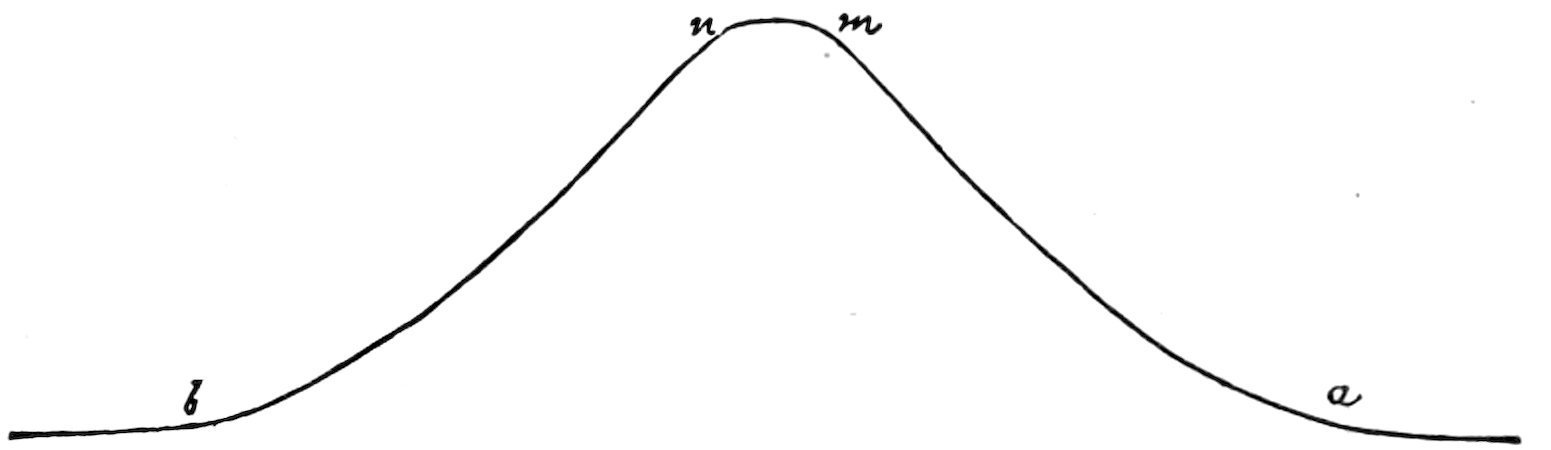
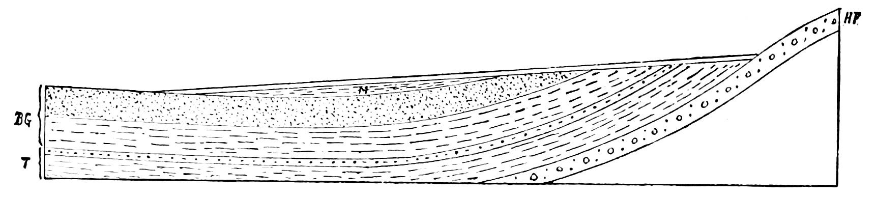
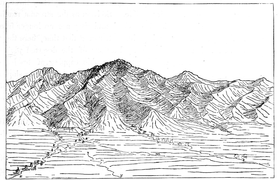
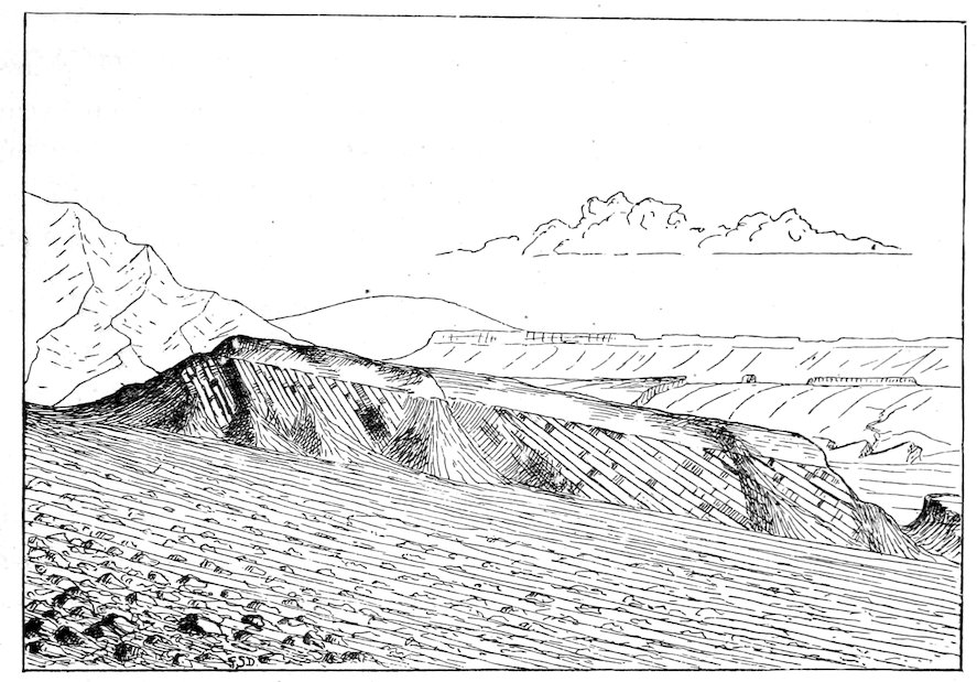
New original cover art included with this eBook is granted to the public domain.
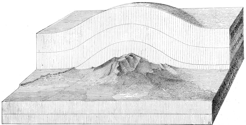
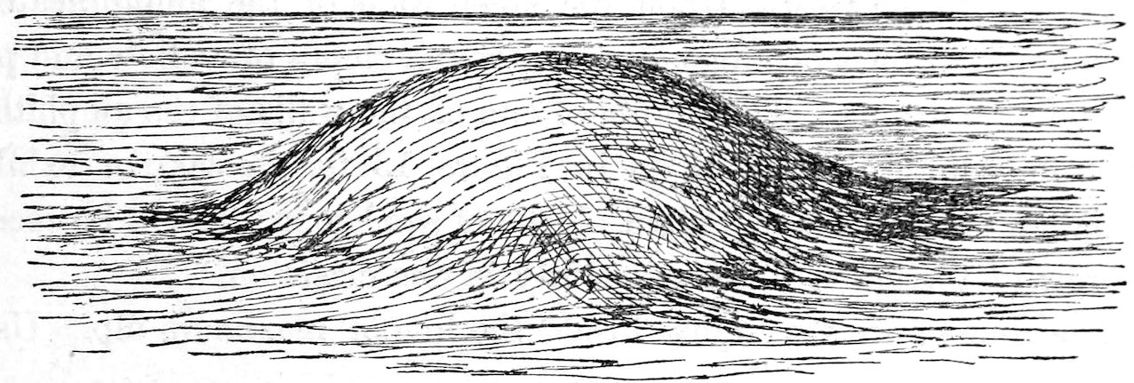
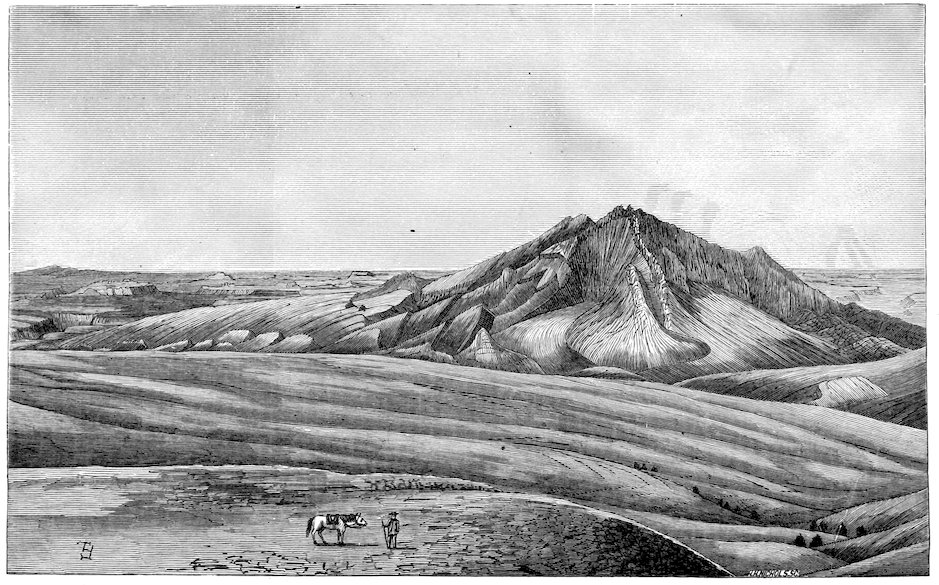
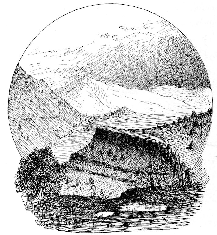
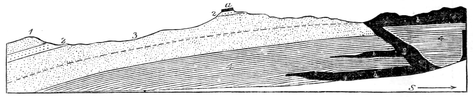
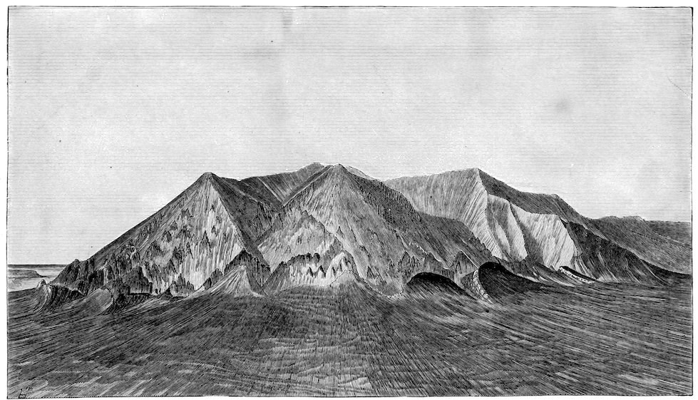
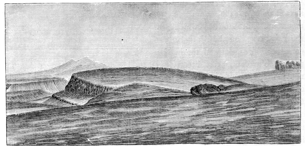
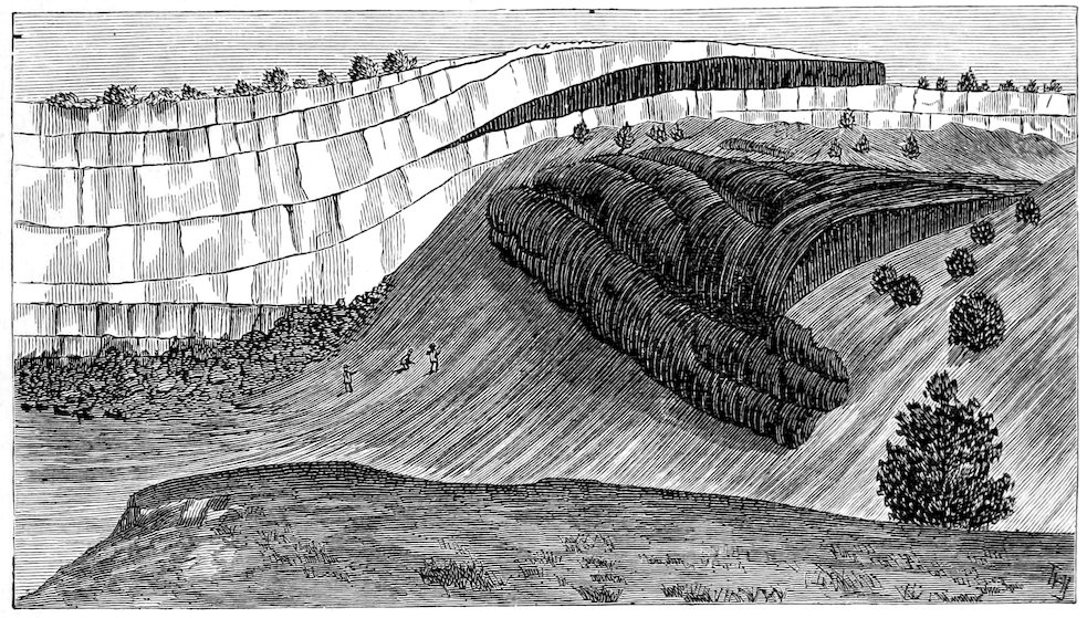
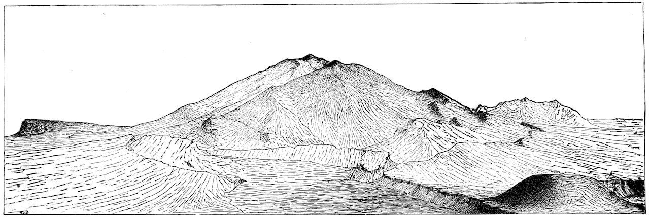
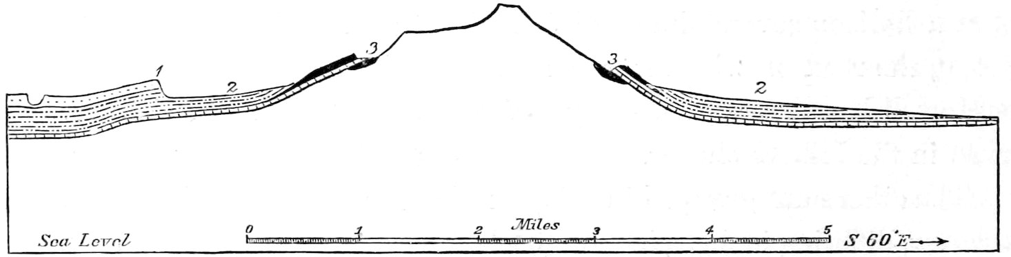
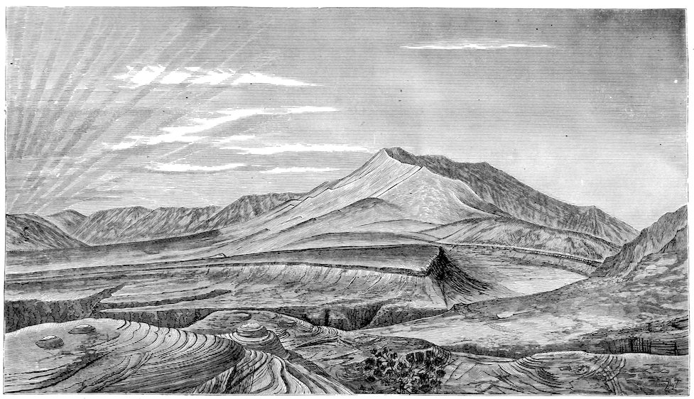
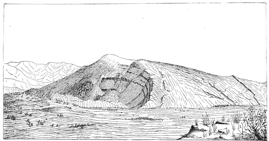
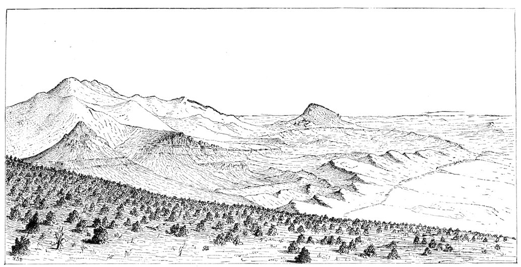
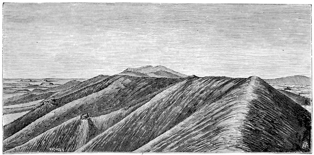
Frontispiece.—Half-stereogram of Mount Ellsworth, drawn to illustrate the form of the displacement and the progress of the erosion.
The base of the figure represents the sea-level. The remote half shows the result of uplift alone; the near half, the result of uplift and erosion, or the actual condition. (See page 95.)
DEPARTMENT OF THE INTERIOR.
U. S. GEOGRAPHICAL AND GEOLOGICAL SURVEY OF THE ROCKY MOUNTAIN REGION.
J. W. POWELL, in Charge.
By G. K. GILBERT.
WASHINGTON:
GOVERNMENT PRINTING OFFICE.
1877.
Department of the Interior,
U. S. Geographical and Geological Survey
of the Rocky Mountain Region,
Washington, D. C., March 5, 1877.
Sir: I have the honor to transmit herewith a report on the Geology
of the Henry Mountains, by Mr. G. K. Gilbert.
I am, with great respect, your obedient servant,
J. W. POWELL,
In charge.
The Hon. Secretary of the Interior,
Washington, D. C.
Department of the Interior,
U. S. Geographical and Geological Survey
of the Rocky Mountain Region,
Washington, D. C., March 1, 1877.
Dear Sir: I submit herewith my report on the Geology of the Henry
Mountains, prepared from material gathered under your direction in the
years 1875 and 1876.
I am, with great respect, your obedient servant,
G. K. GILBERT.
Prof. J. W. Powell,
In charge.
PREFACE.
VII
If these pages fail to give a correct account of the structure of the
Henry Mountains the fault is mine and I have no excuse. In all the earlier
exploration of the Rocky Mountain Region, as well as in much of the more
recent survey, the geologist has merely accompanied the geographer and
has had no voice in the determination of either the route or the rate of
travel. When the structure of a mountain was in doubt he was rarely able
to visit the points which should resolve the doubt, but was compelled to
turn regretfully away. Not so in the survey of the Henry Mountains.
Geological exploration had shown that they were well disposed for examination,
and that they promised to give the key to a type of structure which
was at best obscurely known; and I was sent by Professor Powell to make
a study of them, without restriction as to my order or method. I was limited
only in time, the snow stopping my work two months after it was
begun. Two months would be far too short a period in which to survey a
thousand square miles in Pennsylvania or Illinois, but among the Colorado
Plateaus it proved sufficient. A few comprehensive views from mountain
tops gave the general distribution of the formations, and the remainder of the
time was spent in the examination of the localities which best displayed
the peculiar features of the structure. So thorough was the display and
so satisfactory the examination, that in preparing my report I have felt less
than ever before the desire to revisit the field and prove my conclusions
by more extended observation.
In the description of the details of the structure a demand arose for a
greater number of geographic titles than were readily suggested by natural
forms or other accidents, and recourse was had to the names of geologists.
Except that the present members of my own corps are not included,
the names chosen are of those whose cognate studies have given me most
aid. Mr. Steward and Mr. Howell saw the Henry Mountains before I did,
VIIIand gleaned something of their structure from a distance; Dr. Newberry,
Mr. Marvine, Dr. Peale, and Mr. Holmes have described allied phenomena
in Colorado and New Mexico; and the works of Messrs. Jukes, Geikie,
Scrope, and Dana have been among my chief sources of information in
regard to igneous mountains in general. If any of these gentlemen feel
offended that their names have been attached to natural features so insignificant,
I can assure them that the affront will never be repeated by the
future denizens of the region. The herders who build their hut at the base
of the Newberry Arch are sure to call it “the Cedar Knoll”; the Jukes
Butte will be dubbed “Pilot Knob”, and the Scrope, “Rocky Point”.
During the preparation of my report every part of the discussion has
been submitted to Professor Powell for criticism, and many of his suggestions
are embodied in the text. Similar and valuable aid was received
from Capt. C. E. Dutton and Mr. William B. Taylor in the study of the
physical problems to which the discussion of the intrusive phenomena gave
rise. Captain Dutton rendered an important service also by the study of
the collection of igneous rocks, and his report, included in the fourth chapter,
testifies to the thoroughness of his work. The supervision of the publication
has fallen in large share upon Mr. J. C. Pilling, and the text has
had the advantage of his literary criticism, as well as of his watchful care.
CHAPTER I. INTRODUCTORY. — THE ROCK SERIES. — UNCONFORMITIES. — THE GREAT FOLDS. — CLIFFS AND PLATEAUS. — HOW TO REACH THE HENRY MOUNTAINS.
1
The Henry Mountains have been visited only by the explorer. Previous
to 1869 they were not placed upon any map, nor was mention made
of them in any of the published accounts of exploration or survey in the
Rocky Mountain region. In that year Professor Powell while descending
the Colorado River in boats passed near their foot, and gave to them the
name which they bear in honor of Prof. Joseph Henry, the distinguished
physicist. In 1872 Prof A. H. Thompson, engaged in the continuance of
the survey of the river, led a party across the mountains by the Penellen
Pass, and climbed some of the highest peaks. Frontiersmen in search of
farming and grazing lands or of the precious metals have since that time
paid several visits to the mountains; but no survey was made of them until
the years 1875 and 1876, when Mr. Walter H. Graves and the writer visited
them for that purpose.
They are situated in Southern Utah, and are crossed by the meridian
of 110° 45′ and the thirty-eighth parallel. They stand upon the right
bank of the Colorado River of the West, and between its tributaries, the
Dirty Devil and the Escalante.
At the time of their discovery by Professor Powell the mountains were
in the center of the largest unexplored district in the territory of the United
States—a district which by its peculiar ruggedness had turned aside all
previous travelers. Up to that time the greater part of the knowledge that
had been gained of the interior of the continent had been acquired in the
search for routes for transcontinental railways; and the cañons of the Colorado
Basin, opposing more serious obstacles to travel than the mountain
ranges which were met in other latitudes, were by common consent avoided
by the engineers.
2The same general causes which have rendered the region so difficult of
access and passage have made it a desert, almost without economic value.
The physical conditions of elevation and aridity which have caused it to be
so deeply carved in cañons, have prevented the streams with which it is
scantily watered from being bordered by tracts of land which can be irrigated;
and agriculture without irrigation being in that climate an impossibility,
there is nothing to attract the farmer. As will be explained in the
sequel, the mountains offer no inducements to the miner of the precious
metals. There is timber upon their flanks and there is coal near at hand,
but both are too far removed from other economic interests to find the market
which would give them value. It is only for purposes of grazing that
they can be said to have a money value, and so distant are they at present
from any market that even that value is small.
But while the Henry Mountains contribute almost nothing to our direct
material interests, they offer in common with the plateaus which surround
them a field of surpassing interest to the student of structural geology. The
deep carving of the land which renders it so inhospitable to the traveler
and the settler, is to the geologist a dissection which lays bare the very
anatomy of the rocks, and the dry climate which makes the region a naked
desert, soilless and almost plantless, perfects the preparation for his examination.
The study of the mountains is further facilitated by their isolation.
They mark a limited system of disturbances, which interrupt a region of
geological calm, and structurally, as well as topographically, stand by themselves.
The Henry Mountains are not a range, and have no trend; they are
simply a group of five individual mountains, separated by low passes and
arranged without discernible system. The highest rise about 5,000 feet
above the plateau at their base and 11,000 feet above the level of the ocean.
Projecting so far above the surface of the desert, they act as local condensers
of moisture, and receive a comparatively generous supply of rain.
Springs abound upon their flanks, and their upper slopes are clothed with
a luxuriant herbage and with groves of timber. The smaller mountains and
the foot-hills of the larger are less generously watered and but scantily
3clothed with vegetation. Their extent is small. From Ellen Peak to Mount
Ellsworth, the two summits which are the most widely separated, the distance
is but twenty-eight miles, and a circle of eighteen miles radius will
include the whole group.
Mount Ellen which is the most northerly of the group, has an extreme
altitude of 11,250 feet, and surpasses all its companions in horizontal extent
as well as altitude. Its crest-line is continuous for two miles, with an elevation
varying little from 11,000 feet. From it there radiate spurs in all
directions, descending to a series of foot-hills as conspicuous in their
topography as they are interesting in their structure. In some places the
base of the mountain is guarded by a continuous, steep ridge, through
which a passage must be sought by the approaching traveler, but within
which movement in any direction is comparatively unimpeded.
Mount Pennell is a single peak rising to an altitude of 11,150 feet.
On one side its slopes join those of Mount Ellen in Pennellen Pass (7,550
feet), and on the other those of Mount Hillers in the Dinah Creek Pass
(7,300 feet). Its profiles are simple, and it lacks the salient spurs that
characterize Mount Ellen. From the west it is difficult of approach, being
guarded by a barrier ridge continuous with that of Mount Ellen.
Mount Hillers is more rugged in its character, and although compact
in its general form, is carved in deep gorges and massive spurs. Its rugosity
is contrasted by the smoothness of its pedestal, which to the south and west
and north is a sloping plain merging with the surrounding plateau.
Mount Ellsworth (8,000 feet) and Mount Holmes (7,750 feet) stand
close together, but at a little distance from the others. The pass which
separates them from Mount Hillers has an altitude of 5,250 feet. They are
single peaks, peculiarly rugged in their forms, and unwatered by springs.
They stand almost upon the brink of the Colorado, which here flows
through a cañon 1,500 feet in depth.
The sedimentary rocks which occur in the Henry Mountains and their
immediate vicinity, range from the summit of the Cretaceous to the summit
of the Carboniferous. It is probable that they were covered at one time
4by some thousands of feet of Tertiary strata, but from the immediate banks
of the Colorado these have been entirely eroded, and their nearest vestiges
lie thirty miles to the westward, where they have been protected by the
lava-beds of the Aquarius Plateau.
Cretaceous.—The Cretaceous strata do not reach to the Colorado River,
but they extend to the Henry Mountains, and are well displayed upon the
flanks. They include four principal sandstones, with intervening shales, in
the following (descending) order:
1.
The Ma-suk′ Sandstone, yellow, heavy-bedded
500 feet.
2.
The Ma-suk′ Shale, gray, argillaceous, and toward the top slightly arenaceous
500 feet.
3.
The Blue Gate Sandstone, yellow and heavy-bedded
500 feet.
4.
The Blue Gate Shale, blue-black and argillaceous, weathering to a fine gray clay (Inoceramus deformis and I. problematicus)
1,000 feet.
5.
The Tu-nunk′ Sandstone, yellow and heavy-bedded
100 feet.
6.
The Tu-nunk′ Shale, blue-black and argillaceous, weathering to a fine gray clay (Inoceramus problematicus and Baculites anceps)
Arenaceous shales, purple, green, and white, with local beds of conglomerate
190 feet.
c.
Coarse sandstone and conglomerate, with many white grains and pebbles, interleaved with local beds of purple and red shale, and containing immense silicified tree-trunks
300 feet.
Total Cretaceous
3,500 feet.
The three upper sandstones, the Masuk, the Blue Gate, and the Tununk,
are so nearly identical in their lithologic characters that I was unable
5to discriminate them in localities where their sequence was unknown. This
was especially the case upon the summits of Mounts Ellen and Pennell
where they occur in a somewhat metamorphosed condition. All of them
contain thin beds of coal, none of which are continuous over large areas,
and only one of which was observed of workable thickness. At the western
foot of Mount Ellen, a bed four feet thick lies at the base of the Blue Gate
Sandstone.
There is almost equal difficulty in discriminating the Masuk, the Blue
Gate, and the Tununk shales. The first is usually of a paler color and is
more apt to include arenaceous bands. It has not been found to contain
fossils, while the lower shales rarely fail to afford them when search is made.
The Blue Gate and Tununk shales are typical examples of fine argillaceous
sediments. They are beautifully laminated and are remarkably homogeneous.
It is only in fresh escarpments that the lamination is seen, the
weathered surface presenting a structureless clay. The fossils of these shales
are so numerous, when they have been sought out and studied, that they
will probably serve not merely to discriminate the two, but also to correlate
them with some of the beds which have been examined elsewhere in the
Colorado Basin. For the present I am unable to refer any of the Cretaceous
rocks above the Henry’s Fork Group to the divisions which have been recognized
elsewhere, and it is for this reason that I have given local, and
perhaps temporary names to such beds as I have need to mention in the
discussion of the structure of the mountains.
The fossils of the Henry’s Fork Group have been more fully collected,
and they have been referred without question by Dr. White to the group of
that name, as recognized in the Green River Basin (Geology of the Uinta
Mountains, pp. 82 and 94). The white grit which lies at the base of the
group is a conspicuous bed of unusual persistence, and is recognized
wherever Cretaceous rocks are found in the upper basin of the Colorado.
Jura-Trias.—The rocks which intervene between the base of the Cretaceous
and the summit of the Carboniferous are of doubtful age, having
been referred to the Trias by one geologist and to the Jura and Trias by
others, while the fossils recently discovered by Mr. Howell (Geology of
Uinta Mountains, page 80) lead to the suspicion at least that they are all
6Jurassic. It is probable that the uncertainty will soon be dispelled by the
more thorough working of Mr. Howell’s new localities; but while it remains,
it seems best to recognize its existence in our nomenclature, and I
shall include the whole of the doubtful series under the title of Jura-Trias.
At the Henry Mountains it is easily divided into four groups, as follows:
1.
Flaming Gorge Group; arenaceous shales or bad-land sandstones, purple and white at top and red below
1,200 feet.
2.
Gray Cliff Group; massive cross-laminated sandstone, buff to red in color
500 feet.
3.
Vermilion Cliff Group; massive cross-laminated sandstone, red, with a purple band at the top
500 feet.
4.
Shin-ar´-ump Group; consisting of—
a.
Variegated clay shale; purple and white above and chocolate below, with silicified wood
300 feet.
b.
Gray conglomerate, with silicified wood; the “Shinarump Conglomerate”
30 feet.
c.
Chocolate-colored shale, in part sandy
400 feet.
Total Jura-Trias
2,930 feet.
The rock of the Flaming Gorge Group is of a peculiar character. It is
ordinarily so soft that in its manner of weathering it appears to be a shale.
It is eroded so much more rapidly than the Henry’s Fork conglomerate
above it, that the latter is undermined, and always appears in the topography
as the cap of a cliff. Nevertheless, it is not strictly speaking a shale. The
chief product of its weathering is sand, and wherever it can be examined
in an unweathered condition it is found to be a fine-grained sandstone,
massive and cross-laminated like those of the Gray and Vermilion Cliffs, but
devoid of a firm cement. In a number of localities it has acquired, locally
and accidentally, a cement, and it is there hardly distinguishable from the
firmer sandstones which underlie it. In the immediate vicinity of the Henry
Mountains it varies little except in color from summit to base, but in
other localities not far distant it is interrupted near the base by thick
beds of gypsum and gypsiferous clays, and by a sectile, fossiliferous limestone.
7The Gray Cliff and Vermilion Cliff sandstones are often difficult to
distinguish, but the latter is usually the firmer, standing in bold relief in
the topography, with level top, and at its edge a precipitous face. The former
is apt to weather into a wilderness of dome-like pinnacles, so steepsided
that they cannot often be scaled by the experienced mountaineer, and
separated by narrow clefts which are equally impassable.
The colors of the two sandstones are not invariable. The lower, which
although not reddened throughout its mass is usually stained upon its surface
with a uniform deep color, appears in Mount Ellsworth and at other points
of elevation with as pale a tint as that of the Gray Cliff. The latter sandstone,
on the other hand, where it lies low, is often as deep in color as the
Vermilion. Standing upon one of the summits of the Henry Mountains and
looking eastward, I found myself unable to distinguish the Gray Cliff Sandstone
by color either from the lower part of the Flaming Gorge Group or
from the Vermilion Sandstone. The bleaching of the redder sandstone in
Mount Ellsworth is probably a result of metamorphism; the reddening of
the gray sandstone may depend on the hydration of the iron which it contains.
The thickness of individual strata in these great sandstones is remarkable,
and is one of the elements which must be taken into account in the
discussion of the problem—which to my mind is yet unsolved—of the manner
in which such immense quantities of homogeneous sand were accumulated.
Ordinarily the depth of strata is indefinable, on account of the impossibility
of distinguishing stratification from lamination; but where, as in
this case, the lamination is oblique to the stratification, the upper and lower
limits of each stratum are definitely marked. I have at several points
measured single strata with thicknesses of about fifty feet, and near Waterpocket
Cañon a stratum of Vermilion Cliff sandstone was found to be 105
feet thick.
One other measurement is worthy of record; the inclination which
oblique lamination bears to the plane of the stratum in which it occurs
appears to have a definite limit. The maximum of a series of measurements
made at points where to the eye the dip seemed to be unusually great, is
24°.
8The sandy layers at the base of the Shinarump Group are characterized
by profuse ripple-marks.
Carboniferous.—Beneath the Jura-Trias is the Carboniferous. A few
hundred feet of its upper member, the Aubrey Sandstone, are exposed near
the summit of Mount Ellsworth. At that point the sandstone is altered to
the condition of a quartzite, but where it is cut by the upper and lower
cañons of the Dirty Devil River it is massive and cross-laminated, differing
from the Gray Cliff sandstone chiefly in the abundance of its calcareous
cement.
From the Masuk Sandstone to the Aubrey Sandstone, inclusive, there
is perfect conformity of dip. The fold system of the region, of which a
description will be found in succeeding pages, was established after the
deposition of all these strata, and the whole series were flexed together.
Nevertheless, the strata do not represent continuous deposition. There
were intervals in which the sea receded and exposed to erosion the sediments
which it had accumulated. Shallow valleys and waterways were
excavated, and when the sea returned it deposited new sediments upon the
somewhat uneven surface of the old.
The first occurrence of this sort was at the close of the Aubrey epoch.
Its evidence was not found in the Henry Mountains; but at the confluence
of the Paria with the Colorado, eighty miles to the southeast, the
surface of the upper member of the Aubrey Group, which is there a cherty
limestone, is unevenly worn, and in its depressions are beds of conglomerate,
the pebbles of which are derived from the chert of the limestone itself.
The shaly, rippled sandstones which succeed this conglomerate indicate
that the water remained shallow for a time, and in the middle of the Shinarump
epoch the region was once more abandoned by the sea. The chocolate
shales and shaly sands were unevenly worn, and the first deposit that
the returning sea spread over them was a conglomerate. The evidence of
this break is found at many points. The Shinarump conglomerate although
remarkably persistent for a conglomerate thins out and disappears at a
number of points, and at the margins of its areas it is evident to the eye
that it occupies depressions of the surface on which it rests.
9The next break is at the base of the Vermilion Cliff Group. In the
region of the Virgin River and Kanab Creek the change from the variegated
shales of the Upper Shinarump to the homogeneous sandstone
of the Vermilion Cliff is gradual, the interval being filled by a series of
alternating shales and sandstones; but further to the east, in the region of
the Henry Mountains and Waterpocket Cañon, the change is abrupt, and
the firm sandstone rests directly upon the soft shale. The abruptness of the
change would suggest that the currents which brought the sand had swept
away all evidence of the intermediate conditions which are likely to have
connected the epochs represented by the two sediments; but in one locality,
at least, there is direct evidence that the surface of the clay was exposed
to the air before it was covered by the sand. On the northern flank of
Mount Ellsworth are the vestiges of a system of mud-cracks, such as form
where wet clays are dried in the sun. Where the under surface of the
Vermilion sandstone is exposed to view, it is seen to be marked by a network
of ridges which once occupied the sun-cracks of the Shinarump clay;
and where the clay is seen in juxtaposition, tapering fillets of sand can be
traced from the ridges downward ten feet into the clay.
Fig. 1.—Fossil Suncracks in the Shinarump Shale.
10From the base of the Vermilion to the summit of the Cretaceous no
evidence of land erosion has been found; but the association of coal seams
with all of the Cretaceous sandstones except the lowest, shows that the sea-bottom
was frequently brought to the surface of the water if it was not
carried above.
Thus it is evident that the strata of the Henry Mountain region do not
represent continuous sedimentation. At the close of the Aubrey epoch, in
the middle of the Shinarump, and again at the close of the Shinarump, not
merely was the accumulation of sediments interrupted, but the process was
reversed, and a portion of the deposits which had already been formed were
excavated by the agency of rains and rivers, and swept away to some other
region. Each break is indefinite, alike as regards the interval during which
the record of the sea was interrupted and as regards the extent of the record
which was at the same time obliterated. And yet the evidence of these
breaks is of such nature that it would probably elude observation if a
single section only were examined, and in a region masked by the soil and
vegetation of a humid climate it would hardly be discovered except by
accident. The parallelism of contiguous strata is not alone sufficient evidence
that they were consecutive in time.
At the close of the Cretaceous period there came an epoch of disturbance.
The system of strata which has been described was bent into
great waves, and the crests of the waves were lifted so high above the sea
that they lost thousands of feet by erosion.
In the troughs between the waves lakes remained, in which the material
removed from the crests was redeposited, and by a later change the
lake waters rose so as to cover the truncated crests, and deposit upon the
worn edges of the upbent strata a series of unconforming, fresh-water, Tertiary
sediments.
Thus was produced the only unconformity of dip which involves the
Henry Mountain rocks, and even this is not to be observed in the immediate
vicinity of the mountains, for a later erosion has thence removed all of the
Tertiary strata, and has resumed the degradation of the older beds.
11
The disturbances at the close of the Cretaceous period were of the
Kaibab type[1]. It seems as though the crust of the earth had been divided
into great blocks, each many miles in extent, which were moved from their
original positions in various ways. Some were carried up and others down,
and the majority were left higher at one margin than at the other. But
although they moved independently, they were not cleft asunder. The
strata remained continuous, and were flexed instead of faulted at the margins
of the blocks. Subsequent erosion has obliterated in great part the
inequality of the surface, and the higher-lying blocks do not stand as mountains,
but are outlined by zones of tilted strata which mark the flexures by
which the blocks are separated. Along the zones of flexure it frequently
happens that a hard stratum outcropping between two that are softer will
be preserved from erosion and form a long, continuous ridge. Such ridges,
and other forms produced by the erosion of the flexures, are conspicuous
features of the topography, and the tracing out of the limits of the blocks is
a simple matter. Indeed the flexures are the first elements of the structure
to attract attention, and it is easy in studying them to overlook the fact that
they merely mark the limits between displaced masses of great extent. If
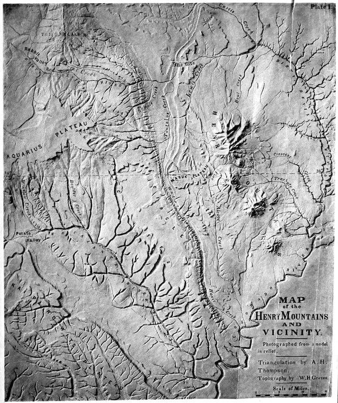
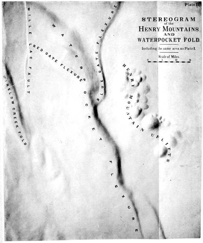
the reader will examine Plate I at the end of the volume, he will observe
that the system of parallel ridges and valleys which follow the line of the
Waterpocket flexure are very conspicuous features; but it is only by some
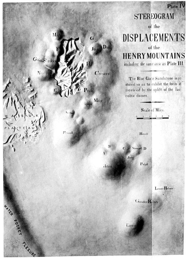
such generalization as that given in the stereogram of the same region
(Plate II) that the full structural significance of the flexures can be realized.
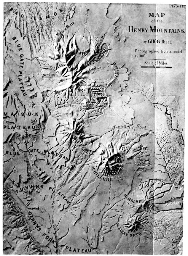
Each map was obtained by photography from a model in relief, in which
the proportionate heights of the several features were not exaggerated. The
stereogram was produced by the restoration of the top of the Cretaceous,
the Masuk sandstone, in the form and position it would have, had there
been no erosion of the region, but displacement only.
1. For a definition of the Kaibab structure, see “Geology of the Uinta Mountains,”
pp. 14 and 17, and American Journal of Science for July and August, 1876,
pp. 21 and 85.
I must caution the reader against an implication of rigidity which might
attach to the meaning of the word “block”, as I have used it in speaking
12of the great displaced rock masses. To what extent they may be regarded
as rigid is uncertain, but the presence upon their surfaces of numerous minor
flexures, such as appear in the stereogram, would seem to imply that their
rigidity is not of a high order.
In the northwest corner of the area represented by the stereogram are a
few faults belonging to a system which occupies a large area in that
direction. The system of faults and the system of flexures are independent,
the latter having originated at the close of the Cretaceous period,
and the former after the formation of the Tertiary rocks of the region,
which are referred by Professor Powell to the Bitter Creek epoch. Over
a large district the Tertiary strata were covered by a deep mantle of lava,
which has protected them from erosion to such an extent that the structure
of the district is portrayed in its topography. The district is its own stereogram,
each uplifted block constituting a mountain and each depressed block
flooring a valley.
Not all the displacements of the later system are by faulting, but by
far the greater number. Of the earlier system of displacements none are
simple faults, but a few are combinations of fault and flexure.
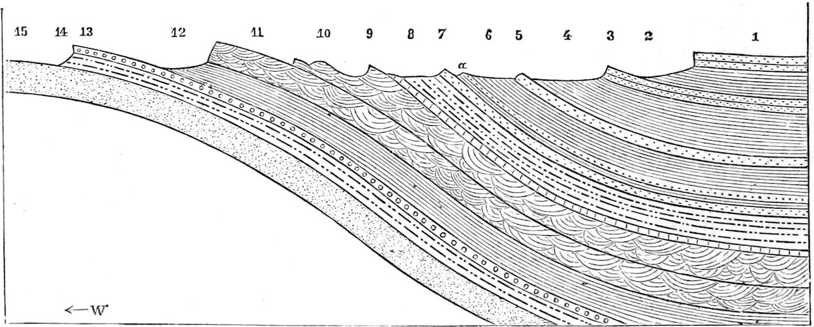
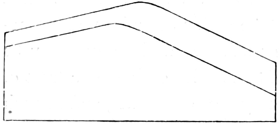
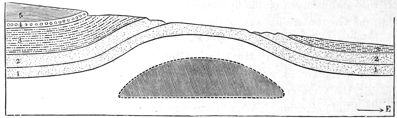
Fig. 2.—Cross-section of the Waterpocket Flexure, opposite the Masuk Plateau. Scale, one inch = 3,500 feet. 1, Masuk Sandstone. 2, Masuk Shale. 3, Blue Gate Sandstone. 4, Blue Gate Shale. 5, Tununk Sandstone. 6, Tununk Shale. a, Gryphea Sandstone. 7, Henry’s Fork Conglomerate. 8, Flaming Gorge Shale. 9, Fossiliferous Limestone. 10, Gray Cliff Sandstone. 11, Vermilion Cliff Sandstone. 12, Upper Shinarump Shale. 13, Shinarump Conglomerate. 14, Lower Shinarump Shale. 15, Aubrey Sandstone.
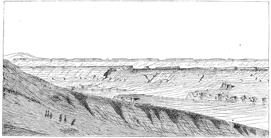
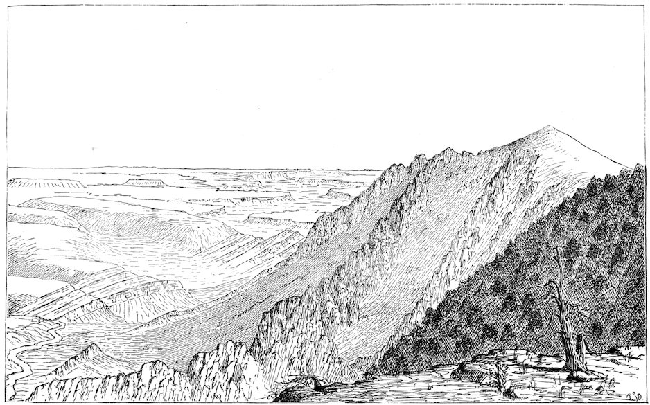
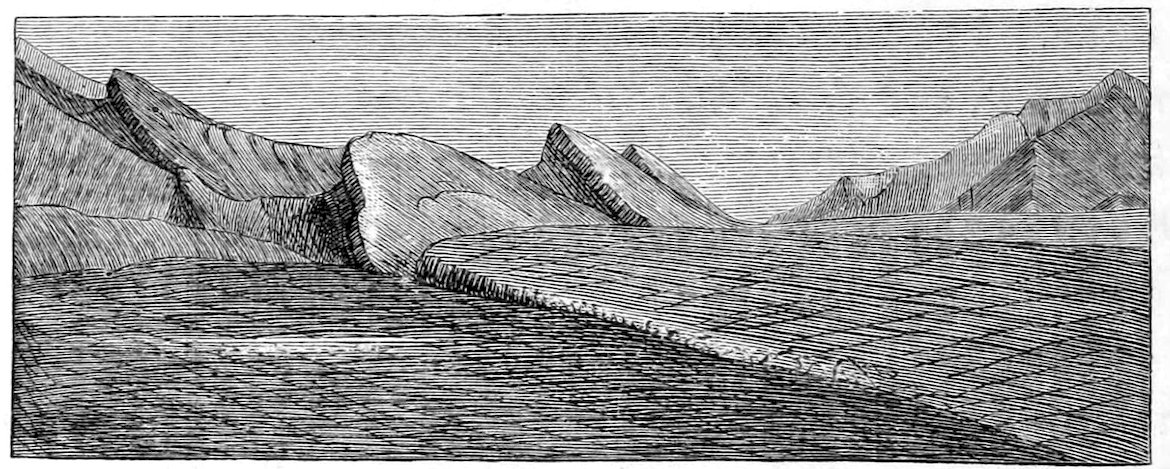
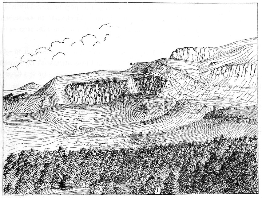
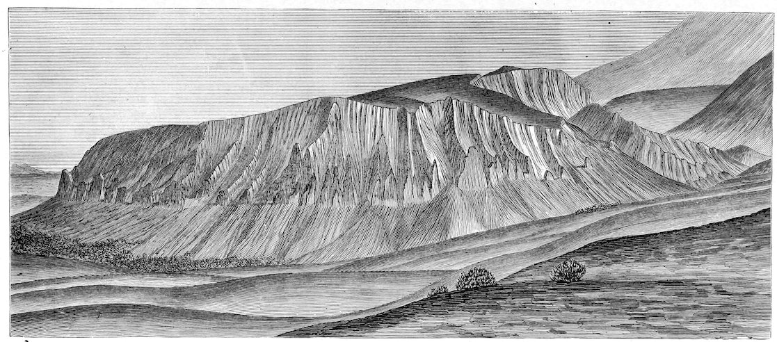
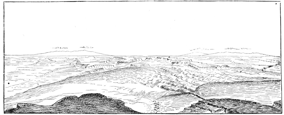
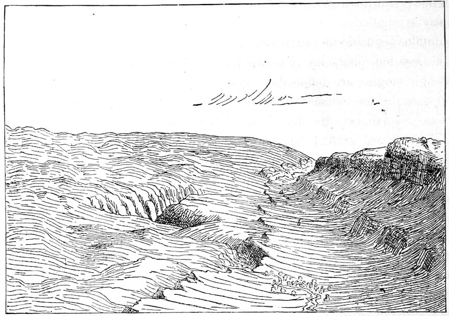
Fig. 3.—View of the Waterpocket Cañon and the Waterpocket Flexure. The cliff at the left is capped by the Henry’s Fork Conglomerate. The arched rocks at the right are the Gray and Vermilion Cliff Sandstones.
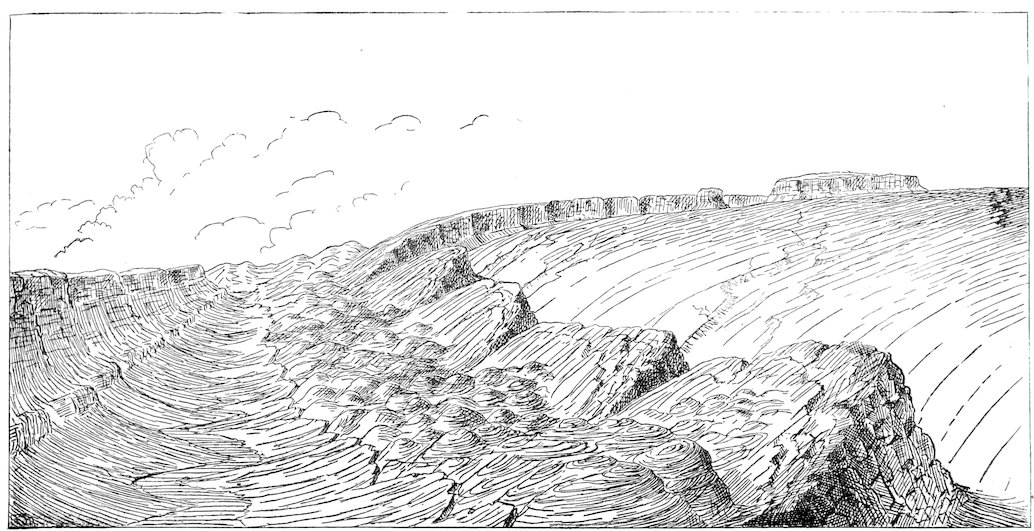
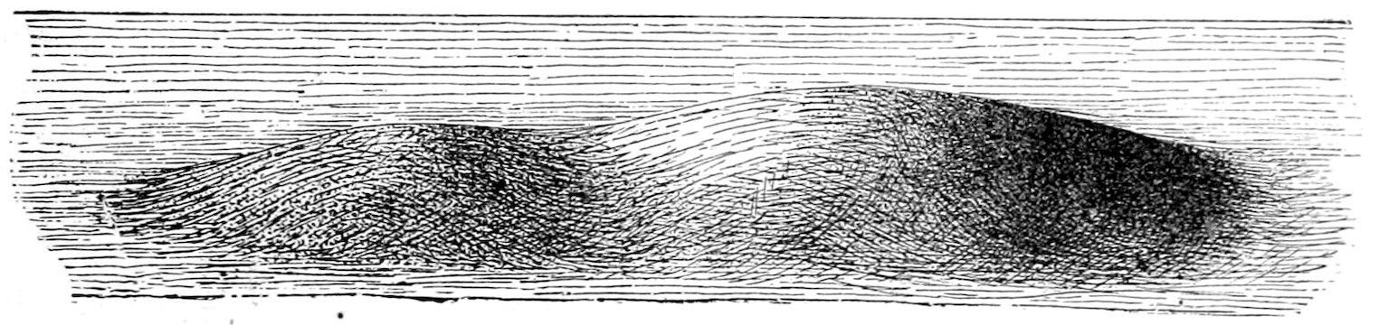
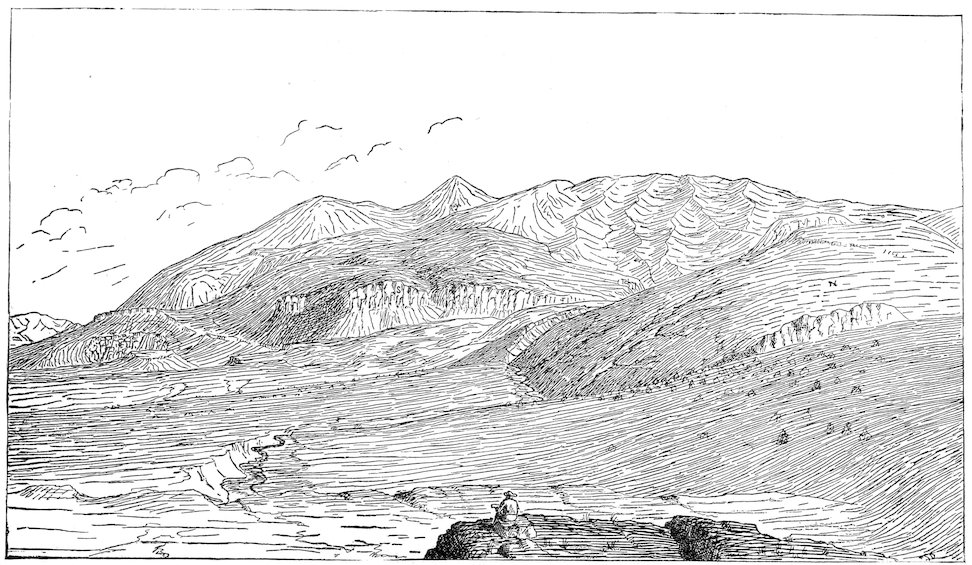
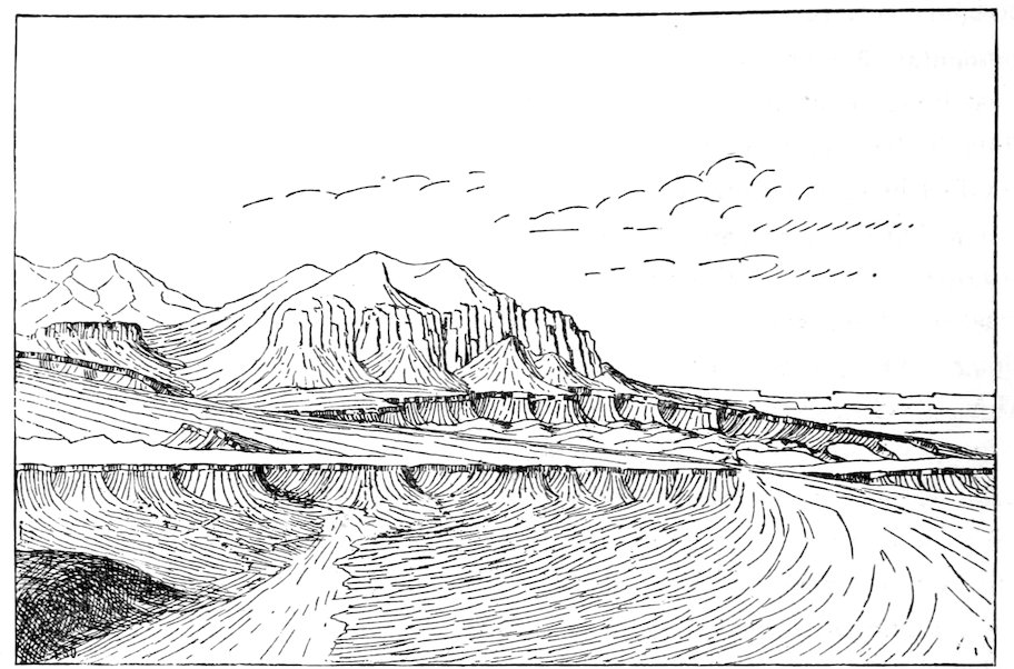
Fig. 4.—Waterpocket Flexure, as seen from the south end of Mount Ellen.
13The Waterpocket flexure, represented in the stereogram (Plate II), is
better known in detail than any other of the great flexures of Southern
Utah. It is far from following a straight line, but like most lines of orographic disturbance swerves to the right and left, while maintaining a general
trend. The amount of its “throw”, or the difference in level between
adjacent parts of the two blocks which it divides, is inconstant, its maximum
being 7,000 feet. At some points the flexed strata are inclined at an angle
of 50° while at others their greatest dip is but 15°. Toward the north
the flexure twice divides. One of its branches, the Blue Gate flexure, has
a throw in the same direction, and by its separation diminishes the throw
of the main flexure. The other, the Red Gate flexure, has a throw in the
opposite direction, and by its separation increases the throw of the main
flexure. Or in other words, the blocks at the west of the main flexure stand
higher than those at the east; and of two blocks which lie at the west, that
at the north of the Red Gate flexure stands higher than that at the south;
while of two blocks at the east, that which lies northwest of the Blue Gate
flexure is higher than the one at the southeast.
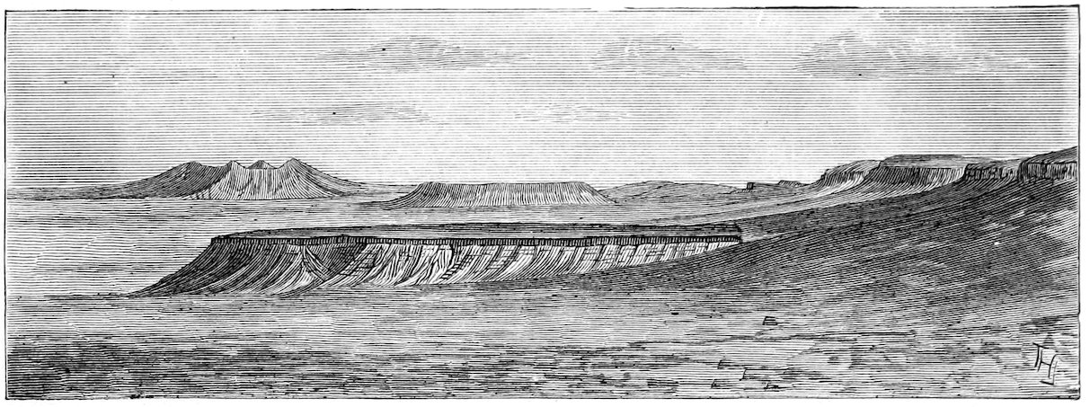
Let us now return to the topographic map (Plate I) and examine the
forms into which erosion has wrought the disturbed strata. Thanks to the
aridity of the climate, the erosion has been greatly influenced by the varying
texture of the rocks. Every hard stratum, if inclined, stands forth in a
ridge, or if level, caps a plateau. The Masuk Sandstone, undermined by
the weathering of the Masuk Shale, breaks off everywhere in a cliff which
completely encircles the Masuk Plateau. The plateau stands upon the Blue
Gate Sandstone, and this breaking off in a cliff upon all sides constitutes
another plateau. The Blue Gate Plateau, in turn, rests upon the Tununk,
and that again upon the Henry’s Fork. Passing either to the north or to
the south from the Masuk Plateau, one descends a great geological stairway,
of which each step is a hard sandstone and each riser a soft shale.
Toward the Waterpocket flexure the edge of each plateau is upturned, and
if one goes westward from the Masuk Plateau, he will cross in the first mile
the upturned rocks of all the lower tables.
The preservation of the Masuk Plateau is due in part to the fact that
it lies in a slight synclinal, but chiefly to the arrangement of the drainage lines.
No streams cross the Henry Mountains, but all go around, and the
14plateau occupies the divide between those which flow southward to the
Colorado and those which flow northward to the Dirty Devil.
The antithesis of the Masuk Plateau is to be seen in the Circle Cliffs,
on the summit of the Waterpocket fold. At the lowest point of the Masuk
synclinal a circling cliff has been formed, which facing outward surrounds
a plateau. At the highest point of the Waterpocket fold, which is in a
certain sense anticlinal, a circling cliff has been formed which, facing inward,
surrounds a valley. The two phenomena are alike illustrations of
the law that in regions of inclined strata cliffs face toward districts of elevation
and away from districts of depression.
Fig. 5.—Ways and Means.
No one but a geologist will ever profitably seek out the Henry Mountains,
and I will therefore, in marking out a route by which they may be
reached, select whenever there is option those paths which will give him
the best introduction to this wonderful land. There is no
wagon-road to the mountains, and although a wagon
might carry his baggage the greater part of the way, he
must provide himself with other means of transportation. At
Salt Lake City he can procure pack-mules and pack-saddles,
or apparajos, and everything necessary for a mountain
“outfit”. His route southward follows the line of the Utah
Southern Railway to Juab Valley, and then touches the
Mormon towns of Nephi, Gunnison, and Salina. At Salina
he halts his train for a day while he rides a few miles
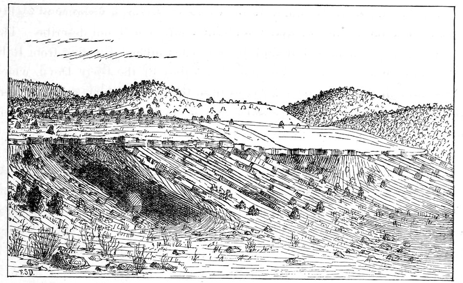
up the creek to see the unconformity between the Tertiary above, and the
Jura-Trias and Cretaceous below. This is at present the last settlement on
the route, but there are “ranches” as far as Rabbit Valley, and if he delays
a few years he will find a town there. By way of the “Twist” road and
King’s Meadows he goes to Grass Valley, and thence to Fish Lake. The lake
lies between two upheaved blocks of trachyte, and covers one which is relatively
depressed, and tilted to the north. At the south end of the lake he
stands on the higher end of the depressed block, and if he follows the shore
to the outlet at the north he will find that the water is contained by a
15moraine, which has been thrown across the valley by an ancient glacier,
descending from the mountain at the west. From Fish Lake he goes
to Rabbit Valley, and there delays a day or two to climb Thousand Lake
Mountain. Looking west from the summit he sees the lava-capped plateaus
of the faulted district among which he has journeyed since he left the
“Twist”—huge tables of trachyte bounded by cliffs of displacement, of
which only the sharpest edges have been worn away; and when his eye
has become accustomed to the facies of the faults, he perceives that there
is an identity in structure between the great and the small features. Just as
the whole district is divided into blocks, of which the dimensions are measured
by miles, and the displacements by thousands of feet, so the greater
blocks are sometimes divided into smaller, of which the dimensions are
measured by rods and furlongs and the displacements by tens and hundreds
of feet. Looking eastward he sees the region of the great flexures
spread out before him like a map. The Waterpocket flexure starts from the
very mountain beneath him, and curving to the right, runs far to the south
and is lost in the distance. Beyond it are the Henry Mountains springing
abruptly from the desert; and against the horizon are outlined other island
mountains, gray in the distance. To the left is the San Rafael Fold, the
rival of the Waterpocket in grandeur; and all about are tables and cliffs.
The vivid hues of the naked rocks are obscured only by the desert haze,
and the whole structure is pictured forth by form and color.
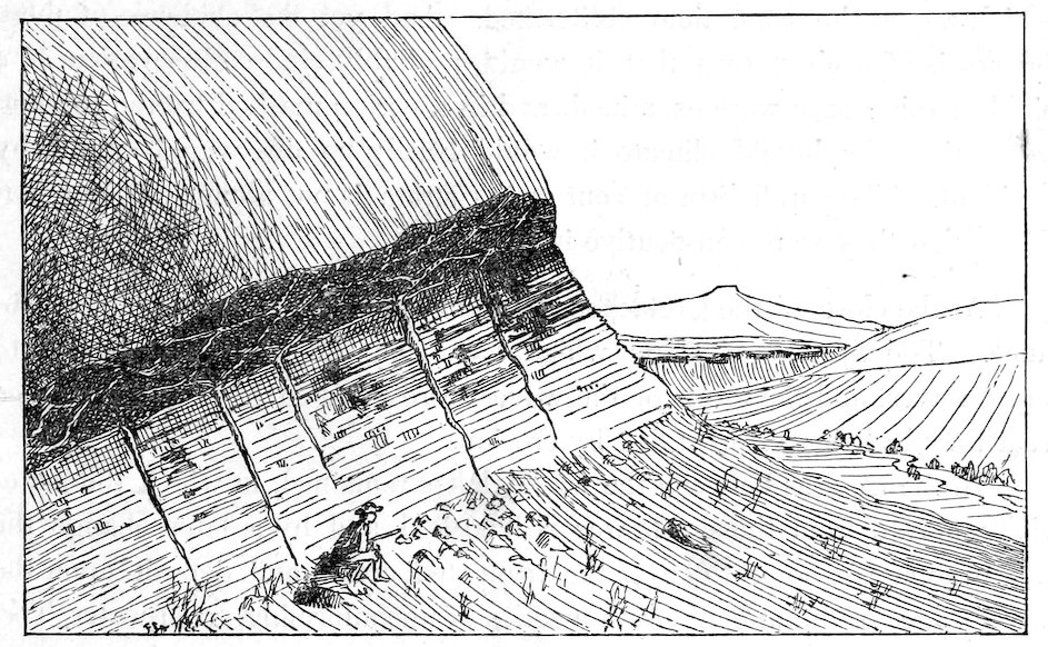
Fig. 6.—The Unconformity of the lower cañon of Salina Creek. The horizontal strata are Tertiary; the inclined, Cretaceous.
16To reach the Henry Mountains from Rabbit Valley, he must cross the
Waterpocket flexure; and so continuous and steep are the monoclinal ridges
which follow the line of flexure, that there are but four points known where
he can effect a passage. Except at these points, the barrier is impassable
from Thousand Lake Mountain to the Colorado River, a distance of eighty
miles. The most difficult and circuitous route I will not describe. The
remaining three diverge but slightly from each other. Starting from Rabbit
Valley he follows for a few miles the valley of the Dirty Devil, which
here, through the “Red Gate”, passes from the trachyte plateaus and enters
the land of cañons. He does not follow it far, but where the river enters
a cañon in the Aubrey Sandstone, bears to the left, and by the aid of a
trail which Indians have made finds a sinuous but easy pathway along a
monoclinal valley, following the outcrop of the lower Shinarump. At
his right the Aubrey Sandstone rises to form the plateau through which
the river defiles. At his left the Vermilion Sandstone stands in a vertical
wall. Beneath his feet are the shaly sandstones of the Shinarump Group,
bare of vegetation and displaying a profusion of ripple-marks, such as is
rarely if ever equaled. A ride of twelve miles brings him once more to
the Dirty Devil River, which emerging from its Carboniferous cañon
dives at once into a still deeper cañon through the Vermilion and Gray
Cliff Sandstones. He can follow the river if he tries, and emerge with it
beyond the flexure; but the way is difficult and the Indian trail he
has followed thus far leads on to another cañon. The monoclinal valley
which has opened so easy a way continues for fifteen miles farther, and
in that distance is crossed by four waterways, each of which leads by
a narrow cañon through the great sandstones. The first and fourth are
impassable. The second carries no permanent stream, and is called the
“Capitol Cañon”. The third affords passage to Temple Creek. The
smoothest road lies through Capitol Cañon, but the Temple Creek Cañon
17has an advantage in the presence of water, and is furthermore attractive by
reason of the picture-writings on the walls.
He has now to cross the Blue Gate flexure, and to do this he leaves
Temple Creek a little below the mouth of its cañon. Seeking once more
the guidance of a trail, he journeys southeastward over the gypsum and
sand of the Flaming Gorge Group to a pass which from a distance he has
detected in the monoclinal ridge marking the Henry’s Fork conglomerate.
Through this pass Tantalus Creek sometimes runs on its way to
join the Dirty Devil, and he may find a stream of muddy water; but
the bottom is more likely to be dry with the exception of a few pools.
Passing through the gap he finds before him a similar opening in the Tununk
Ridge, and beyond that a break in the Blue Gate Cliff. From Tantalus
Creek he ascends to the pass in the Blue Gate Cliff, and climbing to
the summit of a sharp divide in the shales descends again to Lewis Creek,
which there follows a cañon through the Blue Gate Plateau. Here he finds
bowlders of the Henry Mountain trachyte—for Lewis Creek rises in the
Henry Mountains—and a few hours’ ride toward the sources of the stream
brings him to the base of Mount Ellen.
Distances.
From Salt Lake City to Salina
155 miles.
From Salina to Fish Lake
38 miles.
From Fish Lake to Rabbit Valley
27 miles.
From Rabbit Valley to Temple Creek Cañon
27 miles.
From Temple Creek Cañon to Lewis Creek
18 miles.
Thence to the base of Mount Ellen
10 miles.
Total from Salt Lake City to the Henry Mountains
275 miles.
CHAPTER II. THE STRUCTURE OF THE HENRY MOUNTAINS.
18
The mountains stand within the province of the great flexures, but are
independent of them. Fifteen miles to the westward runs the Waterpocket
flexure. Thirty miles to the north is the San Rafael fold. At the east the
strata rise toward a great uplift, of which the full form is unknown. But
where the Henry Mountains stand the rocks are unaffected by these disturbances.
They have a uniform dip of about 45′ to the northwest, and
form a perfect datum-plane from which to measure the magnitude of the
displacements which have given rise to the mountains.
The mountains are composed of a large number of parts which are in
a certain degree individual and homologous. By the generalization of the
characters of those parts a conception has been obtained of a type structure
to which the entire series of phenomena has been referred.
In laying the material before the reader, the following plan will be followed:
First. The type of structure will be briefly set forth.
Second. The phenomena by which the type is at once demonstrated
and illustrated will be described in detail.
Third. The type of structure will be discussed.
If the structure of the mountains be as novel to the reader as it was to
the writer, and if it be as strongly opposed to his preconception of the manner
in which igneous mountains are constituted, he may well question the
conclusions in regard to it while they are unsustained by proof. I can
only beg him to suspend his judgment until the whole case shall have been
presented. On some accounts it would have been well to follow in writing
the order of investigation, and develop the general plan of structure as it
19was developed in the field, by the addition here of one element and there
of another; or at least to assemble the facts before announcing my deductions.
But such a course would be at the expense of an important element
of convenience and brevity. As will appear in the sequel, the preliminary
explanation of the type structure furnishes a complement of categories and
terms by the aid of which the description of the details of observation,
essentially tedious, is greatly abbreviated.
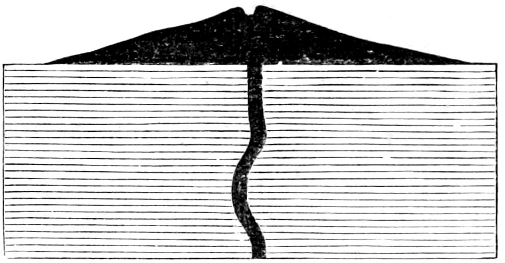
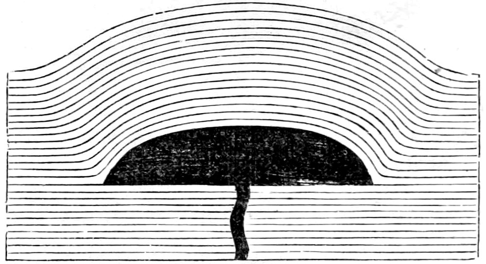
Fig. 7.—Ideal Cross-section of a Mountain of Eruption.
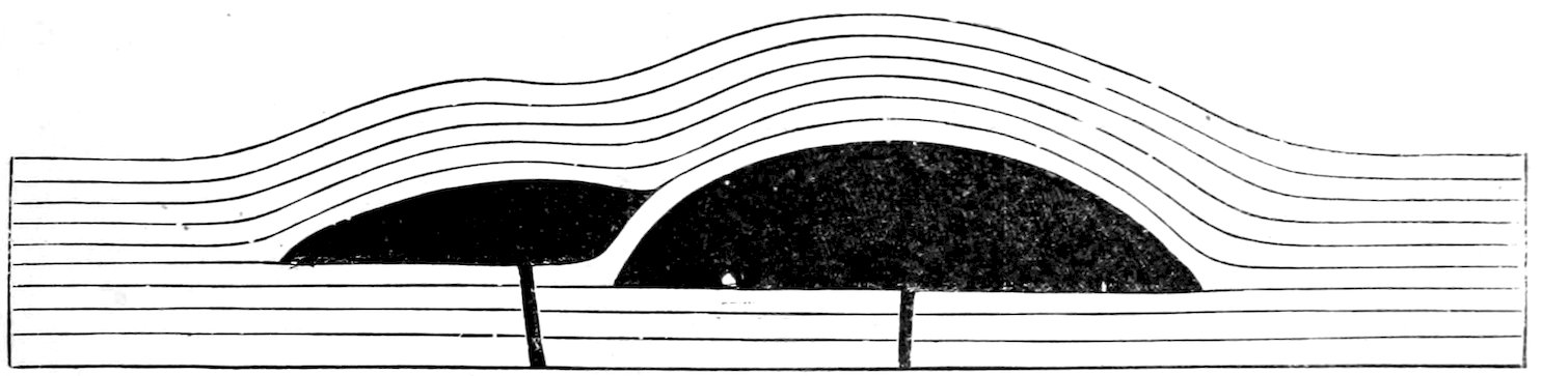
Fig. 8.—Ideal Cross-section of a Laccolite, showing the typical form and the arching of the overlying strata.
It is usual for igneous rocks to ascend to the surface of the earth, and
there issue forth and build up mountains or hills by successive eruptions.
The molten matter starting from some
region of unknown depth passes
through all superincumbent rock-beds,
and piles itself up on the uppermost
bed. The lava of the Henry
Mountains behaved differently. Instead
of rising through all the beds of
the earth’s crust, it stopped at a lower
horizon, insinuated itself between two strata, and opened for itself a chamber
by lifting all the superior beds.
In this chamber it congealed, forming
a massive body of trap. For this body
the name laccolite (λάκκος, cistern, and
λίθος, stone) will be used. Figure 7
and Figure 8 are ideal sections of a
mountain of eruption and of a laccolite.
The laccolite is the chief element
of the type of structure exemplified in the Henry Mountains.
It is evident that the intrusion of a laccolite will produce upon the
surface as great a hill as the extrusion of the same quantity of matter, the
mass which is carried above the original surface being precisely equivalent
to that which is displaced by the laccolite; and it is further evident that
where the superior rock is horizontally stratified every stratum above the
laccolite will be uplifted, and, unless it is fractured, will be upbent, and will
20portray, more or less faithfully, by its curvature, the form of the body it
covers.
Associated with the laccolites of the Henry Mountains are sheets and
dikes.
The term sheet will be applied in this report to broad, thin, stratified
bodies of trap, which have been intruded along the partings between sedimentary
strata, and conform with the inclosing strata in dip. Dikes differ
from sheets in that they intersect the sedimentary strata at greater or less
angles, occupying fissures produced by the rupture of the strata.
The logical distinction between dike and sheet is complete, but in nature
it not unfrequently happens that the same body of trap is a sheet in
one place and a dike in another. Between the sheet and the laccolite there
is a complete gradation. The laccolite is a greatly thickened sheet, and the
sheet is a broad, thin, attenuated laccolite.
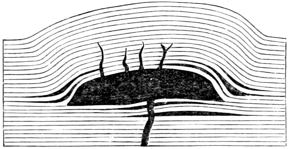
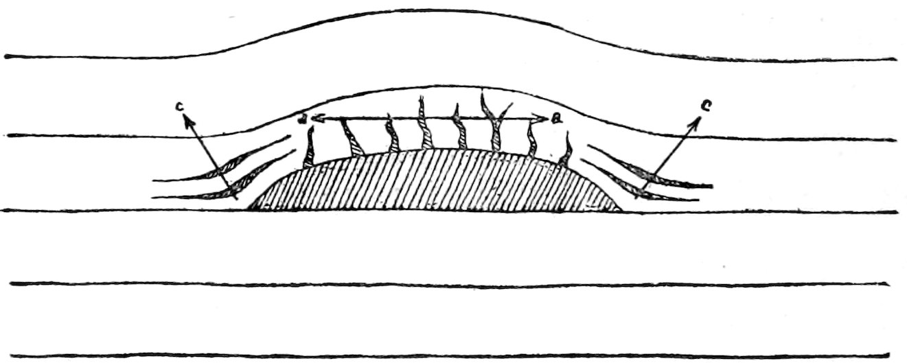
Fig. 9.—Ideal Cross-section of a Laccolite, with accompanying Sheets and Dikes.
In the district under consideration the laccolite is usually, perhaps
always, accompanied by dikes and
sheets (see Figure 9). There are
sheets beneath laccolites and sheets
above them. The superior sheets have
never been observed to extend beyond
the curved portion of the superior
strata. Dikes rise from the upper surfaces
of the laccolites. They are largest
and most numerous about the center, but, like the superior sheets,
they often extend nearly to the limit of the flexure of the uplifted strata.
The larger often radiate from the center outward, but there is no constancy
of arrangement. Where they are numerous they reticulate.
In the accompanying diagrams dikes are represented beneath as well
as above the laccolites. These are purely hypothetical, since they have not
been seen. In a general way, the molten rock must have come from below,
but the channel by which it rose has in no instance been determined by
observation.
The horizontal distribution of the laccolites is as irregular as the arrangement
of volcanic vents. They lie in clusters, and each cluster is marked
21by a mountain. In Mount Ellen there are perhaps thirty laccolites. In
Mount Holmes there are two; and in Mount Ellsworth one. Mount Pennell
and Mount Hillers each have one large and several smaller ones.
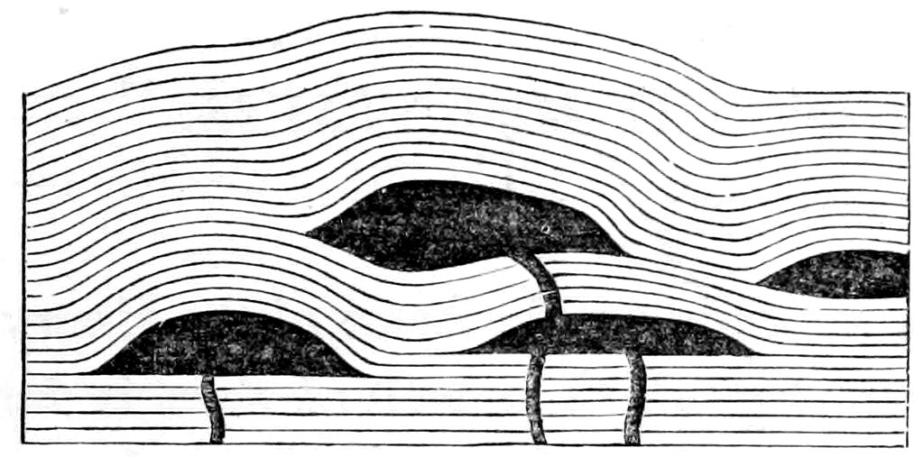
Fig. 10.—Ideal Cross-section of Grouped Laccolites.
Their vertical distribution likewise is irregular. Some have intruded
themselves between Cretaceous strata, others between Jura-Triassic, and
others between Carboniferous. From
the highest to the lowest the range is
not less than 4,000 feet. Those which
are above not unfrequently overlap
those which lie below, as represented
in the ideal section, Figure 10.
The erosion of the mountains has
given the utmost variety of exposure to the laccolites. In one place are
seen only arching strata; in another, arching strata crossed by a few dikes;
in another, arching strata filled with a network of dikes and sheets. Elsewhere
a portion of the laccolite itself is bared, or one side is removed so as
to exhibit a natural section. Here the sedimentary cover has all been removed,
and the laccolite stands free, with its original form; there the hard
trachyte itself has been attacked by the elements and its form is changed.
Somewhere, perhaps, the laccolite has been destroyed and only a dike remains
to mark the fissure through which it was injected.
CHAPTER III. DETAILED DESCRIPTION OF THE MOUNTAINS. — MOUNT ELLSWORTH. — MOUNT HOLMES. — MOUNT HILLERS. — MOUNT PENNELL. — MOUNT ELLEN. — STEREOGRAM OF THE HENRY MOUNTAINS.
22
It has already been stated that the strata about the bases of the Henry
Mountains are nearly level; but the country which is built of them is far
from level. The arrangement of the drainage lines has caused the degradation
of some parts to greatly exceed that of others, so that while the district
at the south, which borders the Colorado River, is paved with the red
sandstones of the Jura-Trias series, the adjacent region at the north still
carries the yellow sandstones and blue shales of the Cretaceous series. All
about Mount Ellsworth are the upper strata of the Jura-Trias. The lower
beds of the same series rise upon its flanks and arch over its summit.
A description of the structure of the mountain must include, first, the arch
of the strata; second, the faults which modify the arch; third, the system of trachyte
dikes and trachyte sheets; and fourth, the sculpture of the mountain.
In its general proportions the arch is at once simple and symmetrical. From
all sides the strata rise, slowly at first, but with steadily increasing rate, until
the angle of 45° is reached. Then the dip as steadily diminishes to the center,
where it is nothing. A model to exhibit the form of the dome would resemble
a round-topped hat; only the level rim would join the side by a curve instead
of an angle, and the sides would not be perpendicular, but would flare
rapidly outward (see Figure 11). The base of the arch is not circular, but is
slightly oval, the long diameter being one-third greater than the short. The
length of the uplift is a little more than four miles; the width a little more
than three miles, and the height about 5,000 feet. The curvature fades away
so gradually at its outer limit that it is not easy to tell where it ends, and the
horizontal dimensions assigned to the dome are no more than rude approximations.
But there is another element which can be given more exactly.
The line of maximum dip, which separates the convex upper portion of the
dome from the concave periphery, is easily traced out in nature, and runs
at the foot of the steep part of the mountain. It surrounds an area two
miles in width and two and two-thirds miles in length.
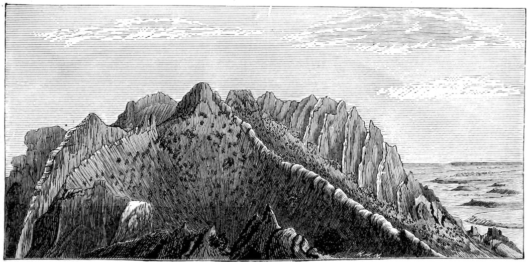
Fig. 11a.—View from the west spur of Mount Ellsworth, showing the trachyte dikes of the north spur and revetments of sandstone and trachyte.
Fig. 11.—Stereogram of Mount Ellsworth; an ideal restoration of the form of the overarching strata.
The Ellsworth arch is almost but not completely isolated. The
Holmes arch, upon the east side, stands so near that the bases of the two
impinge and coalesce, and the same thing happens, though less notably,
with the Hillers arch at the north.
The simplicity of the arch is further impaired by faults—not great
faults dividing the whole uplift, but a system of small displacements which
are themselves subordinate phenomena of the uplift. They are restricted to
the central portion, and never occur so low down as the line of maximum
dip. The strata of the upper part of the arch are divided into a number of
prismoid blocks which stand at slightly different levels but are not sufficiently
deranged to destroy the general form of the arch. The greatest
throw is only a few hundred feet. All or nearly all of the fault planes
are occupied by dikes of trachyte.
The trachyte injections are not confined to the fault planes, nor is
their area so restricted as the fault area. Dikes and sheets abound from
the crest of the dome down to what might be called its springing line—the line
of maximum dip. At the center, dikes are more numerous; near the limit,
sheets. The central area is crowded so full of dikes, and the weathering
brings them so conspicuously to the surface, that the softer sedimentaries are
half concealed, and from some points of view the trachyte appears to make
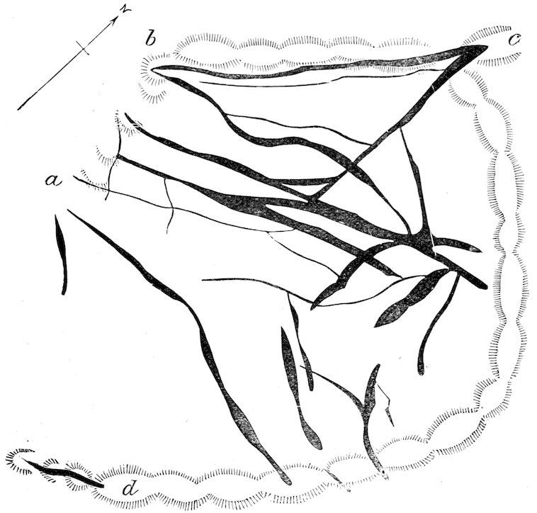
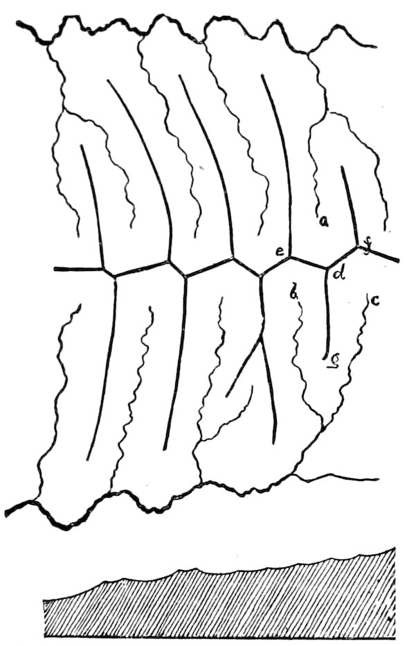
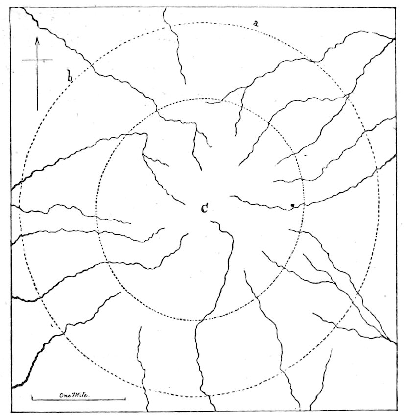
the entire mass. The accompanying plan (Figure 12) shows the arrangement
23of the dikes in one of the outer amphitheaters of the mountain, where
they are less complicated than in the central region. The trends of two
spurs (a b and c d) are indicated by the hatchings. They join the main
crest of the mountain at e, and inclose between them a deep amphitheater
which opens to the west. Upon the steep walls of the amphitheater the
dikes outcrop in lines of crags, dividing rough slopes of yellow and purple
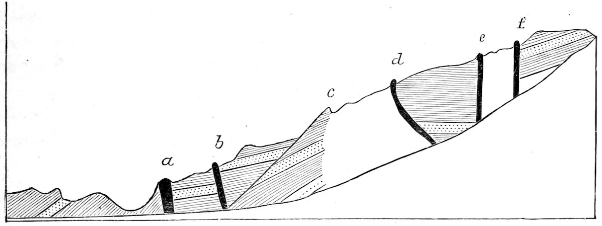
and brown sandstone. The profile of one of the walls of the amphitheater
(from a to b, Figure 12) is drawn in Figure 13 for the sake of exhibiting
the relation of the dikes to faulted blocks of sandstone. It will be seen that
the throw of the faults is not constantly in one direction.
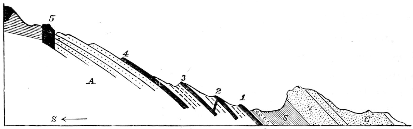
Fig. 14.—Profile of the Northern Spur of Mount Ellsworth. 1, 2, 3, 4, and 5 are Trachyte Dikes. A, Aubrey Sandstone. S, Shinarump Shale. V, Vermilion Cliff Sandstone. G, Gray Cliff Sandstone.
The zone of sheets is just inside the line of maximum dip. Usually
only one or two sheets are laid bare by the erosion, but at one point (see
Figure 14) four can be counted. Toward the center of the uplift all of
these are limited by the erosion and exhibit their broken edges. Downward,
or toward the periphery, they dip out of sight. Laterally they can
be traced along the mountain side for varying distances, but they soon
wedge out and are replaced by others en echelon. In thickness the sheets
rarely exceed 50 feet, and never 100. They are always thin as compared
to the rock masses which separate them, but, by reason of their superior
ability to resist erosion, monopolize a large share of the surface, and mask
a still greater amount with their débris.
Fig. 12.—Ground plan of Trachyte Dikes on the western flank of Mount Ellsworth.
Fig. 13.—Profile of a western spur of Mount Ellsworth, showing the arrangement of Dikes and Faults. The dotted bed is the purple band at the top of the Vermilion Cliff Sandstone. The dikes of trachyte are indicated by letters.
24The sedimentary rocks are not altered beyond the region of trachyte
intrusion. The mere flexure of the strata was not accompanied by a perceptible
change of constitution. In the zone of sheets there is little change
except along the surfaces of the contact. For a few feet, or perhaps only
a few inches, there is a discoloration (usually a decolorization) and a slight
induration, without notable alteration of minerals. But in the region of
reticulated dikes none of the sedimentaries are unchanged; crystals are developed,
colors are modified, and hardness is increased, so that the physical
properties of familiar strata no longer serve for their identification. Still
there is no crumpling.
The trachyte masses and the altered rocks in contact with them are so
much more durable than the unaltered strata about them that they have
been left by the erosion in protuberances. The outcrop of every dike and
sheet is a crag or a ridge, and the mountain itself survives the general
degradation of the country only in virtue of its firmer rock masses. Nevertheless,
the mountain, because it was higher than its surroundings, has
been exposed to more rapid erosion, and has been deprived of a greater
depth of strata. From the base of the arch there have been worn 3,500
feet of Cretaceous, and from 500 to 1,500 feet of the Jura-Trias series,
which is here about 3,000 feet thick. From the summit of the arch more
than 2,500 feet of the Jura-Trias have been removed.
The strata exposed high up on the mountain being older than those at
the base, and the dip being everywhere directed away from the center, it
is evident that the mountain is surrounded by concentric outcrops of beds
which lift their escarpments toward it. It is usually the case, where the
strata which incline against the flank of a mountain are eroded, that the
softer are excavated the more rapidly, while the harder are left standing in
ridges; and an alternation of beds suitable for the formation of a ridge
occurs here. One of the upturned beds is the massive Vermilion Cliff
sandstone, and beneath it are the shales of the Shinarump Group. By
the yielding of the shales the sandstone is left prominent, and it circles
the base of the mountain in a monoclinal ridge. But the ridge is of a
peculiar character, and has really no title to the name except in the
homology of its structure with that of the typical monoclinal ridge. It
lacks the continuity which is implied by the word “ridge”. The drainage
of Mount Ellsworth is from the center of the dome outward. A half dozen
drainage lines originate in the high crests and pass outward through the zone
of upturned strata. Lower down their interspaces are divided by others, and
25when they reach the circling escarpment of the Vermilion sandstone their
number is fifteen. Each of these cuts the ridge to its base, and the effect
of the whole is to reduce it to a row of sandstone points circling about the
mountain. Each point of sandstone lies against the foot of a mountain
spur, as though it had been built for a retaining wall to resist the out-thrust of
the spur. Borrowing a name from the analogy, I shall call these elementary
ridges revet-crags, and speak of the spurs which bear them as being
revetted. The accompanying sketch is designed to illustrate the structure,
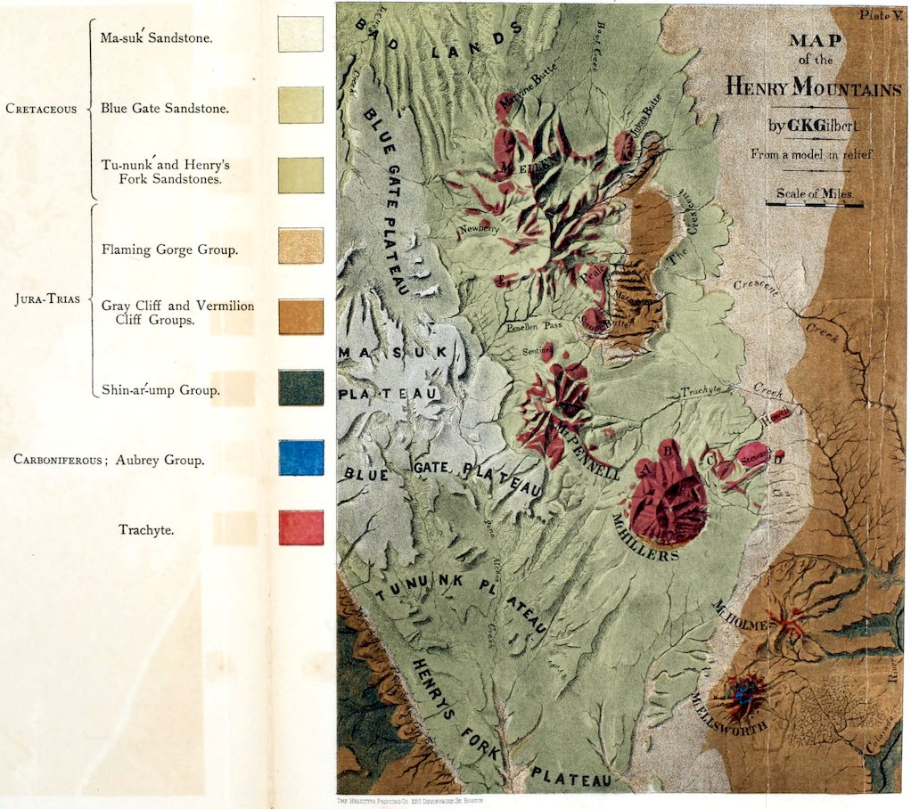
but is not drawn from nature. In the view of Mount Hillers (Figure 27)
the revetments may be seen, and in the bird’s-eye view of the Henry
Mountains (Plate V), as well as in the Frontispiece, the revet-crags of Mount
Ellsworth also are portrayed. The diagram of the north spur of Mount
Ellsworth (Figure 14) shows the revet-crag of that spur at V.
Fig. 15.—Revet-Crags.
The revet-crags of Vermilion sandstone follow, in a general way, the
line of maximum dip about the base of Mount Ellsworth; but a few of them
rise higher, and one—that which joins the northwest spur—climbs until it
is but little lower than the summit of the mountain. Outside the circle of
Vermilion Cliff sandstone lies the Gray Cliff sandstone, and in a few places
it takes the form of a revetment. Inside the same circle there are many
revetments, constituted by trachyte sheets bedded in Shinarump shales
(Figure 14). Conforming perfectly with the strata, the sheets yield by
erosion forms which are identical with those afforded by hard sedimentary
beds, and to the distant eye the impression of the arching structure of Mount
Ellsworth is conveyed less by what can be seen of the strata than by ascending
revetments of trachyte sheets, which simulate and interpret the
strata.
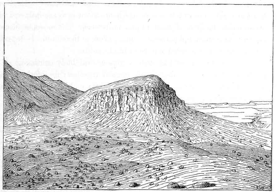
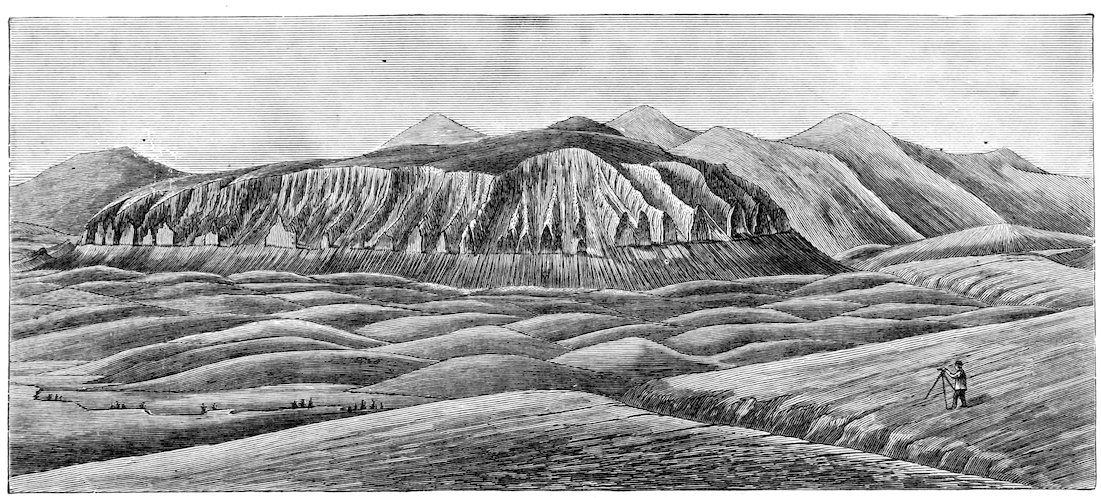
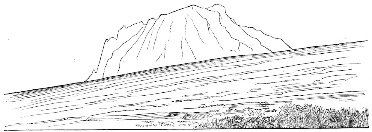
Fig. 16.—Mount Holmes, from the north.
26The laccolite of Mount Ellsworth is not exposed to view, but I am
nevertheless confident of its existence—that the visible arching strata envelop
it, that the visible forest of dikes join it, and that the visible faulted blocks
of the upper mountain achieved their displacement while floated by the still
liquid lava. The proof, however, is not in the mountain itself, but depends
on the association of the phenomena of curvature and dike and sheet with
laccolites, in other mountains of the same group. In the sequel these will
be described, but it chances that the mountain next to be considered is even
less developed by erosion than Mount Ellsworth.
The order of sequence which places Mount Ellsworth before Mount
Holmes is the order of complexity. The former contains one laccolite,
the latter two. Neither of the two is visible, but the strata which envelop
them shadow forth their forms and leave no question of their duality.
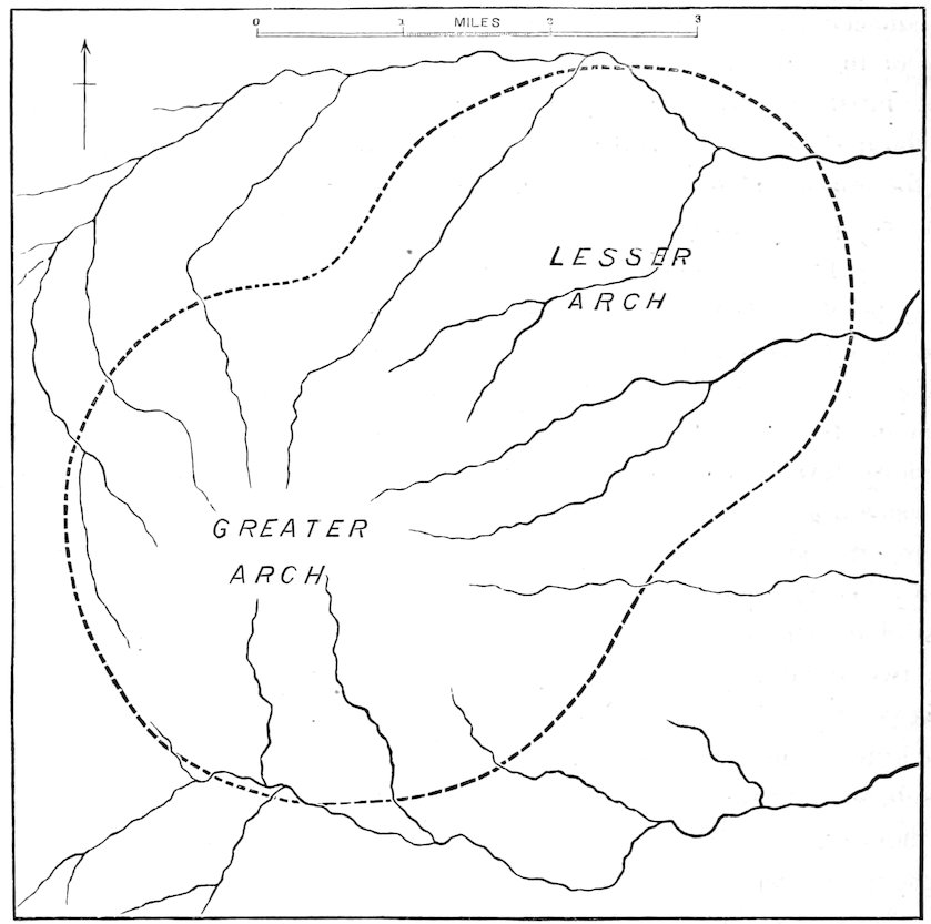
They are so closely combined that the lesser seems a mere appendage of
the greater. From the center of the greater there is a descent of strata in
all directions, but from the center of the lesser the rocks incline toward
one-half only of the horizon. Where the two convex arches join there is
a curved groin—a zone of concave curvature uniting the two convexities.
About the compound figure can be obscurely seen a line of maximum dip,
and beyond that the fading of the curves. The curves throughout are so
gentle that it was found exceedingly difficult to establish their limits. In
a general way it may be said that each of the Holmes arches is as broad
as the Ellsworth arch, but the vertical displacement is less. In the formation
of the greater Holmes arch the amount of uplift was 3,000 feet; for
the lesser arch, 1,500 feet.
There is no evidence in the forms of the arches which proves one to
be older than the other. Studying the curves in the field, I could not discover
that either arch asserted itself more strongly than the other in their
common ground. They seem to meet upon equal terms. Still it is probable,
a priori, that they were formed successively and not simultaneously.
The coincidence in time of two eruptions of lava from neighboring vents is
no more unlikely than the coincidence of the two irruptions, and the same
27principle of least resistance which causes individual laccolitic arches to
assume spheroidal forms, would have given to the compound arch of two
laccolites, coincident in time, a simple instead of a compound form.
Assuming that the arches were successive in origin I shall in another
and more appropriate chapter discuss the problem of their chronological
order in the light of their somewhat peculiar drainage system.
The lesser arch betrays no dikes nor sheets. The Vermilion Cliff
sandstone covers it to the top. The greater is crowned by a few grand
dikes which govern its topography. From the center a long dike runs
to the south, a short one to the north, two to the east, and one to the
west. The course of each is a mountain spur, and between them are amphitheaters
and gorges. Clinging to the dikes are bodies of altered sandstone,
but the great sandstone masses of the summit were unaltered and
from them have been excavated the gorges. Along the dike-filled fissures
there has been some faulting, but there is no reason to believe that
the displacement is great in amount. Toward the flanks of the mountain
there are a few sheets, the outermost of which is far within the line of maximum
flexure. Their escarpments instead of facing upward like the revetting
sheets of Mount Ellsworth, face downward; their buried and unknown
edges are the edges toward the mountain. Their thinning toward the
periphery of the arch is conspicuous to the eye in many instances, as is also
the thinning of the dikes.
Another peculiarity of dike form, one which has since been noted in a
number of localities, was first detected in Mount Holmes. It consists in a
definite upper limit. The dike so marked is often as even upon its upper
surface as an artificial stone wall. The upper surface may be level or
may incline toward one end of the dike, but in either case it is sure to be
found parallel to the bedding of the strata which inclose the dike. This
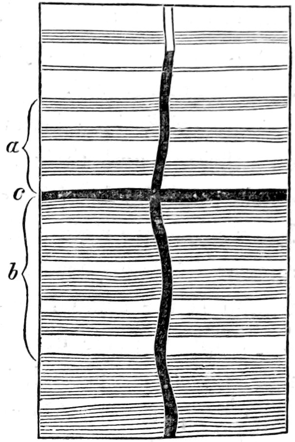
fact led to the suspicion, afterward confirmed by more direct evidence,
that the flat top of the dike was molded by an unbroken stratum of rock
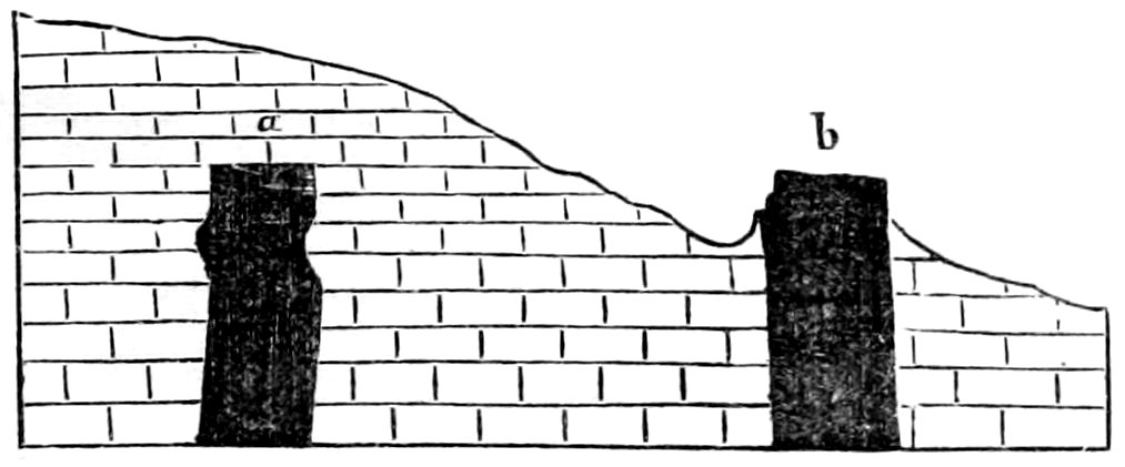
bridging across the fissure which the lava filled (Figure 20). The converse
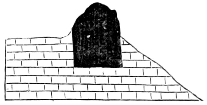
phenomenon can be observed in the ridge which joins Mounts Ellsworth
and Holmes. A great dike there forms the crest of the ridge for half
a mile, its base being buried in sandstone; but at the end of the ridge
the strata are seen to be continuous beneath it (Figure 21).
Fig. 17.—Stereogram of the Holmes Arches; an ideal restoration of the form of the overarching strata.
Fig. 18.—Ideal cross-section of the Laccolites of Mount Holmes.
Fig. 19.—A flat-topped dike.
Fig. 20.—Ideal Cross-section of Flat-topped Dikes; a, before denudation; b, after denudation.
Fig. 21.—Ideal Cross-section of a Flat-bottomed Dike.
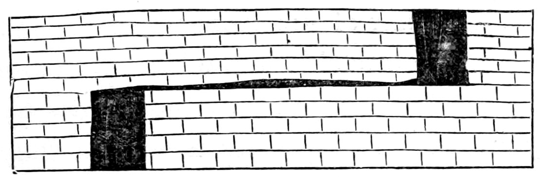
Fig. 22.—Diagram to illustrate a hypothetical explanation of Flat-edged Dikes.
That a fissure several feet or several scores of feet in width should
end thus abruptly, demands explanation, and the phenomena immediately
concerned offer none. Nevertheless it is easy to make an assumption
which if true renders both cases clear. If we assume that the fissure
instead of ending at the crosshead
is merely offset, and resumes
its course beyond, and that
the dike contained in it has two
bodies connected by a thin sheet
(Figure 22), we shall have no difficulty
in conceiving the erosion which will produce either of the natural
appearances described.
The rocks which constitute Mount Holmes are the same as those about
its base. The Vermilion Cliff and Gray Cliff Sandstones alone appear in
the crests. The underlying Shinarump shales are cut by the erosion at a
few points only, and those are near the base. For this reason the Vermilion
Sandstone is not undermined about the base, and the circle of revet-crags
which surrounds Mount Ellsworth finds no counterpart. There are,
indeed, a few revetments of Gray Cliff sandstone, but they are scattered
and for the most part inconspicuous.
In the general view of Mount Holmes (Figure 16), one of the main
dikes crowns the nearest spur, and another the spur leading to the right.
At the left are minor dikes, and high up is a trap sheet notched on its lower
edge. At the left base of the mountain lies the lesser arch.
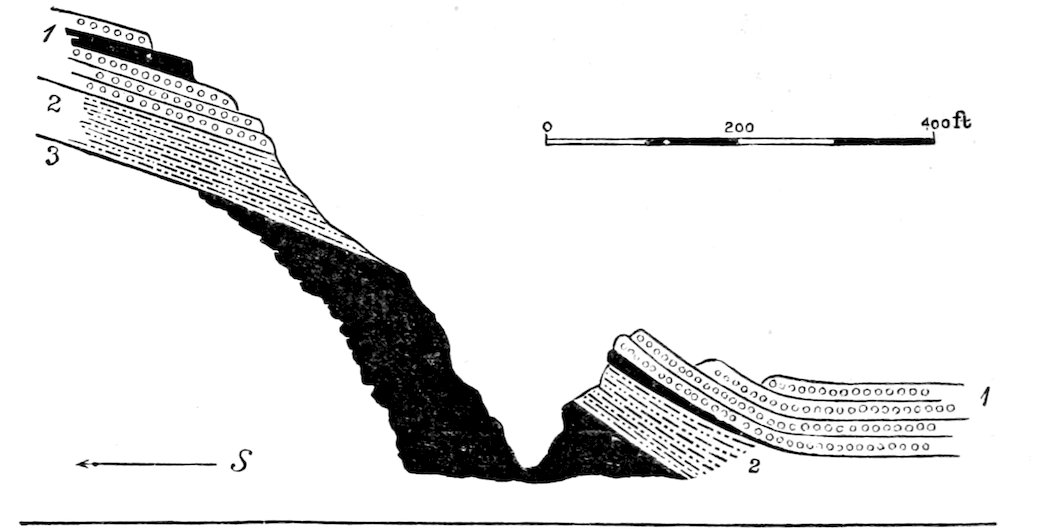
28Figure 23 gives a section exhibited by one of the northward cañons.
It shows one of the faults of the upper part of the arch and illustrates the
thinning of the sheets as they descend.
Fig. 23.—Section shown in a northward cañon of Mount Holmes. a, Vestige of Trachyte sheet. bbb, Trachyte sheets. c, Trachyte dike. 1, Gray Cliff Sandstone. 2 2, Purple Sandstone. 3, Vermilion Cliff Sandstone. 4, Shinarump Shale.
Next in order to the north is Mount Hillers. Let it not be supposed,
however, that there is discernible system in the geographic arrangement
of the mountains or of the laccolites. A chart of the mountain peaks and
a chart of the laccolites would alike prove intractable in the hands of those
geologists who draw parallel lines through groups of volcanic vents by
way of showing their trend. They are as perfectly heterotactous as they
could be made by an artificial arrangement.
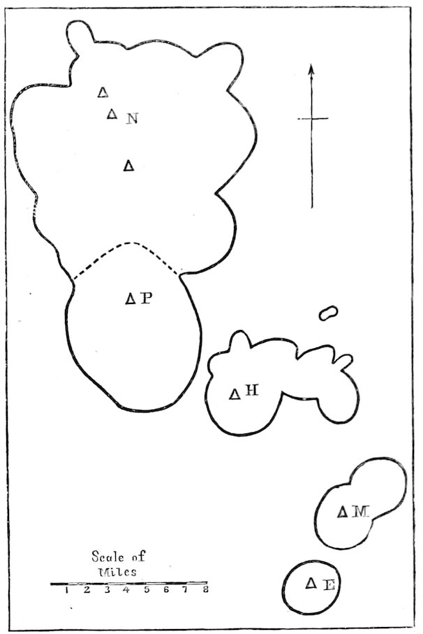
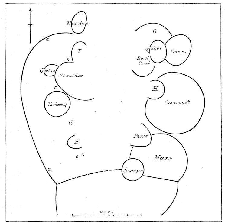
The diagram (Figure 24) shows the relation of the laccolite groups to
each other and to the meridian. The principal mountain summits are indicated
by triangles, and the curved lines inclose areas of disturbance.
Mount Hillers and its foot-hills are constituted by a group of no less
than eight laccolites, and a ninth, the Howell laccolite, is conveniently
classed with them, although not contiguous.
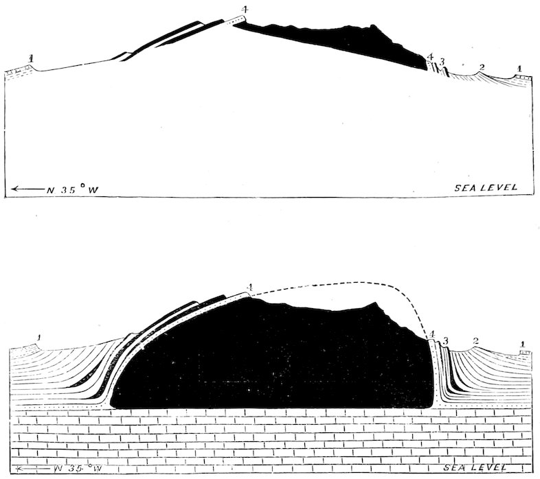
Fig. 25.—Cross-section of Mount Hillers.
Fig. 26.—The same, with ideal representation of the underground structure.
Scale, 1 inch = 4,000 feet. 1. Tununk Sandstone; 2. Henry’s Fork Conglomerate; 3. Gray Cliff Sandstone. The full black lines represent trachyte sheets, and the broad black area the Hillers Laccolite.
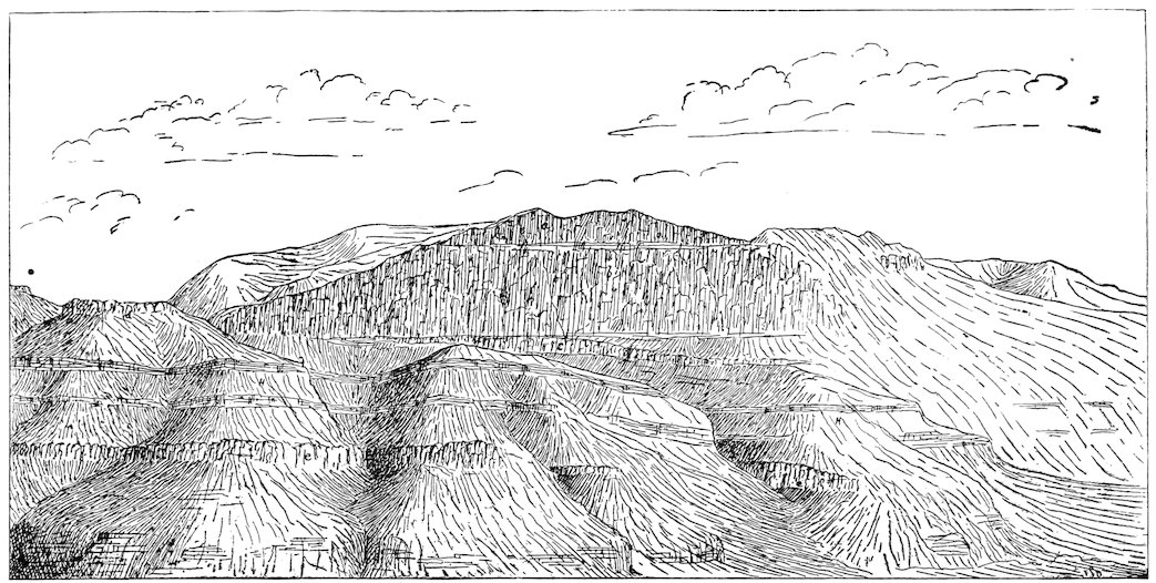
Fig. 27.—Mount Hillers, from the south.
29The Hillers laccolite is the largest in the Henry Mountains. Its depth
is about 7,000 feet, and its diameters are four miles and three and three-quarter
miles. Its volume is about ten cubic miles. The upper half constitutes
the mountain, the lower half the mountain’s deep-laid foundation.
Of the portion which is above ground, so to speak, and exposed to atmospheric
degradation, less than one-half has been stripped of its cover of overarching
strata. The remainder is still mantled and shielded by sedimentary
beds and by many interleaved sheets of trachyte. The portion which has
been uncovered is not left in its original shape, but is sculptured into alpine
forms and scored so deeply that not less than 1,000 feet of its mass are
shown in section. All about the eroded (south) face of the mountain the
base is revetted by walls of Vermilion
and Gray Cliff sandstone, strengthened
by trachyte sheets. At the extreme
south these stand nearly vertical
(80°), and their inclination diminishes
gradually in each direction, until at
the east and west bases of the mountain
it is not more than 60°. On the
north side there are no revet-crags,
and the inclination is comparatively
slight. It would appear that the laccolite
was asymmetric, and was so
much steeper-sided on the south that
that side suffered most rapid degradation.
Fig. 24.—Ground Plan of the Henry Mountains. The curved lines show the limits of the principal displacements; the triangles, the positions of the main peaks. N, Mount Ellen. P, Mount Pennell. H, Mount Hillers. M, Mount Holmes. E, Mount Ellsworth.
By reference to the section (Figure
25) it will be seen that the sedimentary
strata of the north flank
stretch quite to the summit of the
mountain. The same beds which form
the revet-crags on the southern base
constitute also some of the highest
peaks. Since these rest directly upon the laccolite, it is assumed that the
next lower beds of the stratigraphic series form its floor; and the base of
the laccolite is drawn in the ideal section on the level which the Shinarump
Group holds where it is unaffected by the displacements of the mountain.
It is noteworthy that wherever the sedimentaries appear upon the
mountain top they are highly metamorphic. But in the revet-crags there
is very little alteration. Massive sandstone, divided by sheets and dikes
several hundred feet in thickness, is discolored and indurated at the contact
surface only, and ten feet away betrays no change.
The engraving of Mount Hillers (Figure 27) exhibits the south face
30with its revet-crags and bold spurs of trap. In nature the effect is heightened
by the contrast of color, the bright red revetments being strongly
relieved against the dark gray of the laccolite. The strata of the summits
cannot be discriminated at a distance. They are too near the laccolite in
hardness to differ from it in the style of their sculpture.
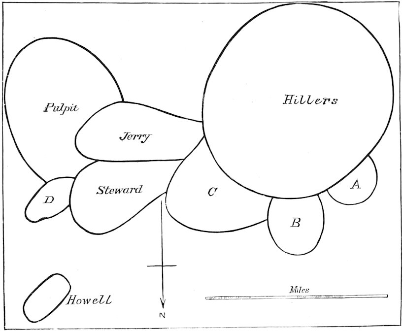
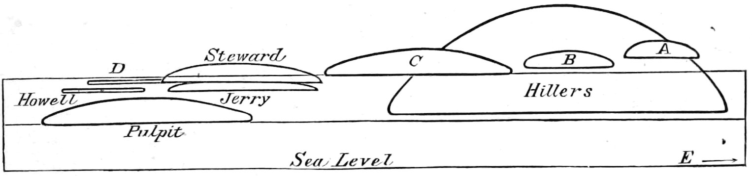
Of the minor laccolites of the cluster there are three so closely joined
to the chief that they merge topographically with the mountain. They are
not well exposed for study. The smallest, which overlooks the pass between
Mount Hillers and Mount Pennell (A, Figure 28) has probably lost
the whole of its cover and with it so much of its substance that the
original form and surface cannot be seen. Its floor is probably the Tununk
sandstone. East of it and lying a little deeper in the Cretaceous
series is a second laccolite (B), broader, lower, and less eroded. The third
(C) joins the great one on the northeast, and is so closely united that it
was at first supposed to be the same body. Later examinations have shown,
however, that its immediate roof is the Henry’s Fork conglomerate, and its
horizon is thus established as more than two thousand feet above that of
its great companion.
Fig. 30.—The Steward Laccolite.
Fig. 28.—Diagram of the Hillers Cluster of Laccolites; Ground plan.
Fig. 29.—Diagram of the Hillers Cluster of Laccolites; Elevation.
The upper horizontal line marks the base of the Cretaceous; the middle, the base of the Jura-Trias; the lower, the level of the sea.
31The Steward laccolite (Figure 30) is better exposed for study. It was
buried in the soft bad-land sandstone of the Flaming Gorge Group, and its
matrix has been so far washed away that nearly the whole body of trap is
revealed. It is weathered out, like a chert-nodule on the face of a block
of limestone. At one end it is bared quite to the base, and the sandstone
floor on which it rests is brought in sight. The waste of the sandstone has
undermined its edge, and a small portion of the laccolite has fallen away.
Near the opposite end a fragment of its cover of arching sandstone survives—just
enough to indicate that the sedimentaries were once bent over
it, and that the smooth low-arching surface which now crowns it portrays
the original form which the molten lava assumed. The laccolite is about
two and a half miles long and one and one-half broad. The height of its
eastward face, where it is sapped by the erosion of the bad-land rock, is
six hundred feet, and the central depth must be more than eight hundred
feet.
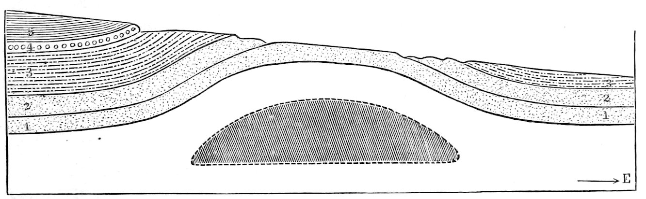
Fig. 31.—Cross-section of the Pulpit arch, with ideal representation of the Pulpit Laccolite. Scale, 1 inch = 3,500 feet. 1, Vermilion Cliff Sandstone. 2, 2, Gray Cliff Sandstone. 3, 3, Flaming Gorge Shale. 4, Henry’s Fork Conglomerate. 5, Tununk Shale.
Pulpit arch is as high and as broad as the lesser arch of Mount
Holmes, but its place is not marked in the topography by an eminence for
the reason that the degradation of the land has not yet progressed so far as
to unearth its core of trachyte. The drainage from Mount Hillers crosses
it from west to east and has given it an oblique truncation, as illustrated in
the diagram. At the upper end of the slope the Henry’s Fork conglomerate
outcrops; at the lower end the base of the Flaming Gorge series, and
in the interval the Gray Cliff sandstone is lifted to the surface. The same
streams which planed away the crown of the arch have now cut themselves
deeper channels and divide the massive sandstone by picturesque cañons,
between which it is grotesquely carved into pinnacles and ridges. A curious
salient of the sandstone has given its name to the arch. How deeply the
32Pulpit laccolite lies buried is not known, no sheet nor dike of trachyte
betraying its proximity. The valley of the Colorado may have to be deepened
thousands of feet before it will be laid bare.
The Jerry Butte is the most conspicuous adjunct to Mount Hillers and
topographically is more important and striking than the features which have
just been described, but its structure is less clear. Its crest is formed by a
great dike several hundred feet in width and two miles in length, and with
an even top like those observed on Mount Holmes. The western end of
the dike is the higher and forms the culminating point of the butte, and
from it there radiate three other dikes of notable size. The inclosing
strata, preserved from erosion only by the shelter of the dikes, are the
lower portion of the Cretaceous series, and they are so little lifted above
their normal level that there is room for no considerable laccolite beneath
them. The inclination of the beds is so complicated by the dips of the
Pulpit, Steward, and Hillers arches, all of which are contiguous, that
nothing can be made out of the form of the laccolite, if it exists.
The Howell laccolite lies apart from the cluster and is well exposed. It
differs from all that have been enumerated in its extreme thinness. With
a breadth of more than two thousand feet, it has a depth of only fifty. Seen
from the east, it might readily be mistaken for a coulée, for on that side it is
the thin, hard, black cap of a table carved out of soft, sandy shale (Flaming
Gorge Group) by circumdenudation. But followed westward, the table is
found gradually to lose its height by the rising of the adjacent land, and at
last the lava-bed runs into the slope and disappears beneath the upper layers
of the same sandy shale on which it rests. How far it extends under ground
can only be conjectured. How far it originally stretched in the opposite
direction cannot be known because it is broken away. The original edge
is concealed at one end and has been undermined and destroyed at the
other, so that the only place where it can be seen is the point at which it
emerges from the shale. At this point, where erosion has bared but has not
yet attacked the lava, the form and character of the edge are exhibited. In
place of the tapering wedge which usually terminates intrusive sheets, there
is a blunt, rounded margin, and the lava scarcely diminishes in depth in
approaching it. The underlying strata, locally hardened to sandstones, lie
33level; the overlying curve downward to join them, and between the curved
strata is interleaved a curved lava-sheet. In all these characters the intrusive
body is affiliated with the typical laccolites, and distinguished from the
typical sheets.
Fig. 32.—The Howell Laccolite, as seen from the north.
Fig. 33.—The Edge of the Howell Laccolite.
Fig. 34.—Mount Pennell, from the west.
34The laccolite which is marked “D” on the diagrams of the Hillers cluster
is identical in nearly all its characters with the Howell; it is thin and broad.
One margin is wasting as its foundation is sapped; the other is hidden
from view. Its depth does not diminish toward the edge. Moreover, a
few dikes issue from its margin, or from beneath its margin. It was intruded
within the same formation as the Howell (the Flaming Gorge shale),
but at a horizon several hundred feet higher; and, what is specially noteworthy,
the rock of which it is composed is identical in facies with that of
the Howell laccolite, and notably different from all others which were observed
in the Hillers cluster.
Thus there are grouped in this one cluster laccolites of the most varied
character, differing in form, in magnitude, in the stratigraphic depth at which
they were intruded, in the extent to which they have been uncovered or
demolished in the progress of erosion, and also, but very slightly, in their
lithologic characters. The greatest is one thousand times as bulky as the
least. The length of the most obese is three times its depth; the length of
the most attenuated is more than one hundred times its depth. The one
highest in the strata lies a thousand feet above the base of the Cretaceous
rock series; the lowest is not higher than the summit of the Carboniferous.
The latter has not yet been touched by erosion, others have been completely
denuded, and some have been partially demolished and removed.
Mount Pennell and Mount Ellen are distinct mountain masses separated
by a low pass, but there is no interval between the clusters of laccolites by
which they are constituted.
Whether the site of a laccolite shall be marked by a mountain depends
in great measure on the relation of the laccolite to the progress of erosion.
In the Henry Mountains the laccolites which have not been reached by the
denudation scarcely affect the topography. The arched sedimentaries above
35them are no harder than the same strata in the surrounding plain, and they
are brought substantially to the same level. It is to those which the downward
progress of erosion has reached and passed that the mountains are due.
In virtue of their hardness they survive the general degradation, and conserve
with them broad foundations of more perishable material. Mounts
Ellen and Pennell mark the positions of the highest of a great cluster of
laccolites, and the pass between them marks a part of the cluster where all
the laccolites lie low in the strata.
Fig. 35.—Cross-section of Mount Pennell. 1, Blue Gate Sandstone. 2, 2, Blue Gate Shale. 3, 3, Tununk Sandstone. The full black lines represent Trachyte.
Mount Pennell is not so easily studied as the lower mountains at the
south. Its summits are timbered and are carved into alpine forms which
do not portray the structure but rather mask it. Upon its flanks however
the topography and the structure are in so close sympathy that the latter is
easily read; and by their study some of the general features of the mountain
have been made out. From the east and south and west the strata can
be seen to rise toward it. The uprising strata on the west are the Tununk
sandstone and the shales above and below it. The sandstone forms no revetments,
but accords so closely in its dips with the slopes of the mountain
that it is the surface rock over a broad area, outcropping wherever there is
rock exposure. At the head of the foot-slope trachyte sheets are associated
with it, some overlying and others underlying it; and at one point a gorge
reveals a laccolite not far below it—a laccolite that may or may not be the
great nucleus of the mountain. On the west and south flanks the uprising
strata are the Blue Gate and Tununk sandstones, with their shales. The
Gate sandstone has been worn away nearly to the foot of the slope, and
forms a monoclinal ridge circling about the base. The ridge is interrupted
by a number of waterways, and it sends salients well up upon the flank,
36but it is too continuous to be regarded as a mere line of revetments. The
Tununk sandstone is not to be seen without search, being covered by heavy
trachyte sheets. Trachyte sheets also underlie it, and the whole are carved
into a conspicuous series of revet-crags.
Fig. 36.—Mount Pennell, from the north.
37The association of overarching strata with sheets of trachyte leaves no
doubt in my mind that the core of Mount Pennell is laccolitic, but whether
it is simple or compound is not so clear. The collation of all the observed
dips shows that if there be but one laccolite it has not the simplicity of form
which usually characterizes them.
There are low arches of the strata at the southern, northern, and northeastern
bases, which reveal no trachyte and give the impression that there
may be a foundation of low-lying laccolites upon which the main trachyte
mass or masses of the mountain are based. One of these low arches, that
at the northeast, is shown in the foreground of Figure 36. The strata which
portray it are of the Henry’s Fork conglomerate, and the laccolite which
they cover is of necessity distinct from that which is revealed on the east
flank of the mountain.
Fig. 37.—Sentinel Butte.
38In addition to the laccolites of the foundation and of the main body,
there is a series which jut forth from the northern flank like so many dormer
windows. They are comparatively small but are rendered conspicuous
by the removal of the soft rocks which originally inclosed them. They are
higher in the strata than any other observed laccolites, their position being
above the Tununk sandstone and in the Blue Gate shale. The core of the
main body of the mountain is probably inclosed in the Tununk shale, and the
laccolites under the low arches (at the north at least) are entirely below the
Cretaceous. The higher series stand on top of the low arches, and are just
outside of the sheets which inclose the central body. The largest of them
constitutes Sentinel Butte, and stands guard over Penellen Pass. Sapped by
the yielding of its soft foundation it is rapidly wasting, and on three sides
its faces are precipitous. The huge blocks which cleave from it as they are
undermined strew the surrounding slopes for a great distance. Its depth of
400 feet is made up of two layers, of which the lower is the deeper, and between
which there is a slight lithologic difference. The upper surface of
the butte is smooth and plane with an inclination to the south. It is probably
a portion of the original surface of the laccolite.
Thus we have in Mount Pennell a great central body consisting of a
single laccolite or of a number closely massed together; an inferior group
of three or more, evidenced by low broad arches; and a superior group of
not less than four, all of which are partially destroyed.
The crest of Mount Ellen is as lofty as that of Mount Pennell and it
is more extended. It stretches for two miles from north to south and is
buttressed by many spurs.
The sculpture of the crest is alpine, and the structure is consequently
obscured. There are dikes of trachyte and perhaps the remnants of laccolites;
there are Cretaceous sandstones greatly indurated; and there are
Cretaceous shales baked to clinking slate; but they are all carved into
smooth, pyramidal forms, and each is half hidden by the débris from the
rest so that their order and meaning cannot be seen.
The flanks however are full of interest to the geologist. The Ellen
39cluster of laccolites is a broad one, and all but the central portion is well
exposed for study. In the spurs and foot-slopes and marginal buttes no
less than sixteen individual laccolites have been discriminated, a number of
them most beautifully displayed. They will be enumerated in the order of
their position, beginning at the west of Penellen Pass and passing along
the western, northern, and eastern flanks to the Scrope Butte, east of the
pass.
Fig. 38.—Ground Plan of the Ellen Cluster of Laccolites.
In the chart of the Ellen cluster, Figure 38, an attempt is made to show
the horizontal grouping of the laccolites and the order of their superposition
wherever they overlap. It will be observed that where the limits are
imperfectly known the outlines are left incomplete, and that the central
40area remains blank, not because it contains no trachyte masses, but because
its alpine sculpture has prevented their study. Where it is not evident
which of two encroaching laccolites is the superior, they are separated by
a straight line.
Fig. 40.—Section of the Lewis Creek Cañon through the Newberry Arch. 1, Henry’s Fork Conglomerate. 2, Upper portion of Flaming Gorge Shale. 3, Newberry Laccolite.
The line a a in the chart is the springing line of a broad, flat arch
which underlies all the other arches of the western flank. If it covers but
one laccolite, that one is the rival in magnitude of the Hillers nucleus,
although widely different in proportions; but it is more probable that it
contains a greater number. The upper surface is rolling and uneven, and
has not the degree of symmetry which laccolites usually display. At the
points b, c, d, and e the altitude of the arch is 3,800, 3,500, 2,000 (estimated)
and 2,500 feet. Nevertheless there is nothing in its simple outline
to indicate a compound structure; the monoclinal ridges by which it is
margined do not exhibit the flexuous curves which are commonly seen
about the bases of confluent arches. Whether the nucleus is simple or
compound it sends no branches to the surface; the only outcrops of trachyte
belong to the overlying arches. The upper parts of the arch have
been so carried away that the steepness of the mountain flank is not increased
by it, and inferior strata are brought to the surface. At the north
the crown of the arch bears the Henry’s Fork conglomerate, while beyond
its base the plateau is built of Blue Gate sandstone. At the south the arch
bears the Tununk sandstone, and the Masuk lies outside.
Fig. 39.—The Newberry Arch and Laccolite.
41The laccolite marked “E” on the chart rests upon the Tununk sandstone.
The Blue Gate shale which once buried it has been all washed away except
some metamorphosed remnants upon the top, and the trachyte itself
has wasted to such an extent that its original form cannot be traced. The
laccolite has no near neighbor, and the erosion has left it prominent upon
the mountain flank. A continuous and solitary spur joins it to the central
ridge.
The Newberry laccolite makes a knob 1,700 feet high, and stands by itself.
Its cover of Henry’s Fork conglomerate is re-enforced by a number of trachyte
sheets, and is broken through at one point only. At that point Lewis
Creek cuts with a straight course across a flank of the arch, and exposes a
portion of the nucleus in section (Figures 39 and 40). The conglomerate
does not rest directly upon the trachyte, but is separated by one or two
hundred feet of shale of the Flaming Gorge Group.
Fig. 41.—The Geikie Laccolite (G), overlapped by the Henry’s Fork Conglomerate (H H), and the Shoulder Laccolite (S).
Two miles to the northward is the Geikie laccolite, smaller than the rest
42but similar in character. It lies close to the top of the Flaming Gorge shale,
and is enwrapped by the Henry’s Fork conglomerate. Upon three sides
the conglomerate can be seen to curve over its margin from top to bottom,
and upon two of these sides the curves are so broken through by erosion
that the trachyte is visible within. On the north two cañons cut down to
the nucleus, and on the south there is a broad face of trachyte framed all
about by the cut edges of the conglomerate beds.
The Shoulder laccolite overlaps the Geikie, and the two are exposed in
such manner as to show their relation in section. The conglomerate runs
under the one and over the other and separates them. The upper laccolite
is a broad and deep one, and takes its name from the fact that it makes a
great shoulder or terrace on the mountain side. Toward the mountain it
is buried; toward the valley it is uncovered, and in part bounded by a cliff.
It is deeply cleft by cañons. It has not been subjected to measurement,
but its depth is not overestimated at fifteen hundred feet nor its area at five
square miles.
In the sketch (Figure 42) many of these features can be traced—the
Geikie laccolite at the left and the Shoulder in the center, with an outcrop
of the conglomerate curving down from the roof of the one to the floor of
the other, and the Newberry arch in the foreground with its cleft side. At
the rear is the pyramidal Ellen Peak and the F laccolite, overlooking the
Shoulder. In the distance at the left is the Marvine laccolite.
Little more can be said of the F laccolite than that it exists and is the
nucleus of a lofty spur. Its summit rises too nearly to the crest of the
mountain to be well defined, and at its base the sedimentaries are hidden
by talus.
Fig. 42.—The Western Flank of Mount Ellen. N, Newberry Arch; S, Shoulder Laccolite; G, Geikie Laccolite.
Fig. 43.—The Northern face of the Marvine Laccolite.
Fig. 44.—The Western face of the Marvine Laccolite.
Not so the Marvine laccolite. Lying at the foot of the mountain where
erosion is so conditioned as to discriminate between hard and soft, and surrounded
by nothing firmer than the Tununk shale and Tununk sandstone,
it has suffered a rapid denudation, in which nearly the whole of its cover
has been carried away without seriously impairing its form. It stands
forth on a pedestal, devoid of talus, naked and alone. The upper surface
undulates in low waves preserving the original form as it was impressed
on the molten mass. Over a portion there is a thin coating of sandstone,
43the layer next to the trachyte being saved from destruction by the induration
acquired during the hot contact. From the remainder this also has
disappeared, and the contact face of the trachyte is bare. For some reason
the exterior portion of the laccolite disintegrates more slowly than the interior.
It may be that there was some reaction from the surrounding sedimentaries
during the cooling, which modified the crystallization. Or it
may be that at a later epoch a reciprocal metamorphism was induced
along the contact of the diverse rocks. At all events there is a crust a
few feet in thickness which is specially qualified to resist destructive agents,
and which by this peculiarity can be distinguished from the trachyte of the
interior. All about the northern and western faces, which are steep, this
crust has been broken through and the interior excavated; but it is only
along the upper edge of the face that the crust is completely destroyed.
Along the lower edge it is preserved in remnants sufficiently numerous to
fully define the outline of the base. Each remnant is a sort of revet-crag
standing nearly vertical and joined by a buttress to the cliff behind it. In
the accompanying sketches (Figures 43 and 44) the most of these features
find better expression than words can give them. The solemn order of
the tombstone-like revetments is not exaggerated, nor is the contrast between
the ruggedness of the cliff and the smoothness of the upper crust.
At the left in the upper view, and at the right in the lower, there can be
seen inclined strata, the remnants of the arch which once covered the whole.
The extreme depth of the laccolite is 1,200 feet, and its diameters are
6,000 and 4,000 feet.
The G arch, the Dana, the Crescent, and the Maze agree in having no
visible laccolites. They are mere dome-like uplifts, by which inferior beds
are brought to light. In the middle of the Crescent arch, and there only,
is a small dike. They differ in their dimensions and in their erosion and
topography. The G arch is low and broad, and lifts the Henry’s Fork
conglomerate a few hundred feet only. It is covered by that bed except
where Bowl Creek and one or two others cross it in shallow cañons.
The Dana arch bears the same relation to Mount Ellen and Jukes
Butte that the Pulpit arch bears to Mount Hillers. The streams which
flow down have truncated it, and afterward carved a system of cañons below
44the plane of truncation. The Henry’s Fork conglomerate overlooks it
from the base of the Jukes laccolite on one side, and on the other margins
it with a monoclinal ridge; and in the interval the Flaming Gorge and
Gray Cliff rocks come to the surface.
Fig. 45.—The Jukes Butte, as seen from the southeast, showing the Jukes Laccolite, resting upon the Dana Arch.
The Crescent arch is so perfectly truncated by the existing mountain
streams that their flood-plains unite above it in a single broad slope. On
the side toward the mountain there are a few insular hills of the conglomerate,
and on the side toward the plateau the same rock lifts a low monoclinal
ridge which circles about the base of the arch in a crescent. Within
the crescent there are few outcrops, but it is probable that the Gray
Cliff Sandstone is brought to the surface. Near the center a solitary thin
dike juts forth, like a buoy set to mark the place where a laccolite is
sunk. Judging the magnitude of the laccolite by the proportions of the
uplift, it has a diameter of nearly four miles and a depth of 2,500 feet; and
these dimensions indicate a volume of three and a half cubic miles.
The Maze arch covers a smaller area than the Crescent, but its height
is greater. The drainage from the mountain crosses it on a number of
45lines, but there is no indication that at any recent stage of the degradation
they have produced an even truncation. At present they divide the Gray
and Vermilion Sandstones by so intricate a labyrinth of deep cañons that
the whole area of the uplift is almost impassable. The monotony of red
sandstone, for here all members of the Jura-Trias are brick-red, the variety
of dip, complicated to the eye by oblique lamination, the multiplicity of
cañons and ridges, conspire to give an impression of chaos from whatever
point the tract is viewed; and even from the most commanding stations I
was unable to make out completely the arrangement of the drainage lines.
Still no faults were discerned, and it is probable that the Maze arch, intricate
as it seems, is a simple circular dome. On the north it adjoins the
Crescent arch, and the monoclinal ridges of conglomerate which margin
the two at the east are confluent. On the south it adjoins rather more
closely one of the low arches which have been referred to the Pennell
cluster. On the west, or toward the mountain, it is probably met by other
arches at its own level; but these if they exist cannot be fully known
until the progressing degradation of the country shall have removed certain
laccolites which lie above them and slightly overlap the Maze arch.
The four arches just described are of the foundation series of the eastern
base, and cover laccolites of unknown depths. Higher in the strata,
and at the same time absolutely higher, is a second series, which to a certain
extent overlap them. The Bowl Creek encroaches on the G laccolite;
the Jukes, on the Dana and on the Bowl Creek; the H laccolite, on the
Crescent; the Peale and Scrope, on the Maze.
Fig. 46.—Cross-section of the Bowl Creek Arch. c, c marks the water level of Bowl Creek; l, the Bowl Creek Laccolite; a, a, Shales; and s, the Gryphea Sandstone. Scale, 1 inch = 1,000 feet.
The Bowl Creek arch is so masked by the overlapping Jukes laccolite,
and by the encroachment of certain large dikes, that its general form and
proportions are not known; but it is laid bare at one point in a fine natural
section. Bowl Creek crosses it near the center, and in the walls of the cañon
46are exhibited two hundred feet of the laccolite, together with two hundred
and fifty feet of superjacent beds. The curve of the strata is unbroken by
faults or dikes, and carries them below the level of the creek at each end of
the cañon. Next above the trachyte lies a clay shale which has been baked
to the hardness of limestone. It is one hundred feet thick, and is more or
less altered throughout, as is also the sandstone which overlies it. The extent
of the metamorphism indicates that the trachyte mass by which it was
produced is not a mere sheet, but is the body of the laccolite itself.
The Jukes laccolite encroaches upon the G, the Dana, and the Bowl
Creek arches, and is superior to them all; it may be said to stand upon
them. The trachyte has a depth of only one thousand feet, but it lies so
high with reference to the general degradation that it is a conspicuous feature
of the topography. The edges of the laccolite are all eaten away, and
only the central portion survives. All of its faces are precipitous. The
cover of shale or sandstone has completely disappeared, and the upper surface
seems uneven and worn; but a distant view (Figure 47) shows that its
wasting has not progressed so far as to destroy all trace of an original even
surface. The eminences of the present surface combine to give to the eye
which is aligned with their plane the impression of a straight line. The
hill is loftier than the laccolite, for under the one thousand feet of trachyte
are five hundred feet of softer rock which constitute its pedestal, and by
their yielding undermine the laccolite and perpetuate its cliffs.
Fig. 47.—Profile of the Jukes Butte, as seen from the northwest.
The H laccolite is not well exposed. It lies on one edge of the Crescent
arch and is covered by the Henry’s Fork conglomerate.
Fig. 48.—The Peale Laccolite exposed in natural cross-section. a, b, c, d, and e are intrusive masses of trachyte. H is the Henry’s Fork Conglomerate.
Fig. 49.—The East Flank of Mount Ellen, showing the Scrope, Peale, and Jukes Laccolites, and the Maze and Crescent Arches.
47Little is known of the form of the Peale laccolite. One edge is lost in
the obscurity of the alpine sculpture, and the other has been removed along
with the crest of the Maze arch, on which it rested. But by this removal
a section has been opened across the laccolite, revealing its internal structure
from top to bottom. It is shown to be composite, attaining its height
of 850 feet by the compilation of three distinct beds of trachyte, separated
by partings and wedges of shale. The lowest bed is thin and of small extent.
Next is the main bed, six hundred feet thick and a mile or more
broad; and on top is a bed two hundred feet thick and proportionately narrow.
Each of the beds is lenticular in section, and the piling of the less
upon the greater produces a quasi-pyramidal form. The interleaved shale
bands are metamorphosed to the condition of slate. Under the laccolite are
one or two hundred feet of shale, apparently unaltered except at the contact.
Then come the Henry’s Fork conglomerate, 350 feet thick, and the
Flaming Gorge shale, several times thicker. Within the upper shale is a
restricted trachyte sheet and near the top of the lower shale is a broader
one. The latter is double throughout, its two layers having been intruded
at different times.
The top of the escarpment is at the top of the laccolite, and only a
short distance back from the brow are shale and sandstone resting upon the
trachyte and conforming to its uneven surface.
The Scrope laccolite resembles the Jukes in everything except that its
erosion has progressed so far as to obliterate every trace of the original
upper surface. Its position in the strata is about the same, and the erosion
of its matrix has left it a conspicuous crag. It rests on the flank of the
Maze arch, just as the Jukes laccolite rests on the Dana arch. The remnant
of trachyte is less than one thousand feet high, and has been carved
into a subconical form in which no hint of the original size and proportions
of the trachyte body is conveyed.
Figure 49 is a view of the east flank of Mount Ellen, as seen from
Mount Hillers. It groups together many of the details that have been
enumerated. The conical hill at the left is the Scrope laccolite. The spur
from the mountain which ends just at the right of it is the Peale laccolite.
The bold butte which terminates the last spur of the mountain in the distance
48is the Jukes laccolite. Across the base of the latter one can trace
the outcrop of a hard bed. This is the Henry’s Fork conglomerate, and
the upward curve which it shows belongs (probably) to the Crescent arch.
Nearer than the Jukes Butte and in the same direction is a low hill, marking
the dike within the Crescent. Just to the left of it is an insular outcrop
of the conglomerate, and nearer by is another outcrop in the form of
a cliff, which is continuous to the base of the Peale laccolite. Between the
Peale and Scrope laccolites the conglomerate is hidden by an embayment
of the cliff, and it reappears in the base of the Scrope Butte. In all these
outcrops the escarpments of conglomerate face toward the east and at the
same time toward the Maze and Crescent arches. On the opposite side of
the arches the same conglomerate outcrops in a monoclinal ridge with its
escarpment facing to the west. The ridge can be traced in the sketch from
a point in the foreground under the Jukes Butte nearly to the eastern base
of the butte, the course at first being almost directly toward the butte and
then curving far to the right and forming the Crescent. Between the
Scrope and Peale laccolites on one side and the monoclinal ridge on the
other, lie the Maze and the Maze arch. Beyond the Maze arch and limited
at the right by the Crescent, is the Crescent arch. The Scrope, the Peale,
and the Jukes are visible laccolites; the Maze and Crescent arches cover
invisible laccolites.
The determinate laccolites and arches which compose the lower slopes
of Mount Ellen, while they are of prime importance for purposes of investigation,
must not be considered superior in number and magnitude to those
of the central region. That region is known to abound in trachyte masses,
and it far exceeds the marginal district in the extent and degree of its
metamorphism. There is every reason to believe that the mountain crest
marks the zone of greatest igneous activity, and that the foot-hills are as truly
subsidiary from a geological point of view as they are from a topographic.
There is no evidence of a great central laccolite, such as the Hillers and
Pennell clusters possess, and I am disposed to regard the mountain as a
great congeries of trachyte masses of moderate size, separated and in the
main covered by shales and sandstones. The sedimentary strata of the
49summits are all of the Cretaceous series, but they are too greatly altered to
permit the discrimination of the Masuk, Gate, and Tununk groups. The
Henry’s Fork conglomerate, which might have been recognized even in a
metamorphic condition, was not seen.
For the double purpose of mapping and studying the mountains a
model in relief was constructed, in which great pains was taken to give
all the principal features their proper altitudes and proportions. This model
was photographed, and has been reproduced by the heliotype process in
Plate III, at the end of the volume. After it had been completed, a second
model was constructed by adding to the surface of the first. Wherever
the Blue Gate sandstone appeared in the original model no addition was
made. Where the Tununk sandstone appeared there was added an amount
equivalent to the combined thickness of the Blue Gate sandstone and the
Blue Gate shale; and in general, enough was added in every part to bring
the surface up to the summit of the Blue Gate sandstone. In this way a
restoration was made of the form of that sandstone previous to its erosion.
It is not to be understood that the mountains ever possessed this form; for
when the surface of the Blue Gate sandstone was unbroken by erosion it
was unbroken only because it was covered by other strata, which while
they shielded it were themselves eroded. If the sandstone had been indestructible,
this is the form which would have been developed by the washing
away of all the overlying beds; and in this form are embodied the
arches and domes which were impressed upon the sandstone by the upswelling
of the laccolites. The model became a stereogram of the displacements
of the Henry Mountains, and a photograph from the stereogram
appears in Plate IV.
It will be observed that over the central district of Mount Ellen, where
by reason of the peculiar sculpture of the rock its structure was concealed,
the restoration of the sandstone was not carried; it seemed better to represent
our lack of knowledge by a blank than to bridge over the interval by
the aid of the imagination.
If the reader will study the plate, he will find that it expresses a great
50body of the phenomena which have been described in this chapter. The
simplicity of the Ellsworth and Holmes arches is contrasted with the complexity
of the others; the greatness of the Hillers and Pennell domes with
the smallness of those which lie upon their flanks. One point that is
especially striking is the relation between the upper and lower domes of
the Ellen cluster. The upper, which give rise to all the conspicuous features
of the mountain flanks, are comparatively small, while the lower,
which might almost be overlooked in a rapid examination of the mountain,
are comparatively large and constitute the great mass of the uplift. The
smaller laccolites, because they are the upper, have been denuded of their
covers, and in virtue of their hardness stand forth salient. The larger, because
they are the lower, have not been laid bare, and the comparatively
feeble resistance which their covers have opposed to erosion has impressed
their forms but slightly on the topography.
CHAPTER IV. THE LACCOLITE. — The Material of the Laccolites.
51
The principal facts in regard to the laccolites of the Henry Mountains
having been set forth in the preceding chapter, an attempt will now be
made to deduce from them the natural history of the Laccolite.
There is a question which the critical geologist will be likely to propound,
and which should be answered at the outset. “What evidence”, he
may demand, “is there that the origin of the laccolite was subsequent to
the formation of the inclosing strata rather than contemporaneous with it?
May it not have been buried instead of intruded? May not the successive
sheets and masses of trachyte have been spread or heaped by eruption
upon the bottoms of Mesozoic seas, and successively covered by the accumulating
sediments?” The answer is not difficult.
1st. No fragment of the trachyte has been discovered in the associated
strata. The constitution of the several members of the Mesozoic system in
the Henry Mountain region does not differ from the general constitution
of the same members elsewhere. This evidence is of a negative character,
but if there were no other it would be sufficient. For there is indubitable
proof that at the end of the Shinarump period the Henry Mountain region
was lifted above the ocean, and if any of the nuclei of the mountains had
then existed they could not have escaped erosion by shore waves, and must
have modified the contemporaneous deposits.
2d. The trachyte is in no case vesicular, and in no case fragmental.
If it had been extruded on dry land or in shallow water, where the pressure
upon it was not sufficient to prevent the dilatation of its gases, it would
have been more or less inflated, after the manner of recent lavas. If it had
issued at the bottom of an ocean, the rapidity of cooling would have cracked
the surface of the flow while the interior was yet molten and in motion, and
52breccias of trachyte débris would have resulted. The absence of inflation
and of brecciation are of course of the nature of negative evidence, but
they derive weight from the fact that a great number of distinct bodies of
trachyte have been examined in the course of the investigation.
3d. The inclination of the arched strata proves that they have been
disturbed. If the laccolites were formed in each case before the sediments
which cover them, the strata must have been deposited with substantially
the dips which they now possess. This is incredible. The steepest declivity
of earth-slopes upon the land is 34° from the horizontal, and they have
not been found to equal this under water. Prof. J. D. Whitney noted 23°
as the original slope of a deposit on the Pacific Coast, and regarded it as an
extreme case. The writer has made many measurements of the inclination
of oblique lamination in massive sandstones, and found the maximum to be
24°. But the strata which cover the laccolites dip in many places 45° to
60°, and in the revetments of the south base of Mount Hillers they attain
80°.
4th. It occasionally happens that a sheet, which for a certain distance
has continued between two strata, breaks through one of them and strikes
across the bedding to some new horizon, resuming its course between
other strata. Every such sheet is unquestionably subsequent to the bedding.
5th. The strata which overlie as well as those which underlie laccolites
and sheets, are metamorphosed in the vicinity of the trachyte, and the
greatest alteration is found in the strata which are in direct contact with it.
The alteration of superior strata has the same character as the alteration of
inferior. This could never be the case if the trap masses were contemporaneous
with the sediments; the strata on which they were imposed would be
subjected to the heat of the lava, but the superior strata would accumulate
after the heat had been dissipated. In the Henry Mountains a large number
of observations were made of the phenomena at and near the contacts of
sedimentary and igneous rocks, and in every instance some alteration was
found.
In fine, all the phenomena of the mountains are phenomena of intrusion.
There is no evidence whatever of extrusion. It is not indeed
inconceivable that during the period in which the subterranean chambers
53were opened and filled, a portion of the lava found its way to the top of
the earth’s crust and there built mountains of eruption; but if such ever
existed, they have been obliterated.
The Henry Mountains are similar among themselves in constitution.
They all exhibit dome-like uplifts; they all contain intrusive rocks; and
their intrusive rocks are all of one lithologic type. They are moreover
quite by themselves; the surrounding country is dissimilar in structure,
and there is no gradation nor mingling of character. Thus similar and
thus isolated it is natural to regard the mountains as closely related in
origin, to refer their trachytes to a common source, and to look for homology
in all their parts. It was the search for such homology which led to the
hypothesis that the laccolite is the dominant element of their structure. It
is now time to examine this hypothesis, the truth of which has been assumed
in the preceding pages, and see how far it accords with the facts of
observation.
The facts to be correlated are the following:
1st. There are seven laccolites which lie so far above the local plane
of erosion that they are specially exposed to denuding agents. They have
no enveloping strata, and their only associated sheets lie in the strata under
them. Their original forms have been impaired or destroyed by erosion.
They are the Scrope, the Jukes, the Sentinel and its three companions, and
the A laccolites.
2d. There are two laccolites so nearly bared that their forms are
unmistakable, but which are still partially covered by arching strata, and
which have associated sheets and dikes. They are the Marvine and the
Steward laccolites.
3d. There are five supposed laccolites situated where the erosion planes
are inclined, which run under the slopes and are covered at one side or end,
and at the other project so far above them as to have lost something by
erosion. These are accompanied by overarching strata and by sheets and
dikes. They are the Peale, the Howell, the Shoulder, the D, and the E.
4th. There are seven or eight supposed laccolites, of which only a
small part is in each case visible, but which are outlined in form by domes
54of overarching strata. Their bases are not exposed. Associated with them
are dikes and sheets. They are the Hillers, the Pennell, the Geikie, the
Newberry, the Bowl Creek, the C, the H, and perhaps the F.
5th. There are five domes of strata accompanied by dikes and (with
one exception) by sheets, but showing no laccolite. They are the Ellsworth,
the Greater Holmes, the Crescent, the Jerry, and the B arches.
6th. There are nine or more domes of strata with no visible accompaniment
of trachyte. They are the Lesser Holmes, the Pulpit, the G, the
Dana, and the Maze arches, and those of the foundation of Mount Pennell
and of the west base of Mount Ellen.
Upon the hypothesis that all these phenomena are examples of the laccolitic
structure, they have the following explanation: Each individual
case comprised originally a laccolite, covered by a great depth of uplifted
and arching strata, and accompanied by dikes and sheets which penetrated
the strata to a limited distance. Lying at different depths from the surface,
they have borne and still bear different relations to the progressive degradation
of the country, and have been developed by erosion in different degrees.
In nine of the instances cited the arch of strata has been truncated,
but at so high a level that no dikes nor sheets were unearthed. In five instances
the plane of truncation was so low that dikes and sheets were brought
to light, but not the main body of trachyte. The truncation was in most
of these cases less perfect because of the resistance to erosion by the hard
dikes and sheets and by the strata which their heat had hardened. In eight
other instances the erosion has left prominent the dome of hardened strata
with its sheets and dikes, but has somewhere broken through it so as to
reveal a massive core of trachyte. In five instances one side of the dome
of strata has been washed away, exposing the core of trachyte to its base
and showing undisturbed strata beneath it. In two instances the soft matrix
has been so far washed away from the laccolite as to expose its form fully;
and seven laccolites have not only lost all cover but have themselves been
partially demolished.
Certainly, the hypothesis accords with all the facts that have been observed
and unites them into a consistent whole. It explains fourteen dome-like
arches of sedimentary rock which are imperfectly exposed, by classing
55them with seven other arches of the same region which have been opened
in section to the base and found to contain laccolites; and it strengthens the
case by pointing to a connected series of intermediate phenomena. Until
some strata-dome of the Henry Mountains, or of a closely allied mountain,
shall be found to display some different internal structure, it will be safe to
regard the whole phenomena of the group as laccolitic.
Form of laccolites.—As a rule laccolites are compact in form. The base,
which in eleven localities was seen in section, was found flat, except where
it copied the curvature of some inferior arch. Wherever the ground plan
could be observed it was found to be a short oval, the ratio of the two diameters
not exceeding that of three to two. Where the profile could be observed
it was usually found to be a simple curve, convex upward, but in a
few cases and especially in that of the Marvine laccolite the upper surface
undulates. The height is never more than one-third of the width, but is
frequently much less, and the average ratio of all the measurements I am
able to combine is one to seven.
The ground plan approximates a circle, and the type form is probably
a solid of revolution—such as the half of an oblate spheroid.
Internal Structure.—Of the laccolites which are best exhibited in section,
there are a number which appear to be built up of distinct layers. The
Peale exhibits three layers with uneven partings of shale. The Sentinel
shows two without visible interval. The Howell shows two. The Pennell
has a banded appearance but was not closely examined. The Marvine
shows at a distance a faint banding, which near by eludes the eye. No division
nor horizontal structure was seen in the Hillers, Jukes, Scrope, or
Steward laccolites, but observation was not sufficiently thorough to satisfy
me of its absence. It is probable that all the larger laccolites are composite,
having been built up by the accession of a number of distinct intrusions.
There is little or no prismatic structure in the trachytes. It is sometimes
simulated by a vertical cleavage induced in sheets and laccolites which
are undergoing disintegration by sapping, but I did not observe the peculiar
prismatic cleavage which is produced by rapid cooling in dikes, sheets,
and coulées of basalt. The two structures are not often discriminated, but
56they are really quite distinct, and their peculiar characters are easily recognized.
The cleavage planes produced by cooling are as a rule perpendicular
to the cooling surface, and the systems of prisms which are based
on the opposite walls of a dike or sheet, do not correspond with each other,
and do not run across, but meet midway in a confused manner. The cleavage
planes which are produced by the shearing force when a massive bed
of trap or other rock is undermined or sapped and yields under its own
weight, extend from base to top, and are perpendicular to the plane of the
horizon instead of the plane of the bed.[2]
2. See page 172 of the “Exploration of the Colorado River”, by J. W. Powell.
Vertical Distribution.—The range of altitudes at which laccolites have
been formed is not less than 4,500 feet, and neither the upper nor the lower
limit is known.
The highest that are known—those which were intruded at the highest
geological horizon—are near the base of the Blue Gate shale (Middle Cretaceous),
but it is quite possible that higher ones have been obliterated by
erosion. The lowest that is known was intruded in the Shinarump shale,
but it is known of the invisible Ellsworth laccolite that upper Carboniferous
strata lie above it, so that its horizon of intrusion must be still lower.
The plexus of dikes and sheets on the Ellsworth arch indicates that the laccolite
is not deeply buried; but in the series of arches there are nine which
show no trachyte, and we have no data from which to infer their depth.
How the laccolites are distributed within these limits is more readily
comprehended by the aid of a diagram. In Figure 50 the triangles mark
the horizons of determined laccolites, and the crosses the horizons which
the invisible laccolites cannot exceed. For example, the base of the Scrope
laccolite is visible and is seen to lie on the Tununk shale 400 feet above the
Henry’s Fork conglomerate; to represent it a triangle is placed at about
the middle of the space representing the Tununk shale, and in the column
devoted to the Ellen cluster. The upper surface of the Geikie laccolite is
visible and upon it rest, first a few feet of Flaming Gorge shale, and then
the Henry’s Fork conglomerate; to represent it a triangle is placed near
the top of the Flaming Gorge space. The crown of the Pulpit arch has
57been so far eroded that half of the Vermilion Cliff sandstone is shown in
section, but no laccolite is revealed. It is evident that the Pulpit laccolite
is lower than the middle of that sandstone; and to represent it a cross is
placed below the middle of the Vermilion Cliff space and in the column
devoted to the Hillers cluster.
Fig. 50.—Diagram of the Vertical Distribution of the Laccolites of the Henry Mountains.
The first feature which this graphic assemblage yields to the eye is that
there are at least two zones of laccolites. The upper ranges from the lower
part of the Blue Gate Group, through the Tununk and Henry’s Fork, to
the upper part of the Flaming Gorge Group. The lower has not yet been
fully developed by erosion, but its proximity is indicated. The Hillers laccolite
is uncovered at top, and the dikes of the Ellsworth, the Greater Holmes,
58and the Crescent have been reached. All of the invisible laccolites indicated
in the Vermilion Cliff and Shinarump spaces must be referred to this
zone; and there is reason to suspect that all but one of the invisible laccolites
whose indication falls in the Tununk and Flaming Gorge spaces belong
also to the lower zone. However this may be, it is not probable that
the determination of the depths of the invisible laccolites would vitiate the
conclusion that there is an upper zone of laccolitic frequency which is separated
from a lower zone by an interspace of laccolitic infrequency.
Another feature illustrated by the diagram is that all the determined
laccolites are inclosed by soft beds. They have been intruded into the
shales, but not the sandstones. They cluster about the Henry’s Fork conglomerate,
but none of them divide it. This selection of matrix is confined
however to the laccolites and is not exercised by sheets and dikes. Trachyte
sheets were seen within the Henry’s Fork, the Gray Cliff, the Vermilion
Cliff, and the Aubrey sandstones.
A third feature of the diagram is the restriction of the upper zone of
laccolites to the northward clusters; Mounts Ellsworth and Holmes contain
laccolites of the lower zone only. This fact of distribution is correlated
with a fact of denudation—namely, that in the general degradation of the
country, the region about the southern mountains has lost two thousand
feet more than the northern. One fact is probably the cause of the other.
The absence of laccolites of the upper zone at the south may have permitted
the greater degradation; or the greater degradation may have caused
the destruction of several of the upper laccolites. The fact that the difference
in degradation can be independently accounted for is favorable to the
latter supposition. The Colorado River which is the main artery of drainage
for the whole region, flows close to the bases of the southern mountains,
and the rapid declivity from the mountain summits to the river has given
and still gives exceptionally great power to the agents of erosion. No
other cause is needed to explain the difference of degradation, and the
absence of laccolites of the upper zone is explicable without assuming that
they were never present.
The negative objection to the idea that the southern mountains originally
possessed laccolites of the upper zone being thus disposed of, it is
59worth while to inquire whether there is any evidence in its favor. If superior
laccolites existed, they would be sure to leave behind them a record of
the conduits through which their lava was injected. A dike or a chimney
must always connect a laccolite with the source of its material; and the
removal of the laccolite necessarily exposes a cross-section of its stem. The
discovery of such a dike can be regarded, not indeed as a proof of the former
existence of a superior laccolite, but as demonstrating its possibility.
The summits and flanks of Mounts Holmes and Ellsworth bear many dikes,
which have been regarded as subsidiary features of the laccolites beneath
them, but it is quite possible that any one of them formerly led to another
laccolite above. The upper laccolite may have been first formed and
then have been lifted, dike and all, when the lower was intruded; or it
may have been last formed, and been fed through a fissure which traversed
the lower after its congelation. The only dike which was discovered in
the vicinity of these mountains, without being upon them, stands midway
between them. It is the only observed dike of the Henry Mountains (excepting
always the alpine district of Mount Ellen), which is not so closely
associated with some laccolite as to seem an accessory feature, and its exceptional
position has led to the suspicion that it belonged to an overlying
laccolite.
Upon such uncertain evidence no positive conclusion can be based,
and it is vain to build laccolites in the air. The most that can be said is
that the southern mountains need not be distinguished from the northern,
because at the present stage of degradation they contain laccolites of the
lower zone only.
The intrusive rocks of the Henry Mountains were sampled with care.
Specimens were selected which had undergone little decomposition and
which represented all the prominent lithologic varieties. They were
chosen from the trachytes of both zones and of each of the mountain
masses; and they represent dikes and sheets, as well as laccolites. From
about thirty specimens thin slices were cut for microscopic examination.
60Captain C. E. Dutton, of Omaha, Nebraska, was so kind as to undertake
the study of the collection, and the letter which embodies his conclusions
is given below. In accordance with his diagnosis I shall call the
intrusive rocks porphyritic trachyte; and I am glad to have the weight of his
authority in support of my belief that all the rocks of the series are of one
type, their resemblances far outweighing their differences.
Note.—Persons desiring to examine the Henry Mountain trachytes under the
microscope can obtain mounted thin sections from Mr. Alexis A. Julien, School of
Mines, Columbia College, New York.
REPORT ON THE LITHOLOGIC CHARACTERS OF THE HENRY MOUNTAIN INTRUSIVES. — THE QUESTION OF CAUSE. — THE STRETCHING OF STRATA. — THE CONDITIONS OF ROCK FLEXURE. — THE QUESTION OF COVER AND THE QUESTION OF AGE. — HISTORY OF THE LACCOLITE.
61
BY CAPTAIN C. E. DUTTON.
“I have examined with great interest and attention the Henry Mountain
rocks you sent me, and proceed to acquaint you with such results as
my limited facilities have permitted me to derive from the examination. It
is a very well defined series, having some marked characters which distinguish
it from the nearest allied group with which I am acquainted. This
is all the more interesting, because I am inclined to think that these peculiarities
may have a definable association with or relation to the manner in
which the intrusive rocks occur in those “laccolites”, as you term them.
“The hand specimens show in most cases large and unusually perfect
crystals of orthoclase imbedded in a very compact uniform paste through
which hornblende is also disseminated rather more abundantly than is
usually the case where the dominant felspar is monoclinic. Micaceous
crystals appear to be wholly wanting and this is a notable circumstance,
since the trachytes of the Plateau country, to which these rocks are most
nearly allied, are seldom without one or more of them. The only other mineral
which is of frequent occurrence in the specimens is magnetite (or possibly
titanic iron), which is diffused in the usual form of minute granules in
many of them, but is scarce in several of them. In general there is a
great scarcity of mineral species and any others than those mentioned are
of the greatest rarity.
“The dominant felspar is orthoclase, but a portion of it is triclinic,
and I presume this portion is albite, with an occasional occurrence of oligoclase.
The groundmass in which the crystals are included is in most cases
62decidedly compact and without distinguishable crystals, but shows between
the crossed Nicols closely aggregated luminous points, which with a ¼-inch
objective are resolved indistinctly into felspar. In some cases the crystals
of the groundmass are quite apparent with an inch objective, and their
species determinable. But the greater portion of the groundmass is quite
amorphous, and does not polarize light at all. The proportion of crystalline
to amorphous matter in the paste is highly variable—in some cases it
is quite bright between crossed Nicols, in others far less so, and in none is
it entirely dark. Those specimens which have the finer and more amorphous
groundmass have the larger and more perfect crystals of felspar—an
association of properties which is not wholly without qualification, but still
sufficiently decided.
“Turning to the included felspars, their mode of occurrence is quite
an uncommon one, I believe, so far as the eruptive rocks of the Rocky
Mountain region are concerned, and give rise to some hesitation before
assigning them definitely to the trachytic group. In a great many cases the
felspathic crystals are well developed, and so large and so nearly perfect
that their aspect is decidedly porphyritic. This is especially the case with
the dikes of Mounts Ellsworth and Holmes (Nos. 56, 61, 68, and 69). The
orthoclase is invariably of the white “milky” variety, with the exception of
a single specimen from a Mount Ellsworth dike (No. 57), where it is present
as sanidin. (This is an exceptional rock in all respects, and will be spoken
of hereafter.) Nearly all of them appear to have been subject to alteration
by chemical action since their formation as is indicated by their
diminished power to polarize light. Whether this is due to atmospheric
weathering or to changes en masse it is of course impossible to distinguish
with certainty, though I incline to the latter view since it is manifested as
decidedly in specimens which show no external indications of weathering
as in those which do show them. It is not uncommon to find crystals which
have almost entirely ceased to polarize. The zonal arrangement is very
common in the crystals, and some of the zones contain numberless minute
fluid cavities in the largest crystals. The foreign substances included in
the crystals present no novelty, being the ordinary films of hornblende,
63minute needles of felspar, granules of magnetite, and those dust-like points
of brownish yellow color which are the proper inclusives of the groundmass.
“The orthoclase occasionally presents the adular variety, but this
never becomes a marked feature. I have observed the same in many of
the trachytes of the High Plateaus and of the Great Basin. Another
phenomenon is the occurrence of crystals which are quite typically monoclinic
at one end (orthoclase), and at the other end have the arrangement
of plagioclase. This is well known elsewhere, and described by Zirkel.
(Mik. Beschaff der Mineralien u. Gesteine).
“In classifying these rocks therefore, we may observe that they present
a blending of the characteristics which are common to trachyte and
felsitic porphyry. Those who regard porphyry as a distinct class of eruptive
rocks would have no hesitation in calling Nos. 18, 56, 61, 68, and 69
undebatable felsitic porphyries, and to the same series might with propriety
be added No. 33. With equal confidence Nos. 16, 20, 35, and 43 may be
called unqualified trachytes. The other rocks are intermediate in character
between these two extremes, and the whole may be regarded as a series in
which the individuals form a graduated scale.
“You will recall the fact that many lithologists object to the terms porphyry
or porphyritic being used to designate a distinct class or group of
rocks, holding that they merely characterize a single feature which is more
or less frequently presented by all igneous rocks and having no necessary
relation to any of them, and that this is no more adequate to such an important
distinction than the color or relative degree of fineness or coarseness of
texture. Although this latter view seems to me to underrate the distinctive
value of the porphyritic character in general, I incline very decidedly to the
belief that it is true as applied to these Henry Mountain rocks. Here at
least the porphyritic character has but little significance. In some varieties
the crystals are larger and more perfect and the groundmass more homogeneous;
in others the crystals are smaller and imperfect, and the groundmass
more coarse and irregular; while still others are ‘betwixt and between’.
The most careful scrutiny fails to show any fundamental differences in the
groundmass or in the included minerals. Hence I think these rocks would
64be accurately designated as a group by calling them porphyritic trachytes.
Such varieties as Nos. 16, 20, and 35 may by themselves be called simply
trachyte, the porphyritic character being insufficiently distinct in them to
warrant any qualification of the name.
“There is one specimen (No. 57, from dike in Shinarump shale, Mount
Ellsworth) which constitutes an exception to the foregoing. By inspection
of a hand specimen it might hastily pass for a very compact andesite, but
the observer will be instantly undeceived by applying the microscope. It
consists of imperfect crystals, which must be sanidin, imbedded in a very close
groundmass composed of a material which differs from the foregoing trachytes
in being wholly amorphous. Between crossed Nicols the paste transmits
no light whatever, though between the parallel Nicols it closely resembles
the others. The hand specimen is very dark colored (gray), but the
slide is sufficiently translucent. The felspar crystals are either fragmental
or very imperfectly developed as to their edges and angles, but polarize very
sharply. The amount of twinning is very small, but it appears occasionally.
The rock is undoubtedly a trachyte, but an unusual one. Its dark color is
not due to hornblende nor to magnetite, both of which occur in it very
sparingly, especially the former.
“I have already remarked that the only frequent minerals besides felspar
are hornblende and magnetite. Apatite occurs and is tolerably plentiful
in a few of the specimens, but absent from most of them. The crystals
are all small, requiring a low power for the determination of the larger and
a high power for the smaller. They present no peculiarities. Of very rare
occurrence is nepheline. This mineral is usually associated with the more
basic volcanic rocks and seldom penetrates the trachytic group. Quartz is
almost equally rare. The absence of any great variety in the mineral species
is quite normal, except possibly the total absence of mica, which is
usually present and frequently the only associate of felspar in the western
trachytes. The Henry Mountain rocks do not so far as I can discover
contain a trace of it.
“In answer to your particular inquiries—
“1st. ‘Is the paste vesicular, or is there any evidence in the crystals to
indicate the pressure under which they were formed?’ I can only say that
65the paste is extremely compact and contains no vesicles even in those specimens
of which the aspect is most decidedly trachytic. Some of the larger
crystals of felspar contain an abundance of pores or vesicles which may
have contained liquids, but with a ¼-inch objective they are too small for
treatment by the method you refer to. A few large cavities, usually of
irregular shape, occur, but I am quite unfamiliar with the practical treatment
of this subject and cannot advise you. I do not find any cavities still
containing fluids, and I presume that even if they existed they would be
difficult if not impossible to gauge on account of the impellucidity of the
felspar. I presume quartz is the most favorable mineral for this investigation
on account of its transparency and the greater frequency of its large
cavities. Quartz however is almost the scarcest of the contents of these
rocks.
“2d. ‘Do any mineralogic differences correlate with the superficial or
geographic distribution of the rocks?’ and
“3d. ‘Do any mineralogic differences correlate with the vertical distribution
of the trachytes?’ As it appears from your account of the distribution
of the masses that the upper zone belongs (with one exception)
to Mounts Ellen and Pennell and the lower to the other mountains, the
answer to one is the answer to both, and this is in the negative. The
mineralogical differences are exceedingly small, considering the number of
distinct masses, and this covers the inquiry entirely. Regarding the texture
or habitus, on the contrary, it appears to me that the true trachytes
predominate in the upper zone and the porphyries in the lower, but not
without exceptions.
“4th. ‘Do any mineralogic differences correlate with the size of the
intrusive masses?’ No mineralogical differences thus correlate, but I find
a preponderance of the porphyritic texture in the smaller masses and of the
trachytic texture in the larger. It is not without exception, and the preponderance
is small.”
Metamorphism and Contact Phenomena.—Wherever the trachytes came
in contact with the sedimentaries the latter were more or less altered. Large
bodies of trachyte produced greater changes than small. The laccolites
both metamorphosed their walls more completely, and carried their influence
66to a greater distance than the sheets and dikes. The summits of the laccolites
had a greater influence than the edges; a phenomenon to which I
shall have occasion to revert. The sandstones were less affected than the
shales, at least in such characters as readily catch the eye. Clay shales
were indurated so as to clink under the hammer, and Captain Dutton discovered
with the microscope that minute crystals of felspar had been developed.
Sandstones were usually modified in color, and their iron was
segregated so as to give a mottled or speckled appearance to the fracture.
They were indurated, but the granular texture was always retained.
The trachyte carries numerous small fragments of sedimentary rock
broken apparently from its walls, and these are as thoroughly crystalline
as their matrix.
The altered rocks are usually jointed, but nothing approaching to
slaty cleavage was seen, nor has there been any crumpling.
The reciprocal influence of the sandstone and shale upon the trachyte
was small. Specimens broken from the contact surface of a laccolite and
from its interior cannot be distinguished. In the Marvine laccolite however
there is a difference between the exterior and interior portions in their
ability to withstand erosion.
Historical.—Before leaving the subject of the structure of the mountains
it is proper to place on record certain observations by others which
antedated my own but have never been published.
While Professor Powell’s boat party was exploring the cañons of the
Colorado, Mr. John F. Steward a geologist and member of the party
climbed the cliff near the mouth of the Dirty Devil River and approached
the eastern base of the mountains. He reported that the strata had in the
mountains a quaquaversal dip, rising upon the flanks from all sides.
The following year Prof A. H. Thompson then as now in charge of
the geographic work of Professor Powell’s survey crossed the mountains
by the Penellen Pass and ascended some of the principal peaks. He noted
the uprising of the strata about the bases and the presence of igneous rocks.
In 1873 Mr. E. E. Howell at that time the geologist of a division of
the Wheeler Survey traveled within twelve miles of the western base of
the mountains, and observed the uprising of the strata.
67My own observations were begun in 1875, at which time a week was
spent among the mountains. They proved so attractive a field for investigation
that in the following year a period of nearly two mouths was devoted
to their study.
Other Igneous Mountains.—The Henry Mountains are not the only
igneous group which the Plateau province comprises. They are scattered
here and there throughout its whole extent. From the summits of the Henry
Mountains one can see the Sierra La Sal ninety miles to the northeastward,
and the Sierra Abajo seventy miles to the eastward. Beyond them and
two hundred miles away are the Elk Mountains of Colorado. Fifty miles to
the southwestward stands the Navajo Mountain on the brink of the Colorado;
and one hundred and twenty miles to the southeast the Sierra La Lata and
the Sierra Carriso are outlined against the horizon. Westward it is less than
thirty miles to the Aquarius Plateau, the nearest member of the great system
of volcanic tables among which the Sevier and Dirty Devil Rivers rise.
Beyond the horizon at the south and southwest and southeast are a
series of extinct volcanoes; Mount Taylor and the Marcou Buttes in New
Mexico; the Sierra Blanca, the Sierra Mogollon, the San Francisco Group
and the Uinkarets in Arizona; and the Panguitch Lake Buttes in Utah.
Of the groups which are visible, all but that of the Aquarius Plateau
are allied in character to the Henry Mountains.
The Sierra Abajo was studied in 1859 by Dr. J. S. Newberry, geologist
of the Macomb Expedition, who writes: “Within the last few weeks
we have been on three sides of this sierra, and have learned its structure
quite definitely. It is a mountain group of no great elevation, its highest
point rising some 2,000 feet above the Sage-plain, or perhaps 9,000 feet
above the sea. It is composed of several distinct ranges, of which the most
westerly one is quite detached from the others. All these ranges, of which
there are apparently four, have a trend of about 25° east of north, but being
arranged somewhat en echelon, the most westerly range reaching farthest
north, the principal axis of the group has a northwest and southeast direction.
The sierra is composed geologically of an erupted nucleus, mainly a
gray or bluish-white trachyte, sometimes becoming a porphyry, surrounded
68by the upheaved, partially eroded, sedimentary rocks. The Lower Cretaceous
sandstones and Middle Cretaceous shales are cut and exposed in all
the ravines leading down from it, while nearly the entire thickness of the
Cretaceous series is shown in spurs which, in some localities, project from
its sides; apparently the remnants of a plateau corresponding to, and once
connected with, the Mesa Verde. Whether the Paleozoic rocks are anywhere
exposed upon the flanks of the Sierra Abajo I cannot certainly say,
though we discovered no traces of them. It is, however, probable that they
will be found in some of the deeper ravines, where, as in most of these isolated
mountains composed mainly of erupted material, they are doubtless
but little disturbed, but are buried beneath the ejected matter which has
been thrown up through them.
“The relations of the Cretaceous rocks to the igneous nucleus of the
Sierra Abajo are very peculiar, for, although we did not make the entire
circuit of the mountain mass, and I can, therefore, not speak definitely in
regard to the western side, as far as our observations extended we found
the sedimentary strata rising on to the trachyte core, as though it had been
pushed up through them.” (Geology of the Macomb Expedition, page 100.)
Of another group Dr. Newberry says in the same report (page 93): “Of
the composition of the Sierra La Sal we know nothing except what was
taught by the drifted materials brought down in the cañons through which
the drainage from it flows. Of this transported material we saw but little,
but that consisted mainly of trachytes and porphyry, indicating that it is
composed of erupted rocks similar to those which form the Sierra Abajo, of
which it is in fact almost an exact counterpart. From the cliffs over Ojo
Verde we could see the strata composing both the upper and second plateaus,
rising from the east, south, and southwest on to the base of the Sierra La Sal,
each conspicuous stratum being distinctly traceable in the walls of the cañons
and valleys which head in the sierra. It is evident, therefore, that the rocks
composing the Colorado Plateau are there locally upheaved, precisely as
around the Sierra Abajo * * *.”
These mountain groups have been since visited by the geologists of Dr.
Hayden’s survey, Dr. A. C. Peale ascending the Sierra La Sal and Mr. W.
H. Holmes the Sierra Abajo. Mr. Holmes has also examined the La Lata
69and Carriso Mountains and found in them the same upbending of Cretaceous
strata and the same association of igneous material.
The Navajo Mountain has been viewed by Mr. Howell and by the writer
from a commanding position on the opposite side of the Colorado River,
and fragments of its trachyte have been gathered on the river bank by
Professor Powell, but no geologist has yet climbed it. Still there can
be no question of its general structure. It is a simple dome of Jura-Triassic
sandstone, springing abruptly from a plateau of the same material,
and veined at the surface by sheets and dikes of trachyte—the counterpart
in fine of Mount Ellsworth, only of more imposing proportions.
The La Sal, the Abajo, the La Lata, the Carriso, the Navajo, and the
Henry Mountains agree in their essential features. Structurally they have
no trends. Their phenomena are grouped about centers and not axes.
In all of them the strata are lifted into dome-like arches, and associated
with these arches are bodies of trachyte. The trachytes are all of one
lithologic type, and are so closely related that a collection of rock specimens
representing all the groups would show scarcely more variety than a
collection representing the Henry Mountain laccolites. With so many
characters in common they can hardly fail to agree in the possession of
laccolitic nuclei.[3]
3. While these pages are passing through the press a paper by Dr. A. C. Peale
“On a peculiar type of eruptive mountains in Colorado” (Bulletin U. S. Geol. Sur.,
Vol. III, No. 3) comes to hand. He groups together as of one type not only the Elk,
La Sal, Abajo, La Lata, and Carriso Mountains, but also the Spanish Peaks, Park View
Mountain, Mount Guyot, Silverheels Mountain, the San Miguel Mountains, the La
Plata Mountains, and certain smaller masses in Middle Park and near the Huerfano
River. He says, “Although modified in several instances, the general plan appears to
be the same. The igneous material came up through fissures in the sedimentaries,
sometimes tipping up their ends, and sometimes passing through without disturbing
them. On reaching the Cretaceous shales, it generally spread out in them, and pushed
into and across them dikes and intrusive sheets of the same igneous rock. The elevation
in some cases appears to be due to actual upheaval caused by the eruptive force.
The mountains as they now exist are doubtless largely the result of erosion, the hard
igneous rock opposing greater resistance to erosive influences than do the surrounding
soft sedimentary beds.”
The Elk Mountains are at the very margin of the plateau, and geographically
might be connected with the Sawatch Range which bounds
70the plateau province on that side. But structurally they are a group instead
of a range, and affiliate with the groups which are insulated by an
environment of tables. Thanks to the labors of Mr. Holmes and Dr. Peale
their general structure is known. The Eastern Elk Mountains consist of
four great bodies of “eruptive granite”, over which are arched not only
Mesozoic but Paleozoic strata. Their foundation must be a floor of
Archæan metamorphics. Two of them, the Snow Mass and White Rock
laccolites, are joined by a continuous line of disturbance, in the description
of which by pen and pencil Mr. Holmes has made an important contribution,
not only to dynamical geology, but to the methods of geological
illustration. The others are more symmetric and are complementary
illustrations of the common structure. One, the Sopris, is half truncated
by erosion so that the core is exposed at top with an encircling fringe of
upturned sedimentaries; and the other, the Treasury, retains a complete
arch of Paleozoic strata. The Western Elk Mountains are a cluster of
smaller laccolites which are inserted between strata of Cretaceous age.
Their traps include porphyritic trachytes undistinguishable from those of
the Henry Mountains, and eruptive granites identical with those of the
Eastern Elk Mountains; and they exhibit a gradation from one to the other.
Indeed the two rocks are nearly related, and their assignment to classes so
diverse as trachyte and granite is merely an illustration of the imperfection
of our classification of rocks. The description of the Elk Mountains will
be found on pages 61 to 71 and 163 to 168 of the Annual Report for 1874
of the “Geological and Geographical Survey of the Territories.”
If we turn now to the distinctively volcanic mountains of the Plateau
province—to those which are built by eruption at the surface—we leave at
once the porphyritic trachytes. Mount San Francisco, Mount Bill Williams,
Mount Sitgreaves, Mount Kendrick, Mount Floyd and the Sierra
Blanca (of Arizona) are all composed of basic trachytes, and so are the
Aquarius Plateau and the many tables that lie beyond it.
The Mogollon group, the Marcou Buttes, the minor cones about Mount
San Francisco, the Uinkarets, and the Panguitch Lake group are basaltic.
In each of these instances the igneous rock issued above the surface
71and there is no evidence by displacement that any portion of it was
deposited below.
Mount Taylor may be an exception. In the character of its lava and
its general features it resembles Mount San Francisco, but there are disturbed
strata on its southern flank, and it is possible the mountain is both
extrusive and intrusive. Extrusion and intrusion are probably combined
in some small tables lying fifty miles north of the Henry Mountains. They
are built of Flaming Gorge shale, preserved from erosion by dikes, sheets,
and (probably) outflows of basalt.
Combining all these facts we attain to a simple relation between two
types of igneous rock on the one hand, and two types of mountain structure
on the other. One type of rock is acidic, including “porphyritic trachyte”
and “eruptive granite”, and its occurrence is without exception
intrusive. The other type of rock is basic, including basic trachyte and
basalt, and its occurrence is almost uniformly extrusive.
It is not possible to combine the two groups of phenomena by saying
that in one case the eruptive cones cover laccolites, and in the other the
laccolites have been covered by eruptive cones which have disappeared;
first, because many of the eruptive cones are too well exposed to admit of
the concealment of laccolitic arches beneath them; second, because the two
types of lava are essentially different. The acidic type if extruded at the
surface would be an ordinary trachyte; the basic type if crystallized
under pressure would be classed with the greenstones.
The basis for the generalization is exceedingly broad. I have enumerated
only seven groups of laccolitic mountains and ten groups of eruptive;
but with few exceptions each group is composed of many individuals,
each one of which is entitled to rank as a separate phenomenon. In the
Uinkaret Mountains Professor Powell has distinguished no less than one
hundred and eighteen eruptive cones, and in the Henry Mountains I have
enumerated thirty-six individual laccolites. In one locality basic lava has
one hundred and eighteen times risen to the surface by channels more or
less distinct, instead of opening chambers for itself below. In the other
locality porphyritic trachyte has thirty-six times built laccolites instead of
rising to the surface.
72If our attention was restricted to these two localities we might as
naturally correlate the types of structure with some accidents of locality as
with types of lava; but when all the localities are taken into account it is
evident that there is no common mark by which either the laccolitic or the
volcanic are distinguished.
We are now ready to consider the question: Why is it that in some
cases igneous rocks form volcanoes and in other cases laccolites?
It is not necessary to broach the more difficult problem of the source
of volcanic energy. We may assume that molten rock is being forced
upward through the upper portion of the earth’s crust, and disregarding its
source and its propelling force may restrict our inquiry to the circumstances
which determine its stopping place.
Let us further assume, but for a moment only, that the cohesion of the
solid rocks of the crust does not impede the upward progress of the fluid
rock, nor prevent it from spreading laterally at any level. The lava will
then obey strictly the general law of hydrostatics, and assume the station
which will give the lowest possible position to the center of gravity of the
strata and lava combined.
(1) If the fluid rock is less dense than the solid, it will pass through it
to the surface and build a subaërial mountain.
(2) If the upper portion of the solid rock is less dense than the fluid,
while the lower portion is more dense, the fluid will not rise to the surface
but will pass between the heavy and light solids and lift or float the
latter.
(3) If the crust be composed of many horizontal beds of diverse and
alternating density, the fluid will select for its resting place a level so
conditioned that no superior group of successive beds, including the bed
immediately above it, shall have a greater mean specific gravity than its
(the fluid’s) own; and that no inferior group of successive beds, including
the bed immediately beneath, shall have a less mean specific gravity than
its own.
73
Fig. 51.—Diagram to illustrate the application of the law of Hydrostatic Equilibrium to the movements of lavas. The shaded bands represent heavy strata; the open, light.
[In the diagram, a series of light and heavy beds are represented in
section by open and shaded spaces. A lava stream
free to move upward or laterally will intrude itself
at some point (c) so placed that every combination
of superior beds (a), which includes the
lowest, shall have a less average density; and
every combination of inferior strata (b), which includes
the highest, shall have a greater average
density than that of the lava.]
The first case is that of a volcano; the second
is that of a laccolite; and the third is the general
case, including the others and applying to all
volcanoes and laccolites.
Conversely we may say that, given a series
of strata of diverse and alternating density, a
very light lava will traverse it to the top and be
extruded; a heavier will intrude itself at some
lower level; and a series of dissimilar lavas may select an equal number
of distinct levels.
It is easy to imagine such a balancing of conditions that a slight change
in a lava will determine a great change in its level of intrusion.
Having seen the general application of the hydrostatic law, it is time
to recall the condition which we laid aside at the start. Cohesion, or rigidity,
is never absent and must affect every phase of vulcanism. It certainly opposes
the free circulation of lavas, and it cannot but modify their obedience
to the hydrostatic law.
But granting this, and believing that a full comprehension of the subject
must include this condition, I am at a loss to tell in what way it influences
the selection by a lava flood of a subaërial or a subterranean bourne.
Whether it will on the whole oppose upward progress more than lateral, or
vice versa, is not clear. If it resists lateral intrusion the more strongly, it
favors the formation of volcanoes; if it resists upward penetration the
more strongly, it favors the formation of laccolites; and in either case the
working of the hydrostatic law is modified.
74But in neither case is the working of the law more than modified.
The law is not abrogated, and in obedience to it light lavas still tend to
rise higher than heavy however much the rising of all lavas may be
hindered or favored.
In brief, since lavas are fluids they are subject to the law of fluid
equilibrium, and their behavior is conditioned by the relations of their
densities to the densities of the solids which they penetrate; and since the
latter solids are rigid and coherent, it is further conditioned by the resistance
which is opposed to their penetration. When the resistance to penetration
is the same in all directions, the relation of densities determines
the stopping place of the rising lava; but when the vertical and lateral
resistances are unequal, their relation may be the determining condition.
If we can decide whether the determinative condition in the Plateau
region was that of densities or that of penetrability, we shall have solved
our problem.
Assuming, first, that the essential condition is that of penetrability, we
should expect that some particular stratum or that a few particular strata,
being less penetrable than others, would check the rising lavas and accumulate
them in a system of laccolites, which would occupy one, or a few
definite horizons. Volcanoes would occur in districts from which such
impenetrable strata either were originally absent or had been removed
before the igneous epoch; and we should expect to find the same variety
of material in laccolites and in volcanoes.
Assuming, second, that the essential condition is that of densities, we
should expect as before to find certain stratigraphic horizons more favorable
than others to the accumulation of laccolites, and we should also expect
to find certain lavas usually volcanic and certain others usually laccolitic.
That is to say—since the condition of impenetrability resides in the
solid rock only, and the condition of density pertains to both solid and
fluid, either condition might determine laccolites at certain stratigraphic
horizons, while the latter only could discriminate certain lavas as intrusive
and others as extrusive.
The vertical distribution of laccolites is not inconsistent with either assumption.
In the Henry Mountains there are two zones of occurrence; in
75the Eastern Elk Mountains there is a third; and it is probable in the present
state of our knowledge that all other laccolites of the Plateaus can be
assigned to one or another of these. The fact that the laccolites of the
upper zone have a vertical range of two thousand feet is rather favorable to
the idea that their stations were determined by relations of density, but is
not decisive.
When however we turn to the relation between the constitutions and
the behaviors of lavas, we find the entire weight of the evidence in favor of
the assumption that conditions of density determine the structure. The coincidence
of the laccolitic structure with a certain type of igneous rock is
so persistent that we cannot doubt that the rock contained in itself a condition
which determined its behavior.
We are then led to conclude that the conditions which determined the
results of igneous activity were the relative densities of the intruding lavas
and of the invaded strata; and that the fulfillment of the general law of
hydrostatics was not materially modified by the rigidity and cohesion of
the strata.
Having reached this conclusion it is natural to seek for confirmation
by the investigation of the densities of the rocks concerned in the phenomena.
As will appear by a table given further on, the density of the Henry
Mountain trachyte has been determined to be 2.61.; but the densities of the
erupted lavas of the Plateaus are not yet known. There can be no doubt
however that the latter are heavier. Von Cotta in his Lithology gives 2.9
to 3.1 as the density of basalt, and 2.6 to 2.9 as the density of the more
basic trachytes. And in general, it is well established that where the state
of aggregation is the same, basic igneous rocks are always heavier than
acidic. But in order that the laccolitic structure should have been determined
by density, the acidic rock of the laccolites must have been heavier
in its molten condition than the more basic rocks of the neighboring volcanoes;
and since in the crystalline condition the acidic is the lighter, it follows
that it has gained less density in cooling than the basic.
If the amount of contraction of the several rocks in passing from their
natural molten condition to the crystalline condition could be determined
experimentally, a crucial test would be applied to our conclusions as to the
76origin of laccolites. The matter is however beset with difficulties. Bischof
attempted by melting eruptive rocks in clay crucibles to obtain their ratios
of expansion and contraction, but his method involved so many sources of
error that his results have been generally distrusted. He concluded that
the contraction in passing from the molten to the crystalline state is greater
in acidic than in basic rocks. Delesse by an extended series of experiments
in which crystalline rocks were melted and afterward cooled to glasses,
showed that acidic rocks increase in volume from 9 to 11 per cent. in passing
from the crystalline state to the vitreous, while basic increase only 6 to
9 per cent. Mallet concluded from some experiments of his own that the
contraction of rocks in cooling from the molten condition is never more than
6 per cent., and that it is greater with basic than with acidic rocks; but
considering that the substances which he treated were artificial and not natural
products, that his methods were not uniform, and that he ignored the
distinction between the vitreous and the crystalline, of which Delesse had
demonstrated the importance, no weight can be given to his results.
If however all of these experiments were trustworthy and their results
were concordant, their bearing upon the problem of the laccolites would
still be slight. It is generally conceded that the fusion of lavas is hydrothermal,
while in all the experiments recourse was had to dry fusion; and
the densities attained in the two ways are necessarily different. The practical
difficulty in the way of restoring the natural molten condition is great
and may be insuperable, but unless it shall be overcome we cannot learn
experimentally the changes of density which igneous rocks undergo in
congelation.
There is a fact of observation which tends to sustain the view that the
laccolitic rocks contracted less in cooling than the volcanic. The prismatic
structure is produced by the contraction of cooling rocks during and after
solidification. That it does not occur in the Henry Mountain trachytes indicates
that their contraction was small. That it does occur at numerous localities
in Utah in basalts, indicates that their contraction was relatively great.
Mr. Jukes, in his Manual of Geology, says that it is most frequently
exhibited in “doleritic lavas and traps, being especially characteristic of
basalt, but occurs almost as perfectly in some greenstones and felstones”;
77and in the range of my own observation I can recall no instance of its occurrence
in other than basic rocks.
For the sake of comparing the densities of the intrusive rocks with
those of the strata which contain them, a number of determinations were
made of the specific gravities of specimens representative of the trachytes
and of the several sedimentary groups of the Henry Mountains.
Trachytes were selected to represent as great a variety of locality and
relation as possible, and at the same time exclude all specimens which showed
traces of decomposition. Hand specimens weighing from one hundred to
four hundred grains were used, and these were weighed first dry, and then
suspended in water. By using such large quantities averages were obtained
of a rock which, minutely considered, is heterogeneous; and by using the
blocks entire instead of pulverized or granulated, the state of aggregation
of its minerals was included as an element of the specific gravity of the rock.
It will be observed that the range, 2.54 to 2.66, is very small.
Table of Specific Gravities of Trachytes of the Henry Mountains.
Locality.
Specific gravity.
East flank of Mount Pennell; sheet
2.66
Marvine Laccolite; north base of Mount Ellen
2.65
Peale Laccolite; east flank of Mount Ellen
2.64
Dike on Mount Ellsworth
2.64
South base of Mount Hillers; sheet
2.63
Sheet under the Peale Laccolite
2.62
Scrope Laccolite; southeast base of Mount Ellen
2.60
Bowl Creek Laccolite; northeast base of Mount Ellen
2.58
North spur of Mount Pennell; dike
2.58
Sentinel Laccolite; north base of Mount Pennell
2.54
Mean
2.61
Specimens to represent the stratigraphic series were selected at the
margins of the disturbed region so far as possible, to avoid the effect of
metamorphism. But as it was not practicable to eliminate this source of
error in every case, the densities of highly metamorphic specimens were
78also measured for the purpose of indicating the effect of the metamorphism.
In order to restore so far as practicable the condition of the rocks at the
time of the lavic intrusion, the specimens were saturated with water, and in
this condition were weighed in air as well as in water. The results for the
porous sandstones are from one-seventh to one-fourteenth lower than would
have been obtained by the usual method. Hand specimens were used as
before.
Table of Specific Gravities of Sedimentary Rocks of the Henry Mountains.
Rock.
Condition.
Specific gravity.
1
Masuk Sandstone
Unaltered
2.16
2
Blue Gate Sandstone
Unaltered
2.14
3
Blue Gate Shale
Unaltered
2.45
4
Flaming Gorge Shale
Unaltered
2.42
5
Gray Cliff Sandstone
Unaltered
2.13
6
Vermilion Cliff Sandstone, (top)
Unaltered (?)
2.21
7
Vermilion Cliff Sandstone, (base)
Unaltered (?)
2.28
8
Henry’s Fork Conglomerate
Slightly altered
2.25
9
Vermilion Cliff Sandstone,
Altered
2.48
10
Aubrey Sandstone
Altered
2.55
11
Tununk Shale
Altered
2.60
It is plain from this table that the effect of the metamorphism was to
increase the densities of the rocks affected. The Blue Gate shale which
unaltered gave 2.45, is lithologically identical with the Tununk shale which
altered gave 2.69. The Aubrey sandstone cannot be observed unaltered in
the vicinity of the mountains, but at a distance of forty miles where it
again comes to the surface it closely resembles the Gray Cliff sandstone.
If it has the same normal weight as the latter, then it has increased from
2.13 to 2.55.
The specimens of the Vermilion Cliff sandstone numbered 6 and 7 were
not visibly changed, but as they were obtained from the flank of the Holmes
arch there was reason to suspect that their condition was not normal, and
the determined densities strengthen the suspicion. Judged by other localities,
79the normal density of the Vermilion Cliff rock is not far from that of
the Gray Cliff rock, namely 2.13; and it is easy to believe that the upper
portion of the bed where it lay on the side of the Holmes arch was changed
in density to 2.21; while the lower portion lying nearer the laccolite was
changed to 2.28; and while the same bed among the Ellsworth dikes acquired
the density of 2.48.
Taking into account both these considerations and certain others which
need not be enumerated, I derive the following:
Table of the Specific Gravities of the Henry Mountain Sedimentary series in the Order of Superposition.
Bed.
Specific gravity.
Masuk Sandstone
2.16
Masuk Shale
estimated
2.40
Blue Gate Sandstone
2.14
Blue Gate Shale
2.45
Tununk Sandstone
2.15
Tununk Shale
estimated
2.45
Henry’s Fork Conglomerate
2.25
Flaming Gorge Shale
2.42
Gray Cliff Sandstone
2.13
Vermilion Cliff Sandstone
estimated
2.15
Shinarump Shale
estimated
2.40
Aubrey Sandstone
estimated
2.15
Taking into account the thicknesses of the several beds enumerated in
the foregoing table, it is easy to obtain the mean specific gravity of all
which lie above a given horizon; and by making this determination for the
horizon of the base of each of the indicated beds, the following table has
been derived. The figures are based on the assumption that the rock series
included nothing above the Masuk sandstone. If (as is probable) there
were Tertiary beds also, the estimates are too low, for the Tertiaries of the
vicinity are calcareous and argillaceous and consequently dense.
80
Table showing the Mean Specific Gravities of the Rock Series contained between certain horizons and the summit of the Masuk Sandstone.
Horizons.
Specific gravities.
Base of Masuk Sandstone
2.16
Base of Masuk Shale
2.28
Base of Blue Gate Sandstone
2.23
Base of Blue Gate Shale
2.32
Base of Tununk Sandstone
2.31
Base of Tununk Shale
2.34
Base of Henry’s Fork Conglomerate
2.33
Base of Flaming Gorge Shale
2.36
Base of Gray Cliff Sandstone
2.33
Base of Vermilion Cliff Sandstone
2.32
Base of Shinarump Shale
2.33
From this it appears that the laccolites of the upper zone, extending
from the lower part of the Blue Gate Shale to the upper part of the Flaming
Gorge Shale, bore loads of which the mean densities were from 2.31 to
2.34, and that laccolites of the lower zone, which has its upper limit in the
Shinarump Shale, bore loads of which the mean densities were 2.32 and
upward. If the positions of the laccolites were determined purely by the
law of hydrostatic equilibrium, then these figures define the density of the
molten trachyte, and show that its contraction in cooling—from the density
2.34 to the density 2.61—was about one-tenth of its volume.
It has been the opinion, not only of the writer but of other students
of the displacements of the West, that the ordinary sedimentary rocks,
sandstone, limestone, and shale, are frequently elongated as well as compressed
by orographic movements, and that this takes place without any
appreciable metamorphism; but it is difficult to find opportunity for the
demonstration of the phenomenon by measurement. When a fold is made
in a level stratum, either of two things may take place; the portions of the
stratum which remain level at the sides may approach each other; or the
stratum may be stretched. But when a circular portion of a continuous
81level stratum is lifted into a quaquaversal arch (as illustrated in Figure 11),
an approach of the level portions is out of the question, and there must be
a stretching or a fracture. Of the unfractured quaquaversals of the Henry
Mountains there is one which combines all the essentials of a crucial case.
The Lesser Holmes arch is nearly isolated; on three sides it rises from the
undisturbed plateau, and on the fourth it joins a similar but fractured dome.
The major part of its surface is composed of one bed, the Vermilion Cliff
sandstone, broken only by erosion. Comparing the length of this bed in
its present curved form with the space it must have occupied before it was
upbent, I find that in a distance of three miles it has been elongated three
hundred feet. Moreover there is every reason to suppose that the elongation
was produced quickly, or at least by a succession of finite rather than
infinitesimal increments; for the lifting of the arch was caused by the intrusion
of a laccolite, and though the latter may have been built by the
addition of many separate lava flows, it could not have risen with secular
and continuous slowness. The molten trachyte, rising through a passage
and into a reservoir that were comparatively cool, would have clogged itself
by congelation had it not moved with a certain degree of rapidity.
Fig. 52.—Cross-section of an uplifted dome. The dotted lines show the original position of a bed; the curved lines, the imposed.
The condition which rendered possible the elongation and the sudden
bending of so rigid and brittle a rock as a massive sandstone, was pressure.
At the time of the uplift the sandstone was buried by other sediments to a
depth of from five thousand to eight thousand feet, and sustained a pressure
of from five thousand to eight thousand pounds to the square inch. Now
the experiments which have been made upon building stones show that
the weight required to crush similar sandstones in a dry condition, is
three thousand to five thousand pounds to the inch; and it is a fact
familiar to quarrymen that sandstone and limestone which are quarried
below the water level are both softer and weaker while they are still saturated
than they are after drying. So we may fairly assume that the Vermilion
82sandstone was loaded at the time of its displacement with a crushing
weight. No part could yield to the pressure while it was sustained by the
surrounding parts; but every part was ready to yield whenever its support
was withdrawn. It was in a quasi-plastic state and abhorred a fissure as
strongly as “nature abhors a vacuum”, and for the same reason. A fissure
could not be opened in it unless it was coincidently filled by something—such
as lava—which would resist the tendency of its walls to flow together.
The formation of a gaping fissure being thus prevented, and the uplifting
of the dome requiring that the sandstone should cover a greater area, an
extension of the bed was the necessary result. It was not stretched into the
dome form; it was compressed. The efficient force did not act in the direction
of the extension, but vertically. The sandstone was pushed, not
pulled.
If this explanation is the true one, then it is true in general that just
as for each rock there is a crushing weight, so there is for each rock a certain
depth at which it cannot be fissured and can be flexed. The softer
rocks are plastic at small depths. Fire-clays under coal seams exude, or
“creep”, even with the pressure of a few feet of superincumbent strata.
Springs of water rise at the outcroppings of soft strata because the joints
which intersect most rocks near the surface of the ground cannot cross
those which are soft enough to yield under the pressure incident to them.
If the soft beds were jointed they would not intercept percolating water,
and the distribution of springs would be very different.
The phenomena of fissure veins are in point. When a fault takes
place, and one rock mass is slidden past another to which it had been
joined it is usually the case that the opposed surfaces no longer fit together
as they did before the movement, and interspaces are left. These become
filled, at first by water, and afterward by minerals deposited from the
water, and the mineral masses thus deposited are called fissure veins. But
the preservation of the interspaces depends upon the rigidity of the rocks
which inclose them; and it frequently happens that where a system of
rocks is traversed by a fault, the harder will keep somewhat apart and
maintain a fissure, while the softer will be crushed together without an
interspace. If the mineral vein which forms in such a fissure is afterward
83explored in mining, it is found to be traceable and continuous so far as it
is walled by the hard rock upon both sides, but when the hard is replaced
by the soft in one or both walls, the vein is either reduced to a mere fillet
or disappears completely. If the fault extends to a great depth, it will
finally reach a region where the hardest rocks which it separates are coerced
by so great a pressure that they cannot hold themselves asunder, but
are forced together before the fissure can be filled by mineral deposits.
Thus there is a definable inferior limit to the region of vein formation; and
even while it is impossible to assign a downward limit to the fault which
made place for a vein, it may be possible to assign a downward limit to
the vein itself.
Accordant with this view is the absence of fissure veins from the Henry
Mountains. Displacement and thermal disturbance are usually regarded
as the conditions of mineral concentration; and here were displacement
and lavic intrusion coincident in time and place. The heat which metamorphosed
great bodies of shale and sandstone was surely competent to
excite the currents and reactions which concentrate minerals in veins; but
the displacements did not open fissures, and the heated water could circulate
only through the pores of rocks. Fissure veins were impossible, and
the sluggish currents which were engendered in continuous rock masses did
not effect a great change in the distribution of minerals.
There are three known conditions under which strata of the most rigid
character may be bent without fracture; or in other words there are three
ways in which flexibility may be either induced or demonstrated. At
ordinary temperatures and at the surface of the earth a hard stratum cannot
be quickly flexed. But no rigidity is absolute, and a constant strain, even
though slight, will in the course of time produce deformation. The same
result may be accomplished quickly if the temperature of the stratum is
raised to near the point of fusion. Or it may be accomplished with neither
great heat nor great time if only the stratum is so deeply buried that the
weight of its cover keeps it from opening fissures. The three conditions of
flexure are time, heat, and pressure; and whenever the circumstances of a
84displacement include none of these, the rocks are broken. A fourth condition,
moisture, is of great importance as an accessory, but alone it is not
sufficient to prevent fracture. The whole body of strata of the earth’s crust
is saturated with water, except a very little at the surface, and all rock
movements are thereby facilitated. If the strata were dry, their flexure
would require much more time, or heat, or pressure, than is necessary in
their moist condition.
Often the three conditions complement each other; but not always.
We may say, the greater the load which strata bear the more rapidly
they can be flexed; and conversely, the more slowly strata are displaced
the less the pressure necessary to prevent fracture.
And we may say, the higher the temperature of strata the more
rapidly they can be flexed; and conversely, the more slowly strata are
displaced the lower the temperature necessary to prevent fracture.
For both these statements we find support in a great series of homologies.
But we cannot affirm that such a reciprocal relation exists between
the effects of heat and pressure. For all rocks are believed to expand by
heating, up to the point of fusion; and it is a recognized physical law that
in all bodies which heat expands, the effects of heat are opposed by pressure.
Hence we cannot say, “The heavier the load which strata bear the
lower the temperature necessary to prevent fracture”, nor can we say, “The
higher the temperature of strata the less the load necessary to prevent
fracture”.
It is evident that the laccolites of the Henry Mountains were formed
beneath the surface of the earth’s crust, but at what depth is not so evident.
The problem is involved with the problem of the age of the laccolites, and
the two are connected with the general history of the Basin of the Colorado.
Neither problem can be called, for the present at least, determinate, but it
is possible to narrow them down by the indication of limits which their solutions
will not exceed.
So much of the Colorado Plateau region as lies within Colorado and
Utah was covered during a geological age which it is convenient to call
85Cretaceous, by a sea, the waters of which appear to have become fresh
toward the last. Then came elevation both general and differential. A
great part of the sea bed became dry land, and the accumulated sediments
together with many which underlay them were bent into great waves thousands
of feet in altitude. The crests of the waves were subjected to erosion
and truncated. Then came a second submergence which was purely lacustrine.
In some way that has not been ascertained a lake basin was formed,
and the region received a new system of sediments which it is convenient
to call Tertiary, and which not merely filled the troughs between the great
rock-waves but covered the truncated summits of the waves themselves.
Then followed the desiccation of the basin by the cutting down of its rim
where the water overflowed. The overflowing river as it deepened its
channel and gradually lowered the lake, steadily extended its upper course
to follow the receding shore; and finally when the basin was completely
drained the river remained, its channel leading through what had been the
deepest part of the Tertiary sea. That river is the Colorado. As portions
of the lake bottom were successively drained they began at once to be
eroded, and from that time to this there has been progressive degradation.
The regions nearest to the central river were reduced most rapidly and have
been completely stripped of their Tertiary strata, but broad areas of the
latter remain at the west, and north, and east.
(The reader will understand that this succinct history is shorn for the
sake of clearness of all details and qualifications. There have been complicating
eruptions and displacements or oscillations at every stage, and if
the full story could be told, it would not be by a single paragraph nor
by a single chapter.)
When the Cretaceous strata were thrown into waves the site of the
Henry Mountains remained in a trough, and it probably was not dried,
but continued the scene of sedimentation while the crests of the surrounding
rock-waves were worn away. Certainly it was not greatly eroded at that
time; and when the Tertiary lake beds were thrown down it was favorably
disposed for a heavy deposit. It is not extravagant to assume that four
thousand feet of lake beds rested on the Masuk sandstone at the beginning
of the final desiccation.
86In brief there may be distinguished—
1.
The deposition of the Cretaceous.
2.
The folding and erosion of the Cretaceous.
3.
The deposition of the Tertiary.
4.
The desiccation of the Tertiary lake basin.
5.
The erosion which is still in progress.
It is evident that the laccolites were not formed until the Cretaceous
strata had been deposited; for their uplifts have bent and tilted all Cretaceous
rocks up to and including the Masuk sandstone.
They were not formed at any late stage of the final erosion, for they conserve
tables along their western base, which but for their shelter would long
since have disappeared. From the end of the Cretaceous period to the end
of the desiccation of the basin there is no event with which the laccolites
can be directly connected. There is however a consideration which in an
indirect way sanctions the opinion that the epoch of igneous activity was
after the deposition of the Tertiaries and before their erosion.
The Masuk Sandstone is at once the summit of the Cretaceous and the
highest bed in the present Henry Mountain section. If it were restored
over the entire range, the laccolites of the upper zone would have on the
average thirty-five hundred feet of cover, and those of the lower zone nearly
seven thousand feet. This was the depth of their original cover, if they
were intruded at the close of the Cretaceous age. During the epoch of
Tertiary deposition and the subsequent epoch of erosion, the cover first
increased in depth and then diminished, having its maximum at the end of
the Tertiary deposition. If it can be shown that the original cover of the
upper laccolites exceeded thirty-five hundred feet, the question of age will
be reduced to comparatively narrow limits. In order to discuss the problem
of the original depth of cover it will be necessary to consider another matter,
of which the connection will not at first be apparent.
The size of laccolites.—It is a matter worthy of note that no laccolite
of inconsiderable extent is known in the Henry Mountains. The smallest
which has been measured is more than half a mile in diameter, and the
87largest about four miles. The phenomenon does not occur upon a small
scale, but has a definite inferior limit to its magnitude. Let us seek an
explanation of this limit.
The dome of strata which covers a laccolite has for its profile on every
side a monoclinal curve. In Figure 52 the section of a dome exhibits a
monoclinal flexure in s a and again in s b; and the dome being approximately
circular this flexure completely surrounds it. We may even describe
or define the dome as a monoclinal flexure encircling a point or a
space. Considering now that when the laccolite was injected the overlying
strata were lifted, and that this disturbance was communicated upward
to the then existing surface of the earth, we may properly speak of
the lifted body of rock as a cylinder bounded on every side by a monoclinal
flexure. Furthermore, since the monoclinal flexure is the structural
equivalent of the fault[4], we may render our conception still simpler by
replacing in imagination the encircling flexure by an encircling fault, and
picturing to ourselves the uplifted rock mass as a simple cylinder, perfectly
divided from the surrounding rock and slidden upward so as to project
above the surface an amount equal to the depth of the laccolite.
4. Exploration of the Colorado, pp. 182–184. Explorations West of the 100th
Meridian, Vol. III, p. 48. American Journal of Science, July, 1876, p. 21.
It is possible to give a mathematical expression to the force necessary
to produce such a circular fault. Disregarding lithologic differences, the
resistance to the rupture is measured by the area of the faulted surface, or
what is the same thing, the area of the convex surface of the cylinder.
Representing the resistance to be overcome by r, the height of the cylinder
(equal to the depth of the cover of the laccolite) by d, and its circumference
by c, we have
r = dcC (1),
in which C is a function of the cohesion of the material and is constant.
The force by which the cylinder is lifted and by which it is assumed
that the faulting is accomplished, is communicated through the molten lava
of the forming laccolite. Being thus communicated it is applied equally
to all parts of the base of the cylinder, and its efficient total is measured
88by the area of that base. A part of it is devoted to lifting the weight of
the cylinder, and the remainder is devoted to the making of the fault.
Each of these parts is proportioned, like the whole, to the area of the base
of the cylinder, or to the area of the laccolite. Representing the portion
applied to the faulting by f, and the area of the laccolite by a, we have
f = a Cl
in which Cl, is a constant, and a function of the pressure under which the
lava is injected.
Substituting for a its equivalent, c²⁄₄π
f = c2 Cl/4π
and substituting Cll for the constant term Cl/4π
f = c2 Cll (2)
Equation 1 gives an expression for the resistance which cohesion can
oppose to the uplift of the cylinder. Equation 2 gives an expression for the
force exerted by the fluid laccolite toward overcoming the resistance of cohesion.
It is evident that for a given value of d it is possible to assign a
value of C so large that f will be greater than r, or so small that f will be
less than r. That is to say, at a given depth beneath the surface a laccolite
of a certain circumference will be able to force upward the superjacent
cylinder of rock, while a laccolite of a certain smaller circumference will be
unable to lift its cover. Or in other words, there is a limit in size beneath
which a laccolite cannot be formed.
When a lava forced upward through the strata reaches the level at
which under the law of hydrostatic equilibrium it must stop, we may conceive
that it expands along some plane of bedding in a thin sheet, until its
horizontal extent becomes so great that it overcomes the resistance offered
by the rigidity of its cover, and it begins to uplift it. The direction of least
resistance is now upward, and the reservoir of lava increases in depth instead
89of width. The area of a laccolite thus tends to remain at its minimum limit,
and may be regarded as more or less perfectly an index of that limit.
In equations 1 and 2, if f = r, then
c2Cll = d c C
or
c = d(C/Cll) (3)
That is to say, if the force exerted by the lava is barely sufficient to
overcome the resistance to uplift, then the circumference of the laccolite is
proportional to the depth of its cover. Or in other words, the (linear) size
of a laccolite is proportioned to its depth beneath the surface.
If now we return from the faulted cylinder which for simplicity’s sake
has been hypothecated, to the actual cylinder which is surrounded by a
flexure instead of a fault, can we retain our conclusions? With certain modifications
I think we can. The strains developed in deformation by flexure
are less easy of analysis than those which arise in faulting, but the two cases
are in some degree analogous.
The expression (equation 2) for the force which the lava applies to deformation
is unaffected by the manner in which the strata yield.
The expression (equation 1) for the resistance to deformation by faulting
involves two terms, each in its simplest relations; the resistance varies
directly as the circumference of the laccolite, and it varies directly as the
depth of the cover. In order to pass to an expression for the resistance to
deformation by flexure, only one of these terms need be changed. The resistance
bears the same relation to the circumference of the laccolite; but
it is no longer simply proportional to the depth of the cover. It varies
more rapidly.
If the covering strata were all of a given thickness, were identical in
kind, and were free to slide upon each other without friction, their total resistance
to deformation would be equal to the resistance of a single stratum
multiplied by the number of strata. But since they are not free to slide
one upon another, they sustain each other, and the resistance offered by the
combination is greater than that product.
90I am led by the analogy of allied problems in mechanics to assume
that the resistance of the body of strata varies with some power of its depth,
but I am unable to say what power. So far as I am aware, neither mathematical
analysis nor experimentation has been directed to the problem in
question. According to Rankine “the resistances of flexure of similar cross-sections
[of elastic beams] are as their breadths and as the squares of their
depths” (“Applied Mechanics”, page 316), and it is possible that the same
law applies to the resistances which continuous strata oppose to the uplifts
of domes. But it appears more probable that the greater complexity of the
strains developed in the formation of domes causes the depth to enter into
the formula with a higher power than the second.
On the other hand, some allowance should be made for the fact that
the elasticity of the resisting strata is imperfect.
If we call the power with which the depth enters the formula a, equation
1 becomes
r = dacClll (4).
and equation 3 becomes
c = da (Clll/Cll) (5).
It is probable that the true value of a is not less than 2, nor more than 3.
Interpreting these equations in the same manner as those applying to
deformation by faulting, we reach the following conclusions:
1st. At a given depth beneath the surface, lava injected under a given
pressure cannot form a laccolite of less than a certain area. This may be
called its limital area.
2d. The pressure of injection remaining constant, the limital area of a
laccolite is a direct function of its depth beneath the surface. The limital
area is greater when the depth is greater, and less when the depth is less.
3d. A laccolite of small volume will not exceed the limital area, but
will grow by lifting its cover. If however the volume of intruded lava be
great, its own weight becomes a factor in the equilibrium of forces and modifies
the distribution of the pressures. As the rock bubble rises, the weight
of the contained fluid is progressively subtracted from the pressure against
its top, and this proceeds until the upward and lateral pressures become
91proportional to the resistances which severally oppose them. Further expansion
is then both upward and outward.
4th. There is a limit to upward expansion, dependent on the fact that
the pressure due to the combined weight of the laccolite and cover cannot
exceed the pressure of the intrusive lava. Regarding the intrusive pressure
as constant, it is divisible into three parts, of which one sustains the weight
of the cover, also constant; another sustains the weight of the fluid laccolite,
and is measured by its thickness or depth; and the third produces deformation.
When the sum of the weights of the cover and laccolite equals
the total pressure of the intrusive lava, uplift ceases, and the maximum depth
or thickness is attained. We may call this the limital thickness. With regard
to simple laccolites the limit is absolute, but it applies only to the distinct
layers of those which are composite; for a composite laccolite, built
by successive intrusions at wide intervals of time, may be relieved of part
of its load by the erosion of the mound which its expansion causes at the
surface of the land.
A laccolite formed beneath the bottom of a sea has a greater limital
thickness than one formed beneath a land surface; for the superjacent water
being displaced and thrust aside, is to that extent subtracted from the load
to be lifted.
5th. The laccolite in its formation is constantly solving a problem of
“least force”, and its form is the result. Below, above, and on all sides its
expansion is resisted, and where the resistance is greatest its contour is
least convex. The floor of its chamber is unyielding, and the bottom of the
laccolite is flat. The roof and walls alike yield reluctantly to the pressure,
but the weight of the lava diminishes its pressure on the roof. Hence the
top of the laccolite becomes broadly convex, and its edges acutely. Local
accidents excepted, the walls oppose an equal resistance on every side; and
the base of the laccolite is rendered circular.
The second of the conclusions enunciated above is susceptible of test
by observation. By selecting those laccolites of which the dimensions are
known with the best degree of approximation, the following table has been
formed:
92
Formations.
Titles of Laccolites.
Diameters in miles.
Means.
Upper Zone
Blue Gate Shale
Sentinel
.7
.7
1.2
Tununk Shale
Geikie
.8
1.2
A
.9
Marvine
1.0
Jukes
1.4
Peale
1.8
Flaming Gorge Shale
Steward
1.0
1.4
B
1.1
Newberry
1.8
C
1.9
Lower Zone
Dana
2.0
2.6
Greater Holmes
2.1
Lesser Holmes
2.1
Ellsworth
2.3
Pulpit
2.3
Maze
2.8
Crescent
3.6
Hillers
3.9
There is no laccolite of the upper zone so large as the smallest in the
lower zone; and the mean diameter of those in the lower zone is double the
mean of those in the upper. The measurements do not give the diameters
of limital areas, but it is presumable that the actual areas bear substantially
the same relation to the limital in the two zones. If we select the smallest
laccolites in each group as those most likely to express the limital areas, the
result is practically the same.
93
Formations.
Diameters.
Means.
Upper Zone
Tununk Shale
.8
.9
1.0
.9
1.0
Flaming Gorge Shale
1.0
1.05
1.1
Lower Zone
2.0
2.1
2.1
2.1
The mean for the lower zone is still double the mean for the upper.
The confirmation of the conclusion is as nearly perfect as could have
been anticipated. There is no room to doubt that a relation exists between
the diameters of laccolites and the depths of their intrusion.
Having determined by observation the mean size of the laccolites in
the upper and lower zones, as well as the interval which separates the two
zones, and knowing approximately the law which binds the size of the laccolite
to its depth of intrusion, we can compute the depth of intrusion of
each zone. Our result will doubtless have a large probable error, but it
will not be entirely without value.
Let x represent the thickness in feet of the original cover of the laccolites
of the upper zone; and x + 3300 the thickness of the cover of the
laccolites of the lower zone. The mean circumference in feet of the upper
laccolites is 1.2 π × 5280 = 6336 π. The mean circumference of the lower
laccolites is 2.6 π × 5280 = 13728 π. Substituting these values in equation
5, we obtain
6336 π = xa(Clll/Cll)
and
13728 π = (x + 3300)a(Clll/Cll)
94Dividing the second equation by the first and reducing,
3300
x = 3300/ª√(¹³⁷²⁸⁄₆₃₃₆ − 1) (6).
To obtain a minimum result, assume a = 2; then
x = 3300/√(¹³⁷²⁸⁄₆₃₃₆ − 1) = 7000 feet,
and
x + 3300 = 10300 feet.
The summit of the Masuk sandstone is 3,500 feet above the mean level
of the upper laccolites; subtracting this from the value of x gives 3,500 feet
as the depth of Tertiary strata which overlay the Masuk beds during the
epoch of laccolitic intrusion.
To obtain a maximum result, assume a = 3; then
x = 3300/∛(¹³⁷²⁸⁄₆₃₃₆ − 1) = 11200 feet,
x + 3300 = 14500 feet,
and the result for the depth of the Tertiary strata is 7,700 feet.
I am far from attaching great weight to this speculation in regard to the
original depths of the laccolite covers. It is always hazardous to attempt
the quantitative discussion of geological problems, for the reason that the
conditions are apt to be both complex and imperfectly known; and in this
case an uncertainty attaches to the law of relation, as well as to the quantities
to which it is applied. Nevertheless after making every allowance
there remains a presumption that the cover of the laccolites included some
thousands of feet of Tertiary sediments.
What evidence we have then, indicates that the epoch of laccolitic intrusion
was after the accumulation of deep Tertiary deposits and before the
subsequent degradation had made great progress—that it was at or near
the close of the epoch of local Tertiary sedimentation.
95If the reader would realize the relation between the eroded material
and the surviving mountains, let him turn to the Frontispiece. A perspective
view is there given of a tract ten miles square, with Mount Ellsworth
in the center. It is represented as cut out from all surroundings by vertical
planes which descend to the level of the ocean. The southern or nearer
half of the block shows the present aspect of the country; the remote half
shows the form it is supposed to have had if the uplift was completed before
the erosion began, or what is the same thing, the form it would have, had
there been no erosion. The difference between the two represents the total
amount of the material that has been washed away since the completion
of the Tertiary sediments.
Partly in review, let us now sketch the
When lavas forced upward from lower-lying reservoirs reach the zone
in which there is the least hydrostatic resistance to their accumulation,
they cease to rise. If this zone is at the top of the earth’s crust they build
volcanoes; if it is beneath, they build laccolites. Light lavas are more
apt to produce volcanoes; heavy, laccolites. The porphyritic trachytes of
the Plateau Province produced laccolites.
The station of the laccolite being decided, the first step in its formation
is the intrusion along a parting of strata, of a thin sheet of lava, which
spreads until it has an area adequate, on the principle of the hydrostatic
press, to the deformation of the covering strata. The spreading sheet
always extends itself in the direction of least resistance, and if the resistances
are equal on all sides, takes a circular form. So soon as the lava can
uparch the strata it does so, and the sheet becomes a laccolite. With the
continued addition of lava the laccolite grows in height and width, until
finally the supply of material or the propelling force so far diminishes that
the lava clogs by congelation in its conduit and the inflow stops. An
irruption is then complete, and the progress of the laccolite is comparable
with that of a volcano at the end of its first eruption. During the irruption
and after its completion, there is an interchange of temperatures. The
96laccolite cools and solidifies; its walls are heated and metamorphosed. At
the edges, where the surface of the laccolite is most convex, the heat is
most rapidly dissipated, and its effect in metamorphism is least. A second
irruption may take place either before or after the first is solidified. It may
intrude above or it may intrude beneath it; and observation has not yet
distinguished the one case from the other. In any case it carries forward
the deformation of cover that was begun by the first, and combines with it
in such way that the compound form is symmetric, and is substantially
the same that would have been produced if the two irruptions were combined
in one. Thus the laccolite grows by successive accretions until at
length its cooled mass, heavier and stronger than the surrounding rocks,
proves a sufficient obstacle to intrusion. The next irruption then avoids it,
opens a new conduit, and builds a new laccolite at its side. By successive
shiftings of the conduit a group of laccolites is formed, just as by the shifting
of vents eruptive cones are grouped. Each laccolite is a subterranean
volcano.
Fig. 53.—Diagram to illustrate the relation of Dikes and Sheets to the Strains which are developed in the uplifting of laccolitic arches.
The strata above the laccolite are bent instead of broken, because their
material is subjected to so great a pressure by superincumbent strata that
it cannot hold an open fissure and is quasi-plastic. But although quasi-plastic
it is none the less solid, and can be cracked open if the gap is instantaneously
filled, the cracking and the filling being one event. This
happens in the immediate walls of the laccolite, and they are injected by
dikes and sheets of the lava. The directions of the cracks are normal to
the directions of the extensive strains (strains tending to extend) where
they occur. From the top of the laccolite dikes run upward into the roof,
97marking horizontal strains (a a). From the sides smaller vertical dikes run
outward, marking horizontal, tangential strains. And parallel to the sides
near the base of the laccolite, are numerous sheets, marking strains directed
outward and upward (c c). These last especially serve to show that the
rigidity of the strata is not abolished, although it is overpowered, by the
pressure which warps them.
Here we are brought face to face with a great fact of dynamic geology
which though well known is too often ignored. The solid crust of the
earth, and the solid earth if it be solid, are as plastic in great masses as wax
is in small. Solidity is not absolute but relative. It is only a low grade
of plasticity. The rigidity or strength of a body is measured by the square
of its linear dimensions, while its weight is measured by the cube. Hence
with increase in magnitude, the weight increases more rapidly than the
strength; and no very large body is strong enough to withstand the pressure
of its own weight. However solid it may be, it must succumb and be
flattened. When we speak of rock masses which are measured by feet, we
may regard them as solid; but when we consider masses which are measured
by miles, we should regard them as plastic.
The same principle is illustrated by the limital area of laccolites. A
small laccolite cannot lift its small cover, but a large laccolite can lift its
correspondingly large cover. The strength or rigidity which resists deformation
is overcome by magnitude.
Laccolites of Other Regions.—In many lands geologists have observed
intrusive rocks occurring in great bodies, but I am not aware that such a
system as that of the Henry Mountains has ever been described. Doubtless
all such bodies are laccolitic, but the combination of conditions which this
field presents can rarely be repeated. In the first place the strata which
here contain the laccolites lay level. They had suffered no displacement
before the epoch of irruption, and they have suffered none since. The laccolitic
phenomena stand by themselves, with nothing to mar their symmetry
or complicate their study. In the next place the laccolites are here
assembled in such number and with such variety of size, form, and horizon
that there is little danger of mistaking accidental features for essential.
Again, the region having been recently elevated is the scene of rapid
98degradation. Waterways are deeply corraded, slopes are steep, and escarpments
abound. And finally the climate is so arid that vegetation is exceedingly
scant. The rocks are for the most part bare and their examination
is unobstructed.
If the conditions of erosion and climate had been unfavorable in the
Henry Mountains, they could not have yielded the key to the laccolitic
structure; but the key once found, it is to be anticipated that the structure
will be recognized in other laccolites of which the exposures are less perfect.
If the strata had experienced anterior displacements so as to be inclined,
folded, and faulted, a symmetrical growth of laccolites would have
been impossible, and the mountains would not have yielded a knowledge
of the type form. But the type form being known, it is to be anticipated
that in disturbed regions aberrant forms will be recognized and referred to
the type.
Possible Analogues of the Laccolite.—All the arches of the Henry Mountains
have been ascribed to laccolites, whether their nuclei were visible or
concealed, and the evidence upon which the latter were included appears
to admit of no controversy. The question arises whether the great flexures
of the Plateau region may not be allied in structure. The volcano having
its homologue in the laccolite, may not broad lava fields have their homologues
beneath displacements of the Kaibab type?
The idea is naturally attractive to one who has made a special study of
laccolites, but it is hardly tenable. There are indeed many points of resemblance
between such flexures as the Waterpocket, and the uplifts of the
Henry Mountains; but the points of contrast are equally conspicuous, and
seem to mark a radical difference.
There is a certain symmetry of form which is characteristic of the
laccolitic arches, but which is rarely seen in the great flexures. And there
is a linear element which is characteristic of the latter, but not of the former.
The great flexures always have direction or trend, and often exhibit
parallelism; the laccolitic arches betray no trend either individually or
collectively.
These features are well shown in Plate II, where the Waterpocket
flexure is contrasted with the Henry Mountain arches.
CHAPTER V. LAND SCULPTURE. — I.—EROSION. — A. PROCESSES OF EROSION. — B. CONDITIONS CONTROLLING EROSION. — II. SCULPTURE. — Sculpture and Declivity. — Sculpture and Structure; the Law of Structure. — The Law of Divides. — Sculpture and Climate. — Bad-lands. — Equal Action and Interdependence. — III.—SYSTEMS OF DRAINAGE. — THE STABILITY OF DRAINAGE LINES. — THE INSTABILITY OF DRAINAGE LINES. — THE STABILITY OF DIVIDES. — CONSEQUENT AND INCONSEQUENT DRAINAGE. — THE DRAINAGE OF THE HENRY MOUNTAINS
99
The Basin of the Colorado offers peculiar facilities for the study of the
origin of topographic forms, and its marvelous sculpture has excited the
interest of every observer. It has already made notable contributions to
the principles of earth sculpture[5], and its resources are far from exhausted.
The study of the Henry Mountains has not proved entirely unfruitful, and
for the sake of showing the bearing of its peculiar features upon the general
subject, I shall take the liberty to restate certain principles of erosion
which have been derived or enforced by the study of the Colorado Plateaus.
5. Geology of the “Colorado Exploring Expedition”, by J. S. Newberry, p. 45.
“Exploration of the Colorado River of the West”, by J. W. Powell, p. 152.
“Geology of the Uinta Mountains”, by J. W. Powell, p. 181.
“Explorations West of the 100th Meridian”, Vol. III, Part I, by G. K. Gilbert, pp.
67 and 554.
“The Colorado Plateau Region” in American Journal of Science for August, 1876,
by G. K. Gilbert.
A portion of the last paper is repeated, after modification, in the first section of this
chapter.
The sculpture and degradation of the land are performed partly by shore waves,
partly by glaciers, partly by wind; but chiefly by rain and running
water. The last mentioned agencies only will be here discussed.
The erosion which they accomplish will be considered (A) as consisting
of parts, and (B) as modified by conditions.
All indurated rocks and most earths are bound together by a force
of cohesion which must be overcome before they can be divided and removed.
100The natural processes by which the division and removal are
accomplished make up erosion. They are called disintegration and transportation.
Transportation is chiefly performed by running water.
Disintegration is naturally divided into two parts. So much of it as
is accomplished by running water is called corrasion, and that which is not,
is called weathering.
Stated in their natural order, the three general divisions of the process
of erosion are (1) weathering, (2) transportation, and (3) corrasion. The
rocks of the general surface of the land are disintegrated by weathering.
The material thus loosened is transported by streams to the ocean or other
receptacle. In transit it helps to corrade from the channels of the streams
other material, which joins with it to be transported to the same goal.
Weathering.
In weathering the chief agents of disintegration are solution, change of
temperature, the beating of rain, gravity, and vegetation.
The great solvent of rocks is water, but it receives aid from some other
substances of which it becomes the vehicle. These substances are chiefly
products of the formation and decomposition of vegetable tissues. Some
rocks are disintegrated by their complete solution, but the great majority
are divided into grains by the solution of a portion; and fragmental rocks
usually lose by solution the cement merely, and are thus reduced to their
original incoherent condition.
The most rigid rocks are cracked by sudden changes of temperature;
and the crevices thus begun are opened by the freezing of the water within
them. The coherence of the more porous rocks is impaired and often destroyed
by the same expansive force of freezing water.
The beating of the rain overcomes the feeble coherence of earths, and
assists solution and frost by detaching the particles which they have partially
loosened.
When the base of a cliff is eroded so as to remove or diminish the
support of the upper part, the rock thus deprived of support is broken off
101in blocks by gravity. The process of which this is a part is called cliff erosion
or sapping.
Plants often pry apart rocks by the growth of their roots, but their
chief aid to erosion is by increasing the solvent power of percolating
water.
In general soft rocks weather more rapidly than hard.
Transportation.
A portion of the water of rains flows over the surface and is quickly
gathered into streams. A second portion is absorbed by the earth or rock
on which it falls, and after a slow underground circulation reissues in
springs. Both transport the products of weathering, the latter carrying
dissolved minerals and the former chiefly undissolved.
Transportation is also performed by the direct action of gravity. In
sapping, the blocks which are detached by gravity are by the same agency
carried to the base of the cliff.
Corrasion.
In corrasion the agents of disintegration are solution and mechanical
wear. Wherever the two are combined, the superior efficiency of the latter
is evident; and in all fields of rapid corrasion the part played by solution
is so small that it may be disregarded.
The mechanical wear of streams is performed by the aid of hard
mineral fragments which are carried along by the current. The effective
force is that of the current; the tools are mud, sand, and bowlders. The
most important of them is sand; it is chiefly by the impact and friction of
grains of sand that the rocky beds of streams are disintegrated.
Streams of clear water corrade their beds by solution. Muddy streams
act partly by solution, but chiefly by attrition.
Streams transport the combined products of corrasion and weathering.
A part of the débris is carried in solution, and a part mechanically. The
finest of the undissolved detritus is held in suspension; the coarsest is
rolled along the bottom; and there is a gradation between the two modes.
There is a constant comminution of all the material as it moves, and the
102work of transportation is thereby accelerated. Bowlders and pebbles,
while they wear the stream bed by pounding and rubbing, are worn still
more rapidly themselves. Sand grains are worn and broken by the continued
jostling, and their fragments join the suspended mud. Finally the
detritus is all more or less dissolved by the water, the finest the most
rapidly.
In brief, weathering is performed by solution; by change of temperature,
including frost; by rain beating; by gravity; and by vegetation.
Transportation is performed chiefly by running water. Corrasion is performed
by solution, and by mechanical wear.
Corrasion is distinguished from weathering chiefly by including mechanical
wear among its agencies, and the importance of the distinction will
be apparent when we come to consider how greatly and peculiarly this
process is affected by modifying conditions.
The chief conditions which affect the rapidity of erosion are (1) declivity,
(2) character of rock, and (3) climate.
Rate of Erosion and Declivity.
In general erosion is most rapid where the slope is steepest; but weathering,
transportation, and corrasion are affected in different ways and in different
degrees.
With increase of slope goes increase in the velocity of running water,
and with that goes increase in its power to transport undissolved detritus.
The ability of a stream to corrade by solution is not notably enhanced
by great velocity; but its ability to corrade by mechanical wear keeps pace
with its ability to transport, or may even increase more rapidly. For not
only does the bottom receive more blows in proportion as the quantity of
transient detritus increases, but the blows acquire greater force from the accelerated
current, and from the greater size of the moving fragments. It is
necessary however to distinguish the ability to corrade from the rate of
corrasion, which will be seen further on to depend largely on other conditions.
103Weathering is not directly influenced by slope, but it is reached indirectly
through transportation. Solution and frost, the chief agents of rock
decay, are both retarded by the excessive accumulation of disintegrated
rock. Frost action ceases altogether at a few feet below the surface, and
solution gradually decreases as the zone of its activity descends and the circulation
on which it depends becomes more sluggish. Hence the rapid removal
of the products of weathering stimulates its action, and especially
that portion of its action which depends upon frost. If however the power
of transportation is so great as to remove completely the products of weathering,
the work of disintegration is thereby checked; for the soil which
weathering tends to accumulate is a reservoir to catch rain as it reaches the
earth and store it up for the work of solution and frost, instead of letting it
run off at once unused.
Sapping is directly favored by great declivity.
In brief, a steep declivity favors transportation and thereby favors corrasion.
The rapid, but partial, transportation of weathered rock accelerates
weathering; but the complete removal of its products retards weathering.
Rate of Erosion and Rock Texture.
Other things being equal, erosion is most rapid when the eroded rock
offers least resistance; but the rocks which are most favorable to one portion
of the process of erosion do not necessarily stand in the same relation to the
others. Disintegration by solution depends in large part on the solubility
of the rocks, but it proceeds most rapidly with those fragmental rocks of
which the cement is soluble, and of which the texture is open. Disintegration
by frost is most rapid in rocks which absorb a large percentage of
water and are feebly coherent. Disintegration by mechanical wear is most
rapid in soft rocks.
Transportation is most favored by those rocks which yield by disintegration
the most finely comminuted débris.
Rate of Erosion and Climate.
The influence of climate upon erosion is less easy to formulate.
The direct influences of temperature and rainfall are comparatively simple,
104but their indirect influence through vegetation is complex, and is in part
opposed to the direct.
Temperature affects erosion chiefly by its changes. Where the range
of temperature includes the freezing point of water, frost contributes its
powerful aid to weathering; and it is only where changes are great and
sudden that rocks are cracked by their unequal expansion or contraction.
All the processes of erosion are affected directly by the amount of
rainfall, and by its distribution through the year. All are accelerated by
its increase and retarded by its diminution. When it is concentrated in
one part of the year at the expense of the remainder, transportation and
corrasion are accelerated, and weathering is retarded.
Weathering is favored by abundance of moisture. Frost accomplishes
most when the rocks are saturated; and solution when there is the freest
subterranean circulation. But when the annual rainfall is concentrated
into a limited season, a larger share of the water fails to penetrate, and the
gain from temporary flooding does not compensate for the checking of all
solution by a long dry season.
Transportation is favored by increasing water supply as greatly as by
increasing declivity. When the volume of a stream increases, it becomes
at the same time more rapid, and its transporting capacity gains by the increment
to velocity as well as by the increment to volume. Hence the
increase in power of transportation is more than proportional to the increase
of volume.
It is due to this fact chiefly that the transportation of a stream which
is subject to floods is greater than it would be if its total water supply were
evenly distributed in time.
The indirect influence of rainfall and temperature, by means of vegetation,
has different laws. Vegetation is intimately related to water supply.
There is little or none where the annual precipitation is small, and it is
profuse where the latter is great—especially where the temperature is at
the same time high. In proportion as vegetation is profuse the solvent
power of percolating water is increased, and on the other hand the ground
is sheltered from the mechanical action of rains and rills. The removal of
disintegrated rock is greatly impeded by the conservative power of roots
105and fallen leaves, and a soil is thus preserved. Transportation is retarded.
Weathering by solution is accelerated up to a certain point, but in the end
it suffers by the clogging of transportation. The work of frost is nearly
stopped as soon as the depth of soil exceeds the limit of frost action. The
force of rain drops is expended on foliage. Moreover a deep soil acts as a
distributing reservoir for the water of rains, and tends to equalize the flow
of streams.
Hence the general effect of vegetation is to retard erosion; and since
the direct effect of great rainfall is the acceleration of erosion, it results that
its direct and indirect tendencies are in opposite directions.
In arid regions of which the declivities are sufficient to give thorough
drainage, the absence of vegetation is accompanied by absence of soil.
When a shower falls, nearly all the water runs off from the bare rock, and
the little that is absorbed is rapidly reduced by evaporation. Solution becomes
a slow process for lack of a continuous supply of water, and frost
accomplishes its work only when it closely follows the infrequent rain.
Thus weathering is retarded. Transportation has its work so concentrated
by the quick gathering of showers into floods, as to compensate, in part
at least, for the smallness of the total rainfall from which they derive their
power.
Hence in regions of small rainfall, surface degradation is usually limited
by the slow rate of disintegration; while in regions of great rainfall it
is limited by the rate of transportation. There is probably an intermediate
condition with moderate rainfall, in which a rate of disintegration greater
than that of an arid climate is balanced by a more rapid transportation than
consists with a very moist climate, and in which the rate of degradation attains
its maximum.
Over nearly the whole of the earth’s surface there is a soil, and wherever
this exists we know that the conditions are more favorable to weathering
than to transportation. Hence it is true in general that the conditions
which limit transportation are those which limit the general degradation of
the surface.
To understand the manner in which this limit is reached it is necessary
to look at the process by which the work is accomplished.
106
Transportation and Comminution.
A stream of water flowing down its bed expends an amount of energy
that is measured by the quantity of water and the vertical distance through
which it descends. If there were no friction of the water upon its channel
the velocity of the current would continually increase; but if, as is the
usual case, there is no increase of velocity, then the whole of the energy is
consumed in friction. The friction produces inequalities in the motion of
the water, and especially induces subsidiary currents more or less oblique
to the general onward movement. Some of these subsidiary currents have
an upward tendency, and by them is performed the chief work of transportation.
They lift small particles from the bottom and hold them in suspension
while they move forward with the general current. The finest particles
sink most slowly and are carried farthest before they fall. Larger ones are
barely lifted, and are dropped at once. Still larger are only half lifted;
that is, they are lifted on the side of the current and rolled over without
quitting the bottom. And finally there is a limit to the power of every current,
and the largest fragments of its bed are not moved at all.
There is a definite relation between the velocity of a current and the
size of the largest bowlder it will roll. It has been shown by Hopkins that
the weight of the bowlder is proportioned to the sixth power of the velocity.
It is easily shown also that the weight of a suspended particle is proportioned
to the sixth power of the velocity of the upward current that will prevent
its sinking. But it must not be inferred that the total load of detritus
that a stream will transport bears any such relation to the rapidity of its
current. The true inference is, that the velocity determines the size-limit
of the detritus that a stream can move by rolling, or can hold in suspension.
Every particle which a stream lifts and sustains is a draft upon its
energy, and the measure of the draft is the weight (weighed in water) of the
particle, multiplied by the distance it would sink in still water in the time
during which it is suspended. If for the sake of simplicity we suppose the
whole load of a stream to be of uniform particles, then the measure of the
energy consumed in their transportation is their total weight multiplied by
the distance one of them would sink in the time occupied in their transportation.
107Since fine particles sink more slowly than coarse, the same consumption
of energy will convey a greater load of fine than of coarse.
Again, the energy of a clear stream is entirely consumed in the friction
of flow; and the friction bears a direct relation to its velocity. But if detritus
be added to the water, then a portion of its energy is diverted to the
transportation of the load; and this is done at the expense of the friction of
flow, and hence at the expense of velocity. As the energy expended in
transportation increases, the velocity diminishes. If the detritus be composed
of uniform particles, then we may also say that as the load increases
the velocity diminishes. But the diminishing velocity will finally reach a
point at which it can barely transport particles of the given size, and when
this point is attained, the stream has its maximum load of detritus of the
given size. But fine detritus requires less velocity for its transportation
than coarse, and will not so soon reduce the current to the limit of its efficiency.
A greater percentage of the total energy of the stream can hence
be employed by fine detritus than by coarse.
(It should be explained that the friction of flow is in itself a complex
affair. The water in contact with the bottom and walls of the channel develops
friction by flowing past them, and that which is farther away by
flowing past that which is near. The inequality of motion gives rise to cross
currents and there is a friction of these upon each other. The ratio or coefficient
of friction of water against the substance of the bed, the coefficient
of friction of water against water, or the viscosity of water, and the form of
the bed, all conspire to determine the resistance of flow and together make
up what may be called the coefficient of the friction of flow. The friction
depends on its coefficient and on the velocity.)
Thus the capacity of a stream for transportation is enhanced by comminution
in two ways. Fine detritus, on the one hand, consumes less energy
for the transportation of the same weight, and on the other, it can utilize a
greater portion of the stream’s energy.
It follows, as a corollary, that the velocity of a fully loaded stream depends
(ceteris paribus) on the comminution of the material of the load.
When a stream has its maximum load of fine detritus, its velocity will be
108less than when carrying its maximum load of coarse detritus; and the greater
load corresponds to the less velocity.
It follows also that a stream which is supplied with heterogeneous
débris will select the finest. If the finest is sufficient in quantity the current
will be so checked by it that the coarser cannot be moved. If the
finest is not sufficient the next grade will be taken, and so on.
Transportation and Declivity.
To consider now the relation of declivity to transportation we will assume
all other conditions to be constant. Let us suppose that two streams
have the same length, the same quantity of water, flow over beds of the
same character, and are supplied to their full capacities with detritus of the
same kind; but differ in the total amount of fall. Their declivities or rates
of fall are proportional to their falls. Since the energy of a stream is measured
by the product of its volume and its fall, the relative energies of the
two streams are proportional to their falls, and hence proportional to their
declivities. The velocities of the two streams, depending, as we have seen
above, on the character of the detritus which loads them, are the same; and
hence the same amount of energy is consumed by each in the friction of
flow. And since the energy which each stream expends in transportation
is the residual after deducting what it spends in friction from its total energy,
it is evident that the stream with the greater declivity will not merely
have the greater energy, but will expend a less percentage of it in friction and
a greater percentage in transportation.
Hence declivity favors transportation in a degree that is greater than
its simple ratio.
There are two elements of which no account is taken in the preceding
discussion, but which need to be mentioned to prevent misapprehension,
although they detract in no way from the conclusions.
The first is the addition which the transported detritus makes to the
energy of the stream. A stream of water charged with detritus is at once
a compound and an unstable fluid. It has been treated merely as an unstable
fluid requiring a constant expenditure of energy to maintain its constitution;
109but looking at it as a compound fluid, it is plain that the energy
it develops by its descent is greater than the energy pertaining to the water
alone, in the precise ratio of the mass of the mixture to the mass of the simple
water.
The second element is the addition which the detritus makes to the
friction of flow. The coefficient of friction of the compound stream upon
its bottom will always be greater than that of the simple stream of water,
and the coefficient of internal friction or the viscosity will be greater than
that of pure water, and hence for the same velocity a greater amount of
energy will be consumed.
It may be noted in passing, that the energy which is consumed in the
friction of the detritus on the stream bed, accomplishes as part of its work
the mechanical corrasion of the bed.
Transportation and Quantity of Water.
A stream’s friction of flow depends mainly on the character of the bed,
on the area of the surface of contact, and on the velocity of the current.
When the other elements are constant, the friction varies approximately with
the area of contact. The area of contact depends on the length and form
of the channel, and on the quantity of water. For streams of the same
length and same form of cross-section, but differing in size of cross-section,
the area of contact varies directly as the square root of the quantity of water.
Hence, ceteris paribus, the friction of a stream on its bed is proportioned to
the square root of the quantity of water. But as stated above, the total
energy of a stream is proportioned directly to the quantity of water; and
the total energy is equal to the energy spent in friction, plus the energy
spent in transportation. Whence it follows that if a stream change its quantity
of water without changing its velocity or other accidents, the total
energy will change at the same rate as the quantity of water; the energy
spent in friction will change at a less rate, and the energy remaining for
transportation will change at a greater rate.
Hence increase in quantity of water favors transportation in a degree
that is greater than its simple ratio.
It follows as a corollary that the running water which carries the débris110of a district loses power by subdivision toward its sources; and that, unless
there is a compensating increment of declivity, the tributaries of a river will
fail to supply it with the full load it is able to carry.
It is noteworthy also that the obstruction which vegetation opposes to
transportation is especially effective in that it is applied at the infinitesimal
sources of streams, where the force of the running water is least.
A stream which can transport débris of a given size, may be said to be
competent to such débris. Since the maximum particles which streams are
able to move are proportioned to the sixth powers of their velocities, competence
depends on velocity. Velocity, in turn, depends on declivity and
volume, and (inversely) on load.
In brief, the capacity of a stream for transportation is greater for fine
débris than for coarse.
Its capacity for the transportation of a given kind of débris is enlarged
in more than simple ratio by increase of declivity; and it is enlarged in
more than simple ratio by increase of volume.
The competence of a stream for the transport of débris of a given fineness,
is limited by a corresponding velocity.
The rate of transportation of débris of a given fineness may equal
the capacity of the transporting stream, or it may be less. When it is less,
it is always from the insufficiency of supply. The supply furnished by
weathering is never available unless the degree of fineness of the débris
brings it within the competence of the stream at the point of supply.
The chief point of supply is at the very head of the flowing water.
The rain which falls on material that has been disintegrated by weathering,
begins after it has saturated the immediate surface to flow off. But it forms
a very thin sheet; its friction is great; its velocity is small; and it is competent
to pick up only particles of exceeding fineness. If the material is
heterogeneous, it discriminates and leaves the coarser particles. As the
sheet moves on it becomes deeper and soon begins to gather itself into
rills. As the deepening and concentration of water progresses, either its
capacity increases and the load of fine particles is augmented, or, if fine
particles are not in sufficient force, its competence increases, and larger
111ones are lifted. In either case the load is augmented, and as rill joins rill
it steadily grows, until the accumulated water finally passes beyond the
zone of disintegrated material.
The particles which the feeble initial currents are not competent to
move, have to wait either until they are subdivided by the agencies of
weathering, or until the deepening of the channels of the rills so far
increases the declivities that the currents acquire the requisite velocity,
or until some fiercer storm floods the ground with a deeper sheet of
water.
Thus rate of transportation, as well as capacity for transportation, is
favored by fineness of débris, by declivity, and by quantity of water. It is
opposed chiefly by vegetation, which holds together that which is loosened
by weathering, and shields it from the agent of transportation in the very
place where that agent is weakest.
When the current of a stream gradually diminishes in its course—as
for example in approaching the ocean—the capacity for transportation also
diminishes; and so soon as the capacity becomes less than the load, precipitation
begins—the coarser particles being deposited first.
Corrasion and Transportation.
Where a stream has all the load of a given degree of comminution
which it is capable of carrying, the entire energy of the descending water
and load is consumed in the translation of the water and load and there is
none applied to corrasion. If it has an excess of load its velocity is thereby
diminished so as to lessen its competence and a portion is dropped. If it
has less than a full load it is in condition to receive more and it corrades
its bottom.
A fully loaded stream is on the verge between corrasion and deposition.
As will be explained in another place, it may wear the walls of its channel,
but its wear of one wall will be accompanied by an addition to the opposite
wall.
The work of transportation may thus monopolize a stream to the exclusion
of corrasion, or the two works may be carried forward at the same time.
112
Corrasion and Declivity.
The rapidity of mechanical corrasion depends on the hardness, size, and
number of the transient fragments, on the hardness of the rock-bed, and on
the velocity of the stream. The blows which the moving fragments deal
upon the stream bed are hard in proportion as the fragments are large and the
current is swift. They are most effective when the fragments are hard and
the bed-rock is soft. They are more numerous and harder upon the bottom
of the channel than upon the sides because of the constant tendency of the
particles to sink in water. Their number is increased up to a certain limit
by the increase of the load of the stream; but when the fragments become
greatly crowded at the bottom of a stream their force is partially spent
among themselves, and the bed-rock is in the same degree protected. For
this reason, and because increase of load causes retardation of current, it is
probable that the maximum work of corrasion is performed when the load
is far within the transporting capacity.
The element of velocity is of double importance since it determines
not only the speed, but to a great extent the size of the pestles which grind
the rocks. The coefficients upon which it in turn depends, namely, declivity
and quantity of water, have the same importance in corrasion that they
have in transportation.
Let us suppose that a stream endowed with a constant volume of water,
is at some point continuously supplied with as great a load as it is capable
of carrying. For so great a distance as its velocity remains the same, it will
neither corrade (downward) nor deposit, but will leave the grade of its bed
unchanged. But if in its progress it reaches a place where a less declivity
of bed gives a diminished velocity, its capacity for transportation will become
less than the load and part of the load will be deposited. Or if in its
progress it reaches a place where a greater declivity of bed gives an increased
velocity, the capacity for transportation will become greater than
the load and there will be corrasion of the bed. In this way a stream which
has a supply of débris equal to its capacity, tends to build up the gentler
slopes of its bed and cut away the steeper. It tends to establish a single,
uniform grade.
113Let us now suppose that the stream after having obliterated all the inequalities
of the grade of its bed loses nearly the whole of its load. Its
velocity is at once accelerated and vertical corrasion begins through its
whole length. Since the stream has the same declivity and consequently
the same velocity at all points, its capacity for corrasion is everywhere the
same. Its rate of corrasion however will depend on the character of its bed.
Where the rock is hard corrasion will be less rapid than where it is soft,
and there will result inequalities of grade. But so soon as there is inequality
of grade there is inequality of velocity, and inequality of capacity for corrasion;
and where hard rocks have produced declivities, there the capacity for
corrasion will be increased. The differentiation will proceed until the capacity
for corrasion is everywhere proportioned to the resistance, and no
further,—that is, until there is an equilibrium of action.
In general, we may say that a stream tends to equalize its work in all
parts of its course. Its power inheres in its fall, and each foot of fall has
the same power. When its work is to corrade and the resistance is unequal,
it concentrates its energy where the resistance is great by crowding many
feet of descent into a small space, and diffuses it where the resistance is
small by using but a small fall in a long distance. When its work is to
transport, the resistance is constant and the fall is evenly distributed by a
uniform grade. When its work includes both transportation and corrasion,
as in the usual case, its grades are somewhat unequal; and the inequality is
greatest when the load is least.
It is to be remarked that in the case of most streams it is the flood stage
which determines the grades of the channel. The load of detritus is usually
greatest during the highest floods, and power is conferred so rapidly with
increase of quantity of water, that in any event the influence of the stream
during its high stage will overpower any influence which may have been
exerted at a low stage. That relation of transportation to corrasion which
subsists when the water is high will determine the grades of the waterway.
Declivity and Quantity of Water.
The conclusions reached in regard to the relations of corrasion and declivity
depend on the assumption that the volume of the stream is the same
114throughout its whole course, and they consequently apply directly to such
portions only of streams as are not increased by tributaries. A simple modification
will include the more general case of branching streams.
Let us suppose that two equal streams which join, have the same declivity,
and are both fully loaded with detritus of the same kind. If the
channel down which they flow after union has also the same declivity, then
the joint stream will have a greater velocity than its branches, its capacity
for transportation will be more than adequate for the joint load, and it will
corrade its bottom. By its corrasion it will diminish the declivity of its bed,
and consequently its velocity and capacity for transportation, until its capacity
is equal to the total capacity of its tributaries. When an equilibrium
of action is reached, the declivity of the main stream will be less than the
declivities of its branches. This result does not depend on the assumed
equality of the branches, nor upon their number. It is equally true that
in any river system which is fully supplied with material for transportation
and which has attained a condition of equal action, the declivity of the
smaller streams is greater than that of the larger.
Let us further suppose that two equal streams which join, are only partially
loaded, and are corrading at a common rate a common rock. If the
channel down which they flow after union is in the same rock and has the
same declivity, then the joint river will have a greater velocity, and will
corrade more rapidly than its branches. By its more rapid corrasion it will
diminish the declivity of its bed, until as before there is an equilibrium of
action,—the branch having a greater declivity than the main. This result
also is independent of the number and equality of the branches; and it is
equally true that in any river system which traverses and corrades rock
of equal resistance throughout, and which has reached a condition of equal
action, the declivity of the smaller streams is greater than that of the larger.
In general we may say that, ceteris paribus, declivity hears an inverse relation
to quantity of water.
(There is an apparent exception to this law, which is specially noteworthy
in the sculpture of bad-lands, and will be described in another
place).
115
Erosion may be regarded from several points of view. It lays bare
rocks which were before covered and concealed, and is thence called denudation.
It reduces the surfaces of mountains, plateaus, and continents, and
is thence called degradation. It carves new forms of land from those which
before existed, and is thence called land sculpture. In the following pages
it will be considered as land sculpture, and attention will be called to certain
principles of erosion which are concerned in the production of topographic
forms.
We have already seen that erosion is favored by declivity. Where the
declivity is great the agents of erosion are powerful; where it is small they
are weak; where there is no declivity they are powerless. Moreover it has
been shown that their power increases with the declivity in more than simple
ratio.
It is evident that if steep slopes are worn more rapidly than gentle, the
tendency is to abolish all differences of slope and produce uniformity. The
law of uniform slope thus opposes diversity of topography, and if not complemented
by other laws, would reduce all drainage basins to plains. But
in reality it is never free to work out its full results; for it demands a uniformity
of conditions which nowhere exists. Only a water sheet of uniform
depth, flowing over a surface of homogeneous material, would suffice; and
every inequality of water depth or of rock texture produces a corresponding
inequality of slope and diversity of form. The reliefs of the landscape
exemplify other laws, and the law of uniform slopes is merely the conservative
element which limits their results.
We have already seen that erosion is influenced by rock character.
Certain rocks, of which the hard are most conspicuous, oppose a stubborn
resistance to erosive agencies; certain others, of which the soft are most
conspicuous, oppose a feeble resistance. Erosion is most rapid where
the resistance is least, and hence as the soft rocks are worn away the
116hard are left prominent. The differentiation continues until an equilibrium
is reached through the law of declivities. When the ratio of erosive
action as dependent on declivities becomes equal to the ratio of resistances
as dependent on rock character, there is equality of action. In the
structure of the earth’s crust hard and soft rocks are grouped with infinite
diversity of arrangement. They are in masses of all forms, and dimensions,
and positions; and from these forms are carved an infinite variety of topographic
reliefs.
In so far as the law of structure controls sculpture, hard masses stand
as eminences and soft are carved in valleys.
We have seen that the declivity over which water flows bears an inverse
relation to the quantity of water. If we follow a stream from its
mouth upward and pass successively the mouths of its tributaries, we find
its volume gradually less and less and its grade steeper and steeper, until
finally at its head we reach the steepest grade of all. If we draw the profile
of the river on paper, we produce a curve concave upward and with the
greatest curvature at the upper end. The same law applies to every tributary
and even to the slopes over which the freshly fallen rain flows in a
sheet before it is gathered into rills. The nearer the watershed or divide
the steeper the slope; the farther away the less the slope.
It is in accordance with this law that mountains are steepest at their
crests. The profile of a mountain if taken along drainage lines is concave
outward as represented in the diagram; and this is purely a matter of sculpture,
the uplifts from which mountains are carved rarely if ever assuming
this form.
Fig. 54.—Typical profile of the Drainage Slopes of Mountains.
Under the law of Structure and the law of Divides combined, the features
of the earth are carved. Declivities are steep in proportion as their
material is hard; and they are steep in proportion as they are near divides.
117The distribution of hard and soft rocks, or the geological structure, and the
distribution of drainage lines and watersheds, are coefficient conditions on
which depends the sculpture of the land. In the sequel it will be shown
that the distribution of drainage lines and watersheds depends in part on
that of hard and soft rocks.
In some places the first of the two conditions is the more important, in
others the second. In the bed of a stream without tributaries the grade depends
on the structure of the underlying rocks. In rock which is homogeneous
and structureless all slopes depend on the distribution of divides
and drainage lines.
The relative importance of the two conditions is especially affected by
climate, and the influence of this factor is so great that it may claim rank
as a third condition of sculpture.
The Henry Mountains consist topographically of five individuals,
separated by low passes, and practically independent in climate. At
the same time they are all of one type of structure, being constituted by
similar aggregation of hard and soft rocks. Their altitudes appear in the
following table.
Altitude above the sea.
Mount Ellen
11,250 feet.
Mount Pennell
11,150 feet.
Mount Hillers
10,500 feet.
Mount Ellsworth
8,000 feet.
Mount Holmes
7,775 feet.
The plain on which they stand has a mean altitude of 5,500 feet, and
is a desert. A large proportion of the rain which falls in the region is caught
by the mountains, and especially by the higher mountains. Of this there
is abundant proof in the distribution of vegetation and of springs.
The vegetation of the plain is exceedingly meager, comprising only
sparsely set grasses and shrubs, and in favored spots the dwarf cedar of
the West (Juniperus occidentalis).
118Mount Ellen, which has a continuous ridge two miles long and more
than 11,000 feet high, bears cedar about its base, mingled higher up with
piñon (Pinus edulis), and succeeded above by the yellow pine (P. ponderosa),
spruce (Abies Douglasii), fir (A. Engelmanni), and aspen (Populus
tremuloides). The pines are scattering, but the cedars are close set, and the
firs are in dense groves. The upper slopes where not timbered are matted
with luxuriant grasses and herbs. The summits are naked.
Mount Pennell sends a single peak only to the height of the Ellen
ridge. Its vegetation is nearly the same, but the timber extends almost to
the summit.
Mount Hillers is 650 feet lower. Its timber reaches to the principal
summit, but is less dense than on the higher mountains. The range of
trees is the same.
Mount Ellsworth, 2,500 feet lower than Mount Hillers, bears neither
fir, spruce, pine nor aspen. Cedar and piñon climb to the summit, but are
not so thickly set as on the lower slopes of the larger mountains. The
grasses are less rank and grow in scattered bunches.
Mount Holmes, a few feet lower, has the same flora, with the addition
of a score of spruce trees, high up on the northern flank. Its summits are
bare.
In a word, the luxuriance of vegetation, and the annual rainfall, of
which it is the index, are proportioned to the altitude.
Consider now the forms of the mountain tops.
In Figure 55 are pictured the summit forms of Mount Ellen. The
crests are rounded; the slopes are uniform and smooth. Examination has
shown that the constituent rocks are of varying degrees of hardness,
trachyte dikes alternating with sandstones and shales; but these variations
rarely find expression in the sculptured forms.
In Figure 56 are the summit crags of Mount Holmes. They are dikes
of trachyte denuded by a discriminating erosion of their encasements of
sandstone, and carved in bold relief. In virtue of their superior hardness
they survive the general degradation.
Fig. 55.—The Crest of Mount Ellen, as seen from Ellen Peak.
Fig. 56.—The Crest of Mount Holmes.
119The other mountains are intermediate in the character of their sculpture.
Mount Pennell is nearly as smooth as Mount Ellen. Mount Ellsworth is
nearly as rugged as Mount Holmes. One may ride to the crest of Mount
Ellen and to the summit of Mount Pennell; he may lead his sure-footed
cayuse to the top of Mount Hillers; but Mounts Ellsworth and Holmes are
not to be scaled by horses. The mountaineer must climb to reach their
summits, and for part of the way use hands as well as feet.
In a word, the ruggedness of the summits or the differentiation of
hard and soft by sculpture, is proportioned inversely to the altitude. And
rainfall, which in these mountains depends directly on altitude, is proportioned
inversely to ruggedness.
The explanation of this coincidence depends on the general relations
of vegetation to erosion.
We have seen that vegetation favors the disintegration of rocks and
retards the transportation of the disintegrated material. Where vegetation
is profuse there is always an excess of material awaiting transportation,
and the limit to the rate of erosion comes to be merely the limit to the rate
of transportation. And since the diversities of rock texture, such as hardness
and softness, affect only the rate of disintegration (weathering and
corrasion) and not the rate of transportation, these diversities do not affect
the rate of erosion in regions of profuse vegetation, and do not produce
corresponding diversities of form.
On the other hand, where vegetation is scant or absent, transportation
and corrasion are favored, while weathering is retarded. There is no accumulation
of disintegrated material. The rate of erosion is limited by the rate
of weathering, and that varies with the diversity of rock texture. The soft
are eaten away faster than the hard; and the structure is embodied in the
topographic forms.
Thus a moist climate by stimulating vegetation produces a sculpture
independent of diversities of rock texture, and a dry climate by repressing
vegetation produces a sculpture dependent on those diversities. With
great moisture the law of divides is supreme; with aridity, the law of structure.
Hence it is that the upper slopes of the loftier of the Henry Mountains
are so carved as to conceal the structure, while the lower slopes of the same
mountains and the entire forms of the less lofty mountains are so carved
120as to reveal the structure; and hence too it is that the arid plateaus of the
Colorado Basin abound in cliffs and cañons, and offer facilities to the student
of geological structure which no humid region can afford.
Here too is the answer to the question so often asked, “whether the
rains and rivers which excavated the cañons and carved the cliffs were not
mightier than the rains and rivers of to-day.” Aridity being an essential
condition of this peculiar type of sculpture, we may be sure that through
long ages it has characterized the climate of the Colorado Basin. A climate
of great rainfall, as Professor Powell has already pointed out in his “Exploration
of the Colorado,” would have produced curves and gentle slopes
in place of the actual angles and cliffs.
Mountain forms in general depend more on the law of divides than on
the law of structure, but their independence of structure is rarely perfect,
and it is difficult to discriminate the results of the two principles. For the
investigation of the workings of the law of divides it is better to select
examples from regions which afford no variety of rock texture and are
hence unaffected in their erosion by the law of structure. Such examples
are found in bad-lands.
Where a homogeneous, soft rock is subjected to rapid degradation in an
arid climate, its surface becomes absolutely bare of vegetation and is carved
into forms of great regularity and beauty. In the neighborhood of the
Henry Mountains, the Blue Gate and Tununk shales are of this character,
and their exposures afford many opportunities for the study of the principles
of sculpture. I was able to devote no time to them, but in riding across
them my attention was attracted by some of the more striking features, and
these I will venture to present, although I am conscious that they form but
a small part of the whole material which the bad-lands may be made to
yield.
If we examine a bad-land ridge, separating two drainage lines and
forming a divide between them, we find an arrangement of secondary ridges
and secondary drainage lines, similar to that represented in the diagram,
(Figure 58.)
Fig. 57.—General view of the Plateaus lying East of the Henry Mountains.
121The general course of the main ridge being straight, its course in detail
is found to bear a simple relation to the secondary ridges. Wherever a secondary
joins, the main ridge turns, its angle being directly toward the secondary.
The divide thus follows a zigzag course, being deflected to the right
or left by each lateral spur.
The altitude of the main ridge is correspondingly related to the secondary
ridges. At every point of union there is a maximum, and in the
intervals are saddles. The maxima are not all equal, but bear some relation
to the magnitudes of the corresponding secondary ridges, and are especially
accented where two or more secondaries join at the same point. (See profile
in Figure 59.)
I conceive that the explanation of these phenomena is as follows: The
heads of the secondary drainage lines laid down in the diagram are in nature
tolerably definite points. The water which during rain converges at one
of these points is there abruptly concentrated in volume. Above the point
it is a sheet, or at least is divided into many rills. Below it, it is a single
stream with greatly increased power of transportation and corrasion. The
principle of equal action gives to the concentrated stream a less declivity
than to the diffused sheet, and—what is especially important—it tends to produce
an equal grade in all directions upward from the point of convergence.
The converging surface becomes hopper-shaped or funnel-shaped; and as
the point of convergence is lowered by corrasion, the walls of the funnel
are eaten back equally in all directions—except of course the direction of
the stream. The influence of the stream in stimulating erosion above its
head is thus extended radially and equally through an arc of 180°, of which
the center is at the point of convergence.
Where two streams head near each other, the influence of each tends
to pare away the divide between them, and by paring to carry it farther
back. The position of the divide is determined by the two influences combined
and represents the line of equilibrium between them. The influences
being radial from the points of convergence, the line of equilibrium is
tangential, and is consequently at right angles to a line connecting the two
points. Thus, for example, if a, b, and c (Figure 58) are the points of convergence
at the heads of three drainage lines, the divide line ed is at right
122angles to a line connecting a and b, and the divides fd and gd are similarly
determined. The point d is simultaneously
determined by the intersection of the
three divide lines.
Fig. 58.—Ground plan of a Bad-land Ridge, showing its relation to Waterways. The smooth lines represent Divides.
Fig. 59.—Profile of the same ridge.
Furthermore, since that point of the line
ed which lies directly between a and b is nearest
to those points, it is the point of the divide
most subject to the erosive influences which
radiate from a and b, and it is consequently
degraded lower than the contiguous portions
of the divide. The points d and e are less reduced;
and d, which can be shown by similar
reasoning to stand higher than the adjacent
portion of either of the three ridges which
there unite, is a local maximum.
There is one other peculiarity of bad-land
forms which is of great significance, but which
I shall nevertheless not undertake to explain.
According to the law of divides, as stated in
a previous paragraph, the profile of any slope in bad-lands should be concave
upward, and the slope should be steepest at the divide. The union
or intersection of two slopes on a divide should produce an angle. But in
point of fact the slopes do not unite in an angle. They unite in a curve,
and the profile of a drainage slope instead of being concave all the way
to its summit, changes its curvature and becomes convex. Figure 60 represents
a profile from a to b of Figure 58. From a to m and from b to n
the slopes are concave, but from m to n there is a convex curvature. Where
the flanking slopes are as steep as represented in the diagram, the convexity
on the crest of a ridge has a breadth of only two or three yards,
but where the flanking slopes are gentle, its breadth is several times as great.
It is never absent.
Thus in the sculpture of the bad-lands there is revealed an exception
to the law of divides,—an exception which cannot be referred to accidents
123of structure, and which is as persistent in its recurrence as are the features
which conform to the law,—an exception which in some unexplained way
is part of the law. Our analysis of the agencies and conditions of erosion,
on the one hand, has led to the conclusion that (where structure does not prevent)
the declivities of a continuous drainage slope increase as the quantities
of water flowing over them decrease; and that they are great in proportion
as they are near divides. Our observation, on the other hand, shows that the
declivities increase as the quantities of water diminish, up to a certain point
where the quantity is very small, and then decrease; and that declivities
are great in proportion as they are near divides, unless they are very near
divides. Evidently some factor has been overlooked in the analysis,—a
factor which in the main is less important than the flow of water, but which
asserts its existence at those points where the flow of water is exceedingly
small, and is there supreme.
Fig. 60.—Cross-profile of a Bad-land Divide.
The tendency to equality of action, or to the establishment of a dynamic
equilibrium, has already been pointed out in the discussion of the
principles of erosion and of sculpture, but one of its most important results
has not been noticed.
Of the main conditions which determine the rate of erosion, namely,
quantity of running water, vegetation, texture of rock, and declivity, only
the last is reciprocally determined by rate of erosion. Declivity originates in
upheaval, or in the displacements of the earth’s crust by which mountains and
continents are formed; but it receives its distribution in detail in accordance
with the laws of erosion. Wherever by reason of change in any of the conditions
the erosive agents come to have locally exceptional power, that power is
124steadily diminished by the reaction of rate of erosion upon declivity. Every
slope is a member of a series, receiving the water and the waste of the
slope above it, and discharging its own water and waste upon the slope
below. If one member of the series is eroded with exceptional rapidity, two
things immediately result: first, the member above has its level of discharge
lowered, and its rate of erosion is thereby increased; and second, the member
below, being clogged by an exceptional load of detritus, has its rate of
erosion diminished. The acceleration above and the retardation below,
diminish the declivity of the member in which the disturbance originated;
and as the declivity is reduced the rate of erosion is likewise reduced.
But the effect does not stop here. The disturbance which has been
transferred from one member of the series to the two which adjoin it, is by
them transmitted to others, and does not cease until it has reached the confines
of the drainage basin. For in each basin all lines of drainage unite
in a main line, and a disturbance upon any line is communicated through it
to the main line and thence to every tributary. And as any member of
the system may influence all the others, so each member is influenced by
every other. There is an interdependence throughout the system.
To know well the drainage of a region two systems of lines must be
ascertained—the drainage lines and the divides. The maxima of surface
on which waters part, and the minima of surface in which waters join, are
alike intimately associated with the sculpture of the earth and with the history
of the earth’s structure; and the student of either sculpture or history
can well afford to study them. In the following pages certain conditions
which affect their permanence and transformations are discussed.
In corrasion the chief work is performed by the impact and friction
of hard and heavy particles moved forward by running water. They
are driven against all sides of the channel, but their tendency to sink
in water brings them against the bottom with greater frequency and
force than against the walls. If the rate of wear be rapid, by far
125the greater part of it is applied to the bottom, and the downward corrasion
is so much more powerful than the lateral that the effect of the latter
is practically lost, and the channel of the stream, without varying the position
of its banks, carves its way vertically into the rock beneath. It is
only when corrasion is exceedingly slow that the lateral wear becomes of
importance; and hence as a rule the position of a stream bed is permanent.
The stability of drainage lines is especially illustrated in regions of
displacement. If a mountain is slowly lifted athwart the course of a stream,
the corrasion of the latter is accelerated by the increase of declivity, and
instead of being turned aside by the uplift, it persistently holds its place
and carves a channel into the mountain as the mountain rises. For example
the deep clefts which intersect the Wasatch range owe their existence
to the fact that at the time of the beginning of the uplift which has made
the range, there were streams flowing across the line of its trend which
were too powerful to be turned back by the growing ridge. The same
relation has been shown by Professor Powell where the Green River crosses
the uplift of the Uinta Mountains, and in many instances throughout the
Rocky Mountain region it may be said that rivers have cut their way
through mountains merely because they had established their courses
before the inception of the displacement, and could not be diverted by an
obstruction which was thrown up with the slowness of mountain uplift.
The stability of waterways being the rule, every case of instability
requires an explanation; and in the study of such exceptional cases there
have been found a number of different methods by which the courses of
streams are shifted. The more important will be noted.
Ponding.
When a mountain uplift crosses the course of a stream, it often happens
that the rate of uplift is too rapid to be equaled by the corrasion of
the stream, and the uprising rock becomes a dam over which the
water still runs, but above which there is accumulated a pond or lake.
Whenever this takes place, the pond catches all the débris of the upper
126course of the stream, and the water which overflows at the outlet having
been relieved of its load is almost powerless for corrasion, and cannot continue
its contest with the uplift unless the pond is silted up with detritus.
As the uplift progresses the level of the pond is raised higher and higher,
until finally it finds a new outlet at some other point. The original outlet
is at once abandoned, and the new one becomes a permanent part of the
course of the stream. As a rule it is only large streams which hold their
courses while mountains rise; the smaller are turned back by ponding, and
are usually diverted so as to join the larger.
The disturbances which divert drainage lines are not always of the
sort which produce mountains. The same results may follow the most
gentle undulations of plains. It required a movement of a few feet only to
change the outlet of Lakes Michigan, Huron, and Superior from the Illinois
River to the St. Clair; and in the tilting which turned Lake Winipeg from
the Mississippi to the Nelson no abrupt slopes were produced. If the
entire history of the latter case were worked out, it would probably appear
that the Saskatchewan River which rises in the Rocky Mountains beyond
our northern boundary, was formerly the upper course of the Mississippi,
and that when, by the rising of land in Minnesota or its sinking at the
north, a barrier was formed, the water was ponded and Lake Winipeg came
into existence. By the continuance of the movement of the land the lake
was increased until it overflowed into Hudson’s Bay; and by its further
continuance, combined with the corrasion of the outlet, the lake has been
again diminished. When eventually the lake disappears the revolution
will be complete, and the Saskatchewan will flow directly to Hudson’s Bay,
as it once flowed directly to the Gulf of Mexico. (See the “Physical Features
of the Valley of the Minnesota River,” by General G. K. Warren.)
Planation.
It has been shown in the discussion of the relations of transportation
and corrasion that downward wear ceases when the load equals the
capacity for transportation. Whenever the load reduces the downward
corrasion to little or nothing, lateral corrasion becomes relatively and actually
of importance. The first result of the wearing of the walls of a stream’s
127channel is the formation of a flood-plain. As an effect of momentum the
current is always swiftest along the outside of a curve of the channel, and
it is there that the wearing is performed; while at the inner side of the
curve the current is so slow that part of the load is deposited. In this way
the width of the channel remains the same while its position is shifted, and
every part of the valley which it has crossed in its shiftings comes to be
covered by a deposit which does not rise above the highest level of the water.
The surface of this deposit is hence appropriately called the flood-plain
of the stream. The deposit is of nearly uniform depth, descending no lower
than the bottom of the water-channel, and it rests upon a tolerably even
surface of the rock or other material which is corraded by the stream. The
process of carving away the rock so as to produce an even surface, and
at the same time covering it with an alluvial deposit, is the process of planation.
It sometimes happens that two adjacent streams by extending their
areas of planation eat through the dividing ridge and join their channels.
The stream which has the higher surface at the point of contact, quickly
abandons the lower part of its channel and becomes a branch of the other,
having shifted its course by planation.
The slopes of the Henry Mountains illustrate the process in a peculiarly
striking manner. The streams which flow down them are limited in
their rate of degradation at both ends. At their sources, erosion is opposed
by the hardness of the rocks; the trachytes and metamorphics of the
mountain tops are carved very slowly. At their mouths, they discharge
into the Colorado and the Dirty Devil, and cannot sink their channels more
rapidly than do those rivers. Between the mountains and the rivers, they
cross rocks which are soft in comparison with the trachyte, but they can
deepen their channels with no greater rapidity than at their ends. The
grades have adjusted themselves accordingly. Among the hard rocks of
the mountains the declivities are great, so as to give efficiency to the eroding
water. Among the sedimentary rocks of the base they are small in comparison,
the chief work of the streams being the transportation of the trachyte
débris. So greatly are the streams concerned in transportation, and
so little in downward corrasion (outside the trachyte region), that their
128grades are almost unaffected by the differences of rock texture, and they
pass through sandstone and shale with nearly the same declivity.
The rate of downward corrasion being thus limited by extraneous conditions,
and the instrument of corrasion—the débris of the hard trachyte—being
efficient, lateral corrasion is limited only by the resistance which the
banks of the streams oppose. Where the material of the banks is a firm sandstone,
narrow flood-plains are formed; and where it is a shale, broad ones.
In the Gray Cliff and Vermilion Cliff sandstones flat-bottomed cañons are
excavated; but in the great shale beds broad valleys are opened, and the
flood-plains of adjacent streams coalesce to form continuous plains. The
broadest plains are as a rule carved from the thickest beds of shale, and
these are found at the top of the Jura-Trias and near the base of the Cretaceous.
Where the streams from the mountains cross the Blue Gate, the
Tununk, or the Flaming Gorge shale at a favorable angle, a plain is the
result.
The plain which lies at the southern and western bases of Mount Hillers
is carved chiefly from the Tununk shale (see Figure 27). The plain
sloping eastward from Mount Pennell (Figure 36) is carved from the Blue
Gate and Tununk shales. The Lewis Creek plain, which lies at the western
base of Mount Ellen, is formed from the Blue Gate, Tununk, and Masuk
shales, and the planation which produced it has so perfectly truncated the
Tununk and Blue Gate sandstones that their outcrops cannot be traced
(Figures 61, 39, and 42). The plain which truncates the Crescent arch
(Figure 49) is carved in chief part from the Flaming Gorge shale. Toward
the east it is limited by the outcrops of the Henry’s Fork conglomerate, but
toward the mountain it cuts across the edge of the same conglomerate and
extends over Tununk shale to the margin of the trachyte.
Fig. 61.—Cross-section of the Lewis Creek Plain. M, Masuk Shale. BG, Blue Gate Group. T, Tununk Group. HF, Henry’s Fork conglomerate. Scale, 1 inch = 4,000 feet.
129The streams which made these plains and which maintain them, accomplish
their work by a continual shifting of their channels; and where the
plains are best developed they employ another method of shifting—a method
which in its proper logical order must be treated in the discussion of alluvial
cones, but which is practically combined in the Henry Mountains
with the method of planation. The supply of detritus derived from
the erosion of the trachyte is not entirely constant. Not only is more
carried out in one season than another and in one year than another, but
the work is accomplished in part by sudden storms which create great
floods and as suddenly cease. It results from this irregularity that the channels
are sometimes choked by débris, and that by the choking of the channels
the streams are turned aside to seek new courses upon the general
plain. The abandoned courses remain plainly marked, and one who looks
down on them from some commanding eminence can often trace out many
stages in the history of the drainage. Where a series of streams emerge
from adjacent mountain gorges upon a common plain, their shiftings bring
about frequent unions and separations, and produce a variety of combinations.
Fig. 62.—Ideal sketch to illustrate the Shifting of waterways on a slope of Planation.
130The accompanying sketch, Figure 62, is not from nature, but it serves to
illustrate the character of the changes. The streams which issue from the
mountain gorges a and b join and flow to z; while that which issues at c
flows alone to x. An abandoned channel, n, shows that the stream from b
was formerly united with that from c, and flowed to x; and another channel,
m, shows that it has at some time maintained an independent course to y.
By such shiftings streams are sometimes changed from one drainage system
to another; the hypothetical courses, x, y, and z, may lead to different rivers,
and to different oceans.
An instance occurs on the western flank of the mountains. One of the
principal heads of Pine Alcove Creek rises on the south slope of Mount
Ellen and another on the northwest slope of Mount Pennell. The two unite
and flow southward to the Colorado River. They do not now cross an area
of planation, but at an earlier stage of the degradation they did; and the
portions of that plain which survive, indicate by the direction of their slopes
that one or both of the streams may have then discharged its water into
Lewis Creek, which runs northward to the Dirty Devil River.
As the general degradation of the region progresses the streams and
their plains sink lower, and eventually each plain is sunk completely through
the shale whose softness made it possible. So soon as the streams reach
harder rock their lateral corrasion is checked, and they are no longer free
to change their ways. Wherever they chance to run at that time, there they
stay and carve for themselves cañons. Portions of the deserted plains
remain between the cañons, and having a durable capping of trachyte
gravel are long preserved. Such stranded fragments abound on the slopes
of the mountains, and in them one may read many pages of the history of
the degradation. They form tabular hills with sloping tops and even profiles.
The top of each hill is covered with a uniform layer of gravel, beneath
which the solid rock is smoothly truncated. The slope of the hill
depends on the grade of the ancient stream, and is independent of the hardness
and dip of the strata.
The illustration represents a hill of planation on the north slope of
Mount Ellsworth. It is built of the Gray Cliff sandstone and Flaming
Gorge shale, inclined at angles varying from 25° to 45°; but notwithstanding
131their variety of texture and dip the edges of the strata are evenly
cut away, so that their upper surface constitutes a plane. The stream
which performed this truncation afterward cut deeper into the strata and
carved the lower table which forms the foreground of the sketch. It has
now abandoned this plain also and flows through a still deeper channel on
the opposite side of the hill.
Fig. 63.—A Hill of Planation.
The phenomena of planation are further illustrated in the region which
lies to the northwest of the Henry Mountains. Tantalus and Temple
Creeks, rising under the edge of the Aquarius Plateau, transport the trachyte
of the plateau across the region of the Waterpocket flexure to the Dirty
Devil River. Their flood-plains are not now of great extent, but when their
drainage lines ran a few hundred feet higher they appear to have carved
into a single plain a broad exposure of the Flaming Gorge shale, which
then lay between the Waterpocket and Blue Gate flexures.
At the Red Gate where the Dirty Devil River passes from a district of
trachyte plateaus to the district of the Great Flexures, it follows for a few
132miles the outcrop of the Shinarump shale, and the remnants of its abandoned
flood-plains form a series of terraces upon each bank. Small streams
from the sides have cut across the benches and displayed their structure.
Each one is carved from the rock in situ, but each is covered by a layer of
the rounded river gravel. The whole are results of planation; and they
serve to connect the somewhat peculiar features of the mountain slopes with
the ordinary terraces of rivers.
Fig. 64.—Ideal cross-section of a Terraced River Valley, after Hitchcock. A, B, C, D, E, and F, Alluvial deposits. G, Indurated rock, in situ.
River terraces as a rule are carved out, and not built up. They are
always the vestiges of flood-plains, and flood-plains are usually produced
by lateral corrasion. There are instances, especially near the sea-coast, of
river-plains which have originated by the silting up of valleys, and have
been afterward partially destroyed by the same rivers when some change of
level permitted them to cut their channels deeper; and these instances, conspiring
with the fact that the surfaces of flood-plains are alluvial, and with
the fact that many terraces in glacial regions are carved from unconsolidated
drift, have led some American geologists into the error of supposing
that river terraces in general are the records of sedimentation, when in fact
they record the stages of a progressive corrasion. The ideal section of a
terraced river valley which I reproduce from Hitchcock (Surface Geology,
Plate XII, figure 1) regards each terrace as the remnant of a separate
deposit, built up from the bottom of the valley. To illustrate my own idea
I have copied his profile (Figure 65) and interpreted its features as the
results of lateral corrasion or planation, giving each bench a capping of
alluvium, but constituting it otherwise of the preëxistent material of the
valley. The preëxistent material in the region of the Henry Mountains
133is always rock in situ, but in the Northern States it often includes glacial
drift, modified or unmodified.
There is a kindred error, as I conceive, involved in the assumption
that the streams which occupied the upper and broader flood-plains of a
valley were greater than those which have succeeded them. They may
have been, or they may not. In the process of lateral corrasion all the
material that is worn from the bank has to be transported by the water,
and where the bank is high the work proceeds less rapidly than where it is
low. A stream which degrades its immediate valley more rapidly than the
surrounding country is degraded (and the streams which abound in terraces
are of this character) steadily increases the height of the banks which must
be excavated in planation and diminishes the extent of its flood-plain; and
this might occur even if the volume of the stream was progressively
increasing instead of diminishing.
Fig. 65.—Ideal cross-section of a Terraced River Valley, regarded as a result of Planation. A, B, C, &c., Alluvial deposits. G, Preëxistent material from which the valley was excavated.
Of the same order also is the mistake, occasionally made of ignoring
the excavation which a stream has performed, and assuming that when
the upper terraces were made the valley was as open as at present, and
the volume of flowing water was great enough to fill it.
Alluvial Cones.
Wherever a stream is engaged in deposition instead of corrasion—wherever
it deposits its load—there is a shifting of channel by a third process.
The deposition of sediment takes place upon the bottom of the channel
and upon its immediate banks, and this continues until the channel
bottom is higher than the adjacent country. The wall of the channel is
134then broken through at some point, and the water abandons its old bed for
one which is lower. Such occurrences belong to the histories of all river
deltas, and the devastation they have wrought at the mouths of large rivers
has enforced attention to their phenomena and stimulated a study of their
causes.
The same thing happens among the mountains. Wherever, as in
Nevada and Western Utah, the valleys are the receptacles of the detritus
washed out from the mountains, the foot-slopes of the mountains consist of
a series of alluvial cones. From each mountain gorge the products of its
erosion are discharged into the valley. The stream which bears the débris
builds up the bed of its channel until it is higher than the adjacent land
and then abandons it, and by the repetition of this process accumulates a
conical hill of detritus which slopes equally in all directions from the
mouth of the mountain gorge. At one time or another the water runs
over every part of the cone and leaves it by every part of its base; and it
sometimes happens that the opposite slopes of the cone lead to different
drainage systems.
An illustration may be seen in Red Rock Pass at the north end of
Cache Valley, Idaho. Lake Bonneville, the ancient expansion of Great
Salt Lake,[6] here found outlet to the basin of the Columbia, and the channel
carved by its water is plainly marked. For a distance of twelve miles
the bed of the channel is nearly level, with a width of a thousand feet.
Midway, Marsh Creek enters it from the east, and has built an alluvial
cone which extends to the opposite bank and divides it into two parts. In
the construction of the cone Marsh Creek has flowed alternately to the
north and to the south, being in one case a tributary to the Snake and
Columbia Rivers and to the Pacific Ocean, and in the other to the Bear
River and Great Salt Lake. So far as the creek is known to white men
it is a tributary of the Snake, but an irrigating ditch that has been dug
upon its cone carries part of its water to the Bear.
6. Lake Bonneville is described in volume III (Geology) of the “U. S. Geog. Surveys
West of the 100th Meridian,” pp. 88–104; and less fully in the American Naturalist
for November, 1876, and the American Journal of Science for March, 1876, p.
228. See also Johnson’s Cyclopedia, article “Sevier Lake.”
Another illustration exists at the mouth of the Colorado River. As
135has been shown by Blake in the fifth volume of the Pacific Railroad Reports
(p. 236), the delta of the Colorado—or in other words the alluvial cone
which is built at its mouth—has extended itself completely across the Gulf
of California, severing the upper end from the lower and from the ocean,
and converting it into a lake. In continuing the upbuilding of the delta
the river has flowed alternately into the lower gulf and into its severed
segment. At the present day its mouth opens to the lower gulf; but at
rare intervals a portion of its water runs by the channel known as “New
River” to the opposite side of the delta. While it is abandoned by the
river the lake basin is dry, and it is known to human history only as the
Colorado Desert. Its bottom, which is lower than the surface of the ocean,
is strewn with the remains of the life its waters sustained, and its beaches
are patiently awaiting the cycle of change which is slowly but surely preparing
to restore to them their parent waves.
Fig. 66.—Cross-section of inclined strata, to illustrate Monoclinal Shifting of waterways.
Monoclinal Shifting.
In a fourth manner drainage lines are unstable.
In a region of inclined strata there is a tendency on the part of streams
which traverse soft beds to continue therein, and there is a tendency to
eliminate drainage lines from hard beds. In Figure 66, S represents a
homogeneous soft bed, and H and K, homogeneous hard beds. A and B
are streams flowing through channels opened in the soft rock, and in the
hard. As the general degradation progresses the stream at a abrades both
sides of its channel with equal force; but it fails to corrade them at equal
rates because of the inequality of the resistance. It results that the channel
does not cut its way vertically into the hard rock, but works obliquely
downward without changing its relation to the two beds; so that when the
degradation has reached the stage indicated by the dotted line, the stream
136flows at a, having been shifted horizontally by circumstances dependent on
the dip and order of the strata.
At the same time the stream at B, encountering homogeneous material,
cuts its way vertically downward to b; and a continuance of the process
carries it completely through the hard rock and into the soft. Once in the
soft it tends like the other streams to remain there; and in the course of
time it finds its way to the lower edge and establishes a channel like that
at A.
Fig. 67.—Ground plan of outcrops of inclined strata, to illustrate the results of Monoclinal Shifting.
The effect of this process on the course of a stream which runs
obliquely across inclined beds is shown in Figure 67. The outcrops of a
series of hard and soft strata, H, H, H and S, S, are represented
in ground plan, and the direction of their dip is
indicated by the arrow. Supposing that a stream is
thrown across them in the direction of the dotted lines
and that the land is then degraded, the following changes
will take place. The portion of the stream from c to d
will sink through the soft rock down to the surface of the
hard, and then follow down the slope of the hard, until
at last its whole course will be transferred to the line of
separation between the two, and its position (with reference
to the outcrops which will then have succeeded the
original) will be represented by the line g c. The portion
from e to d sinking first through the hard bed and then through the
soft, will be deflected in the same manner to the position e h g. The points
e and c will retain their original relations to the strata. The same changes
will affect the portion from e to f; and the original oblique course will be
converted into two sets of courses, of which one will follow the strike of
the strata and the other will cross the strike at right angles.
The character of these changes is independent of the direction of the
current. They are not individually of great amount, and they do not often
divert streams from one drainage system to another nor change their
general directions. Their chief effects are seen in the details of drainage
systems and in the production of topographic forms. The tendency of
hard strata to rid themselves of waterways and of soft strata to accumulate
137them, is a prime element of the process which carves hills from the hard
and valleys from the soft. Where hard rocks are crossed by waterways
they cannot stand higher than the adjacent parts of the waterways; but
where they are not so crossed they become divides, and the “law of
divides” conspires with the “law of structure” to carve eminences from
them.
The tendency of waterways to escape from hard strata and to abide in
soft, and their tendency to follow the strike of soft strata and to cross hard
at right angles, are tendencies only and do not always prevail. They are
opposed by the tendency of drainage lines to stability. If the dip of the
strata is small, or if the differences of hardness are slight, or if the changes
of texture are gradual instead of abrupt, monoclinal shifting is greatly
reduced.
Waterpocket Cañon is one of the most remarkable of monoclinal valleys;
and it serves to illustrate both the rule of monoclinal shifting and its
exception. The principal bed of soft rock which outcrops along the line of
the Waterpocket flexure is the Flaming Gorge shale, having a thickness of
more than one thousand feet. Through nearly the whole extent of the outcrop
a valley is carved from it, but the valley is not a unit in drainage. At
the north it is crossed by the Dirty Devil River and by Temple and Tantalus
Creeks, and the adjacent portions slope toward those streams. At the
south it is occupied for thirty miles by a single waterway—the longest
monoclinal drainage line with which I am acquainted. The valley here
bears the name of Waterpocket Cañon, and descends all the way from the
Masuk Plateau to the Colorado River. The upper part of the cañon is dry
except in time of rain, but the lower carries a perpetual stream known as
Hoxie Creek. Whatever may have been the original meanderings of the latter
they are now restrained, and it is limited to the narrow belt in which the
shale outcrops. As the cañon is worn deeper the channel steadily shifts
its position down the slope of the underlying Gray Cliff sandstone, and
carves away the shale. But there is one exceptional point where it has not
done this. When the bottom of the cañon was a thousand feet higher the
creek failed, at a place where the dip of the strata was comparatively small,
to shift its channel as it deepened it, and began to cut its way into the
138massive sandstone. Having once entered the hard rock it could not retreat
but sank deeper and deeper, carving a narrow gorge through which it still
runs making a detour from the main valley. The traveler who follows
down Waterpocket Cañon now comes to a place where the creek turns from
the open cañon of the shale and enters a dark cleft in the sandstone. He
can follow the course of the water (on foot), and will be repaid for the wetting
of his feet by the strange beauty of the defile. For nearly three miles
he will thread his way through a gorge walled in by the smooth, curved faces
of the massive sandstone, and so narrow and devious that it is gloomy for lack
of sunlight; and then he will emerge once more into the open cañon. Or
if he prefer he can keep to his saddle, to the open daylight, and to the outcrop
of the shale, and riding over a low divide can reach the mouth of
the gorge in half the distance.
Fig. 68.—Waterpocket Cañon and the Horseshoe Bend of Hoxie Creek.
The rain drops which fall upon the two sides of a divide flow in opposite
directions. However near to the dividing line they reach the earth the
work of each is apportioned to its own slope. It disintegrates and transports
139the material of its own drainage slope only. The divide is the line
across which no water flows—across which there is no transportation. It
receives the minimum of water, for it has only that which falls directly
upon it, and every other point receives in addition that which flows from
higher points. It is higher than the surfaces which adjoin it, and since less
water is applied to its degradation it tends to remain higher. It tends to
maintain its position.
Opposed to this tendency there are others which lead to
THE INSTABILITY OF DIVIDES,
and which will now be considered.
Ponding, Planation, and Alluviation.
Whenever by ponding, a stream or a system of streams which have
belonged to one drainage system are diverted so as to join another there
is coincidently a change of divides. The general divide between the two
systems is shifted from one side to the other of the area which changes its
allegiance. The line which was formerly the main divide becomes instead
a subordinate divide separating portions of the drainage system which has
increased its area; and on the other hand a line which had been a subordinate
divide is promoted to the rank of a main divide. In like manner
the shifting of streams from one system of drainage to another by the extension
of flood-plains, or by the building of alluvial cones or deltas, involves
a simultaneous shifting of the divides which bound the drainage systems.
The changes which are produced by these methods are per saltum.
When a pond or lake opens a new outlet and abandons its old one there is
a short interregnum during which the drainage is divided between the two
outlets, and the watershed separating the drainage systems is double. But
in no other sense is the change gradual. The divide occupies no intermediate
positions between its original and its final. And the same may be
said of the changes by planation and alluviation. In each case a tract of
country is transferred bodily from one river system to another, and in each
case the watershed makes a leap.
But there are other methods of change, by which dividing lines move
slowly across the land; and to these we will proceed.
140
Monoclinal Shifting.
In regions of inclined strata, the same process which gathers the
waterways into the outcrops of the softer beds converts the outcrops
of the harder into divides. As the degradation progresses the waterways
and divides descend obliquely and retain the same relations to
the beds. The waterways continuously select the soft because they resist
erosion feebly, and the watersheds as continuously select the hard because
they resist erosion strongly. If the inclination of the strata is gentle, each
hard bed becomes the cap of a sloping table bounded by a cliff, and the
erosion of the cliff is by sapping. The divide is at the brow of the cliff, and
as successive fragments of the hard rock break away and roll down the
slope the divide is shifted. The process is illustrated in the Pink Cliffs of
Southern Utah. They face to the south, and their escarpment is drained
by streams flowing to the Colorado. The table which they limit inclines
to the north and bears the headwaters of the Sevier. As the erosion of
the cliffs steadily carries them back and restricts the table, the drainage area
of the Colorado is increased and that of the “Great Basin”, to which the
Sevier River is tributary, is diminished.
Fig. 69.—Ideal cross-section of inclined strata, to show the Shifting of Divides in Cliff Erosion. Successive positions of a divide are indicated at a, b, and c.
Unequal and Equal Declivities.
Fig. 70.—Cross-profile of a bad-land divide separating slopes of Unequal Declivity. Two stages of erosion are indicated, to illustrate the horizontal shifting of the divide.
In homogeneous material, and with equal quantities of water, the rate
of erosion of two slopes depends upon their declivities. The steeper is
degraded the faster. It is evident that
when the two slopes are upon opposite
sides of a divide the more rapid wearing
of the steeper carries the divide toward
the side of the gentler. The action ceases
and the divide becomes stationary only
when the profile of the divide has been
rendered symmetric.
141It is to this law that bad-lands owe much of their beauty. They acquire
their smooth curves under what I have called the “law of divides”, but the
symmetry of each ridge and each spur is due to the law of equal declivities.
By the law of divides all the slopes upon one side of a ridge are made interdependent.
By the law of equal declivities a relation is established between
the slopes which adjoin the crest on opposite sides, and by this means the
slopes of the whole ridge, from base to base, are rendered interdependent.
One result of the interdependence of slopes is that a bad-land ridge
separating two waterways which have the same level, stands midway
between them; while a ridge separating two waterways which have different
levels, stands nearer to the one which is higher.
It results also that if one of the waterways is corraded more rapidly
than the other the divide moves steadily toward the latter, and eventually,
if the process continues, reaches it. When this occurs, the stream with the
higher valley abandons the lower part of its course and joins its water to
that of the lower stream. Thus from the shifting of divides there arises yet
another method of the shifting of waterways, a method which it will be convenient
to characterize as that of abstraction. A stream which for any reason
is able to corrade its bottom more rapidly than do its neighbors, expands its
valley at their expense, and eventually “abstracts” them. And conversely,
a stream which for any reason is able to corrade its bottom less
rapidly than its neighbors, has its valley contracted by their encroachments
and is eventually “abstracted” by one or the other.
The diverse circumstances which may lead to these results need not be
enumerated, but there is one case which is specially noteworthy on account
of its relation to the principles of sculpture. Suppose that two streams
which run parallel and near to each other corrade the same material and
degrade their channels at the same rate. Their divide will run midway.
But if in the course of time one of the streams encounters a peculiarly hard
mass of rock while the other does not, its rate of corrasion above the obstruction
will be checked. The unobstructed stream will outstrip it, will
encroach upon its valley, and will at last abstract it; and the incipient corrasion
of the hard mass will be stopped. Thus by abstraction as well as by
monoclinal shifting, streams are eliminated from hard rocks.
142Résumé.—There is a tendency to permanence on the part of drainage
lines and divides, and they are not displaced without adequate cause.
Hence every change which is known to occur demands and admits of an
explanation.
(a) There are four ways in which abrupt changes are made. Streams
are diverted from one drainage system to another, and the watersheds which
separate the systems are rearranged,
(1)
by ponding, due to the elevation or depression of portions of the land;
(2)
by planation, or the extension of flood-plains by lateral corrasion;
(3)
by alluviation, or in the process of building alluvial cones and deltas; and
(4)
by abstraction.
(b) There are two ways in which gradual changes are effected:
(1)
When the rock texture is variable, it modifies and controls by monoclinal
shifting the distribution in detail of divides and waterways.
(2)
When the rock texture is uniform, the positions of divides are adjusted in accordance
with the principle of equal declivities.
The abrupt changes are of geographic import; the gradual, of topographic.
The methods which have been enumerated are not the only ones by
which drainage systems are modified, but they are the chief. Very rarely
streams are “ponded” and diverted to new courses through the damming
of their valleys by glaciers or by volcanic ejecta or by land-slips. More
frequently they are obstructed by the growing alluvial cones of stronger
streams, but only the smallest streams will yield their “right of way” for
such cause, and the results are insignificant.
The rotation of the earth, just as it gives direction to the trade-winds
and to ocean currents, tends to deflect rivers. In the southern hemisphere
streams are crowded against their left banks and in northern against the
right. But this influence is exceedingly small. Mr. Ferrel’s investigations
143show that in latitude 45° and for a current velocity of ten miles an hour,
it is measured by less than one twenty-thousandth part of the weight of the
water (American Journal of Science, January, 1861). If its effects are ever
appreciable it must be where lateral corrasion is rapid; and even there it is
probable that the chief result is an inclination of the flood-plain toward one
bank or the other, amounting at most to two or three minutes.
If a series of sediments accumulated in an ocean or lake be subjected
to a system of displacements while still under water, and then be converted
to dry land by elevation en masse or by the retirement of the water, the
rains which fall on them will inaugurate a drainage system perfectly conformable
with the system of displacements. Streams will rise along the
crest of each anticlinal, will flow from it in the direction of the steepest dip,
will unite in the synclinals, and will follow them lengthwise. The axis of
each synclinal will be marked by a watercourse; the axis of each anticlinal
by a watershed. Such a system is said to be consequent on the structure.
If however a rock series is affected by a system of displacements after
the series has become continental, it will have already acquired a system of
waterways, and provided the displacements are produced slowly the waters will
not be diverted from their accustomed ways. The effect of local elevation
will be to stimulate local corrasion, and each river that crosses a line of uplift
will inch by inch as the land rises deepen its channel and valorously
maintain its original course. It will result that the directions of the drainage
lines will be independent of the displacements. Such a drainage system
is said to be antecedent to the structure.
But if in the latter case the displacements are produced rapidly the
drainage system will be rearranged and will become consequent to the
structure. It has frequently happened that displacements formed with moderate
rapidity have given rise to a drainage system of mixed character in
which the courses of the larger streams are antecedent and those of the
smaller are consequent.
There is a fourth case. Suppose a rock series that has been folded and
eroded to be again submerged, and to receive a new accumulation of unconforming
144sediments. Suppose further that it once more emerges and
that the new sediments are eroded from its surface. Then the drainage
system will have been given by the form of the upper surface of the superior
strata, but will be independent of the structure of the inferior series,
into which it will descend vertically as the degradation progresses. Such a
drainage system is said to be superimposed by sedimentation upon the structure
of the older series of strata.
Fifth. The drainage of an alluvial cone or of a delta is independent of
the structure of the bed-rock beneath; and if in the course of time erosion
takes the place of deposition and the alluvial formation is cut through, the
drainage system which is acquired by the rocks beneath is not consequent
upon their structure but is superimposed by alluviation.
Sixth. The drainage of a district of planation is independent of the
structure of the rock from which it is carved; and when in the progress of
degradation the beds favorable to lateral corrasion are destroyed and the
waterways become permanent, their system may be said to be superimposed
by planation.
In brief, systems of drainage, in their relation to structure, are
(A)
consequent
(a)
by emergence, when the displacements are subaqueous, and
(b)
by sudden displacement;
(B)
antecedent; and
(C)
superimposed
(a)
by sedimentation, or subaqueous deposition,
(b)
by alluviation, or subaërial deposition, and
(c)
by planation.
is consequent on the laccolitic displacements. The uplifting of a laccolite,
like the upbuilding of a volcanic cone, is an event of so rapid progress that
the corrasion of a stream bed cannot keep pace with it. We do not know
that the site of the mountains was dry land at the time of their elevation;
but if it was, then whatever streams crossed it were obstructed and turned
from their courses. If it was not, there were no preëxistent waterways, and
145the new ones, formed by the first rain which fell upon the domes of strata,
radiated from the crests in all directions. The result in either case would
be the same, and we cannot determine from the present drainage system
whether the domes were lifted from the bed of the Tertiary lake or arose
after its subsidence.
But while the drainage of the Henry Mountains is consequent as a
whole, it is not consequent in all its details, and the character of its partial
inconsequence is worthy of examination.
Let us begin with the simplest case. The drainage system of Mount
Ellsworth is more purely consequent than any other with which I am acquainted.
In the accompanying chart the point c marks the crest of the
Ellsworth dome; the inner circle represents the line of maximum dip of the
arching strata and the outer circle the limit of the disturbance. It will be
seen that all the waterways radiate from the crest and follow closely the
directions in which the strata incline. At a the Ellsworth arch touches that
of Mount Holmes and at b that of Mount Hillers; and the effect of the compound
inclination is to modify the directions of a few of the waterways.
Fig. 71.—Drainage system of the Ellsworth Arch.
146Turning now to Mount Holmes, we find that its two domes are not
equally respected by the drainage lines. The crest of the Greater arch (see
Figure 72) is the center of a radiating system, but the crest of the Lesser
arch is not; and waterways arising on the Greater traverse the Lesser from
side to side. More than this, a waterway after following the margin of the
Lesser arch turns toward it and penetrates the flank of the arch for some
distance. In a word, the drainage of the Greater arch is consequent on the
structure, while the drainage of the Lesser arch is inconsequent.
Fig. 72.—Drainage system of the Holmes Arches.
There are at least two ways in which this state of affairs may have
arisen.
147First, the Greater arch may have been lifted so long before the Lesser
that its waterways were carved too deeply to be diverted by the gentle flexure
of the latter. The drainage of the Lesser would in that case be classed
as antecedent. If the Lesser arch were first formed and carved, the lifting
of the Greater might throw a stream across its summit; but it could
not initiate the waterways which skirt the slopes of the Lesser, especially
if those slopes were already furrowed by streams which descended them.
If the establishment of the drainage system depended on the order of uplift,
the Greater arch is surely the older.
Second, the drainage of the Lesser arch may have been imposed upon
it by planation at a very late stage of the degradation. Whatever was the
origin of the arches, and whatever was the depth of cover which they sustained,
the Greater is certain to have been a center of drainage from the
time of its formation. When it was first lifted it became a drainage center
because it was an eminence; and afterward it remained an eminence because
it was a drainage center. When in the progress of the denudation its dikes
were exposed, their hardness checked the wear of the summit and its eminence
became more pronounced. It was perhaps at about this time that the
last of the Cretaceous rocks were removed from the summits and slopes of
the two arches and the Flaming Gorge shale was laid bare, and so soon as
this occurred the conditions for lateral corrasion were complete. With
trachyte in the peaks and shale upon the slopes planation would naturally
result, and a drainage system would be arranged about the dikes as a center
without regard to the curves of the strata. The subsequent removal of the
shale would impart its drainage to the underlying sandstones.
Either hypothesis is competent to explain the facts, but the data do not
warrant the adoption of one to the exclusion of the other. The waterways
of the Lesser arch may be either antecedent, or superimposed by planation.
The Greater arch may have been the first to rise or the last.
The drainage of Mount Hillers is consequent to the main uplift and
to the majority of the minor, but to the Pulpit arch it is inconsequent. In
this case there is no question that the arch has been truncated by planation.
(Figure 73.) The Hillers dome, rising five times as high as the Pulpit,
became the center of drainage for the cluster, and the trachyte-laden
148streams which it sent forth were able to pare away completely the lower
arch while it was still unprotected by the hardness of its nucleus. The
foot-plain of Mount Hillers, which extends unbroken to the outcrop of the
Henry’s Fork conglomerate, is continued on several lines across the Pulpit
arch, although in the intervals the central area is deeply excavated. The
planation stage is just completed, and an epoch of fixed waterways is
inaugurated.
Fig. 73.—Cross-section of the Pulpit Arch, showing its truncation.
The drainage of Mount Pennell is consequent in regard to the main
uplift, but inconsequent to some of the minor. A stream which rises on the
north flank not merely runs across one of the upper series of laccolites,—a
companion to the Sentinel,—but has cut into it and divided it nearly to the
base. It is probable that the position of the waterway was fixed by planation,
but no remnant of the plain was seen.
Too little is known of the structure of the central area of Mount Ellen
to assert its relation to the drainage. About its base there are five laccolites
which have lost all or nearly all their cover, and each of these is a
local center of drainage, avoided by the streams which head in the mountain
crest. Four others have been laid bare at a few points only, and these
are each crossed by one or two streams from higher levels. The remainder
are not exposed at all, and their arches are crossed by numerous parallel
streams. The Crescent arch is freshly truncated by planation, and the
Dana and Maze bear proof that they have at some time been truncated.
The laccolites which stand highest with reference to the general surface are
exempt from cross-drainage, and the arches which lie low are completely
overrun.
If we go back in imagination to a time when the erosion of the mountain
149was so little advanced that the stream beds were three thousand feet
higher than they now are, we may suppose that very little trachyte was
laid bare. As the surface was degraded and a few laccolites were exposed,
it would probably happen that some of the then existing streams would be
so placed as to run across the trachyte. But being unarmed as yet by the
débris of similar material they would corrade it very slowly; and the
adjoining streams having only shale to encounter, would so far outstrip
them as eventually to divert them by the process of “abstraction”. In this
way the first-bared laccolites might be freed from cross-drainage and permitted
to acquire such radiating systems of waterways as we find them to
possess. At a later stage when trachyte was exposed at many points and
all streams were loaded with its waste, the power to corrade was increased,
and the lower-lying laccolites could not turn aside the streams which overran
them.
The work of planation is so frequently seen about the flanks of the
Henry Mountains that there seems no violence in referring all the cross-drainage
of lateral arches to its action; and if that is done the history of
the erosion of the mountains takes the following form:
When the laccolites were intruded, the mounds which they uplifted
either rose from the bed of a lake or else turned back all streams which
crossed their sites; and in either case they established upon their flanks a
new and “consequent” set of waterways. The highest mounds became
centers of drainage, and sent their streams either across or between the
lower. All the streams of the disturbed region rose within it and flowed
outward. The degradation of the mounds probably began before the
uplift was complete, but of this there is no evidence. As it proceeded the
convex forms of the mounds were quickly obliterated and concave profiles
were substituted. The rocks which were first excavated were not uniform
in texture, but they were all sedimentary and were soft as compared to the
trachyte. The Tertiary and probably the Upper Cretaceous were removed
from the summits before any of the igneous rocks were brought to light,
and during their removal the tendency of divides to permanence kept the
drainage centers or maxima of surface at substantially the same points.
When at length the trachyte was reached its hardness introduced a new
150factor. The eminences which contained it were established more firmly as
maxima, and their rate of degradation was checked. With the checking of
summit degradation and the addition of trachyte to the transported material,
planation began upon the flanks, and by its action the whole drainage has
been reformed. One by one the lower laccolites are unearthed, and each
one adds to the complexity and to the permanence of the drainage.
If the displacements were completed before the erosion began, the
mountains were then of greater magnitude than at any later date. Before
the igneous nuclei were laid bare and while sedimentary rocks only were
subject to erosion, the rate of degradation was more rapid than it has
been since the hardness and toughness of the trachyte have opposed it.
If the surrounding plain has been worn away at a uniform rate, the
height of the mountains (above the plain) must have first diminished to a
minimum and afterward increased. The minimum occurred at the beginning
of the erosion of the trachyte, and at that time the mountains may
even have been reduced to the rank of hills. They owe their present magnitude,
not to the uplifting of the land in Middle Tertiary time, but to the
contrast between the incoherence of the sandstones and shales of the Mesozoic
series and the extreme durability of the laccolites which their destruction
has laid bare. And if the waste of the plain shall continue at a like
uniform rate in the future, it is safe to prophesy that the mountains will
for a while continue to increase in relative altitude. The phase which will
give the maximum resistance to degradation has been reached in none of
the mountains, except perhaps Mount Hillers. In Mount Ellen the laccolites
of the upper zone only have been denuded; the greater masses which
underlie them will hold their place more stubbornly. The main bodies of
Mounts Ellsworth, Holmes, and Pennell are unassailed, and the present
prominence of their forms has been accomplished simply by the valor of
their skirmish lines of dikes and spurs. In attaching to the least of the
peaks the name of my friend Mr. Holmes, I am confident that I commemorate
his attainments by a monument which will be more conspicuous to
future generations and races than it is to the present.
CHAPTER VI. ECONOMIC.
151
There is little to add to what has already been said of the economic
value of the mountains, and this chapter is hardly more than a regrouping
of facts scattered through those that precede.
Coal.—Possibly some valuable though restricted deposit was overlooked;
but it is safe to say that no thick and continuous bed will be
found. The Cretaceous sandstones all contain thin and local beds—enough
to mark them as coal-bearing rocks—but there are no seams of value.
The best outcrop was seen in the bank of the south branch of Lewis Creek
where it crosses the upturned edge of the Blue Gate sandstone. The seam
has a thickness of four feet only, and is not well disposed for mining.
But if the Cretaceous coals were well developed it is to be doubted if
they would ever be used. They could have no local market. They could
not be carried to the east or south on account of the cañons. If taken
northward they would have to compete with the coal of Castle Valley,
which is more convenient and very abundant. If taken westward to the
metal mines of Nevada and Western Utah they would be undersold by the
more accessible coals found on the headwaters of the Virgin River and
Kanab Creek, and even by those of the Kaiparowits Plateau.
The Gypsum and Building Stones of the region need not be described.
They are plentiful in many parts of Utah, and however abundant in this
remote place can never be in demand.
Gold, Silver, etc.—Three parties of “prospectors” have at different
times made unsuccessful search for metalliferous veins. In the course of my
survey I spent more than a month’s time among the crystalline and metamorphic
formations of the mountain tops, and although directing my attention
constantly to the rocks, did not discover a fissure vein. Combining
these negative data with certain theoretic considerations which are set
forth in the fourth chapter, I am led to the very confident opinion that the
essential conditions for the production of fissure veins have not existed in
152the Henry Mountains, and hence that there are no valuable deposits of the
precious metals. The same theoretic considerations apply to other mountains
of the same character, and I venture to predict that gold and silver
will not be found in paying quantity in Navajo Mountain, the Sierra la Sal,
the Sierra Abajo, the Sierra Carisso, or the Sierra La Lata.
Agricultural Land.—Bowl Creek, both branches of Lewis Creek, and
the south branch of Trachyte Creek can readily be led to tracts of land sufficiently
level for farming, and each furnishes enough water to irrigate several
hundred acres. It is possible that these tracts will prove useful for
farming, but they lie a little too high to be assured of a favorable climate.
The lowest has an altitude of 6,000, and the highest of 6,800 feet.
Grazing Land.—Above the altitude of 7,500 feet there are many tracts
of good grass, available for grazing through the greater part of the year
but covered by snow in the winter. Below that level there is a greater
area of inferior grass, available through the whole year. By using one
portion in summer and the other in winter the mountains could be made
to give permanent support to a herd of 3,000 or 4,000 cattle. With such
overstocking as is often practiced in Utah they may subsist 10,000 animals
for one or two years.
Timber.—The trees worthy to be classed as timber are of three species—fir
(Abies Engelmanni), Douglass Spruce (A. Douglasii), and yellow pine
(Pinus ponderosa). The pine is the most valuable and the fir the most
abundant. The fir grows upon the mountain slopes, above the level of
7,500 feet and forms thick-set forests. The total area which it covers is
not far from twenty-five square miles. The spruce mingles with the fir at
the lower edges of the forests; and the pine forms a few open groves a little
lower down the slopes.
It is to be doubted if the trees will ever be cut. Other timber of the
same quality and superior in quantity lies between it and the settlements,
and neither railroad nor mine nor town is likely to create a local demand.
Coal, building stone, gypsum, and timber have no value for lack of a
market, either present or prospective; gold and silver are not found; and
there is little or no land that can be successfully farmed. Only for grazing
have the mountains a money value.