In addition to what we have
already observed with respect to the shores of the Syrtis and
Cyrenaica, we have thought it necessary to subjoin the following
short description of them, and of the supplies that ships may
expect to meet with at the different places situated along the
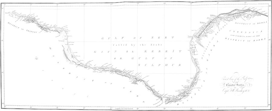
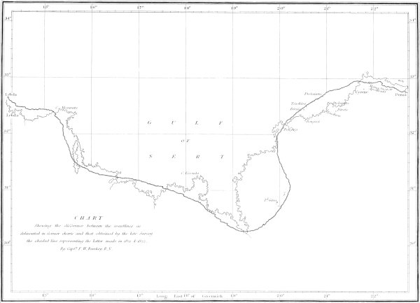
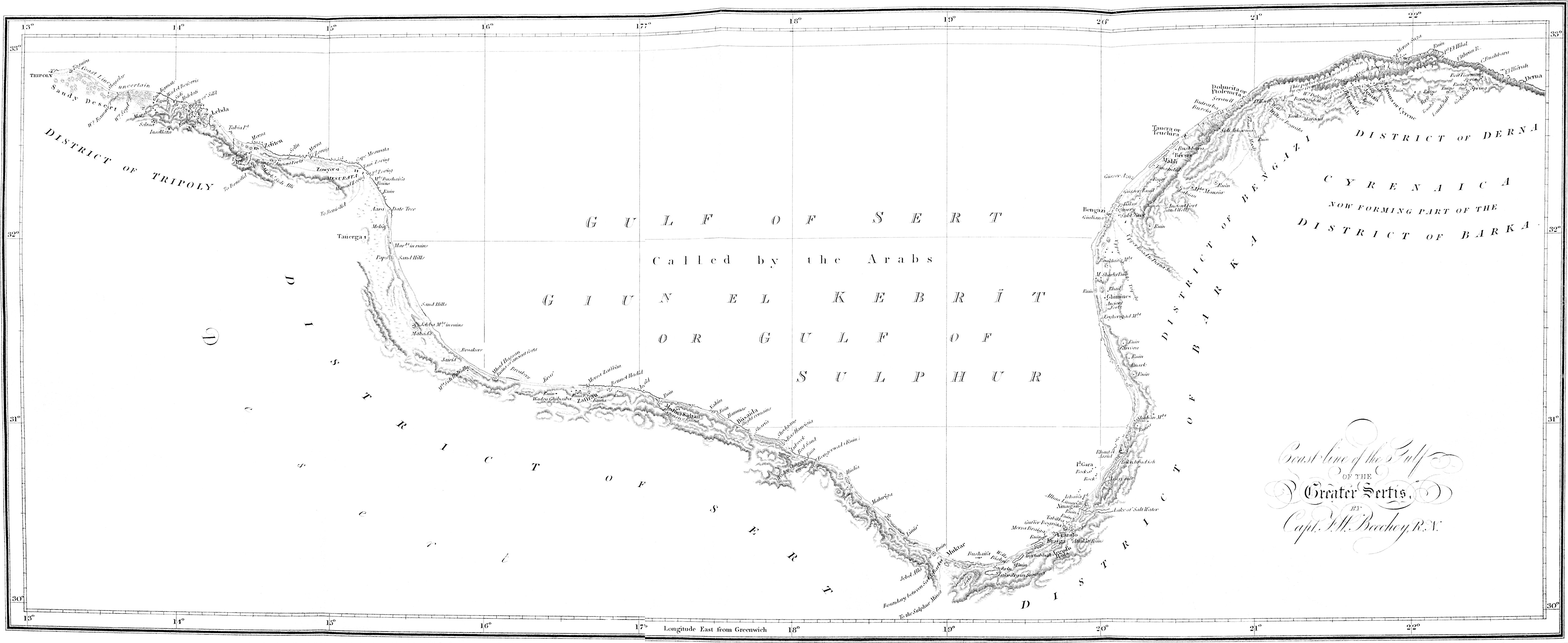
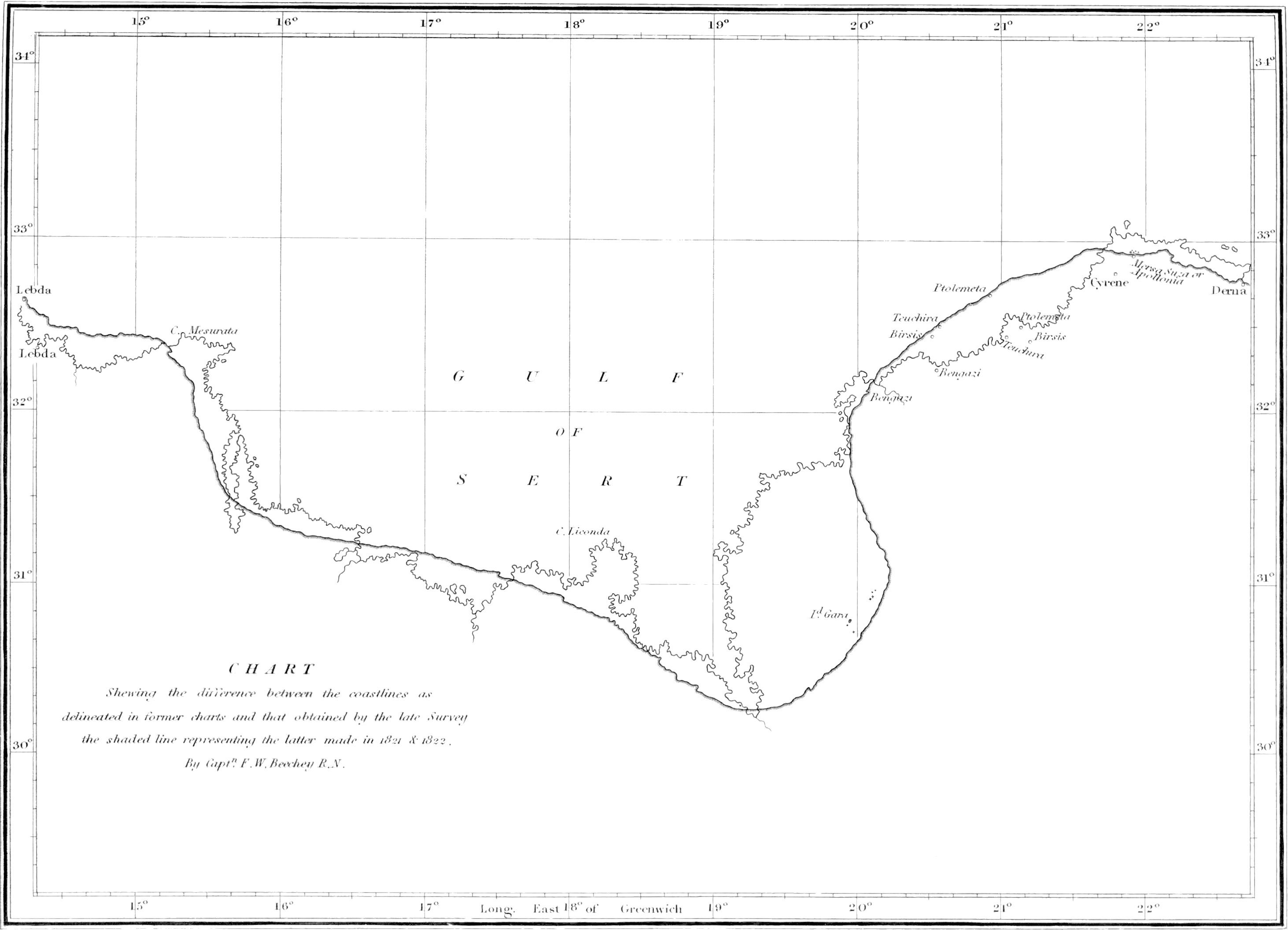
coast from Tripoli to Derna. The several places therein alluded to,
will be found in the accompanying chart, which has been constructed
from a succession of angles, carried on along the coast, assisted
by astronomical observations, and chronometrical measurements,
between three distant points, whose positions were well determined
by Captain W. H. Smyth, R.N.
The instruments with which we were furnished, in consequence of
the difficulty of carriage, were small, and their number limited;
they consisted of a five-inch theodolite, one four-inch and two
eight-inch sextants, a telescope for observing the eclipses of the
satellites of Jupiter, a Kater’s azimuth compass, two pocket
chronometers, Nos. 2164 and 2184 of Mr. Arnold’s make[1], and a measuring chain and tapes, &c.
Before entering into any particular description, we shall
premise by stating that, between Tripoli and Bomba, there is not a
harbour capable
of containing a man-of-war brig; though several anchorages will be
found along the coast, well sheltered with particular winds.
Tripoly.Tripoly itself is
a secure harbour, and has from four to six fathoms water in it: the
protection is afforded by a chain of rocks which project from the
north-east angle of the town, and by a shoal lying off Caluisa
Point. A heavy swell sometimes rolls in from the northward, between
the reefs, to which quarter ships should moor with open hawse. On
entering the harbour care must be taken to avoid a rocky patch,
with only three to three and a half fathoms water upon it, which
lies nearly mid-channel. But we shall abstain from entering into
further detail, in consequence of this place having been surveyed
by Captain W. H. Smyth, from whose plan indeed, partly, we are now
enabled to offer these few remarks. When off the port a pilot may
always be procured on making the necessary signal.
At Tripoly vessels will find fresh provision, fruit, vegetables,
and water.
All vessels from the eastern ports of the Mediterranean must
land their cargoes at the Lazzaretto, and perform a stated
quarantine.
Tagiura.About seven miles eastward
of Tripoly is Tagiura point, which may be known by the
clusters of date-trees around the village of Tagiura, terminating
there. From Tagiura to Cape Sciarra there is a sandy desert,
traversed by two small streams, Wadey Rammel and Wadey M’Seidi,
which give a supply of water throughout the year. Eastward of
Cape Sciarra the coast gets higher, and is formed in rocky
points and capes, with sandy bays between them. The mountains,
which are a continuation of the Tarhoona range, here approach the
sea within seven or eight miles; and a little beyond Sidi
Abdellati, throw off a branch at right angles to them, which
extends to the sea, and then continuing eastward, nearly parallel
to the coast, terminates a few miles south-west of Mesurata[2].
There are several towers upon the summits of this range, of
which the most
conspicuous is Mergip. These mountains form the western
Lebdalimit to the great plain of
Lebda, (the ancient Leptis Magna.) The ruins of the
ancient city stand close upon the beach: they are more than half
buried in sand, and are situated about three miles west of the
groves of date-trees, which are easily distinguished from the sea.
The port, or cothon of Lebda, is now filled up, but there is a
small place called Mersa Ligatah, a mile and a half to the westward
of the ruins, where small vessels may find shelter, except with the
wind from the eastward. The sea here affords good fish; and the
shore is stocked with sheep, fruit, vegetables, and corn, which
with the help of a chaous, may be obtained at a cheaper rate than
at Tripoly.
Tabia Point.Seven miles south-east
from the ruins of Lebda, is Tabia Point, a rocky headland,
about forty feet high, with some rocks at the foot of it. Near it,
there will be found indifferent protection for boats behind some
rocks, that form Mersa Ugrah; but these rocks are
sometimes covered.
Mersa, and Point
Zeliten.Immediately round Tabia point, the coast forms a bay
as far as Zeliten Point: this is a rocky projection with
several sunken rocks lying off it. Near the point there is a small
cove, which has obtained the name of Mersa Zeliten, but it is too
small for even boats to remain in blowing weather. It lies a mile
and a half to the westward of a márábūt’s tomb, which will be seen
upon the beach supported upon small marble columns.
At Zeliten, sheep, fowls, butter, oil, fruit, vegetables, corn,
and sweet water, may be procured in abundance, and very reasonably.
The town is a short walk from the Mersa, over a ridge of
sand-hills, which extend along the coast towards Mesurata.
Eastward of Zeliten, the coast is rocky, and at times rises into
cliffs. About mid-way between Cape Mesurata and Zeliten Point,
there is a small Arab village, that may be distinguished by a
cluster of date-trees, at the foot of some high sand-hills. Several
reefs of rocks lie off here, and form Mersa Zoraig, and Mersa
Gusser[3]. The inhabitants of Zoraig are about one
hundred in number, and nothing but water could be procured in any
abundance.
Toward the eastern termination of the sand-hills, the rocky
coast gets higher, and when four miles from the entrance of the
Gulf of Syrtis, forms three cliffs, which, at a distance, Monsieur
Lauthier informs us, appear like as many islands. The eastern one
of these Cape Mesurata.three is
Cape Mesurata (the Cephalus Promontorium of Strabo).
Entrance of the Gulf of SyrtisThe
entrance to the gulf is formed by a low rocky point: at the back of
it there are groves of date-trees among low sand-hills; and a mile
to the southward is the white mausoleum of Márábūt Bushaifa, which
gives name to the bay it overlooks[4].
Bushaifa Bay.There is good landing
under the low point before mentioned, in a small sandy bay abreast
of a low sand-hill. The bay appears to be full of fish, and the
seine might here no doubt be hauled to advantage.
Mesurata.The Town of Mesurata is
about two miles to the southward of the cape of the same name; it
is governed by an Aga, to whom it would be found advantageous to
make a small present. Fresh provision, fruit, vegetables, and sweet
water, may be procured here in abundance.
AarārAbout ten miles south of
Bushaifa there is a solitary date-tree, overlooking a low sandy
tract of coast, bearing the name of Aarar. Off here,
Monsieur Lauthier informs us, at two leagues distant from the
shore, there is a rocky bank, a league in length from east to west,
with from fourteen to seventeen feet water upon it. The date-tree,
the position of which is well determined, will serve as a mark for
this bank.
Leaving Aarār and coasting southward, the shore is very low and
sandy, with apparently no danger. A low ridge of hills
extends along the coast from one to three miles distance from it.
Some few of these hills are covered with vegetation, and now and
then a straggling flock of goats or sheep may be met with; but
otherwise no supplies of any kind are to be procured until you
arrive at
Zafferan—firewood excepted, which may be obtained from the wrecks
upon the beach in large quantities.
Kusser el Jébbah.Jébbah
is the first conspicuous object that presents itself after Aarār.
It is an old Arab building, upon an eminence about four miles from
the coast. Its position is well determined, and its distance from
the beach ascertained by a base purposely measured.
The whole of this coast is very low, and in blowing weather
should be avoided, as there appears to be a great set down upon it
from the north-east, judging from the number of wrecks, masts and
yards, &c., that are thrown upon the beach, on this side of the
gulf only—none being seen on the eastern shore.
Shoals.Until we arrived at
Jaireed, in latitude 31° 23′ 27″ N., we did not perceive any
dangers lying off the coast; but at that place we observed the sea
breaking heavily over two shoals, distant from the shore about a
mile and a quarter[5].
From Jaireed the coast trends more easterly, but still continues
low and sandy, with small hillocks at a short distance from the
coast. When near the latitude of 31° 16′ N., ships must avoid some
Dangerous Shoal.dangerous shoals that
branch off from the shore at Jiraff, and extend westward seven or
eight miles—their most distant part from the shore being about two
miles: the sea broke heavily over them when we passed, but within
them it was more quiet; and if a passage should be found between
the breakers, a tolerably secure anchorage will in all probability
be discovered.
Eastward of Jiraff the coast alters its character: the shore is
rocky, the land gets more hilly, and is covered with vegetation. In
one part, in latitude 31° 12′ 48″ N., some high sand-hills,
surmounted with small tufts of trees, will be seen overlooking the
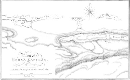
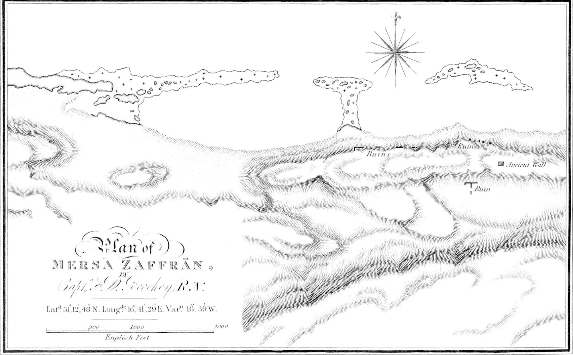
Mersa Zafferān.beach; at the foot of
them there is a small port called Mersa Zafferan, in which
boats may find shelter with all winds; but it will be difficult to
find, in consequence of there being no object to distinguish it
from the other ports of the coast, except indeed the wall of a
building which stands upon the beach be seen protruding through
the sand that
has nearly covered it. At Zafferan supplies of meat, some few
vegetables, and good water, will be found. The Arab tents are at
the back of the sand-hills. These hills extend a few miles to the
eastward of Zafferan; the coast then rises into cliffs of about
fifty feet in height, and is covered with vegetation and brushwood.
These cliffs terminate at a wadey eleven leagues eastward of
Zafferan, and the coast then continues low and sandy, with
sand-hills, at a short distance from it. There are here several
small bays, Hammah.and one in
particular at Hammah, in which boats may find shelter with almost
all winds, and may procure good water, from some wells situated
close to the beach. The country about it abounds in game; but we
would not recommend landing here, or, in fact, on any part of the
coast, without being provided with a chaous. Five miles eastward of
Hammah the coast is hilly, but soon declines again to the low sandy
beach which continues to Ras How-y-jer, having a range of hills
about two or three miles from the coast.
Ras How-y-jer.Ras How-y-jer is a
bluff rock, that has the appearance of a ruined castle; it stands
at the entrance of a spacious bay formed between it and a bold
rocky promontory, called Bengerwad. South 76° east (true) from
How-y-jer we noticed the water discoloured, but the sea did not
break. In the above-mentioned bay ships may find shelter from east
to west north-west, and boats may land in a sandy bay a little
south of How-y-jer with almost all winds.
Ras Bengerwād.Bengerwād is about
sixty feet in height, and has been strongly fortified, but the
ruins are not visible from the sea. There is a small sandy bay,
close round the cape, convenient for landing; but care must be
taken to avoid the mouth of a ravine, that comes down from the
mountains, and deposits a soft quicksand, upon which it is
dangerous to land. The range of hills that extend from Boosaida are
distant from Bengerwad only a few hundred yards, and afterwards
recede to a mile or more from the sea. From Bengerwad the coast
gets low, and small sandy bays are formed between very low rocky
flats, some of which project a mile into the sea, and are not more
than a foot above water. Sixteen leagues from Bengerwad Abanbāsathere are some high sand-hills, called
Abanbāsa; and a few miles Jebel-Allasouth-east of them a remarkable
table-hill named Jebel-Alla. Coasting along this part of the gulf,
care must be taken to avoid a low rocky islet, with breakers east
and west of it. It lies one mile and a half off shore, Bushaifa Islet.and is called Bushaifa. Upon the
beach opposite the Islet, there are two wells of good water: they
point out Secherine, which is the bottom of the Gulf of Syrtis, in
latitude 30° 16′ 00″ north.
GartúbbahFrom Secherine to
Gartúbbah, there is a sandy beach; but the general appearance of
the coast will be hilly, with high mounds of sand. Near to
Gartúbbah is Mersa Braiga; the only place that we have seen in the
Gulf of Syrtis, that is at all entitled to the name of a port, and
here the protection is made by breakers.
Mersa Braiga.Braiga may be known
at a distance, by some very high sand-hills situated at the back of
it, and on a nearer approach, by a heap of ruins upon a rocky
point, at the western extremity of the Mersa. On the sandy beach
within this point, there is safe landing with all winds. Fresh
provisions may be procured from the Arab encampments at the back of
the sand-hills, and in all probability, a plentiful supply of fish
will be found in the bay[6]. The water here is
brackish, and tastes of sulphur; it is contained in wells high up
among the sand-hills.
We should not recommend Mersa Braiga being approached in bad
weather, on account of the number of reefs lying off it, and the
difficulty there would be of working off, in consequence of the
lee-set which the northerly winds always occasion in the Gulf.
From Braiga, the coast trends north-east by east, is rocky, and
slightly indented; the shore, generally speaking, is high and
hilly. Ras Tabilbey.Ras Tabilbey is a
bold promontory, with a sandy bay on either side of it. The summit
of the Ras has been strongly fortified; and the walls are carried
up to a castle on the hill at the back of it, but these are now all
in ruins, and cannot be discerned from the sea. The promontory is
excavated into compartments, which from time, and the constant washing of the sea,
are in a very dilapidated state, and dangerous to remain in during
windy weather.
There are several Arab encampments a short distance from the
Ras; from which small supplies of fresh provision may be
procured.
North-eastward of Ras Tabilbey, there is a cliff of white
sand-stone, somewhat conspicuous, with some sunken rocks lying off
it. The Rocks.rocks bear north 9″
west (true), from the northern one of two conical hills, that will
be seen situated between the before-mentioned Cape and Ras
Tabilbey; they are two or three miles off shore. Eastward of the
white cliff there is a deep ravine, and then a remarkable
Allum Limàrish.peaked hill, called
Allum Limàrish. Between these two is situated Ain Agān.Ain Agān, an Arab encampment, from which
small supplies of meat, corn, and brackish water may be
procured.
North 38° west (true) from Allum Limàrish, there is a remarkably
white rock, about forty feet in height and steep on all sides, with
reefs of breakers extending east and west from it. It lies about
half Ishaifa Rock.a mile off shore,
and is known by the name of Ishaifa. From the Breakers.top of Allum Limàrish, we observed the
sea breaking heavily over some reefs three or four miles off shore,
and appeared to extend From N. 78° W.
(true).toward the island of Gāra.
Island of Gāra,Gāra is a
small island, bearing north 13° east (true), from Allum Limàrish,
and distant from the shore four miles and a half. It is tolerably
high, and appeared steep on all sides. South-west (true)
Rocks and Shoals in its vicinity.from
Gāra at two miles and a half distance, a rock makes its appearance
among a reef of breakers; and south 16° east (true), three miles,
another. There is also a bank east by south (true), three miles
from it, over which the sea constantly broke.
The coast about here is low and sandy, and, in consequence of
the above-mentioned reefs, somewhat dangerous to be approached; but
when Gāra and its reefs shall be better known, I have no doubt
ships will find shelter from all winds within them.
Several hills, covered with brushwood, will be seen a short
distance from the coast, and near the beach there will be found
wells of water somewhat brackish, and strongly impregnated with
sulphur.
North 52° east
(true) from Gāra, at one and a quarter to one and a Islets.half off shore, lie a group of rocky
islets, connected by breakers; behind which, I have no doubt, small
vessels will find shelter with all winds. They are in the
neighbourhood of Rhote el Assoud, (or black valley,) so called, it
is said, from the dark appearance of the hills.
North-eastward of these islets, there is a Marabot upon a
pointed hill at Shāwhan, and inland two ruined towers, upon the
summits of hills.
From Shāwhan, the coast trends to the westward of north up to
Carcōra.Carcōra, and forms a large
open bight. The shore is low and sandy, with hills of brushwood or
sand, a short distance from the sea.
Carcōra may be known by some high sand-hills, which overlook the
beach. The coast thereabout is much indented, and there are two
small places, somewhat sheltered by projecting points, that would
afford protection for boats with northerly or easterly winds.
The most desirable of these is the one at the northern extremity
of the sand-hills, a small tower upon a ridge inland, bearing south
77° 45′ east (true). Among the sand-hills will be found several
wells some of which will furnish sweet water, but the greater part
of them are stinking or brackish. From Ain Agān to Carcōra the
country is very thinly inhabited, and no supplies, except what may
be procured from straggling flocks, are to be expected. But
northward of Carcōra Arab encampments are very numerous. The hills
abound in hares, partridges, and pigeons, &c.
Carcōra to Bengazi.From Carcōra to
Bengazi, the shore is low and sandy, rising as it recedes from the
coast, and is covered with vegetation. Several ruins of forts
appear at a little distance from the sea: the most remarkable of
these are at Ghimenes, and Imshali, and all of them are laid down
trigonometrically in the chart.
Breakers.Care must be taken, as
you approach Bengazi, to avoid some breakers, which extend
southward from Juliana point, and lie about three-quarters of a
mile off shore.
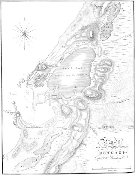
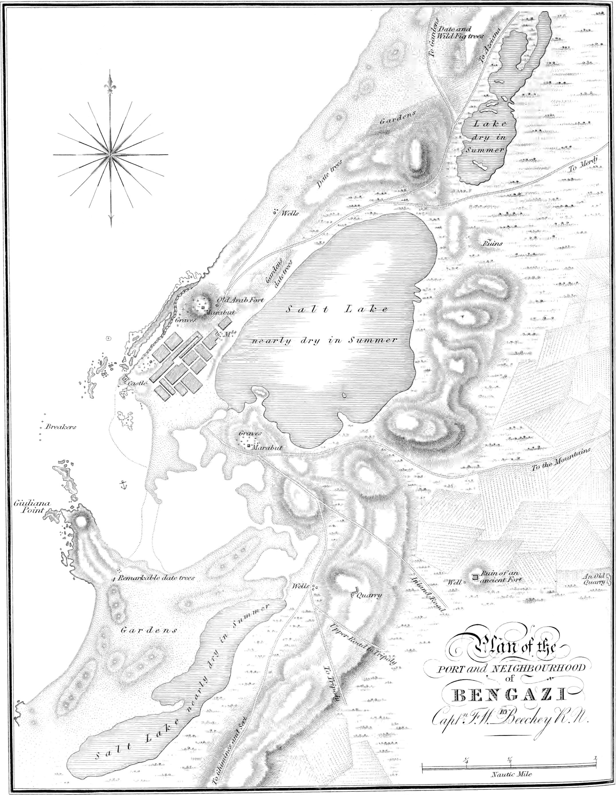
Bengazi.Bengazi is situated at the
eastern entrance of the Gulf of Syrtis, and may be known by the clusters of
date-trees in its vicinity. They are the only ones that occur upon
the coast westward of Derna; but on making the land, the hills,
about fourteen miles west-south-west from Bengazi, will be first
seen. On a near approach, a white Marábot upon an eminence near the
sea, and a square castle at the entrance of the harbour, will serve
more immediately to point out the town. During the summer months
north-easterly winds are very prevalent in the day time, but
generally die away towards night. They are said to extend about
forty miles off the coast; and ships bound to Bengazi should in
consequence keep to the eastward, as well to take advantage of
them, as to counteract the effects of the strong current which they
occasion, sweeping along shore into the gulf.
The port of Bengazi is formed by rocks, that project from the
castle, and Juliana point; and is rendered very secure by a reef
that extends across at a short distance from the mouth of it,
leaving a narrow channel on either side: both these passages are
very difficult, and upon an average the depth of water in the
harbour will be found greater by a foot and a half, or two feet, in
winter, than in summer. But we must not always depend upon this, or
upon a rise with the winds that may be blowing at Bengazi at the
moment; as they may be confined to a short distance only from the
coast; whereas it is the wind generally prevalent over the
Mediterranean at the season that occasions the increase.
The port of Bengazi is fast filling up with sand, and alluvium,
brought down by the heavy rains that annually deluge the town, and
boats only can now enter where the Bashaw’s ships were used to
remain forty years ago.
The castle is strengthened with bastions at the north, south,
and eastern angles; but is deficient at the western one, which is
that which would prove most destructive to ships entering the
harbour: there are nine guns, eighteen pounders, mounted; they are
the only cannon Bengazi can boast of, and the walls which support
them would not long withstand the broadside of a man-of-war
brig.
Supplies.At Bengazi, ships will find a plentiful
supply of fresh beef, mutton and poultry, vegetables, fruit, good
water, and sometimes wood; but the latter is very small.
Bengazi toward Bomba.From Bengazi
to Bomba, a chain of mountains, from eight hundred to eleven
hundred feet in height, extend along the coast in a diagonal
direction with the shore, being distant from Bengazi thirteen and a
half miles, from Tochra five, Ptolemeta one and a half, and coming
close down to the sea in the neighbourhood of Ras Sem. From a rocky
point, four and a half miles north-east of Bengazi, the coast runs
low and sandy to, or a little way beyond, having at the back a
woody country extending to the mountains.
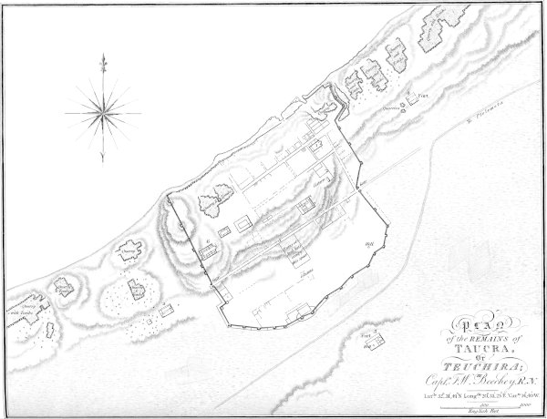
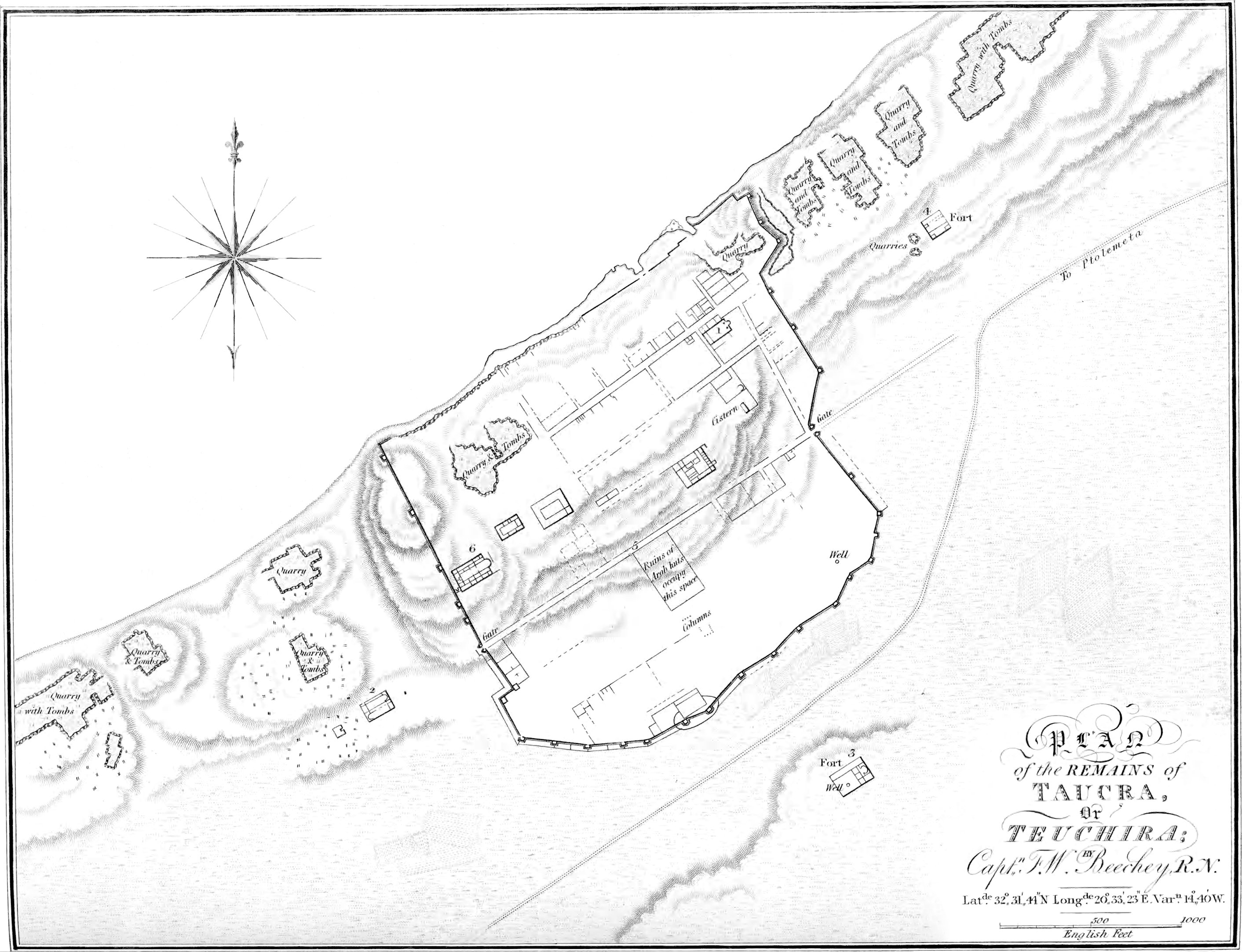
Tochra, or Teuchira.The ruins of
Tochra stand upon a small rising ground, which terminates toward
the sea in a cliff; the landing here is bad, except in very smooth
water, and there is nothing but water to be procured. Between
Tochra and Ptolemeta, the woody country approaches the beach.
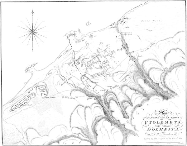
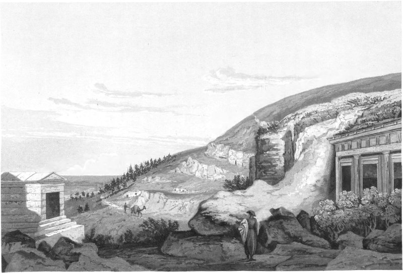
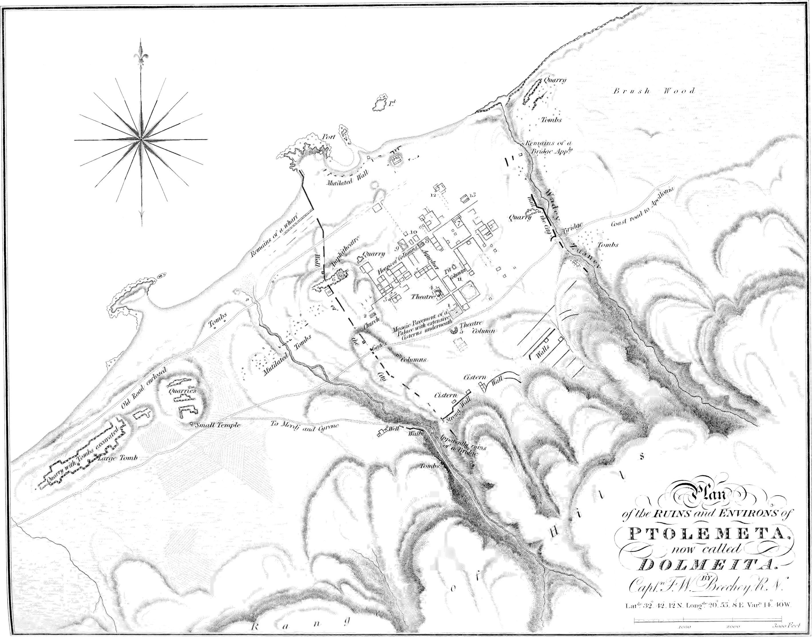
Ptolemeta, or Dolmāita.Ptolemeta
may be distinguished by a large square tomb near the beach, and by
the ruins upon the hills to the eastward of it. A mile from the
tomb (to the eastward) will be found a small bay, offering
convenient landing for boats, except with the wind on shore. It is
immediately round a rocky promontory, the first that occurs after
the tomb. There are no supplies to be had at Ptolemeta, and no
water except, occasionally, in some ancient cisterns.
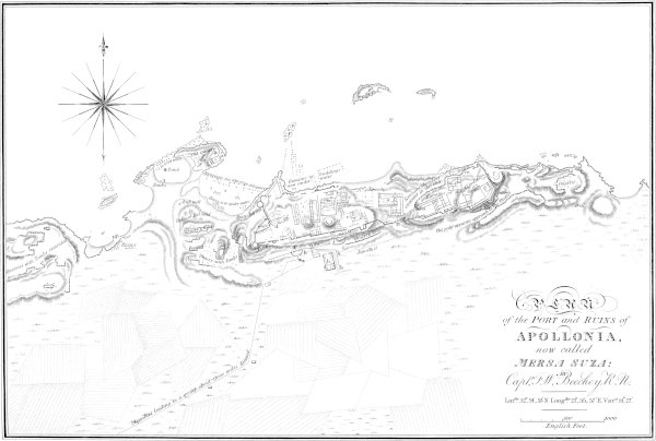
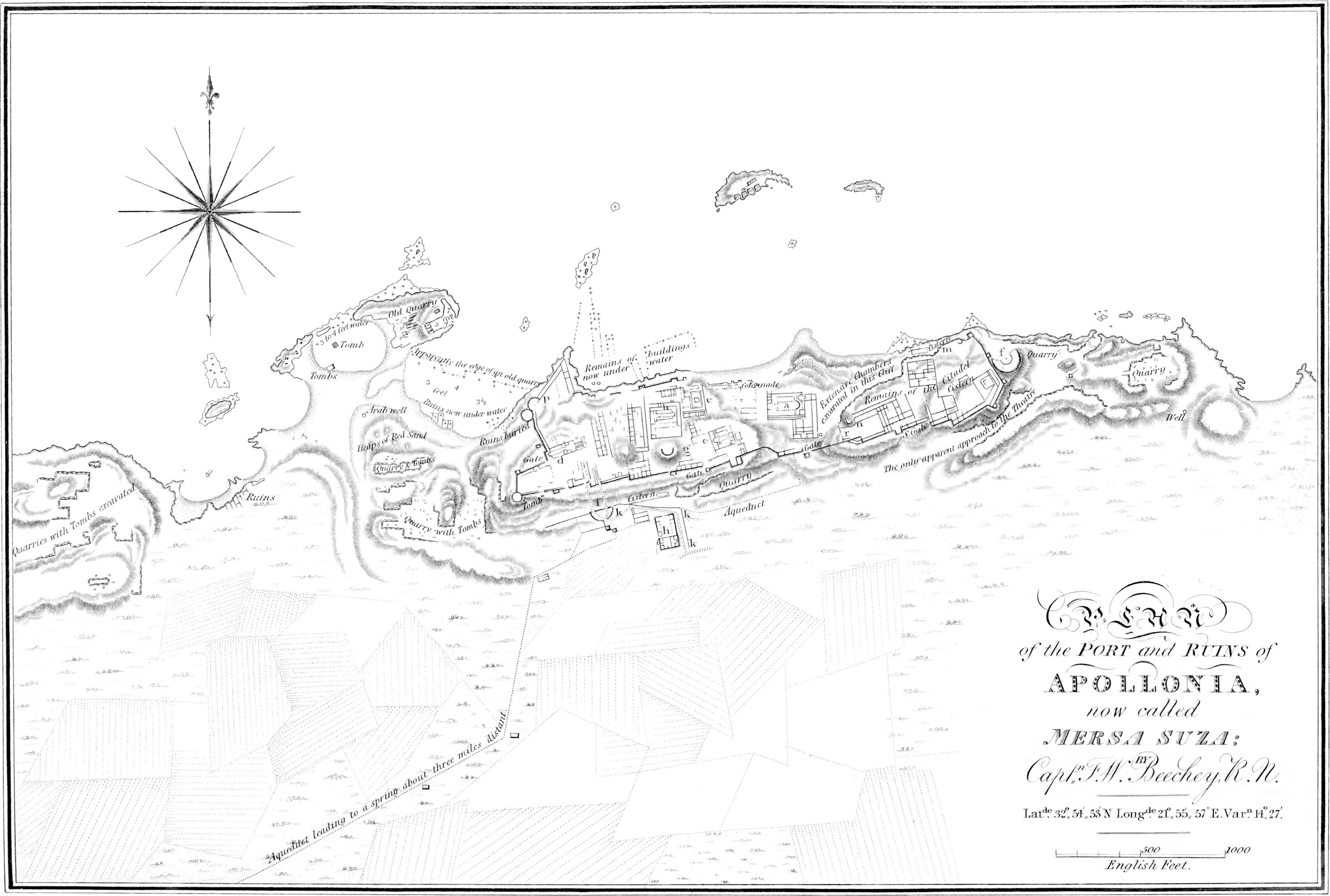
Mersa Sūsa, or Apollonia.Mersa
Susa Hammām, or Apollonia, is situated in the bight of a large bay,
formed by Ras El Hilal, and a cape, designated in the charts as
Cape Ras Sem. The ruins of the ancient town stand upon a rising
ground close to the beach, and may be easily distinguished from the
sea.
Though the Arabs have dignified the small indentation of coast
that here occurs, with the title of Mersa, and we have the
authority of the ancients for its being used as a port formerly,
yet it cannot with any propriety be recommended as such for vessels
of the present day; nevertheless, boats, or perhaps small craft,
may find some shelter behind the islets that lie off the town.
Ranges of mountains.Shipping off
this coast will see two distinct ranges of mountains, one above the other. The
upper one we ascertained to be one thousand nine hundred and
ninety-two feet above the sea[7], and the lower one
thousand and fifty-five[8].
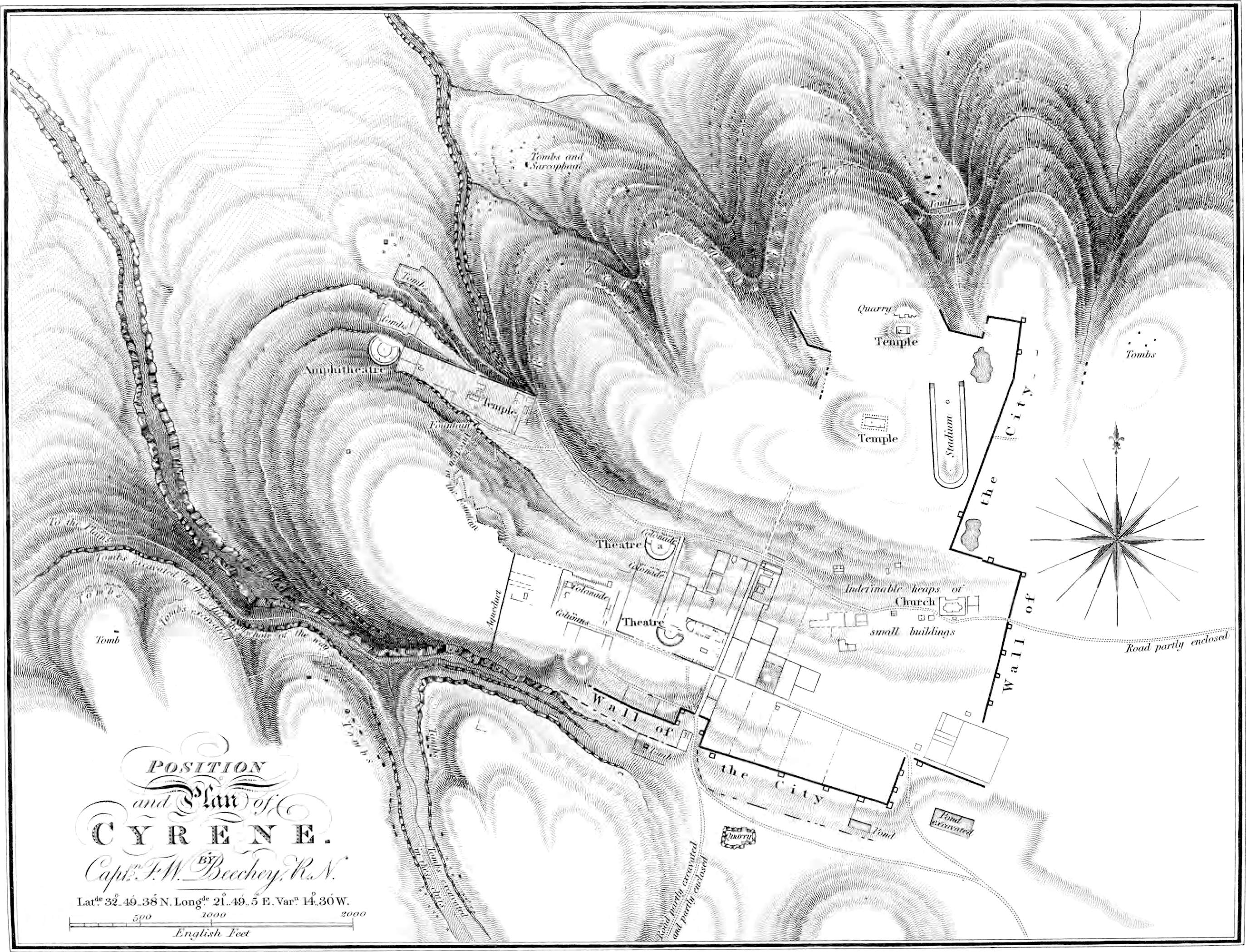
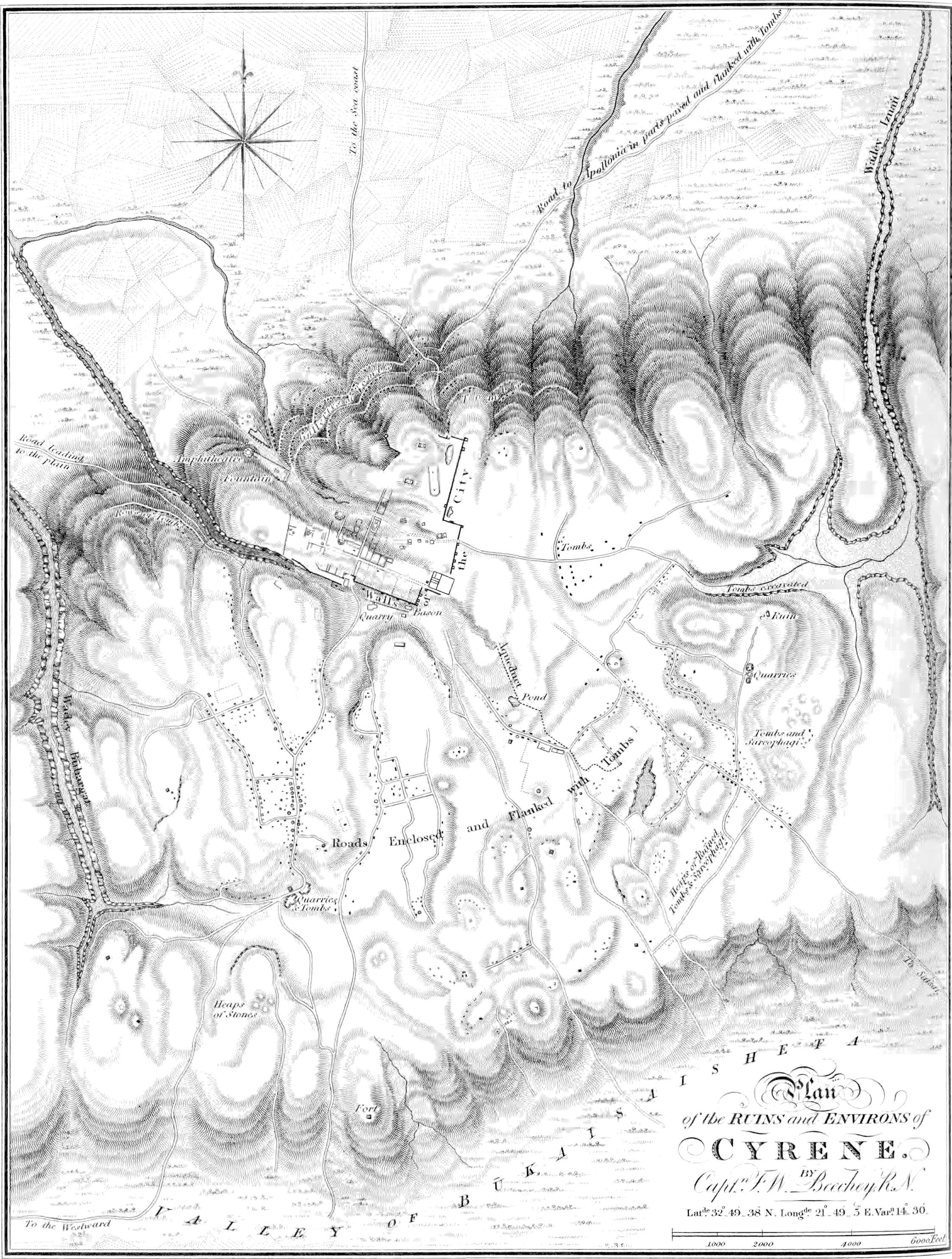
The upper range, upon which is situated the ancient Cyrene,
declines gradually to the eastward, and unites with the lower one
near Cape Bujebāra.
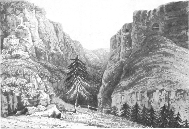
Wadys, or ravines.These mountains
are frequently broken by deep chasms that extend far inland. In
them grow vast numbers of pine-trees fit for small spars; but we
saw none sufficiently large for topmasts, except in Wady Jeräib,
far inland. The largest and most remarkable of these chasms, or
fiumaras, is at Cape Ras Sem; an abundance of firewood will be
found a little way up it, and water may be procured from a stream
in the bed of it, which receives its supply from the fountain at
Cyrene.
Between Ras Sem and Ras El Hilāl, there are several rocks above
water close in shore.
Ras El Hilāl.Ras El Hilāl, or new
moon, so called from a round hill upon the range above it, is a
rocky projection which extends a mile and a half from the foot of
the mountains. On the eastern side of the promontory there is a bay
about three-quarters of a mile deep, in which vessels may ride with
the wind any way from the southward or westward.
Bujebāra.From El Hilāl to
Bujebāra, the next promontory eastward, the shore is rocky; and
there is bad landing, except in a small sandy nook, two miles west
of the latter place. About mid-way between these capes at Elthroon,
a fine stream of water falls into the sea from a deep fiumara.
From Cape Bujebāra to Derna, the same rocky coast continues; but
the ravines are fewer, and the mountains somewhat farther removed
from the coast.
Rocky Islets.Eight miles westward from Derna, at
two miles distance from the shore, there are three small rocky
islets, which must be avoided.
The whole of this coast is very thinly inhabited.
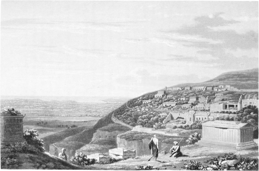
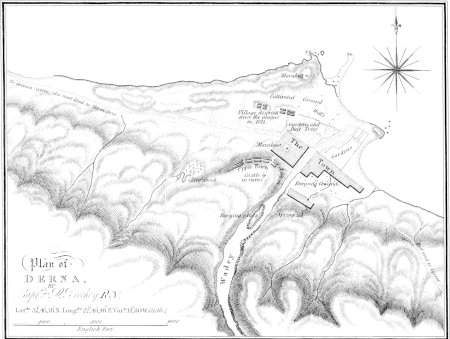
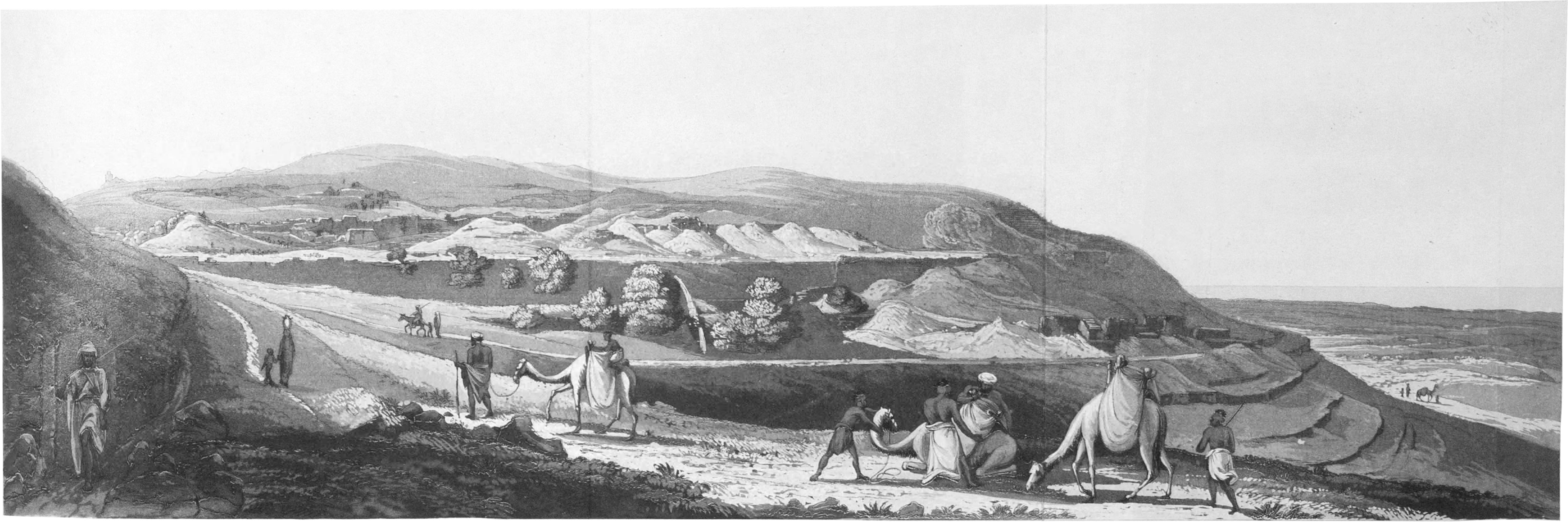
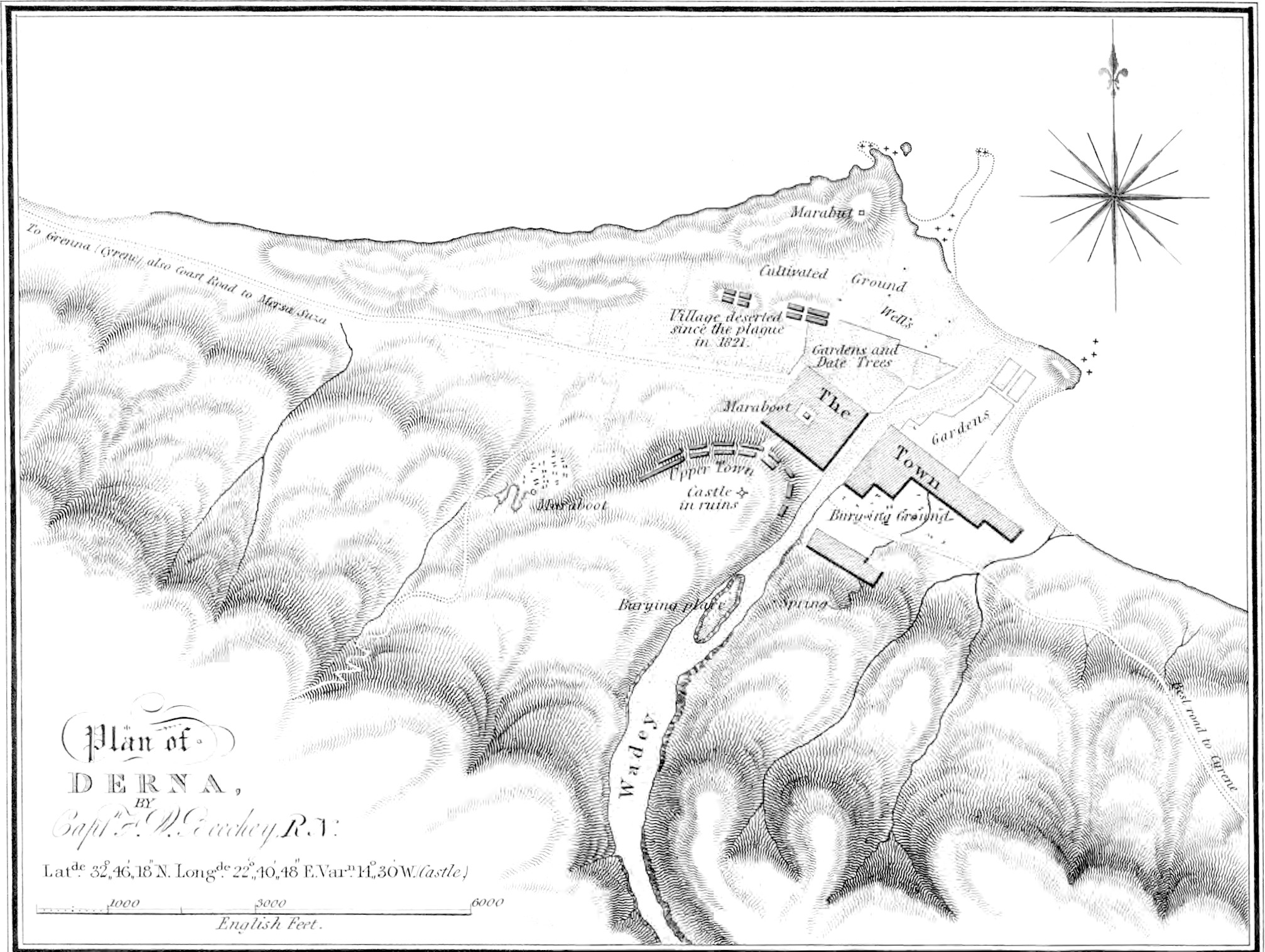
Derna.Derna is situated at the
mouth of a large fiumara, and is surrounded by clusters of
date-trees, which are sufficient of themselves to distinguish the
place; but it may also be known by a ruined castle upon a ridge
above the town, on the western side of the fiumara, and a márábūt,
which stands upon a point, a mile from the town.
There is a good roadstead about a mile and a half off shore, and
some shelter for small craft close in shore with the wind from
north-north-west to south-east; but they cannot remain with a
north-east or easterly wind, nor should they hang on too long in
the event of the wind coming in, or they will find it difficult to
weather either of the capes.
Supplies.Supplies of fresh beef,
vegetables, fruit, and water may be had in abundance. Cattle are
from seven to nine dollars a head, and fine sheep about a dollar
a-piece.
The town is the residence of Sidi Mahommed, Bey of the district,
and eldest son of the Bashaw of Tripoly; to whom it might be found
advantageous to make some little present, and to notice by firing a
salute.
Strength.Derna is not at all
defended; there is an old fort upon the sandy point, but the guns
are not in order, and those which once occupied the turrets of the
castle upon the hill are thrown down and rendered useless by
corrosion—the only annoyance boats attempting to land could find,
would be from the few muskets which the inhabitants might
furnish.
Landing.The best landing place is
to the eastward of the date-trees in a sandy bay round a low point
about half a mile eastward of the márábūt. Some rocks lie off this
point which boats should avoid.
Prevalent winds.At Derna, as at
Bengazi, the most prevalent wind during the summer is along shore;
but here it comes from the west north-west. The north wind appears
to diverge at Ras Sem, and takes the direction of Bengazi on one
side, and Alexandria on the other; for which reasons vessels bound to Egypt
frequently make Ras Sem, and continue along shore.
Pilot.Vessels desirous of entering
the harbour, may always procure a pilot, by making the usual
signal, except it blow hard, in which case he prefers standing upon
the point near the castle, and waves his barracan to the right or
left, as he wishes the helm to be put. But as this pilotage may not
suit every person, ships would perhaps prefer standing off, until
the weather moderated; particularly, as at such times the channel
is difficult to hit, on account of the breakers extending across
it. But should it be attempted, the weather channel will of course
be preferred.
Marks.The mark for the southern
one, is the castle in one with the márábūt on the hill to the
north-east of the town, and for the northern one, the four
date-trees on Juliana point in one, with an old ruined fort upon
the rising ground inland of them. But both these passages are very
narrow, and it would be more advisable to conn the ship between the
reefs, than trust to the marks, as the slightest deviation from
them would put the vessel on shore.
When through the breakers, avoid the shore off the castle, as a
shoal extends some distance off it; the edge of it is steep, and
may generally be seen, and continued along to the west anchorage,
which is about three hundred yards west-north-west of the point of
a narrow pit of sand, that contracts the port to its present
limit.
The depth of water in the harbour varies constantly, according
to the winds which prevail in the offing. We observed that the
greatest increase was with north-westerly gales, and vice
versâ; they generally occasioned a rise of two or three feet,
and if continued, even more than that. North-easterly winds had but
little effect upon it.
The Greater Syrtis appears
to have been at all times ill provided with ports and harbours, and
may at the present day be considered to be wholly unprovided with
any; that is to say, with any which could be used as such by ships
of modern construction. It will be observed that the whole line of
coast laid down in the chart is, at the same time, very
indifferently formed by nature to afford security to vessels of any
description.
It was not, however, necessary that the ports of the ancients
should possess wholly by nature those local advantages which are at
the present day considered to be essential for affording
protection; and we find that many of them existed in places which
must always have been unqualified by their position for affording
the security required. In such places art was made to supply the
deficiencies of nature, and harbours were built where none could
otherwise have been obtained. The mode of constructing these
artificial ports has been clearly defined by Vitruvius; and as it
may serve to explain what we have stated with respect to the
present state of the ports of Ptolemeta and Aspis, we shall submit
the passage in question as we have extracted it from Wilkins’s
translation.
“A spot was, if possible, selected, which had the advantage of
some protection on one of its sides; and the want of a
corresponding defence on the other side was supplied in the
following manner:—rows of grooved beams were driven in the water,
connected by oaken planks, and bound together by chains. The
surface of the ground below the water was then levelled and
consolidated by means of transtilli, and the space comprehended
between the beams filled up with a composition of rough stone, and
cement formed of sea-sand mixed with lime, in the proportion of two
parts to one, which soon produced a solid wall.” The author
adds, “that sand should be procured for this purpose from the
sea-coast between Cumæ and the promontory of Minerva,” which seems
to be considered by him as most efficient in forming the cement
here alluded to.
If the beams could not, however, be firmly fixed, on account of
the action of tides or currents, or from being too much exposed to
a heavy swell from the open sea, a strong buttress is recommended
by Vitruvius to be built upon the water’s edge, and a portion
somewhat less than half the upper surface of the buttress to be
constructed upon a horizontal level, the remaining part inclining
towards the sea. Upon the edges of this part of the buttress walls
were to be raised to the height of the level part, of a foot and a
half in thickness, and the intermediate space filled with sand.
Upon this foundation a solid pile, we are told, may be built,
which, after being finished, should be left to dry for two months
at least. The walls which were raised upon the edges of the
inclined surface of the buttress, and which seemed to confine the
sand, should then be destroyed; and the water, in washing away the
sand by degrees, will undermine the pile, and cause it to be
precipitated into the sea. This operation should be repeated until
the whole is complete.
In places, however, (Vitruvius observes) where this sand is not
to be procured, other methods must be resorted to. The space, which
the mole is intended to occupy, having been inclosed by a double
range of beams connected by planks and chains, the interval between
the ranges should be filled with loam, rammed into baskets made of
the ulva palustris. The space being filled by masses of this kind,
stowed as closely together as possible, the water contained in the
inclosed area may be removed by engines calculated for the purpose,
such as cochleæ, rotæ, and tympana; and when the ground is left
perfectly dry, the foundations may be dug of greater width than the
walls they are intended to support, and filled in with rough stone,
lime, and sand. Piles of charred alder, olive, or oak, must first
be driven into the ground if it be soft, and the intervals between
them filled with charred wood, in the manner
recommended for
forming the foundations of the walls of theatres. The walls should
then be built upon these foundations with squared blocks of
considerable length, so that the stones between these blocks, which
extend across the wall, may be bound firmly together. The space
inclosed by the walls may be filled in with rubble, or stone-work,
and be made so firm that a tower may be erected upon it. The mole
being completed, (continues our author) the docks should be built
facing the north; because the greater heat of a southern aspect
occasions a more rapid decay, and engenders and nourishes moths,
ship-worms, and other noxious insects. Timber should, at the same
time, be used as sparingly as possible in works of this kind, that
they may not be liable to accidents by fire[9].
Harbours[10] of this kind were usually built in a
semicircular form, with arms of great length extended into the sea;
these were sometimes called χηλαι, from their resemblance to crabs’
claws[11]; Cicero terms them cornua (horns).
(Epist. ad Attic. lib. ix. ep. 19.)
For the better security of the ships within the harbour, it was
usual to draw strong chains or booms across the entrance, and to
defend them with large pales, fortified against the water with
pitch. On both sides of the mole were strong towers, which were
garrisoned with troops; and not far from these was a watch-tower,
or lighthouse, called Pharos, which name belonged originally to a
little island in the mouth of the Nile, where the first of these
towers was built, but was afterwards naturalized both in Greece and
at Rome. In the innermost part of the harbour vessels were often
suffered to lie unmoored, whereas in other parts of the port, which
were not so well secured, they were either chained to the land, or
obliged to lie at anchor. This portion of the harbour was divided
into several partitions by walls, constructed for the most part
with stone, within which the vessels laid very securely,
without the necessity, as we have just mentioned, of using either
cable or chain. These places were termed ορμοι, υφορμοι, ναυλοχοι,
ormoi, uphormoi, naulokoi, &c., and
formed altogether what was called ναυσταθμος
(naustathmos[12]).
Here were likewise the docks in which ships were built, or
careened, drawn up on the beach.
Most harbours were adorned with temples, or altars, where
sacrifices were offered to the tutelar deities of the place, and to
those which presided over the sea and the winds. The adjacent
places were filled with inns and other places of public
entertainment, for the use of mariners, merchants, &c., who
might be stationed or touch at the port.
In times of war, harbours were also defended on the land side by
a ditch and parapet, or by a wall, built in the form of a
semicircle, extending from one point of the sea to the other. The
wall was occasionally defended by towers, and beautified with
gates, through which the garrison sometimes issued to attack their
enemies.
Towards the sea, or within it, pales of wood were also fixed,
like those in the harbours, before which the vessels of burthen
were placed in such order as to serve instead of a wall, and to
give protection to those within. Nicias is reported by Thucydides
to have entrenched himself in this manner; but it seems only to
have been practised when the enemy were supposed to be very
superior in strength, or excited unusual apprehension: at other
times a few ships were appointed to reconnoitre the hostile
squadron, and to observe the enemy’s motions.
When the fortifications were considered sufficiently strong to
resist any assault which might be made upon them, the vessels were
usually hauled up on the beach, and around them were pitched the
tents of the soldiers and sailors, as appears everywhere in Homer,
Thucydides, &c. This practice, however, seems only to have been
resorted to in the winter season, when the enemy’s fleet was
equally laid
up, and there was no apprehension of an assault; or in
long-continued sieges, where no danger was to be apprehended from
the enemy’s navy, as in the Trojan war, when the Greeks were never
attacked by sea. At other times the ships lay at anchor, or were
made fast to the shore, that upon any alarm they might be ready to
receive the enemy.
Construction of ancient
vessels.The ships of the ancients were very differently
constructed from those which are at this day in use; and their rate
of sailing was, for the most part, even lower than that of the
dullest sailing vessel we are at present acquainted with. The rate,
however, varied at different times, and will be found at some
periods of the Roman empire to have been extremely respectable.
The earliest ships were built with very little art or
contrivance, and had neither strength nor durability, beauty nor
ornament; they consisted of nothing more than single planks laid
together, just sufficiently united to keep out the water, and were
in some places nothing more than trunks of trees hollowed out,
forming vessels of single pieces of timber. Other materials besides
wood were also employed in the construction of ships; among which
may be mentioned the Egyptian papyrus, and more especially the
hides of different animals, of which the primitive vessels were
very frequently composed. These were sometimes girt with
wicker-work, and frequently used in that manner, even in later
times, on the rivers of Egypt, Ethiopia, and Sabæan Arabia.
In early periods, however, when vessels of this construction
were employed, we find no mention of anything but leather, or hides
sewed together. It was in a ship of this kind that Dardanus secured
his flight from Samothracia to the country afterwards called Troas;
and Charon’s boat was also (according to Virgil) constructed of the
same material[13].
On their first invention, all ships, for whatever purpose they
might have
been designed, appear to have been of the same form; but the
various ends of navigation, some of which were better answered by
one form, some by another, soon gave occasion for a distinction,
not only in point of size, but also in the mode of construction and
equipment.
Without attempting to enumerate every trifling alteration, we
may state generally, that the vessels of the ancients were divided
into three classes—ships of burthen, of war, and of passage; and
these again had their several distinctions into other classes and
subdivisions. Ships of burthen were usually of an orbicular form,
having large and capacious hulls for the convenience of stowage;
whereas, ships of war were of a greater length in proportion to
their size, as we find to be the case at the present day. Transport
vessels were of a form between the ships of war and of burthen,
being more capacious than the former, and longer than the
last-mentioned species.
Management of the vessels.There
was at the same time a difference in the management of the vessels
enumerated. Men-of-war, though not wholly destitute of sails, were
chiefly managed with oars, that they might be more able to tack and
manœuvre in light or contrary winds, and to lay themselves
alongside the enemy to advantage; while the other two species were
commonly governed by sails, and vessels of transport were towed,
when it was practicable, with ropes. All three modes of government
(by sail, oar, and tow-rope) were, however, occasionally adopted by
each of the classes. The rowers were not placed, as some have
imagined, upon the same level in different parts of the ship, nor
perpendicularly above each other’s heads; but their seats, being
fixed one at the back of another, ascended gradually in the manner
of stairs. The most usual number of these banks was three, four,
and five, composing what are called trireme, quadrireme, and
quinquireme Number of banks of
oars.galleys; the second of these having a range of oars
more than the first, and the third a range more than the second—the
height of the vessel always increasing in proportion to the number
of ranges. In primitive times, the long ships had only one bank of
oars; and
therefore, when we find them called πεντεκοντοροι (fifty-oared),
and εκατοντοροι (hundred-oared), we are not to suppose they were
rowed with fifty and an hundred banks, but only with so many oars.
The ship Argo, invented by Jason, was rowed with fifty oars, and,
according to some writers, was the first of the long ships; all
vessels, till that time, having been of a form much more inclining
to oval. Others carry the invention of long ships somewhat higher,
referring it to Danaus, who sailed from Egypt to Greece in a ship
(we are told) of fifty oars; and even if Jason be allowed to have
been the first who introduced the long ships into Greece, yet he
cannot be considered as the original contriver of them, but rather
an imitator of the Egyptian or African model, the latter of which
was constructed some time before by Atlas, and much adopted in that
part of the Mediterranean. The first who used a double bank of oars
were the Erythræans, and Aminocles of Corinth added a third, as
Herodotus, Thucydides, and Diodorus have reported; although Clemens
Alexandrinus attributes this invention to the Sidonians. A fourth
bank was added by a Carthaginian called Aristotle; and Nesicthon of
Salamis (according to Pliny), or Dionysius the Sicilian (according
to Diodorus), increased the number to five; Xenagoras of Syracuse
added a sixth; and Nesigiton increased the number to ten. Alexander
the Great and Ptolemy Soter had vessels of twelve and fifteen banks
of oars; and Philip, the father of Perseus, is said to have had one
of sixteen.
Extreme bulk of some of the
vessels.As the method of erecting one bank above another
came to be generally known, it was easy to make further additions;
Demetrius, the son of Antigonus, built a ship of thirty banks; and
Ptolemy Philopator, that he might outdo his predecessors, enlarged
the number still further to forty; which, as all other parts were
necessarily in proportion, raised the vessel to such an enormous
size, that it appeared at a distance like a floating mountain or
island, and on a nearer view took the form of a huge castle in the
midst of the waves. This enormous structure contained four thousand
rowers, four hundred sailors employed in other services, and a body
of nearly three thousand soldiers! But this, and such like
fabrics, (says the author of the Archæologia, from which we have
extracted these particulars,) served only for show and ostentation;
being by their great bulk rendered unwieldy and unfit for ordinary
use. Athenæus (he adds) has informed us, that these vessels were
commonly known by the names of Cyclades and Ætna; names of islands
and mountains, to which they appeared almost equal in
size—consisting, as some report, of materials sufficient for the
construction of at least fifty triremes.
Besides those already mentioned, there were other vessels fitted
with half banks of oars, which seem to have been between a unireme
and a bireme, and consisting of a bank and a half: also some
between a bireme and a trireme, having two banks and an half of
oars. These, although perhaps built in other respects after the
model of the long ships, or men-of-war, are seldom comprehended
under that name, and are sometimes mentioned in opposition to
them.
Various descriptions of ancient
vessels.Several other kinds of ships are enumerated by
different authors, which varied from those already described; being
fitted for particular uses, or seas, or employed upon urgent
occasions in naval fights, but more commonly as υπηρετικαι (or
tenders), and as victualling ships for supplying the principal
fleet.
Some were built for expedition, to carry expresses, or to
observe the enemy’s motions, without incurring the danger of being
taken by the heavier, and armed vessels; these were distinguished
from the former by the manner of their construction and equipment,
being in part like men-of-war, and partly resembling ships of
burthen, while in some things they differed from both, as the
various exigencies for which they were fitted might seem to
require.
Mode of rigging.Every ship in
later times had several masts; but we are told by Aristotle, that
at first there was only one mast, which was fixed in the middle of
the ship. On landing, the mast was taken down, as appears
everywhere in Homer, and placed on a thing called ιστοδοκη, which
according to Suidas, was a case wherein the mast was
deposited; but
Eustathius will have it to be nothing more than a piece of wood,
against which it was reared. About the mast was constructed a kind
of turret for soldiers to stand upon and cast darts.
Sails are by some thought to have been first invented by
Dædalus, and to have given rise to the fable of his using wings;
others refer this invention to Icarus, making Dædalus the contriver
of masts and yards. There was originally only one sail in a ship;
but afterwards a greater number was found convenient; the names of
which are enumerated by Potter.
Sails were commonly of linen; but sometimes of any other
material fit for receiving and repelling the wind. We occasionally
find mention of leathern sails; and it was usual with the ancients,
when none were at hand, to hang up their garments for this purpose:
whence arose (continues our author) the fable of Hercules, who is
feigned to have sailed with the back of a lion, because he
used no other sail but his garment, which was a lion’s skin.
Occasionally the ropes and rigging were for the most part composed
of leathern thongs; afterwards cordage of hemp and flax came into
use, as well as of broom, palm-leaves, philyry, and the bark of
trees, such as cherry, vine, maple, &c. The oars were usually
covered with brass in the blade, or broad part of the oar, to make
them stronger and more durable; Oars and
anchors.the oars of the lowest bank were shorter than the
rest, and those of the uppermost ranges were necessarily the
longest, being at the greatest distance from the water, for which
reason it was customary to load their handles with lead, lest the
bottom should outpoise the top. The row-locks, and the seats of the
rowers were generally covered with hides.
The most ancient anchors are said to have been of stone, and
occasionally of wood, to which a quantity of lead was attached. In
some places, baskets full of stones, and sacks filled with sand,
were employed for this purpose. In later times they were composed
of iron, and furnished with teeth (arms,) whence οδοντες and
dentes are frequently used for the anchors themselves in
the Greek and Latin poets. Originally there was only one tooth; but
a second was
added by Eupalamus, or by Anacharsis, the Scythian philosopher.
The Scholiast on Apollonius confidently asserts, that this
species of anchor was used by the Argonauts; but herein (says
Potter) he appears to deserve no great credit, for his assertion is
contrary to the testimony of other writers, and his own author,
Apollonius, makes mention of none but those of stone. The anchors
with two teeth appear, from ancient monuments, to have been much
the same with those which are used in the present day, except that
the transverse piece or anchor-stock is found to be wanting in all
of them. Every ship had several anchors, one of which surpassed all
the others in point of size and strength, and was never used but in
cases of extreme danger; for which reason it was termed ιηρα, in
Latin, sacra; and sacram anchoram solvere, is
proverbially applied to such as are forced to their last refuge.
The instrument which answered to the lead of modern days
was also composed of lead or brass, and lowered by a chain instead
of a line.
Cables were sometimes called καμιλοι, or καμηλοι, (cámili, or
camēli,) whence, in the passage of St. Matthew, where our Saviour
remarks, that “it is easier for a camel to pass through the eye of
a needle, than for a rich man to enter into the kingdom of heaven,”
Theophylactus, and some others, have interpreted the word καμηλος,
(camēlus) not as meaning the animal, but the cable so called.
Equipment of vessels.With regard
to the equipment of the vessels of the ancients, we are told by
Thucydides, that there was originally no distinction of
Ships’ companies.rank among their
crews; but that the same persons were employed indiscriminately in
those duties which in later ages were executed by separate orders
of men, that is to say, by rowers, mariners, and soldiers. The same
men originally filled these three offices; they laid down their
arms to labour at the oar, and to do, perhaps, what was necessary
in other respects for the management of the vessel they belonged
to; but resumed them as often as occasion required, to assault, or
defend themselves from, their enemies. At these periods no
extraordinary preparations were made for the equipment of ships of war, but
the same vessels were thought sufficient to answer the purposes of
fighting and transport indiscriminately.
As the arts of navigation and of naval warfare improved, it was
found that any one of the occupations we have enumerated was enough
to engross the whole time and application of the persons employed
in the performance of it; and it then became customary to furnish
ships of war with three distinct orders of men; viz.,
rowers, mariners, and soldiers. The rowers were divided into three
classes; those of the upper, the middle, and the lower ranges. Each
person had a separate oar, for, except in cases of necessity, one
oar was never managed by more than one person; but the labour and
pay of the several classes of rowers were not at the same time
equal: they who were stationed in the uppermost banks, by reason of
their distance from the water, and the consequent length of their
oars, underwent more toil and labour than those in the inferior
banks, and their pay was on that account greater.
The crew took their rest upon the deck, or upon the seats where
they rowed; and the officers only, or persons of more than ordinary
rank on board, were permitted to have clothes spread under them; of
which the following instance is quoted by the author of the
Archæologia from Homer:—
But clothes the men for great Ulysses
spread,
And placed an easy pillow for his
head;
On these he undisturb’d, securely
slept,
Lying upon the stern.
They who could not content themselves with the accommodation
here afforded to the son of Laertes, were looked upon as
effeminate, and unfit to endure the toils and hardships of war: we
find accordingly, that Alcibiades was censured by the Athenians,
for having allowed himself the luxury of a “bed hung on cords,” or,
in other words, a cot or a hammock.
The class termed mariners were exempt from drudging at the oar,
but performed all the other duties of the ship; and in order that
every thing might be carried on without tumult or confusion, each
had his
peculiar office assigned to him, as appears from the Argonautics of
Apollonius and Flaccus. We there find one employed in rearing the
mast, another in fitting the yards, a third in hoisting the sails,
and the rest employed fore and aft in the ship, each in his proper
place. Hence, they had different titles to distinguish them, taken
from the parts of the ship where they were stationed, and the
offices which they were in the habit of performing.
There was a class of men inferior to the rest of the crew, which
was not confined to any particular station or duty, but was ready
on all occasions to attend the other seamen, and supply them with
whatever they wanted.
“The whole ship’s crew,” says Potter, “were usually
wicked and profligate fellows, without any sense of religion or
humanity, and therefore reckoned by Juvenal among the
vilest of rogues[14]!”
It does not, however, follow, because Juvenal here alludes to
sailors of the worst description, that he considered every ship’s
company in the light of thieves and deserters.
The soldiers who served at sea were armed after the same manner
with those designed for land service; only that among them there
seems to have been a greater number of heavy-armed men than was
considered to be necessary on shore; for we find in Plutarch, that
of Themistocles’ ships, four only were light-armed. Indeed, it
highly imported them (says Potter) to fortify themselves in the
best manner they could, since there was no possibility of retiring,
or changing places: but every man was obliged to fight hand to
hand, and maintain his ground till the battle was ended; wherefore
their whole armour, though in form usually the same with that
employed on land service, yet exceeded it in strength and firmness.
Besides Instruments of war.this, we
find also some instruments of war used at sea, which were never
employed on shore; the principal of which were:—spears of an
unusual length, sometimes exceeding twenty cubits; instruments of
iron crooked like a sickle and fixed to the top of a long pole,
wherewith they cut in sunder (continues our author) the cords of
the
sail-yards, and thereby letting the sails fall down, disabled the
light ships. Not unlike this, he adds, was another instrument,
armed at the end with a broad iron head, edged on both sides,
wherewith they cut the cords that made fast the rudder of the
ship.
There were also engines to cast stones into the enemy’s vessels;
and another engine is mentioned by Vegetius, which hung upon the
mainmast, and resembled a battering ram; it consisted of a long
beam with a head of iron, and was pushed with great violence
against the sides of adverse ships. Besides these, there were
grappling irons, which were cast out of an engine into the vessels
of the enemy; these are said to have been first used in Greece by
Pericles the Athenian, at Rome by Duilius; hooks of iron were also
used, which were hung on the top of a pole, and being secured with
chains to the masts or some other lofty part, and cast with great
force into the enemy’s ship, caught it up into the air[15].
The means used to defeat this extraordinary engine, were, (it is
said) to cover the ships with hides, which cast off, or blunted the
stroke of the iron.
With regard to the naval officers employed by the ancients, we
find that in all fleets there were two superior to the rest; one
took the command of the vessels and seamen, the other of the
soldiers; Officers.but this latter
had also some power over the ship-masters (as Potter calls
them) and their crews.
The commission of admiral varied according to the exigency of
times and circumstances, being sometimes held by one alone,
sometimes in conjunction with others; as happened to Alcibiades,
Nicias, and Lamachus, who were sent with equal power to command the
Athenian fleet in Sicily. The period of command was also limited by
the people, and shortened or prolonged as they pleased.
We read of
Epaminondas (continues our author), that, finding his country would
probably be exposed to great danger upon the resignation of his
office, he held it four months longer than he was commissioned to
do; during which time he put a new face upon the affairs of the
Thebans, and by his skilful management dispelled the fears under
which they laboured: this done, he voluntarily laid down his power;
but had no sooner relinquished it, than he was called to account
for having held it so long, and narrowly escaped being condemned to
death! It was feared, it seems, that a precedent of this nature
might at some future time be dangerous to the commonwealth, and
facilitate the views of ambitious persons intrusted with so high a
command, who might avail themselves of it to enslave their
fellow-citizens. For the same reason, probably, by the Lacedæmonian
law, no person could be admiral more than once, a regulation which
nevertheless (continues Potter) stood them in no good stead, it
thereby often happening that they were forced to commit their fleet
to raw and inexperienced commanders.
Next in rank to these were what may be termed vice-admirals, who
acted under the admirals.
The captains of vessels took their names from the rate of the
ships they commanded; and, without enumerating all the different
persons intrusted with commands of various kinds, we may observe
that the duty of master appears to have been split into several
parts, and each person holding a portion of it (whom we may call
master’s mate) to have been distinguished by a different
appellation.
The master himself (properly so called) took charge of the helm
as well as of the ship, and sat at the stern to steer; he was
obliged, at the same time, to be an accomplished pilot, and
familiar with all the harbours, rocks, quicksands, &c., which
were likely to present themselves in the voyage.
The labour of the rowers, which must have been excessive, was
cheered by a musician appointed for the purpose, who at the same
time contributed, by his voice and his instrument, to make the
rowers keep time and pull together. This office could have been no
sinecure; and
the lungs of the musician must have been formed of no ordinary
materials.
Steering by fixed stars.The
heavenly bodies (continues our author) were observed by sailors on
a twofold account; being of use to them in prognosticating the
Which were the chief stars observed by the
ancients.seasons, and as guides to direct their course. The
chief stars observed in foretelling the weather were Arcturus, the
Dog-star, Aræ, Orion, Hyades, Hædi, Castor and Pollux, Helena,
&c. It was likewise Reliance upon omens
of various kinds.customary to take notice of various omens
offered by sea-fowl, fishes, and divers other things, as the
murmuring of the floods, the shaking and buzzing noise of trees in
the neighbouring woods, the dashing of the billows against the
shore, and many more, in all which good pilots were nicely skilled.
As to the direction in their voyage, the first practitioners in the
art of navigation, being unacquainted with the rest of the
celestial motions, steered all the day by the course Exclusive course by the sun practised in early
times.of the sun, betaking themselves at night to some safe
harbour, or making fast their vessel to, and sleeping on, shore;
not daring to venture to sea till their guide had risen to discover
the way: that this was their constant custom, may be observed from
the ancient descriptions of those times, whereof, says Potter, I
shall only give the following instance:
Sol ruit interea, et montes umbrantur
opaci,
Sternimur optatæ gremio telluris ad
undam,
Sortiti remos, passimque in littore
sicco
Corpora curamus, fessos sopor irrigat
artus.—Æneid, iii. v. 508.
Afterwards the Phœnicians, who some will have to be the first
inventors of navigation, discovered the motions of other stars, as
may be observed in Pliny (lib. vii.), and Propertius (lib. ii. v.
990). We find the Phœnicians to have been directed by Cynosura, or
the Lesser Bear (which was first observed, in the opinion of some,
by Thales the Milesian); when the mariners of Greece, as well as of
other nations, steered by the Greater Bear, called Helice. For the
first observation of this they were obliged to Nauplius, if we may
believe Theon; or, according to the report of Flaccus (Argonaut 1),
to Tiphys, the pilot of the celebrated Argo. But of these two, we
are told by Theon, the former was the securer guide,
and therefore was followed by the Phœnicians, who for skill in
marine affairs outstripped not only all the rest of the world, but
even the Grecians themselves.
The general rate of sailing
of the vessels of the ancients appears to be even lower than we
might naturally expect from their clumsy and imperfect
construction. This will be sufficiently evident from the examples
collected of their voyages, by the justly-celebrated author of the
Illustrations of Herodotus, a work which we are sorry to say has
become extremely scarce, since there are few books whose
circulation would be more advantageous to those who value
historical and geographical research.
It will be seen, from a view of the examples in question, that
the mean rate of sailing of the best-equipped vessels of antiquity,
was no more than thirty-five and thirty-seven geographic miles per
day, equivalent to two and a half or three geographic miles an
hour, taking the day at twelve hours. We will give them in Major
Rennell’s own words.
“Miltiades, under favour of an easterly wind, passed in a single
day from Elæos, in the Chersonese of Thrace, to Lemnos (Herod.
Erato 40); the distance is thirty-eight geographic miles only.”
“The fleet of Xerxes sailed in three days from the Euripus to
Phalerus, one of the ports of Attica (Urania 66). This is about
ninety-six geographic miles, or thirty-two per day. The fleet was
unusually great.”
“Nearchus reckoned the promontory of Maceta a day’s sail from
him when he first discovered it; and it is shewn by circumstances
that the distance was about thirty-eight geographic miles (Arrian’s
Voyage of Nearchus).”
“Scylax allows seventy-five days and a quarter for the
navigation between Canopus and the pillars
of Hercules; equal to about thirty-two per day (Periplus of Scylax,
p. 51)[16].”
“The Red Sea is forty days’ navigation (Eut. 11), and the track
which a ship must necessarily make through it is about thirteen
hundred geographic miles, or less; so that the rate must be taken
at thirty-two per day.”
“The Euxine is said by the same author (Melp. 186) to be sixteen
days’ navigation from the Bosphorus to the Phasis; producing about
thirty-eight per day; he says, indeed, nine days and eight nights,
which, according to his own rule given in the same place, is equal
to sixteen days.”
“The Caspian Sea is said by the same author (Clio, 203) to be
fifteen days’ navigation for a swift-rowing vessel; and
being about six hundred and thirty miles long, this allows a rate
of forty-two.”
“Pliny says (lib. vi. 23), that it was forty days’ sail from the
outlet of the Red Sea to the coast of India (Malabar), which is
about one thousand seven hundred and fifty geographic miles, equal
to forty-four.”
“He also reckons it thirty days’ sail from Berenice to the
outlet of the Red Sea; this would give about thirty per day
only.”
“It will be seen that the mean rate of sailing, resulting from
these examples, is thirty-seven geographic miles per day; and that
of the six first, which Major Rennell considers to be the fairest,
no more than thirty-five such miles in the same time.”
“We may add (continues our author), that the mean rate of
Nearchus was no more than twenty-two and a half during his voyage;
and less than thirty through the Persian Gulf. But we regard his
rate as unusually low, for the reasons above stated[17].”
“It
appears from Procopius (Vandal. lib. i. c. 12), that the fleet of
Belisarius was sixteen days on its passage from Zante to Caucana in
Sicily. The distance being three hundred and twenty geographic
miles, gives twenty such miles per day, or about two hundred and
fifty stadia. This must be regarded as the effect of oars
generally; there being very little wind, or almost a continued
calm.”
“Diodorus (lib. v. c. 2) says, that tin was carried across in
four days from Britain to Gaul, where it was landed, and carried
across the Rhone in thirty journies. From the descriptions and the
circumstances altogether, it appears to have been embarked at St.
Michael’s Mount in Cornwall, and landed near the other mount of the
same name in France; perhaps at St. Maloes.”
“This would give a rate of about forty miles per day: but he
says (Diodorus) that the western promontory of Britain is four
days’ sail from the opposite continent.”
“It is conceived (Major Rennell continues) that the slow
progress of the vessels of the ancients will be readily admitted;
since in addition to so many other examples, we have the reports of
Herodotus and Nearchus,—of the latter respecting the length of a
day’s sail; of the former, as to the space actually sailed through
in the course of a day, and remarked as an uncommon long
run in those days: as also the time required to navigate the
Red Sea and the Euxine, the latter of which appears to be reported
from Herodotus’s own experience.”
“In effect none of these differ materially from the rest:—the
mean rate of all, then, being so low as thirty-seven
geographic miles, we are naturally led to inquire (continues the
Major) why there should be so great a disproportion between the
sailing of ancient and modern ships; since a day’s sail (of
four-and-twenty hours) of a modern ship cannot be reckoned at less
than three times that of the ancient ones?”
“Even the worst description of modern vessels of which we have
any knowledge seems to be superior to the antient ones in
respect of
their daily progress. And therefore we suppose that some cause is
to be looked for, besides that of dulness of sailing.”
“That this had a considerable share in the delay is evident, by
the circumstance mentioned by Pliny (if we may depend upon the
numbers), of the Roman Ships sailing no more than about forty-four
geographical miles per day across to open sea between Arabia and
India, in which we cannot suppose them to have absolutely stopped
at night, as in their coasting voyages and in soundings.”
“We may reckon, at a medium, from thirteen to fourteen hours of
daylight throughout the year in that parallel; so that three miles
per hour for the daylight makes up the whole sum (bating three or
four miles), which is a very slow rate of sailing before the brisk
monsoon that prevails in that sea, and leaves little or nothing for
the night; and although it is possible, and even probable, that
they may have lain to during this interval, yet ten or
eleven hours drift must amount to something. Hence we
shall not lay so great a stress on this instance, being a solitary
one of the kind, as on the others in the coasting navigation. In
these it appears almost certain that the ordinary mode of sailing
was confined to daylight; for without a compass, or a substitute
for it, great danger must have been incurred in the night, when a
small error in the angle of the course would be fatal. Lighthouses,
on prominent parts of the coast, would doubtless direct them; but
this could not be a general arrangement, and must have been
confined to particular coasts only. Notwithstanding, sailing by
night was doubtless practised occasionally, as in clear moonlight,
or at other times when necessity pressed, or the nature of the
shore (as at the mouths of the Tigris and Euphrates) prevented his
coming to an anchor or landing. Sailing by night is also implied,
when Scylax admits nights as well as days in his calculation of the
distance between Carthage and the columns of Hercules; a navigation
by no means intricate, and perhaps assisted by lighthouses or
signal fires. It must also have been occasionally practised in the
Euxine. (See Note to p. 678, article 6.)”
“In effect, then (Major Rennell continues), we must suppose a
rate of
sailing of only two and a half sea, or geographic, miles per hour,
or less than three at the utmost. The cause must either have been
the defective form of the ships’ hulls, or the faulty disposition
of the cargo and ballast, which might not permit them to spread
sail enough[18]. Certainly the sails of ancient ships are
represented, on medals, as being remarkably small, and do not seem
to be on a par in that respect even with Chinese junks, which, like
the others, have generally lower masts only. If we reject
the examples given by Herodotus on the Caspian Sea, and by Pliny in
the open sea, as being out of rule, we have thirty-five (miles)
only for the mean rate per day of the Grecian, Egyptian, Phœnician
and Carthaginian ships, between the times of Darius, Hystaspes and
Alexander, generally; and in which none rise above thirty-eight, or
fall below thirty-two sea miles.”
“It appears (continues our author) that the principal difficulty
to be surmounted in antient voyages, arose from the
impracticability of storing the ships with provisions adequate to
the vast length of time required for their navigation, when the
rate of sailing was so remarkably slow. They were ill adapted to
distant voyages, which indeed they seldom, it appears, undertook,
but did very well in situations where they could land and command
provisions almost at pleasure; or, at any rate, by compulsion, when
they sailed in fleets. But, on the other hand, they were better
adapted to those coasting voyages which constituted almost the
whole of their navigation. The flatness of their bottoms required
much less depth of water than modern vessels of the same tonnage:
whence arose an incredible advantage over ours in finding shelter
more frequently; and indeed almost everywhere, except on a steep or
rocky shore—since, in default of shelter afloat, they drew their
large ships upon the beach, as our fishermen do their large boats.
And we may certainly conclude, that vessels of a
construction and size best adapted to the service of discovery and
long voyages were chosen on occasions like the present.”
In addition to the instances selected by Major Rennell, as
proofs of the slow rate of sailing of the vessels of the ancients,
we here submit a few examples of a contrary tendency; and from
these it will appear (if the numbers of Pliny may be relied upon),
that navigation under the Romans had made rapid strides, and that
voyages undertaken by the vessels of the empire must have been
performed under other disadvantages than those resulting from a
slow rate of sailing, when they are found to be so bad as those
which we have instanced above.
The Præfect Galerius is stated by Pliny (lib. xix, Proemium) to
have employed no more than seven days in the voyage from Sicily to
Alexandria; and Babilius is said, immediately afterwards, to have
made the same voyage in six.
We cannot reckon less than one thousand Roman miles for the
distance between the Faro of Messina and Alexandria; which
performed in the space of seven days (as first mentioned), would
give a rate of one hundred and forty-three M. P. per day; and being
reckoned at six (as in the latter instance), a rate of one hundred
and fifty such miles.
In the same place we find that Valerius Marianus accomplished
the voyage from Puteoli to Alexandria in the space of nine days
(lenissimo flatu), under the disadvantage of extremely light winds.
This may be reckoned at two hundred and fifty M. P. more than the
voyage above stated, or one thousand two hundred and fifty Roman
miles; and from it will be found to result a distance of nearly one
hundred and forty M. P. per day—differing very little from the
instance first mentioned, and much less from the latter than might
reasonably be expected, from the circumstances under which it was
performed.
We also find, from what follows, in the passage alluded to, that
the voyage from the Straits of Gibraltar to Ostia was
accomplished in the course of a week; and as
it cannot be reckoned at less than one thousand three hundred Roman
miles (supposing it to have been a coasting voyage), or at less
than one thousand two hundred and twenty-five M. P., in straight
course to the southward of Sardinia, we must conclude that the
vessel in which it was performed actually sailed at the rate of
more than one hundred and eighty-five M. P. in the first instance,
and one hundred and seventy-five in the latter.
Other examples follow, of the coasting voyage just mentioned in
detail—viz. from Ostia to the Provincia Narbonensis (say, the
south-east point of the Gulf of Lyons), the Gallicus Sinus of the
Romans, a distance of four hundred and fifty M. P., performed in
the space of three days; this gives a rate of one hundred and fifty
miles per day.
From Ostia to the coast of Spain (Hispania Citerior), say the
south-western point of the same Gulf, which is the nearest that can
be taken, is four days; this would give a rate of more than one
hundred and sixty M. P. per day.
Again, from the same port (Ostia) to the coast of Africa, in two
days; which, taken at the nearest points, Carthage, or Utica, on
the extremity of the Hermæum Promontorium, could not be less than
three hundred and fifty Roman miles in straight course. This will
afford us a rate of one hundred and seventy-five M. P. per day, the
exact rate of the sailing from Ostia to Gibraltar, in the straight
course imagined above.
It does not appear that there is any mistake in the numbers here
mentioned by Pliny; for the instances are all of them consistent
Allow current 2½ miles per hour.with
each other; one only being a little below one hundred and forty M.
P. per day, and another one hundred and forty-three; two examples
afford one hundred and fifty, one hundred and sixty, two one
hundred and seventy-five, and one one hundred and eighty-five. The
lowest of these rates of sailing may be reckoned at between six and
seven M. P. per hour, and the highest at something less than eight;
giving a mean of seven M. P. per hour, which would be reckoned a
good one for ships of the present day.
Mean rate.One of the reasons to
which this great improvement in ancient vessels may be attributed, appears
to be clearly stated by Pliny himself, in the Proemium from which
we have selected the examples here[19] adduced: we allude to the
increased number and size of the sails in use, at the time when the
historian flourished, as noticed in the preface in question
attached to the nineteenth book.
Before entering upon the dissertation on flax, with which this
book opens, the Roman naturalist indulges himself in calling to
mind some of the extraordinary effects resulting from the various
applications of that humble and unassuming plant; and gives way to
his feelings with so much enthusiasm and good sense, that it will
not, we think, be considered tedious or superfluous, if we extract
the greater part of the preface from the old English translation of
Holland[20].
It seems
evident from the remarks here quoted below, that the rate of
sailing in Pliny’s time was greatly superior to that
which has been
given (from the Illustrations of Herodotus) down to the time of
Alexander the Great; and when we find that other voyages described
by this author (as well as those which various writers of his time
have recorded) fall short of the rate of sailing deduced from the
last mentioned instances; we may probably be allowed to make the
following conclusion—that the difference did not really so much
consist in the faulty construction of the vessels themselves, or
the little sail which they were able to carry, as in circumstances
which would equally contribute to retard ships constructed in
modern days. At the same time we may suppose that the voyages here
enumerated by Pliny were performed under the most favourable
circumstances which could be commanded. They were government
vessels, and probably equipped in the most liberal and judicious
manner possible at the time; they were navigating a sea which long
habit must have rendered familiar to them, and where they must have
known the best courses to be steered under every change of weather
and season. The voyages were not sufficiently long to be retarded
by want of provisions, and the confidence resulting from experience
and comparative security would have induced them to carry all the
sail they could command without hesitation or dread. Under these
circumstances we may also suppose that the day intended was
twenty-four hours, and indeed, in the passage to Alexandria, and
other parts of the African coast, it could scarcely have been any
other.
Independent of the operations for laying down the coast, an
account of the various windings of the road travelled by the camels
was regularly kept by Lieutenant Coffin as far as Bengazi.
This was done by observing the direction of their route by
compass, and noticing the time they were on the road; proper
deductions being made for stoppages, &c. At the end of each day
the courses and distances were collected into a traverse-table, and
the latitude and longitude deduced therefrom, as is usual with the
D.R, on board ships at sea. If the latitude by these means differed
from the observation, a proper correction for error in course,
distance, or both was made, and the result noted accordingly.
A more favourable opportunity of proving the dependance that may
be placed on such a reckoning on land, could not, in all
probability, have offered itself; as the extent of each day’s
progress was accurately determined by the means adopted for
carrying on the survey. And it may be useful to future travellers,
as well as to those persons who may have to compile maps from camel
journeys, to insert an abstract of the different days’ works,
compared with the latitude and longitude by observations, which
will be found annexed.
By this Table it will be seen that the average rate of
travelling has not exceeded two miles and a half per hour, and that
at the end of the journey from Mesurata to Bengazi, a distance of
four hundred and twenty-two miles, there is only a difference of 9′
in the longitudes. This is an error so small, that there are few
persons who would object to the accuracy of the places laid down by
the means employed, and yet there are many who would feel inclined
to dispute the accuracy of the average rate. But the truth is that,
in travelling through countries in general, there are so many
things to obstruct a direct track, that, though an animal
may actually pass over the ground at the rate of three or three and
a half miles per hour, as the camel in reality does, yet, in
estimating the distance for a traverse-table, great deductions must
be made, or our reckoning will far exceed the truth[21].
The journey round the Syrtis having satisfied us with respect to
the rate which might be allowed, and the accuracy that was to be
expected under general circumstances, we determined to
ascertain what precision we could arrive at when the direction of
the road and nature of the ground were the most
favourable. For this purpose we kept a track from Bengazi to
Ptolemeta; and having occasion to go over the same ground a second
time and return, we had three measurements between the places
independent of that of the chronometers[22], which, as well as those of the intermediate
stations, agree together and with the truth, to an exactness which
we did not expect; and will serve to show that, under favourable
circumstances, and when attention is paid to the rates of the
camels, the topography of a country may be laid down sufficiently
accurate for most purposes. We should have informed our readers,
that the track from Bengazi to Ptolemeta is particularly straight,
and encumbered with as few obstructions as are likely ever to occur
in a country where, properly speaking, no road exists.
| TABLE OF DISTANCES MEASURED BY CAMEL
AND HORSE PACE. |
| Left. |
Arrived. |
Interval |
Rate per hour. |
Distance |
REMARKS, &c. |
| Place. |
Time. |
Place. |
Time. |
|
|
H. |
′ |
|
H. |
′ |
H. |
′ |
Miles. |
|
|
|
| Teuchira |
10 |
10 |
Wady |
12 |
00 |
1 |
50 |
3½ |
6¼ |
⎫
⎬
⎭ |
These distances are by horse
pace. |
| Wady |
12 |
00 |
Wady |
1 |
00 |
1 |
00 |
„ |
3½ |
| Wady |
1 |
00 |
A Fort |
3 |
10 |
2 |
10 |
„ |
7½ |
| Fort |
4 |
00 |
Ptolemeta |
6 |
25 |
2 |
25 |
2½ |
6¼ |
|
This by camel pace. |
|
|
|
|
Whole distance |
|
|
|
|
= |
23½ |
|
From Teuchira to Ptolemeta. |
| Bengazi |
7 |
00 |
Aziana |
9 |
15 |
2 |
15 |
3 |
6¾ |
⎫
⎬
⎭ |
Camel pace. |
| Aziana |
9 |
15 |
Birsis |
5 |
08 |
7 |
53 |
3 |
23¾ |
| Birsis |
6 |
10 |
Teuchira |
8 |
30 |
2 |
20 |
3 |
7 |
|
|
|
|
Whole distance |
|
|
|
|
= |
37½ |
|
From Bengazi to Teuchira. |
| Teuchira |
8 |
30 |
Wady El Assa |
11 |
25 |
2 |
55 |
3 |
8¾ |
⎱
⎰ |
Horse pace. |
| Wady El Assa |
11 |
25 |
Ptolemeta |
4 |
10 |
4 |
45 |
2¾ |
13¼ |
|
|
|
|
Whole distance |
|
|
|
|
= |
22 |
|
From Teuchira to Ptolemeta. |
| Ptolemeta |
7 |
10 |
Wady El Assa |
11 |
07 |
3 |
57 |
3¼ |
13 |
⎱
⎰ |
Horse pace; camels arrived an hour
after. |
| Wady El Assa |
11 |
07 |
Teuchira |
1 |
45 |
2 |
38 |
„ |
8⅛ |
|
|
|
|
Whole distance |
|
|
|
|
= |
21⅛ |
|
From Ptolemeta to Teuchira. |
| Teuchira |
7 |
00 |
Birsis |
9 |
10 |
2 |
10 |
3 |
6½ |
⎫
⎪
⎬
⎪
⎭ |
Single camel. |
| Birsis |
9 |
10 |
Handoola |
4 |
00 |
6 |
50 |
3 |
20¼ |
| Handoola |
7 |
00 |
Aziana |
8 |
00 |
1 |
00 |
2¾ |
2¾ |
| Aziana |
8 |
00 |
Bengazi |
10 |
25 |
2 |
25 |
2¾ |
6¾ |
|
|
|
|
Whole distance |
|
|
|
|
= |
36¼ |
|
Teuchira to Bengazi. |
| From |
|
|
To |
|
|
|
|
|
|
|
|
| Teuchira |
|
|
Ptolemeta |
|
|
|
|
|
23½ |
|
By first measurement. |
| Ditto |
|
|
Ditto |
|
|
|
|
|
22 |
|
By the second. |
| Ditto |
|
|
Ditto |
|
|
|
|
|
21⅛ |
|
By the third. |
| Ditto |
|
|
Ditto |
|
|
|
|
|
22⅕ |
|
Mean. |
|
|
|
|
Actual distance |
22 |
|
By observations of latitude and longitude. |
| Teuchira |
|
|
Bengazi |
|
|
|
|
|
37½ |
|
By second measurement*. |
| Ditto |
|
|
Ditto |
|
|
|
|
|
36¼ |
|
By third. |
|
|
|
|
|
|
|
|
|
|
36⅜ |
|
Mean. |
|
|
|
|
Actual distance |
34½ |
|
By latitude and longitude. |
| And by these the whole
distance, |
|
|
|
| From |
|
|
To |
|
|
|
|
|
|
|
|
| Bengazi |
|
|
Ptolemeta |
|
|
|
|
|
59½ |
|
By one measurement. |
| Ditto |
|
|
Ditto |
|
|
|
|
|
57⅜ |
|
By the other. |
|
|
|
|
|
|
|
|
|
|
58½ |
|
Mean. |
|
|
|
|
Actual distance |
56½ |
|
By latitude and longitude. |
| *The first measurement from
Bengazi to Teuchira is omitted, in consequence of the camels having
deviated a little from the road afterwards travelled. |
POSITION OF PLACES BY OBSERVATION.
| TABLES OF LATITUDE AND
LONGITUDE. |
| Names of Places. |
Latitude N. |
|
Longitude E. |
|
|
|
° ′ ″
|
|
° ′ ″
|
|
| Bashaw’s Castle, Tripoli |
|
|
13 10 42 |
4 Im. |
| Mergip Tower |
32 39 11 |
R |
|
|
| Tabia Point |
32 33 41 |
+ |
14 22 20 |
Ch. |
| Mersa Zeliten |
32 30 20 |
☉
|
14 33 18 |
Ch. |
| Ditto |
|
|
14 31 18 |
+ |
| Town of Zoraig |
32 26 48 |
R |
14 52 20 |
R. |
| Cape Mesurata |
32 25 01 |
☉ 2 |
15 10 19 |
3 Im. |
| Date-tree at Aara |
32 10 15 |
☉
|
15 24 49 |
+ |
| Ditto |
|
|
15 25 14 |
Ch. |
| Melfa Sand-hills |
32 03 43 |
☉
|
15 29 08 |
+ |
| Soolub |
31 45 40 |
☉
|
15 29 29 |
Ch. |
| Ditto |
|
|
15 28 08 |
+ |
| Maháda |
31 31 57 |
⚹ |
15 40 45 |
Ch. |
| Ditto |
|
|
15 37 58 |
+ |
| Jebba Ruin |
31 33 23 |
+ |
15 32 18 |
+ |
| Jaireed |
31 23 27 |
⚹ 2 |
15 52 26 |
Ch. |
| Ditto |
|
|
15 50 21 |
+ |
| M’Had Hassàn |
31 16 53 |
⚹ |
16 06 40 |
Ch. |
| Ditto |
|
|
16 04 40 |
+ |
| Jiraff |
31 13 27 |
⚹ 3 |
16 23 31 |
Ch. |
| Mersa Zafferan |
31 12 48 |
☉
|
16 41 29 |
Ch. |
| Jedeed |
31 12 43 |
⚹ 3 |
16 47 40 |
Ch. |
| Shwaisha |
31 10 42 |
⚹ 4 |
17 02 18 |
Ch. |
| Medina Sultan |
31 07 25 |
⚹ ☉ |
17 15 18 |
Ch. |
| Nahim |
31 04 23 |
⚹ 2 |
17 26 58 |
Ch. |
| Boosaida |
30 59 39 |
⚹ ☉ 5 |
17 39 15 |
5 Im. |
| Shedgàn |
30 55 30 |
⚹ 2 |
17 51 27 |
Ch. |
| Howyjer Rock |
30 55 37 |
☉
|
17 57 46 |
+ |
| Shegga |
30 49 17 |
⚹ 2 |
18 4 47 |
Ch. |
| Hoodea |
30 44 13 |
☉ ⚹ 3 |
18 17 55 |
„ |
| Mahirrīga |
30 34 21 |
⚹ 3 |
18 30 38 |
„ |
| Linoof |
30 23 51 |
⚹ 3 |
18 44 18 |
„ |
| Muktarr |
30 17 43 |
⚹ 3 |
18 59 18 |
„ |
| Bushaifa (Rock) |
30 17 40 |
⚹ |
19 12 05 |
+ |
| Sechereen (Bottom of the Gulf) |
30 16 00 |
⚹ 3 |
19 18 33 |
Ch. |
| Gartubba |
30 18 48 |
⚹ 3 |
19 32 15 |
„ |
| 123 |
30 22 22 |
☉ & ⚹ |
19 32 31 |
+ |
| Braiga Sand-hills |
30 23 39 |
⚹ 2 |
19 39 45 |
„ |
| Ditto |
|
|
19 39 19 |
+ |
| Oorartow |
30 25 59 |
☉
|
|
|
| Tabilbey |
30 28 53 |
⚹ 3 |
19 46 06 |
Ch. |
| Ishaifa Rock |
30 36 18 |
+ |
19 52 56 |
+ |
| Ain Agan |
30 33 57 |
⚹ 3 |
19 50 42 |
Ch. |
| Allum Limàrish |
30 35 88 |
☉
|
|
|
| Shiebah |
30 38 35 |
⚹ 3 |
19 58 23 |
Ch. |
| Gara Island (N. E. end) |
30 47 20 |
+ |
19 57 24 |
+ |
| Rhowte Elassouad |
30 50 00 |
⚹ 3 |
20 05 51 |
Ch. |
| Ditto |
|
|
20 06 28 |
+ |
| 149 Rock |
30 53 32 |
+ |
20 06 20 |
+ |
| Shawhan |
31 02 44 |
⚹ 3 |
20 12 26 |
Ch. |
| Carcora Sand-hills |
31 26 23 |
⚹ 2 |
20 02 50 |
Ch. 2 |
| Ditto |
|
|
20 02 45 |
+ |
| Point of Mersa |
31 28 25 |
+ |
20 00 30 |
+ |
| Amara Marabot |
31 54 57 |
⚹ 2 |
19 58 19 |
Ch. |
| Ditto |
|
|
|
|
| Bengazi Castle |
32 06 54 |
☉ 4 |
|
|
| Tochira (S. E. end of the town) |
32 31 44 |
⚹ 2 |
20 33 23 |
Ch. 2 |
| Ditto (Mean) |
|
|
20 34 10 |
R. 3 |
| Tomb at Ptolemeta |
32 42 12 |
⚹ 2 |
20 55 08 |
Ch. 2 |
| Ditto |
|
|
20 54 57 |
R. 3 |
| Cyrene (Tents near small Theatre) |
32 49 38 |
⚹ 3 |
21 49 05 |
Ch. |
| Mersa Suza (or W. end of the Town) |
32 54 53 |
⚹ 4 |
21 55 57 |
Ch. 2 |
| Castle at Derna |
32 46 18 |
⚹ 3 |
22 40 48 |
Ch. |
| El Hilàl (small Ruin on the Cape) |
32 55 48 |
⚹ 2 |
22 11 00 |
Ch. |
| Ditto |
|
|
22 11 45 |
+ |
| Bujebara (Cape), or Ejeburni |
32 53 13 |
⚹ 3 |
22 24 52 |
Ch. |
| Ditto |
|
|
22 23 30 |
+ |
| Cape Rasat |
32 56 50 |
— |
|
|
| Cape, N. E. Ptolemeta |
32 46 38 |
|
|
|
| Rock off El Hyera |
32 50 20 |
+ |
22 34 12 |
R. |
| Cape N. E. |
|
|
|
|
| Note.—Ch. stands for chronometer; + intersections of
bearings and latitudes, or ∠’s; Im. for observations with
satellites of Jupiter; R. reduction by camel pace, or otherwise;
and the figures denote the number of observations, of which the
results are a mean. |
| OBSERVATIONS FOR
VARIATION.
|
| Date. |
Place. |
Latitude. |
Longitude. |
Variation W. |
Remarks, &c. |
|
|
|
|
° ′ ″
|
° ′ ″
|
° ′ ″
|
|
| Oct. |
8 |
Tripoly |
32 54 00 |
13 10 27 |
17 07 40 |
Azimuth. Kater’s Compass. |
| Nov. |
10 |
Sidi Abdelati |
32 42 25 |
|
16 31 00 |
Azimuth. |
| Nov. |
17 |
Zeliten |
32 29 04 |
|
16 43 52 |
Azimuth. |
| Nov. |
24 |
Mesurata |
32 22 41 |
15 10 35 |
16 57 00 |
Azimuth. |
| Dec. |
1 |
Mesurata |
32 22 41 |
15 10 35 |
17 12 36 |
Azimuth. |
| Dec. |
6 |
Soolup |
31 45 40 |
|
16 19 40 |
Azimuth. |
| Dec. |
14 |
Zafferan |
31 12 21 |
|
16 39 04 |
Azimuth. |
| Dec. |
26 |
Hoodea |
30 44 24 |
|
15 26 45 |
Azimuth. |
| Dec. |
31 |
Braiga |
30 23 40 |
|
14 21 20 |
Azimuth. Theodolite. |
| Jan. |
3 |
Braiga |
30 23 40 |
|
14 28 53 |
Azimuth. Kater’s Compass. |
| Feb. |
16 |
Bengazi |
32 10 18 |
20 03 00 |
14 44 13 |
Azimuth. Theodolite. |
| March |
26 |
Bengazi |
32 07 07 |
20 03 00 |
14 51 0 |
Amplitude. Kater’s Compass. |
| July |
25 |
Bengazi |
32 06 41 |
20 03 00 |
15 13 40 |
Azimuth. Kater. |
| June |
20 |
Apollonia |
32 54 53 |
|
14 12 40 |
Azimuth. Ditto. |
| June |
11 |
Apollonia |
32 54 53 |
|
14 29 00 |
Amplitude. Ditto. |
| June |
12 |
Apollonia |
32 54 53 |
|
14 33 00 |
Amplitude. Ditto. |
| June |
19 |
Apollonia |
32 54 53 |
|
14 27 30 |
Amplitude. Ditto. |
| June |
1 |
Derna |
32 46 24 |
|
14 30 10 |
Azimuth. Ditto. |