Pittsburgh Main Thoroughfares and the Down Town District
Whole book · 14 sections
PITTSBURGH
The cover image was created by the transcriber and is placed in the public domain.
MAIN THOROUGHFARES AND THE
DOWN TOWN DISTRICT
East Ohio Street—a two-line thoroughfare
Fifth Avenue—a four-line thoroughfare
Of the 530 miles of main thoroughfares within a radius of seven
miles of City Hall, less than one and one-half per cent have
room for passage between cars and vehicles, slow-moving or
standing at curb. See page 31.
Liberty Avenue—a six-line thoroughfare
PITTSBURGH MAIN THOROUGHFARES AND THE DOWN TOWN DISTRICT IMPROVEMENTS NECESSARY TO MEET THE CITY'S PRESENT AND FUTURE NEEDS A Report
PITTSBURGH CIVIC COMMISSION
BY
FREDERICK LAW OLMSTED
Prepared under the direction of The Committee on City Planning
ADOPTED BY THE COMMISSION
DECEMBER, 1910
324 FOURTH AVENUE FEBRUARY, 1911
Publication No. 8
PITTSBURGH CIVIC COMMISSION
H. D. W. English
President
J. W. Kinnear
First Vice-President
John W. Beatty
Second Vice-President
H. J. Heinz
Third Vice-President
J. J. Donnell
Treasurer
Allen T. Burns
General Secretary
O. H. Allerton
T. E. Billquist
Charles F. Chubb
William L. Jones
Morris Knowles
H. L. Kreusler
Joseph W. Marsh
Marcus Rauh
George R. Wallace
Charles F. Weller
COMMITTEE ON CITY PLANNING
T. E. Billquist, Chairman
Charles F. Chubb
Benno Janssen
H. J. Heinz
Richard Kiehnel
E. K. Morse
Copyright, 1911
By Pittsburgh Civic Commission
Mount Pleasant Press
J. Horace McFarland Company Harrisburg, Pennsylvania
Dedication
THIS BOOK AND ITS CONTENTS ARE DEDICATED TO THOSE
CITIZENS OF PITTSBURGH WHO, IMBUED WITH CIVIC PRIDE
AND THE VISION OF A CITY USEFUL, CONVENIENT, ECONOMICAL
AND HEALTHFUL, AS WELL AS BEAUTIFUL, WILL, IN THE
YEARS TO COME, RESPOND TO THE CALL OF THEIR CITY TO
SERVE IT WITHOUT HOPE OF PERSONAL REWARD, AND WITH
PATIENCE, FIDELITY AND ENTHUSIASM.
Mr. T. E. Billquist, Chairman, Committee on City Planning. Pittsburgh Civic Commission.
Dear Sir:—I have the honor to submit herewith a report
upon desirable improvements in the main thoroughfares and the
down town district of Pittsburgh, prepared in accordance with
the instructions of your Committee and in consultation with its
members.
In submitting the report I wish to take the opportunity of
expressing my appreciation of the attitude of your Committee
throughout the twelve months during which the investigations
and the preparation of the report have continued, and of the
part which the keen interest of its members and their helpful
criticism have had in making the report a useful one.
The closeness of the connection between the problems discussed
in this report and those of the Traction System, which
have been concurrently studied by Mr. Bion J. Arnold, has
involved frequent conferences with Mr. Arnold and his assistant,
Mr. George A. Damon, as well as with Mr. John P. Fox, engaged
by the Mayor for a study of the same problem; and the information
and suggestions furnished by them have been of great
assistance. In the preparation of the report on the Allegheny
River bridge problems, submitted jointly by Colonel T. W.
Symons and myself and printed in Part V of this report, information
furnished by Colonel H. C. Newcomer, in charge of the
local office of U. S. Government engineers, has been of the
utmost value. I am also greatly indebted to the Flood Commission,
and especially to Mr. F. K. Morse, Chairman of the Engineers'
Committee of that Commission, for the use of maps and
other data gathered by them.
It would have been impossible to secure an intelligent basis
for the conclusions and suggestions presented in this report
without the great quantity of detailed information and other help
furnished by the Board of Assessors, the Departments of Public
Safety, of Public Works and of Law, especially through
Mr. N. S. Sprague, Superintendent of the Bureau of Construction,
Mr. Chas. A. Finley, Superintendent of the Bureau of City
Property, and Mr. Lee C. Beatty, First Assistant City Solicitor.
Throughout the investigation and the preparation of this report
I have had the benefit of illuminating and stimulating conferences
with Mayor Magee.
The actual gathering of necessary information from the above
and other sources, the field studies and the preparation of nearly
all of the drawings accompanying the report, were carried on
under the direction of my personal assistant, Mr. Edward C.
Whiting, with the active help of Mr. Allen T. Burns and Mr.
Sherrard Ewing, General Secretary and Assistant Secretary of
the Commission, to all of whom my hearty thanks are due.
My friend and colleague in the study of several city problems
elsewhere, Mr. Arnold W. Brunner, of New York, has given me
valued counsel in regard to the possible architectural treatment
of the proposed Civic Center, and has been good enough to contribute
to the report the interesting sketches on pages 13 and
14 for a possible municipal building framing the east side of
the proposed square.
As explained at length in the body of the report, the work
has been greatly handicapped and limited in its scope and effectiveness
by the entire lack of accurate detailed maps of the city
and surrounding country. This lack would have rendered the
report almost wholly impossible had it not been for the very useful
topographical map of this part of Pennsylvania prepared and
published by the United States Geological Survey. Not only
have my studies of the outlying thoroughfares been based almost
wholly upon this map, but the Survey has courteously permitted
the use of transfer sheets from their original plates for the
thoroughfare map published in this report.
Respectfully submitted,
(Signed) FREDERICK LAW OLMSTED.
City Planning and the Cost of Living in Pittsburgh — PURPOSE AND PREPARATION OF THE REPORT
A factor in the cost of living in Pittsburgh is stated
graphically in the frontispiece of this report. These
drawings also suggest, from Pittsburgh's own provision
for some of her needs, a method to decrease this cost.
All delays and congestion of traffic, such as illustrated on Fifth
Avenue and East Ohio Street in the frontispiece and as shown
by illustrations in this preface and the introduction, add to
the expenses of manufacturers, the costs borne by wholesale
merchants, and the prices charged consumers by retail dealers;
in short inadequate traffic facilities in Pittsburgh, as in other cities,
add to the cost of doing business and of living.
The map at the end of this preface portrays a second factor
influencing the cost of living. This map shows how much land
Pittsburgh has, both used and still unused, for business, manufacturing
and residence districts and for means of communication,
i. e., streets between these districts. A glance also indicates
the almost unparalleled problems of this city because of the large
amount of territory 25 per cent or over in grade. For land of
this grade is not only unused for buildings and streets, but also
often erects barriers to the natural growth and spread of business,
manufacturing and residence sections. Consequently, Pittsburgh
must exercise greater ingenuity and foresight than other
cities to prevent such congestion of all these activities as would
increase rents of all kinds abnormally. This would mean again
an added burden to the ultimate consumer for all life's necessities.
In addition, tax rates are chronically assailed as a charge on the
cost of living. But taxes are spent largely for improvements to
furnish adequate streets, to provide for the city's spread and
growth and to carry out other improvements which alone can
make life livable and desirable in a modern city. In fact, "taxes
may actually diminish the cost of living, if the city's money is
spent economically in the performance of necessary co-operative
service." But taxes are often wasted because the improvements
are made piecemeal, by patchwork, with no reference to future
needs. Taxes for such improvements should be made only as a
part of a far-sighted and comprehensive plan. Then, without
waste, work done at the present will fit into the work to be done
in the future.
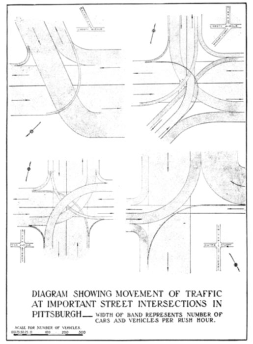
DIAGRAM SHOWING MOVEMENT OF TRAFFIC
AT IMPORTANT STREET INTERSECTIONS IN
PITTSBURGH—WIDTH OF BAND REPRESENTS NUMBER OF
CARS AND VEHICLES PER RUSH HOUR.
Note: Vehicle traffic on Market Street, between Fifth and Liberty Avenues,
now discontinued
By offering solutions for the above and many other similar
problems this report demonstrates that practical city planning—or
better, replanning—is part of the world-wide conservation
movement. City planning is municipal conservation. Pittsburgh,
like other cities and to a greater extent than most of them, faces
the problem of using her financial and territorial resources to the
utmost. The "utmost" means making these resources go the
furthest in securing ample streets for transportation and traffic,
and easy communication between all parts of the city; in providing
for the cheap distribution of food, fuel and clothing; in making
all residence districts as nearly as possible equally healthful,
un-congested, and provided with trees and yards; in establishing
for all residents public accommodations for recreation and leisure;
and in maintaining and developing adequate districts for retail
and wholesale trade, manufacture and commerce.
The Pittsburgh Civic Commission has conducted its city
planning with the above ends in view, and purposes by this report
to contribute to the economy, convenience, practicability and
attractiveness of Pittsburgh's development and growth. The
Commission began this work by retaining Bion J. Arnold, John
R. Freeman and Frederick Law Olmsted to make a report on the
outline and procedure of city planning for Pittsburgh. This
report stated the scope and methods for investigations on the
following subjects:
Steam Railroads
Water Transportation
Electric Railroads
Street Systems
Public Lands and Buildings
Water System
Sewerage System
Control over Developments on Private Property
Smoke Abatement
Building Code
Provision has been made by which several sections of this
program are already under way. The city administration has been
foremost in appreciating the necessity for just such investigations
as the report recommended. Expert advice at this period in our
civic advance is imperative if this city is to take its proper rank
among American cities. Upon completion of the preliminary
report Mayor Magee undertook to have studies made upon the
electric and steam railroads, and requested that the Commission
release to the city Mr. Bion J. Arnold for this purpose. This the
Commission gladly did, and since then Mr. Arnold has conducted
these investigations for the city along the lines laid down in this
preliminary report. The preparation of a building code as suggested
in this report was authorized by the city councils at the
request of the Mayor, and the latter appointed a competent
building code commission, and an appropriation has been made
for the carrying out of this part of the City Plan. Mayor Magee
also secured the retention of Mr. Allen Hazen of New York, who
is making such a comprehensive study of an adequate sewerage
system as was suggested in this report. Likewise, the Mayor has
planned to carry out the studies for the water system.
The Commission itself continued the retention of Mr. Frederick
Law Olmsted to make a study of a comprehensive main
thoroughfare system for the center of the city and to the principal
residence and manufacturing districts and the surrounding
boroughs. Mr. Olmsted was also asked to report upon the locations
of the main public buildings and grounds of the down town
district. This report was to cover both immediately necessary
improvements and a comprehensive improvement program for
the next twenty-five years. Thus could present improvements be
made economically because planned with reference to those of
the future.
The Commission presents herewith Mr. Olmsted's report on
these subjects, made under the supervision of the Committee on
City Planning. The members of this Committee have given months
of time from their private business to the consideration of every
detail of this report; and this committee, with Mr. Olmsted, has
given to the report its value as a contribution to the movement
for the Greater and Better Pittsburgh.
There are two main divisions of City Planning. One
looks to the rearrangement and improvement of what
has already been unwisely done through lack of proper
planning or through force of adverse circumstances of any sort.
The other looks to the wise and economical layout of what still
remains to be done, especially at the outskirts of the city where
the major part of the city's growth is bound to occur, and where
the city plan is daily taking shape out of nothing, whether it is
intelligently designed or not.
Prevention is cheaper than cure, and a moderate expenditure
of effort and money will accomplish far greater results in the
long run if applied to the wise control of the growing suburban
districts, where new streets are constantly coming into existence,
than if applied to costly remodeling of the older parts of the
city; but the latter is sometimes of the utmost importance, and
is of direct interest to a much larger number of citizens than
the prosaic work of controlling scattered suburban development.
In accordance with the instructions of the Commission this
report deals primarily with certain problems of remodeling in
the down town district, and with the improvement of the main
thoroughfares between this, the heart of the city, and the more
important outlying districts.
To carry out at once all the recommendations of this report
would, even if it were possible, impose an altogether unreasonable
financial burden upon the City and the contiguous boroughs.
Such procedure is unnecessary and indeed impossible. But in
many cases there is a crying need for the improvement already,
or it is of such a nature that any delay is apt to involve a considerable
increase in the cost and the difficulty of carrying it out.
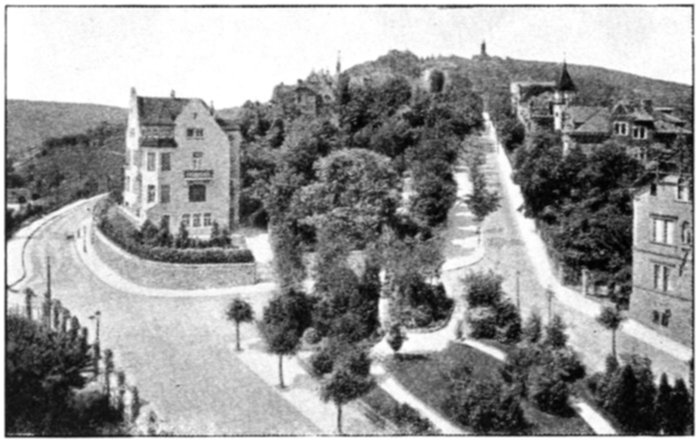
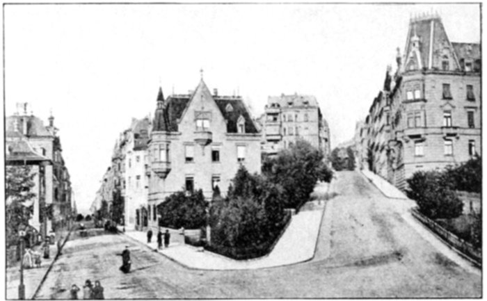
Suggestive treatment of street junctions in outlying
districts, Stuttgart
The most urgent
general improvement
of this sort is
the establishment
of new building
lines on all main
thoroughfares
which it is proposed
to widen;
this in order to
anticipate, as far as
possible, the construction
of new
and costly buildings on the present street lines.
Of the specific recommendations made in this report it seems
advisable to give the earliest attention to the following:
In the Down Town District
Page
The cutting of the Hump and the widening of certain streets in the Hump District as recommended
In the following cases the actual improvements are not so
urgent, but the new street locations should be established before
expensive developments, which are apt to occur at any time, shall
interpose serious new difficulties in the way of the proposed
improvements:
For other specific thoroughfare improvements recommended
in this report there appear to be no very urgent demands at
present. Generally speaking they should be carried out only as
some special opportunity offers, or in anticipation of some
obstructing development which cannot now be foreseen, or as
a growing traffic shall demand.
But a thing of greater consequence than any one of these
specific improvements, a thing of vital import to every taxpaying
citizen of the present and future City, is the making of comprehensive
and accurate topographical maps. It is only on the basis
of such maps that all municipal engineering, and indeed much
other work, directly managed by the City, can be planned and
carried out with proper economy and efficiency. It is only on
the basis of such maps that improvements in the city—details
of city replanning—can be most economically determined. And
in the outlying districts, where the future city is being built, such
maps are absolutely essential to an intelligent planning or control
which will avoid the heavy penalties that follow haphazard city
growth, especially in such a hilly region.
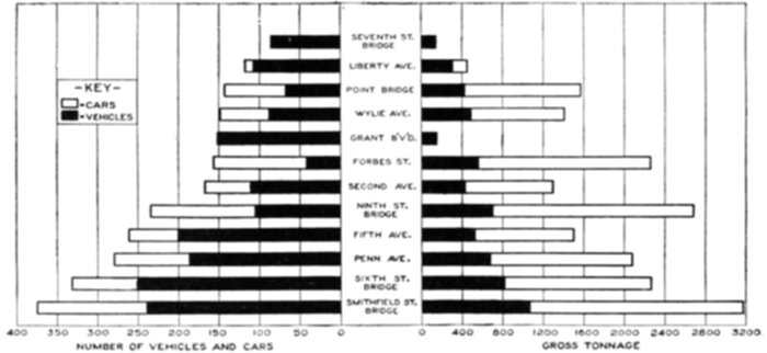
Comparative diagram showing the volume and the estimated gross tonnage of traffic
on the thoroughfares leading into the Down Town District
[1] Already provided for, wholly or in part, in the current bond issue.
PART I The Down Town District — The Main Arteries — Eastward Arteries and Their Improvement — A New Traffic Center — Sixth Avenue — Try Street Grade Crossing — Second Avenue Freight Yards — The "Hump Cut" — Grant Boulevard Extension — A Civic Center — Diamond Street Widening — Market Street Widening — The Market — The Water Front — The Improvement of The Point — FOOTNOTES:
The down town district is substantially that part of the
city known as the Point District. It is bounded by the
two rivers and by the steep hills to the eastward, and
within this section of the city, as elsewhere, the basic problem is
that of the means of transportation—specifically the problem of
the street plan. There is a daily circulation of
inward and outward travel to be borne by a limited
number of main arteries, of which those leading to
most of the tributary districts are bridges. It is clear that the
bridges can be enlarged or increased in number at any time when
the volume of travel justifies the expense of reconstruction.
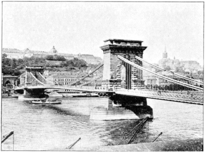
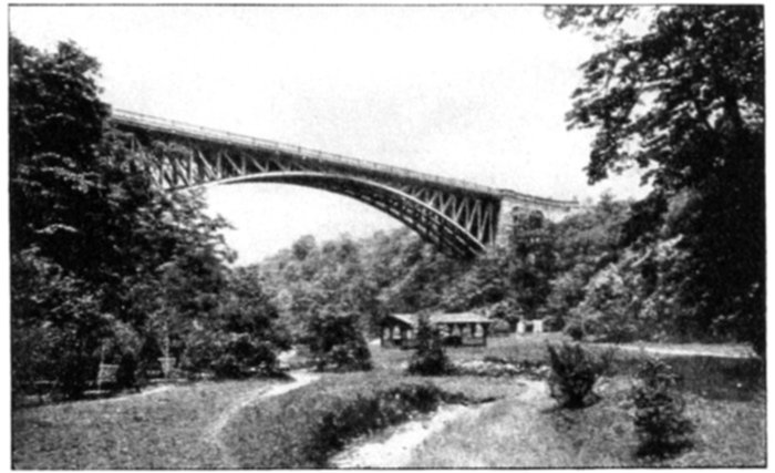
A one-span bridge across the Danube at Budapest
Considering the fact that Pittsburgh is a world capital in
the steel bridge industry, that its busiest quarters are sundered
by three of the world's big rivers, and that it is traversed in
every direction by ravines which demand the construction of
mighty viaducts, it is a striking and rather shameful thing that it
does not possess a single bridge over its rivers that is notable
among the bridges of the world either for its beauty, for its
perfect engineering adaptation to its purpose, for its size,
strength or amplitude.
In fact the
bridges of Pittsburgh,
compared
with those of other
great cities, are
rather unusually
limited in capacity
and lacking in the
qualities of impressiveness
and
beauty.
It is a case of
the cobbler's children going barefoot: when a man sells shoes
at wholesale in every quarter of the globe, it is time for his
own family to be well shod. Pittsburgh can afford to have, and
owes it to herself to have, the very best of bridges. No time
or pains or reasonable expense should be spared in planning
future bridges, whether they be on new locations or to replace
existing structures, to get the best designs that the highest
engineering skill combined with the highest artistic ability can
produce. Bridge-builders everywhere should be enabled to think
of Pittsburgh not merely as a source of cheap raw material for
bridges, but as an all-round leader in the bridge-building art.
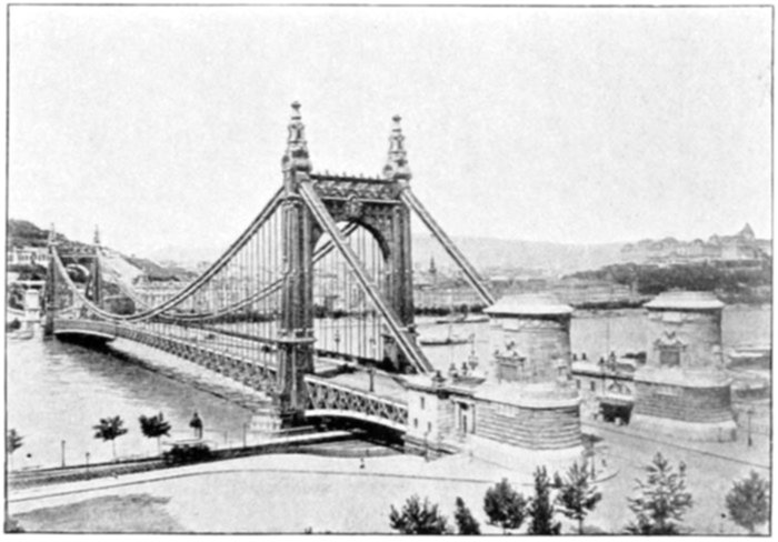
Bridge of distinctive character at Budapest
To the eastward, where the most active growth of the city
has been taking place, the arteries consist not of bridges over
open rivers, but of
streets, very limited
in number by reason
of the form of
the land, and so
situated that the
cost of securing
greater capacity
will increase by
leaps and bounds
with the rise of
land values and the
erection of new
structures. The
first step in planning
improvements for the heart of the city must therefore be to
consider the possibilities for improvement in the eastward arteries.
There are only three places where such arteries
could ever have been laid out, even if the wisest
foresight had been exercised in the early planning
of the city when all was free and open. These
three places are around the north edge of the hills along the
Allegheny, around the south edge of the hills along the Monongahela,
and through the gap in the hills followed by Fifth
Avenue and Forbes Street.
The northerly route is followed by Penn and Liberty Avenues,
by the Pennsylvania Railroad, and by Grant Boulevard clinging
to the hillside above the railroad. The space between Penn
Avenue and the river is largely occupied by railroads and by
business dependent upon the railroads, and there seems to be no
possibility of opening any new line for relief, except in so far as a
subway might reduce the number of people inconvenienced by
delays on the surface. On account of its gradients and of the
districts toward which it leads at both ends, the usefulness of
Grant Boulevard seems likely to remain confined to light passenger
traffic, chiefly automobiles. In any case all the teaming and
surface traffic of a very large region must be carried through
the throat on the lower level. It is important also to note that
the only street which passes through the down town district
with more than village dimensions—eighty-foot Liberty Avenue—leads
directly to this throat and then chokes down to a fifty-foot
street.
It may safely be said that increased capacity for east and west
general traffic north of the hills can be secured only by a radical
widening of Liberty Avenue or Penn Avenue. Upon the whole
the latter seems the more advantageous route. On the score of
cost there seems to be but little choice; on the score of value in
the result Penn Avenue is the better. To have one side of such
an important avenue flanked by a railroad to the exclusion of
general business frontage would make it less agreeable as a
thoroughfare and less productive as a real estate proposition.
On the other hand if Penn Avenue is widened the narrow portion
of Liberty, above Eleventh Street and next the railroad, will be
important almost solely for local purposes; warehouses or
factories could be erected extending through from the principal,
or Penn Avenue, frontage to Liberty Avenue, and could be provided
with sidings from the railroad passing over Liberty.
Further details as to this suggested widening of Penn Avenue
and its connections eastward are given, along with other highway
improvements, in Part II of this report. But considering here
only its relation to the down town district, this widening will
undoubtedly throw increased emphasis upon Penn and Liberty
Avenues as traffic lines within this district; and it is obvious
that a good cross-connection should be provided so that eastbound
traffic coming from Liberty Avenue and from Grant
Street, as well as from Penn Avenue, can freely reach the widened
portion of the latter. A traffic square at the angle in front of the
Union Station, where the broad part of Liberty Avenue ends and
the narrow part begins, would furnish the desired connection.
Fortunately such a square can now be formed with the destruction
of but few buildings and those of relatively little cost.[2]
Second Avenue between Try Street and the
Tenth Street Bridge
The street along the Monongahela—Second Avenue—although
it might have been made of great importance and value by proper
planning at the start, cannot at the present time be greatly
widened without the most serious difficulties. For much of its
length it is pinched
between railroads
and industrial
plants. It does not
lead eastward into
any district comparable
in population
or importance
with those tapped
by Penn and Liberty
Avenues, and
its connection westward
through the
Point District is narrow, difficult to widen, and relatively unimportant.
For these reasons Second Avenue, although it must be
recognized as a main thoroughfare and should be improved as
much as practicable, especially as far east as the Tenth Street
bridge, is not of such first-class importance as to demand radical
enlargement in spite of all obstacles.
The only remaining natural outlet to the east is that occupied
by Fifth Avenue and Forbes Street and the block between them.
Neither street is wide enough for the traffic it will be called
upon to bear, but the widening of Fifth Avenue would be so costly
as to be almost out of the question. For many reasons, discussed
in detail in Part II, the widening of Forbes Street into an
ample main thoroughfare seems to be the best solution of the
problem here presented.
The importance of this route and of its future traffic burden
will be better realized when it is understood that at Soho a
direct extension can be made, on easy gradients, from the widened
Forbes Street to Fifth Avenue, the street which can more easily
be widened beyond that point; and further, that, a little to the east,
a new and greatly needed street might branch off to the right
from Forbes Street where the latter turns inland. This new street
would continue along the side hill above the river, and would
provide the only possible convenient outlet from the down town
district to all the upland regions south and southwest of Squirrel
Hill. Thus the western portion of Forbes Street, when widened,
would carry the great bulk of all future street traffic between the
down town district and the whole district from East Liberty to
the Monongahela River as well as all the country east and southeast
of that triangle.
The intersection of Forbes Street, widened, with
Sixth Avenue, extended, is likely to become a traffic
center of the utmost consequence to Pittsburgh.
The importance of the Forbes Street route to the eastward has
been indicated above; Sixth Avenue, crossing Fifth Avenue and
Grant Street, leads toward the Union Station and toward all the
northeast part of the business district, and to the North Side
bridges; a new bridge and tunnel are quite likely to lead from
this very intersection to the South Side and the South Hills;
from this center a good connection is readily obtainable with
Fourth, Third, and Second Avenues and with the southern water
front; and Diamond Street can be widened at moderate expense
so as to continue Forbes Street right through the heart of
the business district.
The importance of Sixth Avenue between Forbes
and Grant Streets has been pointed out. It is the
natural route from the Union Station and the adjacent freight
yards and from all the Allegheny bridges to the districts fed by
Fifth Avenue, Forbes Street, the proposed South Hills bridge,
and Second Avenue. It ought to be widened to the dimensions
of a main thoroughfare, and its grade ought to be lessened. Its
stream of travel splits at Grant Street, a portion turning to the
left into the other part of Sixth Avenue, and a portion turning
to the right along Grant Street to Liberty Avenue and the
freight yards. The latter obviously is a very important line, and
the off-set which makes at Seventh Avenue is so serious that
the corner ought to be cut.
The elimination of the grade crossing of Second
Avenue with the Panhandle Road at Try Street
is a pressing improvement. The avenue now
descends toward the railroad from both directions, and the best
plan appears to be to carry it over the tracks. In this way Second
Avenue would connect directly (through the west side of the
Civic Center) with Forbes Street; with Fourth, Fifth, and Sixth
Avenues, and so with the Union Station and the Allegheny Valley;
with the main or upper deck of the South Hills bridge rising
across the river to the proposed tunnel; and with the suggested
lower deck of that bridge leading to the South Side. In order
to secure a good gradient, the westerly approach of Second Avenue
should start from Grant Street, rising on an incline or viaduct
through the so-called park and the street on one side of it, in
order to pass over Ross Street. In this way there would be
no interference with the teaming through Ross Street to the
Baltimore and Ohio freight yards.
Mention should here be made of a plan, which
it is understood is already being considered, to
develop the area between Second Avenue and the
river, from Try Street to the Tenth Street bridge, for freight purposes.
Even now the connections from this region to the Tenth
Street and Smithfield Street bridges, and, via First and Second
Avenues, to the whole Point District, are good. But the street
changes proposed in connection with the traffic center at Sixth
Avenue and Forbes Street will provide greatly improved connections
directly to the Point District, the East End and the South
Hills. First Avenue and Water Street would enter the freight
yard underneath the Panhandle and the proposed Baltimore and
Ohio local tracks; and if Second Avenue is raised to go over
the Panhandle tracks, as recommended above, direct entrances
can be secured to the second or third floor of a freight house
with car elevators such as those at St. Louis. On the whole this
seems like a good place for a large distributing freight station.
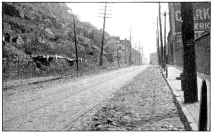
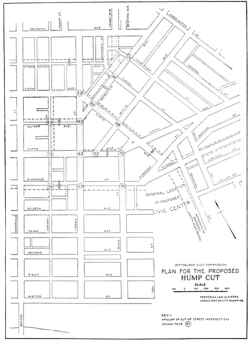
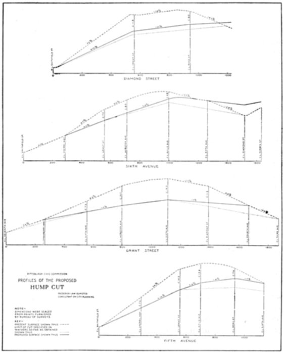
The Sixth Avenue improvement, and others in the
vicinity, are bound up with the question of the
"Hump Cut." Pushing to one side all differences of opinion
as to the local effect of the proposed cut,—its influence on land
values, and the share of the cost which ought to be borne by
abutters,—the fact stands out that the City as a whole needs the
improvement in order to clear an obstruction from some of its
most important general highways. Another fact, seen clearly
from this larger point of view, is that the essential matter is to
secure a radical reduction of the maximum gradients on the three
great thoroughfare lines, Sixth Avenue, Fifth Avenue, and Diamond
Street, even though the minor streets on the margins of
the Hump be skimped. Detailed recommendations, as to gradients,
etc., are discussed in Part V and are embodied in the
accompanying plans and profiles.
Diagram showing the distribution of automobiles coming
in town on Grant Boulevard
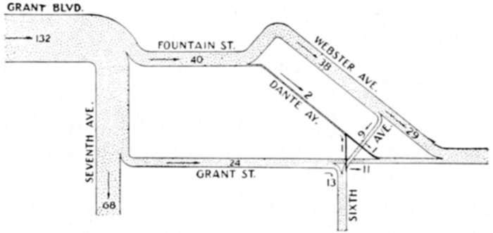
Only one other thoroughfare problem is involved
with the "Hump Cut," that of Grant Boulevard
extension. Since the grade of Webster Avenue will
be considerably lowered in connection with the "Hump Cut,"
and the buildings along its lower end greatly damaged in any
case, by far the best
plan for Grant
Boulevard is to
carry it straight
through to Webster
Avenue and to
widen the lower end
of the latter to 60
feet, as far as Grant
Street. The widening
of Oliver Avenue to 50 feet between Grant and Smithfield
Streets, and the possible widening of Strawberry Way, would,
together with existing streets, provide adequate means of distribution
for the large number of automobiles using the boulevard,
and would at the same time create a decided local improvement.
The location of a Civic Center, where the city
offices can be grouped in a convenient and dignified
manner, ought to connect with the main transportation lines.
It ought, if possible, to embrace the county buildings. It ought,
if possible, to occupy land which is not of such high cost as to
preclude the setting apart of the open space which is requisite
to the highest dignity and beauty of public buildings. All these
advantages are embraced to a high degree in a locality now so
unpromising and unattractive that it is hard not to feel an unfair
prejudice against it.
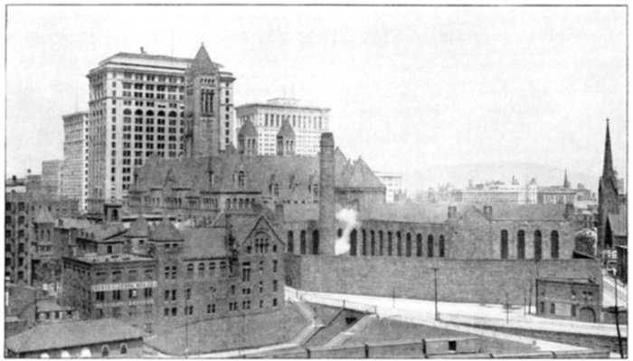
County Buildings—the northwest side of the proposed Civic Center
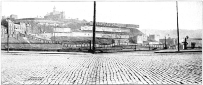
Present appearance of the Civic Center site from the rear of the County Buildings
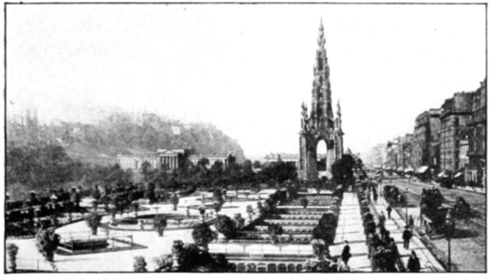
Princes Street in Edinburgh—an interesting example of a
public garden built over a railroad
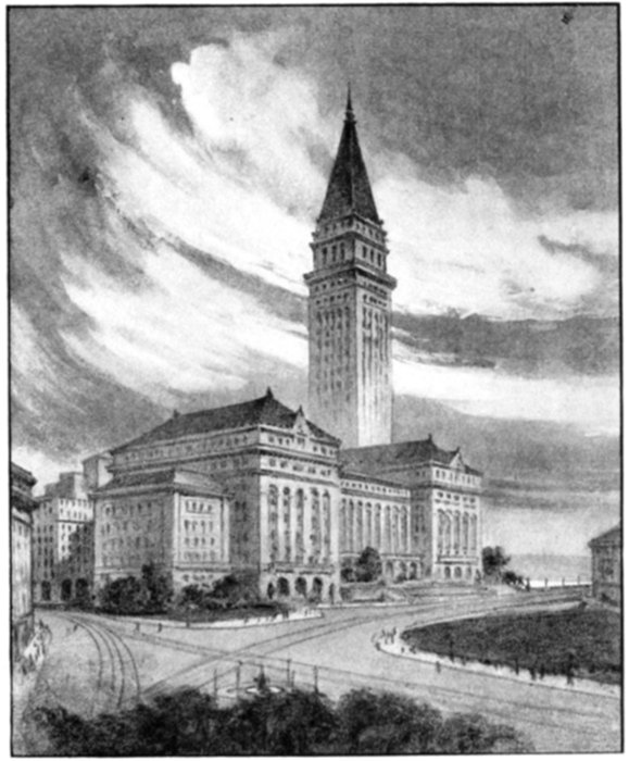
Suggestion for the Municipal Building in the Civic Center
The locality in question lies to the east and southeast of
the present county buildings. It embraces a bit of low ground
occupied by the little Panhandle station and local freight yard,
surrounded, except for the county buildings, by vacant lands
and cheap buildings at various higher levels, mounting on the
east to the commanding ridge that dominates all this part of
the city. Through this locality the Forbes and Diamond Street
thoroughfare and the South Hills and Sixth Avenue thoroughfare
will pass. Fifth Avenue borders it on the north, and Second
Avenue on the south. It is flanked on the northwest by
the noble and distinguished
architecture
of the court
house and the jail—masterpieces
of
Richardson, priceless
examples of
the work of one of
the few great artists
America has
yet produced. To
the west a new
county building is about to be erected. It is proposed that the
central area of low ground, occupied by the railroad, be decked
over at about the level of Fifth Avenue, and that a great public
square with gardens
be laid out
thereon somewhat
after the manner of
the celebrated public
gardens built
over the railroad
at Princes Street,
Edinburgh, or, in a
much smaller way,
at Park Avenue,
New York. Below
the structure would
simply be a first
class station and
freight sheds of
permanent construction,
with skylights
and ventilators,
at suitable locations,
piercing a
flat roof of adequate
strength. The cost of construction would be less than the cost
of an equal area of land independently acquired for an open
space in connection with a Civic Center in any other locality that
could reasonably be considered.
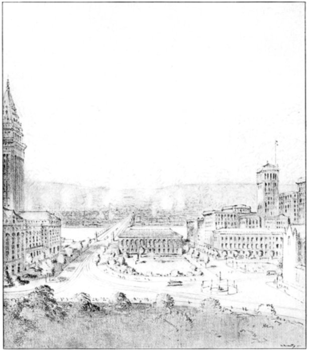
Sketch of the proposed Civic Center for Pittsburgh, looking south. The crossing of tracks
in center of foreground is at the present corner of Sixth Avenue and Forbes Street
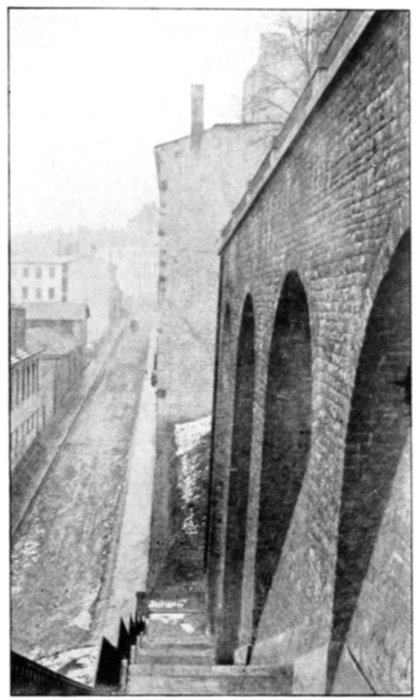
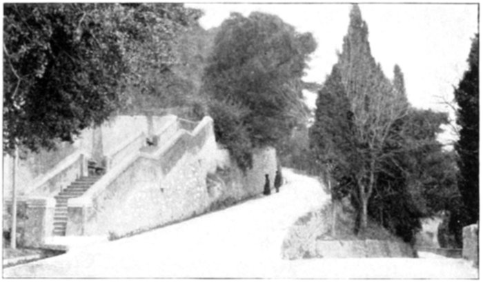
Retaining wall supporting a local
park at Lyons—a suggestion for the bluff
between Second Avenue and the new
City Hall.
Hillside site of the proposed City Hall
Along the east side of this square or garden, in the form of
a gradually rising terrace, would run the approach to the new
South Hills bridge ascending gently from Forbes Street; and on
the east side of this again, as though terraced on the hillside,
would be the principal municipal
building culminating in a tower
which would spring from the
highest level at Bluff Street, where
the playground of the Holy Ghost
College could be utilized as a
park. The group enclosing the
square would be completed by
another building at the north
with frontage on Forbes Street,
Fifth Avenue, and Sixth Avenue,
and by a low building on the
south serving to screen the factories
and freight yards south of
Second Avenue but leaving open
the view of the opposite hills.
The plan and the sketch perspectives
indicate in a general way the
sort of architectural development
for which the situation appears
to call. The pronounced and unsymmetrical
differences in elevation,
the slanting grade of the approach to the great South Hills
bridge, the irregular and picturesque form of the site and of the
existing county buildings, all seem to demand a certain informality
and picturesqueness of design. These peculiarities of the
site ought to be welcomed because they are eminently characteristic
of the city and of the mountainous region in which it
is set. Throughout
the city and its
surroundings the
one preëminent
quality of an agreeable
sort is the
bold picturesqueness
of the landscape—the
deep
ravines, the lofty
hills, the precipitous
declivities, the plunging prospects from hilltops into the
river valleys—and a similar quality of forcefulness, activity, and
bold, irregular adaptation of means to ends, is to be felt in all
the more dominant and impressive works of man in the city—the
steel works, the bridges and viaducts, the jagged sky-line of office
buildings. To build a City Hall and Civic Center of scholastic
formality, appropriate in the placid surroundings of Paris, would
be to lose a great esthetic opportunity.
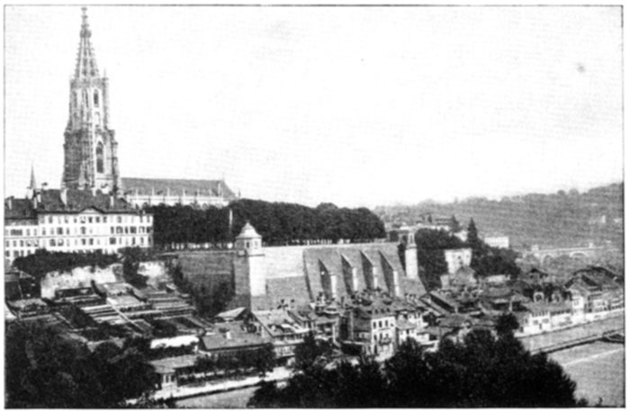
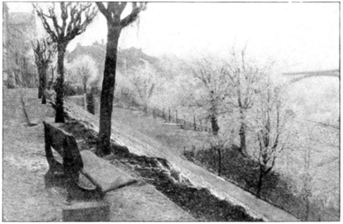
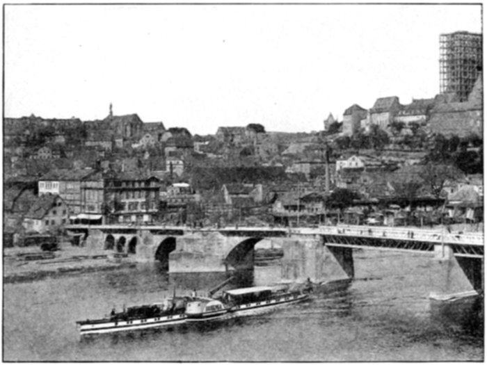
The Cathedral Terrace at Bern; a suggestion for utilizing a high situation for
public buildings and grounds
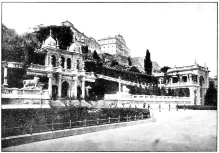
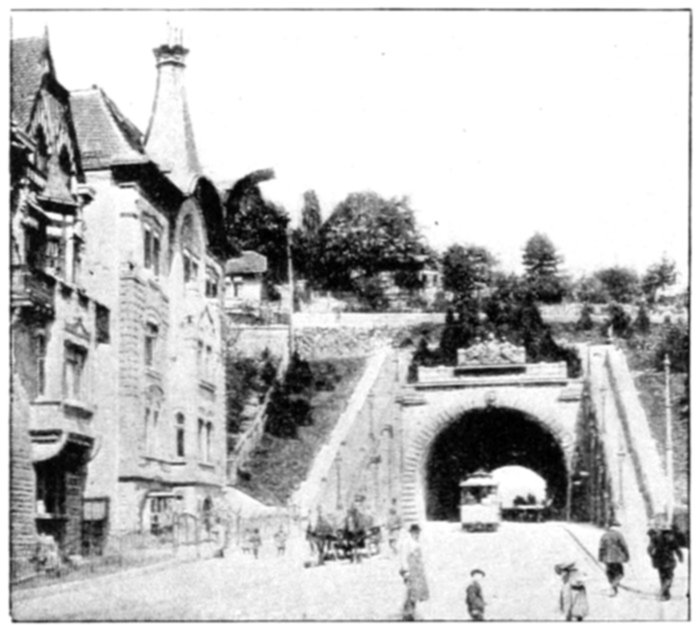
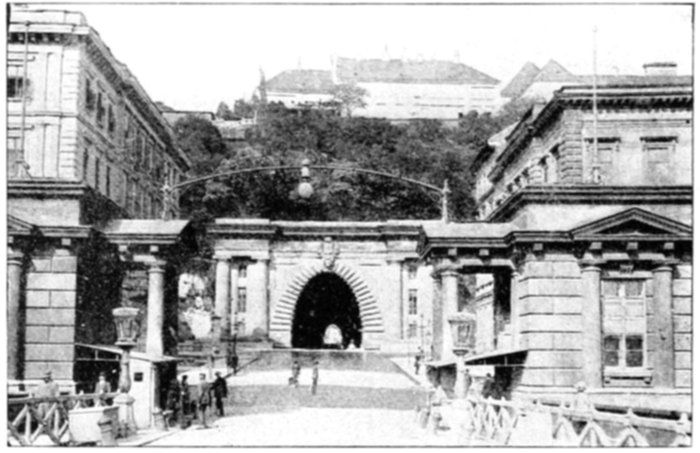
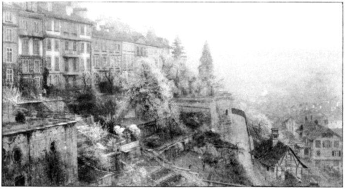
The hillside of Ofen at Budapest, an interesting treatment of the slope crowned
by a public building
It would be difficult to overestimate the value, to
the future convenience prosperity and business
efficiency of the city, of carrying the Forbes Street
improvement straight through to a junction with Liberty Avenue
on the line of Diamond Street; and it is deemed a peculiarly
fortunate thing that this is the only east and west line in the
midst of the business district where a wide street can still be
put through without destroying any considerable number of
costly modern buildings.
When Diamond Alley was widened, in part, from 20 feet to 50
feet, not long ago, the improvement was of much importance
because it added one more street large enough for general
business in a locality where there was a great demand for
business frontage, and where the original lots were of very
excessive depth. But the improvement was a distinctly local
one and contributed little or nothing to the solution of the
general traffic problem. But the peculiar relation of Diamond
Street to the general system of main traffic lines demands a much
more courageous action for the benefit of the whole city. In connection
with the widening of Forbes Street, it should be converted
into a thoroughfare at least equal in width to Liberty
Avenue. A glance at the map shows the convenient and equitable
location of Diamond Street, and its importance as a
thoroughfare to supplement Liberty Avenue in handling the traffic
of the Point District.
Coming, as it does, directly opposite the Sixth
Street bridge, Market Street ought to be a very
important cross-town connection; and because the
buildings are generally small and old, and most of the lots are so
deep as not to be seriously injured by curtailment, a widening
is suggested throughout its length.
The widening of Diamond and Market Streets makes clear
that the Diamond Square Market site should not be occupied in
any way that would perpetuate the obstruction offered by the
present use of the square to through travel. The need is not
for a mere mitigation or slight improvement of the present conditions
by opening little archways through a new building on
the Market site, but for a radical and effective clearance. The
space was originally set apart as an open public square, and the
complete occupation of it by revenue-producing buildings was a
diversion of the square from its original purpose—an act in
general accordance with the unfortunately short-sighted policy
which has done much to bring about the notably congested conditions
prevailing in the city today.
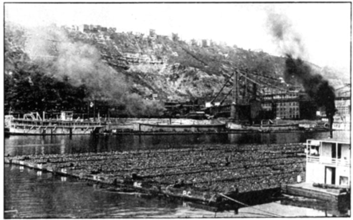
A bridge and water front at Pittsburgh—Monongahela River
It may be necessary to provide elsewhere for the
Market, and a site is suggested in the block
between Third and Fourth Streets on Liberty Avenue, having the
great advantage of
rail connections.
On account of the
character of the
surrounding country,
an exceptionally
large proportion
of market
supplies comes to
Pittsburgh by rail
and must continue
to do so. It is
highly uneconomical,
and adds needlessly
and considerably to the congestion of the streets, to unload
the market supplies from the railroad a full mile away (as is
now done) and to then haul them by team through the heart of
the retail district.[3]
Within the interior of the Point District, Diamond and
Market Streets widened, supplemented by the existing Liberty
Avenue, appear to be the only thoroughfares of Metropolitan
dimensions which it is reasonable to provide for. But around
the borders of the district there is much that ought to be done.
In its water front Pittsburgh has a great public
asset which now lies undeveloped both from the
point of view of transportation and from that of
recreation and civic beauty.
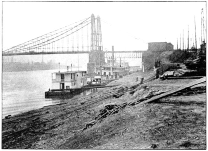
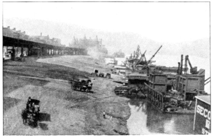
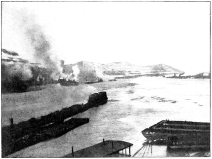
Primitive commercial quay at Pittsburgh—Allegheny River
As a transportation factor, its primary use is for the transshipment
of water-born commodities.
As discussed elsewhere,[4]
the actual
amount of river
freight is at present
relatively small;
but it is potentially
important, and one
of the reasons for
its lack of growth
is the neglect of
Pittsburgh and
other river ports to provide for the quick, convenient, and economical
handling of river-born traffic at the public wharf.
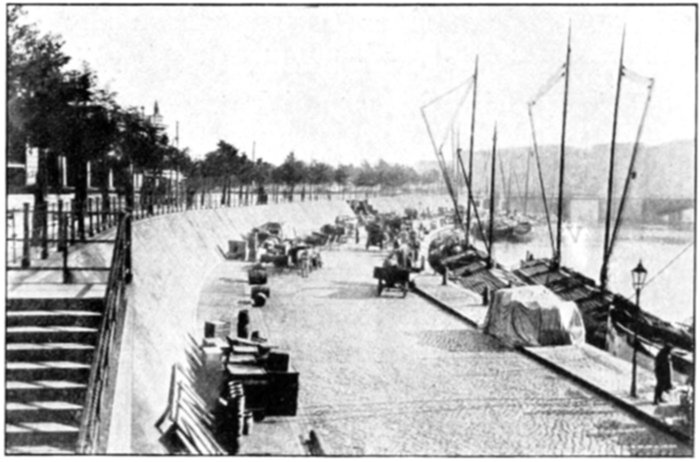
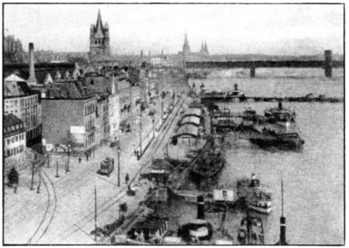
Berlin water front, both useful and attractive
At river ports throughout the world, the first primitive step,
beyond the mere dumping of stuff and passengers on the natural
shelving bank or river bed of mud or gravel, is the paving of
the slope, as at Pittsburgh, still leaving the goods to be dragged
up and down the bank by main force. But among the live
modern river cities
of Europe, wherever
a real water
competition with
rail service has
been desired, even
though such competition
be limited
in its range, the
day of the primitive
or mud-bank
type of shore has
long gone by; and
the public wharf has been reconstructed into one of the many
well-recognized types of commercial embankment providing an
up-to-date equipment for handling freight, and decent, attractive
conditions for passengers. This development of the public wharf
properties in Europe has kept pace with the activities of the
railroads, making for the steady and intelligent improvement of
terminal facilities. Indeed in many European river ports the improvement
of the water terminals has rather forced the pace for
the railroads.
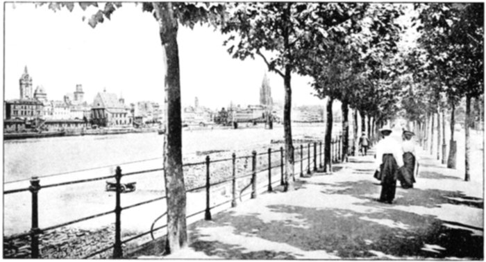
Frankfurt's double use of its river front, for business and for pleasure
In contrast to this active aggressive spirit, Pittsburgh, like
most American river towns, where she has not actually turned
her water front over bodily to the railroads, has left it in a most
inefficient primitive condition.
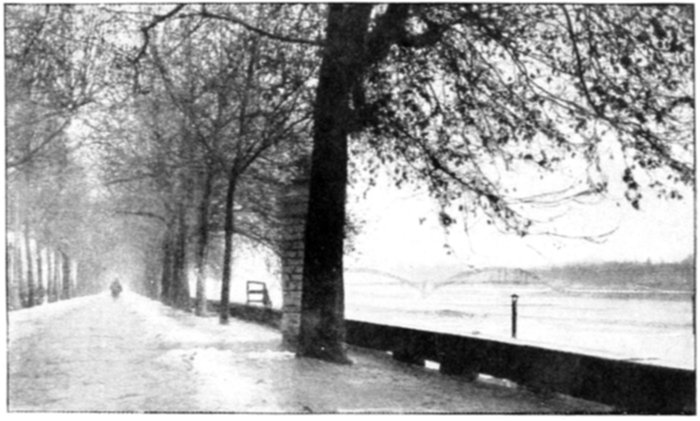
Shaded promenade upon the embankment that protects
Lyons from the floods of the Rhone
But the value of Pittsburgh's water front lies not merely in
its use as a wharf, however much improved. Another use, shown
by the varied experiences of other river cities, is that, in a commercial
water front on modern lines, there is generally opportunity
for a wide marginal thoroughfare for the relief of traffic congestion
in the adjacent streets. Sometimes such a water-front thoroughfare
becomes a busy avenue of retail trade and general travel; but
more usually its peculiar value lies in diverting some of the main
streams of heavy teaming from the older interior streets where the
retail trade and office business tend to concentrate, and where the
passenger travel is most dense. Especially with an isolated and
limited business district like that of Pittsburgh, made up almost
wholly of narrow streets and connected with the rest of the city
by a series of
bridges and of
bridge-like gaps in
the hills which wall
it in, it becomes of
the utmost importance
to secure the
formation of a
wide circuit street
connecting these
outlets together, so
that not all the
travel is forced to
filter slowly through the midst of the business district.
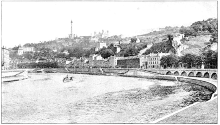
View of the same water front at Lyons, showing the
commercial quay
A third undeveloped asset of the Pittsburgh water front is
its value for recreation and as an element of civic comeliness and
self-respect. One of the deplorable consequences of the short-sighted
and wasteful commercialism of the later nineteenth century
lay in its disregard of what might have been the esthetic
by-products of economic improvement; in the false impression
spread abroad that
economical and
useful things were
normally ugly; and
in the vicious idea
which followed,
that beauty and the
higher pleasures of
civilized life were
to be sought only
in things otherwise
useless. Thus the
pursuit of beauty was confounded with extravagance.
Among the most significant illustrations of the fallacy of such
ideas are the comeliness and the incidental recreation value which
attach to many of the commercial water fronts of European river
ports, and it is along such lines that Pittsburgh still has opportunity
for redeeming the sordid aspect of its business center.
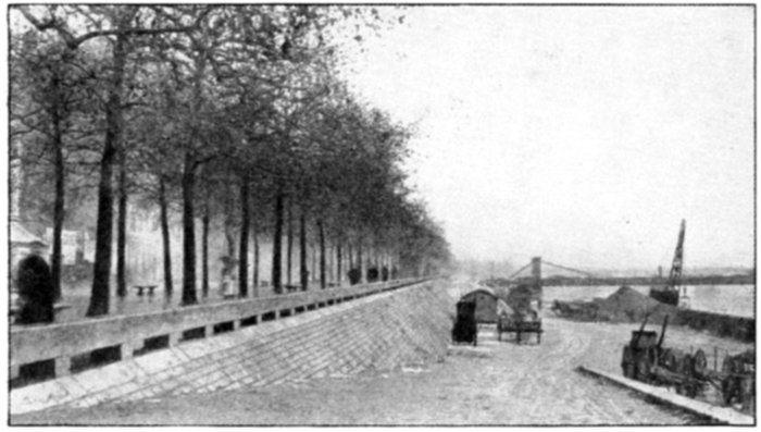
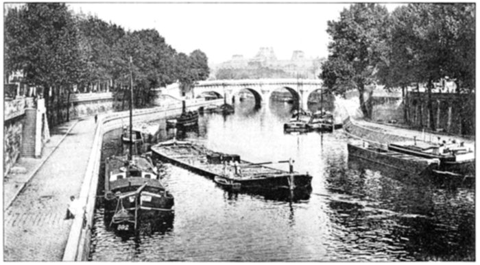
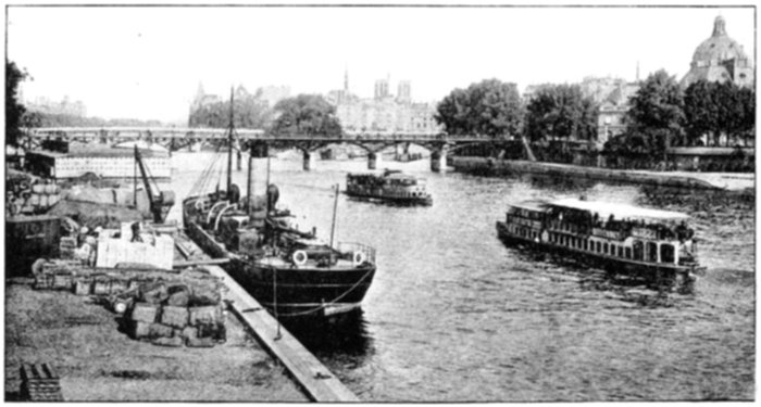
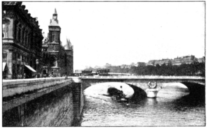
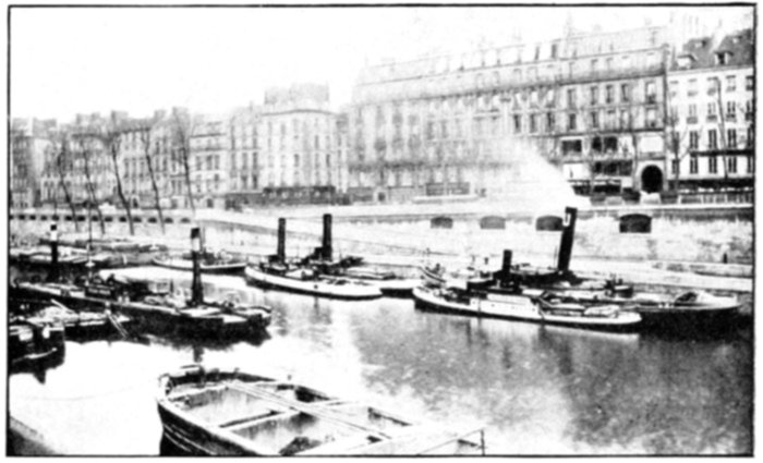
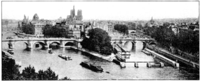
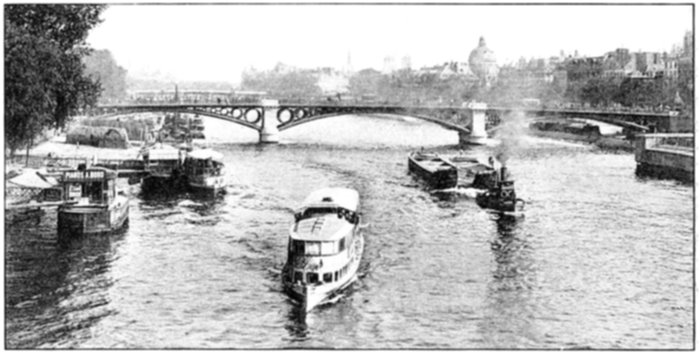
How Paris appreciates the value of its river frontage
The outlook from The Point, Pittsburgh
Wherever in the world, as an incident of the highways and
wharves along its riverbanks, a city has provided opportunity
for the people to walk and sit under pleasant conditions where
they can watch the water and the life upon it, where they can
enjoy the breadth of outlook and the sight of the open sky and
the opposite bank and the reflections in the stream, the result
has added to the comeliness of the city itself, the health and
happiness of the people and their loyalty and local pride. This
has been true in the case of a bare, paved promenade, running
along like an elevated railroad over the sheds and tracks and
derricks of a busy ocean port, as at Antwerp; in the case
of a tree-shaded sidewalk along a commercial street with the
river quays below it, as at Paris and Lyons and hundreds of
lesser cities; and in the case of a broad embankment garden
won from the mud-banks by dredging and filling, as at London.
Pittsburgh has an unusual opportunity to secure this incidental
value for recreation in the treatment of its river front. Immediately
across the Monongahela are the high and rugged hillsides
of Mt. Washington and Duquesne Heights, and below these
are the lesser but still striking hills along the Ohio River from
the West End to McKees Rocks. The outlook over the river
with its varied activities to these hills immediately beyond, would
be notable in any part of the world. Furthermore, the rivers and
the hills are the two big fundamental natural elements characteristic
of the Pittsburgh
District.
Thus, any provision
close to the
heart of the city,
whereby the people
can have the
enjoyment of these
mighty landscapes,
is of peculiar importance.
Mt. Washington hillside from the Monongahela water front
It does not diminish
the essential
grandeur of
the situation that
the river swarms with barges and steamers; that it is spanned
by busy bridges; that the flat lands along the rivers are crowded
with railroads, buildings and smoking factories; and that the
hillsides are crowned with houses. It is a spacious and impressive
landscape in any case. But for the people to get the good of
it two things are needful. A locally agreeable place must be
provided from which the scene can be enjoyed; and the landscape
must be treated with the respect which it deserves, by the
elimination of certain features which are merely indicative of
neglect, waste, and
abuse, and which
have no economic
justification. Especially
is it desirable
that the precipitous
hillside rising
to Mt. Washington,
now largely
an unfruitful waste,
a place of raw gulleys
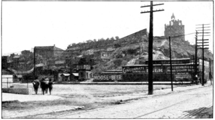
and slides mingled
with some painful advertising signs, should be treated with
respect as a vital part of the great landscape of the city. It
should be protected from defacement and its earthy portions
should be reclothed with the beauty of foliage.
The accompanying illustrations are suggestive of the sort of
thing which might be done by Pittsburgh with its remaining
public water front, and in time, let us hope, with portions of the
water front which have passed into private hands. But the actual
details of the treatment to be adopted can be properly worked
out only in connection with the comprehensive plans for flood
protection with which the Flood Commission is now grappling.
Water front and hillside at Lyons
The great majority of river cities which have undertaken
modern improvements on their water fronts have had to deal
with more or less serious flood problems, and the complex and
varying conditions of each river have had an important influence
on the design of the embankment. The technical problems
involved in the control of rivers are among the most complex and
baffling with which the engineering profession has to deal, and
any attempt to forestall the investigations of the Flood Commission,
by definite plans for permanent improvements on the water
front, would be folly. Nevertheless, the experience of hundreds
of cities and the work of thousands of engineers have developed
certain types of treatment, one or more of which, with suitable
local modifications, will pretty surely appear in the final solution
of the Pittsburgh problem. Subject, therefore, to the conclusions
of the Flood Commission, a satisfactory development of the Pittsburgh
wharf may be expected to include the following features.
First, there should be an amply wide water-front street, presumably
formed by extending Water Street and Duquesne Way
over the upper part of the present sloping bank. Second, the
outer sidewalk of this street should become at most points a
tree-shaded promenade, of such width and with such equipment
of benches and other features for public recreation as the circumstances
permit, so arranged that the people using it will neither
be in the way of the transportation activities nor be annoyed or
endangered by them, and so designed that the people can enjoy
to the full the natural beauty of the river valley and the always
interesting activities of which it is the stage. Third, there should
be next the water a commercial quay, substantially level, of
adequate but not unnecessary width, and accessible from the
streets by inclined roads of reasonable gradient, parallel with the
river, in place of the present excessive slopes.
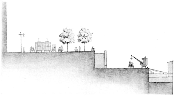
In the first typical section here given is shown one such
arrangement. Here, the level of the promenade is such that its
solid parapet rises above the maximum flood level. This is of
a type adopted for rivers that are subject to occasional excessive
floods, as at Pittsburgh. It assumes the embankment to be made
water-tight; the sewers and drains to be provided with proper
back-pressure gates, and the openings from the streets, through
the promenade and its parapet to the commercial quay, to be
arranged for prompt damming on the rise of the water above
the danger level. Thus would the entire business district be
protected from floods, not only on the surface but also in the
basements. The quay shown on this section is supposed to be
at a level just above ordinary navigable stages, and to be
equipped with power cranes for direct loading and unloading
between steamers or barges, tied up at the quay, and wagons
upon it. Provision could also be made for a freight track running
in alongside the cranes for transfer between cars and vessels
(if thought desirable), in addition to the facilities provided on
railroad property. Alongside the quay, floating landing-stages for
packets and so forth, reached by gang-planks or bridges, would
be provided as at present, but in a more decent and commodious
style.
Typical section for the water front. The parapet along the promenade would be
above extreme flood height; the commercial quay would be at a lower level, flooded
at very high water, but above all ordinary river stages.
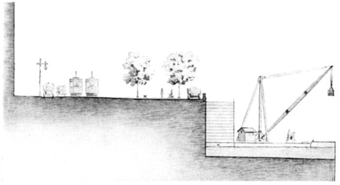
Alternative section for the water front, suggesting a floating commercial quay that
would rise and fall with the river. Large cranes could transfer freight directly from the
boats to trucks at the street level. At certain places roadways would cut through the
promenade to provide access to ramps leading down to the quays and to provide places for
freight trucks to stand while being loaded and unloaded.
This section is of a type tested by practical experience and is
clearly a great improvement upon the present primitive conditions.
But it is open to two objections: first, that the quay is flooded
at intervals, although so designed as to suffer no injury and to be
put out of commission only when the river is practically closed to
navigation by the height of the flood; and, second, that at low
water, that is to say "pool full," it is not at the most convenient
height.
An alternative section is therefore suggested, which has less
precedent behind it, but which might prove better adapted to the
Pittsburgh conditions. In this the fixed level of the commercial
quay is replaced by a continuous landing stage formed of long
floats or barges, of permanent construction, moored against the
wall and free to rise and fall with the changing level of the river.
The approaches to the floating quay for wagons would be, as in
the case of the fixed quay, by descending inclines parallel with
the river just outside the main wall; but in this case the roadway
would be formed by a line of barges which would rest on a
fixed incline during low water. The rising water would lift the
barges off the incline successively, beginning with the lowest,
so that at all stages of the water they would maintain an uninterrupted
roadway to the quay on a proper gradient. Successful
precedents for such use of permanent floating quays, and of
alternately floating and grounded driveways to the landing stage,
are to be found in Italy and in the recent harbor developments at
Manaos, Brazil.
A great advantage of the floating quay is that in this type of
construction the bed of the river may be excavated to its full
depth back to the face of the flood wall itself, and that the space
necessary for the commercial quay is secured on the floating
structure outside of this line without materially reducing the
prism, or section, of the flood discharge. It would therefore be
possible, with this design, to secure more ample width for street,
for promenade, and for commercial quay, and at the same time
have more space in the river for the passage of the floods.
Whatever may prove to be the best details of the river-front
treatment, it is clear that it can and should provide an ample
thoroughfare, a clean, pleasant, tree-shaded promenade, and
a convenient, up-to-date wharf with easy access to and from the
streets. There is no serious difficulty in providing for such an
improvement from the junction of the two bridges at The Point
to Ninth Street, on the Allegheny, and to Smithfield Street, on
the Monongahela.
East of Smithfield Street the passenger station of the Baltimore
& Ohio now blocks the way. But it is not unreasonable to
expect that the main Baltimore & Ohio station will, before long,
be moved to some point in Junction Hollow in order to avoid
the long delay, to all through trains, caused by the run down to
Smithfield Street and back again. The suburban business of the
Baltimore & Ohio could then be turned in, parallel with the
Panhandle tracks, to a new joint suburban station in connection
with the important future center of traffic near the junction of
Forbes and Diamond Streets with Sixth Avenue and the proposed
South Hill bridge.
When the Baltimore & Ohio passenger station is removed
from Smithfield Street it would be possible to continue the new
water-front street and promenade east of Smithfield on a viaduct
just outside of the present Water Street; this viaduct would rise
over the Baltimore & Ohio freight yard and the grade entrances
thereto at Grant and Ross Streets, and so connect along the line
of the Panhandle (Try Street) with the proposed Second Avenue
bridge over the railroad, and thence with Forbes Street and
Sixth Avenue.
Any better connection than now exists from Ninth Street and
Duquesne Way to Liberty Avenue would be so costly as to seem
hardly worth while, although it would be a much-desired link
in the circuit thoroughfare.
It is probably impossible for Pittsburghers, who are familiar
with the present neglected aspect of the water front and are
not familiar with the finer European quays, to form any conception
of how fine a situation will be created for public or private
buildings, especially on the southern water front when thus
improved. If it were not so much to one side of the main
streams of passenger travel, the river frontage between Smithfield
and Ferry Streets would offer a most admirable site for public
buildings in the down town district.
At the opposite end of the business district from
the proposed Civic Center is another spot where
the civic pride of Pittsburgh should lead the City
to make liberal expenditures for other than the
economic ends which justify those Street improvements which are
the main burden of this report.
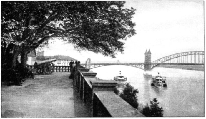
Water front park and an interesting bridge at Bonn, Germany
At the end of The Point, where the two lines of water-front
improvement would join, is a considerable area of public open
space. Here is the spot where the Ohio River has its birth: here
was built the fort which broke the peace of Europe and around
which turned the frontier struggles of the war that gave America
to the English speaking race. It is here that all the most inspiring
associations of the city are chiefly concentrated. Poetically, this
spot, at the meeting of the rivers, stands for Pittsburgh.
Because the eastward drift of the business center has
followed the eastward drift of residences, and the growth of
business has not yet expanded back to fill the void; and because
The Point is left pocketed beyond the freight yards, and is visited
only by the throngs who use the old Point bridge, it seems to be
rather forgotten and disregarded by most Pittsburghers. But its
historical and topographical significance can never be altered,
and it is to be hoped that the City will rise to its opportunity
and nobly form The Point into a great monument.
The North Point bridge is about to be rebuilt; the South
Point bridge is very narrow and some day must be rebuilt in its
own turn. In the placing of these bridges, in every feature of
their design and of the design and decoration of their approaches,
the monumental element ought always to control. The plan
shown herewith in outline is an attempt to solve, in a dignified
and monumental way, the obvious problems presented by the
bridges and the means of approach to them. Whether just this
plan or some better one be adopted, it is essential that the whole
Point be regarded as one single monument, that no pains be
spared in bringing the best artistic skill to bear in working out
the details of the plan, and that the general plan, when thus
worked out, shall really determine the construction of all the
parts. At any time conditions may arise, as in regard to one of
the bridges, for which the general plan does not exactly provide;
but, if so, the plan should be adapted as a whole to meet the new
conditions, so that work may still proceed in accordance with a
complete plan. Never can a single feature of The Point safely be
designed independent of the rest, if worthy results are to be
obtained. And what is true of this great monumental feature
is true in large measure of all public improvements in relation
to a comprehensive city plan.
[3] A general discussion of the Market problem is included in Part V.
[4] The City and the Allegheny River Bridges, Part V.
PART II Main Thoroughfares — Width of Thoroughfares — Special Types of Thoroughfares — Widening Old Streets — Unified Procedure For City, County and Borough — SPECIFIC RECOMMENDATIONS MAIN ARTERIES — Penn Avenue Artery — Forbes Street Artery — South Hills Artery — OUTLYING THOROUGHFARE IMPROVEMENTS — FOOTNOTES:
In considering the economical widths for the main thoroughfares
of a city, so many complex factors are involved that
no exact and indisputable conclusions can be reached; but
there are certain facts and principles that ought to remove such
decisions from the realm of purely arbitrary
whim and custom by which they are now generally
settled. Practically every normal main thoroughfare,
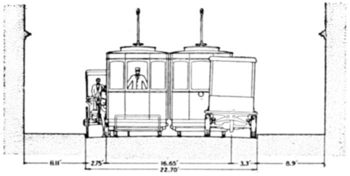
even of the most compact type, must provide for car
tracks in the middle. On straight runs, according to the present
practice and with the new cars in Pittsburgh, the width occupied
from the outside of one car to the outside of the other is 17 feet
8½ inches. At that, the cars are narrower than the modern
standard in some other American cities, and the clearance
between the cars is reduced to less than a reasonable requirement
for safety. On curving roads, such as the Pittsburgh topography
often imposes, the space occupied is greater. Without allowing
any clearance on the outside, a space not less than 18 feet, and
preferably more, should be allowed for the actual cars on
straight runs.
In Pittsburgh, the gauge of the car tracks was originally
made to conform to the prevailing local gauge of other vehicles,
on the mistaken theory that it was desirable to have the smooth
tracks used by wagons; and this has resulted in the almost
invariable conformity of the wagon gauge to that of the tracks,
regardless of the size or character of the vehicle. With the
added fact that Pittsburgh pavements are prevailingly bad, and
that the form of rail is such that it is very difficult for a wagon
to turn out when it has once got into the track, the teamsters in
Pittsburgh are more inveterate in the habit of driving in the car
tracks, and less ready to turn aside for cars or other vehicles,
than in most cities. The severe and constantly repeated strain of
the horses, which is required to wrench heavily-loaded wagons free
from the tracks, is, in the aggregate, a serious economic loss; and
the delays not only to the street cars but to all forms of wheeled
traffic, caused by the conditions described, are incalculably great.
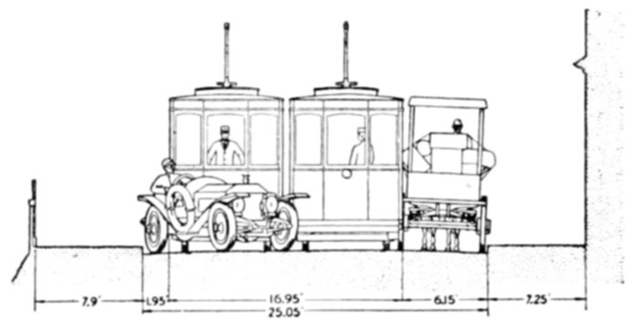
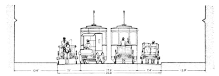
But even good pavements and the use of a grooved rail would
not cure the trouble in Pittsburgh streets as now laid out,
because, almost universally, there is not sufficient room for a
vehicle to pass between the cars and another vehicle standing or
slowly moving next the curb.
In every street, vehicles must be free to stop for loading and
unloading, and on a busy thoroughfare the space next the curb
is so much used in this manner as to become merely a series of
sidings into which slow-moving vehicles can turn from time to
time in order to clear the main passageway. The result of the
conditions above described is that practically the whole wheeled
traffic in Pittsburgh streets is inevitably concentrated on the
eighteen-foot width where the cars run. The extent to which this
reduces the average speed of travel and the total capacity of the
thoroughfare has been strikingly illustrated for Pittsburghers by
the contrast of the former sluggish congestion of traffic on
Smithfield Street with the sparse appearance and rapid movement
of the same traffic since the "one-way" regulations have
made it possible to get one free line in each direction for moving
vehicles separate from the cars. The same striking increase in
capacity is to be secured, without the grave inconveniences and
drawbacks of the "one-way street" regulations, where the space
between the cars and the curb can be made wide enough for
two lines of vehicles, instead of just enough for one or for one
and a half, as is usual in Pittsburgh.
It is very difficult to determine just what is the most economical
allowance of width. There is much variation in the widths of
the vehicles themselves, and the necessary amount of clearance
varies with the average skill of the drivers and with the effectiveness
of the police control. The width of the line is plainly determined
by the widest vehicles in it rather than by the narrowest.
In Pittsburgh the customary width of the heavier and wider
wagons is now controlled by the practical necessity of fitting the
wheels to the railway gauge of 5 feet 2½ inches, and the widths
are considerably less than prevail in New York, Boston, and other
reasonably well-paved cities where the wagons are not fitted to
the car tracks. About 7 feet over all is now the ordinary
maximum in Pittsburgh, a few auto trucks and delivery vans
exceeding that figure slightly, and an occasional three-horse team
occupying over 8 feet. In New York and Boston, wagons
measuring from 7 to 8 feet from hub to hub are common, and
they sometimes considerably exceed 8 feet.
Just as in the case of steam and electric railway equipment,
the tendency is constantly in the direction of heavier, longer,
wider vehicles, for the sake of the operating economy due to
large units; and, with the steady increase in the use of motor
vehicles for business purposes, this tendency is likely to be
greatly accelerated. There is every reason to expect that motor
trucks will gradually increase in size until a limit is fixed by the
public authorities in order to protect the pavements, and for the
sake of standardizing the lines of travel in relation to the street
widths. But, in the interests of economy of operation, the limit
should be as high as practicable, probably not less than 8 feet.
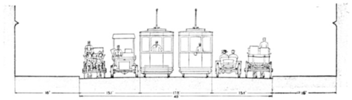
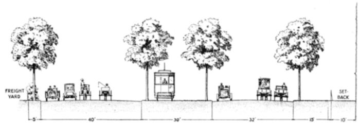
If 8 feet be allowed for each vehicle, plus only a foot of
clearance, the cars and one row of vehicles on each side, between
them and the vehicles standing at the curb, would require 54 feet
between curbs. A wagon backed up to the curb on a busy street
will seriously discommode travel at that, and the clearance allowed
is very small. A width of 54 to 60 feet between curbs is, therefore,
highly desirable in the main thoroughfares.
As a matter of fact, with the widths of vehicles which now
prevail in Pittsburgh, if standing and slow-moving vehicles are
compelled to keep in contact with the curb, it is possible to keep
open a line of travel on each side of the car tracks, with only
occasional blockades, where the width between curbs is 50 feet,
or, at a pinch, even 48 or 47 feet. That is to say, the difference
in traffic capacity between a thoroughfare 50 feet from curb to
curb and one 45 feet is enormous; while the difference between
45 feet and 40 feet is very slight.
Since a main thoroughfare is apt in time to become a retail
trading street, wide sidewalk space is important. It is a common
rule to make the distance of the curb from the property line one-third
the width of the roadway.
A total width of 90 feet, with a 54-foot roadway and 18-foot
sidewalks, is a satisfactory minimum for meeting the practical
requirements of an ordinary main traffic street; a width of 100
feet is preferable, and 80 feet may be regarded as a rather niggardly
irreducible minimum.
In this connection it is interesting to note the standard
widths adopted in European cities. The standard in London
is 48 feet[5] between curbs and 80 feet between buildings for
secondary avenues, and 100 feet over all for principal arteries;
and 140 feet over all is proposed for two great main arteries, the
cutting of which, through the midst of the city, is being considered.
In German cities of the second size, such as Leipzig,
Frankfort and Hanover, the standards are as follows: for strictly
local streets, 33 to 47 feet; for secondary thoroughfares, 50 to 80
feet, and for main thoroughfares, 85 to 118 feet. A Prussian law,
in force since 1875, and apparently drawn up to meet the requirements
of Berlin with its heavier traffic, requires the following
dimensions for the laying out of new streets and for the alteration
of old ones: local streets, 40 to 65 feet; secondary thoroughfares,
65 to 95 feet; main thoroughfares, over 95 feet.[6]
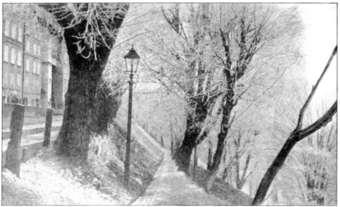
Park treatment of hillside street junction at Stuttgart
The above considerations apply only to the
ordinary main thoroughfares of normal character.
In most of the great cities of the world, there
has been a considerable development of special thoroughfares
of much greater width, including, for example, locations for
transportation lines (surface or elevated), on separate rights of
way decorated with trees; and including tree-shaded promenades
and garden strips. These have usually been laid out
in suburban sections before they were much built up; or, if
within the built-up districts, on the sites of old fortifications,
canals, or other abandoned engineering works. The latter
opportunities are lacking at Pittsburgh, except in connection
with the river banks. In the suburban localities of Pittsburgh,
so much of the available building land is topographically divided
into narrow strips that it would be cut to pieces in an exceptionally
uneconomical manner by any boulevards, of the type
usual in flatter cities, where a substantially uniform width of 150,
or 200, or 300 feet is not infrequently carried through for
considerable distances. As a general rule, any width to be
secured for esthetic purposes in connection with Pittsburgh
suburban thoroughfares, over and above that needed for handling
the expectable future street traffic, must not be in the form of
a general and continuous
widening.
But occasional
pieces here and
there may be taken
for park purposes,
as, for instance, a
steep sidehill adjacent
to the line and
unavailable or difficult
for building.
Or a narrow ridge,
on which the thoroughfare
runs, may have at some point so little available building
land fronting upon it that the whole can reasonably be parked
for a short distance, thus keeping open the distant views.
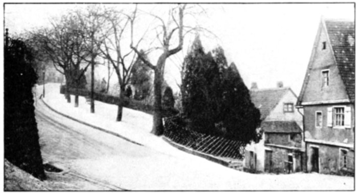
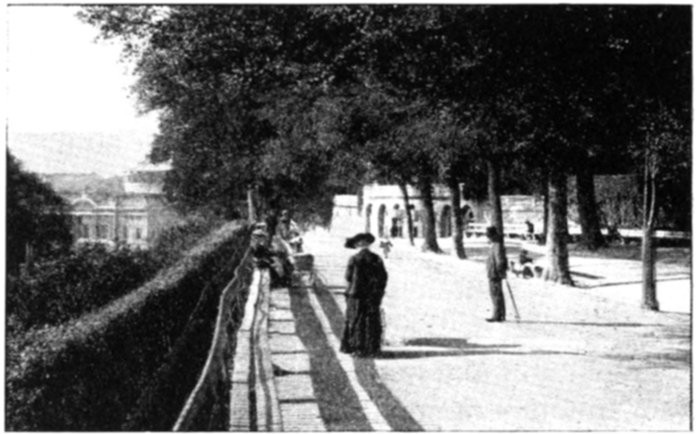
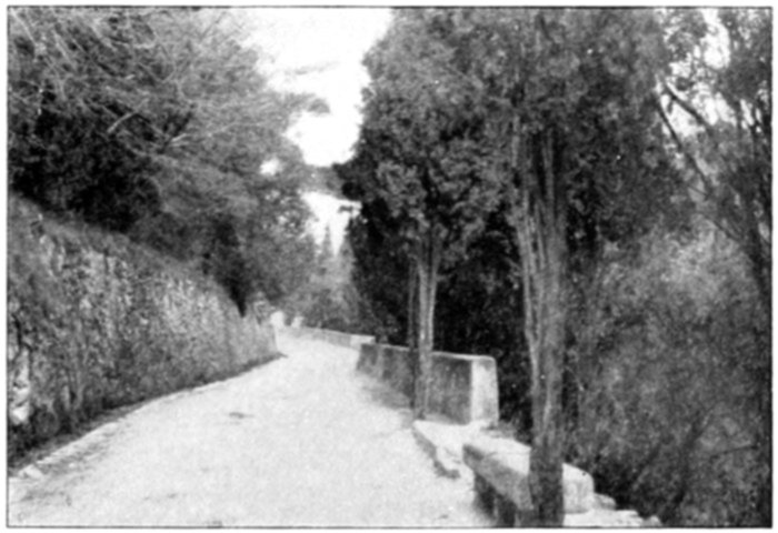
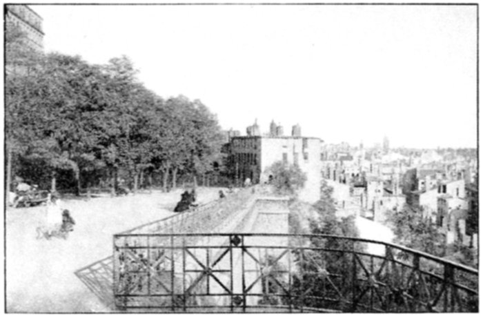
Public resting place and outlook spot on a one-sided
hillside street in Heidelberg
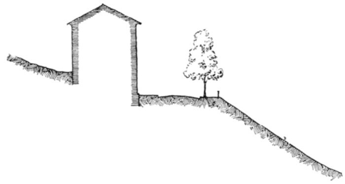
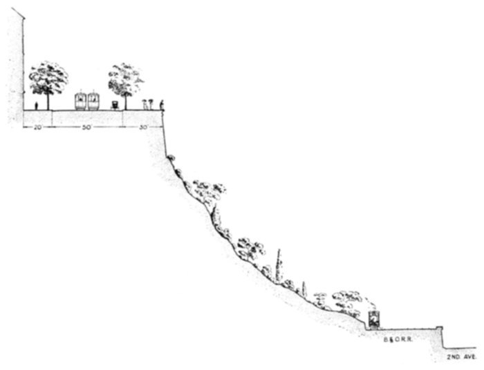
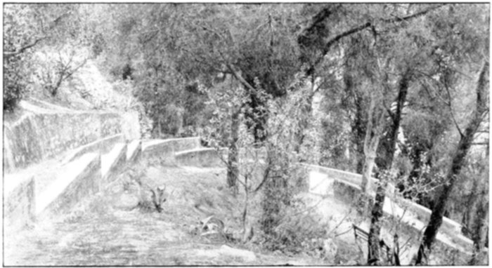
Section showing one type of hillside street
There are two special forms of street, developed here and
there in hilly cities all over the world, of which Pittsburgh needs
to take account in its suburban development. In many instances,
and for long distances, existing suburban thoroughfares that
must be enlarged and improved, and others that must be laid
out, are compelled
to run along the
face of hills so
steep that a street
of level cross section,
even though
limited to 80 feet,
would leave the
land on one or
both sides so far
above or below the
grade as to destroy
its value for building purposes. In such cases it is often practicable
to make use of one-sided streets or two-level streets. The
former are designed to give accessible frontage on one side only,
usually the uphill side. The property on the opposite side is
reached by the next street, which is laid out correspondingly
nearer in order not to make the lots too deep. The width of
such a one-sided
street may be curtailed
without reducing
its thoroughfare
capacity because
it is freed
from local business
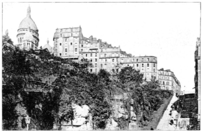
all along one side. Bluff Street, though not
a thoroughfare, is an excellent Pittsburgh
example of the one-sided street, and illustrates
the great attractiveness which such
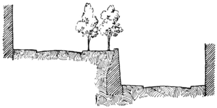
streets often possess. In a two-level street a longitudinal bank,
or retaining wall, is introduced in the middle so as to adapt
it to the topography and bring each half of it nearer to the
natural surface where the abutting property fronts upon it.
Such a street must normally be wider than a single thoroughfare
of the same capacity, the saving in construction and in the
development of abutting land more than counterbalancing the
cost of extra width.
Section of a two-level street at Zurich, Switzerland.
Widths for outlying thoroughfares in a district like
Pittsburgh, therefore, cannot be determined by any general
rule. Each must be laid out as a problem by itself, the principal
objects in each problem being to select a tolerably direct line on
reasonable gradient,
and so to fix the side
lines of the location
that it shall be possible
to meet the immediate
needs by constructing
an economical
suburban road,
where it does not
already exist, and ultimately
to convert it into an ample urban thoroughfare with the
minimum of cost and inconvenience.
Whatever radical changes may be made to improve
the present or safeguard the future condition of the
thoroughfare system in regions that are now rural,
there remains a huge problem within the district where the street
system has already crystallized into substantially its final form.
Here increased capacity can, for the most part, be secured only
by local improvements and widenings of existing thoroughfares.
Fortunately, the building up of the street frontage with solid
blocks of stores, apartments, and business structures, has at most
points followed rather slowly after the earlier wave of detached
dwelling houses, and a large proportion of the streets which are
destined to be the main arteries of the huge future city are still
lined by buildings which are set back at various distances from the
street, leaving front dooryards between them and the sidewalk.
Outside of the down town district, and a limited area in East
Liberty, it is possible, therefore, to provide for the ultimate
widening of these streets without the destruction of many valuable
structures, provided the preliminary steps are promptly taken.
As traffic increases and the lots come to be used for business
purposes, such a set-back becomes inconvenient and undesirable,
and one by one the buildings are either extended to the sidewalk
by new additions, or new buildings are erected on the sidewalk
line. The reason for this change is not usually that additional
lot depth is required, for often considerable yards are left unoccupied
at the rear, but is simply that on a commercial street the
buildings need to be as close to the stream of traffic as possible;
and since the individual lot owner cannot move the street as a
whole up to his building, he has to extend or move his building
to the street. His immediate purpose is thus served, and ultimately
the whole row of buildings is similarly advanced in response
to changed conditions. But at just about the time when this
process is fully completed, the volume of traffic flowing over the
street is apt to have become so great that everybody recognizes
the street to be too narrow for the increased traffic it has now to
carry. If the case is a bad one, the inconvenience due to overcrowding
the traveled way will in time reach a point where, in
spite of the great cost of such an operation, the buildings all
along one or both sides of the street have to be destroyed and a
new building line established—it may be on the very line where
most of the original buildings stood before increasing traffic
began to offer inducements to move them forward to the sidewalk.
Indeed, it may be said as a general rule that on any street
where the buildings are set back from the sidewalk line the very
advancement of a few buildings to the sidewalk line is a sign
which points directly to the growth of travel and indicates that
ample width will soon be needed in that thoroughfare.
As soon as these conditions appear, it is time to act. As
already noted, it is not, in most cases, the desire to utilize a
greater depth of lot which leads to the change, but the desire to
get next to the sidewalk and to do away with a front yard which
has served its purpose and is not wanted under the new conditions.
If the street is one likely to have a considerable amount
of through travel, it would be reasonable at once to lay it out wide
enough to handle such travel; and the cost of the land taken for
the widening would be charged, at least in part, to the abutters, for
they get, by the change, what many of them already want and what
the rest will soon be wanting—direct frontage on a busy sidewalk.
A still wiser course of procedure would be to determine on
the widening of these future main thoroughfares before any
buildings have been advanced to the sidewalk line, and to establish
building lines far enough apart to leave room for all probable
future requirements; but to make no physical widening of the
street until the growth of travel—or the demands of the abutters—call
for shifting the sidewalks over to the established building
line and enlarging the roadway to correspond. This is the invariable
practice in Washington and in most well-conducted European
cities. It is the plan to some extent in New York, where just
recently the sidewalks of Fifth Avenue have been moved back
against the building line on the space formerly occupied by
stoops, areaways, and dooryards. Pennsylvania Avenue and Sixteenth
Street, in Washington, are both laid out 160 feet wide from
building line to building line, although Pennsylvania Avenue is an
important business artery and Sixteenth Street is a residence
street without heavy traffic and with no commercial business.
On the former, the wide sidewalks are in immediate contact with
the fronts of the buildings, as is proper for a business street, and
the roadway, with car tracks in the middle, is more than wide
enough to carry all traffic that can ever be concentrated upon it.
Whereas, on Sixteenth Street, the traveled portion of the street,
including sidewalks and the space for sidewalk trees, is only 80
feet wide; and the remainder is occupied by front dooryards 40
feet deep, which the householders are at liberty to fence and use
almost as freely as if they owned them in fee simple. At the
same time all the householders are protected against the premature
action of any individual lot owner who might see a possible
advantage in being among the first to bid for a commercial
business by building a flat-house with stores under it out upon
the sidewalk line 40 feet in advance of the other houses. This is
the sort of thing that is happening every now and then in Pittsburgh
on streets where the great majority of the owners would
prefer to have the set-back continued for some years longer. In
Washington this crowding forward cannot be done; but when a
reasonably large proportion of the owners on any street, or any
block of a street, are ready for the change, the front yards are
abolished and the sidewalk is moved over into contact with the
buildings. If a single owner wants to put in a store long before
his neighbors are ready to give up their front yards and long
before the City is ready to widen the street to increase its traffic
capacity, he is of course at liberty to do so; but he must not move
forward of the general building line. What he usually does is to
abolish his own front dooryard and substitute an extra wide piece
of sidewalk paving in place of it, sometimes using the space for
outdoor stands, or show cases, to attract trade. He may even be
permitted to erect light temporary structures, such as awnings, on
the space between his main building and the present sidewalk line,
under which, in good weather, he can do a very good business.
There is, then, one course of action which overshadows, in
permanent importance and in urgency, all other things that Pittsburgh
could do at the present time for the improvement of its
main thoroughfare system. That is to establish new building
lines, at a suitable distance apart, along all of its present and prospective
main thoroughfares which there is any prospect of being
able to widen.
Pittsburgh, in common with other cities in Pennsylvania, has
a remarkable power, which is of the utmost importance in connection
with the intelligent control of its street development, but of
which it has not hitherto taken adequate advantage; a power that
appears to be denied to the cities of every other state in the
Union, although effectively used in some other countries. Pittsburgh
may legally lay out a street in anticipation of a future need,
and yet postpone entering upon the land for construction or for
opening it to the public. Until the city legally enters on the
street, the owner of the land has the free use thereof, and he receives
payment only when the opening takes place; but if, in the
interim, he shall have erected any structure within the limits of the
proposed street, he will receive no compensation therefor when
the street is opened. Although similar laws have been declared
unconstitutional in other states, this provision has been sustained
in Pennsylvania, and the power has been effectively exercised in
numberless cases since the middle of the last century.
Philadelphia has applied the same principle to street widenings,
as for example in the case of Chestnut Street. The procedure
is to define a building line, set back a certain distance
from the street line, and to permit no new buildings to be erected
in front of that line, but to pay damages only when the power to
prevent the erection of a new building is actually exercised.
The Chestnut Street widening was authorized by legislation
which provided merely that the street should be widened ten feet,
without specifying the procedure or method of awarding damages.[7]
The procedure used in the widening, as above described, had
apparently no other authority than the general acts under which
Pittsburgh has proceeded in laying out new streets.[8] This application
of those acts has been sustained by the courts. If it is held
that a specific extension of the principle of the Act of 1871 to the
widening of Chestnut Street was implied in the ordinance of 1874,
under authority of the Act of April, 1870, and that it is not generally
applicable to widenings, a general act so intending ought
to be secured from the legislature.
In the Chestnut Street case existing buildings covered most
of the space between the building line and the street line, and
the exercise of the power, with the consequent accruement of
damages, occurred in each case only when the original building
was torn down by the owner and he was required to set the new
building back to the new building line.
The same principle is equally applicable to those cases where
the existing buildings are mostly or wholly back of the new building
line; the damages becoming due in such a case only when
a building permit for the erection of a new structure encroaching
on the designated open space is actually withheld.
The advantages of such a method of procedure, in the case of
those highways where all, or nearly all, of the buildings are now
set back from the street and where a widening will ultimately be
needed, are obvious and very great. In a large percentage of
cases, where the street is still mainly residential, the majority of
the abutters would welcome the establishment of a building line
for their own protection from inconsiderate neighbors; just as the
majority of people will pay higher prices for lots in a neighborhood
that is protected by properly drawn restrictions for setbacks,
etc., imposed by a land company. In a great many such
cases abutters could be induced to waive any claims for damages
on condition that the building line should be applied to the
whole street. Furthermore, the actual net damages to be paid
would be distributed over a long period, and a considerable
proportion of them, in many cases, could properly be assessed
on adjacent benefited property owners.
When the actual physical widening of the street takes place,
through absorbing the restricted zones on each side of it, the
damages for land taking will be comparatively small, because at
that time most of the abutters will want nothing so much as that
very widening, if only to bring the sidewalks in contact with the
fronts of their buildings. But regardless of its clear financial
advantages to the City, in reducing its total payments for street
widening and especially in distributing the burden of that cost
over a long period without running up a large bonded indebtedness
and interest charges, the fundamental argument for this
method of procedure is that it avoids the absolute dead loss to
the whole community resulting from the destruction of valuable
buildings. It is not practicable to avoid this in any other way and
still accomplish the result of widened thoroughfares. Theoretically,
it could be done by a direct widening of all the highways
in the ordinary manner, if it were to be done promptly; but there
are comparatively few cases in which there would be enough
immediate advantage in the increased width to make the proposition
attractive; and it is obvious that any such wholesale
immediate action would involve a sudden and enormous financial
burden which it is utterly impracticable for the City to
assume.
If, after the gradual piecemeal process of widening at moderate
and distributed expense has been begun, the City thinks it
would prefer to have the process over and done with promptly,
it is just as able to complete the widening immediately, by wholesale
condemnation, as if the gradual process had never been
entered upon. If the City begins on the gradual process, it can
always change to the other when it feels rich enough, or when the
buildings on the old lines have become few enough; and in the
meantime the erection of new and costly buildings, obstructive to
the proposed widening, has been prevented at comparatively
slight expense. If the City does nothing, pending such time as it
can afford to make the widening at a single operation, the cost of
the operation is liable to mount at least as fast as the City's
ability to pay for it.
While the method proposed is peculiarly adapted to handling
the problem of a thoroughfare along which the majority of the
frontage is not yet occupied by buildings standing on the street
line, it may be objected that it is not suitable for widening one
that is built up, like Forbes Street. It is true that the patchwork
appearance of such a street during the process of gradual reconstruction
is somewhat unsightly,—with here and there a wide
place where new buildings have gone up, and between them narrow
parts, thus exposing the blank side walls of old buildings
projecting beyond the new ones. Yet in cities where the sense of
civic beauty is far more acute than it generally is in America,
this temporarily ragged condition is accepted as a small price to
pay for the economical and certain accomplishment of a great
permanent improvement.
It is obvious that the flow of traffic moves regardless
of the artificial boundaries of the city and the
surrounding boroughs, and that if an efficient
system of thoroughfares is to be involved for the
Pittsburgh Industrial District it will be necessary to disregard
those boundaries in planning it. This has been done in the
preliminary studies which have resulted in this report, and the
necessity for it must control the form of any permanent organization
for preparing final plans and executing them. If these duties
are to be entrusted to officers of the City, and the city boundaries
remain unchanged, those officers must have authority from the
legislature to deal with territory beyond the boundaries of the
city, as is the case in a limited way in Wisconsin cities.[9]
The simplest and most logical procedure, if the boundaries of
the city and of the boroughs are to remain substantially unchanged,
would be to establish a common agency for dealing with
the general problems of city planning for all of the municipalities
and the related parts of the country outside of them. The Constitution
of Pennsylvania apparently prevents the formation of a
special metropolitan board for the Pittsburgh Industrial District,
but general authority might be obtained under which the County
could establish such a board. If the difficulty should be met
simply by extending the boundaries of the city, it is important
that the new boundaries should include not merely those areas
which are now seen to have close physical relations with the city,
but a great extent of territory within which the beginnings of
urban or suburban growth have started, or are likely to start,
during the next generation.
Whether the duty of planning and providing for the main
transportation lines is made a city affair or a county affair, those
who are charged with it should be free to go as far in any given
direction as the demands of the traffic lead them. They should
neither be limited by arbitrary boundaries in those directions
where scattering but connected urban development may reach out
furthest from the center, nor compelled to extend their operations
to an arbitrary boundary in those directions where such development
falls short.
As noted earlier in this report, one of the two main eastward
thoroughfare routes, from the Point District, must lie along the
flat land between the Allegheny River and the bluff southeast of
the Pennsylvania tracks. Through this bottle-neck
must pass the trunk line (or lines) of one of the
largest thoroughfare systems leading from the down
town district of Pittsburgh. At the foot of the Lawrenceville hill
the system branches into two main lines of extension. On the one
hand are Penn and Liberty Avenues, extending, by different
routes, through the Garfield, Bloomfield, Friendship and Shadyside
Districts to East Liberty; and from there connecting directly to
Squirrel Hill, Highland Park, Homewood, Brushton, Wilkinsburg
and all points further east. On the other hand is Butler
Street, following the low land along the river through Lawrenceville
to Morningside and Highland Park. Via the Forty-third
Street bridge, this line reaches Millvale and the country north
thereof; via the Sharpsburg and Aspinwall bridges it reaches Etna,
Sharpsburg, Aspinwall, and Shaler and O'Hara townships, and
connects directly with the Freeport Road, the only thoroughfare
leading up the Allegheny River. The trunk line of this system is
composed of two narrow streets, Penn Avenue and Liberty Avenue,
the one 60 and the other 50 feet in width. Even now this accommodation
is inadequate, and, considering the extent of territory
served and the increase of through traffic to be expected as the
city grows and the outlying lands develop, a much greater capacity
for general traffic through this throat will very soon be needed.
There are four different ways in which this greater capacity
might be realized.
In the first place, a new street might be cut through north of
Penn Avenue. Smallman Street, from Twenty-first to Thirty-sixth
Street, already forms a good sized piece of such a thoroughfare.
Pike Street would be its normal extension in town to Eleventh
Street, but, like Try Street near Second Avenue, it has been surrendered
to the Pennsylvania Railroad for a connecting line and
spur tracks. Furthermore, it is very narrow (not over 40 feet) and
is difficult to widen on account of the many industrial plants
abutting thereon. The connections from such a thoroughfare
with Penn Avenue, Liberty Avenue and Butler Street at one end,
and with the down town thoroughfares at the other, are quite
indirect; and they could be improved only at great expense.
The only other place for a new thoroughfare is along Spring
Alley, between Penn and Liberty Avenues. As this whole block is
only 220 feet wide, including the alley, it is obvious that a broad
avenue through the middle of it would leave the abutting property
in very uneconomical shape.
As a modification of this plan, the widening of Spring Alley
entirely on the south side was considered. As this would leave
lots 40 feet or less in depth between the new street and Liberty
Avenue, it would mean the practical destruction of the half-block
from Spring Alley to Liberty Avenue. The remaining strip could
be taken as a central parking space in a wide boulevard thoroughfare,
extending from Spring Alley to the railroad; or Liberty
Avenue could be abandoned, and the space, left between the new
street and the railroad, could be used for warehouses or for
business wanting direct railroad connections; or it might be sold
in whole or in part to the Pennsylvania Railroad, for additional
track space. It is obvious that each of these plans cuts up the
property undesirably: the first is not only costly but is extravagantly
wasteful of land in a region where available land is strictly
limited and should therefore be put to its most efficient use: and
the other plans both involve an entire redistribution of the land
south of the new street. They could hardly be executed without
powers of "excess condemnation" for which constitutional authority
is lacking.
A third plan would be to widen Liberty Avenue on the
north side. There is no special difficulty in the way of this
scheme, and it could certainly be more easily carried out, and at
less cost, than any of the Spring Alley plans. Merely as a traffic
way between two points, Liberty Avenue widened would be perfectly
satisfactory, but several incidental considerations must be
borne in mind. First, the lots on the north side of the street
would be cut at least to 70 and probably to 50 feet, neither of
which is a desirable depth for lots on a main thoroughfare; and
second, the street would have business frontage on one side only.
The latter is an uneconomic arrangement from the point of view
both of the real estate owner and of the City, and the street would
be much less agreeable than if it were separated from the railroad.
The fourth plan would be to widen Penn Avenue. This street
is now 60 feet in width, and most of the lots on each side are 100
feet deep, except for several blocks on the north side where they
are about 120 feet. The street is built up solidly on both sides,
but scarcely any of the buildings are new or costly. The property
values are almost uniformly a little higher than on Liberty Avenue.
If Penn Avenue were widened 10 feet on each side, making an
80-foot thoroughfare, the abutting lots would still be 90 feet
or over in depth; and if the street were made 100 feet wide, the
lots would still be 80 feet deep. Though it might cost somewhat
more to widen Penn Avenue than Liberty Avenue, it is evident
that the abutting property would be left in far better shape, and
the benefit to be had from increased frontage value would be
much greater.
After due consideration of each of the above plans, bearing
in mind the cost, the difficulty of carrying it out, and the value of
the result, both as an important main thoroughfare artery and
as a local improvement, it is recommended that Penn Avenue be
widened to 100 feet. If the widening is to be accomplished by
the gradual process,[10] that is by merely establishing the new building
lines at the present time, and by paying damages only when
new buildings are set back to this line, the widening should
probably be made on both sides: for in this way the minimum
set-back will be required for individual new developments and the
lots will be left of a good depth on both sides of the street. But
if the widening is all to be made at once, it will be less costly to
make it entirely on the south side. In either case, the lots remaining
will be none too deep, and it is suggested that ultimately
Spring Alley may be abandoned and the opportunity furnished
for deep lots for warehouses and similar purposes, fronting on a
large thoroughfare and having direct railroad connections over
Liberty Avenue in the rear.
The other eastward thoroughfare system lies south
of the Hill District. From Soho eastward there
are two main branches to the system: on the one
hand are Forbes Street and Fifth Avenue, leading through Oakland
to Bellefield, Shadyside, East Liberty, Squirrel Hill, and
all points east; on the other hand is a possible and much-needed
thoroughfare reaching Greenfield, Hazelwood, Glenwood, and
Hays, and from there, by branches and extensions, connecting
to Homestead, Duquesne, McKeesport, and points up the
Monongahela and Youghiogheny Rivers, as well as to the country
south in Baldwin, Mifflin, Snowden, and Jefferson townships.
At present the trunk-line of this system (from the Point
District past Soho hill) is composed of three narrow streets,
Second Avenue, Forbes Street, and Fifth Avenue, which all together
are no more than adequate to accommodate the present surface
travel. Future developments in the East End, up the Monongahela,
and in the country south of Homestead, and improved
thoroughfare connections with the two latter regions, will
undoubtedly increase the through traffic on these streets to such
an extent that their capacity will soon be taxed beyond its limit.
There can be no doubt that more accommodations will be needed
in the near future.
Section of Second Avenue between Try
Street and Tenth Street Bridge
At first thought it was hoped that Second Avenue might be
improved to accommodate a reasonable increase in east and west
traffic; but the Baltimore & Ohio Railroad on one side, and
several large industrial plants on the other, present serious
obstacles to widening it. A
plan to exchange locations with
the railroad was considered,
but it did not appear to offer
sufficient advantage to the
railroad to tempt them to
cooperate in the matter.
Incidentally, Second Avenue
can and should be widened
to 80 feet, from Ross Street to the Tenth Street bridge, thus
making a good connection between the Point District and the
South Side.
It remained then to secure the desired street capacity, in some
way, through the valley now occupied by Forbes Street and Fifth
Avenue. To avoid the higher land values on these streets,
various schemes were tried to get a third thoroughfare in this
valley, first on the south and then on the north side, but without
success. The indirectness of line and the seriousness of grade
difficulties, coupled with cost of cutting new connections at
either end, more than outweighed the advantages offered by the
cheaper land.
One proposition, however, is worthy of special remark. That
was to cut a new street from Fifth Avenue, near Sixth Avenue,
to the end of Colwell Street, widen the latter, carry it over the
Moultrie Street valley on a high viaduct, skirt around Soho
hill, partly above and partly below Beelen Street, and either join
Fifth Avenue at Robinson Street, or, going over this street,
follow along the hillside and meet the southerly end of Bayard
Street. The cost of constructing this line, the complication of
grades with cross-streets (owing to the width of the new street),
and the difficulty of getting good connections with any thoroughfares
leading up the Monongahela, practically put it out of the
question as a solution of the main problem in hand. But it offers
many advantages as a specialized thoroughfare for fast-moving
automobiles for the East End. It is well up on the hill, furnishing,
at times, fine outlooks over the river; the gradient need
nowhere be over 4 per cent, and the line could be easily laid out
so as to have very few grade crossings with other important
streets. It is urged that this route be borne in mind when the
demand is felt for another "Grant Boulevard," south of the Hill.
It remained, then, to consider adequate widenings of Fifth
Avenue or Forbes Street. The former is now 60 feet wide
throughout; it is by far the more important thoroughfare at
present, land values are much higher than on Forbes Street, and
new and somewhat costly buildings are already crowding out the
cheap houses of an older generation. Forbes Street is also 60 feet
in width, except near its westerly end where it is only 50 feet, but
the buildings, on the whole, are much less valuable than those
on Fifth Avenue. Lot depths are practically the same, and so
are the street gradients. It is evident, therefore, that the widening
of Forbes Street should be a far less costly undertaking
than the widening of Fifth Avenue.
A thorough study of the possible eastward extensions of
Forbes Street has developed no obstacles to using it as the principal
thoroughfare. By referring to "Outlying Thoroughfare
Improvements" below (Sections 11, 14, 15, 16, 17 and 19), it
will be seen that a cross connection can easily be secured at Brady
Street to Fifth Avenue—the latter being the easier street to widen
beyond this point, as well as offering somewhat better gradients.
It will also be seen that the thoroughfare extension to Greenfield,
Hazelwood, Glenwood, and eastward, can branch from Forbes
Street (just east of Brady) more easily and cheaply than it could
from Fifth Avenue. Forbes Street, moreover, enters the down
town district at a slightly more central, and, considering the proposed
improvements in the down town district, a more advantageous
point.
It is recommended, therefore, that Forbes Street be made
the main artery of this eastbound thoroughfare system, and that it
be widened to 100 feet. As in the case of Penn Avenue, the
widening should be made on both sides if done by the gradual
process; but if done all at one time, it should be made entirely
on the south side.
Between the Point District and the South Hills
there is now urgent need for a thoroughfare connection
of adequate capacity and on reasonable
gradients. At present the only access for surface traffic—except
electric cars—is via the Brownsville Road, or South Eighteenth
Street, or the inclines. The two roads are steep, from 7 to 8 per
cent, and the inclines are expensive and of very limited capacity.
The South Hills country is sparsely developed as yet, but, being
comparatively free from smoke and very near to the business district,
it offers unusually desirable opportunities for homes, and it
must soon be thickly settled. The need for a good thoroughfare
to this region will then be of far greater importance even than now.
Only two reasonable ways of securing such a thoroughfare
appear. One is by a new slanting road up the hillside south of the
river, much longer, and so on an easier gradient, than Brownsville
Road; the other is by some high-level bridge and tunnel
scheme, such as that proposed by residents of the South Hills.
The opportunities for a hillside road have been studied with
some care, but the excessive length required to get a reasonable
gradient, and the difficulties and high cost of constructing a wide
thoroughfare on the steep hillside, have proved to be serious
drawbacks to all possible plans for such a street.
Entrance to a thoroughfare tunnel, Stuttgart
In any thoroughfare scheme
to the South Hills, it is reasonably
clear that the end to
be attained is the most direct
access possible on easy gradients
to the higher levels of the
South Hills country. For it is
on the upper levels, the hilltops
and the upper slopes,
that most of the present development
has taken place;
and there can be little doubt
that in the future, even when
building space is at a much higher premium than it is now, the
overwhelming majority of the population will be found on the
hills rather than in the narrow valleys.
Thoroughfare tunnel at Budapest
Panther Hollow bridge—a good-looking viaduct in
Pittsburgh
There are certain general tendencies which are observable,
both in America and in Europe, in cities which have a large area
of hilltop land separated by deep valleys. The hills are generally
preferred for residential purposes, and the earliest roads or trails
often follow the ridges, plunging down and climbing up again
steeply to get from one ridge to another. The main roads in the
second stage of development are apt to seek the valleys for the
sake of good gradients,
with a corresponding
development
of the most
active urban growth
in the valleys and
on the lower slopes;
the hilltop development
being retarded
by lack of
transportation facilities.
Nevertheless
the continued
attractiveness of the uplands slowly builds them up, and as the
wealth of the community grows there is an inevitable tendency to
reduce the obstacles to ready connection between one hill district
and another
by raising the levels
of the bridges
which cross the intervening
valleys.
Bolder and bolder
viaducts are built,
until finally there is
a complete and
more or less independent
highway
system on the upper
levels, and the
major part of the residential district comes to be there too.
Obviously, therefore, every opportunity should be utilized to
gain grade, in the approach to the South Hills District, by starting
at a high elevation and wasting no distance in level stretches,
if the most efficient thoroughfare artery to this district is to be
secured.
A viaduct in Lausanne, showing how the valleys are
spanned by the main traffic ways
The bridge and tunnel plan, proposed by residents of the
South Hills, is briefly as follows: to start from Forbes Street, at
Sixth Avenue, and rise steadily to the bluff north of Second Avenue;
from here to rise on a bridge over the river, at a uniform gradient,
to the opposite
hill; to pierce the
hill by a tunnel, at
the same gradient,
and reach the level
of the present highways
at the junction
of Washington
Avenue and
Haberman Street.
It is proposed also
to have a lower
deck on the bridge,
which would connect East Carson Street with Second Avenue and
an extension of Sixth Avenue.
This plan has the obvious advantage of starting some 40 feet
higher than any of the present bridge approaches in the down
town district, and at a point from 500 to 1000 feet north of any
other feasible point of departure. Considerable gain is thus made
at the very start. A uniform, uninterrupted gradient is proposed,
from Forbes Street to Washington Avenue, in order to climb the
maximum amount possible with a given distance and gradient.
Information furnished us through the office of Edwin K. Morse
shows that the horizontal distance from Forbes Street to Washington
Avenue is 6800 feet and the difference in elevation between
the two points is 260 feet. It follows that a uniform gradient,
from one end to the other would be 3.82 per cent; this could be
reduced to 3.74 per cent by raising the grade of Forbes Street
about 6 feet, a change which is to be desired in connection with
the down town thoroughfare improvements and the Civic Center.
At first sight this gradient seems good for Pittsburgh; but bearing
in mind the distance—over a mile and a quarter—for which this
gradient is maintained without a break, considerable hesitancy is
felt about recommending it for the main artery of a large
thoroughfare system. A gradient of 3.5 per cent should probably
be considered a maximum for such a long climb on a main
thoroughfare, and 3 per cent would be far better. The former
gradient could be secured by dropping the southern end of the
tunnel about 16 feet, the latter by dropping it about 50 feet. In
either case, the southern end of the tunnel, or its approach, would
be bent westward and extended a little down the valley, north of
Washington Avenue, toward the mouth of the street car tunnel.
The exact amount of reduction to be desired in the tunnel gradient
must be finally determined in conjunction with a careful
study of its southerly extensions based on complete and accurate
surveys of the possible routes. There is no advantage in lengthening
one portion of a thoroughfare to get a 3 per cent gradient
if nothing better than 3.5 or 4 per cent can be secured on the rest
of the route. The surveys made for the County Commissioners,
under the direction of E. M. Bigelow, and courteously shown to
representatives of the Civic Commission, unfortunately fail to
furnish the needful data, as they do not extend to the upland
districts which are the ultimate objective of the proposed
route.
The high-level tunnel reaches existing streets at Washington Avenue. From this point is planned a system of thoroughfares, which, if
constructed, would reach all parts of the South Hills. These thoroughfares are indicated by dashes beyond the junction of the tunnel with
Washington Avenue.
The Bell House, or low-level tunnel is indicated by a dotted line. It is an approach to the West Liberty Road and would give easy
access only to the territory reached by that road and to other territory in the nearby valley bottoms.
The above diagrams show the areas that can be reached via the low-level and high-level
tunnel routes to the South Hills, on a maximum gradient of 3½ per cent, by hauls of
various lengths from City Hall. The areas are given in the following table:
Length of haul from City Hall
Total area reached
Amount of land sloping over 25 per cent
Remaining land available for use
Low-level route
High-level route
Low-level route
High-level route
Low-level route
High-level route
2½ miles
156
acres
1091
acres
86
acres
373
acres
70
acres
718
acres
3 miles
672
"
2710
"
293
"
848
"
379
"
1862
"
3½ miles
2763
"
4877
"
1053
"
1617
"
1710
"
3260
"
4 miles
6329
"
7408
"
1935
"
2449
"
4394
"
4959
"
But even without precise data, it is clear that the best permanent
means of reaching those upland districts, whether on one
side of Sawmill Run or on the other, is not by a tunnel debouching
in the bottom of the valley—say at the Bell Tavern. This
follows from the fact that the tunnel can reach a much higher
level at a good gradient and with a shorter distance. And from
this higher outlet point a viaduct high in the air above the
Bell Tavern would give direct access to the uplands of Beechview
and Mt. Lebanon and southward, while streets of easy
gradient would reach the uplands east of Sawmill Run. The high
level tunnel, furthermore, will reach all the areas served by the
low level, or Bell Tavern, route, and in addition can reach the
other and more important lands on the hills which cannot be
reached via the Bell Tavern route within a reasonable distance.
The thoroughfare extensions from the southern end of the
tunnel are briefly discussed under "Outlying Thoroughfare
Improvements" below. At its northern end the new bridge
would fit admirably into the proposed thoroughfare system of the
Down Town District, main wide streets extending directly from the
end of the bridge approach to the north, south, east, and west.
Owing to the importance of the South Side as a point for the
delivery of freight, a reasonably direct and easy approach from
there to the new tunnel seems desirable. Freight to be teamed to
the South Hills District seems likely to originate either near the
Smithfield Street bridge, or east of South Seventeenth Street.
From the former point, it is almost out of the question to get
an approach of easy gradient to the mouth of the tunnel, on
account of the lack of distance; but it must be remembered that
the inclines will still be available, greatly relieved by the new
tunnel from their present congestion, and further that freight for
the South Hills could easily be shipped to points from which
access to the new tunnel would be easy and direct. From the
latter point, the connection can be secured by climbing over
the railroad on a viaduct, probably along South Twelfth Street,
and thence following the hillside westward on a more or less
uniform gradient to the mouth of the tunnel. An examination
of the hillside below the Brownsville Road indicates that such a
street, though somewhat costly, is not in the least impracticable.
It might be best to construct it with a minimum of cutting by
the use of a sidehill viaduct of reinforced concrete.
With the modifications above suggested the plan proposed
by the residents of the South Hills, for a bridge and tunnel to
the South Hills District, is eminently desirable. It is, therefore,
urgently recommended as the best method of securing an
adequate main thoroughfare artery to this region.
The following recommendations are in no sense the result of
an exhaustive study of the main thoroughfare system of the
Pittsburgh District. They comprise only the most desirable
improvements noted during a general study of the outlying
branches and connections of those thoroughfares which concentrate
upon the down town district. The fact that a study undertaken
with such a point of view has led so far afield that it has
compelled the investigation of existing and probable connections
so remote as some of those noted below, is, in itself, evidence of
the complexity of the highway problem, and of the fact that it
cannot be dealt with locally, in a piecemeal manner, without great
sacrifice of opportunity.
The improvements are designated in the following text by
numbers which correspond with those on the accompanying
folded map of the Pittsburgh District.[11]
1. Sixteenth Street Bridge.—The first thoroughfare branch of
the Penn Avenue artery is the Sixteenth Street bridge. Because of
its physical unfitness, and because it is, at present, an unreasonable
interference to navigation, it must soon be rebuilt.[12]
At the time of reconstruction, the railroad grade crossing on
each approach should be eliminated, probably by carrying the
street over the tracks. At the southern end, the grades make
such a change very simple. At the northern end, the separation
of grades will be facilitated if the tracks of the Pittsburgh and
Western Division of the Pennsylvania Railroad can be lowered
a few feet. No physical objection to such a change of track
grade is apparent.
Diagram No. 1. Thirty-third Street improvement. Profile of Liberty Avenue
2. Twenty-eighth Street Grade Crossings.—Near Twenty-eighth
Street the tracks of the Allegheny Valley Railroad cross both
Liberty and Penn Avenues at grade. These grade crossings should
be eliminated, the railroad tracks being raised to go over both
streets.
Diagram No. 2. Penn-Liberty connection at
Thirty-first Street
3. Thirty-third Street Improvement.—At Thirty-third Street on
Liberty Avenue there is a railroad grade crossing. The street
should be lifted over the tracks and the filling extended west to
Thirty-first Street and east to Thirty-seventh Street; in this way
the gradient of the steep portion of the Lawrenceville hill can be
reduced from 5.6 per cent to 4 per cent, which is the present
gradient on the rest of the hill. (Diagram No. 1.) An easy connection
should be made with the Penn Avenue artery at about Thirty-first
Street. (Diagram
No. 2.) With these
changes the Penn-Liberty
line would provide
a thoroughfare
from the down town
district to the East
End with a 4 per cent
maximum gradient,
which is easier than
can be reasonably obtained on any other line. The northern end
of the Thirty-third Street bridge and the west end of Ligonier
Streets should be raised to meet the new grade of Liberty Avenue;
the bridge will then be about level, and Ligonier Street will
slope between 6 and 7 per cent down to Thirty-fourth Street.
Diagram No. 3. Penn-Liberty Connection at
Howley Street.
4. Sassafras Street Outlet.—Raising the grade on Liberty Avenue
will seriously interfere with the western outlet of Sassafras Street.
But if this street becomes
of sufficient importance—and
its location in the valley
close to the railroads suggests
a considerable development
of its frontage for
freight houses, warehouses
or manufacturing—it will be
simple and satisfactory to
bring the western outlet to
the junction of Penn Avenue
and Butler Street by means
of a short tunnel under
Thirty-fourth Street from
the south side of Liberty
Avenue to the northwest side
of Ligonier Street.
5. Penn-Liberty Connection
at Howley Street.—A connection
northeast from the junction
of Liberty Avenue and
Main Street to Penn Avenue
will be needed. (Diagram
No. 3). This can be secured
by widening and extending
Howley Street. Thereby
traffic bound for the Garfield
District and east thereof can climb the Lawrenceville hill by the
comparatively easy gradient (4 per cent) on Liberty Avenue,
avoiding the steeper hill (about 5 per cent) on Penn Avenue. This
will also connect with the proposed Bloomfield bridge to Grant
Boulevard.
6. Forty-third Street Bridge.—Butler Street is the main extension
of the Penn Avenue artery up the Allegheny River, and its first
branch thoroughfare is at Forty-third Street. The Forty-third
Street bridge, like the one at Sixteenth Street, must soon be
rebuilt.[13] This bridge connects Millvale and large sections of
Shaler and Ross townships with the Point District via the Penn
Avenue artery. The new bridge should be of ample width and
should be high enough so that the approaches can be carried over
the railroad tracks at either end.
7. Sharpsburg Bridge.—The Sharpsburg bridge is the next
important branch of the Butler Street thoroughfare. It forms the
most direct connection from Pittsburgh proper to the boroughs
of Sharpsburg and Etna and to large portions of Shaler and
O'Hara townships. The bridge should be widened—the present
roadway being only 21 feet including car tracks—and the northern
approaches should be improved. (Sections 60 and 61 following.)
8. Butler Street Improvement.—From a point nearly opposite
the western end of Baker Street east to Haights Run, there is no
property of value for manufacturing, or for dwellings, or stores,
between Butler Street and the railroad which runs below it on the
river bank. The same is true east of Haights Run as far as the
Brilliant pumping station or the present beginning of Beechwood
Boulevard. It seems very desirable that these portions of Butler
Street, instead of being widened merely enough for traffic accommodation,
be developed as a picturesque riverside parkway—a
fitting approach to Highland Park and a continuation of Beechwood
Boulevard. This involves the control of the narrow strip of
property between Butler Street and the railroad; though occasional
houses might be allowed to remain therein without detriment to
the effect as a whole. The Bureau of Parks is working along
these general lines, and has already bought many parcels of the
land north of Highland Park between Butler Street and the
railroad.
9. Haights Run Bridge.—The present Butler Street bridge
over Haights Run is of light construction and has a total width
of only 17 feet; this should be rebuilt of ample strength and
capacity.
10. The Aspinwall Bridge.—The Aspinwall bridge, crossing
the river at Six Mile Island from Butler Street to the eastern
portion of Sharpsburg, is narrow (36 feet over all) and is of light
construction. It is so important that it will some day need to be
rebuilt of ample width and strength for main thoroughfare use.
At its southern end it connects (1) with the Butler Street
thoroughfare, of which it forms the northeastern extension, and
(2) with a proposed cross-town line (Section 25 following) up the
Haights Run Valley to East Liberty. On the north it connects
directly with Guyasuta and Aspinwall, with most of the country
in O'Hara township, and with the Freeport Road leading to
Claremont, Montrose, Oakmont and all points up the Allegheny
River. This Freeport Road is destined to become the main
thoroughfare up the Allegheny because the precipitous character
of the south bank of the river, and the consequent almost total
absence of land suited to residential or commercial development
between Highland Park and Verona, make the direct extension
of Butler Street, as a riverside thoroughfare, both expensive and
impracticable.
Diagram No 4. Forbes Street—Fifth Avenue connection at Soho
Diagram No. 5. Fifth Avenue—Center Avenue
connection at Soho
11. Forbes Street—Fifth Avenue Connection at Soho.—At Soho
the connection between the Forbes Street artery and Fifth Avenue—the
principal thoroughfare to Bellefield and all points to the
east thereof—is most simply accomplished by splitting the Forbes
Street artery at Seneca Street into two levels, the upper, on the
north side, running on nearly a straight line and gradient to
Fifth Avenue, joining it just west of the school house. (Diagram
No. 4.) The lower portion would become the continuation of
Forbes Street, and should be raised at Brady Street about 17 feet,
or so much that the gradient on Brady Street, up from Forbes
Street under the proposed high-level street to Fifth Avenue, will
not be over 6 or 7 per cent. A good
gradient will still be possible on the
approach from Forbes Street to the
Twenty-second Street bridge; and the
Forbes Street gradient, down from
Seneca Street, will be much reduced.
These changes will greatly improve the
means of access to the Twenty-second
Street bridge.
On Forbes Street, just west of Craft
Avenue, there is a bad gradient for a
main thoroughfare (about 6½ per cent)
which is not easy to improve; but the
above cross connection at Brady Street
will give a through line to the East
End via the Forbes Street artery and
Fifth Avenue, with a maximum gradient
of about 4½ per cent (on the Soho
hill).
Diagram No. 6. Ellsworth Avenue extension
12. Fifth Avenue—Center Avenue
Connection at Soho.—As a main thoroughfare
feeding Minersville
and the northern part of
the Hill District, either
from the South Side via
the Twenty-second Street
bridge, or from the Point
District via Fifth Avenue
or Forbes Street, a connection
is needed on a reasonable gradient from Fifth Avenue to
Center Avenue through the valley south of Soho hill. Such a
street (Diagram No. 5) could leave Fifth Avenue at Jumonville
Street, start along the location of Wyandotte Street, then curve
around the nose of the hill and follow the hillside on the west of
the valley; thus, by cutting away some of the recent filling at the
upper end of the valley, it could reach Center Avenue at the corner
of Soho Street
with a uniform
gradient of about 3
per cent. At present
there is no way
of reaching this
high land on a
gradient less than 7
per cent.
The new street
shown on the diagram
is preferred to the improvement and extension of Moultrie
Street because (1) it gives a better gradient, (2) it is a more direct
approach from the down town district, and (3) it leaves the
bottom of the valley available for enlarging the Moultrie Street
playground.[14]
A one-sided hill-street in Geneva, possessing an
incidental recreative value
13. Ellsworth Avenue Extension.—As Fifth Avenue is the
principal thoroughfare to Bellefield, so Ellsworth Avenue becomes
its main branch or
extension from
Bellefield to East
Liberty. This street
should not end at
Neville Street, as
at present, but
should be extended
to the
corner of Craig
Street and Fifth
Avenue. (Diagram
No. 6.)
14. Monongahela Hillside Thoroughfare.—The thoroughfare
requirements from the Forbes Street artery up the Monongahela
River can best be met by a hillside street, partly new and partly
following existing streets, running substantially parallel to Second
Avenue but along the hillside above the railroad tracks. This
thoroughfare would leave Forbes Street at the bend about 1200
feet east of Brady Street, cross the little valley (which should be
filled north of the new street) and extend eastward, crossing Bates
Run on a viaduct, and using, where possible, parts of Lawn and
Frazier Streets, to the mouth of Four Mile Run. Thence, by
another viaduct, it would connect with Sylvan Avenue, on the north
side of the valley, and follow this street widened to Hazelwood
Avenue; by another viaduct it would cross the Flowers
Avenue valley to Glenwood Avenue
and follow the latter widened and partially
regraded to Mansion Street. There
it would bend to the northeast, cut
through the plateau land to the next ravine,
cross this on a viaduct and, bending
southward again, descend
around the nose of the hill to
the Glenwood bridge. So easy
a gradient can be obtained on
this new street that it
may reasonably be expected
to carry nearly all
the through traffic. With proper
connections (the most important of
which are described below), it will also take
most of the travel to and from the residential
districts lying above it to the northeast.
The location of this street, high on the hillside above the
Monongahela River, presents unusual opportunities incidental to
serving its primary purpose as a main thoroughfare. With an
ample roadway for all kinds of traffic, with trees for shade and
decoration, with a broad promenade overlooking the river and
the hills to the south, it would furnish rare and much-needed
facilities for recreation; and, further, it would have a distinctive
character most appropriate to the rugged topography of the
Pittsburgh District. (Diagram No. 7.)
15. Bates Run Connection.—Starting from the western end of
this new street, the first important transverse street connection
would be at Bates Run. Here a street should be run up the east
side of the valley, not far from the present location of Romeo
Street, to the intersection of Wilmot and Bates Streets, thus
reaching the Oakland District.
16. Greenfield Avenue Connection.—On the southeast side of
Four Mile Run the new thoroughfare will pass over Greenfield
Avenue. But a connection should be made therewith by running
a practically level street, from about the junction point of Sylvan
Avenue and the new thoroughfare, northeast along the hillside
adjacent to Greenfield Avenue until it meets the Greenfield
Avenue grade.
17. Greenfield and Squirrel Hill Extension.—From this point on
Greenfield Avenue a new street should be built running to the
northeast. It would cross the first little ravine on a viaduct,
thence follow the south bank of the Four Mile Run valley, climbing
at a uniform gradient, and join Beechwood Boulevard at the
southern end of the bridge into Schenley Park. This will furnish
a direct connection from the new hillside thoroughfare to the
eastern portion of the Greenfield District and to Squirrel Hill; the
maximum gradient will be only about 3½ per cent instead of
about 7 per cent as at present on Greenfield Avenue.
This new street could be extended, from the point where it
joins the boulevard, underneath the Greenfield Avenue viaduct,
along the side of the valley to the south and up to the higher
portions of the Greenfield District. The gradient of such a street
need not exceed 5 per cent.
18. Hazelwood Grade Crossing.—Although the construction of
the hillside thoroughfare (Section 14 above) does away with the
necessity for widening Second Avenue east of the Tenth Street
bridge, Second Avenue is still an important main line, and all
feasible improvements should be made thereon. One of these
is the elimination of the grade crossing at Hazelwood, and here
Second Avenue should probably be carried under the tracks.
19. Glenwood Bridge.—The Glenwood bridge becomes a most
important link in the thoroughfare system; it connects Second
Avenue and the proposed hillside line at one end, with Eighth
Avenue in West Homestead and with the mouth of Streets Run
at the other. Eighth Avenue leads up the Monongahela to Homestead,
Munhall, Rankin, Braddock, Bessemer, Duquesne and
McKeesport; Streets Run is the starting point of several important
thoroughfare lines into the country south and east. One of
these thoroughfares will undoubtedly be a main line from the city
proper to Dravosburg and points above on the Monongahela
River. The bridge should certainly be widened and the gradients
of the approaches improved, especially that from Second Avenue.
20. Baum Street Improvement.—Grant Boulevard will always be
an important line to the East End, especially for fast-moving
travel. To improve its outlet eastward from Herron Hill, Baum
Street and South Atlantic Avenue should be connected and
extended west to Craig Street. The connection between the
two streets is easily made by cutting through the corner between
Liberty Avenue and Rebecca Street, leaving a small triangular
park. The extension of South Atlantic Avenue will require a
bridge over the Pennsylvania Railroad just east of Morewood
Avenue, a bridge over the Baltimore & Ohio tracks, and the grading
and paving of the street already located west to Melwood
Avenue and Craig Street.[15]
At its eastern end the outlet into Penn Avenue should be improved
by widening Whitfield Street on the east side and by
rounding back the corner of Baum Street and South Highland
Avenue.
21. Center Avenue Improvement.—The junction of Center,
Ellsworth and South Highland Avenues at East Liberty is certain
to become a congested point and to require more ample outlet
into Penn Avenue. Several possible solutions have been considered,
but the simplest plan, and probably in the end the most
economical and satisfactory, is to widen Center Avenue on the
south side from South Highland Avenue to Penn Avenue, cutting
off the jog at the latter end. This improvement will give ample
connection with Penn Avenue and the more important streets
radiating from East Liberty. (Diagram No. 9.)
22. Hamilton Avenue Extension.—The proposed extension of
Hamilton Avenue from Fifth Avenue west to Penn Avenue is certainly
desirable. The western end, however, should not be located
adjacent to the Pennsylvania Railroad tracks (as planned by the
Bureau of Surveys) but should join Frankstown Avenue at
Station Street. (Diagram No. 9.) This location provides a more
economical arrangement of streets and lots because it avoids (1)
constructing a main thoroughfare with business frontage on only
one side, and (2) leaving a building block only 100 feet in total
depth between two main streets. The plan necessitates widening
Frankstown Avenue, but this street is an important thoroughfare
much in need of widening on its own account and a few additional
feet to accommodate Hamilton Avenue traffic will not materially
affect the cost.
At its eastern end the Hamilton Avenue extension should
connect more directly with Kelly Street. This connection can be
secured by widening and constructing Kelly Street, as located,
from Fifth Avenue to Julius Street, and from there building a
short diagonal to Hamilton Avenue. (Diagram No. 8.)
Diagram No. 8. Hamilton Avenue extension
23. Negley Run Boulevard.—East Liberty is so important a
junction point of main thoroughfares, a distributing point as it
were, that good connections to all localities are important. One of
these is a boulevard, or street, chiefly for pleasure vehicles, down
Negley Run to Beechwood Boulevard. It could practically follow
the lines of Princeton Place and Butler Street. By widening and
regrading these streets and by acquiring and controlling the
ravine and its banks a very attractive boulevard may easily be
secured. Incidentally an extremely unattractive and undesirable
Negro and Italian settlement, in this valley, will be cleared out.
24. Larimer Avenue Extension.—Princeton Place, or the boulevard
just proposed, and Larimer Avenue, a thoroughfare leading
into the Lincoln District, both dead-end at Broad Street. A connection
for both should be made through to Penn Avenue.
(Diagram No. 9.)
When this change is made and Frankstown Avenue is widened
(Section 22) the eastern corner of Frankstown and Penn Avenue
should be cut back to aid general traffic circulation.
Diagram No. 9. East Liberty Improvement
25. Haights Run Thoroughfare.—Another connection to be
desired is from the East Liberty center to the Aspinwall bridge.
The needed link is from Stanton Avenue to Butler Street. Following
Haights Avenue for two blocks the new street should
extend down the west bank of the Haights Run valley, with a
maximum gradient of about 3½ per cent, to Butler Street. This
new street would be used for both business and pleasure traffic,
and its location on the steep side of a beautiful valley, much of
which is already park land, will greatly enhance its value as a
pleasure drive.[16] West frontage on this street, where the bank is
not too high for use, will have a peculiar value for residential
purposes owing to the permanence and beauty of an unobstructed
outlook toward the park.
A branch connection might easily be secured (at a somewhat
steeper gradient) between this new street and the table land of
the Morningside District by winding up the side of the branch
valley and joining Chislett Street four or five hundred feet south
of Martha Street.
26. Meadow Street Connections.—Stanton Avenue is already an
important thoroughfare feeding the high sections of Morningside
and cross-connecting many radial streets especially in the Highland
Park District. Meadow Street is its logical extension to the
southeast, and by an approach from Stanton Avenue to the new
Meadow Street bridge over Negley Run these two streets can
and should be connected. It is understood that this connection
is already being made.
Unfortunately on the east Meadow Street comes almost to a
dead-end a block or so before reaching the junction of Frankstown
and Fifth Avenues. Owing to the location of the Pittsburgh
Hospital, the direct extension of Meadow Street is impracticable
and the outlet to Frankstown Avenue can best be secured by
widening Finley Street.
27. Stanton Avenue Connection to the Lincoln District.—A viaduct
should be built from Stanton Avenue, at substantially the point
where it enters Highland Park, running over Beechwood Boulevard
and the Brillant Cutoff tracks to that portion of Highland
Park lying east of the railroad and now practically unused because
of its inaccessibility.
Furthermore, if it shall be possible to acquire a considerable
portion of the Highland Cemetery property (still vacant) for
residential or other taxpaying use, or if simply a right-of-way can
be secured through the cemetery property, a combined thoroughfare
and boulevard should be built from the viaduct above
proposed, running about as shown on the map and connecting
with Lincoln Avenue at the top of the hill. By this line the steep
gradients on Lincoln Avenue can be avoided and the high country
to the east reached on a gradient of not over 4¾ per cent.
28. Beechwood Boulevard Connection.—Chiefly for pleasure
traffic more street accommodation is needed between the ends
of Beechwood Boulevard, at Frankstown Avenue and at Fifth
Avenue. As the Pennsylvania Railroad freight yards practically
prevent linking the ends of the Boulevard by a new street west of
Fifth Avenue, the best plan would be to widen Fifth Avenue,
from boulevard to boulevard, enough for two roadways, one for
pleasure vehicles and the other for business traffic. (Diagram
No. 10.) The west roadway would be best suited for pleasure
travel because more than half of the west frontage is occupied by
freight yards requiring access at only one or two fixed points.
Diagram No. 10. Beechwood Boulevard connection. A possible section
29. Boundary Street Improvement.—The plan to relocate and
lower the Baltimore & Ohio Railroad tracks in Junction Hollow
and to construct a cross-town thoroughfare on the present railroad
site, is advantageous to all concerned and, it is hoped, will
soon be carried out. The new street (Boundary Street relocated),
at its southern end, should connect both with Second Avenue and
the proposed hillside thoroughfare (Section 14); with the former
by following the present line of Forward Avenue south to Greenfield
Avenue, and with the latter by going over the Baltimore &
Ohio tracks just north of the present Sylvan Avenue viaduct, and
extending west along the bank up to the new hillside street. At
its northern end the new Boundary Street would bend to the east,
after passing under Forbes Street, and, following the side of the
ravine to get an easy gradient, curve westward again and join
Fifth Avenue at Clyde Street. A branch to the west could connect
with Boquet Street at Joncaire and with Forbes Street at the
Schenley Park entrance. (See Bellefield Improvement, Plans
A and B, Part IV, pages 102 to 104.)
The new Boundary Street line should further be extended
from Clyde Street north to Millvale Avenue at Center Avenue.
This will give a continuous cross-town thoroughfare—the first one
on a good gradient east of the down town district—from Second
Avenue on the south to Penn Avenue on the north, tapping,
en route, practically all the radial thoroughfares in the East End.
30. Murray Avenue Extension.—Murray Avenue, in Squirrel
Hill, is of secondary importance as a thoroughfare, owing to its
steep gradients: but its usefulness can and should be increased
by extending the street south along the line of the street railway
from Forward Avenue, over Beechwood Boulevard on a viaduct
or bridge, to Hazelwood Avenue.
Practically as a continuation of this line and of the Boulevard,
the present roadway to Brown's bridge, now maintained by the
Street Railways Company, should be widened and improved as a
city street.
31. Beechwood Boulevard Re-alignment.—Beechwood Boulevard
at Monitor Street makes two uncomfortably sharp bends to skirt
a ravine. The ravine should be filled out two or three hundred
feet from the upper end, and the Boulevard should be carried
across on an easy curve at the eastern edge of the fill.
32. Second Avenue Extension.—From the Glenwood bridge to
the mouth of Nine Mile Run, the old location of Second Avenue,
between the Baltimore & Ohio tracks and the river, presents a
first-rate opportunity for a riverside street or boulevard. There
are practically no buildings or industries requiring river frontage
for commercial purposes, and yet there is sufficient room for a
riverside thoroughfare of ample width without encroaching too
much upon the flood section of the river. In a city where rivers
play so vital a part in the commercial development, and form
a most telling and characteristic element in the landscape, every
opportunity should be seized to enjoy as well as utilize them.
To be well above a maximum flood line, a boulevard along the
water's edge would have to be nearly as high as the railroad
grade; but to avoid the large cost for river walls and filling, which
such a construction would imply, the road could be built at a level
only rarely flooded without sacrificing an appreciable amount of
its essential value for recreative purposes. At its southern end it
would rise over the Baltimore & Ohio tracks, a short distance
east of the Glenwood bridge, to connect with the proposed
hillside thoroughfare (Section 14); and at its northern end it
would rise to connect with Brown's bridge, and from there could
extend into the Nine Mile Run valley. A parallel location for
this street, on the hillside above the railroad, has been suggested
and carefully considered; but it is believed that, owing to the
large amount of retaining wall required, the cost of construction
would be almost, if not fully, as great as in the other location,
and, other things being equal, it is a very real disadvantage to
have a railroad between the river and a road which would otherwise
have so much value as a pleasure drive. In either location,
however, this street would form an attractive and important link
in a hoped-for park and parkway development.[17]
33. Batavia Street.—Frankstown Road is the principal
thoroughfare feeding large portions of Penn township and
country to the east. The importance of this line means inevitably
the concentration of much traffic at the junction of Frankstown
Avenue and Oakwood Street where the Frankstown Road begins.
Some relief can and should be afforded by improving portions of
Batavia Street and extending it to Frankstown Road at Blackadore
Avenue. Batavia Street should also be extended across
Oakwood Street to Kelly Street, thus encouraging the use of the
latter as an approach to the Frankstown Road thoroughfare.
34. Wilkinsburg Grade Crossings.—In Wilkinsburg three
important streets,—Rebecca Avenue, South Avenue and Penn
Avenue,—cross the Pennsylvania Railroad tracks at grade.
Although plans for separating these grades must depend on the
general plan of the Railroad for improvements in this region,
it seems that the best solution, both for the Railroad and for the
people, will probably be to raise the tracks as much as possible
and to carry them over the streets. It is supposed that a plan
to raise their tracks is now under consideration by the Railroad.
35. Wilkinsburg-Edgewood Connection.—Improved thoroughfare
connections from Wilkinsburg through Edgewood to Swissvale,
Rankin and beyond are much needed. Pennwood and
Edgewood Avenues offer perhaps the most promising route. By
sufficiently widening the former from Hampton Avenue to
Hutchinson Avenue it can be divided, the east half remaining
as at present, and the west half rising gradually to an overhead
railroad crossing at Hutchinson Avenue. East of the tracks
the street would descend gradually to the south over Race Street
to the junction of Swissvale and Edgewood Avenues, forming
practically an extension of the latter.
Pennwood Avenue should also be extended along the railroad
from Rebecca Avenue to Penn Avenue. If possible, the small
freight yard now in the way should be removed, perhaps to the
other side of Penn Avenue, but if this proves to be impracticable
it will not be unreasonably indirect to carry Pennwood Avenue
around and simply cut back the southerly corner of the freight
yard.
36. Braddock Avenue—Northerly End.—Braddock Avenue
should be an important thoroughfare, cross-town from Frankstown
Avenue to Forbes Street, and radial from Forbes Street
southeast. North of Penn Avenue it is only located; this portion
should be constructed and the railroad grade crossing eliminated.
37. Braddock Avenue Viaduct.—To avoid the two, long, bad
gradients on Braddock Avenue, crossing the Nine Mile Run
valley, a diagonal connection should be made from Henrietta
Street and Braddock Avenue to Hutchinson and Laclaire Streets.
From the southern end of Laclaire Street a viaduct should be
built across the valley, and connections should be made to South
Braddock Avenue at the top of the hill and to Monongahela
Street at Euclaire Street.
38. Rankin Improvement.—Miller Avenue and Fifth Avenue
extension continue the Monongahela Street thoroughfare in
Rankin. The sharp cramped corners at Harriet Street should
be eliminated by cutting a diagonal from Miller Avenue at Gas
Alley to Fifth Avenue extension at Harriet Street.
The steep gradients and cramped turns from Hawkins
Avenue to Braddock Avenue, at the Braddock borough line,
should be short-circuited by extending Fifth Avenue eastward
from Hawkins Avenue to Kenmawr Avenue, lowering the grade
of the latter or even running under it if necessary to get an easy
gradient, and thence running southward along the side of the
valley to Braddock Avenue.
The portion of Braddock Avenue north of the Pennsylvania
Railroad should connect with this new street by bending sharply
to the west, after crossing the tracks, descending on a gradient
of 4 or 4½ per cent, and joining the Fifth Avenue extension
at about Antisbury Street.
39. Forbes Street Extension.—Kelly Avenue is the best extension
of Forbes Street from East End Avenue, under the Pennsylvania
tracks, to the eastern portion of Wilkinsburg. The two
streets do not connect easily at Peebles Street, and a diagonal
should be run through the Pittsburgh Field Club grounds from
East End Avenue to Kelly Avenue.
From Trenton Street to West Street, Kelly Avenue is quite
steep; but the gradient can easily be reduced by filling 10 or
12 feet at West Street.
40. Woodstock Avenue Extension.—Woodstock Avenue is probably
the most important thoroughfare from Swissvale to Braddock,
East Pittsburgh, and points up Turtle Creek; but it connects
very indirectly at Swissvale with Edgewood and Braddock
Avenues, its main feeders. From Rosslyn Street it should be
extended to Center Street at the end of the Washington Avenue
bridge over the railroad, and from there curve around parallel to
the railroad, descending gradually past the Swissvale station to
Braddock Avenue. The corner of Noble and Orchid Streets
could be lowered to meet the grade of the new street, and the
connection with Edgewood Avenue would be via Orchid Street
as at present.
41. Bell Avenue Extension.—Hawkins and Bell Avenues form
the natural extension of the Woodstock Avenue thoroughfare
through North Braddock. The connection between these two,
however (west of Jones Avenue), is indirect and cramped.
Fortunately it can easily be improved; Bell Avenue should be
extended northwest along High Street (by widening the latter
on the south side), thence, by a viaduct or filling, across the
ravine to join Hawkins Avenue at the bend by Penn Street.
42. Ardmore Thoroughfare.—The route of the Ardmore car
line offers a first-rate opportunity for a direct thoroughfare from
Wilkinsburg to East Pittsburgh and thence up Turtle Creek.
Such a thoroughfare is much needed, partly because it will open
up for development large areas of the back country in Wilkins
and Braddock townships and partly because, owing to the already
dense development in Rankin, Braddock and Bessemer, efficient
thoroughfare widenings between the steep hills and the river
would be so expensive as to be hardly justified and very difficult
of attainment. The need for extensive street widenings through
these districts will be practically eliminated by a thoroughfare
of easy gradient along the Ardmore route. It is understood that
the County has already begun the construction of this street.
43. Wilkins Township Thoroughfares.—From Wilkinsburg,
Penn Avenue is the chief thoroughfare approach to most of the
hilltop country in Wilkins township, feeding it via the Greensburg
Pike and another highway to the east. Its gradient is very
bad. A new approach can be made to the high land on an easy
gradient by branching to the north from the proposed Ardmore
thoroughfare (Section 42 above) about 3,000 feet east of Franklin
Avenue, crossing the mouth of the first valley and following up
the side of the eastern valley to the hilltop roads.
As a further improvement, opening up this high land and
connecting the important radial thoroughfares, this new street
should be extended north along the hilltop to Frankstown Road.
44. Greensburg Pike.—From the northwest the Greensburg
Pike (or Penn Avenue) descends into Turtle Creek with many
sharp angles and a very steep gradient. A new hillside street
descending the west side of the hill, rounding the nose thereof,
and thence extending northward down to the valley level at Turtle
Creek, is not an impossible solution of the present difficulties.
45. Greensburg Pike South of Turtle Creek.—South of Turtle
Creek the Greensburg Pike again ascends the hill on a pretty
steep gradient. In part at least this gradient can be improved by
making the route somewhat more circuitous.
46. Streets Run.—From the Glenwood bridge one thoroughfare,
destined to be of importance, follows the valley of Streets Run
to Miller's Grove, branching there into lines feeding Snowden,
Jefferson and the southern portions of Baldwin and Mifflin townships.
The street needs, in addition to widening, some re-alignment
and regrading. At several points where it crosses the Run,
the fords should be replaced by bridges.
47. Dravosburg and Mifflin Township Thoroughfares.—Going
south from the Glenwood bridge the first valley branching eastward
from Streets Run leads to the high land at Lincoln Place.
Irwin Street is the present thoroughfare in this valley, but towards
its upper end it becomes rather steep for main thoroughfare purposes.
The most feasible plan to reach the southern highlands of
Mifflin township and to connect with Dravosburg and thence up
the Monongahela, is probably to follow up the south fork of the
Irwin Street valley, climbing gradually but steadily along the hillside,
and reaching the high land above the head of Thompson
Run. From this point branch roads can tap much of the hilltop
land of the township. Extending southeast the main road would
cross the ridge south of Thompson Run, and descend gradually
along the south side of the ridge to Dravosburg; there it would
connect with lines up the Monongahela River.
The high land between Streets Run and Whitaker Run can
probably be best served by a hillside road following up the valley
between Homestead and West Homestead.
48. Eighth Avenue Improvement.—The Eighth Avenue extension,
from Munhall to Duquesne, has for the most part a satisfactory
gradient for a main thoroughfare; but just south of Green
Spring it is unnecessarily steep. The road can easily be shifted a
little down the hill, and the climb lengthened enough to get a very
easy gradient.
The location of this thoroughfare high on a precipitous hillside
overlooking the river and the enormous industrial plants at
Braddock and Bessemer, vital elements in the development of the
Pittsburgh District, presents an opportunity for scenic value which
should not be overlooked. The natural beauty of the hillside and
the interesting outlook over the river should be preserved.
49. Eighth Avenue Branch Westward.—The best way to reach
the high land west and northwest of Duquesne is from the Eighth
Avenue thoroughfare. A branch could easily wind up the hill from
the vicinity of Kennywood Park, and thence cross the hilltops
forming a main east and west thoroughfare.
50. Eighth Avenue Branch to Dravosburg.—From the next
plateau south of Kennywood Park a branch could be extended
southwest across Thompson Run (on a viaduct) and along the
high land south of the Run. By branches, very little steeper than
the main road, good connections can be secured with Duquesne
and Dravosburg.
51. Duquesne Bridge.—The bridge from Duquesne to McKeesport
has cramped and dangerous approaches at both ends. The
northern approach should be widened and made less abrupt.
The southern end of the bridge should be lifted and the bridge
extended over all the railroad tracks.
Diagram No. 11. Connection
from West Park, north
side to California Avenue and
Brighton Road.
52. California Avenue and Brighton Road Extension.—Coming
now to the North Side, one of the most important thoroughfare
routes runs northwest through Bellevue, Avalon, Ben Avon,
Emsworth and down the Ohio River to Sewickley, Leetsdale
and points beyond. California Avenue in Allegheny, Lincoln
Avenue in Bellevue, California Avenue again in Avalon, then
either Brighton Road in Ben Avone, and the
old Beaver Road in Emsworth, or the route
followed by the street-car line through these
two boroughs, and the Beaver Road again
beyond, practically comprise
this thoroughfare.
Connecting with Stockton
and Marion Avenues, a
street should be cut through
West Park, North Side, adjacent
to the east side of the
railroad from Ohio Street, to
the junction of Irwin and
North Avenues. Thence a
diagonal should be cut
through to the corner of
Pennsylvania Avenue and
Fremont Street. (Diagram
No. 11.) These changes, together
with the widening of
Fremont Street and Washington
Avenue, will give a proper
and sufficient outlet (and inlet) for both
the California Avenue and the Brighton
Road thoroughfares.
California Avenue should also be cut
through, adjacent to the railroad, from
the corner of Sedgwick and Kirkpatrick
Streets to Wolf Alley.
53. Brighton Road Viaduct.—In Ben
Avon, Brighton Road makes a steep
and circuitous dip into the Spruce Run valley. This may be
avoided by carrying the street across the ravine on a viaduct
from about Park Street on one side nearly to Dickson Avenue
on the other.
54. East Street.—On account of its steepness, and the difficulty
of improving the gradient, Perrysville Avenue will never be a main
thoroughfare except to the high country immediately north of the
down town North Side. East Street, therefore, must eventually
become the principal thoroughfare leading north. Its gradient is
easy and it needs only widening. Throughout much of its length
(except at the southern end) the widening can now be done,
mostly on the east side, with comparatively little expense for building
damage. The physical widening, however is most urgently
needed from Third Street to Madison Avenue, where the
thoroughfare is only 40 feet wide and is closely built up.
Spring Garden Avenue is a thoroughfare; but as practically
all the territory which might be reached thereby, except the
narrow valley in which the street runs, can be served perfectly
well from East Street and from other lines, the expense of widening
Spring Garden Avenue and its approaches seems scarcely
justifiable.
55. Troy Hill Road.—Troy Hill Road is the thoroughfare to
Troy Hill and the ridge to the north in Reserve township. From
Ohio Street up to the plateau level it is quite steep, about 8 per
cent. The only feasible improvement is to run a new hillside
street from Vinial Street at Wooster around the west nose of the
hill and up the north side to Lowry at Gardener Street. The
gradient can thus be reduced to about 5 per cent. But because of
the somewhat limited area to be served by this thoroughfare, and
the considerable expense of constructing such a road, this improvement
is not urged as of special importance.
56. Lowry's Lane.—From Ravine Street north to the county
road, Lowry's Lane, a link in the Troy Hill Road thoroughfare,
is very steep (about 10 per cent). From the foot of the hill a
street can easily be run around the west side of the hill, reaching
the county road at its southern end. By this short detour the
gradient will be reduced at least one half. It is understood that
the County has already started an improvement of this nature.
57. East Ohio Street.—East Ohio Street with its extensions—Butler
Street, Main Street, Freeport Street and the Freeport
Road—forms the only thoroughfare from the North Side through
Millvale, Etna, Sharpsburg and Aspinwall up the Allegheny River.
Most of the way from Troy Hill Road to Etna, the street is in
sore need of widening and paving. Where it is adjacent to the
railroad one sidewalk can be omitted and that much width saved.
At Millvale the grade must be raised to meet a new approach
over the railroad to the Forty-third Street bridge. (Section 6.)
58. Millvale Thoroughfare.—Girty Run valley, at the mouth of
which is Millvale, must inevitably be the route of the trunk line for
a most important northern thoroughfare system. Thoroughfares
following Girty Run and its numerous branches can reach Westview,
Perrysville and all parts of Ross and McCandless townships
and points north, on reasonable gradients.
From the mouth of the valley up to Evergreen, the present
thoroughfare, comprising Grant Street, North Avenue, Klopfer
Street, and the Evergreen Hamlet Road, is narrow and in some
cases very crooked, and is more or less closely lined with buildings.
Improvements on this line have not been studied in detail
but much widening and some re-alignment is urgently needed.
Probably the widening of Grant Street will be more satisfactory
than paralleling it with a new street.
59. Etna Improvement.—Etna is at the mouth of the Pine
Creek valley, the route of another very important thoroughfare
system. Butler Pike, the Middle Road, Kittanning Pike and the
three valley roads following Pine Creek and the two Little Pine
Creeks, reaching all available country to the north on easy
gradients, converge at Etna.
To avoid the bottle neck at the Spang-Chalfant mills a new
street should be run west of the mills from Bridge and Butler
Streets over the creek and the railroad, joining Butler Street again
a little west of the Kittanning Pike. A branch should descend
from this overhead street westerly to the street which parallels the
railroad tracks on the south and connects directly with the Butler
Pike and the line up Little Pine Creek west.
Further improvements on these thoroughfares have not been
studied in detail, but numerous widenings and re-alignments are
needed, especially in the Pine Creek thoroughfare.
60. Sycamore Street Grade Crossing and Bridge Street Improvement.—Bridge,
Freeport and Main Streets should be lifted over
the Baltimore & Ohio tracks at Sycamore Street. Bridge Street
had best be kept up, probably on a viaduct, clear to the Sharpsburg
bridge. The South Main Street approach to this bridge
will thus be cut off, but another eastern approach will be provided.
(Section 61 below.)
61. Allegheny River Boulevard.—From the Sharpsburg bridge
up the river to Hoboken and possibly to Montrose, a first-rate
opportunity is presented for a riverside thoroughfare or boulevard.
Such a line will have rare scenic value and will also take
much traffic from Main Street and the Freeport Road. It is
understood that the Pennsylvania Railroad owns all the land from
the Sharpsburg bridge to Aspinwall between the river and Main
Street, but as no railroad development has yet taken place it
seems not unlikely that sufficient land can be obtained next the
river for the boulevard.
At its western end this new street would connect by a viaduct
directly with the Sharpsburg bridge.
62. Main Street Grade Crossing.—The railroad grade crossing
on Main Street (Sharpsburg), near North Canal Street, is peculiarly
dangerous because the sudden angles in the street interrupt
all view of the crossing until one is almost upon the tracks. No
better way of separating the grades appears than to raise Main
Street and carry it over the railroad. The railroad grade might
be lowered somewhat but probably not enough to materially
reduce the grade damages for filling on Main Street.
A connection should be made from the bend just east of
this crossing out to the riverside boulevard proposed above.
(Section 61.)
63. Squaw Run Thoroughfare.—North from Claremont is the
valley of Squaw Run with its branch Stonycamp Run. The thoroughfare
in this valley should be extended south to the Freeport
Road and the proposed riverside boulevard. (Section 61.)
64. Carson Street.—South of the Ohio and Monongahela
Rivers, Carson Street is a continuous thoroughfare from Ormsby,
on the east, to McKees Rocks and points down the Ohio River, on
the west. All thoroughfare lines from the south and west feed
into Carson Street and are thence distributed to the bridges leading
into the city proper. This street is of varying width, nowhere
(except for ten blocks east of South Seventeenth Street) more
than 50 feet and often much less.
(a) From Brownsville Avenue to South Seventh Street the
vehicle capacity of the street can be somewhat increased by
removing the south sidewalk which is next to the railroad. This
improvement, however, would not obviate the need for a general
widening of the whole street. The gradient from South First to
South Fourth Street should be reduced by filling at the former
end and cutting slightly at the latter.
(b) From the Point bridge to Main Street (West End) West
Carson Street is most in need of improvement and is at the same
time most difficult to improve. Though much study has been put
upon this problem, no plan has been hit upon less expensive or
less difficult of accomplishment than a generous widening accompanied
by slight re-alignment. By widening entirely on the south
side most of the property between the street and the Panhandle
Railroad would be taken and what is left could be used for warehouses,
coal pockets and the like. The manufacturing property
north of Carson Street would thus be undisturbed.
(c) From the West End to Corliss Street, Carson Street is
confined between two railroads. As there is no abutting property
available for buildings, one sidewalk is sufficient and that could be
reduced to a minimum width of 8 or 10 feet. Furthermore, as
the street is for the most part well above the Pittsburgh and Lake
Erie tracks the sidewalk might be bracketed out over the tracks,
thus leaving a clear roadway of at least 48 feet.
(d) From Corliss Street to McKees Rocks, West Carson
Street can readily be widened on the southwest side. One sidewalk
will still be sufficient.
65. Chartiers Avenue Grade Crossing.—Chartiers and Island
Avenues are the main connections from West Carson Street
through McKees Rocks. Close to the junction of these streets,
where the Pittsburgh, Chartiers & Youghiogheny Railroad crosses
Chartiers Avenue at grade, the street should be raised and the
tracks somewhat lowered to separate the grades.
66. Wind Gap Road.—The Wind Gap Road is the present
thoroughfare from McKees Rocks to Ingram and Crafton. The
connection with Chartiers Avenue should be improved by carrying
the street on a viaduct over the creek and both the railroads in
the valley, and then cutting an approach through, running about
north, from Caughey Street to Chartiers Avenue.
67. Corliss Street.—With the improvement of West Carson
Street, its connection with Corliss Street becomes important.
Corliss Street should be carried underneath both the Panhandle
and the Pittsburgh, Chartiers & Youghiogheny tracks to West
Carson Street. Charters Avenue and Corliss Street will thus form
a short line of fair gradient to the high portions of Sheraden and
Esplen.[18]
68. Crafton Hillside Thoroughfare.—From Main Street (West
End) the Noblestown Road is a main thoroughfare on reasonable
gradients to Carnegie and points south and east. From the sharp
turn near Stratford Avenue (Chartiers township) a main branch
into Crafton should follow the present street railway line. On the
steep hillside it should be constructed as a three-level street, cars
in the middle and a roadway on either side.
69. Crafton-Carnegie Connection.—There is no direct connecting
highway between Crafton and Carnegie. A street should be
constructed from Ridge Avenue to Idlewood Avenue along the
street car line just north of the Panhandle Railroad.
70. Washington Road.—Washington Road through Greentree
borough is an important hilltop thoroughfare feeding into West
Carson Street through the West End. From the hilltop down to
Woodville Avenue it is undesirably steep. A new road should be
built from the top of the hill running northward down the west
bank of the valley, rounding the nose of the hill and running west
about a thousand feet, then crossing the ravine on a viaduct and
joining the Noblestown Road just west of West End Park. The
gradient on such a road would not be over five per cent.
71. Sawmill Run Thoroughfare.—Sawmill Run valley offers a
splendid opportunity for a connecting and radial thoroughfare
from the West End to Bell Tavern and thence south to Fairhaven,
Castle Shannon, and points beyond in Bethel, Snowden and
Jefferson townships. Branching to the southwest would be at
least two important valley thoroughfares, the Banksville and West
Liberty Roads. Woodville Avenue, from the West End through
Shalerville, is the start of such a thoroughfare. It should be
improved and extended up the valley, past the Bell Tavern, to
Oak Station and the Library Road. Such a thoroughfare should
be designed as part of a boulevard system.[19]
The proposed traffic tunnel to the South Hills will come out
in the valley between Mt. Washington and Beltzhoover, probably
a little east of the south portal of the present street car tunnel.
To serve its best purpose this traffic tunnel must have thoroughfare
connections on reasonable gradients to all available land
south of Mt. Washington and Allentown and east of Little
Sawmill Run. The more important thoroughfare extensions from
the tunnel are noted below, Sections 72 to 75 inclusive.
A plan showing the thoroughfare extensions from the proposed South Hills tunnel.
Figures refer to the descriptive paragraphs in the text
72. (a)Washington Avenue Improvement.—Washington Avenue
forms too steep a line up to the tunnel from the valley thoroughfares—the
West Liberty Road and the Sawmill Run Road
proposed above (Section 71). A reasonable gradient can be
secured by raising the grade of the West Liberty Road north
from the West Side Belt railroad bridge to Kaiser Avenue, thence
running a bridge north across the valley, then climbing gradually
northward along the hillside and joining Washington Avenue just
below the Castle Shannon railroad bridge. Above this point
Washington Avenue should be regraded by cutting at the top of
the steep portion, thus getting an easy gradient to the new tunnel.
(b)Southern Avenue Connection.—From a point just below
the Castle Shannon railroad bridge a branch connection should
be run west across the valley to Boggs Avenue, about at Minsinger
Street, thus connecting the new tunnel with Boggs and
Southern Avenues leading to Mt. Washington.
73. (a)Beechview Thoroughfare.—The higher lands to the
south, upon which most of the future development will take
place, can best be reached by a street around the west end of
the Beltzhoover ridge at, or slightly above, the level of the Castle
Shannon railroad, about the location of the present Boggstown
Avenue. From a point two or three hundred feet east of Sylvania
Street a sloping viaduct should be run southwest up over the
street railway bridge and the West Side Belt tracks to the nose
of the opposite hill. From here a new street should be run west
climbing gradually along the north slope of the hill to the high
land at the northern end of Beechview. An extension of this line
should then be made from Crane Street and Center Avenue
southerly along the west side of the Beechview ridge joining
Seventh Avenue just south of South Sharon Avenue. Beechview
and the West Broadway thoroughfare, running south along the
ridge, can thus be reached on a gradient under 4 per cent instead
of 6½ or 7 per cent along the present street car right-of-way, or
considerably more than that on the present streets. The viaduct
from Southern Avenue to Price's Hill, proposed in the recent bond
issue program, has been studied with some care, but the steep gradients
it would require—6 per cent or over—to reach the hilltop
land have led to its abandonment in favor of the plan just proposed.
(b)West Broadway Extension.—West Broadway should be extended
along the present street car route from Snyder Street
south to the junction of the Banksville and West Liberty Roads.
(c)Lang Avenue Connection.—Starting again from the southerly
end of the above proposed viaduct over Sawmill Run, a street
should be built running south over the West Liberty road and
striking the opposite hillside at or just above Lang Avenue.
Southwest from here, nearly to Summerhill Street, Lang Avenue
should be shifted slightly down the hillside to reduce its gradient
from about 12 to 4 or 5 per cent.
(d)Sawmill Run Hillside Thoroughfare.—Returning now to
the northerly end of the proposed viaduct over Sawmill Run, the
thoroughfare from Washington Avenue should be extended south
along the Castle Shannon railroad to the Library Road at Oak
Station. The road should be built on the uphill side of the tracks
to facilitate running branch roads to the high country east
thereof. If the Sawmill Run valley shall become park land[20] this
new street will be a border drive with a commanding location
overlooking the park.
74. Fairhaven County Road.—Just south of Fairhaven the
county road climbs the hill to the Brownsville Road on a 10 per
cent gradient. This can easily be reduced one half by shifting the
road a little west, down the hillside, and reaching the high land
twelve hundred feet farther south.
75. Carrick Connection from the South Hills Tunnel.—Perhaps
the most important district to be reached, via the proposed South
Hills tunnel, is that tapped by the Brownsville Road, i. e. Mount
Oliver, Lower Saint Clair, Carrick and most of Baldwin township.
To serve this district requires a thoroughfare connection past the
bad gradients of the Beltzhoover ridge, to Brownsville Road at or
beyond Charles Street.
There appear to be two possible routes for such a connection.
The shorter is as follows: along Washington Avenue east to
Curtin Avenue, thence diagonally southeast to Climax Street,
along Climax Street widened to a point about 200 feet east of
Allen Street and thence diagonally southeast and through a short
tunnel under the ridge to the corner of Charles and Amanda Streets.
Amanda Street connects south to the Brownsville Road; and
Charles Street, if widened straight through to the Brownsville
Road, would furnish a reasonably direct connection with Arlington
Avenue leading along the ridge to the east. This route could
probably be brought to a very reasonable gradient, say 3½ per
cent as a maximum.
The other route is by a new street rising around the northerly
end of the Beltzhoover ridge and connecting with Michigan
Street. The latter would be widened and regraded, cutting
through the two narrow ridges over which it now humps at Gearing
Street and Estella Avenue. These streets would be carried
over it by bridges at the present grade. The improved Michigan
Street would be connected with Charles Street; and the latter
would be widened and improved in gradient, with another separation
of grades at Knox Avenue where there is now a sharp hump
in the Charles Street profile. Instead of following Charles Street
through to a right-angle corner at Amanda, the thoroughfare
might curve at the end so as to join Amanda Street a block or
two farther south. This route is at least two thousand feet longer
than the other, but if the mouth of the tunnel is not dropped too
low, it can probably be brought to a maximum gradient of not
over 3¼ per cent.
In the absence of complete and accurate information as to
grades and distances throughout these two routes, it is impossible
to say which is to be preferred. If, upon further study on the
basis of reliable topographical data, it should develop that a
materially better gradient can be secured by the longer route, that
line would be the more desirable. But if the saving in gradient
should prove to be very slight, perhaps not more than a third or
a half of one percent, it is believed that the shorter route, that via
Climax Street, should be adopted.
76. Arlington Avenue and Washington Avenue Connection.—Arlington
Avenue is the direct road east from the junction of Washington
Avenue and the Brownsville Road, but between this point
and South Eighteenth Street it has two bad gradients, 7 per cent
and over. To get a good cross-town connection without such
gradients and at the same time to give better access to the Mount
Oliver incline, Washington Avenue should be widened east from
the Knoxville incline to Amanda Street,[21] and thence cut through
on a curve to the corner of Angelo and Mount Oliver Streets.
By widening Mount Oliver and Freeland Streets, by rounding off
the east corner of Amanda and Freeland Streets and by cutting
back the southwest corner of Freeland and South Eighteenth
Streets, a nearly level, though somewhat circuitous, connection
can be secured between Washington Avenue on the west and
Arlington Avenue on the east.
77. South Eighteenth Street.—Plans have been proposed, by the
Bureau of Surveys, to widen, pave and otherwise improve South
Eighteenth Street from the South Side up the hill to Arlington
Avenue. The gradient, which is now about 7 per cent, cannot be
improved without very radical and costly changes in the street
location; and since the proposed South Hills tunnel will reach, on
easy gradients, practically all the hilltop territory now served by
South Eighteenth Street, the trouble and cost of materially
reducing the South Eighteenth Street gradient seems hardly
justified.
Diagram No. 13. Twenty-second Street bridge
approach—South Side
The plans of the Bureau of Surveys propose a roadway width
of 40 feet with two sidewalks each 10 feet wide in some places
and in others 7½ feet. This means a widening of from 5 to 20
feet. As this entire section of South Eighteenth Street is on a
hillside mostly steeper than one in three, such widening will
require from 2 to 7 feet of additional retaining wall, or excessive
cutting and filling,
which means large
damage to property
in the vicinity. Furthermore,
the adjacent
hillsides are
so steep that no
extensive development
of abutting
property is likely to
take place.
In consideration
of all these points
it is urged that a width of not less than 45 feet nor more than
50 feet be adopted in the improvement plans. This will give a
roadway 35 feet and one sidewalk 10 feet or more in width.
78. Brownsville Road.—The Brownsville Road, climbing the
hill from Carson Street, is similarly situated. Any improvements
which may be contemplated therein should be governed by the
same considerations as those cited above in connection with South
Eighteenth Street.
79. South Tenth Street.—From the south end of the Tenth
Street bridge to Muriel Street, South Tenth Street is cramped
down to a total width of 45 feet, with a roadway only 26½ feet
wide, because of a freight area 10 or 12 feet wide next to the
Oliver Iron and Steel Company building. This area should be
covered and the street widened.
80. Twenty-Second Street Bridge Approach—South Side.—The
approach from East Carson Street to the Twenty-second Street
bridge is cramped and crooked. The corner from the bridge into
Wharton Street should be rounded back and an additional
approach should be run along the east side of the playground.
Some additional playground space can be secured by closing
Sidney Street, between South Twenty-second Street and South
Twenty-third Street, except for pedestrians. (Diagram No. 12.)
Several other changes in the outlying thoroughfares are
marked in red on the accompanying plan but are not specifically
noted in this report. They are suggested changes to improve
certain steep gradients but have not been thoroughly studied on
the ground.
SUBJECT INDEX TO OUTLYING THOROUGHFARE IMPROVEMENTS
[5] English street cars are narrower than American cars.
[6] Dr. Stübben's "Der Stadtebau," pp. 69 and 622.
[7] "An Act.—Defining the line of Chestnut Street in the City of Philadelphia. Section 1.
Be it enacted by the Senate and House of Representatives of the Commonwealth of
Pennsylvania in General Assembly met, and it is thereby enacted by the authority of the
same, That the south line of Chestnut Street, between the rivers Delaware and Schuylkill,
shall be at the distance of (539) five hundred and thirty-nine feet southward of the south
side of Market Street: Provided, That this act shall not interfere with any buildings now
erected on the south side of Chestnut Street. Approved the twenty-eighth day of April,
Anno Domini 1870.
"An Ordinance.—To provide for the widening of Chestnut Street on the City Plan:
Section 1. The Select and Common Council of the city of Philadelphia do ordain that the
Department of Surveys be and is hereby authorized to revise the City plan so as to make
Chestnut Street from the Delaware River to the Schuylkill River of the width of sixty (60)
feet, widening equally on both sides from the old center line. Section 2. After confirmation and
establishment of said lines it shall not be lawful for any owner or builder to erect any new
building or to rebuild or alter the front of any building now erected, without making it
recede so as to conform to the lines established for a width of sixty (60) feet. Approved the
thirty-first day of March, A. D. 1884.
Samuel G. King, Mayor of Philadelphia."
[8] Act of December 20, 1871, Pamphlet Laws of 1872, p. 1390; and Act of May 16, 1891.
[21] Improvement to this point is provided in the current bond issue.
PART III Surveys and a City Plan — Pittsburgh's Need for Surveys — Objects To Be Secured — Technical Procedure — Maps — Management and Cost — Sample Maps — New York — Baltimore — FOOTNOTES:
No city of equal size in America, or perhaps in the
world, is compelled to adapt its growth to such a difficult
complication of high ridges, deep valleys, and precipitous
slopes, as Pittsburgh. By consequence no other city has
such imperative need of accurate and comprehensive
surveys, as a basis for the layout of streets,
sewers, and all public works, for the purpose of
avoiding the extravagant mistakes, misfits, and reconstructions
that are bound to result from groping, piecemeal work done
amidst such obstacles.
New York, Baltimore, Washington and other American cities,
where the need is far less crying than in Pittsburgh, have awakened
to the importance of modern, accurate and comprehensive
topographical maps as a basis for the intelligent and economical
planning of public improvements, and have provided themselves
therewith. But Pittsburgh, having less excuse for the omission
and paying a heavier penalty for the blunders to which it gives
rise, lags in the same class with too many unprogressive cities in
this country where the official surveys are merely incomplete and
casual records of streets, properties and public works, gradually
accumulated through a long series of years. These records consist,
for the most part, of independent piecemeal surveys of all
degrees of accuracy and inaccuracy, made for all sorts of purposes,
and of compilations and transcripts of these piecemeal records
patched together in attempts to reconcile irreconcilable data.
It is not necessary to give a long list of examples of the incompleteness
and the inaccuracy of much of the old data of which the
Bureau of Surveys is the official repository in Pittsburgh. Every
surveyor and engineer in Pittsburgh with whom I have talked,
whose work has given him occasion to use this data, is familiar with
the conditions; with the fact that the tapes used in the original
surveys of different parts of the city differed in length and that
the errors were never compensated, so that today, measurements
in different parts of the city have to be made with special tapes
of particular degrees of inaccuracy in order to conform to the
records; with the fact that independent bench marks are used in
different parts of the city and that discrepancies of several feet,
and sometimes of unknown amount, in elevation occur in the
records of adjacent or intersecting streets; with the fact that an
extraordinarily large proportion of the streets are not marked by
any permanent monuments, and that there is no adequate system
for protecting the monuments that do exist, so that the City often
has no sure recourse against abutting owners who have encroached
upon a street; and finally, that no general official surveys whatever
exist of the complicated topography of the undeveloped areas.
And yet through these undeveloped areas, streets and sewers and
other public works are almost daily being extended without knowledge
of what lies beyond, although from the back regions soon
to be developed, somehow, sometime, outlets must be provided.
The city charter places upon the Bureau of Surveys the onerous
and important duty of reporting favorably or unfavorably to
Councils upon the plan of every new street proposed to be laid
out by any one whomsoever within the city; yet the Bureau, presumably
through lack of funds, has never had the data in hand
upon which alone such a report could be intelligently based.
No criticism of the present Bureau, or indeed of its predecessors,
is intended in these remarks. The blame falls upon the
whole system of penny-wise, pound-foolish, hand-to-mouth procedure
in regard to city surveys that has been characteristic of a
large proportion of American cities in the past, and of Pittsburgh
with the rest. It is earnestly recommended that Pittsburgh should
take example from the cities of Europe and from such American
cities as New York, Baltimore and Washington. And because its
peculiar topography is bound to make the evil results of unprogressive
medieval methods more serious than in other cities, it
should take the pains to surpass, rather than to lag far behind,
in this respect.
In outline the objects to be secured are these:
(a) An accurate framework of reference points
needs to be established, including: 1. The gradual
systematic setting of permanent street monuments throughout
the city to serve as reference points for the definite determination
of street locations and for all public and private local surveys.
2. The accurate determination of the locations and elevations of
these and other monuments and bench marks in reference to a
single general system of coördinates and in reference to the
United States Government bench. 3. As a means of accomplishing
these ends, an accurate geodetic triangulation of the district,
supplemented by the necessary precise traverse work and precise
leveling, all fully checked and compensated for errors.
(b) The existing local surveys and records need to be tied
into the accurate framework thus established, and in cases which
show deficiencies or discrepancies beyond a reasonable and carefully
defined standard of accuracy, they need to be gradually, in
due turn, re-surveyed and re-plotted.
(c) Complete topographical maps, based upon the framework
first described, should be prepared upon some uniform system
beginning in those sections where public works are immediately
contemplated and gradually extended so as to cover the whole
area into which the city's growth is likely to spread.
In the facts which would be gathered in the above process,
and only in such facts, can a safe basis be found for plans that
will provide the most economical and effective layout of new
streets, sewers, parks, water system—in short for a city plan that
will minimize the total draft on the taxpayers for public works
and give the maximum results for money expended.
The actual steps of technical procedure called for,
in addition to the present routine work of the
Bureau of Surveys, appear to be about as listed
below. I omit at this point any consideration of the method
of deciding on the plans for future improvements—the city planning
proper, which would be based on the surveys—or of the
procedure for enforcing any part of a city plan when adopted,
and consider only the work of recording and mapping.
The steps that are mentioned last are more or less dependent
upon those mentioned first, for any given area of the city, but
the several steps of the work would be carried on more or less
simultaneously, and some of the results would become available
for use at once. 1. The establishment of reference points by
triangulation and precise traversing and leveling throughout the
district, and the reduction of these points to a general coördinate
system. 2. The surveying, in relation to the new coördinate
system, of existing street monuments and reference points, and of
existing buildings, fences, bound-stones, and other evidences of
ownership; and the preparation of general topographical maps.
3. The determination of the correct location of the legal boundaries
of streets and public properties, and the translation of
the old descriptions, running lines, etc., into terms of correct
descriptions related to the new coördinate system. 4. The verification
or correction of the legally established street profiles in
terms consistent with the real distances and levels. 5. The setting
of additional street monuments. 6. The draughting and publication
of maps.
The maps might ultimately include the following
features, every one of which is to be found in the
maps of one or another of the progressive cities of this country
and Europe, and many of them in all.
(a) A general one-sheet map of the city and vicinity, showing
the streets, the boundaries of civil divisions, the coördinate
system, and the locations of primary reference points and bench
marks. This will serve as an index to the maps on a larger scale.
(b) A general topographical map in sections, to be published
by lithography, one sheet at a time as completed, on a scale
of (say) 200 feet to the inch, showing all existing streets and
roads, buildings, property lines, surface grades (by contours and
points) and other topographical features, and all monuments and
benches. This might be, and should be, so arranged that new
and corrected editions of individual sheets could be gotten out at
reasonably frequent intervals so as to keep it permanently up to
date. Moreover it could well be made to serve all the purposes
of the inaccurate but useful real estate atlases now gotten out by
private enterprise. A charge of (say) twenty-five cents a sheet
would cover the cost of printing, and, if some form of loose-leaf
atlas cover were gotten out into which new editions of single sheets
could be inserted, the public could obtain, at no extra cost to the
city, and for a price about equal to that charged for the ordinary
real estate atlas, a much more useful and accurate and up-to-date
volume. Of course this map would serve all the purposes of the
assessors' maps far better than anything they have now, and, if
experience in other cities is any criterion, would lead to the discovery
of a good deal of untaxed property.
To accomplish the above purposes the best method of reproduction
would probably be to have the maps engraved on aluminum
sheets, from which transfers can be quickly and cheaply
made at any time to a lithographic stone for printing. Such sheets
can be readily and indefinitely corrected.
(c) Record sheets at a much larger scale, showing all the
information contained on the small scale sheets and also construction
details relating to public properties, especially streets, such as
pipes, sewers, conduits, etc.; to be prepared at first for limited
areas only but gradually extended.
(d) A system of indexing and filing, to include, to keep track
of, and to keep up to date, the records of existing physical conditions
in areas covered by the surveys. This would include keeping
track of the legal instruments affecting the physical conditions
within streets and other public properties, or affecting the
control over them; such as deeds, ordinances, and other instruments
relating to the layout and grades of streets, permits and
franchises for the construction or maintenance of anything within
them, executive orders for new constructions or changes, and
inspectors' reports of new constructions and changes actually
made. As a part of this indexing and correcting system, provision
could readily be made for periodical transmission of information
as to changes in property ownership from the Assessors'
Office (originally from the Registry of Deeds) to the Bureau of
Surveys, so as to permit keeping the record maps always up to
date and accurate. By means of similar transmission of records
from the office of the Building Inspector, the record maps could
be kept up to date with respect to new buildings. A typewritten
multigraph notice of changes and corrections from all sources,
made on the record sheets, could be mailed monthly to all the
city Bureaus and others having sets of prints, and at longer
intervals new and corrected prints of certain sheets would be
offered. This would be the same general plan that is followed in
regard to changes and corrections on the charts of the Coast
Survey and the official Coast Pilot books, where the Notices to
Mariners are issued periodically from the Hydrographic Office,
and summed up at longer intervals by new editions of the several
volumes and of the various charts stamped to show the dates to
which they are corrected.
It would seem advisable to put a first-class man of
broad experience and ability in charge; to establish
a new division under the Bureau or Surveys, coördinate
with the existing force, which is dealing with the current
routine work, but distinct from it; and to go at the work with an
annual appropriation amounting, after the first six months or so
devoted to organization, to say $50,000 a year until the arrears of
work shall have been cleaned up.
The following data in regard to the topographical
survey work of New York and of Baltimore is of
considerable interest in this connection. There are on file in the
office of the Civic Commission single copies showing the kind of
sectional topographical maps published by the official surveys of
New York, of Baltimore, of the District of Columbia and of
Zurich, Switzerland (representing European cities); and a sheet
of the large-sized detailed sectional map published by the City of
Paris, which covers the whole city at the scale of 1/_{500} or about
40 feet to the inch.
In the City of New York, for the first four years
after the consolidation in 1898, the work of preparing
a comprehensive topographical map, and, upon the basis
thereof, a general plan of streets, was in the hands of the Board
of Public Improvements; but most of the work has been done
since the establishment of independent Topographical Bureaus in
1902. It is now proposed by the Comptroller that the Bureaus
of the several Boroughs be again centralized under the Board of
Estimate and Apportionment. The triangulation, upon which the
whole work depends, was done in coöperation with the United
States Coast and Geodetic Survey.
The following tables indicate the magnitude of the work and
the amounts expended up to December 31, 1909, the force
required to prosecute the work and a detailed analysis of the
cost of the work in the Borough of Queens. The last table is
taken from a report of Assistant Engineer H. K. Endemann to
W. C. Elliott, Engineer-in-charge. In the first table, no data are
given as to Manhattan and Brooklyn because of the abnormal
conditions which they present.
AMOUNT AND COST OF WORK
Bronx
Queens
Richmond
Totals
Population (1910)
430,980
283,041
85,969
Total area in acres
26,523
75,111
36,480
138,114
Triangulation (in acres)
26,523
75,111
36,480
138,114
Topographical Survey (in acres)
26,523
55,118
18,430
100,141
Tentative Street Maps Approved (in acres)
18,700
19,661
6,300
44,661
Final Maps Approved (in acres)
13,000
9,912
6,300
29,212
Expenditures 1902 1909
$779,916
$1,281,946
$839,975
$2,901,837
Recommended for 1910
$160,395
$362,752
$218,000
$705,147
On March 31, 1910, the forces of the several topographical
Bureaus of New York were as follows:
Bronx
Queens
Brooklyn
Richmond
Totals
Engineers in charge and principal assistant engineers
1
2
2
1
6
Assistant engineers
17
15
16
17
65
Transitmen, computers and draftsmen
26
53
17
41
137
Chainmen, rodmen, axemen and levelers
21
18
12
17
68
Clerical
3
6
5
2
16
Laborers
7
62
11
25
105
Foremen, drivers and others
3
15
2
8
28
Total
78
171
65
111
425
Expenses recommended for 1910
$160,395
$326,752
$80,000
$218,000
$785,147
The work is expected to be so far advanced as to permit of
material reductions in the present staffs at the following dates: in
the Bronx, December 1911; in Queens, April 1915; in Brooklyn,
April 1913; in Richmond, June 1911.
A detailed analysis of the cost of the work in the Borough
of Queens, dated October 14, 1910, is subjoined:
Cost per acre to date
Estimated cost per acre of complete work
Topographical Survey including preparation of maps of street system and grades
In Baltimore the work of preparing an accurate and
comprehensive topographical and property map
was begun in 1893 by a Topographical Survey Commission
created for the purpose. The area completely mapped was about
thirty square miles although the triangulation necessarily extended
over a considerably larger area. The first two-thirds of the area
mapped was completed in about two years; the cost, including
all field work, office work, draughting, and publication, was about
$5,000 per square mile. Allowing for the normally higher costs of
all work in New York as compared with Baltimore, and allowing
for the fact that the Baltimore figures include little if any street
monumenting or final record maps of layout, this figure corresponds
very closely with the cost of $10.29 per acre or $6,585.60
per square mile reported from the Borough of Queens.
[22] The difference between the cost per acre to date and the estimated cost per acre of
completed work is due to the initial cost of organization and to the cost of general work,
such as triangulation and traversing, which must be done at the start for the whole or most
of the area to be surveyed.
PART IV Notes on Parks and Recreation Facilities — The Bellefield Improvement — Grant Boulevard — Steep Hillsides — GENERAL DISCUSSION OF PARKS — Neighborhood Parks — Rural Parks — SPECIAL PARK OPPORTUNITIES — FOOTNOTES:
Plans for a grouping of public buildings in the Bellefield
District, and for improving the entrance to Schenley Park,
have been studied with some care. Two plans are herewith
submitted (Plan A and Plan B), the essential difference between
them being that Plan A contemplates scarcely more
than the improvement of the existing layout, while
Plan B involves a radical change of design, and
absolutely requires, for its happy execution, a control of developments
on the Frick property north of Forbes Street.
In Plan A the ravine between the Carnegie Institute and
Forbes Field is not filled up but is enlarged. The bridge over
the ravine remains, but the present driveway entrance from
Forbes Street is moved 50 or 60 feet east, to give room for a
double row of trees to screen the Forbes Field grandstand. This
road is continued south from the end of the stone bride to Bates
and Boquet Streets, thus gaining a direct connection to the
Oakland District. Another driving entrance is shown east of the
ravine to accommodate travel from the East End through
Bellefield, Dithridge and Forbes Streets. Bellefield Street is
widened and Tennyson Avenue is extended from Fifth Avenue
to Forbes Street, in order to give a more fitting approach to
the Institute. And finally, an appropriate setting is provided
for the front of the Institute by a small plaza surrounded by
public or quasi-public buildings. It may be noted that one of
these buildings, the stone church on Dithridge Street, already
exists, but it is nearly hidden from Forbes Street by cheap
wooden buildings and signboards.
BELLEFIELD IMPROVEMENT
PLAN A
University Buildings at Berlin, suggestive of the grouping
proposed at the entrance to Schenley Park.
It cannot be denied that the approach from Grant Boulevard
to Schenley Park remains rather indirect, and even with the
Bates Street extension there is a lack of obvious justification
for the bridge location. It must be granted, however, that this
bridge in itself is very attractive; and the whole scene, the little
valley with its informal groups of shrubbery and trees, spanned
at one end by a stone bridge, is extremely interesting and pictorial
and peculiarly characteristic of the Pittsburgh topography.
The novelty of such a scene, in contrast to the stiff formality of
the city all about, gives it not a little value, and there is reasonable
doubt if it should not be saved even at some sacrifice. An
increased use of this valley would give further reason for its
preservation; and the proposed taking of Junction Hollow for
park purposes (discussed below) furnishes the opportunity. By
carrying an informal park treatment from the valley below up the
ravine and under
the bridge to
Forbes Street, and
by having plenty of
walks and benches
and attractive planting
therein, this
ravine becomes an
interesting and inviting
branch of the
park, and serves
also as an informal
entrance to the
lower park levels such as Junction and Panther Hollows. The
use and the value of the ravine are thus materially increased.
In plan B the ravine is filled and the bridge abandoned. The
present Grant Boulevard approach is changed to a more direct
and dignified approach from Fifth Avenue and the Boulevard by
widening Tennyson Avenue and cutting a broad street through
from Fifth Avenue and Tennyson to Forbes Street on the axis of
the new park entrance. This new entrance is a formal court
enclosed by the Carnegie Institute on the east, by proposed
public buildings on the north and west, and by a terrace overlooking
the valley, on the south. By narrowing the area between
the Institute and Forbes Field, a court of good proportions is
obtained, and ample space is left on land already owned by the
City for the enclosing building on the west. The strong axial
approach in reality extends the park entrance to Fifth Avenue;
and the court at Forbes Street, while adding to the dignity and
character of this entrance, becomes a fitting plaza around which
will be grouped the buildings of a public character. At the
southern end of this court are the terrace, overlooking the park
to the south, and the two driving entrances, one over Junction
Hollow bridge as at present and the other skirting down the
west bank of Junction Hollow and joining the new Boundary
Street (mentioned below), and thence entering the present park
through Panther Hollow.
BELLEFIELD IMPROVEMENT
PLAN B
Junction Hollow at Schenley Park entrance
The parking of Junction Hollow is indicated in both plans,
A and B. The Baltimore & Ohio Railroad proposed several
years ago to relocate and lower its tracks in Junction Hollow
and to abandon its present roadbed to the City as compensation
for the streets and other city property to be occupied by the
new railroad right-of-way. The present roadbed would become
a cross-town thoroughfare[23] (Boundary Street) and the railroad
would be in a cut just west of the street. This whole scheme has
many advantages both to the railroad and to the City, and it is
to be hoped that it may soon be realized. A careful investigation
has shown that the Baltimore & Ohio owns such portions
and only such portions of the valley as it may need to carry out
this plan; and it is also reasonably certain that the Railroad does
not contemplate using the wide portion of the valley—where the
Italian settlement now is—for freight or storage yards. This
whole valley is so closely associated topographically with Schenley
Park, it plays so important a part in many of the views from
the Park,—from
the entrance, from
the Junction Hollow
bridge, from
Panther Hollow
and the Panther
Hollow bridge,—that
its control is of
very real moment
as a means of raising
the value of
the western portion
of Schenley
Park. Incidently it
can be made a very
attractive and valuable park unit in itself. On the whole, the
entire valley from Forbes Street to Wilmot Street, and possibly
beyond, should be controlled, and the taking should extend
to the top of the west bank. In the narrow portion opposite
Panther Hollow the Baltimore & Ohio Railroad owns to the top
of the west bank, but undoubtedly it will be willing to release to
the City such portions of this bank as are not required by
its relocation plans; or, if not, some agreement should be
reached whereby this wooded bank will be saved from unnecessary
defacement.
In conclusion, it should be noted that Plan A, although it
shows some new buildings on private land, would be reasonably
satisfactory without them. It is a plan which does not change the
present design and one which can be carried out without the
coöperation of private landowners in the development of adjacent
properties. Plan B on the other hand involves a radical
change in the park design, and furthermore it absolutely requires
the coöperation of Mr. Frick in the development of his property
between Forbes Street and Fifth Avenue, or the acquirement of
that property by the City.
Although it is not ordinarily a good public policy to make
radical changes in a park design already established, the improvements
thereby obtained are sometimes so positive and important
that the procedure is fully justified. It is believed that the radical
changes proposed in Plan B are fully justified by the value of
the improvement attained.
This street—a boulevard by courtesy—has undoubtedly
more than justified the large cost of its
construction by supplying a much-needed route for automobiles
and other fast-moving travel—largely passenger vehicles—between
the East End and the down town district. But it is to be regretted
that a little more foresight was not evidenced in planning
this work; that a better appreciation was not shown of the
splendid opportunities offered and of incidental purposes to be
served. Located as it is at a commanding height on a steep hillside
with an impressive outlook over the Allegheny Valley and the
hills beyond, and with little chance to develop a commercial frontage,
this street seems peculiarly fitted to be a real pleasure way
in fact as well as in name. But instead it has been built without
even room for shade trees; it is a mere street, in all appearances
like any other traffic way of the city, and no more generous in its
width than Fifth Avenue or Smithfield Street; and the unkempt,
sordid appearance of the slumping hillsides above is an ever-present
eyesore.
Suggestion from Lausanne for treatment of a bluff
In view of these facts it is urged that the following improvements
be made in Grant Boulevard: First, enough additional
width should be obtained, where the value of frontage or the
character of the land does not make it impracticable, to provide
for a planting-strip with shade trees on either side of the roadway.
Second, additional width should be secured at certain points
along the street, where the opportunity seems most favorable, in
order to provide special tree-shaded promenades or overlook
terraces, where people may stroll amidst comfortable and agreeable
surroundings, or sit upon benches and watch the passing
stream of travel or look out upon the broad, distant views.
Third, the steep hillsides above the Boulevard, at least those
which do not have
and are not likely to
have in the future
any appreciable
commercial value,
should be controlled
by the City
and reclaimed from
their present status
as free dumping-grounds
and barren
wastes. These hillsides
are in fact so
closely related to the Boulevard that their appearance is of almost
equal import, in the value of the street as a pleasure thoroughfare,
with the treatment of the street itself. Neatly kept banks, partially
covered with trees and shrubs, would go far toward making this
street a boulevard in fact as well as in name. Finally, where the
slopes are too steep to stand securely at all times of year and in all
kinds of weather, retaining walls should be built to prevent the
slumping of clayey hillsides into the road, and the more dangerous
falling of large pieces of stone from the disintegrating cliffs.
Except for the western portion, the banks are seldom steep
enough to require a wall of more than ten feet or so in height,
even if the street is widened fifteen or twenty feet; but west of
the line of Kirkpatrick Street the bank becomes steeper and is
partially supported by strata of rather firm shale. It is where the
bank is almost precipitous for a height of 30 to 60 feet that the
problem becomes difficult. A regular retaining wall of that height
would be a tremendous undertaking and would look none too
well in the bargain. It may be noted, however, that these cliffs are
not solid ledges of shale, but are composed of separate layers, or
strata, of pretty firm shale, between which are layers of loose disintegrated
stone and earthy material. It is believed that advantage
can be taken of this formation, and that all the necessary
retaining can be done by several low walls, built one upon each
stratum of ledge, and extending up to the bottom of the next
solid stratum above. Each wall would thus retain only the few
feet of loose material between two solid strata, and it need not,
therefore, be very thick or heavy; and in addition to the work of
retaining, each little wall would act as a support for the shale
stratum above. Such a device would require less than a quarter
of the volume of masonry needed for one large retaining wall.
Furthermore, if each little wall, instead of being built directly
over the one below it, were set back a foot or two, or even
more, as circumstances might require, and if small ledges and
pockets were thus left, where little shrubs and vines and other
clinging plants could be grown; and if great pains were taken
to avoid the stiff monotony of regular cut masonry, it will be
possible to make this utilitarian construction a feature of interest
and beauty.
Terraced gardens at Bern, effectively using the opportunity offered
by steeply sloping land
Hillside suggestion from Nice—Easy gradients and beauty
Hillside road in a park at Nice
The problem of making use of the excessively
steep hillsides in the Pittsburgh District is a
troublesome one.
There is a great
deal of such land
in the district,
amounting, outside
of the flat regions
of East Liberty
and the down town
districts, to as
much as 30 to 35
per cent of the
total area.[24] Generally
speaking, the slopes are of little value for business purposes
and are not well adapted to residential use, the cost of development
being excessive in proportion to the location value of the
improved property. The market prices are naturally low, especially
for the steeper and rougher slopes and peaks and gulleys;
and there the owners of very many of these unavailable properties
have been delinquent in their taxes for so many years that
the accumulation of taxes and costs of attempted collection form
a lien that is much larger than the owner's equity in the property
or even than its total value. As a rule these "unavailable areas"
are unoccupied and unproductive, and are mainly held by owners
not resident in the locality, whose sole interest in them is in the
hope—sometimes a forlorn
hope—of an ultimate
speculative profit. In far
too many cases they are
apt to be wholly uncared
for and to become shabby,
dirty, and altogether unsightly,
depreciating adjacent
property and contributing
largely to the
slatternly conditions in
the midst of which so
many of Pittsburgh's working people, no matter how self-respecting
and personally cleanly, are compelled to live.
Steep hillside in Bern, made available for public use and enjoyment
Hillside path at Nice, laid out to avoid steep gradients
The condition is a deplorable one from every point of view,
and it is of great importance that steps should be taken to alter
it. Where they are really worth developing for private occupation,
so as to become useful and productive, such lands ought
generally to be so improved; in the many other instances where
to follow such a course would be for the owners to throw good
money after bad, the City ought to step in and assume the burden
of maintaining the land in a decent and attractive condition, converting
it from a public nuisance into a park asset of positive
value to the public.
An overlook terrace at Lyons
To advance this end the City ought to pursue a definitely
active policy in the matter. First, it should systematically insist
upon the maintenance of all such vacant lands in a clean and
orderly condition, and, upon the failure of any owner to perform
the duty, it should declare the condition of the lot a nuisance, clean
it up, and make the cost a lien upon the property. Second, it
should entirely reform
the procedure
with respect to the
collection of delinquent
taxes and
other public liens;
instead of allowing
them to run on
indefinitely with
accumulating costs,
it should enforce a
prompt settlement
or demand the sale
of the property for taxes. Third, it should deliberately acquire
considerable areas of the lands in question, by tax sale, private
purchase or condemnation, having due regard, in selecting the
lands for acquisition, for their relative adaptability to public and
to private use.
Precipitous hillside in Paris, planted and cared for
by the City
Generally speaking, these steeper and more irregular pieces
will be of greater use to the public than they could be to private
occupants. It must be noted, however, that their value for
recreation is distinctly limited. They cannot adequately or
economically supply the local needs for playfields, outdoor
gymnasiums and the like; and as isolated fragments they cannot,
of course, fulfill the functions of large rural parks. It is possible,
however, to lay out sidehill walks on easy gradients and to furnish
seats and terraces, especially near the upper edge of such declivities,
where the people of the neighborhood can stroll and rest
and enjoy interesting and extensive views over the city, the river
or the adjacent valley; always with the steep natural hillside below
as a foreground.
Such areas, for
instance, as the rugged
slope under
Bluff Street, or the
precipitous land
south of West Carson
Street should
be under public
control. Hillsides
less conspicuous,
less striking in their
characteristics, and
offering inferior opportunities
of outlook—while in themselves, perhaps, of doubtful
value to the city—should be taken over rather than allowed to
become positively injurious features in private hands. In other
cases, unless their cost is practically nothing, and there is no
apparent probability of future taxpaying development, the City
could hardly afford to purchase and maintain them.
Hillside at Meissen, made useful and attractive by
terracing, planting and care
In any city closely built over a large area, public parks or
recreation grounds become one of the most urgent civic needs,
if the health and vigor of the people are to be maintained. And
the most important classes to provide for are the children and
the women of the wage-earning families; most important, not
only because of their numbers and of the direct influence of their
health and vigor upon the efficiency of the coming generation,
but also because they, least of all, have energy and opportunity to
seek out healthful recreation at a distance. Normally it requires
two distinct kinds of recreation grounds to supply the needs of
these people,—the local or neighborhood park for frequent and
regular use, and the rural park for occasional holiday enjoyment.
The size and form and character most desirable
for neighborhood recreation grounds depend upon
the functions to be performed by each. Some of
the activities in the best developed playgrounds, as for example
in Chicago, are these: (1) The playing of little children in sand-piles
and upon the lawn, under the watchful guidance of an
attendant who not only keeps them out of danger and mischief,
but plays with them, tells them stories and stimulates the healthy
activity of their little minds and bodies. Here the mothers may
come with their children and remain to watch them play or leave
them in safety. A plot one hundred feet square may be of value for
such uses. (2) For boys of larger growth and men and for girls
and women, the more active games with and without apparatus,
in the open air and under cover, always with opportunity and
inducement to bathe, and, if possible, with a swimming-pool.
Sometimes space is found for the big field games and regular
athletic sports on a running track; sometimes for nothing that
takes more space than basketball. (3) For the older and the less
active people, pleasant shaded walks for strolling and benches to
sit upon amid agreeable surroundings, with opportunity to see
the youngsters play, and once or twice a week, perhaps, to enjoy
a band concert. (4) For the use of all, a field house where the
sanitary accommodations are kept to a standard of cleanliness
and order that sets a good example to the neighborhood, where
a reading-room branch of the public library is available, and
in which one or more large rooms are at the disposal of the
neighborhood for lectures, entertainments and dances. Clean,
healthy recreation may thus be given full play amid decent surroundings
instead of being driven to saloons, to vicious or
questionable dance-halls and other baneful establishments for the
commercial exploitation of the spirit of play.
Of perhaps first importance in the planning of local parks is
the problem of distribution—accessibility to the people served.
Practically there are few women or small children who will take
the trouble habitually to walk much more than a quarter of a
mile to a playground or local park for exercise or rest, and for
most a carfare is out of the question. This means that, ideally,
there should be neighborhood recreation centers not more than a
quarter or at most a half mile from every home in the city.
As for the total area desired for local parks, it is so seldom
possible to get enough that there is little danger of overdoing
the purchase; and the extremely limited experience of any of our
cities renders any definite figures on the subject decidedly misleading.
But there is a rather general consensus of opinion that
about 5 per cent of the total city area is a reasonable minimum
allowance to be devoted to local parks, playgrounds, and squares,
and that more than 10 per cent may be uneconomic.
In Pittsburgh the questions of size and distribution of local
parks must be considerably affected by the topographical conditions.
The city and the contiguous boroughs are, to a certain
extent, subdivided into hilltop and valley communities, close
together it may be, but nevertheless isolated one from the other
by almost precipitous hillsides from one hundred to four or five
hundred feet in height. These communities are sometimes very
small and are frequently very irregular in shape, as, for instance,
when confined to the bottom of a narrow valley only two or three
hundred feet in width and a mile or two in length. And even on
those hillsides where a less severe topography does not actually
stop development, it may still make intercommunication so difficult
and laborious that the upper portion is practically separated
from the lower.
Under such conditions it is certain that a comparatively small
recreation center is the most suitable local park unit, especially
in the rougher portions of the Pittsburgh District. In Chicago
and other cities of normally flat topography, such advantages
have been found in grouping related activities—economy in maintenance
and operation, and increase of efficiency per thousand of
population served—that, other things being equal, reasonably large
park units, probably twenty acres or more in extent, are considered
more desirable than the same total area split into a larger
number of small scattered squares. But the conditions in Pittsburgh
are peculiar. Here each isolated community, no matter
how small, needs its local park; every portion of the long, narrow
valley settlement should be near a park; and hillside settlements
at distinct levels should have separate opportunities for recreation.
Considering the size and shape of the area to be served in
many of these cases it is evident that the advantages of concentration
must give way to the need for frequent centers, and that
economy will here indicate the adoption of a normal size considerably
less than that most desirable for cities of flatter
topography.
In selecting the land for local parks in Pittsburgh there are
three chief points to consider: cheapness, suitability of the land
for the purpose, and accessibility to the people who will use it.
The best method of procedure is as follows: first, decide upon
the general locality within which the park is needed and the functions
which it is to serve; second, make a general examination of
the values of property within the locality, consider roughly the
cost of developing different kinds of land into the sort of park
required, and select, tentatively, one or more sites which seem
promising; third, obtain options on such of the land within the
limits of the tentative site or sites as can be put under favorable
option; then, fourth, ask publicly for the tender of any lands in
the locality for parks, and hold public hearings thereon; finally,
in the light of the information thus secured, select definitely the
site and boundaries of the park and take the lands by condemnation
proceedings. It is far better to proceed in this way than to
begin by buying or accepting certain pieces of land, no matter
how favorable the terms may be, and subsequently acquiring
adjacent pieces to rectify the boundaries or complete the requisite
area. The very establishment of a park renders the adjacent land
more valuable at once, and therefore, if the City buys park land
piecemeal it has to pay in the latter purchases an increased price
due solely to its having previously started to establish a park in
the neighborhood. The condemnation process, preceded by
obtaining options where possible, takes all the land at one and
the same instant, and the cost is that of land in a park-less district.
Delay is apt to add but little to the cost of acquiring parks
in built-up regions where land and building values are reasonably
stable, whereas it adds enormously to the cost in regions at the
growing margin of the city. Here, where the greater city of the
future is being made, is surely the opportunity to save the large
cost of supplying a built-up district with neighborhood parks.
It should be the invariable rule, as it is in some of the states
of Germany, that the amount of land which will be required to
meet the public needs of the locality when fully developed should
be set apart as a necessary incident to the subdivision of land.
The method of setting apart such lands in a district which is subdivided
and put on the market by a single owner would normally
be dedication, as in the case of streets; but where the area to be
subdivided is controlled by a number of different owners, the
City might have to purchase or condemn the necessary public
spaces and assess the cost upon the whole district benefited, as it
frequently has to do with streets that run through the lands of
several owners. A rigid and universal city regulation as to the
reservation of open spaces would remove the competitive pressure
which now forces many real estate owners and promoters to
adopt, as a pure matter of business, an illiberal and short-sighted
policy in the layout of land.
Some of the most successful suburban real estate operators
in the northeastern states have satisfied themselves, and are now
operating on the principle, that the dedication of land for local
park purposes, up to a reasonable amount, if so arranged as not to
interfere with the lotting system, actually increases the net returns
from the operation. On a plat which was drawn by Wood, Harmon
& Company to illustrate the application of this principle,
about 30 per cent of the area was devoted to streets (about the
normal figure for Pittsburgh) and about 7¾ percent to the park.
The large rural park ought to provide something
quite different from the neighborhood park.
Except for those who live near it and for whom it may serve
incidentally as a local park also, it is remote from the people,
can be visited only occasionally and with some effort, and it will
be justified only if it affords something which the small local
parks are totally unable to give. To afford the maximum of
pleasant contrast with urban conditions is its fundamental purpose
and, if it fail in this, there is reasonable doubt if its return
in public usefulness is worth its cost to the community. A considerable
degree of seclusion from adjacent land with its city
developments is practically essential, and the more complete the
barrier, both as to sight and sound, the more perfectly will the
park fulfil its purpose. A sense of spaciousness is very important,—the
expansive opposite of cramping city streets and walls.
For this is needed the concentration of a large area in a single
park. But of greater importance than mere size, especially in
Pittsburgh, is the topographical situation. Hilltop lands though
not in the least secluded frequently offer vantage points from
which to look upon vast stretches of landscape, thus giving the
greatest possible sense of spaciousness and lack of confinement.
On the other hand, the valleys, with their wooded banks, are
unrivaled in the natural opportunities they afford for almost
complete seclusion from urban surroundings. Fortunately the
Pittsburgh District is well endowed with available sites of both
kinds, a few of which are noted below under "Special Park
Opportunities."
The following are some notes, made in the course of the
main thoroughfare investigations, regarding certain special opportunities
for parks and parkways in and about Pittsburgh.
1. Moultrie Street Playground.—The small playground at Moultrie
Street, in the Soho District, should be enlarged; for it is
in the midst of a section where the need for public recreation
facilities is very great. Moultrie Street, running north from Fifth
Avenue, can be abandoned beyond the south side of the playground,
because the proposed street on the hillside to the west[25]
will furnish the needed connection between Fifth Avenue and
Centre Avenue. The playground can then be extended from side
to side of the valley bottom and north to the foot of the dump,
thus getting an area of some 3½ acres. This dump, by the way,
should not be extended any further down the valley.
2. Millvale Playground.—At Millvale, Butler Street bends into
the mouth of the valley leaving a fair space of vacant land (some
5 or 6 acres) between the street and the railroad. Although this
would not be an ideal location for a large neighborhood park,
because the district benefited is entirely on one side, and the
maximum number of people that could be accommodated would
not be found within easy walking distance, a small park such as
this, adjacent to the dense population of Millvale, would probably
be within reach of all the people it could reasonably serve.
Where flat vacant land is so scarce, this opportunity for a small
park should not be neglected.
3. Etna Playground.—At Etna there is some vacant land in the
hollow between Butler Street and Pine Creek in the vicinity of
Isabella Street. Though the area is small, it should be reserved for
public recreation, for it is in the midst of a dense population of
working people, a place where playground space is most in
demand.
4. Etna Park.—A short distance up the Pine Creek valley,
just above the upper mills of the Spang-Chalfant Company, is a
large meadow between the railroad and the main valley thoroughfare
on the east, and the steep hillside on the west. Bearing in
mind that this valley is the most important line of connection
from Pittsburgh to the northern districts and is consequently sure
to build up thickly, even as less important valleys have done, it
seems wise to secure this land for public use while it is still
vacant. Some fifteen acres are now available, and a complete,
useful, and beautiful recreation ground could easily be made
therewith. The flatness of the ground would make the development
of such a park easy and comparatively cheap.
5. Chartiers Valley.—There is a good deal of vacant land along
the Chartiers Valley, even in the vicinity of McKees Rocks.
Considering the character and density of the population at
McKees Rocks, and in the northern corner of Sheraden, it would
seem eminently wise to secure a reasonable amount of this for
local parks.
6. Rankin Playground.—In Rankin there is a hollow east of
Kenmawr Avenue between the Pennsylvania Railroad and Braddock
Avenue, which is available for a playground. Eight or ten
acres could probably be obtained, and, by controlling the banks
of the hollow, a beautiful and secluded little park could be made.
It is in the center of thickly populated sections of Rankin and
Braddock.
7. Sawmill Run Parkway.—The Sawmill Run valley, from the
West End to Fairhaven and possibly beyond, offers a park and
parkway opportunity which should not be neglected until commercial
development becomes a serious stumbling block to its
realization. It is an interesting valley of varying width and form,
enclosed by high, steep banks, occasionally wooded; in some
parts it is wide enough only for a drive, while in others large, flat
meadows make ideal places for play. And Sawmill Run itself,
when it is no longer used as an open sewer, will be an additional
element of park value. Surrounded as it is by land accessible to
the city and reasonably adapted to residential use, this valley
seems an unusual opportunity for effective park service. In taking
it for park use, Shalerville and the Bell Tavern settlement would,
of course, be excepted; otherwise, the holdings should be continuous
from Temperanceville to Fairhaven; and such scattered
buildings as would in any way impair the value of the park
should eventually be removed. A boulevard thoroughfare should
extend the length of the valley, serving not only as a cross-town
connection between important radial thoroughfares, but as a link
in a circumferential parkway system.[26]
8. Nine Mile Run Park.—Perhaps the most striking opportunity
noted for a large park is the valley of Nine Mile Run. Its
long meadows of varying width would make ideal playfields; the
stream, when it is freed from sewage, will be an attractive and
interesting element in the landscape; the wooded slopes on either
side give ample opportunity for enjoyment of the forest, for
shaded walks and cool resting places; and above all it is not
far from a large working population in Hazelwood, Homestead,
Rankin, Swissvale, Edgewood, Wilkinsburg, Brushton and Homewood;
and yet it is so excluded by its high wooded banks that
the close proximity of urban development can hardly be imagined.
If taken for park purposes, the entire valley from the top of one
bank to the top of the other should be included, for upon the
preservation of these wooded banks depends much of the real
value of the park.
A pleasure drive should extend from one end of this valley to
the other. The route of this drive has not been studied. At the
northern end, however, there is no apparent obstacle to reaching
any of the important thoroughfares, such as Penn Avenue or
Forbes Street. At the other end there is a good chance to extend
a parkway down the river as a riverside drive,[27] connecting at the
Glenwood bridge with a proposed boulevard thoroughfare to the
down town district.[28] This would furthermore be a desirable link
in a circumferential parkway system which it is not unlikely will
some day extend southward from the Glenwood bridge, and ultimately
connect with the Sawmill Run parkway above proposed.
(Section 7 above.)
9. Squaw Run Park.—Northeast of Aspinwall, the valley of
Squaw Run with its tributary, Stonycamp Run, would be ideal for
park use. It has great beauty and variety of landscape. It has
fields for playing as well as woods and a brook. It is secluded
and by its wooded banks can always be kept so, even
when the higher land about it is commercially developed. It is
none too accessible at present, but it is in a clean and beautiful
region, well adapted, topographically, for residential use, and such
development will inevitably follow the improvement of transportation
facilities to the business districts of Pittsburgh. The park
will then supply the local needs of the surrounding communities,
and, furthermore, it will be easily reached from many parts of the
city. A parkway thoroughfare should extend up the valley.[29]
10. Guyasuta Park.—Just west of Aspinwall is the valley of
Guyasuta Run, a beautiful wooded ravine well suited to give holiday
enjoyment to the people. It is already used extensively for
this purpose, and it should be saved for the people for all time.
11. Allegheny River Parkway.—A riverside thoroughfare is
described on page 79 (Part II, Section 61), running from the
Sharpsburg bridge up the Allegheny River to Hoboken or Montrose.
This should certainly be treated as a parkway, for opportunities
to take advantage of the river in this way for public
enjoyment are rare in Pittsburgh. Connections should be made
into the Guyasuta Run and Squaw Run valleys.
12. Beechwood Boulevard.—From Highland Park to Frankstown
Avenue, Beechwood Boulevard follows the bottom of a
valley. The plateau land above is thickly settled, and the valley
banks are mere dumps of the most unsightly and objectionable
character, which rob the Boulevard of much of its value as a
pleasure drive. These banks are commercially of little use. In
some portions of the valley there is sufficient depth of private
property between the Boulevard and the foot of the bank to
give usable frontage on the parkway, but the location, in the
bottom of a valley, is so undesirable for house sites that a very
cheap and unsightly development is apt to take place. This
would be even more damaging to the pleasure drive than the
present conditions. It is urged, therefore, that this whole valley
from the top of one bank to the top of the other be taken as an
essential part of the present parkway.
Lincoln Avenue bridge over Beechwood Boulevard, at
Silver lake, Pittsburgh
13. Negley Run Parkway.—It is further urged that the entire
valley of Negley Run be added to the park system. This would
be part of the plan for extending a thoroughfare parkway from
Beechwood Boulevard
up this valley
and along Princeton
Place to the
heart of East
Liberty.[30]
14. Silver Lake
Playground.—Partly
as an improvement
to Beechwood Boulevard,
but chiefly
for its own sake,
Silver Lake, together
with the enclosing valley and its banks, should be taken
for park purposes. It is an attractive spot in the midst of a closely
built up section which has no local parks. Though small, it could
well supply much of the need for recreation in the immediate
neighborhood.
15. Haights Run Valley.—Another valley which should be
added to Highland Park is that of Haights Run. Topographically
it is so related to the park that any defacement of its present
beauty by unsightly usage would greatly injure the value of the
western portion of Highland Park. The whole valley, from its
mouth to Wellesley Avenue and west to the top of the bank,
should be controlled. A parkway thoroughfare from East Liberty
down to the river should follow this valley.[31]
16. Bluff Street Hillside.—The precipitous bank, between Bluff
Street at the top and Second Avenue and the Baltimore & Ohio
tracks at the bottom, is a topographical feature of much interest
and beauty in itself and having, further, a peculiar value as a typical
and striking example of the natural physical characteristics of
the Pittsburgh District. Commercially, it has little value, unless
perhaps as a site for signs, and such use should above all others
be guarded against. The whole bank should be owned or controlled
by the City to prevent its defacement and to preserve a
natural element of civic interest and beauty.
17. Mt. Washington Hillside.—Another feature of the same
sort, only much larger, more conspicuous and therefore more
important, is the precipitous hillside south of the Monongahela
River from the West End to the Castle Shannon incline. Most of
this slope is owned by the Railroad, and it may be that an agreement
can be made with them whereby the City need not buy the
land in order to stop effectually all defacement. But, whatever
might be the best plan for control, there is no doubt that the
area in question should be preserved intact for all time as a
monumental example of the Pittsburgh landscape.
PART V Special Reports — THE MARKET — THE HUMP CUT — THE CITY AND THE ALLEGHENY RIVER BRIDGES Recommendations for Bridge Heights and Pier Location to Meet the Various Transportation Needs of Pittsburgh — INTRODUCTION — RECOMMENDATIONS — FULL REPORT — RECOMMENDATIONS — APPENDIX I — APPENDIX II — FOOTNOTES:
Two conclusive reasons point to the removal of the Diamond
Square Market from its present site. First, it is
an obstruction at a vital point to the development of the
thoroughfare system of the city; second, it is too small and congested
for the proper performance of its functions.
The ingenious proposition has been made, in order to secure
more space for the business, that the whole of the square be
excavated and a basement or underground market be built
extending under the surrounding streets. This would permit the
extension and widening of Diamond Street and Market Street
through the square at the ground level, although these improvements
were not contemplated by those who suggested the basement
market. Such an arrangement, if not coupled with the
erection of structures above ground in such a manner as to interfere
with the free passage of the two streets through the space,
would seem to meet the traffic problem; except that the massing
of vehicles and people on the surface, in connection with the
marketing, would be somewhat objectionable.
But from the market point of view such a solution seems
wholly unsatisfactory and inadequate. There is no question that
the space is now too small for handling the business in a comfortable,
sanitary and decent manner, and the space now occupied
is by no means confined to the two old buildings. The sidewalk
stalls, so called, from which nearly half the rentals of the market
are derived, occupy a large part of the surrounding streets, and
at the busy hour there is hardly a square foot of those streets
that is not in use by the dealers or their customers. To build a
basement market occupying the whole of the square, after
deducting the considerable space required for entrances, stairways
or inclines, elevators, piers, ventilating shafts, etc., would
not materially enlarge upon the present facilities; and it would
put the market in a position where automatic means of relief, by
overflow into the streets and into adjacent private stores, would
be practically impossible. Moreover, the opinions of market-men
and of experts on the values of retail trade locations seem
to be that the chances are desperately against the commercial
success of any basement or underground market, no matter what
skill may be exercised in meeting the problems of lighting, ventilation,
and means of access.
In judging other possible solutions of this very perplexing
problem it is important to consider the experiences of other
large cities of the northeast states with the market business.
With only two exceptions all the markets of Boston, New
York, Philadelphia, Baltimore and Washington have become less
and less profitable during recent years. In some cases the business
has fallen off so much that half the stalls are vacant, and in
others the markets have had to be abandoned. The reasons
offered by market superintendents and others for this general
decline, upon analysis, may be summarized as follows: (1) With
the increase in size of cities and the general change in habits,
retail purchasers find it increasingly troublesome to go to a central
market, and attach an importance to the convenience of purchasing
from neighboring local provision dealers, and of having
the goods delivered. (2) Owing also to general changes in habits
of life, especially to the increasing specialization of knowledge
and skill of all kinds, the average retail purchaser is becoming
constantly less competent to form an independent judgment of
the quality of provisions offered for sale, is more conscious of
this incompetency, and is more and more dependent upon the
reliability of the dealer; he is therefore less able to get any
advantage from purchasing in an open competitive market. This
again obviously makes for the advantage of the local provision
stores. An index of this tendency is the increasing amount of
ordering by telephone and otherwise "sight unseen."
Both the above factors, but especially the latter, are reflected
in the fact that such of the public markets as are falling off least
in their business are taking on more of the character of wholesale
markets where the purchasers are experts representing either
local retail provision dealers, or hotels, clubs and restaurants.
The two markets which have proved exceptions to the general
rule are the Reading Terminal Market in Philadelphia and
the Center Market in Washington. The Reading Terminal
Market is owned by the Reading Railroad and is managed by a
superintendent who has absolute control. It has been built up
from nothing, fifteen or twenty years ago, to a flourishing business
at present, and this has all happened in the face of the general
decline in the market business throughout this section of the
country. Mr. McKay, the superintendent, attributes his success
to three main causes. In the first place, every consideration possible
is given to the farmers; stalls are rented to them at about
one-third the prices paid by city dealers and they are never
ousted in favor of the latter. Furthermore, Mr. McKay spends
considerable time canvassing the agricultural sections of the
country within fifty miles of Philadelphia, hobnobbing with the
farmers, getting them interested in selling their produce to the
best advantage through facilities which he can offer them. In
fact he does everything possible to encourage the farmers to
make use of the market both for their own advantage and for
his. In the second place, direct railroad connections furnish the
best possible transportation facilities. Produce can be collected
from the surrounding country at the least possible cost, and can
be delivered to suburban residences much cheaper than by
independent city stores. The third reason for success is able
management. The market business, like any other, needs able
management, and without that it is probable that any market
undertaking, no matter how favored in other circumstances, will
run a large risk of financial failure.
The success of the Center Market in Washington is apparently
due mainly to the close relation maintained with the farmers
and to its efficient general management.
It may be noted further that in Germany practically all the
large public market houses have direct railroad connections.
In Pittsburgh the market business is apparently flourishing;
and this in spite of the facts that no special encouragement is
given to the farmers, that there are no direct or convenient transportation
facilities, and that the management is not especially
able. Considering the experiences of other cities, it is hard to
account for this condition, but it is only reasonable to take warning
and to expect a decline in the business sooner or later unless
radical improvements are made.
It is to be considered furthermore that the city is not in the
market business simply for the sake of getting a little revenue
out of it. It is justified in conducting such an enterprise only on
the ground that it provides a facility for the people which can
not otherwise be well and economically provided. In the first
instance public market places have always been established as a
convenient means of purchasing provisions in an "open market,"
a place where prices are supposed to be determined by free competition
among the producers with the minimum absorption of
profit by the agencies roughly indicated by the term "middlemen."
Under modern conditions, as the gap between the producer
and the consumer has grown steadily bigger, the mere
providing of a convenient vacant space in the city, where producer
and consumer could meet and do their bargaining, has
proved utterly insufficient. Apparently the recognition of the
changing conditions has been so tardy on the part of those
representing our cities in the administration of public markets,
and their action so timid and temporizing, that they have left the
bridging of the gap to commercial middlemen. In the course of
the last two or three generations, therefore, the public provision
markets have become largely places for a special group of middlemen,
or retailers, to display their wares; in essence not very
different from the natural groupings of other classes of retailers'
stores in various quarters of the business district.
It is, therefore, of peculiar interest to note that the only two
public markets in the cities investigated which have not shown a
decline of business are those in which special, constructive efforts
have been made, by the market administration, to maintain a
close relation with the producer and to minimize the growing
obstacles that tend to impede and complicate and make costly
the operation of transferring goods from him to the consumer.
Not only do these two exceptional markets with increasing
trade point this moral very clearly; but at Boston, where the
market is still very successful, though in diminishing degree
and with an increasing emphasis on the wholesale end of the
business, the superintendent is very clear in his view that it is
upon the facilities offered to the farmers for direct sale from
their wagons that the continued success of the market largely
depends.
It is one of the unfortunate features of the Diamond Square
Market that it has been thought necessary to segregate the
farmers' wagons in another locality, and a serious objection to
the Square as a permanent market site is the impossibility of
providing for them in connection with it. But while the farmers'
wagons are important, even more important is the maintenance of
facilities for the economical shipment, receipt, and sale of provisions
from farmers who cannot bring their goods to market in
their own wagons. Pittsburgh is not in the midst of an ideal
farming country and an exceptionally large proportion of its food
must come by rail. Even in Philadelphia, where the immediate
surroundings of the city are much better adapted for the raising
of provisions, the notable success of the Reading Market is
largely due to the economical and convenient arrangements for
getting produce to market by rail, and in Pittsburgh such facilities
seem almost essential to any large and permanent success.
It seems clear then, that, if such a permanent success is to be
made of the Pittsburgh Market, it must be moved from Diamond
Square to a larger site with rail connections and room for farmers'
wagons. Several localities have been studied with this idea in
view and the best of them appears to be, as recommended earlier
in this report, between Third and Fourth Streets and Penn and
Liberty Avenues. The advantages of the site briefly are as follows:
First, it is not far from Diamond Square, and is even more
accessible from the cars passing over the Point Bridge by which
a large proportion of the present patrons of the Market appear
to arrive; and furthermore, the improvement of street railway
transportation will undoubtedly mean the through-routing of
cars, a change which will make this site directly accessible also
from other sections of the city. Under the circumstances, to
move the market so short a distance should not involve any
serious loss of trade. Second, the land and the buildings are
reasonably cheap although the frontage is on Liberty Avenue,
one of the main arteries of travel in the Point District. Third,
the area is large enough to allow a reasonable provision of space
where farmers can remain and sell produce directly from their
wagons and not be forced, as at present, to do business at a distance,
on the Monongahela wharf; and furthermore there is
plenty of room for expansion either across Penn Avenue or
Fourth Street. Lastly, in this location, a direct connection already
exists, via the Duquesne Elevated, with the Pennsylvania Railroad
System, the most important freight carrier in the District;
also the site is close to the Wabash Railroad, with which connection
could be secured if further developments of the road should
justify it; and being close to the Allegheny River all possible
advantage can be taken of river transportation, especially for the
receipt of produce.
It should be noted further that even with the best advantages
of site and physical equipment a public market is by no means
sure of success. More important probably than any other one
element making for success is able and stable management. The
market business is a large, intricate and many-sided business; and
it is not reasonable to expect any very brilliant results under the
management of a succession of superintendents rotating in office
with political changes in the City Government, and not selected
because of any special qualifications of experience or great business
ability. A highly competent superintendent holding his office
during good behavior will be essential to the success of the new
market in Pittsburgh.
The purpose of this improvement, upon the successful attainment
of which the plans must be judged, appears to be twofold:
(1) To reduce the obstacle offered by the Hump to the general
street traffic of the city, and (2) to reduce the obstacle which
appears to be offered by the steep gradients to the expansion of
the district available for high-class retail trade and offices.
The former is the larger consideration as regards the whole
city. The latter is the main consideration as regards the locality
itself and the interests of the owners of land therein.
The plan of the Bureau of Surveys, marked "Approved
December 23, 1909," shows proposed gradients on the east and
west streets ranging from 4.75 per cent on Sixth Avenue to 5.88
per cent on Diamond Street, Fifth Avenue being 5.52 per cent.
On Grant Street the maximum gradient is proposed to be
reduced from 4.8 per cent to 4.6 per cent. While these proposed
gradients are undesirably heavy, it is believed that they would not
in themselves offer a very serious obstacle to the advance of first-class
business into the Hump District if for other reasons the
growth should tend in that direction. Further, for automobiles,
electric cars and light horse-drawn carriages the proposed gradients,
while objectionable, are not, in view of the topography of
Pittsburgh, very excessive. Such gradients, however, are prohibitive
to economical teaming. They will be avoided by teamsters
at the expense of a long detour if they can find a route of low
gradient, and if there is no such route they mean the hauling of
smaller loads, the making of more trips to do the same work,
and a very appreciable tax upon the public, paid in the cost of
coal, building material, household supplies, etc.
Almost at first sight there appear two important lines of
travel which might naturally be expected to pass through the
Hump District, and which would be seriously affected by gradients
as heavy as those remaining under the Bureau of Surveys'
plan. One is that leading from the Point District and from practically
all the freight yards into the valley occupied by Fifth
Avenue and Forbes Street. A second line which may be expected
to have great importance is one connecting Second Avenue
east of Try Street with Liberty and Penn Avenues in the vicinity
of the Union Station—in other words, the most easterly line upon
which a connection of easy gradient can be secured between the
two valleys. The improvement of Forbes Street as the main
artery of a large eastbound thoroughfare system, the location of
the traffic artery to the South Hills region—the high-level bridge
and tunnel—and the location of the proposed Municipal Building
and Civic Center, which are all recommended in Parts I and II of
this report, must inevitably add greatly to the importance of this
region behind the Hump as a distributing point for traffic. Sixth
Avenue, especially the diagonal portion, Fifth Avenue and Diamond
Street are the thoroughfare lines to this point. Considered
together with other improvements of the down town district,
Diamond Street becomes perhaps the most important line over
the Hump. From the point of view of the city as a whole, any
plan for cutting the Hump which does not secure reasonable
gradients on these thoroughfares must be regarded as ineffective.
PLAN FOR THE PROPOSED
HUMP CUT
PROFILES OF THE PROPOSED
HUMP CUT
The accompanying plan and profiles indicate the area and
amount of cut which appears to be the least that should be undertaken.
The area is practically the same as that proposed on the
Bureau of Surveys' plan of December, 1909; the cut at certain
places, however, is considerably deeper. A cut of 11.3 feet at
Grant and Diamond Streets gives a maximum gradient of 4.75
per cent on the latter; a cut of 14.3 feet at Grant Street and
Fifth Avenue gives a maximum gradient of 4.74 per cent on Fifth
Avenue; and a cut of 8.9 feet at Webster and Sixth Avenues
gives a maximum gradient of 4.34 per cent on the latter and 3.4
per cent on the Grant Street-Sixth Avenue cross-town route.
These gradients are certainly not ideal, but it is believed that
they are good enough to justify the undertaking, and deeper cuts
are not urged chiefly because the area of cut would thereby
be extended further into abutting regions where little or no
benefit could be assessed and practically no damage-waivers
could be obtained; the cost of the undertaking being thereby
inordinately increased.
On Grant and Ross Streets the maximum gradients proposed
are about 4.5 per cent, not excessive for lines which are not of
the first importance. There is little advantage in extending the
cutting any further on Wylie Avenue than is forced by the cut on
Sixth Avenue, for there is no object in securing an easy gradient
at one point when the gradient just beyond is over 7 per cent and
cannot well be improved. The same applies to Webster Avenue
east of Tunnel Street, but it must be cut heavily at this point
partly on account of the cut at Sixth Avenue and partly to provide
a good gradient on the extension of Grant Boulevard.
The extension of Grant Boulevard and the widening of Webster
Avenue from Tunnel Street to Grant Street, the widening of
Strawberry Way and Oliver Avenue and the widening of Sixth
Avenue and Diamond Street have been recommended in the first
part of this report. It is further recommended: (1) that Fifth
Avenue between Ross and Grant Streets be widened to 60 feet;
(2) that Cherry Alley be widened to 50 feet between Fifth
Avenue and Sixth Avenue, and (3) that the westerly corner of
Sixth Avenue and Grant Street be cut off enough to allow the
passage of one line of vehicles between the curb and a car rounding
the corner. These changes should all be incorporated in any
general plan for cutting and improving the Hump District.
By Colonel Thomas W. Symons
and Frederick Law Olmsted
March 15th, 1910, upon recommendation of the Committee
on City Planning, the Pittsburgh Civic Commission authorized
Colonel Thomas W. Symons, Corps Engineers, U. S. A. retired,
and Mr. Frederick Law Olmsted to make a report upon desirable
heights and pier locations for bridges over the Allegheny River.
The purpose of the Commission was to secure a report which
weighed the interests of all parties to the bridge question, and
which would strike a balance to meet the various transportation
needs of Pittsburgh.
The Commission asked the Committee on City Planning to
direct the preparation of the report. The Committee consists of
T. E. Billquist, chairman; Charles F. Chubb, H. J. Heinz,
Benno Janssen, Richard Kiehnel, E. K. Morse. This committee
passed upon the report April 18th and recommended it to
the Commission for adoption. On April 25th the Commission
received and adopted the report and voted their hearty appreciation
of the work of Colonel Symons, Mr. Olmsted and the Committee
on City Planning. This report was published separately in
May 1910.
1. That the Sixteenth Street and Forty-third Street bridges,
which are obstructions to navigation on account of their pier
locations, narrow channels, and exceptionally low clearance height,
be required to be rebuilt with their piers so located as to
give channels conforming to the neighboring bridges, and that
their elevation be fixed with regard to eliminating the railroad
grade crossings on their approaches, but the minimum clearance
shall be fixed in accordance with the closing paragraph below.
2. That the Ninth Street bridge should be rebuilt as soon as
practicable with a central pier and two wide spans conforming
to those of the Sixth Street and Seventh Street bridges. The
design of the new Ninth Street bridge, however, should not be
finally determined and erection begun until a definite plan for
comprehensive improvements in the traction system between the
two sides of the river has been decided upon. Unless new circumstances
develop before the construction of this bridge is begun
that materially affect the problem of clearance height, the elevation
should be fixed in accordance with the closing paragraph
below.
3. That all questions pertaining to changing the elevation
of the Sixth Street, Seventh Street, Fort Wayne, Thirtieth Street
and Junction Railroad bridges be deferred to await the report of
the Pittsburgh Flood Commission and the resultant action; to
await the report on a comprehensive plan for traction improvements;
to await the completion of the work projected by the
City in cutting down some streets and filling others; and to await
the results of the investigation of river boat design and construction
provided for in the River and Harbor bill just passed by
Congress.
4. That if it is deemed essential and necessary at present to
decide upon the elevation to which all Allegheny River bridges
must be made to conform, this elevation be fixed so that there
shall be a clear head room of substantially 37 feet above pool
level, varied so as to give at each bridge a clear head room of 28
feet when the river is at a 15 foot flood stage. This height to be
maintained over the entire main span where there is a central
span and for 180 feet on each side of the central pier where there
is a central pier.
April 19th, 1910
The Pittsburgh Civic Commission:
Gentlemen: In accordance with your expressed desire we have
examined into the bridge problem on the Allegheny River now
before the City, particularly in regard to the use of the bridges
and their connections with the streets of the city and the use of
the river for harbor and navigation purposes, and beg to submit
the following report thereon:
German side-wheel boat, common on European rivers
There are three great interests concerned in the problem of
the bridges over the Allegheny River at Pittsburgh: (1) those
who frequently cross the river or whose business requires the
transportation of
workmen, raw and
manufactured material,
and supplies
from one side of
the river to the
other; (2) those
concerned in the
navigation of the
river and harbor,
and (3) those who
own and operate
the bridges.
In the hearings
recently held on
the subject much consideration has been given to the bridge
owners and the navigation interests but comparatively little attention
has been given, at first hand, to the interests of the general
public, who in great numbers are interested in transportation
across the river and for whose service both the bridges and river
transportation exist.
Design of boat for American rivers, adapted from
European models
It is quite apparent, from a study of the situation and the
interests involved, that changes might be demanded in the
bridges which
would give some
added advantage to
river navigation,
but yet would place
so great a burden
upon the interests
concerned in crossing
the river that
the result would be
a net loss to the
general public. The
following are the
two extreme positions somewhere between which all concerned
would agree that a balance of interests most beneficial to the
general public must be determined:
Wharf at Cologne, showing heights of boats
From the viewpoint of traffic across the river the best
arrangement would be level bridges at the grade of the connecting
streets, regardless of river traffic. The more bridges are
raised above that
standard, apart
from any question
of first cost, the
greater will be the
interference with
travel across the
river, up to the
point of prohibitive
grades on the
bridges and their
approaches. Before
this point is
reached drawbridges
must be considered which, while often required and
adopted, are objectionable to the interests using the bridges and
those passing under or through the bridges.
From the viewpoint of the river interests the most complete
improvement would be to do away with the bridges entirely, thus
giving absolute freedom of navigation. This is out of the question.
The next best thing from that point of view would be to
change the bridges to one span each across the river from bank
to bank with height enough for passage beneath of the highest
floating structures at all stages of the river. This would be impracticable
without remodeling the city along both sides of the
river for long distances from the banks at an expense so great
as to be almost beyond computation. Anything less than this will
impose, at least in theory, some hindrance upon river navigation,
and this hindrance will be greater in amount as the head room is
decreased and as piers are introduced into the river.
The aim in arriving at a solution of the bridge problem must
be to adjust these conflicting interests impartially; and the factors
to be considered in arriving at such an adjustment are these:
First, the amount and importance of the traffic likely to be
affected in each case. Second, the extent to which any given solution
would benefit or injure the bridge traffic and the river traffic,
respectively.
1. Amount and Importance of Traffic Affected.—(a)Bridge Traffic.—There
are in question six highway bridges and two railroad
bridges.
UNDER BRIDGES
OVER BRIDGES
TONNAGE IN MILLIONS
██
2,344,398
SIXTH ST.
13,240,010
████████
██
2,796,122
NINTH ST.
14,732,130
█████████
█
2,228,270
FT. WAYNE.
53,127,210
████████████████████████████████████
▊
1,045,570
THIRTIETH ST.
398,430
▎
▋
865,024
JUNCTION RR.
24,335,982
████████████████▌
▐
714,856
FORTY-THIRD ST.
311,090
▎
PASSENGERS IN MILLIONS
▕
25,680
SIXTH ST.
27,098,291
████████████████████████████████████
▕
30,567
NINTH ST.
24,325,900
████████████████████████████████▌
▕
24,408
FT. WAYNE.
4,877,495
██████▌
▕
11,455
THIRTIETH ST.
715,985
█
▕
9,475
JUNCTION RR.
217,254
▎
▕
7,831
FORTY-THIRD ST.
816,333
█
UNDER BRIDGES
OVER BRIDGES
Diagram No. 1, showing comparative importance of traffic over and under Allegheny river bridges
108,000,000 TONS OVER BRIDGES
1,500,000 TONS UNDER BRIDGES
COMPARATIVE DIAGRAM SHOWING
TOTAL TONNAGE, OVER AND UNDER
THE ALLEGHENY RIVER BRIDGES.
to accompany report of
Col. Thomas W. Symons.
Frederick Law Olmsted.
Before referring to the statistics in regard to traffic over
these bridges we wish to point out that much the greater part of
it is of a kind daily and intimately affecting the business and the
convenience of a large population. Any delay affecting the transportation
of passengers over any of these bridges, and any delay
or any increase of cost in teaming package freight and supplies
from freight stations and warehouses and stores on one side of
the river to their destination on the other side, would be felt very
sharply by a considerable fraction of the manufacturers, merchants
and other citizens of Pittsburgh. The inconvenience arising from
any interference with traffic of this class would clearly be greater
in proportion to the volume and value of the traffic than in the
case of the slower moving river traffic. Ten minutes' delay to
people in reaching their offices or an hour's delay beyond the
expected time in the delivering of household food supplies or
express packages, etc., for a number of families, is a much more
serious matter than a corresponding or even a greater delay in
the delivery of a
barge-load of
gravel or coal,
even though the
barge-load were of
equal value with
the delayed lot of
supplies.
Details in regard
to the volume
of traffic over the
bridges and estimates
of the value
of the goods transported
and the
equipment engaged
in the traffic
are given in Appendix
I and are
summarized in
graphical form in
Diagrams 1, 2 and
3. The amount
and importance of
bridge traffic may
be summarized by
stating that there
passes over the
existing Allegheny River bridges each year about 108,000,000
tons of traffic roughly valued at $9,350,000,000; and about 62,700,000
human beings, passengers and pedestrians.
$9,366,973,935 OVER BRIDGES
$105,000,000 UNDER BRIDGES
COMPARATIVE DIAGRAM SHOWING
TOTAL VALUE OF TRAFFIC OVER
AND UNDER THE ALLEGHENY RIVER BRIDGES.
to accompany report of
Col. Thomas W. Symons.
Frederick Law Olmsted.
(b)River Traffic.—The data in regard to existing navigation
under the Allegheny bridges consist of detailed reports of vessels
and cargoes passing Dam No. 1 and counts of the number of
vessels passing under the several bridges during representative
periods of from one to two months in 1909. From these data we
have estimated the annual river traffic under each of the bridges,
and very roughly, its value.[32] These amounts are shown graphically
in comparison with the corresponding figures for traffic over
the bridges in Diagrams
1, 2 and 3.
To briefly summarize,
it may be
stated that the river
traffic of the Allegheny
River in one
year amounts in the
aggregate to about
3,500,000 tons, including
all freight
carriers and power
boats, roughly
valued at about
$105,000,000; and
about 35,000 human
beings, passengers
by boat.
It seems well
here to note that
the water-borne
traffic of the Allegheny
River has
been steadily decreasing
for many
years and is now
but a small portion
of that which once
existed. That this decline in river traffic is not due to the interference
of the bridges is shown by the statement that the navigation
facilities are better than ever before. It is due to the lack of modern
terminal facilities, boats and methods of carrying on business.
There is a possibility that, in case improved conditions are
provided for Allegheny River navigation, the amount thereof may
increase with the lapse of years, but for the reasons set forth in
Appendix II, this increase is not likely to be so great in relation
to the natural increase of the bridge traffic as to render the comparison
of the existing facts in Diagrams 1, 2 and 3 inapplicable
to the future.
(c)Comparison of Bridge and River Traffic.—To sum up, it
may be said that each year the amount of traffic passing over the
bridges is at least 30 times that floating on the water of the river,
and about 90 times its value. The passenger traffic over the
bridges is about 1800 times that on the water. The character of
the traffic over the bridges is such that a given degree of interference
with it is a far more serious annoyance to the public than the
same degree of interference with river traffic.
Paris passenger and freight boats
2. Effect of Various Solutions.—It remains to be considered to
what degree the bridge traffic and the river traffic would be
hampered or facilitated by various permanent solutions of the
bridge problem. With a view to arriving at a plan as nearly
ideal as the circumstances permit for a permanent arrangement
of bridges over the Allegheny River, various projects have been
put forward and considered. These concern two nearly independent
matters, the elevation of the bridges above pool level and
the location and design of the bridge piers. The former must
be decided with regard to the effect upon both bridge and river
traffic; the latter may be determined with regard solely to the
navigation interests, giving due consideration to the cost and the
appearance of the resulting bridges, as discussed below.
Barge and towboat designed for shallow rivers and low
bridges in the United States
The plan upon which interest is now most centered is that
officially recommended by the local office of the United States
Engineer Corps. We shall consider the effect of the bridge
heights proposed
in this plan as compared
with certain
modifications thereof;
first, upon the
bridge traffic, and
second, upon the
river traffic.
(a)Effect of Various
Possible Bridge
Heights upon the
Traffic over the
Bridges.—Highway
Bridges.—The highway
bridges carry
two principal
classes of travel.
The first consists
of vehicles moved
by power, electric
cars and automobiles,
and of pedestrians.
With this class an increase of gradient on the bridges
or their approaches, within reasonable limits, simply means the
expenditure of a moderate amount of additional energy without
material loss of time, or other difficulties. The second class
consists of horse-drawn vehicles a large portion of which do not
enter the hill districts but are limited in their movements to the
large district lying on the lowlands of the three river valleys or
accessible therefrom on moderate gradients. A great deal of this
teaming consists of freight of all kinds received or shipped at
the numerous freight stations on both sides of the river. The
area accessible on roads of easy gradient from each end of these
bridges is very great and includes nearly all the important industrial
plants in Pittsburgh as well as all the freight stations and
the principal warehouses, retail stores and other commercial establishments
of Pittsburgh and Allegheny. Any considerable increase
of gradient on these bridges means a reduction in average size of
load hauled by vehicles of this important class, and a corresponding
increase in the number of trips and in the number of
teams required to do the work, making for increased cost and
greater congestion of traffic. For all horse-drawn vehicles an
increase of gradient on the bridges, beyond a certain limit, means,
especially in wet or snowy or frosty weather, more slipping and
falling, more stalling of all bridge traffic by such accidents, more
wear and tear on horse flesh, and a resultant increased burden
on the people. To raise the gradient of the bridges from those
now existing to those indicated in the plans of the local United
States Engineers' office would more than double the traction
effort required in hauling over these bridges.
It must be borne in mind that, as the gradients increase, the
cost of teaming and the wear and tear on teams increases much
more rapidly than the theoretical effective horse power, because
of the increased difficulty of foothold. It is impossible to measure
the effect of any given increase of grade with precision, but a
comparison of the existing conditions with those resulting from
various possible bridge heights will give a good general idea of
the effect as shown by the following tables:
Table Showing Bridge Grades Involved by the Adoption of Various Clearance Heights
Elevation in feet above pool level of under side of bridge over 360´ channel.
Table Showing Effective Energy Required to Overcome Rise over Bridges at Various Heights
Elevation in feet above pool level of under side of bridge over 360´ channel.
Present
37´
42´
47´
Tons per annum
Foot tons of effective energy
Sixth Street bridge
13,240,010
99,300,075
137,696,104
203,896,154
270,096,204
Ninth Street bridge
14,732,130
151,740,939
195,937,329
269,597,979
343,258,629
Per cent of increase of effective energy required
Sixth Street bridge
38.6%
105.3%
172.0%
Ninth Street bridge
29.1%
77.7%
126.2%
At the Sixth Street bridge there is at present an undesirably
steep gradient[35] on the Allegheny, or North Side, approach, but
it is only 230 feet long and being paved with stone gives a good
foothold for horses. This is to be greatly benefited by filling up
the street with material taken from the "Hump" grading, the
plans on file in the City Bureau of Construction providing for
an improved gradient of only 2.22 per cent. Many of the
abutters have already waived their damages and there is no question
that the improvement will be made. The present bridge
gradients and those of the Pittsburgh approach are less than 3
per cent. At the Seventh Street bridge the gradients do not
exceed 3 per cent, except on the Allegheny approach where it is
now being reduced to 2 per cent. At Ninth Street, while the
present bridge gradients do not exceed 2.8 per cent, there is a
short pitch about 100 feet long in the approach on the Allegheny
side with a grade of 5.24 per cent.[36] A small amount of regrading,
involving no heavy property damages, will suffice to reduce
these gradients to 1.3 per cent, and appropriations for this
improvement have already been made by the City.
The existing grades at the Sixteenth Street, Thirtieth Street
and Forty-third Street bridges are light, but it is not important
to consider these bridges in detail in this connection as it is
probable that the necessity for eliminating railroad grade crossings
will sooner or later alter the existing approaches in such
a manner that the resulting gradients would not be further
increased by raising the bridges. It is to be noted, however, that
the precise elevations recommended by the local office of the
United States Engineers for these bridges would involve serious
complications with the railroad tracks.
In many cities having similarly situated level business and
manufacturing districts along rivers, very large sums of money
have been spent to reduce the gradients on the connecting
bridges to less than 3 per cent, and that figure is rather generally
regarded by engineers as a maximum upon important traffic
bridges.
People in Pittsburgh are so accustomed to steep gradients
in the adjacent hill districts that they are apt to ignore the fact
that there is a city within their city, and that this inner manufacturing
and business city is closely confined to the long drawn-out,
irregular, level river-bottoms and is much freer from hills than
New York, almost as much so as Chicago.
The city has expressed its willingness to spend a large sum
of money and undergo great inconvenience for the sake of a
moderate reduction in the street gradients of the "Hump" at
one of the gateways of the hill districts. Important as this work
is, it cannot be compared for a moment as a matter of traffic
improvement with the importance attaching to easy gradients on
the bridges, for the streets of the "Hump" district lead in the
main from the flat part of the city to the hilly part where average
loads are limited by the prevailing steep gradients, whereas the
bridges lie between two parts of the level industrial and commercial
city. If at low gradients they serve to unite them; if at
high gradients they divide them.
Railroad Bridges.—In so far as any changes in the railroad
bridges produce conditions less convenient and expeditious for
handling the business which the people have to do with the railroad,
the public has a direct concern in the matter.
With regard to the Junction Railroad bridge of the Baltimore
and Ohio Railroad System, the raising proposed by the
local office of the United States Engineers, appears to involve no
serious difficulties in operation which would affect the general
public or the shippers.
With regard to the Pittsburgh, Fort Wayne and Chicago
bridge of the Pennsylvania System, it is to be noted that this is a
double-deck bridge, the upper tracks being used principally by
passenger trains and the lower tracks by freight trains almost
exclusively devoted to local freight business. The most serious
consideration affecting this bridge is that any very considerable
raising of the level of the lower tracks would throw them out of
connection with the important local freight station to which those
tracks run. Even if expense of reconstruction be wholly disregarded
we believe no way can be devised by which the freight
tracks of the Fort Wayne bridge, if raised as proposed by the
local office of the United States Engineers can be connected with
the freight station and industrial plants without involving greatly
increased difficulty and delay in the handling of freight either on
the tracks or in the station itself or in the teaming approaches to
the station. When the large volume of local traffic handled at
this station is considered, it is apparent that such a radical change
is a serious matter for shippers and the great manufacturing and
commercial industries of the city. Other than the expense of
making changes in the bridge and its approaches no serious
difficulty stands in the way of raising the clearance of the main
span of the Fort Wayne bridge 2 or 3 feet to about 37 feet above
pool level. To go above that figure involves the serious objections
discussed above.
(b)Effect of Different Bridge Heights Upon River Traffic.—The
effect upon river navigation of any standard that may be adopted
for the heights of bridges depends upon the heights of the vessels
using the river and the fluctuations of the river level itself.
(See Diagrams 4 and 5.)
By means of Davis Island Dam in the Ohio River the water
of Pittsburgh harbor is now kept practically at a minimum stage
of six feet above the datum of zero at natural low water. This is
the prevailing water level for the greater portion of the year.
Floods come occasionally, produced by rains and melting snows,
and, of course, with the floods come increased current velocities.
These current velocities of each river depend upon the source of
the flood. When the flood comes down the Allegheny River high
velocities result. When the flood comes down the Monongahela
the high water in the Allegheny is back-water without excessive
currents. Under this condition the Allegheny becomes a harbor
of refuge for Monongahela commerce; and the reverse is true
that in an Allegheny River flood the Monongahela becomes a
harbor of refuge for Allegheny commerce. The floods in the
two rivers seldom come at the same time on account of the differences
in the topography and climatic conditions along the two
water-sheds. The most serious floods in the Allegheny generally
come in the spring, when they are frequently accompanied with
drift and ice to such an extent as to render navigation dangerous.
At a stage of 15 feet in an Allegheny River flood the river current
runs at rates of from 4 to 7 miles per hour. The record of fifty-five
years shows that there is an average of 9 days each year
when the river is above a 15-foot stage, and this is mostly in the
winter and spring when navigation in the harbor is at its lowest
ebb. There is presented herewith Diagram 4, showing graphically
the average number of days each year during which the river has
reached the various heights indicated.
DIAGRAM SHOWING WATER LEVEL IN
ALLEGHENY RIVER—AVERAGE LAST 53 YEARS
There is also presented a hydrograph record of the river for
four years past which indicates the conditions ordinarily met with
as regards river stages at various times of year.
Towboat and barge passing under low bridge
In the balancing of interests between the traffic on the river
and that across the bridges, it is believed to be fair and just that
for boats of excessive size and height the navigation of the river
above a 15-foot
stage be eliminated
from the
problem; (1) because
of the comparatively
small
number of these
boats; (2) because
of the questionable
necessity of having
such high boats at
all; (3) because of
the period of the
year when these extreme stages are reached; (4) because these
periods of time are so limited in length; (5) because of the generally
accompanying swift currents, and (6) because of the oft-times
accompanying dangerous floating drift and floating ice.
Closer view of such boats
As to the height of vessels, it is to be noted that the great
bulk of navigation
under the bridges
is not through
traffic, but is simply
movements about
in the lower stretch
of the river which
forms part of the
harbor of Pittsburgh.
The commodities
moved are
nearly all sand,
gravel and coal in
barges, which loads are almost invariably taken up stream while
the downward movement is mostly of empty barges. These barges
are mostly moved by harbor tugs. The harbor tugs actually in
use are from 22 to 27 feet high, averaging about 24 feet.
Allegheny River heights for each day, 1906-1907.—U. S. Engineers' Report (Diagram 5)
Allegheny River heights for each day, 1908-1909.—U. S. Engineers' Report (Diagram 5)
The heights of the Monongahela standard towboats vary
from 24 to 32 feet, averaging about 28 feet. Out of a list of 28
such boats but 5 exceed 28 feet in height.
The few packet boats running on the river are of moderate
height and can be accommodated in the harbor under the bridges
at ordinary river stages. The amount of business that could be
done by a few packet boats of extreme and unnecessary height is
so small that to raise the bridges to a sufficient height to accommodate
it would place an entirely unjustifiable tax and inconvenience
upon the far greater business interest of the city concerned
in crossing the river.
The following tables show the average number of days per
annum during which various types of existing vessels would be
prevented from navigation by bridges of various assumed heights
above the Davis Island Pool:
Table Showing Effect of Various Clearance Heights under Bridges
Assumed bridge height above pool level in feet
Present 6th St. bridge 33
37
42
47
Present 6th St. bridge 33
37
42
47
Types of Vessels
Total number of days per annum when clearance would be insufficient.
Total number of days per annum when clearance
would be insufficient excluding days when river is above 15-foot
stage.
Harbor tugs, average height 24´
12
3
1
1
3
0
0
0
Harbor tugs, maximum height 27´
36
9
1
1
28
0
0
0
Monongahela boats, ordinary maximum height 28´
57
12
2
1
48
3
0
0
Monongahela boats, extreme maximum height 32´
198
57
9
1
189
48
0
0
In drawing conclusions from the above table, as a basis for
plans governing the expenditure of millions of dollars in construction
and the permanent establishment of conditions of navigation
and of traffic over the bridges and the enormous business
interests concerned, it is important to bear in mind that the
types of vessels here considered are antiquated, and can undoubtedly
be materially changed in many particulars to the benefit of
all interests.
As bearing directly on this question of boats and bridges,
attention is invited to the following extract from the report of
Hon. D. S. Alexander, chairman of the River and Harbor Committee
of the United States House of Representatives, in submitting
for action of the House the last River and Harbor bill
on February 11th, 1910:
Modern Type of Boats for Non-tidal Rivers.—"The British Government
has been designing shallow-draft boats for use on the
Nile, and the German and Austrian governments have been
working along similar lines with reference to methods of transportation
on the Rhine, the Danube, the Elbe and other waterways.
The boats designed have been very successful, having
been used in connection with modern loading and unloading
appliances. On our western rivers little change has been made
in the design of towboats, barges, etc., since 1860, and it is
believed that a design embodying the best points of modern
vessels, with modern machinery and cargo handling devices,
might lead to a marked increase in the traffic on the non-tidal
rivers of the United States, especially after permanently improved
channels are available.
"It is believed that the appropriation of $500,000 to be
expended in the purchase of plant for use in connection with the
work of improvement of the river will also provide for experiments
to be carried on by the Government which will result in
improving the present type of river freight carriers; and also
that these tests can be made in no other way, since the expenditures
and uncertainties involved preclude the use of private capital
for the purpose. As a result of the tests or experiments it is
hoped that a large saving to the country at large may accrue
from decreased costs of transportation, and that a type of carrier
may be developed which will also reduce the cost of all bridges
across navigable streams due to lessened requirements in the
matter of head room."
This report of Colonel Alexander, the very able Chairman of
the River and Harbor Committee of the House of Representatives,
is worthy of serious consideration. Such an investigation
and experiments to determine the best type of carriers to use on
the river seems certain to be provided for and may result in
clearly demonstrating that no necessity exists for raising the
Allegheny bridges at all, in accordance with the possibility outlined
by the closing paragraph of Colonel Alexander's report
above. The appropriation of $500,000 as recommended by Colonel
Alexander is included in the River and Harbor bill which
has passed the House of Representatives and Senate. There is
every probability that it will become a law.
A vast amount of water traffic is carried on inland waterways
all over the world under fixed bridges with far less head room
than is provided for under the Allegheny River bridges. It is
customary in other parts of the country and the world to establish
for rivers a minimum head room for bridges at a high navigable
stage, which stage is considerably lower than the maximum
or even the ordinary high flood stage. For instance, in the new
barge canal being built by the State of New York at a cost of
$108,000,000 the minimum head room under all stationary
bridges is fixed at 15½ feet at the high navigable stage of the
water. The high navigable stage is based chiefly upon what is a
safe navigable stage, taking everything into consideration. It is
by no means a very high stage. As this canal runs through the
canalized Mohawk, Oneida, Oswego, Seneca and Clyde rivers, the
situation is comparable with that on the Allegheny. The depth
of the canal at low water is to be 12 feet, so it is seen that the
clear head room is but about 25 per cent greater than the minimum
depth of the water. The boats must be made to fit the bridges,
and not the bridges to fit the boats. It is estimated that the amount
of traffic which will pass through these canals about 450 miles
long and under these 15½-foot bridges will be about 20,000,000
tons annually, many times the amount making use of the Allegheny
River. The present Erie, Champlain and Oswego canals
in the State of New York, which have been in operation for about
80 years, are crossed by several hundred bridges giving a clear
head room of 13 feet. No complaint about this head room is
known to exist, notwithstanding that steam vessels are largely
used for navigation purposes on the canals. The boats have to be
made to fit the bridges and not the bridges to fit the boats.
At Paris, the river Seine running through the city carries a
very large amount of business. Annually about 20,000,000 passengers,
and about 11,000,000 tons of freight are carried on
boats of various kinds. There are 36 bridges which span the
river and must be passed by the water-borne traffic. The clear
head room under these bridges at the highest navigable water
varies from 11.25 feet to 21.88 feet. By highest navigable water
is meant the stage of water when by reason of floods or currents,
navigation ceases. This Paris water-borne freight traffic on the
Seine amounts to fully 7 times that of the Allegheny River and
passes under 5 times as many bridges, with minimum available
head room at high navigable stages just about one half that under
the present bridges over the Allegheny at a 15-foot stage. The
conditions of navigation on the Seine at Paris are practically the
same as those on the Allegheny at Pittsburgh. In Paris the boats
are made to fit the bridges and not the bridges to fit the boats.
From these and many other illustrations that could be given
it is evident that it is not universally or even commonly considered
necessary or advisable to sacrifice business interests crossing
the bridges to navigation interests using the waterways, to any
such extent as that demanded by the navigation interests of the
Allegheny River.
Conclusions as to Clearance Heights.—Disregarding for the
moment the question of the time when changes in the present
bridges should be required, it is believed, after very careful consideration,
that the conditions brought out by our study of the
problem would best be met by fixing the elevation for a substantial
portion of each bridge in the center at a clear height above
the pool level of substantially 37 feet, or 28 feet above the river
at a 15-foot stage at each bridge. It is believed that this elevation
will give fair, justifiable and all really needed accommodations to
the navigation interests. This height can be attained without
extravagant and unjustifiable expense and inconvenience to the
business interests involved in crossing the river, and while it cannot
be hoped that it would be satisfactory to the extreme advocates
of river and harbor interests, it ought to satisfy those who
are able and willing to give proper and fair consideration to other
interests than their own. There are no reasonable navigation
demands, with bridges at this elevation, that cannot be met if the
water-borne commerce be conducted with vessels of the best
modern accepted type and not of extreme or unnecessary height.
Piers and Channels.—For the benefit of the navigation interests
there are certain changes in some of the bridges over the Allegheny
that should be made without question. These relate to the
location of piers and location and width of the navigable channels.
Bridges over the Seine, Paris, showing low clearance heights required and shallow water
At the extreme mouth of the Allegheny River a new bridge,
the North Side Point bridge, has been approved by the War
Department and is to be built. This is to have one central pier
dividing the river into two channels.
A short distance above this North Side Point bridge is situated
the Sixth Street bridge, in some respects the most important
highway structure crossing the river. This bridge now corresponds
to the North Side Point bridge in having a central pier
and dividing the river into two main channels of ample width of
over 400 feet.
The next bridge, the Seventh Street bridge, also has now a
central pier with channels about 320 feet width on each side of it.
The next bridge up the river, that at Ninth Street, has shorter
spans, with the piers so unfortunately located as to be decidedly
obstructive. As this bridge is of relatively light construction it is
possible that the heavy and constantly increasing traffic which it
is called upon to bear will before long necessitate its reconstruction
anyway, and it will not be unreasonable to require it to be
rebuilt with fewer piers properly located to conform to the plan
adopted for the Sixth Street and Seventh Street bridges.
As a permanent arrangement of piers for the above three
bridges either of two logical plans may be adopted. The first is
to retain the existing two-spans center-pier arrangement of the
Sixth Street and Seventh Street bridges, conforming to the center
pier plan required by the United States Engineers for the new
North Side Point bridge, and reconstruct the Ninth Street bridge
upon the same general plan. The other is to reconstruct all three
bridges with two piers and three spans each, as recommended by
the local office of the United States Engineers. The first or central
pier plan has the merit of economy of construction in that it
involves the construction of no new piers for the Sixth Street and
Seventh Street bridges, and permits the continued use of the
existing superstructures of the Sixth Street and Seventh Street
bridges by simply raising them to the elevation that may be decided
upon and ordered. So far as we can ascertain, in view of
the center pier plan adopted for the North Side Point bridge, the
advantage to navigation appears to lie on the side of adhering to
a center pier plan for these bridges also. On the other hand,
there is no doubt that three-span bridges could be made more
agreeable in appearance than two-span bridges. But the possible
gain in appearance alone does not appear sufficient to justify the
adoption of three spans.
The next bridge above Ninth Street is that of the Pittsburgh,
Fort Wayne and Chicago Railroad. This has been constructed
with two main piers providing one main central channel 337.5 feet
wide and three other piers giving four channels from 155 to 163
feet wide. Owing to the bend in the river at the bridge and the
distance above the Ninth Street bridge, there is no valid objection
to this single main central channel at the railroad bridge
connecting either with two channels divided by the central piers
of the bridges below, or with a central channel if those bridges
should be reconstructed on the three-span plan.
Paris bridges and boats—low boats to fit bridges
The Sixteenth Street bridge has been constructed with 3 piers
dividing the river into 4 channels of about 150 feet each; the clear
head room beneath it is less than that now given by the bridges
below it. The best arrangement to be made with this bridge is to
require it to be rebuilt without the central pier, leaving a central
channel about 320 feet in width between the two side piers to
correspond with the railroad bridge just below it. It is an old,
covered, wooden bridge, in poor physical condition, and, as previously
noted, it is probable that it must be raised anyhow in connection
with eliminating railroad grade crossings on the approaches.
The Thirtieth Street bridge has its piers properly spaced to
leave a central channel 285 feet in clear width and no changes
are required in pier and channel location at this bridge.
The Thirty-third Street or Pittsburgh Junction Railroad
bridge of the Baltimore and Ohio System has 3 piers, giving a
main central channel of 232 feet wide, with side channels 195 feet
wide, and on the Herrs Island side of 150 feet. No change is
needed in the location of the piers and channels at this bridge.
The Forty-third Street bridge is built with 3 piers, making 4
channels each of about 160 feet wide. It gives less clear head
room at high river stages than most of the lower river bridges. It
is an old wooden bridge, in poor physical condition. The best
arrangement for this bridge is to treat it as the Sixteenth Street
bridge, and to require it to be rebuilt, omitting the central pier
and leaving a central channel about 300 feet wide, to correspond
with the bridges below it. The elimination of railroad grade
crossings on the approaches to this bridge is already a pressing
public need and must soon result in its raising or reconstruction
at a higher level.
Considerations against Requiring Changes in Bridges To Be Made
at Present.—The following important questions, having a direct
bearing upon the proper design of permanent bridges across the
Allegheny River, are now under consideration:
1. The Flood Commission is getting data for studying the
question of a protective embankment along the river front, and of
the proper grades of streets and bridge approaches in the region
subject to inundation. The design of such flood-protection works
should have important bearing upon the grade, location and
design of the permanent bridge abutments. This Commission is
also studying the question of impounding the flood waters of the
Allegheny and Monongahela Rivers in their upper valleys, which
may result in materially lessening the height and velocity of floods
in the harbor of Pittsburgh, and consequently, simplify the bridge
and navigation problems of the harbor.
2. The question of the best routes for surface cars and rapid
transit lines crossing the Allegheny River is now being studied
for the City as a part of a comprehensive plan for traction
improvements. The result of these studies might readily affect
the design of the new bridges.
3. The government experiments recommended by Colonel
Alexander of the River and Harbor Committee and authorized in
the River and Harbor bill just passed by Congress and providing
for the development of a more economical and efficient type of
river-boats, requiring less head room than the present antiquated
types, may soon show results that would have a decided influence
in determining the reasonable clearance heights of bridges.
A typical Paris boat and tows
4. Attention is also invited to the fact that the people of Pittsburgh
have voted to expend about $7,000,000 in certain public
improvements. Among these are the cutting down of the
"Hump," an obstructive hill in the city's midst, widening some
streets and filling certain other streets in the North Side and
West End that are flooded at high river stages. The material
from the "Hump" in the vicinity of the Court House is to be
hauled to these North Side streets across the lower Allegheny
bridges under question. The work is of great magnitude and it
will take at least two years to complete it. Any material alteration
to the bridges such as proposed by the Board of Engineers will
require a long time to be carried into effect. While this bridge
work would be under way, the transportation of the material excavated
from the "Hump" and the filling up of the low grade
streets of the North Side would have to cease or would be carried
on with great difficulty and inconvenience to other traffic. This
would tie up the whole work while it is in progress, causing
material injury to the city, for it is to be extremely annoying and
bothersome while it is in progress, and the longer this period is
strung out the worse it will be.
For all of the above reasons we believe that to precipitate the
actual reconstruction of the bridges at this time would be most
undesirable for the city and prejudicial to the best results, in the
long run, for all concerned.
In conclusion we beg to recommend as follows: 1. That the
Sixteenth Street and Forty-third Street bridges, which are obstructions
to navigation on account of their pier locations, narrow
channels, and exceptionally low clearance height, be required to
be rebuilt with their piers so located as to give channels conforming
to the neighboring bridges, and that their elevation be
fixed with regard to eliminating the railroad grade crossings on
their approaches, but the minimum clearance shall be fixed in
accordance with the closing paragraph below.
2. That the Ninth Street bridge should be rebuilt as soon as
practicable with a center pier and two wide spans conforming
to those of the Sixth Street and Seventh Street bridges. The
design of the new Ninth Street bridge, however, should not be
finally determined and erection begun until a definite plan for
comprehensive improvements in the traction system between the
two sides of the river has been decided upon. Unless new circumstances
develop before the construction of this bridge is begun
that materially affect the problem of clearance height, the elevation
should be fixed in accordance with the closing paragraph below.
3. That all questions pertaining to changing the elevation of
the Sixth Street, Seventh Street, Fort Wayne, Thirtieth Street and
Junction Railroad bridges be deferred to await the report of the
Pittsburgh Flood Commission and the resultant action; to await
the report on a comprehensive plan for traction improvements; to
await the completion of the work projected by the City in cutting
down some streets and filling others; and to await the results of
investigation of river-boat design and construction provided for
in the River and Harbor bill just passed by Congress.
4. That, if it is deemed essential and necessary at present to
decide upon the elevation to which all Allegheny River bridges
must be made to conform, this elevation be fixed so that there
shall be a clear head room of substantially 37 feet above pool
level, varied so as to give at each bridge a clear head room
of 28 feet when the river is at a 15-foot flood stage. This height
to be maintained over the entire main span where there is a central
span and for 180 feet on each side of the central pier where
there is a central pier.
We have the honor to be, very respectfully,
Your obedient servants,
Thomas W. Symons,
Col. Corps Engineers U. S. A., retired,
Frederick Law Olmsted.
Amount and Importance of Bridge Traffic.—Highway Bridges.—The
following table gives the records of counts made in the
fall of 1909, and spring of 1910 on the various bridges over the
Allegheny River:
Assuming that the average number of vehicles per day and
the average tonnage per day are the same throughout the year as
during the periods of counting, we deduce the following results:
Railroad Bridges.—The bridge carrying the heaviest traffic is
that of the Pittsburgh, Fort Wayne and Chicago Railroad, a part
of the Pennsylvania System, which forms one of the links in the
main line of this railroad system between the East and West.
Across this bridge are carried each year about 2,750,000 passengers,
32,000 tons of mail, and 53,000,000 tons of freight and general
railroad traffic, besides about 2,135,000 pedestrians,[42] making
it one of the greatest throats of commerce in the country. This
is a double deck bridge of 4 tracks, 2 tracks on each deck, with
a wide footway on the lower deck. It is to be noted that the
amount of traffic passing over this bridge is about 25 times as
much as that which floats on the water beneath it, and is far
higher in quality and value per ton.
The other railroad bridge crossing the river within the city
limits is the Thirty-third Street viaduct of the Baltimore and
Ohio Railroad. This is a link in the Baltimore and Ohio Railroad
between the East and the West and carries an enormous traffic
amounting each year to about 217,000 passengers and 24,330,000
tons of freight, express and other trains.
Uniting this with the traffic over the Fort Wayne bridge of
the Pennsylvania we have crossing the Allegheny River on the
two railroad bridges a gross amount of 77,330,000 tons, and
5,102,000 passengers and pedestrians, with a value of tonnage
traffic estimated at approximately $4,957,000,000.
Amount and Importance of River Traffic.—The following statistics
were obtained from the United States Engineers' office and
show the number of boats, net tonnage and number of passengers
passing Dam No. 1 in the Allegheny River during the year 1909:
Table No. 1
Month
No. vessels
No. passengers
Tonnage of cargoes
January
338
16
30,889
February
358
18
30,073
March
1,055
25
81,424
April
732
197
51,457
May
896
1,506
57,269
June
958
1,248
56,324
July
901
2,495
37,888
August
868
2,019
29,102
September
1,006
1,681
36,759
October
955
982
53,622
November
789
616
42,827
December
495
231
29,086
Total
9,351
11,034
536,720
The following are statistics of counts taken in 1909 at the
different bridges:
Table No. 2
Location of count
Period covered by count
No. of vessels passing
Sixth Street Bridge
Aug. 24-Oct. 23 (61 days)
4,534
Ninth Street Bridge
Aug. 26-Sept. 30 (36 days)
3,279
Fort Wayne Bridge
Aug. 20-Oct. 28 (70 days)
4,925
Thirtieth Street Bridge
Aug. 24-Oct. 23 (61 days)
2,022
J. R. R. Bridge
Sept. 13-Nov. 13 (60 days)
1,460
Forty-third Street Bridge
Aug. 23-Nov. 1 (70 days)
1,580
Assuming that the ratio between the number of vessels during
any given period and the total for the year is the same at all
bridges as at Dam No. 1; and assuming that the relative number
of different kinds of vessels are the same at all bridges; and
further assuming that the average weight of cargo is the same at
all bridges as recorded at Dam No. 1, we reach the estimates of
total traffic under the bridges given in Table No. 3.
The largest total, that passing under the Ninth Street bridge,
is without doubt somewhat less than the total traffic on the river,
and a careful study of the figures would seem to indicate that the
total water-borne traffic of the Allegheny River in 1909 amounted
to about one and three-quarter (1¾) million tons of cargo or
three and one-half (3½) million tons gross displacement, including
cargoes, barges, tugs and all vessels.
The water-borne commerce on this river is of the cheapest
character, consisting almost entirely of sand and gravel dredged
from the rivers and coal floated down the Monongahela and
delivered along the shores. All this sand, gravel and coal is carried
in low-lying barges or scows moved by tugs or towboats.
A small amount of package freight comes in and leaves by
packet boats.
Table No. 4
TONNAGE PASSING DAM NO. 1 DURING YEAR 1909. (OBTAINED FROM UNITED STATES ENGINEERS)
Coal
231,232 tons
Other iron or steel products
428 tons
Sand
132,894 tons
Gravel
123,579 tons
Brick
75 tons
Stone
3,869 tons
Timber
8,519 tons
Lumber
3,519 tons
Pit posts
13,950 tons
Braces
600 tons
Railroad ties
6,650 tons
Wood
45 tons
General merchandise
3,119 tons
New barges
2,628 tons
New boats (coal)
3,940 tons
Manure
1,000 tons
Bark
455 tons
The average value of the freight based on prices prevailing
in 1910 is about $3 a ton. The average value of the carriers is
about $65 a ton. As there is a slightly greater weight of freight
than carrier, an average of $30 per ton would be a fair estimate
of the value of freight and carriers. The total value of the water-borne
traffic of the Allegheny River for the year under the various
bridges would, therefore, be about $105,000,000.
The passenger traffic on the river is so small that it may be
considered negligible. It is estimated at 35,000, largely pleasure
traffic in small boats.
About one-third as much tonnage goes through Lock No. 2
as through Lock No. 1, and about one-sixteenth as much goes
through Lock No. 3 as through Lock No. 1. There is no navigation
on the river above the third pool. It is claimed, however,
that with the further canalization of the river above Dam No. 3
and the raising of the bridges this traffic would be greatly
increased. It is to be hoped that there will be a considerable
increase, but there are distinct limitations on the probable
amount of the increase. The Monongahela has a larger and
more highly favored local territory to draw upon for freight than
the Allegheny so that under the best of conditions, with every
possible improvement of navigation, the traffic on the Allegheny
can never be expected to approach that upon the Monongahela.
The total amount of freight of all kinds passing Dam No. 1
on the Monongahela in 1909, was 5,417,873, or a little more than
ten times the amount on the Allegheny, while the tonnage passing
over the Allegheny bridges is thirty times greater than the
tonnage on the Allegheny River.[44] Yet, if conceivably the traffic
on the Allegheny should equal that now on the Monongahela, it
would still be only one-third that over the Allegheny bridges.
Since the figures for the present traffic over the Allegheny
River bridges are used for comparison with the present river
traffic, and since the former must continue to grow steadily with
the growth of the Pittsburgh industrial district, it seems quite
clear that no conceivable growth in the latter can seriously affect
the overwhelming predominance of the bridge traffic in amount
and value.[44]
[33] The maximum gradients here given assume the improvement of the short pitches now
existing on some of the bridge approaches.
[34] Gradients for this clearance height are greater than those shown on United States
Engineers' plans because of greater width of channel. If United States Engineers' plans
were adopted the maximum gradients would be as follows: Sixth Street, 4.35%; Seventh
Street, 4.93%, and Ninth Street, 4.98%.
[35] 3.64 per cent (United States Engineer's Office) or 4.0 per cent, (City Bureau of
Construction.)
[36] Given as 6.35 per cent on United States Engineers' Sections.
[37] Automobiles and carriages included in counts for light and heavy wagons.
[38] Table 1A. The count at Seventh Street bridge was recorded by different units and,
therefore, required a separate table. The North Side approach to this bridge was being
improved at the same time the count was made, causing a temporary interference with travel
reflected in an abnormally small proportion of traffic on the bridge and a corresponding
increase for the adjacent bridges.
[39] In estimating the gross tonnage, the following average weights were used: a street
car with average load—19 tons; a heavy wagon (including team), averaging loaded and
empty vehicles—4 tons; a light wagon (including team), averaging loaded and empty
vehicles—1.75 tons; an automobile or carriage (including team),—.9 tons; pedestrians
and passengers are figured at 150 pounds apiece.
[40] Estimating heavy and light wagons, including team and load at $125 per ton; carriages
and automobiles, including teams, at $300 per ton; cars at $160 per ton and live
stock at $200 per ton, we get an average tonnage value of $150 over the Sixth Street, Seventh
Street[41] and Ninth Street bridges, and $125 over the Sixteenth Street, Thirtieth
Street and Forty-third Street bridges.
[41] The figures for pedestrians, passengers and general tonnage are taken from the affidavit
of John C. Perrott. The tonnage of mail was obtained from the report of the U. S.
Post-office Department.