Contributions to Encyclopædia Britannica and Edinburgh Encyclopædia—The
alveus or bed of the German Ocean—Sectio planography—Wasting effects
of the sea at the Mersey and Dee—Density of fresh and salt water—The
Hydrophore.
We have seen that Mr. Stevenson’s college education
was mainly, if not altogether, due to his own thirst for
knowledge, and his education being voluntarily undertaken,
could hardly fail to issue in good results. That his
early studies were of incalculable value to him no one can
doubt; and his own conviction of this may explain the
solicitude with which, in after life, he impressed on his
sons the extreme importance of being properly grounded
in every branch of study, scientific and practical, which a
well trained engineer has to call to his aid in the
practice of his profession.
Fortified by this valuable training, Mr. Stevenson had
also that unselfish love of his profession which alone
can move a man to give the results of his experience
freely to others, and this he did to the Edinburgh
Encyclopædia and the Encyclopædia Britannica, in articles
on “Roads,” “Lighthouses,” “Railways,” “Dredging,”
“Blasting,” and other engineering subjects.
But he did not confine his literary labours to matters
purely professional. His love for nature in all its aspects
led him also to make communications to the Scientific
Journals of the day on subjects of more general interest.
Of these his papers “On the Alveus or Bed of the German
Ocean,” in which by an investigation of many evidences
he is led to the conclusion that the sea is gradually
encroaching on the land, may be quoted as an example.
Mr. Stevenson’s first communication on this subject
was published in 1816, in vol. ii. of the Wernerian Transactions,
in which he gives examples, from actual observation,
of the wasting effects of the sea on various parts of
the coasts of the British Isles. His second communication
was made to the Wernerian Society in March 1820,
and published in the Edinburgh Philosophical Journal of
that year.
In the fifth edition of Baron Cuvier’s “Essay on the
Theory of the Earth,” reference is made to Mr. Stevenson’s
theory. His papers are several times quoted in
Lyell’s Principles of Geology, and the General Committee
of the British Association at York in 1834 passed
a resolution, “that Mr. Stevenson be requested to report
to the next meeting upon the waste and extension of the
land on the east coast of Britain, and upon the general
question of the permanence of the level of the sea and
land, and that individuals who may be able to supply
information upon the subject be requested to correspond
with him.”
Without discussing in how far Mr. Stevenson’s theory
may be sound (for on such questions it is notorious that
the views of geologists do not always coincide), it cannot
be denied that his mode of dealing with the subject is
original and interesting, and as the papers are not now
accessible to the general reader, it may be excusable to
give one of them in extenso. I also notice another feature
which gives interest to the subject. In his illustrations
he adopted a mode of representation which was peculiarly
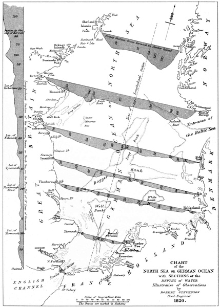
suitable for the object in view. It will be seen from
Plate XII. that the sections are laid down on what is now
known by engineers as sectio planography, which it is believed
was used for the first time in illustrating this paper.
“The efforts of man in exploring the more occult
processes of nature are necessarily much circumscribed,
especially when his attempts are directed to the investigation
of regions which his senses cannot penetrate. It has
accordingly been with the utmost difficulty that his exertions
have been rendered in any degree successful in prying
into the bowels of the earth, or in his endeavours to
ascend to the aërial regions. In proof of this, the limited
excavations even of the most extensive mining works,
have required the lapse of ages, and the powerful stimulus
of commercial enterprise, for their accomplishment. From
these the philosopher has not hitherto derived much light,
to enable him to compare the theories which have been
assigned by geologists to account for the various and
discordant appearances of the structure of the globe. It
has also been with much difficulty, and at no small
personal hazard, that the philosophical inquirer has
ventured to climb the highest mountains, to examine
into the phenomena of the atmosphere. The balloon has
indeed enabled us to attain still higher points of elevation;
but as yet we do not seem to have made proportional
progress in knowledge. In all such attempts to
ascend the greatest heights or penetrate the deepest
excavations, we still breathe in our own element, though
under different modifications. If, however, we would
explore the depths of the Ocean, we immediately encounter
an element to which the organisation of our lungs
is not at all adapted; the density of air, compared with
water on a level with the surface of the sea, being in the
ratio of one to about 850; and our difficulties must consequently
increase in a very rapid proportion. Here
therefore we are unavoidably left to conjecture on many
points of our inquiries regarding this highly interesting
subject. Even the ingenious contrivance of the diving
bell contributes but little towards our investigations for
ascertaining the nature of the bottom of the sea, at least
to any considerable depth, on account of the difficulty of
its application in situations exposed to stormy weather,
and also of the increasing ratio of the pressure of the fluid
as we descend. This curious machine, it is believed, was
invented and employed, about the year 1720, by a Captain
Rowe for raising the wreck of ships upon the coast of
Scotland; and in the year 1778, the active mind of
Smeaton first applied it to the operations of the engineer.
PLATE XII.
CHART
of the
NORTH SEA OR GERMAN OCEAN
with SECTIONS of the
DEPTHS of WATER
Illustrative of Observations
by
ROBERT STEVENSON
Civil Engineer
1820.
W. & A. K. Johnston, Edinburgh.
“Our knowledge of the bottom of the ocean, therefore,
remains still very imperfect, and, with little exception,
the simple apparatus of the mariner, consisting of a plummet
and line, continues to be chiefly in use for ascertaining
the depth of the sea and the nature of the ground. With
these, and the addition of a little grease applied to the
lower extremity of the plummet, which strikes against
the bottom, we learn the quality of the soil, though
imperfectly, by the particles which adhere to the grease.
What the navigator has yet been able to discover
regarding the depth and the nature of the bottom of the
German Ocean, I shall now endeavour to notice, being
myself enabled to offer the result of a pretty extensive
acquaintance with this field of inquiry.
“It may be necessary to premise, in treating of a subject
so extensive, and in comparing great things with
small, that we are obliged to speak of the North Sea as a
bay or basin, and of the immense collection of débris
which we meet with, extending over a great proportion
of its bottom, under the common appellation of sand
banks. We must also be allowed to consider the undulating
line, or the irregularities of the bottom, to arise
chiefly from the accumulation of deposited matters; and
in most of the situations connected with these banks, we
are supported and borne out in this conclusion, by their
local positions relatively to the openings of firths, and the
line of their direction in regard to the set or current of
the ebb tide.
“The accompanying map (Plate XII.) of the eastern
coast of Great Britain, with the opposite Continent, though
upon a small scale, exhibits numerous soundings of the
depth of the German Ocean; and the sections delineated
on it will perhaps be found to give a pretty distinct view
of the subject. This chart extends from the coast of
France, in latitude 50° 57´ to 61° N. On the east, this
great basin is bounded by Denmark and Norway, on the
west by the British Isles, on the south by Germany,
Holland, and France, and on the north by the Shetland
Islands and the Great Northern or Arctic Ocean. The
term German Ocean, though in very common use, is
certainly not so comprehensive in its application to this
great basin as that of North Sea, now more generally used
by the navigator. The extent of this sea from south to
north, between the parallels of latitude quoted above, is
233 leagues, and its greatest breadth from west to east,
reckoning from St. Abb’s Head, on the coast of Scotland,
to Ringhjoöbing Fiord, on the opposite shore of Denmark,
is 135 leagues. The greatest depth of the water in this
basin seems to be upon the Norwegian side, where the
soundings give 190 fathoms; but the mean depth of the
whole may be stated at only about 31 fathoms.
“To be more particular with regard to the depth of the
German Ocean, or North Sea, it will be observed by the
sections and soundings marked upon the chart, that the
water gradually deepens as we sail from south to north.
The first of these sections which we shall notice is on the
parallel of three degrees of east longitude, running from
Ostend to the latitude of the northmost of the Shetland
Islands, being an extent of 227 leagues. The depth, as
will be seen from this section (which, to avoid confusion
in the body of the chart, is traced along the western side
of it), varies rather after an irregular progression, from
120 fathoms towards the northern extremity of this
sectional line, to 58, 38, 24, and 18 fathoms, as we proceed
southwards, to within five miles of the shore, nearer
which we do not approach in our remarks regarding the
soundings. Notwithstanding the irregularity of the depth
from the occurrence of numerous sandbanks, it is curious
to observe the increase upon the whole as we proceed from
south to north, by which this sea exhibits all the characteristic
features of a great bay, encumbered with numerous
sandbanks.
“In the same manner, though not strictly connected
with our present purpose, we may observe that the
English Channel deepens progressively from Dover to its
entrance, formed by the Land’s End of England and the
Isle of Ushant, on the coast of France; so that the Strait
between Dover and Calais may be said to form a point of
partition between two great inclined planes, forming the
bottom of these seas.
“Besides the longitudinal, or north and south sectional
line described above, we have also six other sections
delineated in an easterly and westerly direction, across
the accompanying chart, which are as follow. One
between the Shetland Islands and the coast of Norway;
a second between Tarbetness in Ross-shire and the Naze
of Norway; a third extends from the Firth of Forth to
the coast of Denmark; a fourth from the mouth of the
river Tyne to Sylt Island, also in Denmark; a fifth from
Flamborough Head, in Yorkshire, to the mouth of the
River Elbe; and the sixth is from Yarmouth to Egmond-op-Zee,
on the coast of Holland. Other sections of this
sea have also been made, which include the general elevation
of the land, as, for example, one of these extends
from Holland across the German Ocean to the Thames,
and through the interior of the country to the Bristol
Channel; then crossing St. George’s Channel, this sectional
line passes through the southern extremity of
Ireland, and falls into the Atlantic Ocean; but this will
be more particularly noticed, when I come to speak of the
bed of the English Channel, in a future paper.
“On examining the accompanying cross sections of the
depths of water on the same parallel they will be found
to vary considerably. It may, however, be stated as a
general conclusion, that there is a greater depth of water
on the eastern and western sides of the German Ocean
than in its central parts, and that, upon the whole, it is
deeper on the British than on the continental shores, the
coast of Norway excepted.
“We have already observed, that this sea is much
encumbered with sandbanks, or great accumulations of
débris, especially in the middle or central parts, and also
along the shores towards what may be termed the apex
of the bay, extending from the river Thames along the
shores of Holland, etc., to the Baltic. One of these great
central banks, delineated on the chart, and known to
mariners as the Long Forties, trends north-east in the
direction of the ebb tide from the entrance of the Firth
of Forth no less than 110 miles, while the Denmark and
Jutland banks may also be traced on the chart from the
entrance of the Baltic, upwards of 105 miles in a north-western
direction. Besides these, we have also another
great central range of banks, which is crossed by no fewer
than four of our sectional lines. These are known under
the common appellation of the Dogger Bank, which is
subdivided by the navigator into the Long Bank, the
White Bank, and the Well Bank, including an extent of
upwards of 354 miles from north to south. There are
also a vast number of shoals and sandbanks, lying wholly
to the southward of our section, between Flamborough
Head and Heligoland. Altogether, therefore, the superficies
of these extensive banks is found to occupy no
inconsiderable portion of the whole area of the German
Ocean; the surface of which, in making these investigations,
has been estimated to contain about 153,709 square
miles, while the aggregate superficial contents of the
sandbanks alone amount to no less than 27,443 square
miles, or include an area of about 5¾ of the whole surface
of the North Sea.
“But to render these dimensions a little more familiar
by comparison, we may notice, that the Island of Great
Britain contains about 77,244 square miles, being not
quite one half of the area of the North Sea; so that the
area of the sandbanks bears a proportion equal to about
one third of the whole terra firma of England and Scotland;
and they are, therefore, perhaps, far more considerable
in their extent than has been generally imagined.
“In speaking of the dimensions of sandbanks situate
in the middle of the ocean, we are aware that great allowance
must be made in forming a proper estimate of their
extent, especially in speaking of their cubical contents.
From a vast number of observations and comparisons
relative to this subject, I have, however, been enabled to
determine, that the average height of these banks measures
about seventy-eight feet, from a mean taken of the whole.
In ascertaining their height above the surrounding bottom,
the measurement has been taken from the general depth
around each respectively. Now, upon taking the aggregate
cubical contents of the whole of these immense collections
of débris, supposing the mass to be uniformly the
same throughout, it is found to amount to no less a
quantity than 2,241,248,563,110 of cubic yards, being
equal to about fourteen feet of the depth of the whole
German Ocean, or to a portion of the firm ground of
Great Britain, on a level with the sea, taken twenty-eight
feet in perpendicular height or depth, supposing the
surface to be a level plane.
“These calculations at least tend to show that an
immense body of water must be displaced, in consequence
of these banks occupying so very considerable a proportion
of the bed of the North Sea, the unavoidable effect of
which must give a direct tendency to the tidal waters,
and the flux produced by storms in the Atlantic, to overflow
the bed of the German Ocean, in the same manner
as if stones or other matter were thrown into a vessel
already nearly brimful of water. This may further be
illustrated by considering the actual state of any of the
great inland lakes, as those of Geneva, Lochness, Lochlomond,
etc., which for ages past have been receiving the
débris of the surrounding mountains. We must doubtless
allow that they contain a smaller portion of water, or are
actually of a less depth than they were at an earlier period
of the history of the globe. Accordingly, from inquiries,
which, in the prosecution of this subject, I have been led
to make regarding the two last mentioned lakes, it has
satisfactorily appeared that their waters are subject to
overflow or rise upon their banks. On Lochlomond, in
particular, the site of a house at the village of Luss was
pointed out to me, which is now permanently under the
summer water mark, while the gable of another house in
its neighbourhood is in danger of being washed down by
the increase of the waters of the loch. Whether this
striking appearance is to be attributed wholly to natural
causes, or partly to artificial operations upon the bed of
the river Leven, flowing from the loch, I have had no
opportunity of inquiring. But the great bench or flat
space round the margin of the loch, which is left partly
dry during summer, forms altogether such a receptacle
for débris as to be sufficient to affect the surface of the
loch, and indeed permanently to raise its waters. We
also infer, though by a different process, that the constant
deposition going forward in the bed of the German Ocean
must likewise displace its waters, and give them a tendency
to enlarge their bed and to overflow their banks or
boundary.
“In this view of the subject, it will appear that we have
not only to account for the supply of an immense quantity
of débris, but we must also dispose of the water displaced
by the process of deposition which is continually going
forward at the bottom of the ocean.
“With regard, then, to the supply of the débris of which
these banks are composed.—We find that a very great
portion of it consists of siliceous matters in the form of
sand, varying in size from the finest grains to coarse
bulky particles, mixed with coral and pounded shells, the
quantity of these calcareous matters being altogether
astonishingly great; and being specifically lighter than
the particles of sand, the shells generally cover the surface
of these sunken banks. With regard to the vast collection
of siliceous particles connected with the banks, our surprise
ceases when we consider the receptacle which the
North Sea forms, to an almost unlimited extent of drainage
from the surrounding countries, on which the change of
the seasons, and the succession of rain and of drought
upon the surface of the earth, are unceasingly producing
their destructive effects. All have remarked the quantity
of mud and débris with which every rill and river is
charged, even after the gentlest shower; especially
wherever the hand of the agriculturist is to be found.
His labours in keeping up the fertilising quality of the
ground consist in a great measure in preparing a fresh
matrix for the chemical process or the germination of the
seeds of the earth, in lieu of that portion of the finely
pulverised soil which the rains are perpetually carrying to
the sea, as the grand receptacle and storehouse of nature
for these exuviæ of the globe. From the effect of rills
and rivulets, we should, perhaps, rather be apt to expect
a greater deposition in the bed of sheltered bays and arms
of the sea than we really observe. So that we can readily
believe that the quantity of débris, even for a single year,
along such an extent of coast, may bear some consideration
in respect to the bed of the German Ocean; what, then,
must these effects produce in the lapse of ages?
“Whatever be the cause, the fact is certain, that on
almost every part of the shores of Great Britain and
Ireland, and their connecting islands, from the northernmost
of the Shetland to the southernmost of the Scilly
Islands, and also upon the shores of Holland, and part of
France, particularly in the neighbourhood of Cherbourg,
this wasting effect is going forward. These shores I have
myself examined. But my inquiries have not been confined
to the coasts which I have personally visited, having
also, through the kind attentions of some nautical friends,
been enabled to extend my investigations even to the
remotest parts of the globe. The general result has been,
that equally in the most sheltered seas, such as the Baltic
and Mediterranean, and on the most exposed points and
promontories of the coasts of North and South America,
and the West India Islands, abundant proofs occur, all
tending to show the general waste of the land by the
encroachments of the sea. Such wasting effects are quite
familiar to those locally acquainted with particular portions
of the shores; and I have often received their testimony
to these facts, as the sad experience of the removal
of buildings, and the inundation of extensive tracts of land
by the encroachment of the sea.
“Indeed, by a closer inquiry into this department of
the subject, we shall, perhaps, find ourselves rather at a
loss to account for the smallness of the quantity of this
deposition, considering the waste which is constantly
going forward in the process of nature, and even be led
to seek for its wider distribution over the whole expanse
of the bed of the ocean, as has been supposed in that
theory of the globe, so beautifully and so ably defended
by our late illustrious countryman Professor Playfair.
“One of the most striking and general examples of this
kind may perhaps be found in the abrupt and precipitous
headlands and shores which we everywhere observe along
the coast, and which we suppose to have once been of the
same sloping form and declining aspect with the contiguous
land. In the production of these effects alone, an
immense quantity of débris must have been thrown into
the bed of the ocean. The channels which are cut by
the sea in the separation of parts of the mainland, and
the formation of islands, no doubt make way for a considerable
portion of the displaced fluid; but still these
channels, when filled with water, come far short, in point
of bulk, when compared with the portions of the elevated
land which are thus removed. Now, it has been alleged
by some, that while the land is wasting at certain points,
it is also gaining in others; and this is a state of things
which is freely admitted to take place in various quarters;
yet these apparent acquisitions are no more to be compared
with the waste alluded to, than the drop is to the
water of the bucket. But accurate observations regarding
the formation of extensive sandbanks, and the accumulation
of the débris, of which they are formed, are not to be
made in a few years, perhaps not in a century, nor indeed
in several centuries; for although the short period of the
life of man is sufficient to afford the most incontrovertible
proofs of the waste of the land where we become observers,
yet when we extend our views to the depths of the ocean,
and speak of the events and changes which are there going
forward, we must not be supposed to set limits to time.
“We have many convincing proofs in the natural
history of the globe, that the sea has at one time occupied
a much higher elevation than at present. On the banks of
the Firth of Forth, near Borrowstounness, for example, I
have seen a bed of marine shells, which is several feet in
thickness, and has been found to extend about three
miles in length, and which is now situate many feet above
the present level of the waters of the Forth. A recent
illustration of this subject occurred also in the remarkable
discovery of the skeleton of a large whale, found in the
lands of Airthrey, near Stirling,—the present surface of
the ground where the remains of this huge animal were
deposited, having been ascertained (by my assistants,
when lately in that neighbourhood) to be no less than
twenty-four feet nine inches above the present level of the
Firth of Forth at high water of spring tides. Now,
whether we are to consider these as proofs of the higher
elevation of the waters of the ocean in the most general
acceptation of the word, at a former period, I will not
here attempt to inquire. But aside from these anomalous
appearances, there is reason for thinking that the waters
of the higher parts of the Firth of Forth, like those of the
Moray Firth, may, at one time, have formed a succession
of lakes, with distinct barriers, as we find in the case of
Lochness, and the other lakes forming the track of the
Caledonian Canal. My object on the present occasion,
however, is simply to notice the wasting effects of the
North Sea upon the surrounding land, its deposition in
the bottom of the sea, and the consequent production
of surplus waters at the surface, and to endeavour to
account for these appearances consistently with the laws
of nature. The opinion accordingly which I have formed,
and the theory which I have humbly to suggest (for I
am not aware that this subject has been before particularly
noticed) is, that the silting up of the great basin of the
North Sea has a direct tendency to cause its waters to
overflow their banks.
“Referring to the chart, we find that the North Sea is
surrounded with land, excepting at two inlets or apertures,
the one extending about 100 leagues, between the
Orkney Islands and the Norwegian coast, and the other
between Dover and Calais, which is of the width of seven
leagues. The aggregate waterway of these two passages
forms the track for the tidal waters, and also for the
surplus waters produced during storms which affect the
Atlantic and Arctic Oceans. It is also obvious that this
waterway must remain nearly the same, and admit a
constant quantity; or, to speak more correctly, by allowing
these inlets to follow the general law, they must be
enlarged by the waste or wearing of their sides, in a
ratio perhaps greater than the silting up of the bottom in
those particular parts, while the interior and central
portions of the German Ocean are continually acquiring
additional quantities of débris, along with the drainage
water of the widely surrounding countries. If therefore
the same, or a greater quantity of tidal and surplus
waters continue to be admitted from the Atlantic and
Arctic Seas into this great basin, where the process of
deposition is constantly going forward, it is evident that
the surface of the German Ocean must be elevated in a
temporary and proportionate degree, and hence the production
of those wasting and destructive effects which
are everywhere observable upon its shores.
“This reasoning is also applicable, in a greater or less
degree, to all parts of the world; for as the same cause
everywhere exists, the same effects, when narrowly examined,
must everywhere be produced. In the Southern
or Pacific Ocean we have wonderful examples of great
masses of land formed by madrepores and extensive coral
banks, which in time assume all the characteristic features
of islands. These occupy considerable portions of the
watery bed of the ocean, and displace corresponding
portions of the fluid. Immense quantities of mud are
also said to be deposited in the Yellow Sea of China, in
the great deltas formed at the mouths of the Ganges, the
Plate, the Amazon, the Mississippi, the St. Lawrence, the
Nile, the Rhine, and other large rivers, whose joint operations,
both at the surface and bottom of the ocean, are
continually carrying forward the same great process of
displacing the waters of the ocean; for it matters not to
this question whether the débris of the higher country
which is carried down by the rains and rivers, or is occasioned
by the direct waste produced by the ocean itself
on the margin of the land, be deposited at the bottom or
surface of the ocean, it must still be allowed to displace
an equal or greater bulk of the fluid, and has therefore
a direct tendency to produce the derangement which we
are here endeavouring to describe.
“A striking illustration of this doctrine may be drawn
from M. Girard’s able and ingenious observations on the
delta of Egypt, made in 1799, and published in the Mem.
de l’Acad. for 1817, in a memoir Observations sur la Vallée
d’Égypte, et sur l’exhaussement séculaire du sol qui la
recouvre. It appears that the whole soil of the “Valley
of the Nile” is very considerably increased by the alluvium
deposited annually by the inundations of the Nile, as
ascertained by the marks on some ancient Nilometers and
statues, the dates of which have been traced and compared
by Girard, with the corresponding historical periods. In
the quarter of Thebes, where the statue of Memnon is
erected, the increase of the soil since the commencement
of the Christian era is lm. 924 (6 feet 3·7 inches), or this
process may be stated as going forward at the rate of
0m. 106 (4·17 inches) in the course of each century. The
magnitude of the deposits at the mouths of the Nile, in the
bed of the Mediterranean, appears to be no less surprising.
It is remarked that the Isle of Pharos, which in the time
of Homer was a day’s journey from the coast of Egypt,
is now united to the continent.
“If, then, we compare these effects with the same
process, going forward in a certain proportionate rate
over all parts of the globe, and where the same facilities
for these depositions being made on firm ground are not
afforded, we shall find that the quantity of deposit in the
bottom of the ocean must be so considerable as to affect
the level of the waters of the ocean.
“In thus disposing of the waste of the surrounding
land beyond the accumulation of the sunken banks in
the German Ocean, we are not left at any loss for a distributing
cause, as this is provided by the tides and
currents of the sea; and with regard to their action we
have many proofs, even at very considerable depths, by
the breaking up of the wrecks of ships, the occasional
drift of seaweed, and also drift timber, nuts, etc., into
regions far distant from those in which they are spontaneously
produced. The dispersion of fishes, evinced by
their disappearance from the fishing grounds in stormy
weather, tends to show the disturbance of the waters of
the ocean to the depth of thirty or forty fathoms. This
observation I have frequently had an opportunity of
making near the entrance of the Firth of Forth. Numerous
proofs of the sea being disturbed to a considerable
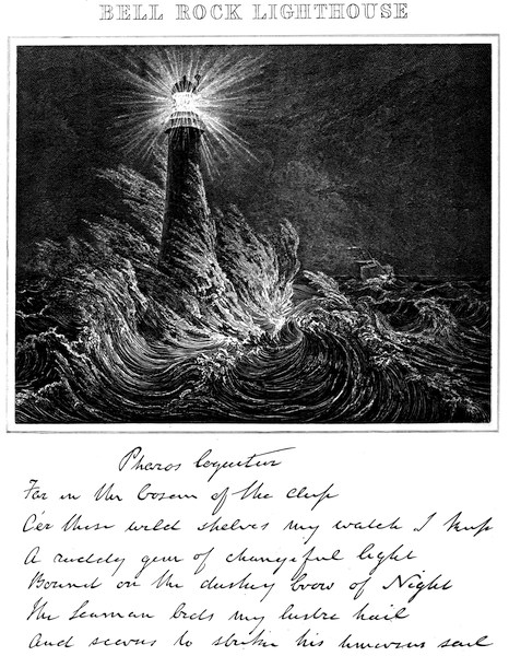
depth have also occurred since the erection of the Bell
Rock Lighthouse, situate upon a sunken rock in the sea,
twelve miles off Arbroath, in Forfarshire. Some drift
stones of large dimensions, measuring upwards of thirty
cubic feet, or more than two tons weight, have, during
storms, been often thrown upon the rock from the deep
water. These large boulder stones are so familiar to the
lightkeepers at this station as to be by them termed
travellers. It is therefore extremely probable, that a
large portion of the débris is carried down with the
drainage water of the higher country, as before noticed,
and ultimately washed out of the North Sea into the
expanse of the ocean.
“The question which naturally arises as to the result
of all this waste or transposition of the solid matters of a
large portion of the globe, is to inquire what has become
of the body of water displaced by this wasting process.
Without attempting to go into all the minutiæ of this
part of the subject, I shall here briefly observe, that
there seems to exist (if I may be allowed so to express
myself) a kind of compensating arrangement between
the solid or earthy particles of the globe in the one
case, and the waters of the ocean in the other. Thus
by the process of evaporation, and the universal application
of water, which enters so largely, in its simple or
chemical state, into the whole animate and inanimate
creation, the surface of the ocean may be kept nearly at
a uniform level. Phenomena of this description are, no
doubt, difficult in their solution upon the great scale,
being met by the process of decomposition, which resolves
bodies into their constituent parts, and also by our theory
of the atmosphere, by which its limits and operations are
determined. But were we to abstract our attention from
the more general view of the subject, and confine our
inquiries to the German Ocean, the Baltic, the Mediterranean,
the Red Sea, or to any other inland and circumscribed
parts of the ocean, this difficulty seems to be
lessened. Indeed, the probability is, and it is a pretty
generally received opinion, that a greater quantity of
water is actually admitted at the Straits of Gibraltar
and of Babelmandel than flows out of the Mediterranean
and Red Seas. We consider water, therefore, as the
great pabulum of nature, which, as before noticed, enters
either simply or chemically into the constitution of all
bodies, and appears to be held, almost exclusively, in
solution, in the formation and maintenance of the whole
animal and vegetable kingdoms, and is found to exist
largely in the composition of all mineral substances. The
quantity of water, consequently, that is required, and is
continually supplied from the ocean by the process of
evaporation, both for the support and reanimation of
nature, must be immense, and may of course be supposed
permanently to absorb a very large proportion of the
surplus waters of these circumscribed seas, while the
remaining portion of surplus water, if not thus wholly
accounted for, may be distributed over the general
expanse of the ocean.
“But if we suppose with some, that in nature there is
neither an excess nor diminution of the waters of the
globe, and that the united and counterbalancing processes
of evaporation, condensation, decomposition, and regeneration,
so completely equalise each other, that the surplus
waters, arising from the displacement of a portion of
the solid surface of the globe, must again be wholly distributed
and intermixed with the waters of the ocean,
the portion of water remaining thus to be accounted for
becomes more considerable, and, upon the great scale,
must be permanently disposed of, independently of the
process of evaporation.
“Another view has been suggested as applicable to
the distribution of the surplus waters produced by the
gradual filling up of the bed of the ocean. These waters,
in place of being elevated in any sensible degree, may be
naturally disposed to find their level in the great polar
basins, or oblate portions of the surface of the globe which
are known to exist next the poles. The oblate figure of
the earth at the poles makes these imaginary points the
nearest to the centre of the earth, and consequently, with
regard to level, they are also the lowest. It therefore
appears to follow, that any filling up of the bed of the sea
near the equator, or at a distance from the poles, will
have the effect of promoting the retiring of the surplus
waters to the polar regions by their own gravity, while
the centrifugal force occasioned by the earth’s diurnal
motion will prevent their being further removed from
the earth’s centre, without a corresponding elevation of
the waters in the great polar basins.
“In this manner, such an accumulation of water may,
at a former period of time, have taken place at the then
poles of the globe, as to have altered the position of these
points, and given rise to the Flood, or temporary general
overflowing of the waters over the earth’s surface, producing
a change in the beds of the seas or oceans of former
times. In this way may have been produced many of the
phenomena observable in the crust of the earth, which
are otherwise with much difficulty accounted for.
“Of what has now been advanced, regarding the waste
of the land by the operations of the sea, it will be proper
to notice that much consists with my own personal observation.
The consequences of this process must be the
deposition of débris, and a tendency to raise the bottom
of the ocean and produce a proportional elevation of the
water. With regard, however, to the distribution of the
surplus waters that is produced, what I have now said is
offered with much deference, in the hope that some one
better qualified than myself will turn his attention to
this curious subject.”
* * * * *
In connection with this discussion I give the following
interesting account of observations on the estuary of the
Mersey:—
“On a former occasion I had the honour to make a few
observations which appeared in the second volume of the
Society’s Memoirs regarding the encroachment of the sea
upon the land generally. The present notice refers only
to that portion of the coast which lies between the rivers
Mersey and Dee, extending to about seven miles.
“To this quarter my attention, with that of Mr.
Nimmo, Civil Engineer, had been professionally directed
in the course of last month. In our preambulatory survey
we were accompanied by Sir John Tobin and William
Laird, Esq., of Liverpool, along the Cheshire shore and
its connecting sandbanks between Wallasey Pool in the
Mersey, and Dalpool in the river Dee.
“Within these estuaries the shores may be described
as abrupt, consisting of red clay and marl, containing
many land or boulder stones of the cubic contents of
several tons, and very many of much smaller size, diminishing
to coarse gravel. But the foreland or northern
shore between these rivers, which I am now to notice, is
chiefly low ground, and to a great extent is under the
level of the highest tides. The beach or ebb extends
from 300 to 400 yards seaward, and toward low water
mark exposes a section of red clay; but toward high
water it consists of bluish coloured marl, with peat or
moss overlaid by sand. This beach, at about tide level,
presents a curious and highly interesting spectacle of the
remains of a submarine forest. The numerous roots of
trees, which have not been washed away by the sea, or
carried off by the neighbouring inhabitants for firewood,
are in a very decayed state. The trees seem to have
been cut off about two feet from the ground, after the
usual practice in felling timber, and the roots are seen
ramifying from their respective stumps in all directions,
and dipping towards the clay subsoil. They seem to
have varied in size from eighteen inches to perhaps thirty
inches in diameter, and when cut with a knife appear to
be oak. Several of the boles or trunks have also been
left upon the ground, and being partly immersed in the
sand and clay, are now in such a decomposed state that,
when dug into with a common spade, great numbers of
the shell fish called Pholas candida, measuring about
three fourths of an inch in length and two inches in
breadth, were found apparently in a healthy state. These
proofs of the former state of this ebb or shore—now upwards
of twenty feet under full tide—having been once
dry land to a considerable extent beyond the region of
these large forest trees were rendered still more evident
by the occurrence of large masses of greenstone, which, at
a former period, had been embedded in the firm ground
here, and especially on the shore within the river Dee.
It may further deserve notice that the inhabitants of this
district have a traditional rhyme expressive of the former
wooded state of this coast, where not a tree is now to be
seen, viz., “From Birkenhead to Helbre a squirrel
may hop from tree to tree;” that is, from the Dee to the
Mersey, now presenting a submarine forest.
“As these evidences of great changes upon the state and
former appearances of the land were highly interesting to
the party, and intimately connected with the professional
inquiries of myself and colleague, it seemed desirable, if
possible, to get them corroborated by oral testimony.
Sir John Tobin accordingly very obligingly took measures
for examining the oldest people in the neighbourhood as
to their recollection of the former state of these shores. In
particular, Thomas Barclay, aged ninety-three, “all but
two months,” by profession a mason and measurer of
country work; Henry Youd, labourer, aged eighty-six;
and John Crooksan, labourer, aged eighty, were examined.
Barclay stated that he had been employed at the erection
of the Leasowe landward lighthouse in the year 1764;
that there were then two lighthouses near the shore, for
a leading direction to shipping through the proper channel
to Liverpool; and that the seaward light became uninhabitable
from its being surrounded by the sea. A new
light was then built upon Bidstone Hill, and the present
Leasowe Lighthouse, formerly the landward light which
he had assisted in building, became the sea light. He
could not condescend upon the distance between the two
original lights, but was certain that it must have been
several hundred yards; that he knows that in the course
of thirty years the shore of the Leasowe lost by measurement
eleven Cheshire roods or eighty-eight yards; and
verily believes that, since he knew this shore, it has lost
upwards of half a mile of firm ground. To the correctness
of these statements the other two aged men gave ample
testimony, Henry Youd having also worked at the lighthouse.
“As to the present state of things, the party alluded
to were eye-witnesses of the tides on the 16th, 17th, and
18th of February 1828, having exhibited a very alarming
example of the encroachment of the sea upon the Leasowe
shore. At high water it came over the bank, and ran in
a stream of about half a mile in breadth surrounding the
lighthouse, and continued its course through the low
grounds toward Wallasey Pool on the Mersey, thereby
forming a new channel, and threatening to lay several
thousands of acres of rich arable and pasture lands into
the state of a permanent salt lake. The present Leasowe
Lighthouse, which, in 1764, was considered far above the
reach of the sea, upon the 17th of February last was thus
surrounded by salt water, and must soon be abandoned
unless some very extensive works be undertaken for the
defence of the beach, the whole of the interior lands of
the Leasowe being considerably under the level of high
water of spring tides.
“This coast, with its sandbanks in the offing, its submarine
forest, and the evidence of living witnesses as to
the encroachment of the sea upon the firm ground, is
altogether highly interesting to the geological and scientific
inquirer. The remains of forests in the bed of the
ocean occur in several parts of the British coast, particularly
off Lincoln, on the banks of the Tay near Flisk, at
Skail in the mainland of Orkney, and in other places
noticed in the Transactions of this Society, and are strong
proofs of the encroachments of the sea upon the land.
However difficult, therefore, it may be to reconcile the
varied appearances in nature regarding the sea having at
one time occupied a higher level than at present, yet its
encroachment as a general and almost universal principle
seems to be beyond doubt in the present day.
“Since I had last the honour of addressing the Society
on this subject, opportunities have been afforded me of
making many additional observations on the British
shores, and of personally extending these to almost every
port on the Continent between the Texel and the Garonne.
I have also, through the obliging communications of friends,
been enabled to extend my inquiries to other quarters of
the globe, and I am now prepared to state that, with a
few comparatively trifling exceptions, the sea appears to
be universally gaining upon the land, tending to confirm
the theory that débris arising from the general degradation
of the land, being deposited in the bed of the minor
seas, is the cause of their present tendency to overflow
their banks.”
Mr. Stevenson’s discovery that the salt water of the
ocean flows up the beds of rivers in a stream quite distinct
from the outflowing fresh water, was made in 1812, when
investigating a question regarding salmon fishings on the
Dee. It is described in the following extract from his
Report:—
“The reporter observed in the course of his survey that
the current of the river continued to flow towards the sea
with as much apparent velocity during flood as during
ebb tide, while the surface of the river rose and fell in a
regular manner with the waters of the ocean. He was
led from these observations to inquire more particularly
into this phenomenon, and he accordingly had an apparatus
prepared under his directions at Aberdeen, which,
in the most satisfactory manner, showed the existence of
two distinct layers or strata of water; the lower stratum
consisting of salt or sea water, and the upper one of the
fresh water of the river, which, from its specific gravity
being less, floated on the top during the whole of flood as
well as ebb tide. This apparatus consisted of a bottle or
glass jar, the mouth of which measured about two and a
half inches in diameter, and was carefully stopped with a
wooden plug, and luted with wax; a hole about half an
inch in diameter was then bored in the plug, and to this
an iron peg was fitted. To prevent accident in the event
of the jar touching the bottom, it was coated with flannel.
The jar so prepared was fixed to a spar of timber, which
was graduated to feet and inches, for the convenience of
readily ascertaining the depth to which the instrument
was plunged, and from which the water was brought up.
A small cord was attached to the iron pin for the purpose
of drawing it, at pleasure, for the admission of the water.
When an experiment was made the bottle was plunged
into the water; by drawing the cord at any depth within
the range of the rod to which it was attached, the iron
peg was lifted or drawn, and the bottle was by this means
filled with water. The peg was again dropped into its
place, and the apparatus raised to the surface, containing
a specimen of water of the quality at the depth to which
it was plunged. In this manner the reporter ascertained
that the salt or tidal water of the ocean flowed up the
channel of the river Dee, and also up Footdee and Torryburn,
in a distinct stratum next the bottom and under
the fresh water of the river, which, owing to the specific
gravity being less, floated upon it, continuing perfectly
fresh, and flowing in its usual course towards the sea, the
only change discoverable being in its level, which was
raised by the salt water forcing its way under it. The
tidal water so forced up continued salt; and when the
specimens from the bottom, obtained in the manner described,
were compared with those taken at the surface by
means of the common hydrometer of the brewer (the only
instrument to which the reporter had access at the time),
the lower stratum was always found to possess the
greater specific gravity due to salt over fresh water.”
The instrument Mr. Stevenson then invented and used
was that to which the term hydrophore has been applied.
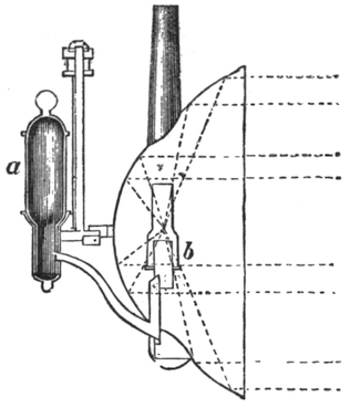
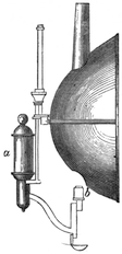
Figs. 18 and 19 show two forms of hydrophores made
under his directions.
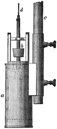
Fig. 18.
Fig. 18 is used for procuring specimens of water from
moderate depths, drawn on a scale of one-tenth of the full
size. It consists of a tight tin cylinder, a, having a
conical valve in its top, b, which is represented in the
diagram as being raised for the admission of water. The
valve is fixed dead, or immoveable, on
a rod working in guides, the one resting
between two uprights of brass
above the cylinder, and the other in
its interior, as shown in faintly dotted
lines. The valve rod is by this means
caused to move in a truly vertical line,
and the valve attached to it consequently
fills or closes the hole in the
top of the cylinder with greater accuracy
than if its motion was undirected.
A graduated pole or rod of iron, c,
which in the diagram is shown broken
off, is attached to the instrument, its end being inserted
into the small tin cylinder at the side of the large water
cylinder, and there fixed by the clamp screws shown
in the diagram; the bottom of the water cylinder may
be loaded with lead to any extent required, for the
purpose of causing the apparatus to sink; but this, when
an iron rod is used for lowering it, is hardly necessary.
The spindle carrying the valve has an eye in its upper
extremity, to which a cord is attached for the purpose of
opening the valve when the water is to be admitted, and
on releasing the cord, it again closes by its own weight.
When the hydrophore is to be used, it is lowered to the
required depth by the pole which is fixed to its side, or,
if the depth be greater than the range of the pole, it is
loaded with weights, and let down by means of a rope so
attached as to keep it in a vertical position. When the
apparatus has been lowered as far as is required, the small
cord is pulled, and the vessel is immediately filled with
the water which is to be found at that depth. The cord
being then thrown slack, the valve descends and closes
the opening, and the instrument is slowly raised to the
surface by means of the rod or rope, as the case may be,
care being taken to preserve it in a vertical position.
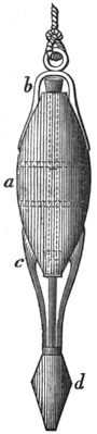
Fig. 19.
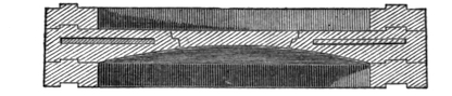
The form of hydrophore represented in Fig. 19 is used
in deep water, to which the small one just described
is inapplicable. It consists of an egg-shaped
vessel a, made of thick lead to give the apparatus
weight, having two valves, b and c, one in
the top and another in the bottom, both opening
upwards; these valves (which are represented
as open in the diagram) are, to insure more perfect
fitting, fixed on separate spindles, which
work in guides, in the same manner as in the
instrument shown in Fig. 18. The valves, however,
in this instrument are not opened by means
of a cord, but by the impact of the projecting
part, d, of the lower spindle on the bottom,
when the hydrophore is sunk to that depth.
By this means the lower valve is forced upwards, and the
upper spindle (the lower extremity of which is made nearly
to touch the upper extremity of the lower one, when the
valves are shut) is at the same time forced up, carrying
along with it the upper valve, which allows the air to
escape, and the water rushing in fills the vessel. On
raising the instrument from the bottom, both valves again
shut by their own weight, and that of the mass of lead, d,
which forms part of the lower spindle. The mode of using
this hydrophore is sufficiently obvious; it is lowered by
means of a rope, made fast to a ring at the top, as shown in
Fig. 19, until it strikes on the bottom, when the valves are
opened in the manner described, and the vessel is filled;
on raising it the valves close, and the vessel can be drawn
to the surface without its contents being mixed with the
superincumbent water through which it has to pass. This
instrument, shown on a scale of one twentieth of full size,
weighs about half a hundredweight, and has been easily
used in from thirty to forty fathoms water.
* * * * *
Mr. Stevenson subsequently extended his experiments
on the density of salt and fresh water to several firths
and tidal rivers, and gave the results in a paper communicated
to the Royal Society of Edinburgh in May
1817, of which the following digest is given in Thomson’s
Annals of Philosophy:14—
“The waters of the Thames opposite the London
Dock gates were found to be perfectly fresh throughout;
at Blackwall, even in spring tides, the water was found
to be only slightly saline; at Woolwich the proportion
of salt water increases, and so on to Gravesend. But the
strata of salt and fresh water are less distinctly marked
in the Thames than in any of those rivers on which Mr.
Stevenson has hitherto had an opportunity of making his
observations. But these inquiries are meant to be extended
to most of the principal rivers in the kingdom,
when an account of the whole will be given.
“From the series of observations made at and below
London Bridge, compared with the river as far up as Kew
and Oxford, Mr. Stevenson is of opinion that the waters
of the Thames seldom change, but are probably carried
up and down with the turn of the alternate tides for an
indefinite period, which, he is of opinion, may be one, if
not the principal cause of what is termed the extreme
softness of the waters of the Thames.
“Mr. Stevenson has made similar experiments on the
rivers Forth and Tay, and at Loch Eil, where the Caledonian
Canal joins the Western Sea. The aperture at
Corran Ferry, for the tidal waters of that Loch, being
small compared with the surface of Loch Eil, which
forms the drainage of a great extent of country, it
occurred to him that the waters of the surface must
have less saline particles than the waters of the bottom.
He accordingly lifted water from the surface at the anchorage
off Fort William, and found it to be 1008·2; at the
depth of 9 fathoms 1025·5; at the depth of 30 fathoms,
in the central parts of the Loch, it was 1027·2; being
the specific gravity of sea water.”
The hydrophore, which was originally devised and
used by Mr. Stevenson, in 1812, at Aberdeen, has now
reached its height of excellence of construction and scientific
importance in the famous ‘Challenger’ Expedition.