JOURNAL OF A TOUR IN ASIA MINOR, WITH
COMPARATIVE REMARKS ON THE
ANCIENT AND MODERN GEOGRAPHY
OF THAT COUNTRY.
BY
WILLIAM MARTIN LEAKE, F.R.S. &c.
ACCOMPANIED BY A MAP.
LONDON:
JOHN MURRAY, ALBEMARLE-STREET.
1824.
PRINTED BY RICHARD TAYLOR,
SHOE-LANE.
PREFACE.
To the traveller who delights in tracing
vestiges of Grecian art and civilization
amidst modern barbarism and desolation,
and who may thus at once illustrate history
and collect valuable materials for the geographer
and the artist—there is no country
that now affords so fertile a field of discovery
as Asia Minor. Unfortunately, there is no
province of the Ottoman empire more difficult
to explore in detail. In European
Turkey, the effects of the Mahometan system
are somewhat tempered by its proximity
to civilised Europe, by its conscious
weakness, and by the great excess of the
Christian population over the Turkish: but
the Turk of Asia Minor, although he may
be convinced of the danger which threatens
the whole Ottoman empire, from the change
that has taken place in the relative power
of the Musulman and Christian world,
since his ancestors conquered the favoured
regions of which their successors have so
long been permitted to remain in the undisturbed
abuse—derives, nevertheless, a
strong feeling of confidence and security,
from his being further removed from the
Christian nations which he dreads; and
sensible that European Turkey must be the
first to fall before the conqueror, he feels
no restraint in the indulgence of his hatred
to the Christian name, beyond that which
may arise from the dictates of his religion,
or from the native hospitality of the people
of the East.
In Asia Minor, among the impediments
to a traveller’s success may be especially
reckoned the deserted state of the country,
which often puts the common necessaries
and conveniences of travelling out of
his reach; the continual disputes and wars
among the persons in power; the precarious
authority of the government of Constantinople,
which rendering its protection
ineffectual, makes the traveller’s success
depend upon the personal character of the
governor of each district; and the ignorance
and the suspicious temper of the Turks,
who have no idea of scientific travelling;
who cannot imagine any other motive for
our visits to that country, than a preparation
for hostile invasion, or a search after treasures
among the ruins of antiquity, and
whose suspicions of this nature are of course
most strong in the provinces which, like
Asia Minor, are the least frequented by us[1].
If the traveller’s prudence or good fortune
should obviate all these difficulties, and
should protect him from plague, banditti,
and other perils of a semibarbarous state
of society, he has still to dread the loss of
health, arising from the combined effects
of climate, fatigue, and privation; which
seldom fails to check his career before
he has completed his projected tour.
Asia Minor is still in that state in which
a disguised dress, an assumption of the
medical character, great patience and perseverance,
the sacrifice of all European
comforts, and the concealment of pecuniary
means, are necessary to enable the
traveller thoroughly to investigate the
country, when otherwise qualified for the
task by literary and scientific attainments,
and by an intimate knowledge of the language
and manners of the people.
Among modern travellers, two only have
yet traversed Asia Minor in various directions
for exploratory purposes; Paul Lucas
in the years 1705, 1706, and 1715, and Capt.
Macdonald Kinneir in the years 1813 and
1814. The rest have merely followed a single
route in passing through the country; even
the travels of the two persons just named,
amount only to a description of several
routes instead of one; the state of the provinces
and the mode of travelling having
rendered it impossible to make any of those
excursions from the main road, without
which the geography of an unknown country
cannot possibly be ascertained. It even
appears from the journal of Mr. Kinneir,
that the difficulties of travelling in Asia
Minor have rather increased of late years
than diminished. And hence he was unsuccessful
in all his attempts to explore particular
sites interesting to ancient history,
and was unfortunate in his collection of the
surest tests of ancient geography,—inscriptions.
The principality of Tshappán-Oglu, which
offered some security to the traveller, has
been broken up by his death; and that of
the family of Kara-Osmán-Oglu, the mildness
and equity of whose government over
the greater part of Æolis, Ionia and Lydia,
had attracted thither great numbers of
Greeks from Europe, has been put an end
to by the same impolitic jealousy of Sultan
Mahmud which is undermining his own security
and threatens the destruction of his
empire. There remain only a few dispersed
chieftains, most of them in a state of
doubtful allegiance to the Porte, in whose
districts, by good management and previous
preparation, the traveller might perhaps be
allowed to explore the country in safety.
In no other parts can he, unless with all
the requisites above stated, and a great sacrifice
of time, hope to effect more than a
rapid passage along the principal roads,
take a transient view of some of the remains
of antiquity, and note the distances
of places, and the general bearings of the
route, together with the relative situations
of a few hills or other remarkable objects
on either side of the road.
Under such circumstances, it is obvious
that the geography of Asia Minor can only
be improved by collecting and combining
the information contained in the journals of
modern travellers; by which means an approximation
to a detailed map of the country
may progressively be made. It was
with the view of contributing to this object
that I published the journal of two routes
through the central parts of Asia Minor,
in the second volume of the Rev. R. Walpole’s
Collection of Memoirs on Greece
and Asia Minor.
Having, since that publication, extended
over the whole peninsula the comparative
inquiry into its ancient and modern geography,
which was there confined to the
parts forming the subject of the journals,
the result has been, the map which accompanies
the present volume; the volume
itself containing, together with the
substance of the memoir in Mr. Walpole’s
Collection, the additional remarks suggested
by the more enlarged geographical inquiry.
As the remarks have become considerably
more voluminous than the journal,
I cannot flatter myself that the work in its
present form will possess much attraction
for the general reader. It can only pretend
to contain, when accompanied by the
map, all the existing information upon Asia
Minor most essential to the exploring traveller;
at the same time that it cannot fail
to offer some interest to the reader of ancient
history.
The modern authorities which have served
in the construction of the map are of two
kinds—the maritime, and those relating
to the interior of the country: the former
derived from celestial observations, or nautical
surveys on the sea coast; the latter,
from the routes of travellers. The maritime
being the most certain, and giving
accuracy of position to the two ends of
some of the principal routes, and consequently
in a great degree to the entire lines—may
be considered as the foundation of
the work.
The positions of Constantinople and
Smyrna are assumed from the concurrence
of several good observations. The entire
southern coast, from the Gulf of Iskenderún
to that of Mákri, together with several
parts of the coast between Mákri and
Smyrna, has been laid down from the Survey
of Captain Beaufort, which was made
in the years 1811 and 1812, by order of the
Admiralty, during the administration of
Mr. Yorke; and which was published in the
year 1820, by direction of the Lords Commissioners.
The principal points and the general
outline of the Pontic coast of the peninsula
have been adopted from the recently-published
chart of the Black Sea by Capt.
Gauttier, of the Royal Navy of France[2].
The western coast, from the Gulf of Elæa to
the mouth of the Hellespont, has been laid
down from Truguet and Racord, officers of
the French Navy, who accompanied Count
Choiseul Gouffier in his Embassy to the
Porte in 1784; and the result of whose labours
is published in the second volume
of M. Choiseul’s Voyage Pittoresque de la
Grèce.
In the interior of the peninsula the latitude
of some important points, as Kesaría,
Kónia, Afiom Karahissár, Kutáya, Manissa,
Brusa, Isnik, have been observed
by Niebuhr, Browne, or by Messrs. Chavasse
and Kinneir: the remaining construction
is nothing more than the result
of a comparison of the ancient geographers
and historians with the routes of modern
travellers, and with the descriptions of two
Turkish geographers, who lived about the
middle of the seventeenth century—Mustafa
Ben Abdalla Kalib Tsheleby, commonly
called Hadji Khalfa, and Abubekr
Ben Behrem of Damascus. Though little
is to be derived from these authors with
regard to the exact situation of towns,
their evidence on the orthography of names,
and their information on the political geography,
are of considerable utility.
The elder travellers, whose routes have
served in the construction of the Map, may
be confined to Tavernier, Tournefort, Paul
Lucas, Otter, and Pococke; for Bertrandon
de la Brocquière, de la Mottraye, and Le
Bruyn, afford no geographical matter that
is not contained in the others.
Tavernier informs us, in his introduction,
that he began his travels by a visit to England,
in the reign of James the First; he
died in 1685. Although he crossed Asia
Minor several times, in the way to Persia,
where his commercial speculations carried
him, he has left us nothing more than a
very brief description of two caravan routes
to Tokât: the one from Constantinople, by
Bóli, Tósia, and Amasía; the other from
Smyrna, by Kassabá, Allah-shehr, Afiom
Karahissár, Buhwudún, and across the Salt
country to the Kizil-Ermak, which he passed
at Kesre Kiupri.
Tournefort traversed Asia Minor only in
one direction, from Erzrúm by Tokát to
A´ngura, from whence he passed a little to
the north of Eski-shehr, to Brusa.
Paul Lucas was sent out in the year 1704,
by the same minister of Louis XIV. who
employed Tournefort on a similar expedition
in the Archipelago, the Black Sea, and
Armenia. But, unfortunately for our geographical
knowledge of Asia Minor, Lucas’s
qualifications were very inferior to those of
his contemporary; nor does he appear to
have been well adapted, by previous study,
even for those branches of investigation to
which his attention was particularly directed
by his employers; namely, the collecting
of coins and inscriptions.
By assuming the medical character, he
secured a good reception at several of the
provincial towns, and protection from the
governors, as far as their authority extended;
but the banditti which at that period
infested every part of the country, obliged
him always to travel in haste, and often in
the night; and he was not qualified to derive
as much advantage from journeys made
under such circumstances as a more experienced
and more enlightened traveller
might have done. He was generally careful
in noting the time employed in each
stage; but the names of places are often
disfigured by his careless mode of writing.
His ignorance and credulity made him delight
in repeating the absurd tales which
the traveller so often hears in these half-civilised
countries; at the same time that
he omitted the insertion of many useful
observations which he could not have failed
to make. In some instances he has repeated
the fabulous accounts of the natives as if
he had himself witnessed them, and has
thus rendered himself liable to the suspicion
of having wilfully imposed upon his
readers. There can be no doubt, however,
that his itinerary, abstracted from his narrative,
is as correct as he was capable of
making it. The geographical results, when
connected and compared with those of other
travellers, are a sufficient proof of this fact;
and Lucas, with all his faults, has furnished
us with a greater number of routes than any
other traveller in Asia Minor. In 1705 he
went from Constantinople to Nicomedia,
Nicæa, and Brusa; from Brusa to Kutaya,
Eski-shehr, A´ngura, Kir-shehr, Kesaría;
from Kesaría to Nigde, Bor, Erkle, and
Kónia; from Kónia to A´ngura, Beibazár,
Kíwa, Nicomedia, and Constantinople, to
which city he returned in February 1706.
In the autumn of the same year, after a
long journey in Greece, he set out on a second
tour in Asia Minor from Smyrna, travelling
by Sardes, to Allah-shehr, Alan-kiúi,
Burdur, Susu, and Adália; from Adália
to Susu, Isbarta, Egerder, Serkiserai,
and Kónia; from Kónia to Erkle, and over
Mount Taurus, by the Pylæ Ciliciæ to
A´dana, Tarsus, and thence into Syria. In
a third journey in Asia Minor, in the year
1715, Lucas went from Smyrna to Ghiuzel
Hissár by Tire; from thence by the valley
of the Mæander to Denizlú; and from Denizlú
by Burdur to Isbarta, from whence he
travelled the same road as before to Kónia.
He states also, but without giving any
particulars of his route, that he again visited
Kesaría; and that, after having returned to
to Kónia, he once more proceeded by the
Pylæ Ciliciæ to A´dana and into Syria.
Next to Lucas, Otter is the most useful
of the earlier travellers. He was a Swede,
sent to Persia by the Court of France in
1734. He crossed Asia Minor by the way
of Iznimid, Lefke, Inoghi, Eski-shehr, Ak-shehr,
Kónia, Erkle, and A´dana; and returned
from Persia by the route of Amasía
and Boli. His narrative is chiefly valuable
from his knowledge of the Turkish language,
and from his having previously
consulted some manuscript works in the
Royal Library at Paris, especially that of
Ibrahim Effendi, who first established a
Turkish press at Constantinople, and whose
information seems to accord with that of
Hadji Khalfa, and of Abubekr of Damascus.
Among our own countrymen, Pococke
is the only traveller of the last century who
has published his route with sufficient precision
to be of any use to the geographer;
but he has been extremely negligent in
noting bearings and distances: his narrative
is very obscure and confused; and his
journey in Asia Minor is consequently of
much less importance than it might have
been made by so enlightened, learned, and
persevering a traveller. In the year 1740,
after visiting a great part of Ionia and Caria,
he ascended the valley of the Mæander
and its branches to Ishekli and Sandukli,
from whence he crossed to Beiad, Sevrihissár,
and A´ngura. From A´ngura he
crossed to the northward into the great
eastern road from Constantinople, and returned
to that capital by the way of Boli
and Nicomedia.
Niebuhr traversed Asia Minor in the
year 1766, on his return from India by the
way of Baghdad, Mosúl, and Aleppo.
From Iskenderún he passed by Bayas to
Adana, and from thence by Erkle to Kónia,
Karahissár, Kutaya, and Brusa[3].
In the year 1797, Browne returned from
the interior of Africa by the way of Asia
Minor. From Aleppo and Aintab, he traversed
the range of Taurus to Bostán, Kesaría,
A´ngura, Sabanje, and Nicomedia.
Mr. M. Bruce[4] travelled the same route
in 1812, and has given us a diary of names
and distances not to be found in Browne’s
printed book of travels.
It was in the year 1797, also, that Olivier
passed through Asia Minor, from Celenderis
by Mout, Láranda, Kónia, Ak-shehr,
Afiom Karahissár, Kutaya, Yenishehr, Nicæa,
and Nicomedia.
Seetzen traversed Asia Minor from Constantinople
to Smyrna, and from Smyrna
to Afiom Karahissár, Ak-shehr, Kónia, Láranda,
Ibrala, and across Mount Taurus to
Karaduar (anciently Anchiale, the port of
Tarsus), from whence he passed by sea to
Seleuceia, the port of Antioch, now Suadíeh.
The distances and the names of the
places which he passed through, written
with great care, have been preserved; but
it is feared that the rest of his valuable
manuscripts are irretrievably lost[5].
In the year 1801, Browne again traversed
Asia Minor from Constantinople, by Nicomedia,
Brusa, Kutaya, Afiom Karahissár,
Ak-shehr, Kónia, Erkle, Tarsus.
Among recent travellers, Capt. M. Kinneir
has furnished us with the greatest
number of routes. These are; 1. from
Constantinople, by Nicæa, Eski-shehr,
Seid-el-Ghazi, and Germa, to A´ngura;
from A´ngura, by Uskát, to Kesaría; and
from Kesaría, by Nigde, Ketch-hissar[6],
and over Mount Taurus, by the Pylæ Ciliciæ,
to Tarsus, Adana, and Iskenderún.
2. From Celenderis to Mout, Láranda,
Kónia, Ak-shehr, Afiom Karahissár, Kutaya,
Brusa, Mudánia. 3. From Constantinople,
by Nicomedia, Sabanje, Turbali,
Boli, Kastamni[7], Samsún, Tarabizún, to
Erzrúm.
Mr. Kinneir was also one of the many
persons who, during the late war, crossed
the northern part of Asia Minor, to or from
Persia by the way of Boli, Amasía, and
Tokát.
Another road, which has been still more
followed, is from Brusa or from Mikhalitza,
by Ulubad and Magnesia, to Smyrna, or
in the opposite direction: the latitudes of
all the principal places on it have been determined
by Browne[8]. Of this and of several
other routes in the ancient provinces
of Mysia, Lydia, Ionia, and Caria, we
have descriptions in Smith, Wheler, Spon,
Chishull, Pococke, Picenini, Chandler, and
Choiseul Gouffier.
The authorities upon which our knowledge
of the ancient geography of Asia Minor
is chiefly founded, are the works of
Strabo, Ptolemy[9], Pliny, Stephanus Byzantinus,
the curious table or map of roads
called the Peutingerian Table, the Antonine
and Jerusalem Itineraries[10], the Synecdemus
of Hierocles, and the following
historical narratives of some celebrated military
expeditions:—1. The Journal by Xenophon[11],
of the route of Cyrus from Sardes
to Celænæ, and from thence to Iconium;
and through Lycaonia and part of
Cappadocia, and over Mount Taurus to
Tarsus. 2. Arrian’s history of the conquest
of Asia Minor by Alexander; in which the
part more particularly worthy of the geographer’s
attention is the march from Lycia
into Pamphylia and Pisidia, and thence to
Gordium in Phrygia, and to Ancyra, and
through Cappadocia and the Pylæ Ciliciæ
to Tarsus[12]. 3. The history of the Roman
wars in Asia by Polybius, Livy, and Appian;
especially the description by Livy
of the marches of Cn. Manlius, in Phrygia,
Pamphylia, and Pisidia, and thence into
Gallogræcia, and to Ancyra[13]. 4. The
march of the Emperor Alexius Comnenus,
from Constantinople to Iconium, in an expedition
against the Turks, as related by
his daughter Anna Comnena.
To these may be added, with regard to
the southern coast, an anonymous Periplus,
entitled, “σταδιασμὸς τῆς μεγάλης θαλάσσης,”
which was extracted from a manuscript in
the Royal Library of Madrid, and published
in a volume called Regiæ Bibliothecæ
Matritensis Codices Græci MSS. by the
librarian Iriarte, in the year 1769. But
the best and most numerous evidences of
ancient geography are those which still
exist in the country itself, in the ruins of
the ancient cities, and in the inscriptions
and other monuments which may be found
there. When these remains of antiquity
shall be thoroughly explored, and the results
compared with the geographers, with the
itineraries and with the passages of history
just referred to, they will probably lead to a
system of Ancient Geography in Asia Minor,
much more correct than we at present
possess[14]. For while we are still ignorant of
the exact position of such important points
as Gordium, Pessinus, Synnada, Celænæ,
Cibyra, Sagalassus, Aspendus, Selge, Antioch
of Pisidia and Isaura, it is almost
a vain attempt to form any satisfactory system;
as the several parts of it must depend
so much upon one another, and upon
an accurate determination of the principal
places.
After this remark, the reader will not be
surprised, upon consulting the map, to find
that not only the boundaries of the provinces
or districts are indistinctly marked,
but that even the names of places, both ancient
and modern, are often inserted without
the usual note of exact locality.
The ancient provincial divisions are distributed
according to the description of
Strabo; or, in other words, according to
their usual acceptation at the time of the
establishment of the Roman Empire, when,
as they ceased to have any political use,
their boundaries became, as they had always
in some degree been, extremely uncertain.
The appellations of the Turkish districts
are either derived from the principal town
of each district, or from the names of those
chieftains who, together with the founder
of the Ottoman dynasty, shared Asia Minor
among them, on the breaking up of the
Seljukian kingdom of Iconium, at the death
of Aladin the Second, about the year 1300
of the Christian æra. These chieftains
were, Karamán, Kermián, Teke, Aidín,
Sarukhán, Sassan or Sagla, and Karasi.
Múntesha, the appellation of the southwestern
corner of Asia Minor, is supposed
to be a corruption of Myndesia, or
the country of Myndus; and this is the
only district, therefore, the name of which
the Turks adopted from the conquered
people.
All the north-eastern part of the peninsula
fell to the share of Amur and his sons,
but its divisions were not distinguished by
their names.
Osman, who inherited the country around
Shughut from his father Ertogrul, soon increased
his territory by the country to the
northward and westward of that town, as
far as the Propontis and the Black Sea.
This part of the peninsula still retains the
appellation of Khodja-Ili, or the country
of Khodja, given to it in honour of Aktshe
Khodja, the officer of Osman, who effected
the conquest.
Khodavenkiar[15], which was the surname
of Murad, son of Orkhan son of Osman,
has been attached to the district of Brusa
ever since Orkhan, having conquered that
country from the Greeks, confided the government
of it to his son.
Kermián-oglu, or the successor of Kermian[16],
was the first of the Turkish princes
of Asia Minor who resigned a part of his
dominions to the house of Osman, and who
put his family under their protection, by
the marriage of his daughter with the son of
Murad, the celebrated Bayazid. During the
three subsequent reigns, those princes were
generally tributary to, but not otherwise dependent
on, the Ottoman monarchs, whom
they often resisted in the field; and it was
not until the family of Isfendiar, who governed
in Heracleia Pontica, Castamon,
and Sinope, was reduced by Mahomet the
Second, and the kingdom of Karaman by
Bayazid the Second, in the year 1486, that
the whole of Asia Minor became an Ottoman
province.
Thus much it seemed necessary to recall
to the reader’s recollection, in explanation
of the Turkish provincial names in
the map.
Transcriber’s Note: The map is clickable for a larger version.
ESSAY of a MAP of ASIA MINOR, Ancient and Modern
By W. M. Leake, 1822.
Published as the act directs Febʸ. 1824, by John Murray Albermarle Street
London.
J. Walker sculpt.
JOURNAL OF A TOUR IN ASIA MINOR, &c. — CHAPTER I. JOURNEY FROM CONSTANTINOPLE TO KÓNIA.
Departure from Constantinople—Kartal—Ghebse—Kizderwént—Lake
Ascanius—Nicæa—Site of the ancient Towns between
Constantinople and Nicæa—Ruins of Nicæa—Lefke—Shughut—Eski-shehr,
the ancient Dorylæum—Seid-el-Ghazi—Doganlú,
probably the ancient Nacoleia—Kosru-Khan—Bulwudún—Isaklú—Ak-shehr—Ilgún—Ladík—Ruins
of Laodiceia—Kónia.
On the 19th of January 1800, I quitted Constantinople,
on my way to Egypt, in company with the
late Brigadier General Koehler, the late Sir Richard
Fletcher, the late Archdeacon Carlyle, Arabic professor
at Cambridge, and Mr. Pink, of the corps of
Royal Military Surveyors, and Draftsmen. We
were well armed, and dressed as Tatár Couriers;
and the whole party, including servants, baggage,
Turkish attendants, and postillions, formed a caravan
of thirty-five horses. At this time, there were
two roads across Asia Minor, used by messengers
and other persons, travelling post between the
Grand Vizier’s army, and the capital; the one
meeting the south coast at Adália, the other at
Kelénderi. We deferred deciding as to which we
should follow, until we should arrive at the point
of separation.
We left Iskiodár (in Greek, Σκουτάριον, Skutári)
at 11 A.M., and travelled for four hours along the
borders of the sea of Marmora, through one of the
most delightful tracts in the neighbourhood of Constantinople;
its beauty heightened by the mildness
of the weather and the clearness of the atmosphere.
On our right was the tranquil expanse of the sea of
Marmora, as far as the high woody coast on the
south side of Nicomedia, surmounted by the majestic
summits of the Bithynian Olympus. In the
midst of this magnificent basin were seen immediately
before us the Princes Islands, with their picturesque
villages and convents, amidst pine groves
and vineyards. The road led sometimes through
rich pastures, covered with sheep, but, for the most
part, through the gardens which supply a large proportion
of the vegetables consumed in the city and
its suburbs. Already the beans, and other productions
of the spring, were in a forward state. The
road was in some places muddy, but in general
very good. Kartal, where we arrived at the end of
four hours, is a small place upon the edge of the
gulf, in the midst of a fertile and well cultivated
district, and has a harbour for small vessels. Half
an hour further is a Greek village, which preserves
unaltered the ancient name Παντίχιον, pronounced
Pandíkhi.
Jan. 20.—From Kartal to Ghebse[17] five hours,
passing through Pandíkhi; and at the end of three
hours Tuzla, so called from the salt-works belonging
to it. The road winds along the side of the
gulf, which, as it narrows, presents a great variety
of beautiful landscapes. The soil affords a fine
pasture, in some parts of which appear rocks of
blue and white marble, projecting above the surface;
and several remains of ancient quarries. We
met a Mollah travelling in a Taktreván, lounging
upon soft cushions, smoking his Narghilé[18], and
accompanied by splendidly-dressed attendants on
horseback. His baggage-horses were loaded with
mattresses and coverings for his sofas; with valises
containing his clothes; a large assortment of pipes;
tables of copper; cauldrons; saucepans; and a
complete batterie de cuisine. Such a mode of travelling
is undoubtedly very different from that
which was in use among the Turks of Osman, and
Orkhan. The articles of the Mollah’s baggage
are, probably, for the most part, of Greek origin,
adopted from the conquered nation in the same
manner as the Latins borrowed the arts of the
Greeks of a better age. In fact, it is in a great
degree to Greek luxuries, with the addition of coffee
and tobacco, that the present imbecile condition of
these barbarians is to be ascribed; and “Græcia
capta ferum victorem cepit” applies as well to the
Turk as it once did to the Roman; for though
Grecian art in its perfection may be degraded by a
comparison with the arts of the Byzantine Greeks,
yet in the scale of civilization, the Turks did not
bear a higher proportion to these than the Romans
did to the ancient Greeks.
Ghebse, called by the Greeks Gívyza[19] (Κίβυζα),
is a Turkish town, having a few Greek houses.
The only remarkable object in it is a fine mosque
of white marble, surrounded by a grove of large
cypresses, both of the pointed kind and of that of
which the branches are looser and more spreading.
This mosque, and some good baths, were built by
Mustafá Pasha, who was Grand Vizier to Sultán
Selím the First at the time of the conquest of Egypt.
An imperfect Greek inscription was the only indication
which I observed of Ghebse being on the
site of a Greek city.
Jan. 21.—From Ghebse to Kizderwént, nine
hours. Our route for the first three hours was parallel
to the shore of the gulf, which here presents,
on either side, a beautiful scenery of abrupt capes
and woody promontories, with villages upon the
sides of the mountains, and corn-fields and vineyards
to their very tops. The road then descends to
the water-side under the small village of Malsúm,
where a long tongue of land, projecting from the
opposite shore, affords a convenient ferry of about
two miles across, to the south side of the gulf. It
is called the ferry of the Dil (tongue), and being
much frequented, is well supplied with large boats
and constant attendance. The persons employed
in it are lodged in tents by the water-side. We
write to our friends at Constantinople by a huntsman
of the Sultan, who is returning from the chace
loaded with pheasants, partridges, and other game,
which he has been killing for the Imperial table in
the woods near the gulf. It takes us two hours to
unload, cross the ferry, and reload. We then ride
three miles along the Dil before we gain the line of
coast. Leaving the town of Ersek at no great distance
on our right, we proceed up a beautiful valley,
watered by a river which joins the gulf near the
Dil. This river we cross more than twenty times;
passing through the water, or over good stone
bridges. In many places the river falls in cascades
over the rocks. The sky is without a cloud; and
the temperature that of England in April or May.
The ground is covered with violets, crocusses, and
hyacinths. The road being excellent, we travel
nearly at the rate of four miles and a half an hour,
and complete our computed journey of nine hours
in seven. We passed a ruined castle of the lower
Greek empire, with many towers. On the slopes
on either side are seen flocks of sheep and goats;
in the valley the peasants are at plough, and we
meet long caravans of camels tied together, and
preceded by an ass. As we approach Kizderwént,
which is situated in a retired part of the valley,
near the source of the river which we have been
following, we enter an extensive mulberry plantation,
this being one of the numerous villages in the
neighbourhood that supply Brusa with the excellent
silk for which it is noted in the commercial world.
Vineyards, on the slopes of the hills around, furnish
also a tolerable wine. Kizderwént (the pass of the
girls) having the misfortune to lie upon the great
road from Constantinople to Brusa, Kutáya, and
Kónia, is exposed to a thousand vexations from
passengers, notwithstanding the privileges and exemptions
which have been granted to it by the
Porte. It is inhabited solely by Greeks. Upon our
arrival we found our konakjí, or Tatár courier, who
has the charge of riding forward to procure lodgings
(konák), seated over a blazing fire in a neat cottage,
which formed a favourable contrast to the meanness
and want of comfort seen amidst the pretended magnificence
of some of the Turkish houses which we
had seen. To judge from what we have hitherto
observed, the lower order of Christians are not in a
worse condition in Asia Minor than the same class
of Turks; and if the Christians of European Turkey
have some advantages arising from the effects of the
superiority of their numbers over the Turks, those of
Asia have the satisfaction of seeing that the Turks
are as much oppressed by the men in power as they
are themselves; and they have to deal with a race
of Mussulmans generally milder, more religious,
and better principled than those of Europe.
Jan. 22.—We travel in a fine valley, continually
ascending. At the end of an hour we come suddenly
upon a view of the lake Ascanius. It is about
ten miles long, and four wide; surrounded on three
sides by steep woody slopes, behind which rise the
snowy summits of the Olympus range. A forest of
Ilex, and other evergreens, mixed with oaks, cover
the nearer hills; while on the left, along the head of
the lake, we perceive a rich cultivated plain, at the
extremity of which, soon afterwards appears, on the
edge of the lake, the entire circuit of the ancient
walls of Nicæa, with their massy towers and gates.
Nothing is more striking in this magnificent prospect,
than that clearness of atmosphere, and brilliancy
of colouring, which is so seldom seen in our
northern scenery. We make the circuit of the
northern end of the lake; passing for ten miles
through the plain, and traversing plantations of
olives, mulberries, and vines: the almond-trees
were already in blossom. At about two miles on
our left, we saw an ancient triangular obelisk, standing
single in the middle of the plain. It bears an inscription,
which has been published by Pococke,
and which proves that the obelisk was erected in
honour of C. Cassius Philiscus. Having passed
through one of the ancient gates of Nicæa, and
through the garden ground now inclosed within its
walls, we arrive at the wretched Turkish town of
Isnik, distant five complete hours, or about twenty
miles, from Kizderwént.
Among the ancient places situated between Constantinople
and Nicæa, there is sufficient evidence
of the situation of Scutarium[20]
and Pantichium[21],
in the preservation of their ancient names. Gívyza
has generally been supposed a corruption of Libyssa,
the name of a small maritime town, celebrated
as having been the burying-place of Hannibal; but
Gívyza is more probably a corruption of Dacibyza;
being, when written in Greek (Κίβυζα), no other
than the ancient Δακίβυζα, with the loss of the first
syllable. The thirty-six or thirty-nine Roman miles,
moreover, placed in the itinerary, between Chalcedonia
and Libyssa, will not agree so well with the
nine hours from Skutári to Gívyza, as with the
twelve hours to Malsúm; which place, therefore, I
take to stand on the site of Libyssa. Plutarch appears
to confirm this supposition, for in mentioning
Libyssa[22], he speaks of a sandy place near it on the
sea-side, answering to the promontory of Dil, which,
as we have seen, is immediately below Maldysem or
Malsum. Dacibyza is mentioned by several of the
historians of the Lower Empire, as a place where,
by order of the Arian Emperor Valens, eighty priests
of the opposite sect were burned, with the ship
wherein they were embarked[23]. The river descending
from Kizderwént to the Dil, can be no other
than the Draco, which joined the sea at Helenopolis,
a small town, so named by Constantine in honour
of his mother: for it seems evident, upon comparing
Procopius with Anna Comnena, that Helenopolis
was at or near Ersek. The Dil has been formed
by the alluvial deposition of the Draco; whose impetuosity
has been well described by Procopius, as well
as its winding course[24]. In riding from the Dil to
Kizderwént, I remarked that we traversed the river
about twenty times, without being aware that Procopius
has made precisely the same remark with
regard to the Draco[25].—In the first crusade, the
passes of this stream were fatal to many of the followers
of Peter the Hermit; who, after having by
the assistance of the Emperor Alexius crossed the
sea from Constantinople, encamped at Helenopolis.
From thence they proceeded to ravage the country
around Nicæa, which city was then in the possession
of the Turks of Kilidj Arslan; and they occupied
the fortress of Xerigordus. But this place was
soon retaken by the Sultan; who slew many of the
Franks, captured others, and destroyed a still greater
number by means of an ambuscade, which he stationed
in the passes of the Draco[26].
In the evening we found time to walk among the
ruins of Nicæa. The ancient walls, towers, and
gates are in tolerably good preservation. Their
construction resembles that of the walls of Constantinople,
with which they are coæval. In most
places they are formed of alternate courses of Roman
tiles, and of large square stones, joined by a cement
of great thickness. In some places have been
inserted columns, and other architectural fragments,
the ruins of more ancient edifices. Of the towers,
those on the edge of the lake, and on either side of
the different gates, are the largest and most perfect.
We remark, also, the remains of two walls which
projected from the main inclosure into the water,
and which were undoubtedly intended to exclude,
when necessary, all communication under the walls,
along the edge of the lake. Some of the towers,
like those of Constantinople, have Greek inscriptions;
these have been published in the Inscriptiones
Antiquæ of Pococke. The ruins of mosques,
baths, and houses, dispersed among the gardens
and corn-fields, which now occupy a great part of
the space within the Greek fortifications, show that
the Turkish Isnik, though now so inconsiderable,
was once a place of importance, as indeed its history
under the early Ottomans, before they were
in possession of Constantinople, gives sufficient reason
to presume. But it never was so large as the
Grecian Nicæa, and it seems to have been almost
entirely constructed of the remains of that city;
the walls of the ruined mosques and baths being full
of the fragments of Greek temples and churches.
Jan. 23.—From Isnik to Lefke, six hours, and
from Lefke to Vezir-Khan, four hours. We rise
at two in the morning; but as it takes near three
hours for the whole party to breakfast, pack up the
baggage, and load the horses, we are not ready till
five, and have then to wait an hour and a half for
horses. We soon leave the borders of the beautiful
lake of Isnik, and proceed up a valley, which we
quit after three or four miles, and suddenly ascend
to the left a hill of moderate height. Soon losing
sight of the lake, we advance along an elevated barren
country, until we enter a deep ravine formed by
towering cliffs on either side, where a great variety of
luxuriant evergreens spring from among the rocks.
The ravine leads into a valley, where the same kind
of scenery receives additional beauty from the contrast
which opens upon us of a fine valley, watered
by the Sakaría, a name corrupted from the ancient
Sangarius, although this river is not the
main branch of the Sangarius, but that which was
anciently called Gallus[27]. Lefke, a neat town built
of sun-baked bricks, is situated in the middle of
this beautiful valley near the river, which we crossed
by a handsome stone bridge a little before we entered
the town. We find the cultivation in this
valley as perfect as that of some of the most civilized
parts of Europe. The fields are separated by
neat hedges and ditches. Extensive plantations of
mulberry-trees, mixed with vineyards and corn-fields,
occupy the lower grounds, while cultivated
patches are seen to a great height in the hills,
which in other parts furnish a fine pasture to sheep
and goats. This delightful region exhibits a most
picturesque contrast with the unevenness and grandeur
of the surrounding mountains. We were told
there had lately been an insurrection, with the design
of expelling an obnoxious Kadi, but we did
not perceive the least symptom of disturbance.
We follow the valley, passing many villages on
either hand, for four hours more, to Vezir-Khan.
Since leaving the gulf of Nicomedia we have seen
no marks of wheel-carriages, and we met with
scarcely any person on the road during this day’s
journey, except a party of Turkish horsemen with
their dogs, in search of hares. The Turks of this
part of the country are an extremely handsome
race: they have a great variety of head-dresses,
most of which are highly becoming to their fine
countenances. The women who appear abroad are
invariably dressed in the shapeless ferijé, and the
veil so often described by travellers. At Vezir-Khan
we were lodged in a small mud-built house,
and had to wait a considerable time before our attendants
could prevail upon the people to kill the
fowls intended for our dinner, and to send men to
the river to catch some fish. The valley around is
covered with extensive plantations of mulberry-trees,
and with orchards, vineyards, and corn-fields,
inclosed with hedges; but to these signs of neatness
and comfort there is a great contrast in the
misery of the houses.
Jan. 24.—From Vezir-Khan to Shughut, eight
hours: the weather still delightfully clear and mild.
For the first two hours we continue to pursue the
valley, and then ascend a lofty ridge, a branch of
Olympus. It incloses on the east the valleys watered
by the branches of the Sangarius which we
have passed, as the heights between Isnik and
Lefke do on the opposite side. Our road across
the mountain presents some wild scenery of broken
rocks and barren downs with little or no wood,
and occasionally the view of extensive valleys on
either side. At the summit of the ridge we pass
a Karakol-hané (guard-house), and at the foot of
the mountain on the east side we enter some pleasant
valleys, conducting into an open expanse of
undulated ground, well cultivated with corn. It
gives a favourable idea of Asiatic husbandry; but
there is little appearance of inhabitants, only three
or four small villages being in sight in the whole
of our day’s journey. The weather being dry the
road is excellent; but in seasons of rain it must be
quite the reverse, on account of the rich deep soil.
At the further end of this champaign country we
perceive the town of Shughut, and upon an adjacent
hill the tomb of Ali Osman, founder of the
Ottoman dynasty. Shughut was bestowed upon
Ertogrul, the father of Osman, by the Sultan of
Kónia, for his services in war; and became the
capital of a small state, which included the adjacent
country as far as A´ngura on the east, and in
the opposite direction all the mountainous district
lying between the valleys of the Sangarius and
those of the Hermus and Mæander. From hence
Osman made himself master of Nicæa and Prusa,
and gradually of all Bithynia and Phrygia, and thus
laid the foundations of the Turkish greatness.
There is another tomb of Osman at Brúsa, the most
important of the places which he conquered from the
Greeks. But the Turks of this part of Asia Minor
assert that the monument at Brúsa is a cenotaph,
and that the bones of Osman were laid by the side
of those of his father Ertogrul in his native town.
The tomb is built like some of the handsomest and
most ancient of the Turkish sepulchres at Constantinople,
and is situated in the midst of a grove of
cypresses and evergreen oaks.
The town is said to contain 900 houses, but now
exhibits a wretched appearance, chiefly in consequence
of a late insurrection of the inhabitants, a
party of 300 of whom have put to death, within
three months, three different Ayáns sent here by
the Porte. At present the government of Constantinople
has the upper hand, and the insurgents
have been obliged to fly to the mountains; but we
find the new governor with all his troops still on
the alerte to prevent the place from being once
more surprised and pillaged. Our situation is rendered
still more uncomfortable by the discovery we
now make, that our travelling firmahn, in consequence
of an intrigue at Constantinople, of which
we too well know the original mover, is drawn up
in such a manner as to leave it in the power of any
of the Turks to obstruct our progress; and the
Ayán of Shughut accordingly takes advantage of it
to extort a present before he will give us the smallest
assistance. We are wretchedly lodged in a
ruinous apartment over a stable occupied by the
Ayán’s cavalry; and cannot prevent the soldiers
from coming into the room, or from examining our
arms and baggage. There are large plantations of
mulberries around the town, and every house manufactures
a considerable quantity of raw silk.
Jan. 25.—It is nine o’clock before we can procure
any horses, and then find none to be had but
some wretched animals covered with sores, and almost
skeletons. At first setting out they are hardly
able to walk; but to our surprise we find, before
we have travelled many miles, that most of them
have a very easy and rapid pace; they performed
a journey of ten hours’ distance with only a few
short halts, and arrived at our konák at Eski-shehr
apparently in better travelling condition than when
they set out. Our road indeed is dry and level,
and the weather still fine. Half the route was over
mountains, and woody; the latter half over an extensive
plain not less than 30 miles in length and
10 in breadth, but very thinly peopled and not
above one-third cultivated. Seven or eight miles
short of Eski-shehr are some ancient Greek ruins
upon a rising ground in the plain. Amidst a great
number of scattered fragments of columns, and
other remnants of architecture, we find several
square pedestals or στήλαι of a clumsy construction,
with some almost-defaced fragments of Greek inscriptions,
in which we endeavoured in vain to discover
the name of the city, though the word πόλις
was visible. The ruins are called Besh-Kardash
(the five brothers); the number of pedestals standing,
however, is more than five, but five is a favourite
number with the Turks: the generality of
whom, having little idea of numerical accuracy,
confine themselves in common conversation to a
few numbers, which they particularly affect. These
numbers are 5, 15, 40, 100, and 1001.
Eski-shehr is about the same size as Shughut,
and is advantageously situated on the root of the
hills which border on the north the great plain
already mentioned. The town is divided into an
upper and lower quarter; and is traversed by a
small stream, which at the foot of the hills joins
the Pursek, or ancient Thymbres. This river rises
to the south of Kutáya, passes by that city, and joins
the Sangarius a few hours to the north-east of Eski-shehr.
This place is now celebrated for its natural
hot-baths: we were unable to ascertain whether
it preserves any remains of antiquity[28]; but there
can be little doubt that it stands upon the site of
Dorylæum. The plain of Dorylæum is often mentioned
by the Byzantine historians as the place of
assembly of the armies of the Eastern empire in
their wars against the Turks, and it is described by
Anna Comnena[29] as being the first extensive plain
of Phrygia after crossing the ridges of Mount
Olympus from Nicæa, and after passing Leucæ.
As we have the strongest evidence of the position
of Leucæ in the name of the village Lefke, which
is exactly the modern pronunciation of the Greek
Λεύκαι, there cannot be any doubt that the plain of
Dorylæum is that which surrounds Eski-shehr.
The site of the ancient town is not less decisively
fixed at Eski-shehr. Athenæus speaks of the hot
waters of Dorylæum, and remarks that they are very
pleasant to the taste. Cinnamus mentions the hot
baths, the fertile plain, and the river of Dorylæum[30];
and the site is indicated with equal certainty by
the ancient itineraries[31]: for from Dorylæum diverged
roads, to Philadelphia; to Apameia Cibotus;
to Laodiceia Combusta, and Iconium; to Germa,
and to Pessinus: a coincidence of lines which
(their remote extremities being nearly certain) will
not apply to any point but Eski-shehr, or some
place in its immediate neighbourhood. The position
of Eski-shehr accords also with the Antonine
and Jerusalem itineraries, inasmuch as we observe
in these tables, that the road from Nicæa to Ancyra
did not pass through Dorylæum, but to the
northward of it; and Eski-shehr is about thirty
miles to the southward of a line drawn from Isnik
to A´ngura.
The Aga of Eski-shehr was formerly in the government
of a town six hours distant, the name of
which we neglected to note. He had long been at
war with the governor of Eski-shehr, and at length
having acquired the preponderancy so far as to carry
off all his opponent’s sheep and cattle, he followed
up his successes last year with such increased energy
that he added his rival’s head to the other spoils,
and has since been in undisturbed possession of
both places, and confirmed in his authority by the
Porte.
Jan. 26.—From Eski-shehr to Seid-el-Gházi, a
computed distance of nine hours. We have a sharp
wind at east. Our road for the first half of the journey
continues to cross the same wide uncultivated
plains; but towards the end they are more broken
into hill and dale, and appear less wild and desolate.
Scarcely a tree is to be seen through the whole
day’s journey. Upon the edge of the plains we
observe in many places sepulchral chambers excavated
in the rocks. In these, and in the fragments
of ancient architecture dispersed in different parts
of the plains, we have undoubted proofs of their ancient
cultivation and populousness. At about half
way we found, near a fountain, several inscribed
stones. The annexed is the only inscription I could
decypher:
ΔΗΜΑΣΚΑΙ
ΓΑΙΟΣΥΠΕΡ
ΒΟΩΝΙΔΙΩΝΠΑ
ΠΙΑΔΙ ΙΣΩΤΗ
ΡΙΕΥΧΗΝΚΑΙ
ΗΡΑΚΛΗΑΝΙΚ
ΗΤ.
It appears to be a dedication of thanks to Jupiter
Papias, the Saviour, and Hercules, the Invincible,
for their care of the oxen of Demas and Gaius.
This inscription is upon a flat slab, surmounted
with a pediment, in the middle of which is a caput
bovis, with a festoon. Here also is a square stele,
with an ornamented cornice; on one of its sides
is an obliterated inscription, in the centre of a garland.
G. Scharf Lithog: London. Pub: by J. Murray. Albemarle Sᵗ. 1824.
Printed by C: Hullmandel
The latter part of our journey is over low ridges;
the road throughout is excellent, and fit for wheel-carriages.
Seid-el-Gházi is a poor ruined village,
but it bears marks of having once been a place of
more importance, even in Turkish times; upon
the side of a hill which commands the village, there
is a fine mosque dedicated to the Mussulman saint
from whom the place derives its name. There are
also several fragments of architecture which fix it
as the site of an ancient Greek city.
Jan. 27.—From Seid-el-Gházi to Kósru Pasha-Khany,
the distance is seven hours; but we made
a détour to the right of the direct road, for the sake
of viewing some monuments of antiquity, which
were reported to us at Seid-el-Gházi. We first
ascend for some distance, and pass over an elevated
stony heath, in a direction to the westward of south;
we then enter a forest of pine-trees, from many of
which they had been extracting the turpentine, by
making an incision at the foot of the tree, and then
lighting a fire under it. By these means the resin
descends rapidly, and is soon collected in large
quantities, but the tree is killed; and it sometimes
happens that the fire communicating destroys large
tracts of the forest. We saw several remains of
these conflagrations as we passed along. After traversing
the forest for an hour, we came in sight of
a beautiful valley, situated in the midst of it. Turning
to the left, after we had descended into the valley,
we found it to be a small plain, about a mile long
and a quarter of a mile broad, embosomed in the
forest, and singularly variegated with rocks, which
rise perpendicularly out of the soil, and assume the
shape of ruined towers and castles. Some of these
are upwards of 150 feet in height, and one or two,
entirely detached from the rest, have been excavated
into ancient catacombs, with doors and windows,
and galleries, in such a manner that it required a
near inspection to convince us that what we saw were
natural rocks, and not towers and buildings. We
found the chambers within to have been sepulchres,
containing excavations for coffins, and niches for
cinerary vases. Following the course of the valley
to the S.E., we came in sight of some sepulchral
chambers, excavated with more art, and having a
portico with two columns before the door, above
which a range of dentils forms a cornice. But the
most remarkable of these excavations, is that which
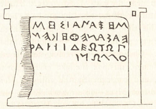
will best be understood by the annexed sketch of it,
taken by General Koehler, while Mr. Carlyle and
myself were employed in copying two inscriptions
engraved upon the face of the rock. In the upper
inscription a few letters are deficient at the beginning
and end; the lower appeared to us to be complete.
The letters of the first are larger and wider
asunder than those of the second. Both are written
from left to right, but in the lower inscription the
letters are written downwards, along the edge of the
monument, so that to place the eyes upon the same
line with the inscription, the head must be held sideways.
The rock which has been shaped into this
singular monument rises to a height of upwards of
one hundred feet above the plain; and at the back,
and on one of the sides, remains in its natural state.
The ornamented part is about sixty feet square,
surmounted by a kind of pediment, above which
are two volutes. The figures cut upon the rock are
no where more than an inch deep below the surface,
except towards the bottom, where the excavation
is much deeper, and resembles an altar. It
is not impossible, however, that it may conceal the
entrance into the sepulchral chamber, where lie the
remains of the person in whose honour this magnificent
monument was formed; for in some other
parts of Asia Minor, especially at Telmissus, we
have examples of the wonderful ingenuity with
which the ancients sometimes defended the entrance
into their tombs. There can be little doubt that
the monument was sepulchral; the crypts and catacombs
in the excavated rocks around it prove that
the valley was set apart for such purposes, to which
its singularly retired position and romantic scenery,
amidst these extensive forests, rendered it peculiarly
well adapted.
The valley bears the name of Doganlú, from a
neighbouring village which we did not see, but
where, according to the information we received,
are remains of an ancient fortification, called by
the Turks Pismésh Kálesi. I am inclined to
think they mark the site of Nacoleia[32], named by
Strabo among the cities of Phrygia Epictetus,
together with Cotyaeium, Dorylæum, and Midaeium;
the first of which places (now Kutáya)
is within twenty geographical miles, in direct distance,
to the north-westward of Doganlú; the
second, Dorylæum (Eski-shehr), is at nearly that
distance to the north of Doganlú; and Midaium
was to the north-eastward, distant about 35 G. M.
direct. But a still closer argument, in favour of
this situation of Nacoleia, is derived from a comparison
of the several routes leading from Dorylæum,
as stated in the ancient itineraries, with their
directions on the map. These roads are five in
number; and though little reliance can be placed
upon the distances between the several places, the
order of names furnishes evidence that cannot be
very erroneous, and the positions of the places at
the extremity of each route are known with tolerable
accuracy. The first of the roads, as they are
arranged in the subjoined note[33], led by Midaium
to Pessinus; the second by Archelaium to Germa,
now Yerma; the third conducted south-eastward
to Synnada, Philomelium, and Laodiceia Combusta
(now Yorgán Ladík); the fourth by Nacoleia and
Eumenia to Apameia Cibotus; and the fifth south-westward,
by Cotyaium to Philadelphia (Allah-Shehr).
Now, although the site neither of Apameia
Cibotus, Synnada, nor Pessinus, has yet been
explored, their situations are very nearly certain.
Apameia was at the source of the Mæander, and
bore a little westward of south from Eski-shehr.
Nacoleia, therefore, bore in about that direction
from Dorylæum; it lay between the roads conducting
from that city to Synnada and Laodiceia, and
to Cotyaium and Philadelphia; and it was the first
town which occurred on the road to Apameia: all
which circumstances accurately accord with the position
of Doganlú in respect of Eski-shehr.
On first beholding the great sculptured rock of
the valley of Doganlú, and on remarking the little
resemblance which it bears to the works of the
Greeks, our idea was, that it might have been
formed by the ancient Persians, when in possession
of this country; and that the lower part, resembling
an altar, might have had some reference to their
worship of fire; but, upon further reflection, there
appeared several objections to such a supposition.
In the first place, none of the great monuments of
the Persians are likely to be found at so great a
distance from Susa and Persepolis, in a part of the
country of which they had only a temporary possession,
and which could never have been considered
by them otherwise than as a conquered foreign
country, of doubtful tenure. Secondly, the style of
ornament does not exactly resemble any known
monument of the ancient Persians; and, thirdly,
the characters of the inscriptions, which have every
appearance of being coeval with the rest of the
work, bear so close a resemblance to the letters of
the Greek alphabet, in their earliest form, that the
most reasonable conjecture seems to be that this
monument is the work of the ancient Phrygians,
who, like the Ionians[34], Lydians, and other nations
of Asia Minor, who were in a state of independence
before the Persian conquest, made use of an alphabet
differing slightly from the Greek, and derived from
the same oriental original. While the form of the
characters, as well as the vertical ranges of points
for noting the separation of the words, bear a
marked resemblance to the archaic Greek: on the
other hand, some of the words agree with the
semibarbarous style of the sculptured ornaments
of this monument, in indicating that the inscriptions
are not in pure Greek. Both in the resemblance
and dissimilitude, therefore, they accord
with what we should expect of the dialect of the
Phrygians, whose connexion with Greece is evident
from many parts of their early history; at the
same time, that the distinction between the two
nations is strongly marked by Herodotus, who
gives to the Phrygians the appellation of barbarians.
It is further remarkable that the sculpture of the
monument of Doganlú, though unlike any thing of
Greek workmanship, is very much in the same
style as the elaborate ornaments (equally remote
from Grecian taste) which covered the half columns
formerly standing on either side of the door of the
Treasury of Atreus at Mycenæ[35], a building said to
have been erected by the Cyclopes, who were supposed
to have been artisans from Asia[36].
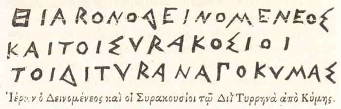
Upon comparing the alphabet of the monument
of Doganlú with the archaic Greek, and with the
Etruscan, it is observable that there is no greater
difference between the three than might be expected
in distant and long-separated branches of the same
family. It may be remarked, however, that the
Greek alphabet, and that of Doganlú, resemble each
other much more than they resemble the Etruscan,
as well in the form of the letters, as in the important
circumstance of their being written from left
to right, instead of from right to left, as the Etruscan
always continued to be[37].
It may seem a vain attempt to endeavour to explain
inscriptions, written in a language or dialect
of which we have no other remains; yet as the
characters are themselves a proof that there was
a great resemblance between this dialect and the
Greek, it is not impossible that some light may be
thrown upon ancient history by the monument of
Doganlú, if other inscriptions in the same dialect
should hereafter be discovered. Upon this subject
one or two remarks occur which may not be unimportant.
It has already been observed, that the lower
inscription beginning ΒΑΒΑ is complete, and
it may be assumed that the upper, though incomplete
at either end, has lost but a few letters.
This seems evident, as well from its occupying
the whole length of a sort of outer pediment, as
from its concluding word, which wants only one
letter of being the same as the concluding word
of the lower inscription. This concluding word
is very remarkable; written in Greek it is ΕΔΑΕ,
or ΕΔΑΕΣ. Now ἔδαε from δαίω, to divide or
cut with a sharp instrument, is precisely such a
Greek word as one might have expected to find in
a very ancient Greek inscription upon a monument,
all the apparent merit of which is the cutting
of squares, lozenges, and other regular figures,
upon the smoothed surface of a rock. In examining
the other words, we find further resemblances
of the Greek. The 2d, 3d, and 4th words of the
lower inscription, and the first word of the upper
inscription (if it be a single word), all seem to end
in sigma, and three of them in ος, thus rendering it
not improbable that the words 1, 2, 3, 4, of the lower
inscription, contained the name and title of the person
who engraved that inscription; that the fifth word
Σικεμεμαν may have indicated some such distinction,
as the place from whence he came; and that the long
word, No. 1. of the upper inscription, was the name of
the person who placed that inscription. But the most
remarkable words of all are the second and fourth of
the upper inscription, which, written in Greek, are
ΜΙΔΑΙ ϜΑΝΑΚΤΕΙ, “to King Midas;” and
which furnish an immediate presumption that the
monument was erected in honour of one of the
Kings of Phrygia of the Midaian family. The situation
of the place is no less favourable to this supposition
than the construction of the monument,
the tenor of the inscription, and the form of the
letters; for it cannot be doubted that the valley in
which the monument stands is precisely in the heart
of the country which formed the ancient kingdom
of Phrygia. Strabo remarks, that the royal families
of Gordius and Midas possessed the countries adjacent
to the river Sangarius, on the banks of which
stood the cities of Midaeium and Gordium[38]. We
learn from Pausanias[39] that Ancyra was founded
by Midas, and that in his time there was a fountain
in that city, called the fountain of Midas; and
both these authors concur in the testimony[40] that
a tribe of Gauls, in seizing the country adjacent to
Ancyra and Pessinus, occupied a part of the ancient
dominions of the Gordian dynasty. The fertile
valleys of the Sangarius, and its branches, seem,
therefore, to have formed the central part of the
dominions of the kings of Phrygia. According to
this supposition, the date of the monument of Doganlú
is between the years 740 and 570 before the
Christian æra; for that such was nearly the period
of the Gordian dynasty appears from Herodotus[41],
who informs us that Midas, son of Gordius, was
the first of the Barbarians who sent offerings to
Delphi, and that his offerings were earlier than
those of Gyges, king of Lydia, who began his reign
B.C. 715. Phrygia lost its independence, when all
the country to the west of the Halys was subdued
by Crœsus, king of Lydia, in or about the year
572 B.C. A few years afterwards Atys, son of
Crœsus, was killed accidentally by Adrastus, who
was of the royal family of Phrygia, and son of the
Gordius who had been rendered tributary to Crœsus.
As this Gordius was son of a Midas[42], and
the first Midas was son of a Gordius, it is probable
that several of the intermediate monarchs of the
dynasty, during the two centuries of their independence,
bore the same names.
The distinguishing appellation of the particular
Midas to whom the monument was dedicated,
seems to be contained in the word of the upper
inscription, which occurs between Μίδᾳ and ἄνακτι[43];
but as we possess no details of the history
of independent Phrygia, it is impossible to determine
to what period in the two centuries the monument
of Doganlú is to be ascribed. In regard
to the word ΒΑΒΑ, which begins the lower inscription,
it was probably the highest title of honour
at that period. Papas, or Papias, derived from
ΠΑΠΑ, nearly the same word as ΒΑΒΑ, and
meaning father, was a common epithet of Jupiter
in this part of Asia Minor at a subsequent period.
The dedication to Jupiter Papias, mentioned in a
preceding page, was copied from a marble found at
no great distance from Doganlú: and we are informed
by an ancient author, that Papas was the
name of the Bithynian Jupiter[44]. In another part
of the country we find the title applied, by a natural
descent, to the magistrate of a city[45]; and it
was a common name among the Etruscans, the
kinsmen of the Phrygians[46].
Close by this magnificent relic of Phrygian art
is a very large sepulchral chamber with a portico,
of two columns, excavated out of the same reddish
sandstone of which the great monument and other
rocks are formed. The columns have a plain plinth
at the top, and are surmounted by a row of dentils
along the architrave. They are of a tapering form,
which, together with the general proportions of the
work, give it an appearance of the Doric order,
although, in fact, it contains none of the distinctive
attributes of that order. It is an exact resemblance
of the ordinary cottages of the peasants, which
are square frames of wood-work, having a portico
supported by two posts made broader at either end.
The sepulchral chambers differ only in having their
parts more accurately finished; the dentils correspond
to the ends of the beams, supporting the flat
roof of the cottage.
I cannot quit the subject of this interesting valley
without expressing a wish that future travellers,
who may cross Asia Minor by the routes of Eski-shehr
or Kutáya, will employ a day or two in a
more complete examination of it than circumstances
allowed to us; as it is far from improbable that
some inaccuracy or omission may have occurred in
our copy of the inscriptions, from the singularity
of the characters, the great height of one of the inscriptions
above the ground, and the short time
that was allowed us for transcribing and revising
them.
After leaving the great sculptured rock, we followed
the valley for a short distance, and then passed
through a wild woody country, having met scarcely
any traces of habitations till we reached our konák,
at the little village which receives its appellation
from the Khan built there by a Pasha of the name
of Kosru; and where we arrived at five in the evening,
having, according to our calculation, made a
circuit of nine or ten miles more than the direct
distance from Seid-el-Gházi. We had a sharp
shower of hail as we galloped through the wood,
but the weather soon cleared again.
Jan. 28.—From Kosru Khan to Bulwudún,
twelve hours. We rose at two in the morning:
the baggage set off at five, ourselves at six. The
road lay through several small woody valleys, and
towards the latter part of our journey across a ridge
of hills, with a fine soil, containing a few cultivated
patches of ground, but for the most part overgrown
with brushwood; at intervals we saw a few flocks of
sheep and goats, and in one place a large herd of
horned cattle. We saw many sepulchral chambers
excavated in the rocks, some of which were ornamented
on the exterior; others were plain. In
several parts of our route, also, were appearances of
extensive quarries, from some of which was probably
extracted the celebrated Phrygian marble, called
Synnadicus, or Docimitis, from the places where it
was found.
This marble was so much esteemed that it was
carried to Italy[47]; and such was the force of fashion
or prejudice, that Hadrian placed columns of it in
his new buildings at Athens[48], where the surrounding
mountains abound in the finest marble. At
about ten miles from Bulwudún we came in sight
of that town with a lake beyond it: to the southward
was the high range of mountains called Sultán-dagh,
and parallel to it, on the northern side of
the plain of Bulwudún, the Emír-dagh.
From hence we descended by a long slope to
Bulwudún, which is situated in the plain. It is a
place of considerable size, but consists chiefly of
miserable cottages. There are many remains of
antiquity lying about the streets, and around the
town, but they appeared to be chiefly of the time
of the Constantinopolitan empire. At Bulwudún
we had to make choice of two roads to the coast;
one leading to Satalía, the other, by Kónia and
Karaman, to Kelénderi. We prefer the latter on
account of the uncertainty of the long passage by
sea from Satalía to Cyprus at this season of the
year; and we are informed that all the Grand Vizier’s
Tatárs now take the Kónia road.
Jan. 29.—From Bulwudún to Ak-shehr, eleven
hours. For the first two hours the road traversed
the plain which lies between Bulwudún and the foot
of Sultán-dagh; towards the latter a long causeway
traverses a marshy tract, through the middle of
which runs a considerable stream. This river comes
from the plains and open country, which extend on
our right as far as Afiom Karahissár, and joins the
lake which occupies the central and lowest part of
the plain lying between the parallel ranges of Sultán-dagh
and Emír-dagh. Our road continues in
a S.E. direction along the foot of Sultán-dagh; it
is perfectly level, and, owing to the dry weather, in
excellent condition. On our left were the lake and
plains already mentioned. The ground was every
where covered with frost, and the hills on either
side of the valley with snow; but these appearances
of winter vanished as the day advanced, and from
noon till three P.M. the sun was warmer than we
found agreeable; our faces being exposed to it by
that most inconvenient head-dress, the Tatar Kalpak.
Our Surigis (postillions) wore a singular kind
of cloak of white camels’ hair felt, half an inch thick,
and so stiff that the cloak stands without support
when set upright upon the ground. There are neither
sleeves nor hood; but only holes to pass the
hands through, and projections like wings upon
the shoulders for the purpose of turning off the
rain. It is of the manufacture of the country. At
the end of six hours we passed through Saakle or
Isaklú, a large village surrounded with gardens and
orchards, in the midst of a small region well watered
by streams from Sultán-dagh, and better cultivated
than any place we have seen since we left
the vicinity of Isnik and Lefke. Yet the Aga of
Isaklú is said to be in a state of rebellion; and this
is not the first instance we have seen of places in
such a state being more flourishing than others;
whence we cannot but suspect that there is a connexion
in this empire between the prosperity of a
district and the ability of its chieftain to resist the
orders of the Porte. This is nothing more than
the natural consequence of their well-known policy
of making frequent changes of provincial governors,
who, purchasing their governments at a high price,
are obliged to practise every kind of extortion to
reimburse themselves, and secure some profit at the
expiration of their command. It seems that the
Aga of Isaklú, having a greater share of prudence
and talents than usually falls to the lot of a Turk
in office, has so strengthened himself that the Porte
does not think his reduction worth the exertion
that would be required to effect it, and is, therefore,
contented with the moderate revenue which
we are told he regularly remits to Constantinople.
In the mean time he has become so personally interested
in the prosperity of the place, that he finds
it more to his advantage to govern it well than to
enrich himself rapidly by the oppressive system of
the other provincial governors. The territory of
Isaklú contains several dependent villages to which
fertility is ensured by the streams descending from
Sultán-dagh. We here observe a greater quantity
and variety of fruit-trees than in any place in Asia
Minor we have yet seen. Their species are the
same as those which grow in the middle latitudes
of Europe, as apples, pears, walnuts, quinces,
peaches, grapes; no figs, olives, or mulberries[49].
The climate, therefore, though now so mild, and
exposed undoubtedly to excessive heat in summer,
is not warmer upon the whole than the interior of
Greece and Italy.
We follow the level grounds at the foot of Sultán-dagh
until we come in sight of Ak-shehr (white
city), a large town, situated, like Isaklú, on the foot
of the mountains, and furnished with the same natural
advantages of a fertile soil, and a plentiful
supply of water. It is surrounded with many pleasant
gardens, but in other respects exhibits the
usual Turkish characteristics of extensive burying-grounds,
narrow dirty streets, and ruined mosques
and houses. At a small distance from the western
entrance of the town we pass the sepulchre of Nureddin
Hoja, a Turkish saint, whose tomb is the
object of a Mussulman pilgrimage. It is a stone
monument of the usual form, surrounded by an
open colonnade supporting a roof; the columns
have been taken from some ancient Greek building.
The burying-ground is full of remains of Greek architecture
converted into Turkish tomb-stones, and
furnishes ample proof of Ak-shehr having been
the position of a Greek city of considerable importance.
The only apartment our Konakjí could
procure for us at Ak-shehr was a ruinous chamber
in the Menzil-hané (post-house); and the Aga
sending insolent messages in return to our remonstrances,
we resolve, though at the end of a long
day’s journey, upon setting out immediately for the
next stage. While the horses are preparing, we
eat our kebáb in the burying-ground, and take
shelter from the cold of the evening in the tent
of some camel-drivers, who were enjoying their
pipes and coffee over a fire. On our arrival, we had
observed the people fortifying their town, by erecting
one of the simplest gates that was ever constructed
for defence. It consisted of four uprights
of fir, supporting a platform covered with reeds,
in front of which was a breastwork of mud-bricks
with a row of loop-holes. These gates and a
low mud-wall are the usual fortifications of the
smaller Asiatic towns. In one place we saw the
gates standing alone without any wall to connect
them.
The lake of Ak-shehr is not close to the town as
D’Anville has marked it on his map; but at a distance
of six or eight miles: it communicates by a
stream with that of Bulwudún, and after a season
of rain, when these lakes are very much increased
in size, they form a continued piece of water, thirty
or forty miles in length. It is probable that D’Anville
was equally mistaken in placing Antioch of
Pisidia at Ak-shehr: for if Sultán-dagh is the Phrygia
Paroreia of Strabo, as there is reason to believe,
Antioch should, according to the same authority,
be on the south side of that ridge; whereas Ak-shehr
is on the north.
At six in the evening we set out from Ak-shehr,
and at one in the morning of January 30 arrived
at Arkut-khan. Our pace was much slower than
by day. The road lay over the same open level
country as before, and towards the latter part of
the route, over some undulations of ground, which
separate the waters running into the lake of Ak-shehr
from those which flow into the lake of Ilgún.
The weather was frosty and clear, but very dark
after eleven o’clock, when the moon set. Several
of our party then became so oppressed by sleep as
to find it difficult to save themselves from falling
from the horses. After two or three hours’ repose
at Arkut-khan, we pursued our route for three hours
to Ilgún, a large but wretched village, containing
some scattered fragments of antiquity, where we
procured some eggs and kaimak (boiled cream) for
breakfast, and then continued our route to Ladík.
From near Ak-shehr, the loftier summits of the
range of Sultán-dagh begin to recede from our
direction towards the south; and our route has
continued through the same wide uncultivated
champaign, intersected by a few ridges, and by torrents
running from the Sultán-dagh to the lakes in
the plain. At two hours is a more considerable
stream, crossed by a bridge, and discharging itself
into the lake of Ilgún. Six hours beyond Ilgún
we pass through the large village of Kadún-kiúi,
or Kanun-haná, said to consist of 1000 houses;
and three hours further we come to Yorgan-Ladík,
or Ladik-el-Tchaus, another large place, famous
throughout Asia Minor for its manufacture of carpets;
and advantageously situated in a well-watered
district, among some low hills to the northward of
which lies a very extensive plain.
The road through the open country which we have
passed has been wide, well beaten, fit for any carriage,
and, owing to the late dry weather, in an excellent
state. We continue to enjoy a sky without
a cloud: there is generally a slight breeze from the
east in the day: in the afternoon the sun is hot;
and at night the sky is perfectly calm and clear,
with a sharp frost, which in the shaded places generally
continues to a late hour in the afternoon.
The plains between Arkut-Khan and Ladík are
traversed by several low stony ridges, and by streams
running towards the lake of Ilgún. The country is
bare and open; not a tree or inclosure was to be
seen, nor any appearance of cultivation, except in
small patches around a few widely-scattered villages.
The country to our right forms the district
of Dogan-hissár, a town belonging to the Sanjak
of Ak-shehr. To the left is seen the continuation
of the series of long narrow lakes which begin near
Bulwudún: they receive the torrents running from
the surrounding mountains, and are greatly enlarged
in winter, but in summer are entirely dried
up.
Jan. 31.—From Ladík to Kónia nine hours;
the road excellent, and weather very fine; the sun
even scorching, and much too glaring for our exposed eyes.
At Ladík we saw more numerous
fragments of ancient architecture and sculpture
than at any other place upon our route. Inscribed
marbles, altars, columns, capitals, frizes, cornices,
were dispersed throughout the streets and among
the houses and burying-grounds; the remains of
Laodiceia κατακεκαυμένη, anciently the most considerable
city in this part of the country. At less
than an hour’s distance from the town, on the way
to Konia, we met with a still greater number of remains
of the same kind, and copied one or two sepulchral
inscriptions of the date of the Roman empire.
The following fragment appears to be part
of an imprecation against any person who should
violate the tomb upon which it is inscribed.
ΤΟΝ ΒΩΜΟΝ ΑΔΙΚΗϹΕΙ
Η ΚΑΙ ΠΕΡΙ ΤΟΝ ΤΑΦ
ΟΝ ΤΙ ΟΡΦΑΝΑ ΤΕΚΝΑ ΛΙΠΟΙ
........................
ΤΟΝ ΧΗΡΟΝ ΒΙΟΝ ΟΙΚΟΝ Ε
ΡΗΜΟΝ
Soon after we had quitted this spot, we entered
upon a ridge branching eastward from the great
mountains on our right, and forming the northern
boundary of the plain of Kónia. On the descent
from this ridge we came in sight of the vast plain
around that city, and of the lake which occupies
the middle of it, and we saw the city with its
mosques and ancient walls, still at the distance of
12 or 14 miles from us. To the north-east nothing
appeared to interrupt the vast expanse but two very
lofty summits covered with snow, at a great distance.
They can be no other than the summits of Mount
Argæus above Kesaría, and are, consequently,
near 150 miles distant from us, in a direct line.
To the south-east the same plains extend as far as
the mountains of Karaman, which to the south-west
of the plains are connected with the mountains
of Khatun-serái, on the other side of which
lies Bey-shehr and the country of the ancient Isaurians;
and these bending westward in the neighbourhood
of Kónia form a continuous range with
the ridge of Sultán-dagh, of which we have been
following the direction ever since we left Bulwudún.
At the south-east extremity of the plains beyond
Kónia we are much struck with the appearance of
a remarkable insulated mountain, called Kara-dagh
(black mountain), rising to a great height, covered
at the top with snow, and appearing like a lofty
island in the midst of the sea. It is about sixty
miles distant, and beyond it are seen some of the
summits of the Karaman range, which cannot be
less than ninety miles from us; yet it is surprising
with what distinctness the form of the ground and
of the woods is seen in this clear atmosphere. As
far as I have observed, the air is much more transparent
in a fine winter’s day in this climate than it
is in summer, when, notwithstanding the breeze of
wind which blows, there is generally a haze in the
horizon, caused probably by the constant stream of
vapour which rises from the earth. The situation
of the town of Karaman is pointed out to us exactly
in the line of our route, a little to the right of
Mount Kara-dagh. After descending into the plain
we move rapidly over a road made for wheel-carriages;
the first we have met with since we left the
neighbourhood of Skutári.
At Kónia we are comfortably accommodated in
the house of a Christian belonging to the Greek
church, but who is ignorant of the language, which
is not even used in the church-service: they have
the four Gospels and the Prayers printed in Turkish.
At the head of the Greek community is a
Metropolitan bishop, who has several dependent
churches in the adjacent towns. As it is now the
moon Ramazan, when the Turks neither take nourishment
nor receive visits till after sunset, we are
obliged to defer our visit to the Governor of Kónia
till the evening. He is a Pasha of three tails, but
inferior in rank to the Governor of Kutáya, who
has the title of Anadol-Beglerbeg, or Anadol-Valesi,
and who has the chief command of all the
Anatolian troops when they join the Imperial camp.
Our visit, as usual among the Turks, was first to
the Kiaya, or Deputy, and afterwards to the Pasha.
The entrance into the court of the Serai was striking;
portable fires of pine-wood placed in a grating
fixed upon a pole, and stuck into the ground, were
burning in every part of the court-yard; a long
line of horses stood ready saddled; attendants in
their gala-clothes were seen moving about in all
directions, and trains of servants, with covered
dishes in their hands, showed that the night of a
Turkish fast is a feast. The building had little in
unison with these appearances of gaiety and magnificence,
being a low shabby wooden edifice, with
ruinous galleries and half-broken window frames;
but it stands upon the site of the palace of the ancient
sultans of Iconium, and contains some few
remains of massy and elegant Arabic architecture,
of an early date. The inside of the building seemed
not much better than the exterior, with the exception
of the Pasha’s audience-chamber, which was
splendidly furnished with carpets and sofas, and
filled with a great number of attendants in costly
dresses. The Pasha, as well as his deputy in the
previous visit, received us with haughtiness and
formality, though with civility. The Pasha promised
to send forward to Karaman for horses to be
ready to carry us to the coast, and to give us a travelling
order for konáks upon the road. After
passing through the usual ceremony of coffee,
sweetmeats, sherbet, and perfumes, which in a
Turkish visit of ceremony are well known to follow
in the order here mentioned, we return to our
lodging. Nothing can exceed the greediness of the
Pasha’s attendants for Bakshish. Some accompany
us home with mashallahs (the torches above mentioned),
and others with silver wands. Soon after
our return to our lodgings we are visited by a set
of the Pasha’s musicians, who seem very well to
understand that after our fatigues we shall be glad
to purchase their absence at a handsome price;
but no sooner are they gone than another set make
their appearance; the Kahwejí, the Tutunjí, and
a long train of Tchokadars; and these being succeeded
by people of the town, who come simply to
gratify their curiosity, it is not till a late hour that
we are at liberty to retire to rest.
The circumference of the walls of Kónia is between
two and three miles, beyond which are suburbs
not much less populous than the town itself.
The walls strong and lofty, and flanked with square
towers, which at the gates are built close together,
are of the time of the Seljukian kings, who seem
to have taken considerable pains to exhibit the
Greek inscriptions, and the remains of architecture
and sculpture belonging to the ancient Iconium,
which they made use of in building their walls.
We perceived a great number of Greek altars, inscribed
stones, columns, and other fragments inserted
into the fabric, which is still in tolerable preservation
throughout the whole extent. None of
the Greek remains that I saw seemed to be of a
very remote period, even of the Roman Empire.
We observed in several places Greek crosses, and
figures of lions, of a rude sculpture; and on all the
conspicuous parts of the walls and towers, Arabic
inscriptions, apparently of a very early date. The
town, suburbs, and gardens around are plentifully
supplied with water from streams, which flow from
some hills to the westward, and which to the north-east
join a lake varying in size according to the
season of the year. We are informed that in the
winter and after the melting of the snows upon the
surrounding mountains, the lake is swollen with
immense inundations, which spread over the great
plains to the eastward for near fifty miles. At
present there is not the least appearance of any
such inundation, the usual autumnal rains having
failed, and the whole country labouring under a
severe drought. The gardens of Kónia abound
with the same variety of fruit-trees which we remarked
in those of Isaklú and Ak-shehr; and the
country around supplies grain and flax in great
abundance. In the town carpets are manufactured,
and they tan and dye blue and yellow leather.
Cotton, wool, hides, and a few of the other raw
materials which enrich the superior industry and
skill of the manufacturers of Europe, are sent to
Smyrna by the caravans. The low situation of
the town and the vicinity of the lake seem not to
promise much for the salubrity of Kónia; but we
heard no complaint on this head; and as it has in
all ages been well inhabited, these apparent disadvantages
are probably corrected by the dryness of
the soil, and the free action of the winds over the
surrounding levels. The most remarkable building
in Kónia is the tomb of a saint, highly revered
throughout Turkey, called Hazret Mevlana, the
founder of the Mevlevi Dervishes. His sepulchre,
which is the object of a Mussulman pilgrimage, is
surmounted by a dome, standing upon a cylindrical
tower of a bright green colour. The city, like all
those renowned for superior sanctity, abounds with
Dervishes, who meet the passenger at every turning
of the streets, and demand paras with the
greatest clamour and insolence. Some of them
pretend to be idiots, and are hence considered as
entitled to peculiar respect, or at least indulgence.
The bazars and houses have little to recommend
them to notice.
CHAPTER II. ILLUSTRATION OF THE ANCIENT GEOGRAPHY OF THE CENTRAL PART OF ASIA MINOR. — Additional note to page 51 .
Geographical Structure of the Country—Ancient Sites near the
Road from Eski-Shehr to Kónia—Polybotum—Synnada—Docimia—Metropolis—Julia—Philomelium—Tyriaium—Iconium—Ancient
Sites between Iconium and Mazaca or Cæsareia—Tyana—Castabala—Cybistra—Cilician
Taurus—Archalla—Country called Axylus—Lycaonian Downs—Garsabora—Coropassus—Sabatra—Lakes
Coralis, Trogitis, and Tatta—Germa—Orcistus—Places in the ancient
Itineraries on the Road from Ancyra to the Pylæ Ciliciæ, Archelais,
&c.—Roads in the Peutinger Table across the Taurus to the southern
Coast—Juliopolis or Gordium—Pessinus—Amorium—Santabaris—Pœmanene—Orcaoryci—Pitnisus—Caballum—Tolistochora—Sub-divisions
of Galatia.
Before we pursue our route beyond the capital
of the Greek province Lycaonia and of the Turkish
kingdom Karamán, it may be right to offer a few
remarks upon the general geography of this part
of the peninsula, and upon the situation of some
of the opulent and celebrated cities which anciently
adorned it.
From the sources of the Sangarius and Halys on
the north and east, to the great summits of Mount
Taurus on the south-west and south, there is an
extent of country nearly 250 miles long and 150
broad, in which the waters have no communication
with the sea. Its southern part consists of fertile
valleys or of extensive plains intersected by a few
ranges of hills, and it is bounded to the southward
by the great ridges of Mount Taurus, from
whence are poured forth numerous streams, which,
after fertilizing the valleys, collect their superabundant
waters in a chain of lakes, extending
from the neighbourhood of Synnada in Phrygia
through the whole of Lycaonia to the extremity
of the Tyanitis in Cappadocia. In the rainy season
these lakes overflow the lower part of the
plains, and would often form one entire inundation
200 miles in length, were it not for some
ridges which traverse the plains and separate them
into several basins. By the structure of the hills,
and the consequent course of the waters, these basins
form themselves into three principal recipients,
having no communication with one another, unless
it be in very extraordinary seasons. These are, 1.
The recipient of Karahissár and Ak-shehr. 2. That
of Ilgún and Ladik, which receives I believe the
superfluous water of the lake of Karajeli as well as
that from the slopes of the neighbouring mountains.
3. The recipient of Kónia, which collects
the overflowings of the lakes of Sidyshehr and Bey-shehr.
4. The basin lying between the Cilician
Taurus to the south-east and the Cappadocian
mountains in the opposite direction, which mountains
are now called the Hassan Daghi, and give
rise to the western branch of the Halys. Were the
bountiful intentions of Providence seconded by a
rational government, the inundations would but
prepare the plains for an abundant harvest: at present
they water only an immense extent of pasture
land[50], while the lakes supply the surrounding inhabitants
with fish, and with reeds for the construction
of their miserable cottages.
Concerning two of the ancient sites traversed by
the modern road leading from Eski-Shehr to Kónia,
there can be little doubt. The modern name
of Ladik is decisive of its being upon the site of
Laodiceia Combusta, and the sound of Πολυβοτόν as
pronounced by the modern Greeks, with the accent
on the last syllable, so nearly resembles that of Bulwudún,
that the latter name is probably a Turkish
corruption of the former. The position of Bulwudún,
moreover, agrees perfectly with that ascribed to Polybotum
in the narrative of Anna Comnena[51]. Polybotum,
however, is mentioned only in the history of
the Lower Empire[52]: and although from the 6th to
the 12th century it appears to have been with Philomelium
and Iconium the chief city of these vast
plains[53], its name is not found in the earlier periods
of history, when Synnada, Philomelium, and Iconium
seem to have been the principal places[54]. The
position of Polybotum, therefore, affords us no assistance
in tracing the other ancient places on the main
route between Dorylæum and Laodiceia.
Of these places the most important to determine
is Synnada, which indeed is in some measure the
key to the ancient geography of the central parts of
Asia Minor. It appears from the Table that Synnada
was on the road from Dorylæum to Philomelium
and Laodiceia Combusta,—from Livy, that it was in
the way from the country lying eastward of Apameia
Cibotus towards the frontiers of Galatia,—and
from Cicero[55], that it was in the way or nearly so
from Apameia to Philomelium and Iconium. The
crossing of these lines will fall not far from the
modern Bulwudún, as appears from the route of
Pococke in his way from the upper valley of the
Mæander to Ancyra. It is highly probable, therefore,
that the extensive quarries which we saw on
the road from Khosrukhan to Bulwudún are those
of Docimia, a small town in the plain of Synnada,
celebrated for the marble extracted from thence in
large quantities, and sent even to Rome. This
marble was known to the Romans by the name of
Synnadic, from the more important town of Synnada,
which was only sixty stades distant from Docimia[56].
It is difficult to ascertain the name of the ancient
city which occupied the remarkable position of
Karahissár, which is distinguished from some other
towns of the same name by the epithet of Afiom, in
reference to its abundant produce of opium. D’Anville
supposed it to be the site of Apameia; but the
waters of Karahissár, instead of running into the
Mæander, of which the principal sources were at
Apameia, flow to the lake of Bulwudún. Pococke
asserts that he found an inscription at Karahissár,
which proves it to be the site of Prymnesia; but
upon referring to his Inscriptiones Antiquæ, it appears
that the inscription to which he alludes is
nothing more than the memorial of a man whose
name ends in ΜΕΝΝΕΑΣ, and who with his wife
had constructed a tomb for themselves and their
only daughter. A few miles southward of Karahissár
are the fountains of a branch of the Mæander;
it is probably the Obrimas, whose sources according
to Livy were at Aporis[57]. As the Consul
Manlius entered the plain of Metropolis from Aporis,
and marched onward to Synnada and Beudos
vetus in his way towards Galatia, there is some reason
to think that Karahissár stands on the site of
Metropolis.
If we suppose the Beudos vetus of the Latin historian
to have been at Beiad, from the similarity
of name and the proximity of Beiad to the site of
Synnada (for Beudos, according to Livy, was only
five Roman miles from Synnada), we shall find that
the distance from Karahissár to Beiad, which is
twenty G. M. direct, agrees very exactly with the
march of two days and five miles by the Consul
Manlius, according to the mean rate of armies reduced
a little in consequence of the plunder which,
as the historian tells us, impeded the movement of
the Romans. It will be found, moreover, that the
situation of Metropolis at Karahissár, accords extremely
well with the description given by Artemidorus
of the road through Asia from Ephesus to
Mazaca or Cæsareia in Cappadocia, which, after
ascending the valley of the Mæander to its sources
at Apameia, proceeded by Metropolis and through
Phrygia Paroreius to the termination of that district
at Tyriaium; and thence through Lycaonia to
Garsabora and Mazaca[58]: for although the distances
on that road in our copies of Strabo from Apameia
as far as Laodiceia Combusta will not bear examination,—and
although Karahissár does not fall in
the direct line from Ephesus to Mazaca,—neither of
these objections can be considered of much weight:
the inaccuracy of numbers in the ancient MSS. is
too common an occurrence to overthrow other testimony;
and the divergence of the ancient road to
the northward at Karahissár, was evidently occasioned
by the projection of that part of Mount
Taurus which is now called the Sultan-dagh, and
which causes so many of the modern routes to pass
through Karahissár.
Though the proportionate distances do not exactly
agree with the numbers in the Table, it may
be inferred from the remains of antiquity at Ak-shehr
and Ilgún, that these were the Jullæ and
Philomelium named in that itinerary. Strabo describes
Philomelium as being in the midst of a
plain on the north side of the hills of Paroreia;
his description[59] of which district agrees exactly
with the Sultan-dagh and the plain on its northern
side. Its position no less accords with the testimony
of Artemidorus cited in the preceding page,
according to whom the road from Apameia to Mazaca
led through the Paroreia. And the territory
of Philomelium appears from the narrative of Anna
Comnena[60] to have been at no great distance from
that of Iconium; for as soon as the Emperor Alexius
had taken Philomelium from the Turks, his troops
spread themselves over the country round Iconium.
The lake of the Forty Martyrs mentioned in this
narrative corresponds also with that of Ilgún, so
that it will probably be found that Ilgún stands
upon the site of Philomelium.
The Jullæ of the Table seems to be a false
writing for Julia, a name which became common
in every part of the Roman world under the
Cæsars; and it is probably the same place as the
Juliopolis placed by Ptolemy[61] in the part of the
country where stood Synnada, and Philomelium.
But there can be little doubt that so fine a situation
as that of Ak-shehr was occupied, before the time
of the Cæsars, by some important place, which
on its being repaired or re-established may have assumed
the new name of Julia or Juliopolis.
Of the cities mentioned by Xenophon on the
route of Cyrus through Phrygia into Lycaonia,
Tyriaium and Iconium are the only two which
occur in later authors. Tyriaium, which is named
by Hierocles as well as by Strabo (from Artemidorus),
is shown by the latter to have been between
Philomelium and Iconium. It must consequently
have been at no great distance from Laodiceia,
although this situation is quite incompatible with
the distance which Xenophon has stated between
Tyriaium and Iconium[62].
In following the march of Cyrus onwards from
Iconium towards the Ciliciæ pylæ of Mount Taurus,
we find the distances of Xenophon rather more
reconcileable with the reality. It is agreed that
Dana, which he places at nine marches or fifty-five
parasangs from Iconium, was the same place as
Tyana, otherwise called Eusebeia ad Taurum, and
which under Archelaus and the Romans was the
chief town of one of the præfectures of Cappadocia[63].
It was the only place in that province, except Mazaca,
which Strabo thought deserving to be called a city;
and under the Byzantine empire it was the capital
of the second Cappadocia, and the see of a metropolitan
bishop until the Turkish conquest.
There can be little doubt that the site of Tyana
is now occupied by Kílisa Hissár, or the Castle of
Kílisa near Bor[64]. This place is acknowledged by
the Greek clergy as the site of their episcopal see
of Tyana; it is situated, as Strabo describes Tyana
to have been, in a fertile plain not far from the entrance
of the Pylæ Ciliciæ, or the easiest and most
frequented pass leading over Mount Taurus into
Cilicia Pedias and Syria,—and midway in the road
to that pass from Mazaca[65].
At Kílisa Hissár are found very considerable
ruins of an ancient city, among which are those of
an aqueduct upon arches, designed to convey water
to the town from the hills to the southward, which
are connected with the last slopes of Mount Taurus.
Aqueducts of this description are indubitable signs
of an ancient place which flourished under the Romans,
and such we know to have been the condition
of Tyana.
Strabo remarks that Castabala and Cybistra were
not far from Tyana; that they were nearer than that
city to the heights of Taurus; that they belonged
to the Cilician præfecture of Cappadocia, and that
Cybistra was situated at a distance of three hundred
stades from Mazaca[66]. We learn also from the
Table, that Cybistra was on the road from Tyana
to Mazaca, sixty-four Roman miles from the former.
These data seem sufficient to fix the site of Cybistra
at Karahissár[67], where are considerable remains of an
ancient city; and they render it probable that the
position of Castabala is now occupied by Nigde,
where we find similar evidences of an ancient site.
The situation of Cybistra at Karahissár illustrates
the interesting account which Cicero has left
us of his military operations, in defending Cilicia
and Cappadocia against a threatened attack of the
Parthians[68], when he fixed his camp at Cybistra, because
it was on the frontier of the two provinces,
but nearer to the great plains of Cappadocia lying
to the eastward of Mount Taurus. These plains
(he remarks) afford an easy access to Cappadocia
from Syria, while nothing can be stronger than
Cilicia on the side of Syria. In the end, however,
the Parthians having advanced towards Antioch,
Cicero was obliged to cross Mount Taurus from
Cybistra to Tarsus, from whence he proceeded to
clear Mount Amanus of the enemy.
In order thoroughly to understand the reason of
one of the præfectures of Cappadocia being called
Cilicia by the Romans, it is to be observed that
more anciently both the sides of Taurus belonged
to the Eleuthero-Cilices, or independent Cilicians;
and that the whole range from the plains of Lycaonia
to the Antitaurus was called the Cilician Taurus[69].
Archelaus the last king of Cappadocia,
having added all the country on the northern side
of the mountain to his kingdom, together with a
large portion of Cilicia Tracheia, Tiberius, who put
him to death at Rome, included it all, except the
maritime parts, in the Roman province of Cappadocia;
and he added to the ten præfectures of the
late kingdom of Archelaus an eleventh, composed
chiefly of his Cilician conquests: and hence called
the Cilician præfecture of Cappadocia. Its chief
town was Mazaca; it comprehended Cybistra and
Castabala, and extended along the mountains on
the south side of the Tyanitis as far as Derbe inclusively[70].
The inconvenience, however, of a division
which included in the same district two such
distant places as Mazaca and Derbe, seems to have
been soon felt: for we find that in the time of Hadrian,
Derbe, Laranda, and a neighbouring region
of Taurus containing the town of Olbasa, formed
a separate district called the Antiochiana[71]; and
that the Cilician præfecture was confined to the
parts about Mazaca and Cybistra.
The name of Erkle so much resembles the
Turkish corruption of Heraclia, as instanced in
two cities of that name on the coasts of the Euxine
and Propontis, that it has often been supposed
that the Erkle on the road from Kónia to the Cilician
Pylæ occupied the site of a Heraclia; and
Hadji Khalfa even asserts that it was so. No
Greek or Latin authorities, however, hint at the
existence of a Heraclia in this situation. I have
little doubt therefore that Erkle occupies the site
of Archalla, named as one of the cities of the Cilician
præfecture of Cappadocia[72], which, as we have
already seen, comprehended Erkle. Erkle, it may be
added, is precisely the softened sound which Turks
would give to the word Ἄρχαλλα pronounced in
the Greek manner with the accent on the first syllable.
To the northward of the region of lakes and
plains, through which leads the road from Afióm
Karahissár to Kónia and Erkle, lies a dry and
naked region, anciently called Axylus, which extends
as far as the Sangarius and Halys. Pococke,
who crossed a part of this dreary country,
describes it exactly in the same manner as Livy[73],
though apparently without having adverted to that
historian.
The southern part of this open country consists
of a range of mountains running parallel to Mount
Taurus, and bordering the great valleys of Philomelium,
Iconium and Tyana on the northern side.
The western part of this range is a summit called
Emír-dagh, which rises to a considerable elevation
from the lakes of Bulwudún and Ak-shehr, slopes
gradually into the open champaign to the eastward,
and to the north is bounded by a very broad naked
valley, which is included on the opposite side by
the hills in which originate some of the branches
of the Sangarius. To the N.W. this valley opens
into the great axylous plains of Phrygia, extending
to Dorylæum; and to the S.E. into those of Galatia
or Lycaonia. The ridges lying to the northward
of Kónia and Erkle form the district described by
Strabo as the cold and naked downs of Lycaonia,
which furnished pasture to numerous sheep and
wild-asses, and where was no water, except in very
deep wells. As the limits of Lycaonia are defined
by Strabo, and by Artemidorus, whom he quotes[74],
to have been between Philomelium and Tyriaium
on the west, and Coropassus and Garsabora on the
east,—which last place was 960 stades from Tyriaium,
120 from Coropassus, and 680 from Mazaca,—we
have the exact extent of the Lycaonian
hills intended by the geographer. Branching from
the great range of Taurus, near Ilgún (Philomelium),
and separating the plain of Laodiceia from
that of Iconium, they skirted the great valley which
lies to the south-eastward of the latter city, as far
as Erkle; comprehending, to the north of Erkle
and Bor, a part of the mountains of Hassan Daghi.
It would seem that the depopulation of this country,
which rapidly followed the decline of the Roman
power, and the irruption of the Eastern barbarians,
had left some remains of the vast flocks
of Amyntas, mentioned by Strabo, in undisturbed
possession of the Lycaonian hills to a very late period:
for Hadji Khalfa, who describes the want of
wood and water in these hills, adds, that there was a
breed of wild sheep on the mountain of Fudul Baba,
above Ismil, and a tomb of the saint from whom
the mountain receives its name: and that sacrifices
were offered at the tomb by all those who hunted
the wild sheep; and who were taught to believe that
they should be visited with the displeasure of heaven,
if they dared to kill more than two of these
animals at a time[75].
At the back of the Lycaonian hills was Soatra,
or Sabatra, situated in a part of the country so desolate,
that water was sold in the streets. Sabatra
was at a distance of 55 Roman miles from Laodiceia
Combusta, and of 44 from Iconium[76].
There is some difficulty in understanding to which
of the lakes at the foot of the Lycaonian hills we are
to apply the names Coralis and Trogitis. Stephanus
mentions a city of Carallis, or Caralleia, which he
ascribes to Isauria. About the same period of time
there was a Caralia belonging to the consular government
of Pamphylia, and a bishopric of that
province; but which had ceased to be an episcopal
see in the ninth century[77]. If these notices refer to
one and the same place, it is probable that the lake
of Karajeli is the ancient Coralis, or Caralis; and
that the ruins which are found near its shore are
those of the town Caralleia[78]. In this case, the
lake of Ilgún is probably the Trogitis of Strabo;
for it is difficult to suppose that he meant the lake
of Iconium by either of those which he names.
As to the difference of size which he remarks between
them, our information is so imperfect, and
the lakes themselves differ so much in size, according
to the seasons, that no certain inference can
be drawn from this distinction of the geographer.
One of the most remarkable features of this part
of Asia Minor is the lake Tatta; which, according
to Strabo, produced salt in such abundance, that
any substance immersed in it was very soon entirely
covered with the crystal; and that birds were
unable to fly, if they had dipped their wings in it.
The lake still furnishes all the surrounding country
with salt, and its produce is a valuable royal
farm in the hands of the Pasha of Kir-shehr.
In 1638, Sultan Murad the Fourth made a causeway
across the lake, upon the occasion of his
army marching to take Bagdad from the Persians.
The road from Ak-serai and Khoja Hissár to Haimane
and to the north-westward, passes across the
lake.
The numerous places noticed in ancient history in
the country round the lake Tatta, and from thence
north-westward as far as Dorylæum, prove that,
however naked and disagreeable, it was not unfruitful.
The natural landmarks, however, are so few,
and the mention of the towns by the ancients is so
slight, that it will be difficult for travellers to identify
any ruins which may exist, unless where they
are assisted by the preservation of the ancient appellations,
either in inscriptions or in the modern
names. At present, Germa and Orcistus are the
only two places whose sites are exactly determined;
the former by the modern name of Yerma, the
latter by means of a Latin inscription which Pococke
copied at the modern village of Alekiam[79].
Germa was a Roman colony, and probably flourished
after the decline of the neighbouring city of
Pessinus. Of Orcistus we know nothing, except
that its bishop subscribed to the Council of Chalcedon
in the year 451, and that it continued to be
a see of the ecclesiastical province of the Second
or Pessinuntine Galatia until a late period of the
Byzantine Empire[80].
The documents which chiefly assist in placing
the ancient cities of these parts of Lycaonia, Galatia,
and Phrygia, are the Antonine and Jerusalem
Itineraries, and the Peutinger Table. It is to be
regretted that we can seldom place entire confidence
in the distances contained in these authorities—flagrant
instances of discrepancy and inaccuracy
being so frequent as to make one very cautious in
trusting implicitly to them, without some corroborating
evidence.
The following is a comparative view of the distances
in Roman miles, in the three Itineraries,
between the several places on the great Roman road
from Nicæa, by Juliopolis and Ancyra to Tyana,
omitting such of the mere changing- or halting-places[81]
as are found only in one of the itineraries,
and correcting the orthography of some of the names
from the better authority of Strabo, Ptolemy, &c.
The Antonine and Jerusalem proceed together
as far as Mopsucrene[87], 56 M. P. from Tyana in
the former and 63 in the latter. From thence the
Antonine proceeds by Ægæ to Baiæ and Alexandria
ad Issum—and the Jerusalem to the same points
by Tarsus and Adana.
Between Tyana and the Pylæ was situated Faustinopolis,
probably not far from the camp of Cyrus[88];
for it can hardly be doubted that Curtius, in
stating the Pylæ to have been only fifty stades from
the camp of Cyrus, alluded to the beginning of the
passes. The narrowest part, which was particularly
called the Pylæ, was towards the southern side of
the mountain, as the Jerusalem Itinerary[89] and
modern travellers concur in showing.
Of the places contained in the preceding extract
from the Itineraries, Andabilis is the only one of
which the position is determined by the name in
actual use. But there is a strong presumption
that Ak-serai stands on the site of Archelais, as
well from the agreement of its position on a line
drawn from A´ngura to Bor with that which the
distances in the Itineraries give to Archelais on the
same line, as from the remark of Pliny, that this
colony of Claudius stood on the Halys; for Ak-serai
by all accounts is watered by the stream which
forms the western branch of that river. As no
traveller, however, has yet described Ak-serai, we
are still uninformed whether it stands on the exact
site of the ancient colony, or only near it.
Upon comparing together the distances from Nicæa
to Tyana in the three itineraries, it is obvious
that the Antonine is most to be depended upon; for
in some of the important points in which it differs
from the Jerusalem it is confirmed by the Table;
and in one instance, where it differs from the Jerusalem,
and where the Table fails us, it is confirmed
by itself in another passage. We may conclude,
therefore, in taking the road distance in Roman miles
between Nicæa and Ancyra at 242, and from Ancyra
to Tyana at 230. Both these measured on my construction
in distances of half a degree along the general
direction of the route give 150 geographical
miles or a rate of 62/100 of a G. M. to the M. P. on
the former road, and of 65/100 on the latter; both
somewhat below the correct rate of the Roman mile
on level ground (and such is by far the greater
part of this road), but sufficiently near the truth
to give a strong presumption of accuracy both
to the ancient numbers and to my construction.
It must be confessed, however, that the ancient
road which branched to Mazaca from the road
Ancyra-Tyana, compared with the map, does
not give a similar result. The distance of 114
M. P. between Parnassus and Mazaca in the Antonine
Itinerary, compared with the 85 G. M. of
the map, gives a rate to the M. P. of not much
less than 75/100 or 3/4 of a G. M. Future geographers
will determine whether my construction is in fault
or the Itinerary, which unfortunately on this route
we have no means of checking by any other authority.
There are five routes in the Table across Mount
Taurus, from the interior plains to the southern
coast. The easternmost is not connected at either
end; but the word Paduando shows its real position.
The Pylæ Ciliciæ was also called the pass of Podandus,
which place was about midway between Tyana
and Tarsus: this route of the Table, therefore, is evidently
intended for that from Tyana to Tarsus; and
should be connected accordingly[90]. Next to this is
a road from Iconium, unconnected at its southern
extremity, and without any places named on it,
except “the boundaries of Cilicia” and “Mount
Taurus[91].” It is evidently intended for the road from
Iconium to Tarsus. The third route leads from Iconium
by Tetrapyrgia to Pompeiopolis: the sum of
its distances from “ad fines” (the boundary of Cilicia)
to Pompeiopolis is 54 M. P., or very nearly
the same as the distance from the “boundaries” to
Tarsus in the former road, and from the “hot waters”
to Tarsus, in the first road. It gives us the
line of Tetrapyrgia[92]; a town, therefore, which cannot
be the same as that placed by Ptolemy in the
Garsauritis of Cappadocia. The fourth road led
from Iconium by Taspa, Isaura, and Crunæ to Seleuceia,
with a branch leading from between Isaura
and Crunæ to Anemurium. It gives us the line of
Isaura, but its distances are imperfect[93]. The fifth
road across the Taurus led from Iconium to Side,
with a branch to Antiocheia of Pisidia. The distance
in the Table seems to be 80 M. P. to Side,
which is about half the reality.
Having drawn upon the map the several routes
of the three Itineraries, inserting the names of the
principal places at their proportional distances,
and correcting occasionally their orthography from
better authorities, it remains only for me, in reference
to the central region immediately under consideration,
to offer some remarks upon a few of the
chief points on which the Itineraries are assisted
by other authorities. It is hoped that by these
several means the future traveller will be furnished
with an approximation that may assist him in ascertaining
the real sites.
The most important places in the northern part
of the country under consideration were (after Ancyra),
Juliopolis, Pessinus, and Amorium.
1. Juliopolis.—We learn from Strabo that this
city stood on the Sangarius, on the site of the ancient
Gordium[94], and that it received its name from
Cleon, a native, who after having exercised the
profession of robber with great success in Mount
Olympus, Phrygia Epictetus, and the adjacent districts,
had the good fortune to make himself useful,
first to Marcus Antonius and afterwards to
Julius Cæsar: for these services he was acknowledged
by the Romans as an independent prince,
and was honoured with the priesthood of Comana
in Pontus, and of Jupiter Abrettenus in Mysia: in
gratitude to Cæsar, he gave the name of Juliopolis
to his native town, which had greatly declined from
its former importance until he made it his capital[95].
It appears from an existing coin of Juliopolis[96]
that it was situated at the confluence of the Sangarius
and Scopas, and from Procopius that it stood
about ten miles to the west of the Siberis[97]. The
latter seems to have been the same stream which
Pliny calls Hiera, for he makes no mention of the
Siberis, but names the Hiera next to the Scopius[98];
and the Jerusalem Itinerary places the river Hierus
at 13 M. P. to the eastward of Juliopolis[99]. The
respective distances of Juliopolis from Nicæa and
from Ancyra in the Antonine Itinerary fall precisely
at the point, where the stream named Aladan by
Paul Lucas unites with the Aialá or Sakaría not far
to the westward of Sarilár. The character, also, of
being subject to inundation, which Procopius shows
to have been that of the Siberis[100], agrees with a
remark of Lucas in regard to the Kirmir, which he
crossed between Beybazar and Aiás, and which falls
into the Sakaría about ten miles to the eastward of
the junction of the Aladan. From all these considerations
it appears that the Aladan is the Scopas,
and the Kirmir the Siberis or Hierus; and that
some vestiges of Juliopolis would probably be found
at or near Sarilár at the junction of the Scopas or
Aladan with the Sangarius. Pliny remarks that the
Hierus was the boundary of Bithynia and Galatia,
thus agreeing with Ptolemy[101], who places Juliopolis
the last town in Bithynia, after Dablæ and
Dadastana. At a later period, however, Dadastana,
where the Emperor Jovian died, was considered the
frontier town[102].
That Juliopolis stood exactly at the junction of
the two rivers Sangarius and Scopas, may be inferred
as well from the coin as from Procopius,
who informs us that Justinian erected a dyke to
defend the walls of Juliopolis from the ravages of
a river flowing on the western side of the city[103]:
a remark which shows also, that the city was on the
eastern side of the junction.
The advantages which twice made this site the
capital of the surrounding country were not entirely
those of its position, at the confluence of two perennial
streams in the centre of the fertile valley of the
Sangarius, near the southern foot of the Olympene
range, and at a favourable point for commanding
the open country to the southward, though all these
must have had a powerful influence on its prosperity.
They were in part derived from its situation relatively
to the sea-coasts of Asia Minor; its central position,
and the facility of its communication as well with
the Euxine and Ægæan as with the Pamphylian sea,
having made it one of the most frequented commercial
marts in the peninsula[104].
2. Pessinus.—It unfortunately happens, that the
only two ancient places in this country, the positions
of which are deduced from the superior though not
always infallible evidence, of a preservation of the ancient
name, Orcistus and Germa, afford us very little
assistance in a determination of the neighbouring
sites. Orcistus does not occur in the itineraries or
in the march of Manlius; its position at Alekiam
serves, therefore, only to show where those roads did
not pass. As to Germa, its position at Yerma is in
total disagreement with the itinerary of Antoninus,
according to which, Germa was 16 M. P. on the
road from Pessinus to Ancyra[105]; whereas Pessinus
being by the consent of Polybius, Livy, and Strabo
on the Sangarius[106], and Yerma being about 15
miles to the S.W. of that river, Pessinus should
rather have been on the road from Germa to Ancyra,
if Germa was at Yerma. We are under the
necessity, therefore, either of doubting the identity
of Yerma, or of rejecting the evidence of the Antonine
as to the site of Pessinus. I am the more
inclined to adopt the latter part of the alternative,
because that itinerary is liable to great suspicion
in this place, from its total disagreement with the
Peutinger Table in its distance from Dorylæum to
Germa, while the Table on the other hand is confirmed
by the actual construction. The Table
gives 77 M. P. from Dorylæum to Pessinus[107],
which agrees very accurately with the 56 G. M. of
direct distance on the map; whereas the Antonine
has only 50 M. P. from Dorylæum to Germa,
although according to that itinerary Germa ought
to be still further than Pessinus from Dorylæum.
It is probable, therefore, that there is some error
in this part of the Antonine itinerary, and that the
Roman remains which Mr. Kinneir observed at Yerma
are really those of the Roman colony of Germa.
Pessinus was situated on the Sangarius, at the foot
of mount Dindymum[108].
It appears from Livy[109] to
have been on the right bank of the river; for he states
that Manlius coming from the southward, after having
constructed a bridge and crossed the river, was
met by the priests of Pessinus as he marched along
the bank; and that having accepted the omen of their
predictions in favour of the Romans, he halted for the
day in the same place where he met them, which
appears to have been very near to Pessinus. As he
arrived on the next day at Gordium, which we have
already seen was only ten or thirteen miles from
the river Hierus; and as his march in direct distance
could hardly have been more than 14 G. M.—it
is evident that Pessinus was not very far above
the junction of the Hierus with the Sangarius. It
is not improbable that it may have stood exactly
at the junction of these two streams, and that the
Hierus may have received that name as partaking
of the sacred character of Pessinus.
This position of Pessinus, it may be observed, is
in exact agreement with the account which Ammianus
gives of the march of Julian from Nicæa;
who, after having followed the great road of
the Itineraries as far as the confines of Gallogræcia
(near Gordium), turned to the right to Pessinus[110].
The traveller, therefore, who after discovering the
site of Gordium should turn out of the great road
to A´ngura about Sarilár, and follow the right
bank of the Sangarius, could hardly fail in finding
some indications of the site of a place which is described
by Strabo[111] as a great mart of commerce, and
which flourished as a metropolitan bishopric until
the Mussulman conquest[112]. It is not impossible
that he might discover some remains of the very ancient
and celebrated temple dedicated to Angistis,
the Great Goddess, or Phrygian Cybele, which had
been sumptuously adorned with porticos of white
marble by the Pergamenian kings, and which was
the object of the visit of the apostate emperor.
The only evidence of ancient history militating
against the position of Pessinus here supposed, is
the assertion of Strabo that the sources of the Sangarius
were only 150 stades distant from Pessinus,
for this short interval does not very well agree with
the description of the Sakaría given by Pococke and
Kinneir, who crossed it considerably above the supposed
site of Pessinus[113],—a better knowledge of the
country will show whether the error is in the numbers
of Strabo, or in my conjecture as to the site
of Pessinus: or, perhaps, it may be found that the
sources of the Sangarius alluded to by Strabo were,
in the same manner as those of the Mæander and
of several other Grecian rivers, not the natural or
most distant springs of the river; although, from
something remarkable in them, they may have been
the reputed sources.
3. Amorium chiefly flourished under the Byzantine
empire. It was the metropolitan see of the
Second Galatia, and was taken and cruelly plundered
by the Caliph Motasem, in the year of the
Christian æra 837[114]. Under the Saracens it rose
to be the chief town of all the surrounding country;
and continued to be so in the eleventh century,
when Idrisi wrote his geographical work[115].
The Turkish conquest, however, effected so complete
a change in the political arrangement and
geographical nomenclature of Asia Minor, that we
find no trace of the name of Amorium in the Turkish
Geographers; and future travellers will perhaps
find the best evidence of its site in its Saracenic
vestiges, combined with such slender data as the
Greek authors have left us. Strabo, and Stephanus
who follows him, place Amorium in Great Phrygia;
and Strabo clearly describes it[116] as being in the
country which lay southward of Cotyaeium, Dorylæum,
and Pessinus; westward of Lycaonia, and
in the parts near Phrygia Paroreius and Synnada.
And this situation of Amorium serves to explain,
and at the same time receives confirmation from,
a part of the Peutinger Table which is rather obscure.
We find in this Table a road from Pessinus
to Amorium by Abrostola, and from thence to Laodiceia
Combusta; it then returns from Amorium
to Abrostola, and from the latter is carried to join
the great route from Ancyra to Tyana, at Salaberina
(the Salambria of Ptolemy) 20 M. P. beyond
Archelais. Hence it seems evident, upon placing
these routes upon the map, that Amorium must
have been to the southward of Abrostola; a situation
which agrees very well with that described in
the words of Strabo.
The princess Anna Comnena[117] relates that her
father Alexius, in his expedition against the Turks
in the year 1116, after moving from Dorylæum,
sent forward detachments of his army from a place
called Santabaris, towards Polybotum in one direction,
and in another towards Pœmanene and
Amorium. This seems to place Santabaris at or
near Seid-el-Ghazi, and Pœmanene between that
place and Amorium.
Orcaoryci, which the passage of Strabo cited in
the preceding note tends to place to the northward
of Lycaonia, towards Pessinus, is shown by the
geographer’s description of Galatia to have been
between that city and the lake Tatta, on the confines
of the Tectosages[118]. A third mention of
Orcaoryci by the same author, seems to imply that
it was not to the northward of Tatta[119]. Not far
from these places was a town called Pitnisus, or Pitnissa[120],
or Petenessus[121]. Ptolemy, who considers
this country a part of Lycaonia, names Petenessus
next to Daumana, or Ecdamua, or Ecdaumana—the
same, undoubtedly, as the Egdaua of the Table,
which places it at 71 M. P. from Abrostola, on the
road to Tyana. This position, therefore, of Petenessus,
and consequently of the neighbouring Orcaoryci,
agrees perfectly with that which is deducible
from the observations of Strabo. Orcaoryci
and the neighbouring places formed a part of the
axylous country described by Livy, through which
the consul Manlius marched his army in proceeding
from Synnada to cross the Sangarius near Pessinus[122].
I am unable to trace his route, because
none of the names of the intermediate places
mentioned by him are found in any other author.
In any such attempt it will be necessary to recollect
that the boundaries of the Asiatic provinces
followed by Strabo, were not established until long
after the time of Manlius, by Augustus and Tiberius,—that
the Gauls had not long before conquered
the greater part of Asia Minor, and that the Consul’s
expedition was for the purpose of reducing
them. Hence we find that he arrived at the limits
of the Tolistobogii only in three days’ march from
Beudos; he then moved, in four days, to Alyatti;
from thence crossed the Axylus to Cuballum,
where he was attacked by the Galatian cavalry;
and from thence, in several days’ continued march
(continentibus itineribus), he arrived at the Sangarius.
It is evident that the Consul was not
marching in any regular line during these days, but
was overrunning the country of the Tolistobogii,
while waiting for an answer from the king of the
Tectosages: it seems not at all improbable, therefore,
that he may have advanced as far southward
as the Caballucome placed in the Table at 23 M. P.
from Laodiceia, and at 32 from Sabatra; and consequently,
that the Caballucome of the Table may
be the same as the Cuballum of Livy.
There can be little doubt that the Tolosocorio
marked in the Table at 24 miles from Abrostola,
in the road to Tyana, and which by Ptolemy is
written Τολαστόχωρα, ought to be Tolistochora,
“the town of the Tolistobogii”; who being the
southern and western division of the Galatians,
must have precisely occupied the part of the country
in which the direction and distances of the route
in the Table place Tolistochora[123]. It has already
been remarked, that the Egdaua of this road in the
Table is the Ecdaumana of Ptolemy; in like manner
Congusso may be corrected from him into Congustus;
Petra into Perta, which writing is confirmed
by the Notitiæ Episcopatuum[124]; and Salaberina
into Salambria, at which place the road fell into
that from Archelais to Tyana.
The existence of a large district in the interior of Asia Minor,
in which the waters do not flow to the sea, and that much
larger tract on the frontier of Persia, and Caubul, which is
watered by the Elmend, (Etymander) terminating in a lake
subject to periodical inundations, seem sufficient without other
examples to render it probable that a great part of the still
larger continent of North Africa may have a physical construction
of the same kind, and that its interior may be a system
of oases, formed by rivers ending in lakes which vary in size
according to the season of the year. The mode in which
Nature fertilizes low lands in countries so situated as to climate
that rain seldom falls, except in the mountains or their vicinity,
is exemplified in Egypt; and it is obvious that the same end
may be produced, whether the inundating river has a delta and
a communication with the sea, or whether it terminates in a
lake which overflows large plains around its banks after the
season of rain in the high lands. In some instances, as in the
small district of Taka, which is situated in the midst of the
Desert, between the Astaboras and the Red Sea, the inundation
which descends from the mountains of Abyssinia previous
to the season of vegetation, is afterwards totally dried up.
(Burckhardt’s Nubia, p. 387.) But it more frequently happens
that the recipient preserves a part of its water all the year; and
this seems to be the condition of the lakes of Fitré and Bornou.
From the southern slopes of the African mountains bordering on
the Mediterranean Sea, several considerable rivers run southward
into the great Desert, which cannot terminate otherwise
than in fertilized sands, or lakes, or inundations. The lake
Dibbie, or Tybe, which was crossed by Alexander Scott in the
course of his captivity, we know from Park to be an inundation
derived from the Niger. It is not impossible that the lake of
Bornou may originate, in part at least, from the same stream;
for as Nature generally economizes her means, it is evident
that in the case of an interior river the greatest effect will be
produced by the spreading of its waters as its course advances,
instead of their being collected into one bed, as occurs in rivers
which flow into the sea. In proportion, therefore, as the information
of travellers may show the impossibility of a junction
of the Niger with the Nile (and Browne and English seem to
have furnished the strongest evidence to this effect), it will
become more probable that the Niger, by branching and by
expanding into lakes and inundations, is the great fertilizing
cause throughout the low countries of North Africa which lie
just without the reach of the tropical rains. Thus spread out
and exposed to the rapid evaporation of an African sun, the
Niger may be as large, or perhaps even larger where Park saw
it as Sego, than in any subsequent part of its course. In several
rivers of Spain, Italy, and particularly of Greece, artificial derivations
alone have caused a similar effect; so that the quantity
of water in the bed of the river diminishes instead of increases
from the foot of the mountains to the sea. Even the Nile carries
very little of its water to the sea, except during the inundation;
and in ancient times when the Mæris and other smaller
lakes were annually filled to a great extent, and when three or
four times as much land was watered by the overflowing of the
river as in the present day, the quantity of water discharged
by the mouths of the Nile must have been still smaller than it
is at present.
CHAPTER III. CONTINUATION OF THE JOURNEY FROM KÓNIA.
Tshumra—Kassabá—Karamán or Láranda—Ancient Cities of this
Part of the Country—Laranda, Derbe, Lystra, Ilistra—Passage
over Mount Taurus into the Valley of the Calycadnus—Mout—Passage
of another Ridge of Taurus—Sheikh-Amúr—Approach
to the Sea-coast—Gulnar or Kelénderi, ancient Colenderis—Ancient
Cities of the Interior of Tracheiotis—Olbasa
Claudiopolis—Philadelphia—Diocæsareia—Passage by Sea to
Cyprus—Tzerína—Lefkosía—Lárnaka—Return to Tzerína—Passage
by Sea to Kháradra—Cape Selenti—Aláya—Author’s
Route by Sea along the Coast to Constantinople—Journal
of General Koehler from Aláya to Shughut—Alara—Menavgát—Stavros—Adália—Bidjikli—Tshaltigshe—Búrdur—Ketsiburlu—Dombai—Sandukli—Sitshanli—Altún
Tash—Kutáya—In-óghi—Shughut—Conclusion of the Tour.
Feb. 1.—Our journey of this day is from Kónia
to Tshumra, reckoned a six hours’ stage. We have
remarked that since leaving Ak-shehr the post-horses
are of an inferior kind. They are larger
and not well formed, often broken-knee’d, and frequently
falling, which seldom happened in the first
part of our journey. Those supplied from Kónia
for this day’s journey are very indifferent, and we
did not get them till ten o’clock, nor till after we
had paid some high fees to the post-master and
Tatár-aga. The plain of Kónia is considered the
largest in Asia Minor; our road pursues a perfect
level for upwards of twenty miles, and is in excellent
order for travelling. In such roads the journey,
even with loaded horses, may be performed in two-thirds
of the computed time. A rough kind of
two-wheeled carriage, drawn by oxen or buffaloes,
is used in this plain. It runs upon trucks, ingeniously
formed of six pieces of solid wood, three
in the centre, and three on the outside, the outer
joints falling opposite to the centre of the inner
pieces; the whole is kept together by an iron
felloe, and by fastenings connecting the outer pieces
with the inner.
Tshumra is a small village with a scanty cultivation
around it. We are lodged in a Turk’s cottage,
which consists of two apartments. The inner
(which is considerably the larger of the two) is for
his horse; the other is separated from the passage
leading into the stable by two or three steps and a
low rail, and is just sufficient to contain the fireplace,
and a sofa on either side of it. This is the
whole of his habitation, and here we are just able
to find room enough to lie down at night.
Feb. 2.—From Tshumra to Kassabá, nine hours
over the same uninterrupted level of the finest soil,
but quite uncultivated, except in the immediate
neighbourhood of a few widely dispersed villages.
It is painful to behold such desolation in the midst
of a region so highly favoured by nature. Another
characteristic of these Asiatic plains is the exactness
of the level, and the peculiarity of their extending,
without any previous slope, to the foot of the
mountains, which rise from them, like lofty islands
out of the surface of the ocean. The Karamanian
ridge seems to recede as we approach it, and the
snowy summits of Argæus are still seen to the
north-eastward. We passed only one small village
in this day’s route. It was called Alibey Kiúi, and
was situated at one hour’s distance short of Kassabá.
We observed, however, some ruins of villages, and
in several places fragments of ancient architecture,
particularly about half way, at a bridge constructed
almost entirely of such remains, which traverses a
small stream running from the mountain on our
right to the lake of Kónia. At three or four miles
short of Kassabá, we are abreast of the middle
of the very lofty insulated mountain already mentioned,
called Kara-dagh. It is said to be chiefly
inhabited by Greek Christians, and to contain 1001
churches; but we afterwards learned that these
1001 churches (Bin-bir Klissa) was a name given
to the extensive ruins of an ancient city at the foot
of the mountain. Since leaving Kónia we have
experienced more civility from the inhabitants than
before; a change to be ascribed to our being now
upon a less frequented route. On approaching
Kassabá, the people met us in great numbers. One
person threw a pair of pigeons, with the legs tied
together, under the feet of the general’s horse;
others wrestled and danced. On arriving at our
lodging they brought us presents of water-melons,
dried grapes, and other fruits. Kassabá differs
from every town we have passed through, in being
built of stone instead of sun-baked bricks. It is
surrounded with a wall flanked by redans, or angular
projections, and has some handsome gates
of Saracenic architecture. It has a well supplied
bazar, and seems formerly to have been a Turkish
town of more importance than it is at present.
The dry clear weather which has been so propitious
to our travelling, has been very unfavourable to
agriculture. At Kassabá we are informed that
there has been neither snow nor rain for two
months, and that the drought is very distressing.
Khatun-serái is four hours to the westward of Kassabá,
in a pleasant situation in the mountains.
Feb. 3.—From Kassabá to Karamán, four hours:
the weather cool and overcast; the road still passing
over a plain, which towards the mountains
begins to be a little intersected with low ridges
and ravines. At one hour from Kassabá we pass
on the outside of Illísera, a small town with low
walls and towers, built of mud bricks, and situated
upon a rising ground half a mile from the foot
of the mountains. Between these mountains and
the Kara-dagh there is a kind of strait, which
forms the communication between the plain of
Karamán and the great levels lying eastward of
Kónia. Having passed this opening, we enter the
plain of Karamán. Our course from Kónia has
been more southerly than it was before we reached
that town, or upon an average S. by E. by compass.
We are told that the mountains above Illísera
produce madder in great abundance, partly
used in the dyeing manufactories of Kónia, and
partly sent to Smyrna. The plain of Karamán
and the foot of the surrounding mountains are in
general well cultivated; and as they present a more
bounded prospect, and are intersected with frequent
streams, and varied with swelling grounds, they
are much more pleasing and picturesque than the
immense unbroken levels we have for so many days
been travelling over.
Advancing towards Karamán I perceive a passage
into the plains to the N.W. round the northern
end of Kara-dagh, similar to that of Illísera on
the south, so that this mountain is completely insulated.
We still see to the north-east the great snowy
summits of Argæus, which is probably the highest
point of Asia Minor[125]. As we approached the town
of Karamán two horsemen met us, and conducted
us to our Konák, at the house of the Vekíl of the
Bishop of Iconium, who is at the head of the
Christian community of the place. Karamán is
situated at a distance of two miles from the foot
of the mountains. Its ancient Greek name, Láranda,
with the accent on the first syllable, is still
in common use among the Christians, and is
even retained in the firmahns of the Porte. The
houses, in number about a thousand, are separated
from one another by gardens, and occupy a large
space of ground. There are now only three or
four mosques, but I observed the ruins of several
others; and the remains of a castle show that the
place was formerly of much greater importance.
It was the capital of a Turkish kingdom, which
lasted from the time of the partition of the dominions
of the Seljukian monarchs of Iconium until
1486, when all Caramania was reduced to subjection
by the Ottoman emperor Bayazíd the Second.
Karamán derives its name from the first and greatest
of its princes, who on the death of Sultan
Aladin the Second, about the year 1300, made
himself master of Iconium, Cilicia, Pamphylia,
Lycaonia, and of a large portion of Phrygia and
Cappadocia. His name, like those of some other
Turkish chieftains[126], who at the same time shared
among them a great part of the western provinces
of the peninsula, has been transmitted to posterity
in one of the great Turkish divisions of Asia
Minor. The Ottomans upon obtaining possession
of Karamán subdivided it into Kharidj the
outer and Itshili the interior country: probably
because to them who came from the north-east
Itshili, which comprises the Cilician coast and
Cyprus, lay behind or within the mountains; Iconium
the former Seljukian capital became the seat
of the Ottoman Pashalik; and the decline of the
town of Karamán may be dated from that period.
The appearance of Karamán indicates poverty.
The only manufactures are some coarse cotton and
woollen stuffs; but they send the produce of the
surrounding mountains, consisting chiefly of hides,
wool, and acorns used in dyeing, to the neighbouring
coasts and to Smyrna. The houses are built
of sun-baked bricks, with flat roofs. The chimneys
being very wide, and much exposed to violent winds
from the surrounding mountains, have a trap-door
on the top, which may be raised or lowered at
pleasure, by means of a cord, communicating
through the roof into the house. The women of
Karamán when passing through the streets conceal
their faces with unusual care. In the other parts
of Asia Minor a veil covering the upper and lower
parts of the face has been the utmost we have remarked,
but here I see several women with only a
single eye exposed to the view of passengers. The
rest of the person is in the usual shapeless form of
Turkish drapery.
We could not find any Greek remains at Karamán,
with the sole exception of a stone in a wall
near the entrance of the castle with the words
ΙΩΑΝΝΗϹ ΔΟΜΕϹΤΙΚΟϹ upon it.
The chief ancient towns near Laranda were Derbe
and Lystra, whose names have been immortalized
by the sacred writer of the Acts of the Apostles[127].—About
the middle of the century preceding the
birth of Christ, Derbe was the residence of an independent
chief, or robber, as Strabo calls him[128],
named Antipatrus, who possessed also Laranda.
Antipatrus having been slain by Amyntas king of
Galatia, Derbe fell into the power of the latter;
who had already received Isauria from the Romans,
upon its reduction by Servilius. Amyntas conquered
all Pisidia, as far as Apollonias, near Apameia
Cibotus; but having fallen in fighting with
the Homonadenses, his dominions devolved to the
Romans; who having not long afterwards succeeded
also to those of Archelaus king of Cappadocia,
made a new distribution of these provinces,
in which Derbe, as we have already seen, was the
western extremity of the Cilician præfecture of
Cappadocia. Strabo, from whom we learn most
of the preceding facts[129], observes in another place,
that Derbe was on the Isaurian frontier of Cappadocia[130].
But it must also have been on the frontier
of Lycaonia; for about the same time St. Luke calls
both Derbe and Lystra cities of Lycaonia. About a
century afterwards, we find that Derbe had been separated
from the Cilician præfecture of Cappadocia,
and that it formed,—together with Laranda and
the adjacent part of Mount Taurus, which contained
Olbasa,—a separate district called Antiochiana;
which Ptolemy places between Lycaonia and the
Tyanitis[131]. From all these circumstances, there
seems no doubt that Derbe stood in the great Lycaonian
plain, not far from the Cilician Taurus,
on the Cappadocian side of Láranda; a situation
precisely agreeing with that of the ruins called
the 1001 churches of Mount Kara-dagh. These
ruins have never been visited, or at least described,
by any modern traveller; nor has the route from
Láranda to Erkle, near which they stand, been traversed
by any except Bertrandon de la Brocquière,
in 1432, from whom we learn nothing more than
that he travelled for two days in a plain from Erkle
to Láranda. It is impossible, therefore, to say,
whether there is any lake near these ruins, which
will support the conjecture that the word λιμὴν,
used by Stephanus[132] in speaking of Derbe, may be
altered into λίμνη; for without this change the word
can have no meaning.
Lystra appears to have been nearer than Derbe
to Iconium; for St. Paul, leaving that city, proceeds
first to Lystra, and from thence to Derbe; and in
like manner returns to Lystra, to Iconium, and to
Antiocheia of Pisidia. And this seems to agree with
the arrangement of Ptolemy, who places Lystra
in Isauria, and near Isaura, which seems evidently
to have occupied some part of the valley of Sidy
Shehr, or Bey Shehr. Under the Greek empire,
Homonade, Isaura, and Lystra, as well as Derbe
and Laranda, were all included in the consular
province of Lycaonia, and were bishoprics of the
metropolitan see of Iconium. The similarity of
name induced me at first to believe that Lystra
was situated at the modern Illísera; but we find,
as well in the civil arrangement of the cities in
Hierocles as in two ecclesiastical lists in the Notitiæ
Episcopatuum, that Lystra and Ilistra were
distinct places. I am inclined to think that the
vestiges of Lystra may be sought for with the greatest
probability of success at or near Wiran Khatoun
or Khatoun Serai, about 30 miles to the southward
of Iconium. Nothing can more strongly show the
little progress that has hitherto been made in a
knowledge of the ancient geography of Asia Minor,
than that of the cities, which the journey of St. Paul
has made so interesting to us, the site of one only
(Iconium) is yet certainly known. Perga, Antioch
of Pisidia, Lystra, and Derbe, remain to be discovered.
Feb. 4.—Such is the poverty of Karamán, that
we cannot procure the number of horses necessary
for our party, and are obliged to perform the remainder
of the journey to the coast, reckoned at
thirty-six hours, with camels, instead of horses,
for carrying our baggage, although the intervening
track, being almost entirely mountainous, is the
kind of country the least adapted to that animal.
It requires all this day to procure a sufficiency of
camels and horses; and we are under the necessity
of deferring our departure.
Feb. 5.—The arrival of Captain Lacy from Constantinople
produces a further delay this morning,
an addition to our cattle being necessary. It was
eleven o’clock before we set out from Karamán,
though we rose at two, and were ready to start at
four. At the distance of two or three miles from
the town we began to ascend, and entered the
mountainous region which extends all the way to
the coast, and which anciently formed part of the
division of Cilicia called Tracheiotis, or Cilicia
Tracheia. Our caravan now consists, besides saddle-horses,
of thirteen camels, one of which is laden
with provisions for the rest. On account of the
difficulty of the road, their burthen is light; they
carry no more than the usual load of a horse, yet
with this easy weight they do not move quicker
than two miles and a half in the hour. They step
a yard at a time, and make about seventy-five steps
in a minute. The post-horses laden with baggage
in the former part of the route, moved at the rate
of three miles and a half an hour in the plains.
Entering the hills, we see rocks excavated into a
great number of chambers, anciently sepulchral,
but now inhabited by peasants and shepherds. As
we leave the plains the climate changes. At four
hours from Karamán, in the lower region of the
mountains, we pass a village where the snow beginning
to fall heavily, and there being no habitation
beyond for the next fifteen hours, our guides and
attendants are much inclined to remain for the
night; but our delay at Karamán makes us impatient
to proceed, and we advance four hours further
to a khan in the wildest part of the mountain.
During the ascent, the road presented some magnificent
views of mountain-scenery. On the left
was a very lofty peaked summit, one of the highest
of the range of Taurus, probably between 6 and
7000 feet above the level of the sea. In the lower
regions of the mountain, we passed through woods
consisting chiefly of oak, ilex, arbutus, lentisk, and
junipers of various species. As we ascend, we enter
the region of pines; and through the latter part
of the route do not see a living creature; though
we are told that the woods abound with deer, wild
boars, bears, and wolves. The khan where we take
up our lodging for the night is deserted, and partly
in ruins. As we resolve not to unload the camels,
they are seated on the outside of the khan in a ring
round the door. We break some branches from the
fir-trees, now heavily covered with snow, which grow
near the khan, then select a part of the building
where the roof is still entire, and make a fire on one
of the hearths which are ranged in a line along the
inside of the wall. Here we cook some meat which
we had brought with us, and then sleep round the
fire till midnight; soon after which we send off our
camels in advance, and at six o’clock (Feb. 6.) pursue
our journey to Mout, distant eleven hours.—The
weather is again fine. The road lies over the
highest ridges of the mountains, where, amidst the
forests of pines, are several beautiful valleys and
small plains, forming with the surrounding rocks
and woods the most beautiful scenery. In several
places we trace the footsteps of the wild animals,
and observe spots where wild boars have been rooting
up the earth. The soil is fertile in the intervals
of the woods, and the climate cannot be very
severe during the greater part of the year, there being
no permanent snow, now in the middle of winter,
upon any but the highest summits. There appears,
however, no trace of cultivation, though there
is ample proof that these mountains were anciently
well inhabited; for we meet with scarcely a rock
remarkable for its form or position, that is not
pierced with ancient catacombs. Many of these
rocks present at a small distance the exact appearance
of towers and castles. At a khan half way
between our last night’s konák and Mout, we begin
to descend into the valley where this town is situated.
The khan seems to stand upon the site of
an ancient temple, or other public building, there
being many fragments of ancient architecture in its
walls, and lying around it, and among the latter
a handsome Corinthian capital. Not far beyond
the khan we stop to examine a tall rock, which,
partly by its natural form, and partly by the effect
of art, represents a high tower. At the foot of it
is a niche with a semicircular top, the lower part
forming a coffin, cut out of the solid rock; the lid
of this sarcophagus, which is a separate stone, lies
at the foot of the rock; upon it is the figure of a
lion seated in the middle, with a boy at either end;
the boy facing the lion has his foot upon the paw
of the animal. The sculpture is much defaced,
and the heads have been purposely destroyed. We
find also many entire sarcophagi, with their covers.
They had all been opened; in some instances
by throwing off the covers, in others by forcing a
hole through the sides. The usual ornament is the
caput bovis with festoons, but some have on one
side a defaced inscription on a tablet; on either
side of this are ornaments varying on different sarcophagi.
We observe on some, a garland on one
side of the tablet, and a crescent on the other; some
have emblems which seem to refer to the profession
of the deceased. These, and all the other monuments
of antiquity we have met with, excepting those of
Doganlú, are evidently of the time of the Romans.
Not far from the spot where we saw these remains
is the village of Máhile; not in view from our road;
it may, perhaps, have been the site of the ancient
town to which the sepulchres belonged. From
hence we begin to descend through woods of oak,
beech, and other timber-trees, growing amidst an
underwood of arbutus, andrachne, ilex, lentisk, and
many other of the shrubs cultivated with so much
care in our gardens. As we approach the valley,
we meet with the wild olive in considerable quantities,
and at length, after a very rugged descent,
we enter the valley of Mout. The town and its
dependent territory are governed by a pasha of two
tails: who in this retired and distant situation
seems to care little for the orders of the Porte, for
he laughs at our firmahn, and declares, what the
desolate appearance of the place tends to confirm,
that he has not a horse or a camel to furnish us
with; but he offers us forage for our cattle, and
lodging for ourselves. The latter is a ruinous hut
in the castle, where we can procure nothing but
some coarse barley-bread to add to the meat which
we brought with us. The walls of the castle are
surmounted with battlements, flanked by square
towers open to the interior. In the middle is a
round tower, cased, as it were, in another circular
wall, rising to half the height of the tower, and
leaving a narrow interval between them[133]. On one
side of the castle is a precipice, the foot of which
is washed by a river.
Mout stands on the site of an ancient city of
considerable extent and magnificence. No place
we have yet passed preserves so many remains of
its former importance, and none exhibits so melancholy
a contrast of wretchedness in its actual condition.
Among the ruined mosques and baths,
which attest its former prosperity as a Turkish
town under the Karamanian kings, a few hovels
made of reeds and mud are sufficient to shelter its
present scanty population. Some of the people we
saw living under sheds, and in the caverns of the
rocks. Among these Turkish ruins and abodes of
misery may be traced the plan of the ancient Greek
city. Its chief streets and temples, and other public
buildings, may be clearly distinguished, and
long colonnades and porticoes, with the lower parts
of the columns in their original places. Pillars of
verd-antique, breccia, and other marbles, lie half-buried
in different parts, or support the remains of
ruined mosques and houses. Most of the inhabitants
whom we saw appeared half-naked, and half-starved;
and this in a valley which promises the
greatest abundance and fertility, and which is certainly
capable of supporting a large population.
Its scenery is of the greatest beauty: the variegated
pastures, groves, and streams are admirably contrasted
with the majestic forms and dark forests of
the high mountains on either side. Every thing is
seen that can be desired to complete the picturesque,
unless it be an expanse of water.
Feb. 7.—In leaving Mout this morning, we
particularly admire the fine effect of the castle with
its round and square towers, the precipices with the
river below them, the surrounding trees, and the
ancient colonnades; and, among the most remarkable
of the modern buildings, an old Turkish
mosque, with the tomb of Karamán-Oglu, its
founder. On quitting the town, we pass along the
ancient road, which led through the cemetery.
Sarcophagi stand in long rows on either side; some
entire and in their original position, others thrown
down and broken; the covers of all removed, and
in most instances lying beside them. The greater
part were adorned with the usual bull’s head and
festoons, and had a Greek inscription in a tablet
on one side. The letters were sufficiently preserved
to indicate the date to be that of the Roman
Empire. We looked in vain for the name of the
city; though, perhaps, it might have been found,
with more leisure than we could command.
The journey of this day is from Mout to Sheikh
Amúr, reckoned 12 hours for walking horses, and
18 for camels; the proportion of their movements
being nearly as two to three. We had wished to
have sent off our camels in the middle of the night,
and to have followed in the morning, that we might
all have arrived at our journey’s end at the same
time, but the Pasha’s language and the wildness of
the country make us think it more advisable to
keep together. Another apprehension of more real
magnitude is suggested by our Tatár, that the drivers,
having been forced to go beyond their post,
would take some opportunity, unless we should
send a sufficient force along with them, of cutting
off the baggage, leaving it on the road, and perhaps
plundering it, and riding away with the horses and
camels. We had risen at three in the morning,
but could not with every exertion set out from
Mout before seven; from which time we continued
travelling, without halting, except occasionally
for a few minutes, till eleven at night; having
during the last two hours preceded the camels,
which arrived at a little past twelve. For the first
two or three hours, the road led us along the delightful
valley of Mout. A little beyond a small
village, around which are some rice-grounds, we
forded, by the help of guides belonging to the
place, a deep and rapid river, called the Kiúk-su
(Sky-blue river). The river of Mout is a branch of
this stream, and joins it further down the valley.
After passing over a level for a short distance, we
crossed another stream rather wider than the former,
the water of which runs perfectly clear over a bottom
of pebbles. This branch, the principal of
those which form the Calycadnus, is called the
Ermenék-su, from a town of that name near its
sources in the western part of the valley, where, we
are informed, considerable remains of antiquity, similar
to those of Mout, are to be seen. Others
are said to exist also lower down the valley, between
Mout and Selefke. The Calycadnus passes the
ruins of Seleuceia at Selefke, and joins the sea not
far below that place. Soon after crossing the Ermenék
we began to ascend, and travelled for the
rest of the day along a horse-track amidst the forests
and mountains. The oaks are not numerous,
and are chiefly confined to the lower regions, where
they are intermixed with arbutus, ilex, cornel, juniper,
lentisk, &c. In the upper parts scarcely any
trees are seen but pines of different species: most
of these are of a moderate size, but some which
we saw in the highest parts of the mountain were
straight, large, tall, and fit for the masts of ships of
war. Great numbers had been destroyed for the
sake of the turpentine, by making an incision near
the foot of the tree and lighting a fire under it,
which has the effect of making the resin run more
freely. The summits in the centre of the ridge
which we crossed yesterday are higher than any
part of this range; but these mountains are more
extensive, and of a still wilder and more rugged description.
We are told, that in addition to the
wild animals found in the ridge to the north of
Mout, the forests of these mountains contain tigers,
or at least an animal to which the Turkish
name of Kaplán is given. The road sometimes
passed along the edge of precipices of immense
height; at other times it was a rugged path, climbing
amidst broken rocks, where there seemed hardly
a footing for a mule; and at others it was a descent
upon banks and slopes so slippery that it was
difficult even on foot to avoid falling. The camels,
whose footing is so very ill formed for such roads,
passed them nevertheless without any material accident;
they had no doubt been often accustomed
to carry the merchandize of the people of Karamán
across the mountains which separate that town from
the coast in every direction; and it may be mentioned
as a remarkable instance of the force of habit.
We met with a very civil reception from the
Aga of Sheikh-Amúr, who presented us with part
of a large wild boar which his men had killed in
the woods.
This morning, (Feb. 8.) we are much gratified by
the delightful situation of the village perched upon
a rocky hill, in a small hollow, surrounded by an
amphitheatre of woody mountains. We proceed
from Sheikh-Amúr to Gulnar, on the sea-side, a
distance of six hours for horses. At a short distance
from Sheikh-Amúr we remark several comfortable
cottages, surrounded with patches of cultivation,
and inclosures of palisades. These detached
habitations, so uncommon in Turkey, indicate a
degree of security which gives us a favourable opinion
of the Caramanian mountaineers, whom indeed
we have found very hospitable and inoffensive.
The road is through the most beautiful mountain-scenery.
A woody valley between high rocks, with
a rivulet of clear water trickling through it, conducted
us into a district more open and level, but
at the same time more singularly wild, than any we
had yet seen; for over the whole of it high perpendicular
rocks, of the most grotesque and varied
forms, stood up among the trees, resembling the
representations of rocks on Chinese earthenware.
From hence we passed along the dry bed of a torrent,
which served as a road, between high calcareous
precipices, rising close to us on either side.
As we advanced, these rocks were fringed with ivy,
saxifrage, &c., and mixed with small groves of
evergreens: at the bottom, a clear stream ran along
a natural groove in the rock. The prospect soon
opened upon an extensive forest of oaks upon the
slope of the mountain, through which we at length
arrived at a pass between two summits, from whence
we beheld the sea with almost as much delight as the
soldiers of Xenophon, from the top of Mount Theches.
The island of Cyprus appeared in the horizon.
We descended into the valley which borders
the coast, by a long and extremely steep and rugged
mountain-path, often intersected by rivulets running
in ravines, shaded by plane-trees. The valley
presented a prospect very different from those we
had passed. Its meadows and cultivated fields
were in all the luxuriant vegetation and brilliant
colours of an advanced spring. Among them were
dispersed some cottages, with flat roofs and open
galleries, like those of the interior country. In
descending the mountain we followed the remains
of an ancient aqueduct, and, as we approached the
coast, traced it again leading towards the ruins
which occupy the cape forming the bay of Celenderis.
The road through the valley led along the
beds of torrents adorned with oleander and agnus
castus, and through groves of myrtle, bay, and
other shrubs, produced only in the softer climate
of the coast. The ruins, the beautiful curve of the
bay, and the distant sea-view on the one side, and
on the other the rich valley, contrasted with the
steep mountains and dark woods behind, form a
picture, the beauty of which was greatly heightened
by the brightness of the weather.
Gulnar is the name applied by the Turks, and
Kelénderi by the Greeks, to a harbour and surrounding
district, in which, with the exception of the
dispersed cottages already mentioned, the only habitations
are the tombs and subterraneous vaults of
the ancient Celenderis; several of the latter were occupied
by poor Turkish families. Our lodging was
a brick vault, with a stone pavement, which seemed
once to have been a cistern; a low arch divided it
into two equal parts. The outer was without a
roof, but the inner furnished a dry and comfortable
apartment. The remains of Celenderis are of various
dates, but none of them, unless it be some
sepulchres excavated in the rock, appear to be older
than the early periods of the empire of Rome; and
there are some even of a late date in that of Constantinople.
The town occupied all the space adjacent
to the inner part of the bay, together with
the whole of the projecting cape. The best preserved
remains of antiquity are, a square tower
upon the extremity of the cape, and a monument
of white marble among the tombs; the latter is
formed of four open arches, supported upon pilasters
of the Corinthian order, of not very finished
workmanship; and the whole is surmounted with a
pyramid, the apex of which has fallen. I observed
some handsome tessellated pavements among the
ruins, and a great number of sarcophagi, together
with fragments of columns and wrought stones.
Celenderis, although it now preserves the remains
only of a Roman town, seems in more ancient
times to have been the principal place in this part
of the country. It gave name to a region called
Celenderitis, and coined those silver tetradrachms
which supply some of the earliest and finest specimens
of the numismatic art. The antiquity of the
city is proved by the tradition of its having been
founded by Sandocus, son of Phaethon[134], and like
the neighbouring Nagidus, it received a colony
from the island of Samus[135]. It is situated about
the centre of the coast of Cilicia Tracheia.
As this province extended to the boundaries of
Tarsus on the east, of Coracesium on the west,
and of Laranda on the north[136], it seems to have
corresponded exactly to the Turkish province of
Itshili. The most fertile and the only extensive
level in Tracheiotis is the valley of the Calycadnus,
a district which was sometimes called Citis[137]. This
river, which rises to the north-west, passes by Ermenék,
Sinanli, Mout, and Selefke, and joins the
sea not far below the last of these modern places.
Olbasa being the only city mentioned in the inland
part of Citis by Ptolemy[138], and Claudiopolis by
Ammianus[139], it is not improbable that Olbasa
may have changed its name to Claudiopolis, when
a Roman colony was established there by the Emperor
Claudius, and that its situation may have been
at Mout. The extent and description of the remains
of antiquity at that place are highly favourable to
the supposition of its being the site of a city which
flourished under the Roman Empire, at the same
time that the vicinity of this part of Taurus to the
plains which contain Derbe and Laranda is in agreement
with the evidence of Ptolemy[140] as to the position
of Olbasa; for he states the district of Antiochiana
to have consisted of the townships of Laranda,
Derbe, Olbasa, and a fourth town which he calls Musbanda.
If the Roman colony at Mout was entirely
a new foundation, perhaps it will be found that Olbasa
was at Mahile. Philadelphia and Diocæsareia,
which were also in this part of the country, may have
been the one at Ermenék, and the other at the ruins
already mentioned between Mout and Selefke.
Feb. 9.—Nothing can more strongly show the
present desolation of these fine countries, than the
fact, that as we descended the hills yesterday, towards
the coast, only one vessel was visible in the
vast extent of sea then open to our view. It proved
to be the boat which was to carry us across to Cyprus,
and in which we embarked this evening,
having delayed until that time, in the hope of profiting
about midnight by the land-breeze from the
mountains, which seldom fails when the weather
is fair.
Feb. 10.—The land-breeze carries us half across
the channel, and then leaves us to be tossed all day
by the swell in a calm.
Feb. 11.—We land this forenoon at Tzerína,
called by the Italians Cerina, and by the Turks
Ghirne. It is a small town with a Venetian fortification,
and a bad port on the northern coast of
Cyprus; it is reckoned by the Greek sailors to be
eighty miles from Kelénderi, but is probably less than
sixty English. The town is situated amidst plantations
of oranges, lemons, olives, dates, and other
fruit-trees; and all the uncultivated parts of the
plains around are covered with bay, myrtle, and
lentisk. On the west side of the town are extensive
quarries, among which are some catacombs,
the only remains of the ancient Ceryneia. The
harbour, bad and small as it is, must, upon a coast
very deficient in maritime shelter, have always ensured
to the position a certain degree of importance.
The natural formation of the eastern part of the
north side of Cyprus is very singular: it consists
of a high rugged ridge of steep rocks, running in a
straight line from east to west, which descend
abruptly on the south side into the great plain of
Lefkosía, and terminate to the north in a narrow
plain bordering the coast. Upon several of the
rocky summits of the ridge are castles which seem
almost inaccessible. The slope and maritime plain
at the foot of the rocks, on the north, possess the
finest soil and climate, with a plentiful supply of
water; it is one of the most beautiful and best
cultivated districts I have seen in Turkey.
Feb. 12.—Finding it impossible to procure horses
in time to enable us to reach the gates of Lefkosía
before sunset, at which time they are shut, we are
under the necessity of remaining at Tzerína to-day.
I visit a large ruined monastery, in a delightful situation,
not far to the eastward of Tzerína, at no
great distance from the sea. It contains the remains
of a handsome Gothic chapel and hall, and
bears a great resemblance to the ruins of an English
abbey[141].
Feb. 13.—From Tzerína to Lefkosía, six hours.
At the back of Tzerína the road passes through a
natural opening in the great wall of rock I have
already described, and descends into the extensive
plain of Lefkosía. This is in some places rocky
and barren, and is little cultivated even where the
soil is good. Like most of the plains of Greece,
it is marshy in the winter and spring, and unhealthy
in the summer. On the west and south are the
mountains which occupy all that part of the island,
and the slopes of which produce the wines exported
in so large a quantity from Cyprus to all the
neighbouring coasts. In the centre of the plain is
Lefkosía (Λευκοσία), called Nicosia by the Italians,
the capital of the island and of the province of
Itshili, of which Cyprus is considered a part, though
the government is now always administered, like that
of the other Greek islands, by a deputy of the Capudán
Pasha. The ramparts of the Venetian fortifications
of Lefkosía exist in tolerable preservation; but the
ditch is filled up, and there is no appearance of
there ever having been a covert way. There are
thirteen bastions: the ramparts are lofty and solid,
with orillons and retired flanks. In the town is a
large church converted into a mosque, and still
bearing, like the great mosque at Constantinople,
the Greek name of St. Sophia: it is said to have
been built by Justinian; but this may be doubted,
as Procopius, in his work on the edifices of that emperor,
makes no mention of it; and its Gothic style
seems rather to mark it for the work of one of the
Frank kings of Cyprus. The flat roofs, trellised
windows, and light balconies of the better order of
houses, situated as they are in the midst of gardens
of oranges and lemons, give, together with the fortifications,
a respectable and picturesque appearance
to Lefkosía at a little distance, but, upon
entering it, the narrow dirty streets, and miserable
habitations of the lower classes, make a very different
impression upon the traveller; and the sickly
countenances of the inhabitants sufficiently show
the unhealthiness of the climate. At Lefkosía we
were very hospitably entertained by an Armenian
merchant, of the name of Sarkís, who is an English
baratli, and under that protection has amassed a
considerable property, and lives in splendour: he
and his relations seem to occupy all the principal
offices of the island held by Christians, such as
those of interpreter and banker to the Motsellim,
or deputy of the Capudán Pasha, of collector of
the contributions of the Christians, of head of the
Christian community, &c.
Feb. 14.—From Lefkosía to Lárnaka, eight
hours. The first half of the distance was a continuation
of the same plain as before; the remainder
lay over rugged hills of soft limestone, among
which we cross some long ridges of selenite. At
Lárnaka we found Sir Sidney Smith with his small
squadron: he had just signed a treaty for the evacuation
of Egypt by the French.
Feb. 15.—We pass the day on board the Tigre,
where we find General Junot, afterwards Duke of
Abrantes, and Madame Junot and General Dupuy:
the latter, next to Kleber, the senior general of the
army of Egypt. They were taken by the Theseus,
Captain Styles, in attempting to escape from Alexandria.
The town of Lárnaka stands at the distance of a
mile from the shore, and has a quarter on the sea-side,
called Ἀλικαίς by the Greeks, and Marina by
the Italians. In the intermediate space are many
foundations of ancient walls, and other remains,
among the gardens and inclosures. The stones
are removed for building materials as quickly as
they are discovered; but the great extent of these
vestiges, and the numerous antiquities which at
different times have been found here[142], seem to
leave little doubt that here stood Citium, the
most ancient and important city in this part of
Cyprus.
March 2.—After having remained several days
at Lárnaka and Lefkosía, we arrive to-day at Tzerína,
on our return to Constantinople. The purity
of the air on the north coast of Cyprus is very sensibly
perceived, after leaving the interior plains and
the unhealthy situation of Lárnaka. The Turkish
troops are already arriving in large bodies, on their
way home, in the faith that the war of Egypt is
concluded.
We set sail at eight this morning, in a three-masted
covered vessel, with latine sails, for Adália.
A halo round the moon last night, and a turbid
atmosphere this morning, portend a change of
weather. At two or three miles from the port,
the land-wind which carried us out, falls and leaves
us becalmed, but a breeze soon springs up from
the eastward, and we steer N. by W. Having
come in sight of the coast, we soon perceive the
point of Anamúr, five or six leagues to leeward of
us. As we approach the shore, the wind coming
from the westward, and freshening, we are unable
to weather Cape Selenti, and are obliged to make
for a small cove, called Kalándra by the Turks,
and Kháradra (its ancient name) by the Greeks.
Here we are sheltered under the lee of a high cape,
and by the help of six cables, three attached to the
anchors, and three to the shore, we ride out a most
tempestuous night of wind, rain, and thunder.
March 8.—At ten this forenoon, the weather
having become serene, we land and spend the day
at some huts on the sea-shore, belonging to a village
on the hills which we do not see. Here the
coast, retiring from the cape under which we were
sheltered last night, forms a small bay; around it
is a fertile valley; at the head of which a torrent,
making its way from high mountains[143], between
lofty precipices, seems to have given to this place
its Greek name of Kháradra. The retired valley,
with the bold coast, and the woods and precipices
at the back, is extremely beautiful. The only remains
of antiquity are part of a mole, just below
the huts on the sea-shore. On the side of the torrent,
a mile up the valley, is a deserted building,
which has every appearance of Venetian or Genoese
construction. Kháradra is reckoned by our boatmen
ninety miles from Tzerína, twenty or thirty
from Cape Selenti, and sixty from Aláya. It has
been already remarked that they reckon eighty
from Kelénderi to Tzerína. Comparing these computed
distances with the real distances on the map,
it appears that the Greek mile is about two-thirds
of the geographical. As the word μίλι was borrowed
from the Latin, the measure must originally
have been the same as the Roman mile, though it
is now shorter. It is, however, merely a computed
and not a measured distance, and I could never obtain
from the Greeks any accurate definition of it.
March 9.—We sail this forenoon at ten with a
fair breeze, which in two hours brings us abreast
of Cape Selenti. Here the wind slackens, and becomes
variable, and sometimes contrary with frequent
showers and calms, so that we do not arrive
at Aláya till eight in the evening. During the first
half of the distance from Cape Selenti, we sail
under high cliffs and headlands, beyond which
are some very lofty mountains covered with snow.
Further on, the mountains retire more inland, and
leave upon the coast a fertile plain, which increases
in breadth as we approach Aláya.
March 10.—This town is situated upon a rocky
hill, jutting into the sea from the outer or westernmost
angle of the plain. It resembles Gibraltar, the
hill being naturally fortified on one side (the western)
by perpendicular cliffs of vast height, and falling in
the opposite direction by a very steep slope to the
sea. The whole face of the hill is surrounded by
high solid walls[144] and towers, but the lower part
only is occupied by the town, which is about a
mile in circumference. The ground upon which
it stands is in some parts so steep that the houses
rise above one another in terraces, so that the flat
roofs of one row of houses serve for a street to
those above them. To the eastward of the town
there is an anchorage for large ships, and small
vessels are drawn up on the beach. In the middle
of the sea-front are some large vaulted structures,
on a level with the water’s edge, intended for sheltering
galleys; and constructed, perhaps, by the
Genoese. They now serve for building the vessels,
called by the Turks Ghirlanghitsh (swallow), which
are generally formed with three masts and a bolt-sprit,
all bearing triangular sails. Of these and
other vessels nearly resembling them, of from
twenty to sixty tons burthen, there are several belonging
to Aláya. The place is said to have taken
its name from its founder Alah-ed-din, son of Kai-kosru,
who was surnamed Kaikobad, and who was
the tenth of the Seljukian dynasty, and the founder
of the Iconian race. It seems to have become the
principal maritime fortress and naval arsenal of
these sovereigns, and of their successors the princes
of Karamán. In the old maps Aláya is called
Castel Ubaldo, which may possibly have been the
name given to it by the Venetians or Genoese,
when in possession of this and other strong holds
upon the Caramanian coast, but there is no recollection
of the name in this country at present. In
the year 1471 the Prince of Karamán, then engaged
in a struggle for independence with Mahomet the
Second, was put in possession of Aláya, and several
other places, by the Venetians, who were then in alliance
with him as well as with Usum Kassan King
of Persia against the Ottoman Emperor[145]. From
the town, the beach runs eastward, and thence forms
a long sweep to the south-east to Cape Selenti, which
is seen from Aláya. The level coast extends about
half that distance, and ends in an angle, where
some trees are seen round a village, at which I was
informed there are remains of an ancient city.
There are other ruins said to be of great extent at
a few hours to the northward of Aláya.
I was detained at Aláya by illness; and while
General Koehler, with his two remaining companions,
(Mr. Carlyle having left them in Cyprus,)
pursued their journey overland to Constantinople,
I proceeded thither by sea, visiting the most
remarkable places on the coast, as well as the
adjacent islands of Rhodus, Cos, Patmus, Samus,
Chius, Lesbus, and Tenedus. Of those places which
I visited on the coast, and which deserve to be
more thoroughly described than they have yet been,
the most remarkable are, 1. The ruins of a large
city, with a noble theatre, at Kákava, in a fine
harbour, formed by a range of rocky islands.
2. The island called Καστελόρυζον by the Greeks,
and Castel Rosso by the Italians. It is a flourishing
little Greek town, carrying on a considerable
commerce of timber and charcoal with Egypt. In
a plain in the interior of the island, I found the
remains of some ancient buildings, of Hellenic construction.
The importance of the situation must
at all times have attracted inhabitants. 3. Antiphellus,
on the main land, opposite to Castel Rosso.
Here I found a small theatre nearly complete, the
remains of several public buildings and private
houses, together with catacombs, and a great number
of sarcophagi, some of which are very large
and magnificent. The greater part have inscriptions,
few of which are legible. In two or three,
however, I read the name of the city Antiphellus.
4. Telmissus, at Méi, the port of Mákri, at the
bottom of the gulf anciently called Glaucus. The
theatre, and the porticoes and sepulchral chambers,
excavated in the rocks at this place, are some of the
most remarkable remains of antiquity in Asia Minor.
5. The ruins of Assus, at Behrém or Beriám Kalesi,
opposite to Mólivo (the ancient Methymna), in
Mytilene. The ruins are extremely curious. There
is a theatre in very perfect preservation; and the
remains of several temples lying in confused heaps
upon the ground; an inscription upon an architrave
belonging to one of these buildings shows that it
was dedicated to Augustus; but some figures in
low relief on another architrave, appear to be in a
much more ancient style of art, and they are sculptured
upon the hard granite of mount Ida, which
forms the materials of several of the buildings[146]. On
the western side of the city the remains of the walls
and towers, with a gate, are in complete preservation;
and without the walls is seen the cemetery,
with numerous sarcophagi still standing in their
places, and an ancient causeway leading through
them to the gate. Some of these sarcophagi are
of gigantic dimensions. The whole gives, perhaps,
the most perfect idea of a Greek city that any
where exists.
I shall now subjoin a brief itinerary of the
route of General Koehler and his party from
Aláya to Shughut, where he fell into the same
road by which we came from Constantinople in
January.
March 11.—From Aláya to A´lara, eight computed
or caravan hours. The road leads along the
sea-shore, sometimes just above the sea-beach,
upon high woody banks, connected on the right
with the great range of mountains which lies parallel
to the coast; at others, across narrow fertile
valleys, included between branches of the same
mountains. There are one or two fine harbours
formed by islands and projecting capes; but the
coast for the most part is rocky and without shelter,
and after such a westerly gale as occurred last
night, is exposed to a tremendous surf. The equinoctial
monsoon occurs very regularly upon these
coasts, and the Greek sailors think themselves sufficiently
prudent if they remain in port during the
first fortnight of March, old style. A´lara is two
or three miles from the sea, in a valley inclosed
between woody hills, and situated amidst gardens
and corn-fields, with neat fences. Near the village
is a remarkable conical hill, with the ruins of a
strong castle upon it in good preservation. It is
said by the natives to have been built by the Sultan
Alah-ed-din, of Iconium.
March 12.—From A´lara to Hadji-Ali Kiúi,
eight hours. The road proceeded at a distance of
three or four miles from the sea, crossing several
fertile and well-cultivated valleys, and passing some
neat villages pleasantly situated. The valleys are
watered by streams coming from a range of lofty
mountains, appearing at a great distance on the
right. The largest of these rivers was a little beyond
the fortified hill of A´lara, and was traversed
by a wooden bridge sixty feet in length. Another
large river occurred about three hours further. On
the west side of the gulf, a little to the left of the
direction of the route, appeared another range of
mountains[147], still more lofty than those on the
right, and so distant that nothing but their outline
was visible. No remains of Grecian antiquity were
seen by the travellers either this day or yesterday.
March 13.—From Hadji-Ali Kiúi to Menavgát,
four hours: weather rainy. Crossed the large river
of Menavgát at one hour short of the town,
which is situated in the midst of fields and gardens,
in a fertile district, watered by many rivulets. The
surrounding valleys are well cultivated and inhabited.
Distant mountains appear to the north and
east; and to the N.W. is the steep range which
rises from that side of the gulf, and extends from
Cape Khelidóni to Adália. The price of a sheep
at Menavgát is eight piastres, equal to twelve shillings
sterling; four fowls for a piastre.
March 14.—Detained at Menavgát for want of
horses.
March 15.—From Menavgát to Dashashéhr, six
hours. These two days were frosty, and perfectly
clear. The road passes at the same distance from
the sea as before, but winds for the most part
through deserted valleys, where the rich soil, and
the rains which had lately fallen, had made the
road very muddy. There was seen abundance
of the cattle which is brought for pasture in the
winter and spring from the mountainous districts
of the interior; at intervals are several villages,
with a scanty cultivation around them. Dashashéhr
is situated upon some rocky hills, commanding a
view of the sea; and the cottages have gardens,
and orchards, and plantations of vines and fig-trees
attached to them. The great range of mountains is
seen at a distance of twenty or thirty miles to the
northward. The whole of this part of Pamphylia
seems to be a succession of fine valleys, separated
by ridges branching from the mountains, and each
watered by a stream of greater or less magnitude.
March 16.—From Dashashéhr to Stavros, six
hours, through a vast plain of the richest pasture,
in which were great numbers of oxen and sheep.
At the end of two or three hours was a large river,
crossed by a bridge built upon the ruins of a
magnificent ancient bridge, one arch of which,
still standing, forms a part of the modern work.
Several other smaller streams were passed in the
course of the day. In the last half of the road
the late rains had inundated the plains in several
places. The villages are numerous, and the population
consists entirely of Turks, who are hospitable
and inoffensive.
March 17.—From Stavros to Adália, six hours.
The first half over the same kind of road, inundated
in many places. At the end of two hours
a large and rapid stream was passed by a ferry, a
little beyond which, appeared on the left the ruins
called by the Turks Eski-Kálesi, where are great
remains of walls and vaulted buildings. The road
passes from thence over a more elevated level, with
a dry soil, nearly as far as the walls of Adália, at
one hour short of which it crosses a very deep and
rapid stream[148], dividing itself into several branches,
from which there are artificial derivations for irrigating
the gardens and cultivated fields around
Adália. Besides the two principal streams just
mentioned, the road from Stávros crossed several
smaller, particularly one between those two, the
banks of which are thickly sheltered with trees, and
where is a solid ancient bridge, its summit level
with the banks. Adália is a large and populous
town, which, though governed only by a Motsellim,
is considered as one of the best governments
in Anatolia, the district being large and fertile, and
the maritime commerce extensive. The town is
situated around a circular port; behind it, on a
height, is a castle, built with battlements and
square towers. In the suburbs, the houses are
dispersed amidst orange groves and gardens, and
thus occupy a large space of ground. Granite columns,
and a great variety of fragments of ancient
sculpture, found about the place, attest its former
importance as a Greek city. Among other remains
are those of an aqueduct, extending the whole
length of the suburbs, but now quite ruined and
overgrown with bushes. These different objects,
with the sea, and the stupendous ridge of rugged
mountains on the west side of the gulf, render the
place extremely picturesque.
March 18.—Halt at Adália.
March 19.—From Adália to Bidjikli, seven
hours, due north. The road passes over a region
of rugged rocks, intersected with hollows full of
water. No cultivation was in sight; to the left the
same kind of ground seemed to extend as far as the
ridge of rocky mountains, which borders the west
side of the gulf, and to the right as far as the
Dudén, or river of Adália.
March 20.—From Bidjikli to Karabunár Kiúi,
nine hours: the first two hours over the same
rugged plain not far from the river. The two great
ranges on the west and north of the plains of Adália
now approach each other, and at length are only
divided by the passes, through which the river finds
its way. The road, however, leaves this gorge to
the right, and ascends the mountain by a paved
winding causeway, a work of great labour and ingenuity.
At the foot of it, in the plain, are the
ruins of a castle, and of many towers and gateways
of elegant architecture, with cornices, capitals, and
fluted columns lying upon the ground. Sarcophagi,
with their covers beside them, are seen in great
numbers, as well in the plain as for a considerable
distance up the side of the hill. Some of them
were of large size, many with inscriptions. At the
top of this formidable pass, which was anciently
commanded by the city, standing at the foot of it,
the road enters an elevated level surrounded with
mountains, and proceeds along a winding valley
amidst rocks and precipices, some of which, being
quite detached and perpendicular, appear at a distance
like castles and towers. The konák this
evening was a tchiftlik (farm and country-house)
of the Motsellim of Adália, situated near three
small villages on the banks of a rivulet, in a pure
air and most romantic situation. The usual
spring weather of these climates has now prevailed
for some days; showers, often accompanied
with thunder, occur in the afternoon and
in the early part of the night, and during the remainder
of the day the sky is perfectly clear and
serene.
March 21.—From Karabunár Kiúi to Tsháltigtshi
Kiúi, five hours and a half. One hour from the
place of departure is a khan, formed out of the
remains of an old building, upon which are angels
sculptured on either side of a large arched gate.
It appears to have been a church of the earliest
ages of Christianity. The route continues through
valleys of the same description as that of Karabunár
Kiúi, level and surrounded by barren rocks
and mountains. A neighbouring town called Butshuklu,
is said to contain a thousand houses, and
has the reputation of refusing quarters to strangers,
especially to couriers and persons travelling under
the orders of the Porte. This district, however, as
has already been remarked in regard to other places
having the character of rebellious, exhibits several
marks of superior industry, and a better kind of
public economy; good roads and bridges are seen,
and large clean pieces of wheat surrounded with
ditches or fences. In the mountain not far from Butshuklu
there are said to be ruins of ancient buildings
with columns, and sculptured and inscribed
stones. A hill which bounds the district of Butshuklu
to the north limits the command of the Motsellim
of Adália. At the foot of this hill is a khan,
which appears to have been constructed from the
ruins of some large ancient building; fragments
of architecture, and ruins of walls, are seen on
every side of it. The hill is rugged and extensive,
and has on the north side a level much
lower than all those lying between it and Adália.
A river flows through this plain, and there are
many villages, among which is that of Tsháltigtshi.
The people appeared simple and hospitable, and
welcomed the travellers by presents of fruit and
flowers, which they threw down at their feet, and
then departed without saying a word. The villages
are surrounded with fruit-trees, but no oranges,
nor lemons, nor olives are seen among them; and
the season here is a month or six weeks behind that
of Adália. Wheel-carriages are used: the wheels
being either solid trucks formed of one piece of
wood, or of three pieces joined together, and shod
with an iron plate turned up at the edges, and thus
fixed on without any nails. They had also iron axles,
and a box for them to turn in, exhibiting a neatness
of workmanship seldom seen in Turkey.
March 22.—From Tcháltigtshi to Burdur, seven
hours and a half; for the first two hours along the
valley; then up a high steep mountain, not a mere
rock, like the others which the travellers had passed,
but having trees, and a soil fit for any vegetation.
They passed an insulated valley, where was a rivulet
which disappeared in a cavity at the foot of a mountain.
The weather was very cold, and four inches
of snow lay upon the ground at no great distance
above them. After a narrow craggy pass, they
entered an open country, which, unlike the level
valleys to the southward, was diversified with undulations
and slopes. At two hours short of Burdur,
they came into a valley full of rocks, thrown
about in the wildest manner: some of these were
of a kind which looked like bundles of rushes, incrusted
with cement, and petrified into a solid
mass: in some places the scene around had the
appearance of a succession of enormous sand-pits.
They passed several water-mills, and saw nothing
of the town or lake of Burdur until they were close
upon it. The houses are flat-roofed; the town is
large, and comparatively well paved, and there is
some appearance of wealth and industry in the
streets. Tanning and dyeing of leather, weaving
and bleaching of linen, seemed to be the chief occupations.
Streams of clear water flow through
most of the streets. The country around produces
good butter. The salt lake of Burdur begins at a
very short distance from the town, and stretches to
the N. and N.W., forming a beautiful picture with
its winding shores, its shrubby or bare and rocky
capes, and the cultivated lands, numerous villages,
and woody hills around it.
March 23.—Detained at Burdur by a violent
southerly gale and heavy rain.
March 24.—From Burdur to Ketsiburlu, six
hours. The road along the edge of the lake having
been rendered difficult by the rains, they took
another nearer the hills. They passed a good deal
of arable land, and many villages with abundance of
fruit-trees and vineyards. The walnut-trees grow to
a great size: on the 22nd they had seen poplars also
of not less than six and eight feet in diameter.
March 25.—From Ketsiburlu to Dombai-óvasi
(the valley of Dombai) five hours: the wind north:
a sharp frost, and the hills around covered with
snow: the road very good, leading at first through
rocky hills, but afterwards through a rich valley,
where are many villages; Dombai is the chief and
one of the largest. Here they received much civility
from the Motsellim, whose design in it was
to get their interest at the Porte in his endeavours
to obtain the Pashalik of Isbárta, a considerable
town at no great distance to the eastward. At
Dombai they were told of the ruins of an ancient
town very near, with the remains of columns, inscribed
stones, and statues.
March 26.—From Dombai to Sandukli on the
river Méndere, the distance seven hours, through
a fine country variegated with gentle undulations,
but bare of wood, except upon the mountains,
which are at no great distance on either side.
There were several small villages and a good deal
of arable land, but the season was still six weeks
behind that of the coast: the cold severe with much
snow.
March 27.—From Sandukli to Sitshanli, seven
hours: a north wind, with ice an inch thick: the
road was for the most part hilly and stony, but in
some places there were villages and cultivated lands.
Sitshanli is in a fertile valley, with many villages
around.
March 28.—From Sitshanli to Altún-Tash, nine
hours: the country is of an undulated form with little
wood. They observed several villages, and in many
places scattered fragments of ancient buildings,
but in no one spot any thing that indicated the site
of a large town. At Altún-Tash the snow was
lying on the ground. The place takes its name
(signifying golden stone) from some rocks of a
yellow colour in the neighbourhood. It stands on
the left bank of the river Pursek, the ancient Thymbrius,
or Thymbres, a branch of the Sangarius.
Here were 200 horsemen of the Pasha of Kutáya,
who had been reducing a rebellious chieftain, and
were in the act of driving away his flocks.
March 29.—From Altún-Tash to Kutáya, nine
hours: at first over a swampy plain, which had
been inundated by the rains and the melting of the
snow upon the hills, then across the Pursek, which
between this place and Kutáya forms an S: a high
mountain, at the foot of which Kutáya is situated,
filling up the northern part of the S. After crossing
the Pursek at Altún-Tash, they passed over gentle
hills and a pleasant country. Nearly midway were a
fountain, the ruins of a mosque, and an ancient Greek
church. A good gravel road led in a winding direction
through a delightful scene of lawns of the finest
herbage, adorned with detached trees and clumps
of evergreen, disposed in a manner which art could
not have improved. From hence, after passing a
tract of wild cliffs and rocks, which formed a remarkable
contrast to the former, they descended a
steep hill to the Pursek, here a very deep and
rapid river. Having crossed it by a bridge, and
ascended a part of the mountain of Kutáya, they
proceeded along a dangerous path on the edge of
an immense precipice: the mountain, with its snow-topped
summit, rising to a great height on the left,
and on the right the Pursek taking a large sweep
round the base of the mountain. Thus they made
almost half the circuit of it before they arrived at
Kutáya. This is a large town with an ancient
castle, which stands upon a projecting point of
the hill rising above the town. Being the usual
residence of the Beglerbeg of Anatolia, Kutáya
may in some measure be considered the capital of
the province, though much inferior in size to
Smyrna, Tokát, and A´ngura. The Pasha being
absent with the army in Syria, the place was governed
by a Motsellim, who furnished the travellers
with a tchaous to accompany them to Constantinople,
and orders for horses and other necessaries.
Ancient coins and gems may be collected in the
bazars of Kutáya in considerable numbers.
March 30.—Halt at Kutáya.
March 31.—From Kutáya to In-óghi, twelve
hours: the weather fine, and the road for the most
part good. They soon crossed the Pursek, and
passed at first over a flat swampy road, inundated
by floods from the mountains; they then ascended
a hill, upon the top of which the rocks appeared to
be of a hard and handsome kind of breccia. Thus
they proceeded nearly half the day’s journey: the
scenery sometimes very dreary and barren; at others
grand and picturesque; but the country no where
cultivated. They then descended a steep slope to
the Pursek, which they now crossed for the second
time since they had left Kutáya, and proceeded
for some distance along its left bank with high
steep cliffs on each side; among these, and along
the river, grow a variety of trees and shrubs, particularly
evergreens. In one part conical and
sharp-pointed rocks arise to a great height, resembling
in some places the spires and ornamented
sides of Gothic churches. Here the ancients had
excavated crypts, niches, and sepulchral chambers
with doors and windows. After the pass the valley
opens into fine meadows, with the river winding
through the middle. Soon afterwards the road
quits this valley and turns to the right up another,
watered by a small branch of the same
river; the route then passes through a tract of
country where it winds amidst clumps of evergreens
beautifully disposed by nature upon a fine
turf, with hills, valleys, and lawns, as in an English
park. Here they met a company of Turks coursing
with their greyhounds, who made them a present
of a hare. They then crossed a ridge, the absolute
height of which (though apparently inconsiderable,
when compared with the adjacent valleys) was indicated
by large patches of snow lying upon the
ground. The country consists of fine pasture-lands,
mixed with good timber-trees. On a long descent
from this place they looked down upon an extensive
and well cultivated plain, and at the foot of
the descent they arrived at In-óghi, a large village
situated on the edge of the plains under the vast
precipices of a mountain of bare rock, excavated
naturally into caverns, and artificially into sepulchral
chambers. Some of those in the upper
part of the heights are the abode of eagles, which
are seen soaring around them in great numbers.
One enormous cavern is shut up in front by
a wall with battlements and towers, and seems
once to have served as a sort of citadel to the
town.
April 1.—From In-óghi to Shughut, five hours:
the weather very clear. The road passes over pleasant
hills and dales, where appears a considerable
degree of cultivation. The country is interspersed
with fine oaks and beeches, and in one place there
is a large forest. Some symptoms of spring have
begun to appear, but the season is not yet so forward
as it was upon the south coast in the beginning of
February. Not a tree has begun to bud: the corn
is but just above the ground; and primroses, violets,
and crocuses, are the only flowers to be seen.
At Shughut the appearance was more wintry than
when we passed in January; and the broad summit
of Olympus was capped with snow to a much
greater extent.
CHAPTER IV. OF THE ANCIENT PLACES ON THE ROAD FROM ADALIA TO SHUGHUT, INCLUDING REMARKS ON THE COMPARATIVE GEOGRAPHY OF THE ADJACENT COUNTRY.
Ancient Authorities—Cotyaeium—Termessus—Lake Ascania—Milyas—Cibyra—Selge—Pednelissus—Cretopolis—Lyrbe—Sagalassus—Cremna—Lysinoe—Sinda—Isionda—Tabæ,
Tiaba—Mender-su at Sandukli the ancient Obrimas—Ancient
Sites on the four Roads of the Table, which cross the modern
Route from Adália to Shughut—Themisonium—Cormasa—Celænæ
or Apameia—Eumeneia—Apollonia—Euphorbium—Conni—Eucarpia—Acmonia—Cadi—Azani—Synaus.
I shall now submit to the reader some observations
on the ancient geography of the route of
General Koehler and his party from Adália to
Shughut.
This road traverses a part of Asia Minor upon
which ancient history throws little light. The text
of Strabo is almost contradictory in regard to some
of the principal places which lay near the road;
and the itineraries supply no routes in this direction,
though there are five in the Peutinger
Table which intersect it.
The march of Alexander from Pamphylia to Gordium
in Phrygia, as related by Arrian; and the description
by Livy of the progress of the Consul Cneius
Manlius in his Expedition from Cibyra into Pamphylia
and from thence by Sagalassus to Synnada
and into Galatia, are the only historical documents.
As the passage of Livy is very detailed
and was borrowed from Polybius[149], its information
deserves more confidence than is usually due to that
of a Latin author in regard to Grecian geography;
and it may hereafter be extremely useful, when the
ancient ruins, with which Pisidia and the adjacent
districts are known to abound, shall have been
more explored. In the present state of our knowledge
of the country, it supplies not much positive
information.
The only point in General Koehler’s route which
can be considered absolutely certain is Cotyaeium.
The position of that city in Phrygia Epictetus, not
far from Nacoleia, and Dorylæum[150], agrees perfectly
with that of Kutáya, the resemblance of which name
to the Greek Κοτυάειον is still more striking when
we observe the identity of accent.
There are two other places also in General
Koehler’s route, upon the ancient names of which
we cannot entertain much doubt. These are Termessus
and the lake Ascania. The latter corresponds
with the salt lake of Burdur; for Arrian
relates that Alexander, after having reduced Sagalassus
and some other strong places in Pisidia, passed
by the lake Ascania in his way to Celænæ (afterwards
Apameia), and that the water of this lake was so
salt, that the inhabitants had no need of sea salt
for domestic purposes[151]. The same fact is mentioned
by the anonymous geographer of Ravenna.
Perhaps this is the lake Ascanius, of which Pliny
remarks, that the upper surface of the water was
fresh, while the lower was nitrous[152].
The great ruins which General Koehler passed
through at the ascent of the mountains, on the
second day of his departure from Adália, seem to
be those of Termessus, which, next to Selge, was
the largest of the Pisidian cities, and was situated at
the passes of mount Solyma, leading from the maritime
plains through Milyas to the lake Ascania[153],
and from thence to Celænæ. Milyas was the country
of the more ancient Solymi[154]; and being also
described by Strabo as the mountainous district,
which extended from the passes of Termessus to
the district of Apameia, it answers exactly to the
elevated region which General Koehler traversed
after he had mounted the pass which I have supposed
the Termessian.
Between Milyas and the valley of the Mæander
were Cabalis and the Cibyratis[155]. The latter district,
which long flourished under the monarchy of a
family named Moagetes[156], was a tetrapolis; the four
cities were, Cibyra, which had two votes in the general
council, Œnoanda, Balbura, and Bubon. The
Cibyratis is clearly indicated by Strabo to have
been situated between Lycia and the parts of the
valley of the Mæander about Nysa and Antiocheia[157];
in the height of its prosperity, its dependencies extended
from Pisidia and Milyas to Lycia and Peræa
of the Rhodii[158]. Balbura and Bubon having been
given to Lycia by Murena, on the reduction of the
last Moagetes, and Œnoanda having been included
in the same province, in the arrangement of Constantine[159],
while Cibyra was ascribed to Caria, it
may be presumed that Cibyra lay to the northward
of the three other cities. This in some measure
agrees with Ptolemy, who places Bubon, Œnoanda,
and Balbura in a district of Lycia called Carbalia;
under this name, as a part of Pamphylia, he ranges
also Termessus, Cretopolis, and six other towns;
Cibyra he places in Phrygia. Such are the data
afforded by ancient history, to assist the traveller
in discovering the sites of the four cities of the
Cibyratis.
Polybius[160], in his account of the proceedings of
Achæus, king of the provinces within Taurus,
against Antiochus the Great[161], has furnished a few
data as to the situation of some of the towns on
the frontiers of Pisidia and Pamphylia. In relating
the operations of Garsyeris, commander of the army
of Achæus, whose ostensible object was to assist the
people of Pednelissus against the Selgenses, Polybius
appears to apply the name of Climax to all
the ridge of the mountains Solyma, from the summit
called Olympus on the shore of the Gulf of
Attaleia, to the great heights of Taurus. Garsyeris
was at first unable to penetrate through the passes
of Mount Climax, leading to Pednelissus, because
they were occupied by the Selgenses, and particularly
the pass of Saporda—a place not mentioned
by any other author. We know from Strabo[162], that
Pednelissus was situated inland from Aspendus;
and it has been seen that the principal pass of the
Solyma was commanded by the city of Termessus:
Saporda, therefore, may perhaps have stood at
another pass which leads over the ridge of Solyma
from Adália in a W.N.W. direction to Dauas and
Denizli. Cretopolis in Milyas, where Garsyeris
encamped before he attempted the passes, is shown
from this circumstance to have been on the western
side of Mount Climax: and the Etennenses,
who, together with the Aspendii, joined the party
of Achæus against Selge, are stated by the historian
to have inhabited the mountains above that
city,—being thus obviously the same people as the
Catennenses of Strabo[163]; who describes them as
bordering on Selge and the Homonadenses.
Lyrbe, which, as well as Etenna, was still a bishopric
in the ninth century[164], under the metropolitan
of Side, seems, from some verses of Dionysius
of Charax[165], to have stood between Termessus and
Selge, a little above the maritime plains, among
hills once covered with olives, but now affording
little but pasture.
There is great difficulty in reconciling the authority
of Arrian with that of Strabo in regard to the
site of Sagalassus, otherwise called Selgessus[166], one
of the most important cities and most fertile districts
in Pisidia[167]; and which could not have been far from
the route of General Koehler. Arrian, in a passage
already referred to, seems to place it to the south of
Burdur[168]; thus far agreeing with Strabo, who, after
describing the cities on the southern side of Mount
Taurus, just noticed, remarks that Sagalassus was
within, or on the northern side of Taurus, near
Milyas[169], which district, as he tells us in another
place, extended northward as far as those of Sagalassus
and Apameia[170].
Strabo further informs us[171], that Sagalassus was
one day’s journey from Apameia; whereas Arrian
relates that Alexander was five days in marching
from Sagalassus to Celænæ, passing by the lake
Ascania.
Nothing but an examination of this country
by an intelligent traveller can clear up this difficulty,
or explain the passage of Strabo cited in
the note below; and for this purpose the ruins
seen by Paul Lucas in this country, and the
others heard of by General Koehler, probably
contain ample materials. The remarkable site
which gave name to Cremna[172] could hardly elude
research; and it is the more likely to preserve
some remains of antiquity, as having been a Roman
colony.
If by the lake, mentioned in the march of
Manlius, Polybius, from whom Livy has taken all
this part of his history, meant the lake of Burdur,
Lysinoe may have occupied the site of Burdur; or
more probably some situation near the opposite end
of the lake, where the future traveller may perhaps
find the river Lyses, from which Lysinoe seems to
have taken its name. And this might also lead to
the discovery of the lake Caralitis and Sinda[173].
It is evident from the passage of Livy just cited,
that Sinda and Isionda were different places, and
not the same place as has sometimes been supposed.
Livy seems to agree with Strabo in placing Sinda
to the northward of Cibyra at the extremity of Pisidia
bordering on Caria and Phrygia; whereas
Isionda appears clearly to have been on the Pamphylian
side of Termessus[174].
Dombai seems to be a corruption of Tabæ:
hardly, indeed, a corruption, as it is no more than
the hard and rustic pronunciation of the Greek
word Τάβαι. The situation of Dombai accords
very well with that which Strabo assigns to Tabæ,
for he places it in the part of Pisidia adjacent to
Phrygia and Caria[175], and names it among the cities
which lay around Apameia and Laodiceia, which is
precisely the position of Dombai[176]. The fertile
plain which has obtained the name of Dombai-ovasi,
or Valley of Dombai, corresponds equally
with the Ταβηνὸν πεδίον, which, according to another
passage of Strabo, lay on the confines of Phrygia
and Pisidia[177]. It can hardly be doubted that Livy
has incorrectly described Tabæ as situated on the
frontier of Pisidia towards the Pamphylian sea[178].
The river called the Mender-su, which General
Koehler crossed at Sandukli, seems to be that
branch of the Mæander anciently called Obrimas,
the fountains of which were something more than
two days’ march from Synnada, and not far from
Metropolis on the side towards Apameia[179]. The
modern application of the name Mæander (slightly
corrupted) to a stream which was anciently considered
a tributary of that river, is another instance
of those natural changes of geographical nomenclature,
of which a similar example has already been
given in the case of the river Sangarius.
It has already been remarked, that General
Koehler’s route was crossed by five of the Roman
roads marked in the Peutinger Table. These are,
beginning from the southward, 1. From Laodiceia
ad Lycum to Perge; 2. From Apameia Cibotus to
Antiocheia of Pisidia; 3. From Apameia to Synnada;
4. from Apameia to Dorylæum; 5. From
Philadelphia to Dorylæum.—The real situations of
all these cities, except Antioch, being known with
sufficient exactitude, those of the intermediate places
on the several roads would also have been determined,
had the distances in the Table been accurate;
but unfortunately, like some of those to which I have
already had occasion to advert, they are either imperfect
or they are obviously erroneous, when compared
with the map.
1. From Laodiceia ad Lycum to Perge, passing
through Themisonium and Cormasa.—Although
the direct distance is upwards of 100 G. M. there
are only 46 M. P. marked in the Table, namely,
34 between Themisonium and Cormasa, and 12
from Cormasa to Perge. If these two distances were
correct, therefore, the omitted distance between
Laodiceia and Themisonium ought to be supplied
with about 100 M. P. It is impossible to believe
however that Themisonium, which is named by
Strabo among the smaller towns around Apameia
and Laodiceia[180], could have been so far to the south-east.
Cormasa, on the other hand, must have been
much more than 12 M. P. from Perge; for it appears
from Livy that Cormasa was at a considerable
distance from the borders of Pamphylia
towards Lysinoe and the lake of Burdur[181]; which
agrees with Ptolemy, who names it among the
cities of Pisidia and next to Lysinia. The suspicion
of inaccuracy in this route of the Table is
confirmed by the negligences which occur on its
continuation to Side; where the distance between
Perge and Syllium is wanting, and where Syllium
and Aspendus occupy each other’s places. Upon
the whole, therefore, this route serves only to give
us the line of Themisonium and Cormasa, the
distance between which two places (34 M. P.) may
perhaps be correct. And so far it may be an useful
approximation to the traveller.
2. From Apameia to Antiocheia of Pisidia.—There
cannot be a stronger proof of the little progress
yet made in geographical discovery in Asia
Minor, than the fact, that the site of Apameia still
remains unexplored. Under the name of Celænæ,
it was the capital of Phrygia; and in Roman
times, although not equal in political importance
to Laodiceia, which was the residence of the proconsul
of Asia, it was inferior only to Ephesus as
a centre of commercial transactions[182]. It appears
from Pococke to have been at a place called Dinglar
(or some such name), situated, as well as we
can discover amidst the negligence and want of
precision which are the usual characteristics of
Pococke’s narrative, at 8 or 10 miles on the right
of the road leading from Khónos to Ishékle[183], and
about 16 miles[184] to the southward of the latter
place. Pococke himself had no doubt that some remains
of antiquity which he observed at Ishekle
were those of Apameia; thus overlooking, or failing
to decypher, an inscription which he copied at
that place, and which clearly proves it to be the site
of Eumeneia or Eumenia[185].
Eumenia was situated on the river Glaucus, as
appears from an existing coin[186]. Pliny names the
Glaucus, but places Eumenia upon the river Cludrus.
Possibly this may have been the name of
the sources of the Glaucus, those fine fountains
which Pococke observed at Ishékle, and which may
perhaps join another stream in or near the town.
As Eumenia is marked in the Table on the road
from Dorylæum to Apameia at 26 M. P. from the
latter, we have a presumption in this datum alone
that Apameia was not far from Dinglar, the site of
which modern place, relatively to the other chief
ancient cities of Phrygia, is in conformity with that
of Apameia, as described by Strabo[187]. Our knowledge
of the peculiarities of the place itself is derived
from Pococke and some recent travellers, who were
informed that at the place called Dinglar or Dizla
there are many remains of antiquity under a high
hill which has a lake on the summit and a river falling
down the face of the hill; for this description
of Dinglar accords precisely with that of Celænæ as
given by several ancient authors. According to
Xenophon[188] the Mæander rose in the palace of Cyrus,
flowing from thence through his park and the
city of Celænæ: and the sources of the Marsyas were
at the palace of the king of Persia in a lofty situation
under the acropolis of Celænæ. From
Arrian and Q. Curtius[189] we learn that the citadel
was upon a lofty precipitous hill, and that the Marsyas
fell from its fountains over the rocks with a
great noise: from Herodotus[190] it appears that the
same river was from this circumstance called Catarrhactes;
and from Strabo[191], that a lake on the
mountain above Celænæ was the reputed source
both of the Marsyas, which rose in the ancient
city, and of the Mæander. Comparing these authorities
with Livy[192], who probably copied his
account from Polybius, with Pliny[193], with Maximus
Tyrius[194],
and with the existing coins of Apameia[195],
it may be inferred that a lake or pool on
the summit of a mountain which rose above Celænæ,
and which was called Celænæ or Signia, was the
reputed source of the Marsyas and Mæander; but
that in fact the two rivers issued from different
parts of the mountain below the lake: that the
lake was named Aulocrene, as producing reeds well
adapted for flutes, and that it gave the name of Aulocrenis
to a valley extending for ten miles from
the lake to the eastward: that the source of the
Marsyas was in a cavern on the side of the mountain
in the ancient agora of Celænæ: that the
Marsyas and Mæander, both of which flowed
through Celænæ, united a little below the ancient
site: that to this junction the city was removed by
Antiochus Soter, son of Seleucus Nicator, when
he gave it a new name after his mother Apama;
and that the united stream was soon afterwards
joined by the Orgas and the Obrimas. Whether
these inferences drawn from the ancient authors
are correct, will be decided by the future traveller.
He may also ascertain whether there are any volcanic
rocks, the burnt appearance of which will justify
the etymologist[196] who ascribed to that cause the
origin of the word Celænæ; or he may discover
the valley of Aulocrenis, the scene of the celebrated
contest of Apollo with Marsyas, whose skin
was still shown in the time of Herodotus, in the
acropolis of Celænæ[197].
I have been thus particular in laying before the
reader the ancient evidences on the site of Apameia,
because it is a point of great importance to the
ancient geography of the western part of Asia Minor,—not
less so than Tyana is to the eastern: and
because in regard to both these places, I have the
misfortune to differ from the author in whose opinion
the public is justly in the habit of placing the
highest confidence[198].
The Roman road from Apameia to Antiocheia
of Pisidia passed through Apollonia, otherwise
called Mordiæum[199], which was 24 M. P. distant
from the former, and 45 from the latter. Although
on account of our ignorance of the site of Antiocheia,
no exact comparison can be instituted between
the amount of the two numbers just mentioned
and the actual distance on the map, it is manifestly
not very erroneous; and the position of
Apollonia therefore was probably at no great
distance from a town called Ketsibúrlu, which
General Koehler passed through between Burdur
and Dombai, and which according to Abubekr
Ben Behren is a kadilik of Hamed, of which Isbárta
is the chief city. Ptolemy places Apollonia near
Antiocheia; and its situation, between that city and
Apameia, which the Table gives, is in exact conformity
with Strabo’s description of the conquests
of Amyntas. Having taken Derbe, and received
Isauria from the Romans, he made himself master
of Antiocheia, and the country as far as the district
of Apollonia, near Apameia Cibotus[200], together
with Lycaonia and some part of Phrygia Paroreius.
He took Cremna, but did not venture on attacking
Sandalium: and after capturing the greater part of
the places belonging to the Homonadenses, (whose
tyrant he slew,) he was himself destroyed by a stratagem
of the wife of the latter. Sulpicius Quirinius
and the Romans afterwards reduced Homona:—all
the late territories of Amyntas were then placed
under the government of a præfect[201].
3. The ancient road from Apameia to Synnada
must have crossed that of Gen. Koehler at or near
Sandukli, on the river now called the Mendere (Mæander),
but which anciently, I suppose to have been
the Obrimas, a branch of the Mæander. The total
distance of 73 Roman miles on this road agrees
tolerably with the 66 geographical miles in direct
distance, which the map gives between the assumed
site of Synnada and that of Apameia at Dinglar.
Euphorbium, the only place on the road mentioned
in the Table, and which was midway between the
two extremes, will fall at Sandukli. Euphorbium
is noticed as a town in this part of Asia by Pliny
only, who tells us that its people formed,—together
with those of Metropolis, Peltæ, Acmonia and
some other towns,—the conventus held under the
Romans at Apameia[202].
4. The fourth Roman road which crossed the
modern route from Adália to Shughut, is that
marked in the Table from Dorylæum to Apameia
Cibotus, leading through Nacoleia, Conni,
Eucarpia, and Eumenia[203]. Although the total
distance of 148 M. P. on this road sufficiently
agrees with the 100 G. M. in direct distance on
the map, it must be confessed that the 26 Roman
miles and the 15 geographical miles of direct
distance, between Eumeneia at Ishékle and Apameia
at Dinglar, do not bear the same proportion
as the Roman and geographical numbers on the
whole line; and that, if I am right in the position
of Nacoleia, the 20 M. P. of the Table, between
Dorylæum and Nacoleia, errs almost as much in
defect, as the 26 M. P. between Eumeneia and
Apameia does in excess. But it is in vain that
we look for much accuracy of detail in the Table.
The positions of Nacoleia and Eumeneia rest upon
very satisfactory grounds. All that remains to be
done, therefore, is to arrange Conni and Eucarpia
between Doganlu and Ishékle, at the proportional
distances of the numbers in the Table. This will
place Conni not far to the southward of Altun Tash,
near where the roads to Altun Tash, both from
Karahissár and from Sandukli, cross the ancient
road; a position which agrees with that of Conna
in Ptolemy[204], according to whom it appears to have
been not far from Cotyaeium, to the southward.
Under the Byzantine emperors, Conna (then called
Cone[205]) was a bishopric of the province of Phrygia
Salutaris, of which Synnada was the metropolis.
Eucarpia was another bishopric of the same
province. Its name was derived from the fertility
of the soil[206], which by attaching the people to agriculture
may have contrasted them with those of the
neighbouring Euphorbium, celebrated probably for
its flocks and pasture. The position of Eucarpia
in the Table agrees with that which Ptolemy gives
it to the southward of Conna.
5. The fifth and last of the ancient roads intersected
by the modern road from Adália to Shughut
was from Dorylæum to Philadelpheia: its two extremities
are known points; its length in direct
distance is equal to two degrees of latitude, or 120
G. M., which corresponds with as much accuracy
as one can expect to the 155 M. P. of the Table.
The line, as will be seen on referring to the map,
leads directly through Kutáya. We cannot doubt
therefore that Cocleo, the first name occurring on
this road in the Table, is an error for Cotyaeio;
especially as the distance of 30 M. P. answers very
well to the real distance from Eski-shehr to Kutáya.
The distance of 35 M. P. between Cotyaeium and
Acmonia furnishes the traveller with a good approximation
for discovering the site of the latter
city, which is mentioned in one of the Orations of
Cicero[207], and which was one of the towns of the conventus
of Apameia, and afterwards a bishopric under
the metropolitan of Laodiceia. It is difficult to reconcile
the position of Aludda, 25 miles beyond Acmonia
on the road to Philadelpheia, with that which
may be inferred from Ptolemy, who names Alydda
among the towns of the greater Mysia, together
with Pergamum and Apollonia on the Rhyndacus.
Clanudda I suspect to be an erroneous
writing; but its correction I am unable to discover.
It is in the unexplored part of Phrygia Epictetus[208],
lying between the Thymbres and the
branches of the Rhyndacus on the southern side of
the Olympene mountains, that the future traveller
will seek for the Phrygian cities of Cadi, Azani,
and Synaus. One is much disposed at first sight
to consider the remarkable position of In-óghi, which
General Koehler passed through in his way from
Kutáya to Shughut, to have been the site of one of
these cities of Phrygia Epictetus; but upon further
examination, they all appear to have been situated
considerably to the westward of this position.
The Azanitis, or district of Azani, contained the
sources of the river Rhyndacus, which, after passing
through the lake of Apollonia, joined the Propontis
opposite the island of Besbicus, having first
received the united waters of several streams from
Mysia Abrettena, particularly the Mecistus, which
flowed from Ancyra Abassitis, a Phrygian town on
the frontier of Lydia[209]. Synaus appears to have
been near this Ancyra; for in the acts of one of
the Councils, a bishop of the Phrygian Ancyra
signs himself Αγκύρας Συννάου, no doubt in order
to distinguish this Ancyra from the Galatian. Cadi
also may be presumed to have been to the westward
of the meridian of In-óghi and Kutáya; for
we find that Cadi is assigned by some authors to
Mysia[210]. It is precisely in the situation, which may
be inferred from this circumstance, combined with
what has been said of the position of Synaus and
Azani,—that is to say, between the Thymbres and
the sources of the Rhyndacus,—that we find a
town of the name of Kodús, which has not been
visited by any modern traveller, but which is briefly
described by Hadji Khalfa—as situated on the banks
of a river, in a plain surrounded by mountains.
He adds that the river, which bears the same name
as the town, descends from Mount Morad, and
passes by Magnesia into the Gulf of Smyrna. We
know from modern travellers, that this river, which
is the ancient Hermus, is still called Kodús or Ghedís
in all the lower part of its course; and Kodús, it
can hardly be doubted, is the same place as Καδοί,
the name of which the Turks received from the
Greeks, in the usual Romaic form of the accusative
case Καδούς.
In exploring the equally unknown country which
extends to the southward of this part of Phrygia
Epictetus, towards the mountains Messogis and
Tmolus, and which formed the frontier of Lydia
and Great Phrygia, the traveller may derive assistance
from a passage in Strabo[211], where he enumerates
the principal plains in their order from west
to east. Adjacent to the Caystrian, which lay between
Tmolus and Messogis, was the Cilbian,
then the Hyrcanian, the plain of Cyrus, the Peltene,
the Cillanian, and the Tabene. It cannot
be doubted that a journey through these plains
would lead to a knowledge of the general distribution
of the geography of the country, as well as
to that of the sites of some of the towns which
gave name to the several plains. Peltæ, Lysias,
and Silbium appear to have been in the country
northward of the upper Mæander, which is traversed
by the caravan route from Smyrna to Tokát: but
the few names and distances which Tavernier and
Seetzen have left us between Alláh-Shehr and Karahissár,
throw no light whatever upon ancient
geography.
CHAPTER V. OF THE ANCIENT PLACES ON THE SOUTHERN COAST OF ASIA MINOR. — NOTES.
Although the Karamania of Captain Beaufort
has anticipated all that is most interesting in regard
to the southern coast, the publication which
has recently been made of his minute and accurate
delineation of this coast, induces me to enter into
an examination of its ancient geography at greater
length than was consistent with the plan of the
Karamania: for poor and deserted as this country
now is, the numerous remains of antiquity which
it possesses, attest that it was formerly one of the
most populous and flourishing regions of the ancient
world. It is remarkable that in Strabo, and
in the anonymous Periplus, entitled the Stadiasmus
of the Sea (σταδιασμὸς τῆς θαλάσσης), a fragment
of which is preserved in the Madrid library,
we have a more ample description of this coast than
of any other that has been distinguished by Grecian
civilization: and thus at the same time that history
has preserved an abundance of information concerning
its ancient places, the survey of Capt. Beaufort
furnishes us with a most correct representation of
its real topography.
The most convenient mode of putting the reader
in possession of the ancient authorities on the sea
coast of Lycia, Pamphylia, and Cilicia, in order
that he may compare them with the actual delineation,
will be to give a translation of its description
by Strabo, subjoining in the notes the collateral
information of other ancient authors, together with
a few remarks suggested by a comparison of them.
The passages of the Stadiasmus I shall cite at
length in the original language, because they are
found only in a scarce work. So minute is the
description which this coasting pilot has given, that
nothing short of the detailed accuracy of Captain
Beaufort’s survey could have been sufficient to explain
it, or to detect and rectify the numerous
errors which have been left in it by the negligence
and ignorance of the copier[212].
As Captain Beaufort’s survey begins at the gulf
anciently called Glaucus, and now the gulf of Mákri,
I shall also begin the extract from Strabo[213] at
the same point, omitting all the passages which do
not assist in elucidating the geography.
“Beyond Dædala, which is the last place in Peræa
of the Rhodii(1), is a mountain of the same
name, from whence begins the coast of Lycia, which
is 1720 stades in circum-navigation, rugged and dangerous,
but provided with good harbours.... Near
Dædala, a mountain of the Lycii, is Telmissus, a
small city of the Lycii, and Cape Telmissis with a
harbour. Next is Anticragus, a very steep mountain,
under which is Carmylessus, situated in a narrow
valley: beyond it is Cragus, which has eight capes
and a city of the same name. It is to these mountains
that the fables related of the Chimæra are applied,
and in the vicinity there is a ravine called Chimæra
opening to the sea. Under Mount Cragus
in the interior is Pinara, one of the largest cities in
Lycia. Then occurs the river Xanthus, formerly
called Sirbe. It may be ascended in small boats to
the temple of Latona, which is situated ten stades
above its mouth: sixty stades above the temple is
the city of the Xanthii, the greatest in Lycia(2).
Beyond the Xanthus is Patara, also a great city,
and having a port and a temple of Apollo, founded
by Patarus(3).... Then occurs Myra(4), situated
twenty stades above the sea on a commanding
hill; then the mouth of the river Limyrus;
and twenty stades inland from it, the small town of
Limyra. On the coast just mentioned are many
harbours and islands: of the latter, the largest is
called Cisthene(5), and has a town of the same
name. In the interior are Phellus, Antiphellus(6),
and Chimæra, of which last we have already spoken.
Beyond the mouth of the Limyrus is the Sacred Promontory(7),
and the three rugged islands called the
Chelidoniæ, equal in size, and distant from each
other about five stades, and from the continent six
stades; one of them has an anchorage. From hence
it is generally thought that Mount Taurus has its
beginning.... But in truth the mountains are uninterrupted
from Peræa of the Rhodii, as far as the
parts about Pisidia; and the whole of this range also
bears the name of Taurus.... From the Sacred
Promontory to Olbia there is a distance of 367 stades(8),
in which space occurs Crambusa(9) and Olympus:
the latter is a large city, and has a mountain
of the same name, which is also called Phœnicus(10);
next to it is the coast named Corycus(11);
and then Phaselis, a large city with three harbours
and a lake. Above Phaselis is Mount Solyma.
Termessus, a Pisidian city, is situated at the straits
of Mount Solyma, where is the ascent into Milyas.
Alexander destroyed Termessus, because he was
desirous of opening those passes. Near Phaselis
is the defile on the sea-shore through which Alexander
led his army. The mountain is called Climax;
it borders upon the Pamphylian sea, leaving a
narrow passage along the shore, which, when the sea
is calm, is dry and practicable to travellers, but when
swollen, is, for the most part, covered by the waves.
The road over the mountain is circuitous and difficult,
for which reason the passage along the shore
is preferred in fair weather. Alexander happening
to be here in the winter season, and trusting to
fortune, attempted to pass before the waves had
subsided; the soldiers in consequence had to march
the whole day up to the middle in water(12).
Phaselis is a city of Lycia on the confines of Pamphylia;
it does not, however, belong to the community
of the Lycians, but has a separate government
of its own. In like manner Homer considers
the Solymi as separate from the Lycians....
Next to Phaselis is Olbia(13), a great fortress, and
the beginning of Pamphylia; then the Catarrhactes,
a large and rapid river, which falls from a lofty
rock, with a sound heard at a great distance(14).
Next is the city Attaleia, so named from its founder
Attalus Philadelphus, who having also introduced a
colony into the neighbouring town of Corycus, comprehended
them within a wall, which inclosed a space
of ground of no great extent(15). It is said that
Thebe and Lyrnessus[214] are to be seen between Phaselis
and Attaleia; for Callisthenes informs us that
a part of the Cilices of Troas being driven out of the
plain of Thebe, came into Pamphylia. Next is the
river Cestrus(16), navigable for sixty stades to
Perge; near Perge, in a lofty situation, is the
temple of Diana Pergæa, where a religious assembly
is held every year. Then, at a distance
of forty stades from the sea, is a lofty city, conspicuous
from Perge; then a lake of considerable
size, called Capria; and next the river Eurymedon;
and a navigable ascent of sixty stades to the populous
city of Aspendus, which was a colony from
Argus. Higher up lies Pednelissus. Beyond (the
Eurymedon) is another river, with many small
islands lying before it(17). Then occurs Side(18),
a colony from Cyme, and having a temple of Minerva.
Near it is the coast of the lesser Cibyra;
then the river Melas(19), and a station for ships;
and then the city Ptolemais(20), beyond which are
the boundaries of Pamphylia and Coracesium, which
is the beginning of Cilicia Tracheia. The whole
circumnavigation of Pamphylia is 640 stades.
“Of Cilicia, beyond Taurus, a part is called Tracheia
(rugged), and a part Pedias (plain). Of the
rugged, the maritime part is narrow, and has very
little or no level country; the part which the Taurus
overhangs is equally mountainous, and is thinly
inhabited as far as the northern flanks near Isaura,
and the Homonadenses, and as far as Pisidia.
Hence the country is called Tracheiotis, and the
inhabitants Tracheiotæ. Cilicia Pedias extends
from Soli and Tarsus as far as Issus; and includes
all the country as far as the part of Cappadocia
which is adjacent to the northern flank of Taurus.
This division of Cilicia consists for the most part
of plains, and a fertile land.
“Having spoken of the parts (of Cilicia) within
Taurus[215], we shall now proceed to speak of those
without Taurus, beginning with Tracheiotis. The
first fortress of the Cilicians is Coracesium, built upon
a precipitous rock(21). Diodotus, surnamed Tryphon,
made use of it as an arsenal, when, with varying
success, he headed an insurrection of Syria
against its kings, and at length was forced to put an
end to his own life, upon being blockaded in a certain
fortress by Antiochus the son of Demetrius.
Tryphon set the example of piracy to the Cilicians,
&c.
“After Coracesium is Syedra(22), then Hamaxia(23),
a small inhabited place upon a rock, with a
station for vessels below it, to which ship-timber is
brought down from the mountains. This consists
chiefly of cedar, a wood apparently very abundant
in these parts; for which reason Antonius gave this
region to Cleopatra, as being well suited for fitting
out her fleets. Next occurs Laertes(24), a fortress
situated upon a hill shaped like a woman’s breast,
and having an anchorage below it; then the river
Selinus; then Cragus, a rock rising from the sea,
and precipitous on every side; and then the castle
of Charadrus, which has an anchorage below it.
The mountain Andriclus rises above Charadrus,
beyond which is a rugged shore called Platanistus,
and the promontory Anemurium. Here the continent
lies nearest to the coast of Cyprus, at the promontory
Crommyon, the distance being 350 stades.
From the frontier of Pamphylia to Anemurium, the
length of the coast of Cilicia is 820 stades; the remainder,
as far as Soli, is 500 stades(25). In this
space Nagidus(26) is the first city which occurs after
Anemurium; then Arsinoe(27), having a station for
ships before it; then the place called Melania, and
Celenderis, a city with a harbour(28). Some consider
this place, and not Coracesium, as the beginning
of Cilicia.... Next occurs Holmi, where
the people of Seleuceia first dwelt, but who after
the erection of Seleuceia upon the Calycadnus
emigrated to that place. Immediately after turning
the shore which forms a promontory, called
Sarpedon, is the mouth of the Calycadnus; near
the Calycadnus is Zephyrium, also a promontory;
the river is navigable up to Seleuceia, which is a
populous city(29).... Beyond the Calycadnus
is the rock Pœcile(30), cut into steps leading to
Seleuceia. Then occurs Anemurium, a cape, of
the same name as the former, and the island
Crambusa, and the promontory Corycus(31), 20
stades above which is the Corycian cave....
Next to Corycus is Elæussa, an island near the
shore(32). The town was founded by Archelaus,
and became his residence when he took all Cilicia
Tracheia, except Seleuceia, in the same manner as
Amyntas had it before him, and still earlier Cleopatra....
The boundary of Cilicia Tracheia is
between Soli and Elæussa, at the river Lamus,
where is a town of the same name.... Beyond
Lamus is the important city of Soli, the beginning
of Cilicia Issensis: it was founded by the Achæans,
and the Rhodii of Lindus. To this place, being in
a deserted state, Pompey the Great removed such
of the pirates as he thought most worthy of clemency
and protection, and named the place Pompeiopolis(33)....
Next occurs Zephyrium, of the
same name as that at the Calycadnus(34); then
Anchiale, situated at a short distance from the shore(35)....
Above it is the fortress Cyinda, where
the Macedonians formerly kept their treasures, which
Eumenes seized, rebelling against Antigonus.
Above this place and Soli are mountainous districts,
where is the city Olbe, with a temple of Jupiter,
founded by Ajax the son of Teucer.... Next
to Anchiale are the mouths of the Cydnus, near
the place called Rhegma. This place, which resembles
a lake, preserves some remains of the naval
arsenal, which it formerly contained; it is now the
port of Tarsus. The river Cydnus, which rises in
the part of Mount Taurus above Tarsus, flows
through the middle of that city, and into the lake(36)....
Beyond the Cydnus is the Pyramus,
flowing from Cataonia(37). Artemidorus says that
the distance from this river to Soli, in a direct line,
is 500 stades. Near it is Mallus, situated upon a
height; it was founded by Amphilochus and Mopsus,
who, having slain one another in single combat,
were buried so that the tomb of one should not be
visible from that of the other:—the sepulchres are
now shown near Magarsa and the Pyramus....
Above this coast is the plain called Aleium, through
which Philotas led the cavalry of Alexander, while
the king himself conducted the phalanx from Soli
by the sea-coast and the Mallotis to Issus(38)....
Beyond Mallus is the town Ægææ, which has
an anchorage below it, and then the gates (Pylæ)
Amanides. Here also is an anchorage; and here
Mount Amanus terminates, which joins to Taurus,
and bounds Cilicia on the East. Next to Ægææ is
the small town of Issus, where the battle was fought
between Alexander and Darius. The gulf is called
Issic: in it are the towns Rhosus and Myriandrus,
and Alexandreia, and Nicopolis, and Mopsuestia(39):
and the gates (Pylæ) as they are called, which
are the boundary of Cilicia and Syria.”
(Note 1.) Peræa (from Πέρα) was the name of the coast of
Caria opposite to Rhodus, which for several centuries formed a
dependency of that opulent republic. In the time of Scylax,
the Rhodii possessed only the peninsula immediately in face of
their island. As a reward for their assistance in the Antiochian
war, the Romans gave them a part of Lycia and all Caria as
far as the Mæander. By having adopted a less prudent policy
in the second Macedonic war, they lost it all, including Caunus,
the chief town of Peræa. It was not long, however, before
it was restored to them, together with the small islands
near Rhodus; and from this time Peræa retained the limits
which Strabo has described, namely, Dædala on the east, and
Mount Loryma on the west, both included. Vespasian finally
reduced Rhodus itself into the provincial form, and joined it to
Caria. Liv. l. 38. c. 39.—l. 45. c. 20, 25. Cicero, Ep. ad
Fratrem. l. 1. c. 1. Sueton. in Vespas. c. 8.
(2) The names and distances on this part of the coast, in the
anonymous Periplus or Stadiasmus, which proceeds in a contrary
direction to Strabo (or from east to west), are as follows:
Here it may be observed, that, reckoning about ten stades
to the geographical mile, the total coasting distance of 355
stades between Telmissus and the Xanthus is not incorrect
when applied to the map; that the 140 stades from the Xanthus
to Cape Hiera, carries us to the most projecting point of
the Efta Kávi, or Seven Capes, as the eight promontories of
Mount Cragus mentioned by Strabo are now called; and that
the 130 stades from Cape Hiera to Cissides, and the 85 stades
from Cissides to Telmissus,—concur in showing that Cissides
was the name of the peninsular promontory, on the south side
of which is the island and harbour of St. Nicholas. As the
ruins upon this cape and island, which I visited in coasting
from Castel Rosso to Mákri, indicate a late period of the
Roman Empire, it is probable that the town did not exist in
the time of Strabo; for the position will not answer to that of
Carmylessus, which, according to the Geographer, was in a
φάραγξ, or narrow valley, of Mount Anticragus. The exact
situation of Carmylessus, therefore, still remains unknown;
as well as that of the cities of Cragus, of Pinara at the foot of
Mount Cragus, and of Tlos at the passage of the mountains
leading from the sea-coast into the Cibyratis[216]. According
to Artemidorus,—Pinara, Tlos, Patara, Xanthus, Myra, and
Olympus were the six great cities of Lycia: so that Telmissus,
which is styled a πολίχνη, probably had not in the time
of Artemidorus reached that importance which its theatre shows
that it afterwards enjoyed. The ruins remarked by Captain
Beaufort under Mount Cragus, at the northern extremity of
the sandy beach which extends to the river Xanthus, seem to
answer to the Pydnæ of the Stadiasmus: it is perhaps the
same as the Cydna, which Ptolemy places among the cities of
Mount Cragus.
(3) The port of Patara, which was too small to contain the
allied fleet of the Romans, Rhodii, and other Greek states under
the command of L. Æmilius Regillus in the Antiochian war[217],
is now entirely choked up by encroaching sands. The ruins
of the city are extensive; consisting of the town-walls, and of
numerous sepulchres on the outside; and within, of the remains
of several public buildings. Among these is a theatre, in good
preservation, and nearly of the same size as that of Telmissus;
it is 295 feet in diameter, with thirty-four rows of seats,
and a proscenium, upon which a long inscription shows that
the theatre was built by Q. Velius Titianus, and dedicated
by his daughter Velia Procla, in the fourth consulate of
the Emperor Antoninus Pius (A.D. 145). Appian remarks,
that Patara was like a port to Xanthus; which city appears
from Strabo and the Stadiasmus to have been on the banks of
the river Xanthus, eight or nine miles above Patara. Ruins
are known to exist in this situation, but they have not yet been
described by any modern traveller. According to Arrian[218], it
seems to have been on the left bank of the river; for Alexander
crossed the river Xanthus from Telmissus, before he took the
cities Pinara, Xanthus, and Patara. Hence, also, we have
some light on the site of Pinara.
(4) Myra still preserves its ancient name, together with the
ruins of a theatre 355 feet in diameter; the remains of several
public buildings, and numerous inscribed sepulchres, on some of
which are the Lycian characters, found also at Limyra, Telmissus,
and Cyana. The distance of the ruins of Myra from the sea
corresponds very accurately with the twenty stades of Strabo.
Andriace, described as the port of Myra by Appian[219], and which
is named also by Pliny and Ptolemy, is still called Andráki. On
the banks of the river by which Lentulus ascended to Myra, after
breaking the chain which closed the port, are the ruins of a large
building, which appears by an inscription to have been a granary
of Hadrian. Here are also several other remains of antiquity.
(5) There is no variation in the MSS. of Strabo in this
place, and Isocrates also names Κισθήνη in a manner which
leads one to believe that he is speaking of a place on this
coast[220]. Later writers, however, make no mention of Cisthene;
and Ptolemy[221], Pliny[222],
and Stephanus[223], agree in
showing that Megiste and Dolichiste were the two principal
islands on the coast of Lycia: the former word (greatest) well
describing the island of Kastelóryzo, or Castel Rosso, as the
latter word (longest) does that of Kákava. Nor is Scylax less
precise in pointing out Kastelóryzo as Megiste; which name is
found in an inscription copied by Mr. Cockerell from a rock at
Castel Rosso[224]. It would seem, therefore, that this island was
anciently known by both names (Megiste and Cisthene), but in
later times perhaps chiefly by that of Megiste. Its convenience
to maritime war and commerce must have secured its importance
in every age; whence its mention in the narrative, by Livy[225], of
the transactions of the Rhodian fleet against Antiochus, would
alone perhaps have been sufficient, without other evidence, to
identify Castel Rosso with Megiste, although the historian describes
Megiste as a port only, not as an island. The anonymous
Periplus, or Stadiasmus, has accurately enumerated the islands
between Antiphellus and Patara, in the passage cited in a following
Note. His Rhope and islands of Xenagoras are evidently
the Rhoge and Enagora of Pliny. Rhoge is now called
St. George. The two islands of Xenagoras, now named Volo
and O’khendra, are situated at the mouth of the bay of Kalamáki;
the situation of which harbour, two miles eastward of
the ruins of Patara, accords, no less than its steep rocky shore,
with the description of Port Phœnicus, from whence, in the
course of the operations against Antiochus, C. Livius made an
unsuccessful attempt upon Patara[226].
(6) Strabo is inaccurate in placing Antiphellus among the
inland towns, ἐν τῇ μεσογαίᾳ, in contradiction to Ptolemy,
Pliny, and the author of the Stadiasmus. There can be no
doubt of the ruins on the coast opposite to Castel Rosso being
those of Antiphellus: the ancient name is still preserved in
the corrupted form of Andífilo; at which place I distinguished
on many of the ancient tombs the word Ἀντιφελλείτης, which is
found to be the ethnic adjective in Stephanus of Byzantium.
(7) The name of the Chelidoniæ insulæ has been transferred
to Cape Hiera, or the Sacred Promontory, which is now
called Cape Khelidhóni. The following is the description of
the coast between Patara and the Sacred Promontory in the
Stadiasmus, which, as I have already observed, travels in an
opposite direction to Strabo, or from east to west:—
The greater part of the distances towards the beginning of
this extract are quite unintelligible. Melanippe, however,
seems to accord with the bay on the north side of Cape Khelidhóni.
This place may possibly have been the port of Gagæ,
which was a city of some celebrity[227], and appears from Scylax
to have been near the coast, between Limyra and the Chelidoniæ.
Being also named by Pliny[228] as near Olympus and
Corydalla,—which last place, according to the Peutinger Table,
was 29 miles from Phaselis on the road to Patara,—the site of
Gagæ will accord very well with the ruins marked in Captain
Beaufort’s survey at Aladjá, five miles from the centre of the
Bay of Fínika. Following the same direction into the interior,
we ought to meet with the remains of Corydalla, coins of which
city are still extant. Rhodiopolis, also, called Rhodia by Stephanus
and Ptolemy, which Pliny names next to Corydalla,
and which Ptolemy enumerates together with Corydalla, among
the cities adjacent to Mount Masicytus,—would also probably
be found in the neighbouring part of the interior of Lycia[229].
And here it may be observed, that the position of several of the
towns which Ptolemy enumerates around Mount Masicytus[230],
are now determined with a degree of accuracy sufficient at least
to show the situation and extent of that mountain, a very lofty
projection of which separates the bays of Fínika and Myra, under
the name of Cape Fínika.
Following the Stadiasmus to the westward, we cannot doubt
that his river Almyrus is a corruption of Limyrus, mentioned,
together with the town of Limyra, by Pliny and Stephanus, as
well as by Strabo. The remains of Limyra are found at Fínika,
on the river which enters the bay of Fínika at its western angle:
not, however, at a distance of sixty stades from the river’s
mouth, as the Stadiasmus indicates, but, as Strabo remarks, at
twenty. Some of the curious sepulchres inscribed in the Lycian
character and dialect, which Mr. Cockerell found here,
have been published by him in the 2d volume of Walpole’s
Collection (p. 524). A stream which joins the sea close to the
mouth of the Limyrus, seems to be the Arycandus of Pliny[231],
which name we learn to have been that of a Lycian city, from
Hierocles, from Stephanus, and from the Scholiast of Pindar[232],
who speaks also of a sacred place called Embolus in its vicinity.
That Arycanda was in this part of the country, might be
presumed likewise from an inscription found by Mr. Cockerell[233]
at Limyra, in honour of a person who had acquired the rites of
citizenship at Arycanda and Olympus. Some vestiges of Arycanda,
therefore, might possibly be found on the banks of
the river above mentioned. I am inclined to think that the
name of a town near Mount Masicytus, which in some of the
copies of Ptolemy is Τριβένδα, and in others Ἀρένδαι, ought to
be Ἀρυκάνδαι. Pliny places Arycanda (perhaps improperly)
in Milyas.
In Captain Beaufort’s survey, we find the beach of Myra
bounded to the west by a small rocky cape, called Pýrgo.
This seems to be the tower named Isium (εἰς Πύργον τὸ Ἴσιον
καλούμενον) in the Stadiasmus; though in arriving at that conjecture
we must overlook the distance from Andriace there
stated. As to the distance of the same tower from Melanippe,
I take that word to have been a mistake of the copier of the
Stadiasmus for Limyrus: the repetition of Melanippe a second
time was necessary, because Gagæ being an inland place, the
Periplus was obliged to revert to Melanippe: and this second
repetition may have led to an erroneous repetition a third time;
for it is to be observed that the total distance from Cape Hiera
to Andriace minus that from Melanippe to Gagæ is correct.
And so is the distance (120 stades) from Limyrus to Andriace,
assuming the correction which I have mentioned.
To the westward of Andriace we have two ancient sites determined
by inscribed sepulchres, which record the name of the city,
and the inscriptions upon which have been copied by Mr. Cockerell:—that
of Cyana, or the city τῶν ΚΥΑΝΕΙΤΩΝ, at the head
of Port Trístomo, as the inner part of the bay behind the island
of Kákava, is now called ——; and that of Aperlæ, or the city
τῶν ΑΠΕΡΛΕΙΤΩΝ at the head of Assar Bay. In our copies of
Pliny, the former name is written Cyane; in Hierocles and the
Notitiæ Episcopatuum it is Cyaneæ. The Stadiasmus has omitted
it, probably because it is at a considerable distance from the
open sea. Aperlæ is erroneously written by Ptolemy Aperræ, by
Pliny Apyræ; in the Notitiæ the bishopric is styled Ἀπριλλῶν:
in Hierocles and the Stadiasmus we find the orthography correct.
The Somena of the Stadiasmus we can hardly doubt to be the
same place as the Simena mentioned as a Lycian city by Pliny
(l. 5. c. 27.), and by Stephanus. Simena is placed by the Stadiasmus
at four stades to the westward of Andriace, precisely
in which situation we find some sepulchres marked in the survey
of Captain Beaufort. A further examination of these monuments
might perhaps discover the name of Simena as that
of the ancient town which stood here.
(8) The Stadiasmus describes the places between Attaleia
and Cape Hiera as follows:—
Captain Beaufort discovered the ruins of Olympus at Deliktash,
and those of Phaselis at Tékrova; the inscriptions at either
place leaving no doubt of the identity. The ὄρος μέγα, in the
second paragraph of the above passage of the Stadiasmus, is
Mount Solyma, which extends 70 miles to the northward, but
the highest part of which, now called Taghtalu, is immediately
above the ruins of Phaselis. From the third paragraph of the
preceding passage of the Stadiasmus compared with Strabo, it
appears that the names Phœnicus and Olympus were applied
indifferently, both to the city which stood at Deliktash and to
the mountain above it. In the inscriptions, however, and in
the coins of this city, Olympus only occurs. In several of the
inscriptions found at Deliktash, the name of the people is
written ΟΛΥΝΠΗΝΟΙ, in others, as well as on the existing
coins, it is ΟΛΥΜΠΗΝΟΙ, and thus also we find the name in
the ancient authors. Scylax, in the place of Olympus, names
the cape and harbour of Siderus[234]; and it cannot be doubted
that he meant the bay of Deliktash or Olympus; for he adds
that in the mountain above there was a temple of Vulcan, at
which there was a perpetual fire issuing from the earth, exactly
as Captain Beaufort discovered it, at a short distance above the
ruins of Olympus.
(9) Crambusa is an island still known by its ancient name,
slightly corrupted. It is probably the same as the Dionysia of
Scylax and Pliny.
(10) Strabo in a subsequent passage (p. 671) remarks, that
all Lycia, Pamphylia, and Pisidia, were visible from Mount
Olympus; and that upon it was the fortress of a celebrated pirate
named Zenicetus.
(11) The Corycus of the Stadiasmus corresponds exactly in
situation with that which Strabo describes as a coast (Κώρυκος
αἰγαλός) between Olympus and Phaselis; and Lyrnas is evidently
the representative of Lyrnessus; which Homer mentions
together with Thebe. According to Strabo, Thebe and Lyrnessus
were supposed to have been between Phaselis and Attaleia.
(12) Arrian (l. 1. c. 26.) relates the same occurrence in the
following manner: “Alexander moving from Phaselis, sent
part of his army through the mountain to Perge, the Thracians
pointing out the road, which was difficult, but not long. Those
attached to his person, were led by himself along the sea-side.
This road cannot be used, except when the wind is northerly;
when the south wind blows, it is impracticable. When Alexander
arrived there, a north wind succeeding to violent south winds,
rendered the passage short and easy; an accident which, by
Alexander and his court, was considered as having happened
by the interposition of some deity.”
The incident is well illustrated by the actual geography; for
the whole coast, from the ruins of Phaselis to the western corner
of the plain of Attaleia, consists of a lofty mountain, rising
abruptly from the shore. Arrian, in saying that the passage
was not long through the mountains from Phaselis into the
plains where Perge was situated, shows that there was a pass
in Mount Solyma not far from Attaleia; for Alexander was not
yet in possession of Termessus, which commanded the principal
pass of Mount Solyma, and the detour that way instead
of being short would have been very long.
(13) The position of Olbia is still uncertain; but as Strabo
and Ptolemy agree in placing it at the beginning of Pamphylia,
between Attaleia and the Lycian frontier, I am inclined to think
that its remains may still be found (especially if Strabo has
truly described it as a great fortress) in some part of the plain
which extends for seven miles from the modern Adália to the
foot of Mount Solyma. Stephanus, who states that the name
is properly Olba, not Olbia, adds that it did not belong to
Pamphylia, but to the country of the Solymi—a strong presumption
that it stood upon or at the foot of Mount Solyma.
As the Stadiasmus was a Periplus, the omission of Olbia is at
once explained, if we suppose it to have been situated at some
distance from the coast: and as Captain Beaufort’s survey was
equally a Periplus, the same circumstance would account for
the site of Olbia having eluded his researches. The following
is the description of the coast between Coracesium and Attaleia
in the Stadiasmus:
(14) Pomponius Mela gives a similar description of the
Catarrhactes:—“Deinde duo validissimi fluvii, Cestros et Catarrhactes:
Cestros navigari facilis, hic quia se præcipitat ita
dictus. Inter eos, Perga est oppidum.” The Stadiasmus affords
a still more accurate allusion to its present state, by using
the plural τοὺς Καταῤῥάκτας, the Cataracts. The river on approaching
the coast divides itself into several branches, which
in falling over the cliffs that border the coast from Laara to
Adália, form upon their upper part a mass of calcareous deposition,
projecting considerably beyond the perpendicular line of
the cliffs. Through the calcareous crust, the water makes its
way to the sea; and being thus separated into several streams
by a natural process, which has been rapidly increasing in its
operation in the course of time, the river has now no determinate
mouth (as it may perhaps have had in former ages), unless
it be after heavy rains, when, as I saw it in passing along the
coast, it precipitates itself copiously over the cliffs near the
most projecting point of the coast a little to the west of Laara.
Besides this natural peculiarity which divides the Catarrhactes
into many branches, its main stream is further diminished by
the derivations which turn the mills and supply water to the
gardens and town of Adália.
(15) I am aware that this passage has been differently interpreted.
The words of Strabo are these: Εἶτα πόλις Ἀττάλεια,
ἐπώνυμος τοῦ κτίσαντος Φιλαδέλφου καὶ οἰκίσαντος εἰς
Κώρυκον πολίχνιον ἄλλην κατοικίαν ὅμορον καὶ μικρὸν περίβολον
περιθέντος. That the meaning of the geographer was that which
I have given, seems confirmed by Demetrius, as quoted by Stephanus
in the following words, in which, however, he has misnamed
Cilicia for Pamphylia: Ἀττάλεια ... οἱ δὲ τὴν
Κιλικίας Κώρυκον οὕτω φασὶ λέγεσθαι, ὡς Δημήτριος· ἀπὸ
Ἀττάλου Φιλαδέλφου κτίσαντος αὐτήν. It seems, therefore,
that Attalus sent a colony to occupy the shore of the harbour
of Adália, near a small town then called Corycus; that Corycus
also received a part of the colony, and that he inclosed that town
and his new settlement within the same walls. The passage of
Strabo is further illustrated by Suidas, (in Κωρυκαῖος,) who says
that Corycus was a cape of Pamphylia, where Attaleia was built:
Κώρυκος γὰρ τῆς Φαμφυλίας ἀκρωτήριον παρ’ ᾧ πόλις Ἀττάλεια.
Captain Beaufort expresses his conviction that the modern
Adália stands on the site of Olbia; and he places Attaleia at
some ancient ruins, which he discovered at Laara, to the eastward
of the Catarrhactes. D’Anville, as well as M. Gosselin
(See the new French translation of Strabo, l. 14. c. 4.), are of a
similar opinion. This opinion is founded entirely upon the
order of names in Strabo, though he is contradicted by the
evidence of Ptolemy[235], of the Stadiasmus, and of the modern
name of Adália. To me it appears that the ruins at Laara,
whose position possesses no advantages adapted to the seat of
a colony, are too inconsiderable for those of a city, the importance
of which may be traced from the time of its Pergamenian
founder, through the history of the Greeks, Romans, Crusaders,
and Byzantines, down to the Turkish conquest of Constantinople,
without any indication or probability of a change of
situation. Adália possesses all the natural advantages likely
to have made it the chief settlement of the adjacent country,
when the power of Asia became embodied under the successors
of Alexander. The walls and other fortifications—the magnificent
gate or triumphal arch, bearing an inscription in honour
of Hadrian—the aqueduct—the numerous fragments of sculpture
and architecture—the inscribed marbles found in many
parts of the town—the Episcopal church, now converted into a
mosque—the European coats of arms seen upon this church
and upon the city walls—and lastly, the bishopric of Attaleia
(τῆς Ἀτταλείας), of which Adália is still the see—appear to
me incontrovertible evidences of identity[236]. In regard to the
names Adália and Satalía applied to the place by the Turks and
Italians respectively, it may not be unworthy of observation
that they are both taken immediately from the Greek; the
former from the nominative or accusative case (ἡ Ἀττάλεια, or
στὴν Ἀττάλειαν), which were the forms most frequently used
by the Greeks in speaking of the town itself; the latter from
the genitive case (τῆς Ἀτταλείας), this being perhaps the case
which the Italian navigators are chiefly in the habit of hearing
the Greeks employ in speaking of the gulf or port (of the κόρφος
or πόρτος τῆς Ἀτταλείας). The great difference of sound
in the two modern words has been the necessary consequence
of the difference between the accent of the gen. case of the
Greek word, and that of the nom. or acc. The Turkish name
Adália is precisely the Greek, except that the Turks have hardened
the tt into d.
The vestiges of an ancient town and port, which Captain
Beaufort observed at Laara, answer to the Magydus of Ptolemy,
a place which flourished under the Byzantine Empire, and was
a bishopric of the province of Pamphylia[237]. The Masura of
the Stadiasmus, and the Μάσηδος of Scylax, appear to be the
same place as Magydus.
(16) Although the ancient geography of the coast of Pamphylia
cannot be thoroughly illustrated until the position of its
chief towns is examined and ascertained, there seems little
doubt that the four rivers mentioned by Strabo,—namely the
Cestrus, the Eurymedon, a third river not named with islands
before it, and the Melas,—are accurately fixed by the survey of
Captain Beaufort and the route of General Koehler, confronted
with Strabo, the Stadiasmus, Zosimus[238],
and Pomponius Mela[239].
The Cestrus is that which General Koehler crossed at two hours
to the west of Stavros, and the ruins which he had on his left
hand in crossing it seem to be those of Perge. The Eurymedon
is called Kápri-su, a name derived from the ancient city of
Capria, which, as well as can be understood from the imperfect
text of Strabo, stood at the distance of about two miles from
the sea, upon the banks of a lake of the same name, which occupies
a part of the maritime region between the Eurymedon
and Cestrus. The name of Kápri has, by a process not uncommon,
been transferred from the lake or city to the neighbouring
river Eurymedon. The remains of Aspendus ought to
be found at six or eight miles from the mouth of the Eurymedon,
on a lofty precipitous height on the banks of the river[240]. Higher
up was Pednelissus. But the most interesting discovery in this
part of the country would be Selge, a colony from Laconia,
situate on the frontiers of Pisidia and Pamphylia, in a very fertile
district, difficult of approach, in the upper regions of Mount
Taurus, near the sources of the Cestrus and Eurymedon[241].
(17) There can be little doubt that the river without a name
here mentioned, is that which is marked on the map between
Side and the Eurymedon, although instead of any islands before
it, nothing is now seen but some rocks below or even with
the water’s surface. In proceeding by sea from Alaya to Castel
Rosso, I remained for two or three days in the mouth of this
river, in a two-masted vessel of Alaya of about 50 tons. It is
the only river which affords shelter, or even entrance to a boat;
the Cestrus and Eurymedon, although much larger streams,
being now closed by bars. It is very probable that the remains
of Sylleium would be found upon the banks of this river, for
which we have no name either ancient or modern; for Sylleium
appears both from Scylax and Arrian[242] to have been situate
between Side and the Eurymedon; and as it continued to be a
place of importance under the Byzantine empire, and became
the principal bishopric of the province of Pamphylia upon the
decline of Perge, and superior even in rank to Attaleia[243], I have
little doubt that its site might be ascertained. According to
the Stadiasmus, there stood also between Side and the Eurymedon
one of the numerous places named Seleuceia. This
may perhaps have been the port of Sylleium. The relative
distances of the Stadiasmus, which are tolerably correct on this
part of the coast, would place Seleuceia in the bay to the eastward
of the nameless river. At the mouth of that river I did
not observe any remains of antiquity.
(18) The fine ruins of Side have been described by Captain
Beaufort. Its site is decisively fixed by the inscriptions found
there. The extensive moles and artificial harbours, of which
the remains still exist, illustrate the remark of Strabo, that
Side was the chief port and place of construction of the piratic
fleets; and its magnificent theatre, 400 feet in diameter, indicates
that under the more civilised government of the Romans
it still continued to be the chief city of this coast. Though the
Turks are so ignorant as to give it the name of Eski Adália
(Old Attaleia), the name of Side was not unknown to their
geographers 150 years ago, being mentioned by Hadji Khalfa.
The Greeks give the name of Παλαιὰ Ἀττάλεια to the ruins of
Perge.
(19) There can be no doubt that the Melas is the river now
called Menavgát-su, for Zosimus and Mela[244] agree in showing
its proximity to Side. Strabo, Mela, and the Stadiasmus, all
place it to the eastward of Side; and the distance of 50 stades
in the Stadiasmus between the Melas and Side, is precisely that
which occurs between the ruins of Side and the mouth of the
river of Menavgát.
Cape Karáburnu being the most remarkable projection upon
this coast, seems to be the promontory Leucotheius of the
Stadiasmus, although the modern name implies black and the
ancient white. The situation of Karáburnu relatively to Coracesium
and the Melas, agrees also with that of Leucotheius
with regard to the same places in the Stadiasmus. It is probably
the same as the Cape Leucolla of Pliny[245].
If the Κύβερνα of the Stadiasmus is the same as the Little
Cibyra of Strabo, as we can hardly doubt, there is a manifest
disagreement between the two authorities in regard to the position
of its territory. It is probable that the text of Strabo is
in fault, and that in the order of names the coast of Lesser Cibyra
should follow instead of preceding the Melas; for it is
difficult to believe that any other territory should have been
interposed between that of so large a city as Side and a river
which was only four miles distant from it. The vestiges of
Cibyra are probably those observed by Captain Beaufort upon
a height which rises from the right bank of a considerable river
about 8 miles to the eastward of the Melas, about 4 miles to
the westward of Cape Karáburnu, and nearly 2 miles from the
shore. Ptolemy[246] places Cibyra among the inland towns of
Cilicia Tracheia; Scylax names it as a city of Pamphylia, near
Coracesium.
The 200 stades of the Stadiasmus between Coracesium and
Leucotheius, accord tolerably well with the 16 G. M. of the map
between Alaya Coracesium and Karáburna: and although the
relative distances of the two ancient ruins which occur in this
interval do not very accurately agree with the two places mentioned
in that Periplus, I am inclined to consider the easternmost
of the ruins as Anaxia, and the westernmost (which is on
a cape) as Augæ. The meaning of the Stadiasmus seems to
be, that Anaxia was not on the coast, and that it had a port
called Aunesis,—circumstances which exactly agree with the
ruins nearest to Alaya. I greatly suspect also that the Anaxia of
the Periplus is the Hamaxia of Strabo, and that the geographer
has erroneously placed that town to the eastward of Coracesium.
(20) As no other author makes mention of this Ptolemais,
and as its name is not found in the Stadiasmus, it may be conjectured
that Ptolemais did not stand upon the coast, but occupied,
perhaps, the situation of the modern town of A´lara, where
is a river, and upon its banks a steep hill crowned with a
Turkish castle.
(21) The testimonies of Strabo, Ptolemy, Scylax, and the
Stadiasmus, concur in placing Coracesium at Alaya, the extraordinary
situation of which town upon a rocky promontory,
precipitous on one side and on the other extremely steep, is
well suited to that fortress, which alone held out against Antiochus
the Great, when all the other places on the coast of
Cilicia had submitted to his arms[247]. Coracesium was one of
the positions which particularly assisted in supporting the spirit
of piracy upon this coast; and it was the last at which the pirates
ventured to make any united resistance to the fleet of Pompey,
before they separated and retired to their strong holds in Mount
Taurus. For the history of the pirates the reader may consult
Strabo, the Mithridatic war of Appian, (who gives an account
of their reduction by Pompey,) and Plutarch’s life of the same
Roman commander. Their long success was owing to the
commodious ports and strong positions of the coast, to the
strength of Mount Taurus behind, and to the frequent disputes
of the kings of Cyprus, Egypt, and Syria, among one another
and with the Romans; which made it occasionally the interest
of every party to support the Cilician cities in piracy and independence.
Thus, like the Barbary states in the present day,
the opportunity was afforded them of collecting plunder and
captives from every vessel and shore that was unable to resist
them. The sacred island of Delus became the entrepôt of their
trade; and the increasing luxury of the Romans gave encouragement
to their commerce in slaves.
(22) Lucan[248] calls Syedra a port. Floras describes it as a
desertum Ciliciæ scopulum; yet its copper-coins are not uncommon[249];
it probably shared with Coracesium a fertile plain
which here borders the coast, and stretches for ten miles to the
eastward of the latter place.
(23) I have already observed that I am inclined to prefer the
testimony of the Stadiasmus, as to the site of Hamaxia, to that
which Strabo has here given: for notwithstanding the frequent
interruptions, false spellings, and false distances in the Periplus,
the order of names in a work of that description is more to be
depended upon than in Strabo. Unfortunately, Hamaxia is
not mentioned by any other author.
(24) The following is the description in the Stadiasmus of
the coast between Anemurium and Coracesium.
The distance between Selinus and Laertes is wanting; which,
as it deprives us also of the whole number of stades between
Anemurium and Coracesium, deducts very largely from the information
contained in this passage of the Stadiasmus, where,
moreover, there are great errors in some of the separate distances.
Neither Syedra nor Hamaxia are mentioned; but the other names
are the same as in Strabo and in the same order, with the addition
of Cape Nesiazusa, which is not mentioned by any other
author, and of Cape Nephelis, which according to Livy[250] was
the station of the fleet of Antiochus the Great, when having
reduced the cities of Cilicia as far as Selinus inclusive, he was
employed in the siege of Coracesium, and where he received
the ambassadors of the Rhodii.
The preservation of the ancient names of Selinus, Charadrus,
and Anemurium, renders it easy to fix the principal places on
the line of coast between Alaya and Anamúr. If we allow any
weight to the evidence of the distances in the preceding passage
of the Stadiasmus, the site of Laertes was at some ruins
on a hill near the shore, 9 G. M. direct from Alaya, and 13½
from the ruins of Selinus, or Trajanopolis, at Selinti. Cragus,
the Antiocheia super Crago of Ptolemy (l. 5. c. 8.), who places
it next to Selinus eastward, is found about half way between
Selinus and Charadrus on a steep hill rising from the shore,
which exactly corresponds with the description of Cragus by
Strabo. Nephelis appears from the distance in the Stadiasmus
to have been the promontory two or three miles to the westward
of the same place. But in this case Ptolemy has improperly
inserted Nephelis between Antiocheia and Anemurium.
It seems not improbable that Antiocheia was founded or named
by Antiochus, when he chose the bay of Nephelis for the station
of his fleet in his operations against the Cilician fortresses.
According to Appian (Mithrid. c. 96.) there was a fortress of
Anticragus, as well as of Cragus. In regard to Platanus, Captain
Beaufort remarks, that “between the plain of Selinti and
the promontory of Anamúr, a distance of 30 miles, the ridge of
bare rocky hills forming the coast is interrupted but twice by
narrow valleys which conduct the mountain torrents to the sea.
The first of these is Kháradra; the other is half way between
that place and Anamúr.” The latter seems therefore to be the
Platanus of the Stadiasmus: in comparing which authority with
Strabo and with the map, it would appear that Platanus gave
the name of Platanistus to the whole coast between Charadrus
and Anemurium, and that the distance of Platanus from either
place in stades should be ρν (150) instead of τν (350).
(25) These two numbers, namely, 820 stades from Coracesium
to Anemurium, and 500 stades from Anemurium to Soli,
are obviously incorrect; nor would they be very accurate if they
were to change places, the distance from Coracesium to Anemurium
being about 50 geographical miles in direct distance,
and that from Anemurium to Soli near 100.
(26) Nagidus, a colony of the Samii[251], appears from its
silver coins[252] to have been anciently one of the chief cities upon
this coast: it probably declined in proportion as the neighbouring
position of Anemurium (which was better adapted to be one
of the fortresses and ports of the pirates) rose into importance.
The two theatres, the aqueduct, and other ruins at Anemurium,
all show that it chiefly flourished under the Romans. The site
of Nagidus appears to have been on the hill above the castle of
Anamúr.
The river Arymagdus, placed by Ptolemy between Anemurium
and Arsinoe, seems to be the same as the Lalassis, which,
according to Pliny, flowed from Isauria into the sea of Anemurium[253].
The name of Lalassis was applied also to the
country on the banks of this river. Ptolemy mentions Nineia,
as the only town which it contained. The river is now called
the Direk-Ondasi; it joins the coast at the castle of Anamúr,
five miles north-eastward of Cape Anamúr.
The following are the places between Celenderis and Anemurium
according to the Stadiasmus:
Notwithstanding the distortion of names in this passage,
yet as the two extreme places preserve their ancient appellations,
and the amount of distance 237 stades corresponds with
the 26 G. M. of the map, we may place some confidence in the
intermediate positions. The fifty stades of the Stadiasmus between
Rhygmana and Anemurium accord with the real distance
between the cape of Anamúr and the castle of Anamúr, which
stands at the mouth of the Arymagdus: it is probable therefore
that Ρύγμανα is an error for Ἀρύμαγδος. Nor can it well be
doubted that the promontory Poseidium is the cape now called
Kizlimán, this being the only remarkable headland between
Anemurium and Celenderis, and the distances in the Stadiasmus
according very accurately with the reality. According to
an emendation of Saumaise, who was not acquainted with this
corroborating passage of the Stadiasmus, Scylax also makes
mention of the promontory of Poseidium.
(27) The Arsinoe here mentioned by Strabo is the only
place in Ptolemy between the mouth of the Arymagdus and
Celenderis: it is named also by Pliny, Stephanus, and the
geographer of Ravenna, the last of whom in giving the names
in this order, Anemurium, Arsinoe, Sicæ, Celenderis, corroborates
Strabo and Ptolemy, and justifies us in placing Arsinoe
at or near the ruined modern castle called Sokhta Kálesi, below
which is a port such as Strabo describes at Arsinoe, and a peninsula
on the east side of the harbour covered with ruins. The
relative distances in the Stadiasmus place Dionysiophanæ at the
same spot. Possibly this may have been the name of the harbour
or peninsula, and Arsinoe may have stood upon the hill
of Sokhta Kálesi. The name of Syce or Sycea, the Sicæ of the
geographer of Ravenna, is found as a Cilician town in Athenæus[254]
and Stephanus of Byzantium; and if the emendation of
Scylax by Gronovius may be followed, it was very near the promontory
Poseidium.—Perhaps it possessed the fertile valley lying
on the east side of the hills which end in Cape Kizliman.
One cannot but suspect at first sight that the Mandane of
the Stadiasmus is the same place as the Melania of Strabo.
The seven stades however of the Stadiasmus place Mandane
very near Poseidium to the eastward. On the other hand there
is a small bay only two or three miles to the westward of
Kelénderi, where Captain Beaufort remarked some vestiges of
antiquity: it remains doubtful therefore whether the distance in
the Stadiasmus is correct, and whether Melania and Mandane
were the same, or different places.
(28) As the Stadiasmus does not mention any distance between
the Gulf of Berenice and Celenderis, there is reason to
think that Berenice was the name of the bay to the eastward of
the little port of Kelénderi. The following are the names and
distances of the places in the Stadiasmus between the mouth of
the Calycadnus and the Gulf of Berenice:
(29) Although there is not much to be learnt from the preceding
passage of the Stadiasmus, one very important point is
settled by it. The long sandy promontory of Lissan El Kahpeh
is so accurately described by the words ἄκραν ἀμμώδη στενὴν, as
to leave no doubt of its identity with Sarpedonia, celebrated as
being the place beyond which the ships of Antiochus the Great
were forbidden to sail by his treaty with the Romans[255]. Strabo
has therefore justly described the mouth of the Calycadnus
as occurring after turning Cape Sarpedon to the eastward;
and the same relative situation of the places is indicated as
well by the Stadiasmus, as by Ptolemy, whose names are in
the following order: Celenderis, Aphrodisias, Sarpedon, the
mouth of the Calycadnus, Zephyrium, Corycus. Although
Ptolemy here describes the mouth of the Calycadnus and Zephyrium
as separate places, I believe them to have been the
same, and that Cape Zephyrium was nothing more than the remarkable
projection of the sandy coast at the mouth of that river;
for Polybius, Livy, and Appian, all speak of Calycadnus as
a cape, and the two latter as a cape different from Sarpedon:
it can hardly be doubted therefore that the projection at the
mouth of the river was meant by them. In corroboration of this
opinion, it is to be observed that the Stadiasmus does not notice
any Zephyrium on this part of the coast, but names only the
mouth of the Calycadnus at 80 stades to the east of Sarpedonia,
which is nearly the distance of the mouth of the Ghiuk Su from
Lissan El Kahpeh. Pliny[256] in like manner omits Cape Zephyrium,
stating the order of names (from E. to W.) as follows:
“Corycus eodem nomine oppidum et portus et specus; mox
flumen Calycadnus, promontorium Sarpedon, oppida Holme,
Myle promontorium et oppidum Veneris, a quo proxime Cyprus
insula.”
The Aphrodisias or city of Venus which Ptolemy here names,
although unnoticed by Strabo, is mentioned by Stephanus, by
Diodorus[257], and by Livy[258];
from the last of whom it appears
to have ranked in the time of Antiochus the Great among the
chief towns of the coast. Its position, as indicated by Pliny,
agrees with that ascribed to it by Ptolemy and the Stadiasmus;
and it appears from their joint authority to have been situated
between Celenderis and Sarpedon, on or very near a promontory,
also called Aphrodisias, which lay about north of Cape
Aulion the north-eastern extremity of Cyprus. These data, however
precise, are not sufficiently so to decide the question between
two adjacent capes on the coast westward of Sarpedon;
and the confused account of the places in the Stadiasmus does
not inspire much confidence in that authority. We perceive,
however, that the Stadiasmus accords with Strabo and Pliny in
naming Holmi as the first place to the westward of Cape Sarpedon,
and Pliny confirms the Stadiasmus in placing Mylæ
between Holmi and Aphrodisias. Mylæ in the Stadiasmus is
called a Cape and Chersonese, a description precisely applicable
to Cape Cavaliere, which is a peninsula connected with
the continent by a very narrow isthmus. I am inclined to
think, therefore, that cape Cavaliere was Mylæ, that the cape
near the Papadúla rocks was the promontory of Venus, and
that some vestiges of the town of Aphrodisias would be found
near the harbour behind the cape. Captain Beaufort informs
us that he did not observe many remains of Grecian antiquity
on this part of the coast; they were probably converted into
new buildings by the Crusaders, many marks of whose residence
are found here, and among others the names of Cavaliere
and Provençal attached to the most remarkable cape and
island[259]. The island of Provençal, called by the Turks Menavát,
is probably the Pityussa of the Stadiasmus; for the Papadúla
islands, consisting of several small rocks, would hardly
have been described by a Greek word in the singular. Holmi,
the ancient residence of the people of Seleuceia before the
time of its foundation by Seleucus Nicator[260], was probably at
Aghalimán, the modern port of Seléfke. The observation of
the Stadiasmus, that the distances were equal between Cape
Sarpedonia and Seleuceia, and between the same promontory
and Holmi, will be found accurate when applied to Aghalimán
and Seléfke, relatively to the extreme point of the
sandhills above the low sandy cape of Lissan el Kahpeh: for
it may easily be credited that the point of the sandhills was
the extreme cape at the date of the Stadiasmus; at which time
the long low spit may have been the shoals which that authority
notices as extending twenty stades beyond Sarpedonia.
The distance, however, of 120 stades from Sarpedon to Seleuceia
and to Holmi will be found too great, when measured from
the point of the sandhills to Seléfke and Aghaliman.
The river which joins the sea at the bottom of the Bay of
Papadúla, being the largest stream on the part of the coast
under consideration, seems to be the Melas of the Stadiasmus;
and the cape which lies midway between that stream and Celenderis
may possibly be the Crauni of the same authority. The
other places mentioned in the Stadiasmus, I shall not pretend
to determine, but proceed to extract from it the names of the
places on the whole extent of the coast of Cilicia Campestris,
with their respective distances. As this authority proceeds in
a contrary direction to Strabo, it will be found more convenient
to examine the entire passage relating to the coast
of Cilicia before we continue the immediate reference to
the text of Strabo, followed in the numbers attached to these
Notes.
The reader will think, perhaps, that this long passage was
hardly worth transcribing. Some of the distances indeed between
the known points give us not much confidence in its
authority: the number of stades, for instance, from Paltus on
the coast of Syria to the Cilician pylæ is more than double,
and that across the Gulf of Issus from Myriandrus to Ægæ
is less than half the true distance. Nor will the shorter lines
along the coast bear much examination. I have thought it
worth while, however, to complete the comparison of this Periplus
with the survey of Capt. Beaufort, because its minute
description can be illustrated only by a delineation so detailed
and accurate as that of Capt. B. In the part of the Gulf of
Issus which has not yet been surveyed, the names and their
order may be of use to future investigators of the comparative
geography of these countries: and the Periplus may throw
some light upon ancient topography, when it has itself received
illustration from a correct delineation.
There are two points at the head of the Gulf of Issus besides
Alexandreia, which have preserved the ancient name. These
are Baiæ and Ægæ, both which words are still used in the
Romaic form (the accusative case), in which they were received
by the Turks from the Byzantine Greeks. Βαιαί is now called
Bayás, and Αἰγαί or Αἰγαῖαι, Ayás. The former stands in a
small plain at the foot of Mount Amanus, which rises from the
extremity of the Gulf; the latter occupies a point on the north
side of the gulf, at the entrance of a bay, which is formed on
the opposite or western side by a low cape, at the mouth of
the Djihún, or Ghihún—the ancient Pyramus.
Strabo, Ptolemy[263], and the Stadiasmus agree in naming two
pylæ, or passes, fortified with a wall and gate at the head of
the gulf; namely, the gate of Amanus, which was in Cilicia,
and the Cilician gate, which formed the division between Syria
and Cilicia. The position of both these pylæ has been
ascertained[264]; the northern or Amanic, between Ayás and
Bayás, at the northern or innermost extremity of the gulf,
ἐν τῷ κοιλοτάτῳ τοῦ κόλπου, as the Stadiasmus has well described
it,——the southern or Cilician, between Bayás and
Iskenderún, not far from, if not exactly at the place, where
Pococke and other modern travellers observed some ruins vulgarly
known by the name of the Pillars of Jonas. The pass
of Beilan, leading from Iskenderún over the mountain into the
plain of Antioch, was a third pylæ[265], which has been well distinguished
by Ptolemy from the other two, and was justly
called the Gate of Syria.
It will follow from the foregoing remarks, that I cannot agree
with the author of the Illustrations of the Expedition of Cyrus,
in thinking that Strabo, by the words Ἀμανίδες Πύλαι, and αἱ
Πύλαι λεγόμεναι, ὅριον Κιλίκων τε καὶ Σύρων[266], meant one
and the same pass; or that by either of these pylæ he meant
the pass of Beilan. For it is to be observed, that his words
Ἀμανίδες πύλαι occur in enumerating the places in their order,
thus: Mallus, Ægæ, Amanides Pylæ, Issus. At Issus, after
observing that the gulf took its name from that city, he suddenly
breaks off from his former order, mentions several cities in the
neighbourhood of the Gulf, and ends with naming the gate
which formed the boundary of Syria and Cilicia; which, it is
to be observed, could not have been the Pass of Beilan, because
in that case Alexandria would have been included in Cilicia:
whereas we know that Issus was the last town of that province.
Nor is the meaning which Major Rennell gives to these words
of Strabo supported by the other passage which he cites
(from p. 751); the words of which are ... αἱ Πάγραι τῆς
Ἀντιοχίδος, χωρίον ἐρυμνὸν κατὰ τὴν ὑπέρθεσιν τοῦ Ἀμανοῦ τὴν
ἐκ τῶν Ἀμανίδων πυλῶν εἰς τὴν Συρίαν κείμενον. Ὑποπίπτει μὲν
οὖν ταῖς Πάγραις τὸ τῶν Ἀντιοχέων πεδίον. The ruins of
Pagræ are found under their ancient name, in the usual modern
form of the accusative case (Pagras), on the southern slope of
Mount Amanus eight or nine miles below Beilan on the road
to Antioch. Had Beilan been the Amanic gate meant by
Strabo, he would surely have described Pagræ simply as being
on the descent from the gates of Amanus into the plain of Antioch,
not as on the passage over Mount Amanus, which leads
from the Pylæ Amanides into Syria; for thus the passage should
be translated, and not as Dr. Gillies has given it, “situate upon
the ascent of Mount Amanus leading from the gates of Amanus
into Syria.” Beilan certainly was, as I have just observed, a
Pylæ, and it was upon Mount Amanus, or rather exactly at the
point which separated Mount Amanus from Mount Pieria; but
it was not the Pylæ Amanides of Strabo, the position of which,
as already described, is exactly confirmed by the Stadiasmus, as
well as by Ptolemy. There was a fourth pass, as Major Rennell
has justly observed, which crossing Mount Amanus from the
eastward, descended upon the centre of the head of the gulf,
near Issus. By this pass it was that Dareius marched from
Sochus, and took up his position on the banks of the Pinarus;
by which movement Alexander, who had just before marched
from Mallus to Myriandrus, through the two maritime pylæ,
was placed between the Persians and Syria. Cicero also alludes
to this pass when he observes, that “nothing is stronger
than Cilicia on the side of Syria, there being only two narrow
entrances into it over the Amanus, the ridge of which
mountain divides the two provinces: “qui Syriam a Cilicia
aquarum divortio dividit[267].” The other pass to which he alludes
was that of Beilan.
With regard to the military operations of Alexander and of
Cyrus on this celebrated scene of action, I must be satisfied,
until we have a more detailed and accurate map, with referring
the reader to Major Rennell, who has ably confronted the various
evidences upon the subject in his illustrations of the Expedition
of Cyrus. The chief movements and the general situation
of the places are sufficiently clear, and I fully subscribe
to Major Rennell’s opinions, with the sole exception which I
have just stated.
Having ascertained the eastern extremity of the line of coast
comprehended between the mouth of the Calycadnus and the
head of the gulf of Issus, I shall now return to the western
extremity, and, proceeding according to the order of names in
the extract from Strabo, examine how far the text of the Geographer
can be illustrated by other authorities, particularly the
Stadiasmus. The modern names of Kórgos, Lámas, and Tersús,
which would probably be still nearer the original Corycus, Latmus,
and Tarsus, when written by a Greek, are the principal
landmarks, and together with the ruins of Pompeiopolis at Mezetlu,
they render it not difficult, with the assistance of Captain
Beaufort’s survey, to fix most of the intermediate places.
(30) Here it will be observed that the Stadiasmus exactly
confirms Strabo’s description of the rock Pœcile, with its steps
leading to Seleuceia. Its distance of 40 stades from the Calycadnus,
if correct, will place it about Pershendi, at the north-eastern
angle of the sandy plain of the Calycadnus, where
a sheltered bight between the sandy beach and a projection of
the mountains which constitute the coast from thence as far
as the Lámas, serves as the harbour of Selefke towards the east,
as Aghalimán is to the west. Instead of any steps in the rocks,
Captain Beaufort here found the “extensive ruins of a walled
town, with temples, arcades, aqueducts, and tombs built round
a small level, which had some appearance of having once been
a harbour, with a narrow opening to the sea.” An inscription
copied by Captain Beaufort from a tablet over the eastern gate
of the ruins, accounts for the omission of any notice of this town
by Strabo; for the inscription states it to have been entirely
built by Fluranius, archon of the Eparchia of Isauria, in the
reign of the Augusti Valentinian, Valens, and Gratianus[268]. It
seems probable that it is the same place called Pœcile Petra by
Strabo; and that being the eastern port of Seleuceia, it acquired
under the Roman emperors a share of the importance to which
Seleuceia then attained, and probably some new name, perhaps
Zephyrium. As the Stadiasmus speaks of the place in the same
terms as Strabo, it may be inferred that this Periplus is older
than the ruins at Pershendi, or older than the 4th century.
(31) Between Pœcile Petra and Corycus, Strabo places Cape
Anemurium and the island Crambusa; the Stadiasmus names
only port Coracesium. Κώρυκος still preserves its name; but
instead of being a promontory as described by Strabo, it is an
island, upon which stands a castle similar in structure to another
larger castle on the neighbouring shore of the continent. The
castle on the island appears from the inscriptions which it preserves,
to have been of the time of the Armenians, who possessed
this country in the beginning of the 13th century. In 1432
Korgos belonged to the king of Cyprus[269]. In 1471 it was taken
from the Turks of Mahomet the Second by the Venetians, who
gave it up to the prince of Karaman[270]. The castle on the shore
stands on the site of a Greek town, the ancient Corycus[271],
which Strabo has not noticed. There does not appear to be
any cape on the four miles of coast between this point and
Pershendi that will readily identify itself with his cape Anemurium,
nor any harbour that will agree with the Coracesium
of the Stadiasmus; and the distances in the last authority are
quite absurd. On the summit of the mountain, above the ruins
of Corycus, ought to be found the Corycian cave, of which
Strabo, Mela, and Solinus have related such wonders, that with
regard to the greatest part of them we may use the words
applied by Solinus himself to one of the circumstances reported
of the cave—Qui volunt, credunt.
(32) Elæussa is no longer an island; and it is remarkable
that Stephanus, though in one place[272] he calls it an island
near Corycus, in another[273] describes it as a Chersonese. A
sandy plain now connects Elæussa with the coast, and with the
ruins of the city which derived its importance and its name of
Sebaste from having been the residence of Archelaus king of
Cappadocia[274]. These ruins consist of a temple, theatre, numerous
sepulchres, and three aqueducts, one of which is derived
from the river Lamus, six miles distant. The distance
of Elæussa as well as of Soli from Corycus is tolerably exact
in the Stadiasmus; consequently there must be some error
either in the distance between Soli and Calanthia, or in that
between Calanthia and Elæussa: and hence, as there are no
conspicuous ruins upon this part of the coast, it becomes impossible
to fix Calanthia.
(33) Soli, which like Aspendus and Rhodus was a colony
from Argus, was at one time the chief city on the coast of
Cilicia; but it had fallen into decay, chiefly by the ill treatment
of Tigranes, when Pompey, having reduced Cilicia, rebuilt it and
named it Pompeiopolis[275]. Captain Beaufort has published a
plan of its ruins. The elliptical mole and artificial port seem
to have been a magnificent structure, and may perhaps be
only a repair of an ancient Greek work. The other remains,
the walls, aqueduct, theatre, temples, and the long colonnade
on either side of the main street, were probably erected by
Pompey, as they resemble the skeletons of Roman cities seen
at Antinoe in Egypt, at Gerasa in Syria, and less perfectly in
many other places.
(34) The most projecting point between the ruins of Soli
and the mouth of the Tersús-tshai, or Cydnus, is the sandy
cape at the mouth of the river of Mersín. This cape, therefore,
is probably the ancient Zephyrium, though its distance from
Tarsus is somewhat greater than that which the Stadiasmus
gives between these two places, namely 120 stades. The Stadiasmus
agrees with Hierocles in showing that there was a
town as well as a cape of Zephyrium.
(35) We naturally look for Anchiale, the port of Tarsus, at
the nearest part of the coast at which there is shelter for shipping,
or at that from whence the maritime traffic of Tarsus is
now carried on. The shore opposite to Kazalú and Karaduar
is in both these predicaments; and between these two villages
is a river answering to the Anchialeus[276]. Anchiale boasted of
an antiquity equal to that of Tarsus; but as early as the time of
Alexander the Great it retained only the vestiges of its former
importance, in its massy and extensive walls[277]. A large mound,
not far from the Anchialeus, with some other similar tumuli near
the shore to the westward, are the remains, perhaps, of the works
of the Assyrian founders of Anchiale, which probably derived its
temporary importance from being the chief maritime station of
the Assyrian monarchs in these seas.
(36) The Cydnus, instead of flowing through Tarsus, as in
former times[278], leaves the present city to the westward, and
no longer forms the lake towards its mouth, which once served
as a naval arsenal to Tarsus. The alluvion of the river itself
has converted this lake into a sandy plain.
Although Strabo has omitted to mention the Sarus in this
place, there is sufficient proof that it was the modern Sihún,
which enters the sea at a short distance to the S.E. of the
Cydnus; for the town of A´dana, the district of which adjoined
to that of Tarsus, still retains its ancient name and situation on
the western bank of the Sihún[279]; the course of which river is
traced upwards through mount Taurus into the plains of Cappadocia,
exactly as Strabo describes the Sarus[280].
(37) It is equally evident that the Ghihún is the Pyramus,
whose origin, like the Sarus[281], was in Cappadocia, from whence
it flowed through the Taurus; for the Pyramus was the next
river eastward of the Sarus[282]; and at Mensís, the Ghihún flows
within 20 miles of the Sihún at Adana, without any intermediate
river of magnitude between them; from thence it winds
to the east, and joins the sea in the middle of the Issic gulf.
The Ghihún is larger than any other river in Cilicia, as Strabo
describes the Pyramus, and it has deposited a large tract of
alluvial land at its mouth, which, however, has not increased so
rapidly as the ancients had predicted.
(38) The great plain situated between the lower course of
these two rivers and the sea was called Aleium. The only hill
which it contains rises from the shore of the gulf of Iskenderun,
and forms at its southern extremity the northern cape of that gulf
under the name of Karadash. Here Captain Beaufort observed
the vestiges of an ancient town. This I believe to have been
Megarsus, and that Mallus was situated on another hill which
rises from the eastern bank of the Pyramus near its mouth;
for these two situations accord perfectly with the evidence which
the ancients have left respecting the position of Megarsus and
Mallus. 1. Megarsus was a sea-beaten hill in the neighbourhood
of Mallus and the mouth of the Pyramus[283], and Karadash
is the only hill near the Aleian plain which borders the sea-coast.
2. Mallus was upon a height near the Pyramus, as
Euphorion[284], Scylax[285],
Strabo, Stephanus[286],
and Mela[287], all
indicate, and not far from the sea-coast, as appears from its
being noticed in the Periplus of Scylax, as well as in the Stadiasmus.
3. Strabo and Ptolemy agree in naming the Pyramus
before Mallus in proceeding from west to east. 4. This
position of Megarsus, the Pyramus, and Mallus, agrees perfectly
with the proceedings of Alexander, as related by Strabo,
Arrian, and Curtius[288]. Alexander having sent his horse under
Philotas from Tarsus across the Aleian plain to the Pyramus,
marched the infantry from Soli along the sea-coast to Megarsus;
from whence, after having sacrificed to Minerva Megarsis,
he proceeded to Mallus, which it appears that his army did not
enter until they had thrown a bridge across the Pyramus.
It is further remarkable, in reference to the site of Mallus,
that the sailing distance in the Stadiasmus from Mallus to
Soli, accords precisely with that of Artemidorus[289] from the
Pyramus to Soli, namely 500 stades, which is very near the
truth; and that the description which the Stadiasmus gives of
the navigation is exactly confirmed by the form of the intermediate
coast, namely, that it trended first to the southward,
and then to the north-westward.
(39) Mopsuestia is represented to have stood on the Pyramus[290].
Its name under the Byzantine empire was corrupted to
Mampsysta, or Mamista, or Mansista[291]; of which names the
modern Mensís appears to be a further corruption. This town
stands on the Ghihún, on the road from Baiás to A´dana, nearly
at the distance from each at which the Jerusalem Itinerary
places Mansista. The Peutinger Table, also, places Mopsuesta
at 19 M. P. from A´dana. We cannot doubt, therefore, that
Mensis occupies nearly, if not exactly, the site of the ancient
city of Mopsus.
Above this place, on the same river, stood Anazarba, or
Cæsareia at Mount Anazarbus, which has probably preserved
some remains of antiquity, as it was the capital of the second
or eastern Cilicia about the fifth century, Tarsus being at that
time the metropolis of the western[292].
To the north-eastward of Ægæ was Epiphaneia[293], one day’s
march from Mount Amanus[294], on the road from Alexandria
to Anazarbus[295], which probably branched from the road to
Mopsuestia, not far from the Amanic gates. In the mountains
above Epiphania and Anazarbus towards Cappadocia were Pindenissus
and Tibara, two strong towns of the Eleuthero-Cilices
which were taken by Cicero[296]. Castabalum, placed by the
Itineraries about 16 M. P. from Baiæ, and about 26 from Ægæ,
appears from Curtius to have been very near the Pylæ Amanides,
on the northern side[297]. According to the Table, Issus
was 5 M. P. to the southward of Castabalum.
Below Mopsuestia, between that place and Mallus, there appears
to have been a town upon the Pyramus called Antiocheia;
for besides the evidence which the Stadiasmus affords of this
fact, we find it exactly confirmed by Stephanus, who mentions
it as one of ten cities of that name[298].
The Seretila, which the Stadiasmus places between Mallus
and Ægæ, is probably an error for Serrepolis, which name is
inserted by Ptolemy[299] in the same situation; and this conjecture
is in some measure confirmed by the genitive Σερετίλλεως,
in which form the Stadiasmus afterwards mentions the same
name, and which nearly approaches to Σεῤῥεπόλεως.
I shall not pretend to explain the Stadiasmus any further,
or to justify its distances, some of which may, however, be
found accurate, when a better knowledge of the real geography
and of the ancient sites shall have illustrated its meaning.
With such a multitude of verbal and literal errors, we cannot
be surprised at finding many of the numbers also inaccurate.
It may be observed, however, that of the three distances which
the author has drawn across the gulf of Issus,—namely, from
Myriandrus to Ægæ, from Rhosus to Serrepolis, and from the
Rhosic rock (now cape Hanzír) to Antiocheia on the Pyramus,—the
two latter seem to be tolerably near the truth.
CHAPTER VI. SOME REMARKS ON THE COMPARATIVE GEOGRAPHY OF THE WESTERN AND NORTHERN PARTS OF ASIA MINOR.
Principal places in Peræa Rhodia—in Doris—in Caria—in the
valley of the Mæander—in the valley of the Caystrus—on the
coast of Ionia—in the valleys of the Hermus and Caicus, and
in the adjacent country—in Troas—in Bithynia—in Paphlagonia.
It remains to submit to the reader some observations
in justification of the ancient names in the
western and northern parts of the map which accompanies
the present volume. It will not be necessary
to enter into this part of the subject so
fully as into those which have already been under
consideration. The western provinces, in consequence
of their celebrity and greater advantages of
climate, soil, and situation, have been more fully
described, both by ancient and modern writers; so
that, in conducting the reader to the results recorded
on the map, a general reference on the one
hand to the travellers whose routes are there marked,
and on the other to the ancient historians, geographers,
and itineraries, will be sufficient. In
those instances only, it may be necessary to be
more particular, where the ancient positions are
determined by less obvious authorities or by unpublished
documents, or where the question is rendered
doubtful by deficient or conflicting evidence.
As to the north-eastern part of the peninsula, we
must be contented with a brief notice of its geography,
for a reason the reverse of that which induces
me to abridge the geographical notice of the provinces
bordering on the Ægæan sea. The distance
of Paphlagonia and Eastern Bithynia from the centre
of Grecian civilization, and the little attention
which those countries have received from ancient
history, have hardly tempted a single traveller to
trust himself among their barbarous tribes, or to
explore their mountains and forests; and hence the
evidences of the geography of that country, both
ancient and modern, are extremely imperfect.
I shall begin from the western extremity of Captain
Beaufort’s Survey, and shall proceed to the westward
and northward from the same point at which the remarks
of the preceding chapter set out in the opposite
direction. It so happens that Dædala is precisely
the point at which Strabo also changes the course of
his observations; and from which, after describing
the coast of Caria with the adjacent islands and continent
in a western direction, he proceeds, as we
have seen in the translated extract at the beginning
of the last chapter, to direct his description of
Lycia, Pamphylia, and Cilicia, from west to east.
Captain Beaufort not having surveyed any part
of the coast between Telmissus and Halicarnassus,
excepting that near Cnidus; and no traveller having
pretended to publish a delineation of it, except
M. de Choiseul Gouffier, whose map is too obviously
incorrect, both in construction and in detail,
to merit much attention; this part of the coast-line
of Asia is more subject to a suspicion of inaccuracy
than any other. The important positions of Rhodus,
Cnidus, Cos, and Halicarnassus, are indeed ascertained
by the observations of Captain Beaufort,
and I have derived some assistance from a few
measurements taken with the compass and sextant
from the same places, by Sir William Gell;
but no reliance can yet be placed on the outline of
the gulfs of Syme and Kos: even the extent of those
magnificent bays is very uncertain, and nothing is
known of the situation of the numerous towns and
islands placed in them by the ancient authors, especially
by Pliny: in short, the exploring of these two
gulfs with that of the coast in the vicinity of Caunus,
is now one of the most interesting desiderata
in the geography of Asia Minor.
Strabo[300] describes Peræa as beginning at the
fort and mountain Dædala, near Telmissus, and as
ending at mount Phœnix, both places included.
“Next to the gulf Glaucus occurs the cape and temple
Artemisium, and then the grove of Latona;
above which, 60 stades inland, is the city Calynda,
then Caunus, a city with docks and a closed port;
and near it the Calbis, navigable by boats. Between
Caunus and the Calbis is Pisilis; and on a
height above Caunus is a fort named Imbrus. The
next place on the coast to Caunus is Physcus, a
small city which has a harbour and a grove of Latona;
then the rugged coast of Loryma, the highest
mountain above which is named Phœnix, and
has a castle of the same name on its summit. Before
this coast lies Elæussa, 4 stades from the sea,
8 stades in circumference, and 120 stades distant
from Rhodus. Beyond Loryma is the cape Cynossema
and the island Syme.”
As it appears from another passage in Strabo[301],
where he cites Artemidorus, that the common road
from this coast to the northward, was from Physcus
by Alabanda and Tralles, there seems little doubt
that Physcus was at Mármara, which is still the
usual place of debarkation from Ródos to those
going towards Ghiuzel-hissár and Smyrna.
The distances of Elæussa and port Cressa from
Rhodus, as given by Strabo and Pliny[302], are sufficiently
accurate to identify those two places. The
excellent harbour of Cressa is now called Aplothíka
by the Greeks, and Porto Cavaliere by the Italians,
and on its western shore are the ruins of a Hellenic
fortress and town, which are undoubtedly those of
Loryma; for Loryma is called a city by Seneca[303]
and Stephanus, although not so designated by Strabo
or by Pliny; and port Loryma is described by Livy
as being opposite to Rhodus[304], at a little more
than the distance[305] which Pliny assigns to Cressa.
The order of names on this coast in Ptolemy[306] is in
exact agreement with the other authorities which
I have cited in proof of their position, as marked
on the map, if we suppose his cape Onugnatus to
be the same as the Cynosema of Strabo.
Although Choiseul Gouffier must have nearly
crossed the sites of Dædala and Calynda, he did
not ascertain the position of either of them: nor
has that of Caunus, the chief city of Peræa, yet
been explored. The promontory called by Strabo
Artemisium, from the temple of Diana which
stood upon it, appears to have been the same as
the Pedalium of Pliny and the Stadiasmus, and to
be the cape now called Bokomadhi.
The Clydæ, which the Stadiasmus[307] names between
Pedalium and Crua (Crya) is evidently the
same as the Chydæ, which Ptolemy places a little
to the westward of Crya, and Crya is undoubtedly
the Cryassus of Stephanus and Plutarch[308]. We
are not surprised at finding in the modern town
of Ródos an inscription[309], in which Cryassus and
Chalce (the island still called Khalki) are alluded
to, both these places having been dependencies of
the Rhodian republic. The islands off the coast
of Dædala and Crya are noticed by Pliny[310], who
says there were two belonging to the Dædalenses;
and three, two of which are by Stephanus[311] named
Alina and Carysis, belonging to the Cryenses.
In consequence of our ignorance of the actual
topography of the gulfs of Doris and Ceramus, I
have not attempted to place any of their towns,
even conjecturally, except Euthenæ, which is stated
by Mela[312] to have been in a bay between Cnidus
and the Ceramic gulf: Bargasa and Ceramus are
described by Strabo[313] as being near the sea, between
Cnidus and Halicarnassus; and Passala, an
island in the same gulf, was the port of the Mylassenses[314].
The modern name Kéramo, which, if
it exists, identifies the site of Ceramus, rests, I believe,
solely upon the authority of D’Anville.
The Dorian colonies from the Peloponnesus,
which settled in Halicarnassus, Cnidus, Cos, and
in the three cities of Rhodus, introduced the use
of Doric architecture, and of the Doric dialect, into
this angle of Caria. Remains of Doric buildings
are found at Lindus, Cnidus, and Halicarnassus[315];
and inscriptions in the Doric dialect have been found
in most of the cities of the Hexapolis. It appears
that they had not neglected the latter mark of their
origin in the early ages of the Roman empire[316].
The conversion into a peninsula of the island
on which Strabo and Stephanus represent Jasus
(now Asýn Kale) to have stood, is probably a remote
effect of the encroachments of the Mæander
upon the sea. We find another instance of the
same kind at Caryanda: for there can be little
doubt that the large peninsula, towards the western
end of which is the fine harbour called by the
Turks Pasha Limáni, is the ancient island of
Caryanda, now joined to the main by a narrow
sandy isthmus. Pasha Limáni (the port of the
Pasha) is the harbour of Caryanda, noticed by
Strabo, Scylax, and Stephanus; its position according
with that of the other places along this
coast, as described by Strabo. “Next to Halicarnassus,”
he says, “is Termerium, a cape of the
Myndii, opposite to cape Scandaria of Cos....
Proceeding towards Myndus are the capes Astypalsæa
and Zephyrium; and immediately beyond the latter,
the city Myndus, with a harbour; then Bargylia,
also a city, between which and Myndus is the harbour
and the island of Caryanda[317]. Near Bargylia is
the temple of Diana Cindyas. Next occurs Iasus.”
We can hardly doubt that Myndus stood in the
small sheltered port of Gumishlú, where Captain
Beaufort remarked the remains of an ancient pier
at the entrance of the port, and some ruins at the
head of the bay. The cape to the southward of
this port will consequently be Zephyrium; and it
is not improbable that the ruins which the same
traveller observed at Kadí Kálesi, in a bay on the
south side of that cape, are those of a small ancient
town of the same name, which has not been noticed
by the ancient authors.
Such having been the situation of Myndus and
of Caryanda, Bargylia (called Andanus[318] in the
Carian language) should be sought for on the coast
between Pasha Limáni and Asýn Kálesi: this position,
it may be added, agrees with that which
Mela[319] ascribes to Bargylia, as well as with the
fact that the gulf of Iasus was often called the
gulf of Bargylia[320].
Of the interior cities of Caria, Stratoniceia is
shown to have been at Eski-hissár, by the important
ruins which have given rise to the modern name,
in conjunction with an inscription[321] found there,
which relates to Jupiter Chrysaoreus, the deity particularly
worshipped at Stratoniceia.
The names of Lagina and Mylasa still subsist,
slightly corrupted. Of the latter city there are
many remains; but that which constituted its most
remarkable antiquity in the time of Pococke, the
temple of Rome and Augustus, was destroyed about
the middle of the last century by the Turks, who
built a new mosque with the materials[322].
The situation of Alabanda is still doubtful; and
the ancient testimony on that of Labranda is so
much connected with it, that the same uncertainty
prevails as to the site of the latter. The following
is the substance of what Strabo says of these
places:
Labranda was a dependency of Mylasa, distant
from thence 68 stades, and situated in the mountain
over which lay the route from Mylasa to Alabanda.
As far as Labranda there was a paved road,
which, as leading to the temple of Jupiter Stratius,
(otherwise named Labrandenus,) was called the Sacred
Way[323]. Alabanda stood at the foot of a hill with
a double summit, which resembled an ass bearing
a pack-saddle. It was situated near a very winding
river, and its territory was separated by a ridge of
hills from that of Mylasa[324].
Pococke and Chandler supposed Alabanda to
have been at Karpúsli, where they found sepulchres
and the remains of public buildings, of a theatre,
and of town walls; and Chandler was the first to
describe the ruins (at Iakli, not far to the southward
of Kizeljik or Mendeliat,) of a small fortified town
containing a theatre, and a ruined temple of the
Corinthian order, of which 16 columns of 2½ feet
in diameter, with a part of the entablature, were
standing in the year 1776. This, Chandler supposed
to have been the temple of Jupiter of Labranda[325].
M. de Choiseul Gouffier[326] and M. Barbié
du Bocage[327] were of a different opinion. Without
pretending to determine the position of Alabanda,
they agreed in thinking that the ruins at
Iakli are those of Euromus, which we know from
Polybius and Livy[328] to have been one of the most
important places in this part of the country, at the
time of the Roman wars; and from Strabo, to have
been situated, as the ruins at Iakli are, near the
eastern extremity of Mount Grium[329]. It appears,
moreover, from a coin of the emperor Caracalla[330],
that the Jupiter of Euromus had considerable celebrity;
to him, therefore, the existing temple may
have been sacred, and not to Jupiter of Labranda:
in favour of which opinion, it may be added that
the temple of Labranda was noted for its antiquity,
whereas the architecture at Iakli is of Roman
times.
On the other hand, it may be remarked that the
distance of Iakli from Mylasa agrees tolerably with
the 68 or 70 stades between that place and Labranda;
that supposing Alabanda to have been at Karpúsli,
the direction of Iakli from Mylasa is not much
to the left of a line drawn from thence to Karpúsli:
and that the deviation is a natural consequence of
the projection westward of the range of hills, a part
of which overhangs the temple at Iakli.
There are some reasons, however, for thinking
that Alabanda was not at Karpúsli, but at Arabissár.
1. Pococke describes the ancient remains
at Arabissár as consisting of town-walls, a theatre,
and a large oblong Roman building with windows,
which appeared to him to have been intended for
public assemblies: he adds that the city occupied
the slope and foot of two hills. Now the two hills
accord with Strabo’s description of Alabanda; and
the oblong building may have belonged to the
Roman conventus of which Alabanda was the chief
town[331]. 2. The river Tshina, near Arabissár, accords
extremely well with the river upon which
Alabanda was situated; as do the mountains which
separate its valley from the plain of Mylasa, with
the geographer’s words, ἡ μεταξὺ ὀρεινὴ, relating to
the mountain between Mylasa and Alabanda.—3.
The other words of Strabo, descriptive of the
situation of the temple, ἐν τῷ ὄρει, and of the road
which led to Labranda from Mylasa, tend to show
that the temple was on a mountain, and that
the road thither did not lead through a plain like
that from Mylasa to Iakli. It may be added, 4. that
the ancient gate at Mylasa, upon which Chandler
observed the figure of a hatchet, the symbol of
Jupiter Labrandenus, and from which he inferred
that it was the gate leading to Labranda, does not
open towards Iakli, but faces the east towards the
mountain and Arabissár[332]. Upon the whole, therefore,
I am inclined to think that Alabanda was at
Arabissár, and Euromus at Iakli; and that the vestiges
of Labranda will hereafter be found on the
mountain to the north-eastward of Mylasa. The
ancient remains at Karpúsli are perhaps those of
Orthosia. This was a place of some importance;
and we know that it was situated in the country to
the southward of the Mæander, opposite to Tralles
and Nysa; that it was not far from Coscinia[333], and
that Coscinia was upon the same river as Alabanda[334].
If Alabanda was at Arabissár, Tshina, where
Pococke[335] found considerable remains, may be the
site of Coscinia, and its modern name may possibly
be a corruption of the ancient.
M. Barbié du Bocage[336] has with great reason
supposed that the river of Tshina was the branch
of the Mæander called Marsyas by Herodotus[337].
The historian describes the Marsyas as flowing
from the country of Idrias into the Mæander; and
he relates that the Persians under Daurises having
met the revolted Carians not far from the junction
of the two streams, the Carians were defeated, and
retired to Labranda, where they took up a position
in the sacred grove, and were joined by the Milesii
and others of their allies. They were defeated a
second time, and the Persians continued to advance
into Caria, until the Carians, attacking the invaders
by night on the road to Pedasus, were in their turn
victorious, and slew Daurises and several others of
the Persian leaders. It is evident that the Marsyas
of which the historian here speaks was a Carian
river, totally different from the stream or fountain
of the same name at Celænæ, the course of which
was not longer than that city itself[338]. Idrias was one
of the earlier names of the city, which under the Macedonians
assumed the name of Stratoniceia, and
its territory included Lagina, celebrated for a temple
of Hecate[339]. The latter place still preserves its ancient
name, and not far from it are the sources of
the Tshina. It may be further observed, in confirmation
of the identity of this river with the Marsyas
of Herodotus, that the retreat of the Carians
from its valley into the hills to the westward was a
very natural movement, and perfectly conformable
with the other circumstances of these transactions.
In opposition to the placing of Alabanda at Arabissár
will perhaps be adduced the distances on the
road which led from Physcus by Tralles to Smyrna,
as stated by Artemidorus, and preserved by Strabo[340].
These distances are from Physcus to Lagina 850
stades, to Alabanda 250, to the Mæander, which
was the boundary of Caria, 80, to Tralles 80, to
Magnesia 140, to Ephesus 120, to Smyrna 320,—total
from Physcus to Tralles 1260, from Tralles
to Smyrna 580. The numbers from Tralles to
Smyrna agree tolerably well with the reality: but
it is sufficient to refer for a moment to the map, to
perceive how totally unworthy of credit those on the
road from Physcus to Tralles must be, both in the
aggregate and in detail. The 1260 stades are
represented on the map by only 60 geographical
miles in direct distance, making more than 20 stades
to a mile. Instead of 850 stades from Physcus
to Lagina, there could not have been with all the
windings of the road more than 300; nor are there
more than 50, instead of 80, from the Mæander to
the ruins of Tralles. The evidence of position derived
from this passage may therefore be rejected,
except inasmuch as it shows that Alabanda lay in
the road from Physcus to Tralles.
The second-rate places of Caria, dependent upon
the chief cities of the coast, or upon the three great
towns of the interior, were Euromus, Chalcetor,
Heracleia, and Amyzon[341].
As Mount Grium extended from the Milesia
eastward to Chalcetor and Euromus[342], Chalcetor
would perhaps be found, supposing Euromus to
have been at Iakli, at the foot of the mountain
which lies between that place and Asýn Kálesi.
The Heracleia mentioned by Strabo among the
four smaller towns of the interior of Caria, is not
the same as the Heracleia under Mount Latmus
which he describes elsewhere, for this was a maritime
town. It must therefore be the same which
Ptolemy distinguishes from Heracleia of Latmus
(πρὸς Λάτμῳ) by the name of Heracleia of Albanum
(πρὸς Ἀλβάνῳ). Whether Albanum was the name
of a river or mountain it is difficult to say;—but
the traveller might perhaps seek for the site of this
Heracleia, with some prospect of success, in the
situation in which it stands in the enumeration of
the towns of this country by Pliny[343], namely, between
Euromus and Amyzon.
The ruins of the citadel and town-walls of Amyzon
are to be seen on the eastern side of Mount
Latmus on the road from Bafi to Tchisme, one hour
short of the latter, and a little above some villages
called Kafaslár. Mr. Hamilton here copied an
inscription in a very defective state of preservation,
of which however some of the expressions are distinguishable.
Towards the beginning I observe
ΑΜΥΤΟΝΕΩΝ and ΧΑΙΡΕΙΝ. When the letters of
the inscription were perfect, the former word was
undoubtedly , and it proves that these
remains belonged to Amyzon[344]. Mixed with Hellenic
ruins, there are others at this place, of the
date of the Byzantine empire,—a circumstance
which agrees with the mention made of Amyzon
among the places of Caria in Hierocles, and in the
list of Greek bishoprics.
The city of Latmus or Heracleia at Mount
Latmus has preserved considerable remains of its
walls, together with many sepulchres and a small
temple. These ruins are found at the foot of a
rocky mountain, the ancient Latmus, on the shore
of a lake, which takes its name from the village
of Báfi near the eastern extremity. This lake is
the Latmic Gulf described by Strabo[345], but which
since his time has been separated from the sea
by the new plain formed at the mouth of the Mæander.
Chandler, not adverting to this remarkable
change, mistook the lake of Báfi for that of
Myus, and consequently the ruins of Heracleia
for those of Myus—an error which was corrected
by M. de Choiseul Gouffier. With this adjustment,
and the undoubted landmarks afforded by
the fine ruins of Priene at Samsún[346], and by the
theatre of Miletus at Palátia, we have accurate
data for judging of the progress of the encroachments
of the Mæander upon the sea, as well as for
determining the sites of the two towns of Pyrrha and
Myus, the situation of which relatively to Miletus
is accurately described by Strabo[347].
The reader has perceived that in the question
concerning the site of Alabanda, that of Tralles
has been assumed to have been at Ghiuzel-hissár.
It is now time to show that Smith, as well as Pococke
and Chandler, who too blindly followed the
opinion of Smith, were wrong in supposing that
town to stand on the site of Magnesia—an error
which infallibly led to others of equal importance.
M. Barbié du Bocage in the notes to his translation
of Chandler gave convincing reasons for thinking
that Ghiuzel-hissár occupied the position of Tralles:
but it was not until Mr. Hamilton explored the ruins
of Magnesia at Inekbazar[348], and discovered the ruins
of the celebrated temple of Diana Leucophryene,
(which has since been measured and drawn by the
Mission of the Society of Dilettanti,) that the question
could be considered as satisfactorily determined.
The decisive reasons in proof of the positions of
Magnesia, Tralles and Nysa, as marked on the map
at Inekbazar, Ghiuzel-hissár and Sultan-hissár,
respectively, shall here be stated as briefly as possible.
1. Magnesia was according to Pliny 15 miles[349],
and according to Artemidorus 120 stades[350] from
Ephesus. This is about the real distance of Inekbazar,
and not half that of Ghiuzel-hissár, from the
ruins of Ephesus at Aiasolúk.
2. Tralles was on the road from Physcus to
Ephesus[351]. But had Magnesia been at Ghiuzel-hissár,
Tralles, which was 18 miles according to
one author[352],
or 140 stades according to another[353],
to the eastward of Magnesia, must have been about
Atshá, which is very much out of the direction from
Mármara to Ephesus.
3. We are told by Strabo, that to the traveller
going from Magnesia to Tralles, with Mount Messogis
on his left hand, the plain on his right belonged
to the Magnetes, and to the people of Myus
and Miletus[354]. But the two last places were too
distant to have possessed any part of the plain
opposite to Ghiuzel-hissár and Atshá.
4. Strabo describes Magnesia as situated in a
plain at the foot of a mountain called Thorax, not
far from the Mæander, but nearer the Lethæus a
stream flowing from Pactyas a mountain of the
Ephesii[355]. This description agrees precisely with
Inekbazar, in face of which are two insulated hills,
which, when all the plain of the Mæander below
Inekbazar was sea, were two islands called Derasidæ
and Sophonia[356]. Besides the town-walls, theatre,
stadium[357], and other indications of the site of a
great city, are the vast prostrate fragments of an octastyle
Ionic temple, the peristyle of which was near
200 feet in length, and was formed of columns more
than 4 feet and a half in diameter. It agrees perfectly
with the description given of the temple of Diana
at Magnesia by Vitruvius[358] and Strabo[359];
the former
of whom informs us that this building was a pseudodipterous
octastyle of the Ionic order, and the latter
that it was larger than any temple in Asia except
those of Diana Ephesia and of Apollo Didymeus,
and that it surpassed even the Ephesian temple in
harmony and in the construction of the cell (τῇ εὐρυθμίᾳ
καὶ τῇ τέχνῃ τῇ περὶ τὴν κατασκευὴν τοῦ σηκοῦ
πολὺ διαφέρει). Among the ruins are seen inscribed
pedestals which formerly supported statues of Nerva
and Marcus Aurelius; one of these is dedicated by
a high priest and scribe of the Magnetes; and on
another fragment were found the names of some
priestesses of Artemis Leucophryene[360].
5. The ruins of Tralles are found above the
modern town of Ghiuzel-hissár, in a situation such
as Strabo[361] has described—a table summit strong
by nature (ἵδρυται ἐπὶ τραπεζίου τινὸς, ἄκραν ἔχοντος
ἐρυμνήν). The only ruin well defined is that of the
theatre and stadium, which formed one building.
The Ionic temple of Æsculapius built by Argelius,
which Vitruvius mentions[362], as well as the other
works of the purer times of Grecian art, seem to
have been buried by earthquakes beneath the ruins
of later buildings; among which are many remains
of the architecture of the Lower Empire, vestiges
of the restoration of Tralles by Andronicus Palæologus[363].
Pococke copied a Latin inscription at Ghiuzel-hissár
in which the name of Tralles occurs, but
without having observed it. It is found also in two
inscriptions copied at Ghiuzel-hissár by Sherard.
The site of Tralles is traversed by a torrent answering
to the ancient Eudon.
6. At Sultán-hissár, not far to the westward of
Nasli, are the remains of a large city, corresponding
with the description which Strabo has given of Nysa.
Nysa was situated for the greater part on the slope
of Mount Messogis, and was divided by a torrent
so as to appear like two separate towns—a bridge
traversed this torrent in one place, and in another
the valley was occupied by an amphitheatre, beneath
which flowed the torrent[364]. Chandler’s account of
the ruins at Sultan-hissár is exactly conformable
with this description of Nysa,—so perfectly in regard
to the remark of Strabo on the appearance of
a double city, that Chandler supposed the western
division to be Tralles, and the eastern Nysa. Pococke
has reported an inscription found at Nasli,
which contains the words ΝΥΣΑΕΙΣ and ΜΑΣΤΑΥΡΕΙΤΟΥ.
Possibly Nasli may have been the site of
Mastaura.
The situation of the other dependencies of Nysa,—namely
Briula, Aromata, celebrated for its vines,
and Acharaca where was a Plutonium and cavern,—have
not yet been discovered. The latter was not
far from Nysa on the road to Tralles[365].
It may be inferred from Strabo that Hydrela
also was in this part of the valley; and notwithstanding
his remark[366]—that when the three towns
founded by Hydrelus and his two brothers fell into
decay, their united population formed the single
one of Nysa,—Hydrela appears to have flourished
at the time of the Roman wars in Asia[367].
To the eastward of the Marsyas, or river of
Tshina, several other smaller streams join the Mæander
on its southern bank. That which is nearly
opposite to Nasli may perhaps be the Harpasus,
which flowed near the town of Harpasa[368]; for we
learn from Pococke[369], that some ruins in this situation
are called Arpás-Kálesi. Not far to the eastward
of this stream is another, which descends
from Gheira and Karajasu. On the eastern side of
its junction with the Mæander are the remains of
an ancient city. This was probably Antiocheia,
which stood at the junction of the Mosynus with
the Mæander; having a bridge over the latter river,
and a fertile territory on either bank[370]. At this
bridge it appears that the great eastern road from
Ephesus to Mazaca—which passed through Magnesia,
Tralles, and Nysa—crossed the river, leading
afterwards from Antiocheia along the left bank
to Carura and Laodiceia[371].
Other ancient sites were observed in this region
by Sherard[372] and Pococke: but all the ancient geography
of the country to the southward of the Mæander
is still involved in great uncertainty, there
being no points absolutely certain except Laodiceia
ad Lycum, Aphrodisias, and Mount Cadmus, now
called Baba-dagh.
Aphrodisias is proved to have been at Gheira,
by the numerous remains of antiquity still to be
seen at that place. Among these are several inscriptions
containing the name of the people; and
ruins still exist of the temple of Venus[373], from
whose worship was derived the name by which the
city was most commonly known[374].
There can be little doubt that the hot springs
observed by Pococke[375] and Chandler[376]
on the south
bank of the Mæander, about 12 miles west of Denizlú,
mark the site of Carura, which was celebrated for
its hot baths in the time of Strabo, and was then
the boundary of Caria and Phrygia. It was the same
place, probably, as the Cydrara of Herodotus; for
either here, or at no great distance, must have been
the meeting of the three great roads which the historian
mentions[377], one leading into Lydia through
the opening of Mount Messogis by Tripolis to
Philadelphia; a second down the valley of the Mæander
into Caria; and the third into Phrygia by the
valley of the Lycus and Celænæ. Cydrara, in the
time of Herodotus, was near the frontier of the
three provinces.
Smith, in his Journey to the Seven Churches in
1671, was the first to describe the sites of Laodiceia,
Hierapolis, Tripolis, and Colossæ. In all these
places, except Tripolis, he has been followed by Pococke,
or by Chandler; and at Hierapolis, recently,
by Mr. Cockerell: the general topography and the
antiquities which exist in these places are therefore
known, although they have not yet been described
to the public with sufficient accuracy or detail[378].
Laodiceia[379] preserves great remains of its importance
as the residence of the Roman governors of
Asia under the emperors; namely, a stadium in uncommon
preservation, three theatres, one of which
is 450 feet in diameter, and the ruins of several
other buildings[380].
There are few ancient sites more likely than Laodiceia
to preserve many curious remains of antiquity
beneath the surface of the soil: its opulence, and
the earthquakes to which it was subject[381], rendering
it probable that valuable works of art were often
there buried, beneath the ruins of the public and
private edifices[382]. And a similar remark, though
in a smaller degree perhaps, will apply to the other
cities of the vale of the Mæander, as well as to some
of those situated to the north of Mount Tmolus:
for Strabo informs us that Philadelphia, Sardes, and
Magnesia of Sipylus were not less than Laodiceia
and the cities of the Mæander, as far as Apameia at
the sources of that river, subject to the same dreadful
calamity[383].
Hierapolis, now called Tabúk-Kale or Pambúk-Kale,
owed its celebrity, and probably the sanctity
indicated by its name, to its very remarkable sources
of mineral water, the singular effects of which,
caused by the rapid accumulation of its deposit, are
shown by the narratives of Pococke and Chandler[384]
to have been accurately described by Strabo[385]. A
great number and variety of sepulchres are found
on the different approaches to the site, which is a
commanding hill overlooking the valleys of the Lycus
and Mæander, and terminating on that side in
a precipice. The town-walls are seen on the other
sides, and the main street is traced in its whole
length, bordered by three Christian churches, one of
which is upwards of 300 feet long. About the middle
of the street, just above the mineral sources, Pococke,
in 1740, thought that he distinguished some
remains of the temple of Apollo, which according
to Damascius, quoted by Photius, was in this situation[386].
Chandler distinguished the area of a
stadium in a recess of the mountain. But the
principal ruins are a theatre and gymnasium, both
in a state of uncommon preservation; the former
346 feet in diameter, the latter nearly filling a
square space of 400 feet the side.
Of Tripolis we have a very imperfect description
by Smith. Chandler saw at a distance the theatre
which Smith mentions. Lucas, the only other traveller
who has visited the site, was incompetent to
give a description of its antiquities; and all that can
be understood from his narrative is, that he really
did pass by Tripolis, though he writes Kosh-Yenije,
a village near the ruins of Tripolis, Kashashead,
and Pambúk-Kálesi, Bambour-quezer.
The remains of Colossæ were found by Smith
and Pococke below the modern Khónas; which
name serves to identify the site, as we learn from
Constantine Porphyrogennetus[387] that Colossæ was
in his time called Chonæ (Χῶναι). Herodotus[388]
mentions a subterraneous course of the Lycus for
about half a mile near this place; but no traveller
has yet verified this observation of the historian, or
has ascertained the existence of the salt lake of
Anava between Colossæ and Apameia[389].
M. Barbié du Bocage, in his notes to the French
translation of Chandler’s Travels, has justly remarked
that Chandler very improperly blames Pococke
for having misunderstood the geography of
this part of the country. It was Chandler himself
who erred, in mistaking the river Caprus for the
Lycus, and the Lycus for the Mæander. But although
Pococke was right, he did no more than
follow Smith, who clearly saw that the river which
he crossed between Kosh-Yenije and Tabúk-Kálesi
is the Mæander; that the stream between Tabúk-Kálesi
and Eski-hissár (Laodiceia) is the Lycus;
and that the small rivers which meet at the site of
Laodiceia are the Caprus and the Asopus.
The valleys of four parallel rivers with the interjacent
ridges of mountains, form the leading
features of that beautiful and fertile country in the
middle part of the western extremity of Asia Minor,
which comprehended the ancient provinces of
Ionia, Lydia, and Mysia.
The Mæander and Hermus, which (in proceeding
from south to north) are the first and third of
those rivers, are nearly equal as well in magnitude as
in the length of their course, which is between two
and three hundred miles. The fourth or northernmost
river, the Caicus, although not so celebrated
as the Caystrus, which is the second in the above-mentioned
order, is much more considerable in size.
Deriving its origin from the same mass of Olympene
mountains which give rise to the Hermus and
the Rhyndacus, it is formed of two large branches,
either of which is as long in its course as the Caystrus.
But the latter, although little more than
70 miles in length, collects all the waters from the
adjacent slopes of the great mountains Tmolus
and Messogis; and thus becomes a stream of considerable
magnitude at Ephesus, where it joins
the sea.
There is very little certainty as to the names and
positions of the ancient cities which occupied the
valley of the Caystrus. The evidences of ancient
history are so scanty with regard to them, that it
is only from the discovery of their ruins, and of
ancient inscriptions, that we can hope to ascertain
either their situations or their names.
The remains of antiquity at Beréki, on the southern
side of Tmolus, seem from Strabo and Ovid
to have belonged to Hypæpa[390]; and it is not improbable
that, in the fertile and delightful region
on the summit of the mountain between Beréki
and Sart (Sardes), a part of which is occupied by
a large lake, there might be found some remains
of the city Tmolus; which, together with many of
the surrounding places, was destroyed by an earthquake
in the fifth year of the reign of Tiberius[391].
From the many remains of antiquity at Tyre, it
appears that this large and advantageously-situated
modern town is the successor of the chief Grecian
city of that part of the country. It is known from
Strabo and Pliny[392], that the valley of the Caystrus
was divided into that of Ephesus towards the sea;
the plain properly called Caystrian; and the Cilbian
plain: above the last were the Cilbian mountains,
in which the Caystrus had its sources. We
find that the Caystriani, the lower Cilbiani, and the
upper Cilbiani, coined each their own money, with
the name of the people inscribed[393]; and they had
undoubtedly each a chief town in which the coinage
took place. As Tyre stands in the central part of
the Caystrian valley, it probably occupies the site of
the city of the Caystriani: whether this place had any
other name cannot be discovered in ancient history.
Larissa Ephesia, which possessed a temple of Apollo
Larissenus, and was supposed to have been anciently
a city of much greater importance than it was in
the time of Strabo, stood in another part of the
Caystrian plain, 180 stades from Ephesus, towards
Mount Tmolus[394]. There was another Larissa, 30
stades distant from Tralles, on the road leading
from thence across the Messogis into the plain of
Caystrus, from whence the worship of Jupiter Larissius
at Tralles had its origin[395].
Although the remains of Ephesus are still very
considerable and of easy access, they have hardly
yet been sufficiently explored, or at least they have
not yet been described to the public with the accuracy
and detail which they merit. The temple of
Diana Ephesia, the largest and most celebrated of
the Asiatic Greek buildings, is the only one of the
great examples of the Ionic order, of which we do
not now possess particulars more or less satisfactory.
The temples at Samus, Branchidæ, Priene,
Magnesia, and Sardes, have been measured and
drawn by experienced architects;—but not a stone
has yet been discovered that can with certainty be
ascribed to the Ephesian temple, although very
little doubt remains as to its exact situation[396].
There has been some difference of opinion with
regard to the ancient maritime sites between
Ephesus and Cape Trogilium, which was the extreme
point of Mount Mycale. Strabo[397] describes
this coast in the following terms: “Beyond the
strait formed by Samus and Mycale, in sailing
towards Ephesus, a part of the coast on the right
hand belongs to the Ephesii and a part to the
Samii;—the first place is Panionium, situated three
stades above the sea. Here is held the common
festival of the Ionians, who sacrifice to Neptune
Heliconius; the priesthood belongs to the people of
Priene. Next occurs Neapolis, which the Ephesii
exchanged with the Samii for Marathesium, the
latter being nearer to them; then Pygela, a small
city; then the port Panormus, and the temple of
Diana Ephesia.”
The uninhabitable aspect of the rocks and forests
of Mycale from Cape Trogilium to the modern
Tshanglí, is such as make it impossible to fix
upon any spot, either on the face or at the foot of
that mountain, at which Panionium can well be
supposed to have stood. Tshanglí, on the other
hand, situated in a delightful and well watered valley
between two projecting points of the mountain,
was admirably suited to the Panionian festival:
and here Sir William Gell found, in a church
on the sea-shore, an inscription in which he distinguished
the name of Panionium twice. I conceive,
therefore, that there can be little doubt of
Tshanglí being on the site of Panionium.
Several travellers in passing from Ephesus to
Skalanóva have remarked the ruins of a small town
near the sea, at about one-third of the distance
from the former place to the latter. These are
probably the remains of Pygela; though I am not
aware how far the neighbouring coast will answer
to Livy’s description of Pygela as a harbour[398].
Between this spot and Tshanglí there are only
two places which we can suppose to have been anciently
occupied by towns: one is Skalanóva; the
other is half-way between Skalanóva and Tshanglí;
where, in a valley watered by a stream, is a source
of hot water, near the ruins of a fortress, which,
although it appears to have been a work of the
Lower Greek Empire, contains some remains of
an earlier age. This latter I take to be the site of
Neapolis, which the Ephesii built, and afterwards
exchanged with the Samii; and Skalanóva stands
probably on the ancient Marathesium.
The survey by Captain Beaufort of the coast between
Skalanóva and the canal of Khio, illustrates
ancient history in the most satisfactory manner.
There still exist on this coast some remains of two
celebrated buildings—the Ionic temple of Bacchus
at Teos, and the temple of Jupiter Clarius at Notium,
the port of Colophon[399]. The chief written
evidence is supplied by Livy and Strabo; and upon
this the map will be found a sufficient commentary.
Although the ancient names to the westward of
Teos are not so certainly fixed as those to the eastward
of that place, one can hardly doubt that the
harbour of Sykiá, on the west side of Cape Corycus,
now Kóraka, was the port called Corycus; for Livy
describes Corycus both as a promontory of the Teii
and as a harbour. In the war between Antiochus
and the Romans, in the year B.C. 193[400], Polyxenidas,
commander of the fleet of Antiochus, hearing
that the Roman fleet was approaching from Delus,
and being desirous of coming to an engagement
with them before they should be joined by Eumenes
and the Rhodii, sailed from Phocæa with a
hundred vessels of a small class, of which seventy
were covered. Having passed through the channel
of Chius, he anchored in Cyssus, a port of the Erythræi.
The Romans sailed from Delus to Phanæ
in Chius, and from thence, after taking in provision
at the city of Chius, they proceeded to Phocæa;
where they were joined by Eumenes from Elæa, the
port of Pergamum, with twenty-four covered, and
many open vessels. The combined fleet, amounting
to 200 ships, (a fourth of which were uncovered,)
then sailed along the shore, with the view
of passing into port Corycus, which was beyond
Cyssus. Polyxenidas, when he saw the enemy approach,
advanced against them, and was defeated.
Cyssus, from this transaction, seems to have been
the harbour now called Latzáta, the largest on this
part of the coast; and it is probably the same which
Strabo calls Casystes[401]. Tshisme, noted for more
than one Turkish disaster, seems to be the port
Phœnicus of the Erythræi, in which the Romans
anchored after the action, on their way to the city
of Chius. The remains of Erythræ are found considerably
to the northward of Tshisme, in a port
sheltered by the islands, anciently called Hippi[402].
As Strabo[403] states the entrance into the canal
of Chius on this side, between Cape Argennum
of the main land and Cape Poseidium of Chius, to
have been sixty stades in breadth, these two capes
could be no others than the promontories marked
with those names in the map; the real distance
agreeing exactly with the ancient number.
The next place to Poseidium, in coasting the
island with the shore on the light hand, was Phanæ[404],
which is described by Livy as a harbour
turned toward the Ægæan (portum Chiorum in
Ægeum mare versum), and in another place as a
promontory (promontorium Chiorum). We have
already seen that it was the place at which the Roman
fleet touched in proceeding from the isle of
Delus to the Pergamenian coast; on another occasion
they assembled at Phanæ, previously to their
sailing to the same island[405]: it seems therefore to
have been in the bay on the western side of the
southernmost cape of Chius.
The other ancient names of this island have been
placed on the map, as well as the information afforded
by the ancient authors[406] compared with the
blind accounts of the modern travellers Pococke
and Heyman would admit.
The rivers Hermus and Caicus, each of which is
formed by the union of two branches meeting at
thirty or forty miles above the mouth, water two
extensive valleys equal in natural advantages to
those of the Mæander and Caystrus, and not exceeded
in beauty and fertility by any in the world.
Sardes was the chief city of the valley of the Hermus,
and Pergamum in that of the Caicus. Both
have retained the ancient name a little corrupted
by the Turks: but while Pergamum continues to
be the capital of the surrounding country, Sardes
has yielded to Magnesia of Mount Sipylus, and has
dwindled to a small village. This village however
and its vicinity have to boast of two of the most
interesting remains of antiquity in Asia; the colossal
tumulus of Alyattes near the lake Gygæa[407], and the
vast Ionic temple of Cybebe[408] or the Earth, on the
bank of the Pactolus[409]. Here is also a theatre connected
with a stadium, and the ruins of a large
church, perhaps the only one of the Seven Churches
of Asia of which there are any distinguishable remains.
Pergamum retained under the Romans that superiority
over all the cities of Asia which it had
acquired under the successors of Philetærus: and
it still preserves many vestiges of its ancient magnificence.
Remains of the Asclepium and of some
other temples; of the theatre, stadium, amphitheatre,
and several other buildings, are still to be seen[410].
There is a confusion of names in regard to the
two branches of the Hermus, similar to that which
I have already had occasion to notice in the instances
of the Sangarius and Mæander. It seems
clear from Homer[411] and from Strabo[412],
that the
branch of the Hermus which waters the plain of
Ak-hissár, and which joins the main stream not far
from Magnesia, is the ancient Hyllus, which in the
time of Strabo was called Phrygius; for we find no
mention in ancient history of any other tributary
stream of the Hermus, with the exception of the
Cogamus near Philadelphia, that of Sardes the
famed Pactolus, and a third the Cryus, obscurely
named by Pliny, and which was probably of no
greater magnitude than the other two just mentioned.
Nor in fact is there any stream of importance
joining the main river now called Kodus or
Ghedis, in the lower part of its course, except the
river of Ak-hissár. The course of the main stream,
moreover, agrees exactly with the description which
Strabo has given of the Hermus. “It rises,” he
says, “in the sacred mountain Dindymene, flows
through the Catacecaumene into the district of Sardes,
and from thence through the subjacent plains
into the sea[413].”
From Livy however, in his narrative of the transactions
which preceded the decisive victory gained
by the Romans over Antiochus at Magnesia, it seems
evident that Phrygius was the name by which the
southern or main branch of the Hermus was better
known to the Romans. Antiochus had collected
his forces at Thyateira, when his opponent the
Consul Lucius Cornelius Scipio crossed the Hellespont,
and moved in six days from Ilium to the
sources of the Caicus. Here he was joined by
Eumenes from Elæa; and from hence, on the supposition
that the king was still near Thyateira, he
marched to meet him, and moved in five days into
the Hyrcanian plain. But Antiochus in the mean
time had quitted Thyateira, and after having crossed
the river Phrygius, had entrenched himself at
Magnesia. The Consul followed on the opposite
side of the river, until he arrived in the enemy’s
presence. When the armies had remained in this
position, with the river between them, for two days,
the Romans crossed it and took up a position with
their left to the stream, consequently to the westward
of the position of Antiochus, which was probably
done for the sake of securing a communication
with the fleet at Elæa, and a retreat in that direction
in case of necessity. After his defeat Antiochus
fled to Sardes and Apameia.
From these transactions it cannot well be doubted
that Livy applies the name of Phrygius to the
southern or main branch of the Hermus, in contradiction
to Strabo, who identifies it with the
northern. And in this the historian agrees with
Pliny[414], who by distinguishing the Phryx from the
Hyllus, and by observing that the Phryx gave name
to Phrygia, and that it separated that province from
Caria, shews clearly that he applied the name Phryx
to the largest, and at the same time to the southernmost
branch. This instance serves, like that of the
Sangarius, to prove how easily a confusion of names
occurs in regard to the branches of a river.
From the direction of Scipio’s route from Troy
to the Hyrcanian plain, and from the proportion of
his marches, it may be inferred that the north-eastern
branch of the river of Bergma, which flows
by Menduria and Balikesri, is that which was anciently
called Caicus;—of the name of the southern
branch I have not found any trace in ancient history.
Strabo[415] informs us that the Caicus was joined
by the Mysius flowing from Temnum; and that
this mountain separated the valley of the Caicus
from the plain of Apia, which bordered on Thebe
and Adramyttium. Such is our ignorance of the
real structure of this part of the country, that it is
only from the ancient geographer that we have any
knowledge either of the mountain or the river.
Notwithstanding the facilities which were so long
given to the researches of travellers by the favourable
disposition of the ruling Turkish family of Kara-Osmán-Oglu,
added to the influence of the European
factories at Smyrna, even the most accessible
parts of the valleys of the Hermus and Caicus
and of their interjacent ridges are still very insufficiently
explored. It seems strange to say, that of
a coast so near to Smyrna as that between the
mouths of the Hermus and Caicus, we possess no
delineation that can be relied on; and consequently
no satisfactory information upon the very interesting
positions of Leucæ, Phocæa, Cyme, Ægæ, Neontichus,
Myrina, and Grynium; the latter noted for a
magnificent temple of Apollo, of white marble[416].
In short, with the exception of Temnus, which
appears from the Peutinger Table to have been at
Menimen; and of Nacrasa, which an inscription
mentioned by Chishull[417] shews to have been at
Bakír,—we have no accurate information on the
sites of any of the second-rate towns of this part of
Asia Minor—and all to the east and north of Philadelphia,
Thyateira and Pergamum, as far as the
Thymbres, Mount Olympus, and the coast of the
Propontis, is little better than an unknown land, in
which there are very few ancient names that I have
been able to place with any degree of certainty.
The site of Cyzicus has been visited and imperfectly
described by Pococke and Sestini, and Miletopolis
appears from Chishull’s description of the neighbouring
lake to have been at Miniás[418]. And hence
we have two lines in the Table of which the extremities
are known—namely, that leading from Pergamum
to Miletopolis, and that leading from Pergamum
to Cyzicus. On the former was Hadrianotheræ[419],
for such undoubtedly is the correction that
should be made of the corrupted name in the Table,
though the distance there assigned to it of 8 M. P.
from Pergamum cannot be implicitly relied on, as
the 41 M. P. which forms the whole interval between
Pergamum and Miletopolis is not half the
reality. On the road from Pergamum to Cyzicus
we find two names in the Table, which do not
occur elsewhere in ancient history—Phemeneo—Argesis.
The distance of Phemenium from Cyzicus
is omitted in the Table: but if the other two
distances on this line are correct, the mines of Ergasteria
mentioned by Galen were between Phemenium
and Argesæ[420].
The name of Kesri or Balikesri seems to be a
corruption of Cæsareia[421]. It is the chief town of
the Turkish district of Karasi, and is situated on
the Caicus, near the great road from Smyrna to
Constantinople: it is probably the site of one of
the numerous places which under the Romans
changed their more ancient name to Cæsareia.
In some part of Mount Olympus, to the westward
of Brusa, we find mention made by the Turkish
geographer Abubekr, of a town called Edrenús.
There can be little doubt that this is the ancient
Hadriani ad Olympum or in Olympo, of which
coins inscribed with this local distinction are still
in existence[422]. Edrenús is no other than Ἀδριανούς,
a slight corruption of Hadriani in the usual modern
Greek form of the accusative, like Kodus for Cadi.
The geography of the western side of the Idæan
range, which slopes to the Ægæan sea and the Hellespont,
is in a very different state from that of the
country to the eastward of that mountain. The
natural beauties of the Troas, its accessibility by
sea, but above all its celebrity as the scene of the
Ilias, have attracted a greater number of travellers
to it, than to any other part of Asia Minor[423].
The Troas from
Rhœteium and Alexandreia
to the
Summits of Mᵗ. Ida.
W.M.L. del. Published Febʸ. 1824 by John Murray Albemarle Street London.
J. Walker Sculpt.
Sketch to explain the supposed alteration in
the coast and in the rivers of TROY since the time of the
Trojan War.
The strong lines represent the supposed state of the rivers and
coast in the time of the War. The dotted lines shew the course of the
rivers and line of coast at the present day.
W.M.L. delᵗ. Published Febʸ. 1824 by John Murray Albemarle Street London.
J. Walker sculpᵗ.
The most remarkable places in the Troas were
Assus, Lectum, Hamaxitus, Larissa, Colonæ, Alexandreia,
Cebrene, Neandria, Cenchreæ, Scamandria,
Sigeium, and New Ilium.
The two most important, and to which the
greater part of the population of the others was
drawn as early as the time of the successors of
Alexander, were Alexandria and New Ilium; and
these continued to be the chief towns under the
Roman emperors. Alexandria has preserved considerable
remains to this day. Of New Ilium only
the foundations of the walls with a few other
fragments are to be seen.
As Hamaxitus, Larissa, and Colonæ, were from
their proximity to Alexandria absorbed by that city
at the time of its foundation[424], we are not surprised
that no remains of them have been remarked by
travellers. Some circumstances, however, mentioned
by Strabo[425], are sufficient very nearly to fix
their positions. Hamaxitus in particular is determined
by the salt-works of Tragasæ, which are still
in a state of operation on the sea-coast near the
mouth of the river of Tuzla. This river (perhaps
the ancient Satnioeis) does not, however, take its
name, which means salt, from the maritime salt-works
alone: there are other salt-works at some
very copious sources of hot salt water, at a considerable
distance from the sea, on the northern
side of the valley, where is a village called Tuzla,
and where the neighbouring hills are composed
of rock salt. This curious fact accounts for the
name Halesium, anciently applied to the district[426].
As it appears from Strabo that Cebrenia bordered
on the territories of Antandrus, Hamaxitus,
Neandria, New Ilium, and Scepsis[427], and that the
Scepsia was on the Æsepus[428], consequently on the
eastern side of the summit of Ida,—Cebrenia seems
to have occupied the higher region of Ida on the
western side, and its city very probably stood at
Kushunlú Tepe, not far from Bairamitsh, where
Dr. E. D. Clarke, proceeding from the latter place
towards the sources of the Mendere and the summit
of Ida, found very considerable remains of antiquity.
The fine valley which extends from thence
to the modern town of Ene, seems to answer in its
upper part to the level country of Cebrenia, mentioned
by Strabo[429]; and in its lower or western
to the plain called Samonium, which belonged to
Neandria[430]: for Neandria being described by the
geographer as inland from Hamaxitus towards New
Ilium, and as 130 stades distant from the latter[431],
corresponds exactly in position with Ene.
In the plain of Troy, or region watered by the
lower course of the Mendere and its branches, the
only positions proved to be ancient sites, by remains
of buildings existing in their original places, are—
1. That of New Ilium on a hill which rises to
the eastward of the villages of Kum-Kiúi and Kalafátli,
about 5 miles to the S.E. of Kum-Kalé
or the lower castle of the Dardanells, and three
miles from the nearest shore. The vestiges of the
walls of the citadel are to be traced on the summit
of the height; and some of the buildings of the
town, on the western slope and at the foot of the
hill: but very little now remains in its place, the
site being resorted to (as it probably has been ever
since its abandonment), as to a stone-quarry, for
the materials of modern constructions—whence we
find all the villages, farms, and particularly the
Turkish cemeteries of the surrounding country, full
of the inscribed or decorated marbles of New Ilium.
2. Paleó Aktshi Kiúi. This, by its direction and distance
from New Ilium, corresponds exactly with the
Ἰλιέων κώμη, or village of the Ilienses, described by
Strabo[432] as being 30 stades eastward of New Ilium
towards Ida and Dardania. 3. Paleó-Kastro, near
the Turkish village of It-ghelmés, on a height overlooking
the Bosphorus. This is probably the site of
the town Rhœteium, on a part of the sea-shore of
which was the Æanteium or tomb of Ajax[433], still
existing. 4. Yenishehr, the ancient Sigeium.
5. Another Paleó-Kastro, near the mouth of the
small river which receives the canal derived from
the river of Bunárbashi. This has been supposed,
with great probability, to have been a small town
and port called Agameia[434]. 6. The hill which
rises above the less or lower Bunárbashi to the
S.E., and which is bounded in the same direction
by the deep valley of the Mendere. This, it is not
improbable, was the site of Scamandria; for it may
be presumed that Scamandria being named by Pliny
together with New Ilium[435], was in some part of the
lower plain of the Scamander, near that river; and
there is no site on the Mendere so remarkable as
that of Bunárbashi. Pliny describes Scamandria
as a small town: but it seems from an extant inscription
to have been of sufficient importance to
make a recorded treaty with New Ilium concerning
the sale of corn[436].
The same heights are by many persons supposed
to have been in an earlier age the position of the
renowned capital of Ilus and his successors: indeed,
so many of the most intelligent travellers[437] in the
Troas are agreed in placing the Homeric Ilium at
Bunárbashi, that I should have been satisfied on
the present occasion with stating my concurrence
with their opinion, and with referring to the arguments
of such of them as have supported it by
their publications, had not some adverse systems
been recently maintained with great learning and
ingenuity; though chiefly, it must be admitted, by
those who have considered the question in the closet
only. I shall here offer, therefore, a few observations
on this subject; first stating what appear to
me to be the strongest grounds for thinking that
Bunárbashi was the site of Troy, and then the
principal objections that have been made to that
opinion, together with the arguments which occur
in reply to them[438].
As even the identity of the country on the Asiatic
side of the entrance of the Hellespontine strait
with the scene of the Ilias has been doubted, it
may not be useless to premise, that if the war of
Troy was a real event, having reference to a real topography
(and to doubt it would shake the whole
fabric of profane history), no district has yet been
shown that will combine even a few of the requisite
features of the plain of Troy, except that between
Kum-Kalé and Bunárbashi: whereas in that district,
and in the surrounding country by land and by
water, we find the seas and mountains and islands
in the positions which the poet indicates, and many
of them with the same or nearly the same names.
The features which do not accord so well with his
description are those which are the most liable to
change in the lapse of ages,—the course and size of
the rivers, and the extent and direction of the low
coast where these waters join the sea. Instead of a
river with two large branches, which Homer seems
to describe, we find on one side of the plain a broad
torrent, reduced in the dry season to a slender brook,
and a few stagnant pools; and on the other side a
small perennial stream, which instead of joining the
former is diverted into an artificial channel, and is
thus carried to a different part of the coast. But the
diminutive size of some of the most celebrated rivers
of antiquity is well known to those who have travelled
in Greece; and it must be considered that a
poet writing of a real scene is obliged to magnify
those features, which without exaggeration would
be beneath the dignity of his verse. In regard to
the course of the streams, it seems sufficient still
to find, at the end of three thousand years, two rivers
which, if they do not now unite, evidently did
so at a former period of time: and for the sources
of that stream which Homer describes as rising
under the walls of Troy, to find some very remarkable
springs, not very different in their peculiarities
from the poet’s description, and rising at the foot of
a commanding height on the edge of the plain.
For poetry this coincidence appears sufficient:
and in regard to the position of Troy itself, it seems
enough to find a hill rising above the sources just
mentioned, not only agreeing in all particulars with
the kind of position which the Greeks[439] usually
chose for their towns, but the only situation in this
region which will combine all the requisites they
sought for; namely, a height overlooking a fertile
maritime plain,—situated at a sufficient distance
from the sea to be secure from the attacks of pirates,
and furnished with a copious and perennial supply
of water,—presenting a very strong and healthy
position for the city; and for the citadel a hill beyond
the reach of bowshot from the neighbouring
heights, defended at the back by steep rocks and
precipices, surrounded by a deep valley and broad
torrent, and backed beyond the river by mountains
which supplied timber and fuel. That it was precisely
such a situation as the inhabitants of Greece
and Asia in remote ages preferred, might be shown
by a great variety of examples: and it can hardly be
doubted that a person totally unacquainted with the
Ilias, but accustomed to observe the positions of ancient
Greek towns, would fix on Bunárbashi for the
site of the chief place of the surrounding country.
It is a necessary consequence of placing Troy
on the heights to the S.E. of Bunárbashi, that the
river flowing from the sources which give that village
its name (meaning Spring-head), is the Scamander
of Homer: that the large torrent which
flows through a deep ravine on the eastern side of
the heights, is the Simoeis: and that notwithstanding
the much greater magnitude of the bed of the
latter and occasionally of that stream itself, the united
river after the junction in the plain was called by
the name of the former, Scamander. In support
of this opinion, it has been justly observed by Lechevalier,
that Homer’s description, allowance being
made for poetical exaggeration, is correct, both as
to the springs themselves, and as to the very different
character of the two rivers: nor can it be
denied that the two hills, that of Bunárbashi and
the higher eminence behind it, correspond to the
mention by Homer of Ilium and its citadel Pergamus.
The termination of the slope towards
the springs accords also with the idea which we
receive from the poet of the extent of the city on
that side, and of the position of the gate Scææ or
Dardaniæ, which was near the sources of the Scamander,
and was the principal outlet towards the
plain[440]. But if these assumptions are not unreasonable,
it cannot be denied on the other hand that in
attempting to identify such objects as the tombs of
Ilus, Myrinna, and Æsyetes, Lechevalier has exposed
himself to reasonable objections from his opponents,
and has rather injured than strengthened
his cause. For it is not certain that all the monuments
mentioned by Homer were tumuli; and it is
very possible that if they were, several of them have
been obliterated by time. Nothing can be more
likely than that the real history of the monuments
should have been forgotten in the interval between
the destruction of Troy and the foundation of New
Ilium, and that names should have been ascribed
to them by the inhabitants of the latter place, suited
to their own system of Trojan topography, and favourable
to the pretensions which they held, that
their city stood upon the ancient site. With regard
to the existing barrows, it seems incontrovertible
only that those which stand in conspicuous situations
on either side of the mouth of the Scamander,
are the tumuli, supposed in the time of the Romans,
and probably with reason, to have been the sepulchres
of Ajax, Achilles, and some other chieftains;
and these monuments are so far important, as they
prove the identity of the plain of the Mendere with
the scene of the Ilias[441].
It is objected to the springs of Bunárbashi, that
instead of being only two,—one hot and the other
cold, as described by Homer[442],—they are in one place
so numerous as to have received from the Turks the
name of Kirk-Ghiuz, (the Forty Fountains), and
that they are all of the same temperature.
But viewing them as the springs of a river, they
may in poetical language, or even in common speech,
be considered as two, since they arise in two places,
distant from each other about 200 yards: in one
the water appears in a deep basin, which is noted
among the natives for being often covered with a
thick vapour like smoke: in the other place, there
are numerous rills issuing from the rocks, into a
broad shallow piece of water, terminating in a
stream which is joined by that from the smoking
spring. As to the temperature of the water, the
observations of travellers give various results. Some
have observed a difference: according to others, it
would appear that being all deep-seated springs, their
temperature is the same at all seasons, or about 60°
of Fahrenheit at their eruption from the ground;
consequently that they will feel cold when the air is
at 70° or 80°, and warm when it is at 40° or 50°[443].
But even in this case it is obvious that there will
be a real difference between the heat of the shallow
recipient of the springs called the Forty Fountains,
and that of the single deep pool. It seems sufficient
to justify Homer’s expression, that a difference of
temperature was believed, and that an occasional
appearance of vapour over one source was often observed
by the natives: for the poet would probably
flatter the local prejudices, even if he had examined
the fountains so attentively as to be convinced that
the warmth of all the sources was the same.
Another and a more weighty objection to the
placing of Troy on the heights of Bunárbashi, is
that the much greater magnitude of the river, which
flows on the east side of those heights, concurs
with its modern name Mendere in showing it to
be the Scamander of Homer; and that such was
evidently the opinion of several authors of antiquity,
particularly of Demetrius, a native of Scepsis in the
Troas, from whom Strabo principally derived his
information on the geography of this district. In
fact there can be no doubt, that in the time of
Demetrius, who wrote in the second century before
Christ[444], the Mendere from its source in Mount
Kazdagh to its junction with the sea was called
Scamander. But was it so in the time of the Trojan
war? In this inquiry we have nothing to do
with any authority but that of the Ilias itself: for
it is evident from the remarks of Demetrius and
Strabo, that the topography of the poem and the site
of Troy were as much a subject of doubt and dispute
in their time as they are at present. Nor is this
surprising. The result of the Trojan war was the
subversion of Ilium and the extinction (with the
exception of a single branch of the royal family) of
the colony which had settled in this part of Phrygia[445].
Strabo repeatedly remarks that the revolutions
following the Trojan war were the great
cause of the difficulty which he experienced in adjusting
the Homeric chorography. The barbarous
people of Thrace, called Treres, who then established
themselves in the Troas, could not have taken much
interest in any thing relating to the former colony,
to whose language they were strangers, and
whose history was recorded only in the songs of an
Ionian stranger. It was not till long afterwards that
the Æolian Greeks of Lesbus extended their settlements
into the Troas. It was not even by them that
New Ilium was founded, but by a Lydian, and consequently
a semibarbarous colony[446], about the eighth
century before Christ; and it was not till a taste for
the poems of Homer having begun to prevail in
European Greece, and the Athenians having taken
possession of Sigeium[447] and a part of the Chersonesus,
that their enlightened sovereigns Pisistratus and his
sons[448], if they were not the first to collect, arrange,
and edit the Ilias,—were at least the first to bring it
into notice among the most lettered of the European
Greeks[449]. We cannot wonder that the Homeric
topography should at that time have become
subject to the same kind of uncertainty now found
to prevail in regard to such places as Athens, Rome,
Jerusalem, Alexandria of Egypt, and even many cities
much more modern.
For the New Ilium founded by the Lydians, colonized
afterwards by the Æolians, and augmented
and first fortified with a circuit of forty stades by
Lysimachus[450], a situation was chosen which, being
nearer to the sea than that of the ancient city, was
better adapted to the more advanced state of commerce
and civilization[451]. It was very natural that
its inhabitants the Ilienses[452] should pretend that
their town stood on the site of the ancient city[453];
and no less so, that a historian of a neighbouring
and kindred race should flatter them by concurring
in their opinion[454]. That the conquerors of Asia
likewise, and so many other illustrious visitors of
Ilium from Xerxes to the Cæsars, when they found
it useful to their purposes or grateful to their vanity
to sacrifice to Minerva Ilias, should have willingly
followed the guidance of the priests to the
temple in New Ilium, and should have admitted
without inquiry that it stood on the site of the Pergamus
of Priam—is nothing more than we should
expect under such circumstances. But we know
that the claim of the Ilienses was strongly contested
during the whole period in which their city flourished.
Demetrius of Scepsis and Hestiæa of Alexandria
Troas opposed it about the time of the Antiochian
war, and Strabo subscribed to their opinion
in the Augustan age[455].
Although Demetrius found it impossible to
assent to the claim of the Ilienses in this respect,
and seems to have been far from implicitly believing
in the identity of all the Homeric places pointed
out by them[456]; he appears never to have suspected
that the Scamander was any other than the large
torrent, to which he found that name then applied
from its mouth in the Hellespont to its distant source
in the summit of Ida called Cotylus[457]. It was a
necessary consequence (as all those who have concurred
in the same belief have experienced) to identify
the Simoeis with one of the branches of the
Mendere flowing from the eastward. The Ghiumbrek-su,
the most important of the Trojan streams
after the Mendere and Bunárbashi river, seems to
have been that which Strabo (probably following
Demetrius[458]) supposed to be the Simoeis, as may
be inferred from his observation that the site of
Troy, which he places at the Pagus Iliensium (Paleó
Aktshi), was near the river Thymbrius; and that the
temple of Apollo Thymbræus at the junction of this
river with the Scamander, was 50 stades from New
Ilium[459]; for these data concur in showing that the
Kamára-su[460] was the Thymbrius, and consequently
that the Ghiumbrek-su was the Simoeis of the geographer.
But although a site had been found for Troy
at Pagus by those who did not subscribe to the
claims of the Ilienses in favour of their own site,
neither Demetrius nor Strabo was able to discover
any springs corresponding to the Scamandrian
sources of Homer. Demetrius, having observed
how utterly irreconcileable the single source of the
Scamander in the distant summit of Mount Ida
is with Homer’s description of the Scamandrian
springs, was under the awkward necessity of imagining
that those fountains, wherever they might be,
were called the springs of Scamander, not as being
in reality the sources, but only because they were
near the Scamander, or because they afforded a
stream which joined that river[461]. And as the valley
and river of Ghiumbrek do not unite with the plain
and river of the Mendere till very near the sea, Demetrius
distinguishes the Simoeisian from the Scamandrian
plain[462]—a distinction, it may be observed,
which no where occurs in Homer, and is in fact
inconsistent with his topography.
There seems no other mode of obviating these
difficulties, inevitably attendant upon taking the
Mendere in its whole course for the Homeric Scamander,
but to suppose that the river of Bunárbashi
was the ancient Scamander, that it gave name
to the united stream, and that the part of the Mendere
above the junction was the Simoeis. The
latter name appears to have become obsolete during
the ages in which the events of the war of Troy
had been almost forgotten on the scene itself, and
in the time of Demetrius and Strabo to have been
known only to antiquaries inquiring into the topography
of the Ilias. The name of Scamander on the
other hand, being the more illustrious of the two,
and a name apparently of familiar import in Asia
Minor[463], was retained in use: but as the river of Bunárbashi
had lost much of its local importance, and
had now become of inferior consideration, the name
of Scamander before attached to the united stream
and to the Bunárbashi-su, was after the revival of
New Ilium by Lysimachus (and perhaps long before
that time) applied to the united stream and to the
whole course of the Mendere.
In some of the preceding pages we have had
occasion to remark in the instances of the Sangarius,
Mæander, and Hermus, how easily the names
of two branches of a river are confounded with
one another or with the united stream, and how
readily they are transferred from the one to the
other. In addition to these examples, it may be observed
that a similar transmutation of name in two
branches of the same river, under circumstances
which cannot so easily be accounted for as in the
Trojan rivers, is to be found in Thessaly, where the
river called by Herodotus and Thucydides Apidanus,
is undoubtedly the same as the Enipeus of
later writers, whose Apidanus is at twelve miles
distance, and joins the other branch not far from the
confluence of the united stream with the Peneus.
The principal causes of the obscurity into which
the Homeric Scamander (or river of Bunárbashi)
had fallen at the time of Demetrius, are sufficiently
manifest. When Troy stood at Bunárbashi, it was
natural that the river which had its sources under
the walls should be one of the deified rivers of the
district. In the climate of Greece a perennial fountain,
however small, was held in at least equal honour
with a large torrent affording only water that
was either turbid or stagnant: and we find many
proofs in ancient history, and upon ancient monuments,
especially coins, of the importance often attached
to streams, however diminutive, which flow
near the sites of large cities. It is not surprising,
therefore, that the river, which from the position of
its sources and from its utility was more peculiarly
the river of Troy, should, while Troy flourished, have
had a preference over the broad torrent in giving
name to the united stream; or that its local importance
should have ceased when the capital of the
district was removed to a situation nearer the sea.
But besides these accidental causes, there were
others arising from physical changes which tended
to destroy the importance of the river of Bunárbashi.
The Mendere and its tributary streams, which
flow from Aktshi-Kiúi, from the Kamára valley,
from Tshiblak and from Ghiumbrek, being all torrents
descending from lofty mountains, bring down
with them a great quantity of stones, earth, and
other matter: while the Bunárbashi stream, deriving
all its water from pure deep-seated veins, has
little or no deposit. Hence during the ages which
have elapsed since the Trojan war, the eastern side
of the plain has been gradually rising; the course
of the Mendere has been gradually receding from
that side[464], and the western side has become more
and more marshy; until at length the Bunárbashi,
instead of uniting with the Mendere about the
middle of the plain, as in the time of the Trojan
war, is now forced to find its way through the
marshes on the western side, and from those marshes
into the Mendere by two exits not far from Kum-Kale,
or towards the ancient Sigeium. Its waters
in the plain have been still further diminished by
a canal, which carries off a large portion of them
into another stream, which joins not the Hellespont,
but the Ægæan, at a part of the coast situated
not less than seven miles from the ancient
mouth of the Scamander. Whether this canal
is the remains of an ancient work made for the
purpose of draining the plain, when it became
marshy by the operation of the causes above stated,
or whether it was formed by the Turks merely for
its present use, of turning some mills, may be
doubtful: its effect has been to cut off in summer
all communication between the Bunárbashi springs
and the marshy ground on the western side of the
plain; so that it is only in rainy seasons that the
old bed of the river, which is still very traceable,
is now filled with water. I shall here take occasion
to remark, that the manner in which the alluvion
collects in this plain, as already described, will account
for an apparent difficulty in regard to those
passages of the Ilias which shew that the Scamander
(the united stream) flowed on the left of the
Grecian encampment, or toward Rhœteium[465], instead
of towards Sigeium, as might be inferred from
Strabo[466] and present appearances: for it is evident
from the causes mentioned, that the altered course
of the river would be to the westward of the former
course; and consequently that when there was a
bay at the mouth of the Scamander, the river probably
issued into that bay, not towards its western,
but towards its eastern side[467]. No appearance of
a bay indeed is now visible; but its former existence
is undoubted, as well from the testimony of
Homer as from the physical structure of the land.
Instead of two promontories with a beach between
them, as described by the poet, there is now only
one low point of land, which has been formed between
the two ancient capes by the soil brought down
from the upper country by the river, and deposited
at its mouth in the course of ages. The rate at
which the new land has accumulated may be inferred
from Strabo and Pliny, from whom it appears
that in their time New Ilium was distant about a
Roman mile and a half from the nearest shore[468].
Now it appears from the existing vestiges of New
Ilium, by those of its citadel on the summit of the
hill of Paleó Kastro, which rises behind Kalafatli,
and Kum Kiui, and by other remains on the
western slope of that hill,—that the lower part
of the town reached nearly to the position of
Kum Kiui, which is three miles from the shore,
or more than double the distance assigned by
Strabo. Allowing therefore the same rate of accumulation
between the Trojan war and the Augustan
age, as since that period, it becomes probable that
in the former age the sea reached to about half a
mile below the position of Kum Kiui: and consequently
that Hestiæa of Alexandria was nearly correct
in supposing that all the plain below the hill
of New Ilium had been gained from the sea since
the time of the Trojan war[469],—the sandy ground at
the extremity of the slope of that hill, which gives
name to Kum Kiui (Sand-village), marks perhaps
what was at one period the sea beach. To those
who may think this formation of new land over-rated[470],
it is to be observed, that in every instance
in which the history of Greece has left us the
means of comparison, the same phenomenon has
occurred in the maritime plains; and that in the
instances of the Spercheius and Mæander, but particularly
of the latter, the soil has been formed in
the same period of time with a much greater rapidity.
From all these considerations, therefore, it seems
highly probable that the mouth of the Scamander
in the time of the Trojan war was not far from
the situation now occupied by the village of Kum
Kiui, and that the river of Bunárbashi or Scamander,
instead of then creeping along the foot
of the southern and western heights, crossed the
plain from near Erkessi in the direction of Kum
Kiui, and that it joined the Mendere or Simoeis
towards the middle of the plain, perhaps not far
from the present village of Kalafatli. The passages
of the Ilias in which the πόρος, or ford of the Scamander
is mentioned, tend to show that such must
have been the course of the river, if Troy stood at
Bunárbashi; and we have seen that the nature of
the plain, and the manner in which the alluvion has
been accumulated, render such a state of the river
in ancient times highly probable.
A third objection to Bunárbashi as the site of
Troy is, that its distance from the Grecian station
at the mouth of the Scamander is so great as to
render impossible some of the events of the Ilias.
In considering this distance, however, we must first
deduct from the actual distance of Bunárbashi
from the nearest shore, the new land formed
since the Trojan war, together with the depth of
the Grecian encampment, which in length extended
from the foot of the hill of Achilleium on
the right, to the mouth of the Scamander on the
left. The new land we have already seen to have
been nearly all that which now lies below Kum
Kiui. The following are the only circumstances
upon which we may build a judgement as to the
extent of the Grecian encampment.
According to the poet, the bay was too narrow
to contain the whole fleet, which was therefore arranged
in several lines[471]. Although nothing but
necessity could have made the Greeks submit to
having any of their vessels at a distance from the
sea, and that we may therefore suppose the number
of lines to have been as few as possible, the poet’s
expression will hardly allow the supposition that
there were fewer than four or five lines. And this
number agrees very well with the dimensions of the
ground: for if we allow 25 feet for the breadth of
each ship, added to the interval between it and the
next, we shall find that about one-fifth of 1200,
which is the amount of Homer’s enumeration[472],
would have been sufficient to occupy the space of
one mile and a quarter, to which the rear of the
Greek encampment was confined by the hill of
Achilleium on the right, and by the river on the left,
supposing its mouth to have been near Kum Kiui[473].
For the breadth or depth of the encampment it
would not be necessary to assign more than three
or four hundred yards, if it were measured only by
the length of the ships, added to the necessary
interval between the rows: but it is obvious that
a large space must, either in the length or depth
of the encampment, have been required for the
tents of the leaders, for the chariots and horses,
for the market, and for the places to contain the
cattle and other commodities which the Greeks
collected for provisions, or to be exchanged for
wine[474]. In short, for a permanent encampment of
between 50,000 and 100,000 men[475], with a front
of a mile and a quarter, a depth of not less than
half a mile would be necessary. Such a space
would not be greater than was required by the Romans
for their encampments[476]; in which, although
there was ample accommodation for the several departments
of the army, there was no necessity for
the space required in the camp before Troy, for the
ships, and for some of the other incumbrances incidental
to its permanence. On the one hand we
can hardly restrict the Greek camp to a smaller
space than I have mentioned, because it would have
been insufficient to contain the ships and tents:
on the other, a much larger can hardly be assigned;
because the inconvenience of having any of the
ships at a distance from the sea-shore would be a
powerful motive for contracting the space towards
the plain, and because the poet expressly states that
the army was crowded[477].
In considering, therefore, the transactions of the
Ilias, the present distance of Bunárbashi from the
mouth of the Scamander must be diminished about
three miles and a half, in order to give the distance
between Troy and the Grecian rampart, which will
thus be reduced to about six miles.
The events which have been considered most inconsistent
with the distance of Bunárbashi from the
Hellespont, are those occurring on the days called
by Pope the 23d and 28th; the former day occupies
the 2d, 3d, 4th, 5th, 6th, and the greater part
of the 7th books of the poem; the 28th day extends
from the beginning of the 11th to the middle of
the 18th book.
On the 23d day the Greeks are drawn out, after
their forenoon’s repast, in the plain lying between
the rampart and the Scamander; and from thence
they advance to the city, where, after the duel between
Menelaus and Paris, the armies join battle
with alternate success. At one time the Trojans
have so far prevailed as to have approached the
Greek camp[478]; and at another, the Greeks are
again near the city[479]. Hector then rallies his army;
a duel ensues between him and Ajax, which is put
an end to by the approach of night[480], and the
Greeks retire to their encampment. It does not
seem necessary to suppose that the ground passed
over by the Greeks on this day is more than 20
or 22 miles; six of which were performed after the
close of day.
On the 28th day the two armies drawn out in
the plain before the Greek encampment, fought
only with the light troops until the hour of the
woodman’s meal[481], which, to judge by modern
customs, was about 9 or 10 o’clock in the forenoon.
The charioteers of the two armies having
then come to action, the Greeks had the superiority,
and beat back the Trojans quite to the walls
of Troy[482], where Agamemnon being wounded,
Hector in turn leads the victorious Trojans to the
Grecian rampart, forces it, and fights at the ships.
Patroclus then advances to battle in the armour of
Achilles, and drives the Trojans back to the city.
Here he is slain, and the Trojans again advance
near to the Greek camp before the day closes[483].
As the movements on this day carry the parties
quite up to the hostile fortifications, the distance
passed over is in so much, but no more, greater
than on the 23d day; and 24 miles seems to be
the utmost distance that we are obliged to suppose
the Greeks to have passed over on this day.
In considering the probability of these exploits,
we must take into consideration that whatever may
have been the proportion of the infantry to the
chariots, the extreme distances appear to have been
performed only by the latter; for Homer, in all
the great movements from the Greek camp to
Troy, and from Troy to the Greek camp, as well
as in all the principal actions, notices the chariots
only. Even in the assault of the wall, in the beginning
of the 12th book, Hector descends from
his chariot; and all the other Trojans, adds the
poet, follow his example.
Not much argument, however, seems necessary
against objections which, when allowed in their fullest
force, are founded only on the exaggerations of a
poet, to whom, however accurate as a geographer
and historian when it was his object to be so, we
cannot refuse the usual poetical liberties in some of
the most animated descriptions which his work
contains. If the labours of the Trojan and Grecian
heroes in the two days the events of which are
thought to disprove the position of Troy at Bunárbashi,
were too great for ordinary men; they were
not beyond the power of heroes who could hurl
such rocks as two men in the time of the poet
were unable even to lift[484]; who could make their
voices heard from the centre to either extremity[485],
or even from the one end to the other[486] of an encampment
of sixty or eighty thousand men; and
who could see so clearly, that Helen is able from
the walls of Troy to point out and minutely describe
all the leaders of the Grecian host, when the whole
Trojan army lay between[487]. It is evident that these
are fictions which the Muse allows and encourages;
and instances of them are so frequent throughout
the poem, that it cannot be necessary to make any
more particular reference to them. At one time
the poet found it convenient to magnify beyond probability,
or even beyond possibility, the common occurrences
of war; at another, to bring together the
actions of an extensive field, in order to present
them to view in one continued scene.
A fourth objection which has been made against
the site of Bunárbashi is, that in this position it
would have been impossible for Achilles to have pursued
Hector three times round the walls of Troy,
as Homer relates. But does Homer really so relate?
It cannot be denied that many interpreters, ancient
and modern, have understood the poet in this sense;
and it is perhaps the most obvious meaning to a cursory
reader, who does not particularly consider the
fact described, or who has not, by a view of the site
of Troy, been convinced of its extreme improbability.
Virgil, however, who in the latter part of the
12th book of the Æneis, has very closely imitated
every part of Homer’s description of the encounter
between Achilles and Hector, seems to have understood
his prototype very differently. He does not
represent Turnus as pursued by his adversary round
the walls of Laurentum, but as forming a circle in
a plain which was bounded by those walls, by a
marsh, and by the Trojan army. In like manner
the pursuit of Hector by Achilles occurred in sight
of the Trojans, collected on the ramparts on one
side, and of the Grecian army drawn out in the
plain on the other. And the poet, in describing
the action, mentions no objects passed by Hector
and Achilles, except the Scæan or Dardanian gate,
the carriage-way under the walls, the Erineus, and
the source of the Scamander[488]; all places which we
know to have been on the side of the city towards
the plain. Can it be supposed that Homer intended
to describe the heroes as following such a track as
must have concealed them entirely from the view of
both armies, except in a small portion of the circle?
It has justly been observed by Lechevalier and
Choiseul Gouffier that the word περὶ, which has
given rise to the erroneous interpretation of this
passage, means, in other passages[489] perfectly similar,
near or before the city, and not around it.
To this I may add, that no supposed situation
of the city, which is not entirely in the plain,
will suit the idea of a course round the entire
circuit of the walls; and that such a situation
would be totally unadapted to the description
which Homer has given of Troy, as windy[490],
lofty[491],
and as surmounted with a citadel bordered
by precipices[492]. Strabo in fact, following Demetrius,
makes use of this very argument to prove
that the ancient city did not stand at New Ilium;
round which, he remarks, it would have been impossible
for Achilles to have pursued Hector[493]. It
would seem, therefore, that the poet, as a keen observer
of nature, intended to describe that circular
course, which a person invariably takes when he
runs from another, and finds no shelter or advantageous
position for defending himself. The track
of the two heroes was from the Scæan gate, along
the road under the walls, by the Erineus, and by
the fountains of the Scamander back again to the
Scæan gate. Ὣς οἳ τρὶς Πριάμοιο πόλιν περὶ δινηθήτην[494].
It remains to offer a few remarks in justification
of the north-eastern portion of the map which accompanies
the present volume. This part of Asia
Minor was called Pontus by the Romans, from its
bordering on the Euxine sea: though it still retained
the divisions of its ancient inhabitants, the Bithyni,
Maryandini, Caucones, and Paphlagones. Here, as
in many other parts of the peninsula, modern travellers
have not yet afforded us sufficient information
to enable us to make the best use of the evidence
of ancient history. The astronomical observations
of M. Beauchamp and Capt. Gauttier have been of
great importance in giving the correct length of the
coast, its general outline, and the exact position of
the principal places: but it requires such a careful
survey as that of the southern coast by Capt. Beaufort,
to illustrate fully the three ancient Periplus of
the Pontic coast[495], and to correct the numerical
errors which their disagreement with one another
proves to exist in them.
On the sea-coast all the most important sites of
antiquity are determined by the actual names.—These
sites are Rhebas, now Ríva; Calpe, Kerpe;
the river Sangarius, Sakaría; Heraclia, Erégri;
the river Parthenius, Bartan, in Greek Parthéni;
Amastris, Amásera; Cytorus, Kídros; Thymena,
Temena; Carambis, Kerempe; Abonuteichus, afterward
Ionopolis, Aináboli; Cinolis, Kinóli; Stephane,
Istefán, in Greek Stéfanos; Sinope, Sinub,
in Greek Sinópi; Carusa, Kerze; Amisus, Samsun.
With these data it will not be difficult for
the future traveller to fix the intermediate names
of the three Periplus: especially as existing vestiges
of antiquity, and the rivers which form a large
proportion of the ancient names, will greatly facilitate
the task.
Although the route along this coast, in the
Peutinger Table, is unworthy of much notice, and
conveys very little information, it is right to point
out the obvious correction of one remarkable error
which it contains. The author, misled by the
similarity of the name of Amastris (written Mastrum
in the Table) with that of Amasia, has substituted
the coast-road from Amastris to Sinope
for that leading from Amasia to Sinope. Of this
the names along the latter route in the Table, although
disfigured, leave no doubt.—Cromen, Cythero,
Egilan, Carambas, Stefano, Syrtas, are obviously
intended for Cromna, Cytorum, Ægiali,
Carambis, Stephane, Syrias; and the sum of the
distances, 149 M. P., is tolerably correct. It
is probable, therefore, that the two roads should
change places in the Table; although it must be
confessed that no proof of this inference is to be
found in the road of the Table from Mastrum to
Sinope; for the sum of the distances of the three
places on that route is not above half the real road-distance,
and I can find no traces of their names
(Tycæ, Cereæ, and Miletus) in any other ancient
author.
Another and a more important defect in the routes
of the Table through Paphlagonia, is the omission
of the name of the place which by its two towers is
shown to have been the most remarkable on the road
leading from Nicomedia to Gangra, with a branch
to Amasia. As this route of the Table lies between
the coast road and that leading from Nicæa to
Amasia by Juliopolis, Ancyra, and Tavium, it
seems evidently to have been the same as the modern
road from Nicomedia to Amasia by Boli; for
the structure of the country, and the direction of
its mountains, passes, valleys, and rivers, must naturally
have led the main ancient road in the same
direction as the modern. The position in the Table
of the place with two towers without a name, relatively
to the two ends of the route, shows that it
stood on or about the site now occupied by Boli.
Now Boli is evidently an abbreviation of some name
ending in Polis, which in process of time was vulgarly
used in that form, like ἡ πόλις for Constantinople.
In Honorias, which under Constantine
formed a district separate from Paphlagonia proper,
lying between it and Bithynia, there were three
places with the termination of polis—Claudiopolis,
or Bithynium; Flaviopolis, or Cratia; and Hadrianopolis[496].
The other towns of Honorias were Tium,
Heraclia Pontica, and Prusias on the Hypius; so
that the district seems to have chiefly comprehended
the country lying between the Sangarius and
the Billæus. Bithynium or Claudiopolis was on the
Sangarius[497]; and having been originally a colony
from Greece[498], was probably not far from the
mouth of that river, Greek colonies having generally
settled in maritime situations, as we see instanced
in several cities on this coast. Flaviopolis
was twenty or thirty miles from Claudiopolis, on the
road leading from that place to Ancyra[499]; consequently
to the westward of Boli. Boli, therefore,
seems to have been the ancient Hadrianopolis. It
is singular that among the numerous inscriptions
which so many travellers agree in having observed
near Boli, not one should yet have been copied,
containing the name of the ancient city.
The other places on this road in the Table have
been inserted in the Map, in the situations which
I have thought the most probable, trusting less to
the distances in the Table, (which are probably not
more correct in detail than they are in the general
result,) than to the situation of the valleys and fertile
districts. Potamia, a place which Strabo has
noticed as being in this part of the country[500], seems
to have stood in the valley of Beinder, where the
branches of the Parthenius first unite into a considerable
stream.
On another route in the Table, which crosses
the preceding nearly at right angles, the only place
named between Gangra and Sinope is Pompeiopolis.
This place seems to have occupied the site of
Tash Kiupri, as well from the position of that modern
town, as from the considerable remains of antiquity
found there, and which are apparently of the
date when Pompeiopolis may be supposed to have
flourished.
Of Germanicopolis, or Germanopolis, we know
only that it was one of the principal places of the
interior of Paphlagonia, and that it continued to
be so in the sixth century[501]. It has probably left
some remains similar to those of Pompeiopolis,
though they have not yet been discovered by modern
travellers. D’Anville supposed Germanicopolis
to have occupied the site of Kastamúni; but
the words in the Novellæ of Justinian seem to
place it near Gangra[502].—Kastamúni is the modern
corruption of Castamon, which we find mentioned
in the Byzantine history[503], and which may
have been a more ancient name, although it is not
found in Ptolemy, nor in any authority earlier
than the 12th century.
The subordinate districts of Paphlagonia and
Cappadocia Pontica; namely, Timonitis, Bogdomanis,
Zygiani, Marmolitis, Blaene, Domanitis,
Cimiatene, Gazelonitis, Saramene, Phamezonitis,
Diacopene, Babamonitis,—have been inserted in the
map, from the information, as well as it could be
understood, of Strabo and Ptolemy; and some of
the Turkish names from the still obscurer description
of Abubekr Ben Behrem.
It is much to be regretted that no modern traveller
has visited Tshorúm, which there is the
strongest reason to believe occupies the site of Tavium,
the chief fortress of the Trocmi, and a very
important point in the ancient itineraries.
Upon comparing the road from Tavium to Cæsareia
(Mazaca) in the Table with that in the Antonine
itinerary, we find that none of the names
agree—that the distance in the Table is nearly double
that in the Antonine—and that both of them
give an incorrect rate to the Roman mile. It might
be supposed, in explanation of this difficulty, that
there were two roads from Tavium to Cæsareia;
but I am inclined to think there is some error here
in the Antonine, as it places Soanda on this road,
which we have good authority for believing to have
been in a very different situation, namely, on the
great western road from Cæsareia, between that
city and Garsabora[504].
ADDITIONAL NOTES. — NOTE TO PAGE 9 . — NOTE TO PAGE 18 . — NOTE TO PAGES 37 , 58 . — NOTE TO PAGE 65 . — NOTE TO PAGE 60 . — NOTE TO PAGE 117 . — NOTE TO PAGE 182 . — NOTE TO PAGE 183 . — NOTE TO PAGE 229 . — NOTE TO PAGE 230 . — NOTE TO PAGE 248 . — NOTE TO PAGE 253 . — NOTE TO PAGE 259 . — NOTE TO PAGE 265 . — NOTE TO PAGE 268 .
I have reserved to this place all observations on the geographical
information contained in the Latin historians of the 12th
century, who have described the first crusade[505]; because, upon
a careful examination of it, I have not found any thing either to
invalidate or materially to confirm that which is deducible from
the ancients or from the Byzantines. At the same time there
are several passages in the Latin historians which may receive
some illustration from the cotemporary Greeks, or from the
ancient geographical authorities.
The following is the substance, of a short account, by Anna
Comnena, of the military operations in Bithynia in the autumn
of the year 1096, which proved fatal to so many of the followers
of Peter the Hermit. Peter having passed over into Asia, contrary
to the advice which the Emperor Alexius gave him to wait
for the other crusaders who were then on the way, encamped at
Helenopolis, from whence the Normans proceeded to ravage the
country around Nicæa; and having successfully defended themselves
against a body of Turks, which advanced against them, they
carried back their spoil in safety to Helenopolis. In a second expedition
they occupied the fort of Xerigordus, but the sultan Kilidj
Arslan, having sent one of his officers against them, retook
that place, slew many of the Normans, and made many of them
prisoners. He then sent two men to raise a report in the
camp at Helenopolis, that the Normans had taken possession
of Nicæa, and were plundering it; when the other troops, desirous
of sharing in the spoil, proceeded in a disorderly manner
towards Nicæ: and thus they fell into an ambuscade which the
Sultan had stationed in a place called Draco, and were cut to
pieces. The number that fell was so great that their bones
formed a mountain. Peter then retired to Helenopolis, where
he was invested by the Turks: but the Emperor, unwilling that
he should be taken, sent his officer Catacalon with some ships
to his succour, upon whose arrival the Turks retired, and Peter
returned with his surviving followers into Europe.
From the Latins there is great difficulty in extracting any
clear account of these events, which may partly be ascribed
to the want of a good map, partly to the ignorance of the
authors in ancient geography, but chiefly to the circumstance
of none of those writers having been personally engaged
in Peter’ s imprudent expedition. They agree tolerably well
with the Greek Princess in regard to the principal events, but
are at variance both with her and with one another as to many
of the particulars. They relate that the crusaders, having
crossed the Bosphorus, marched to Nicomedia, and from thence
to a place on the sea-side called Civitot or Civito, where they
were amply supplied with provisions by sea. The French
troops, separating from the others, spread themselves over the
country and took possession of an abandoned fortress called
Exerogorgo (the Xerigordus of Anna Comnena), the situation
of which is variously described as four days beyond Nicomedia,
as four days beyond Nicæa, and as three or four miles from the
latter. Here they were soon surrounded by the Turks, who cut
off their supply of water, slew many of them, and at length, by
the treachery of one of the French chieftains named Reynald,
captured many more. Soon after this event there was a general
action in the field, which was fatal to the gallant military commander
of Peter’s army, Gauthier Sansavoir, (Walter the moneyless,)
as well as to several other distinguished leaders. The
exact scene of action it is very difficult to understand, though it
rather appears from a comparison of Anna Comnena with Albert
of Aix-la-Chapelle, and William of Tyre, the two Latin authors
who have given the fullest account of these transactions, to have
been at the northern extremity of the plain of Nicæa, and on the
adjoining hills. The chief slaughter of the Franks seems to have
occurred in the passes leading from thence to the sea, of which
passes the Turks had made themselves masters during the action,
unknown to the enemy. According to the Latin historians, a
part of their army found its way back to Civitot, where they were
speedily surrounded by the Turks, and where they would have
been in great danger of being all slain or taken, had not the
Turks been induced, by the mediation of Alexis, to retire, and
to leave the crusaders at liberty to return to Constantinople.
It naturally occurs, on reading these two accounts of the
same events, that Helenopolis, which name is not found in the
Gesta Dei per Francos, was the same place which the authors
of that collection mean by Civitot; but a little further examination
will show this supposition to be inadmissible. In the first
place, the passage of Procopius referred to in page 8 of this volume[506]
is a convincing proof that Helenopolis was on the shore
of the Gulf of Nicomedia. Procopius, in complaining of the injury
which Justinian had done to the imperial establishment for
the relay of horses on all the great post roads of the empire[507], remarks
in particular, that the abolition of the post from Chalcedon
to Dacibyza had obliged all persons who were going from Constantinople
to Helenopolis to cross the sea in small boats, which
often exposed them to great danger. It is evident, as well from
this passage of Procopius as from several others in Anna Comnena,
that Helenopolis was the usual place of debarkation for those
going from the capital to Nicæa and the south eastward, as the Dil
or Glossa is at present; and hence Constantine turned his attention
to this important point soon after he had established the
seat of empire at Byzantium, giving to the village of Drepanum[508],
which before stood there, the name of Helenopolis in
honour of his mother. From the same sense of its importance,
Justinian augmented Helenopolis, and constructed there an
aqueduct, a bath, and other buildings[509].
Secondly, it cannot be doubted that the barbarous name Civitot
or Civito, which, like many other parts of the narrative, the authors
of the Gesta Dei have copied from one another, is no other than
the Κιβωτὸς (pronounced Kivotó in modern Greek) of Anna Comnena.
In the following year we find that it was the place of debarkation
and maritime supply for the crusaders, especially during
their operations before Nicæa; and it clearly appears, upon a
comparison of the Latin historians with Anna, to have been in the
Gulf of Cius, and not far from that city: for the former state that,
in order to complete the blockade of Nicæa, and to prevent the
Turks in the city from receiving succours by the lake, boats were
collected at Civitot and conveyed from thence overland into the
lake; while from the Greek princess we learn[510] that this operation,
which according to her was performed by placing the boats
in chariots, took place on the side of the lake towards Cius.
Here, in fact, the ground was more favourable to it than in any
part of the borders of the lake, and here also the lake approaches
nearest to the sea, the interval being, as Albert of Aix remarks,
about seven miles.
As to the statement of Anna, that Alexius sent ships to the
assistance of Peter, when invested by the Turks at Helenopolis,
compared with that of the Latin historians, who represent Civitot
to have been the last retreat of the crusaders, the only mode
of reconciling this apparent contradiction is to suppose that the
defeated and dispersed crusaders retreated through the woods
to both those places, that both were invested by the victorious
Turks, but that it was to Helenopolis that Alexius sent his
admiral, whose interference with the Turks liberated the Franks
at Cibotus, as well as those who were shut up in Helenopolis.
The Latin historians are at variance with one another, and
with Anna Comnena, in many of the circumstances attending
the march of the crusaders, after the capture of Nicæa, to the
plain of Dorylæum, and relating to the great battle which took
place there. Thus much however may be gathered from them:
that the crusaders moved in a single line in two days from Nicæa
to Leucæ; that at Leucæ they crossed the Gallus by a bridge,
and halted for two days to refresh themselves and their cattle in
that fertile valley. They then divided themselves into two
bodies; that which was accompanied by Godfrey took the road
to the right, (the road probably which now leads through Bozavik,)
while Bohemond and the remainder of the forces pursued
the direct route to Dorylæum. On the fourth day, the
latter corps being then, as it appears, encamped on the banks
of the Thymbres in the plain of Dorylæum not far to the westward
of that town, was attacked by an immense army of Turks
under Kilidj Arslan. They supported the unequal contest from
the 2d to the 8th hour of the day, when Godfrey, who had received
from the messengers of Bohemond intelligence of what
was occurring, arrived, and, making an immediate attack on the
flank and rear of the Sultan’s army, gained a complete victory
over them.
The crusaders now marched in a single body and suffered
extreme distress from a want of water in the dry and barren
country which they had to traverse, until they arrived at a river
which appears to have been at no great distance from Antioch
the Less, or Antiocheia of Pisidia. At this city several chieftains
with their followers separated themselves from the main
body and pursued different routes; the remainder moved forward
to Iconium. It must be admitted, that if the evidence as
to the position of Antiocheia of Pisidia contained in this part of
the Gesta Dei is not sufficient to overthrow that of Strabo and
the Peutinger Table,—both which authorities tend to show that
it was not exactly on the modern route from Eski Shehr to
Konia by Bulwudun and Ak Shehr,—it is at least a proof that
Antiocheia lay not far from that line. The river which relieved
the sufferings of the crusaders seems to have been that which
flows through the plain of Karahissár to the lake of Bulwudún.
The princess Anna is silent as to all the proceedings of the
crusaders between the battle of Dorylæum and their arrival before
Antioch of Syria. But the Latins agree in stating that,
after marching from Iconium, they arrived at a place which is
variously spelt Erachia, Eraclia, Heraclea, Reclei; and that here
they turned to the right through the mountains to Tarsus.
Some of them add, that on the first day from Iconium they were
obliged to take a provision of water in skins, because none was
met with at the end of that day’s journey; that on the second
day they arrived at a river, and on the third at Heraclea. This
account of the country through which the crusaders marched
after quitting Iconium, is in every respect so accurate a description
of the route from Konia to Tarsus through Erkle, that no
doubt can remain of Erkle having been the place at which they
arrived at the end of the third day’s march from Iconium,—and
hence the authority of their historians may perhaps have been
considered a proof that Erkle is the position of one of the many
Greek cities called Heracleia. I have already remarked, however,
that there does not appear at any period of ancient history to
have been a Heracleia in this quarter of Asia Minor; and I have
stated my reasons for thinking that Erkle is a corruption not
of Ἡράκλεια but of Ἄρχαλλα. It must be recollected that the
Mussulmans had been in possession of that part of the country
400 years before the arrival of the crusaders, and that sufficient
time therefore had elapsed for the Greek name to have assumed
the form of corruption which it now bears: Albert of Aix, who
writes it Reclei, which nearly represents the present sound, furnishes
us with a strong presumption that it really had then assumed
that form.
It is natural that the historians of the crusade, having a sufficient
degree of learning to write in Latin, but no profound
knowledge of ancient geography, should have had just so much
familiarity with the name of Heraclea as would lead them to suppose
Erkle to be a corruption of Heraclea, and would induce
them to translate it in Latin by that word. It has been seen,
however, that they did not all so convert it. Tudebode, Archbishop
Baldric, and the Abbot Guibert, all write it Erachia.
Upon the whole, therefore, I find nothing in the Gesta Dei
which invalidates the conjecture of Erkle being the site of
Archalla.
In addition to the other proofs which I have given in the
note to this page of the little dependence that can be placed on
Xenophon’s description of the route of Cyrus through Asia
Minor, the following may also be mentioned: Xenophon states
that there were three stations or thirty parasangs between Colossæ
and Celænæ: the distance by the road is not more than
30 miles.
The following is the description of Cilicia by Ammianus:
“Superatis Tauri montis verticibus, qui ad solis ortum sublimius
attolluntur, Cilicia spatiis porrigitur late distentis, dives
bonis omnibus terra ejusque lateri dextro adnexa Isauria; pari
sorte uberi palmite viret, et frugibus multis; quam mediam
navigabile flumen Calycadnus interscindit. Et hanc quidem,
præter oppida multa, duæ civitates exornant; Seleucia opus
Seleuci regis, et Claudiopolis quam deduxit coloniam Claudius
Cæsar. Isaura ... ægre vestigia claritudinis pristinæ monstrat
admodum pauca.” Ammian. l. 14. c. 25. The situation of
Mout between the two great parallel ridges of Taurus corresponds
exactly with that of Claudiopolis as described by Theophanes:
Κλαυδιοπόλεως ... τῆς μεταξὺ τῶν δύο Ταύρων ἐν πεδίῳ
κειμένης. In the 3rd year of the Emperor Anastasius, Claudiopolis,
which had been recently recovered by Diogenes from the
Isaurians, was again suddenly invested by them and reduced to
the greatest extremity, when it was opportunely relieved by
John Cyrtus and Conon bishop of Apameia, who suddenly
crossing the passes of Taurus (those between Mout and Láranda),
were assisted by a sortie of Diogenes, and thus completely
defeated the Isaurians. The bishop died of a wound
which he received in the action. Theoph. Chronog. p. 119.
Strabo (p. 672) describes a very ancient Greek colony of
the name of Olbe, founded by Ajax, son of Teucer, and which
had a temple of Jupiter that preserved its sanctity and importance
through many revolutions. He places Olbe in the mountains
behind Soli and Cyinda, which, although not a very accurate
description of the situation of the valley of Mout, seems
sufficient to identify the Olbe of Strabo with the Olbasa
which Ptolemy places in the Citis or valley of the Calycadnus.
Nothing indeed is more probable than that this spacious, fertile,
and easily defensible valley should have attracted a colony of
Greeks at an early period. Hierocles mentions both Olbe
and Claudiopolis in the province of Isauria, of which in his
time Seleucia was the chief town. It appears also from the
Notitiæ, that they were separate Greek bishoprics.
The theatre of Telmissus is smaller than that of Patara. According
to Foucherot, (see Choiseul Voyage Pittoresque de la
Grèce, tome 1. pl. 72) the diameter of the theatre of Telmissus
was 238 French feet, equal to 254 English. That of Patara is
265 (not 295 as stated in page 182). At Telmissus the cavea
contained 28 seats divided by a diazoma at the fifteenth seat
from the bottom. The theatre of Patara had about 30 rows of
seats. At Patara are the ruins of a bath, an inscription upon
which shows that it was erected by the Emperor Vespasian.
The theatre was built in the reign of Antoninus Pius.
THEATRE OF PATARA.
THEATRE OF MYRA.
By the kindness of Mr. Cockerell, I am enabled to submit
to the reader a plan on a small scale of the theatre of Patara,
together with a sketch of the form and dimensions of the
theatre of Myra. Their construction resembles that of the
other theatres of Asia Minor, as exemplified at Side[511], Telmissus,
Miletus, Hierapolis, Laodiceia, and in several other
smaller theatres. It differs from that of the theatres of European
Greece in the form of the extremities of the cavea, as far as we
can judge from such of the European Greek theatres as are sufficiently
preserved to show the construction of that part of the
building. In the Asiatic theatres the ends of the cavea diverged
from the orchestra, so as to form an oblique angle to the direction
of the scene. We find, on the contrary, that in the theatres of
Segeste, Tauromenium, Syracuse, Sparta, Epidaurus, Sicyon,
in the theatre of Herodes at Athens, and in that near Ioannina
in Epirus, the extremities of the cavea were parallel to the
scene. In both, the cavea exceeded a semicircle; but in the
Asiatic theatres the excess was formed by producing the same
curve at either extremity of the semicircle, until the cavea occupied
from 200 to 225 degrees of a circle[512]; whereas at Tauromenium,
Sicyon, Epidaurus, and in the theatre near Ioannina,
the excess above a semicircle is formed by two right lines
drawn from the extremities of the semicircle perpendicular
to its diameter and to the direction of the scene, as in the annexed
figure[513].
At Syracuse, the cavea was a semicircle and no more. In
the theatre of Herodes at Athens, the excess above a semicircle
was a curve, and it is therefore an exception to the European
rule. The other theatres of European Greece are too much
ruined to admit of any certainty on this point.
Vitruvius has not noticed this remarkable difference between
the Greek theatres of Europe and Asia; but he gives the following
precise distinction between the Greek and the Roman
theatre: “To construct the Roman theatre,—having described
a circle of the size intended for the lowest part of the theatre,
inscribe in it four equilateral triangles, the angles of which will
divide the circumference into 12 equal parts. Assume the
side of one of the triangles for the position of the scene. A
line drawn parallel to it through the diameter of the circle, will
mark the separation of the pulpitum of the proscenium
from the orchestra. The seven angles of the triangles in the
semicircle of the orchestra determine the position of the scalæ
or steps leading from the orchestra between the cunei into
the first præcinctio. The scalæ leading from these to the
second præcinctio are in the middle of the intervals between
the scalæ of the lower cunei. The five remaining angles of the
triangles determine the divisions of the scene, the length of
which ought to be double the diameter of the orchestra. The construction
of the Greek theatre differs in some respects from that
of the Roman. In the Greek three squares are inscribed in
the circle of the lowest part of the theatre, dividing the circumference
into 12 equal parts as before. Having assumed a side
of one of the squares for the position of the λογεῖον or pulpitum
of the proscenium, a line parallel to it, touching the circumference
of the circle in the point most distant from the cavea,
will determine the line of the scene. Draw a diameter of the
circle parallel to the scene, and from each extremity of the diameter
as a centre describe a curve from the opposite extremity
until it intersects the line of the proscenium. These two curves,
the semicircle and the proscenium, inclose the orchestra.”
CONSTRUCTION OF THE ROMAN THEATRE, ACCORDING
TO VITRUVIUS.
A B C D E F A Cavea.
F D Pulpitum of the Proscenium.
G H Scene.
I Proscenium.
K K Cunei separated by Scalæ.
F E D F Orchestra.
L Postscenium.
CONSTRUCTION OF THE ORCHESTRA OF THE GREEK
THEATRE, ACCORDING TO VITRUVIUS.
A C Pulpitum of the Proscenium.
A B C A Orchestra.
D D Cunei of the Cavea.
E Proscenium.
F G Scene.
H I K The three centres, from which the curve of the Orchestra is described.
The effect of these two modes of construction was, to give a
more spacious cavea and a more spacious orchestra to the
Greek theatre than to the Roman; a scene further removed
from the middle of the cavea, and a narrower pulpitum to the
proscenium. The intention of their difference is to be found in
the different destinations of the two theatres. Among the
Greeks the tragic and comic actors only performed on the
scene: all other exhibitions took place in the orchestra; and
hence their theatrical artists were divided into Scenici and Thymelici—the
latter term being derived from the thymele or altar
of Bacchus; which in process of time was often used as synonymous
with the whole orchestra. The Roman theatres, on the
other hand, being chiefly intended for dramatic representations,
it was desirable to bring the scene as near as possible to the
centre of the cavea; the orchestra was used only for the moveable
seats of privileged spectators, and the cavea seldom exceeded
a semicircle. In Roman theatres the height of the pulpitum
above the orchestra was only five feet, that the spectators
in that part of the theatre might command a good view of the
stage—as in our pit; in the Greek theatres, there being no
spectators in the orchestra, it was ten or twelve feet high[514].
As no science can less bear to be fettered by rules than architecture,
it will not be surprising to find, as we increase our
collection of ancient examples, that the speculations of Vitruvius
seldom agree with the ancient monuments. His rules, in fact,
are rather to be regarded as his own system, than that which was
followed by the architects of Greece; whose genius is in nothing
more remarkable than in the variety which pervaded their
designs, according to the circumstances of each particular
work; and in the singular felicity with which they harmonized
the several parts of those designs.
The theatre of Patara may exemplify the rules given by Vitruvius
for the position of the scene in Greek theatres, and for
that of the scalæ, which determine the dimensions of the cunei:
but, like all the other theatres in Asia Minor, it is an exception
to his rule for constructing the curve of the orchestra or
cavea; this curve being in all those theatres a segment of one
and the same circle, instead of being formed from three centres.
And even in regard to the position of the scene, the theatre
of Patara is subject to the remark, that between the lower seat
of the cavea and the orchestra there is a præcinctio or διάζωμα[515],
twelve feet wide, and four feet (not ten or twelve, as he prescribes
in Greek theatres) in height above the level of the
orchestra; which diazoma must be included within the circle of
the orchestra, in order to make the scene a tangent to that
circle, as the rule of Vitruvius requires. The scene of the theatre
of Myra is still more distant from the cavea.
It is impossible to determine, without further excavation,
whether in any existing theatre the curve of the orchestra at
the two ends next the proscenium was formed from three centres
as Vitruvius has described; but in no instance that has yet
been remarked are the extremities of the cavea constructed in
this manner; they are either right lines or continuations of the
same circle which forms the middle of the cavea.
The great theatre of Laodiceia[516] is also an exception to the
rules of Vitruvius, or rather it exemplifies a mixture of his Greek
and Roman theatre; for with a cavea, spacious like that of the
Greek theatre, it has a Roman scene; as not only appears
from the position of the scene within the curve of the orchestra,
but likewise from the great niche in the centre of the scene,
which is found also at Hierapolis, and is remarked at Nicopolis
of Epirus, and in some other theatres of Roman construction[517].
The advantage of the Asiatic over the European construction
in Greek theatres, consisted only in the increase of capacity
derived from the obliquity of the two ends of the cavea.
As the spectators in the upper seats of the two extremities must
have had a very imperfect view of the scene, the Asiatic construction
may perhaps have been adopted to provide accommodation
for the classes who cared less for the drama than for the
dancing and dumb-show of the orchestra: and these classes
may perhaps have been more numerous in the Asiatic than in
the European cities of Greece.
In Asia Minor the lower part of the cavea was generally excavated
in a hill, and the upper part was built of masonry
raised upon arches; so that there was a direct access from the
level of the ground at the back of the theatre into the middle
diazoma, either at the two ends of the diazoma, or by arched vomitories
in the intermediate parts of the curve, under the upper
division of the cavea. The same mode of construction occurred
also in some of the theatres of European Greece; though in
the more ancient theatres of that country it seems to have been
the common practice to excavate all the middle part of the cavea
and even the seats out of the rock. It seldom happened
that theatres were constructed in plains, as it added so much
to the labour and expense of them: instances, however, exist
at Mantineia and Megalopolis.
As the scene and every part of the theatre relating to the
spectacle stood on level ground at the lowest part of the building,
it has invariably happened, in all the remaining theatres
of Greece and Asia, that the parts belonging to the scene have
been more or less buried in their own ruins, and in those of the cavea,
which rises above them like a crumbling mountain. It is only
by excavating, therefore, that we can arrive at an exact knowledge
of the construction of that which is the most important part of
the Greek theatre: but when circumstances admit of a complete
examination of the theatres of Hierapolis, Patara, Laodiceia,
Side, of some in Syria, which are in a remarkable state of preservation,
and of two or three in European Greece, great light
may be thrown on many interesting inquiries relating to the ancient
drama.
I may here take the opportunity of observing, that there are
no remains of Greek architecture more illustrative of the ancient
state of society in Greece than the theatres. Comparing them
with modern works of the same kind, we are astonished at the
opulence required to collect the materials of those immense edifices,
and afterwards to construct them; as well as at the effect
of those customs and institutions, which, in filling the theatre,
could inspire such a multitude of citizens with a single sentiment
of curiosity, amusement, or political feeling. It may be said that
the theatres of Greece are an existing proof of the populousness
of the states of that country, much more convincing than
the arguments of those who have endeavoured to confute the received
opinion on this subject. No Grecian community was complete
without a theatre. In the principal cities they were from
350 to 500 feet in diameter, and capable of containing from eight
or ten to twenty thousand spectators. I have already, in
another work[518], shown some reasons for believing that the
Greeks were indebted for the invention of these buildings to the
same city, to which they owed so large a share of their civilization.
The Dionysiac theatre at Athens, in the form in which
it was constructed at the time that Æschylus brought the drama
to perfection, seems to have been the original model which, with
some slight variations, was adopted throughout the Grecian
states both of Europe and Asia.
I subjoin the diameters of the principal theatres in existence.
They were all measured by Mr. Cockerell, except those marked
D.; which are from the Missions of the Society of Dilettanti.
All those of Greece Proper I have myself measured; but the
reader will undoubtedly be better satisfied in possessing the
measurements of Mr. Cockerell.
The reader will perhaps be curious to learn something more
of the Latin inscription of Stratoniceia mentioned in the note
to page 229; which, although it has been more than a century
in England, and the greater part of that time in the British
Museum, has never yet been published. It consists of a decree,
very long and wordy, and written in a style strongly
indicating a declining Latinity, followed by a list of articles
of provision in most common use among the Romans, with
prices annexed to each of them.
The decree makes some allusion to the damages sustained by
recent incursions of the Barbarians into the Roman empire, and
to its actual pacific state. It contains repeated reflections on
the avarice of forestallers, who frustrate the bounty of nature;
refers to the plenty which generally reigns in Asia; directs that
those engaged in the traffic of provisions shall never exceed
the subjoined prices in time of scarcity; and denounces capital
punishment against such as shall infringe the decree which
is promulgated to the whole world—called our world: the decree
being as usual in the first person. There is no mention
however made of the Emperor’s name, but there are some expressions
which seem to indicate that his reign had already been
of some length. For the following reasons I am inclined to think
it was a decree of the Emperor Theodosius. It appears by the
tailor’s work at the end of the catalogue, that silken garments
were in very common use. Now it is known that, as late as
the reign of Aurelian, they were still very rare and expensive;
and that their use was confined almost entirely to women[522].
The only successors of Aurelian, whose length of reign and stability
of power were suited to the language of the Inscription,
are Diocletian, Constantine, and Theodosius. As Diocletian
arrived at the empire only ten years after the death of Aurelian,
it cannot be supposed that the use of silk had in his time become
so common as the Inscription indicates. Constantine
chiefly triumphed over his Roman rivals; but the victories of
Theodosius over the Goths, who under Valens had overrun all
Thrace, were the peculiar pride and characteristic of the reign
of Theodosius. Ammianus, who wrote his History in that reign,
observes that the use of silken garments, formerly confined to the
nobility, had then become common among the lower classes[523];
a state of customs which appears to be in exact conformity
with the prices of the tailors’ work in silk in the Inscription,
as well as with the classification of those articles of dress among
the other garments used by the common people of that age—namely,
the rough coat, or birrhus; the caracallis, or hooded
cloke, which soon afterwards became the dress of the monks;
the Gallic breeches, and the socks. The late date of the
Inscription is shown by its barbarous style, and the use
of several words not found in earlier Latin; but that which
declares its age more strongly, perhaps, than any other peculiarity,
is the very reduced value of the drachma or denarius,
in its exchange for the necessaries of life. It is true that the
prices in the decree are given as a maximum; but the value of
the denarius must have very greatly diminished from that which
it bore in the two first centuries of the Roman Empire, when
butchers’ meat was about 2 denarii the pound, and middling
wheat from 3 to 6 denarii the modius[524],—before, under any circumstances
contemplated by the Roman government, it could
have been equivalent to an oyster, or the hundredth part of a
lean goose. It appears from the coins of the early Byzantine
Emperors, that great liberties were at that period taken with the
weight of the denarius, and that it varied greatly between the
time of Constantine and that of the final division of the Empire;
but its diminution of value seems from this inscription to have
been much greater than has hitherto been supposed[525].
The Inscription cannot well be referred to a later time than
that of Theodosius, as under his sons the Empire was again oppressed
by the Barbarians; and after the final separation of the
Empire, which took place in their reign, the use of the Latin
language was gradually laid aside in the acts of government of
the Eastern Empire.
It would be difficult to deduce any inference as to the date
of the Inscription from the form of the letters; more especially
as the Harleian MS. of Sherard, in which it is preserved, is only
the copy of a copy. The characters seem to have been executed
by a Greek engraver, and to have been left unfinished, so that
the S resembles a Greek gamma, and the A a lambda. The
following is a specimen of the characters, as nearly as they can
be represented by printed types.
ETΓEMPERPRɅECEPTORMETUΓIUΓTIΓΓI
MUΓOFFICIORUMΙNUENITUREΓΓEMODE
RATORPLɅCEΤΓIQUIΓCONTRɅFORMAM
ΓTATUTIΗUIUΓCONUIXUΓFUERITɅUDE
NTIɅCɅPITɅLIPERICULOΓUBICIETUR
Et semper præceptor metus justissimus invenitur esse moderator.
Placet si quis contra formam statuti hujus convictus fuerit
audentia capitali periculo subjicietur.
The following is the list of provisions with their prices. It is
very possible that Mr. W. Bankes may have procured a more
complete copy of the Inscription, and a longer list.
It should be observed that the denomination of coin, here
expressed by an asterisk, is in the original denoted by the usual
sign of the denarius, namely X with a transverse line, or an
asterisk with six points. The sign of quantity here expressed
by ƒ, which nearly resembles the note in the original, is probably
S for sextarius, with a transverse line; but it may be worthy of
remark, that this note is not commonly found in ancient manuscripts
like the asterisk for drachma or denarius.
Tabellanioni in scriptura livelli bel tabulæ versibus no centum..................
Bracario pro excisura et urnatura
Pro birro qualitatis primæ * se............
Pro birro qualitatis secundæ * quadra......
Pro Caracalli majori * viginti
Pro Caracalli minori * viginti
Pro Vracibus * viginti
Pro Udonibus * quattuor
Sarcinatori in beste soubtili replicatoriæ * sex......
Eidem aperturæ cum subsutura sit olosericæ * quinquaginta
Eidem aperturæ cum subsutura subsericæ[557] * triginta
Subsuturæ in beste grossiori * quattuor
Sherard copied the following curious inscription in two places
at Mylasa:—
ΜΑΥΣΣΩΛΟΣΕΚΑΤΟΜΝΩΤΟΜΒΩΜΟΝΑΝΕΘΗΚΕΝ
Mausolus, who here erects an altar to Hecatomnus, was his
eldest son, and his successor in the kingdom of Caria. Mausolus
married his eldest sister Artemisia, who on his death
built the celebrated sepulchre at Halicarnassus called Mausoleum.
According to Pliny, Mausolus died in the second year
of the 106th Olympiad, or before Christ 355.[558] He was succeeded
in the regal authority by Artemisia, according to a custom
which Arrian observes to have been not uncommon in
Asia[559]. Artemisia died before the monument of Mausolus was
finished, and was succeeded by Hydrieus the second son of
Hecatomnus, and he by his widow and sister Ada. Ada was
expelled from Halicarnassus by her brother Pixodarus, the third
son of Hecatomnus; who submitted to the Persians, and was
succeeded by the Persian satrap Orontobates, who had married
his daughter. It was from this Persian that Alexander took
Halicarnassus, after an obstinate defence, in the year B.C. 334,
when he restored the kingdom of Caria to Ada; who, on being
expelled from the sovereignty by her brother, had remained in
possession of Alinda[560].
The reduplication of the sigma in Μαύσσωλος is found also
in other proper names of this period of time. The conversion
of N before B into M, was in conformity with a pronunciation
which has continued to the present day. Other conversions of a
similar kind are often found in inscriptions: see some examples
in the Inscriptiones Antiquæ of Chishull and of Chandler.
The following are the two inscriptions mentioned in the text
as containing the name of Tralles, and as having been copied
by Sherard at Ghiuzél Hissár.
I.
... ΣΤΗΜΑ ΤΗΣ ΓΕΡΟΥ-
-ΣΙΑΣ ΚΑΙ ΟΙ ΦΙΛΟΣΕΒΑΣΤΟΙ
ΝΕΟΙ ΚΑΙ ΟΙ ΕΝ ΤΡΑΛΛΕΣΙ
ΡΩΜΑΙΟΙ ΕΤΕΙΜΗΣΑΝ ΤΙΒ
ΚΛ ΠΑΝΥΧΟΝ ΕΥΤΥΧΟΝ
ΚΟΙΒΙΛΟΝ ΣΤΡΑΤΗΓΗΣΑΝ-
-ΤΑ ΤΗΝ ΝΥΚΤΕΡΙΝΗΝ ΣΤΡΑ-
-ΤΗΓΙΑΝ ΔΕΚΑΠΡΩΤΕΥΣΑΝ-
-ΤΑ ΑΡΓΥΡΟΤΑΜΙΕΥΣΑΝΤΑ
ΕΚΔΑΝΕΙΣΑΝΤΑ ΚΟΥΡΑΤΟ-
-ΡΕΙΣΑΝΤΑ ΤΩΝ ΡΩΜΑΙΩΝ
ΣΕΙΤΩΝΗΣΑΝΤΑ ΑΠΟ ΑΙΓΥ-
-ΠΤΟΥ ΚΑΙ ΕΠΕΡΓΟΝ ΠΟΙΗΣΑΝ-
-ΤΑ ΕΙΣ ΤΟΝ ΣΕΙΤΟΝ ΚΑΙ ΔΟΝΤΑ
ΕΙΣ ΤΟ ΔΗΜΟΣΙΟΝ ΧΒΦΚΖ ΝΕ-
-ΟΠΟΙΗΣΑΝΤΑ ΣΤΡΑΤΗΓΗΣΑΝ-
-ΤΑ ΑΓΟΡΑΝΟΜΗΣΑΝΤΑ ΦΙΛΟ-
ΤΕΙΜΩΣ ΑΝΑΘΕΝΤΑ ΔΕ ΕΚ ΤΩΝ
ΙΔΙΩΝ ΚΑΙ ΤΑΣ ΕΝ ΤΗ ΟΨΑΡΙΟ-
-ΠΩΛΕΙ ΜΑΡΜΑΡΙΝΑΣ ΤΡΑΠΕ-
-ΖΑ. ΙΒ Σ.. ΤΑΙΣ ΒΑΣΕΣΙΝ Β
Π. ΤΙΤΙΟΣ ΜΗΟΥΒΙΑΝΟΣ Κ.
-ΛΩΝ ΤΟΝ ΕΑΥΤΟΝ ΦΙΛΟΝ
II.
ΜΑΡΚΟΝ ΝΩΝΙΟΝ ΕΥΤΥΧΗ
ΤΟΝ ΑΞΙΟΛΟΓΩΤΑΤΟΝ
ΓΡΑΜΜΑΤΕΑ
ΒΟΥΛΗΣ ΔΗΜΟΥ
ΣΕΙΤΩΝΗΣΑΝΤΑ ΕΙΡΗΝΑΡΧΗ-
-ΣΑΝΤΑ ΣΤΡΑΤΗΓΗΣΑΝΤΑ
ΔΕΚΑΠΡΩΤΕΥΣΑΝΤΑ ΚΑΙ
ΔΙ ΟΛΟΥ ΤΟΥ ΕΤΟΥΣ ΠΡΩΤΟΝ
ΚΑΙ ΜΟΝΟΝ ΦΙΛΟΤΕΙΜΩΣ
ΑΓΟΡΑΝΟΜΗΣΑΝΤΑ
ΚΑΙ ΘΕΝΤΑ ΕΛΑΙΟΥ
ΗΜΕΡΑΣ ΠΕΝΤΕ
Η ΛΑΜΠΡΟΤΑΤΗ ΚΑΙΣΑΡΕΩΝ
ΤΡΑΛΛΙΑΝΩΝ ΠΟΛΙΣ
ΕΚ ΤΩΝ ΙΔΙΩΝ ΠΡΟΣΟΔΩΝ
ΠΡΟΝΟΗΣΑΜΕΝΩΝ ΤΗΣ ΑΝΑΣΤΑ-
-ΣΕΩΣ ΤΗΣ ΤΙΜΗΣ Μ ΑΥΡ ΛΗΤΟΙΔΟΥ
ΙΟΥΛΙΑΝΟΥ ΧΡΥΣΟΦΟΡΟΥ ΚΑΙ
Μ ΑΥΡ ΤΡΟΦΙΜΟΥ ΓΡΑΜΜΑΤΕΩΣ.
In the annexed plate are plans, on a small scale, of the theatre
and palæstra of Hierapolis, from the drawings of Mr. Cockerell.
I know of only two other palæstræ, or gymnasia[561],
in a state of preservation sufficient to give any useful information
on the subject of these buildings, whose spacious chambers
and massy walls show the importance which was attached to
them by the ancients.
THE THEATRE OF HIERAPOLIS.
THE PALÆSTRA OF HIERAPOLIS.
Near the mineral sources which rise in the centre of the site
of Hierapolis, Mr. Cockerell observed the Plutonium or mephitic
cavern, which eluded the search of Pococke and of Chandler.
Dio accurately remarks that it was situated below the
theatre, Strabo says that it was fatal to oxen placed within its
influence, and both he and Dio assert that they exposed birds to
it, which fell dead immediately. Mr. C. found several small birds
lying dead near the grotto; and though he tried its effects on a
fowl for a whole day without any result, he was assured by the
inhabitants that it was sometimes fatal to their sheep and oxen,
but that it was not always equally dangerous. The ancient authors
who have mentioned this Plutonium are Strabo (p. 629.),
Pliny (l. 2. c. 95.), Dion Cassius (l. 68. c. 27.), Apuleius (de
Mundo), Ammianus (l. 23. c. 6.), and Damascius (ap. Photii Bibl.
p. 1054.)
Pliny (l. 36. c. 21.) says, the temple of Ephesus was built
“in solo palustri ne terræ motus sentiret aut hiatus timeret.”
Mr. Cockerell has been so kind as to furnish me with the
following note on the antiquities of Sardes:—
“Sardes was magnificently situated on one of the roots of
Mount Tmolus, which commands an extensive view to the
northward over the valley of the Hermus, and the country beyond
it. To the south of the city, in a small plain watered by
the Pactolus, stood the temple, built of coarse whitish marble.
The western front was on the bank of the river; the eastern
under the impending heights of the Acropolis.
“Two columns of the exterior order of the east front, and
one column of the portico of the pronaus, are still standing,
with their capitals: the two former still support the stone of
the architrave, which stretched from the centre of one column
to the centre of the other. The columns are buried nearly
to half their height in the soil, which has accumulated in the
valley since their erection; chiefly, it is probable, by the destruction
of the hill of the Acropolis, which is continually
crumbling, and which presents a most rugged and fantastic
outline. On the edges of its summit the remains of the ancient
walls are still observable in many places. I was told that,
four years ago, three other columns of the temple were still
standing, and that they were thrown down by the Turks, for
the sake of the gold which they expected to find in the joints[562].
“Besides the three standing columns which I have mentioned,
there are truncated portions of four others belonging to
the eastern front, and of one belonging to the portico of the
pronaus; together with a part of the wall of the cella. When it
is considered that these remains are 25 feet above the pavement,
it cannot be doubted that an excavation would expose the greater
part of the building: even now, however, there is sufficient
above the soil to give an idea of the dimensions of the temple,
and to show that it was one of the most magnificent in
Greece; for though in extent it was inferior to the temples of
Juno at Samus, and of Apollo at Branchidæ, the proportions of
the order are at least equal to those of the former, and exceed
those of the latter. The following plan and elevation will illustrate
what I have just stated: the shading expresses those
parts which still remain in their places above the soil.
“The dimensions are as follow:—
F.
In.
Diameter of the exterior columns, at about 35 feet below the capital
6
4½
Diameter of the exterior columns under the capital
5
6¼
Diameter of interior columns under the capital
6
0¾
Diameter of the same under the caps
5
3
“The height of the entire column has been assumed from the
proportions of those at Branchidæ, Miletus, &c. The stone A
must have weighed 25 tons, and that above the centre intercolumnium
was still larger.
“The capital, appeared to me to surpass any specimen of
the Ionic I had seen in perfection of design and execution. I
suppose the temple to have been an octastyle dipterus, with
seventeen columns in the flanks; though in regard to the number
in the flanks, I am more guided by the proportion of the other
dipteral temples of the Ionic order than by any proof that can
be derived from the ruins in their present state. The gradual
diminution of the intercolumnia from the centre of the front to
the angles, is remarkable, and, I believe, without any other example.
The larger intercolumnium in the centre is indeed
found in the temple of Diana at Magnesia; and is recommended
by Vitruvius lib. iii. c. 11: the contraction of the intercolumnia,
in the flanks, is exemplified in the temple of Samus. The
smaller diameter of the interior columns is not uncommon in
Greek temples: the capitals resembled those of the exterior order.
The flutings are not continued in any of the columns below
the capital; which I conceive to be a proof that this temple,
like that of Apollo Didymeus, was never finished.
“The great height of the architrave, the peculiar style of the
design and workmanship, and the difference of intercolumnia
in the faces and in the flanks of the peristyle, I cannot but regard
as tokens of high antiquity; and perhaps we may consider
as no less so the vast size of the stones employed in the architrave;
and the circumstance of their being single stones, whereas
in the temple of Didyma and in the Parthenon there were two
blocks in the same situation[563]. In subsequent times the durability
ensured by this massive mode of construction was sacrificed
for appearances, and for a more easy result.
“The merit of the very ancient architects in overcoming such
a difficulty, and the great expense incurred by it, may be illustrated
by the practical observation, that the price of the cubic
foot of stone is doubled and trebled, according to size, as well in
the quarrying as in the carriage and setting. Modern architecture
has indeed succeeded in producing buildings of immense bulk,
but they cannot be kept together without continued repair; and
the triumph is little more than that of balancing a skeleton on its
legs. In some late works only, such as the recent artificial
docks and basins, have we imitated the solidity of the ancients.
“On the north side of the Acropolis of Sardes, overlooking the
valley of the Hermus, is a theatre, attached to a stadium: in
the manner of which we find several examples in Asia Minor.
The stadium is near 1000 feet in length, the theatre near 400
in diameter.”
THE TEMPLE OF CYBEBE AT SARDES.
The subjoined plate is intended to show the relative proportions
of the principal temples of Asia Minor, as well with each
other as with the four most celebrated temples of European
Greece. All these plans, except the first, are formed from
observations made by skilful architects, on the existing ruins of
the buildings.
1. Temple of Diana at Ephesus.—Vitruvius mentions this
building as an example of the class of temples which he calls
dipterus; and one of the characters of which, according to him,
is, that of having eight columns in front. His words, however,
are ambiguous, and I am disposed to think that he alludes, not
to the temple which existed in his time, but to the original work
of Chersiphron of Cnossus, and his son Metagenes, who were
cotemporaries of Theodorus and Rhœcus, the architects of the
Heræum of Samus; and whose building, after having been enlarged
by another architect, was destroyed by fire in the year
B.C. 356: for it was not until then that the edifice was begun,
which, after 220 years employed in its construction, was in
perfection in the time of the Roman empire; when it was noticed
by Strabo, Pliny, and Vitruvius[564]. In any case, as the expression
of Vitruvius forms part of his absurd classification of
temples[565], it deserves not much weight in contradiction to the
description of the building by Pliny, whose principal data will be
found (on the supposition that the temple was decastyle) to agree
in a remarkable manner with each other, as well as with some
other great examples of the Ionic order. Pliny relates that the
temple was 220 feet in front, and 425 long, and that the diameter
of the columns was one eighth of the height, which was
60 feet. The columns, therefore, were 7½ feet in diameter;
and the intercolumnia of the front, supposing them to have
been all equal, were 16 feet, or only 9 inches less than the eustyle
proportion of Vitruvius; which is 2¼ times the diameter
of the column.
It has been thought that the side of this temple, having been
less than double the front, the number of columns on the sides
must also have been less than double the number in the fronts.
But this is by no means a necessary consequence; on the contrary,
we find that in the temples of Samus and Branchidæ, both
of which had one column more in the flank than in the front,
the side is less than double the front; and that the breadth exceeds
half the length, even in a greater proportion than it did,
according to the numbers of Pliny, in the temple of Ephesus.
There is no reason, therefore, why the Ephesian temple, like
the temples of the same order, which most nearly approached
it in magnitude, namely those of Samus and Branchidæ, should
not have had 21 columns in the sides. In regard to its total
number of columns, which in our copies of Pliny is 127, there
is evidently some error, as the number could not have been
uneven. It is very possible that the early copiers of Pliny
made the common oversight of omitting an unit, writing cxxvii.
instead of cxxviii.; for such would have been the number if we
suppose that there was a triple row of columns before the vestibule
of the cell in front, as in the temples of Samus and Sardes,
and also at the opposite end, as in the Olympium of Athens;
together with four columns between the Antæ at either end of
the cella, as the general construction of Greek temples renders
highly probable.
As it cannot be certain whether Pliny refers to the Greek or
Roman foot in this example, I have drawn the little plan in the
plate by the same scale of English feet used for the other figures.
The English foot being somewhat greater than the
Roman, and smaller than the Greek, the error must be very
trifling, whether Pliny used the Greek or Roman.
2. Temple of Juno at Samus.—Herodotus has prepared us
for the magnificence of this building. He names it, together with
the temple of Ephesus, as the most admirable of all the works
of the Grecians; and in another place he calls it the largest
temple of which he has any knowledge[566]. Hence it appears
that the Heræum of Samus was larger than the Artemisium of
Ephesus as the latter existed in the time of Herodotus.
Although only one column of the Heræum deprived of its capital
is now standing, its plan was ascertained by Mr. Bedford,
one of the architects who accompanied Sir William Gell
in the second Asiatic Mission of the Dilettanti. The length
was 346 feet, the breadth 189. It was a decastylus dipterus,
had 10 columns in front, 21 on the sides, a triple row in the
pronaus, and a double row of four columns between the antæ
at the entrance of the cella in front. The columns were about
7 feet in diameter at the bottom of the shaft, and about 60 feet
high. The intercolumniation in the two fronts was 14 feet,
in the flank only 10½ feet, and in the flank of the pronaus
something still less. There was no appearance of fluting in
the columns. The material was the white and blueish-gray
marble of the island.
3. Temple of Apollo Didymeus at Branchidæ in the Milesia.—Of
this building there remain two columns with the architrave,
still standing: the remainder is an immense mass of ruin.
The proportions of the order are more slender than those of
Samus and Sardes, their height being 63 feet, with a diameter
of 6½ feet, at the base of the shaft. The architrave is lower,
and the building much less ancient than those two temples. It
was a decastylus dipterus, with 21 columns in the flanks, and
4 between the antæ of the pronaus: in all 112. The fluting
of the columns is finished only in the exterior order; in the
interior it exists only under the capital[567]. The material of
the temple is white marble—in some parts blueish.
4. Temple of Cybebe at Sardes.—Of this the foregoing note
of Mr. Cockerell, the only person who has measured it with
care, has furnished the reader with all that is known. The plan
is constructed on the supposition, not yet sufficiently proved,
that it had 17 columns on the sides, and not more than a double
row at the back of the cella. Of the other particulars Mr.
C.’s measurements leave no doubt.
5. The Temple of Artemis Leucophryene—which is now a
mere heap of ruins, among other remains of the city of Magnesia
on the Mæander. Its material is white marble, not of the
purest kind. The length is 198 feet, the breadth 106; measured,
as usual, on the upper step of the stylobate. There were
8 columns in the fronts and 15 in the sides, measuring 4 feet 8
inches in diameter at the bottom of the shaft. The number of
columns was only 56; this temple being the example which
Vitruvius has given of the pseudodipterus, a mode of construction
by which 38 columns were saved, and a larger space
was left for the reception of the people in the peristyle. The
central intercolumnium of the temple of Magnesia is found to
be three-fourths of a diameter greater than the other intercolumnia;
and we are informed by Vitruvius that such was exactly
the proportion of the central intercolumnium to the others in
the eustylus, a disposition so called as being the most harmonious
mode of proportioning the diameters to the intercolumnia.
The other intercolumnia, however, of the temple of Magnesia
do not bear so large a proportion to the diameter of the
column, as the eustylus required.—Vitruvius informs us that
Hermogenes of Alabanda, the architect of the temple of Magnesia,
was the inventor both of the Pseudodipterus and Eustylus;
but in regard to the former at least, his merit seems not
to have been very great, as we now find from the observations
of two architects, Messrs. Harris and Angell, who have lately
resided six months at Selinus in Sicily for the purpose of examining
the magnificent ruins at that place, which are much
more ancient than the time of Hermogenes, that the great temple
of Jupiter as well as one of the hexastyles was constructed
on the principles of the pseudodipterus.
6. The Temple of Bacchus at Teos.—The ruins of this building
afford only the diameter of the column (about 3 feet 8
inches at the base), with a few less important details of the other
parts of the construction. But we have some means of judging
of the dimensions of the temple, from its being the example
of the eustylus given by Vitruvius, who informs us also that
it was a hexastylus monopterus[568]. The columns therefore being
3.8 in diameter, and the intercolumniation of the eustylus
being 3 diameters in the centre with 2¼ in the four other intercolumnia,
the total length of the front must have been about
64 feet on the upper step, which is very nearly the breadth of
another Ionic hexastyle, namely the temple of Minerva at
Priene. If we suppose the number of columns in the sides at
Teos to have been the same as at Priene, namely 11, these
two temples must have been nearly equal in length as well as
in breadth. It seems highly probable that such was the number
of columns in the sides at Teos, because Vitruvius, who
chiefly extracted his theoretical system from the commentaries
of the great architects of the Asiatic temples, prescribes the
number of columns in the hexastyle to be not more than 11.
One of those Asiatic writers, we know, was Hermogenes the architect
of the temple at Teos; and he also was the inventor
of the eustylus or beautiful proportion, of which this temple
was an example[569].
PLANS OF TEMPLES AT
1. Ephesus, Ionic. 425 feet long, 220 broad.
2. Samus, Ionic. 346 × 189.
3. Branchidæ, Ionic. 304 × 65.
4. Sardes, Ionic. 251 × 144.
5. Magnesia, Ionic. 198 × 105.
6. Teos, Ionic. 122 × 64.
7. Priene, Ionic. 122 × 63.
1. Agrigentum, Doric. 358 × 172.
2. Selinus, Doric. 358 × 164.
3. Athens (Olympium), Corinthian. 354 × 171.
4. Athens (Parthenon), Doric.
7. Although the temple of Minerva at Priene seems to have
closely resembled that of Bacchus at Teos in the length and
breadth, its other proportions were different, the intercolumnia
being smaller in proportion to the diameter of the column,
which measures four feet and a quarter at the bottom of the
shaft. The shaft was 38 feet high and fluted. The material of
the temple, as well as of the other buildings of the city, was
the stone of the mountain on which it stands—a blue and white
marble, not of a very compact texture.
Vitruvius has not spoken of the temple of Sardes, probably
because it was already in ruins in his time. The other six just
enumerated are the great examples of the Ionic order to which
he has particularly alluded, and which happen also to be the
temples of Asiatic Greece of which the existing ruins furnish
us with the most satisfactory details. There were other temples
of great celebrity in that country; particularly those of Apollo
at Grynium and at Clarus, of Hercules at Erythræ, and of
Minerva at Phocæa, to which we may add that of Cyzicus destroyed
by an earthquake in the reign of Antoninus Pius[570]; but
no remains of these edifices, except that of Clarus, which is
stated by Captain Beaufort to have been of the Doric order,
have yet been discovered.
To the testimony of Livy as to the Phrygius might have
been added that of Appian; but it is evident that in the description
of the battle of Magnesia both the historians have drawn
from the same source, namely Polybius, and Appian is less particular
than Livy as to the topography of the position.
FOOTNOTES
[1] These remarks were written before the insurrection
broke out in Greece—an event which will greatly increase
the difficulties of travelling in Asia Minor.
[2] The coast between Cape Carambis and Sinope was
not seen by Captain Gauttier, who has therefore borrowed
that part from the Russian charts.
[3] An unfortunate fire destroyed the engravings prepared
for Niebuhr’s third volume, and put a stop to its
publication. I believe Major Rennell is in possession of
a copy of the map of Niebuhr’s route through Asia Minor,
struck from the plate before the fire.
[5] In the latter part of the last century, Griffiths and
Capper published their routes across the peninsula, from
S.E. to N.W., but without adding much to geography.
[6] This is probably an error for Kílissa-Hissár, which,
according to Hadji Khalfa, is the name of a castle near
Bor; for the bearing and distance of Mr. Kinneir’s Ketch-Hissar
from Nigde are sufficient to prove that it must
have been very near the Bor of Hadji Khalfa and Paul
Lucas.
[7] Mr. Kinneir calls this place Costambol; but the
Turkish geographers give it the name in the text, which
in fact is nothing more than a slight corruption of Castamon,
its Greek name under the Byzantine empire. See
Anna Comnena, l. 7. p. 206.—Nicet. in Joan. Comnen.—Chalcocond.
l. 9. p. 259.—Leuncl. Annal. Turc.—It
is to be regretted that Mr. Kinneir was not more careful
in his orthography of places, which often requires
correction from Hadji Khalfa, or modern travellers. Like
Pococke he has omitted, in giving us his computation of
miles, to add the actual measure by the watch, which is
generally the more useful of the two.
[8] The following are among some of the observations of
the latitude of places on the road from Smyrna to Constantinople,
made by Mr. Browne. They are taken from
his manuscript papers.
Latitude.
Longitude.
Smyrna
38°
28′
7″
27°
6′
48″
Magnesia
38°
41′
30″
Demir Kapu
39°
49′
0″
Balikesr
39°
32′
0″
Ulubad
40°
9′
30″
Mikhalitza
40°
16′
30″
Brusa
40°
9′
30″
Yenishehr
40°
12′
0″
Kizdervent
40°
32′
0″
Nicæa
40°
21′
30″
[9] It is almost unnecessary to remark that the latitudes
and longitudes of Ptolemy are of very little use, though
they may be sometimes employed as a concurrent testimony
in proof of the vicinity of places.
[10] The routes of these three itineraries are described
upon the map by a double line; and thus the part of the
Peutinger Table relating to Asia Minor is (I believe for
the first time) placed upon the real projection. This part
of the Table has at the same time been engraved on the
same plate with the Map, for the greater convenience of
reference and comparison.
[14] An inquiry into the situation of the sees of the Greek
bishoprics of the Lower Empire may sometimes assist the
traveller in the discovery of the ancient Pagan sites. In
regard to the smaller places, this method may not often
be successful, Turkish conquest and Christian depopulation
having gradually obliterated the greater part of them;
but it is difficult to suppose that the metropolitan, and
some others of the more important sees, which are at the
same time desiderata of ancient geography,—such as Synnada,
Antiocheia of Pisidia, Perge, Philomelium, Pessinus,
Amorium,—should be unknown to the Christians of
Asia Minor, although their names may be no longer in
common use.
[16] This name has been supposed to prove that Kutaya,
the capital of Kermian, stands on the site of the Κεραμῶν
ἄγορα of Xenophon; but there is no doubt that Kermian
is a Turkish name, and foreign to ancient Asia Minor.
The mosque of Sultan Kermian still exists at Kutaya.
[17] The rule which I have observed in writing Turkish names,
requires the reader to pronounce the vowels as in Italian,
and the consonants as in English. Gh, Dh, and Kh, are intended
to express the aspirated forms of G, D, K. The accent
is marked in all words, the sound of which might be
doubtful without it.
[18] A kind of pipe in which the smoke is made to pass through
water: used in every part of the East.
[19] The initial K, P, T, in names of places have generally
among the modern Greeks the sound of G, B, D: this arises
from their practice of using those names in the accusative case
preceded by στὴν; for ν before κ, π, τ, gives the harder kindred
sound to the vowel which follows. Before π the ν becomes converted
into m: as, στὴν πόλιν—Constantinople, pronounced
stim bólin. Whence the Turkish Stambol.
[20] Ὀρχάνης ... ἦλθε πρὸς τοῦ Βυζαντίου τὴν Περαίαν, ὃ
Σκουτάριον ἐρχωρίως ὀνομάζεται.—Cantacuz. l. 4. c. 4.
[21] Antonin. Itin. ed. Wessel. p. 139. Hierosol. It. p. 572.
[22] Ἐν δὲ Βιθυνίᾳ τόπος ἐστὶ θινώδης ἀπὸ θαλάσσης καὶ πρὸς
αὐτῷ κώμη τις οὐ μεγάλη Λίβυσσα καλεῖται—Plutarch. in Flam.
[23] Zonaras, l. 13. c. 16. Socrates, l. 4. c. 16. Sozomen, l. 6.
c. 14. Cedrenus, p. 311. Theophanes, p. 50.
[24] Procop. de Ædif. l. 5. c. 2. Hist. Arcan. c. 30. Anna Comn.
l. 10. p. 287.
[25] Διαβαίνειν αὐτὸν πλεῖον ἢ εἰκοσάκις ἐστὶ τοῖς τῇδε ἰοῦσι.
Proc. de Ædif. l. 5. c. 2.
[27] A similar confusion as to the Gallus and Sangarius seems
to have prevailed in ancient times. Herodian places the city
Pessinus on the Gallus; although we know from Polybius,
Livy, and Strabo, that it stood on the banks of the Sangarius,
not far from the sources of that river. Strabo, in describing
the Gallus as the branch which joins the main river 300 stades
from Nicomedia, has identified it with the river of Lefke.
[28] Mr. M. Kinneir found some antique remains, and copied
some Christian Greek inscriptions here. Paul Lucas found some
ruins, and transcribed some incomplete inscriptions at an Armenian
village an hour and a half from Eski-shehr.
[30] Athen. l. 2, c. 5. ed. Casaub. Cinnam. l. 6. c. 74.
[31] Tab. Peutinger. Segm. vi. Anton. Itin. p. 202.
[32] Nacoleia was the chief fortress of this country in the reign
of Arcadius, whose officer, Count Tribigild, with a garrison of
Ostrogoths, rebelled against the Emperor, and reduced all the
neighbouring country. Philostorg. l. 11. c. 8. For an account of
the rebellion of Gainas and Tribigild, which illustrates several
points of Asiatic geography, see Gibbon, c. 32, and the authors
to whom he refers.
I. Dorileo 28 Mideo 28 Tricomia 21 Pessinunte. Total
77 M. P. to Pessinus: the distance on the map is
about 55 G. M. d.
II. Iter a Dorilao:—Arcelaio M. P. 30, Germa M. P. 20.
Total 50 M. P.: the distance on the map is 57 G.
M. d.
III. Dorileo Docymeo 32 Synnada 32 Jullæ 35 Philomelo
28 Laudicia Catacecaumeno. Total 127 M. P. plus
the distance from Dorylæum to Docimia. The distance
upon the map is about 130 G. M. d.
IV. Dorileo 20 Necolea 40 Conni 32 Eucarpia 30 Eumenia
Pella 12 ad vicum 14 Apamea Ciboton. Total
148 M. P. The distance upon the map is about 100
G. M. d.
V. Dorileo, 30 Cocleo (lege Cotyæo) 35 Agmonia 25
Aludda 30 Clanudda 35 Philadelfia. Total 155 M. P.
The distance upon the map is about 120 G. M. d. The
second of these roads is from the Antonine itinerary,
the other four from the Peutinger Table.
The proportion between the real distances, and the amount
of the several computed distances in Roman miles, shows that
the distance, in the itineraries, from one place to another, cannot
be relied on to within ten or twelve miles. In many instances,
the errors of the Table are still greater.
[37] See Lanzi, Saggio di Lingua Etrusca. There is nothing,
however, very surprising in this peculiarity of the Etruscan.
The Greek alphabet, like its oriental prototype, was at first
written from right to left, then indifferently either way, then
alternately, in the manner called boustrophedon; and lastly,
from left to right. It was imported into Etruria at a period
when it was written in the earliest manner; and the Etruscans,
by a practice often observable in colonies, seem to have adhered
to the custom after it had been altered in the mother
country.
It can no longer be doubted, from a comparison of the military
architecture and other arts of the Etruscans with those of the
Greeks, as well as from that of their language and writing, so
ably investigated by Lanzi, that the two people had a common
origin, or a common source of civilization. This source, in the
opinion of the Greeks, was a people called Pelasgi, the last
seat of whose prosperity was the country adjacent to the Thessalian
Olympus. Driven away from thence about the fifteenth
century before the Christian æra, they migrated to Asia, Crete,
Epirus, and a part of them to Etruria; where they are said to have
been joined, about two centuries afterwards, by a colony from
Lydia. We find an evidence of the skill of the Pelasgi in military
architecture, in the circumstance of the Athenians having
employed some of those who were settled in Attica to fortify the
Acropolis: and it is probable that the peculiar style of building
exhibited in the walls of many ancient cities, as well in Greece
as in Etruria and Italy, and which is the same in all, had its
origin in the Pelasgic school. Hellanicus of Lesbus, and Dionysius
of Halicarnassus, denied that the Etruscans had ever been
colonized from Lydia: but in this they were opposed to the
general opinion of antiquity, as shown by Herodotus, Strabo,
Paterculus, Pliny, Seneca, Plutarch, Appian, Justin, and Tacitus.
At the time of the War of Troy, the Pelasgi possessed
the fertile plains on the south-eastern side of Mount Ida, and
had given the name of the Thessalian Larissa to their chief
town. Hom. Il. β. 840. Several other communities in the surrounding
parts of Asia Minor were of Pelasgic origin, and Lydia
is said to have received one of their colonies. (Plutarch in
Romulo, Raoul Rochette Hist. des Colonies Grecques.) Etruria,
therefore, in its manners, arts, language, and writing, could
not have been very much altered by the addition of a Lydian
colony, if any such event ever took place. Among the numerous
instances of resemblance between the Etruscan and Æolic
Greek adduced by Lanzi, I shall mention one only, as it is illustrated
by a discovery of my own. 𐌀𐌐𐌋𐌖 Aplu, we find, by
some of the monuments of Etruria, to have been the Etruscan
name for Apollo; and Plato, in a passage of the Cratylus referred
to by Lanzi, observes that Ἀπλοῦν or Ἀπλὸς was the
name of the Thessalian Apollo. Between Larissa and Mount
Olympus, in the part of Thessaly which, as late as the time of
the Roman empire, was called Pelasgiotis, I found two marbles
inscribed with dedications to this deity, ΑΠΛΟΥΝΙ. See Lanzi
Saggio di Lingua Etrusca, tomo 2. p. 200, 224; Walpole’s Collection
of Travels in Turkey, vol. 2. p. 506; Classical Journal,
No. 52.
[43] The first letter of this word appears to be the old gamma,
,
as written on several ancient monuments. The sixth letter
was perhaps a Τ, of which a part of the upper line has been
effaced. Upon this supposition, the name in Greek was
ΓΑϜΑΤΤΑΗΣ, which bears a resemblance to the royal Lydian
names, Sadyattes, Alyattes.
[45] An inscription found by Pococke, at Nysa in the valley of
the Mæander, qualifies one Artemidorus as Παπὰς τῶν τῆς πόλεως
στρατηγῶν, and as Παπὰς ἄρχων. Pococke Inscr. Ant.
p. 13.
[49] Strabo, however, informs us that anciently these plains
bore olives: he describes the plain of Synnada as an ἐλαιόφυτον
πεδίον.
[50] Of pasture there appears from Cicero to have been a great
abundance in Asia Minor, even when the country was still famous
for the exuberance of its agricultural productions. Asia
tam opima est et fertilis ut et ubertate agrorum et diversitate
fructuum et magnitudine pastionis, et multitudine earum rerum
quæ exportantur, facile omnibus terris antecellat. (Cicero
pro lege Manil.) But probably even as early as the time of
Cicero, Asia had suffered from the wars and military despotism
of the Romans.
[57] Apamiam ... ante adpellatam Celænas, dein Ciboton.
Sita est in radice montis Signiæ, circumfusa Marsya, Obrima,
Orga fluminibus, in Mæandrum cadentibus. Plin. Hist. Nat.
l. 5. c. 29.
Inde in agrum Sagalassenum.... Progressus inde ad
Obrimæ fontes ad vicum, quem Aporidis Comen vocant, posuit
castra ... profectus eo die in Metropolitanum campum,
postero die Dinias Phrygiæ processit. Inde Synnada venit,
metu omnibus circa oppidis desertis, quorum jam præda grave
agmen vix quinque millium die toto itinere perfecto, ad Beudos
quod vetus appellant pervenit. Ad Anabura inde, &c. Liv. Hist.
l. 38. c. 15.
[62] The following was the route of Cyrus, according to Xenophon:—
Stathmi.
Parasangs.
From Celænæ, afterwards Apameia Cibotus, to Peltæ,
2
or
10
Ceramorum Agora, at the end of Mysia,
2
—
12
Caystri Campus (a city),
3
—
30
Thymbrium, where was the fountain of Midas,
2
—
10
Tyriaium,
2
—
10
Iconium,
3
—
20
Through Lycaonia,
5
—
30
Through Cappadocia to Dana (Tyana),
4
—
25
Total
23
92
In Major Rennell’s work on the Retreat of the Ten Thousand,
the reader will see the extreme difficulty of fixing the places on
this route. Indeed there seems no mode of reconciling Xenophon
with other geographical authorities than by supposing
great errors in his numbers; for it is difficult to believe that
his Καΰστρου πεδίον is not the same as that which Strabo
(p. 629.) describes as watered by the Caystrus and situated on
the south side of Mount Tmolus. In like manner there is the
greatest reason to think that Thymbrium and the fountain of
Midas were on the branch of the Sangarius called Thymbres
in the country which formed the kingdom of Midas, and not in
the plains between Ak-shehr and Ilgún, where we must place
Thymbrium, if we follow the evidence of Xenophon’s numbers.
Upon the whole, I am inclined to think that this itinerary of
Xenophon is so incorrect that very little reliance can be placed
on its authority. We have a strong proof of its inaccuracy in the
positive assertion of Xenophon, that after he had crossed Mount
Taurus, he marched twenty-five parasangs (or about seventy-five
miles) in four days through the plain of Tarsus to the city,
though Tarsus is only ten miles from the foot of that mountain.
Xenophon probably meant four days from the halting-place of
Cyrus, afterwards called the plain of Cyrus, on the north side
of Taurus, but his words express the former meaning without
the smallest ambiguity. Again, he places ten parasangs between
Tarsus and the river Sarus, and only five between the Sarus
and the Pyramus, although the real distances are nearly equal.
[64] In a rude delineation of the country between Kesaría and
Ak-shehr by a bishop of Iconium, published at Vienna in 1812,
Bor is written πόρος, which suggests the origin of the word Bor—namely,
that it is a Turkish corruption of the Greek πόρος, and
that Porus was a suburb of Tyana, so called as being situated at
the πόρος, or passage of the river, which now runs through Nigde
and Bor into a lake near Erkle. Kílisa also is undoubtedly
a Greek name (Κίλισσα, the feminine of Κίλιξ), derived
from that of the neighbouring Cappadocian præfecture. The
substitution of local names for provincial, and of provincial
for local, was a kind of change common among the lower
Greeks.
[65] Of course this distance must not be measured horizontally,
the road from Mazaca to Tyana being plain, and that from
Tyana to the Pylæ very mountainous.
[67] D’Anville placed Cybistra at Bustere, which he supposed
a corruption of the Greek word; but according to Hadjy Khalfa
the name is Kostere not Bustere.
[68] See particularly the letter to Marcus Cato. Ep. ad Diversos,
l. 15. ep. 4.—and that to Atticus, l. 5. ep. 20.
[69] Ἡ Καππαδοκία ... οἱ δ’ οὖν ὁμόγλωττοι μαλιστά εἰσιν οἱ
ἀφοριζόμενοι πρὸς νότον μὲν τῷ Κιλικίῳ λεγομένῳ Ταύρῳ, πρὸς ἕω
δὲ τῇ Ἀρμενίᾳ. Strab. p. 533. Ἡ Καταονία ... Περίκειται δ’ ὄρη
ἄλλα τε καὶ ὁ Ἄμανος ἐκ τοῦ πρὸς νότον μέρους, ἀπόσπασμα ὂν
τοῦ Κιλικίου Ταύρου, καὶ ὁ Ἀντίταυρος εἰς τἀναντία ἀπεῤῥωγώς.
Strab. p. 535. Ptolemy (l. 5. c. 6.) describes Antitaurus as
the mountain which extends from Taurus to the Euphrates.
[73] ... duci inde exercitus per Axylon quam vocant terram
cœptus; ab re nomen habet: non ligni modo quidquam, sed ne
spinas quidem, aut ullum aliud alimentum fert ignis. Fimo
bubulo pro lignis utuntur. Pococke observes, “They are very
much distressed in these parts for fuel, and commonly make
use of dried cow-dung.” His remark on the abundance of fine
fish in the Sangarius had not escaped the notice of the Latin
historian: Sangarius ... non tam magnitudine memorabilis
quam quod piscium adcolis ingentem vim præbet. Liv. Hist.
l. 38. c. 18.
The merit of this accuracy, however, is not due to Livy, but
to Polybius, from whom the Latin compiler copied this part of
his history.
For the extract from Artemidorus, relating to the same subject,
see page 57.
[75] Hadji Khalfa lived in the middle of the 17th century.
Whether any wild asses or wild sheep are still found on the
Lycaonian hills, I have never been able to learn; but it is certain
that the ὄναγρος, or wild ass, is still hunted on similar hills
in many parts of Persia. Naturalists have often confounded
this animal with the zebra.
[77] Compare Hierocles and the Acts of the Councils of Ephesus,
Chalcedon, and Constantinople, with the Notitiæ Græcorum
Episcopatuum.
[78] Livy (l. 38. c. 15.) mentions a Caralitis palus; but it
seems to have been situated further westward than Karajeli,
and near the Cibyratis.
[79] Pococke, in mentioning this inscription in the Narrative
of his Travels (vol. 2. part 2. ch. 15.), makes a blunder similar
to that which I have noticed relating to another inscription at
Afióm Karahissár. He observes, that the inscription at Alekiam
contains the word “Amorianorum:” no such word occurs, but
“Orcistanorum” is found twice; and the inscription, which is
long and curious, and (what is very uncommon with Pococke)
tolerably correct, clearly shows that Alekiam is the site of
Orcistus.
[81] In the Jerusalem Itinerary the places are distinguished by the
words Civitas, city; Mutatio, changing-place; Mansio, konák.
[82] These four distances occur again in the Antonine (ed.
Wessel, p. 205.), in the road from Ancyra to Cæsareia, or
Mazaca, as follows—24, 18, 20, 22; but I have rejected them,
because those given in the text from the Antonine are confirmed
by the Jerusalem as far as Aspona. On the other hand,
the 24 M. P. from Aspona to Parnassus, in the Antonine, is so
far confirmed by the 22 of the same itinerary in the road to
Cæsareia, as to make it probable that the 35 of the Jerusalem
is erroneous.
[83] This part of the route in the Table is very incorrect. Nitazus
seems to stand in the place of Corbeus, and vice versa;
and the names of Ancyra and Archelais are omitted.
[84] This distance is taken from the road from Tyana to Mazaca.
[85] By a route which must have been different from that of
the other two itineraries; none of the names being alike.
[86] By assuming (from the Antonine) 16 M. P. for the last
stage to Tyana.
[87] Mopsucrene was 12 M. P. short of Tarsus, and was noted
for the death of the Emperor Constantius. The name is disfigured
in both the Itineraries. For the correction see the
authorities quoted in Cellarius, l. 3. c. 7. § 122.; but particularly
Ammianus, l. 21. c. 15., compared with Theophanes
Chronog. p. 39. The Antonine seems to have confounded
Mopsucrene with Mopsuestia; and hence to have omitted the
distance between these two places.
[88] Xenoph. Anab. l. 1. c. 2. Arrian, l. 2. c. 4. Q. Curt.
l. 3. c. 4. Strabo, p. 539.
[89] According to this authority, the post-station of the Pylæ
(mutatio Pylæ) was 24 M. P. from Tarsus.
[90] It should then be read thus,—Tyana ... Aquis Calidis 12
Podando 22 Coriopio 12 in Monte 12 Tarso Ciliciæ. We know
from modern travellers, that there are about 12 miles from the
foot of the mountain to Tarsus. Coriopium here stands at the
same distance from Tarsus as Pylæ in the Jerusalem, and is
probably the same place.
[91] I read it thus. Iconium 20 fines Ciliciæ 25 in Monte
Tauro 30 Tarso Ciliciæ: thus connecting the extremity, as in
the former instance, with the words Tarso Ciliciæ. The number
20 (xx.) ought perhaps to be 120 (cxx).
[92] Tetrapyrgia and Crunæ are named together by the geographer
of Ravenna.
[93] The only two that have any appearance of reality are 24
M. P. from Taspa to Isaura, and 33 M. P. from Crunæ to Seleuceia.
[97] Ἔστι δὲ ποταμὸς ἐν Γαλάταις, ὅνπερ καλοῦσιν οἱ ἐπιχώριοι
Σίβεριν, τῶν μὲν καλουμένων Συκέων ἄγγιστα, πόλεως δὲ
Ἰουλιοπόλεως ἀπὸ σημείων μάλιστα δέκα ἐς τὰ πρὸς ἀνίσχοντα
ἥλιον. Procop. de Ædif. l. 5. c. 4.
[98] De cætero intus in Bithynia colonia Apamena, Agrippenses,
Juliopolitæ, Bithynion; flumina, Syrius, Lapsias, Pharmicas,
Alces, Crynis, Lilæus, Scopius, Hiera, qui Bithyniam et
Galatiam disterminat. Plin. Hist. Nat. l. 5. c. 32.
[99] Civitas Juliopolis 13 M. P. Mutatio Hieron potamon 11
M. P. Agannia (Laganeus) Itin. Hierosol. p. 574. Wessel.
[100] Justinian built a bridge and dyke to preserve the high road
from the ravages of the Siberis. Procop. de Ædif. l. 5. c. 4.
[104] Postero die ad Gordium pervenit. Id haud magnum quidem
oppidum est, sed plus quam mediterraneum celebre et
frequens emporium: tria maria pari ferme distantia intervallo
habet, Hellespontum, ad Sinopen, et alterius oræ litora, qua
Cilices maritimi colunt: multarum magnarumque præterea gentium
fines contingit, quarum commercium in eum maxime locum
mutui usus contraxere. Liv. l. 38. c. 18.
Phrygia tunc habebat quondam nobilem Midæ regiam; Gordium
nomen est urbi, quam Sangarius amnis interfluit pari intervallo
Pontico et Cilicio mari distantem. Q. Curt. l. 3. c. 1.
These observations of Livy and Curtius may be taken as examples
of the extreme negligence and inaccuracy often shown
by the Latin authors in matters of fact relating to foreign countries.
It could hardly have been unknown at Rome in their
time, that Gordium was not half so distant from the Propontis
or Euxine as from the Ægæan or Cilician sea.
The 32 to Vindia is an error for 24, as appears by the numbers
in the former list agreeing with the total: 32 seems by a mistake
of the copier to have been written twice.
[106] Polyb. l. 22. c. 20. Liv. l. 38. c. 18. Strabo, p. 567. Herodian
(in the Life of Commodus) says that Pessinus was on
the Gallus: but we know from Strabo that the Gallus was
that branch of the Sakaría which waters the valley of Léfke.
The mistake of Herodian is easily accounted for:—The Gallus
being a very important branch of the Sangarius, the united
stream was often known by the former name; as we observe in
Ammianus,—who in coupling the Gallus with the lake Sophon,
which we know from some passages in the Byzantine history
to have been the lake of Sabanja,—evidently means by the
Gallus the lower part of the Sangarius. In process of time
the name Gallus became applied to the whole course of the
Sangarius as far as its sources. The same thing happened
to the Scamander at Troy, the name of which between the
time of Homer and that of Antiochus the Great had become
attached not only to the part below the junction of the two
rivers, but to that also above it, as far even as the sources
of the Homeric Simoeis.
[123] The chief town of the Tolistobogii, however, in the time
of Strabo, was not Tolistochora, but Pessinus. Ancyra, according
to the arrangement of Augustus, was the chief town of
the Tectosages, who occupied the central part of Galatia, and
Tavium was that of Trocmi, who possessed the eastern part of
the province. Strabo, p. 567.
[124] A bishop of Perta sat in the Second Nicene Council, A.D.
787.
[125] By the description of Mr. Kinneir it appears that Argæus
is not less than 8 or 9000 feet above the sea; for it was covered
with snow to a great distance below the summit in October:
Strabo’s expression, therefore, of ὅρος πάντων ὑψηλότατος may,
perhaps, apply to it with truth, if we confine his observation to
the countries between the Caucasus and the Alps.
[126] Karasi, Sarukhan, Aidin, Kermian. See Niceph. Greg.
l. 7. c. 1. Chalcocond. l. 1. p. 7.
[128] Cicero speaks of him with more respect: “Cum Antipatro
Derbete mihi non solum hospitium, verum etiam summa
familiaritas intercedit.”—Ep. ad Div. l. 13. ep. 73.
[143] This is the Mount Andriclus which Strabo places above
Charadrus.
[144] In some parts of the modern wall are remains of Hellenic
masonry, of the kind often called Cyclopian.
[145] Josaphat Barbaro, who was sent by the Venetian government
into Persia, and who published a description of his journey,
assisted at the capture of Corycus and Seleuceia by a
squadron under Pietro Mocenigo. The work of Barbaro was
printed at the Aldine press in 1543.
[146] The following words are distinguished upon one of the
architraves.... ΙΕΡΕΥΣ ΤΟΥ ΔΙΟΣ ... ΚΑΙΣΑΡΙ ΣΕΒΑΣΤΩΙ.
On another architrave is recorded the name of a person
who had bequeathed land for restoring the city, and from
the profits of which the temple had been rebuilt. Ἐκ τῆς
προσόδου τῶν ἀγρῶν, ὧν ἀπέλιπεν εἰς ἐπισκευὴν τῆς πόλεως
Κλεόστρατος υἱὸς πόλεως, φύσει δὲ Τελλικόντος, ἐπεσκευάσθη.
[147] Mount Solyma, then distant about sixty miles.
[148] In passing by sea from Aláya to Castel Rosso, I was obliged
to follow the coast of the gulf of Adália, the sailors being
afraid, in this season, of crossing directly to Cape Khelidóni.
This practice has been common among the Greek seamen of
every age, and was anciently expressed by the word κατακολπίζω.
After having been detained three days in the mouth
of a river, to the westward of Menavgát, I passed within sight
of the mouth of the river Dudén, not far to the eastward of
Adália, and I observed that it discharged itself into the sea by
a perpendicular fall over a high cliff. This singularity accounts
for the name Catarrhactes, anciently given to it.
[149] This is evident upon comparing it with the fragments of the
22d book of Polybius, as well as from the confession of Livy
himself in several places.
In Arrian the names are Salagassus and Telmissus, but improperly,
as the coins of the two cities show. Stephanus says
there was a greater and lesser Termissus in Pisidia, which is
confirmed by the coins with the legend, Τερμησσέων τῶν μειζόνων.
(Eckhel and Mionnet in Pisidia.)
[157] Compare the preceding passages of Strabo, pp. 629, 630,
with those of pp. 651, 665, where he says that a branch of Taurus
occupied all Lycia, from the Cibyratis to Peræa of the Rhodii, and
that Tlos a Lycian city stood near the pass leading to Cibyra.
[172] Κρήμναν ... ἐν ἀποκρήμνῳ τε κειμένην καὶ κατὰ
μέρος χαράδραις βαθυτάταις ὀχυρωμένην. Zosim. l. 1. c. 69.
[173] “A Cibyra per agros Sindensium exercitus ductus, transgressusque
Caularem amnem, posuit castra. Postero die est
præter Caralitin paludem agmen ductum; ad Mandropolim
manserunt; inde progredientibus ad Lagon, proximam urbem
metu incolæ fugerunt; inde ab Lysis fluminis fonte, postero die
ad Cobulatum (ap. Polyb. Κολοβάτον) amnem progressi. Termessenses
eo tempore Isiondensium arcem, urbe capta, oppugnabant....
Volenti consuli causa in Pamphyliam divertendi
oblata est; adveniens obsidione Isiondenses exemit. Termesso
pacem dedit, 50 talentis argenti acceptis: item Aspendiis cæterisque
Pamphyliæ populis. Ex Pamphylia rediens ad fluvium
Taurum primo die, postero ad Xylinen comen posuit castra.
Profectus inde continentibus itineribus ad Cormasa (ap. Polyb.
Κύρμασα) urbem pervenit. Darsa proxima urbs erat; eam ...
desertam ... invenit. Progredienti præter paludes (ap. Polyb.
τὴν λίμνην) legati ab Lysinoe dedentes urbem venerunt. Deinde
in agrum Sagalassenum, uberem fertilemque omni genere frugum,
ventum est. Colunt Pisidæ, longe optimi bello regionis
hujus: quum ea res animos facit, tum agri fœcunditas, et multitudo
hominum, et situs inter paucas munitæ urbis....
Progressus inde ad Obrimæ fontes, ad vicum, quem Aporidos
comen vocant, posuit castra. Eo Seleucus ab Apamea postero
die venit. Ægros inde et inutilia impedimenta quum Apameam
dimisisset, ducibus itinerum ab Seleuco acceptis, profectus eo
die in Metropolitanum campum, postero die Dinias Phrygiæ
processit. Inde Synnada,” &c. Liv. l. 38. c. 15.
[174] Compare the preceding Note with those in pp. 146, 147,
158. Artemidorus (ap. Strabon. p. 570) includes Sinda among
the cities of Pisidia. Stephanus calls it a city of Lycia.
[178] “Inde (ab Antiochia ad Mæandrum) ad Gordiutichos,
quod vocant, processum est; ex eo loco ad Tabas tertiis castris
perventum: in finibus Pisidarum posita est urbs, in ea parte,
quæ vergit ad Pamphylium mare.” Liv. l. 38. c. 13.
[180] Strabo, p. 576. See Note 187,
p. 158.—Ptolemy places it
in the same part of the country with Cibyra, Hierapolis and
Apameia. By Hierocles it is named among the towns of Phrygia
Pacatiana, together with Laodiceia, Colossæ and Hierapolis.
[184] I have somewhat enlarged Pococke’s computation of miles,
as I find, in the sequel of his route to A´ngura, that (contrary
to the common error of travellers) it is generally below the
truth. He computes about 100 English miles from Karahissár
to A´ngura; whereas the distance is little less than 120 G. M.
in direct distance.
[185] The beginning of this inscription is imperfect: it ends in a
form common upon sepulchral monuments, by subjecting the
violator of the tomb to a fine, payable to the treasury of the
city, and another sum to the Council.
......................
......................
ΦΙΣΚΟΝ ΔΗΝΑΡΙΑ ΔΙΣΧΕΙΛΙΑ ΚΑΙ
ΤΗ ΕΥΜΕΝΕΩΝ ΒΟΥΛΗ ΔΗΝΑΡΙΑ Β. Φ
Pococke copied the third letter of the lower line Σ instead of Ε,
which was probably the cause of his failing to discover the
ancient name of Ishekle. Εὐμενεύς is the ethnic adjective of
Eumeneia in Stephanus, and ΕΥΜΕΝΕΩΝ is the legend on
the coins of that city. Another inscription at Ishekle supported
a statue of Marcus Aurelius, τὸν ἴδιον θεὸν εὐεργέτην. And a
third attests the worship at that place, among other deities, of
the dæmon Angdistis, ΑΝΓΔΙΣΤΕΩΣ ΔΑΙΜΟΝΟΣ, under
which name the mother of the gods was adored at Pessinus.
Her worship in the country adjacent to the Mæander may be
inferred from Pliny, who alludes to her epithet of Berecynthia
in the passage in which he speaks of Eumenia: “Est Eumenia
Cludro flumini apposita, Glaucus amnis. Lysias oppidum et
Orthosia, Berecynthius tractus, Nysa, Tralles,” &c. l. 5. c. 29.
[187] P. 576. “To the south of Phrygia Epictetus,” he says,
“is Great Phrygia, which has Pessinus and Lycaonia on the
right, the Mæones, Lydians and Carians on the left: it contains
Phrygia Paroreius and the part towards Pisidia, and the
country about Amorium, and Synnada and Eumeneia, Apameia
surnamed Cibotus, and Laodiceia, which are the two greatest
of the Phrygian cities, and around which are other smaller towns,
Aphrodisias, Colossæ, Themisonium, Sanaus, Metropolis, Apollonias;
and still further off Peltæ, Tabæ, Eucarpia, Lysias:”
the “still further off” (ἔτι δὲ ἀπωτέρω τούτων) is however not
geographically accurate in regard to all the places mentioned.
Xenophon adds that Celænæ was a large and flourishing city;
that the palace and acropolis were built by Xerxes on his return
from Greece; that the park was full of wild beasts which
Cyrus hunted for the exercise of himself and his horses; that
the Marsyas rose in a cavern, where Apollo hung up the skin of
Marsyas; and that the breadth of the Marsyas was 25 feet.
[189] Ἀλέξανδρος ... ἀφικνεῖται ἐς Κελαινὰς πεμπταῖος. Ἐν δὲ
ταῖς Κελαιναῖς ἄκρα ἦν πάντη ἀπότομος. Alexander gladly came
to terms with the people on account of the strength of the
citadel. (ἄπορον πάντη προσφέρεσθαι τὴν ἄκραν.) Arrian, l. 1.
c. 29.
Alexander ... ad urbem Celænas exercitum admovit. Mediam
illa tempestate interfluebat Marsyas amnis.... Fons
ejus ex summo montis cacumine excurrens in subjectam petram
magno strepitu aquarum cadit.... Alexander ... arcem
oppugnare adortus caduceatorem præmisit ... illi caduceatorem
in turrim et situ et opere multum editam perductum,
quanta esset altitudo intueri jubent, &c. Q. Curt. l. 3. c. 1.
[192] Consul (Cn. Manlius) ... ad Antiochiam super Mæandrum
amnem posuit castra. Hujus amnis fontes Celænis oriuntur.
Celænæ urbs caput quondam Phrygiæ fuit: migratum inde
haud procul veteribus Celænis, novæque urbi Apameæ nomen
inditum.... Et Marsyas amnis, haud procul a Mæandri
fontibus oriens, in Mæandrum cadit. Famaque ita tenet
Celænis Marsyam cum Apolline tibiarum cantu certasse. Mæander,
ex arce summa Celænarum ortus, media urbe decurrens,
per Caras primum, deinde Ionas, in sinum maris editur,
qui inter Prienen et Miletum est. Liv. l. 38. c 38.
[193] Tertius (Asiæ Conventus) Apamiam vadit, ante appellatam
Celænas, dein Ciboton. Sita est in radice Montis Signiæ,
circumfusis Marsya, Obrima, Orga fluminibus in Mæandrum
cadentibus. Marsyas ibi redditur ortus ac paullo mox conditus;
ubi certavit tibiarum cantu cum Apolline, Aulocrenis
ita vocatur, convallis decem millia passuum ab Apamia Phrygiam
petentibus.... Amnis Mæander ortus e lacu in
monte Aulocrene.... Apamenam primum pervagatur regionem
mox Eumeniticam, &c. Plin. Hist. Nat. l. 5. c. 29.
He then proceeds to relate a tale resembling that which
Strabo has told us of the Alpheius and Eurotas, and which
shews that the sources of the Mæander and Marsyas were
exactly circumstanced as those of the two Peloponnesian rivers,
described by Pausanias (Arcad. c. 43.) and Strabo (p. 343),
and the accuracy of whose description I have myself ascertained.
Those celebrated streams issue from separate sources
at the foot of a mountain, behind which, in the elevated plain
of Asea, is a rivulet, which, after crossing that plain, runs
through a small lake into the mountain. This rivulet was
anciently reputed to be the common origin of the two rivers;
and it was believed (but apparently not by Strabo himself),
that if offerings to the two river-gods were thrown into this
stream, each offering would re-appear at the source of the river
for the god of which it was destined by the sacrificer. Maximus
Tyrius improves upon the similar story relating to the
Mæander, by adding, that if a joint offering was thrown in for
both the gods, it was divided in its passage through the mountain,
and a portion appeared at each of the lower sources.
[197] M. Barbié du Bocage, in his notes to the French translation
of Chandler, thinks that the words of Pliny cited above, warrant
the supposition that Apameia was ten miles distant from the site
of Celænæ. I cannot perceive any such meaning in them: on
the contrary, I think it clearly appears from Strabo, that both
the rivers ran through Celænæ, and that they united in the
suburb, which afterwards became the new city Apameia. The
removal of Grecian cities, from the strong positions of the ancient
independent republics, to neighbouring situations more
commodious but less defensible, was a common occurrence on
the decline of the republican system in Greece, and on the prevalence
of monarchy; and it was a natural consequence of that
change of system. The removal was generally attended with
a change of name, which flattered the Macedonian or Roman
prince under whom the removal took place. It often occurred,
also, that a new name was given upon the mere occasion of a
repair, when there was no change of situation.
[198] See Rennell’s Illustrations of the Expedition of Cyrus.
[202] Plin. Hist. Nat. l. 5. c. 29. Similar assemblies were held
at Cibyra, Synnada, Laodiceia ad Lycum, Alabanda, Ephesus,
Smyrna, Sardes, Adramyttium, and Pergamum.
[203] Between Eumenia and the number which marks the miles
from thence to ad vicum, which seems to have been a small place
between Eumenia and Apameia,—occurs the word Pella. I am
quite unable to explain what this means. I thought at first it was
a mistake for Peltæ, an important town situated in this part of
Phrygia; but it is impossible to find room for Peltæ and the
great Peltene plain between Ishékle and Dinglar.
[208] It was also called Hellespontine Phrygia, although totally
divided from the Hellespont by Mysia. Hence it would seem
that the part of Mysia lying between mount Olympus and the
Caicus was included at one time in the district of Hellespontus;
which at that time extended from the Hellespont to the
Thymbres.
[210] Strabo ibid. See Note, p. 145.—Ptolemy ascribes Cadi
and two other towns to the Erizeli, a people of Mæonia, on the
borders of Mysia, Lydia and Phrygia.
[212] The survey having been reduced to a tenth of Captain
Beaufort’s scale in the map which accompanies the present
volume, the latter may in some instances, perhaps, be found
inadequate to illustrate the geographical remarks in the following
chapter; which were constantly made with a reference to
the survey itself. In all such difficulties, which it is hoped will
not be found numerous, the reader is necessarily referred to
the original authority.
[224] With a little correction it was as follows; but the beginning of
the third line still wants explanation:
ΣΩΣΙΚΛΗΣ ΝΙΚΑΡΟΤΑ
ΣΑΜΙΟΣ ΕΠΙΣΤΑΤΗΣΑΣ
ΕΝΤΕΚΑΣΤΑΒΙ ΚΑΙ ΕΠΙ
ΤΟΥ ΠΥΡΓΟΥ ΤΟΥ ΕΝ ΜΕ-
-ΓΙΣΤΑΙ ΕΡΜΑΙ ΠΡΟΠΥ-
-ΛΑΙΩΙ ΧΑΡΙΣΤΗΡΙΟΝ
The Doric dialect may be accounted for by Megiste being in possession,
and probably a colony, of the Rhodii. I found the ruins of a
Hellenic tower here, at the end of a small plain: perhaps the tower
mentioned in the inscription.
[227] Stephan. Byzant. with the Notes of Holstein.
[228] Oppidum Olympus ubi fuit, nunc sunt montana: Gage, Corydalla,
Rhodiopolis. Juxta mare Limyra cum amne, in quem Arycandus
influit, et Mons Massycites, Andriaca, civitas Myra. Oppida
Apyre, Antiphellus, quæ quondam Habessus (al. Edebessus) atque in
recessu Phellus. Deinde Pyrrha itemque Xanthus a main xv. M. P.
flumenque eodem nomine. Deinde Patara, &c. Plin. Hist. Nat.
l. 5. c. 27.
[229] The following fragment in honour of a person who had received
the rites of citizenship in Rhodiopolis, Myra, and Phaselis, was found
by Mr. Cockerell in the ruins of Olympus at Deliktash.
ΟΠΡΑΜΟΑΝ ΑΠΟΛΛΩΝΙΟΥ
ΔΙΣ ΤΟΥ ΚΑΛΛΙΑΔΟΥ ΡΟΔΙΟ
ΠΟΛΕΙΤΗΝ ΚΑΙ ΜΥΡΕΑ (καὶ)
ΦΑΣΗΛΕΙΤΗΝ ...
....
[230] The following are the names in their order:—Corydalla, Sagalassus,
Rhodia, Trebenda (al. Arendæ), Phellus, Myra.
[231] Limyra cum amne, in quem Arycandus influit. Plin. Hist. Nat.
l. 5. c. 29.
[234] Stephanus of Byzantium describes Σιδαροῦς as a city and harbour,
but he omits to add in what country it was situated.
[235] The order of names in Ptolemy on this coast is, Phaselis, Olbia,
Attalia, the mouth of the Catarrhactes, Magydis, the mouth of the
Cestrus, the mouth of the Eurymedon, Side. Ptol. l. 5. c. 5.
[236] Voyage au Levant, par C. Lebruyn, c. 74. Voyage en Grèce,
&c. par Paul Lucas, tom. 1. c. 33. Beaufort’s Karamania, c. 6.
Itinéraire de l’Asie Mineure, par Corancez, l. 4. c. 2.
[250] Livy (l. 33. c. 20.) says: “Nephelida promontorium Ciliciæ, inclitum
fœdere antiquo Atheniensium.” What treaty this was it is
difficult to discover—not the treaty of Cimon with the Persians;
for according to that, the Chelidonian promontory was the point
beyond which the Persians were forbidden to sail.
[255] In the copy of the treaty in Polybius (l. 22. c. 26.) Cape Calycadnus
is mentioned as the point. Μηδὲ πλείτωσαν ἐπὶ τάδε τοῦ Καλυκάδνου
ἀκρωτηρίου, εἰ μὴ φόρους ἢ πρέσβεις ἢ ὁμήρους ἄγοιεν. In the
Latin copy of the treaty in Livy (l. 38. c. 38.) both capes are mentioned.
“Neve navigatio citra Calycadnum neve Sarpedonem promontoria”
&c. Appian, who has given the substance only of the treaty, names
also both the capes: Ὅρον μὲν Ἀντιόχῳ τῆς ἀρχῆς εἶναι δύο ἄκρας
Καλύκαδνόν τε καὶ Σαρπηδόνιον. Appian Syr. c. 39.
[259] Among other places on this coast taken possession of by the
Knights of St. John were three fortresses, consigned to their care
about the year 1200 by Pope Innocent III., who had received them
from Leo king of Armenia, on the occasion of his coronation and
acknowledgment of the Latin church. The ancient Armenian inscriptions
still existing at Korgos and Selefke, render it probable
that these were two of the fortresses. See Beaufort’s Karamania,
pp. 220, 245.
[260] Stephanus (in Σελεύκεια) says that this Seleuceia was formerly
called Olbia: which appears to be a mistake, arising from the similarity
of the names Olbia; and Holmi. Strabo is confirmed by Pliny
(l. 5. c. 27.), who says, “Seleucia supra amnem Calycadnum, Trachiotis
cognomine, a mare relata, ubi vocabatur Hormia” (Holmia).
[261] Ptolemy calls the southern cape at the entrance of the Issic gulf
(now Cape Hanzir) by this name, Ῥωσσικὸς σκόπελος.
[262] Stephanus (in Ὑρία) says, the Calycadnus was sometimes called
Calydnus.
[263] Τῆς ἴδιως Κιλικίας μεσόγειοι ... Μοψυεστία, Καστάβαλα,
Νικόπολις, Ἐπιφάνεια, καὶ αἱ Ἀμανικαὶ πύλαι. Ptolem. l. 5.
c. 8.
[264] Pococke’s Travels, vol. 2. part 1. c. 20. M. Kinneir’s Journey in
Asia Minor, p. 135. Niebuhr’s Map in the Voyage en Arabie, tom. 2.
pl. 52. Drummond’s Travels, letter 5.
[265] I saw the foundation of the wall which once fortified this pass.
Perhaps Beilan is only a corruption of Πύλην, or Pyla in the accusative.
[266] Strabo, p. 676. See the translation in p. 180 of this volume.
[267] Cicero ad Div. l. 15. ep. 4. ad Attic. l. 5. ep. 20. Cicero, in clearing
Mount Amanus of the Parthians, took Erana, the chief town, and
several smaller places.
[268] We find in Hierocles that Seleuceia was the metropolis of Isauria
at the time when Cilicia, divided into two ἐπαρχίαι, extended
no further westward than Corycus inclusive. The chief magistrate,
however, is stated by Hierocles to have been intitled ἡγεμών, not
ἄρχων: but Hierocles probably wrote long after the date of this
inscription, and in the interval some change may have taken place
in the mode of government.
[269] Travels of Bertrandon de la Brocquière in the years 1432, 1433,
translated by Johnes, pp. 174, 190.
[274] Joseph. Antiq. Jud. l. 16. c. 4. Strabo, p. 671.
[275] Xenoph. Exp. Cyr. l. 1. c. 4. Arrian, l. 2. c. 5. Q. Curt. l. 3. c. 7.
Dio. Cass. l. 36. c. 20. Liv. l. 33. c. 20.—l. 37. c. 56. Pompon.
Mel. l. 1. c. 13. Ptol. l. 5. c. 8.
[276] Stephan. in Ἀγχιάλη. Eustath. in Dionys. Perieg.
[301] Strabo, p. 663. Strabo has committed a great error in
stating that Physcus was the nearest point of the coast to Mylasa.
The gulf of Kos is not one-third of the distance of Marmara
from Mylasa.
[302] Caria mediæ Doridi circumfunditur ad mare utroque latere
ambiens: in ea promontorium Pedalium, amnis Glaucus
deferens Telmissum; oppida Dædala, Crya fugitivorum: flumen
Axon: oppidum Calydna ... oppidum Caunos liberum; deinde
Pyrnos, portus Cressa a quo Rhodus insula xx M.; locus Loryma.
Plin. Hist. Nat. l. 5. c. 27.
Here Pyrnus occupies the place of Physcus, which ought
perhaps to be substituted for the former word.
200 stades from Pedalium to Panormus of the Caunii is nearly
the real distance from cape Bokomádhi to port Karagatsh, and
renders it probable that the latter was the ancient Panormus,
a name which well applies to that fine basin. Its having been
a part of the territory of the Caunii, may perhaps account for
other authorities having omitted to mention it.
[311] Stephan. in Κρύα.—Stephanus has distinguished Crya from
Cryassus, ascribing the former to Lycia and the latter to Caria,
copying Artemidorus for the former, and Plutarch for the latter.
The distinction is probably an error; unless Crya was the old site,
and that the other was the new Cryassus mentioned by Plutarch.
[314] Plin. Hist. Nat. l. 5. c. 31. Stephanus in Πάσσαλα.
[315] At Lindus are the ruins of a dodecastyle Doric portico
in front of a cavern, at Cnidus there is a Doric stoa, and at
Halicarnassus are the ruins of a large Doric temple, supposed
by Choiseul Gouffier, who has published a design of it, to
have been the temple of Mars mentioned by Vitruvius.
It is not to be supposed that the people of the Hexapolis
confined themselves to Doric architecture, being so near the
country where the Ionic originated and was brought to perfection.
At all the three places just mentioned, but particularly
at Cnidus, we find examples of the other orders.
Cnidus formed one of the most important objects of the late
mission of the Society of Dilettanti. There is hardly any ruined
Greek city in existence which contains examples of Greek
architecture in so many different branches. There are still to
be seen remains of the city walls, of two closed ports, of several
temples, of stoæ, of artificial terraces for the public and private
buildings, of three theatres, one of which is 400 feet in diameter,
and of a great number of sepulchral monuments. Designs
of the most important of these curious remains are about
to be published by the Society of Dilettanti.
In a fragment of another Doric inscription at Cnidus, mention
is again made of the officer called δαμιουργὸς, also of
a γυμνικὸς ἀγὼν πενταετηρικὸς held at Cnidus. It was, probably,
for these quinquennial celebrations, common, no doubt,
to all the surrounding country, that the great theatre at Cnidus
was principally intended.
In an inscription copied by Chandler (Ins. Ant. p. 19), at
Iasus (Asýn Kale), we find a decree of the Calymnii cited at
length. This decree is in the Doric dialect, whereas that of the
Iasenses which contains it is in common Hellenic. We are
informed by Herodotus (l. 7. c. 99.) that the islands Calydniæ,
of which Calymna was the chief, were colonized from Epidaurus;
they were consequently included (as was Nisyrus likewise)
among the Dorians of the Hexapolis.
In Mitylene I found several inscriptions, shewing that the
use of the Æolic dialect was preserved to a late period in that
island, which was colonized from Thessaly: the most remarkable
form is ΒΟΛΛΑ for ΒΟΥΛΗ, and ΒΟΛΛΕΥΤΑΣ for ΒΟΥΛΕΥΤΗΣ.
Pococke has given copies (very inaccurately as usual) of
some of these inscriptions (Inscr. Antiq. p. 45); and one is to
be seen in Gruter, p. 1091.
In reference to the use of the Doric dialect by the colonies
of that race of Greeks, it may be worthy of remark that the
Greek inscription of the time of Psammetichus king of Egypt,
lately discovered by Mr. W. Bankes on the temple of Ibsambal
in Nubia, appears from the words Ψαματιχο Ἐλεφαντιναν, and
τοι for οἱ, to be in the Doric dialect. Herodotus tells us that
the Greeks in the service of Psammetichus were Ionians and
Carians: those who inscribed the temple of Ibsambal may
therefore have been from the Carian Doris. It was perhaps in
memory of these first Greek settlers in Upper Egypt that the
Greeks of the Thebais often used the Doric dialect as late as
the time of the Roman emperors.
[317] Pliny also (Hist. Nat. l. 5. c. 31.) numbers Caryanda
among the islands.
[318] Stephan. in Βάργυλα. Const. Porph. de Them. l. 1. th. 14.
[319] ... sinus Iasius et Basilicus. In Iasio est Bargylos.
Pomp. Mel. l. 1. c. 16.
[320] Liv. l. 37. c. 17. Stephan. in Βάργυλα. Constant.
Porph. ubi supr.
[321] Chishull, Antiq. Asiat. p. 155.—This inscription was copied
at Eski-hissár in 1709, by the celebrated botanist Sherard,
then British Consul at Smyrna. He also copied at the same
place, a long Latin inscription, containing a list of the prices
of various commodities, as regulated by one of the Roman emperors—which
has recently been excavated and more completely
transcribed by Mr. W. Bankes. Sherard presented to
the Earl of Oxford a volume containing copies of between three
and four hundred inscriptions collected by him in Asia Minor.
This MS. is now in the British Museum. Catal. Harl. Cod. 7509.
[322] Pococke, vol. 2. part 2. c. 6. Chandler, Asia Minor, c. 56.
[335] Pococke, vol. 2. part 2. c. 9.—It is impossible from Pococke’s
confused narrative to understand either the exact course
of the river Tshina, or the position of the places in its vicinity.
The attempt to describe them on the map must therefore be
considered as a mere approximation.
[339] Strabo, p. 600. Stephan. in Ἑκατησία, Ἰδριὰς, Χρυσάορις.
All these were ancient names of Stratoniceia. In consequence
of some restorations by Hadrian, it afterwards received that of
Hadrianopolis, but did not long retain the appellation. See
Hierocles Synec. The worship of Hecate is mentioned in the
inscription of Stratoniceia, published by Chishull.
[344] The form of the letters in this inscription seems to show
that its date is about the time of the first wars of the Romans
in Asia. It was an epistle addressed to the Amyzonenses
by some person in power: beginning with the usual
form of salutation, and ending with the no less customary ΕΡΡΩΣΘΕ.
In the Classical Journal, No. 28, the reader will
find an inscription nearly of the same tenor and date, which I
copied at Cyretiæ in Perrhœbia, and which was an epistle addressed
to the people of that place by the Consul Titus Quinctius
Flamininus, when he commanded the Roman army in
Greece against the king of Macedonia, Philip son of Demetrius.
In the inscription of Amyzon, besides the two words already
stated, I distinguish ΤΟ ΙΕΡΟΝ ΑΣΥΛΟΝ—ΒΑΣΙΛΕΩΣ ΕΥΝΟΙΑΝ—ΚΑΙ
ΜΗΘΕΝΙ ΕΝΟΧΛΕΙΝ ΥΜΑΣ.
[345] Having described Miletus and the islands before it, Lade
and the Tragææ, now heights in the plain, he adds: ἐξῆς δ’ ἐστὶν
ὁ Λατμικὸς κόλπος ἐν ᾧ Ἡράκλεια ἡ ὑπὸ Λάτμῳ λεγομένη, πολίχνιον
ὕφορμον ἔχον· ἐκαλεῖτο δὲ πρότερον Λάτμος ὁμωνύμως τῷ
ὑπερκειμένῳ ὄρει. Strabo, p. 635.
[346] A re-examination of the ruins of Priene and Branchidæ
was a principal object of the second Asiatic Mission of the
Society of Dilettanti. Their late publication renders it unnecessary
for me to make any observations on the great monuments
at those two places: but the reader will not be displeased
at my here inserting a curious inscription, in Boustrophedon,
from Branchidæ. It was copied by Sir W. Gell from the chair
of a sitting statue on the Sacred Way, or road leading from the
sea to the temple of Apollo Didymeus. This road—bordered on
either side with statues on chairs of a single block of stone, with
the feet close together and the hands on the knees—is an exact
imitation of the avenues of the temples in Egypt. The inscription
(which is perfect to the right and incomplete to the left) is
as follows:
The name at the beginning was probably Hermesianax. It
appears by ἡμεὰς (Ion. for ἡμὰς us) ἀνέθηκεν, that the inscribed
statue speaks for them all. The word at the beginning of line 3
may possibly be ΒΡΑΝΚΙΔΕΩ. Of the crasis instanced in ΤΩΠΟΛΛΩΝΙ,
there are several examples in the Sigeian inscription,
in the Eleian tablet, and in other monuments of a time
when the Greeks wrote rather by sound than grammar. It
seems to have been particularly at the end of inscriptions that
the Greek ear required an agreeable cadence and combination
of vowel sounds; and hence their inscriptions sometimes ended
in metre, although the former part was not constructed by any
such rules. Thus the last line of the following Doric inscription
on a helmet lately found at Olympia appears to be the end
of a hexameter verse: a supposition which will account for the
crasis or omission of two of the vowels.
The single instead of double liquid in TVRANA, seems to
have been not uncommon in the old Doric—we have ΑΛΑΛΟΙΣ
for ἀλλήλοις in the Eleian tablet.
This curious inscription relates to a military expedition of
Hiero king of Syracuse, son of Deinomenes, (commonly called
Hiero the First,) in aid of the people of Cyme, who had suffered
severely from the Tyrrhenian fleet. (Diod. l. 11. c. 51.) The triremes
of Hiero gained a brilliant victory and destroyed a great
number of Tyrrhenian ships; and the helmet seems to have been
among the Tyrrhenian spoils which upon this occasion Hiero
and his Syracusans dedicated at Olympia. A few years before
this exploit, the same prince had obtained a victory in the
Olympic games, which the first Ode of Pindar has made
more illustrious than the historian Diodorus has rendered his
triumph over the Tyrrhenians: though the poet alludes also to
the latter victory. (Pyth. l. v. 137.) Pausanias, who has described
(Eliac. post. c. 12. Arcad. c. 42.) the magnificent dedications
of Deinomenes the son of Hiero, in honour of his father’s
three victories in the Olympic games, says nothing of
the offerings of Hiero after his success over the Tyrrhenians:
but so numerous were these martial dedications at Olympia,
that the omission is not surprising. Pausanias had enough to
do to describe the great monuments of art and religion.
[347] ... ἀφ’ Ἡρακλείας ἐπὶ Πύῤῥαν πολίχνην πλοῦς ἑκατόν
που σταδίων. Μικρὸν δὲ πλέον τὸ ἀπὸ Μιλήτου εἰς Ἡράκλειαν
ἐγκολπίζοντι· εὐθυπλοίᾳ δ’ εἰς Πύῤῥαν ἐκ Μιλήτου τριάκοντα·
τοσαύτην ἔχει μακροπορίαν ὁ παρὰ γῆν πλοῦς.... Ἐκ δὲ Πύῤῥας
ἐπὶ τὴν ἐκβολὴν τοῦ Μαιάνδρου πεντήκοντα.... ἀναπλεύσαντι
δ’ ὑπηρετικοῖς σκάφεσι τριάκοντα σταδίους πόλις Μυοῦς.... Ἔνθεν
ἐν σταδίοις τέσσαρσι κώμη Καρικὴ Θυμβρία παρ’ ἣν Ἄορνόν ἐστι
σπήλαιον ἱερὸν Χαρώνειον λεγόμενον.... Ὑπέρκειται δὲ Μαγνησία
ἡ πρὸς Μαιάνδρῳ.... Μετὰ δὲ τὰς ἐκβολὰς τοῦ Μαιάνδρου
ὁ κατὰ Πριήνην ἐστὶν αἰγιαλός· ὑπὲρ αὐτοῦ δ’ ἡ Πριήνη καὶ ἡ
Μυκάλη τὸ ὄρος &c. Strabo, p. 636. I have inserted this passage,
as giving, when compared with the actual topography,
the clearest idea of the situation of the ancient places and the
state of the coast in the time of Strabo. The plain of the Mæander
as it advanced upon the sea, and converted the commercial
shores of the maritime cities into unhealthy marshes,
successively devoted them to desolation. Myus in the time of
Strabo had recently been abandoned by its inhabitants, who had
removed to Miletus; but the accumulations had not yet shut
up the Latmic Gulf. Such having been the causes of the desolation
of the ancient sites near the mouth of the Mæander, they
are never likely to be reoccupied. In the Voyage Pittoresque
of Choiseul Gouffier, vol. 1. pl. 111., will be found plans by
Kauffer and Barbié du Bocage, explanatory of the progressive
increase of the Mæandrian plain and the consequent changes in
the topography.
[348] Inekbazar was visited by Van Egmont and Heyman in
passing from Skalanóva to Ghiuzel-hissár; and one is rather surprised,
that their account of the ruins at that place, although
extremely vague, did not lead geographers to the suspicion
that at Inekbazar would be found remains of Magnesia and of
the temple of Leucophryene. The general dulness and inaccuracy
of Heyman’s book may perhaps account for this neglect
of its authority. I am ignorant of the exact date of the Travels
of the Dutch statesman and of the Oriental scholar of the same
nation who was his companion. The English translation was
published in 1759. We are told in the Preface that the travels
occupied thirteen years.
[357] It appears to have been very customary with the Asiatic
Greeks to make their stadia circular at both ends. Examples
exist at Magnesia ad Mæandrum, Tralles, Aphrodisias, Laodiceia
ad Lycum, and Pergamum. At Magnesia, Tralles, Sardes,
and Pergamum, the theatre is placed on one side of the stadium thus,
Under the Romans the stadium was sometimes converted into
an amphitheatre, by building a curved wall across its breadth, so
as to form with one of the circular ends a circle or oval. An
inscription at Laodiceia, boasting of such a pitiful conversion
of the stadium at that place, has been published by Chandler:
and Pococke remarked the remains of a similar operation in the
stadium of Ephesus. It appears from Strabo that there was an
amphitheatre at Nysa: and there is one still existing at Pergamum;
the latter is a building separate from the theatro-stadium.
Although Magnesia was an Æolic city founded by Thessalians,
(Strabo, p. 647.) no inscriptions have been found there
in the Æolic dialect.
Pausanias in enumerating the great temples of Ionia has
omitted that of Magnesia, possibly because he did not consider
its district a part of Ionia. He states the temple of Ephesus
to have been the first both for size and riches; next, the temples
of Apollo at Branchidæ and at Colophon, neither of which
was ever finished; then the temple of Juno at Samus and of
Minerva at Phocæa, both of which had been burnt by the Persians,
but were still objects of admiration: and after them the
temples of Hercules at Erythræ, and of Minerva at Priene; the
former remarkable for its antiquity, the latter for the statue
which it contained. Pausan. Achaic. c. 5. The remark of Pausanias
on the temple of Samus, which in magnitude was second
only to that of Diana Ephesia, may account for the neglect of
it by Strabo and Vitruvius. The latter was so ill-informed as
to call it a Doric building.
[372] Sherard was accompanied in a tour to Aphrodisias in the
year 1705, by Picenini; and in another in the year 1716, by
Lisle. He copied upwards of 100 inscriptions at Aphrodisias,
which are to be found in the MS. volume already mentioned.
From two of the inscriptions of Aphrodisias, selected for publication
by Chishull, it appears that Aphrodisias and Plarassa
formed one community, having a governing council and a temple
of Venus common to both: coins with a legend of both
names are also not very uncommon. Plarassa is designated
as a town of Caria by Stephanus.
[373] Mr. Gandy, one of the architects of the Mission of the
Dilettanti, visited Gheira, and made drawings of the ruins.
[374] Its other appellations were Ninoe, Megalopolis, and Lelegopolis.
Steph. in Μεγάλη Πόλις et Νινόη.
[378] The Second Mission of the Dilettanti into Asia did not penetrate
so far as these places.
[379] Laodiceia is now a deserted place, called from the ruins
Eski-hissár, a Turkish word equivalent to the Paleókastro,
which the Greeks so frequently apply to ancient sites.
[380] Antiquities of Ionia, part 2. p. 32.—Chandler, Asia Minor,
c. 67.
[381] Cicero. Epist. ad Am. l. 2. ep. 17. l. 3. ep. 5. l. 5. ep. 20.
Tacit. l. 14. c. 27.
[382] ... Εἰ γάρ τις ἄλλη καὶ ἡ Λαοδίκεια εὔσειστος καὶ τῆς
πλησιοχώρου τὸ πλέον. Strabo, p. 578.
[387] Const. Porphyrog. de Them. l. 1. th. 3. The bishops of
Chonæ subscribed to the second Nicene Council in 787, one
hundred and fifty years before Porphyrogennetus.
[392] Strabo, p. 440, 620, 629. Plin. Hist. Nat. l. 5. c. 29.
[393] See Eckhel Doct. Num. Vet. vol. 3. p. 96; where several
coins are described, with the legends ΚΑΥΣΤΡΙΑΝΩΝ, ΚΙΛΒΙΑΝΩΝ
ΤΩΝ ΚΑΤΩ and ΚΙΛΒΙΑΝΩΝ ΤΩΝ ΑΝΩ. But
it seems that not only the upper and lower Cilbiani, but that
settlers also in their country, from Nicæa and Pergamum, had
their separate coinage. Eckhel. ibid.
[396] The total disappearance of such a vast edifice as the temple
of Diana Ephesia is to be ascribed to two causes, both arising
from its situation. Its position near the sea has facilitated
the removal of its materials for the use of new buildings during
the long period of Grecian barbarism; while that gradual
rising of the soil of the valley, which has not only obstructed
the port near the temple, but has created a plain of three miles
between it and the sea, has buried all the remains of the temple
that may have escaped removal. Enough of these however, it
is probable, still exists beneath the soil to enable the architect to
obtain a perfect knowledge of every part of the construction.
It is remarkable that all the greatest and most costly of the
temples of Asia, except one, are built on low and marshy spots:
those of Samus, Ephesus, Magnesia, and Sardes, are all so
situated. It might be supposed that the Greek architects, having
to guard against earthquakes, as against the most cruel
enemy of their art, and having ample experience in all the concomitant
circumstances of these dreadful convulsions, which are
the peculiar scourge of all the finest parts of Asia Minor, were
of opinion that a marshy situation offered some security against
their effects. But the custom seems rather to be connected with
the character of the Ionic order, which is itself associated with
that of the Asiatic Greeks. While the massy and majestic Doric
was best displayed on a lofty rock, the greater proportional height
of the elegant Ionic required a level, surrounded with hills. So
sensible were the Greeks of this general principle, that the columns
of the Doric temple of Nemea, which is situated in a narrow
plain, have proportions not less slender than some examples
of the Ionic order. In fact, it was situation that determined the
Greeks in all the varieties of their architecture; and, so far
from being the slaves of rule, there are no two examples of the
Doric, much less of the Ionic, that exactly resemble, either in
proportion, construction, or ornament. It must be admitted,
however, that the colonies of Italy and Sicily appear to have been
less refined in taste; and, like all colonies, to have adhered to
ancient models longer than the mother-country.
[399] Colophon stood at a distance of two miles from the shore.
Liv. l. 37. c. 26. The temple of Clarus has not yet been sufficiently
examined, although, according to Captain Beaufort, its
remains are not inconsiderable; and, what is curious in this
part of the country, it was of the Doric order. For Teos, see
Antiquities of Ionia, part 1. c. 1.
[406] Particularly Herodot. in vitâ Hom. Thucyd. l. 8. c. 24.
Strabo, ubi sup. There is a manifest error in regard to the
breadth of the island in our copies of Strabo, which assign 60
stades for the interval between Elæus on the western side, and
the city Chius on the eastern:—the narrowest part of the island
cannot be less than double that distance.
From a drawing of the temple by Peyssonel in 1750, it appears
there were then standing three columns with their architraves,
a part of the cella, and three detached columns. Mr.
Cockerell found there in 1812 only three columns standing
with their capitals; but enough remained of the ruins to satisfy
him that it was of the kind called by Vitruvius Octastylus Dipterus—that
the exterior columns of the peristyle were about
7 feet in diameter at the base, and that the peristyle was upwards
of 260 feet in length.
[410] Choiseul Gouffier. Voyage Pittoresque de la Grèce, tome 2.
c. 13.
[412] Strabo, p. 554. ... Ἕρμον εἰς ὃν καὶ ὁ Ὕλλος ἐμβάλλει,
Φρύγιος νῦν καλούμενος. Strabo, p. 626.
[413] Pliny (Hist. Nat. l. 5. c. 29.) says that the Hermus rises
near Dorylæum of Phrygia; which although not a very accurate
description, agrees at least with the distant origin of the Kodús
in the mountains adjoining to Olympus.
[414] Hermus ... oritur juxta Dorilaium Phrygiæ civitatem
multosque colligit fluvios, inter quos Phrygem, qui nomine
genti dato a Caria eam disterminat, Hyllum et Cryon et ipsos
Phrygiæ, Mysiæ, Lydiæ amnibus repletos. Plin. Hist. Nat. l. 5.
c. 29.
[418] This place was visited by Chishull in the year 1702, in his
way from Smyrna to Adrianople; when leaving the main road
from Smyrna to Brusa to the right at Susugerli, he proceeded
from thence to the Hellespont which he crossed at Gallipoli. It
is from his route alone that I obtain any clear knowledge of the
situation and course of the Æsepus and Granicus.
[419] This Hadrianotheræ was a place of sufficient importance
to coin its own money. Eckhel Doct. Num. Vet. Bithynia.
[420] Ergasteria was at 440 stades from Pergamum on the road
to Cyzicus. Galen, in proceeding to Ergasteria from Pergamum,
remarked a great quantity of metallic substance, which
he calls molybdæna. Galen. de Medicam. Simp. l. 9. c. 22.
[421] Bala, or Bali, from the Greek Παλαιὰ, is not unfrequently
prefixed to Turkish corruptions of ancient Greek names. Abubekr
Ben Behrem mentions a Baliambóli (Παλαιὰν πόλιν) in
the district of Aidin, and a Balia in that of Karasi. Patræ in
the Peloponnesus is called by the Turks Balabátra.
[422] Eckhel Bithynia.—Sestini, Lett. t. 2. p. 103.
[423] It is to M. de Choiseul Gouffier, and to those who assisted
him, that we are indebted for the best map of this interesting
region, though much still remains to be done in the details of its
topography. In 1819 Choiseul’s map received some corrections
and additions from M. Barbié du Bocage, founded upon the observations
of M. Dubois, who had been sent to the Troas in the
preceding year by M. de Choiseul. See Voyage Pittoresque de
la Grèce, tom. 2. pl. 19.
[434] Stephan. in Ἀγάμεια. Hesych. et Phavorin. in Ἀγαμίας
et Ἄγαμος. Choiseul Gouffier, Voyage Pitt. de la Grèce,
tom. 2. p. 331.
[435] Est tamen et nunc Scamandria civitas parva, ac M. D.
passus remotum a portu Ilium immune. Plin. Hist. Nat. l. 5.
c. 30.
[436] This inscription is now in the Royal Museum of Paris.
Choiseul Gouffier, tom. 2. p. 288.
[437] I may particularly mention Choiseul Gouffier, Lechevalier,
Morritt, Hawkins, Gell, Hamilton, and Foster.
[438] To those who may consider it idle to inquire for a site
which was unknown 2,000 years ago, it may not be improper
to offer the remark, that not one of the ancient authors who
have written on the Troas, with the exception of Homer, was
so well acquainted with the locality as modern travellers are;
and that not one possessed any delineation of its topography approaching
to the accuracy of that with which we are furnished
and not yet satisfied.
[439] It is almost unnecessary here to remark, that the ruling
family, and hence probably a large portion of the people of
Troy, were of Greek origin, and that they had adopted the
manners and language of Greece. The Dardanidæ were Greeks
settled in Asia, as the Atridæ were Phrygians settled in Europe.
For the history of Ilium the reader may conveniently consult
the work of Chandler, in 4to. 1802.
[440] Lechevalier, Voyage de la Troade, tome 2. c. 5, 6.
[441] A monument of the same kind is seen on the summit of
the hill above the lower European castle of the Dardanells,
and another at the upper European castle. The latter has
been clearly described as the Cynossema or tomb of Hecuba
(Strabo, p. 595); the former as the monument of Protesilaus,
near Elæus. Herodot. l. 9. c. 116. Philostr. Heroic. c. 2.
[443] Major Rennell quotes several observations, all of which
make both the sources from 61° to 64° Fahr. Choiseul says
that on the 10th Feb. he found the atmosphere at 10° Reaumur,
the hot source at 22°, the cold source at 8°. Dubois from
the 12th to 16th Jan. found the temperature of the single or
hot source from 2° to 5° Reaumur higher than the air; and
that of the Forty Fountains, from ½° to 1° below the heat of the
air. Although I was several days in the Troas, I could not
make any observations, from an accident which happened to
my thermometer.
[444] Strabo, p. 594. Demetrius visited New Ilium about the
time that Antiochus the Great was defeated by the Romans—he
was then a boy. He describes the town of New Ilium as
being in a state of decline, and so poor that the houses were
not covered with earthen tiles—ὥστε μηδὲ κεραμωτάς ἔχειν τὰς
στέγας: meaning probably that they were covered with what
are called in modern Greek πλάκες, generally made of schistose
limestone.
[445] That Troy was totally ruined and abandoned as early as
the time of the poet, is evident from his expressions in many
parts both of the Ilias and Odysseia. That it continued to be
an uninhabited place was the general opinion of all antiquity.
[446] Strabo, p. 601. The Lydians are here called semibarbarous
in the Greek sense—as using a language and writing not
Greek, and yet bearing a great resemblance to it.
[451] Thucydides (l. 1. c. 7.) has remarked the effect of the
progress of Grecian society, in moving the settlements of the
Greeks nearer to the sea-coast.
[452] Ἰλιεῖς. This word is never used by Homer, who always
calls the people Trojans, Τρῶες.
[456] He says that the greater part of the actions described by
the poet were fought in the Scamandrian plain (or Trojan properly
so called): and there, he adds, the Ilienses point out
the Erineus, the tomb of Æsyetes, Batieia, and the tomb of
Ilus—τοὺς ὀνομαζομένους τόπους ἐνταῦθα δεικνυμένους ὁρῶμεν,
τὸν Ἐρινεὸν &c. Demetr. ap. Strab. p. 597.
[457] Strabo, p. 602. A passage in the 12th book of the Ilias
(v. 20.) has been adduced in favour of the opinion that the
Mendere was the Scamander of Homer; because the description
there given of the origin of the Scamander in Mount Ida, will
better apply to the Mendere than to the Bunárbashi stream,
which rises on the edge of the plain. But the same passage
makes the Granicus and Æsepus concur with the Scamander
and Simoeis in the destruction of the Grecian rampart, though
they flow in an opposite direction and fall into the Propontis,—an
absurdity which must destroy the geographical authority of
the passage, if indeed it be not spurious.
[458] It is not easy to distinguish the opinions and observations
of Strabo from those which he has copied from Demetrius. In
general, however, it may be supposed that Strabo had seen little
of the Troas himself, and that he therefore followed Demetrius,
as a native and a copious writer on the subject. But there
is reason to think that even Demetrius saw little of the Troas
after his early youth.
[460] So called from the ruins of an aqueduct upon arches
(καμάρες) which crosses the bed of the river. This aqueduct
probably conveyed water from Mount Ida to New Ilium.
[463] Scamander, Mæander and Mendere,—which last is now
applied by the Turks to three of the rivers of Asia Minor,—seem
all to belong to the ancient language of the country,
before the introduction of Greek. Scamander may be Sca-Mæander,
Sca being perhaps a distinctive prefix to the Trojan
Mæander. And the Σκαιαὶ πύλαι may have received its name
from the same word.
[464] A part of the old bed is still to be seen in going from
Bunárbashi to Tshiblak.
[465] This has been admitted by nearly all the writers on the
Trojan question, but has been stated with particular clearness
by Major Rennell (Observations, Sect. IV.). I shall therefore
merely cite the verse of Homer, which furnishes the direct
proof.
... Ἕκτωρ
... μάχης ἐπ’ ἀριστερὰ μάρνατο πάσης,
Ὄχθας πὰρ ποταμοῖο Σκαμάνδρου....
Il. Λ. v. 497.
It is almost unnecessary to add, that the poet here, as elsewhere,
speaks of the left of the Greeks. Hector was opposed
to Ajax, whose station was on the Greek left.
[467] In the time of Strabo (or Demetrius) the mouth of the
river was 20 stades distant from New Ilium: it has now moved
still further west, and joins the sea close to Kum-Kale. The
small harbour under Intepe (or the tomb of Ajax) is the modern
representative of the portus Achæorum, which was the port of
New Ilium, and the nearest point of the coast to that city.
Strabo, p. 598. Plin. Hist. Nat. l. 5. c. 30. Pomp. Mel. l. 1.
c. 18. Naustathmum was near the place where the river joined
the sea in the time of the geographer.
[468] Strabo says 12 stadia; Pliny, 1500 Roman paces.
[470] A late writer on the Trojan question (Mr. Maclaren) particularly
insists on this supposed error, and conceives the sandy
point of Kum Kale to be nearly in the same state as it was in
the Trojan war; founding his opinion chiefly on the rapidity
of the current of the Hellespont, which must, he thinks, have
carried away the soil almost as quickly as it was brought down.
But the cape of new formation which lies between Kum Kale and
Intepe is surely a proof that the current has had no such effect;
and in fact every one who has navigated the Hellespont knows
that there is a strong counter current along the two shores,
the effect of which has probably contributed to form that cape.
Strabo (p. 599.) has collected the passages of Homer which
support his opinion that Troy stood far from the sea; and these
alone seem fatal to the new hypothesis brought forward by the
author just alluded to—that of its position at New Ilium.
[472] Thucydides (l. 1. c. 10.) verifies our copies of the catalogue
by remarking that the total number of ships was 1200.
[473] In one passage (O. 676) the poet seems to represent
Ajax as striding from ship to ship: but if some of the vessels
were so closely arranged as to have admitted of such an action,
a greater width must have been necessary between the divisions
than if each vessel was isolated: so that in either case the entire
space required will be nearly the same.
[475] About one hundred thousand is the result of the calculation
of Thucydides; and the extent of country from which the
army was collected will hardly allow of a smaller number. We
may admit, however, with the historian, that a large part of
them was always absent collecting plunder and provisions.
[476] Polyb. l. 6. c. 27, &c. See Lipsius de Mil. Rom. l. 5.
[477] στείνοντο δὲ λαοί. These words, however, seem more to
relate to the unusual and somewhat dangerous expedient of
doubling the ranks of ships, in consequence of the narrowness
of the beach, than to the crowded state of the army in general.
[495] These Periplus are: 1. By Arrian, governor of Cappadocia
under Hadrian. 2. By Marcian of Heraclia Pontica, who is
supposed to have lived about a century later than Arrian. And,
3. By an anonymous author, who has collected his information
from the two former, and from some other sources. He is of
a much later date than the two others, as appears from the
names of his own time, which he has annexed to some of the
ancient names, and by the miles which he has subjoined to the
stades.
[496] Ptolem. l. 5. c. 1. Hierocl. Synecd. p. 694. Notit. Episc.
Græc.
[507] In each interval that might be traversed by a foot passenger in a day,
there were several inns, and at each inn 40 horses and as many grooms,—so
that a courier could perform in one day a distance equal to ten pedestrian
journeys. Justinian substituted asses for horses, and left only one
inn, where before there had been from five to eight.
[511] For the details of the theatre of Side, from the drawings of Mr.
Cockerell, see the Karamania of Captain Beaufort.—The theatre of Side
is of the largest size, and is in better preservation than any in Asia Minor.
[512] The reader will perceive from the plan of the theatre of Myra, that
when the segment was very great, the ends of the cavea were directed not
upon the centre of the orchestra, but upon a point nearer to the scene.
[513] The form of the Asiatic Greek theatre is exemplified in the annexed
plans of Patara and Myra, and in that of Hierapolis, given in a succeeding
note.
[517] Perhaps the theatre of Laodiceia was accommodated to the Roman
mode of construction, when that city became the seat of the Roman government
in Asia, and when the stadium was converted into an amphitheatre
in the Roman fashion. See page 245.
[523] Sericum ad usus antehac nobilium nunc etiam inferiorum sine ulla
discretione. Ammian. l. 23. c. 6. Although silken garments were then
so common, Ammianus still describes silk, as Virgil and Pliny had done
three centuries earlier, as a sort of woolly substance (lanugo, canities frondium)
which was combed from a tree in China.
[526] i.e. one Italian sextarius cost 24 denarii. The sextarius or sextarium
was in general use among the Greeks under the Roman Government. The
Greek sextarius contained 15 ounces of oil or 16 of water. Galen de Comp.
Med. l. 1.—L. Pætus ap. Græv. Thes. vol. 11.
[527] Conditum, wine mixed with various ingredients; in the Apsinthium
the prevailing ingredient was wormwood, and in the Rhosatum roses. Apicius,
l. 1, has given us the receipt for making these three mixtures.
[528] (Oleum) quod post molam primum est, flos. Plin. H. N. l. 15. c. 6. ed.
Harduin.
[529] Cibarium, the most ordinary kind of oil used by soldiers, &c., and
made from the refuse of the olives. Columella, l. 12. c. 50.
[530] Raphaninum, oil of coleseed, or rape. Plin. H. N. l. 23. c. 49. Dioscor.
l. 1. c. 41.
[531] Liquamen: this favourite condiment, also called Garum, as having been
originally obtained from the fish garum, was made by throwing salt on the
entrails of fish, exposing the mixture to the sun for some time, and then
separating the liquid part. This liquor was the liquamen: the residue was
called Alec. Geopon. l. 20. c. ult. Plin. H. N. l. 31. c. 43. There were other
kinds of liquamen less commonly used, which are described by Apicius.
[532] M̊ was the usual note for modius or modium, the dry measure in most
common use in the time of the Roman Empire, from whence the use of
the word passed into Italy and France and became the moggio and muid.
The sextarius in like manner became the setier. Here appear to be two
modia, that for salt preceded by F, and that for grain preceded by K. I
am unable to discover the meaning of this distinction.
[533] Sal conditum, salt mixed with drugs of several kinds and used for medicinal
purposes. Apic. l. 1. c. 27.
[534] Perhaps mel phœnicinum, the debs or date honey of Egypt and Arabia.
[536] Vulva virginis porcellæ. Apicius calls it vulva sterilis, to distinguish
it from the sumen. For the mode of dressing these two famous dainties
see Apicius l. 7.
[537] Sumen—abdomen suis cum ubere. Optimum uno die post partum.
Plin. H. N. l. 11. c. 84.
[538] Ficatum, in Greek συκωτὸν, hog’s liver enlarged by a particular mode
of fatting. The word was originally derived from the fatting of geese with
figs for a similar purpose—ficis pastum jecur anseris albi. Hor. It was said
to have been the invention of the first Apicius, who lived in the time of the
Republic, and whose name was assumed by some other subsequent professors
of the culinary art. Apicius Cœlius, whose work is extant, appears,
from the names and descriptions which he gives to some of the dishes or
sauces, to have lived not long after the reign of Elagabalus. See the preface
to the edition of Apicius, by Dr. Lister, physician to Queen Anne.
From ficatum, συκωτὸν, are derived the Italian and modern Greek words
fegato, συκότι, used for liver in general.
[539] Fumosæ cum pede pernæ, Hor. Petaso and perna appear, from
Athenæus, to have been synonymous, πετασῶνος, ἣν πέρναν καλοῦσι (l. 14.
c. 21.). Perna was perhaps more particularly the ham, and petaso every
part of the hog similarly cured. Laridum or lardum was the fat part of the
bacon. Menapica was the ham of Westphalia, Ceritana that of the Cerdagne
in the Pyrenees, the excellence of which is attested by Strabo (p. 162).
[540] Marsicæ, sc. pernæ. This being of the same price as the two former
was probably a foreign ham also; not from the Marsi of Italy, but from
the Marsi near the mouth of the Rhine.
[541] Ungellæ—ungulæ suum et pedes, Apic. l. 4. c. 7. Aqualiculum—venter
porcinus; for the mode of dressing it see Apicius, l. 7. c. 7.
[542] Apicius has described the mode of making isicia as well of pork as
of birds, shell-fish, &c. They consisted of the meat minced with a variety
of condiments, and were made either into tessellæ, square cakes, or wrapt
in a bay leaf; and sometimes they were omentata or inclosed in a membrane
like our sausages. It appears from this inscription that their common size
was about an ounce in weight. The Turkish dolma inclosed in a vine leaf
seems to be a lineal descendant of the isicium. From salsum isicium is
derived the Italian salsiccio, and thence saucisse and sausage.
[543] Lucanicæ, sausages of a particular kind, originally from Lucania, which
was famous for its pork. Apicius (l. 2. c. 4.) has described the mode of
making the Lucanicæ.
[544] The Roman mode of dressing all the birds, game, &c. in the preceding
list may be seen in Apicius.
[545] Pisces aspratiles, quales sunt merulæ, scaurus.... De piscibus generaliter
quales invenias albos carnes habentes, quod genus sunt aspratiles
... omnem aspratilem piscem, ut sunt lupi, corvi. Plin. Valerian. de Re
Med. l. 5. Fish caught in deep water and near rocky shores. The word
aspratilis is not found in authors of a better time, who use saxatilis with
the same meaning. See Pliny, Columella.
[547] Sagenici, from σαγήνη, whence the English word sein: in Latin it was
called everriculum, and served to catch the small fish eaten only by the
common people, or given as food to the choice fish which some of the rich
Romans kept in piscinæ. See Varro de Re Rust. l. 3. c. 17.
[548] Cimæ. Apic.—Cymæ. Plin. Columel. The small tender shoots of the
cabbage. See Plin. H. N. l. 19. c. 41.
[549] Here and in two other instances below, we find the beginning of the
change of viridis into the Italian verde.
[550] Sisinarii, perhaps the same as Cinaræ, artichokes.
[551] Ruscus, in English, butcher’s broom; it puts forth many tender
shoots in the spring, which were eaten like asparagus. Dioscor. l. 4. c. 146.
[552] Sicale, in French seigle, rye. The name of this grain, written secale,
by Pliny, is here in the state of transition to the σίκαλις, sigalis, sigalum, &c.
of the middle ages. The synonymous Centenum I have not found in any
author; it seems to have been derived from the prolific nature of the
grain, which was supposed to yield a hundred-fold. Secale ... nascitur
qualicunque solo cum centesimo grano. Plin. H. N. l. 18. c. 40.
[553] Milii pisti and milii integri formed into single words like Piscisalsi
above.
[556] Fabæ fressæ and fabæ non fressæ are expressions of low Latinity for
fabæ fractæ and fabæ solidæ, as panicii and lenticlæ are terms of the
same period for panici and lenticulæ.
[557] Oloserica, a cloth entirely silken—subserica, that in which the warp
only was of silk. For the several articles of dress in this list see the writers
de Re Vestiaria in the 6th volume of Grævii Thesaurus.
[561] At Alexandria Troas and Ephesus. For their plans see Antiquities
of Ionia, part 2, pl. 40, 54.
[562] Peyssonel, in a rude drawing of the temple made in the year 1750,
represents six columns and a part of the cell standing. Three of the columns
were surmounted by an entablature.
[563] The reasons which Mr. Cockerell here gives for believing that the
temple of Sardes was a building of very high antiquity, render it probable
that it was the work of one of the kings, or perhaps of several successive
kings, of the Lydian dynasty; which began under Gyges in 715, B.C., and
ended with the capture of Sardes by Cyrus in 545. It was undoubtedly
in the same period, when the power and opulence of Samus were at their
height, that the magnificent temple of Juno in that island was constructed;
and it was probably about the same time that the inhabitants of the
little island of Ægina, which was then sufficiently powerful to rival Samus
and even Athens, constructed the temple of Jupiter Panellenius. The
temple of Sardes was burnt by the Ionians in the year 503. It may have
been repaired, but it is not probable that it was entirely rebuilt after that
misfortune.
[564] Plin. Hist. Nat. l. 16. c. 79. l. 36. c. 21, 56. Strabo, p. 640. Vitruv.
præf. in l. 7.
[565] “Dipteros autem octastylos et pronao et postico, sed circa ædem duplices
habet ordines columnarum sicut est ædes Quirini Dorica, et Ephesiæ
Dianæ Ionica a Chersiphrone constituta.” Vitr. l. 3. c. 2.
Such is his definition of the dipterus which he confines to octastyle temples;
although we find that all the decastyle temples in existence are dipteral,
that is to say, that they have a double range of columns round the cell.
In like manner he defines the peripteri as having six columns in front,
though all temples with a greater number of columns in front are in fact
peripteral, or having a cell surrounded with columns. Thus also he
defines the hypæthri as temples having ten columns in front, though we
know that the Parthenon and the temple of Delphi, neither of which had
so many columns, were hypæthral, or with a part of the cella open to the
sky. But, in truth, Vitruvius himself often forgets his own definitions,
and uses the Greek terms just mentioned according to their real meaning.
[566] Meaning the largest Greek temple; for in the other passage just alluded
to, he names it for the purpose of adding that it was smaller than
the labyrinth of Mœris in Egypt. Herod. l. 2. c. 148. l. 3. c. 60.
[567] The fluting under the capital forming part of the same block as the
capital, was executed, together with it, before the column was erected—the
remainder of the fluting was the last operation after the columns were
erected; and hence it happens that we so often find the columns of Greek
buildings fluted only under the capitals. The time and labour required
for the fluting finished with that perfection which the Greeks required,
were so great that it was often deferred until political circumstances no longer
admitted of its execution; the temple meantime being complete, with
the exception of this ornament. Almost all the great edifices of antiquity
attest that such immense undertakings are seldom ever finished.
[568] Vitruv. l. 3. c. 3. l. 7. præf. Jocundus, in his edition of Vitruvius,
reads octastylus; but all the best manuscripts have hexastylon or exastylon.
See Schneider’s Note.
[569] It is probable that the observations of Vitruvius on the eustylus and
pseudodipterus contain merely the ideas and names of Hermogenes, made
into a system; and that no other examples of these two classes were
known to Vitruvius than the temples of Teos and Magnesia. Selinus destroyed
by the Carthaginians was perhaps in his time nearly in the same
shapeless state of ruin that it is now.
[570] Plin. H. N. l. 36. c. 22. Dion. Cass. l. 70. ad fin. Dio says the columns
were τετραόργυιοι μεν πάχος, ὕψος δε πεντήκοντα πηχέων, ἕκαστος πέτρας
μιᾶς, a description which, if true, justifies his assertion, that the temple
was the largest in existence.
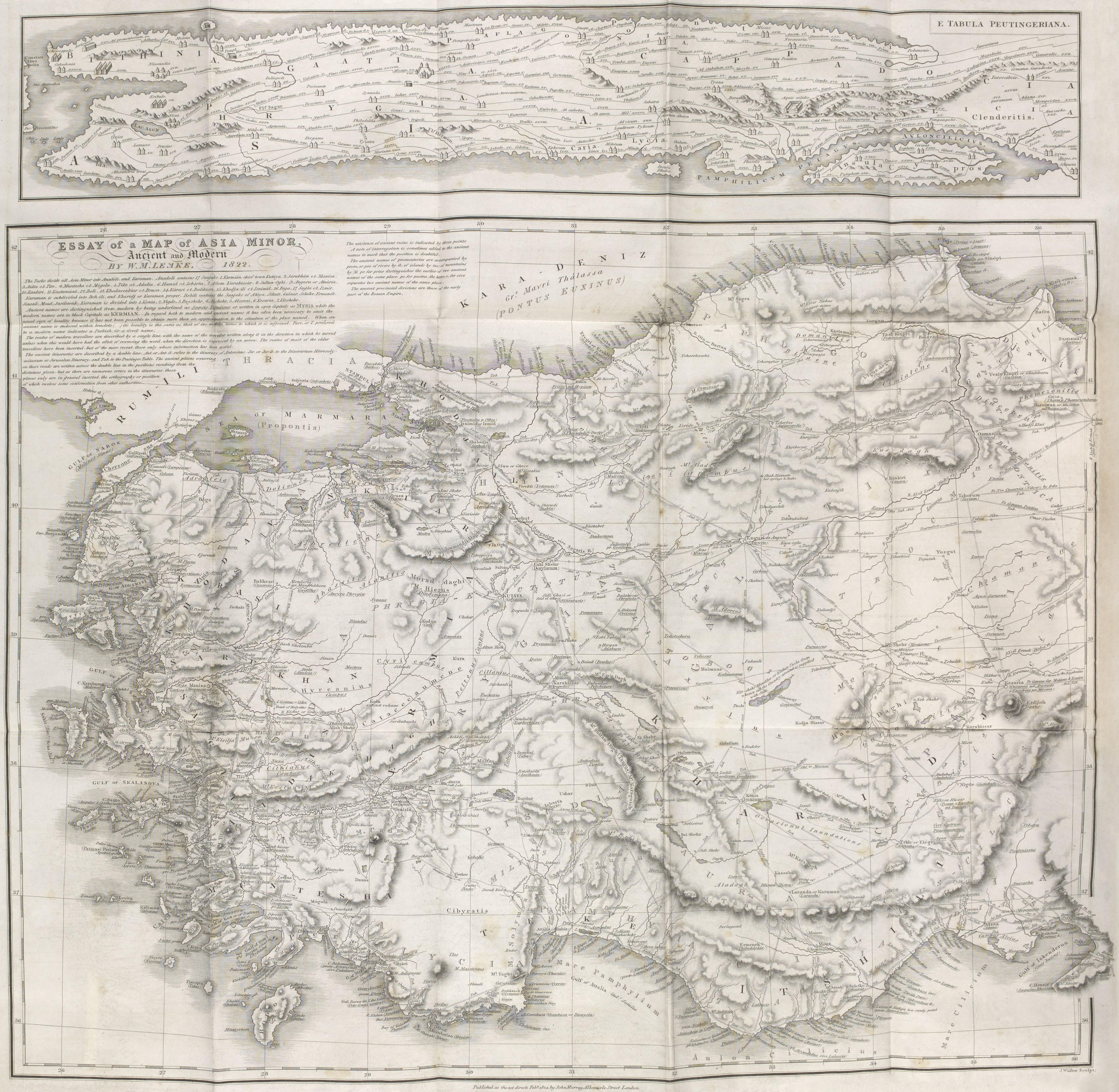

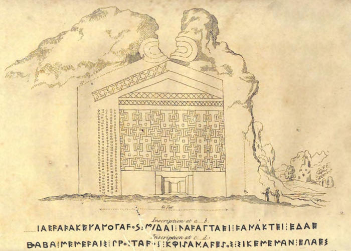
 , and it proves that these
remains belonged to Amyzon
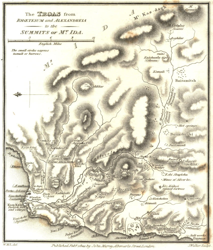
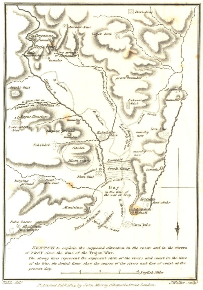
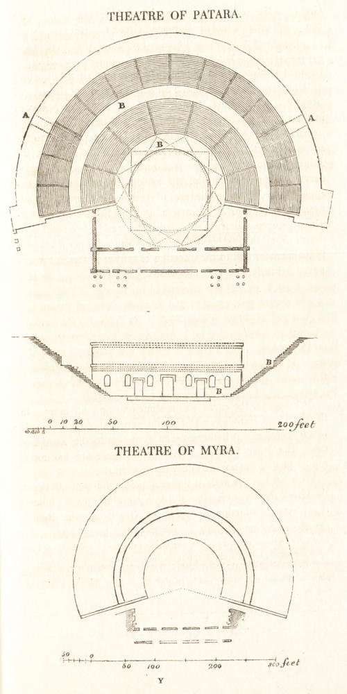
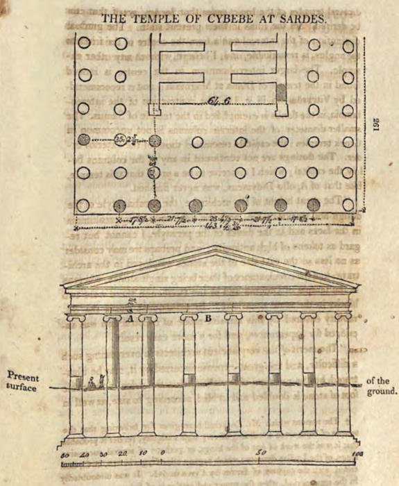
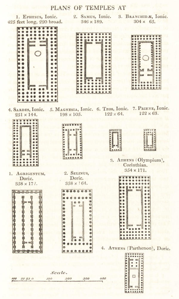
 ,
as written on several ancient monuments. The sixth letter
was perhaps a Τ, of which a part of the upper line has been
effaced. Upon this supposition, the name in Greek was
ΓΑϜΑΤΤΑΗΣ, which bears a resemblance to the royal Lydian
names, Sadyattes, Alyattes.