Some maps have been moved from their original location as printed in the
List. Maps shown in the text are thumbnails linked to larger versions.
Blue lines and numbers were extremely faded and have been redrawn. Note
that some maps include segments of railroad which had been planned but
not completed at the time of the guidebook's publication in 1888.
Is situated 54 miles W. from Leghorn, 98 m. S. from Genoa,
and 106 m. S.E. from Nice. It is 116 m. long, 52 m. broad, and
contains an area of 3376 square miles; divided into 5 arrondissements,
subdivided into 62 cantons, and these again into 363 communes, with a
population of 275,000. The surface, of which little more than a tenth is
under cultivation, is composed of lofty and rugged granite mountain
chains, diverging in all directions from the culminating peaks of Mounts
Cinto, 8892 ft.; Rotondo, 8613 ft.; Pagliorba, 8278 ft.; Padro, 7846 ft.; and Oro, 8829 ft. On the western and southern sides of the
island these ranges terminate abruptly on the shore, or run out into the
sea; while, on the eastern side, a great undulating plain intervenes
between their termination and the coast, in summer troubled with
malaria, but in a less degree than formerly.
Corsica is the central region of the great plant system of the
Mediterranean. Among the many fine forests which cover the mountains,
the most important are those of Valdoniello, Filosorma, Vizzavona Verde,
Zonza, Bavella, Ometa and Calenzana. They contain noble specimens of
pines, oaks, beech, chestnut, walnut and olive trees. The cork oak forms
woods, chiefly in the south of the island. The chestnut trees are as large and fruitful as the best
on the Apennines, and the nuts form the staple article of food for man
and beast during the winter months. Indeed, these glorious chestnut and
beech forests, when in full foliage, are the grand features of Corsican
scenery, which therefore cannot be seen to advantage till towards the
end of May, and if to this we add the splendid bloom of the oleanders,
not till July. “I at any rate know of no such combination of sea and
mountains, of the sylvan beauty of the north with the rich colours of
the south; no region where within so small a space nature takes so many
sublime and exquisite aspects as she does in Corsica. Palms, orange
groves, olives, vines, maize and chestnuts; the most picturesque beech
forests, the noblest pine woods in Europe; granite peaks, snows and
frozen lakes—all these are brought into the compass of a day’s
journey. Everything is as novel to the Alpine climber as if, in place of
being on a fragment of the Alps, severed only by 100 miles from their
nearest snows, he was in a different continent.”—D. W.
Freshfield, Alpine Club.
The prickly pear, the American aloe, the castor-oil plant and the
fig-tree, grow wild along the coast; while a little farther upwards, on
the slopes and plateaus, the arbutus, cistus, oleander, myrtle and
various kinds of heaths, form a dense coppice, called in the island
maqui, supplying an excellent covert for various kinds of game and
numerous blackbirds. When the arbutus and myrtle berries are ripe the
blackbirds are eagerly hunted, as at that time they are plump and make
very savoury and delicate eating.
There are few cows on the island, the greater part of the milk supply
being procured from goats. It is excellent, and has no rank flavour.
The Navigazione Generale Italiana, Piazza Marini, Genoa, have a steamer
every week for Portotorres, at the north-west extremity of Sicily, calling at
Bastia. Also from Leghorn to Bastia. Distance 72 miles, fare 20 frs.,
time 7 hrs.
Small steamer between Ajaccio and Propriano twice weekly.
There are besides three good family hotels, charging from 8 to 12
frs.; in the Course Grandval, the H. Continental, wine 1½ fr.,
carpeted brick floors, garden; near it, with south exposure and full
view of the bay, the *H. Suisse or Schweizerhof, wine 1 fr.,
smooth wood floors, partially carpeted, garden; at the top of the Course
Grandval, the H. Bellevue, wine 1¼ fr., partially carpeted
wood floors, garden.
These prices include coffee or tea in the morning, meat breakfast and
dinner and service, but neither candles nor wine, of which the lowest
price per bottle is given above. In the Place Bonaparte is the
H. de France, a good French hotel, pension 8 to 12 frs.
The office of the Compagnie Transatlantique is in the same Boulevard;
the office of the Compagnie Insulaire is in the Place du Marché.
AJACCIO, pop. 19,050, the capital of Corsica, is situated on the
extremity of a small gulf 677 miles from Paris and 15 to 20 hours’ sail
from Marseilles. Founded in 1492 by the Bank of St. George of Genoa, a
commercial association similar to the East India Company, it was raised
in 1811 through the influence of Madame Letitia and Cardinal Fesch to
the dignity of capital of the island, and became accordingly the
residence of the Préfet and the seat of the civil and ecclesiastical
Courts. Ajaccio has a handsome Episcopal chapel built by Miss Campbell, of
Moniack Castle, Scotland, an accomplished lady, the authoress of a work
on the island in French and English.
The houses in Ajaccio, as well as those throughout the island, are
generally built in large square blocks of from 3 to 5 stories, each
story forming a separate dwelling.
The mole at which passengers land from the steamers is at the foot of
the Place du Marché. In the centre of this “Place” is a fountain
ornamented with lions and a white marble statue of Napoleon I. by
Laboureur. To the left of the statue is the Hotel de Ville, the markets,
and the commencement of the Rue Fesch, in which is the edifice
containing the public library, the museum, and the memorial chapel (p. 5); while to the right is the Rue
Napoleon, in which the first opening right leads into the Place Letitia.
A little beyond this opening is No. 17, the house of the Pozzo di Borgo family, of whom
Charles André, 1768-1842, was the great upholder of Paoli and the bitter
enemy of Napoleon I. Napoleon’s house, though not equal to that of the
Borgo family, was one of the best in Ajaccio. It is well built, of three
stories of six windows each, and all the rooms have a more or less
handsome marble chimney-piece. Over the door is inscribed on white
marble “Napoleon est né dans cette maison le XV Aovt MDCCLXIX”. A good staircase, bordered by a wrought-iron
railing, leads to the top. The rooms shown are on the first floor. The
first is the parlour, with a small table, a few chairs, and a piano said
to have belonged to Mme. Letitia. Then after having passed through a
small chamber we enter the room in which Napoleon was born, into which
Madame was brought hurriedly from the church in the sedan chair kept in
the end room. Over the chimney-piece are portraits of the father and
mother. Then follows the dining-room, and after it the drawing-room,
with inlaid wood floor and six windows on both sides. The floors of all
the other rooms are of glazed tiles. In the next room is the sedan
chair. Fee for party 1 fr.
This now silent and empty house was once enlivened and brightened by
the fair Letitia and her large family of children, just like other men’s
children; schoolboys toiling at their Plutarch or Cæsar, and their three
young sisters growing up careless and rather wild, like their
neighbours’ daughters, in the half-barbarous island town. There is
Joseph, the eldest, then Napoleon, the second born, then Lucien, Louis,
and Jerome; then Caroline, Eliza, and Pauline, the children of a notary
of moderate income, who is incessantly and vainly carrying on law-suits
with the Jesuits of Ajaccio to gain a contested estate which is
necessary to his numerous family. Their future fills him with anxiety;
what will they be in the world and how will they secure a comfortable
subsistence? And behold! these same children, one after the other, take
to themselves the mightiest crowns of the earth—tear them from the
heads of the most unapproachable kings of Europe and wear them in the
sight of
all the world; and they, the sons of an Ajaccio lawyer, cause themselves
to be embraced as brothers and brothers-in-law by emperors and kings.
Napoleon is European Emperor; Joseph King of Spain; Louis King of
Holland; Jerome King of Westphalia; Caroline Queen of Naples and Pauline
and Eliza Princesses of Italy. In 1793, after the flight of Madame
Letitia and her children to her country residence, the Casone, the house
was pillaged by the Corsicans opposed to the French Republic.
Near the Place Letitia is the cathedral built in the 16th century by
Pope Gregory. It contains the font at which Napoleon I. was baptized on
the 21st July 1771.
In the Rue Fesch is the College founded in 1822. In one wing of the
edifice is the public
library, with 33,000 volumes, founded by Lucien Bonaparte, and the
museum and picture
gallery, with 900 paintings, mostly copies; and in the other the
memorial chapel built by Napoleon III., lined with beautiful marble. In
the crypt under the transept, left hand, is the tomb of Marie Letitia
Ramolino, died at Rome in 1836; and right hand, that of Napoleon’s
uncle, Cardinal Fesch, died at Rome in 1839. Both bodies were brought to
this, their present resting-place, in 1851. There are, besides, the
tombs of Prince Charles and of Zenaida his daughter. Napoleon’s father
died in 1785 and is buried at Montpellier. Madame was only 35 at his
death and had already borne him 13 children, 5 of whom were dead, and
Jerome was an infant in the cradle.
Parallel with the Rue Fesch is the Cours Napoleon, by which all the
diligences enter and leave the town. The continuation round the bay is
bordered with plane trees. At the commencement is a bronze statue of
“E. C. Abbatucci né à Zicavo le 12 Novembre 1770, mort pour la
patrie le 2 Decembre 1796.” Near it is the railway station.
At the western end of the Cours Napoleon is the Place Bonaparte or
Diamant, bordered with trees and ornamented with a complicate bronze
monument on a granite pedestal by Violet le Duc, “à la memoire de
Napoleon I. et de ses frères Joseph, Lucien, Louis, Jerome.” All
are life-size statues; Napoleon is on horseback, the others on foot,
marching solemnly towards the sea.
From the port, 11 m. W., is the chapel S. Antonio, 850 ft. The road
passes the penitentiary of S. Antonio, 331 ft. North from it, under
the peak of La Barrage, 1476 feet, is the Castelluccio penitentiary.
Westward by the Hospice Eugenie and the Batterie de Maestrello, a
pleasant road leads along the coast to the orange gardens of Barbicaja,
passing by the Chapelle de Greco and the cemetery. About 4 m.
farther is the Tête Parata, 199 ft., opposite the Iles Sanguinaires.
About 6 m. N. from Ajaccio is the village of Alata, 1312 ft. Within
an easy walking distance north from Ajaccio is the pleasant estate of Carrosaccia, on the canal
which supplies the town with water from the Gravona. 5½ m. N.
from Ajaccio are the sulphurous springs of Caldaniccia.
In the neighbourhood of Ajaccio and of the other Corsican towns and
villages are numerous family sepulchral chapels enclosed within walls. A
more pleasing characteristic feature, probably inherited from the Moors,
are the numerous fountains in the villages and by the road side,
whence flow streams of cold, sparkling water of exquisite purity.
The principal winds are the Libeccio or S.W. wind, the Sirocco or
S.E. wind, and the Mistral or N.W. wind.
Ajaccio to Bocognano by rail, thence by diligence to Corté; Corté to
Bastia by rail 47 m., or 44 by road. The road from Ajaccio ascends
the valley of the Gravona to its source at the Col Vizzavona. On the N.
side of the Col it follows the course of the Vecchio. The most
picturesque part of this route is between Vizzavona and Vivario.
AJACCIO
BASTIA
95
AJACCIO. Start from the station in the Cours Napoleon. The road, after
traversing the fertile plain of Campo dell Oro, crosses the Col
Sudricchio, 804 ft., and then the bridge of Ucciani, 948 ft., built in the reign of Louis XIV.,
17½ m. from Ajaccio and 2 m. from the village of Ucciani. Use
general map, and map,
p. 27.
Bocognano.
AJACCIO
BASTIA
25
70
BOCOGNANO pop. 2000, and 2120 ft. above the sea. Inn: Univers.
Picturesquely situated in a plantation of chestnut trees, surrounded by
high mountain peaks. Near Bocognano commences the Vizzavona tunnel, 4375
yards through the mountain. Diligence now to Corté. The road, having
crossed the Sellola bridge, 2843 ft., winds its way up by the Col de
Pinzalone, 3370 ft., and the Maison and Pont de Lavatoggio 3615 ft. to
the top of the ridge. See map, p. 27.
Vizzavona.—Pines.
AJACCIO
BASTIA
31
64
LE FORT DE VIZZAVONA on the summit of the Pass, 3813 ft. above the sea,
with the Gendarmerie and a few houses of refuge. A few miles northwards
is Monte d’Oro, 7845 ft., and southwards Monte Renoso, 7733 ft. The diligence, in its descent to
Vivario, traverses the forest of Vizzavona, consisting mainly of beeches
and larches, frequently 150 ft. high. Of
this tree there are two varieties, the Pinus pinaster or cluster pine, the Pin
maritime of the French, which grows best on deep loose soils and
flourishes even on the drifting sands of the sea shore. They supply
large quantities of resin. Their wood being soft, coarse and perishable,
is usually converted into charcoal and lamp black. The other is the Pinus laricio,
which thrives on the high lands of Corsica, Spain, south of France,
Greece and Cyprus. Their growth is rapid, the trunk straight and from
100 to 150 ft. high, the branches are in regular whorls, forming in
large trees a pyramidal head, and the leaves are slender, from 4 to 7
inches long, and of a dark green tint. The timber is good and durable,
though less strong than that of the Pinus silvestris. Between the
51st and 53d kilomètre stones
are passed the “Maison de Refuge
d’Alzarella,” and the “Maison de refuge Omellina,” 2832 ft.
After crossing the Col de Campo di Lupo, 2684 ft., 35 m. from
Ajaccio, the road descends into the ravine of the Vecchio, above
which is
Vivario.
AJACCIO
BASTIA
38
57
VIVARIO pop. 1500, and 2152 ft. Inn: H. Voyageurs a
three-storied house. Junction with road to Zicavo, 37 m. S.
(pp. 27, 29).
Although Vivario be a poor village, yet it has a terrace and fountain
ornamented with a statue of Diana. The breeding of pigs fed in the
adjoining chestnut forest, and the manufacture of hams, sausages and
bacon, are the most important industries of the inhabitants.
From Vivario a forest road extends 27 m. S.E. to the hamlet of Vadina, by Muracciole 2022 ft.,
1½ m., the Col
Erbajo 3018 ft., 7 m.; Pietroso 10½ m., Saparelli
12½ m., and Quinzena 18 m. From Vadina a good carriage road
leads 6 m. to the Baths of Pietrapola, which are
supplied by most copious springs of hot, saline, sulphurous water. The
season is from May 1 to June 30; or September 1 to November 30. The
situation is beautiful and the bathing-establishment and lodging
accommodation comfortable, and much frequented.
The road from Vivario to Serraggio passes along the top of the rocky
gorge of the foaming Vecchio. The best view of the gorge is from the
Pont du Vecchio 40 m. from Ajaccio and 280 ft. above the bed. From
Serraggio, 1890 ft., Mt
d’Oro is well seen. See map, p. 20.
The road now passes Lugo, 1980 ft.;
S. Pietro, 2496 ft.; the Col. S. Nicolo, 2473 ft.; and
Casanova, 2136 ft., to
Corté.
AJACCIO
BASTIA
51
44
CORTÉ 1329 ft., pop. 5500. Hotels: *Paoli, 8 to 10 frs., Europe.
Is situated at the junction of the Tavignano with the Restonico, in the
midst of majestic mountains of the most varied form. The citadel or
château, built in the early part of the 15th century, stands on
precipitous and jagged rocks rising from the Tavignano, commanding from
the top a magnificent view of the wild surrounding scenery. In the
“Place” is a statue of Paoli, the Corsican patriot, born at Stretta in
1726, and to the right of the statue the post and telegraph office. In
the immediate neighbourhood stands a large house, a Franciscan convent,
in which the Corsican parliament assembled in Paoli’s time. Near Corté,
by the left side of the Restonico, is a quarry of marble of a bluish
tint with reddish white veins. To take the walk up the gorge of the
Restonico, descend by first road left up the main street from the hotels
and cross only the Tavignano bridge. The mountain appearing to close the
valley is Mte. Rotondo. See map, p. 20.
Coach to Aleria, 31 m. S.E. (p. 33), by a beautiful road.
Just outside Corté the rail traverses the Torretta tunnel, 1531
yards.
Mte. Rotondo.
From Corté
the ascent of Monte Rotondo is most easily effected. It is 8613 feet
above the sea-level, or 7284 feet above Corté. Cabins inhabited by the
herdsmen are scattered over the declivities of the mountain up to within
3000 feet of the top. Time 2 days. Guide
with mule 25 frs. Ascend by the road up the picturesque valley of the
Restonico to the Timozzo bridge, 3590 feet, and 2½ hours from Corté.
From this the path extends 1½ hour up the wild ravine of the Timozzo to
the shepherds’ huts; whence the rest must be done on foot. Now the hard
work commences. Block lies above block, towering upwards and upwards in
such endless masses of monotonous gray that the heart quails with the
sight and the foot trembles to go farther. After about 2 hours’ scramble
over these colossal steps the traveller reaches the fontaine de
Triggione, about 2200 feet below the summit and in full view of it, an
incomplete circle of steep jagged cliffs. About 330 feet higher is a
little dark lake, the Lago di Monte Rotondo, encircled by gentle green
slopes, where the night is generally spent. Snow-field extend from the
lake to the summit, which, although apparently near, requires 2 full
hours’ climbing to reach, often on hands and feet, over sharp fragments
of rock, or up steep beds of slippery frozen snow. The extreme peak is a
rugged obelisk of gray rock ending in a pinnacle. A way leads down by
the S. side in 6 hours, to Guagno by lake Bettianella, 3419 ft., then W. by the road over the Col de Manganella,
5874 ft. See map, p. 20.
Granite.
“The view from Monte Rotondo did not impress me. The central uplands,
which form a large portion of it, are bare and arid, while the great
ridge of Monte Cinto stretches across the northern horizon like a long
screen. Comparatively little of the coast is seen in any direction, but
most towards the west. It was curious to notice how completely the tops
of the mountains between us and the Cinto ridge were flattened down,
while the crest on which we stood was a set of bristling teeth. There
are two kinds of granite in Corsica, one friable and unable to resist
the action of the air, the other hard and defiant of the elements. Of
this latter consist the Cinto range, Monte Rotondo and the rocks in the
forest of Bavella.”—D. W. Freshfield, Alpine Club.
The road now from Corté to Bastia traverses the Quilico Col, 1932
ft., passes Soveria, 1843 ft., and Caporalino, 8 m. from Corté, 36
from Bastia and 1 m. from Omessa. About 1½ m. farther it
crosses the Golo by the Francardo bridge, 856 ft., where it meets the great
Forest Road from Porto, 50 m. S.W. by Evisa and the Col de Vergio,
p. 18, and map,
p. 20.
Ponte Leccia.
AJACCIO
BASTIA
66
29
PONTE ALLA LECCIA 624 ft. Village, and coach and railway station.
Inn: Cyrnoz. Diligence to Calvi by the beautiful northern
continuation of the road from Prunete by Cervione and Piedicroce, p. 20. "Courrier" daily to Piedicroce,
18 m. S.E. by Morosaglia, see p. 34. During the summer heats Ponte
alla Leccia is considered insalubrious.
Ponte Novo.
AJACCIO
BASTIA
71
24
PONTE NOVO. The site of the disastrous battle fought on the 9th of May
1769, when the Corsicans lost their independence and
became subject to France. The two small houses on the right bank, a
little farther down the river, were Paoli’s headquarters. One month
afterwards he, with some other Corsican refugees, sailed from Porto
Vecchio in a British vessel for England (p. 39).
Borgo.
AJACCIO
BASTIA
85
10
BORGO pop. 820. On the Mariana hills, rising from Lake Biguglia, one of the many lagoons on the eastern coast,
separated from the sea by narrow sandbanks. Along this coast extend the
only large plains in Corsica. Unfortunately, in summer they are subject
to malaria, which, however, a judicious system of drainage is gradually
abating. They are cultivated by Italian labourers who visit the island
periodically. Between Borgo and Bastia is Bevinco, with valuable marble quarries. Southward from
Borgo on the coast is Mariana, the site of the colony founded by Marius
(p. 34).
Bastia.
AJACCIO
95
BASTIA pop. 21,000. Hotels: *France; Europe; Lingenieur; Croix de
Malte over the post and telegraph office, all in the Boul. du Palais,
8 to 10 frs. Theatre; Public Library with 65,000 volumes. Steamers twice a week
to Marseilles, time 18 hours, touching once a week at Nice, 12 hours
distant. Fare direct to Marseilles, including food, 28 frs. To Nice,
without food, 30 frs. Rubattino’s steamers leave three times a week for
Leghorn; time 6 hours. These same steamers proceed afterwards to
Genoa. Railway to Corté. Rail also to Aleria, whence diligence to
Bonifacio, Sartène and Ajaccio.
Diligences daily from Bastia to Cap Corse, 7 hours, 6 or 5
frs.; and also to Calvi, 12 hours, 13 or 10 frs.
Brando.
Carriages to visit the stalactite cave at Brando, 10 frs. Admission
2 frs. each. It is 7 m. from Bastia, above Erbalunga, on the
face of a mountain; and was discovered in 1841 by M. Ferdinandi. A
steep path leads up to it. Keeper near cave. See p. 12.
Bastia, the most important city of Corsica, is built on ground
rising gently from the sea. Facing the sea and the principal harbour is
the Place St. Nicholas, adorned with a marble statue of Napoleon I., by
Bartolini, looking towards the island of Elba. In this “Place”, the
promenade of the town, are the offices of the Messageries Maritimes and
of the Compagnie Insulaire. Fraissinet’s office is at the old harbour;
whence also their steamers sail.
From the Place St. Nicholas ascends the principal street, the
Boulevard du Palais, to the Palais de Justice. In this Boulevard are the
post and telegraph offices (whence most of the diligences start), the
hotels, cafés and the best shops, and from it ramify the streets of the
town. At the top of the B. du Palais commences, right hand, the
Boul. Cardo, one of the best roads to take for views of the town and
neighbourhood. A flight of steps leads from the quay up to the
cathedral, a handsome building in the Italian style. The markets are
held in the “Place” fronting the cathedral. Most of the houses are built
in large blocks from 5 to 6 stories high and from 6 to 9 windows broad,
each story forming a separate residence.
Bastia owes its name to the bastion built here by the Genoese in the
14th century. From the hills behind Bastia the view embraces the islands
of Gorgona, Capraja, Elba, and Monte-Christo, seen best from the top of
the Serra di Pigno, 3640 feet. Refer to map on
fly-leaf.
Steamers.
The most beautiful part of Corsica, and the most easily visited, is
the eastern side, including the Castagniccia or the chestnut country,
and the whole region up in the mountains, which border this coast. The
wealthiest, most industrious and most enterprising of the people are
those who inhabit that long narrow tongue of land called Cap Corse.
Although boats are constantly sailing from Marseilles and Leghorn to
Bastia, invalids visiting Corsica with the intention of wintering in
Ajaccio should, if possible, sail from Marseilles or Nice direct to
Ajaccio; but on leaving the island, when winter is over, Bastia is
perhaps the best port to sail from, as it affords an excellent
opportunity for visiting the most beautiful parts of Corsica and the
most important towns in Italy. On arriving at Leghorn (see Black’s
South France) it is best to proceed at once to the railway
station, and start for Pisa, only 30 minutes distant. There are numerous
trains. At the station and in the kiosques in the “Piazzas” of Leghorn,
is sold an excellent little book with all the railway Time-tables,
L’Indicatore Ufficiale, price 50 c.
Cap Corse.—Wine.
By diligence, fare to Rogliano, 4 frs. and 3 frs., distance
27½ m., 6 hrs. To Morsaglia, 5½ and 4½ frs., distance
37½ m., 8 hrs. By the road skirting the eastern side of the
peninsula of Cap Corse, the best cultivated part of the island, and
containing the tidiest villages. The best Cap Corse wine, mostly white, is produced around Luri and
Rogliano. The quality used as table wine is drunk the first year. It
improves till the fifth year, the better qualities till the tenth and
twentieth year. Cap Corse is traversed by a rugged mountain range or
serra, of which the
culminating peaks are Mount Alticcione, 4230 feet; Mount Stello, 4536
feet; and the Serra de Pigno, 3640 feet. From the east side of this
rugged serra little fertile valleys extend to the sea.
Pino.—Luri.
Mr. Freshfield thus describes the “Cap”:—“Down a promontory
8 to 10 m. wide runs a range 3000 to 4000 ft. high, with the
crest towards the western coast and the valleys towards the eastern.
Hence the western Cornice road is a terrace along an always steep,
sometimes sheer, mountain side, while the eastern crosses a succession
of low maquis-covered spurs, which beyond Cap Sagro flatten and become
monotonous. Pino is one of the most beautiful sites on the western
coast. It is also important as the spot where the cross-road through the
vale of Luri, under Seneca’s tower, falls into the western Cornice.
Half-way on this road the village of Luri groups itself in the most picturesque way imaginable on
a hill-side broken by a deep ravine. Down on the seashore above the
little Marina or port is a large convent; a church occupies a projecting
brow 200 ft. above it; higher still, and right and left, every
vantage-ground is occupied by groups of well-built villas and sepulchral
chapels. The slopes are terraced into orchards of citron, lemon, peach
and almond trees, olive groves and vineyards, sheltered from the gales
of winter by high palisades.”
Farther south, 5¼ m., is Nonza,
with inn, 479 ft., pop. 550. Coach to St. Florent. This is one of the
most curious villages of the island. It stands like an eagle’s nest,
perched above the sea on a black rock on the mountain side. Its houses,
built level with the edge of the cliffs, formed in olden days a
sufficient rampart against marauders.
The diligence having passed Lavasina 4½ m. from Bastia, Brando
7 m., and Erbalunga
6¼ m., halts at Sisco-port 9¼ m. To visit the cave of Brando take the steep narrow path left,
near a mill, just before arriving at Erbalunga. Seats in shady places
are placed here and there. The keeper’s house is close to the entrance.
The diligence then proceeds by Pietracorbara 11½ m., and the Torre all’Osse 13 m.;
one of the best remaining specimens of the 85 towers built by the Pisans
and Genoese to ward off the attacks of the Saracens. From the Torre the
diligence proceeds other 2 m. to Perticciolo, where it halts.
Seneca’s Tower.
Two miles farther is S. Severa, where the horses are changed and the
passengers breakfast. From S. Severa, a road ramifies
10 m. W. to Pino on the other side of the peninsula by the
valley of the Luri, with vineyards and orange groves, passing the
village of Luri 3½ m., with good inn, the Col de S. Lucie 7 m., 1363 ft., and
Saronese 9¾ m. From the Santa Severa inn, Seneca’s tower is
distinctly seen, at the head of the valley, on the summit of a
precipitous peak, rising from the S. side of the Col, 1355 ft., from
which a steep, stony path leads up
to it, by a forsaken Franciscan convent. The view is grand. To this
tower, one of the many watch-towers built in the 12th cent., Seneca
could never have been sent, but to the Roman colony of Mariana, then
used as a place of banishment for political offenders.
Seneca.
Lucius Annæus Seneca was born at Cordova in Spain, just before the
commencement of the Christian era. His eldest brother was A. Seneca
Novatus, which name was altered afterwards to that of his adopted
father, Junius Gallio. This brother was the proconsul of Achaia, before
whom St. Paul was arraigned (Acts xviii. 12). While Seneca was still a
child he was brought by his aunt to Rome, where he had for teachers
Sotion, Papirius Fabianus and Attalus the Stoic. Although weak in body
he was a most diligent student, which, joined to his powerful memory,
enabled him to obtain at an early age important offices. Before his
banishment, A.D. 41, he had
already served as quæstor. Having irritated Caligula, he would have been
put to death, had not one of the mistresses of the emperor assured him
that it was not worth while, as Seneca was so consumptive he would soon
die a natural death.
In the first year of the reign of Claudius, his wife Messalina having
become jealous of the influence his niece Julia, daughter of Germanicus,
had over Claudius her husband, succeeded in getting rid of her by
imputing to her improper intimacy with Seneca, then a married man. For
that reason Seneca was banished to Corsica A.D. 41.
During his exile he wrote his consolatory letter to his mother
Helvia, as well as a panegyric on Messalina and a consolatory letter to
Polybius, ostensibly to condole with him on the loss of his brother; but
in reality to get that powerful freedman to exert his influence with the
emperor, to recall his sentence of exile. This letter is full of fulsome
flattery and expressions unworthy of an honest man.
After the death of Messalina, Claudius married his niece Agrippina,
sister of Julia and mother of Nero by a former husband. Through her
influence Seneca was recalled A.D. 49 and appointed a prætor and tutor to
Nero, then 11 years old. In A.D. 51 Agrippina poisoned her
husband.
Macinaggio.—Rogliano.—Botticella.
From S. Severa, the diligence, resuming its journey, passes
Meria 20½ m., and halts again at the port of Macinaggio 2½ m.
more. From this commences the steep
ascent up to Rogliano 1300 ft., a town built in groups on
the side of the mountain, among vineyards and olive and chestnut trees,
the inn being in the second highest group, near the post-office.
After Rogliano the diligence crosses the Cols S. Anne, Cappiaja and
S. Nicholas, and arrives
at Botticella 31 m., and then proceeds to Ersa with inn, near the top of the Col de Serra 1182 ft., commanding a good view of Cap
Corse. Shortly afterwards the diligence arrives at Morsaglia, called also Pecorile, a village composed of groups of houses like
Rogliano on the side of a hill. The conductor of the diligence will show
the hotel. Six miles S. from Morsaglia is Pino, see p. 12.
From Botticella a road leads 4½ m. N. to Barcaggio, opposite the island of Giraglia, on which is a first-class lighthouse,
269 feet above the sea, seen within a radius of 14 m.
From Morsaglia the road is continued 31 m. farther to the Col
S. Bernardino on the Bastia and St. Florent road, passing Pino,
25 m. from the Col S. Bernardino; Minerbio, 21½ m.;
Marinca, 16 m.; Nonza,
9 m.; Farinole, 2½ m.; Pont du Patrimonio, 1¼ m.; and
joins the Bastia road at the Col S. Bernardino, 11¼ m. W.
from Bastia.
57 miles west; time 12 hours; fare 13 and 10 frs.
Col Teghime.
BASTIA
CALVI
57
BASTIA. The road traverses a mountainous country, with scanty
vegetation. As far as St. Florent the prevailing rocks are micaceous and
beyond granitic. Immediately after leaving Bastia the diligence
commences the ascent of the Col de Teghime (1785 feet) in the Serra di
Pigno, discovering as it winds its way upwards, an ever-extending
panorama over the great eastern plain, including Lake Biguglia, and the
Mediterranean with the islands of Elba, Gorgona and Monte Christo. As
the road descends towards the western shore, the enchanting panorama of
the blue gulf of St. Florent, encircled by low reddish rocks, gradually
unfolds itself. It was at this road, made by Count Marbœuf, at which, it
is said, King Bernadotte worked among the other labourers. It passes the
hamlets of Barbaggio and Patrimonio, the Col St. Bernardino 11¼ m.
from Bastia, and the Pont des Strette, and enters the valley of Nebbio,
partly watered by the sluggish Aliso, flowing through a marsh crowded
with oleanders.
St. Florent.
BASTIA
CALVI
14¼
42¾
ST. FLORENT, pop. 760. Hôtel de l’Europe, where a hurried breakfast can
be had while the horses are being changed. Close to the village is the
site of the ancient town of Nebbio, occupied now by a few poor houses
and a small church, now a ruin, built in the 12th century. Napoleon
said, “St. Florent has one of the finest situations I have ever seen. It
lies most favourably for commerce, its landing
places are safe and its roads can accommodate large fleets. I should
have built there a large and beautiful city.” It was one of the first
places to give adherence to the Bank of Genoa.
The road now for some distance leaves the shore and ascends a range
of barren hills containing slate, limestone and granite. Hardy trees
become more abundant than the chestnut, and the mountains higher and
more imposing, as we approach the little port of
L’Ile Rousse.
BASTIA
CALVI
42
15
L’ILE ROUSSE, pop. 1610; Hotel Europe. The diligence stops in the
“Place” near the monument to Pascal Paoli, and remains a sufficient time
to enable the traveller to cast a glance over the main features of this
port, founded by Paoli in 1759. The street beyond the “Place” leads by
the market to the harbour and to the long jagged tongue of red sandstone
rocks projecting into the sea, bearing on the extreme point a lighthouse
of the fourth order. Steamer every alternate week to Marseilles. There
is a charming view from the eminence St. Reparata, crowned with a
church, now abandoned.
Inland from L’Ile Rousse is the fertile valley of Balagna, famous for
the size and fertility of its olive trees (p. 20).
BASTIA
CALVI
47
10
ALGAJOLA, pop. 200. The block
of granite which forms the pedestal of the column in the Place Vendome
came from the quarries of this place. Pillars 65 feet long can be
procured from this quarry.
Lumio.
BASTIA
CALVI
51
6
LUMIO, pop. 1100, among orange groves and high cactus hedges. From the
hills here there is a beautiful view of the valley and gulf of Calvi.
Junction here with road to Corté, 55½ miles, south-east, passing through
a charming and picturesque country (see p. 20).
Calvi.
BASTIA
57
CALVI, pop. 2200. Inns: H. France, in the high town;
*Colombani, in the low town, near the dil. office and the wharf. Steamer
for Marseilles every alternate week. This, the nearest port to France,
is composed of the Citadel or Haute Ville and the Port or Basse Ville.
The former, although the residence of the public functionaries, has a
dilapidated and forsaken appearance. A rough road, paved with blocks of
granite, leads up to it and to the ramparts, commanding beautiful and
extensive views. The houses, shops and streets of the Basse Ville are
much better and more cheerful than those in the Citadel. Both are
defended by Fort Mozzello, rising behind the harbour. On the
Punta-Revellata is a lighthouse of the first order, with a fixed light
seen 20 miles off. Eight miles S.E. from Calvi is Calenzana, pop. 2900, with the
chapel of S. Restituta, visited by pilgrims.
CALVI
AJACCIO
102
Distance 102 miles S.E. The road skirts the coast the greater part of
the way. The first village is Galeria, pop. 500—Inn: Seta, 21 miles S. from
Calvi. From Galeria the Route Forestière, No. 8, extends 16 miles
eastwards to the Col Capronale, 4495 feet, in the forest of Ometa. Six
miles from Galeria is the entrance to the forest of evergreen oaks of Treccio, as well as the
commencement of the road, 4½ m. long, to the forest of Perticato by the Col Erbajo, 3½ m., 2090 ft., and the Bocca
Melza, 4½ m. 2500 ft.
Grand scenery. Guide necessary. Map,
p. 20.
This, the forest road No. 8, has two ramifications. The main line
follows the course of the Fango the whole way, and only becomes a
mule-path when near the Maison de Cantonniers d’Ometa, 14 m. E.
3¾ m. from Galeria a mule-path ramifies from the road to the
hamlets of Tuarelli, Prunicciole and Chiorna. 3 m. farther is the
ramification, 4½ m. S., through the forest of Perticato by the Col
d’Erbajo, 2090 ft., 3½ m. S., and the Bocca Melza, 2500 ft., 4½ m. S. From the
Bocca Melza a very bad path leads 2 m. S. to the hamlet of
Pinito. At the beginning of the above ramification the main road enters
the Ilex forest of Treccio, and leaves it nearly 2 m.
afterwards.
8¾ m. from Galeria is a roadside inn, and 3¼ m. farther the
entrance into the Ilex forest of Ometa.
11¼ m. from Galeria and about 2 m. from the almost unknown valley of the Lonca, an affluent of the
Porto, is the Pont de Lancone, 1083 ft., across the Rocce. From this
bridge there is a good view of Mt. Tafonato, 7687 ft., to the N.E., with its
singularly perforated peak.
13¼ m. is the Grand Cassis d’Ometa,
1680 ft. A little farther the road becomes a bridle-path, and ascends
from 1677 ft. to the Maison de Cantonniers d’Ometa, 2274 ft., and
1 m. farther is the end of the forest of Ometa.
15 m. from Galeria is the Grand Cassis de Giargione, 1163 ft., and about
2 m. farther the summit of Col Capronale, 4495 ft. A little way beyond, at the
Capo Guagnerola, is a beautiful semicircle of reddish rocks covered with
trees at the base. Farther E. by the Golo this forest road joins the
forest road No. 9 to Francardo (p. 18).
Having crossed the Col de Castellaccio, 850 feet, and passed through
the villages of Partinello and Vitriccia, 20 m. from Galeria, we
arrive at
CALVI
AJACCIO
51
51
PORTO (Inn: H. Padoram),
occupying a pleasant and sheltered situation at the head of a fine gulf,
with a climate rivalling that of Ajaccio. Most of the timber from the
forests of Valdoniello and Perticato is shipped here. For Porto to Ponte
Francardo, see p. 18.
The road from Porto to La Piana (map, p. 20)
affords a delightful
drive, and exhibits good engineering. It is cut for a considerable
distance through the rocks and cliffs and tall jagged peaks, like
cypresses turned into stone, standing on the edge of this savage coast,
parts of which are truly splendid. As the ascent is slowly continued,
charming views disclose themselves, and on each side of the road the eye
discerns some new beauty to dwell upon. At the Col Geneparo, to the
right are the ruins of the castle of the Colonnas di Leca, rising boldly
above the sea and surrounded and protected by magnificent natural
battlements and pinnacles. Six miles from Porto, after having passed the
Cols of Geneparo and Mezzano, both about 1250 feet, the traveller
reaches
La Piana.
CALVI
AJACCIO
58
44
LA PIANA, 1587 feet, pop. 1280. Inn: H. France. Delightfully
situated, with a fine sea-view. From the Col San Martino, 1 m. from
La Piana and 1630 feet above the sea, the landscape undergoes a rapid
change. The magnificent rocks become parched and arid and the grass as
yellow as the soil where it tries to grow.
Cargésé.
CALVI
AJACCIO
70
32
CARGÉSÉ, pop. 1100. Inn: H. de Voyageurs. A large village at
the foot of a hill which slopes down to the sea. It was founded by a
colony of 730 Greeks, who, fleeing from the oppression of the Turks,
arrived and settled here, by the permission of the Genoese, in March
1676. For having refused to aid Paoli in 1755 against the Genoese their
villages were burnt to the ground, and they themselves had to seek
refuge in Ajaccio. After the cession of Corsica to the French in
1769 M. de Marbœuf had the village and church of Cargese built for
the colonists, when they all returned. Greek is still spoken in the
village, and it has a Greek as well as a Romanist priest.
Sagona.
CALVI
AJACCIO
79
23
SAGONA, pop. 100. The port of Vico. It contains a few houses, one of
which is the inn, where beds, bread, eggs, coffee and wine can be had.
On the beach are generally large logs brought down from the forests for
shipment. Junction with road to Vico 9¼ miles E. (see p. 23), and also with the road extending 19 miles E. to the forest of
Aïtone, passing by the Col Vico, 7½ m., 1607 ft.; Poggio,
12½ m.; the Col Sevi, 3612
ft., 13¼ m.; Cristinacce, 16½ m.; and the Col Lacciola, 3040 ft. in the
forest. Five and a half miles from Sagona are the cold sulphurous springs of Caldanella; efficacious
as a tonic.
CALVI
AJACCIO
87½
14½
CALCATOGGIO, pop. 670. A
poor village on a hill above the road. From this the diligence shortly
after commences the ascent of the Col Sebastien,
1344 feet, 12 miles from Ajaccio.
After the Col Sebastien, the road having passed over the Col Staggiola,
930 feet, within a short distance of Appietto, situated on a hill;
reaches
CALVI
102
AJACCIO, 102 miles south-west from
Calvi.
50 miles north-east. Map, p. 20.
This important forest road traverses the region of the highest mountains
and of the greatest forests, passes through Albertacce, and by the other
villages of the Canton of Calacuccia, and then proceeds to Francardo by
the defile of the Golo.
Porto to
Evisa, 13¾ m., by an excellent carriage road wending
through most picturesque mountain scenery. The road, after following the
course of the Porto, crosses the stream Onda, ascends the ravine of the
Cario, which it crosses 3 m. from Porto under the Capo Polmonaccia,
5627 ft. It now winds its way round little valleys into the narrow gorge
of the Porto between dark red cliffs crowned with pinnacles.
Nine m. from Porto is the ramification of the mule-path to Chidazzo, and ½ m. farther the
ramification to Marignano. The road, after passing the chapelle
S. Cyprien, enters Evisa,
pop. 1000; Inn: *H. Carrara; 2770 ft., on a high promontory
projecting in the centre of a mountain-girt basin from the central range
between two deep gulfs hollowed out to a depth of 2000 ft. Behind it
rise pine forests to a broad mountain crest, the pass of the Niolo.
Evisa is admirably situated for excursions. A difficult winding path
leads in 2½ hours down to the great walls of the dark granite ravine
called the Spelunca, at the
confluence of the Aïtone with the Porto. Rambles and drives into the forest of Aïtone, from which
unfortunately the old stately pines have disappeared.
Evisa to
Albertacce, 18 m. E. The road traverses the forest of
Aïtone with its vigorous beeches and young pines (Pinus laricio),
whose stems are clear of branches from 80 to 100 ft. It is watered by
the Porto and numerous brawling streams; which rush down steep ravines
covered with moss and ferns. In the forest, 3 m. from Evisa, by
this road, is the Maison
forestière d’Aïtone, where those provided with introductions, see p. 41, will find pleasant headquarters for
grand excursions and fishing and botanical expeditions. 1¼ m.
farther is the house of
the road menders (Cantonniers) of Tagnone; where lodging can also be
had.
The road having made several detours to get round the heads of ravines,
ascends the Col de Vergio
4803 ft. on the great mountain chain separating the valley of the Golo
from the valley of the Porto. About 230 ft. above the Col on the Cricche
ridge, a little to the W., is an admirable view of Mt. Tafonato, 7687 ft., almost
due N., with a strange natural tunnel through the summit. From Mt. Cuculla, 6733 ft., nearly 1¾
hours W. from the Col is a still better view of Tafonato, and besides a
sight of Mt. Cinto, the valley of the Golo and the mountain range of
Monte Rotondo. A little beyond the summit of the Col is the Maison de Cantonniers
de Castellaccio, whence there is a good view of the forest of Valdoniello, 11,483
acres, containing besides many large pines very fine specimens of
beeches, birches and alders. The felling of the trees in this forest
commenced in 1863.
After arriving at the Maison forestière de Sciattarina 10½ m.
from
Evisa, the road passes by some of the finest trees, and descends into
the valley of the Golo;
which has its source in a ravine between Mts. Tafonato and
Paglia-Orba.
Four and a half miles farther is the Maison forestière de Popaja, 3468 ft., 15 m.
from Evisa and 3 m. from Albertacce. Either this house or the
former, make good quarters for exploring the forest.
Two miles farther is the Ponte Alto, 2740 ft.; where the road crosses
the Golo and enters the pastoral country of the Niolo; now called the canton of Calacuccia, comprehending
the villages of Albertacce, Calacuccia, Corscia, Lozzi, and
Casamaccioli.
From near the bridge a mule path of 1¾ m. ascends to Casamaccioli, 2780 ft., pop. 550;
whence the continuation leads in 7 hours to Corté by the Bocca la Croce,
the Melo forest, and the valley of the Tavignano.
Albertacce.—Monte Cinto.
Albertacce, 18 m. from
Evisa, 2845 ft., pop. 1000, a dirty village amidst chestnut and walnut
trees; where a good deal of coarse linen and Corsican cloth is woven. It
is one of the places whence the ascent is made of Monte Cinto, 8892 ft., in 7 hours, and in about 6
for the descent. The path ascends by Calasima, 3610 ft., to the height of 5251 ft. After this
the course extends almost horizontally in a western direction across
ridges, ascending by gradations more or less fatiguing.
When about 7720 ft., and having climbed nearly 6 hours, a cave is passed
where shelter can be had. The remainder of the ascent is comparatively
easy. The view is grand, Monte Falo, 8363 ft., being the most prominent
object. The ascent cannot be made till the beginning of summer on
account of the snow.
Lake Nino.
To Lake Nino, 5598 ft., the source of the Tavignano in 5 hours.
From the lake a mule path chiefly by the left bank of the Tavignano,
leads in 6½ hours to Corté, through magnificent forests.
Around the lake are some shepherds huts; where rest and refreshment can
be had, but no further supply of food can be counted on between the lake
and Corté. The lake, full of fish, lies in a hollow between high
mountains, the highest being Mt.
Retto, 6592 at the western end.
Albertacce to Ponte Francardo,
18 m. N.E. The road follows the Golo. To the left, a road
1¼ m., leads up to Lozzi, pop.
1050. 2½ m. from Albertacce is Calacuccia, 2779 ft. pop. 860, and 2 m. farther,
another byeroad ascends to Corscia, 2913 ft., pop. 1000, about 5 hours walk S. from
Asco, whence also Mt. Cinto may be ascended by the valley of the Asco
called also Stranciacone. Asco is 5
hours from Olmi Capella by the Stranciacone, its affluent the
Tassinella, and the Col de
Petrella, 6440 ft., to the S. of Mt. Corona, 7032 ft.
Near the chapel of S. Pancrazio, 2786 ft., 4 m. from
Albertacce is the commencement of the Scala di Santa Regina, as this part of road is called,
cut in the face of perpendicular cliffs rising from the bed of the Golo.
About half way are the small chapel and inn of Santa Regina, and the
cave which in former times used to be the stronghold of robbers.
Thirteen miles from Albertacce is the Pont du Diable, 1083 ft., where four roads meet. The road
southwards or to the right leads to Corté, 7 m. S. by Castirla
and Soveria, and the Col of
Oninanda, 2155 ft., between cliffs rising 1720 ft.
above it.
Asco.
The road leading northwards extends to the beautiful highway between Ponte alla Leccia and
Calvi; by Castiglione
3¼ m., pop. 550, at the foot of Mt. Traunato, 7186 ft., Popolasca, 7 m., pop. 200, with beautiful red
granite pinnacles, and Moltifao
12 m., pop. 1050, with Inn, consisting of a group of villages,
clustered on the slopes of the ridge which separate the valley of the
Tartagine from the Asco. The byeroad S.W. from Moltifao leads up the
highly picturesque valley of the Asco, with magnificent forest trees, to
the village of Asco, pop. 950, a group
of hamlets seldom visited, although one of the best points from which to
make the ascent of Mt.
Cinto.
Ponte Francardo.
The road leading 5 m. N.E. by the Golo extends to the Ponte
Francardo, where the rail may be taken. See p. 9 and General Map.
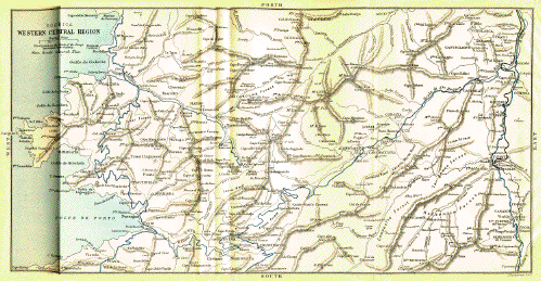
Corsica Western Central Region
— larger view —
By Ponte alla Leccia. The finest part of the road is between Calvi and
the Col Colombano. “If I were to permit myself to dwell in detail on the
exquisite variety and charm of the drive, especially after quitting the
route forestière a little E. of the hamlet of Palasca, I should
wander far from the main purpose of this paper. Valery, Gregorovius,
Lear and others have done justice to its wonderful beauty, and the last
truly remarks that ‘those who visit Corsica without going through upper
Balagne remain ignorant of one of its finest divisions,’ adding, ‘no
description can exaggerate the beauty of this remarkable tract of
mountain background and deep valley, which for richness of foreground,
cheerful fertility and elegance of distance may compete with most
Italian landscapes.’ The district is densely peopled—at least
twelve large villages are situated on the road itself between Belgodere
and Lumio, a distance of 21 miles—and picturesque hamlets with
lofty campanili perch high up on the mountain slopes or crown the
summits of the lower hills, whilst everywhere there is the richest
culture and most varied produce, and the charm of the picture is
completed by continually varying views over ‘bowery hollows crowned with
summer sea.’”—F. F. Tuckett, Alpine Club.
The Olive Tree.
CALVI
CORTÉ
61
CALVI. The road skirts the coast as far as Lumio, 6 m. from Calvi,
whence it commences to ascend gradually by an admirably engineered road
round the undulations of olive-clad mountains, disclosing at every turn
a different view of the fertile
valley of Balagna, extending from the distant mountains to the blue
waters of the Mediterranean. It is said that there is no district
throughout the whole of Italy where the olive attains such a size as in
this valley. Of the tree there are three varieties, the Sabine
(Sabinacci), the Saracen (Saraceni),
and the Genoese (Genovesi), the most common of all, and is
ascribed to the Genoese, who during the government of Agostino Doria
compelled the Corsicans to plant olives in great numbers.
After passing the picturesquely situated village of Lavatoggio, 9 m.; the Col
Cesario, 1200 ft., 10½ m.; the villages of Feliceto, inn, pop. 640, 16¼ m.; Castor,
24 m.; Speloncato;
Ville di Paraso, pop. 750;
Occhiatana, and many more perched on the surrounding mountain tops, or
nestling in nooks among olive and chestnut trees, the diligence
arrives at
Belgodere.
CALVI
CORTÉ
26¾
34¼
BELGODERE 1017 feet, pop. 950, commanding the finest view of this
beautiful valley, its orchards, fields and mountains undulating towards
the blue sea. The diligence just remains long enough to give time to run
through the gate and up the narrow dirty street to the top of the rock
on which the houses are clustered, and there to take a rapid glance at
the lovely scene around and underneath. After the gate, the diligence
halts at the post-office, and then moves on a few yards towards the
stables, where the horses are changed.
Capella.—Tartagine Forest.
From Belgodere, Route Forestière, No. 3, leads down to the small port of
Losari, 6 miles N. from Belgodere and 4½ E. from the Ile Rousse. A
continuation of the same route southward extends to the bridge across
the Tartagine, 2355 feet, 25 miles from the Ile Rousse, in the great
forest of Tartagine. It passes the Bocca Campana, 2782 feet, 3¼ miles
from Belgodere; the Bocca Croce, 3045 feet, the culminating part of the
road, 7 miles from Belgodere; and 2½ miles farther, the
hamlets of Olmi and Capella, 9 miles from Speloncato; with
ever-varying mountain and village scenes among great forests; 20 m.
from Belgodere is the Pont Tartagine in the forest of that name. The
forest of Tartagine, enclosed within the high crests of the Capo Dente 6667 ft. on the west, and of
Mt. Padro on the east,
measures 7166 acres, and contains principally the Pinus laricio
and the P. pinaster, intermingled with ilexes or evergreen oaks
(p. 41).
“Olmi-Capella 2723 ft. is in an open airy
situation, commanding fine views of the mountains to the S. and S.W.,
and protected to some extent on the N. and N.W. by the ridge which
sweeps round to the head of the Tartagine valley. This ridge, though in
the neighbourhood of the village only about 1000 ft. above the sloping
plateau on which it is built, rises to the W. into the peaks of Monte
Tolo 4370 ft., Monte San Parteo 5512 ft., Monte Cineraggia 5286 ft., Monte Grosso 6227 ft., Punta
Radiche 6595 ft., Capo al Dente 6667 ft., and Monte Corona 7031 ft. The N. slope of this ridge is
very steep, and commands most magnificent views of the Haute Balagne and
the sea beyond, whilst it is traversed by numerous passes which afford
charming scenery. Besides the route forestière, which crosses the
Col de Bocca
Croce 3048 ft., and by which the timber of the forest of Tartagine
is conveyed to Ile Rousse for shipment, several mule-paths connect Olmi
Capella much more directly with Ville
and Speloncato by the Bocca Battaglia 3550 ft., and Bocca Croce d’Ovo
3629 feet; with Feliceto by
the Bocca Pianile 5033 ft.; with Zilia and Calvi by the Bocca di Cineraggia 4698
ft.; with Calenzana by
the Bocca Bianca 6155
ft., with Calenzana or the Val Ficarella by the Bocca di Tartagine 6093
ft.; and with the head of the valley of Asco by the Bocca de l’Ondella
6086 ft.”—F. F. Tuckett, Alpine Club.
Palasca.
CALVI
CORTÉ
28¾
32¼
PALASCA pop. 550. Situated lower down than the high road and the last
village on this side of the
CALVI
CORTÉ
31½
29½
COL DE SAN
COLOMBANO 2625 feet above the sea. The view though more vast is less
distinct, presenting a succession of mountain-tops, between which are
dimly seen valleys with the sea in the distance. The diligence now
descends into the narrow, rocky vale of the Navaccia, an affluent of the
Tartagine, which enters the Golo a little above the important bridge
called the
Ponte alla Leccia.
CALVI
CORTÉ
46¾
14¼
PONTE ALLA LECCIA. Inn at station. Here take rail for Corté (see p. 8) or for Bastia, 29 miles N.E. (see p. 10). The Ponte Nuovo is distinctly seen from the station. The
two small houses near the railway bridge, on the S. side of the Golo,
were Paoli’s headquarters during the battle (see pp. 9 and 39).
CALVI
61
CORTÉ, see page 8.
Ajaccio to Vico and Evisa.
33 miles north; time 7 to 8 hours; fare 4 frs.
AJACCIO
VICO
33
AJACCIO. At about two miles from the town the diligence commences the
ascent of the low Col of Stileto, passing the aqueduct for the Gravona
water. On the left hand are the granite quarries whence the large slabs
were taken for the monument to Napoleon in the Place d’Armes, as well as
the long blocks for the pillars of the Marseilles cathedral. To the right are the village of Appietto,
pop. 700, on a hill and the great cliff Monte Gozzi, 656 feet high.
AJACCIO
VICO
12
21
Summit of the COL ST. SEBASTIEN,
1344 feet above the sea,
commanding a lovely prospect of the Bays of Liscia, Sagona and Cargésé,
and of the valley of Cinarca, with its villages and vineyards. At the
foot of the Col is a small inn called Le Repos des Voyageurs, where
bread and wine and capital
sea-urchins can be had. They are eaten raw, and taken out of the
shell by cutting it in two horizontally.
23
10
SAGONA junction with road to
Calvi, 79 miles N. (see p. 17).
AJACCIO
VICO
31
2
Summit of the COL ST.
ANTOINE, 1488 feet. Near the top,
at some distance to the left, is the village of Balogna, pop. 600,
while in front is seen the splendid range of the Monte Rotondo, among
which the most conspicuous is La Sposata, at the head of wooded
valleys.
The road to the left or N. leads to Evisa, 18 miles from Vico, pop. 1000, and 2770 feet
above the sea. Hotel: Carrara, a comfortable house, where
vehicles may be hired. Evisa is charmingly situated on the confines of
the forest of Aïtone,
containing 3,749 acres. Beyond Aïtone, or 11 miles from Evisa, is the
large forest of
Valdoniello, 11,483 acres. These forests, instead of extending
monotonously on large plains, plunge into deep valleys, or creep up the
sides of high mountains.
From Evisa descend to Porto (see p. 18).
Vico.
AJACCIO
33
VICO pop. 2020. Inns: France, where the diligence stops;
Voyageurs; Univers. Most picturesquely situated in the valley of the
Liamone, surrounded by steep mountains covered with apple, peach,
chestnut, walnut, olive and oak trees. On the opposite side of the
valley is the large whitewashed convent of St. Francis, with terraced
garden shaded by tall magnolias, beautifully placed on a thickly-wooded
bank, above which is seen the small hamlet of Nessa. It is a favourite
summer resort of the élite of Ajaccio, who revel here on carpets
of cyclamen, violets, and a profusion of other wild flowers, in the
shade of the dense foliage of the chestnut groves around.
Baths of Guagno.
Seven and a half miles from Vico up the wooded vale of the Liamone and
by the Bridges of Silvani and Belfiori, the village of Murzo and the Col
de Sorro, are the Baths of Guagno, with hot, sulphurous springs,
resembling in their properties those of Bareges in the Pyrenees (see
Black’s South France). From May to September they are much
frequented, when a coach runs between Vico and Guagno. Time, 2 hours;
fare, 3 frs. Coaches can be hired at Vico for Evisa. Charge, 10
frs.
53 m. S. by diligence, over a hilly road; 13 hrs.
AJACCIO
SARTÈNE
53
AJACCIO. The most comfortable way to go to Sartène is to take the
steamer to Propriano, only 8 miles N. from Sartène, and there to
await the daily coach. The diligence from Ajaccio, after having crossed
the rivers Gravona, Prunelli, Agnone, Vergajolo and Margone, and the
pass of Campolaccio, 843 feet, arrives at
Cauro.
AJACCIO
SARTÈNE
12½
40½
CAURO or CAVRO, 1180 ft. Inn. Coach to Bastelica. Pop. 700. A
straggling mountain village, commanding extensive views.
12 m. northwards by “Courrier” by a charming forest road, which
after crossing the Else at the Pont Zipitoli, 7 m. from Cauro,
enters the defile of the Prunelli at the Col de Menta, about 2 m. from Bastelica.
The road from Cauro crosses the Col Torro, 1394 ft., 1½ m. Four
miles, the col and bridge S. Alberto, 1710 ft. whence a road
ramifies 7½ m. S. to S. Maria-Siché and Grossetto. On the
right side of the road a waterfall descends from the crest of the
Usciolo. Large oaks and chestnut trees with ilexes and pines are now
seen. 7 m. here a short branch road leads to a maison forestière
surrounded by large trees, at the foot of Mt. Mantelluccio, 5515 ft. A
little farther a road ramifies 4½ m. by the wild and beautiful valley of the Else into the forest of Ponteniello, and where it
ends a mule path commences to Frasseto, pop. 750, on the coach road between Ajaccio
and the baths of Guitera. 7½ m. the Zipitoli bridge across the
Else, a short way above its junction with the Prunelli. On the right
side of the river is the Maison de Cantonniers of Zipitoli.
8 m. The Col Crichetto, 2380 ft., and nearly 3 m. farther the
Col Menta, 2458 ft., from which the road descends to the Prunelli and
continues by its banks to
Dominicacci.
Bastelica, pop. 4000,
inn, 2400 ft., consisting of a group of hamlets, none of which bears the
name of Bastelica. Sampiero
was born in the one called Dominicacci, between Stazzona and Costa, at
the end of the 15th cent., and killed by the Ornanos in the defile of
the Prunelli on the 17th January 1567. The house which stands on the
site of the one he lived in bears an epitaph to his memory, placed by
“William Wyse, Irish Roman Catholic,
nephew of Napoleon the Great.”
Mt. Renoso.
Among the many pleasant excursions is the ascent of Mt. Renoso, 7733 ft., 5½ hrs.
N.E.
In summer men go up every day with mules for frozen snow. There are
lakes on the south and east sides of the mountain, and some fine velvety
swards. Map, p. 27.
Five miles beyond Cauro, the Sartène road attains the summit of the
Col St. Georges,
2500 ft., commanding a fine prospect of the surrounding country, and
afterwards descends to the valley of Ornano, the native land of Vanina,
traversed by the Taravo.
AJACCIO
SARTÈNE
20
33
APA whence a Route Departamentale extends
18 m. N.E. to the baths of Guitera and Zicavo. Maps, pp. 1 and 27.
Baths of Guitera.
8¼ hrs. by coach and 39 m. from Ajaccio by the Apa mill, 1841 ft.,
then by the slopes of the Punta del Castello, 2674 ft., through a charming country, to S. Maria-Siché,
2 m. from Apa, inn where coach stops, pop. 800. An old lofty
building here of granite, with the remains of towers blackened by age,
was the birthplace of the unfortunate
Vanina, strangled by Sampiero,
p. 39. The ruins of the chateau he built
for himself in 1554, after his house had been destroyed, are seen on a
hill to the left of the road. Coaches for Ajaccio, Guitera, Zicavo, and
Propriano. 4½ m. from Apa at Campo, pop. 390, the road describes a great circuit to get
round the head of the defile of the torrent of Frasseto, an affluent of
the Taravo. 1¼ m. farther is Frasseto, pop. 740. When about 2770 feet high there is,
through an opening, a superb view extending to the sea by the valley of
the Frasseto. 8 m. from Apa is the Col de Granace,B* 2713 ft., with a splendid view. Zecavo, 10 m., 2238 ft., pop. 510, on
an affluent of the Taravo. Then rounding the buttresses of the Sposata, 3288 ft., enter the village of
Corrano, 12 m., pop. 470, in a lovely situation. 14½ m. from
Apa and 34½ from Ajaccio are the hot sulphurous springs of
Guitera, with hotel, 1437 ft., on the right bank of the Taravo,
an excellent trout stream. Coach to and from Ajaccio during the season,
from May to September. Pleasantly situated among cork oaks and banks
covered with the Osmunda fern. The road from the Baths of Guitera up to
Zicavo, 3½ m., follows for about 1 m. the Taravo till its
union with the torrent from Mt. Coscione, whence it climbs up through the
gorge to
Zicavo.—Mt. Incudine.
Zicavo, pop. 1500, hotel, 2385 ft.,
charmingly situated, overlooking the
valley of the Taravo, 38 m. by coach from Ajaccio. From Zicavo the
ascent is made of Monte
Incudine, 7008 ft., in 6 hrs. Mules can be employed to
within ½ hr. of summit. Although not difficult, guide and mule are
advisable, if for nothing else than to assist in fording the streams.
After having passed the chapel of S. Roch, ascend a steep mule
path, right, among the largest and best formed chestnut trees in the
island, then rounding Mt. Buchino, 3623 ft., among ilexes, and Mt.
Occhiato, 5749 ft., covered with beech trees, ascend southwards by a
wooded ravine between great rocks. Between 2 and 3 hrs. the Pastures of
the plain of Coscione, with many shepherds’ huts, are reached, whence
Mt. Incudine is seen. After leaving this the path becomes very bad, over
loose stones and across troublesome torrents. These are succeeded by an
annoying thick coppice of alders, and then the Col de Cheralba, 6345
ft., is ascended, in about 5½ hrs. from starting. The mules are left
here, and the ascent is made by the western flank, taking care to make
the guide understand that the highest peak is wanted, and not the Rocher
de l’Incudine.
Nelson.
“The view is probably the most beautiful in Corsica—a vast
panorama full of variety. Steep pine clad hills sink abruptly into the
eastern sea; glens open southward on a rich glowing valley; the blue
depths of the bays are fringed with an edging of white sand and green
water. The great granite aiguilles of the forest of Bavella, a strange
array of horns and pinnacles, run across the foreground; to the left the
long fiord of Porto Vecchio stretches far into the land; while in the
centre of the picture are spread out the broad Straits of Bonifacio,
studded with pale isles and islets. On the left is Caprera, the home of
the liberator of the Two Sicilies. The one beside it, Maddalena, is linked with even greater
memories—Nelson and Napoleon.
Under its lee, in a bay which
Nelson christened ‘Agincourt Sound,’ the British fleet lay for months
before the battle of the Nile, watching for the French squadron
sheltered behind the guns of Toulon. Two silver candlesticks on the
altar of the village church record Nelson’s gratitude for the friendly
services of the inhabitants. It was in attacking this same village that
Napoleon, in 1793, first
saw fire. For mountain views the Alpine clubman is spoilt, but for sea
views, and they are not less beautiful, he must go far, perhaps as far
as Greece, to find such another.”—D. F. Freshfield, Alpine
Club. See map on fly-leaf.
AJACCIO
SARTÈNE
21
32
GROSSETO 1476 feet, pop. 600;
4½ hours by diligence from Ajaccio.
A little beyond the inn is the church, sheltered
by large ilex trees, which grow to a great height in this
neighbourhood.
AJACCIO
SARTÈNE
30
23
BICCHISANO 350 feet, pop.
1800, where the passengers dine.
The diligence then passes the villages of
Petreto and Cassalabriva, pop. 300, and shortly afterwards
reaches the summit of the Col Celaccia, 1910 feet, about 2½ m. E.
from Sollacaro, pop. 800,
where Boswell visited Paoli. Sollacaro is not on the highroad.
Olmeto.
AJACCIO
SARTÈNE
39
14
OLMETO pop. 1650, hotel. On a hill, with an extensive view.
In the neighbourhood, on Monte Buttareto, are
the ruins of the castle of Arrigo della Rocca. No more beautiful sight
than that of Olmeto can be pictured. Immediately below the town the
ground dips steeply down, covered with corn or turf; or in terraces of
vineyard, varied with large groups of fine olive trees stretching down
to the shore. Above the village a vast growth of vegetation climbs the
heights. Among huge masses of granite are tangles of every shrub the
island produces, the wild olive or oleaster being one of the most
elegant; while every part of the heights close to the town abounds with
little picture subjects, with a clear blue sky for a background.
The road now descends to the coast, and after crossing the Baracci, near
the hot sulphurous mineral baths of
Baracci, arrives at
Propriano.
AJACCIO
SARTÈNE
44½
8½
PROPRIANO pop. 1000. H. France.
Every Saturday a steamer arrives from Ajaccio,
and returns on the Monday morning. Another steamer twice weekly between
this and Ajaccio. Near the bridge over the Rizzanèse, are the two Celtic
monuments called the Stazione del’ Diavolo.
Two and a half miles beyond the bridge commences the Route Forestière,
No. 4, leading to Solenzara, 42½ m. N.E. This road ascends by the
Rizzanese to S. Lucia di
Tallano, whence eastward to Levie, 1970 ft.; and thence Zonza, 2586 ft. The road afterwards ascends N.E. by a
picturesque ravine to the Col Bavella, 3965 ft.; whence after descending to
the Maison Cantonniere, 1476 ft., it crosses the Col Larone, 2013; whence it
descends by a winding road partly by the banks of the Fiumicello and
partly by the R. Solenzara to Solenzara (see p. 36).
Shortly after crossing the Rizzanese the diligence commences the long
ascent to Sartène, disclosing views of the great valley below and of the
splendid snowy heights of the long range of mountains opposite,
terminating in the lofty regions of the great Monte Incudine,
7008 ft.
Sartène.
AJACCIO
53
SARTÈNE 1000 feet; pop. 6010; Inns: Commerce: Univers.
Coaches daily to and from Ajaccio, Bonifacio and
Santa Lucia di Tallano. Old Sartène is a town of narrow streets
approached by a fine bridge, whence the whole valley is seen down to the
Gulf of Valinco. It still retains some towers and parts of the walls
erected in the 16th century. The houses are built of rough, dark gray
granite, with steep stone steps leading up to the main entrance, and odd
Italian chimneys, some in the shape of pillars with curious capitals,
others in the form of towers or obelisks. The houses bordering the
Nouvello Traverse and the streets leading into the “Place” form the new
town.
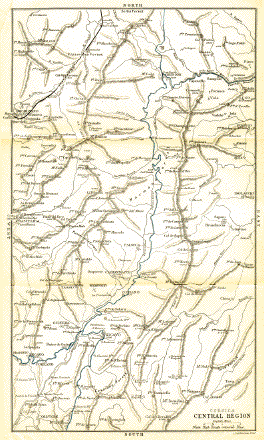
Corsica, Central Region
— larger view —
up the centre of the island. Maps, pp. 1 and
27.
This grand mountain road, No. 196 bis, extends from Sartène,
73 m. N. to the Ajaccio and Corté road, which it joins at the
60 kilometres-stone,
on the Col Serra, ½ mile from Vivario.
All the diligences between Ajaccio and Corté halt at the inn of Vivario
(p. 8).
S. Lucia di Tallano.
After leaving Sartène the road crosses the Fiumicicoli and ascends
the valley of the Rizzanese to Loreto, 12 m., and Cargiaca 15 m. N. from Sartène
1302 ft.; grand view. Near Loreto is S. Lucia di Tallano, 1270 ft.,
with a quarry of a beautiful amphibole, a variety of hornblende. The ground colour is
grayish blue sprinkled with white and margined with black spots (see p. 37).
Zicavo.
From Cargiaca the road enters the valley of the Coscione and ascends
through the ilex forest of Taca amidst
towering mountains and vertical cliffs by the villages of Zerubia and Aullene, 2736 ft., pop. 1100;
inn; 21 m. N. from Sartène. It now crosses the Coscione, 3492
ft., then the Col Vaccia, 3898 ft., and descends by the Col d’Alisandri,
3426 ft., to Zicavo, 2445 ft.,
with an inn, 17 m. from Aullene,
3½ m. E. from the baths of Guitera, 38 m. N. from
Sartène and 37 m. S. from Vivario.
From the Bocca Tinzole a road ramifies N.W. to Olivese 1460 ft., pop. 700, in the valley of the
Taravo, 7 m. from Guitera by a beautiful road.
From Zicavo the road crosses the Col San Francesco, 1969 ft., to Cozzano, 40 m., pop. 900, and
enters the valley of the Taravo, which it ascends by the east bank
between two great mountain chains, the culminating point of the western
chain being Mt. Don
Giovanni 6405 ft., and that of the eastern Pointe Capella 6706 ft.
Three and a quarter miles up the valley from Cozzano a wheel road leads
1½ m. E. to the Maison Forestière of St. Antoine, whence a mule
path by the Col de Rapara,
5557 ft., extends to Isolaccio and the hot baths of Pietrapola, p. 8, by a picturesque road through a
beautiful part of the forest.
Four and a half miles above Cozzano is the Col Scrivano, 2959 ft., whence a mule path leads
across the valley to Palneca,
pop. 1050, on the wooded slopes of Mt. Pietra Cinta, 4958 ft.
A little below the summit of the Col is the Maison de Cantonniers de
Scrivano.
Nine and a half miles N. from Zicavo is the bridge Argentuccia,
fronting a grand semi-circle of mountains covered with noble trees. This
is the commencement of the real Verde forest.
Eleven and three quarter miles from Zicavo is the Maison de Cantonniers de Ghiraldino, 3936 ft.,
49 m. N. from Sartène, 2 m. S. from the Col Verde
and 5 m. S. from the House of Refuge of Marmano. A little
beyond the house a wheel road, left, descends into one of the finest
parts of the Verde
forest.
Col Verde.
Thirteen and three quarter miles from Zicavo and 51 m. from
Sartène is the Col Verde, 4290 ft., with, nearly a mile distant, the Maison de Cantonniers de
Marmano. Below is the forest of Marmano, with its best trees cut down,
and in the neighbourhood the sources of the rivers Taravo, 5678 ft., at the Col Tisina, of the Fium Orbo, 3783 ft. under a mountain a
little to the N. of the Col Verde, and of the Prunelli, 4790 ft., among a group of high mountains to
the W. The Vecchio rises
from the springs on Mt. Oro.
Refuge de Marmano.
Seventeen miles from Zicavo and 54 m. from Sartène is the Refuge
de Marmano, 3182 ft., beautifully situated. Here was formerly the summer
station of the Casabianda
penitentiary. The escaped criminals committed such outrages that the
government at the repeated petitioning of the shepherds were obliged to
withdraw it. Finally Casabianda was abandoned also, and the prisoners
removed to the neighbourhood of Ajaccio, where they could be well looked
after.
Food and lodging may be obtained at the Maison Forestière, or
1¼ m. farther at the Maison de Cantonniers de Canareccia, 2760 ft.,
in the rocky defile of the Fium Orbo. Between this and Ghisoni,
6 m., 3 bridges and 2 low Cols are crossed. At the second
bridge, the Pont de Casso, 4½ m. from Ghisoni, are seen the great
pinnacles or needles and lofty cliffs of Albuccia Point or Kyrie
Eleison, 4935 ft.
From the Canaraccia the road winds its way northward along the
flanks of mountains sloping down to the Orbo, which it leaves shortly
before reaching
Ghisoni.—Col Sorba.
Ghisoni, pop. 1740, 2160 ft., 62 m. N. from Sartène,
12 m. S. from Vivario, 8 m. N. from the House of Refuge, and
24 m. N. from Zicavo. Four m. N. from Ghisoni the
road crosses the Col Scozzolatojo, 3916 ft., and 2 m. farther
the Col Sorba, 4310 ft.,
6 m. S. from Vivario, see p. 8. The descent from the Col Sorba into Vivario is
very striking. It is effected by excessively sharp zigzags through a
noble pine forest. Between the branches tower the bold forms of Monte
d’Oro, Monte Rotondo, and, in the distance, behind the uplands of Corté,
the crags of Monte Traunato.
The best resting-places on this road are Zicavo, 39 m. S.E. from
Ajaccio, from which it is approached by a diligence; and the pleasant
village of Ghisoni, where there is a very fair inn. At Vivario there is
the Hotel Voyageurs. Guides and carriages should be hired either at
Sartène or Vivario, 20 frs. per day.
By the Forest road No. 5, cut for nearly 11 m. in the face of the
steep cliffs which enclose the Orbo. As this road in all the dangerous
parts is hardly 11 ft. wide, it is necessary to ascertain before
starting in a vehicle, the position of the carts conveying the logs, and
to arrange accordingly.
The road descends from Ghisoni to the Pont de Regolo, 2077 ft., where it
crosses the Casapietrone, and then follows the course of the Fium Orbo,
crosses the Ruello Bridge 1450 ft., and enters the Salto della Sposata
4½ m. from Ghisoni, where the river flows in a narrow bed between
vertical precipices, some more than 1200 ft. high.
L’Inzecca.
The road, chiselled out of these cliffs, passes under 3 great portals.
From the third is seen, through the great cleft in the rock of Inzecca,
the sea at Aleria.
After this the defile opens up to close again between serpentine cliffs.
It then crosses the 2 Ponts de Parabuja and the viaduct de l’Inzecca,
and reaches the entrance to the Passage de l’Inzecca, 7 m. from Ghisoni, 985 ft. above the sea, where the road is
cut through great serpentine rocks. This is the most difficult part for
the waggons to pass. Map, p. 27.
The plain now widens, and 8 m. from Ghisoni a branch road leads to
Vezzani.
Nine and a quarter miles from Ghisoni is the Col S. Antoine,
355 ft., and 8¾ m. farther is Ghisonaccia, p. 32.
33 miles south-east, by diligence; time, 6 hours.
SARTÈNE
BONIFACIO
33
SARTÈNE. The road winds its way through great blocks of granite
scattered on a plain studded with shrubby specimens of the ilex, towards
the shore of the Golfo di Roccapina, with a fantastically shaped rock
called il Leone Coronato. East from
the gulf the road passes the village of Pianottoli, 21 m. from
Sartène, almost due south from the singular mountain l’Uomo di Cagna, 3980 ft.; then the bridge
across the Figari at the head of the Gulf of Figari, 23 m.; the Col
de la Testa or Scopeto, 225 ft., 24 m.; and the bridge across the
Ventilegni, 27 m. from Sartène, and 6 from Bonifacio.
Bonifacio.
SARTÈNE
33
BONIFACIO pop. 4000. H. du Nord; France in the high town.
Diligences leave daily for Bastia, Sartène, and Ajaccio. A steamer
arrives every Saturday from Ajaccio and returns on the Monday. Bonifacio
was founded in 833 by the Tuscan marquis whose name it bears, to protect
this part of the island against the piratical incursions of the
Saracens. The high town is built on the top of a limestone rock rising
vertically from the sea. The low town occupies one side of the fine
natural dock, hemmed in by perpendicular cliffs with an opening of only
328 yards towards the sea. From the steamboat wharf a broad paved series
of steps leads up to the high town, entering it through the Porte
Vieille. In the old house fronting this Porte or gateway, Charles V., in 1541,
stayed two days and a night on his return from his unsuccessful
expedition against Algiers. Overtaken by a storm, he had taken refuge in
the Gulf of Santa Manza. The door of the house, decorated with an
arabesque on marble, is in the narrow side street. In the Place d’Armes
are the church of San Domenico, built by the Templars, characterised by
its octagonal tower with an embrasured termination; and the great tower
“Torrione,” part of the fortifications built by the marquis, and
formerly the most important part of the citadel. Near this tower is the
flight of steps “Redragon,” cut in the rock by the Genoese, which
descends by 202 steps to the sea. The small room over the gateway of the
citadel, opposite the house of Charles V., was inhabited by Napoleon for nearly
eight months. There are grand sea-views from the ramparts. The town
consists of tall, dingy houses, and narrow, steep, and in most cases
dirty streets. The promenade of Bonifacio is the small covered terrace
before the church of Santa Maria. Here also is the public cistern.
Of the numerous caves which pierce the base of the rock of
Bonifacio, the most remarkable one enters from the sea, 214 feet below
the
Place d’Armes, and extends to an unknown distance. It contains a
freshwater lake, which rises and falls with the tide. A staircase with a
vaulted roof and consisting of 337 steps leads down to this lake. The
water is brought up to the surface by a force pump, is perfectly
transparent, with a slight calcareous taste. In the high town there are
39 private and one public cistern, in which the rain water from the
roofs is stored up. The low town has a well supplied from a stream by an
aqueduct. The afternoon is the best time to visit the caves. A boat for
one or party should not cost more than 5 frs. The finest, the
Dragonetta, cannot be visited when the sea is rough.
On Monte Pertusato
(the south extremity of Corsica), 2 miles S.E. from Bonifacio, is a
lighthouse of the first order, 325 feet above the sea. The southern
promontory is pierced by a cavern hung with stalactites.
103 miles; diligence to Ghisonaccia, 50 m. N., the rest by
rail.
BONIFACIO
BASTIA
103
BONIFACIO. The diligence, after passing the Col Finocchio, 354 feet,
2½ miles N. from Bonifacio, the Maison Francola, 7 miles, the
bridge across the Stabiacco, 16 miles, and the Col Mattonara, 17½ miles
(whence the Route Forestière, No. 11, ascends 14 miles west into the
forest of the Ospedale), arrives in 3 hours at
Porto-Vecchio.
BONIFACIO
BASTIA
27
76
PORTO-VECCHIO, pop. 2740. Hôtel Amis. Surrounded by its old walls, and
at the head of a beautiful gulf. The surrounding country is fertile, but
unhealthy during the hot weather, on account of the miasma rising from
the morasses and lagoons. To the N. of Porto, the mountains still
approach near to the sea; but beyond Solenzara (where the diligence
halts) 41½ miles from Bonifacio, they recede and leave free those great
undulating plains which characterise the eastern coast of
Corsica—plains almost uninhabited and covered with heaths. From
the north side of the Travo commences a series of large lakes swarming with fish and a kind
of cockle. They are separated from the sea by long narrow sandbanks,
like earthen break-waters. The malaria prevails from June to October,
but even then only the night should be avoided in travelling along this
coast. The road after passing by the hamlet of Favona, 33 m.,
arrives at
Solenzara.
BONIFACIO
BASTIA
45
58
SOLENZARA.
Whence a wheel road extends westwards into the
forest of Bavella by the Col Bavella 18½ m. S.W., and the Col Scalella,
22 m., 2982 ft. to Zonza,
24½ m. from Solenzara; 4 m. farther is the village of
S. Gavino di Carbini, 2292 ft., and other 2½ m.
the village of Levie; 30 m.
S.W. from Solenzara, and 10½ from Propriano is S. Lucia de Tallano,
on the highroad to Aullene (see p. 27), and for continuation of this road
to Propriano see p. 26.
The road to Bastia, after passing the Travo, 44 m., Vicchiseri,
46 m., and Casamozza, 48½ m., arrives at the railway
station of
Ghisonaccia.
BONIFACIO
BASTIA
53
50
GHISONACCIA pop. 850. On the Fium Orbo, 36 m. S.E. from Corté.
From this a department road of 4½ m. leads
to the hot sulphurous baths
of Pietrapola, with a large hotel in a healthy situation.
From Ghisonaccia a carriage road extends N.W. to the villages of Poggio-di-Nazza, 9½ m.,
and Lugo-di-Nazza,
11½ m. From Ghisonaccia railway station a forest road extends
18 m. N.W. to Ghisoni, where it joins the high road between Sartène
and Vivario (p. 29). The southern
prolongation of this road leads to Zicavo, Petreto, Bicchisano, and Portopollo, on the Gulf of
Valinco.
Forty-six m. from Bastia is Casabianda. H. Perett; a
village situated on a well-cultivated estate belonging to the
government; formerly used as an agricultural penitentiary for juvenile
criminals. In the hot season it is safer to pass the night at Casabianda
than at Aleria.
Aleria.
BONIFACIO
BASTIA
58¼
44¾
ALERIA. Inn. The capital of Corsica till the invasion of the Saracens in
the 4th cent., now a poor village with an old Genoese fort, situated at
the mouth of the Tavignano, 1¼ m. from the Etang de Diane. Ancient
Aleria, the colony founded by the dictator Sulla about 82 B.C., occupied both banks of the Tavignano, which
waters one of the finest plains in the world, where winter is unknown.
The site of the town was well selected. The population was probably
20,000.
It was at Aleria that Theodore
Neuhoff, a native of Altona, in Germany, landed to have himself
proclaimed King of Corsica, March 1736. He died a pauper in London, and
was buried in an obscure corner of St. Anne’s churchyard, Soho. On a
mural tablet against the exterior wall, west end, is the following
epitaph written by Horace Walpole:—“Near this place is interred
Theodore, King of Corsica, who died in this parish, Dec. 11, 1756,
immediately after leaving the King’s Bench prison, by the benefit of the
Act of Insolvency. In consequence of which, he registered his kingdom of
Corsica for the use of his creditors.” His capital was Cervione. The lake de Diane is a great sheet of salt water with one
narrow opening to the sea. It formed the harbour of Aleria, and was
provided with quays, of which a vestige still remains. The lake contains
an island 460 yards in circumference, composed of oyster shells covered
with luxurious vegetation. Fish, and a cockle a species of Venerupis,
inhabit the brackish water of the lake.
Coach every other day; fare, 5 francs; time, 4 hours.
Thirty-one and a half m. N.W., by a picturesque road up the course
of the Tavignano, passing Cateraggio, 2 m., Rotani, 5 m.,
commencement of bridle path leading N. to Tallone, 7½ m., Tox,
9½ m., Campo, 11 m., and Moïta, 12½ m. Seven m.
farther up the main road a ramification extends N. to Giuncaggio,
4½ m., and to Pancheraccia, 5½ m.
Up the main road, 21½ m. from Aleria, and near the bridge across
the Vecchio, a bridle path strikes off S. to Rospigliani, 5 m., and
Vezzani, 6½ m. A little higher a ramification extends
5 m. W. to Serraggio (p. 8). The
road, after passing several other ramifications with the Corté and
Ajaccio road, arrives at Corté, p. 8.
Ten m. W. from
Aleria are the cold saline sulphurous springs of, 190 ft., considered
efficacious in the cure of syphilitic diseases, resembling in this
property the water of Aulus in the Pyrenees. See Black’s South
France, West Half (Pyrenees).
Prunete.—Cervione.—Alesani.
BONIFACIO
BASTIA
79
24
PRUNETE. Inn: Gaetan. Junction with road to Ponte alla Leccia,
44 m. N.W. (p. 9), leading through a
region of chestnut trees and past many villages on the mountains, built
chiefly on terraces. A coach runs from the station to Alesani
called also Castagneto 1938 ft. 14 m. W.;
ascending by Muchieto 808 ft. 3¾ m., Cervione 1073 ft. 4½ m., pop. 1000; Inns:
France: Voyageurs: an untidy village, once the capital of King
Theodore’s realm. From Cervione the road describes a long detour to the
bridge across the Chebbia, whence it ascends to Cotone 1008 ft 6¼ m., the Col d’Aja 1236 ft., and
Ortale 1489 ft., 1¾ m.
from Alesani. Good red wine is made in the neighbourhood of Cervione. The dirty little village of Castagneto
or Alesani is picturesquely situated on the side of a mountain
overlooking a valley covered with chestnut trees. The diligence stops at
an inn, where bread, eggs and coffee with goats’ milk can be had and a
comfortable bed. A char-a-banc from this inn to Piedicroce (Orezza)
costs 10 frs., time 2½ hours, 11 miles. For Orezza, see p. 34. Passengers from Prunete to Piedicroce or
Stazzona should not stop at Cervione but continue the diligence route to
Castagneto, whence start next morning. The drive between Castagneto and
Piedicroce, 11 miles, is by far the most beautiful part of the road. The highest part of the
Col d’Arcarotta is a narrow ridge between the valleys of Orezza and
Ortia, commanding a charming view. See also p. 35.
BONIFACIO
BASTIA
87¼
24¾
PADULELLA. Four and a quarter
miles west by a good road is San Nicolao, pop. 600.
Stazzona.
BONIFACIO
BASTIA
84¼
18¾
FOLELLI-Orezza station.
Junction with road to Piedicroce 14¼ m.
S.W.; by the course of the Fium’alto, the Chestnut country, and the
village of Stazzona, 13¼ m. from Folelli, ¼ m. from
and 355 ft. under Piedicroce, and 1 m. from and 200 ft. above the
spring of Orezza. The coach from the station stops at Stazzona, pop.
250. Hotels: *Paix, Casino. Very fine oleanders in the gardens.
On the opposite side of the valley of the Fium’alto is Granajola, with
the establishment Manfredi, 2016 ft. above the sea and 220 feet above
the spring. The hotel Manfredi has the most select society, is the
largest house, and its road from the spring is the least dusty; but as
no public coach goes there it is necessary to hire a private conveyance
either at Stazzona or Piedicroce, 3 or 4 miles. The charge in all
the hotels is 7 frs. per day, not including coffee or tea in the
morning. The hotels of Stazzona and the hotel Manfredi are the most
convenient for the Spa drinkers; those of Piedicroce are too
distant.
Orezza.
The Orezza spring is in the centre of a small terrace in the narrow
valley of the Fium’alto, whose steep banks are covered with chestnut
trees, and ascended by dusty winding roads. The water is a bicarbonate
chalybeate, with an agreeable amount of free carbonic acid gas.
Vescovato.
BONIFACIO
BASTIA
89
14
VESCOVATO STATION. Town 1¼ m. W., pop. 1500.
*H. de Progreso in the large “Place” where
all the coaches stop, near a fountain of pure gushing water, cold even
in summer. The rather untidy town of Vescovato is almost hidden in the
corner of a valley, 550 ft. above the sea, by woods of vigorous olive
and chestnut trees. From it a coach starts daily to Porta,
15 m. W., by a bad, dusty, jolting road, passing through Venzolasca, pop. 1300, on the
top of a hill, 732 ft., 1½ m. from Vescovato. Three m. farther
a road, left, 1 m., leads to Porri, 1718 ft., pop. 300. 7½ m. from Vescovato is the
Col S. Agostino, and then follow, 8 m., Silvareccio, 2198 ft., pop. 550;
8½ m., Piano, 2230 ft., pop.
170; Casabianca, 4 m.
farther, 2133 ft.; and then Porta,
pop. 630; Inn: H. Franceschi, in the “Place,” opposite the
church, where the coach stops. In July and August the coach goes on to
Piedicroce.
BONIFACIO
BASTIA
91
12
PONT DU GOLO. A little more than
3 miles from the bridge, at the mouth of the river, stood the town
of Mariana, founded by Marius
(B. 155, D. 86 B.C.), where
Seneca most probably spent his exile, and of which there remain only a
few insignificant fragments on the beach. In the vicinity are the ruins
of a chapel, and about a mile farther those of the church, called La
Canonica, with 2 aisles and a nave 100 feet long and 40 wide, ornamented
with rows of pillars of the Doric order. Both church and chapel are in
the Pisan style.
At Casamozza Station,
12½ m. S. from Bastia, the Aleria railway joins the one from
Corté.
BONIFACIO
103
BASTIA. See p. 10.
Eighteen miles S.E. by “Courrier” daily. Fare 3 frs. Time 5 hours,
by a mountain road, making immense circuits round by the
heads of ravines among rich pastures and great chestnut and beech
trees.
Nine miles from the Ponte is Morosaglia, pop. 1060, with an inn, where the
coach stops. A conglomeration of hamlets on the slopes of a mountain,
one of which, Stretta, was the
birthplace of Pascal Paoli. 2 m. farther is the summit of the Col de Prato with an inn, 3215
ft., 2850 ft. below, or 3 hours from the top of San Pietro, commanding a
magnificent view of the Castagniccia or the Chestnut country, and the
islands of Monte Christo, Pianosa, and Elba, floating in the haze
between sky and water. See map on fly-leaf.
Castagniccia.
The Castagniccia may be said to lie between the Golo and the
Tavignano, bounded on the W. by the railway. The chestnut trees are not
so famous for their size as for the qualify of their fruit.
The coach having passed the hamlet of Campana arrives at
Piedicroce.
Piedicroce, pop. 600, several inns, 2104 ft., 18 m. from
Ponte alla Leccia, and 650 ft. above the spring of Orezza by a winding,
dusty, bad wheel road, passing Stazzona 1978 ft. above the sea.
Although Piedicroce is not a suitable place for those who come to drink
the Orezza water, it is an excellent centre for excursions, the
favourite one being to the top of Monte S. Pietro 5795 ft. in 3 hours, by
the cabins of Tajalto 4600 ft., and a beech forest. Mule to nearly
the top. Guide and mule, 5 frs. See also above.
Coach in July and August to the Vescovato station by Porta, p. 34.
The continuation of the road from Ponte alla Leccia.
From Piedicroce the road passes by Pied’Orezza, 2106 ft., 1¾ m.
from Piedicroce, Piedipartino, 2124 ft., 2 m.; Carcheto,
2172 ft., 3m.; Brustico,
2293 ft. 4 m.; the Col d’Arcarotta, 2698 ft., 5¼ m. from
Piedicroce, between the richly wooded valleys of the Fium’alto and the
Alesani, and commanding a very fine view of both. From this the road
gradually descends to Prunete, the most beautiful part being from this Col to
Castagneto called also Alesani, where there is an inn and whence a coach
starts daily to Prunete Railway Station.
Castagneto.
Seven miles from Piedicroce and 2 from the Col is Ortia,
2638 ft.,
pop. 400, hidden among chestnut trees; Felce, 2570 ft., 8¾ m., pop. 400; Pied Alesani
11 m.; Querceto, 2041 ft., and Castagneto or Alesani,
1938 ft., 12 m. from Piedicroce and 14 from Prunete Railway
Station, the principal village in this valley.
A little below Castagneto, at the commencement of this chestnut wooded
valley is Ortale,
1489 ft., pop. 280. The coach then having passed Cotone 1008 ft., 19¼ m., pop. 800,
and having crossed the little bridge over the stream Chebbia arrives at
Cervione, Inn, France:
1073 ft., 21¾ m. from Piedicroce, and 4¼ from Prunete. From
Cervione another coach descends to Prunete Railway Station by Muchieto 820 ft. Prunete consists of
a few houses near the beach, resorted to by bathers in summer, situated
on the highway between Bastia and Bonifacio. See also p. 33.
46 m. S.W. This forest road, No. 4, ascends the valley of the
Solenzara, crosses the great S.E. range at the Col de Bavella, descends into the valley of the
Rizzanese, passes through the villages of Zonza, San Gavino, Levie, and
Ste. Lucie, and joins the highroad between Ajaccio and Bonifacio at the
miles tone 76·690 (47¾ m.) from Ajaccio, 3¾ m. from Sartène,
and 42 m. from Solenzara.
The road, after passing up by the S. side of the river through olive
groves and “maquis,” arrives at the Col and Maison de Cantonniers
de Castelluccio, 210 ft., 4 m. from Solenzara. Two m.
farther by the Pont de Ghiadole, the road crosses the Solenzara by the
Calzatojo bridge, 6 m. from Solenzara,
340 ft., winds upward by the deep gully of the Fiumicello, which having
crossed by the bridge 7¼ m. from Solenzara, ascends a steep winding
road bordered with great trees to the Maison de Cantonniers de
Rocchio-Pinzuto, 8¾ m., 1060 ft., at the foot of the great
cliff of that name.
The road still winding upwards passes the immense wall of reddish
cliffs called the Rochers de Bavella before arriving at the Col de Larone10¾ m., 2056
ft. The road, still winding, ascends a huge promontory between the
torrents Fiumicello and S. Pietro, separating into two distinct
parts the forest of Bavella, and crosses the Pont de Bocintoro, 1510
ft., 12 m. A little farther, in a wild yet beautiful situation, is
the Maison de
Cantonniers d’Arghiavara. From the Pont 1½ m. is the better
house, la maison forestière
de l’Alza, commanding superb views, situated among great trees and
nursery gardens.
The ascent from this is by a steep road, almost impracticable for
vehicles, through a forest of the stateliest and oldest pines in
Corsica.
18 m. from Solenzara and 28 from Sartène is the Maison de Cantonniers de
Bavella, 3885 ft., near the summit of the Col Bavella, 4068 ft. In
this house of refuge there is generally comfortable accommodation and a
supply of provisions. The surrounding huts are occupied in July and
August by people from the plains about Solenzara, who come here to
escape the fever-producing malaria. The house commands, even from the
windows, grand views.
On the other side of the Col, 550 ft. below it and 2¼ m. from
it, is the Maison
de Cantonniers de Ballatojo, from which the road descends amidst
great pines mixed with a few oaks and ilexes, in view of the Asinao
forest and of the lofty granite pinnacled precipices, 10 m. long,
between Mt. Colva, 4520 ft., and the Point Tintinaja, 6658 ft.
Zonza, good inn, pop. 1040,
height 2582 ft., 24¼ m. from Solenzara and 21¾ m. from
Sartène, hidden among chestnut trees and conveniently situated for
visiting the forests of Zonza, Asinao, and Bavella.
S. Gavino.
3½ m. beyond is San Gavino di Carbini, pop. 770, height 2238 ft., a poor miserable
village, where there existed in 1365 a sect of socialists, with whom
even the women and children were held in common, and by whom were
committed frightful abominations.
Levie.
30 m. from Solenzara and 16 m. from Sartène is Levie,
consisting of various hamlets. Inn where the coach, running between this
and Sartène, stops. Pop, 2040, height 2238 ft This village, easily
approached, is situated among mountains abounding with game. It commands
superb views, and makes in April a very pleasant residence. In winter it
is rather cold. On the road between Levie and Santa Lucia di Tallano, 5
½ m. from the Col d’Aja Vignarsa, 2408 ft., are seen the valley of
the Rizzanese and the Gulfs of Valinco and Ajaccio. On the grassy table
lands of the Col d’Aja are many rare flowers, among others a species of
red gladiolus.
S. Lucia di Tallano.
5½ m. W. from Levie and 11¼ from Sartène is Santa Lucia di Tallano, pop. 1300, Inn where the Sartène
and Levie coach stops. S. Lucia is built in terraces on the hills
rising from the Fiumicicoli. Church 14th cent. The wines grown in this
neighbourhood command good prices in the Corsican market.
Below, on the Fiumicicoli, is a hot sulphurous spring. On the way
down to the river by the sides of the Point Campolaccia, near a place
called Campolajo, is beautiful
hornblende, page 27.
From Santa Lucia the road leads southwards by the Rizzanese to
Sartène, p. 27.
It is not known who the original inhabitants of Corsica were. The
Phocæans of Ionia were the first civilised people that established
settlements in Corsica. About the year 560 B.C. they landed on the island, and founded at the
mouth of the Tavignano the city of Aleria, which after a short
occupation they were compelled to abandon. After an interval of a few
years they again returned, rebuilt Aleria, which they fortified, and
endeavoured to maintain their ground against the natives. After a
struggle of some years they were again compelled to leave the island.
The next foreign occupants of Corsica were the Tuscans, who founded the
city of Nicæa, but they in their turn were compelled to give way before
the growing maritime power of the Carthaginians, whose jurisdiction in
the island was unquestioned till the beginning of the first Punic War.
On that occasion the Romans sent out a fleet, drove the Carthaginians
from the island, and exacted
at least a nominal homage from the native population. They did not,
however, fully establish their power here till about thirty years later,
and even then rebellions and revolts were of constant occurrence.
The first step made towards the real subjugation of the island was
the establishment of the two colonies on its eastern coast-that of
Aleria by Sulla and that of Mariana by Marius. In the time of the
emperors the island had fallen into disrepute among the Romans, by whom
it was used chiefly as a place of banishment for political offenders.
One of the most distinguished of these sufferers was the younger Seneca,
who spent in this island eight years of banishment ending with 49 A.D.
On the downfall of the Roman empire in the West, Corsica passed into
the hands of the Vandals. These barbarians were driven out by
Belisarius, but after his death, 565 A.D., the resistless hordes of Attila once more
gained possession of the island. Since that period it has successively
owned the dominion of the Goths, the Saracens, the Pisans and the
Genoese. The impress of the last is to be found in the style of the
church architecture, while the armorial crest of the island, a Moor’s head, with a
band across the brow, dates from the expedition of the Saracen king,
Sanza Ancisa.
Among the most renowned and intrepid patriots in the struggle of the
Corsicans to free themselves from the Genoese was Sampiero, born of poor
parents towards the end of the 15th cent, in Dominicacci, one of the
hamlets which compose Bastelica. His house having been burned down by
the Genoese, the inhabitants in the 18th cent. constructed a new one on
the same site, on which Mr. Wyse, an Irishman, affixed a tablet with an
inscription in 1855, expressing his admiration of the man. After serving
with great distinction in the armies of the Italian princes and in those
of Francis I., King of France, Sampiero returned to Corsica in 1547 and
married the fair Vanina,
heiress of Ornano, belonging to one of the oldest families in the
island.
Shortly after the marriage the Corsicans, led by Sampiero, revolted
against the tyranny of the Banking Company of St. George of Genoa, and,
assisted by the French, under General Thermes, overthrew them after six
years of hard fighting and much bloodshed, in which Sampiero and his
peasant army bore by far the greatest share. All, however, they had
gained at such immense sacrifice was completely lost to them by the
treaty of Chateau Cambresis, 1559, by which France agreed
to restore Corsica to Genoa. Sampiero and his family had to leave the
island. Such was the virulent and implacable hatred Sampiero bore to the
Genoese, that he with his own hand, in cold blood, strangled mercilessly
his trembling wife three years after (1562) in Marseilles, for having
allowed herself, in his absence, to be persuaded to make an arrangement
with the Genoese to save the patrimony of her children. Sampiero escaped
with impunity, although he buried his murdered wife publicly, and with
pomp, in the church of St. Francis at Marseilles.
Antonio Francesco, the younger son, who was, when a mere child, with
his mother when she was murdered, was afterwards assassinated at Rome by
a Frenchman, whom he had insulted while playing at cards.
On the 12th June 1564 Sampiero landed at the Gulf of Valinco with a
band of 20 Corsicans and 25 Frenchmen, to make another desperate attempt
to free Corsica from the hated yoke. After a five years’ life-and-death
struggle, fired by a feverish thirst for revenge, the Corsicans had to
yield to the might of Genoa, supported by well-drilled Italian, German
and Spanish mercenaries, commanded by their greatest generals, Doria,
Centurione and Spinola, and aided by a powerful fleet.
On the 17th January 1567 Sampiero was slain in an ambuscade laid for
him in the defile of Cauro, into which he had been led by forged letters
brought him by the monk Ambrosius of Bastelica.
His elder son Alfonso d’Ornano continued the struggle after his
father’s death, till the exhausted state of Corsica compelled him to
desist and to accept a general amnesty proclaimed by the Genoese
governor George Doria in 1569. Alfonso d’Ornano was afterwards created
“Maréchal de France.”
After Corsica had been made one of the departments of France he was
invited in 1790, by the National Assembly, to take the supreme command
in the island. On his arrival at Paris (3d April 1790), on his way
to Corsica, he was fêted as the Washington of Europe, and Lafayette was
constantly by his side; while, on his arrival at Marseilles, he was
received by a deputation, among whom was Napoleon. In July 1790 he
landed at Macinaggio,
on the east side of Cap Corse.
The English, from ignorance, managed the affairs of the island so
badly, that when in 1796 Napoleon sent troops against them, they were
joined by the Corsicans, who together forced the English to leave the
island. Not only had a certain Gilbert Elliot been named viceroy instead
of Paoli, but this same man having written to the Government that it was
necessary for the safety of the English to remove Paoli from the island,
George III. wrote Paoli a letter inviting him to return to England and
to his court. It is suspected that Andrea Pozzo di Borgo, president of
the Council of State, under the short viceroyship of Elliot, influenced,
for his own ends or from jealousy, the English in Corsica against
Paoli.
Paoli lived twelve years more in London, died peacefully on 5th
February 1807 at the age of 82, was buried in St. Pancras churchyard,
and a small monument to his memory was placed in Westminster Abbey. He
bequeathed to four professors of the intended Corté University salaries
of £50 a year each, but as it was never established the money was given
to the Ecole Paoli in Corté, attended by 120 pupils.
Since the expulsion of the English, the French have remained in
undisturbed possession of Corsica. The English occupation lasted from
1794 to 1796.
The Corsicans look to the Government for the improvement of their
island far more than to their own efforts, for they themselves are
neither industrious nor enterprising. The roads, railways, bridges and
other public works are constructed chiefly by Italian labourers. The
women do the drudgery both in their homes and on the fields, carrying
great loads on their heads, as the mules do on their backs; but bestow
little labour on the cleanliness of their children and dwellings, and do
not make good domestic servants. In many small towns women are the bread
bakers and assistant butchers. The villages, excepting in Cape Corse,
are untidy. The use of the bath is almost unknown to young and old, rich
and poor.
The staple food of the majority of the inhabitants, as well as of the
horses and mules, during a great part of the year, is the chestnut. For domestic purposes it is
mostly ground, when it costs only about half the price of wheat flour,
which is procured chiefly from Marseilles, Corsica itself producing very
little. The ease with which the harvest of chestnuts is annually
obtained tends to foster indolence and deaden enterprise among the
peasantry. The one great danger to which the generous chestnut trees are
exposed is a conflagration. Besides olives, pines, beeches and
chestnuts, there are also important forests of evergreen oaks, the Quercus Ilex, called also the holm
oak. It has abundance of dark-green ovate leaves, mostly prickly at the
margin; the acorns are oblong on short stalks; the stem grows to the
height of 80 ft.; the wood is dark-brown and hard, weighing 70 lbs. the
cubic foot, while the same of the Quercus ruber or British oak weighs
only 55 lbs., and the tree attains a vast age. The cork oak, Quercus
suber, grows either singly among other trees or in groups, principally
in the southern parts of the island. The bark is of little commercial
importance.
The inhabitants do not assist nature. Their seed potatoes are of an
inferior class, their fruit trees receive little attention, very few of
the vineyards are carefully cultivated, and their sheep, goats and pigs
are of poor breeds. Of late years many have taken to the growing of
lemons and citrons; which in a good year yield a very handsome profit;
but the harvest, through untimely frosts, is precarious. The
headquarters of this culture is Cape Corse. The olive trees yield a more
secure though less remunerative harvest. That terrible scourge the
phylloxera has got among the vineyards, where it is committing its usual
havoc.
The drives and pedestrian excursions about Corsica are superb,
especially along the east side and up the centre by Sartène, Zicavo and
Ghisoni (p. 27), and the road between
Calvi and Ponte alla Leccia (p. 20). There are inns in all the large
villages, though the only good and comfortable hotels are in
Ajaccio.
Enterprising tourists wishing to explore the great forests and to scale
the mountains should endeavour to procure letters of introduction from
the chief forestal authorities at Ajaccio, Corté, Bastia or Calvi to the
occupants of the Maisons Forestières in the forests to be visited.
Although the gardes forestières are generally hospitable, they are
afraid to follow their inclination without orders from their superiors.
For each day in these houses 7 to 8 frs. should be given.
Index links lead directly to the named entry, not to the top of the
page.