INSIDE ILLINOIS Mineral Resources — INSIDE ILLINOIS— Mineral Resources — WHAT IS THE EARTH MADE OF BENEATH THE GROUND SURFACE? — WHAT IS CORE? — HOW DOES THE MANTLE DIFFER FROM THE CORE? — WHAT IS THE CRUST OF THE EARTH AND HOW IS IT DISTINGUISHED FROM THE MANTLE AND THE CORE? — WHAT IS THE EARTH’S CRUST UNDER ILLINOIS MADE OF? — WHEN AND HOW WAS THE LAND SURFACE OF ILLINOIS FORMED? — WHERE DID THE LOOSE, UNCONSOLIDATED DEPOSITS COME FROM AND WHAT ARE THEY MADE OF? — HOW DID ILLINOIS GET ITS SOILS? — ARE ANIMAL AND PLANT REMAINS FOUND IN THE GLACIAL DEPOSITS OF ILLINOIS?
Educational Series 9
Illinois State Geological Survey

STATE of ILLINOIS
DEPARTMENT of
REGISTRATION and EDUCATION
1965
ILLINOIS STATE GEOLOGICAL SURVEY
John C. Frye, Chief
URBANA, ILLINOIS
Printed by Authority of State of Illinois, Ch. 127, IRS, Par. 58.25.
Although Illinois has been nicknamed the “Prairie State,” many parts of it are hilly and scenic. The idea of large areas of the state being nothing more than broad, flat prairies has come about because the major highways have been built to take advantage of the comparatively low, gently rolling landscape rather than the rougher more scenic areas.
Physiography is the study of the creation and gradual change of land surface forms (the landscape). Thus, the land surface as we see it today in each of the physiographic provinces (fig. 1) has had a particular history of development.
Illinois is about 385 miles long from north to south and about 218 miles wide. It has an area of 55,947 square miles. The average elevation of the state is about 600 feet above sea level. Charles Mound, however, in the northern part of Jo Daviess County in extreme northwestern Illinois, has an elevation of 1,241 feet above sea level and is the highest point in the state.
Cheap water transportation is available to Illinois industry through Lake Michigan, the Illinois Waterway, and the Mississippi, Ohio, and Wabash Rivers. These major rivers of Illinois collect the surface drainage of the state from a network of about 500 streams.
The earth is made of a large number of different rocks and minerals (limestone, sandstone, shale, coal, iron, granite, and many others). These materials are divided into three zones: core, mantle, and crust (fig. 2).
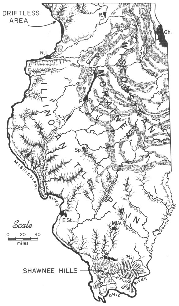
Figure 1—Physiographic provinces of Illinois.
- DRIFTLESS AREA
- WISCONSINAN MORAINES
- ILLINOIAN TILL PLAIN
- MISSISSIPPI RIVER
- WABASH RIVER
- SHAWNEE HILLS
- OHIO RIVER
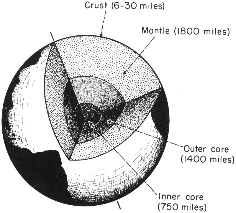
Figure 2—The earth with a segment removed to show supposed internal zones.
- Crust (6-30 miles)
- Mantle (1800 miles)
- Outer core (1400 miles)
- Inner core (750 miles)
The core is the innermost zone of the earth. It is mainly iron with some nickel and cobalt. The inner core probably is solid, but the outer core may consist of the same elements in a molten form. The core is the most dense (heaviest) of the three zones.
The mantle, which surrounds the core, is a rigid zone of materials rich in iron and magnesium. These materials are not as dense as those found in the core.
The crust, the top part of which includes the ground we walk on, is the hard, outer surface layer of the earth. Although the 4 crust is about 6 to 30 miles deep, the scale (size) of figure 2 allows it to be drawn only as the thin outer line. The rocks and minerals that we are all acquainted with are found in the crust. These rocks are not as dense and do not have as high an iron content as do the rocks of the mantle and the core.
The earth’s crust under Illinois is made of: sedimentary rocks deposited by water, wind, or glaciers (limestone, sandstone, shale, glacial drift); igneous, or melted rocks (granite, gabbro); and metamorphic, or altered sedimentary and igneous rocks (quartzite, gneiss). These various types of rocks have a relatively thin covering of broken or weathered material called mantle rock and soil.
The ground surface over most of Illinois was formed during the ice age (Quaternary Period) which lasted from about one million years ago up to nearly 5,000 years ago. As much as 90 percent of the state was covered by one of several sheets of glacial ice (fig. 3). The glaciers smoothed down and covered much of the old, rocky, hilly land surface and filled old valleys with loose, unconsolidated deposits.
In Canada vast thicknesses of snow and ice accumulated until the weight of the ice finally caused it to flow slowly outward, mainly to the south (fig. 4). Rocks and surface materials of all types were picked up and carried by the glaciers for great distances before being deposited. Pieces of granite, quartzite, and native copper among the many local rocks and minerals are found in glacial deposits and indicate that at least part of these deposits came from the Great Lakes Region. The materials deposited range from clay-size minerals to large boulders.
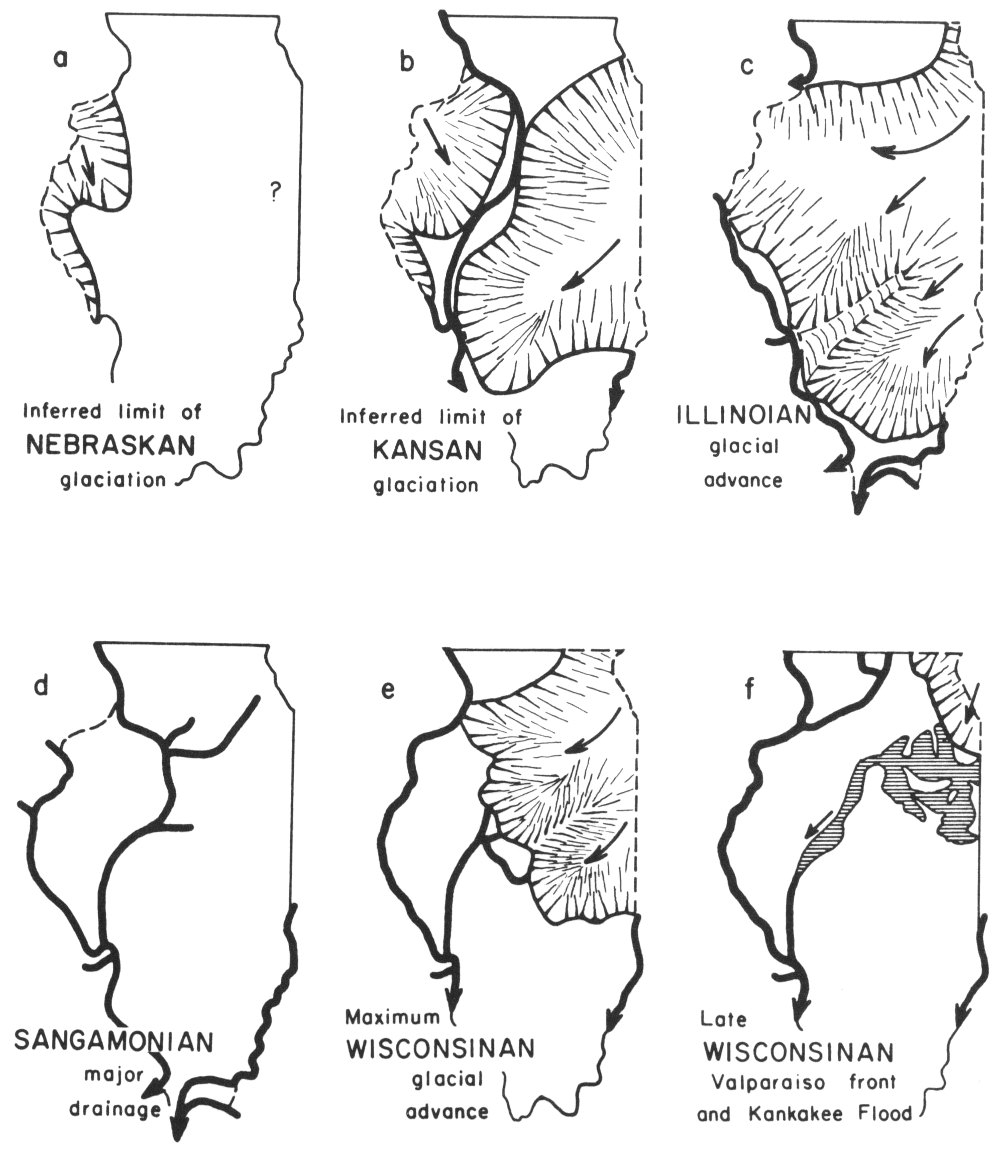
Figure 3—Extent of the main glacial advances which began with the Nebraskan (a—the oldest) and ended with the late Wisconsinan (f—the youngest). Diagram “d” shows the major stream development during the time between the Illinoian and the earliest Wisconsinan glaciers. The heavy lines on the diagrams indicate major stream valleys that were present during these times.
- a. Inferred limit of NEBRASKAN glaciation
- b. Inferred limit of KANSAN glaciation
- c. ILLINOIAN glacial advance
- d. SANGAMONIAN major drainage
- e. Maximum WISCONSINAN glacial advance
- f. Late WISCONSINAN Valparaiso front and Kankakee Flood
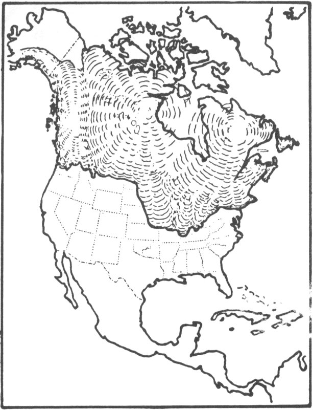
Figure 4—Limits of ice age glaciers.
Weathering and bacterial decay action have modified many of the loose, unconsolidated surface materials into soils. The present soils of Illinois are fertile partly because they have minerals and trace elements (minute amounts of elements such as copper, zinc, manganese) brought in by the glaciers from adjacent parts of the country. The youngest and most fertile soils occur in the northeastern part of the state and along the Illinois and Mississippi River valleys. These young soils are more fertile because the glacial deposits and loess (wind-blown silt) upon which they have developed are younger and fresher. The minerals and trace elements in these deposits have not been dissolved out to the extent that they have in the older glacial deposits and soils in other parts of the state.
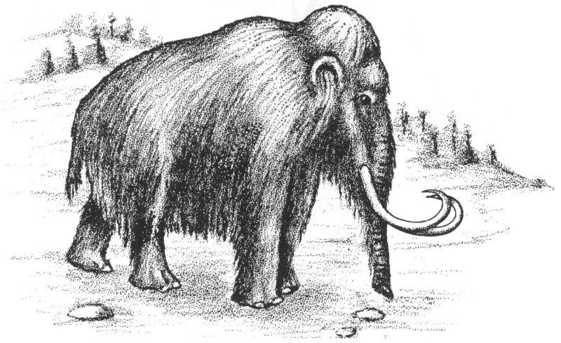
Figure 5—Woolly mammoth (after C. R. Knight).
Scattered mammoth (fig. 5) and mastodon remains have been found in glacial deposits at various localities in the state. Peat, which is an accumulation of partially decomposed plant materials, has been found, especially in the northern part of the state. It is marketed as an organic soil conditioner.