A VISIT TO THE ABORIGINAL RUINS IN THE
VALLEY OF THE RIO PECOS.

About thirty miles to the south-east of the city of Santa
Fé, and in the western sections of the district of San
Miguel (New Mexico), the upper course of the Rio Pecos
traverses a broad valley, extending in width from east to west
about six or eight miles, and in length from north-west to
south-east from twenty to twenty-five. Its boundaries are,—on
the north and north-east, the Sierra de Santa Fé, and the
Sierra de Santa Bárbara, or rather their southern spurs; on
the west a high mesa or table land, extending nearly parallel
to the river until opposite or south of the peak of Bernal; on
the east, the Sierra de Tecolote. The altitude of this valley
is on an average not less than six thousand three hundred
feet,[87] while the mesa on the right bank of the river rises abruptly
to nearly two thousand feet higher; the Tecolote chain
is certainly not much lower, if any; and the summits of the
high Sierras in the north rise to over ten thousand feet at
least.[88]
The Rio Pecos (which empties into the Rio Grande fully
five degrees more to the south, in the State of Texas) hugs,
in the upper part of the valley, closely to the mountains of
Tecolote, and thence runs almost directly north and south.
The high mesa opposite, known as the Mesa de Pecos, sweeps
around in huge semicircles, but in a general direction from
north-west to south-east. The upper part of the valley, therefore,
forms a triangle, whose apex, at the south, would be
near San José: whereas its base-line at the north might be
indicated as from the Plaza de Pecos to Baughl's Sidings; or
rather from the Rio Pecos, east of the town, to the foot of
the mesa on the west, a length of over six miles. Nearly in
the centre of this triangle, two miles west of the river, and
one and a half miles from Baughl's, there rises a narrow,
semicircular cliff or mesilla, over the bed of a stream known
as the Arroyo de Pecos.[89] The southern end of this tabular
cliff (its highest point as well as its most sunny slope) is covered
with very extensive ruins, representing, as I shall hereafter
explain, three distinct kinds of occupation of the place by
man. These ruins are known under the name of the Old
Pueblo of Pecos.
The tourist who, in order to reach Santa Fé from the
north, takes the Atchison, Topeka & Santa Fé Railroad
at La Junta, Colorado,—fascinated as he becomes by the
beauty as well as by the novelty of the landscape, while running
parallel with the great Sierra Madre, after he has traversed
the Ratonis at daybreak,—enters a still more weird
country in the afternoon. The Rio Pecos is crossed just
beyond Bernal, and thence on he speeds towards the west
and north: to the left, the towering Mesa de Pecos, dark
pines clambering up its steep sides; to the right, the broad
valley, scooped out, so to say, between the mesa and the
Tecolote ridge. It is dotted with green patches and black
clusters of cedar and pine shooting out of the red and rocky
soil. Scarcely a house is visible, for the casitas of adobe
and wood nestle mostly in sheltered nooks. Beyond
Baughl's, the ruins first strike his view; the red walls of
the church stand boldly out on the barren mesilla; and to
the north of it there are two low brown ridges, the remnants
of the Indian houses. The bleak summits of the high northern
chain seem to rise in height as he advances; even the
distant Trout mountains (Sierra de la Trucha) loom up solemnly
towards the head-waters of the Pecos. About Glorieta
the vale disappears, and through the shaggy crests of
the Cañon del Apache, which overlooks the track in awful
proximity, he sallies out upon the central plain of northern
New Mexico, six thousand eight hundred feet above the sea-level.
To the south-west the picturesque Sandia mountains;[90]
to the west, far off, the Heights of Jemez and the Sierra del
Valle, bound the level and apparently barren table-land. An
hour more of fearfully rapid transit with astonishing curves,
and, at sunset, he lands at La Villa Real de Santa-Fé.
Starting back from Santa Fé towards Pecos on a dry, sandy
wagon-road, we lose sight of the table-land and its environing
mountain-chain, when turning into the ridges east of Manzanares.
Vegetation, which has been remarkably stunted until
now, improves in appearance. However rocky the slopes are,
tall pines grow on them sparsely: the Encina appears in
thickets; Opuntia arborescens bristles dangerously as a large
shrub; mammillary cactuses hide in the sand; even an occasional
patch of Indian corn is found in the valleys. It is
stunted in growth,[91] flowering as late as the last days of the
month of August, and poorly cultivated. The few adobe
buildings are mostly recent. Over a high granitic ridge, grown
over with piñon (all the trees inclined towards the north-east
by the fierce winds that blow along its summit), and from
which the Sierra de Sandia for the last time appears, we
plunge into a deep valley, emptying into the Cañoncito, and
thence follow the railroad track again through a deep gorge
and pleasant bottom, overgrown with pines and cedars,
past Glorieta to Baughl's.[92] It required all the skill and
firmness of my friend and companion, Mr. J. D. C. Thurston,
of the Indian Bureau at Santa Fé, to pilot our vehicle over
the steep and rocky ledges. From Baughl's, where I took
quarters at the temporary boarding-house of Mrs. Root (to
whose kindness and motherly solicitude I owe a tribute of
sincere gratitude), a good road leads to the east and south-east
along the Arroyo de Pecos. In a direct line the distance
to the ruins is but a mile and a half; but after nearing the
banks of the stream (which there are grassy levels), one is
kept at a distance from it by deep parallel gulches. So
we have to follow the arroyo downwards, keeping about
a quarter of a mile to the west of it, till, south of the old
church itself, the road at last crosses the wide and gravelly
bed, in which a fillet of clear water is running. Then we
ascend a gradual slope of sandy and micaceous soil, thinly
covered by tufts of grama; a wide, circular depression
strikes our eye; beyond it flat mounds of scarcely 0.50 m.—20
in.—elevation are covered extensively with scattered and
broken stones. Further on distinct foundations appear, rectangles
enclosed by, or founded originally upon, thick walls
of stone, sunk into the ground and much worn,—sometimes
divided into small compartments, again forming large enclosures.
To the south a conspicuous, though small, mound
is visible. Immediately before us, due north, are distinct
though broken walls of stones; and above them, on a broad
terrace of red earth, completely shutting off the mesilla or
tabulated cliff, on which the Indian houses stand, there arises
the massive former Catholic temple of Pecos.
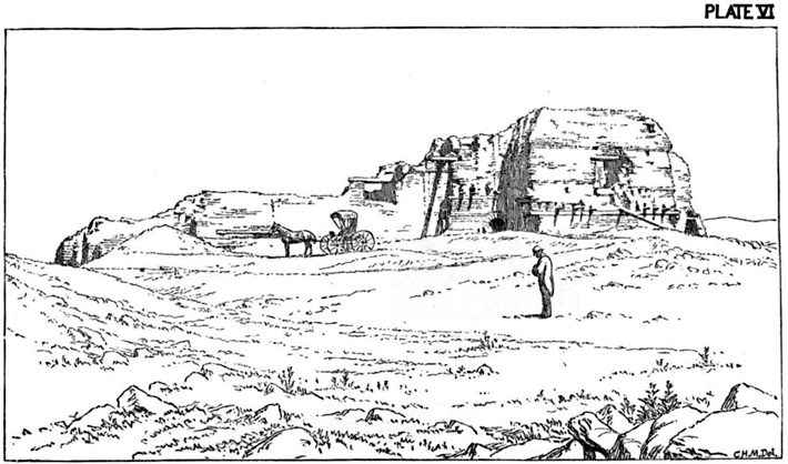 PLATE VI:
VIEW OF CHURCH, FROM THE SOUTH.
The building forms a rectangle, about 46 m.—150 ft.—long,
from east to west, and 18 m.—60 ft.—from north to
south. The entrance was to the west, the eastern wall being
still solid and standing. Plate I., Fig. 2, gives an idea of its
form: á a are gateways, each capped by a heavy lintel of
hewn cedar; b, carved beam of wood across.
The roof of the building is gone, and on the south side a
part of the walls themselves are reduced to a few metres
elevation. The church may originally have been not less
than 10 m.—33 ft.—perhaps higher. It had, according to
tradition, but one belfry and a single bell,—a very large one
at that. The Indians carried it off, it is said, to the top of the
mesa, where it broke. It is certain that a very large bell, of
which I saw one fragment, now in possession of Mr. E. K.
Walters, of Pecos, was found on the western slope of the
Mesa de Pecos, about three miles from its eastern rim, in a
cañada of the Ojo de Vacas stream, towards San Cristóbal.
Mr. Thomas Munn, of Baughl's, took the pains of piloting me
a whole day (6th of September) through the wilderness of the
mesa, and showing me the place where this interesting relic
was finally deposited. I shall return to this by and by.
Mrs. Kozlowski (wife of a Polish gentleman, living two
miles south on the arroyo) informed me that in 1858, when
she came to her present home with her husband, the roof of
the church was still in existence. Her husband tore it down,
and used it for building out-houses; he also attempted to dig
out the corner-stone, but failed. In general, the vandalism
committed in this venerable relic of antiquity defies all description.
It is only equalled by the foolishness of such as,
having no other means to secure immortality, have cut out
the ornaments from the sculptured beams in order to obtain
a surface suitable to carve their euphonious names. All the
beams of the old structure are quaintly, but still not tastelessly,
carved; there was, as is shown in Plate VII., much
scroll-work terminating them. Most of this was taken away,
chipped into uncouth boxes, and sold, to be scattered everywhere.
Not content with this, treasure-hunters, inconsiderate
amateurs, have recklessly and ruthlessly disturbed the
abodes of the dead. "After becoming Christians," said to
me Sr. Mariano Ruiz, the only remaining 'son of the tribe' of
Pecos, still settled near to its site, "they buried their dead within
the church." These dead have been dug out regardless
of their position relative to the walls of the building, and
their remains have been scattered over the surface, to become
the prey of relic-hunters. The Roman Catholic Archbishop
of New Mexico has finally stopped such abuses by asserting
his title of ownership; but it was far too late. It cannot be
denied, besides, that his concession to Kozlowski to use some
of the timber for his own purposes was subsequently interpreted
by others in a manner highly prejudicial to the preservation
of the structure.
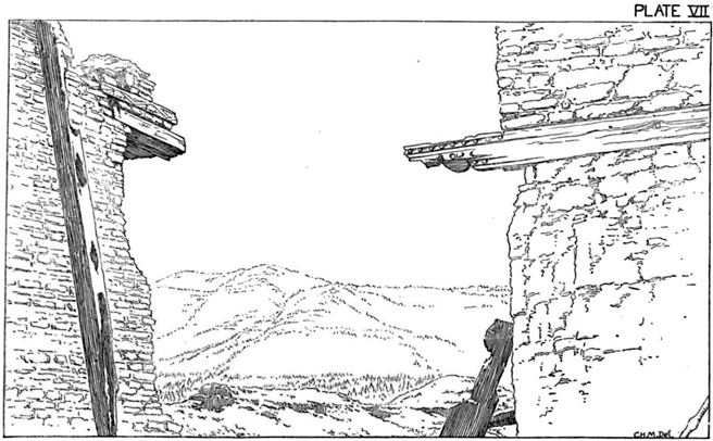 PLATE VII:
WALLS OF CHURCH, LOOKING SOUTHWEST.
What alone has saved the old church of Pecos from utter
ruin has been its solid mode of construction. Entirely of
adobe, its walls have an average thickness of 1.5 m.—5 ft.
The adobe is made like that now used, wheat-straw entering
into it occasionally; but it also contains small fragments of
obsidian,—minute chips of that material and broken pottery.
This makes it evident that the soil for its construction must
have been gathered somewhere near the mesilla; and the
suspicion is very strong on my part that it was the right
bank of the arroyo which furnished the material.[93] It is self-evident
that the grounds which were used for that purpose
must have antedated, in point of occupation, the date of the
construction of the church by a very long period. I have
measured all the adobe bricks of the church that are within
easy reach, at various places, and found them alike. They
all measure .55 m. × .28 m.—22 in. × 11 in.—and .08 m.—3
in.—in thickness. They are laid as shown in Plate I., Fig. 4.
The mortar is, as the specimen sent by me will prove, of
the same composition as the brick itself.
The regularity with which these courses are laid is very
striking. The timbers, besides, are all well squared; the ornaments,
scrolls, and friezes are quaint, but not uncouth; there
is a deficiency in workmanship, but great purity in outline
and in design.
To the south of the old church, at a distance of 4 m.—13
ft.—there is another adobe wall, rising in places a few
metres above the soil; which wall, with that of the church,
seems to have formed a covered passage-way. Adjoining it
is a rectangular terrace of red earth, extending out to the
west as far as the church front. A valuable record of the
manner in which this terrace was occupied is preserved to us
in the drawing of the Pecos church given by Lieutenant W.
H. Emory in 1846. It appears that south of the church there
was a convent;[94] and this is stated also by Sr. Ruiz. In fact,
the walls, whether enclosures or buildings, which appear to
have adjoined the church, extend south from it 74 m.—250 ft.
Plate I., Fig. 2, gives an idea of their relative position, etc.:
c is 4 m.—13 ft.—wide; d is 21 m. × 46 m.—70 ft. × 156
ft.; e is 25 m. × 46 m.—82 ft. × 150 ft.; f is 24 m. × 46
m.—78 ft. × 150 ft.
The divisions are not strictly marked, and I forbear giving
any lengths, since there is great uncertainty about them.
The foundation walls, where visible, are generally about
0.60 m. to 0.75 m.—23 in. to 30 in.—wide, and composed of
three rows of stones, set lengthwise, selected for size, and
probably broken to fit.[95]
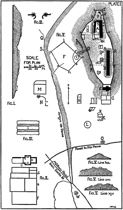 PLATE I:
GENERAL PLAN OF RUINS OF PECOS.
Looking northward from the church, a wall of broken
stones, similar to the one we already noticed at the south,
meets the eye. The mesilla itself terminates east and west
in rocky ledges of inconsiderable height, and the wall stretches
across its entire width of 39 m.—129 ft. Its distance from
the church is 10 m.—33 ft.; and it thus forms, with the
northern church wall, a trapezium of 10 m.—33 ft. This enclosure
is said to have been the church-yard.[96] Beyond it the
mesilla and its ruined structures appear in full view; and from
the church to the northern end, which is also its highest point,
it has exactly the form of an elongated pear or parsnip.
Hence the name given to it by Spanish authors of the
eighteenth century, "el Navon de los Pecos."[97] This fruit-like
shape is not limited to the outline: it also extends to the
profile. Starting from the church, there is a curved neck,
convex to the east, and retreating in a semicircle from the
stream on the west. At the end of this neck, about 200 m.—660
ft.—north of the church, there is a slight depression,
terminating in a dry stream-bed emptying into the bottom of
the Arroyo de Pecos south-westward; and beyond this depression
the rocks bulge up to an oblong mound, nearly
280 m.—920 ft.—long from north to south, and at its greatest
width 160 m.—520 ft.—from east to west. At the northern
termination of this mound the mesilla curves to the north-east,
and finally terminates in a long ledge of tumbled rocks, high
and abrupt, which gradually merges into the ridges of sandy
soil towards the little town of Pecos.[98] Pl. I., Fig. 5, gives a
tolerably fair view of the mesilla. Pl. I., Fig. 1, is designed
to exhibit its appearance as seen from below, the highest
elevation above the stream being nearly 30 m.—95 ft.
The rock of the mesilla is a compact, brownish-gray limestone.
It is crystalline, but yet fossiliferous, very hard, and
not deteriorating much on exposure. Its strata dip perceptibly
to the south-west; consequently the western rim is
comparatively less jagged and rocky than the eastern, and the
slope towards the stream more gentle, except at the north-western
corner, where the rocks appear broken and tumbled
down over the slopes in huge masses.
From the church-yard wall, all along the edge of the
mesilla, descending into the depression mentioned, and again
rounding the highest northern point, then crossing over
transversely from west to east and running back south along
the opposite edge, there extends a wall of circumvallation,
constructed, as far as may be seen, of rubble and broken
stones, with occasional earth flung in between the blocks.
This wall has, along its periphery, a total length of 983 m.—3,220
ft.—according to Mr. Thurston's measurement.[99] It
was, as far as can be seen, 2 m.—6 ft. 6 in.—high on an
average, and about 0.50 m.—20 in.—thick. There is but
one entrance to it visible, on the west side, at its lowest level,
where the depression already mentioned runs down the slope
to the south-west as the bed of a rocky streamlet. There a
gateway of 4 m.—13 ft.—in width is left open; the wall
itself thickens on each side to a round tower built of stones,
mixed with earthy fillings. These towers, considerably ruined,
are still 2 m.—6 ft. 6 in.—high, and appear to have been at
least 4m.—13 ft.—in diameter; at all events the northern
one. At the gateway itself the walls curve outward,[100] and
appear to have terminated in a short passage of entering and
re-entering lines, between which there was a passage, as well
for man as for the waters from the mesilla into the bottom
and the stream below. But these lines can only be surmised
from the streaks of gravel and stones extending beyond the
gateway, as no definite foundations are extant. Pl. I., Fig. 3,
is a tolerably correct diagram of this gateway.
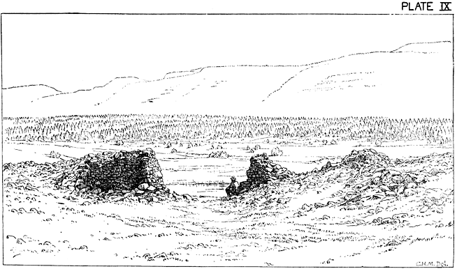 PLATE IX:
VIEW OF GATEWAY OF CIRCUMVALLATION, FROM THE EAST.
The face of the wall at each side of the gate is 1.3 m.—4
ft.—wide. Whether there was any contrivance to close it
or not it is now impossible to determine; but there are in the
northern wall of the gate pieces of decayed wood embedded
in and protruding from the stone-work. For what purpose
they were placed there it is not permitted even to conjecture.
Having thus sketched, as far as I am able, the topography
of the mesilla, and described its great wall of circumvallation,
I now turn to the ruins which cover its upper surface, starting
for their survey from the transverse wall of the old church-yard,
10 m.—33 ft.—north of the church, and proceeding
thence northward along the top of the tabulated bluff.[101]
Sixty-one metres—200 ft.—north of our point of departure
we strike stone foundations running about due east and
west and resting almost directly on the rock, since the soil
along the entire plateau which I have termed the neck is
scarce, and has nowhere more than 1 m.—39 in.—in depth.
The eastern corner of this wall, as far as it can be made out,
is 12 m.—39 ft.—from the eastern wall of circumvallation.
From this point on there extends one continuous body of
ruins, one half of which at least (the southern half), if not
two-thirds, as the ground plan will show, exhibits nothing
else but foundations of small chambers indicated by shapeless
stone-heaps and depressions. The northern part is in a better
state of preservation; a number of chambers are more or less
perfect, the roofs excepted,[102] and we can easily detect several
stories retreating from east to west. About 9 m.—30 ft.—from
its northern limits a double wall intersects the pile for
one half of its width. The ruins beyond it, or rather the
addition, is in a state of decay equal to that of the southern
extremity. The western side is, generally, in a better state of
preservation than the eastern, especially the north-western
corner. Along the eastern side upright posts of wood, protruding
from stone-heaps, often are the only indications for
the outline of the structure. Along the north-west, however,
such posts are enclosed in standing walls of stone, at distances
not quite regularly distributed, but still showing plainly that
here, at least, the outer wall presented an appearance similar
to Pl. II., Fig. 4.
At the place where I measured, the upright posts stood at
about 1.39 m.—4 ft. 6 in.—from each other; the projecting
wall was 2 m.—6 ft. 6 in.—long, and 0.63 m.—2 ft.—thick;
the retreating wall 1.40 m.—4 ft. 6 in.—long, and 0.33 m.—13
in.—thick. The posts themselves were sometimes, but
not always, backed, or even encased in adobe sheaths, built
up like little chimneys in the wall itself. This mode of construction
was possibly peculiar to the western side alone, and
gives it a slight appearance of ornamentation, as well as more
strength, the projecting walls acting like buttresses.
The whole structure, taking the sides of the débris as they
are now scattered, extends nearly north and south 140 m.—460
ft.—and east and west about 16 m. to 26 m.—50 ft. to
80 ft.—thus forming a rectangle of 140 m. × 20 m.—460
ft. × 65 ft. To determine the exact size of the building I
proceeded to measure each compartment for itself, judging
that the total number of these apartments, adding to their
sizes the thicknesses of the walls, would finally give, within a
few decimetres, the exact length and width of the house. On
the ground plan I have numbered this building B.[103]
Beginning at the north-west corner, I ran my line almost
due east to within 10 m.—33 ft.—of the circumvallation,
where I found the north-east corner indicated by a broken
post of wood. Along this line I met the following sections
from west to east: 2.92 m.—9 ft. 6 in.; then a gangway,
1.55 m.—5 ft.; chamber, 3.22 m.—11 ft.; gangway, 1.21 m.—4
ft.; and three chambers, 2.09 m., 2.72 m., and 2.72 m.—7
ft., 9 ft., and 9 ft.—respectively, thus giving, adding to it
eight walls of a uniform thickness of 0.33 m.—13 in.,—a total
width of 19.07 m.—63 ft. Its length was easily found to be
8.56 m.—28 ft.; the northern appendix, therefore, forming a
rectangle of 8.5 m. × 19 m.—28 ft. × 63 ft.,—and containing,
as the ground-plan shows, ten rooms and two corridors,
the latter running through the structure from north to south.
It will also be noticed that the two middle rooms are the
largest, measuring each 4.28 m. × 3.22 m.—14 ft. × 10 ft.
I must also advert, here, to the fact that this structure is
extremely ruined, and that the east part of it exposes the
surveyor to dangerous errors.
The line a b, and its continuation eastwardly to c, appears
to form the main northern wall of the whole structure.
Here the annex, just described, terminates. This wall
is of unequal thickness. In the north-westerly projection
from a to b, a length of 8 m.—26 ft.,—its thickness is
0.63 m.—2 ft.; from b to c, on the eastern line, it is only
0.33 m.—13 in.—thick. This inequality indicates also a
division of the structure to the southward, as far as the line
d d d, into two longitudinal sections. The western one, whose
four corners are respectively a b d d in the diagram, contains
eighteen rooms of equal size, measuring each 3.71 m. × 2.25
m.—12 ft. × 7 ft.; it is consequently, inclusive of the rear
wall and the sides, 24.24 m. × 8.08 m.—80 ft. × 27 ft.
The eastern division, comprised within the area b c d d, has
fifteen rooms, or five longitudinal rows of three, whereas the
western has six rows of three. The rooms east must therefore
be larger than those west, and we see that they measure
from east to west respectively, 2.25 m., 2.28 m., and 2.28 m.—7
ft., 7 ft. 6 in., and 7 ft. 6 in.: from north to south, 3.60 m., 5.07
m., 4.43 m., 4.13 m., and 3.43 m.—12 ft., 17 ft., 15 ft., 14 ft., and
11 ft. It is a rectangle, or rather trapezium, 22.31 m. × 7.81
m.—70 ft. × 25 ft.,—consequently the width of the building
B is somewhat less on the line d d d than on the line a b c.
The cause of this singular contraction I have found, and shall
afterwards indicate.
Then follows a transverse section (d d d e e), containing
two rows of six rooms each, or twelve in all, of very unequal
sizes, as the ground-plans show. This entire section appears
to be trapezoidal. The line d d d is 15.89 m.—52 ft.—long;
the line e e 16.33 m.—53 ft.; d e measures 7.42 m.—24 ft.—along
the west, and 8.04 m.—27 ft.—along the east. Rooms
marked II and III are particularly irregular, having, as the
diagram shows, not less than six corners.
From e e to f f, another transverse section, this time of four
rows of six each, or twenty-four cells in all, those of each row
being of equal length, to wit 3.65 m.—12 ft.; and in width
from east to west, respectively: 2.25 m., 2.78 m., 3.18 m., 2.63
m., and 4.40 m.—7 ft., 9 ft., 10 ft., 9 ft., and 14 ft. (the last
measure being the aggregate of the two eastern compartments,
the longitudinal partition being nearly obliterated).
To the south of f f a further slight change occurs, inasmuch
as the three eastern rooms, instead of being respectively 2.68
m., 2.20 m., and 2.20 m.—9 ft., 7 ft., and 7 ft.,—now become
2.25 m., 2.33 m., and 2.32 m.—7 ft., 8 ft., and 8 ft. From f f
to g g, the southern limits of the structure, the whole structure
is badly ruined; and while the rooms can be counted,
measurements are possible only in a few places. Still I am
satisfied that no great error lies in the assumption that they
were, taken longitudinally, all equal to the six rooms contained
in the transverse row south of the line f f, that is,
3.65 m.—12 ft.—from north to south; and in width, counting
the cells from west to east, respectively, 2.25 m., 2.78 m.,
3.18 m., 2.25 m., 2.33 m., and 2.32 m.—7 ft., 9 ft., 10 ft., 7 ft.,
8 ft., and 8 ft. The section, f f g g, which forms the southern
and largest portion of the house (B), contains, therefore,
twenty-two transverse rows of six chambers each, or
one hundred and thirty-two apartments on the ground-plan;
and it forms a rectangle running from north to south and
east to west respectively of 80.30 m. × 15.11 m.—260 ft. ×
50 ft.
The general dimensions of this building (B), therefore
appear as follows:—
| Length from north to south, east side |
133.81 m.—440 ft. |
| Length"from nort" to south, west side |
134.92 m.—442 ft. |
| Width of northern appendix |
19.07 m.— 63 ft. |
| Width along line a b c |
19.07 m.— 63 ft. |
| Wi"th along" line d d d |
15.89 m.— 52 ft. |
| Wi"th along" line e e |
16.33 m.— 53 ft. |
| Wi"th along" line f f |
15.24 m.— 50 ft. |
| Width of line g g, approximated |
15.70 m.— 51 ft. |
From the appearance of the ground-plan, as I have been
compelled to give it, it would result that the "first floor"
contained two hundred and eleven cells, or rooms. Such is,
however, not the case. The builders of this extensive fabric
had not the means of preparing the hard rock foundation by
removing it wherever it protruded over an average level.
While giving a uniform height to their structure, they accommodated
its ground-plan to the sinuosities of the rock. Out
of this accommodation the irregularities noticed in the construction
have mainly arisen. Pl. II., Figs. 1, 2, 3, will illustrate
this statement.
Pl. II., Fig. 1.—Cross-section of B along the line a b c,
north end; a b, actually visible top-line; c d e f g h, rock;
i k, top of probable highest story, now destroyed.
I have every reason to assume that this cross-section holds
good for the entire division (a b c d d). From d d on to f f
the distance between the rim of the mesilla to the east and
the house is greatest; the top-rock bends also to the west
about e e, and there the irregularities noticed on the diagram
about the chambers (II and III) come in. They evidently
result from an effort to conform the general plan to both the
lateral and vertical deviations of its base. About the line f f,
while the same number of chambers (six) remains in every
transverse row, there is but one story below the general surface
to the east. I may safely assume that south of the line
f f all the rooms of the first floor were on the same level.
Pl. II., Figs. 2 and 3 will illustrate this point. As far as I
could detect, the line e e can be admitted as the one where one
of the two lower stories disappears, and but one remains on
the east side lower than the rest.
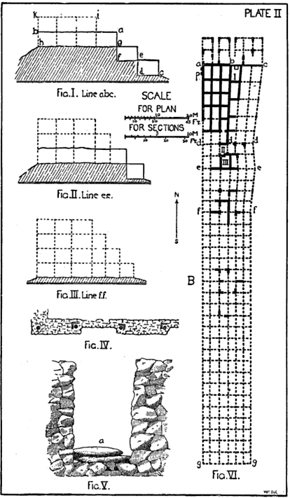 PLATE II:
PLAN OF SECTIONS OF BUILDING B.
I have everywhere assumed four stories. It is at least certain
that there were not less than four. When Coronado
visited the pueblo in 1540, he found "the houses with four
stories."[104] Sr. Mariano Ruiz told me that "they all were
of three stories;" but then he mentioned, below, the
"casas de comodidad," thus indicating that the lowest story
was used for store-rooms. It is very apparent from the ruins
that, as I have indicated in the cross-sections, the western
wall was unbroken, whereas from the east the stories rose in
four retreating terraces. The western wall already mentioned
was given additional strength, by means of the buttresses, of
which I have given a small outline. The winds blow very
fiercely over the mesilla, especially from the north-west; there
is no tree to be seen on or about it, not even a cedar-bush,
higher than a couple of feet at most. Against such blasts
the solid wall was necessary, while the many intersecting partitions
inside gave additional strength. It was a very solid
structure as against winds, notwithstanding the comparative
thinness of the walls,—0.63 m.—2 ft.—being their greatest
width, and 0.33 m.—13 in.—their average.
With reference to the cross-sections, it now becomes possible
to approximate the total number of chambers, apartments,
or cells, contained in the entire building; a point
impossible even to estimate from the ground-plan alone.
Leaving aside the northern appendix, about whose elevation
I have not even means of conjecture, it becomes evident that
the section whose four corners are marked respectively a, c,
d, d, had the following number of compartments, starting with
the lowest story, and remembering that, as above stated, one
longitudinal row had six, and the other five, rooms:—
| Lowest story |
5 |
|
| Second story |
5 |
|
| Third story. 3 × 6 + 5 |
23 |
|
| Fourth story. 3 × 6 |
18 |
|
| Total |
51 |
rooms. |
| Brought forward |
51 rooms. |
| The section |
d d e e had probably the same arrangement, and therefore, there being but two transverse rows, it contained in all |
|
18 |
| Section |
e e f f contained on lower story |
4 |
|
| |
Second Story. 5 × 4 |
20 |
|
| |
Third Story. 4 × 4 |
6 |
|
| |
Fourth Story. 3 × 4 |
12 |
|
| |
|
|
52 |
| Section |
f f g g:— |
4 |
|
| |
Lower Story. 22 × 6 |
132 |
|
| |
Second Story. 22 × 5 |
110 |
|
| |
Third Story. 22 × 4 |
88 |
|
| |
Fourth Story. 22 × 3 |
66 |
|
| |
|
|
396 |
| Total number of rooms contained in building B |
517 |
These rooms are very nearly of equal size, the largest one
being III. 2.85 m. × 4.78 m.—9 ft. × 16 ft.—on one side, and
3.71 m.—12 ft-on the other, with an entering angle; the smallest
room adjoining to it measuring 2.25 m. × 2.70 m.—7 ft. ×
9 ft. The entire structure, therefore, presents the appearance
of a honeycomb, or rather of a bee-hive, and perfectly illustrates,
among the lower degrees of culture of mankind, the
prevailing principle of communism in living, which finds its
parallel in the lower classes of animals. Tradition, historical
relation, and analogy, tell us that this house was used as a
dwelling,[105] and that consequently it was, to all intents and purposes,
a communal house.
The height of the various stories it is almost impossible to
determine. I have measured walls which appeared to be
perfect, and they gave me an average of 2.28 m.—7 ft. 6 in.—elevation.
Should such be the rule, the western wall of the
building, at its greatest height south, would have risen about
11 m.—36 ft.
The northern appendix I have ignored in the above computation,
because its whole appearance gives no ground for
definitive statements. It seems really to be an annex, and in
fact the whole building seems to have progressed, in its construction,
from south to north, in point of date and time.
The southern portion of the building—the one which appears
to have been erected on a plane surface—was, in all
probability, the one first built. The northern portions were
added to it gradually as occasion required. This is further
shown by the fact that in these northern sections, along the
line a, b, c, parts of the third story wall are patched with
regular adobe bricks, about half as large as those in the church,
but still made by the same process.[106] The rest of the structure
is exclusively composed of stone.
It is to all intents and purposes a stone house. Two kinds of
rocks predominate among the material; a slaty, gray and red,
sandstone,—highly tabular, easily broken into plates of any
size,—and a sandstone conglomerate, containing small pebbles
from the size of a pea up to that of a small hazel-nut,—the
whole rock of a gray color. When freshly broken or wetted,
this conglomerate becomes very friable, and so soft that goats
have left the impression of their feet on scattered fragments.
When dry it becomes hard, and is always very heavy. Both
kind of rocks are found in the vicinity of the mesilla. Besides
these, loose pieces of stone from the bluff itself, boulders from
the creek, of convenient size, enter into the composition of the
walls. Sometimes the latter consist exclusively of slabs of
sandstone superposed; again there are polygonal fragments of
rocks piled upon one another, with courses of tabular sandstone,
forming, so to say, the basis for further piling; the foundations
are usually boulders and the hardest rocks, also of greater
width. There are no walls of dressed stone, but the rocks
are broken to a suitable size, as may be done with any stone
maul or sledge, or even by smashing with the hand and another
rock. In fact the whole stone-work must be termed, not
masonry, but simply judicious and careful piling.[107] In performing
it, great attention has been paid to having the vertical
surfaces as nearly as possible vertical; but this end could be
reached without the use of the plumb-line, and with the aid
of mere ordinary eyesight, for the rooms are so small, and the
partitions so thin, that anything not "true" could, and can
yet be, "shoved" into position by a mere steady, slow push;
carefully watched on the opposite side. The same applies to
the angles, although they are tolerably accurate. As a general
thing, the transverse walls appear to be continuous, and
the longitudinal partitions to have been added afterwards, but
there are also instances of the contrary. In this respect the
sinuosities of the rocky foundation seem to have determined
the mode of action. To fill up the gaps between the stones,
and to coat them with a smooth surface within the chambers
what appears to be earth from the surrounding bottoms has
been flung into the crevices, thus forming a natural mortar,
and at the same time a "first coat" of plaster of varying
thickness. This in turn is covered with a thin white layer
(now of course turning into gray, yellow, and flesh-red) much
resembling our plaster, but whose composition I am unable to
determine. (Specimens of the mud, containing small gravel
and minute particles of mica, are sent with the other collections,
also fragments of the white coating for analysis.[108])
The woodwork proper appears not to have had any connection
with the strength or support of the walls, but simply
to have been erected within and among the walls as a scaffold
for the ceilings, which are also the floors of the higher
stories. Upright posts of cedar and pine, stripped of their
bark, but not squared, are, as I have already shown, set inside
of the stone wall, at more or less even distances. As far as I
could ascertain, these distances are regulated by the size of
the rooms. These posts are coarsely hacked off at the upper
end, and over them other similar beams are laid longitudinally,
sometimes fitted over the posts with chips wedged in. Such
is the case in a room in the northern wing of the building
marked A, of which I shall hereafter speak.[109]
On these longitudinal beams other ones rest, laid transversely,
and imbedded in the wall on the opposite side. On
these again longitudinal poles are placed, also at intervals
varying according to the dimensions of the chambers, and on
them transversely, a layer of brush, or splinters of wood,
closely overlapping each other; and the whole is capped by
about .20 m.—8 in.—of common clay or soil. Pl. III., Fig. 1,
is a front view of the wooden scaffold in a lower story room,
and of the ceiling which it supports.
a, clay and lower seam of brush or splinters.
b, transverse poles or beams, in case the beams are lacking.
c, longitudinal beam.
d, upright posts.
In most cases, however, the beams are transverse and the
poles longitudinal, and this is where the beam (c) is lacking,
as in the interior apartments, where the ceiling appears as in
Pl. III., Fig. 2: a, clay; b, brush or splinters; c, poles;
d, beams; e, wall.[110]
The diameter of the upright posts is, on an average, 0.28 m.—11
in.,—but even sometimes as great as 0.33 m.—13 in.,—the
longitudinal and transverse beams are scarcely less thick,
whereas the poles are about 0.05 m.—2 in.—across. The
splinters seem to have been obtained by splitting a middle-sized
tree, and tearing out thin segments.
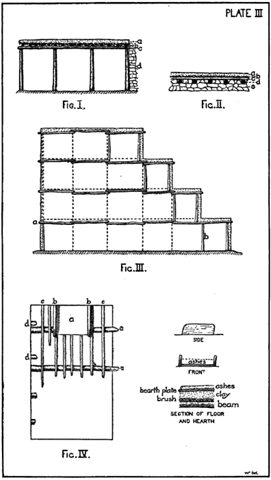 PLATE III:
SECTIONS OF BUILDING B.
Pl. III., Fig. 4, is a ground plan of the floor of room marked
I on the diagram. This room is on the eastern row of the
third floor, therefore an outer room.
c, longitudinal poles.
d, the end of the transverse beams projecting from the
other room.
e, the transverse beams, resting in the wall on both sides.
On the latter rested a thin layer of brush and a compact
mass of clay, 0.20 m.—8 in.—thick. The clay, or rather
soil, is very hard and was probably stamped or pounded.
As far as I have been able to detect, the upright posts are
not found inside of the house, except, perhaps, on the rear
wall of the outer chamber, as in one room of building A, to
which I shall hereafter refer. If this is the room, then the
skeleton of the wood-work (upright and transverse posts and
beams) would present nearly the appearance shown in Pl.
III., Fig. 3, when viewed from the side, and admitting the
house to be four stories high.
a, horizontal beams.
b, upright posts, along the western wall, and in the three upper
stories. These posts are hypothetical, and therefore only
indicated by dotted lines. (It may be also that every cell had
its front and its rear posts, but I have not been able to detect
any except in the outer rooms.)
With the exception of one chamber in building A, I
nowhere met anything like a roof. This one appears to
be nothing else than a ceiling-floor, but of nearly 0.75 m.—2
ft. 6 in.—in thickness. It is, as Pl. VIII. shows, much
covered by fallen stones, and its original height may have
been increased by débris; but at all events it was thoroughly
impermeable, and such as would be required in a climate
where, indeed, it seldom rains, but "whenever it rains it
pours."
There is a certain air of sameness cast over the entire structure
which has strongly impressed me with the thought that
not only was it used as a dwelling for a large number (as
the reports, indeed, establish), but also that all its inhabitants
lived on an equal footing,—as far as accommodations for living
were concerned. There are no special quarters, no spacious
halls. The few rooms of somewhat larger size are naturally
explained by the mode of construction, adapting the house to
the configuration of the rock, and not conversely as we do.
It was, therefore, a large joint-tenement structure, harboring,
perhaps, when fully occupied, several hundreds of families.
In regard to ingress and egress, not only have I found no
doors in any fragments of exterior walls, but the many persons
I have asked have always assured me that there had
been none, that the house was entered by means of ladders,
ascending to the top of each story in succession, and descending
into the rooms also by ladders and through trap-doors in
the roofs. They have also assured me that each room of each
story communicated with the one above and below, also by
means of trap-doors and ladders. It is quite certain that
there are no staircases nor steps, and that consequently ladders
were used, in the same manner as they are still used by
the Indians of the pueblos of Zuñi, Moqui, Acoma, Taos, and
others. Ingress and egress, therefore, must have taken place,
not horizontally "in and out," but vertically "up and down."
I have not been able to identify any one of the trap-doors referred
to, but I should not be surprised to hear that they have
been subsequently found in the north-west corner of each
room. By referring to the diagram of the floor (Pl. III.,
Fig. 4), it will be seen that the rectangular spaces between the
beams and overlying poles are almost everywhere large
enough, if the superstructure of splinters (or brush) and clay
is removed, to give passage to any man. The ladders themselves
have completely disappeared.
On one and the same floor, I found in the side walls at a
few places, the remains of low and narrow openings through
which a man might pass in a stooping position and "sidling."
Nowhere could I see the full height of these small doorways,
so that I do not know whether there was a lintel, or whether
they terminated in an open angle, like the doorways of
Yucatan. I have seen openings showing the peculiar so-called
"aboriginal arch" of Yucatan on a small scale, and I
also have seen that an accidental "knocking-out" of one or
two stones from the walls produced a hole or gap very similar
in shape to the doorways at Uxmal and other pueblos of
Southern Mexico, though of course on a small scale. It is
self-evident that, the coincidence being accidental, I do not
place any stress upon it in view of "tracing relationships."
The coincidence is of ethnological, and not of ethnographical,
value. As far as I could ascertain, they were certainly 1 m.—3
ft. 3 in.—high, whereas their average width may have
been 0.45 m.—18 in. (Those I measured averaged between
0.42 m. and 0.48 m.—16 in. and 19 in.) Their appearance is
shown in Pl. II., Fig. 5.
a is what might be termed a door-sill, a smooth oval
stone, evidently from the drift, probably dioritic, at all events
a dark-green hornblende rock. In the present instance one
was not long enough to fill the gap left between the walls, and
two were superposed. I saw no traces of wooden lintels or
sills. These doorways appeared to be generally about
0.50 m.—20 in.—above the floor, but if we deduct 0.20 m.—8
in.—for the clay (measure having been taken from the
timbers), 0.30 m.—12 in.—will remain as their approximate
height over the chambers.
The few doors that I could observe are all in the longitudinal
walls, and none of them in the transverse; that is, they
all open from east to west. But not all the longitudinal partitions
have doorways. It cannot, therefore, be admitted that
every transverse row was occupied by one family, still less that
the family apartments were arranged longitudinally. I rather
suspect that this arrangement was vertical, or perhaps vertical
and transverse. This surmise is given, however, for what it
may be worth. Windows I could not find, although small
apertures undoubtedly existed in all the outer walls, both for
light and for air.
The chambers being all very much ruined, the lower ones
filled with the stones and decayed ruins of the superposed
stories,—of these stories themselves but part of the walls, denuded
and often twisted, remaining,—I have not been able,
with one single exception, to secure or even see any of what
we would call the "furniture." Small fragments of grinding-stones
(metates) are sparsely scattered over the entire ruins,
otherwise the only object of daily use as articles of furniture
met with by me has been a hearth, which I found or dug out
in situ, in room I, and which, complete, forms part of the
collections sent by me to Cambridge.
The place where this hearth was situated is marked on the
diagram in room I. It stood on the floor against the north
wall, and is composed of three plates of stone, originally
ground and polished (as the specimen found in building A
will show, which is a fragment only), and, judging from new
fragments found, of diorite or other hornblende rock. There
are three plates,—a basal one, 40 m.—16 in.—long and
20 m.—8 in.—wide, and two sides, placed vertically east and
west of the base,—all three resting against the north wall of
the room. Pl. III., Fig. 4, is a diagram of the room, the floor
timbers, and the hearth.
The basal plate was covered with 0.10 m.—4 in.—of very
white ashes, which I have also secured, and the rear of the
hearth, which is formed by the original "first coat" of earth
daubed over the wall, is thoroughly baked by the heat produced
in front of it, as the samples sent will show.[111]
Of course, I looked at once for an opening where the smoke
arising from the hearth, etc., could have escaped. I am sorry
to say, however, that I utterly failed in finding anything like
a chimney,—not only in B, but in all the other buildings.
Still, in the ruined condition of the place, this is no proof of
their non-existence.[112]
I will refer to subsequent pages to such articles of mechanical
use and of wearing apparel which I was fortunate
enough to meet. I shall also return hereafter to the almost
omnipresent pieces of painted pottery, of two distinct kinds,
and to the very numerous chips of obsidian, jet-black on the
face, but transparent as smoky glass; of black lava; and to the
flint, jasper, and moss-agates, broken mechanically by man,
and scattered over the premises. These premises have been
thoroughly ransacked by visitors, and every striking object
has already been carried off. I had heard mentioned, among
such samples, flint, agate, and obsidian arrow-heads, stone
hatchets and hammers, and copper (not brass or iron) rings
used for ornamental purposes,[113] but my luck it was not to find
any. Therefore the harvest is perhaps slim in that respect.
It is beyond all doubt that judicious digging among the lower
stories of the structures will reveal treasures,—not money, as
the tale current among the inhabitants has it, but things of
archæological and ethnological value. For such an undertaking
I was, as the Institute well knows, not prepared. I attempted
to dig, indeed, though quite alone, but soon came to
the conclusion that the time consumed in excavating one metre
of decayed and crumbling stones and earth would be more
satisfactorily employed in other directions; paving the way
for the exhaustive labors of better situated archæologists.
I have been very lengthy in my exposé of facts and data
regarding this particular house B, for the simple reason that,
as far as the principles of architecture, based upon a knowledge
and want of "how to live," are concerned, it is typical
of the rest. Many details become therefore unnecessary in
subsequent descriptions.
To return to the structure itself, its general plan and its mode
of construction in detail more and more forcibly remind me of
an extraordinarily large honeycomb. The various walls, a few
of the outer walls excepted, have little strength in themselves
(as the rapid decay shows), but combined altogether they oppose
to any outside pressure an immense amount of "inertia."
There is not in the whole building one single evidence of any
great progress in mechanics. Everything done and built within
it can be built and made with the use of a good or fair eyesight
only, and the implements and arts of what was formerly
called the "stone age." This does not exclude the possibility
that they had made a certain advance in mechanical agencies.
They may have had the plummet, or even the square; but
such expedients, applied to their system of building, might at
most have hastened the rapidity of construction. Necessary
they were not at all, still less indispensable. As the bee builds
one cell alongside of the other and above the other,—the
norm of one and the "habitat" impelling the norm of those
above and alongside,—so the Indians of Pecos aggregated
their cells according to their wants and the increase of their
numbers; their inside accommodations, the wood-work, bearing
the last trace of the frail "lodge" of a former shifting
condition.
Leaving B for the present, I turn to the other ruins on the
so-called "neck" of the mesilla.
4 m.—13 ft.—west of the N.W. corner of the northern annex,
I struck stone foundations indicating a structure (whether
enclosure or building I do not venture to tell) 10.21 m.—33
ft.—from E. to W., and 6.60 m.—22 ft.—from N. to S.[114], 49
m.—160 ft.—to the north-west of its north-easterly angle
there is a mound about 2 m. or 6 ft. in diameter, thence 20
m.—65 ft.—further N.W. or N.N.W. the southern ruins of
the east wing of A are reached.
Parallel to B, longitudinally, and at an average distance of
28 m.—90 ft—to the west from it, there is a row of detached
buildings or structures, of which only the foundations and
shapeless stone heaps indicating the corners remain. Pl. I.,
Fig. 8, conveys an idea of their position and size. The walls
are reduced to mere foundations, or to heaps in the corners;
but these remnants indicate that the rocks used were similar
in kind and shape to those composing the walls of all the
other kinds of construction in the mesilla north of the church.
For what purpose these buildings were erected, and in what
relation they stood to B, I am unable to determine. Some of
them appeared to have doors opening to the east.[115] Beyond
f the ground rises suddenly. The floor of those structures
is, in some instances, formed of a black or red loam. I excavated
one of those, or, rather, dug into it, to the depth of
one metre. The surface had shown traces of a fire built in
the centre, and I found also, at the depth of nearly two feet,
that the dark soil was traversed by a band of charcoal, fragments
of burnt and blackened pottery, and some splinters of
bone. Below it the soil was dark red. Whether there was
a buried hearth at that depth, or whether the traces of fire
were due to an original destruction of woodwork through
combustion, the débris subsequently covering them with clay,
I am unable to judge.[116] In all of them, of course, pottery
and obsidian were found.
I have already stated that the mesilla dips to the south-west;
that there is a depression along the northern end of its
"neck;" and that from f the rocks bulge upwards again. All
this contributes to concentrate the drainage of the entire cliff-top,
as far north of the church as it was inhabited, in the hollow
where the gate of the general enclosure is placed. This
gate was therefore not only a passage-way, but also the water-gap
or channel through which the mesilla was finally drained
into the bottoms of the Arroyo de Pecos.
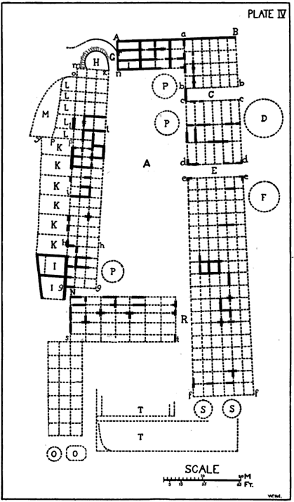 PLATE IV:
PLAN OF BUILDING A.
20 m.—65 ft.—to the N.N.W. of the mound i, there rises
before us the huge pile of ruins which, on the plat as well as
on the diagram, I have designated by A. It crowns the highest
point of the entire mesilla, and covers the greatest portion
of its top. In ruins like B, its general aspect is yet somewhat
different Instead of forming, like the latter, a narrow, solid
rectangle of 140 m. × 20 m.—460 ft. × 65 ft.—, the building
A is (taking, of course, the outlines of the entire débris) a
broad hollow rectangle of 150 m. × 75 m.—490 ft. × 245 ft.
Its interior is occupied by a vast court or square, containing
three circular depressions, and surrounded on all four sides by
the broad ruined heaps of the former dwellings. On the east
side, between the circumvallation and the eastern line of the
structure, there are two more circular depressions similar to
those within the court. The latter is entered by four passageways,—one
on the S.E. corner, 4 m.—13 ft.—wide and about
12 m.—40 ft.—long from S. to N.; one through the eastern
wing, 3.40 m.—11 ft.—wide and about 14 m.—46 ft.—long
from E. to W.; one in the N.W. corner and another from the
S.W., both 2 m.—6 ft. 6 in.—across. I have designated these
four gateways respectively as R, E, G, and N. R and E enter
straight through the wall; G forms a semicircle almost from
W. through N. to S.; N describes a right angle from S. by N.
to E. The distribution of decay in this house is the same as
in B,—the southern parts are on all sides almost totally obliterated;
the N.W. corner is very nearly perfect; the northern
and western walls are tolerably fairly preserved; but the
eastern outline of the east wing, the southern outline of the
south wing, and the southern ends of both east and west have
almost completely disappeared under hills of rubbish, a few
posts alone assisting the explorer. The path of destruction
has in both buildings lain in the same direction,—from S.S.E.
to N.N.W.,—and across both its effects have decreased from
south to north. Still, while the similarity in that respect is
astonishing, and while there are apparently more walls in A
standing than in B, there is, owing to the very uneven surface
of the rock upon which it is built, much more confusion among
the ruins of the former than among those of the latter. B is
built on a gradual slope or ridge; A caps a generally convex
surface, scooped out in the middle, and sloping eastward.[117]
Hence comes the division of the whole structure into four separate
and distinct buildings, and hence, also, the complicated
manner in which the whole or each part is ruined, even walls
still standing being twisted out of shape and out of position.
Actual measurements were much less efficacious here than in
B; and, although I have worked with not less zeal and conscientiousness,
the result in neatness and precision is certainly
less satisfactory. This explanation will, I hope, induce subsequent
explorers to look up my inaccuracies and correct them.
It is needless, of course, to detail the methods of work.
They are on a larger scale, and in more tedious ways, a repetition
of the proceedings in the case of B. The results are as
follows, starting from the line f f northwards: The space comprised
between the corners (e, e, f, f) forms a rectangle, containing
18 longitudinal rows of 6 rooms each. These rows
are all on the same level, except the most easterly one,
which lies on the slope. The cells, as far as measured and
still measurable, appear to be of the same size in length, namely,
2.87 m.—9 ft. 6 in.,—and their widths are respectively from
W. to E., or 2.83 m., 2.00 m., 3.14 m., 2.70 m., 2.53 m., and
2.53 m.—9 ft., 6 ft. 6 in., 10 ft., 9 ft., 8 ft., and 8 ft. The whole
area is therefore 51.66 m. × 15.73 m.—170 ft. × 51 ft. Still,
I believe that a sensible narrowing (possibly of nearly 2.0 m.—6
ft. 6 in.—) may have taken place up to ee; but this is compensated
by the strengthening of the corners, which there are
rounded outwards, so that the line e e presents about the same
length as f f. Thereupon follows the open passage E, which
is 3.40 m.—11 ft. wide, and north of it a rectangle of 3 longitudinal
rows of 3 apartments, two of which rows are on the
eastern slope. The width of the rooms appears to be the same
as that in the former section, whereas their length from N. to
S. is respectively 6.10 m., 4.27 m., and 5.44 m.—20 ft., 14 ft.,
and 18 ft. It is therefore a rectangle of 15.81 m. × 15.73 m.—51
ft. × 51 ft. North of it is an open space marked C, 3.13 m.—10
ft.—wide, in which I could detect no longitudinal partition,
except one closing its western outlet towards the court.
I have therefore left it an open question, and marked it as an
alley or corridor. It may yet prove to have contained six
rooms on the ground; but, as this is uncertain, the rooms that
may have existed are not included in the computation of cells.
North of the line b b begins the section a B b b, which is very
badly ruined. This forms also the north-east angle of the
whole building, and whose northern line (a B) shows the
partitions of six chambers, each 2 m.—6 ft. 6 in. wide, each one
indicating a longitudinal row of 4 rooms, respectively 2.83 m.—9
ft.—each from N. to S. It would indicate a rectangle of
11.32 m. × 12.00 m.—37 ft. × 40 ft. Of its six rows of
rooms, three are on the slope.
From a to A extends the main northern wall of the structure.
It is very strong, .78 m.—2 ft. 6 in.—wide, and constructed
as follows, Pl. V., Fig. IX.:—
a, the outer wall, is 0.33 m.—13 in.—wide.
b, filling of mud, is 0.17 m.—6 in.—wide (this filling is
both earth and gravel).
c, inner wall, is 0.28 m.—11 in.—wide.
The width of the inner wall being the average thickness of all
the other walls in the whole house, the suggestion is not improbable
that it was built first, and the outer one, which is
made of larger stones, added subsequently for additional
strength, and the interstice filled up as the work rose.
The line a A is 17.28 m.—56 ft.—long. From A it runs
down to the south for 8.10 m.—27 ft.—, thence east, 17.28 m.—56
ft.—, to connect with the north-east corner of the eastern
wing. It thus forms an aisle, and at the same time closes the
court to the north. A rectangle of 8.10 m. × 17.28—27 ft.
× 56 ft.—consists of 4 longitudinal sections of 3 rooms each,
which, while their length is uniformly 2.70 m.—9 ft.—(from
N. to S.), have widths from W. to E. of 5.46 m., 3.18 m., and
3.62 m.—18 ft., 10 ft., and 12 ft. All the rooms are on the same
level, and they are the largest and best preserved of any in the
entire area of ruins. Room I has even an unimpaired roof.
The north wall of a A stands out boldly on the highest crest
of the mesilla. Below it northwards, a small hill of stones,
from which timbers occasionally protrude, forms a tumbled
and confused slope of inextricable ruin; and beyond this
slope there extend the foundations of walls on the level mesilla
up to 10 m.—33 ft.—from the northern transverse part of the
general circumvallation, which there is 45 m.—148 ft.—from
a A, and 30 m.—100 ft.—long from W. to E. It thus appears
that the building A had its northern annex as well as
the house B. To this annex I shall hereafter return.
West of line A n there runs alongside of it the interesting gateway
G, 2 m.—6 ft. 6 in.—wide, its bottom somewhat higher
than the floor of the adjoining rooms,[118] and forming, as before
stated, the north-westerly entrance to the great inner court. It
is perfectly straight on the east as far as r; but then a heavy
bank of stones and gravel starts out like a lower continuation of
the wall a A, and winds down, curving, till close to the western
circumvallation on the edge of the mesilla. It thus forms a
northern embankment to the gateway. Almost parallel to it, on
the opposite side of n r, the conical mound or tower H constitutes
the western and southern wall of the passage G. This
passage is therefore nearly semicircular. It is level from n to r,
and thence descends steeply towards the edge of the mesilla.
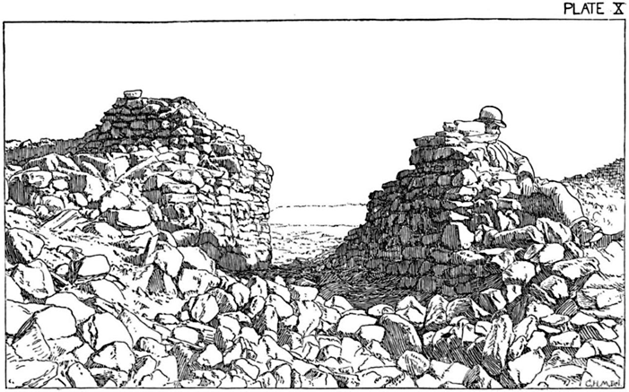 PLATE X:
VIEW OF PASSAGE G, BUILDING A, FROM THE NORTH.
The mound H describes about two-thirds of a circle. Its
base at the south is 6 m.—20 ft.—from E. to W.; its diameter,
6.85 m.—23 ft; its actual height, about 1.5 m.—5 ft. It
is conical, and appears to be a round heap of earth and rocks
encased with neat and judicious piling of well-selected stones.
This naturally gave the stone-work a slanting surface; the
higher it reaches, however, the more it becomes vertical, until
at last it juts out above the surface of the mound like a circular
breastwork, or a hollow round tower on a conical base. I refer
to Pl. X. for an excellent view of its vertical aspect and structure.
This mound, or tower, while it commands an extensive view to
the west, north, and even north-east, is also the most northerly
"spur" of the western wing of the great house A. This wing
extends in an unbroken length of 62 m.—203 ft.—from the
base line of H to the entrance N, and is divided into 3 transverse
sections, all connected, and all having 3 longitudinal rows
of rooms or cells. The width of each cell is the same in every
section, to wit, from E. to W. 2.58 m., 2.58 m., and 3.22 m.—8
ft. 6 in., 8 ft. 6 in., and 10 ft. 6 in., respectively.
Section k l l m has 3 × 5 apartments; in length from N. to
S., 2.51 m., 3.86 m., 2.35 m., 3.71 m., and 3.72 m.—8 ft., 13 ft.,
8 ft., 12 ft., and 12 ft. It was therefore 16.15 m. × 8.38 m.—53
ft. × 27 ft. Probably all the ground-floor cells were on
the same level.
Section l l h h has 3 × 12 apartments, each 2.53 m.—8 ft.—long.
Consequently, it was a rectangle of 30.36 m. x
8.38 m.—100 ft. × 27 ft. The eastern row of chambers was
on the slope.
Section h h N 3 × 4 long, respectively 2.77 m.—9 ft. each,
therefore 10.98 m. × 8.38 m.—36 ft. × 27 ft. There
were two eastern rows on the slope.
This entire wing (forming a rectangle of 62 m. × 8.38 m.—203
ft. × 27 ft., if we add to the spaces given the thicknesses
of the transverse partitions, this time not included in the measures)
has given me more trouble than the rest of A and B
combined. Nowhere are the walls so twisted and out of range
as here. Besides, there is an unfinished air about it that is
almost bewildering. The height of the stories does not agree
with that of the other sections,—the western wing would
be one story lower. Furthermore, it contains in several places
squared beams of wood inserted in the stone-work lengthwise.
These beams (of which there is also one in the opposite wing
similarly embedded) are identical and apparently of the same
age with the (not sculptured) beams still found in and about
the old church. Entire walls of chambers, or rather sides,
appear to be new; the mud or adobe is fresh, whereas almost
everywhere else it has disappeared, out of the crevices even;
the stones are almost laid in courses. As I shall hereafter
relate, there are at several places adobe walls, the adobe containing
wheat-straw! And all this right among chambers
showing sides as uncouth and old as any of the pueblo, though
still as high as their more recent and better preserved neighbors.
Here there is evidently patchwork of later date, and
patchwork executed with material unknown to the Indians
previous to the advent of the Spaniards. I am even convinced
that it was done after 1680; for the beams evidently came
from the church or the convent, which buildings we know were
sacked and fired by the Indians in the month of August of
that year. If this conclusion be correct, the south-western
part of A, its entire westerly wall, was somehow destroyed
after 1680, and partly rebuilt with materials unknown to the
Indians at the time when Pecos was first erected.
I say partly, because there is evidence that the western wing,
from H to N, was originally much broader. As it now appears,
the wall m h presents itself as the western line of the
structure. But there are, still further out, although distinctly
connected with it, remains of buildings which were at least
attached to it. These are the ruined enclosures designated
on the ground-plan by I, K, and L.
Nothing besides foundations, heaps of stones defining corners,
and upright posts protruding along the western limits of
L and K inside, remain of these structures. L L are of the
size of the ordinary chambers; K K are four times larger.
Their interior shows no partition whatever: the soil is level,
somewhat depressed in the centre of each apartment; and on
the whole they present very much the same appearance as
those structures on the "neck," which lie to the west of B,
but are not connected with the latter. Besides, the enclosures
are on a lower level than the two rows of rooms immediately
east of the wall m N. This wall itself is a double wall, each
single one being of the size of the ordinary partition; the total
width is therefore 0.56 m.—22 in.,—as proven by actual
measurement. The idea is therefore suggested—very naturally—that
the entire western wing of the building A was
originally a double house,[119] terraced both towards the east and
the west. In sketching the cross-sections, I have taken due
notice of this very probable, if not positive, fact.
The double wall m N shows no trace of lateral passages.
It therefore divides the whole structure from H to N into two
longitudinal sections. The western one, from o to p, consisted
of but one row of 5 rooms; from p to N it had two rows of 16
chambers each. The ground slopes still further to the S. and
S.W. outside of the trapezoidal enclosures, I I, and is covered
with débris; so that I presume that, from ll to N, there was an
additional row of 3 rooms on the outside. The entire division
was at one time very completely razed to the ground, so that its
owners never attempted to rebuild it after the original plan.
The western division was also badly damaged in its southern
half, but the damage was subsequently repaired with the
aid of material and mechanical arts postdating the Spanish
conquest of New Mexico. Pl. V., Fig. 3, gives a view of the
western end, along the line h h.
I would recall here the fact already noticed, that the northern
part of building B is also mended in places with adobes of
the same make as those used in repairing the western wing of
A, and that, while the squared beams are wanting, the stone-work
there in places appears also of a more recent date. The
suggestion may therefore not be uncalled for, that the same destroying
power which spent its main force on A, distinct from
the general decay, and moving in a direction from S.W. to
N. E., reflected or glanced off upon the northern portions of
B. This question will, however, be discussed hereafter.
The annexes I I are trapezoidal enclosures of stone-work
as high as a man's breast, and respectively of the sizes indicated
on the ground-plan. The northern one is divided lengthwise
into two compartments; the southern is open to the
south. Both appear to be new and unfinished. From the
centre of the last one protrude two well-squared heavy timbers.
These timbers are in a singularly unfit position; they
cannot be accounted for, and convey the impression that they
were carried hither from some other totally different construction.
They look almost forlorn. Whence they came, and for
what purpose they were brought,—what was the object in
erecting the enclosures I I,—I do not intend to speculate
upon, unless they are recently constructed store-rooms ("Almacenas").
Across the passage-way N, both southward from the line
g g and eastward from I, fitting into it to the east and barring
access to the great court from the "neck," lies the south wing
of A,—a rectangle of 27.25 m.—90 ft.—from W. to E., and
13 m.—43 ft.—from N. to S., including the walls. It is much
decayed and overturned; the northern side is far less so than
the southern; nowhere are there any signs of repairs. Here
the rows of rooms must be taken transversely (from W. to
E.). There are 5, each with 7 chambers, measuring in succession
from N. to S. 2.00 m., 2.00 m., 3.09 m., 2.40 m., and
2.00 m.—6 ft. 6 in., 6 ft. 6 in., 10 ft., 8 ft., and 6 ft. 6 in;
and from W. to E. 3.61 m.—12 ft. each. Two of these transverse
rows appear to be on the southern slope, and three on
the upper level towards the court.
Here I have again reached the passage-way R, my original
point of departure. Before entering into an examination of
the other particulars of the building, as well as of its annexes
and surroundings, I shall make once more a rapid circuit, to
give an idea of its size, and also attempt a rude computation
of the number of rooms it contained.
| Lengths of the eastern wing from f to B (E. side N. and S.) |
51.66 m.—170 ft. |
|
| |
3.40 m.— 12 ft. |
|
| |
15.81 m.— 52 ft. |
|
| |
11.32 m.— 37 ft. |
|
| |
7.84 m.— 25 ft. |
|
| Adding 28 walls à 0.28m.—11 in., total |
|
93.16 m.—306 ft. |
| Brought forward |
93.16 m.—306 ft. |
| Lengths of the north side from B to a |
12.00 m.— 40 ft. |
|
| from a to A |
17.28 m.— 57 ft. |
|
| 6 transverse walls à .28m.—11 in. |
1.68 m.— 6 ft. |
|
| |
|
30.96 m.—102 ft. |
| Length from A to n |
8.10 m.— 27 ft. |
|
| n to m |
8.38 m.— 27 ft. |
|
| m to o |
2.51 m.— 8 ft. |
|
| o to W. corner of L (estimated) |
5.00 m.— 16 ft. |
|
| W. corner of L. to p |
16.17 m.— 53 ft. |
|
| p to y |
2.10 m.— 7 ft. |
|
| y, southward, to line g g |
33.44 m.—110 ft. |
|
| passage-way N |
2.00 m.— 6 ft. |
6 in. |
| Width of western section of W. wing (about) |
7.48 m.— 25 ft. |
|
| Length of south wing |
13.00 m.— 43 ft. |
|
| 28 transverse walls à .28 m.—11 in. |
7.84 m.— 26 ft. |
|
| |
|
106.02 m.—348 ft. 6 in. |
| Width of S. wing |
27.25 m.— 90 ft. |
|
| Passage R |
4.00 m.— 13 ft. |
|
| From R to f (about) |
4.00 m.— 13 ft. |
|
| Line f f |
15.73 m.— 52 ft. |
|
| 8 longitudinal walls à .28 m.—11 in. |
2.24 m.— 7 ft. |
|
| Total length to f, my point of departure |
|
53.22 m.—175 ft. |
| Entire length of circuit of building A |
|
283.36 m.—928 ft. |
Adding to this 15 m.—49 ft.—for the probable periphery
of mound H, and 64 m.—210 ft.—for the perimeter of a
southern annex to the south wing, which I have not yet described,
we reach a perimeter of 362 m.—1,190 ft.—in all.
Comparing these figures with those given about the great
ruins of the Rio Chaco by Dr. W. H. Jackson,[120] and of the
pueblo of Las Animas River by my friend the Hon. L. H.
Morgan,[121] it will be seen that this building, A, at Pecos is
probably the largest aboriginal structure of stone within the
United States so far described, and that it will even bear
comparison with many of the aboriginal ruins of Mexico and
Central America.[122]
The size of the interior court can now be easily determined.
It is 64 m.—210 ft.—from N. to S., and 19.28 m.—63 ft.—from
E. to W. Its area covers therefore 1,235 sq. m.—13,230
sq. ft.,—or about one fourth of an acre; whereas the entire
débris, measured as well as possible, scatter over more than
two acres of ground.
For the computation of the number of rooms in the whole
pile, cross-sections are necessary. (Pl. V., Figs. 1-8.) The
height of each story is about the same as in B, to wit, 2.28 m.—7
ft. 6 in.
Fig. 1, section of west wing about l l, from west to east.
Fig. 2, lines b b and a B.
Fig. 3, section of west wing along h h.
Fig. 4, line d d, north, up to south line of C.
Fig. 5, section of west wing along line g g.
Fig. 6, line f f, southern boundary of east wing, and for the
entire rectangle up to E.
Fig. 7, cross-section of north wing, line A n, from north to
south.
Fig. 8, south wing, from north to south.
It is possible that the second row, from S. to N., had two
superposed chambers, but I am not positive of it, and therefore
do not include it in the computation of rooms which will
follow.
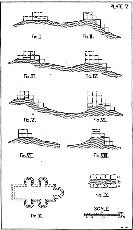 PLATE V:
SECTIONS OF BUILDING A.
It will be seen that, according to the ground plan and sections,
the east wing had five stories, the north wing two, the
west wing successively two, three, and four, and the south wing
four. Looking at the buildings from the great court, the south
presented an unbroken front of a two-story wall, the east
successively walls of four, three, and two stories; the north side
formed two, and the west side, from north to south, in succession,
two, three, and four terraces. In this manner, not only
was the building remarkably well accommodated to the great
irregularities of the surface, but even a tolerably uniform height
was attained, well agreeing, therefore, with the description of
"Cicuyé," as Castañeda saw it in 1540. "The houses have
four stories, terraced roofs all of the same height, along which
one can make the circuit of the entire village without meeting
any street to intercept the passage.[123] Here we must remember
that the widest gateway is 4 m.—13 ft.—wide,—an expanse
easily spanned by common beams used by the Indians
in their house architecture.
An attempt to compute the number of rooms in A results
as follows:—
| Rectangle f f e e, 18 longitudinal rows of 6 rooms and 5 stories. |
| |
1st story |
18 |
|
| |
2d story 5 × 18 |
90 |
|
| |
3d story 4 × 18 |
72 |
|
| |
4th story 3 × 18 |
54 |
|
| |
5th story 2 × 18 |
36 |
|
| |
|
|
270 rooms. |
| (d d c c) |
1st story and 2d story on the slope,
and 3 rooms per row. |
|
|
| |
1st story |
3 |
|
| |
2d story |
3 |
|
| |
3d story 4 × 3 |
12 |
|
| |
4th story 3 × 3 |
9 |
|
| |
5th story 2 × 6 |
6 |
|
| |
|
|
33 " |
| Carried forward |
|
|
303 rooms. |
| Brought forward |
|
|
303 rooms. |
| (b b a B) |
6 rows of 4 rooms, and 3 stories on the slope. |
|
|
| |
1st, 2d, 3d story, each 4 |
12 |
|
| |
4th story 3 × 4 |
12 |
|
| |
5th story 2 × 4 |
8 |
|
| |
|
|
32 " |
| (North wing) |
2 stories, easily computed as |
|
20 " |
| (k m l l) |
1st story 5 × 4 |
20 |
|
| |
2d story 5 × 2 |
10 |
|
| |
|
|
30 " |
| (l l h h K) |
Lowest story |
12 |
|
| |
2d story 12 × 4 |
48 |
|
| |
3d story 12 × 2 |
24 |
|
| |
|
|
84 " |
| (h h K g g I) |
Lowest story |
4 |
|
| |
2d story |
4 |
|
| |
3d story 4 × 4 |
16 |
|
| |
4th story 4 × 2 |
8 |
|
| |
|
|
32 " |
| (South wing) |
From E. to W. |
|
|
| |
Lowest story |
7 |
|
| |
2d story |
7 |
|
| |
3d story 7 × 3 |
21 |
|
| |
4th story 7 × 2 |
14 |
|
| |
|
|
49 " |
| Adding for the southern annex a probable number of |
|
35 " |
| Building A contained in all not less than |
|
585 cells. |
Turning now to the inside of the building itself, I am compelled
to acknowledge here an important omission in my survey
of B. It relates to the vertical connection of the walls.
They are all, with few exceptions, as far as their dilapidated
condition admits of observation, continuous from bottom to
top; that is, the sides were everywhere carried up above the
ceiling (or floor), and then, after the beams had been embedded
in the stones, another wall was piled up on it as straight
as possible. In this manner it became possible to add each
cell separately.
There are several doors visible in A, as marked on the
ground-plan. Those in the eastern and western wings open
from east to west, those in the northern wing from north to
south; therefore transversely to the length of each structure.
But I have also seen longitudinal walls without passages. The
tops of the doors are all gone; the rest is everywhere similar
to the sample found in B, and already figured. In some
cases even the sills are gone. Windows I could not find, nor
trap-doors or ladders; there was no trace of steps, and, unfortunately,
no clew to any chimney or vent. Of furniture I
secured pieces of new hearth-stones; of other articles, broken
"metates," part of a fine maul of stone, flint chips, celts,
stone skin-scrapers, and, of course, painted pottery and obsidian.
But not one specimen is entire; every striking implement,
etc., has been carried off by amateurs, of whose presence
besides, broken beer bottles, with the inscription "Anheuser-Busch
Brewing Co., St. Louis, Mo.," give occasional notice.
Room I, in the S.W. corner of the north wing is very well
preserved: so well, indeed, that it is nearly certain that there
was no entrance to it from above. On the contrary, the entrance
appears to have been from the front, as shown in Pl.
VIII., where this room stands in full view. It is perfectly plain
inside; eight posts of wood, round, and stripped of all bark,
support the ceiling and roof, whose composition I have elsewhere
described. These posts (which are also shown in Pl.
VIII.) are so distributed as to have one in each corner, and
two between, on each longer side of the room. In the S.E.
quarter of the ceiling the splinters covering the rafters or
poles are removed, and fresh straw (or rather very well preserved)
protrudes, as having formed a layer with the brush.
I was at first inclined to take it for wheat-straw, but other
parties insisted that it was mountain grass. For the latter it
appears to be very long, and it has a marked head. I have
not, as yet, seen any wheat-plants grown at these elevations.[124]
Otherwise this chamber appears nearly perfect. In the
middle of the north wall a hole is knocked out, but the two
coats of plaster (dark and white) are almost everywhere preserved.
Great interest attaches to this apartment, from the
fact that, according to Sr. Mariano Ruiz, the sacred embers
("braza") were kept here until 1840, in which year the five
last remaining families of Pecos Indians removed to their cognates
at Jemez, and the "sacred fire" disappeared with them.
Sr. Ruiz is good authority on that point, since, as a member
of the tribe[125] ("hijo del pueblo"), he was asked to perform
his duty by attending to the embers one year. He refused,
for reasons which I shall hereafter state. The facts—that
the fire was kept in a sort of closed oven, and that the front
opening existed—made it unnecessary to search for any
other conduit for smoke and ventilation. The fire was kept
covered, and not permitted to flame.
I now come to one of the most interesting features of the
court,—the three circular depressions marked P on the diagram.
Two of them are in the N. E. corner,—the northern
one close to the northern wing, and the other 2.65 m.—9 ft.—to
the S. S. E. of it. Both are perfect circles, and each has a
diameter of 7.70 m.—25 ft. In the S.W. corner, near to the
passage N, is the third, with a diameter of only 6 m.—20 ft.
They look like shallow basins, encased by a rim of stone-work
piled up in the usual way, and forming a wall of nearly 0.35
m.—14 in.—in thickness. This wall is sunk into the ground,
but at the northern basin it certainly, as former excavations
plainly show, did not reach the depth of 1 metre; and it appears
that at about that depth there were flat stones laid, like
a rough stone floor. These basins were the "Estufas," or
council chambers, where, as late as 1840, the meetings of the
poor remnants of the tribe were still held. Although an
adopted son of Pecos, Sr. Ruiz was never permitted to enter
the Estufa. Across the northern one a very large and very
old tree, nearly 0.75 m.—2 ft. 6 in.—in diameter, is lying
obliquely. Its thick end is towards the N.E. wall. It looks
as if uprooted and fallen upon the ruins. But how could a
tree of such dimensions ever have grown there? Again, for
what purpose, and how, could the Indians of Pecos have
carried it hither?
Outside of the building A, the narrow ledge separating its
rubbish from the eastern wall of circumvallation, a rim 150 m.—192
ft.—long by 32 m.—105 ft.—wide at the south, and
12 m.—40 ft.—at the north, shows the basins D and F, respectively
10 m.—33 ft.—and 8 m.—26 ft.—in diameter.
They hug the rock of the mesilla very closely, and look
completely like the estufas in the court. These buildings,
according to Sr. Epifanio Vigil, of Santa Fé, were barns or
store-houses (round towers 10 to 11 feet high), in which the
Indians preserved their gathered crops, forage, etc. Still, it
is not unlikely that they were tanks, built for collecting rain-water.
On the south side of the eastern wing, and so close to it
that the heaps of rubbish touch, are two circular depressions
surrounded by large masses of stones. They are marked S S
on the plan. Their shape and size cannot be accurately determined,
and their object is unknown.
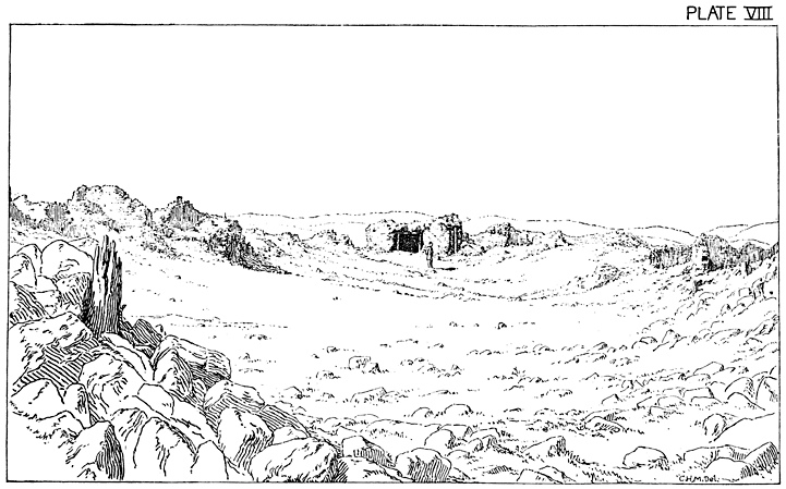 PLATE VIII:
INTERIOR OF BUILDING A, FROM THE SOUTH.
Nearly the same must be said of a rectangular space, dotted
and intersected with foundations and upright beams marked
T T, and lying out in front of the south wing on the denuded
and thinly soiled apron forming the southern spur of the
"body" of the mesilla. Its eastern line, a double stone wall
sunk 0.50 m.—20 in.—into the soil, is 8 m.—26 ft.—long
from N. to S. From its southern extremity similar foundations
run to the west 37 m.—120 ft.,—thence 8 m.—26 ft.—north,
and 37 m.—120 ft.—east back to the first line. Thus
a rectangle of 8 m. × 37 m.—26 ft. × 120 ft.—is formed,
within whose area, especially in the western portion, upright
beams start up in something like a semicircle, which would
indicate that the structure was once a building. A metre and
a half to the north, a foundation wall runs about 20 m.—66
ft.—E. and W.; and at both of its extremities a corridor
ascends towards the south wing of A. The nature and object
of these fabrics are equally a mystery to me.
Attached to the S.W. corner of the south wing is the annex
of which I have already spoken. It is an elevated rectangle
of 24 m. × 9 m.—80 ft. × 30 ft., and is clearly divided into
compartments of 3½ m. × 3 m.—12 ft. × 11 ft. The whole
is not much more than a stone mound of oblong shape, but it
contained on its ground-plan 21 chambers. I presume, from
the mass of débris, that it had an upper story. Its eastern
row of cells is a direct continuation of the most westerly
row of the S. wing. Due south of this annex, and almost
touching it, there are two structures marked O O which are
very remarkable. They are octagonal. The most easterly
one is best preserved, and appears to be the largest. Its two
lateral walls are each 4 m.—13 ft.—long, the transverse 5.34
m.—18 ft.,—and the corners are cut off sharply by intersections
of 0.86 m.—3 ft.—in length, so as to give the whole
eight sides. The walls are well defined; the corners sharp
and still one metre high. They are of the usual thickness.
The other structure is so ruined that it appears round. These
buildings, according to Sr. Vigil, were store-houses also; and
they favor the suspicion that those marked S S south of the
east wing had the same shape. As they now appear, they
look like the ruins of octagonal towers. The stone-work is
like that of the estufas, but they are erected exclusively above
the ground, and still cannot have been very high.
I have now reached the utmost south-westerly point of
ruins on the "body," where its drainage leads us into the
often-mentioned depression and to the broad gateway of the
circumvallation. From this gate the enclosure-wall creeps up
along the edge of the mesilla N.W. and N., in all 104 m.—340
ft.,—to a point 44 m.—144 ft.—due west of the S. W.
corner of the annex; and here we find a distinct stone enclosure
27 m.—89 ft.—long from N. to S., and 15 m.—50 ft.—wide,
with an entrance of 3 m.—10 ft. wide, and terminating at
the circumvallation. North-east of this, and about 28 m.—92
ft.—west of i on the middle wall of western wing, another
enclosure begins 20 m. × 8 m.—66 ft. × 26 ft.; and 3 m.—10
ft.—south of this a small ruin 10 m. × 8 m.—33 ft. x
26 ft. Adjacent to L L, etc., around from o to y, a curved
enclosure of stone extends, 42 m.—140 ft.—long, and thence
east 6 m.—20 ft.—back to the N.W. corner of K. It appears
like a garden, or corral, and shows no partitions. These
are, as far as I could see, all the remains west of the building
A. The edge of the mesilla rounds into the north-western
corner of the latter, almost closing up with it; the slope is
very steep and covered with huge rocks, broken and tumbled
down along the declivity.
The small northern plateau between the transverse circumvallation
and the top-wall of A is therefore nearly shut out
from communication to the S.W. This plateau is a trapezium
45 m.—148 ft.—long from N. to S.,—50 m.—164 ft.—wide
on the S., and 30 m.—98 ft.—on the N. It holds
but few ruins; but, among these, a valuable find was made a
short time ago by Mr. Harry Dent, of Baughls.
These ruins, in the main, can be described as follows: The
slope descending from the top-wall is a heap of rubbish with
shrivelled posts of wood, impossible to disentangle without
excavations. North of this débris, and 29 m.—95 ft.—from
A a B, stands a knoll, or mound, covered with stones. Looking
south from this, I thought I noticed that it stood in the
line of the second row of chambers of the east wing of A,
counting from E. to W.; and retracing my steps in that direction
I found, indeed, traces of stone foundations disappearing
under the great débris, which indicated a corridor, or perhaps
series of rooms, about 2 m.—6 ft. 6 in.—wide. It therefore
looked like a northern annex to A. From the mound, which
I have designated by V (Pl. I., Fig. 5), other foundations
radiate to the W. and N.W. Those west soon disappear, but
to the N.W. they are plainly visible for 14 m.—46 ft.—to
another mound, or knoll T, similar to the first, whence another
line of foundations vanishes to the west also. This appears to
be the utmost limit of structures north, except the wall of
enclosure, from which to T on the south is about 10 m.—33
ft. About the N.W. corner of A large heaps of rubbish
descend in shapeless terraces outside and merge into the slope
of the mesilla. They are, like the entire slope itself, covered
with fragmentary pottery. About their eastern declivity, also,
I thought I saw foundations, but could not be sure whether
or not they connected with those extending westward from
the two mounds just mentioned.
In the eastern section of mound V, Mr. Dent has, as I was
informed and saw, dug down one metre into the dark loamy
clay and stones of which the knoll is composed, and has thus
exposed a small stone chamber, or flue, walled in to the north,
west, and south in the ordinary manner, and closed with earth,
etc., at the east. Whether there was any stone top other than
rocks heaped up above the hillock I could not learn; neither
did I, in digging down further, find any floor. This chimney-like
structure is 1.32 m.—3 ft. 8 in.—wide from E. to W.,
and 0.70 m.—2 ft. 3 in.—from N. to S. It is therefore too
large for a chimney, or flue, and too small for a room. Out
of it Mr. Dent, whom I could not find personally, as he was
absent at the time, extracted a human skeleton and much
fairly preserved pottery. Of course, I was unable to see what
he carried off (among which was the skull), but I saw and dug
further in the same excavation, removing out of it bone splinters
and the best preserved pottery piece of the entire collection.
They are, in part, very similar to the yellow bowls still
made by the Indian pueblo of Nambé (a Tehua tribe); but
many of them have been so charred and blackened that it is
impossible to make out their color. The pottery is all thin.
Among it were also bits of charcoal and of rotten wood. The
structure therefore appears to have been a grave, in which the
body was placed in a sitting posture with its face to the east.
Subsequent information and discovery have fully confirmed
this view. I shall return to this on a subsequent page, and
only state here that my efforts to find another skeleton in the
same location failed.
The aboriginal remains encircled by the great wall of circumvallation
and north of the old church are now exhausted,
so far as my work among them goes, and the surroundings of
the mesilla shall therefore become the subject of report.
The slope towards the east and south-east is rocky on the
top, covered with sandy soil growing grama and very few
cedar bushes, studded with ant-hills, and devoid of all remains
of human structures so far as I could see. Pottery and
obsidian are ever present, but become perceptibly less and
almost disappear further east. The rills which drain the eastern
slope carry much of this broken stuff into a small arroyo
that winds to the left of the mesilla. About one quarter of a
mile east of the building A, on a bare sunny and grassy level,
are, quite alone, the foundations of a singular ruin. They
run N. and S., consist of three rows of stones laid aside of
each other longitudinally, and have the shape shown in Pl.
V., Fig. 10.
Its length from N. to S. is 25 m.—82 ft.,—and its width
about 10 m.—33 ft. From its form I suspect it to have been
a Christian chapel, erected, or perhaps only in process of erection,
before 1680. Not only is it completely razed, but even
the material of the superstructure seems to have been carried
off. Stones are scattered about the premises, but I found
neither obsidian nor pottery. It stands protected from the
north by the extremely rocky ledge terminating the mesilla
towards the east, and appears without the least connection
with the Indian pueblo proper.
It is the almost circular bottom on the west of the mesilla,
encompassed by the north rock of A to the north, by the
whole length of the mesilla to the east, by the gradual expanse
below the church on the south, and by the Arroyo de Pecos
on the west, that contains the aboriginal remains. Much better
than a description, a diagram will illustrate their extent and
shape. Pl. I., Fig. 5.
The distances are not very correctly given, and the shape
of F is slightly exaggerated in irregularity.
A and B being the respective large buildings, C the church,
D the great gate of the circumvallation; E is a stone or rubble
wall of undeterminable length running along the foot of
the mesilla in a slight curve till near the "wash-out" sallying
from the gate, and F is an irregular lozenge, or trapeze, enclosed
by a heavy low stone or rubble wall which might in
some places be called an embankment. The corner l is
50 m.—165 ft.—from the border of the creek-bottom, which
there is cut off abruptly from 1 m. to 3 m.—3 ft. 3 in. to 10
ft.,—presenting a section of red clay and gravel with pottery
fragments. The line l r m runs W.N.W. to E.S.E., and is
138 m.—452 ft.—long; the line m s n measures 121 m.—398
ft.,—n o p 146 m.—480 ft., and p l 100 m.—330 ft.
From r to s an embankment of earth and stone runs almost in
a circle, and the whole triangle r m s forms a slightly elevated
platform, in the centre of which is a pond (estanque) t,
which, even at the present time, is filled with water. Viewed
through the gate from above, this pond appears, with a part
of the enclosure, as seen in Pl. IX. Several gullies (barrancas)
have cut through the western and southern parts of the enclosure.
This enclosed area, now covered with tufts of grama, occasional
cactuses, knolls and scattered drift and pottery, was
according to Sr. Ruiz, the former huerto del pueblo; that is,
the fields of the inhabitants of the pueblo, where they planted
and raised Indian corn, beans, calabashes, squash, and, after
the advent of the Spaniards, also wheat, melons, and perhaps
other fruit. Not a vestige of former cultivation is left; but
the platform r m s, with a pond in the centre, at once explains
their mode of securing the water for irrigation. Through the
gateway D the drainage of the mesilla was conducted directly
to the platform r m s, where the pond t acted as a reservoir,
out of which the fields themselves could be very easily and
equitably supplied with moisture. Whether this was done by
channels radiating from below the curve r s over the area F,
or by carrying the water, I cannot tell, neither my informants
nor the appearance of the area giving any clew. But I could
not escape being forcibly struck by this plain and still very
forcible illustration of communal living. Not only did the
Pecos Indians live together, and build their houses together, but
they raised their crops in one common field (though divided
into individual or rather family plots, according to Ruiz),
irrigated from one common water source which gathered its
contents of moisture from the inhabited surface of the pueblo
grounds. "The lands," said Mariano Ruiz, "belong to the
tribe, but each man can sell his own crops." ("Las tierras
son del pueblo, pero cada uno puede vender sus cosechas.")
It forcibly recalls the system of "distribution and tenure of
lands" among the ancient Mexicans.
I now cross the Arroyo de Pecos, and on its western bank,
in the triangle formed by the creek with the military road to
Santa Fé, nearly opposite the site of the old church, I met
with a ruined enclosure and with remains of structures whose
purposes are yet unexplained to me.
The distance from M to the arroyo is 40 m.—130 ft. Its
E. line is 75 m.—246 ft.,—the S. line 70 m.—230 ft.,—the
W., up to where the curve begins, 55 m.—180 ft. The distance
from M to N is 15 m.—50 ft. At the north end of N
is a mound of stone and débris, like a conical tower, 5 m.—16
ft.—in diameter; the other lines are distinct foundations
only. Both M and N are scattered over with broken pottery,
chips of obsidian and flint, and I also found a fragment of a
stone implement.
Mariano Ruiz told me that the enclosure M was the corral
of the pueblo; that is, the enclosure where they kept whatever
herds they possessed. It was at all events but an enclosure,
and no building. Still, why were their herds, their most valuable
property, kept on the opposite side of the creek, so far
from the dwellings themselves?
There are other ruins yet further south on the western bank
of the arroyo, which, however, I shall not mention here. They
are so important as to deserve special discussion in a later
portion of this report. I therefore cross the creek back again
to its eastern shore, and thence to the south side of the old
church, proceeding thence southwards. From the church a
grassy slope, very gentle and with almost imperceptible undulations,
extends to the road which runs almost due W. and E.
from the creek towards the Rio Pecos. The distance is about
300 m.—1,000 ft.,—of which 74 m.—240 ft.—are taken up
by the embankments, walls, and foundation lines already described
as pertaining to the church building. Plate I. shows
the position of this section, its northern limit being about
34 m.—112 ft.—N. of the southern lines of the church annexes
(or 42 m.—138 ft.—S. of the temple itself) the
southern limit being the road itself, while on the west the
creek-bed forms the boundary.
H, Corral-like structure, very plain, about 50 m. × 20 m., or
163 ft. × 65 ft. I understood Sr. Ruiz to say that it was the
garden of the church ("la huerta de la iglesia"), but believe
that he probably meant G, not having my field-notes with me
at the time.
I, rectangle of foundation lines 30 m.—98 ft.—from A;
30 m. × 31 m.—98 ft. × 100 ft.—divided into 2 compartments,
the western one 9 m. × 30 m.—30 ft. × 98 ft.
J, trapezium, with mound at S.W. corner 18 m. × 21 m.,
or 60 ft. × 70 ft.
K, rectangle 25 m. × 36 m.—82 ft × 118 ft.—open to
the west, and only recognizable from the semicircular mound
of not 0.50 m.—20 in.—elevation, dotted out as leaving a
depression in the centre.
L, circular depression 36 m.—118 ft.—in diameter; ground
always wet.
O, circular mound 10 m.—33 ft.—in diameter, 1.5 m.—5
ft.—high.
k, shapeless mound, possibly part of a hollow rectangle.
In many cases the foundations (which are the only remains
visible) are themselves obliterated,—or at least overgrown.
They are sometimes of 0.27 m.—10 in.—in width; again,
two rows, even three rows, of stones compose them longitudinally.
The mound is regular, but the soil is everywhere so
hard and gravelly that I desisted from excavating. The basin
L looks much like an estufa: there are few scattered
stones on its surface, and this surface is moist; but I did not
notice any trace of stone encasement. In general, there is no
rubbish at all over the area. Stones are scattered about, and
evidently they were once used for building purposes; but
they nowhere form heaps. Then there is not the slightest
trace of pottery or obsidian. In this respect the area just
described forms a remarkable exception. All around it in
every direction the painted fragments cover the soil; this
particular locality, as far as I could find, has none. It only
reappears in I, opposite the church annexes, and also in the
enclosure H, whereas the church grounds are again strewn
with handsome pieces, and some of the finest obsidian flakes
were found on them.
Across the road to the south, the ground becomes covered
with shrubs of cedar, and the eastern slope hugs the creek-bed.
Upon reaching the creek, the road divides,—one branch
crossing over directly to the west, and the other proceeding
along the arroyo about 200 m.—630 ft.—to the south ere it
turns across. The main military line of travel intersects there-about
the one to the Pecos River, and thence, striking almost
due south, forms a very acute angle with the creek. In this
angle ledges of rock protrude, sheltered by a fine group of
cedar-shrubs; and here, in what may be termed a snug little
corner, the rocks bear some Indian carvings.
Expecting daily a supply of paper for "squeezes," I have
until now deferred taking any exact copies of these vestiges.
Therefore this report contains but superficial notice of them.
It would have been useless labor to make sketches and take
measurements when I knew that, within the period of time I
shall spend in New Mexico, I should certainly be able to
secure fac-similes. The carvings are certainly old; they are
much worn, and represent mainly so-called footprints (of adults
as well as of children), turkey tracks, a human form, and a
circle formed by small cup-shaped holes, of the patterns about
which I hope that my friend Professor C. C. Rau, of Washington,
will by this time have finished his elaborate and very interesting
work. The human figure is as rude and childlike an
effort as any represented on the plates accompanying the reports
of General Simpson and of my friend Mr. W. H. Holmes;
the footmarks are fair, and the circle is rather perfect. Something
like a "diamond" appears within its periphery, but I
am not yet quite certain whether it is a carving or the result
of decay. Some of the tracks seem to point to the high
mesa, others to the north.[126] By the side of these original efforts
there are recent additions, destined, perhaps, to become
at some future time as successful archæological frauds as
many of the most interesting products of excavation in the
States of Ohio and Iowa. About the sculptured stones I
again met with fragments of painted pottery. Still further
down, on the east bank of the Arroyo de Pecos, about a
mile from the church in a southerly direction, and on a low
promontory of red clay jutting out into the creek-bed, there
are vestiges of other ruins,—a low, flat mound covered with
stones. I saw no pottery about it.
Directly opposite the sculptured rocks, on the other bank
of the arroyo to the west, the cliffs of clay bordering it form a
huge cauldron, out of which the contents seem to have been
originally removed, leaving a semicircle of vertical bluffs of
clay and drift about 3 m.—10 ft.—high. It is out of this
locality that I suggested the clay for the adobe of the church
might have been secured. The faces of the slope cannot have
been washed out, for the creek runs straight far to the east,
hugging closely that side of its banks; there is no trace of an
old stream-bed winding to the westward, neither is there any
sufficient drainage from the west in the shape of gulches or
branches. It appears as if there had been an original start,
at least, given to the present basin by a removal of earth
in a curve, subsequent wearing and weakening enlarging the
cauldron to its actual form and size. This size is constantly
increased by decay and by the work of diggers; for this bluff
has been of late a favorite resort for them, from the fact that
in its face human bones—nay, complete graves—have been
found.
I consequently started to examine the bluff, and finally noticed
a plain wall jutting out at about one fourth of the length
of the western curve from N. to S. This wall seemed at first to
be a corner. It is well made, and its stone-work is much like
that figured by Mr. Holmes from the cliff-dwellings on the
Rio Mancos in South-western Colorado. Still the stones are
not hewn, but only were carefully broken, the rock itself having
a tabular cleavage. The surface is true. I am unable to
say whether it was a corner or not; the thickness of the side
(east) is 0.65 m.—2 ft.,—and it looks like a strong outside
line running almost due N. and S., perhaps a little to the E.
The height of the wall is 0.94 m.—3 ft.; its depth beneath
the surface, 0.52 m.—21 in. The sod (covered with grama)
looks undisturbed; it is hard and coarsely sandy on the
top, but beneath the clay is softer and loamy. Under the wall
there is red clay to the bottom of the bluff with bands of drift.
Clambering along the cliff to the northward, I soon perceived,
at a depth nearly agreeing with the base of the wall, a layer of
white ashes, similar to those found over the hearthstone in
building B, mixed with charcoal and charred pottery. This
layer was continuous along the exposure of the bluff; it formed
a regular seam, intersected horizontally by bands of charcoal,
and, at the lower end, a continuous stratum of pottery totally
different from that found hitherto, except one fragment in
the drift of the creek and another one among the adobe rubbish
of the church. Instead of being painted, it was corrugated
and indented, and identical with the corrugated and
indented ware from the Rio Mancos and from South-eastern
Utah, so beautifully figured by Mr. W. H. Holmes. There
were also a very few pieces of painted pottery: but these,
which became more numerous towards the top of the bluff, or
cliff, appeared to have been washed in; whereas the corrugated
fragments were a distinct, continuous band, most of the convex
surfaces being downwards; and this band, except where ledges
of the cliff projected far out into the bottom, or where the
clay had tumbled down recently in front of the exposure, was
visible from 50 m.—165 ft.—N. of the wall to 62 m.—203
ft.—S. of it on a line of 110 m.—360 ft. It was everywhere
accompanied by the ashes and charcoal.
A, little barranca, exposing ashes, etc., which contained
corncobs, and, in the upper parts of the clay, human bones.
a, grave found by Mr. E. K. Walters, of Pecos; obliterated
now.
B, wall.
b, place where skeleton of child was partly secured, five
metres S. of B.
C, southern barranca; no remains found.
c, last sign south of pottery, ashes, and charcoal.
W, rock carvings on west bank of the arroyo.
The following are sections at four different places:—
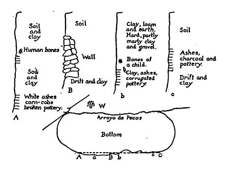 Clay Pit Area
Specimens of every section have been sent with the collection.
It has struck me that the stratum of ashes, charcoal, and pottery,
while visible always inside,—that is, to the west of a
supposed lateral extension of the wall from B,—still appears
to run below it. The human remains, however, protrude about
at heights where the wall, if in existence, might have been in
front of them. There were bones lying on rubbish in front of
C,—there were also bones within the ashes, even at A; but
the action of wear and washing being everywhere visible and
very complicated, I do not venture any surmise in these cases
beyond expressing the conviction that the human remains
originally rested above the layers of charcoal, ashes, corncobs,
and corrugated pottery.
While at Sr. Ruiz's, I had diligently inquired of the old gentleman
about the graves of the Pecos Indians. He finally replied
(after he had for a time insisted upon it that they were at
the church) that before they became Christians ("antes que
fuéron cristianos") they buried their dead on the right bank of
the Arroyo de Pecos, where he had often seen the skeletons
(las calaveras, the corpses) washed out of the cliffs and strewn
about. At Mrs. Kozlowski's, this also appeared to be a known
fact; but an examination of the creek banks showed no trace
of bones, and showed no other structures except the mound
already mentioned on the left shore. In the cliffs of the basin
which I have now described I met with the first sign of what
Sr. Ruiz called "El Campo-Santo de los Indios, antes que
fuéron Cristianos." Still it is not at all positive, because the
surface of the level west of the bluff shows extensive but flat
and low mounds, covered with stones used for building, and
with painted pottery, showing that at least adjoining the human
remains a very large building, if not several, had stood at some
very remote time. The wall would then stand towards that
ancient structure in the same relation as the mound or chamber
V stands towards the ruin A on the mesilla; and it would indicate
the custom on the part of their inhabitants of burying
their dead around their houses, or at least in sight of the rising
sun, and in little chambers of stone. This view is corroborated
by the statement of Mr. E. K. Walters, of Pecos, that at a place
which I have marked a (therefore to the north of the wall)
he dug out, very near the edge of the bluff, a stone grave, and
with it a human skeleton. The grave was a rectangle, walled
up on four sides, with stones on the top and no floor. The
western side was rounded, so as to present the following
plan:—

In it lay the skeleton, two feet below the soil, the feet pointing
eastward. The length of the chamber was about one third
of a large man's body; the head lay at the west end, amongst
the bones of the chest. It had therefore been buried in a sitting
posture facing the rising sun.[127] Along with the body
arrow-heads were found, and pieces of tanned deerskin, such
as are still worn by the Indians. Of course, all traces of the
skull, etc., have since disappeared.
While this conversation was taking place, the partner of
Mr. Walters, Sr. Juan Basa y Salazar, came in, and the question
of the great bell (which I have already mentioned)
came up for discussion. All the parties assured me that
this bell formerly belonged to the church of Pecos, and
that after the outbreak of 1680 the Indians carried it up
into their winter pueblo, on the top of the high mesa, where
it broke and they left it. The positive assertion that the
winter pueblo of the Pecos tribe was about 2,000 feet higher
than the great ruins on the mesilla—that these ruins themselves
were but their summer houses—was very startling.
It appeared incredible that the Indians should have left
their comfortable quarters in the coldest season to look for
shelter in the highest and coldest places of the whole
region. Still, my informants being old residents and candid
men, with certainly no intention to deceive me, and
there being besides confused reports of the existence of
ruins on the mesa current among the people of the valley,
I resolved to devote my last day to a rapid reconnoissance
of the elevated plateau. Therefore, after a visit to the
Plaza de Pecos, on the 5th of September, where the Rev.
Father Léon Mailluchet confirmed the reports about the
winter houses on the mesa, I set out (always on foot) on
the morning of the 6th, Mr. Thomas Munn having volunteered
to be my guide.
We followed the railroad track downwards, and about a mile
and a half south of Baughl's, east of the track, met a tolerably
large mound. At the station of Kingman, four miles from
Baughl's, there is also a ruined stone house, rectangular, but
smaller than any one of those on the mesilla.[128] I had no time
to make any survey. We went along the railroad for one mile
farther, then struck to the S. W. across a recently cultivated but
abandoned field, and finally reached the apron of gravelly clay
and locas skirting the high mesa. Here Mr. Munn assured
me were the remains of stone structures all along for miles,
and especially stone graves. Of the latter he had seen "hundreds."
He described them exactly as Mr. Walters had, and
as I had found the pit in mound V, and described the position
of the skeleton also as if sitting with the face to the east. We
soon came to a walled ruin 6 m. × 6 m. or 20 ft. × 20 ft., the
walls composed of sandstone,—a range of rubble blocks very
much ruined,—a piñon having a diameter of 0.45 m.—18 in.—shooting
up from the interior. 50 m.—165 ft.—further north
a clearly defined estufa is seen, 4 m.—13 ft.—across, with
stone walls 1 m.—3 ft. 3 in.—in width. The apron of the
mesa is overgrown with fine pines. Thence, following a tie-shoot,
we ascended very nearly vertically, about 1,000 feet at
least, to the top. Here already the view to the E. and S. was
magnificent; but the air was light and chilly. Thunder-clouds
were hovering N. and E., rain-streaks pouring down on the
Sierra de Tecolote, and soon a heavy cloud formed south of us,
while others were slowly nearing from the N.E. The mesa dips
or slants decidedly to the W. and S.W.; the strata on its surface
are tilted up to a high pitch, and appear to be almost
vertical. The ground is very rocky, covered with high piñon.
Notwithstanding the steadily nearing thunder, we plunged to
the S.W., past the tie-camp of Mr. Keno, and soon struck the
source of an arroyo in a rocky, desolate hollow, pines shooting
up in and around it. There, on its left bank, were the
foundations of a stone structure 11 m. × 3 m.—36 ft. × 10
ft. About three miles from the edge of the mesa, in a still
wilder cañada, where there is no space nor site for any
abode around, the bell was found. There is no trace of any
"winter house" here,—not even on the entire mesa; and the
bell was left there, not because its carriers there remained,
but because it dropped there and broke. Who these carriers
were I shall discuss further on; at all events, they were not
the Indians of Pecos. This cañada is the entrance to a
gorge descending directly towards the pueblo of Galisteo.[129]
Meanwhile the clouds had accumulated over our heads, sharp
thunder-claps and icy blasts preceding the storm. It was of
short duration, but as the hail fell thickly we were thoroughly
pelted and wet before again reaching the camp, glad to enjoy
the hospitality and hot coffee of its inmates. At one p.m. the
sun shone again, and we started (this time to the north) along
the border of the mesa. Vegetation is here more exuberant
than in the valley of Pecos. Not only do tall pines grow
everywhere, but there is a thick undergrowth of encina;
the Yucca is large and green, mountain sage covers the soil,
and grassy levels are dotted with flowers. Animal life, also,
is more vigorous and more varied. Whereas in the valley
crows and turkey-buzzards alone enliven the air, and there are
scarcely any beetles; up here there is deer and turkey, and the
gray wolf; jays and magpies flutter through the thickets, and
the horned lizard is met with occasionally. The pith of the
pine-trees attracts a large species of buprestis, and lepidopteræ
are quite common. But there is not the least vestige of former
human dwellings, so far as I could see: the top of the
mesa of Pecos is, and was, a wilderness. It may have been the
hunting-grounds of the tribe even in winter, but as for their
exchanging their large pueblo at the bottom for a residence
on the top it is very much as if the good people of New
York City should spend Christmas week on the Catskill
Range, or the Bostonians take winter quarters on Mount
Monadnock. We followed the crest of the mesa for nearly
four miles, ascending two of its highest tops. They are
steep, denuded, and craggy. Beneath them vertical ledges
descend in amphitheatres. From the highest point the
horizon to the south appears unbounded. Like a small
cone, the peak of Bernal seems to guard the lowest end of
the Valley of Pecos. Over this vale rain-clouds still cast
their shadows, and distant thunder muttered behind the
Owl Mountains and the high Sierras in the north. To
the west and south-west are almost unlimited expanses of
slope, dark green pineries, and grassy spots. The bold
outline of the Sandia Mountains looms up stately beyond
it. Even the distant Sierra de Jemez protrudes. Between
it and the northern limits of the mesa lies, far off yet, the
city of Santa Fé.
The mesa is mostly yellow sandstone, but its highest points
are capped with red; therefore the name of "Cerro amarillo"
often applied to it. Through a gorge worn in the rock, and
on an almost perpendicular "burro-trail," we finally descended
to the apron of the plateau, surrounded during our
descent by scenery as weird and wild as any of the lower Alps
of Switzerland. On the lower edge of the apron, a mile and
a half north of Kingman, and half a mile from the railroad
track, we struck again several ruins. They were partitioned
rectangles, very similar in size and in condition to the foundations
seen south of the old church of Pecos, and, like those,
utterly devoid of fragments of pottery. Along their eastern
line, and inside of the walls, there appeared little square
heaps of stones. These were the graves of which my guide
had spoken, and their position is exactly similar to that of
those near and at the pueblo itself.[130]
My time was up, however, and I could not stop to explore
them. I therefore returned to Baughl's, and thence to Santa
Fé, with the firm determination to revisit Pecos at a future
day, and then do what I was compelled reluctantly to leave
undone this time. Should, in the mean time, some archæologist
explore the same locality, correct my errors, and unravel
the mysteries hovering about the place, I heartily wish him as
much pleasure and quiet enjoyment as I have had during my
ten days' work, in which the dream of a life has at last begun
its realization. Before, however, turning to the close of my
report, which will embody scraps of history gathered about
the place, remarks on the customs and arts of its former inhabitants,
and general reflections, I must express my thanks
here to a few gentlemen not yet named in this "personal narrative."
Besides Mr. J. D. C. Thurston, who kindly assisted
me for the first two days, Mr. G. C. Bennet, the skilful photographer,
of whose ability his work is telling, has been for
two days a pleasant and welcome companion. Last, but certainly
not least, I thank Mr. John D. McRae, not only for his
assistance free of expense to the Institute in many important
mechanical matters, but especially for the solicitude with which
he has watched my work and looked to my comforts, and for
the great store of information I have gathered from his conversation.
My survey of the grounds occupied by the aboriginal ruins
in the valley of the Pecos indicates, as I have already stated,
three epochs, successive probably in time, in which they have
been occupied by man; that is, I have noticed these, and beyond
these I have not been able to go as yet. Subsequent
explorers may be more fortunate. This distinction, or rather
classification, is very imperfect in the two earlier stages, and
even arbitrary; but between the second and the last there is
a marked break,—not in time, but in ethnological development.
I shall term the three epochs as follows:—
1. Pre-traditional. (Indicated by the presence of the corrugated
and indented pottery as its most conspicuous "land-mark.")
2. Traditional and documentary. (Documents in the sense
of written records.)
3. Documentary period.
I have not been able to detect as yet among the confused
traditions current about the pueblo of Pecos any tale concerning
occupation of their grounds by human beings prior to the
settlement of which the ruins now bear testimony. It is true
that the proper traditions of the tribe of Pecos are now preserved
only at the pueblo of Jemez, about eighty miles N.W.
of Pecos and fifty miles W. of Santa Fé, and that I have not
as yet visited that place.[131] But it must be remembered that I
now report "up to date," and that subsequent information
will, or at least should, come in time.
My reason for admitting a pre-traditional period is, then,
simply that I have found human remains at Pecos older than
those of the present ruins and different in kind. These remains,
as it may already have been inferred from the "personal
narrative," are those found on the west side of the
arroyo, in the basin (or rather the bank encircling it) opposite
the rock carvings.
One fact is certain, the human bones, the walls protruding
from the banks, and the grave found by Mr. E. K. Walters,
are all above the layer of white ashes, charcoal, corncobs, and
corrugated pottery found as a continuous seam along an
extent of over 100 m.—327 ft.—from N. to S. Consequently,
the walls and graves must have been built over these
remains of a people which appears to have made indented
and corrugated pottery alone, and consequently also the latter
must be older in time than the former. It does not appear
that the sedentary Indians of New Mexico ever made, within
traditional and documentary times, any other than the painted
pottery in greater or less degree of perfection. Even Gaspar
Castaño de la Sosa, when he made his inroad into New Mexico
in 1590, mentions at the first pueblo which he conquered:
"They have much pottery,—red, figured, and black,—platters,
caskets, salters, bowls.... Some of the pottery was
glazed."[132] The corrugated and indented pottery, as I am assured
by Sr. Vigil, is rarely met with over New Mexico, except
at old ruined pueblos, and only when digging (en cavando).[133]
I feel, therefore, justified in assuming it to have been
the manufactured ware of a people distinct from the Pecos
tribe or the pueblo Indians of New Mexico in general, and
their predecessors in point of time. This pottery, however,
is frequently met with among the cliff dwellings of the Rio
Mancos and in Utah.[134] Its relation, then, to the painted pottery
has, as far as I know, not yet been investigated.
But what could have been the purpose in covering originally
a space of over 100 m.—327 ft.—in length with the
products of combustion and fragments of one and the same
industry in such a manner as to form an uninterrupted layer
of 0.45 m.—18 in.—at least in thickness? Those who subsequently
buried their dead over the seam certainly did not
collect these ashes and spread them there as a floor on which
they rested their structures afterwards. The combustion of a
large wooden building would not have given the same uniformity
on such a large scale. Sr. Vigil has suggested to me
the following very plausible explanation: In order to burn or
bake their pottery, the present pueblo Indians of New Mexico
build large but low hearths on the ground of small wood,
sticks, and other inflammable rubbish and refuse, on which
they place the newly formed articles, and then set the floor on
fire, until the whole is thoroughly burnt. Fragments of broken
objects, etc., are not removed. The combustible material
is thus reduced to ashes, and the broken pieces remain within
them; their convex surfaces, of course, falling outwards, and
thus resting on the floor. In this manner a thick layer of
ashes and charcoal, with pottery, is easily formed. These
"hogueras" are still from 20 to 40 feet in diameter; but, as
they accommodate themselves to the size of the pueblo, it is
certain that they were formerly much larger. The analogy
between such a "potters'-field" and the layer in question is
very striking, and the inference appears likely that the people
who made this corrugated and indented pottery made it in the
same manner as the pueblo Indians now make their painted
ware, and as they made it at the time of the conquest.
These very old manufacturers of indented ceramics were
also a horticultural people, for they raised Indian corn. The
cob found in the ashes, or rather cut out with the knife at
some distance inside the bluff, is charred and small. To
what variety of Zea it belongs the specialist must decide.
I hold it to be utterly useless, and even improper, on my
part to speculate any further on these "pre-traditional" people.
Perhaps I have already said too much. Excavations
alone can throw further light on the subject.
The term "traditional" is applied to this period, because
the people occupying the site of Old Pecos have left some
traditions behind them, and not because we know when it
commenced. In fact, I am much inclined to divide it, for the
sake of convenience, into two periods again, one of which includes
the occupation of the area within the circumvallation
and its necessary annexes (field, etc.), whereas the other includes
the area without. Of the former, we have definite
knowledge in regard to its inhabitants; of the latter, we have
none whatever. It is therefore also pre-traditional as yet. Nevertheless,
I have included it in the second epoch, as its ruins
indicate that its people possessed arts identical with those of
the present pueblo Indians. Their pottery, wherever exposed,
was painted, figured, and vitrified in places; its ornamentation
is exactly similar to that of the pottery of the interior area, and
different from that of Zuñi. They used flint, but no trace of
obsidian is found. This may be purely accidental; still, why
should it occur at three places so totally different in regard to
erosion and abrasion as the slope south of the church, the west
bank of the creek directly opposite, and, if thorough examination
should confirm the results of my cursory observations, the
apron of the high mesa? The graves, wherever found, are identical
with those of the mesilla; the plan of building, and consequently
of living,[135] appears similar to that exhibited in houses
A and B; the material used is the same, but the walls are more
ruinous, and apparently of a much older date. The inference
is therefore not unreasonable, that the inhabitants of the three
areas named, as outside of the great circumvallation, were of
the kind now called "pueblo Indians," who preceded the tribe
of Pecos proper in point of time. It is not improbable that
one or the other of these ruins may have been erected by the
Pecos themselves before they settled on the mesilla. Still,
there is neither proof nor disproval of this surmise extant.
There appears to be also a slight difference between the
different ruins of this period themselves. The ruins south of
the church and those along the mesa are similar, in that they
are more ruined, and not covered with débris, and in that their
surfaces are also devoid of pottery. The space west of the
creek has pottery and also heaps of rubbish, and I therefore
conclude that it was the most recent of the three locations,—or
at least the one last abandoned. To it must be added the
small mound or promontory found further south on the east
bank of the arroyo. One fact is certain: all these places
were deserted, and perhaps as badly ruined as now, at
the time when Coronado first visited Pecos.[136] (The partial
removal of the surface material may have been effected by
the Pecos Indians themselves in order to build their own
houses.)
Referring now to the inhabitants of the two houses, whose
ruins are situated on the mesilla, north of the church, it is a
thoroughly well-authenticated fact that they spoke the same
language as the Indians of the pueblo of Jemez. Jemez lies
80 miles N.W. of Pecos, beyond the Rio Grande. It is possible
that the Pecos Indians came to the valley from that
direction. But it is singular that, while there are no other
settlements speaking this same idiom but Jemez and Pecos,
these two pueblos should be separated, as early as at Coronado's
time (1540), by three distinct linguistical stocks, different
from theirs and lying across, intervening between
them. Directly W. of Pecos the Queres, S.W. the Tanos,
N.W. the Tehuas—all at war with the Jemez and the
Pecos, and often with each other—lay like a barrier between
the latter two. The point is an interesting one, as
the pueblo of Pecos defines (together with Taos at the
north) the utmost easterly limit to which the pueblo Indians
seem to have penetrated.
Who were first in the valley of the Rio Grande? Did
the Queres, Tanos, Tehuas, etc., drive out the Pecos, then
already settled to the S.W., into the Sierra, or did the Pecos,
migrating from Jemez, force their passage through the
other tribes? I conjecture that the Jemez, etc., were the
first; that they migrated down the Rio Grande, and on the
same area, between Sandía to the S. and Santa Fé, were gradually
displaced by the others successively coming in,—one
branch, the Jemez, recoiling into the mountains towards
San Diego;[137] the other, the Pecos, driven up the cañon of
San Cristóbal,[138] and finally, when the Tanos moved up into
that valley, crossing over to the valley of Pecos.
This is to a great extent conjecture; still there are other
singular indications. I give them with due reserve, however,
formally protesting against any imputation that they are
intended for anything else than to suggest problems for future
study.
According to my friend Mr. A. S. Gatchet, of Washington,
D. C., an excellent linguist, the Tanos and the inhabitants
of Isleta, the most southerly pueblo on the Rio Grande
still occupied, speak the same language.[139] The same is asserted
here, as a known fact, to be the case with the Taos
and the Picuries in the north, and the Isletas at the south.
If this be true, then the supposition that the Queres and
Tehuas are the latest intrusive stock would become a certainty.
More than that: the Tanos prior to 1680, had their
chief pueblo at San Cristóbal, N. E. of Galisteo, on the slope
of the mesa of Pecos. They also had become dispossessed
of the Rio Grande valley, and divided into (originally)
two branches,—the Picuries and Taos north, and the Tanos,
of Galisteo, east. Isleta itself is a later agglomeration.[140]
There being no pueblo E. and S. E. of Pecos, then it appears
that the Jemez, or rather Emmes, were the first migration,
the Tanos the second, and the Queres and Tehuas
the last.
The earliest traditions of the Pecos are preserved to us
by Pedro de Castañeda, one of the eye-witnesses and chroniclers
of Coronado's "march" in 1540. They told him that,
five or six years (?) before the arrival of the Spaniards, a
roaming tribe called the "Teyas" (Yutas) had ravaged the
surroundings of their pueblo, and even, though fruitlessly,
attempted to capture it.[141] This tribe was afterwards met by
Coronado in the plains to the N.E. and E.[142]
Another tradition, very well known,—so well, indeed, that
it has given to the name of the unlucky "capitan de la guerra"
of the ancient Mexicans the honorific title of an aboriginal
"cultus-hero,"—is that of Montezuma.
I hope, at some future time, to be able to give some further
information on this Spanish-Mexican importation. Suffice it
to say for the present, that not a single one of the numerous
chronicles and reports about New Mexico, up to the year 1680,
mentions the Montezuma story! The word itself, Mon-te-zuma,
is a corruption of the Mexican word "Mo-tecu-zoma,"—literally,
"my wrathy chief,"—which corruption that eminently
"reliable gentleman," Bernal Diez de Castillo, is to be
thanked for. He wrote in 1568.[143]
What the Indians themselves say of this tale I have not as
yet ascertained; but the people of the valley all assert that
the people of the pueblo believe in it,—that they even affirmed
that Montezuma was born at Pecos; that he wore
golden shoes, and left for Mexico, where, for the sake of these
valuable brogans, he was ruthlessly slaughtered. They further
say that, when he left Pecos, he commanded that the
holy fire should be kept burning till his return, in testimony
whereof the sacred embers were kept aglow till 1840, and
then transferred to Jemez.
There is one serious point in the whole story, and that is
the illustration how an evident mixture of a name with the
Christian faith in a personal redeemer, and dim recollections
of Coronado's presence and promise to return,[144] could finally
take the form of a mythological personage. In this respect,
for the study of mythology in general, it is of great importance.
That the sacred fire had, originally, nothing at all to
do with the Montezuma legend is amply proven by the earliest
reports.
It will also become interesting to ascertain in the future how
many pueblos, and which, concede to Pecos the honor of being
the birthplace of that famed individual, and how many, as
is the case with other great folks in more civilized communities,
claim the same honor for themselves.
I cannot, therefore, attach to the Montezuma tale any historical
importance whatever,—not even a traditional value.
Of course, Castañeda reports the story which every Indian
tribe tells of themselves; namely, that the Pecos Indians were
the bravest and the most warlike of the pueblos, and that in
every encounter they were always victorious.[145]
Historical data, founded upon positive written records, begin
for Pecos towards the fall of the year 1540, when Francisco
Vasquez de Coronado, then at Zuñi or Cibola, sent the Captain
Hernando de Alvarado with twenty men to visit a village
called "Cicuyé."[146] Indians from that village, "situated seventy
leagues towards the east"[147] from Zuñi, had visited the latter
town, and offered to the Spanish leader "tanned hides,
shields, and helmets." The hides were buffalo-robes, for the
woolly hair was still on them.[148] Alvarado reached Cicuyé,
passing, as I have elsewhere stated, through Acoma and Bernalillo.
I have already identified Cicuyé with Pecos. Besides
the proofs already given, a few descriptive abstracts from
the report of Castañeda will add to the strength of the evidence:—
(p. 71.) "Five days' journeys further, Alvarado reached Cicuyé,
a well-fortified village, whose houses are four stories high."
(p. 176.) "It is built on the summit of a rock. It forms a
great square, in the centre of which are the estufas." (Compare
general description and diagrams.)
(p. 177) "The village is surrounded besides by a stone wall
of rather low height. There is a spring which might be cut
off."
In regard to the wall, I refer to the plans and descriptions;
as for the spring, it trickles out beneath a massive ledge of
rocks on the west side of the arroyo, nearly opposite to the
field. Its water, slightly alkaline, is still limpid and cool, and
a great source of comfort. The sketch upon the next page
will give an idea of its appearance.
There is no trace of work about it. At sunset of the 3d of
September, Mr. Bennet and I saw a herd of many hundred
sheep and goats driven to this spring by Mexicans for water,
although the creek still had a fillet of clear water running, and
the pond in the old field was filled nearly to its brim; they
still preferred the old source.
Finally, it must be borne in mind, that the name of Pecos,
in the language of its former inhabitants and of those of Jemez,
is "Âqiu," and that, in an anonymous report of the expedition
of Coronado from the year 1541, Cicuyé is spelt Acuique.[149]
Castañeda gives some few details concerning the mode of
life and the customs of the inhabitants. Aside from those
which I have already mentioned, he notices the ladders (p.
176); that at night the inhabitants kept watch on the walls, the
guard calling each other by means of "trumpets" (p. 179);
that the unmarried females went naked until their marriage
(p. 177); that the pueblo could muster 500 warriors (p. 176);
and finally, that it was situated in a narrow valley in the midst
of mountains covered with pines, and traversed by a small
river where excellent trout is caught; very large otters, bears,
and good hawks are found there (p. 179). The inhabitants
received Alvarado with the sound of "drums and flutes, similar
to fifes, which they use often." They presented to him a
great quantity of cloth and turquoises, which are common in
this province (p. 72). I must here add that the turquoise
mines of "Serrillos" are, in a direct line, only about twenty
miles nearly west of Pecos, in a country between the former
pueblos of the Tanos and those of the Tehuas. I have seen
splendid specimens of the mineral from that locality, and Mr.
Thurston found and I have sent on a perforated bead of
bluish color which he picked up among the rubbish of the
house B.
When, in 1543, Coronado left Nuevo México with his whole
army to return to Mexico, two ecclesiastics remained there,—Fray
Juan de Padilla, who was subsequently killed by the
Indians near Gran Quivira,[150] and a lay brother called Luis,
who took up his abode at Pecos. Before Coronado left Bernalillo
("Tiguex"), he sent to brother Luis the remainder of
the sheep. He was then of good cheer, but still expected to
be killed some day by the old men of the tribe, who hated
him, although the people were friendly to him in general.[151]
Nothing was afterward heard of him. Thus Pecos was the
first "mission" in New Mexico; perhaps, also, the first place
where domestic quadrupeds became introduced.
Forty years elapse before we again hear of Pecos. The unfortunate
father, Augustin Ruiz, who, in 1581, attempted to
convert the pueblos, did not reach further north than Puaray,
where the Tiguas killed him, with his two companions.[152] But
Antonio de Espejo, who, with fourteen soldiers, explored New
Mexico in 1582 and 1583, visited Pecos. There can be no
doubt but that the pueblos of the "Hubates"—two journeyings
of six leagues to the east of the "Quires"—are the
Pecos and the "Tamos," the Tanos.[153] Espejo is very liberal
in his estimates: he gives to the "Hubates" five towns
with 25,000 inhabitants, and to the "Tamos" even 40,000 souls.
He says they had cotton cloth; he also says there was much
good pine and cedar in their country, and that their houses
were four and five stories high. His visit to the pueblo was
of very short duration.
In 1590, Gaspar Castaño de la Sosa, "being then Lieutenant-Governor
and Captain-General of the kingdom of New
Leon," made a raid into New Mexico. It is possible that
the pueblo which he came to on the 11th January, 1591, may
have been Pecos.[154]
The "Spanish conquest of New Mexico" proper took place
in the years 1597 and 1598, under Don Juan de Oñate. He
met with little opposition, and his conquest amounted to little
else than a military occupation, followed by the foundation
of Santa Fé. On the 25th of July, 1598, he went to "the
great pueblo of Pecos,"[155] and on the 9th of September, 1598,
in the "principal estufa" of the pueblo of San Juan, the Pecos
pledged fidelity to the crown of Spain. On the same
occasion, Fray Francisco de San Miguel became the first regular
priest of the pueblo.[156] Here terminates the second period
of the second epoch; and the last one begins where the history
of the Pecos tribe, whatever is left of it, becomes almost
exclusively documentary.[157]
Before, however, leaving this period, I must recall here two
facts elicited by the reports of the forays and travels above
mentioned. One is, that the Pecos Indians, however warlike
they may have been towards outsiders, still were of an orderly,
gentle disposition in every-day intercourse. This is a natural
consequence of their organization and degree of development.
The other and more important one is, that Pecos was the most
easterly pueblo in existence in 1540, and that even at that time
it was quite alone.
Castañeda says (p. 188): "In order to understand how the
country is inhabited in the centre of the mountains, we must
remember that from Chichilticah, where they begin, there are
eighty leagues; thence to Cicuyé, which is the last village,
they reckon seventy leagues, and thirty from Cicuyé to the
beginning of the plains."
Juan Jaramillo, another eye-witness of "Coronado's march,"
intimates a similar fact.[158]
In regard to Pecos being "quite alone," Castañeda is positive;
so is Juan de Oñate, who received and registered its
submission. It is true, however, that Castañeda mentions a
small pueblo as subject to Cicuyé, which pueblo, however, he
says was half destroyed at his time. He locates it "between
the road and the Sierra Nevada."[159] This may have been the
small ruin noticed near Kingman.
These facts are very interesting in their bearings upon the
older ruins of Pecos. It goes far towards furnishing additional
proof that they were indeed abandoned and decayed
already in 1540. In regard to building B, it is ignored in the
reports, A, with its vast court and its estufas, claiming exclusive
attention. Still there is no room left for doubt that B
was occupied during this period. But it is evident, from the
statements of the eye-witnesses, that A was the principal abode
of the Pecos tribe in 1540 and afterwards.
commencing in 1598, and running up to the present time.
Here we should be entitled to find, of course, ample and detailed
documentary evidence. Two unfortunate occurrences,
however, have contributed to destroy the records of the territory
of New Mexico.
In the month of August, 1680, when the pueblo Indians
rose in successful revolt against the Spanish rule, and captured
the "villa" of Santa Fé, they brought the archives,
ecclesiastical and civil, into the plaza, and made a bonfire of
the entire pile. This was an act of barbarous warfare. But
few papers escaped the general destruction; these were saved
by Governor Don Antonio de Otermin, and sent to El Paso
del Norte, where they are still supposed to remain. We are,
therefore, as far as the period of 1598-1680 is concerned,
almost exclusively reduced to general works like the "Teatro
Mexicano" of Fray Augustin de Vetancurt, and to the collections
of documents published at Mexico and at Madrid. That,
nevertheless, some documents were saved, and subsequently
carried back to Santa Fé, is proved by the fact that Mr.
Louis Felsenthal, of this city, has recovered one, a copy of
which it is hoped will appear in the Journal of the Institute
in time.
Subsequent to the return of the Spaniards, the archives of
Santa Fé were kept in good order by its administrators, the
last revision thereof being made by Governor Donaciano Vigil.
In 1870, however, the man who then acted as Governor
of the Territory, although otherwise of irreproachable character,
permitted an act of vandalism almost without its parallel.
The archives had accumulated in the palace to a vast extent:
the original good order in which they were kept had been totally
neglected during and since the war of secession; there
was not even a custodian for them. So the head of the executive
of this territory suffered its archives to be sold as waste
paper, even sometimes used as kindling in the offices. Of the
entire carefully nursed documentary treasures, the accumulation
of 190 years, the Hon. Samuel Ellison, of this city (notwithstanding
his feeble health), has been able to register about
fifty bundles (legajos), whereas wagon-loads were scattered
or sold for wrapping.
Many of the intelligent inhabitants attempted to save what
they could, and there are some who succeeded to a limited
extent; but of what yet remained in the palace, reduced to a
sufficiently small bulk as not to be "in the way" any longer,
even the valuable journals of Otermin and Vargas were considerably
reduced through further decay.
This has been, in times of profound peace and in the nineteenth
century, the fate of the archives of New Mexico.
Ever since, the legislature of the territory has been, in fact,
utterly neglectful of its public documents. Each and every
reminder in the shape of a petition has been disregarded, and
only Governor L. Wallace has at last succeeded in having
them overhauled. Hon. W. G. Ritch effected their removal
to a suitable place, and it is to the acts of these gentlemen,
and to the labor of love of Mr. Ellison, that we owe the preservation
of what now remains.
What little documentary evidence has, therefore, been left
at my disposal, contains, as might be supposed, meagre information
concerning the pueblo of Pecos. The older church
annals I have not been able to find, for those at the Plaza de
Pecos date back only to 1862. Whither they have gone I am
unable to tell, except that they are not at Santa Fé.
About the year 1628, through the action of Fray Francisco de
Apodaca,[160] then Commissary-General of the Franciscan order
in Mexico, religious life in this territory obtained a new impulse.
Until then the work performed had been almost exclusively
missionary work; the priests had (and still have) enormous
districts to visit. Thus: that of the first priest of Pecos embraced
from N. to S. a country of over 60 miles long, and 30
to 50 wide from E. to W. However, after Fray Gerónimo de
Zarate Salmeron had addressed to his superior at Mexico his
remarkable report in the year 1626,[161] a new life began. It is
therefore after 1629 that the large church at Pecos was erected,
but I am as yet unable to give the exact dates. This church
and the "convent" were both built by Indians, whom the
fathers had taught to square timbers, to ornament them with
simple friezes and scroll-work, and to make adobe in the
manner now practised, namely, mixing straw with the clay
and moulding it in boxes. They were also taught to grow
wheat and oats, and their flocks increased. In addition to
being a horticultural people they became herders, and the
pueblo was prosperous. Its church was renowned as the
finest in New Mexico.[162] Whereas Santa Fé, in 1667, had but
250 inhabitants,[163] Pecos, as late as 1680, sheltered 2,000 Indians.[164]
Still, during this very time of comparative prosperity, a storm
was brewing in New Mexico, from whose effects its sedentary
Indians never recovered. This was the great rebellion of
1680. The Indians of Pecos claim to have remained neutral
during that bloody massacre, and I am inclined to believe
their statements. Nevertheless, it is a positive fact that, on
the 10th of August of the aforesaid year, their priest, Fray
Fernando de Velasco, was murdered and their church sacked.[165]
By whom, then, was it done? The reply is intimated by the
place where the great bell was found, and by the events intervening
between 1680 and 1692, when Diego de Vargas recaptured
Santa Fé. It will be remembered that the bell was left on
the slope of the high mesa towards the S.W., in the rocky and
desolate gorge descending towards the pueblo San Cristóbal,
the old home of the Tanos tribe.[166] Father José Amanda Niel
writes, about twenty-five or thirty years after the rebellion, that
the Tanos secured the greatest part of the booty, among which
were bells (campanas).[167] That this bell was not carried to
the high mesa by the Pecos I believe I have proved; its proximity
to the Tanos village, and its actual position in the cañada
leading towards the latter, shows that it was either to
be carried down to it or carried up from it. If it is (as current
report has it) the bell of Pecos, then it was a trophy which
the Tanos secured when they, on the 10th of August, 1680,
committed the atrocities at the pueblo of Pecos; and this
would make it extremely probable, also, that the slaughter of
Father Velasco was accompanied by that partial destruction
of the buildings A and B, which I have described, and which
appears to have been partly repaired by means of material
taken from the church, and of adobe containing wheat-straw.
This is rendered more likely by the events subsequent to the
driving out of the Spaniards, and it does not appear that the
Pecos Indians took any part even in their expulsion.
After the victorious aborigines had returned from their pursuit
of Otermin, dissensions arose among them, and intertribal
warfare, in conformity with their pristine condition, set in.
The Pecos, aided by the Queres, made a violent onslaught on
the Tanos, compelling them to abandon San Cristóbal and
San Lázaro.[168] This looks very much like an act of retaliation.
During that time the Spaniards were not idle. In 1682, Governor
Otermin penetrated as far as Cochiti,[169] but appears to
have taken no notice of Pecos. In 1689, however, Don Domingo
Gironza Petroz de Cruzate made a successful raid into
New Mexico, in which raid the warriors of Pecos assisted him
against the other tribes. In reward of their services he, on
the 25th of September, 1689, after his return to El Paso del
Norte, executed there the document a copy of which is
hereto appended, and for which I am indebted to the kindness
of my friend David J. Miller, Esq., chief clerk of the
Surveyor General's Office at Santa Fé. It is a grant to the
tribe of Pecos of all the lands one league north, south, east,
and west from their pueblo ("una legua en cuadro"), therefore
four square leagues, or 18,763-33/100 acres, to be therefore
their joint and common property. When, therefore, in the
afternoon of the 17th of October, 1692, Diego de Vargas Zapata,
having recaptured Santa Fé from the Tanos who then
held its ruins,[170] moved upon Pecos, he was received by the
whole tribe with demonstrations of joy,[171] and the "capitan de
la guerra" of the pueblo afterwards assisted him in subduing
a second outbreak in 1694.[172]
The result for the pueblos of the great revolt in New Mexico
was a gradual diminution in the numbers of their inhabitants.
It was the beginning of decline. The Tanos had been
in some places nearly exterminated, and all the others more
or less weakened.[173] The distant Moqui, far off in Arizona,
were the sole gainers by the occurrence, receiving accessions
from fugitives of New Mexico.[174] But it would be incorrect to
attribute this weakening of the pueblos during that time to the
warfare with the Spaniards, or to the latter's retaliatory measures
after final triumph. Vargas was energetic in action, but
not cruel. A few of those who had committed peculiar atrocities
were executed, but the remnants of the pueblos were reestablished
in their franchises and privileges as autonomous
communities. It is the intertribal warfare, which commenced
again as soon as the aborigines were left to themselves, and
drouth accompanying the bitter and bloody feuds, which destroyed
the pueblos of the Rio Grande Valley.[175] The Pecos,
isolated and therefore less exposed, suffered proportionately
less; still, their time was come also, though in a different
way.[176]
I have already stated that, in the beginning of the eighteenth
century, the Utes introduced near the pueblo of Taos another
branch of the great Shoshone stock,—the Comanches. This
tribe soon expelled the Apaches,[177] who had not been exceedingly
troublesome to the pueblos, and, a vigorous northern
stock, became that fearful scourge of all the surrounding settlements,
which they have continued to be for 150 years. Their
efforts were mainly directed against the pueblo of Pecos, as
the most south-easterly village exposed to their attacks. On
one occasion the Comanches slaughtered all the "young men"
of Pecos but one,—a blow from which the tribe never recovered.
Thus, when the Indians of the Rio Grande rose in arms
against the Mexicans in 1837, as has been so ably described
by Mr. D. J. Miller,[178] the Pecos did not take any part, for there
were only eighteen adults left, huddled together in the northern
wing of the huge building A, and watching the sacred
embers in the face of slow, inevitable destruction.
Then, in the following year, 1838, an event took place which,
simple and natural as it is, still illustrates forcibly the powerful
link which the bond of language creates between distant
Indian communities. The pueblos of Pecos and Jemez had
been almost without intercourse for centuries; but in the year
1838, says Mariano Ruiz, the principal men of Jemez appeared
in person on the site of Pecos and held a talk with its occupants.
They had heard of the weakness of their brethren, of
their forlorn condition, and now came to offer them a new
home within the walls of their own pueblo. The Pecos took the
proposal under consideration, but were loth to leave the home
where they had lived for so many centuries. In the following
year "mountain fever" broke out among them, and only five
adults remained alive. These, by joint indentures, sold the
majority of the lands granted to them in 1689 by Cruzate.[179]
Another portion was left to Ruiz as "son of the tribe." In
1840 these five men, named respectively Antonio (gobernador,
and still living at Jemez), Gregorio, Goya, Juan Domingo,
and Francisco, appeared before Don Manuel Armijo, then
Mexican governor of the territory, and declared to him their
intention to abandon their home and to seek refuge among
their kindred at Jemez. Soon after, the gobernador, the
capitan de la guerra and the cacique of Jemez, with several
other Indians of that tribe, appeared at Pecos. The
sacred embers disappeared, tradition being, according to the
Hon. W. G. Ritch, Secretary of the Territory, that they were
returned to Montezuma.[180] The remnants of the tribe moved
on with their chattels, and guided by their friends, to Jemez,
where, in a few months, I hope to visit "the last of the
Pecos."
About the mythology of the Pecos Indians, aside from the
Montezuma story and the sacred embers, the tale of the Great
Snake ("la vívora grande") appears to be widely circulated.
It is positively asserted[181] that the Pecos adored, and the Jemez
and Taos still adore, an enormous rattlesnake, which they keep
alive in some inaccessible and hidden mountain recess. It is
even dimly hinted at that human sacrifices might be associated
with this already sufficiently hideous cult. I give these
facts as they were given to me, and shall not believe them
until I am compelled. It has always been the natural tendency
in everything which (like the idolatrous practices still
existing among the pueblos, of which there is no doubt) we
do not positively know, to make bad look worse and good better
than it actually is. The prospect of securing a knowledge
of it is, however, not very good. The Indians themselves appear
to deny it, and are generally very reticent about their
aboriginal beliefs.
I have previously mentioned that Ruiz had been called
upon by the Indians of Pecos to do his duty by attending to
the sacred fire for one year, and that he refused. The reason
for his refusal appears to have been that there was a belief to
the effect that any one who had ever attended to the embers
would, if he left the tribe, die without fail, and he did not wish
to expose himself to such a fate.
About the social organization of the Pecos Indians, it has
not been possible, of course, to ascertain anything as yet.
That they lived on the communal plan is plainly shown by
the construction of their houses. That they were originally,
at least, organized into clans or gentes, can be inferred; but
here I must remark that it may be difficult to trace those clusters
among the Rio Grande pueblos, on account of their weakness
in numbers, and of the intermixture of the Tehua, Tanos,
and Queres stocks resulting from the convulsion of 1680. It
may be possible, however, to find them at Jemez. They exist
at Laguna and among the Moquis, according to Mr. Morgan,
and I do not doubt but that Mr. Cushing, who is so thoroughly
studying the Zuñi Indians, has by this time settled the question
for that tribe. One fact, however, I consider to be ascertained;
namely, that there were neither castes nor classes
among the pueblos, therefore not at Pecos. At the head of
their communal government were the usual three officers,—the
gobernador, the capitan de la guerra, and the cacique. I
am not quite clear yet as to the proper functions of each,
except that the first two are both warriors ("ambos son guerreros,"
Ruiz); that the capitan has also the supervision of
the lands of the tribe; and that the cacique is more or less
a religious functionary. Mr. D. J. Miller states that the latter
very seldom leaves the pueblo. It was therefore an unusual
act when the cacique of Jemez came to Pecos in 1840,
and I presume it was brought about through his connection
with the holy fire. I asked Sr. Ruiz very distinctly as to
whether these three officers were elective or not, and he
promptly affirmed that they were ("son elegidos por el pueblo").
I then inquired if the sons succeeded to the fathers in
office, and his reply was that there was no objection to their
being elected thereto if they were qualified ("si son buenos").
This disposes of the question of heredity in office, rank, and
title, and it is almost identical with the customs found by
Alonzo de Zuevita among the Indians of Mexico in the middle
of the sixteenth century. How the presumable "gentes"
of the Pecos might have localized for dwelling in the great
communal houses I am, of course, unable to conjecture.
In regard to their marriage customs, their mode of naming
children, etc., I have not been able to gather much information
as yet. The old marriage customs are supplanted by
those of the church. Still, they may be traced up eventually.
Every Pecos Indian had, besides his Spanish name, an Indian
name; and there is, according to Mr. Ritch, still a Pecos Indian
at Jemez whose aboriginal appellation is "Huaja-toya"
(Spanish pronunciation). I heard of him this morning (Sept.
17) through an Indian of Jemez. What I know of their burials
is already stated.
Of their agriculture, or rather horticulture, I have also
spoken; the modes of cultivation have not been explained to
me as yet. Irrigation is therefore the only part of their tillage
system upon which I have been able to gather any information.
In addition to what the preceding pages may
contain, Sr. Vigil has assured me that they also irrigated their
huerta from the arroyo. This thin fillet of clear water, now
scarcely 0.50 m.—20 in.—in width, fills at times its entire
gravelly bed, 100 m. to 150 m.—327 ft. to 490 ft.—from
bank to bank. This does not occur annually, but at
irregular intervals. Sr. Ruiz said that while the Pecos Indians
were living at their pueblo the streams were filled with
water ("en ese tiempo, corrieron los arroyos con agua, muy
abundante"). It is further said that the tribe worked other
"gardens" besides, on the banks of the river Pecos, two miles
to the east.
For their arts and industry I must refer to the collections,
however meagre and unsatisfactory they are; a condition for
which I have already apologized. Nowhere did I find a trace
of iron nor of copper, although they used the latter for ornaments
(bracelets, etc.), and there can be no doubt that they
had the former metal also,—after the Spanish conquest, of
course. The squaring of timbers, the scroll-work and friezes
in the church, could only be done with instruments of
iron. But all traces of these implements have disappeared
from the ruins, as far as the surface is concerned. I cannot
refrain, however, from dwelling at greater length upon
two products of industry, so common among the ruins as
hardly to attract the attention of curiosity-hunters any more.
These are the flakes of obsidian and lava and the painted
pottery.
I have called these flakes a product of industry; while the
material itself is of course a mineral, the fragments scattered
about are undoubted products of skill. They are chips and
splinters. There is neither lava nor obsidian cropping out in
or about the valley,[182] but highly volcanic formations are abundantly
found to the north, within fifty miles from Pecos, in
the high Sierra de Mora; perhaps, also, nearer yet. At all
events, the mineral has been brought to the pueblo and
chipped there. The same is the case with the flint flakes,
agates, jaspers, and moss-agates, with the difference, however,
that, in the case of these, water has done a great part of the
carrying, if not all; whereas the drift of the arroyo contains
no obsidian nor lava, except such as has clearly been washed
into it from the ruins. Among the flakes there will be noticed
several which may have been used for knives, whereas still
others approximate to the arrow-head. A small perfect arrow-head
was found and transmitted by me to the Institute,—the
only one I met with on the premises.[183]
The fact that several localities at Pecos are completely
devoid of obsidian has already been mentioned. These are
the oldest ruins. In the case of the ruins along the mesa
and those south of the church, I can only speak of the
surface; but where the corrugated pottery was found the
whole section of the bluff was exposed for more than 100 m.—327
ft.,—and still not a trace of the mineral appeared,
while flint, agate, and jasper were rather conspicuous.[184] This
may be accidental, but it is certainly suspicious and suggestive.
The painted pottery is scattered in wagon-loads of fragments
over the ruins. There are two places, however, where, as already
stated, the surface is utterly devoid of them. Whether
or not this deficiency extends to the soil, I cannot tell. I
doubt it, however. These localities are, again, the apron
along the mesa and the ruins south of the church. For the
rest, it is very equally distributed everywhere. Still there are
two distinct kinds at least. One is exactly similar to the kind
now made and sold: it is coarse, soft; the ground is painted
gray or yellow; the ornaments show, in few instances, traces of
animal shapes (they are either black or brown); and the vessels
must have been thick, and with a thicker coarse rim. Out
of the grave in the mound V, the pottery was more perfect.
There are pieces of a tinaja (bowl) with a vertical rim, yellow
outside, white inside, with black geometrical ornamentation,
not vitrified. This kind of pottery is still made by the
Indians of Nambé, of Tezuque, and of Cochiti. (The former
two are Tehuas, the latter is Queres.) But there I also found
fragments of a plain black pottery, of dark red, and of dark
red with black ornaments, which are thinner and much superior
in "ring," and therefore in quality, to any now made.
This pottery is older in date, and appears to be almost a lost
art. There was, however, no distinction in distribution. Both
kinds have one point in common, namely, the varnishing of the
ornamental surfaces. I say varnishing,[185] and not "glazing;"
for, although I believe the glassy appearance of the painted
lines to be due to some admixture of the coloring material,
and not to a separate glossy exterior coating, I do not as yet
find a reason for admitting that the Indians knew the process
of vitrification.
Of the military manufactures of the Pecos, a small arrow-head
of obsidian found near the church is the only trace. It
is even too small for a war-arrow. They had stone hatchets,
and may have had the dart, and, later on, the spear. Pebbles
convenient for hurling are promiscuously observed on the
mesilla, but they are not numerous; and nowhere along the
circumvallation did I notice any trace of heaps.[186] The military
constructions, however, become very interesting through
their connection with the system of drainage and a comparison
with the ancient Mexicans. Around the ancient pueblo of
Mexico ("Tenuchtitlan") the water formed the protective
circumvallation; at Pecos, the defensive wall collected the
water and conducted it where it was needed for subsistence
for the irrigation of crops.
That this great circumvallation, 983 m.—3,225 ft.—in circuit,
was a wall for protection also there is no doubt, although
the main strength of the pueblo lay in the construction of its
houses, where the inhabitants could simply shut themselves in
and await quietly until the enemy was tired of prowling around
it. By Indians it could only be carried by surprise or treachery.[187]
Hence it was customary for the young men to leave the
pueblo at times in a body, abandoning it to the old men and
women, etc., without concern.[188] As long as these kept good
watch they were safe, even if the Comanches should appear.
Roaming Indians cannot break open a pueblo house if well
guarded. For that purpose alone the mounds near the great
gate, and the mound H, Pl. IV., were erected. They were
watch-towers for special purposes, for particular sections, where
the lookouts from the wall-tops were not sufficient.[189] These two
mounds—one on each side of the gateway—overlooked the
fields and the creek-bank: in the morning, when the people
went out to work, or to carry drinking water from the spring
opposite; during the day, while they attended to their simple
labor of tillage.
The mound and tower H performed a similar office towards
the steep ledge of rocks there descending, among whose fragments
Indians could hide for hours from the scouts on the
house tops. Thus the great enclosure with its details served
a triple purpose. It was the reservoir which held and conducted
the waters precipitated on the mesilla to the useful
purpose of irrigation. It was a preliminary defensive line,—a
first obstruction to a storming foe, and a shelter for its defenders.
But it was also in places an admirable post of observation.
It formed the necessary complement to the houses
themselves,[190] and both together composed a system of defences
which, inadequate against the military science of civilization,
was still wonderfully adapted for protection against the
stealthy, lurking approach, the impetuous but "short-winded"
dash, of Indian warfare.
In conclusion of this lengthy report, I may be permitted to
add a few lines concerning the great houses themselves. Their
mode and manner of construction and occupation I have already
discussed; it is their abandonment and decay to which
I wish to refer. This decay is the same in both houses; the
path of ruin from S.S.E. to N.N.W. indicates its progress. It
shows clearly that, as section after section had been originally
added as the tribe increased in number, so cell after cell (or
section after section) was successively vacated and left to ruin
as their numbers waned, till at last the northern end of the
building alone sheltered the poor survivors. They receded
from south to north; for the church, despoiled and partly
destroyed in 1680, was no protection to them. Its own ruin
kept pace with that of the tribe.[191] The northern extremity of
the pueblo was their best stronghold, and thither they retired
step by step in the face of inevitable doom.
A. F. Bandelier.
Santa Fé, Sept. 17, 1880.
To Professor C. E. Norton, President of the Archæological Institute of America,
Cambridge, Mass.
GRANT OF 1689 TO THE PUEBLO OF PECOS.
The following is a literal copy of the original grant, now (Sept. 25,
1880) on file at the United States Surveyor-General's office at Santa
Fé, made to the inhabitants of the Indian pueblo of Pecos in New
Mexico. The language of the document is not altogether clear, but
the essential terms are distinct:—
Año de 1689
|
En el Pueblo de nu. S.a de Guadalupe del Paso del Rio
del Norte en veinte y cinco dias del mes de Sep.te de mil seiscientos
y ochenta y nueve años el Señor Gov.or y Cap.n Gen.l
D.a Domingo Jironza Petroz de Cruzate dijo que por quanto
en el alcanze que se dio en los de la Nueva Mex.co de los
Yndios Queres y los Apostatas y los Teguas y de la nacion
Thanos y despues de haber peleado con todos los demas
Yndios de todos Pueblos un Yndio del Pueblo de Zia llamado
Bartolomé de Ojeda que fue el que mas se señaló en la vatalla
acudiendo á todas partes se rindio viendose herido de
un balazo y un flechaso lo cual como dicho es mando que
debajo de juram.to declare como se halla el Pu.o de Pecos
aunque queda muy metido á donde el sol sale y fueron unos
Yndios Apostatas de aquel Reyno de la Nueva Mexico. |
Preguntado que si este Pu.o volverá en algun tiempo como
ha sido constumbre en ellos y dice el confesante que no que
ya está muy metido en terror que aunque estaban abilantados
con lo que les habia susedido á los de el Pu.o de Zia el año
pasado juzgaba que era un imposible que dejaran de dar la
obediencia; por lo cual se concedieron por el Señor Governador
y Capitan General D.a Domingo Jironza Petroz de
Cruzate los linderos que aqui anoto; para el. Norte una
legua; y para el Oriente una legua; y para el Poniente una
legua; y para el Sur una legua; y medidas estas cuatro lineas
de las cuatro esquinas del Pu.o dejando á salvo el templo
que queda al medio dia del Pu.o y asi lo proveyo mando y
firmo susca [?] á mi el presente Secretario de Gov.on y
Guerra que de ello doy fé. D.a
Domingo Jironza
Petroz de Cruzate.
Ante mi
Don Pedro Ladron de Guitara
Sc.o de G.n y Gu.a
|
[Translation.]
In the year 1689.
|
In the Pueblo of Our Lady of Guadalupe of El Paso
del Rio del Norte, on the twenty-fifth day of the month
of September, in the year sixteen hundred and eighty
nine, the Governor and Captain-General, Don Domingo
Jironza Petroz de Cruzate, said that inasmuch as during
the pursuit of the men of New Mexico, [namely], of the
Queres Indians, and the Renegades, and the Teguas, and
those of the Thanos nation, and after the fight with all
the rest of the Indians of all the Pueblos—an Indian of
the Pueblo of Zia, named Bartholomé de Ojeda, who had
greatly distinguished himself in the fight, assisting at every
point, surrendered, having been wounded by a bullet and
by an arrow; he [the Governor] ordered that he should
declare, under oath, how the Pueblo of Pecos is disposed,
although it lies far off toward the sunrise, and [its
people] are renegade Indians of that kingdom of New
Mexico. |
|
Being asked whether [the inhabitants of] this Pueblo
will ever return to their old ways, he, the deponent, says
that they will not, since they are now in great terror,
and though they were very much emboldened by what
had happened to those of the Pueblo of Zia the year before,
he thought it was impossible that they should fail to
give in their submission. Wherefore there were granted by
the Governor and Captain-General, Don Domingo Jironza
Petroz de Cruzate, the boundaries here noted: to the
north a league, and to the east a league, and to the west a
league, and to the south a league; and these four lines
measured from the four corners of the Pueblo, reserving
the temple, which lies to the south of the Pueblo; and
thus did his Excellency provide, command, and sign
before me, the present Secretary of the Interior and of
War, who attest it.
Don Domingo Jironza
Petroz de Cruzate.
Before me,
Don Pedro Ladron de Guitara,
Secretary of the Interior and of War.
|
Transcriber’s Note
Every effort has been made to replicate this text as faithfully as possible,
including obsolete and variant spellings and other inconsistencies.
Minor punctuation and printing errors have been corrected.
The Google Print source suffers from numerous gaps in the text.
A copy of the original text obtained from the library at the College of Santa Fe (New Mexico)
enabled the transcriber to include all omitted pages and plates for this complete transcription.
Footnotes occurring on each page of the original text are grouped at the end of the two major sections of the transcribed text,
Part I and Part II.
This HTML edition contains a new table of plates and illustrations.
Hyphen use in directional terms is now consistent throughout the author's text. This HTML edition contains inserted notes
like this for each occurrence.

 PLATE XI. MAPS OF COUNTRY NEAR SANTA FÉ.