PREFACE
xix
When viewed historically, geographical concepts are seen to
have come from an immense variety of sources. They have
sprung partly from activities that cause men to travel over the
surface of the earth: war, commerce, pilgrimage, diplomacy,
pleasure. They have also sprung from the accumulated learning
and lore of preceding ages and to no small extent from unfettered
flights of the imagination. The history of geography, therefore,
leads its students into many fields, affording them a key by means
of which they may gain a sounder understanding of the extensive
ranges of human activity and of the evolution of important
phases of intellectual life.
This book is an attempt to illustrate and trace the origins of the
most characteristic geographical ideas current in Western Europe
at the height of the Middle Ages. Historians of geography have
tended to neglect this period partly because of the dramatic appeal
of the great Age of Discovery which was immediately to follow.
It should be remembered, however, that, small as the
known world was during the Middle Ages and naïve as may have
been men’s conceptions of it, medieval learning was none the less
the central element in the scholarly background of the Age of
Discovery. The Renaissance brought no sudden and complete
emancipation from old modes of thought. While medieval science
persisted and some of its errors may have restricted subsequent
progress, on the whole the positive achievements of the
fifteenth and sixteenth centuries would have been impossible had
it not been for the enlightenment transferred from the centuries
that went before.
C. R. Beazley in the second volume of his great work, The
Dawn of Modern Geography (1901), adequately treats of the travels
and explorations of the twelfth and early thirteenth centuries, but
to the more theoretical aspects of geographical knowledge in this
age he gives but meager space. Karl Kretschmer in a monograph,
Die physische Erdkunde im christlichen Mittelalter (1889),
xxdeals systematically with the physical geography of the entire
Middle Ages but necessarily slights or wholly neglects many of
the more interesting writings of the century and a half to which
the present book is devoted. Other, lesser studies of the geographical
conceptions of this period have to do exclusively with
points of detail. The present writer ventures to hope, therefore,
that there is place for a book in which the geographical lore of the
time of the Crusades is discussed with greater fullness and at the
same time with an orientation differing in many particulars from
that of any work hitherto devoted to the subject.
Except as regards a few minor points (especially in Chapter X)
he makes no claim to having based his work upon hitherto unpublished
manuscript sources. The main part of the study, however
(that dealing with the time of the Crusades, Chapters IV-XIII),
is founded essentially upon printed editions of the primary
sources for the history of civilization in the period. The first
three chapters, on the other hand, relating as they do to the background
of medieval geography and covering an enormous field,
of necessity have to a large degree been written with the aid of the
secondary works of modern scholars.
The volume is an enlargement of a thesis submitted in 1922 in
partial fulfillment of the requirements for the degree of Doctor of
Philosophy in history at Harvard University. Some of the research
was pursued in Europe in 1919–1920, during which academic
year the writer held the Woodbury Lowery Fellowship
from Harvard. Subsequently the American Geographical Society
has generously permitted him, while acting as Librarian of
the Society, to devote much time to the revision of the manuscript.
The writer owes a special debt of gratitude to Professor
C. H. Haskins, largely as a result of whose advice the particular
period dealt with was selected. Helpful suggestions and the
occasional receipt from Professor Haskins of a photograph or
transcript of a manuscript bearing upon an apposite topic have
been a constant stimulus. Useful suggestions have also been
made by Professor R. P. Blake of Harvard and by Monsieur
Charles de La Roncière of the Bibliothèque Nationale in Paris.
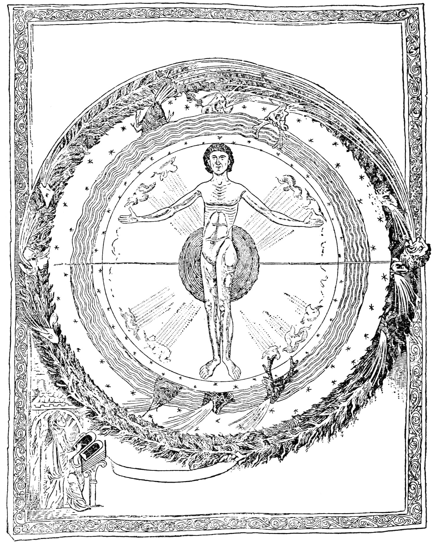
xxiDr. Charles Singer of the University of London courteously permitted
the use of Plate VIII from his Scientific Views and Visions
of St. Hildegard (1917) as a basis for Figure 5 of the present volume.
The writer is indebted to Mr. W. L. G. Joerg, the editor,
from whose editorial skill, experience, and tireless care the book
has greatly profited. He also wishes to thank Mr. George W.
Robinson, Secretary of the Harvard Graduate School of Arts and
Sciences, Miss Genevieve R. Fallon, formerly of Radcliffe College,
and Mr. Arthur A. Brooks and members of the library staff
of the American Geographical Society for their painstaking aid
with manuscript and proof.
New York, October 7, 1924.
INTRODUCTION — The Time of the Crusades — Scope of the Term “Geographical Lore” — Origins of the Geographical Lore of the Time of the Crusades — Organization of the Present Work
1
The time of the Crusades, like all great constructive epochs in
the history of civilization, was an age of contrasts. A succession
of crises marked the progress of conflict between the ideals of
Papacy and of Empire. The feudalism of an earlier day was
giving place in Western Europe to centralized monarchy, in
Italy to the growth of city states. Though faith swayed the
masses of men to the undertaking of immense coöperative
enterprises—cathedral building and crusades—the time, none
the less, was one of questioning and doubt: faith sometimes gave
place to heresy hunting. Keener intellects were not afraid to
probe deep at the very foundations of established theological
doctrine. A profound and widespread enthusiasm for scholarship
expressed itself in many forms. The writings of older
authorities were ransacked for the wisdom which they contained,
and from them erudite and forbidding tomes were compiled.
But wandering students and poets were abroad who hated the
musty learning of the monastic cell and frankly rejoiced in the
beauty of the world around them. For some time historians
have been in the habit of speaking of a “twelfth-century
renaissance.” This expression is not wholly apt if used in a
narrow sense to imply merely a rebirth of interest in the Greek
and Latin classics. If taken to mean a re-stirring of the vital
forces of civilization, the twelfth and thirteenth centuries were
an age of renaissance indeed.
The purpose of this book is to illustrate a limited aspect of
the intellectual activity of the time of the Crusades, but an
aspect that is sufficiently broad to reveal to us something of the
contrasting forces of this age.
By “geographical lore” we mean what was known, believed,
and felt about the origins, present condition, and distribution
2of the geographical elements of the earth. This covers a wider
field than most definitions of geography. It comprises theories
of the creation of the earth, of its size, shape, and movements,
and of its relations to the heavenly bodies; of the zones of its
atmosphere and the varied physiographic features of air, water,
and land; finally, it comprises theories of the regions of the
earth’s surface. Because many of these theories were false they
are no less deserving of attention. The errors of an age are as
characteristic as the accurate knowledge which it possesses—and
often more so. Moreover, in addition to formulated beliefs,
whether true or false, our definition of geographical lore covers
man’s spiritual and esthetic attitude toward the various geographical
facts, as revealed—often unconsciously—in descriptions
of regions or of landscapes.
The historian of geology or the theologian may complain that
we trespass on their domains in discussing theories of the Creation
in a book devoted to the history of geography. Yet this is
justifiable if we hold with most modern geographers that some
explanation of the immediate causes of existing terrestrial
conditions is an essential part of geography. These causes, it
was the opinion of medieval thinkers, were to be sought for in
the processes of the Creation. No man had the vaguest conception
of the countless eons that have elapsed during which
air, sea, and land have been in evolution. The good Christian
thought that the world was made by God in the course of the
six days of Genesis and that it then assumed practically the
identical geographical appearance it has preserved ever since.
In the Middle Ages geology, geography, and theology were
inextricably interwoven.
Then again, the geographical lore of the Middle Ages involves
a wider range of subjects in space, as well as in time, than is now
included in geography. If medieval man had no knowledge of
the age of the earth, he also had but the feeblest understanding
of the immensity of the universe. To him, earth, stellar bodies,
and celestial spheres were all part of a unified system of which
the earth formed the core and most important member. Cosmology,
astronomy, astrology, theology all dealt with this unified,
3geocentric, cosmic system; the interrelations between them
were immediate and intimate. We cannot avoid some discussion
of the matters in which these allied sciences bore directly
on geography.
Whence came the geographical lore of the time of the Crusades?
Some of it came from books of earlier ages, some of it from
contemporary observation. A sharp distinction may be made
between the geography of the scholar and churchman, drawn
largely from antiquity, and the geography of the merchant,
soldier, and pilgrim, who learned of the world by travel and
exploration. It was exceptional when the philosopher or theologian
incorporated in his book the reports of recent travels.
Indeed, we are almost startled to come across a bit of “up-to-date”
geography in the philosophical or theological treatises.
Even the histories and chronicles of contemporary events,
though perforce containing more new geography than works of
deeper learning, tended to appeal to ancient authorities in
explaining the course of rivers or the relation of provinces or
mountain chains to each other.
Any consideration of the state of medieval geography inevitably
presupposes some acquaintance with the earlier accumulation
of geographical lore from which it borrowed.
This was derived for the most part from two fountainheads of
original observation and thought: (1) the writings of Greek
historians and philosophers and (2) the Bible. Greek geography
was the main source whence Latin writers of the Roman Empire
and Moslems of the eighth, ninth, and tenth centuries of our era
found their inspiration and facts. The Bible, as interpreted in
the exegetical works of the Church Fathers, stimulated thought
on geographical problems. The scholar of our period had at
his disposal many Latin writings, both classical and patristic,
and a somewhat more limited number of Arabic books and
translations from the Arabic.
4
The aim of the first three chapters of our study is to give an
estimate in broad outline of the contributions of classical,
patristic, and Oriental geography to the medieval West. The
purpose is to show the kind of geographical ideas which a reader
of the twelfth or thirteenth century might have gathered from
older works in the libraries and to reveal something of the
evolution of these ideas. No attempt is made to discuss works
not well known in the Occident. The writings of famous
Greek geographers like Herodotus, Pausanias, Strabo, Eratosthenes,
Hipparchus, and Ptolemy receive only scant attention,
and their contents are noted only in so far as they became
familiar to Western Christendom through Latin media. Similarly
the Greek Fathers of the Church and most of the more
important Moslem geographers are overlooked because they
exerted almost no influence on Western thought. Nor within
the period itself that forms the subject of our investigation is
much space given to writers like the Moslem Edrisi or the Greek
Michael Psellos, whose researches did not contribute materially
to the formation of Western science.
After a fourth chapter, on the literary and cartographic
sources which date from the time of the Crusades and upon
which our estimate of the geographical lore of this age is based,
and a fifth, on the place of geography in the medieval scheme of
learning, there follows the main part of this book. The attempt
is here made to illustrate from representative sources geographical
lore of all kinds, whether original or borrowed, to emphasize
evidences of originality where they are apparent, and to trace
a few significant borrowed theories to their origins. Though
the period under consideration lasted a century and a half,
there was not much change during this time in the quantity of
geographical information available or in the quality of geographical
thinking. Hence it will be more convenient and enlightening
to adopt a topical and regional arrangement for the main
portion of our treatment than to try to arrange the material
chronologically.
5By no means all the geographical knowledge and thought of
the Crusading age could be stated and discussed in a volume of
even many times the size of this. It is the writer’s hope that
the materials selected are sufficiently diverse to give a rounded
and just, though it be necessarily far from complete, understanding
of the geographical lore of a significant period in the
history of science and of civilization.
PART I ORIGINS, SOURCES, AND PLACE IN THE CLASSIFICATION OF KNOWLEDGE OF THE GEOGRAPHICAL LORE OF THE TIME OF THE CRUSADES — CHAPTER I THE CONTRIBUTION OF THE ANCIENT WORLD — SOURCES — THE HISTORY OF THE UNIVERSE — SHAPE, MOVEMENTS, AND SIZE OF THE EARTH — THE DISTRIBUTION OF HABITABLE REGIONS; ZONES; THE DISTRIBUTION OF LAND AND WATER — PHYSICAL GEOGRAPHY — MATHEMATICAL GEOGRAPHY AND CARTOGRAPHY — THE EXPANSION OF REGIONAL KNOWLEDGE — CHAPTER II THE CONTRIBUTION OF WESTERN CHRISTENDOM BEFORE 1100 A. D. — INTRODUCTION — SOURCES — THE HISTORY OF THE UNIVERSE — SHAPE AND SIZE OF THE EARTH — ZONES AND THE ANTIPODES — PHYSICAL GEOGRAPHY — THE MEDIEVAL ATTITUDE TOWARDS LANDSCAPE AND SCENERY BEFORE 1100 A. D. — MATHEMATICAL GEOGRAPHY AND CARTOGRAPHY — REGIONAL GEOGRAPHY — CHAPTER III THE CONTRIBUTION OF THE MOSLEMS — SOURCES — ASTRONOMICAL GEOGRAPHY; THEORIES OF THE TIDES — ARABIC EXPLORATION AND TRAVEL — CHAPTER IV THE SOURCES FOR THE PERIOD 1100–1250 A. D. — INTRODUCTION — THEOLOGICAL AND PHILOSOPHICAL WORKS — TRANSLATIONS FROM THE ARABIC; WORKS WRITTEN UNDER ARABIC INFLUENCE; ARISTOTELIANISM AND ITS OPPONENTS — ENCYCLOPEDIC WORKS — HISTORIES, CHRONICLES, SAGAS, EPIC POEMS — LEGENDS — PILGRIM NARRATIVES; MISCELLANEOUS RECORDS OF TRAVEL — TOPOGRAPHICAL WORKS — MAPS — CHAPTER V THE PLACE OF GEOGRAPHY IN THE MEDIEVAL CLASSIFICATION OF KNOWLEDGE — Geography Included Under Geometry — Geography Included Under Astrology — Geography and the Aristotelian Division of Learning
7
9
The Pythagoreans, Plato, and Aristotle
The earliest writers who dealt with geographical matters in a
more or less scientific spirit were the Greeks of Ionia and the
Pythagorean philosophers of Magna Graecia. Though their
theories exerted no direct influence on the formation of
medieval geography, they should not be entirely overlooked.
Ionic geography gave many ideas to the later Greeks; Pythagorean
thought brought to bear a strong influence on the Platonic
cosmology, which reached the Middle Ages through the Latin
translation of Plato’s Timaeus made by Chalcidius early in the
fifth century after Christ, and through the Platonists Martianus
Capella and Macrobius. Until the middle of the twelfth
century Plato, of all philosophers, held the strongest grip on
medieval thought; after that time the influence of Aristotle became
more potent in the framing of the scholastic conception of
the universe. We must regard Plato and, even more, Aristotle
as the indirect sources of most of the cosmological, physiographic,
and meteorological knowledge which, elaborated by later writers
of antiquity and by the Moslems, reached the Middle Ages at
second hand. Among the many writings of Aristotle those which
contain the most material of interest to the geographer are the
De caelo (Περὶ οὐρανοῦ) and the Meteorology. The former, in
four books, treats of the properties of the heavenly bodies, of
the elements, and of the earth. Translations of the De caelo in
the Middle Ages often went under the title De caelo et mundo.[1][2]
The Meteorology, besides a detailed discussion of the phenomena
of the atmosphere, includes many speculations on physical
geography. Theories of cosmology also found expression in the
Physics and De generatione et corruptione.
10The scientific genius of the Alexandrian Greeks of the Hellenistic
period showed itself in the work of men like Eratosthenes
and Hipparchus. By them the mathematical and astronomical
aspects of geography were developed with accuracy; but unfortunately,
owing to the almost universal ignorance of Greek
in the West, the products of their genius had little part in the
molding of medieval theories.
Roman Influence on Geography
The Roman conquests tended to discredit scientific investigations
and to bring into favor works of a descriptive nature
which would appeal to the military chief, the provincial governor,
or man of the world—to the practical rather than speculative
type of mind. Polybius regarded geography as an important
auxiliary science to politics and history. The geographical
portions of his history treat of the countries of the known world,
their peoples and customs; he is not concerned with the size and
shape of the earth nor with the determination of latitudes and
longitudes. Strabo, writing at the time of Augustus, represents
the culmination of the Polybian method; but his great and
comprehensive work, though of first importance in the history of
ancient geography, was not read at the time of the Crusades.
Ptolemy
The Greek, or more purely scientific, attitude, however, did not
completely succumb. Posidonius[3] in the first century before
Christ reverted to the method of Eratosthenes; and with Marinus
of Tyre and Claudius Ptolemy, in the reigns of Trajan and
Hadrian, there came a revival of mathematical geography which
almost, if not quite, equaled the high level reached by the
Alexandrians[4]. Ptolemy was the author of two works, both of
which were destined profoundly to modify the development of
science in later ages. These were the Mathematical Composition
(or Almagest, as the Arabs called it), a treatise on astronomy,
knowledge of which reached the medieval West through Moslem
channels; and the Geography, a work which remained virtually
unknown in Europe until the fifteenth century.
11
Latin Writers: Pliny, Solinus, Capella, Macrobius
Though the most fertile investigations were made by Greeks,
Latin writers naturally influenced more directly medieval thought
in the West. Of those who dealt with geographic matters in the
strictly classical period Pliny the Elder (23–79 A. D.) and Seneca
(3 B. C.-65 A. D.) were the most influential. The Historia
naturalis of Pliny, an ill-digested compilation of information of all
sorts, contained books on geography that were destined to furnish
the larger part of the lettered man’s geographical ideas during
many centuries.[5] Pliny’s work was not merely extensively read
but was used and plagiarized by other writers of possibly greater
popularity. The most significant of these was Solinus,[6] a compiler
of fables in the third century after Christ, whose Collectanea
rerum memorabilium consists almost entirely of borrowings from
Pliny or from a book from which Pliny drew.[7] The geographical
information in Isidore’s Etymologiae is largely made up of
quotations and paraphrases from Solinus. Seneca’s Quaestiones
naturales[8] was also widely read and formed the source of
the bulk of the meteorological lore of the Middle Ages.
Two Latin writers of the late Empire also contributed
materially to the evolution of geographical knowledge, Martianus
Capella (fourth or fifth century) and Macrobius (fifth
century). Capella’s encyclopedic De nuptiis Philologiae et
Mercurii is an elaborate commentary on and exposition of the
seven arts; the book dealing with geometry gives the author an
opportunity of presenting a résumé of geography, more particularly
in its mathematical aspects.[9] That Martianus Capella’s
treatise enjoyed an immense popularity in the medieval period
is indicated by the quantity of manuscripts extant and by the
frequency with which we find it listed in the medieval library
catalogues[10] that have been preserved. The general sketch of the
distribution of land and water on the surface of the globe
contained in Macrobius’ commentary on the Somnium Scipionis[11]
of Cicero was often quoted at later periods and formed
the basis for some of the extremely crude maps of the world used
in the twelfth, thirteenth, and fourteenth centuries.
In the remainder of the present chapter a very general
12review will be given of the more important geographic ideas
borrowed by the Western world in these centuries from
Aristotle, Pliny, Solinus, Seneca, Martianus Capella, Macrobius,
and some others, and an attempt will be made to indicate the
relationship between the growth of these ideas and the broader
evolution of ancient geography as a whole.
Ancient Cosmogony
Though it is not now regarded as lying strictly within the field
of geography, the history of the evolution of theories about the
origin of the earth is so closely allied to the history of geography
that the two cannot well be dissociated. A marked antagonism
inevitably arose between the usual Greek view, which regarded
matter as eternal, and the Christian view, which was based on
the first chapter of Genesis and conceived of the universe as
created at a definite point in time or concurrently with time.
The men of the Middle Ages tended to adhere strictly to the
Christian opinion, for to have done otherwise would have been
heretical. Nevertheless, the ancient theory was well known to
Christians and exerted in its various forms no small influence on
the development of certain phases of Christian thought.
Celestial Influences
It was a deeply rooted belief of many classical thinkers that
the events and conditions on this world and on all the regions
below the sphere of the moon’s orbit are regulated by the heavenly
bodies. Aristotle and his followers taught that the
heavenly bodies themselves are made of an imperishable and
incorruptible, almost divine, fifth element, ether, which distinguishes
them from the four corruptible elements (fire, air, water,
and earth) that constitute the immediate world of our senses.[12]
By virtue of this semi-divine quality, it was argued, the sun,
planets, and stars exert an all-powerful control over the earth
around which they revolve—an absolutely determining control
over all events both great and small.[13] From this fatalistic belief
13sprang the science of astrology, a science which throughout
antiquity was held in equal esteem with astronomy.
The study of the movements of the celestial bodies revealed
the fact that at some time in the distant future, sun, planets, and
stars will bear exactly the same relative position one to another
that they do at the present moment. Consequently, it was
inferred that the influence exerted by them on the sublunar
regions will at that time be exactly the same as it now is, and
all the phenomena now apparent on the earth’s surface will be
exactly repeated. They will be repeated not only once but an
infinite number of times at periodic intervals in the future;
similarly they have been repeated throughout infinite cycles in
the past.[14]
Cosmic Cycles: The Great Years
This idea of cosmic cycles, or Great Years, appears to have
originated in the Orient, possibly with the Chaldeans.[15] It was
firmly established among the Ionian Greeks[16] and Pythagoreans,[17]
from whom Plato adopted it. Many and various opinions
prevailed about the violence and character of the changes
produced by the celestial cycles. The Chaldeans had thought
that whenever all the planets come into conjunction on one
straight line in the sign of the zodiac Cancer, the entire universe
is destroyed by fire but destroyed only to be born again; similarly
the world is destroyed by water when the same phenomenon
occurs in Capricorn.[18] The theory of a complete and universal
birth and rebirth (palingenesis) was held by some of the
Greek philosophers.[19] Plato and Aristotle, however, seem to
have restricted the destructive effects of the celestial influence
to the sublunar sphere and maintained that the realms above
the moon were eternal.[20] On the whole, belief in periodically
recurrent destructions of the earth by water was more widespread
and was given greater definition than belief in corresponding
destructions by fire.[21] The main reason for this is
probably to be looked for in the dissemination among nearly all
peoples of legends of a great flood, but it also in no small measure
may be attributed to rudimentary geological observations (notably
14of the presence of shells on high ground) which showed that
portions of the earth’s surface had at one time lain beneath the
waters.[22]
Geographic Application of the Theory of the Great Years
The theory of the Great Years was invoked to explain changes
in geographic and climatic conditions on the earth’s surface.[23]
When the various planets and stars bear a certain relation to one
another, a period of dryness and heat, or a Great Summer, is
experienced; conversely, when other stellar relationships prevail,
there is a period of cold and wetness, or a Great Winter. Even
land and sea gradually change places under stellar control.
Certain parts of the land, Aristotle observed, had once been
covered by the sea, and what is now sea had once been land:
like plants and animals, land and sea grow to maturity and old
age. If the causes adduced for these changes were not so utterly
different from those that are now accepted, we might almost be
tempted to think that Aristotle had some conception of climatic
cycles and cycles of erosion.
After Plato and Aristotle, as before them, the doctrine of the
Great Years, though by no means universal, was very popular
in antiquity.[24] The Stoics adopted it in its more extreme form
involving successive burnings and liquefactions of the universe.[25]
It entered into Neoplatonism and was ultimately taken
over by the Jews. It seems to have penetrated to India, where
the Greek elaboration of the theory gave precision to ideas that
were probably already in existence there. The Indian belief
in the recurrent reincarnations of Brahma was brought into
connection with Hellenic calculations of the duration of the
Great Years.[26] From the Hindus and from the Greeks the
conception was transferred to the Arabs and by them to the
knowledge of the Latin West.
Duration of the Great Years
Numerous endeavors were made in antiquity to calculate the
length of a Great Year.[27] The figure that was adopted by the
15Arabs and passed on to the Christian world originated in
Hipparchus’ discovery of the precession of the equinoxes, or
apparent gradual revolution of the fixed stars around the pole
of the ecliptic.[28] Ptolemy calculated that the period of this
revolution was 36,000 years,[29] a figure which became known to
the Hindus and Arabs and ultimately to medieval Christendom.[30]
The actual figure is approximately 25,800 years.
Sphericity of the Earth
Nearly all scholars of antiquity after the fifth century before
Christ thought that the earth was a globe.[31] The earlier opinion
of a disk-shaped earth resting upon the waters, which appears to
have been held by Anaximander (although some students have
thought that he, too, believed in a spherical earth [32]), was discarded
by the Pythagoreans and Plato, and after their time no
serious thinkers questioned the theory of sphericity. The
Pythagoreans based their opinion on speculative and philosophical
grounds rather than on physical and experimental proofs;
they thought that since the sphere is the most perfect mathematical
form, the earth must therefore be a sphere. The whole
tendency of Aristotle’s thought, less speculative and less hypothetical
than Plato’s,[33] led him to look for proofs of sphericity,[34]
and these he enunciated with great emphasis. Cleomedes,[35]
Pliny,[36] Ptolemy,[37] Martianus Capella,[38] and other ancient
writers likewise adduced more or less convincing proofs, which
were well known and often cited in the medieval period.
Immobility of the Earth
Though the learned men of the ancient world were almost universally
agreed that the earth is a globe, they were not unanimous
in the belief that it stands immovable in the center of the universe;
yet the various theories which diverged from this orthodox
view had no place in the development of medieval cosmology until
long after our period.[39] Certain among the Pythagoreans
maintained that there is a fire in the heart of the earth.[40] Plato
16said that the center of the earth, which stands immobile[41] in the
center of the universe, is the seat, not of a fire, but of the World
Soul.[42] Through its own internal movement the World Soul
causes the movement of the universe as a whole. Belief in the
World Soul of Plato was extraordinarily tenacious, and it emerges
in the writings of more than one Neoplatonist of the Middle Ages.
Aristotle, however, though he likewise held fast to the doctrine
of the immobility of the earth in the center of the universe, differed
both from the Pythagoreans and from Plato in refusing to
believe that the center of the universe could be the seat of an incorruptible
being of the same substance as the celestial bodies,
be it fire or World Soul. Aristotle,[43] Pliny,[44] and Ptolemy[45] also
brought forward proofs of varying validity in favor of the immobility
of the earth.
Circumference of the Earth
Several figures were given by ancient authors for the circumference
of the earth. Aristotle stated it to be 400,000 stades;[46]
Eratosthenes determined it to be 252,000 stades according to the
testimony of many writers, including Pliny,[47] Vitruvius,[48] Martianus
Capella,[49] and Macrobius,[50] although Cleomedes, who gives
the most circumstantial account of Eratosthenes’ measurement,
had said that the latter’s figure was 250,000.[51] It is probable
that Eratosthenes himself arbitrarily added 2000 stades to his
result in order to obtain a figure more easily divisible.[52] Cleomedes
quotes Posidonius as giving 240,000 stades,[53] and Strabo
says that the latter gave 180,000 stades.[54] The last number was
that adopted by Marinus of Tyre and by Ptolemy.
Though we have several distinct figures cited by ancient writers,
these assuredly do not indicate that as many distinct processes
of measurement were carried out. The circumference
given by Aristotle was a mere estimate; Eratosthenes’ result was
the only one based on accurate measurements and calculations;[55]
the two figures given by Posidonius may well have been derived
from Eratosthenes, the larger arising from a mistaken interpretation
or intentional alteration of the latter’s figure, and the smaller
from the use of a longer stade.[56]
17At all events, so far as we know, only one method was employed
by the Greeks for determining the size of the earth. This consisted
of finding on the same day of the year the meridian altitudes
of the sun at two places supposed to be on the same meridian of
longitude, the distance between which was known through itineraries.
The angle between the two meridian altitudes was then
assumed to bear the same relation to the circumference of the
heavens as the distance between the two points of observation
bore to the circumference of the earth. Cleomedes[57] and Martianus
Capella[58] described how Eratosthenes carried out such
observations in Egypt.
The figure determined by Eratosthenes is surprisingly accurate.
Whether the stade used by him was 157.50[59] or 168[60] meters,
as different modern scholars contend, the circumference
according to his estimate would be 39,375 or 42,336 kilometers.
In either case the error is seen to be very slight, the true circumference
of the earth being about 40,000 kilometers.
We see, then, that the writers of antiquity whose opinions were
destined to mold the thought of the medieval period believed that
the earth is a sphere, immovably fixed in the center of the universe.
We must now examine their theories regarding the distribution
of phenomena on the surface of the globe and the interaction
of these phenomena. Of prime importance were their
views concerning the distribution of habitable areas of land,
but these were so closely bound up with the theory of climatic
zones that it is absolutely necessary to understand what this theory
was before going further, even though the subject of zones
might more properly be included in the study of the atmosphere.
Zones
Parmenides may have been the first to conceive of zones
upon the earth’s surface corresponding to the zones into which
18the astronomers had divided the heavens. Eratosthenes is said
to have been the first to place the theory of terrestrial zones upon
a firmly scientific footing, “by determining exactly upon the
sphere the position of the fixed circles which mark the limits
of each zone” (Thalamas).[61] Ancient geographers set the number
of terrestrial zones at five, though they differed as to the
character of the climates within them. The general opinion—one
which was shared by Aristotle—was that the polar caps and
the equatorial regions were incapable of sustaining life, the first
on account of cold, the second on account of heat. Despite the
fact that the notion of the existence of a fiery belt between the
tropics was challenged by Polybius and Posidonius, who had
heard reports from expeditions in these regions, this notion
persisted in the writings of Martianus Capella, Macrobius, and
many others and exerted an extremely restrictive effect on the
subsequent development of geographical knowledge and enterprise.
The majority of the ancient writers whose works were read in
Christendom before 1300 also thought that the oikoumene, or portion
of the earth inhabited by men of our kind, is completely
surrounded by an ocean. This is a belief common to many early
peoples.[62] In the Greek world we can trace it back to the Homeric
and Hesiodic Ocean Stream and to the conceptions of
early Ionian philosophers, who had gone so far as to maintain
that the earth had been created out of water,[63] or at least that
it was originally submerged beneath the ocean and had been
brought forth through the evaporation of the water by sun and
stars.[64] The theory of an encircling ocean was certainly held by
Aristotle, Pliny,[65] Seneca, Macrobius, and Martianus Capella.
Crates’ Theory of Four Land Masses
The two last-named writers set forth an elaboration of an
opinion first held by the Pythagoreans and worked out in detail
by Crates of Mallos in the second century before Christ, which
gained great ascendancy over the minds of map makers and
writers of the Middle Ages. They explained that the oikoumene
is one of four similar inhabited bodies of land on the surface of
19the globe. These bodies of land are separated from one another
by two oceans which encircle the earth, one running east and
west in the fiery equatorial regions, and one running north and
south at right angles to the equatorial ocean. This idea, which
we shall call the “Cratesian” theory after its foremost expositor,
did not pass unchallenged either in antiquity or in the Christian
period. Involving as it did the doctrine of the antipodes—people
dwelling in quarters absolutely inaccessible to men of our race,
eternally cut off from our oikoumene by the fires of the equator
and the terrors of the meridional ocean—the Cratesian theory
provoked the indignation of the Fathers of the Church as containing
the seeds of heresy.[66]
Extent of the “Oikoumene”
Aristotle, although he had derived from the Pythagoreans the
theory of an uninhabitable torrid belt,[67] believed in a greater
southward extension of our oikoumene than would be possible in
accordance with the Cratesian theory. He harbored no idea
of the existence of another oikoumene in the same latitude as ours.
He says very clearly in the De caelo[68] that there is no great
distance between India and Spain and hinted at the same
opinion in the Meteorology.[69] Seneca[70] held similar views.
The opposite theory—which has been called the continental
as opposed to the oceanic hypothesis[71]—that Africa and Asia
extended unknown distances south and east and that the Atlantic
and Indian Oceans, like the Caspian Sea, were enclosed basins—also
had its adherents, among them Herodotus, Hipparchus, and,
most significant of all, Ptolemy. But Ptolemy’s Geography,
though its content was reflected in Arabic notions of the earth’s
surface, had almost no readers in the Christian West until the
fifteenth century, and the works of Herodotus and Hipparchus
were unknown.
Aristotle, Seneca, and Pliny
Among the writers of antiquity who dealt with physical
geography only three can be said to have influenced twelfth- and
20early thirteenth-century thought to any marked degree. These
were, first and foremost, Aristotle, the substance of whose
De caelo and Meteorology had reached the West before the year
1187 through the borrowings and plagiarisms of later scholars
and after that time could be read in translations from the Greek
and Arabic. In the second place, Seneca’s Quaestiones naturales
was popular before the direct influence of the De caelo and
Meteorology began to be felt. In the third place, as we have
seen, the Elder Pliny’s Historia naturalis was not only widely
read in the original, but also much that it contained was familiar
through the intermediary channels of Solinus, Isidore, Martianus
Capella, and others. Aristotle, however, was the fundamental
authority, for a large portion of the material in the books of the
two Latin authors came from his treatises.
The Four Elements
Most ancient authorities believed that the universe is composed
of four elements, fire, air, water, and earth, arranged in concentric
spheres. Theoretically, according to this view, the sphere
of water should entirely enclose the earth. Practical observation
shows that it covers the lower levels of the earth’s surface
only. How to reconcile the theoretical conception with observed
facts was a problem which, as we shall see, greatly puzzled
geographers and physicists during the later Middle Ages.[72]
According to Aristotle the four elements, under the control
of the heavenly bodies and through their interaction upon each
other, produce all the physical phenomena of the atmosphere,
sea, and earth.[73] Working from this axiom, he, and all the ancient
writers who dealt with the subject, attempted to explain
winds, tides, earthquakes, and other occurrences of nature; but
there was little agreement among them as to the manner in
which these interactions were manifested. Though there were
many theories, the actual matters under discussion were not
very numerous. Only the most striking and unusual happenings—such
as tides, earthquakes, and floods—attracted attention,
and we find almost no trace of a minute and careful
observation or even of a superficial understanding of those imperceptibly
21slow natural forces which modern geology recognizes
as having fashioned mountains, rivers, and seas.
A logical division of the subject matter of physical geography
is into three studies: that of the atmosphere, that of the waters,
and that of the earth. In each of these there is room for a great
deal of hairsplitting about what belongs to geography and what
to geology, geophysics, or meteorology. Physical geography
merges into the other natural sciences as human geography
merges into history, politics, economics, or ethnology. Even
at the present day, when the often futile attempt is being made
to delimit the domains of the various sciences ever more definitely,
it is impossible to distinguish where one begins and another
ends, and it would be foolish to set up hard and fast definitions
in dealing with the lore of the ancient and medieval worlds, when
natural science was as yet inchoate.
Meteorology
The ancients were more interested in meteorology[74] than they
were in oceanography and physiography (if such terms can be
used for their naïve attempts at explaining the features of ocean
and land), perhaps because the phenomena of the air make a
deeper impression on men than the phenomena of the sea and
earth—tides, earthquakes, and volcanoes excepted. Thunder
and lightning, comets, rainbows, balls of fire were looked upon
as portents, and complex theories were created to explain them
and what they were supposed to foretell. But all this type of
meteorological lore, however interesting in itself, is, strictly
speaking, not geography. On the other hand, there are certain
distinctly geographical aspects of the study of the atmosphere
as pursued by the Greeks and Romans that deserve our attention.
The men of antiquity conceived of the interaction of atmosphere
and earth in two ways: effects produced by the land upon
the atmosphere, and effects produced by the winds upon the
land. In connection with the first, Seneca makes a remark
which, when taken from its context, would not be out of place
in a modern manual of meteorology. He conceived the lower
portion of the atmosphere to be extremely variable and inconstant
22as a result of the proximity of the earth. “The earth is a
more important cause than all others ... for the air’s changefulness
and inconstancy. The varying positions of the land,
facing here this way and there another way, are of great moment
in determining the temperature of the air.”[75] Nothing is truer
than this, but the reasons that Seneca gives for the influence of
the atmosphere upon the land are not satisfactory, being based
to a large extent on the supposition that winds are produced by
vapors. Indeed, by the theory of vapors and exhalations many
ancient and medieval thinkers attempted to explain nearly all
the phenomena of the atmosphere and heavens as well. Aristotle
had pointed out that a dry and smokelike exhalation is caused
by the sun to rise from the earth’s surface through the air and
even to penetrate the zone of fire.[76] While near the earth this
exhalation takes the form of wind; when ignited at higher levels
it becomes comets and shooting stars. Besides this, Aristotle
maintained that a damp and watery vapor is also drawn into the
atmosphere by the sun’s heat and when cooled turns into cloud
or falls in the form of rain and snow.[77] These ideas of Aristotle
became known to the Western world of the Middle Ages with
translations of the De caelo and Meteorology and found their
expression in the thirteenth-century writings of Albertus Magnus.[78]
Seneca, on the other hand, explained that the winds
were air in motion and that they might be produced by many
and various causes.[79]
Winds
All three of the writers whom we are specially considering,[80]
Aristotle, Seneca, and Pliny, had observed that there is a variety
of local winds—valley, river, sea, and marsh breezes—taking
their origin from the exhalations and vapors arising from these
natural features. But even though their explanations of the
causes for these winds are now regarded as archaic, the observations
they made of their occurrence were not inaccurate.
As to the effects of the winds on the earth, we encounter a
theory that sounds most extraordinary in the light of modern
science but which corresponds logically to the Aristotelian
23hypothesis of the elements and to the general ideas current in
classical times regarding the structure of the earth. This theory,
that the winds are the cause of earthquakes, can better be understood
after we have examined the ancient opinions about the
physical geography of the water and of the earth.
Another persistent belief, held alike by poets, physicists, and
geographers, originated in the Homeric mythology of the calm
heights of Olympus, dwelling place of the gods. This was to the
effect that the winds are limited to the lower part of the atmosphere,[81]
a zone some ten or fifteen stades in thickness.[82] The
highest mountains were thought to reach above into a realm of
perpetual tranquillity where clouds and dew and frost were unknown
and where the ashes of sacrifice would remain undisturbed
for a year’s time.[83] This idea was transferred to the Middle Ages
through the writings of Pomponius Mela, Solinus, and others.
Climatology
As to the climates, it has already been shown that many writers
of antiquity divided the earth’s surface into zones: fiery, temperate,
and frozen. Aristotle, Seneca, and Pliny do not seem to have
had that more exact understanding of the distribution of climates
which recognizes that two countries in the same latitude may,
nevertheless, have different climatic conditions and products.[84]
To them, all places on the same parallel were virtually the same
from the climatic point of view. In this connection it must be
pointed out that the parallel strips, or climata, into which
Eratosthenes, Hipparchus, Ptolemy, Pliny, and Martianus
Capella divided the oikoumene were not climatic divisions in our
modern sense—implying the prevalence of well-defined conditions
of temperature and weather—but, rather, artificial astronomical
divisions the boundaries of which were determined by arbitrary
means.[85] Nevertheless, true climatic differences were well
understood; Seneca describes vividly in more than one place in
the Quaestiones naturales the intense heat and dryness of southern
regions[86] and the cold of the far North; Seneca and Pliny had
acquired more detailed knowledge than Aristotle of the northern
ice and snows.[87] Pliny made some interesting, if unsound,
24observations connecting the dark complexions of the Ethiopians
with the scorching effects of the sun and foreshadowed a modern
theory by asserting that the inhabitants of northern Europe are
blonde (and savage) because of the coldness and inclemency of
the climate in which they dwell.[88] A brief but striking passage
from the Octavius of Marcus Minutius Felix explains as follows
the warming effect of the western ocean upon the climate of
Britain: “God is mindful of our welfare not only universally but
locally. Britain is deficient in sunshine, but this deficiency is
made good by the warmth of the sea that flows around it.”[89]
The Greeks and Romans certainly had no satisfactory understanding
of the general circulation of the atmosphere. Only with
the maritime voyages since the fifteenth century have we come to
know the distribution of belts of prevailing winds and calms.
Aristotle said that the etesian, or north, winds blow from the
cold countries full of water and snow under the Great Bear; and
that the south wind originates at, but not south of, the Tropic of
Cancer;[90] this is the nearest he came to giving a theory of atmospheric
circulation. Megasthenes had heard of the monsoons of
the Indian Ocean; Pliny described the use made of them by
sailors in going out to India,[91] but he made no attempt to explain
the general areas of westerlies or trades. On the other hand,
Aristotle,[92] Seneca,[93] and Pliny[94] all recognized and discussed at
considerable length the influences of wind on weather; for example,
the fact that the etesians, though they bring clear skies
to Italy, deluge Ethiopia and India with rain—a conception which
contains a shadow of truth.[95] Auster, the south wind, was
supposed to bring rain to Italy.
The Water Element
Since water was one of the four—or, according to Aristotle, five—elements
that were supposed to make up the universe, the
ancient authorities looked upon the ocean as necessarily as old as
the earth itself. Seneca thought that the Nile and the Ister
(Danube) are of equal age with the primordial ocean, because of
remarkable characteristics which differentiate them from all other
streams.[96]
25
The Sea: Its Salinity, Depth, Currents, and Tides
We must note what features of the sea interested the Greeks
and Romans. These were primarily its saltness, its depth, its
currents, and its tides.
The problem of why the sea is salt gave rise to a good deal of
theorizing. That the evaporation of the lighter fresh water
leaves behind the heavy salt water was well understood, but in the
further solution of the problem opinions diverged widely. Aristotle
thought that the salt was the result of combustion;[97] that
it was an ashlike substance first carried into the air by the
exhalations from the earth and then deposited in the sea by rainfall—particularly
by the autumn rains that accompany the south
winds blowing from hot, dry districts where the process of combustion
is most active. Pliny believed that the salt came partly
from dry vapors intermingled with the sea waters and partly
from the nature of the earth, which tends to impregnate the sea
with salt.[98]
Aristotle said[99] that the Pontus (Black Sea) was deeper than
the Maeotis (Sea of Azov), the Aegean deeper than the Pontus—except
in one place—the Sicilian Sea deeper than the Aegean,
and the Sardinian and Tyrrhenian the deepest of all seas. Pliny
quotes[100] a certain Fabianus to the effect that the greatest known
depth of the sea is fifteen stades, or about 1200 fathoms—not an
excessive figure, for parts of the Mediterranean are in fact even
deeper. Pliny,[101] following Aristotle,[102] believed that the “Deeps
of the Euxine,” opposite the shores of the people of the Coraxi,
were unfathomable.[103] Aristotle had a very false idea that the
Atlantic is made up of shallows and mud banks and that it is
calm, an idea shared by the Mohammedans and one that may
have contributed to the horror of the Western Ocean which
lingered in the minds of Mediterranean peoples throughout
antiquity and until the close of the Middle Ages.[104]
The ancient geographers certainly had no clearer understanding
of the general circulation of the ocean than of the atmosphere, and
for the very same reason: they had not traveled sufficiently.
Aristotle thought that there is a flow of water southward from the
higher northern part of the earth,[105] and Macrobius explained a
26series of currents in the oceanic belts which he imagined surrounded
the earth.[106] Certain currents of the Mediterranean
attracted attention: the constant flow from the Euxine into the
Aegean and the fluctuating currents of the Strait of Messina and
the Euripus (between Euboea and the mainland). A tradition
arose at later times that the death of Aristotle was caused by his
disgust at being unable to explain to his satisfaction the currents
of the Euripus.[107]
Only with the travels of Pytheas of Marseilles along the North
Atlantic coasts, the expedition of Alexander, and Nearchus’
voyage and exploration of the mouths of the Indus and coasts of
Beluchistan and Mekran did the Greeks gain any adequate
knowledge of tidal phenomena; for the tides of the Mediterranean,
except in a few places, are so low as to be almost negligible.[108]
Eratosthenes thought that the currents through narrows
in the Mediterranean are caused by variations in the relative
levels of the sea at either end of the channels and that these
variations are a response of the sea to fluctuations of the tides in
the ocean beyond the Pillars of Hercules.[109] As early as the
third century before the Christian era the Greeks had understood
the relation of the moon’s phases to the ebb and flood, but certainly
not much earlier, for Aristotle appears to have been ignorant
of it.[110] Posidonius was the first to give a full account of the
manner in which the moon and sun regulate the tides.[111] He had
accurate knowledge of the diurnal, the monthly, and perhaps the
annual tidal periods,[112] a knowledge which formed a bulwark of
the structure of his astrology. Pliny also believed that the tides
were caused by lunar influence and described the three periods
with even greater accuracy than Posidonius.[113] He recognized
that the tides must correspond to a lunisolar cycle of one hundred
lunations, or eight years, an astronomical cycle that had long been
familiar to the Greeks.[114] He included in his account an astute
observation that the tides, like everything else on the earth’s
surface depending on celestial controls, tend to drag behind the
time when these controls are exerted.[115] Seneca does not try to
explain the tides; he mentions them only incidentally in connection
with a graphic description of the terrible deluge that will
27overwhelm the earth at the end of the Great Winter. Though
in some respects like the spring tides at the equinoxes, when the
sun and moon are in conjunction, this flood will be bound by no
law of nature and will have no curb to its fury.[116] Macrobius’
explanation of the tides,[117] which was copied by many later
writers, though ingenious, was not founded on actual knowledge
or observation. He said that the ebb and flood are caused by the
impact of the opposing currents of the two ocean belts which
encircle the earth, and, with Eratosthenes, he thought that the
tide of the Mediterranean is a repercussion of the ocean tides.
Indeed, after the time of Pliny there was no addition to the
scientific understanding of tidal phenomena until the eighth
century.
Subterranean Channels
Evaporation was given by Aristotle as a reason why the sea
does not overflow its bed on account of the constant inflow from
the rivers.[118] Another explanation of this puzzling circumstance
was found by Pliny[119] in a curious theory that prevailed throughout
antiquity and the Middle Ages to the effect that the land is
seamed with veins, cavities, and tunnels.[120] Into some of these
the air enters; others are the passages for rivers which sink into
the ground; through still others the water of the sea finds its way
to wells, springs, and fountains, where, made fresh by its passage
through the earth, it bursts forth to form rivers which return it
to the sea. A continuous circulation of the waters of the earth
is thus maintained through passages corresponding to the veins,
arteries, and canals of the human body.[121]
The origin of the latter theory is undoubtedly to be sought for
partly in the nature of the ground in Greece and the Aegean
region and partly in the age-old belief that the interior of the
earth is the abode of the dead.
The soluble character of the limestone rocks throughout parts
of the Balkan Peninsula has led to the production of what is now
known as karst topography, so called from the Karst, a plateau
between Trieste and Fiume, where it has attained its most typical
development. In such regions many streams disappear into
hollows of the ground; caverns and underground galleries are
28extremely common; and the traveler occasionally comes across a
full-grown river bursting out of the depths of the earth. The old
and persistent story that the river Alpheus of the Peloponnesus
passes beneath the Ionian Sea only to gush forth in the well of
Arethusa in Syracuse was destined to have a medieval counterpart
in the explanation of the subterranean courses of the rivers
of Paradise.
Rivers of the Underworld
Among the most famous and sinister of the subterranean
streams of antiquity were the dark waters of Cocytus, Acheron,
Pyriphlegethon, and Styx.[122] These were the streams of the
nether world, the world of the dead. Belief in the subterranean
position of the after-world, the Hades of the Greeks, the Inferi of
the Italian folk, was widespread and lasting among early Mediterranean
peoples. Hellenic mythology placed not only Tartarus,
the abyss of torment, but also the Elysian Fields in the depths.
Plato taught that within the bowels of the earth are immense
caverns, some filled with fire, some with water, others the abode
of the shades. To be sure, rationalistic arguments against such
doctrines were raised by the incredulous. Aristotle had believed
that of all four elements the earth is the most dense and solid and
that its position is at the center of the universe. Although the
earth might be seamed with small water channels, it would be a
reversal of the physical laws of the universe to suppose that
within it there could exist caverns large enough to “hold Tartarus,
the Elysian Fields, and the infinite multitude of the dead”
(Cumont).[123] Hence some would identify the Elysian Fields
with the Islands of the Blessed, placing them in the antipodes,
and would relegate Tartarus to the lowest hollow of the celestial
sphere.[124] But even this explanation could not be reconciled
with the more mature cosmography of the Alexandrian age. The
Epicureans resorted to out-and-out disbelief in a future life and
future dwelling place of the spirit.[125] Others looked for the
shades in the atmosphere below the moon’s orbit or else treated
the whole problem in a lofty vein of allegory. Rationalistic
questioning of the subterranean position of the next world,
29however, did not shake faith in this doctrine as it persisted among
the ignorant, and the doctrine was given new life, if in somewhat
different forms, by the Neoplatonic movement and the influx of
Oriental cults during the waning years of the Western Empire.[126]
The Neoplatonists reverted to Plato’s theory that the interior of
the earth may well include hollows large enough to contain the
future abode of men’s souls. The religion of Mithras tended to
spread throughout the Occident the dualistic cosmology of an
eternal conflict between the powers of light and goodness on high
and the powers of darkness and evil below. In the words of
Franz Cumont, whose truly fascinating study of this subject we
are here following: Oriental dualism cut “the abode of the souls
into two halves, of which it placed one in the luminous sky and
the other in subterranean darkness. This was also the conception
which, after some hesitation, became generally accepted
by the Church and which for long centuries was to remain the
common faith of Christendom.”[127] In the period with which it
is our special problem to deal, then, we shall find that Hell is
almost invariably placed in the heart of the earth.[128]
Origin of Rivers
To return from this digression to the vexed question of the
origin of super-terrestrial rivers, we find that the circulation of
water from the sea either by underground passages or by rain was
not regarded by the majority of ancient thinkers as sufficient to
account for the huge volumes of water that rivers constantly pour
into the sea. Plato had thought that there were enormous
reservoirs in the interior of the earth which served to keep the
rivers supplied,[129] but Aristotle rejected this hypothesis.[130] A
reservoir as large as the entire earth, he said, would be necessary
for the purpose. His explanation was worked out of the theory
that one element actually may be transformed into another.
In a relatively unscientific age what is more natural than to believe,
when one sees soluble substances passing into solution in
water, that they actually become water? Or when one sees the
condensation of invisible vapor into clouds and of clouds into
rain, that the air is actually turning to water? Aristotle, followed
30by Seneca,[131] argued that the air which penetrates into the
internal cavities and recesses of the earth is chilled and liquefied
by the cold encountered there, just as air seems to be condensed
by cold in the outer atmosphere. Aristotle cited as a proof of this
the supposed fact that most great rivers have their sources in
mountains.[132] Mountains were to be looked upon as enormous
elevated sponges exuding water on all sides. Aristotle concluded
likewise that the northern part of the earth must be high and
mountainous,[133] because many great rivers originate there.
But, if the air is transmutable into water, why, then, was it not
perfectly logical to suppose that the earth could also undergo a
similar change? This as a theory to explain the origin of some
of the water of rivers was clearly expressed by Seneca and,
among the early Church Fathers, by Gregory of Nyssa.[134] The
faulty character of Seneca’s scientific thought is seen in his failure
to account satisfactorily for the logical demands of his theory,
i. e. for the replacement of the land lost by its liquefaction.
The Nile Flood
One of the natural phenomena most puzzling to the Greeks and
Romans was the inundation of the Nile.[135] Herodotus in his
famous book on Egypt had given a lengthy account of the Nile
and what it meant to Egypt. He had called Egypt the “gift of
the Nile,” for he understood the alluvial character of the country.
His theory as to the cause of the flood—he held that the normal
height of the river was its flood height but that the etesian winds,
by driving the sun southward out of its course in winter, caused
the sun to dry up the headwaters of the stream—was less successful
than his description of the features of the flood itself.
Seneca also gives a long and extremely picturesque description of
the inundation[136] and sets forth various older explanations of its
origin, all of which he tries to refute without presenting an opinion
of his own. He tells how, starting in the upper reaches of the
river, the flood travels downstream and arrives in Egypt about
midsummer; how it adds to the fertility of the country by its
deposits of silt; and how—here Seneca repeats the crisp phrase of
Herodotus—Egypt is the creation of its stream. Among the
31various theories which he comments upon and refutes it is rather
significant to find one which had been propounded by Anaxagoras
and which is now recognized, in part at least, as the right explanation:
that the high water is caused by the melting of the
snows on the Ethiopian mountains. Seneca said that there were
twenty proofs available to refute this hypothesis.[137] Another
view which Seneca rejected was that the flood was caused by the
etesian winds backing up the water, a theory fated to reappear in
many medieval books, among them the Expositio in hexaemeron
of Peter Abelard.[138] Pliny discussed the Nile and its peculiarities.[139]
Like Herodotus, he believed that it rises in the western
part of Africa and reaches the Sudan and Upper Egypt only after
a series of long subterranean journeys. He described the flood,
giving statistics of the various heights of the water on the
nilometer and explaining which heights meant plenty and which
meant famine. He shows a lack of critical sense in his remarks
on the causes of the high water; for he held that two theories
are equally worthy of credence, the theory of the etesian wind,
which we have just examined, and the true explanation that the
floods are due to summer rains in Ethiopia.
The Lands
To turn now from water to land. We have already discussed
Aristotle’s idea of the gradual transposition of continents and
oceans under the control of the celestial bodies. Pliny describes
a large number of local changes of land and sea:[140] the building of
new land by alluvial deposits, the sudden appearance of land and
islands out of the depths of the waters, the separation of islands
from the mainland, the tying of islands to the shore, the total
disappearance of entire countries beneath the sea—Plato’s
Atlantis is given as an example[141]—the collapse of mountains;
but in all this, though he tells where such prodigies took place, he
rarely tries to explain how and why they happened.
Earthquakes and Volcanoes
The explanation of the causes of earthquakes and volcanoes,
however, was attempted by Plato, Aristotle, Pliny, Seneca, and
32many other writers of antiquity with no small measure of ingenuity.
We have seen that ancient philosophers almost universally
were of the opinion that the earth is honeycombed with
cavities and subterranean passages. Plato said that some of
these cavities were filled with water and air but that others
contained mighty swamps and streams of fire, including the immense
fiery river Pyriphlegethon. The volcanoes of the earth’s
surface were outpourings from these internal streams, and their
minglings with the atmosphere and strivings to burst forth were
the cause of earthquakes.[142] Aristotle, on the other hand, denied
the possibility of subterranean fires. According to his scheme of
physics the place for fire in the universe was above the sphere of
air. He maintained that the dry and smokelike exhalation which
causes the winds of the atmosphere not only penetrates into the
cavities of the earth from the outside but is generated within the
earth’s interior[143] and that when this exhalation tries to escape
and is opposed by any obstacle—for example, by the sea—there
is a tremendous upheaval and the land is shaken. Seneca[144] and
Pliny[145] ascribed the cause of earthquakes to the winds. Pliny
believed that after a great storm, in which wind is driven down
and compressed in the interior of the earth, it frequently strives
to come forth and in so doing shakes the earth’s surface far and
wide. Occasionally, if the pressure is too tremendous to be
withstood by the crust of the earth, the winds burst through,
accompanied by a violent tempest and a rain of sparks and
cinders. Aristotle describes such a volcanic eruption in the
Eolian (Lipari) Isles.[146] While this was the explanation of violent
eruptions, the quiescent volcanic activity of mountains like
Etna was usually attributed to a different cause. Pliny[147]
speaks of Etna, Chimaera in Lycia, and various other volcanoes
as burning, and it would seem that he connected them with such
phenomena as burning naphtha wells and pits of bitumen and
sulphur.
Height of Mountains
A word must be said about classical estimates of the height of
mountains.[148] Aristotle suggested that these altitudes might be
determined by observing the duration of sunlight on the peaks.
33He would have us believe that the Caucasus range is illumined
by the sun for a third of the night after sunset and for a corresponding
time before sunrise. If this were true, these mountains
would be from 60 to 180 miles high![149] Less fantastic were
the estimates of Dicaearchus and Eratosthenes. The former,
Pliny tells us, measured Pelion and found it to be 1250 paces
(10 stades) in height.[150] If we are right in our understanding
of the length of the pace here employed, this represents 5167
feet[151]—certainly not far short of the actual altitude (5308 feet).
We do not know the method used by Dicaearchus in this survey,
but his calculation was probably determined from simple triangulation
with the aid of a diopter, an instrument for measuring
angles.[152] Triangulation as a means of finding the height of trees
and buildings was well understood. Eratosthenes probably did
not carry out a triangulation of his own but adopted the results
obtained by Dicaearchus, asserting that the highest mountains
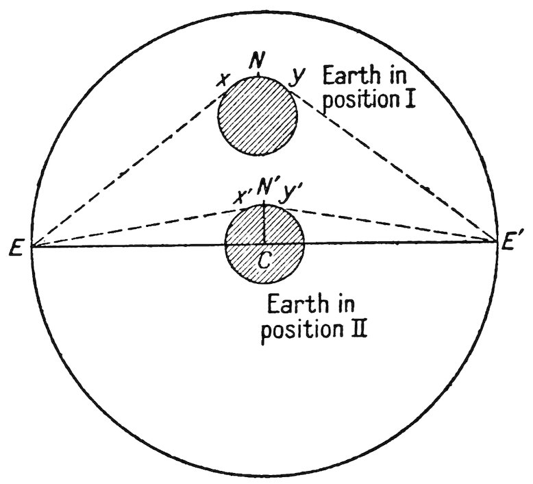
in the world do not exceed 10 stades in elevation. He demonstrated
by an ingenious and graphic mathematical proof that the
volume of mountains is so utterly insignificant in comparison
with the volume of the earth as a whole that the earth can be
regarded as essentially a sphere,[153] a conception which became
well established in the astronomical thought of antiquity and one
which reappeared in the Middle Ages.[154] When the Greeks
learned something of the Alps, they were able to correct Eratosthenes’
underestimate of the maximum height of mountains.
Posidonius argued that 15 instead of 10 stades should be taken
as the correct figure and that the maximum depth of the sea was
no greater than 15 stades.[155]
Mathematical geography deals in part with the accurate
determination of the location of places and with the accurate
representation of the earth’s surface on maps.
Mathematical Geography Largely Based on Itineraries
The method almost universally employed by ancient geographers
for determining locations was the compilation of itineraries;
34the position of a place was found, not by accurate surveys,
but by reference to other places at so many stades or so many
days’ journey in such and such a direction. Whatever maps the
Romans may have had (for example the great representation of
the Empire set up by Agrippa in the Porticus Octaviae in Rome)
were probably compiled entirely from route traverses. The
greater part of the information which even the most accurate
and scientific of the Greek geographers, Eratosthenes, Marinus
of Tyre, and Ptolemy, possessed, was drawn from such itineraries
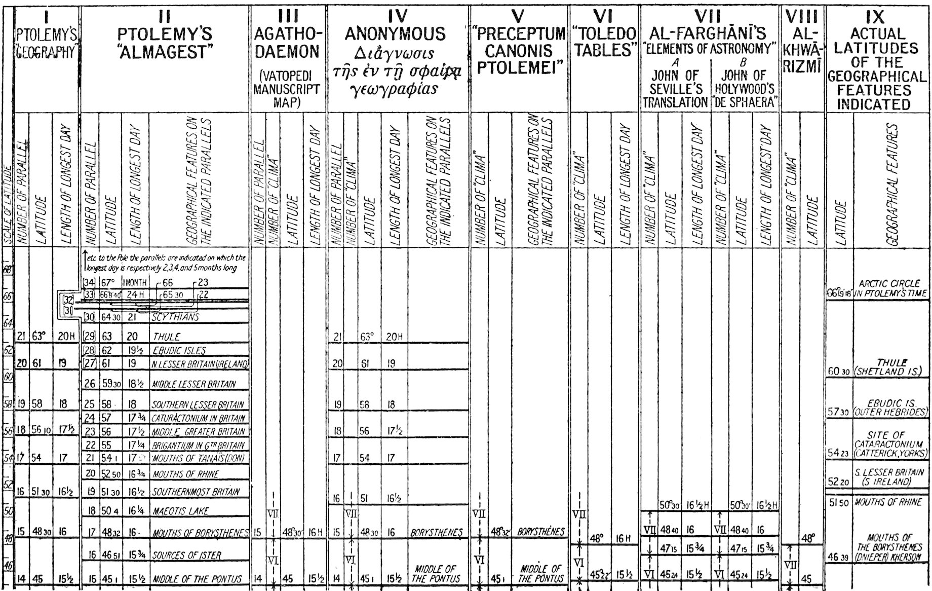
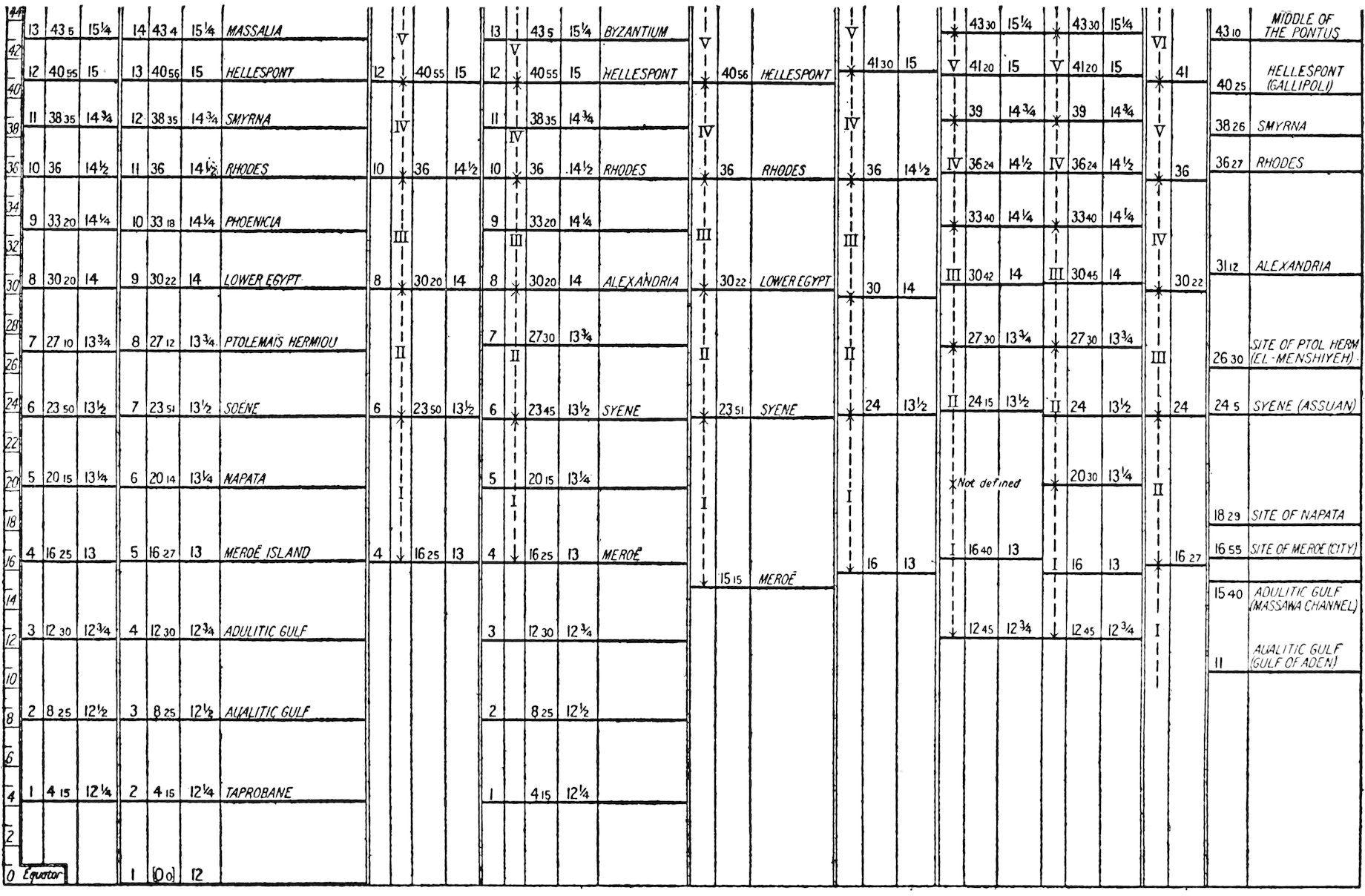
and from estimates of sea voyages. The figures for the latitude
and the longitude of the large number of places given in Ptolemy’s
Geography are for the most part not the result of astronomical
observations, and the tables cannot be regarded as analogous to
modern tables of latitudes and longitudes but must be considered
rather as guides for the construction of maps.[156]
Other methods besides these simple reckonings of locations
were well known, none the less.
Astronomical Determination of Latitude
The determination of latitude has always been a comparatively
easy astronomical problem. No complicated instruments are
needed to measure either the vertical elevation of the sun on the
meridian or of the north celestial pole, and from both of these the
latitude of the observer can be calculated with extreme accuracy.
The instrument commonly used by the Greeks for measuring the
angle of the sun[157] consisted of an hemispherical bowl (scaphe)
with a vertical rod (gnomon) for a radius. The shadow of the
rod on the concave interior of the bowl gives the elevation of the
sun (with an error of 16′[158]) and thereby the latitude. Eratosthenes,
Hipparchus, and Ptolemy were all familiar with the latitudes
of several places that had thus been determined.
Astronomical Determination of Longitude
To find longitude by astronomical means is a more difficult
matter for people who have neither chronometers nor telegraphs.
Eratosthenes, Hipparchus, Pliny, and Ptolemy all understood
that it may be found by observing the time of eclipses in different
35localities.[159] Hipparchus believed that an extensive series of
observations should be carried out in order to ascertain, by
mathematical and astronomical means alone, latitudes and
longitudes of a large number of places.[160] To facilitate such a
survey he prepared tables of lunar eclipses and tables to aid in the
determination of latitudes, but the practical difficulties of the
undertaking were too great and the work was never completed.
In fact, throughout antiquity the total number of places whose
position had thus been accurately determined probably does not
exceed half a dozen, if it is as many.
Pliny gives[161] an account of two different occasions when observations
were made of the same eclipse at two different places.
He says that at the time of the battle of Arbela the moon was
eclipsed at the second hour of the night, when at the same hour
it was rising in Sicily. He also speaks of an eclipse of the sun
that was seen in Campania between the seventh and eighth hours
and in Armenia between the eleventh and twelfth, indicating a
difference in longitude of four hours, or 60°. The actual distance
is no more than half of this. Ptolemy also cites[162] the eclipse of
331 B. C. as giving the distance between Carthage and Arbela.
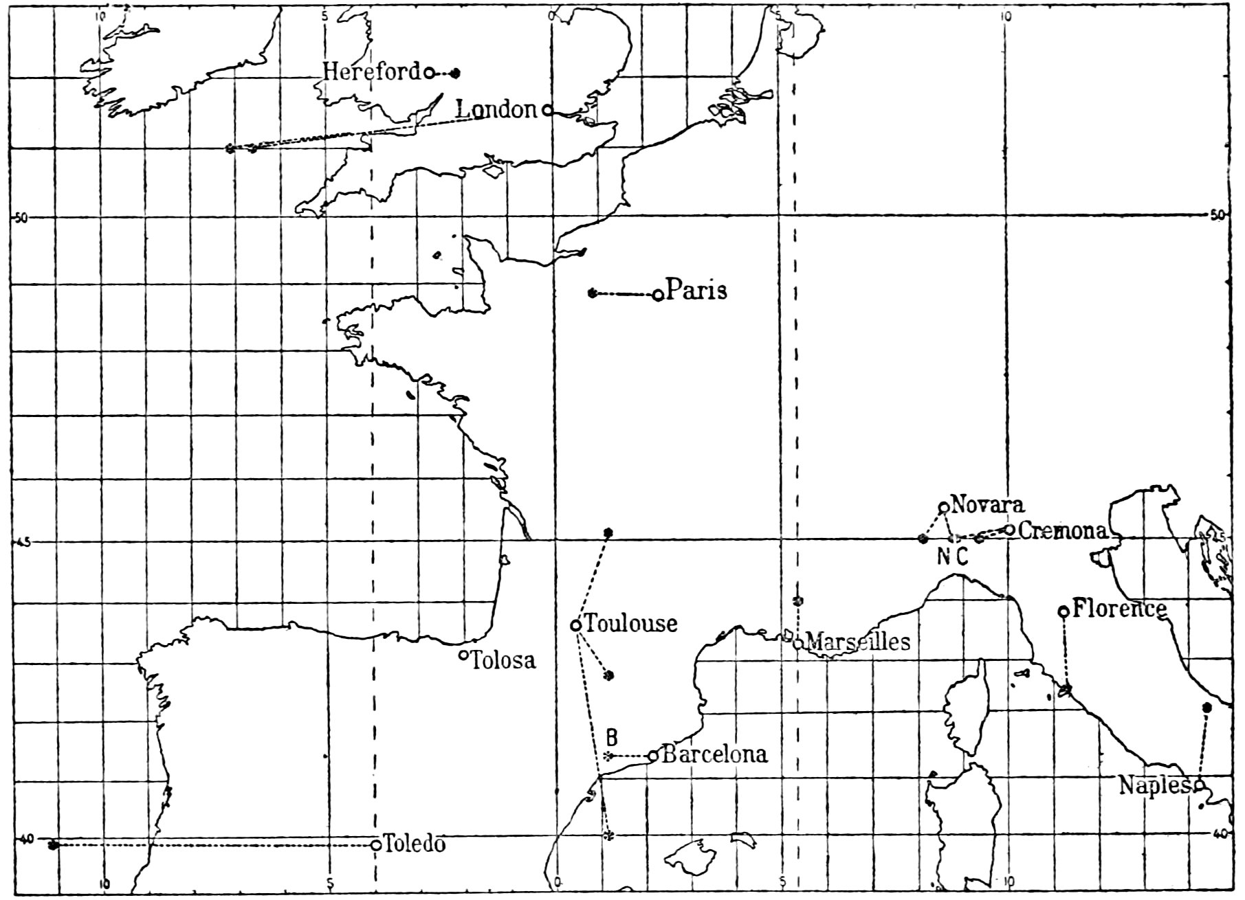
We shall see later that much greater accuracy was attained by the
Arabs in their calculations of longitude and that some of their
figures were passed on to the Western world in astronomical
tables during the twelfth and thirteenth centuries.
Cartography
Little need be said of the cartography of antiquity,[163] for although
medieval maps undoubtedly owe much to classical
predecessors, none of the classical maps which were destined
directly to influence the cartography of the Middle Ages have
come down to us. Indeed we have good copies of only two.
These are the maps of Ptolemy and the so-called Tabula Peutingeriana,[164]
or Peutinger Table. Ptolemy’s maps exerted no
influence whatever on the cartography of the age of the Crusades.[165]
The Tabula Peutingeriana is preserved in a manuscript of the
twelfth century or earlier and probably was originally copied
36from a large chart showing the main routes and provinces of the
Roman Empire. It is an extremely long and narrow affair in
which the geography is woefully distorted. Though in itself
hardly representative of the best in the Roman cartographer’s
art, the original may have been compiled from a contemporary
Roman map of the world and adapted through its long and narrow
form to the especial purpose of illustrating itineraries. We
know that maps of the world were officially drawn in imperial
Rome and posted up for the benefit of the public: the one constructed
by the order of Agrippa and Augustus in the Porticus
Octaviae was the most famous;[166] and others are mentioned in
literary sources.[167] Certain medieval maps of the world are
possibly related to some of these Roman charts,[168] but unfortunately
in the absence of the Roman maps themselves the exact
relationships cannot satisfactorily be worked out.
Although the ancient astronomers knew a variety of projections
for representing the heavens—stereographic, orthographic, and
others[169]—these were not applied to maps of the earth until long
after our period. Ptolemy describes several projections, among
them the conic, which he may have used; but there is no question
of any mathematical projections in the twelfth and thirteenth
centuries, and none of the cartographers of that period took
account of the fact that they were endeavoring to show a globe
on a flat surface.
We have seen what the geographers of antiquity thought about
the general distribution of land and water and about the physical
processes of the earth’s surface. We now must study a subject
which is less concerned with what they thought than with what
they actually knew—however vague and inexact this knowledge
was. Though the heritage of knowledge which antiquity left
to the Middle Ages of the countries and regions of the oikoumene
was vast, much had been lost and much garbled in the process of
transmission. Hence it would be beside the point to discuss the
details of topographic information contained in the works of
Strabo, Pliny, and Ptolemy; our aim is merely to indicate in a
37broad way the limits of the regional knowledge of the ancient
world. This can best be done by sketching the various stages in
which the horizon of geography was expanded until it reached
the Shetlands and Scandinavia in the north, China in the east,
and, perhaps, the Central African mountains in the south.
Expansion of Greek Regional Knowledge
Homer’s geographical horizon was limited by the Mediterranean—one
might almost say Aegean—shores; Italy, Sicily, and
everything to the west was a realm of fable, and his acquaintance
with the Black Sea coasts was little better. The colonizing
movement of the eighth to the sixth centuries before Christ
brought Greek settlers to these coasts; and through them there
was gained some acquaintance with the country behind them,
which found expression in the writings of Hecataeus at the close
of the sixth century. With this writer ancient geography begins
to assume its familiar classical form. He shows some slight
knowledge of Central Asia beyond the Caspian Sea and is even
aware of the existence of India—or at least of the northwestern
portions of that peninsula. The great struggle with Persia
brought the Greeks into much closer relations with Asia, and
a corresponding increase in geographical knowledge ensued.
This was summed up by Herodotus. Much of his geography is
fabulous and legendary, but much of it is of surprising detail and
accuracy. The voyage of Scylax of Caryanda from the Indus
to the Persian Gulf had brought the Indian Ocean within Greek
ken. Herodotus also describes the rivers of Scythia and of
Central Asia and displays detailed familiarity with Egypt and
northeastern Africa; he knew less of the West, although at about
this same time the voyages of the Carthaginian Hanno in the
Atlantic Ocean extended the horizon at least as far as the Canaries,
which were destined to remain on the limits of the known
world in that direction for many centuries to come. Shortly
after Herodotus, Ctesias, who had lived seventeen years at the
Persian court, wrote his Persica and Indica, in which we find
collected together many of the fabulous and marvelous tales of
Oriental animals and monsters which were later to figure so
38strikingly in the Historia naturalis of Pliny, in the medieval
encyclopedias, and in the Physiologus, a collection of animal
lore widely read in the Middle Ages. Further detail regarding
the local features of Mesopotamia and Armenia was learned from
the expedition of Cyrus and preserved for the future in Xenophon’s
Anabasis. But the events which did most to expand the
regional knowledge of the ancients were those connected with
Alexander’s conquests and with the reigns of his successors.
Alexander’s march in itself opened to Greek eyes wide territories
that had been unknown before; it brought Greek armies and,
after them, Greek merchants into the innermost heart of Asia;
it established direct connections with India; rumors reached the
companions of Alexander of an enormous island of Taprobane in
the Southern Ocean, an island which we now recognize to be Ceylon.
With the voyage of Nearchus came a better understanding
of the Indian seas; and subsequently under Seleucus I (Nicator),
Megasthenes, who was sent as ambassador to the court of an
Indian potentate on the Ganges, gave a detailed description of
the tribes and products of Hindustan, more extensive notes on
Taprobane, and—unfortunately—a repetition of the fabulous
legends of Ctesias. Patroclus, in command of the easternmost
provinces of the kingdom of Antiochus I, provided some valuable
statistical and geographical facts about the peoples of the
Caspian region, although he was quoted as an authority for the
belief that the Caspian communicates with the outer ocean and
that it is an easy matter to sail thence to India.
Geography at Alexandria
In addition to the reports of travelers and eyewitnesses, the
establishment of Greek control over Egypt and the greater part
of southwestern Asia led to a scientific awakening that centered
in Alexandria. One of the greatest triumphs of Hellenistic
science was the geographical and astronomical school that flourished
at Alexandria under the Ptolemies. Eratosthenes and
Hipparchus were undoubtedly the most famous representatives
of this school, and in them we see the culmination of Greek
scientific geography; for their work, all things considered, surpassed
39that of Claudius Ptolemy, and the work of no other man
approached it. Though Eratosthenes’ researches were significant
mainly in the field of mathematical geography, he made use of
much of the regional knowledge which was available in the
library at Alexandria and which he could gain from enterprising
Greek traders, administrators, and soldiers who had actually
visited the countries with which he deals in his treatises.
One striking result of this broadening of regional knowledge
was the lesson it taught in regard to the countries south of the
Tropic of Cancer. The progress of exploration in Upper Egypt
and in India showed that these countries were not only habitable
but thickly settled. Adherents of what we have called the
Cratesian theory were obliged to acknowledge that the tropic
could not be taken as the beginning of the burning zone. Eratosthenes
pushed the limit of the oikoumene as far south as latitude
11½° N.[170]
Hellenistic Regional Knowledge
While Greek military enterprise had been opening up the Orient
and exploratory enterprise penetrating the tropics, an important
advance was made in the direction of the northwestern seas and
the British Isles. The voyage of Pytheas of Marseilles, about
330 B. C., had brought within the scope of ancient knowledge
Britain, Scandinavia, Thule, and the frozen ocean beyond.
Thus, in the Hellenistic period the frontiers of knowledge included
the Orkneys, Shetlands, Faroes—or whatever of the northern isles
was meant by Thule—the Canaries, tropical Africa, and Ceylon.
No further notable extension of these borders seems to have been
made until the first century after Christ, except that vague
rumors of a people called “Seres” and of the use of silk had crept
into the Roman world in Virgil’s time. This may have indicated
acquaintance with China, although Horace took the Seres to be a
tribe of Central Asia.[171] The Scythian invasions which overwhelmed
the Greek kingdom of Bactria and the conquest by the
newly risen power of Parthia of the provinces of the Seleucids
east of the Euphrates tended to cut all communication with
the interior and farther parts of the Asiatic continent; but the
Mithridatic wars, as described by Theophanes, familiarized the
40public with the local geography of Armenia, Pontus, and the
Caucasus. Similarly Caesar’s campaigns in Gaul, Germany,
and Britain opened Western Europe to the Roman world.
Regional Knowledge of Mela and Pliny
The most complete and accurate summing up of the regional
geography of the ancients was the Geography of Strabo, written
in Greek probably shortly before 17 A. D. But, as we have seen,
this work was unknown to our period of the Middle Ages, when
men had to rely on Latin writers like Pomponius Mela and
Pliny, whose writings were of distinctly inferior quality and
included a great deal of fabulous and worthless material. Devoid
of that critical judgment which characterized Eratosthenes and
Strabo, Mela and Pliny were content to bring together huge
quantities of miscellaneous information, much of which was
derived from antiquated Greek sources. Mela, for example,
closely follows Herodotus’ description of the marvels of Asia, and
Pliny retails many of the fanciful legends of Ctesias and Megasthenes.
Pliny’s contributions to geography were somewhat more
satisfactory than those of Mela; for he added some details about
Asia that had not been mentioned before, especially in his description
of Serica and of India and in his account of the monsoons.
On the other hand Mela was the first writer to mention the Baltic
Sea, or “Sinus Codanus,” which he described as a great gulf full
of islands.
The “Periplus of the Erythraean Sea”
Nearly contemporaneously with Pliny there came an advance
in the knowledge of the Indian Ocean in the anonymous Greek
Periplus of the Erythraean Sea, a manual for sailors and merchants.
This is of interest because it gave indications of the
existence of coasts and islands beyond India, the islands of
Chryse, the land of the Seres, and, at the end of the earth
to the east, a region of “Thin”—the first mention of the
word “China” in the West unless we take into account the
“Sinim” of Isaiah xlix, 12, which may or may not have referred
to the great nation of the Far East.
41At about the same time, as we have already seen, the upper
reaches of the Nile, possibly as far as the great marshes of the
White Nile in about latitude 9° N., were explored by the expedition
described by Seneca and Pliny which Nero sent out to solve
the age-long mystery’ of the sources of the river of Egypt.[172]
Pliny accordingly placed the southern border of the oikoumene
some 7½° south of the position to which Eratosthenes had assigned
it, or at about latitude 4° N.[173]
Limits of Ancient Regional Knowledge on the South and East
Before the days of Marinus of Tyre and Ptolemy the limits of
geographical knowledge were again much extended both southward
and eastward. The Ptolemaic map depicts a wealth of
detail in the interior of Africa, although we are unable to say with
assurance what most of this detail represents in reality.[174]
Ptolemy certainly had some knowledge of the great lakes and
mountains of east-central Africa. The snow-covered mountains
which he placed at the sources of the Nile may be associated with
reports derived from the east coast of Africa, of Kenya, Kilimanjaro,
or possibly the Ruwenzori range.[175] Farther to the west he
describes a river, the Nigir, flowing from a region south of the
country of the Garamantes (probably modern Fezzan) to the
westward into a lake near the Atlantic. It seems altogether
likely that by this river he meant the Niger. Ptolemy mentions
two expeditions that had been made at an unknown period to the
south from the land of the Garamantes, one under Septimius
Flaccus, who arrived at the country of the Ethiopians after three
months’ journey, and the other under Julius Maternus and the
king of the Garamantes, a four months’ journey to a country
called Agisymba, abounding in rhinoceroses. Ptolemy’s regional
knowledge certainly extended as far south as the equator, and he
was well aware of the fact that the equatorial zone is inhabited.
In the east, also, the Ptolemaic map reveals an advance in
knowledge over its predecessors. Chryse appears as a peninsula,
and other islands and coasts are shown that certainly indicate
familiarity with the Malay Peninsula and China, possibly also
42with Borneo and Java. We shall find, however, that these
valuable extensions of knowledge eastward and southward were
universally lost sight of in the West in the Middle Ages and that
cosmographers were united in placing India or Paradise as the
farthest end of the world in the one direction and either the
shores of the Ethiopian Ocean immediately beyond the Garamantes
or the edge of the uninhabitable zone at the tropic or not
far beyond it, as the extreme limit in the other.[176]
43
The geographical lore of antiquity was carried over to the
Western Europe of the Crusading age by the Christians of the first
eleven centuries of our era and by the Moslems. In this chapter
we shall study the manner in which it was transmitted, transformed,
and augmented by Christian agencies.
Scriptural Influence on Early Medieval Geography
Our primary problem is to examine the effects of Christianity
on geographical knowledge and belief, effects which sprang in
large measure from men’s varying attitudes toward the Bible.
Some believed that Scripture contains the absolute and only
truth, but others were willing to grant a partial authority to
pagan teachings. The evolution of science was profoundly
modified by the conflicts between these divergent tendencies of
thought and by the efforts made to reconcile one with the other.
The general result spelled disaster to clear thinking in geography.
Moreover, many of the facts which the scholars of antiquity had
gathered together were wholly lost sight of in the confusion that
accompanied the disintegration of Roman civilization. The
horizon of the known world was narrowed from the wide bounds
it had reached in the time of Ptolemy.[177] New information acquired
by exploration and travel was ignored; and a host of
legends, fancies, and false theories took the place of the reasonably
accurate body of information which the Greeks and Romans
had possessed.
Ignorance of the Best Work of Antiquity
During these long years Constantinople was the only great
metropolis of Christendom, the only center where the arts and
44sciences of civilization were cultivated without interruption.
We might expect, therefore, that the Byzantine influence upon
Western geography would be as marked as it was upon Western
art and architecture. But this was not the case. However
much the scholars of Constantinople may have been interested
in the historians of antiquity, they neglected the geographers;
and the scientific geography of the Greek Empire was at best a
work of lifeless compilation and commentary. Furthermore,
knowledge of Greek was at no time widespread in the West until
the Renaissance, and the great majority of Western scholars were
profoundly ignorant of Byzantine literature.[178] For their geography
the men of the Occident turned rather to the Bible and to the
mediocre and worse than mediocre works of an age of intellectual
degeneracy. Solinus, Martianus Capella, Macrobius, Aethicus
of Istria, and Orosius became authorities from which later writers
derived their facts.
Scientific Stagnation During the Early Middle Ages
The earlier Fathers of the Church, whatever may have been
their merits as theologians and dialecticians, were not distinguished
by an ability to understand the truths of natural science
or to combat error in that field. With the establishment of the
barbarian kingdoms between the sixth and eighth centuries came
an epoch of mental stagnation in nearly all realms of science and
scholarship. Learning in general and geography in particular
suffered almost universal eclipse. Yet dark and ignorant as the
times may have been, the torch of civilization was kept burning,
if feebly, by a few Irish and English monks[179] and by contacts with
the Levant that were maintained through Greek, Asiatic, and
Egyptian traders in the principal cities of Europe.[180] If not much
authentic geographical information was contributed to Western
society by these agents of enlightenment, they served to disseminate
certain geographical legends and traditions destined to seize
a strong hold on the Western imagination.
In the days of Charlemagne came the new awakening sometimes
known as the “Carolingian Renaissance;” and, although
tenth-century Europe relapsed temporarily into a torpor, a
45current of theological interest and, with it, interest in the natural
sciences had by then once more set in—a current which was to
reach full flood at the time of the Crusades.
What works widely read during these centuries served as
sources of geographical information for the scholar of the era of
the Crusades?
The Bible
First and foremost we must place the Bible. Certainly in the
pagan world no one book had ever held the paramount position
in the minds of thoughtful men that Scripture held during the
Middle Ages. As we saw in the Introduction, the two great
fountainheads of medieval geography were the works of Greek
philosophers and historians and the Bible. The geographic
material in Scripture is neither very extensive nor very explicit
in comparison with the contributions of such writers as Strabo
and Ptolemy to the geographic education of mankind, and yet so
tremendous was its authority that it tended at one time completely
to supersede classical teachings. Slight and confusing as
may have been its geographical references, the man of the Middle
Ages attached to all of them paramount importance. Simply
compare a map of the world reconstructed from Ptolemy’s data[181]
with one of the crude Beatus sketches reflecting Biblical beliefs,[182]
and some of the changes which the reading of Scripture had
wrought become strikingly apparent.
Genesis was the most important book of the Bible from the
geographical point of view. Here we find, in the history of the
Creation, texts which were the starting point of many speculations
about the origin of the world and the elucidation of which
was attempted in many a long commentary on the Works of the
Six Days.[183] Furthermore, in Genesis we find the description of
Paradise and its four rivers, which figured largely on most
medieval maps, and the account of the division of the earth
among the descendants of Noah, which lay at the bottom of the
crude ethnography of the Middle Ages. By some writers the
46description of the tabernacle of the Lord and its furnishings[184]
was regarded as an allegorical account of the heavens and earth.
Gog and Magog, described in Genesis, Ezekiel, and Revelation,
were prominent among the supposed medieval tribes of Asia.[185]
And in the apocryphal Acts of the Apostles, which, though
technically not a part of Scripture, were often given the authority
of Scriptural truth, we find accounts of the preaching of the Gospel
in far lands, India, Ethiopia, Babylonia.[186]
Writings of the Church Fathers
These and many other incidental references gave rise to those
relatively restricted portions of the vast mass of patristic literature
which deal with geography, but which nevertheless inevitably
marked out the channels that certain elements of
geographic thought and tradition were destined to follow until
the beginnings of the Renaissance. How these passages were
interpreted was, then, of great importance.[187]
Interpretation of the Bible
According to the Church Fathers there were four methods of
interpretation; but for our purposes we need consider only two
of these, the literal and the allegorical.[188] Both led to pitfalls:
the literal interpretation tended to narrow the thought and make
it correspond to the exact words of a text; the allegorical, unjustifiably
to expand the meaning of simple statements.[189] To
these dangers were added the difficulties and contradictions due
to the manifold authorship of Scripture and to the misunderstanding
of passages woefully faulty from the textual point of
view.
Yet the writers of the early Christian age were in most cases
unaware of these pitfalls and did not even know when they had
fallen into them. Faith in the truth of the Holy Word was
usually sufficient to render men supremely oblivious to conflicting
and inconsistent assertions that would otherwise have been revolting
to reason. Tertullian said: “When we believe, we desire
nothing besides belief. For we believe this in the beginning:
that there is nought which we need to believe beyond it.”[190]
47
Classical Influences
This faith in the truth of the written Word persisted throughout
the Middle Ages and down to our own day. During the
earliest Christian centuries the Bible was sometimes regarded as
the only source of truth, and the teachings of pagan writers were
often looked upon with abhorrence. Lactantius Firmianus
(early fourth century), with an inconsistency characteristic of
many of the Church Fathers, made use in his Institutiones
divinae of the classical authors themselves to prove the supposed
fallacies and evils of pagan science.[191] About the fourth century
men began to try to amplify and expound the fundamental Biblical
truths by appeal to the legacy of classical learning. To effect
a reconciliation and combination of Christian teachings with the
classics—especially the works of Plato and his followers—became
one of the main preoccupations of theologians. Platonic and
Neoplatonic influences made themselves felt in the thought of
churchmen and scholars, and among the most popular works
of the entire period was Chalcidius’ translation of the Timaeus
of Plato. Neoplatonism was interwoven into the theological
system of Augustine.[192] In the ninth century it appears in the
writings of the great Irish scholar, John Scot Erigena.[193] In the
tenth and eleventh centuries the Platonic commentary by
Macrobius on Cicero’s Somnium Scipionis enjoyed an immense
vogue;[194] it was read by the mathematician and astronomer Pope
Sylvester II (Gerbert) at the end of the tenth century and on the
threshold of our period aroused the protests of the more old-fashioned
churchmen like Manegold, who objected to the seeds
of heresy which it contained.[195]
Encyclopedic Compilations
For more strictly geographical, rather than “cosmogonic”
or cosmological material, we must turn to the encyclopedias
rather than to the thoughtful and speculative theological books
of such men as Augustine. Like the mighty volumes of Aristotle
or the Natural History of Pliny these encyclopedias were attempts
to encompass and to put in convenient form the entire range of
human knowledge. The most significant was the Etymologiae
48sive originum libri XX of Isidore of Seville (died 636 A. D.).
This large compilation of miscellaneous information served as a
model of style and composition as well as a mine out of which
later writers dug their “facts.” For the geographical portions
of the Etymologiae, Isidore used the Bible and classical authorities
alike; he derived much from Orosius and Solinus; and, though it
is doubtful whether he was acquainted with Pliny at first hand,[196]
he incorporated in his book not a little Plinian material taken
from Solinus. Isidore’s method was followed, and much of his
work copied, by the Irish and English monastic encyclopedists of
the eighth and ninth centuries. We find a great deal from Isidore
in the Venerable Bede’s (died 735 A. D.) De natura rerum,
in Raban Maur’s (776–856 A. D.) De universo, in Dicuil’s De
mensura orbis terrae (825 A. D.),as well as in the De imagine mundi
of our period. John Scot Erigena, the great Platonist of the
eighth century, stands out among his contemporaries as one of
the most original and critical scholars of the Middle Ages. The
range of his interests was very broad, and it seems probable that
he understood Greek. In his De divisione naturae, beside the
Latin sources which Isidore, Bede, and other encyclopedists had
copied, he made use of the De nuptiis Philologiae et Mercurii of
Martianus Capella and also of various Greek works, including
the Geography of Ptolemy.[197] Martianus Capella was held in
high favor during this epoch, and his works were commented
upon by such men as Remy (Remigius) of Auxerre, the master
of Gerbert, and by Adam of Bremen.[198]
Miscellaneous Geographical Writings
Closely akin to the geography of the encyclopedias, and not
infrequently borrowed from by the encyclopedists, are a number
of miscellaneous writings, which, though intrinsically of slight
value, nevertheless profoundly affected the development of
geographical ideas. The most important of these was the brief
description of the countries of the world forming the second
chapter of the first book of Orosius’ Historiae adversus paganos
(fifth century). Enjoying great popularity, as is testified by the
existence of over two hundred manuscripts, this was much plagiarized
49by later scholars: parts of it became incorporated into
Isidore’s Etymologiae; it was translated into Anglo-Saxon by
King Alfred the Great;[199] and during our period it was extensively
quoted and copied by nearly all who attempted to write on
geographical subjects. Another of this miscellaneous group is a
seventh-century cosmography in barbarous Latin, a pretended
translation of a fictitious work originally written in Greek by
Aethicus of Istria.[200] We find set forth here for the first time many
of those marvels of Scythia and the northern regions employed
by later writers to add interest to their pages. Priscian’s sixth-century
translation of the geographical poem[201] of Dionysius
Periegetes was also extensively quoted. In the middle of the
seventh century an anonymous cleric of Ravenna wrote a
description of the world in five books. Though entirely the
result of compilation, this cosmography is in many respects the
most elaborate and interesting geographical book dating from
the early medieval West. The sources quoted and utilized are
extremely varied, including the Bible, “Jordanis” (Jornandes),
Ptolemy, Orosius, Isidore, and possibly the Tabula Peutingeriana,
in addition to a number of Greek, Roman, and Gothic writings
otherwise unknown.[202] The main importance of the work of the
Ravenna geographer in relation to the geography of the Crusading
age lies in the fact that a large portion of it was included
in a compilation made by a certain Guido in 1119.[203]
Legends
During the twelfth and thirteenth centuries many legends were
current in the West, some of which contained geographical elements.
Though we shall have occasion to discuss this subject in
greater detail later on, the fact should be brought out here that
the origin of most of these legends may be traced far back into the
centuries before the beginning of the Crusading age.
Perhaps the most significant was the cycle of stories of the exploits
and adventures of Alexander the Great which originated in
a Greek history purporting to be the work of Callisthenes, a companion
of the Macedonian conqueror, and is hence known as the
Pseudo-Callisthenes. Written in Alexandria about the beginning
50of the third century after Christ, this work subsequently became
widely dispersed through the East, where translations were made
into Syriac, Arabic, Ethiopic, and other Oriental tongues. Put
into Latin by Julius Valerius about the middle of the fourth century,
again translated in the tenth century,[204] given further Latin
vernacular renderings with many additions at later dates, the Romance
of Alexander had come, by the time of the Crusades, to
form the nucleus of a mass of stories and fables whose scenes were
laid in distant Asiatic countries. With it had been associated
those mysterious tales and prophecies of Gog and Magog whose
origins were ultimately connected with the Biblical revelations of
the end of the world.[205] Alexander the Great and Gog and Magog
appear in the Pseudo-Methodius, a book of prophecy which foretold
the dread events of the Last Day. Rendered into Latin at
an early period from a Greco-Syrian original, the Pseudo-Methodius
made a deep impression on the medieval mind,
especially at the time of the Mongol invasions in the early
thirteenth century.
Writers of our period like Gervase of Tilbury and Giraldus Cambrensis
also drew on the legends found in Geoffrey of Monmouth’s
mythological history of Britain, many of which had entered into
the composition of the Romance of King Arthur. Some of the
latter were of slight geographical interest.
Finally, the mythology and folklore of Ireland, with infusions
from classical and even Arabic literature, gave rise to the story of
the wanderings of St. Brandan[206] among mysterious islands in the
Western Ocean, an account of which we have in a manuscript
dating back perhaps to as early a period as the ninth century.[207]
Books of Travel and Description
The most important books describing actual travels and explorations
written between the conversion of Constantine and the
Crusades were for the most part in languages unknown to the men
of the West—Greek and Arabic. Zemarchus’ account of the
tribes and trade of Central Asia[208] and the Meadows of Gold of
Al-Masʿūdī, wherein were described things personally seen by
the travelers between Spain and Burma and south as far as Madagascar,
51were treasures of geographical lore unknown to Occidental
readers of this age.
In Adam of Bremen’s Gesta Hammenburgensis ecclesiae pontificum,
written in the latter half of the eleventh century, we find a
description of the countries of the North. This was based on
knowledge acquired from the voyagings of the Northmen between
the eighth and eleventh centuries and, together with the Sagas,
will be discussed in a later chapter.
From the varied narratives of Christian pilgrims the Western
student might have gleaned some arid details about routes
eastward and about the topography of the Holy Land.
We saw in the first chapter that Plato, Aristotle, Seneca, and
most of the other Greek philosophers had believed that the universe
is eternal, though subject to ever-recurring destructions
by fire or water, followed by “rebirths” (palingeneses).[209] Aristotle
had attributed to the stars control over all occurrences in
the sphere below the moon; not only over physical and material
happenings, but over the mind and will. He had believed that
this was by virtue of the fact that the celestial bodies are formed
of a divine substance different from the four corruptible elements
which constitute the sublunar world. On this theory of the stars
had been built the “science” of astrology.
Christianity Opposed to Belief in an Eternal Universe
What could be more antagonistic to such ideas than the teachings
of the Bible? The antagonism, however, was not felt by all
the Fathers of the Church. The fascination of Platonism led
many to seek for analogies between Greek and Biblical cosmology.
Clement of Alexandria, for instance, thought that the
destruction of the world by fire prophesied in Deuteronomy
(xxxii, 22) was one of those general burnings which would occur
when the stars find themselves in conjunction in Cancer.[210]
Indeed, it was a common belief, and one shared by Augustine,
that the Greeks themselves had actually derived the best of their
theological concepts from the Bible.[211] But the glaring contradictions
52between Scriptural and classical cosmology could not be
overlooked even by the Augustinians, and classical theories of the
periodicity of the universe in general were vigorously combated.
Christian monotheism could never be reconciled with a fatalistic
doctrine that attributed to the stars in their control over the
destinies of the world a quality that approached the divine; and
through Christian teachings the astrology built on this doctrine
was discredited and the stars stripped of their divinity.[212] This
alone was enough to strike a deathblow at the idea of the unvarying
periodicity of the universe under celestial controls; but other
arguments equally potent were leveled against it. Augustine
refused to believe that Christ had been incarnated an infinite
number of times in the past or was destined to suffer the Passion
an infinite number of times in the future.[213] Origen declared that
another Adam, another Moses, another Judas were unthinkable
and asked how the belief in the stellar control of man’s actions
and volition could be reconciled with the Christian doctrine of
the freedom of the will.[214]
Perhaps the most fatal argument lay in the express contradiction,
by the Old Testament account of the Creation, of the Hellenic
idea of an eternally recurrent universe.[215] Neoplatonist
and Peripatetic alike had denied that there ever had been a first
day or a first Great Year.[216] Yet the words of Scripture are very
definite and very explicit: “In the beginning God created
heaven and earth.” Neither Christian nor Jew could question
the meaning of these words nor think otherwise than that all
things were created at a certain fixed and calculable point in
time or else, following Augustine, that the universe and time
were created simultaneously.
In spite of these fatal objections, neither the Great Year
theory nor astrology perished completely in the Middle Ages.
Lingering on underground, they gave an heretical and pagan
tinge to the thought of many a philosopher and theologian during
our twelfth and thirteenth centuries and thereafter.[217]
The Creation
Even the Scriptural history of the Creation did not wholly
satisfy the inquiring curiosity of theologians or philosophers.
53One of the primary problems dealt with by scholars was the
problem of the first chapters of Genesis. This inquiry led into
the domain of metaphysics and theology: through it men hoped
to arrive at an understanding of the nature of God and of his
relation to the universe, to time, and to man. It also led to
innumerable speculations about the actual manner in which the
will of God operated in fashioning the world and to discussions
of this question from very diverse points of view—literal, allegorical,
transcendental. Indeed, there were even a few writers,
notably the Venerable Bede, who went so far as to try to reconcile
a physical conception of the processes of creation with the account
given in the Bible[218] and who thus prepared the way for more
rationalistic studies of the Works of the Six Days in the centuries
which were to follow.
Early Christian Belief in a Flat Earth
Prevalent among most peoples in an early stage of their
intellectual development is the natural and obvious theory
that the earth is a flat disk covered by a dome-shaped heaven.
This view was held by the Assyrians, Chaldeans, Egyptians,[219]
and, as we saw in the first chapter, by the early Greeks; it was
long believed by the Jews[220] and is found in the Koran;[221] it was
undoubtedly reflected in the words of Scripture, although what is
said there on the subject is by no means definite and occurs in connections
wholly incidental to other subjects. We read in Isaiah
(xl, 22):[222] “It is he that sitteth upon the circle of the earth, and the
inhabitants thereof are as grasshoppers; that stretcheth out the
heavens as a curtain and spreadeth them out as a tent to dwell in.”
This can hardly be called an exhaustive dissertation on the
shape of the universe, yet on it and on other scraps even less detailed
were erected the medieval arguments in favor of the flatness
of the earth, a firm belief in which was probably held by the
majority of the earlier Church Fathers, especially those of the
East.[223] Not only were the ancient proofs of sphericity overlooked;
but such ideas were regarded as heretical, and elaborate
new systems were raised on the weak foundations of littleunderstood
54Scriptural texts. The most remarkable theories of
the universe, however, were devised by the Greek fathers
Patricius, Cosmas Indicopleustes, and Severian of Gabala.[224]
They remained unknown to the men of the Western world and
consequently do not concern us. The Latin father Lactantius
contented himself with endeavoring to prove by pseudo-scientific
means that the earth is not a sphere; a spherical heaven, he argued,
does not necessitate a spherical earth; and the idea of the
possibility of antipodes was to him thoroughly absurd.[225]
Early Christian Belief in a Spherical Earth
On the other hand, the theory that the earth is a globe never,
perhaps, suffered complete eclipse.[226] Augustine was non-committal
in this regard, evidently troubled and puzzled by contradictory
statements in the Bible and in the writings of classical
astronomers.[227] Isidore quotes writers of antiquity who favored
a spherical earth, though if we interpret correctly texts in the De
natura rerum[228] and Etymologiae[229] we are impelled to think that
he himself conceived of a flat earth surrounded by a spherical
heaven. The Venerable Bede, on the contrary, did not mince
matters; he stoutly maintained that the earth is a sphere and cited
as proof the fact that stars visible in one latitude are invisible in
another.[230] After the so-called Carolingian Renaissance the world
of thinkers seems gradually to have outgrown the primitive
notion of a flat earth. To the De nuptiis Philologiae et Mercurii
of the Neoplatonist Martianus Capella may be ascribed much of
the credit for keeping alive the doctrine of sphericity during
these centuries. This immensely popular work, with its condensed
argument in favor of a globe-shaped earth, doubtless contributed
to the formation of the opinions of men like John Scot
Erigena, Gerbert, Hermann of Reichenau, and Adam of Bremen,
adherents to the only theory compatible with any observation
better than the most superficial and any reasoning better than
the most trivial.[231]
Size of the Earth
With the reëstablishment of the belief in a spherical earth we
find men again making conjectures about its size, though there
55is no evidence that attempts were made in Christendom (as in
the Moslem world) actually to measure the circumference. In
the ninth century John Scot Erigena gave, from Martianus
Capella, a full explanation of the famous Eratosthenic measurements.[232]
An unknown author of the ninth or tenth century
of a work on geometry often attributed to Gerbert also explained,
from Capella, Eratosthenes’ method of measuring a
degree;[233] and the eleventh-century mathematician Hermann of
Reichenau[234] had learned (possibly from Macrobius) how the
length of a degree could be ascertained from observations of the
pole star. His result, 700 stades, was the same as that of
Eratosthenes, a fact which alone indicates that he did not himself
undertake any measurement. Thus we see that as a result
of the Platonic movement between the ninth and eleventh centuries
knowledge of one of the most magnificent achievements of
classical geographical investigation had been revived.
Zones
Most Greek thinkers had agreed in dividing the earth’s
surface into five zones, though they differed as to whether or not
the equatorial zone was habitable. By Ptolemy’s time the
discovery of countries in the heart of the tropical regions and
possibly beyond had exploded the old idea of an equatorial ocean
and fiery belt around the middle of the globe. Unfortunately
the broader regional knowledge which had been at Ptolemy’s
disposal was lost in the Middle Ages, and older views reappeared.
The maps of the period show us the encircling ocean in which
Homer had believed, and nearly all writers of the patristic age
thought that Africa has a very limited extension toward the
south.[235] Beyond Africa, they said, lies an equatorial ocean and
an equatorial zone uninhabitable on account of heat.
The Antipodes
Whether or not there were other regions of the world on the
other side of this equatorial zone or beyond the waters of the
56western ocean, and whether or not such regions were inhabited,
were questions which piqued the curiosity of the Church Fathers.
The possibility of antipodal regions—perhaps continents—must,
in the logic of things, have been admitted by those who were
ready to believe that the earth is a sphere; and even those who
were not believers in the sphericity of the earth were prone
to discuss the possibility of a fourth, or austral, continent,
usually called by analogy the region of the antipodes, lying immediately
south of the equatorial zone.[236] Bede adopted Crates’
theory of two oceans encircling the earth, east and west, and north
and south, dividing its surface into four temperate habitable
areas; and after the interest in Macrobius had become widespread
in the ninth century this theory undoubtedly must have been
generally familiar if not generally accepted.
Whether or not the antipodes were actually inhabited was
another matter. Lactantius, who thought that the world is
flat, was a determined opponent of the possibility of inhabited
antipodes for physical reasons. His arguments were obvious
but seem puerile to us: “Is there any one so stupid,” he asked,
“as to believe that there are men whose feet are higher than
their heads?”[237] It puzzled him to explain how trees could grow
upside down or rain fall upward. More serious were the religious
objections to the possibility of inhabited regions in other parts
of the earth, for this was as antagonistic to the words of the Bible
as the Great Year theory and antagonistic in much the same way.
The theory of the antipodes, as generally presented in association
with the theory of a fiery equatorial zone, presupposed the existence
of other races of men absolutely cut off from our race.
How, then, inquired Augustine,[238] could such races be descended
from Adam, who, the Bible tells us, was the forefather of all
men? How could Christ have died for antipodeans? How
could the Gospel have been preached in “the four corners of the
earth” if half the earth is cut off from our quarter by tropical
fires? How could the text of Romans x, 18, be true which says:
“Yes, verily, their sound went forth over all the earth, and their
words unto the ends of the whole world”? Isidore[239] and Bede[240]
categorically denied the possibility of inhabitants of antipodal
57regions. Their authority, together with the strength of their
arguments and the arguments of Augustine, were sufficient to
arouse suspicions of the man who ventured to believe in this
doctrine. Such a man must certainly be a heretic. A tenth-century
interpreter of Boëthius wrote: “God forbid that anybody
think we accept the stories of antipodes, which are in every way
contradictory to Christian faith.”[241] In the middle of the eighth
century the question reached a head in a controversy between
St. Boniface and a certain Virgil, bishop of Salzburg.[242] The
latter, who doubtless thought that there were antipodal regions
if not antipodeans, was accused by Pope Zachary, to whom St.
Boniface had complained, of holding “perverse and iniquitous
doctrines regarding another world.” Unfortunately we do not
possess Virgil’s own account of the incident and are unable to
tell exactly what these doctrines were.[243] At all events, belief in
antipodes contained the seeds of bitter religious quarrels and was
one of the charges brought against Cecco d’Ascoli, who, after
our period, was burnt to death for holding this and other damning
convictions.[244]
In the field of physical geography slight was the contribution
of the early medieval writers.
Meteorology
Classical ideas about the atmosphere were repeated and garbled,[245]
little progress was made in the development of earlier
theories, and little new was added but superstition. Isidore,
followed closely by Bede and Raban Maur, was the primary
authority in matters of meteorology.[246] The ancient view persisted,
that the polar regions were uninhabitable on account of
cold and the equatorial zone on account of heat. The sort of
popular meteorology that prevailed is illustrated in an early
ninth-century treatise written by Agobard, archbishop of Lyons,
and entitled Against the Absurd Opinion of the Vulgar Touching
Hail and Thunder.[247] This was an attack on charlatans who
claimed that they could control the weather, produce storms and
58hail at will, and who asserted that there is a region, called
Magonia, “whence ships come in the clouds” (Poole’s translation).[248]
Natural enough as it is for the uneducated in any age
to believe such things,[249] the significant fact here is that Agobard
did not attempt to invoke scientific arguments to confute the
claims of the impostors. Poole says: “He disdained to allege
scientific reasons to overthrow what was in its nature unreasonable.
He could only fall back on ... broad religious principles.
He argued that God’s relation to nature is immediate
and least of all conditioned by the artifices of men.”[250]
The Waters Above the Firmament
One distinctly new idea, however, was introduced by the Bible
into the circle of what we may, with a slight stretch of the
imagination, consider the medieval physical geography of the
water element. This new conception tended to revolutionize
theories based on classical physics and to cause much confusion
and doubt in the minds of the Fathers of the Church. The
orthodox classical physicists had held that the elements normally
form four concentric spheres surrounding the center of the universe,
in order, from the heaviest to the lightest, earth, water, air,
fire. Genesis (i, 6–7) states that “God said: Let there be a
firmament made amidst the waters; and let it divide the waters
from the waters. And God made a firmament, and divided the
waters that were under the firmament from those that were above
the firmament.” Though belief in waters above the firmament
is found in the cosmologies of the ancient Egyptians and Persians
and is there closely associated with belief in a disk-shaped earth
covered by a dome-shaped heaven, water in such a position was
very far removed from its proper place in the scheme of nature
of Aristotle and his followers. The Church Fathers, nevertheless,
were unwilling to doubt the actual existence of these waters,
and in general they accepted the text literally.[251] Gregory of
Nyssa even went to the extent of imagining mountains on the
back side of the firmament and that the waters were contained
in the hollows and valleys between them.[252] Others thought the
waters were in the form of clouds or fine drops. Jerome, Josephus,
59Ambrose, and Bede all held that the waters were crystal.[253]
Augustine was non-committal, though he gathered together the
statements of many who had expressed concrete views on the
subject.[254] Ambrose argued from analogy that if the earth can
hang in the center of the universe without support so also can the
waters hang unsupported above the firmament.[255]
The purpose which the waters were to serve was also a thorny
problem. Ambrose said they were intended to cool the axis of
the universe, overheated by its perpetual rotation;[256] others
thought that they were meant to screen the earth from the fiery
heat generated by stars and sun;[257] others that they were stored up
as a reservoir to supply hydraulic resources at the time of the
Great Flood.[258]
The Congregation of the Waters
According to the description of the Creation in the book of
Genesis “God also said: Let the waters that are under the heaven
be gathered together into one place; and let the dry land appear.
And it was so done.” The difficulty in explaining this text was
to account for what became of these waters. Great as are the
seas, they were not considered large enough to absorb all the
primordial waters, and consequently arguments were elaborated
in favor of the existence of vast reservoirs within the earth.
Bede, for example, was of the opinion that the waters under the
firmament at first took the form of clouds and that when they
became condensed and fell as rain the water was sequestered in
caverns of the earth’s interior.[259]
Of even greater significance was the assertion that God had
gathered the waters below the firmament into “one” place.
This could mean nothing else than that all the waters of the earth,
whether in subterranean reservoirs, oceans, lakes, rivers, or in
the atmosphere, must be connected and must constitute a unit.
Probably with this idea in mind Isidore wrote: “The abyss is the
deep water which cannot be penetrated, whether caverns of unknown
waters from which springs and rivers flow, or the waters
which pass secretly beneath, whence it is called abyss. For all
waters or torrents return by secret channels to the abyss which is
60their source” (Brehaut’s translation).[260] Certainly most medieval
theorizing about the origin of springs and rivers[261] was dependent
on the doctrine of a “congregation of waters.” In further
elaboration of this doctrine it was often said that the water of the
sea found its way by underground channels to the Garden of
Eden and returned again to the sea, flowing first through a
subterranean passage and thence through the four rivers of
Paradise. Augustine maintained that the words of Genesis
(ii, 6), “But a spring rose out of the earth, watering all the surface
of the earth,” mean that all the waters of the earth come from a
single source.[262] Rainfall as a source of springs and well water,
however, was also recognized,[263] and Gregory of Nyssa accepted
and elaborated the classical theory of the transmutation of earth
into water.[264]
The Nile Flood
The strange phenomenon of the flood of the Nile brought forth
no new theories during the Middle Ages, and Isidore, whose
words were most often copied, reverted to the explanation of
Thales that the flood was caused by the building of sand bars at
the mouth of the river during the summer when the etesian winds
blow.[265]
The Earth Upon the Waters
Another Biblical phrase that provoked discussion of the
problems of hydrography was in the one hundred and thirty-fifth
Psalm (Vulgate): “Praise ye the Lord of lords, ... Who
established the earth above the waters” (qui firmavit terram super
aquas). Many writers took this literally and thought of the
earth as actually floating upon water, held up by the arbitrary
force of God’s will. A few, despite the explicit words of Scripture,
were inclined to doubt; they either explained the phrase by
urging that the word “above” (super) should be taken to mean
“beside” or argued that all that was meant here was that the
land rises to a higher level than the sea.[266] The difficulty was also
avoided, as was frequently the case with puzzling Scriptural
passages, by saying that the passage was allegorical and should
not be taken literally.
61
The Sea
There is not much to record about the development of knowledge
or theory concerning the physical geography of the sea.
The ancients themselves had known little enough about the sea
to pass on to an age when maritime ventures were almost unknown—to
learned men at least—and certainly we cannot find
a great deal of marine lore in the Bible. Occasional glimmerings
of intelligence, however, break the darkness of the times in this
respect. Dicuil, for instance, in his De mensura orbis terrae,
questions Fabianus’ statement that the sea is at most fifteen
stades deep. “Has Fabianus measured its depth?” he asks;
“if not, how can we believe what he says?”[267] Bede understood
the difference in density between fresh and salt water; and in
accord with Isidore and others he explained why the seas do not
overflow their banks by pointing out that water is constantly
being removed into the air and into the land.[268]
Though the Church Fathers stood out valiantly against those
teachings of astrology which tended to exaggerate the powers of
the heavenly bodies, they were none the less ready to admit that
the moon may exert a physical attraction on the ocean and in
that way may produce the tides. Basil even explained that there
is a corresponding lunar control over the atmosphere.[269] Augustine
and Ambrose believed that the moon causes tides;[270] and a
certain Augustine, writing in the seventh century, described the
spring and neap tides and tried to show how they follow not only
the moon’s phases but also the equinoxes and solstices. He
made a serious mistake by placing spring tides at the time of the
solstices.[271] Bede corrected this in his De natura rerum, apparently
from personal observation—a rare thing at this time—and noted
a number of tidal peculiarities which had not been commented
on before.[272]
Not all writers attributed the action of the tides to the moon.
Most significant among the opponents of the lunar theory was
Paul the Deacon (720–780 A. D.). In his Historia gentis Langobardorum
he described[273] the maelstrom on the coast of Norway.
He asserted that this gigantic whirlpool and another one, which
he placed off the coast of Ireland, made the tides by sucking in
62and spewing out vast quantities of water twice a day. With
the fashion of reading Macrobius a theory became popular that
the flood and ebb result from the impact of opposing ocean
currents; and in the twelfth century, as we shall see later,[274]
William of Conches and Giraldus Cambrensis made curious
combinations of the theories of Paul the Deacon with those of
Macrobius.
The Lands
There was no science of geomorphology in the Middle Ages.
The medieval mind interested itself for the most part only in
those natural phenomena that force themselves upon the attention
or seem out of the ordinary. Commonplace and static
elements of the earth’s surface such as hills, valleys, and plains
were taken more or less for granted by those who sought to
explain the secrets of Nature. In the geographical writings of
the period, on the other hand, not a little space was devoted to
volcanoes and earthquakes. Their violent and spectacular
qualities have made these the object of interest throughout all
time. And yet in the early Middle Ages there seems to have
been no originality in observing them or in speculating about
their causes. Men were content uncritically to accept what
classical writers had said.[275] Isidore, for example, following
Aristotle and Pliny, wrote that volcanoes were burning mountains
rather than vents for deep-seated terrestrial fires and that the
whole of Sicily was filled with seams of sulphur and bitumen,
readily kindled by the winds into flame. The eruption of Etna,
more especially, was caused by winds driven down into the
interior of the earth by the waves of the Strait of Messina.[276]
This theory of vulcanism was reiterated by Bede, Dicuil, and the
multitude who copied from Isidore’s work. Other writers
explained volcanoes as the outlets of profound subterranean
fires,[277] a view fostered by Plato and one that gained authority in
the minds of many of the Church Fathers as well as of laymen
through the widespread belief, derived from classical mythology[278]
as well as from the Bible, that the heart of the earth is the seat
of Hell.[279]
63
Man has been accustomed to look upon the geographical
elements of the earth’s surface from widely different points of
view. So far we have been concerned with the record of his
scientific or pseudo-scientific investigations of these elements.
Let us now turn for a moment to his emotional attitude toward
them. The impression made upon the heart and imagination
by the aspects of countryside, mountain, and sea has constantly
changed with changing religious and philosophical beliefs and with
shifting social régimes. We may estimate the character of these
changes in a multitude of descriptions of landscape and scenery
scattered throughout the whole realm of literature.
Esthetic Appreciation of Nature in Antiquity
It is probably safe to assert that there prevailed in antiquity a
genuinely esthetic appreciation of nature. If the Greeks seldom
made conscious efforts to paint word pictures of the form and
colors of their land, their poetry and drama none the less show
in many a turn of phrase that they were alive to its beauty.
The Romans rejoiced in the tranquil serenity of mild and cultivated
landscapes as an escape from the welter of city life.[280]
Perhaps the Roman attitude toward nature was tinged with
pessimism, with regret that beauty is transient, that man’s
span of life is short, and that all too soon we must cease to find
solace in the loveliness of the world.[281] With the crystallization
of Latin literary forms there appeared a stereotyped conception
of the ideal landscape in which the essential elements were always
the same: a rich meadow shaded by laurels, myrtles, and elms
and watered by a murmuring stream, clear and cool; a placid
spot where eternal spring prevails and where rain and storm,
frost and heat are alike unknown.[282] This formula was used by
the Latin poets in describing the blessed Isles of the Hesperides
and the Elysian Fields; ultimately it was employed by the
Christians in picturing the terrestrial Paradise.[283]
64
Early Christian Attitude Towards Nature
A new and different spirit pervaded the early Christian’s
attitude towards nature. His thoughts were turned to the world
to come and to the glory of the Kingdom of God.
The more austere and ascetic of the Church Fathers believed
that, as it is sinful to take pleasure in things of this world, so
also sin must lurk in the breast of him who derives personal and
esthetic satisfaction from scenes of natural beauty. This is one
of the reasons why hermits retired to deserts and rugged mountains,
where they might no longer be tempted either by things of
the flesh or by the charm of green and level meadows or of rolling,
cultivated hillsides. Among some of the hermits there arose
an actual love for the grandeur of the very wildernesses to which
they betook themselves. Jerome regarded the desert as a place
of beauty: in deep valleys, rough mountains, and steep rocks
he saw not only negative excellence, in so far as these were free
from the pollutions of “civilization,” but also a congenial background
for his work and thought.[284] The eremitic movement was
primarily characteristic of the Eastern branch of Christendom,
but it extended to the West, where its influence was powerful
during the early centuries of our era.[285] Nevertheless an ascetic
disdain for the haunts of man and glorification of the wilderness
was, at best, alien to Western modes of thought. The normal
habit of the Occidental Christian was, rather, to take joy in the
immensity of earth and heaven and in the marvelous detail of
the created world because these stand as manifestations of the
unity and glory of the Deity, symbols of the omnipotence of God.
Revival of Esthetic Feeling in the Middle Ages
On the other hand, pleasure in a landscape by reason of the
merely personal satisfaction it affords the beholder was exceptional
before the time of the Renaissance. But, though exceptional,
an esthetic as distinguished from a religious or transcendental
love of nature was by no means wholly lacking. Certainly
from the eleventh century onward we find many poems and letters
that testify to the existence of a truly pagan enjoyment of
scenery. Whether this can be said of the earlier periods is more
65doubtful. Ganzenmüller, whose important study of the feeling
for nature in the Middle Ages we are following in this connection,
maintains that the term “Carolingian Renaissance” is more or
less of a misnomer because under Charlemagne the classical
spirit was lacking, even though classical forms of expression were
revived; that the classical influence on descriptions of landscape
was but rarely felt; and that we find at that time nothing of the
subjective and pessimistic attitude of the Roman poets. In short
Ganzenmüller concludes that the feeling for nature was altogether
Christian.[286]
However this may be, there is no question that throughout a
century or more before the age of the Crusades individuals not
only among the laity but even in the monasteries were openly
writing poems of earthly love and openly lauding the beauty of
natural scenery in more or less the vein of the Romans.[287] This
was but one aspect of the worldly tendency in Church and society
which brought about the Cluniac and later movements of reform.
Mathematical Geography
We may pass over the mathematical geography of the Christian
period before 1100; no discoveries were made, nor were there any
attempts to apply the results of older discoveries. Gerbert,
indeed, in his Liber de astrolabio, gives a few details of the division
of the earth’s surface into seven climates, details which he had
probably derived entirely from Latin authors like Pliny and
Martianus Capella.[288] Though Gerbert owed much to Arabic
writers, he did not draw from them the semi-geographical portions
of his writings. Certainly in the strict application of mathematical
geography to the determination of positions—latitudes and
longitudes—nothing was done in the West. Ptolemy was
forgotten, and the labors of the Arabs in this field were as yet
unknown.
Maps
Though very few maps dating from these centuries are actually
in existence, maps were then made in no inconsiderable numbers.[289]
66Three circumstances convince us of the truth of this
statement. In the first place, we find frequent references to lost
maps in contemporary literature. Then again, many of the
cosmographies and encyclopedic works, such as those of Orosius,
Isidore, and the Ravenna geographer, show undeniable indications
that they were either compiled from maps or else were
accompanied by maps as illustrations. And, finally, most of the
examples of twelfth- and early thirteenth-century cartography
can only have been derived from older models, some of which
in the final analysis may well have been inspired by the cartography
of the period of the Roman Empire.[290]
With a few exceptions[291] the existing specimens of the cartography
of Western Europe dating from before 1100 may be
classified as regards form in four more or less well-defined groups,
representatives of each of which are also found from the Crusading
age and even later. The character of the maps was
largely determined by the purposes intended to be served.[292]
Macrobian Maps
The first group consists of outline diagrams illustrating
Macrobius’ division of the earth’s surface into zones and is to be
found in manuscripts from as early as the ninth century. This
group cannot properly be said to include true maps.[293]
T-O Maps
The second group is made up of simple representations of the
three continents, often called T-O maps (Figs. 1a-1b). On these
the known world is shown as a circle within which a T is drawn
dividing it into three parts. East is at the top. The upper
compartment, that above the crossbar of the T, represents Asia;
the two lower compartments, Europe and Africa. The surface
is usually unadorned with vignettes or conventional symbols of
any sort, and the legends are reduced to a minimum. It seems
likely that Augustine had before him such a diagram when he
wrote a passage in De civitate dei which describes to perfection
the division of the known world as the T-O maps show it, and
it may well be that the map which Orosius must have used when
67he wrote the geographical chapter of his history was a modified
example of the same type. An extremely large number of T-O
maps are to be found in codices dating from the eighth century
onward, illustrating the writings of Isidore, Bede, Raban Maur,
and others.[294]
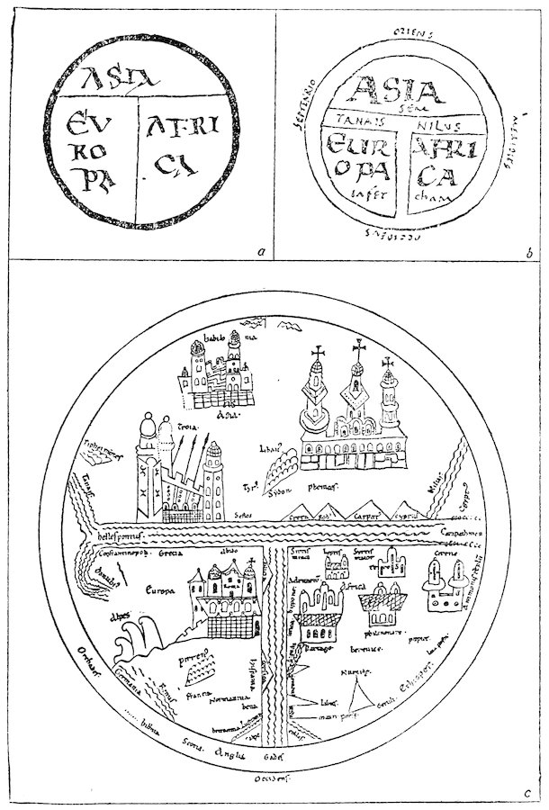
Fig. 1—Types of T-O and Sallust maps. (Figs. 1a and 1b from Santarem, Essai, 1849–1852, atlas, vol. i, pl. 5, figs. 5 and 1; Fig. 1c from Miller, Mappaemundi, vol. iii, 1895, fig. 43.)
68
Sallust Maps
Closely akin to the T-O maps, but somewhat more elaborate,
are the sketches of the third group (Fig. 1c). These accompany
manuscripts of Sallust’s works and may have been drawn to illustrate
a passage in Sallust’s De bello Jugurthino describing briefly
the countries of the known world. The T-O form is carefully
followed, but legends and pictures add a touch of life. The
oldest example (tenth century) is strictly classical and fails to
show Jerusalem, a stock feature in most medieval maps. Later
specimens reveal the influence of the Christian tradition, and
upon them Jerusalem figures as an immense church or castle.[295]
Beatus Maps
The fourth group is by far the most interesting. In the latter
part of the eighth century a priest, Beatus, of the Benedictine
abbey of Valcavado in northern Spain wrote a commentary on
the Apocalypse, destined to become very popular in later times.
To demonstrate graphically the division of the world among the
twelve apostles, which is spoken of in a passage included in this
commentary, either Beatus or one of his contemporaries drew a
map. Though the original of this is not now extant, no less than
ten subsequent maps for which it served as a model are preserved
in manuscripts of the tenth century and later. The researches
of Miller[296] have shown that three of these ten were probably
derived from a fairly full and faithful copy of the original, but
that the others represent merely a generalized outline. The best
example, the so-called St. Sever map, dating from about 1050
and now in the Bibliothèque Nationale at Paris, displays an
immense wealth of detail, legends, vignettes, and pictures of all
sorts (Fig. 2).
69
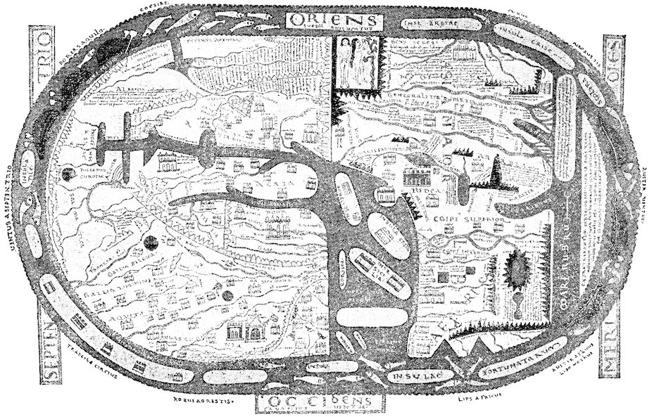
Fig. 2—St. Sever Beatus map. In the original, east is, as here, at the top. The geographical features (e. g. the Mediterranean, the Nile and its delta) may be recognized more readily, however, by viewing the map with north at the top. (From Miller, Mappaemundi, vol. i, 1895, colored reproduction in pocket.)
70
Limited Geographical Horizon in the Early Middle Ages
In the first chapter, under the heading “The Expansion of
Regional Knowledge,” was discussed the expansion of actual
knowledge of the earth’s surface, and a careful distinction was
made between that section dealing with actual knowledge and the
preceding sections of the chapter which had been concerned with
theories. We cannot make this distinction in speaking of the
regional geographical ideas of the early Christian centuries,
for fact and fancy were irrevocably blended. In the Greek and
Roman age knowledge of the earth’s surface was widened by
exploration, trade, wars, and conquests; but in the early Middle
Ages the limits of the accurately known world contracted, and
the ocean, Asia, Africa, even Western Europe itself, became
domains of legend and fable.
This does not mean that exploration, trade, and conquest did
not progress. Commerce in silk flourished in the sixth century
between Byzantium and the nations of Central Asia, and much
knowledge of those distant countries was thereby acquired in the
Greek world.[297] Between the eighth and the beginning of the
twelfth centuries the Northmen had penetrated in their open
ships to the innermost recesses of the White Sea[298] and westward
as far as Iceland, Greenland, and the shores of America.
Throughout the Middle Ages there was an intermittent flow of
pilgrims to and from the Holy Land. At a very early date the
Italian cities began to lay the foundations of their great Levantine
trade. Why, then, was geographic knowledge not enriched by
all this activity? There were many reasons. The spirit of the
age turned the scholar’s mind almost exclusively to religious and
theological matters. He felt no particular interest in voyages
unless they had some religious significance. He cared nothing
about the exploits of piratical Norse rovers in subarctic seas or
about things that Byzantine traders and diplomats might have
seen in the heart of Asia. Even if he could have read the
languages in which the stories of these discoveries were written,
he probably would not have troubled to investigate them. The
71pilgrim, forcing his way through hardships and privations to the
Holy Land, was certainly stirred by no interest in the geography
of the lands and seas through which he passed beyond that of
finding the best and quickest practicable route. Once arrived
in Palestine, he may have felt some slight enthusiasm about
studying out the topography of the sacred places. On the whole,
however, pilgrim narratives added as little to Western geographical
knowledge of the East as American soldiers’ letters during
the World War added to our geographical knowledge of France.
Medieval Conception of the Known World
The usual medieval conception of the known world was of
a circular or oval area, divided into three continents. Asia
occupied the eastern portion and was cut off from Europe by
the Tanaïs (Don) and from Africa by the Nile. The Mediterranean,
piercing the center of the western section, separated
Europe from Africa. The relative size of the continents was
variously represented; Asia was usually thought to be much
larger than either Europe or Africa. The two latter were
believed to be of about the same size.
Paradise
One of the principal Biblical contributions to medieval geography
was Paradise with its four rivers.[299] In the maps of the
period, the garden is drawn at the easternmost limits of the
world in accordance with the words of Genesis (ii, 8), “And the
Lord God planted a garden eastward in Eden.”[300] Martianus
Capella, however, by following a Greek tradition which placed
the Hyperboreans in a favored and delightful country of the far
north, caused certain of the Church Fathers to look northward
for Paradise.[301] Modeling their account of Paradise on the
Biblical description and on the ideal landscape of the Roman
poets,[302] the men of the Middle Ages conceived of the garden as a
deliciously cool and shady meadow, made beautiful with flowers
of many sorts, watered by murmuring streams, and redolent with
sweet odors.[303] Many theories were elaborated concerning the
surroundings of the forbidden garden.[304] In order that men be
72kept out, an impassable barrier must have encircled it. Some
believed that this was an immense wall; others, a ring of flames;
others, mountains and deserts. Some placed Paradise on an
island in the ocean; Cosmas removed it beyond the ocean to the
shores of unknown lands in the east; Augustine, Origen, and
Philo regarded it as allegorical and not real at all.
Rivers of Paradise
“And a river went out of Eden to water the garden; and from
thence it was parted, and became into four heads” (Gen. ii, 10).[305]
These four heads were the sources of the four rivers of Paradise:
the Pison, later thought to be either the Indus, the Ganges,[306]
or, sometimes, the Danube; the Gihon, or Nile; the Hiddekel, or
Tigris; and, finally, the Euphrates. It was a little difficult for
some persons at first sight to understand how all these rivers,
whose upper reaches were known in reality to be very far apart,
could actually spring from one source.[307] Many cosmographers
were even tempted to place Paradise in Armenia, near the known
sources of the Euphrates and Tigris. In general an appeal to the
simple theory of the existence of subterranean watercourses
sufficed to solve the problem and to explain the otherwise absurd
belief that the Nile had its headwaters in the far east beyond the
Red Sea.
Asia
Gog and Magog
Asia was frequently made the scene of Paradise and of the
creation of man. Here, too, medieval tradition placed Gog and
Magog,[308] whose advent at the Last Day should bring destruction
to the world. There are three different Biblical accounts of Gog
and Magog. On the basis of Genesis (x, 2), which makes Magog
a son of Japhet, a Jewish tradition conceived of this shadowy and
fearful personage as the progenitor of the Scythian tribes. In
the book of Ezekiel (xxxviii, xxxix) we read the prophecy of the
ravages and destructions of “Gog, the land of Magog, the chief
prince of Meshech and Tubal,” who should issue with his terrible
hordes from the north and bring death and devastation to the
lands of Israel. Finally, in Revelation (xx, 7) we are warned
73that “when the thousand years shall be finished, Satan shall be
loosed out of his prison, and shall go forth and seduce the nations
which are over the four quarters of the earth, Gog and Magog,
and shall gather them together to battle, whose number is as the
sand of the sea.” Here “Gog and Magog” are not the names
either of men or of a country, but rather of savage tribes. Most
medieval writers, following the Jewish tradition, thought of these
tribes as Scythian barbarians of the north—so Josephus, Jerome,
and Isidore, though Eusebius believed that they were Kelts,
and Jerome referred to a certain history which identified them
with the Goths; one chronicle even made the Aquitanians their
descendants.[309]
The apocalyptic story of Gog and Magog spread widely in the
Orient as well as through the Christian world. In the East,
curiously enough, it was made a part of the Romance of Alexander.
We read in the Koran[310] that the “two-horned Alexander”
built a great wall of bronze and pitch and brimstone, behind
which he enclosed the wild peoples of Yajūj and Mājūj (Gog and
Magog) until they should break forth on the day of the Last
Judgment. This story was probably told for the first time in
connection with Alexander the Great by Procopius in his De
bello Persico.[311] It formed one of the most important parts of
the immensely popular work, the Pseudo-Methodius, which foretold
with considerable detail the events of the Last Day.[312]
It entered into later versions of the Romance of Alexander itself,
although it formed no part of the versions of the Pseudo-Callisthenes
or of the translation of Julius Valerius.[313]
Romance of Alexander the Great
The Romance of Alexander, one of the most widely known of
the various cycles of medieval legend, deserves some comment
here because the scene of most of Alexander’s exploits was laid in
Asia. The Romance contains some fantastic geographical details
concerning the East in general and India in particular. The
classical stories of the monsters and marvels of these mysterious
lands are here preserved in attractive form. We meet with
Amazons and mermaids, griffons, and men who live on the smell
74of spices. We have a text of correspondence between Alexander
and the Brahmin king, Dindimus, in which the latter explains
to the Macedonian conqueror his religion and the simple habits
of the Brahmins.[314]
St. Thomas in India
India was also supposed in the Middle Ages to have been
visited by St. Thomas, the Apostle,[315] who was said to have
built therein a great castle for King Gundophorus. Though
little geography is to be gleaned from the apocryphal legends of
St. Thomas and St. Bartholomew in India and of St. Matthew
in Ethiopia, they served to carry the reader’s mind to distant
corners of the earth and are of passing interest to us because
certain elements of the story of St. Thomas became part of the
fabric of the great twelfth-century legend of Prester John. If
we are to believe the Anglo-Saxon Chronicle,[316] an Englishman
visited India in the ninth century, for we are told that King
Alfred sent a certain Sighelm to the shrines of Saints Thomas and
Bartholomew in A. D. 883.
Africa
Africa was utterly neglected. Unlike Asia, it did not become
the habitat of legend and fable. Supposedly of small extent and
made up mostly of desert, it failed to arouse much interest until
long after our period. The universal testimony of cosmographer
and cartographer during the entire age under consideration
was to the effect that the African continent stops well to the
north of the equator at the borders of the sea.
Europe
Europe was of course less a land of romance than Asia, but
geographical ideas concerning it were crude enough, as a glance
at any contemporary map or at the brief and dry catalogue of
facts given in the encyclopedic works will show. Isidore,
Orosius, and Bede added little to what classical writers had
already said. Local mythology tended to creep into the geographical
conceptions of the best-known countries and to blur
75what had been in classical times fairly distinct and clean-cut
conceptions.
Explorations to the North
In one quarter, however, to the north, the horizon of geographical
knowledge was immensely widened. The inner shores of the
Baltic, of which the Romans and early Christians had known
next to nothing, became from the eighth century familiar ground
to the Northmen. Furthermore, the widespread rovings of
these adventurous seamen carried them not only westward and
southward to harry Britain, France, and Spain and to penetrate
into the Mediterranean but also northward along the long stretch
of Norwegian coast. Alfred the Great appended to his translation
of Orosius an account of the journey in 890 of Othere of
Halogaland around the North Cape and into the White Sea even
as far as the shores of Biarma Land (near modern Archangel;
the word “Biarma” is said to be related to the Russian “Perm”).
In later years Norse expeditions visited the remote coasts of
Finnmark and Biarma, seeking trade and carrying war and
destruction.[317]
The Atlantic
The maritime wanderings of the early Irish and their successors,
the Northmen, gave rise to a circle of legends regarding
fabulous islands in the Atlantic and fabulous voyages among
them. The poetic imagination of both Kelt and Viking contributed
marvelously to the growth of these tales. Great and
often misguided ingenuity has been shown in modern times in
attempts to find the seeds of truth from which these stories may
or may not have sprung.[318] The most famous legend and the
one destined to exert the strongest influence on the imagination
of the future told of St. Brandan’s journeyings among enchanted
isles and fantastic seas to the west and northwest of Ireland.
Actual discovery in these quarters is recorded in the pages of the
ninth-century Dicuil, who narrates the finding of Thule by Irish
priests some thirty years before his time (825 A. D.) and describes
the cold of those regions and the long twilights at the time of
the summer solstice, when one day merges into the next.[319]
76The Northmen reached Iceland in 860 and settled there a few
years later; Greenland was discovered by them in 877, though
it was not colonized until the close of the following century.
America Reached by the Norsemen
Icelandic rovers also reached America in the latter years of the
tenth century.[320] The Landnámabók, compiled from an original
version written about 1200, tells how, about the year 983, Ari
Marsson “was driven out of his course at sea to White-men’s-land
(Hvitramanna-land), which is called by some persons Ireland the
Great (Irland-it-mikla); it lies westward in the sea near Wineland
the Good; it is said to be a sail of six doegr west of Ireland”
(Reeves’s translation).[321] Though we may not be certain whether
this brief passage is rightly to be interpreted as referring to
America, it is undeniable that soon after Ari Marsson’s discovery
the northeastern shores of our continent were visited by Biarni,
the son of Heriulf, and by Leif, the son of Eric the Red, and that
the latter were followed by Thorfinn Karlsefni and others.[322]
Sailing southwestward, these adventurers came to the shores of a
barren country of flat stones which they called Helluland; thence
they coasted southward past the forested Markland and past
long beaches and sand reefs, until they reached Wineland,
with grapevines, a mild climate, and savage inhabitants (or
Skraellings). From some of the latter, captured by Karlsefni in
Markland, the Icelanders learned that “kings governed the
Skraellings” and that “there was a land on the other side over
against their country which was inhabited by people who wore
white garments and yelled loudly and carried poles before them
to which rags were attached” (Reeves’s translation). This land
they identified with White-men’s-land, or Ireland the Great.
77
There is no necessity here of giving a general review of the very
broad field of Arabic geography. The works of the foremost
Mohammedan geographers, Al-Masʿūdī, Ibn Ḥauqal, Al-Iṣṭakhrī,
were unknown in Europe during the Middle Ages, and formal
Arabic geography certainly contributed next to nothing to the
knowledge of the earth possessed by the Occidentals of the
Crusading age.
Other branches of Arabic science, however, profoundly
influenced the development of European thought at this time.
As transmitters of classical learning to the West, the Saracens
reintroduced fragments of the geographical lore of the Greeks.
The two classical authors in whom they had taken the deepest
interest were Aristotle and Ptolemy. Their most important
contribution to Western geographical knowledge was to make
known to the West geographical speculations in the works of
these men and in the various treatises which the Moslem writers
themselves had composed under Peripatetic and Ptolemaic
influences.
Influence of Aristotle
Aristotle held a position of preëminent authority among the
Moslems in all matters scientific. Arabic scholars had received
his writings both through Syriac translations and direct from
Greek texts. Vast commentaries on his works were made by
Avicenna (Ibn Sīnā, 980–1037 A. D.) in the Eastern Caliphate
and by Averroës (Ibn Rushd, 1126–1198 A. D.) in Spain. Aristotelian
astronomy, as distinguished from Ptolemaic, was reproduced
with modifications in the work On the Sphere of Al-Biṭrūjī
of Cordova, known to the Christians as Alpetragius.[323]
By the end of the twelfth century, owing to the rising interest in
78Aristotelianism in Europe (the “flood of Aristotelianism,” as
Duhem calls it), translations had been done from the Arabic into
Latin of a large number of Aristotelian works on astronomy,
physics, meteorology, and many other subjects.[324] It was in
these works that most of Aristotle’s thought and observation in
geography had found expression. Aristotelian physical geography,
transmitted through these channels, was destined to
dominate the geographical speculations of many Christian writers
of the thirteenth century.
Influence of Ptolemy’s “Almagest”
The Moslems of the Eastern Caliphate also had become familiar
with Ptolemy’s Almagest and Geography through Syriac
translations and through versions of the original Greek text.[325]
A manuscript of the Kitāb al-Majisṭī, or Almagest, was translated
into Arabic in the days of Hārūn ar-Rashīd by that caliph’s
vizier, Yaḥyā, and other translations appeared during the middle
part of the ninth century. Study of the Almagest stimulated
Arabic scholars and incited them to write such original treatises
of their own as Al-Farghānī’s (Alfraganus’) On the Elements of
Astronomy, Al-Battānī’s On the Movements of the Stars, or Astronomy,[326]
and Ibn Yūnūs’ Ḥakīmī Tables.
Influence of Ptolemy’s “Geography”
Furthermore, Ptolemy’s Geography was certainly known to the
Moslems in Syriac translations and probably also in copies of
the original Greek text.[327] With the Geography as a model a
number of Arabic treatises, usually entitled Kitāb ṣūrat al-arḍ,
or Book of the Description of the Earth, were composed at an early
period of Islam and served as bases on which later geographical
writers built more complex systems. One of the most significant
was the Kitāb ṣūrat al-arḍ of Al-Khwārizmī, composed about the
time of Al-Maʾmūn (813–833 A. D.), the full text of which was
discovered forty-four years ago by Spitta.[328] From another book
of the same sort and title Al-Battānī derived the geographical
details included in his Astronomy.[329] The latter was translated
79into Latin during the twelfth century; and Al-Khwārizmī’s work
was known in Europe at second hand.[330]
Az-Zarqalī and the “Toledo Tables”
Ptolemy was studied in the western as well as in the eastern
centers of Islam. Toledo, notwithstanding its conquest by the
kings of Castile in 1085, long remained a scientific center, where
the Arabic spirit of investigation lingered on among Jew, Christian,
and Moor. It was largely through Spanish channels that
the Latin West found its Oriental inspiration in astronomy and
astrology.[331] About 1080 Az-Zarqalī, of Toledo,[332] who had devised
a new type of astrolabe, wrote various works on astronomical
subjects, including a commentary on a series of astronomical
tables that had been constructed by a group of Jewish and Moslem
scholars before his time.[333] These so-called Toledo Tables,
with Az-Zarqalī’s Canons explaining them, contained some incidental
geographical information derived in part from Ptolemy’s
Geography and from Al-Khwārizmī.[334] They were rendered into
Latin in the twelfth century by the famous Gerard of Cremona,
who probably found in Spain most of the manuscripts from which
he made his many Latin translations.[335]
Geography in Sicily
Ptolemy’s Geography was also studied in Sicily under the
Moslem emirs and their successors, the Norman kings. From
the eleventh century date several Arabic descriptions of Sicily
now known only in fragments but bearing eloquent witness to a
true enthusiasm for geography prevalent among the Moslem
aristocracy of the island.[336] The Normans, who became masters
of Sicily between 1060 and 1071, preserved much that was best
of Arabic traditions and culture, and Moslem scholars played a
brilliant part in the intellectual life of the court. Roger II
himself was a devotee of geography, occupying much of his spare
time in collecting Arabic geographical treatises and in questioning
travelers about distant parts of the earth. “He gave himself up
to this work tirelessly for fifteen years, never ceasing to examine
personally into all geographical questions, to search for their
80solution and to verify facts, in order that he might obtain in
complete form all the information that he desired” (from Jaubert’s
translation of Edrisi).[337]
Edrisi
At Roger’s instigation and with his aid Al-Idrīsī, or Edrisi
(as the name is more usually written), who had come to the
Sicilian court from Spain, undertook a great series of geographical
labors. Little is known of the life of Edrisi besides a few details
to be gleaned from later biographers[338] and what he himself tells
us in the preface to his Geography, as it is usually known, or, to
cite its Arabic title, The Recreation for Him Who Wishes to Travel
Through the Countries, which was completed in 1154 or later.[339]
We know that he constructed for Roger a celestial sphere and a
disk-shaped map of the world, both of silver. Furthermore,
we are told that Roger provided him with special facilities for the
construction of maps and for the compilation of his great treatise.
It appears that the king and Edrisi together selected “certain
intelligent men, who were despatched on travels and were accompanied
by draftsmen. Just as soon as these men returned
Edrisi inserted in his treatise the information which was thus
communicated to him.” On the basis of observations made in the
field, data derived from Ptolemy and earlier Arabic geographers
were correlated and brought up to date. The book and the
maps which were drawn to elucidate the book are for this reason
unquestionably among the most interesting monuments of Arabic
geography; furthermore, the book is the most voluminous and
detailed geographical work written in twelfth-century Europe.
After a very brief description of the earth as a globe, the hemispheres,
climates, seas, and gulfs, Edrisi launches into a long
and minute account of the regions of the earth’s surface. He
takes up the seven climates in order, dividing each climate into
ten sections, an arrangement that is artificial to excess. None
the less, Edrisi’s works are of exceptional quality when considered
in comparison with other geographical writings of their period,
partly by reason of their richness of detail but mainly because of
the scientific method used, the coöperative employment of many
81observers, and the critical correlation of their observations—a
procedure which was indeed unlike that adopted by Latin
scholars of the time.
Influence of Sicilo-Moslem Geography
The question of the full extent to which the fruits of this Sicilian
geographical school became known in the Latin Europe of the
late twelfth and early thirteenth centuries is a matter that awaits
further investigation.
Certainly the influence of Edrisi’s Geography could not have
been great in the world of letters or else traces of it would more
easily be detected in Western literature. Unlike a multitude of
Arabic writings of far less intrinsic value, the Rogerian Description
(as the Geography of Edrisi is often called) found no Gerard of
Cremona to put it into Latin, and the authoritative geographical
knowledge of the Western world was destined to develop unenriched
by the treasures which Roger and Edrisi together had
amassed.
On the other hand, there is no question but that the Sicilo-Norman
enthusiasm for geography exerted an indirect influence
on the evolution of geographical knowledge, an influence that
was to make itself felt more especially after the close of our
period. This enthusiasm for geography was the product of a
mingling of Arabic scientific and scholarly traditions with Norman
maritime enterprise in an island which occupied a central
position in relation to the world of its day. It was an enthusiasm
that arose partly from pure love of knowledge but also in very
large degree from the practical necessities of a sea-faring people,
and it was early applied to the solution of the problems of navigation.
In the words of De La Roncière, “The use of coast
charts was destined to become general in Sicily; a rational method
of navigation to be substituted for the routine of pilotage, and
thus the way was prepared for the progressive conquest of the
world.”[340] As De La Roncière goes on to point out, the Genoese
learned the arts of navigation from the Sicilians in the early
thirteenth century and transmitted them subsequently to the
Spaniards, Portuguese, French, and English; and a new science
82of the sea was developed upon the foundations originally laid by
Sicilian Moslems and Normans.[341]
Oriental Ideas Transmitted to the West
Besides the classical heritage, the Moslems also transmitted
some peculiarly Oriental ideas to the West. Al-Khwārizmī was
the author of a treatise with astronomical tables, the translation
of which by Adelard of Bath usually goes under the name of
Khorazmian Tables.[342] The original work was a redaction of a
book drawn ultimately from Hindu sources and known as the
Little Sindhind.[343] Thus it was from Hindu sources, as is shown
by this work, that the Mohammedans got their idea of the world
center of Arin. Hindu religion, furthermore, contributed something
toward the molding of Greek and Moslem doctrines of the
periodicity of the universe and of the Great Year—doctrines
which became widely known in the West through Hermann the
Dalmatian’s Latin translation of the Persian Abū Maʿshar’s
book, The Great Book of the Introduction, entitled in the Latin,
Liber introductorius in astrologiam.[344] Hindu influences were also
felt in an anonymous but widely read Arabic treatise falsely
attributed to Aristotle in the Middle Ages and called Liber de
proprietatibus elementorum.[345]
Turning now from the sources to the material substance of the
contribution of the Moslems, we find that, except in so far as
it brought a knowledge of Aristotle to Europe, it added little
to Western notions either of physical or of regional geography.
Though the Moslems entirely failed to share with the Western
World their wide practical acquaintance with lands and seas, the
Arabic writers did nevertheless introduce some new ideas in the
fields of astronomical—or, better, astrological—geography and
in the closely allied study of tidal phenomena.
The Great Years
The theory of the Great Years was very popular among the
Orientals, possibly because it appealed to their fatalistic spirit.
83Arabic astronomers adopted Ptolemy’s calculation of the length
of the Great Year at 36,000 terrestrial years[346] and seem to have
believed that after every complete revolution of the sphere of
the fixed stars, the planets, as well as the fixed stars, will find
themselves in the same relative positions that they held at the
beginning of the revolution.[347] The Arabic work on this subject
most read in the Latin West was Hermann the Dalmatian’s
translation of Abū Maʿshar’s book, in which it was explained that
astral influences—especially the perpetual circulation of the fixed
stars—are the cause of everything which is born and dies and of
everything which occurs between birth and death on this earth.
Cosmic Cycles and Geographical Changes
In much the same way that the Chaldeans, Hindus, and
Greeks had done, the Moslems worked out a theory of the
supposed influence of these cosmic cycles on geography.[348] The
most striking elaboration of the theory was made by the “Brothers
of Piety and Sincerity,” who formed a philosophical school
in the tenth century after Christ. In the great encyclopedic
work[349] produced by this school (which, incidentally, contains
many other interesting speculations on the subject of physical
geography) gradual alterations in the relative position of land
and sea are ascribed to almost imperceptible changes in the
longitude of the fixed stars resulting from the precession of the
equinoxes. Not only do lands and seas change places, but
various types of terrain; in the course of time “cultivated land
becomes desert, desert becomes cultivated land, steppes become
seas, and seas become steppes or mountains.”[350]
Whereas this curious theory was accepted by the Aristotelian
Al-Biṭrūjī, the author of the pseudo-Aristotelian Liber de proprietatibus
elementorum vigorously opposed to it the following
argument.[351] If the fixed stars revolve around the earth in 36,000
years, the land ought to revolve around the 34,000 miles which
he believed make the circumference of the earth in the same time,
or, as we may infer, at a rate of slightly less than a mile per
year. We should therefore expect to find certain cities much
nearer the coast and other cities farther from the coast than they
84used to be. The anonymous author says that if the theory were
valid one ought to be able to observe great changes in the position
of such places as Arin, Ceylon, Byzantium, and Rome in relation
to the sea. But since, as a matter of fact, no such changes
are apparent, the whole theory of the transposition of land and
sea falls to the ground.
Obvious as it may seem to us, this reasoning is remarkable at
a time when actual observation as a foundation for, or check on,
theorizing was rare indeed; and hence it is gratifying to note
that the Liber de proprietatibus elementorum with its argument
against the Great Year, rather than the encyclopedia of the
“Brothers of Piety and Sincerity” with its argument for it, was
the work on this subject that was read by Occidental scholars.
Theories of the Tides
The Moslems did not add much to the classical theories of the
tides which they transmitted to Christendom. Their fundamental
work concerning tides was that treatise of Abū Maʿshar
which we have already mentioned, a work from which, as Duhem
says, all the Middle Ages learned the laws of the ebb and flood.[352]
Here, in the chapters on the moon,[353] a full description is given of
the various characteristics of the tides together with copious
speculations regarding their causes. The actual observations
of fact were exact and careful. Abū Maʿshar explains with not
a little accuracy the relation of the tides to the moon’s rising and
setting, to her phases, and to the position of the sun; he understood
that winds might cause exceptionally high water; he
recognized the influences of local topographic features, that some
seas display different tidal phenomena from others and that the
flood waters may be retained by reefs, or valleys, or deep bays.
On the other hand, Abū Maʿshar’s treatment of the causes of
the tides was less successful. Though he believed firmly that
the moon produces the ebb and flood, he failed to account for
the presence of the high tide at the time of the moon’s opposition.
His explanation of the moon’s attraction of the waters was in
keeping with astrological methods of reasoning. Our satellite
was supposed by astrologers to be of peculiarly aqueous nature
85and for that reason exceptionally capable of governing the movements
of the liquid element of the earth.
Other theories of the tides entered the West from Arabic
sources. Al-Biṭrūjī’s On the Sphere ascribed their origin
not to the moon but to the general circulation of the heavens.[354]
Averroës, in a commentary on the Meteorology of Aristotle,
devoted a confused chapter[355] to an attempt at showing that ebb
and flood are the results partly of currents produced by differences
in level between the ocean and certain seas and partly of the
moon’s attraction of the waters. The possibility of differences
in level between seas and ocean had probably become known
to the Spanish scholar through some garbled rendering of Eratosthenes’
observations on the currents and levels of the Mediterranean.[356]
Measurement of a Terrestrial Degree
That the Saracens also were interested in the more strictly
mathematical aspects of astronomical geography is emphatically
proved by the fact that they undertook actually to measure the
length of a terrestrial degree[357] and thereby to determine the
circumference of the earth. Some knowledge of this great
work came to the Western world in our period through translations
of the Astronomy of Al-Farghānī.[358]
Geographical Positions
The Arabic investigations, however, which most profoundly
interested the men of the West were those concerned with the
determination of the location of places on the earth’s surface
rather than those whose aim was to find the size of the globe.
Stimulated by their interest in Ptolemy, the Moslems felt a
special need for the accurate knowledge of positions, for upon
such knowledge depended the construction of mosques, which,
according to religious law, must face in the direction of Mecca.
Astrology also necessitated this type of investigation. In order
to cast a horoscope one must know what stars are overhead at a
particular moment; and, to ascertain this, one must know latitude
and longitude. In the Arabic astronomic works there
86occur rules for determining positions and tables of the latitudes
and longitudes of places throughout the world.[359]
One of the most practical results of Arabic investigations
in this field was a reduction of Ptolemy’s exaggerated estimate of
the length of the Mediterranean Sea. The Greek geographer
gave the length as 62° or about half again too long. Al-Khwārizmī
cut this figure down to about 52°, and, if we are right in our
interpretation of the available data, Az-Zarqalī still further
reduced it to approximately the correct figure, 42°. As we shall
see in a later chapter, the results of these corrections became
known in the medieval West.[360]
The Moslems, as a general rule, measured longitudes from the
prime meridian which Ptolemy had used, that of the Fortunate
Islands (now the Canaries), situated in the Western Ocean at the
westernmost limit of the habitable earth; but individual writers
came to make use of another meridian farther west, a meridian
destined to become known to the Christian world as that of the
True West as distinguished from the supposed border of the
habitable West.[361] Abū Maʿshar, on the other hand, referred his
prime meridian to a fabulous castle of Kang-Diz, far to the east
in the China Sea.[362]
Arin
The western prime meridian was commonly supposed to be 90°
from a mythical city called Arin (or Arim) situated on the equator,
halfway between the farthest east and the farthest west.
This city was said to have neither latitude nor longitude, and its
meridian came arbitrarily to be placed at 10° east of that of
Baghdad. The idea of Arin probably originated among the
Hindus,[363] who believed that the city of Langka in Ceylon (or
perhaps Sumatra)—the abode of devils—lies on the equator.
They traced their prime meridian from Langka through Odjein,
a place in India, to Mount Meru at the north pole—the abode of
angels. Odjein was transliterated into Arabic as “Arin” or
“Arim” and was shifted by the Moslems to the equator. It was
made known to the Christian world through such works as Adelard
of Bath’s translation of the Khorazmian Tables (which, as
87we have already seen, was an Arabic redaction of a Hindu work)
and Plato of Tivoli’s translation of Al-Battānī’s Astronomy. In
the latter, Arin was represented as a cupola or tower; and on
Christian maps and diagrams of the Middle Ages it was not
infrequently so depicted.
This sums up briefly a few of the more significant original
ideas that the Moslems added to twelfth-century geographical
knowledge in the West. By way of contrast, it is not out of
place briefly to recall what they had actually accomplished in the
field of geographical investigation.[364] Moslem trade between the
seventh and ninth centuries reached China by sea and by land;
southward it tapped the more distant coasts of Africa, including
Zanzibar; northward it penetrated Russia;[365] westward Mohammedan
navigators saw the unknown and dreaded waters of the
Atlantic. Al-Masʿūdī speaks of the presence of Moslem traders
in the heart of Europe, in a country to which he gave the name
Ad-Dir (probably Bohemia).[366] Arabic literature abounds with
descriptions of the lands within these wide borders; of their
products and kingdoms and marvels, true and fanciful. But all
this was destined to remain a sealed book to the man of the
Latin Occident,[367] who as a rule felt little genuine interest in the
world beyond his immediate ken. He looked to Arabic books
for practical aid in making calendars and star tables and horoscopes;
he looked to Arabic translations and commentaries on
Aristotle for help toward a better understanding of the dark
and hidden meaning in the words of Scripture. The geographical
knowledge which he acquired from the Moslems during our
period was merely incidental to other interests, a sort of flotsam
borne in on the great wave of astrologic and Aristotelian lore
sweeping into Europe at this time.
88
To gain anything approaching complete understanding of the
status of the geographical lore in Western Europe during the
Crusading period, one would be obliged to undertake the colossal
task of ransacking practically all the available literature of this
age. From an examination of selected specimens of various
types of document, however, we may arrive at a fairly correct
conception of the kind of geographical thought and information
that was current. Certainly our view of the subject would not
be materially modified by the further accumulation of illustrative
examples. We must, none the less, look to a large variety of
sources: to the writings of theologians, philosophers, historians,
chroniclers, and topographers; to maps, poetry, romances, and
even to works of art. These show us what the sedentary man of
the Middle Ages could learn of geography through reading and
study. Pilgrim narratives, letters, commercial and diplomatic
treaties, and many other miscellaneous documents throw light
upon the actual extent of travel during this century and a half.
Writers of the Middle Ages did not specialize as we do at the
present day. They treated subjects of the most diverse nature
within the pages of the same book. We shall group their productions
into a few broad categories: philosophical and theological
writings that were read for the most part by the scholar and
churchman; translations from Arabic scientific treatises and
other works written under Arabic influence; encyclopedic
compilations or attempts to encompass the whole range of
human learning, also for the scholar, and popularizations of these
in prose and verse for the intelligent layman; histories and
chronicles; pilgrim narratives and other records of travel;
topographical works; and, finally, maps.
Other more instructive classifications might well be made.
89One in which the works were grouped according to the type of
thought of which each is the expression might bring out the
conflicting intellectual crosscurrents of the age. In such a
classification the great differentiation could be emphasized
between writers bound by respect for authority and writers of
originality and independence; between those who interpreted
the words of Scripture literally, those who interpreted them
allegorically, and those who went so far as to neglect or to doubt
them. The classification which follows, based upon the purposes
which the various groups of writings were intended to serve,
is merely one of convenience.
The distinction between theology, philosophy, and the physical
and natural sciences was not sharply drawn during the earlier
Middle Ages. Only after the ninth century did the tendency
to mark off theology and philosophy as separate spheres of
thought become gradually evident,[368] and it remained for a much
later age to set off the physical and natural sciences from philosophy.
Theological Works
Though not much geography is found in the strictly theological
writings of our period, those portions of them which deal with
the Creation embody cosmogonic and cosmographic speculations
which have a geographic character for reasons that have
already been explained.[369] Many of the philosophical writings, on
the other hand, are rich in passages of geographical interest;
for the physical geography, like the natural history, of the
Middle Ages was the province of the philosopher.
Peter Abelard
Among the outstanding theologians of the twelfth century was
Peter Abelard (1079–1142), whose tragic history is well remembered.
In his Expositio in hexaemeron, Sermones, and more
famous Sic et non we find a few scattered observations of a
geographical character. Though Abelard’s fame rests upon the
keenness of his reasoning and the destructive brilliance of his
90dialectic, his position when dealing with the Works of the Six
Days was that of mystic.[370] We shall have occasion to see how the
geographical passages from his works reveal a love of elaborate
allegory.
Hugh of St. Victor
The monastic school of St. Victor in Paris was preëminently a
center of twelfth-century mysticism.[371] A leading figure here was
Hugh of St. Victor, who held the direction of studies after about
the year 1125 and who enjoyed during his lifetime (he died in
1141) a great reputation for learning in things divine.[372] Among
Hugh’s writings we find Adnotationes elucidatoriae in Pentateuchon,
containing speculations on the Creation, and the curious
treatises De arca Noë mystica, De arca Noë morali, and De vanitate
mundi,[373] which display a love of symbolism and include the
exposition of a strange theory of the westward course of the tide
of civilization.[374]
Hildegard of Bingen
Hildegard (1098–1179 or 1180), abbess of a Benedictine convent
near Bingen on the Rhine, was another lover of the symbolic.
Her mystic exaltation took the form of visions in which were
revealed to her the secrets of the universe. With the knowledge
thereby attained she served her fellow man as a prophetess and
healer of disease. Besides a series of letters, she wrote three
works recording her visions: Scivias sive visionum ac revelationum
libri tres (1141–1150), Liber vitae meritorum (1158–1162), and
Liber divinorum operum simplicis hominis (1163–1170). She was
also probably the author of two treatises, Subtilitates diversarum
naturarum creaturarum and Causae et curae, which, though not
avowedly the record of visions, could hardly have been written
except as the result of some form of religious experience.[375] Her
“cosmology and physiology,” as Thorndike points out, were
none the less in essential conformity with “the then prevalent
theories of natural science” although she “displays no little
originality in giving a new turn to the familiar concepts.”
She does not, however, “evolve any really new principles of
nature.”[376]
91
Peter Lombard and Peter Comestor
To turn from the imaginative and visionary writings of
Hugh and Hildegard to the more coldly intellectual theology
and philosophy of the age, we find in the Sic et non of Abelard
the first example of a new method of handling philosophical and
theological questions. This so-called didactic method was
destined to find its culminating expression in the mighty volumes
of Thomas Aquinas. Its essence was to incite discussion by
placing in juxtaposition divergent and contradictory Scriptural
and patristic texts on the same subject. Abelard did this in the
Sic et non without giving interpretations of his own. Peter
Lombard (died 1164), who in his Sententiae followed Abelard’s
method, usually gave in addition his own views on a subject,
though not infrequently the reader was left faced by two or more
conflicting theories. It might almost be said that the Sententiae
served to standardize the orthodox doctrine of the age. Shortly
after Peter Lombard’s death Peter Comestor (the “eater”), at
one time dean of the cathedral church in Troyes and lecturer in
Paris, produced an extensive treatise entitled Historia scholastica.
This compilation of commentaries on Scripture enjoyed an
immense popularity at a later period, especially towards the close
of the thirteenth century.[377] Comestor, like Peter Lombard,
represented the more orthodox point of view.
The School of Chartres: Its Intellectual Independence
Unusual intellectual independence was displayed during the
twelfth century by the philosophical writers of the school of
Chartres[378] and by those who came under their influence. Well
known early in the eleventh century, this cathedral school had
acquired, in the first half of the twelfth, a European reputation,
founded on the boldness and originality of its masters and on
the widespread influence which they exerted through their
pupils and associates.
Bernard and Theodoric of Chartres
Two brothers stand out preëminently among them, Bernard
and Theodoric (or Thierry). Very little in detail is known
92about the life of either. Bernard was probably born late in the
eleventh century and was chancellor between 1124 and 1126.[379]
He enjoyed an immense reputation and was called by John of
Salisbury the most perfect Platonist of his century.[380] It seems
likely that he died before 1130 and was not the same man as Bernard
Sylvester of Tours, with whom he has often been confused.[381]
We know even less of Theodoric, who enjoyed a contemporary
fame as great as, if not even greater than, that of his brother.
Theodoric was mentioned by a disciple as the foremost philosopher
of the whole of Europe.[382] Master of the school (magister
scholae) in Chartres in 1121, the successor to Gilbert de la Porrée
as chancellor in 1141, he produced a large work on the seven
liberal arts (the Heptateuchon) and a treatise describing the
Creation.[383] The latter, entitled De sex dierum operibus,
was in many respects unique, representing a remarkably rationalistic
discussion of a subject in the treatment of which any
display of reason or independence almost inevitably was deemed
heresy.[384]
Adelard of Bath; Hermann the Dalmatian; Robert of Retines
Bernard and Theodoric maintained scholarly connections
throughout Western Europe and counted many famous men
among their disciples. The Englishman Adelard of Bath[385] belongs
to their broader circle, for it is likely that he was acquainted
with the Chartres scholars, at least by reputation, and his important
work, Quaestiones naturales[386] (dating from between 1107
and 1142), shows that he held many ideas in common with the
most famous of Bernard’s pupils, William of Conches. In his
wide travels[387] and in his translations from the Arabic[388] Adelard
exemplifies another phase of the awakening intellectual life of
the age, a turning to Moslem literature for new sources of information
and inspiration beyond the standard and easily available
collections of classical, Scriptural, and patristic authorities.
Among the disciples of Theodoric may also be counted the
travelers and translators from the Arabic, Hermann the Dalmatian
(or Hermann the Carinthian) and Robert of Retines, to
whose translations we shall later have occasion to refer.[389]
93
Bernard Sylvester
Very closely akin in spirit with the scholars of Chartres was
Bernard Sylvester, who taught at Tours in the fifth decade of the
twelfth century.[390] It has long been a moot point whether or not
Bernard Sylvester was the same as Bernard of Chartres. There
are very potent arguments in favor of identifying them, among
the most convincing being the remarkable manner in which
the philosophy of the De mundi universitate (or Cosmographia
turonense),[391] written by Bernard Sylvester between 1145 and
1148, gives expression to theories which John of Salisbury ascribes
to Bernard of Chartres. Yet, despite these extraordinary
similarities, the weight of evidence seems opposed to the theory
that the two names refer to the same man.[392] In any case, if
Bernard Sylvester was not the brother of Theodoric of Chartres,
he was acquainted with Theodoric and with the latter’s work,
for it was to Theodoric that he dedicated the De mundi universitate.
William of Conches
Another member of the Chartres group, William of Conches,
was a disciple of Bernard of Chartres in his youth. He taught
at Chartres probably as early as 1126. Between 1140 and 1150
he acted as tutor to the young Henry and Geoffrey Plantagenet.[393]
Hauréau says that William believed that “la philosophie tient
subordonnées à ses principes généraux, comme deux sciences
subalternes, la théologie et la physique.”[394] His most significant
book, the De philosophia mundi,[395] throughout exemplifies this
attitude and reveals to us a mind deeply interested in physics and
natural science for their own sakes and a desire to explain the
phenomena of the universe according to natural and observable
laws. The rationalism of his philosophy brought him into
conflict with the ecclesiastical authorities and necessitated his
retracting various opinions late in life.[396] He died either in 1150
or 1154.
Alexander Neckam
The scholars of the Chartres group formed the intellectual
élite of their age. More in keeping with the normal habit of the
94period than their mode of thought was the manner in which
the Englishman Alexander Neckam dealt with matters of natural
science. Born in 1157, Neckam had become a professor at the
University of Paris by 1180; later in life he returned to England,
became abbot of Cirencester in 1213, and died in 1217.[397] His
principal works were De naturis rerum, in prose, and a verse
paraphrase and enlargement of it entitled Laus sapiencie divine,
or De laudibus divinae sapientiae.[398] In these works we see that
Neckam, though inspired by a lively curiosity and even by some
degree of understanding of experimental and observational
science, was on the whole less original and less courageous
intellectually than either Theodoric of Chartres or William of
Conches. Instead of trying to explain rationally the phenomena
of nature as these earlier writers had done, he was nearly always
content merely to describe these phenomena as facts and to draw
lengthy moral lessons from them.
These are merely a few characteristic representatives of the
host of theologians and philosophers of the twelfth and early
thirteenth centuries. Their works serve to illustrate widely
diverse tendencies of thought: the heretical independence of the
scholars of Chartres as contrasted with the mysticism of Hugh
of St. Victor, the orthodoxy of Peter Lombard and Peter Comestor,
and the cautious inquisitiveness of Alexander Neckam.
Though these men differed in mental caliber, their learning was
based almost exclusively on the Latin writings of classical and
earlier Christian authors, and most of their geographical knowledge
was borrowed from the sources we have discussed in Chapters
I and II. But our period was also memorable by reason of the
influx of a new body of learning destined to bring about profound
modifications in the methods of European scholarship and to add
materially to the sum total of European knowledge. This new
body of learning was made available through translations from
the Arabic.
95
The enthusiasm for the work of translation which prevailed
during our period foreshadowed a far broader enthusiasm of the
same sort that marked the great age of the Renaissance. Only
a relatively few scholars, however, were familiar with Greek; and
the number of direct translations from the Greek was limited.[399]
The men of the Crusading age received the results of Greek
scientific investigation primarily through the medium of the
Moslems.
We saw in Chapter III how the Moslems had translated certain
works of Aristotle, of Ptolemy, and of the Hindus and had themselves
composed sundry treatises under Peripatetic, Ptolemaic,
and Hindu influences. Many of these Arabic translations, in
turn, were converted into Latin by Occidental scholars of our
period.[400]
Western interest in Moslem science centered at first on the
translation of astronomical and mathematical treatises and
somewhat later on Arabic versions of Aristotle. Indirectly
through both of these channels important geographical conceptions
gained currency in Europe.
Adelard of Bath; Peter Alphonsi
Among the early translators of astronomical and mathematical
treatises was Adelard of Bath, whose connections with the school
of Chartres we have already mentioned. Through Adelard’s Latin
version of the so-called Khorazmian Tables[401] of Al-Khwārizmī,
made in the year 1126,[402] knowledge of the Hindu conception
of a world center, Arin, was introduced into Europe. The
Khorazmian Tables had found their way to Spain by the beginning
of the eleventh century and were there adapted from the era
of Yezdegerd to that of the Hejira by a certain Maslama al-Majrīṭi
of Madrid.[403] In addition to Adelard’s version of Maslama’s
work, there is reason to believe that the Khorazmian
Tables were also put into Latin by Hermann the Dalmatian.[404]
96A contemporary of Adelard of Bath was the Jew, Peter
Alphonsi[405] (or Petrus Anfusi), who was baptized in 1106 at the
age of forty-five and subsequently became an ardent devotee of
Christianity. His Dialogus cum Judeo contains references to
Arin and a few significant observations on astronomical geography.
John of Seville; Plato of Tivoli
In 1135 John of Seville (also known as Johannes Hispanensis,
or John of Luna) translated Al-Farghānī’s On the Elements of
Astronomy,[406] a work from which John of Holywood borrowed
much of the materials that he incorporated into his De sphaera
and which thereby was fated to produce a profound effect on
the future development of astronomical geography during the
later Middle Ages. Gerard of Cremona also translated the same
work.[407]
From about 1140 dates Plato of Tivoli’s version of the Astronomy
of Al-Battānī,[408] a close rendering into Latin of Al-Battānī’s
chapters on the theory of astronomy but not of the astronomical
and geographical tables that followed in the original Arabic.
Our interest in the chapters lies in the fact that they contain
(Chapter 6) a brief general description of the inhabited earth
widely differing from those found in contemporary Latin geographical
works.
“Marseilles Tables” and “Toledo Tables”
Preserved in a twelfth-century manuscript of the Bibliothèque
Nationale is a set of astronomical tables for Marseilles dating
from 1140, the work of a certain Raymond of Marseilles.[409] The
Canons, or introductory explanation, of these tables are drawn
largely from the astronomical Canons of Az-Zarqalī;[410] the tables
are an adaptation for the meridian of Marseilles of the Toledo
Tables. Both Az-Zarqalī’s Canons and the Toledo Tables, with
their modifications like the Marseilles set, contained not a little
incidental material of importance from the point of view of
astronomical geography, including a list of cities with their latitudes
and longitudes derived ultimately from Al-Khwārizmī.[411]
That this material enjoyed wide popularity during our period
97and later is proved by the existence of a large number of manuscripts.[412]
One of the translations of Az-Zarqualī’s Canons was
done by the hand of the famous Gerard of Cremona, as we have
already seen in Chapter III.[413]
Robert of Retines; Hermann the Dalmatian; Daniel of Morley
It is almost certain that before 1143 the Astronomy of Al-Battānī
was again put into Latin, this time by Robert of Retines[414]
(or Robert of Chester). We do not, as in the case of Plato of
Tivoli’s version, possess the text of this translation, though we
have what was probably Robert’s adaptation to the meridian
of London of Al-Battānī’s and Az-Zarqalī’s astronomical tables.
This adaptation, for 1149–1150, forms a continuation of tables
for the meridian of Toledo in 1149.[415] Furthermore, Al-Battānī
is cited, and some of the geographical ideas expressed in his
Astronomy are reflected, in the as yet unpublished Liber de essentiis
of Hermann the Dalmatian, who was a close associate of
Robert and a student of Theodoric of Chartres. The Liber de
essentiis was written at Béziers in 1143.[416] Robert also adapted
Adelard’s Khorazmian Tables to the meridian of London.[417] Another
Englishman, Roger of Hereford, was probably the maker of
tables for the meridian of Toledo and certainly of a series for
Hereford dating from 1178, based on tables for Toledo and Marseilles.[418]
Towards the end of the century, still another Englishman,
Daniel of Morley, journeyed to Spain in search of Arabic
astronomical lore. Here, at Toledo, he came in contact with
Gerard of Cremona. On his return to England he took with him
“a precious multitude of books” and, “to explain the teaching of
Toledo to Bishop John of Norwich” (1175–1200),[419] wrote a work
called De philosophia, or Liber de naturis inferiorum et superiorum,
the astronomy of which, as in the case of John of Holywood’s
De sphaera, was mainly based on the writings of Al-Farghānī.
Gerard of Cremona; John of Holywood (Sacrobosco)
At about the same time, Gerard of Cremona produced a short
independent treatise, the Theorica planetarum,[420] which became a
98stock text from which later writers borrowed extensively. This
is merely a summary of the Almagest, produced apparently
before Gerard made his famous translation of that great work in
1175,[421] and is of interest to us because it contains an account of
methods of transposing astronomical tables to different longitudes.
It had certainly been read by the author of the London
tables of 1232,[422] a set which, in addition to being of astronomical
value, contains a few incidental notes of geographic importance.
The De sphaera[423] of John of Holywood (also known as John of
Halifax, or John Sacrobosco), dating from the very end of our
period, includes citations from Al-Farghānī’s Astronomy as well
as from classical authors and was the most influential work in the
field of astronomical geography of its century, though the intrinsic
value of its contents was not great.
Aristotelianism Introduced Through Arabic Works
The translators of Arabic mathematical and astronomical
works during the twelfth century prepared the way for an event
of the first magnitude in the intellectual history of the Middle
Ages—the reintroduction of Aristotelian learning into the West.[424]
It would lead us far beyond the bounds of this study to try to
discuss the immense influence of Aristotelianism on the development
of European philosophy and theology in and after the thirteenth
century. Something of the geographical content of
Aristotle’s writings on physics and natural science, however, was
indicated in Chapter I, and it was during the closing years of the
twelfth and the beginning of the thirteenth centuries that these
works began to gain a hold on European thought. Their
influence at this time was for the most part exerted through
roundabout channels: probably in some cases through Latin
translations of Arabic translations from the original Greek;
unquestionably in others through Latin translations of Arabic
translations of Syriac translations from the original Greek; and
in still others through Latin translations of Arabic commentaries
on Aristotle or of works inspired by his writings. The desire or
ability to tap the sources of Aristotelian lore by direct recourse to
99Greek texts themselves was exceptional before the middle of the
thirteenth century.
The precise date when the Occident became acquainted with
the Physics and De caelo is a matter of some doubt. It is likely
that Avicenna’s version of these two books had been converted
into Latin at Toledo before the middle of the twelfth century by
Dominicus Gondisalvi,[425] who worked there under the patronage
of Archbishop Raymond, but the extent to which these early
translations influenced European science is a subject of controversy.
It has been suggested by Duhem that Latin translations
of Aristotle were known to the scholars of the Chartres
school, Theodoric, Gilbert de la Porrée, and William of Conches,
passages in whose works certainly reveal some familiarity with
Peripatetic theories.[426] On the other hand, there are no actual
citations of Aristotle which would enable us to prove that the
passages in question show first-hand knowledge of the books of
the Stagirite.[427] The fact that much Peripatetic thought had
been brought to the West through the writers of the late Roman
and earlier Christian periods often makes it difficult, in the
absence of actual citations, to distinguish between what had been
learned from these earlier sources and what was contemporaneously
derived from the Moslems.
Gerard of Cremona
We are on much firmer ground when we turn to the work of
Gerard of Cremona,[428] for we know as a fact that before his death
in 1187 this indefatigable translator had put into Latin, of the
works of Aristotle of geographical interest, the first three books
of the Meteorology,[429] the Physics, the De caelo et mundo,[430] and
the De generatione et corruptione.[431]
Michael Scot
Michael Scot, who died in 1236[432] and was remembered by later
ages as a great magician, was another student of Aristotelian
science. After studying in Spain this Scotsman became court
astrologer of the Emperor Frederick II in Sicily. He learned
Arabic and composed treatises on astronomy, astrology (Liber
100introductorius and Liber particularis) and physiognomy under
the influence of Moslem learning. He also undertook the
translation of sundry works on alchemy and astronomy, among
them the treatise of Al-Biṭrūjī, based on Aristotelian astronomy,
and Aristotle’s De caelo with Averroës’ commentary. Associated
with the Liber particularis we have the text of a questionnaire[433]
which Frederick II presented to Michael and which reveals
something of that versatile Emperor’s burning interest in
cosmology and physical geography. The philosopher’s “brief
statements” in reply “concerning hell, purgatory, heaven, and
the terrestrial paradise are followed by an account of the marvels
of nature—strange lakes and rivers of the East, wondrous metals,
stones, plants, drugs, and animals, with their respective virtues”
(Haskins).[434] Michael in this connection also gives expression to
familiar, traditional opinions on the earth as a sphere, though he
includes some original observations on volcanoes and hot springs.[435]
Aristotelianism in the Thirteenth Century
By the time of Michael Scot Aristotelian theories of physics
and of physical geography as introduced through Moslem channels
were finding fairly general currency in the West. Arnold
the Saxon, for instance, in his encyclopedic treatise written perhaps
about 1225, gave citations from the De caelo et mundo, the
Meteorology, and the Physics, as well as from Averroës and other
Arabic admirers of Aristotle.[436] Aristotelian cosmology, astronomy,
and metaphysics, however, were not accepted by
Western scholars until after a strenuous intellectual battle had
been waged over them. Serious efforts were made to place these
teachings forever under the ban of the church. In 1210 and
1215 strict prohibitions against the study of the Averroïstic
versions of the Physics and Metaphysics were issued by the
authorities of the University of Paris.[437] This shows that by
that time not only had the commentaries of Averroës been
translated but that they must have become popular.[438] Indeed,
the popularity of Aristotle and Averroës was destined to increase
despite all prohibitions, and after their works, by the middle of
the thirteenth century, had been purged of objectionable matter
101by the ecclesiastical authorities, they became prescribed studies
in the curriculum of the University of Paris. Aristotelianism
dominated the scientific thought of the late thirteenth and
fourteenth centuries; and the physical geography of the great
encyclopedist, Albertus Magnus, was largely based upon it.
Albert, indeed, was sometimes unjustly called Aristotle’s ape.
Opponents of Aristotelianism
On the other hand, there were many individuals who, though
accepting the teachings of Aristotle and his Arabic commentators
in regard to specific facts and theories, were none the less sternly
opposed to blind and uncritical adoption of them.
William of Auvergne
William of Auvergne, bishop of Paris from 1228 to his death
in 1249, was leader of the ecclesiastical party that stood out
against the study of Aristotelian philosophy and theology in
that city. It was nevertheless true, as Duhem tells us, that
William’s erudition “had received in abundance additions from
sources which had not enriched the erudition of earlier centuries:
that is from the works of Aristotle and Arabic authors.”[439] The
De universo of William contains much material on cosmology
and natural history.
Robert Grosseteste
The great English churchman, Robert Grosseteste, bishop
of Lincoln from 1235 until his death in 1253, presents an even
more striking example of the scholar, well read in Aristotelian
and Arabic learning, who was prone to question many of the
Peripatetic doctrines. Grosseteste deserves a high place in the
history of medieval science by reason of the depth of his scholarship
and the originality of his ideas. His style, however, is
often difficult and obscure. From the geographical point of
view several of his treatises are of unusual interest. The De
sphaera is devoted to problems of astronomical geography. In
the De impressionibus aëris seu de prognosticatione rules are laid
down for the preparation of weather forecasts based upon astrological
102considerations. The De luce seu de inchoatione formarum
explains Robert’s theory of the Creation. The De natura
locorum, in which the influences of celestial rays upon the earth’s
surface are discussed, gives expression to many views that were
elaborated in fuller detail by Robert’s more famous pupil and
intellectual successor, Roger Bacon.[440]
Our period was marked by the production of encyclopedic
works the object of which was to bring together as much human
knowledge as possible in convenient, readable, and, frequently,
in popular form. These encyclopedias carried on the traditions
of Pliny, Solinus, Isidore, Bede, and other earlier writers and for
the most part were lacking in originality. Made up of paraphrases
and word-for-word excerpts from older books, they
exemplify better than any other type of literary production the
respect which the man of the Middle Ages felt towards the authority
of the written word and his lack of critical acumen.
Their immense popularity shows that they satisfied a distinct
want: the lore contained in them, however worthless and puerile
it often may seem to us, formed an important part of the intellectual
cargo of the medieval mind. It is imperative, therefore,
that representatives of this type of work should be consulted by
anyone who wishes to arrive at a just estimate of the status of
medieval knowledge.[441]
Most of the geography of the encyclopedias was a geography
handed down from classical times, a geography but distantly
related to contemporary facts and one in which fabulous elements
tended to persist and multiply at the expense of sound and accurate
information. Yet it was the geography of the majority
of the lettered men, and the man who did not himself actually
travel found here practically the only convenient means of
learning about the countries of the world. He might pick up
occasional details of routes to Rome and Palestine from pilgrims,
traders, or soldiers; but only in the pages of the encyclopedias
could he find anything approaching a systematic treatment of
the earth and its various parts.
103
“De Imagine Mundi”
The most widely read book of this nature was the De imagine
mundi, which dates from about 1100. Though this has often
been attributed in recent years to Honorius of Autun (it has also
been ascribed to St. Anselm and with far greater probability to
an unknown Honorius Inclusus), the evidence at hand is insufficient
to warrant us in coming to any definite conclusions on the
vexed question of its authorship.[442] The general character of the
compilation is illustrated by a remark at the close of the dedicatory
letter: “I place nothing in this work except that which is
approved by the best authorities.”[443] The main source of the
geographical chapters was the Etymologiae of Isidore, though the
author also drew directly from Orosius.[444] It seems likely,
indeed, that the geographical chapter of Orosius served as a basis
for the entire compilation and provided an outline which was
embellished by copious excerpts of detail from the more elaborate
writings of Isidore, Augustine, and Bede. Furthermore, it is
even probable that the unknown author had a map before him.[445]
He appears to have borrowed directly from the Collectanea rerum
memorabilium of Solinus his account of the marvels of India,
though elsewhere he taps Solinus at second hand through the
medium of Isidore.[446]
Lambert’s “Liber Floridus;” Guido’s Encyclopedia
Dating from approximately the same period is a similar work,
the Liber floridus of Lambert. Practically all we know of the
author is that he was a canon of St. Omer early in the twelfth
century.[447] His book, a hodgepodge of notices, geographical and
otherwise, from Isidore, Bede, Martianus Capella, Raban Maur,
and others, though it did not enjoy popularity comparable to
that of the De imagine mundi, nevertheless by no means lapsed
into obscurity during the centuries that followed. There are at
least eight manuscripts of it preserved in the libraries of Europe,
and it was referred to with high praise by writers of the thirteenth
century.[448] The manuscripts are illustrated by crude maps,
among the few remaining relics of twelfth-century cartography.
104Of much the same nature is an encyclopedic compilation made
by a certain Guido, probably an Italian, in 1119.[449] It contains
excerpts from a variety of sources, including Isidore, the Romance
of Alexander, Paul the Deacon, and, more especially, the anonymous
Ravenna geographer.
“Lucidarius”
The De imagine mundi became an important source for later
writings. It was a standard authority during the closing years
of the Middle Ages for those who deliberately undertook to give a
geographical description of the earth. The Lucidarius (or
Aurea gemma) was a popular encyclopedia written in German
towards the end of the twelfth century at the order of Henry
the Lion. Though embodying the peculiar and fabulous features
of the De imagine mundi, it omitted the drier but more correct
geographical and topographical details.[450] The principal source
of much of the natural science in the Lucidarius was William of
Conches’ De philosophia mundi. The Lucidarius was translated
at a later date into Danish, Dutch, and Bohemian,[451] and
from it were derived the geographical portions of the famous
Hortus deliciarum of the abbess Herrad of Landsperg.[452]
Gervase of Tilbury
Another widely read book that came under the influence of the
De imagine mundi was the Otia imperialia of Gervase of Tilbury,[453]
a protégé of Otto IV and by him appointed marshal of the
kingdom of Arles. The Otia, composed to entertain the emperor
during the leisure moments of his struggle with Frederick II,
is in large measure a compilation of facts, fables, and theories
borrowed from earlier works. The cosmological chapters are
drawn from Peter Comestor’s Historia scholastica, the geographical
ones from Orosius, Isidore, and, more particularly, the De
imagine mundi, which furnished a framework into which the
statements of the other writers were made to fit.[454] The large
number of manuscripts of the Otia bears witness to its great
popularity.
105
Jacques de Vitry
Jacques de Vitry, bishop of St. John of Acre until 1220, in his
Historia hierosolymitana[455] also borrowed from the De imagine
mundi, especially in describing Palestine and Asia. His interest
in the remarkable caused him to include, as had been done by the
authors of the German Lucidarius, most of the fabulous elements
of the earlier book as well as to add fabulous stories from other
sources. It was these stories, derived in part from the Historia
hierosolymitana and in part directly from the De imagine mundi,
that accounted for the great popularity of a poem to which we
must now turn.
“L’Image du Monde”
This poem, the Image du Monde,[456] destined to be read for over
three centuries, was decidedly the most important of the many
works that felt the influence of the De imagine mundi. Like its
Latin predecessor, it is an attempt at the popularization of
universal knowledge. The work of popularization, however,
was here carried to the stage of translation into a popular tongue,
which rendered the book available to a much broader circle of
readers. The style was vivid and not lacking in originality, and
the subject matter contained sufficient of the grotesque and unexpected
to assure the poem a long-lived success. Though the
question of authorship and exact date is a somewhat perplexing
one, it seems likely that the Image du Monde was partially
composed in Metz in 1245 or 1247 by a certain Gossouin and
within the following two or three years was added to either by
Gossouin himself or by a certain Walter of Metz, to whom the
entire work has occasionally been attributed.[457] Prior, however,
to the composition of the second verse redaction by Gossouin or
Walter, the poem had been put into a prose form,[458] from which
translations were subsequently made into Hebrew, Judeo-German,
and English (the last by Caxton in 1480).
“Konungs-Skuggsjá”
From the very end of our period there dates an Icelandic
dialogue of more or less encyclopedic scope, a work which might
106well be called a northern counterpart of the De imagine mundi.
This Konungs-Skuggsjá, or King’s Mirror,[459] written about the
year 1250 or perhaps as late as 1260, contains chapters that reveal
to us something of the status of Scandinavian knowledge of the
geography and natural phenomena of Iceland, Greenland, and
the Arctic seas. But, like the Sagas, so far as we know, it was not
translated into Latin or into the vernacular tongues, and the
type of knowledge contained in it remained until the great age of
discovery virtually the exclusive property of the peoples of
Iceland and of the far north of Europe.[460]
Great Encyclopedias of the Thirteenth Century
We cannot well leave the subject of encyclopedic compilations
without mentioning such gigantic thirteenth-century productions
as the Specula of Vincent of Beauvais,[461] the various writings of
Albertus Magnus,[462] and the relatively less ambitious popularizations
of Bartholomew Anglicus,[463] Brunetto Latino,[464] and others.[465]
The Opus majus of Roger Bacon is also encyclopedic in scope.
These great works contain a wealth of reference the systematic
study of which would unquestionably shed much additional light
on the substance of medieval geographical knowledge. The
innumerable pages of Albertus Magnus, indeed, show not a
little originality; and Roger Bacon stands somewhat apart from
his contemporaries as a fearless exponent of scientific method.[466]
On the whole, however, there is no very essential difference between
the geography of these men and that of their less well-informed
and perhaps less diligent predecessors. This is one
reason why we have felt justified in failing to treat them in
detail. Another reason is that adequate treatment of the
geography of the thirteenth-century encyclopedists would fill
another volume at least the size of the present one.
Dante
A figure, however, whom we cannot refrain from mentioning in
this connection, though he lived after 1250 and though his genius
far transcended that of any encyclopedist of any age, is Dante.
Much of the information amassed by the laborious compilers of
107encyclopedic works (especially Brunetto Latino) was fused by
the poet into the Divine Comedy and molded into his various
prose writings. The universality of Dante’s knowledge embraced
the geography and cosmography of his age. Though we
shall not attempt to deal with Dante’s geographical lore[467] in
the pages which follow, it would be a serious mistake to omit all
reference to one who flourished so soon after the end of our
period and who, besides being a poet of all time, was an outstanding
figure in medieval scholarship and, incidentally, in the
history of medieval geography.
The reader who wishes to investigate the geography of Dante
and of the encyclopedists of the thirteenth century will find brief
summaries and references in Notes 92–98 to the present chapter.
The writings of the historians and chroniclers of the Middle
Ages, though they do not as a rule include systematic expositions
of geography, nevertheless often contain incidental geographical
matter of no slight interest. The present section is devoted to
a very few selected specimens of historical narrative of the
Crusading age, whether prose or verse, that are of particular
significance from the geographical point of view.
Otto of Freising
Among the outstanding medieval historians was Otto of
Freising.[468] A man of intelligence and breadth, steeped in the
academic literature of his age, Otto, though never going out of
his way to write of geographical subjects, always maintained an
attitude of open and receptive interest toward all branches of
science. The range of his literary and scholarly learning is a
key to the intellectual attainments of the average man of the
world of his period. Born about 1114 or 1115 of a noble or even
royal family—his maternal grandfather was the Emperor Henry
IV—Otto studied in Paris probably early in the second quarter
of the century. After his return to Germany in 1132 or 1133,
he became a Cistercian and was subsequently made bishop of
108Freising. His principal works were a Chronicon, running from
the beginning of the world to the year 1146, and the Gesta
Friderici, recording the deeds of Frederick Barbarossa down to
the year 1156 and continued after that date by Ragewin (or
Rahewin).[469] Among other classical authorities Otto may have
used Seneca’s Quaestiones naturales: most of his geographical
ideas, however, were derived from Isidore and Orosius and from
certain unknown “topographers” whom he cites as giving details
on the rivers of Europe.[470]
Gunther of Pairis
On the Gesta Friderici was based an historical poem composed
about 1186 by Gunther of Pairis (in Alsace), of whom we know
next to nothing.[471] This work, the Ligurinus, adds little of material
nature to the sources from which it was taken, although the
poet converts the simple, straightforward narrative of Otto and
Ragewin into a poem vividly expressed. It has been shown that
the Ligurinus, even though the work of a German author, is a
typical product of the poetical school of France of the late
twelfth and early thirteenth centuries.[472] Where the writer
expands and converts into verse Otto’s and Ragewin’s words describing
natural features of the earth’s surface and geographical
regions, he displays a sense of color and a feeling for nature that
are striking,[473] even though the actual epithets employed are
hackneyed and drawn from well-known classical models. Furthermore,
in the description of Germany he departs so widely
from his literary sources that it seems more than likely that he
actually based his lines on personal acquaintance with the
country.[474]
Walter of Châtillon; William the Breton
Two other historical poems of the same school and of analogous
character to the Ligurinus are the Alexandreis[475] of Walter of
Châtillon (also known as Walter of Lille), written about 1180,
and the Philippis of William the Breton, published about 1225.[476]
These are Latin hexameter epics modeled on Virgil and Lucan;
full of allusions to Latin literature and mythology, they also
109show originality and a power of accurate description of scenes
and country.[477] The Alexandreis sings the deeds of Alexander
the Great; the Philippis the exploits of Philip Augustus of France.
Historians and Histories of the Crusades
Our period was the age of the reopening of the Levant and the
regions of the Black Sea to Western knowledge through the
Crusades and through the expansion of commerce that came in
their train. The historians of the Crusades, consequently,
furnish us with geographical notices of a kind differing from
the stereotyped and secondhand geography of the encyclopedias.
The items in the Crusaders’ records are often the results of
actual experience. They give us an impression of freshness
lacking in the pages of dry compilations like the De imagine
mundi. But the Crusaders were not geographers and were
without any true geographical instinct. They rarely felt an
interest in anything besides the immediate events they were
undertaking to describe or in matters not purely practical
or utilitarian.[478]
The most important work, from this point of view, is the
Historia rerum in partibus transmarinis gestarum of William of
Tyre (born 1130).[479] This covers events in Palestine and in the
Crusaders’ states during the years between 1095 and 1185 and
abounds in observations on the products and appearance of the
country, on the habits of the Arabs—whose language William had
probably learned[480]—and on other peoples of the East.
The Gesta regis Ricardi, which has sometimes been erroneously
ascribed to Benedict of Peterborough,[481] records the voyage of
Richard Coeur-de-Lion to the Holy Land in 1190. In the
description of the routes to and from Palestine[482] we find a wealth
of detail about the countries, isles, and seas traversed. The
distinctly nautical style and content in places make it seem not
at all improbable that a part of the book at least was derived
from some sailing manual. Roger of Hoveden in his Chronica[483]
(to the year 1201) made use of the same sources as those on which
the author of the Gesta regis Ricardi drew, though Roger’s account
is fuller and more detailed, especially regarding Spain. Another
110source for the Crusade of Richard Coeur-de-Lion is the Estoire de
la guerre sainte by Ambroise,[484] a professional writer, who took
part on the expedition and who described the Holy Land with
less understanding than William of Tyre almost exclusively
from the point of view of the sufferings and hardships experienced
by the Crusaders.
The Prise de Constantinople[485] of Robert de Clari, a history of
the Fourth Crusade by a participant, is the work of a man of
relatively humble estate but of a man who felt more or less
genuine interest in strange peoples and their customs. This
interest is manifested particularly by the data that he gives on
the Komans of the Russian plains, some of whom he undoubtedly
had seen on the streets of Constantinople.
A letter from the patriarch of Jerusalem to Innocent III,
entitled La devision de la terre de oultremer et des choses qui i sont,[486]
was composed about 1200 in reply to a request from the Pope
for information concerning the Saracen countries. In this
anonymous work a geographical sketch of Egypt and Palestine
shows that its author had no limited acquaintance with the
Moslem faith and the Mohammedan peoples.
Scandinavian Historical Works
The geographical knowledge acquired by the Crusaders became
the common property of all Western Europe. That which was
acquired by the Vikings, on the other hand, was disseminated
practically not at all among the peoples of the Latin West.
Brief mention, therefore, must suffice for the Scandinavian
sources, even though of all European folk the Vikings were the
most adventurous voyagers and their geographical horizon the
widest.
The introduction of Christianity marked the end of the heroic
age of Norwegian and Icelandic history. It also ushered in an
extraordinary period of literary productivity, the age of the
Sagas[487] and Eddas.[488] The composition of the Sagas began
in the twelfth and lasted on into the fourteenth century, but the
events which they relate occurred far back in pagan days. For
the most part bald but telling narratives of adventure, war, and
111litigation, they devote little space to comment or description;
and the numerous place names mentioned are referred to as if the
reader were already familiar with them.
The records of the farthest voyages of the Vikings to the shores
of Wineland the Good were not given the final written form in
which we now know them until after the close of the thirteenth
century.[489] On the other hand, the history of Iceland was told
by Ari Frodhi (1067–1148) in his Íslendingabók;[490] and the
chronicles of the settlement of the coasts of this isle and of the
discovery of Greenland are recorded in the Landnámabók,[491] or
Book of Settlements, the original of which probably dates from
the twelfth century. The famous Heimskringla of Snorri
Sturluson, the greatest of early Scandinavian historians, records
the history of the kings of Norway. Its title means “the Round
World,” and the prelude consists of a brief geographical description
of the principal countries of the world. The text includes
no less than sixteen Sagas, among them that of Sigurd the
Crusader chronicling an adventurous voyage (1109) of a king
of southern Norway to the Holy Land by way of the Strait of
Gibraltar and homeward overland. Scattered geographical
references are found in other Sagas and in the Icelandic[492] and
Greenland Annals[493] which, though written after our period,
throw light on events that took place before the mid-thirteenth
century.
Latin Histories of the North
Besides the Sagas, three historical works written in Latin by
Northern writers of our age deserve particular mention inasmuch
as they all contain geographical descriptions of the Scandinavian
world. The first of these is the history of Adam of Bremen.
On strictly chronological grounds Adam, who died about 1076,
belongs before the opening of the Crusading age. We shall
discuss him, however, among the historians of the twelfth and
early thirteenth centuries, to whose works his writings are more
akin in spirit than to those of the earlier Middle Ages. Adam
was canon of Bremen and master of the cathedral school of that
city in the time of the great Archbishop Adalbert, who had
112“made Bremen an Arctic Rome and his court the greatest center
of Northern learning” (Beazley).[494] The archiepiscopal province
of Bremen was the largest in the entire medieval church, including
all of Scandinavia, Iceland, Greenland, the Orkneys, the Faroes,
and the Hebrides. Adam was thus placed in a most favorable
position to gather together materials on the geography and
history of these northern lands. His great work (called sometimes
Gesta Hammenburgensis ecclesiae pontificum, sometimes
Historia ecclesiastica, and sometimes Bremensium praesulum
historia) is in four books, the last of which deals with the geography
of the North. Much of this was based on information
derived from contemporaries; but Adam was also well read in
Latin literature and often quotes and copies from the works of
Macrobius, Martianus Capella, Solinus, and Orosius.
From somewhat more than a century later we have another
Latin history of the Scandinavian North—if Saxo Grammaticus’
curiously heterogeneous combination of mythology, folklore,
poetry, and accurate observation deserves the name of history.
The first book of this work, known as the Gesta Danorum, contains
a formal geographical sketch of Denmark, the Baltic, the
Scandinavian Peninsula, and remoter countries and isles beyond
the Atlantic, wherein fact is blended with romance. There are
also occasional observations of geographical interest scattered
through the later books.
Finally, in an anonymous Historia Norwegiae dating from the
early thirteenth century we find an introductory passage on the
geography of the regions with which this history deals: a concise
description of Norway is followed by briefer comments on the
tributary islands, Iceland, Greenland, the Orkneys, and the
Faroes. Especially interesting are the author’s observations
upon the volcanoes of Iceland. The contents show that, like
Adam of Bremen and Saxo Grammaticus, the writer must have
been familiar with the standard geographical books of the Middle
Ages, with Bede and Solinus, and perhaps with Isidore and Pliny.
The Historia Norwegiae, however, can never have enjoyed great
popularity, or else more than one manuscript would be known
at the present day.[495]
113
Many of the legends of our period contain material of geographical
significance, and a few of these may claim our particular
attention.
Romance of Alexander
The stories of Alexander the Great served to direct men’s
attention eastward, for, besides narrating the adventures of the
Macedonian conqueror, they gave, as we have already seen,[496]
details of a sort about the geography of Asia, particularly of
India.[497] Not only were the earlier Latin versions derived from
the Pseudo-Callisthenes paraphrased and copied by historians,[498]
but new elements were added to the cycle—notably the Iter ad
Paradisum,[499] an account of Alexander’s journey to Paradise.
Walter of Châtillon (or of Lille), about 1180, composed in the
style of Lucan a great Latin hexameter poem entitled Alexandreis,
based in part on the legendary stories of the Macedonian and in
part on the more authentic histories of Justin and Quintus
Curtius.[500] The widest currency, however, was given to the
Romance through its translation into the vernacular tongues.
The oldest French version, which covers the earlier portion of
the Romance only, was written by Alberic of Besançon (early
twelfth century?) in octosyllabic verse of the dialect of the
Dauphiny.[501] This was translated into German by one Lamprecht
and was rendered into the langue d’oïl in decasyllabic
form.[502] The Romance reached its highest vernacular development
in a version in alexandrines,[503] the joint composition of
Lambert li Tors of Châteaudun, Alexander of Bernai (or of
Paris), and Peter of St. Cloud. The existence of more than
twenty manuscripts testifies to the popularity of this great poem,
which is a sort of mosaic from various sources.[504] Much of it
came from the Pseudo-Callisthenes through the medium of
Valerius, the Epitoma of Valerius, Alberic of Besançon, and the
decasyllabic poem; but some elements can be traced back to
Orosius, Justin, Quintus Curtius, Eustatius, and Josephus, and
the texts show many later interpolations of unknown origin.
The Romance in alexandrines was drawn upon in its turn by
114later compilers. From the mid-thirteenth century there dates
a poem, probably by one Eustace of Kent, which incorporates
much material from this and other sources.[505] It includes miscellaneous
geographical elements; and certain of the manuscripts
are adorned with a wealth of magnificent miniatures, representing,
among other things, the marvels of India and all the fantastic
creatures encountered by Alexander throughout the East.
Prester John
During our period the belief was spread abroad in the existence
of a numerous Christian population in Asia. We find an account
of Christians in India in an anonymous report of the visit of a
certain Patriarch John of India to Rome in 1122, the authenticity
of which is apparently confirmed in a letter of Odo, abbot of St.
Remi in Rheims, to a certain Count Thomas.[506] Of far greater
importance was the fabulous story of Prester John. Belief in
this mighty Christian potentate and his immense kingdom may
be traced in large measure to the widely read Letter of Prester
John, dating in its earliest form from before 1177,[507] addressed
in some manuscripts to the Byzantine Emperor[508] and elsewhere
to other Western monarchs. The popularity of this is attested
by the fact that Zarncke, its editor, knew of no less than eighty
manuscripts. The question of the sources of the Letter in its
original form is obscure, though the origins of the numerous interpolations
can nearly all be explained. Much, certainly, was
borrowed from the Alexander stories, and much from the legend
of St. Thomas in India; other parts are indubitably connected
with the great Oriental reservoir of fabulous and miraculous lore.
The account of the visit of Patriarch John to Rome and the
Letter of Prester John constituted the principal sources of an
anonymous and highly fanciful description of India and of Prester
John’s country found in a twelfth-century manuscript in the
Heiligenkreutzerstift, near Vienna, and commonly called the
Elysaeus account.[509] The Letter of Prester John was not only
extensively read in its various Latin versions but was translated
into French, Italian, German, and English.[510]
115
St. Brandan
Another legend which enjoyed perhaps an even greater popularity
was that dealing with the wanderings of St. Brandan (or
Brendan) in the Western Ocean. The story occurs in several
distinct forms.[511] The Latin version had already taken shape
before our period opened and perhaps dates back to the ninth
century or earlier. From it was derived in part an Anglo-Norman
version composed in 1121, which ultimately found its
way into the Image du monde. The legend furthermore gained
currency among the Teutonic peoples in a somewhat different
version developed probably from a twelfth-century French
original.
The travels of pilgrims and traders during the Middle Ages
have been the subject of more careful research in recent years
than many other aspects of our study.[512] Consequently, it will
suffice merely to give a very brief statement of the more significant
pilgrim records dating from the Crusading age.
Christian Pilgrim Narratives
The first pilgrim after the conquest of Jerusalem in 1099 who
has left a fairly complete account of the Holy Land was the
Anglo-Saxon, Saewulf,[513] a traveler who visited Palestine in 1102
and 1103, combining trading enterprise with religious zeal.
From the middle of the century the journeys of John of Würzburg,[514]
of his follower Theoderic,[515] as well as of the Icelandic
abbot, Nikulás Bergsson[516] of Thverá, deserve mention because
in these records we find a personal touch that distinguishes them
from the majority of similar narratives. The latter as a rule
show that the pilgrims, like the medieval men of learning, suffered
from that tendency, so characteristic of their age, to copy
slavishly what others had said rather than to rely on their own
powers of observation. This is particularly well illustrated by
the majority of pilgrim records dating from after the early years
116of the twelfth century, when, as Beazley puts it, a decline had
set in, “hastened by the compilation of standard guidebooks,
which may be faintly described as legendary and inaccurate, and
from which the later pilgrim narratives blindly copy, to the
ever growing exclusion of anything independent or scholarly.
Two of these handbooks, known as the Old and the New Compendium,
are the source of most of the tracts on the Holy Road
which have been left us, under various names, from the time of
the Second Crusade to the close of the Middle Ages.”[517] To this
dry, guidebook type belong the narrative ascribed to Fetellus,
archdeacon of Antioch,[518] and a series of anonymous accounts of
pilgrimages dating from the twelfth and early thirteenth centuries.
Though several of these contain more or less original matter,
the desiccating influence of the Old Compendium is nearly everywhere
apparent.[519]
Besides the pilgrims other travelers were on the road, and the
records of their travels have in some cases come down to us.
The journeys of Giraldus Cambrensis through Wales and Ireland
will be discussed in the next section, on topographical works.
Narratives of travel are also occasionally to be found in historical
works and chronicles, poems, and letters.
Letters of Travel
The letter was an honored form of literary expression throughout
antiquity and the Middle Ages. Carefully composed
epistles of the ecclesiastic and educated man of the world were
looked upon as more than mere media for the conveying of information.
Not infrequently they were highly polished specimens
of stylistic art, worthy of finding a permanent place in
literature. From our point of view, they are of interest for the
personal accounts of journeys which they sometimes contain.[520]
Guy of Bazoches, for instance, who was precentor of the church
of St. Stephen at Châlons, gave a brilliant description of his
experiences and of what he saw on the Crusade of 1190 in a
series of letters to his nephew and to others.[521] Conrad of Querfurt,
bishop of more than one see in Germany during the last
years of the twelfth century, wrote enthusiastically of his wanderings
117through Italy in a letter preserved for us in Arnold of
Lübeck’s Chronica Slavorum.[522] A thorough study of the epistolography
of the Crusading age would surely reveal a wealth of
geographical lore.
Jewish Travelers
The Jews of the Middle Ages often journeyed farther afield
than their Christian contemporaries. Their travels, for the
most part in the interests of commerce, though in some instances
in the nature of pilgrimages to Jerusalem, a city holy to Jew and
Christian alike,[523] were facilitated by the presence of Hebrew
communities in nearly all the cities of Europe and Western Asia.
Strongly imbued with the racial consciousness of a vigorous and
often oppressed people, the members of these communities did all
in their power to receive the travelers and speed them on their
way. The books composed by such Jewish wanderers as Benjamin
of Tudela and Petachia of Ratisbon have been preserved
and are invaluable as geographical records. It should be remembered,
however, that they were written by men of a despised race
and in a tongue unknown to the Christians of the West and that
the geographical lore which may have been widespread among the
more intelligent Hebrews never became an integral part of the
geographical knowledge of Christendom. Hence in the pages
which follow and which deal primarily with the geographical
knowledge of Western Christendom but relatively little space can
be devoted to Jewish geography.
A few words, nevertheless, must be said of Benjamin and of
Petachia.
Benjamin of Tudela
Rabbi Benjamin came from the small Spanish city of Tudela
on the Ebro. It was probably about the year 1159 that this
observant wanderer journeyed eastward from his native town,
moving leisurely through southern France, Italy, Greece, Constantinople,
and thence by sea to Syria. After a thorough examination
of the cities of Syria and Palestine he made his way
overland to Baghdad. It is unlikely that he penetrated beyond
Mesopotamia, though on his homeward journey he visited Egypt
118sometime before 1171 and returned to his home in Castile in 1173.
He appears to have kept a record as he went along, and from a
critical examination of his book it is possible in a general way to
reconstruct his route. He describes in detail the cities he passed
through and the distances in days’ journeys, though not the
directions, from one to another. He notes particularly the names
of the leading Jews of each place and gives estimates of the numbers
of the Jewish population. Indeed, probably one of his main
purposes was to get in touch with Jews of as many countries as
possible in order to determine where they were treated well.
One result of the Crusades was an outburst of persecution of
Hebrews throughout Christendom, and Benjamin, besides traveling
for the sake of trade, was undoubtedly seeking for places
“where his expatriated brethren might find an asylum” (Adler).[524]
But, as well as revealing an interest in the Jewish inhabitants of
the regions he traversed, his book gives us many significant data
in regard to commerce and politics, monuments and natural
features. For the regions actually visited by Benjamin this information
is accurate and precise, but for the farther parts of
Asia it becomes confused and often legendary.[525]
Petachia of Ratisbon
The second of the great Hebrew travelers of the twelfth century
was Rabbi Petachia of Ratisbon in Bavaria. In the ninth
decade of the century Petachia traveled eastward from Prague
through Poland, Russia, Transcaucasia, and Kurdestan to
Baghdad, whence he returned homeward by way of Palestine.
The outward journey was a most unusual exploit for this time,
traversing the steppes of Russia then infested with wild Tatar
tribes. Unfortunately, much that was most important and significant
in Petachia’s book appears to have been removed by
Rabbi Yahudi the Pious, “who acted as Petachia’s literary
mouthpiece” (Beazley).[526]
We must now examine a few works on the geography and
topography of local regions.
119
Godfrey of Viterbo
In a manuscript of the mid-twelfth-century writings of Godfrey
of Viterbo, and in all probability to be ascribed to Godfrey, there
is a poem entitled Denumeratio regnorum imperio subjectorum.[527]
The writer explains his purpose in the following terms: “Not the
wars of kingdoms are here set forth, but their fortune (pride?),
their rivers, the extent and kind of regions which constitute them,
the types of customs, the manner of harvesting and of trade.”[528]
In the course of the poem he treats of Rome, of Apulia and other
Italian districts subject to Rome, of the kingdom of the Lombards,
of Venetia, of “true France”—by which he means the
lands of the Franks along the lower Rhine—of Basel, of Alsace, of
Strasburg, of Worms; but, though much of the detail constitutes
a poetic geography of peoples and cities, little attention is paid to
physical features.
Gervase of Canterbury
Among the lesser writings of the English chronicler, Gervase
of Canterbury, we find a mappamundi dating from about the
year 1200.[529] This is a brief account of England, its dimensions[530]
and languages, followed by a table in three columns showing, for
each county. (1) the most important ecclesiastical officers, archbishops,
bishops, abbots, and priors; (2) the names of the churches;
and (3) the religious orders and mother churches to which the
various ecclesiastics appertained. After this there follows a list
of hospitals, castles, islands, fresh- and salt-water springs, and
other curiosities.
Giraldus Cambrensis
By all means the most important topographical works of our
period, however, came from the pen of Giraldus Cambrensis, or
Gerald of Barry (c. 1146-c. 1222).[531] This active and intelligent
Norman-Welsh ecclesiastic, who at the time had already made
one visit to Ireland, was appointed chaplain to Henry II in 1184
and in the following year was sent as counselor to the young
Prince John on the latter’s expedition to Ireland. During the
expedition he collected materials for two treatises, the first of
which, the Topographia Hiberniae, was completed in 1188.
120Though Giraldus’ knowledge of Ireland in reality was limited,
barely extending beyond the areas occupied by the English,
though his impression of the Irish people was prejudiced and
hostile, and though he overburdens us with the recitation of
marvels, his books show, none the less, that their author possessed
a keen interest in natural history and geography and that his
powers of observation were far from mediocre. The second
treatise, the Expugnatio Hiberniae, or history of the English
conquest of the island, contains much less geographical material
than the Topographia.
In 1188, when Henry II was about to start out on the Crusade,
he sent Archbishop Baldwin of Canterbury into Wales to preach
there and urge the people to take the cross. Giraldus accompanied
the archbishop on this tour and subsequently wrote an
account of it in his Itinerarium Kambriae. Together with the
Descriptio Kambriae that followed a few years later, this contains
many accurate and important remarks and notes on the physical
and human geography of Giraldus’ native land.
These treatises on Ireland and Wales hold a unique position in
the literature not only of our period but of the entire Middle Ages.
Brewer, in his introduction to the collected works of Giraldus,
says that the Topographia Hiberniae is a “monument of a bold
and original genius” and that Giraldus “must take rank with
the first who descried the value and, in some respects, the proper
limits of descriptive geography.”[532] Though this may be a little
too strong, we readily agree with Dimock’s estimate of the treatises
on Wales: “His account of the land and the people of Wales
will bear very honourable comparison with any topographical
attempt that had appeared up to his time and with any that
appeared for many ages afterwards.”[533] Giraldus was in a very
real sense the forerunner of the modern writer of the better sort
of book of travel. His works reveal to us a mind keenly interested
in the results of its own observation and not merely in
collecting what others had said. Giraldus was certainly enthusiastic,
and we are almost tempted to say that he was endowed
with an “outdoor” and even “Rooseveltian” interest in the
world about him.
121Before leaving the topographical works, mention should be
made of a little anonymous guide to the monuments and antiquities
of Rome, the Mirabilia urbis Romae,[534] dating from the late
twelfth century and widely read during the years that followed.
From the age of the Crusades date several of the most characteristic
medieval maps. These highly important sources, which
serve so admirably to illustrate the geographical conceptions of
the time, have been made the object of such thorough and careful
research by Konrad Miller,[535] the results of whose investigations
are well summarized in Beazley’s Dawn of Modern Geography,[536]
that it hardly seems necessary here to devote a great deal of
space to them. Let us merely indicate what the more important
maps were, and show in a general way their relation to the literature
of the age, leaving for Chapter XI a brief discussion of them
as typifying medieval geographical thought.
We saw in Chapter II that the maps of the world drawn before
1100 and now extant could nearly all be classified in four groups.
Zone Maps
1. Of the first, zone maps, or diagrams illustrating the division
of the earth’s surface into zones, examples occur in twelfth- and
thirteenth-century manuscripts of Macrobius, of the De imagine
mundi, of Lambert’s Liber floridus (Fig. 3), of William of Conches’
De philosophia mundi, of Herrad of Landsperg’s Hortus
deliciarum, and of John of Holywood’s De sphaera.[537] The Paris
manuscript of Peter Alphonsi’s Dialogus also contains two related
diagrams, one showing the eccentricity of the sun’s orbit and
the other the division of the northern hemisphere into climates.
Arabic influence upon Peter Alphonsi is revealed by the fact that
south is at the top of his diagrams, instead of east, according to
the almost universal custom of medieval Christian cartography.[538]
T-O Maps and Sallust Maps
2. The diagrammatic T-O group are also represented. By all
means the most interesting of these is a map preserved in a manuscript
122in St. John’s College, Oxford, and dating from 1110.
Somewhat more elaborate than others of the same type, this one
assigns Greek names to the cardinal points of the compass, a
circumstance which has given rise to a plausible conjecture that
it may have been a copy of an original found in the Levant at
the time of the First Crusade.[539]
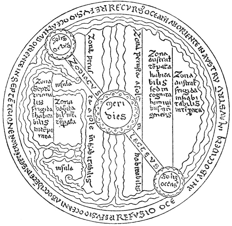
Fig. 3—Zone map in an early twelfth-century manuscript of Lambert of St. Omer’s Liber floridus, viz. Ghent Codex 2, fol. 24 vo. East is at the top. (From Miller, Mappaemundi, vol. iii, 1895, fig. 59.)
3. There also date from our period several examples of the
ornamented T-O maps drawn to illustrate Sallust’s works.[540]
Beatus Maps
4. We saw that the existing specimens of that series of maps
of the world drawn to elucidate a passage in Beatus’ commentary
123on the Apocalypse appear to have come from two sources: (a)
maps which were modeled closely on the original map of Beatus
or a contemporary copy and (b) those which were merely generalized
outlines of it.[541]
a. A map dating from 1203 and preserved at Osma in Old
Castile comes nearest to the original in design and form, if not in
the richness of detail (Fig. 4). Alone of all the Beatus type this
shows the heads of the twelve apostles scattered over the earth’s
surface. Another map, probably derived from the same source,
is to be found in the Bibliothèque Nationale in Paris; though it is
rich in detail, little attempt was made to show localities in their
proper relative positions, and consequently the geography represented
is chaotic to an extreme.
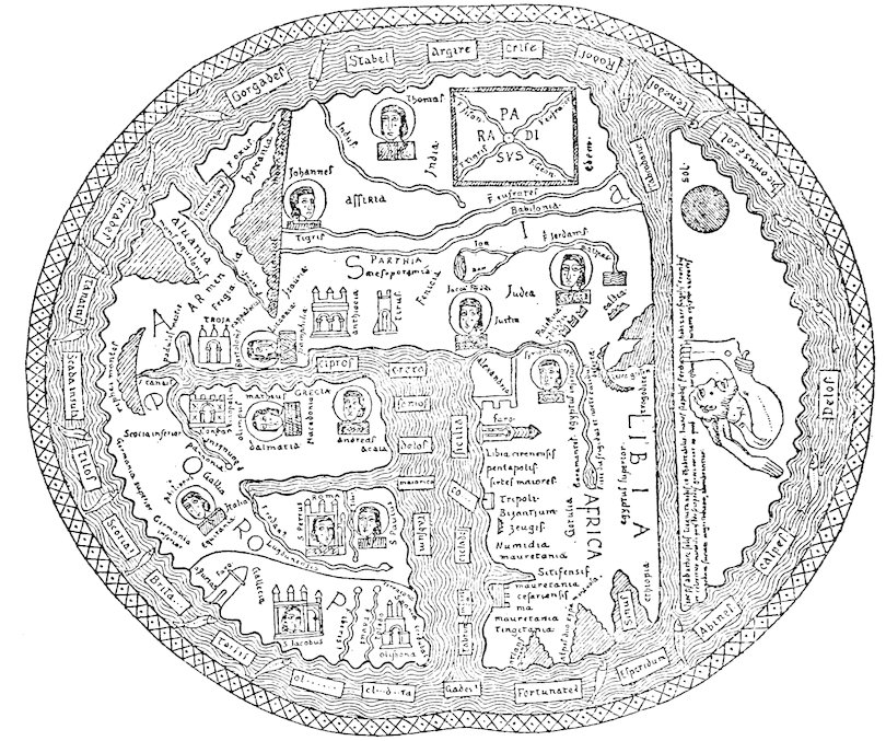
Fig. 4—Osma Beatus map dating from 1203 showing the division of the world among the twelve apostles. East is at the top. (From Miller, Mappaemundi, vol. i, 1895, p. 35.)
124b. There are also three or four maps dating from our period
from the second source. Their main interest lies in the remarkable
naïveté of workmanship.
Maps of Lambert, Guido, Henry of Mayence, and Others
In addition to the above, for which we have prototypes from
the period before 1100, there are a number of maps of the world
of the twelfth and early thirteenth centuries, the prototypes of
which either have been lost or never existed. Among the most
notable of these is one found in certain manuscripts of Lambert’s
Liber floridus.[542] It was compiled from the usual medieval authorities,
Isidore, Orosius, Julius Honorius, Martianus Capella,
Pomponius Mela, Solinus, the Pseudo-Callisthenes, and the
Bible, though there also appear upon it a few names that could
have been taken only from contemporary sources. The influence
of Macrobius is most strikingly revealed, for, unlike most other
medieval maps which indicate the known world (Asia, Europe,
and Africa) as occupying the entire area or by far the greater part
of the world disk (as in the Beatus group), Lambert’s map divides
the disk along its diameter by a zone representing the course of
the sun and places in the southern hemisphere an austral continent
of magnitude equal to that of the oikoumene.[543]
Guido’s compilation of geographical works, made in 1119, contains
in two manuscripts not only a T-O map but also a map of
the world accompanying a selection from the book of the anonymous
Ravenna geographer and a detailed map of Italy and the
surrounding lands. The map of the world is peculiar because of
the enormous area which the Mediterranean occupies. Miller
believes it to be a reduced sketch of a large map of the world and
holds that the detailed map of Italy is a copy of a small portion
of this same original.[544]
A compilation of the De imagine mundi, put together by one
Henry, canon of the Church of St. Mary in Mayence, in 1100 and
preserved in a late twelfth-century copy in Cambridge, England,
contains a world map (see below, p. 245, Fig. 6, inset). Though
indirectly made from the sources that the writers of the De
imagine mundi and other medieval cosmographies utilized, it was
125probably not compiled directly from the De imagine mundi but
rather from a large wall map. Its affinities to the immense late
thirteenth-century world disk in Hereford Cathedral make it
seem possible that both had a common source. In addition to
the older nomenclature, about a dozen more modern place names
are to be found upon it.[545]
A map of the world which somewhat resembles that of Henry
of Mayence is also to be found in two manuscripts of the Chronica
maiora (or Historia maiora) of Matthew Paris. Though there
are many names that have come down to modern times, the
geography is meager and poor, in striking contrast to the detail
of Matthew’s map of Britain,[546] to which reference is made below.
To complete the discussion of mappaemundi, mention must be
made of a very small but very neat little map in a late thirteenth-century
Psalter in the British Museum. If this was not actually
drawn during our period, it undoubtedly had predecessors much
like it, and it shows marked resemblances to the map of Henry of
Mayence as well as to the Hereford and Ebstorf maps.[547]
Regional Maps
Several of the regional maps, or maps of limited areas, dating
from our period may be merely fragments or copies of small portions
of maps of the world. This is certainly true of the map of
Europe in the Ghent manuscript of Lambert’s Liber floridus,
which depicts that continent crammed into slightly more than a
quarter of a circle with no attempt to show the articulations of
the coast. The Guido map of Italy, as we have already seen,
probably represents a portion of a larger map, and the same can
possibly be said of the maps of the East and of Palestine which
follow a treatise by Jerome, entitled De situ et nominibus locorum
Hebraicorum, or De Palestinae locis, in a manuscript now in the
British Museum. Though these two maps were actually drawn
in the twelfth century, they represent the cartography of a very
much earlier age and perhaps may be attributed to Jerome himself.[548]
They were drawn to illustrate the Biblical geography of
Palestine and the Orient, and they show a great wealth of Scriptural
legends. Other legends were taken from profane sources,
126such as the writings of Isidore, Orosius, Julius Honorius, Dionysius,
and the Romance of Alexander; and affinities to the Peutinger
Table show that the draftsman was under the influence of the
cartography of the Roman imperial epoch.
Among the regional maps that had no connection with mappaemundi
are plans of Jerusalem (“Situs Ierusalem”) accompanying
twelfth- and thirteenth-century manuscripts of an anonymous
work written about 1109 and entitled Gesta Francorum Ierusalem
expugnantium (Fig. 7, p. 250, below). Though these plans reveal
many names from the early Crusading age, their outlines as a
whole—the fact, for instance, that Jerusalem is shown to be circular
instead of rectangular—make it seem probable that they
represent a schematic diagram of the Holy City going back to as
early as the sixth century and brought up to date by the anonymous
compiler of the Crusading epoch.[549]
Matthew Paris’ Maps of Britain
In addition to the map of the world of which we have spoken
already, the works of Matthew Paris contain no less than five
regional maps.[550] Two of these, the “Situs Britanniae” and the
“Schema Britanniae,” are simple diagrams of Britain and are of
no particular importance. The other three are far more significant.
The first, a pictorial itinerary of the route from London to
southern Italy, with legends in Old French and Latin, delineates
vividly towns and principal topographic features. The second
is a map of Palestine which superficially resembles that of Jerome;
the names, however, are in French, and the legends refer to places
familiar to the contemporary pilgrim and Crusader. Finally
come the three manuscript variants of Matthew’s map of Britain,
which, as Beazley observes, “among all designs of purely
medieval origin ... show the best evidence of critical study,
the most systematic attempt at the exact delineation of a particular
country”[551] (for one variant, see below, p. 343, Fig. 9).
There is a profusion of detail and accuracy in the representation
of the relative position of places refreshing when we contemplate
the confusion and credulity manifested in the earlier works.
This map is also the first example of late medieval cartography
in which north instead of east is shown at the top of the sheet.
127
Geography in the Middle Ages did not form a distinct and
separate science. The student who learned anything of geography
learned it incidentally to the study of other subjects and
never thought of it as sufficiently dignified to enjoy a place by
itself in the scholastic curriculum. Even the word “geography”
was scarcely ever used.[552] The term cosmographia, sometimes
employed to distinguish certain aspects of our subject from
geometry, included practically all branches of natural history, the
sciences of animals, rocks, monstrosities, and meteorological
phenomena. On the other hand, cosmography did not comprise
many of the topics with which we are concerned, particularly
those lying on the border line between geography, astronomy, and
geology. The question of the origin of the earth was in the
province of the theologian of the Middle Ages.
The well-known seven liberal arts formed the foundation of the
work in the medieval schools. From them the student might
advance to higher researches in philosophy and theology, but the
seven arts were the base of all learning.[553] Martianus Capella’s
De nuptiis Philologiae et Mercurii was an attractive and somewhat
imaginative exposition of the arts and had become one of the
most popular of medieval textbooks long before the twelfth
century.[554] Here each art is personified as a gorgeously clad
woman, and the seven together compose the escort of “Philosophy.”
In practical teaching, the arts were divided into two groups:
the trivium, comprising grammar, rhetoric, and dialectic (or
logic); and the quadrivium, arithmetic, geometry, astronomy
(astrology), and music. Geoffrey of St. Victor, in his Fons
philosophiae, gives[555] an allegorical description of the arts as a
128spring which divides into two main streams, the trivium and
quadrivium, that in turn separate into three and four lesser
streams respectively. The teaching of practically all the natural
science of the Middle Ages was included in the quadrivium.
Geometry was generally expanded to include geography and
quite naturally so in view of prevalent opinions regarding its
origin. Adelard of Bath, in his De eodem et diverso, repeats an
old story to the effect that in the early days men began to set up
stones as boundaries.[556] Disputes about claims inevitably arose,
in Libya because of sand, and in Egypt because the Nile often
obliterated or destroyed the stones. This necessitated the invention
of the science of geometry, or surveying, by the application
of which the bounds might be replaced so that it would be
“possible for all the centuries to have an everlasting rule for the
measurement of land.”[557] Out of the invention of geometry,
Adelard adds, arose subsequently the custom of subdividing
territory into areas of various sizes.[558] Thus it happened that
geometry had become closely allied in the classical and medieval
mind with matters of geographical or topographical interest.
Capella includes his long geographical discourse among chapters
devoted to geometry and makes his symbolical figure of the latter
science carry in one hand a compass and in the other a sphere to
represent the terrestrial globe.[559] Alan of Lille, in the Anticlaudianus,
describes Geometry as carrying a scale with which she
measured the earth: “The maid carries a rod by which she encircles
the entire earth.”[560] In the sculptured figures of the cathedrals
Geometry is often depicted compass in hand.[561]
Geography was not always placed in a subordinate position to
geometry in the quadrivium. In the De divisione philosophiae of
Dominicus Gondisalvi, which follows the Aristotelian rather
than the Platonic division of knowledge, we find our science
grouped under astrology. Of the latter art, Dominicus says,[562]
there are three parts: the first is concerned with the number and
shape of the heavenly bodies; the second with their movements;
and the third with the earth, those regions that are inhabited and
129those that are not, the climates, and the varying influences
exerted by the location of places and the revolutions of the
universe over happenings on the earth’s surface.[563]
Both geometry and astrology belonged in the quadrivium.
Where did the higher study of the arts of the quadrivium fall in
the general classification of knowledge?
The medieval mind tended to seek for a logical and symmetrical
subdivision of the sum of all knowledge. The desire for systematization
found its supreme expression in the great philosophic
structures of the thirteenth century, the systems founded on
Aristotle and devised by such men as Albertus Magnus. Prior to
the thirteenth century confusion had reigned. According to the
Platonists, who divided philosophy into logic, ethics, and physics,
the study of the mathematical and natural sciences—and, therefore,
of geography—fell under the heading of physics. Aristotle,
more logically perhaps, had divided the subject matter of all
human learning into two great categories, theoretical knowledge
and practical knowledge. Theoretical knowledge included
physics, mathematics, and metaphysics (or theology). The
studies of the quadrivium were thrown by the Aristotelians under
the heading of mathematics: geography, then, became to those
who followed the Aristotelian classification—Gondisalvi, Hugh
of St. Victor,[564] Roger Bacon—a sub-department of mathematics.
But on the whole we need not linger over this topic, because
the question of exactly where geography belonged in the artificial
systems devised by the medieval mind was largely a matter of
academic interest even in the Middle Ages and was without
influence on the actual condition of the geographical lore of that
time.
PART II THE SUBSTANCE AND CHARACTER OF THE GEOGRAPHICAL LORE OF THE TIME OF THE CRUSADES — CHAPTER VI COSMOGONY, COSMOLOGY, AND COSMOGRAPHY — GENERAL CHARACTER OF THE COSMOLOGY AND NATURAL SCIENCE OF THE PERIOD — THE CREATION — MACROCOSM AND MICROCOSM — SHAPE, MOVEMENTS, AND SIZE OF THE EARTH — ZONES, THE ANTIPODES, AND “CLIMATA” — CHAPTER VII THE ATMOSPHERE — METEOROLOGY — CLIMATOLOGY — CHAPTER VIII THE WATERS — THE WATERS ABOVE THE FIRMAMENT — THE CONGREGATION OF WATERS — THE OCEANS AND SEAS — THE WATERS OF THE LANDS — CHAPTER IX THE LANDS — CLASSIFICATION OF LAND AREAS — MOUNTAINS — VOLCANOES AND EARTHQUAKES — DESERTS — ISLANDS — INFLUENCES OF GEOGRAPHICAL ENVIRONMENT — FEELING FOR LANDSCAPE AND SCENERY — CHAPTER X THE ASTRONOMICAL GEOGRAPHY OF THE KNOWN WORLD — Phenomena Resulting From Differences in Latitude — “ Climata ” — Geographical Coördinates — Methods of Finding Latitude and Longitude — CHAPTER XI CARTOGRAPHY — INACCURACY — TECHNIQUE — SUMMARY — CHAPTER XII REGIONAL GEOGRAPHY — GENERAL CHARACTER OF REGIONAL KNOWLEDGE OF THE PERIOD — THE “OIKOUMENE” AS A WHOLE — THE CENTER OF THE “OIKOUMENE” — THE TERRESTRIAL PARADISE — ASIA — AFRICA — THE MEDITERRANEAN SEA — EUROPE — ISLANDS OF THE ATLANTIC OCEAN — CHAPTER XIII CONCLUSION — The Outstanding Elements of the Geographical Lore of the Time of the Crusades — Character of the Geographical Lore of the Time of the Crusades
131
133
In the preceding chapters the attempt has been made to show
the origins of a large part of the geographical lore of the Crusading
epoch, the sources from which we may learn about it, and where
it stood in the classification of learning. Now we may turn to our
central theme: an estimate of its actual substance and character.
This geographical lore was in no sense a unified body of knowledge
and belief. It was no more a unit than the religious thought
of the age, or the philosophy, astronomy, or morals. No one in
the Middle Ages was acquainted with all the facts and theories
with which we shall have to deal. Mental caliber, credulity,
critical spirit, curiosity, opportunities for research and for travel—these
all varied widely with the individual and determined his
geographical concepts. Nevertheless, though there was no unity
of knowledge or belief in regard to specific facts and no unity of
point of view, the reader will not fail to perceive, in the multitude
of illustrative details which are presented, that certain habits of
thought and modes of expression were typical of the epoch as a
whole.
We must first discuss what was known and believed about the
earth in its larger relations, both in time and space, to the remainder
of the universe: opinions about the Creation, about the size and
shape of our terrestrial globe, about the influences exerted by the
heavenly bodies in determining or affecting geographical conditions
upon its surface.
In the Introduction we explained why it is justifiable when dealing
with ancient and medieval geography to wander into the fields
of cosmogony and cosmography far beyond what are now regarded
as the rightful limits of geography. The present chapter,
it is hoped, will make clear how closely medieval conceptions of
the present condition of the earth may be connected with the
medieval idea of the origins and nature of the universe.
134
These difficult questions of cosmogony, cosmology, and cosmography
excited keen and vivid thinking because they lie on
the border between philosophy and theology. Men were more
interested in attempting to solve the insoluble mysteries of God
and the universe than they were in the world of nature immediately
surrounding them. Immense and weighty volumes were
written in commentary on the Works of the Six Days, wherein
complicated arguments were elaborated with the finesse of scholastic
logic. In an age of faith, the religious enthusiasm of the
architect and artisan was transmuted into lofty cathedrals; that of
the theologian turned to the elucidation of the words of Scripture.
To analyze these words, to comment upon their minutest detail,
to reveal the meaning that presumably lay behind them was not
only a work of piety and devotion but an absorbing intellectual
pastime for keen-witted thinkers. In more concrete realms of
natural science, the epoch was characterized by little enough
observation and creative thought. The teachings of Plato, of
Aristotle, and of the other available classical, Arabic, and early
Christian authorities were accepted and adopted uncritically.
Very different was the case with matters of cosmogony and cosmography.
Here was highly controversial ground where classical
opinions were either enthusiastically defended as casting light
on Scripture or else bitterly attacked as subversive of all truth.
The Chartres Group: Bernard Sylvester and Theodoric
We have seen in Chapter IV that the scholars of the Chartres
group and their pupils during the early twelfth century were endowed
with peculiar freedom of thought.[565] We note in the works
of Bernard, Theodoric, Adelard of Bath, William of Conches, and
Bernard Sylvester a wide departure from authoritative, orthodox
theology. Theodoric, William, and the two Bernards were readers
of Chalcidius’ translation of the Timaeus, of Macrobius, and perhaps
of the writings of the great ninth-century Platonist, John
Scot Erigena, and all four felt the powerful and seductive attraction
135of Platonism. Bernard Sylvester was almost an out-and-out
pagan, so much so, indeed, that his writings can hardly be
considered to lie within the pale of Christian theology.[566] Theodoric
and William tried harder to reconcile Platonism with the
teachings of the church, yet they did so in a rationalistic spirit
almost as abhorrent to strict orthodoxy as the paganism of
Bernard Sylvester. Theodoric expressly stated in his De sex
dierum operibus that he was going to explain the different Works
of the Six Days “according to physical principles,” and, following
the letter of the text,[567] he proposed to avoid all allegorical and
moral interpretations of Scripture. He believed that the best
way to attain a genuine knowledge of God was through an accurate
understanding of what God had created; and his explanation
of the Creation, as we shall soon see, was independent to a
degree that amazes us in a writer of his time. The following
phrase is particularly significant where Theodoric extols Moses’
treatment of the Creation in Genesis, saying: “He shows in a
rational manner the causes out of which this world has come into
existence and the order of time in which this same world was
founded and adorned.”[568] Hauréau writes of the first book of
Theodoric’s commentary: “Quant au premier livre, essai d’accord
entre la Genèse et le Timée, où l’on voit la religion et la philosophie
conspirant à résoudre le plus grave et le plus obscur des problèmes,
le problème de l’être, et se déclarant satisfaites de l’avoir
résolu, ce premier livre est ... de plus grand intéret.”[569]
Adelard of Bath and William of Conches
In the Quaestiones naturales Adelard of Bath gives vent to his
scorn for the mentality that blindly accepts beliefs merely because
they have the weight of authority behind them. In an
extraordinary passage he expresses these ideas thus (as translated
and paraphrased by Professor Haskins[570]): “‘It is hard to
discuss with you,’ Adelard tells his nephew [in the dialogue form
of the Quaestiones naturales], ‘for I have learned one thing from
the Arabs under the guidance of reason; you follow another halter,
caught by the appearance of authority, for what is authority
but a halter?’... ‘If reason is not to be the universal
136judge, it is given to each to no purpose.’[571]... While
plants spring from the earth by God’s will, this does not act
without a reason.[572] Human science must first be listened to ...
and ‘only when it fails utterly should there be recourse
to God’ as an explanation.”[573]
William of Conches shows the same spirit where he insists that
God acts reasonably and not capriciously. He writes: “I am
aware that some people assert, ‘Though we do not know how this
happens to be so, we know that God can make it so.’ Wretched
ones! What is more craven than to talk in that way! Because
God can do something is no sign that he actually does it, nor any
reason why he should do it, nor any reason why it is useful that it
should be done. For God does not do whatever he can do. To
employ a rustic expression: ‘God can make a calf out of a tree
trunk,’ but does he ever do so?”[574] William apparently, unlike
Theodoric, thought that we are justified in avoiding irrational
deductions from Scripture by an appeal either to an allegorical
interpretation or—what is even more surprising at a time when
the word of authority was usually regarded as all-sufficient—to
one’s own intellect: “We may begin our reasoning from the authority
of a master, but it should be perfected by our own
intellect.”[575]
Concept of Natural Laws
Thus we see in the writings of Adelard, Theodoric, and William
that the approach was tentatively made toward the acceptance of
the doctrine that the universe is governed by natural laws. This
doctrine, upon which the edifice of modern science has been built,
was also given partial expression by other thinkers of the twelfth
century. John of Salisbury stated in effect that a sequence of
causes gives rise to all things that we may perceive with our senses,
that we call these causes nature, that nothing happens that is not
the result of natural causation even though the operation of this
causation may be concealed from us; finally, that the first cause of
all is the will of God.[576] Alan of Lille clothed a similar theory in
allegory by personifying Nature in poetic form as the representative
of God and making her say: “Hear how in this universe, as in
137a great city, order is established by the control of a majestic government”
(Moffat’s translation).[577] Much the same opinion was
expressed by an anonymous Scandinavian historian of the early
thirteenth century in his Latin Historia Norwegiae. After describing
a terrible volcanic upheaval from the bottom of the sea,[578]
this writer adds that many people regard such occurrences as
prodigies, believing that the world itself thereby gives warning of
its own destruction.[579] Citing Solinus, he goes on to set forth a
purely physical explanation of earthquakes and volcanic eruptions
and adds that, though it may not be possible to attain to clearsighted
understanding of these phenomena and of the major marvels
of the world, they should not be looked upon as prodigies nor
considered as portents of universal cataclysm. On the contrary
they are, as it were, the servants of the all-knowing and immutable
founder of the universe to whose nature through some marvelous
process they have been placed in bondage.[580]
The Orthodox Tendency
This sort of reasoning, however, was exceptional. In the mid-twelfth
century the appearance of Peter Lombard’s Sententiae
tended to divert the theologian’s mind from Platonic and rationalistic
studies and to restore Church Fathers and Scripture to
paramount authority.[581] We look in vain for traces of the liberal
attitude of the Chartres scholars in the orthodox works of such
prolific writers but perhaps less clear thinkers as Peter Comestor,
Giraldus Cambrensis, Gervase of Tilbury or even Alexander Neckam.
Giraldus’ Symbolum electorum[582] contains a cosmography in
verse which explains the Scriptural view of the Works of the Six
Days, and though we feel in this poem the influence of the Peripatetic
physics—which by this time were becoming universally
known—no attempt was made to expound the work of the Creation
according to physical laws. In the Topographia Hiberniae[583]
Giraldus illustrates his own attitude and the dominant attitude
of his age by the moral he draws from the story of eagles which occasionally
fly so high that they scorch their wings in the sun.
This he compared to the hopeless vanity of the man who tries to
solve by reason or by knowledge God’s riddles of the Creation and
138of the universe. Neckam also despairs of explaining the mysteries
of nature and asks, “Who may comprehend the causes of
things?” He describes thunder and lightning briefly but adds,
“The herald of the thunder fills the mind with terror and shows
how great is the creator thereof.”[584] Even Michael Scot, who
enjoyed the patronage of the enlightened, scientifically minded
Emperor Frederick II, attributed the fact that the waters of the
spherical earth are held in place to “a secret virtue ... beyond
human ken and merit” (Haskins).[585] Gervase of Tilbury reproduces
uncritically in his Otia imperialia[586] the ideas compiled by
Peter Comestor regarding the Creation. These were strictly correct
opinions on which no suspicion of heterodoxy could be
thrown. Comestor went out of his way to express opposition
and antagonism to Platonic teachings.
Effects of Influx of Arabic Science
The conventional orthodox position, however, did not remain
unchallenged. The influx of Moslem Aristotelian lore at
the end of the twelfth century was held to be as menacing to the
integrity of the ecclesiastical tradition as any of the Platonic doctrines.
But, though stern prohibitions were leveled against the
study of Aristotle and his Arabic interpreters, the seductions of
Aristotelianism could not be resisted, and those elements of Peripatetic
science which did not seem utterly outrageous to Christian
theology became the accepted and authoritative science of
the West in the mid-thirteenth century. William of Auvergne,
bishop of Paris, stood out valiantly against what he regarded as
teachings subversive of Christianity and of morals and in his vigorous
opposition to Aristotelianism even went so far as to adopt
many of the Platonic doctrines that had been popular among the
scholars of Chartres during the preceding century.[587] But translators
like Gerard of Cremona had done their work too well, and
the enormous tomes of Albertus Magnus were based to a large extent
on the learning of the Stagirite.
The usual medieval treatise on the Works of the Six Days as described
in the Book of Genesis deals with many problems. Some
139of these are abstruse and metaphysical: questions of the nature of
God and the nature of time and space. With these we are not
concerned. Others are more concrete: questions of the materials
out of which God made the universe and of the actual manner in
which he worked.
Problems
For the sake of clearness let us state some of these questions as
follows, (1) The question of whether matter existed prior to
God’s creation of the world. That is to say, Did God fashion the
universe out of a pre-existing substance or did he make it out of
nothing? (2) The question of the manner in which the universe
was fashioned after it was once “created.” (3) The question of
what furnished the light during the first three days before the creation
of the sun. (4) The problem of whether the Six Days were
actual divisions of time or merely hypothetical divisions of the
process of creation. (5) The question of the nature of the waters
above the firmament. (6) Various problems arising in regard to
the nature and location of Paradise and of the four rivers flowing
from Paradise. The first four problems are discussed briefly in
the present chapter. That of the waters above the firmament is
left for Chapter VIII (on waters), and that of Paradise for
Chapter XII (on regional geography).
The Preëxistence of Matter
(1) Did matter exist prior to God’s creation of the universe as
we now know it?
Consistently with his Platonism, Bernard Sylvester thought
that God formed the universe out of what he termed materia primordialis—a
chaotic mingling of the elements that had coexisted
with God before he converted the universe into its present shape.[588]
The Orthodox View
Theodoric of Chartres, on the other hand, explicitly denied the
coëxistence of the materia primordialis with God before the Creation.
In this respect he showed himself far less divergent than
Bernard from the Christian point of view. The work of the first
140day, he said, was the creation from nothing of the materia of the
universe, out of which earth and heaven, fire and water and life
were to be evolved.[589] This materia was the hyle, or chaos, of the
ancient philosophers, he explained, and was designated by Moses
in the book of Genesis under various names.[590] For example,
when Moses wrote, “In the beginning God created the heaven and
the earth” (Gen. i, 1) the words “heaven” and “earth” referred
to chaos; when Moses wrote, “And the earth was without form
and void” (Gen. i, 2) the word “earth” referred to the primordial
mixture of land and water, a mingling of land that was not solid
and of water that was not liquid. Air and fire at that time were
of about the density of water.
Theodoric’s interpretation of the initial process of the Creation
was entirely in keeping with the views of more orthodox writers.
Peter Lombard, for instance, wrote as follows: “In the beginning
God created the ‘heaven,’ that is to say the angels, and the
‘earth,’ by which is meant the material which composed the four
elements. The latter were as yet in the confused and formless
condition to which the Greeks gave the name of chaos, and this
was before any day.”[591]
Peter Comestor also set forth an orthodox view of the Creation.
In his commentary on Genesis he revealed a love of the number
three and classified every thing possible into groups of three.[592] He
pointed out how Moses had avoided three errors. “First, that of
Plato, who had conceived of three coëxistent things, God, ile
(hyle, or chaos), and time, and that the world was made out of ile;
second, that of Aristotle, who had conceived of two coëxistent
things, the world and the fashioner thereof (mundus et opifex); and
third, that of Epicurus, who had also conceived of two, space
(inane) and matter in the form of atoms, and that in the beginning
natural processes had brought together certain atoms to form
water, others to form earth, and others to form fire. Moses, however,
had said that God alone was eternal and that the world was
created out of nothing, for there was no matter in existence prior
to the ‘Creation.’”[593] “In the beginning” meant in the beginning
of time as well as of matter, for time and matter were
coëternal.[594]
141
A Rational View
William of Conches refused, on rational, physical grounds, to believe
in the possibility of a chaos preëxisting the Creation.[595] Having
accepted the classical doctrine whereby the four elements were
arranged in concentric spheres in order from heaviest to lightest,[596]
he was unable to conceive of a time when they could have been so
intermingled that they contradicted this law, though there may
have been a time, he conceded, when the earth was completely
enveloped in a thick mantle of water reaching very high and when
air and fire themselves were denser than they now are. Such a
condition, William thought, was that described in Genesis i, 2.[597]
Processes of the Creation
Theodoric of Chartres’ Theory
(2) How was the universe converted into its present form after
God had once created it?
Most commentators answered this either by saying or tacitly
implying that it was through the immediate operation of God’s
will alone. Theodoric of Chartres’ theory, therefore, is peculiarly
interesting, because Theodoric maintained that the formation
of the universe resulted from what we should now style a
series of purely mechanical and chemical reactions which began,
once the composition of the materia was completed, on the first
day. For its time this was an extremely hazardous view, akin
in some respects to the modern belief in the sufficiency of physical
and chemical action to produce practically all observable
phenomena.
Let us examine Theodoric’s theory in a little greater detail. In
Genesis i, 2, we read the words, “And the spirit of God moved upon
the face of the waters.” Theodoric explained that by the
“waters” was meant the whole of matter:[598] the “spirit of God”
was that which was destined to give order and form to the chaos,
that is to say the “force which fashioned” or “operated” (virtus
artifex or virtus operatrix). Plato had called this force the World
Soul, the Christians called it the Holy Ghost,[599] and through
its agency the evolution of the universe out of chaos by physical
processes was rendered possible.
142Coincidently with the creation of the original materia the universe
had assumed a rotary motion,[600] each complete rotation
marking a day. In the further unrolling of the universe, fire was
the active element (artifex et efficiens causa), earth the passive
element, and air and water stood as intermediaries between fire
and earth. During the first rotation, or first day, the fire heated
and illumined the inferior elements in such a manner as to cause
the air to be released from them (aer ex inferioribus elementis
spissatus), and thus the atmosphere came into existence.[601] On
the second day the fire, by illuminating the air, transmitted heat
to the third element, water, which rose in the form of clouds.
Some of this vaporized water ascended so high that it passed into
the second heavenly sphere, where it became the “waters above
the firmament,” the firmament itself, according to Theodoric, being
the atmosphere.[602] So much water in this manner was absorbed
out of the original materia that inevitably on the third day
the earth appeared like islands in the midst of the waters remaining
behind. Theodoric compared these to islands that are formed
when water dries after it has been spilled upon a table. Immediately
the heat of the atmosphere was mingled with the humors of
the earth, and the latter thereby received the power of producing
vegetable life, herbs and trees. On the fourth day the stars were
formed out of the waters which had been drawn above the firmament.
On the fifth day the heat of the universe brooded over
(incubuit) the waters of the earth’s surface and gave birth to fish
and birds. Finally, on the sixth day, the life-giving heat reached
the earth; and from it the animals were created, including, of
course, man.[603]
William of Conches’ Theory
William of Conches’ theory of the Creation did not differ a great
deal from that of Theodoric, except that the materia primordialis
was not, in his opinion, a chaotic mingling of the elements;
for within it, he thought, as we have already seen,[604] that the elements
were arranged in their proper order according to accepted
classical laws of physics. The lands were uncovered by the removal
of the waters, though this took place later in the process
143according to William than it did according to Theodoric. William
attributed the drying off of the waters partly to the warmth
of the stars (which were not formed until the fourth day) and
partly to the creation of the water and land animals on the fifth
and sixth days respectively.[605] In different portions of this primordial
land, when it was just in the act of emerging from the
waters, fiery, watery, earthy elements were present in varying
quantities. This condition gave birth to divers varieties of animals.
Where the fiery element was in excess, choleric animals,
like the lion, came into being; where the water element prevailed,
phlegmatic animals, like the pig; and the earthy element produced
melancholic creatures like the ass and cow. At the one and only
place where the combination was absolutely equal, man appeared.
Woman, on the other hand, was made from a combination almost
like that of man but one in which the colder elements were very
slightly in excess, because the warmest of women by nature is
colder than the coldest of men! This last, an extremely free and
heretical and from our point of view unchivalrous theory, William
retracted in his old age.[606]
Function of Light in the Creation
(3) What was the nature of the light which God made when he
said, “Let there be light”? Although Augustine had interpreted
this passage allegorically or mystically as referring to the creation
of the world of the angels,[607] he had also suggested that God might
have created an actual body of light corresponding to the sun.
Bede[608] developed the latter suggestion and maintained that there
must have been a luminary revolving around the earth as does the
sun. In the twelfth century Hugh of St. Victor and Peter Comestor,
both of whom interpreted Scripture more or less literally in
this respect, followed Bede. Hugh maintained that this original
light was like a luminous cloud which rose in the east and set in
the west,[609] and Comestor spoke of it in much the same terms.[610]
Other theologians, however, refused to believe that such a light
could have actually existed and reverted to Augustine’s first explanation
that by the light was meant the world of angels as distinct
from the world of evil spirits below.[611] Peter Lombard referred
144to both interpretations, though he appears to have been inclined
to favor the more literal and materialistic theory of Bede.[612]
With Robert Grosseteste light is made to play the leading part
in the entire process. In his unpublished Hexaemeron[613] and in the
De luce[614] he sets forth a theory of cosmogony which was derived
in part from the Moslems but in essentials was original.[615] We
trust that the following brief statement of the theory does not do
violence to the thought of Grosseteste as expressed in the De luce.
He conceived of light as the first corporeal form and also as giving
form to the materia prima of the universe. By radiating through
the unformed materia prima the light converted it into a sphere.
Thereupon the light made its way from the outer edge of the
sphere towards the center. As it passed through the various
realms of the universe it diffused, rarified, and purified the materia
of each, but with each stage of its advance its powers were diminished
and correspondingly the potentiality of each successive
realm of being purified was diminished. Thus thirteen concentric
spheres were produced, nine celestial spheres and four spheres of
the elements, and each of these was more complex, dense, and impure
than its neighbor above.
The Nature of the Six Days
(4) Were the Six Days described in the book of Genesis actual
divisions of time? The words of the Bible seemed to be contradictory
on this point. From the words of Genesis alone one would
gather that the completion of the universe was accomplished in
six days. On the other hand, we read in Ecclesiasticus (xviii, 1),
“He that liveth forever created all things together” (Qui vivit
in aeternum, creavit omnia simul). According to Theodoric of
Chartres[616] these two statements referred to different events.
The passage in Ecclesiasticus applied only to the creation of the
materia primordialis on the first day. The works of the succeeding
days were the result of the automatic development of natural
processes by which the universe became as we now know it. Belief
in the reality of the duration of the Six Days was shared with
Theodoric by most commentators, such as William of Conches,
Hugh of St. Victor,[617] Peter Lombard, and Peter Comestor. Augustine,
145however, had argued in a more abstruse vein that the
“days” were not actual units of time but that they represented
merely so many distinct operations in the work of creation.[618]
And in our period Arnold of Chartres urged that the Creation was
carried out in one day and all at once (uno die et semel).[619]
Eternity of the Universe
Though they differed in the details of interpretation, these theories
were all based on the fundamental acceptance of the axiom,
deduced from Scripture, that God created the universe out of nothing.
In Chapter II was explained the antagonism between this
view and the Aristotelian doctrine of an eternal, periodically re-formed
universe. Certainly, among Christians of our period, no
one believed either in the eternity or in the periodicity of the universe,
although the existence and nature of these concepts were
well known. Both theories were set forth in Seneca’s Quaestiones
naturales,[620] in translations of Plato’s Timaeus[621] and of
Aristotle’s Meteorology[622] and De generatione et corruptione,[623] and in
translations from the Arabic such as the Liber introductorius
in astrologiam of Abū Maʿshar[624] and the pseudo-Aristotelian
Liber de proprietatibus elementorum.[625] When William of Conches
specifically denied the possibility of more than one deluge he may
have had in mind the pagan association of Noah’s flood with the
Great Winter.[626] Certainly one of the primary objections of the
orthodox Christians to the acceptance of Aristotelian science during
the early years of the thirteenth century lay in the fact that
Averroës, the great interpreter of Aristotle, was firmly convinced
that the universe is eternal.[627] William of Auvergne also vigorously
attacked the Aristotelian theory as it found expression in
Avicenna’s commentary on the Metaphysics[628] and Robert
Grosseteste leveled destructive criticism against it in his Summa
super libros octo Physicorum, a commentary on the Physics of
Aristotle, and in other works.[629]
Bernard Sylvester’s Account of the Creation
Before leaving this aspect of the subject, a few words should be
said about two other accounts of the Creation that found literary
146expression in Western Europe during our period. Very dissimilar,
these two accounts are akin only in the circumstance that
they were both based upon the mythology of an older age and
that, though written by Christians, neither referred in any way to
the Scriptural story. One was the remarkable allegory in Bernard
Sylvester’s De mundi universitate, the other the Icelandic
myth of the Creation as recorded in the Edda of Snorri Sturluson.
In the Megacosmus, or first part of the De mundi universitate,
Bernard tells us of the confusion of matter in the eternal ages
that preceded the “Creation.”[630] Nature, personified, laments to
“Nous,” or Providence, about this confusion and demands that
the universe be put into an orderly condition: “Nous,” moved by
the appeal, carries out the task, separating the elements, arranging
the nine hierarchies of angels, placing the stars in the firmament
and regulating their orbits, ordering the four winds, and,
finally, fashioning the earth in the midst of the universe. The
last process gave Bernard occasion to digress and to tell of the
riches and beauties of this earth.
The Microcosmus, or second part of the book, goes on to relate
the story of the creation of man. “Nous” sees the barren desolation
of an inanimate world and orders Nature to undertake the
work of peopling it. With the aid of Urania, goddess of the stars,
Nature seeks for Physis, goddess of life, whom she finds in the terrestrial
paradise after Urania has conducted her on a long journey
through the heavenly spheres. Here she tells Physis her mission;
and Physis carries out the fashioning of a human body, in which
the soul is then established. Thus was man created.
No comment is needed to bring out the pagan character of this
account, wherein the Six Days are not even mentioned! It would
probably be wrong, however, to assume that this work of literary
imagination, any more than Snorri’s graphic record of the beliefs
of his forefathers, represents a formulated and accepted doctrine
of its author.
The Icelandic Account
The Icelanders were converted to Christianity in the mid-eleventh
century, and the mythology of their pagan days still
147remained fresh in their minds and hearts during the period we are
studying. The old gods were looked upon with affection, and
the old story of the Creation was remembered with sympathetic
understanding. The Icelandic myth of the Creation is one of
great beauty and vigor. In it is revealed the impression made
upon the minds of a northern people by struggles against the cold
and stormy darkness of the subarctic winter. The outline of the
story, which is worked out in much detail in the Eddas, is about as
follows.[631]
In the beginning a great abyss lay between the icy rivers and
the drizzling rains and blasts of wind of the north and the blazing
heat of the south. This was before heaven and earth and sea
were made. “And Fimbultyr said: Let the melted drops of vapor
quicken into life, and the giant Ymer was born in the midst of
Ginungagap[632] [the abyss]. He was not a god but the father of
all the race of evil giants. This was Chaos.
“And Fimbultyr said: Let Ymer be slain and let order be established.
And straightway Odin and his brothers ... gave
Ymer a mortal wound, and from his body they made the universe;
from his flesh, the earth; from his blood, the sea; from his bones,
the rocks; from his hair, the trees; from his skull, the vaulted heavens;
from his eyebrows, the bulwark called Midgard. And the
gods formed man and woman in their own image of two trees, and
breathed into them the breath of life. Ask and Embla became
living souls, and they received a garden in Midgard as a dwelling
place for themselves and their children until the end of time.
This was Cosmos” (Anderson).[633]
All medieval accounts of the Creation culminate in the creation
of man, as modern outlines of evolution conclude with man’s evolution
from lower forms of life. Christian theology taught that
the universe itself was made for man, a view that persists even to
this day. Grosseteste asserted that when man “no longer requires
the processes of generation and corruption which the movements
of the heavens cause, the heaven itself will cease to move
148and time will be no longer.”[634] Rupert of Deutz explained that
mountains were placed upon the earth to protect human beings
against the winds.[635] But if the universe and all its parts were
made for man, medieval thinkers held, with the Stoics of antiquity,[636]
that man himself was a lesser universe (minor mundus), or
microcosm, comprising all the elements both physical and spiritual
which constitute the greater universe, or macrocosm.
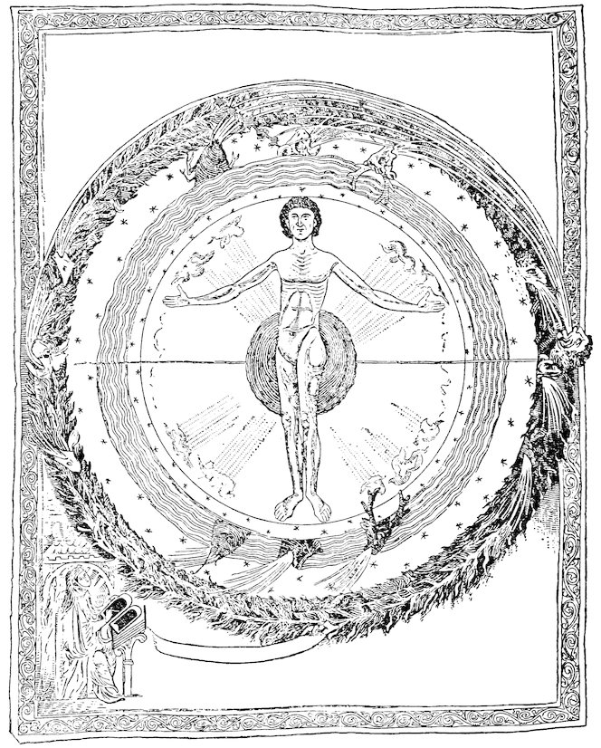
Explanation of Fig. 5—The human figure here represents the microcosm in the midst of the universe. The heads of the animals give rise to the winds, which Hildegard believed controlled the movements of the celestial bodies (see p. 171). The blast originating in the human head at the right and moving in a counter-clockwise direction runs opposite to the movement of the firmament. “This blast did not give forth his breath earthward as did the other winds, but instead thereof it governed the course of the planets” (Liber div. op., in: Migne, Pat. lat., vol. cxcvii, col. 791, as cited by Singer, op. cit. p. 28).
In another miniature from the same manuscript (fol. 9 ro) shown in Singer, op. cit., pl. VII, the universe is revealed in much the same manner with the human figure as the microcosm. There is also represented the macrocosm, as a larger figure standing behind and holding the sphere of the cosmos; only its head, feet, and hands appear.
149Fig. 5—The macrocosm, the microcosm, and the winds, from a miniature in an illustrated codex of Hildegard of Bingen’s Liber divinorum operum in the Municipal Library at Lucca, fol. 27 vo. (Redrawn, by permission, from Singer, Scientific Views and Visions of Saint Hildegard, 1917, pl. VIII.) For explanation, see bottom of opposite page.
The doctrine of man as the microcosm had its roots far back in
antiquity. Medieval writers from the time of Isidore elaborated
upon it with detail and ingenuity. In the literature of our period
it occurs in many a passing comparison of the phenomena of nature
with the human body, such as that of the De imagine mundi
where rivers are compared with blood vessels.[637] It forms an important
element in the cosmology of Bernard Sylvester’s De
mundi universitate[638] and of Herrad of Landsperg’s Hortus deliciarum.[639]
Hildegard of Bingen’s writings are full of similes and
medical recommendations based upon it (Fig. 5).[640] In her Subtilitates
the abbess says: “In the creation of man from the earth
other earth was taken, and all the elements served man because
they perceived that he lived; both the elements and man worked
together to each others’ advantage in all relationships.”[641] The
thought is expressed more clearly in the Causae et curae: “Oh,
man! Look at man, for man has in himself heaven and earth and
all other things that are created, and his form is one and in him all
things lie hidden.”[642] To illustrate the detail in which Hildegard
worked out this theory we may do no better than to quote from
Thorndike’s summary. “She compares the firmament to man’s
head, sun, moon, and stars to the eyes, air to hearing, the winds to
smelling, dew to taste, and ‘the sides of the world’ to the arms and
sense of touch. The earth is like the heart, and other creatures in
150the world are like the belly. In the Liber divinorum operum she
goes into further detail.... From the top of the cerebral cavity
to the ‘last extremity of the forehead’ there are seven distinct and
equal spaces, by which are signified the seven planets which are
equidistant from one another in the firmament. An even more
surprising assumption as to astronomical distances is involved in
the comparison that as the three intervals between the top of the
human head and the end of the throat and the navel and the groin
are all equal, so are the spaces intervening between the highest
firmament and lowest clouds and the earth’s surface and center....
As the heart is stirred by emotion, whether of joy or of sorrow,
humors are excited in the lungs and breast which rise to the
brain and are emitted through the eyes in the form of tears. And
in like manner, when the moon begins to wax or wane, the firmament
is disturbed by winds which raise fogs from the sea and
other waters.”[643] The preface to the Subtilitates contains another
discussion of the microcosm in the course of which the stones of
the earth are likened to bones and it is pointed out that the earth
has sweat, humors, and other by-products of the body.[644] Much
of the argument of the Causae et curae is based upon the assumption
that the very diseases of man have their counterparts in the
facts of the macrocosm.
When once created, what form did this universe take, and the
earth within it?
Sphericity of the Universe
Nearly all the authors of our period appear to have shared in
the belief that the universe is a sphere and that the earth is situated
in its center. Lambert of St. Omer says in his Liber floridus:
“We say the earth is the center, that is, the point in the middle of
the sphere.” “For the earth is located as a central point in
the midst of the celestial circle through which the sun passes.”[645]
Robert Grosseteste stated that the sphericity of the universe was
necessitated by the nature of the substances composing the heavenly
bodies and that it could be proved by simple astronomical
151observations.[646] There is, perhaps, an echo of Pythagorean mathematical
doctrines in the exposition which we find in the Image du
monde, that the world is round since God desired it to be so, because
roundness is the most perfect of all forms.[647] Al-Farghānī,
whose work was translated more than once during our period and
formed the basis of much that is found in John of Holywood’s De
sphaera,[648] had said that there was no difference of opinion among
learned men that the universe was a sphere. That the earth is in
the center of the heaven, he asserted, was shown by the fact that
half the heaven is always visible from all parts of its surface.[649]
The author of the De imagine mundi had also thought the same
way:[650] he compared the universe to a ball, or to an egg of which
the shell corresponds to the upper heavens, the white, to the upper
air, the yolk, to the lower air, and the pinguedinis gutta, or drop of
grease in the center, to the earth.[651] Gervase of Tilbury,[652] who
borrowed the idea from Comestor,[653] and the author of the Image
du monde[654] make similar comparisons, although Peter Abelard,[655]
William of Conches,[656] and Daniel of Morley conceived of the four
parts of the egg as corresponding exactly to the four elements.[657]
Michael Scot compared the earth, surrounded by water, to the
yolk of an egg and the spheres of the universe to the layers of an
onion.[658]
In her Causae et curae, on the one hand, and in her Scivias and
Liber divinorum operum, on the other, Hildegard of Bingen makes
contradictory statements in regard to the position of the earth in
relation to the heavenly spheres. Scientific consistency was not,
perhaps, the ascetic abbess’s strongest quality, and too much
emphasis should not be laid upon contradictions found in the
writings of one who believed herself to be favored by special divine
revelations. The passage in the Causae et curae, however,
diverges so widely from current medieval opinion that it is worth
translating. “The earth,” writes Hildegard, “is of moderate size
and is near the base of the firmament, because if it were in the
center of the firmament, then it would have to be larger; and even
so it would easily fall and be shattered to pieces, had it the same
expanse of air beneath that there is above.”[659] On the contrary,
in her Liber divinorum operum she tells how she saw in a vision
152the universe as a wheel[660] and that “in the midst of the air the
earth was placed in such a way that the air measured an equal
distance above the earth, below the earth, and on either side of
the earth.”[661]
Shape of the Earth
Most writers of the Crusading age thought the earth also was a
sphere, though there was less unanimity in this belief. The De
imagine mundi calls it a sphere, whence comes the term orbis.[662]
William of Conches[663] furnishes us with the Aristotelian proofs of
sphericity. If the earth is flat, he says, it would be day at the
same time in the farthest east as in the farthest west. Certain
stars are visible in one latitude that cannot be seen in another, and
this would not be the case if there were no curvature from north
to south.[664] John of Holywood, following Al-Farghānī, gave two
proofs that the earth is round and two that the water is round.[665]
That there exists a swelling or curvature of the earth (tumor
terrae), he says, is shown by the difference in the time of eclipses
between places in the east and west as well as by differences in
the visibility of stars.[666] The curvature of water surfaces is demonstrated
by the fact that a person standing at the foot of a mast
is frequently unable to see objects visible to somebody at the
masthead. Furthermore, since water is a homogeneous body, all
parts of it must partake of the nature of the whole. Therefore
it follows that because a drop is round, the mass of the waters of
the earth must also be spherical.[667]
Gervase of Tilbury has been accused of believing that the earth
is square, though the evidence in the text of the Otia imperialia on
which this accusation is based is very slender; and other texts
would seem to support the opposite contention, that he accepted
the theory of sphericity.[668]
Two passages in the Causae et curae of Hildegard can apparently
be explained only on the supposition of a flat earth.[669] Hildegard
seems also to have been haunted by the old belief that bulked so
large in the imagination of Cosmas Indicopleustes,[670] the belief
that the earth rises into an immense mountain in the north.[671]
She asserted that this mountain prevented the light of the east
153from penetrating the darkness of the north and the darkness of
the north from obscuring the light of the east. On the other
hand, in her visions the abbess more than once saw the earth as a
globe.[672]
In the writings of the mystic Hugh of St. Victor we have a typical
medieval allegorical interpretation of the words of Scripture
regarding the earth’s form, with instructions as to how a map of
the world ought to be made.[673] Hugh compares the orbis terrae to
an “oblong circle,” or oval, drawn around the ark, touching each
corner. An oval shape was necessitated by the rectangular
ground plan of the ark. Within this oval the mappa mundi, or
map of the world, is to be drawn, with the front of the ark facing
the east, and its rear, the west. In the segment formed to the
east, between the ark and the circle, is Paradise; in that to the
west the resurrection will take place; the chosen will go to the
right, and the damned to the left into Hell, which forms the segment
toward the north. Beyond this “oblong circle” another
circle is to be drawn to show the zones, and the space between the
two is the atmosphere.
One hesitates to draw conclusions from this as to what shape
Hugh imagined the earth to be; probably he himself had no very
definite theory. The picture which his description seems to invoke
in our minds is that of a flat oval earth covered by an ovoid
heaven, and certainly it is in every respect inconsistent with belief
in a spherical earth.
Immobility of the Earth
However men may have thought about the shape of the earth,
there was no questioning the fact that it stands immobile and
firm. Doctrines like that of the Pythagorean Philolaus had no
place in medieval thought.[674] The ignorant, nevertheless, were
often puzzled by the problem of what supports the earth. The
author of the De imagine mundi was content uncritically to explain
that no fulcrum or support is necessary for this purpose but
that the “divine power” is all-sufficient.[675] He quoted the one
hundred and third Psalm: “Who hast founded the earth upon
its own bases: it shall not be moved for ever and ever.”
154Theodoric of Chartres, Adelard of Bath, and John of Holywood,
on the other hand, adduced proofs of the immobility of the earth
which had been derived indirectly from Aristotle. Theodoric asserted[676]
that the earth does not gain its compactness either from
its inherent nature, because earth is actually observed on occasions
to become mingled with air; or from the weight of the overlying
atmosphere and sphere of fire, because these have no weight.
What, then, keeps it from flying to pieces? Here Theodoric appealed
to the Peripatetic reasoning that the circular motion of the
heavens necessitates the existence of a solid and immovable body
in the center.[677] All heavy bodies acquire their substantia, or
solidity, from the motion of light bodies; and conversely light
bodies derive their motion from heavy bodies.
The Quaestiones naturales of Adelard of Bath is in the form of a
dialogue between Adelard and a nephew who asks questions. The
nephew was much puzzled by the fact that, whereas heavy objects
like rocks need a piece of wood or other support to hold them
up in the air, the earth as a whole, much the heaviest of all, requires
no such support.[678] Adelard replies first that the earth
does not fall because there would be no utility in its doing so; then
he proceeds to show by a rational argument (rationabiliter) why
the earth does not need a support. The principal quality of earth
he says, is heaviness; heavy bodies naturally seek the lowest position
(infimum); the lowest position of a spherical body like the
universe is its center—though why this latter proposition is so,
Adelard fails to make clear. At all events, the earth tends to seek
the center of the universe, just as a stone thrown into an imaginary
hole piercing the center of the earth would come to a halt
there.[679] Since the center of the universe is one point, not several,
the earth forms a single unit, not several; and for these reasons,
moreover, the earth is stable and immobile.
John of Holywood explained[680] the same thing more briefly
than Adelard by simply stating that the immobility of the earth
is due to its weight, since it is the nature of all heavy things to seek
the center of the universe and since the earth is the heaviest of all
elements. Both Adelard’s and John of Holywood’s arguments
155suggest the Aristotelian doctrine of an equilibrium of forces
around the center of the globe, though this doctrine is not cited in
so many words. Like most medieval writers, Adelard and John
seem only partially to have understood the obscure texts from
which they derived their proofs and to have left out many links in
their chains of reasoning.
Size of the Earth
Though the geocentric hypothesis prevailed in the Middle Ages,
there is plenty of evidence to show that the smallness of the earth
in relation to the heavenly bodies was understood.[681] William of
Conches had thought that the sun was eight times as big as the
earth.[682] In the Image du monde this theme is elaborated:[683] we
are told that it would take more than a hundred years for a rock to
fall from the heavens; that the earth is like a tiny star in comparison
with the immensity of the cosmos and is one hundred and
sixty-six and three-twentieths times smaller than the sun.[684]
John of Holywood quoted Alfraganus (Al-Farghānī) to the
effect that the smallest fixed star is larger than the earth[685] but
that the dimensions of such a star are as but a point in the firmament.
He argued that the extreme smallness of the earth is
proved by the fact that it is possible to see the middle of the firmament
(medietas firmamenti) not only from the center of the earth
but also from the earth’s surface.[686] His argument, which certainly
proves nothing as it stands, is evidently a confused reflection
of Ptolemy’s reasoning in the Almagest.[687]
As to the actual size of our planet various figures were occasionally
quoted. The De imagine mundi[688] gives Posidonius’ estimate
of the circumference as 180,000 stades, or 12,052 miles (duodecies
mille millaria et quinquaginta duo). The Image du monde,[689]
however, gives 20,428 miles. Eratosthenes’ 252,000 stades appears
in Lambert of St. Omer’s Liber floridus[690] and John of
Holywood’s De sphaera.[691] In the latter work it is cited on the
authority of Ambrose, Macrobius, “et Eristenis philosophorum,”
along with a brief account of the great Alexandrian geographer’s
method of measurement.
156
The surface of the terrestrial sphere, surrounded as it is by the
heavens, is naturally subjected directly to the influence of the
heavenly bodies. We must now examine those general phenomena
of the globe as a whole which were conceived to be
consequences of the earth’s shape and position in relation to the
remainder of the universe, postponing for a later chapter the
study of the more local features of the oikoumene (or habited
quarter), which also result from the same circumstances.
Zones
The most primitive observation reveals the fact that the heavenly
bodies in their course through the sky revolve around two
points and mark out certain circles. Very elaborate and often
admirable discussions of the celestial poles, Arctic and Antarctic
circles, equator, tropics, and ecliptic, are to be found in the numerous
astrological and astronomical works of our period.[692] The
study of these matters was already a highly developed science,
but except in its geographical bearing it does not fall within our
province.
We saw in Chapter I that ancient astronomers had drawn imaginary
circles around the terrestrial sphere corresponding to the
circles of the heavens and had designated these lines as the boundaries
of zones on the earth’s surface.[693] The classical theory of
five zones, divided from each other by parallels of latitude, was
accepted by the geographical writers of the twelfth and early thirteenth
centuries, although, as in classical times, opinions diverged
widely regarding the characteristics of each zone. All, however,
believed that the two polar caps were cold and that the equatorial
regions were hot. For example Bernard Sylvester says in his De
mundi universitate:[694] Nous, or Providence, “encompassed the
earth with five parallels; on the one hand the extremes are frozen,
on the other the central portions are hot. Also she made temperate
two zones by placing on both sides of them the coldness of
the extremities and the course of the sun over the midst of the
earth.”
157
Uninhabitability of Polar Caps and Equatorial Zone
Furthermore, a widely prevalent but not universal theory made
the polar caps and equatorial zones not only cold and hot but also
uninhabitable. The author of the De imagine mundi[695] and Gervase
of Tilbury[696] plagiarized what Isidore had written on this
subject.[697] They called the five circles separating the zones and
the zones themselves from north to south, respectively, septentrionalis
(our Arctic Circle and North Polar zone), solstitialis (our
Tropic of Cancer and North Temperate zone), equinoctialis (our
Equator and Torrid zone), brumalis—or hyemalis according to
Gervase—(our Tropic of Capricorn and South Temperate zone),
and finally australis (our Antarctic Circle and South Polar zone).
Of these they thought that only solstitialis was habitable. William
of Conches likewise believed[698] in uninhabitable torrid and
frigid zones, though he rejected the theory that in the heavens
above the sphere of the moon there are qualities of heat and cold
corresponding to those of the terrestrial zones.
Austral Continent and Antipodal Regions
Speculation was rife as to what lay beyond the equatorial zone
and in those mysterious parts of the earth of which man had no
knowledge. Rumors and conjectures of an austral continent and
of antipodal regions figure widely in the geographical literature
of the age. A fourth continent beyond the equatorial ocean (or
Mare Rubrum) is shown on all the Beatus maps. It is represented
as a strip of land along the southernmost edge of the earth (see Figs.
2 and 4, pp. 69 and 123, above). A legend, taken from Isidore, informs
us on the St. Sever map that “In addition to the three parts
of the world, there is a fourth part beyond the ocean in the midst
of the south and unknown to us on account of the heat of the
sun. Within its confines the antipodeans are fabulously said to
dwell.”[699] The Osma Beatus map locates the skiapodes, or sun-shade-footed
men, here (see Fig. 4). Confusion between true
antipodal regions on the opposite side of the world and an austral
continent lying south of the equator was not uncommon in antiquity
and during the Middle Ages.[700] Belief in the latter did
not necessarily involve belief in a spherical earth, and it has
158been argued that the Roman cartographers (whose maps may
have inspired Beatus) showed such a fourth continent south of
the equator, even though they did not deem the question of the
sphericity of the world worthy of serious consideration. The
Beatus maps themselves may easily be reconciled with an
implicit belief in a flat world disk.
While this may be true of the Beatus maps, it cannot be said of
the mappamundi of Lambert of St. Omer or of references to the
antipodes elsewhere in the literature of our period where it is impossible
to question the conviction in the cartographers’ or
writers’ minds that the earth is a sphere.
On Lambert’s map the austral continent occupies half of the
circle of the earth. A long legend explains,[701] in terms similar to
those of the St. Sever Beatus map, that this region is unknown to
mankind because of the sun’s heat; that philosophers say the
antipodeans dwell here; and that winter prevails during our summer.
In addition to the austral continent, Lambert indicates
without a shadow of doubt his faith in the existence of other antipodal
regions. A large island on the western margin of his map
is labeled, “Here dwell the antipodeans, but they have a different
night and opposite days.”[702] We know from other parts of the
Liber floridus that Lambert was strongly influenced by Macrobius.
A Macrobian sketch of a spherical world showing the five zones is
inserted in the Ghent and other manuscripts. This reference to
the antipodes can only apply to the unknown regions on the opposite
side of the globe, beyond the meridional ocean which, as we
have seen in Chapter I, had been described by Crates of Mallos
and popularized in Macrobius’ In somnium Scipionis commentarius
and in Martianus Capella’s De nuptiis Philologiae et Mercurii.
Belief in a spherical world is essential to belief in these theories.
The Cratesian Theory
Crates of Mallos’ conception of the arrangement of the world,
introduced to Western knowledge through the works of Macrobius
and Capella, was well known in our period. William of Conches,
Adelard of Bath, and Bernard Sylvester all show the influence of
the Crates-Macrobian system in their belief in a great equatorial
159ocean.[703] Giraldus Cambrensis and the author of the De imagine
mundi, by their explanation of the causes of the tides, make it
plain that they accepted the same opinion. Geoffrey of St. Victor
gives a clear exposition of it in his Microcosmus.[704] Robert Grosseteste
adopts it in his De sphaera, explaining carefully the two
seas that encircle the earth and calling the equatorial sea “Occeanus”
and that which includes the poles “Amphitrites.” He believed
that only one of the areas of land separated by these seas is
inhabited.[705] The same idea is reflected in words of the Image du
monde[706] to the effect that only a quarter of the earth’s surface is
inhabited and in the recommendation to the reader in his imagination
to cut the globe into four quarters like an apple and to think
of the habitable part as occupying the surface of one of the
quarters. Godfrey of Viterbo points out the significance of the
golden ball of empire which formed part of the regal insignia of
the Holy Roman Emperors upon which, he said, the fourfold division
of the lands of the earth’s surface was shown.[707] Among the
imperial treasures (Reichskleinodien) in Vienna the golden apple
dating from the twelfth century is of this form. Two bands encircling
the regal ball at right angles represent the Cratesian idea
of oceans girdling the earth.[708]
In one version of the legend of St. Brandan there is a curious
passage where not only the possibility of antipodal regions is indicated
but the pious necessity of belief in such regions.[709] St.
Brandan is here reported to have read in an old book that beneath
this earth there is another world, where day prevails when it is
night with us. Unable to accept such a story, Brandan burned the
book in a fit of exasperation; and as a punishment for his incredulity
God made him voyage nine years upon the seas. What the
book was we are not informed, but perhaps we do not err in assuming
that the poet had in mind a copy of the In somnium Scipionis
commentarius or possibly the De nuptiis Philologiae et Mercurii.
Persistence of Belief That Antipodal Regions Were Inhabited
An essential feature of the theory as it had been expounded by
Macrobius and Capella, however, was the insistence that the
160other three temperate areas are inhabited by races of men like our
own. As belief in the existence of inhabitants in the antipodal
regions rested in our period on the authority of Capella and Macrobius
and was subjected to lively discussion and controversy, it
is not out of place for us to observe what these two writers had
actually said.
Capella, after briefly stating that three out of the five zones are
uninhabitable on account of cold and heat, declared that the
other two are tempered by a wind which encourages life.[710] The
inhabitants of the quarter south of us, beyond the equator, he
called antoikoi; those of the quarter also in the southern hemisphere
but beyond the north-south ocean, who have winter when
we have summer, antichthones. Those in our own temperate zone
beyond the ocean, who have the same summer and winter as ours
but who have night when we have day, he called antipodes.[711] No
commerce or communication is possible between us and these
other groups of human beings, nor between one group and any of
the others. Macrobius set forth this theory in similar terms,[712]
expressly emphasizing the point that reason teaches us that the
southern zone must be inhabited because its climate is temperate
like ours. However, he added, it is not peopled by men like
ourselves—Greeks, Romans, barbarians—nor shall we ever be
able to learn what sort of men the inhabitants actually are.
Though, as we have seen, out-and-out belief in antipodeans
was heretical during the epoch we are studying, there is plenty of
evidence to show that the possibility of such a thing was an attractive
subject of speculation. The legends on the Lambert
maps to which reference has been made above would alone be
sufficient to convince us of this. William of Conches spoke very
guardedly on the matter;[713] his avowed theory was that the other
temperate regions were habitable but not actually inhabited.
But are we not justified in thinking that in denying the existence
of antipodeans he was merely making a verbal concession to theological
prejudice, especially when he went on to explain that, if
there were people dwelling in other quarters, they would be called
antoikoi, antipodes, and antichthones, and that some would have
summer when we have winter, others night when we have day?
161Gervase of Tilbury relates a fanciful story which might be interpreted
to show that he too liked to dally with the pleasing fancy
that there may be antipodeans, even though elsewhere he rejects
such a possibility. He tells of a cave in a mountain belonging to
the domain of the castle of Bech in Great Britain.[714] From this
there nearly always blew a violent wind; but once, when the wind
did not happen to be blowing, a swineherd entered the cave to look
for a breeding sow which had wandered in. Here he found an
open plain with cultivated lands and harvesters bringing in their
crops, and from the harvesters he recovered his sow. To this Gervase
adds, “It was an extraordinary circumstance that wintry
coldness coming from these subterranean harvest fields seemed to
penetrate into our hemisphere, which phenomenon I think ought
to be attributed to the sun’s absence and presence elsewhere.”[715]
Manegold’s Arguments Against This Doctrine
The most convincing proof of the persistence in the early
twelfth century of a tendency to believe in antipodeans is furnished
by the fact that Manegold in Alsace,[716] sometime after
1103, saw fit to write a vigorous pamphlet attacking a certain
Wolfelm of Cologne, whom he accused of harboring an heretical
opinion. Manegold’s Contra Wolfelmum opusculum illustrates
admirably the orthodox, or even obscurantist, point of view. He
accused Wolfelm of adhering to Macrobius’ teachings about the
four inhabited quarters of the earth. Granting that there are
four such quarters, he demanded, how can the teachings of the
Holy and Apostolic Church, buttressed by all the authority of the
Fathers, the patriarchs, and the prophets from the earliest times,
be true? And how can we believe the prophecies that the Savior
will come to bring salvation to the entire human race, if these
branches of the human race are cut off from the rest, as Macrobius
would have it, by the zones and temperatures of the earth’s
surface? How could the prophecy have been true, “All the ends
of the earth will bow down before our God (salutare Dei nostri), if
certain ends of the earth are inhabited by men to whom the voice
of the prophets and the apostles could not reach through impassable
tracts of water, of cold, and of heat?”[717]
162
Habitability of the Equatorial Region
Macrobius’ theory was also contradicted from a position opposite
to that of the orthodox churchmen. The study of Moslem
astronomy brought to Europe the opinion that the equatorial
zone itself was not only habitable but actually inhabited. In the
preamble to the Marseilles Tables[718] of Raymond of Marseilles,
which reproduces ideas expressed by the Spanish-Moslem astronomer
Az-Zarqalī, we have an explanation of the current theory
among “philosophers” of the uninhabitability of the polar and
equatorial regions. The latter the author of the treatise refuses
to believe because the city of Arin and the temple of “Jupiter
Arenosus” are both known to lie within the equatorial zone. He
proceeds then to explain why it is physically possible for the
regions beyond the equator to be inhabited.
Peter Alphonsi,[719] also influenced by Arabic reasoning, argued
that the existence of Arin on the equator was sufficient evidence of
the habitability of the equatorial regions and gave a glowing account
of the temperate climate and attractions of those parts of
the world. Man can live throughout the entire area covered by
the seven climates, he maintained, and, as his interpretation of
ancient authorities led him to suppose that the first climate began
at the equator, he was convinced that the equator also would support
human life. On the other hand, he did not agree with the
preamble to the Marseilles Tables, for he maintained that the
parts of the earth in the southern hemisphere beyond Arin were
not habitable. This was because the sun, on account of the eccentricity
of its orbit, approaches much nearer the earth in those
climes than it does in more northern latitudes. In this way he
accounted for the excessive cold of the Arctic and polar regions
and a (supposed) excessive heat of the trans-equatorial zones.
Plato of Tivoli’s translation of Al-Battānī’s work brought to
Western knowledge another Arabic discussion of the probable
characteristics of the areas of the earth’s surface unknown to
man.[720] As to the equator, Al-Battānī said, it was uncertain
whether men had actually been there or not. The climate, however,
could not be excessively hot, because the sun in crossing the
zenith, as it does twice a year between the tropics, does not remain
163directly overhead very long. Al-Battānī saw no reason
why winters and summers should not be temperate in countries
along the equator and believed that these latitudes must have,
in fact, a climate not greatly unlike that of Aden and Yemen,
which, however hot it may seem to the European, apparently
did not impress the Arabs by its torridity. The unknown districts
of the world, Al-Battānī went on to explain, comprise
eleven-twelfths of the whole. Though no man had ever reached
them, he thought it not irrational to suppose that they were like
the known parts, for the sun and stars must pass across them and
produce in the same way winter and summer, the tides of the
sea, and animal and vegetable life.
Grosseteste on the Habitable Parts of the Earth
When we come to the close of our period, we find that Robert
Grosseteste, bishop of Lincoln, and after him his more famous
pupil Roger Bacon, like Peter Alphonsi, took over from the Moslems
much geographical and astronomical lore which they interpreted
and freely criticized.
In a book entitled De lineis angulis et figuris Grosseteste elaborated
some general principles relating to the incidence and reflection
of rays from celestial bodies. The De natura locorum is an
attempt to show how far these principles may be used to account
for various phenomena of the earth’s surface. Grosseteste conceived
of celestial rays and influences as emanating in an infinite
number of cones, or “pyramids,” as he called them, the apexes of
which were the celestial bodies; the longer and more oblique these
pyramids, the weaker the effect of the rays upon the earth’s surface
and vice versa.[721]
Let us see how Robert applied the principle of the pyramids to
explain conditions in the equatorial zone, in the southern hemisphere,
and in the polar regions.
The Equatorial Zone
Logically the equatorial zone should be scorched and burnt by
the sun because the pyramids are there the shortest and the angles
at which the rays reach the earth approach nearest to a right
164angle. As a matter of fact, Robert had it on the authority of
Ptolemy and Avicenna that, whereas the subtropical regions are
intensely hot, the subequatorial zone is not only temperate but
extremely temperate (temperatissimus); indeed, he said, theologians
place Paradise under the equator in the Orient. A modification
of the principle of the pyramids was therefore necessary.
In his readiness to admit such modifications of rules that he had
laid down, Robert showed an open-minded and a scientific spirit.
In order to allow for the circumstance of a supposedly temperate
equatorial region, he stated that the heat received during the daytime
must be neutralized by the coolness of the nights, since day
and night between the tropics are always approximately the same
length, as they are in the latitudes of Europe during spring and
autumn only.[722]
The Southern Hemisphere
The southern hemisphere, on the other hand, Robert thought
to be uninhabitable on account of the intense heat of summer and
bitter cold of winter. The excessive heat he ascribed to the fact
that the eccentricity of the solar orbit around the earth brings the
sun no less than five degrees nearer the earth during the southern
summer than it approaches during the northern summer.[723] The
pyramids, or lines of heat radiation, are therefore shorter and the
heat is more intense.[724] Conversely the southern winter must be
colder than that of the north because the sun at that season is
farthest from the earth.
Granting a geocentric universe, this reasoning was sound though
its consequences were exaggerated. It is quite true that the
earth is nearer the sun in the summer of the southern than in the
summer of the northern hemisphere, yet no extreme results flow
from this circumstance, and there is no great difference in the
amount of heat received by each hemisphere.[725]
An exaggerated idea of the differences in temperatures north
and south of the equator led Robert,[726] and after him Roger
Bacon,[727] to doubt the validity of the theory of the precession
of the equinoxes. This phenomenon would inevitably produce a
gradual shifting of the climatic conditions of the southern hemisphere
to the northern, and, as a result, the latter would presumably
165in the course of time become uninhabitable. Since this
seemed incredible to Grosseteste and Bacon, they were impelled
to deny the possibility of its cause.
The Polar Regions
In discussing the climate and habitability of the polar regions,[728]
Robert cites a work, De vegetabilibus (erroneously ascribed to Aristotle
in the Middle Ages) and a commentary upon it. Here the
extraordinary view was expressed that no plants or animals could
survive in the polar zone because the heat of the sun would burn
them up! This view originated in the known fact that the sun
shines continuously for half the year at the pole and at no time
sinks very far below the horizon. The commentator pointed out
that the sun never retires more than 23° out of sight and that it is
capable of illuminating and heating the atmosphere at 18° below
the horizon. The theory, however, failed to take into account the
very important fact that the sun’s rays reach the polar regions at
a sharply oblique angle and that consequently their powers of
generating heat are limited. This circumstance together with the
“observations and reasoning of Aristotle, Ptolemy, and other
authorities” led the Bishop of Lincoln conclusively to reject
the singular theory of the De vegetabilibus and to attribute to the
polar zones a climate that, in so far as it was dependent upon the
disposition of the heavens, rendered these regions uninhabitable
on account of the cold. Nevertheless, he recognized that there
might be accidental local conditions, such as the presence of mountains
of peculiar shape, capable in the polar regions of producing
areas of intense heat or of delightfully temperate climate. But
to this subject we shall revert in a later section devoted to
the influence of mountains on climate.[729]
166
At the present time we divide the study of the atmosphere
into the sciences of meteorology, devoted to the investigation of
individual and local atmospheric phenomena, and climatology,
devoted to the investigation of the geographical distribution of
weather conditions throughout the world as observed during long
periods of time. We may make the same arbitrary division in
dealing with the theories current in the twelfth and thirteenth
centuries. Meteorology and climatology, however, merge into
each other. Some understanding of one is absolutely essential to
an understanding of the other, and hence we must take certain
meteorological theories into consideration before attempting to
deal with the more truly geographic subject of climatology.
Probably the most complete and satisfactory extant treatment
of meteorology from our period is to be found in the writings of
William of Conches, whose interest in physics and in the natural
sciences led him to study carefully the views of Seneca and also
to express at great length opinions of his own about the atmosphere.[730]
Composition of the Atmosphere
In the first place, William had very definite ideas concerning
the composition of the air. The aerial and aqueous spheres, he
said, act as intermediaries between the spheres of fire and earth.[731]
The qualities of the two latter are opposite; but the atmosphere
partakes more or less of the qualities of each, for neither sphere
is made up exclusively of one element. William was an atomist:
he thought that matter is composed of minute atoms and that
each atom is the smallest conceivable particle of one of the four
elements.[732] He explained that the atmosphere, which extends
up as far as the moon’s orbit, contains in addition to the aerial
167atoms a certain number of aqueous particles in its lower levels
and of fiery atoms higher up. Hence its density and humidity
decrease progressively from the earth’s surface upward; the higher
air is clear and lucid, the abode of good demons or angels, messengers
of God to man, whereas the lower air is full of clouds and
constitutes the abode of evil spirits.[733]
These parts of the atmosphere formed two out of five concentric
regions into which William divided the entire universe.[734]
Temperature
With much acuteness of observation, William recognized the
fact that the sun’s influence on the denser air of low altitudes is
far more potent than it is on the rarer strata above.[735] Though
heat comes from the sun, he said, it is not apparent until it becomes
mingled with humidity. In valleys the air, lying stagnant
and damp, is easily heated, whereas the dry upper levels remain
cold even though the sun’s warmth passes through them. The
presence of this coldness explains why snow is found on the summits
of the highest mountains, for the belief that mountain snow
is due to cold north winds William branded as false, observing
that snow often occurs on the south as well as on the north sides
of the peaks. Robert Grosseteste also held that the air at high
altitudes is much colder than it is near the surface.[736] This, he
said, was because the heating effect of the sun’s rays is inoperative
on account of the transparency of the medium. At the surface
heating takes place as a result of reflection and condensation of
the solar rays.[737] The cold air at high levels explains the origin
of perpetual snow on mountain tops. Hail is generated in these
strata, rain at lower levels. Robert cited as proof of this the
fact that birds of prey fly high in summer to cool off and that
cranes and many other birds descend into the valleys to escape
the icy chill but fly up the mountain sides to avoid the heat.[738]
Upper Levels of the Atmosphere
In contrast with these opinions of William of Conches and
Robert Grosseteste, which were based apparently on more or
less direct observation, we find echoes in our period of a doctrine
168that had its roots in classical mythology—the doctrine that
above a certain height on mountain peaks the air is undisturbed
by wind and unsullied by clouds.[739] Hermann the Dalmatian
hints at this in his Liber de essentiis. In the course of a discussion
of the dimensions of the habitable area of the earth’s surface
that had probably been suggested by the reading of Arabic
works he explains that the living offspring of the earth require
for the maintenance of life a certain heavy, “greasy” terrestrial
vapor which, “as Aristotle determined from the height of Olympus,
does not rise more than sixteen stades above the earth’s
surface. Here consequently would seem to be the upper limit
of our habitable zone. Possibly this might be measured by means
of the rainbow, which, according to the description of Hipparchus,
reaches from the clouds themselves down to the surface of
the earth. But since Hipparchus’ description is not accurate
nor is the figure of the rainbow a semicircle, we leave the matter
for whosoever may wish to prove it.”[740] Peter Alphonsi, who was
also influenced by Moslem thought, placed the upper limit of the
clouds at sixteen miles,[741] a figure which may have been derived
from the same origin as Hermann’s sixteen stades. Peter Comestor
inserted in his Historia scholastica some observations in regard
to the tranquillity of the summit of Mount Olympus and the
physiological effects of the rarity of the atmosphere.[742] So quiet
and untroubled by winds is this peak that letters written there
in the dust remain legible for a year. The air is too thin even to
support the life of birds, and several philosophers who climbed
the mountain would have been unable to remain on top if they
had not held to their faces sponges soaked with water and in this
way made it possible to breathe by attracting denser air to their
nostrils.[743]
Clouds
In this connection a puzzling question seems to have occurred
to William of Conches. If the general rule holds that the atmosphere
is rarer higher up than on the earth’s surface, how then
does it happen that the upper air so often becomes dense in the
form of clouds? To this William gave the correct answer,[744] that
169clouds are not composed of air of greater density than the surrounding
parts of the atmosphere, but that water vapor arising
from below is turned into clouds by the cold. True as it may be,
this idea does not fit in very well with William’s theory of the
coldness of the higher altitudes. First he maintains that one of
the main reasons why the upper air is cold is because it lacks
dampness; then he goes on to explain that dampness rising to a
great elevation is converted by the cold into clouds. Though
there is no direct contradiction of two statements here, one cannot
but sense inconsistency and looseness of thought of a sort
that pervades all medieval natural science, though William of
Conches on the whole was rather less illogical and less inconsistent
than most of his contemporaries.
Much the same explanation of the effects of cold on the condensation
of water vapor is found in the Dialogus of Peter Alphonsi,[745]
where it is shown that the sun draws a damp vapor
from the sea and a dry humor from the land. Out of a combination
of these, clouds are formed which rise until they reach a
height of about sixteen miles. Here, coming in contact with
strata of cold air, they are prevented from ascending any higher,
and the damp vapor may be precipitated in the form of rain.
Precipitation
William of Conches also endeavored to explain rainfall.[746]
This phenomenon may result, he said, from various causes:
either from the conversion into drops of water of dense vapors
arising from the earth, from the actual transformation of air into
water through the influence of cold, from the tumbling back to
earth of some of the water which the sun raises to itself for its
own nourishment,[747] or, finally, from water swept up by the
winds off the surface of streams, lakes, and swamps. That the
last was possible he believed to be demonstrated by the fact that
frogs sometimes fall with raindrops![748]
Theodoric of Chartres gives a clear statement[749] of the theory
of evaporation, condensation, and precipitation in terms that
sound almost modern. Heat, he says, causes water to ascend
into the atmosphere in minute drops which form clouds. If the
170heat increases, these droplets turn to pure air; if it diminishes,
they coalesce into rain. The most minute drops are constricted
by a cold wind into snow; when the drops are large they are converted
into hail by the same agency.[750]
Topographic influences on precipitation were partially understood
by Giraldus Cambrensis, who believed that the influence
of land—particularly hilly land—frequently tends to change the
vapors of the air into mists and clouds, or rain and snow.[751] In
the seas off Ireland, for instance, water is attracted into the
atmosphere in immense quantities; the temperature being
equable, the water is neither consumed by an excess of heat nor
turned to snow by an excess of cold but is altered into rain, a
process greatly facilitated by the presence of many mountains
in Ireland.
Floods; The Deluge
An excess of rainfall results in floods. William of Conches
believed that under normal conditions the warmth of summer
counteracts the excessive dampness of winter but that a long
series of cool, damp summers will end in floods and, conversely,
a series of hot, dry summers will end in droughts. But, however
many local floods there may be, only one diluvium, or deluge, is
possible.[752]
Whence came the waters of the Deluge? This was a question
which puzzled some of the commentators on Scripture during
the Middle Ages. Adelard, though he did not believe it himself,
cited a theory that the purpose of the waters above the firmament
was to furnish these waters.[753] Peter Comestor,[754] followed
by Gervase of Tilbury,[755] said that they came partly from the
bowels of the earth and partly from the air above and that they
rose higher than the tops of the mountains of today,[756] to the level
to which the vapors of burnt offerings ascend. Gervase also
spoke of a curious theory that there may have been no rain in
Paradise nor anywhere on the earth until the time of the Deluge.[757]
The vegetation in the Garden was watered in these early days
by the heavenly dew. The argument that no rain fell until the
Deluge was based, he said, on the words of God to Noah: “I
171will no more curse the earth for the sake of men; ... seedtime
and harvest, cold and heat, summer and winter, night and
day shall not cease” (Gen. viii, 21–22). Gervase adds: “Perhaps
the four seasons were not yet fully distinguished one from
the other, since not until the time of the Deluge were the waters
gathered into clouds.”[758] According to the Liber divinorum
operum of Hildegard the temperature was far hotter before the
Deluge than it has been since, and “the men of that time possessed
great bodily strength in order that they might endure this
heat. The Deluge reduced the temperature, and men since have
been weaker” (Thorndike).[759]
Winds
The winds interested the men of the twelfth and thirteenth
centuries even more than rainfall. Popular notions of winds,
rain, and storms as manifestations of magical powers or evil
spirits,[760] though universally believed among the unlearned, were
not given serious consideration by the majority of scholars. Isidore,
Bede, Raban Maur, and those who copied from them during
our period—the author of the De imagine mundi[761] and Gervase of
Tilbury in his Otia imperialia—defined wind as air in a disturbed
and agitated condition,[762] Adelard of Bath said it was dense air
moving in a particular direction,[763] and William of Conches used
Seneca’s definition, “Wind is air flowing one way.”[764]
Hildegard of Bingen made the winds play a supremely important
part in the dynamics and physics of the universe. To the
winds she ascribed the movement of the firmament from east to
west and of the planets from west to east.[765] Were it not for the
winds, she said, the fires of the south, the waters of the west, the
shadows of the north would burst forth over the earth. The four
winds are the wings of God’s power; were they to move forward at
once all the elements would be confounded and split asunder, and
they would shake the sea and dry up its waters.[766] As the body of
man is held together by the soul, so the whole firmament is kept
intact by the winds lest it be corrupted; and the winds are invisible
like the soul, which comes from the mystery of God[767] (see
Fig. 5, p. 149).
172What causes the wind? William of Conches made one of the
most elaborate attempts in many centuries to answer this,[768] for,
though borrowing largely from Seneca, he added some significant
observations of his own. In the first place he argued that local
winds are produced by various local causes, as, for instance, when
air enters a cavern, on account of its labilitas, or fluidity, it tends
to force out the air already there and thus to make a commotion
which generates wind. We may be allowed to suppose here that
William has in mind a cavern with two entrances, for it is difficult
to understand how such an effect could be produced in a cavern
with only one. Similarly, William thought that waters entering
the hollows of the earth tend to force out the vapors therein contained
and thus to produce blasts and even earthquakes. A
damp vapor in rising might cause a wind to blow on account of
the removal of its weight (ex ponderatione sua). William borrowed
the idea that winds may result from the destruction and
flattening out of clouds directly from the ἐκνέφτα, or “cloud
breezes,” of Aristotle and Seneca. Adelard of Bath also attributed
the origin of certain winds to local exhalations of vapors off
the surface of land and water. “Marshes and valleys give up a
great deal of dense air, which in the natural course of things rises
upward; further, when they are loosened, they give back to its
natural position much moisture of water which they had previously
held imprisoned; add to this that I do not exclude from my
statement the actual air which is the content of earth” (Gollancz’s
translation).[769]
Atmospheric Circulation
The most original theory of the winds was not any of those
which attempted to account for purely local breezes but an explanation
propounded by William of Conches of the circulation of the
atmosphere as a whole. Unlike our modern conceptions of atmospheric
circulation based on the observation of facts, William’s
ingenious theory seems to have been the product of his own vivid
imagination. It was founded on a persistent idea, dating back to
classical times, that disturbances in the water can produce currents
of air. Gervase of Tilbury, for example, states in so many
words that “mountains and water cause winds” and that the
173swift-flowing Rhone makes the mistral that blows over Provence
and Dauphiny.[770] William of Conches[771] believed that there are
two ocean currents trending east and west out of the equatorial
ocean. Each of these was supposed to divide in two at the extremities
of our oikoumene, making four currents which collide at
the North and South Poles in the ocean perpendicular to the
equatorial ring (Amphitrites). The cardinal winds are generated
at four points, at the two junctions of the oceans where the currents
divide and at the poles where they collide. The western
division gives rise to Zephyr, the eastern to Eurus, the collision at
the North Pole to Boreas, and the one at the South Pole to Auster.
It may happen, however, that one of the currents will on occasion
flow more strongly than its opponent and will push the point of
collision beyond the pole. This displacement of the point of collision
explains the blowing of the collateral winds. Absurd as it
may be in itself, this theory is of interest to us mainly because it
shows that William understood that a broad system of atmospheric
circulation is possible and assigned to it, as well as to local
breezes, a purely physical cause. Curiously enough, it is the
exact reverse of our modern conception of the usual relation existing
between atmospheric and ocean currents, for now we understand
that the winds are more effective as the cause of the ocean
currents than vice versa.
William also maintained, as we shall see later,[772] that the tides
are produced by the impact of ocean currents. Why then, it was
asked, if the tides are of daily, periodic occurrence, do not the
winds, which he tells us result from the same cause, show a similar
periodicity? To this William replied[773] that the winds in fact do
show such regularity but that it is not apparent to us for two
reasons: in the first place, wind produced by these causes does not
always reach the part of the earth where we happen to be; and,
secondly, the resulting wind may blow at such a high altitude as
not to be noticed by men on the ground—an observation now well
known to be true.
Names of the Winds
Classical names for the winds were almost universally employed.
The distinction between cardinal and collateral which
174was made by William of Conches goes back to the Greeks,[774] who
had conceived of four cardinal and four, six, seven, or eight collateral
winds. Seneca’s[775] rose of twelve winds, the idea of which
in its essentials had been derived from Posidonius, Timosthenes,
and, ultimately, from Aristotle, was adopted by Isidore, who
passed it on to the Middle Ages, though terrible confusion
(which, happily, it is not necessary for us to unravel) reigned at all
times regarding the names employed to designate its elements.[776]
In addition to the classical terms, our modern names were already
familiar. In the Ghent manuscript of Lambert of St. Omer’s
Liber floridus[777] there is a diagram in which the winds are called
“ost-ost,” “sud-ost,” “sud-sud,” “sud-west,” “west-west,”
“nord-west,” “nord-nord,” and “nord-ost.” This terminology
was used in the time of Charlemagne[778] and is probably of Anglo-Saxon
origin,[779] although it has been suggested that the terms are
corruptions of Latin words—“ost” from “Augustus;” “ovest,”
or “west,” from “ob est;” “nord” from “novus arctus,” etc.[780]
Qualities of the Winds
To the various winds classical and medieval writers liked to attribute
qualities—or, at any rate, descriptive adjectives, “cold”
or “hot,” “dry” or “damp,” “stormy” or “calm,” and the like—but
there was little enough uniformity in making these distinctions.
Some writers of our period seem to have been content
merely to repeat what had been said in classical times; others,
like William of Conches or Giraldus Cambrensis, showed more independence.
Boreas was probably universally regarded as cold
and Auster as hot, but beyond this we cannot generalize.[781] William
of Conches[782] conceived of the winds as partaking of the qualities
of the regions over which they blow: Auster, coming from the
South Pole and hence originally frigid like Boreas, in its passage
across the torrid, equatorial zone becomes hot and dry—an observation
which may perhaps be founded on some knowledge of the
sirocco of the Mediterranean. On the other hand, Giraldus Cambrensis,
undoubtedly from personal acquaintance with the water-laden
south and southwest gales of the British Isles, calls Auster
damp and rainy in winter. Similarly Giraldus breaks with classical
175tradition when he speaks of the east wind, or Eurus, as pure
and clear, a bringer of fair summer weather, strikingly different
from Zephyr, wet and cloudy from the sea.[783]
Local Winds
We find occasional descriptions—some of them from personal
observation, no doubt—of winds peculiar to particular parts of
the world. Gervase of Tilbury, as we have seen, tells of very violent
blasts in the Rhone valley,[784] supposedly generated by the current
of the river in a region now famed for the furious mistral that
sweeps across Dauphiny and Provence from the north. In another
connection[785] he tells of a valley in the Kingdom of Arles,
once so shut in by precipitous mountains that no winds at all entered
it and that it consequently was sterile and useless. In the
time of Charlemagne, however, Caesarius, the archbishop of Arles,
filled his glove with sea breezes and let them forth in the valley;
thus originated a wind known as pontianum, which wrought an
immediate change in the character of the place and caused it
henceforth to become fertile and healthy. This wind was doubtless
the breeze now called pontias that blows at Nyons in the
Department of the Drôme; but as to its miraculous origin Gervase
is merely repeating one of many popular medieval stories.[786]
William of Tyre[787] describes in vivid terms the simoom of the
Arabian desert and how men have to lie flat on the ground at the
time of its passing: equal to a storm at sea, it sweeps down upon
the traveler waves of sand as huge as those of the sea and causes
grave danger to persons who would cross the desert.
The most important factor in determining the atmospheric
climate of any given region is the amount of sunlight and
heat received. This, in turn, depends largely on geographical
latitude. As we have already discussed the broad climatic divisions
of the earth’s surface in zones, it remains here for us to deal
merely with what was known of climatic conditions within the
oikoumene.
176
Hot and Cold Climates
Climatic differences between northerly and southerly latitudes
were well understood. Classical writers had told of the coldness
of the regions beyond Thule, and in the De imagine mundi[788] we
read that in those parts the sea is frozen and perpetual cold prevails.
An interpolation into Solinus’ Collectanea rerum memorabilium
dating perhaps from our period contains a vivid and possibly
exaggerated description of the cold of Iceland: “These people
also are good Christians, but in winter they dare not leave
their underground holes on account of the terrible cold. For if
they go out they are smitten by such terrible cold that they lose
their color like lepers and swell up. If by chance they blow their
nose, it comes off and they throw it away” (Nansen’s translation).[789]
Giraldus Cambrensis praises the temperate climate of
Ireland, placed between the torrid warmth of Spain and the rigors
of Iceland;[790] and the chroniclers and historians of the Crusades
give evidence of first-hand knowledge of the terrific summer heats
in the Holy Land.[791] Ambroise says, for example:
“Ca c’est entur la seint Johan
Que la chalur tote rien seche
En la terre, tele est sa teche.”
[792]
Benjamin of Tudela’s extensive travels made him familiar with
countries of widely different climate. The peculiarities of some
of these he notes briefly. Writing of Russia, for example, he remarks
that “no one issues forth from his house in winter time on
account of the cold. People are to be found there who have lost
the tips of their noses by reason of the frost” (Adler’s translation).[793]
Similarly it was his belief that in Khulam (or Quilon)
in southern India no one left his home all through the summer on
account of the sun.[794] A hint of the intensity of the Mesopotamian
summer is given in a description of a hospital in Baghdad, which
Benjamin had perhaps seen, “where they keep charge of the demented
persons who have become insane through the great heat ... and
they chain each of them with iron chains until their
reason becomes restored to them in the winter time” (Adler’s
translation).[795]
177
Distribution of Climates
William of Conches, in his usual manner, tried to generalize on
climates. He said that our habitable portion of the earth’s surface
is not of an even temperature throughout. The parts nearest
the torrid zone, Ethiopia and Libya, are hot and dry; the
northern parts near the frigid zone are cold and damp. Furthermore,
though for us it is less easy to see exactly why, the West is
cold and dry, and the East warm and damp. The symmetry of
the system is perfect: climates vary in a direct ratio with distance,
or, as William puts it, “Aequaliter vero distans, aequaliter est
temperata.”[796]
Climatic Differences Between East and West
Men were not so well agreed in the Middle Ages regarding differences
of climate between East and West as regarding those between
North and South. Bartholomew Anglicus[797] believed the
West to be cold and damp and the East hot and dry, an opinion
unlike that of William of Conches in that it may well have been
based on actual observation rather than on theory. Giraldus
Cambrensis in the Topographia Hiberniae gives a long discourse[798]
on climatic and other differences between the Orient and Occident,
in which his main contention is that, though the air is
clearer, finer, and more “subtle” in the East, the stormy and
damp climates of the West are better for the health. The true
climate of the Orient—that is of the Levant—had been made
known to the Occidental world through the Crusaders, who often
dwelt with insistence on its disagreeable and injurious qualities,
especially the heat, dust, and thirst of the Syrian summer, which
dried cisterns and carried disease and death in its train. In the
East, Giraldus says, everything threatens the traveler, and he
writes a word of warning against doing many of those very things
which the modern wanderer in the Levant knows to be imprudent:
such as going uncovered, sitting on rocks, or overeating.[799]
Topographic Influences Upon Climate
The Sea
During our period we find several descriptions of local climatic
conditions and of variations due to topographic features like sea
178and mountains. A vivid impression of the wild marine weather of
the North Atlantic off the coast of Ireland is given us in the narrative
of St. Brandan’s wanderings. The saint and his companions
were forced to remain three months on an island because of
storms with furious gales, rain, and hail.[800] Giraldus Cambrensis[801]
pictures the turbulent climate of Ireland, an isle surrounded by
vast seas, unprotected and exposed to all the blasts. He was especially
struck by the thick and rainy westerly gales, Zephyr and
Corus, which bend over the trees in the seaward parts of the island.
However violent the winds, Giraldus maintained that Ireland
is the most temperate of all lands:[802] snow there is infrequent
and when it comes lasts but a short while. Though cold weather
accompanies all the winds, it never becomes too cold, and green
grass grows in the pastures at all times of year. Yet so constant
is the dampness, so prevalent the rain and clouds, that a clear day
is rare indeed.
Mountains
William of Conches speaks in general terms of the influence of
mountains on climate. We have seen how he recognized the fact
that the tops of mountains are colder than the valleys below.[803] In
another connection[804] he explained that places cut off from the
north winds by mountains have dry, warm conditions and are
good for winter residence, though less desirable in summer. The
opposite is true of places on the north sides. Similarly, places exposed
to the east are warm and damp with a pleasant autumn but
bad spring weather, and the converse is true of places with a western
exposure. This systematic arrangement is deduced from
William’s fundamental and oversymmetrical conception of the
various climatic characteristics of the cardinal points of the compass.
Gunther of Pairis, in his Ligurinus,[805] embellishes a description
of the mountain ranges of Italy with an imaginative discourse on
how they influence the climate: the Apennines temper the moist,
summer heat of the south wind, and the crags of the Alps cut off
the cold northerly gales of Boreas and Arctos. Giraldus Cambrensis
says[806] that Ireland, like all other mountainous districts,
produces an abundance of rain. In the Itinerarium Kambriae[807]
179he explains that the lake of Brecknock (Llangorse) in Wales is
encircled north, west, and south by high mountains. The great
range of Cader Arthur to the south, by cutting off the rays of the
sun, renders the climate in the vicinity of the lake both pleasant
and healthy. The valley of Ewyas, completely surrounded by
mountains (now the Black Mountains), is constantly the resting
place of clouds, strong gales, and rain, which make it, in Giraldus’
opinion, an extremely healthful locality.[808]
We cannot leave this subject without alluding again to the
theoretical discussion of the influence of mountains on the climate
of the polar regions that is found in that most interesting treatise
of Robert Grosseteste, the De natura locorum. The bishop of
Lincoln recognized the fact that insolation is greatly reduced in
high latitudes owing to the obliquity of the sun’s rays and that
the climate normally should be too cold to sustain life. He believed,
however, that the presence of very high mountains,
Rhipaean, Hyperborean, and others to which the authorities referred,
might totally neutralize the effects of position in relation
to the sun’s rays. “Some of these mountains,” he wrote,[809] “are
smooth of surface, like the salt or rock hills that are found in many
places, and others are in the nature of crystal, as divers authors
and explorers testify, so that the reflection from them is good.
As a result of this they are able to cause the rays all to converge
and to produce a powerful effect. From these two accidental
causes, that is from the smoothness of the mountains and from
their concave shape, there is an intense heating of the air in certain
regions around the pole. The great height of some of these
mountains also cuts off the cold of the north, and thus certain localities
may well be intensely hot.” On the other hand, Grosseteste
had learned from Capella, Pliny, Solinus, and “many
others who describe the regions of the world that in the Hyperborean
Mountains next to the pole there are men who are called
Hyperboreans from these mountains. And they enjoy the most
temperate and healthy of climates and as a result live to such an
age that they grow tired of life and without other cause throw
themselves off of high rocks into the sea and die. The cause of
this may be assigned to the form of the mountains beneath which
180they dwell, inasmuch as these mountains are smooth and of even
surface, nor are they concave but are elongated (oblongam) and
convex or of some other shape which does not concentrate the
heat in those regions but on the contrary renders the climate
temperate.”[810]
Influence of Climate on Man
In the literature of our period we find several observations
about the influence of climate on man. Gervase of Tilbury[811]
maintained that the character of the different European peoples
varies with varying climatic conditions. “According to the diversities
of the air the Romans are grave, the Greeks fickle and unreliable,
the Africans sly and crafty, the Gauls fierce, and the
English and Teutons powerful and robust.”
In another connection[812] he explains that the violent mistral of
the Rhone valley generates in this region men who are windy,
empty-headed, inconsistent, and most unreliable in their promises.
The supposedly mollifying influence of a warmer climate
on the Lombards is hinted at by Otto of Freising.[813] Otto believed
that these tribes gave up their ferocity on settling in Italy, where
they adopted Italian customs, partly because they married Italian
women but partly also because of the nature of the country
and climate (ex terris aerisve). We have already seen how
Giraldus Cambrensis stressed the healthy qualities of damp and
humid Ireland in contrast with the disease-breeding Orient.
Even the most delicate persons thrive in Ireland, he said, and
though the Eastern air may endow men with keener wits and
intelligence, the West gives them stronger bodies and a more
martial spirit.[814]
Climate of Rome
If we may believe Otto of Freising[815] and Gunther of Pairis,[816]
the climate of Rome was even more noxious and dangerous in the
twelfth than in the nineteenth century. Otto tells us that Frederick
Barbarossa’s army arrived in Rome in midsummer when the
Dog Star was on high. It was a time when the ponds, caverns,
and ruinous places around the city were exhaling poisonous vapors,
181and the air in the entire vicinity had become densely laden
with pestilence and death. Gunther enlarges on this, giving a
circumstantial, though probably fanciful, account of the effects of
the terrible Roman summer on the German army, especially of the
disease and malaria engendered by the climate and foul condition
of the city.[817]
182
Rationalistic Beliefs
“And God made the firmament and divided the waters which
were under the firmament from the waters which were above the
firmament” (Gen. i, 7).
We saw in Chapter II that this text had induced many of
the earlier Church Fathers to devise strange theories about the
waters above the firmament. The idea of Jerome, Josephus,
Ambrose, Isidore, and Bede that these waters were in crystalline,
or frozen, form met with opposition from those who were influenced
by classical science and especially by the writings of
Aristotle. Abelard in his Expositio in hexaemeron[818] discussed in
considerable detail various opinions about the existence of
solidified water above the firmament, though personally he was
inclined to think that the air sustains the water in the form of
very fine drops. That much heavier objects may sometimes be
supported by air or water he proved by citing examples of cases
where this is actually known to happen, as where a needle may
be made to float on water. Theodoric of Chartres and William
of Conches approached the problem from an even more rationalistic
standpoint. Theodoric[819] held that water, when subjected
to sufficient heat, turns into “pure air.” On the second day of
the Creation the fire element heated the water element in such a
way that large portions of the latter rose as high as the moon and
were there suspended in vaporous form “above the top of the
sky” (super summam coeli). As a result the atmosphere became
intercalated between the liquid water of the earth’s surface and
this water vapor above the firmament. The firmament itself,
Theodoric contended, was merely the air and was so called either
because it “firmly” supported that which was above it and enclosed
that which was below it or else because it “firmly”
183gripped the earth on all sides. William of Conches also argued
against the possibility of frozen water above the firmament.[820]
This, he declared, is quite contrary to reason: frozen water is
solid and heavy, and the place for solid and heavy substances in
the constitution of the universe is either on or beneath the earth’s
surface. Then again, water in or near the celestial sphere—which
is the abode of fire—would either extinguish the fire or
else itself be consumed. William objected to juggling with the
Aristotelian laws of physics. He explained the Biblical text by
asserting that the firmament is the atmosphere and that the
waters “above” it are in reality nothing more than the clouds
within it.[821] On the whole, he concluded that the text should be
interpreted allegorically rather than literally.
Literal Beliefs
In decided contrast with these more or less rationalistic
theories was Michael Scot’s bold assertion that beyond the
realm of fire and above the eighth heavenly sphere comes a
“multitude of waters,”[822] or Gervase of Tilbury’s extraordinary
account of a sea either in or above the atmosphere. To prove
the existence of such a sea Gervase told[823] how “in his time some
people coming out of a church in England found an anchor let
down by a rope out of the heavens, how there came voices from
sailors above trying to loose the anchor, and, finally, how a
sailor came down the rope, who, on reaching the earth, died as if
drowned in water” (White).[824] William of Auvergne, Platonist of
the early thirteenth century and staunch opponent of Aristotelianism,
also found no difficulties in the way of literal belief in the
waters above the firmament. Ignoring the arguments of Peripatetic
physics, he wrote:[825] “Nobody in the world is either
amazed or horrified at the presence of fire beneath the waters
and more especially beneath the earth. This is proved to the
eye by the fiery outbreaks from three mountains (that is Vulcano,
Etna, and Chimaera). Why then should one wonder so
much that water is found above the heavens?”
Hildegard of Bingen gave expression to some views, probably
original with her, regarding the waters above the firmament.
184In the Causae et curae she speaks of “the waters of the great sea
which surrounds the world and forms as it were a flank to those
waters which are above the firmament, because the height
(summitas) of those which are above and the extreme edge
(extremitas) of those which are below the firmament are mutually
joined together.”[826] In the Solutiones she characterized the celestial
waters, asserting that they neither increase nor decrease
(implying perhaps that they are disturbed by no tides) but that
they have remained just as they are now since God created them.
They are unlike the waters of the earth inasmuch as they are far
more fine in texture and entirely invisible to human eyes.[827]
Purpose of the Waters
What purpose is served by the waters above the firmament?
Gervase of Tilbury declared that they supply the earth with
dew.[828] Abelard said that there were two opinions on this
subject.[829] The first was that the waters were originally placed
in the heavens in order to be used in the Deluge. To this he was
opposed, because the Psalms show that the waters were still in
existence in David’s time, long after the Flood. If there had
not been waters above the firmament in David’s time, how could
the latter have sung: “Praise ye the Lord ... ye heavens
of heavens and let all the waters that are above the heavens praise
the name of the Lord”?[830] Abelard was more inclined to favor
the second theory, that the waters were intended to temper the
heat of the upper celestial fires. He felt, however, with more or
less reason, that this entire problem presents great, if not insoluble,
difficulties.
There is an abundance of evidence that the authority of the
Bible was invoked to support a theory that the waters beneath
the firmament must constitute one unit, or “congregation of
waters.” This view, as we saw in Chapter II, was based on the
assertion in Genesis that God “gathered together the waters in
one place.” Peter Abelard,[831] Peter Comestor,[832] and Hugh of
185St. Victor[833] all maintained that there are great subterranean
reservoirs connected with the seas and rivers of the surface in
such a way that the whole hydrographic system of the earth
forms a single unit. Prior to the action of God in gathering them
together these waters in the primordial chaos were supposed to
have been disseminated in the form of vapor, which took up
vastly more room than the liquid into which God’s power later
concentrated them.
Connection Between Seas and Rivers
That many writers believed in the connection between the
seas and the rivers and in the consequent unity of the waters is
shown by numerous passages. Medieval thinkers, as we have
seen, were constantly preoccupied by the doctrine of the microcosm,
the theory that the human body includes all the elements
which constitute the universe and is indeed in itself a miniature
replica of the universe. This appears in a statement in the
De imagine mundi that the whole interior of the earth is filled with
channels like the blood vessels that permeate the body.[834] Whenever
and wherever a man digs into the ground he is sure to find
water. A constant circulation is maintained between the ocean
and the waters of the surface of the land through these passages
and through the air.[835]
William of Conches held that the great ocean in the equatorial
zone is the source of all dampness in the earth (fons humoris) and
that the land is seamed with canals full of water derived from that
source.[836] Peter Alphonsi describes the circulation of the waters
from the sea into the atmosphere by evaporation, thence in the
form of rain to the rivers, and so back to the sea.[837] Peter
Comestor, however, held that the river which springs from
Paradise and divides in four is the source of all the water of the
earth;[838] and Gervase of Tilbury, who follows Comestor in this
respect, mentions in another connection that springs have their
sources in the sea.[839] Perhaps if he had analyzed the question he
would have said that the waters of the sea must find their way
at some time through the rivers of Paradise and thence to the
springs.
186
The Earth Established on the Waters
The phrase in the Psalms, that God established the earth
above or on (super) the waters,[840] also proved puzzling to the
thinkers of our period. The easy explanation that such a
phenomenon might be due to the arbitrary working of God’s will
was not always readily accepted. Some commentators on the
Psalms observed dubiously that it surpassed their understanding.[841]
Alexander Neckam stated that it might possibly refer to waters
beneath the earth, since “Alfraganus [Al-Farghānī] says that the
sphere of the waters and of the earth are one.” Saints who had
expounded the phrase, he added, tried to explain away the
difficulty by referring to the colloquial manner of saying that
Paris is founded “on the Seine.” “The truth of the matter,
however, is that the terrestrial paradise is above the waters,
since it is above the sphere of the moon.”[842] An allegorical interpretation
was also resorted to, and the reader was told to conceive
of “earth” as being the Church and “the waters” as the
many peoples upon which the Church is founded.
Peter Abelard, in an interesting passage in the Expositio in
hexaemeron,[843] gave an interpretation of this phrase as well as of
the text about the “congregation of the waters” which seems to
foreshadow a theory later to be elaborated by Brunetto Latino
and destined to gain a firm grip on the hydrographical conceptions
of many individuals until as late as the eighteenth century.
Abelard wrote: “When the waters receded into one part of the
earth, the other parts were uncovered, as was written: ‘God,
who established the earth on the waters.’ As any globe may be
immersed in water in such a way that one part of it rises above
the water, even so the globe of the earth rests in the waters so
that one side of it is contiguous with the sea and causes the sea
to permeate through its veins, whence springs and rivers take
their rise. The waters of this sea, in truth, are congregated into
one place and are consequently deeper than if they were diffused,
unless, perchance, the fact that they may be drawn off through
the veins of the earth makes them less deep.” We have seen
that Abelard and William of Conches compared the universe to
an egg in which the four parts correspond to the four elements,
187fire, air, water, and earth.[844] This was the theoretical arrangement
of the elements according to the logical application of
Aristotle’s physical laws. As a matter of fact, the aqueous sphere
does not completely envelop the earth, as it should if this theoretical
arrangement were carried out in nature. How, then,
could it be explained that a portion of the earth’s surface is not
covered by water? Robert Grosseteste, without attempting a
physical explanation, answered this question from the teleological
point of view, echoing the words of Genesis. “Truly it is a fact,”
he wrote, “that, in order that the animals of this earth might
have a habitation and refuge, the water receded into the concave
parts of the earth and the surface of the land appeared dry and
distinct. And so the land with the waters contained upon it is
like a sphere of earth.”[845] Later writers were not willing to
accept such a simple declaration and looked for physical and
mechanical explanations. For instance, Brunetto Latino assigned
to the spheres of earth and of water each a different center,
placed in such positions in relation to one another that the aqueous
sphere covers the sphere of earth to a great depth on one side
(the southern hemisphere) but on the opposite side leaves dry the
portion inhabited by man.[846] Certainly the passage we have
quoted above shows that Abelard may well have had something
of this sort in mind.
Relative Areas of Land and Sea
We saw in Chapter I that two theories prevailed in ancient
times as to the distribution of land and water: the oceanic theory,
that the oikoumene is surrounded by water; and the continental
theory, that the oceans of the earth occupy relatively small and
enclosed basins. Though the writers of our period held to the
oceanic hypothesis, they had various and conflicting notions in
regard to the size of the ocean or oceans which surround the
known world. The great popularity of Martianus Capella and
Macrobius, who both held the doctrine that there are three
areas of land corresponding to our oikoumene in the three quarters
of the earth’s surface, must have rendered impossible any widespread
188acceptance of a theory like the one hinted at by Abelard,
that all of the earth’s surface except the oikoumene is covered by
water; and the definition of the ocean as a zone or hem surrounding
the inhabited world, not infrequently given in our period,
certainly does not imply the existence of water areas of immense
size in comparison with the land areas.[847] Furthermore, the
Second Book of Esdras, which, though apocryphal, enjoyed high
authority in the Middle Ages,[848] gave the reader an opposite
impression. Here it was stated: “Upon the third day thou
didst command that the waters should be gathered in the seventh
part of the earth: six parts hast thou dried up, and kept them, to
the intent that of these some being planted of God and tilled
might serve thee.” “Upon the fifth day thou saidst unto the
seventh part, where the waters gathered, that it should bring
forth living creatures, fowls and fishes: and so it came to pass.”
Roger Bacon uses this text from Esdras to reinforce his argument
that, relatively speaking, the water surface of the world is very
restricted in comparison with the land surface.[849]
Explanation of Uniform Level of Sea Surface
Into the sea there pours at all times a vast volume of water
from the rivers. Neckam moralized mournfully on this[850] and
compared the flow of fresh water into the salt depths with the
way in which greater powers absorb lesser and the way in which
the voluptuousness of this world—a sham sweetness—is turned
to bitterness and salt; but he did not attempt to explain the
puzzling physical problem of why the surface of the sea fails to
rise and overflow the lands.[851] Most writers who dealt with the
latter problem appealed to the theory of the congregatio aquae:
since all the waters of the earth form one unit, they must inevitably
make their way back from the sea through various routes to
the sources of streams.[852] Other explanations, however, were
sometimes brought forward. Adelard of Bath believed that the
stars and sun absorb a certain amount of water.[853] The author of
the De imagine mundi was convinced that the fresh water entering
the sea is partially consumed by the salt of the deeps and partially
evaporated by the winds and taken up into the sun.[854]
189
Salinity of the Sea
The two characteristics of the oceans that distinguish them
from bodies of fresh water and have always aroused men’s
curiosity are their saltness and their tides. The De imagine
mundi gives a popular etymology of the word mare from amarum,
meaning bitter or salty.[855] Though there is no attempt in this
book to show reasons for the salinity of the sea, the author
followed Isidore and Bede in the opinion that the water at great
depths is more bitter and salt than near the surface and that
evaporation draws off the fresh water only and leaves the bitter
and dense elements behind; similarly, that part of the sea water
makes its way back to the sources of the springs, deposits its salt
in the land, and bursts forth fresh and purified from its passage
through the earth. In the Image du monde, on the other hand,
there is a naïve explanation of why the sea is salt.[856] Great
saline mountains in the deeps are said to be constantly dissolving
away and thereby imparting a peculiar character to the water.
Adelard of Bath, Gervase of Tilbury, and William of Conches
treated the subject a shade more rationally, perhaps, in attributing
the saltness to the influence of heat. Adelard says,[857] “I
consider the cause of the saltness of the sea to be the heat of the
sun and planets. For, since the true ocean passes through the
heart of the torrid zone and since the course of the planets runs
through the same zone, though obliquely, the ocean must of
necessity be heated by such a great heat of the heavenly bodies
that it is thereby rendered salt.” This explanation, he adds, is
even subject to proof: for along coasts nearest the ocean, sea
water “when dried in the sun on the rocks” may readily be
converted into salt without any artificial aid; in more distant
seas the water must be boiled and reboiled before this effect is
produced. Furthermore, in summer all sea water is salter
than in winter.
William of Conches[858] and Alexander Neckam[859] also followed
Aristotle in believing that water in its purest form has an insipid
taste but that it is thickened and rendered salt by the sun’s heat
in the torrid ocean, whence it is distributed to the other seas by
currents. Gervase of Tilbury tends to exaggerate this theory:
190we read in the Otia imperialia[860] of a lake in the County of Aix,
near Arles, the waters of which are congealed into ice by the cold
of winter and into salt by the heat of August. This led Gervase
to conclude that it would be impossible to sail around the earth,
because the all-encircling ocean would be frozen stiff in the north
and thickened into solid salt in the south.
Tides
If we discard fanciful ideas like that of Richard, prior of St.
Victor in Paris (died 1173), to the effect that the tides are produced
by the breathing of some great submarine monster or
spirit,[861] we find two distinct groups of tidal theories prevalent
in the twelfth century: as Duhem defines them, the physical
and the astrological. The astrological theories, which explained
the tides by the influence of the moon, had been expounded
before the period we are studying by Posidonius, Pliny, Bede,
and the Moslem Abū Maʿshar. The physical theories had been
set forth by Macrobius, who had believed that the tides were
due to the impact of ocean currents, and Paul the Deacon,
who had attributed them to the action of great whirlpools.
Although twelfth-century students added little to these earlier
opinions, they made some remarkable combinations of them,
and their observations were distinguished by a few close records
of actual tidal phenomena.[862]
Lunar Causation
Bernard Sylvester explained the tides by lunar causation alone[863]
and attributed to the moon the power of attracting and repelling
not only the waters but also terrestrial substances,[864] inasmuch
as the moon is the nearest planet to the earth, the largest, and
consequently the most powerful.[865]
In the following century we find that Robert Grosseteste saw
in the effects of lunar rays upon the bottom of the sea sufficient
cause for the ebb and flood. If in their broad outlines the ideas
of the bishop of Lincoln are plain enough, the individual steps of
his argument are neither clear nor coherent. They are of sufficient
interest, nevertheless, to justify an attempt at interpreting
191them.[866] We have already alluded to Robert’s theory of rays
emanating from the celestial bodies in the shape of cones or
“pyramids” and to his principle that the power of these rays is
inverse to the obliquity of the angle at which they meet the
earth’s surface and to the length of the pyramids.[867] When the
moon is rising, Grosseteste explains in the De natura locorum,[868]
the rays are very oblique and the pyramids long: hence the power
of the rays is much too weak to disperse vapors that have accumulated
on the sea floor or to draw these vapors up into the air.
The result is that the vapors tend to displace the waters in the
depths, to rise in bubbles to the surface, and thus to produce
flood tides. As the moon approaches the meridian the rays
become less oblique, the pyramids shorter, and the lunar power
consequently greater. The moon now disperses and consumes
the vapors and draws them up into the air from the depths of the
sea. By the time our satellite reaches the meridian, the vapors
are entirely consumed, “and, since the cause ceases, the effect
also ceases; and the waters of the sea naturally flow back into
their proper place in order not to create a vacuum.” Hence the
ebb begins.
Grosseteste does not make clear what generates the vapors,
though he probably meant us to assume that they were produced
by the heat due to the reflection of the moon’s rays upon the sea
floor. In another treatise, the De impressionibus elementorum,[869]
he explains how reflected rays, though not necessarily the rays
of the moon, in passing through a transparent body of water
may create heat at the bottom.
The problem of the flood tide when the moon is in the opposite
hemisphere of the heavens still remained. Grosseteste’s obscure
explanation of this runs about as follows: “Many try to give a
reason for this difficult circumstance on the grounds that opposite
quarters of the universe are of the same composition (commixtionis)
and consequently produce the same effects. But this
explanation falls short, since it is false to assert that there are
any actual replicas of the stars of one quarter of the heavens in
another quarter, inasmuch as the earth interposes its bulk between
a planet in one quarter and the quarter opposite. Moreover,
192even were this explanation true, an explanation of the original
cause would be required. That is to say, it would be necessary
to ask why the opposite quarters are of the same composition and
consequently exert the same effect. The fact is that the reflection
of rays solves this problem, since the rays of the moon are
multiplied on the stellar heaven. Because the stellar heaven is
an opaque body, we are consequently not able to see it, though
it nevertheless is very luminous according to Alpetragius and
Messalahe [sic]. Other reflected rays fall on the opposite quarter
at right angles.”[870]
Terrestrial Causation
Most writers found that the astrological, or lunar, theory alone
was insufficient to explain all the peculiarities of the tides and
made appeal, as well, to physical theories—in particular to that
of Macrobius. This is given in varying terms by Adelard of
Bath, Lambert of St. Omer, William of Conches, and Giraldus
Cambrensis. Macrobius, as we have already observed, had
conceived of four ocean currents issuing out of the great equatorial
ocean and flowing north and south in the girdling ocean which
includes the poles.[871] These currents run together somewhere in
the polar regions; the waters rebound on themselves (ex repercussione
ingurgitur retro mare) and in this way cause the ebb and
flow. Lambert of St. Omer in his Liber floridus seems to have
accepted the Macrobian theory much as it stands,[872] but Adelard
harbored doubts as to the sufficiency of the impact of the waters
against each other to produce a tidal rebound and thought that
some mountain or other mass of land must interpose to produce
such an effect.[873]
William of Conches cites two theories of tidal controls:[874] the
first is that of Macrobius; the second, confusingly stated, suggests
Adelard’s hypothesis of an interposing mass of land. William
says, in effect, that the tides are due in part to the existence of
mountains submerged beneath the sea, against which the waters
are attracted forward and then repelled, producing an oscillating
motion. As to this, we may well be led to inquire how Macrobius,
Adelard, and William explained this oscillating motion, for
certainly two steadily flowing currents meeting each other or
193running against submerged reefs would not create any such
motion. Unfortunately in this we are left unsatisfied by our
medieval writers, who characteristically here, as often elsewhere,
were content, when stating that one phenomenon causes another,
to leave entirely to the imagination the explanation of the manner
in which such causation is actually effected.
William did not rule out all lunar control over the ebb and flood
but explained the spring and neap tides by variations in the
moon’s power of heating and drying the atmosphere. This
power, he thought, is at a minimum both when the moon is full
and when it is new. Consequently we have high spring tides at
these times, and vice versa. William’s theory is the reverse of
Abū Maʿshar’s:[875] that the tides are caused by the active attraction
by the moon of the humid elements on the earth’s surface.
William fails to show us why the tides should be in flood when the
moon is rising toward the meridian and why spring tides should
occur when there is a full moon. Abū Maʿshar, on the other
hand, fails to explain why there is a flood tide when the moon is
on the other side of the earth, in the opposite celestial hemisphere.
Alexander Neckam gives what is, to say the least, an unsatisfactory
treatment of the tides.[876] After quoting the scientific
opinions of others, he remarks that to explain the ebb and
flow of the waters is a problem that cannot be solved. Then, in
his customary vein, he adds the moral observation that the tides
are like the persecutions of the Christians and that they should
not fill one with too much despair, for after they have risen they
always subside again in the due course of time.[877]
William the Breton wondered at the tides but, like Neckam,
refrained from trying to explain their cause and said that God
alone understands this and no man can comprehend it either now
or ever.[878] He was amazed that such a wide, deep, and powerful
stream as the Seine at Rouen could be forced back upon itself
by the waters of the sea and made to flow in the opposite direction
through a space of land across which its normal current could
scarcely pass in three days. Was this due to the fact that fresh
water is less powerful than salt? Or does the fresh water find
the salt water odious and recoil before it? Or does the stream do
194reverence, as it were, to its mother, the sea, falling back before
her and then when the tide turns following behind her respectfully?
None of these explanations was William ready to accept
as true. “For us who live our human lot here below, it is sufficient
to know the fact; it is not allowed to us to know the cause.”[879]
Giraldus Cambrensis’ Tidal Studies
The most elaborate tidal studies of our period are in the pages
of Giraldus Cambrensis’ Topographia Hiberniae, where we find a
combination of the astrological theory of Abū Maʿshar, the
whirlpool theory of Paul the Deacon, and the ocean-current theory
of Macrobius. Giraldus said that when the moon passes the
meridian the waters begin to recede from the coasts of Britain
and to retire into hidden submarine reservoirs.[880] The moon,
being the heavenly body that controls all things humid on the
earth, when full causes the tides to rise to unusual heights. A
little further on in his discussion, Giraldus explains that at the
four opposite parts of the ocean there is a force that violently
attracts the sea water, producing a sort of periodic swelling and
sinking; this is connected in some manner with a belief in Giraldus’
mind that greater quantities of fresh water enter the sea at
the extremities of the earth and in the vicinity of the poles than
elsewhere, though on what he based this supposition and how it
produced the results which he ascribes to it, he does not explain.
Giraldus’ theory also owes much to Macrobius’ hypothesis of the
effects of the collision of ocean currents on the tides, as well as to
Paul the Deacon’s whirlpool theory, for he explains elsewhere[881]
that philosophers mention the existence of four whirlpools at the
opposite ends of the earth and that some people attribute to these
the causation of tides and storms of wind. Each of the whirlpools
resembles a great vortex in the northern seas towards which
the waters of the sea rush together, to be absorbed in secret
caverns as if in an abyss; ships approaching too near are sucked
in and destroyed.
The most interesting feature of Giraldus’ tidal studies, however,
are not these general speculations regarding causes but some
very neat observations made on the British and Irish coasts. In
195the first place, he remarks on the choppy water of the Irish Sea,
which presumably he connects with tide rips.[882] He then goes on
to discuss the difference in the hour of high water at various Irish
ports, at Milford Haven in Wales, and at Bristol in England.
When the tide is at the half-ebb in Dublin, at Milford Haven it is
at the half-flood, and near Bristol just beginning the rise. Let
us see what the facts of the case are at the present day.[883] On
February 1, 1919, half-ebb occurred at Dublin at about 2:30
P. M., half-flood at Milford Haven only about an hour and a half
later, and low water had occurred at Bristol half an hour earlier.
In other words Giraldus’ observations on the relative times of the
tides at these three points were unusually accurate. Furthermore,
he explains that at Wicklow, on the Irish coast opposite
Wales, the water falls at the same time that it rises throughout
the sea in general. When Giraldus here speaks of the “sea in
general” he perhaps had in mind tidal observations made at
other points on the coast not far to the south. Modern tide
tables show that near Arklow, only about fourteen miles away,
it is low water some two hours and a half earlier than at Wicklow.
The water, consequently, is rising at Arklow for two hours and a
half while it is still falling at Wicklow. That Giraldus was
familiar with Arklow is shown by the fact that he mentions a
river entering the sea there and describes a curious rock in the
harbor.[884]
Finally, Giraldus states[885] that when the moon has passed the
meridian the waters first recede from the coasts of Britain but
that on the Irish coasts in the vicinity of Dublin full flood corresponds
to this recession of the waters. In the vicinity of
Wexford, however, flood waters do not correspond with the flood
at Dublin but rather with the flood waters on the British coast
at Milford Haven. Giraldus was mistaken, if we are right in
interpreting his words to mean that he thought that the tidal
undulation which produces high water at Dublin is a different
wave from that of Wexford or Milford Haven. No tidal undulation
enters the Irish Sea from the north, and consequently
the ebb and flood at all of these places is caused by the same
wave. On the other hand, this wave reaches Dublin nearly five
196hours later than it reaches Wexford and Milford on the opposite
shore, and the accuracy of Giraldus’ data on the time of these
tides is further confirmed by modern tide tables, which show that
flood water at the Welsh port may occur only twenty-four
minutes earlier than at Rosslare Point, the entrance to Wexford
Harbor.
It would be interesting if we could know how Giraldus gathered
these data. Probably they were pieced together from incidental
observations of sailors or fishermen, for certainly no systematic
investigation of tidal phenomena could well have been undertaken
at Giraldus’ time.[886] It is typical of an immense amount
of close and accurate knowledge that has always existed along with
ignorance and superstition among the more humble workers of
this world, knowledge that until recent years has but rarely
found literary expression.
Other Marine Phenomena Noted by Giraldus
Giraldus certainly was not always so fortunate in his discussion
of marine phenomena. He taxes our credulity a little when he
tells of a rock in Arklow harbor on one side of which the water
rises while it is falling on the other,[887] though this may perhaps
have resulted from some local play of currents and eddies. It is
less easy to find an explanation of a story which he relates of a
recession of the sea at “Crebonensus” (Proconnesus?) near
Constantinople.[888] Here, during eight days at the time of the
festival of St. Clement, the waters fell back in order to allow
pilgrims to go to the saint’s shrine. This kind of miracle, to be
sure, had the support of Biblical authority in the story of the
parting of the waters of the Red Sea to permit the passing of the
children of Israel; and we find a similar tale in the Otia imperialia,[889]
where Gervase asserts that the Sea of Pamphylia was divided for
Alexander the Great, because God wished to destroy the Persian
kingdom by means of the Macedonian. The lake (or river)
which in the legend surrounded the church of St. Thomas in
India was also said to go dry at regular intervals to permit
pilgrims to approach.[890]
In his description of South Wales, Giraldus Cambrensis gives
197an account of marine encroachments on the land and perhaps of
coastal subsidence. A great storm on this sandy coast laid bare
a forest hitherto covered by the waters. Trunks of trees appeared
with marks of the ax upon them, fresh as if cut only the day
before. Giraldus was convinced that the marks dated from inconceivable
antiquity, perhaps even from the time of the Flood.[891]
The wood was overwhelmed, he said, by the constant and ever
increasingly violent advance of the sea; and certainly it is well
known in modern days that the waves long have been eating into
the coast of Pembrokeshire and that the uncovering by storms of
buried forests and stumps is a commonplace occurrence there.
Perhaps we are justified in interpreting Giraldus’ remarks by
assuming that the forest had not, as he states, previously been
covered by water but more probably by marine sands or muds,
which subsequently were removed from the stumps by storm
waves.
St. Brandan and the Spirit of the Sea
Less scientific—or perhaps we had better say less prosaic—than
the writings we have just been discussing but fully as replete
with understanding of the ocean and its various moods, is the
legend of the wanderings of St. Brandan. The style and spirit of
this entire story shows that it must have been composed by men
filled with a sense of the immensity and mystery of the Atlantic.[892]
Probably the tale had its roots in the reports of actual voyagings
of Irishmen blown far out to sea. Although there is much of the
marvelous and supernatural borrowed from older tradition, the
tone of the legend as a whole rings true to nature. Certainly it
was not written by a landsman. At one time St. Brandan and
his companions sailed north for three days, and the sea became
“as it were coagulated through an excess of calmness.”[893] It has
been suggested that this refers to the semi-solid “Liver Sea” of
Germanic legend, itself perhaps an echo of the reports of Pytheas
and other classical writers about clotted sea waters north of Thule
and in the Western Ocean.[894] On another occasion the travelers
came in sight of a high column of clearest crystal apparently not
far away, though it took three days to reach it.[895] So great was its
198height that they could scarce discern the summit, and as they
drew near they saw that it was covered by a silvery canopy of
marvelously fine texture. They passed through a hole in the
canopy and entered a sea whose waters were so clear that the base
of the column could be seen resting on the earth at the bottom of
the sea. For an entire day they sailed along one side of the column.
If we discard from all this what is obviously fabulous or
borrowed from the vision of Ezekiel[896] or from the description of
the New Jerusalem in Revelation,[897] may we not be justified in
supposing that the sight of a great iceberg flashing in the sun gave
rise to the story of the crystalline column and that the canopy
represented curtains of fog hanging about its flanks?
St. Brandan and his crew also had other glimpses of the bottom
of the sea[898] through waters of such remarkable transparency
that they thought they could almost touch the beasts of various
kinds lying there. When mass was said on board, these beasts
rose and circled about the ship but did not molest the saint and
his party. After seven days’ voyage with sails set they had
scarcely crossed this stretch of translucent water.
Bottom of the Sea
We find other accounts of the bottom of the sea and even of
visits made to it, in the legendary writings of our period. Gervase
of Tilbury[899] tells of an individual named Nicholas Pappas,
a dweller on the shores of the Strait of Messina, who was forced
by King Roger II of Sicily to dive into the waters. Being well
known to the submarine monsters, he escaped all danger from
molestation by them and afterwards used to tell about a grove
beneath the “Strait of Pharo,” how the tides wash first one way
and then the other through the branches of the trees, and how he
had seen submarine mountains, valleys, fields and woods, and
trees with acorns on them. Gervase adds that our faith in the
truth of this story may be increased by noting the fact that
acorns are often washed ashore along the neighboring coasts.
Nicholas also used to occupy himself by warning ships of the
approach of storms and showing sailors how to calm the waters
with oil. At a later period the legend became current[900] of a
199man named “Piscis” or “The Fish” (possibly this should be substituted
for the “Pappas” of Gervase) who was accustomed to
swim under the Strait of Messina, having been sent there in the
first place to rescue a chalice cast into the sea by King Roger.
Alexander the Great, according to one version of the Romance
of his adventures, also made a visit to the sea floor.[901] After he
had crossed a desert infested with ferocious beasts, he called his
companions together and complained that, in view of the fact
that he had conquered the greater part of the world, he knew
enough about the inhabitants of the land and now wanted to
learn something of the inhabitants of the sea. He then proceeded
to descend in a glass cask to the bottom of the deeps; there,
among other things, he noted that the large fish eat the small
ones, an observation whose novelty hardly seems to have
justified the effort expended to make it.
Let us turn now to the waters of the lands—ground water,
sources (wells, springs, fountains), rivers, and finally lakes.
Ground Water
In our period the existence of water in various forms underneath
the surface of the land was well understood. Bernard
Sylvester says:[902] “A watery humor is diffused all through the
lap of the land and makes streams and rivers, swamps and
lakes.” William of Conches attributed[903] the origin of the water
in springs and wells to (1) underground streams, or, as he called
them, “cataracts,” which pass through wells en route from one
part of the earth to another, and (2) the sweat of the earth (sudor
terrae), or minute particles of water percolating through small
holes in the earth much as human sweat percolates through the
pores of the body. William maintained that the existence of
underground watercourses as a source of well water was proved
by the fact that wells near rivers are constantly full and that
whatever happens to the water of a well in a given district is
likely to happen to the water of all the other wells in the vicinity,
showing that there must be some intercommunication between
200them. That springs and wells were constantly replenished in
dry times was proof to William—as to modern geographers—of
the existence of the sweat of the earth, or what we now call
“ground water,” which permeates the interstices in rocks, gravel,
and sand alike. It is possible, however, that William believed
that the sudor terrae was actually generated by the earth. This
was undoubtedly the opinion of Adelard of Bath, who discusses
the subject in terms very similar to those of William.[904]
The Sea As the Source of the Waters of the Land
Most of this subterranean water, as we have already seen, was
supposed during the Middle Ages to come from the sea, whence
it made its way inland either through the atmosphere in the form
of rain or directly through the land. We need cite but two texts
to show how firmly this idea was rooted in the medieval mind.
One is from a sermon of Bernard of Clairvaux, the other from a
questionnaire prepared by the Emperor Frederick II. It would
perhaps be hard to find two men who stood at more diametrically
opposite intellectual poles, and yet both, in this case, shared the
same conviction.
Bernard, characteristically, treated the matter symbolically.
“The sea,” he said, “is the source of fountains and rivers; the
Lord Jesus Christ is the source of every kind of virtue and knowledge....
What? Are not pure purposes, just judgments,
holy aspirations, one and all streams from that same source? If
all waters seek incessantly to return to the sea, making their way
thither sometimes by hidden and subterranean channels, so that
they may go forth from it again in continual and untiring circuit,
becoming visible once more to man and available for his service,
why are not those spiritual streams rendered back constantly
and without reserve to their legitimate source, that they may
not cease to water the fields of our hearts? Let the rivers of
divers graces return from whence they came, that they may flow
forth anew. Let the heavenly shower rise again to its heavenly
source that it may be poured anew and still more plentifully upon
the earth” (Eales’s translation).[905]
Frederick II propounded to Michael Scot a list of questions on
201matters of cosmology and physical geography. Regarding most
of these matters the Emperor was in doubt and perplexity, but
concerning the waters of land and sea he was sure. “For we
greatly wonder at these things,” he said, “knowing already that
all waters come from the sea and passing through divers lands and
cavities return to the sea, which is the bed and receptacle of all
running waters” (Haskins’ translation).[906]
A most elaborate discussion of the qualities of the waters of the
lands is found in the Causae et curae of Hildegard of Bingen.[907]
Hildegard likewise assumed that the water of wells, springs, and
rivers is derived from the ocean which surrounds the earth.[908] She
also believed that the nature of the water varies widely in different
parts of the ocean and consequently that the quality of the
water of the land depends on the part of the ocean from which it
comes. Furthermore, she maintained that some of the waters of
the sea do not lose their salinity in passing through the land but
that other waters are rendered fresh before they appear upon the
earth’s surface. Upon the basis of these assumptions Hildegard
proceeded to analyze the qualities, sanitary, medicinal, and gastronomic,
of waters both fresh and salt according to their derivation
from the four cardinal points and from the northeast and
northwest. Her analysis was meant as a practical guide for
those who wished to use water for drinking and bathing with a
minimum risk of disease, though she fails to explain how one is
to determine the ultimate source of a specific spring, well, or
river. Without undertaking a detailed examination of Hildegard’s
argument, we may note that, unlike Giraldus Cambrensis,
who regarded the East as the fountain of poisons, she believed
that the waters of the Orient were the purest and most healthful
of all. On the other hand, she held that the putrid and corrupt
elements of the earth were concentrated in the Western Sea and
that waters coming from that quarter were very dangerous unless
boiled.[909] The Southern Sea harbored an immense quantity of
venomous worms and small animals, and consequently waters
from it were not good for cooking or drinking. As we shall see
in the next chapter,[910] Giraldus Cambrensis’ discussion of the
different qualities of the East and West was probably based in
202some measure on observation. The same can hardly be said
of Hildegard’s theories. We cannot but feel that they were
the offspring of an unusually ingenious imagination, though
the prophetic abbess undoubtedly attributed them to divine
inspiration.
Hildegard went on to assert that swamp waters are dangerous
from whatever part of the earth they come, since they contain
vile and noxious damp elements of the ground and the poisonous
spume of worms. Such waters should not be used unboiled
except for washing. Well and spring waters which flow from
swamps are equally bad, though as a general rule all waters
arising from an unsanitary source become purer the farther they
flow. Water from deep wells is usually better and smoother
(suavior) for cooking, drinking, and other uses of man than the
water of flowing springs; the latter, in turn, is better than river
water, which should be avoided because of the impurities it receives
from the air. The water of small, clear, pure rills is
excellent for both men and cattle.
Effect of Land on Waters Which Spring From It
The land itself might produce varying effects on the water
within it, and thus on the wells and fountains which spring from
it. In summer, William of Conches tells us,[911] the pores of the
earth are open, and the warm vapor (fumus) contained therein
can escape. Consequently the heat of the earth is loosed, and
the springs and wells are cooler than in winter, when the cold
constricts the earth’s pores and keeps the heat in. It is very
easy to understand what gave rise to such a theory when we consider
the fact that water always preserves a more uniform temperature
than the surrounding air. Hot and putrid springs, the
De imagine mundi tells us,[912] are caused by the ground water
coming into contact with subterranean caves full of sulphur
that is sometimes ignited by the winds. In some places serpents,
by poisoning the earth and the ground water which passes through
it, indirectly cause the water sources of a region to become noxious.[913]
Michael Scot, in a somewhat repetitious and not wholly
clear passage, explained in effect that the hot and boiling springs
203of Italy and Sicily are produced by waters arising out of subterranean
cavities where the native heat of the interior of the earth
in combination with the winds produces a violent combustion of
sulphur and “white-hot rocks” (petre calidissime).[914]
Miraculous Wells and Springs; Geysers
Wells and springs, like lakes, seem to have appealed to the
imagination of men at all times, and the description of their
peculiarities occupied disproportionate space in medieval books
of marvels. Giraldus Cambrensis mentions wells with petrifying
properties in Ulster, Norway, Britain, and Cappadocia;[915]
and Saxo Grammaticus expresses great wonder at a spring in
Iceland the exhalation or foam of which is capable of turning the
softest substances almost instantaneously into the hardest stone.[916]
Gervase of Tilbury describes a salt well in the diocese of Worcester.[917]
Though these are reasonable enough, it is a little more
difficult to explain Giraldus’ belief in wells which ebb and flow
like the tides,[918] especially when he insists that some of them
are situated far from the sea.
Giraldus describes an absolutely miraculous spring in the province
of Munster in Ireland.[919] When touched or even looked at
by a man, this spring will proceed to inundate the entire province
with rain. The rain does not stop until a priest, virgin from
birth and especially deputed for the purpose, celebrates mass in
a chapel not far away and, having blessed the waters, conciliates
the spring by sprinkling into it the milk of a one-colored cow.
Giraldus remarked parenthetically that this was a barbaric ceremony
and quite lacking in reason. Gervase of Tilbury tells of a
lake in Great Britain which would produce a storm when certain
words were chanted over it and of a fountain in the Kingdom of
Arles which would cause rain if a stick or stone were thrown into
it.[920] These tales, indeed, are but examples of a widespread
belief among primitive and ignorant folk that man can attain
the secret of the magical control of the elements. Sir James G.
Frazer cites them with similar examples from other peoples and
ages as illustrations of the doctrine that a “way of constraining
the rain-god is to disturb him in his haunts. This seems to be
204the reason why rain is supposed to follow the troubling of a
sacred spring.”[921]
In treating the water element in his De naturis rerum, Alexander
Neckam rushes over the problems of the four rivers of
Paradise and of why the sea is salt to come to a discussion of
springs,[922] about which he relates many marvels, appending to
each a little moral lesson. For example, he tells of two founts in
Italy, one of which turns the feathers of white birds black, and
the other the feathers of black birds white. He suggests the
analogy of the former to contemporary worldly knowledge that
darkens minds glowing in the brightness of innocence; and of
the latter to true wisdom that renders serene minds obscured by
the shades of vice.[923] Then he goes on to discourse about springs
that rise when some one throws a red cloth into them; a spring
that boils up with much noise, as if in annoyance, when men talk
near it; a spring that gives flame to an unburnt torch and puts
out a lighted one; and a spring whose water, when thrown upon
a certain rock in its neighborhood, causes a storm of wind, rain,
and hail to arise. These are but a few of many remarkable
sources that Neckam describes and places in various parts of the
world, drawing on Solinus, Isidore, and the mass of medieval
pseudo-science that flourished in all countries.
More convincing is Saxo Grammaticus’ circumstantial account
of certain water holes in Iceland. In these the water sometimes
wells up in abundance and is thrown high into the air in a shower
of drops. At other times the flow is quiescent, and the water
seems to be sucked into the holes deep in the earth where it
scarce may be seen. This description is obviously based on
reports Saxo had received from eyewitnesses of the geysers of
Iceland.[924]
The Fountain of Youth
The most remarkable and most sought-for of sources has always
been the Fountain of Youth. In the first letter of Prester
John we find the description[925] of a grove at the foot of Mount
Olympus, not far from Paradise, in Central Asia. In this grove
there is a spring that wafts forth odors of all kinds, varying from
205hour to hour, by day and by night. Its waters give eternal
youth to any one who bathes therein, restoring him to the bodily
strength and vigor that he possessed at the age of thirty-two.
Closely parallel to this account, though probably not derived
from it, is a description in the Romance of Alexander[926] of a
fountain that receives its waters from the Euphrates, one of the
four rivers of Paradise, and which four times daily has the power
of rejuvenation. Two old men who jumped in emerged looking
exactly as if they were thirty years old. Akin to the Fountain
of Youth, but less powerful in its action, is a spring described by
Gervase[927] in Staffordshire, England, to which he attributed
the ability of restoring energy to men when weary. But this is
true of any fresh mountain pool.
Rivers
As to the source of rivers, we need add nothing to what has
already been said about the “congregation of waters” (congregatio
aquae) and about springs and fountains. It was commonly
thought in medieval and classical times that two or more rivers
may rise from one source and flow off in diverse directions. The
most striking example of this was furnished by the Scriptural
four rivers of Paradise, which, though rising from one stream,
were believed to find their way to at least three different seas.
In commenting on the rivers of Paradise, Gervase of Tilbury
expressly asserts[928] that not only is it possible for more than one
stream to rise from the same headwaters but that the same rivers
may again mingle and again separate their waters. Giraldus
Cambrensis describes[929] how the Shannon of Ireland rises in a
lake between Connaught and Munster and thence divides into
two branches flowing in opposite ways, one southward to the
“Sea of Brandan,” the other northward into the Northern Ocean.
It is true that in regions of imperfect drainage development, like
Ireland, northern North America, and parts of the Amazon
Valley, two small streams occasionally do spring from a single
source. On the other hand, it is entirely contrary to the laws of
hydrography that two or more full-grown rivers should either
leave a lake and depart across country in different directions or,
206except in the case of deltas, owe their origin to the separation of
the waters of a single large stream. Classical and medieval
geographers, however, were not acquainted with this law, and
the words of the Bible justified the writers of geographical books,
even down to as late a date as the eighteenth century, in making
broad rivers divide into separate branches and wander at random
over the country.
Giraldus Cambrensis noted several other peculiarities of
rivers.[930] For example, he remarked that the stream at Wicklow
which flows across the harbor (we may presume in a channel
through mud flats) is brackish at ebb tide; a similar river at Arklow
is fresh.[931] Tide water, he said, does not mingle with the
River Conway in North Wales.[932] Elsewhere he observed that
the term aber in Welsh is applied to all those places where one
stream flows into another.[933] The River Dee is not affected by
rains, but the winds make it rise.[934] It changes its bed every
year, and, as its course forms the boundary between England
and Wales, these changes are interpreted as omens foretelling
whether the English or the Welsh are going to be the more successful
in their combats with each other during the succeeding
year.[935]
The Nile Flood
In his consideration of the problem of the flood of the Nile,
Abelard gives a curious example of the symbolic interpretation
of scriptural and geographic matters which was also characteristic
of the writings of Bernard of Clairvaux.[936] Isidore had
followed earlier classical authorities in describing the flood as
due to the building up, by the etesian winds, of sand bars at the
mouth of the river during the winter.[937] Abelard, from Bede’s
rendering of Isidore’s text,[938] adopted the same theory in his discussion
of the Nile in the Expositio in hexaemeron.[939] He also discussed
the Nile flood in a sermon on the text, “And the Lord, the
God of hosts, is He who toucheth the earth, and it shall melt: and
all that dwell therein shall mourn: and it shall rise up as a river
and shall run down as the river of Egypt” (Amos ix, 5). In the
sermon[940] he compared the rising of the Lord at the resurrection
to the Nile: as the river fructifies the land, so the Lord strengthened
207the despairing hearts of his disciples. Abelard then quoted
the passage from Bede just mentioned, and proceeded to interpret
it as follows: The Nile coming down from Paradise is like
unto the wisdom of God descending from above to give us to
drink as from a fountain. Egypt is like unto the carnal darkness
of this world. Its river enters the sea through seven
mouths, which are obstructed when the wind blows and causes
the backing up of the waters that can find no outlet. Thus,
after the resurrection of the Lord but before the sevenfold grace
of his spirit could find its way out into the broad sea of the nations,
it was impeded as were the waters of the Nile. In other words,
the apostles, through fear of the Jews, were held in Judea blinded,
as it were, and for some time were not permitted to go forth as if
from Egypt and through their preaching to bring about a rebirth
of mankind. What does the wind represent, Abelard asks, if
not the temptation of the devil? And what the sand, if not
those men who at the turning of the ages wavered this way and
that, held fast by earthly desires and temptations? [941]
It is hardly necessary to point out the contrast between this
sort of geographical speculation and that of William of Conches.
Better perhaps than any other text with which the writer is familiar,
these ideas of Abelard illustrate that absorption, so often
characteristic of medieval thought, of scientific and geographical
interests into those of theology.
Lakes
Abundance of lakes is characteristic of glaciated countries like
New England, Switzerland, Scotland, Sweden, Wales, and Ireland.
Giraldus Cambrensis was impressed by the number of lakes in
Ireland, where, he says,[942] they are more numerous than in any
other part of the world. Giraldus and Gervase of Tilbury describe
many lacustrine marvels.
In tracing the history of Ireland, Giraldus says [943] that about
three hundred years after the Deluge four ponds suddenly broke
forth from the bowels of the earth and that this was repeated at
the time of the third colonization of Ireland under Neimhith.[944]
Two ponds in Wales [945] were said to have burst their bounds and
208overflowed the neighborhood on the night of the death of Henry I.
Before a great war, during which a province of central Wales was
ravaged, a certain lake turned green, and old men described a
similar portent just before the devastation of Wales by “Hoel, son
of Moreduc” (Howel, son of Meredith).[946] The Lake of Brecknock
in Wales appears sometimes a greenish color and sometimes
ruddy as if penetrated by veins of blood.[947] Perhaps Giraldus
was reminded of this by the mud-streaked appearance of mountain
tarns after a rain, but it is less easy to explain the buildings,
pastures, gardens, and orchards which he declares were occasionally
visible beneath the surface. On the other hand, all who
are familiar with inland waters in cold latitudes know the booming
sounds they emit when frozen, which Giraldus compares to
the moaning of a large herd of animals. These noises, he said,
were caused by the sudden outrush of air imprisoned beneath
the ice. At the top of Mount Snowdon, according to Giraldus,
there are two lakes, one containing a floating island blown by
the winds.[948] The most interesting lake with which Giraldus
deals, however, is Lough Neagh in Ireland. This, he said,[949]
lies in Ulster and is of remarkable size, thirty miles by fifteen.
Though the relative proportions are right, the actual size is exaggerated,
the dimensions being fifteen English miles long by from
five to eight broad. The origin of the lake he attributed to an
inundation that came as a punishment for the unnatural crimes
of the natives of the region. This led him to a comparison of
the story of Lough Neagh with the Biblical history of the destruction
of the Pentapolis and the origins of the Dead Sea.
The Dead Sea has always exerted a potent fascination over
the minds of men. The uncanny natural features of its basin,
and the terrible story associated with them, have been objects
of curiosity from the very earliest times. Gervase of Tilbury
goes into some detail on the subject.[950] The five cities, he says,
were submerged, on account of the sins of their inhabitants, in
a salt and sterile lake called the Dead Sea, where neither bird
nor fish can live. The sea is open to no ship; nay, it even rises
over everything not impregnated with bitumen, probably because
of the living men within it. If any one by any means
209immerses a living creature in it, the living being immediately
leaps out.[951] A burning torch will float on the lake, an extinct
one will sink. There was certainly an infernal quality about
the Dead Sea, and it was even supposed that beneath its waters
there was an entrance into Hell.
Gervase tells of the discovery of another mouth of Hell near
Pozzuoli in southern Italy.[952] A bishop John of Pozzuoli was
said to have discovered a pond whose waters were opaque but
would become clear and translucent when oil was thrown upon
them. Exploring about its shores one day, the bishop heard
the sounds of lamentation coming from beneath the waters and,
casting oil upon them, was horrified to behold, far down in the
depths, the gateway to the infernal regions! Elsewhere[953]
Gervase tells of a lake on the summit of Mount Cavagum
(Canigou) in Catalonia, inhabited by devils, who raise a storm
when stones are thrown in to disturb them.
210
The inquiring curiosity of men as well as of children is not first
stimulated by those things which seem most usual and commonplace.
The latter are taken for granted. Science originates
rather in the wonder aroused by the extraordinary or by the impressive.
Only after a long process of development does it turn
to the study of the homely and the obvious.
The truth of this is illustrated in the medieval geography of
the lands. Geomorphology, or the science of land forms, was
very much in its infancy during our period and for many centuries
thereafter. Only rarely did the man of the Middle Ages
seek for an explanation of the origin of the familiar features of
the earth’s surface which he saw around him day by day. If he
described a landscape in terms that often reveal love of its beauty
or, at least, appreciation of its productive capacity, he was almost
totally blind to the possibilities of profounder analysis of its
nature. A plain was a plain, a valley a valley because God had
made it so.
The present chapter will deal mainly with the character of
these external, unscientific descriptions of land forms. The
attempt will be made, however, to point out a few notable exceptions
to the general rule, a few cases where men sought for
a deeper meaning in the aspects of nature than the meaning
written upon the surface.
Quantitative and Qualitative Subdivisions
There are two ways of subdividing and classifying areas of
land, the quantitative and the qualitative.
Adelard of Bath gives us an example of a quantitative subdivision
where he tells in his De eodem et diverso[954] that the inventor
of geometry split the known world into parts (or, perhaps, continents),
211the parts into provinces, the provinces into regions,
the regions into localities, the localities into territories, the territories
into fields, the fields into centuries, and the centuries into
jugera (acres).
The author of the De imagine mundi, borrowing from Isidore,[955]
makes a qualitative subdivision.[956] Land, he says, may be grouped
under six different heads, terra being the name applied to the
entire element of earth. The six kinds of terra are: (1) tellus,
fertile; (2) humus, infertile, because of an excess of moisture;
(3) arida, waterless, like Libya, dried up by the sun; (4) sicca,
rather less dry than arida, but where, nevertheless, all precipitation
quickly disappears, as in Judea; (5) solum, so called from its
solidity, as mountainous land (a soliditate ut sunt montana); and,
finally (6) ops, or wealthy land, like that of India, where gold
and gems abound.[957]
In addition to such variations in the character of the lands, it
was a common view that certain localities are by nature either
peculiarly noxious or else peculiarly free from poisons. Gervase
of Tilbury notes[958] an area near Pozzuoli which resembled a dried-up
swamp but proved fatal to all animals venturing upon it.
Elsewhere[959] he repeats, in connection with the tree of life spoken
of by Alexander in his supposed letter to Aristotle, a widespread
tradition of a land where no man could die even though he were
decrepit with old age and might wish for relief from the cares of
this world.[960] The Image du monde[961] attributes a similar quality
to an island in the northern seas. When the inhabitants wished
to die they had themselves taken to Tylle (Thule), where they
might expire in peace. Giraldus Cambrensis describes[962] such an
island in a lake in Ireland, as well as an island where no females
could live.
Giraldus Cambrensis’ Comparison of East and West
Probably, however, the most striking study of the varying
qualities of different regions is Giraldus Cambrensis’ elaborate
comparison of Orient and Occident.[963] In Chapter VII we discussed
this writer’s belief that the atmosphere of the West is far
healthier than that of the East. But not only is the air better,
212he asserted, but also the land itself, and of all the lands Ireland
is the most healthy. No venomous reptiles can exist in the
Emerald Isle. Giraldus attributed this phenomenon not to the
beneficent work of St. Patrick in driving out the snakes[964] (this
story, he said, was merely a pleasant fiction) but rather to some
natural deficiency in Irish soil that had existed long before St.
Patrick’s time. He explained further that no poisonous reptiles
could survive in Ireland even when they were brought there;[965]
toads, when carried over on ships, burst open as soon as they are
thrown ashore; and the dust of Ireland, when sprinkled on poisonous
creatures of any sort, kills them instantly.[966] The East,
on the other hand, Giraldus called[967] a fountain of poisons (fons
venenorum), and he waxed most eloquent on its terrors:[968] poisonous
animals abound, the waters are always polluted, and death
lurks on every hand; but the farther away from this Oriental
source of poison one travels, the less its effect, until in the extreme
West it exerts no influence at all, just as the sun’s rays are
weaker the farther one goes from beneath the zodiac.
This distinction between Eastern and Western climate and
conditions of terrain may to a limited extent have been based on
actual observation. Undoubtedly the pilgrim and Crusader
suffered more from disease and hardship when traveling in the
Orient than they did at home, because they were not acclimatized
to Levantine conditions of life and did not understand what was
necessary for the preservation of health; and this may well have
produced the unfavorable impression of the East which found
its way in exaggerated form into the pages of the Topographia
Hiberniae.
Mountains are the most imposing natural features of the
lands.[969] Though there did not exist in the Middle Ages anything
comparable to that love of mountains for their own sake
which developed later and of which we see an early manifestation
in the ascent of Mont Ventoux by Petrarch in April, 1336,
the very bulk of the hills, nevertheless, impressed men’s imaginations,
and medieval literature is full of notices concerning
mountains.
213
Origin of Mountains
In regard to their origin, Peter Comestor asserts that the
mountains may not have been as high at the time of the Flood
as they now are,[970] and Gervase of Tilbury cites the opinion of
some that there were no mountains at all on the face of the earth
before the Deluge.[971] Bartholomew Anglicus[972] conjectured
that in the very beginning the earth was a plain covered with
waters, the movements of which produced the valleys, while the
heights were the ridges that remained separating the valleys;
many mountains also were the result of great telluric convulsions
and were full of caverns that give forth immense volumes
of water and form the sources of rivers.
In a translation by Alfred of Sareshel of an Arabic work,[973]
perhaps that of Avicenna, we have a strikingly modern description
of the geological processes resulting in the production of
mountains by the forces of erosion and by the accumulation of
soil and earth. “Mountains may arise from two causes, either
from uplifting of the ground, such as takes place in earthquakes
or from the effects of running water and wind in hollowing out
valleys in soft rocks and leaving the hard rocks prominent,
which has been the effective process in the case of most hills.
Such changes must have taken long periods of time, and possibly
the mountains are now diminishing in size. What proves that
water has been the main agent in bringing about these transformations
of the surface is the occurrence in many rocks of the
impressions of aquatic and other animals. The yellow earth
that clothes the surface of the mountains is not of the same origin
as the framework of the ground underneath it but arises from the
decay of organic remains, mingled with earthy materials transported
by the water. Perhaps these materials were originally in
the sea which once overspread all the land” (Geikie’s translation).[974]
If, in reading the above passage, we feel that we are dealing
with ideas that could well stand in the light of modern science
and that in this passage at least geomorphology has emerged
from its infancy, we are brought back to the Middle Ages when
we turn to Rupert of Deutz’s teleological explanation of the reasons
214why God created deep valleys and high mountains on the
land. According to this mystic, these features were made to
serve as a protection to the human wanderer upon the surface of
the earth from the violence of the winds which would otherwise
have unlimited power over all things, as they do on the Libyan
desert or on the ocean.[975]
Their Size and Height
The fact that, great as mountains may appear to men, they
are in reality but insignificant in comparison with the size of the
entire earth, was partially appreciated by the author of the De
imagine mundi, when he remarked[976] that, if we could look down
on the earth from the air above, the entire height of the mountains
and depth of the valleys would seem less than the width of
the fingers of one who holds a very large ball in his hand.
We find occasional speculations regarding altitudes. Peter
Comestor, followed by Gervase of Tilbury, asserted[977] that Olympus
reaches up into a region of calm, windless air; and William
of Conches held[978] that the presence of snow on mountains is due
to the rarity of the air at high altitudes. Gervase stated,[979] on
the authority of Posthumianus in the Dialogue of Sulpicius
Severus[980] (a historian of the fourth century of our era), that
Sinai is so lofty that its peak is very near the heavens and that
consequently it is impossible to go there.[981]
Miraculous Mountains
Mountains and hills might have miraculous qualities. Giraldus
Cambrensis told[982] of heights in Mona and in the northern part of
Britain, beyond the Humber, over the crests of which no shouts
could be heard; and Gervase of Tilbury described[983] Mount
Cavagum (Canigou) in Catalonia, with a miraculous lake, the
dwelling place of devils, on its summit; on one peak there lies
perpetual snow and ice in a spot where the sun never shines, and
a river of golden sand flows from its base. In the Romance of
Alexander, the conqueror was said to have passed near a mountain
which made brave men cowards and cowards brave.[984] On another
occasion,[985] Alexander and his army became lost in a perilous
215valley among wild peaks; they could not find their way out unless
one man sacrificed himself for the others by remaining in the
valley. Alexander himself volunteered to remain, and the army
escaped in the midst of fearful tempests; but subsequently Alexander
was conducted out by a devil whom he found in the place
and to whom he did a good turn.
Accurate Observation of Orographic Phenomena
On the other hand, during our period there was not a little
reasonably accurate observation of the phenomena of mountains.
Bernard Sylvester, for example, pointed out that mountains are
bad plowland largely because of the thinness of the soil on their
steep slopes.[986] Gervase of Tilbury noted that many of the high
hills of Wales, though they might have firm and rocky bases,
were characterized by watery and boggy summits.[987] Giraldus
Cambrensis pictures the characteristics of the Welsh hills and
brings out their combination of crag and pasture land. In one
passage he tells of Mount Ereri—called by the English “Snowdon,”
or mount of snows—which has such an extent of pasture
lands upon it that it could supply the flocks of the whole of
Wales.[988] The land of Meiryonidd (Merioneth) he spoke of as a
wild, rough region, with mountains so broken and irregular that
it frequently took all day for the shepherds to gather together in
one spot,[989] even though they might have been within earshot of
one another in the morning.
Appreciation of the Beauty of Mountains
It is not hard to believe that during our period some men had
the beginnings of a genuinely esthetic appreciation of the beauty
of mountains. Bernard Sylvester tells of the orographic systems
of the world in terms not lacking in color and poetic appreciation.[990]
He writes that the world is strung with mountains like
nerves in a body and goes on to enumerate and describe them:
“Clear Olympus, which looks down on the clouds; Parnassus,
with double yoke; Lebanon, in its woods;” Sinai, Athos, Eryx,
Pindus, Othrys, Pelion, Caucasus. Though he merely repeats
classical names and classical designations, the whole long passage
216could hardly have been written by a man wholly blind to the
grandeur of his subject. Giraldus Cambrensis tells about the
Church of St. David, now known as Llanthoni Abbey, in the
midst of the hills of southern Wales. “Here the monks, when
they sit down in their cloister to rest and take the air, see in all
directions over the high gables of their roofs the peaks of the
mountains bounding their horizon and, as it were, touching the
sky. They see the wild deer pasturing on their summits, and at
about the hour of the prime or shortly before in clear weather
they see the sun appearing over the mountain crests.”[991] This
certainly shows that the writer found delight in the restful qualities
of a highland landscape.
If Walter of Châtillon had not at some time in his life felt the
elation of a view at dawn from a mountain summit, he could
hardly have written the brilliant description in the Alexandreis
where he tells how Alexander, at the moment when the sun began
to gleam upon the surface of the sea, rushed forth from his camp
and climbed upon a steep peak whence his vision embraced the
bounds of Asia. Looking out over fields green with crops, over
many a forested mountain and meadow lavish in its rank grass,
over many a city with its encircling walls and many a vineyard
and elm tree entwined with vines, the conqueror exclaimed:
“Enough! my friends: this land alone satisfies me. To you I
leave Europe and your native country.”[992]
Religious Attitude Towards Mountains
Ganzenmüller in his book on the feeling for nature in the
Middle Ages cites several important texts which illustrate the
religious attitudes towards mountains that must have prevailed
throughout our period. We shall see a little later that Bernard
of Clairvaux in one of his letters spoke of mountains as symbolizing
the aspirations of the haughty and worldly.[993] But others
believed that there is a godly quality about the heights. The
biographer of bishop Altmann of Passau, writing in the twelfth
century, tells us that one day the bishop, accompanied by an
immense crowd of people, climbed a mountain near Mautern in
Lower Austria firmly believing that those who serve God here
217below will climb to the corners and bounds of heaven.[994] Eadmer
records of Anselm of Canterbury that on one occasion, when the
latter happened to find himself on a high summit, he was so refreshed
by the clear air and solitude that he remarked: “Here
is my resting place: here will I dwell.”[995] St. Francis of Assisi
must have felt the same mystic love of mountains that he felt
for birds and animals and that he expressed so beautifully in his
hymn to Brother Sun, for did he not in 1224 go into retreat at
La Verna, a remote, forest-covered peak in the Casentino,[996] and
did he not, as he left, turn back and bless the mountain as he had
blessed the birds? At the present time the lower slopes of La
Verna are bare and sun-baked. The summit, buttressed by
massive ledges, is covered with a beautiful wood, and from it the
eye wanders over Tuscany, across the ranges of the Apennines,
and to the eastward catches a glimpse of the Adriatic. That St.
Francis should deliberately have chosen this place of exceptional
charm for a retreat; that he should have made a long, hard journey
to reach it; and, above all, that here he received the supreme
glory of his life reveal to us something far deeper than mere esthetic
satisfaction in the beauty of nature. To St. Francis the
quiet summit of the mountain was a symbol of the peace and
tranquillity of heaven and of eternity.
Normal Medieval Feeling About Mountains
But for the most part mountainous regions were regarded as
places of grimness and horror. The many journeys over the
Alps made in the Middle Ages by pilgrim, soldier, and trader
brought forth few comments on aught else than the hardships
of the way. Otto of Freising tells[997] how in September, 1155,
Frederick Barbarossa’s army passed through a narrow gorge
in the Alps above Verona where robbers impeded its passage.
Otto’s description is very brief and simple; the road, he says,
runs between high cliffs on one side and the unfordable river on
the other. Gunther in the Ligurinus[998] elaborates on this by
the copious addition of words emphasizing the terrors of the
route: the narrow track wide enough for only one person at a
time to proceed; on one side the “cloud-swept crags of the jagged
218Alps,” on the other a chaotic, whirling stream; these combined
to fill the passer-by with fear.
Perhaps the most striking narrative of a mountain passage
dating from our period tells of the crossing of the Great St. Bernard
Pass by the abbot of St. Trond and the archdeacon of
Liége in 1128.[999] Having celebrated Christmas at Piacenza, the
travelers arrived at the beginning of winter in the village of
Restopolis (Étrouble) in the valley leading to the pass, Mons
Jovis; here they were snowbound until after New Year’s Day.
Finally the native guides were able to conduct them on to St.
Rhémy farther up the valley close to the final ascent. “Frozen
as it were in the jaws of death” they remained here a day and a
night, constantly menaced by the gravest danger. The small
village was full of travelers, many of whom had been overwhelmed
by the avalanches which kept falling from the high cliffs on
either side. Some of these unfortunates had been suffocated,
and others so badly hurt that they were disabled.[1000] The ecclesiastics
were obliged to spend several miserable days in this
“accursed spot,” but at last they were able to prevail on their
guides to lead them onward. A procession was organized, the
guides in the lead, clad in thick felt hats, gloves, and with spikes
in their boots to enable them to cross the ice; then came other
storm-bound travelers; the horses and the clergy, who were physically
the weakest, brought up the rear. Just before leaving,
the party stopped for mass in a chapel. While the service was
going on, ten of the guides who had gone ahead were engulfed
by an avalanche and killed. This so alarmed the prelates that
they retreated to Restopolis; but at last good weather came,
and on January 6 they managed to get across the pass with no
great difficulty.
In 1188 John of Bremble, a monk of Christ Church, Canterbury,
visited the Great St. Bernard Pass. He wrote about it as
follows to his sub-prior, Geoffrey, and gave expression to what
Gribble correctly calls the “normal medieval view of mountains:”[1001]
“I have been on the Mount of Jove; on the one hand
looking up to the heaven of mountains, on the other shuddering
at the hell of the valleys, feeling myself so much nearer heaven
219that I was sure that my prayer would be heard. ‘Lord,’ I said,
‘restore me to my brethren, that I may tell them that they come
not to this place of torment.’ Place of torment, indeed, where
the marble pavement of the stony ground is ice alone, and you
cannot set your foot safely; where, strange to say, although it is
so slippery that you cannot stand, the death into which there is
every facility for a fall is certain death” (Gribble’s translation).
Glaciers
As a general rule the medieval traveler took no interest in
glaciers. Journeys across the Alps were such hazardous undertakings
that even the traveler of scientific tastes could have had
little opportunity or inclination to investigate the phenomena
of the ice. A passage in the Gesta Danorum of Saxo Grammaticus,
therefore, is doubly remarkable because it gives us some
specific details regarding the glaciers of Iceland. After speaking
of the ice floes breaking on the shore, Saxo writes: “There is
also there another type of ice which runs between the rocks and
passes of the mountains. This undergoes certain changes: it is
subject to a process of transposition in which the upper parts
sink down to the bottom and the lower parts arise to the surface.
It is reliably asserted that persons who happened to be
passing over the flat surface of the ice have fallen into crevasses
and gaping fissures and that, soon after, their dead bodies have
been recovered without a trace of ice above them. This circumstance
has led many people to believe that whomsoever the
icy caldron takes into its lowest depths, it will deliver again
shortly after upside down.”[1002] Though this passage shows that
Saxo did not have a clear conception of what he was trying to
describe, it was certainly based upon some knowledge, though
slight, of glacial phenomena. It is a well-known fact that on its
arrival at the lower portion of a glacier, ice that at higher elevations
was at the bottom often comes to the surface and brings
with it materials scraped from the glacial bed or objects that may
have fallen into the crevasses. This passage of Saxo has been
cited as the earliest occasion in literature in which the motion of
glacial ice was recognized.[1003]
220
Visits to Volcanoes
Volcanoes are a type of mountain that attracted particular
attention, and, though the men of medieval and ancient times
were certainly not mountain climbers,[1004] there are a few records
of their having deliberately visited volcanoes out of curiosity or
scientific interest. It is well known that Pliny the Elder perished
in an attempt to investigate the eruption of Vesuvius in 79 A. D.,
and during the twelfth century the Sicilian scholar and administrator,
Henricus Aristippus, is said to have made a careful study
of the volcanic phenomena of Etna, not without danger.[1005] In the
legend of St. Brandan’s voyage we find an account of the manner
in which a companion of the saint lost his life in an attempt to
scale a fiery peak on an island in the northern seas.[1006]
The writer of the second verse redaction of the Image du monde
also tells us that he himself had made the ascent of Mongibel
(Etna), and his observations are so detailed and realistic that
we cannot but believe that he is telling the truth.[1007] His object
was to see what comes out of the smoking mouth of the mountain.
He noticed that the fire which issues forth soon turns to vapor
and smoke; that the rocks of the mountain resemble “foam of
iron” (escume de fer—pumice or some other volcanic ejecta);
that the land about the mountain is broken (esparse) and appears
to be blasted and burned (bruslée et arse). The volcanic heat
touched (ting) his bare hand, and a gentle sweat broke out over
his body; but near the summit he was able to slake his thirst
from frozen snow. On the way down he had the curious experience
of hearing thunder in the clouds below him. When he
finally got back to the city, the people thought he was a fool
(musard) for venturing into a place with such a bad reputation.
He adds that some people say that Mongibel is the highest
mountain in the world. That it is much higher than appears
from below, he himself had demonstrated. It can be seen from
no less than two hundred leagues away at sea.
Volcanic Region of Southern Italy and Sicily
The two volcanic regions known to the medieval world were
Southern Italy and Sicily on the one hand and Iceland on the
221other. Gervase of Tilbury describes Vesuvius and the volcanic
features about Naples;[1008] he says that in the vicinity of Pozzuoli
there are hills with sands near the summit so hot that they hinder
persons from ascending across them. On the very outskirts of
Naples he speaks of a high mountain, called Mons Virginum,
overlooking the sea and the surrounding country. In the month
of May it belches forth a terrifying smoke with firebrands that
turn to the color of carbon when burnt out. This would seem to
indicate the presence of a vent connecting the mountain with
the infernal regions. (“Unde illic quoddam inferni terreni
spiraculum asserunt ebullire.”) The south wind blows a hot
dust from the volcano which ruins the crops and fruits of the
neighborhood and tends to render the land barren and sterile.
To this fairly clear description of a volcano Gervase adds a fantastic
tale about the preventive measures which Virgil[1009] took to
avert the disaster caused by the hot winds; the poet erected a
statue holding a horn which automatically tooted whenever the
south wind began to blow, and for some reason repulsed the blast.[1010]
Recently, however, the statue had either gone to pieces with age
or else had been destroyed by malice, for the damage done by
the volcanic blasts was once more repeated as in bygone days.
The traveler Conrad of Querfurt looked with interest upon the
volcanic features of the Phlegraean Fields to the northwest of
Naples and drew attention to the confused labyrinth of passages
in the interior of Monte Barbaro and to the hot springs, subterranean
channels of boiling water, and other wonders of the
region.[1011]
Guy of Bazoches, who passed through Sicily on the way to the
Holy Land, included in a letter to his nephews a striking word
picture of Etna. “Sicily,” he wrote, “fears not to pierce the
clouds with its immense mountain summits. Etna towers above
all of these with its flaming crests upon which the opposing elements
strive with each other tirelessly and indomitably in an
immense conflict. For though Etna incessantly sends forth
scorching heat, its summit, none the less, is white with snow, and
with a wintry garment it covers its burning shoulders.”[1012] Guy
mentioned also the “Isles of Vulcan” in the Sicilian Sea, “the
interior of which were said to glow with eternal fires. Eolus
222once dwelt in these isles and was in the habit of dispensing their
smokes, which were stirred up by the winds, and hence he came
to be called the king of the winds.”[1013] The Image du monde
refers to a volcano two leagues distant at sea from Sicily; this
may have been Vulcano or possibly Stromboli, though in any
case the distance was underestimated.[1014]
Michael Scot on the Eolian Isles and Etna
Michael Scot brought together information about the volcanoes
of the Eolian (Lipari) Islands and of Sicily which he included
in a discourse on natural phenomena that he prepared for
his patron Frederick II.[1015] He speaks of “Strongulus” (Stromboli),
“a mountain which is in the midst of the sea,” of “Strongulinus”
(Strombolicchio), “Vulcanus” (Vulcano), “Vulcaninus”
(Vulcanello?), “Moncibellus” (Etna), and the isle of Lipari, “on
which there are all manner of fine trees and grains.” From the
summit of Stromboli and “Strongulinus,” a lesser mountain
than Stromboli, great fiery flames are continuously emitted.
The other four, he declares, emit flames only when the south
wind (Auster) blows; and, when the flames cease, a mighty smoke
issues from them. The eruptions are often accompanied by
showers of scorched rock and sometimes with roots of trees
(? sticiones lignorum) and cinders; the ground is covered and the
air obscured as stream waters are clouded with sand. Glowing
bombs are hurled aloft like sparks from a furnace; when these
fall to the ground they burst into fragments, great and small,
and in these fragments is found the pumice which writers use.
This pumice floats on the sea and is carried ashore, where the
people collect it for building walls and for uses similar to those to
which we put bricks. Liquid sulphur is also gathered by sailors
from the surface of the sea thereabouts in baskets and bowls.
The nearer this may be obtained to the mountains whence it
boils forth, the better its quality.
Volcanoes of Iceland
In the Topographia Hiberniae of Giraldus Cambrensis we find
a description of the volcanic eruptions of Iceland.[1016] After remarking
223that thunder and lightning are rare in the northern isle,
he goes on to explain that there is another and even worse affliction
than these; every year or two fire bursts out of a certain
part of the island like a whirlwind with a violent gale and melts
everything in its path; he adds that the cause of this phenomenon
and whether it originated above or below ground are unknown.
Into two manuscripts of Solinus, the oldest of which dates from
the twelfth century, there was inserted some additional information
about the northern isles. We are told that the marine ice
on the coasts of Iceland “ignites itself on collision, and when it
is ignited it burns like wood” (Nansen’s translation).[1017] Adam
of Bremen had also spoken of ice that appeared to be black and
dry on account of its age and burned when kindled.[1018] Though
it has been suggested that this impression may have been derived
from mists arising from the ice, the story was perhaps, as Nansen
observes, “due to statements about volcanoes and boiling springs
which have been confused with it. The black color and dryness
of the ice may have been due to confusion with lava or with
floating pumice stone in the sea.”[1019]
More definite information concerning the volcanic activity of
Iceland reached Saxo Grammaticus about a century after the
time of Adam of Bremen. Saxo refers to a mountain there which
perpetually glows like a star with its burning flame, and it seemed
to him no less marvelous that the eruption could occur in a region
of such extreme cold.[1020] In the Historia Norwegiae the fiery outbreaks
of Mons Casule (Hekla) are likened to those of Etna, and
an immense submarine eruption is described; over a space three
miles wide the sea had boiled and bubbled as in a caldron; the
earth was upheaved and out of the submarine depths there arose
fiery fumes, and a mighty mountain sprang from the sea.[1021] This
perhaps refers to a submarine eruption that took place off Cape
Reykyanes in 1211.[1022]
In the King’s Mirror the volcanic activity of Iceland is compared
with that of Sicily, and the curious statement is made
that, unlike the subterranean fires of the Mediterranean isle,
those of Iceland will burn neither wood nor earth. On the
224other hand, they will burn the hardest stones and pieces of rock
just as easily as oil.[1023]
St. Brandan’s Visits to Volcanic Isles
St. Brandan in the course of his wanderings came across two
fiery islands.[1024] The first was eight days’ sail to the north of the
mysterious crystal column we have already mentioned. It was
a rough, treeless, and rocky isle covered with the forges of smiths.
Though the saint wished to keep clear of this dangerous spot, a
wind sprang up which drove his vessel towards it. One of the
smiths threw a gigantic mass of molten slag at the voyagers; but
luckily he missed the ship, and the slag fell into the sea, sending
up huge clouds of steam. This was a signal for all the smiths to
start heaving lumps of molten ore at the vessel, running back
and forth from their forges to heat them. Soon the entire island
was burning and blazing like a furnace, and the sea around boiling
like a kettle. The saint and his party miraculously escaped from
this peril, but throughout the entire day they could hear an immense
din and shouting from the isle; and even when they had
drifted out of sight the tumult came to their ears, and their nostrils
were afflicted by a terrible stench. Soon the wanderers approached
the second fiery isle; their first sight of it revealed a
mighty mountain on the northern horizon, with its peak enveloped
in what appeared to be a thin cloud but in reality was smoke.
They landed on the shores of the island, and one of Brandan’s
companions who endeavored to climb the steep, high crags and
investigate the summit was burned to death by the fires. Happily
for the others, a wind arose which drove the ship southward,
whence they saw the island now clear of smoke and spouting flames
into the air, so that the whole mountain appeared to be aglow.
It has been suggested that these stories were derived from
classical and Celtic mythology. The first island brings to mind
pagan tales mingled with Christian traditions of devils and the
infernal regions; perhaps it owes something to the Homeric account
of the isle of the Cyclops. But why, we may ask, did
Irish writers place such fiery phenomena in the cold and rainy
seas surrounding their home? Is it not possible that early Irish
225poets had heard vaguely of the volcanoes of Iceland and that
nebulous reports of them, modified by the influence of classical
and Christian traditions, took the form which we find in the
legend of St. Brandan’s voyagings? May it not be significant
that the fiery islands of St. Brandan were reached only after
northerly wanderings?
Volcanoes As Gates of Hell
Volcanoes were often popularly supposed to be the entrances
into Hell or else little independent scenes of punishment and
dwelling places of devils. Michael Scot would not decide
“whether the gate to the lower regions is” in the volcanoes of
the Lipari Islands and Sicily “or in the northern isle seen by St.
Brandan....” But, he said, “whatever the way in,
Hell is in the bowels of the earth, and there is no way out”
(Haskins).[1025] St. Brandan, seven days’ journey to the south
of the second island just described, found Judas sitting alone on
a rock in the midst of the sea.[1026] In the course of their conversation,
Judas explained that he was imprisoned every day excepting
Sundays and Christmas in the mountain which they had
seen erupting. On these days, through the infinite mercy of
Jesus Christ, he was permitted to come out and cool off. The
bishop of Pozzuoli, Gervase of Tilbury tells us,[1027] on several
occasions heard the wailings and lamentations of the damned
during his walks in the volcanic country near his city and had
actually seen the gates of Hell in a lake near by. Icelandic
mythology conceived of a gigantic hell under and inside of Mount
Hekla.[1028] The King’s Mirror placed in the volcanic fires of
Iceland a scene of punishment for souls.[1029] In addition it
speaks of a cold hell, belief in which seems natural to Northern
peoples and is also expressed in Saxo Grammaticus’ description
of the moanings and wailings to be heard in the clashing of ice
floes on the cliffs and crags of the Icelandic coast.[1030]
Causes of Vulcanism
Medieval writers did not add much to what the Greeks and
Romans had said in regard to the causes of vulcanism. In
226general they accepted the theories of Isidore and Pliny. Sicily,
a typical volcanic region, was supposed to be cavernous and full
of sulphur and bitumen strata which, when ignited and kept
burning by the air, throw off smoke, vapor, and flames and,
when a strong wind blows upon them, vomit forth masses of
sand and rocks.[1031] Gervase of Tilbury elaborates confusedly
on this theme,[1032] saying that there are many fires and earthquakes
in Sicily because beneath that land there is a mighty
abyss, the bottom of which is unknown to man. Near at hand
are immense caverns and broad caves, wherein winds are conceived
from the whirling of the waters, for mountains and waters
create winds—mountains by offering an obstacle to the air.
Though he does not say so specifically, we may conclude that
Gervase believed that earthquakes and other volcanic phenomena
were caused by these winds trying to escape from the interior of
the earth. This was certainly the opinion of Michael Scot, who
pointed out that masses of sulphur and other white-hot rocks
(petre calidissime) are made to burn by the native heat of the
earth’s interior and by the winds which enter the earth’s crust
in remote regions (in extremis partibus) and force their way
downward through passages, tubes, and caverns. These winds
are volatilized and given explosive force by contact with the
sulphur and hot rocks. When they burst forth again into the
atmosphere they have all the attributes of fire and flame—sparks,
ashes, cinders—and are supposed by many people to be genuine
fire, though as a matter of fact they are by nature quite different
because the waters ever present in the subterranean cavities
fail to extinguish them. So intense is the heat produced by the
sulphur and other combustible materials that the world would
be entirely consumed by the winds that would blow over them
if they were on the earth’s surface. Hence it is a great mercy
of God that he has hidden them away in the depths of the ground
and has thus made impossible the destruction of the world by
this cause and that he has permitted men to dwell and cultivate
their fields on the mountains beneath which such evil forces are
buried.[1033]
Alexander Neckam defined a volcano as a subterranean fire
227which, though bound to the earth with one foot, seeks to spring
aloft with the other. He believed that volcanic rocks contain
gases within them which when kindled produce eruptions.[1034]
Though these passages reveal to us belief during the Crusading
age in the presence of heat and fire in the inside of the earth, the
teachings of Plato and many of the Church Fathers that the
sources of volcanic fires spring from immense subterranean
reservoirs of fire do not appear to have been given much credence.
Though the earth’s crust and even its innermost heart might be
interpenetrated with cavities into which air, water, and fire
enter, confidence in the essential solidity and massiveness of
the earth prevailed, and theories which would admit of the
presence of bodies of water or of fire of any great extent within
the heaviest and most solid of the elements were not regarded
as worthy of serious consideration. Hell, however, was almost
universally placed at the very center of the earth by medieval
theologians and geographers alike.[1035]
Earthquakes
The majority of medieval writers believed that earthquakes
are caused by the same physical forces as those which produce
volcanic eruptions, the violent stirring of winds,[1036] vapors, or
exhalations within the earth’s crust.[1037] In the Quaestiones
naturales of Adelard of Bath, which takes the form of a dialogue
between uncle and nephew, the nephew finds it difficult to
reconcile the stability and immobility of the earth, which his
uncle had just demonstrated, with the well-known fact that
the earth sometimes quakes and trembles. To this Adelard
replies that, while it is true that the earth may occasionally
move in particular localities, it does not move as a whole[1038] and
that earthquakes are caused by the air contained within the
earth and have nothing whatever to do with the intrinsically
stable qualities of the earth as a globe. He then proceeds to
give the Aristotelian explanation of the causes of earthquakes.[1039]
The De imagine mundi, followed by the Image du monde and by
Bartholomew Anglicus,[1040] also assigns the same causes; and
William of Conches explains[1041] that earthquakes are the result
228of waters descending into underground hollows where they encounter
vapors, condensed into cloudlike form by the coldness
of the earth’s interior; these vapors, in turn, produce telluric
movements by forcing their way to the surface. Neckam repeats
much the same explanation but adds the usual allegorical lesson:[1042]
the land symbolizes the Church, which, although on the whole
serene and firm, may well be shaken now and then by purely
local troubles and disturbances.
The medieval chronicler took delight in mentioning prodigies
of nature that came to his attention, and of these prodigies earthquakes
were among the most striking. The Gesta regis Henrici
Secundi, under the year 1178, records a terrific earthquake at
Oxenhale in England:[1043] some land owned by Hugh, bishop of
Durham, rose up like a tower, so that its highest point was on a
level with the summits of the hills and higher than the highest
pinnacle of the churches (templorum); after remaining like this
from nine o’clock until nightfall, it collapsed at sunset with a
terrific noise that frightened all the onlookers. The earth then
absorbed the tower of land and in its place there remained until
the time of writing a well of immense depth as a perpetual testimony
to the occurrence of this phenomenon. In the same
chronicle, under the date of April 15, 1185,[1044] we find a more
typical and less fantastic description of an earthquake felt
throughout almost the entire length of England; rocks were
shattered, stone houses fell in ruins, and the metropolitan church
of Lincoln was broken asunder from top to bottom.
The deserts of the Orient impressed the medieval writer in
much the same way as mountains, by the obstacles and difficulties
which they presented to the traveler. William of Tyre
dilates[1045] on the terrors of drought in the desert and explains
how the Saracens carry in great sacks on camels water sufficient
to serve man and beast for many days at a time; he pictures
impressively the horrors of the sand storms that may spring up
at any time. In the Egyptian desert, he says, the land is so
dry and barren that no manner of tree can grow there. The
229features of the desert are also described in the Letter of Prester
John.[1046] This fabulous Christian potentate of the East tells us
that in the great Sandy Sea which lies in his country the sands
are disturbed by the wind and form endlessly moving waves like
the waves of the real sea. But the analogy with the sea is carried
a trifle too far when he goes on to assert that fish are found in
the Sandy Sea. He adds that from certain mountains, three
days’ journey away, a river of stones flows down and, running
three days a week, sweeps both rocks and logs into the Sandy
Sea, but they disappear in the sands and are never seen again.
If we remove the halo of fable surrounding all this, we discern
here an account of a desert of dunes, with dry watercourses
entering it, a feature common enough in southwestern Asia and
northern Africa. On the whole, however, little was known of
deserts in Western Europe in the Middle Ages, and, though the
waste places of Asia and India are constantly mentioned in the
Romance of Alexander, the descriptions of them are wholly
fanciful.
Origins
The men of the West at this time were familiar with many
islands. Giraldus Cambrensis takes up the problem of the
origin of the islands of the earth and in particular the question of
whether they were formed at the time of the Deluge or long
before or long after.[1047] His opinion seems to have been that
some time after the Flood the lands became replete with animal
life and that it was then that the islands came into existence,
not violently and suddenly but little by little out of alluvial
deposits.[1048] In his emphasis on the gradual and non-catastrophic
manner of their formation, Giraldus by hazard enunciates
a sound geological doctrine which contrasts favorably
with the theories he elsewhere expresses about the violent and
sudden appearance of lakes.
Miraculous Islands
Like mountains and lakes, islands were convenient topographic
units to which the medieval mind was wont to attribute fabulous
230and supernatural qualities. Gervase of Tilbury, for example,
describes a certain isle in the sea off the coast of the Kingdom of
Arles—Lirniensis, perhaps the Isle de Lérins—where no worms
ever are found.[1049] He was unable to decide whether this was due
to the extreme holiness of a colony of monks which once dwelt on
the island or to some natural peculiarity of the soil. At all
events, this reminds us of the tradition about the inability of
poisonous reptiles or noxious animals of any kind to exist in
Ireland.
Giraldus Cambrensis speaks of a floating island in a lake on the
summit of Mount Snowdon.[1050] This was said to be blown about
by the winds, and shepherds were much startled now and then
to see their cattle transported on it from one side of the lake to
the other. Giraldus explains this reasonably enough as follows:
a portion of the shore had become bound together and made firm
and solid as if by ropes formed from the roots of the willow and
other plants. After being gradually increased in size by the
addition of alluvium it finally broke off. The violent winds
prevalent in the vicinity then drove it back and forth over the
surface of the lake. This story undoubtedly had a basis of truth,
for it is well known that sod floats about on the surface of one of
the lakes near Snowdon, but that it could carry cattle upon it is
a decided exaggeration.
Islands of St. Brandan
The most marvelous of the islands mentioned in medieval
legend were those which St. Brandan visited.[1051] The first one
he came to, a high and rocky crag rising abruptly out of the sea,
was doubtless suggested to the mind of the poet by one of the
forbidding islets in the seas off the western coast of Ireland.
Thence the saint and his crew voyaged in turn to an island
entirely covered with sheep, to one that proved to be the back
of a gigantic fish called Jasconius, to one full of miraculous birds
that could speak, to one that put them in mind of Paradise, to a
rocky isle full of forges and smiths, to an isle where there dwelt a
certain hermit, Paul, who had lived there forty years without
food but for thirty years had been fed by a certain beast;[1052] and
231finally the saint himself attained the island which was the goal of
all his wanderings, the Saints’ Land of Promise (Terra repromissionis
sanctorum), or Paradise—a reminiscence perhaps of the
Hesperides, or Happy Islands, of Greek mythology.
Giraldus describes an isle off the Irish coast which would seem
to be akin to Brandan’s Jasconius.[1053] Doubts were raised as to
whether this peculiar island was a whale or some other monster
or whether it was really land; for some youths had tried to disembark
upon it, but, just as they were about to set foot ashore, it
disappeared beneath the waves. The next day it reappeared
and the same thing was repeated. Finally, on the third day,
one of the young men shot a red-hot arrow into it; this seems
to have stabilized it, for the island did not disappear again and
ultimately proved to be habitable. From this Giraldus argued
that as fire is the most noble of the elements no phantasm can
withstand its power.
On Plant and Animal Life
In the writings of the Crusading age we find a few scattered
remarks on the relationship between geographical features and
environment and the life of man and animals, or on those branches
of our science now called biogeography and anthropogeography.
The writings of Bernard Sylvester furnish us with some striking
examples. The Platonic and realist conception of the unity of
all matter, which was exemplified in the theory of a World Soul
and expounded in vivid terms by Theodoric of Chartres, led
Bernard in his De mundi universitate to emphasize the close
interrelations of all natural phenomena and the influences of the
various elements and parts of the universe upon each other. He
stressed, for example, the importance of astrological influences,
by attributing to the moon control over the tides and other terrestrial
phenomena.[1054] In geography he emphasized the influences
of terrain on plant and animal life. Thus he says “fruitful
land gives birth to wolves, desert to lions, arid land to serpents,
woods to bees.”[1055] Elsewhere he explains how the plane tree
232grows in flat country, the alder in valleys, the box among rocks,
the willow on the banks of streams, the fragrant cypress in the
mountains, the sacred vine on the slopes, and the olive in well-worked
loam.[1056] Neckam also recognized that the growth of
plants was governed by the qualities of the earth.[1057] Only about
the center of the globe is there really true earth; the surface
which we cultivate is not true earth because it is intermingled
with particles of air, fire, and other substances. Consequently
it follows that in the same territory there may grow herbs by
nature both warm and cold and that in certain places oats thrive
well and in others barley.
There is a very striking passage in Hildegard’s Subtilitates
explaining in much detail the influence of various kinds of soil
upon agriculture.[1058] Hildegard asserts that there are divers
types of soil (terra)—black, white, and red. White soil is pallid
and sandy and contains much humidity in the form of large
raindrops: because of this quality white soil produces great vines
and apple orchards but is rather less well adapted for the raising
of grains. The latter may better be cultivated upon soil characterized
by humidity of finer texture and minuter drops. Black
soil contains too much cold and dampness to produce more than
a moderate yield; red soil, on the other hand, has the right
balance of dampness and dryness and hence produces a quantity
of fruits, which, however, through their very abundance fail to
attain perfection. And so Hildegard proceeds with a discussion
that would have been of a highly utilitarian character, had it
only been based more directly upon the observation of the facts
of nature.
On Man
The influence of geographical environment on man is also
noted by some of the writers of our period. Otto of Freising explains[1059]
that the Lombards on entering Italy gave up their wild
customs and adopted Italian ways, partly because they married
native women but partly as a result of the nature of country and
climate. Giraldus tells how the plains of southern Wales are
far more pleasant to live in than those of the north.[1060] The
latter region, on the other hand, has not only better natural
233defenses but a richer soil and is more fertile in producing men of
strength and power. Gunther in the Ligurinus[1061] enlarged on
Ragewin’s simple description (in his continuation of Otto of
Freising’s Gesta Friderici) of the wild ferocity of the natives
of Poland by saying that their fierceness and savagery is due
partly to the nature of the soil and partly to the influence of
their neighbors.
Topography As a Natural Defense
In the same connection these authors try to show that topography
may often serve as a natural defense against hostile invaders.
Giraldus speaks of Wales[1062] as a country easily defensible
because of the depth of its valleys and the immensity of its
woods, waters, and swamps. The remnants of the ancient
Britons who were driven here were able to hold out and preserve
their independence against both Angles and Normans. On the
other hand, those who were driven into the southern promontory
(Cornwall), where the land was not by nature so easy to
defend, yielded to the conqueror. In another connection[1063]
Giraldus speaks of the difficulties any one would encounter in
trying to conquer such a rough country as Wales and one so well
fortified by nature. Gervase of Tilbury also testifies to the
strong natural defenses of Wales,[1064] specifying how the Welsh,
when enemies appear, take to the bog lands on the mountains,
which they can easily cross through an agility resulting from long
familiarity. Here they either escape from their enemies or lie
in wait to inflict grave harm on them. Giraldus[1065] tells that the
islands in the lakes of Ireland were used for refuges as well as for
dwelling places by the lords of the surrounding districts; and
Ragewin[1066] speaks of the natural defenses of Genoa, hemmed in
on one side by mountains and on the other by the sea.
Theory of the Westward Flow of Civilization
We may close this account of the relations of man with his
geographical environment with a few words about a strangely
fatalistic theory which prevailed among certain thinkers and in
particular among the mystics. It was a theory that civilization
234flows from the East to the West and that when it reaches the uttermost
limits of the West the human race will meet its doom and
extinction. Severian of Gabala had said in the fourth century:[1067]
“God looked into the future and set the first man in that place
[Paradise, in the East] in order to cause him to understand that,
just as the light of heaven moves toward the west, so the human
race hastens towards death; but that it is just as reasonable to
expect a future resurrection from death as it is to expect that
the stars will again rise in the east.” This idea appears in the
writings of Hugh of St. Victor, who states in the De arca Noë
morali[1068] that the order of places and the order of time run in
series; that whatever happened in the beginning of time happened
in the Orient and that henceforth the course of events has gradually
been moving westward, until now it has reached the end
of the earth and we must face the fact that we are approaching
the end of the ages (saeculi). Shortly after the Deluge the most
important kingdoms and the capitol of the world were in the
East, in the lands of the Assyrians, Chaldeans, and Medes; then
the supreme power passed to the Greeks; and finally, towards
the end of the ages, to the Romans who dwell on the confines of
the world. In the De arca Noë mystica the front of the ark is
said to face the east and the rear the west “in order that the
position of places shall correspond with the order of time and
the end of the world shall be at the end of the centuries.”[1069]
The ark is here supposed to represent a map of the world, and
the segment of the circle of the orbis terrarum cut by the ark and
facing the east is the location of Paradise; the segment facing
the west will be the place of universal resurrection. Ideas very
similar to this are also found in the De vanitate mundi of Hugh of
St. Victor.[1070]
Though it cannot be proved that Otto of Freising made use
of these works, nevertheless his philosophy of history is to a
large extent based on the theory of the westward flow of civilization.[1071]
In the prologue to his Chronicon he queries, “Who can
wonder that human power is changeable, when mortal wisdom
also is unstable (labilis)? What great learning there was in
Egypt and among the Chaldeans, from whom Abraham derived
235his knowledge! But what now is Babylon, once famous for its
science and its power? A shrine of sirens, a home of lizards and
ostriches, a den of serpents! And Egypt is now in large part a
trackless and uninhabitable waste, whence science was transferred
to the Greeks, then to the Romans, and finally to the
Gauls and Spaniards. And,” he concludes, “let it be observed
that because all human power or wisdom began in the Orient
and will end in the Occident, the mutability and disappearance
of all things is demonstrated. This I propose, with God’s aid,
to make clear in the work which follows.” Otto again hammers
on this theme in the prologue of his fifth book[1072] and finally,
near the close of the same book,[1073] remarks, “For behold, as I
have explained above, just as the heavens turn from east to west,
so we behold worldly affairs and powers revolving.” If human
power is so changeable, he asks, who can expect that the Kingdom
of the Franks will last very long?
The idea that “westward the course of empire takes its way”
was thus raised in the Middle Ages to a position of theological
doctrine and philosophical principle.
The pagan, or classical, attitude toward nature was characterized
by a subjective and esthetic enjoyment of beautiful
scenery; the Christian saw in nature the symbol and manifestation
of the divinity.[1074] Both points of view were represented
in the literature of our age.
Spiritual Feeling for Nature
The more spiritual feeling found its expression in the writings
of men like Bernard of Clairvaux, Hugh of St. Victor, Francis
of Assisi, Alexander Neckam, and many others.[1075] Bernard of
Clairvaux believed that a man could learn more of the eternal
verities through a reverent contemplation of nature than through
the study of books. He wrote to Master Henry Murdach, an
Englishman who afterwards became a monk of Clairvaux:
“Believe one who has tried: you shall find a fuller satisfaction
236in the woods than in books. The trees and the rocks will teach
you that which you cannot hear from the masters. Do you
think that you cannot draw honey from the rock and oil from the
hardest flint? Do not our mountains drop sweetness? the hills
flow with milk and honey? and the valleys stand thick with corn?”
(Eales’s translation).[1076] Bernard was fond of complex and detailed
allegorical comparisons of the aspects of nature with the
theological or spiritual concepts which he believed they symbolize.
In a sermon on Benedict he said: “St. Benedict was a mighty
fruit tree, like a tree planted by a watercourse. Where are the
watercourses? Truly they are in the valleys, because midway
between the mountains the water flows down. Who may not
perceive that the streams retreat from the steep slopes of the
mountains and make their way straight to the lowly midst of
the valleys? Thus does God repulse the haughty and give
grace to the humble. Here you may set foot in safety. Whoever
of you are of the flock of Christ, place your trust in his staff
and follow the footpath in the valley. On the hillsides that
ancient serpent has ever chosen his abode which bites the horse’s
hoof and makes the rider fall back. Select rather the valley for
your wanderings and plantings. Do not seek the dry and rocky
mountain side to set out trees. In the valleys is abundance.
There plants thrive, the grass is lush, fruits grow, and, according
to the words of Scripture, ‘the vales shall abound with corn.’”[1077]
It was in much the same vein that Bernard spoke of the sea
as the origin of all springs and rivers and compared it with
Christ, the fount of all virtue and wisdom.[1078] It was a wish to
find an allegorical meaning in the phenomena of nature that
induced Abelard to compare the flood of the Nile with the spread
of Christian grace throughout the world.[1079] These and the many
other similar allegorical comparisons that are so frequent in the
literature of our period are not mere juxtapositions of things
that were seen to be alike. Bernard did more than liken the
valley to the humble of spirit. He implied that the valley itself
partook of the quality of humility and was thereby in some way
more divine than the mountain. But, if Bernard believed that
mountains were symbolical of pride and arrogance, others, like
237Altmann of Passau, Anselm of Canterbury, and Francis of Assisi,
were lovers of mountains in a truly spiritual sense. To the
twelfth-century mystic the beauty of nature was more than a
symbol of the divinity: it drew its very essence from God. The
love that St. Francis bore towards birds and animals, mountains
and fellow man was a love that arose out of his regarding all of
these as creatures of God impregnated with something of the
divine.
Esthetic Love of Nature
The esthetic love of nature that existed during our period was
very different. It had its roots in a movement of protest and
rebellion against the austerity of the Christian life and ideals.
Men wished to enjoy the things of this world without thought
of the next. What is more, they sometimes actually dared to
write about their pleasures. These early stirrings of the humanistic
spirit, the spirit of the Great Renaissance, brought forth
troubled protests and angry remonstrances from men like Bernard
and other reformers; but none the less love poems were often
composed in the monasteries, and vagrant poets wandered over
Europe singing the praises of earthly love, rejoicing in the springtime,
with little heed for aught but the beauty of the world.
Popular wherever they went, these wanderers exerted a great
influence, and something of their joyous, pagan spirit crept into
more serious writings of the age.
It would be possible to quote at some length texts testifying
to the presence of an esthetic feeling for nature in the twelfth
and early thirteenth centuries.[1080] Two or three examples must
here suffice.
One of the most enthusiastic observers of natural scenery was
Guy of Bazoches. He describes the environs of the castle of St.
Gilles in southern France about as follows:[1081] “Here smile cultivated
and fertile fields, and here the sides of the hills are adorned
with vineyards. The pleasing aspect of the shrubbery and the
beauty of gardens meets the eye, and oh! how the sweet smell of
the grass fills the air! Fruit trees groan under their load and
lament their fertility, and the warbling birds in the branches
send forth rich harmonies. If we look in a different direction
238we see the plain stretching out its level lap covered with green
meadows and alluring us with its beauty. The Rhone, disdainfully
cutting through the midst of the fields, rolls down proud
waters and, reaching its place of birth, flows forth into the
neighboring sea.”
Even more striking is a passage from a poem that has been
ascribed to Marbod of Rennes. “My uncle owns an estate in
the forest where I am in the habit of going to leave care behind
and all that may trouble one. The green grass, the silent woods,
the soft and festive breezes, and a lively spring in the meadow
revive my tired spirit: they give me back to myself and enable me
to regain my poise (me mihi reddunt et faciunt in me consistere).
For who is not robbed of himself in the restless city, roaring with
a multitude of noises?”[1082] The writer goes on to meditate in truly
Roman fashion on the transitory character of all things of this
earth. Ganzenmüller comments on the subjective character of
these sentiments: “What a distance separates this from the
attitude towards nature of a Bernard of Clairvaux! Bernard
ascribes loneliness to God, our poet to himself. No longer did
one seek in nature for God but for one’s own self.”[1083]
Practical Interest in Countrysides
On the whole, however, the passages just quoted are more or
less exceptional. The majority of descriptions of countrysides
that date from our period reveal neither highly developed
esthetic feeling nor transcendental emotion. What they do
reveal is the prevalence of keen intellectual interest in detail.
If a region was in any way unusual either by reason of the richness
of its produce or the marvelous tales that were in circulation
about it, that region was held to be worthy of comment.
Dreesbach has clearly pointed out[1084] that the passages from
the French literature of the Crusading period which describe the
Orient show that the things which impressed themselves on the
minds of historian and chronicler and poet were the richness of
gardens and orchards and the fertility of the fields. Her fecundity,
not her romantic or esthetic qualities, made the average
man of the Middle Ages love nature; and a country not rich
239and prosperous hardly deserved any particular notice, in his way
of thinking. The descriptions of Syria in William of Tyre’s
history reveal a great number of observations like the following:
“The plain of Antioch, full of many rich fields for the raising of
wheat and abounding in springs and rivulets,”[1085] or the neighborhood
of Damascus, “where there are a great number of trees
bearing fruits of all kinds and growing up to the very walls of
the city and where everybody has a garden of his own.”[1086]
Elsewhere William of Tyre emphasizes the contrast between the
sterility of the desert and the marvelous fertility of Egypt, with
its abundance of wheat.[1087] The same interest in the economic
qualities of the land appears in the few local descriptions that
we find in the writings of Otto of Freising. Otto speaks[1088] of
the forested region about the Rhine, near Worms, as being “rich
in produce and wine, abundant in hunting and fishing,” and for
this reason, he adds, the region was pleasing to the princes who
came from across the Alps to take part in the Diet at Worms.
In detailing the life of Corbianus, founder of the church at Freising,
he gives us a topographical account of the vicinity of this
city.[1089] A hill, he says, situated in a most beautiful and delicious
spot, overlooks like a watchtower the whole region, through
which can be seen the swift stream of the Isar. In the days of
Corbianus (about 745 A. D.) this territory was said to have been
covered with woods and was a haunt of game; traces of these
woods were still to be found in the ancient tree trunks among the
thickets of the plains, and to Otto’s own day immense quantities
of deer and goats ran wild there. In the northern part of the
district by no means inconsiderable tracts of woodland, commonly
called “the forest,” were still in existence, and from them much
useful building material and fuel could be procured. The land
contiguous to the hill was inclosed by the rivers Isar on the
south and Amper on the north, and between the two streams it
extended four German miles in the form of a very fertile peninsula.
At the end of this, where the two rivers come together,
was a place called Moosburg, beautiful and delightful, the site
of a congregation of clergy connected with the church of the
blessed Castulus.
240
Giraldus Cambrensis’ Eye for Local Topography
Giraldus Cambrensis, more than his contemporaries, had an
eye for local topography. In spite of his taste for the marvelous,
this impelled him now and then to paint a fairly clear word
picture of the appearance of the countryside. He notes many
things of a sort that do not usually occur in other medieval
works; for instance, the fact that in fair weather it is possible to
see the hills of Ireland from St. David’s Head in Wales;[1090] that
the fertility of the Irish soil lies in its grassland rather than in
its grain;[1091] that Ireland is rugged and hilly, very damp and
watery, full of woods, swamps, and trackless wastes, with lakes
at the foot of the hills and pools and bogs even on the highest
summits; that here and there one sees beautiful plains, but in
general open surfaces are of limited extent in comparison to
woodland; that the seacoasts are low, that hills and mountains
are restricted to the interior, and that both inland and along
the shores there is more sandy than rocky country.[1092] He was
also impressed by the barren and desolate character of many
parts of Wales;[1093] the “angle” of the land near St. David’s, he
says, has a rocky, sterile soil, with neither woods, nor rivers, nor
orchards, but is open and exposed to winds and storms. Mona
also is arid and rocky, deformed in appearance, and generally
unpromising, though as a matter of fact vastly more fertile and
opulent than the adjacent portion of the Welsh mainland.[1094]
241
We have already examined the broader theories of astronomical
geography whereby the relation of the globe to the remainder
of the universe was explained. In this chapter we shall speak
only of those aspects of astronomical geography which were
intimately connected with man’s knowledge of the various parts
of the known world, or oikoumene, as distinguished from the
sphere as a whole.
Within the oikoumene the phenomena resulting from varying
elevations of the ecliptic in different latitudes were fairly well
understood. The facts that there are two summers between
the tropics (particularly in India) and that the sun there passes
vertically overhead twice a year had been commented on by
Pliny and Solinus, whose observations in this connection found
their way into Isidore’s Etymologiae[1095] and thus to the works of
the plagiarists of Isidore in our period. The De imagine mundi,[1096]
the Image du monde,[1097] Gervase of Tilbury,[1098] and John of Holywood[1099]
all tell us that the same phenomenon was said to occur in Arabia
which lies between the tropics. Similarly the long days and
nights of far northern latitudes were described on the authority
of Solinus and Isidore. In the De imagine mundi,[1100] from which
Gervase copies, it is said that in the island of “Chili” (Thule)
there are six months of daylight and summer and six of night and
winter. Giraldus Cambrensis also quotes Solinus[1101] and Isidore[1102]
to the same effect and adds a brief description of how the sun
continuously circles around the horizon during the long Arctic
day and how its light disappears completely when the luminary
departs southward towards the Tropic of Capricorn.[1103]
242
The ancient geographers had divided the earth’s surface into
climata, or climates, which, as we have already seen,[1104] were not
atmospheric regions but mathematical strips running east and
west and bounded by parallels of latitude. Pliny,[1105] for instance,
had conceived of seven climates, the first in the latitude of India,
where the length of the longest day is fourteen hours, and the
seventh in that of the Borysthenes (Dnieper) and of Venetia, Umbria,
Milan, and Aquitania, where the longest day is fifteen and
three-quarters hours. Martianus Capella[1106] added an eighth
climate in the north between the parallel of the Borysthenes
and that of the Rhipaean Mountains. Furthermore, he applied
names to the strips. It must be added, however, that neither
Pliny nor Capella were precise in the data they gave, and
neither indicated in degrees the latitude of the parallels which
bound their climates.
More definite is the information we find in the two works of
Ptolemy. The Almagest[1107] and Geography[1108] give accounts of
the characteristic astronomical phenomena that occur along a
series of parallels, thirty-eight in number according to the former,
twenty-one according to the latter.[1109] The positions of these
were determined by the length of the longest day at each one.
Though there is no explicit mention of the older division by
climates in the text of either of Ptolemy’s books, such a division
not only appears upon the map of the world made by Agathodaemon
on the basis of material supplied by Ptolemy but also
upon certain of the special regional maps which were probably
the work of Ptolemy himself.[1110]
At all events, the conception of the seven or eight climates
did not disappear but at a very early period, whether by Ptolemy
or not, was correlated with the Ptolemaic parallels.[1111] That is
to say, certain of Ptolemy’s parallels were used to designate the
imaginary lines marking the centers and bounds of the climates.
This practice was adopted by the Arabs and from them transferred
to the knowledge of the Christian West in various astronomical
treatises. Among the Latin manuscripts of the Toledo
Tables,[1112] for instance, there are series of astronomical tables for
243each of the seven climates, according to which the climates
occupy the space between latitude 16° N., with a longest day of
thirteen hours, and 48° N., with a longest day of sixteen hours.
The length of the longest day and the latitude are given for each
parallel that bounds the climates. Except that Ptolemy notes
minutes as well as degrees and in the Toledo Tables the minutes
have in most cases been omitted, the figures correspond essentially
with those of the Almagest and Geography. Thus: Ptolemy’s
eleventh parallel according to the Almagest (or tenth according
to the Geography) has a longest day of fourteen and a half hours
and is at latitude 36°. In the Tables the southern edge of the
fourth climate likewise has a longest day of fourteen and a half
hours and is at latitude 36°.
Again, in John of Seville’s translation of Al-Farghānī’s Astronomy[1113]
and in the De sphaera[1114] of John of Holywood, who had
borrowed from Al-Farghānī in this matter, we find a similar
correlation. In both cases the figures of latitude correspond
essentially, though with slight divergences in detail, to those of
Ptolemy. The boundaries of each climate, however, have here
been displaced by one parallel to the south of the parallels used
in the Toledo Tables and those which we may presume were the
Ptolemaic boundaries of the climates.[1115]
The table, Figure 11 (in the Notes to Ch. X), gives some idea of
the relative degree of accuracy of these figures as they were
employed in the West during the Middle Ages. But just as in
the case of other figures for latitude and longitude, as we shall
shortly have occasion to see, this material was not utilized for
geographical purposes during our age.
At the present time the study of regional geography is largely
dependent on a precise knowledge of the geographical coördinates
of places. The foremost duty of the explorer is to know where
he is from day to day and to find this out by astronomical means,
if possible. In classical times and among the Moslems the
importance of such observations was not only well understood,
but several methods of carrying them through were described
244by astronomers and geographers, and the latitudes of a great
many stations had been determined astronomically. Longitude,
on the other hand, long remained a stumbling block, and before
the twelfth century, certainly, no systematic attempts to ascertain
the longitudes of any large number of places had ever met
with success.
A few relics of classical and Moslem study in this field became
familiar in the West as a result of the intense interest in Arabic
astronomy prevailing in Europe between the tenth and thirteenth
centuries.[1116]
Various figures representing the results of Arabic corrections
of and additions to the data given in Ptolemy’s Geography found
their way into Western astrological tables. The most interesting
of these occur in a list of the latitudes and longitudes of some
sixty odd cities appended to the Paris manuscript of the Marseilles
Tables of Raymond of Marseilles[1117] and also to most of the
Latin versions of the Toledo Tables.[1118] This list and certain figures
scattered through the astrological tables and canons[1119] reveal the
results of the reductions made by Al-Khwārizmī and by Az-Zarqalī
of Ptolemy’s gross overestimate of the length of the Mediterranean,
to which we have referred in a preceding chapter.[1120] The
European student of these astrological works might have drawn a
by no means contemptible map from the figures to be found in
them had he been interested in what these figures could teach
him of geography. Figure 6 is a map compiled from the coöordinates
given in the Paris manuscript of the Marseilles Tables.
At the end of this list of geographical coördinates in many
manuscripts additional figures not derived from Moslem sources
are given. These show the positions of such points in Europe
as London, Hereford, Paris, Toulouse, Barcelona, Marseilles,
Novara, Cremona, Florence, and Naples[1121] (see Fig. 12, in Notes
to Ch. X). They were undoubtedly determined by observations
made during our period or shortly after.
245
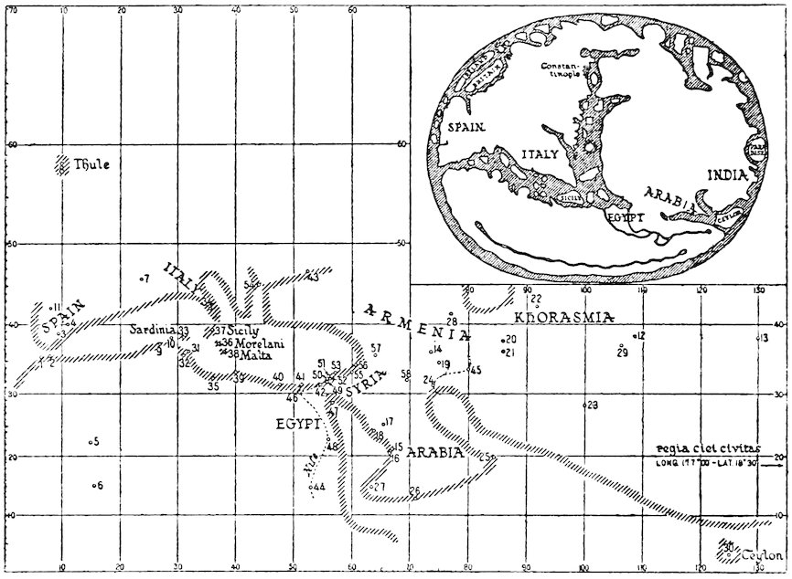
Fig. 6—Sketch map constructed from the list of geographical positions appended to the Paris manuscript of Raymond of Marseilles’ Marseilles Tables. The outline of the coast, arbitrarily indicated by a shaded band, is shown merely to give some idea of the type of map that might have been constructed from the data given in the tables. This may be compared with the Henry of Mayence map (see above, p. 124) shown in outline in the inset. The original Henry of Mayence map reveals far greater detail and upon it east (not north, as in this figure) is at the top.
This list is based on the observations of the eleventh-century Arabic astronomers Al-Khwārizmī and Az-Zarqalī. Cities and other points have been plotted according to the coördinates of this list. The resulting map of the Mediterranean region and the Near East is remarkable for its comparative accuracy. For a key to the names represented by the numbers on the diagram and for the figures for the latitudes and longitudes, see J. K. Wright, Knowledge of Latitudes and Longitudes, 1923, pp. 87–88.
That such observations were carried out is entirely possible,
for there is absolutely no doubt that methods of finding latitudes
and longitudes were well understood in theory and were sometimes
put to practical use. Rules are given for finding latitude
in Az-Zarqalī’s Canons, in Plato of Tivoli’s translation of the
Astronomy of Al-Battānī, and in many other astronomical and
astrological treatises.[1122] Two principal methods were recommended.
You may either measure with the astrolabe the altitude
of the sun above the horizon at noon at the spring or autumn
equinox and find the latitude by subtracting this angle from 90°
or you may measure the altitude of the celestial pole above the
246horizon, which is the same as the latitude. As to longitude, the
fact that there are differences in local time between points east
and west of each other was recognized and clearly explained by
several writers of our age.[1123] The Marseilles Tables give a rule
for finding longitude by the observation of eclipses. Roger of
Hereford indicates that he himself, by observing an eclipse in
1178, ascertained the positions of Hereford, Marseilles, and
Toledo in relation to Arin, the world center of the Moslems.[1124]
Gerard of Cremona describes a method of finding longitude by
noting the distance of the moon from a given point in the heavens
and thereby dispensing with eclipses,[1125] though it is doubtful
whether this method was used until the sixteenth century.
The lack of accurate instruments for ascertaining time must
have rendered it extremely difficult to calculate longitude under
any circumstances. Making allowances for this, it is surprising
to find how accurate the few coöordinates that have come down
to us seem to be, if our interpretation of them is correct.[1126]
The geographical interest of these figures and of investigations
of this sort was not appreciated by the majority of the men of
our age. The application of astronomical considerations to the
problems of navigation was still in its infancy. The purpose of
the investigator of the twelfth and early thirteenth century in
finding geographical coöordinates was astrological. He wished
to make use of them to transpose tables made originally for the
meridian and parallel of one station to the meridian and parallel
of another. Their influence on the cartography of the age was
absolutely nil. It is probably safe to make the categorical
statement that the maps and geographical treatises of the century
and a half preceding the year 1250 were drawn and written
with almost complete disregard of any astronomical considerations
whatsoever.
247
The maps of our period give us the most convincing possible
illustrations of the geographical ideas that were current.[1127] Their
bright colors, naïve legends, childlike but often skillfully drawn
vignettes, and preposterous inaccuracy take us back into the
atmosphere of a credulous and uncritical age. We can catch
much more of the flavor of the popular geography of the Middle
Ages by a hasty glance at one of the crude Beatus representations
of the world than by plowing through many of the dry
pages of compilations like the De imagine mundi.
In this chapter there will be given a brief analysis of these
maps as specimens of the cartographer’s art and an explanation of
certain points which all, or most, of them have in common.
What strikes us first is their extraordinary inaccuracy. It is
easy to laugh at this because subconsciously but inevitably we
compare the outlines of seas, continents, and regions as represented
in these maps with the outlines with which we have
become familiar in modern atlases. We tend to forget that the
contours of Europe, Asia, and Africa as we now know them are
not images that have been stamped upon the minds of men at
all times, that their accurate representation is the result of a
series of long and laborious observations completed only at a
relatively recent date. Hence it is somewhat unjust to reproach
the medieval cartographer with his inaccuracy, for the reason
that accuracy in the present-day sense was something impossible
for him to achieve. The Greeks and Moslems, to be sure, had
made far better maps than did the men of the Middle Ages;
but, unfortunately, Greek maps had perished, few Arabic maps
came through to the West, and the prevalent ignorance of Greek
made it impossible for the Occidental scholar to gain inspiration
from treatises on cartography written in that tongue.
248
Accuracy Not Deemed Necessary
Furthermore, it is a mistake to regard accuracy as the goal
and ideal of the medieval map maker. To gain a sympathetic
understanding of his work we must see what purposes he intended
it to fulfill. He drew maps to accompany and clarify the written
texts to which they were usually subsidiary. The maps were
more or less in the nature of diagrammatic sketches on which
the features of the earth’s surface were shown in a general way,
and the draftsman understood perfectly well that all he could
hope to give was a rough approximation to relative positions.
The medieval scribe and map maker was an artist who took pride
in the beauty of his work. The same motives which impelled
him to enliven his manuscript with a multitude of miniatures
led him to relieve the coldly geometrical outlines of his map by
lines and colors pleasing to the eye, by entertaining sketches and
readable legends. He was creating something very different
from the modern cartographic or topographic sheet that stands
on its own merits as an independently useful, scientific document
and from which we can get precise information about distances,
heights, positions, and terrain. He would have branded any
man a fool who thought that one could hope to determine from
his map the distance from Jerusalem to England or from the
mouth of the Ganges to the mouth of the Nile. In other words,
most medieval maps—including wall maps—were nothing more
than rough diagrams converted into works of art.
When, during the latter years of the thirteenth century, the
sailors of the Mediterranean, driven by the necessity of securing
reliable aids to navigation, began piece by piece to construct
marine charts upon which the contours of the coasts were shown
with an approach to modern correctness, we have indeed a revolution
in cartographic art and geographical science.
Bearing in mind these considerations, we see that the major
inaccuracies of medieval maps are (1) exaggeration in the scale
of particular regions at the expense of others and (2) distortion,
often amounting to a complete failure to show places in their
proper relative positions. The first of these inaccuracies was
usually deliberate, the second more or less unavoidable. Both
249are well-known characteristics of our modern American railway
folder maps.
Exaggeration
The purpose of exaggeration was, of course, to emphasize the
most interesting and significant localities. For example, on
many maps of the world, Palestine—about which a good deal
was known and in which interest naturally was centered—is
shown to be almost as large as all the rest of Asia put together.
The Jerome map of the East[1128] exaggerates Asia Minor to an enormous
size, making it a greater distance from Constantinople to
Mount Ararat than from Armenia to Taprobane (Ceylon). On
the other hand, the Jerome map of Palestine itself[1129] would lead us
to believe that the district lying between the Lebanon, the Jordan,
and the sea is at least three times as large as the Anatolian peninsula.
Certainly nobody ever thought that such proportions
actually obtain in nature. Similarly, the plans of cities that are
not infrequently included in maps are often immensely enlarged
in relation to the surrounding country, as, for example, in the
case of London, Rome, Acre, and Jerusalem on Matthew Paris’
pictorial itinerary[1130] and map of Palestine,[1131] and Jerusalem on the
“Situs Ierusalem”[1132] (see Fig. 7).
Distortion
Errors arising from distortion were due partly to ignorance
and partly to the necessity of making the map fit either the page
upon which it was drawn or else a preconceived idea of an oval,
or circular world. The “Cotton,” or “Anglo-Saxon,” map[1133]
several of the Beatus series,[1134] and even Matthew Paris’ maps of
Britain[1135] (the best of the whole period; see Fig. 9, p. 343, below)
show a semi-rectangular land mass corresponding to the pages
of the codices. On the latter a legend frankly admits that, if
only the size of the page permitted, the island would be shown
longer than it is (“Si pagine pateretur, haec totalis insula longior
esse deberet”).[1136] The manner in which geography was forced
to conform to a circular or oval world is admirably illustrated
in the treatment of the islands of the ocean. On the Beatus
series[1137] and on Lambert’s mappaemundi,[1138] Britain and the other
250islands appear as small, round, oval, or rectangular blocks more
or less regularly spaced in the circumambient ocean. Other
maps, like that of Henry of Mayence[1139] (see inset of Fig. 6, p. 245,
above), fit the islands into recesses in the oceanic shores of the
continental areas so that the smooth outlines of the whole land
mass are preserved.
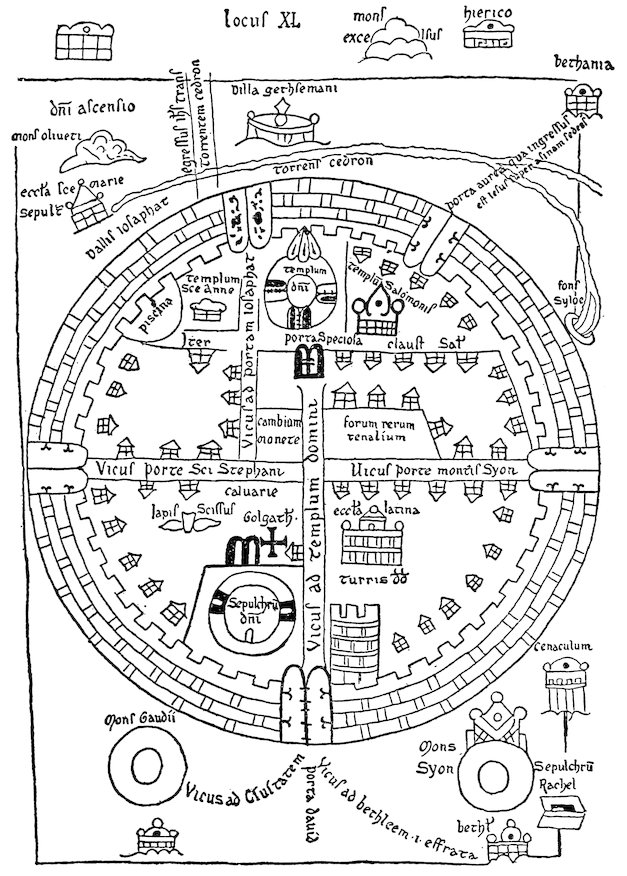
Fig. 7—The Situs Ierusalem, or plan of Jerusalem, illustrating the anonymous Gesta Francorum Ierusalem expugnantium as reproduced by Miller, Mappaemundi, vol. iii, 1895, fig. 14, from map in Codex of St. Omer.
251An extreme of confusion and disregard for reality is found in
one of the Beatus group[1140] preserved in Paris. Here it is difficult
to make out which continent is which. India, for instance, lies
just across the Red Sea from Spain (it is doubtful in what direction);
Arabia would seem to be in the farthest Orient, adjoined
by Greece on one side and Thrace on the other. Such absurdities
are unusual, but even the best maps of the period show serious
errors when measured by modern standards. The “Cotton,”[1141]
for instance, in such a well-known part of the world as Italy,
locates Ravenna on the Mediterranean shore southeast of Rome
and shows an amazing eastward displacement of Arabia and the
Red Sea, though in many other respects its geography, relatively
speaking, is very good.
The diagrammatic character of these maps is evident in the
technique of their workmanship. They all show a tendency
toward geometrical lines, curves, and symmetry. This is carried
further on some than on others (as, for example, in the cruder
specimens of the Beatus group[1142]); but, in nearly all, the ocean is
represented as a smooth circular band of even width; and, in
many, rivers and mountains follow direct lines or regular curves.
It is obvious that the ruler and compass were not neglected.
Conventions
Moreover, certain cartographic conventions were followed.
In the great majority of cases east was placed at the top, and
some authorities have endeavored to trace this convention back
to the maps of the Romans.[1143] While this explanation of its
origin may be true, the traditions of the Church, which placed
in the Orient the Garden of Eden together with the fountain of
252the waters of the world and of human life, must have had much
to do toward perpetuating it. Conventions of a sort were also
observed in the use of colors on colored maps: seas and rivers
were nearly always blue or green, except for the Red Sea, which
was invariably red. Less uniform was the color used for mountains:
on the map of the world of Henry of Mayence[1144] and on
one of Lambert’s mappaemundi[1145] they are red; the “Cotton”[1146]
shows them a brilliant green; and one of the maps of Matthew
Paris,[1147] a yellow.
Symbols and Legends
Symbols representing the various features of the earth’s surface
were more or less conventionalized, though we can hardly say
that any definitely developed “conventional signs” were in use.
It is the usual intention of symbols as employed on modern maps
to reproduce the appearance of the various features more or less
as they look when viewed from above. This is relatively recent
development; on medieval maps such elements as mountains,
forests, and cities were shown as they appear from the side. In
addition to symbols, legends were extensively employed to explain
details of the map’s surface, and sometimes these were expanded
to considerable length to include historical data and other points
of interest. A large variety of subjects were represented on
these maps by symbols, vignettes, and legends.
The atmosphere figures in the Turin Beatus[1148] in pictures at the
four corners of wind blowers seated astride of wind bags. On
the Jerome map of the East[1149] the names of certain of the winds
are written along the eastern border, and wind blowers were
familiar figures in the cartography of a later period than ours.
The ocean and inland seas, usually tinted green or blue, are
generally without symbols to emphasize their watery nature,
except perhaps for pictures of fish. On two of the Beatus series,[1150]
however, lines are drawn running parallel to the coasts, showing
that the medieval draftsman had hit upon and crudely executed
a modern scheme of representing water. The Guido map of
Italy[1151] represents the sea by scalloped lines. On the Guido
map of the world[1152] the size of the Mediterranean and its branches
253is enormously enlarged;[1153] whereas the worst examples of the
Beatus group[1154] show the inland seas as narrow channels bounded
by straight shores.
The width of rivers is nearly always immensely exaggerated;
on some maps rivers appear to be as wide as the seas themselves.
Only the “Cotton”[1155] forms an exception in representing them
(except for the Nile) as single lines. On the whole, hydrography
is drawn arbitrarily. Streams cross each other, separate, and
connect one sea with another; though the Jerome maps,[1156] certain
of the Beatus series,[1157] and the “Cotton”[1158] place the headwaters
of many of the rivers of Asia and Europe in mountain ranges.
Lakes are generally represented as bulb-shaped bodies from
which rivers rise or into which they expand.
No attempt was made to show by symbols different kinds of
land surface, except perhaps by Matthew Paris in one of his
maps of Britain,[1159] which differentiates the marshy country of the
eastern shires from the rest of the island. On certain members
of the Beatus group[1160] we read legends in Africa and Asia calling
the country “deserta et arenosa;” and legends appearing on
Matthew Paris’ maps[1161] describe the boggy, wild, and mountainous
country of northern Scotland and Wales. The Paris Beatus
No. II[1162] has a legend in a remote part of Asia indicating “land
uninhabitable on account of the abundance of water.”
Mountain ranges were generally represented by jagged, saw-tooth
lines running parallel to straight lines;[1163] particularly high
or famous peaks, by a single great pyramid. Such pyramids
are prominent features in the Beatus series,[1164] where woods are
often shown growing upon them. The Hyrcanian Forest is
depicted and labeled on the Jerome map of Palestine,[1165] and the
pepper forests of India are indicated on the Jerome map of the
East.[1166]
Among the works of man cities and buildings take a foremost
place, represented by vignettes of castles, towers, and churches.
On several maps[1167] especially notable works are depicted, as the
lighthouse of Alexandria, the tower of Babel, the columns of
Alexander and Hercules; and the seas are sometimes filled with
ships. As to men themselves, the legends give the names of
254cities, provinces, and countries. The Jerome maps[1168] give a series
of tribal names in Scythia. Adam and Eve with the serpent
were stereotyped features enlivening the East on many but by
no means all the maps of our age; and on the Osma Beatus[1169] we
see the uniformly gloomy features of the twelve apostles distributed
over the earth’s surface (see Fig. 4, p. 123, above).
The monsters of India were also represented by vignettes of
a skiapod, or shadowfoot, on two of the Beatus group,[1170] where
this uncomfortable creature is shown as the most prominent
inhabitant of the austral continent (see Fig. 4) and the existence
of other monsters is hinted at by legends referring to griffons,
cynocephali, and the like.
In surveying the extant maps of our period as a whole, and in
comparing them with one another, it is impossible to detect any
appreciable development from worse cartography to better. To
be sure, Matthew Paris’ three maps of Britain[1171] (Fig. 9, p. 343,
below), made at the very end of our century and a half, are
probably also the best. But they represent a limited area; and
among the maps of the world the “Cotton,” or Anglo-Saxon,[1172]
which possibly dates from the twelfth century but may be very
much older, holds by all odds the highest rank so far as cartographic
excellence goes. The complex and elaborate wall map of
the late thirteenth century in Hereford Cathedral[1173] and the immense
Ebstorf map at Hanover (dated 1284)[1174] represent the
culmination of a process in the direction of increasing elaboration
that had been in progress throughout the age. They do not indicate
any improvement in cartographic standards but rather, as
was the case with some of the great works of compilation of the
time, a multiplication of fabulous and incongruous detail. Beazley
dismisses them rather summarily as monstrosities. They are
the cartographic counterparts of the Image du monde and the
Livre du trésor of Brunetto Latino.
255
We shall not attempt the thankless and impossible task of
giving a complete conspectus of Western regional lore in the
twelfth and early thirteenth centuries. This chapter, like its
predecessors, consists largely of illustrative examples.
Geography of Tradition and Geography of Observation
We explained in the Introduction that there were two kinds of geographical information available in the Middle Ages—information derived from earlier literature and information derived from contemporary tradition and observation. In the
period we are studying, these were found among men of very
different interests and activities, and hence they usually failed to
blend. It is true that now and then in a work of erudition of the
time we come across a report of some original observation made
by the writer himself or learned by him from a contemporary;
but these data were seldom really assimilated into the body of
the text, seldom used as a check on the assertions of older authorities.
They seem to float like drops of oil on the deep, or shallow,
waters of authoritative learning. Conversely, in works recording
contemporary events—histories, chronicles, letters—we often
come across facts and theories that were taken from older books;
but these were infrequently subjected to critical examination in
the light of contemporary knowledge. On the contrary, they
were usually treated with indulgence or respect merely because
they were old, even when observed phenomena seemed to prove
them false.
In the present as in the foregoing parts of this book the attempt
is made to distinguish between these two distinct types of
geographical lore. For many regions the geographical ideas are
256indicated that were derived from Pliny, Solinus, Isidore, Bede,
and other encyclopedists and that found expression in treatises
like the De imagine mundi, the Otia imperialia, and the Image du
monde. In contrast to these there is set forth the kind of information
that was being gathered by contemporary eyewitnesses.
Gradations of Accuracy of Knowledge
Maps are sometimes drawn at the present day to show the
state of progress of geographical knowledge. Upon these by
various tints or shadings are indicated tracts that are accurately
surveyed, partially surveyed, known only through route traverses,
known only through reports from natives, or totally unknown.
No such map could be constructed to show the character
of regional knowledge in the Middle Ages, because our sources of
information are not sufficiently complete and because the knowledge
both actually and potentially available varied from country
to country, from community to community, even from individual
to individual. The printing press and facility of communication
between the peoples of the world has rendered scientific
knowledge or, at any rate, the possibility of obtaining scientific
knowledge the common property of all modern civilizations. An
Australian student, for instance, if he is willing to take the time
and trouble, can learn through research virtually all that is
known to Danish or Icelandic scholars about the geography of
Greenland. In the Middle Ages, on the contrary, we may feel
certain that the Danes and Norwegians had at hand much
detailed information on Greenland and the Arctic shores of
Europe that the Italian had no means whatever of obtaining.
Correspondingly, the Italian trader of Genoa or Venice unquestionably
knew a great deal about remote parts of Asia and North
Africa that could never reach the ears of an author of a De
imagine mundi or of a Lambert of St. Omer, writing in quiet
cloisters of France or Belgium.
Yet if, for these reasons, we cannot show on a map the gradations
in the character and accuracy of Western geographical
knowledge in the age of the Crusades, such gradations nevertheless
existed. From the point of view of Western Europe as a
257whole they might be grouped in a broad way as follows. First
there were the well-known regions about which knowledge was
derived and kept fresh through active commercial, diplomatic,
ecclesiastical, military, and scholarly enterprise. These regions
may be said to have included most of Europe west of the Elbe
and Hungary. They also included the overland routes to Constantinople,
the shores of the Mediterranean, and the Holy Land.
From the point of view of the Scandinavian peoples, who were
great travelers, they took in not only the foregoing regions but
also the Baltic coasts, southern Norway and Sweden, and Iceland.
Beyond the bounds of the well-known areas lay a second group of
areas about which a fair amount of reasonably trustworthy
information was at hand, derived from one of three sources: (1)
reports of occasional travelers; (2) more or less reliable hearsay;
(3) classical descriptions drawn from literary sources. Much of
Western Asia and North Africa fell within this category and, for
the Scandinavians, Greenland. Beyond lay the third group of
regions known only through the vaguest of rumors—the domains
of fabulous monsters and legendary men. To some writers India
was such a land, to others Russia and northern Scandinavia, to
still others the legendary isles that lay concealed in the Western
Ocean. Finally, beyond them came those regions lying without
the known world, about which the men of the Middle Ages themselves
would have acknowledged that they knew nothing: the
austral continent, the countries of the antipodeans, antoikoi,
antichthones, which have been discussed in an earlier chapter.
No boundaries could be drawn setting off these various tracts
from one another; the well-known shaded off imperceptibly into
the less well-known, and the vaguely known merged into fairyland;
within each well-known tract were islands of doubt and
mystery, and fabulous stories were told of even the most commonplace
features of the landscape.
Before turning to the various regions of the known world—the
oikoumene, as the Greeks called it; the orbis terrarum or habitatio
of the Romans—something must be said concerning theories
258about the oikoumene as a whole, about its center, and about Paradise
and the four rivers of Paradise. It was usually supposed
that the oikoumene itself occupies a relatively restricted part of
the surface of the globe. The words of Seneca to the effect that
there is only a short distance from Spain to India imply that the
known world must stretch out over much more than a half of the
circumference of the sphere.[1175] Though these words were often
read in our period, scant attention was paid either to them or to
the Arabic interpretation of Aristotle’s similar theory until a
later date. Roger Bacon’s specific explanation that the habitatio
extends around much more than half the earth’s circumference
represents an opinion that was exceptional.[1176] The majority of
the thinkers of the twelfth and early thirteenth centuries who
speculated on the subject at all were probably under the spell of
the theory fostered by Macrobius, which made our habitable
portion of the earth one of four similar regions separated from
each other by two oceans.[1177] This undoubtedly was the view most
widely accepted, but in addition the idea was perhaps already
being propounded early in the twelfth century that the lands of
the known world form merely a small portion of the surface of the
terrestrial sphere emerging above the surface of a larger, enveloping
sphere of water.[1178]
The “Oikoumene” Divided into Three Parts
The writers of the Crusading age were unanimous in dividing
the oikoumene itself into three parts, Asia, Libya (or Africa), and
Europe. Bernard Sylvester said: “In two parts the ether, and
likewise in two parts the air, but in three parts you are to understand
that the land is divided,”[1179] almost as if a tripartite division
of the lands were in accord with a law of nature. This division
was inevitable in view of what was known of the arrangement of
lands and seas. Orosius,[1180] however, had spoken of certain writers
who would split the known world in two, making Africa a part of
Europe “because of its small size” and making Asia as large as
Africa and Europe together. Those who had preferred to conceive
of Africa as a separate continent, he had said, did so not on
account of its size but because it is cut off from Europe by an
259arm of the sea. These words of Orosius were quoted by Otto of
Freising[1181] and by Gervase of Tilbury.[1182] The theory that Asia is
equal in size to Europe and Africa put together is reproduced by
the author of the De situ terrarum,[1183] and upon it was based that
symmetrical division of the world’s surface which we find depicted
on the so-called T-O maps of the early Middle Ages.[1184]
Isidore of Seville drew largely from Orosius in writing his chapters
on geography. Theoretically he accepted the tripartite
division,[1185] but in his actual treatment of the countries of the
world he appended a discussion of islands to his discussion of the
continents. In this he was followed by the author of the De
imagine mundi and by many other writers of the time,[1186] all of
whom declared that the earth’s surface is divided in three, but
added chapters on the islands after their descriptions of Asia,
Africa, and Europe.
Jerusalem as the Center
During the Middle Ages the idea that Jerusalem is at the center
of the oikoumene seems gradually to have gained ground.
Arculf, a bishop of an unknown see in Gaul and pilgrim to the
Holy Land, so described it as early as the close of the seventh
century;[1187] but the tradition does not appear to have become established
in the cartography of the West until the twelfth or even
the thirteenth century.[1188] To place Jerusalem at the center was
to recognize the preëminence given that city in Scripture, not
only in the New but also in the Old Testament.[1189] It is natural
for primitive peoples to think that the most holy of all places occupies
a central position:[1190] the Greeks believed that either Delphi
or Olympus was the navel of the earth;[1191] the Scandinavians
thought the same was true of Asgard; the Hindus, of Mount
Meru; the Babylonians, of Nippur.[1192] Gervase of Tilbury argues
in a confused, semi-theological manner on the position of Jerusalem:[1193]
Augustus, he believed, had thought that Judea was the
heart of the earth because that Emperor had begun a survey of
the provinces of the empire there; in addition, from texts of the
260Bible Gervase attempted to demonstrate that Jerusalem is halfway
between the North and the South, that by “antithesis” it
must be halfway between the East and the West, and consequently
must be at the center of the known world.
The Exact Position of the Earth’s Center
There seems to have existed in the minds of writers some confusion
as to the exact spot that marks the navel of the earth. A
map of the year 1110 identifies it with Mount Zion.[1194] The pilgrim
Saewulf, who was in the Holy Land in 1102 and 1103,
says:[1195] “At the head of the Church of the Holy Sepulchre, in the
wall outside, not far from the place called Calvary, is the place
called Compas, which our Lord Jesus Christ himself signified
and measured with his own hand as the middle of the world, according
to the words of the Psalmist, ‘For God is my king of old,
working salvation in the midst of the earth.’ But some say that
this is the place where our Lord Jesus Christ first appeared to
Mary Magdalene, while she sought him weeping and thought he
had been a gardener, as is related in the Gospels” (Thomas
Wright’s translation).[1196]
In certain astronomical notes of the early twelfth century an
anonymous writer (possibly Adelard of Bath) asserts that
Mount “Amor reorum” is the center of the earth and that he
proved this to be the case by experiment.[1197] It would seem that
upon this mountain (possibly Mount Moriah) he hung a log,
twelve cubits long by three in diameter, suspending it vertically
in the air by means of a rope, and that at the time of the summer
solstice he observed that the shadow of the log was directly beneath
and circular in shape. This, he asserted, showed that
Mount “Amor reorum” was the center of the earth. To clinch
the veracity of his observation, he added that he had not been
drinking wine and that his eyes were not satiated with sleep. Although
the sun is not directly overhead at the summer solstice in
Palestine, the same idea reappears in the Otia imperialia of Gervase
of Tilbury.[1198] Gervase seems to favor, as the center of the
earth, the well where Christ spoke to the Samaritan woman.[1199]
He adds that this well has the characteristic that philosophers
261attribute to wells on the Tropic of Cancer at Syene in Africa, that
is to say, that the sun shines directly into it at the summer solstice
every year.
Paradise in the East
Most medieval maps include in the eastern part of the world a
picture of the Terrestrial Paradise,[1200] surrounded by a high wall
or mountain range and containing within it figures of Adam and
Eve and the serpent[1201] (see above, Fig. 2, p. 69). “The first
place in the East is Paradise, a garden famous for its delights,
where man can never go, for a fiery wall surrounds it and reaches
to the sky. Here is the tree of life which gives immortality, here
the fountain which divides into four streams that go forth and
water the world.”[1202] “Around Paradise extends a savage,
trackless waste, infested with wild beasts and serpents.”[1203]
This was the orthodox medieval view, to be found in Peter
Abelard’s commentary on the Works of the Six Days,[1204] in the De
situ terrarum,[1205] and in the Image du monde.[1206] Gervase of Tilbury
copies it word for word from the De imagine mundi[1207] but gives
additional details in another connection,[1208]where he tells us that
Paradise was the seat of the first of the four universal monarchies,
that of Adam; that it was so called because of its delights, for
“delight” is the meaning of the word “Eden,” and that the Garden
makes a spot of marvelous deliciousness, separated from our
inhabited earth by a long tract of land and sea and elevated so
high that it reaches the sphere of the moon, so high that the
waters of the Deluge failed to disturb it.[1209] Peter Lombard explained
why it is thought that Paradise is in the East:[1210] Scripture,
he said, teaches us that God made man outside of Paradise and
placed him ready-fashioned in the Garden of Delights which had
been planted by the divine power at the beginning of time (a
principio). In an old translation, Peter explained, instead of
this phrase, a principio, the words ad Orientem were given, and
consequently the earlier translator would have had us believe
that Paradise was to be found in the eastern parts of the earth.
Peter added that a long stretch of land and sea cut Paradise off
262from the regions inhabited by men and that it was situated on a
height touching the circle of the moon’s orbit, whence it came
about that the waters of the Deluge could not penetrate thither.
It was generally agreed that Paradise is in Asia,[1211] although this
was not a universal belief. Hermann the Dalmatian in 1143
asserted that there was “no mean opinion” that Paradise lies
beyond “Amphitrites,” the ocean which encircles the earth from
north to south, and that indications of its presence had been
found both to eastward and to westward.[1212] Gervase said that
it could be forcibly argued that the Garden lies beyond the Torrid
Zone and is inaccessible to man, though he did not commit
himself either for or against this theory.[1213] Robert Grosseteste
speaks of theologians who would place Paradise under the equator.[1214]
Otto of Freising’s words[1215] also seem to imply indirectly
that the Garden is not in Asia, for Otto tells us that Alexander
the Great conquered the entire Orient from Scythia to the ends
of the earth. The same idea may be gathered from the De situ
terrarum,[1216] which places the Seres and not Paradise in the farthest
East, and also from the cycle of romances of Alexander, which
relate how the Macedonian hero conquered all those Oriental
regions where Paradise was usually supposed to be. The mappaemundi
of Henry of Mayence[1217] and of Lambert of St. Omer[1218]
place Paradise on an island beyond the easternmost limits of the
habitable world; but St. Brandan found the Saint’s Land of
Promise (probably no other than Paradise) far out in the Western
Ocean.[1219] As a matter of fact there was no uniformity of opinion
regarding the geographical position of the Happy Land: St.
Augustine, whose works were read during our period, had even
gone so far as to state that Paradise had no real existence at all
but was merely an allegorical conception.[1220] A child is not worried
about the latitude and longitude of fairyland, and the average
man of the Middle Ages was just as little worried about the
exact whereabouts of the Garden of Eden.
Nevertheless, in one version of the Romance of Alexander a
logical outcome of the conqueror’s travels in the Far East was
recognized. In the Iter ad Paradisum[1221] Alexander is actually
brought to the gates of Paradise. When he had subjugated
263India he came to a broad river which he understood to be the
Ganges; embarking with five hundred men on a ship that happened
to be at hand, he arrived at the end of a month before an
immense city surrounded by a wall on all sides. Here, after
various adventures, he learned from a Jew that this city was the
place where the souls of the just were sojourning until the Last
Judgment or, in other words, that it was the Terrestrial Paradise.
Journeys to Paradise
The Iter ad Paradisum and the various versions of the legend
of St. Brandan’s voyage are examples of a type of story very
common in the Middle Ages, the story of actual journeys to
Paradise by mortal men.[1222] Among these we should include the
account of the visit there of Adam’s son, Seth, who brought back
seeds from the tree of knowledge which were planted in Adam’s
mouth after the latter’s death; the seeds ultimately sprouted
into a great tree, the wood of which was used to make Christ’s
cross.[1223] Tales were told of the sojourns of pious monks in
Paradise and of how on their return to the homes of men they
found that what had seemed only three days in the Garden of
Delights was in reality a period of three hundred years. Godfrey
of Viterbo in his Pantheon[1224] relates a tale of a hundred
brothers who, like St. Brandan, made widespread explorations
in the ocean before coming to Paradise, a golden mountain redolent
with wonderful odors and adorned with an image of the
Virgin and Child. Another story, dating from an earlier time
but undoubtedly well known during our period, was that of the
fabulous St. Macarius.[1225] Three brothers from a convent between
the Tigris and Euphrates set out to find the place where “the
earth joins the sky.” After crossing Persia they entered India—a
land of wonders, of cynocephali and of pygmies, of serpents
and of darkness. Here they came upon the altars set up by
Alexander the Great to mark the limits of his wanderings,[1226] and
beyond them reached miraculous countries filled with giants and
birds that talked. At last, about twenty miles from the Terrestrial
Paradise, they found Macarius, a man of hoary age, dwelling
in a cave on friendly terms with two lions. Macarius told them
264a romantic story, in the course of which he described the wonders
of Paradise but, alas, emphasized the fact that this long-sought-for
garden was absolutely inaccessible to human beings.
The Rivers of Paradise
The account of the four rivers of Paradise, like other passages
in Scripture, was interpreted both allegorically and literally. In
the religious art of our period these streams were often depicted in
stone, glass, or miniature as symbolizing the four evangelists
spreading the gospel throughout the world.[1227] Neckam, after
mentioning Paradise and the rivers, goes on to explain that, just
as the world is watered by the four streams, so “by the gift of
the Holy Ghost the garden of the Holy Church is irrigated by the
four virtues, Justice, Temperance, Fortitude, and Prudence.”[1228]
Literal interpretation of the passage, on the other hand, would
present difficulties to the modern hydrographer, but these difficulties
were easily overcome in the Middle Ages by appeal to the
familiar theory of subterranean watercourses.[1229]
The author of the De imagine mundi,[1230] copying from Isidore,[1231]
makes the four rivers disappear into the ground, whence they
spring forth in lands far distant; and some of the maps of our
period represent all four rivers as rising from a central source
within the Garden and vanishing into the earth at its walls or
not far beyond. The Psalter map,[1232] on the other hand, shows
no less than five rivers issuing from an aperture leading out of
Paradise and spreading out like a fan over the interior of Asia.
Abelard[1233] explains carefully that if we interpret the Bible correctly
there can be but one river within Paradise, that this divides
into four outside of the Garden, and that the names given to each
of the four are applied to those parts only “which flow from their
sources to the sea.” We may assume that he refers here to the
portions of the rivers between points where they issue from their
subterranean passages and their mouths. Some writers would
seem to imply, Abelard continues, that we cannot take literally
the words of the Bible because the sources of some of the four
streams are known and those of others are not. But, he asks,
may not those streams, whose sources are supposedly known, in
265reality arise elsewhere far away and pass through numerous
countries before issuing forth to the knowledge of mankind?
There is no question but that this is the case with many streams,
as is shown, he adds, by the statement in Boethius’ De consolatione
philosophiae (a famous work of the sixth century much
read throughout the Middle Ages) that “the Tigris and the
Euphrates spring from one source.”
One version of the legend of Prester John informs us that the
four rivers of Paradise all arise in a spring in the mountains of
India and water the two Indias.[1234] Like most rivers of Prester
John’s realm, they give forth quantities of gold and precious
stones at regular intervals three times a year.
Discussion of the individual characteristics of each of the four
rivers falls more logically with the treatment of the ideas concerning
the countries through which they flow and will be reserved
until later. In most of the geographical works of our
period, however, the rivers receive special consideration immediately
after the remarks on Paradise and before the description
of the regions of Asia. Their unusual origin and character,
as described in Scripture, entitled them to particular distinction:
they were holy streams to Jew and Christian alike. It is, then,
a peculiarly eloquent commentary on the paganism of Bernard
Sylvester to find that he mentions and describes the Euphrates,
Tigris, and Nile in his De mundi universitate[1235] without referring
to Paradise in connection with any of these three streams. To
his thinking they would seem to have occupied no higher or
holier place among streams than Tiber, Rhone, or Seine.
There are no more absorbing chapters in the history of geography
than those connected with the growth of European knowledge
of Asia in antiquity and during the Middle Ages [1236] and with
its converse, the growth of Oriental knowledge of the Occident.[1237]
Of late years the historical and archeological investigations of
Albert von Le Coq, Sir Aurel Stein, Edouard Chavannes, Paul
Pelliot, and Albert Herrmann have thrown a flood of light on the
connections that existed in the earlier medieval period between
266eastern and western Asia. While these early connections may
have brought some vague information regarding the Far East to
the Byzantine world, they probably exerted almost no influence
upon the conceptions of Asia prevalent in Western Europe before
the middle of the thirteenth century.
The Opening of Asia in the Thirteenth Century
Relations between the Far East and Far West, however, were
profoundly modified by certain events that took place during the
first half of the thirteenth century. As a result of these events,
Farther Asia for the first time in history was opened to Occidental
travelers. Beginning with the year 1245 no inconsiderable
number of European missionaries and traders made their way
overland through the hitherto unknown heart of the continent
and penetrated to the mysterious region of Cathay (China) at
the ultimate point of the world. For somewhat more than a
century the veil of the Extreme Orient was drawn aside, but
drawn aside only again to be closed when the disruption of the
Mongol empires and the rise of the Ottoman Turks barred the
overland routes. It remained for Portuguese and Spanish seafarers
of the great age of maritime exploration to rediscover the
Far East. The history of the earlier relations of eastern and
western Asia and of the opening of that continent in the thirteenth
and fourteenth centuries, however, falls outside our province and
cannot be discussed in detail in the present volume. A few
words, nevertheless, must be said on this subject in order that the
traditional geographical lore of Asia in our period may be seen in
its proper perspective.
The Mongol Conquests
The events that led to the overland journeys sprang from the
establishment of what was probably the most extensive military
empire the world has ever known.[1238] Toward the end of the
twelfth century, Temujin, chief of a small tribe dwelling near the
headwaters of the Amur, consolidated his dominion over the
neighboring Mongol peoples of the steppes north and northwest
of China. Proclaimed “Chinkkis Khan” (Jenghiz Khan), or
267“Inflexible Emperor,” in 1206, he soon conquered northern
China and turned his hordes to the west; Turkestan was subjugated,
Persia was invaded, and in 1222–1224 a detachment
overran southern Russia in the course of a great whirlwind raid
that completely encircled the Caspian Sea. Jenghiz Khan died
in 1227, but under his successors the wave of conquest swept still
farther westward. Toward the close of the thirties the steppes
of Russia were again overwhelmed, in 1240 Poland was devastated,
and the Christian army of Henry of Silesia was defeated in
1241 at Liegnitz, near Breslau. Meanwhile another Mongol
army was ravaging Hungary and had even driven the king of
that country to seek refuge in an island off the Dalmatian coast.
Relief to the stricken people of Central Europe came, however, in
1243 when news of the death of the Great Khan caused the
invaders to withdraw to the plains of Russia, there to maintain
their hold for many centuries to come.
These visitations of the Tatars, as the Mongols were called,
took Europe unaware. “Barely a rumour” of the invasion of
Russia in 1222 had “reached western Europe,” writes Rockhill,[1239]
“and contemporary writers have left us but few brief references
to it.” The first full description of the Tatars is given in Matthew
Paris’ Chronica maiora[1240] for the date 1240, the following
extracts of which, as translated by Rockhill, are worth quoting:
“That the joys of mortal men be not enduring, nor worldly
happiness long lasting without lamentations, in this same year
(i.e. 1240) a detestable nation of Satan, to wit, the countless army
of the Tartars, broke loose from its mountain-environed home,
and piercing the solid rocks (of the Caucasus), poured forth like
devils from the Tartarus, so that they are rightly called Tartari
or Tartarians. Swarming like locusts over the face of the earth,
they have brought terrible devastation to the eastern parts (of
Europe), laying it waste with fire and carnage.... They
are inhuman and beastly, rather monsters than men, thirsting
for and drinking blood, tearing and devouring the flesh of dogs
and men, dressed in ox-hides, armed with plates of iron, short and
stout, thickset, strong, invincible, indefatigable, their backs
unprotected, their breasts covered with armour.... They
268are without human laws, know no comforts, are more ferocious
than lions or bears, have boats made of ox-hides, which ten or
twelve of them own in common: they are able to swim or to
manage a boat, so that they can cross the largest and swiftest
rivers without let or hindrance, drinking turbid or muddy water
when blood fails them (as beverage).... They know no
other language than their own, which no one else knows; for until
now there has been no access to them, nor did they go forth (from
their own country); ... They wander about with their
flocks and their wives, who are taught to fight like men....
It is believed that these Tartars, of cursed memory, are of the
ten tribes who, having forsaken the Mosaic law, followed after
the golden calves, and whom Alexander the Macedonian endeavoured
at first to shut up in the rugged mountains of the Caspians
with bitumen-covered rocks.[1241] When he saw that the undertaking
exceeded the power of man, he invoked the might of the
God of Israel, and the tops of the mountains came together, and
an inaccessible and impassable place was made.... It is
written in sacred history that they shall come out toward the end
of the world, and shall make a great slaughter of men. There
arises, however, a doubt whether the Tartars now coming from
there be really they, for they do not use the Hebrew tongue,
neither do they know the laws of Moses, nor have they laws, nor
are they governed by them....”
Despite the impression of extreme ferocity reflected in this
passage, after the warlike ardor of conquest had somewhat subsided,
the Mongols showed themselves not intolerant in their
attitude toward strangers and not unreceptive of foreign influence.
The immediate result of their withdrawal from Hungary
to Russia and the consequent removal of the direct menace to
Central Europe was the dispatch of Christian ecclesiastics as
ambassadors to the Mongol lords. Rumors had come to Europe
that these nomads from the Far East were monotheists, and hope
sprang up that they might be converted to Roman Catholic
Christianity and used to offset the reviving Moslem power menacing
the Christian states of the Holy Land.[1242] The origin of the
rumors which gave rise to this elusive hope is to be sought in the
269fact that the Nestorian form of Christianity had been firmly
established among some of the Mongol tribes north of the Great
Wall of China and was represented even in their ruling dynasty.
Furthermore, these rumors seemed to confirm and be confirmed
by the reports that had been in circulation since the twelfth
century of the existence of a great Christian kingdom of Prester
John in the remote interior of Asia.[1243]
Thirteenth-Century Journeys
The journeys of the diplomatic missions sent out by Pope
Innocent IV and by Louis IX, King of France, in 1245 and the
years immediately following have often been described.[1244] The
Pope’s envoy, John of Pian de Carpine,[1245] and Louis’ representative,
William of Rubruck,[1246] reached the Mongol capital at
Karakorum, near Lake Baikal, and on their return wrote graphic
narratives of their journeys, which have been preserved and
which give full account of the Tatars and their customs. Many
of the observations made by John of Pian de Carpine and by
Simon of St. Quentin (who took part in an expedition under
Friar Ascelin, or Anselm, sent by the Pope to a Mongol ruler in
Persia in 1247) are included in the Speculum historiale of Vincent
of Beauvais.[1247] The geographical information acquired by Rubruck,
although it was ignored by other writers of the period,
found its way to Roger Bacon, who incorporated much of it in
the Opus majus.[1248]
The way shown by Pian de Carpine and Rubruck was soon
followed by Nicolo and Maffeo Polo, whose incentive was commercial,
and by their far more famous son and nephew, Marco.[1249]
Marco Polo’s amazing wanderings were succeeded by the journeys
of others, among them the wonderful missionary enterprises of
John of Monte Corvino, Riccold of Monte Croce, and Orderic of
Pordenone. The story of these and other travels of the period,[1250]
fascinatingly told in the third volume of Beazley’s Dawn of Modern
Geography, falls far beyond the limits of our subject. Suffice
it to remark, however, that the wanderings of the adventurous
traders and friars were generally forgotten in the West during the
centuries that followed and were largely ignored, even in the
270literature of the time itself. Marco Polo was branded as an
impostor, and the traditional lore of eastern Asia that had come
down from the days of the Roman Empire, together with its
accretions of legend and romance, was held to be more worthy of
credence than the observations of eyewitnesses. We must now
turn to this traditional lore as expressed in the writings of the
time of the Crusades.
The Great Mountain System of Asia
Asia, the author of the De imagine mundi[1251] tells us, quoting
from Isidore,[1252] derived its name from a queen of that name.
The great system of mountains which runs eastward through
the heart of the continent—the Caucasus, the ranges of northern
Persia, the Hindu Kush, the Himalayas—was well known to the
Greek geographers, and the men of our time had acquired some
hazy notions about it through reading Orosius and Isidore.[1253]
Gervase of Tilbury,[1254] copying Orosius,[1255] tells how the Caucasus,
joined by the “Imabus” (Imaus), divides India from Scythia
and extends the entire length of Asia as far east as the Seric
Ocean, though bearing different names in its eastern parts.
Several of the maps show a straight range of mountains running
east and west across the continent and labeled with various
names (Taurus, Caucasus, Ceraunius, Paropamisus).[1256] The
Jerome map[1257] reveals, on the other hand, many mountains in
Asia but does not make them continuous.
According to the De imagine mundi, the Caucasus divides the
countries of southern from those of northern Asia. Among the
former were India, Parthia, Mesopotamia, and Palestine, reaching
in a straight line from the Far East to the Mediterranean.[1258]
Egypt, which was regarded as belonging to Asia by the Greek
geographers and by Isidore, was held to adjoin Palestine on the
west, and to be part of this southern tier of countries. North of
the Caucasus were the lands of the Seres, Bactria, Hyrcania, and
Scythia, in the east, and in western Asia, Armenia, the country
of Mount Ararat, Cappadocia (“where mares conceive through
the wind alone and give birth to foals that live only three years”),
and finally Asia Minor, almost completely surrounded by the sea.[1259]
271
The Land of the “Seres”
At the eastern end of Asia, Gervase, following the Roman
geographers, had placed the Seres on the shores of an ocean named
after them.[1260] “Seres” was a classical designation of the people
of China in so far as that country was the terminus of the overland
route toward the Far East described by Pliny and Ptolemy.
Beyond vast solitudes, the former had said,[1261] you come to this
remote land, where the people comb silk from the trees; though
they carry on an extensive trade in this commodity, they avoid
all personal dealings with strangers (whose commercial morality
must have been high) by leaving the silk on the banks of streams
to be picked up by those who wish to procure it. Solinus [1262]
copied Pliny’s account, but Isidore,[1263] followed by the author of
the De imagine mundi,[1264] gives us less detail, merely stating that
Seres is a city of the East, from which were named the Seric
region, the people, and a kind of cloth. Pausanias first among
classical writers had understood that silk comes from a worm.
The silk manufacture was introduced into the Byzantine Empire
in 552 A. D., and it may well be from Byzantine sources that
there originated the more or less correct understanding of its
production revealed in the Letter of Prester John,[1265] where we are
informed that the salamander is a worm which makes a sort of
capsule (pellicula) around him, “as do the other worms that make
silk.”
China
If the land of the Seres lay at the end of the overland route
eastward, the sea route ended, according to the Periplus of the
Erythraean Sea, at the land of “Thin” (China), and according
to Ptolemy’s Geography at the country of the “Sinae.”[1266] Here
we have the first use in the West of the word “China,” knowledge
of which had probably reached the Occident through Arabic
channels, though not until the sixteenth century was it recognized
that the land of the “Seres” (Cathay) and “China” were
the same.[1267] An indication of the Ptolemaic “Sinae” is found in
Plato of Tivoli’s translation of Al-Battānī’s Astronomy:[1268] here a
branch of the Indian Ocean is described as reaching to the furthest
point of India where lies “Thiema” (China).
272Benjamin of Tudela also speaks of the country of “Zin,” or
China, in the uttermost East near the reputed Sea of Nikpa,
where violent and stormy winds blow—possibly the typhoons of
Far Eastern waters. Ships carried into this sea by the winds
stick fast there; their supplies of food give out, and the crews often
die of starvation. In order to avoid this fate, some of the men,
armed with knives, throw themselves into the sea and are carried
to shore in the talons of an enormous bird, the griffon. By slaying
the griffon with their knives they are able to escape.[1269] This
story reminds us, on the one hand, of Western reports of the congealed
sea[1270] and, on the other, of Arabic tales of the Rukh, which
reappear in Marco Polo’s travels.[1271]
India
Subdivisions
More abundant and somewhat more accurate information was
to be had regarding India. This name was applied loosely to
cover all of Farther Asia: the anonymous report of the visit of
the Patriarch John of India to Rome in 1122 calls India the ultimate
border of the world. The Pseudo-Abdias[1272] had quoted
“certain historiographers” as asserting that there are three
Indias, the first facing Ethiopia, the second facing the country of
the Medes, and the third occupying the end of the earth, with the
realm of darkness on one side and the ocean on the other. The
threefold division of India was found on many of the maps.[1273]
It was adopted by Ordericus Vitalis in his Historia ecclesiastica.[1274]
It undoubtedly inspired the declaration in the Letter of Prester
John[1275] that that potentate rules over the “three Indias,” and
probably with it in mind Gervase of Tilbury[1276] spoke of “India
superior,” where St. Bartholomew, “India inferior,” where St.
Thomas, and “India meridiana,” where St. Matthew preached.
On the other hand, there is evidence of a twofold division of India
in the Elysaeus[1277] account of Prester John’s kingdom. The
broad and loose medieval usage of the term “India” is especially
well shown in the Image du monde, where it comprises not only
what we now know as Hindustan but also Persia.[1278]
Limiting ourselves to the narrower definition of India, the
273tract between the Himalayas and the ocean, let us see what was
believed to exist there.
Facts Known About India
A few facts were known, many half-facts, and a great many
more fables. This knowledge and misinformation was based to
a very large extent on classical authority, for little new had
been learned about these parts of the world since the days of
Pliny. First let us examine the facts and half-facts.[1279] It was
known that much of India lies beyond the tropic so that the
shadows fall south in summer and north in winter. It was
known that a giant range of mountains encloses India on the
north, and perhaps there was a hint of familiarity with the
Himalayan forests in the old story of trees so lofty that they
touch the skies. It was likewise known that the Ganges takes
its rise in the mountains to the north and is joined by many
streams. According to Isidore, who was followed by the De
imagine mundi, Peter Abelard, Gervase of Tilbury, Peter Comestor,
and a host of other plagiarizers,[1280] the Ganges is no other
than the Pison, one of the rivers of Paradise, which springs from
Mount Orcobares and flows eastward to the ocean. Peter
Comestor explains[1281] that “Phison” may mean “flock,” because
ten rivers join to make this stream,[1282] an interpretation in
which we see perhaps a reflection of the true characteristics of
the great stream of India, so strikingly different from the other
three “rivers of Paradise” by reason of its multitude of tributaries.
The same idea, or possibly even a suggestion of the
Ganges delta with its many outlets, is found in the Letter of Prester
John[1283] where the river Ydonus is mentioned as one of the
streams of Paradise, flowing across a pagan province of the realm
of the great Christian potentate and spreading its branches
throughout the entire area. The “Ydonus” doubtless means
the Pison, or Ganges. It was also known in the time we are
studying that there are other mighty rivers of India, among them
the Indus, sweeping into the ocean.[1284] Likewise it was appreciated
that India supports an immense population and enormous
riches; that many of the people are Brahmins—though little
274enough was understood about their religion; and that some of
them practiced the custom of suttee, which prescribed that wives
burn themselves on the funeral pyres of their husbands.
Benjamin of Tudela acquired (probably in Mesopotamia)
some information about Khulam, or Quilon, a great medieval
seaport on the Malabar coast. He comments briefly on the
honesty and dark complexions of the natives, the intense heat
of the summer, the practices connected with the cultivation of
pepper, the customs of embalming the dead, and the superstitions
of sun worship.[1285]
Marvels of India
But India was above all else a land of marvels (Fig. 8). Here
were pygmies who fight with storks and giants who combat with
griffons; here were “gymnosophists” who contemplate the sun
all day, standing in the hot rays first on one leg and then on the
other; here were men with feet turned backward and eight toes
on each foot; cynocephali, or men with dogs’ heads and claws,
who bark and snarl; people whose women give birth to but one
child and that one with white hair; races whose hair is white in
youth but turns dark with age; one-eyed men; people who shade
themselves from the sun by lying on their backs and holding up a
single huge foot (skiapodes); persons who live on the smell of
food alone; headless men with eyes in their stomachs; forest
peoples with hairy bodies, dogs’ teeth, and terrific voices; and a
variety of horrible non-human monsters combining the parts of
several animals.[1286]
These marvels and more still are related by nearly all the
Western writers of our period who concern themselves with
India and the Orient. They originated, as we have seen, early
in classical times. Collected by Ctesias,[1287] Pliny, Solinus and
others, they were passed on to our age, when we find them faithfully
retold by the author of the De imagine mundi, by Gervase
of Tilbury, by Rudolf of Hohen-Ems,[1288] and in the Image du
monde. They made their way into the Romance of Alexander
as exemplified by the Pseudo-Callisthenes and the Letter from
Alexander to Aristotle. In short, the “marvels of India” were a
275stock feature of medieval geography.[1289] They figure on maps
and in miniatures and even in architectural sculpture—a skiapod
helps adorn the façade of Sens cathedral.
Two mythological personages and one historical character, the
story of whose exploits became mythological in the Middle Ages,
were supposed to have visited India. These were Bacchus
(Liber Pater), Hercules, and Alexander the Great. The Altar
of Liber and the Column of Hercules are shown on the Psalter
map in the region between the Red Sea and Paradise.[1290] On the
Jerome map of Palestine two columns mark the ultimate limits
of the journeys of Alexander and of Hercules.[1291] The Letter of
Alexander to Aristotle mentions the miraculous trees of the sun
and moon, which spoke oracular words to the Macedonian conqueror
and figured widely in the medieval geography of the Far
East, appearing prominently on many of the maps.[1292]
Legend of St. Thomas in India
Though classical antiquity was the main source of medieval
knowledge and fancy concerning India, it was not the only
source. The mysterious Ophir, whence came the gold and jewels
of Solomon, was placed in India on the Lambert map [1293] and on
the Jerome map of the world.[1294] There also early came into existence
a well-rooted idea that this country was the home of a
large and flourishing Christian colony. The origins of the latter
belief are to be found in reports which had filtered through to
Europe at an early date of St. Thomas the Apostle’s preaching
of the gospel in India and of the existence of Nestorian Christianity
in southern Hindustan.[1295] The story of St. Thomas contains
some elements of geographical interest.[1296] Christ was said
to have sold Thomas to the merchant Habban in order that he
might be taken to India to convert the people. Once arrived
there by ship, having landed at a port of Sandaruk, or Andrapolis,
he succeeded in gaining for the Christian religion the king,
Gundophorus, and his brothers. The saint built for the king a
palace in heaven. According to the original story, this palace
was not a real structure but merely the symbol of a heavenly
habitation for the monarch. As the legend was subsequently
276developed, St. Thomas was represented as an architect whom
Gundophorus summoned to his court to build an actual dwelling,
and one of the miracles by which the saint succeeded in converting
the Indian potentate to Christianity was his almost instantaneous
construction of the palace. The legend then proceeds
to relate how St. Thomas was conducted by one Siphorius to the
kingdom of a certain Mazdeus, of his martyrdom at the hands of
the latter, and of the subsequent removal of his body to Edessa in
Syria.
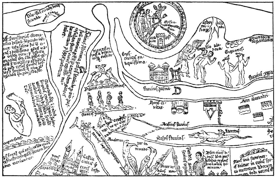
Fig. 8—Two sections from the Hereford map to illustrate the marvels of India. (From the reproduction accompanying Miller, Mappaemundi, vol. iv, 1896.)
In this first section are shown, among others, a skiapod, or sunshade-footed man (to the left), and cynocephali, or men with dogs’ heads.
277
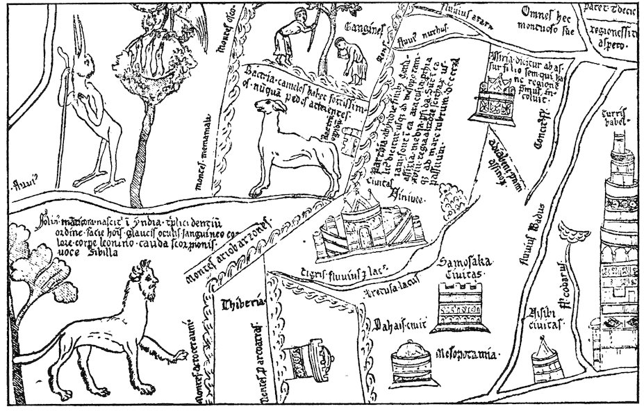
Fig. 8 (second section)—In this section is shown a mantichora, or beast with a man’s head and a lion’s body.
278The stories of St. Thomas and St. Bartholomew were often
retold during our period, notably, for instance, in the Historia
ecclesiastica of Ordericus Vitalis.[1297] The Osma Beatus map[1298]
shows heads representing the twelve apostles in the various countries
of the world; that of St. Thomas is placed in India (see
Fig. 4, p. 123, above). The unknown writer of the Letter of
Prester John was undoubtedly familiar with the legend of St.
Thomas, because he makes Prester John’s palace correspond exactly
to the palace built by the saint.[1299] This legend was a favorite
subject for representation in the sculptures of cathedrals and
stained glass windows of the twelfth and thirteenth centuries.[1300]
Visit of Patriarch John of India to Rome
Belief in the existence of a large Christian population in Asia
was reënforced by an obscure event that took place in Rome in
1122. We have an anonymous account[1301] of the visit of a certain
Patriarch John of India in that year and of the stupendous sensation
which it created in the Roman curia and throughout the
whole of Italy. The narrator informs us that in the course of
countless ages no native was ever known to have come from those
distant and barbaric Oriental regions, nor had any one ever before
been seen in Italy who had actually been there.[1302] The purpose
of the patriarch’s visit to the West originally was to procure
at Byzantium the pallium and the confirmation of his office,
which he had recently assumed on the death of his predecessor.
At Byzantium, however, being told that Rome was in reality the
capital of the world,[1303] he proceeded thither along with some
homeward-bound Roman ambassadors and while in Rome gave a
279lecture about his native country before the papal curia. The
principal city, he said, was Hulna, on the river Pison, one of
the four rivers of Paradise; the city was of huge size, surrounded
by gigantic walls and inhabited by faithful Christians. Outside
the walls there was a mountain encircled by a very deep lake and
on the top of the mountain was situated the Church of St.
Thomas. Surrounding the lake were twelve monasteries erected
in honor of the twelve apostles. The Church of St. Thomas was
inaccessible except once a year, when the waters of the lake disappeared,
allowing pilgrims to approach. The Patriarch John
then went on to explain in considerable detail the marvels and
miracles connected with the church.
We should be inclined—and justifiably—to reject the story of
Patriarch John’s visit as wholly fanciful, did it not seem to be
confirmed by a letter[1304] to a certain Count Thomas written by
Odo, abbot of St. Remi in Rheims (1118–1151), who happened to
be in Rome at the time John was there. The report of Odo
about this event was probably not derived from the anonymous
account, from which it differs in several minor details. Among
other matters, according to Odo, John speaks of a river, not a
lake, surrounding the shrine of St. Thomas and of how its waters
diminished as a result of drought and became passable to a boy of
seven years during eight days before and eight days after the
festival of the apostle. The whole clergy and (Christian) people
of India were said to gather here on this occasion.
We shall see shortly that these stories contributed to the formation
of the curious medieval belief in the existence of a great
Christian kingdom in the heart of Asia. First, however, we
must consider what notions were current regarding the seas and
islands to the south of India and the vast tracts to the northward
beyond the Himalayan barrier.
Indian Ocean
A very brilliant feature on the maps of our period is the Red
Sea, almost invariably colored red. This name was given to the
entire Indian Ocean, and the red color was applied to the Persian
Gulf as well as to the “Arabian Gulf,” or Red Sea proper. The
280name “Indian Ocean” was also occasionally used, as, for example,
on the Jerome map of the East.[1305]
The Greeks had acquired some fairly correct information about
the northwestern shores of the Indian Ocean and had heard vague
rumors of the great peninsula and islands east and south of India:
Malaya, Ceylon, Sumatra. Confused reports of the geography
of Taprobane, or Ceylon, are found in classical works as far back
as the time of the expedition of Alexander. Pliny, Solinus,
Ptolemy, and others described Taprobane in some detail but
exaggerated its dimensions to enormous proportions. Pomponius
Mela had spoken of the islands of Chryse, lying off the
eastern promontory of Asia, and Argyre, off the mouth of the
Ganges. Perhaps these represented some vague knowledge of the
Andamans or Nicobars or the Malay Peninsula; and certainly we
recognize the last-named in the Aurea Chersonesus of Ptolemy.
Islands of the Indian Ocean
Some relics of this classical knowledge of Indian seas and isles
was retained in the Middle Ages. Isidore[1306] had spoken of
“Chrisa” and “Argare” as full of gold and silver and perpetually
blooming flowers, with mountains of gold guarded by dragons
and griffons. This account found its way into the De imagine
mundi[1307] and was copied by Gervase of Tilbury;[1308] the islands
themselves, together with the “Island of the Sun” of Pliny, Mela,
Solinus, and others, figured on many contemporary maps.[1309]
Orosius had said that in Taprobane there were ten cities.[1310] Isidore,
whom Gervase of Tilbury copied, added that the dimensions
of the island were 875 by 625 miles, that it has two summers
and two winters each year, and that the vegetation always remains
green.[1311] Solinus had described[1312] Taprobane as being
divided in two by a river; one half, he said, was full of wild beasts,
but the other was inhabited by men. This division of the island
is perpetuated on the Henry of Mayence,[1313] Jerome,[1314] Hereford,[1315]
and Ebstorf maps.[1316]
Al-Battānī on the Indian Ocean
The geographical chapter in Al-Battānī’s Astronomy, probably
compiled from a redaction of Ptolemy’s Geography and translated
281by Plato of Tivoli in our period, gave a description of the seas of
the world.[1317] The Indian Ocean, Al-Battānī said, extends from
the land of the negroes to the extreme limits of India, a distance
of 8000 miles. Its width was 2200 miles, of which 1900 (Plato of
Tivoli mistakenly translated this 3900) reach south of the equator.
What lands lay beyond are not specified. From this sea four
gulfs run into the land: first the Barbaric Sea, which extends into
the “land of the negroes,” or Ethiopia, and may be the Gulf of
Aden or possibly even Mozambique Channel; second, the Green
Sea (Mare Viride), or our Red Sea, which reaches towards Hyla
(Ailah?); third, the Persian Gulf (Mare Persicum); and, fourth,
a second Green Sea, running out to the east towards China
(“Thinae”) and representing the Bay of Bengal or possibly the
China Sea. In the Indian Ocean there are some 1370 islands,
among them a very large one called “Tibiariae” (Taprobane), or
Sarandib (Ceylon), opposite the eastern coast of India, 3000 miles
in circumference, full of great mountains and rivers, quantities of
rubies and hyacinths, and surrounded by fifty-nine lesser isles.
The traditional account of the many isles of the Indian seas so
persistent in Arabic literature arose unquestionably from familiarity
with the vast Malay Archipelago or at least with its
western portion. On the other hand, whether we may assume,
as some have done, that the exaggerated classical and Arabic
estimates of the size of Ceylon had their origin in rumors of
the existence of Australia[1318] is an obscure problem which we
cannot attempt here to solve.
Scythia and Central Asia
North of the mountain barrier enclosing India lay lands about
which Western medieval knowledge was equally vague. “Upper
Scythia, stretching from the Caspian Sea to the Seric Ocean and
southward to the Caucasus, includes much habitable land but
also much that is sterile: gold and gems abound there, but men
avoid them on account of the griffons. Lower Scythia adjoins
Hyrcania, so called from the Hyrcanian Forest, where a marvelous
bird is found whose plumage glows in the dark. Iranea, or
Iran, is next to Scythia on the west: a region of nomads who
282wander widely because of the sterility of the soil and who are
horrible and ferocious (portentuosi ac truces), eaters of human
flesh and drinkers of human blood.” In about these terms the
author of the De imagine mundi and Gervase of Tilbury, borrowing
from Isidore,[1319] summed up very nearly all that was known of
Central Asia before the great overland journeys of the thirteenth
century to which brief reference has already been made.[1320]
Several of the maps show large rivers—Araxes, Oxus, Oscorus,
and even Acheron, the stream of Tartarus—rising in the Caucasus
and flowing northward into the Caspian.[1321] The latter, in accordance
with the usual classical tradition, is represented as a
gulf of the encircling Ocean Stream.
Benjamin of Tudela on Central Asia
Benjamin of Tudela, who himself journeyed at least as far east
as Baghdad, had opportunities for gaining information about
Central and Northern Asia more favorable than those of his less
traveled contemporaries. Samarkand he mentions briefly as a
“great city on the confines of Persia” inhabited by 50,000 Jews.
“Thence,” he adds, “it is four days’ journey to Tibet, the country
in whose forests the musk is found” (Adler’s translation).[1322] He
quotes the reports of Persian Jews that four of the lost ten tribes
of Israel dwell in the mountains of Naisabur (in eastern Persia).
These people were said to be independent and to dwell in a broad
tract of land twenty days’ journey in extent, with cities and large
villages among the mountains.[1323] Others associated the lost
tribes with the abhorrent hordes of Gog and Magog.[1324] Benjamin
goes on to tell us that these Jews were in league with the
“Kufar-al-Turak, who worship the wind and live in the wilderness
and who do not eat bread nor drink wine but live on raw,
uncooked meat. They have no noses, and in lieu thereof they
have two small holes through which they breathe” (Adler’s
translation).[1325] He relates the confused story of wars between
these undeniably Turanian tribes of the steppes of Turkestan and
the “King of Persia” (the Seljuk Sultan, Sanjar), events which
perhaps gave rise to a legend that became widespread in twelfth-century
Europe and to which we must now turn.
283
Prester John
The legend was the romantic story that in these far regions
there lay a vast and powerful Christian kingdom ruled by a
mighty potentate, Prester John. This tradition was the most
important contribution of our period to regional geography, for,
false as it was, it long persisted, became an integral part of late
medieval geographical theory, and exerted in subsequent centuries
a powerful influence on the course of exploration. The
thirteenth-century Oriental travelers were constantly on the
lookout for Prester John’s kingdom and, when it finally became
obvious that there was no such kingdom in Asia, Prester John
was transferred to Africa, where he was sought for by the Portuguese
navigators of the fourteenth and fifteenth centuries. How
did this strange legend come into existence, and what did it
contribute to Western notions of Asia?
Origins of the Legend
Various elements seem to have given rise to it. Perhaps
rumors of the existence of a Christian nation in Abyssinia may at
a very early period have fostered belief in the existence of a great
Christian potentate in Asia. India in Asia and Ethiopia in
Africa were often confused both in antiquity and during the
Middle Ages. Furthermore, the story of the visit of the Indian
archbishop or patriarch, already referred to, encouraged belief
in a numerous Asiatic Christian population. Some of the elements
of the patriarch’s report became an integral part of one of
the twelfth-century versions of the story of Prester John.
Then again, we have echoes of actual events in the East in
Benjamin of Tudela’s Itinerary, as we have just seen, and in
Otto of Freising’s Chronicon. Otto relates[1326] that in 1145 the
bishop of Gabala in Syria had come to Viterbo to report to Pope
Eugenius III, among other things, the fall of Edessa. Here
Otto met the bishop, and what he learned is recorded in the
Chronicon. This was to the effect that, not very long before, a
certain John, king and priest, who dwelt in the Far East beyond
Persia and Armenia and who, together with his tribe (gens), was
a Christian, waged war with the Samiards (Saniards), two
284brothers who were kings of the Medes and Persians. John
captured Ecbatana, the capital of the Samiards’ realm, defeated
the brothers in battle, and put them to flight. He then proceeded
to advance to the aid of the church at Jerusalem but was
hindered from going very far by the river Tigris. Turning
northwards in hope that the river would freeze over and thereby
enable him to cross, he was finally constrained, after several
years had elapsed, to give up the enterprise because continued
warm weather prevented ice from forming. This John, Otto
added, was said to have come of very ancient lineage, in fact, to
have been one of the progeny of the Magi. The tribes under his
command were perhaps the same as the “Kufar-al-Turak” of
Benjamin of Tudela.[1327]
Though the attempt has been made to identify the Christian
potentate of the legend with a chieftain of the Caucasus,[1328] the
weight of evidence would seem to favor belief that the story in
its more specific thirteenth-century form grew out of rumors of
some Christian Mongol lord of Central Asia.[1329] It is certain
that the Nestorian form of Christianity was strongly represented
in Central Asia during this period and that two powerful tribes
of these distant regions, the Keraïts and the Onguts, formed outposts
of this faith. But, as Pelliot writes, “whatever may have
been the origin of the famous legend of Prester John, ...
it was to a prince of the Keraïts that the tradition was applied
during the first half of the thirteenth century. All the Keraïts
spoken of in the history of the Mongol dynasty seem to have
been Christians; in any case this is true of the majority of them.
In fact it was through marriage with Keraït princesses that
Christianity penetrated even into the family of Jenghiz Khan.”[1330]
Many of these Asiatic Christians bore Christian names preserved
in Chinese forms, such as Yao-su-mu for Joseph or K’wo-li-ki-ssö
for George.[1331] We learn from Marco Polo and other thirteenth-century
travelers that Mongol princes often submitted to baptism,
though this was probably done out of indifference to religion
rather than as the expression of any deep-seated convictions.
On such slender foundations as the report in Otto’s Chronicon
or the anonymous account of the visit of the Patriarch John to
285Rome or on other rumors of events in the heart of Asia of which
no record has been preserved, there was erected an elaborate,
detailed, and wholly fanciful series of descriptions of Prester
John and his realm, embellished by borrowings from the Romance
of Alexander, from the legend of St. Thomas, and from that world
of fable which constituted the medieval European conception of
the Orient.
Prester John’s Kingdom As Described in His “Letter”
The most important description of Prester John’s kingdom is
contained in the famous Letter, addressed in some manuscripts
to Manuel, the Byzantine Emperor, in others to Frederick, the
Roman Emperor; in still others, to the Pope. In this letter,[1332]
the earliest version of which dates from before 1177, John tells
that he is superior in wealth and power to all the kings of the
world. His realm includes the three Indias and St. Thomas’
shrine. It extends across the desert of Babylon to the tower of
Babel and contains seventy-two provinces, each ruled over by a
king. Prester John is lord of the Amazons and Brahmins. In
one direction his territory reaches out four months’ journey. In
the other, no one can tell how far. “Only if you could count
the stars of the heaven and the sands of the sea would you be
able to form an estimate of our dominion and our power.” Many
are the extraordinary features of this realm which abounds in
milk and honey: here is one of the rivers of Paradise; here are
streams that give forth gold and jewels; here pepper is gathered;
here is the fountain of youth; and here a mysterious sea of sand
fed by a river of rocks, beyond which dwell the ten tribes of the
Jews, who, although they have their own kings, are nevertheless
subject to the mighty Christian ruler. In one of the provinces
near the torrid zone the salamander thrives, a “worm” which
cannot live without fire and which makes a chrysalis about himself
as do the silkworms (an interesting and unexpected bit of
natural history embedded in the midst of fable). Prester John
takes particular delight in expatiating on the enormous wealth
of his country, on the virtues of its inhabitants—for among them
there are neither liars nor adulterers nor indeed vice or crime of
286any description—and on their clemency and Christian piety.
Every year the king makes a pilgrimage with his army across the
serpent-infested Babylonian desert to the shrine of the prophet
Daniel. A large part of the Letter is taken up with a minute
description of the royal palace—exactly like that which St.
Thomas built for the King Gundophorus, of the king’s household,
the grandees who wait upon him, the officials of the kingdom,
etc., etc. In an early Latin version of the Letter, written probably
in England, we are informed that there are people from all
countries of the world at Prester John’s court;[1333] among the
personal servants of the king there are Englishmen who wait
upon him at table. No less than eleven thousand Englishmen
are in his bodyguard, and every Englishman who comes to the
court, whether clerk or knight, is invested with the order of
knighthood. The French and Italian versions of the Letter,
which were probably translated from this Latin text, substitute
“François” and “Franceschi” for “Anglici.”
Alliance With Prester John Desired
During the thirteenth century it was the vain hope of the Popes
and of the Christian kings of Europe to gain the alliance of some
great power in the East—either the Mongols or Prester John—as
an offset to Turkish encroachments on the Crusaders’ frontiers.[1334]
Perhaps we may detect the beginnings of this policy in
a letter of Pope Alexander III (1177) to John, “Magnificus rex
Indorum sacerdotum sanctissimus.”[1335] The Pope informs the
great king that he has heard of his piety through a certain Master
Philip, papal physician, who had held conversation with distinguished
and honorable persons of his realm. Consequently
Alexander was sending this Philip to expound to him the tenets
of Western Christianity and to convert him to the true Catholic
faith. It seems probable that Alexander was acquainted with
the supposed letter of Prester John to the Byzantine Emperor,
though there is also strong probability that he had confused the
stories of the Asiatic Prester John with reports regarding the
Christian kingdom of Abyssinia—a source of much confusion at
a later period than ours.
287
Gog and Magog
The northern part of Asia was the reputed seat of the terrible
tribes of Gog and Magog, whose eruption at the Last Day was
destined to bring about the destruction of the human race. We
have seen that Biblical prophecies were combined with the story
of Alexander the Great’s enclosing of these tribes behind great
walls. The legend appears in our period under various forms.
Most of the maps show Gog and Magog, usually surrounded by
a wall; some add disparaging epithets, such as “gens immunda.”
Matthew Paris on his map of Palestine indicates in the north
the walls whereby King Alexander the Great shut in Gog and
Magog and states in the explanatory legend that from this same
direction came the Tatars.[1336] In the De imagine mundi[1337] we
find a simple statement that between the Caspian Mountains
and the sea of that name dwelt those tribes who had been walled
in by Alexander the Great, Gog and Magog, the fiercest of all
peoples, eaters of the raw flesh of wild beasts and of human
beings. The Moslems had placed Gog and Magog in the farthest
corner of northeastern Asia: and in John of Seville’s translation
of Al-Farghānī’s Astronomy we find the land of Gog at the easternmost
extremity of the sixth and seventh “climates” (those
farthest north).[1338] Lambert li Tors speaks in the Romance of
Alexander of “Gos et Magos” among the vassals of Porus:
though they came forth with four hundred thousand men, Alexander,
after he had defeated Porus, chased them back into the
defiles of the mountains, where he shut them in with a great wall.[1339]
In a later part of the Romance, the subdivision of Alexander’s
kingdom at his death is explained: to Antigonus was given Syria
and Persia as far as Mount Tus, together with the duty of standing
guard over Gog and Magog.[1340] Otto of Freising also mentions
these tribes.[1341] He derived his information from Frutolf’s
Chronica,[1342] whence, in turn, it had come from the version of the
Romance of Alexander known as the Historia de praeliis. In
the days of Heraclius, Otto says, the “Agareni” (Saracens)
devastated the lands of the empire and destroyed part of the
army of Heraclius. In revenge the latter opened the Caspian
Gates and let out those most savage tribes, which Alexander the
288Great had enclosed along the Caspian Sea on account of their
heinousness, and inaugurated a war against the Saracens. By
night, as a punishment sent by the Deity for this sacrilegious
act, fifty-two thousand of Heraclius’ army were struck down by
lightning, and, as a result of this terrible visitation, Heraclius
himself died in the twenty-seventh year of his reign.
There were many variations of the legend of Gog and Magog.
Elsewhere in Otto of Freising’s Chronicon[1343] we find an
account, taken from Orosius, of the way in which Artaxerxes
forced many of the Jews to dwell in Hyrcania near the Caspian
Sea. It was believed that these people had multiplied greatly,[1344]
and they were expected to burst forth on the world in the days
of Antichrist. Though not here expressly called Gog and Magog,
the connection is plain; and Godfrey of Viterbo relates how
Alexander enclosed Gog and Magog, the “eleven [sic] tribes of
the Jews.”[1345] We have already quoted[1346] Matthew Paris’
description of the Tatars who, he said, might be the same as the
tribes whom Alexander enclosed—the ten tribes of Israel.
Western Asia
When we turn from the remote parts of the Orient to Western
Asia we find ourselves in regions much better known to the Western
world, though the traditional geography of these regions,
founded on classical and Biblical authority, persisted in encyclopedic
writings hardly influenced at all by the contacts that in
reality had been established. The De imagine mundi, Gervase
of Tilbury’s Otia imperialia, and other similar works add little to
what Isidore and Orosius had written. Between the Indus and
Tigris lie many countries, Arachosia, Parthia, Assyria, Persia,
Media, all forming a harsh and mountainous tract called in
Scripture “India” but more generally known as Parthia. Fire
had been discovered in Persia.[1347] The Tigris, so called because
it is as swift as a tiger, rises from a common source with the
Euphrates in the mountains of Armenia.[1348] Thence the two
rivers separate, leaving a long space between them known as
Mesopotamia; the Tigris encircles Assyria and empties into the
Dead Sea! Peter Comestor and the author of the De imagine
289mundi accepted the views of Isidore regarding the source of the
Tigris in the highlands of Armenia,[1349] but the latter adds to the
already prevailing confusion by stating that both rivers of Mesopotamia
debouch into the Mediterranean Sea. Gervase, on the
other hand, corrects the error of the author of the De imagine
mundi by making them flow into the Red Sea (or Indian
Ocean),[1350] as was depicted on most maps.
Mesopotamia
Mesopotamia was said to be famous as the site of Nineveh and
of Chaldea, where astronomy was discovered;[1351] and Gervase of
Tilbury dilates on the immense size of the walls of Babylon.[1352]
Regarding Babylon, it is refreshing to find in Otto of Freising’s
Chronicon some really up-to-date information which he had derived
from Frutolf.[1353] In the first place, he makes a careful distinction
between Babylon and Cairo, to which the name of Babylon
was commonly given. “Old Babylon,” he added, “as we
learn from reliable men from across the seas, is partly inhabited
at the present day and now called Baldach [Baghdad]. Part,
however, as you would expect from the words of prophecy, is a
desert waste extending for ten miles as far as the tower of Babel.
The part which is inhabited and called Baldach is very large and
populous.” He explains that here is the seat of the greatest
priest of the Persians, whom they call “Caliph,” and who holds
in some respects a position among these pagans parallel to that
which the Pope at Rome holds among Christians.
With Baghdad we have at last come to a city that was actually
visited and described during our period by Western Europeans
whose descriptions have come down to us. The Jewish travelers,
Benjamin of Tudela and Petachia of Ratisbon, appear to have
sojourned in the Mesopotamian city in the seventh and ninth
decades of the twelfth century respectively.
Benjamin of Tudela on Baghdad
Benjamin’s personal familiarity with Baghdad saved him from
making Frutolf’s and Otto’s mistake of confusing the Abbasid capital
with old Babylon. We gather from Benjamin’s Itinerary that
290the latter is three days’ journey distant and that “the ruins of the
palace of Nebuchadnezzar are still to be seen there, but people are
afraid to enter them on account of serpents and scorpions” (Adler’s
translation).[1354]
Baghdad, Benjamin writes (our quotations are from Adler’s
translation), “is on the River Tigris,” which “divides the metropolis
in two parts.” The city “is twenty miles in circumference,
situated in a land of palms, gardens, and plantations, the like of
which is not to be found in the whole land of Shinar. People come
thither with merchandise from all lands. Wise men live there,
philosophers who know all manner of wisdom, and magicians expert
in all manner of witchcraft.”[1355] Benjamin was particularly
interested in the Caliph, of whose palace, park, family, and widespread
authority he writes in no little detail and in highly commendatory
terms,[1356] for it seems that the Caliphs were more tolerant
toward the Jews than were most Christian monarchs of the age.
Besides treating of the Caliph, Benjamin tells about the “Head of
the Captivity,” another powerful ruler whose headquarters were
Baghdad and in whom the Caliph had vested authority over all
the Jewish communities throughout the eastern Moslem world.
A descendant of David, King of Israel, he was a man of great dignity
and rank, held high in the esteem of the Mohammedans. His
power extended “over all the communities of Shinar, Persia, Khurasan,
and Sheba, which is El-Yemen, and Diyar Kalach (Bekr)
and the land of Aram Naharaim (Mesopotamia) and over the
dwellers in the mountains of Ararat and the land of the Alans,
which is a land surrounded by mountains and has no outlet except
by the iron gates which Alexander made but which were afterwards
broken. Here are the people called Alani. His authority
extends also over the land of Siberia [Sikbia?] and the communities
in the land of Togarmim[1357] unto the mountains of Asveh and
the land of Gurgan, the inhabitants of which are called Gurganim
who dwell by the river Gihon (Oxus?); and these are the Girgashites
who follow the Christian religion. Further it extends to the gates
of Samarkand, the land of Tibet, and the land of India. In respect
of all these countries the Head of the Captivity gives the
communities power to appoint Rabbis and Ministers who come
291unto him to be consecrated and to receive his authority. They
bring him offerings and gifts from the ends of the earth.”[1358]
Whether or not Benjamin was personally presented to the Head
of the Captivity we are not informed. In any case he undoubtedly
came into contact at Baghdad with Jews from all over Central and
Western Asia and from them was able to gather those details regarding
the Jewish communities which form such an important
and interesting part of his Itinerary. Most striking in this connection
are the data which he furnishes us about the Jews of
Arabia.
Benjamin of Tudela on Arabia
The interior of that great peninsula until recently has remained
very vaguely known to Western Christians, and in the Middle
Ages there reigned almost complete ignorance regarding it. Gervase
of Tilbury tells us (from Orosius) that Arabia lies between
two seas and is the country of Mount Sinai, of the Queen of Sheba,
and of frankincense.[1359] Beyond this and a few details about the
Bedouins picked up by the Crusaders, nothing was known.
Hence the information which Benjamin gives on the Jewish communities
is of exceptional importance. If we may trust his figures,
it would seem that there was at this time a large Jewish population
both in Yemen and farther north. Benjamin’s conception
of the geography of the peninsula, however, is remarkably confused.
He tells us that at a distance of twenty-one days’ journey
through the deserts from Hillah in Mesopotamia one comes to the
land of Saba, or El-Yemen. Here he places the great Jewish cities
of Tanai, Tilmas, Teima, and Kheibar. Neither Tilmas nor
Tanai have been definitely identified. To the former Benjamin
assigned a population of 100,000 Jews; to the latter, with the district
surrounding, a population of no less than 300,000 Jews.
They may represent Jewish settlements in Yemen, though Benjamin’s
statement that Tilmas is only three days from Kheibar
would seem to preclude this possibility. Tanai, on the other
hand, has been thought to be Sanaa. Kheibar (to which Benjamin
assigns 50,000 Jews) and Teima have long been well-known
towns of northern Arabia not far from Medina. Now inhabited
by half-breed negroes, these places were the centers of a Jewish
292population from before the times of Mohammed until as late as
the sixteenth century.[1360]
Ina totally different connection Benjamin refers to Jews of the
“land of Aden,” which he believed to be part of India, taking India
to include southern Arabia and Ethiopia. Their country he
describes as mountainous. The Jewish element in the population,
he adds, “are not under the yoke of the Gentiles but possess
castles on the summits of the mountains from which they make
descents into the plain country called Libya, which is a Christian
empire” (Adler’s translation).[1361] This is indeed confusing. If
by Libya Abyssinia is meant—which is likely, for Abyssinia was a
Christian kingdom from very early times—it seems peculiar that
Benjamin makes no mention of the Red Sea intervening between
the land of Aden in Arabia Felix and the African coasts which
would have to be crossed by Jews of the Aden highlands in making
war on the Abyssinians. Possibly Benjamin, like Marco Polo a
century later, conceived of Aden as lying in Africa.[1362]
Syria and Palestine
Unlike all the rest of Asia, Syria and Palestine were well known
at first hand to many European Christians. Yet, in writing
about them, the makers of compilations like the De imagine mundi
and the Otia imperialia were content to do little more than copy
Isidore’s dry catalogue of the names of places rendered famous
through Scriptural associations.[1363] The Dead Sea with its sinister
neighborhood was the only natural feature of this part of the
world which seems to have made a strong enough appeal to the
imagination of these writers to impel them to add anything to
what Isidore had said long before.[1364]
Geographical Knowledge Enlarged by the Crusades
On the other hand, the Levantine countries were familiar
through the journeys of Western travelers, though their observations
were not incorporated into the works of the scholarly compilers.
Many were the motives that induced men of the West to
visit the Nearer East. Religious enthusiasm and the desire for
commercial gain, however, were paramount. The Crusades
293contributed more than any great series of events between the time
of Claudius Ptolemy and the middle of the thirteenth century to
the broadening of man’s geographical horizon, and, with it, the
broadening of the whole range of human activity. We cannot attempt
to discuss these wider aspects of the Crusading movement
in any detail, but a few words must be said about the dissemination
of regional knowledge that resulted from it. Feudal nobility,
soldiers, pilgrims, and adventurers of all sorts and from all
parts of the West were joined by Italian merchants in the great
enterprise, the object of which was not only to redeem the holy
places from the infidel but also to profit from the Levantine trade.
Men of all ranks and callings, coming from every part of Christendom,
made their way by land and sea to the Holy Land. Peasant,
serf, and petty townsman, as well as powerful noble and church
dignitary, were torn from old and familiar environments to wander
through countries about which they had hitherto known next to
nothing. In some cases the stories of their travels and adventures
were preserved in chronicles and poems, but in most no permanent
record was left. Nevertheless, the geographical knowledge
of the average man was widened to an extent which we can
scarcely appreciate at the present day. Before the Crusades
communities throughout the greater part of Europe had lived
very much to themselves, in limited contact with the outside
world; but by the year 1200 it is safe to infer that practically
every town and village of France, England, Germany, and Italy
held someone who had visited the East and was not unready to
tell about what he had seen there and on his way out and back.
Just as the War of 1914–1918 has taught the world much European
geography, so the Crusades taught all classes of Europe
about the Holy Land and the routes thither. But the Crusades
did more than give the people a wider knowledge of places: they
brought them into contact with new customs, new religions, new
ideals and modes of life, as well as with new types of landscape and
terrain. All this tended to displace men from habitual and local
modes of thought; Europe became more cosmopolitan, and the
way was prepared for that profound change in man’s entire attitude
towards life which we now call the Renaissance.
294
Occidental Population of the Levant
We can merely hint at these general results of the extension of
geographical contact with the Levantine world and turn to the
more specific problem of the limits to which Western penetration
was actually pushed. The Occidental population of the states
established after the First Crusade along the eastern border of
the Mediterranean was composed primarily of the Frankish nobility
and soldiery and of Italian traders.[1365] The former had established
themselves in castles and garrisons, from which they ruled
over widespread manorial estates tilled by native Syrians. The
traders occupied large foreign quarters in such commercial centers
as Acre, Jaffa, Ascalon, Tyre, and Tripoli on the coasts, and in the
interior at Jerusalem. Trading privileges and the right to build
up commercial colonies in the towns were granted to Genoese,
Pisans, Venetians, and others in return for services rendered the
Crusading armies by the Italian navies in the conquest of the coast
towns and in the transportation of military forces. Through the
reports brought back to Europe by returning soldiers, adventurers,
and merchants, Syria and Palestine became more widely and
accurately known in the West than most parts of Europe itself.
European Occupation of Syria
First-hand acquaintance with the Levant, however, did not,
either in the twelfth or in the thirteenth century, necessarily lead
to first-hand acquaintance with the neighboring countries that
still lay under the domination of the Turk. At the time of its
greatest extent the Kingdom of Jerusalem reached eastward to the
edge of the desert plateau beyond the Jordan and Dead Sea and
southward to Ailah on the Gulf of Akaba. Northeastward the
upper Tigris marked the frontier of the County of Edessa. Beyond
these restricted borders lay Saracen territory into which
traders from the West did not dare to venture. Southern Mesopotamia
was virtually terra incognita; and the men who held the
small garrison posts along the eastern border of the states of the
Crusaders were not prone to undertake rash enterprises in the
enemy’s country.
The danger of such enterprises is illustrated by the fate of a
295Christian naval expedition sent down the Red Sea from Akaba in
1182–1183.[1366] A small fleet, fitted out by Reynauld of Châtillon,
lord of the castle of Kerak beyond the Jordan, succeeded in getting
almost as far as Yembo, the port of Medina. We are not told of
its true purpose by the Arabic historians, who alone seem to have
recorded this adventure, though the Arabs certainly believed
that the Crusaders were bent upon plundering the tomb of the
prophet at Medina. Perhaps its leaders harbored a fanatic hope
of attacking the holy cities of Islam. At all events, the navy of
Saladin, hastily summoned from Egypt, soon overtook and defeated
the little squadron at Haura, and those of the Crusaders
who escaped ashore were either killed by the Bedouins or sold into
slavery.
But though, with a few exceptions, Europeans themselves did
not go beyond these bounds of the Crusaders’ states, commercial
relations were established with the more eastern regions.[1367] Antioch
and Laodicea were the termini of two trade routes from Aleppo,
whence came merchants from Rakka on the Euphrates and
ultimately from Mesopotamia, Persia, and Central Asia. Asiatic
goods were also sold at a great open fair in the Hauran country, at
one time in the territory of the Kingdom of Jerusalem and undoubtedly
frequented by Westerners. And the harbors of the
kingdom were the entrepôts of an extensive traffic from Arabia
Felix and India by the Red Sea and across the Isthmus of Suez.
At all of these points the Italians established connections with the
Oriental merchants and learned from them much about Oriental
lands and their products.
Asia Minor
During the early thirteenth century Asia Minor also became
familiar ground to the men of the West.[1368] The establishment of
the Latin Empire at Constantinople in 1204 during the Fourth
Crusade was mainly responsible for this; but even before the close
of the twelfth century the Venetians had become preponderant
from a commercial point of view in the districts that had hitherto
formed parts of the Byzantine Empire, and after 1204 they were
in a position to conclude advantageous treaties with their Anatolian
neighbors, Greek, Seljuk, and Armenian. Venetian merchants
296were to be seen in the important towns and along the highways
of the peninsula. Italians, with Provençaux in their train,
exploited the trade of the small Christian kingdom of Little
Armenia (the ancient Cilicia) and penetrated from the Mediterranean
into and across the Seljuk sultanate of Iconium, whose
rulers were disposed to look with fairly friendly eyes on the
Frankish trader. Even the Empire of Nicaea, a small remnant
of the Greek dominions which had managed to preserve its
independence after the Fourth Crusade, was constrained in 1219
to grant extensive trading privileges to the Venetians.
Western Asia As Described by the Crusaders
The knowledge of Western Asia acquired in these various ways
was naturally enough reflected in the works of the historians,
chroniclers, and poets of the Crusades, many of whom had themselves
visited the places they describe. Their fresh and realistic
accounts contrast strikingly with the sort of geographical writings
we have so far been discussing in this chapter. From Dreesbach’s
study of the Orient as described in the early French Crusading
literature we may gain a concise idea of the sort of thing that
impressed itself on the mind of the Occidental.[1369] His impressions
of climate and landscape need not detain us here, as they have
already been explained in early chapters.[1370] Of the natural resources,
the wealth of the fruits of Syria, grapes, figs, pomegranates,
almonds, olives, and locusts, were often the subject of wonder
and admiration, and William of Tyre speaks enthusiastically
of the great sugar plantations at Sur.[1371] Of the animals,[1372] the
Arab horse and the camel attracted most attention; and the usefulness
of the latter was known both as a beast of burden and as a
swift traveler through the desert. A lively sketch of a man
leading a camel laden with a large cask figures prominently on
one variant of the Matthew Paris map of Palestine, and a legend
reads: “Here abound camels, buffaloes (bubali), mules, and asses,
which are used by the merchants trading between the peoples of
the Orient and of the Occident.”[1373] Bears and lions, serpents and
tarantulas, and carrier pigeons also invited notice; and the
mosquito is mentioned by Ambroise, who says that though very
297small it has a terribly poisonous bite, bad enough to make every
one, old and young alike, appear to be leprous:
“Que chescons, vielz ou damoisels,
Sembloit a estre tut mesels.”
[1374]
Concerning the people[1375] of the Levant we find that the distinction
between the nomadic desert-dwelling Bedouins and the
bearded turban-wearing Saracens (townsfolk) was well understood.
The Bedouins—contrary to their present reputation—were
looked down upon as cowards in battle, and William of
Tyre relates with some disgust that it was their custom to hang
about on the outskirts of a fight until they saw which side was
going to win and then to join the victors.[1376]
In commenting on the religion[1377] of the Saracens the medieval
Christians made the fundamental error of supposing that Islam
is an idolatrous cult and that Mohammed was worshipped as a
god. Nevertheless they were far from inaccurate in their remarks
on the various customs, habits, and minor beliefs of the
Moslems, on such matters, for example, as the pilgrimage to
Mecca, the prohibited eating of pork and drinking of wine, the
importance of ablutions, polygamy, and the customs of divorce.
William of Tyre describes[1378] the division of the Mohammedans into
two great groups, Shiah and Sunni, and explains how the former
held that Ali (“Haly”) was the only true prophet and the latter
that Mohammed was the one messenger of God. Baghdad was
referred to as the seat of the great “apostle” of the Saracens, or
caliph, whom William of Tyre spoke of as a sovereign prince and
chieftain whom all must obey; Cairo in Egypt was recognized as
the capital of the caliphs of the rival Shiah persuasion.
Benjamin of Tudela also acquired some fairly clear ideas of
Islam during his visits to Baghdad and to Egypt. He states that
the Abbasid Caliph at Baghdad “is head of the Mohammedan
religion, and all the kings of Islam obey him” and likens his position
to that of the Christian Pope.[1379] In writing about Cairo he
tells us that the subjects of the Emir were followers of Ali (hence
Shiites), that they rose against the Abbasid Caliph of Baghdad,
and that a lasting feud was kept up between the two factions.[1380]
298Particular terror was inspired in the hearts of the Crusaders by
that strange sect of Assassins,[1381] whose principal seat was at
Alamut in Persia, the stronghold of the notorious Old Man of the
Mountain, though most of the Crusaders mistakenly thought that
the outlying fortress of Massiat in Syria was the abode of the Old
Man. William of Tyre dilates[1382] on the treachery and murderous
nature of this people; and in Ambroise’s Estoire we find[1383] a vivid
account of how the children of the Assassins were brought up to
do the bidding of the Old Man in every detail and in particular to
bring about the murder of his enemies.[1384]
Egypt As Part of Asia
Both the author of the De imagine mundi and Gervase of
Tilbury include an account of Egypt with their descriptions of the
countries of Asia. They then take up the remainder of Asia and
Europe before finally returning to Africa toward the close of the
geographical parts of their books. This order of treatment, which
accorded with classical traditions, usually included Egypt with
Asia or at least, as in the De imagine mundi, made the Nile rather
than the Red Sea the boundary between Asia and Africa.[1385]
Certainly from an historical and cultural point of view Egypt has
been more closely related to the Asiatic than to the African continent,
even though geographically it forms a portion of the
latter.[1386]
The description of Egypt in the Otia imperialia[1387] was copied
in large part from the De imagine mundi,[1388] and this in turn had
closely followed the words of Isidore.[1389] It ran somewhat as follows.
Surrounded by the course of the Nile, which forms a
letter delta,[1390] Lower Egypt comprises five thousand country
estates; these are not watered by rainfall but by the floods of the
river alone, for the skies of Egypt are never obscured by clouds.
The capital of Egypt is Babylon (Cairo), built by Cambyses.
Close to Thebes—a city founded by Cadmus, Agenor’s son and
founder of Boeotian Thebes as well—are vast solitudes where there
used to dwell a great company of hermits. The De imagine
mundi speaks of the island of Meroë and of Syene on the tropic in
299Upper Egypt, the latter famous for the well built there by the
philosophers, into which the sun shines directly in the month of
June.[1391] The Jerome map of Palestine also shows Egypt in
considerable detail, one of the most important features being the
lighthouse at Alexandria.[1392]
Descriptions of Egypt
Egypt, like the Holy Land, was frequently visited by Western
merchants throughout our entire period. Benjamin of Tudela
testifies to the enormous trade carried on there with the West.
Alexandria was the principal port whence the spices and luxuries
of the Far East were transshipped to Europe. Benjamin spoke
with high appreciation of the wide straight streets of the city and
of the architectural beauty of its buildings. He was much impressed
by the swarm of merchants from all over the world who
congregated in its streets and markets.[1393] William of Tyre enlarged
on the commercial importance of the great port and explained
that the peppers, spices, ointments, drugs, lectuaries,
precious stones, and silks of the Orient were brought first to Aden
on the Red Sea and thence transported direct to Alexandria. He
pointed out that Alexandria was also important as the meeting
place of the river and maritime trades, and he gave a description
of the local topography of the city.[1394] Merchants from various
Occidental nations and city states of Italy had fondachi, or trading
stations, in this cosmopolitan metropolis, which was, as
Schaube says, more subjected to European influences than any
other city of Islam.[1395] The Church endeavored to place severe restrictions
on commerce with the infidel, in particular by the prohibition
of the importation into Egypt of wood and iron, two materials
of vital importance to the Saracens and much in demand.
The restrictions, however, were disregarded, and trade flourished
between Southern Europe and Egypt throughout nearly the entire
twelfth and early thirteenth centuries, except for a short interruption
at the time of the Third Crusade. In 1215–1216 there
were said to be no fewer than three thousand Frankish merchants
in Alexandria.[1396] Egypt was the objective of the Crusaders of the
Fifth Crusade, who seized and held the city of Damietta from
3001219 to 1221, and again under Louis IX of France, who held it
from 1248 to 1249; but in the interval between these two Crusades
the Emperor Frederick II was on friendly and even intimate
terms with the sultans.[1397]
William of Tyre, who knew Egypt at first hand, gives a vivid
picture of the fertile strip of country, hemmed in on either side by
two deserts “in which the land is so burned and sterile that it supports
no herb and no manner of tree, except where the river Nile
waters the ground when it is in flood; in these parts alone a great
abundance of wheat can grow.”[1398] He speaks of the flood of the
Nile, between the months of June and September, and how it
leaves a rich deposit of silt; of the palm gardens like a forest along
the banks of the stream; and of the extensive orchards of fruit
trees in the neighborhood of Alexandria.[1399] He also fully describes
the caliph’s palace at Cairo and the Mamelukes, or sultan’s
bodyguard, recruited from the children of captured enemies.[1400]
Benjamin of Tudela also marveled at the agricultural wealth
of the flood plain of the Nile. The river alone, he said, irrigates
and fertilizes the land, for “no rain falls, neither is ice or snow ever
seen” (Adler’s translation). Among other curiosities he described
the Nilometer, which measured the height of the flood
waters, and he gave details regarding the agricultural crops and
fruits. Benjamin quoted the correct explanation of the flood:
“The Egyptians say that up the river, in the land of Al-Habash
(Abyssinia), which is the land of Havilah, much rain descends at
the time of the rising of the river, and this abundance of rain
causes the river to rise and to cover the surface of the land” (Adler’s
translation).[1401]
Africa West of Egypt
To the west of Egypt, according to the De imagine mundi, lies
Africa, stretching from the Nile to the ocean. Here in order are
the provinces of Libya, named from a queen of that name; Cyrenaica,
called from the city of Cyrene; Pentapolis, from the five
cities of Berenice, Arsinoë, Ptolemaïs, Apollonia, and Cyrene;
Tripolis, from the three cities of Occasa, Berete, and Leptis Magna;
Heusis, containing the site of Carthage; Getulia; Numidia, with
Hippo, the home of St. Augustine; and Mauretania.[1402] The two
301Syrtes (Major and Minor), or shallow bays of the north coast of
Africa, are shown on the Henry of Mayence map immediately to
the west of Egypt.[1403] In the extreme west of Africa the De imagine
mundi, with characteristic confusion, places Gades (Cadiz),
from which the adjacent sea is called the Sea of Gades; and, on the
borders of the ocean, Mount Atlas, a mountain of immense
height, named after Atlas, once a king of Africa.[1404] These mountains
also appear prominently on the St. Sever Beatus map as a
long range running parallel to the Atlantic[1405] (see Fig. 2, p. 69,
above). Other maps of the same group[1406] show two great peaks
on the western coast of Africa, which seem to represent a confusion
of the Atlas Mountains with the famous Pillars of Hercules.
A legend on the St. Sever Beatus map in the neighborhood of
Tangier (Tingi) draws attention to the fact that “this region
produces monkeys and ostriches,”[1407] true certainly at the present
day in regard to the former.
In the fourth and fifth decades of the twelfth century the
Norman king of Sicily, Roger II, the patron of Edrisi, conquered
many of the seaport towns along what is now the coast of Tunis;
and, though the Latins were expelled from this region by the
powerful Moroccan dynasty of the Almohads,[1408] who during the
following decade came to supersede the Almoravids in the domination
over North Africa and Spain, close commercial relations
were maintained between the northern and southern coasts of
the Mediterranean Sea throughout the century and a half with
which we are concerned.[1409] The Genoese held the foremost
place in the North African trade; but Pisan, Venetian, Massiliot,
and Catalan merchants also frequented the markets of the seaboard
towns. Under the Almohads, Ceuta and Bugia were
important entrepôts of Genoese trade; and when the Almohad
dominions split up in the early years of the thirteenth century
(1212–1238), these two towns fell into the hands of Genoa.[1410]
Genoese fleets also ventured through the Strait of Gibraltar and
not only tapped the commerce of the western coasts of the Iberian
Peninsula but penetrated as far as Saleh on the Moroccan shore.
Christians also found their way in various capacities into the
interior of Maghreb, as the Moslems termed these western territories
302of Islam. During the Crusading epoch many Christians
were taken captive in the wars in Spain and by pirates on the
high seas; most of these were sold into slavery in the markets of
the sea ports of Morocco, Algeria, and Tunis and sent to drag
out lives of suffering in the towns of the interior. Towards the
close of the twelfth century a Christian religious order was
formed for the purpose of ameliorating the sufferings of the
captives and of bringing about their redemption by exchange
with Moslem captives held in Christendom.[1411] We have evidence
that these “Redemptorists,” and the Franciscan and Dominican
friars who were soon to follow them in the same work and who
also served as ministers of the Christian religion to the European
merchants engaged in business in Moslem countries, were not at
all inhospitably received.[1412] Their work was facilitated by almost
uniformly friendly relations between the papacy and the
rulers of Morocco, and the number of Christians in this part of
the world became so great by the fourth decade of the thirteenth
century that an episcopal see was established in Fez (1233),
subsequently to be removed to Morocco City.[1413] Another tie
between Morocco and the Latin West was created by the maintenance
at the court of the Almohads and their successors of a
mercenary force composed for the most part of Spanish Christians
from Catalonia and Aragon.[1414]
On certain of the Beatus maps a “sandy desert” is shown between
Egypt, western Africa, and Ethiopia;[1415] and on the Psalter
map it appears as a well-defined strip of territory labeled “sandy and
sterile land.”[1416] This of course is no other than the Sahara,[1417]
of which little or nothing was known, except that the Henry of
Mayence map shows,[1418] far back in the desert, the Temple of
Jupiter (Ammon), in the oasis of that name, known since antiquity,
and the St. Sever Beatus map represents certain immense
salinae, or salt pits (the two squares west of the Nile on Fig. 2,
p. 69, above), said to wax and wane with the moon.[1419]
Ethiopia
South of Egypt and the Sahara lies Ethiopia. In the minds
of medieval writers this name was not restricted to the region
303beyond Upper Egypt but was applied to the entire southern
part of the known world, just as “India” sometimes was applied
to the entire Far East. Indeed, from early classical times
Ethiopia had itself been confused with India, and some of the
writers whose works we are studying believed that the two regions
were coterminous.
Nearly all the maps of the period carried the extremities of
Ethiopia far to the east and minimized the size of the Red Sea
and Indian Ocean in such a way as to bring Central Africa within
no great distance of India. On the Jerome map of Palestine two
tracts called “India Egyptii” and “India Ethiopie” were placed
along the shores of the Red Sea opposite the mouths of the
Indus.[1420] Gervase of Tilbury speaks of three peoples inhabiting
Ethiopia: the Hesperi in the west, the Garamantes in the center,
and the “Indians” in the east,[1421] and adds that there are one
hundred and twenty provinces “from India into Ethiopia.”[1422]
The De imagine mundi places Saba, the city of the Queen of
Sheba, in the easterly part of Ethiopia.[1423] It was conceded that
Ethiopia is terribly hot on account of the proximity of the sun
and that the soil there for the most part is dry and desert.
Gervase speaks of the mighty Mount Climax of Ptolemy,
Orosius, and other ancient writers in the midst of Ethiopia, a
home of bearded women and similar marvels.
Some of the Beatus maps designate Ethiopia as a country
“where there are races horrible on account of their strange faces
and monstrous appearance. It extends as far as the borders of
Egypt. It also abounds in wild beasts and serpents; and precious
stones, cinnamon, and balsam are found there.”[1424] In fact, all
remote parts of the world were made the habitats of marvels in
the Middle Ages, and few parts of the known world were more
remote than Ethiopia. In addition, the intimate connection
between India and Ethiopia, which had persisted in the minds of
men throughout so many ages, seems to have brought about a
transference thither of many of those marvels and monsters that
originally had been placed in the Far East. A most entertaining
example of the peopling of Ethiopia by monstrous creatures is
provided by the Psalter map and by the Ebstorf map of a period
304later than ours.[1425] On these the entire shore of the equatorial
ocean along the southern border of the known world is lined with
men that are tongueless, earless, noseless, or men that have four
eyes or mouths and eyes on their breasts, and with cannibals,
cynocephali, snake-eating troglodytes, and the like.
Sources of the Nile
The main interest in Ethiopia, however, lay in the fact that
from this country comes that great river the problem of whose
sources has puzzled mankind from the earliest ages down nearly
to our own day. In classical times three theories had prevailed
concerning the headwaters of the Nile.[1426] The correct theory,
that of Eratosthenes and of Ptolemy, that the river rises in
Ethiopia itself but far to the south, met with no recognition in
our period. The second theory placed the sources in India and
was closely allied with the very old belief that tended to confuse
Ethiopia itself with India and can be traced back to Homeric or
even pre-Homeric times.[1427] The third theory, which probably
originated in vague rumors that reached the Carthaginians and
later the Romans and still later the Moslems, of the eastward-flowing
course of a great river south of the Sahara (a river which
we now know to be the Niger), placed the headwaters of the Nile
either in a great lake or else in the Atlas Mountains in western
Africa close to the ocean.
Traces of each of the last two theories are to be found in the
writings of our period. According to the accepted interpretation
of Scripture, the Nile was the same as the Gihon, one of the four
rivers of Paradise, and its ultimate source must therefore have
been in the east, where Paradise was nearly always thought to be.
It is also possible that early Christian monks in Abyssinia may
have learned of the course of certain of the eastern tributaries of
the Atbara which rise close to the Red Sea, and this information,
in the devious course of its transmission to Western Europe, may
have been confused in such a way as to foster belief that one of
these minor streams was the headwaters of the main river itself.[1428]
In any case, Orosius,[1429] whose words were copied by Gervase of
305Tilbury,[1430] made the Nile spring from the ground near Mossylon
Emporium on the shores of the Red Sea and, after flowing westward
for some distance, turn north to enter Egypt. But he also
said that other authorities state that the river rises far in the
west and that, after an underground course through the sands and
thence through a great lake, it runs eastward across the Ethiopian
desert even as far as the ocean and then turns to the left into
Egypt. In any case, he adds, it is true that there is a large
river which has exactly such a source and produces all the
monsters that the Nile does. The barbarians who dwell near
its source call this latter river the Dara, but other natives
name it the Nuchul. The Dara is mentioned by Pliny and
the Nuchul by Mela; perhaps they represent a reminiscence
of the generally eastward-flowing Niger. Orosius suggested
that this river, coming from the west, may well contribute by
an underground channel to the westward-flowing stream that
springs from the earth near the Red Sea. Isidore seems to
have derived from Orosius the idea of a West African origin
of the Nile, its disappearance under ground, and subsequent
emergence on the shores of the Red Sea and thence of its
encircling of Ethiopia before flowing down into Egypt,[1431] and
in this idea he was followed by the author of the De imagine
mundi.[1432]
Orosius’ and Isidore’s theories are graphically represented on
the maps. Several of the Beatus maps simply show the river
springing from mountains in the western part of the continent
and swinging east and north into the Mediterranean.[1433] The
symbols and legends on the St. Sever Beatus[1434] indicate (see Fig.
2, p. 69, above) that the river originates in the neighborhood
of the Atlas Mountains; thence, passing beneath the sands, it
expands into a vast lake, whence it flows toward the east through
an immense swamp, like the Maeotic Swamp, but surrounded by
mountains. After this it turns to the left, envelops the Isle of
Meroë, and flows down into Egypt. Other maps, like the Cotton,
Henry of Mayence (inset on Fig. 6, p. 245, above), and
Jerome map of Palestine are even more faithful to the Orosian
description. The sources of the Nile proper are shown near
306the Red Sea in the eastern part of Ethiopia, but another large
river is also depicted, coming from the far west near the Atlas
range and emptying into a large lake not far from the sources
of the Nile, with which the lake may communicate. The Cotton
map[1435] splits this river into two sections and calls the upper
section “Dara” and the lower “Fluvius Nilus.” On the Jerome
map of Palestine[1436] it is called “Nuchul” and made to flow into
a lake of the same name. Henry of Mayence[1437] names it “fl.
Gion.”
Traditional View of Central Africa
As a matter of fact, no new information about Central Africa
was brought to light during our entire period or had been during
many centuries before, and no new theories were propounded.
Old and hackneyed notions were handed down from one writer to
another. Simar, in a recent admirable study of the geographical
ideas regarding Central Africa in antiquity and in the Middle
Ages, trenchantly sums up the whole matter with the following
words, which might equally well be applied to ideas regarding
many other parts of the world: “These meager notions soon became
stereotyped and were repeated by the scholars of the Middle
Ages, who vied with each other in their unalterable ardor. From
Martianus Capella in the fourth century to Honorius of Autun
[here the author of the De imagine mundi is meant] in the twelfth,
passing by Macrobius, Priscian, Saint Avitus, Gregory of Tours,
Jornandes, the Venerable Bede, Raban Maur, Dicuil, Alfred the
Great, Alfric, Adelbold, Richer, Asaph, Hermann Contractus,
Robert of St. Martin of Auxerre, Otto of Freising, Hugh of St.
Victor, and even, later, the historian Joinville, men copied Solinus,
Orosius, and Isidore and adopted like them a round oikoumene
separated from the terra incognita by an impassable equatorial
ocean, the uninhabitability of the torrid zone, the limit of Africa
this side of the equator, the sources of the Nile in Mauretania,
its course through Ethiopia from west to east, its ultimate
origin in the Terrestrial Paradise situated to the east of India,
and its submarine course as far as its emergence in the western
part of Libya.”[1438]
307
The Name “Mediterranean”
To the great chain of inland seas that lies between Africa, Asia,
and Europe the Romans had applied the name of mare internum
or mare nostrum. Solinus was probably the first to describe these
as mediterranean seas, and Isidore the first to convert the term
“mediterranean” into a proper name.[1439] The authority of Isidore
was sufficient to make this designation familiar to future ages; and
it was used by the author of the De imagine mundi and by Gervase
of Tilbury with the same connotation that it enjoys at the present
day.[1440] The term, however, was not firmly established in popular
use in our period and is conspicuously absent from most of the
maps, which as a rule either give no name at all for the sea as a
whole or else employ some vague designation like mare nostrum
or mare magnum.[1441]
Gervase of Tilbury says[1442] that the Mediterranean is shaped
like a letter Y with two branches, a longer one extending from the
entrance (Strait of Gibraltar) to the Hellespont, and a shorter one
forming the Sea of Alexandria or of Syria. This comparison
suggests that Gervase must have had before him a typical medieval
map of the world with east at the top. More detailed is the
account of the Mediterranean in Plato of Tivoli’s translation of
Al-Battānī’s Astronomy.[1443] Here the “Roman Sea” is described
as extending a distance of 5000 miles [!] from the Isle of Gadir
(Cadiz) to Tyre and Sidon; it has various branches, one running
off towards the Narbonnese, one called Adriatic, another called
Pontus; and it contains a total of one hundred and sixty-two inhabited
islands, of which five are especially noteworthy on account
of their size.
The Mediterranean During the Crusades
During the Crusades the Mediterranean served as one of the
main highways from the West to the Holy Land, and hence the
men of Europe were enabled to learn much of its waters and
coasts. Though the principal armies of the First Crusade had
proceeded overland, in the years that followed the establishment
308of the states of the Crusaders there was constant coming and
going by sea between the Levant and the ports of Italy, France,
and England. The sea route was the way taken by the armies of
Philip Augustus and Richard Coeur-de-Lion in 1190; by the
cosmopolitan army that captured Constantinople in 1204; by
Frederick II and the ill-starred expedition of St. Louis to
Egypt; as well as by innumerable pilgrims, soldiers, merchants,
and other individuals unconnected with any definite Crusading
enterprise.
Instructions for Navigation in the Mediterranean
Perhaps the most attractive account of the Mediterranean
derived from the literature of the Crusaders is to be found in the
chronicles and histories recording the expedition of Richard
Coeur-de-Lion. The Gesta regis Ricardi, mistakenly attributed
to Benedict of Peterborough, and the Chronica of Roger of
Hoveden contain descriptions of routes and coasts, parts of
which were undoubtedly drawn from manuals of navigation.
Here we find much the same sort of data that at the present
time is incorporated in our Coast Pilot books, a combination of
practical advice to sailors with useful and interesting information
about the waters, islands, and shores. Great care is taken to
inform the navigator of the best and most practicable routes for
him to follow. For example, two ways are mentioned of going
from Marseilles to Acre, one through the open sea and the other
near the coast.[1444] If the wind is favorable you can proceed by
the first, leaving Sardinia and Sicily out of sight to the left,
though you must constantly be on your guard against running
too far to the right and falling afoul of the barbarian shores.[1445]
With a good breeze this journey can be made in fifteen days,[1446]
and vessels are safer on it from the menace of pirates than when
they follow the coastwise route. On the other hand, the navigation
is more difficult, and under no circumstances should this
route be attempted by galleys, which might easily be sunk if a
storm should come up. In the account of the coastwise route
various menaces and dangers to ships are carefully pointed out.
For instance, off the coast of Greece, about twenty miles from
309land and fifty from Modon, there is a low round rock called Triffar;
and in order to avoid it ships are warned not to stand too far
out to sea. West-bound vessels, however, are advised, instead of
passing through the channels between “Chefeline” (Cephalonia),
“Fale de Campar” (Ithaca), and the neighboring islands to keep
out to sea, placing these islands on the right. Navigators are
cautioned to beware of a sand bar in Corfu harbor with only four
and a half ulnae of water upon it. The dangers of the narrow
and crooked channel between Corfu and the mainland make it advisable
for vessels en route to Italy to avoid taking this passage
and, by steering out to sea, to leave Corfu on the right. The harbor
of Karentet (Santa Quaranta) is said to be a fine one, except
for submerged reefs at the entrance and extending under about
half of its area; the best approach for ships is not far from the
Corfu side.
We find also many full and practical details regarding the distances
between various points along the coasts, the width of
straits, the length of islands; the names of seaport towns and now
and then their products and other distinguishing features are
mentioned, for example, the fact that Marseilles has an excellent
harbor surrounded on all sides by hills, or that Almeria in Spain is
far-famed for its manufacture of silk. Prominent landmarks are
carefully pointed out: great mountains making promontories on
the coast of Spain, sand banks, the mouths of rivers (like the
Ebro, or the Salef in Asia Minor, “in which Frederick Barbarossa
was drowned and from the neighborhood of the sources of which
the three wise men were said to have come”), the high peaks in
the interior of Crete, or the volcanoes of Sicily and the Lipari
Isles. Marine life, such as the flying fish of the waters near Corsica
and Sardinia as well as less credible monstrosities of the Gulf
of Satalia on the southern coast of Asia Minor, also seems to have
aroused the curiosity of the navigator and chronicler.[1447]
Islands of the Mediterranean
Most medieval maps show the islands of the Mediterranean
scattered about with scant respect for their actual locations and
relative sizes. The Guido map of the world, for instance, indicates
310but one island by name in the entire Mediterranean, and
that is “Baleares.”[1448] The most important islands are fairly well
represented on the St. Sever Beatus[1449] (Fig. 2, p. 69, above),
but the draftsman of the Osma Beatus did not have room enough
for Tenedos and Rhodes in the Mediterranean (Fig. 4, p. 123,
above), and hence placed then in the circumambient ocean to the
east of Taprobane![1450] In the De imagine mundi and in the Otia
imperialia the islands are described in a dull and catalogue-like
manner from the data given by Orosius and other classical authorities.[1451]
The accounts of the Mediterranean in the chronicles
which we have just been discussing also add little beside
scattering details on Corfu and Cyprus and a significant observation
that, owing to the danger from pirates, a large number of the
islands of the Greek archipelago had been deserted by their inhabitants.[1452]
Guy of Bazoches, who journeyed overseas with the Crusaders
to Syria in 1190, told in a letter to his nephews[1453] that on the
third morning out from Marseilles they were in sight of Corsica
and the many and varied inlets and promontories of its broken
coast. The following day Sardinia was visible, likewise on the
left. Sardinia, Guy wrote, might almost have been called free
from poisonous serpents, were it not for one variety, the solifuga,
which took the place of all the others, since the poisonous virulence
of all serpents was concentrated in this one. Besides this there
was a violently poisonous plant in Sardinia. On the other hand,
these pests were compensated for by the presence of hot springs in
several parts of the island which prevailed against the solifuga and
were good for broken bones and for the eyes. We have already
spoken[1454] of Guy’s description of Sicily, which was reached soon
after Sardinia was left behind. From Sicily Guy came to Crete,
“a famous island and once powerful with a hundred cities.”
Crete was blessed with an absence of all kinds of serpents,
though the place of serpents was taken by a small animal called a
spalangius, the bite of which was deadly. In the sea where Crete
lay were the Cyclades, forming a circle around Delos, and Cyprus,
more pleasing to the eye because of the richness of its fields, the
delights of its vineyards, and its far-famed fertility.
311
Sicily
The critical position of Sicily on the routes between East and
West and North and South, its peculiar volcanic phenomena, as
well as the establishment of a Norman kingdom there, brought
that island to the attention of the outside world.[1455] Sicily came
inevitably to figure in the poetry and legend of the period both in
France and in the isle itself. The song of Roland and the Breton
cycle of legends of King Arthur were sung and related on Sicilian
soil, and echoes of these popular romances found their way into
the Latin literature of our age. One story had it that the peers of
Charlemagne had passed through Sicily on their return from
Jerusalem and had named mountains after Roland and Oliver.
Godfrey of Viterbo wrote: “There stands a great mountain which
was called Roland and another similarly called Oliver, and these
names were applied by the bold dukes as memorials.”[1456] Gervase
of Tilbury was inclined to treat skeptically the report of how, in
his own day, King Arthur, said to have been enclosed within
Mongibel (Etna), had appeared miraculously on the outside of the
mountain.[1457] King Arthur also was associated in a French poem,
Florian et Florete, with a distinctively Sicilian fairy, Morgain—who
gave her name to the fata morgana, or mirage, over the
Strait of Messina, and with Mongibel, an abode of supernatural
beings. French poets writing of Sicily from far away often revealed
an amazing ignorance of the geography of the isle, as is
well shown by the Dolopathos of Jean of Haute Seille, in which not
only is the city of Mantua placed in Sicily but the insular character
of the latter is entirely overlooked.[1458]
The travelers Conrad of Querfurt and Guy of Bazoches both
discuss the phenomena of Etna[1459] and Scylla and Charybdis and
refer to the stories of Arethusa and of the rape of Proserpina.[1460]
Conrad identifies Taormina with the home of the minotaur.[1461]
These twelfth-century travelers were well read in the classical
mythology of the places they chose to visit.
With this mythical lore of the Mediterranean island should be
contrasted a few excellent and graphic accounts given by eyewitnesses.
The troubadour Ambroise, who sings of the expedition
of Richard Coeur-de-Lion, tells us something of the contemporary
312population of Messina, consisting of Lombards, “Griffons”
(or Greeks), and “persons of Saracen extraction.”[1462] The latter,
he complained, treated the French pilgrims abominably, insulting
them with evil gestures, calling them dogs, and acting in an
especially objectionable manner when the Frenchmen tried to
take liberties with the Saracens’ wives, a naïve admission not to
the credit of the Frenchmen. We have already alluded to the
graphic descriptions of Etna in the letters of Guy of Bazoches and
in the second redaction of the Image du monde.[1463]
Northeastern Europe
Eastern and northeastern Europe were quite as shadowy and
unfamiliar to the men of the West during our period as Central
Asia or the heart of Africa. Classical tradition had placed in the
northern part of Europe a range of mountains not far from the
Ocean Stream, the Rhipaeans—perhaps an echo of some very
early acquaintance with the Urals.[1464] Between these and the
Ocean, so Gervase of Tilbury[1465] affirmed, there was a land in the
vicinity of the “septentrional” circle (called thus from the “seven
stars” and known to the Greeks as the “Arctic circle”) so cold as
to be constantly frozen and uninhabitable. Another tradition
dating back to remote antiquity placed the Hyperboreans far
north in a region of temperate climate. Robert Grosseteste and
Roger Bacon tried to prove that such a climate might be produced
by the character of the mountains at very high latitudes.[1466] The
rivers of Scythia, among them the Lentulus and the Tanaïs (Don),
were said to have their sources in the Rhipaean Mountains, and of
these the Tanaïs, which was the largest, after flowing past the
altar of Augustus, constantly poured an immense volume of water
into the Euxine (Black Sea) near Theodosia.[1467]
Russia
More recent information about Russia had been acquired by
men of the West, though it had not been widely disseminated.
In regard to northern Russia the Northmen were in possession of
313much valuable knowledge. We have already mentioned their
adventurous voyagings in the Baltic and around the North Cape
into the White Sea to a region which they had called Biarma.[1468]
There is evidence that their trade with Biarmaland was maintained
throughout our period, although only three actual voyages
after the tenth century are recorded: one in 1090, one in 1217, and
one in 1222.[1469] A member of the expedition of 1217, however,
crossed Russia to the Black Sea and penetrated ultimately to the
Holy Land before returning to Norway.
Of southern Russia and the northern coasts of the Black Sea
some slight knowledge had undoubtedly filtered into the West
through the medium of the Italian merchants. Though Genoese,
Pisans, and Venetians penetrated these regions in the twelfth
century,[1470] the great expansion of Occidental commerce into the
steppes and thence into the heart of Asia came only after the
establishment of the Latin Empire in Constantinople in 1204 and
after the conquest of the Ukraine and Crimea by the Mongols,
whose relatively tolerant rule was favorable to the presence of
European colonies and mercantile enterprise. Otto of Freising
mentions the tribes dwelling to the north and east of Hungary on
the plains of Russia, Petchenegs and Komans, devourers of raw
and foul meats, such as those of horses and cats—tribes who inhabited
a land which, though rich in game, had never felt the
plow or rake.[1471] The Komans were also spoken of by Robert de
Clari (died 1216) in his Prise de Constantinople as a tent-dwelling
folk, living on cattle, cheese, and milk and possessed of large
herds of horses.[1472] We have already quoted from Matthew
Paris’ graphic description of the Mongols,[1473] who swept into
Russia in 1222–1224 and later, in 1240–1243, menaced Central
Europe itself.
Poland
Northwest of these tribes lay Poland, of which Ragewin gave
a brief description in his continuation of Otto’s Gesta Friderici.[1474]
Dwelling in a country bounded by the Oder on the west, the
Vistula on the east, the Ruthenians and the Scythian Ocean on
the north, and the Bohemian Forest on the south, the Poles, he
tells us, are well protected by the character of the land on which
314they live. They are almost a barbaric people and are very quick
to fight, partly because of their own inherent ferocity but partly
too because of contact with more ferocious neighbors on the
shores of the sea that washes their coasts.[1475]
Slavic Europe As Described by Benjamin of Tudela and Petachia of Ratisbon
The Hebrew travelers Benjamin of Tudela and Petachia of
Ratisbon also wrote of Slavic Europe, the former from hearsay,
the latter from personal observation. Benjamin stated that
Russia was “a great empire stretching from the gate of Prague
to the gates of Kieff, the large city which is at the extremity of
that Empire. It is a land of mountains and forests, where there
are to be found animals called vair [a species of marten], ermine,
and sable”[1476] (Adler’s translation). It seems that Benjamin
would include in Russia much of Bohemia, Galicia, and Poland,
together with the Carpathian Mountains. Petachia, who
traversed Russia, Caucasia, and Armenia on his way from
Prague to Baghdad, was one of the few Occidental travelers of
the Middle Ages who ventured into the land of the steppes before
the overland journeys of John of Pian de Carpine, William of
Rubruck,[1477] and others to the Mongol court during the middle
and closing years of the thirteenth century. Petachia commented
on the absence of mountains in Russia. He described
accurately the tent-dwellers of Kedar, or the Ukraine (Petchenegs
and Komans), noting especially the horsehide rafts on which they
cross the great rivers; their diet of rice and millet boiled in milk
and of raw flesh which they warm under the saddles of their
horses; their custom of drinking from vessels of copper cast in the
shape of a human face; their government in the hands of princes
and nobles rather than of kings. He gave some details about
that portion of the Sea of Azov now known as the Putrid Sea,
telling us that when the wind blows from its foul surface in the
direction of the Black Sea it causes the death of many people![1478]
Hungary
With Pannonia, or Hungary, Western Europe was in much
more intimate contact than with Russia and Poland. Gervase
315of Tilbury, to be sure, adds little to what Orosius had told about
this country,[1479] but in Otto of Freising’s Gesta Friderici there is a
description of both land and people.[1480] Otto writes that Pannonia
is enclosed by woods and mountains, particularly by the
range of the Apennines (sic); it forms a wide and well-watered
plain, fed by springs and rivers; there are a great many woods
stocked with game of every variety, and the land abounds in
fields so rich and fertile that they can be likened either to the
Paradise of God or else to Egypt. The aspect of the country is
beautiful but rendered so rather by nature itself than by the
work of man, for, owing to the barbaric state of civilization in
which the people remain, walls and buildings are very rare.
Boundaries are marked by the courses of great rivers and not by
woods and hills. The names which Otto assigns to the borders
of Pannonia have a distinctly modern sound, contrasting with
the classical geographic nomenclature used by Gervase for all
this part of the world. “Eastward, where the famous river
Sawa (Save) is received by the Danube, Pannonia borders on
Bulgaria; westward on Moravia and the eastern marches of the
Teutons; southward on Croatia, Dalmatia, Hystria (Istria), or
Carinthia; and northward on Boemia (Bohemia), Polimia (Poland),
Ruthenia, etc.; to the northeast are the Pecenati (Petchenegs)
and Falones (Komans), and to the southeast is Rama.”
Otto also describes rather fully the tent-dwellers of the Hungarian
plain. The country, he says, has suffered much through the
invasions of barbarians, and hence no wonder it remains a land
where the people are of rough speech and little culture. First
the Huns overran this region, then the Avars, eaters of raw and
unclean meat, and finally the Hungarians from Scythia. The
latter have deep-set eyes, are ugly and small, wild and barbaric
in speech and customs; and one is constrained to wonder at the
injustice of fate, or, even more, at the patience of God, for giving
such a beautiful country to such a monstrous folk. Otto then
adds further details about the customs of the people: their
deliberation in council, their unlimited obedience to the tyrannical
and arbitrary authority of their kings, the rigid requirements
of their military system. Their dwellings in the villages
and towns are primitive to an extreme, the houses nearly always
316built of reeds, rarely of wood, and almost never of stone. As a
matter of fact, the majority of the people lived both winter and
summer in tents.
Relations between France and Hungary were fairly close in the
twelfth century.[1481] Intermarriages between members of the
reigning houses had induced many of the Hungarian nobles to imitate
French manners and customs. French teaching monks
and military orders (Templars and Hospitalers) had established
themselves in the Danubian plain before the close of the century,
and during the Crusades many Frenchmen found occasion to visit
the eastern kingdom in one capacity or another.[1482] In the thirteenth
century the Gallic colonies in Hungary became even more
numerous than previously, and French merchants and architects
were well known among the Magyars.[1483] Conversely, this French
infiltration led to the dissemination of some knowledge of Hungary
in France and to frequent mention of that country in the
chansons de geste, though the phrase “to go to Hungary” was held
to be synonymous with visiting any extremely distant and unknown
region.[1484] It was not in the nature of the chansons de geste
to supply detailed geographical information, least of all about a
remote country; and consequently the presence of any testimony
at all of a geographical nature in them justifies our belief that the
troubadours knew more of Hungary than their songs at first glance
would seem to indicate. We are told that among the products of
the Magyar kingdom were horses, mules, and donkeys, which
were exported to France; that the gold of Hungary was well
known in the West; and that there were many cities in this realm,
though only one of these, Striguus, is mentioned by name.
Balkan Peninsula
Quite characteristically, in dealing with Hungary and the Balkan
Peninsula, such writers as the author of the De imagine
mundi[1485] and Gervase of Tilbury [1486] merely copied from Isidore
and Orosius, who in turn had derived their knowledge from
much earlier sources. The accounts of this part of Europe in
these standard authorities of our period, though fairly full, were
nearly a thousand years out of date. Even so, it comes as
317something of a shock to find that on the Jerome map of the East,
drawn as late as 1150, a legend near the Ister (Danube) informs
us that in this locality “the pygmies fight with the cranes.”[1487]
More recent information seems to have been gathered by Arnold
of Lübeck. In the Chronica Slavorum[1488] he speaks of a city
of Ravenelle,[1489] where the river Ravana flows into the Morava.
This city, he says, lies in the midst of a wood, and its inhabitants
are called Servi. They are sons of the devil, heathens, ravenous
for meat, and worthy of their name, for they are the slaves of all
low and foul passions and live like beasts but are even wilder than
beasts. In such uncomplimentary terms Arnold describes the
ancestors of the modern Serbians and adds that they were subjects
of the kings of the Greeks, i. e. the Byzantine emperors.
In regard to the Balkan Peninsula as well as to Hungary, however,
much knowledge had undoubtedly been gained through the
Crusaders. The main route from the West to Constantinople by
way of the Morava and Maritsa valleys was taken in the First Crusade
by Godfrey of Bouillon; in the Second by Louis VII and Conrad
III (1147); and, in the Third, Frederick Barbarossa followed it
as far as Adrianople, whence he made his way into Asia Minor
through Gallipoli and across the Dardanelles. Other leaders of
the First Crusade had traveled overland from the Adriatic at
Durazzo and Avlona to Thessalonica and thence eastward along
the shore to the Bosporus. During the Fourth Crusade the
Latin fleet coasted Dalmatia, Greece, and the Archipelago; and
the founding of the Latin Empire, with its petty Frankish principalities
in Greece and among the isles, inevitably established a
connection between those parts of the world and Europe beyond
the Alps.
Knowledge of Balkan countries was also derived from trade as
well as from the enterprise of the Crusaders. In the twelfth century,
Occidental colonies were to be found in practically all the
important cities of the Byzantine Empire. Heyd in his Histoire
du commerce du Levant[1490] gives a summary of the evidence on this
subject, which shows that before the Fourth Crusade (1203–1204)
there were in existence colonies, mostly of Italians from Genoa,
Venice, and Pisa. Thessalonica harbored in its foreign quarter
318not only Italians, but Spaniards, Portuguese, and French. As
commerce went mainly by sea, an important traffic had sprung
up among the islands of the Archipelago and especially between
Euboea, Crete, Rhodes, Lemnos, and the West, though prior to
the Fourth Crusade Western merchants avoided penetrating the
interior of Greece.
Constantinople
Constantinople was a great meeting place of merchants from all
quarters of the known world and consequently a very important
center for the dispersal of geographical knowledge. During the
twelfth century Pisan, Venetian, and Genoese colonies flourished
together there unharmoniously and vied with each other for trade
privileges, but after 1204 the Venetians had matters very much
in their own hands. Eustathius, archbishop of Thessalonica,
says[1491] that in 1180 there were no fewer than 60,000 Latins in
Constantinople and that the majority of these were Italians.
Benjamin of Tudela[1492] and other writers also tell of merchants here
from Babylon, Mesopotamia, Media, Persia, Armenia, Iberia (in
the Caucasus), Egypt, Palestine, Russia, Hungary, the country of
the Petchenegs, Bulgaria, Spain, France, and Germany, though
the Latins were by all odds the most numerous among this multitude.
After the establishment of the Latin Empire in 1204 we
hear of the presence of Provençaux, Spaniards, citizens of Ancona,
and even Danes and English,[1493] though the latter were probably
mercenaries rather than traders. With this motley population
Constantinople was preëminently the great cosmopolitan city of
the world and as such served as a vast clearing house for geographical
information brought thither from all four corners of the
earth.
Benjamin of Tudela described the Constantinople of his day in
graphic terms,[1494] alluding especially to the busy activity of its
merchants, the costly magnificence of its buildings (notably the
Church of Santa Sophia and the Palace of Blachernae), as well as
to the wealth of its Greek inhabitants, who “go clothed in garments
of silk with gold embroidery and ride horses and look like
princes” (Adler’s translation). He was impressed by the great
shows given annually on Christmas Day at the Hippodrome, the
319like of which were to be seen in no other land; here, in accord with
the old Roman custom, lions, leopards, bears, and wild asses were
made to engage in combat. The Jews of Constantinople were
segregated in the quarter of Pera, where their condition was very
miserable, and they were subjected to many indignities. “Yet,”
Benjamin adds, “the Jews are rich and good, kindly and charitable,
and bear their lot with cheerfulness.”
Italy
Otto of Freising’s Gesta Friderici[1495] probably contains one of the
best general descriptions of Italy dating from the time of the
Crusades.[1496] Otto says that the Italian peninsula as a whole is
divided into three parts. The districts that once constituted the
Roman colonia form ulterior Italia, which consists of Venetia,
Emilia, and Liguria, with Aquileia, Ravenna, and Milan respectively
as capitals. The part “within” the Apennines, where Rome
and Tuscany are situated, is known as interior Italia. Beyond
these mountains (to the south) are the fields from which Campania
derives its name. This part of the peninsula extends as far
as the Faro, or strait cutting off Sicily from the mainland—Sicily
itself being counted with Sardinia and other neighboring
isles as a part of Italy—and is known as citerior Italia, or Magna
Graecia. In Otto’s day this third portion was more commonly
called Apulia or Calabria. In conclusion Otto adds that some
authorities preferred to divide Italy into two parts only, ulterior
and citerior, the latter consisting of the above-mentioned middle
and southern districts together.[1497]
Otto waxes particularly enthusiastic about Northern Italy, a
region which he conceived of as bordered or hedged in by the high
and craggy ranges of the Apennines and “Pyrenean” (sic) Alps,
stretching out in either direction, enclosing the region in their
midst. Like a “garden of delights” (the term frequently used to
describe Paradise), this district is bounded by the Pyrenean Alps
on the north, the Apennines (vulgarly called Mount Bardo) on
the south, the Tyrrhenian Sea on the west, and the Adriatic on
the east. Watered by the course of the great river Po, or Eridanus
(which topographers considered one of the three most
320famous streams of Europe, says Otto), and by other rivers, blessed
with a rich soil and a temperate climate, this land is most fertile in
grain, in the vine and olive, and produces such a variety of fruit
trees—especially chestnuts, figs, and olives—that it resembles an
immense grove.[1498]
To the world beyond the Alps, Lombardy was the best-known
part of Italy. Godfrey of Viterbo[1499] dilates on its immense
potential strength, with thirty cities, the equal of any one of
which could scarcely be found elsewhere in the world. The
population of Lombardy is thicker than the hair on a woman’s
head, and rare are the times when a ship cannot be seen on the
Po. Otto of Freising[1500] gives an account of the Lombard invasion
of Northern Italy, of the founding of Milan and its neighboring
cities, and of the free government and liberal democratic
institutions of the Italian city states.
Gunther of Pairis amplified and made more picturesque Otto of
Freising’s description of Italy, but it is doubtful whether he added
any observations resulting from first-hand acquaintance with the
peninsula. Whatever the sources from which he derived his descriptions
of Lombardy and Apulia—his own imagination, personal
experience, the inspiration of classical poetry, or the Gesta
Friderici—if we compare them, we find that the differences between
the inhabitants of the northern and southern parts of the
peninsula were fully appreciated in the twelfth century. The
Lombards, Gunther says,[1501] are a keen, skillful, and active people,
foresighted in counsel, expert in justice, strong in body and
spirit, full of life and handsome to look upon, with light, supple
bodies that give them great powers of endurance, economical and
always moderate in eating and drinking, masters of their hands
and mouths, honorable in every business transaction, mighty in
the arts and always eagerly striving for the new. Lovers of freedom
and ready to face death for freedom’s sake, these people have
never been willing to submit to kings.
Apulia in the south, Gunther goes on to say, is also a fair
country, rich in all the blessings of this earth:[1502] fruit trees,
vineyards, pasture lands, towns and cities, all of which make a
gloriously beautiful prospect. But what a contrast its people
321present to the Lombards, dirty, lazy, weak, good-for-nothing
idlers that they are!
Rome
Rome must have been in a sad state of decay and dilapidation,
if we can place any trust in the picturesque accounts of the city
given by Otto and Gunther.[1503] From our period there also dates
a little booklet on the topography and monuments of Rome, which
exerted wide influence and enjoyed great popularity during the
thirteenth and later centuries. This work, the Mirabilia urbis
Romae, contains a discourse on the antiquities and architecture of
the Eternal City. It is in three parts. Part One treats of “the
foundation of Rome and of her chief monuments, with chapters on
the town walls, gates, arches, hills, baths, palaces, theaters,
bridges, cemeteries, places where the saints suffered martyrdom,”
and so on; Part Two contains “divers histories touching certain
famous places and images in Rome,” that is legends of both classical
and Christian origin; and Part Three is a “perambulation of
the city,” like Baedeker in its fullness of topographical and architectural
detail. Though this book is a dry catalogue, its very existence
and popularity are significant of the fact that antiquities
aroused interest in the twelfth century and that the archeological
tourist was not altogether a product of the days of the Renaissance.
Gregorovius, the historian of medieval Rome, says of the
Mirabilia: “In this curious composition ... Roman archeology,
which has now attained such appalling proportions, puts
forth its earliest shoots in a naïve and barbarous form and in a
Latin as ruinous as its subject.”[1504]
Another contemporary writer on Roman monuments, an unknown
Master Gregory, includes a description of six out of the
seven wonders of the world in his short tract on the marvels of the
Eternal City![1505]
Antiquities
In a letter of the traveler Conrad of Querfurt describing a journey
through Italy[1506] we also find a strongly antiquarian interest
in evidence. Conrad’s primary concern was for the mythological
and historical associations of the places he visited, and he took a
322genuine tourist’s pride in being able to say that he had seen with
his own eyes spots made famous by the poets. His route carried
him over the Alps to Mantua, thence down the length of the peninsula
to the Strait of Messina and into Sicily. He tells us that
he would have been amazed at the smallness of the famous Rubicon
and that such a paltry stream could have presented any kind
of obstacle to Caesar, had not a native informed him that in
rainy weather the river was much wider. In the vicinity of Naples
he noted, besides the baths of Virgil at Baiae, certain natural
features: Mount “Veseus” (Vesuvius), which every ten years
sends out flames and stinking ashes, and the subterranean passages
under Monte Barbaro. Calabria, he says, is a rough and
trackless country through which it is necessary to pass in order to
reach Sicily.
Spain
Gervase of Tilbury[1507] adds little besides a list of the archiepiscopal
sees and their suffragans to the dry details which Orosius[1508]
and the De imagine mundi[1509] had furnished concerning Spain.
In the Chronica[1510] of Roger of Hoveden the story of the passage
of Richard Coeur-de-Lion’s fleet around the coasts of the Iberian
Peninsula was the occasion for a discussion of the geography of
that part of the world, together with a list of the towns of the
coast. Roger[1511] enumerates the bishoprics of Spain and, in his
description of Castile, mentions Toledo as the seat of the primate,
under whom there were twenty-one bishops. He says that there
were two hundred castles in Castile and, furthermore, that Castile
contained a mountain from which were taken daily many
thousand camel-loads of earth. No matter how big an excavation
was made, if rain fell it was always filled up again on the following
day. This earth was sold in the surrounding countries
for washing the heads and garments of Christians and pagans
alike. Roger also is careful to bring out the distinction between
Christian Spain, consisting of Navarre, Castile, Portugal, Aragon,
and the “lands of the kings of St. James” (Leon), on the one hand,
and Saracenic Spain, comprising the kingdoms of Cordova,
“Gahang” (Jaén), Murcia, and Valencia, on the other.
323
The Alps
Otto of Freising asserted that the Alps and Apennines join
near Tortona,[1512] though he was not inclined to dispute a prevalent
belief that these two mountain systems form in effect one continuous
range.[1513] In order to demonstrate this, he says people
assert that, as viewed from the deck of a vessel lying off Genoa,
the two systems appear to be continuous and to constitute the
same mountain range and that, according to Isidore, Pannonia
was enclosed by the Apennines, from which it took its name. He
argues that the portion of the Apennines which encloses Pannonia
certainly cannot be the same as that part which is to be
found in peninsular Italy and is there called Mount Bardo, but
must be a continuation of the “Pyrenean Alps.”
The Alps themselves not only are a great, wall-like barrier—broken,
to be sure, by relatively low breaches—between Italy
and the North, but themselves constitute a broad band of territory
which until comparatively recent times has been difficult
of access and during the Middle Ages was for the most part
virtually terra incognita to the outside world. The existence of
thickly populated centers of civilized life on either side had,
however, long before our age led to familiarity with the main
routes through the mountains. There were four or five motives
which induced men to cross the Alps in the Middle Ages. Ecclesiastics
traversed them when bound to and from Rome on
official missions. German emperors en route to Italy to be
crowned and to attempt to regulate Italian affairs led their
armies over their defiles. Pilgrims and Crusaders toiled painfully
through their passes towards Rome and the East; and merchants
brought their wares across the snows back and forth from the
busy cities of Northern Italy. Taking it all in all, there must
have been a large number of men scattered throughout Germany,
France, England, and the Scandinavian countries who were
acquainted with the appearance of Alpine scenery and the
difficulties of Alpine travel. Between 1100 and 1250 seven
emperors made no less than thirty-nine journeys over Alpine
passes.[1514] The size of their armies varied greatly. The numbers
given for the immense concourse (30,000) which Henry V is said
324to have mustered in 1110 at Roncaglia after conducting them
through the mountains were undoubtedly exaggerated.[1515] At all
events, the army was so great that Henry had to divide it and
send part over the Brenner Pass and part over the Great St.
Bernard. The numbers of Frederick Barbarossa’s armies probably
ranged from 10,000 to 15,000. The time of year chosen for
undertaking the journey by those among the medieval travelers
who were free to make their own plans—notably the pilgrims—was
usually the month of August. Albert of Stade near Hamburg,
writing in his chronicle early in the thirteenth century,
says that the journey should be undertaken “about the middle
of August, since the air is then temperate, the roads dry, there is
no excess of water, the days are sufficiently long for traveling
and the nights for rest, and you will find at this time the storehouses
full of fresh fruits.”[1516] Political exigencies, however,
forced the emperors to conduct their hosts across at all seasons
and under all conditions of weather.[1517]
Of the many Transalpine routes, the Mont Cenis, Great St.
Bernard, Septimer, and Brenner were the most frequented during
our period. These were the passes over which trade flowed back
and forth between Italy and the North.[1518] English and North
German pilgrims made frequent use of the Mont Cenis route
because it offered an easy way, a long and simple ascent to and
descent from the crest of the ridge, and no subsidiary passes to
surmount.[1519] Pilgrims from Iceland, though they also used the
Mont Cenis, seem to have preferred the Great St. Bernard;[1520]
but when bound for the Holy Land they would sometimes
traverse the Carnic Alps and embark from Venice.[1521] The
Brenner Pass was, of course, most used by the Germans and
formed the grand highway of the imperial expeditions. Out of
the thirty-nine imperial crossings between 1100 and 1250 nearly
half were made by the Brenner, four by the Great St. Bernard,
six by the Septimer, three by the Mont Cenis, two by the Lukmanier,
and six by other passes.[1522]
Use of Terms “Transalpine” and “Cisalpine”
In classical times the terms trans Alpes and transalpinus
always referred to Gaul, Germany, and regions north of the
325mountains, for these countries were beyond the Alps as viewed
from Italy. This usage was continued in the Middle Ages by
writers who themselves dwelt north of the Alps, and we find in
our period that Otto of Freising speaks of Germany as trans
Alpes and of Italy as cis Alpes.[1523] Ragewin, Otto’s continuator,
wrote more avowedly from the Germanic point of view and on
several occasions refers to Italy as trans Alpes.[1524]
“Alemannia”
The name “Alemannia” as applied to the whole of Germany
was also in use in our period, although in the opinion of Otto it
ought not to have been so used. Otto says that the city of
Turegum (Zurich) is situated on a lake from which the river
Lemannus flows and that from this river the province of Swabia
is sometimes called Alemannia. “From this circumstance, some
have come to think that the whole Teutonic land is called ‘Alemannia,’
whereas this province only [i.e. Swabia] should be
called Alemannia, and its inhabitants only should be spoken of
as ‘Alemanni.’”[1525] The question of the true etymology of the
word Alemanni is one that lies beyond our field.
Germany
Though the author of the De imagine mundi[1526] follows Isidore
and classical tradition in dividing Germany into two parts,
“Germania superior” and “Germania inferior,” in the description
of this part of the world he departs from his usual slavish habit of
copying the words of Isidore and actually gives us a little information
derived from a later source or, perhaps, even representing the
result of personal and original observation. “Germania superior,”
he says, extends between the Danube and the Alps and westward
to the Rhine. Called also Rhaetia, it is the land in which
the Danube takes its rise (a river which, enlarged by the junction
of sixty great streams, discharges its waters into the Pontic Sea
through seven mouths, as does the Nile). Suevia (Swabia), Alemannia
(so called from Lake Leman), and Noricum (or Bavaria),
in which is the city of Ratisbon, are all parts of “Germania superior.”
It would almost seem as if the author of the De imagine
mundi goes out of his way to mention Ratisbon, a fact that has
326been cited[1527] as evidence (very slender evidence, it is true) that
he may have been a native of this city or was at least personally
acquainted with Germany. He carefully refrained from placing
Isidore’s marvelous bird with luminous plumage in the Hercynian
Forest, but removed it to Hyrcania in Central Asia, which seems
to show that he was skeptical about the possibility of such a bird
being found in Germany.[1528] Yet, though less lacking in originality
than other parts of the work, the chapters on Germany in the De
imagine mundi can hardly stand comparison with the information
to be found in Otto of Freising’s Gesta Friderici and in Gunther
of Pairis’ Ligurinus, both of which bespeak undeniable personal
familiarity with the country. We have already noticed Otto’s
description of the local topography in the vicinity of Freising.[1529]
Elsewhere he mentions such matters as the good hunting and
fishing in the neighborhood of Worms, enjoyed by the Italian
princes who came over the Alps to take part in a diet held
there.[1530] This territory, he said, was divided by the Rhine, with
Gaul on one bank and the confines of Germany on the other. On
the Gallic side stood the Vosges and Ardennes; on the German,
forests of considerable extent, which to Otto’s day retained their
barbaric place names (“barbara adhuc nomina retinentes”).
Godfrey of Viterbo[1531] also enlarges on the beauties of the region
about Worms, the wealth and numbers of its population, the
fields and the fish-filled streams which water them, flowing down
from wooded places.
Gunther’s description of the Main, Rhine, and Moselle country
show that he probably was better acquainted with this district
than with any of the other territories described in his poem.[1532]
He cites, among specific details concerning Mayence, the fact that
the city is situated on the Rhine a few leagues below the junction
of the Main with that stream and not at the junction, as had
usually been stated previously.[1533]
Hildegard of Bingen includes in her Subtilitates[1534] remarks
about the rivers of her native country, with cautions regarding
their use. Her introductory statement in this connection, that
the sea sends forth rivers by which the land is irrigated as is the
human body by the blood in the veins, should be interpreted in the
327sense we have already explained in Chapter VIII.[1535] She writes
of the Seh (possibly the Selz, a stream that flows into the Rhine
near Bingen), Rhine, Main, Danube, Moselle, Glan, Nahe, and
other rivers, repeating in each case the assertion that the river
arises from the sea. The bed of the Seh and its sands, she says,
are polluted like a swamp because the stream rises and falls with
the storms. Its waters should not be taken raw, nor even cooked
in food, for, since they come from the foam of the sea, they are
bad for the digestion and generally unsanitary. The Rhine is
clear and flows through sandy country; but its water, when drunk
unboiled, causes noxious blue fluids in the body. The sands of
the Danube are clean and beautiful, its waters clear and harsh but
not very good for drinking; the waters of the Main are insipid
(pinguis); those of the Moselle light and transparent; and so on.
We find in the German chronicles of the time of the Crusades
and of the century immediately preceding, some detailed notices
about the northern parts of Germany and the shores of the Baltic
not to be found in earlier works. In the middle of the eleventh
century Adam of Bremen had described Saxony as a generally
flat, low region of roughly triangular shape, lying between the
lower Elbe and Rhine.[1536] The rivers Elbe and Oder, he said, rise
near each other in the forested mountains of Moravia but flow
off in opposite directions, the former to the northern sea, the latter
to the Scythian swamp, or Baltic.[1537] Saxo Grammaticus in the
geographical introduction to his Gesta Danorum gives some fairly
full remarks on the configuration of the German Baltic coast and
on the peninsulas and islands of Denmark. The latter country,
he says, is so intersected and broken by arms and channels of the
sea that it contains few continuous tracts of land of any great
size.[1538] Frisia Minor, adjacent to Denmark, is so low that it is
often swept by violent storms and inundations which ruin the
fields and destroy the houses.[1539]
Baltic Regions
Adam of Bremen’s foremost interest was not Germany, however,
but the Scandinavian North and the wilder and little-known
lands beyond the Elbe, into which the frontier of Teutonic
328civilization was at this time gradually being pushed eastward.
Adam mentions Jumna,[1540] at the mouth of the Oder, a great
commercial city and gathering place of heathens and Greeks,
and adds that according to some authorities Jumna was the largest
city in Europe.[1541] Farther east lay various nations of Slavonia—Pomeranians
and Prussians—and beyond them other “islands,”
Samland, Kurland, and “Ehstland” (Esthonia), peopled by
heathens. Traveling still more remotely in this direction one
came to Russia and the fabulous regions of the North. Adam
speaks well of the Prussians,[1542] for though heathen, he said, they
were good men, ready to come to the aid of ships beset by pirates
or in danger from the sea. Blue-eyed, with red skins and thick
hair, eaters of horseflesh and drinkers of mare’s blood, they
dwell in the midst of almost impenetrable swamps. Helmold, a
chronicler of the twelfth century, copies extensively from Adam
but adds many details regarding the religion and customs of the
Slavs and, in particular, describes their worship of a great idol
of the God Svantevith.[1543]
Saxo Grammaticus was better informed than Adam on the
countries bordering upon the southern and southeastern coasts
of the Baltic, and about them he supplies more or less extensive
details.[1544] Though the Greeks and Romans alike had believed
that on the north of Germany lies the ocean, in the midst of
which are various islands—including Scandia and Scandinavia,
about which little was known—they certainly had no adequate
conception of the peninsular nature of Norway and Sweden.
In the ninth century Einhard had described the Baltic as a bay,
and Adam of Bremen quoted Einhard to this effect[1545] and it is
also possible that Adam may have learned something of the Gulf
of Bothnia.[1546] Adam, however, had no clear knowledge of the
geography of this part of the world for “he speaks of the countries
of the North as islands, and he seems to draw no sharp
distinction between island and peninsula.”[1547] Saxo, on the other
hand, writing over a century later, harbored no doubts whatever
of the peninsular character of Scandinavia. He maintained
that the sea swings around the north side of Norway and with
constantly increasing breadth ends finally in a curved shore.
329This sea was here called by the ancients Gandvic (the White
Sea). A narrow isthmus separates Gandvic from the sea to the
south (the Baltic), and if the isthmus did not exist, Saxo said,
Norway and Sweden would be an island.[1548]
Scandinavia
Adam of Bremen enjoyed peculiar opportunities for gathering
information about the lands immediately to the north of Denmark
through his association with archbishop Adalbert of Bremen.[1549]
Beyond Denmark, he wrote, a new world was opened
up. Norway, he believed, extended northward to the limits of
the known world, to the Rhipaean Mountains.[1550] Through a
second of his patrons, King Svend Estridsson of Denmark, who
had spent no less than twelve years in these parts, Adam was
enabled to learn something of the remote land of Sweden: a
rich country, the principal towns of which were Birka and
Upsala, the latter possessing a heathen temple, the scene of
human sacrifices. Northward of Sweden were regions inhabited
by tribes of Finns of marvelous swiftness of foot. These so-called
“Finns”—probably in reality Lapps—are frequently
mentioned in medieval literature on Scandinavia and the North.[1551]
They are sometimes called “Scritefinns,” “Skritofinns,” or
“Skridfinns.” Saxo Grammaticus spoke of them as great hunters
who can climb over the rocky crags of the mountains to the very
summits.[1552] In the Historia Norwegiae we are told that they
“fasten smoothed pieces of wood [literally, balks, stakes] under
their feet, which appliances they call ‘ondrer,’ and, while the
deer [i.e. reindeer] gallop along carrying their wives and children
over the deep snow and precipitous mountains, they dash on
more swiftly than the birds” (Nansen’s translation).[1553] Here we
have one of the earliest accounts of the use of skis.
Beyond the Finns Adam of Bremen placed the realm of fable
that encircled the medieval world,[1554] where were to be found a
race of dwarfs and bearded women inhabiting the Rhipaean
Mountains; where were also Amazons, Cyclopes, and monsters
like those which other writers of our age placed in the heart of
Asia or of Africa.
330Adam of Bremen, Saxo Grammaticus, and the author of the
Historia Norwegiae, though they included much that is fanciful
in their geographical chapters, also provided reliable data
regarding the peoples of the North. Ragewin, on the other
hand, in the continuation of the Gesta Friderici, and Gunther of
Pairis give an account which undoubtedly represented a more
usual idea of these people in the minds of Western Europeans.
These northern folk aroused Ragewin’s disgust, for, he said,
they devour each other in time of famine. Owing to perpetual
frosts, agriculture is impossible in their country, and their lives
consequently are given over to hunting and killing. Well
versed in the arts of piracy, these treacherous tribes infest the
shores and isles of the ocean, Hibernia, Britain, Denmark, and
other coasts.[1555] Gunther in the Ligurinus[1556] enlarges and amplifies
this uncomplimentary description by drawing on his own
imagination. He says that the inhabitants of the isles of the
“Scythian Sea” are strong in the arm but weak in the head.
They neither plow a soil made sterile by the perpetual cold nor
harrow their uncultivated fields. Neither do they couple the
vine to the elm, nor gather in the fruits of the trees, autumn’s
gifts, but seek their food by the chase and by frequent forays
and grow old in piracy on the tireless waves of the sea. And
when long privation aggravates a famine—horrible to relate and
scarce to be believed, though report would have it so!—these
miserable creatures bite and lacerate their own limbs. Father
does not know enough to spare his son, nor brother his brother,
and the daughter finds refreshment by devouring the boiled body
of her mother!
We certainly must not take this effusion as a literally exact
account of the customs of the Scandinavians at a time when
they were far from being sunk in the abject state of savagery
which Gunther pictures; but it shows the terror which the Vikings
had instilled into the consciousness of Europe and also the very
vague and hazy kind of reports which an intelligent German of
the twelfth century received in regard to regions not very distant
from his home. Furthermore, it is not at all improbable that the
story of cannibalism among these people may have arisen from an
331actually existing practice of human sacrifice coupled with cannibalistic
rites at an earlier date.[1557]
France
Otto of Freising regarded the Rhine as the boundary between
Germany and Gaul. Though he had studied at Paris, he used
Orosius as the main source for the description of Gaul in his
Chronicon[1558] and discussed the various parts of this country and
the proper manner in which it ought to be subdivided in a way
that reminds us of Caesar. Authorities, he said, declare that
there are two main subdivisions; Gallia Cisalpina and Gallia
Transalpina. The former lies in Italy between the Po and the
Alps; the latter—our France—in turn may be divided into three
parts (the three parts made famous by Caesar), Belgian, Lugdunensian,
and Aquitanian. Otto then proceeds to a dry and
technical discussion of how these parts should be properly
grouped in relation to an ill-defined Celtic Gaul.
Paris
More full of color than the pedantic discussion of Otto is a
picturesque description of the Paris of the last half of the twelfth
century in one of the letters of Guy of Bazoches.[1559] “The
city,” Guy writes, “lies in the lap of a delightful valley crowned
on both sides by hills which Ceres and Bacchus make beautiful,
striving with one another in their eagerness. The Seine, by no
means a humble stream among a host of rivers, takes its rise in
the east and in mid-course divides its proud current into two
branches, thus making an island out of the center of the city.
Two suburbs stretch forth on either side, and even the lesser of
these arouses the envy of many an envious town which it surpasses.
Connecting each suburb with the island is a bridge of
stone, the name of which is derived from the amount of traffic
that falls to its lot. The bridge facing the north, the sea, and
England is styled the ‘great bridge’ and the one which faces the
Loire on the opposite side is called the ‘little bridge.’” The
so-called great bridge—
332“Densely crowded with a wealthy, bargaining throng,
Swarms with boats, groans under riches, overflows
With merchandise: for lo! there is nowhere its equal!”
The little bridge, on the other hand, is given over to walkers,
strollers, and disputers of logic. On the narrow strip of land that
forms the island the royal palace towers up to lofty heights and
audaciously overlooks with its shoulders the roofs of the whole
city. Reverence for it is commanded not so much by the marvelous
structure of the building as by the noble authority of its
rule.
“This is that house, the glory of the Franks, whose
Praises the eternal centuries will sing.
This is that house which holds in its power
Gaul mighty in war, Flanders magnificent in wealth.
This is that house whose scepter the Burgundian,
Whose mandate the Norman, and whose arms the Briton fears.”
The description of Paris closes with a tribute to the island, from
ancient times the home of philosophy and of the seven sisters—the
liberal arts.
Alsace
Godfrey of Viterbo seems to have known something of Alsace,
whose attractions and beauties he highly praised.[1560] The Rhine,
he said, is enlivened with shipping. Flowing into Alsace from
Basel it laves with its waters wide fields through varied stretches
of landscape and traverses a rich countryside. To cross this
region takes a traveler three beautiful days’ journey, and such
vineyards as flourish there the poet sees nowhere else in the world,
and the grainfields are marvelous in their fertility. It is a land
that can be aptly compared with “Liguria” (Lombardy), for in
like manner it is naturally defended by rivers and mountains.
The Lord, in his special love for Alsace, had made its plain stand
preëminent in beauty among the plains of the world. The
population is extremely numerous, and so great are the riches of
333the people that England and Denmark look thither for markets.
Dominating the whole country is the city of Argentina (Strasburg),
through which flows the river Ill, rushing to pour forth
its water into the Rhine.
Southern France
We find various passages in the Otia imperialia of Gervase of
Tilbury revealing his familiarity with the south of France. On
two different occasions Gervase speaks of the three mouths of the
Rhone, which enclose the Sucades (or Sicades) Islands, “commonly
called the Camargae.”[1561] The earth here is rich in salt
of a high quality, and the region as a whole is incomparable for its
sea and pond fishing, for the hunting of game and birds, and for
its pastures.[1562] Orosius[1563] and Isidore[1564] had mentioned the
Sicades, undoubtedly having in mind the Stoechades of the
ancient geographers, or what are now either the Iles d’Hyères or
else, possibly, the small islets just outside the harbor of Marseilles.
Gervase, on the other hand, identifies them undeniably
with the flat alluvial islands of the Rhone delta, the largest of
which is now called Camargue, as in Gervase’s day. He also
mentions the famous church of Saints Martha and Mary Magdalene
on this isle, then, as at present, a much frequented shrine
of pilgrimage.[1565]
Gervase knew something of the Narbonnese.[1566] On the authority
of the De imagine mundi[1567] he states that this province
was called togata because of the length of the togas worn there,
but adds that the description was no longer apt, because in his
time the natives wore shorter garments.
Concerning Provence, Gervase made observations intended to
impress on the Emperor Otto some idea of the strategic importance
of this territory to his empire.[1568] We have here an example
of medieval political and strategic geography, based in this case
not on classical authority but on what the writer actually had
observed and thought. The argument, curiously enough, arose
out of the discussion we have already mentioned[1569] of the effects
of the mistral on the character of the people of the lower Rhone
valley. Gervase concluded that not only does the atmosphere
334exert an influence on everything upon which it bears down but
also that every weight, whether material or spiritual, affects in
some manner the objects upon which it rests. This led him to
warn Otto that it would be advisable to moderate his imperium
over Provence in order to propitiate the people. This should be
done because the strategic position of that country—the old
Kingdom of Arles—is of such nature that it might prove either a
great menace or else a great benefit to the unity of the empire.
Though admirably situated to threaten France, Gervase explained
that Provence is subject to easy invasion by land from
Spain, by sea from Africa, or across the Alpine passes from Italy.
The character of the people, furthermore, makes it particularly
important that they should be handled with circumspection.
The Provençaux are shrewd in council and effective in whatever
enterprise they undertake but false to their promises and without
military strength; owing to their poverty largely dependent on
charity (pro sua paupertate in cibando larga); insidious in
crime (nocenda); but calm in the face of trouble. If they
have a stable ruler whom they honor, no race is more quickly
turned by good impulses, but no other race is more prone to evil
when not blessed by such a ruler. In addition, their land is
worth holding for its own sake, fruitful as it is above all countries
in its seas, fish, meats, and all kinds of hunting, precious stones,
swamps, lakes, mountains, rivers, springs and groves, and delicious
in its woods and pastures.[1570]
The Romans had discovered the Canary and Madeira groups
and, owing to the mild climate and favorable conditions, had
associated them with the “Islands of the Blest” of Greek mythology
and hence had come to call them the “Fortunate Isles.”
In the Middle Ages these isles passed again into the realm of the
unknown, though their memory lingered on to adorn the Western
Ocean on the Beatus maps, together with more fabulous isles and
to serve as the datum point for the western prime meridian.
The Cape Verde group and the Azores were utterly unknown.
335On most of the maps of the world of our period the islands are
arbitrarily squeezed within narrow confines of the encircling
ocean, and no attempt is made to represent them in their relative
positions or to indicate their distinctive shapes. On the St.
Sever Beatus map[1571] all islands are shaped like sausages (see
Fig. 2, p. 69, above), whether in the Mediterranean or in the
ocean. Ireland lies off the coast of Spain and is designated as
“Insula Hibernia ab Scotorum gentibus colitur;” Britain, separated
from the coasts of Frisia, Gaul, Aquitania, and Gascony
by an “Oceanus Britannicus,” is said to be 800 miles long by 200
broad—figures taken from Orosius,[1572] who got them from Pliny.[1573]
Five cities are equally spaced from north to south, London,
Lincoln, Wroxeter, Seaton, and “Condeaco” (?). Indeed,
among the maps of the world the only one which represents the
British Isles in recognizable outline is the Cotton,[1574] and this
probably dates from long before our period. Here we may note,
in pleasing contrast to the absurdities we find elsewhere, such
features as the westward extension of Cornwall and Devon and
of Scotland; Ireland in its correct position and approximately its
correct size; the Orkneys to the north of Scotland, and even
Man and the Scilly Isles.
British Isles
The medieval reader of the De imagine mundi could certainly
have gained no very accurate impression from the chapter devoted
to the British Isles. This is worth translation in order to
demonstrate the utter futility and antiquated character of this
much-quoted and at one time, perhaps, unduly popular work:[1575]
“Over against Spain toward the setting sun are the following
islands in the ocean: Britain, England, Hibernia, Thanet—the
earth of which, wherever it may be carried, will destroy serpents—the
thirty-three Orkneys on the Arctic Circle where the solstice
occurs, Scotia and Chile (Thule)....” This is all the
De imagine mundi tells us of the British Isles!
For more ample data we must look to such native authorities
as Giraldus Cambrensis, Alexander Neckam, Gervase of Tilbury,
Matthew Paris, and the various British historians and chroniclers.
336Gervase of Tilbury adds some details from Geoffrey of Monmouth
to the brief notices which he took from Orosius on the
dimensions of Britannia Major.[1576] His account, though not
thoroughly up-to-date in any sense of the term, is fuller and less
misleading than that of the De imagine mundi; and we certainly
do not gain from it any impression like the one we derive from
the latter work, that Britain, England, and Scotland are three
distinct islands. Geoffrey of Monmouth had told how Great
Britain—as distinguished from Britannia Minor, or Armorica
(Brittany) on the Gallic side of the Britannic sea—was divided
in ancient times into four parts: Cornwall (Cornubia) to the west;
Cambria, called vulgarly Wallia, to the north of this; Albania,
called also Scotia, in the far north; and Loegria, or Loegrino,
called also Anglia, in the middle and south; and that the rivers
dividing these provinces were the Waja (Wye), Sabrinus (Severn),
Boecura (?), and Deia (Dee).
Cities of Britain
Alexander Neckam, in the De laudibus divinae sapientiae, also
regales us with a rambling poetical description of the marvels of
Britain and of its principal cities.[1577] Fame, he says, rejoices in
placing Exeter before all other cities: but as for himself he would
give New Troy (London) the first place, on account of its glory,
wealth, customs, charm, and situation. The walls of London, he
adds, would be worthy to hold a Helen. Among other famous
cities he mentions Winchester, known in early times for its
wealth, and also Canterbury, York, Lincoln, Durham (famous for
its associations with the Venerable Bede), Gloucester, Verolamia
(St. Albans), where took place the martyrdom of St. Alban, and
Colchester. In the same poem Neckam discourses on the
streams of England and Ireland when discussing the principal
rivers of the world.[1578] In connection with the Thames, he retells
the mythological story of the founding of London. The Severn,
he says, delights in the cities of Worcester and Gloucester on its
banks, and its waters are augmented by those of the Usk. He
points out that Britain contains several streams named Avon
besides the one upon which Bath stands; that the Trent sends its
337fish to London; and that the Humber, unsafe for shipping on account
of its tides, disdains to see a city but flows through the
open fields.
Giraldus Cambrensis on Ireland and Wales
Gervase of Tilbury and Alexander Neckam give us more or less
hackneyed and stereotyped descriptions of the British Isles. Far
greater originality is revealed in the works of Giraldus Cambrensis.
In many other connections we have spoken of the Topographia
Hiberniae and Descriptio Kambriae, which are the most
complete and satisfactory geographical descriptions of limited
regions dating from our period. The introduction of a long series
of fables into the treatise on Ireland tends to blind us to the merits
of those parts of the work that have real scientific or historical
value. In the beginning of the second “Distinctio” of the
Topographia Hiberniae, Giraldus says that, as the prodigies of
the East have long since been made familiar by the writings of
diligent authors, he proposes to throw some light on the prodigies
of the West. This he proceeds to do in a highly competent manner,
wholly in keeping with the style of Solinus, that master
among the “diligent authors” to whom he refers. The Englishman
of the time who sat down with Giraldus’ work on Ireland
before him gathered from it quite as much fabulous and fantastic
lore as he could have gathered from the pages of Solinus, but in
this case it was lore of countries near at hand. It would almost
seem that Giraldus, like a novelist, deliberately set out to throw a
glamour of romance over familiar scenes and places. But, however
this may be, Giraldus, unlike his model, Solinus, was more
than a mere spinner of yarns. His works show that in many respects
he was a close and accurate, if not always critical, observer;
and certainly he had a vivid and lively interest in nature
and mankind.
Ireland
Ireland, he writes, after Britain is the largest of islands. It
lies one rather short day’s journey to the west of Wales. Between
Ulster and Galloway in Scotland the intervening arm of the
338sea narrows to about half its average width, and the promontories
on either side can be seen across the straits in clear weather.
South of Ireland, at three days’ sailing, is Spain; and northward
at an equal distance, Iceland, the greatest of the northern isles.[1579]
Cut off by the sea, Ireland is almost like another world and contains
many phenomena not found elsewhere.[1580]
After discussing in detail various earlier theories about the
dimensions of Ireland—what Solinus, Orosius, Isidore, and Bede
had said[1581]—Giraldus proceeds to give some observations of his
own on the healthful qualities of the climate, the character of the
terrain,[1582] and the fertility[1583] and products of the soil. Ireland is
a land full of pastures and of rich meadows flowing with milk and
honey; wine is drunk there, but, as there are no vineyards, it has
to be imported from Poitou in exchange for ox-hides and the skins
of other cattle and of wild beasts. Owing to the presence of a
certain poisonous wild yew tree and also to the violence of the
rainy winds, not nearly so many bees are kept in Ireland as one
would expect.[1584] Giraldus also remarks that there are more
lakes in Ireland than in any other country,[1585] a statement which,
though perhaps not true literally, shows that he was aware of one
of the differences, if not of the reasons for the difference, between
glaciated and nonglaciated countries. These lakes and the rivers
abound in fish, many of which are peculiar to the island.[1586]
Giraldus gives a legendary account of the clearing of the Irish
forests in the days of Partholan,[1587] who was supposed to have
come there only three hundred years after the Deluge. At that
time the whole landscape—with the exception of a few mountains—was
covered by an immense forest; and even in his own
time, Giraldus adds, the area under cultivation was very restricted
in comparison with the woodlands.
His attitude toward the Irish people is neither sympathetic nor
complimentary.[1588] A rude and inhospitable race, he says, they
live like beasts and have scarcely advanced beyond a primitive
pastoral stage of civilization. Their fields are used only to a
limited extent for pastures, even less for raising of flowers, and
less still for the sowing and cultivation of crops. What cultivated
fields there are, are very poor; but this condition is the
339fault of the farmers rather than the result of defects in the soil,
which is extremely fertile. There are few fruit trees, the metallic
veins of the country are not worked, and there are neither manufacturing,
trade, nor mechanical arts. But the people are great
musicians![1589]
We ought not to place too much faith in the accuracy of this
account of the Irish people. As Dimock points out in his introduction
to the “Rolls Series” edition of the Topographia, Giraldus’
acquaintance with them was in all probability limited to a
few clergy and to those elements of the population who could
still submit “to exist in degradation under the grinding rule of
the English invaders.”[1590] Giraldus was also prejudiced by the
feeling of contempt for a supposedly “inferior race” which
nearly always results from the conquest of one people by another.
Though his travels in Ireland were not extensive, the Welshman
had acquired a superficial and inexact acquaintance with
the topographical features of the island and, in particular, with
its river systems.[1591] The existence of nine principal rivers, he
says, dates back to the earliest times, although more recently
other streams of no less size had sprung into being. The Shannon
is by far the most important. Rising in a large and beautiful
lake which divides Munster from Connaught, it separates into
two branches that run off in opposite directions. One turns
south and, forming the border between the two parts of Munster,
flows into “St. Brandan’s Sea.” The other divides Meath and
Connaught from Ulster and after a winding course debouches
into the Northern Ocean. The western quarter of the island is
thus separated from the other parts by this “mediterranean
river” (mediterraneum flumen) from sea to sea. Giraldus was
accused in the seventeenth century by a violent Irishman[1592] of
either “raving or dreaming” when he made the Shannon divide
Ulster from Connaught. It has nevertheless been shown that,
though the Welshman’s hydrographic theories were false, there
was some justification for his mistaken statements. Certainly,
from very near the headwaters of the Shannon other rivers flow
away to the north, and a hasty observer might easily have believed
them to arise from the same source.[1593]
340
Wales
Giraldus was far better acquainted with his native country,
Wales, about which his two treatises give us much accurate
information regarding the mountain ranges and river systems,
the types of terrain, and the character and customs of the
people. He brings out the contrast between North and South
Wales.[1594] South Wales, he says, is pleasanter by reason of its
flat plains, but North Wales is stronger in its defenses, more
productive of powerful men, and also more fertile. Merioneth,
however, and the land of Canani are the roughest and most
inaccessible of all parts of Wales.[1595] The Welsh people dwell for
the most part in sequestered isolation and not in cities, villages,
or castles.[1596] Their houses are of the simplest construction.
They possess neither gardens nor orchards, and the land is little
used for aught else than pasturage. The inequalities and
natural defensive strength of the ground make Wales a very
difficult region to conquer.
The character of the topographic detail which Giraldus gives
reveals his extensive personal acquaintance with the country.
We have already had occasion to mention[1597] his graphic description
of the mountains around the Lake of Brecknock, of the
valley of Ewyas, of the quicksands and submerged forests along
the southern coast, and of the pasturage on Snowdon. His
knowledge of the Welsh rivers (Severn, Wye, Usk, Dee), the
mountains in which they take their source, and their courses
seaward was far more accurate than his knowledge of the streams
of Ireland. Certainly among the works of our period there is
none that vies with the Descriptio Kambriae either in richness
and correctness of detail or in vividness of presentation.
We must say a few words about a chapter which Giraldus
introduces on the dialects spoken in Wales,[1598] the only discussion
of linguistic geography that the writer has found in
the literature of the time.[1599] The Welshman points out that the
British tongue spoken in North Wales is more delicate, beautiful,
and generally more praiseworthy than that spoken elsewhere,
because this region had been subjected to the intermixture of
foreign peoples. The speech of Cardiganshire, however, though
341this province lies in the heart of South Wales, was also said to be
very distinguished and praiseworthy. The natives of Cornwall
and Brittany made use of tongues much alike and nearly always
comprehensible to the Welsh, because originally the language
of all these people was the same. Cornish and Breton, however,
in so far as they were more lacking in delicacy and form than
Welsh, approached more closely to the ancient British idiom.
Similarly the English spoken in southern England, and especially
in Devonshire, seemed to Giraldus to be far less correct and more
archaic than the tongue of the northern parts of the island,
which had been modified by the incursions of the Danes and
Northmen. We thus see that Giraldus was broad-minded
enough to grant that a language could be materially enriched
by contact with alien speech and by the infusion of foreign
expressions.
William Fitzstephen on London
Any discussion of the medieval geographical lore of the British
Isles would be inadequate without some mention of a famous account
of London that forms part of the preface of William Fitzstephen’s
life of Thomas à Becket.[1600] The highly colored picture
that William draws surpasses in superlatives Guy of Bazoches’
contemporary description of Paris.[1601] Even in the twelfth century
local pride might lead to the innocent exaggeration of merit.
William tells us that “among the noble cities of the world celebrated
by Fame, the city of London in the kingdom of the English
is the one seat that pours out its fame more widely, sends to
farther lands its wealth and trade, lifts its head higher than the
rest.” He goes on to specify how fortunate is London in its
mild climate, piety, fortifications, site, manners and customs, and
the character of its citizens. London’s piety is shown by the
presence not only of an episcopal church but of no less than thirteen
“larger conventual churches besides one hundred and
twenty-six lesser parish churches.” “Above all other citizens,”
he says, “the citizens of London are regarded as conspicuous and
noteworthy for handsomeness of manners and of dress, at table
and in the way of speaking. The city matrons are true Sabine
342women.” The city is very well organized so that the different
businesses are distributed in different quarters. In the suburbs
are “spacious and beautiful gardens” “planted with trees.”
To the north lie pastures and meadowland with streams flowing
through them, “where the turning wheels of mills are put in
motion with a cheerful sound.” “The tilled lands of the city
are not barren gravel but fat plains of Asia that make crops
luxuriant and fill their tillers’ barns with Ceres’ sheaves.”
Nevertheless “very near lies a great forest with woodland pasture,
coverts of wild animals, stags, fallow deer, boars, and wild bulls”
(Morley’s translation).[1602] In the long account of the sports of
the London youth with which William Fitzstephen closes we see
that even at this early period the English were devoted to outdoor
athletics and games. Besides shows and cockfights we are told in
detail of ball games, gymnastics, wrestling, dancing, and more
strenuous horseback exercises, sham battles, tourneys, and combats
in the water with lances. In winter, when the “great fen
or moor which waters the walls of the city on the north side” was
frozen, boys and girls engaged in sports upon the ice. Nor
were young people alone interested in athletics, for in the twelfth,
as in the twentieth century, “the ancient and wealthy men of the
town came forth to see the sport of the young men and to take
part of the pleasure in beholding their agility” (Stow’s translation).[1603]
Matthew Paris’ Maps of Britain
If Giraldus Cambrensis’ treatises are the best descriptions of
regional geography in the literature of our period, the best regional
maps were also the work of a native of the British Isles.
In their relative accuracy and fullness of detail, as well as in their
freedom from servile dependence on acknowledged authorities,
Matthew Paris’ three maps of Britain occupy a place by themselves
in medieval cartography. By far the best way to gain an
idea of what they are like is to examine them in reproduction[1604]
(one herewith in Fig. 9). It will not be amiss, however, to point
out a few significant details.
343
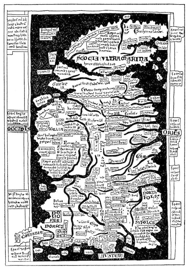
Fig. 9—One of the three maps of Britain by Matthew Paris, that on London Codex Claud. D VI, folio 8 vo. (From Miller, Mappaemundi, vol. iii, 1895, fig. 23).
On one map a legend in the middle informs us that “Britain,
344which includes Scotia, Galloway, and Wales, is now called England.”[1605]
Another legend on a different map gives the dimensions
(800 miles in length from St. Michael in Cornwall to Caithness,
and 300 miles from St. David’s to Dover)[1606] and says that
there are two archiepiscopal and thirty-two episcopal sees. The
outlines of the coasts are in general admirably shown, especially
the west coast, with the westward-reaching promontories of
Galloway, Wales, and Cornwall. The east coast is less satisfactory,
for neither the indentation of the Wash nor the broad
eastward projection of Norfolk appear, and by some confusion a
point on the coast of Suffolk is taken as the southeastern corner
of Britain, with the result that the Thames is shown as debouching
into the English Channel. In the far north, the sketchy
outlines of Scotland show that relatively little was known of this
remote part of the island. Indeed, on two of the maps the Firths
of Clyde and Forth join in such a way as to cut off “Scocia Ultramarina”
from the remainder of Britain, with which it is connected
by a bridge (see Fig. 9). The courses of the main rivers, Severn,
Humber, Avon, Thames, on the whole are well delineated. A
large tract in the east is labeled mariscus to designate the Fen
country, and the mountains Snowdon, Plynlimon, and Cheviot
appear in their correct positions.[1607] The northern Scottish Highlands
are described by long legends as mountainous and woody
regions which generate an uncultivated and pastoral people, inasmuch
as a great part of this area is boggy and full of reeds.[1608]
Argyll is a “trackless and watery district well adapted to cattle
and pasturage,”[1609] and South Wales is spoken of in much the
same terms.[1610] Among the islands off the coast we notice Sheppey,
Thanet, Wight, possibly some of the Channel Islands, Portland
Head, Scilly, Lundy, Anglesey, Man, Tiree, Iona, and, to the
east of Scotland, the Orkneys.[1611] The Hebrides are conspicuously
absent, and in their place a legend reads “immense and
trackless sea.” A large number of cities are placed more or less
in their proper positions, together with the names of counties
and other territorial divisions; and finally the Roman walls from
Forth to Clyde and from Carlisle to Newcastle make the most
prominent feature among the works of man.
345
Orkneys and Shetlands
Returning to Giraldus, we find that among the islands in the
neighborhood of Britain he mentions Man, Mona (or Anglesey),
the Orkneys, and the Shetlands. Man, he remarks, should be
considered as belonging to Britain and not to Ireland. His
criterion for so assigning it was the fact that its earth does not
resemble the earth of Ireland in the property of killing venomous
reptiles.[1612] The Orkneys and Shetlands,[1613] in the northern ocean
beyond Ulster and Galloway, were subject to the Norwegian
king, through whose piracy and prowess at sea they were held
in submission even though geographically they lay nearer the
coasts of other countries. Giraldus quotes Orosius and Isidore
to the effect that, of the thirty-three Orkneys, thirteen were inhabited
and twenty deserted, and he added that in his day, also,
the greater part of these isles were uninhabited.
Iceland and Thule
Giraldus writes of Iceland, three days’ sail to the north of
Ireland, and gives a few details regarding its people.[1614] The
speech of the Icelanders was brief and truthful and they rarely
made oath; their king was the equivalent of a priest; and government
was in the hands of a bishop. Though thunder and lightning
were rare in this distant isle, there was another curse far
more terrible: volcanic eruptions and lava flows.
Apparently Giraldus did not associate Iceland with the Thule
of the ancients, an isle which he was at a loss to identify.[1615] In
regard to the latter, he remarked that it was strange that this
island, the nature of which was so well known to the Orientals,
should remain unknown to the people of the West. After quoting
what Solinus and Isidore had written about it, he added that no
island familiar to the men of the Occident partook of the qualities
which these writers attributed to Thule and that consequently it
must either be fabulous—as well as famous, he naively remarks—or
else hidden away in the far corners of the Boreal Ocean under
the Arctic Pole.
The Emperor Frederick II in his treatise on falconry says
that the gerfalcons come from a certain island between Norway
346and Gallandia (Greenland) called in Teutonic “Islandia,” which
may be translated as “frozen” or “region of ice.”[1616]
Iceland in Icelandic Literature
Long prior to the beginning of our period Iceland had become
the home of an enterprising and cultivated Scandinavian people.
From its shores pilgrims found their way to Italy and the Holy
Land, and navigators sailed westward into the more mysterious
recesses of the ocean. The Sagas give us data regarding these
voyages and incidentally throw light on the geographical concepts
in the minds of the Northern peoples concerning the seas
and islands of the North. The Ílendingabók of Ari Frodhi,
dating from shortly after 1134, tells of the first Norse visit to
Iceland in 870 by Ingolf. Ari mentions it as significant that “at
that time Iceland was clothed with forest from the mountains to
the strand,” and that “there were Christian men here, whom the
Norsemen called Papar” (Nansen’s translation).[1617] It was supposed
that these men came from the British Isles because here
were found Irish books, bells, and crooks. In the Historia de
antiquitate regum Norwagiensium of the monk Theodricus we are
told that certain merchants in the time of Harold Fairhair had
sailed to the Faroes but were driven out to sea by storms and
came “to a far distant land, which some think to have been the
island of Thule; but I cannot either confirm or deny this, as I do
not know the true state of the matter. They landed and wandered
far and wide; but although they climbed mountains, they
nowhere found trace of human habitation” (Nansen’s translation).[1618]
In the Historia Norwegiae, dating probably from the
thirteenth century, we are told that “next, to the west, comes the
great island which by the Italians is called Ultima Tile; but now
it is inhabited by a considerable multitude, while formerly it was
waste land, and unknown to men, until the time of Harold
Fairhair” (Nansen’s translation).[1619] In the Landnámabók, of
about 1200, we have a vivid account of the first Norwegian discoverers’
ascent of a high mountain in this remote land. They
“looked around them, whether they could see smoke or any sign
that the land was inhabited, and they saw nothing.... As
347they sailed from the land much snow fell upon the mountains,
and therefore they called the land Snowland” (Nansen’s translation).[1620]
Greenland
Greenland had been discovered about the year 900. In our
period the southwestern coast had become the seat of two small
settlements, the ruins of which may be seen at the present time.[1621]
The population was not great (less than two thousand), and yet
this far outpost of European civilization was large enough to be
constituted an independent bishopric about the year 1110.
From its settlements, certainly during and after the thirteenth
century and probably in the course of our period as well, regular
summer seal-hunting expeditions were made to the north along
the coast, perhaps as far as Baffin’s Bay. The icebound east
coast of Greenland, on the other hand, was avoided by the
Scandinavian seafarers, although we read of frequent shipwrecks
there. There is also a report of a seal-hunting trip to this coast
made in 1129. From the mid-thirteenth century dates the
work called the King’s Mirror, which gives us a vivid account of
the ice floes and icebergs that beset the inhospitable eastern
shore.
“Now in that same sea [i.e. the Greenland Sea] there are yet
many more marvels, even though they cannot be accounted for
by witchcraft [skrimslum]. So soon as the greater part of the
sea has been traversed, there is found such a mass of ice as I
know not the like of anywhere else in the world. This ice [i.e.
the ice-floes] is some of it as flat as if it had frozen on the sea
itself, four or five cubits thick, and lies so far from land [i.e. from
the east coast of Greenland] that men may have four or five days’
journey across the ice [to land]. But this ice lies off the land
rather to the northeast (landnorr) or north than to the south,
southwest, or west; and therefore anyone wishing to make the
land should sail round it [i.e. round Cape Farewell] in a southwesterly
and westerly direction, until he is past the danger of
[encountering] all this ice, and then sail thence to land. But it
has constantly happened that men have tried to make the land
too soon, and so have been involved in these ice-floes; and some
348have perished in them; but others again have got out, and we
have seen some of these and heard their tales and reports....
These ice-floes are strange in their nature; sometimes they lie as
still as might be expected, separated by creeks or large fjords; but
sometimes they move with as great rapidity as a ship with a fair
wind, and when once they are under way they travel against the
wind as often as with it. There are, indeed, some masses of ice
in that sea of another shape, which the Greenlanders call ‘fall-jökla.’
Their appearance is that of a high mountain rising out
of the sea, and they do not unite themselves to other masses of
ice, but keep apart” (Nansen’s translation).[1622]
Polar Seas
In the boreal parts of the Atlantic the Northern writers of our
period placed great whirlpools and fabulous countries peopled by
monsters. Adam of Bremen tells of the explorations of certain
noblemen of Friesland during the time of the predecessor of
archbishop Adalbert of Bremen. Sailing beyond Iceland “towards
the extreme axis of the north ... they suddenly
glided into the misty darkness of the stiffened ocean, which can
scarcely be penetrated by the eye” (Nansen’s translation).[1623]
Here they were caught by a terrible current and were almost
sucked into the vortex of the deep, only to be thrown forth away
from danger by a reverse tidal current. Thence they came to an
island, fortified like a town, where they found a race of giants
whom they called Cyclopes and from whom they barely were able
to make their escape. Saxo Grammaticus, writing about 1200,
tells of the voyage of a legendary King Gorm of Denmark and an
Icelander Thorkill to an even more mysterious region called
“Farther Biarmaland,” north of Norway.[1624] Here too were
loathsome monsters, a river dividing the land of men from the
land of spirits, and many other wonders. In the Historia Norwegiae
we are also told of a fabulous coast in the North Atlantic
upon which sailors had landed when on the way from Iceland to
Norway. This country lay “between the Greenlanders and the
Bjarmas,” and the sailors “asserted that they had found people
of extraordinary size and the land of virgins [‘virginum terram’]
349who are said to conceive when they taste water. But Greenland
is separated from these by ice-clad skerries [‘scopulis’]” (Nansen’s
translation).[1625] Yet more full of color is another description
in the same work. Beyond Norway “there is the very deep and
northerly gulf which has in it Charybdis, Scylla, and unavoidable
whirlpools; there are also ice-covered promontories which plunge
into the sea immense masses of ice that have been increased by
heaving floods and are frozen together by the winter cold; with
these traders often collide against their will, when making for
Greenland, and thus they suffer shipwreck and run into danger”
(Nansen’s translation).[1626]
Possibly these accounts in the Historia Norwegiae refer to
Svalbard, “the country of the cold coasts,” mentioned in the
Landnámabók.[1627] The discovery of Svalbard was placed by the
Icelandic Annals in 1194,[1628] and it may well be that sailors in that
year were driven out of their course and landed on the inhospitable
shores of Spitsbergen.[1629]
Wineland the Good
The voyages of Leif Ericsson and others to the coasts of America,
though they had taken place over a century earlier, were
doubtless remembered by the Icelanders of the period we are
studying. Ari Frodhi in the Íslendingabók, written about 1134,
refers to Wineland and to the Skraelings as if they were entirely
familiar to his contemporaries.[1630] There is also a record in the
Icelandic Annals, under the date 1121, that the Bishop Eric of
Greenland actually sought Wineland, though we are not told
whether his search was successful or whether he made any important
discoveries in prosecuting it.[1631] The detailed stories of
the Wineland voyages which were current in oral tradition during
the eleventh century were undeniably put into written form long
before 1250, although the versions in which we now have them,
the Saga of Eric the Red and the Flatey Book, are of later date.[1632]
The true position of Wineland has for many years been a matter
of acrimonious dispute among historians and geographers, but
it is beyond our province to enter upon this controversy. On the
other hand, it is of interest to point out that the Icelanders themselves
350or some of them, at least, must have believed that Wineland
lay in relatively southern latitudes, for an Icelandic geographical
description of the world,[1633] dating perhaps from our
period, contains the following remark: Not far from Markland is
“Wineland the Good, which some affirm extends from Africa;
and, if this is so, an arm of the sea separates Wineland and Markland.”[1634]
In Europe outside of the Scandinavian countries practically
nothing was known of Wineland. The earliest mention
of it is in the pages of Adam of Bremen’s description of the North,
where we read the following brief passages: “Moreover he [King
Svend Estridsson] spoke of an island in that ocean discovered by
many, which is called Wineland, for the reason that vines grow
wild there, which yield the best of wine. Moreover, that grain
unsown grows there abundantly is not a fabulous fancy, but from
the accounts of the Danes we know to be a fact” (Reeves’s translation).[1635]
Ordericus Vitalis in his Historia ecclesiastica includes
Wineland in a list of countries made subject to the king of the
Norsemen but gives no details.[1636]
Adam of Bremen or a later interpolator[1637] adds to the passage
just quoted a description of the Northern Ocean, which he erroneously
places beyond Wineland. He says: “Beyond this
island, it is said that there is no habitable land in that ocean, but
all those regions which are beyond are filled with unsupportable
ice and boundless gloom, to which Marcian thus refers: ‘One
day’s sail beyond Thile the sea is frozen.’ This was essayed not
long since by that very enterprising Northmen’s prince, Harold,
who explored the extent of the Northern Ocean with his ship but
was scarcely able by retreating to escape in safety from the gulf’s
enormous abyss, where before his eyes the vanishing bounds of
earth were hidden in gloom” (Reeves’s translation).[1638]
Fabulous Isles
Until modern times the Atlantic has been an ocean filled by the
imaginations of the coast-dwelling peoples of the Old World with
fabulous and fantastic isles. In the De imagine mundi we read
of the Isle of the Gorgons and of the Hesperides,[1639] “among
which was that great land described by Plato as having been
351submerged beneath that part of the sea now coagulated—an isle
greater in extent even than Africa and Europe.” In this story
we recognize the old legend of Atlantis which had been the subject
of speculation and discussion ever since the time of Plato.
The De imagine mundi then goes on to speak of “Perdita,” or
the Lost Island, which far exceeded all the surrounding countries
in the delightfulness and fertility of all things to be found therein.
Though as a general rule unknown to man, this isle was sometimes
to be found by hazard, though never found when looked for.
Hence it was called “Perdita,” or “Lost.” To it St. Brandan
was said to have gone in the course of his wanderings.
St. Brandan’s Isles
For a full account of the islands visited by St. Brandan we must
look to the famous narration of his voyages. Ernest Renan
poetically characterizes this legend as follows: “In the midst of
these dreams there appears with surprising truth a feeling for the
picturesque in polar navigations: the transparence of the sea, the
aspects of the ice floes and icebergs melting in the sun, the volcanic
phenomena of Iceland, the playing of the cetaceans, the
characteristic appearance of the fiords of Norway, the sudden
fogs, the milklike sea, green islands covered with grass which
overhangs into the waves....”[1640] In the most widely known
Latin version, which was translated into English and French
during our period,[1641] we are told[1642] that Brandan, the abbot of a
large monastery in Munster, received information from a certain
Barinthus of marvelous isles that the latter had visited in the
western seas and in particular of the “Terra repromissionis sanctorum,”
or Saints’ Land of Promise. Taking seven companions,
the saint set out in a ship built especially for the voyage and
wandered for seven years from one marvelous isle to another.
After forty days’ sailing in a northerly direction they came to an
islet, where they entered into a narrow harbor between high and
precipitous rocks. This harbor mouth, just wide enough to admit
a ship, was typical of the ragged western coasts of Ireland
and Scotland and was doubtless suggested to the poet by some
bleak cove among the rocks of St. Kilda or the Outer Hebrides.
352After leaving the islet the wanderers reached an isle covered with
sheep—perhaps a reminiscence of the Faroes, the sheep of which
had long before been described by Dicuil.[1643] Beyond this they
came to a smooth islet lacking verdure and with no sand upon it;
this turned out to be a sea monster, which dived beneath the
waves when the saint and his companions tried to light a fire
upon its back. Their fortunate escape from the monster was
followed by wanderings that brought them to an isle full of birds
in such numbers and of such brilliant plumage that the voyagers
could scarce see the branches of the trees. Some of the birds
could talk; and one spoke words of prophecy foretelling the future
course of Brandan’s journeys. Thence they came to yet another
isle, where they entered a port with a narrow entrance and found
a monastery; then to an isle with a fresh-water spring which put
each brother to sleep for a period corresponding to the number of
cups he drank. After that they made their way still farther
north, where the sea was coagulated, and then returned to many
of the isles already visited in the course of their earlier sailings
and also to fresh marvels—seas of miraculous clearness, terrible
volcanoes, Judas’s rock, the islet of Paul the hermit.[1644] Finally,
after seven whole years, they attained a broad and spacious country
full of trees bearing apples as if it were the autumn of the
year, a land where no night was ever known. Here a youth
greeted Brandan and said that this was the country for which he
had been seeking. Then Brandan sailed back to Ireland, where
he lived out the remainder of his earthly life, and, after his death,
returned forthwith to this “land of promise of the saints,” or
Paradise, which for so long had been his goal.
353
It now remains for us to give a brief résumé of the outstanding
elements which constituted the geographical lore of the time
of the Crusades and to draw a few generalizations from the
mass of details that have been set forth in the foregoing pages.
The dangers of attempting to condense the geographical
thought of a century and a half into the compass of a few pages
are manifest, and yet some of the more significant ideas may perhaps
be presented without running an undue risk of over-simplification.
According to the orthodox view of the ecclesiastics, the world
was created by an arbitrary act of God at a certain definite point
of time. Under the influence of classical thought, writers of the
Chartres group of the early twelfth century worked out theories
of the Creation according to which, though the initiative was attributed
to God’s act, the actual Works of the Six Days were
ascribed to the unfolding of physical processes governed by the
laws of nature. Such theories did not meet with general acceptance,
though they were never wholly lost sight of. The ancient
belief in an eternally existent, periodically re-formed universe
was not given credence, though it was well known to the
readers of the period with which we are concerned through classical
works in their libraries and through translations from the
Arabic.
It was probably the opinion of most scholars that the universe
is a sphere in which the four elements are arranged concentrically.
Furthermore, nearly all scholars argued that the earth likewise is
a sphere and that they were acquainted with convincing proofs
of this. Standing immobile in the center of the universe, the
earth was usually supposed to be a small body in proportion to
354the entire cosmos. The surface of our globe was divided into five
zones, two temperate, two polar—uninhabitable on account of
the intense cold—and an equatorial zone, uninhabitable by
reason of heat. The habitability of the equatorial zone, however,
was affirmed by a few writers conversant with Arabic literature.
There was a great deal of speculation regarding the characteristics
of those parts of the world which lay beyond the oikoumene,
or quarter of the globe known to Europeans. The theories of
Macrobius and of Martianus Capella, who had divided the earth’s
surface into four equal parts by two encircling bands of ocean,
strongly influenced the thought of many. Macrobius and
Martianus Capella had also believed that all of these quarters of
the earth were inhabited but that three of them were unknown to
members of our human race, who could not visit them owing to
the heat of the equatorial zone and the terrors of the ocean.
Though this theory could not be reconciled with Christian teachings
and was strongly controverted, it nevertheless persisted,
and many of the writers of the Crusading age undoubtedly
shared it.
Something was known of the atmosphere. William of Conches
wrote of its decreased density and temperature with increased
altitude. Rainfall was explained as the result of many causes,
among them evaporation of sea water and condensation of water
vapor in the air, and topographic influences on rainfall were
recognized by Giraldus Cambrensis. The winds, defined as air
in motion, were also occasionally ascribed to the influence of
topography. William of Conches worked out an elaborate
theory of a general circulation of the atmosphere produced by the
circulation of ocean currents. The impressions made upon men
by the climatic conditions of various parts of the earth found expression
in many passages. The cold of the North was contrasted
with the heat of the South, and Giraldus Cambrensis gives a
colorful comparison of the damp climate of Ireland with the
noxious dryness of the East.
The aqueous element was supposed to be divided into two
parts, the waters above and the waters below the firmament.
Theodoric of Chartres and William of Conches tried to explain
355the waters above the firmament on rational grounds; others were
inclined to take the Biblical assertions absolutely literally. The
waters below the firmament were believed to form one unit or
congregation of waters, and an unceasing circulation was thought
to be maintained from the seas and oceans through subterranean
channels and cavities of the earth to the sources of streams. As
to the seas themselves, many ingenious explanations were
brought forward to account for their salinity. It was understood
that the tides are caused by the moon, though subsidiary
causes, such as whirlpools and ocean currents, were also adduced
to explain them. The most interesting tidal studies of the period,
made by Giraldus Cambrensis on the shores of the Irish Sea and
Bristol Channel, were undoubtedly the results of careful synchronous
observations of the times of high and low water in different
localities. Something of the spirit of the North Atlantic is conveyed
through the pages of the legend of St. Brandan. Of the
waters of the lands, rainfall was not usually thought sufficient to
account for the flow of rivers, which were supposed to be fed by
underground channels from the seas. Springs, wells, and fountains
attracted much attention, and many are the marvels related
about them in the literature of the age. Giraldus Cambrensis
describes marvelous lakes in Ireland, and strange tales
were told of lakes of Italy, Spain, and elsewhere, which, together
with the Dead Sea and volcanic craters, were objects of fear,
because some men believed them to be ways of ingress to the
infernal regions.
The lands of the earth’s surface were classified in various manners.
The author of the De imagine mundi mentions no less than
six types of land surface. Different regions were supposed to
have different effects on life: Ireland was thought to be remarkably
healthful, and its earth to have the property of destroying
venomous reptiles; the East, Giraldus Cambrensis would have us
believe, is a fountain of poisons. Many medieval writers had
an eye for the spiritual and esthetic beauties of landscape, and
picturesque descriptions of rich cultivated scenes are not rare.
It is doubtful, however, to what extent the grandeur of wild nature
and of mountains was appreciated. The great majority of
356men certainly regarded mountains as grim and horrible. Mountain
climbing was not indulged in for pleasure, though we have an
account of an ascent of Etna in the Image du monde. On the
other hand, there date from this age several extremely vivid
descriptions of the hardships encountered during journeys over
the Alps, one of which was made in midwinter. Alfred of Sareshel
gives in a translation from the Arabic a clear account of
geologic processes by which mountains were formed. Volcanoes
impressed the men of the Middle Ages. The volcanic regions of
southern Italy and Sicily and of Iceland are frequently described,
and St. Brandan’s legend contains what can be nothing
else than an account of a volcanic isle. Fiery mountains were
associated in the popular mind with entrances to Hell. Scientific
investigators usually attributed their fires to burning beds of
sulphur and bitumen within the mountains or else to the outbursting
of imprisoned winds. To the action of winds in subterranean
caverns classical authorities had ascribed the cause of
earthquakes, and this view was accepted throughout the Middle
Ages. Other features of the land that attracted attention were
the deserts of the East, vividly described by the historians of the
Crusades and in the Letter of Prester John, and the fabulous islands
of the sea, especially of the unknown Atlantic. Some
peculiarities of the movement of ice in glaciers were noted by
Saxo Grammaticus.
The influence of geographical environment on animals and on
man was sometimes commented upon. Bernard Sylvester emphasizes
the control of terrain over plant and animal life. Giraldus
Cambrensis attributes the independence and audacity of the
Welsh to the rugged character of their country. A fatalistic
idea is expressed in the writings of Hugh of St. Victor and of Otto
of Freising, to the effect that the course of science, empire, and
civilization proceeds with the heavenly bodies across the surface
of the earth from east to west and that, as it has reached the
uttermost confines of the West, the power of the kingdom of the
Franks is soon destined to disappear.
Within the field of astronomical geography several methods
were known whereby latitudes may be determined, and also the
357use of observations of eclipses for ascertaining longitude was
understood. Figures indicating the positions of points in many
parts of the known world had been introduced to Western
knowledge through the Moslems. It seems likely, furthermore,
that not only were the Arabic figures borrowed by the astrological
writers of our age but also that a new series of observations was
made by which the latitudes as well as the longitudes of several
stations in Western Europe were found with no small degree of
accuracy. These figures, however, were intended to serve as
aids for astrologers and astronomers in making their calculations,
and we have no evidence that they were put to geographical
use.
The cartography shows little originality. It was in no way corrected
or checked up with reference to astronomical observations.
Most of the maps were based on earlier models, and it is perhaps
possible to trace their origins back to maps of the Roman Empire.
Cartographic accuracy was not the aim of the map maker
of the time, and we are not justified in criticizing his maps in the
light of modern standards. They should be regarded rather as
diagrammatic approximations. A number of conventions were
followed, the most important of which was the representation of
the east at the top. The maps were vividly colored; and mountains,
rivers, and the works of man were shown by pictorial
symbols.
We may conceive of the regional geographic knowledge of the
age as comprised within two concentric circles: a very broad outer
circle, which includes all those lands of which knowledge had been
derived at second hand through literary sources; and a smaller
inner circle including those lands which were known at first hand
through actual travel.
The outer circle took in to the east the land of the Seres, or
China, and the lost Atlantis to the west; to the north the regions
of the Hyperboreans and the semi-mythical Rhipaean Mountains;
and to the south the Mons Climax of Ptolemy and the
mysterious upper reaches of the Nile. Nearly all that lies between
the two circles was a vague region of fancy and fable,
though ideas that were more or less correct prevailed about some
358parts of Western Asia, familiar ground to the men of ancient
Greece and Rome.
The inner circle included on the east the shores of the Black
Sea and the Holy Land; on the south, the Mediterranean fringe of
Africa; westward it was bounded by the Atlantic coast; north-westward,
warped somewhat out of shape, it enclosed Iceland
and even the icy coasts of Greenland. To the north, it ran
through Scandinavia and the Baltic. Within these bounds there
were many gaps that were still utterly unknown; but, in general,
politics, pilgrimage, war, and commerce had familiarized the men
of the West with most parts of this tract. It seems a small area
indeed compared with what is now known of the world’s surface
and small even compared with what Ptolemy and earlier Greeks
had known. Only in the age that immediately follows ours was
the circle enlarged, at first to the eastward by the great overland
journeys of Marco Polo and the other Asiatic travelers of the late
thirteenth and fourteenth centuries and then westward, southward,
and northward during the Age of Discovery. Not until
our own day has it at last come to comprise the entire earth.
Men have always respected tradition and learning inherited
from former ages, but in some periods dependence on earlier
authority has been more unquestioning than in others. In the
Middle Ages, especially, an immense mass of knowledge and
belief was handed down from generation to generation.
A portion of this inherited mass of knowledge and belief constituted
the recognized and orthodox geographical lore of the
Crusading age. This body of teachings—to be sure, not altogether
uniform or consistent—had been built largely on a foundation
of Biblical and classical doctrine. The early Church Fathers,
taking the Bible as their authority, had leveled destructive
criticism against those ideas of the Greeks and Romans which
appeared to go counter to Scriptural texts, but in the course of
time reconciliation of ancient science with Christianity was
partly achieved and, as a consequence, the accepted scientific
359lore of the twelfth and early thirteenth centuries was only to a
limited extent drawn from a literal interpretation of the Bible.
Nevertheless, those theories of antiquity that were too diametrically
hostile to the words of Scripture still remained tabooed,
and, when Manegold, Peter Lombard, or Peter Comestor inveighed
against belief in hyle, the Great Year, or the antipodes,
they were merely echoing the arguments of their early Christian
predecessors. Classical learning and Christian doctrine were
sufficiently at one by the opening of the twelfth century to make
it no longer heretical to believe in the sphericity of the earth, in
the existence of antipodal regions (if not inhabitants), and in a
physical explanation of many geographical processes that an
earlier age might have ascribed to the direct intervention of the
divine will.
The works of our period show all too plainly that they were
written in a credulous age, for credulity is an inevitable concomitant
of the undue respect for authority. Credulity and love
of the marvelous—which is much the same thing—are in many
ways the most characteristic and entertaining qualities of the
geographical writers of the Middle Ages. Marvels of all kinds,
located in all countries, are solemnly described as if they were
truth. India, especially, was the scene of fabulous monsters and
prodigies; but no country, no matter how well known, was wholly
without them. Even the most serious writers mention them, and
they enliven all the maps.
In contrast with this geography based on authority and tradition
stood another great body of geographical lore derived not
from books or tradition but from observation by eyewitnesses of
the countries of the earth and the physical features of its surface.
We may style this second body of geographical lore the “geography
of observation.” It is represented almost universally in the
literature of the period, for no writer was so completely immersed
in the learning of the past that he failed altogether to respond to
the world of his day. Even in the most learned works there are
occasional passages drawn from contemporary observation; but
it is especially in histories, chronicles, letters, and other less
formal writings that the “geography of observation” finds unhampered
360expression. The latter are among the most illuminating
documents of the age, for they reveal to us those things which
above all interested the average man in the material world around
him.
Measured by modern standards, this “geography of observation”
is the only kind of geography that rests on a sound and
scientific footing. Modern science rejects theories, however old
and hallowed they may be, which cannot stand the test of an
appeal to Nature herself. Precisely the opposite seems to have
been the normal intellectual habit of the Middle Ages, when the
prevailing tendency was if anything to put aside the evidence
of Nature when contradicted by the classics, by the Church
Fathers, or especially by the Bible. Logical impossibility or rational
improbability did not usually bear much weight against a
belief that had been approved by time.
And yet there were in the age of the Crusades numerous exceptions
to this general rule. Never has there been a time when
a few fore-reaching and individualistic spirits have not tried to
search and see and think for themselves, to confront older teachings
with new, to criticize established beliefs in the light of observed
facts and reason. In the ardent, enthusiastic society of
the twelfth and thirteenth centuries there was no lack of such
spirits. Among the writers on geographical subjects we need but
recall the names of the scholars of Chartres: Theodoric, who undertook
to explain the Creation according to physical principles
and specifically excluded from his discussion all moral and allegorical
interpretations of the text of Genesis; or William of
Conches, who argued that we may avoid irrational deductions
from Scripture by an appeal to our own reason and who maintained
that the animals of the earth and also Adam and Eve
were produced through the interaction of the elements of fire,
earth, air, and water. And this critical, inventive attitude reappears
in the thirteenth century in the work of such men as
Robert Grosseteste, Roger Bacon, and even Albertus Magnus.
We gain a deeper and more sympathetic understanding of the
devious workings of the human mind when we trace in the geographical
lore of the Middle Ages the persistence of old ideas and
361the transfer of prejudices and beliefs from age to age; but at best
this is a disheartening study. On the other hand, there is always
fascination in coming across oases of fresh observation and clear
reason in the midst of the arid deserts of plagiarism that constitute
so much of medieval literature. These oases mark the
pathway of the history of science.
BIBLIOGRAPHY — BIBLIOGRAPHICAL NOTE — Bibliographies — Historical Bibliographies — Geographical Bibliographies — Bibliographies of the History of Science — Dictionaries — Manuscripts — Collections of Original Sources — Secondary Works — The Geographical Lore of Antiquity and of the Middle Ages
489
491
Those who wish to carry out detailed investigations of the various
topics discussed in the present volume will find in the Notes and Bibliography
references to the original sources and to secondary works. Owing,
however, to the scattered nature of the references in the Notes and to the
alphabetical arrangement of the Bibliography it is impossible from them
alone to gain a rapid introduction to the outstanding publications on the
subject. To supply such an introduction is the purpose of the following
note.
Titles are not as a rule here cited in full, and the reader should therefore
turn to the Bibliography for the full titles, for indications of the
place and manner of publication, and for other bibliographical details.
The relatively few titles of publications mentioned here only are given in
full and are followed by the words “(not in Bibliography).”
The study of the geographical lore of the Middle Ages has been approached
by scholars from many different points of view. This is reflected
in the character of the bibliographies dealing specifically or incidentally
with this field. We may group these bibliographies arbitrarily into
three classes: (a) historical bibliographies; (b) geographical bibliographies;
(c) bibliographies devoted to the history of science.
Among the historical bibliographies mention should first be made of
Chevalier’s Répertoire des sources historiques du moyen âge, 1894–1907.
Two volumes of this work, with the subtitle Bio-bibliographie, list alphabetically
a large number of personages of importance in the Middle Ages.
Brief biographical notes are given, followed by extensive lists of references
to publications by or in any way relating to these personages. A great
difficulty in using the Bio-bibliographie lies in the fact that no clues are
given regarding the type of publications to which reference is made. We
are not told whether these publications are printed texts of medieval
works, scholarly treatises, or merely passing and relatively unimportant
allusions. In a third volume of Chevalier’s Répertoire (with the subtitle
Topo-bibliographie) the effort is made to list alphabetically a multitude of
topics relating to medieval history and life and, as in the Bio-bibliographie,
to give references to publications upon these topics. Here again, owing to
the lack of critical evaluation of the references as well as to the somewhat
arbitrary selection of the topical headings, the work is of very uneven
utility.
Whereas Chevalier attempts to cover the entire range of medieval
civilization, the writings of the historians and chroniclers of the age are
dealt with in Potthast’s indispensable Bibliotheca historica medii aevi, 1896.
492The main part of these volumes consists of an alphabetical repertory of
names and titles with references to manuscripts, editions, translations,
and secondary works explanatory of the sources. There are also included
highly useful synopses of the contents of the great collections of medieval
sources (see below, pp. 493–495) and an appendix in which the titles of the
original sources are given chronologically within regional divisions.
For a general guide to many of the more important books and articles
on medieval history, L. J. Paetow’s Guide to the Study of Medieval History
for Students, Teachers, and Librarians (University of California Syllabus
Series, no. 90), Berkeley, Cal., 1917 (not in Bibliography), is valuable. A
large part of Paetow’s book is devoted to medieval culture. Though by
no means exhaustive, the Guide is excellent for orienting the student in
an unfamiliar field.
We refrain from mentioning other historical bibliographies of regions
and topics relating to the Middle Ages. References to many of these may
readily be found in the first chapter of Paetow’s Guide and in the various
paragraphs entitled “Bibliographies” appended to the topical sections of
that publication.
The bibliography of ancient and medieval geography has been dealt
with at some length in the summaries of the progress of geographical
research that have appeared from time to time in the Geographisches
Jahrbuch published by Justus Perthes, Gotha (not in Bibliography),
which since 1880 has been edited by Professor Hermann Wagner of Göttingen.
The ancient period has been covered by Professor Eugen Oberhummer
in vols. xix (1896), xxii (1899), xxviii (1905), and xxxiv (1911);
the medieval by Professors Sophus Ruge and Walther Ruge in vols.
xviii (1895), xx (1897), xxiii (1900), xxvi (1903), and xxx (1907). These
reports are running commentaries on the progress of current investigation,
with references to the literature in the footnotes.
A section on the history of geography, with occasional references to
publications in the medieval field, has appeared regularly in the Bibliographie
géographique annuelle (not in Bibliography) of the periodical
Annales de Géographie, published by Armand Colin, Paris, 1893–1914,
and in its continuation, Bibliographie géographique 1915–1919, 1920–1921,
1922 (not in Bibliography), published under the auspices of the Association
de Géographes Français. References to secondary works in medieval
geography are also given in the annual volumes of Bibliotheca Geographica
(not in Bibliography), published by the Gesellschaft für Erdkunde
Berlin, and covering 1891 to 1912.
References to publications on medieval geography as a part of the history
of science may be found in the critical bibliographies that have been
included since its inception in 1913 in each number of the periodical Isis:
493International Review Devoted to the History of Science and Civilization,
Brussels.
Research in the field covered by the present volume requires a working
knowledge of medieval Latin, the language in which most of the original
sources were written. Medieval Latin is not difficult—except in occasional
passages—for one who has some knowledge of classical Latin. The
great dictionary of C. D. Du Cange, Glossarium ad scriptores mediae et
infimae latinitatis (not in Bibliography), first published at Paris in 1678
and subsequently in other editions (the latest at Niort, 1883–1887), is
indispensable. For medieval French, consult F. E. Godefroy, Dictionnaire
de l’ancienne langue française, 10 vols., Paris, 1881–1902 (not in
Bibliography).
Many of the works of medieval authors have never been printed.
They can be consulted only in the collections of manuscripts of the libraries
of Europe and, to a limited extent, of America. While research in
manuscripts is not absolutely essential for a general study like the present,
no detailed research can very well be conducted without direct recourse
to unprinted documents.
The use of medieval manuscripts is an art in itself, requiring some
familiarity with paleography. The handwritings of the twelfth and thirteenth
centuries, however, are frequently not difficult to decipher. On
this subject consult: E. M. Thompson, An Introduction to Greek and Latin
Palaeography, Oxford, 1912 (not in Bibliography), and, for abbreviations
commonly used in manuscripts, A. Cappelli, Lexicon abbreviaturarum
...: Dizionario di abbreviature latine ed italiane ..., Milan, 1899,
2nd edit., Milan, 1912 (not in Bibliography).
A list of catalogues of collections of manuscripts will be found in a publication
of the Bibliothèque Nationale of Paris: Collection alphabétique des
livres imprimés mis à la disposition des lecteurs dans la salle de travail, suivi
de la liste des catalogues usuels du département des manuscrits, Paris, 1910
(not in Bibliography). Useful references to manuscripts of some of the
writings on geography and natural science of the Middle Ages are included
in Beazley, Dawn of Modern Geography, 1897–1906, in Thorndike, History
of Magic and Experimental Science, 1923, and in Haskins, Studies in
the History of Mediaeval Science, 1924. References to manuscript maps
will be found in Miller, Mappaemundi, 1895–1898.
The great printed collections of historical sources dealing with the
Middle Ages are discussed in Paetow’s Guide (see above, p. 492) and analyzed
in Potthast’s Bibliotheca (see above, p. 491). In the Bibliography of
the present volume reference is made to printed texts of individual works.
It will therefore not be necessary here to do more than indicate the titles of
494a few of the collections most important from the point of view of medieval
geography.
The Corpus scriptorum ecclesiasticorum latinorum, 1866 ff., is a collection
of critically edited texts of the writings of the Latin Church Fathers.
Migne, Patrologiae cursus completus ... series latina (referred to in the
Notes as Pat. lat.), 1844–1864, contains texts, for the most part uncritical,
not only of the writings of the Church Fathers but also of a vast assemblage
of works bearing directly or indirectly on the medieval Church.
In nearly all the nations of Europe the publication has been carried
through or is in progress of great collections of sources dealing with the
national history during the Middle Ages. To mention briefly a few of
these, we may refer first to the Rerum britannicarum medii aevi scriptores,
1858–1891, usually known as the “Rolls Series.” This series includes not
only the works of the historians and chroniclers of Britain of the Middle
Ages but also those of many British writers on matters of geography and
natural science. The Monumenta Germaniae historica, 1826–1874 and
1876 ff., contains in its magnificent volumes documents relating to all aspects
of the history and life of the medieval Germans and incidentally of
Europe as a whole. Many of the texts of the Monumenta have been more
critically edited in the Scriptores rerum germanicarum in usum scholarum
ex Monumentis Germaniae historicis recusi, 1840 ff. For France there are
the Rerum gallicarum et francicarum scriptores, or Recueil des historiens
des Gaules et de la France, Paris, 1738–1904 (not in Bibliography), and the
publications of the Société de l’Histoire de France, Paris, 1835 ff. (not in
Bibliography); for the Crusades the most important collection is the
Recueil des historiens des croisades, 14 vols., Paris, 1841–1898 (not in
Bibliography).
Collections dealing more especially with texts of geographical importance
are, for ancient geography, Müller’s Geographi graeci minores, 1882,
and Riese’s Geographi latini minores, 1878. Itineraries to and descriptions
of the Holy Land will be found in Tobler, Descriptiones terrae sanctae,
1874, Tobler, Itinera ... saec. iv-xi, 1877, Michelant and Reynaud,
Itinéraires à Jerusalem, 1882, and Tobler, Molinier, and Kohler, Itinera ...
bellis sacris anteriora, 1880–1885. English translations of certain
medieval travels in Palestine will be found in Thomas Wright, Early
Travels in Palestine, 1848, and in the Library of the Palestine Pilgrims’
Text Society, 1885–1897. Texts and English translations for the early
exploration of Iceland will be found in Vigfusson and Yorke Powell,
Origines islandicae, 1905. Documents relating to the Norse discovery of
America are included in Rafn, Antiquitates americanae, 1837–1841; and
Reeves, The Finding of Wineland the Good, 1890, gives English translations
of the Vineland voyages. On the texts of the great Asiatic voyages
of the thirteenth and fourteenth centuries, which do not fall within the
scope of the present volume, see above, pp. 269–270, and p. 465, notes
70, 71, 74, 75.
495The primary collection of facsimiles of medieval maps prior to the appearance
of the portolan charts is Miller, Mappaemundi, 1895–1898;
critical texts with references to manuscripts and discussions are here
given. Reproductions of early medieval maps are also given in the atlases
to Santarem, Essai sur l’histoire de la cosmographie et de la cartographie,
1849–1852, and to Lelewel, Géographie du moyen âge, 1852–1857.
A selection of medieval texts dealing with meteorology will be found in
Hellmann, Denkmäler mittelalterlicher Meteorologie, 1904.
We may divide our treatment of secondary works into two parts: first,
a discussion of publications dealing with the broader background of medieval
life and thus, incidentally, with the geographical lore of the period;
second, a discussion of publications dealing directly with the geographical
and related lore of antiquity and the Middle Ages or with the enlargement
of geographical knowledge. The titles of secondary works relating to the
specific writings or authors referred to in the present volume may readily
be found by using the cross-references in the Bibliography.
Background of Medieval Intellectual Life
In order not to expand our discussion beyond due measure, we shall
restrict ourselves in this section to mentioning a very few publications the
majority of which have been of direct service in the preparation of the
present volume.
For a broad and brilliantly written treatment of medieval intellectual
activity in its many phases, we may refer to H. O. Taylor, The Mediaeval
Mind: A History of the Development of Thought and Emotion in the Middle
Ages, 2 vols., New York, 1911, revised edit., 1914 (not in Bibliography).
Haskins’ Studies in the History of Mediaeval Science, 1924, which appeared
while the present volume was in press, is fundamental for the
history of science in Western Europe in the twelfth and thirteenth centuries.
Several of its chapters are revisions of articles which had previously
appeared, but other parts of the work are entirely new contributions.
The volume is based to a very large extent upon hitherto unpublished
sources; many critical and interesting passages of Latin texts are published
in it for the first time. Poole’s Illustrations of the History of
Medieval Thought and Learning, 1920, is a discussion of the work of a few
selected exponents of typical modes of medieval thought. The original
work of the scholars of Chartres in the Middle Ages is the subject of
Clerval’s Écoles de Chartres, 1895.
The Latin literature of the period as a whole is dealt with in Gröber,
Übersicht über die lateinische Literatur von der Mitte des 6. Jahrhunderts
bis 1350, 1888–1902, and medieval Latin literature prior to the middle of
the eleventh century is treated in greater detail in M. Manitius, Geschichte
der lateinischen Literatur des Mittelalters, vol. 1, 1911. On the Latin
poetry of the twelfth and thirteenth centuries consult Francke, Geschichte
496der lateinischen Schulpoesie, 1879. For the French literature of the age
there is the important volume of Gaston Paris, La littérature française au
moyen âge, 1914, or the English translation.
Medieval philosophy is outlined in De Wulf, Histoire de la philosophie
médiévale, 1900, or the English translation.
On the art of the twelfth and thirteenth centuries as expressing the
thought of the time the student should read Mâle’s two volumes, L’art
religieux du xiie siècle, 1922, and L’art religieux du xiiie siècle, 1910, or the
English translation of the volume dealing with the thirteenth century.
An old but highly suggestive treatise on the natural science of the early
twelfth century is that of C. B. Jourdain, Dissertation sur l’état de la
philosophie naturelle, 1838. Natural science, magic, and legendary lore of
the first thirteen centuries of the Christian era form the topics of Thorndike’s
learned History of Magic and Experimental Science, 1923. Some
of these subjects as they were embodied in medieval French encyclopedias
compiled for the use of the layman are illustrated in C. V. Langlois, La
connaissance de la nature, 1911. Legendary lore more especially is the
theme of Denis’ little Monde enchanté, 1843, of Berger de Xivrey’s Traditions
tératologiques, 1836, and, more recently, of Graf’s Miti, leggende e
superstizioni, 1892–1893.
The relation between theology and natural science in the Middle Ages has
been a matter of controversy. From a point of view relatively favorable to
medieval science the subject was discussed by Zöckler, Geschichte der Beziehungen
zwischen Theologie und Naturwissenschaft, vol. i, 1877; from a more
critical point of view, by Draper, Conflict Between Religion and Science,
1875, and in White’s scholarly Warfare of Science with Theology, 1895.
The influence of classical scholarship upon medieval thought was potent.
This topic as a whole is dealt with in much detail in Sandys’ monumental
History of Classical Scholarship, 3rd edit., vol. i, 1921. On the use
of classical works in the Middle Ages see also the two monographs of M.
Manitius, Beiträge zur Geschichte der römischen Prosaiker, 1890, and
Philologisches aus alten Bibliothekskatalogen, 1892. In regard to medieval
Latin translations from the Greek, Arabic, and Hebrew, the formerly
authoritative treatises of Amable Jourdain, Recherches critiques, 1843,
and Wüstenfeld, Übersetzungen arabischer Werke, 1877, have to a large
extent been superseded by the researches of Steinschneider (Hebräische
Übersetzungen, 1893; Europäische Übersetzungen, 1905–1906), Mandonnet
(Siger de Brabant, 1908, 1911), Grabmann (Forschungen über die
lateinischen Aristotelesübersetzungen, 1916), Haskins (Studies in the History
of Mediaeval Science, 1924), and others (see above, pp. 95–102, and
notes 32–70 on pp. 398–403).
The publications dealing with ancient and medieval geographical lore
may be divided into three groups: those devoted to (a) the history of
497geography as a whole; (b) the history of geography in particular periods;
(c) the history of particular aspects of geography.
The History of Geography as a Whole
With the exception of a few brief popular works, the writer knows of
only three general histories of geography in which the attempt is made to
cover the entire field. These are Louis Vivien de St. Martin, Histoire de
la géographie et des découvertes géographiques depuis les temps les plus
reculés jusqu’à nos jours, with atlas, Paris, 1873 (not in Bibliography);
Peschel, Geschichte der Erdkunde, 1877; and Günther, Geschichte der Erdkunde,
1904. The first is concerned primarily with explorations and the
expansion of regional knowledge; in its pages the medieval period receives
but scant attention. Peschel aimed to cover both exploration and scientific
geography, and his work, though old, is of great value: scholarly, well
balanced, and clearly written. Whereas Peschel stopped with the early
nineteenth century, Günther carries the record through that century; his
book contains a wealth of detail and of useful bibliographical notes.
The History of Geography in Particular Periods
1. Ancient Geography. Bunbury’s History of Ancient Geography, 1879,
remains to the present day the only work of large scope on Greek and
Latin geography as a whole. Tozer’s delightful History of Ancient Geography,
1897, is a good introduction to the subject but is inadequate for
detailed research. A scholarly treatment of the scientific geography of
the Greeks is Berger’s Geschichte der wissenschaftlichen Erdkunde der Griechen,
1903. The most extensive recent treatment of classical geography
as a whole, with numerous references, is Gisinger’s article “Geographie”
in Paulys Real-Encyclopädie, 1924. The evolution of those theories of
ancient geography which prepared the way toward the discovery of America
is admirably outlined in the now somewhat out of date but nevertheless
useful and stimulating chapter by Tillinghast, Geographical Knowledge
of the Ancients in Relation to the Discovery of America, in the first
volume of Winsor’s Narrative and Critical History, 1889. Alexander von
Humboldt in the first part of the Examen critique de l’histoire de la géographie
du nouveau continent et des progrès de l’astronomie nautique aux
quinzième et seizième siècles, Paris, 1st edit., 1814–1834 (not in Bibliography),
probed deeply into the history of ancient geography. See also
C. B. Jourdain, De l’influence d’Aristote ... sur la découverte du Nouveau-Monde,
1861.
2. Medieval Geography. Santarem’s Essai sur l’histoire de la cosmographie
et de la cartographie, 1849–1852, marks one of the earliest attempts
in modern times to open up the subject of medieval geography. It consists
of a mass of detailed notes on the regional geographical theories of
the cosmographers of the Middle Ages. Lelewel’s Géographie du moyen
âge, 1852–1857, is a work of erudition exasperating in the confusion of its
arrangement, the difficulty of its style, and the untenability of many of
498its theories. Lelewel, however, went beyond Santarem in his endeavor
to take into consideration the work of Arabic as well as of Occidental
geographical authors.
The most recent broad history of medieval geography is Beazley’s important
Dawn of Modern Geography, 1897–1906. These three volumes
are the result of long and arduous research and will probably remain for
many years to come on the whole the most satisfactory general treatment
of the subject. They cover the period from 300 to 1420 A. D. Attention
is given to the explorations and geographical science not only of the
Christians but also of the Arabs and Chinese (the two latter subjects,
however, having been studied through translations and secondary works
only). Throughout, especial stress is laid upon the record of travel and
exploration and upon the historical events that led to the acquisition of
geographical information by travel and exploration. In the first two
volumes, on the period until 1260, extensive chapters are devoted to “Geographical
Theory,” but in the third, covering 1260 to 1420, only 29 out of
a total of 541 pages are given to geographical theory, and the chapter on
geographical theory of the period from 900 to 1260 in the second volume
barely touches upon the various topics discussed in Chapters V to X
of the present book. To illustrate the theoretical “earth-knowledge”
of the “Central Middle Age period” Beazley discusses three examples
only, the work of Constantine Porphyrogenetos, that of Adam of Bremen,
and the chief maps of the age. There is either the briefest passing mention
or else no reference whatever to the writings of the highly characteristic
authors the study of whose geographical opinions is the main purpose
of the present volume—such writers as Peter Abelard, Peter Comestor,
Hildegard of Bingen, Bernard and Theodoric of Chartres, Adelard of
Bath, William of Conches, Gerard of Cremona, Michael Scot, Robert
Grosseteste, Gervase of Tilbury, Otto of Freising, Gunther of Pairis,
Giraldus Cambrensis, Saxo Grammaticus, Guy of Bazoches, and the
various translators from the Arabic. Furthermore, Beazley makes no
attempt to give a systematic analysis of the various elements that constituted
the geographical lore of the scholar or educated reader of Western
Europe in the age of the Crusades.
A scholarly account of the geography of the Church Fathers is Marinelli,
La geografia e i padri della chiesa, 1882 (also translated into German).
Very full references are here given in footnotes.
On the geography of the Moslems of the Middle Ages the first volume of
Reinaud’s Géographie d’Aboulféda, 1848, though now more than seventy
years old, is still, to our knowledge, the only thoroughly scholarly work
covering the whole field in detail. More recent, but much briefer treatments
are those of Baron Carra de Vaux in the second volume of his
Penseurs de l’Islam, 1921, and of Carl Schoy in various articles (cited in
the Bibliography under his name), especially the article in the Geographical
Review, 1924.
499
The History of Particular Aspects of Geography
1. Cosmogony and Cosmology. Duhem’s great Système du monde,
1913–1917, is now the fundamental history of the evolution of cosmological
doctrines from the time of Plato to the fourteenth century. To it
the writer owes, to a large extent, his guidance to the original sources as
well as much of the material which he has necessarily accepted at second
hand in those parts of the present book which deal with the origins and
the larger relations of the earth to the remainder of the universe. For the
twelfth and thirteenth centuries Werner’s two monographs, Die Kosmologie
... Wilhelm von Conches, 1873, and Die Kosmologie ... des Roger
Baco, 1879, are important. On the development of Christian theories of
the Creation one should also consult Zöckler, Geschichte der Beziehungen
zwischen Theologie und Naturwissenschaft, 1877–1879, and Robbins,
Hexaemeral Literature, 1912. See also A. C. McGiffert, The God of the
Early Christians, New York, 1924 (not in Bibliography), for the theologians’
view of the Creation in the early centuries of our era. An interesting
monograph on the ancient theory of the periodic destruction and rebirth
of the universe is that of Günther, Die antike Apokatastasis, 1916.
2. Larger problems of terrestrial geography. These problems are dealt
with by Kretschmer in the monograph discussed in the following subsection
(3).
Several important studies have been written on the medieval beliefs
regarding the shape of the earth. Günther, in his Studien zur Geschichte
der mathematischen und physikalischen Geographie, 1877–1879, treated
the subject from the point of view shared by many Protestants; Schneid,
Die Lehre von der Erdrundung, 1877, replied to Günther from the Catholic
point of view. More recently the matter has been discussed by Betten
(see above, p. 384, note 48). Proofs of the curvature of the earth adduced
in antiquity and during the Middle Ages are the topic of a monograph
by Günther, Optische Beweisung für die Erdkrümmung, 1920.
On the Eratosthenic measurement of the size of the earth and its subsequent
influence the fundamental work is now the two volumes of Thalamas,
Étude bibliographique de la géographie d’Ératosthène, 1921, and La
géographie d’Ératosthène, 1921. Other interesting studies in this field are
those of Mori, La misurazione eratostenica, 1911, Decourdemanche, Note
sur l’estimation de la longeur du degré terrestre, 1913, and Miller, Die Erdmessung
im Alterthum, 1919.
The problems of the antipodes and the austral continent are sketched
historically by Rainaud, Le continent austral, 1893; the antipodes more
particularly by Boffito, La leggenda degli antipodi, 1903.
Three important discussions of the evolution of ancient and medieval
theories regarding the relative positions and extent of areas of land and
water on the earth’s surface and of the relations which obtain between the
spheres of land and of water are Günther, Ältere und neuere Hypothesen
500..., forming part iii of his Studien zur Geschichte der mathematischen
und physikalischen Geographie, 1879; Boffito, La controversia dell’acqua e
della terra prima e dopo di Dante, forming Memoria I of his Intorno alla
“Quaestio de aqua et terra,” 1902; and Norlind, Das Problem des gegenseitigen
Verhältnisses von Land und Wasser, 1918.
3. Physical Geography. An important monograph on the physical
geography of the Christian Middle Ages is Kretschmer, Die physische
Erdkunde im christlichen Mittelalter, 1889. After a discussion of the
sources—both Greek and Latin—Kretschmer takes up systematically
the problems of the size and shape of the earth, the question of the antipodes,
medieval theories of the divergent centers of the spheres of earth
and water, the compass, and the physical geography of the waters, the
atmosphere, and the lands. The topics dealt with are similar to those
treated in parts of Chapter VI and in Chapters VII, VIII, and IX of the
present volume. On the other hand, Kretschmer neglects the interesting
question of theories of the origin of the earth. In dealing with physical
geography he gives little attention to the writers of the age of the Crusades.
With the exception of William of Conches, he neglects the same
authors of that age whom Beazley neglects (see above, p. 498).
Several works on particular phases of ancient and medieval physical
geography deserve special mention. An elaborate study of the meteorological
lore of the Greeks is that of Gilbert, Die meteorologischen Theorien
des griechischen Altertums, 1907. A German doctoral dissertation is devoted
to the theories of the Church Fathers in regard to meteorology:
Hoffmann, Die Anschauungen der Kirchenväter über Meteorologie, 1907
(see also Günther, Notiz zur Geschichte der Klimatologie, 1887). Medieval
wind-roses are discussed in Cusa, Sulla denominazione dei venti, 1884;
Revelli, Una “rosa dei venti,” 1910; and Bertolini, L’orologio solare di
Aquileia e la sistemazione della rosa dei venti, 1916. Dissertations by
Frahm (Das Meer und die Seefahrt in der altfranzösischen Literatur, 1914)
and Koch (Das Meer in der mittelhochdeutschen Epik, 1910) deal respectively
with the sea as depicted in old French literature and in the Middle
High German epic. The basic study of the history of theories of the
tides in antiquity and during the Middle Ages is Almagià, La dottrina
della marea, 1905. Material, pleasingly presented, on the history of geology,
with, incidentally, some interesting observations on medieval physical
geography, will be found in Geikie, Founders of Geology, 1905. Medieval
beliefs regarding the interior of the earth, volcanoes, and earthquakes
are outlined by Stegmann in a dissertation, Die Anschauungen ... über
die endogenen Erscheinungen der Erde, 1913. Classical and medieval
ideas of the arrangement of the mountains of the earth’s surface form the
subject of Benl’s dissertation, Hypothesen über die regelmässige Anordnung
der Erdgebirge, 1905.
4. Feeling for Nature. The feeling for nature as expressed in the Latin
literature of antiquity is the topic of a delightful book by Geikie, The
501Love of Nature Among the Romans, 1912. On the feeling for nature in the
medieval period we may refer to the works of Biese, Die Entwicklung des
Naturgefühls, 1892 (or the English translation), and of Ganzenmüller,
Das Naturgefühl, 1914. To the latter the writer is especially indebted
for numerous references to source material that might otherwise have been
overlooked. Interesting studies of early mountain climbing are those of
Gribble, The Early Mountaineers, 1899; Günther, Wissenschaftliche
Bergbesteigungen, 1896; and W. W. Hyde, The Development of the Appreciation
of Mountain Scenery in Modern Times, in: Geographical Review, vol.
iii, 1917, pp. 107–118 (not in Bibliography), though none of these devotes
a great deal of attention to the period of the Crusades.
5. Astronomical Geography. On the history of the invention and use of
methods of determining latitude, see Schoy, Die geschichtliche Entwicklung
der Polhöhenbestimmung, 1911; on longitudes, Schoy’s Längenbestimmung
und Zentralmeridian, 1915. See also the various articles and monographs
on Ptolemy cited in the cross-references under Ptolemy in the
Bibliography. Knowledge of latitudes and longitudes in the Christian
West in the Middle Ages is discussed by J. K. Wright, Notes on the
Knowledge of Latitudes and Longitudes, 1923.
6. Cartography. The history of cartography is discussed in the works
mentioned in the sections on the history of geography as a whole and in
particular periods, pp. 497–498 above. To the cartography of the ancient
period as a whole are devoted two important recent publications: Kubitschek’s
article “Karten” in Paulys Real-Encyclopädie, 1919, and Cebrian,
Geschichte der Kartographie, 1923. The most complete single study of the
medieval cartography of the period with which we have to deal is Miller,
Mappaemundi, 1895–1898. Other publications which deal incidentally but
significantly with the cartography of the pre-portolan period are the works
of Pullé, Simar, and Langenmaier referred to in subsection 7, immediately
below.
7. Regional Geography. The fundamental study of belief in the Terrestrial
Paradise is that of Coli, Il paradiso terrestre, 1897, although the
matter has also been discussed by Graf in his La leggenda del paradiso
terrestre, 1878, and in his Miti, leggende e superstizioni, 1892–1893.
The growth of medieval knowledge of Asia is traced in the introduction
to Yule, Cathay and the Way Thither, 1913–1916, and much important
material on this topic may be gleaned from the notes in the third edition
of Yule’s Marco Polo, 1903, and from Cordier’s Ser Marco Polo, 1920.
India as depicted on medieval maps is the subject of an interesting treatise
by Pullé, La cartografia antica dell’India, 1901–1905. Lowes, in The
Dry Sea, 1905, deals with interesting problems in the geography of Central
Asia in the Middle Ages (see also Pelliot, Chrétiens d’Asie centrale et
d’Extrême-Orient, 1914). On the history of commercial connections between
the Near East and Europe during our period, two highly important
books are Heyd, Commerce du Levant, 1885–1886 (reprinted 1923), and
502Schaube, Handelsgeschichte der romanischen Völker des Mittelmeergebiets,
1906. Dreesbach, Der Orient in der altfranzösischen Kreuzzugsliteratur,
1901, is a résumé of notices relating to the Near East as they appear in
French literature of the Crusades.
Two scholarly works deal with the widening of Western knowledge of
Central Africa in antiquity and during the Middle Ages. These are
Simar, La géographie de l’Afrique centrale, 1912, and Langenmaier, Alte
Kenntnis ... der Zentralafrikanischen Seenregion, 1916. Schaube’s
Handelsgeschichte and Mas-Latrie, Traités de paix et de commerce ...,
concernant les relations des Chrétiens avec les Arabes de l’Afrique septentrionale,
1866, are also important for the relations between Europe and
North Africa.
Not much has been written in modern times upon the geography of
Europe as it was conceived in the period covered by the present book.
Hungary as it figures in the chansons de geste is the subject of an article
by Karl, La Hongrie ... dans les chansons de geste, 1908, and there are
other monographs of limited scope, but no general discussion. The progress
of geographical knowledge of the North is outlined by Moritz, Die
geographische Kenntnis von den Nord- und Ostseeküsten, 1904; Weinhold,
Die Polargegenden Europas, 1871; and especially by Nansen, In Northern
Mists, 1911. The history of Icelandic geography (both of historical
geography and of geographical studies in Iceland) is treated by Thoroddsen,
Geschichte der isländischen Geographie, 1897. European wanderings
in the Atlantic and legends of fabulous islands in that ocean have been
made the subject of a large library of books and monographs. We may
mention here Westropp, Brasil and the Legendary Islands of the Atlantic,
1912, and the recent volume of Babcock, Legendary Islands of the Atlantic,
1922.
BIBLIOGRAPHY
503
This bibliography is intended merely as an aid to those who wish to
carry on further studies of the topics covered by this book. It is in no
sense complete. The publications listed are for the most part only
those to which reference is made in the Notes. Enough, but only
enough, additional information is given about each entry to enable the
reader to identify it. In the case of original sources the attempt has
been made to refer to modern critical editions, and only to manuscripts
or early printed editions where modern critical editions are lacking.
More complete bibliographical information may be obtained from the
publications discussed on pp. 491–493 above.
The arrangement is alphabetical by authors and, in the case of anonymous
works, by the first important word in the titles. (Collections of
sources are in general placed under the editor’s name.) The names of
authors of original sources, or the titles in the case of anonymous original
sources or collections of sources, are given in capital letters, the former in
Roman, the latter in italic type. The names of authors of modern,
secondary studies are set in small letters in Roman type. Different
works by the same ancient, Arabic, or medieval author are listed together
in the same entry and are indicated by Roman numerals. Different
works by the same modern author are listed separately and are arranged
chronologically.
Cross-references within the Bibliography are, as in the Notes, given in
abbreviated form. The full titles of the works referred to will be found
in the Bibliography in their proper places.
For a topical discussion of the bibliography of ancient and medieval
geography, see the Bibliographical Note above.
ABDIAS, PSEUDO-. Abdiae, Babyloniae primi episcopi, ab apostolis
constituti, De historia certaminis apostolici libri X, Julio Africano
interprete. Paris, 1551, 1560, 1566, etc.
ABELARD, PETER. I. Expositio in hexaemeron, in: Migne, Pat. lat.,
vol. clxxviii, cols. 731–784. II. Sermones, in: Migne, op. cit., cols.
379–610. III. Sic et non, in: Migne, op. cit., cols. 1329–1610.
ABŪ-L-FIDĀ. Géographie d’Aboulféda, traduite de l’arabe en français.
Vol. i (Paris, 1848) of this work, by J. T. Reinaud, is a general
introduction to Moslem geography. Vol. ii, pt. 1 (Paris, 1848),
forms the first part of the French translation and is also by J. T.
Reinaud. Vol. ii, pt. 2 (Paris, 1883), contains the second part
of the translation and is by Stanislas Guyard.
ABŪ MAʿSHAR (ALBUMASAR). The Great Book of the Introduction.
This was translated into Latin by Hermann the Dalmatian and by
John of Seville. The title of Hermann’s translation reads in the
manuscript Liber introductorius in astrologiam (see Haskins, Studies,
1924, p. 45); editions printed in Venice, 1489, 1495, 1506, bear the
title Introductorium in astronomiam (see Duhem, Système, vol. iii,
1915, p. 174, note 6, and Haskins, loc. cit.)
504ACTS OF THE APOSTLES, APOCRYPHAL. Acta apostolorum
apocrypha ... etc., edited by L. F. C. von Tischendorf, Leipzig,
1851. Acta apostolorum apocrypha post Constantinum Tischendorf
denuo ediderunt R. A. Lipsius et [A.] M. Bonnet, Leipzig, 1891–1903.
Acts of Thomas in vol. ii, pt. 2, of this edition. English translation
by M. R. James, The Apocryphal New Testament, Oxford University
Press, 1924.
ADAM OF BREMEN. Gesta Hammenburgensis (or Hammaburgensis)
ecclesiae pontificum (also called Historia ecclesiastica, or Bremensium
praesulum historia), edited by J. M. Lappenberg, in: Mon. Germ.
hist., Scriptores, vol. vii, 1846, pp. 280–389, and in: Scriptores
rerum germ. in usum scholarum, Hanover, 1876.
See Björnbo, A. A.; Kohlmann, P. W.; Krabbo, Nordeuropa,
1909.
ADELARD OF BATH. I. De eodem et diverso, edited by Hans Willner,
in: Beiträge zur Geschichte der Philosophie des Mittelalters, vol.
iv, pt. I, Münster, 1903. II. Quaestiones naturales. There is no
modern edition of the text of this work. An English translation is
found in Gollancz, Dodi ve-Nechdi, 1920, pp. 87–161. The references
in the present work are to the chapters as numbered in the Louvain
incunabulum, ap. 1484, Bibliothèque Nationale, Paris (shelf-mark
“Rés. R. 900”). In parentheses are given references to the chapters
as numbered in the twelfth-century manuscript, Bibliothèque Nationale,
fonds latin, no. 6415. For further bibliographical references,
see Haskins, Adelard, 1911, p. 493; the same, Studies, 1924, p. 26.
III. Translation of Khorazmian Tables. In MSS. only. See Haskins,
loc. cit.; KHWĀRIZMĪ, Al-, II.
Adler, M. N. See BENJAMIN OF TUDELA.
ADVENTU, DE, PATRIARCHAE INDORUM AD URBEM SUB
CALISTO PAPA II. In: Zarncke, Priester Johannes, Erste Abhandlung,
in: Abhandlungen, vol. vii, 1879, pp. 837–843 (also numbered
11–17).
AETHICUS OF ISTRIA. Cosmographia Aethici Istrici, edited by H.
Wuttke, Leipzig, 1854.
AGRIPPA. Map of the world. See Detlefsen, D.; Lessert, C. P. de.
Ainsworth, W. F. See PETACHIA OF RATISBON.
ALAN OF LILLE. I. De planctu naturae, in: Migne, Pat. lat., vol. ccx,
cols. 430–482. English translation by D. M. Moffat, The Complaint
of Nature by Alain of Lille, New York, 1908. II. Anticlaudianus, in:
Migne, op. cit., cols. 482–576.
Al-BATTĀNĪ, Al-FARGHĀNĪ, and other Arabic names beginning with
the article Al. See under first letter of main part of name.
ALBERTUS MAGNUS (OF BOLLSTADT). Opera omnia, edited by
Petrus Jammy, 21 vols., Lyons, 1651. Also an edition by Augustus
Borgnet, 38 vols., Paris, 1890–1899 (not seen).
For brief discussion of the geographical works, see above p. 406,
note 93.
ALBUMASAR. See ABŪ MAʿSHAR.
ALEXANDER THE GREAT, ROMANCE OF. I. Pseudo-Callisthenes,
edited by C. Müller and included in a volume with F. Dübner’s
edition of Arrian’s Anabasis and Indica, Paris, 1846 (also 1877). II.
Julius Valerius, Res gesta Alexandri Macedoniae II, edited by B.
Kübler, Leipzig, 1888. III. Epitoma Julii Valerii, edited by J.
Zacher in his Pseudo-Callisthenes: Forschungen zur Kritik und Geschichte
505der ältesten Aufzeichnung der Alexandersage, Halle, 1867. See
De Julii Valerii epitoma oxoniense, by G. G. Cillie (Dissertation,
University of Strasburg, 1905). IV. Epistola ad Aristotelem de
mirabilibus Indiae, edited by F. Pfister in his: Kleine Texte zum
Alexanderroman, Heidelberg, 1910. See also Thorndike, Magic,
1923, vol. i, pp. 555–556, footnote 2. V. Historia de praeliis of
Leo Archipresbyter. See Landgraf, G. VI. Iter ad Paradisum,
edited by J. Zacher, Regimonti (Königsberg), 1859 (not seen).
VII. The Romance in alexandrines: Li romans d’Alixandre par
Lambert li Tors et Alexandre de Bernay, edited by Heinrich Michelant,
in: Bibliothek des Literarischen Vereins in Stuttgart, vol. xiii, 1846;
F. le Court de la Villethassetz and E. Talbot, Alexandriade ou chanson
de geste d’Alexandre le Grand, de Lambert le Court et Alexandre de
Bernay, Dinan, Huart, and Paris, 1861.
See Meyer, P. For further references to texts and secondary
works on Oriental versions see Thorndike, Magic, 1923, vol. i, pp.
551–552.
ALEXANDER NECKAM. See NECKAM, ALEXANDER.
ALEXANDER III (Pope). See PRESTER JOHN, III.
ALEXANDRE DE BERNAI. See ALEXANDER THE GREAT,
ROMANCE OF, VII.
ALEXANDRIADE. See ALEXANDER THE GREAT, ROMANCE
OF, VII.
ALFRAGANUS. See FARGHĀNĪ, Al-.
ALFRED THE GREAT. See Geidel, H.
ALFRED OF SARESHEL. I. De motu cordis. Extracts were published
by C. S. Barach in: Bibliotheca philosophorum mediae
aetatis, vol. ii, Innsbruck, 1878. II. Liber de congelatis. Baeumker,
Alfred von Sareshel, 1913, p. 27, note, states that this work was
printed under the title Avicennae de congelatione et conglutinatione
lapidum, in: Theatrum chemicum, praecipuos selectorum auctorum
tractatus de chemiae et lapidis philosophici ... etc., vol. iv,
Argentorati (Strasburg), 1659, pp. 883–887 (not seen), and that it
was also printed in: Gebri, régis Arabum ... summa perfectionis
Magisterii, in sua natura ... denique libri Investigationis
Magisterii et Testamenti eiusdem Gebri ac aurei Trium Verborum
libelli et Avicennae ... mineralium additione castigatissimi,
“Gedani” (Danzig), 1682, pp. 245–253 (not seen).
See Baeumker, C.
Almagià, Roberto. La dottrina della marea nell’antichità classica e nel
medio evo, in: Memorie della Reale Accademia dei Lincei, Classe di
scienze fisiche, matematiche, e naturali, series 5, vol. v, Rome, 1905,
pp. 375–514. (Also printed separately.)
The most authoritative study of the history of theories of the
tides in ancient and medieval times.
ALPETRAGIUS. See BITRŪJĪ, Al-.
ALPHONSI, PETER (PETRUS ANFUSI). Dialogus cum Judeo.
Bibliothèque Nationale MSS., fonds latin, no. 10722, fols. 3ff.; also
in: Migne, Pat. lat., vol. clvii, cols. 527–706.
Amari, M. Storia dei Musulmani di Sicilia, 3 vols., Florence, 1854–1872.
Contains material on Edrisi and earlier Moslem geographers of
Sicily.
506AMBROISE. L’Estoire de la guerre sainte: Histoire en vers de la troisième
croisade, edited by Gaston Paris, Paris, 1897.
ANAXIMANDER. See Heidel, W. A.
Anderson, R. B. See SNORRI STURLUSON, II.
Andriani, Giuseppe. La carta dialettologica d’Italia secondo Dante in:
Atti dell’ VIII Congresso Geografico Italiano, vol. ii, Florence, 1923,
pp. 255–263.
ANFUSI, PETRUS. See ALPHONSI, PETER.
ANONYMOUS. See under initial letter of first important word of title.
ANTIQUITATES AMERICANAE. See Rafn, C. C.
ARI FRODHI. Íslendingabók. For editions see Hermannsson, Bibl.
Icelandic Sagas, 1908, pp. 56–59. English translation in: Vigfusson
and York Powell, Origines Islandicae, vol. i, 1905, pp. 279–306.
ARISTARCHUS OF SAMOS. See Heath, T.
ARISTOTLE. Aristoteles, graece (et latine, interpretibus variis), ex
recensione Imm. Bekkeri, edidit Academia Regia Borussica, 5 vols.,
Berlin, 1830–1870. This is the best general edition of the Greek
text of the works of Aristotle and is known as the Berlin edition. It
was reprinted with the title Aristotelis opera, graece, ex recensione
Imm. Bekkeri, accedunt indices sylburgiani, 11 vols., Oxford, 1837.
There is also the following useful edition with Latin translations:
Aristotelis opera omnia, graece et latine, cum indice nominum et rerum
absolutissimo, 5 vols., Paris (Firmin-Didot), 1848–1886. An English
translation is appearing entitled: The Works of Aristotle, Translated
into English, Oxford (Clarendon Press), 1908ff.; in this the De
caelo (translated by J. L. Stocks), 1922, De generatione et corruptione
(translated by H. H. Joachim), 1922, the spurious De mundo (translated
by E. S. Forster), 1914, and the Meteorologica (translated by
E. W. Webster), 1923, have appeared, together with other works of
lesser geographical interest. The best Greek text of the Meteorology
is that of F. H. Fobes, Aristotelis meteorologicorum libri quattuor,
Cambridge, Mass., 1919.
See also Duhem, Du temps, 1909; Endrös, A.; Fobes, F. H.; Grabmann,
M.; Hammer-Jensen, I.; Jourdain, A.; Jourdain, C. B., Infl.
d’Aristote, 1861; von Lippmann, E. O.; Lones, T. E.; Mandonnet, P.
ARNOLD OF CHARTRES. De sex dierum operibus, in: Migne, Pat.
lat., vol. clxxxix, cols. 1513–1570.
ARNOLD OF LÜBECK. Chronica Slavorum, edited by J. M. Lappenberg,
in: Mon. Germ. hist., Scriptores, vol. xxi, pp. 115–250, and in:
Scriptores rerum germ. in usum scholarum, Hanover, 1868.
ARNOLD THE SAXON. Encyclopedic work published in part by
Valentin Rose, Aristoteles de lapidibus und Arnoldus Saxo, in: Zeitschrift
für deutsches Altertum, vol. xviii (new series, vol. vi), Berlin
1875, pp. 424–454.
See Stange, E.
Asher, A. See BENJAMIN OF TUDELA.
ATHELHARD. See ADELARD OF BATH; KHWĀRIZMĪ, Al-, II.
AUGUSTINE, Saint. Works in Migne, Pat. lat., vols. xxxii-xlvii.
Also in part in Corpus script. eccl. lat.
AVERROËS. See IBN RUSHD.
Avezac, [Armand] d’. Coup d’oeuil historique sur la projection des cartes
de géographie, in: Bulletin de la Société de Géographie de Paris, series
5075, vol. v, 1863, pp. 257–361, 438–485. (Also printed separately,
Paris, 1863.)
Still the classical and probably the most satisfactory treatment
of the subject.
AVICENNA (IBN SINĀ). See ALFRED OF SARESHEL, II; IBN
SINĀ; and above, p. 401, note 60.
Babcock, W. H. Saint Brendan’s Explorations and Islands, in: Geographical
Review, vol. viii, New York, 1919, pp. 37–46.
Babcock, W. H. Legendary Islands of the Atlantic (American Geographical
Society Research Series, no. 8), New York, 1922.
BACON, ROGER. I. The Opus majus of Roger Bacon, edited by J. H.
Bridges, 3 vols., Oxford, 1897–1900. II. Opus minus, Opus tertium,
Compendium philosophiae, edited by J. S. Brewer, in: Fr. Rogeri
Bacon opera quaedam hactenus inedita (Rolls Series, no. 15), London,
1859. III. Communia naturalium, edited by Robert Steele, in:
Opera hactenus inedita Rogeri Baconi, fascs. ii, iii, iv, Oxford, 1905,
1911, 1913. IV. Secretum secretorum, edited by Robert Steele, op.
cit., fasc. v, Oxford, 1920.
See Bridges, J. H.; Little, A. G.; Steele, R.; Werner, Kosm. Roger
Baco, 1879.
Baeumker, Clemens. Die Stellung des Alfred von Sareshel (Alfredus
Anglicus) und seiner Schrift De motu cordis in der Wissenschaft des
beginnenden XIII. Jahrhunderts, in: Koeniglich-bayerische Akademie
der Wissenschaften, Sitzungsberichte, Philosophisch-philologische
und historische Klasse, Munich, 1913, Abhandlung 9.
(Also published separately, Munich, 1913.)
Barthold, W. Die geographische und historische Erforschung des Orients
mit besonderer Berücksichtigung der russischen Arbeiten (Quellen und
Forschungen zur Erd- und Kulturkunde herausgegeben von R.
Strube, vol. viii), Leipzig, 1913.
Summary of the history of relations between Orient and Occident
to the nineteenth century. Extensive bibliographies.
BARTHOLOMEW ANGLICUS. De proprietatibus rerum. There is
no modern edition. Translations of extracts will be found in: Robert
Steele, Mediaeval Lore, London, 1907.
BATTĀNĪ, Al-. Astronomy. Arabic text with Latin translation and
commentary in C. A. Nallino, Al-Battānī sive Albatenii opus astronomicum,
in: Pubblicazioni del Reale Osservatorio di Brera in Milano,
no. xl, pts. 1–3, Milan, 1899–1907.
See PLATO OF TIVOLI.
Baur, L. Der Einfluss des Robert Grosseteste auf die wissenschaftliche
Richtung des Roger Bacon, in: Little, Roger Bacon Essays, 1914, pp.
33–54.
Beazley, C. R. The Dawn of Modern Geography, 3 vols., London, 1897–1906.
This, the most extensive and satisfactory work on medieval geography
as a whole, covers the period from 300 to 1420 A. D. The
main emphasis is laid upon the history of discovery and exploration.
The study of the geographical science of the latter part of the Middle
Ages is relatively brief (see above, p. 498).
BEDE, The Venerable. I. De natura rerum, edited by J. A. Giles, The
Complete Works of the Venerable Bede (Bedae opera quae supersunt
omnia), vol. vi, London, 1843, pp. 99–138. Also in Migne, Pat. lat.,
508vol. xc, cols. 187–278. II. De temporum ratione, edited by Giles,
op. cit., pp. 139–342. Also in Migne, op. cit., vol. xc, cols. 293–578.
III. Hexaemeron, sive libri quatuor in principium Genesis, in: Migne,
op. cit., vol. xci, cols. 9–190.
See above, p. 387, note 68.
[BENEDICT OF PETERBOROUGH.] I. Gesta regis Henrici II; II.
Gesta regis Ricardi; both in: The Chronicle of the Reigns of Henry II
and Richard I, A. D. 1169–1192, edited by William Stubbs (Rolls
Series, no. 49), 2 vols., London, 1867.
These two works have been erroneously ascribed to Benedict of
Peterborough.
Benini, R. Origine, sito, forma e dimensioni del Monte del Purgatorio e
dell’Inferno dantesco, in: Rendiconti della Reale Accademia dei Lincei,
Classe di scienze morali, storiche e filologiche, series 5, vol. xxv,
Rome, 1917, pp. 1015–1129.
This important study of the cosmography of Dante came to the
present writer’s attention when this book was in press.
Benisch, A. See PETACHIA OF RATISBON.
BENJAMIN OF TUDELA. The Itinerary of Rabbi Benjamin of Tudela,
text and English translation by A. Asher, 2 vols., London and Berlin,
1840–1841; The Itinerary of Benjamin of Tudela, critical text, English
translation, and commentary, edited by M. N. Adler, London,
1907.
See Borchardt, P.; Zunz, —.
Benl, Oskar. Frühere und spätere Hypothesen über die regelmässige
Anordnung der Erdgebirge nach bestimmten Himmelsrichtungen
(Dissertation, University of Munich, 1905).
Berger, Hugo. Geschichte der wissenschaftlichen Erdkunde der Griechen,
2nd edit., Leipzig, 1903.
The fundamental work on the geographical science of antiquity.
Berger, Hugo. Die Lehre von der Kugelgestalt der Erde im Altertum,
in: Geographische Zeitschrift., vol. xii, Leipzig, 1906, pp. 20–37.
Berger de Xivrey, [J.]. Traditions tératologiques, ou récits de l’antiquité et
du moyen-âge en Occident sur quelques points de la fable, du merveilleux
et de l’histoire naturelle, Paris, 1836.
Throws light on the marvels of India.
BERGSSON, NIKULÁS. See NIKULÁS BERGSSON.
BERNARD OF CLAIRVAUX, Saint. Works will be found in: Migne,
Pat. lat., vols. clxxxii-clxxxv. There are numerous other editions.
See also: The Life and Works of St. Bernard, Abbot of Clairvaux,
Edited by Dom John Mabillon, Translated and Edited with Additional
Notes by Samuel J. Eales, 4 vols., London, vols. i and ii, 1889,
vols. iii and iv, 1896. This translation is from the fourth edition of
Mabillon, Paris, 1839.
BERNARD SYLVESTER. De mundi universitate, edited by C. S.
Barach and J. Wrobel, in: Bibliotheca philosophorum mediae aetatis,
vol. i, Innsbruck, 1876.
See Hauréau, Mémoire, 1883; Langlois, C. V., Maître Bernard,
1893; Poole, R. L., Masters, 1920.
Bertolini, G. L. I quattro angoli del mondo e la forma della terra nel passo
di Rabano Mauro, in: Bollettino della Società Geografica Italiana, vol.
xlvii, Rome, 1910, pp. 1433–1441.
509Bertolini, G. L. L’orologio solare di Aquileia e la sistemazione della rosa
dei venti nel medio evo, in: Bollettino della Reale Società Geografica
Italiana, vol. liii, Rome, 1916, pp. 969–985.
BIBLE, THE. Citations are to the Vulgate; translations, except where
otherwise stated, from the Douai and Rheims version.
Biese, A. Die Entwicklung des Naturgefühls im Mittelalter und Neuzeit,
Leipzig, 1892. English translation with title The Development of
the Feeling for Nature in the Middle Ages and Modern Times, London,
1905 (not seen).
Birkenmajer, Alexander. Eine neue Handschrift des “Liber de naturis
inferiorum et superiorum” des Daniel von Merlai, in: Archiv für die
Geschichte der Naturwissenschaften und Technik, vol. ix, Leipzig,
1920, pp. 45–51 (not seen).
BITRŪJĪ, Al- (ALPETRAGIUS). On the Sphere. This work was translated
into Latin by Michael Scot in 1217 (on manuscripts see Haskins,
Michael Scot, 1921–1922, p. 251, note 3; the same, Studies,
1924, p. 273, note 9). It was also translated into Latin from the
Hebrew version of Moses ben Samuel ben Tibbon (1259) by the
Neapolitan Jew Calo Calonymos ben David under the title Alpetragii
Arabi planetarum theorica ... etc., Venice, 1528 (not seen; cited by
Duhem, Système, vol. ii, 1914, p. 146).
Björnbo, A. A. Adam af Bremens Nordensopfattelse, in: Aarböger for
nordisk Oldkyndighed og Historie, Copenhagen, 1909 (not seen).
Blázquez y Delgado Aguilera, Antonio. San Isidoro de Sevilla: Mapa
mundi, in: Boletín de la Real Sociedad Geográfica, vol. 50, Madrid,
1908, pp. 207–272, 306–358.
Boffito, Giuseppe. Intorno alla “Quaestio de aqua et terra” attribuita a
Dante: Memoria I, La controversia dell’acqua e della terra prima e
dopo di Dante, in: Memorie della Reale Accademia delle Scienze di
Torino, series 2, vol. li, Appr. nell’adunanza del 23 giugno 1901,
Turin, 1902, pp. 73–159; Memoria II, Il trattato dantesco, in: op. cit.,
series 2, vol. lii, Appr. nell’adunanza del giugno 1902, Turin, 1903,
pp. 257–342. See also above, p. 410, note 98.
Boffito, Giuseppe. La leggenda degli antipodi, in: Miscellanea di studi
critici ed. in onore di Arturo Graf, Bergamo, 1903, pp. 583–601.
Boncompagni, Baldassare. Delle versione fatte da Platone Tiburtino,
traduttore de secolo duodecimo: Notizie, Rome, 1851.
Boncompagni, Baldassare. Della vita e delle opere di Gherardo Cremonese,
traduttore del secolo duodecimo, e di Gherardo da Sabbionetta, astronomo
del secolo decimoterzo: Notizie raccolte da —, in: Atti dell’Accademia
Pontifica dei Nuovi Lincei, anno IV, sesione VII del 27 giugno, 1851,
Rome, 1851. (Also published separately.)
Borchardt, Paul. L’itinéraire de Rabbi Benjamin de Tudèle en Chine, in:
T’oung Pao, ou archives concernant l’histoire, les langues, la
géographie et l’ethnographie de l’Asie orientale, vol. xxiii, Leiden,
1924, pp. 31–35.
See above, p. 414, note 156.
BRANDAN (BRENDAN), Saint. Peregrinatio sancti Brandani
abbatis. Latin text and early German versions edited by Carl
Schröder, Sanct Brandan: Ein lateinischer und drei deutsche Texte,
Erlangen, 1871. Latin, Flemish, and French texts in: A. Jubinal,
La légende latine de Saint Brendaines, Paris, 1836. Anglo-Norman
text in: H. Suchier, Brandans Seefahrt (anglonormannischer Text der
510Handschrift Cotton, Vesp. B. X.), in: Romanische Studien herausgegeben
von E. Böhmer, vol. i, pt. 5, Strasburg, 1875, pp. 553–588.
See Babcock, W. H.; Goeje, M. J. de.
Brehaut, Ernest. An Encyclopedist of the Dark Ages: Isidore of Seville
(Columbia University Studies in History, Economics, and Public
Law, vol. xlviii, no. 1), New York, 1912.
Part I deals with Isidore’s life, writings, relation to previous culture,
his general view of the universe, and his attitude toward education.
Part II consists of commentary and translation of selected
passages from the Etymologiae, including extracts from Book XIV,
“On the Earth and Its Parts.”
Bréhier, Louis. Les colonies d’orientaux en Occident au commencement du
moyen-âge, ve-viiie siècle, in: Byzantinische Zeitschrift, vol. xii, no.
i, Munich, 1903, pp. 1–39.
Bréhier, Louis. L’Église et l’Orient au moyen âge: Les croisades, Paris,
1911.
BRENDAN, Saint. See BRANDAN, Saint.
Bresslau, H. Die Chroniken des Frutolf von Bamberg und des Ekkehard
von Aura, in: Neues Archiv der Gesellschaft für ältere deutsche
Geschichtskunde, vol. xxi, Hanover, 1895, pp. 197–234.
Bridges, J. H. The Life and Work of Roger Bacon: An Introduction to the
Opus Majus, edited by H. G. James, London, 1914.
Brown, J. Wood. An Enquiry into the Life and Legend of Michael Scot,
Edinburgh, 1897.
Unreliable. See Haskins, Michael Scot, 1921–1922, p. 250; the
same, Studies, 1924, p. 272.
BRUNETTO LATINO (or LATINI). See LATINO, BRUNETTO.
Bruun, P. Die Verwandlungen des Presbiters Johannes, in: Zeitschrift
der Gesellschaft für Erdkunde zu Berlin, vol. xi, 1876, pp. 279–314.
Bubnov, Nicholaus. See GERBERT (SYLVESTER II).
Bunbury, E. H. A History of Ancient Geography, 2 vols., London, 1879.
Scholarly and accurate. Though old, the best work on the subject
in English.
CALLISTHENES, PSEUDO-. See ALEXANDER THE GREAT,
ROMANCE OF, I.
CAMBRENSIS, GIRALDUS. See GIRALDUS CAMBRENSIS.
CAPELLA, MARTIANUS. De nuptiis Philologiae et Mercurii, edited
by F. Eyssenhardt, Leipzig (Teubner), 1866.
See Mori, Misuraz. eratos., 1911.
Capelle, Wilhelm. Berges- und Wolkenhöhen bei griechischen Physikern
(Στοιχεῖα: Studien zur Geschichte des antiken Weltbildes und der
griechischen Wissenschaft herausgegeben von Franz Boll, vol. v),
Leipzig and Berlin, 1916.
Carmoly, E., transl. and edit. ITINÉRAIRES DE LA TERRE
SAINTE DES XIIIe, XIVe, XVe, XVIe, ET XVIIe SIÈCLES
traduits de l’hébreu, et accompagnés de tables, de cartes et d’éclaircissements,
Brussels, 1847.
Carra de Vaux, [Bernard.] Les penseurs de l’Islam, vols. i and ii, Paris,
1921; vol. iii, 1923 (to be complete in 5 vols.).
The first three chapters of vol. ii give an admirable popular account
of the geographers of Islam and their work.
511Cebrian, Konstantin. Geschichte der Kartographie: Ein Beitrag zur
Entwicklung des Kartenbildes und Kartenwesens. I. Altertum. 1.
Von den ersten Versuchen der Länderabbildung bis auf Marinos und
Ptolemaios (Zur Alexandrinischen Schule), (Geographische Bausteine,
edited by Hermann Haack, vol. x), Gotha, 1923.
Useful general history, sometimes misleading in details. The
author was killed in the World War, and hence the present part
represents the only part published. Contains an appendix by Joseph
Fischer, Ptolemaios als Kartograph, pp. 113–129, in which the endeavor
is made to correct Cebrian’s misapprehensions regarding
Ptolemy.
Chevalier, Ulysse. Répertoire des sources historiques du moyen âge:
(1) Bio-bibliographie, 2 vols., Paris, 1905–1907; (2) Topo-bibliographie,
Montbéliard, 1894–1899, 1903.
See above, p. 491.
CHRONICLES AND MEMORIALS OF GREAT BRITAIN AND
IRELAND. See “ROLLS SERIES.”
Clarke, John. See SENECA.
CLEOMEDES. De motu circulari corporum caelestium libri duo, edited
by Hermann Ziegler, Leipzig (Teubner), 1891.
Clerval, A. Les écoles de Chartres au moyen âge du ve au xvie siècle.
(Mémoires de la Société Archéologique d’Eure-et-Loir, no. 11),
Paris, 1895.
Important study of the scholars of the leading intellectual center
of France in the early twelfth century.
Coli, Edoardo. Il paradiso terrestre dantesco (Pubblicazioni del R. Istituto
di Studi Superiori Pratici e di Perfezionamento in Firenze,
Sezione di filosofia e lettere, vol. ii, no. 28), Florence, 1897.
Columba, G. M. La questione soliniana e la letteratura geografica dei
Romani, in: Atti della Reale Accademia di Scienze, vol. xi, Palermo,
1920 (not seen).
COMESTOR, PETER. Historia scholastica, in: Migne, Pat. lat., vol.
cxcviii, cols. 1045–1722.
See Masson, G.
CONRAD OF QUERFURT. Letter describing journey through Italy,
in: Arnold of Lübeck, Chronica Slavorum, v, 19, in: Mon. Germ. hist.,
Scriptores, vol. xxi, pp. 192–196.
Coolidge, W. A. B. The Alps in Nature and History, New York, 1908.
Contains compact, scholarly discussions of Alpine history and of
the great passes.
Cordier, Henri. Documents historiques et géographiques relatifs à l’Indochine,
4 vols., Paris, 1910–1914.
Includes texts of Greek and Latin authors relating to the Far
East from the fourth century before Christ to the fourteenth of our
era. Also Oriental geographical texts.
Cordier, Henri, on Marco Polo. See POLO, MARCO.
CORPUS SCRIPTORUM ECCLESIASTICORUM LATINORUM,
Vienna, 1866ff. 65 vols. have appeared (1924).
Great collection of critical texts of the Church Fathers until the
seventh century.
Cousin, G. Etudes de géographie ancienne, Paris and Nancy, 1906.
Chapter 38 is on the geography of the East in the writings of Henri
de Valenciennes and Villehardouin.
512Cumont, Franz. After Life in Roman Paganism, New Haven, 1922.
Cusa, Salvatore. Sulla denominazione dei venti e dei punti cardinali, e
specialmente de Nord, Est, Sud, Ouest, in: Terzo Congresso Geografico
Internazionale tenuto a Venezia dal 15 al 22 settembre 1881, vol.
ii, Rome, 1884, pp. 375–415.
Dahlmann, Joseph. Die Thomas-Legende und die ältesten historischen
Beziehungen des Christentums zum fernen Osten im Lichte der indischen
Altertumskunde, Freiburg-im-Breisgau, 1912.
DANIEL OF MORLEY. De philosophia, or Liber de naturis inferiorum
et superiorum, edited by K. Sudhoff in: Archiv für die Geschichte
der Naturwissenschaften und Technik, vol. viii, pts. 1–3, Leipzig,
June, 1917, pp. 1–40.
See Birkenmajer, A.; Singer, Daniel of Morley, 1920.
DANTE. I. Tutte le opere, edited by Edward Moore, Oxford, 1894. A
convenient edition of all the works. II. The Convivio [Convito] of
Dante Alighieri, translated by P. H. Wicksteed, London, 1903.
III. Dante, De vulgari eloquentia, translated by A. G. F. Howell,
London, 1890. IV. The Divine Comedy. Among the numerous
English translations note especially that of C. E. Norton, 3 vols.,
Boston, 1891–1892. V. Quaestio de aqua et terra [not certainly the
work of Dante], edited by C. L. Shadwell, Oxford, 1909, with English
translation. German translation by Josef Krejcik, Dantes
Quaestio de aqua et terra, in: Kartographische und Schulgeographische
Zeitschrift, vol. ix, Vienna, 1921, pp. 107–110, 136–140.
For further material on Dante’s cosmology and geography see
Andriani, G.; Benini, R.; Boffito, Intorno alla “Quaestio de aqua et
terra,” 1902–1903; Coli, E.; Moore, E.; Mori, La geogr., 1922; Schmidt,
W.; and references in Krejcik, op. cit.
Daunou, P. C. F. Discours sur l’état des lettres au xiiie siècle, Paris,
1860. Also in: Histoire littéraire de la France, vol. xvi, Paris, 1824,
pp. 1–254.
Chapter 17 is on geography and voyages.
DE, etc. For anonymous works title of which begins with DE see under
initial letter of principal word of title.
Decourdemanche, J. A. Note sur l’estimation de la longeur du degré
terrestre chez les Grecs, les Arabes, et dans l’Inde, in: Journal asiatique,
series 11, vol. 1, Paris, 1913, pp. 427–444.
Presents a hazardous theory.
De Goeje, M. J. See Goeje, M. J. de.
Delaborde, H. F. See WILLIAM THE BRETON.
Delambre, J. B. J. Histoire de l’astronomie du moyen âge, Paris, 1819.
Old but still a standard work on medieval astronomy.
De La Roncière, Charles. See La Roncière, Charles de.
Delisle, Léopold. See GODFREY OF VITERBO.
Denis, Ferdinand. Le monde enchanté: Cosmographie et histoire naturelle
fantastiques du moyen âge, Paris, 1843.
Popular, though scholarly, work on medieval marvels.
DESCRIPTIONES TERRAE SANCTAE. See Tobler, Titus.
Detlefsen, D. Ursprung, Einrichtung und Bedeutung der Erdkarte
Agrippas (Quellen und Forschungen zur alten Geschichte und Geographie
herausgegeben von W. Sieglin, no. 13), Berlin, 1906.
513Detlefsen, D. Die Geographie Afrikas bei Plinius und Mela und ihre
Quellen (Quellen und Forschungen zur alten Geschichte und Geographie
herausgegeben von W. Sieglin, no. 14), Berlin, 1909.
See also PLINY.
DEVISION, LA, DE LA TERRE DE OULTREMER ET DES
CHOSES QUI I SONT, edited by C. Hopf in: Chroniques gréco-romanes,
Berlin, 1873, pp. 30–34.
De Wulf, Maurice. See Wulf, Maurice de.
DICUIL. De mensura orbis terrae, edited by A. Letronne, in his Recherches,
1814. Also by Gustav Parthey, Berlin, 1870.
Dietrich, ——. Die geographischen Anschauungen einiger Chronisten des
XI. und XII. Jahrhunderts, in: Zeitschrift für wissenschaftliche
Geographie, vol. v, Vienna, 1885, pp. 95–103, 187–207.
Dinse, Paul. Die handschriftlichen Ptolemäus-Karten und die Agathodämonfrage,
in: Zeitschrift der Gesellschaft für Erdkunde zu Berlin,
1913, pp. 745–770.
DIONYSIUS PERIGETES. Orbis descriptio, in: C. Müller, Geographi
graeci minores, 1882, vol. ii, pp. 103–176.
Doberentz, Otto. Die Erd- und Völkerkunde in der Weltchronik des
Rudolf von Hohen-Ems, in: Zeitschrift für deutsche Philologie, vols.
xii, Halle, 1880, pp. 257–301, 387–454, xiii, 1881, pp. 29–57, 165–223.
Important material in this monograph on the sources of the De
imagine mundi.
DOMINICUS GONDISALVI (GUNDISSALINUS). I. De divisione
philosophiae, edited by L. Baur, in: Beiträge zur Geschichte der
Philosophie des Mittelalters herausgegeben von C. Baeumker, vol.
iv, pts. 2–3, Münster, 1903. II. Translations of the Physics and
De caelo of Aristotle. Unpublished. See Steinschneider, Europäische
Übersetzungen, in: Sitzungsberichte, vol. cxlix, 1905, pp. 32,
42, 43.
Dozy, R. See IDRĪSĪ, Al-.
Draper, J. W. History of the Conflict Between Religion and Science, New
York, 1875. (Also other editions.)
Endeavors to show the baneful influence of organized religion
upon the development of science.
Dreesbach, Emil. Der Orient in der altfranzösischen Kreuzzugsliteratur
(Dissertation, University of Breslau, 1901).
A compilation of references to the Near East in the French literature
of the Crusades, with explanatory comment.
Duhem, Pierre. Du temps où la scholastique latine a connu la physique
d’Aristote, in: Revue de philosophie, vol. xv, Paris, 1909, pp. 163–178.
Duhem, Pierre. Le système du monde: Histoire des doctrines cosmologiques
de Platon à Copernic, 5 vols., Paris, 1913–1917.
A work of fundamental importance. From the geographical
point of view significant for the data it contains on the history of
cosmography, of astronomical geography, and of theories of the tides.
Contains valuable bibliographical references, though not always
complete (see criticism in Haskins, Studies, 1924, pp. 82–83).
Eales, S. J. See BERNARD OF CLAIRVAUX.
EDDAS, THE. I. SAEMUNDAR EDDA, or POETIC EDDA. Text
in: R. C. Boer, edit., Die Edda, mit historisch-kritischem Commentar, Haarlem,
1922; Eduard Sievers, edit., Die Eddalieder (Abhandlungen
der sächischen Akademie der Wissenschaften, Philologisch,
514historische Klasse, vol. xxxvii, no. 3), Leipzig, 1923. English
translation: H. A. Bellows, The Poetic Edda, Translated from the
Icelandic, With an Introduction and Notes, 2 vols., New York, 1923.
II. SNORRIS EDDA, or PROSE EDDA. See SNORRI STURLUSON,
II.
See also Hermannsson, Bibl. Eddas, 1920.
EDRISI. See IDRĪSĪ, Al-.
EKKEHARD OF AURA. See FRUTOLF OF MICHAELSBERG.
ELYSAEUS ACCOUNT. See PRESTER JOHN, II.
Endrös, A. Die Gezeiten, Seiches und Strömungen des Meeres bei Aristoteles,
in: Bayerische Gesellschaft der Wissenschaften, Sitzungsberichte,
Mathematisch-physikalische Klasse, Munich, 1915, pp. 355–385.
ERATOSTHENES. Die geographischen Fragmente des Eratosthenes,
edited with commentary by Hugo Berger, Leipzig (Teubner), 1880.
See Mori, Misuraz. eratos., 1911; Scala, R. von; Thalamas, A.
ERIGENA (or ERIUGENA), JOHN SCOT. See JOHN SCOT
ERIGENA.
Esposito, M. On Some Unpublished Poems Attributed to Alexander
Neckam, in: English Historical Review, vol. xxx, London, 1915, pp.
450–471.
Fant, C. L’Image du monde, poème inédit du milieu du xiiie siècle, étudié
dans ses diverses rédactions françaises d’après les manuscrits des bibliothèques
de Paris et de Stockholm (Dissertation, University of
Upsala, 1886.)
Gives a summary of the contents of the poem.
FARGHĀNĪ, Al- (ALFRAGANUS). On the Elements of Astronomy.
See GERARD OF CREMONA, I; JOHN OF SEVILLE, I.
FETELLUS (FRETELLUS). Tractatus de distantiis locorum Terrae
Sanctae. Text in: Comte Melchior de Vogue, Les églises de la Terre
Sainte, Paris, 1860, pp. 412–433; also in: Migne, Pat. lat., vol. clv,
cols. 1037–1054. English translation by J. R. Macpherson, Fetellus
(circa 1130 A. D.), London, 1892 (in: Palestine Pilgrims’ Text
Society, Library, 1897, vol. v).
Fischer, Joseph. Ptolemäus und Agathodämon, forming supplement (on
pp. 71–93) to von Mžik, Afrika.
Fischer, Joseph. Pappus und die Ptolemäuskarten, in: Zeitschrift der
Gesellschaft für Erdkunde zu Berlin, 1919, pp. 336–358.
Fischer, Joseph. Ptolemaios als Kartograph, forming supplement (on pp.
113–129) to Cebrian, Geschichte der Kartographie, 1923.
FITZSTEPHEN, WILLIAM. Description of London in Latin forming
the preface to his Latin life of Thomas à Becket, in: J. C. Robertson,
Materials for the History of Thomas Becket, Archbishop of Canterbury
(Rolls Series, no. 67), vol. iii, London, 1877. Also in: Migne, Pat.
lat., vol. cxc, cols., 103–110; A Survey of London by John Stow, edited
by C. T. Kingsford (2 vols., Oxford, 1908), vol. ii, pp. 219–223.
English translation in: John Stow, A Survay of London ... 1598,
edited by Henry Morley, London, 1908, pp. 22–29, 117–119.
Fobes, F. H. Mediaeval Versions of Aristotle’s Meteorology, in: Classical
Philology, vol. x, Chicago, 1915, pp. 297–314.
Frahm, Wilhelm. Das Meer und die Seefahrt in der altfranzösischen
Literatur (Dissertation, University of Göttingen, 1914).
515Francke, Kuno. Zur Geschichte der lateinischen Schulpoesie des XII.
und XIII. Jahrhunderts, Munich, 1879.
FRETELLUS. See FETELLUS.
Fritsche, Franz. Untersuchung über die Quellen der Image du monde des
Walther von Metz, Halle, 1880.
FRODHI, ARI. See ARI FRODHI.
FRUTOLF OF MICHAELSBERG (or of BAMBERG). Chronica.
Edited as if the work of Ekkehard of Aura, in: Mon. Germ. hist.,
Scriptores, vol. vi, 1844, pp. 33–231. See Bresslau, H.
Ganzenmüller, Wilhelm. Das Naturgefühl im Mittelalter (Beiträge zur
Kulturgeschichte des Mittelalters und der Renaissance herausgegeben
von Walter Götz, vol. xviii), Leipzig and Berlin, 1914.
An attempt to interpret the medieval attitude toward nature
“von innen heraus, aus der geistigen Eigenart des Mittelalters....”
(p. 4). German translations of many descriptions of landscape and
scenery are included.
Ganzenmüller, Wilhelm. Die empfindsame Naturbetrachtung im Mittelalter,
in: Archiv für Kulturgeschichte, vol. xii, Berlin, 1916, pp.
195–228.
GAUTIER DE CHÂTILLON (or DE LILLE). See WALTER OF
CHÂTILLON.
Geidel, Heinrich. Alfred der Grosse als Geograph (Münchener geographische
Studien herausgegeben von Siegmund Günther, no. 15),
Munich, 1904.
Geikie, Sir Archibald. The Founders of Geology, London, 1905.
Geikie, Sir Archibald. The Love of Nature Among the Romans During
the Later Decades of the Republic and the First Century of the Empire,
London, 1912.
GEOFFREY OF MONMOUTH. Historia Britonum, edited by J. A.
Giles, Caxton Society, London, 1844. An English translation entitled
Geoffrey of Monmouth’s British History by J. A. Giles, in:
Monkish Historians of Great Britain, vol. iv, London, 1844 (also in
Bohn’s Antiquarian Library, London, 1848).
GEOFFREY OF ST. VICTOR (GODEFROI DE BRETEUIL). I.
Fons philosophiae, edited by M. A. Charma in his Fons philosophiae:
Poème inédit du xiie siècle, publié et annoté par —, Caen, 1868. II.
Microcosmus. Unpublished. See above, p. 428, note 135.
GEOGRAPHI GRAECI MINORES. See Müller, C.
GEOGRAPHI LATINI MINORES. See Riese, A.
GERALD OF BARRY. See GIRALDUS CAMBRENSIS.
GERARD OF CREMONA. I. Liber de aggregationibus scientiae
stellarum et principiis coelestium motum, a translation of Al-Farghānī’s
On the Elements of Astronomy. See Woepcke, Notice, 1862, pp.
117–120. II. Translation of Az-Zarqalī’s Canons on the Toledo
Tables. See above, pp. 399–400, notes 44–45. III. Translations of
Aristotle’s Meteorology (first three books), Physics, De caelo et
mundo, and De generatione et corruptione. Unpublished. On manuscripts
see Thorndike, Magic, 1923, vol. ii, p. 87; see also above, pp.
401–402, notes 59, 60, 61, 62. IV. Theorica planetarum. MS. in
Bibliothèque Nationale MSS., fonds latin, no. 7421. This work was
also printed in the fifteenth and sixteenth centuries. The edition
516referred to in the Notes of the present work as the “Renner edition”
was printed in Venice “per Franciscū Renner de Hailbrun, MCCCCLXXVIII.”
In the same volume is to be found the De sphaera of
John of Holywood, q. v. For references to other editions see
Duhem, Système, vol. iii, 1915, p. 219, note 3.
See Boncompagni, Della vita, 1851.
GERBERT (SYLVESTER II). Gerberti postea Silvestri II papae opera
mathematica, edited by Nicholaus Bubnov, Berlin, 1899.
GERVASE OF CANTERBURY. I. Chronica de tempore regum Angliae
Stephani, Henrici II et Ricardi I, edited by William Stubbs, in:
The Historical Works of Gervase of Canterbury (Rolls Series, no. 71),
vol. i, London, 1879. II. Mappamundi, edited by Stubbs, op. cit.,
vol. ii, London, 1880, pp. 414–444.
GERVASE OF TILBURY. Otia imperialia, edited by G. G. Leibnitz,
in: Scriptores rerum brunsvicensium (3 vols., Hanover, 1707–1711),
vol. i, pp. 881–1004, vol. ii, pp. 754–784.
See Liebrecht, F.
Gilbert, Otto. Die meteorologischen Theorien des griechischen Altertums,
Leipzig, 1907.
Fundamental study of ancient meteorology.
Giordano Carlo. Alexandreis, poema di Gautier da Châtillon, Naples, 1917.
GIRALDUS CAMBRENSIS (GERALD OF BARRY). I. Topographia
Hiberniae et (II) Expugnatio Hiberniae, edited by J. F. Dimock,
in: Giraldi Cambrensis opera (Rolls Series, no. 21), vol. v, London,
1867. English translation by Thomas Foster, The Historical Works
of Giraldus Cambrensis Containing the Topography of Ireland and the
History of the Conquest of Ireland, revised by Thomas Wright, in
Bohn’s Antiquarian Library, London, 1863. III. Itinerarium
Kambriae et (IV) Descriptio Kambriae, edited by J. F. Dimock,
op. cit., vol. vi, London, 1868. Sir R. C. Hoare’s English translation
of 1806 appeared under the title The Itinerary Through Wales and
the Description of Wales by Giraldus Cambrensis in Everyman’s
Library, London and New York, 1908. V. Symbolum electorum,
edited by J. S. Brewer, in: Giraldi Cambrensis opera (Rolls Series,
no. 21), vol. i, London, 1861, pp. 199–395.
See Lynch, J.
Gisinger, F. “Geographie,” article in: Paulys Real-Encyclopädie der
classischen Altertumswissenschaft: Neue Bearbeitung, begonnen von
Georg Wissowa, edited by Wilhelm Kroll, supplementary vol. iv,
Stuttgart, 1924, cols. 521–685.
GODFREY OF VITERBO. I. Pantheon seu universitate libri, qui
chronici appellantur, XX, ... ab O. C.-1186. Edited by B. J.
Herold, Basel, 1559, and by J. Pistorius (3rd edition, edited by B. G.
Struve, vol. ii, Ratisbon, 1726, pp. 2–392); also edited (in part only)
in: Migne, Pat. lat., vol. cxcviii, cols. 875–1044, and in: Mon. Germ.
hist., Scriptores, vol. xxii, 1872, pp. 107–307. II. Denumeratio
regnorum imperio subjectorum, edited by Léopold Delisle in his
Littérature latine et histoire du moyen âge, Paris, 1890, pp. 41–50.
Goeje, M. J. de. La légende de St. Brandan, in: Actes du Huitième
Congrès Internationale des Orientalistes, 1889, Leiden, 1891, pp.
43–76. (Also printed separately, Leiden, 1890.)
Goeje, M. J. de, on Edrisi. See IDRĪSĪ, Al-.
517Gollancz, Hermann. Dodi ve-Nechdi (Uncle and Nephew), the Work of
Berachya Hanakdan, Oxford, etc., 1920. Pp. 87–161 consist of a
translation of the Quaestiones naturales of Adelard of Bath, q. v.
GONDISALVI, DOMINICUS. See DOMINICUS GONDISALVI.
GOSSOUIN OF METZ. Possibly author or co-author of the Image du
monde. See above, p. 105 and p. 405, note 89.
Grabmann, Martin. Forschungen über die lateinischen Aristotelesübersetzungen
des XIII. Jahrhunderts, in: Beiträge zur Geschichte der
Philosophie des Mittelalters herausgegeben von C. Baeumker, vol.
xvii, pts. 5–6, Münster, 1916.
Graf, Arturo. La leggenda del paradiso terrestre, Turin, 1878.
Graf, Arturo. Roma nella memoria e nelle immaginazioni del medio
evo, 2 vols., Turin, 1882–1883.
Graf, Arturo. Miti, leggende e superstizioni del medio evo, 2 vols., Turin,
1892–1893.
Much material and a wealth of references on legendary geography.
Vol. i, pp. 1–193, deals with the legend of the terrestrial paradise.
GREGORIUS, MAGISTER. See GREGORY, MASTER.
Gregorovius, Ferdinand. Geschichte der Stadt Rom im Mittelalter, 8 vols.,
1st edit., Stuttgart, 1859–1872. Translation from fourth German
edition by Annie Hamilton, History of the City of Rome in the Middle
Ages, 8 vols. in 13, London, 1894–1912.
GREGORY, MASTER. Magister Gregorius de mirabilibus urbis Romae,
edited with introduction by M. R. James in his Magister Gregorius,
in: English Historical Review, vol. xxxii, London, 1917, pp. 531–554.
Gribaudi, Pietro. La geografia di S. Isidoro di Siviglia (Memorie della
Reale Accademia delle Scienze di Torino, series 2, vol. lv), Turin,
1905.
Gribaudi, Pietro. Per la storia della geografia, specialmente nel medio
evo, Turin, 1906. Fasc. I of this contains: L’autorità de S. Isidoro
de Siviglia, come geografo, nel medio evo.
Gribble, Francis. The Early Mountaineers, London, 1899.
Gröber, G. Übersicht über die lateinische Literatur von der Mitte des 6.
Jahrhunderts bis 1350, in his Grundriss der romanischen Philologie
(2 vols., Strasburg, 1888–1902), vol. ii, pt. i, pp. 97–432.
GROSSETESTE, ROBERT (ROBERT OF LINCOLN). (I) De
sphaera, (II) De impressionibus aëris seu de prognosticatione, (III) De
luce seu de inchoatione formarum, (IV) Quod homo sit minor mundus,
(V) De lineis angulis et figuris seu de fractionibus et reflexionibus
radiorum, (VI) De natura locorum, (VII) De impressionibus elementorum,
(VIII) De finitate motus et temporis, all edited by Ludwig
Baur in his Die philosophischen Werke des Robert Grosseteste, Bischofs
von Lincoln (Beiträge zur Geschichte der Philosophie des Mittelalters
herausgegeben von C. Baeumker, vol. ix), Münster, 1912. (IX)
Summa super libros octo Physicorum (commentary on the Physics of
Aristotle), first printed in Venice in 1498, and subsequently frequently
printed in the sixteenth century; no modern critical edition.
On early editions and manuscripts see Baur, op. cit., pp. 19*-20*.
(X) Hexaemeron. Unpublished. Baur, op. cit., p. 24*, note 1, cites
MS. Brit. Mus. Bibl. reg. 6 E. V. (XI) Summa philosophiae.
Ascribed probably erroneously to Grosseteste. Edited by Baur,
op. cit., pp. 275–643.
See also Baur, L.; Little, A. G.
518GUI DE BAZOCHES. See GUY OF BAZOCHES.
GUIDO. Encyclopedic compilation in six books containing geographical
passages which in part are edited by M. Pinder and G. Parthey,
Ravennatis anonymi Cosmographia et Guidonis Geographica, Berlin,
1860, pp. 449–556.
GUILELMUS, GUILLAUME, etc. See WILLIAM.
GUNDISSALINUS, DOMINICUS. See DOMINICUS GONDISALVI.
Günther, Siegmund. Studien zur Geschichte der mathematischen und
physikalischen Geographie, 3 vols., Halle, 1877–1879. Parts i and
ii consist of Die Lehre von der Erdrundung und Erdbewegung im
Mittelalter; part iii, of Ältere und neuere Hypothesen über die chronische
Versetzung des Erdschwerpunktes durch Wassermassen.
See Marinelli, Scritti minori, vol. i, [1908?].
Günther, Siegmund. Die kosmographischen Anschauungen des Mittelalters,
in: Deutsche Rundschau für Geographie und Statistik, vol.
iv, Vienna, 1882, pp. 249–254, 313–317, 345–352.
Günther, Siegmund. Notiz zur Geschichte der Klimatologie, in: Bibliotheca
mathematica, no. 3, Stockholm, 1887.
Günther, Siegmund. Wissenschaftliche Bergbesteigungen in älterer Zeit,
in: Jahresberichte der Geographischen Gesellschaft in München für
1894 und 1895, Munich, 1896, pp. 51–67.
Günther, Siegmund. Geschichte der Erdkunde, Leipzig and Vienna, 1904.
A dry and compact summary of the history of geographical science
and exploration from antiquity to modern times. Contains many
valuable references.
Günther, Siegmund. Die antike Apokatastasis auf ihre astronomischen
und geophysischen Grundlagen geprüft, in: Bayerische Akademie
der Wissenschaften, Sitzungsberichte, Mathematisch-physikalische
Klasse, Munich, 1916, pp. 83–112.
Günther, Siegmund. Optische Beweisung für die Erdkrümmung sonst
und jetzt, in: Bayerische Akademie der Wissenschaften, Sitzungsberichte,
Mathematisch-physikalische Klasse, Munich, 1920, pt. 2,
pp. 371–385.
GUNTHER OF PAIRIS. Ligurinus, edited by C. G. Dümge, Heidelberg,
1812; also in: Migne, Pat. lat., vol. ccxii, cols. 327–476. German
translation by T. Vulpinus, Der Ligurinus Gunthers von Pairis
im Elsass ... etc., Strasburg, 1889.
See Pannenborg, A.; Paris, G., Dissertation critique, 1872.
GUY OF BAZOCHES. Selections from the letters in: W. Wattenbach,
Aus den Briefen des Guido von Bazoches, in: Neues Archiv der Gesellschaft
für Ältere Deutsche Geschichtskunde, vol. xvi, Hanover,
1891, pp. 69–113.
See above, p. 414, note 152.
Haag, Heinrich. Die Geschichte des Nullmeridians (Dissertation, University
of Giessen, 1913).
The discussion of the prime meridians used in the Middle Ages
appears to be based mainly on the now antiquated work of Lelewel.
See Schoy, Längenbestimmung, 1915.
Hammer-Jensen, Ingeborg. Das sogennante IV. Buch der Meteorologie
des Aristoteles, in: Hermes: Zeitschrift für classische Philologie, vol.
50, Berlin, 1915, pp. 113–136.
519Haskins, C. H. Adelard of Bath, in: English Historical Review, vol.
xxvi, London, 1911, pp. 491–498.
See Below, Haskins, Studies, 1924.
Haskins, C. H. The Reception of Arabic Science in England, in: English
Historical Review, vol. xxx, London, 1915, pp. 56–69.
See below, Haskins, Studies, 1924.
Haskins, C. H. Michael Scot and Frederick II, in: Isis: International
Review Devoted to the History of Science and Civilization, vol. iv,
Brussels, 1921–1922, pp. 250–275.
See below, Haskins, Studies, 1924.
Haskins, C. H. Science at the Court of the Emperor Frederick II, in:
American Historical Review, vol. xxvii, New York, 1922, pp. 669–694.
See below, Haskins, Studies, 1924.
Haskins, C. H. Studies in the History of Mediaeval Science, Cambridge,
Mass., 1924.
A profound contribution, based largely on research in manuscript
sources, to the history of science in the twelfth and thirteenth centuries.
Traces the work of translators from the Arabic and Greek
and deals with science at the court of the Emperor Frederick II.
All the studies by Haskins referred to above appear in this volume
in revised form.
Haskins, C. H., and D. P. Lockwood. The Sicilian Translators of the
Twelfth Century and the First Latin Version of Ptolemy’s Almagest,
in: Harvard Studies in Classical Philology, vol. xxi, Cambridge,
Mass., 1910, pp. 75–102. See also: Haskins, C. H., Further Notes on
the Sicilian Translators of the Twelfth Century, in ibid., vol. xxiii,
1912, pp. 155–166.
Important for material on early translations of the Almagest.
See above, Haskins, Studies, 1924.
Hauptmann, E. Die Erdvermessung der Römer [im] Raum des heutigen
Kriegsschauplatzes bis zur Rheingrenze ..., Zugleich Lehrbuch der
antiken Erdmesskunst, Bonn, 1915.
Hauréau, B. Singularités historiques et littéraires, Paris, 1861.
Hauréau, B. Mémoire sur quelques chanceliers de l’église de Chartres,
Paris, 1883. Also in: Mémoires de l’institut Nationale de France,
Académie des Inscriptions et Belles-Lettres, vol. xxxi, pt. 2, Paris,
1884, pp. 63–122.
Hauréau, B. Les oeuvres de Hugues de Saint-Victor: Essai critique,
new edit., Paris, 1886.
Hauréau, B. Thierry de Chartres, De sex dierum operibus, in his Notices
et extraits de quelques manuscrits latins de la Bibliothèque Nationale,
Paris, vol. i, 1890, pp. 48–68 (commentary, pp. 48–51; text, pp.
52–68).
Heath, Sir Thomas. Aristarchus of Samos, Oxford, 1913.
Heidel, W. A. Anaximander’s Book, the Earliest Known Geographical
Treatise, in: Proceedings of the American Academy of Arts and
Sciences, vol. lvi, Boston, 1921, pp. 239–288.
HEIMSKRINGLA. See SNORRI STURLUSON, I.
Hellmann, G., edit., DENKMÄLER MITTELALTERLICHER
METEOROLOGIE (Neudrucke von Schriften und Karten über
520Meteorologie und Erdmagnetismus herausgegeben von G. Hellmann,
no. 15), Berlin, 1904.
Collection of texts dealing with meteorology from medieval
authors.
HELMOLD. Chronica Slavorum, edited by J. M. Lappenberg, in:
Mon. Germ. hist., Scriptores, vol. xxi, 1869, pp. 11–99. Also in:
Script. rer. germ. in usum scholarum, Hanover, 1868. German
translation by J. C. M. Laurent, Berlin, 1852; 2nd edit., Leipzig,
1888 (not seen).
HENRY OF HUNTINGDON. Historiae Anglorum libri VIII, edited
by Thomas Arnold (Rolls Series, no. 72), London, 1879.
HERMANN THE DALMATIAN (HERMANN THE CARINTHIAN,
HERMANN THE SLAV, HERMANNUS SECUNDUS). I.
Liber de essentiis. Unpublished. See Haskins, Studies, 1924, pp.
48–49, 56–66. On pp. 62–65 Haskins publishes for the first time the
text of two interesting geographical passages. II. Translation of
The Great Book of the Introduction of Abū Maʿshar under the title
Liber introductorius in astrologiam. See ABŪ MAʿSHAR. III.
Translation of the Khorazmian Tables of Al-Khwārizmī. No text
of this is known. See above p. 95.
Hermannsson, Halldór. Bibliography of the Icelandic Sagas and Minor
Tales, in: Islandica, vol. i, Ithaca, N. Y., 1908.
Hermannsson, Halldór. The Northmen in America (982-c. 1500): A
Contribution to the Bibliography of the Subject, in: Islandica, vol. ii,
Ithaca, N. Y., 1909.
Hermannsson, Halldór. Bibliography of the Sagas of the Kings of Norway
and Related Sagas and Tales, in: Islandica, vol. iii, Ithaca, N. Y., 1910.
Hermannson, Halldór. Bibliography of the Eddas, in: Islandica, vol.
xiii, Ithaca, N. Y., 1920.
HERRAD OF LANDSPERG. Hortus deliciarum, edited by A. Straub
and G. Keller, Strasburg, 1879–1899.
See Le Noble, A.
Heyd, W. Histoire du commerce du Levant au moyen âge, translated from
the German into French by F. Raynaud, 2 vols., Leipzig, 1885–1886.
French translation reprinted, Leipzig, 1923.
The French translation contains material not to be found in the
German original. Still a fundamentally important work on medieval
trade with the East.
HILDEGARD OF BINGEN. (I) Scivias sive visionum ac revelationum
libri tres, (II) Liber divinorum operum simplicis hominis, (III) Liber
vitae meritorum, (IV) Subtilitates diversarum naturarum creaturarum,
and (V) Solutiones quaestionum XXXVIII, all in: Migne, Pat.
lat., vol. cxcvii. (VI) Causae et curae, edited by Paul Kaiser, Leipzig
(Teubner), 1903.
For references to other editions, manuscripts, and secondary
works, see Thorndike, Magic, 1923, vol. ii, pp. 125–126. See also
Singer, Visions of Saint Hildegard, 1917.
Histoire littéraire de la France, 35 vols., Paris, 1733ff. 35 vols. had
appeared by 1921.
A great collection of bio-bibliographical notices, printed texts,
and critical discussions of the literature of Gaul and France. Publication
was begun by the Benedictines of the Congregation of St.
Maur in the eighteenth century and continued by the Académie des
Inscriptions et Belles-Lettres early in the nineteenth.
521HISTORIA DE PRAELIIS. See Landgraf, G.
HISTORIA NORWEGIAE, edited by P. A. Munch, in: Symbolae ad
historiam antiquiorem rerum Norvegicarum, Christiania, 1850. A
more critical edition in: Storm, Mon. hist. Norveg., 1880, pp. 69–124.
Hoffmann, Immanuel. Die Anschauungen der Kirchenväter über Meteorologie
(Dissertation, University of Munich, 1907). (Also as:
Münchener geographische Studien herausgegeben von Siegmund
Günther, no. 22.)
Hofmeister, Adolf. Studien über Otto von Freisingen, in: Neues Archiv
der Gesellschaft für Ältere Deutsche Geschichtskunde, vol. xxxvii,
Hanover, 1911–1912, pp. 99–161, 663–768.
HONORIUS AUGUSTODUNENSIS, HONORIUS INCLUSUS, HONORIUS
OF AUTUN. See IMAGINE MUNDI, DE.
HUGH OF ST. VICTOR. I. Adnotationes elucidatoriae in Pentateuchon,
in: Migne, Pat. lat., vol. clxxv, cols. 29–114. II. De arca Noë morali,
in: Migne, op. cit., vol. clxxvi, cols. 617–680. III. De arca Noë
mystica, in: Migne, op. cit., vol. clxxvi, cols. 681–704. IV. De
vanitate mundi, in: Migne, op. cit., vol. clxxvi, cols. 703–740; also
edited by Karl Müller, Hugo von St. Victor soliloquium De arrha animae
und De vanitate mundi (Kleine Texte für Vorlesung und Übungen,
no. 123), Bonn, 1913. V. De sacramentis, in: Migne, op. cit., vol.
clxxvi, cols. 173–618. VI. De situ terrarum (not certainly the work
of Hugh of St. Victor), forming bk. III of Tractatus excerptionum,
in: Migne, Pat. lat., vol. clxxvii, cols. 209–216.
See Hauréau, Oeuvres, 1886.
IBN RUSHD (AVERROËS). Commentaries on the works of Aristotle.
See [Bernard] Carra de Vaux, article “Ibn Rushd,” in: The Encyclopaedia
of Islam, vol. ii, Leiden and London, 1918, pp. 410–413.
See also Renan, E.
IBN SINĀ (AVICENNA). Commentaries on the works of Aristotle.
See ALFRED OF SARESHEL, II; T. J. de Boer, article “Ibn
Sina,” in: The Encyclopaedia of Islam, vol. ii, Leiden and London,
1918, pp. 419–420; and above, p. 401, note 60.
IBN YŪNŪS. Hākimī Tables. Portions of these tables and the commentaries
which accompanied them were published and translated
by J. J. A. Caussin de Perceval in: Notices et extraits des manuscrits
de la Bibliothèque Nationale, vol. vii, Paris, An XII [1803–1804],
pp. 16–240; for the description of the measurement of the circumference
of the earth, see especially pp. 94, 96, footnote (2).
IDRĪSĪ, Al- (EDRISI). Geography (or Roger Book, or Rogerian Description),
in: Géographie d’Édrisi, traduite de l’Arabe en français,
by P. A. Jaubert (Recueil de voyages et de mémoires publié par la
Société de Géographie, vols. v and vi), 2 vols., Paris, 1836–1840.
This is the only translation of the whole of Edrisi’s Geography.
More recent and more critical translations of parts are (1) Description
de l’Afrique et de l’Espagne par Edrîsî, Arabic text with French translation
and notes by R. Dozy and M. J. de Goeje, Leiden, 1866; (2)
L’Italia descritta nel “Libro del Re Ruggero” compilato da Edrisi,
Arabic text with Italian translation and notes by M. Amari and
C. Schiaparelli, Rome, 1883 (not seen).
See also Pardi, G.
IMAGE DU MONDE, L’. Metrical versions unedited. For text of prose
version, see O. H. Prior, L’Image du monde de Maître Gossouin, Lausanne,
5221913. For Caxton’s English translation of 1485, see the
same, Caxton’s Mirrour of the World, London, 1913. On sources
see Fant, C.; Fritsche, F.; Le Clerc, V.
See also Langlois, C. V., Connaissance, 1911, ch. 5.
IMAGINE MUNDI, DE. In: Migne, Pat. lat., vol. clxxii, cols. 115–188,
where it is attributed to Honorius of Autun. See above, p. 403, note
73; pp. 325–326, and p. 481, note 347.
See Doberentz, O.
ISIDORE OF SEVILLE. I. Etymologiae sive originum libri XX,
edited by W. M. Lindsay, 2 vols., Oxford, 1911. Also in: Migne,
Pat. lat., vol. lxxxii, cols. 73–728. See Brehaut, E.; Philipp, H. II.
De natura rerum, in: Migne, op. cit., vol. lxxxiii, cols. 963–1018. See
also above, p. 387, note 79.
See Blázquez y Delgado Aguilera, A.; Brehaut, E.; Gribaudi, P.
ITER AD PARADISUM. See ALEXANDER THE GREAT,
ROMANCE OF, VI.
ITINERA ET DESCRIPTIONES TERRAE SANCTAE. See
Tobler, Titus.
ITINERA HIEROSOLYMITANA. See Tobler, T., and A. Molinier.
ITINÉRAIRES À JERUSALEM. See Michelant, H., and G. Reynaud.
ITINÉRAIRES DE LA TERRE SAINTE ... traduits de l’hébreu.
See Carmoly, E.
JACQUES DE VITRY. Historia hierosolymitana, in: J. Bongars,
Gesta Dei per Francos, vol. i, Hanover, 1611, pp. 1047–1125. English
translation by Aubrey Stewart, The History of Jerusalem, A. D.
1180, by Jacques de Vitry, London, 1896 (in: Palestine Pilgrims’
Text Society, Library, 1897, vol. xi).
James, M. R. See GREGORY, MASTER.
JEROME. De situ et nominibus locorum Hebraicorum (or De Palestinae
locis), in Migne, Pat. lat., vol. xxiii, cols. 859–928.
JERUSALEM ITINERARIES. See Carmoly, E.; Michelant, H., and
G. Reynaud; Tobler, T.; Tobler, T., and A. Molinier.
JOHANNES. See JOHN.
JOHANNES, PRESBYTER. See PRESTER JOHN.
JOHANNES HISPANENSIS. See JOHN OF SEVILLE.
JOHN, PRESTER. See PRESTER JOHN.
JOHN OF HOLYWOOD (SACROBOSCO). De sphaera, or Sphaera
mundi, in: Johannes de Sacrobusto anglici viri clarissimi Spera
mundi, impressa Venetiis per Franciscū Renner de Hailbrun,
MCCCCLXXVIII. This text of the De sphaera was printed in the
same volume with the Theorica planetarum of Gerard of Cremona,
q. v. See also Duhem, Système, vol. iii, 1915, p. 239, note 4, and
p. 240, note 1.
JOHN OF LUNA. See JOHN OF SEVILLE.
JOHN OF SALISBURY. Opera omnia, edited by J. A. Giles, Oxford,
1848, and reprinted in Migne, Pat. lat., vol. cxcix, cols. 1–1039.
The Policraticus, sive de nugis curialium et vestigiis philosophorum,
was edited by C. C. J. Webb, 2 vols., Oxford, 1909.
523JOHN SCOT ERIGENA. De divisione naturae, in: Migne, Pat. lat.,
vol. cxxii, cols. 439–1022.
See Rand, E. K.
JOHN OF SEVILLE (JOHANNES HISPANENSIS, JOHN OF LUNA).
I. Translation of the On the Elements of Astronomy of Al-Farghānī
was published by Johannes Petreius in Nuremberg, 1537, under the
title Brevis ac perutilis compilatio Alfragani, quod ad rudimenta astronomica
est opportunum. For references to manuscripts, see Woepcke,
Notice, 1862, pp. 115–117. II. Translation of Abū Maʿshar’s The
Great Book of the Introduction. See Haskins, Studies, 1924, p. 45.
JOHN OF WÜRZBURG. Descriptio terrae sanctae, in: Tobler, Descriptiones
terrae sanctae, 1874, pp. 108–192, 415–448. Also in:
Migne, Pat. lat., vol. clv, cols. 1054–1090. English translation by
Aubrey Stewart, Description of the Holy Land by John of Würzburg
(A. D. 1160–1170), London, 1890 (in Palestine Pilgrims’ Text
Society, Library, 1897, vol. v).
Jourdain, Amable. Recherches critiques sur l’âge et l’origine des traductions
latines d’Aristote et sur des commentaires grecs ou arabes employés par
les docteurs scholastiques, 2nd edit., Paris, 1843.
Jourdain, C. B. Dissertation sur l’état de la philosophie naturelle en
Occident et principalement en France pendant la première moitié du
XIIe siècle, Paris, 1838.
Jourdain, C. B. De l’influence d’Aristote et de ses interprètes sur la
découverte du Nouveau-Monde, Paris, 1861.
Jowett, Benjamin. See PLATO.
Jubinal, A. See BRANDAN, Saint.
JULIUS VALERIUS. See ALEXANDER THE GREAT, ROMANCE
OF, II, III.
Karl, L. La Hongrie et les Hongrois dans les chansons de geste, in: Revue
des langues romanes, vol. li, Montpellier, 1908, pp. 5–38.
Khvostov, M. Istoriya vostochnoi torgovli Greko-Rimskago Egipta (History
of the Eastern Trade of Greco-Roman Egypt), Kazan, 1907.
KHWĀRIZMĪ, Al-. I. Kitāb ṣūrat al-arḍ, edited by C. A. Nallino, with
commentary, under title Al-Ḫuwârizmî e il suo rifacimento della
Geografia di Tolomeo, in: Memorie della Reale Accademia dei Lincei,
series 5, Classe di scienze morali, storiche, e filologiche, vol. ii, pt. 1,
Rome, 1894 (published 1896). See also von Mžik, Ptolemaeus,
1915; the same, Afrika, 1916; Nallino, Al-Khuwarizmi, 1896;
Spitta, W. II. Astronomical tables known as Khorazmian Tables,
in: H. Suter, Die astronomischen Tafeln des Muḥammed ibn Mūsā
al-Khwārizmī in der Bearbeitung des Maslama ibn Aḥmed al-Madjrīṭī
und der latein. Übersetzung des Athelhard von Bath, etc. (Mémoires
de l’Académie Royale des Sciences et des Lettres de Danemark,
series 7, Section des lettres, vol. iii, no. 1), Copenhagen, 1914. As
to the Little Sindhind of Al-Khwārizmī, to which these tables were
related, see above, p. 394, note 20.
KING’S MIRROR. See KONUNGS-SKUGGSJÁ.
Klotz, Alfred. Quaestiones Plinianae geographicae (Quellen und Forschungen
zur alten Geschichte und Geographie herausgegeben von
W. Sieglin, no. 11), Berlin, 1906.
524Koch, Joseph. Das Meer in der mittelhochdeutschen Epik (Dissertation,
University of Münster, 1910).
Kohlmann, P. W. Adam von Bremen: Ein Beitrag zur mittelalterlichen
Textkritik und Kosmographie (Leipziger historische Abhandlungen,
vol. x), Leipzig, 1908.
KONUNGS-SKUGGSJÁ. Speculum regale, ein altnorwegischer Dialog,
edited by Oscar Brenner, Munich, 1881. English translation by
L. M. Larson, American Scandinavian Foundation, New York, 1917.
Krabbo, Hermann. Bischof Virgil von Salzburg und seine kosmologischen
Ideen, in: Mitteilungen des Institut für Österreichische Geschichtsforschungen,
vol. xxiv, Vienna, 1903, pp. 1–28.
Krabbo, Hermann. Nordeuropa in der Vorstellung Adams von Bremen,
in: Hansische Geschichtsblätter, vol. xv, Leipzig, 1909, pp. 37–51.
Krejcik, J. See DANTE, V.
Kretschmer, Konrad. Die physische Erdkunde im christlichen Mittelalter,
in: Geographische Abhandlungen herausgegeben von Albrecht
Penck, vol. iv, pt. 1, Vienna and Olmütz, 1889.
The best general summary of medieval theories of physical geography.
See the critical review in Marinelli, Scritti minori, vol. i,
[1908?], pp. 439–448.
Krumbacher, K. Geschichte der byzantinischen Literatur von Justinian
bis zum Ende des Oströmischen Reiches (527–1453), Munich, 1890,
2nd edit. 1897 (forming vol. ix, pt. 1 of Iwan von Müller, Handbuch
der klassischen Altertumswissenschaft).
Kubitschek, Wilhelm. “Karten,” article in: Paulys Real-Encyclopädie
der classischen Altertumswissenschaft: Neue Bearbeitung, begonnen
von Georg Wissowa, edited by Wilhelm Kroll, vol. x, pt. 2 (20th half
vol.), Stuttgart, 1919, cols. 2022–2149.
LACTANTIUS. Divinae institutiones, edited by Samuel Brandt, in:
Corpus script. eccl. lat., vol. xix, pt. 1, 1890.
La Marche, R. A. Lecoy de. See Lecoy de La Marche, R. A.
LAMBERT LI TORS. See ALEXANDER THE GREAT, ROMANCE
OF, VII.
LAMBERT OF ST. OMER. Liber floridus. There is no modern edition.
For a synopsis, see Migne, Pat. lat., vol. clxiii, cols. 1003ff. For
references to manuscripts see Miller, Mappaemundi, vol. iii, 1895,
pp. 43–46, and Beazley, Dawn, vol. ii, 1901, pp. 621–624.
Landgraf, Gustav. Die Vita Alexandri Magni des Archipresbyters Leo
(Historia de preliis), Schweinfurt, 1885 (not seen).
LANDNÁMABÓK. For editions see Hermannsson, Bibl. Icelandic
Sagas, 1908, pp. 70–72. English translations by T. Ellwood, The
Book of the Settlement of Iceland, Kendal, 1898, and by Vigfusson
and York Powell, Origines Islandicae, vol. i, 1905, pp. 2–236, 266–274.
For corrections of renderings given in the latter, see review by
E. Magnússon, in: Saga Book of the Viking Club, vol. iv, pt. 2,
London, 1905–1906, pp. 415–467.
Langenmaier, Theodor. Alte Kenntnis und Kartographie der zentralafrikanischen
Seenregion, in: Mitteilungen der Geographischen Gesellschaft
in München, vol. xi, Munich, 1916, pt. 1, pp. 1–144. Also
published separately as a dissertation, University of Erlangen, 1916.
An elaborate and detailed study covering the period from Ptolemy
to the beginning of the eighteenth century. Extensive bibliography
and lists of maps.
525Langlois, C. V. Maître Bernard, in: Bibliothèque de l’École des Chartes,
vol. liv, Paris, 1893, pp. 225–250.
Langlois, C. V. La connaissance de la nature et du monde au moyen âge
d’après quelques écrits français à l’usage des laïcs, Paris, 1911.
Chapters on popular medieval encyclopedias in French. Throws
light on medieval geographic ideas as expressed in these works. A
useful bibliography is given (pp. 394–400) of eighty-eight titles of
secondary works on references to natural phenomena in the Middle
Ages.
Langlois, E. Tables des noms propres de toute nature compris dans les
chansons de geste imprimées, Paris, 1904.
Includes geographic names.
La Roncière, Charles de. Histoire de la marine française, 5 vols., Paris,
1899–1920. Vol. i, 2nd edit., 1909.
LATINO, BRUNETTO. Le livre du trésor. Edited by P. Chabaille,
Li livres dou trésor, publié pour la première fois, Paris, 1863. See the
references in C. V. Langlois, Connaissance, 1911, pp. 328–337.
Le C[lerc], V[ictor]. L’Image du monde et autres enseignements, in:
Histoire littéraire de la France, vol. xxiii, 1856, pp. 294–335, 836–837.
Lecoy de La Marche, R. A. Les connaissances géographiques au moyen
âge, in: Revue du monde catholique, vol. lxxix, July-Sept., 1884.
Lelewel, Joachim. Géographie du moyen âge, 5 vols. and atlas, Brussels,
1852–1857.
Poorly arranged and written in often incomprehensible French
(the author was a Pole). A work of great erudition marred by the
hazardous character of the theories put forth. For the most part
on Moslem geography.
Le Noble, Alexandre. Notice sur le Hortus deliciarum, encyclopédie
manuscrite composée au douzième siècle par Herrade de Landsberg,
abbesse du monastère de Hohenbourg (Sainte Odile) en Alsace, et conservée
à la Bibliothèque de Strasbourg, in: Bibliothèque de l’École des
Chartes, vol. i, Paris, 1839, pp. 239–261.
Lenormant, François. Magog: Fragments d’une étude sur l’ethnographie
du chapitre X de la Genèse, in: Le Muséon: Revue des sciences et
des lettres, publiée par la Société Internationale des Lettres et des
Sciences, vol. i, Louvain, 1882, pp. 9–48.
LEO ARCHIPRESBYTER. See Landgraf, G.
Lessert, C. Pallu de. L’oeuvre géographique d’Agrippa et d’Auguste,
in: Mémoires de la Société Nationale des Antiquaires de France, vol.
lxviii, pp. 215–298, Paris, 1909. (Also published separately.)
Letronne, A. Recherches géographiques et critiques sur le livre De mensura
orbis terrae, composé en Irlande au commencement du neuvième siècle
par Dicuil, suivi du texte restitué, Paris, 1814.
Letronne, [A.] Des opinions cosmographiques des pères de l’église,
rapprochées des doctrines philosophiques de la Grèce, in: Revue des
deux mondes, series 3, vol. i, Paris, 1834, pp. 601–633.
LIBER DE PROPRIETATIBUS ELEMENTORUM (or LIBER DE
ELEMENTIS). Latin translation of an Arabic work falsely
attributed to Aristotle in the Middle Ages. Duhem, Système, vol. ii,
1914, p. 226, note 3, refers to a text to be found on fols. 464 vo-469 vo
in an edition of the works of Aristotle published in Venice, 1496,
“per Gregorium de Gregoriis expensis Benedicti Fontanae.” On
manuscripts, see Haskins, Studies, 1924, p. 24.
526Liebrecht, Felix. Des Gervasius von Tilbury Otia imperialia, Hanover,
1856.
Selections from the Otia imperialia with commentary to illustrate
the development of Germanic mythology.
Lippmann, E. O. von. Chemisches und Alchemisches aus Aristoteles, in:
Archiv für die Geschichte der Naturwissenschaften und der Technik,
vol. ii, Leipzig, 1910, pp. 233–300.
Little, A. G., edit. Roger Bacon Essays, Contributed by Various Writers
on the Commemoration of the Seventh Centenary of His Birth, Oxford,
1914.
Lloyd, J. E. A History of Wales from the Earliest Times to the Edwardian
Conquest, 2 vols., London, 1911.
LOMBARD, PETER. Libri quattuor sententiarum, in: Migne, Pat. lat.,
vol. cxcii, cols. 519–962. Critical text in the edition of the Opera
of Saint Bonaventura, Quaracci, 1882–1889, vols. i-iv.
Lones, T. E. Aristotle’s Researches in Natural Science, London, 1912.
A useful introduction.
Lowes, J. L. The Dry Sea and the Carrenare, in: Modern Philology, vol.
iii, Chicago, 1905, pp. 1–46.
On the origins of Chaucer’s “Dry Sea” in the history of Prester
John and elsewhere.
LUCIDARIUS, edited from the Berlin manuscript by Felix Heidlauf, in:
Deutsche Texte des Mittelalters herausgegeben von der Königlich
Preussischen Akademie der Wissenschaften, vol. xxviii, Berlin, 1915.
See also above, p. 404, note 82.
Ludwig, Friedrich. Untersuchungen über die Reise- und Marschgeschwindigkeit
im XII. und XIII. Jahrhundert, Berlin, 1897.
Important investigation of an interesting phase of medieval travel.
Lutz, H. F. Geographical Studies Among Babylonians and Egyptians, in:
American Anthropologist, vol. xxvi, N. S., Menasha, Wis., 1924,
pp. 160–174.
Lynch, Dr. John (“Gratianus Lucius”). Cambrensis eversus, seu potius
historica fides in rebus hibernicis Giraldo Cambrensi abrogata, 1662,
edited and translated by Matthew Kelly for the Irish Celtic Society,
3 vols., Dublin, 1848–1851.
MACROBIUS. In somnium Scipionis commentarius, edited by [J. M.
N. D.] Nisard in Macrobe (Oeuvres complètes), Varron (De la langue
latine), Pomponius Mela (Oeuvres complètes), avec la traduction en
français (Collection des auteurs latins, avec la traduction en français,
publiée sous la direction de M. Nisard), Paris, 1883, pp. 9–116.
Also edited by F. Eyssenhardt, Leipzig, 1893.
MAGISTER GREGORIUS. See GREGORY, MASTER.
Magnússon, E. See LANDNÁMABÓK.
Mâle, Émile. L’art religieux du xiiie siècle en France: Étude sur l’iconographie
du moyen âge et sur ses sources d’inspiration, Paris, 1898,
3rd edit., 1910. English translation by Dora Nussey, Religious Art
in France, London, 1913.
Explains, among other matters, the representation of geographic
and cosmographic ideas in medieval sculpture, architecture, stained
glass, and other forms of artistic expression.
Mâle, Émile. L’art religieux du xiie siècle en France: Étude sur les origines
de l’iconographie du moyen âge, Paris, 1922 (not seen).
527Mandonnet, Pierre. Les idées cosmographiques d’Albert le Grand et de
St. Thomas d’Aquin et la découverte de l’Amérique, in: Revue thomiste,
vol. i, St. Maximin, 1893.
Mandonnet, Pierre. Siger de Brabant et l’Averroïsme latin au xiiie
siècle, Fribourg, 1899; 2nd edit.: vol. i, constituting: Les philosophes
belges: Textes et études, vol. vi, Louvain, 1911; vol. ii, pt. 1, chs. 1–2,
constituting op. cit., vol. vii, Louvain, 1908 (sic).
MANEGOLD. Magistri Manegaldi contra Wolfelmum Coloniensem
opusculum, in: L. Muratori, Anecdota quae ex Ambrosianae Bibliothecae
codicibus nunc primum eruit —, vol. iv, Padua, 1713, pp.
163–208.
Manitius, Karl. See PTOLEMY, CLAUDIUS, I.
Manitius, M. Beiträge zur Geschichte der römischen Prosaiker im Mittelalter,
in: Philologus: Zeitschrift für das classische Alterthum, vol.
xlix, Göttingen, 1890, pp. 380–384.
Manitius, M. Philologisches aus alten Bibliothekskatalogen (bis 1300),
in: Rheinisches Museum, Ergänzungs-Heft, Frankfurt-a-M., 1892.
Manitius, M. Geschichte der lateinischen Literatur des Mittelalters,
vol. i, Munich, 1911 (forming vol. ix, pt. 2, section 1, of Iwan von
Müller, Handbuch der klassischen Altertumswissenschaft).
MARCO POLO. See POLO, MARCO.
Marinelli, Giovanni. La geografia e i padri della chiesa, in: Bollettino
della Società Geografica Italiana, vol. xix, Rome, 1882, pp. 472–498,
532–573. (Also printed separately, Rome, 1882.) Reprinted with
additional footnotes by Carlo Errera in Scritti minori di Giovanni
Marinelli, vol. i, [1908?], pp. 281–383 (see next title). German
translation, with an introduction by Siegmund Günther, by Ludwig
Neumann entitled Die Erdkunde bei den Kirchenväter, Leipzig, 1884.
Marinelli, Giovanni. Scritti minori di Giovanni Marinelli: vol. i, Metodo
e storia della geografia, Florence, [1908?]; vol. ii, Corografia italiana e
questioni didattiche, Florence, [1920?].
Collection of reprints of important monographs, all of which had
appeared previously. Additional editorial notes and bibliographical
references are given by the editors in the footnotes. The following
are the titles of the most interesting monographs from the point of
view of medieval geography, with references to the publications in
which they were first published: (vol. i, pp. 63–98) Note straboniane,
in: Cosmos di Guido Cora, vol. vi, Turin, 1880, pp. 161–180 (also
printed separately); (vol. i, pp. 181–279) Intorno agli studi del Dott.
Günther sulla storia della geografia matematica e fisica, in: Bollettino
della Società Geografica Italiana, vol. xvii, Rome, 1880, pp. 309–332,
469–487, 534–543, 585–596 (also printed separately; forms an extensive
review and analysis of Günther, Studien, 1877–1879); (vol.
i, pp. 281–383) La geografia e i padri della chiesa (see preceding entry);
(vol. i, pp. 385–438) Gog e Magog: Leggenda geografica, in: Cosmos di
Guido Cora, vol. vii, Turin, 1882–1883, pp. 155–180, 199–207;
(vol. i, pp. 439–448) Un nuovo lavoro sulla storia della geografia
medioevale, in: Bollettino della Società Geografica Italiana, vol.
xxvii, Rome, 1890, pp. 232–238 (also printed separately; a review of
Kretschmer, Die physische Erdkunde, 1889).
Marquart, Josef. Über das Volkstum der Komanen, in: Koenigliche
Gesellschaft der Wissenschaften zu Göttingen, Abhandlungen,
Philologisch-historische Klasse, vol. xiii (N. S.), 1912–1914, pp.
25–238.
528MARTIANUS CAPELLA. See CAPELLA, MARTIANUS.
Mas-Latrie, L. de. Traités de paix et de commerce et documents divers concernant
les relations des Chrétiens avec les Arabes de l’Afrique septentrionale
au moyen âge, Paris, 1866.
The introduction deals with the relations between Europe and
North Africa in the Middle Ages and incidentally with the extent
of European knowledge of North African geography.
Masson, Gustave. Biblical Literature in France During the Middle Ages:
Peter Comestor and Guiart Desmoulins, in: Journal of Sacred Literature,
vol. viii (N. S.), London, 1865, pp. 81–106.
MASTER GREGORY. See GREGORY, MASTER.
MATTHEW PARIS. I. Chronica maiora, edited by H. R. Luard (Rolls
Series, no. 57), 7 vols., London, 1872–1883. II. On maps see Miller,
Mappaemundi, vol. iii, 1895, pp. 68–94.
MAUR, RABAN. See RABAN MAUR.
MELA, POMPONIUS. See POMPONIUS MELA.
METHODIUS, PSEUDO-. See Sackur, E.
Meyer, Paul. Alexandre le Grand dans la littérature française du moyen
âge, 2 vols., Paris, 1886.
Thorough study of the Romance in French literature. Also,
in vol. ii, a general treatment of the Latin versions.
MICHAEL PSELLOS. See Zervos, C.
MICHAEL SCOT. I. Liber introductorius. Unpublished. On manuscripts
see Haskins, Michael Scot, 1921–1922, p. 262, note 6; the
same, Studies, 1924, p. 287, note 95. II. Liber particularis. Unpublished.
On manuscripts see Haskins, Michael Scot, 1921–1922, p.
266, note 7; the same, Studies, 1924, p. 290, note 117. III. Translation
of Al-Bitrūjī’s On the Sphere, unpublished. On manuscripts see
Haskins, Michael Scot, 1921–1922, p. 251, note 3; the same, Studies,
1924, p. 273, note 9. IV. Translation of Aristotle’s De caelo. Unpublished.
On manuscripts see Haskins, Michael Scot, 1921–1922,
p. 256; the same, Studies, 1924, p. 278, note 39.
See Brown, J. W.; Haskins, Michael Scot, 1921–1922; the same,
Studies, 1924, pp. 272–298.
Michelant, H. See ALEXANDER THE GREAT, ROMANCE OF,
VII.
Michelant, H., and Gaston Reynaud, edits. ITINÉRAIRES À
JERUSALEM ET LA DESCRIPTION DE LA TERRE SAINTE
REDIGÉS EN FRANÇAIS AUX XIe, XIIe, ET XIIIe SIÈCLES,
Geneva, 1882.
Migne, J. P., edit. PATROLOGIAE CURSUS COMPLETUS, SIVE
BIBLIOTHECA.... OMNIUM SS. PATRUM, DOCTORUM
SCRIPTORUMQUE ECCLESIASTICORUM, QUI AB AEVO
APOSTOLICO AD USQUE INNOCENTII III TEMPORA
FLORUERUNT...: SERIES LATINA, 221 vols., Paris, 1844–1864.
(Referred to in the present work as Migne, Pat. lat.)
Great collection of the writings of the Church Fathers and other
medieval authors. The texts in many cases are not critical.
Miller, Konrad. Die Weltkarte des Castorius, genannt die Peutinger’sche
Tafel, Ravensburg, 1888. Colored facsimile and explanatory text.
More complete commentary in the same author’s Itin. Romana,
1916.
529Miller, Konrad. Mappaemundi, die ältesten Weltkarten, 6 vols., Stuttgart,
1895–1898.
A series of critical discussions of medieval maps of the world with
transliterations of the texts. Profusely illustrated with facsimiles.
Miller, Konrad. Itineraria Romana: Römische Reisewege an der Hand
der Tabula Peutingeriana, Stuttgart, 1916.
An elaborate commentary on the Peutinger Table, its sources and
influence.
Miller, Konrad. Die Erdmessung im Alterthum und ihr Schicksal, Stuttgart,
1919.
Summary and synthesis of recent investigations regarding ancient
and Moslem estimates of the circumference of the earth. See,
however, critical review in Petermanns Mitteilungen, vol. lxviii,
Gotha, 1922, p. 27.
MIRABILIA URBIS ROMAE, edited by G. Parthey, Berlin, 1869; also
edited by H. Jordan in his: Topographie der Stadt Rom im Altertum,
vol. ii, Berlin, 1871. English translation by F. M. Nichols, Mirabilia
Urbis Romae: The Marvels of Rome, or a Picture of the Golden City,
an English Version of the Mediaeval Guidebook, London, 1889.
Molinier, A. See Tobler, T., and A. Molinier.
Mommsen, Theodor. See SOLINUS.
MONUMENTA GERMANIAE HISTORICA, folio series, Hanover,
later Berlin, 1826–1874; quarto series, Hanover, later Berlin, 1876ff.
Great collection of historical sources in many volumes relating to
the history of Germany and incidentally of Europe as a whole.
Divided into five sections: (1) Scriptores; (2) Leges; (3) Diplomata;
(4) Epistolae; (5) Antiquitates.
Certain texts published in the Monumenta are also edited in
Scriptores rerum germ. in usum scholarum.
MONUMENTA HISTORICA NORVEGIAE. See Storm, G.
Moore, Edward. Studies in Dante: Second Series, Oxford, 1899. Contains
The Genuineness of the Quaestio de aqua et terra, pp. 303–374.
Moore, Edward. Studies in Dante: Third Series, Oxford, 1903. Contains
The Astronomy of Dante, pp. 1–108; The Geography of Dante,
pp. 109–143. The last-named is translated into Italian and reviewed
at length by G. Boffito and E. Sanesi, La geografia di Dante
secondo Edoardo Moore, in: Rivista geografica italiana, vol. xii,
Florence, 1905, pp. 92–101, 204–215.
Mori, Assunto. La misurazione eratostenica del grado ed altre notizie
geografiche della “Geometria” di Marciano Capella, in: Rivista geografica
italiana, vol. xvii, Florence, 1911, pp. 177–191, 382–391,
584–603.
Mori, Assunto. La geografia nell’opera di Dante, in: Atti dell’ VIII
Congresso Geografico Italiano, vol. i, Florence, 1922, pp. 271–299.
Deals with the traditional geography of Dante’s period and with
the poet’s original contributions in the field of geography.
Moritz, Eduard. Die geographische Kenntnis von den Nord- und Ostseeküsten
bis zum Ende des Mittelalters, pt. 1, in: Wissenschaftliche
Beilage zum Jahresbericht der Sophienschule zu Berlin, Berlin, 1904.
Müller, Carl (Carolus Müllerus), edit. GEOGRAPHI GRAECI MINORES,
2 vols., Paris, 1882.
Important collection of the texts of the lesser Greek geographers,
with Latin translations.
530Mžik, Hans von. Ptolemaeus und die Karten der arabischen Geographen,
in: Mitteilungen der Kaiserlich-koeniglichen Geographischen Gesellschaft
in Wien, vol. lviii, Vienna, 1915, p. 152–176.
Mžik, Hans von. Afrika nach der arabischen Bearbeitung der Γεωγραφικὴ
ὑφήγησις des Claudius Ptolemaeus von Muhammad ibn Mūsā al-Ḫwārizmī,
edited and translated with commentary by —— (Kaiserliche
Akademie der Wissenschaften in Wien, Denkschriften,
Philosophisch-historische Klasse, vol. lix, Abhandlung 4) Vienna,
1916.
Nallino, C. A. Al-Khuwarizmi et son remaniement de la Géographie de
Ptolémée, in: Bulletin de la Société Khédiviale de Géographie, series
4, no. 8, Cairo, Feb. 1896, pp. 525–543.
See BATTĀNĪ, Al-; KHWĀRIZMĪ, Al-, I.
Nansen, Fridtjof. In Northern Mists: Arctic Exploration in Early Times,
2 vols., New York, 1911.
Elaborate history of theories and explorations. References to
the sources and many translations.
NECKAM, ALEXANDER. I. De naturis rerum libri duo, edited by
Thomas Wright (Rolls Series, no. 34), London, 1863, pp. 1–354. II.
De laudibus divinae sapientiae, edited by Thomas Wright (Rolls
Series, no. 34), London, 1863, pp. 356–503.
See Esposito, M.
Neubauer, A. Where Are the Ten Tribes? in: Jewish Quarterly Review,
vol. i, London, 1888–1889, pp. 14–28, 95–114, 185–201, 408–423.
Nichols, F. M. See MIRABILIA URBIS ROMAE.
NIKULÁS BERGSSON OF THVERÁ, Abbot. Geographical description
of the world and itinerary to Rome and the Holy Land (probably
in part only the work of Abbot Nikulás). Icelandic text with
Latin translation from MS. no. 194 in the Arne Magnússon collection
at Copenhagen, in: Werlauff, Symbolae, 1821, pp. 9–34. Also in:
C. C. Rafn and others, edits., Antiquités russes d’après les monuments
historiques des Islandais et des anciens Scandinaves, published by the
Société Royale des Antiquaires du Nord, 2 vols., Copenhagen, 1850–1852,
vol. ii, pp. 394–415.
See above, p. 405, note 90.
Norlind, Arnold. Das Problem des gegenseitigen Verhältnisses von Land
und Wasser und seine Behandlung im Mittelalter (Lunds Universitets
Årsskrift, N. S., pt. 1, vol. xiv, no. 12), Lund and Leipzig, 1918.
On the evolution of ancient and medieval theories regarding the
relative positions of earth and water and the interpenetration of the
land by channels of water.
Oberhummer, Eugen. Bericht über Lander- und Völkerkunde der antiken
Welt, in: Geographisches Jahrbuch, Gotha, vols. xix, 1896, xxii, 1899,
xxviii, 1905. (See also vol. xxxiv, 1911.)
See above, p. 492.
ODO OF RHEIMS. Epistola ad Thomam comitem de quodam miraculo
S. Thomae Apostoli, in: Zarncke, Priester Johannes, Erste Abhandlung,
in: Abhandlungen, vol. vii, 1879, pp. 845–846 (also numbered
19–20).
Oehlmann, E. Die Alpenpässe im Mittelalter, in: Jahrbuch für schweizerische
Geschichte, Zurich, vol. iii, 1878, pp. 165–289, vol. iv, 1879,
pp. 163–324.
531Oppert, Gustav. Der Presbyter Johannes in Sage und Geschichte, 2nd
edit., Berlin, 1870.
ORDERICUS VITALIS. Historia ecclesiastica, edited by Auguste le
Prévost and Léopold Delisle (Société de l’Histoire de France, [publ.]
no. 6), 5 vols., Paris, 1838–1855. Also in Migne, Pat. lat., vol.
clxxxviii, cols. 47–984.
ORIGINES ISLANDICAE. See Vigfusson, G., and F. York Powell.
OROSIUS. Historiarum adversus paganos libri VII, edited by C.
Zangemeister, Leipzig (Teubner), 1889. Also in: Corpus script.
eccles. lat., vol. v, 1882. The geographical chapter alone in: Riese,
Geogr. lat. min., 1878, pp. 56–70.
OTTO OF FREISING. I. Chronicon, edited by Adolf Hofmeister,
in: Scriptores rerum germ. in usum scholarum, Hanover and Leipzig,
1912. This edition supersedes that in: Mon. Germ. hist., Scriptores,
vol. xx, pp. 116–301. II. Gesta Friderici I imperatoris cum continuatione
Rahewini, edited by G. Waitz, in: Scriptores rerum germ.
in usum scholarum, Hanover, 1884. This edition supersedes that
in: Mon. Germ. hist., Scriptores, vol. xx, pp. 347–491.
See Hofmeister, A.
Palestine Pilgrims’ Text Society. THE LIBRARY OF THE PALESTINE
PILGRIMS’ TEXT SOCIETY, 13 vols, and index vol.,
London, 1897. The individual texts, which were combined under
this title, had been issued separately between 1885 and 1897.
English translations of medieval pilgrims’ descriptions of the Holy
Land.
Pannenborg, A. Über den Ligurinus, in: Forschungen zur deutschen
Geschichte, vol. xi, Munich, 1871, pp. 163–300.
Pannenborg, A. Magister Guntherus und seine Schriften, in: Forschungen
zur deutschen Geschichte, vol. xiii, Munich, 1873, pp. 227–331.
Pannenborg, A. Der Verfasser des Ligurinus: Studien zu den Schriften
des Magister Gunther, Göttingen, 1884.
Paraskévopoulos, J. S. The Etesiens, in: Monthly Weather Review,
vol. 50, Washington, 1922, pp. 417–422.
Pardi, G. L’Italia nel XII secolo descritta da un geografo arabo (Memorie
geografiche di Giotto Dainelli pubblicate come supplemento alla
“Rivista geografica italiana,” no. 38), Florence, 1919.
A discussion of Edrisi’s geography of Italy.
Paris, Gaston. Dissertation critique sur le poème latin du Ligurinus
attribué à Gunther, Paris, 1872.
Paris, Gaston. La Sicile dans la littérature française du moyen âge, in:
Romania, vol. v, Paris, 1876, pp. 108–113.
Aims to suggest possibilities of research rather than to stand as a
finished study.
Paris, Gaston. La littérature française au moyen âge, 3rd edit., Paris,
1905; 5th edit., 1914. English translation by H. Lynch entitled
Medieval French Literature in Temple Primer Series, London, 1902.
Covers the eleventh to the fourteenth centuries. A useful summary
and interpretation by a foremost authority.
PARIS, MATTHEW. See MATTHEW PARIS.
Parker, H. The Seven Liberal Arts, in: English Historical Review, vol.
v, London, 1890, pp. 417–461.
532PAUL THE DEACON. Historia gentis Langobardorum, in: Mon. Germ.
hist., Scriptores rerum langobardicarum, Hanover, 1878. Also in:
Scriptores rerum germ. in usum scholarum, Hanover, 1878.
Pelliot, Paul. Chrétiens d’Asie centrale et d’Extrême-Orient, in: T’oung
Pao, ou archives concernant l’histoire, les langues, la géographie et
l’ethnographie de l’Asie orientale, vol. xv, Leiden, 1914, pp. 623–644.
Summary of recent researches. Includes data on the origins of
the legend of Prester John.
Peschel, Oscar. Geschichte der Erdkunde bis auf Alexander von Humboldt
und Karl Ritter, 2nd edit., edited by Sophus Ruge, Munich, 1877.
Peschel, Oscar. Abhandlungen zur Erd- und Völkerkunde, 3 vols., Leipzig,
1877–1879.
PETACHIA OF RATISBON. The Travels of Rabbi Petachia of Ratisbon.
English translation by A. Benisch and W. F. Ainsworth,
London, 1856.
PETER ABELARD. See ABELARD, PETER.
PETER ALPHONSI. See ALPHONSI, PETER.
PETER COMESTOR. See COMESTOR, PETER.
PETER LOMBARD. See LOMBARD, PETER.
PEUTINGER TABLE. See Miller, Weltkarte des Castorius, 1888; the
same, Itin. Romana, 1916.
Philipp, Hans. Die historisch-geographischen Quellen in den Etymologiae
des Isidorus von Sivillia (Quellen und Forschungen zur alten Geschichte
und Geographie herausgegeben von W. Sieglin, nos. 25–26),
2 pts., Berlin, 1912–1913.
Philipps, W. R. The Connection of St. Thomas the Apostle with India,
in: The Indian Antiquary, vol. xxxii, Bombay, 1903, pp. 1–15, 145–160.
PLATO. Dialogues, English translation by Benjamin Jowett, The
Dialogues of Plato, 5 vols., London, 1892.
PLATO OF TIVOLI. Translation of the Astronomy of Al-Battānī.
Manuscript in: Bibliothèque Nationale MSS., fonds latin, no. 7266,
fols. 47–112vo. Also published under the title Mahometis Albatenii
de scientia stellarum liber, cum aliquot additionibus Joannis Regiomontani,
ex Bibliotheca Vaticana transcriptus, Bologna, 1645.
See BATTĀNĪ, Al-; Boncompagni, Delle versione, 1851.
PLINY. Historia naturalis. Edited by C. Mayhoff, C. Plinii Secundi
Naturalis historiae libri XXXVII, 6 vols., Leipzig, 1892–1909. The
references in the present work are to chapters of this edition. English
translation by John Bostock and H. T. Riley, 6 vols. (Bohn’s
Classical Library), London, 1855–1857. For the geographical books
see D. Detlefsen, Die geographischen Bücher (II, 242-VI Schluss) der
Naturalis Historia des C. Plinius Secundus, mit vollständigem kritischen
Apparat (Quellen und Forschungen zur alten Geschichte und Geographie
herausgegeben von W. Sieglin, no. 9), Berlin, 1904.
See Detlefsen, Geographie Afrikas, 1909; Klotz, A.; Rück, K.
POLO, MARCO. The Book of Ser Marco Polo the Venetian Concerning
the Kingdoms and Marvels of the East, translated and edited with
notes by Sir Henry Yule, 3rd edit. revised by Henri Cordier, 2 vols.,
London, 1903. Supplemented by: Henri Cordier, Ser Marco Polo:
Notes and Addenda to Sir Henry Yule’s Edition, Containing the
Results of Recent Research and Discovery, London and New York,
1920.
533POMPONIUS MELA. De situ orbis, edited by [J. M. N. D.] Nisard, in:
Macrobe (Oeuvres complètes), Varron (De la langue latine), Pomponius
Mela (Oeuvres complètes), avec la traduction en français (Collection
des auteurs latins avec la traduction en français, publiée sous la direction
de M. Nisard), Paris, 1883. Also edited by G. Parthey, Berlin,
1867.
Poole, R. L. Illustrations of the History of Medieval Thought and Learning,
2nd edit., revised, London, 1920.
Poole, R. L. The Masters of the Schools at Paris and Chartres in John
of Salisbury’s Time, in: English Historical Review, vol. xxxv,
London, 1920, pp. 321–342.
Potthast, August. Bibliotheca historica medii aevi: Wegweiser durch die
Geschichtswerke des europäischen Mittelalters bis 1500, 2nd edit., 2
vols., Berlin, 1896.
See above, pp. 491–492.
Powell, F. York. See SAXO GRAMMATICUS; Vigfusson, G., and
F. York Powell.
PRECEPTUM CANONIS PTOLEMEI. Manuscript in Chartres,
Bibliothèque Publique, MS. no. 214.
PRESBYTER JOHANNES. See PRESTER JOHN.
PRESTER JOHN. Letters and documents relating to Prester John or
supposedly written by him: I. Letter of Prester John, in: Friedrich
Zarncke, Der Priester Johannes, Erste Abhandlung, in: Koeniglich-saechsische
Gesellschaft der Wissenschaften, Abhandlungen, Philologisch-historische
Classe, vol. vii, Leipzig, 1879, pp. 909–924 (also
numbered 83–98). For medieval German translations, see Zarncke,
ibid., pp. 947–1028 (also numbered 121–202); for other medieval
Latin and English versions, see Zarncke, in: Koeniglich-saechisische
Gesellschaft der Wissenschaften, Berichte, vol. xxix, Leipzig, 1877,
pp. 111–156; vol. XXX, pt. I, 1878, pp. 41–46. II. Elysaeus Account,
in: Zarncke, Der Priester Johannes, Zweite Abhandlung, in: Königlich-sächische
Gesellschaft der Wissenschaften, Abhandlungen, Philologisch-historische
Classe, vol. viii, Leipzig, 1876 (sic), pp. 122–128.
III. Letter from Pope Alexander III to Prester John, in: Zarncke.
op. cit., Erste Abhandlung, in: Abhandlungen, vol. vii, 1879, pp.
941–944 (also numbered 115–118).
See Bruun, P.; Oppert, G.
Prior, O. H. See IMAGE DU MONDE, L’.
PRISCIAN. Periegesis, edited by C. Müller, Geogr. graeci min., vol.
ii, Paris, 1882, pp. 190–199.
PSELLOS, MICHAEL. See Zervos, C.
PSEUDO-ABDIAS. See ABDIAS, PSEUDO-.
PSEUDO-CALLISTHENES. See ALEXANDER THE GREAT,
ROMANCE OF, I.
PSEUDO-METHODIUS. See Sackur, E.
PTOLEMY, CLAUDIUS. I. Μαθεματικῆς συντάξεως βιβλία ̅ι̅γ (Mathematical
Composition or Almagest), edited by J. L. Heiberg, Claudii
Ptolemaei opera quae exstant omnia, vol. i, pts. 1 and 2, Syntaxis mathematica,
Leipzig (Teubner), 1898–1903. French translation: Composition
mathématique de Claude Ptolemée traduite pour la première fois du
grec en français sur les manuscrits originaux de la Bibliothèque imperiale
par M. Halma (avec le texte grec) et suivie des notes de M.
Delambre, 2 vols., Paris, 1813–1816. German translation: Karl
534Manitius, Des Claudius Ptolemäus Handbuch der Astronomie, Leipzig
(Teubner), 1912. The introduction of the last named gives a
brief account of the influence of the Almagest in later times. See
also above, p. 398, note 32. II. Γεωγραφικὴ ὑφήγησις (Geography).
Books i-v edited, with Latin translation, by Carolus Müllerus, Claudii
Ptolemaei Geographia, vol. i, pts. 1 and 2, and atlas, Paris, 1883–1901.
Complete Greek text edited by C. F. A. Nobbe, Cl. Ptolemaei
Geographia, 3 vols., Leipzig, 1888–1913. Also numerous fifteenth-
and sixteenth-century editions.
See Dinse, Ptolemäus-Karten, 1913; Fischer, J.; Haskins, C. H.,
and D. P. Lockwood; Rose, V.; Schütte, G.; Tudeer, L. O. T.
Pullé, F. L. La cartografia antica dell’ India, pt. 2: Il medio-evo europeo e
il primo rinascimento, in: Studi italiani di filologia indo-iranica, vol.
v, Florence and Pisa, 1905. (Pt. 1, in vol. iv of the Studi italiani,
etc., is entitled Disegno della cartografia antica dell’ India, Florence,
1901, and deals with the period “dai principi fino ai Bizantini e agli
Arabi”).
RABAN MAUR. De universo, in: Migne, Pat. lat., vol. cxi, cols. 9–614.
See Bertolini, I quattro angoli, 1910.
Rafn, C. C., edit. ANTIQUITATES AMERICANAE, SIVE SCRIPTORES
SEPTENTRIONALES RERUM ANTE-COLUMBIANARUM
IN AMERICA, Societas Regia Antiquariorum Septentrionalium,
Copenhagen, 1837; Supplement, 1841.
Collection of sources of Norse voyages to America with commentary.
RAGEWIN. See OTTO OF FREISING, II.
Rahn, J. R. Die Glasgemälde in der Rosette der Kathedrale von Lausanne:
Ein Bild der Welt aus dem XIII. Jahrhundert, in: Mittheilungen der
Antiquarischen Gesellschaft in Zürich, vol. xx, 1878–1879, pp. 31(3)-58(30).
Deals with medieval geography as displayed on a stained glass
window. A facsimile of the window is given.
Rainaud, Armand. Le continent austral: Hypothèses et découvertes, Paris,
1893.
History of the evolution of theories regarding the antipodes and
austral continent and of explorations to the south from early times
to the voyages of Cook.
Rand, E. K. Johannes Scottus (Quellen und Forschungen zur lateinischen
Philologie des Mittelalters herausgegeben von Ludwig Traube, vol.
i, pt. 2), Munich, 1906.
RAVENNA GEOGRAPHER, Anonymous. Cosmographia, edited by
M. Pinder and G. Parthey, Ravennatis anonymi Cosmographia et
Guidonis Geographica, Berlin, 1860, pp. 1–445.
RAYMOND OF MARSEILLES. Marseilles Tables. Unpublished.
On manuscripts see Haskins, Studies, 1924, pp. 96–98, and also
above, p. 399, note 41. On a geographical table accompanying the
Paris manuscript see J. K. Wright, Knowledge of Latitudes and
Longitudes, 1923, pp. 87–88.
Reeves, A. M. THE FINDING OF WINELAND THE GOOD:
THE HISTORY OF THE ICELANDIC DISCOVERY OF AMERICA,
London, 1890.
Translations of the sources with critical commentary.
Reinhard, R. Pässe und Strassen in den schweizer Alpen: Topographisch-historische
Studien, Lucerne, 1903.
535Reinaud, J. T. Mémoire géographique, historique, et scientifique sur l’Inde
antérieurement au milieu du xie siècle, etc., Paris, 1849.
Reinaud, J. T., on Moslem geography. See ABŪ-L-FIDĀ.
Renan, Ernest. Averroès et l’Averroïsme, 1st edit., Paris, 1852; 3rd edit.,
Paris, 1866; 4th edit., Paris, 1882.
RERUM BRITANNICARUM MEDII AEVI SCRIPTORES. See
“ROLLS SERIES.”
Revelli, P. Una “rosa dei venti” del secolo ix, in: Bollettino della Società
Geografica Italiana, vol. xlvii, Rome, 1910, pp. 269–279.
Rey, E. Les colonies franques de Syrie aux xiie et xiiie siècles, Paris,
1883.
On society, economic conditions, and life.
Rey, E. Géographie historique de la Syrie au temps des croisades: Formation
des noms de lieux avec index des localités occupées en Syrie par les
Francs au xiie et xiiie siècles, Geneva, n. d.
Reynaud, G. See Michelant, H., and G. Reynaud.
Riese, Alexander, edit. GEOGRAPHI LATINI MINORES, Heilbronn,
1878.
Important collection of texts of the writings of the lesser Latin
geographers.
Robbins, F. E. The Hexaemeral Literature: A Study of the Greek and
Latin Commentaries on Genesis (Doctoral Dissertation, University
of Chicago, 1912).
Includes useful material on classical and medieval theories of
cosmogony.
ROBERT DE CLARI. La prise de Constantinople, edited by Charles
Hopf, in his Chroniques gréco-romanes inédites ou peu connues,
Berlin, 1873, pp. 1–85.
ROBERT GROSSETESTE. See GROSSETESTE, ROBERT.
ROBERT OF RETINES (ROBERT OF KETENE, ROBERT OF
CHESTER). I. Translation of the Astronomy of Al-Battānī. No
text of this is known. See above p. 398, note 36. II. Adaptation
to the meridian of London of tables of Az-Zarqalī and Al-Battānī.
Unpublished. See Haskins, Reception, 1915, p. 64; the same,
Studies, 1924, p. 122. III. Adaptation of Adelard of Bath’s translation
of the Khorazmian Tables to the meridian of London. Unpublished.
See Haskins, Reception, 1915, pp. 64–65; the same,
Studies, 1924, p. 123.
ROGER OF HEREFORD. I. Theorica planetarum. Unpublished.
II. Tables for the meridian of Hereford based on tables for Toledo
and Marseilles. Unpublished.
On manuscripts see Haskins, Reception, 1915, p. 66; the same,
Studies, 1924, p. 125.
ROGER OF HOVEDEN (HOWDEN). Chronica, edited by William
Stubbs (Rolls Series, no. 51), 4 vols., London, 1868–1871.
Röhricht, Reinhold. Bibliotheca geographica Palaestinae, Berlin, 1890.
“ROLLS SERIES.” Customary designation of RERUM BRITANNICARUM
MEDII AEVI SCRIPTORES, OR CHRONICLES
AND MEMORIALS OF GREAT BRITAIN AND IRELAND
DURING THE MIDDLE AGES, published by authority of Her
Majesty’s Treasury, under direction of the Master of the Rolls,
London, 1858–1891.
536Roscher, W. H. Omphalos, in: Koeniglich-saechsische Gesellschaft der
Wissenschaften, Abhandlungen, Philologisch-historische Klasse,
vol. xxix, Leipzig, 1913, pp. 1–140.
Roscher, W. H. Neue Omphalosstudien, in: Koeniglich-saechsische Gesellschaft
der Wissenschaften, Abhandlungen, Philologisch-historische
Klasse, vol. xxi, Leipzig, 1915, pp. 1–90.
Rose, Valentin. Ptolemäus und die Schule von Toledo, in: Hermes:
Zeitschrift für classische Philologie, vol. viii, Berlin, 1874, pp. 327–349.
Rose, Valentin, on Arnold the Saxon. See ARNOLD THE SAXON.
Rück, Karl. Auszüge aus der Naturgeschichte des C. Plinius Secundus
in einem astronomisch-komputistischen Sammelwerke des achten
Jahrhunderts, Programm des Ludwigsgymnasiums in München,
Munich, 1888.
Rück, Karl. Die Naturalis Historia des Plinius im Mittelalter: Exzerpte
aus der Naturalis Historia auf den Bibliotheken zu Lucca, Paris und
Leiden, in: Koeniglich-bayerische Akademie der Wissenschaften
zu München, Sitzungsberichte, Philosophisch-philologische und
historische Classe, vol. ii, Munich, 1898, pp. 203–318.
Rück, Karl. Das Exzerpt der Naturalis Historia des Plinius von Robert
von Cricklade, in: Koeniglich-bayerische Akademie der Wissenschaften
zu München, Sitzungsberichte, Philosophisch-philologische und
historische Classe, Munich, 1902, pp. 195–285.
RUDOLF OF HOHEN-EMS. See Doberentz, O.
Ruge, Sophus, and Walther Ruge. Die Litteratur zur Geschichte der
Erdkunde vom Mittelalter an, in: Geographisches Jahrbuch, Gotha,
vols. xviii, 1895, pp. 1–60; xx, 1897, pp. 217–248; xxiii, 1900, pp.
173–212; xxvi, 1903, pp. 175–218; xxx, 1907, pp. 329–380.
See above, p. 492.
RUPERT OF DEUTZ. De sancta trinitate et operibus eius, in: Migne,
Pat. lat., vol. clxvii, cols. 199–1828.
Sackur, Ernst. Sibyllinische Texte und Forschungen, Halle, 1898.
Data on early medieval prophecies of the end of the world, including
the Pseudo-Methodius.
SACROBOSCO. See JOHN OF HOLYWOOD.
SAEWULF. De situ Hierusalem, edited by A. d’Avezac (Recueil de
voyages et de mémoires publiées par la Société de Géographie, vol.
iv, pp. 817–854), Paris, 1839. English translation in Thomas
Wright, Early Travels, 1848, pp. 31–50. Also translation by Canon
Brownlow in Palestine Pilgrims’ Text Society, Library, vol. iv,
London, 1897.
SAGAS, THE. For editions, see Hermannsson, Bibl. Icelandic Sagas,
1908; the same, Bibl. Sagas Kings, 1910.
Sandys, Sir J. E. A History of Classical Scholarship, 3rd edit., vol. i,
From the Sixth Century B. C. to the End of the Middle Ages, Cambridge,
1921.
Santarem, [M. F.] Le Vicomte de. Essai sur l’histoire de la cosmographie
et de la cartographie pendant le moyen âge, etc., 3 vols. and atlas,
Paris, 1849–1852.
An elaborate study. Vol. i contains a general summary of the
development of cartography and geographic theories during the
early Middle Ages. Though largely out of date in details, this great
work is still one of the primary approaches to medieval geography.
537SAXO GRAMMATICUS. Gesta Danorum, edited by Alfred Holder,
Strasburg, 1886. English translation: The First Nine Books of the
Danish History of Saxo Grammaticus, translated by Oliver Elton,
with some considerations on Saxo’s sources, historical methods, and
folk lore, by Frederick York Powell, London, 1894.
Scala, R. von. Das Fortleben der eratosthenischen Masse, in: Verhandlungen
des achtzehnten deutschen Geographentages zu Innsbruck,
Berlin, 1912, pp. 206–217.
Schaube, Adolf. Handelsgeschichte der romanischen Völker des Mittelmeergebiets
bis zum Ende der Kreuzzüge, Munich and Berlin, 1906.
Valuable from the geographic point of view for the light it throws
on the extent of travel of Mediterranean peoples during the Middle
Ages.
Scheffel, P. H. Verkehrsgeschichte der Alpen: vol. i, Bis zum Ende des
Ostgotenreiches Theodorichs des Grossen; vol. ii, Das Mittelalter; Berlin,
1908, 1914.
Schmidt, W. Über Dante’s Stellung in der Geschichte der Kosmographie,
Graz, 1876 (not seen).
Schneid, M. Die Lehre von der Erdrundung und Erdbewegung im Mittelalter,
in: Historisch-politische Blätter für das katholische Deutschland,
vol. lxxx, no. 6, Munich, 1877, pp. 433–451.
Reply from Catholic point of view to a paper of same title in S.
Günther’s Studien, 1877–1879.
Schneider, Artur. Die abendländische Spekulation des zwölften Jahrhunderts
in ihrem Verhältnis zur aristotelischen und jüdisch-arabischen
Philosophie, in: Beiträge zur Geschichte der Philosophie des Mittelalters
herausgegeben von C. Baeumker, vol. xvii, pt. 4, Münster,
1915.
Schoy, Carl. Die geschichtliche Entwicklung der Polhöhenbestimmung bei
den älteren Völkern (Dissertation, University of Munich, 1911).
Schoy, Carl. Längenbestimmung und Zentralmeridian bei den älteren
Völkern, Mitteilungen der Kaiserlich-koeniglichen Geographischen
Gesellschaft in Wien, vol. lviii, Vienna, 1915, pp. 27–62.
Schoy, Carl. Erdmessungen bei den Arabern, in: Zeitschrift der Gesellschaft
für Erdkunde zu Berlin, 1917, pp. 431–445.
Schoy, Carl. Aus der astronomischen Geographie der Araber: Originalstudien
aus “Al-Qânûn al-Masʿûdî” des arabischen Astronomen
Muḥ. b. Ahmed Abû’l-Rîḥân al-Bîrûnî (973–1048), in: Isis: International
Review Devoted to the History of Science and Civilization,
vol. v, pt. 1, Brussels, 1923, pp. 51–74.
Schoy, Carl. The Geography of the Moslems of the Middle Ages, in:
Geographical Review, vol. xiv, New York, 1924, pp. 257–269.
Schröder, Carl. See BRANDAN, Saint.
Schulte, A. Geschichte des mittelalterlichen Handels und Verkehrs zwischen
Westdeutschland und Italien mit Ausschluss von Venedig, 2 vols.,
Leipzig, 1900.
Includes data on the Alpine passes in the Middle Ages.
Schütte, Gudmund. Ptolemy’s Maps of Northern Europe, Copenhagen,
1917.
SCOT, MICHAEL. See MICHAEL SCOT.
SCOTUS ERIGENA. See JOHN SCOT ERIGENA.
538SCRIPTORES RERUM GERMANICARUM IN USUM SCHOLARUM
EX MONUMENTIS GERMANIAE HISTORICIS
RECUSI, Hanover, 1840 ff. The volumes of this series are not
numbered, only dated.
Important collection of sources based on Mon. Germ. hist. In
some cases the texts are revisions and improvements over those of
the Monumenta.
SCRIPTURE. See BIBLE.
SENECA. Quaestiones naturales, edited by Alfred Gercke, Naturalium
quaestionum libri VIII, Leipzig (Teubner), 1907. English translation:
John Clarke, Physical Science in the Time of Nero, Being a
Translation of the Quaestiones Naturales of Seneca, with notes by Sir
Archibald Geikie, London, 1910.
Shadwell, C. L. See DANTE, V.
SIGURD THE CRUSADER. The Saga of Sigurd the Crusader, in
Snorri Sturluson’s Heimskringla. See Hermannsson, Bibl. Sagas
Kings, 1910, pp. 19–30. English translation in Thomas Wright,
Early Travels, 1848, pp. 50–62.
Simar, T. La géographie de l’Afrique centrale dans l’antiquité et au moyen
âge, Brussels, 1912. Also published in: Revue Congolaise, vol. iii,
Brussels, 1912, pp. 1–23, 81–102, 145–169, 225–252, 289–310, 440–441.
A thorough and well-documented study of the evolution of ancient
and medieval knowledge of Central Africa.
Singer, Charles. The Scientific Views and Visions of Saint Hildegard, in:
Charles Singer, edit., Studies in the History and Method of Science,
vol. i, Oxford, 1917, pp. 1–55.
Singer, Charles. Daniel of Morley, An English Philosopher of the XIIth
Century, in: Isis: International Review Devoted to the History of
Science and Civilization, vol. iii, Brussels, 1920, pp. 263–269.
SITU ORBIS, DE. M. Manitius, edit., Anonymi de situ orbis, Stuttgart,
1884.
A compilation dating from the end of the ninth century.
SITU TERRARUM, DE. See HUGH OF ST. VICTOR, VI.
SNORRI STURLUSON. I. Heimskringla. On editions see Hermannsson,
Bibl. Sagas Kings, 1910, pp. 19–30. English translation by
William Morris and Eirikr Magnûsson in: The Saga Library, vols.
iii-vi, London, 1893–1905. II. Snorra Edda (Snorri’s Edda).
On editions see Hermannsson, Bibl. Eddas, 1920, pp. 74–79. English
translations: R. B. Anderson, The Younger Edda, Also Called Snorre’s
Edda, or the Prose Edda: An English Version of the Foreword; the
Fooling of Gylfe; the Afterword; Brage’s Talk; the Afterword to Brage’s
Talk; and Important Passages of the Poetical Diction (Skaldskaparmal),
Chicago, 1880; A. G. Brodeur, The Prose Edda by Snorri Sturluson,
New York, 1916 (not seen).
SOLINUS. C. Iulii Solini collectanea rerum memorabilium, edited by
Theodor Mommsen, Berlin, 1895.
See Columba, G. M.
SPECULUM REGALE. See KONUNGS-SKUGGSJÁ.
Spitta, Wilhelm. Die Geographie des Ptolemaeus bei den Arabern, in:
Verhandlungen des fünften internationalen Orientalisten-Congresses,
pt. 2, Abhandlungen und Vorträge, vol. i, Berlin, 1882, pp. 19–28.
539Stange, Emil. Arnoldus Saxo, der älteste Enzyklopädist des XIII.
Jahrhunderts (Dissertation, University of Halle, 1885).
Stange, Emil. On Arnold the Saxon, in: Programm des königlichen
Gymnasiums zu Erfurt, 1905–1907 (not seen).
Steele, Robert. Roger Bacon and the State of Science in the Thirteenth
Century, in: Charles Singer, edit., Studies in the History and Method
of Science, vol. ii, Oxford, 1921, pp. 121–150.
Steele, Robert. See BARTHOLOMEW ANGLICUS.
Stegmann, Otto. Die Anschauungen des Mittelalters über die endogenen
Erscheinungen der Erde (Dissertation, University of Tübingen, 1913).
Also in: Archiv für die Geschichte der Naturwissenschaften und der
Technik, vol. iv, Leipzig, 1913, pp. 243–269.
Steinschneider, Moritz. Études sur Zarkali, astronome arabe du xie
siècle, et ses ouvrages, in: Bollettino di bibliografia e di storia della
scienze matematiche e fisiche pubblicato da B. Boncompagni, Rome,
vols. xiv, 1881, pp. 171–182; xvi, 1883, pp. 493–527; xvii, 1884,
pp. 765–794; xviii, 1885, pp. 343–360; xx, 1887, pp. 1–36, 575–604.
Steinschneider, Moritz. Die hebräischen Übersetzungen des Mittelalters
und die Juden als Dolmetscher: Ein Beitrag zur Literaturgeschichte des
Mittelalters, 2 vols., Berlin, 1893.
Steinschneider, Moritz. Die europäischen Übersetzungen aus dem Arabischen
bis Mitte des 17. Jahrhunderts, in: Kaiserlich-koenigliche
Akademie der Wissenschaften in Wien, Sitzungsberichte, Philosophisch-historische
Klasse, Vienna, vol. cxlix, 1905, pp. 1–84;
vol. cli, 1906, pp. 1–108.
This and the preceding are arranged alphabetically by authors’ or
translators’ names and by titles.
Storm, Gustav, edit. MONUMENTA HISTORICA NORVEGIAE:
LATINSKE KILDESKRIFTER TIL NORGES HISTORIE
I MIDDELALDEREN, Christiania, 1880.
Collection of texts of several medieval histories of Norway, including
Historia Norwegiae and Theodricus Monachus, Historia de
antiquitate regum norwagensium.
Stubbs, William. See BENEDICT OF PETERBOROUGH; GERVASE
OF CANTERBURY; ROGER OF HOVEDEN.
STURLUSON, SNORRI. See SNORRI STURLUSON.
Suchier, H. See BRANDAN, Saint.
SULPICIUS SEVERUS. Dialogus, in: Migne, Pat. lat., vol. xx, cols.
183–222.
Suter, Heinrich. Die Mathematiker und Astronomen der Araber und ihre
Werke, in: Abhandlungen zur Geschichte der mathematischen Wissenschaften,
etc., vol. x and vol. xiv, pp. 155–185, Leipzig, 1900, 1902.
Suter, Heinrich, on the Kharazmian Tables. See KHWĀRIZMĪ, Al-, II.
SYLVESTER, BERNARD. See BERNARD SYLVESTER.
SYLVESTER II (Pope). See GERBERT.
TABULA PEUTINGERIANA. See Miller, Weltkarte des Castorius,
1888; the same, Itin. Romana, 1916.
Thalamas, A. Étude bibliographique de la géographie d’Ératosthène,
Versailles, 1921.
Thalamas, A. La géographie d’Ératosthène, Versailles, 1921.
540THEODERIC (Pilgrim). Libellus de locis sanctis, edited by T. Tobler,
St. Gall and Paris, 1865. English translation by Aubrey Stewart,
Theoderich’s Description of the Holy Places (circa 1172 A. D.), London,
1891 (in: Palestine Pilgrims’ Text Society, Library, vol. v, London,
1897).
THEODORIC OF CHARTRES. De sex dierum operibus, edited by
B. Hauréau, in his Notices et extraits de quelques manuscrits latins
de la Bibliothèque Nationale, vol. i, Paris, 1890, pp. 52–68.
THEODRICUS MONACHUS. Historia de antiquitate regum norwagiensium,
edited by G. Storm, in his Mon. hist. Norveg., 1880,
pp. 1–68.
THIERRY DE CHARTRES. See THEODORIC OF CHARTRES.
THOMAS, Saint (The Apostle). See ACTS OF THE APOSTLES,
APOCRYPHAL; Dahlmann, J.; Philipps, W. R.
Thorndike, Lynn. A History of Magic and Experimental Science During
the First Thirteen Centuries of Our Era, 2 vols., New York, 1923.
Fundamental work on the subject. Contains many valuable
bibliographical indications. The researches whose results are
embodied in these volumes were largely made in manuscript
sources.
Thoroddsen, Thorvaldur. Geschichte der isländischen Geographie.
Translated into German by A. Gebhart. Vol. i, Die isländische
Geographie bis zum Schlusse des 16. Jahrhunderts, Leipzig, 1897.
The outstanding work on the historical geography of Iceland.
Contains section (pp. 53–92) on the oldest descriptions of Iceland and
on Iceland on medieval maps.
Tiander, K. Poyezdki Skandinavov v Byeloe More (The Voyages of the
Scandinavians to the White Sea), in: Zapiski Istoriko-Filologicheskago
Fakulteta Imperatorskago S. Peterburgskago Universiteta
(Journal of the Historical-Philological Faculty of the Imperial
University of St. Petersburg), vol. lxxix, 1906.
Tillinghast, W. H. The Geographical Knowledge of the Ancients Considered
in Relation to the Discovery of America, in: Justin Winsor, edit.,
Narrative and Critical History of America, vol. i, Boston and New
York, 1889, ch. i.
Particularly valuable for its bibliographical references.
Tobler, Titus, edit. DESCRIPTIONES TERRAE SANCTAE EX
SAECULO VIII, IX, XII, ET XV, Leipzig, 1874.
See also THEODERIC (Pilgrim).
Tobler, Titus, edit. ITINERA ET DESCRIPTIONES TERRAE
SANCTAE, LINGUA LATINA SAEC. IV-XI EXARATA,
vol. i (constituting Publications de la Société de l’Orient Latin:
Série géographique, no. 1), Geneva, 1877.
Tobler, Titus, and A. Molinier, edits. ITINERA HIEROSOLYMITANA
ET DESCRIPTIONES TERRAE SANCTAE BELLIS
SACRIS ANTERIORA ET LATINA LINGUA EXARATA,
vol. i, pt. 2 (constituting Publications de la Société de l’Orient latin:
Série géographique, no. 2) Geneva, 1880; vol. ii, edited by A. Molinier
and C. Kohler, (constituting op. cit., no. 4), Geneva, 1885.
TOLEDO TABLES. Unpublished. On manuscripts of Latin translations,
see Steinschneider, Études sur Zarkali, in: Bollettino, vol.
xx, 1887, pp. 1–36, 575–604.
Tozer, H. F. A History of Ancient Geography, Cambridge, 1897.
Brief, attractively written introduction.
541Tudeer, L. O. T. On the Origin of the Maps Attached to Ptolemy’s Geography,
in: Journal of Hellenic Studies, vol. xxxvii, pt. 1, London,
1917, pp. 62–76.
VALERIUS, JULIUS. See ALEXANDER THE GREAT, ROMANCE
OF, II, III.
Van der Linden, Herman. Virgile de Salzbourg et les théories cosmographiques
au VIIIe siècle, in: Académie royale de Belgique, Bulletin
de la Classe des lettres, Brussels, 1914, pp. 163–187.
Vaux, Carra de. See Carra de Vaux, B.
Vidier, A. La mappemonde de Théodulfe et la mappemonde de Ripoll
(ixe-xie siècle), in: Bulletin de géographie historique et descriptive,
Paris, 1911, pp. 285–313.
Vigfusson, Gudbrand, and F. York Powell, edits, and transls. ORIGINES
ISLANDICAE: A COLLECTION OF THE MORE IMPORTANT
SAGAS AND OTHER NATIVE WRITINGS RELATING TO
THE SETTLEMENT AND EARLY HISTORY OF ICELAND,
2 vols., Oxford, 1905.
VINCENT OF BEAUVAIS. I. Speculum naturale and (II) Speculum
historiale, in: Bibliotheca mundi Vincentii Burgundii ... episcopi
Bellovacensis speculum quadruplex, opere et studio theologorum Benedictinorum
collegii Vedastini, 4 vols., Douai, 1624. This is the latest
complete edition. For bibliographical notes, see J. C. Brunet,
Manuel du libraire, vol. v, Paris, 1864, cols. 1253–1257. On Speculum
historiale, see Potthast, Bibliotheca, vol. ii, 1896, p. 1095.
VITALIS, ORDERICUS. See ORDERICUS VITALIS.
von Mžik; von Scala; etc. See Mžik, von; Scala, von; etc.
Vulpinus, T. See GUNTHER OF PAIRIS.
WALTER OF CHÂTILLON (WALTER OF LILLE). Alexandreis,
edited by F. A. W. Müldener, Leipzig (Teubner), 1863. For commentary
and bibliography, see Giordano, Alexandreis, 1917.
Wattenbach, W. See GUY OF BAZOCHES.
Weinhold, Karl. Die Polargegenden Europas nach den Vorstellungen
des deutschen Mittelalters, in: Kaiserliche Akademie der Wissenschaften
in Wien, Sitzungsberichte, Philosophisch-historische Klasse,
vol. lxviii, Vienna, 1871, pp. 783–808.
Data on the voyages northward described by Adam of Bremen,
Saxo Grammaticus, and other Germanic writers.
Werlauff, E. C. Symbolae ad geographiam medii aevi ex monumentis
islandicis, Copenhagen, 1821.
A brief summary of the status of Icelandic geographical knowledge
in the Middle Ages together with texts dating from the twelfth
century and later.
Werner, Karl. Die Kosmologie und Naturlehre des scholastischen Mittelalters
mit specieller Beziehung auf Wilhelm von Conches, in: Kaiserliche
Akademie der Wissenschaften in Wien, Sitzungsberichte, Philosophisch-historische
Classe, vol. lxxv, Vienna, 1873, pp. 309–403.
Werner, Karl. Die Kosmologie und allgemeine Naturlehre des Roger
Baco, in: Kaiserliche Akademie der Wissenschaften in Wien, Sitzungsberichte,
Philosophisch-historische Classe, vol. xciv, Vienna,
1879, pp. 489–612.
Westropp, T. J. Brasil and the Legendary Islands of the Atlantic, in:
Proceedings of the Royal Irish Academy, vol. xxx, sect. C, no. 8,
Dublin, 1912, pp. 223–260.
542White, A. D. A History of the Warfare of Science with Theology in
Christendom, 2 vols., New York, 1895 (reprinted 1920).
A wealth of material is here brought together in an attempt to
demonstrate the almost universally adverse influence that theology
(as distinguished from religion) has exerted on the development of
scientific thought.
WILLIAM OF AUVERGNE. De universo, in: Guillelmi Alverni,
episcopi parisiensis, opera, etc. ... curante Blasio Ferronio, 2 vols.,
Orléans, 1674 (not seen).
WILLIAM THE BRETON. Philippidos libri XII, or Gesta Philippi
regis Franciae, edited by H. F. Delaborde, in: Oeuvres de Rigord et de
Guillaume le Breton, vol. ii, Paris, 1885, pp. 1–385. Also in part in:
Mon. Germ. hist., Scriptores, vol. xxvi, pp. 319–389.
WILLIAM OF CONCHES. I. De philosophia mundi (or Philosophicarum
et astronomicarum institutionum libri, tres or Περὶ διδαξέων
sive elementorum philosophiae libri quattuor), edited in: Migne, Pat.
lat., vol. clxxii, cols. 39–102, among the works of Honorius of Autun
(the references in the present work are to books and chapters of this
edition); also in: Migne, op. cit., vol. xc, cols. 1127–1182, among the
works of Bede. See above, p. 398, note 28. Book III, chs. 1–11 and
15, dealing with meteorology, are printed in Hellmann, Denkmäler
1904, pp. 62–74. II. Dragmaticon philosophiae. This is the title
given in the manuscripts. This work, which corresponds closely in
content to the De philosophia mundi, was published at Strasburg,
1567, under the title Dialogus de substantis physicis, ante annos
ducentos confectus a Vuilhelmo Aneponymo philosopho. Item libri
tres incerti authoris eiusdem aetatis. I. De calore vitalis. II. De
mari aquis. III. De fluminum origine. Industria Guilelmi Grataroli
medici ... etc. The portion of Dragmaticon philosophiae
dealing with meteorology is published in Hellmann, Denkmäler,
1904, pp. 42–45.
See Werner, Kosm. Wilhelm von Conches, 1873.
WILLIAM FITZSTEPHEN. See FITZSTEPHEN, WILLIAM.
WILLIAM OF TYRE. Historia rerum in partibus transmarinis gestarum,
or Belli sacri historia, in: Recueil des historiens des croisades,
Historiens Occidentaux, vol. i, Paris, 1844. Also in: Migne, Pat.
lat., vol. cci, cols. 209–892. Medieval French translation edited by
Paulin Paris, Guillaume de Tyr et ses continuateurs, 2 vols., Paris,
1879–1880.
Wisotzki, Emil. Zeitströmungen in der Geographie, Leipzig, 1897.
Important study of tendencies of geographical thought in the
sixteenth to nineteenth centuries, with occasional references to the
earlier periods.
Woepcke, Franz. Notice sur quelques manuscrits arabes ... relatifs
aux mathématiques et récemment acquis par la Bibliothèque Impériale,
in: Journal asiatique, series 5, vol. xix, Paris, 1862, pp. 101–127.
Wolkenhauer, W. Aus der Geschichte der Kartographie, in: Deutsche
geographische Blätter, vol. xxxiv, Bremen, 1911, pp. 120–129 (on
the cartography of the Greeks and Romans), vol. xxxv, 1912, pp.
29–47 (on medieval and Moslem cartography).
A useful summary. Maps are listed and bibliographical data
appended.
Wright, J. K. Notes on the Knowledge of Latitudes and Longitudes in the
Middle Ages, in: Isis: International Review Devoted to the History
of Science and Civilization, vol. v, pt. 1, Brussels, 1923, pp. 75–98.
543Wright, Thomas, edit. Popular Treatises on Science Written During
the Middle Ages in Anglo-Saxon, Anglo-Norman, and English,
London, 1841.
Wright, Thomas. EARLY TRAVELS IN PALESTINE (Bohn’s
Antiquarian Library), London, 1848.
Translations of medieval books of travel.
Wulf, Maurice de. Histoire de la philosophie médiévale, précédée d’un
aperçu sur la philosophie ancienne, Louvain, 1900 (4th edit., Louvain,
1912). English translation by P. Coffey entitled History of Medieval
Philosophy, London and New York, 1909.
Wüstenfeld, F. Die Übersetzungen arabischer Werke in das Lateinische
seit dem XI. Jahrhundert, in: Abhandlungen der königlichen Gesellschaft
der Wissenschaften zu Göttingen, Philologisch-historische
Klasse, vol. xxii, no. 2, 1877.
Now superseded by Steinschneider, Europ. Übersetz., 1905–1906.
Xivrey, Berger de. See Berger de Xivrey, J.
York Powell, F. See SAXO GRAMMATICUS; Vigfusson, G., and
F. York Powell.
Yule, Sir Henry. Cathay and the Way Thither, 2nd edit., edited by Henri
Cordier, 4 vols., Hakluyt Society [publs.], series 2, vols. xxxiii,
xxxvii, xxxviii, xli, London, 1913–1916.
The best general account of the development of Western knowledge
of the Far East in ancient and medieval times. Translations of the
sources are given with commentaries. The introduction is an excellent
outline of the entire subject.
See also POLO, MARCO.
Zarncke, Friedrich. See PRESTER JOHN.
ZARQALĪ, Az-. Canons on the Toledo Tables. Unpublished. On
manuscripts, see Steinschneider, Études sur Zarkali, in: Bollettino,
vol. xx, 1887, pp. 1–36, 575–604.
See GERARD OF CREMONA, II.
Zervos, Charles. Un philosophe néoplatonicien du XIe siècle, Michel
Psellos: Sa vie, son oeuvre, ses luttes philosophiques, son influence,
Paris, 1919.
Zeuss, Kaspar. Die Deutschen und die Nachbarstämme, Munich, 1837.
Many quotations from chronicles and medieval historians. Useful
in determining changes in the names of tribes.
Zimmer, Heinrich. Über die frühesten Berührungen der Iren mit den
Nordgermanen, in: Koeniglich Preussiche Akademie der Wissenschaften,
Sitzungsberichte, Berlin, 1891, pp. 279–317.
Zöckler, O. Geschichte der Beziehungen zwischen Theologie und Naturwissenschaft
mit besondrer Rücksicht auf Schöpfungsgeschichte, 2 vols.,
Gütersloh, 1877–1879: vol. i, Von den Anfängen der christlichen
Kirche bis auf Newton und Leibniz; vol. ii, Von Newton und Leibniz
bis zur Gegenwart.
A thorough study of the development of natural science in its
relation to theology. The author attempts to show that medieval
theology was not adverse to the growth of natural science. Analyses
given of theories of the Creation.
Zunz, ——. Essay on the Geographical Literature of the Jews from the
Remotest Times to the Year 1841, in: The Itinerary of Rabbi Benjamin
of Tudela, edited by A. Asher, vol. ii, London and Berlin, 1841, pp.
230–317.