Larger versions of the illustrations may be seen by right-clicking them
and selecting an option to view them separately, or by double-tapping and/or
stretching them. Full-size, higher-resolution versions of the illustrations
may be seen by clicking (Larger) below them.
Published jointly by
Plimoth Plantation, Inc.
and the Pilgrim Society
Plymouth, 1953
Copyright by Plimoth Plantation, Inc., and the Pilgrim Society, 1953
Henry F. Howe is author of Prologue to New England,
New York, 1943, and Salt Rivers of the Massachusetts
Shore, New York, 1951, both published by
Rinehart & Co., Inc. Much of the material here presented
is condensed from these volumes.
The cover decoration, which is reproduced from the
London 1614 translation of Bartholomew Pitiscus,
Trigonometry: or the doctrine of triangles, shows
not only early seventeenth century ships but seamen
using a cross-staff and casting a lead.
Printed in offset by The Meriden Gravure Company, Meriden, Connecticut Composition by The Anthoensen Press, Portland, Maine
Early Explorers of Plymouth Harbor , 1525–1619 — Transcriber’s Notes
Visitors to Plymouth are often amazed to learn that
the Mayflower was not the first vessel to drop anchor
in Plymouth Harbor. The “stern and rock-bound coast” of
Massachusetts was in fact explored by more than twenty recorded
expeditions before the arrival of the Pilgrims. At least
six of these sailed into Plymouth Harbor. Plymouth appeared
on five good maps of the Massachusetts coast by 1616, one of
them a detailed map of Plymouth Harbor itself, made by
Samuel de Champlain in 1605. The Harbor had been successively
called Whitson Bay, the Port du Cap St. Louis, and
Cranes Bay by English, French and Dutch explorers, but the
name Plimouth, bestowed on it by Captain John Smith in
1614, was the one the Pilgrims perpetuated.
The Pilgrim voyage was the successful culmination of a
century of maritime efforts along the New England coast by
Spanish explorers, Portuguese fishermen, French and Dutch
fur traders, and Elizabethan English “sea dogs.” All the western
ports of Europe seethed with ambitious shipmasters in
search of opportunities for profit in commerce or fishing, free-booting,
the slave trade, warfare or piracy. Some, like Henry
Hudson, visited New England primarily as geographers looking
for a Northwest Passage through North America. A few
were probing out possibilities for a colonial beachhead in the
New World. One of these, led by French Jesuits, had, like the
Pilgrims, a religious motive. Three or four others attempted
New England colonies, but failed. Only the Pilgrims succeeded
in hanging on, through the inevitable preliminary disasters
of the first year or two, to found a permanent colony.
Indians of Massachusetts probably first saw Europeans during
the four Vinland voyages of Leif Ericsson and his successors
between 1003 and 1015 A.D. There is good reason to
suppose that these voyages touched the shores of Cape Cod
and the islands about Martha’s Vineyard, but no direct evidence
connects them with Plymouth Harbor. Continuous
contact with Europeans did not begin until nearly five hundred
years later when John Cabot’s second Newfoundland
voyage coasted North America southward to the Carolinas in
1498. The Portuguese nobleman, Miguel Cortereal, a castaway
on a voyage of exploration, may have lived among the Indians
at the head of Narragansett Bay from 1502 until 1511.
Certainly these Indians, the ancestors of Massasoit, were visited
in 1524 by Giovanni da Verrazano, whose French expedition
spent two weeks in Narragansett Bay in that year. Verrazano
wrote that he was met by about twenty dugout canoes
filled with eager people, dressed in embroidered deerskins and
necklaces. The women wore ornaments of copper on their
heads and in their ears, and painted their faces. These Indians
were delighted to trade furs for bright bits of colored glass.
They lived in circular houses “ten or twelve paces in circumference,
made of logs split in halves, covered with roofs of
straw, nicely put on.” From the description, these people were
no doubt the Wampanoags, who a hundred years later were
such friendly allies to the Pilgrims at Plymouth, only thirty
miles away.
Verrazano did not enter Massachusetts Bay. But in the
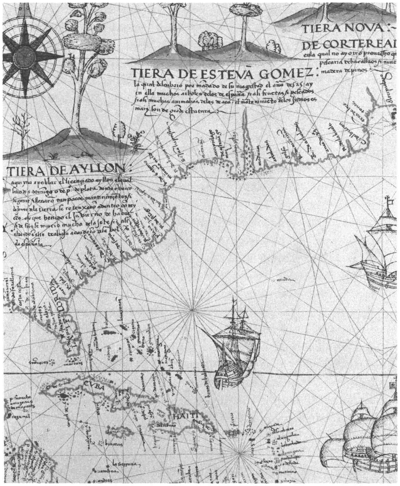
spring of 1525 a Spaniard, Estevan Gomez, cruised for two
months on the New England coast. While he left no narrative
of his voyage, “Tierra de Estevan Gomez” appeared immediately
on Spanish maps of the period, notably that of Ribero,
1529. An indentation of the bay shore behind his “Cabo de
Arenas” sufficiently suggests Plymouth Harbor and Cape Cod
Bay to make one speculate whether this is not in fact the first
record of a visit to Plymouth, ninety-five years before the landing
of the Pilgrims. What has been interpreted as Boston
Harbor on this Ribero map bears the name “Bay of St. Christoval,”
but the indentation that suggests Plymouth remains
nameless. It seems likely that Estevan Gomez was the discoverer
of Plymouth in 1525.
After these first Massachusetts discoveries, there follows a
period of seventy-five years of documentary obscurity so far
as Massachusetts is concerned. Maritime activities about Newfoundland,
the St. Lawrence River, and Nova Scotia steadily
grew. Cartier founded, and then had to abandon, his French
colony at Quebec. Jehan Allefonsce, one of his shipmasters,
was blown southward from the Newfoundland banks in
1542, into “a great bay in latitude 42°,” but Massachusetts Bay
is not mentioned during the rest of the century. Both French
and English built up an increasing fur trade on the Maine
coast, especially about the Penobscot and in the Bay of Fundy.
Fishermen from all the maritime nations of Europe crowded
in increasing numbers to the Newfoundland banks, carrying
back apparently inexhaustible supplies of codfish to feed
Catholic Europe in the season of Lent. By 1578 as many as 350
fishing vessels were making the transatlantic voyage, usually
twice each year. Since fishermen and fur traders rarely left
written records, we can only assume that with the increased
volume of shipping, some of these vessels found their way to
Massachusetts shores. But we have no documentary evidence
of their visits.
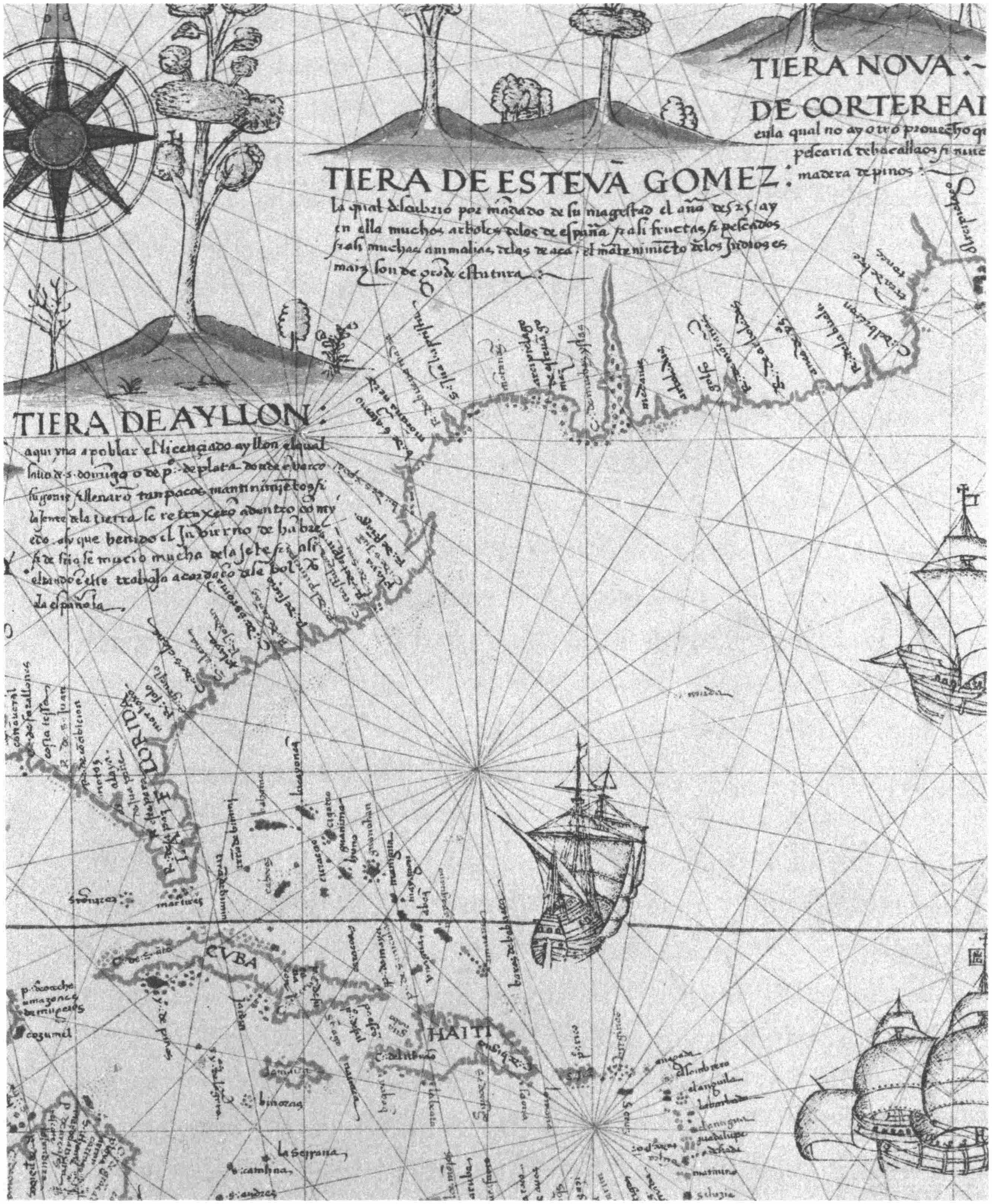
TIERA DE AYLLON
TIERA DE ESTEVA GOMEZ
TIERA NOVA: DE CORTEREAI
Map of the North American Coast, a portion of the World Map made by
Diego Ribero in 1529, showing the results of the explorations of Estevan
Gomez in 1525
Reproduced from the Map Collection, Yale University Library
Inevitably the tremendous growth of all this free-lance commercial
shipping, in the fur trade and fisheries, must lead to
attempts to organize it either into colonial administrations
under government control, or business companies privately
financed. Everyone could see that permanent bases were needed
in the New World. International quarrels and actual piracy
were already appearing in the Newfoundland fisheries. Sir
Humphrey Gilbert determined to make Newfoundland an
English colony. But in 1583 his well-organized expedition
came to grief by shipwreck. His half brother, Sir Walter Raleigh,
renewed the attempt, this time at Roanoke in the Carolinas,
but was unable to maintain the colony’s supply, once it
was established. The project failed. But the idea was right,
and men in England like Raleigh and Richard Hakluyt, the
historian of English voyages, kept preaching the necessity of
overseas colonies. Similar ideas were growing in the western
ports of France.
The turn of the century marked the beginning of a concerted
campaign on the part of both France and England to
establish plantations in New England. The first move was
made by a group of free-lance English merchants who in 1602
sent out Bartholomew Gosnold on a commercial voyage with
thirty-two men in the bark Concord. Its objective was twofold,
to get sassafras (a medication thought to be “of sovereigne
vertue for the French poxe”) and to establish an outpost
somewhere in the area described by Verrazano seventy-five
years before. Sir Humphrey Gilbert’s son Bartholomew was
among the company. After brief landings on Cape Cod and
Martha’s Vineyard, the expedition built a hut on the islet in
the pond on Cuttyhunk Island in Buzzards Bay, there traded
with the Indians, cut a cargo of sassafras root and cedarwood,
and after a minor altercation with the natives pulled up stakes
and sailed back to England with two enthusiastic narratives
of the country and its commodities.
Less than nine months later, and obviously because of the
success of the Gosnold voyage, a new expedition of two vessels,
Speedwell and Discoverer, with forty-four men and boys,
sailed to Massachusetts from Bristol under command of Martin
Pring, a Devonshire skipper. This voyage was instigated
by Richard Hakluyt, together with some merchants of Bristol.
Robert Salterne, pilot of the Gosnold voyage, was assistant
to Pring. Deliberately avoiding the long sail around Cape
Cod, Pring entered Massachusetts Bay, coasted its North
Shore looking for sassafras, and finding none, sailed across to
“a certaine Bay, which we called Whitson Bay.” It had a
“pleasant Hill thereunto adjoyning,” and a “Haven winding
in compasse like the Shell of a Snaile,” with twenty fathoms
at the entrance, and seven fathoms at the land-locked anchorage.
Here was a “sufficient quantitie of Sassafras.” This was
Plymouth Harbor in 1603.
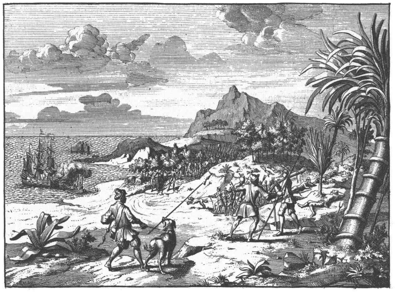
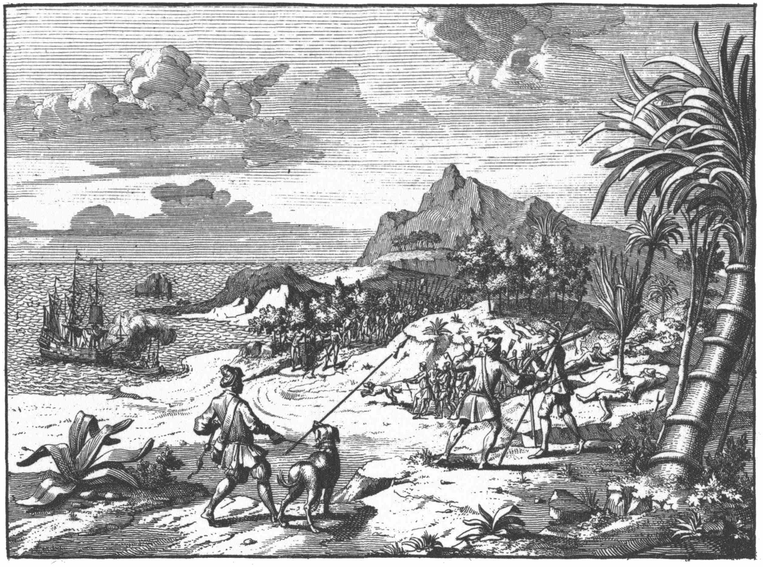
Ashore, Pring’s men built a “small baricado” or watchtower
and kept it manned with sentinels while the crew worked in
the woods. They also took ashore with them two great mastiff
dogs, of whom the Indians were mortally afraid. Indians appeared
in considerable numbers, “at one time one hundred
and twentie at once.” One of the crew delighted the natives
by playing a guitar and they sang and “danced twentie in a
ring” about him and gave him gifts of tobacco, tobacco pipes,
snakeskin girdles and “Fawnes skinnes.” They had black and
yellow bows, and prettily decorated quivers of rushes filled
with long feathered arrows. They used birch-bark canoes
“where of we brought one to Bristoll.” Their gardens were
planted with tobacco, pumpkins, cucumbers and corn. The
men wore breech clouts, and feathers in their knotted hair;
the women “Aprons of Leather skins before them down to
the knees, and a Bears skinne like an Irish Mantle over one
shoulder.”
Martin Pring’s men ashore with a mastiff, Plymouth Harbor, 1603
Reproduced from J. P. Abelin, De Wytheroemde Voyagien der Engelsen (Leiden, 1727)
in the Boston Athenæum
For the story of the latter days of their seven weeks’ stay at
Plymouth, we can scarcely do better than read Pring’s narrative
in the original: “By the end of July we had laded our
small Barke called the Discoverer with as much Sassafras as
we thought sufficient, and sent her home into England before,
to give some speedie contentment to the Adventurers; who
arrived safely in Kingrode about a fortnight before us. After
their departure we so bestirred ourselves, that our shippe also
had gotten in her lading, during which time there fell out
this accident. On a day about noone tide while our men which
used to cut down Sassafras in the woods were asleep, as they
used to do for two houres in the heat of the day, there came
down about seven score Savages armed with their Bowes and
Arrowes, and environed our House or Barricado, wherein
were foure of our men alone with their Muskets to keepe
Centinell, whom they sought to have come down unto them,
which they utterly refused, and stood upon their guard. Our
Master like-wise being very careful and circumspect, having
not past two with him in the shippe, put the same in the best
defence he could, lest they should have invaded the same, and
caused a piece of great Ordnance to bee shot off to give terrour
to the Indians, and warning to our men which were fast
asleepe in the woods: at the noyse of which peece they ... betooke
them to their weapons, and with their Mastives, great
Foole with an halfe Pike in his mouth, drew down to their
ship; whom when the Indians beheld afarre off with the Mastive
which they most feared, in dissembling manner they
turned all to a jest and sport and departed away in friendly
manner, yet not long after, even the day before our departure,
they set fire on the woods where wee wrought, which
wee did behold to burne for a mile space, and the very same
day that wee weighed Anchor, they came down to the shore
in greater number, to wit, very neere two hundred by our estimation,
and some of them came in theire Boates to our ship,
and would have had us come in againe, but we sent them back,
and would none of their entertainment.” One would love to
know more than is provided in Martin Pring’s brief narrative
in order to estimate fairly whether the English had given
provocation to the Indians for this threatened attack at Plymouth.
The only hint of provocation is the taking of a canoe
back to England.
Had Plymouth been populated by two hundred Indians in
1620 it seems unlikely that the Pilgrims could have survived.
The English adventurers transferred their explorations to the
coast of Maine, where in 1605 George Waymouth, and in
1606 Martin Pring, made investigations preparatory to the major
colonization attempt of the English Plymouth Company
at Sagadahoc, the mouth of the Kennebec River. This colony
failed after a year through a breakdown in leadership. For our
purposes it is significant that the English sent no further explorations
into Massachusetts waters for eight years after the
voyages of Gosnold and Martin Pring. It looks as though the
enmity of the Massachusetts Indians dissuaded English merchants
from further plans to set up a colony in that region.
Plymouth’s next visitor was that great French explorer and
empire builder, the founder of Canada, Samuel de Champlain.
A group of French merchants organized by the governor
of Dieppe, that old French port which had been sending
fishermen to America for more than a century, succeeded in
1603 in getting from Henri IV a commission to found a colony.
After spending the summer of 1603 exploring the St.
Lawrence, the leaders decided that a more southern climate
was desirable. Accordingly in 1604, De Monts and Pont-Grave,
with Samuel de Champlain as geographer and chronicler
of the expedition, explored the Bay of Fundy and founded
a colony on Dochet Island in Passamaquoddy Bay. Half
the colonists died during the first winter, and the colony was
moved across the Bay to a better site at what is now Annapolis,
Nova Scotia. Meantime Champlain spent the summers of
1605 and 1606 exploring the New England coast, familiarizing
himself with all the shores as far south as Woods Hole in
Massachusetts. He wrote a splendid account of these expeditions,
which is still good reading; and for the first time produced
a good map of the Massachusetts coast, with detail
maps of Gloucester, Plymouth, Eastham and Chatham harbors.
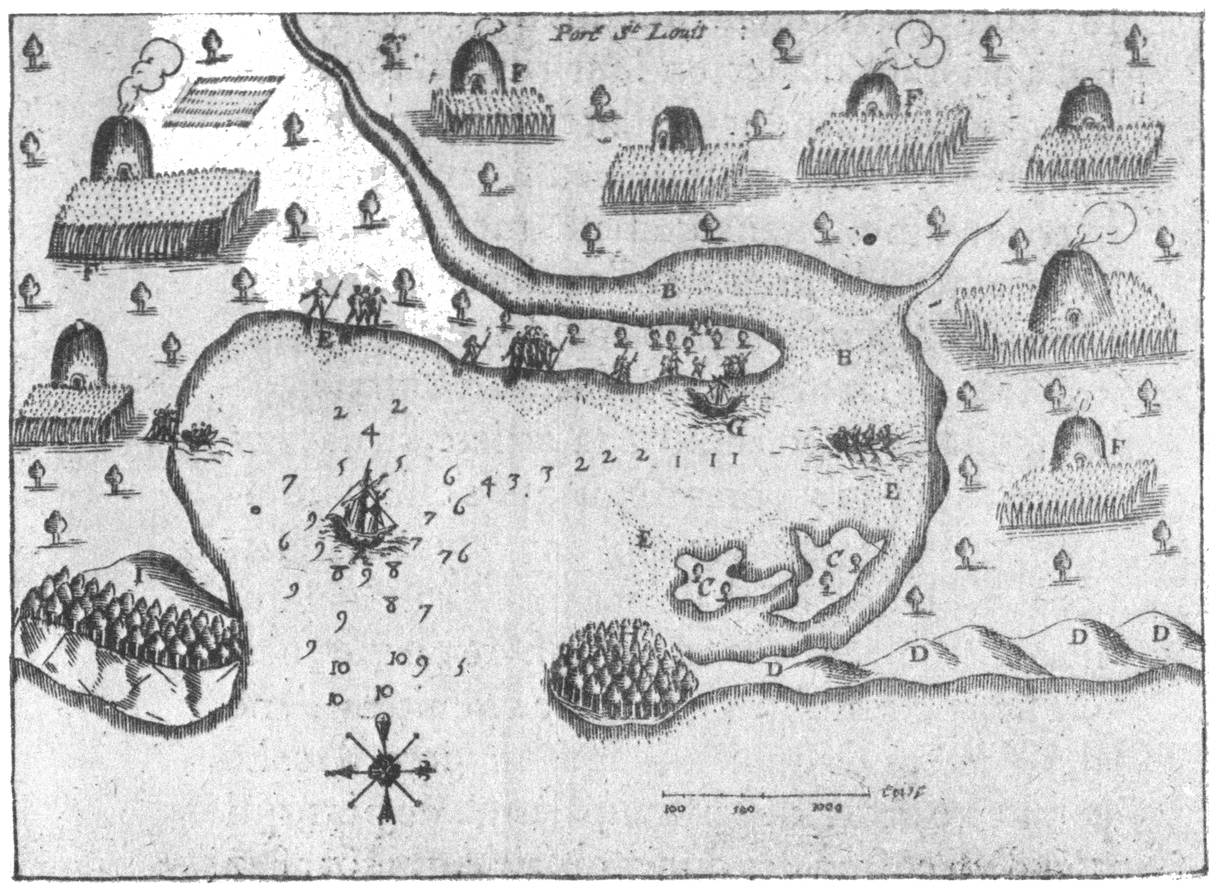
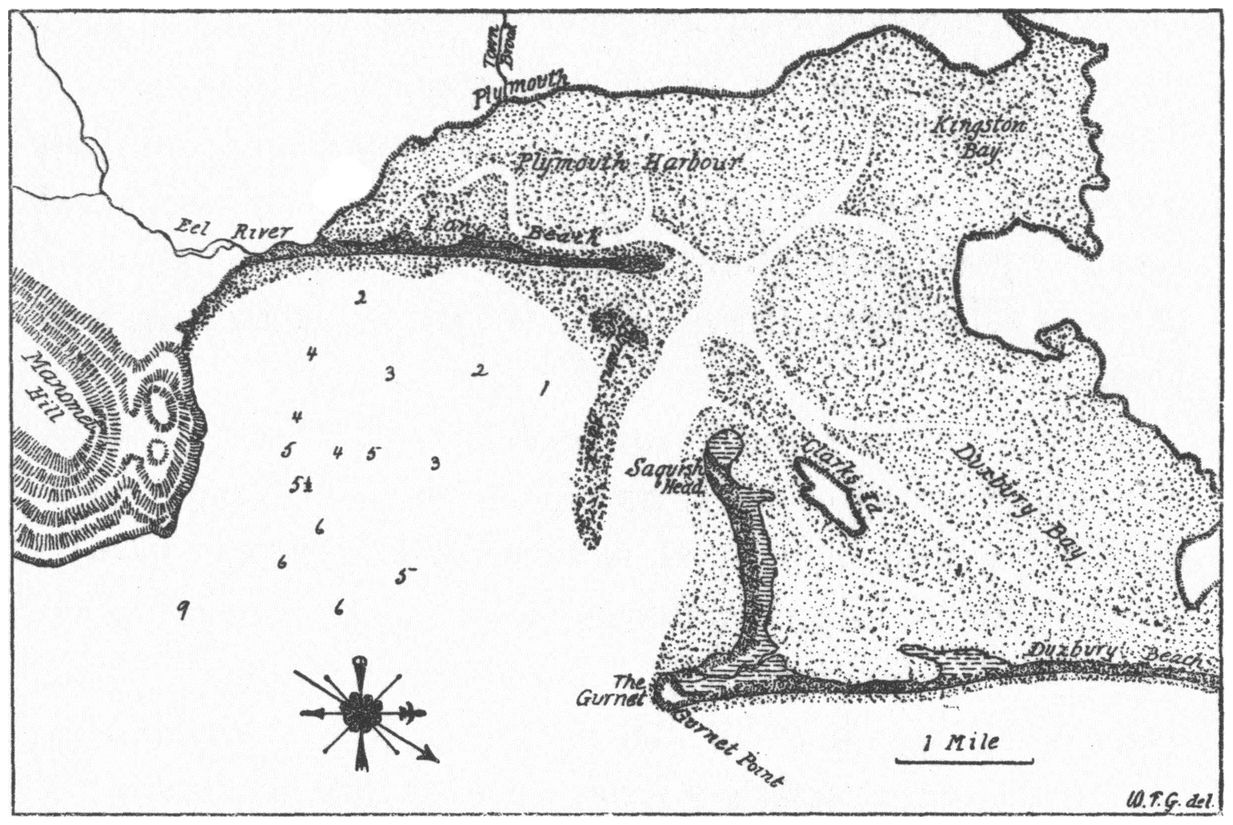
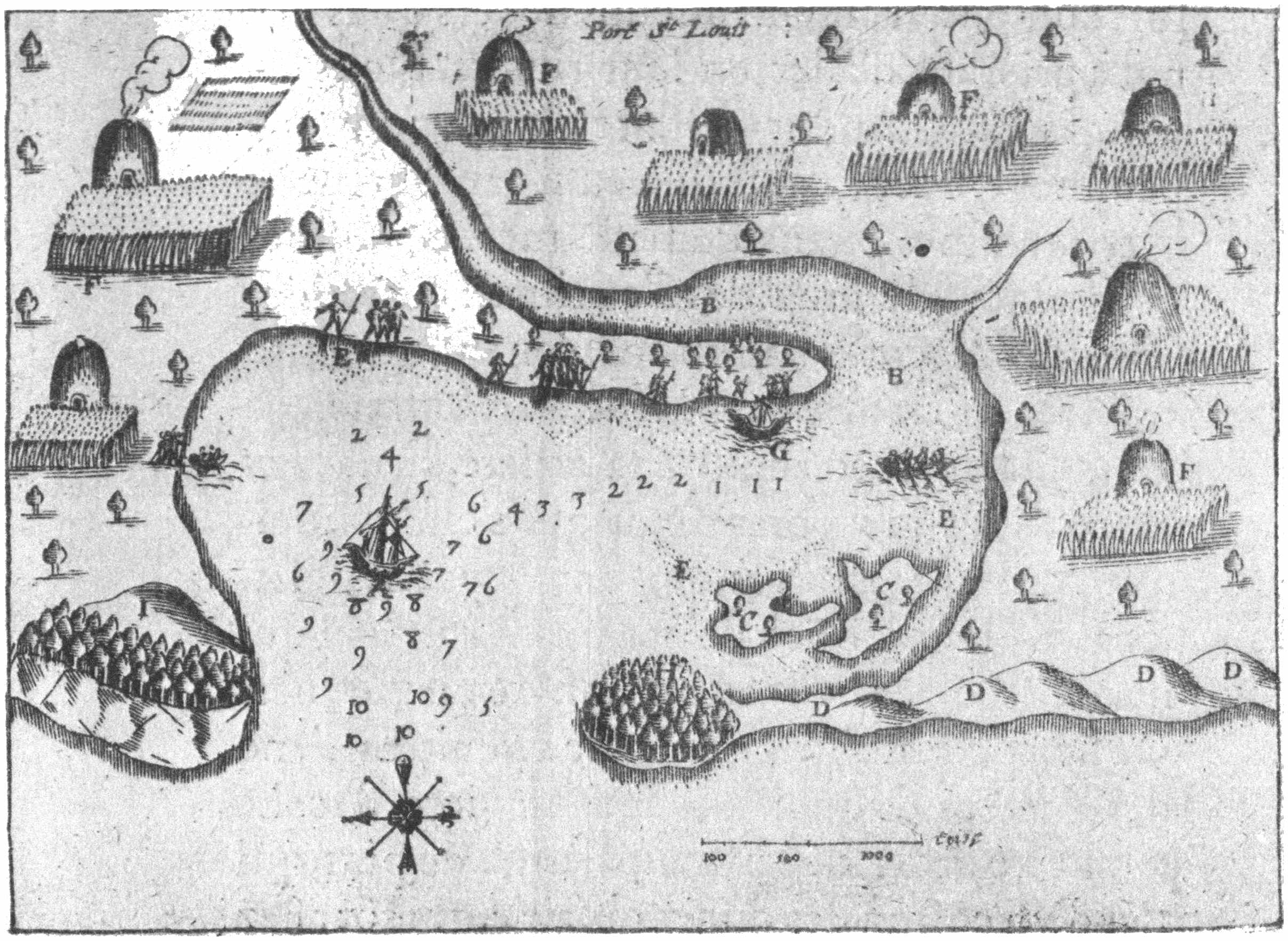
Legends on Champlain’s Map of Port St. Louis with comments
A. SHOWS THE PLACE WHERE VESSELS ANCHOR
The figures show the fathoms of water. The depths are now much less than those indicated
on the map, and the difference may represent an actual change.
B. THE CHANNEL
C. TWO ISLANDS
Clarks Island, a low swell of upland occupied by farms, and Saquish Head, likewise low
upland occupied by a few buildings and some bushes.
D. SAND DUNES
The long line of dune beaches, collectively called Duxbury Beach, connecting Brant and
Gurnet points.
E. SHOALS
A prominent feature of this part of Plymouth Harbor and of Duxbury Bay. As Champlain
states, they are largely bare at low tide.
F. WIGWAMS WHERE THE INDIANS CULTIVATE THE LAND
A number are situated on the slope where now stands the historic city of Plymouth founded
by the Pilgrim Fathers fifteen years after this visit of Champlain.
G. THE SPOT WHERE WE RAN OUR PINNACE AGROUND
Browns Bank, still an impediment to the navigation of the harbor. Apparently it was
while their pinnace was aground that Champlain landed on the north end of Long Beach,
where he sketched this map.
H. A KIND OF ISLAND COVERED WITH TREES, AND CONNECTED WITH THE SAND DUNES
The Gurnet, a low-swelling upland island, ending in a low bluff; it is largely bare of trees
and occupied by a group of buildings belonging to the light station. It was thickly wooded
when the Pilgrim Fathers settled here in 1620. Slafter’s contention that this was
Saquish Head he later abandoned.
I. A FAIRLY HIGH PROMONTORY, WHICH IS VISIBLE FROM FOUR TO FIVE LEAGUES OUT TO SEA
Manomet Hill, 360 feet in height, a plateau ridge cut to an abrupt bluff where it reaches
the sea, thus forming a conspicuous landmark.
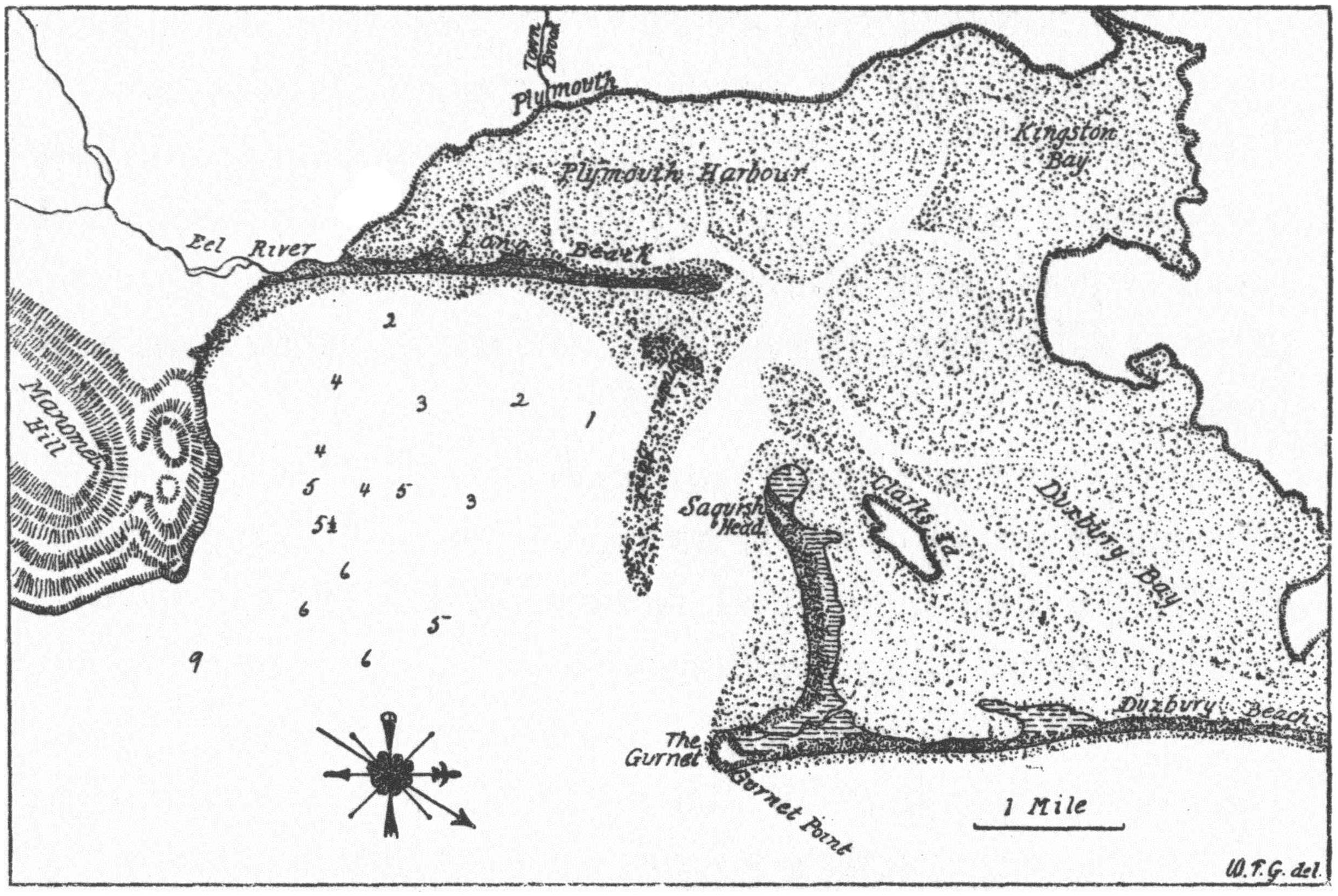
Map of Plymouth Harbor, Massachusetts, adapted from a modern chart for
comparison with Champlain’s map of Port St. Louis, to which it is adjusted
as nearly as possible in scale, extent, and meridian
Reproduced from the Champlain Society edition of The Works of Samuel de Champlain,
plate LXXIV. The compass is Champlain’s, which is supposed to be set to the magnetic
meridian, but the true north is shown by the arrow.
Champlain’s Plymouth visit occurred in 1605, two years
after Pring’s expedition. He had spent several days in Gloucester
Harbor and a night in Boston Harbor, where he had
watched the building of a dugout canoe by the Indians. Coming
down the South Shore, his bark grounded on one of the
numerous ledges that dot that portion of Massachusetts Bay.
“If we had not speedily got it off, it would have overturned in
the sea, since the tide was falling all around, and there were
five or six fathoms of water. But God preserved us and we
anchored” near a cape, which perhaps was Brant Rock. “There
came to us fifteen or sixteen canoes of savages. In some of them
there were fifteen or sixteen, who began to manifest great
signs of joy, and made various harangues, which we could
not in the least understand. Sieur de Monts sent three or four
in our canoe, not only to get water but to see their chief, whose
name was Honabetha.—Those whom we had sent to them
brought us some little squashes as big as the fist which we ate
as a salad like cucumbers, and which we found very good—We
saw here a great many little houses scattered over the
fields where they plant their Indian corn.”
The expedition now sailed southward into Plymouth Harbor.
“The next day [July 18] we doubled Cap St. Louis, so
named by Sieur de Monts, a land rather low, and in latitude
42° 45’. The same day we sailed two leagues along a sandy
coast as we passed along which we saw a great many cabins
and gardens. The wind being contrary, we entered a little bay
[Plymouth] to await a time favorable for proceeding. There
came to us two or three canoes, which had just been fishing
for cod and other fish, which are found there in large numbers.
These they catch with hooks made of a piece of wood,
to which they attach a bone in the shape of a spear, and fasten
it very securely. The whole thing has a fang-shape, and the
line attached to it is made out of the bark of a tree. They gave
me one of their hooks, which I took as a curiosity. In it the
bone was fastened on by hemp, like that in France, as it seemed
to me. And they told me that they gathered this plant without
being obliged to cultivate it; and indicated that it grew to the
height of four or five feet. This canoe went back on shore to
give notice to their fellow inhabitants, who caused columns
of smoke to rise on our account. We saw eighteen or twenty
savages, who came to the shore and began to dance.” Was this
a reminiscence of dancing to the guitar for Pring’s sailor, perhaps?
“Our canoe landed in order to give them some bagatelles,
at which they were greatly pleased. Some of them came
to us and begged us to go to their river. We weighed anchor
to do so, but were unable to enter on account of the small
amount of water, it being low tide, and were accordingly
obliged to anchor at the mouth. I went ashore where I saw
many others who received us very cordially. I made also an
examination of the river, but saw only an arm of water extending
a short distance inland, where the land is only in part
cleared up. Running into this is merely a brook not deep
enough for boats except at full tide. The circuit of the Bay is
about a league. On one side of the entrance to this Bay there
is a point which is almost an island, covered with wood, principally
pines, and adjoins sand banks which are very extensive.
On the other side the land is high. There are two islets in
this bay, which are not seen until one has entered and around
which it is almost dry at low tide. This place is very conspicuous
from the sea, for the coast is very low excepting the cape
at the entrance to the bay. We named it Port du Cap St. Louis,
distant two leagues from the above cape and ten from the Island
Cape [Gloucester]. It is in about the same latitude as
Cap St. Louis.”
Reproduced from the Pequot Collection, Yale University Library
Champlain’s map of Plymouth Harbor, which is reproduced
herewith, was a quick sketch which he drew from the
end of Long Beach after his vessel went aground there, probably
during the afternoon of their arrival. Since the expedition
stayed in Plymouth Harbor only over one night, too
much accuracy of detail must not be expected of it. Saquish
Head is represented as an island, and no distinction is made
between Eel River and Town Brook. Plymouth Harbor has
probably shoaled a good deal since the early seventeenth century,
since it would now be impossible to find a seven-fathom
anchorage anywhere except immediately around Duxbury
Pier Light; yet Champlain’s anchorage in the middle of
Plymouth Bay is so designated. Martin Pring had even described
a landlocked anchorage in seven fathoms. The chief
value of Champlain’s little map, aside from confirming the
locality, is its evidences of very extensive Indian houses and
cornfields occupying much of the slopes above the shore all
the way around from the Eel River area through Plymouth
and Kingston to the shores of Duxbury Bay.
The expedition left Plymouth on July 19 and sailed around
the shores of Cape Cod Bay before rounding the Cape and arriving
the next day at Nauset Harbor in Eastham. During
several days’ stay there, a French sailor was killed by the Indians
in a scuffle over a kettle. The following year, when
Champlain returned to Cape Cod, a more serious disaster occurred.
Four hundred Indians at Chatham ambushed and
massacred five Frenchmen in a dawn raid, then returned and
disinterred their bodies after burial. The French took vengeance
by coolly slaughtering half a dozen Indians a few days
later. But, like the English adventurers, the French then abandoned
Massachusetts and never returned. Champlain reported
that in all his travels he had found no place better for settlement
than Nova Scotia. Two years later, changes of plans
in France transferred him to Quebec, where he spent the remainder
of his career laying the foundations of French Canada
along the St. Lawrence. Massachusetts Indians had again
rebuffed the threat of European penetration.
We have already noted that while Champlain was in Massachusetts,
George Waymouth and Martin Pring had been
exploring Maine. The coördination of these exploratory voyages
was largely the work of Sir Ferdinando Gorges, a diligent
organizer of New England colonial preparations. In
1606 the administrative architecture of the English colonial
movement in America was built. King James gave charters
to two companies, the London Company and the Plymouth
Company, providing for settlements respectively in what
came to be known as “Southern” and “Northern” Virginia.
The successful colony at Jamestown was founded by the London
Company in 1607. The coincident attempt by the Plymouth
Company, organized by Gorges, and the Popham and
Gilbert families, to found a colony on the Kennebec River in
Maine failed after a year’s trial. This Sagadahoc Colony failure
was a blow to New England colonization, the effects of
which lasted for a generation, since the impression of New
England as a subarctic area, impractical for settlement, remained
in English minds for many years. It needs to be emphasized,
however, that despite this setback to English hopes,
the loss of fortunes invested in the enterprise, and the breakdown
of the Plymouth Company produced by this failure, the
enterprise had come much nearer to success than Humphrey
Gilbert’s attempted colony in Newfoundland. Much was
learned about techniques of living in the new country, getting
along with Indians, and the need for continuous replacement
and supply. These ventures were hazardous: they required
courage, teamwork, strong leadership, and personnel of heroic
wisdom and tenacity.
After the Sagadahoc failure, the pattern of English activity
on the New England coast reverted for five years to the former
state of occasional trading and fishing voyages. The only
events that touched even remotely on Plymouth history were
Cape Cod visits of three men from different areas of activity.
In 1609 Henry Hudson landed briefly on Cape Cod on his
way from Maine to his explorations of the Hudson River
which led to the Dutch claims in that region. Samuel Argall
from Virginia in 1610 likewise saw Cape Cod on a voyage
designed to supplement Jamestown’s failing food supplies
with New England codfish. And in 1611 Captain Edward
Harlow, sent on an exploring voyage to the Cape Cod region
by the Earl of Southampton, seems to have had five skirmishes
with Indians on Cape Cod and the Vineyard. Harlow’s vessel
was attacked by canoes while at anchor, and lost a long
boat being towed astern to the Indians, who thereupon
beached her, filled her with sand and successfully prevented
the English from retaking her. Harlow returned to England
with little except five captured natives. Among them was
Epenow, an Indian whose treachery later accounted for the
death of Captain Thomas Dermer.
In 1613 the French fur-trading activities on the Bay of Fundy
were supplemented by an ambitious project to establish a
Jesuit missionary colony in that region. But this second French
attempt to colonize Maine was nipped in the bud after only
a few weeks by Sir Samuel Argall’s armed cruiser, sent from
Virginia for the purpose. This ended the threat of France as
a colonial power in New England except for occasional incursions
into eastern Maine.
The year 1614 opened with a visitor to Plymouth from a
new quarter. Dutch fur traders, following in the wake of
Henry Hudson’s 1609 discoveries, were already at work in
the Hudson River. Two of them, Adrian Block and Hendrick
Christiansen, were about to weigh anchor from Manhattan
and depart for the Netherlands with a cargo of furs in the
fall of 1613 when one of their ships caught fire and burned to
the water’s edge. Both crews therefore stayed over the winter
on Manhattan Island, and there built a new “yacht,” the Onrust,
which they felt must be given a shakedown cruise before
attempting the Atlantic crossing. Block therefore sailed her
eastward, the first passage of Long Island Sound by a European,
and explored the Connecticut shore and rivers, Narragansett
Bay and the Cape Cod region, to all of which he laid
claim for the Dutch as “Nieu Nederlant.” Contemporary
Dutch accounts offer us little of interest about the Massachusetts
phases of this voyage except some sailing directions in
Massachusetts Bay that suggest that Adrian Block sailed from
a place called Pye Bay, usually identified with Salem, to the
Lizard on the English Channel. But the Figurative Map
which he published in 1616 as a part of his report to the States
General of the Netherlands contains many additional details
to which Dutch names are applied, including a wholly unmistakable
outline of Plymouth Harbor, here called Cranes
Bay. From this it seems obvious that Block did visit Plymouth
in the spring of 1614, and may be considered as yet another
of its explorers. It would be interesting to know whether any
of the Leyden Pilgrims, living in the Netherlands for four
years after the map’s publication, ever saw it before setting
out for the New World. In view of the controversy over
whether the Pilgrims were indeed headed for the Hudson
River, it is interesting to note that this map of Adrian Block’s
would have been the most accurate one available to them as a
guide to the New York region, yet there is nothing in the
Pilgrim chronicles to suggest that they had it with them on
the Mayflower.
Also in 1614 there came sailing into Plymouth Harbor a
man whose map and writings were used by the Pilgrims,
though he said that they refused his advice and his leadership.
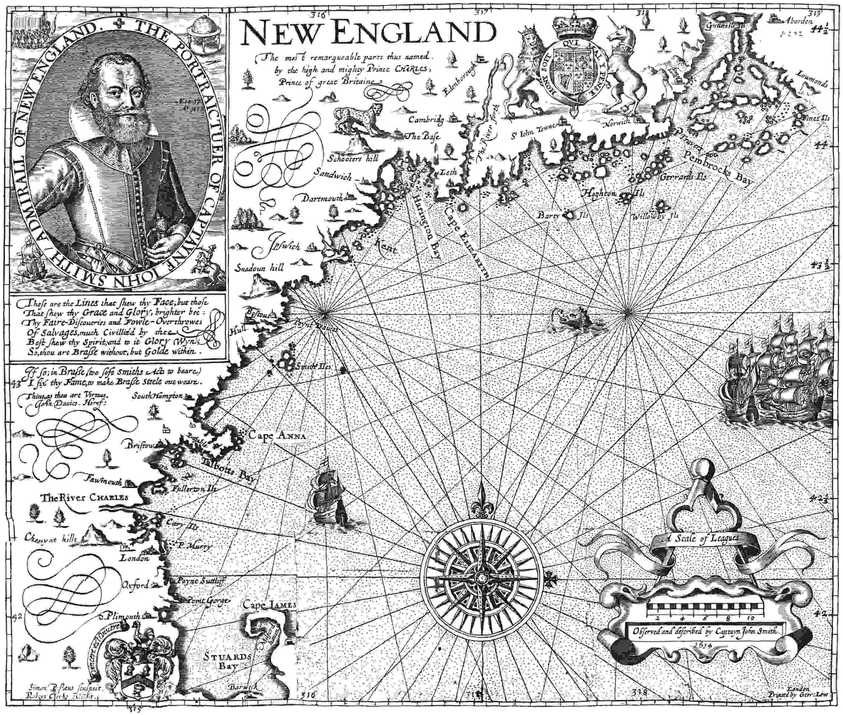
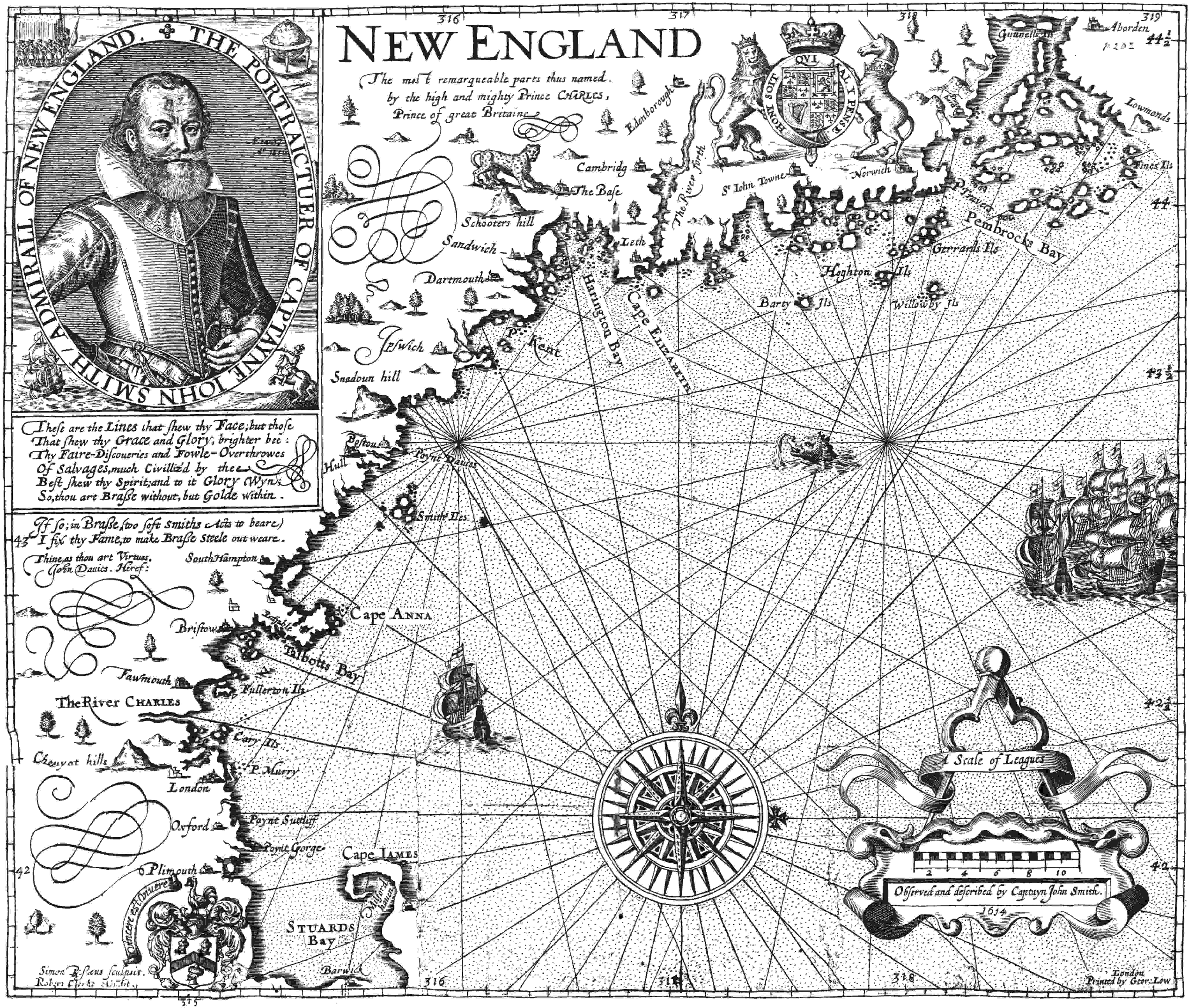
Captain John Smith would like to have been the founder of
New England, but had to be content to be its Hakluyt. He
named New England, and “Plimouth,” and Massachusetts,
and the Charles River and Cape Ann—at least he was the first
to publish these names. He produced the best known map of
New England of that early period. He spent the last seventeen
years of his life writing the history of New England voyages
and pamphleteering for its settlement. Yet a succession
of misfortunes prevented him from ever revisiting the coast
for which he developed such enthusiasm during his three
months’ voyage in 1614. Smith had already been governor of
Virginia and had experience in what it took to plant a successful
colony. His writings had unquestionably a strong influence
on the Massachusetts colonial undertakings, particularly
since he was not afraid of Indians and since he recognized
the difference between the bleak coast of Maine and the relatively
better-situated Massachusetts area as a site for colonial
development.
John Smith arrived at Monhegan Island in Maine in April,
1614, with two vessels. In the smaller of these he spent his
time exploring and mapping the coast from the Penobscot to
Cape Cod, much as Champlain had done nine years earlier.
Thomas Hunt in the larger vessel remained at Monhegan,
fishing. Reaching “the Countrie of the Massachusetts, which
is the Paradise of all those parts,” Smith entered Boston Harbor.
“For heere are many Iles all planted with corne: groves,
mulberries, salvage gardens, and good harbours: the coast is
for the most part high clayie, sandie cliffs. The Sea Coast as
you passe, shews you all along large corne fields and great
troupes of well proportioned people; but the French, having
remained heere neere six weeks left nothing for us.” At Cohasset
he wrote: “We found the people in those parts verie
kinde, but in their furie no lesse valiant. For upon a quarrell
we had with one of them, hee onely with three others, crossed
the harbor of Quonahassit to certaine rocks whereby wee must
passe; and there let flie their arrowes for our shot, till we
were out of danger,—yet one of them was slaine, and another
shot through his thigh.” His description of Plymouth, which
was variously known as Patuxet or Accomack, immediately
follows the Cohasset episode quoted above: “Then come you
to Accomack, an excellent good harbor, good land, and no
want of anything except industrious people. After much kindnesse,
upon a small occasion, wee fought also with fortie or
fiftie of those; though some were hurt, and some were slaine;
yet within an hour after they became friends.” In another
passage he adds, “we tooke six or seven of their Canowes
which towards the evening they ransomed for Bever skinnes.”
Apparently Smith supplied a motive for the resumption of
friendship, knowing that the Indians could be bought off.
This was the kind of Indian policy Myles Standish used at
times; in fact there is a certain resemblance between the two
men. In any case Smith left for England with a cargo of beaver,
and the Indians of Plymouth got back their canoes.
But the next visitor to Plymouth, still in 1614, did not leave
as good an impression. With Smith departed for England,
Thomas Hunt appeared in Plymouth Harbor in Smith’s larger
vessel. Not content with a hold full of Monhegan codfish,
Hunt now kidnaped twenty or more Plymouth natives,
stowed them below decks, and sailed away to Spain, where
he sold them into slavery at Malaga, “for £20 to a man.” This
was a typical seaman’s private venture, or side bet to the profits
of the codfish cargo. John Smith wrote that “this wilde act
kept him [Hunt] ever after from any more emploiment in
those parts.” Samuel Purchas termed Hunt’s “Savage hunting
of Savages a new and Devillish Project.” One can imagine
what bitterness grew toward the English among Massachusetts
Indians after this demonstration of European barbarism.
The quirks of history are at times worthy of the most fantastic
fiction. Thomas Hunt’s universally condemned crime
happened to produce one result which proved of great advantage
to the Pilgrims. Among the twenty wretched Plymouth
natives whom Hunt sold at the “Straights of Gibralter” was
an Indian named Squanto. Then began a five-year European
education which trained Squanto for his irreplaceable services
to the Pilgrims as their interpreter. Squanto was rescued by
good Spanish friars, “that so they might nurture [him] in the
Popish religion.” In some unknown manner he reached England
and continued his education for several years in the
household of one John Slany, an officer of the Newfoundland
Company. His subsequent travels will appear in our discussion
of Thomas Dermer’s voyage in 1619. It is sufficient at this
point to note that perhaps the greatest blessing ever bestowed
upon the Pilgrim Fathers was the gift of a treacherous English
shipmaster, a Spanish Catholic friar, and an English merchant
adventurer.
Things were going badly in another area of Massachusetts
during that eventful year of 1614. As though the expeditions
of Block, Smith, and Hunt were not sufficient for one year,
Nicholas Hobson now made his appearance at Martha’s Vineyard.
Sent out by Sir Ferdinando Gorges in an attempt to establish
a fur-trading post in that region, Hobson was using
the Indian, Epenow, captured by Harlow’s expedition in
1611, as his pilot through the shoals of Nantucket Sound.
Epenow cleverly contrived his escape, and a full-scale battle
ensued. “Divers of the Indians were then slain by the English,
and the Master of the English vessel and several of the
Company wounded by the Indians.” Hobson’s party “returned
to England, bringing nothing back with them, but
the News of their bad Success, and that there was a War
broke out between the English and the Indians.” Increase
Mather later remarked that “Hunt’s forementioned Scandal,
had caused the Indians to contract such a mortal Hatred
against all Men of the English Nation, that it was no small
Difficulty to settle anywhere within their Territoryes.”
It was at this point in history that another strange series of
events took place, of much more far-reaching significance.
With English expeditions defeated and sent back to England
empty-handed, with an Indian war “broke out,” fate, or
Providence, or whatever you call that destiny which seems at
times to intercede for civilization in its remorseless quest for
progress, now took a hand. Some European disease, to which
the natives had no resistance and the Europeans complete
immunity, swept the coasts of Massachusetts clear of Indians.
Suddenly it appeared in all the river villages along the
Mystic, the Charles, the Neponset, the North River, and at
Plymouth. No one knows what it was—whether chicken pox
or measles or scarlet fever. The Indians believed it was the
product of a curse leveled at them by one of the last survivors
of a French crew wrecked on Boston Harbor’s Peddock’s Island
in 1615. By analogy with what later happened to other
primitive races in the Americas and the Pacific islands, it
was probably one of the children’s diseases. The Indians died
in thousands. A population of a hundred thousand shrank to
five thousand in the area from Gloucester to New Bedford.
“They died on heapes,” Thomas Morton wrote, “and the
living that were able to shift for themselves would runne
away and let them dy and let there Carkases ly above the
ground without buriall.... And the bones and skulls upon
the severall places of their habitations made such a spectacle
after my comming into those parts that as I travailed in that
Forrest, nere the Massachusetts, it seemed to mee a new-found
Golgotha.”
Overnight the Indian war had vanished. Overnight the
coast from Saco Bay in Maine to Narragansett Bay in Rhode
Island lay wide open to European settlements. The cleared
fields along the rivers and salt marshes grew up to weeds,
ready for the spade of the English planter. For twenty miles
inland the land was cleared of the Indian menace in precisely
the area where they had been most agricultural, in what John
Smith had called the “Paradise of all those parts.” The choicest
sites for plantations, at the river mouths and along the tidal
reaches of Boston Bay, Salem, Gloucester, and Plymouth,
were stripped of opposition. Beaver, deer, and codfish multiplied
unhindered. Smith’s description of Plymouth, “good
harbor, good land and no want of anything but industrious
people,” was now doubly true of the whole mainland shore
of Massachusetts Bay.
These conditions were confirmed by Captain Thomas
Dermer in 1619. Dermer had been associated with John Smith
and Ferdinando Gorges in an attempted New England voyage
in 1615, and was probably familiar with the coast. He was
in Newfoundland in 1618 and there became acquainted with
Squanto, who had been living in the household of John Slany
in England. Squanto’s European stay was now completed,
and someone had brought him out to Newfoundland. Dermer
appreciated how valuable he might prove to be in a trading
voyage to Massachusetts, and secured permission from
Governor John Mason of Newfoundland, and also from Sir
Ferdinando Gorges, to use him as a pilot for a Massachusetts
voyage.
Arrived in Massachusetts Bay, Dermer wrote: “I passed
alongst the coast where I found some ancient Plantations, not
long since populous now utterly void, in other places a remnant
remaines but not free of sickenesse. Their disease the
Plague for wee might perceive the sores of some that had escaped,
who describe the spots of such as usually die.” Reaching
Plymouth, which, we remember, was Squanto’s home, he
goes on: “When I arrived at my Savages native Country (finding
all dead) I travelled alongst a daies journey Westward, to
a place called Nummastaquyt [Nemasket or Middleboro],
where finding Inhabitants I dispatched a messenger a dayes
journey further west to Poconokit, which bordereth on the
sea; whence came to see me two Kings; attended with a guard
of fiftie armed men, who being well satisfied with that my
Savage and I discoursed unto them—gave me content in
whatsoever I demanded.” At Poconokit he “redeemed a
Frenchman, and afterwards another at Mastachusit,” victims
of shipwreck three years before. What a chronicle these two
castaways might have added to Massachusetts history had
their memoirs been preserved!
Squanto now found himself the only survivor of those two
hundred or more natives of Plymouth whom Martin Pring
and Champlain and John Smith had encountered. We note
that he brought the Englishmen of Dermer’s party into
friendly association with the sachems of Poconokit, which
was Massasoit’s village at the mouth of the Taunton River.
This was the first friendly contact with Massachusetts Indians
in five years, the first since the criminal barbarity of Thomas
Hunt had aroused the enmity of the natives in 1614. We can
read between the lines what a reconciliation the homecoming
of Squanto, himself a victim of that barbarous kidnaping,
must have produced among the Wampanoags. For Dermer
freed Squanto later, in 1619, and he found his way back to
Massasoit before the arrival of the Pilgrims. Whether Sir
Ferdinando Gorges or Dermer himself was responsible for
this peacemaking gesture, we have no way of knowing, but
it seems to have cemented again a long-standing peace between
the English and the Wampanoags, which was worth a
whole battalion of soldiers to the safety of New Plymouth.
Captain Thomas Dermer, who probably never heard of the
Pilgrims, thus brought them peace. The Indian war was
ended.
It is therefore the more tragic that Dermer died of Indian
arrow wounds the next year after a battle with Epenow of
Martha’s Vineyard, an Indian captive who had not made
peace with the English. Had Epenow, instead of Squanto,
lived at Plymouth, history might have run quite differently.
Captain Thomas Dermer may be considered the first of the
Plymouth martyrs, who lost his life after saving a New Plymouth
that did not yet exist, though the Mayflower was on its
way when he died.
It is a strange commentary on the justice of history that the
men who had spent their lives on New England colonization
had almost no share in the first successful plantation in Massachusetts.
We have seen what an outpouring of futile struggle
men like Gorges and Smith and Dermer had expended
on the failures that set the stage for the Pilgrims. It was now
to fall to the lot of a group of English exiles, who had lived
twelve years in the Netherlands, to arrive by accident in Massachusetts
at the precise moment when the merchant adventurers,
whom they despised, had succeeded in producing the
conditions for success. The Pilgrim legend is well founded, in
the tribute it pays to the forthright courage and persistence of
the forefathers, but it ignores their utter dependence on the
maritime renaissance of England as the foundation on which
their success rested. The line of succession stemming from
the exploits of Drake and Hawkins and the ships that sank
the Armada carried directly on into the efforts of Gosnold,
Pring, Gorges, Smith, Hobson, and Dermer to set the stage
for Plymouth. The fur trade and the fisheries by which New
Plymouth finally paid off its creditors had been painstakingly
developed by many hazardous years of experiment by small
shipowners of Bristol and Plymouth and other smaller havens
in the west of England. Faith in New England ventures,
so nearly destroyed by the Sagadahoc failure, had been kept
alive and sedulously cultivated by a little group of earnest
men around Gorges and John Smith, so that money could be
available to finance even the risky trading voyages necessary
to keep a foothold on the coast. We have seen how recently
peace had been made with the Indians.
The Pilgrims ascribed all these blessings to acts of Providence
in their behalf. But Providence has a way of fulfilling
its aims through the acts of determined men. Any visitor to
Plymouth who reveres the Pilgrims should also honor those
representatives of the glorious maritime energies of the Old
World whose discoveries and explorations prepared the way
for permanent settlement. To them also applies the phrase
which Bradford used of the Plymouth colonists:
“They were set as stepping-stones for others who came
after.”
Punctuation, hyphenation, and spelling were made
consistent when a predominant preference was found
in the original book; otherwise they were not changed.
Simple typographical errors were corrected; unbalanced
quotation marks were remedied when the change was
obvious, and otherwise left unbalanced.
Illustrations in this eBook have been positioned
between paragraphs and outside quotations.