G. P. PUTNAM’S SONS NEW YORK AND LONDON The Knickerbocker Press 1918
COPYRIGHT, 1908 by G. P. PUTNAM’S SONS
COPYRIGHT, 1918 by G. P. PUTNAM’S SONS
Revised Edition The Knickerbocker Press, New York
PREFACE
The preparation of a volume on Climate for The Science Series
was suggested to me by the Editors in October, 1904. I was asked to
prepare a book “which can be read by an intelligent person who has
not had special or extended training in the technicalities of the
science, ... the book to be such as would not compete with strictly
meteorological text-books, but to handle the broad questions of
climate.” It so happened that it was then already in my mind to prepare
a book dealing with certain large relations of climate, which might
serve as supplementary reading for the students in my course on General
Climatology in Harvard University. The present volume is an attempt on
my part to write a book which shall meet the wishes of the Editors of
The Science Series and at the same time fit the needs of my students.
Climate is based on lecture-notes which have been accumulating
for the past ten years. It does not attempt to present any very new
or original material, but it does aim to co-ordinate and to set forth
clearly and systematically the broader facts of climate in such a way
that, as desired by the Editors, the general reader, although not
trained “in the technicalities of the science,” may find it easy to
appreciate them. At the same time, the needs of the teacher and
student have been kept constantly in mind, and the subject-matter has
been arranged in such a way as seems best to adapt it for purposes of
thorough study.
Climate may be considered in a way as supplementing the first
volume of Dr. Julius Hann’s Handbuch der Klimatologie, an
English translation of which was prepared by me and published in
1903. In that book, the standard work of its kind in the world,
the principles of climatology are clearly set forth. My present
volume deals with matters which are either omitted altogether in
the Handbook, or else are very briefly treated therein.
Climate is wholly independent of Hann’s splendid work, except in
so far as my study of that book inspired me to prepare this one.
The general scope and purpose of the different sections in
Climate are as follows. The Introduction is essentially a very
condensed synopsis of the first six chapters of Hann’s first volume,
with the addition of some other matter. Chapter I gives a sketch of the
classification of the zones. Chapters II and III give a brief summary
of the general climatic types which result from the control of land and
water, and of altitude, over the more important elements of climate.
Chapters IV, V, and VI are intended to give an outline of the climatic
characteristics of the zones in a simple and vivid form, with the least
possible use of tabular matter. For further general information on this
subject, reference may be made to the world-charts of temperature,
winds, cloudiness, rainfall, etc., given with greater or less
completeness in the various text-books of meteorology, and, very fully,
in the Atlas of Meteorology. In Chapter VII the attempt is made
to give a survey of some of the relations between weather and climate
and a few of the more important diseases. Little information on this
subject is readily accessible to the general reader. The life of man in
the tropics, the temperate zones, and the polar zones is considered in
Chapters VIII to X. No attempt has been made to discuss this subject
in detail, for to do so would far exceed the limits set for this
book. It has rather been my plan to pick out typical illustrations
here and there, as suggestions. Many of the cases referred to will
probably be familiar to teachers and students of geography, but the
co-ordination of all the examples by climatic zones and by the natural
climatic subdivisions of these zones will, it is hoped, tend to give
adequate emphasis to the climatic factor, which has hitherto been
much neglected. The final chapter, on changes of climate, deals with
historic and periodic, and not with geologic changes. The last phase of
the subject has been fully discussed in many books, while the former,
which are of more interest to most persons, have received much less
attention. The question of the influence of forests on climate, which
many readers may expect to find considered in this book, is omitted
because it is adequately taken up in Hann’s Handbook (Vol. I).
I have drawn very freely upon Hann’s Handbuch der Klimatologie,
Vols. II and III (2d ed., Stuttgart, 1897), as well as upon his
Lehrbuch der Meteorologie (2d ed., Leipzig, 1906), two
books which are so complete in all details that every writer on
meteorological or climatological subjects is inevitably very
dependent upon them. The curves in Chapters IV, V, and VI were all
drawn from data given in the Lehrbuch. In the chapters on
the life of man in the different zones, I have made liberal use
of Ratzel’s Anthropogeographie (2d ed., Stuttgart, 1899).
The principal references other than these are the following: W. M.
Davis: Elementary Meteorology (Boston, 1902); A. J. and F.
D. Herbertson: Man and His Work (London, 1899); W. Köppen:
Klimakunde. I. Allgemeine Klimalehre (2d ed., Leipzig, 1906);
A. Supan: Grundzüge der physischen Erdkunde (3d ed., Leipzig,
1903); W. Trabert: Meteorologie und Klimatologie (Leipzig and
Vienna, 1905); W. J. van Bebber: Hygienische Meteorologie
(Stuttgart, 1895); A. Woeikof: Die Klimate der Erde (Jena,
1887); Atlas of Meteorology (Edinburgh, 1899).
I am indebted to the publishers, Messrs. G. P. Putnam’s Sons, for
their generous permission to me to use certain parts of this book
in an article prepared for the Encyclopædia Britannica in
1906, as well as for the privilege which they willingly accorded me
of publishing as separate articles many of the chapters included in
this book. Chapters I to III have appeared in the Bulletin of the
American Geographical Society; Chapters IV to VI in the Journal
of Geography; Chapter VII in the Bulletin of the Geographical
Society of Philadelphia, and Chapter XI in the Popular Science
Monthly. My thanks are also due to my fellow-workers, Professors
Hann, Mohn, Supan, Köppen, Angot, and W. M. Davis, and also to Dr.
Fridtjof Nansen, for permission to reproduce some of their maps and
diagrams in the present volume. Mr. Henry S. Mackintosh, of Keene, N.
H., has very kindly helped me in the proof-reading.
I have taken the opportunity offered by the publication of a second
edition of this volume to make some revision of the chapters on The
Characteristics of the Polar Zones and on Changes of Climate, in order
that these subjects may be more accurately presented in the light of
recent investigations. A few other changes have also been made, and all
errors which occurred in the first edition have been corrected.
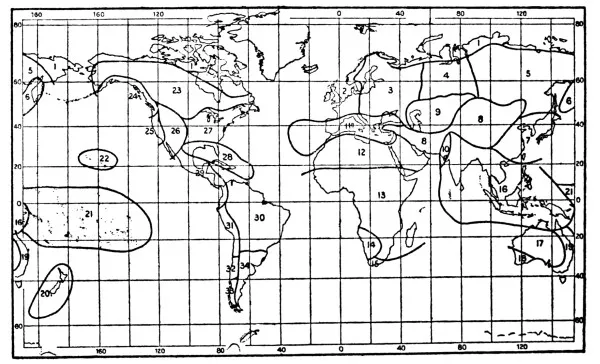
3, 7, 8, 9. A. Angot: Traité élémentaire de Météorologie.
”
4.
H. Berger: Geschichte der wissenschaftlichen Erdkunde der Griechen.
”
5,
10, 24. A. Supan: Grundzüge der physischen Erdkunde. 3d edition.
”
6.
W. Köppen: Die Wärmezonen der Erde, nach der Dauer der
heissen, gemässigten und kalten Jahreszeit, und
nach der Wirkung der Wärme auf die organische
Welt betrachtet. Met. Zeitschr., i, 1884.
”
11,
12, 13, 14, 15, 16, 17. W. Köppen:
Versuch einer Klassifikation der Klimate,
vorzugsweise nach ihren Beziehungen zur
Pflanzenwelt.
Hettner’sGeogr. Zeitschr., vi, 1900.
”
18.
A. J. Herbertson: The Major Natural Regions. Geogr. Jour., xxv, 1905.
”
30,
31, 32. Scientific Results of the Norwegian North Polar Expedition.
Vol. vi, Meteorology.
INTRODUCTION
CLIMATE
Meaning and Scope of Climatology—Relation of
Meteorology and Climatology—Literature of Climatology—The Climatic
Elements and their Treatment—Solar Climate—Physical Climate.
Meaning and Scope of Climatology. The word klima (from
κλίνειν, to incline), as used by the Greeks, originally referred to
the supposed slope of the earth toward the pole, or to the inclination
of the earth’s axis or of the sun’s rays. It may, perhaps, have had
reference to the different exposures of mountain slopes. Later,
probably after Aristotle’s time, it came to be used as about equivalent
to our zone, but at first it was simply a mathematical or an
astronomical term, not associated with any idea of physical climate. A
change of latitude in those days meant a change of climate. Such
a change was gradually seen to mean a change of atmospheric conditions
as well as a change in length of day. Thus klima came to have
its present meaning.
An excellent illustration of the ancient meaning of the word
klima is found in the system of climates proposed by the famous
geographer, Ptolemy. This was a division of the earth’s surface between
equator and north pole into a series of climates, or parallel zones,
separated by latitude circles and differing from one another simply in
the length of their longest day. Ptolemy’s subdivision of the earth’s
surface was really nothing but an astronomical climatic table.
Climate, as we use the term, is the resultant of the average
atmospheric conditions, or, more simply, it is the average condition
of the atmosphere. Weather is a single occurrence, or event,
in the series of conditions which make up the climate. The
climate of a place is in a sense its average weather. The
average values of these atmospheric conditions can be determined only
by means of careful observations, continued for a period sufficiently
long to give accurate results. Climatology is the study or science of
climates.
Relation of Meteorology and Climatology. Meteorology and
climatology are interdependent. It is impossible to distinguish very
sharply between them. Each needs the results obtained by the other. In
a strict sense, meteorology deals with the physics of the atmosphere.
It considers the various atmospheric phenomena individually, and seeks
to determine their physical causes and relations. Its view is largely
theoretical. The aspect of meteorology which is of most immediate
practical importance to man is that which concerns weather-forecasting.
When the term meteorology is used in its broadest meaning, climatology
is a subdivision of meteorology. Climatology is largely descriptive.
It aims to give as clear a picture as possible of the interaction of
the various atmospheric phenomena at any place on the earth’s surface.
It rests upon physics and geography, the latter being a very prominent
factor. Climatology may almost be defined as geographical meteorology.
Its main object is to be of practical service to man. Its method of
treatment lays most emphasis on the elements which are of the most
importance to life. Climate and crops, climate and industry, climate
and health, are subjects of vital interest to man. No other science
concerns man more closely in his daily life.
Literature of Climatology. Scientific climatology is based
upon numerical results obtained by systematic, long-continued, and
accurate meteorological observations. The essential part of its
literature is therefore found in the collections of data published by
the various meteorological services and observatories. In addition,
large numbers of short sketches and notes on climate, partly the more
or less haphazard accounts of travellers, partly the more careful
studies of scientific observers, are scattered through a wide range of
geographical and other publications. The only comprehensive text-book
of climatology is the Handbuch der Klimatologie of Professor
Julius Hann, of the University of Vienna. This is the standard book on
the subject, and upon it is based much of the present volume, and of
other recent discussions of climate. The second edition of this work,
in three volumes, was published in 1897 (Stuttgart, Engelhorn). The
first volume deals with general climatology, and has been translated
into English.[1]
The second and third volumes are devoted to the
climates of the different countries of the world. Woeikof’s Die
Klimate der Erde (Jena, Costenoble, 1887) is also a valuable
reference book. The first part concerns general relations of climate,
particularly to rivers and lakes, to vegetation, and to snow-cover,
while the second part deals with the climates of special areas. The
standard meteorological journal of the world, the Meteorologische
Zeitschrift (Braunschweig, Vieweg, monthly), is indispensable
to anyone who wishes to keep in touch with the latest publications
on climatology, for it contains the most complete record of such
literature, as well as a large number of original notes and
discussions. The newest and most complete collection of charts is that
in the Atlas of Meteorology (London, Constable, 1899), in which
also there is an excellent bibliography. For the titles of more recent
publications reference may be made to the International Catalogue
of Scientific Literature (annual volume on Meteorology); or
to the more frequent bibliographical lists in the Meteorologische
Zeitschrift; the Monthly Weather Review (Washington, U. S.
Weather Bureau); the Quarterly Journal of the Royal Meteorological
Society (London), and the Halbmonatliches Litteraturverzeichniss
der “Fortschritte der Physik” (Braunschweig, Vieweg, twice a month).
The Climatic Elements and their Treatment. Climatology has to
deal with the same groups of atmospheric conditions as those with which
meteorology is concerned, viz.: temperature (including radiation);
moisture (including humidity, precipitation, and cloudiness); wind
(including storms); pressure; evaporation, and also, but of less
importance, the composition and the chemical, optical, and electrical
phenomena of the atmosphere. The characteristics of each of these
so-called climatic elements are set forth in a standard series
of numerical values, based on careful, systematic, and long-continued
meteorological records, corrected and compared by well-known methods.
Various forms of graphic presentation, by curves, or by wind roses,
etc., are employed to emphasise and simplify the numerical results.
Instructions concerning the use, exposure, hours of observation,
and corrections of the ordinary meteorological instruments; as well
as for obtaining the usual numerical results, are published by the
various governmental meteorological services. In Hann’s Handbook
of Climatology, Vol. I, will be found a general discussion of the
methods of presenting the different climatic elements, and of the
reasons for adopting the accepted scheme of presentation. The most
complete guide in the numerical, mathematical, and graphic treatment
of meteorological data for climatological purposes is Hugo Meyer’s
Anleitung zur Bearbeitung meteorologischer Beobachtungen für die
Klimatologie (Berlin, Springer, 1891).
Climate deals first of all with average conditions, as is
apparent from the definition given above. But means may be
made up of very different values of the elements which go into them,
and therefore a satisfactory presentation of a climate must include
more than mere averages. It must take account, also, of regular and
irregular daily, monthly, and annual changes, and of the departures,
mean and extreme, from the average conditions which may occur at the
same place in the course of time. The mean minimum and the mean maximum
temperature or rainfall of a month, or a season, are important data,
not in any way replaced by a knowledge of the mean monthly or seasonal
temperature and rainfall. Further, a determination of the frequency
of occurrence of a given condition, or of certain values of that
condition, is important, for periods of a day, month, or year, as, for
example, the frequency of winds according to direction or velocity; or
of different amounts of cloudiness; or of temperature changes of 5,
or 10, or more degrees; the number of days with and without rain or
snow in any month, or year, or with rain of a certain amount, etc. The
probability of occurrence of any condition, as of rain in a certain
month; or of a temperature of 32°, for example, is also a useful thing
to know concerning a climate. In the past, climatology has been
too much concerned with monthly, seasonal, and annual averages. An
important addition to the usual climatic summaries would be the
introduction, for all regions in which the cyclonic or storm control
of weather conditions is characteristic, of the cyclonic unit, so
that, for example, the average duration and value of cyclonic ranges
of temperature in the several months, or the proportion of the annual
rain and snowfall received from cyclonic storms and from local
thunderstorms, might be determined.[2]
Solar Climate. The sun is clearly the principal control
of climates on the earth’s surface. The general distribution of
temperature, as well as the seasonal and diurnal changes, all depend
upon changes in the intensity of sunshine. Hence a brief consideration
of the distribution of insolation over the earth’s surface is essential
to a proper understanding of climates. Climate, in so far as it is
controlled solely by the amount of solar radiation which any place
receives by reason of its latitude, is called solar climate.
Clearly, all places on the same latitude circle would have the same
solar climate, for the intensity and amount of insolation depend upon
the angle of incidence of the sun’s rays, and upon the length of day,
and both of these depend upon latitude. Solar climate alone would
prevail if the earth had a homogeneous land surface, and if there were
no atmosphere. For under these conditions, and without air or ocean
currents, the distribution of temperature at any place would depend
solely on the amount of energy received from the sun, and upon the loss
of heat by radiation. And these two factors would have the same value
at all points on the same latitude circle.
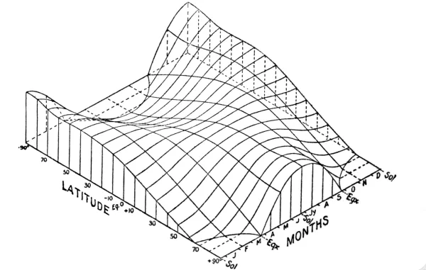
Fig. 1. Distribution of Insolation Over the Earth
The relative amounts of insolation received at different latitudes
and at different times have been carefully determined. The values all
refer to conditions at the upper limit of the earth’s atmosphere,
i. e., without the effect of absorption by the atmosphere. The
accompanying diagram (see Fig. 1) shows very clearly the distribution
of insolation in both hemispheres at different latitudes and at
different times in the year. The latitudes are given at the left margin
and the time of year at the right margin. The values of insolation are
shown by the vertical distance above the plane of the two margins.
At the equator, where the day is always twelve hours long, there are
two maxima of insolation at the equinoxes, when the sun is vertical at
noon, and two minima at the solstices, when the sun is farthest off
the equator. The annual curves show that the values do not vary much
through the year, because the sun is never very far from the zenith,
and day and night are always equal. There is a slight difference in
the insolation at the two maxima, owing to a difference in the sun’s
distance, the earth’s orbit being an ellipse and not a circle. The
earth is nearer the sun in the winter of the northern hemisphere,
and therefore the spring maximum is somewhat greater than the autumn
maximum. The varying distance from the sun also explains the fact that
the maxima of insolation do not come exactly on the dates of the equinoxes.
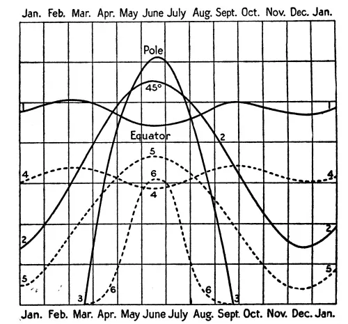
Fig. 2. Annual Variation of Insolation at
Different Latitudes
These conditions are clearly brought out in curve 1 of Fig. 2,
which shows the annual march of insolation on the equator. The law of the
distribution of insolation would be simple if the sun were always on
the equator, for the angle of insolation and the length of day and
night would then always remain the same. But under existing conditions,
both the angle of insolation and the length of day are constantly
changing, and the interaction between these two controls becomes very
complex. As the latitude increases, the angle of insolation becomes
more oblique, and the intensity of insolation decreases, but at the
same time the length of day rapidly increases during the summer, and
towards the pole of the hemisphere which is having its summer the gain
in insolation from the latter cause more than compensates for the loss
by the former. The double period of insolation, above noted for the
equator, prevails as far as about lat. 12° N. and S.; at lat. 15° the
two maxima have united, and the same is true of the minima. Take the
case of an intermediate latitude, like 45° N. (see curve 2, Fig. 2).
Here there is one minimum, in December, when the sun is south of the
equator, and one maximum, in June, when the sun is north. The slight
displacement of this maximum and minimum from the exact date of the
two solstices is due to the difference in the sun’s distance. At the
north pole (curve 3, Fig. 2), there is one maximum at the summer
solstice, and no insolation at all while the sun is below the horizon.
The distribution of insolation at different latitudes on the same
day is also interesting. On June 21, for example (see Fig. 1), the
equator has a day twelve hours long, but the sun’s maximum altitude is
only 66½°, i. e., it does not reach the zenith, and the amount
of insolation is less than at the equinox. On the northern tropic,
however, the sun is vertical at noon, and the day is between thirteen
and fourteen hours long. Hence the amount of insolation received at
this latitude on June 21 is greater than that received on the equinox
at the equator. As one passes from the tropic to the pole the sun
stands lower and lower at noon, and the value of insolation would
steadily decrease with latitude if it were not for the increase in the
length of day. Going polewards from the northern tropic on June 21, the
value of insolation increases for a time, because, although the sun is
lower, the number of hours during which it shines is greater. A maximum
value is reached at about lat. 43½° N. The decreasing altitude of the
sun then more than compensates for the increasing length of day, and
the value of insolation diminishes, a minimum being reached at about
lat. 62°. Then the rapidly increasing length of day towards the pole
(the day being twenty-four hours long beyond the Arctic circle) again
brings about an increase in the value of insolation, until a maximum
is reached at the pole which is greater than the value received at
the equator at any time. (See Fig. 2, in which the curves are all
drawn on the same scale). The length of day is the same on the Arctic
circle as at the pole itself, but while the altitude of the sun varies
during the day on the former, being at the horizon at midnight and
highest at noon, the altitude at the pole remains 23½° throughout the
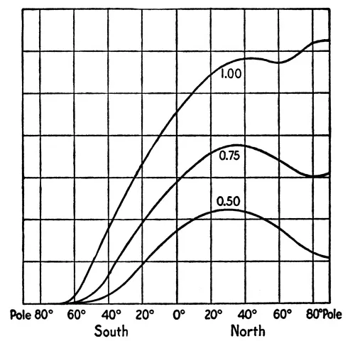
twenty-four hours. The result is to give the pole a maximum (See Fig. 3,
curve marked 1.00.). On June 21, there are therefore two maxima of
insolation, one at lat. 43½° and one at the north pole. From lat. 43½°
N., insolation decreases to zero on the Antarctic circle, for sunshine
falls more and more obliquely, and the day becomes shorter and shorter.
Beyond lat. 66½° S. the night lasts twenty-four hours. On December 21
(see Fig. 1), the conditions in southern latitudes are similar to those
in the northern hemisphere on June 21, but the southern latitudes have
higher values of insolation because the earth is then nearer the sun.
At the equinox, the days are equal everywhere, but the noon sun is
lower and lower with increasing latitude in both hemispheres until the
rays are tangent to the earth’s surface at the poles (except for the
effect of refraction). Therefore, the values of insolation diminish
from a maximum at the equator to a minimum at both poles. From the
fact that the southern hemisphere has its summer in perihelion and
its winter in aphelion, it follows that there is a greater difference
between the seasonal values of insolation south of the equator than
north of it. In other words, the solar climate of the southern
hemisphere is more severe than that of the northern. Nevertheless,
owing to the fact that the earth moves more rapidly around its orbit
when nearest the sun, both hemispheres receive equal amounts of
insolation at the same latitudes, and in the mean of the year, both
have the same amount of insolation.
Fig. 3. Insolation Received at
Different Latitudes on June 21
The values of insolation thus far considered have
reference to the upper limit of the earth’s atmosphere,
or to the earth’s surface assuming that no atmosphere
exists. The effect of the atmosphere is to weaken the
sun’s rays. The more nearly vertical the sun, the less
the thickness of atmosphere traversed by the rays.
The values of insolation at the earth’s surface, after
passage through the atmosphere, have been calculated.
They vary much with the condition of the air,
as to dust, clouds, water vapour, etc. In Fig. 2,
the broken lines, 4, 5, and 6, show the values of insolation
at the equator, lat. 45° N., and the north pole, allowing
for a loss of 25% during the passage through the atmosphere, i. e.,
with a coefficient of transmission 0.75. This is higher than
that usually observed, even under very favourable conditions, with
the sun in the zenith. As a rule, even when the sky is clear, about
one-half of the solar radiation is lost during the day by atmospheric
absorption. The great weakening of insolation at the pole, where the
sun is very low, is especially noticeable. The effect of the atmosphere
is also shown in Fig. 3. The upper curve represents the total quantity
of insolation received at the earth’s surface with a coefficient of
transmission of 1.00 (i. e., no loss). Under such conditions,
as already noted, there are two maxima on June 21, at lat. 43½° N. and
at the north pole. The second curve corresponds to a coefficient of
transmission of 0.75, which is also used in the broken curves of Fig. 2.
Under these conditions, there is but one maximum, at about lat. 36°
N., and the north pole has only 49% of the total radiation emitted by
the sun. The third curve is based on a coefficient of transmission of
0.50, and shows one maximum at lat. 32° N., the pole receiving only 18%
of the total amount which reaches the upper limit of the atmosphere at
that point. The curves 0.75 and 0.50 show that, taking the atmosphere
into account, even in midsummer the amount of insolation decreases
from between lats. 30° and 40° to the pole. The following table (after
Angot) shows the effect of the earth’s atmosphere (coefficient of
transmission 0.7) upon the value of insolation received at sea-level.
Values of Daily Insolation at the Upper Limit of
the Earth’s Atmosphere and at Sea-Level.
Lat.
Upper limit of atmosphere
Earth’s surface
Equator
40°
N. Pole
Equator
40°
N. Pole
Winter Solstice
948
360
0
552
124
0
Equinoxes
1000
773
0
612
411
0
Summer Solstice
888
1115
1210
517
660
494
The following table gives, according to Zenker, the relative thickness
of the atmosphere at different altitudes of the sun, and also the
amount of transmitted insolation.
Relative Distances Traversed by Solar Rays Through
the Atmosphere, and Intensities of Radiation Per Unit Areas
Altitude of Sun.
0°
5°
10°
20°
30°
40°
50°
60°
70°
80°
90°
Relative Lengths of Path through the Atmosphere.
44.7
10.8
5.7
2.92
2.00
1.56
1.31
1.15
1.06
1.02
1.00
Intensity of Radiation on a Surface Normal to the Rays.
0.0
0.15
0.31
0.51
0.62
0.68
0.72
0.75
0.76
0.77
0.78
Intensity of Radiation on a Horizontal Surface.
0.0
0.01
0.05
0.17
0.31
0.44
0.55
0.65
0.72
0.76
0.78
Physical Climate. It is clear that the distribution of
insolation, just considered, explains many of the large facts of the
distribution of temperature—for example, the decrease of temperature
from equator to poles; the double maximum of temperature on and
near the equator; the increasing seasonal contrasts with increasing
latitude, etc. But it is equally apparent that the distribution of
temperature often does not follow the distribution of insolation
closely, for, if it did so, the two poles would be warm at the
times of their respective maxima of insolation. The high values of
insolation at the poles do not correspond to high temperatures,
as will be seen in a later chapter (VI). The old view which thus
explained an “open polar sea” was erroneous. The distribution of
insolation suggests a subdivision of the earth’s surface into three
distinct belts. In one, within about 12° of the equator, there are two
maxima and two minima. In a second, there is one maximum; and for part
of the year the absence of the sun reduces the amount to zero. In a
third, the conditions are intermediate; there is one maximum and one
minimum, but there is no time when the value of insolation decreases to
zero. Of the second and third of these belts, there are two divisions,
one in the northern and one in the southern hemisphere. It will be
noted that the tropics, the polar, and the temperate zones roughly
correspond to these insolation belts.
The regular distribution of solar climate between equator and poles
which would exist on a homogeneous earth, whereby similar conditions
prevail along each latitude circle, is very much modified by the
unequal distribution of land and water; by differences of altitude;
by air and ocean currents; by varying conditions of cloudiness, and
so on. Hence the climates met with along the same latitude circle are
no longer all alike. Solar climate is greatly modified by atmospheric
conditions and by the surface features of the earth, and what is known
as physical climate is the result. The uniform latitudinal
arrangement of solar climatic belts is interfered with. Physical
climate results from the reaction of the earth’s surface features upon
the atmosphere. According to the dominant control, in each case, we
have solar, continental, marine, and mountain climates. In the first
named, latitude is the essential; in the second and third, the effect
of land or water; in the fourth, the effect of altitude.
CHAPTER I THE CLIMATIC ZONES AND THEIR SUBDIVISIONS
Classification by Latitude Circles: The Five
Classic Zones; Klima as Used by the Greeks; Ptolemy’s Climates;
Parmenides; Polybius; Posidonius; Aristotle; Eudoxus; Strabo;
Hippocrates—Temperature Zones: Supan; Köppen; Gebelin—Wind Zones:
Davis; Woeikof—Summary and Conclusions—Necessary Subdivisions of the
Zones.
Classification by Latitude Circles. So great is the variety
of climates to be found in different parts of the world that it has
long been customary to classify these climates roughly into certain
broad belts. These are the climatic zones. A simple grouping of this
kind can, however, obviously take account only of the most general
characteristics of the climates which are included within each zone.
The five zones with which we are most familiar are the so-called
torrid, the two temperate, and the two frigid zones. The torrid, or,
better, the tropical zone, naming it by its boundaries, is limited on
the north and south by the two tropics of Cancer and Capricorn, the
equator dividing the zone into two equal parts. The temperate zones are
limited towards the equator by the tropics, and towards the poles by
the Arctic and Antarctic circles. The two frigid, or, better, the two
polar zones, are caps covering both polar regions, and bounded on the
side towards the equator by the Arctic and Antarctic circles.
These five zones are classified on purely astronomical or mathematical
grounds. They are really zones of sunshine, or of solar climate. Within
the tropical zone, the sun reaches the zenith at two different times
in the year; its greatest possible zenith distance is 47°; the day is
never less than ten and a half hours long. On the tropics themselves,
the sun reaches the zenith but once a year. In the polar zones, the sun
is below the horizon for twenty-four hours at least once in winter,
and is above the horizon for the same length of time at least once in
summer. On the polar circles, the noon altitude of the sun decreases to
0° on the shortest day. The temperate zone has conditions between these
two extremes. At no point can the sun be in the zenith; nor, except on
the polar circles, is there ever anywhere a twenty-four-hour day or
night.
The tropical zone has the least annual variation of insolation. It
has the maximum annual amount of insolation. Its annual range of
temperature is very slight. It is the summer zone. Beyond the tropics
the contrasts between the seasons rapidly become more marked. The polar
zones have the greatest variation in insolation between summer and
winter. They also have the minimum amount of insolation for the whole
year. They may well be called the winter zones, for their summer is so
short and cool that the heat is insufficient for most forms of
vegetation, especially for trees. The temperate zones are intermediate
between the tropical and the polar in the matter of annual amount
and of annual variation of insolation. Temperate conditions do not
characterise these zones as a whole. They are rather the seasonal
belts of the world. These five zones further differ more or less from
one another in the character of their animals and plants, and in the
conditions of human life within their boundaries.
Taking the area of a hemisphere as unity, the relative areas of these
zones are as follows:
Tropical
0.40
Temperate
0.52
Polar
0.08
This subdivision of the earth’s surface on the basis of the geometrical
distribution of sunshine dates from the time of the early Greek
philosophers and geographers, but it is impossible to determine with
certainty just when and by whom the various suggestions in this
connection were made. The famous geographer Ptolemy, who lived in the
second century A.D., used different schemes at different
times. In the lower latitudes the breadth of a klima, or zone,
was fixed by the difference of a quarter of an hour in the length of
the longest day, but in higher latitudes differences of half an hour,
an hour, and finally a month were the determining factors.
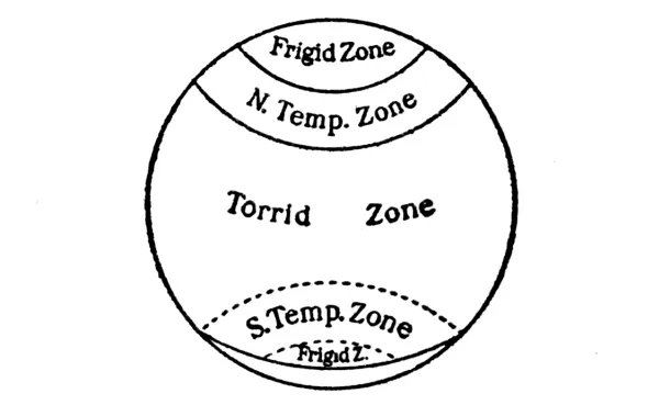
Parmenides, who flourished about the middle of the fifth century
B.C., proposed a five-zone division of the earth’s surface not
very unlike our present system. These zones were a torrid zone,
uninhabitable because of heat; two frigid zones, uninhabitable because
of cold; and two intermediate zones, of moderate temperature, suitable
for man. The exact limits assigned to these zones are not known with
certainty; but it is reasonable to suppose that the Arctic circle was
even then recognised as a natural boundary for the north polar zone,
and it is pretty clear that the temperate zone was much smaller, and
the torrid zone much larger, than in our present classification.
(See Fig. 4.)
Fig. 4. the Zones in the Time of Parmenides
The exact boundaries of the different zones varied more or less for
some time, as astronomical knowledge became more and more exact, and as
the habitable area of the earth’s surface was gradually extended, but
the scheme was generally adopted by later writers. Polybius (born about
B.C. 204), however, divided his torrid zone into two parts by
the equator, and Posidonius (born about B.C. 135) divided his
torrid zone into three parts, making six and seven zones respectively.
Aristotle (born B.C. 384) limited the torrid zone by the
tropics, and the north temperate zone by the Arctic circle; but
there is doubt whether he really meant the fixed Arctic circle which
we know. He believed both temperate zones habitable, thus limiting
the uninhabitable area to the astronomical tropical zone. Eudoxus,
of Cnidus, who lived about B.C. 366, used a division of a
quadrant of the earth’s circumference into fifteen parts, of which
four belonged to the torrid, five to the temperate, and six to the
frigid zone. The tropics were thus fixed at latitude 24°. Strabo
(born about B.C. 54), opposed the prevailing view that the
whole of the belt between the two tropics was uninhabitable, and also
first clearly set forth the opinion that the temperature decreases
with increasing altitude above sea-level, as well as with increasing
latitude. Strabo also had some fairly distinct ideas regarding local
differences of climate resulting from the influence of land and water
and of mountain barriers, and noted several effects of climate upon man
and upon vegetation. He appreciated the fact that the zones were zones
of temperature as well as zones of sunshine. As early as about 400
B.C., Hippocrates had endeavoured to show a causal relation
between sunshine and the topography of a district on the one hand and
the characteristics of its inhabitants on the other. He also gave an
outline of geographical pathology.[3]
Temperature Zones. The classification of the climatic zones
on the basis of the geometrical distribution of sunshine serves
very well for purposes of simple description, but a glance at any
isothermal chart shows at once that the isotherms do not coincide
with the latitude lines. In fact, in the higher latitudes, the former
often follow the meridians more closely than they do the parallels
of latitude. The astronomical zones—i. e., the zones of
light—therefore differ a good deal from the zones of heat. Hence it
has naturally been suggested that the zones be limited by isotherms
rather than by parallels of latitude, and that a closer approach be
thus made to the actual conditions of climate.
Fig. 5. Supan’S Temperature Zones
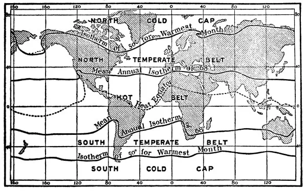
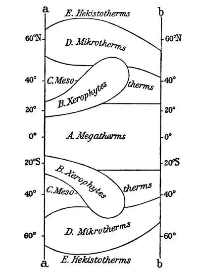
Supan (see Fig. 5) has suggested limiting the hot belt, which
corresponds to the old torrid zone, but is slightly greater, by the
two mean annual isotherms of 68°—a temperature which approximately
coincides with the polar limit of the trade winds and with the polar
limit of palms. The latter is considered by Grisebach to be the truest
expression of a tropical climate. The hot belt widens somewhat over
the continents, chiefly because of the mobility of the ocean waters,
whereby there is a tendency towards an equalisation of the temperature
between equator and poles in the oceans, while the stable lands
acquire a temperature suitable to their own latitude. Furthermore, the
unsymmetrical distribution of land in the low latitudes of the northern
and southern hemispheres results in an unsymmetrical position of the
hot belt with reference to the equator, the belt extending farther
north than south of the equator. The polar limits of the temperate
zones are fixed by the isotherm of 50° for the warmest month. This is
a much more satisfactory limit than the mean annual isotherm of 32°,
which has also been suggested; for climates differing very widely from
one another are found to have the same mean annual temperature of 32°.
The latter value has chiefly a theoretical interest, but is of some
practical importance in its relation to the regions of frozen ground.
Summer heat is more important for vegetation than winter cold; and
where the warmest month has a temperature below 50°, cereals and forest
trees do not grow, and man has to adjust himself to the conditions
in a very special way. The two polar caps are not symmetrical as
regards the latitudes which they occupy. The presence of extended
land masses in the high northern latitudes carries the temperature of
50° in the warmest month farther poleward there than is the case in
the corresponding latitudes occupied by the oceans of the southern
hemisphere, which warm less easily and are constantly in motion. Hence
the southern cold cap, which has its equatorial limits at about lat.
50° S., is of much greater extent than the northern polar cap. So
far as this south polar zone is concerned, the presence or absence
of an Antarctic continent is immaterial; for such a land mass must
be ice-covered, and hence cannot operate to raise the temperature
as in the case of a land surface to which the sun’s rays have
immediate access. The northern temperate belt, in which the great
land areas lie, is much broader than the southern, especially over
the continents. These temperature zones have real significance. They
emphasise the natural conditions of climate more than can be the case
in any subdivision by latitude circles, and they bear a fairly close
resemblance to the old zonal classification of the Greeks.
Fig. 6. Temperature Zones After Köppen
In high latitudes, neither the mean annual temperature nor the
temperature of the coldest month is nearly as important a climatic
control over vegetation as is the temperature of summer, from the point
of view of climate as a whole, and especially in relation to organic
life. The summer temperatures determine habitability, the limits of
plant growth, and the general conditions of human life. Hence, in the
higher latitudes, zones bounded by mean annual isotherms are no great
improvement over zones limited by latitude circles.
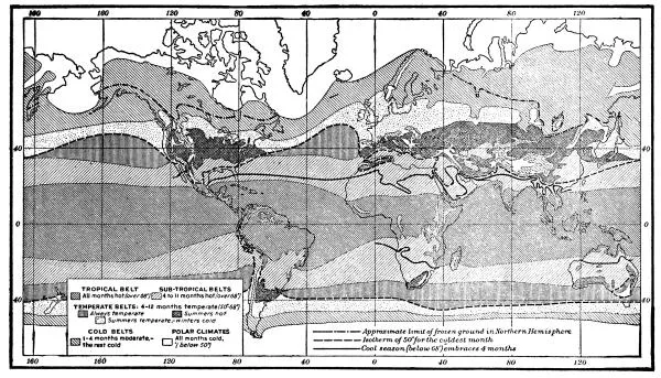
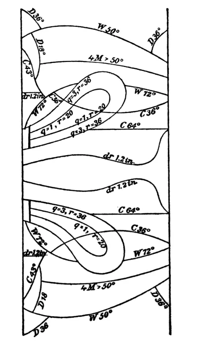
Another classification of temperature zones has been suggested by
Köppen (see Fig. 6). In this, the length of time during which the
temperature remains within certain fixed limits, these limits having
well-marked relations to organic life, is taken into account. Two
critical daily mean temperatures, 68° and 50°, and the duration of
these temperatures for periods of one, four, and twelve months, are
the factors in this classification. These temperatures are not reduced
to sea-level. A normal duration of a temperature of 50° for less than
a month fixes very well the polar limit of trees and the limits of
agriculture. Near this line are found the last groups of trees in the
tundras. A temperature of 50° for four months marks the limit of the
oak, and also closely coincides with the limits of wheat cultivation.
North of the tree limit, agriculture ceases, and man’s food is to
be sought very largely in the sea. With the approach to this line,
the period of plant growth is shortened more and more, agricultural
operations become restricted, and occupations of other kinds are
followed. These critical temperatures and their varying periods of
duration form the basis of the following classification:
1. Tropical belt: all months hot (over 68°). This is almost
altogether within the tropics; it reaches, in round numbers, from
latitude 20° N. to 16° S.
2. Sub-tropical belts: 4 to 11 months hot (over 68°); 1 to 8
months temperate (50°-68°.)
3. Temperate belts: 4 to 12 months temperate.
4. Cold belts: 1 to 4 months temperate; the rest cold (below
50°).
5. Polar belts: all months cold.
The temperate belts of both hemispheres are further subdivided into
three districts[4]
the steadily temperate belt[5]
is found only on the oceans; the belt of hot summers[6]
only on the continents; and the third, with moderate summers and cold
winters,[7]
extends around the world, with the exception of a notable interruption over Siberia.
In the second of these subdivisions, except in eastern North America
and Asia, the rainfall is generally deficient; irrigation is more or
less necessary, and deserts and steppes characterise the continental
portions. Only in the monsoon districts of southern and eastern
Asia, of Brazil, and of south-eastern North America, do we find high
temperatures combined with high relative humidity. The third
subdivision above noted is now the chief seat of human development.
Over a large part of the cold belt of the northern hemisphere, the
ground is permanently frozen, thawing only a little on the surface in
summer. Nevertheless, in portions of it trees and hardy cereals grow.
The polar belts are, as a whole, outside the limits of tree growth.
Another suggestion has been made by Gebelin, who has proposed to
select, as limits of the temperate zone, certain visible geographical
boundaries, in contrast with the ideal climatic limits based upon the
distribution of sunshine. On the oceans, the tropical circles serve
as acceptable boundaries on the sides towards the equator, but on the
continents the desert belts on both sides of the tropics are reasonable
limits, although these deserts do not reach the eastern coasts of the
continents. For the polar limits of the temperate zone, the tundras are
chosen on the continents, and the summer ice-masses on the oceans.
Wind Zones. While a simple classification of the zones on
the basis of temperature is an improvement upon any rigid scheme of
division by latitude circles, the heat zones emphasise the element of
temperature to the exclusion of such important elements as winds and
rainfall. So distinctive are the larger climatic features of the great
wind belts of the world, that a classification of climates according
to wind systems has been suggested by Davis. As the rain belts of the
world are closely associated with these wind systems, a classification
of the zones by winds also emphasises the conditions of rainfall.
In such a scheme, the torrid, or tropical zone, with its regularity
of weather through the year, and the comparative simplicity of its
climatic features, is bounded on the north and south by the margins of
the trade wind belts, and is therefore larger than the classic torrid
zone. This trade wind zone is somewhat wider on the eastern side of
the oceans, and properly includes within its limits the equable marine
climates of the eastern margins of the ocean basins, even as far north
as latitude 30° or 35°.
Most of the eastern coasts of China and of the United States are thus
left in the more rigorous and more variable conditions of the north
temperate zone. Through the middle of the trade wind zone extends the
sub-equatorial belt, with its migrating calms, rains, and monsoons. On
the polar margins of the trade wind zone lie the sub-tropical belts,
of alternating trades and westerlies. The temperate zones, with the
great irregularity of their weather phenomena and their marked seasonal
changes, embrace the latitudes of the stormy westerly winds, having on
the equatorward margins the sub-tropical belts, and being somewhat
narrower than the classic temperate zones. Towards the poles, there is
no obvious limit to the temperate zones, for the prevailing westerlies
extend beyond the polar circles. These circles may, however, serve
fairly well as boundaries, because of their importance from the point
of view of insolation. The polar zones in the wind classification,
therefore, remain just as in the older five-zone scheme.
A compromise between the rigid division by latitude circles and the
isothermal and wind classifications has been suggested by Woeikof,
who objects to limiting the torrid zone by the tropics on the ground
that the high temperatures of that zone, as well as its characteristic
winds, extend beyond these parallels. Latitude 30° would be a more
natural boundary; but as the westerlies, which are characteristic of
the temperate zones, prevail there in winter, latitude 25° is chosen
as a compromise between 23½° and 30°. The polar zones are bounded by
latitude 65°. When bounded by these several limits, the areas of the
different zones are as follows:
Tropical Zone
417
Temperate Zones
490
Polar Zones
93
1000
Summary and Conclusions. Reviewing what has been said regarding
the climatic zones, it would seem that, all things considered, a simple
division by isotherms, such as that suggested by Supan (1896), is the
best for general use. The early division by latitude circles, while it
has the merits of great simplicity, and emphasises the all-important
element of sunshine, is too arbitrary, and hence does not accord
sufficiently well with the facts of actual climate. Nevertheless, we
should not discard the classic zones without recognising that they
have a real meaning in relation to solar climate. The grouping of the
climatic zones according to wind systems has much to recommend it from
a meteorological standpoint, but is not quite simple enough for general
use. Its adoption involves an understanding of the great wind and calm
belts of the world, and of the migration of these belts. The shifting
of the boundaries of the torrid zone also brings in an element of
uncertainty which is somewhat confusing, although, as a place in the
sub-tropical belt really changes its climate with the seasonal change
from westerlies to trades, and vice versa, it may reasonably be
expected to change its zone. In other words, actual climatic conditions
are recognised; and in any case, this is a more reasonable plan than to
limit the torrid zone by means of the tropics, which arbitrarily cut
across the trade wind belts and separate areas which are climatically
the same. The temperature zones proposed by Köppen, while useful in
special studies of plant distribution, are too detailed for general
adoption.
Whatever climatic zones we adopt, we should certainly abandon the
word temperate altogether as the designation of the middle
zone in each hemisphere, and substitute some such adjective as
intermediate for it. The words torrid and frigid
should likewise disappear, and be replaced by tropical or
equatorial, and polar.
Necessary Subdivisions of the Zones. However we may classify
them, the climatic zones are far from being uniform in character
throughout their whole extent. Hence, no brief, simple description
of the climate of a zone can be given. For this reason, suggestions
have been made regarding subdivisions of the different zones. Thus,
in the case of the classic north temperate zone, it has been proposed
to subdivide it into sub-tropical, temperate, and sub-arctic, but the
question how to limit these subdivisions is difficult to settle. A
more rational scheme is that which, in view of the great differences
in the climatic relations of land and water, recognises a first
large subdivision of each zone into land and water areas. Then, as
continental interiors differ from coasts, and as windward coasts have
climates unlike those of leeward coasts, a further natural subdivision
would separate these different areas. Finally, the control of altitude
over climate is so marked that plateaus and mountains may well be set
apart by themselves as separate climatic districts. If each of the
zones, whether bounded by latitude circles, or by isotherms, or by wind
systems, be considered under these general subdivisions, as close an
approach to actual conditions of climate will be made as is possible
in general description. Obviously, however, when the larger zones are
subdivided to such an extent as is here suggested, we are dealing with
a classification of climates rather than with climatic zones.
CHAPTER II THE CLASSIFICATION OF CLIMATES
Need of a Classification of Climates—Relation
of Continental and Ocean Areas to Temperature: Reasons for the
Slow Change in the Temperature of Ocean Waters—Marine or Oceanic
Climate—Continental Climate—Desert Climate—Coast or Littoral
Climate—Monsoon Climate—Mountain and Plateau Climate—Mountains as
Climatic Divides.
Need of a Classification of Climates. A broad division of
the earth’s surface into zones is necessary as a first step in any
systematic study of climate, but it is not satisfactory when a more
detailed discussion is undertaken. The reaction of the physical
features of the earth’s surface upon the atmosphere complicates the
climatic conditions found in each of the zones, and makes further
subdivision desirable. Under the control of these different physical
conditions, the climatic elements unite to produce certain fairly
distinct types of climate, and these may be classified in various ways.
The usual method is to separate the continental (near sea-level)
and the marine. An extreme variety of the continental is the
desert; a modified form, the littoral; while altitude is
so important a control that mountain and plateau climates
are further grouped by themselves.
Relation of Continental and Ocean Areas to Temperature. Land
and water differ greatly in their behaviour regarding absorption and
radiation. The former warms and cools readily, and to a considerable
degree; the latter, slowly and but little. (1) Of the insolation
which falls upon the ocean, a good deal is at once reflected, and is
therefore not available for warming the water. Land surfaces, on the
other hand, are poor reflectors; but little insolation is lost in that
way; hence more energy is available for raising their temperature.
(2) Most of the insolation which enters the water is transmitted to
some depth, and, therefore, is not effectively applied to warming the
surface. Land is opaque and does not allow the incident insolation
to pass beyond a comparatively thin surface stratum; hence this
surface can be well warmed. (3) The evaporation of water requires a
large amount of energy, which changes the state of the water without
raising its temperature (latent heat). Land, although often moist, is
itself non-volatile; therefore the loss of energy in the process of
evaporation is usually very slight. (4) Water is more difficult to
warm than any other natural substance, while land is warmed easily and
quickly. If equal amounts of heat are received by equal areas of land
and water, the former warms about twice as much as the latter. (5) The
mobility of water keeps the warmer and the colder portions well mixed,
and therefore greatly retards the process of warming any one portion of
the surface. Land cannot thus equalise its temperature. (6) The
cloudiness over the oceans is usually greater than that over the lands,
and this operates to shade the former more than the latter, reducing
the energy available for warming the water surface. For these various
reasons, ocean surfaces can warm but little during the day, or in
summer, and can cool but little during the night, or in winter. They,
and the air over them, are therefore conservative as regards their
temperatures. Land areas, and the air over the lands, on the other
hand, warm and cool readily. The influence of latitude, as seen in
solar climate, is not infrequently wholly overcome by the influence of
land and water.
Marine or Oceanic Climate. Conservatism in its temperature
conditions is the most distinctive feature of a marine climate. The
results of the Challenger Expedition show that the diurnal range
of air temperature over the ocean between latitudes 0° and 40° averages
only 2° or 3°. Further, the slow changes in temperature of the ocean
waters involve a retardation in the times of occurrence of the maxima
and minima, and a marine climate, therefore, has characteristically
a cold spring and a warm autumn, the seasonal changes of temperature
being but slight. The surface waters of oceans and lakes average
somewhat warmer than the air over them, and for this reason all
considerable bodies of water which remain unfrozen in winter become
sources of warmth for the adjacent lands during the colder months.
Characteristic, also, of marine climates is a prevailingly higher
relative humidity, a larger amount of cloudiness, and a heavier
rainfall than is found over continental interiors. All of these
features have their explanation in the abundant evaporation from the
ocean surfaces. In the middle latitudes, again, there is this contrast
between the oceans and the continental interiors, that the former have
distinctly rainy winters, while over the latter the colder months have
a minimum of precipitation. Ocean air is cleaner and purer than land
air, and ocean air is, on the whole, in more active motion, because
friction of air on water is less than friction of air on land.
It is obvious that an equable, damp, and cloudy climate, such as that
which is, on the whole, typical of the oceans and of their leeward
coasts, must affect vegetation in a way quite different from that noted
in a hotter and drier climate, with greater variations of temperature.
Thus Schindler has shown that wheat contains less protein in a marine
climate, and hence more meat, leguminous plants, and other nitrogenous
foods are necessarily eaten. An interior climate, like that of southern
Russia and Hungary, produces wheat which is richer in protein; the need
of other nitrogenous foods is consequently decreased. The proportion
of starch is decreased, and that of gluten is increased, in a hot, dry
climate. The size of the crop is also affected by the climate.
Fig. 7. Influence of Land and Water on the
Annual March of Air Temperature
Continental Climate. Marine climate is equable; continental,
is severe. The annual temperature ranges increase, as a whole, with
increasing distance from the ocean; the regular diurnal ranges are also
large, reaching 35° or 40°, and even more, in the arid continental
interiors. The coldest and warmest months are usually January and July,
the times of maximum and minimum temperatures being less retarded than
in the case of marine climates. April is usually warmer than October,
unless spring warming is delayed by the melting of a snow-cover. In
the latter case, the snow-covered land surface temporarily takes on
the characteristics of a water surface, and has a retarded spring. The
greater seasonal contrasts in temperature over the continents than
over the oceans are furthered by the less cloudiness over the former.
The clearer continental skies of high latitudes favour a lowering of
the winter, but a slight rise of the summer temperatures, while in
lower latitudes the clearer summer skies favour a higher mean annual
temperature. Diurnal and annual changes of nearly all the elements of
climate are greater over continents than over oceans; and this holds
true of irregular, as well as of regular, variations. The contrast
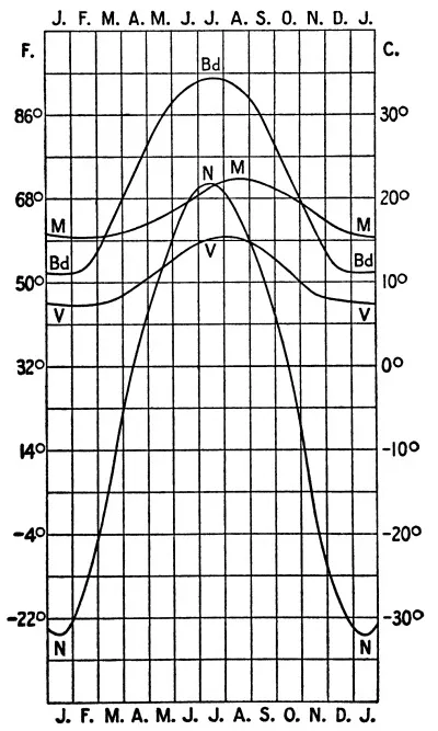
between marine and continental climates in the matter of the annual
march of temperature is shown in Figure 7. In low latitudes,
the curve for Funchal, on the island of Madeira (M), represents the marine
type, and that for Bagdad, in Asia Minor (Bd), the continental. For
higher latitudes, the curves for Valentia (V), a coast station in the
south-west of Ireland, and for Nerchinsk (N), in eastern Siberia, are
representatives of the two types.
Owing to the distance from the chief source of supply of
water vapour—the oceans—the air over the larger land areas is
naturally drier and dustier than that over the oceans. Yet even in the
arid continental interiors in summer, the absolute vapour content is
surprisingly large, although the air is still far from being saturated.
In the hottest months the percentages of relative humidity may reach
20% or 30%. At the low temperatures which prevail in the winter of the
higher latitudes, the absolute humidity is very low, but, owing to the
cold, the air is often damp. Cloudiness, as a rule, decreases inland,
reaching its minimum in deserts. And with this lower relative humidity,
more abundant sunshine and higher temperature, the evaporating power
of a continental climate is much greater than that of the more humid,
cloudier, and cooler marine climate. Actual evaporation is, however,
under these conditions, usually much less than the possible evaporation
which would take place were there more water present to be evaporated.
Both amount and frequency of rainfall, as a rule, decrease inland,
but the conditions are very largely controlled by local topography
and by the prevailing winds. The decreased frequency of rainfall on
the lowlands is especially marked in winter. Winds average somewhat
lower in velocity, and calms are more frequent, over continents than
over oceans. The seasonal changes of pressure over the former give
rise to systems of inflowing and outflowing, so-called continental,
winds, sometimes so well developed as to become true monsoons. Usually,
however, the changes in direction and the development are not very marked.
In winter, clear, crisp days, which are followed by cold, calm nights,
and interrupted from time to time by spells of cloudy, windy weather,
with or without light precipitation; in summer, clear, calm nights,
followed by hot days with increasing wind velocity and heavy clouds
towards noon, and often by thunderstorms later in the afternoon—these
are typical weather conditions of continental interiors in the
higher latitudes; and they are of much interest to man. The extreme
temperature changes which occur over the continents are the more
easily borne because of the dryness of the air; because the minimum
temperatures of winter occur when there is little or no wind, and
because, during the warmer hours of the summer, there is the most air
movement.
Desert Climate. An extreme type of continental climate may
be found in deserts. It is a curious fact that desert and marine
climates—the two extremes of the climatic scale—resemble one
another in some respects. Desert air, though often dusty by day, is
notably free from micro-organisms; the purity of ocean air is well
known. Again, deserts and oceans alike have high wind velocities. The
large diurnal temperature ranges of inland regions, which are most
marked where there is little or no vegetation, give rise to active
convectional currents during the warmer hours of the day. Hence high
winds, disagreeable because of the dust and sand which they carry, are
common by day, while the nights are apt to be calm and relatively cool.
Travelling by day is unpleasant under such conditions. Diurnal cumulus
clouds, often absent because of the excessive dryness of the air, are
thus replaced by clouds of blowing dust and sand. This sand, often
carried afar, may find a resting-place on the moister lands to leeward.
Thus beds of loess are formed. Indeed, many geological phenomena, and
special physiographic types of varied kinds, are associated with the
peculiar conditions of desert climate. The excessive diurnal ranges
of temperature cause rocks to split and break up. Wind-driven sand
erodes and polishes the rocks. When the separate fragments become
small enough, they, in their turn, are transported by the winds and
further eroded by friction during their journey. The ground is often
swept clean by the winds. Curious conditions of drainage result from
the deficiency in rainfall. Rivers “wither” away, or end in sinks or
brackish lakes. Desert plants protect themselves against the attacks
of animals by means of thorns, and against evaporation by means of
hard surfaces and an absence of leaves. The life of man in the desert
is likewise strikingly controlled by the climatic peculiarities of
strong sunshine, of heat, and of dust. Occasionally heavy downpours of
rain (cloud-bursts) over mountains or on the borders of deserts, cause
sudden floods. Even slight rainfalls in deserts awaken multitudes of
dormant plant seeds.
Coast or Littoral Climate. Between the pure marine and the pure
continental types, the coasts furnish almost every grade of transition.
Hence coast or littoral climates may well be placed in a group by
themselves. Prevailing winds are here important controls. When these
blow from the ocean, as on the western coasts of the temperate
zones, the climates are more marine in character; but when they are
offshore, as on the eastern coasts of these same zones, a somewhat
modified type of continental climate prevails, even up to the immediate
seacoast. Hence the former have a much smaller range of temperature;
their summers are more moderate and their winters milder; extreme
temperatures are very rare; the air is damp; there is much cloud. All
these marine features diminish with increasing distance from the ocean,
especially when there are mountain ranges near the coast, as is the
case in the western United States and in Scandinavia. In the tropics,
windward coasts are usually well supplied with rainfall, and the
temperatures are modified by sea breezes. Leeward coasts in the trade
wind belts offer special conditions. Here the deserts often reach the
sea, as on the western coasts of South America, Africa, and Australia.
Cold ocean currents, with prevailing winds along shore rather than
onshore, are here hostile to rainfall, although the lower air is often
damp, and fog and cloud are not uncommon.
Monsoon Climate. Exceptions to the general rule of rainier
eastern coasts in trade wind latitudes are found in the monsoon
regions, as in India, for example, where the western coast of the
peninsula is abundantly watered by the wet south-west monsoon. As
monsoons often sweep over large districts, not only coast but interior,
a separate group of monsoon climates is desirable. In India, there
are really three seasons—one cold, during the winter monsoon; one
hot, in the transition season; and one wet, during the summer monsoon.
Little precipitation occurs in winter, and that chiefly in the northern
provinces. The high temperatures of the transition periods are most
oppressive when the air is most damp. In India this is the case in the
autumn. In low latitudes, monsoon and non-monsoon climates differ but
little, for summer monsoons and regular trade winds both give rains,
and wind direction has slight effect upon temperature.
The winter monsoon is offshore, and the summer monsoon onshore, under
typical conditions, as in India. But exceptional cases are found where
the opposite is true. Thus, on the north-western coast of Japan, the
north-eastern coasts of Formosa and of the Philippines, and the eastern
coasts of the southern Deccan and of Ceylon, the prevailing offshore,
winter, dry monsoon becomes an onshore, rainy wind. Many complicated
cases of this kind are not easily co-ordinated. In higher latitudes,
the seasonal changes of the winds, although not truly monsoonal,
involve differences in temperature and in other climatic elements. The
eastern coast of the United States has prevailing cold, dry, clear
winds from the continental interior in winter, while the prevailing
winds of summer are south-west, and hence warm and often moist. The only
well-developed monsoons on the coast of the continents of higher
latitudes are those of eastern Asia. These are offshore during the
winter, giving dry, clear, and cold weather; while the onshore movement
in summer gives cool, damp, and cloudy weather. Without these seasonal
winds the winters would have the maximum amount of rain and cloud.
Mountain and Plateau Climate. Both by reason of their actual
height and because of their obstructive effects, mountains influence
climate similarly in all the zones. Hence mountain and plateau climates
are placed in a group by themselves, as distinguished from those of
lowlands. The former, as contrasted with the latter, are characterised
by a decrease in pressure, temperature, and absolute humidity; an
increased intensity of insolation and radiation; larger ranges in soil
temperature; usually a greater frequency of precipitation, and, up to a
certain altitude, more of it.
At an altitude of 16,000 ft., more or less, pressure is reduced to
about one-half of its sea-level value. The highest human habitations
are found under these conditions. While the pressures and the pressure
changes at sea-level have no marked effect upon man, the physiological
effects of the decreased pressure aloft (faintness, nausea, headache,
weakness) are experienced by a majority of people at altitudes above
12,000 to 15,000 ft. The symptoms, and the height at which they appear,
vary much in different cases, and depend upon the physical condition of
the individual, the weather, bodily exertion, and so on. The greatest
altitudes attained by man were reached by balloon, and in such cases
a supply of oxygen is usually taken up by the aëronaut. Man endures
the rapid pressure changes during balloon ascents with difficulty,
and often only with considerable suffering. The eagle and the condor,
however, suffer no inconvenience during their high flights.
It has been suggested by Jourdanet that mountain and plateau climates
be divided into groups, climats de montagne, below 6500 feet,
and climats d’altitude, above that height. The former are
beneficial because of the stimulating quality of their clean, cool air;
the latter may be injurious because of the low pressure. The variations
in pressure, as well as the actual pressures, diminish aloft. On high
mountains and plateaus, the pressure is lower in winter than in summer,
owing to the fact that the atmosphere is compressed by cold to lower
levels in the winter, and is expanded upwards in summer by heat. The
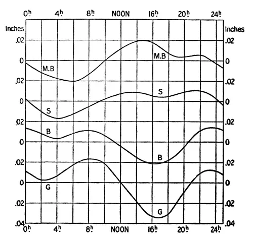
morning minimum pressure on mountains is usually the primary minimum,
the afternoon minimum being less marked and coming later than on
lowlands. Figure 8 shows the diurnal variation of pressure
at Geneva (408 meters, G), Berne (573 meters, B), on the Säntis (2467 meters, S),
and on the summit of Mont Blanc (4811 meters, MB), and illustrates well
the general characteristics of the curves found at different altitudes.
Local topography, however, is an important controlling influence, and
modifies such curves very much.
Fig. 8. Diurnal Variation of Pressure:
Influence of Altitude
The intensity of insolation and of radiation both increase aloft in the
cleaner, purer, drier, and thinner air of mountain climates. The sun
usually shines more often and more powerfully at high altitudes. The
intensity of the sun’s rays attracts the attention of mountain-climbers
at great altitudes. The excess of surface temperature over air
temperature also increases aloft, and is a favourable element in
plant growth. There is likewise an increase in the range of surface
temperature, although this is much influenced by exposure. The
vertical decrease of temperature, which is also much affected by local
conditions, is especially rapid during the warmer months and hours;
mountains are then cooler than lowlands. The inversions of temperature
characteristic of the colder months, and of the night, give mountains
the advantage of higher temperature then, a fact of importance in
connection with the use of mountains as winter resorts. At such
times, the cold air flows down the mountain sides and collects in the
valleys below, being replaced by warmer air aloft. Hence diurnal and
annual ranges of temperature on the mountain tops of middle and higher
latitudes are lessened, and the climate in this respect resembles a
marine condition; but topography and the conditions of local clouds
and winds are here important controls. The times of occurrence of the
maximum and minimum are also much influenced by local conditions.
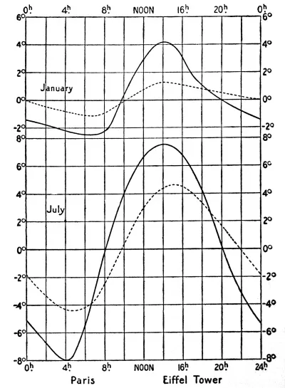
Figure 9 shows the diurnal march of temperature for Paris (solid) and
the Eiffel Tower (broken) in January and July. It will be noted that
the times of maximum and minimum are retarded on the Eiffel Tower,
and that the range is less than at the earth’s surface. These are
characteristics of mountain climates. Elevated, well enclosed valleys,
with strong sunshine, often resemble continental conditions of large
temperature range; and plateaus, as compared with mountains at the same
altitude, have relatively higher temperatures and larger temperature
ranges. Altitude tempers the heat of the low latitudes. High mountain
peaks, even on the equator, can remain snow-covered the year around;
the plateau of southern India, at 6000 to 7000 ft. above sea-level,
always has moderate mean temperature, and from the dense jungle of the
tropical lowland to the snowy mountain top, successive zones of
vegetation are encountered.
Fig. 9. Diurnal Variation of Temperature:
Influence of Altitude
Nine-tenths of the water vapour in the atmosphere are below 21,000
feet. Hence mountains are important vapour barriers, and one side may
be damp while the other is dry. Curiously mistaken ideas of distance
often result from the remarkable clearness and dryness of the air on
high mountains. No general law governs the variations of relative
humidity with altitude, but on the mountains of Europe the winter
is the driest season, and the summer the dampest. At well-exposed
stations there is a rapid increase in the vapour content soon after
noon, especially in summer. The same is true of cloudiness, which is
often greater on mountains than at lower levels, and is usually at a
maximum in summer, while the opposite is true of the lowlands in the
temperate latitudes. One of the great advantages of the higher Alpine
valleys in winter is their small amount of cloud. This, combined with
their low wind velocity and strong insolation, makes them desirable
winter health resorts. Latitude, altitude, topography, and winds are
determining factors in controlling the cloudiness on mountains. In
intermediate latitudes there is a seasonal migration of the level of
maximum cloudiness, and of maximum relative humidity, from the lowlands
in winter to higher altitudes in the warmer months, in association with
the diurnal convectional movements of the warmer season. Frequent rapid
local changes also occur. In the rare, often dry, air of mountains and
plateaus, evaporation is rapid, the skin dries and cracks, and thirst
is increased.
Rainfall usually increases with increasing altitude up to a certain
point, beyond which, owing to the loss of water vapour, this increase
stops. The zone of maximum rainfall averages about 6000 to 7000 feet
in altitude, more or less, in intermediate latitudes, being lower in
winter and higher in summer. Mountains usually have a rainy and a
drier side; the contrast between the two is greatest when a prevailing
damp wind crosses the mountain, or when one slope faces seaward
and the other landward. When the prevailing winds differ little in
dampness, this contrast is lessened, and there may then be a very
close correspondence between the rainfall and the topographic map of
a region. Mountains often provoke rainfall, and local “islands,” or,
better, “lakes,” of heavier precipitation result. Such are found on the
mountains of the Sahara, and of other deserts. This local precipitation
favours the growth of vegetation; small streams and oases are found,
and temporary camps, or more permanent settlements, of the nomadic
tribes of the desert are there established. Well-marked zones of
vegetation are noted under such conditions, as in the transition from
the dry Californian lowlands up through the deciduous, and then the
coniferous, forests of the Sierra Nevada to the snows on the summits.
Similarly, the high plateaus of southern Utah and of Arizona are high
enough to receive fairly abundant rainfall, while the lowlands are arid.
Mountains resemble marine climates in having higher wind velocities
than continental lowlands; mountain summits have a nocturnal maximum
of wind velocity, while plateaus usually have a diurnal maximum.
Mountains both modify the general, and give rise to local, winds. Among
the latter, the well-known mountain and valley winds are often of
considerable hygienic importance in their control of the diurnal period
of humidity, cloudiness, and rainfall, the ascending wind of daytime
tending to give clouds and rain aloft, while the opposite conditions
prevail at night. The high temperature and dryness of the foehn,
which is of immense benefit to man by reason of its melting and
evaporating powers, although often enervating and depressing, result
from the fact of a descent of the air from a mountain slope or summit.
The bora, with its cold gust, is a wind in whose development a mountain
or plateau is essential. And the mistral of southern France owes some
of its cold to radiation over the interior plateaus.
Mountains as Climatic Divides. Very different conditions of
temperature, pressure, and humidity may be found on the opposite sides
of a well-defined mountain range, because such a range interferes with
the free horizontal interchange of the lower air. Mountain ranges which
trend east and west, like the Alps and the Himalayas, separate more
severe from less severe climates; those which follow a coast-line, as in
California, Scandinavia, or eastern Siberia, separate marine from
continental. Large differences of pressure on the two sides may be
equalised by a flow of air across the mountain, as in the foehn.
CHAPTER III THE CLASSIFICATION OF CLIMATES ( Continued )
Supan’s Climatic Provinces—Köppen’s
Classification of Climates—Ravenstein’s Hygrothermal
Types—Classification of Rainfall Systems—Herbertson’s Natural
Geographical Regions—Summary and Conclusions.
Supan’s Climatic Provinces. The ordinary classification into
continental, marine, and mountain climates is too general. Some
scheme of classification is needed in which the geographical factor
plays an important part, and which recognises the types of climate,
possessing common characteristics of temperature, rainfall, and
winds, that occur over areas having similar topographic conditions.
A fairly simple scheme of this kind has been suggested by Supan, who
recognises thirty-five so-called climatic provinces, but any such rigid
subdivision is obviously susceptible of almost infinite modification.
Twenty-one of these provinces are in the eastern hemisphere, including
Polynesia; twelve are in the western, and two in the polar zones. The
description of these provinces is as follows:[8]
1. Arctic Province. This coincides with the north polar cold cap, the
area wherein the mean temperature of the warmest summer month is never
over 50° F., and within which trees do not grow.
2. West European Province. Mild winters, owing to influence of the
westerly winds and Gulf Stream. Yearly temperature range under 59°
F. (15° C.). Plentiful rainfall, fairly well distributed throughout
the year, but varying in quantity owing to great diversity of land
contours. The climatic conditions often vary in short distances, and
hence the region can be divided into many subdivisions.
Fig. 10. Supan’S Climatic Provinces
3. East European Province. Here the evidences of a land climate begin
to be observed; but as most of the region is a plain, differences
depend mainly on latitude. The rainfall is smaller than in Province 2,
and gradually diminishes towards the south-east, and has a marked summer
maximum.
4. West Siberian Province. This is separated from 3 by the limit of the
positive annual isanomalous lines, which practically coincide with the
Urals. The characteristic peculiarities of 3 are found here greatly
emphasised, and the greater variability of temperature is to be noted.
5. East Siberian Province. A gradual rising of the ground is found east
of the Yenisei, with low plains only along the rivers. The winter cold
pole is here, and the yearly range of temperature is a maximum. As a
rule, the rainfall is small.
6. Kamchatkan Province. The sea diminishes the temperature extremes
noted in Province 5, and much rain falls.
7. Sino-Japanese Province. On the continent, relatively well-marked
winter cold, and strong periodical rains. In Japan, these peculiarities
are less extreme.
8. Asiatic Mountain and Plateau Province. This includes all the lofty
plateaus bounded by mountain ranges, which shield it on every side, and
so render it very dry. The great height makes the winter temperature
severe; but the summer heat is great, owing to the continental
position. The daily, as well as the yearly, range of temperature is
very marked.
9. Aral Province. Dry, low-lying plain, with the greatest rainfall in
the north in summer, and in the south in winter. The plains of western
Turkestan have severe winters and very hot summers.
10. Indus Province. A plain remarkable for great dryness and heat.
11. Mediterranean Province. Very varied in climate, owing to its great
irregularity of outline, both horizontal and vertical. Mild, except on
high plateaus. Winter rains.
12. Saharan Province. Reaches to Mesopotamia. Region of dry, north
winds, and probably the one receiving least rain. Its continental
position and lack of vegetation increase the heat of summer
extraordinarily; both annual and daily ranges of temperature are
considerable.
13. Tropical African Province. Owing to the height of the central
plateau, the heat is less intense, but it is very great on the narrow
coastal plains. Tropical rains decreasing towards the west.
14. Kalahari Province. Includes all the almost rainless region of
south-west Africa.
15. Cape Province. Sub-tropical.
16. Indo-Australian Monsoon Province. Strong, periodical rains are
brought with the south-west and north-west monsoons, except at a few
places in the archipelago. The temperature is fairly uniform, despite
the great extent of the province, and the yearly range is very small.
17. Inner Australian Province. With great extremes of temperature.
Irregular and rare rains.
18. South-west Australian Province. Sub-tropical.
19. East Australian Province. It extends to the water-parting and
includes the south-east coast and Tasmania. Plentiful and fairly regular
rains. Moderate range of temperature.
20. New Zealand Province. Probably includes the small neighbouring
islands. Mild climate, with fairly regular rains.
21. Tropical Polynesian Province. Tropical climate, ameliorated by the
ocean, so that mild summer weather prevails throughout the year. On the
loftier islands, the rain is abundant, and has a tropical periodicity.
22. Hawaiian Province. Also a mild climate, but with sub-tropical rains.
23. Hudson (North Canadian) Province. Great extremes of temperature and
little precipitation.
24. North-west American Coastal Province. Mild, equable, rainy climate.
25. Californian Province. Relatively cool, especially in summer. Marked
sub-tropical rainy seasons.
26. North American Mountain and Plateau Province. Great yearly and
daily ranges. Dry.
27. Atlantic (East North American) Province. Great contrast in
temperature conditions of north and south in winter. Extreme climate
even on the coast. Plentiful rains, evenly distributed throughout the
year. Great variability.
28. West Indian Province. This also includes the southern rim of North
America. Equable temperature. Rain at all seasons, but with a marked
summer maximum.
29. Tropical Cordilleran Province. On the interior plateau, perpetual
spring, owing to considerable height above sea-level. In Mexico and
Central America, marked zenithal rains; in South America, more regular
precipitation.
30. South American Tropical Province. Little that is certain is known
about this province, which includes mountainous regions and plains, and
ought, therefore, to possess considerable variety of climate.
31. Peruvian Province. This province extends as far south as 30° S.,
and so includes the northern part of Chile. Abnormally cool. Rainless.
32. North Chilean Province. Sub-tropical.
33. South Chilean Province. Equable temperatures, with cool summers.
Extraordinarily rainy.
34. Pampa Province. Range of temperature fairly large, especially in
the north. Rain not plentiful.
35. Antarctic Province. Resembles the Arctic, so far as can at present
be determined, in winter cold but differs in having a very low summer
temperature and a very regular distribution of pressure and winds.
Fig. 10 shows the geographical distribution
of these climatic provinces.
Köppen’s Classification of Climates. An interesting
classification of climates, from a botanical standpoint, is that
proposed by Köppen. This rests upon certain critical values of the
temperature and rainfall of the warmest or coldest, or of the wettest
and driest month. The plant classification proposed by A. de Candolle
in 1874, and later adopted by Drude, is accepted. This is a division
into five principal biological groups under the control of temperature
and moisture, as follows:
A. Megatherms: plants which need continuously high temperature
without much annual range, and also abundant moisture. There is no cool
season; the temperature of the coolest month is over 64.5° (18° C.),
and there is at least one month of heavy rain. When there are marked
dry seasons, the principal one comes in winter and spring. In parts of
this belt there are two rainy seasons. In this belt are found the lofty
tropical forests intertwined with vines and creepers—sago, betel,
pepper, cacao, bread-fruit, baobab, coffee, sugar-cane, banana, ginger,
and so on.
B. Xerophytes: plants which like dryness and need high
temperatures, at least for a short season. These are found in tropical
districts which have a long dry season, and in the steppes and deserts
of the tropics and of the warmer parts of the temperate zones. They are
adapted in various ways for life in a dry climate; they rest during the
dry time, and, in extreme cases, where rain may not fall for years,
they survive as seeds. The vegetation varies with the soil. In this
group we find the date, mesquite, acacia, cactus, agave, and similar
plants.
C. Mesotherms: need moderate heat (59°-68°) and a moderate
amount of moisture; some require high summer temperatures; others
shun low winter temperatures; others shun the dryness which often
accompanies high summer temperatures. These plants inhabit latitudes
between 22° and 45° N. or 40° S., so long as the moisture continues
sufficient. There is a cool season—coldest month below 64.5° (18°
C.)—and a hot summer—warmest month over 72° (22° C.),—or a
mild winter—coldest month over 43° (6° C.)—or both. The classic
Mediterranean climate is found in this belt. The mesotherm belt
contains the tea, maté, rice, cotton, magnolia, hickory, arbor vitæ,
hemlock, wheat, corn, olive, fig, grape, heath, cinchona, etc.
D. Mikrotherms: need less heat, lower mean annual temperature,
cooler and shorter summers, and colder winters. The warmest month is
at least 50° (10° C.) and not over 72° (22° C.); the coldest is below
43° (6° C.), with at least an occasional snow-cover in winter and
sufficient rainfall in the warmer season. Evergreen and deciduous
forests, grains, and, in the warmer portions, fruit and corn are found.
E. Hekistotherms: plants of the Arctic zone, beyond the limits
of tree growth and of the zone of scrubby Antarctic vegetation. These
need the least heat. Mosses, lichens, and similar lowly forms are typical.
Fig. 11. General Distribution of Plant Zones
A simple scheme of distribution of these five groups of plants may
first be developed with reference to an ideal continent, stretching
from pole to pole, with oceans on both sides and without mountains
(Fig. 11). Here a a is the western and b b the eastern
coast. The approximate latitudes are given at the margins. The groups
of de Candolle’s system are arranged as shown, if the xerophytes are
limited to the deserts and steppes, and if those woody plants of the
megatherm and mesotherm zones which are adapted to a dry climate
are included within these zones. The typical zonal arrangement is
interrupted in latitudes 20° to 50° by the fact that the arid district
of the xerophytes (B) is wedged in on the west coast between A and C.
Farther east, zone B broadens poleward, cuts through the middle of the
mesotherm zone, and usually ends without reaching the east coast.
Fig. 12. Scheme of Climates at Sea-Level
Fig. 13. Names of Climates at Sea-Level
Fig. 14. Vertical Distribution of Climates
The five principal types are further subdivided until the whole
number of climates reaches twenty-four. The special conditions
which characterise each climate are carefully determined, and each
sub-climate is named after one of its characteristic plants or animals;
or after some distinctive meteorological phenomenon; or, again, after
the general character of its vegetation. Fig 12 gives the
limits of the different sub-climates, and also the characteristic conditions
of temperature and precipitation.[9]Fig. 13 gives the scheme of the sub-climates for the lowlands, with
their names. Four climates which do not occur at sea-level are here
lacking (C7, E3, E4, F).[10]
The vertical distribution of these climates, much simplified, is shown
in Fig 14. The descent of the climatic strata from equator to higher
latitudes is shown on the right for the continental, and on the left
for the marine type, as far as about latitude 57°. Climates C1 to
C4, and D1 and D2, have large temperature ranges, and are therefore
lacking at the equator and on the ocean; while C5 to C7, and D3, have
small ranges, and are not found on the continents in higher latitudes.
The general control of pressure, winds, and ocean currents over the
climatic types is shown in the two following ideal diagrams, in which
the two vertical lines indicate the west and east coasts of the ideal
continent, and the area included reaches to the middle of the adjacent
ideal oceans. The line 0°-0° is the equator (Figs. 15 and 16).
The short arrows give the wind direction 500-1000 metres above the surface;
calms are represented by the sign ⍟; the long broken arrows indicate
the prevailing surface ocean currents. At a a there is a rise of cold
water from beneath the surface of the ocean. The curving lines are
sea-level isobars; the lower pressures are shaded. The letters and
boundaries, drawn in short, slanting lines in Fig. 16 indicate the
climatic districts of Fig. 11. Fig. 15
is similar to Fig. 16, as far as these climatic districts
are concerned. Therefore the letters and boundaries are omitted. Fig. 17
shows the geographical distribution of the climatic types and sub-types.
Fig. 15. Pressure and Winds in January
Fig. 16. Pressure and Winds in July
Fig. 17. Köppen’s Classification of Climates
in Relation to Vegetation
Ravenstein’s Hygrothermal Types. Recognising the importance of
relative humidity as a climatic factor in its influence upon life, upon
agriculture and upon industry, and basing his grouping of climates
upon certain relations between temperature and relative humidity,
Ravenstein proposes a subdivision of the earth’s surface into sixteen
hygrothermal climatic types. The general characteristics and
examples of these types are as follows:
1. Hot (73° and over) and very damp (humidity 81% or more): Batavia,
Cameroons, Mombasa.
2. Hot and moderately damp (66-80%): Havana, Calcutta.
3. Hot and dry (51-65%): Bagdad, Lahore, Khartum.
4. Hot and very dry (50% or less): Disa, Wadi Halfa, Kuka.
5. Warm (58° to 72°) and very damp: Walfish Bay, Arica.
6. Warm and moderately damp: Lisbon, Rome, Damascus, Tokio, New Orleans.
7. Warm and dry: Cairo, Algiers, Kimberley.
8. Warm and very dry: Mexico, Teheran.
9. Cool (33° to 57°) and very damp: Greenwich, Cochabamba.
10. Cool and moderately damp: Vienna, Melbourne, Toronto, Chicago.
11. Cool and dry: Tashkent, Simla, Cheyenne.
12. Cool and very dry: Yarkand, Denver.
13. Cold (32° or less) and very damp: Ben Nevis, Sagastyr, Godthaab.
14. Cold and moderately damp: Tomsk, Pike’s Peak, Polaris House.
15. Cold and dry: (No example given).
16. Cold and very dry: Pamir.
Classification of Rainfall Systems.—The seasonal occurrence
of rainfall has suggested a classification of the rainfall systems of
the world into types. While these schemes are useful in climatological
study, they are hardly to be considered as classifications of climate.
Mühry[11]
gave a rigid scheme of rainfall types in six belts for each
hemisphere, these belts being divided by latitude lines; and Köppen has
prepared a useful map of the hyetal regions of the world, based on the
seasonal distribution of rainfall types.[12]
Fig. 18.Herbertson’S Major Natural Regions
Herbertson’s Natural Geographical Regions.—A scheme of “natural
geographical regions” has been suggested by Herbertson,[13]
the basis of classification being a certain unity of temperature,
rainfall seasons, configuration and vegetation (Fig. 18).
The different types of natural regions recur in fairly systematic order
on the different continents, being chiefly controlled by marine and
continental influences, and each type, wherever found, has certain
similar general relations to human life and development, as well as to
animals and plants. The types are as follows:
2. The cool temperate regions. (a) Western margin (West European
type); (b) Eastern margin (Quebec type); (c) Interior
lowlands (Siberian type); (d) Interior mountain area (Altai type).
3. The warm temperate regions. (a) Western margin with winter
rains (Mediterranean type); (b) The eastern margin, with summer
rains (China type); (c) The interior lowlands (Turan type);
(d) Plateau (Iran type).
4. (a) The west tropical deserts (Sahara type); (b) East
tropical lands (Monsoon type); (c) Inter-tropical table-lands (Sudan type).
5. Lofty tropical or sub-tropical mountains (Tibetan type).
6. Equatorial lowlands (Amazon type).
Summary and Conclusions. The broad classification of climates
into the three general groups of marine, continental, and mountain,
with the subordinate divisions of desert, littoral, and monsoon, is
convenient for purposes of summarising the interaction of the climatic
elements under the controls of land, water, and altitude. But in any
detailed study, some scheme of classification is needed in which
similar climates in different parts of the world are grouped together,
and in which their geographic distribution receives particular
consideration. It is obvious from the preceding paragraphs that an
almost infinite number of classifications might be proposed; for we may
take as the basis of subdivision either the special conditions of one
climatic element, as, for example, the same mean annual temperature,
or mean annual range of temperature, or the same rainfall, or rainy
seasons, or humidity, and so on. Or again, similar conditions of the
combination of two or more elements of climate may be made the basis of
classification. Or we may take a botanical, or a zoölogical basis. Of
the classifications which have been proposed, special reference is here
made to those of Supan, Köppen, and Herbertson. That of Supan, taken as
a whole, gives a rational, simple, and satisfactory scheme of grouping,
whose frequent use in climatic descriptions would tend toward system,
simplicity, and facility of comparison. It emphasises the essentials
of each climate, and serves to impress these essentials upon the mind
by means of the compact, well-considered summary which is given in
the case of each province described. Obviously, no classification of
climates which is at all complete can approach the simplicity of the
ordinary classification of the zones.
Köppen’s admirable scheme of subdividing climates, with the emphasis on
the botanical side, is perhaps better adapted to the use of students
of plant geography than of general climatology. But it has the great
merit of recognising the existing differences of climate between east
and west coasts, and between coasts and interiors. The co-ordination of
districts of vegetation and of climate, which this scheme so strikingly
emphasises, is a noteworthy fact in climatology. The subdivision could
obviously be continued almost indefinitely.
Herbertson’s classification of the natural geographical regions is, on
the whole, not very unlike that adopted in Supan’s climatic provinces,
but is less complete. It is obvious that no scheme of subdivision of
this kind can be regarded as being rigid or as satisfying all students
of questions of distribution. Nevertheless, some general grouping of
climatic regions with reference to similar features of temperature and
rainfall and configuration, is a distinct help in most geographical
studies. The larger types naturally recur on the several continents, in
a fairly systematic fashion. It results from this fact that there is
a recurrence, in a large way, of somewhat similar conditions of life.
This is a particularly helpful consideration in investigations of the
economic and political history of mankind. The chief peculiarities of
the important types can be readily learned; the special variations in
individual areas may be investigated for each case by itself.
Ravenstein’s hygrothermal types rest upon unsatisfactory data, and
regions of very different climatic conditions are grouped together
because they happen to have the same mean annual temperature and
relative humidity.
CHAPTER IV THE CHARACTERISTICS OF THE ZONES: I.—THE TROPICS
General: Climate and Weather—Temperature—The
Seasons—Physiological Effects of Heat and Humidity—Pressure—Winds
and Rainfall—Land and Sea Breezes—Thunderstorms—Cloudiness—Intensity
of Skylight and Twilight—Climatic Subdivisions:—I. The Equatorial
Belt.—II. Trade Wind Belts.—III. Monsoon Belts.—IV. Mountain
Climate.
General: Climate and Weather. The so-called “torrid zone” has
been variously bounded. Its limits have been set at the tropics (lat.
23½°); at the mean annual isotherms of 68°, which also correspond
closely with the poleward extension of palms; and at the polar margins
of the trade winds. The dominant characteristic of this great belt,
embracing but a little less than one-half of the earth’s surface, is
the remarkable simplicity and uniformity of its climatic features. This
simplicity is reflected in the striking regularity in the recurrence
of the ordinary weather phenomena. The tropics lack the proverbial
uncertainty and changeableness which characterise the weather of
the higher latitudes. In the torrid zone, weather and climate are
essentially synonymous terms. Periodic phenomena, depending upon the
daily and annual march of the sun, are dominant. Non-periodic weather
changes are wholly subordinate. The succession of daily weather
changes is even more regular, and the distribution of the climatic
elements is even more uniform over the tropical oceans than over the
lands. In special regions only, and at special seasons, is the regular
sequence of weather temporarily interrupted by an occasional tropical
cyclone. These cyclones, although comparatively infrequent, are notable
features of the climate of the areas in which they occur. Generally
bringing very heavy rains, and thus locally increasing the total annual
precipitation by a considerable amount, they yet cause no marked
temperature changes such as those which are the common accompaniments
of extra-tropical cyclones. The devastation produced by one of these
storms often affects the economic condition of the people in the
district of its occurrence for many years.
Temperature. The sun is always well up in the sky. The length of
day and night varies little. Hence the mean temperature is high, it is
very uniform over the whole zone, and there is little variation during
the year. The mean annual isotherm of 68° is a rational limit at the
polar margins of the zone, and the mean annual isotherm of 80° encloses
the greater portion of the land areas, as well as much of the tropical
oceans. The isotherms are thus far apart. The warmest latitude circle
for the year is not the equator, but latitude 10° north. The highest
mean annual temperatures, shown by the isotherm of 85°, are in central
Africa, in India, the north of Australia and Central America, but, with
the exception of the first, these areas are small. Massowah, on the Red
Sea, has an annual mean of over 86°. The temperatures average highest
where there is little rain, and not in the belt of heavy equatorial
rains, where the clouds afford some protection from the sun’s rays. In
June, July, and August there are large districts in the south of Asia,
and in northern Africa, with temperatures over 90°. Winds blowing out
from these heated deserts are uncomfortably hot and dusty.
Over nearly all of the zone the mean range of temperature is less than
10°, and over much of it, especially the oceans, it is less than 5°.
At Equatorville, in the interior of Africa, on the Congo, the mean
annual range is only a little over 2°; at Iquitos (lat. 3.7° S.), in
Peru, it is 4.3°. Even near the margins of the zone, where the seasonal
differences are greatest, the ranges are less than 25°, as at Calcutta,
Hong Kong, Rio de Janeiro and Khartum. The mean daily range is usually
larger than the mean annual. Thus at Equatorville the former is about
14.5°. It has been well said that “night is the winter of the tropics.”
The differences between the maximum and minimum temperatures of the
year near the equator are not much greater than the daily range. Over
an area covering parts of the Pacific and Indian Oceans, from Arabia to
the Caroline Islands and from Zanzibar to New Guinea, as well as on the
Guiana coast, the minimum temperatures do not normally fall below 68°,
and over much of the torrid zone as a whole they do not fall below 59°.
Towards the margins of the zone, however, the minima on the continents
fall to, or even below, 32°. Maxima of 115°, and even over 120° (122°),
occur over the deserts of northern Africa. A district where the mean
maxima exceed 113° extends from the western Sahara to north-western
India, and over central Australia. Near the equator the maxima are
therefore not as high as those in many so-called “temperate” climates.
The greater portion of the torrid zone is a water surface, and marine
conditions are therefore typical for most of it. These tropical oceans
show remarkably small variations in temperature. The Challenger
results showed a daily range of hardly 0.7° in the surface water
temperature on the equator, and Schott determined the annual range as
4.1° on the equator; 4.3° at latitude 10°, and 6.5° at latitude 20°.
It has been clearly pointed out by Hann that the uniform distribution
of temperature throughout the year—the dominant feature of the
tropics—results not only from (1) the small variation in insolation
and in the length of the day; but also (2) from the great extent of the
zone, which makes it impossible for cold winds from higher latitudes
to penetrate into the lower latitudes; (3) the oblique course of the
trades, which are well warmed on their indirect road towards the
equator; (4) the slight nocturnal cooling, where the air is damp and
vapour is readily condensed; and (5) the great extent of the tropical
oceans, which gives so much of the zone a marine climate.
The Seasons. In a true tropical climate, seasons, in the
temperate zone sense, do not exist. The variations in temperature
throughout the year are so slight that the seasons are not classified
according to temperature, but depend on rainfall and the prevailing
winds. The life of animals and plants in the tropics, and of man
himself, is regulated very largely, in some cases almost wholly, by
rainfall. Agriculture prospers, or fails, according to the sufficiency
and punctual appearance of the rains. After a long dry season, when the
rains come, there is an extraordinarily sudden awakening of the parched
and dusty vegetation. Where, on the other hand, there is abundant
moisture throughout the year, a tree may at the same time be carrying
buds, blossoms, and ripe fruit. Vegetation under these conditions has
been well called non-periodic. Although the tropical rainy season
is characteristically associated with a vertical sun (i. e.,
summer), that season is not necessarily the hottest time of the year.
The temperature is usually somewhat lower under the clouds. The rainy
season often goes by the name of winter for this reason, and also
because the weather is dull. The time of the maximum temperature
is also controlled by the rainy season. Towards the margins of the
zone, with increasing annual ranges of temperature, seasons in the
extra-tropical sense gradually appear.
Physiological Effects of Heat and Humidity. Tropical monotony
of heat is associated with high relative humidity, except over deserts
and in dry seasons. The air is therefore muggy and oppressive. The high
temperatures are disagreeable and hard to bear. The “hot-house air”
has an enervating effect. Energetic physical and mental action are
often difficult, or even impossible. The tonic effect of a cold winter
is lacking. The most humid districts in the tropics are the least
desirable for persons coming from higher latitudes; the driest are the
healthiest. The most energetic natives are the desert-dwellers. The
monotonously enervating heat of the humid tropics weakens, so that man
becomes sensitive to slight temperature changes. A fall of temperature
to within a few degrees of 70° seems to some tropical natives almost
unbearably cold, and certain African tribes sleep on clay banks heated
inside by fires, although the mean temperature of the coldest month
is over 70°. In drier climates such changes are more easily borne.
The intensity of direct insolation, as well as of radiation from the
earth’s surface, may produce sunstroke and heat prostration. “Beware of
the sun” is a good rule in the tropics.
Pressure. The uniform temperature distribution in the tropics
involves uniform pressure distribution. Pressure gradients are weak.
The annual fluctuations are slight, even on the continents. The diurnal
variation of the barometer is so regular and so marked that, as von
Humboldt said, the time of day can be told within about fifteen minutes
if the reading of the barometer be known. Even severe thunderstorms
do not overcome the regular diurnal march of the pressure, but the
approach of tropical cyclones can be foretold by the pressure changes.
Winds and Rainfall. Within the tropics, there are both heavy
rains and large districts of very deficient precipitation. Along
the barometric equator, where the pressure gradients are weakest,
is the equatorial belt of calms, variable winds and rains—the
doldrums. This belt, with its actively ascending, damp, hot air,
offers exceptionally favourable conditions for abundant rainfall, and
belongs among the rainiest regions of the world, averaging probably
about one hundred inches. The rainfall is so heavy that the salinity
of the surface waters of the oceans is actually less than in the
latitudes of the trades. The sky is prevailingly cloudy, especially
in the early afternoon hours; the air is hot and oppressive; heavy
showers and thunderstorms are frequent, chiefly in the afternoon and
evening—conditions not very unlike those which exist during certain
spells of summer weather in the north temperate zone. There are the
dense tropical forests of the Amazon and of equatorial Africa. There
frost and drought need not be feared. This belt of calms and rains, of
variable width and rather indefinite limits, shifts north and south
of the equator after the sun. It is dreaded by seamen because sailing
vessels are apt to have long delays in crossing it. The calm belt is
generally somewhat narrower than the belt of rains, the warm ascending
air being carried north and south, and giving precipitation beyond
the limits of the calm zone. In striking contrast are the easterly
trade winds, blowing between the tropical high pressure belts and the
equatorial belt of low pressure, and supplying to the doldrum belt a
constant flow of warm air which already contains a large amount of
water vapour, evaporated from the oceans by the trades, and needs
only a moderate cooling in order to give abundant rainfall. Of great
regularity, embracing about one-half of the earth’s surface, and
adding greatly to the uniformity of tropical climates, the trades have
long been favourite sailing routes because of the steadiness of their
winds, the infrequency of storms, the brightness of their skies, and
the freshness of the air, all of which are in pleasing contrast with
the muggy and oppressive calms of the doldrums. The most desirable
house-sites in the tropics are very commonly on the top of some
elevation, exposed to the trade wind. The trades are subject to many
variations. Their northern and southern margins shift north and south
after the sun; at certain seasons they are interrupted, often over
wide areas near their equatorward margins, by the migrating belt of
equatorial rains and by monsoons; near lands, they are often interfered
with by land and sea breezes; in certain regions, they are invaded
by violent cyclonic storms. The trades, except where they blow onto
windward coasts, or over mountains, are naturally drying winds, for
they blow from higher to lower latitudes. Some facts seem to show that
there is a descending component in the trades. They cause the deserts
of northern and southern Africa, eastern Asia, Australia, and southern
South America. Over the oceans, the only rains in the trade wind belts
are in the form of passing showers.
The monsoons on the southern and eastern coasts of Asia are the best
known winds of their class. In the northern summer, the south-west
monsoon, warm and sultry, blows over the latitudes from about 10° north
to and beyond the northern tropic, between Africa and the Philippines,
giving rains over India, the East Indian Archipelago, and the east
coasts of China. These winds reach a storm velocity over the Arabian
sea. In winter, the north-east monsoon, the normal, cold-season,
continental outflow from Asia, combined with the north-east trade,
generally cool and dry, covers the same district, extending as far
north as latitude 30°. Crossing the equator, these winds reach
northern Australia, and the western islands of the South Pacific, as a
north-west rainy monsoon, while this region in the opposite season has
the normal south-east trade. Other monsoons are found in the Gulf of
Guinea and in equatorial Africa. Wherever they occur, they control the
seasonal changes.
The most important climatic phenomenon of the year in the tropics is
the rainy season. Tropical rains are, in the main, summer rains, i. e.,
they follow, as a general rule, soon after the “vertical sun,”[14]
the rainy season coming when the normal trade gives way to
the equatorial belt of rains, or when the summer monsoon sets in.
There are, however, many cases of a rainy season when the sun is
low, especially on windward coasts in the trades. Tropical rains
come usually in the form of heavy downpours and with a well-marked
diurnal period, the maximum varying with the locality between noon and
midnight. The conditions at Calcutta, as shown in the accompanying
data, are fairly typical.[15]
DIURNAL DISTRIBUTION OF RAINFALL AT CALCUTTA.
12 P.M.—
2 A.M.
50
12 M—
2 P.M.
111
2-4 A.M.
71
2-4 P.M.
116
4-6 A.M.
65
4-6 P.M.
120
6-8 A.M.
71
6-8 P.M.
128
8-10 A.M.
58
8-10 P.M.
73
10 A.M.—
12 M.
92
10 P.M.—
12 P.M.
45
Local influences are, however, very important, and in many places night
rainfall maxima are found.
The tropical rainy season is therefore not to be thought of as a period
of continuous rains, falling steadily day and night for week after
week. The mornings are often fine, with clean air, well washed by the
rains of the preceding afternoon or night. Woeikof’s detailed studies
of tropical rainfalls, as a whole, lead him to the conclusion that (1)
the intensity of tropical rains averages higher than in middle
latitudes, but the difference is not great; (2) the heaviest short
downpours have, so far as observation now goes, occurred in middle
latitudes; (3) general, moderate rainfalls lasting continuously for
many hours, which are common in the temperate zones, are known in many
parts of the tropics and have even been given special names; (4) the
heaviest daily rainfalls have been noted outside the tropics, as at
Cherrapunji, for example; and (5) it is likely that the most intense
rains in the tropics fall during large tropical cyclones.
Land and Sea Breezes. The sea breeze is an important climatic
feature on many tropical coasts. With its regular occurrence, and its
cool, clean air, it serves to make many districts habitable for white
settlers, and has deservedly won the name of “the doctor.” On not a
few coasts, the sea breeze is a true prevailing wind. The location of
dwellings is often determined by the exposure of a site to the sea
breeze. For this reason, many native villages are put as near the sea
as possible. The houses of well-to-do foreigners often occupy the
healthiest and most desirable locations, where the sea breeze has a
free entrance, while the poorer native classes live in the lower, less
exposed and less desirable places. A social stratification is thus
determined by the sea breeze.
Thunderstorms. Local thunderstorms are frequent in the humid
portions of the tropics. They have a marked diurnal periodicity; find
their best opportunity in the equatorial belt of weak pressure gradients
and high temperature, and are commonly associated with the rainy
season, being most common at the beginning and end of the regular
rains. In many places, thunderstorms occur daily throughout their
season, with extraordinary regularity and great intensity. Lightning
is, however, reported as very seldom doing any damage. Attention has
been called to the fact that the frequent electrical discharges cause
the rain water to be relatively rich in nitric acid. This condition,
together with the carbon dioxide in the rain water and the high
temperature of the same, promotes active and deep rock decomposition.
In higher latitudes, where the ground may be frozen part of the year,
and where the decomposing action of rain water is less, there is less
of this effect. In northern India, hail-storms of great violence occur,
and persons have been killed by them.
Cloudiness. Taken as a whole, the tropics are not favoured with
such clear skies as is often supposed. Cloudiness varies about as does
the rainfall. The maximum is in the equatorial belt of calms and rains,
where the sky is always more or less cloudy. The minimum is in the
trade latitudes, where fair skies as a whole prevail.[16]
The equatorial cloud belt moves north and south after the sun. Wholly
clear days are very rare in the tropics generally, especially near the
equator, and during the rainy season heavy clouds usually cover the sky.
Tropical clouds and rainfall, as a whole, repeat, in an exaggerated
form, the summer conditions of much of the north temperate zone.
Broken skies; cumulus and cumulo-nimbus clouds; heavy showers or
thunderstorms—these usually characterise the rainy season. Skies
clear, or flecked with scattered small cumuli, are typical of the dry
season. Wholly overcast, dull days, such as are common in the winter
of the temperate zone, occur frequently only on tropical coasts in the
vicinity of cold ocean currents, as in Peru and on parts of the west
coast of Africa. In these same regions ocean fogs are common.
Intensity of Skylight and Twilight. The intensity of the light
from tropical skies by day is trying, even almost unbearable, to
newcomers. The intense insolation, together with the reflection from
the ground, increases the general dazzling glare under a tropical sun,
necessitating protection of some sort. The far-famed deep blue of the
tropical sky is much exaggerated. During much of the time, smoke from
forest and prairie fires (in the dry season); dust (in deserts), and
water vapour give the sky a pale, whitish appearance. In the heart of
the trade wind belts at sea, the sky is much more of a deep blue. The
beauties of tropical sunrise and sunset, and of the tropical night,
have, however, not been overrated. Twilight within the tropics is
shorter than in higher latitudes, but the coming on of night is less
sudden than is generally assumed. Pechuel-Lösche and others have shown
that it is possible, on the Loango coast, to read ordinary print twenty
to thirty minutes after sunset.
Climatic Subdivisions. The rational basis for a classification
of the larger climatic provinces of the torrid zone is found in the
general wind systems and in their control over rainfall. Following this
scheme there are these subdivisions: I. The equatorial belt; II. The
trade wind belts; III. The monsoon belts. In each of these subdivisions
there are modifications, due to ocean and continental influences. In
general both seasonal and diurnal phenomena and changes are more marked
in continental interiors than on the oceans, islands, and windward
coasts. Further, the effect of altitude is so important that another
subdivision should be added to include IV. Mountain climates.
I. The Equatorial Belt. Within a few degrees of the equator,
and when not interfered with by other controls, the annual curve of
temperature has two maxima following the two zenithal positions of the
sun, and two minima at about the time of the solstices. This, which is
known as the equatorial type of annual march of temperature, is
illustrated in the data and curves for the interior of Africa, Batavia,
and Jaluit. (Fig. 19).
The greatest range is shown in the curve for the interior of Africa;
the curve for Batavia illustrates insular conditions with less range;
and the oceanic type, for Jaluit, Marshall Islands, gives the least
range. At Jaluit, the daily maxima for the entire year are between 88°
and 91.5° and the daily minima between 75° and 77°. This double maximum
is not a universal phenomenon, there being many cases where but a
single maximum occurs, as will be seen later.
TABLE OF MEAN MONTHLY TEMPERATURES
FOR SELECTED TROPICAL STATIONS[17]
I. Equatorial Type
Continental
Insular
Marine
Africa interior
Batavia
Jaluit, Marshall Islands
Lat.
8.1° N.
6° 11′ S.
5° 55′ N.
Long.
23.6° E.
106° 50′ E.
169° 40′ E.
Altitude
1837 ft.
23 ft.
10 ft.
Jan.
73.4°
77.5°
80.8°
Feb.
77.2°
77.7°
81.0°
Mar.
83.8°
78.4°
80.6°
April
85.3°
79.3°
80.4°
May
83.7°
79.5°
80.4°
June
81.5°
78.8°
80.2°
July
78.4°
78.3°
80.2°
Aug.
75.7°
78.6°
80.4°
Sept.
77.7°
79.3°
80.4°
Oct.
78.1°
79.5°
80.8°
Nov.
75.7°
79.0°
80.8°
Dec.
72.9°
78.1°
80.6°
Mean
78.6°
78.8°
80.6°
Range
12.4°
2°
0.8°
II. Tropical Type
Continental
Monsoon
Insular
Wadi Halfa
Alice Springs
Nagpur
Honolulu
Jamestown
Lat.
21° 53′ N.
23° 38′ S.
21° 9′ N.
21° 18′ N.
15° 55′ S.
Long.
31° 20′ E.
133° 37′ E.
79° 11′ E.
157° 50′ E.
5° 43′ W.
Altitude
426 ft.
1926 ft.
1093 ft.
49 ft.
39 ft.
Jan.
61.3°
85.6°
68.2°
70.0°
74.7°
Feb.
66.6°
83.3°
73.8°
70.3°
75.9°
Mar.
73.0°
77.9°
83.7°
70.9°
73.6°
April
81.0°
68.5°
90.3°
72.9°
75.0°
May
87.1°
60.6°
94.3°
74.3°
68.9°
June
91.4°
54.0°
85.6°
76.1°
70.5°
July
93.4°
51.8°
80.1°
77.2°
71.8°
Aug.
91.6°
59.4°
80.2°
77.5°
69.4°
Sept.
87.1°
66.6°
80.4°
77.2°
67.6°
Oct.
83.1°
73.4°
78.6°
76.5°
65.7°
Nov.
71.4°
79.7°
72.3°
73.8°
67.8°
Dec.
64.8°
82.8°
66.7°
71.4°
71.8°
Mean
79.3°
70.3°
79.5°
73.9°
71.1°
Range
32.1°
33.8°
27.6°
7.5°
10.2°
Fig. 19. Annual March of Temperature: Equatorial Type.
As the belt of rains swings back and forth across the equator after the
sun, there should be two rainy seasons with the sun vertical, and two
dry seasons when the sun is farthest from the zenith, and while the
trades blow. These conditions prevail on the equator, and as far north
and south of the equator (about 10°-12°) as sufficient time elapses
between the two zenithal positions of the sun for the two rainy seasons
to be distinguished from one another. In this belt, under normal
conditions, there is, therefore, no dry season of any considerable
duration. The double rainy season is clearly seen in equatorial Africa
and in parts of equatorial South America. The maxima lag somewhat
behind the vertical sun, coming in April and November, and are
unsymmetrically developed, the first maximum being the principal one.
The minima are also unsymmetrically developed, and the so-called “dry
seasons” are seldom wholly rainless. In this equatorial belt, the
annual range of rainfall is generally below 20%; in the western portion
of the Malay Archipelago and on the upper Amazon, it is below 10%. In
these latitudes, therefore, the distribution of rainfall is not unlike
that in extra-tropical latitudes which are under the marine régime of
rainfall, there being precipitation at all seasons.
Fig. 20. Annual March of Rainfall in the Tropics
S. A: South Africa. Q: Quito. S. P: Sâo Paulo. M: Mexico.
H: Hilo. P. D: Port Darwin.
This rainfall type with double maxima and minima has been called the
equatorial type, and is illustrated in the following data and in
the curves for south Africa and Quito. (Fig. 20).
The mean annual rainfall at Quito is 42.12 inches. These double rainy
and dry seasons are easily modified by other conditions, as by the
monsoons of the Indo-Australian area, for example, so there is no rigid
belt of equatorial rains extending around the world. In South
America, east of the Andes, the distinction between rainy and dry
seasons is often much confused. In this equatorial belt, the cloudiness
is high throughout the year, averaging .7 to .8, with a relatively
small annual period. The data and curve following are fairly typical,
but the annual period varies greatly under local controls. (Fig. 21).
TABLE SHOWING MONTHLY DISTRIBUTION OF RAINFALL
FOR SELECTED TROPICAL STATIONS[18]
Tropics
Double Rainy Season Equatorial
Single Rainy Season
Margin of Tropics
Trade Rains
Monsoon Rains
Southern
Northern
Southern Africa
Quito
Sâo Paulo
Mexico
Hilo
Port Darwin
Latitude
6° S.
Equator
23.5° S.
19.4° N.
19.7° N.
12.5° S.
Jan.
86
77
195
7
79
241
Feb.
80
92
156
9
94
215
March
123
115
103
26
86
166
April
195
165
58
26
94
61
May
91
109
60
85
66
23
June
10
35
46
174
55
1
July
7
25
19
180
82
0
Aug.
17
52
31
207
81
2
Sept.
37
60
60
179
73
5
Oct.
61
91
82
79
88
38
Nov.
188
94
74
20
95
72
Dec.
105
85
116
8
107
176
TABLE SHOWING MONTHLY DISTRIBUTION OF CLOUDINESS
IN AN EQUATORIAL CLIMATE. (CAMEROONS; GABOON. LAT. 3° N., WEST AFRICA.)
Jan.
Feb.
Mar.
Apr.
May
June
July
Aug.
Sept.
Oct.
Nov.
Dec.
Year
5.4
6.3
7.0
7.2
7.4
7.7
8.9
8.6
8.4
8.0
7.4
6.6
7.4
At greater distances from the equator than about 10° or 12°, the sun
is still vertical twice a year within the tropics, but the interval
between these two dates is so short that the two rainy seasons merge
into one, in summer, and there is also but one dry season, in winter.
This is the so-called tropical type of rainfall,[19]
and is found where the trade belts are encroached upon by the equatorial
rains during the migration of these rains into each hemisphere. It is
illustrated in the data and curves for Sâo Paulo, Brazil, and for the
city of Mexico (see rainfall table above and
Fig. 20). The mean annual rainfall at Sâo Paulo
is 54.13 inches, and at Mexico 22.99 inches.
Fig. 21. Annual March of Cloudiness in the Tropics
E: Equatorial type. M: Monsoon type
The districts of tropical rains of this type lie along the equatorial
margins of the torrid zone, outside of the latitudes of the
equatorial type of rainfall. The rainy season becomes shorter
with increasing distance from the equator. The weather of the opposite
seasons is strongly contrasted. The single dry season lasts longer than
either dry season in the equatorial belt, reaching eight months in
typical cases, with the wet season lasting four months. The lowlands
often become dry and parched during the long, dry trade wind season
(winter), and vegetation withers away, while grass and flowers grow
in great abundance and all life takes on new activity during the
time when the equatorial rainy belt, with its calms, variable winds,
and heavy rains, is over them (summer). The Sudan lies between the
Sahara and the equatorial forests of Africa. It receives rains, and
its vegetation grows actively, when the doldrum belt is north of the
equator (May-August). But when the trades blow (December-March), the
ground is parched and dusty. The Venezuelan llanos have a dry season
in the northern winter, when the trade blows. The rains come in
May-October. The campos of Brazil, south of the equator, have their
rains in October-April, and are dry the remainder of the year. The Nile
overflow results from the rainfall on the mountains of Abyssinia during
the northward migration of the belt of equatorial rains.
Simple tropical rainfalls, as shown in the above curves, are
typical of large areas, but they are not infrequently complicated by
association with trade or monsoon rains, as in the West Indies, Central
America, and India. The true doldrum rains may come along the polar
margin of the equatorial low pressure belt, when this belt is moving
equatorward, followed by the trades.
Fig. 22. Annual March of Temperature: Tropical Type
W: Wadi Halfa. N: Nagpur. A: Alice Springs. H: Honolulu.
J: Jamestown, St. Helena.
The so-called tropical type of temperature variation, with one maximum
and one minimum, is illustrated in the data given in the table on
page 90, and in the accompanying curves for Wadi Halfa, in Upper
Egypt; Alice Springs, Australia; Nagpur, India; Honolulu, Hawaii, and
Jamestown, St. Helena. The effect of the rainy season is often shown
in a displacement of the time of maximum temperature to an earlier
month than the usual one. During the rains, the temperature is apt to
remain constant, as in the case of Nagpur, and of other stations in
India, Mexico, and the interior of Senegambia. This type of temperature
curve is characteristic of most of the tropics outside of the latitudes
reached by the equatorial belt.
II. Trade Wind Belts. The trade belts near sea-level are
characterised by fair weather, steady winds, infrequent light rains
or even an almost complete absence of rain; very regular, although
slight, annual and diurnal ranges of temperature, and a constancy and
regularity of weather which is more truly “temperate” than that of
most of the so-called temperate zone. The climate of the ocean areas
in the trade wind belts is indeed the simplest and most equable in the
world, the greatest extremes—and even these are moderate—being found
to leeward of the larger lands, where the continental conditions are
carried offshore by the prevailing winds. On the lowlands swept over
by the trades, beyond the polar limits of the equatorial rain belt
(roughly between lats. 20° and 30°), are most of the great deserts of
the world. These deserts extend directly to the water’s edge on the
leeward, western coasts of Australia, south Africa, and South America.
In the two latter regions, the desert conditions are further helped by
the presence of cold ocean currents offshore. Because of their great
extent, these trade wind deserts constitute one of the most important
climatic districts in the world.
The ranges and extremes of temperature are much greater over the
deserts, especially the continental interiors, than over the oceans of
the trade wind belts. Minima of 32° or less occur during clear, quiet
nights, and daily ranges of over 50° are common. The midsummer mean
temperature rises above 90°, with noon maxima of 110°, or more, in the
non-cloudy, dry air of a desert day. The days, with high, dry winds,
carrying dust and sand, with extreme heat, accentuated by the absence
of vegetation, are disagreeable or even dangerous to life; but the
calmer nights, with active radiation under clear skies, are much more
comfortable. The nocturnal temperatures are even not seldom too low
for comfort in the cooler season, when thin sheets of ice may form.
Under the strong insolation by day and the quick cooling by night,
rocks in the deserts split and break up. On the whole, however, man is
less susceptible to the larger temperature ranges in tropical deserts
than to the smaller ones in the equatorial belt, because of the lower
relative humidity in the former case. In the trade wind deserts, as in
other arid regions, man is nomadic.
While the trades are drying winds as long as they blow strong over the
oceans, or over lowlands, they contain a large amount of water vapour,
and readily become rainy if they are cooled during an ascent over a
mountain or highland. Hence the windward (eastern) sides of mountains
or bold coasts in the trade wind belts are well watered, while the
leeward sides, or interiors, are dry. Mountainous islands in the
trades, like the Hawaiian Islands, many of the East and West Indies,
the Philippines, Borneo, Ceylon, Madagascar, Teneriffe, etc., show
marked divergences of this sort. The eastern coasts of Guiana, Central
America, south-eastern Brazil, south-eastern Africa, and eastern
Australia are well watered, while the interiors are very dry in the two
last-named countries. The eastern highland of Australia constitutes a
more effective barrier than that in south Africa; hence the Australian
interior has a more extended desert. South America in the south-east
trade belt is not well enclosed on the east, and the most arid portion
is an interior district near the eastern base of the Andes, where the
land is low. Even far inland, the Andes again provoke precipitation
along their eastern base, and the narrow Pacific coastal strip, to
leeward of the Andes, is a very pronounced desert from the equator to
about lat. 30° S. The cold ocean waters, with prevailing southerly
(drying) winds alongshore, are additional factors in causing this
aridity. The Peruvian climatic province is abnormally cool. Highlands
in the trade belts are therefore moist on their windward slopes—even
in deserts, mountains provoke local rainfall, tree growth, and local
streams—and becomes oases of luxuriant plant growth, while close at
hand, on the leeward sides, dry savannas or deserts may be found.
The damp, rainy and forested windward (N.E. trade) side of Central
America was, from the earliest days of European occupation, left to the
natives, while the centre of civilisation was naturally established on
the more open and sunny south-western side.
The rainfall associated with the conditions just described is known
as the trade type. These rains have a maximum in winter, when
the trades are most active, this being a departure from the general
rule of summer rains in the tropics. In cases where the trade blows
steadily throughout the year against mountains or bold coasts, as on
the Atlantic coast of Central America, there is no really dry season.
The data and curve for Hilo (mean annual rainfall 145.24 inches), on
the windward side of the Hawaiian Islands, show typical conditions
(see Fig. 20). The tropical rains are convectional, and therefore
prefer the warm season; the trade rains are orographic, and have a
winter maximum.
Many combinations of different rainfall types are found in the trade
wind latitudes. Zanzibar, for example (lat. 6° 12′ S., long. 39° 19′
E.), has two equatorial rainfall maxima (April-May; November),
which come soon after the vertical sun, but are associated with monsoon
winds. Again, on the lee of highlands which receive a winter maximum
on their windward slopes, summer rains may occur at the time when the
trade is weakest, and the otherwise long dry season is interrupted by
scattering showers. In the Malay archipelago, there are complications
of equatorial and trade rains; likewise in the West Indies. Trade rains
often have a tendency to give precipitation both day and night, while
torrid zone rains generally prefer the day.
III. Monsoon Belts. In a typical monsoon region, such as that
of India, eastern Asia, and the adjacent islands, the rains follow the
vertical sun, and therefore have a simple annual period much like that
of the tropical type above described, the dry season coming
when the sun is lowest (winter). This monsoon type of rainfall is well
illustrated in the data and curve for Port Darwin (mean annual rainfall
62.72 inches), in Australia. This summer monsoon rainfall results from
the inflow of a large body of warm, moist air from the sea on to a land
area; a consequent retardation of the velocity of the air currents, as
the result of friction, and an ascent of the air, the rainfall being
particularly heavy where the winds have to climb over high lands.
Thus, in India, the precipitation is heaviest at the head of the Bay
of Bengal, where Cherrapunji, at the height of 4455 feet in the Khasi
Hills, has a mean annual rainfall of between 400 and 500 inches; along
the southern base of the Himalayas (60 to 160 inches); on the bold
western coast of the peninsula (80 to 120 inches and over), and on
the mountains of Burma (up to 160 inches). In the rain-shadow of the
Western Ghats, the Deccan often suffers from drought and famine unless
the monsoon rains are abundant and well distributed, and the decreasing
rainfall up the Ganges valley leaves the Indus plain with a deficiency
(less than five inches). The prevailing direction of the rainy monsoon
wind in India is south-west; on the Pacific coast of Asia, south-east.
This monsoon district is very large, including the Indian Ocean,
Arabian Sea, Bay of Bengal, and adjoining continental areas; the
Pacific coast of China, the Yellow and Japan seas, and numerous islands
from Borneo to Sakhalin on the north and to the Ladrone Islands on the
east. Where the seasons are clearly defined in India, they are three
in number: a cool, dry season (winter) when northerly trade winds
prevail, and when there is little or no rainfall except in the northern
provinces, where moderate cyclonic storms occasionally occur; a wet
season, sultry and oppressive, with the inflowing south-west monsoon
of summer; and a hot, dry season before the beginning of the rains.
The beginning of the monsoon rains usually comes suddenly (“burst”),
with heavy thunderstorms. A typical temperature curve for a monsoon
district is that for Nagpur, in the Indian Deccan (see Fig. 22),
and a typical cloudiness curve is given in Fig. 21,
the maximum coming near the time of the vertical sun, in the rainy
season, and the minimum in the dry season.
TABLE SHOWING MONTHLY DISTRIBUTION OF CLOUDINESS
IN A MONSOON CLIMATE (BENGAL, LAT. 23.5° N.).[20]
Jan.
Feb.
Mar.
Apr.
May
June
July
Aug.
Sept.
Oct.
Nov.
Dec.
Year
1.9
1.8
2.6
3.0
4.5
7.5
8.5
8.4
7.5
4.3
2.5
1.8
4.5
In the Australian monsoon region, which reaches across New Guinea
and the Sunda Islands, and west of Australia, in the Indian Ocean,
over latitudes 0°-10° S., the monsoon rains come with north-west
winds in the period between November and March or April. The northern
portion of Australia is thus watered by zenithal summer rains, and
the southern portions of Sumatra, Borneo, and Java are also under the
influence of this north-west monsoon. The essential features of the
whole Indo-Australian monsoon belt, therefore, are a fairly uniform
distribution and small annual range of temperature; and well-marked
periodic rains, coming with north-west or south-west winds according to
the hemisphere.
The general rule that eastern coasts in the tropics are the rainiest
finds exceptions in the case of the rainy western coasts in India and
other districts with similar rains. On the coast of the Gulf of Guinea,
for example, there is a small rainy monsoon area during the summer;
heavy rains fall on the seaward slopes of the Cameroon Mts. Not far
inland, Baliburg shows a double maximum of the equatorial type. Gorée,
lat. 15° N., on the coast of Senegambia, gives a fine example of a
rainy (summer) and a dry (winter) monsoon. A case of a special kind is
the Somali coast, which trends N.E.-S.W., and is therefore parallel
with both monsoons. Hence at no season can it become very rainy, and
mean annual rainfalls of 40 inches are not recorded until the coast
takes a turn to the south, at Mombasa.
Numerous combinations of equatorial, trade and monsoon rainfalls are
found, often creating great complexity. In the case of Port Darwin,
the station is near enough to the equator to have two rainy seasons
(equatorial type) when the sun is vertical, as is frequently the
case in the West Indies and Central America in the same latitude. The
rainiest month, however, is January, between the two times of vertical
sun, but during the height of the monsoon, there being a rainy season
of four months and a dry season of eight months. The monsoon thus
interferes with the typical occurrence of equatorial rains. It is also
true that the dry season in monsoon districts is drier than the two dry
seasons of the equatorial type. Batavia, on the island of Java, has
simple monsoon rains. Buitenzorg, on the same island, has a monsoon
maximum in January, two months before the sun is vertical for the first
time, and it has a regular tropical maximum of rainfall in October,
following the second zenithal position of the sun. The north coast of
Ceram, in the Moluccas, has north-west summer monsoon rains, with a
maximum in February, while the south coast has winter rains, with the
south-east trade. The rainy and dry seasons thus come under different
conditions and at opposite times on the two coasts. These two sets of
conditions are often very close together, with a divide between them.
On the island of Hawaii, Hilo, on the east side, is exposed to the
north-east trade and has a winter maximum of rainfall. Kailua, on the
lee side, has about one-third as much rainfall, with a summer maximum.
The islands of the East Indian archipelago furnish many examples
of such curious complications. The eastern coast of Madagascar has
south-east trade winds fairly uniformly through the year, while the
interior and west coast have a summer maximum—the normal tropical
rainfall season.
IV. Mountain Climate. Within the tropics, altitude is chiefly
important because of its effect in tempering the heat of the lowlands,
especially at night. If tropical mountains are high enough, they carry
snow the year around, even on the equator, and the zones of vegetation
may range from the densest tropical forest at their base to the snow
on their summits. The highlands and mountains within the tropics
are thus often sharply contrasted with the lowlands, and offer more
agreeable and more healthful conditions for white settlement. They are
therefore often sought out by residents from colder latitudes as the
most attractive resorts. In India, the hill stations are crowded during
the hot months by civilian and military officials, and it has been well
said that India is ruled from 7,000 feet above sea-level. The climate
of many tropical plateaus and mountains has the reputation of being a
“perpetual spring.” Thus, on the interior plateau of the tropical
Cordilleras of South America, and on the central plateau of tropical
Africa, the heat is tempered by the altitude, while the lowlands and
coasts are very hot. The rainfall on tropical mountains and highlands
often differs considerably in amount from that on the lowlands, and
other features common to mountain climates the world over are also
noted. But the main emphasis is rightly laid upon the temperature.
CHAPTER V THE CHARACTERISTICS OF THE ZONES: II.—THE TEMPERATE ZONES
General: “Temperate” Zones—Temperature—Pressure
and Winds—Rainfall—Humidity and Cloudiness—Seasons: Their Effects on
Man—Weather—Climatic Subdivisions—South Temperate Zone—Sub-tropical
Belts: Mediterranean Climates—North Temperate Zone: Western
Coasts—Interiors—Eastern Coasts—Mountain Climates.
General: “Temperate” Zones. The so-called “temperate” zones
occupy about one-half of the earth’s surface. As a whole, they are
temperate only in that their mean temperatures and their
physiological effects are intermediate between those of the tropics
and those of the polar zones. The modifications of solar climate which
result from the distribution and influence of land and water are
greatest in the temperate zones. The north temperate zone includes
the greatest known extremes of temperature. If the use of the word
“temperate” were not so firmly established it would be well to change
the name to intermediate, or to middle.[21]
A marked changeableness of the weather is a striking characteristic
of these zones. Apparently irregular and haphazard, these continual
weather changes nevertheless run through a fairly systematic series,
although they are essentially non-periodic. Climate and weather are by
no means synonymous over most of the extra-tropical latitudes.
Temperature. The mean annual temperatures at the margins of the
north temperate zone differ by more than 70°. The ranges between the
mean temperatures of hottest and coldest months reach 120° at their
maximum in north-eastern Siberia, and 80° in North America. A January
mean of -60° and a July mean of 95°, and maxima of over 120° and minima
of -90°, occur in the same zone. In the districts of lowest winter
minima, the mean summer temperatures exceed 85°, and in portions of the
districts of highest mean summer maxima, the mean winter minima fall
below 32°. Such great ranges characterise the extreme land climates.
Under the mild influence of the oceans, the windward west coasts have
much smaller ranges than the interiors; the seasonal differences
increase inland. The annual ranges in the middle and higher latitudes
exceed the diurnal, the conditions in much of the torrid zone being
exactly reversed. Over much of the oceans of the temperate zones the
annual range is less than 10°. In the south temperate zone there are no
extreme ranges, the maxima, slightly over 30°, being near the margin of
the zone in the interior of South America, south Africa, and Australia.
In these same localities, the diurnal ranges, however, rival those of
the north temperate zone.
The north-eastern Atlantic ocean and north-western Europe are about 35°
too warm for their latitude in January, while north-eastern Siberia is
30° too cold. The lands north of Hudson’s Bay are 25° too cold, and the
waters of the Alaskan Bay 20° too warm. In July, and in the southern
hemisphere, the anomalies are small. The lands which are the centre
of civilisation in Europe average too warm for their latitudes. These
lands are the most truly “temperate” portion of the north temperate
zone. The north-west coast of North America is much the same. The
diurnal variability of temperature is greater in the north temperate
zone than elsewhere in the world, and the same month may differ greatly
in its character in different years. One winter in higher latitudes may
have much snow, and temperatures below normal; the next may give much
rain instead of snow, and the ground remain unfrozen. One summer may be
very favourable for crops; the next may give a poor harvest.
From the point of view of temperature, these zones may be considered in
three divisions: (1) the sub-tropical, (2) the “temperate” latitudes,
and (3) the sub-polar. The annual temperature curve has one maximum and
one minimum. In the continental type, the times of maximum and minimum
are about one month behind the maximum and minimum insolation dates. In
the marine type, the retardation may amount to nearly two months.
Coasts and islands have a tendency to a cool spring and warm autumn;
continents, to similar temperatures in both spring and fall.
Pressure and Winds. The prevailing winds are the “westerlies,”
which occupy about as much of the earth’s surface as do the easterly
trades. The westerlies are, however, much less regular than the trades.
They vary greatly in velocity in different regions and in different
seasons, from a light wind to a gale of fifty or more miles an hour.
They are stronger in winter than in summer. They are much interfered
with, especially in the higher northern latitudes, by seasonal changes
of temperature and pressure over the continents, whereby the latter
establish, more or less successfully, a system of obliquely outflowing
winds in winter and of obliquely inflowing winds in summer. On the
eastern coast of Asia there is a complete reversal in wind direction at
the opposite seasons, but usually the seasonal shift is much less than
180°. In summer, when the lands have low pressure, the northern oceans
are dominated by great oval areas of high pressure, with outflowing
spiral eddies, while in winter, when the northern lands have high
pressure, the northern portions of the oceans develop cyclonic systems
of inflowing winds over their warm waters. All these great continental
and oceanic systems of spiraling winds are important climatic controls.
The westerlies are also much confused and interrupted by storms. Hence
their designation of stormy westerlies. A constant succession
of cyclones, and the accompanying anticyclones, travelling along with
the prevailing westerlies, causes the latter very frequently to change
direction in order to become part of a cyclonic or an anticyclonic
whirl. In these storms, velocities of eighty or more miles an hour may
be reached at sea. So common are such interruptions that the prevailing
westerly wind direction is often difficult to discern without careful
observation. Cyclonic storms are most numerous and best developed in
winter. The irregular pressure changes usually wholly mask the faint
diurnal variation of the barometer which is so characteristic of
the tropics, and which becomes less and less marked with increasing
latitude. Although greatly interfered with near sea-level by
continental changes of pressure, by cyclonic and anticyclonic whirls,
and by local inequalities of the surface, the eastward movement of
the atmosphere remains very constant aloft. The drift of the higher
clouds, and wind observations on mountains, show clearly that the
upper currents blow with great steadiness from westerly points, the
departures being temporary, and under the control of passing cyclones
or anticyclones. The south temperate zone is chiefly water. Hence
the westerlies are but little distorted by continental effects. They
are strong and steady, and almost as regular as the trades. “Roaring
forties” is a well-known designation for the southern middle latitudes,
and between latitudes 40° and 60° S. the “brave west winds” blow with
a constancy and a velocity found in the northern hemisphere only on
the oceans, and then in a modified form. Storms, frequent and severe,
characterise these southern hemisphere westerlies, and easterly wind
directions are temporarily noted during their passage. Voyages to the
west around Cape Horn against head gales, and in cold, wet weather, are
much dreaded. South of Africa and Australia, also, the westerlies are
remarkably steady and strong. The winter in these latitudes is stormier
than the summer, but the seasonal difference is less than that north of
the equator.
Between trades and westerlies lies a debatable belt of high pressure,
shifting seasonally. Within it, stormy westerlies and drying trades
alternately hold sway. It is the sub-tropical belt, a favoured climatic
region, where invalids seek health, and an escape from the rigors of
a cold winter is found by many who have time and means to leave their
northern homes.
Rainfall. Rainfall is fairly abundant over the oceans, where
evaporation is large, and also over a considerable part of the lands
(30-80 inches, and more). It comes chiefly in connection with the
usual cyclonic storms, or in thunderstorms, but altitude often serves
locally to increase this precipitation. So great are the differences,
geographic and periodic, in rainfall, produced by differences in
temperature, topography, cyclonic conditions, etc., that none but the
most general rules can be laid down. The equatorward margin of the
temperate zone rains is clearly defined on the west coasts, at the
points where the coast deserts are replaced by belts of light or
moderate rainfall. Bold west coasts, on the polar side of lat. 40°, are
very rainy, having 100 inches and more a year in the most favourable
situations. The hearts of the continents, far from the sea, and
especially when well enclosed by mountains, or when blown over by
cool ocean winds which warm in crossing the land, have light rainfall
(less than 10-20 inches). East coasts, receiving rain from moist
winds blowing in from the adjacent oceans as monsoons, or in front of
cyclonic storms, are wetter than interiors, but drier than west coasts.
Winter is the season of maximum rainfall over oceans, islands, and west
coasts, for the westerlies are then most active, cyclonic storms are
then most numerous and best developed, and the cold lands chill the
inflowing damp air. At this season, however, the low temperatures, high
pressures, and tendency to outflowing winds over the continents are
unfavourable to rainfall, and the interior land areas, as a rule, then
have their minimum. The warmer months bring the maximum rainfall over
the continents. Then conditions are favourable for inflowing damp winds
from the adjacent oceans; there is the best opportunity for convection;
thunder-showers readily develop on the hot afternoons; the capacity
of the air for water vapour is greatest. Continents, from equator to
higher latitudes, thus have a tendency to maximum rainfall in the warm
season; summer rains, as a whole, predominate over the lands. The
marine type of rainfall, with a winter maximum, extends in over the
western borders of the continents, and is also found in the winter
rainfall of the sub-tropical belts. These winter rains are in some
respects like the winter rains on windward coasts in the trades.
Coastal lands reached by them are well watered, and droughts need not
be feared. Rainfalls are heaviest along the tracks of most frequent
cyclonic storms.
For continental stations, the typical daily march of rainfall is shown
in the accompanying data for Berlin and New York.
DAILY MARCH OF RAINFALL
(THOUSANDTHS OF THE DAILY MEAN).
I. Continental Type.
Hours.
Berlin.
New York.
12 P.M.—
2 A.M.
76
79
2-4
83
85
4-6
74
79
6-8
69
80
8-10
62
74
10-Noon
68
81
Noon—
2 P.M.
85
83
2-4
105
95
4-6
104
91
6-8
113
90
8-10
83
85
10-12 P.M.
78
78
The chief maximum is in the afternoon, and the secondary maximum comes
in the night or early morning. The chief minimum comes between 10
A.M. and 2 P.M. Coast stations generally have a night
maximum, and a minimum between 10 A.M. and 4 P.M., as
illustrated in the following data for Valentia.
DAILY MARCH OF RAINFALL AT VALENTIA
(THOUSANDTHS OF DAILY MEAN)
II. Marine Type.
12 P.M.—
2 A.M.
88
2-4
93
4-6
93
6-8
90
8-10
84
10-Noon
76
Noon—
2 P.M.
74
2-4
75
4-6
80
6-8
82
8-10
82
10-12 P.M.
83
Humidity and Cloudiness. Arrhenius gives the mean cloudiness for
different latitudes as follows:
70° N.
60°
50°
40°
30°
20°
10°
Eq.
10°
20°
30°
40°
50°
60° S.
59
61
48
49
42
40
50
58
57
48
46
56
66
75
The higher latitudes of the temperate zones thus have a mean cloudiness
which equals and even exceeds that of the equatorial belt. The amounts
over the oceans and coasts are greater than inland. The belts of
minimum cloudiness are at about lat. 30° N. and S. Over the continental
interiors, the cloudiest season is summer, but the amount is never very
large. Otherwise, winter is generally the cloudiest season, with a
fairly high mean annual amount.
The absolute humidity, as a whole, decreases as the temperature falls.
The relative humidity averages ninety per cent., more or less, over the
oceans, and is high under the clouds and rain of cyclonic storms, but
depends, on land, upon the wind direction; winds from an ocean or from
a lower latitude being damper, and those from a continent or from a
colder latitude being drier.
Seasons: Their Effects on Man. Seasons in the temperate zones
are classified according to temperature—not, as in the tropics, by
rainfall. The four seasons are important characteristics of these
zones, especially of the middle latitudes of the north temperate
zone. Here spring and autumn intervene as transition seasons between
the colder winter with snow, and warmer summer with more or less
rain. Towards the equatorial margins of the zones, the difference
in temperature between summer and winter becomes smaller, and the
transition seasons weaken and even disappear. At the polar margins, the
change from winter to summer, and vice versa, is so sudden that
there also the transition seasons disappear. These seasonal changes are
of the greatest importance in the life of man.
Weather. An extreme changeableness of the weather, depending on
the succession of cyclones and anticyclones, is another characteristic.
For most of the year and most of the zone, settled weather is unknown.
The changes are most rapid in the northern portion of the north
temperate zone, especially on the continents, where the cyclones travel
fastest. The nature of these changes depends on the degree of
development, the velocity of progression, the track, and other
conditions of the disturbance which produces them. The changes may be
sudden and marked, or faint and slow; the wind may back or veer; the
precipitation may be heavy or light; the wind velocity may be light, or
of hurricane force; anticyclones may be clear, or may have clouds, and
not infrequently, precipitation. There is an almost endless variety of
such examples. The detailed study of these varying phases of cyclonic
and anticyclonic weather controls belongs to meteorology. It suffices
here to say that the particular weather types resulting from this
control give the climates their distinctive character, and that the
study of climate through these types is the only method of appreciating
the actual conditions. Annual and monthly averages of the different
climatic elements alone are misleading, and give but a lifeless
picture. The cyclonic unit, although its period is irregular and of
varying length, is an essential basis of computation and comparison.
The weather types vary with the season and with the geographical
position. They result from a combination, more or less irregular, of
periodic, diurnal elements, under the regular control of the sun, and
of non-periodic cyclonic and anticyclonic elements. In summer, on land,
when the cyclonic element is weakest and the solar control is the
strongest, the dominant types are associated with the regular changes
from day to night. Daytime cumulus clouds; diurnal variation in wind
velocity; afternoon thunderstorms, with considerable regularity,
characterise the warmest months over the continents and present an
analogy with tropical conditions. Cyclonic and anticyclonic spells of
hotter or cooler, rainy or dry, weather, with varying winds differing
in the temperatures and the moisture which they bring, serve to break
the regularity of the diurnal types. On the oceans, the diurnal
characteristics are much less marked.
In winter, the non-periodic, cyclonic control is strongest. Local
conditions of heat and cold become subordinate to the general control
by the cyclone, which imports weather from a distance. The irregular
changes from clear to cloudy, from warmer to colder, from dry air
to snow or rain, extend over large areas and show little diurnal
control. Spring and autumn are transition seasons and have transition
weather types. In spring, the growing diurnal quality is marked by the
increasing importance of local controls; the appearance of convectional
phenomena such as spring rains; the struggle between the cyclonic and
the solar controls of temperature, now one and now the other being
paramount, but the latter gaining and the former losing. Cold spells,
with cyclonic winds and clouds, recall winter. Warm spells, with marked
diurnal temperature range, presage summer. In autumn, the decreasing
frequency and importance of diurnal phenomena, such as thunder-showers,
high afternoon temperatures, and the like; the active radiation
and cooling during the longer nights, with resulting fogs; and the
increasing control by the cyclone, point to winter’s coming.
Weather types thus differ with the seasons. They differ also in
continental and marine climates. They differ according to topography
and cyclonic and anticyclonic tracks. The oceans in the south temperate
zone have a constancy of non-periodic cyclonic weather changes through
the year which resembles only faintly that over the oceans of the
northern hemisphere. Winter types differ little from summer types.
The diurnal control is never very strong. Stormy weather prevails
throughout the year, although the weather changes are more frequent and
stronger in the colder months.
Climatic Subdivisions. From whatever point of view the temperate
zones be considered, it is clear that there are fundamental differences
between the north and south temperate. The latter is sufficiently
individual to be given a place by itself. The marginal sub-tropical
belts must also be considered as a separate group by themselves.
The north temperate zone as a whole includes large areas of land,
stretching over many degrees of latitude, as well as of water. Hence it
embraces so remarkable a diversity of climates that no single district
can be taken as typical of the whole. Its climate has been called “a
crazy quilt of patches.” It is a zone of marked seasonal variations and
of great extremes, annual, diurnal, cyclonic. The simplest and most
rational scheme for a classification of these climates is based on the
fundamental differences which depend upon land and water, upon the
prevailing winds, and upon altitude. Thus there are the ocean areas and
the land areas. The latter are then subdivided into western (windward)
and eastern (leeward) coasts, and interiors. Mountain climates remain
as a separate group.
South Temperate Zone. If the climate of the north temperate
zone is “a crazy quilt of patches,” that of the south temperate is
a piece of fairly uniform texture and appearance throughout. This
is the effect of the large ocean surface. The whole meteorological
régime is more uniform than in the northern zone. Although the solar
climate of the southern hemisphere is more severe than that of the
northern, the physical climate is very much less extreme. It has been
pointed out that this zone may properly be called “temperate”; that its
temperature changes are small; its prevailing winds are stronger and
steadier than in the northern hemisphere; its seasons more uniform;
its weather prevailingly stormier, more changeable, and more under
cyclonic control. The uniformity of the climatic conditions over the
far southern oceans is monotonously unattractive. The continental
areas are small, and develop to a limited degree only the more marked
seasonal and diurnal changes which are characteristic of lands in
general. The summers are less stormy than the winters, but even the
summer temperatures are not high. Such an area as that of New Zealand,
with its mild climate and fairly regular rains, is really at the
margins of the zone, and has much more favourable conditions than do
the islands farther south. These islands, in the heart of this zone,
have dull, cheerless, and inhospitable climates, with snow sometimes
in midsummer. The zone enjoys a good reputation for healthfulness,
which fact has been ascribed chiefly to the strong and active air
movement, the relatively drier air than in corresponding northern
latitudes, and the cool summers. It must be remembered, also, that the
lands are mostly in the sub-tropical belt, which possesses peculiar
climate advantages, as will be seen. The northern oceans repeat, in a
much modified form, many of the characteristics of the south temperate
oceans. Except to leeward of the broad lands, the northern oceans have
the conservative features typical of marine climates the world over.
Sub-tropical Belts: Mediterranean Climates. At the tropical
margins of the temperate zones, in the latitudes of the tropical high
pressure areas, are the so-called sub-tropical belts. Far enough from
the equator to be free from continued high temperatures, and near
enough to it to be spared the extreme cold of higher latitudes, these
transition belts are among the most favoured of the world. Their
rainfall régime is alternately that of the westerlies and of the
trades. They are thus associated, now with the temperate, and now with
the tropical zones. In winter, the equatorward migration of the great
pressure and wind systems brings these latitudes under the control of
the westerlies, whose frequent irregular storms give a moderate winter
precipitation. These winter rains recall the winter trade rains of the
tropics, although their origin is different. They are not steady and
continuous, but are separated by spells of fine, sunny weather. The
amounts vary greatly.[22]
In summer, when the trades are extended polewards by the outflowing
equatorward winds on the eastern side of the ocean highs, mild, dry, and
nearly continuous fair weather prevails, with general northerly winds.
The sub-tropical belts of winter rains and dry summers are not very
clearly defined. They do not extend continuously around the world.
They are mainly limited to the western coasts of the continents, and
to the islands off these coasts, in latitudes between about 28° and
40°. Their degree of development and their importance vary in different
longitudes. The sub-tropical belt is exceptionally wide in the eastern
hemisphere, and reaches far inland there, embracing the countries
bordering on the Mediterranean in southern Europe and northern Africa,
including the Azores and the famous Riviera, and then extending
eastward across the Dalmatian coast and the southern part of the Balkan
peninsula into Syria, Mesopotamia, Arabia north of the tropic, Persia,
and the adjacent lands. In the great eastward extension of the
winter rains in this area, the development of secondary lows over
the Mediterranean Sea is an important factor. The fact that the
Mediterranean countries are so generally included in this belt has led
to the use of the name “Mediterranean climates.” Owing to the great
irregularity of topography and outline, the Mediterranean province
embraces many varieties of climate, but the dominant characteristics
are the mild temperatures, except on the higher elevations, and the
sub-tropical rains.
On the west coasts of the two Americas, the sub-tropical belt of winter
rains is clearly seen in California and in northern Chile, on the
west of the coast mountain ranges. Between the region which has rain
throughout the year from the stormy westerlies, and the districts which
are permanently arid under the trades, there is an indefinite belt over
which rains fall in winter. In southern Africa, which is controlled
by the high pressure areas of the South Atlantic and South Indian
oceans, the south-western coastal belt has winter rains, decreasing
to the north, while the east coast and adjoining interior have summer
rains, from the south-east trade. There is sub-tropical vegetation
on the south-east coast, and a cool, dry climate on the south-west
coast. Southern Australia is climatically similar to south Africa. In
summer, the trades give rainfall on the eastern coast, which decreases
inland. In winter, the westerlies give moderate rains, chiefly on
the south-western coast. Northern Chile, California, south-western
Australia, and the Cape province of Africa are thus all in the
sub-tropical belt.
Fig. 23. Monthly Distribution of Rainfall:
Sub-Tropical Winter Rains
M: Malta. W. A: Western Australia
The sub-tropical climates follow the tropical high pressure belts
across the oceans, but they do not retain their distinctive character
far inland from the west coasts of the continents (except in the
Mediterranean case), nor on the east coasts. On the latter, summer
monsoons and the occurrence of general summer rains interfere, as in
eastern Asia and in Florida, and to some extent in South America east
of the Andes.
Strictly winter rains, with a maximum in December or in June, according
to the hemisphere, are typical of the coasts and islands of this belt.
The more continental areas have a tendency to spring and autumn rains.
The rainy and dry seasons are most marked at the equatorward margins
of the belt, and thus recall the tropical characteristic of dry and
wet, rather than cold and hot seasons. With increasing latitude, the
rain is more evenly distributed through the year, the summer becoming
more and more rainy until, in the continental interiors of the higher
latitudes, the summer becomes the season of maximum rainfall. The
monthly distribution of rainfall in two sub-tropical regions is shown
in the accompanying data and curves (see Fig. 23).
ANNUAL MARCH OF RAINFALL: SUB-TROPICAL TYPE
(in thousandths of the annual mean).
Western Australia
Southern Italy Sicily Malta
Latitude
32.3° S.
About 38° N.
January
14
130
February
18
93
March
30
98
April
64
75
May
150
35
June
183
23
July
168
8
August
166
28
September
93
73
October
59
133
November
32
144
December
23
160
The following table (from Supan), giving the seasonal distribution of
rainfall in southern Europe, in percentages of the annual mean, shows
very clearly the change in the rainfall season in going from north
to south. In the northern Tyrol, the normal type of central Europe
prevails. In Sicily, the summer is almost rainless: the sub-tropical
type is fully developed.
SEASONAL DISTRIBUTION OF RAINFALL
IN CENTRAL AND SOUTHERN EUROPE (in percentages of the annual mean).
Winter
Spring
Summer
Autumn
Northern Tyrol
16
24
37
23
Southern Tyrol
14
26
28
32
Po Valley
20
26
24
30
Central Italy
25
24
17
34
Southern Italy
31
25
11
33
Sicily
39
22
3
36
Malta
48
14
2
36
In Alexandria the dry season lasts nearly eight months; in Palestine,
from six to seven months; in Greece, about four months.
The sub-tropical rains are peculiarly well developed on the eastern
coast of the Atlantic Ocean, and are clearly illustrated in the
accompanying diagram, after Supan (see Fig. 24).
The different types of rainfall are as follows:
I.
North of lat. 40° N. Rain throughout the year.
II.
Lats. 40°-27° N. Dry in summer (sub-tropical rains).
III.
Lats. 27°-19° N. Always deficient in rainfall.
IV.
Lats. 19°-7° N. Dry in winter (tropical rains).
V.
Lats. 7°-1° N. Always rainy (equatorial belt).
VI.
Lats. 1° N.-17° S. Dry in winter (tropical rains).
VII.
Lats. 17°-30° S. Always dry.
VIII.
Beyond lat. 30° S. Dry in summer (sub-tropical rains).
(IX.
Always rainy on the oceans. The African west coast does
not extend into this zone.)
Fig. 24. Rainy and Rainless Zones on Eastern Atlantic Coast
The winter rains which migrate equatorward are separated by the Sahara
from the equatorial rains which migrate poleward. An unusually extended
migration of either of these rain belts may bring them close together,
leaving but a small part, if any, of the intervening desert actually
rainless. The Arabian desert occupies a somewhat similar position.
Large variations in the annual rainfall, and droughts, may be expected
towards the equatorial margins of the sub-tropical belts. Irrigation is
practised in many places.
TABLE OF MEAN MONTHLY TEMPERATURES
FOR SELECTED SUB-TROPICAL STATIONS.[23]
Continental
Insular
Bagdad
Cordoba
Bermuda
Auckland
Lat.
33°19′ N.
31°25′ S.
32°20′ N.
36°50′ S.
Long.
44°26′ E.
64°12′ W.
64°43′ W.
174°51′ E.
Altitude
39 ft.
1440 ft.
148 ft.
276 ft.
January
50.9°
73.4°
62.4°
67.1°
February
53.1
72.3
61.9
67.5
March
62.1
68.4
61.7
65.5
April
69.3
61.0
64.4
61.5
May
82.0
54.5
69.6
56.7
June
89.6
49.1
74.8
53.2
July
92.8
50.0
78.8
51.8
August
92.7
54.3
80.1
52.2
September
85.6
58.6
78.1
54.5
October
76.5
63.5
73.4
57.4
November
62.1
68.5
67.6
60.3
December
52.5
71.8
63.7
64.8
Mean
72.4
62.1
69.7
59.4
Range
41.9
24.3
18.4
15.7
The main features of the sub-tropical rains east of the Atlantic are
repeated on the Pacific coasts of the two Americas. In North America,
the rainfall decreases from Alaska, Washington, and northern Oregon
southwards to Lower California, and the length of the summer dry season
increases. The mean annual rainfall (1871-1901) at Neah Bay, Wash.,
is 112.40 inches; at San Francisco, Cal., 22.83 inches, and at San
Diego, Cal., 9.40 inches. At San Diego, six months (May-October) have
each less than five per cent. of the annual precipitation, and four of
these have one per cent. The southern extremity of Chile, from about
latitude 38° S. southward, has heavy rainfall throughout the year from
the westerlies, with a winter maximum. Northern Chile is persistently
dry. In the intermediate area there are winter rains and dry summers.
Neither Africa nor Australia extends far enough south to show the
different members of this system well. New Zealand is almost wholly in
the prevailing westerly belt. Northern India is unique in having summer
monsoon rains, and also winter rains from weak cyclonic storms, which
correspond to the sub-tropical winter rains.
From the position of the sub-tropical belts to leeward of the oceans,
and at the equatorial margins of the temperate zones, it follows that
their temperatures are not extreme. Further, the protection afforded by
mountain ranges, as by the Alps in Europe and the Sierra Nevada in the
United States, is an important factor in keeping out extremes of winter
cold. The annual march, and ranges, of temperature depend upon position
with reference to continental or marine influences. This is seen in the
accompanying data and curves for Bagdad, Cordoba, Bermuda, and Auckland
(see Fig. 25).
Fig. 25. Annual March of Temperature for Selected Sub-Tropical Stations
Bd: Bagdad. Ba: Bermuda. A: Auckland. C: Cordoba
Autumn is, as a rule, a good deal warmer than spring, as in all the
eastern Mediterranean basin, the Canaries, and Madeira. This basin is
particularly favoured in winter, not only in the protection against
cold afforded by the mountains, but also in the high temperature
of the sea itself. The southern Alpine valleys and the Riviera are
well situated, having good protection and a southern exposure. The
coldest month usually has a mean temperature well above 32°. Mean
minimum temperatures of about, and somewhat below, freezing occur in
the northern portion of the district,[24]
and in the more continental localities minima a good deal lower have
been observed. (At San Diego, Cal., the absolute minimum is 32°; at
San Francisco, 29°.) Mean maximum temperatures of about 95° occur in
northern Italy, and of still higher degrees in the southern portions.
Somewhat similar conditions exist in the sub-tropical district of North
America. Under the control of passing cyclonic storm areas, hot or cold
winds, which often owe some of their special characteristics to the
topography, bring into the sub-tropical belts, from higher or lower
latitudes, unseasonably low or high temperatures. These winds have been
given special names (mistral, sirocco, bora, chamsin, leste, leveche,
pampero, southerly burster, etc.)
These belts enjoy abundant sunshine, being among the least cloudy
districts in the world. The accompanying data and curve, giving an
average for ten stations, show the small annual amount of cloud, the
winter maximum and the marked summer minimum, in a typical sub-tropical
climate. (Fig. 26).
MONTHLY DISTRIBUTION OF CLOUDINESS
IN A SUB-TROPICAL CLIMATE (EASTERN MEDITERRANEAN, LAT. 33.8° N.)
Jan.
Feb.
Mar.
Apr.
May
June
July
Aug.
Sept.
Oct.
Nov.
Dec.
Year
4.9
4.6
3.8
3.7
2.8
1.3
1.1
1.3
1.8
2.5
4.0
4.7
3.0
Fig. 26. Annual March of Cloudiness in a Sub-Tropical Climate
(Eastern Mediterranean)
The winter rains do not bring continuously overcast skies; and it has
been well said that the problem of securing a maximum rainfall with a
maximum number of clear days has been solved on the southern Alpine
slopes. A summer month with a mean cloudiness of 0.1 is not exceptional
in the drier parts of the sub-tropics. The winter cloudiness in
northern Italy is 5.0 to 6.0; in summer, 3.0 to 4.0. Cairo has an
annual mean of 1.9, and in June it has 0.8. Biskra, on the northern
margin of the Sahara, has 264 clear days. In the central valley of
California, the number of clear days is similarly very large.
With prevailingly fair skies, even temperatures, and moderate rainfall,
the sub-tropical belts possess many climatic advantages which fit
them for health resorts. The long list of well-known resorts on the
Mediterranean coast, and the shorter list for California, bear witness
to this fact.
North Temperate Zone: West Coasts. Marine climatic types are
carried by the prevailing westerlies on to the western coasts of
the continents, giving them mild winters and cool summers, abundant
rainfall and a high degree of cloudiness and relative humidity.
North-western Europe is particularly favoured because of the remarkably
high temperatures of the North Atlantic Ocean, and because of the
influence of the winds controlled by the low pressure area off Iceland.
In January, north-western Europe has temperatures from 20° to 40° in
excess of the normal for the latitude. The north-western coast of North
America has temperatures more than 10° too warm for the latitude.
January means of 40° to 50° in the British Isles and on the northern
French coast occur in the same latitudes as those of 0° and 10° in
the far interior of Asia. In July, means of 60° to 70° in the former
contrast with 70° and 80° in the latter districts. The conditions are
somewhat similar in North America. Along the western coasts of North
America and of Europe the mean annual ranges are under 25°,—actually
no greater than some of those within the tropics. Irregular cyclonic
temperature changes are, however, marked in the temperate zone, while
absent in the tropics. The data and curves for the Scilly Isles and for
Thorshavn, Faroe Islands, illustrate the insular type of temperature
on the west coasts (see Fig. 27). In the Faroes the mean maximum is
65.1°, and the mean minimum 16°. It will be noted that the poleward
decrease in the mean annual and the mean winter temperatures is very
slow between latitudes 50° and 62° N. on the west coast of Europe.
Fig. 27. Annual March of Temperature For Selected Stations in
the Temperate Zones
TABLE OF MEAN MONTHLY TEMPERATURES FOR
SELECTED STATIONS IN THE TEMPERATE ZONES.
Along lat. 50° N.
West Coast
Continental
East Coast
(A)
(B)
(C)
(D)
(E)
(F)
(G)
Lat.
49°55′
50°5′
50°2′
50°24′
50°21′
50°15′
50°50′
Long.
6°20′ W.
14°26′ E.
36° 11′
80°13′
106°31′
127°38′
142°7′ E.
Alt. (ft.)
98.4
662.7
413.4
593.8
2526
360.9
180.4
Jan.
45.7°
29.8°
16.5°
0.5°
-15.9°
-13.9°
-0.4°
Feb.
45.7
32.0
22.1
1.8
-5.4
-3.3
5.0
March
46.0
37.8
29.3
14.4
16.9
14.4
15.8
April
48.7
47.3
44.8
38.3
34.3
34.7
31.1
May
52.5
55.9
58.8
57.2
48.7
49.6
41.4
June
57.9
63.3
65.1
68.0
63.1
63.7
50.7
July
60.8
66.7
69.6
72.0
66.4
70.5
60.3
Aug.
61.2
65.3
66.4
67.3
61.7
65.8
62.2
Sept.
58.6
58.8
56.1
54.9
48.0
53.2
53.6
Oct.
54.0
48.7
45.5
38.1
32.0
34.2
39.6
Nov.
49.6
37.6
33.8
20.1
11.8
9.7
22.5
Dec.
47.3
31.3
23.2
6.1
-2.7
-9.2
7.3
Year
52.3
47.9
44.3
36.5
29.9
30.8
32.4
Range
15.5
36.9
53.1
71.5
82.3
84.4
62.6
At lat. 62°N.
Insular
Continental
(H)
(I)
Lat.
62°2′
62°1′
Long.
6°44′ W.
129°43′ E
Alt. (ft.)
29.5
Jan.
37.8°
-45.2°
Feb.
38.1
-35.0
March
37.8
-10.7
April
41.9
15.1
May
45.0
40.3
June
49.5
58.5
July
51.4
65.8
Aug.
51.3
59.7
Sept.
48.7
42.3
Oct.
43.9
15.8
Nov.
40.6
-21.3
Dec.
38.1
-41.1
Year
43.7
12.0
Range
13.6
111.0
MONTHLY DISTRIBUTION OF RAINFALL
(IN THOUSANDTHS OF THE ANNUAL MEAN). TEMPERATE ZONE.
Continental Summer Rains
Coast Rains
Moderate
Marked Summer Maximum
Uniform Distribution
Fall and Winter Rains
Central Europe North of Alps
Northern Asia
Atlantic Coast, North America
North-west Europe
Lat.
About 50° N.
About 55° N.
About 40° N.
About 60° N.
January
57
20
84
100
February
56
17
77
80
March
68
18
85
72
April
71
35
70
56
May
92
75
80
58
June
115
235
81
64
July
121
215
96
70
August
117
122
87
80
September
82
133
84
102
October
75
58
91
110
November
74
40
86
102
December
72
32
79
106
The monthly distribution of rainfall, with the marked maximum in the
fall and winter which is characteristic of the marine régime, is
illustrated in the last column of the table above, for north-western
Europe, and in the corresponding curve (see Fig. 28).
On the northern Pacific coast of North America, the distribution is
similar. Thus at Olympia, Washington, there is a distinct cold season
maximum, as appears in the following data:
MONTHLY DISTRIBUTION OF RAINFALL
AT OLYMPIA, WASHINGTON
(IN THOUSANDTHS OF THE ANNUAL MEAN).
January
159
February
135
March
95
April
65
May
44
June
31
July
13
August
13
September
53
October
86
November
124
December
182
In the southern hemisphere, the western coasts of southern South
America, Tasmania, and New Zealand show the same type.
The cloudiness and relative humidity average high on western coasts,
with the maximum in the colder season. The difference in general
rainfall conditions between the west coast, typified by the exaggerated
case of Valentia, in south-western Ireland, and the Mediterranean, is
seen in the number of rainy days in each district. Valentia has nearly
250. In the Mediterranean, they may be set down as about 100, in round
numbers.
The west coasts, therefore, including the important climatic province
of western Europe, and the coast provinces of north-western North
America, New Zealand, and southern Chile, have, as a whole, mild
winters, equable temperatures, small ranges, and abundant rainfall,
fairly well distributed through the year. The summers are relatively
cool, especially on the Chilean coast.
Fig. 28. Annual March of Rainfall: Temperate Zones
C. E: Central Europe. A: Northern Asia.
N. A: Atlantic Coast of North America.
N. W. E: North-west Europe
Continental Interiors. The equable climate of the western coasts
changes, gradually or suddenly, into the more extreme climates of the
interiors. In Europe, where no high mountain ranges intervene, the
transition is gradual, and broad stretches of country have the benefits
of the tempering influence of the Atlantic. In North America, the
change is abrupt, and comes on crossing the lofty western mountain
barrier. The data in the table on page 136, and the corresponding
curves in Fig. 27, illustrate well the gradually increasing severity
of the climate with increasing distance inland in Eurasia. Central
Europe is seen to lie between the modified marine climate of the west
coast and the continental conditions of Russia and Siberia. Its mean
temperatures do not differ very much from those on the coast, but the
seasons are more sharply contrasted.
The continental interiors of the north temperate zone have the greatest
extremes in the world. Towards the Arctic circle, the winters are
extremely severe, and January mean temperatures of -10° and -20° occur
over considerable areas. At the cold pole of northern Siberia a January
mean of -60° is found. Mean minimum temperatures of -40° occur in the
area from eastern Russia, over Siberia and down to about latitude 50°
N. At Verkhoyansk, an important town just beyond the Arctic circle, the
absolute minimum is below -90°. Over no small part of Siberia minimum
temperatures below -70° may be looked for every winter. Thorshavn
and Yakutsk (see table on page 136) are excellent examples
of the temperature differences along the same latitude line. The winter in
this interior region is dominated by a marked high pressure. The
weather is prevailingly clear and calm. The ground below a slight
depth is frozen the year around, over wide areas. The moderate
snowfall is sufficient, with the continued cold, to make sleighing
possible for immense stretches all over the country. The frozen rivers
can be crossed without bridges. This unifying influence, of easy
winter communication, has been most important in Russian history, as
Leroy-Beaulieu has pointed out. The extremely low temperatures are
not disagreeable except when the steppes are swept by icy storm winds
(buran, purga), carrying loose snow, and often resulting in loss of life.
In the North American interior, the winter cold is somewhat less
severe. The lowest January mean temperatures are -30°, in the extreme
northern portion of the continent. Mean annual minima of -40° occur
down into the northern interior portion of the United States. The
lowest is about -60°, near Great Bear Lake, with an absolute minimum of
about -72°. North American winter weather in middle latitudes is often
interrupted by cyclones, which, under the steep poleward temperature
gradient then prevailing, cause frequent, marked, and sudden changes
in wind direction and temperature over the central and eastern United
States. Cold waves and warm waves are common, and blizzards resemble
the buran or purga of Russia and Siberia. With cold northerly winds,
temperatures below freezing are carried far south towards the tropic.
The January mean temperatures in the southern portions of the
continental interiors average about 50° or 60°.
In summer, the northern continental interiors are warm, with July
means of 60° and thereabout. These temperatures are not much higher
than those on the west coasts, but as the northern interior winters
are much colder than those on the coasts, the interior ranges are
very large. The mean annual extreme ranges exceed 150° in northern
North America and 170° in Siberia. Mean maximum temperatures of 85°
occur beyond the Arctic circle in north-eastern Siberia, and beyond
latitude 60° in North America. In spite of the extreme winter cold,
agriculture extends remarkably far north in these regions, because of
the warm, though short, summers, with favourable rainfall distribution.
The July isotherm of 50° is about the northern limit of tree growth.
Beyond a zone of stunted tree growth, comes the tundra. The summer
heat is sufficient to thaw the upper surface of the frozen ground, and
vegetation prospers for its short season. At this time, great stretches
of flat surface become swamps. The southern interiors have torrid heat
in summer, temperatures of over 90° being recorded in the south-western
United States and in southern Asia. In these districts the diurnal
ranges of temperature are very large, often exceeding 40°, and the mean
maxima exceed 110°.
In South America, the interior of Argentina has moderate mean annual
ranges (20°-30°); the mean maxima reach 95°-100° and even higher, and
the mean minima fall below 23°. The west coast has smaller ranges
(less than 20°); lower mean maxima (77°-86°), and higher mean minima
(32°-23°).
The winter maximum rainfall of the west coasts becomes a summer maximum
in the interiors. The change is gradual in Europe, as is the change
in temperature, but more sudden in North America. The curves for
central Europe and for northern Asia (see Fig. 28) illustrate these
continental summer rains. The summer maximum becomes more marked with
the increasing continental character of the climate. Thus, while June
to August in central Europe supply about thirty-five per cent. of the
annual precipitation, in northern Asia, excluding the coast, they give
nearly sixty per cent. The rains of Asia are actually comparable, in
relative intensity, at their maximum, with the rains of the tropics. In
Bengal, e. g., June to August give only fifty-seven per cent. of
the annual rainfall. The winter dry season of Asia is, however, very
different from a tropical dry season, because of the difference in
conditions of vegetation and of snow-cover. In North America, Nebraska,
a state which is typical of a considerable district of summer rains,
receives about sixty per cent. of the annual rainfall in the months of
April, May, June, and July.
The change in rainfall season with increasing distance from the
Atlantic Ocean in Eurasia is well brought out by Supan in the following table:
TABLE SHOWING SEASONAL DISTRIBUTION
OF RAINFALL IN EURASIA
(IN PERCENTAGES OF THE ANNUAL MEAN).
Winter
Spring
Summer
Autumn
Ireland
28
21
24
27
Western England
28
19
24
29
Eastern England
23
19
28
30
North-western Germany
23
22
31
24
Central Germany
20
23
34
23
Eastern Germany
19
22
37
22
Western Russia
16
21
39
24
Central Russia
16
22
37
25
Western Siberia
13
13
42
32
Eastern Siberia
9
12
58
21
There is also a well-marked decrease in the amount of rainfall inland.
In western Europe, the rainfall averages 20-30 inches, with much larger
amounts (reaching 80-100 inches and even more) on the bold west coasts,
as in the British Isles and Scandinavia, where the moist Atlantic
winds are deflected upwards, and also locally on mountain ranges, as
on the Alps. There are small rainfalls (below 20 inches) in eastern
Scandinavia and on the Iberian peninsula. Eastern Europe has generally
less than 20 inches; western Siberia about 15 inches, and eastern
Siberia about 10 inches. In the southern part of the great overgrown
continent of Asia, an extended region of steppes and deserts, too far
from the sea to receive sufficient precipitation, shut in by mountains,
and controlled in summer by drying northerly winds, receives less than
10 inches a year, and in places less than 5 inches. In this interior
district of Asia, population is inevitably small, and suffers under a
condition of hopeless aridity.
The North American interior has more favourable rainfall conditions
than Asia, because the former continent is narrower. The heavy
rainfalls on the western slopes of the Pacific coast mountains
correspond, in a general way, to those on the west coast of Europe,
although they are heavier (over 100 inches at a maximum). The close
proximity of the mountains to the Pacific, however, involves a much
more rapid decrease of rainfall inland than is the case in Europe, as
may be seen by comparing the isohyetal lines in the two cases. The
rain-shadow influence of the Pacific coast Cordilleras extends about
half-way across the continent. A considerable interior region is left
with deficient rainfall (less than 10 inches) in the south-west. The
eastern portion of the continent is freely open to the Atlantic and
the Gulf of Mexico, so that moist cyclonic winds have free access,
and rainfalls of over 20 inches are found everywhere east of the
100th meridian. These conditions are much more favourable than those
in eastern Asia. The greater part of the interior of North America
has the usual warm-season rains. In the interior basin, between the
Rocky and Sierra Nevada mountains, the higher plateaus and mountains
receive much more rain than the desert lowlands. Forests grow on the
higher elevations, while irrigation is necessary for agriculture on the
lowlands. The rainfall here comes chiefly from thunderstorms.
In southern South America, the narrow Pacific slope has heavy rainfall
(over 80 inches). East of the Andes the plains are dry (mostly less
than 10 inches). The southern part of the continent is very narrow,
and is open to the east. It is also more open to the west than is the
country farther north, owing to the decreasing height of the mountains
southward. Hence the rainfall increases somewhat to the south, coming
in connection with passing cyclones. Tasmania and New Zealand have most
rain on their western slopes.
In a typical continental climate, the winter, except for radiation
fogs, is very clear, and the summer is the cloudiest season, as is
well shown in the following data and curve for eastern Asia. In a more
moderate continental climate, such as that of central Europe, and much
of the United States, the winter is the cloudiest season (see Fig. 29).
MONTHLY DISTRIBUTION OF CLOUDINESS
IN CONTINENTAL CLIMATES.
I. Eastern Asia. 10 stations. Lat. 56.5° N. Long. 115° E.
Jan.
Feb.
Mar.
Apr.
May
June
July
Aug.
Sept.
Oct.
Nov.
Dec.
Year.
3.1
3.4
3.9
4.7
5.7
5.6
6.2
6.0
5.5
5.4
4.8
4.2
4.9
II. Central Europe. Hungarian Plain. Lat. 47° N.
Jan.
Feb.
Mar.
Apr.
May
June
July
Aug.
Sept.
Oct.
Nov.
Dec.
Year.
6.5
5.9
5.7
5.6
5.4
5.3
4.4
4.2
4.6
5.8
6.6
6.9
5.6
In the first case, the mean cloudiness is small; in the second, there
is a good deal of cloud all the year around.
The vast continental interiors, whose climatic features have here been
outlined, can obviously be subdivided into smaller climatic provinces
almost indefinitely, as pointed out in Chapter III.
Fig. 29. Annual March of Cloudiness in Continental
and Mountain Climates: Temperate Zones.
E: Central Europe. A: Eastern Asia. M: Mountain
East Coasts. The prevailing winds carry the marine climate
of the oceans on to the western coasts of the temperate zone lands.
They also carry the continental climates of the interiors off over
the eastern coasts of these same lands, and even for some distance on
to the adjacent oceans. The east coasts, therefore, have continental
climates, with modifications resulting from the presence of the oceans
to leeward, and are necessarily separated from the west coasts, with
which they have little in common. On the west coasts of the north
temperate lands the isotherms are far apart. On the east coasts, they
are crowded together. The east coasts share with the interiors large
annual and cyclonic ranges of temperature. At latitude 55° N., for
example, the east coast of Asia has a mean annual range which is four
times as large as that of the west coast. A glance at the isothermal
maps of the world will show at once how favoured, because of its
position to leeward of the warm North Atlantic waters, is western
Europe as compared with eastern North America. A similar contrast, less
marked, is seen in eastern Asia and western North America. In eastern
Asia, there is some protection, by the coast mountains, against the
extreme cold of the interior, but in North America there is no such
barrier, and severe cold winds sweep across the Atlantic coast states,
even far to the south. Owing to the prevailing offshore winds, the
oceans to leeward have relatively little effect. In the north-east, the
cold water is effective in giving cooler summers than farther south.
As already noted, the rainfall increases from the interiors towards
the east coasts. In North America, the distribution through the year
is very uniform, with some tendency to a summer maximum, as in the
interior (see Fig. 28).
In eastern Asia the winters are relatively dry and clear, under the
influence of the cold offshore monsoon, and the summers are warm and
rainy, with the northward extension of the south-east monsoon, which
reaches as far as lat. 60° N. The summer maximum of rainfall on this
coast is clearly shown in the following data (Trabert):
MONTHLY DISTRIBUTION OF RAINFALL. EAST COAST OF ASIA.
(IN PERCENTAGES OF ANNUAL MEAN).
Jan.
Feb.
Mar.
Apr.
May
June
July
Aug.
Sept.
Oct.
Nov.
Dec.
Year.
2
2
3
6
8
10
12
21
16
11
6
3
19.3
ins.
Rainfalls of 40 inches are found on the east coasts of Korea,
Kamchatka, and Japan, while in North America, which is more open, they
reach farther inland. Japan, although occupying an insular position,
has a modified continental, rather than a marine climate. The winter
monsoon, after crossing the water, gives abundant rain on the western
coast, while the winter is relatively dry on the lee of the mountains,
on the east. Japan has smaller temperature ranges than the mainland.
Mountain Climates. The mountain climates of the temperate zone
have the usual characteristics which are associated with altitude
everywhere. If the altitude is sufficiently great, the decreased
temperature gives mountains a polar climate, with the difference that
the summers are relatively cool, while the winters are mild, owing to
inversions of temperature in anticyclonic weather. Hence the annual
ranges are smaller than over lowlands. At such times of inversion,
the mountain tops often appear as local areas of higher temperatures
in a general region of colder air over the valleys and lowlands. The
increased intensity of insolation aloft is an important factor in
giving certain mountain resorts their deserved popularity in winter
(e. g., Davos and Meran). Of Meran it has been well said that
from December to March the nights are winter, but the days are mild
spring. Mountains provoke rainfall, even in arid continental interiors,
and thus we have well-forested plateaus and mountain slopes rising
above desert lowlands. The diurnal ascending air currents of summer
usually give mountains their maximum cloudiness and highest relative
humidity in the warmer months, while winter is the drier and clearer
season. This is shown in the data below (see Fig. 29).
MONTHLY DISTRIBUTION OF CLOUDINESS. MOUNTAIN CLIMATE.
(CENTRAL EUROPE. ALPINE SUMMITS. 8500 FT.
LAT. 47° N. SEVEN STATIONS.)
Jan.
Feb.
Mar.
Apr.
May
June
July
Aug.
Sept.
Oct.
Nov.
Dec.
Year.
5.0
5.3
6.0
6.5
7.0
6.7
6.1
5.8
6.0
6.0
5.5
5.1
5.9
The clouds of winter are low; those of summer are higher. Hence the
annual march of cloudiness on mountains is usually the opposite of that
on lowlands.
CHAPTER VI THE CHARACTERISTICS OF THE ZONES: III.—THE POLAR ZONES
General: Relation to Man, Animals, and
Plants—Temperature—Pressure and Winds—Rain and Snow—Humidity,
Cloudiness, and Fog—Cyclones and Weather—Twilight and Optical
Phenomena—Physiological Effects.
General: Relation to Man, Animals, and Plants. The temperate
zones merge into the polar zones at the Arctic and Antarctic circles
or, if temperature is used as the basis of classification, at the
isotherms of 50° for the warmest month, as suggested by Supan. The
frequent use of maps on the Mercator projection tends to give us an
exaggerated idea of the size of the polar zones. When limited by
the polar circles, these zones occupy but 0.08 of the surface of
each hemisphere, the whole area being 1.00. Astronomically they are
distinguished by the fact that at all places within them the sun is
above the horizon at least one full twenty-four hours each year, and
below it the same length of time. This longer or shorter absence of the
sun gives the climate a peculiar character, not found elsewhere. At the
poles, the day and the year are alike. These zones obviously have the
most oblique insolation.
Our knowledge of polar climatology has advanced very rapidly in the
last two decades. The fragmentary records of the earlier expeditions
gave scattering information about the weather. The longer and more
complete records of recent expeditions give much more accurate
and satisfactory results. It is now becoming possible to see more
clearly what the climatic conditions really are. But no satisfactory
presentation of polar climatology is yet possible. We are still
dealing with the meteorology of the polar zones, rather than with
their climates. More is known of the Arctic than of the Antarctic. The
admirable report, by the late Dr. Henrik Mohn, on the results of the
Nansen North Polar expedition, embracing three years’ observations,
discussed with great care, and well illustrated by curves and charts,
is a monumental piece of work. From the Antarctic, in recent years,
English, Scotch, French, Swedish, Belgian, Norwegian, Australian,
and German expeditions have brought back a great wealth of valuable
meteorological material, the observations in several cases covering a
whole year and also including records obtained by means of balloons.
These data, which have been critically studied and compared, have made
possible the construction of meteorological charts, and even of daily
weather maps, for the far southern latitudes, hitherto largely a blank
on our maps.
Beyond the isotherm of 50° for the warmest month, forest trees and
cereals do not grow. In the northern hemisphere this line is well north
of the Arctic circle in the continental climate of Asia, and north of
it in north-western North America. It is north of it also in northern
Scandinavia, but falls well south in eastern British America, Labrador,
and Greenland, and also in the North Pacific Ocean. In the southern
hemisphere this isotherm crosses the southern extremity of South
America, and runs nearly east and west around the globe.
In the Arctic climate, vegetation must make rapid growth in the short,
cool summer. In the highest latitudes the summer temperatures are not
high enough to melt snow on a level. Exposure is therefore of the
greatest importance. Arctic plants grow and blossom with great rapidity
and luxuriance where the exposure is favourable, and where the water
from the melting snow can run off. The soil then dries quickly, and can
be effectively warmed. On the other hand, when the water stands, it
may freeze again and again, and the soil underneath has no opportunity
to warm. Of Novaya Zemlya Baer has reported that the level surfaces
are polar deserts, while the slopes at the foot of the mountains,
unless covered with boulders, are like gardens in summer. Protection
against cold winds is another important factor in the growth of this
vegetation. Over great stretches of the northern plains the surface
only is thawed out in the warmer months, and swamps, mosses, and
lichens are found above eternally frozen ground. Trees often grow in
favourable conditions along streams when the intervening plains are
typical tundras. Direct insolation is very effective in high latitudes.
Where the exposure is favourable, snow melts in the sun even when the
temperature of the air in the shade is far below freezing. It has been
reported that at Assistance Bay (lat. 74½° N.), in March, when the
air temperature was about -25°, snow near stones and other dark objects
melted in the sun. Even the mean daily temperature of the snow surface
may be higher than the air temperature. The injurious effect of polar
climate upon vegetation, especially upon trees, has been attributed
by Kihlmann to an insufficient water supply furnished by the roots
deep in the cold ground. From the upper parts of the tree, exposed to
sunshine and wind, evaporation proceeds rapidly, and the tree dries up.
Protective devices against excessive evaporation, not unlike those of
desert plants, are found.
Arctic and Antarctic zones differ a good deal in the distribution
and arrangement of land and water around and in them. The southern
zone is surrounded by a wide belt of open sea; the northern, by land
areas. The northern is therefore much affected by the conditions of
adjacent continental masses. Nevertheless, the general characteristics
are apparently much the same over both, so far as is now known, the
Antarctic differing from the Arctic chiefly in having colder summers,
and in the regularity of its pressure and winds. The cold Antarctic
summers are the chief cause of the poverty of the Antarctic flora. Both
zones have the lowest mean annual temperatures in their respective
hemispheres, and hence may properly be called the cold zones.
Fig. 30. January North Polar Isotherms
Temperature. At the solstices, the two poles receive the largest
amounts of insolation which any part of the earth’s surface ever
receives. It would seem, therefore, that the polar temperatures should
then be the highest in the world, but as a matter of fact they are
nearly or quite the lowest. Temperatures do not follow insolation in
this case because much of the latter never reaches the earth’s surface;
because most of the energy which does reach the surface is expended in
melting the snow and ice of the polar areas; and also because the water
areas are large, and the duration of insolation is short. Hence the
mean annual temperatures in the vicinity of the poles must be very low.
Fig. 31. July-North Polar Isotherms
A set of monthly isothermal charts of the north polar area, based
on all available observations, was prepared by Mohn and published
in the volume on Meteorology of the Nansen Expedition. These
charts give the most authentic information now at hand regarding
Arctic temperatures. In the winter months there are three cold poles,
in Siberia, in Greenland, and at the pole itself. In January, the
mean temperatures at these three cold poles are -49°, -40°, and -40°
respectively.
The Siberian cold pole becomes a maximum of temperature during the
summer, but the Greenland and polar minima remain throughout the
year. In April the lowest isotherm, -22°, is in Greenland, and the
north pole is then within the area enclosed by -18.4°. In July the
temperature distribution shows considerable uniformity; the gradients
are relatively weak.
A large area in the interior of Greenland, and one of about equal
extent around the pole, are within the isotherm of 32°. Hence the
statement frequently made, that no places in the northern hemisphere
have mean temperatures below freezing in July, is not correct. In
October the interior of Greenland is enclosed by -13°, and at the pole
we find -11.2°. For the year a large area around the pole is enclosed
by the isotherm of -4°, with an isotherm of the same value in the
interior of Greenland, but a local area of -7.6° is noted in Greenland,
and one of -11.2° is centred at lat. 85° N. and long. 170° E. It will
be seen that the temperatures are relatively lower towards the eastern
sides of the great continents. The ordinary mean annual isothermal
chart shows, within the Arctic circle, temperatures of 40° off the
Norwegian coast and -5° beyond lat. 75° N., north of Asia and North
America. The January chart shows 30° off the Norwegian coast, and
-60° at Verkhoyansk, in Siberia. The July chart shows 60° over the
continents, to 40° in extreme north-eastern Asia.
Fig. 32. Mean Annual North Polar Isotherms
The north polar chart of annual range of temperature shows a maximum
range of about 120° in Siberia; of 80° in North America; of 75.6° at
the north pole, and of 72° in Greenland. The north pole obviously has a
continental climate. The minimum ranges are on the Atlantic and Pacific
oceans. The mean annual isanomalies show that the line of zero anomaly
passes through the pole (as it must do). The interior of Greenland has
a negative anomaly in all months. The Norwegian sea area is 45° too
warm in January and February. Siberia has +10.8° in summer, and -45° in
January. Between Bering Strait and the pole there is a negative anomaly
in all months. The influence of the Gulf Stream drift is clearly seen
on this chart, as it is also on that of mean annual ranges.
The mean temperatures of the higher northern latitudes in January,
July, and for the year have been determined by Mohn with the following
result:
MEAN TEMPERATURES OF THE
HIGHER NORTHERN LATITUDES.
60°
65°
70°
75°
80°
85°
Jan.
+3.0°
-9.4°
-15.3°
-20.2°
-26.0°
-36.6°
July
57.4
54.3
45.1
38.1
35.6
32.5
Year
30.0
21.6
12.7
5.5
-0.6
-6.2
For the north pole itself, Mohn gives the following results, obtained
by graphic methods:
MEAN TEMPERATURES OF THE NORTH POLE.
Jan.
Feb.
Mar.
Apr.
May
June
July
-41.8°
-41.8°
-31.0°
-18.4°
8.6°
28.4°
30.2°
Aug.
Sept.
Oct.
Nov.
Dec.
Year
26.6°
8.6°
-11.2°
-27.4°
-36.4°
-8.9°
It appears that the region about the north pole is the coldest place
in the northern hemisphere for the mean of the year, and that the
interior ice desert of Greenland, together with the inner polar area,
are together the coldest parts of the northern hemisphere in July. In
January, however, Verkhoyansk, in north-eastern Siberia, just within
the Arctic circle, has a mean temperature of about -60°, while the
inner polar area and the northern interior of Greenland have only -40°.
Future exploration in the immediate vicinity of the north pole may
show a lower January mean temperature there than at present appears.
Such exploration will, moreover, certainly necessitate readjustment
of the isothermal lines as now drawn for this polar area. It may be
noted that the isotherm of 32° in January crosses the Arctic circle
in the north-eastern Atlantic. Elsewhere it is south of this line. By
December all land within the Arctic circle is below the freezing point.
Thus far no minima as low as those of north-eastern Siberia have been
recorded in the Arctic, and the Arctic maxima are much lower than those
of Siberia. During the last Peary expedition, the winter of 1905-06 was
distinguished by “comparatively high” temperatures.
Until about twenty years ago, the available observations of temperature
in the Antarctic had been taken almost altogether in the summer months.
Now we know a good deal about the winter temperatures around the
margins of the southern circumpolar area as well. The mean temperatures
of the higher latitudes of the southern hemisphere have been worked out
by Meinardus, with the following results:
MEAN TEMPERATURES OF HIGH SOUTHERN LATITUDES
S. Lat.
60°
70°
80°
90°
January
37.0°
29.7°
24.3°
21.2°
July
12.9°
-7.6°
-19.7°
-27.9°
Year
25.7°
9.0°
-5.1°
-13.0°
It is interesting to compare these temperatures with those given on
page 159 for the corresponding latitudes of the northern hemisphere.
The southern hemisphere is obviously colder than the northern in
these higher latitudes. The climate of the south polar zone is thus
distinctly continental in character, and has the additional unique
feature of a remarkably cool summer, decidedly cooler than the summer
of the Arctic polar area. Important factors in lowering the Antarctic
temperatures are the Antarctic continent, with its great permanent
cover of snow and ice, and the surrounding cold oceans, greatly chilled
by the icebergs and floating ice-masses which have broken off from the
margins of the south polar land mass. In the north polar area, on the
other hand, warm ocean currents, flowing northward, keep much of the
water at a relatively high temperature. There is no great permanently
covered ice-mass, with the exception of Greenland. And warm winds from
more southerly latitudes are able to carry their warmth far into the
north polar zone.
The January isotherm of 32° roughly coincides with the Antarctic
circle, or, speaking in a general way, the mean temperature of the
warmest month is below freezing everywhere inside the Antarctic circle.
At Framheim (lat. 78° S.) the mean temperature of the warmest month was
20°.8. Within the Arctic circle, on the other hand, mean temperatures
above freezing are found, except, perhaps, in the interior of Greenland
and around the north pole. R. C. Mossman has contrasted the summer
temperatures of the northern and southern polar areas between longs.
10° E. and 50° W. in the following striking way. In the southern
hemisphere, the isotherm of 35° F. nowhere extends beyond lat. 58° S.;
in the northern, it reaches as far as lat. 81° N., in Spitzbergen. At
long. 10° E. the summer isotherm of 34° F. is only about 550 miles
from the north pole; on the same meridian in the southern hemisphere
the distance is 2300 miles. The low mean and minimum temperatures of
the south polar summer are responsible for much of the difficulty and
danger of Antarctic exploration. They prevent much melting of snow and
ice, and are monotonous and depressing.
The temperatures at the south pole itself furnish an interesting
subject for speculation. Meinardus has determined them to be -13°
for the mean annual; 21.2° for January and -27.9° for July. The
corresponding figures for the north pole (Mohn) are -8.9°, -41.8° and
30.2°. On the basis of these figures, the south pole averages 9° cooler
in midsummer; 13.9° warmer in midwinter, and 4.1° cooler for the whole
year, than the north pole. It is not yet clear exactly where the real
“cold pole” of the Antarctic is. It is probably not at the south pole
itself.
The mean annual temperatures at regular stations in the Antarctic have
as a whole averaged somewhere between about 25° and zero. At Framheim
(lat. 78° S.) the mean annual was -13.4° (Hann), the lowest hitherto
recorded anywhere in the world. The maxima at regular stations approach
50° and the minima have generally been in the vicinity of -40° to 45°.
Lower readings have been made at some stations, and on sledge journeys
they have been as low as -60°, -70°, and nearly to -75° (Amundsen).
Even in midsummer, minima of -50°, and lower, have been observed.
During his sojourn at the south pole, Amundsen found a mean temperature
of between 8 and 9° F.
Fig. 33. Annual March of Temperature: Polar Type
N. Z., Novaya Zemlya. F. J., Franz Joseph’s Land.
G. L. Grinnell Land.
The annual march of temperature in the north polar zone is peculiar
in having a much retarded minimum, in February or even in March—the
result of the long, cold winter. The temperature rises rapidly towards
summer, and reaches a maximum in July. Autumn is warmer than spring.
Winter comes on gradually, the summer slowly “falling asleep.” The
north polar type of annual march of temperature is illustrated in the
accompanying curves (see Fig. 33). In the Antarctic area,
the mean temperatures of the winter months (April to September) are surprisingly
uniform. The annual temperature curve is flattened. The coldest
month is not nearly as emphatically so as is the case in the Arctic.
Spring is apt to be warmer than autumn. The continents do not penetrate
far enough into the Arctic zone to develop a pure continental climate
in the highest latitudes. Verkhoyansk, in lat. 67° 6′ N., almost on
the Arctic circle, furnishes an excellent example of an exaggerated
continental type for the margin of the zone, with an annual range of
120°. One-third as large a range is found on Novaya Zemlya. The diurnal
period of temperature is noted during the time when the sun is visible,
but is hardly, or not at all, perceptible during the dark season.
During the latter, according to the Fram observations, the day
hours are usually colder than the night hours. This appears to be an
effect of winds, for colder, northerly winds prevailed during the hours
of daytime, and milder, southerly winds by night. Polar climate as a
whole has large annual and small diurnal ranges, but sudden changes of
wind may cause marked irregular temperature changes within twenty-four
hours, especially in winter. The small ranges are associated with
greater cloudiness, and vice versa. The mean diurnal variability
is very small in summer, and reaches its maximum in winter, about 7° in
February, according to Mohn.
Pressure and Winds. Owing to the more symmetrical distribution
of land and water in the southern than in the northern polar area, the
pressures and winds have a simpler arrangement in the former, and may be
first considered. Recent Antarctic exploration has considerably
modified some of the views which have been held regarding the general
winds of the south polar area, and their controlling pressures. The
rapid southward decrease of pressure, which is so marked a feature
of the higher latitudes of the southern hemisphere on the isobaric
charts of the world, does not continue all the way to the south pole.
Nor do the prevailing westerly winds, constituting the “circumpolar
whirl,” which are so well developed over the southern portions of the
southern hemisphere oceans, blow all the way home to the south pole.
The steep poleward pressure gradients of these southern oceans end in
a trough of low pressure, girdling the earth between lats. 60° and 70°
S. From here, the pressure increases again towards the south pole,
where a permanent inner polar anticyclonic area is found. This low
pressure trough is an important wind divide. Strong, damp, cloudy, and
snow-bearing easterly winds have been reported from stations along
the coasts of the Antarctic continent. These, according to Meinardus,
are cyclonic winds and blow from lower latitudes into the cyclonic
depressions whose paths are along the sub-Antarctic low pressure
trough. The relatively high temperature and humidity of these winds
are thus explained by their coming from warmer latitudes, and from the
ocean. They are not dry, as they should be if they were an anticyclonic
outflow immediately from a south polar barometric maximum over the
interior of the Antarctic continent. The limits between the “prevailing
westerlies” of the southern hemisphere and the easterly winds flowing
out from the pole vary with the longitude and with the season. The
change in passing from one wind régime to the other has been reported
upon by several Antarctic observers. The prevalence of outflowing winds
from the inner south polar area is evidenced by the direction of the
ice ridges on the polar plateau.
Meinardus has shown that the Antarctic anticyclone is shallow, and
probably does not extend upward even to the height of the land itself.
Above about 6500 feet (2000 metres), over this anticyclone, with its
outflowing surface winds, there is a polar cyclone, with an inflowing
system of air currents from north and west, i. e., a westerly
circumpolar whirl. Observations of the smoke-drift from Mt. Erebus, and
of the upper clouds, confirm this view. These upper currents, coming
from the vast ocean area surrounding the Antarctic continent, bring in
an abundance of moisture which feeds the continental ice-cap, supplying
the loss due to the formation of icebergs, and to evaporation. The
effect of the Antarctic anticyclone is thus limited to the inner and
lower portions of the Antarctic continent. The upper portions are in a
zone of lower pressure and of westerly winds. Within the area occupied
by the anticyclone the winds, according to Meinardus, are prevailingly
easterly with southerly components. Were there no elevated land masses
around the south pole, winds blowing out from the pole, and from the
east, would probably prevail throughout the high pressure area. Under
certain conditions the winds from the Antarctic continent may develop
high velocity and take on typical foehn characteristics, raising the
temperature to an unusually high degree. These foehn winds have been
a conspicuous feature at several Antarctic stations, especially in
winter, when the high temperatures are most noticeable. They are also
known on both coasts of Greenland, when a passing cyclonic depression
draws the air down from the icy interior. These Greenland foehn winds
are important climatic elements, for they blow down warm and dry,
raising the temperature even 30° or 40° above the winter mean, and
melting the snow.
In the Arctic area the wind systems are less clearly defined, and the
pressure distribution is much less regular on account of the irregular
distribution of land and water. The mean pressure as a whole increases
from lat. 60° N. toward the north pole. North-easterly, i. e.,
outflowing, surface winds occur in the vicinity of the pole itself.
The isobaric charts published in the report of the Nansen Expedition
show that the North Atlantic low pressure area is more or less well
developed in all months. In winter, it greatly extends its limits east
into the inner Arctic Ocean, to the north of Russia and Siberia.
Between May and August it is much less well developed. The Pacific
minimum of pressure is found south of Bering Strait and in Alaska.
Between these two regions of lower pressure, the divide extends from
North America to eastern Siberia. This divide has been called by Supan
the “Arktische Windscheide.” High pressures are found in North
America and in Siberia from September to March, the maxima being in
Asia. The belt of somewhat lower pressure connecting these two maxima
is situated between Bering Strait and the north pole. In July and
August the maximum pressure is between Greenland and somewhat east of
Spitzbergen. The pressure gradients are steepest in winter. At the pole
itself, pressure seems to be highest (about 30.079 ins.) in April,
and lowest (29.882 ins.) from June to September. The annual range is
therefore only about 0.20 in.
The prevailing westerlies, which in the high southern latitudes are
so symmetrically developed, are interfered with to such an extent by
the varying pressure controls over the northern continents and oceans,
in summer and winter, that they are often hardly recognisable on the
wind maps. The isobaric and wind charts prepared by Buchan show that
on the whole the winds blow out from the inner polar basin, especially
in winter and spring. During his last expedition, in the winter of
1905-06, Peary reports “every few days we had violent winds from the
south—sometimes in the shape of squalls of a few hours’ duration,
sometimes continuing as furious gales for two or three days.” During a
westerly gale of six days’ duration (lat. 85° 12′ N.) Peary and members
of his party drifted some seventy miles to the eastward on the ice.
In the European and North American polar areas the annual march of
pressure gives a spring maximum, in April and May, and a minimum in
January or February. The daily fluctuations in pressure in these
circumpolar latitudes are about twice as large in winter as in summer.
Rain and Snow. Rainfall on the whole decreases steadily from
equator to poles. The amount of precipitation must of necessity be
comparatively slight in the polar zones (15-10 ins., and less), chiefly
because of the small capacity of the air for water vapour at the low
temperatures there prevailing; partly also because of the decrease,
or absence, of local convectional storms and thunder-showers.[25]
Even cyclonic storms cannot yield much precipitation. The polar zones,
therefore, have a permanent deficiency of precipitation. Their deserts
of snow and ice are climatic deserts in more senses than one. These
extended snow and ice fields naturally tend to give an exaggerated idea
of the actual amount of precipitation. It must be remembered, however,
that evaporation is slow at low temperatures, and melting is not
excessive. Hence the polar store of fallen snow is well preserved;
interior snow fields, ice sheets, and glaciers are produced. Nansen is
of the opinion that the amount of condensed vapour, much of it being
in the form of “frozen fog” (hoar frost) and not readily measurable,
exceeds evaporation in the polar districts.
The commonest form of precipitation is naturally snow, the summer
limit of which, in the northern hemisphere, is near the Arctic circle,
with the exception of Norway. In lat. 70° N., at Boothia Felix, 40 per
cent. of the precipitation from June to August comes in the form of
snow. So far as exploration has yet gone into north polar latitudes,
rain seems to fall in summer. It is doubtful whether there are places
near sea-level where all the precipitation is snow. It is also
uncertain whether any mountains reach a height where nothing but snow
falls. Von Drygalski believes that the inland ice-cap of Greenland,
over 2600 feet above sea-level, meets these conditions. The interior
of the Antarctic continent probably never has rain. The snow of the
polar regions is characteristically fine and dry. Schwatka has pointed
out that the snow huts of the Eskimos could not be built with the kind
of snow that falls in the United States. At low polar temperatures
flakes of snow are not found, but precipitation is in the form
of ice spicules. The finest glittering ice-needles (“diamond dust”)
often fill the air, even on clear days and in calm weather, and,
gradually descending to the surface, slowly add to the depth of snow on
the ground. Dry snow is also blown up from the snowfields on windy
days, interfering with the transparency of the air. Snowfalls at
temperatures of -40°, and even below, have been reported from eastern
Siberian and Arctic stations. It is probable that under these
conditions the air is warmer aloft.
Humidity, Cloudiness, and Fog. The absolute humidity must be
low in polar latitudes, especially in winter, on account of the low
temperatures. Relative humidity varies greatly, and very low readings
have often been recorded. Cloudiness seems to decrease somewhat towards
the inner polar areas, after passing the belt of much cloudiness in
the higher latitudes of the temperate zones (see table, p. 116).
In polar climates, the summer generally has the maximum cloudiness; the
winter is clearer. The data and curve given below illustrate these
conditions (see Fig. 34). In the Antarctic the stations at the margins
of the polar anticyclone have the clearest skies. The summer maximum is
largely due to fogs, which are produced where relatively warm, damp air
is chilled by coming in contact with colder air or with ice. Open water
in the midst of an ice-covered sea is often detected at a distance by
means of the “steam fog” which rises from it. The amount of cloudiness
naturally varies considerably with the location of the station, and
with the prevailing winds, as is the case in warmer latitudes. Thus the
coasts and islands bathed by the warm waters of the Gulf Stream drift
usually have a higher cloudiness in winter than in summer. The place of
fog is in winter taken by the fine snow crystals, which often darken
the air like fog when strong winds raise the dry snow from the surfaces
on which it is lying.
ANNUAL MARCH OF CLOUDINESS IN POLAR LATITUDES.
MARINE TYPE. (Seven Stations. Lat. 70° N.)
Jan.
Feb.
Mar.
Apr.
May
June
July
Aug.
Sept.
Oct.
Nov.
Dec.
Year
7.1
6.9
6.4
7.0
7.7
8.3
8.5
8.2
8.0
8.0
6.8
6.6
7.5
Fig. 34. Annual March of Cloudiness in
the North Polar Zone: Marine Type
Our knowledge concerning cloud forms and movements in the polar
zones has increased rapidly during recent years, especially for
the Antarctic. The records of the Nansen expedition show a greater
cloudiness by day, and with stronger winds. Cumulus forms are rare,
even in summer, and it is doubtful whether this cloud occurs at all in
its most typical development. Clearly defined cloud forms have been
reported by some observers to be very rare indeed in the Arctic,
especially in the winter sky. On the other hand, Lieutenant Royds,
of the Discovery, reports that he never saw such striking and
beautiful examples of every kind of cloud as within the Antarctic
circle. At Griffith Island, in the north polar zone, two months
passed without clouds. And “day after day, with glorious clear
skies and continuous sunshine” is reported by the Discovery
in the Antarctic. Stratus is probably the commonest cloud of high
latitudes, often covering the sky for days without a break. In place of
well-developed cloud forms, the air is filled with fog in summer, which
often grows into poorly defined stratus clouds. Cirrus forms follow
stratus in frequency. Nansen’s results give an average cloud movement
from W. N. W. and N. W. In the Antarctic, the upper clouds come from
westerly directions. The Belgica expedition noted cirrus from
the east in summer only. At the South Orkneys, cirrus was observed at
altitudes of 6000 to 8000 feet.
Cyclones and Weather. The prevailing westerlies continue up into
the margins of the polar zones. Many of their cyclonic storms—the
weather controls of temperate latitudes—also continue on to the polar
zones, giving sudden and irregular pressure and weather changes. The
inner polar areas seem to be beyond the reach of frequent and violent
cyclonic disturbance. Calms are more common; the weather is quieter and
fairer; precipitation is less. Mostof the observations thus far
obtained from both polar zones naturally come from this marginal zone
of greater cyclonic activity, violent winds, and snowy, disagreeable,
inhospitable weather, and therefore do not show the features of the
actual polar climate.
A very thorough study of cyclonic movements in the highest latitudes
was made in connection with the Nansen expedition in the Fram.
During the three years of her drift, depressions passed on all sides
of her, with a preponderance on the west. The direction of progression
averaged nearly due east, and the hourly velocity twenty-seven to
thirty-four miles, which is about that in the United States. The rainy
winds were usually S. and S.E., while N.E. and N.W. were least likely
to bring rain or snow. For the higher latitudes, most of the cyclones
must pass by on the equatorial side of the observer, giving “backing”
winds in the northern hemisphere. The main cyclonic tracks are such
that the wind characteristically backs in Iceland, and still more so in
Jan Mayen and on the eastern coast of Greenland, these districts lying
on the north and west of the path of progression. Frightful winter
storms occasionally occur along the east coast of Greenland and off
Spitzbergen. During the drift of the Fram the southerly winds
were the warmest in winter and the northerly the coldest, showing that,
at the 82d parallel of latitude, the Siberian cold pole ceases to have
much influence.
For much of the year in the polar zones the diurnal control is weak or
absent. The successive spells of stormy or of fine weather are wholly
cyclonically controlled. Extraordinary records of storm and gale have
been brought back from the far south and the far north. The Swedish
Antarctic expedition, for example, under Nordenskjöld, in 1902-03,
experienced for five months, beginning in May, a period of storms with
short intermissions never exceeding three days, and during all of this
period the average wind velocity was twenty-three miles an hour, and
for a fortnight it averaged forty-five miles. The Discovery
reported a gale on July 19, 1902, which lasted ten hours with a
velocity of eighty-five miles an hour. The Mawson expedition brought
back from the coast of Wilkes Land a record of an average wind velocity
throughout the year of nearly fifty miles an hour. Hourly velocities
of one hundred miles were not uncommon. This particular locality seems
at present to possess the unenviable reputation of being the windiest
region in the world. It is truly the “home of the blizzard.” Over the
marginal area between the Antarctic continent and its surrounding
oceans is a storm belt which, for frequency and intensity of its
cyclones, is unequalled. Gales, and snows, and cold: these are the
dominant climatic features.
During a northern polar winter the average thickness of ice formed over
the oceans, where no storms or strong tides interfere, reaches six feet
and more. Nansen found a thickness of over eight feet in one year.
During the long summer days the temperature rises well above the winter
mean, and under favourable conditions certain phenomena, such as the
diurnal variation in wind velocity, for example, give evidence of the
diurnal control. But the irregular cyclonic weather changes continue,
in a modified form. There is no really warm season. Snow still falls.
The summer is essentially only a modified winter. Its clear spells
are relatively warm, and winds bring lower temperatures. In spite of
its lack of high temperatures, the northern polar summer, near the
margins of the zone, has many attractive qualities in its clean, pure,
crisp, dry air, free from dust and impurities; its strong insolation;
its slight precipitation. The prevalent summer fogs are a serious
disadvantage.
Twilight and Optical Phenomena. The monotony and darkness of
the polar night are decreased a good deal by the long twilight, due to
the high degree of refraction at low temperatures. The sun actually
appears and disappears some days before and after the times which are
geometrically set. Light from moon and stars, and from the aurora, also
relieves the darkness. Optical phenomena of great variety, beauty,
and complexity are common. Solar and lunar haloes and coronas, and
mock suns and moons are often seen. Auroras seem to be less common and
less brilliant in the Antarctic than in the Arctic. Sunset and sunrise
colours within the polar zones are described as being extraordinarily
brilliant and impressive.
CHAPTER VII THE HYGIENE OF THE ZONES
Introduction: Some General Relations of
Climate and Health—A Complex Subject—Climate, Micro-organisms and
Disease—Geographical Distribution of Disease—Tropics: General
Physiological Effects—Tropical Death-rates—Hygiene in the
Tropics—Tropical Diseases—Malaria—Yellow Fever—Dysentery—Diarrhœal
Disorders—Tropical Abscess of the Liver—Cholera—Plague—Sunstroke and
Related Conditions—Dengue—Beri-beri—Other Minor Diseases—General
Conclusions: Tropics—Temperate Zones: General—Winter
and Summer Diseases—Tuberculosis—Pneumonia—Diphtheria—
Influenza—Bronchitis—Rheumatism—Measles and Scarlet Fever—Typhoid
Fever—Whooping Cough—Cholera Infantum—Hay Fever—Polar Zones:
General—Scurvy—Climate and Health: General Conclusions.
Introduction: Some General Relations of Climate and Health.
From earliest times people have sought in atmospheric conditions
an explanation of the occurrence of disease, and have often found
in statistics of mortality and of weather a more or less striking
parallelism. Many fairly obvious facts naturally point to some relation
of cause and effect in this matter. Some diseases are found principally
in the warmer climates; others seem to prefer the colder. Some are
usually more active in the warmer, or the drier, months; others have
shown the contrary relation. High altitudes are free from some diseases
which prevail near sea-level, and have certain favourable climatic
characteristics long recognised in the treatment of disease. The pure
air, increased respiration, and deeper breathing are stimulating
and health-giving; they are beneficial in many affectations of the
lungs, although occasionally over-stimulating in nervous and cardiac
troubles. In the case of other diseases, again, altitude has no effect.
Dry climates, especially deserts, whose air is usually exceptionally
pure and aseptic, are generally healthful, and are beneficial in
many cases where mountain climates are too stimulating. The climates
within forested areas have proved especially favourable in cases of
phthisis. Ocean air, pure and dust-free, with its saline constituents
and equability of temperature, is beneficial to most persons as a
moderate tonic and as a restorative in many illnesses. Winds are
important agents in promoting health. The cool, refreshing sea breeze
of the tropics brings in pure air from the sea, and is one of the most
important desiderata in hot climates. Winds are active ventilating
and purifying agents where population is congested. Fogs and clouds,
by cutting off sunlight, weaken one of the best agents in promoting
health, for the germicidal action of sunlight has been proved by many
investigators. Sternberg has called it “one of the most potent and one
of the cheapest agents for the destruction of pathogenic bacteria,” and
says “its use for this purpose is to be recommended in making practical
hygienic recommendations.” In London, a higher death-rate after a long
fog may, however, result from the lower temperature during the fog, and
not from any direct effect of the fog itself.
A Complex Subject. Facts like the foregoing naturally prejudice
one in favour of a causal connection between atmospheric conditions
and disease. Nevertheless, such studies have often led to very
contradictory conclusions. Diseases usually characteristic of one
zone are known to spread widely over other zones. Diseases which
usually prefer the warmer months sometimes occur in the coldest.
Rules, previously determined as the result of careful investigation,
often break down in a most perplexing way. Some of the difficulty in
this lack of agreement results from untrustworthy statistics, often
collected under very varying conditions and really not comparable.
Curves are smoothed to such an extent that they can be made to show
anything. Conclusions are drawn in individual cases which are neither
of general application, nor do they even apply locally on any other
occasion than the special one in question. Most of this disagreement
comes from the fact that not only may the different weather elements
themselves, temperature, moisture, wind, sunshine, and so on, each have
some effect in the production of a disease, which it is impossible to
determine, but so many other factors are concerned in the matter that
confusion and contradiction in the conclusions reached are inevitable.
Sanitation, food, water, habits, altitude, character and moisture of
the soil, race, traffic, and other controls serve to complicate the
problem still further. In most studies of climate and health some, or
even many, of these factors have not received attention. Hence the
results have usually been incomplete. Local, peculiar, and temporary
conditions may play a large part in the prevalence of disease.
Overcrowding under unhygienic conditions, especially indoors during
cold weather, and traffic by rail, steam, caravan, or on foot, are
often more important than climate. The frequent escape of mountain,
of desert, and of polar peoples from epidemics is to be attributed in
most cases to the smaller chance of importing disease because of little
intercourse with the outside world, and of spreading it, when imported,
because of the scattered population. It may be noted, however, that the
crowding indoors and the sparseness of population in these two cases
are more or less directly climatically controlled.
Climate, Micro-organisms and Disease. The cause of disease
is now no longer sought directly in meteorological conditions,
but in the effects, more or less direct, of these conditions upon
the micro-organisms which are the specific cause of the disease.
Atmospheric conditions may help or may retard the development of the
micro-organism, and may strengthen or weaken the individual’s power of
resistance against the attacks of the germ, as well as affect his
susceptibility. Thus new views have replaced the old. Winds used to be
regarded as the chief agents in spreading epidemics: now it is known
that disease cannot be carried far by winds, for the micro-organisms do
not long maintain their power in the free air and under the sun. Rain
has been supposed directly to control the distribution of diseases: now
we believe that precipitation acts only indirectly, through drinking
water, or through its control of the dust in the air. Dust from dry
soil may contain the germs of infectious diseases, and aggravates
affections of the respiratory organs. Harmful exhalations are no longer
believed to be given off by the soil, but the condition of the soil as
to moisture and temperature may affect the development and diffusion of
certain micro-organisms. Some parallelism has been discovered between
the prevalence of certain diseases, such as diarrhœa and typhoid fever,
and soil temperatures or the ground-water level.
Geographical Distribution of Disease. The scheme of classifying
disease geographically, on a broad climatic basis, is attractive,
but not very satisfactory. For, on the one hand, many diseases are
practically universal in extent, showing great independence of climate,
and on the other, the history of many diseases is still in the making.
In the distribution of disease too many factors are concerned to make
any simple and accurate treatment possible as yet. In spite of this
complexity, however, certain broad general statements may be made,
useful in enabling the layman properly to co-ordinate his ideas on the
subject, and fairly accurate within reasonable limits.
Tropics: General Physiological Effects. The uniformly high
temperatures of the tropics, especially when combined with high
humidity and the characteristically small diurnal variability of
temperature, have certain fairly well established physiological
effects. Among these the following are commonly noted: increased
respiration; decreased pulse action; profuse perspiration; lessened
activity of stomach and intestines, and tendency to digestive
disorders; a depression of bodily and mental activity, enervation,
indifference, disinclination to exertion,—in fact, a general,
ill-defined condition of debility; increased activity of the liver;
surexcitation of the kidneys. In damp, hot air, evaporation from lungs
is slight; the blood becomes more diluted; there is a deficiency in the
number of red corpuscles in consequence of the diminished proportion of
oxygen in the air. There is less power to do work; greater fatigue from
work; lowered vitality. All this renders the body less able to resist
disease. An anæmic condition in the moist tropics is widespread.
Tropical Death-rates. As compared with the death-rates in colder
latitudes, tropical death-rates average high. They range from the
appalling rate of 483 per 1000 among European troops on the Gold Coast
in 1829-1836, through 121 per 1000 for European troops in Jamaica in
1820-1836, down to so low a rate as 14.84 per 1000 for British troops in
India in 1896. These death-rates, however, represent such very diverse
conditions of season, climate, race, occupation, soil, mode of life,
food, dwelling, etc., that they cannot legitimately be compared with
one another. The prevalence of some special disease in exceptionally
virulent or widespread development will raise the death-rate of any
year far beyond its usual figure. Again, the presence of some insect
which causes loss of crops, and the resulting lowered vitality of
the people in consequence of insufficient food, may easily swell the
death-rate. Nor can these tropical death-rates properly be compared
with the death-rates noted under different conditions in other
latitudes. (A recent attempt to compare the death-rate among American
troops in the Philippines with the general death-rate in certain
American cities is an excellent example of the danger of comparing
two totally different things). So various and so complex are the
controlling factors that critical comparative study is not worth
while. Tropical death-rates are certainly high, but this fact should
not be attributed solely to the dangers of the climate. Bad sanitary
conditions and lack of medical attendance account for many, if not
most, of the high tropical death-rates among the natives; and an
irrational mode of life explains many deaths among persons coming from
cooler climates. Tropical death-rates are being reduced with remarkable
rapidity in all countries which are wholly or partly under white
control, and especially among European troops in the tropics. This is
the result of experience with tropical conditions, and of the increased
precautions which are now taken in selecting and caring for the men.
Hygiene in the Tropics. Under the special conditions of tropical
climates, the resident who comes from a cooler latitude needs to take
special precautions regarding his mode of life and personal hygiene. A
rational, temperate mode of life, especially the avoidance of alcoholic
excess; regular exercise; non-fat-producing food; clothing suited to
the climate, such as duck or linen for outside garments during the
day, and light woollen for the cool of the evening and night; careful
attention to the site and construction of dwellings; all possible
sanitary precautions; keeping cool during the warmest hours and season
by the use of fans or punkahs, by frequent baths, and by abstaining
from hard work; protection against mosquitoes by means of screens;
frequent change of climate by returning to cooler latitudes,—all these
are important. It seems like a contradiction, but it is a fact, that
the danger of taking cold in the tropics is very great, and must be
carefully guarded against. General Wolseley is reported to have said
of the tropics, “not to get cold is to avoid almost certainly all the
causes of disease,” and a recent writer has well said that these words
should be inscribed on the walls of all barracks in the tropics. The
situation may be summed up in the rule: “Respect the sun, and rain, and
wind; clothe with a view to avoiding chill, and live temperately.” The
danger of becoming chilled is greatest during the cooler hours of
evening and night, during rains, or when cool winds blow. The skin does
not react well in the tropics, hence chills are frequent with even
slight temperature changes, especially when there is wind. As to the
best style of dwelling for the tropics, there is no absolute agreement.
The material can best be determined by the local conditions in each
case. Wood, stone, and thatch are employed successfully. Of whatever
construction, houses should be roomy and airy, and protected against
direct sunshine during the hottest hours of the day.
Tropical Diseases. In addition to the physiological effects
just considered, certain diseases are so much at home in the tropics
that they have come to be known as tropical diseases. This
designation, however, as Sir Patrick Manson uses it in the title of
his famous work, does not mean diseases confined to the tropics, but
is employed in a meteorological sense for diseases associated with,
but not solely or even directly due to, high temperatures. Tropical
climatic conditions, per se, probably do not injuriously
affect the natives of the tropics any more than do the conditions of
extra-tropical climates affect those who live in them.
Sir Patrick Manson has made the fact very clear that the difference
between the diseases of tropical and extra-tropical latitudes lies in
the specific cause of these diseases. For the development of certain
disease germs, certain temperatures are required. Sometimes the
temperature is too high; sometimes too low. Again, certain media are
necessary in propagating certain diseases, as e. g., a third
organism, other than the disease germ itself, and man, who has the
disease. The third organism may be a tropical species, as in the case
of the tsetse fly; if so, the disease is a tropical disease. The
opportunity for contracting the disease is best, or exists solely, in
the tropics. Again, some diseases are the result of toxins generated
by germs living in an external medium. One condition of development
of these germs may be a certain high temperature. Thus the disease is
a tropical disease, e. g., beri-beri. On the other hand, when
everything seems favourable, natural enemies of the germs themselves,
or of the organism which subtends the germs, may destroy them. Dr.
Manson’s conclusion, which is the result of careful study, may
well be accepted as an authoritative statement. “The more we learn
about these diseases, the less important in its bearing on their
geographic distribution, and as a direct pathogenic agency, becomes the
rôle of temperature per se, and the more the influence of
the tropical fauna.”
Besides the more or less direct effects of exposure to tropical sun
and heat, such as sunstroke, heat exhaustion, and the like, there are
malaria, in varied forms, and dysentery, the two worst enemies of white
residents in the tropics; dengue; ulcers; yaws; tropical abscess of
the liver, a common and dreaded disease; diseases like yellow fever,
cholera, and plague, which are more or less limited to certain
localities, and are being hemmed in more and more by modern sanitary
measures; many other infectious diseases which are common to colder
as well as warmer latitudes; and beri-beri, elephantiasis, and other
diseases which attack the coloured race chiefly, and are therefore of
a medical rather than of a practical interest to white people. The
fact that plague, and leprosy, and to some extent cholera as well, are
practically limited to the tropics, is the result of modern sanitary
precautions in the extra-tropics. The unsanitary conditions among
tropical peoples favour the spread of these and similar diseases, and
not the climate per se. Nevertheless it is as clear as day, in
the words of Dr. Manson, that these very unsanitary conditions are
“more or less an indirect outcome of tropical climate.” There is a
greater variety in tropical than in extra-tropical diseases, but then
many diseases common in cooler latitudes prevail also near the equator,
and many diseases prevail near the equator which have practically been
banished from higher latitudes. Tropical climate is not the sole, or
even in many cases the determining factor. Most tropical diseases
attack both natives and whites; sometimes the former suffer most;
sometimes the latter. There is no rigid rule; but the racial element is
often very potent.
Malaria. Malaria, next to tuberculosis one of the most important
of diseases, was formerly considered a poisonous, gaseous emanation
from the soil. It is now known to be a germ disease. In 1880, Laveran,
a French army surgeon in Algiers, discovered a parasite in the blood of
malarious persons. Manson later suspected mosquitoes as the means of
propagating the malarial parasite. (Dr. A. F. A. King, of Washington,
D. C., had advanced a similar suggestion in 1841.) Ross, at Manson’s
suggestion in 1894, followed up the clue in India, and established
the fact. His work, and that of Grassi, Koch, and others, has shown
that the insect here concerned is a mosquito of the single genus
Anopheles, and that malaria is due mainly, if not solely, to
the injection of the parasites into the blood of human beings by the
bite of mosquitoes previously infected by stinging some human being
suffering from malaria.
Malaria is very widely distributed, from the polar circles to the
equator, but the endemic foci, Manson points out, tend to become more
numerous towards the equator. There is, on the whole, a fairly regular
decrease in frequency and in severity from equator poleward. In certain
parts of the tropics, as, for example, the Gold Coast, the mouths of
the Congo and Zambesi, New Guinea, etc., malaria is so prevalent and so
severe that the question of residence there for the white race has been
practically controlled thereby. The disease is commonly associated with
swamps, and moist low-lying districts, while uplands and well-drained
areas are usually less affected. This relation, however, seems to be
somewhat less apparent in the tropics than in higher latitudes. Malaria
is perennial in the tropics, with a general tendency to a maximum in
the warmer or rainy season. In the temperate zone the maximum is in
late summer or early autumn.
It is clear, with the mosquito theory so well established that Koch can
say, of tropical Africa, “where there are mosquitoes there is malaria,
and where there are no mosquitoes there is no malaria,” that the older
views regarding the relation of climate and soil to malaria must have
undergone some change. Nevertheless, there is still a fairly definite
relation of cause and effect in this matter. For the development of
the malarial parasite in the body of the mosquito a certain degree
of heat is necessary, probably a mean temperature of at least 60° F.
Hirsch pointed out, some years ago, that 60° F. is the limit at which
malarial fevers can occur. Hence it happens that the same mosquito
may be harmless at low temperatures and dangerous at higher. Rainfall
is important because the malaria-bearing mosquito passes part of its
life in water. Hence lakes, and especially marshes, pools, and swamps
are critical controls as breeding-places of the mosquitoes. Rain thus
differs in its effects according to the amount of precipitation, and
according to the conditions present where the rain falls. A rain which
in one place floods and scours out mosquito-breeding pools, in another
may just suffice to fill hollows and low-lying places where mosquitoes
may then breed. Digging up the soil, whether for the first time or not,
may result in hollows where puddles and pools may collect, and
thus give rise to malaria. The ground-water level, by affecting
soil moisture, also plays a part, but decomposing vegetable matter
is no longer believed to be an essential. Many occurrences or
non-occurrences of malaria, unexplained on any meteorological grounds,
may be ascribed to the presence or absence of the malaria-bearing
mosquito.
The best prevention of malaria is to screen persons who have the
disease, so that they cannot infect mosquitoes, and to screen all
doors and windows so that healthy individuals may not be bitten by
infected mosquitoes. Wholesale protection of this kind has recently
been attempted in Havana, on the Isthmus of Panama, in West Africa, and
elsewhere. The danger of being bitten by the Anopheles, whose
habits are chiefly nocturnal, is greatest at night, but residence in
tropical malarial districts for white persons is always safest away
from native huts and villages. The draining and filling up of swamps,
pools, and puddles; levelling of the surface of the ground; cultivation
of the soil by planting trees or other forms of vegetation; destruction
of the larvæ by pouring oil on the standing waters; location of
dwellings on high, dry sites; having these dwellings properly
screened,—all these precautions should be taken. Further, a rational
and scientific use of quinine, and a change of climate to a higher
latitude, are both very important measures in case of the contraction
of the disease. Residence at an altitude of a few thousand feet, where
the temperature is lower than at sea-level, is usually a sure
preventive, but the mountain climates may be injurious to persons
suffering from heart or lung troubles, or from rheumatism.
Relapses are very common after a malarial attack, and an anæmic
condition may continue for a long time. According to Koch, these
relapsing cases infect the new mosquitoes each spring, but the same
authority believes it possible to destroy all the parasites in such
cases, before the spring comes, by the use of quinine.
Malaria is one of the greatest obstacles in the way of white occupation
of many tropical countries. Ross spoke well when he said that the
success of imperialism depends largely on success with the microscope.
The hope for the future lies in the determined effort to destroy the
malaria-bearing mosquitoes, and to protect individuals from infection
by these mosquitoes. Preventable, to a large extent, malaria certainly
is, but it is beyond the range of human power to eradicate the disease,
certainly within any time which is of present political interest. In
the light of the new discoveries, however, white residents in the
tropics are now in far less danger from malarial infection than they
were a few years ago.
Yellow Fever. Yellow fever is endemic only on the eastern coast
of the Americas, and on the western coast of Africa, chiefly within the
tropics, although it frequently extends beyond them, as an epidemic,
even to latitudes between 40° and 50°. It frequents especially the
squalid quarters of seacoast towns and the shores of large navigable
rivers, readily following railways, canals, and other highways of
travel. The opening of the Panama Canal and the establishment of new
steamship lines between Central America and the Hawaiian and Samoan
Islands, where no yellow fever has occurred, may easily be followed
by the introduction of the disease into those islands. Within the
tropics the rainy season brings the maximum prevalence of the disease;
in extra-tropical latitudes, the summer and autumn. Hirsch asserts
that it has not gained a foothold at temperatures below 68° F. Manson
states that a temperature over 75° F. is needed for its development
in epidemic form. Yellow fever weakens as cold weather approaches,
and epidemics disappear when the temperature reaches 32° F., although
the vitality of the germ may not be extinguished by frost (Manson).
Stations more than a few hundred, or thousand, feet above sea-level are
free from the disease, probably because of their lower temperatures.
The altitude of this zone varies, but at the maximum, yellow fever has
only very rarely occurred as high as 4000 feet above sea-level.
The actual cause of yellow fever is still unknown. The brilliant
work of Reed, Carroll, Agramonte, and Guiteras has shown that the
intermediate host, and the diffusing agent of the yellow fever parasite
is a mosquito of the genus Stegomyia fasciata, which has
previously been infected by biting a person suffering from yellow
fever. The disease is non-contagious where S. fasciata is not
present, as at Petropolis, near Rio de Janeiro. Vigorous campaigns
against the mosquito have recently produced a remarkable decrease of
the disease at Havana, on the Isthmus of Panama, and at New Orleans
in 1905. The endemic character of yellow fever in Rio is believed by
Manson to be kept up by the continual arrival of foreigners who are
susceptible to the disease. Newcomers are chiefly attacked. After one
attack, immunity is usually secured. Persons who have lived for some
time in endemic areas without having the fever are more or less exempt,
or may have the disease in mild form. The immunity of natives who leave
their home decreases with the length of their absence. Negroes enjoy
comparative immunity; the yellow race is more, and the white race most,
susceptible. Of the white race, northerners are more susceptible than
southerners.
Dysentery: Diarrhœal Disorders. Dysentery occurs epidemically
in all latitudes, but has its home in the warmer climates, as a whole
increasing in severity and frequency with approach to the equator.
Some form of dysentery is almost always present in lower latitudes,
where this disease is next in importance to malaria in causing high
death-rates and in its lasting effects. High temperatures are clearly
necessary for the development of the disease germ, but numerous other
controls are also needed. The maximum is usually in the hottest, or
wettest, months; cooler weather checks the disease. In India, the
latter half of the rainy season shows the maximum. Altitude cannot be
relied on to give relief from dysentery; residents on mountains often
suffer more than those at lower levels. Lack of sanitary precautions,
impure water, overcrowding, poor food, excesses of all kinds, are
predisposing causes. The best preventive is a rational, temperate
mode of life; protection of the more susceptible parts of the body
against chills, and a proper regulation of the whole system. Epidemics
of dysentery seem independent of the effects of wind, rain, and
atmospheric humidity. Immunity is not secured after one attack, several
attacks being common.
In extra-tropical latitudes, diarrhœal disorders show a similar
dependence on temperature, for they are most frequent in summer and
early autumn. Usually the hotter the summer, the greater the prevalence
and the severity of these complaints, and the higher the death-rate
from them. Other factors are, however, concerned in this matter, so
that “all attempts to express the diarrhœal mortality of a given place
as a function of the temperature only have failed.” Soil temperature is
one factor between which and the death-rate from diarrhœal disorders
some relation has been made out.
Tropical Abscess of the Liver. Rare in temperate and cool
climates, tropical abscess of the liver, as the name implies, is mainly
a disease of warmer latitudes and usually accompanies or follows
dysentery. Among the predisposing causes the most potent are
injudicious and intemperate habits, especially over-eating and
over-indulgence in alcoholic beverages; insufficient exercise;
exposure; chills, and in general the “congestive and degenerative
conditions incidental to tropical life.” Heat, malaria, and dysentery
are active precursors of liver abscess, in that they lower the
vitality. The disease is most common during the colder or rainier
season, when chills are most frequent, but temperature is not the
sole control. The physiological adjustment of a person from a colder
latitude to tropical conditions of climate throws a considerable
strain upon the liver. The result, especially if intemperate living
is indulged in, is likely to be liver abscess. Chiefly because of
their disregard of proper hygiene, white men and women are generally
more liable to have the disease than natives; the death-rate among
white troops in the tropics is much higher than among native troops in
the case of this disease. Tropical liver abscess is most, but by no
means solely, to be expected in the earlier years of residence in the
tropics. Persons suffering from the disease should, if possible, be
sent to a temperate climate, although there are many cases of recovery
even in the tropics.
Cholera. Cholera is due to the specific microbe, the comma
bacillus, discovered by Koch in 1883. From its home in India, it
has spread in great waves as an epidemic over most of the globe, the
last advance reaching its maximum extension early in the decade
1890-1900, in northern Europe. Cholera has gone as far north as Bergen
in Norway, and in Siberia up to about latitude 60° N. No general
relations can be established between the occurrence of cholera and
climatic or weather conditions. Local conditions exercise an important
control. In higher latitudes, however, cholera seems most frequent
towards autumn, decreasing with falling temperatures. Cholera is
chiefly prevalent in low-lying places, on river banks, and where human
beings are over-crowded under unsanitary conditions. The atmosphere
is clearly not the agent for carrying the bacillus, for the latter
does not keep its morbific character long in the free air. The
principal agent in spreading the disease is traffic; but drinking-water
certainly also plays a part. As a whole, cholera is rarer and milder
in the higher latitudes, and has decreased in Europe in cold weather,
coming up again in summer. It has, however, also been active at low
temperatures. With many exceptions, there may be said to be a decrease
with altitude, and soil moisture may also play a part.
Plague. The specific cause of plague is a bacillus discovered by
Kitasato, a pupil of Koch, in 1894, and also independently by Yersin.
Formerly very widespread, plague is now confined to the sub-tropical
districts of southern Asia and of the Mediterranean. It has become
a disease of warm climates, because it depends upon the unsanitary
conditions in which tropical natives live, and it attacks the poorer
part of the population. Filth, famine, social misery, and overcrowding
are predisposing causes. The conclusions regarding the relation of
plague to weather and climate are almost as numerous as are those who
have investigated this subject, but it is clear that plague is not
limited by isotherms, and that meteorological conditions do not spread
it, or solely control it. The Indian Plague Commission concludes that
there is no direct connection between plague and climate; Hirsch had
previously stated that the relation is unsettled. In the tropics,
however, the disease has, on the whole, had a cool season, and in
higher latitudes a warm season, maximum. As to altitude, plague has
occurred at high levels in cold, dry climates, and at low levels where
the climate is warm and moist. It has prevailed when the temperatures
were so low that people suffered with the cold (Roumelia, 1737-8), and
at temperatures so high that sunstrokes occurred (Smyrna, 1735). On the
whole, plague has chiefly prevailed under moderately high temperature
and moisture conditions, and where the soil is damp and the ground low.
These facts do not, however, necessarily point to cause and effect.
The best preventives of plague are pure air and modern sanitation.
In India, Haffkine has been very successful with inoculation. Plague
travels by trade routes. Persons sick with, or incubating plague, and
infected clothing and personal effects, carry the infection.
Sunstroke and Related Conditions. Several disagreeable and some
fatal results of heat and humidity, not to be classed as diseases,
are common in the tropics, and to a considerable extent also in
extra-tropical latitudes, even as far as latitude 50° to 60° N.
Sunstroke and heat prostration are most common in the tropics when
the air is damp during calms, and in temperate latitudes during the
hottest spells of summer, when the weather conditions are tropical in
character. The germ origin of sunstroke has been maintained by Sambon,
but the cause is to be found in the effects of insolation, direct and
reflected; the air temperatures, and the undue heating of the body.
The skin of white persons when exposed to the sun in the tropics often
becomes burned and blistered, and travellers commonly suffer because of
lack of protection of neck or limbs under sunshine. Exposure to the sun
does not always explain sunstroke, for at sea the tropical sun is less
fatal than on land,[26]
and places with apparently similar conditions of insolation differ much
as regards the prevalence of sunstroke. A great deal doubtless depends
on occupation. Many forms of heat exhaustion are induced by exposure
to high temperatures, but greatly aggravated by unsuitable clothing,
impaired physical condition, and intemperance.
A study of the sunstroke weather of August, 1896, in the United States,
led Dr. W. F. R. Phillips to conclude that the number of sunstrokes
followed the excess of the temperature above the normal more closely
than it did any other meteorological element; that there was no
definite relation to the relative or absolute humidity; and that the
liability to sunstroke increased in proportion as the mean temperature
of any day approached the normal maximum temperature for that day.
Sunstroke is most common among those who are exposed to the sun, and
at hard work under conditions which retard or check the cooling of the
body by radiation or conduction. The best protection against sunstroke
and heat prostration in general, and especially in the tropics, is
to be found in the use of suitable light and loose clothing; loose,
wide-brimmed, and well-ventilated headgear; avoidance of exposure to
sun and to high temperatures in general; the use of a white umbrella;
avoidance of alcohol and of an excess of heating foods, and in a
temperate life in all respects. Poor health, fatigue, and violent
exercise are all predisposing causes. Tropical camps should be located
in cool and well-ventilated places, and tents should have double roofs.
Dengue. Dengue is a “highly infectious, febrile disease,
characterised by severe rheumatoid pains in joints and limbs, and in
some cases by a cutaneous eruption of varying character and duration.”
It is distinctly a disease of warm climates, although it has occurred
as far north as latitude 40° in Europe and in North America, and as far
south as the southern tropic. It comes mostly in the hottest months,
and is almost always checked by cold weather. Moisture has a
subordinate influence. Dengue resembles yellow fever in its prevailing
preference for coasts, deltas, and large river valleys; in its relation
to overcrowding and unsanitary conditions, and in its advance along
routes of travel. Dengue attacks any race, and immunity is not secured
by one attack. There is often a recurrence.
Beri-beri. A dropsical affection, combined with a disturbance
of motion and sensation, and of heart action, beri-beri is found
principally in or near the tropics, being especially common in the
Malay Peninsula, and the adjacent archipelago, where it is often a
scourge. It is especially liable to break out among gangs of labourers.
Beri-beri epidemics are most common during the rainy season. High
temperature and dampness are controlling factors, as are poor health,
fatigue, privation, chill, overcrowding, etc. Damp years are apt to be
marked by the severity and prevalence of beri-beri.
Other Tropical Diseases. Among other tropical diseases may be
named sleeping-sickness, limited to tropical Africa and attacking
both native negroes and whites; and yaws, also distinctly tropical in
distribution, requiring high temperature and moisture, found chiefly in
some of the larger island groups, and principally affecting the negro.
General Conclusions: Tropics. All parts of the equatorial zone
are not equally disagreeable or hostile, so far as occupation by
the white race is concerned. Many elderly persons and those who are
overworked may find rest from nervous tension in the enervating
climate of the tropics. The drier districts are to be preferred to the
moister, the higher altitudes to the lowlands, coasts and islands well
ventilated by prevailing winds, to regions where the air is stagnant.
Much-needed relief from the heat at sea-level may be obtained by resort
to tropical mountain stations, and many of these have become well-known
health resorts. Tropical mountain climates resemble the climate of the
temperate zones in their lower temperatures and in certain other ways,
but they can never be the equivalent of a temperate zone climate, for
they lack the seasonal changes. Some tropical climatic characteristics
disappear with altitude, while others change little. The non-seasonal
character of tropical mountain climates, the so-called “perpetual
spring,” is not by any means the best fitted for man’s physical and
mental development, however pleasant it may be for a time. With
increase of altitude, there is a decrease in, or a disappearance of,
some of the diseases which prevail near sea-level, such as malaria,
yellow fever, liver abscess, etc. When introduced from the lowlands,
such diseases are not likely to be severe, or to spread. In their
stead, however, may come an increasing frequency of diseases which are
characteristic of high latitudes, such as rheumatism, and heart and
lung troubles. Tropical hill stations in India show a smaller mortality
among the troops than do lower levels. In India, as elsewhere in
the tropics, hill stations are beneficial in restoring those who
are exhausted by overwork or by the heat of the lowlands. They are
especially advantageous for delicate women and children. Nevertheless,
climates which are temperate because of altitude in the tropics cannot
replace climates which are “temperate” because of latitude.
The acclimatisation of the white race in the tropics is a question
of vast importance. Upon it depend the control, government, and
utilisation of the tropics. It is a very complex problem, and it has
been much discussed. It is complicated by the controls exercised by
race, diet, occupations, habits of life, and the like. To discuss it
fully is impossible in this place. The gist of the matter is this:
White residents from cooler latitudes on coming into the tropics must
adjust themselves physiologically to the new climatic conditions.
During this adjustment there is more or less strain on various organs
of the body. The strain may be too severe; then the individual suffers.
The adjustment is usually much retarded and hindered by a persistence
in habits of food, drink, and general mode of life which, however well
suited to the home climate, do not fit tropical conditions. During the
adjustment, especially if complicated by irrational habits, the body is
naturally sensitive to the new diseases to which it is exposed. Even
should no specific disease be contracted, there are anæmic tendencies
and other degenerative changes. Experience teaches that white men
cannot with impunity do hard manual labour under a tropical sun, but
that they may enjoy fairly good health as overseers, or at indoor work,
if they take reasonable precautions. Acclimatisation in the full sense
of having white men and women living for successive generations in
the tropics, and reproducing their kind without physical, mental, and
moral degeneration,—i. e., colonisation in the true sense,—is
impossible. Tropical disease and death-rates, as has been abundantly
shown, can be much reduced by proper attention to sanitary laws, so
that these rates may be not much, if any, higher than those in the
extra-tropics. And with increasing medical knowledge of the nature and
prevention of tropical diseases, as well as by means of modern sanitary
methods, a white resident in the tropics will constantly become better
able to withstand disease. As Manson has put it, acclimatisation is
less “an unconscious adaptation of the physiology of the individual”
than “an intelligent adaptation of his habits.” For greater comfort,
for better health, and for greater success, properly selected hill
stations will, however, always be essential to northerners who have to
live in the tropics, especially to white women and children.
It has been well said that the white soldier in the tropics is “always
in campaign; if not against the enemy, at least against the climate.”
This sentence may be made to fit the case of the white civilian in the
tropics by making it read: the white race in the tropics is always in
campaign against its enemy, the climate.
Temperate Zones: General. Far from being temperate as regards
the general climatic conditions over much of the land area of the
so-called temperate zones, these belts rightly deserve their name only
in the sense that in their physiological effects they are intermediate
between the equatorial and the polar zones. In the temperate zones the
organs of the body act more equally than in the warmer or the cooler
latitudes. In the central part of the temperate zones, especially over
the continents, are found the four seasons. The winter cold is met by
means of warm clothing, heated houses, and other means of protection.
Unless too severe, or too prolonged, when deaths by freezing may occur,
the cold of a continental winter in the north temperate zone acts as
a healthful stimulant upon body and mind. In the tropics, the body is
unused to adjusting itself to temperature changes, because such changes
are there slight, and is readily affected by them. But the frequent,
sudden, and severe changes of many parts of the temperate zone are
usually borne without serious discomfort or injury, if the body is in
good health, and is accustomed to adjusting itself readily to these
changes. The habit of keeping houses very warm during the winter, and
of having the air indoors very dry, weakens the body’s power to resist
the great cold outdoors, especially if the air be damp, and causes
affections of throat, lungs, and nose. The summers, although hot in
the lower latitudes of these zones, and marked by spells of warm
weather even to their polar limits, are not characterised by such
steady, uniformly moist heat as is typical of the tropics. When the
heat is extreme, and the relative humidity is high, night and day,
sunstroke and kindred affections are occasionally noted in places, but
the invigorating cool of autumn and winter are never far off, and may
always be trusted to bring relief.
Winter and Summer Diseases. It is natural that marked seasonal
and sudden weather changes, such as those which characterise much of
the temperate zones, especially in the northern hemisphere, should be
reflected in the character, distribution, and frequency of the diseases
which are found in these zones. Diseases of the respiratory system,
bronchial and rheumatic affections, diseases that result from colds and
chills, pneumonia, bronchitis, influenza, diphtheria, whooping cough,
are all common in climates with sudden marked temperature changes,
especially if those changes are accompanied by cold, damp winds. These
diseases are also most frequent in the winter months, when the weather
changes are more common and more severe, and when, in consequence, the
vitality of the body is lowered and its power of resistance against the
attack of disease germs is weakened. A greater prevalence of diseases
of the respiratory organs, catarrhs, and rheumatic affections in cool,
moist weather, with sudden changes, has been shown by Weber, and
several investigators have found a higher mortality after a greater
variability of temperature. Many contagious or infectious diseases,
such as diphtheria, influenza, measles, and scarlet fever, for example,
are also more common in the colder season, not because the lower
temperatures are the direct controlling factor, but largely because the
colder weather drives people indoors; houses and buildings generally
are less well ventilated; more clothing is worn, less attention is
paid to personal cleanliness, and there is increased opportunity for
contagion, especially among the poorer classes. Obviously, these are
indirect effects of meteorological conditions. Other factors, also,
must be taken into consideration. Thus one reason why the natives of
the farther north, where the winters are very severe, suffer less
from some of the diseases which are common in warmer latitudes is not
because of the lower temperatures, but because they are less exposed to
contagion owing to less communication with the outside world.
In the warmer months, fevers and diseases of the digestive system,
diarrhœa, malaria, typhoid fever, are prevalent. Thus there are usually
two maxima of mortality: one in the colder season, when the variability
of temperature is greatest, chiefly due to respiratory diseases, and
another in the warmer months, largely due to infant mortality from
diarrhœal disorders.
Tuberculosis. “A nationally self-inflicted, unnecessary, and
preventable pestilence”; world-wide in extent; found in every variety
of climate, and at all altitudes; causing from 10 to 15 per cent. of
all deaths; the scourge of the temperate zone, tuberculosis is, on the
whole, less frequent in higher latitudes, on mountains, and in arid or
semi-arid districts. Climate, however, is not the controlling factor
in the latter cases, but sparseness of population and infrequency of
communication with the outside world. The density of population; the
social and economic conditions; the occupations and habits of the
people,—these are important controls. Overcrowding amid unsanitary
surroundings, absence of sunlight, impure air, are predisposing causes.
Weather, or other conditions which decrease the vitality, increase the
susceptibility to tuberculosis. Sudden temperature changes, especially
with high relative humidity at low temperatures, cause chills and lower
vitality.
Consumption, it is clear, can be successfully treated where pure air,
abundant sunshine, good food, and outdoor exercise are to be had. The
first of these desiderata, pure air, and plenty of it, is the most
important of all. It is usually found on desert, ocean, mountain,
and in forest. Hence such climates are generally advantageous in the
treatment of tuberculosis of various kinds. Yet climate is no longer
believed to play as important a rôle in the matter as was
formerly assigned to it. Good hygiene has to a large extent replaced
climate. A health resort where a patient can find comfortable quarters,
congenial company, plenty of diversion, and where favourable climatic
conditions, such as abundant sunshine, absence of disagreeable winds,
dust, and sudden weather changes, encourage outdoor life, is to be
recommended. The climate does not cure; it is an important help in the
treatment of the disease. Some patients, especially elderly people and
those suffering from nervous, cardiac, or bronchial affections, fare
better at lower altitudes; but higher altitudes, with the stimulating
effects, deep respiration, and active use of the lungs which they
induce, often offer many climatic conditions favourable to outdoor
life and hence of great benefit in the treatment of the disease.
The dry, pure air and abundant sunshine of many of the well-known
mountain health resorts are very favourable climatic helps. Moreover,
the smaller temperature ranges of mountain and marine climates are
also helpful. In many, if not in most cases, any change of climate
is beneficial, but especially so if such a change is accompanied by
the favourable conditions just enumerated. Ocean air, although damp,
is beneficial to many patients because of its purity, its salinity,
and its small temperature ranges. Hence an ocean voyage, with its
relief from unsanitary or harmful occupations, may be an excellent
restorative. Results obtained in the treatment of tuberculosis by
climatic change vary through a wide range. The reasons for such
discrepancy are to be sought in the difference in the stage of the
disease treated, and in the habits, food, and mode of life of the
patients.
Pneumonia. Pneumonia is found almost everywhere, in the
tropics probably quite as commonly as in colder latitudes, and at
high altitudes as well as at sea-level. A greater frequency of
pneumonia generally follows cold, damp weather, with marked changes
of temperature, which lower the vitality and are conducive to chills.
Hence the disease is most prevalent in the colder months. Among the
predisposing causes, physical weakness following other diseases is
potent, as are mal-nutrition and similar debilitating agencies. Severe
cold spells are likely to be followed by an increase of pneumonia,
especially among elderly persons and children. Negroes who have gone to
cold climates are very subject to the disease.
Diphtheria. Although geographically widely distributed,
diphtheria is chiefly a temperate zone disease, occurring sporadically
or epidemically, however, in tropics and polar latitudes. Like other
infectious diseases of the temperate zone, diphtheria is most frequent
in the colder months, because the conditions of life are then most
favourable to contagion, and because vitality is then most lowered by
the prevailing weather conditions. Diphtheria is more common at low
altitudes than high.
Influenza. The well-known disease, “grippe,” caused by a
specific organism discovered in 1892, is occasionally very serious,
and is apt to be closely followed by epidemics of pneumonia and other
diseases of the respiratory organs. Although very carefully studied,
there is no certain evidence of any influence of weather, climate, or
soil upon the disease. The last great epidemic of influenza, in 1890
and thereabout, is believed by Assmann to have been associated with dry
spells and with the carriage of dust. The worst outbreaks have been in
the colder season, when indoor life, less fresh air, and overcrowding
would naturally help to spread the contagion. The fact that those who
are suffering from influenza are often not kept indoors explains a
general spread of the disease.
Bronchitis. Bronchitis is most common in the higher latitudes,
and in the cold months, when the temperature is low and when sudden and
rapid variations of temperature are frequent. Dust, blown from the dry
surface of streets and the like, helps to irritate the throat and nasal
passages. Relief from bronchitis may be found where the climate is warm
and uniform; the air soft and balmy; where there are no irritating
winds driving the dust to and fro, and where sunshine is abundant.
Rheumatism. Rheumatic affections are, as a whole, more common
in colder than warmer, and in damper than drier climates, but may be
classed under the temperate zone. Exposure to cold and wet, bringing on
chills, and sudden temperature changes, especially in damp climates,
while not the cause of rheumatism lowers the vitality in such a way
that the specific cause may assert itself. In many cases a change of
altitude makes no difference whatever; it may, in fact, aggravate the
trouble.
Measles and Scarlet Fever. Both measles and scarlet fever are
independent of weather and climate, except in so far as the colder,
more inclement, months involve an unhealthier mode of life, with less
attention to sanitary measures. A maximum is usually found in the
colder months, when infection is most likely. Measles occurs in all
climates, but usually most commonly and most severely in temperate
latitudes. Scarlet fever is essentially a disease of the temperate
zone. Isolation from sources of infection is more important than any
climatic control in these diseases, which show very various relations
to season, altitude, and race.
Typhoid Fever. Typhoid fever is found in almost all parts of the
world. Although common in the tropics, being one of the most generally
fatal diseases there, especially among recent European arrivals, it is
not, according to Manson, properly classified as a tropical disease. It
is very prevalent in the temperate zone, having a maximum frequency in
late summer and autumn, and is certainly largely preventable by good
sanitation and pure food and water. The germs of typhoid fever are
killed in a few hours under direct sunshine, and their growth is slow
even in diffused daylight. The well-known studies of Pettenkofer, at
Munich, showed an inverse relation between the ground-water level and
the prevalence of typhoid, but this appears not to be a universal
relation. The view formerly held regarding a connection between
temperature and humidity and typhoid epidemics has now generally been
abandoned.
Whooping Cough. Whooping cough is more prevalent in temperate
and cooler climates, where the temperature changes are marked and where
the respiratory organs are most affected, and is rare and less severe
in warmer latitudes. But the absence of whooping cough is doubtless
often to be explained on the ground that it has not been imported,
rather than on any direct climatic basis. Although commoner and more
severe in the cooler months, epidemics may occur at all times, without
relation to altitude. Croup, also, prevails chiefly in damp, cool
weather, with sudden changes.
Cholera Infantum. Among the summer diseases of the temperate
zone, cholera infantum occupies a very prominent place. It increases
with rising, is at a maximum with maximum, and decreases with falling,
temperatures. The greater and more continuous the heat, the more
general is the disease. Cool spells check it immediately. It is more
common in the over-crowded and overheated quarters of the city than in
the country, and may be greatly checked by the use of pure milk and
fresh food.
Hay Fever. The specific cause of hay fever has been much
debated, but is generally regarded as vegetable pollen of some sort.
The particular kind of pollen may differ in different cases. The
irritation is naturally confined to the season of plant growth. Relief
may generally be secured by seeking a higher altitude, where the cause
of irritation is absent, and where the air is pure and clean. Sea
voyages, also, are beneficial.
Polar Zones: General. The north polar summer, as has been
pointed out, in spite of its drawbacks, is in some respects a pleasant
and healthful season. But the polar night is monotonous, depressing,
repelling. Parry said that it would be difficult to conceive of two
things which are more alike than two polar winters. An everlastingly
uniform snow covering, rigidity, lifelessness, silence—except for the
howl of the gale or the cracking of the ice. Small wonder that man
feels like an intruder. Small wonder that the polar night has sometimes
unbalanced men’s minds. Extraordinarily low winter temperatures are
easily borne if the air be dry and still. Nansen notes “not very cold”
at a temperature of -22°, when the air was still. Another Arctic
explorer, at -9°, says “it is too warm to skate.” Zero weather seems
pleasantly refreshing if clear and calm. But high relative humidity and
wind—even a light breeze—give the same degree of cold a penetrating
feeling of chill which may be unbearable. Thus the damper air of spring
and summer usually seems much colder than the drier air of winter,
although the temperatures may be the same. Large temperature ranges are
endured without danger in the polar winter when the air is dry. When
exposed to direct insolation, the skin burns and blisters; the lips
swell and crack. In severe cold the vitality of the body is lowered,
the pulse slackened, and the ability to bear hardships decreased. The
surface of the body cools first; the blood circulates more slowly; the
surface blood-vessels contract, and the blood then becomes internally
congested; the lungs and heart may be affected, and in extreme cases
death results. The danger of freezing is naturally greatest in the case
of the hands, feet, ears, and nose, which are most exposed and can
least well be kept warm. The skin may swell, become thick and hard,
and break open. The power of resistance to extreme cold depends on the
physical condition, clothing, food, exercise, exposure to sunshine,
dampness, wind, and other factors. The feeling of cold is increased by
hunger, and rheumatic people usually suffer most.
The physiological effects of polar cold and darkness have been
fully reported upon by Arctic and Antarctic explorers. The recent
expeditions, on which very careful attention has been given to picking
the men, as well as to their health, diet, exercise, and general
hygiene, have shown much less marked effects than did the earlier
expeditions. Among the effects which have often been observed are
a weakening of the senses of taste and of smell, as a result of
congestion and over-secretion on the mucous membranes; depression,
apathy, and sleepiness, often followed by nervous excitement and even
in some cases by insanity; anæmia; tendency to digestive disorders and
dyspepsia; constipation or diarrhœa; greatly lessened perspiration;
fading of hair and beards; change of colour of the skin to pale and
yellow; a lowering of the body temperature. The monotony of the
polar night is depressing to a degree. Thirst has been one of the
greatest plagues of Arctic explorers in the past. The result of a
large evaporation from the lungs into the dry, cold air, thirst is a
characteristic of the deserts of snow and ice as it is of the deserts
of sand. The relief of this thirst by eating snow is dangerous, for
it leads to inflammation of the throat and to digestive and bowel
troubles. Moreover, such relief is but temporary.
It has been pointed out by physicians that, like the polar animals, the
Eskimos can withstand long periods without food; that their intestinal
capacity is increased in such a way that they can assimilate a constant
meat diet, and that they are protected against the cold by thick, fatty
tissues and by their profuse peripheral circulation.
Life is hard in the polar zones. Deaths by drowning in gales at sea,
by freezing, and in snowstorms are frequent. Yet, on the other hand,
most of the diseases which have been discussed in this chapter are
rare or absent in the far north. There is a remarkable infrequency of
infectious diseases. Polar air is very free from micro-organisms—a
fact which is due chiefly to lack of communication with other parts of
the world; colds are reported as rare or unknown, although changes
of temperature are often frequent and large. The summer sun, both
by direct and by reflected radiation, burns and bronzes the skin,
and may cause snow-blindness. An Arctic summer, with its long days,
crisp, clean air, and sunshine, offers conditions which are doubtless
excellent for many nervous and gastric troubles, and one may predict
a considerable development of summer resorts within the Arctic circle
for the pleasure-loving, wealthy, and unoccupied persons of the north
temperate zone.
Scurvy. Scurvy has been considered a polar disease par
excellence; because it has, in the past, been prevalent on Arctic
expeditions, and is found to-day in northern latitudes. Scurvy is,
however, known also in many other parts of the world. It is found under
conditions of overcrowding, and of poor ventilation, which are natural
consequences of extreme cold. Cold is not the cause of the disease,
for scurvy is found in warm countries also; but rigorous climatic
conditions, poor food—especially the lack of fresh vegetables,
over-exertion, depression, lowered vitality by exposure to cold, etc.,
are predisposing causes. The best preventives of scurvy are good food,
an active outdoor life, and mental stimulation. With these precautions
and good hygiene, scurvy has almost disappeared among civilised nations.
Climate and Health: General Conclusions. The old view concerning
the paramount influence of climate upon health is being replaced by the
view that good hygiene is of more importance than climate alone.
Medical science has done much to stamp out some diseases like
small-pox, and it will in time probably largely stamp out others, like
malaria, or yellow fever, or even tuberculosis and diphtheria. Man
himself, not climate, is being held responsible for the occurrence of
this or that disease or epidemic, for its distribution, and for the
death-rates resulting from it. Man has lowered the death-rate from
disease most wonderfully. He can lower it still further. Vaccination
for small-pox; preventive inoculation for plague; antitoxin for
diphtheria; good food, pure air, and exercise for scurvy; draining
swamps and pools and the use of mosquito netting for malaria; pure
water for cholera, typhoid fever, and dysentery—these are but a few of
the methods now employed by man in his war against disease.
The influence of climate is by no means to be discarded as of no
account, for that it acts, in many ways, both directly and indirectly,
has been shown in this chapter. The newer view regarding the influence
of a change of climate as a preventive, or restorative, is that a
change of residence, habits, occupations, food, is usually of more
importance than the change in atmospheric conditions. If pure air,
good food, freedom from worry, time for rest, proper exercise, outdoor
life, and a congenial occupation are provided, many bodily and mental
ailments will yield to the treatment. Climate is to be considered,
because it affects our bodily comfort; it may be dull, rainy, and
cheerless, or bright, sunny, and exhilarating; it may tend to keep
us indoors, or it may tempt us to go out. Thus some climates will
naturally be avoided, and others sought out, and the choice of a
suitable climate will depend upon the disease to be dealt with. As a
recent writer has well said, climate may “play an important part in
the curative process, but the climate of certain localities does not
possess any peculiar properties which act as a specific on certain
diseases.”
CHAPTER VIII THE LIFE OF MAN IN THE TROPICS
Climate and Man: General—Some Old Views
Regarding the Effects of Climate on Man—Factors in the Problem
Other than Climate—Climate and Habitability—The Development of the
Tropics—The Labour Problem in the Tropics—The Government of Tropical
Possessions—Primitive Civilisation and the Tropics—Dwellings in the
Tropics—Clothing in the Tropics—Food in the Tropics—Agriculture, Arts,
and Industries in the Tropics—Some Physiological Effects of Tropical
Climates—The Equatorial Forests—The Open Grass-Lands of the Tropics:
Savannas—Trade Wind Belts on Land: the Deserts—Trade Wind Belts at
Sea—Monsoon Districts—Tropical Mountains.
Climate and Man: General. Man’s climatic environment affects him
in many ways. His clothing, dwellings, food, occupations, and customs;
his physical and mental characteristics; his systems of government; his
migrations; his history—all are affected to a greater or less degree.
Civilised man protects himself more or less successfully against
unfavourable climatic features. Thus, there is a gradual transition
from the primitive shelter made of branches of trees, of skins, or
leaves, to the permanent and highly elaborate modern building, which
is both heated and cooled artificially. The building materials; the
methods of uniting these materials, as by braiding, or binding, or by
the use of mortar, usually show the control of climate. Moreover, the
material often determines the general plan of the building. There is
also the transition from the primitive and scanty clothing made of
leaves or bark where trees grow, or the skin of an animal where trees
are lacking, or warmer clothing is needed, to the manufactured and
perhaps imported garment of wool, or cotton, or silk. Again, there is
the increasing variety of food, from that of primitive man, supplied
directly where he lives, to the highly varied diet found in a civilised
community to-day, to which distant latitudes are made to contribute
their local delicacies.
All these changes man has brought about. But he cannot change his
climate. Slight local modifications may be secured here and there, as
by planting trees to serve as wind-breaks, or perhaps by increasing the
relative humidity a little through the construction of an artificial
reservoir. No such modification is possible in man’s climatic
environment as has been accomplished on the surface of the land under
human agency. The atmosphere is as essentially unalterable as it is
all-pervading. When we see how plants and animals are affected by
atmospheric conditions, it is not unreasonable that we should expect
man to show effects of a similar kind.
Some Old Views Regarding the Effects of Climate on Man. It
is, however, easy to go too far in calling upon climate to explain
phenomena which we may otherwise find it difficult to account for. This
was the mistake formerly made by many writers on this subject, as has
been clearly pointed out by Ratzel in his Anthropogeographie,
where he gives an outline of many of these earlier views. Maupertius
and others held that the colour of man’s skin becomes paler with
increasing distance from the equator. Livingstone wrote that in Africa
religious ideas also seemed to depend on distance from the equator.
One writer held that cold produces a small stature; another believed
that the Pygmies are small because of the heavy seasonal rains which
fall in hot equatorial Africa. Climate was believed to explain the
over-hanging eyebrows and partly-closed eyes of the negro; the small
eyes and beardless faces of the Chinese; the (supposed) fact that
more twins were born in Egypt than elsewhere. And so on. The broad
generalisations of Montesquieu, Voltaire, Buffon, Hume, Buckle,
and others, furnish interesting reading, and contain much that is
suggestive and instructive, but they usually carry us well beyond the
range of reasonable probability. Even Hippocrates’s observations on
climatic controls are not without value to-day.
Factors in the Problem Other than Climate. To most of these
older writers climate meant more than it does to-day. It included much
of what is now termed our whole physical environment. Moreover they
based their conclusions upon incomplete records, covering far too short
periods of time. It must be remembered that we are dealing here with
large, important, highly complex phenomena. Man moves readily from
place to place, from climate to climate. His food, drink, habits,
occupations; to some extent his physical and mental characteristics,
change in consequence. Inheritance, intermarriage, environment,
opportunities, soil, and many other factors enter in to determine what
changes individual man and the race as a whole shall undergo. Time is
a very important element in the final result, for in time a gradual
adaptation to new conditions takes place. Climate is but one of many
controls, albeit a most important one, for it largely determines what
many of the other factors, such as diet, customs, and occupations, for
example, shall be. The task of giving climate its proper place as a
factor controlling the life of man as a whole is a difficult one, which
cannot be definitely and satisfactorily solved to-day, or to-morrow.
It would take us far beyond the limits set for our present volume
were we to attempt any consideration of the many complex problems in
connection with the possible influences of climate upon the physical
and mental characteristics of man. Investigations along these lines
have given rise to much debate. It is our present purpose merely to
point out some of the more simple and obvious ways in which the life
of man is controlled by climate. This control, it should be observed,
is either direct, where physical and mental changes under climatic
stimulus are concerned, or indirect, as when climate acts upon man
through its influence over the distribution of the animals and plants
upon which man depends for his food, clothing, and materials of various
kinds.
Climate and Habitability. Climate determines both how and where
man shall live. It classifies the earth’s surface for us into the
so-called habitable and uninhabitable regions. The deserts of sand
and the deserts of snow and ice, whether the latter be near sea-level
or high up on mountain tops, are alike climatic, the former because
of aridity; the latter because of cold. The only non-climatic deserts
are recent lava-flows. Where a soil is present which is not frozen for
much over half the year, and where there is reasonable temperature and
sufficient rainfall, plants and animals are found, ranging from few and
lowly forms where conditions are the hardest and where all organic life
is especially adapted to these conditions, to the greatest abundance
where conditions are most favourable.
Man is influenced by much the same controls as those which affect
plants and the lower animals. From the highest latitudes he is excluded
by cold. The higher altitudes are hostile both because of cold and of
diminished pressure. The deserts of sand are uninhabited, or thinly
populated, by reason of aridity. Forests, where rainfall is abundant,
are unfavourable to a dense population. The trees must be cleared away
before settlement is easy. Man is widely distributed over the earth’s
surface. In his migrations he has carried with him, beyond their
original limits, many plants and animals. Ratzel points out that
the coldest place in the world in January is a large Siberian city,
Verkhoyansk, while one of the hottest places in the world is Massowa,
on the Red Sea, the capital of the Italian colony of Eritrea. But the
life of man is harder here and easier there, according to climatic
conditions and the scarcity or abundance of plant and animal life.
Man is distributed in great belts around the world, corresponding
roughly to the broad zones of vegetation, desert, steppe, and forest,
the limits of which are set by temperature and rainfall, but man
is much more dependent on rainfall than upon temperature. Water he
must have, directly from the clouds, or indirectly through rivers,
or springs, or wells, or from melted snow and ice. There are certain
common conditions of life which affect the people who live in the same
zone in the same broad, general way, just as these zones have similar
general conditions of winds and of rainfall. This, as Ratzel has
pointed out, means that there is a climatic factor at work to maintain
differences between the people of different zones, in spite of the
great movements which are constantly tending to produce uniformity.
Obviously, the differences in the life of man which depend upon climate
will be most noticeable, and will be likely to have the greatest
historical significance, when marked differences of climate are found
close together, as in the case of mountain ranges like the Alps, or of
a pronounced lowland, plateau, and mountain topography like that of
Peru or Mexico.
All the regions of sparse population are gradually being encroached
upon by an invasion from their borders. Forests are being cleared and
replaced by open agricultural lands. Wheat and corn are replacing
grass on the steppes and savannas, especially where irrigation can
be practised. Deserts are being reclaimed for farming here and there
where water is available. The more civilised man becomes, the denser
the population which the different parts of the earth can be made to
support. From the wandering hunting and fishing tribes of the African
forest or of the borders of the Arctic sea, through the farming
populations of the cleared forest and of the steppe, to the crowded
industrial centres of the modern city, there is such a gradation. It is
the story of a more complete to a less complete mastery of man by his
environment. But in spite of all that man can do, the larger climatic
limitations persist. The Greenland desert of snow and ice, and the
Saharan desert of sand, must remain practically deserted.
The Development of the Tropics. Within the tropics, under the
equatorial sun, and where there is abundance of moisture, animal and
plant life reach their fullest development. Here are the lands which
are most valuable to the white man because of the wealth of their
tropical products. Here are the tropical “spheres of influence” or
“colonies” which are among his most coveted possessions. It is in this
belt that food is provided for man throughout the year without labour
on his part; in which frost and drought need not be feared; where
shelter and clothing are so easily provided, and often so unnecessary,
that life becomes too easy. Nature does too much; there is little left
for man to do. The simplicity of life, so far as providing food is
concerned, has been emphasised by many writers. We are told that three
bread-fruit trees furnish enough food for one man; that a labourer
needs only twelve bananas for his daily food; that one day a week is
enough time to spend in caring for a manioc plantation; that two days’
work a week is often enough to enable a man to support a family; that
a month’s labour will provide for a Malay more sago than he can use in
a year, etc. Stories are told of shipwrecked seamen in the tropical
Pacific who lived for many days on one cocoanut a day for each man.
Captain Cook put the case very emphatically when he said that a South
Sea Islander who plants ten bread-fruit trees does as much towards
providing food for his family as does a man in northern Europe who
works throughout the year.
In a debilitating and enervating climate, without the necessity of
work, the will to develop both the man who inhabits the tropics, and
also the resources of the tropics, is generally lacking. Voluntary
progress toward a higher civilisation is not reasonably to be expected.
The tropics must be developed under other auspices than their own.
“Where nature lavishes food and winks at the neglect of clothing and
shelter, there ignorance, superstition, physical prowess, and sexual
passion have an equal chance with intelligence, foresight, thought, and
self-control.”[27]
There is no superfluous energy for the higher things of life. Thus
it has come about that the natives of the tropics have the general
reputation of being indolent and untrustworthy; of always being
ready to put off until “to-morrow.” Obviously, no such sweeping
generalisation is to be taken too literally, for the lower latitudes
have produced many men far from deficient in physical and intellectual
power. Moreover in those parts of the tropics where natural conditions
are more severe, the natives are usually more industrious. But it is
true that the energetic and enterprising races of the world have not
developed under the easy conditions of life in the tropics. As Edward
Whymper’s Swiss guide said of the natives of Ecuador, “it would be good
for tropical peoples to have a winter.” Guyot has put the case in this way:
A nature too rich, too prodigal of her gifts, does
not compel man to snatch from her his daily bread by his daily toil. A
regular climate, the absence of a dormant season, render forethought
of little use to him. Nothing invites him to that struggle of
intelligence against nature which raises the forces of man to so high a
pitch, but which would seem here to be hopeless. Thus he never dreams
of resisting this all-powerful physical nature; he is conquered by her;
he submits to the yoke, and becomes again the animal man,—forgetful of
his high moral destination.
The movements of the body, the habit of carrying loads on the head,
even the native dances, have been thought by some to show the
enervating effects of the climate. One writer has even gone so far as
to see similar effects in the domestic animals, which he believes to be
more docile than those in extra-tropical latitudes.
The Labour Problem in the Tropics. “What possible means are
there of inducing the inhabitants of the tropics to undertake steady
and continuous work, if local conditions are such that from the mere
bounty of nature all the ambitions of the people can be gratified
without any considerable amount of labour?” In these words, Alleyne
Ireland well sums up the labour problem in the tropics. If the natives
are, on the whole, disinclined to work of their own accord, then either
forced native labour, which is contrary to the spirit of the times, or
imported indentured labour, becomes inevitable if the tropics are to
be developed. With few exceptions, and those where the pressure of a
large population necessitates labour, effective development has been
accomplished only where imported Chinese, Japanese, or coolie labour
has been employed, under some form of contract. Negro slavery began in
the West Indies, under early Spanish rule, and its perpetuation was
certainly in part aided by climatic controls. The best development of
many tropical lands depends to-day upon Chinese labour. It will be
so in the Philippines. In Java, Holland has succeeded by forcing the
natives to work.
With a large native class which is indolent, working intermittently for
low wages, or which is bound under some form of contract, it follows
that the native or imported labouring classes are separated by a broad
gulf from the upper, employing class, which is usually essentially
foreign and white. The latter class tends to become despotic; the
former, to become servile. Marked social inequalities thus result,
accentuated by the fact that the foreign-born white is usually debarred
from all hard labour in a hot tropical climate. White labourers are
not likely to become dominant in the tropics for two reasons:—first,
because the climate is against them; and second, because the native is
already there, and his labour is cheaper. White men are not doing the
hard daily labour of India, or of Java, or of the Philippines, or even
of Hawaii. They are directing it.
The Government of Tropical Possessions. The government of
European possessions in the tropics has thus far been determined
chiefly by three considerations: (1) The general incapacity of the
natives, through ignorance, or lack of interest, or their undeveloped
condition, to govern themselves properly. (2) The fact that the white
residents are generally comparatively few in number and are only
temporarily in the country, to make money and then to go home again.
The white population is often composed chiefly of men—soldiers,
officials, merchants, adventurers. There is little inducement to found
permanent homes. (3) The marked class distinctions already referred
to. These generalisations must obviously not be carried too far.
Hawaii, very favourably situated as regards climate, will in time
become an American State, and Brazil, most of whose immense area is
typically tropical, has an increasing European immigration of permanent
settlers. But what has been said is, in the main, true. The white
residents constitute a caste, and naturally become the rulers, the
home government retaining general control, often by force of arms. The
native population, although largely in the majority, may have little
or no voice in its own government. This is clearly not a democracy.
It thus comes about that the tropics are governed largely from the
temperate zone; the standards, ideals, motives, come from another land.
And where governed under their own auspices, as independent republics,
the success has not been great. Buckle first strongly emphasised the
point that hot countries are conducive to despotism and cold countries
to freedom and independence; and James Bryce has recently clearly
set forth the climatic control of government in an essay on “British
Experience in the Government of Colonies” (Century, March, 1899,
718-729). The very Europeans who exercise the controlling power in the
tropics, themselves tend to become enervated if they live there long;
they lose many of the standards and ideals with which they started;
they not uncommonly tend to fall towards the level of the natives
rather than to raise the standards of the latter. The peculiar situation
which may arise from the government of a tropical possession in which
the white race does not become acclimated has been emphasised by Dr.
Goldwin Smith in a recent discussion of British rule in India. “British
Empire in India,” he says, “is in no danger of being brought to an
end by a Russian invasion. It does not seem to be in much danger of
being brought to an end by internal rebellion. Yet it must end. Such
is the decree of nature. In that climate British children cannot be
reared. No race can forever hold and rule a land in which it cannot
rear its children.” The future of tropical possessions and “spheres of
influence” offers many problems of great complexity, the solution of
which is largely controlled by the factor of climate.
Primitive Civilisation and the Tropics. There are reasons for
thinking that primitive, prehistoric man, in his earliest stages,
when most helpless, was an inhabitant of the tropics; that he lived
under the mild, uniform, genial climate of that zone, where food was
easily obtained and protection against the inclemencies of the weather
least necessary. There has been a belief that southern Asia, bordering
on the Indian Ocean, with its numerous bays, was probably the cradle
of humanity. Civilised man is believed by many to have appeared first
on the delta formed at the head of the Persian Gulf by the Tigris and
Euphrates rivers, where also wheat was very likely first grown. Ancient
civilisations seem to have developed in the drier portions of the
tropics, where irrigation was necessary in order to insure abundant
and regular crops, and where lived races more energetic and more hardy
than those of the damper and rainier portions of the tropics, with more
luxuriant vegetation. As Professor Hilgard[28]
has well said:
It is hardly doubtful that the ancient
‘Kulturvölker’ recognised these advantages (of irrigated lands) by
experience, and eschewed the laborious task of rendering cultivable
the comparatively infertile, or, at least, readily exhausted, lands
of the forest regions.... And it is also clear that, inasmuch as the
establishment and maintenance of irrigation canals necessarily involve
coöperation, and therefore a rather high degree of social organisation,
the conditions of the arid regions were exceptionally conducive to the
establishment of the highly complex polities of which the vestiges are
now being unearthed in what we are in the habit of calling deserts.
Civilisation was thus probably first developed, not where the
overwhelming superabundance of nature’s gifts seems to offer the best
conditions, but where man was under some stress of labour, some spur to
effort, in less favourable natural conditions, but such as developed
him. Within the tropics, the greatest progress later came, not on the
damp lowlands, but on the less fertile plateaus of Mexico and of Peru,
where the Aztecs and Incas made their marvellous progress in the drier,
cooler, and more rigorous climates of altitudes over 7000 or 8000 feet
above sea-level. Ratzel has pointed out, in the case of the ruins
found on the lowlands of Yucatan and of farther India, that when such
building operations are carried through by the autocratic rule over a
subject class, the situation is very different from that in which we
see spontaneous action on the part of a whole people.
The nations living in ease on the tropical lowlands were naturally,
from early days, the object of frequent attacks and invasions at
the hands of the more active and more warlike races living in more
rigorous climates farther north, or at greater altitudes on mountains
or plateaus. The invading tribes, having in time become enervated by an
easy existence on the warm lowlands, have themselves often been later
overcome by a new enemy from the north. Some of the greatest migratory
movements in history have taken place from colder to warmer climates,
as part of this general equatorward tendency in both temperate and
tropical zones. The barbarous tribes broke through the northern passes
and descended onto the more genial and more fruitful lowlands of India,
being helped to do this by the ease of the descent. Such mountain
systems as the Himalayas, or the Alps, stretching east and west, are
natural climatic divides between more genial and more severe climates,
and have often been crossed by invading armies from the north. The
descent of the Aryans into India; the Manchurian conquest of China; the
invasions of Greece and Italy from the north; the southward movement of
Toltecs and Aztecs in Mexico, have been cited as illustrations of this
equatorward tendency. In the southern hemisphere, it has been suggested
that the Kaffirs have shown the same tendency—there northward,—as did
the native Patagonians in their predatory expeditions to the north. The
equatorward tendency may be seen to-day in the extension of European
“spheres of influence,” especially in Africa, the object now being
essentially a mercenary one, and not a seeking for new homes in a more
genial climate.
Dwellings in the Tropics. Dwellings, clothing, and food are
easily provided in the hot climates of the moist tropics. In the
deserts and on the mountains the conditions of life are harder. The
protection that is needed against sun and rain, and the lowered
temperatures of the tropical night, is usually very simple. Man spends
most of his life outdoors. The building materials are ready at hand and
simple. Many of the primitive native huts are loosely made of bamboo or
other pliable trees, where such are available (e. g., the mimosa
used by the Hottentots); of palm and cocoanut leaves, sugar-cane, or
grass. Pointed roofs, supported on poles, and wooden frames with mats
for walls, are a characteristic style of architecture. In some places
temporary huts are made of skins, while more permanent dwellings are
better built, with good roofs. The permanent dwellings in tropical
cities are oftenest built of stone, with thick walls. The old Spanish
and Portuguese idea was also to have narrow streets, in order that the
sunlight might be shut out as much as possible. In the newer portions
of tropical cities, however, wide streets and fine boulevards are
being laid out. In the modern houses built for European residents in
the tropics, the rooms are large, airy, and well ventilated; there
is a minimum of furnishings; there are broad verandas with screens
for protection against the sun; there is a proper air space between
roof and ceiling. Stoves and fireplaces for heating purposes are
unnecessary, and the absence of chimneys on the tops of city houses
has often attracted the attention of newcomers from colder latitudes.
Nevertheless, in some places the natives are so sensitive to the
nocturnal cooling that they keep themselves warm by fires at night.
Much difficulty is experienced on account of the destructive action
of ants and other insects, and of the dampness, as well as of sudden
tropical rains and floods. Even in dry climates, buildings do not last
well, unless built of stone. As the prevailing winds are easterly, the
eastern quarters of the cities are usually the more desirable and the
more fashionable, and are therefore inhabited by the wealthier classes.
It is the habit of those who live in the tropics to stop work and
stay indoors during the hottest part of the day. Business is done in
morning, or later afternoon, and the afternoon siesta has become
a characteristic of the people. The late afternoon is the time for the
fashionable outdoor life in the park, on the promenade, or at the club.
Clothing in the Tropics. The clothing of the natives of the
tropics is of the simplest kind, often so scanty as hardly to be
called clothing at all. In the moister portions it not infrequently
consists solely of aprons made of grass, leaves, bark, or reeds. The
children generally go naked. Where the diurnal temperature changes are
marked, heavier clothing is usually worn at night. The clothing of
Europeans and Americans is loose and light in colour and weight, but
thin woollens are by no means to be discarded altogether, for they are
useful during the cooler evening hours. Light headgear, for protection
against the sun, such as wide-brimmed straw hats or pith helmets, sun
umbrellas, and low shoes are used. Great care has been taken to devise
the most suitable uniform for white troops in the tropics, even down to
the most minute details of equipment. The kind of material, the number
and cut of the different garments, even the best kind of belt and
shoulder-straps, have received attention. Campaigning in the tropics
is very different from ordinary service in the temperate zones, and
all these details need care. It is the general opinion that a loose,
light uniform, of porous material, with a minimum of straps, belts, and
pouches, is the best. As to materials, khaki has come into extensive
use and is very popular. “Keep the head cool and the abdomen warm” is
the best rule for white residents of the tropics to follow.
Food in the Tropics. Fruits, especially the banana, cocoanut,
and bread-fruit, and rice, manioc, yams, sago, and sugar-cane are
staple articles of food. Meat and fish are not much used. In the
deserts the date-palm is an important article of food, and where
irrigation is practised a variety of cereals and fruits is usually
grown. Of late years, much attention has been paid by military
officials to the question of the best ration for white troops who
serve in the tropics. The general feeling is that a light diet
consisting chiefly of fruit, vegetables, and cereals, with a minimum of
nitrogenous, heat-producing foods, is the most likely to keep the men
in good health. A light midday meal is recommended. There are, however,
those who hold that the prevailing anæmic condition of the tropical
natives is largely due to the deficiency of meat in their diet, and who
therefore urge that meat should be eaten in reasonable quantity.
There is much difficulty in preserving perishable food products. Such
articles sent from cooler latitudes for use in, or for transportation
across, the tropics, need special protection, by refrigeration or quick
carriage. The increase of transportation by steam in place of sail, and
the opening of the Suez Canal, have both been factors of importance in
meeting this difficulty. It is distinctly an advantage for a country
to sell its food products to other countries on its own side of the
equator. Frozen meat, carried long distances by sea across the tropics,
is not as good as fresh meat, and is also poorer than meat carried at
sufficiently low temperatures to preserve, without actually freezing
it. The need for preserving perishable food has led to an increasing
demand for ice, and hence to the multiplication of artificial ice
plants. Recently there comes a demand from one tropical country (India)
for refrigerator cars for the transportation of milk.
Agriculture, Arts, and Industries in the Tropics. The need of
labour in order to procure a good return from the ground is so slight
that agriculture has not yet made much progress in the tropics as a
whole. Where frost need not be feared, where crops ripen all the year
around, and where the soil is rich with decaying vegetable matter,
agriculture is naturally slow to improve. Yet there are native peoples
who have advanced much farther than might be expected, as is seen, for
example, in the cultivation of rice in the Malay archipelago and in
farther India; in the state of Polynesian agriculture; in the success
at farming attained by many negroes in Africa. Tropical soils are
by no means all as fertile as is generally believed. The warm rains
throughout the year leach out the soil, carrying off many salts and
leaving the land poor; the laterite soils which are common in the
tropics are very poor in plant food ingredients.
There have thus far been comparatively few native industries in the
tropics, for the reason, doubtless, that the necessities of life are
readily supplied without the need of manufacture. In the future, with
increasing exploitation by the white race, and under the control of
it, and with growing demands on the part of the natives themselves,
tropical industries are certain to develop. Yet many tropical natives
show great ingenuity in the use and adaptation of the simple natural
products to which they have access. Thus the shell of the cocoanut is
made into bowls and other utensils; the cocoanut fibres are plaited
into thatch, baskets, and mats; the cocoanut stems are used in the
building of houses and boats. Grass and reeds are plaited, and the
bark-cloth of the Pacific islanders and of central Africa is so widely
used, and serves its purposes so well, that it has very probably kept
the natives who use it from advancing to weaving and spinning. Bamboo
and rattan are widely used for domestic utensils of all sorts; for
hunting and agricultural implements; in constructing houses, boats,
rafts, and vehicles for transportation; in making pipes and musical
instruments; and for other purposes; even for food, rope, and string.
From the tropics man procures many things in addition to the plant
products. For example, the warm tropical oceans yield him pearls and
corals. It is an interesting fact that, at the present time, European
countries, particularly Germany, are devising and manufacturing
machines especially intended for harvesting and preparing for export
the products of the tropics, such as machines for splitting cocoanuts;
for preparing and extracting oil from the palm fruit; for making
caoutchouc from the sap of the rubber tree, etc. Germany is also
devising plans for tropical cultivators, railroads, and houses.
Special precautions are necessary in packing many manufactured goods
that are to be transported across the equator, in order to protect
them from injury by the dampness. Leather goods, textiles, and paper
are liable to be stained. Arms, cutlery, and all metal goods need
the utmost care to keep them from rusting. These are best preserved
when packed in cases lined with some absorbent wood well saturated
with hot paraffine wax. It has recently been pointed out in a Vienna
trade journal, that the preservation of lacquered shoes sent from
Europe to Australia depends upon the circumstance whether they may
be kept moderately cool by the ocean water, low down in the ship’s
hold, or are near the deck, exposed to the heat. In Indian warehouses
woven goods are affected by the dampness in such a way that they have
different lengths, although all uniformly woven. Even in the dry month
of February, at Bombay, closely woven imported calicoes, exposed to
the air, experience changes in length from day to day amounting to 3
per cent. Ordinary salt absorbs so much moisture in the damp latitudes
that it has been necessary to prepare a salt which shall escape this
difficulty.
Some Physiological Effects of Tropical Climates. We are not
here concerned with the many complex questions, physiological and
ethnological, which have arisen in connection with the effects of
tropical climates upon man. There has been much debate concerning the
effect of the climate upon the colour of the skin. It was natural that
many early writers should see in the black skin of the negro an effect
of the tropical sun, and should explain the paler colours, and white,
as resulting from residence in higher latitudes. It was pointed out,
e. g., that among certain tropical natives the women, who live
indoors, are lighter in colour than the men, who are more exposed. It
may be remembered that Darwin, in his Descent of Man, pointed
out that the distribution of coloured races does not coincide with
corresponding differences of climate, and that no change in colour
has taken place in the Dutch who have lived for several generations
in south Africa. Darwin also thought it not an improbable conjecture
that the immunity of negroes from certain diseases might be correlated
with the colour of their skins, and that this colour might have
been acquired because darker individuals escaped during successive
generations from these diseases. However opinions may differ concerning
the origin of the black skin of the negro, it is clear that this colour
is an advantage, rather than otherwise, in helping to cool the body
through profuse perspiration and the resulting evaporation. Black skin,
however it may have been developed, seems to be well suited to a hot
climate. Major Charles E. Woodruff, of the United States Army, has
lately maintained that the failure of the white races to colonise the
tropics is due to the excess of light which there prevails, and not to
the heat or humidity. He believes that the white man, especially the
blond, gradually becomes disinclined to work on this account, grows
neurasthenic, and finally breaks down. An effect of climate upon the
kind of hair has also been claimed, but on this point, again, Darwin
has noted that although there are reasons for thinking that the growth
of hair is affected by cold and dampness, he had “not yet any evidence
on this head in the case of man.” Schlagintweit called attention to the
fact that the inhabitants of Nepal wore much less head-covering than
Europeans, and did not suffer. The sallow, anæmic complexions of white
inhabitants of the tropics are a subject of general comment.
There are other physiological matters which must also be passed over
without discussion. For example, it is alleged that a preponderance of
females in warm climates is the effect of the light diet of mothers in
the tropics, whereas a meat diet produces more males.[29]
Direct proof of the assertion that sterility in the white race ensues
after three generations in the tropics is hard to find.
The Equatorial Forests. In the equatorial belt we find the hot,
sultry, cloudy conditions of the doldrums, with frequent heavy rains.
When the doldrums migrate north and south, and the trade winds take
their place, there are clearer skies for a time, and little or no
rainfall. There are two rainy seasons near the equator (equatorial type),
and one rainy season farther away (tropical type).
The life of man in the equatorial belt as a whole is controlled by the
rains. The dense tropical forests of equatorial Africa, South America,
the Malay peninsula and archipelago, grow where the rainfall is
heaviest. These forests are dark and depressing; crowded with creepers
and plants of innumerable varieties; rich in valuable woods such as
mahogany, ebony, and rose-wood; in sap-products such as rubber, and in
drugs such as quinine. Pöppig has compared the native South American
tribes with their forest trees. Man develops rapidly there, as does
the vegetation. He also ages rapidly, like the tree which decays at
the time of its best development. The tropical tree does not strike
its roots firm and deep into the soil; it spreads them out near the
surface, and a high wind overturns it. So it is, according to Pöppig,
with the native. Both he and his trees lack the stability and endurance
of northern forests and of temperate zone man. There are comparatively
few animals in the dense tropical forests. Reptiles, birds, and monkeys
are found. The large mammals are in the more open country.
Such a superabundance of vegetation is unfavourable to human
occupation. The population is small, and generally at a very low
stage of civilisation, as illustrated by the Indians of the Amazonian
forests or the Pygmies of the Congo, who wander about without settled
homes. The trees and undergrowth act as a very effective barrier to the
advance of civilisation from the margins of the forest. The difficulty
and expense of travel and transportation, and of clearing the forest
for purposes of agriculture, operate to retard the advance of
civilised man. The waves of civilisation, as one writer has put it,
beat up against the forest, but only occasionally break through it.
The northern forests of Argentina, inhabited by wandering tribes of
Indians; the densely wooded Amazonian provinces of Peru; the equatorial
forests on the west coast of Africa; the forests of Achin, in northern
Sumatra, in the protection they have afforded the natives in their
resistance against the Dutch; the eastern forested slopes of Central
America, left longest to the native tribes, while the western, more
open, and drier slopes were first settled by white men and are best
developed—these are all examples of the repelling effects of dense
tropical tree growth where the advance of civilised man is concerned.
Even the earlier American civilisations, the Aztec and the Inca, halted
before forested areas. It has been pointed out that the Incas were
almost as much hemmed in by the forests on the east as by the Pacific
on the west.
In the equatorial forests the men hunt and fish; collect rubber or
other forest products; do a little planting in the forest clearings,
without paying much attention to the crop when planted. By clearing
away the forest, these people might extend the area devoted to
agriculture, and become farmers. In the clearings at the margins of the
forests there is a certain amount of agriculture, carried on chiefly
by the women, who are also occupied with domestic duties while the
men are hunting or fighting. Settlements in these clearings are often
abandoned. In the Malayan forest the natives are graded from those who
are simple nomads to those who have settlements where they cultivate
rice in the wet jungles. Rice needs much water, and its cultivation
in Java is closely allied with the general question of deforestation.
Where the sago palm grows, and provides food without the need of much
labour, the natives are least advanced.
Travel through the forest is difficult. Darwin thought it not unlikely
that the habit of carrying knives for the purpose of cutting down
vegetation contributes much to the frequency of murder among the
tropical peoples. Narrow paths, along which travellers move in Indian
file, are natural ways of communication unless travel can be by boat,
which is obviously quicker and easier. The natives thus naturally live
along the rivers. It has been pointed out that there is a connection
between the method of carrying goods in the African forests, on the
backs or heads of negro porters, and the slave trade, which sells the
man as well as the goods. Many of the natives who secure the rubber
from the Amazonian forests, or from those of the Congo, are to-day
subjected to hardships which equal those of slavery.
The seasonal floods on many rivers, the Amazon for example, oblige the
natives to build huts on piles to keep them above the water. When the
waters rise higher than the platforms, the people take to their canoes,
until the flood is over. In some places the floods drive the people
to the towns, which are built on natural eminences. In New Guinea and
in the Mosquito Territory the natives live much in their boats during
the rainy season. In fact, in the former country so much time is spent
on the water that the people partly lose their ability to walk. They
almost become amphibious beings. Sir Charles Eliot reports that some of
the native tribes along the Bahr-el-Gebel, at seasons when mosquitoes
are abundant, use platforms on poles ten or twelve feet high, as these
insects do not fly far above the ground.
The food supply along the Amazon is closely related to the rise and
fall of the water. When the river is in flood, the turtles, fish, and
aquatic birds migrate to the northern tributaries, or even to the
Orinoco, where the dry season is on. With the return of the dry season
on the Amazon comes the opportunity of the natives to catch the fish
and turtles, and to secure turtles’ eggs. There is thus a very general
seasonal migration among the people. The flood time is the time of
deficient food supply. This explains the origin of the native prayer
for a good dry season. The conditions of life on the Mosquito Coast are
very similar (lat. 10°-15° N.). The north-east trade there brings the
dry season (spring), when the Indians collect the eggs of alligators and
turtles on the dry sand-banks. Livingstone pointed out that during
the great floods in the inland lake region of Africa the natives live
upon, and cultivate, the large ant hills, in the Bangweolo and Moëro
districts. On the plateau of western Nyassa, the Ba Bisa profit by
the heavy rains in an interesting way. At such times the hollows are
swampy, so that elephants driven into them become helpless and are
readily killed. Similarly, as reported by Livingstone, the natives of
the islands in the Zambezi River utilise the floods and canoes to hunt
buffaloes, these animals being easily caught in the water. One writer
has pointed out that certain African tribes purposely go naked during
the rains, knowing that they are thus less likely to become chilled.
The great value of the tropical forest products is leading, and will
still further lead, to the settlement of considerable numbers of
whites on the margins of these forests, and along the rivers which
flow through them. Thus in Brazil, along the lower Amazon and its
tributaries, there are cacao, sugar, coffee, tobacco, manioc, and rice
plantations; in some cases also, sugar factories, rice and lumber
mills. Large cities and towns thus gradually grow up, like Para and
Manaos, and the native tribes come more and more into contact with
civilisation.
Travel and transportation are emphatically controlled by climate
throughout the equatorial belt. Roads become almost or quite impassable
during the rainy season. Lowlands, as in central Africa and in
equatorial South America, turn into swamps or temporary lakes, so that
all travel may be stopped. In other places, where boats are used at all
seasons, the rains give high water and aid, rather than hinder, travel.
The control of the floods of the Chagres River, on the Isthmus of
Panama, is one of the most difficult problems with which the engineers
have dealt. Work on railroads is always much interfered with during the
rainy season, if not interrupted altogether. Dense tropical vegetation
seriously obstructs railroad construction and operation. The roadway
is constantly being overgrown, and men must be kept at work cutting
down the weeds, underbrush, and trees. This involves great expense, and
seriously reduces the earnings of the roads. Recently, tank-cars which
frequently spray the right of way with a strong poison have come into
use, as on the Guayaquil-Quito line in Ecuador, and on the Tehuantepec
Railroad. Ties and trestles rot quickly, or are destroyed by insects.
Special kinds of ties, such as lignum vitæ, or camphor wood,
or even iron, have therefore been used. Although vegetation is thus a
serious handicap to railroads in the moist tropics, it serves a useful
purpose in preventing the sides of steep cuts from sliding down. The
absence of frost makes possible cuts with steeper sides than in colder
latitudes. Along the older portion of the Panama Canal, which has been
built for some years, no masonry was needed to keep the banks from
caving in. The heavy vegetation served the purpose of stone and
cement. Fevers and other diseases common in the rainy season of the
tropics are also a serious handicap, and floods and landslides add
to the difficulties. The sultry heat is another obstacle. Curious
complications in the employment of several different kinds of labour
arose on the Uganda Railway. For four castes among the Indian workmen,
four separate water-tanks had to be provided, and if the water in
one tank gave out, that particular one had to be sent by train to be
filled, although the remaining three tanks were full. Dr. H. R. Mill
has pointed out that there are many features on the Uganda Railway
which show climatic control. The cars are built of metal, in order to
defy wood-boring insects. They have deep ventilators, protected by
wire gauze against mosquitoes. The windows are of green glass to give
protection against the glare of the sun.
During the dry season the difficulties are similar to those noted later
under deserts. At that time dust makes travelling disagreeable, and
instead of streams being impassable, they often dry up, and their beds
serve as roads.
A curious relation of thunderstorms and navigation is reported by Hann
from Maracaibo, Venezuela. The lightning flashes from rainy season
thunderstorms at the south-western end of the lake of Maracaibo are
used by captains in navigating their vessels through the strait of
Maracaibo. “El Faro de Maracaibo,” as these lightnings are locally
called, gives a good coin pass-direction for steering a ship on dark
nights.
The Open Grass-Lands of the Tropics: Savannas. Between the
forests on one side and the deserts on the other comes a transition
zone of moderate rainfall. Here the forests are replaced by an
intermediate belt of more or less open, grassy country, known as
the savanna. There are usually a long dry and a shorter wet season
(summer). Vegetation has but a short season for growth. Savannas are
found in Africa and in South America both north and south of the
equator. In Africa they include the Sudan; in South America, the
llanos of Venezuela and the campos of Brazil; in Australia, the downs.
The open country and the grass cover, which forms natural hay in the
dry season, fit the savannas for grazing purposes. The people are
essentially pastoral. Population is denser than in the tropical forest,
and the people are more energetic and more advanced. The African
savannas are abundantly supplied with large animals such as lions,
tigers, antelopes, elephants, rhinoceroses, and giraffes.
Their dependence upon grass and water for their cattle forces the
inhabitants of the savannas to be more or less nomadic, the more so the
more pastoral the people are. They move their tents and household goods
easily over great distances, stopping where there are pasturage and
water. Their food is supplied chiefly from their flocks and herds, of
cows, goats, or camels. Agriculture of a somewhat primitive kind is
often combined with grazing in the better-watered portions of the
savannas, the seed being sown at the beginning of the rains. The
population there becomes more sedentary. Thus in the Sudan there is a
belt of agriculture nearer the equator, where the rainfall is heavier,
and a pastoral zone farther from the equator, where there is less
rainfall. In these districts the rainfall varies much from year to
year, and there are frequent droughts and famines. Thousands of persons
may then die of starvation, as has happened in parts of the Sudan,
in Nubia, and elsewhere within a few years. At such times the cattle
die in large numbers, and where the herds have been lost by famine
or disease it has happened that certain native tribes (e. g.,
the Galla, in eastern Africa), after suffering terribly from hunger,
have changed their place of residence, turning in part to plunder and
hunting, and in part to farming. A curious case of seasonal migration
into the desert has been reported of the Tuaregs, who inhabit part of
the region about Lake Chad. The upper class of these people is nomadic,
and during the rainy season retires into the desert with its camels,
which do not like the rains.
All the savannas will in time be more thickly populated and more
valuable than now, owing to the availability of considerable portions
of them for agriculture, especially where irrigation can be practised.
Under the supervision of white overseers, the natives will become
better agriculturists and cattle-raisers. In South America, as well as
in Australia, the savannas are in part being sown to wheat. From the
savannas and the neighbouring deserts, ivory, ostrich feathers, palm
oil, dates, gums, and so on, are secured.
Trade Wind Belts on Land: the Deserts. The major part of the
earth’s surface in the trade wind belts is a desert, which forms a
marked feature of every rainfall map of the world. These trade wind
deserts, because of their great extent, are of immense importance from
a human standpoint. They are belts of scanty population. They form
great barriers, across which even to-day travel and transportation are
difficult and expensive. The interior of Africa has been out of contact
with the civilised world largely because of the deserts to the north
and south of it. Goods and passengers go around, rather than across
them. Trails across the desert are easily effaced by blowing sand, or
are shifted as some oasis dries up. Along their margins, where there is
a moderate rainfall, or where oases, wells, or streams make permanent
settlement possible, the population is more or less sedentary,
agricultural, pastoral, and commercial, but even here droughts and
famines may occur, and agriculture is not absolutely sure. Rivers which
cross the desert gain their water from the rainier lands beyond, and
then flow long distances without tributaries. The Nile is the classic
example of this. Along such rivers population naturally gathers;
irrigation and agriculture are practised, and the entire valley becomes
an oasis. The Nile and the rivers of the coastal desert of South
America are illustrations; in the Deccan, also, the river systems are
the centres of the densest population. It is difficult to overestimate
the effect which the Nile had upon the civilisation of ancient Egypt.
It has been asserted with good reason that the annual overflow, by
depositing silt and by wiping out the boundaries of individual tracts
of land, obliged the ancient Egyptians to develop mathematical skill
in re-surveying these lands, as it also led to canal and dam building.
Where deserts are irrigated, it is sometimes necessary to guard the
water supply, as in Chile and Peru.
In the desert proper, a nomadic life and a scattered population are
characteristic and inevitable results of the aridity. As Schirmer
has expressed it, “the purer the desert, the more the inhabitants
disperse themselves.” The Saharan nomads camp for a few months in
winter, it may be near the towns, and then travel with their flocks
in summer. The Bedouins, although they wander to and fro over a wide
area, nevertheless keep within certain recognised limits. In the
desert, population gathers in the oases, as on islands. Here the trails
followed by the caravans come together, like sailing routes at sea.
Thus there is naturally developed a settlement, in which the people are
in places so crowded that they may be on the verge of starvation all
the time. There are small Arabian towns where the houses are almost
crowded on top of one another, producing something not unlike the
modern “sky-scraper” of an American city, where land is scarce and
expensive. When such oases dry up, or are encroached upon by the desert
sands, they are abandoned, and the ruins, later discovered by some
explorer, give the impression of a diminishing population.
The climate of the trade wind deserts is drier and more stimulating,
and has larger temperature ranges, than that of the forests and of the
savannas. The need of protection against heat and cold is greater;
food more difficult to obtain; life a harder struggle. Therefore the
desert produces more active, more energetic, and more progressive men.
They are independent, bold, and strong. Nachtigal has pointed out
the difference between the healthy and vigorous tribes of the Sahara
and the less active Sudanese. The hardy, warlike inhabitants of the
desert of Persia and Baluchistan have frequently held in subjection the
people of the richer lowlands on the west. There is a well recognised
difference between the true nomad desert-dweller and the weaker
sedentary. From the latter, the former often takes tribute, and if the
exactions become unbearable, the unfortunate sedentary farmer may be
forced in self-defence to become a nomad himself. The nomadic life of
the desert-dwellers tends to make robbers of them, so that pillaging
of caravans is not an uncommon occurrence. The utter hopelessness of
the isolated Australian desert seems to have led to a most degraded
condition among its inhabitants. Nearly naked, living on the lowest
forms of desert life, and practising cannibalism and the murder of the
weak and helpless, they have ranked among the lowest human beings in
the world.
The trade wind deserts are gaps in the map of the world’s civilisation.
When the tribes or individuals who live along the margins of the
deserts are forced into the deserts, they tend to scatter and
disappear. There are also migrations out from the desert into the more
fertile regions adjoining, as in the case of the Tuaregs in the Sudan.
The advance of the nomadic Arabs from the Sahara into the lands of the
more peaceable agricultural negroes to the south has been compared with
the encroachment of the desert sands over some fertile grass-covered
land along its border.
The more permanent dwellings often have flat roofs, and are built of
stone or adobe, wood and vegetable products being scarce or entirely
lacking. Sloping roofs are not needed, as the protection desired is not
against rain, but against sun and wind. In hot, dry climates the flat
roofs are generally used for sleeping at night. The houses are low,
sometimes even partly underground, for better protection against the
wind. When the people are on the move tents are taken, made of skins
or, where the materials are obtainable, of thatch, palm leaves, or
grass. The timber usually comes from the date tree. On the arid west
coast of South America the Incas used adobe bricks chiefly in the
regions with least rainfall, and granite and porphyry on the rainier
plateaus. Even the great Inca temples, built of massive stone blocks,
had light thatched roofs, because but little protection against rain
was necessary. In the Chilean desert many of the richest mines were
discovered in the early days by men who were hunting for firewood or
tending cattle.
The nights are often cool, and heavier clothing is worn than by day.
Both clothing and food are simple, and are supplied chiefly from the
flocks and herds, which are the desert inhabitants’ most precious
possession, or from desert plants, such as the date. Along the shores
of the Persian Gulf, where there is no wood supply, even boats are made
of date leaves. The dry desert air preserves rather than destroys.
Sun-dried meat may become an article of food, as in the charqui
of Peru. Livingstone and others have noted that the desert peoples of
Africa are much less clean than those who inhabit the moister parts of
the tropics. The lack of water, as well as the belief that water makes
the skin sensitive to the heat, leads to a great lack of cleanliness.
In Abyssinia, Nubia, and elsewhere, a kind of sand bath is substituted
for the usual bath with water. Protection against dust and sun is found
by covering the head and wearing a veil, as is done, for example, by
the Tuaregs, who are completely covered with the exception of their
eyes. Some tribes blacken their eyelids and their faces, just as is
done by people in the Himalayas as a protection against snow-blindness.
During dust storms and high winds all protection may be inadequate, and
death may result.
Utensils of all sorts are made chiefly of leather. In Nubia, as
reported by Speedy, baskets are so closely woven of leather strips
that they are fluid-proof. As these cannot be placed on the fire, milk
is warmed by dropping red-hot stones into them. Many desert people
become adepts at plaiting and weaving in leather. Well-digging is an
occupation in which many of the Saharans have by nature been forced
to become skilled. Here and there salt, nitrate, or borax deposits
locally give an exceptional economic value to the desert, and furnish
employment to many. Salt may become an important article of exchange.
The amount of nitrate exported from Chile is determined largely by the
weather and crop conditions of Europe.
That deserts have had a significant relation to religious ideas has
been suggested by several writers. Ernest Renan points out that the
desert is monotheistic, its uniformity suggesting a belief in the
unity of God. The desert is conducive to a solitary, meditative life;
even to a morbid and fanatical state of mind. Such conditions, it is
believed, furnished good ground for the growth of such a religion as
Mohammedanism. In his Seas and Skies in Many Latitudes (London,
1888, pp. 42-43), Abercromby gives two maps, showing respectively the
areas of Mohammedanism and the districts in Asia and Africa with a
mean annual rainfall of less than ten inches. The maps are strikingly
similar. The author adds: “Whether this distribution of a great creed
is the result of chance, or of some deep connection between the tenets
of that religion and climatic influences, I cannot say;—but still the
relation is so remarkable that I have thought it well to bring the
matter forward.” The rain-ceremonies and rain-dances among the native
tribes of central Australia; the Indian celebrations of the rise of
water in the Peruvian rivers; the ancient Aztec sacrifices to the god
of rain in Mexico, and other similar customs in tropical deserts, are
natural in a region where water is of supreme importance. In one of the
Australian rain-ceremonies, the men dance around a mimic water-hole,
imitating the calls and motions of aquatic animals. These dances are
reported as being carefully timed, by experienced individuals, to come
at the seasons when rain is likely to fall.
The night is cooler and less dusty than the day, and is the best time
for travelling. The camel, which can go long without food and water, is
the natural beast of burden. Trade is still largely carried on by means
of caravans, which require camels and drivers, and give employment
to many men. The construction of railroads across these deserts will
present the same difficulties which have already been met in the arid
regions of the temperate zone. Ties dry up and twist; the danger from
fire is greatly increased, often necessitating fire patrols; fuel is
expensive and must be imported, unless a poor local fuel, like sheep
or llama dung, is used; water for men and locomotives must be brought
in by water-trains, tank-cars, or pipeline, or locally distilled, at
considerable expense; cloud-bursts sweep away bridges and tracks; the
number of working hours by day is reduced by the heat; drifting sands
cover the track and must constantly be shovelled off; the blowing sand
hinders seeing, and increases friction and wear on the rolling stock;
watchmen to guard against accidents from blowing sand on the track
must be employed; proper non-dusty ballast is difficult to secure; all
lumber must be brought from moister regions. On the other hand, the
trade wind deserts are, on the whole, healthy regions. When the Sahara
and the Australian desert are bridged by railroads, and when the South
American coastal desert is traversed by a longitudinal line of track
from north to south, the relations of these great arid regions to man
will inevitably be greatly changed.
Trade Belts at Sea. At sea, the trade wind belts are closely
related to man through their control over sailing routes, and over
voluntary and involuntary migrations. A glance at any pilot chart will
show that all sailing routes which pass through the trade wind belts in
any ocean are determined by the course of these winds. The route from
Europe to India furnishes a good example of the advantage that is taken,
by mariners of the present day, of the prevailing wind systems of the
world. In former times a vessel was kept close in along the west coast
of Africa, amid calms and adverse winds, and then, after passing the
Cape of Good Hope and leaving Mozambique, she waited for the blowing of
the south-west monsoon, with which she continued her voyage to India.
In 1500, Cabral sailed from the Cape Verde Islands out into the open
sea with the north-east trades, avoiding the African coast. Keeping
far to westward he discovered Brazil; continued across the south-east
trade, rounded the Cape of Good Hope with the westerlies, and then
proceeded up the east coast of Africa as had previously been the
custom. In the 17th century the Dutch struck off on the new route from
the Cape of Good Hope, making their easting in the prevailing westerly
winds of the South Indian Ocean, and then sailing up to India with
the south-east trade. The passage across the equatorial belt of calms
(doldrums), which was formerly much dreaded, is now so carefully worked
out that vessels may cross where the belt is narrowest, and where there
is therefore the least danger of delay.
Steady winds like the trades certainly tempted the early navigators to
put to sea. The famous voyage of Columbus, when he discovered America,
was facilitated, if not made possible, by the north-east trade. The
easy outward voyages of the early Spanish adventurers and colonists
took them naturally to that portion of the Americas where they found
climates in which they and their descendants could live, while to the
Anglo-Saxon originally fell the North American continent, with its
more rigorous climate. The monsoons of India have, from the earliest
days of trade with the East, been important agents in aiding commerce.
In the Mediterranean, the Etesian winds—the northward extension of
the trade—favoured early commerce. The migrations of the Malays to
the Melanesian Islands, of the Polynesians, and of other Pacific
islanders, found their occasion and their possibility in the prevailing
winds of those latitudes. The islands from the Philippines to the
Gilbert Islands are in the north-east trade and from the Moluccas to
the Society Islands in the south-east trade. Thus intercourse and
migrations are easy. In the archipelago of the monsoon belt south-east
of Asia trade depends largely upon monsoons. An interesting case is
cited by Ratzel, on the authority of von Maltzan. Two small ports, Bîr
Ali and Megdaha, lie opposite one another on the southern coast of
Arabia, in a small bay. The former is protected on the west, and the
latter on the east. Hence the former is sought by shipping in summer,
and the latter in winter. Both places have grown and really make one
town, the officials and many of the inhabitants moving twice a year
with the seasonal change of wind. The war expeditions of the native
tribes of this great island region have always been governed by the
monsoons. In many places to-day native boats do not venture to sea at
the height of the monsoon. In the discussions regarding the relative
advantages of the Nicaragua and Panama Canal routes, much emphasis was
laid upon the prevailing winds in the two cases. Many of the optimistic
predictions concerning the use of the Panama Canal by sailing vessels
did not take account of the calms and variable or adverse winds to be
encountered before entering and on leaving the canal, which necessitate
transportation by steamer, or at least some towing of sailing vessels.
To leeward of the west coast of Africa navigation is not infrequently
interfered with by the so-called “tornadoes,” which move westward off
the land, and by dust storms, which obscure the air and delay progress.
Tropical cyclones at certain seasons and in certain parts of the trade
wind belts at sea not only damage shipping, but often devastate towns,
bridges, and crops, bringing starvation, poverty, and not infrequently
pestilence as well, owing to decaying animal matter, or fish thrown up
by the sea. Thousands of lives have been lost as the result of such
disasters. The Pacific islands are particularly unfortunate in this
respect. The storm waves produced by these cyclones are especially
severe at the head of the Bay of Bengal. Native huts are easily blown
over by the cyclonic winds, and it has been pointed out that the huts
elevated on high posts in New Guinea, and swaying with the wind,
furnish good evidence that the district in which they are found is not
visited by tropical cyclones. In some places, Mauritius, for example,
houses are provided with shutters to be used in case of a cyclone,
and in many places the natives have resistance to cyclones in mind
when they build their huts. In time, buildings must be erected in the
tropics which will withstand these storms better. Worcester reports of
the Philippines that in order to save the banana trees from destruction
by typhoons, some of the natives cut off all the larger leaves when the
approach of a typhoon becomes evident.
Monsoon Districts. Of the monsoon districts on land, India is
the largest example. The two seasons are strongly contrasted. The
success or failure of the crops depends upon the amount, distribution,
and time of occurrence of the summer monsoon rains. Famine follows when
these rains are deficient or unfavourably distributed, with terrible
suffering and the loss of thousands of lives among men and cattle.
Lately the government of India, at great expense, has undertaken relief
works during times of famine, including irrigation works. The amount
and regularity of the water supply is the chief factor in determining
the density of population in India.
Travel and transportation in monsoon districts depend closely upon
the season. During the rains, the roads are likely to be bad or
impassable, and landslides and washouts are common. In the Philippines
the mud is so deep that sledges are used instead of wheeled vehicles.
Communication may be entirely interrupted by floods. Campaigning under
such conditions is extremely difficult, as was abundantly proved
during the American occupation of the Philippines. Horses, and even
water-buffaloes, were often unable to haul the guns, one of the
difficulties with the buffaloes being their need of a mud bath in the
hottest part of the day. During the early part of the American campaign
in the Philippines the success of the American army was achieved in the
dry seasons, the natives gaining the upper hand, or at least making the
most progress, during the rains, when conditions were hardest for the
white men.
Native dwellings are adapted to the different seasons, as on the
island of Mindoro, where the Mangyans erect simple shelters of rattan
and leaves wherever they happen to be in the dry season, while in the
rainy season the dwellings are more elaborate and more secure. The rain
hat and coat of the Filipinos; the preparations made in north-western
Mysore, on the summit of the western Ghâts, in laying in provisions
to last during the long rainy season, as if it were for an extended
voyage at sea; the general use of punkahs, tatties, grass mats, etc.,
for cooling purposes during the hot and dry season in India and Persia,
these being often wet, and kept in motion by coolies; the habit of
closing houses during the day and of staying indoors during the hottest
hours,—these few cases may suffice to illustrate the control of
climate over the life of man in the monsoon belts.
Tropical Mountains. Their “temperate” climates have given
many tropical mountains and plateaus a deserved popularity, and the
increasing settlement of the tropics by white men and women will
constantly tend to bring such elevations into greater use. Under these
conditions the usual law of the decrease of population with increase
of altitude is locally reversed, at least up to a certain height.
Mountains within the polar zones do not increase the habitable parts
of the earth’s surface. Mountains within the tropics certainly give
white men and women a larger area and more comfortable conditions of
habitability. There is observable a tendency for the altitude of human
settlements to increase from polar latitudes towards the equator. In
the far north man lives close to sea-level; within and near the tropics
there is often a large population at considerable altitudes, as in the
Himalayas and on the Andean plateaus. In parts of South America at the
present day (e. g., Colombia) the plateaus are the chief seat
of the Spanish and Spanish-Indian population, and the lowlands are
occupied by the negroes. The talk of removing the Brazilian capital
from Rio de Janeiro to a more elevated location in the interior
province of La Goyaz, and the government offices of the Italian colony
of Eritrea from Massowa, on the Red Sea, to the high plateau of the
Hinterland, shows the upward tendency of the white man in the tropics.
On the other hand, the production of sugar-cane, coffee, and other
valuable products will obviously lead more and more to the development
of the lowlands under white control. To the greatest altitudes man is
attracted by mineral wealth, and lives under very hard conditions. Some
of the Tibetans live more or less underground, and melt ice in order
to secure water. High mountains within the tropics show a vertical
succession of climates from tropical at their base to eternal snow on
their summits. A very striking illustration of this may be secured by
a passenger who travels over the famous Oroya Railroad, in Peru. This
road runs from sea-level to a height of 15,665 feet, and then descends
again to about 12,000 feet. The first part of the journey is through
fields of sugar-cane and cotton; at about 5000 feet a zone of fruit
trees is passed through; at 10,500 feet there is a district famous for
its potatoes, where little else is grown; above this, the altitude
is so great as to preclude the growth of anything but grass. At the
highest point reached, the snow lies on the mountain summits throughout
the year, and the traveller may enjoy a snowstorm in the middle of
summer (December-February). In the interior valley, farm produce is
again seen growing. This whole succession of climates may be passed
through in the short space of ten hours. Tropical mountains may thus
produce temperate zone crops. In the deserts, mountains may be covered
with forests and other vegetation, by reason of the rainfall which
they provoke. Here man naturally settles, finding water and perhaps
favourable conditions for agriculture. Such mountains become “islands”
of denser population, as do the streams which run out from them to
wither away in the desert. In Dar Fur, in the eastern Sudan, most
of the inhabitants live in or near, and in close dependence upon,
the Marra Mountains. Kilimanjaro, in equatorial Africa, rises as an
island above the surrounding steppes, and is in the centre of a large
population. At the southern foot of the Atlas Mountains there are three
ethnological zones, from the nomadic desert-dwelling Tuareg to the
Berber tribes scattered in the mountains, with a denser population in
the strip of oasis between.
The permanent physiological effects of tropical mountain climates have
not as yet been carefully studied. Junghuhn has noted an improvement
in the physical condition of people who live at altitudes of 6000 to
6500 feet in Java; in Africa, the Zulus and Hovas have been instanced
as furnishing an example of the strengthening influence of mountain
climates, and other cases are cited of mountain tribes who rob, or
rule over, lowland tribes. On the other hand, in Mexico, Jourdanet
has described the anæmic condition, poor physical development, low
birth-rate, and short lives of the inhabitants of the plateau of
Anahuac, and Charnay noted the fact that the Indians who brought
sulphur from Popocatepetl fell off in bodily vigour at an early age.
Prescott, however, in his Conquest of Mexico, noted that the
physical development of the Tlascalans on the plateau was better than
that of the people of the lowlands. The enlarged lung-capacity of the
inhabitants of the lofty punas on the west coast of South
America has naturally been attributed to the effect of the rarefied
atmosphere. It is interesting to observe that it often happens that
plateau and mountain peoples sicken and are unable to work when taken
to sea-level, and the same thing is true of lowlanders who are taken
to considerable altitudes. The Aymara Indians of Peru, when taken
down to sea-level by the Spaniards, could not stand the change. Great
difficulty has been found, as pointed out by Spence, in securing
labourers on coffee plantations at altitudes of 4000 to 6000 feet in
South America. Labourers from greater altitudes and from near sea-level
alike become ill and unfit for work. Additional examples might be cited.
Special mention may be made here of a peculiar relation between climate
and man on certain lofty tropical mountains, which are snow-capped, and
which furnish a supply of snow or ice for refrigerating purposes in the
towns below them. Thus in Ecuador, snow is carried to Quito from the
upper slopes of Pichincha; to Riobamba and Ambato from the slopes of
Chimborazo. Ambato used to supply its brewery with snow from the same
mountain. Guayaquil was formerly supplied with ice in the same way. In
Colombia, Popayan, in the department of Cauca, is also supplied with
ice and snow from neighbouring mountains. In parts of Syria, also,
snow, gathered in the mountains, is packed firmly in pits dug in the
ground, and covered with straw and leaves. It is later sold. In Mexico,
snow is carried from the summit of Colima to the towns on the hot
plains below. Howarth notes the discovery of an “ice factory” in one of
the highest valleys in Oajaca, in Mexico, at an altitude of 8000-9000
feet. In this case the active nocturnal cooling by radiation is the
effective climatic factor at work. “The ground was covered with a vast
number of shallow wooden troughs, which are filled at nightfall with
water from the dividing stream, and during the nights of the winter
months this becomes covered with a film of ice not more than one-eighth
of an inch thick. In the morning this is removed and shovelled into
holes in the ground, and covered up with earth, after which it
consolidates and is cut out in blocks and sent down by mules, where
there seems to be a ready market at all seasons.” On the high veldt the
Boers keep their provisions by letting them cool outdoors at night.
The peculiarly dry climate of the plateaus of the west coast of South
America is due to the leeward position, west of the Cordilleras. The
Incas preserved their dead by allowing them to mummify naturally in the
dry, rare atmosphere.
The construction of railroads at high altitudes in the tropics, as
on the west coast of South America, has been delayed and rendered
expensive by mountain sickness, and by man’s decreased efficiency for
work; by cloud-bursts, flooded rivers, and landslides. In the higher
passes over the mountains, diurnal winds are sometimes met with of such
velocity that travelling by day is impossible at certain seasons.
Moritz Wagner has described the down-cast winds from the snowfields
near Quito, which at certain times are of such violence as entirely to
interrupt travel across the Chimborazo passes. Darwin and many others
have noted the diurnal variation in the height of water in rivers fed
by melting snow. Such streams are easiest to ford in the early morning,
when the water is lowest.
CHAPTER IX THE LIFE OF MAN IN THE TEMPERATE ZONES
Climate and Man in the Temperate Zones:
General—Northward Movement of Civilisation in the North Temperate
Zone—Present-day Migrations within the Temperate Zones—The
Continents and the Temperate Zones—Differences between Northerners
and Southerners—Variety of Conditions in the Temperate Zones:
Classification—Life of Man in the Forests of the Temperate Zones—Forest
Clearings—The Steppes—Climates and Crops in the Temperate Zones—The
Deserts—Mountains—Climate and Weather: Some Mental Effects—Climate
and Weather and Military Operations—Railroads—Transportation by
Water—Various Effects of the Weather.
Climate and Man in the Temperate Zones: General. Intermediate
in location, in mean temperature, and in their physiological effects,
the temperate zones, whatever was the condition in the past, are
to-day clearly the centre of the world’s civilisation, as they have
also been the scenes of the most important historical developments for
several centuries. From the temperate zones have come the explorers and
adventurers of the past, and are coming the exploiters and colonisers
of to-day. In the occurrence of the temperate zone seasons lies much of
the secret—who can say how much of it?—of the energy, ambition,
self-reliance, industry, thrift, of the inhabitant of the temperate
zones. Guyot did not exaggerate when he wrote:
In the temperate zones all is activity, movement.
The alternations of heat and cold, the changes of the seasons, a
fresher and more bracing air, incite man to a constant struggle, to
forethought, to the vigorous employment of all his faculties. A more
economical Nature yields nothing except to the sweat of his brow; every
gift on her part is a recompense for effort on his.... Invited to
labour by everything around him, he soon finds, in the exercise of all
his faculties, at once progress and well-being.
The monotonous heat of the tropics and the continued cold of the polar
zones are both depressing. Their tendency is to operate against man’s
highest development. The seasonal changes of the temperate zones
stimulate man to activity. They develop him physically and mentally.
They encourage higher civilisation. A cold, stormy winter necessitates
forethought in the preparation of clothing, food, and shelter during
the summer. Carefully planned, steady, hard labour is the price of
living in these zones. Development must result from such conditions. In
the warm, moist tropics, life is too easy. In the cold polar zones it
is too hard. Temperate zone man can bring in what he desires of polar
and tropical products, and himself raises what he needs in the great
variety of climates of the intermediate latitudes. Near the poles the
growing season is too short. In the moist tropics it is so long that
there is little inducement to labour at any special time. The
regularity and the need of outdoor work during a part of the year
are important factors in the development of man in the temperate
zones. Where work is a universal necessity, labour becomes dignified,
well-paid, intelligent, independent.
Behind our civilisation there lies what has been well called a
“climatic discipline,”—the discipline of a cool season which shall
refresh and stimulate, both physically and mentally, and prevent the
deadening effect of continued heat. On the other hand, a very long
winter is about as unfavourable as a very long summer. If outdoor
work is seriously interrupted, progress is retarded. Buckle based
certain too broad generalisations on this consideration, and saw in
it an explanation of similar national characteristics among peoples
whose outdoor work is interrupted for the same length of time. But it
is clear that the length of the farming season is a large factor in
controlling the return from the soil, the kind of work done, and the
manner of doing it. It is not surprising to learn that the difficulty
of keeping farm labourers through the long winter has in the past
been a handicap in western Canada, and that it was urged against the
abolition of slavery in Russia that it would be impossible, without
some form of compulsion, to keep farm-hands through the winter.
Northward Movement of Civilisation in the North Temperate Zone.
The gradual migration of the centre of civilisation away from the
tropics, and the highest development of the human race, not where life
is easiest, but in extra-tropical latitudes, are significant.
“Slowly but surely,” as Benjamin Kidd says
[Control of the Tropics, 51-52], “we see the seat of empire and
authority moving like the advancing tide northward. The evolution of
character which the race has undergone has been northwards from the
tropics.... Underneath all the outward national quarrels of Europe
there has been going on for centuries what is really a struggle between
what we might call the Latin type of civilisation, represented by the
southern races, and that type of civilisation which has been developed
in northern Europe.”
From the Mediterranean region, where the world’s civilisation, its
commerce, and its power were long centred, westward through Spain and
Portugal, the migration continued farther and farther north in Europe,
until Holland and then England became the dominant power. From lands
of more genial climates to lands of colder and longer winters, but
also of the most active and energetic races, the migration has taken
place. The advance of Christianity, from its origin in the sub-tropical
belt of Eurasia into higher latitudes, has been pointed to as another
illustration of the same tendency. Together with this northward
tendency of civilisation there has run through the past an equatorward
movement, already noted in the case of the tropics, of the stronger
peoples of the north toward the milder and more genial southern
latitudes, involving historical events of great importance.
Present-day Migrations within the Temperate Zones. Within the
north temperate zone especially, and also across from the north to the
south temperate, vast, peaceful migrations are taking place, determined
largely by climatic considerations. From Europe and Asia to the
United States alone, a million people a year are now migrating. These
immigrants have shown marked tendencies to settle where climate, soil,
and occupations are most like those of their old homes, although the
fact that most of them land at one port on the eastern seaboard, the
concentration of industries in certain sections, and other controls,
have operated very effectively to counteract and interfere with this
tendency. Scandinavians, for example, have gone largely into the
north-west; and in the future the southern parts of the United States
will doubtless have a large Latin population, chiefly of Italians and
Spaniards, who will there find homes and occupations in climates best
suited to their needs. Canada has grown slowly, partly on account
of the repelling effect of her long, cold winters and her generally
severe climate. Of late years, however, the rapid settlement of farming
lands in the United States, the attraction of free, or cheap, lands
in western Canada, and the success which has been attained in raising
wheat and other crops during the short but favourable Canadian summer,
have combined to induce a considerably increased immigration of farmers
from the United States, and of Europeans, into Canada. This migration
within the temperate zone is peopling Canada, South Africa, and
Australia with the same stock that occupies the homeland of the
British Isles. Therefore institutions and government essentially
similar to those at home are possible in these colonies of England
beyond the sea. The case is very different in tropical climates, as has
been seen. Russia will later be found to gain great strength from the
fact that she has expanded eastward within the same zone.
In Argentina, the climatic control of migrations is even more clearly
marked than in the United States, the Italians tending to settle
towards the north, where the climate is most like their own, while the
races from northern Europe show a tendency towards the south.
It is interesting to observe how immediately controlled by the special
weather conditions of even one season these voluntary migrations may
be. Years of sufficient rainfall and abundant crops in the United
States are always followed by a larger immigration. A failure of crops
in Europe, whether it be of wheat in one country, or of fruit in
another, or of potatoes in another, resulting from drought, or storms,
or excessive rainfall, always promotes a larger exodus from the country
concerned. There is, furthermore, a considerable seasonal migration
across the Atlantic. Thousands of Italians come to the United States
in the spring to work during the warmer months, when farm and outdoor
labourers are in demand, and return to the milder climate of Italy for
the winter. Similarly there is a seasonal migration, also chiefly
of Italians, to Argentina at harvest-time. The possible effects of
the advancing ice-sheet of the glacial period in producing forced
migrations equatorward may be mentioned, in passing, as another example
of climatic controls over human movements.
There is also an interesting tendency westward, observable not only in
the westward “course of empire,” but in the advantages enjoyed, in the
belt of prevailing westerly winds, by those who live in the western
quarters of cities. The “west ends” are usually the most fashionable
and the newest sections of these cities, while the quarters to leeward,
the “east sides” and “east ends,” are inhabited by the poorer classes.
Ratzel points out that among the Arabs of Syria the tent farthest west
is that of the sheik.
The Continents and the Temperate Zone. Europe is well situated
climatically, being almost altogether in the temperate zone, and open
to the ocean on the west, so that nearly all parts of it are well watered.
Asia is an overgrown continent. Much of it is in the temperate zone,
it is true, but the interior is so far from the sea that the climate
is severe and the rainfall very deficient. This condition of hopeless
aridity is depressing, in the extreme, and this region is prevented
from becoming thickly populated or important on that account.
Most of Africa is within the tropics. Its plateaus will furnish
considerable areas not wholly unfavourable for white settlement. The
southern part of Africa is just within the marginal sub-tropical belt
of the south temperate zone. The same is true of Australia.
North America is widest in the temperate zone, which is one of its
greatest assets. It suffers from the extreme cold of its winters in
the north, and from the rain-shadow effect of its western mountains,
which gives the interior basin and part of the western plains deficient
precipitation.
South America is widest within the tropics. Its west coast is peculiar
in having the tempering influence of high plateaus in the interior and
of a cool ocean current along the coast. Its southern portion tapers
off into the south temperate zone. This part of South America, and the
scattering islands of the ocean area in these latitudes, suffer from
an equable but cheerless, depressing, and inhospitable climate. The
forlorn natives of Tierra del Fuego, most inadequately clothed and
housed; living on shell-fish and other sea-food; with the poorest kind
of utensils and implements; nomadic in habits; shifting their single
fur garment from side to side according to the wind direction—these
furnish a good illustration of man’s mastery by a climate which Darwin
described in the following words: “It would be difficult to imagine a
scene where he (man) seemed to have fewer claims or less authority. The
inanimate works of nature—rock, ice, snow, wind, water—all warring
with each other, yet combined against man—here reigned in absolute
sovereignty.” The Falkland Islands, by reason of their dull, moist,
cool, and windy climate, produce nothing but a few poor potatoes and
some berries. All other food, excepting mutton and beef, has to be
imported. Very different is the life of man in the same latitudes of
the continents in the northern hemisphere, where a more severe climate
has given better opportunity for man’s development.
Differences between Northerners and Southerners. There are
certain broad, distinguishing characteristics of man in the temperate
and tropical zones, in determining which it is reasonable to believe
that climate has played a part. Similarly, there has been a natural
tendency to attribute certain differences between northerners and
southerners in the temperate zones to a difference in climate. There
is an opinion that the former, living in a duller, harsher climate,
with long and dreary winters, are more serious, more industrious,
more enterprising, and act after more mature deliberation, than the
latter who, reflecting their brighter skies, are more cheerful, more
emotional, more impulsive, more genial, more generous, but also less
energetic, and more easy-going. It has recently been pointed out by
Professor Jerome Dowd that labour organisations in the southern United
States are hampered by their liability to hasty, ill-advised action.
The northerner must exercise more forethought, care, industry, and
prudence; he has to work harder, and is usually better paid than the
southerner. These national differences are proverbial between northern
and southern Germans, French, Spanish, Russians, Italians, Arabs, and
other peoples. The influence of climate has likewise been traced in the
sad, even pessimistic tone of much of the northern literature, and in
the gravity and melancholy of modern northern music, as well as of the
older northern folk-songs.
The question is a very complex one, often much complicated by actual
racial differences between the northern and southern people of the
same country. Yet even racial distinctions are more or less directly
traceable, in many instances, to climate. Thus a recent writer, Gustave
Michaud (The Century, March, 1903), has told us that the Baltic race
is probably the result of the natural
selection by a cold climate over emigrants who belonged to the
primitive Mediterranean race, and who gradually moved northward. Many
of their mental as well as their physical characteristics find an
explanation in that hypothesis; those individuals who, through lack of
ingenuity, foresight, or activity, were unable to meet the requirements
of a severe winter, perished generation after generation; their
posterity was constantly decreased, and the posterity of the active,
energetic, and thoughtful was thereby relatively increased.
Sir Archibald Geikie, in his Scottish Reminiscences, has
emphasised the climatic influence in producing the grim character of
the Scot in the following words: “The gloom of his valleys is deepened
by the canopy of cloud which for so large a portion of the year rests
upon the mountain ridges and cuts off the light and heat of the sun.
Hence his harvests are often thrown into the late autumn, and in many
a season his thin and scanty crops rot on the ground, leaving him face
to face with starvation and an inclement winter. Under these adverse
circumstances he could hardly fail to become more or less subdued and
grim.”
Draper emphasised the important historical consequences of the
difference in the characteristics of northerners and southerners in
the United States, which he attributed largely to climate, and which
found expression in the Civil War. The climate of Virginia, somewhat
more genial than that of New England, may not unreasonably be supposed
to have made its mark upon the early settlers in the former state,
while the Puritans were struggling against the harsher forces of nature
in the north-east. The Boers in Africa have developed along lines
different from those of the Dutch in the United States. The climate,
soil, and crops of the southern states made negro labour highly
desirable, even necessary, and the presence of the negro involved some
form of compulsion—slavery.
Variety of Conditions in the Temperate Zones: Classification.
The temperate zones embrace so great a variety of climates that it is
not practicable to consider the relations of climate and man according
to any rigid climatic scheme. It is simpler, as well as more logical,
to consider the typical examples here selected according to the broad
classification of forests, steppes, and deserts. This is essentially
a scheme which depends upon rainfall, and is, therefore, a reasonable
one for adoption by those who approach the subject from a climatic
standpoint.
Life of Man in the Forests of the Temperate Zones. The forests
of the temperate zones are chiefly coniferous on highlands and in
colder climates, and deciduous on lowlands and in lower latitudes.
They are found, as a rule, where the mean summer temperature is over
50°, where the rainfall is reasonably heavy, and is well distributed,
and where soil and other factors are not unfavourable. Forests are
characteristic at the present time of the rainy west coasts of the
continents, as in southern Chile and on the northern Pacific coast of
North America; of much of the interior of North America and of Siberia;
of the Scandinavian highlands. On the north, the great forest belts
merge into the tundra through a zone of scattering trees and stunted
bushes. On the south, they grade into the open steppe country of the
continental interiors. Much of the temperate zones, except where too
dry, was originally forest-covered, but the trees have been gradually
cleared away and an open country, devoted to agriculture, or the seat
of modern manufacturing and industrial settlements, has taken their
place. The southern portions of the great forest belts, because of
their more favourable climates, are better adapted to agriculture than
the northern portions, and are therefore first attacked, as is now
the case in Siberia. The more severe climate of the latter, and their
greater inaccessibility, will help to preserve them from destruction
for farming districts, with the primitive life of the trapper and
woodsman as their distinguishing characteristic. The temperate zone
forests, hampering man’s movements, preventing dense population, and
being replaced by more profitable farming country, have thus gradually
been driven back from the lowlands onto the mountains and highlands of
Europe, where scattering forests alone remain. These are in most cases
protected by government. In the United States, similar clearing has
been going on, with similar consequences. Many of the forests which
still remain on the mountains have been set apart as national forest
reserves, in order that they may serve as regulators of water supply
and as parks for future generations. The slow spread of the white
population in the United States, from the originally forested eastern
section where it so long had its seat, to the open country farther
west, was certainly in part due to the great difficulty which the early
settlers experienced in clearing away the forests which they found on
the Atlantic slope. A larger population, better means for clearing the
forests, and improved transportation, later changed this.
The foregoing statements must not, however, lead us to jump at the
conclusion that all open areas were once forested, and thus to infer
that a supposed deforestation, which may never have taken place, has
produced a change of climate which has not been proved. Many such cases
have been reported for the sub-tropical belt of the Mediterranean, and
for South Africa, but sub-tropical climates, with their dry season
and light rainfall, are not favourable to heavy forest growth. It is
significant that the ancient Greeks imported their most valuable woods
from the north.
Before the forest cover—the natural product of soil and favourable
climate—is cleared away, man is chiefly occupied in hunting
fur-bearing animals in the colder latitudes; in fishing, and in
lumbering. The latter occupation is greatly facilitated by the winter
snows in northern latitudes, which make sledging easy, and by the
spring freshets, which carry the logs down to the saw-mills. Where
there is no snow, the difficulty and expense of getting out the timber
are usually considerably greater. The woodsman’s life is primitive and
hard, and retains many nomadic traces. The resort to “the woods” for
hunting and fishing by a good many people from the north temperate zone
for a part of the year brings for a time a relief from the restraints
of civilisation, and the rest that comes from a return to more
primitive conditions of life. There is a considerable seasonal change
of occupation among the lumbermen of the northern United States and of
Canada, many of them becoming farmers or sailors in summer. Industries
which depend upon a supply of lumber, such as paper and pulp mills,
shipbuilding, furniture, carriage and barrel manufactories, and the
like, are often found on or near the streams down which the logs are
floated. The simple log hut of the early settler in the American forest
is one of the most typical forest dwellings, which are naturally built
of wood. The Japanese houses of bamboo and wood are not unsuitable in
a region of tree growth, of a modified continental climate, and of
earthquakes. Forest fires are often very destructive, not only to the
trees themselves but to the wooden dwellings in the forest.
Fish and game are the natural food of forest peoples, and clothing is
chiefly made of fur or leather. Forest products are brought to the edge
of the forest for sale or exchange. Thus the trappers in North America
played an important part in the early history of that continent.
Settlements, which were originally trading posts, grew up along the
streams, and later became towns and cities. Almost all the large cities
of the north Pacific coast of the United States owe their prosperity to
the lumber industry, and the same is true of other cities in or near
the forested portions of the country east of the Rocky Mountains.
The dense Alaskan coast forests, which extend far north where the
moisture, even without high temperatures, is favourable to them, have
to-day certain noteworthy effects on the native Indian tribes who live
along their borders. The density of vegetation and the difficulty of
agriculture force them to turn to the sea, on which they spend most
of their time, on which they travel, and from which they obtain their
food. They become expert canoe-builders, sailors, and fishermen; are
finely developed in the upper portions of their bodies, but spend so
much of their life in their boats that they dislike walking and are
poor hunters and porters. Their food, and the material for some of
their utensils and implements, they secure from the sea. They wander
about to different fishing grounds, living a more or less nomadic life;
some of them even going into the State of Washington in harvest-time.
It is an interesting fact that the best canoes are built by the Indians
who live in the most stormy locations, and these same people are also
the best sailors. On the coasts of southern Chile the dense forests
have kept the population close to the sea; have made clearing for
farming difficult, and have resulted in making lumbering, hunting, and
fishing the chief occupations. Darwin reported of this region that the
constant rains keep everything so wet that to clear the forest by fire
is almost impossible.
Forest Clearings. Man gradually makes clearings in the virgin
forest, and then cultivated crops take the place of the natural
tree-cover, except where extremely favourable conditions for tree
growth, or poor soil, or steepness of slope, make forests more
profitable than agriculture. At present, much of the population of the
civilised world lives in such clearings. Where the clearings are small,
as in parts of Scandinavia, the life is simple, combining lumbering,
hunting, and fishing of the forest with agriculture. If the sea is
near by, boat-building, as in Norway, also becomes an important
industry, with deep-sea fishing and sailing. Simpler industries,
like wood-carving and match-making, are also found. Communities
are scattered, and are largely independent of one another. Each
community is self-supporting, and each individual is more or less of a
“Jack-of-all-trades.” Isolated clearings, where civilised man is making
the first inroad into the primeval temperate forest, may still be seen
in several parts of North America, and will become increasingly common
in the Siberian forest belt.
With the destruction of the forest and the growth of agriculture, with
settled places of abode and a reasonably certain food supply following
steady, careful, and intelligent labour, comes the gradual accumulation
of a surplus, and the increasing diversity of interests and occupations
which characterise the modern, highly civilised community. Here we
find a very complex life, with industries and manufactures of all
sorts; where raw materials and supplies are imported from other lands
and climates and exported to them, and where the immediate climatic
control often becomes difficult to see. It is under such conditions
that civilised man lives to-day, using the products of the forest, the
farm, the mine, the sea, the lake, the river; making the most of his
opportunities; overcoming more and more the disadvantages of his
immediate surroundings. It remains a fact, nevertheless, that one of
the most important controls in determining the location of modern
industries, next to nearness to materials and markets and water-power,
is climate.
The Steppes. In the intermediate belts, between the heavier
rainfall of the forested districts and the deficient rainfall of the
deserts, come the grass-lands of the temperate zones, commonly known
as steppes (“unwooded tracts in middle latitudes, of considerable
extent and covered with useful vegetation”). These are found where the
rainfall is small because of distance from the sea, or by reason of
the rain-shadow effect of enclosing mountains, and over broad, more or
less level topographic areas, of fairly uniform climatic conditions.
The general severity of the climate, the small rainfall, the shortness
of the growing season, and other factors, such as high winds, favour
grass rather than tree growth. The central Asiatic plateau, except
where so arid as to be a true desert, with uniformity of climate and of
population, is the great steppe region of the world. Southern Siberia,
southern Russia and Hungary, and parts of Arabia, Persia, and Asia
Minor belong to this same area. The Great Plains between the Rocky
Mountains and the 100th meridian are classed as steppes, as are the
grass-lands of eastern temperate South America. The Asiatic steppe is
extremely unfavourable, so far as occupation and development by man are
concerned. At the centre of a great overgrown continent, with the trade
of the world naturally passing around it, largely by water, rather than
across it; with few rivers and deficient precipitation, the effect on
man, whatever may have been the conditions of the past, is such as to
depress, retard, overcome him. Civilisation there lags behind that
in the rainier lands of the temperate zone. The grass-lands of North
America, it may be noted, have the advantage of being a narrow belt
between two well watered and fertile regions. The dry season scorches
the grass and dries up the rivers; the spring rains bring out the
carpet of grass and flowers. Winter storms and cold sweep over the
steppe, often fatal to man and beast.
The primitive inhabitants of the Eurasian steppe, like the Kirghiz,
Mongols, Kurds, are nomads, moving about during the summer in search
of water and pasturage for their animals. Their migrations often take
them to the higher country, where there is more chance of finding
water, and where the grass is better. A dry year forces migration into
the adjacent rainier districts. In the colder months the people settle
down in more permanent abodes. Thus also we find the inhabitants of
the Hungarian plain townspeople in winter and semi-nomadic farmers in
summer. Professor W. M. Davis has noted the use of small farm-houses
on wheels in Bosnia, which “are drawn forward on the plain in the dry
season, so as to stand near the pasture fields; and back again towards
the higher margin in the wet season.” The driving of cattle from
Argentina across the mountains into Chile during the dry season is
another instance of seasonal migration in search of pasturage in
grass-lands.
The primitive steppe-dweller depends on his flocks and herds for his
food and clothing, and for his tent-coverings and utensils. From their
wool, or hair, he makes his cloth, or carpets. The summer dwellings
of the Asiatic steppe-dweller are usually felt tents, adjustable,
portable, skilfully constructed. These, with simple household goods
made principally of leather, at once the most available and most useful
material, are easily transported from place to place. In winter,
encampments are carefully selected where there are water and grass, and
where hay is collected. The winter dwellings are better built, of the
willows or reeds found along the streams, and the animals are sheltered
against cold and storm. As on the coastal desert of South America, so
here, a common fuel (in winter) is the dried dung of animals. Horses
are a precious possession, essential to the wandering life of people
some of whom call themselves The Horsemen (Kazák). The trade of the
Asiatic steppe is carried on with China on the one side and Russia
on the other. Hides and other products obtained from the flocks and
herds are exchanged for tea, flour, opium, clothing, etc. Independent,
conservative, and proud, the natives retain their traditional customs,
and resist the encroachments of civilisation. The life of man in steppe
and in tundra has many points of resemblance, but the steppe is the
more favourable to improvement.
The early life of the white man on the Great Plains of North America
has been similar in many ways to that on the Asiatic steppes. Immense
herds of cattle have grazed at will over a vast extent of territory,
driven here and there in search of pasturage and water, and tended
by semi-nomadic cowboys spending most of their lives in the saddle.
The gradual destruction of the natural grass forage by over-stocking,
and by the introduction of sheep, has not infrequently led to armed
conflicts between those in charge of different herds of cattle. The
United States has also illustrated what has been observable in other
lands, viz., the conflict between the divergent interests of those who
want grass-lands for agriculture and those who want them for grazing.
In North America the conflict was not waged with bloodshed, but history
furnishes examples of the warlike encroachment of pastoral nomads
into the peaceful farming communities on the borders of the steppe.
China, for example, was invaded by steppe-dwellers, as was Europe at
one time; even to-day, Kurds and Armenians are struggling in a similar
way. In the United States, the facility of communication and the rapid
advance of population from the east have led, in recent years, to a
considerable change in the use of certain portions of the Great Plains
steppe region. After an almost exclusive use of these plains for cattle,
farming without irrigation was tried over their central portion in
the latter part of the decade 1880-1890, during and closely following
a series of years with a rainfall somewhat above the average. The
experiment proved to be a failure when a series of drier years
followed. Since then, local irrigation by means of wind-mills has been
introduced to a considerable extent, and diversified farming under
irrigation, with cattle-raising on a much smaller scale than formerly,
has been found to be a far more profitable undertaking than farming on
a large scale without irrigation. The cattle are fed, when necessary,
with alfalfa or other forage raised for that purpose; are bred under
supervision, and are protected against the severe winter storms and
cold. The climatic limitations of the Great Plains are now clearly
recognised. By far the greater portion must forever remain pastoral,
but where irrigation can be practised, farming and cattle-raising
together are more profitable than either alone. Irrigation, together
with the proper preparation of the soil and the planting of crops
suited to the climate, has worked a complete change in the appearance
and in the economic value of many parts of the Great Plains. The large
modern cattle ranch in the western United States is very different
from the wandering cattle herd of a few years ago. There are summer
and winter ranges for the stock, the winter range being sheltered as
much as possible. On a well-equipped ranch, a barometer is watched as
carefully as on board ship. When a storm is expected, the sheep or
cattle are brought to shelter if possible, or if not, are driven to
windward, so that they will be driven home by the storm. In Australia
the grass-lands have been occupied by British sheep-owners, employing
native stockmen, and the conditions of life are much like those of the
ranchmen on the Plains of North America.
Obviously, wherever irrigation is possible, steppes become more
valuable for farming than for grazing. There is a limit to the water
supply, whether that come from rivers or from underground, and an
increasing population, with increasing demands for water, must in time
reach the limits of the supply. In many of the western states of the
American Union, where with increasing population the need of irrigation
has been felt more and more, much litigation has arisen concerning
the right to water. The difficulties have come in great measure from
the fact that the laws were imported from rainier regions, where
irrigation was unnecessary. On the Asiatic steppes, Russian influences
are encouraging irrigation and agriculture. As a rule, the steppes of
the temperate zone have been cultivated where settled by people who had
formerly been farmers in more humid regions.
The wide expanse of the steppes, with their unobstructed surface,
situated as they usually are in the extreme climates of the continental
interiors, exposes them to sudden temperature changes. The far-reaching
sweep of cold storm winds from higher latitudes, such as the cold
norther or blizzard of North America and the buran of Siberia, may
destroy thousands of cattle in a few hours and not infrequently human
lives as well. Depressing hot winds from lower latitudes, which carry
high temperatures far poleward, sometimes injure crops by their heat
and dryness. In dry times, fires once started have a free sweep over
the open steppe country.
Climates and Crops in the Temperate Zones. The variety of
climates found over the temperate zones, especially in the northern
hemisphere, is very large, ranging from the modified marine climate on
the west coasts to the extreme continental of the interiors and the
modified continental on the east coasts, and also varying greatly with
latitude. No such simple discussion according to climatic subdivisions
is possible as in the case of the tropics. Forests are found on the
rainy west coasts and also in the interiors. Agriculture is practised
where the forest has been cleared, and also on the steppes and even
in the deserts, wherever irrigation is possible. These variations in
climate from east to west and north to south across a continent, are
such as to necessitate great differences in the season and methods of
agriculture, and in the crops that are grown.
In the sub-tropical belts, favoured as they are in many ways as to
climate, man fights against frost in California; protects his crops by
walls or hedges against high winds, as in the Azores, in Malta, and
in southern France; manufactures artificial ice in Palestine; retards
the ripening of his fruit under the spring sun by screening it. The
latter is an interesting phase of man’s effort to make the most of his
climate, regulating it so far as may be possible. In parts of Italy
it is customary to cover the lemons with screens of cloth or rushes,
so that they may not ripen until the summer demand is at its height
in England and America, and prices are good. The equable climate of
the Pacific coast of the United States makes it possible to keep farm
animals outdoors most, or even all, of the year, thus saving the
expense of barns and stables necessary in more rigorous climates. In
summer on this coast, advantage is taken of the dry season to leave
wheat out in sacks, sometimes for weeks at a time, without much fear
of damage by rain. This is a great convenience for the farmer. Raisins
are usually dried outdoors, although some of the larger growers are now
introducing drying houses. The damage done by one rain is so great when
raisins are partially dry, that the field labourers at such critical
times, when rain is forecasted, insist on being paid extra high wages
to bring in the fruit. The kind of agricultural machinery depends
largely upon conditions of climate and crops. The combined harvester
and thresher used in California could not be successfully employed
under other conditions of dryness and ripeness of the grain. The use of
this machine is much restricted farther north, in Oregon and
Washington. It may here be noted, in passing, that in Norway
agricultural machinery has been well received on account of the
shortness of the summer and the need of accomplishing outdoor work
quickly. Cereals are a winter crop in the regions of winter rains,
and many fruits can be very successfully grown, such as lemons, figs,
olives, oranges, etc. The sub-tropical vine-growing districts of Italy,
Spain, southern France, California, southern Australia, and Cape Colony
are natural centres for the wine industry.
The great cereal lands of the world are found in the continental
interiors, in the regions of summer rains, where the precipitation is
sufficient. Roughly, between latitudes 40° and 52°, other conditions
being favourable, we find the principal wheat belt; but wheat is
cultivated much farther north, for example in Asia, and also farther
south than the above limits. Barley grows over a much wider belt,
both poleward and equatorward; oats grow north of wheat, and corn
grows south of it. In the higher latitudes, with shorter summers, it
is more and more difficult for cereals to ripen. All over the cleared
farm-lands and cultivated steppes of the temperate zone, droughts, or
excessive rains, or frosts, or other harmful conditions are always to
be feared. On the whole, the struggle against adverse conditions of
climate, and weather, and soil, is so hard that it constantly demands
man’s best energies, his best methods, his best implements.
Climate has, in a large way, set apart certain great areas where
agriculture may be best carried on. Similarly, it has determined that
one area shall be adapted for grazing and another for forests. Forests
will always grow chiefly in the rainier regions, because, although
trees can be made to grow, by careful selection and proper care, over
a good deal of steppe country, they will always grow better, and
faster, and more cheaply, where the rainfall is heavier. A map of the
products of any country, in crops, or cattle, or forests, will show,
when compared with a rainfall map, the broad, general relations which
are here referred to. There is, it may be noted, often an intimate
connection between a product of one sort and one of another sort, as,
for example, in the case of hogs in the United States, which are raised
in largest numbers in the region which produces the most corn, on which
the hogs are fed. The climatic control of occupations is beautifully
illustrated in Chile. In the rainy south, the forests, with lumbering
and fishing; in the arid north, the deserts, which would be uninhabited
were it not for the nitrate and other mineral deposits which have given
the region an extraordinary value; in the central portion, with a
climate neither too wet nor too dry for agriculture, we have the great
farming, cereal, and stock-raising districts.
The Deserts. In the continental interiors, where the distance
from the ocean is great and the enclosure by surrounding mountains is
effective in intercepting the moisture brought by the winds, grass-land
is replaced by sparser and sparser vegetation; steppe merges into
desert; population decreases more and more. Such arid regions are found
in the deserts of south-eastern California, Arizona, and New Mexico;
in northern Mexico; in the interior of the great overgrown continent
of Asia. These deserts are the extreme product of continental climate.
With moderate or cold winters and hot summers, the life of man in them
is controlled in much the same way as in the deserts of the tropics.
No more striking illustration of this control over the primitive
desert-dwellers of the temperate zone has been given than in the
study made by McGee of the Papago Indian tribes of southern Arizona.
“The Papago prefers to live where other people famish; he is able to
do so by reason of his remarkable adjustment of his habits, his food
and raiment, his industries, his social organisation, to a peculiar
assemblage of conditions.” These people can go long without food
and water; in emergencies they secure water from the barrel cactus
(biznaga)[30]:
they chase rain-storms for miles across the desert, and plant wherever
water or damp soil is found; their houses, built of mesquite saplings,
protected against the ravages of cattle by thorns, or of adobe, are
located near damp soil, or a water supply. The Papago’s life is nomadic
for much of the year because he migrates in search of the means of
subsistence, of which, as McGee puts it, “the first, and the second,
and the third are water, water, WATER, to alleviate his own
thirst in the sun-parched deserts, water to sustain his horses and
burros and kine, water to vivify the plants of which man and his
creatures eat.” The seasons of planting and of harvest depend on
storms, come when these may; when the local water supply fails, water
is carried long distances on burros, or on the head; the springs are
protected by a corral or stockade made of cactus, and even of the dried
carcasses of bulls killed in the battle for water; only the simplest
arts of pottery-making are practised. All this shows a climatic control
of which no better illustration can be found anywhere in the world.
The thick adobe walls of the Indian dwellings of the south-western
United States in general are well adapted for keeping the inside
temperature equable, in spite of the large diurnal ranges outside. The
Pueblo Indians show the influence of climate in their use of stone,
and in the absence of wood in their buildings and utensils. Heat and
cold split the rocks of their mesas and furnish material for building.
The reckoning of a man’s wealth according to the number of horses in
his possession; the open and easily-transported huts of the Navahoes,
which furnish sufficient protection against the heat and the wind of
the hotter months, with more permanent winter houses of adobe, better
fitted as a protection against the severe weather of the colder season;
the rain-dances and rain-gods of the south-western United States,—all
this is but a repetition of what is found among the native tribes of
the hot tropical desert. It has been well said by one writer that “the
whole religion of the south-west may be summed up in a single phrase—a
prayer for rain.”
In the arid interior of Asia we see the same nomadic life, the
same difficulty of travel, the same semi-pastoral, semi-industrial
population along the borders or in the oases of the desert, as in
the tropics. But in the temperate zone deserts there comes always
the greater need of protection against more severe cold. It has been
believed by many writers that a progressive desiccation in central Asia
drove the inhabitants out onto the lowlands, and was followed by the
Asiatic invasion of Europe; but there are not wanting those who do not
believe such desiccation proved, and who doubt, as H. J. Mackinder has
said, whether these changes, even if proved, have “in historical times
vitally altered the human environment.”
In time, civilised man will make use of every available drop of water
which is supplied in these arid regions, whether by streams, or in
the form of rain, or from underground, and the irrigated desert
will develop in man those qualities of coöperation which have been
conspicuous in the irrigated communities of Peru, among the Indians of
the south-western United States, in Africa and in Asia, in Utah and in
California. Where every drop of water has a money value, there results
a unification of interests in the common water supply which is as
striking as it is interesting. But there is a limit to the population
whose needs can be supplied in these deserts, even when every available
water supply is drawn upon; and the temperate deserts, like those of
the tropics, must always remain sparsely populated, as a whole, with
their inhabitants collected here and there around oases, or in the
larger, modern, irrigated areas. The immense public irrigation works
recently completed, or now being carried out by the United States
government, furnish striking illustrations of the effective use which
civilised man now makes of water in an arid region, while the Mormon
irrigation, practised in Utah, still remains a model of what can be
accomplished by individuals working in harmony.
A typical desert industry is the harvesting of salt, as from Great
Salt Lake in Utah, at Salton in the California desert, in Turkestan,
Patagonia, and China. In the last-named country salt was formerly used
as money, the salt industry being a government monopoly, protected by
a prohibition of the importation of foreign salt. In Chinese Turkestan
blocks of rock salt are sometimes used in building walls, and huts
built of rock salt have also been reported. The difficulty of securing
water in the temperate deserts is often serious. Baku is to-day
supplied in part with water obtained by distilling the brackish waters
of the Caspian Sea.
Railroad construction and operation in the temperate deserts, e.
g., in Arizona and south-eastern California, or on the new
trans-Caspian railroad in Asia, and on the projected trans-Australian
railroad, have to contend with difficulties similar to those in the
tropical deserts, to which reference has already been made. A curious
effect of sand-blasting is noted from the California desert, where the
telegraph poles along the railroad are so worn near their bases by
the blowing sand that they have to be protected by piles of stones.
The southern transcontinental railroads of the United States, which
traverse the hottest and dustiest part of the interior desert, lose
much travel in summer because passengers prefer the more northerly,
cooler, and less dusty journey.
Mountains. The mountains of the temperate zones are often
forest-covered on their upper slopes, with pasture lands farther down,
and below these, the lower slopes are used for agriculture. The variety
of occupations within a restricted area is thus considerable, e.
g., lumbering, forest industries, and hunting above; farming and
fruit-growing below. Mountains which rise from steppes or deserts have
the character of oases, or islands. The general conditions of climate
and of life on mountains are so different from those on lowlands that
it is not surprising to note the differences, often observed, between
mountain and lowland peoples. The decreasing mean temperature, the
inaccessibility, the smaller amount of land available for profitable
use (except in the case of mines), and the decrease in plant and animal
life for food, suffice to set a limit of height to the habitability of
these mountains by man. Human settlements, as a whole, therefore
decrease in number and importance with increasing altitude, except
where mineral wealth or forests are an attraction.
The successive vertical zones or belts of vegetation vary much in
altitude above sea-level, according to the slope on which the plants
grow, the warmer southern slopes (in the northern hemisphere) giving
vegetation more favourable conditions at a greater altitude than the
northern. A similar effect of favourable exposure is commonly seen
in the distribution of population in mountainous districts. Human
settlements are usually found at greater elevations on the sunnier
slopes, where the conditions for agriculture and for grazing are most
favourable, but temporary lumbering or mining operations may locally
induce higher settlements on the shady slopes, and more favourable
rainfall on the latter may also bring about a departure from the
general rule. The average upper limit of settlements in the Alps
coincides fairly well with the upper limit of grain. It is reported
that in the Oetz Valley, in the Alps, considerably more than 75 per
cent. of the population live on the sunny side of the valley. Lugeon’s
study of the principal valley of the canton of Valais, between Martigny
and the Rhone glacier, has brought out similar interesting facts. In
a certain part of this district, the villages, with but one or two
exceptions, are on the sunny side. In fact, a certain distinction of
classes results from this difference. There is developed an aristocracy
of the sun, so to speak. The people on the sunny side are, on the
whole, more prosperous and better educated, and look with some contempt
upon the people on the shady side. The marked avoidance of the lower
parts of valleys in the Alps, and in other temperate mountain regions,
and the building of houses on the mountain slopes or the hill-tops,
depend upon the frequent occurrence of inversions of temperature. Löwl
has pointed out that in parts of the Alps, terraces, fan-cones, and
other topographic forms elevated somewhat above the valley floors, are
thus sought out as locations for houses.
The value of land is obviously determined largely by its position
with reference to slope, exposure, and liability to frost occurrence.
Southern slopes (in the northern hemisphere) are usually more desirable
as well as more expensive, and many examples might be given of the
difference in value of land which is more exposed to frost and of that
which is less exposed. California furnishes many excellent examples. A
grain ranch lying in a frosty pocket may there be next to land which
is practically frost-free. The latter is worth two hundred or more
times as much per acre when well established in oranges. The kind of
crop which can be grown, and hence the financial return, also depends
largely upon exposure to sunshine and frost, protection against
destructive winds, and the like, as well as upon soil.
It is a characteristic habit in many parts of the temperate zones to
drive cattle up onto the higher slopes of the mountains for pasturage
in the summer months, whereas, on the approach of the winter, they are
brought back to the permanent settlements below. Examples are found,
among other places, in Switzerland, where the cattle and goats, with
their herders and shepherds, spend the summer far up on the alp; in
Sweden and Norway; in south-eastern France; on the Balkan peninsula;
among certain Indian tribes and also on some of the great cattle
ranches of the United States; in much of the plateau country of Asia,
as on the Pamir, and in parts of Armenia, the Thian Shan, and the
central Himalayas; in northern Africa, and in the Urals. The modern
development of summer resorts in mountains is but another manifestation
of this seasonal control of migrations by the climatic conditions
resulting from the presence of mountains. Special cases of a peculiar
kind are found in the Sary-Tur and Thian Shan mountains, among the
Boginzes and the Kirghiz, who in winter drive their horses and herds up
above the level of the winter clouds and snows to the upper pastures,
which are well watered by the summer rains, and furnish abundant
grass for fodder. Again, in Sistan, Ellsworth Huntington reports an
occasional migration down from the relatively cool mountains during a
dry season, and across the desert to the lake waters beyond. But these
are exceptions to the general rule of upward migrations in summer.
The forests above the grass zone are frequently the last resort of wild
animals which have retreated from the lower slopes, and hunting
expeditions in search of this game are often made.
Mountain peoples have special conditions to meet. Their dwellings
are usually better built and furnish better protection than is the
case on the lowlands. In some cases the people live almost or quite
underground, in order to secure the maximum protection against cold,
or heat, or high winds. In Kashmir some of the natives carry about,
under their loose clothing, earthenware pots filled with live coals,
to keep them warm. Severe winters on mountains, with little or no
possibility of doing outdoor work, promote home industries. Foehn or
chinook winds locally favour the raising of special crops or fruits;
melt the snow rapidly, so that cattle may find sustenance through the
winter; or necessitate strict regulations against fires, as in parts of
Switzerland. The bora interferes with shipping along the eastern shore
of the Adriatic. Mountain and valley winds sometimes locally attain
such violence as to make travel or habitability difficult or impossible.
A peculiar custom which prevails among certain native tribes of the
Himalayas, and which is an interesting result of climate, has been
reported by Ellsworth Huntington (in manuscript). Certain Kashmiris,
who live in the Himalayas between Kashmir and Ladakh, at an altitude of
about 10,500 feet, spread earth on the snow in order to make the snow
melt more quickly.
“Those whom I saw,” reports Huntington, “were
Kashmiris who had come to the country within a generation or two, and
had learned the practice from the long-settled Ladakhi or Tibetan
inhabitants. The snow, April 11, 1905, was unusually deep, about 10
feet, and was not expected to disappear for nearly two months, some
two weeks later than usual. In the drier region of Ladakh, nearly to
the east, the practice is followed by people living as high as 14,000
feet. Sometimes a snowstorm covers the layer of soil on the old snow,
and new soil has to be gathered and spread.”
Travel and transportation meet with many obstacles in mountains, apart
from the natural difficulties which come from steepness of slope
and from forest cover. In all latitudes where snow falls in winter,
obstruction by snow-blockades is a serious matter, and the question
whether it is better to tunnel, or to build above the ground and keep
the tracks clear by means of ploughs and snow-sheds, is an important
one for the engineers to settle. The northern transcontinental
railroads in North America, where they pass over the western mountain
ranges, are protected for long distances at critical points by
snow-sheds. These, being of wood, are apt to take fire, and fire
watches and fire apparatus are provided for such emergencies. Below
the latitudes where snow falls in considerable quantities, sheds are
not needed. Some railroads in mountains are abandoned altogether in
winter. Floods and washouts, landslides and avalanches, are additional
handicaps. The famous Uspallata Pass, between Chile and Argentina, is
not used by travellers in winter, on account of the snow. Traffic then
goes by steamer, by way of the Strait of Magellan. Fierce, cold winds,
and the altitude, have been effective barriers in keeping Tibet so long
isolated, and will remain effective barriers in the way of any movement
of troops across the Tibetan plateau.
Climate and Weather: Some Mental Effects. The frequent and
sudden weather changes of the temperate zones affect man in many ways,
as do the larger seasonal changes. The relations between weather and
conduct have frequently been investigated. Professor E. G. Dexter has
made an extended empirical study of the effects of the weather in
relation to deaths, suicides, the number of errors made in banks, and
misdemeanours generally. It appears, as one of the most interesting
general conclusions, that physically exhilarating weather conditions
are accompanied by an abnormal prevalence of excesses in deportment,
while deaths, suicides, and errors in banks show a decrease. So many
indirect effects come into play in these conditions that care must be
taken not to draw too hasty conclusions. Thus H. H. Clayton has pointed
out that errors in banks may be more likely on cloudy days because of
the greater difficulty in seeing figures, and also that fine weather
tempts people out of doors and thus brings them into contact with
others, giving opportunities for crime. Light wind movement seems to be
accompanied by fewer misdemeanours in schools; low relative humidity by
a larger percentage of misdemeanours; great cold by more suicides, and
so on. Bertillon has collected data on suicides and seasons in France,
and Leffingwell has investigated illegitimacy and the influence of
seasons on conduct in Great Britain.
The difference in the effects of a bright, crisp day, when work is
well and quickly done, and of a dull, depressing, and enervating day
is well known. A dismal day is a dies mali. Strong cyclonic
winds, blowing polewards from lower latitudes, are characteristic of
the temperate zones, and are proverbially disagreeable and irritating,
in strong contrast with the cooler winds from higher latitudes. The
sirocco in Italy; the solano in Spain; the norte in Argentina, for
example, are such winds. The sirocco has been described as “not fatal
to human life,” but “deadly to human temper.” In Spain there is a
proverb, “Ask no favour during the solano.” The nervous effects of
the dry foehn and chinook are well known. The zonda of the Argentine
is reported as not infrequently making people temporarily insane, and
leading to suicide. Many other mental effects of the weather might be
noted.
Climate, Weather, and Military Operations. Historical
consequences of great importance have followed from special conditions
of climate or weather. Maguire’s Outlines of Military Geography
(Cambridge, 1899) contains a chapter on the influence of climate on
military operations, but this subject has hitherto received little
attention. More recently, Bentley, in a presidential address before the
Royal Meteorological Society, London, considered the matter. A few
illustrations only can here be given.
The fleet of Xerxes was lost in a storm on the coast of Greece. In 54
B.C., owing to a preceding drought and scanty harvest, Cæsar
was obliged to scatter his army in separate winter quarters, and in
this situation one of these isolated bodies of Romans was attacked
and destroyed. The consequences came near being very disastrous for
Cæsar. A storm destroyed the Spanish Armada. The French Revolution was
precipitated by a severe winter. Napoleon was defeated in 1796, owing
to the ground being too heavy for the movement of the French artillery.
In 1796, also, Gen. Hoche’s fleet, sailing for Ireland, was scattered
by a storm. The terrible winter retreat of the French from Moscow
furnished a vivid illustration of the strength of the two invincible
Russian generals, January and February (to use a Russian expression).
The battle of Waterloo was postponed on account of a heavy rainfall.
The siege of Sebastopol furnished another illustration of the suffering
which a severe winter may produce. The “Boxer” outbreak in China, in
1900, was precipitated by a scarcity of rain in the preceding autumn,
bringing on destitution and famine, and driving the people to pillage
and robbery. During the fighting around Tientsin, early in July, the
situation of the allied troops was very critical when a torrential
rainfall compelled the Chinese to retire. During the Boer war there were
many instances of weather controls over military operations. On
January 9, 1900, a heavy rain checked the fighting near Ladysmith,
and cloudy weather often prevented the use of the heliograph in
communicating with Ladysmith. During the recent British campaign in
Tibet, great difficulty was experienced at the higher altitudes, owing
to the hardening of the oil in the guns on account of the cold, and
the low boiling point made it difficult to cook food properly in the
absence of cooking utensils adapted for use at low pressures. In the
Russo-Japanese war, the cold and heat and rain made themselves felt as
powerful factors in the campaign.
The effect of even one rain may be far-reaching. It has been said that
a shower of rain acts like a wet blanket on a mob. Numerous recent
illustrations of the truth of this statement are available. A rain in
Paris on the day of the Dreyfus verdict, in September, 1899, doubtless
helped to prevent, if it did not actually prevent, an outbreak. During
a great strike in Moscow at the end of January, 1905, a snowstorm
greatly helped the authorities in keeping the people off the streets.
Again, on April 6, 1906, at St. Petersburg, a steady downpour of rain
all day prevented an open-air meeting which would doubtless have led to
conflict with the military.
Railroads. Railroads have reached their greatest development in
the continental climates of the temperate zones, and the influence of
these climates upon the construction and operation of these roads is
far-reaching, varied, and of the greatest economic importance.
Transportation by rail is necessarily closely affected by weather
conditions, for trains have no protection against snow, or wind, or
heat. The extremes of heat and cold have a racking effect upon all iron
and steel work, and careful allowance has to be made for this factor.
Floods wash away bridges, tracks, and ballast. In the Mississippi
basin of the United States, floods in 1903 cost the Santa Fé Railroad
alone $1,000,000. Stormy weather means bad country roads, and this may
prevent the transportation of farm products to the railroads, and thus
result in irregularity in the supply of freight. It is believed that
were freight delivered regularly, the railroads would find it possible
to use less rolling stock, with better returns.
Many of the most obvious climatic handicaps are seen in the more
northern latitudes of the north temperate zone, where the winter brings
snow and ice. The trans-Siberian Railway was constructed with great
difficulty because of frozen soil, spring thaws, and upheaved tracks.
Across the rivers and across Lake Baikal, rails were laid on the ice
during construction times. Later, the trains were carried across the
lake in winter on ice-breaking ferryboats. The houses for the labourers
were also built on the ice. Work was greatly interrupted during the
winter. On the Great Lakes of North America, temporary rails are laid
on the ice during the ice-cutting season. The new trans-Canadian
railway lines will traverse a region of severe cold in winter, but
generally of moderate snowfall, and although situated far to the north,
they will draw upon a splendid wheat crop, favoured by the warmth and
well distributed rains of summer. The snow-blockades on the northern
railroads of America led to the invention and use of the ingenious and
effective rotary snow-plough; to the planting of trees along the right
of way to serve as snow-breaks, and to the construction of snow-fences.
In Siberia, the snow itself is occasionally piled up in heaps by means
of ploughs or shovels, and is thus made to serve as a windbreak. The
campaign of a modern electric street railway system, in an American
city, against the winter’s snow, is carefully planned in the preceding
summer, and every detail is worked out beforehand. A mild, open winter
in latitudes where winter snowfall is an important factor in railroad
operation, means a saving of money, time, and labour, which results in
increased earnings and even in larger dividends. The motive power which
is otherwise employed in fighting snow is then earning money for the
company.
In the warmer latitudes and drier seasons the blowing sand and dust are
disagreeable, and even delay transportation at times. High temperatures
and heavy rainfall hasten the decay of railroad ties. The growth of
weeds on the right of way of earth-ballasted roads is a considerable
difficulty in many parts of the temperate zones, as well as in the
tropics. In the United States, the Union Pacific Railroad has used a
gasoline weed-burner, which scorches off the vegetation, and the salt
water of Great Salt Lake, sprinkled over the road-bed, has also been
found to serve well as a weed-destroyer.
The state of the weather sometimes fixes the load of an engine, as in
the case of freight trains running west from Pittsburgh, Pennsylvania.
According to the weather forecast of favourable, reasonably good, bad,
and very bad weather, the load of a freight engine varies from 1750
tons to 1225 tons. The business of railroads depends largely upon
the season, but the time at which these roads are generally the most
useful, and also the most overburdened, is after harvest-time. Then, in
the great wheat regions of North America, the immense crops can with
difficulty be handled and stored, and the need of money to “move the
crops” not infrequently leads to financial readjustment and stringency
in the money market.
Transportation by Water. The oceans at the equatorward margins
of the temperate zones have the light, variable winds and calms of
the horse latitude belts, with the seasonal change from trades to
westerlies, and back again. From the Mediterranean, a fairly calm sea
with few storms, came many of the early navigators and explorers,
doubtless tempted to sea by the regularity and steadiness of their
winds and by the clearness of the air which, before the days of
lighthouse, compass, and telescope, aided navigation by making it easy
to see distant landmarks. In the higher latitudes, the prevailing
westerlies, blowing with moderate to high velocity and frequently
disturbed by storms, especially in winter, generally favour voyages
to the eastward, but are head winds for vessels sailing westward. The
voyage from Europe to North America is not an easy one for sailing
ships, for, in addition to the head winds, there is also the danger of
ice and of fog on the Banks of Newfoundland. The sailing route from
Europe to North America by way of the north-east trade, and back,
more directly, in the westerlies, makes effective use of these two
great wind systems. To keep clear of ice and fog, the North Atlantic
steamer routes at certain seasons keep farther to the south, with the
disadvantage of lengthening the distance travelled. Ocean currents,
which are meteorological phenomena because wind-driven, are important
factors in controlling the location of sailing routes. The voyage
around Cape Horn to the westward, in the teeth of boisterous westerly
gales, is much dreaded by seamen. Outward-bound vessels from England to
Australia find it convenient to sail by the Cape of Good Hope, while
on the homeward voyage they can round Cape Horn to the eastward. By
so doing they have a good chance of fair winds all the way. The most
favourable weather condition for passing Cape Horn to the westward is
the presence, during the period necessary for rounding the Horn and for
crossing latitude 50° S. in the Pacific, of a centre of low pressure in
the immediate vicinity of the Cape, and not too far to the southward.
This pressure distribution gives north-east, east, and south-east winds
in succession in the case of a west-bound vessel which passes the
centre to the southward. The cyclones of the westerlies are always more
or less of a hindrance and danger to shipping. Storm winds have, it is
true, accidentally led to the discovery of new lands, but stormy seas
do not tempt man to sail upon them. Protected harbours are naturally
sought; unprotected harbours are provided with breakwaters and docks;
low-lying coasts, like those of Germany and Holland, are subject to
damage and flooding, and even loss of life, by storm waves and high
tides. Even on the borders of the temperate zones, in the sub-tropical
belts, the winter cyclones of the westerlies occasionally give rise
to gales dangerous to shipping, as on the coast of California and of
Chile. When a strong norte blows at Valparaiso, as it sometimes does in
the winter season, the vessels at anchor in the harbour are obliged to
steam or to be towed out into the open ocean, in order to avoid being
blown ashore. The vessels in this harbour are anchored at both bow and
stern, always facing the north.
The freezing of harbours at the termini of the northern railroads is a
serious handicap in many countries. Ice-breakers are used by Russia at
Vladivostock; and at Hango, Cronstadt, St. Petersburg, and other ports
on the Baltic, Germany’s northern ports suffer more or less from the
inconvenience of ice in winter. The closing and opening to navigation
of the grain ports is a matter of the greatest importance in the world’s
grain trade. Canada is much handicapped by the freezing of the St.
Lawrence River. The trans-Atlantic steamers change their sailings
in winter to ports that are accessible the year around. It has been
proposed to use an ice-breaker to keep the St. Lawrence open longer in
the fall, and to break up the ice earlier in the spring. The projected
route from Canada to Europe by way of Hudson’s Bay is obviously greatly
handicapped, if not rendered wholly impracticable, by the winter ice.
On the frozen Gulf of Finland a considerable population of fishermen
live on the ice for several months; building houses for themselves and
abandoning for a time their usual occupation of farming. On the frozen
Neva, at St. Petersburg, street traffic goes on as on dry land; roads
are made over the ice; the streets are lighted; cars are run and fairs
are held.
Various Effects of the Weather. Effects of varying conditions
of seasons and weather are observable on all sides. The march of the
seasons brings a succession of occupations. Thus farming, building,
painting, and outdoor work generally, are prominent occupations in the
warmer months in much of the temperate zones. Lumbering, ice-cutting,
and snow-shovelling are distinctly occupations of the colder months in
the higher temperate latitudes in the United States. In North America
the harvesting of the cereal crops calls for thousands of harvest hands
every summer, many of whom begin work in the south and gradually work
north into Canada, as the crop comes later and later in the season with
increasing latitude. It is worth noting, in passing, that the wheat
harvest in Argentina usually begins late in November in the north, and
progresses southward until February; in India, the harvest begins late
in February in the south and progresses northward until early in May.
The Indian and Argentine wheat thus come to market in what is known as
the “dead season” in the other wheat countries, and therefore have an
important effect on prices.
Rainfall, insufficient in quantity or poorly distributed, leads to a
failure of the crops, and one or more years of crop failure may bring
on a general financial depression. Even political overturns, as has
been shown by Clayton for the United States, have been brought about by
deficient rainfall resulting in short crops, and a similar occurrence
has not been unknown in England. Political consequences following crop
failure have been traced to the occurrence of destructive hot winds
in Kansas in 1890 and 1891, which gave the Populist Party national
importance. The financial value of one rain, at a critical time of
drought, can sometimes be approximately estimated. In Kansas and
Nebraska, in 1900, the value of one rain, lasting twenty-four hours,
in saving the corn crop was put at over $80,000,000. In Australia,
the wheat crop, as has been shown by Wills, is so closely related to
rainfall that the ratio of wheat in bushels per acre and the annual
rainfall in inches has been made out to be a remarkably definite one.
Similarly, the number of sheep per square mile in Australia and in
Argentina depends very closely upon the rainfall, as has also been
shown by Wills. Unseasonable weather, at any time of year, disturbs
trade, which is very closely adjusted to the normal weather conditions
that may reasonably be expected at any given time. Strikes have come
to an end because of the approach of cold weather, and the prospects
of suffering among the strikers; and strikes have continued during
great heat because of the desire of the men to remain idle at such
times. Certain atmospheric conditions seem to be more favourable than
others to spontaneous combustion. A dense London fog causes a heavy
money loss in the extra expense for gas and electric light, and in the
delay and damage to shipping. It has been estimated that the cost of
the gas burned during one day of an ordinary London fog approximates
$15,000. In New York city, the coming of a summer afternoon thunder
storm is reported by watchmen to the electric light power-houses, where
the dynamos are set going at full speed in order to supply the sudden
demand for extra light. In England, a good deal of business is done by
insurance companies in indemnifying cricket clubs against loss in case
an important game happens to be interfered with by rain. So many claims
have arisen for the insurance money that it has become customary in
such cases to stipulate what amount of rain shall fall in order that
the claim shall be paid. Insurance against damage by tornadoes,
lightning, hail, etc., illustrates the efforts of man to guard against
loss due to hostile features of his weather and climate. The danger
from tornadoes on the western plains and prairies of the United States
has led to the building of underground “dug-outs,” or tornado cellars,
which are somewhat akin to the underground winter dwellings of some of
the natives tribes of northern Siberia, built as a protection against
winter storms. Such illustrations might be multiplied indefinitely.
CHAPTER X THE LIFE OF MAN IN THE POLAR ZONES
General: A Minimum of Life—Culture—Subdivisions
of the Arctic Zone—Characteristics of the Tundra—The
Reindeer—Population and Occupations—Dwellings—Food and
Clothing—Iceland—The Polar Ice-cap: The Eskimo—Dwellings—Food and
Clothing—Travel and Transportation—Occupations and Arts—Customs—Deserts
of Sand and Deserts of Snow.
General: A Minimum of Life. The conditions of life are
necessarily very specialised under the peculiar climatic features
which are met with in the polar zones. A “monotony of cold” replaces
the “monotony of heat” of the tropics, and instead of the spur of the
temperate zone seasons there is the depressing, long, polar night.
There is a minimum of life, but life is more abundant in the north
polar than the south polar zone, and our knowledge is confined chiefly
to the former area. Plants are few and lowly. In the farther north,
only a few mosses and lichens are found. Land animals which depend
upon plant food must therefore likewise be few in number. Farming and
cattle-raising cease. The reindeer, which manages to find sufficient
food in the lowly Arctic vegetation, is the mainstay of many of the
Arctic natives. But the reindeer must wander far and wide in search
of their moss. And many reindeer are needed to provide sustenance for
one man. Population is small and scattered. There are no permanent
settlements at all within the Antarctic circle. And the few scattering
islands in the immediately surrounding, vast ocean area of the south
temperate zone are likewise uninhabited, except temporarily by
shipwrecked seamen or, lately, by members of scientific parties. In
the Arctic area human settlements are fairly well scattered over a
considerable range near the margins of the zone, but with increasing
latitude man is more and more rarely seen, and finally he disappears
entirely. There will never be permanent human settlements at the
poles. Life is hard; a constant struggle for existence. Man seeks his
food by the chase on land, but chiefly in the sea. Hardly a tenth
of Greenland’s population could live there without food from the
sea. It has been well said that with every degree of higher latitude
man is more forced to obtain his food supply from the sea. He lives
along, or near, the sea coast. The interior lands, away from the sea,
are deserted. Gales, and snow, and cold, cause many deaths on land,
and also at sea, especially during fishing expeditions. It has been
estimated that about one twenty-fifth of the population of Iceland
perishes through being lost in snowstorms, by freezing, or by drowning.
In the Faroe Islands about 8%, and in Greenland 7% of the deaths have
been reported as due to drowning accidents of one sort or another. Rink
has reported of Greenland that most of the deaths occur at seasons
of most profitable sealing operations. Such difficult conditions of
securing food make famine a likely occurrence. If a successful hunting
or sealing expedition follows a time of famine, the natives are wont
to indulge in the most revolting gorges. The polar limit of permanent
human settlements is believed by Bessels to be fixed, not by the
decreasing temperature, but by the increase in the length of the night,
which shortens the time during which man can lay up food by hunting
and fishing, to last him through the polar night. The chase after land
animals has helped to drive the latter farther and farther north.
Culture. Under such adverse conditions it is not hard to see
that progress towards a higher culture is not a reasonable expectation.
There is no time in which man may seek to develop and satisfy his
higher needs. Much truth is contained in Guyot’s somewhat picturesque
statement: “The man of the polar regions is the beggar overwhelmed
with suffering, who, too happy if he but gain his daily bread, has no
leisure to think of anything more exalted.” Thus the inhabitants of the
north polar zone have not played an important rôle in the history of
human progress. A sparse population, not far advanced in culture or in
social relations, is inevitable under polar conditions of climate. Yet
the courage of the Eskimo in braving a raging sea in his kayak,
or in facing a polar bear; the docility, industry, good nature, and
other attractive qualities of these people, which have been described
by more than one Arctic explorer; the intelligence and the patience
with which they have overcome the disadvantages of their environment;
the contributions made by Iceland to the world’s literature—these and
other similar considerations make us pause before passing too hasty a
judgment. Polar cold has not produced a distinct type of polar man, but
the general effect of the polar climate in eliminating cattle-raising
and agriculture—except to a very limited extent, and in a few favoured
localities—from the list of human occupations; in turning man to the
sea for his food; in magnifying the importance of animal products,
especially bones, in the production of domestic utensils and weapons,
is more or less familiar among all Arctic tribes. There is no steady,
profitable occupation in which large numbers of men may be regularly
employed at good wages. Broad, general analogies have been traced
between the northern Eskimos and the Fuegians of far southern South
America.
Subdivisions of the Arctic Zone. For the purpose of this
consideration the north polar zone may conveniently be subdivided into
(1) the lowlands of the tundra, where the summer sun melts off the snow
and thaws out the upper few inches, or possibly few feet, of the frozen
ground, and (2) the permanently ice- and snow-covered higher land,
where the heat of the summer does not remove the icy cover, and where
man, so far as he inhabits those districts at all, must live along
the margins of the ice-cap, near the sea. In whichever portion of the
Arctic man is found, his general mode of life, his occupations, his
dwellings, food, clothing, arts, and so on, are rigidly controlled by
climate.
Characteristics of the Tundra. The low-lying frozen desert
along the shores of the Arctic Ocean is known as the tundra. “Barren
Lands” is the name by which it goes in Canada. Through belts of lowly,
scattering trees, these lowlands gradually merge on the south into
the northernmost forests of the temperate zone. To the north are
eternal snow and ice. Over the treeless tundra the soil is permanently
frozen to a great depth, but the upper part of the surface thaws out
sufficiently during the summer to produce a great plain, more or less
swampy, which may become dry in places in midsummer. Scattered clumps
of trees, chiefly along the water-courses, relieve the monotony of the
dead-level here and there, and during the summer the tundra is covered
for a few weeks with lowly lichens, mosses, and ferns, or even with
the green leaves of stunted berry-bushes, whose roots are all near the
surface. At this season, also, brilliant flowers, insects, and birds
give life and charm to the scene. With their polar characteristic of an
extraordinarily rapid growth, under the summer sun, the plants of the
tundra awaken as if by magic. The summer is in striking contrast with
the winter, when these great plains are frozen solid, rivers and all,
under a broad sheet of snow.
Journeys by dog or reindeer sledge, or on skis, can be made in any
direction, regardless of the presence of water or land beneath the
snows, the routes to be followed being accurately indicated by means
of landmarks. Thus in the Yukon country of Alaska, as long as the
rivers remain frozen, dog-sledges are used in the interior to carry the
mails and other freight. This is much more expensive than the summer
transportation by boat. When the snow is in good condition, the natives
can travel at the rate of fourteen or fifteen miles an hour on skis. In
spring and early summer, when the upper portions of northward flowing
rivers melt, while the lower portions are still frozen, floods are
frequent over the lowlands. In the transition season, when the rivers
are not frozen and the ground is not snow-covered, travel is usually
difficult or impossible. In the month of October, in northern Russia,
for example, the government mail service is discontinued, labour
contracts are off, and the keepers of stages are freed from their usual
obligations. The fact that her northern ports are ice-bound in winter
is a serious handicap to Russia. This was one of the principal reasons
for her desire to secure an ice-free port on the Pacific, Vladivostock,
the original terminus of the trans-Siberian Railroad, being also
ice-bound in winter. This led to the acquisition of Port Arthur, and
eventually to the war with Japan. An open port would be an immense gain
for Russia, which has been much handicapped in training her sailors by
the freezing of the Baltic harbours in winter.
The Reindeer. The reindeer in Eurasia and the caribou in North
America are the most important animals of the tundra. They feed on
lichens and mosses, or stunted shrubs. The reindeer is wonderfully
adapted to the natural conditions under which it lives. With wide
hoofs, well-fitted for travel over the snow, it moves very swiftly.
Able to endure great cold, it scrapes through the snow in winter to
find the reindeer moss on which it feeds. It migrates northward in
summer and southward to the forests in winter, in search of food. The
reindeer has been partly trained as a domestic animal by the natives
of the tundra. To them, the reindeer is of the utmost importance: a
man’s wealth is rated according to the number of these animals in his
possession, and their loss, by reason of famine or disease, usually
means that the owners are reduced to poverty. The reindeer supplies
milk and flesh for food; it is an excellent draught animal; its skin,
and sinews, and bones furnish material for clothing, tents, and
utensils and weapons of all sorts.
Population and Occupation. The scattered nomadic tribes of the
tundra, a semi-pastoral and semi-hunting population, wander about with
their reindeer over the vast stretches of the tundra, stopping wherever
the animals find food; having no settled abode; making little progress
in the cultivation of the higher arts. Population is inevitably sparse,
and will so remain. The Lapps; the Eskimos, along the borders of the
Arctic Ocean; the Samoyads, Yakuts, Ostyaks, Tunguses—all have a
common mode of life. Hunters and fishermen by force of circumstances,
they can never become farmers. In winter, they hunt for small
fur-bearing animals or for larger game along the borders of the
southern forests. In summer, they fish in the rivers or along the
shores, storing away food for the winter. They are always on the move.
Some of the tribes live along the forest borders in the winter, for the
sake of the shelter there provided. The men procure food and make the
needed implements and weapons. The women prepare the food and clothing;
watch the reindeer; collect berries in summer; dry the fish; and even
take charge, among the Samoyads and Ostyaks, for example, of setting up
and taking down the tents, in order that the men may have more time for
the chase. The ill, the weak, and the aged receive little attention.
Dwellings. The inhabitants of the tundra protect themselves
against the inclemencies of the weather in summer by means of portable
tents made of skins or bark, supported by poles. In winter, the
structure is often more substantial, having more coverings or being
made of turf, or, in the case of some of the Lapps, even of snow. Where
timber is scarce, far from forests, the Samoyads and Ostyaks consider
their tent-poles very valuable property, and carry them along with the
greatest care. The tribes who live nearer the forests do not take the
trouble to transport the tent-poles when they move. In the far north,
away from the forests, drift wood is an important source of lumber
supply. The furnishings are very simple and easily moved when tents are
struck. Furs and skins are the principal articles of trade among the
inhabitants of the tundra.
Food and Clothing. The natural food is obtained chiefly from the
reindeer and other land animals and wild fowl, whose flesh is often
eaten raw. Reindeer milk, fish, berries, and a little other vegetable
food, are occasionally added to the monotonous and unattractive diet
list, as is fresh or dried blood. Trade with the neighbouring, more
highly civilised people on the south gives tea and coffee, tobacco,
and other articles of food. In northern Alaska caribou, bear, salmon,
rabbits, grouse, and ptarmigan make up the principal food of the
natives.
The clothing of the tundra tribes shows climatic control in the
character and in the simplicity of the materials used. Furs and skins
are universally employed. The Samoyads, Tunguses, and others often
ornament their furs with bands of brightly coloured stuffs, when
these can be secured. Mittens, caps, and boots of fur are essential
for protection against the winter cold. Implements of the chase and
domestic utensils are ingeniously made of wood, when available, or of
the skin, sinews, and bones of the reindeer. Needles and spoons are
commonly made of bone; for thread, gut is used. It is worth noting that
the fossil elephants found frozen in the gravelly river banks of the
Siberian tundras have, ages later, furnished ivory for the Chinese to
fashion into their delicate and beautiful carvings.
Iceland. Although outside of the Arctic circle, Iceland is
within the polar zone according to Supan’s classification. Its climatic
conditions are, however, peculiar on account of its being an island,
exposed to the tempering influence of the warm Atlantic waters.
Favoured as it is, the climate is unsuitable for grain, breadstuffs
and other articles of food being imported. Sheep, cattle, and horses
are raised, and fish, feathers, skins, horses, wool, tallow, and other
local products are exported. The summer is the natural time for travel,
by land or water, and for this reason, the judicial assemblies have in
the past been held in that season. The natives of Iceland, although
much handicapped, have played their part in the world’s progress, as
enterprising sailors and discoverers, and have developed a literature.
The Polar Ice-Cap: The Eskimo. The polar people par
excellence, the Eskimos, live characteristically on the margins of
the Arctic ice-cap, beyond the tundra, along the shores of the Arctic
seas. The Eskimo, in common with other Arctic natives, must secure
his food almost wholly from the sea. When he needs to travel to any
distance for food, he moves his dwelling. He is necessarily nomadic
in his habits. His existence is in many ways not unlike that of the
hunting tribes of the equatorial forests.
Dwellings. The rude but substantial dome-shaped ice or snow
hut (igloo) of the Eskimo furnishes one of the most striking
illustrations of the climatic control over human dwellings. Built
low, and entered by a low passageway, the doorway may be closed with
a block of ice or snow, and thus cold and drifting snow and prowling
animals are kept out. The igloos are furnished with the simplest
utensils—a “stove” or lamp to give heat and light, with blubber for
fuel and oil, and dried moss for a wick; a dish for melting ice for
drinking purposes, and for heating the seal or other meat. A clear
sheet of ice, made air-tight by having water poured over it, not
infrequently does duty as a window as effectively as a pane of glass,
and is even preferred to glass. These snow huts are carefully built,
as pointed out by Woeikof, not of freshly-fallen snow, but of snow
well-compacted by successive storms and winds. The snow becomes dense
by this means, and not by being successively melted and frozen, as in
a névé. In the drier parts of Greenland, simple earth or stone houses
are also used, and in the larger towns wooden houses, built of imported
lumber, are the ordinary residences of the inhabitants. The snow
igloo is the common type of the more permanent winter dwelling.
In summer, when these huts may be damp with melting snow, the nomadic
Eskimo travels with tents made of skins, sewed with animal sinews
or strips of leather, and set up with tusks or bones. Settlements,
established during wanderings in search of good hunting and fishing
grounds, may frequently be occupied and abandoned several times, and
the ruins of abandoned settlements north of the present limits of human
habitations may probably often be thus explained. Even in winter, if
the food supply gives out, changes of residence are not uncommon.
Food and Clothing. The clothing of the Eskimo is made of skins
of the reindeer, seal, or bear, or of birds, worn almost in their
natural state. As a protection against the cold, the face is often
smeared with fat. Food consists chiefly, or wholly, of heat-producing
materials, such as bear or seal meat, and blubber from seal, walrus, or
whale, eaten raw or barely heated through. Any surplus food is usually
well preserved by the cold.
Travel and Transportation. The need of quick travel, over
great distances on land, in search of food, makes the dog-sledge an
indispensable possession of the Eskimo. The dog, living on animal food,
can travel farther north than the reindeer, and is the typical polar
draught animal beyond the reindeer country. The dog-sledge has spread
the Eskimo far and wide over the Arctic zone. Conditions are not always
equally favourable for sledging. Sometimes the runners are covered with
ice to make them smoother and to prevent their sinking into the snow.
In Labrador, the winter storms which sweep off the loose snow and leave
the surface hard and smooth are welcomed as giving the best conditions
for sledging.
Occupations and Arts. Hunting and fishing, training the dogs,
and making kayaks, sledges, weapons, and utensils are the chief
occupations of the men, while the women make the clothing and chew the
skins to soften them. The Eskimo displays the greatest mechanical skill
and ingenuity in fashioning all his tools and utensils. As trees do not
grow in his country, wood is so scarce that every bit of it is used,
small pieces even being bound together with leathern thongs to make the
handles of knives and harpoons, and the like. Every piece of driftwood
is a precious possession, more valuable often than iron. Driftwood
plays an important part in the history and laws of Iceland, and Nansen
says that the driftwood “carried down by the polar current along the
east coast of Greenland and up the west coast is ... essential to the
existence of the Greenland Eskimo.” Wood and iron are used instead of
bone and skins. The utensils of Arctic natives show at once whether or
not they have had access to supplies of driftwood. It has been well
said that where driftwood is found undisturbed this is good evidence
that there are no Eskimos in the vicinity. The distribution of man
thus depends largely on the course taken by the driftwood. The skill
of the Eskimo is well shown in his construction of the kayak,
made of skins sewn together and stretched over a framework, a marvel
of lightness, indestructibility, and portability, easily righted if
overturned, which fits the boatman as if he and his boat were one.
Needles and thimbles are made of bone; animal fibres are used for
thread; narwhal tusks serve as tent-pegs. The Eskimo can make or mend
anything that he uses. Nothing is wasted. The Eskimos are naturally
expert sailors, because of their life on the sea. In towing their
catches to land, they make use of inflated bladders or skins.
Customs. The lack of water, and the cold, combine to make
personal cleanliness difficult, and the people are characteristically
very dirty. The winter, when the Eskimos are living in their more
permanent huts, is the time for social visiting, and then they travel
for miles in the family sledges to visit their friends. Marriages take
place at an early age, especially among the women, and the return of
the sun after the long winter has a stimulating effect on the animal
passions which leads to sexual excesses of all kinds.[31]
Deserts of Sand and Deserts of Snow. The hot deserts of sand
near the equator and the frozen deserts of snow near the pole are
singularly alike in many ways in relation to man. Both alike repel
him. Both are largely or wholly destitute of vegetation, of wood, and
of water. The grey or yellow desolate waste of the sand desert is
matched by the monotonous white surface of the snow desert. There are
no opportunities for accumulating wealth in either. Travel is difficult
in both. In one, the camel is the typical beast of burden; in the
other, the reindeer and the dog are man’s most useful possessions. The
monotonous heat and glare and silence of the sand desert find their
counterpart in the cold and glare and silence of the snow desert. The
air is generally clear in both, except for the dust over the sand
desert and the ice-needles in the air of the snow desert. In both
deserts man in very limited in his food supply; in the Sahara, the
date, and in Greenland, the seal, are typical staple articles of diet.
The aridity in one, the cold in the other, are man’s great enemies. The
inhabitants of both deserts are nomadic. Settlements of some permanency
are found in oases or along the edges of the sand desert where there is
water; similarly, the natives of the far north live along the edges of
the ice desert, where they can best find their food. The sand deserts
are deserts because they are arid. The snow deserts are deserts because
they are cold. Denudation of exposed rocks in both types of desert
is largely due to the action of wind, for running water is seldom
found. The dust of disintegration is carried away by the winds, and
sand-blasting has been reported of the antarctic desert as well as of
the Sahara. The polar deserts are perhaps on the whole better suited to
life than the sand deserts, for the former do supply water from melted
snow and ice, and over the tundra portion of the frozen desert there is
an abundance of water in the rivers in summer, with moss, berries, and
other vegetation, as well as animal food. Man has, however, a harder
struggle to protect himself against the cold than against the heat, for
he needs more clothing, and better shelter, and fire. In both deserts
life is isolated and primitive. The sand desert is crossed by caravans
and trade routes between the more populous lands on either side, and
the people of these deserts have more contact with civilisation than do
most of the natives of the far north.
CHAPTER XI CHANGES OF CLIMATE
Popular Belief in Climatic Change—Evidence of
Climatic Changes Within Historic Times—What Meteorological Records
Show—Why the Popular Belief in Climatic Changes is Untrustworthy—Value
of Evidence Concerning Changes of Climate—Periodic Oscillations of
Climate: The Sunspot Period—Brückner’s 35-Year Cycle—Climatic Cycles of
Longer Period—Geological Changes in Climate—Conclusion.
Popular Belief in Climatic Change. Belief in a change in the
climate of one’s place of residence, within a few generations, and even
within the memory of living men, is widespread. It is confined to no
special region or people. It finds support among the most intelligent
as well as among the uneducated. Here it may be the view that the
climate is growing milder; there, that the winters are becoming more
severe; here, that there is increasing aridity; there, that the
rainfall is greater. Whenever a season attracts attention because
of weather conditions which seem in any way unusual, this belief is
strengthened. This popular impression has often found support in the
facts of distribution, or the dates of flowering, or ripening, of
certain cereals or fruits. It is asserted that because grapes, or corn,
or olives, for example, are now no longer grown in parts of Europe
where their cultivation was once an important occupation, we must
conclude that the climate has changed from a favourable to an
unfavourable one.
Evidences of Climatic Changes within Historic Times. Evidence
is constantly being brought forward of apparent climatic variations
of greater or less amount which have occurred during historic times,
and some of which seem now to be going on. Such reports, largely those
of travellers or explorers in comparatively little-known regions, are
based on fluctuations in the extent of inland lakes; on the discovery
of abandoned dwelling sites, the ruins of aqueducts and irrigating
canals, and of human utensils and implements; as well as on the study
of strand lines, dunes, river terraces, abandoned river channels,
vegetation, the salinity of lakes, desert roads now too dry for
caravans, and the like. In several cases descriptions have been given
of extended ruins showing human occupation by a former large population
in districts where there now seems to be an absolutely insufficient
water supply, or where the waters are too saline for use. Thus we have
many accounts, based on various lines of evidence similar to that just
referred to, of a gradual desiccation which seems to have been going on
over a large region in central Asia during historical times.
In northern Africa, certain ancient historical records have been taken
by different writers to indicate a general decrease of rainfall during
the last 3000 years or more, the remains of cities and the ruins of
irrigating works pointing to a larger population and a greater water
supply formerly than at present. The presence of certain animals, now
no longer found there, is implied by ancient records and pictographs,
and from this fact, as well as from a study of the past and present
flora of the region, and of its river history also, a change from a
moister to a drier climate is inferred. From the Sahara, evidence of
a former large population has been adduced and a gradual desiccation
of that region is, therefore, believed to have taken place. Recently,
however, the equatorial rain-belt seems to have been advancing farther
north, giving an increased rainfall. Gautier has divided the history
here into three periods: (1) dense population; (2) aridity; and (3) the
present change to steppe character.
Farther south, several lakes have been reported as decreasing in size,
and wells and springs as running dry. In the Lake Chad district,
Chevalier has reported the discovery of vegetable and animal remains
which indicate an invasion of the Sudan by a Saharan climate. Neolithic
relics indicate the former presence there of prosperous communities.
Again, many writers hold that a decrease in rainfall has taken
place within historic times over Greece, Syria, and other eastern
Mediterranean lands, as well as in Italy and other countries over the
western portion of the Mediterranean. These examples might be
multiplied, for reports of climatic changes of one kind or another are
numerous from many parts of the globe. The literature on the subject is
already very extended and relates to many different parts of the world,
including southern as well as northern Africa, Australia, south-western
North America, Central America, and several of the more arid districts
of South America, where the recent investigations of Bowman seem to
confirm the views of progressive desiccation previously expressed by
several others. As a whole, the general impression which the reader
gains from a study of much of this literature is that of a widespread
tendency toward increasing aridity. There are, however many excellent
authorities who do not unqualifiedly accept the evidence thus far
brought forward, and who take the opposite view, or at least regard the
matter as still far from being definitely settled.
Dr. Ellsworth Huntington has contributed largely to the discussion
regarding variations of climate within historic times. Beginning his
investigations in Asia,—in Turkestan, Transcaspia, and Persia,—he
has extended his studies to include Palestine and the Libyan Desert,
and, more recently, the more arid portions of North America, Central
and South America. His evidence is derived from the archæology,
physiography, botany, history, and tradition of the areas under
discussion. The various kinds of evidence are matched, and are found by
him to accord in a striking manner. Huntington’s latest work, in
western North America, includes an examination of the rings of the big
trees of California, which are believed, to furnish accurate gauges of
the climatic variations which have taken place during their long period
of life. The general conclusion drawn from a study of this great body
of evidence is that the main climatic variations were synchronous in
the Mediterranean regions, in Central Asia, and in North and Central
America; that from the dawn of human history there has been a general
change from moister, and presumably cooler, to drier and warmer
climates. This change has not gone on uniformly, but has taken place
more or less irregularly, in a pulsatory fashion, drier and moister
periods alternating with one another.
These climatic “pulsations” are correlated with certain important
historic events, such as the decline of Persia, agrarian troubles in
Rome, barbarian invasions, and the decline and subsequent revival
of civilization in Central America. A “remarkable agreement” has
been found between these historic events and the “apparent climatic
changes.” The latter “seem competent to give rise to the observed
results.” Dr. Huntington has plotted curves showing variations in
the rapidity of growth of the “big trees” of California since 1300
B.C., and these curves, in his judgment, are in substantial
agreement with his climatic curves for central and western Asia. Hence
the conclusion that, in similar latitudes of western Asia and of
western North America, the pulsations of climate were essentially
synchronous and of the same character.
What Meteorological Records Show. As concerns the popular
impression regarding change of climate, it is clear at the start that
no definite answer can be given on the basis of tradition, or of
general impression, or even of the memory of the “oldest inhabitant.”
Human memories are very untrustworthy, and there are many reasons
for their being particularly untrustworthy in matters of this kind.
The only answer of real value must be based on what the instrumental
records of temperature, and of rain and snowfall show. Accurate
instruments, properly exposed and carefully read, do not lie; do not
forget; are not prejudiced. When such instrumental records, scattered
though they are, and difficult as it is to draw general conclusions
from them, are carefully examined, from the time when they were first
kept, which in a few cases goes back about one hundred and fifty years,
there is found no evidence of any progressive change in temperature, or
in the amount of rain and snow. Apparent signs of a permanent increase
or decrease in one or another element have been fairly easy to explain
as due to the method of exposing the thermometer, or of setting up
the rain-gauge. Little care was formerly taken in the construction
and location of meteorological instruments. They were usually in
cities, and as these cities grew, the temperature of the air was
somewhat affected. The rain-gauges were poorly exposed on roofs or in
court-yards. The building of a fence or a wall near the thermometer, or
the growth of a tree over a rain-gauge, is enough, in many cases, to
explain any observed change in the mean temperature or rainfall. Even
when the most accurate instrumental records are available, care must
be taken to interpret them correctly. Thus, if a rainfall or snowfall
record of several years at some station indicates an apparent increase
or decrease in the amount of precipitation, it does not necessarily
follow that this means a permanent, progressive change in climate,
which is to continue indefinitely. It may mean simply that there have
been a few years of somewhat more precipitation, and that a period of
somewhat less precipitation is to follow.
For the United States, Schott, some thirty years ago, made a careful
study of all the older records of temperature and rainfall, including
snow, from Maine to California, and found nothing which led to the view
of a progressive change in any one direction, but it did appear that
waves of higher and lower temperature followed one another at intervals
of about twenty-two years on the Atlantic coast. In the interior, the
intervals were about seven years. The earliest known measurements of
rainfall were made in Palestine, in the first century A.D.,
and the results were preserved in the Mishnah, a collection of Jewish
religious books. A comparison of these early observations with those
of the present shows that there has been no change in the climate of Palestine.
Non-instrumental records, both regular and occasional, of the opening
and closing of rivers to navigation, of severe winters, etc., in
Europe, in some cases go back several centuries, but give no evidence
of any progressive change in climate there. The records of the closing
of the Hudson to navigation show no permanent change in the dates
for the last hundred years or so. It has been well pointed out that
if a list were carefully compiled of heavy snowstorms, of droughts,
of floods, of severe cold, of mild winters, of heavy rains, and of
other similar meteorological phenomena, for one of the early-settled
sections of the United States, beginning with the date of the first
white settlements and extending down to the present day, we should have
the following situation: Dividing this list into halves, each division
containing an equal number of years, it would be found, speaking in
general terms, that for every mild winter in the first half, there
would be a mild winter in the second; for every long-continued drought
in the first division, there would be a similar drought in the second;
for every “old-fashioned” winter in the first group, there would be an
“old-fashioned” winter in the second. And so on, through the list. In
other words, weather and climate have not changed from the time of the
landing of the earliest pilgrims down to the present day.
Popular Belief in Climatic Changes Untrustworthy. Why is the
popular belief in a change of climate so widespread and so firmly fixed,
when instrumental records all go to show that this belief is erroneous?
It is not easy to answer this question satisfactorily, but several
possible explanations may be given. The trouble arises chiefly from
the fact that we place absolute trust in our memories, and attempt to
judge such subtle things as climatic changes on the basis of these
memories, which are at best short, defective, and in the highest degree
untrustworthy. We are likely to exaggerate past events; to remember a
few exceptional seasons which, for one reason or another, made a deep
impression on us, and we thus very much overrate some special event. To
make use of an illustration given by another, individual severe winters
which, as they occur, may be some years apart, seem, when looked
back upon from a distance of several years later, to have been close
together. It is much as in the case of the telegraph poles along a
railroad track. When we are near the individual poles, they seem fairly
far apart, but when we look down the track, the poles seem to stand
close together. The difference in the impressions made upon youthful
and adult minds may account for part of this misconception regarding
changes of climate. To a youthful mind a heavy snowstorm is a memorable
thing. It makes a deep impression, which lasts long and which, in later
years, when snowstorms are just as heavy, seems to dwarf the recent
storms in comparison with the older. The same is true regarding heavy
rains, or floods, or droughts.
Changes of residence may account for some of the prevailing ideas about
climate. One who was brought up as a child in the country, where snow
drifts deep and where roads are not quickly broken out, and who later
removes to a city, where the temperatures are slightly higher, where
the houses are warmer, and where the snow is quickly removed from the
streets, naturally thinks that the winters are milder and less snowy
than when he was a boy. Similarly, a change of residence from a hill to
a valley, or vice versa, or from the coast to the interior, may
easily give the impression of a changing climate. Even in cases where
individuals have kept a record of thermometer readings during a long
series of years, and are sure that the temperatures are not as low or
as high as they used to be, or who are convinced that the rainfall is
lighter or heavier than it was some years before, the chances are that
the location of the thermometer, or the exposure of the rain-gauge, has
been changed sufficiently to account for any observed difference in the
readings.
Value of Evidence Concerning Changes of Climate. There are
certain considerations which should be borne in mind in dealing with
the evidence of changes of climate within historic times; certain
corrections, so to speak, which should be made for possible controls
other than climatic, before definite conclusions are reached in favour
of climatic changes.
In the first place, there is a large body of facts concerning the past
and present conditions of cultivated crops, and of vegetation in
general. It has been noted above that changes in the distribution of
certain fruits and cereals, and in the dates of the harvest, have
often been accepted as undoubted evidence of changes in climate. Such
a conclusion is by no means inevitable, for it can easily be shown
that many changes in the districts of cultivation of various crops
naturally result from the fact that grapes, or corn, or olives, are in
time found to be more profitably grown, or more easily prepared for
market in another locality. In other words, economic, and not climatic,
controls, may often be the determining factor. Thus the area covered
by vineyards in northern Europe has been very much restricted in the
last few hundred years, because grapes can be raised better and cheaper
farther south. Cultivation in one district is abandoned when it is more
profitable to import the product from another. It is easy, but not
right, to conclude that the climate of the districts first used has
changed. Wheat was formerly more generally cultivated far north in the
British Isles than is the case at present, because it was profitable.
Later, after a readjustment of the taxes on breadstuffs, it was no
longer profitable to grow cereals in that region, and the area thus
cultivated diminished. Changes in the facility, or in the cost, of
importation of certain articles of food from a distance are speedily
followed by changes in the districts over which these same crops are
grown. Similarly, the introduction of some new plant, better suited to
the local soil and climate, will result in the replacement of the older
product by the newer. In France, Angot has made a careful compilation
of the dates of the vintage from the fourteenth century down to the
present time, and finds no support for the view so commonly held there
that the climate has changed for the worse. The dates of the vintage
do, however, indicate some oscillation of the climatic elements.
In the period 1775-1875, the average date of the grape harvest in
Aubonne was about ten days earlier than during the preceding century,
but three days later than during the second century preceding. At
the present time, the average date of the grape harvest in Aubonne
is exactly the same as at the close of the sixteenth century. After
a careful study of the conditions of the date tree, from the fourth
century B.C., Eginitis concludes that the climate of the
eastern portion of the Mediterranean basin has not changed appreciably
during twenty-three centuries. A careful examination of the writings
of Homer, Hesiod, Aristotle, Theophrastus, Strabo, and other ancient
classic authors, has led several recent students of this question to
the definite conclusion that no appreciable climatic change has taken
place in the Mediterranean region within the last thirty centuries.
Lately, Hildebrandsson has again reviewed the botanical evidence
from Palestine, and finds that the culture of the vine and the date
indicates the same climatic conditions now as formerly. In Italy, too,
the laurel, the myrtle, and the fir are growing now where they grew in
the days of Pliny and Virgil. Arago, in his time, concluded that there
had been no change in Palestine in three thousand years. In China, a
comparison of the ancient and present-day conditions of cultivation,
of silk production, and of bird migrations, has led Biot to a similar
conclusion. To this evidence, derived from the past and present
distribution of vegetation, those who believe in climatic change object
on the ground that at the height of the last glacial epoch the mean
temperature of the earth was probably only about 10° or at most 20°,
cooler than now. On that basis, an historic change a tenth as great
as the enormous change since the height of glaciation would mean a
temperature change too small to detect by means of vegetation.
Again, in some cases, the reported cultivation of cereals, or other
soil products, in certain climates at present unfavourable, has been
shown to be purely a myth; as in the case of Greenland and of Iceland.
Thoroddsen, the leading authority on Iceland, has shown that political
and economic changes amply suffice to account for all changes in crop
cultivation in that country.
The evidence derived from a study of the “big tree” rings in California
has not been unchallenged. Seasonal, rather than annual, rainfall, and
other factors such as temperature, insect pests, the height of the
surrounding trees, etc., are controls which enter in to complicate the
problem, and make it difficult to draw definite conclusions regarding
the climates of the past. On the other hand, those who accept the
evidence of the tree rings reply that in our own day exact records
show an unmistakable harmony between spring rainfall and tree growth
in California, on the one hand, and Mediterranean rainfall on the
other. Hence, they maintain, it seems legitimate to infer that the main
fluctuations in tree growth represent climatic pulsations of almost
world-wide extent.
Secondly, many of the reports by explorers from little-known regions
are extraordinarily contradictory. Thus Lake Aral, which was
diminishing in area for many years, has recently been reported by Berg
to be increasing. A railroad built along the shores of this lake has
been moved because of the encroachment of the waters upon the road
bed. Lake Balkash, which was rapidly drying up, has also begun to fill
again. Partly submerged trees are noted as having been seen by Berg,
who in June, 1902, found the lake waters quite fresh. As the lake has
no outlet, this is an interesting fact. Woeikof, in his last study of
the Turkestan region, reported increasing rainfall and expanding and
deepening lakes, and opposed the view of a general desiccation. Stein
(1907) reported a distinct extension of the cultivated area as having
taken place in Khotan between the times of his last two visits to that
region. In Africa, Lake Victoria, which, it was generally agreed, was
sinking in the period 1878-1892, has since shown a tendency to rise.
Lake Rukwa, east of Tanganyika, has risen within the last few years.
Lake Chad is very probably subject to oscillations, sometimes spreading
beyond its usual limits as the result of several years of heavy
rainfall. Such diverse reports show the need of caution in jumping
at conclusions of climatic change. An increased use of water for
irrigation may cause the level of water in a lake to fall, as has been
the case to some extent in Great Salt Lake. Periodic oscillations,
giving higher and then lower water, do not indicate progressive change
in one direction. Many writers have thus seen a law in what was really
a chance coincidence. Partsch believes that the ancient settlements on
the interior lakes of northern Africa show that these lakes contained
no more water formerly than they do now. Some have claimed that the
supposed desiccation of the climate of northern Africa resulted from
deforestation, but no certain evidence exists of the presence or
destruction of such forests, and if deforestation did take place, no
considerable change of climate could have resulted.
Thirdly, where a progressive desiccation seems to have taken place, the
question should be asked, Is less rain actually falling, or have the
inhabitants less capacity, less energy, less ability, than formerly?
Is the change from a once cultivated area to a barren expanse the
result of decreasing rainfall, or of the emigration of the former
inhabitants to other lands? The difference between a country formerly
well irrigated and fertile, and a present-day, sandy, inhospitable waste
may be the result of a former compulsion of the people, by a strong
governing power, to till the soil and to irrigate, while now, without
that compulsion, no attempt is made to keep up the work. The incapacity
of the present inhabitants, or of their rulers, is often responsible
for effects which have been interpreted as due to climatic change.
Where irrigation is now being again resorted to in parts of the
districts about the Mediterranean which have been reported to be
drying up, there the former fruitfulness is returning. In Asia Minor,
for example, the rule of the Turk brought a change from a settled
and civilised to a semi-nomadic state of society; industries died
out, the land to a great extent passed out of cultivation; irrigation
works were destroyed. Recently the building of railroads and of
roads has been followed by a revival of industry and of agriculture,
and by the reclamation of waste land. In many cases the reports of
increasing dryness really concern only the decrease in the water supply
from rivers and springs, and it is well known that a change in the
cultivation of the soil, or in the extent of the forests, may bring
about marked changes in the flow of springs and rivers without any
essential change in the actual amount of rainfall. These conditions
are particularly likely to occur in regions where there is no snow
covering, and where the rain falls in a few months only. In Tripoli,
the Vicomte de Mathuisieulx finds that the Latin texts and monuments
seem to establish the fact that, so far as atmospheric conditions and
soil are concerned, everything is just as it was in ancient times.
The present condition of the country is ascribed to the idleness of
the Arabs, who have allowed wells to become choked and vegetation to
perish. “In a country so little favoured by nature, the first requisite
is a diligent and hard-working population. The Romans took several
centuries to make the land productive by damming rivers and sinking
wells in the wady beds.” In an arid region, man has a hard
task if he is to overcome the climatic difficulties of his situation.
Irrigation; the choice of suitable crops adapted to arid conditions;
steady, thoughtful work, are absolutely essential. To a large extent,
an intelligent man may thus overcome many of the obstacles which nature
has put in his way. On the other hand, a region of deficient rainfall,
once thickly settled and prosperous, may readily become an apparently
hopeless desert, even without the intervention of war and pestilence,
if man allows the climate to master him. A change in man doubtless
explains many of the facts which have been brought forward as evidences
of a change in climate.
Other factors also enter into the problem. Many primitive tribes
readily abandon their tilled fields and their dwelling places without
the spur of necessity due to decreasing water supply. The scanty
supply of firewood, soon exhausted, may enforce migration. Wars, by
withdrawing labour, result in the neglect of agriculture, so that
the land in an arid region reverts to its original desert condition.
Irrigation systems are vulnerable, and are easily silted up by blowing
sand, or are destroyed. In Mesopotamia, the neglect of dykes which
had been built to check the Great Swamp resulted in a change in the
course of the Tigris, and land which the river had rendered fertile
became a desert. Former caravan routes are abandoned because altered
economic conditions have rendered them useless. Continued irrigation
usually produces increasing salinity of the soil, and may necessitate
the abandonment of cultivated fields. This cause, and also the invasion
by nomadic tribes in prehistoric times, are believed by Fewkes to have
been more important than possible climatic variations in causing the
abandonment of many ancient Indian settlements in the south-western
United States.
Various purely human controls, like those here enumerated, are believed
by many competent authorities to explain the facts which have been
brought forward from Asia, from the Mediterranean area, from Africa and
elsewhere, as evidence of climatic changes within historic times. There
is by no means unanimity of opinion on this matter.
Fourthly, a region whose normal rainfall is at best barely sufficient
for man’s needs, may be abandoned by its inhabitants during a few years
of deficient precipitation, and not again occupied even when, a few
years later, normal or excessive rainfall occurs. It is a striking fact
that the districts from which comes much of the evidence of changes of
climate within historical times are in latitudes in which a slight
temporary increase or decrease in rainfall will have far-reaching
consequences for human settlement and human activity.
Lastly, geologic or physiographic processes, such as elevation or
depression of the land, cutting down of the outlets, or the silting
up of lakes, the lowering of river beds below the level of irrigating
canals, and the like, in certain cases doubtless explain some of the
facts which have been interpreted as indications of climatic changes.
It is apparent, on examining the evidence thus far at hand, that the
fact of permanent, progressive changes in climate during historical
times has not yet been definitely established.
Periodic Oscillations of Climate: Sunspot Period. The discovery
of a distinct eleven-year periodicity in the magnetic phenomena of
the earth, naturally led to investigations of similar periods in
meteorology. Numerous and varied studies along this line, extending
back even into the seventeenth century, but beginning actively about
1870, have been and are still being prosecuted by a considerable
number of persons, and the literature on the subject has assumed large
proportions. The results, however, have not been satisfactory. The
problem is difficult and obscure. It is natural to expect a relation
of this sort, and some relation certainly exists. But the results have
not come up to expectations. Fluctuations in temperature and rainfall,
occurring in an eleven-year period, have been made out for certain
stations, but the variations are slight, and it is not yet clear that
they are sufficiently marked, uniform, and persistent over large
areas to make practical application of the periodicity in forecasting
possible. In some cases, the relation to sunspot periodicity is open to
debate; in others, the results are contradictory.
Köppen has brought forward evidence of a sunspot period in the mean
annual temperature, especially in the tropics, the maximum temperatures
coming in the years of sunspot minima. The whole amplitude of the
variation in the mean annual temperatures, from sunspot minimum
to sunspot maximum, is, however, only 1.3° in the tropics, and a
little less than 1° in the extra-tropics. There are, however, long
periods during which there appears to be no influence, or at least,
an obscure one, and the relation before 1816 seems to have been
opposite to that since then. More recently Nordmann (for the years
1870-1900) has continued Köppen’s investigation, using the mean annual
temperatures of certain tropical stations, and finds that the mean
temperatures run parallel with the sunspot curve, but that the minimum
temperatures occur with the sunspot maxima (amplitude 0.7°). This seems
to contradict the fact that the sun is hotter at a time of maximum
sunspots. The latter difficulty has been explained on the ground that
convection is most active at a time of sunspot maxima and that rainfall
and cloudiness, both of which are also at a maximum with the sunspot
curve, lower the temperature, especially in the tropics. It is obvious
that the condition of this matter is rather confusing just at the
present time, and that the relation of sunspots and terrestrial
temperatures is not wholly clear. Köppen’s latest results (1914)
show that the increase of temperature noted within the tropics at
times of sunspot minima is about 1° Fahr. higher than in years of
sunspot maxima, and becomes less and less apparent outside the
tropics, disappearing in the far north. These investigations, however
interesting and important they may be to astronomers and physical
meteorologists, are really outside the field of climatology.
In 1872, Meldrum, then director of the meteorological observatory at
Mauritius, first called attention to a sunspot periodicity in rainfall
and in the frequency of tropical cyclones in the South Indian Ocean.
The latter are most numerous in years of sunspot maxima, and decrease
in frequency with the approach of sunspot minima. Poëy later found a
similar relation in the case of the West Indian hurricanes. Meldrum’s
conclusions regarding rainfall were that, with few exceptions, there
is more rain in years of sunspot maxima. This is to be taken only for
means; and for a majority of stations, and is not to be expected
at all stations, or in every period. Hill found it to be true of the
Indian summer monsoon rains that there seems to be an excess in the
first half of the cycle, after the sunspot maximum. The winter rains of
northern India, however, show the opposite relation; the minimum
following, or coinciding with, the sunspot maximum. Many studies have
been made of a possible relation between rainfall and the sunspot
period, but the conclusions are not very definite, are sometimes
contradictory, and do not yet warrant any general, practical
application for purposes of forecasting the wet or dry character of a
coming year. Particular attention has been paid to the sunspot cycle
of rainfall in India, because of the close relation between famines
and the summer monsoon rainfall in that country. In 1889, Blanford
admitted that the rainfall of India as a whole did not give evidence
of the sunspot cycle in the records of the twenty-two years preceding.
More recently, the Lockyers have indicated that India has two pulses of
rainfall, one near the maximum and the other near the minimum of the
sunspot period. The famines of the last fifty years have occurred in
the intervals between these pulses. These writers believe that if as
much had been known in 1836 as is now known, the probability of famines
at all the subsequent dates might have been foreseen. The latest study
of the relation of rainfall and sunspots, by Gilbert T. Walker, shows
that the coefficient is, in general, not much larger than would result
from chance.
Relations between the sunspot period and various meteorological
phenomena have been made the subject of numerous investigations, but,
on the whole, the results are still too uncertain to be of any but a
theoretical value. Some promising conclusions seem, however, to have
been reached in regard to pressure variations, and their control over
other climatic elements.
Brückner’s Thirty-five-Year Cycle. Of more importance than
the results thus far reached for the sunspot period are those which
clearly establish a somewhat longer period of slight fluctuations or
oscillations of climate, known as the Brückner cycle, after Professor
Brückner, of Berne, who has made a careful investigation of the whole
subject of climatic changes and finds evidence of a thirty-five-year
periodicity in temperature and rainfall. Brückner began with the
long-period oscillations in the level of the Caspian Sea. He then
investigated the levels of the rivers flowing into the Caspian, and
next the dates of the opening and closing of the rivers of the Russian
Empire, and finally extended his study over a considerable part of the
world, including data concerning mean temperatures, rainfall, grape
harvest, severe winters, and the like. The dates of opening and closing
of Russian rivers go back in one case to 1559; the dates of vintage to
the end of the fourteenth century, and the records of severe winters to
about 1000 A.D. In a cycle whose average length is thirty-five
years there comes a series of years which are somewhat cooler and also
more rainy, and then a series of years which are somewhat warmer and
drier. Brückner has found that the price of grain averages 13 per cent.
higher in the wetter lustrum than in the drier. This thirty-five-year
period is not to be thought of as being a perfectly systematic
recurrence, in exactly that term of years. The interval in some
cases is twenty years; in others, it is fifty. The average
interval between two cool and moist, or warm and dry periods, is
about thirty-five years. Moreover, not only the intervals, but the
intensities of the individual periods vary. The mean amplitude of the
temperature fluctuation, based on large numbers of data, is a little
less than 2°, which makes it greater than that obtained by Köppen for
the sunspot period, and it is natural to expect it at a maximum in
continental climates. The fluctuations in rainfall, also, are more
marked in interiors than on coasts. The general mean amplitude is
12 per cent., or, excluding exceptional districts, 24 per cent. In
western Siberia more than twice as much rain may fall in wet as in dry
periods. Regions whose normal rainfall is small are thus most affected.
In years of minimum precipitation they may become uninhabitable, and
the population may be forced to move away, perhaps never returning,
and allowing towns and irrigating works to fall to decay. Slight
fluctuations in rainfall are most critical in regions having a normal
precipitation barely sufficient for agriculture. The extent of land
cultivated, and the returns of agriculture here fluctuate directly
with the temporary increase or decrease of rainfall. A supplementary
study of the newer rainfall observations for Russia and for the United
States, as well as for certain stations in central Europe and eastern
Siberia, has given Brückner satisfactory confirmation of his earlier
conclusions in the fact that he finds a decrease of rainfall over
these districts as a whole, beginning about the middle of the decade
1880-90. The time of the “boom” in western Kansas and Nebraska, and in
eastern Colorado, in the decade 1880-90, followed one of Brückner’s
wet periods, and the collapse of the “boom” came when the drier period
advanced. Farmers who went out onto the high plains in the years of
slightly greater rainfall preceding the boom, and who lost all their
capital, and more too, in the vain attempt to raise their grain in
the years which followed, could with difficulty be convinced that the
climate of the plains had not permanently changed for the worse. The
impression left upon their minds, and upon the mind of anyone who
saw the country later, was one of decreasing rainfall, unsuccessful
agriculture, and financial ruin. Within more recent years, in this
same region of Kansas, with a somewhat increased rainfall during a
wetter cycle, but without any permanent change to a wetter climate, the
intelligent choice of cereals better adapted to the soil and climate,
and the rational use of the available water supply, have wrought a
wonderful change in the aspect and economic value of the state.
The following table shows the characters and dates of Brückner’s
periods:
Warm
1746-1755
1791-1805
1821-1835
1851-1870
Dry
1756-1770
1781-1805
1826-1840
1856-1870
Cold
1731-1745
1756-1790
1806-1820
1836-1850
1871-1885
Wet
1736-1755
1771-1780
1806-1825
1841-1855
1871-1885
Interesting confirmation of Brückner’s thirty-five-year period has
been found by Richter in the variations of the Swiss glaciers, but as
these glaciers differ in length, they do not all advance and retreat at
the same time. The advance is seen during the cold and damp periods.
Supan has pointed out that the Brückner periods appear to hold good in
the south polar regions. And Hann’s study of the monthly and annual
means of rainfall at Padua (1725-1900), Klagenfurt (1813-1900), and
Milan (1764-1900), brings to light an alternation of wet and dry
periods in harmony with the thirty-five-year cycle. It should be noted
that Brückner has found certain districts in which the phases and
epochs of the climatic cycle are exactly reversed. These exceptional
districts are almost altogether limited to marine climates. There is
thus a sort of compensation between oceans and continents. The rainier
periods on the continents are accompanied by relatively low pressures,
while the pressures are high and the period dry over the oceans, and
vice versa. The cold and rainy periods are also marked by a
decrease in all pressure differences. It is obvious that changes in
the general distribution of atmospheric pressures over extended areas,
of the great centres of high and low pressure, are closely associated
with fluctuations in temperature and rainfall. An oscillation of a
few hundred miles one way or another may mean the difference between
drought and plentiful rainfall over extended areas. These changes in
pressure distribution must in some way be associated with changes in
the general circulation of the atmosphere, and these again must depend
upon some external controlling cause, or causes. W. J. S. Lockyer has
called attention to the fact that there seems to be a periodicity of
about thirty-five years in solar activity, and that this corresponds
with the Brückner period. This longer cycle, underlying the sunspot
period, alters the time of occurrence of the sunspot maxima in relation
to the preceding sunspot minima. He makes out three periods in solar
activity, of between three and four years, about eleven, and about
thirty-five years, respectively. These are related as 1 : 3 : 9.
It is clear that the existence of a thirty-five-year period will
account for many of the views that have been advanced in favour of
a progressive change of climate. A succession of a few years
wetter or drier than the normal is likely to lead to the conclusion
that the change is permanent. Accurate observations, extending over as
many years as possible, and discussed without prejudice, are necessary
before any conclusions are drawn. Observations for one station during
the wetter part of a cycle should not be compared with observations for
another station during the drier part of the same, or of another cycle.
Climatic Cycles of Longer Period. There are evidences of longer
climatic cycles than eleven or thirty-five years. Brückner calls
attention to the fact that sometimes two of his periods seem to merge
into one. Richter shows much the same thing for the Alpine glaciers.
James Geikie, in Scotland, has brought forward evidence of several
climatic changes in post-glacial times. Blytt, in Norway and Sweden,
finds some botanical evidence of four great climatic waves since the
last glacial period. Brögger estimates that a mean annual temperature
between 3° and 4° higher than the present was found in the Christiana
Fjord in post-glacial time. Lorié, in Holland, finds confirmation of
Blytt’s views. Gradmann, on botanical evidence, believes in a warmer
climate in central Europe after the last ice age, and then a cooler
one. Clough concludes that a three-hundred-year cycle exists in solar
and terrestrial phenomena, the thirty-six-year cycle being, as it were,
superimposed upon the longer one. Kingsmill reports a periodicity of
three hundred years in droughts and famines in northern China. And so
on. As yet, nothing sufficiently definite to warrant discussion here
has been brought forward.
Geological Changes in Climate. Changes of climate in the
geological past are known with absolute certainty to have taken place;
periods of glacial invasions, as well as periods of more genial
conditions. The evidence and the causes of these changes have been
discussed and re-discussed, by writers almost without number, and
from all points of view. Changes in the intensity of insolation; in
the sun itself; in the conditions of the earth’s atmosphere; in the
astronomical relations of earth and sun; in the distribution of land
and water; in the position of the earth’s axis; in the altitude of the
land; in the presence of volcanic dust—changes now in cosmic, now in
terrestrial conditions—have been suggested, combatted, put forward
again. None of these hypotheses has prevailed in preference to others.
No actual proof of the correctness of this or that theory has been
brought forward. No general agreement has been reached. Under these
conditions, and in view of the fact that practical climatology is
concerned with climatic changes, not of the geological past but of the
historical present, this portion of our subject may be dismissed with
this brief mention.
Conclusion. The subject of changes of climate is highly complex.
The exact nature of the problem is not yet perfectly clear. Hence
it is not surprising that there is much confusion regarding it. No
clear-cut, definite, decisive answers can yet be given to many of the
questions which naturally arise. There is even much confusion in the
use of the word changes of climate. What is often spoken of as
a change may simply be an oscillation, of longer or shorter
period. A difference obviously exists between a permanent, progressive
change and an oscillation, or periodicity.
The occurrence, in geologic times, of varying climatic conditions is
established, although the actual differences between the climates
which prevailed at various epochs were doubtless much smaller than
was formerly believed to have been the case. There is, therefore, no
prejudice on the part of climatologists against the view that climate
may also have varied during historic times. On the other hand, changes
of climate seem to offer a very simple explanation of many otherwise
puzzling facts. There is, therefore, need of great caution before
appealing to this cause alone. Every other possible explanation should
also be carefully tested, and rejected only if proved to be incompetent
and unsatisfactory.
There is a widespread popular belief in permanent progressive changes
during a generation or two. This belief is not supported by the facts
of meteorological record. Abundant evidence has been adduced in
favour of “changes” of climate within historic times. Some of this is
untrustworthy; some is contradictory; much has been interpreted without
sufficient regard to possible controls other than climatic changes.
A great deal of the evidence is of such a nature that it requires
critical examination by specialists in physiography, in geology, in
archæology, in botany, in history. In cases where such experts have
looked into the facts, there is at present a decided tendency, if
not to explain the facts in other ways, at least to hesitate before
ascribing them solely to climatic changes. Further, historians as a
group are not ready to accept a general relation of cause and effect
between curves of possible climatic variations and the great accepted
facts of historical migrations and adjustments.
The whole question is still being actively debated. In some cases, a
complete dead-lock seems to have been reached. While accepting the
possibility, or even the probability, of climatic variations, it
is clearly the general consensus of expert meteorological opinion
that there is no sufficient unimpeachable evidence for believing in
permanent progressive changes of climate within historic times. “Not
proven” is the verdict of the majority of climatologists who have thus
far studied the evidence.
There are clearly periodic climatic oscillations, of relatively slight
amount. An eleven-year period has been made out, with more or less
certainty, for some of the meteorological elements, but it has proved
of no practical importance as yet. A period of about thirty-five years
has been widely recognized, but it is of considerable irregularity, and
cannot yet be practically applied in long-range forecasting. Longer
periods, also, have been suggested, but are not surely established.
As to the possible cause, or causes, of climatic variations within
historic times, there is no agreement. Fluctuations in the amounts
of solar radiation, the effect of volcanic dust veils, oscillations
of the climatic belts, changes in the internal mechanism of the
earth’s atmosphere—these and other controls have been suggested. The
hypothesis that climatic variations, both in geological and historical
times, were probably the result of an alternate equatorward and
poleward shifting of the climatic belts has been urged. Many diverse
types of change may, in this way, occur synchronously in different
parts of the world. According to Huntington, the chief basis for this
conclusion, so far as historic times are concerned, is the fact that
the Maya ruins in the dense forests of Central America seem to indicate
periods of relative dryness when the trees of California indicate moist
periods, and vice versa. There is, however, disagreement as to
the ultimate cause behind this hypothetical shifting of the zones.
In our own day, short-period variations in the character of the seasons
are known to depend upon changes in the position and the development
of the great permanent areas of low and high pressure, the so-called
“centres of action” of the earth’s atmosphere. Hence it is natural
that some should look close at hand for the most probable cause of
climatic variations. This view was well expressed by the late Professor
Cleveland Abbe as follows:
We may, in general, conclude that in the present
state of the globe and the atmosphere, and without any change in
latitude or altitudes, moisture or sunshine, it is perfectly possible
for such combinations of winds to occur as to give us in one century
conditions favourable for rain, snow, and glaciers, but in another
century drought, sand, and desert. These alterations depend essentially
on extreme variations in what is called the general circulation of
the atmosphere; they are perturbations produced by its own internal
mechanism.
Climate is a great complex, and complete and satisfactory explanations
of all the facts will be difficult, perhaps impossible, to reach. At
present, indeed, the facts which call for explanation are still in many
cases poorly determined, and the processes at work are insufficiently
understood. Climate is not absolutely a constant. The pendulum swings
to the right, and to the left. And its swing is probably as far to
the right as to the left. Each generation lives through a part of
one, or two, or even three, oscillations. A snap-shot view of these
oscillations may easily make them seem permanent.
Much remains to be done in the study of climatic variations, not only
in the further collection, correlation, and critical analysis of the
evidence, but also in the investigation of the human relations of such
variations. Such differences in rainfall as are associated with the
thirty-five-year period of Brückner, for example, may easily affect the
size, character, and price of crops; control the level and supply of
water in lakes, rivers, and underground; and have important relations
to industry and transportation. Brückner has himself shown that his
climatic periods, by determining crop conditions, have a marked
influence upon emigration from Europe, and upon immigration to the
United States. H. H. Clayton and Professor H. L. Moore have pointed out
that cycles of rainfall in the United States are also economic cycles.
For north-western Europe, Petterson has traced relationships between
climatic variations in historic times and certain important historical
and economic events there. Arctowski has studied short-cycle variations
of temperature, and has traced the movements of areas of plus and minus
temperature departures. The agreement between conditions over broad
geographic areas leads him to a belief in extra-terrestrial control.
It is clear that great interest attaches to the whole question of
variations in climatic conditions. When the facts of such oscillations,
and the laws which govern them, are accurately determined, long-range
forecasts will become possible which will be of incalculable benefit to man.
[1]
By R. De C. Ward. London and New York, Macmillan, 1903.
[2]
See R. DeC. Ward: Suggestions Concerning a More Rational Treatment
of Climatology. Report Eighth International Geographic Congress,
Washington, D. C., 1904, pp. 277-293.
[3]
The older views regarding the climates and the
habitability of the five zones were thus stated by Virgil
(Georgics, i, 233-239, translation by Davidson): “Five zones
embrace the heavens; whereof one is ever glowing with the bright sun,
and scorched forever by his fire; round which the two farthest ones to
the right and left are extended, stiff with cerulean ice and horrid
showers. Between these and the middle zones, two by the bounty of the
gods are given to weak mortals; and a path is cut through both, where
the series of the signs might revolve obliquely.”
[4]
All characterised by having at least four months temperate
(50°-68°), and not more than four months hot (over 68°).
[6]
Has temperatures below 50° for one or more months.
[7]
Separated from “permanently temperate” by the 50° isotherm for the
coldest, and from “hot summers” by the 71.6° (22° C.) isotherm for the
warmest month.
[8]
Free translation of original, following Bartholomew’s
Atlas of Meteorology, p. 7.
[9]
Figures are degrees Fahr. C = coldest month. W = warmest month. 4 M =
4 months, dr. 1.2 in. = driest month rainfall 1.2 inches. D. 18° and
D 36° = difference between extreme months 18° and 36°. q = quotient
obtained by dividing the amount of rainfall in the wettest month (in
mm.) by the maximum vapour-tension (in mm.) at the mean temperature of
the same month, an expression which combines the effect of rainfall
and evaporating power, r = rain probability of rainiest month.
[10]
C7, High savanna climate; E3, Yak, or Pamir climate; E4, Chamois or
high alpine climate; F, perpetual frost, without life.
[11]
A. Mühry: Klimatographische Uebersicht der Erde, Leipzig
and Heidelberg, 1862, 741-744. Also: Allgemeine geographische
Meteorologie, 1860, 145, and note 23, 199. Containing chart, as
well as the scheme of rainfall types.
[13]
A. J. Herbertson: “The Major Natural Regions: An Essay in Systematic
Geography.” Geogr. Journ. xxv., 1905, 300-309. A revised chart
has been published in Herbertson’s The Senior Geography, Oxford,
1907. (The Oxford Geographies, Vol. III.)
[14]
It will be remembered that at all places within the
tropics the sun is vertical twice in the year.
[15]
Seven year record; expressed in thousandths of the daily mean.
[16]
Supan, Grundzüge der Physischen Erdkunde, 3d ed., 1903, Fig.
13, page 53, gives a diagram showing the distribution of rainfall and
cloudiness (also of other elements) according to latitude.
[18]
The figures in this table are thousandths of the mean annual rainfall.
In the first column of the table, the average of a considerable number
of stations is given.
[19]
Supan calls it the marginal type of the tropics.
[21]
North-middle and south-middle would then distinguish the zones in
the two hemispheres. (See W. M. Davis: The Temperate Zones,
Journ. Geogr., vol. i, 1897, pp. 139-143.) “Temperate” does,
however, apply fairly well to the south temperate zone.
[22]
In round numbers, Lisbon has 28.60 inches; Madrid, 16.50;
Algiers, 28.15; Nice, 33.00; Rome, 29.90; Ragusa, 63.90.