GENERAL ASPECT.—Ceylon, from whatever direction it is
approached, unfolds a scene of loveliness and grandeur unsurpassed,
if it be rivalled, by any land in the universe. The traveller from
Bengal, leaving behind the melancholy delta of the Ganges and the
torrid coast of Coromandel; or the adventurer from Europe, recently
inured to the sands of Egypt and the scorched headlands of Arabia, is
alike entranced by the vision of beauty which expands before him as
the island rises from the sea, its lofty mountains covered by
luxuriant forests, and its shores, till they meet the ripple of the
waves, bright with the foliage of perpetual spring.
The Brahmans designated it by the epithet of "the resplendent,"
and in their dreamy rhapsodies extolled it as the region of mystery
and sublimity[1]; the Buddhist poets gracefully apostrophised it as
"a pearl upon the brow of India;" the
Chinese knew it as the "island of jewels;" the Greeks as the "land of
the hyacinth and the ruby;" the Mahometans, in the intensity of their
delight, assigned it to the exiled parents of mankind as a new
elysium to console them for the loss of Paradise; and the early
navigators of Europe, as they returned dazzled with its gems, and
laden with its costly spices, propagated the fable that far to
seaward the very breeze that blew from it was redolent of perfume.[2]
In later and less imaginative times, Ceylon has still maintained the
renown of its attractions, and exhibits in all its varied charms "the
highest conceivable development of Indian nature."[3]
Picturesque Outline.—The nucleus of its mountain
masses consists of gneissic, granitic, and other crystalline rocks,
which in their resistless upheaval have rent the superincumbent
strata, raising them into lofty pyramids and crags, or hurling them
in gigantic fragments to the plains below. Time and decay are slow in
their assaults on these towering precipices and splintered pinnacles;
and from the absence of more perishable materials, there are few
graceful sweeps along the higher chains or rolling downs in the lower
ranges of the hills. Every bold elevation is crowned by battlemented
cliffs, and flanked by chasms in which the shattered strata are seen
as sharp and as rugged as if they had but recently undergone the
grand convulsion that displaced them.
Foliage and Verdure.—The soil in these regions is
consequently light and unremunerative, but the plentiful moisture
arising from the interception of every passing vapour from the Indian
Ocean and the Bay of Bengal, added to the intense warmth of the
atmosphere, combine to force a vegetation so rich and luxuriant, that
imagination can picture nothing more wondrous and charming; every
level spot is enamelled with verdure, forests of never-fading bloom
cover mountain and valley; flowers of the brightest hues grow in
profusion over the plains, and delicate climbing plants, rooted in
the shelving rocks, hang in huge festoons down the edge of every
precipice.
Unlike the forests of Europe, in which the excess of some peculiar
trees imparts a character of monotony and graveness to the outline
and colouring, the forests of Ceylon are singularly attractive from
the endless variety of their foliage, and the vivid contrast of its
hues. The mountains, especially those looking towards the east and
south, rise abruptly to prodigious and almost precipitous heights
above the level plains; the rivers wind through woods below like
threads of silver through green embroidery, till they are lost in a
dim haze which conceals the far horizon; and through this a line of
tremulous light marks where the sunbeams are glittering among the
waves upon the distant shore.
From age to age a scene so lovely has imparted a colouring of
romance to the adventures of the seamen who, in the eagerness of
commerce, swept round the shores of India, to bring back the pearls
and precious stones, the cinnamon and odours, of Ceylon. The tales of
the Arabians are fraught with the wonders of "Serendib;" and the
mariners of the Persian Gulf have left a record of their delight in
reaching the calm havens of the island, and reposing for months
together in valleys where the waters of the sea were overshadowed by
woods, and the gardens were blooming in perennial summer.[1]
Geographical Position.—Notwithstanding the fact that
the Hindus, in their system of the universe, had given prominent
importance to Ceylon, their first meridian, "the meridian of Lanka,"
being supposed to pass over the island, they propounded the most
extravagant ideas, both as to its position and extent; expanding it
to the proportions of a continent, and at the same time placing it a
considerable distance south-east of India.[1]
The native Buddhist historians, unable to confirm the
exaggerations of the Brahmans, and yet reluctant to detract from the
epic renown of their country by disclaiming its stupendous
dimensions, attempted to reconcile its actual extent with the fables
of the eastern astronomers by imputing to the agency of earthquakes
the submersion of vast regions by the sea.[1] But evidence is wanting
to corroborate the assertion of such
an occurrence, at least within the historic period; no record of it
exists in the earliest writings of the Hindus, the Arabians, or
Persians; who, had the tradition survived, would eagerly have
chronicled a catastrophe so appalling.[2] Geologic analogy, so far as
an inference is derivable from the formation of the adjoining coasts,
both of India and Ceylon, is opposed to its probability; and not only
plants, but animals, mammalia, birds, reptiles, and insects, exist in
Ceylon, which are not to be found in the flora or fauna of the Indian
continent.[3]
Still in the infancy of geographical knowledge, and before Ceylon
had been circumnavigated by Europeans, the mythical delusions of the
Hindus were transmitted to the West, and the dimensions of the island
were expanded till its southern extremity fell below the equator, and
its breadth was prolonged till it touched alike on Africa and
China.[1]
The Greeks who, after the Indian conquests of Alexander, brought
back the earliest accounts of the East, repeated them without
material correction, and reported the island to be nearly twenty
times its actual extent. Onesicritus, a pilot of the expedition,
assigned to it a magnitude of 5000 stadia, equal to 500 geographical
miles.[1] Eratosthenes attempted to fix its position, but went so
widely astray that his first (that is his most southern) parallel
passed through it and the "Cinnamon Land," the Regio
Cinnamomifera, on the east coast of Africa.[2] He placed Ceylon
at the distance of seven days' sail from the south of India, and he
too assigned to its western coast an extent of 5000 stadia.[3] Both
those authorities are quoted by Strabo, who says that the size of
Taprobane was not less than that of Britain.[4]
The round numbers employed by those authors, and by the Greek
geographers generally, who borrow from them, serve to show that their
knowledge was merely collected from rumours; and that in all
probability they were indebted for their information to the stories
of Arabian or Hindu sailors returning from the Eastern seas.
Pliny learned from the Singhalese Ambassador who visited Rome in
the reign of Claudius, that the breadth of Ceylon was 10,000 stadia
from west to east; and Ptolemy fully developed the idea of his
predecessors, that it lay opposite to the "Cinnamon Land," and
assigned to it a length from north to south of nearly fifteen
degrees, with a breadth of eleven, an exaggeration of the
truth nearly twenty-fold.[1] Agathemerus copies Ptolemy; and the
plain and sensible author of the "Periplus" (attributed to Arrian),
still labouring with the delusion of the magnitude of Ceylon, makes
it stretch almost to the opposite coast of Africa.[2]
These extravagant ideas of the magnitude of Ceylon were not
entirely removed till many centuries later. The Arabian geographers,
Massoudi, Edrisi, and Aboulfeda, had no accurate data by which to
correct the errors of their Greek predecessors. The maps of the
fourteenth and fifteenth centuries repeated their distortions[1]; and
Marco Polo, in the fourteenth century, who gives the island the usual
exaggerated dimensions, yet informs us that it is now but one half
the size it had been at a former period, the rest having been
engulfed by the sea.[2]
Such was the uncertainty thrown over the geography of the island
by erroneous and conflicting accounts, that grave doubts came to be
entertained of its identity, and from the fourteenth century, when
the attention of Europe was re-directed to the nascent science of
geography, down to the close of the seventeenth, it remained a
question whether Ceylon or Sumatra was the Taprobane of the
Greeks.[1]
Latitude and
Longitude
.—There has hitherto been considerable uncertainty
as to the position assigned to Ceylon in the various maps and
geographical notices of the island: these have been corrected by more
recent observations, and its true place has been ascertained to be
between 5° 55' and 9° 51' north latitude, and 79° 41' 40" and 81° 54'
50" east longitude. Its extreme length from north to south, from
Point Palmyra to Dondera Head, is 271-1/2 miles; its greatest width
137-1/2 miles, from Colombo on the west coast to Sangemankande on the
east; and its area, including its dependent islands, 25,742 miles, or
about one-sixth smaller than Ireland.[1]
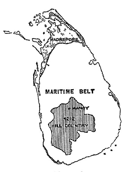
General Form.—In its general outline the island
resembles a pear—and suggests to its admiring inhabitants the
figure of those pearls which from their elongated form are suspended
from the tapering end. When originally upheaved above the ocean its
shape was in all probability nearly circular, with a prolongation in
the direction of north-east. The mountain zone in the south, covering
an area of about 4212 miles[1], may then have formed the largest
proportion of its entire area—and the belt of low lands, known
as the Maritime Provinces, consists to a great extent of soil from
the disintegration of the gneiss, detritus from the hills, alluvium
carried down the rivers, and marine deposits gradually collected on
the shore. But in addition to these, the land has for ages been
slowly rising from the sea, and terraces abounding in marine shells
imbedded in agglutinated sand occur in situations far above
high-water mark. Immediately inland from Point de Galle, the surface
soil rests on a stratum of decomposing coral; and sea shells are
found at a considerable distance from the shore. Further north at
Madampe, between Chilaw and Negombo, the shells of pearl oysters and
other bivalves are turned up by the plough more than ten miles from
the sea.
These recent formations present themselves in a still more
striking form in the north of the island, the greater portion of
which may be regarded as the conjoint production of the coral polypi,
and the currents, which for the greater portion of the year set
impetuously towards the south. Coming laden with alluvial matter
collected along the coast of Coromandel, and meeting with obstacles
south of Point Calimere, they have deposited their burthens on the
coral reefs round Point Pedro; and these gradually raised above the
sea-level, and covered deeply by sand drifts, have formed the
peninsula of Jaffna and the plains that trend westward till they
unite with the narrow causeway of Adam's Bridge—itself raised
by the same agencies, and annually added to by the influences of the
tides and monsoons.[1]
On the north-west side of the island, where the currents are
checked by the obstruction of Adam's Bridge, and still water prevails
in the Gulf of Manaar, these deposits have been profusely heaped, and
the low sandy plains have been proportionally extended; whilst on the
south and east, where the current sweeps unimpeded along the coast,
the line of the shore is bold and occasionally rocky.
This explanation of the accretion and rising of the land is
somewhat opposed to the popular belief that Ceylon was torn from the
main land of India[1] by a convulsion, during which the Gulf of
Manaar and the narrow channel at Paumbam were formed by the
submersion of the adjacent land. The two theories might be reconciled
by supposing the sinking to have occurred at an early period, and to
have been followed by the uprising still in progress. But on a closer
examination of the structure and direction of the mountain system of Ceylon, it exhibits no traces of
submersion. It seems erroneous to regard it as a prolongation of the
Indian chains; it lies far to the east of the line formed by the
Ghauts on either side of the peninsula, and any affinity which it
exhibits is rather with the equatorial direction of the intersecting
ranges of the Nilgherries and the Vindhya. In their geological
elements there is, doubtless, a similarity between the southern
extremity of India and the elevated portions of Ceylon; but there are
also many important particulars in which their specific differences
are irreconcilable with the conjecture of previous continuity. In the
north of Ceylon there is a marked preponderance of aqueous strata,
which are comparatively rare in the vicinity of Cape Comorin; and
whilst the rocks of the former are entirely destitute of organic
remains[2]; fossils, both terrestrial and pelagic, have been found in
the Eastern Ghauts, and sandstone, in some instances, overlays the
primary rocks which compose them. The rich and black soil to the
south of the Nilgherries presents a strong contrast to the red and
sandy earth of the opposite coast; and both in the flora and fauna of
the island there are exceptional peculiarities which suggest a
distinction between it and the Indian continent.
Mountain System.—At whatever period the mountains of
Ceylon may have been raised, the centre of maximum energy must have
been in the vicinity of Adam's Peak, the group immediately
surrounding which has thus acquired an elevation of from six to eight
thousand feet above the sea.[1] The uplifting force seems to have
been exerted from south-west to north-east; and although there is
much confusion in many of the intersecting ridges, the lower ranges,
especially those to the south and west of Adam's Peak, from Saffragam
to Ambogammoa, manifest a remarkable tendency to run in parallel
ridges in a direction from south-east to north-west.
Towards the north, on the contrary, the offsets of the mountain
system, with the exception of those which stretch towards
Trincomalie, radiate to short distances in various directions, and
speedily sink down to the level of the plain. Detached hills of great
altitude are rare, the most celebrated being that of Mihintala, which
overlooks the sacred city of Anarajapoora: and Sigiri is the only
example in Ceylon of those solitary acclivities, which form so
remarkable a feature in the table-land of the Dekkan, starting
abruptly from the plain with scarped and perpendicular sides, and
converted by the Indians into strongholds, accessible only by
precipitous pathways, or steps hewn in the solid rock.
The crest of the Ceylon mountains is of stratified crystalline
rock, especially gneiss, with extensive veins of quartz, and through
this the granite has been everywhere intruded, distorting the riven
strata, and tilting them at all angles to the horizon. Hence at the
abrupt terminations of some of the chains in the district of
Saffragam, plutonic rocks are seen mingled with the dislocated
gneiss. Basalt makes its appearance both at Galle and Trincomalie. In
one place to the east of
Pettigalle-Kanda, the rocks have been broken up in such confusion as
to resemble the effect of volcanic action—huge masses overhang
each other like suddenly-cooled lava; and Dr. Gygax, a Swiss
mineralogist, who was employed by the Government in 1847 to examine
and report on the mineral resources of the district, stated, on his
return, that having seen the volcanoes of the Azores, he found a
"strange similarity at this spot to one of the semi-craters round the
trachytic ridge of Seticidadas, in the island of St. Michael."[1]
Gneiss.—The great geological feature of the island
is, however, the profusion of gneiss, and the various new forms
arising from its disintegration. In the mountains, with the exception
of occasional beds of dolomite, no more recent formations overlie it;
from the period of its first upheaval, the gneiss has undergone no
second submersion, and the soil which covers it in these lofty
altitudes is formed almost entirely by its decay.
In the lower ranges of the hills, gigantic portions of gneiss rise
conspicuously, so detached from the original chain and so rounded by
the action of the atmosphere, aided by their concentric lamellation,
that but for their prodigious dimensions, they might be regarded as
boulders. Close under one of these cylindrical masses, 600 feet in height, and upwards of three
miles in length, the town of Kornegalle, one of the ancient capitals
of the island, has been built; and the great temple of Dambool, the
most remarkable Buddhist edifice in Ceylon, is constructed under the
hollow edge of another, its gilded roof being formed by the inverted
arch of the natural stone. The tendency of the gneiss to assume these
concentric and almost circular forms has been taken advantage of for
this purpose by the Singhalese priests, and some of their most
venerated temples are to be found under the shadow of the overarching
strata, to the imperishable nature of which the priests point as
symbolical of the eternal duration of their faith.[1]
Laterite or "Cabook."—A peculiarity, which is one of
the first to strike a stranger who lands at Galle or Colombo, is the
bright red colour of the streets and roads, contrasting vividly with
the verdure of the trees, and the ubiquity of the fine red dust which
penetrates every crevice and imparts its own tint to every neglected
article. Natives resident in these localities are easily recognisable
elsewhere, by the general hue of their dress. This is occasioned by
the prevalence along the western coast of laterite, or, as the
Singhalese call it, cabook, a product of disintegrated gneiss,
which being subjected to detrition communicates its hue to the
soil.[1]
The transformation of gneiss into laterite in these localities has
been attributed to the circumstance, that those sections of the rock
which undergo transition exhibit grains of magnetic iron ore
partially disseminated through them; and the phenomenon of the
conversion has been explained not by recurrence to the ordinary
conception of mere weathering, which is inadequate, but to the theory
of catalytic action, regard being had to the peculiarity of magnetic
iron when viewed in its chemical formula.[1] The oxide of iron thus
produced communicates its colouring to the laterite, and in
proportion as felspar and hornblende abound in the gneiss, the cabook
assumes respectively a white or yellow hue. So ostensible is the
series of mutations, that in ordinary excavations there is no
difficulty in tracing a continuous connection without definite lines
of demarcation between the soil and the laterite on the one hand, and
the laterite and gneiss rock on the other.[2]
The tertiary rocks which form such remarkable features in the
geology of other countries are almost unknown in Ceylon; and the
"clay-slate, Silurian, old red sandstone, carboniferous, new red
sandstone, oolitic, and cretaceous systems" have not as yet been
recognised in any part of the island.[1] Crystalline limestone in
some places overlies the gneiss, and is worked for oeconomical
purposes in the mountain districts where it occurs.[2]
Along the western coast, from Point-de-Galle to Chilaw, breccia is
found near the shores, from the agglutination of corallines and
shells mixed with sand, and the disintegrated particles of gneiss.
These beds present an appearance very closely resembling a similar
rock, in which human remains have been found imbedded, at the
north-east of Guadaloupe, now in the British Museum.[1] Incorporated
with them there are minute fragments of sapphires, rubies, and
tourmaline, showing that the sand of which the breccia is composed
has been washed down by the rivers from the mountain zone.
NORTHERN PROVINCES.—Coral Formation.—But the
principal scene of the most recent formations is the extreme north of
the island, with the adjoining peninsula of Jaffna. Here the coral
rocks abound far above high-water mark, and extend across the island
where the land has been gradually upraised, from the eastern to the
western shore. The fortifications of Jaffna were built by the Dutch,
from blocks of breccia quarried far from the sea, and still exhibit,
in their worn surface, the outline of the shells and corallines of
which they mainly consist. The roads, in the absence of more solid
substances, are metalled with the same material; as the only other
rock which occurs is a loose description of conglomerate, similar to that at Adam's Bridge and
Manaar.
The phenomenon of the gradual upheaval of these strata is
sufficiently attested by the position in which they appear, and their
altitude above high-water mark; but, in close contiguity with them,
an equally striking evidence presents itself in the fact that, at
various points of the western coast, between the island of Manaar and
Karativoe, the natives, in addition to fishing for chank shells[1] in
the sea, dig them up in large quantities from beneath the soil on the
adjacent shores, in which they are deeply imbedded[2], the land
having since been upraised.
The sand, which covers a vast extent of the peninsula of Jaffna,
and in which the coco-nut and Palmyra-palm grow freely, has been
carried by the currents from the coast of India, and either flung
upon the northern beach in the winter months, or driven into the lake
during the south-west monsoon, and thence washed on shore by the
ripple, and distributed by the wind.
The arable soil of Jaffna is generally of a deep red colour, from
the admixture of iron, and, being largely composed of lime from the
comminuted coral, it is susceptible of the highest cultivation, and
produces crops of great luxuriance. This tillage is carried on
exclusively by irrigation from innumerable wells, into which the
water rises fresh through the madrepore and sand; there being no
streams in the district, unless those percolations can be so called
which make their way underground, and rise through the sands on the
margin of the sea at low water.
Wells in the Coral Rock.—These phenomena occur at
Jaffna, in consequence of the rocks being magnesian limestone and
coral, overlying a bed of sand, and
in some places, where the soil is light, the surface of the ground is
a hollow arch, so that it resounds as if a horse's weight were
sufficient to crush it inwards. This is strikingly perceptible in the
vicinity of the remarkable well at Potoor[1], on the west side of the
road leading from Jaffna to Point Pedro, where the surface of the
surrounding country is only about fifteen feet above the sea-level.
The well, however, is upwards of 140 feet in depth; the water fresh
at the surface, brackish lower down, and intensely salt below.
According to the universal belief of the inhabitants, it is an
underground pool, which communicates with the sea by a subterranean
channel bubbling out on the shore near Kangesentorre, about seven
miles to the north-west.
A similar subterranean stream is said to conduct to the sea from
another singular well near Tillipalli, in sinking which the workmen,
at the depth of fourteen feet, came to the ubiquitous coral, the
crust of which gave way, and showed a cavern below containing the
water they were in search of, with a depth of more than thirty-three
feet. It is remarkable that the well at Tillipalli preserves its
depth at all seasons alike, uninfluenced by rains or drought; and a
steam-engine erected at Potoor, with the intention of irrigating the
surrounding lands, failed to lower it in any perceptible degree.
Other wells, especially some near the coast, maintain their level
with such uniformity as to be inexhaustible at any season, even after
a succession of years of drought—a fact from which it may
fairly be inferred that their supply is chiefly derived by
percolation from the sea.[1]
An idea of the general aspect of Ceylon will be formed from what
has here been described. Nearly four parts of the island are
undulating plains, slightly diversified by offsets from the mountain system which entirely
covers the remaining fifth. Every district, from the depths of the
valleys to the summits of the highest hills, is clothed with
perennial foliage; and even the sand-drifts, to the ripple on the sea
line, are carpeted with verdure, and
sheltered from the sunbeams by the cool shadows of the palm
groves.
SOIL.—But the soil, notwithstanding this wonderful display
of spontaneous vegetation, is not responsive to systematic
cultivation, and is but imperfectly adapted for maturing a constant
succession of seeds and cereal productions.[1] Hence arose the
disappointment which beset the earliest adventurers who opened
plantations of coffee in the hills, on discovering that after the
first rapid development of the plants, delicacy and languor ensued,
which were only to be corrected by returning to the earth, in the
form of manures, those elements with which it had originally been but
sparingly supplied, and which were soon exhausted by the first
experiments in cultivation.
Patenas.—The only spots hitherto found suitable for
planting coffee, are those covered by the ancient forests of the
mountain zone; and one of the most remarkable phenomena in the
oeconomic history of the island, is the fact that the grass lands on
the same hills, closely adjoining the forests and separated from them
by no visible line save the growth of the trees, although they seem
to be identical in the nature of the soil, have hitherto proved to be
utterly insusceptible of reclamation or culture by the coffee
planter.[1] These verdant openings, to which the natives have given
the name of patenas, generally occur about the middle
elevation of the hills, the summits and the hollows being covered
with the customary growth of timber trees, which also fringe the
edges of the mountain streams that trickle down these park-like
openings. The forest approaches boldly to the very edge of a
"patena," not disappearing gradually
or sinking into a growth of underwood, but stopping abruptly and at
once, the tallest trees forming a fence around the avoided spot, as
if they enclosed an area of solid stone. These sunny expanses vary in
width from a few yards to many thousands of acres; in the lower
ranges of the hills they are covered with tall lemon-grass
(Andropogon schoenanthus) of which the oppressive perfume and
coarse texture, when full grown, render it distasteful to cattle,
which will only crop the delicate braird that springs after the
surface has been annually burnt by the Kandyans. Two stunted trees,
alone, are seen to thrive in these extraordinary prairies, Careya
arborea and Emblica officinalis, and these only below an
altitude of 4000 feet; above this, the lemon-grass is superseded by
harder and more wiry species; but the earth is still the same, a
mixture of decomposed quartz largely impregnated with oxide of iron,
but wanting the phosphates and other salts which are essential to
highly organised vegetation.[2] The extent of the patena land is
enormous in Ceylon, amounting to millions of acres; and it is to be
hoped that the complaints which have hitherto been made by the
experimental cultivators of coffee in the Kandyan provinces may
hereafter prove exaggerated, and that much that has been attributed
to the poverty of the soil may eventually be traced to deficiency of
skill on the part of the early planters.
The natives in the same lofty localities find no deficient returns
in the crops of rice, which they raise in the ravines and hollows,
into which the earth from above has been washed by the periodical
rains; but the cultivation of rice is so entirely dependent on the
presence of water, that no inference
can be fairly drawn as to the quality of the soil from the abundance
of its harvest.
The fields on which rice is grown in these mountains form one of
the most picturesque and beautiful objects in the country of the
Kandyans. Selecting an angular recess where two hills converge, they
construct a series of terraces, raised stage above stage, and
retiring as they ascend along the slope of the acclivity, up which
they are carried as high as the soil extends.[1] Each terrace is
furnished with a low ledge in front, behind which the requisite depth
of water is retained during the germination of the seed, and what is
superfluous is permitted to trickle down to the one below it. In
order to carry on this peculiar cultivation the streams are led along
the level of the hills, often from a distance of many miles, with a
skill and perseverance for which the natives of these mountains have
attained a great renown.
In the lowlands to the south, the soil partakes of the character
of the hills from whose detritus it is to a great extent formed. In
it rice is the chief article produced, and for its cultivation the
disintegrated laterite (cabook), when thoroughly irrigated, is
sufficiently adapted. The seed time in the southern section of the
island is dependent on the arrival of the rains in November and May,
and hence the mountains and the maritime districts at their base
enjoy two harvests in each year—the Maha, which is sown
about July and August, and reaped in December and January, the
Yalla which is sown in spring, and reaped from the 15th of
July to the 20th September. But owing to the different description of
seed sown in particular localites, and the extent to which they are
respectively affected by the rains,
the times of sowing and harvest vary considerably on different sides
of the island.[1]
In the north, where the influence of the monsoons is felt with
less force and regularity, and where, to counteract their
uncertainty, the rain is collected in reservoirs, a wider discretion
is left to the husbandman in the choice of season for his
operations.[1] Two crops of grain, however, are the utmost that is
taken from the land, and in many instances only one. The soil near
the coast is light and sandy, but in the great central districts of
Neuera-kalawa and the Wanny, there is found in the midst of the
forests a dark vegetable mould, in which in former times rice was
abundantly grown by the aid of those prodigious artificial works for
irrigation which still form one of the wonders of the island. Many of
the tanks, though partially in ruins, cover an area from ten to
fifteen miles in circumference. They are now generally broken and
decayed; the waters which would fertilise a province are allowed to
waste themselves in the sands, and hundreds of square miles capable
of furnishing food for all the inhabitants of Ceylon are abandoned to
solitude and malaria, whilst rice for the support of the
non-agricultural population is annually imported from the opposite
coast of India.
Talawas.—In these districts of the lowlands,
especially on the eastern coast of the island, and in the country
watered by the Mahawelli-ganga and the other great rivers which flow
towards the Bay of Bengal and the magnificent estuary of Trincomalie,
there are open glades which diversify the forest scenery somewhat
resembling the grassy patenas in the
hills, but differing from them in the character of their soil and
vegetation. These park-like meadows, or, as the natives call them,
"talawas," vary in extent from one to a thousand acres. They are
belted by the surrounding woods, and studded with groups of timber
and sometimes with single trees of majestic dimensions. Through these
pastures the deer troop in herds within gunshot, bounding into the
nearest cover when disturbed.
Lower still and immediately adjoining the sea-coast, the broken
forest gives place to brushwood, with here and there an assemblage of
dwarf shrubs; but as far as the eye can reach, there is one vast
level of impenetrable jungle, broken only by the long sweep of salt
marshes which form lakes in the rainy season, but are dry between the
monsoons, and crusted with crystals that glitter like snow in the
sunshine.
On the western side of the island the rivers have formed broad
alluvial plains, in which the Dutch attempted to grow sugar. The
experiment has been often resumed since; but even here the soil is so
defective, that the cost of artificially enriching it has hitherto
been a serious obstruction to success commercially, although in one
or two instances, plantations on a small scale have succeeded to a
certain extent.
METALS.—The plutonic rocks of Ceylon are but slightly
metalliferous, and hitherto their veins and deposits have been but
imperfectly examined. The first successful survey attempted by the
Government was undertaken during the administration of Viscount
Torrington, who, in 1847, commissioned Dr. Gygax to proceed to the
hill district south of Adam's Peak, and furnish a report on its
products. His investigations extended from Ratnapoora, in a
south-eastward direction, to the mountains which overhang Bintenne,
but the results obtained did not greatly enlarge the knowledge
previously possessed. He established the existence of tin in the alluvium along the base of the
mountains to the eastward towards Edelgashena; but so circumstanced,
owing to the flow of the Walleway river, that, without lowering its
level, the metal could not be extracted with advantage. The position
in which it occurs is similar to that in which tin ore presents
itself in Saxony; and along with it, the natives, when searching for
gems, discover garnets, corundum, white topazes, zircon, and
tourmaline.
Gold is found in minute particles at Gettyhedra, and in the
beds of the Maha Oya and other rivers flowing towards the west.[1]
But the quantity hitherto discovered has been too trivial to reward
the search. The early inhabitants of the island were not ignorant of
its presence; but its occurrence on a memorable occasion, as well as
that of silver and copper, is recorded in the Mahawanso as a
miraculous manifestation, which signalised the founding of one of the
most renowned shrines at the ancient capital.[2]
Nickel and cobalt appear in small quantities in
Saffragam, and the latter, together with rutile (an oxide of
titanium) and wolfram, might find a market in China for the
colouring of porcelain.[1] Tellurium, another rare and
valuable metal, hitherto found only in Transylvania and the Ural, has
likewise been discovered in these
mountains, Manganese is abundant, and Iron occurs in
the form of magnetic iron ore, titanite, chromate, yellow hydrated,
per-oxide and iron pyrites. In most of these, however, the metal is
scanty, and the ores of little comparative value, except for the
extraction of manganese and chrome. "But there is another description
of iron ore," says Dr. Gygax, in his official report to the Ceylon
Government, "which is found in vast abundance, brown and compact,
generally in the state of carbonate, though still blended with a
little chrome, and often molybdena. It occurs in large masses and
veins, one of which extends for a distance of fifteen miles; from it
millions of tons might be smelted, and when found adjacent to fuel
and water-carriage, it might be worked to a profit. The quality of
the iron ore found in Ceylon is singularly fine; it is easily
smelted, and so pure when reduced as to resemble silver. The rough
ore produces from thirty to seventy-five per cent., and
on an average fully fifty. The iron wrought from it requires
no puddling, and, converted into steel, it cuts like a diamond. The
metal could be laid down in Colombo at £6 per ton, even supposing the
ore to be brought thither for smelting, and prepared with English
coal; but anthracite being found upon the spot, it could be
used in the proportion of three to one of the British coal; and the
cost correspondingly reduced."
Remains of ancient furnaces are met with in all directions
precisely similar to those still in use amongst the natives. The
Singhalese obtain the ore they require without the trouble of mining;
seeking a spot where the soil has been loosened by the latest rains,
they break off a sufficient quantity, which, in less than three
hours, they convert into iron by the simplest possible means. None of
their furnaces are capable of smelting more than twenty pounds of
ore, and yet this quantity yields from seven to ten pounds of good
metal.
The anthracite alluded to by Dr. Gygax is found in the southern range of hills near Nambepane,
in close proximity to rich veins of plumbago, which are
largely worked in the same district, and the quantity of the latter
annually exported from Ceylon exceeds a thousand tons.
Molybdena is found in profusion dispersed through many rocks
in Saffragam, and it occurs in the alluvium in grey scales, so nearly
resembling plumbago as to be commonly mistaken for it. Kaolin,
called by the natives Kirimattie, appears at Neuera-ellia at
Hewahette, Kaduganawa, and in many of the higher ranges as well as in
the low country near Colombo; its colour is so clear as to suit for
the manufacture of porcelain[1]; but the difficulty and cost of
carriage render it as yet unavailing for commerce, and the only use
to which it has hitherto been applied is to serve for whitewash
instead of lime.
Nitre has long been known to exist in Ceylon, where the
localities in which it occurs are similar to those in Brazil. In
Saffragam alone there are upwards of sixty caverns known to the
natives, from which it may be extracted, and others exist in various
parts of the island, where the abundance of wood to assist in its
lixiviation would render that process easy and profitable. Yet so
sparingly has this been hitherto attempted, that even for purposes of
refrigeration, crude saltpetre is still imported from India.[1]
GEMS.—But the chief interest which attaches to the mountains and rocks of this region, arises
from the fact that they contain those mines of precious stones
which from time immemorial have conferred renown on Ceylon. The
ancients celebrated the gems as well as the pearls of "Taprobane;"
the tales of mariners returning from their eastern expeditions
supplied to the story-tellers of the Arabian Nights their fables of
the jewels of "Serendib;" and the travellers of the Middle Ages, on
returning to Europe, told of the "sapphires, topazes, amethysts,
garnets, and other costly stones" of Ceylon, and of the ruby which
belonged to the king of the island,
"a span in length, without a flaw, and brilliant beyond
description."[1]
The extent to which gems are still found is sufficient to account
for the early traditions of their splendour and profusion; and
fabulous as this story of the ruby of the Kandyan kings may be, the
abundance of gems in Saffragam has given to the capital of the
district the name of Ratnapoora, which means literally "the
city of rubies."[1] They are not, however, confined to this quarter
alone, but quantities are still found on the western plains between
Adam's Peak and the sea, at Neuera-ellia, in Oovah, at Kandy, at
Mattelle in the central province, and at Ruanwelli near Colombo, at
Matura, and in the beds of the rivers eastwards towards the ancient
Mahagam.
But the localities which chiefly supply the Ceylon gems are the
alluvial plains at the foot of the stupendous hills of Saffragam, in
which the detritus of the rocks has been carried down and intercepted
by the slight elevations that rise at some distance from the base of
the mountains. The most remarkable of these gem-bearing deposits is
in the flat country around Ballangodde, south-east of Ratnapoora; but
almost every valley in communication with the rocks of the higher
ranges contains stones of more or less value, and the beds of the
rivers flowing southward from the mountain chain are so rich in
comminuted fragments of rubies, sapphires, and garnets[1], that their
sands in some places are used by
lapidaries in polishing the softer stones, and in sawing the
elephants' grinders into plates. The cook of a government officer at
Galle recently brought to him a ruby about the size of a small pea,
which he had taken from the crop of a fowl.
Of late years considerable energy has been shown by those engaged
in the search for gems; neglected districts have been explored, and
new fields have been opened up at such places as Karangodde and
Weraloopa, whence stones have been taken of unusual size and
value.
It is not, however, in the recent strata of gravel, nor in those
now in process of formation, that the natives search for gems. They
penetrate these to the depth of from ten to twenty feet, in order to
reach a lower deposit distinguished by the name of Nellan, in
which the objects of their search are found. This is of so early a
formation that it underlies the present beds of rivers, and is
generally separated from them or from the superincumbent gravel by a
hard crust (called Kadua), a few inches in thickness, and so
consolidated as to have somewhat the appearance of laterite, or of
sun-burnt brick. The nellan is for the most part horizontal, but
occasionally it is raised into an incline as it approaches the base
of the hills. It appears to have been deposited previous to the
eruption of the basalt, on which in some places it reclines, and to
have undergone some alteration from the contact. It consists of
water-worn pebbles firmly imbedded in clay, and occasionally there
occur large lumps of granite and gneiss, in the hollows under which,
as well as in "pockets" in the clay (which from their shape the
natives denominate "elephants'
footsteps") gems are frequently found in groups as if washed in by
the current.
The persons who devote themselves to this uncertain pursuit are
chiefly Singhalese, and the season selected by them for "gemming" is
between December and March, when the waters are low.[1] The poorer
and least enterprising adventurers betake themselves to the beds of
streams, but the most certain though the most costly course is to
sink pits in the adjacent plains, which are consequently indented
with such traces of recent explorers. The upper gravel is pierced,
the covering crust is reached and broken through, and the nellan
being shovelled into conical baskets and washed to free it from the
sand, the residue is carefully searched for whatever rounded crystals
and minute gems it may contain.
It is strongly characteristic of the want of energy in the
Singhalese, that although for centuries those alluvial plains and
watercourses have been searched without ceasing, no attempt appears
to have been made to explore the rocks themselves, in the debris of
which the gems have been brought down by the rivers. Dr. Gygax says:
"I found at Hima Pohura, on the south-eastern decline of the
Pettigalle-Kanda, about the middle of the descent, a stratum of grey
granite containing, with iron pyrites and molybdena, innumerable
rubies from one-tenth to a fourth of an inch in diameter, and of a
fine rose colour, but split and falling to powder. It is not an
isolated bed of minerals, but a regular stratum extending probably to
the same depth and distance as the other granite formations. I
followed it as far as was practicable for close examination, but
everywhere in the lower part of the valley I found it so decomposed
that the hammer sunk in the rock, and even bamboos were growing on
it. On the higher ground near some
small round hills which intercept it, I found the rubies changed into
brown corundum. Upon the hills themselves the trace was lost, and
instead of a stratum there was merely a wild chaos of blocks of
yellow granite. I carefully examined all the minerals which this
stratum contains,—felspar, mica, and quartz molybdena, and iron
pyrites,—and I found all similar to those I had previously got
adhering to rough rubies offered for sale at Colombo. I firmly
believe that in such strata the rubies of Ceylon are originally
found, and that those in the white and blue clay at Ballangodde
and Ratnapoora are but secondary deposits. I am further inclined to
believe that these extend over the whole island, although often
intercepted and changed in their direction by the rising of the
yellow granite." It is highly probable that the finest rubies are to
be found in them, perfect and unchanged by decomposition; and that
they are to be obtained by opening a regular mine in the rock like
the ruby mine of Badakshan in Bactria described by Sir Alexander
Burnes. Dr. Gygax adds that having often received the minerals of
this stratum with the crystals perfect, he has reason to believe that
places are known to the natives where such mines might be opened with
confidence of success.
Rubies both crystalline and amorphous are also found in a
particular stratum of dolomite at Bullatotte and Badulla, in which
there is a peculiar copper-coloured mica with metallic lustre.
Star rubies, the "asteria" of Pliny (so called from their
containing a movable six-rayed star), are to be had at Ratnapoora and
for very trifling sums. The blue tinge which detracts from the value
of the pure ruby, whose colour should resemble "pigeon's blood," is
removed by the Singhalese, by enveloping the stone in the lime of a
calcined shell and exposing it to a high heat. Spinel of
extremely beautiful colours is found in the bed of the
Mahawelli-ganga at Kandy, and from the locality it has obtained the
name of Candite.
It is strange that although the sapphire is found in all
this region in greater quantity than the ruby, it has never yet been
discovered in the original matrix, and the small fragments which
sometimes occur in dolomite show that there it is but a deposit. From
its exquisite colour and the size in which it is commonly found, it
forms by far the most valuable gem of the island. A piece which was
dug out of the alluvium within a few miles of Ratnapoora in 1853, was
purchased by a Moor at Colombo, in whose hands it was valued at
upwards of four thousand pounds.
The original site of the oriental topaz is equally unknown
with that of the sapphire. The Singhalese rightly believe them to be
the same stone only differing in colour, and crystals are said to be
obtained with one portion yellow and the other blue.
Garnets of inferior quality are common in the gneiss, but
finer ones are found in the hornblende rocks.
Cinnamon-stone (which is properly a variety of garnet) is
so extremely abundant, that vast rocks containing it in profusion
exist in many places, especially in the alluvium around Matura; and
at Belligam, a few miles east from Point-de-Galle, a vast detached
rock is so largely composed of cinnamon-stones that it is carried off
in lumps for the purpose of extracting and polishing them.
The Cat's-eye is one of the jewels of which the Singhalese
are especially proud, from a belief that it is only found in their
island; but in this I apprehend they are misinformed, as specimens of
equal merit have been brought from Quilon and Cochin on the southern
coast of Hindostan. The cat's-eye is a greenish translucent quartz,
and when cut en cabochon it presents a moving internal
reflection which is ascribed to the presence of filaments of
asbestos. Its perfection is estimated by the natives in proportion to
the narrowness and sharpness of the ray and the pure olive-tint of
the ground over which it plays.
Amethysts are found in the gneiss, and some discoloured
though beautiful specimens in syenite; they are too common to be
highly esteemed. The "Matura Diamonds," which are largely used by the
native jewellers, consist of zircon, found in the syenite not only
uncoloured, but also of pink and yellow tints, the former passing for
rubies.
But one of the prettiest though commonest gems in the island is
the "Moon-stone," a variety of pearly adularia presenting chatoyant
rays when simply polished. They are so abundant that the finest
specimens may be bought for a few shillings. These, with aqua
marina, a bad description of opal rock crystal in
extremely large pieces, tourmaline, and a number of others of
no great value, compose the list of native gems procurable in
Ceylon.[1] Diamonds, emeralds, agates, carnelians, opal and
turquoise, when they are exhibited by the natives, have all been
imported from India.
During the dynasty of the Kandyan sovereigns, the right of digging
for gems was a royalty reserved jealously for the King; and the
inhabitants of particular villages were employed in their search
under the superintendence of hereditary officers, with the rank of
"Mudianse." By the British Government the monopoly was early
abolished as a source of revenue, and no license is now required by
the jewel-hunters.
Great numbers of persons of the worst-regulated habits are
constantly engaged in this exciting and precarious trade; and serious
demoralisation is engendered amongst the villagers by the idle and
dissolute adventurers who resort to Saffragam. Systematic industry
suffers, and the cultivation of the land is frequently neglected whilst its owners are absorbed in
these speculative and tantalising occupations.
The products of their searches are disposed of to the Moors, who
resort to Saffragam from the low country, carrying up cloth and salt,
to be exchanged for gems and coffee. At the annual Buddhist festival
of the Pera-hara, a jewel-fair is held at Ratnapoora, to which the
purchasers resort from all parts of Ceylon. Of late years, however,
the condition of the people in Saffragam has so much improved that it
has become difficult to obtain the finest jewels, the wealthier
natives preferring to retain them as investments: they part with them
reluctantly, and only for gold, which they find equally convenient
for concealment.[1]
The lapidaries who cut and polish the stones are chiefly Moors,
but their tools are so primitive, and their skill so deficient, that
a gem generally loses in value by having passed through their hands.
The inferior kinds, such as cinnamon-stones, garnets, and tourmaline,
are polished by ordinary artists at Kandy, Matura, and Galle; but the
more expert lapidaries, who cut rubies and sapphires, reside chiefly
at Caltura and Colombo.
As a general rule, the rarer gems are less costly in Europe than
in Colombo. In London and Paris the quantities brought from all parts
of the world are sufficient to establish something like a market
value; but, in Ceylon, the supply is so uncertain that the price is
always regulated at the moment by the rank and wealth of the
purchaser. Strange to say, too, there is often an unwillingness even
amongst the Moorish dealers to sell the rarest and finest specimens;
those who are wealthy being anxious to retain them, and few but
stones of secondary value are offered for sale. Besides, the Rajahs
and native Princes of India, amongst whom the passion for jewels is universal, are known to give such
extravagant prices that the best are always sent to them from
Ceylon.
From the Custom House returns it is impossible to form any
calculation as to the value of the precious stones exported from the
island. A portion only appears, even of those sent to England, the
remainder being carried away by private parties. Of the total number
found, one-fourth is probably purchased by the natives themselves,
more than one-half is sent to the Continent of India, and the
remainder represents the export to Europe. Computed in this way, the
quantity of precious stones found in the island may be estimated at
10,000l. per annum.
RIVERS.—From the mountainous configuration of the country
and the abundance of the rains, the rivers are large and numerous in
the south of the island—ten of considerable magnitude flowing
into the sea on the west coast, between Point-de-Galle and Manaar,
and a still greater number, though inferior in volume, on the east.
In the low country, where the heat is intense and evaporation
proportionate, they derive little of their supply from springs; and
the passing showers which fall scarcely more than replace the
moisture drawn by the sun from the parched and thirsty soil.
Hence in the plains there are comparatively few rivulets or
running streams; the rivers there flow in almost solitary lines to
the sea; and the beds of their minor affluents serve only to conduct
to them the torrents which descend at the change of each monsoon,
their channels at other times being exhausted and dry. But in their
course through the hills, and the broken ground at their base, they
are supplied by numerous feeders, which convey to them the frequent
showers that fall in high altitudes. Hence their tracks are through
some of the noblest scenery in the world; rushing through ravines and
glens, and falling over precipitous rocks in the depths of wooded
valleys, they exhibit a succession of
rapids, cataracts, and torrents, unsurpassed in magnificence and
beauty. On reaching the plains, the boldness of their march and the
graceful outline of their sweep are indicative of the little
obstruction opposed by the sandy and porous soil through which they
flow. Throughout their entire course dense forests shade their banks,
and, as they approach the sea, tamarisks and over-arching mangroves
mark where their waters mingle with the tide.
Of all the Ceylon rivers, the most important by far is the
Mahawelli-ganga—the Ganges of Ptolemy—which, rising in
the south near Adam's Peak, traverses more than one-third of the
mountain zone[1], drains upwards of four thousand square miles, and
flows into the sea by a number of branches, near the noble harbour of
Trincomalie. The following table gives a comparative view of the
magnitude of the rivers that rise in the hills, and of the extent of
the low country traversed by each of them:—
|
Embouchure. |
Square Miles drained in Mountain Zone. |
Square Miles drained in the low Country, about |
Length of Course of the main Stream. |
| Mahawelii-ganga |
near Trincomalie |
1782 |
2300 |
134 |
| Kirinde |
at Mahagan |
34 |
300 |
62 |
| Wellawey |
near Hambangtotte |
263 |
500 |
69 |
| Neivalle |
at Matura |
64 |
200 |
42 |
| (Three Rivers) |
near Tangalle |
56 |
200 |
|
| Gindura |
near Galle |
180 |
200 |
59 |
| Kalu-oya |
at Caltura |
841 |
300 |
72 |
| Kalany |
Colombo |
692 |
200 |
84 |
| The Kaymel or Mahaoya |
near Negombo |
253 |
200 |
68 |
| Dederoo-oya |
near Chilaw |
38 |
700 |
70 |
|
|
4212 |
5100 |
|
In addition to these, there are a number of large rivers which
belong entirely to the plains in the northern and south-eastern
portions of the island, the principal
of which are the Arive and the Moderegam, which flow into the Gulf of
Manaar; the Kala-oya and the Kanda-lady, which empty themselves into
the Bay of Calpentyn; the Maniek or Kattragam, and the Koombookgam,
opposite to the Little Bass rocks and the Naveloor, the Chadawak, and
Arookgam, south of Batticaloa. The extent of country drained by these
latter streams is little short of thirteen thousand square miles.
Very few of the rivers of Ceylon are navigable, and these only by
canoes and flat-bottomed paddy boats, which ascend some of the
largest for short distances, till impeded by the rapids, occasioned
by rocks in the lowest range of the hills. In this way the Niwalle at
Matura can be ascended for about fifteen miles, as far as Wellehara;
the Kalu-ganga can be traversed from Caltura to Ratnapoora; the
Bentotte river for sixteen miles to Pittagalla; and the Kalany from
Colombo to the foot of the mountains near Ambogammoa. The
Mahawelli-ganga is navigable from Trincomalie to within a short
distance of Kanda[1]; and many of the lesser streams, the Kirinde and
Wellawey in the south, and the Kaymel, the Dedroo-oya, and the Aripo
river on the west of the island, are used for short distances by
boats.
All these streams are liable, during the fury of the monsoons, to
be surcharged with rain till they overflow their banks, and spread in
wide inundations over the level country. On the subsidence of these
waters, the intense heat of the sun acting on the surface they leave
deserted, produces a noxious and fatal malaria. Hence the rivers of
Ceylon present the curious anomaly, that whilst the tanks and
reservoirs of the interior diffuse a healthful coolness around, the
running water of the rivers is prolific of fevers; and in some
seasons so deadly is the pestilence that the Malabar coolies, as well
as the native peasantry, betake
themselves to precipitate flight.[1]
Few of the larger rivers have been bridged, except those which
intersect the great high roads from Point-de-Galle to Colombo, and
thence to Kandy. Near the sea this has been effected by timber
platforms, sustained by piles sufficiently strong to withstand the
force of the floods at the change of each monsoon. A bridge of boats
connects each side of the Kalany, and on reaching the Mahawelli-ganga
at Peradenia, one of the most picturesque structures on the island is
a noble bridge of a single arch, 205 feet in span, chiefly
constructed of satin-wood, and thrown across the river by General
Fraser in 1832.
On reaching the margin of the sea, an appearance is presented by
the outline of the coast, near the embouchures of the principal
rivers, which is very remarkable. It is common to both sides of the
island, though it has attained its greatest development on the east.
In order to comprehend its formation, it is necessary to observe that
Ceylon lies in the course of the ocean currents in the Bay of Bengal,
which run north or south according to the prevalence of the monsoon,
and with greater or less velocity in proportion to its force at
particular periods.
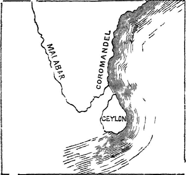
CURRENT IN THE NE MONSOON.
In the beginning and during the strength of the northeast monsoon
the current sets strongly along the coast of Coromandel to the
southward, a portion of it frequently entering Palks Bay to the north of Ceylon; but the main stream
keeping invariably to the east of the island, runs with a velocity of
from one and a half to two miles an hour, and after passing the Great
Bass, it keeps its course seaward. At other times, after the monsoon
has spent its violence, the current is weak, and follows the line of
the land to the westward as far as Point-de-Galle, or even to
Colombo.
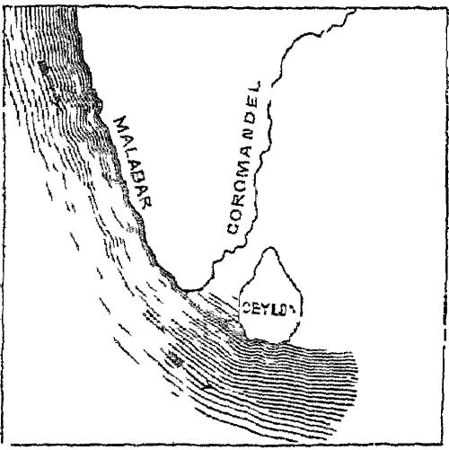
CURRENT IN THE S.W. MONSOON.
In the south-west monsoon the current changes its direction; and,
although it flows steadily to the northward, its action is very
irregular and unequal till it readies the Coromandel coast, after
passing Ceylon. This is accounted for by the obstruction opposed by
the headlands of Ceylon, which so intercept the stream that the
current, which might otherwise set into the Gulf of Manaar, takes a
south-easterly direction by Galle and Donedra Head.[1]
There being no lakes in Ceylon[1], in the still waters of which
the rivers might clear themselves of the earthy matter swept along in
their rapid course from the hills, they arrive at the beach laden
with sand and alluvium, and at their junction with the ocean being
met transversely by the gulf-streams, the sand and soil with which
they are laden, instead of being carried out to sea, are heaped up in
bars along the shores, and these, being augmented by similar deposits
held in suspension by the currents,
soon extend to north, and south, and force the rivers to flow behind
them in search of a new outlet.
These formations once commenced, their growth proceeds with
rapidity, more especially on the east side of the island; as the
southern current in skirting the Coromandel coast brings with it
quantities of sand, which it deposits, in tranquil weather, and this
being carried by the wind is piled in heaps from Point Pedro to
Hambangtotte. Hence at the latter point hills are formed of such
height and dimensions, that it is often necessary to remove buildings
out of their line of encroachment.[1]
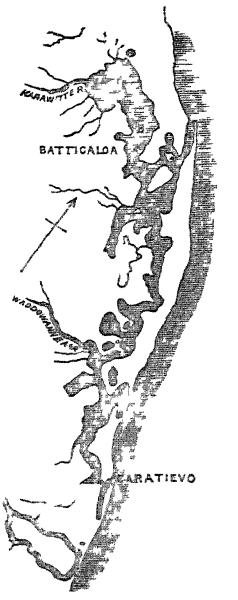
GOBBS ON THE EAST COAST
At the mouths of the rivers the bars thus created generally follow
the direction of the current, and the material deposited being dried
and partially consolidated in the intervals between the tides, long
embankments are gradually raised, behind which the rivers flow for
considerable distances before entering the sea. Occasionally these
embouchures become closed by the accumulations without, and the
pent-up water assumes the appearance of a still canal, more or less
broad according to the level of the beach, and extending for miles
along the coast, between the mainland and the new formations. But
when swollen by the rains, if not assisted by artificial outlets to
escape, they burst new openings for themselves, and not unfrequently
they leave their ancient channels converted into shallow lagoons
without any visible exit. Examples of these formations present themselves on the east side of Ceylon
at Nilla-velle, Batticaloa, and a number of other places north and
south of Trincomalie.
On the west coast embankments of this kind, although frequent are
less conspicuous than on the east, owing chiefly to the comparative
weakness of the current. For six months in the year during the
north-east monsoon that side of the island is exempt from a current
in any direction, and for the remaining six, the current from the
south not only rarely affects the Gulf of Manaar, but as it flows out
of the Indian Ocean it brings no earthy deposits. In addition to
this, the surf during the south-west monsoon rolls with such
turbulence on the level beach between Colombo and Point-de-Galle, as
in a great degree to disperse the accumulations of sand brought down
by the rivers, or heaped up by the tide, when the wind is off the
land. Still, many of the rivers are thrown back by embankments, and
after forming tortuous lakes flow for a long distance parallel to the
shore, before finding an escape for their waters. Examples of this
occur at Pantura, to the south of Colombo, and at Negombo, Chilaw,
and elsewhere to the north of it.
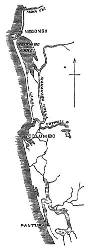
GOBBS ON THE WEST COAST
In process of time these banks of sand[1] become covered with vegetation; herbaceous plants, shrubs,
and finally trees peculiar to saline soils make their appearance
in succession, and as these decay,
their decomposition generates a sufficiency of soil to sustain
continued vegetation.
The process of this conversion may be seen in all its stages at
various points along the coast of Ceylon.
The margin of land nearest to the water is first taken possession
of by a series of littoral plants, which apparently require a large
quantity of salt to sustain their vegetation. These at times are
intermixed with others, which, though found further inland, yet
flourish in perfection on the shore. On the northern and
north-western coasts the glass worts[1] and salt worts[2] are the
first to appear on the newly raised banks, and being provided with
penetrating roots, a breakwater is thus early secured, and the drier
sand above becomes occupied with creeping plants which in their turn
afford shelter to a third and erect class.
The Goat's-foot Ipomoea[1], which appears to encircle the world,
abounds on these shores, covering the surface to the water's edge
with its procumbent branches, which sending down roots from every
joint serve to give the bank its first firmness, whilst the profusion
of its purple-coloured flowers contrasts strikingly with its dark
green foliage.
Along with the Ipomoea grow two species of beans[1] each endowed
with a peculiar facility for reproduction, thus consolidating the
sands into which they strike; and the moodu-gaeta-kola[2] (literally
the "jointed seashore plant,") with pink flowers and thick succulent
leaves.
Another plant which performs an important function in the fertilisation of these arid formations, is the
Spinifex squarrosus, the "water pink," as it is sometimes
called by Europeans. The seeds of this plant are contained in a
circular head, composed of a series of spine-like divisions, which
radiate from the stalk in all directions, making the diameter of the
whole about eight to nine inches. When the seeds are mature, and
ready for dispersion, these heads become detached from the plant, and
are carried by the wind with great velocity along the sands, over the
surface of which they are impelled on their elastic spines. One of
these balls may be followed by the eye for miles as it hurries along
the level shore, dropping its seeds as it rolls, which speedily
germinate and strike root where they fall. The globular heads are so
buoyant as to float lightly on the water, and the uppermost spines
acting as sails, they are thus carried across narrow estuaries to
continue the process of embanking on newly-formed sand bars. Such an
organisation irresistibly suggests the wonderful means ordained by
Providence to spread this valuable plant along the barren beach to
which no seed-devouring bird ever resorts; and even the unobservant
natives, struck by its singular utility in resisting the
encroachments of the sea, have recorded their admiration by
conferring on it the name of Maha-Rawana roewula,—"the
great beard of Rawana or Rama."
The banks being thus ingeniously protected from the action of the
air above, and of the water at their base, other herbaceous plants
soon cover them in quick succession, and give the entire surface the
first aspect of vegetation. A little retired above high water are to
be found a species of Aristolochia[1], the Sayan[2], or
Choya, the roots of which are
the Indian Madder (in which, under the Dutch Government, some tribes
in the Wanny paid their tribute); the gorgeous Gloriosa
superba, the beautiful Vistnu-karandi[3] with its
profusion of blue flowers, which remind one of the English
"Forget-me-not," and the thickly-matted verdure of the
Hiramana-doetta[4], so well adapted for imparting consistency
to the soil. In the next stage low shrubs make their appearance,
their seeds being drifted by the waves and wind, and taking ready
root wherever they happen to rest. The foremost of these are the
Scævolas[5] and Screw Pines[6], which grow luxuriantly within the
actual wash of the tide, while behind them rises a dense growth of
peculiar plants, each distinguished by the Singhalese by the prefix
of "Moodu," to indicate its partiality for the sea.[7]
Where the sand in the lagoons and estuaries is more or less
mingled with the alluvium brought down by the rivers, there are
plants of another class which are equally characteristic. Amongst
these the Mangroves[1] take the first place in respect to their mass
of vegetation; then follow the Belli-patta[2] and Suriya-gaha[3],
with their large hibiscus-like flowers; the Tamarisks[4]; the
Acanthus[5], with its beautiful blue petals and holly-like leaves;
the Water Coco-nut[6]; the Ægiceras and Hernandia[7], with its
sonorous fruits; while the dry sands above are taken possession of by
the Acacias, Salvadora Persica (the true mustard-tree of Scripture[8], which, here attains a height
of forty feet), Ixoras, and the numerous family of Cassias.
Lastly, after a sufficiency of earth has been formed by the decay
of frequent successions of their less important predecessors, the
ground becomes covered by trees of ampler magnitude, most of which
are found upon the adjacent shores of the mainland—the
Margoza[1], from whose seed the natives express a valuable oil; the
Timbiri[2], with the glutinous nuts with which the fishermen "bark"
their nets; the Cashu-nut[3]; the Palu[4], one of the most valuable
timber trees of the Northern Provinces; and the Wood-apple[5], whose
fruit is regarded by the Singhalese as a specific for dysentery.
But the most important fact connected with these recently formed
portions of land, is their extraordinary suitability for the growth
of the coco-nut, which requires the sea-air (and in Ceylon at least
appears never to attain its full luxuriance when removed to any
considerable distance from it)[1], and which, at the same time,
requires a light and sandy soil, and
the constant presence of water in large quantities. All these
essentials are combined in the sea-belts here described, lying as
they do between the ocean on the one side and the fresh-water lakes
formed by the great rivers on the other, thus presenting every
requisite of soil and surface. It is along a sand formation of this
description, about forty miles long and from one to three miles
broad, that thriving coco-nut plantations have been recently
commenced at Batticaloa. At Calpentyn, on the western coast, a like
formation has been taken advantage of for the same purpose. At Jaffna
somewhat similar peculiarities of soil and locality have been seized
on for this promising cultivation; and, generally, along the whole
seaborde of Ceylon to the south and west, the shore for the breadth
of one or two miles exhibits almost continuous groves of coco-nut
palms.
Harbours.—With the exception of the estuaries above
alluded to, chiefly in the northern section of the island, the
outline of the coast is interrupted by few sinuosities. There are no
extensive inlets, or bays, and only two harbours—that of
Point-de-Galle which, in addition to being incommodious and
small, is obstructed by coral rocks, reefs of which have been
upreared to the surface, and render the entrance critical to strange
ships[1]; and the magnificent basin of Trincomalie, which, in extent,
security, and beauty, is unsurpassed by any haven in the world.
Tides.—The variation of the tides is so slight that
navigation is almost unaffected by it. The ordinary rise and fall is from 18 to 24 inches, with an
increase of about a third at spring tides. High water is later on the
eastern than on the western coast; occurring, on full and new moon, a
little after eleven o'clock at Adam's Bridge, about 1 o'clock at
Colombo, and 1.25 at Galle, whilst it attains its greatest elevation
between 5 and 6 o'clock in the harbour of Trincomalie.
Red infusoria.—On both sides of the island (but most
frequently at Colombo), during the south-west monsoon, a broad
expanse of the sea assumes a red tinge, considerably brighter than
brick-dust; and this is confined to a space so distinct that a line
seems to separate it from the green water which flows on either side.
Observing that the whole area changed its position without parting
with any portion of its colouring, I had some of the water brought on
shore, and, on examination with the microscope, it proved to be
filled with infusoria, probably similar to those which have
been noticed near the shores of South America, and whose abundance
has imparted a name to the "Vermilion Sea" off the coast of
California.
THE POPULATION OF CEYLON, of all races, was, in 1857, 1,697,975;
but this was exclusive of the military and their families, both
Europeans and Malays, which together amounted to 5,430; and also of
aliens and other casual strangers, forming about 25,000 more.
The particulars are as follow:—
| Provinces |
Whites. |
Coloured. |
Total. |
Population to the sq. mile. |
|
Males. |
Females. |
Males. |
Females. |
Males. |
Females. |
|
| Western. |
1,293 |
1,246 |
293,409 |
259,106 |
294,702 |
260,352 |
146.59 |
| N. Western |
21 |
11 |
100,807 |
96,386 |
100,828 |
96,397 |
59.93 |
| Southern |
238 |
241 |
156,900 |
149,649 |
157,138 |
149,890 |
143.72 |
| Eastern |
201 |
143 |
39,923 |
35,531 |
40,124 |
35,674 |
16.08 |
| Northern |
387 |
362 |
153,062 |
148,678 |
153,449 |
149,040 |
55.85 |
| Central |
468 |
204 |
143,472 |
116,237 |
143,940 |
116,441 |
52.57 |
|
2,608 |
2,207 |
887,573 |
805,587 |
890,181 |
807,794 |
69.73 |


