Larger versions of most illustrations may be seen by right-clicking them
and selecting an option to view them separately, or by double-tapping and/or
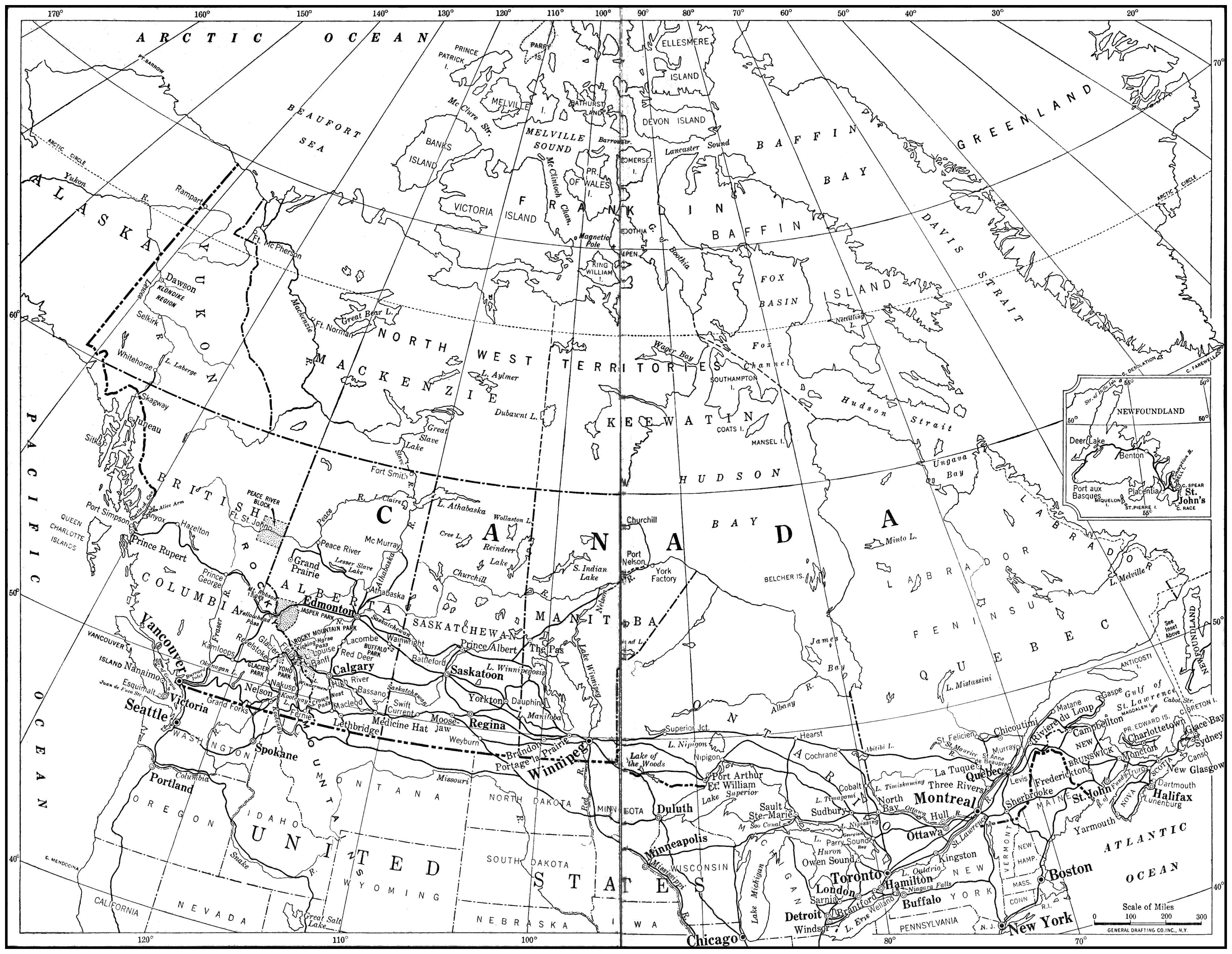
stretching them. A higher-resolution version of the map may
be seen by clicking or right-clicking (Larger) beneath it.
Other notes will be found near the end of this ebook.
WITH THE AUTHOR ON THE SPOT AND
THE READER IN HIS HOME, BASED
ON THREE HUNDRED THOUSAND
MILES OF TRAVEL OVER
THE GLOBE
“READING CARPENTER IS SEEING THE WORLD”
WHERE MAN FEELS CLOSE TO GOD
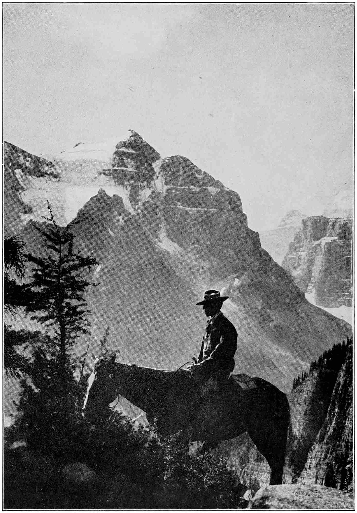
Canada shares with the United States the glories of the Rockies,
which invite the traveller ever westward and, once seen, cast a spell that
is never shaken off.
CARPENTER’S WORLD TRAVELS
CANADA AND
NEWFOUNDLAND
BY
FRANK G. CARPENTER LITT.D., F.R.G.S.
WITH 116 ILLUSTRATIONS
FROM ORIGINAL PHOTOGRAPHS
GARDEN CITY NEW YORK DOUBLEDAY, PAGE & COMPANY
1924
COPYRIGHT, 1924, BY
FRANK G. CARPENTER
ALL RIGHTS RESERVED
PRINTED IN THE UNITED STATES
AT
THE COUNTRY LIFE PRESS, GARDEN CITY, N. Y. First Edition
ACKNOWLEDGMENTS
In the publication of this volume on my travels in
Canada and Newfoundland, I wish to thank the
Secretary of State for letters which have given me the
assistance of our official representatives in the countries
visited. I thank also the Secretary of Agriculture
and our Secretary of Labour for appointing me an Honourary
Commissioner of their Departments in foreign
lands. Their credentials have been of great value, making
accessible sources of information seldom opened to the
ordinary traveller.
To the officials of the Dominions of Newfoundland and
Canada I desire to express my thanks for exceptional
courtesies which greatly aided me in my investigations.
I would also thank Mr. Dudley Harmon, my editor,
and Miss Ellen McB. Brown and Miss Josephine Lehmann,
my associate editors, for their assistance and coöperation
in the revision of notes dictated or penned by me on the
ground.
While nearly all of the illustrations in Carpenter’s World
Travels are from my own negatives, those in the book
have been supplemented by photographs from the official
collections of the Canadian government, the Canadian
National Lines, the Canadian Pacific Railway, the Publishers’
Photo Service, the Holloway Studios of St. John’s,
N. F., and Lomen Bros., of Nome, Alaska.
CANADA AND NEWFOUNDLAND — CHAPTER I JUST A WORD BEFORE WE START
The country through which we shall travel in this
book is the biggest on the North American continent.
The Dominion of Canada is almost as
big as all Europe. It is bigger than the United
States and all its outlying possessions. It is thirty times
as big as Great Britain and Ireland, and it has one third
of all the land over which the Union Jack flies.
We shall find the country one of magnificent distances
and wide, open spaces. It lies just over our boundary and
reaches from there to just below the North Pole. Moreover,
it is so thinly settled that it could increase its lands
now under cultivation fivefold and not exhaust its available
farms.
The Dominion has untold mineral and industrial
wealth. It has enough natural resources to support many
times its present population of nine or ten millions, and
one day it will have, so Canadians tell me, as many white
people as the United Kingdom and all the colonies of the
British Empire have now.
This book is the result of many journeys through Canada.
I have visited the Dominion again and again in the
various stages of its development, and have followed the
star of the new nation as it moved ever westward. I have
stopped with the French in the St. Lawrence Valley, have
travelled along the Saskatchewan when the United States
farmers rushed into the wheat belt, and have seen the
Klondike and the Yukon when they were still pouring
streams of gold into the world.
We of the United States are vitally interested in the
Canadians. We are largely of the same blood, and the lines
of our national lives have run along side by side. Thousands
of us have relatives in the Dominion, for more than a
million former American citizens are now living on the other
side of the border. We have so much faith in Canada that
our financial investments there are already in excess of two
thousand million dollars, and our trade with it is more important
to us than that of almost any other part of the world.
For this reason we shall start out knowing that we shall
receive everywhere a most cordial welcome. The men
and women whom we shall meet, for the most part, speak
our own language, think much the same thoughts, and
have the same high ideals of life. Indeed, we shall be
surprised again and again at the vivid realization of our
great similarity, and the rich inheritance we have received
from our common ancestors.
Two empires, by the sea.
Two peoples, great and free,
One anthem raise.
One race of ancient fame,
One tongue, one faith, we claim;
One God, whose glorious name
We love and praise.
“Canada is a land of untold wealth. Its treasures extend from the
humming industries of the east to the great forests and fisheries of the
West, and from the golden wheatfields of the South to the bricks of
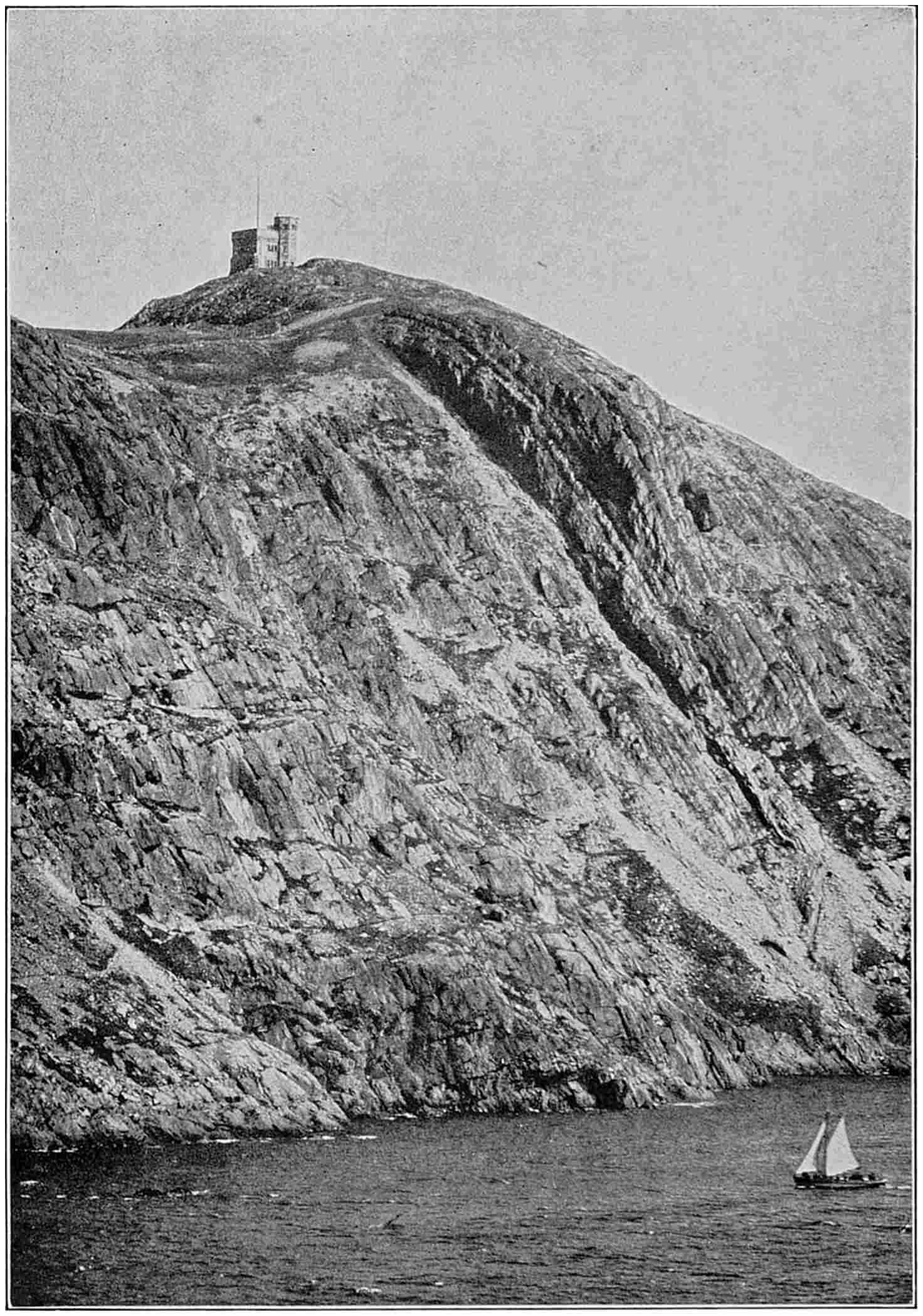
the Klondike gold I saw in the Far North.”What John Cabot saw when he discovered the American continent
were stern cliffs of gray rock such as this near St. John’s, which now has
a tower erected in his honour, five hundred feet above the water.
CHAPTER II THE KEY TO THE ST. LAWRENCE
Imagine yourself aboard ship with me. We are
steaming along off the coast of Newfoundland, bound
north for St. John’s, the capital and chief port of the
oldest and smallest British dominion. Just before
daybreak this morning I was awakened by a glaring light
flashing full in my face. I jumped from my berth and
looked out of the porthole. As I did so three blasts
from the whistle tore the air and made the ship tremble,
and were answered a moment later by the w-h-a-a-n-g
of a foghorn from over the water. The dazzling light
that had awakened me flashed around again. I knew
then that we were saluting Cape Race, the southeast tip of
Newfoundland, and chief signal station for the ocean traffic
of the North Atlantic.
We were hardly a mile from the shore. If it had been
daylight, we would have steamed closer in. The lighthouse
towered high in the air, the flash seeming to come
from out of the sky. Cape Race light is more than three
hundred feet above the water, and, with its foghorn and
the wireless station close by, tells thousands of mariners
their position at sea. It is usually the first land sighted in
coming to Canada across the Atlantic, and marks the
point where practically every vessel in these waters
changes its course.
Day has dawned since we passed Cape Race, and we
can see for miles over the bright blue ocean, silvered and
dancing under the sun. The air is so fresh and crisp it
is almost intoxicating. Even the dolphins, leaping and
diving in graceful curves beside the ship, seem to share
our feeling that it is a wonderful morning on which to be
alive and at sea.
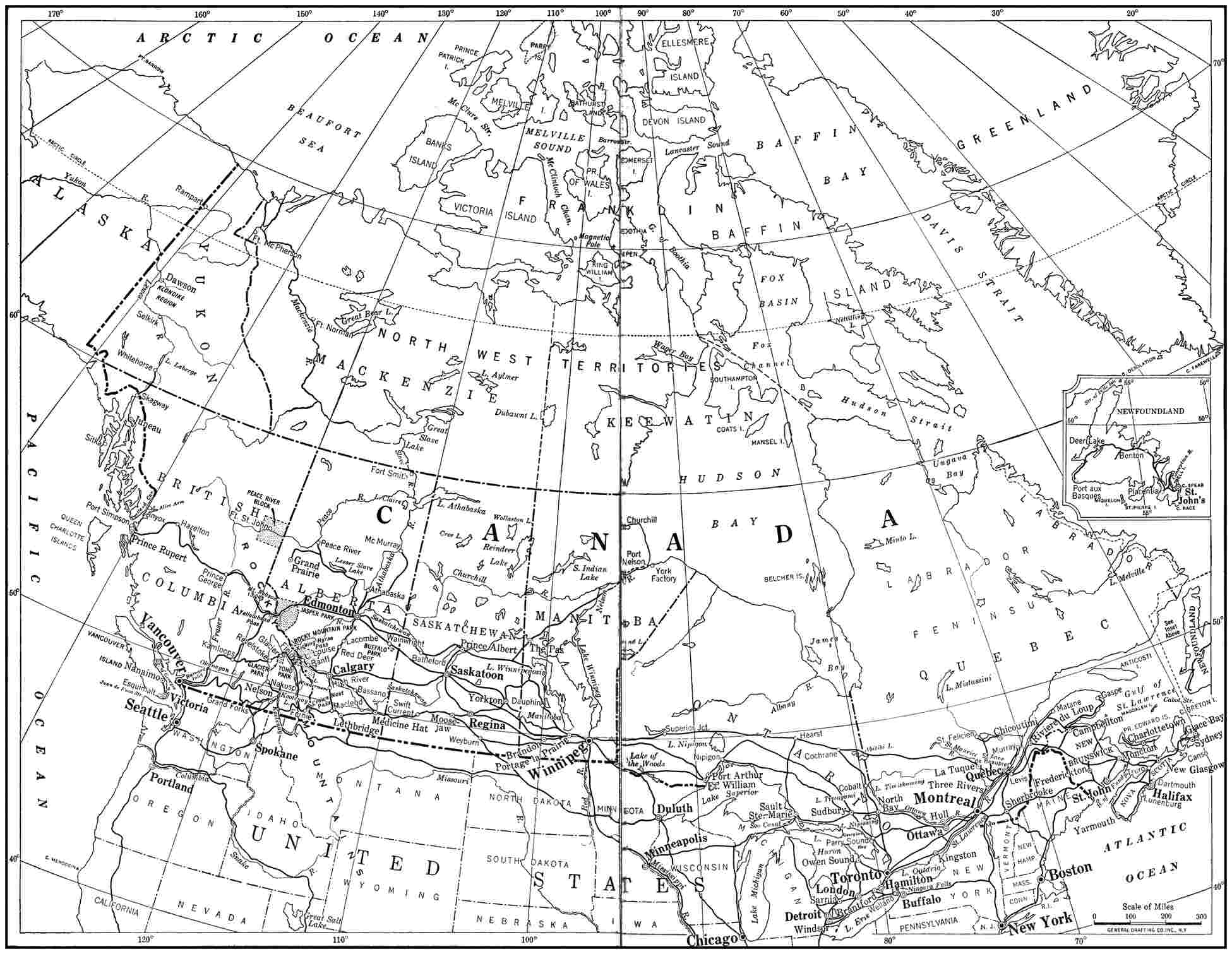
Now turn to the map in this book, and see just where
we are. Like most Americans, I had always thought of
Newfoundland as a sub-arctic country far to the north of
us. Since leaving New York I have felt like an explorer
on his way to the Pole. The fact is, however, that we
have been steaming much more to the east than to the
north, and are at this moment only about sixteen hundred
miles from the west coast of Ireland. We have come
hardly three hundred miles north of New York, but so far
to the eastward that we are half way to Liverpool. We
are still south of England, in the same latitude as Paris,
and are not far from the shoals that form the Grand Banks
of Newfoundland, famous the world over as cod-fishing
grounds. Here the bed of the ocean rises to within less
than five hundred feet of the surface, and the cold arctic
currents meet the Gulf Stream, causing the fogs so much
dreaded in this part of the Atlantic.
As seen on the map, Newfoundland is a triangle of land
that nearly fills, like a plug, the gaping mouth of the Gulf
of St. Lawrence, but it also commands the sea routes of
the North Atlantic, and its possession by an enemy power
would menace both Canada and the United States. It has
an area of forty-two thousand square miles, being larger
than Ireland and of about the same size as Tennessee.
At first glance it seems a part of the mainland, but a
closer look shows the Strait of Belle Isle separating the
island from the Labrador coast. Though in some places
only eight or ten miles wide, this strait furnishes a summer-time
passage for transatlantic liners to Canada.
For some years there has been talk of building a dam
across the Strait of Belle Isle, to stop the icy waters of the
Labrador current coming through the Strait into the Gulf
of St. Lawrence. This, it is claimed, would force the Gulf
Stream closer to Newfoundland, and give that country
and eastern Quebec a climate as warm as that of New
Jersey. How England would fare in this shifting of ocean
waters no one can say; the history of the world would have
been vastly different but for the present course of the Gulf
Stream in relation to the British Isles. However, no one
has yet offered to pay for this project, and shipping men
say it would be impossible to make a dam strong enough
to withstand the enormous pressure of ice, which comes
down from the arctic every year in great floes of from
five hundred to one thousand square miles and sometimes
piles up on shore to the height of a five-story building.
The Newfoundland coast greatly resembles that of
Norway. Looking shoreward, we see great headlands
jutting out into the ocean, their precipitous sides rising
straight out of the water for three or four hundred feet.
Between them are deep bays and inlets, walled with sheer
rock. At the heads of the coves and smaller bays we can
see the white houses of little villages, clinging to the hillsides
above tiny beaches. On top, these great rock ridges
are covered with low scrub, now in red and brown autumn
dress.
Now we are approaching St. John’s, which has one of
the famous natural harbours of the world. Our steamer
heads for what seems an unbroken wall of rock, five hundred
feet high, and surmounted by a mighty stone tower.
This is Cabot Tower, erected to commemorate the discovery
of Newfoundland in 1497 by John Cabot, the Venetian
mariner commissioned by Henry VII of England to
find him new dominions. Except for the Vikings, five
centuries earlier, Cabot was really the first to discover
the North American continent, as Columbus did not reach
the mainland until some years later.
Just south of the Cabot Tower is Cape Spear, the
“farthest east” point of all North America. It was on
these hills that Marconi received the first wireless message
flashed across the Atlantic, and from them that the first
transatlantic hydroplane flight was begun. On these
shores, also, several of our transatlantic cables are
landed.
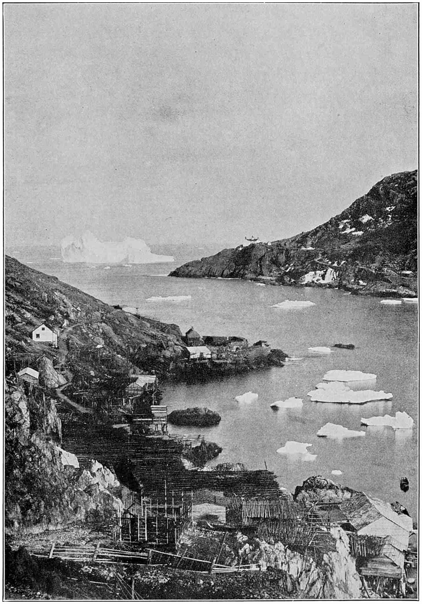
Like pirate ships of old, icebergs in spring hover about the rock-bound
entrance to St. John’s harbour. The channel is so narrow that the French
once closed it to the British ships by a chain from shore to shore.
But see, there is an opening in the wall of rock straight
ahead, and we get a glimpse of the harbour and the city
beyond. The passage is only six hundred feet wide, and
it seems much less from the deck of our steamer. Here
the French, during their brief possession of St. John’s,
slung chains across the Narrows to prevent the entrance
of enemy ships. Inside the Narrows, the harbour is
about a mile long and one half as wide. It is fringed
with a forest of masts and the smokestacks of steamers.
On the right is St. John’s. The hill on which it is built
rises so steeply from the water that we can see the whole
sides of buildings, one above the other along the terraced
streets. The painted brick or wooden structures give the
city a rather drab appearance, which is emphasized by the
absence of shade trees. This is partly because the town
has been burned three times, the last time in 1892. Across
the harbour the red and brown hillside is gashed here and
there with the slate gray of stone pits, or splotched with
fenced-in patches of green, so steep that it is hard to
imagine how they are farmed.
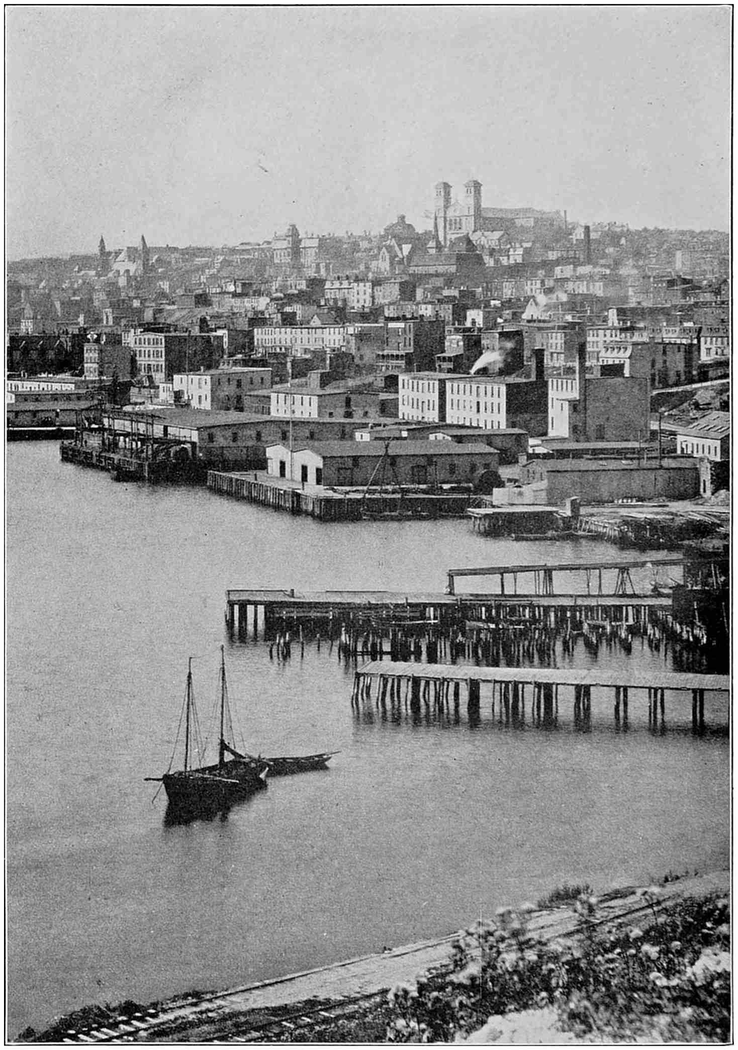
St. John’s, the capital city of Newfoundland, sits high on a hill overlooking
the land-locked harbour. It is the centre of the fishing industry,
and the commercial metropolis of the island. Its atmosphere is distinctly
British.
St. John’s is not quite as large as Portland, Maine, but
it is the chief city of Newfoundland and the centre of the
fishing trade. The whole country has only about a quarter
of a million inhabitants. It is as though the people of
Toledo formed the total population of the state of Ohio.
The Newfoundlanders are a mixture of English, Irish, and
Scotch, with an occasional trace of French. The original
Indian inhabitants have practically all disappeared. Most
of the people worship at the Church of England, though
Catholics also are numerous. Both denominations have
cathedrals at St. John’s, the Catholic edifice being especially
conspicuous as viewed from the harbour. The Methodist
Church is well established, and there is a sprinkling of
Congregationalists. Education in Newfoundland is sectarian,
each church receiving a grant from the government
for the support of its schools. There is much rivalry between
the churches, especially in the villages, but I am
told that some of the Protestants send their children to
Catholic schools, considering them better. The sons and
daughters of well-to-do people usually go to England to
complete their education.
CHAPTER III AROUND ABOUT ST. JOHN’S
Come with me for a drive around St. John’s.
We can hire a touring car of almost any make,
but for novelty we choose a one-horse open
coach. The grizzled driver tells us times are
dull with him just now, the taxis getting most of the trade,
but that he will have the best of it in December, when
the cars are laid up until spring on account of the snow.
St. John’s has an average of about four feet of snow in a
season, but I have seen pictures of the streets snowed in
to the roofs of the houses. The thermometer rarely falls
below zero, but once the snows begin, the ground is covered
until April.
The chief business street of St. John’s is strung out for a
mile or more just back of the wharves. It is lined on both
sides with three- and four-story wood and brick buildings.
Among the most modern is the home for sailormen
built by the Doctor Grenfell mission of Labrador fame.
Though the store windows look bright and attractive,
many of the shops are tiny affairs, and the street seems
more English than American.
I notice many branches of Canadian banks, which
monopolize the banking business of Newfoundland.
Contrary to the belief of many Americans, Newfoundland
politically is no more a part of Canada than it is of New
Zealand. It is a separate dominion of the British Empire,
to which its people are enthusiastically devoted, having
more than once refused to be federated with Canada.
They will tell you that the name of their country is
pronounced with the accent on the last syllable—New-found-land.
The main street of St. John’s has a trolley running practically
its entire length. Whenever the conductor collects
a fare, he puts a little ticket in a tiny cash register
that he carries in his hand. Like all the Newfoundlanders
I have met, the car men are most courteous. One of them
left his car to ask a policeman on the corner to direct me to
the American consulate. Indeed, I like these Newfoundlanders.
They are cordial and hospitable and most polite,
though sometimes I have difficulty in understanding their
Anglicized speech. I was told on the ship that I would see
none but natural complexions in St. John’s, and as far as I
have observed that is true, all the girls having bright rosy
cheeks. Both men and women here are long lived.
Our driver is now asking us to look at the government
buildings. They are high up above the harbour and surrounded
by beautiful grounds. The party having a
majority in the lower house of parliament forms the
government and names the premier and his ministers.
The upper house, called the Legislative Assembly, consists
of twenty-four members appointed by the governor in
council. The members of the lower house are elected for
terms of four years and meet every year. While the
humblest fisherman may be elected to parliament, Newfoundland
has not yet granted women the vote. It has
no divorce laws.
Our next stop is at the west end of St. John’s, where the
Waterford River empties into the harbour. Here is a
valley covered with truck gardens, and beyond lies a park
given to the city by one of its titled shipping magnates.
It is said that spring comes here two weeks earlier than
in the eastern end of town. The reason for this is that
while the fogs and the winds from the sea sweep over the
bluffs at the harbour entrance, they rarely penetrate to
the valley.
Driving back to town we pass the station of the Newfoundland
Government Railway, a narrow gauge line that
covers the most important parts of the island. It runs
far to the north, then to the west shore, and down to Port
aux Basques at the southwest. Branches jut out here and
there, linking the port towns with the main line and the
capital. The greater part of the south shore has no railroad,
nor is there yet any line into the Barbe Peninsula,
which extends northward to Belle Isle Strait. There is
talk of bridging the Strait and connecting Newfoundland
with Canada by a rail line through northeastern Quebec.
The manager of the railroad tells me that the Newfoundland
line is unique in that its passenger revenues
exceed its freight earnings. The reason for this is that
most of the people live near the sea, and the bulk of freight
goes by water. On the cross country route there are
many steep grades, for the interior is hilly, although the
highest point on the island is only two thousand feet above
sea level. The railroad skirts the shores of hundreds of
lakes, of which Newfoundland has more than it has found
time to count. It is estimated that one third of the land
lies under water. I met a man to-day, just returned from
a hunting trip forty miles inland, who told me that he had
stood on a hilltop and counted one hundred lakes and
ponds in plain sight. He has a friend who has fished in no
less than forty different ponds within a half mile of his
camp. Grand Lake, on the west side, is more than fifty-six
miles long, and two others are nearly as large.
American sportsmen have already discovered in Newfoundland
hunting and fishing grounds that rival those of
Canada, and some of our rich Americans have permanent
camps along the rivers and streams on the south and the
west coasts, to which they come every summer for salmon.
The railroad manager promises that if I will take the train
across country I shall see herds of caribou from the car
window.
Much of the land along the railway has been burned
over, but nevertheless the country has ten thousand
square miles of well-timbered land, worth as it stands five
hundred million dollars. Some is being cut for lumber,
and more for mine props that go to England and Wales.
The chief use of the forests at present is to furnish pulp
wood for news print. Lord Northcliffe built at Grand
Falls a six-million-dollar plant, operated by water-power,
to supply his newspapers and magazines, and an even
larger project, to cost twenty-five million dollars, is now
under way at the mouth of the Humber River, on the west
coast. The scenery there is much like that of the fiords of
Norway.
The chief agricultural development of Newfoundland
is on the west side of the island, where stock is raised successfully
and wintered outdoors. This section of the
country has produced as much as three million pounds of
beef or three times as much as the amount imported.
Newfoundland is not primarily, however, an agricultural
country. The efforts of the people have always centred
largely on fishing and related industries.
Newfoundland has had its gold fevers, especially on
the coast of Labrador, which it owns. So far, these have
amounted to nothing. But it has one of the world’s
largest iron deposits, and at one time this country was an
important producer of copper. It suffers commercially
from its handicaps in the way of transportation, and also
because of its limited supply of capital.
In studying the map of Newfoundland, I have been interested
in its many fanciful names, and wish that I might
see what inspired them. There are, for example, “Heart’s
Content” and “Heart’s Ease,” “Bay of Bulls” and
“Leading Tickle,” “Baldhead” and “Redhead Rocks.”
“Come by Chance” is a railroad station in eastern Newfoundland,
while just to the north is “Random.”
Most of the points on the Newfoundland coast were
named by the early mariners who learned from experience
rather than charts how to navigate these dangerous shores.
To help remember sailing directions, they made up little
rhymes such as this one I learned from a schooner captain
just in from Labrador:
When Joe Bat’s point you are abreast,
Fogo Harbour bears due west;
It’s then your course that you must steer
Till Brimstone Head do appear.
And when Old Brimstone do appear,
Then Dean’s Rock you need not fear.
CHAPTER IV THE COD FISHERIES OF NEWFOUNDLAND
Perhaps you have thought, as I did before coming
here, that fish are fish, all the world over. But
in Newfoundland fish are cod. The existence of
the other finny creatures in the sea is recognized,
but they are referred to only by their proper names.
There is a story that a Newfoundlander was asked if there
were any fish in a certain stream.
“No, there are no fish in here,” was the reply, “nothing
but trout.”
The history of Newfoundland is largely the story of its
cod fisheries and the contests to possess them. Cabot reported
to his royal master that the waters off the Newfoundland
coast were so thick with fish as to impede navigation.
Not long ago cod were so plentiful that dogs
caught them alive in the water as they were crowded upon
the beach by the pressure of the thousands behind, and
to-day the cod fisheries here are the largest of their kind
in the world. Nine tenths of the people of Newfoundland
still make their living either directly or indirectly
from fish, and eighty per cent. of the export trade comes
from them. At one time dried cod formed the national
currency, and debts were paid in kind. This fall, as for
many years, thousands of fishermen are paying for their
spring outfits, and for flour and molasses and pork on which
they will subsist during the coming winter, with fish.
Within a year after Cabot’s voyage, fishermen from
Devonshire, England, were on the Newfoundland coast,
and several years later Portuguese and French fishermen
were competing with them for the right to share in the
phenomenal catches. Though claimed by the British by
right of discovery, Newfoundland became a kind of “no
man’s land.” Its coast was frequented by hordes of daring
men, partly fishermen, partly traders, most of whom
were not above a little piracy now and then. In 1578,
four hundred fishing vessels were coming here every year.
Of these nearly half were French. The English dominated
even then, and a quarter of a century later ten thousand
men and boys from the west counties of England were
spending their summers in the fisheries, as catchers at sea
and dryers on shore.
It is estimated that the annual catch of the English
vessels was worth one hundred thousand pounds, a huge
sum in those days. The “Merchant Adventurers” of
England, who gained most of the profit, tried to set up a
monopoly. They did their utmost to drive the French
from the fishing grounds and shore stations, and discouraged
all attempts to colonize Newfoundland, spreading
false reports that the country was desolate and uninhabitable.
At one time there were laws forbidding a fishing
vessel from taking any settlers to Newfoundland and
requiring it to bring back to England every man it carried
away. The “Fishing Admirals,” as the ancient profiteers
of that industry were called, even secured an order to burn
the homes of the fishermen on shore. Indeed, it was not
until 1711 that England changed her cruel policy toward
Newfoundland and organized the colony under a naval
government.
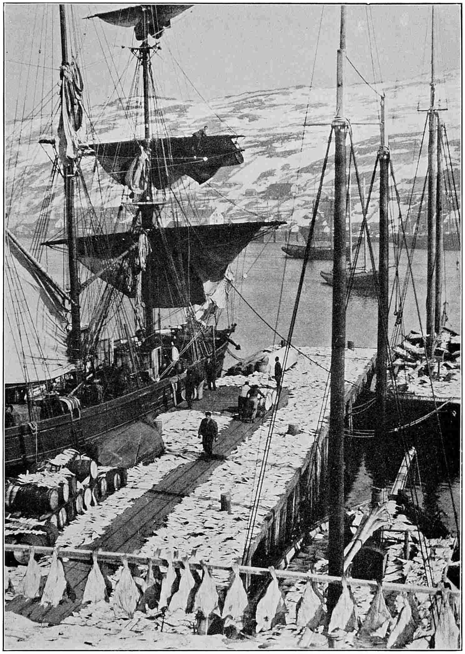
Most of the people of Newfoundland get their living directly or indirectly
from the codfish industry. The bulk of the catch is shipped
abroad from St. John’s, chiefly to the warm countries of the Mediterranean
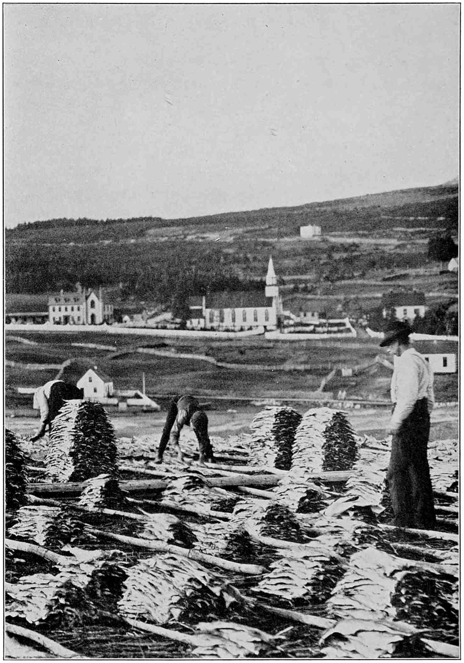
and the West Indies.The fisherman’s work has only begun when he has caught the cod.
After cleaning them, he and his family must spread the fish out to dry
every day, and stack them up every evening until they are “made.”
In the meantime, bitter struggles with the French had
been going on. The French recognized in Newfoundland
a key to their possessions in Canada along the Gulf and
River of St. Lawrence. They succeeded in gaining a foothold
on the south shore of Newfoundland, and from there
frequently attacked the English settlements to the north,
until the Treaty of Utrecht compelled them to give up
their holdings. All that remains of French possessions in
this part of the world are the islands of Miquelon and St.
Pierre just south of Newfoundland. With the prohibition
wave that swept over North America, the port of St. Pierre
has had a great boom as headquarters of the bootlegging
fleets of the North Atlantic. It has grown rich by taxing
the liquor traffic, so much so, in fact, that St. John’s is casting
envious eyes at its island neighbour, and making plans
to get into this profitable trade.
I had my first glimpse of the native cod as I entered St.
John’s harbour. Just as our steamer passed a motor dory
lying off shore, one of the men in her caught a big fish.
He pulled it out of the water, and after holding it up to
our view, clubbed it on the head and threw it into the boat.
To-day I visited one of the fishing villages, where I saw
the day’s catches landed and talked with the fishermen.
I took a motor in St. John’s and drove out to Waterford
Valley, up over the gray rocky hills into the back country.
On the heights I found a blue pond, just below it another,
and then another, like so many steps leading from the
heights down to the sea. The last pond ended in a great
wooden flume running down the rocky gorge to a little
power station that supplies electricity to the city of St.
John’s.
Here I stopped to take in the view. Before me was a
little bay, perhaps a half mile long and a quarter of a mile
wide, where the stream from the hill ponds empties into
the ocean. This was Petty Harbour, a typical Newfoundland
“outport.” On both sides of the harbour rocky walls
rose almost straight up to a height of three or four hundred
feet. The only outlets were the waters of the tiny bay and
the gorge through which I came. There was literally no
level land, only a few narrow shelves and terraces along the
sides of the hills. There were no streets, only a winding
roadway down the slope. The lower portion was too
narrow for our motor, so that I had to go part of the way
down on foot. The houses were placed every which way
on the steep hillsides. Most of them had tiny dooryards,
with a patch of grass and sometimes a few flowers in front.
Behind them, or at the sides, were other patches of green,
on some of which small black and white goats, wearing
pokes about their necks, were feeding. Small as were the
houses, each was neatness itself and shiny with paint.
Every one of the hundred or so houses was built by its occupant
or his father before him. Indeed, I am prepared
to believe, after what I have seen, that the Newfoundland
fisherman is the world’s greatest “handy man.” He builds
not only his house, but also his boats, landing stages, and
fish-drying platforms; he makes his own nets, raises his
own vegetables, and often has a sheep or two to furnish
wool, which his wife will spin and weave into a suit of
clothes or a jersey.
Walk along with me the rest of the way down to the
waterside. You must step carefully on the path that leads
over and between the ridges of out-cropping rock. Behind
us a troop of youngsters are proving themselves true citizens
of the kingdom of boyhood by tooting the horn of our
motor. I notice many children playing about, and I ask
where they go to school. In reply two little frame buildings
are pointed out on the hillsides, one the Church of England
school, and the other maintained by the Catholics. The
children we see look happy and well fed, and the little
girls especially are neatly dressed and attractive.
But here is a fisherman, drying cod, who offers to show
us about. With him we clamber down to the nearest
stage, built out over the rocks, its far end resting in water
that is deep enough for the boats. The stages are built
of spruce poles and look like cliff-dwellers’ homes. At
the end nearest the water is a little landing platform, with
steps leading down to the motor dory moored alongside.
A boat has come in with a load of fish. They are speared
one by one and tossed up to the landing stage, while one of
the men starts cleaning them to show us how it is done.
He first cuts the throat to the backbone, breaks off the
head against the edge of the bench, and then rips open the
belly. He tosses the liver to the table and the other organs
to the floor, cuts out the greater part of the backbone,
and throws the split, flattened-out cod into a tub at his
feet. It is all done in a few seconds.
Outside there is now a great heap of cod. This fish has
a gray-greenish back, a white belly, and a great gaping
mouth lined with a broad band of teeth so fine that to the
touch they feel like a file. One big fellow a yard long
weighs, we are told, perhaps twenty-five pounds, but most
of them will average but ten or twelve pounds.
These fish were caught in a net, or trap. When set
in the water the cod trap measures about sixty feet square.
It is moored in the sea near the shore. The fish swim into
the enclosure, are caught within its walls, and cannot make
their way out. The size of the meshes is limited by law,
so that the young fish may escape. Three fourths of the
Newfoundland cod are taken in this manner. Fish traps
may cost from six hundred to one thousand dollars each,
and making them is the chief winter job of the fishermen.
Sometimes the cod are caught with trawls, or lines, perhaps
three or four thousand feet long, with short lines tied
on at every six feet. The short lines carry hooks, which
are baited one by one, and the whole is then set in the ocean
with mooring buoys at each end. The trawls are hauled
up every day to remove the fish that have been caught, and
to bait up again.
I had thought a fisherman’s work done when he brought
in his catch, but that is really only the beginning. The
Newfoundland fisherman has nothing he can turn into
money until his fish are salted and dried. The drying
process may take a month or longer if the weather is bad.
It is called “making” the fish. The flat split fish are
spread out upon platforms called “flakes.” The sun
works the salt down into the flesh, at the same time removing
the moisture. Every evening each fish must be
picked up and put in a pile under cover, and then re-spread
on the flakes in the morning. The children are a great
help in this part of the work.
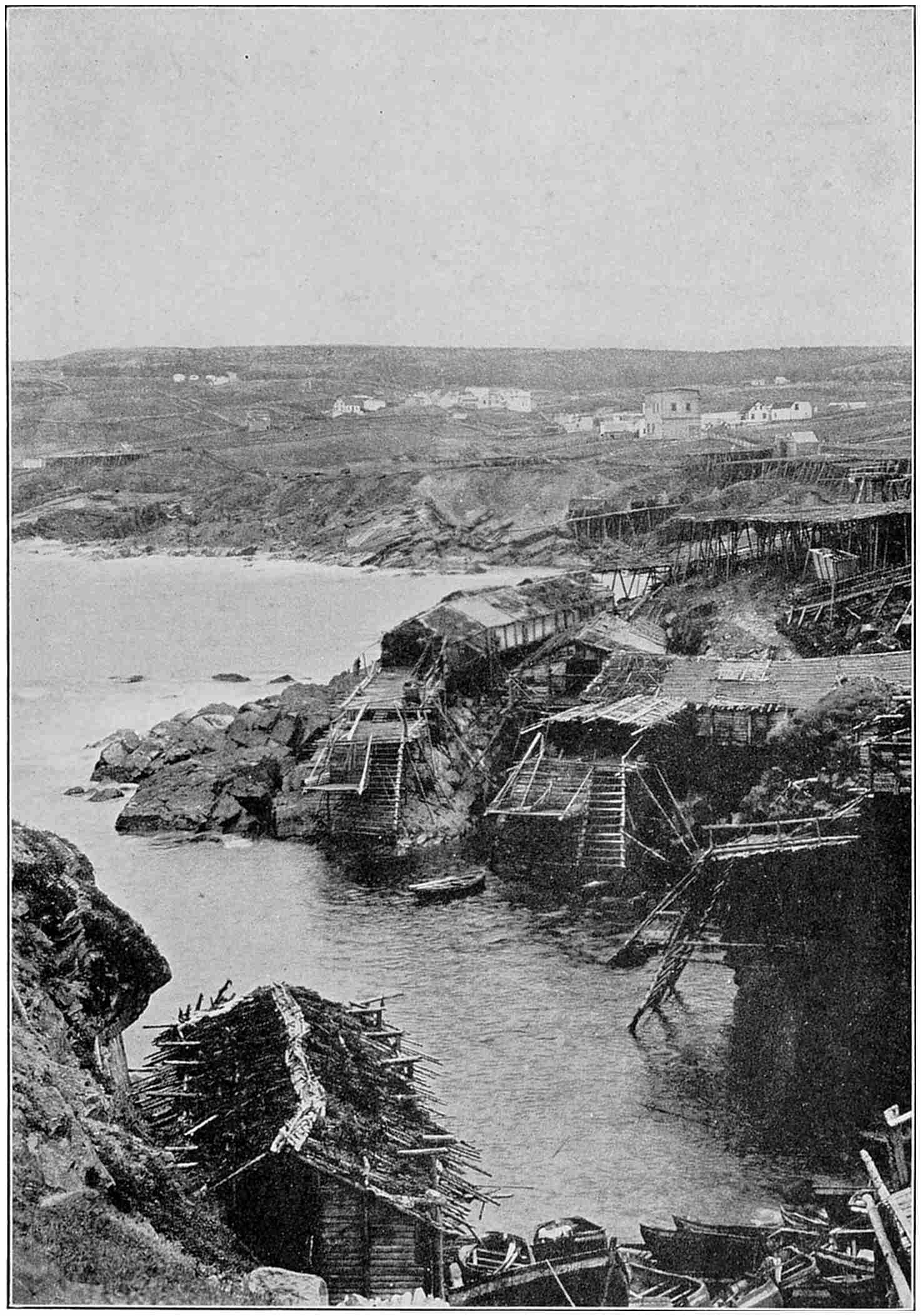
Wherever there is a slight indentation on the high rock-faced coast
you will find a fishing village with its landing stages and drying “flakes,”
built of spruce poles and boughs, clinging to the steep shore.
It is in the perfection of the drying, rather than by size,
that fish are graded for the market. At one of the fish
packing wharves in St. John’s, I saw tons of dried cod
stacked up like so much cord wood. They all looked alike
to me, but the manager said:
“Now, the fish in this pile are for Naples, those in that
for Spain, and those on the other side of the room will be
sent to Brazil. It would never do to mix them, as our
customers in each country have their own taste. Some
like their fish hard, and some soft, and there are other differences
we have to keep in mind as we sort the fish and
grade them for export. The poorest fish, those you see in
the corner, are for the West Indies. The people there
nearly live on our fish, which will keep in their hot climate,
but they can’t afford to buy the best quality.”
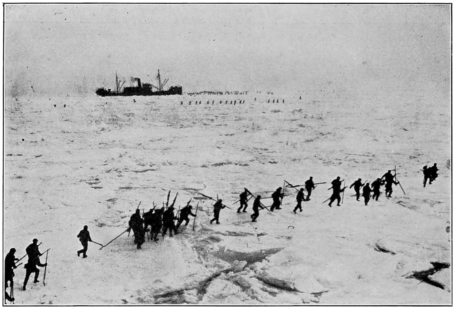
Arrived at the ice fields, the seal hunters armed with spiked poles
scatter over the pack. They kill for their hides and fat the baby seals
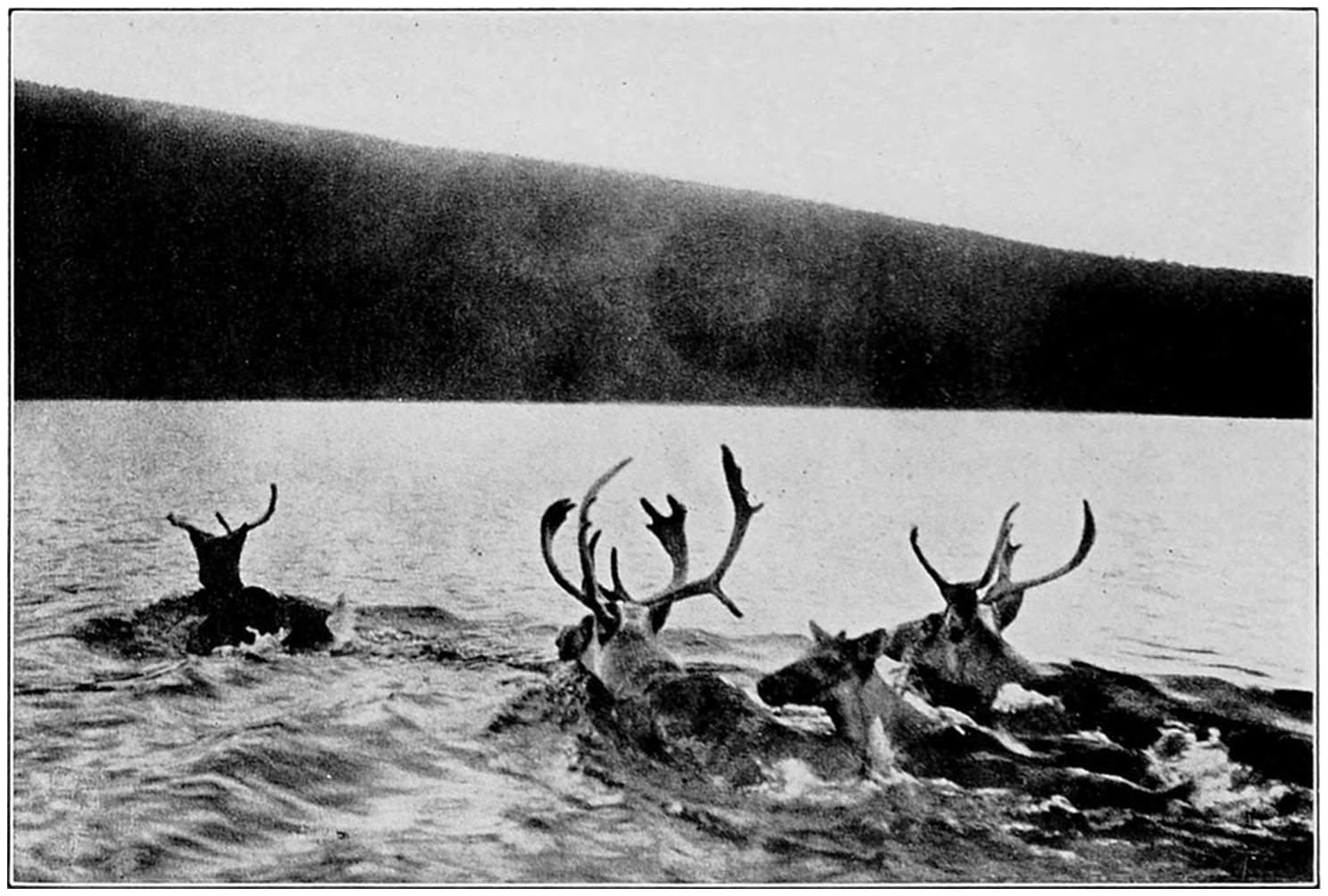
which every spring are born on the ice of the far north Atlantic.Caribou are plentiful in Newfoundland. They are often seen from
the train on the railroad journey across the country. The interior has
thousands of lakes, one third of the island lying under water.
Newfoundland exports more than one hundred and
twenty million pounds of dried cod every year. Brazil,
Italy, Spain, and Portugal take about ninety million
pounds, while the West Indies, Canada, Greece, and the
United States absorb the balance. The fish are exported
in casks each containing about two and a half quintals, or
two hundred and eighty pounds.
While the shore fisheries account for most of the annual
Newfoundland catch, there are two other ways of taking
cod. The first is the “bank fishery,” in which schooners
go off to the Grand Banks where they put out men in
small boats to fish with hook and line until a shipload is
caught. The fish are cleaned and salted on board, but
are dried on shore. The crews of the schooners usually
share in the catch, as in our own Gloucester fishing fleets.
The third kind is the Labrador fishery. Sometimes as
many as nine hundred schooners will spend the summer on
the Labrador coast, fishing off shore, and drying the
catches on the beach. Whole families take part in this
annual migration. Labrador fish do not, however, bring
as good a price as Banks or offshore fish.
The prosperity of the Newfoundlanders depends every
year on the price of cod. This may range from three dollars
a quintal to the record prices of fourteen and fifteen
dollars during the World War. Just now the price is depressed,
and Newfoundland is feeling competition from the
Norwegians, who are underselling them in the western
European and Mediterranean markets. Consequently,
many Newfoundlanders, especially the young people, are
emigrating to the United States. Some of the men go to
New England and engage in the Massachusetts fisheries.
Others ship on merchant vessels, while the girls are attracted
by high wages paid in our stores, offices, and factories.
I have made some inquiries about the earnings of the
Newfoundland fisherman, and find his net cash income
amounts to but three or four hundred dollars a year.
While he builds his own boat, he has to buy his engine,
gasoline, and oil. He must buy twine and pitch for his
nets, cord and hooks for his baited lines, and salt for
pickling. A fisherman usually figures on making enough
from the cod livers and their oil to pay his salt bill. The
bones and entrails and also the livers after the oil has been
removed are used as fertilizer.
The fisherman usually has no other source of income
than his catch, and during the winter he does little except
prepare for the next season. He goes in debt to the merchant
who furnishes his outfit and the supplies for his
family. His catch for the year may or may not bring as
much as the amount he owes, but he must deliver it, at the
current price, to the firm that gave him credit. This system
accounts for the big stores in St. John’s, some of which
have made a great deal of money. The merchants render
a real service in financing the fishermen, whom they carry
through the lean years, but there are those who believe the
credit system has outlived its usefulness.
Some years ago a farmer-fisherman-mechanic named
William Coaker organized the Fishermen’s Protective
Union, with local councils in the outports. The union
organized coöperative companies that now buy and sell
fish, build ships, and handle supplies of all kinds. It
even built a water-power plant to furnish electricity at cost
to light the men’s homes. A new town, called Port Union,
was developed on the northeast coast. This has become
the centre of the Union activities, and there its organizer,
now Sir William Coaker, spends his time. The Union
publishes a daily paper in St. John’s. Its editor tells me
that in the last ten years the dividend rate paid by the
F. P. U. companies was ten per cent. for eight years, eight
per cent. for one year, and none at all for only one year.
The Union went into politics, and for three elections has
had eleven members in the lower house. By combination
with other groups this bloc has held the balance of
power. While the Union has a strong voice in the government,
the conservative business houses seem to be the
dominant influence here in St. John’s, where, quite naturally,
the fishermen’s organization finds little favour.
St. John’s is the centre for the Newfoundland sealing
industry. This is not the seal that yields my lady’s fine
furs, but the hair seal, which is killed chiefly for its fat,
although the skin is used to make bags, pocketbooks, and
other articles of leather. The oil made from the fat is used
as an illuminant, a lubricant, and also for some grades of
margarine.
The annual seal hunt starts from St. John’s on March
13th. The sealing steamers carry from two hundred to
three hundred and fifty men each, packed aboard like sardines
in a can. The vessels make for the great ice floes
off the northeast coast, and it is on the ice that the seals
are taken. The animals spend the winter in waters farther
south, but assemble in enormous herds each January and
start north toward the ice. Within forty-eight hours after
reaching the ice-field, some three hundred thousand mother
seals give birth to as many babies. The baby seals gain
weight at the rate of four pounds a day, and rapidly take
on a coating of fat about two and a half inches thick.
When they are six weeks old, they leave their parents and
start swimming north. It is a matter of record that the
parents reach the ice and the young are born in almost
the same spot in the ocean, and on almost the same day,
year after year.
I visited one of the sealers. It happened to be the
Terra Nova, the ship in which Captain Scott explored
the Antarctic. It was a black craft, designed to work in
the ice-fields and carry the maximum number of men and
seals. I held in my hands one of the six-foot poles, called
“bats,” with which the seals are clubbed to death on the
ice. Once the ship reaches the ice-pack, the hunting parties
scramble overboard and make a strike for the seals.
The ice is usually rough and broken, and a man must make
sure that he can get back to his ship. Each hunter kills
as many seals as he can, strips off the skin and layer of fat,
and leaves the carcass on the ice. The skins and fat are
brought back to the ship. The baby seals are the ones
that are preferred, for since they feed only on their mothers’
milk, the oil from their fat is the best. Seal hunting is
exciting and dangerous work while it lasts, though from a
sporting standpoint baby seals can hardly be considered
big game.
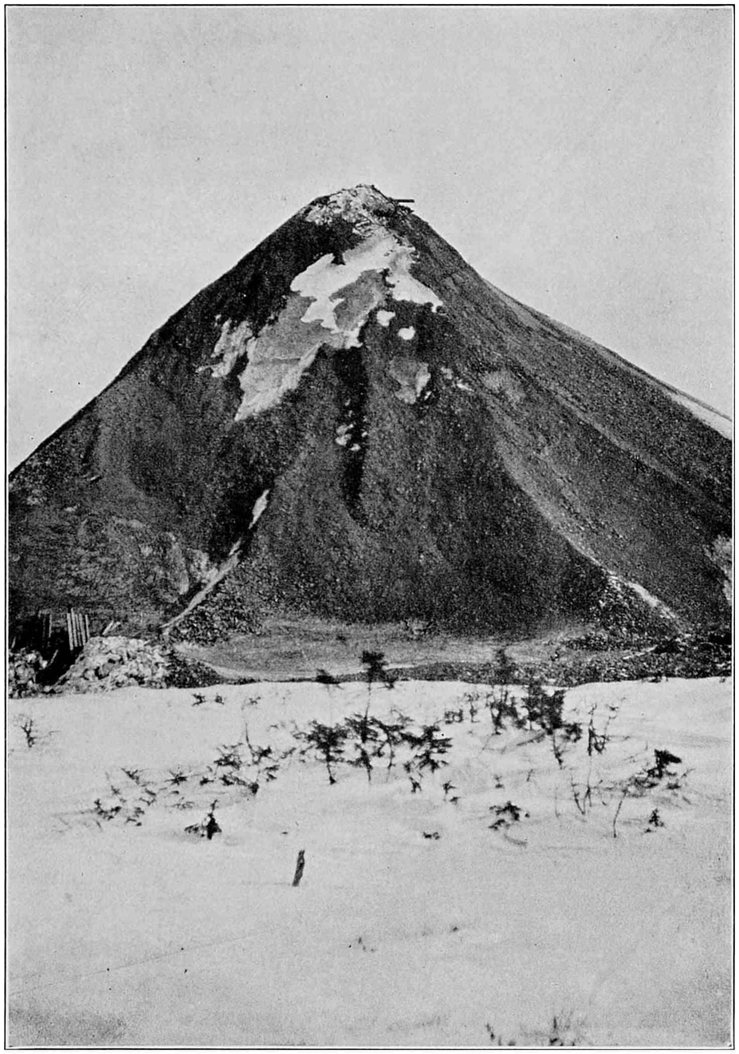
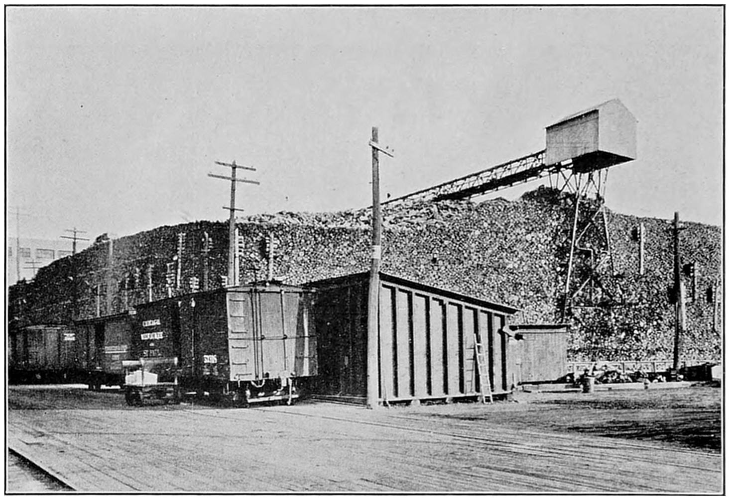
During the winter season the red iron ore from the Wabana mines
is stored in huge piles. In the summer it is shipped by steamer to the
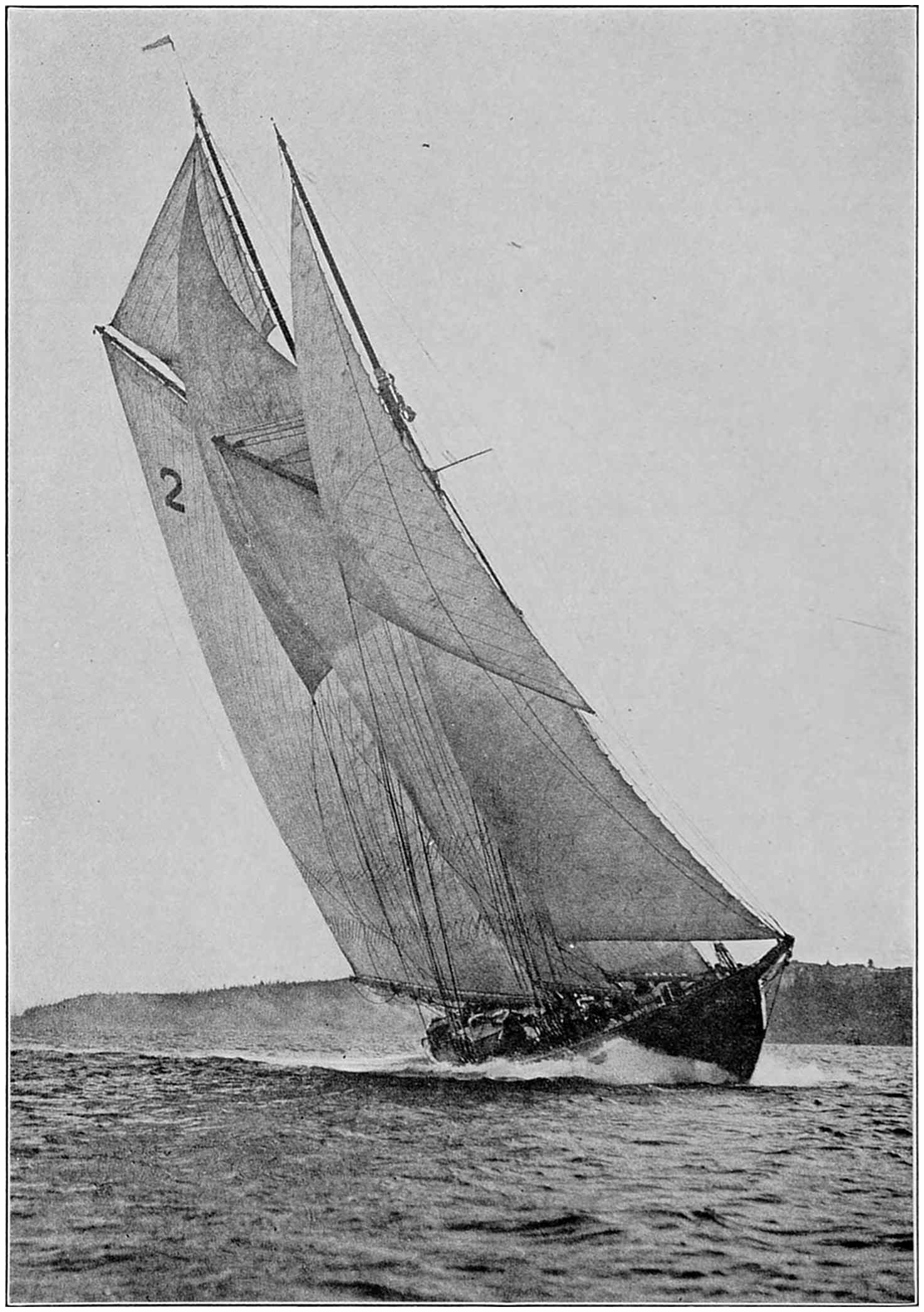
company’s steel mills in Nova Scotia.The annual race between schooners of the rival fleets from Nova Scotia
and Gloucester, Massachusetts, is a unique sporting event. Every other
year the contenders meet on a course off Halifax harbour.
The start of the annual seal hunt is a great occasion for
St. John’s. Two thirds of the proceeds of each catch are
divided among the crew, the steamer owner taking the
balance. It is an old saying in Newfoundland that “a
man will go hunting seals when gold will not draw him.”
The ships usually return by the middle of April. In a
good year each man may get about one hundred and fifty
dollars as his share.
From one hundred and fifty to three hundred thousand
seals are brought into St. John’s every year. At the factories
gangs of skinners strip off the fat from the hides as
fast as they are landed. Sometimes one man will strip as
many as six hundred and forty skins in a day. The fat is
chopped up and steam cooked, and the oil drawn off into
casks. The skins are salt dressed.
One might think the seals would be wiped out by such
methods, but the herd does not decrease and remains at
about one million from year to year. The seals live largely
on codfish, each one eating an average of four every day.
The estimated consumption of cod by the seals is fourteen
times greater than the number caught by the fishermen.
CHAPTER V IRON MINES UNDER THE SEA
I have just returned from a trip through caves richer
than those of Aladdin. They lie far under the ocean,
and their treasures surpass the wildest dreams of the
Arabian Nights. The treasures are in iron ore, from
forty nine to fifty two per cent. pure, and so abundant that
they will be feeding steel mills for many generations to
come.
I am speaking of the Wabana iron mines, located on, or
rather under, Conception Bay on the southeast coast of
Newfoundland. They are on an island seven miles long,
three miles in width, and three hundred feet high. Along
about a generation ago deposits of rich hematite ores were
discovered in veins that ran down under the water with
a slope of about fifteen degrees. They were gradually
developed and within the last thirty years millions of tons
of ore have been taken out. The under-sea workshops
have been extended more than two miles out from the shore
and it is believed that the great ore body crosses the bay.
The capacity yield at this time averages about five thousand
tons for every working day of the year, and the location
is such that the ore can be put on the steamers for export
almost at the mouth of the mines. The property is
owned by the British Empire Steel Company, made up of
British, American, and Canadian capital.
But let me tell you of my trip. I left my hotel in St.
John’s in the early morning. The rocky promontories
that form the narrow entrance to the harbour were canopied
in light fog, under which fishing schooners could be
seen tacking back and forth, beating their way out to the
open sea beyond. As we drove out over the hills the moisture
gathered on the windshield of the motor-car so that we
had to raise it and take the fog-soaked air full in our faces.
We went through King’s Road, where many of the aristocracy
of St. John’s reside in big frame houses with many
bay windows and much gingerbread decoration. They
were set well back from the street, and, in contrast with
most of the houses of the town, were surrounded by trees.
As we reached the open country, rolling hills stretched
away in the mist. They were gray with rock or red-brown
with scrub. Here and there were patches of bright green,
marking vegetable gardens or tiny pastures for a cow or
goat. The growing season in Newfoundland is short, and
the number of vegetables that can be successfully raised is
limited. I saw patches of cabbages, turnips, and beets,
and several fields of an acre or more that had yielded crops
of potatoes. Most of the fields were small, and some no
bigger than dooryards. All were fenced in with spruce
sticks. The houses were painted white, and had stones
or turf banked up around their foundations. A few farms
had fairly large barns, but most had no outbuildings except
a vegetable cellar built into a hillside or half-sunk in
the ground.
Newfoundlanders follow the English fashion of driving
on the left-hand side of the road. It made me a bit nervous,
at first, whenever we approached another vehicle.
It seemed certain that we would run into it unless we swung
to the right, but of course it always moved to the left, giving
us room on what an American thinks of as the “wrong
side of the road.”
We met an occasional motor-car, and many buggies, but
every few minutes we passed the universal vehicle of Newfoundland,
the two-wheeled “long cart,” as it is called.
Strictly speaking, it is not a cart at all, in our sense of
the word, as it has no floor or sides. It consists of a flat,
rectangular frame of rough-hewn poles, balanced like a
see-saw across an axle joining two large wooden wheels.
The long cart is the common carrier of all Newfoundland.
It is used on the farms, in the towns, and in the fishing villages.
One of these carts was carrying barrels of cod liver
oil to the refinery at St. John’s, while on another, a farmer
and his wife sat sidewise, balancing themselves on the tilting
frame.
After a drive of ten miles we reached Portugal Cove,
where I waited on the wharf for the little steamer that was
to take me to Bell Island, three miles out in the Bay. The
men of the village were pulling ashore the boat of one of
their number who had left the day before to try his luck in
the States. The boat was heavy, and seemed beyond
their strength. Some one called out: “Come on, Mr.
Chantey Man, give us Johnny Poker,” whereupon one of
the men led in a song. On the last word, they gave a
mighty shout and a mighty pull. The boat moved, and in
a moment was high and dry on the beach.
This was the chantey they sang:
Oh, me Johnny Poker,
And we’ll work to roll her over,
And it’s Oh me Johnny Poker all.
The big pull comes with a shout on the final word “all.”
After a few minutes on the little mine steamer, I saw
Bell Island loom up out of the fog. Its precipitous shore
rose up as high and steep as the side of a skyscraper, but
black and forbidding through the gray mist. I was wondering
how I could ever reach the top of the island when I
saw a tiny box car resting on tracks laid against the cliff
side, steeper than the most thrilling roller coaster. The car
is hauled up the incline by a cable operated by an electric
hoist at the top of the hill. I stepped inside, and by holding
on to a rail overhead was able to keep my feet all the
way up. Nearly everybody and everything coming to
Bell Island is carried up and down in this cable car.
From the top of the cliff, I drove across the island toward
the mines, and had all the way a fine view of the
property. The mine workings are spread out over an area
about five miles long and two miles in width. The houses
of the miners are little box-like affairs, with tiny yards.
Those owned by the company are alike, but those built by
the miners themselves are in varying patterns.
The miners are nearly all native Newfoundlanders.
They are paid a minimum wage, with a bonus for production
over a given amount, so that the average earnings at
present are about three dollars and fifty cents a day.
When the mines are working at capacity, about eighteen
hundred men are employed.
The offices of the company occupy a large frame structure.
In one side of the manager’s room is a great window
that commands a view of the works. Looking out,
my eye was caught first by a storage pile of red ore higher
than a six- or seven-story building. No ore is shipped during
the winter because of the ice in the Bay, and the heavy
snows that block the narrow gauge cable railway from
the mines to the pier. Also, since the ore is wet as it comes
out of the mine, it freezes during the three-mile trip across
the island. This makes it hard to dump and load. Another
difficulty about winter operations above ground
comes from the high winds that sweep over the island,
sometimes with a velocity of eighty miles an hour.
With the manager I walked through the village, passing
several ore piles, to one of the shaft houses. Trains of
cars are hauled by cable from the depths of the mine to the
top of the shaft house, where their contents are dumped
into the crusher. From the crusher the broken rock is
loaded by gravity into other cars and run off to the storage
piles or down to the pier. The cable railways and crushers
are operated by electricity, generated with coal from
the company’s mines at Sydney, Nova Scotia. The same
power is used to operate the fans that drive streams of
fresh air into the mines and to work the pumps that lift
the water out of the tunnels.
At the shaft house I put on a miner’s working outfit,
consisting of a suit of blue overalls, rubber boots, and a
cap with its socket above the visor for holding a lamp.
These miners’ lamps are like the old bicycle lanterns, only
smaller. The lower part is filled with broken carbide, on
which water drips from a reservoir above and forms acetylene
gas.
I was amazed at the ore trains that came shooting up
out of the mine at from thirty to forty miles an hour, and
trembled at the thought of sliding down into the earth at
such speed, but my guide gave the “slow” signal and we
began our descent at a more moderate rate.
I sat on the red, muddy bottom of an empty ore car.
My feet reached almost to the front and I could just comfortably
grasp the tops of the sides with my hands. It
was like sitting upright in a bathtub. As we plunged into
the darkness, the car wheels roared and rattled like those
of a train in a subway. My guide shouted in my ear that
the shaft was fifteen feet wide, and about eight feet from
ceiling to floor. I noticed that some of the timber props
were covered with a sort of fungus that looked like frost
or white cotton, while here and there water trickling out
of the rock glistened in the light of our lamps.
As we descended the air grew colder. It had a damp
chill that bit to the bone, and though our speed kept increasing
there seemed to be no end to the journey. Suddenly,
out of the darkness I saw three dancing lights.
Were they signals to us of some danger ahead? Another
moment, and the lights proved to be lamps in the caps of
three miners, drillers who had finished their work for the
day and were toiling their way up the steep grade to the
world of fresh air and warm sunshine.
Another light appeared ahead. Our train slowed up
and stopped on a narrow shelf deep down in the earth and
far under the ocean. Just ahead, the track plunged
steeply down again into the darkness. We were at the
station where the underground trains are controlled by
electric signals. On each side curved rails and switches
led off into branching tunnels.
For an hour or more we walked about in the under-sea
workings. At times we were in rock-walled rooms where
not a sound could be heard but the crunch of the slippery
red ore under our rubber-booted feet, or the sound of water
rushing down the steep inclines. At other times the rock
chambers reverberated with the chugging and pounding of
the compressed air drills boring their way into the rock.
We went to the head of a new chamber where a gang was
loading ore into the cars. There was a great scraping and
grinding of shovels against the flinty rock as the men bent
their backs to their work. The miners’ faces were streaked
with sweat and grimy with smears of the red ore. I picked
up a piece. It was not as big as a dinner plate, but was almost
as heavy as lead.
We rode out of the mine at top speed. Upon reaching
the surface, the air of the chilly foggy day felt positively
hot, while the sunlight seemed almost unreal after the
dampness below.
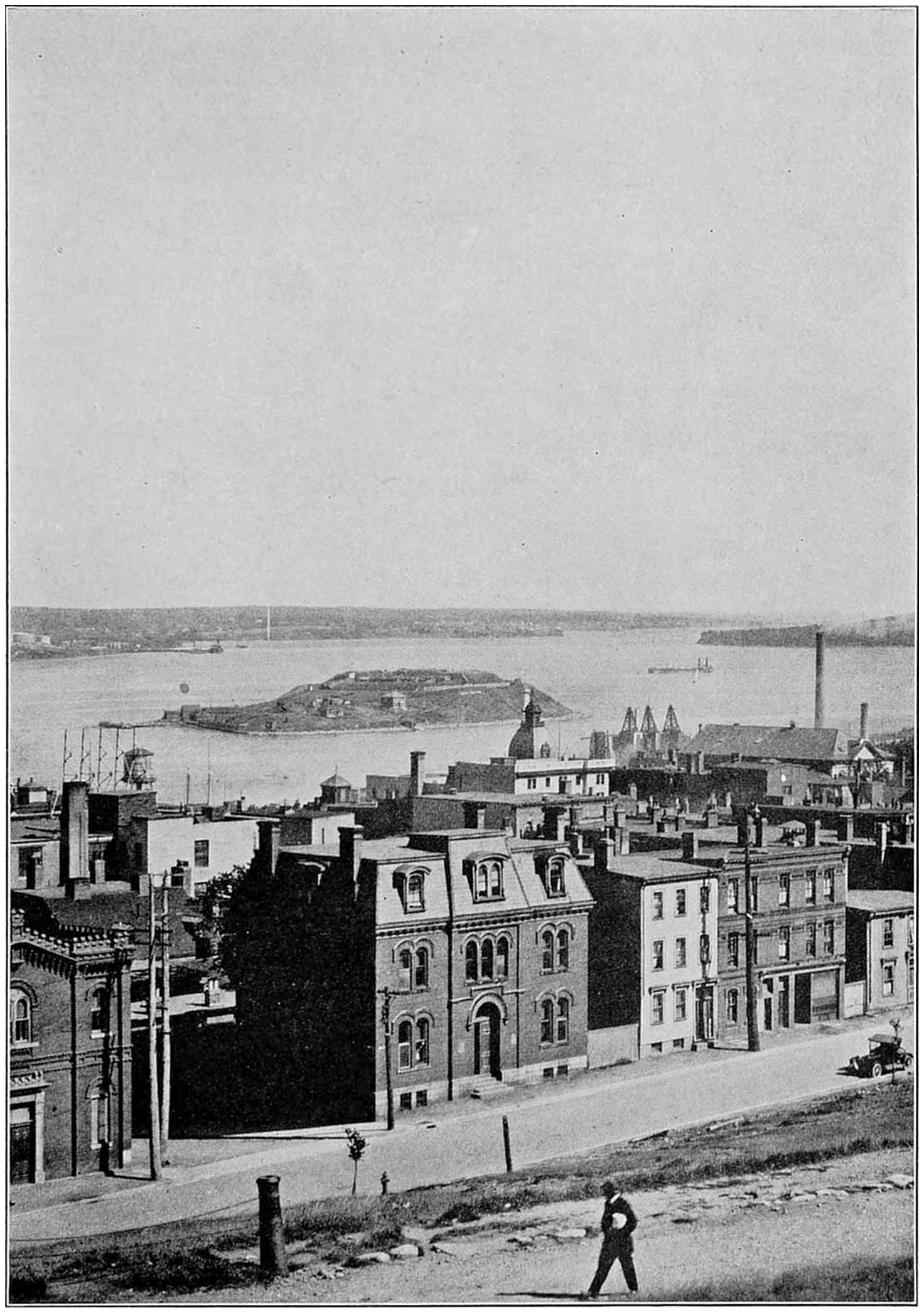
Halifax has a fine natural harbour well protected by islands and with
sufficient deep water anchorage for great fleets. The port is handicapped,
however, by the long rail haul from such centres of population as Montreal
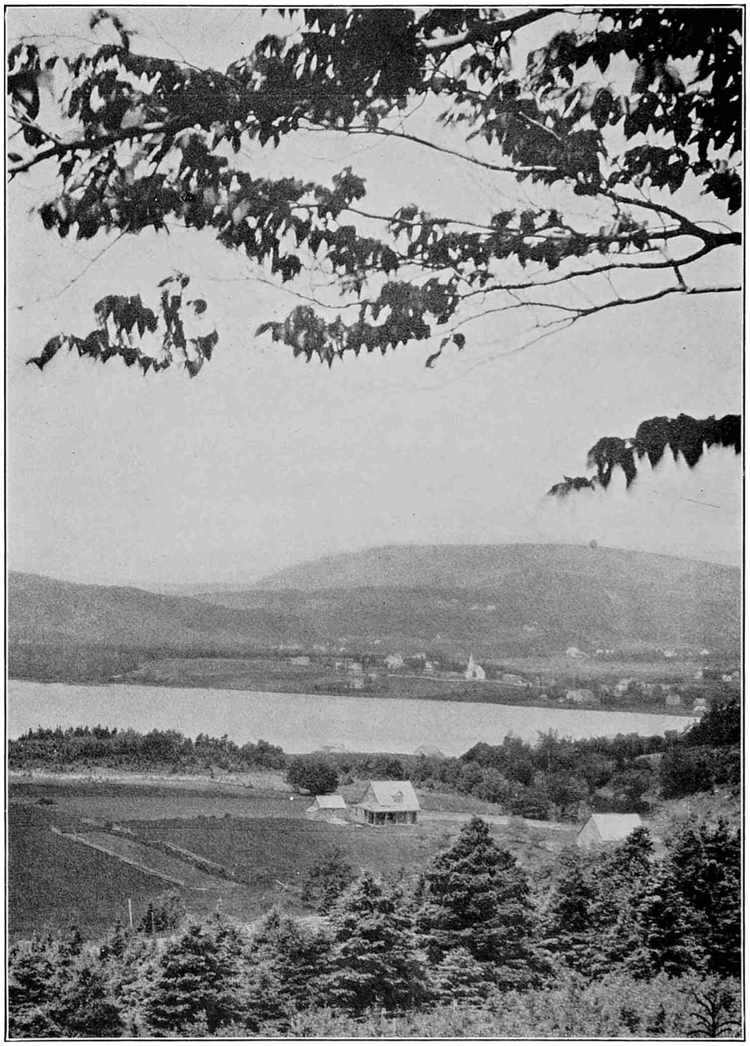
and Toronto.Cape Breton Island has a French name, but it is really the land of the
Scotch, where village pastors often preach in Gaelic, and the names in
their flocks sound like a gathering of the clans.
CHAPTER VI THE MARITIME PROVINCES
I have come into Canada through the Maritime
Provinces, which lie on the Atlantic Coast between
our own state of Maine and the mouth of the St. Lawrence.
The Provinces are Nova Scotia, New Brunswick,
and Prince Edward Island. Their area is almost
equal to that of our six New England states, and in climate
and scenery they are much the same. Their population,
however, is only about one million, or little more than one
fourth as many as the number of people living in Massachusetts.
These provinces were the first British possessions
in Canada, and like New England they have seen the
centre of population and progress move ever westward.
Nova Scotia is the easternmost province of the Dominion
of Canada. Its capital and chief city is Halifax, situated
on the Atlantic on one of the world’s best natural
harbours. This is a deep water inlet ten miles in length,
which is open all the year round. Montreal and Quebec
are closed to navigation during the winter months on account
of the freezing of the St. Lawrence.
Halifax is six hundred miles closer to Europe than is
New York, and nearer Rio de Janeiro than is New Orleans.
As the eastern terminus of the Canadian National
Railways, it has direct connections with all Canada.
With these advantages, the city hopes to become one of
the great shipping centres on the North Atlantic.
Halifax has long been noted as the most English city in
Canada. It was once the military, naval, and political
centre of British North America, and gay with the social
life of British officers and their ladies. Now, both the
warships and the soldiers are gone, and the city is devoting
itself to commercial activities.
As we steamed past the lighthouses and the hidden guns
on the headlands guarding the entrance, I was reminded
of all that this harbour has meant to America. The city
was founded by Lord Cornwallis in 1749 at the suggestion
of Boston merchants who complained that the French were
using these waters as a base for their sea raiders. Less
than thirty years later it provided a haven for Lord Howe
when he was driven out of Boston by our soldiers of the
Revolution, and became the headquarters for the British
operations against the struggling colonies. In the war of
1812, the American warship Chesapeake was brought here
after her defeat by the British frigate Shannon. During
our Civil War Halifax served as a base for blockade runners,
and the fortunes of some of its wealthy citizens of
to-day were founded on the profits of this dangerous trade.
No one dreamed then that within two generations England
and America would be fighting side by side in a World War,
that thousands of United States soldiers would sail from
Halifax for the battlefields of Europe, or that an American
admiral, commanding a fleet of destroyers, would establish
his headquarters here. Yet that is what happened in
1917–18. All that now remains of the former duels on the
sea is the annual sailing race between the fastest schooners
of the Gloucester and the Nova Scotia fishing fleets.
Halifax is built on a hillside that rises steeply from the
water-front to a height of two hundred and sixty feet above
the harbour. The city extends about halfway up the hill,
and reaches around on both sides of it. The top is a bare,
grassy mound, surmounted by an ancient citadel.
Stand with me on the edge of the old moat, and look
down upon Halifax and its harbour. Far to our left is
the anchorage where occurred one of the greatest explosions
the world ever knew. Just as the city was eating
breakfast on the morning of December 6, 1917, a French
munitions ship, loaded with benzol and TNT, collided with
another vessel leaving the harbour, and her cargo of explosives
blew up in a mighty blast. Nearly two thousand
people were killed, six thousand were injured, and eleven
thousand were made homeless. Hardly a pane of glass was
left in a window, and acres of houses were levelled to the
ground. A deck gun was found three miles from the water,
and the anchor of one of the vessels lies in the woods six
miles away, where it was thrown by the explosion. A
street-car conductor was blown through a second-story
window, and a sailor hurled from his ship far up the hillside.
Since then much of the devastated area has been rebuilt
along approved town-planning lines, but the scars
of the disaster are still visible. For a long time after the
explosion, the local institution for the blind was filled to
capacity, and one saw on the streets many persons wearing
patches over one eye.
Standing on the hill across the harbour one sees the
town of Dartmouth, where much of the industrial activity
of the Halifax district is centred. There are the largest
oil works, chocolate factories, and sugar refineries of
Canada. Vessels from Mexico, South America, and the
British West Indies land their cargoes of tropical products
at the doors of the works. Fringing the water-front
are the masts of sailing vessels and the smokestacks of
steamers. Among the latter is a cable repair ship, just in
from mending a break in one of the many submarine telegraph
lines that land on this coast. Next to her is a giant
new liner, making her first stop here to add to her cargo
some twenty-five thousand barrels of apples from the
Annapolis Valley. This valley, on the western side of
Nova Scotia, is known also as “Evangeline Land.” It
was made famous by Longfellow’s poem based on the expulsion
of the French Acadians by the English because
they insisted on being neutral in the French-British wars.
It is one of the finest apple-growing districts in the world,
and sends annually to Europe nearly two million barrels.
Many descendants of the former French inhabitants have
now returned to the land of their ancestors.
Looking toward the mouth of the harbour, we see the
new terminal, a twenty-five million dollar project that
has for some years stood half completed. Here are miles
and miles of railroad tracks, and giant piers equipped with
modern machinery, a part of the investment the Dominion
and its government-owned railway system have made to
establish Halifax as a first-class port. Beyond the port
works another inlet, Northwest Arm, makes its way in
between the hills. I have motored out to its wooded
shores, which in summer time are crowded with the young
people of Halifax, bathing and boating. It is the city’s
chief playground and a beautiful spot.
But now take a look at the city itself, stretching along
the water-front below where we stand. The big red brick
building just under our feet is the municipal market.
There, on Saturdays, one may see an occasional Indian,
survivor of the ancient Micmacs, and Negroes who are
descendants of slaves captured by the British in Maryland
when they sailed up the Potomac and burned our Capitol.
Farther down the hillside are the business buildings of the
city, none of them more than five stories high, and all somewhat
weatherbeaten. I have seen no new construction
under way in downtown Halifax; the city seems to have
missed the building booms of recent years. Most of the
older houses are of stone or brick. Outside the business
district the people live in wooden frame houses, each with
its bit of yard around it. One would know Halifax for an
English town by its chimney pots. Some of the houses
have batteries of six or eight of these tiles set on end sticking
out of their chimneys.
The streets are built on terraces cut in the hillside, or
plunging down toward the water. Some of them are so
narrow that they have room for only a single trolley track,
on which are operated little one-man cars. I stepped
for a moment into St. Paul’s Church, the first English house
of worship in Canada. Its front pew, to the left of the
centre aisle, is reserved for the use of royal visitors.
Passing one of the local newspaper offices, I noticed a big
crowd that filled the street, watching an electric score
board that registered, play by play, a World Series baseball
game going on in New York. The papers are full of baseball
talk, and the people of this Canadian province seem
to follow the game as enthusiastically as our fans at home.
My nose will long remember Halifax. In lower Hollis
Street, just back from the water-front, and not far from
the low gray stone buildings that once quartered British
officers, I smelled a most delicious aroma. It was from
a group of importing houses, where cinnamon, cloves, and
all the products of the East Indies are ground up and
packed for the market. If I were His Worship, the Mayor
of Halifax, I should propose that Hollis street be renamed
and called the Street of the Spices. Just below this sweet-scented
district, I came to a tiny brick building, with a
sign in faded letters reading “S. Cunard & Co., Coal Merchants.”
This firm is the corporate lineal descendant
of Samuel Cunard, who, with his partners, established
the first transatlantic steamship service nearly a century
ago, and whose name is now carried all over the world by
some of the greatest liners afloat.
Another odour of the water-front is not so sweet as the
spices. It is the smell of salt fish, which here are dried
on frames built on the roofs near the docks. Nova Scotia
is second only to Newfoundland in her exports of dried cod,
and all her fisheries combined earn more than twelve million
dollars a year. They include cod, haddock, mackerel,
herring, halibut, pollock, and salmon. Lunenburg,
down the coast toward Boston, is one of the centres of the
deep-sea fishing industry, and its schooners compete on the
Grand Banks with those from Newfoundland, Gloucester,
and Portugal.
I talked in Halifax with the manager of a million-dollar
corporation that deals in fresh fish. He was a Gloucester
man who, as he put it, “has had fish scales on his boots”
ever since he could remember.
“We operate from Canso, the easternmost tip of Nova
Scotia,” he said. “Our steamers make weekly trips to
the fishing grounds, where they take the fish with nets.
They are equipped with wireless, and we direct their
operations from shore in accordance with market conditions.
While the price of salt fish is fairly steady, fresh
fish fluctuates from day to day, depending on the quantities
caught and the public taste. Such fish as we cannot
sell immediately, we cure in our smoking and drying
plants.
“All our crews share in the proceeds of their catch, and
the captains get no fixed wages at all. We could neither
catch the fish nor sell them at a profit without the fullest
coöperation on the part of our men, most of whom come
from across the Atlantic, from Denmark, Norway, and
Sweden, and also from Iceland. Next to the captain, the
most important man on our ships is the cook. Few fish
are caught unless the fishermen are well fed. The ‘cook’s
locker’ is always full of pies, cakes, and cookies, to which
the men help themselves, and the coffee-pot must be kept
hot for all hands to ‘mug up.’”
From Halifax I crossed Nova Scotia by rail into the
adjoining province of New Brunswick. Nova Scotia
is a peninsula that seems to have been tacked on to the
east coast of Canada. It is three hundred and seventy-four
miles long, and so narrow that no point in it is more
than thirty miles from the sea. The coast does not run
due north and south, but more east and west, so that its
southernmost tip points toward Boston. The Bay of
Fundy separates it from the coasts of Maine and New
Brunswick, and leaves only an isthmus, in places not more
than twenty miles wide, connecting Nova Scotia with
the mainland. The lower or westernmost half of the
province is encircled with railroads, which carry every year
increasing thousands of tourists and hunters from the
United States. The summer vacationists and the artists
go chiefly to the picturesque shore towns, while those who
come up for hunting and fishing strike inland to the lakes
and woods. Deer and moose are still so plentiful in Nova
Scotia that their meat is served at Halifax hotels during the
season.
The scenery is much like that of Maine. Rolling hills
alternate with ledges of gray rock, while at every few miles
there are lakes and ponds. Much of the country is covered
with spruce, and many of the farms have hedges and
tall windbreaks of those trees. The farmhouses are large
and well built; they are usually situated on high ground
and surrounded by sloping fields and pastures considerably
larger than the farm lots of New England. In some
places the broad hills are shaped like the sand dunes of
Cape Cod. At nearly every station freshly cut lumber
was piled up, awaiting shipment, while one of the little
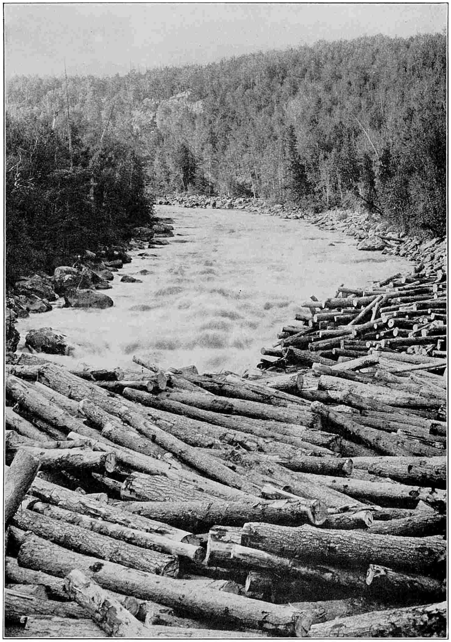
rivers our train crossed was filled with birch logs floating
down to a spool factory.
Some two hours from Halifax we came to Truro at the
head of Cobequid Bay, the easternmost arm of the Bay of
Fundy. Scientists who have studied the forty-foot Fundy
tides attribute them to its pocket-like shape. The tides
are highest in the numerous deep inlets at the head of the
Bay. In the Petitcodiac River, which forms the northernmost
arm, as the tide comes in a wall of water two or three
feet high rushes upstream. These tides are felt far back
from the coast. The rivers and streams have deep-cut
banks on account of the daily inrush and outflow of waters
and are bordered with marshes through which run irrigation
ditches dug by the farmers.
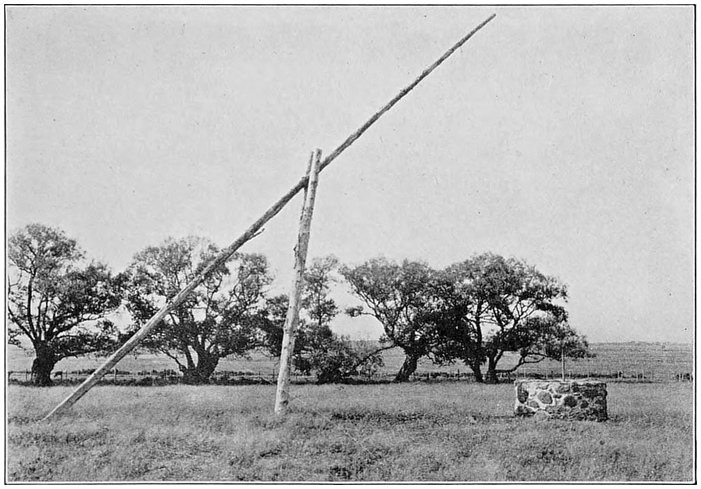
With his poem of Evangeline, Longfellow made famous the old well at
Grand Pré, the scene of the expulsion of the Acadians because they
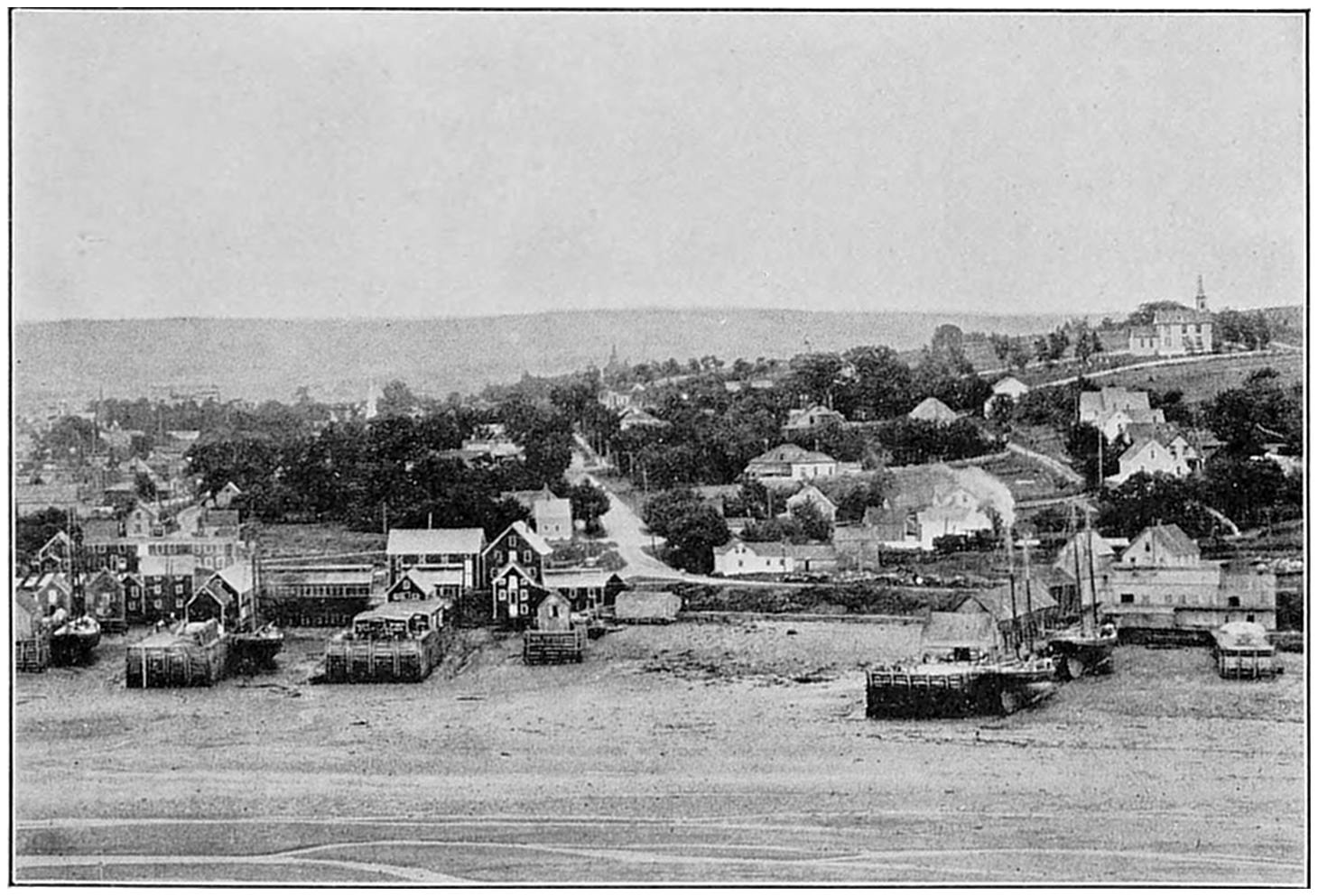
wanted to remain neutral in the French-British wars.When the tide goes out at Digby, vessels tied to the docks are left
high and dry. At some points on the Bay of Fundy the rise and fall of
the water exceeds forty feet.
Truro is a turning-off point for the rail journey down
the Bay side of Nova Scotia through “Evangeline Land”
and the Annapolis Valley, and also for the trip north and
east up to Cape Breton Island. This island is part of the
province of Nova Scotia. It is separated from the mainland
only by the mile-wide Strait of Canso, across which
railroad trains are carried on ferries. In the southern part
of the Island is the Bras d’Or Lake, an inland sea covering
two hundred and forty square miles.
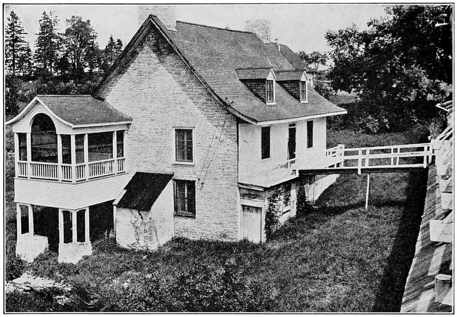
Because of the deep snows in winter the Quebec farmhouse usually has
high porches and often a bridge from the rear leading to the upper floor
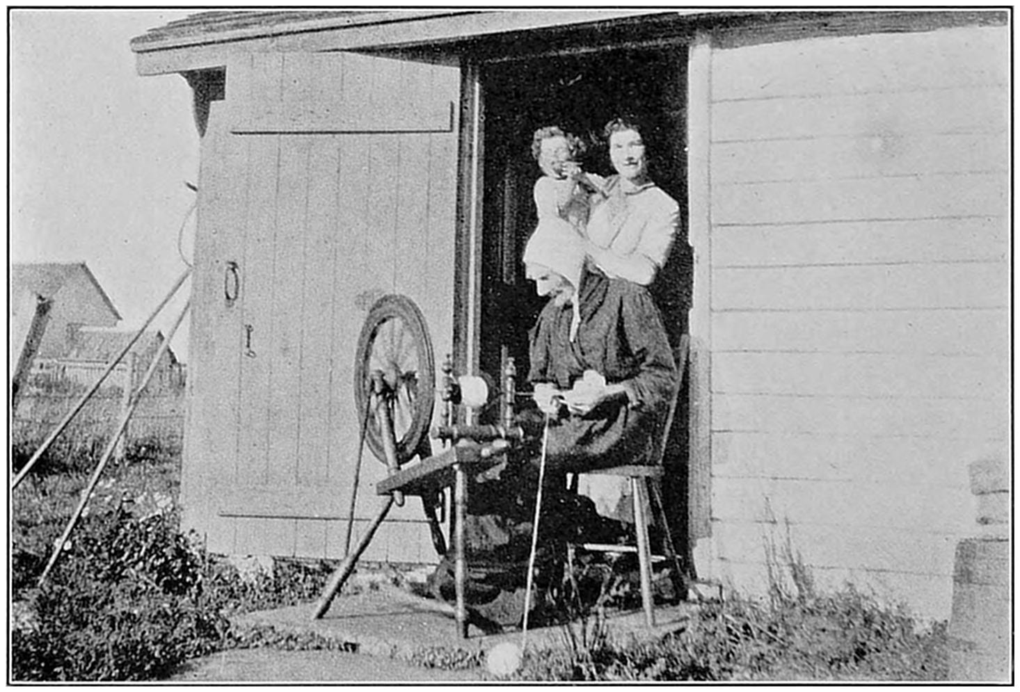
of the barn. The older houses are built of stone.Spinning wheels and hand looms are still in use among the French
Canadian farm women. Besides supplying clothes for their families,
they make also homespuns and rugs for sale.
Though Cabot landed on the coast of Cape Breton Island
after his discovery of the Newfoundland shore, it
later fell into the hands of the French. They found its
fisheries worth more than all the gold of Peru or Mexico.
To protect the sea route to their St. Lawrence territories,
they built at Louisburg a great fortress that cost a sum
equal to twenty-five million dollars in our money. To-day,
hardly one stone remains upon another, as the works
were destroyed by the British in 1758. Not far from
Louisburg is Glace Bay, where Marconi continued the
wireless experiments begun in Newfoundland, and it was
on this coast, also, that the first transatlantic cable was
landed.
Cape Breton Island was settled mostly by Scotch, and
even to-day sermons in the churches are often delivered in
Gaelic. As a result of intermarriage sometimes half the
people of a village bear the same family name. For generations
these people lived mostly by fishing, but the opening
of coal mines in the Sydney district brought many of
them into that industry. The Sydney mines, which normally
employ about ten thousand men, are the only coal
deposits on the continent of North America lying directly
on the Atlantic Coast. They are an asset of immense
value to Canada, yielding more than one third of
her total coal production. One of the mines at North
Sydney has the largest coal shaft in the world. Because
of these enormous deposits of bituminous coal, and the
presence near by of dolomite, or limestone, steel industries
have been developed in the Sydney district. Ownership
of most of the coal and steel properties has been merged in
the British Empire Steel Corporation, one of the largest
single industrial enterprises in all Canada. It is this corporation,
you will remember, that owns the Wabana iron
mines in Newfoundland.
In the Gulf of St. Lawrence, and north of the isthmus
connecting Nova Scotia with the mainland, is Prince
Edward Island, the smallest, but proportionately the
richest province in the Dominion of Canada. It is not
quite twice the size of Rhode Island, and has less than one
hundred thousand people, but every acre of its land is
tillable and most of it is cultivated. The island is sometimes
called the “Garden of the Gulf.”
Prince Edward Island is a favourite resort of Americans
on vacation. It leaped into fame as the scene of the first
successful experiments in raising foxes for their furs, and
now has more than half of the fox farms in Canada. The
business of selling fox skins and breeding stock is worth
nearly two million dollars a year to the Prince Edward
Islanders. The greatest profits are from the sales of fine
breeding animals.
Most of the west shore of the Bay of Fundy and many
of its northern reaches are in the third and westernmost
of the three Maritime Provinces. This is the province of
New Brunswick. It is Maine’s next-door neighbour, and
almost as large, but it has less than half as many people.
The wealth of New Brunswick, like that of Maine, comes
chiefly from the farms, the fisheries, and the great forests
that are fast being converted into lumber and paper.
Its game and fresh-water fishing attract a great many
sportsmen from both the United States and Canada.
St. John, the chief city of New Brunswick at the mouth
of the St. John River, used to be a centre of anti-American
sentiment in Canada. This was because the city was
founded by the Tories, who left the United States after we
won our independence. St. John to-day is a busy commercial
centre competing with Halifax for first place as
Canada’s all-year Atlantic port. It is the eastern terminal
of the Canadian Pacific Railroad, whose transatlantic
liners use the port during the winter. It enjoys the advantage
over Halifax of being some two hundred miles
nearer Montreal, but, like Halifax, suffers on account of
the long railway haul and high freight rates to central
Canada. As a matter of fact, New England, and not
Canada, is the natural market for the Maritime Provinces,
and every few years the proposal that this part of Canada
form a separate Dominion comes up for discussion. Such
talk is not taken seriously by the well informed, but it
provides a good safety valve for local irritation.
CHAPTER VII IN FRENCH CANADA
Come with me for a ride about Quebec, the oldest
city in Canada, the ancient capital of France
in America, and a stronghold of the Catholic
Church. We go from the water-front through
the Lower Town, up the heights, and out to where the
modern city eats into the countryside. The Lower Town
is largely French. The main part of the Upper Town
used to be enclosed by walls and stone gates, parts of which
are still standing. The dull gray buildings are of stone,
with only shelf-like sidewalks between them and the street.
Most of the streets are narrow. The heights are ascended
by stairs, by a winding street, and in one place by an elevator.
The old French caleche, a two-wheeled vehicle between
a jinrikisha and a dog-cart, has been largely displaced
by motor-cars, which can climb the steep grades in
a jiffy. Even the ancient buildings are giving way to
modern necessities, and every year some are torn down.
As a city, Quebec is unique on this continent. It fairly
drips with “atmosphere,” and is concentrated romance
and history. You know the story, of course, of how
Champlain founded it in 1608, on a narrow shelf of land
under the rocky bluff that rises nearly three hundred and
fifty feet above the St. Lawrence. Here brave French
noblemen and priests started what they hoped would be
a new empire for France. Between explorations, fights
with the Indians, and frequent British attacks, they lived
an exciting life. Finally, General Wolfe in 1759 succeeded
in capturing for the British this Gibraltar of the New
World. Landing his men by night, at dawn he was in
position on the Plains of Abraham behind the fort. In the
fight that followed Wolfe was killed, Montcalm, the
French commander, was mortally wounded, and the city
passed into the hands of the English. If General Montgomery
and Benedict Arnold had succeeded in their attack
on Quebec on New Year’s Eve, sixteen years later,
the history of all Canada would have been different, and
the United States flag might be flying over the city to-day.
The British built in the rock on top of the bluff a great
fort and citadel covering about forty acres. It still bristles
with cannon, but most of them are harmless compared
with modern big guns. The works serve chiefly as a show
place for visitors, and a summer residence for dukes and
lords sent out to be governors-general of Canada. The
fortification is like a mediæval castle, with subterranean
chambers and passages, and cannon balls heaped around
the battlements. Below the old gun embrasures is a
broad terrace, a quarter of a mile long. This furnishes the
people of Quebec a beautiful promenade that overlooks
the harbour and commands a fine view of Levis and the
numerous villages on the other shore.
The Parliament building stands a little beyond the
entrance to the citadel. As we go on the architecture
reflects the transition from French to British domination.
The houses begin to move back from the sidewalk, and to
take on front porches. I saw workmen putting in double
windows, in preparation for winter, and noticed that the
sides of many of the brick houses are clapboarded to keep
the frost out of the mortar. Still farther out apartments
appear, while a little beyond are all the marks of a suburban
real estate boom. Most of the “for sale” signs are
in both French and English.
Now come with me and look at another Quebec, of
which you probably have never heard. The city is built,
as you know, where the St. Charles River flows into the
St. Lawrence. The valley of the St. Charles has become
a great hive of industry, and contains the homes of
thousands of French workers. Looking down upon it from
the ancient Martello Tower on the heights of the Upper
Town, we see a wilderness of factory walls, church spires,
and the roofs of homes. Beyond them great fields slope
upward, finally losing themselves in the wooded foothills
of the Laurentian Mountains. Cotton goods, boots and
shoes, tobacco, and clothing are manufactured here. It
was from this valley that workers for the textile and shoe
industries of New England were recruited by thousands.
A few miles upstream is the village of Indian Lorette,
where descendants of a Huron tribe, Christianized by the
French centuries ago, make leather moccasins for lumberjacks
and slippers for American souvenir buyers. A big
fur company also has a fox farm near Indian Lorette.
Quebec was once the chief port of Canada, but when the
river was dredged up to Montreal it fell far behind. All
but the largest transatlantic liners can now sail for
Europe from Montreal, though they make Quebec a port
of call. Quebec is five hundred miles nearer Liverpool
than is New York, and passengers using this route have
two days less in the open sea. The navigation season is
about eight months. The port has rail connections with
all Canada and the United States. Above the city is the
world’s longest cantilever bridge, on which trains cross the
river. After two failures the great central span, six hundred
and forty feet long, was raised from floating barges and
put into place one hundred and fifty feet above the water.
In the English atmosphere of the Maritime Provinces
I felt quite at home, but here I seem to be in a foreign land,
and time has been pushed back a century or so. We think
of Canada as British, and assume that English is the national
language. But in Quebec, its largest province,
containing about one fifth of the total area, nearly nine
tenths of the people are French and speak the French
language. They number almost one fourth of the population
of the Dominion.
Quebec is larger than Texas, New Mexico, Arizona, and
California combined; it is nearly as big as all our states east
of the Mississippi River put together. Covering an area
of seven hundred thousand square miles, it reaches from
the northern borders of New York and New England to the
Arctic Ocean; from the Gulf of St. Lawrence and Labrador
westward to Hudson Bay and the Ottawa River. Most
Americans see that part of Quebec along the St. Lawrence
between the capital and Montreal, but only one fourteenth
of the total area of the province lies south of the river.
The St. Lawrence is more than nineteen hundred miles
long, and Quebec extends along its north bank for almost
the entire distance.
Jacques Cartier sailed up the St. Lawrence in 1535
and claimed possession of the new land in the name of
“Christ and France.” Later, French soldiers and priests
pushed their way up the river, explored the Great Lakes,
and went down the Mississippi. It was French fur
traders, fishermen, and farmers who opened up and
populated eastern Canada. With no immigration from
France since British rule began, the population of the province
of Quebec has had a natural increase from about
sixty thousand to more than two millions. The average
family numbers from six to eight persons, while families
of twelve and fourteen children are common. Quebec
maintains the highest birth rate of any province in Canada.
It has also the highest death rate, but there is a large
net gain every year.
Quebec is one of the chief reservoirs of Canada’s natural
wealth. It leads all other provinces in its production
of pulpwood, and contributes more than one half the
Dominion’s output of pulp and paper. It is second only
to British Columbia and Ontario in lumber production,
while its northern reaches contain the last storehouse of
natural furs left on our continent.
Canada is one of the world’s great sources of water-power.
Nearly half of that already developed is in the
province of Quebec, and her falling waters are now yielding
more than a million horse-power. Tens of thousands
of additional units are being put to work every year, while
some five million horse-power are in reserve. It would
take eight million tons of coal a year to supply as much
power as Quebec now gets from water.
The ancient citadel on the heights of Quebec is now dwarfed by a giant
castle-like hotel that helps make the American Gibraltar a tourist resort.
Its windows command a magnificent view of the St. Lawrence.The St. Louis gate commemorates the days when Quebec was a walled
city and always well garrisoned with troops. Just beyond is the building
of the provincial parliament, where most of the speeches are in French.
At Three Rivers, about halfway between Montreal and
Quebec, the St. Maurice River empties into the St.
Lawrence. Twenty miles upstream are the Shawinigan
Falls, the chief source of power of the Shawinigan Company,
which, with its subsidiaries, is now producing in this
district more than five hundred thousand horse-power.
This is nearly half the total power development in the
province. Around the power plant there have grown up
electro-chemical industries that support a town of twelve
thousand people, while at Three Rivers more paper is made
than anywhere else in the world. Shawinigan power
runs the lighting plants and factories of Montreal and
Quebec, and also serves most of the towns south of the St.
Lawrence. The current is carried over the river in a thick
cable, nearly a mile long, suspended on high towers.
In the Thetford district of southern Quebec, power
from Shawinigan operates the machinery of the asbestos
mines. Fifty years ago, when these deposits were discovered,
there was almost no market for asbestos at ten
dollars a ton. Nowadays, with its use in theatre curtains,
automobile brake linings, and coatings for furnaces
and steam pipes, the best grades bring two thousand
dollars a ton, and two hundred thousand tons are produced
in a year. Quebec now furnishes eighty-eight per cent.
of the world’s annual supply of this mineral.
The Quebec government controls all power sites, and
leases them to private interests for ninety-nine year terms.
The province has spent large sums in conserving its water-power
resources. At the headquarters of the St. Maurice
River, it built the Gouin reservoir, which floods an area of
more than three hundred square miles, and stores more
water than the great Aswan Dam on the Nile.
Quebec is the third province in value of agricultural
production. What I have seen of its farms convinces me
that the French Canadian on the land is a conspicuous
success. For a half day I rode along the south shore of
the St. Lawrence River through a country like one great
farm. Nearly every foot of it is occupied by French
farmers. Most of the time we were on high ground, overlooking
the river, which, where we first saw it, was forty
miles wide. It grew constantly narrower, until, where we
crossed it on a ferry to Quebec, its width was less than a
mile. All the way we had splendid views of the Laurentian
Mountains, looming up on the north shore of the
river. Geologists say the Laurentians are the oldest rock
formation on our continent. They are not high, the peaks
averaging about sixteen hundred feet elevation, but they
are one of the great fish and game preserves of the world
and are sprinkled with hunting and fishing clubs.
In accordance with French law the Quebec farms have
been divided and sub-divided among so many succeeding
generations that the land is cut into narrow ribbons.
Contrary to the custom in France, however, every field
is fenced in with rails. I am sure that the fences I saw,
if joined together, would easily reach from Quebec to
Washington and back. They did not zig-zag across the
fields like ours, thereby wasting both rails and land, but
extended in a straight line, up hill and down, sometimes
for as much as a mile or more.
The standard French farm along the St. Lawrence used
to be “three acres wide and thirty acres long,” with a wood
lot at the farther end, and the house in the middle. As
the river was the chief highway of the country, it was
essential that every farmer have water frontage. With
each division one or more new houses would be built, and
always in the middle of the strip. The result is that every
farmer has a near neighbour on each side of him, and the
farmhouses form an almost continuous settlement along
the highway, much like the homes on a suburban street.
Each wood lot usually includes several hundred maple
trees, and the annual production of maple sugar and
syrup in Quebec is worth several hundred thousand dollars.
The maple leaf is the national emblem of Canada.
The houses are large and well built. They have narrow
porches, high above the ground, reached by steps
from below. This construction enables the occupants to
gain access to their living rooms in winter without so much
snow shovelling as would otherwise be necessary. For
the same reason, most of the barns are entered by inclines
leading up to the second floor and some are connected
with the houses by bridges. The older houses are
of stone, coated with whitewashed cement. With their
dormer windows and big, square chimneys they look comfortable.
I saw the signs of thrift everywhere. Firewood was
piled up for the winter, and in many cases a few cords of
pulpwood besides, sometimes in such a manner as to form
fences for the vegetable gardens. This winter the pulpwood
in these fences will be sold. The chief crops raised
are hay, oats, beans, and peas. The latter, in the form of
soup, is served almost daily in the Quebec farmer’s home.
In the villages all the signs are in French, and in one
where I stopped for a time, I had difficulty in making myself
understood. The British Canadian resents the fact
that the French do not try to learn English. On the other
hand the French rather resent the English neglect of
French, which they consider the proper language of the
country. Proceedings in the provincial parliament are in
both tongues. French business men and the professional
and office-holding classes can speak English, but the mass
of the people know but the one language and are not encouraged
to learn any other.
When the British conceded to Quebec the right to retain
the French language, the French law, and the Catholic
Church, they made it possible for the French to remain
almost a separate people. The French Canadians ask
only that they be permitted to control their own affairs in
their own way, and to preserve their institutions of family,
church, and school. They cultivate the land and perform
most of the labour; they own all the small shops,
while most of the big business is in the hands of British
Canadians. Any slight, real or fancied, to the French
language or institutions, is quickly resented. The other
day a French society and the Mayor of Quebec made a
formal protest to a hotel manager because he displayed a
sign printed only in English. American moving picture
distributors must supply their films with titles in French.
Menu cards, traffic directions, and, in fact, almost all
notices of a public character, are always given in both
languages. Only two of the five daily newspapers are
printed in English; the others are French.
In the old Lower Town are all sorts of narrow streets that may end in
the rock cliff, a flight of stairs, or an elevator. Many of them are paved
with planks.Miles of rail fences divide the French farms into ribbon-like strips of
land that extend from the St. Lawrence far back to the wooded hills.
This is the result of repeated partition of the original holdings.
Quebec is now capitalizing her assets in the way of
scenery and historic association, and is calculating how
much money a motor tourist from the States is worth
each day of his visit. The city of Quebec hopes to become
the St. Moritz of America and the centre for winter
sports. The Canadian Pacific Railroad has here the first
of its chain of hotels that extends across Canada. It is
built in the design of a French castle, and is so big that it
dwarfs the Citadel. The hotel provides every facility for
winter sports, including skating and curling rinks, toboggan
slides, and ski jumps. It has expert ski jumpers from
Norway to initiate visitors into this sport, and dog teams
from Alaska to pull them on sleds. Quebec has snow on
the ground throughout the winter season, and the thermometer
sometimes drops to twenty-five degrees below
zero, but the people say the air is so dry that they do not
feel this severe cold. Which reminds me of Kipling’s
verse:
There was a small boy of Quebec
Who was buried in snow to his neck.
When they asked: “Are you friz?”
He replied: “Yes I is——
But we don’t call this cold in Quebec.”
CHAPTER VIII STE. ANNE DE BEAUPRÉ AND ITS MIRACULOUS CURES
I have just returned from a visit to the Shrine of
the Good Sainte Anne, where three hundred thousand
pilgrims worshipped this year. I have looked
upon the holy relics and the crutches left behind by
the cured and my knees are sore from climbing up the
sacred stairway.
The Shrine of Ste. Anne de Beaupré, some twenty miles
down the river from Quebec, is the most famous place of
the kind on our continent. Quebec is the capital of French
Catholicism, and Beaupré is its Mount Vernon, where
good Catholics pay homage to the grandmother of their
church. The other day a family of five arrived at Ste.
Anne; they came from Mexico and had walked, they said,
all the way. Last summer two priests came here on foot
from Boston, and I talked this morning with a man who
organizes weekly pilgrimages from New England. Thousands
come from the United States and Canada, Alaska
and Newfoundland. I saw to-day a couple just arrived in
a Pennsylvania motor truck.
On Ste. Anne’s day, July 26th, the number of pilgrims
is often twenty thousand and more. Special electric
trains and motor busses carry the worshippers from Quebec
to Ste. Anne. For the accommodation of overnight
visitors, the one street of the village is lined with little
hotels and lodging houses that remind me of our summer
resorts. For a week before Ste. Anne’s day, every house
is packed, and sometimes the church is filled with pilgrims
sitting up all night. Frequently parties of several hundred
persons leave Quebec on foot at midnight, and walk to
Ste. Anne, where they attend mass before eating breakfast.
The story of Ste. Anne de Beaupré goes back nearly
two thousand years. The saint was the mother of the
Virgin Mary, and therefore the grandmother of Christ.
We are told that her body was brought from Bethlehem to
Jerusalem, and then to Apt, in France, which thereupon
became a great shrine. In a time of persecution her
bones disappeared, but they were later recovered in a
miraculous manner. According to tradition they were
revealed to Charlemagne by a youth born deaf, dumb, and
blind. He indicated by signs an altar beneath which a
secret crypt was found. In the crypt a lamp was burning
and behind it was a wooden chest containing the remains
of the saint. The young man straightway was able to
see, hear, and speak, and the re-discovered shrine became
a great source of healing. This was exactly seven hundred
years before Columbus discovered America.
The first church of Ste. Anne was erected at Beaupré
in 1658. Tradition says it was built by sailors threatened
with shipwreck, who promised Ste. Anne a new church at
whatever spot she would bring them safely to land. Soon
after the shrine was established bishops and priests reported
wonderful cures, and since then, as the fame of
the miracles spread, the shrine has become a great place
of worship. Churches, chapels, and monasteries have been
built and rebuilt, and countless gifts have been showered
upon them. The first relic of Ste. Anne brought here was
a fragment of one of her finger bones. In 1892, Pope
Leo XIII gave the “Great Relic,” consisting of a piece
of bone from the saint’s wrist. This is now the chief
object of veneration by pilgrims.
On March 29, 1922, the shrine suffered a loss by fire.
The great church, or basilica, was completely destroyed,
but the sacred relics and most of the other articles of value
were saved. The gilded wooden statue of Ste. Anne,
high up on the roof over the door, was only slightly
scorched by the blaze. It now stands in the gardens
awaiting the completion of the new church. The new
building has been planned on such a large scale that five
years have been allowed for its construction. Meanwhile,
the pilgrims worship in a temporary wooden structure.
The numerous buildings that now form part of the
shrine of Ste. Anne are on both sides of the village street,
which is also the chief highway along the north bank of the
St. Lawrence. On one side the fenced fields of the narrow
French farms slope down to the river. On the other, hills
rise up so steeply that they seem almost cliffs. The
church and the monastery and the school of the Redemptorist
Fathers, the order now in charge of the shrine,
are on the river side. Across the roadway are the Memorial
Chapel, the stations marking “The Way of the
Cross,” the sacred stairway, and, farther up the hillside,
the convent of the Franciscan Sisters.
In the province of Quebec nine tenths of the people are French-speaking
Catholics. Every village supports a large church, every house
contains a picture of the Virgin Mary, and every road has its wayside
shrine.In the heart of the business and financial districts of Montreal is the
Place d’Armes, once the site of a stockade and the scene of Indian fights.
There stands the church of Notre Dame, one of the largest in all America.
One of the Redemptorists, the Director of Pilgrimages,
told me much that was interesting about Ste. Anne and
her shrine. He gave me also a copy of the Order’s advice
on “how to make a good pilgrimage.” This booklet urges
the pilgrim to hear Holy Mass as soon as possible. It
says that “the greatest number of miraculous cures or
favours are obtained at the Shrine after a fervent Communion.”
“After Holy Communion,” the Order’s advices continue,
“the act most agreeable to Sainte Anne and the one
most calculated to gain her favours, is the veneration of
her relic.”
The act of veneration is performed by pilgrims kneeling
before the shrine containing the piece of Ste. Anne’s
wrist bone. It is then that most of the cures are proclaimed.
The people kneel in prayer as close to the shrine
as the number of worshippers will permit. Those who experience
a cure spring up in great joy and cast at the feet
of the saint’s statue their crutches or other evidence of
their former affliction. In the church I saw perhaps fifty
crutches, canes, and sticks left there this summer by grateful
pilgrims. At the back of the church I saw cases filled
with spectacles, leg braces, and body harnesses, and even a
couple of wheel chairs, all abandoned by pilgrims. One
rack was filled with tobacco pipes, evidence of promises to
give up smoking in return for the saint’s favours.
The miraculous statue of Ste. Anne, before which the
pilgrims kneel, represents the saint holding in her arms
the infant Christ. On her head is a diadem of gold and
precious stones, the gifts of the devout. Below the statue
is a slot marked “petitions.” Pilgrims having special
favours to ask of Ste. Anne write them on slips of paper and
drop them into the box. After three or four months, they
are taken out and burned. On the day of my visit the
holy relic was not in its usual place in the church, but in the
chapel of the monastery, a fireproof building, where it had
been moved for safekeeping. It was there that I gazed
upon the bit of bone. The relic is encased in a box of
solid gold and is encircled by a broad gold band, about
the size of a napkin ring, set with twenty-eight diamonds.
The box is studded with gems and inlaid with richly
coloured enamels. All the precious stones came from
jewellery given by pilgrims.
I visited also the “Grotto of the Passion.” This contains
three groups of figures, representing events in the
life of Christ. In front of the central group is a large,
shallow pan, partly filled with water and dotted with the
stumps of candles lighted and set there by pilgrims to
burn until extinguished by the water. The Grotto is in
the lower part of a wooden structure that looks like a
church, built on the side of the hill. Above is the “Scala
Sancta,” or sacred stairway. Large signs warn visitors
that these stairs, which represent those in Pilate’s house,
are to be ascended only on the knees. There are twenty-eight
steps, and those who go up are supposed to pause
on each one and repeat a prayer. As I reverently mounted
the steps, one by one, I was reminded of the Scala Sancta
in Rome, which I climbed in the same way some years
ago. It is a flight of twenty-eight marble steps from the
palace of Pilate at Jerusalem, up which our Saviour is said
to have climbed. It was brought to Rome toward the
end of the period of the crusades, and may be ascended
only on the knees.
The stairway at Beaupré is often the scene of miraculous
cures, but none occurred while I was there. At the
top the pilgrims kneel again and make their devotions,
ending with the words, “Good Sainte Anne, pray for us.”
Near the church are stores that sell souvenirs, bead
crosses, and the like, the proceeds from which go toward the
upkeep of the shrine. At certain hours each day articles
thus purchased, or those the pilgrims have brought from
home, are blessed by the priests in attendance. Another
source of revenue is the sale of the shrine magazine, which
has a circulation of about eighty thousand. Subscribers
whether “living or dead, share in one daily mass” said
at the shrine. Pilgrims are also invited to join the Association
of the Perpetual Mass, whose members, for the sum
of fifty cents a year, may share in a mass “said every day
for all time.”
The Director of Pilgrimages told me that the past
summer had been the best season in the history of the
shrine. The pilgrims this year numbered more than
three hundred thousand, their contributions were generous,
and the number of cures, or “favours,” large. About
one third of these, said the Director, prove to be permanent.
The Fathers take the name and address of each
pilgrim who claims to have experienced a miraculous cure,
and inquiries are made later to find out if relief has been
lasting. The shrine has quantities of letters and photographs
as evidences of health and strength being restored
here, and I have from eye-witnesses first-hand accounts
of the joyous transports of the lame, the halt, and the blind
when their ailments vanish, apparently, in the twinkling
of an eye.
I have referred to Quebec as the American capital
of French Catholicism. It is not only a city of many
churches, but is also headquarters for numerous Catholic
orders, some of which established themselves here after
being driven from France. The value of their property
holdings now amounts to a large sum, and one of the new
real-estate sub-divisions is being developed by a clerical
order. Many of the fine old mansion homes, with park-like
grounds, once owned by British Canadians, are now
in the hands of religious organizations. The Ursuline
nuns used to own the Plains of Abraham, and were about
to sell the tract for building lots when public sentiment
compelled the government to purchase it and convert it
into a park. A statue of General Wolfe marks the spot
where he died on the battlefield. It is the third one
erected there, the first two having been ruined by souvenir
fiends.
The homes of the Catholic orders in Quebec supply
priests for the new parishes constantly being formed in
Canada. They also send their missionaries to all parts
of the world, and from one of the nunneries volunteers
go to the leper colonies in Madagascar. Other orders
maintain hospitals, orphanages, and institutions identified
with the city’s historic past. Before an altar in one
of the churches two nuns, dressed in bridal white, are always
praying, night and day, each couple being relieved
every half hour. In another a lamp burning before a
statue of the Virgin has not been extinguished since it was
first lighted, fifteen years before George Washington was
born. Some of the churches contain art treasures of great
value, besides articles rich in their historical associations.
Driving in the outskirts of Quebec I met a party of
Franciscan monks returning from their afternoon walk.
They were bespectacled, studious-looking young men, clad
in robes of a gingerbread brown, fastened with white
girdles, and wearing sandals on their bare feet. All were
tonsured, but I noticed that their shaved crowns were in
many instances in need of a fresh cutting. These men alternate
studies with manual labour in the fields. In front
of the church of this order is a great wooden cross bearing
the figure of Christ. Before it is a stone where the devout
kneel and embrace His wounded feet. Near by is also a
statue of St. Ignatius, founder of the Jesuit Order, standing
with one foot on the neck of a man who represents the
heretics.
There are in Quebec a few thousand Irish Catholics,
descendants of people who came here to escape the famine
in Ireland. They have built a church of their own. Another
church, shown to visitors as a curiosity, is that of the
French Protestants, who, according to the latest figures,
number exactly one hundred and thirty-five.
Though a city of well over one hundred thousand people,
Quebec has an enviable record for peace and order
and for comparatively few crimes. The credit for this is
generally given to the influence of the Church, which is
also responsible, so I am told, for the success of the French
Canadian in “minding his own business.” The loyalty
of the people to their faith is evidenced by the fact that
even the smallest village has a big church. Outside the
cities the priest, or curé, is in fact the shepherd of his
flock, and their consultant on all sorts of matters. I am
told, however, that the clergy do not exercise the same
control over political and worldly affairs as was formerly
the case, and not nearly so much as is generally supposed.
It is still true, however, that the Catholic religion is second
only to the French language in keeping the French Canadians
almost a separate people.
CHAPTER IX MONTREAL
Following the course of the French explorers,
I have come up the St. Lawrence to the head of
navigation, and am now in Montreal, the largest
city of Canada and the second port of North
America. It is an outlet for much of the grain of both the
United States and Canada, and it handles one third of all
the foreign trade of the Dominion. Montreal is the
financial centre of the country and the headquarters for
many of its largest business enterprises. In a commercial
sense, it is indeed the New York of Canada, although totally
unlike our metropolis.
In order to account for the importance of Montreal, it is
necessary only to glance at the map. Look first at the
Gulf of St. Lawrence and the broad mouth of the river!
See how they form a great funnel inviting the world to
pour in its people and goods. Follow the St. Lawrence
down to Quebec and on by Montreal to the Great Lakes,
which extend westward to the very heart of the continent.
There is no such waterway on the face of the globe and
none that carries such a vast commerce into the midst of a
great industrial empire.
Montreal is the greatest inland port in the world. It
ships more grain than any other city. It is only four
hundred and twenty miles north of New York, yet it is
three hundred miles nearer Liverpool. One third of the
distance to that British port lies between here and the
Straits of Belle Isle, where the Canadian liners first meet
the waves of the open sea. The city is the terminus of
the canal from the Great Lakes to the St. Lawrence and
of Canada’s three transcontinental railways. Vessels
from all over the world come here to get cargoes assembled
from one of the most productive regions on the globe. Although
frozen in for five months every winter, Montreal
annually handles nearly four million tons of shipping,
most of which is under the British flag. It has a foreign
trade of more than five hundred million dollars. The annual
grain movement sometimes exceeds one hundred
and sixty bushels for each of the city’s population of almost
a million.
In the modern sense, the port is not yet one hundred
years old, though Cartier was here nearly four centuries
ago, and Champlain came only seventy years later. Both
were prevented from going farther upstream by the Lachine
Rapids, just above the present city. Cartier was
seeking the northwest passage to the East Indies, and he
gave the rapids the name La Chine because he thought
that beyond them lay China.
At the foot of the rapids the Frenchmen found an island,
thirty miles long and from seven to ten miles wide,
separated from the mainland by the two mouths of the
Ottawa River. It was then occupied by a fortified Indian
settlement. The presence of the Indians seemed to make
the island an appropriate site on which to lay the foundations
of the new Catholic “Kingdom of God,” and the great
hill in the background, seven hundred and forty feet high,
suggested the name, Mont Real, or Mount Royal.
Although the Indians seemed to prefer fighting the
newcomers to gaining salvation, the religious motive was
long kept alive, and it was not until early in the last
century that the city began to assume great commercial
importance. During the first days of our Revolution,
General Montgomery occupied Montreal for a time, and
Benjamin Franklin begged its citizens to join our rebellion.
It had then about four thousand inhabitants. Even as
late as 1830 Montreal was a walled town, with only a
beach in the way of shipping accommodations. The
other day it was described by an expert from New York
as the most efficiently organized port in the world.
I have gone down to the harbour and been lifted up to
the tops of grain elevators half as high as the Washington
Monument. I have also been a guest of the Harbour
Commission in a tour of the water-front. The Commission
is an all-powerful body in the development and control of
the port. Its members, who are appointed by the Dominion
government, have spent nearly forty million dollars
in improvements. This sum amounts to almost five
dollars a head for everyone in Canada, but the port has
always earned the interest on its bonds, and has never
been a burden to the taxpayers.
An American, Peter Fleming, who built the locks on
the Erie Canal, drew the first plans for the harbour development
of Montreal. That was about a century ago.
Now the city has its own expert port engineers, and last
summer one of the firms here built in ninety days a
grain elevator addition with a capacity of twelve hundred
and fifty thousand bushels. A giant new elevator,
larger than any in existence, is now being erected. It
will have a total capacity of fourteen million bushels of
grain.
Montreal’s future, like her present greatness, lies along her water
front. Here the giant elevators load the grain crop of half a continent
into vessels that sail the seven seas.On a clear day one may stand on Mt. Royal, overlooking Montreal and
the St. Lawrence, and see in the distance the Green Mountains of Vermont
and the Adirondacks of New York.
The port handles at times as much as twenty-three
hundred thousand bushels of wheat in a day. It is not
uncommon for a lake vessel to arrive early in the morning,
discharge its cargo, and start back to the head of the lakes
before noon. Rivers of wheat are sucked out of the barges,
steamers, and freight cars, and flow at high speed into the
storage bins. There are sixty miles of water-front railways,
most of which have been electrified. Every operation
possible is performed by machinery, and there are
never more than a few workmen anywhere in sight. Yet
the grain business is a source of great revenue to the city,
and furnishes a living to thousands of people. One of the
industries it has built up is that of making grain sacks, of
which one firm here turns out two and one half millions a
year.
But let me tell you something of the city itself—or, better
still, suppose we go up to the top of Mount Royal and
look down upon it as it lies under our eyes. We shall
start from my hotel, a new eight-million-dollar structure
erected chiefly to accommodate American visitors, and
take a coach. As a concession to hack drivers, taxis are
not allowed on top of Mount Royal.
Our way lies through the grounds of McGill University,
and past one of the reservoirs built in the hillside to supply
the city with water pumped from the river. McGill
is the principal Protestant educational institution in the
province of Quebec. Here Stephen Leacock teaches
political economy when he is not lecturing or writing his
popular humorous essays. Besides colleges of art, law,
medicine, and applied science, McGill has a school of
practical agriculture. It also teaches young women how
to cook. It has branches at Victoria and Vancouver in
British Columbia. The medical school is rated especially
high, and many of its graduates are practicing physicians
in the United States.
Now we are on the winding drive leading to the top of
the hill. Steep flights of wooden stairs furnish a shorter
way up for those equal to a stiff climb, and we pass several
parties of horseback riders. All this area is a public park,
and a favourite spot with the people of the city. See those
three women dressed in smart sport suits, carrying slender
walking sticks. They seem very English. Over there
are two girls, in knickers and blouses, gaily conversing with
their young men. They have dark eyes and dark hair,
with a brunette glow on their cheeks that marks them as
French.
Step to the railing on the edge of the summit. If the
day were clear we could see the Adirondacks and the Green
Mountains of Vermont. Like a broad ribbon of silver the
St. Lawrence flows at our feet. That island over there is
called St. Helene, bought by Champlain as a present for
his wife. Since he paid for it out of her dowry, he could
hardly do less than give it her name.
That narrow thread to the right, parallel with the river,
is the Lachine Canal, in which a steamer is beginning its
climb to the level of Lake St. Louis. The canal has a
depth of fourteen feet, and accommodates ships up to
twenty-five hundred tons. The shores of the lake, which
is really only a widening out of the river, furnish pleasant
sites for summer bungalows and cool drives on hot nights.
Nearer the city the canal banks are lined with warehouses
and factories. Montreal’s manufactures amount to more
than five hundred million dollars a year.
There below us is Victoria Jubilee Bridge, one and
three quarters miles long. Over it trains and motors from
the United States come into the city. Another railroad
penetrates the heart of Montreal by a tunnel under
Mount Royal that has twin tubes more than three miles
in length. The Canadian Pacific Railroad has bridged
the St. Lawrence at Lachine.
Most of Montreal lies between Mount Royal and the
river, but the wings of the city reach around on each side of
the hill. The French live in the eastern section. The
western suburbs contain the homes of well-to-do English
Canadians. One of them, Westmount, is actually surrounded
by the city, yet it insists on remaining a separate
municipality.
Mark Twain said that he would not dare throw a stone
in Montreal for fear of smashing a church window. If he
could view the city to-day he would be even more timid.
Almost every building that rises above the skyline is a
church, and the largest structures are generally Catholic
schools, colleges, hospitals, or orphanages.
In the heart of Montreal’s Wall Street is the huge Church
of Notre Dame. It seats twelve thousand people, and in
its tower is the largest bell in America, weighing about
twenty-nine thousand pounds. That dome farther over
marks the location of the Cathedral of St. James. It is a
replica, on a reduced scale, of St. Peter’s at Rome. It
seats several thousand worshippers; nevertheless, when I
went there last Sunday morning hundreds were standing,
and within fifteen minutes after one service was concluded
it was again filled to capacity for the next.
Downtown Montreal is built largely of limestone. It
has a massive look, but skyscrapers are barred by a city
ordinance. Erection of modern steel and concrete office
buildings is now under way, and they stand out conspicuously
against the background of more old-fashioned
structures. Big as it is and important commercially, Montreal
seems a city without any Main Street. St. Catherine
Street has the largest retail stores and the “bright lights”
of theatres and cafés, but I have seen more impressive
thoroughfares in much smaller places at home. This is
essentially a French city, though less so than Quebec.
The French do not naturally incline toward “big business.”
They seem content with small shops, which since the days
of their grandfathers have grown in numbers rather than in
size. They are by nature conservative, and though they
make shrewd business managers, they care little for innovations
in either public or private affairs.
I have visited the biggest market, the Bonsecours. It
is quite as French as those I have seen in southern France.
This market takes up a wide street running from the heart
of Montreal down to the wharves. The street is the overflow
of the market proper, which fills a church-like building
covering an acre of ground. When I arrived the open
space was crowded with French farmers, who in the early
morning had driven their cars and light motor trucks
loaded down with fruits and vegetables into the city.
Fully half of the wagons were in charge of women, who
looked much like those in the Halles Central in Paris.
As I pressed my way through the throng many of them
called out to me in French and some thrust their wares
into my face and urged me to buy.
The mayor of Montreal is always a French Canadian,
and he is usually reëlected for several terms. I talked
with His Honour and found him a most pleasant gentleman.
Discussing his city, he said:
In the French market one feels he is indeed in a foreign land, and
among a people of alien tongue. When he buys, however, he discovers
that the farmers understand perfectly when money does the talking.Kipling did not endear himself to Montreal when he called Canada
“Our Lady of the Snows,” yet the people are really proud of their facilities
for winter sports, which include a toboggan slide down Mt. Royal.
“Montreal is thriving as never before. Our population
is rapidly increasing and we expect soon to have more
than a million. We have taken in some of the suburbs,
as your great cities have done, and our increasing opportunities
are constantly attracting new people.
“I believe we are one of the most cosmopolitan communities
on the continent,” continued the Mayor.
“About seventy per cent. of us are French, and a large part
of the balance are English Canadians. We have also Americans,
Germans, Belgians, Italians, and Chinese, besides
large numbers of Irish and Scotch, and some of the peoples
of southeastern Europe. We are the Atlantic gate to
Canada, so that a large portion of our immigrants pass
through here on their way west. Many of them go no
farther, as they find employment in our varied industries.
“It costs us more than twenty million dollars a year to
run Montreal, but we feel that we can afford it. The
value of our taxable buildings amounts to nearly seven
hundred and fifty millions, and is increasing at the rate of
fifteen millions a year. We have more than one million
acres of public parks, or in excess of an acre for every man,
woman, and child in the city.”
Montreal is one of the great sport centres of Canada.
In the warm months, the people play golf, baseball,
football, and lacrosse. The latter is a most exciting
game, borrowed from the Indians, with more thrills and
rough play than our college football. It is a cross between
hockey and basketball. A light ball is tossed from player
to player by means of a little net on the end of a long
curved stick, the object of each side being to get the ball
into the opponents’ goal. In the game I saw, the players
were often hit on the head and shoulders, and before the
afternoon was over there had been a good deal of bloodshed
from minor injuries. I was told, however, that this
match was exceptionally rough.
In the winter, hockey is the great game of Canada.
Every large city has its hockey rink, and, where there are
many Scotch, curling rinks as well. In curling, great
round soapstones are slid across a designated space on
the ice toward the opponents, who stand guard with
brooms. By sweeping the ice in front of the approaching
stone, they try to veer it out of the course intended by
the player who started it toward their goal.
As far as the masses of the people are concerned, skiing,
snowshoeing, and coasting are the chief winter sports,
and in them nearly everybody takes part. In Montreal,
toboggan slides are built on the sides of Mount Royal, and
its slopes are covered with young men and women on
snowshoes and skis.
Montreal used to build an ice palace every winter.
Then the business men feared the city was acquiring an
antarctic reputation that would discourage visitors. Consequently,
organized exploitation of winter sports fell off
for a time, but this fall a fund of thirty thousand dollars
is being subscribed to finance them on a large scale.
CHAPTER X CANADA’S BIG BANKS
There are more than eight thousand national
banks in the United States, but Canada has only
sixteen. While new ones are organized in our
country every month, the number in Canada
tends constantly to grow less, and to-day is not half what
it was twenty years ago. The banking system of the
Dominion is patterned somewhat after the Scotch, and
was worked out largely by men of that shrewd, hard-headed
race. The people think it suits their conditions
better than any other. Certainly it is true that while
Canada has had its ups and downs, the people have suffered
far less than we from bank failures and panics.
One might think that with all the banking business of
Canada monopolized by only sixteen institutions, they
might make fabulous profits. However, such is not the
case. I have before me the current monthly statement
which the government publishes regarding the condition
and operation of each bank. This shows that all are making
money, but their dividends range from six to sixteen
per cent., and the Bank of Nova Scotia is the only one
that paid the highest rate. Nine of the banks paid twelve
per cent. on their capital stock last year, while the shareholders
of five got less than ten per cent.
In the United States a handful of business men can
start a bank on a few thousand dollars. Here it is not
so easy a matter. Canadian law requires a minimum
capital of five hundred thousand dollars, half of which
must be paid in, before a bank can be chartered, and there
are other conditions to be met that make the establishment
of a new bank a big undertaking. The smallest
bank in Canada, at Weyburn, Saskatchewan, is the only
one with a capital of less than one million dollars, while the
largest, the Bank of Montreal, has paid-up stock amounting
to twenty-seven and one quarter millions. The total
combined capital of all the banks is one hundred and
twenty-three millions.
The great banks extend their service throughout the
Dominion by means of branches. These now number
nearly five thousand, and new ones are being constantly
added. The branch plan is the most striking difference
between Canada’s banking system and ours, which prohibits
the establishment of branches except within a
bank’s home city, and, under certain regulations, in
foreign countries. The larger Canadian banks are represented
by their own branches in every city, from coast
to coast, while the Bank of Montreal alone has more than
six hundred agencies. Nearly all the banks have their
head offices in Eastern Canada. Six of them are located
in the province of Quebec, seven in Ontario, and one each
in Nova Scotia, Manitoba, and Saskatchewan. Three of
the banks in Quebec are controlled by the French Canadians.
Their combined capital is just under nine million
dollars, or not quite half that of the Royal Bank of
Canada, the second largest in the Dominion.
An official of the Canadian Bankers’ Association has
explained to me some of the advantages of this system.
He said:
When the discoverers sailed up the St. Lawrence to what is now Montreal
they thought these rapids just above the city blocked their passage
to China, and so named them “La Chine.”Montreal’s rise as a great port began a century ago when the Lachine
Canal was built around the rapids, and gave the city a water passage to the
upper St. Lawrence and the Great Lakes.Many homes have the Rideau Canal and its fringe of park at their
front door. Built originally for military reasons, the canal now makes
possible a boat trip through the Rideau Lakes to the St. Lawrence.
“Our plan of branch banks is based partly on the
principle that there is more strength in a bundle of fagots
joined together than there is in the same number of sticks
taken separately. Poor management or bad times, under
your system, may bring disaster to a single bank, whereas
with us losses in any branch would be easily absorbed in
a great volume of business covering the whole country,
and the shock hardly felt at all. Under our system it is
a simple matter for a bank to concentrate its funds in the
districts where they are most needed, and money flows
easily into the channels where there is the greatest demand.
This is of the utmost importance to Canada, for we have
limited capital, and therefore must keep it liquid at all
times.
“Canada is still a young country, not yet done with
pioneering, and its banks must lend a hand in promoting
its development. When a branch bank is opened in a
tent or shack in a new mining camp, the people know that
the manager is there to give them service, and that he
represents a strong institution with millions in assets. A
remote fishing village or new paper-mill town is thus
provided with banking facilities quite as effective as those
of Montreal or Toronto. The difference in rates of interest
charged is never more than two per cent., no matter
how remote from the money centre a branch bank may
be. The only reason it is ever higher is that where the
operations of a branch bank are small, the overhead expenses
are proportionately greater, and must be compensated
for by the bank’s customers. In recent years our
wheat farmers of southern Saskatchewan have been getting
money cheaper than have the farmers of your North
Dakota, just over the border. The banks represented in
our three prairie provinces frequently have more money
on loan in that territory than the sum total of the deposits
in all their branches in the same area.”
The banks of Canada all obtain their charters from the
Dominion government, and their operations are strictly
defined by law. This law, known as the Canadian Banking
Act, dates from 1870, and it automatically comes up
in Parliament for revision every ten years. Under the
act, the banks are permitted to issue paper money, which
ordinarily must not exceed the amount of their capital.
Shareholders are made liable for the redemption of bank
notes up to the amount of twice the value of the capital
stock. In addition, each bank is required to keep on
deposit with the government a sum equal to five per cent.
of its note circulation. This goes into what is called the
redemption fund, which was created to make it absolutely
certain that in case of the failure of a bank, all its notes
will be redeemed at face value. During the period from
September to February, when the crops are moving to
market, the banks may issue notes to fifteen per cent. in
excess of their capital, but must pay a tax of five per cent.
on all such extra circulation.
Canada’s banks are not audited by government examiners,
as with us, but each bank must submit a monthly
statement of its condition to the Minister of Finance.
These reports are more detailed than our bank statements
and are regularly published by the government. They
show, among other things, the amount each bank has
loaned to members of its board of directors, or to firms in
which they are partners. The banks are not allowed to
lend money on real estate; this service is confined to loan
and mortgage companies. Nearly all the chartered banks
of Canada conduct savings banks and many of them also
operate trust companies. The activities of the latter are
almost exclusively confined to acting as trustees and as
administrators of estates.
In the relations between the banks and the government,
the Canadian Bankers’ Association plays an important
part. It has a semi-official status, in that it was incorporated
by special act of Parliament, and is recognized
as the joint representative of all the chartered banks.
It establishes clearing houses, supervises the issues of
bank notes, and manages the central gold reserves. The
chief executive officers of the Association are frequently
consulted by the government on financial questions.
During my stay in Montreal I had an interview with
Sir Frederick Williams-Taylor, president of the Association
and general manager of the Bank of Montreal, the
oldest and largest financial institution in Canada. In
the Dominion, the chief executive of a bank is called the
manager. While the president occupies an important
position as chairman of the board of directors, he has
not the same relation to the daily transaction of business
as is usually the case with us. Canada’s banks are likewise
distinguished for the long service of the men in charge
of their affairs. At the Bank of Montreal, for example,
the president and manager have put in, between them,
nearly one hundred years with the one institution. In
all the banks, as a rule, the men in authority have risen
from the ranks to their present positions.
The Bank of Montreal is one of the great banks of the
world. It was founded more than one hundred years
ago, about the time that James Monroe was beginning his
first term as President of the United States. In those
days, there was still fresh in the minds of the Canadians
knowledge of disastrous financial methods that had been
common in both the American colonies and Canada. In
the time of the French, for example, one of the governors,
not receiving funds expected from home, cut playing cards
into small pieces, and wrote thereon the government’s
promises to pay. These he distributed among his unpaid
soldiers, and “card money,” as it was called, continued
to circulate for a great many years. Our own colony of
Massachusetts, learning of this easy method of “making”
money, produced a similar currency which later led to the
phrase “not worth a continental.” Even after banks
were established in Canada, their notes had different
values in various parts of the country.
The home of the Bank of Montreal in St. James Street
faces the old Place d’Armes, a large square where formerly
stood the stockade built for protection against the Indians.
Now it is the centre of the financial district of Montreal,
and, indeed, of all Canada. Of the total capital of Canada’s
banks, considerably more than half is held by institutions
having their main offices in this city.
When I went to call upon Sir Frederick, I passed
through a doorway supported by huge Corinthian pillars.
Once inside, I found a banking room larger than any I
have ever seen in the United States. Its great size, and
the rows of counters and wicket windows reminded me
somewhat of the New York railroad stations and their
batteries of ticket offices. The roof, more than one
hundred feet above the floor, is supported by columns of
black granite from Vermont, each as big around as a
flour barrel and as bright as polished jet. The building
has not the shine and new look of some of our great banks,
but everything about it is stately, and the servants are as
imposing as those of the Bank of England. A sleek, black-haired
attendant, who looked like Jerry Cruncher, wearing
a blue suit trimmed with red and a bright red vest
with brass buttons, ushered me into Sir Frederick’s office.
In speaking about Canadian banking, Sir Frederick said:
“By means of our branches in all parts of Canada we
have our hand on the pulse of the whole country. Every
one of the great banks receives constantly from its own
representatives accurate information of the state of business
in his locality. We do not have to depend upon
friendly correspondents or outside agencies, but know
promptly and at first hand just what is going on. In this
way we can always anticipate the needs of a particular
section, and act accordingly. We can see the signs of any
trouble ahead, and adopt measures to prevent disaster.
The managers of our branches are responsible directly to
us, and are therefore not likely to be influenced so much
by purely local considerations as might be the case under
a different system. On the other hand, it is our practice
to include in our board of directors men who reside in
western and central Canada, and are therefore in close
touch with conditions in those sections.”
“With such sources of information,” I said, “you should
be in a position to judge of the condition of Canada as a
whole. I wish you would tell me, Sir Frederick, just how
you see her situation?”
“Canada is suffering from three great disadvantages,”
he replied. “I don’t wish to emphasize our troubles, but
there is no country without them, and we have our share,
just as does the United States. Our handicaps are the
high cost of living, high taxation, and loss of population.”
“But is Canada losing population?” I asked.
“I have mentioned these difficulties in the inverse order
of their importance,” said Sir Frederick. “Our loss of
population is not only the most serious problem, but it
grows out of the other two. Here we are, a nation of
some eight million people. To the south of us is your
country, with a population twelve times as great. You
are the richest country in the world to-day. Canada occupies
the north end of the continent, and while she is
larger than the United States in area, and can match you
in some of her natural resources, there are some things
that we lack. For example, we cannot grow cotton. We
have no hard coal. Most of our soft coal lies on our coasts,
while a great part of our industry and population is located
in the eastern and central sections of the country. This
year, I believe, our bill for coal from the United States will
be something like one hundred and twenty-five million
dollars, or nearly thirteen dollars per capita of our total
population.
“We used to be a country of low costs and low taxes,”
continued Sir Frederick. “Now we are nearly up to you
with regard to both the cost of living and high taxes.
On the other hand, you have created a partial vacuum in
the United States by your restrictions on immigration.
These do not, however, apply to Canadians. Just as
great bodies exercise a certain power of attraction upon
smaller ones, so your one hundred and ten millions draw
upon our eight millions. You are admitting fewer immigrants
than your country could easily absorb, with the
result that you afford opportunities to our people to
better their condition. Strange as it may seem to you,
there are many of us who prefer, no matter what happens,
to live our lives under the British flag, but there are
also others to whom this does not seem so important. It
is they who drift over to you.”
While Sir Frederick thus outlined the problems confronting
his country, his further remarks made it quite
clear that he firmly believes in her future and is proud
that he has a part in her development.
In talking with business men, I find that they consider
that Canada has been especially fortunate in the extension
of her banks abroad. The Royal Bank of Canada and
others have branches in the United States and Great Britain,
as well as in France and Spain. The branch banks of
Canada furnish the entire banking system of Newfoundland,
and I have myself done business with their branches
in the course of my travels in South and Central America,
the British and other European West Indies, Cuba, and
Mexico. Canada’s branch banks have gone to those countries
with which the Dominion has the largest foreign
trade, and are an important factor in promoting Canadian
business abroad. They furnish Canadian exporters
with first hand data on markets, tariffs, and credits in
foreign countries. They help to finance exports and also
aid the importers to secure materials they need from other
lands. An American banking expert has made the statement
that with the exception of Great Britain, Canada has
the best banking facilities for foreign trade of any country
in the world.
I find that the Dominion is gaining in financial strength.
In the last ten years the assets of her banks have increased
seventy per cent., and the bank deposits have practically
doubled. At the same time the value of her production,
both in agriculture and industry, has mounted far above
what it was before the World War. There is much evidence
to show that the people themselves are better off
than they used to be. For one thing, they have nearly
two thousand million dollars on deposit in the chartered
banks, an average of one hundred and eighty-eight dollars
per person. They are buying more life insurance than ever
before, the total value of the policies now in force in Canada
amounting to over three thousand five hundred millions of
dollars. If they continue to increase at the present rate,
by 1947 the lives of Canadians will be insured to the
amount of more than twelve thousand millions. This
insurance represents a sum that will be sufficient to buy
three million homes, to keep in comfort sixteen hundred
and eighty thousand people, or to educate about four
million Canadian children.
“From my window overlooking the wooded ravine through which the
Rideau Canal descends in locks to the Ottawa River. I can see the towers
of the university-like quadrangle of government buildings.”The library of Parliament stands on the high bank of the Ottawa
River, a bit of old England in the Canadian capital. It survived the fire
that destroyed the House and Senate chambers.
CHAPTER XI OTTAWA—THE CAPITAL OF THE DOMINION
I have come to Ottawa to get a “close-up” of the
government of Canada, and to see for myself if the
city deserves its name, the “Washington of the North.”
Ottawa gives one an impression of vigour, youth, and
energy. It seems up to the minute, and not hanging on
the coat-tails of the past like Quebec. It has some of the
English flavour of Halifax, but is more modern. Like
Washington, it is built on plans that, as they are developed,
will emphasize its natural beauties.
Ottawa is becoming a centre of intellectual life as well
as of political activity. The city is attracting people of
wealth and leisure who find it a pleasant place of residence
for all or a part of the year. The government service includes
men and women of unusual attainments, who are
less likely to lose their places on account of politics than
those holding similar offices in the United States. Ottawa
is also becoming the headquarters for scientific and other
organizations, and is developing rapidly as an educational
centre.
Washington has the Potomac, but this capital is on
the banks of two rivers, the Ottawa and the Rideau. Its
site was chosen only after a bitter struggle between rival
cities. Quebec, Montreal, Kingston, and Toronto each
wanted the honour, but in 1859 all gracefully accepted
the arbitration of Queen Victoria, who chose Ottawa.
It was then a town of less than ten thousand people. It
now has more than one hundred thousand. It lies in the
province of Ontario, but is separated from Quebec only
by the Ottawa River.
In contrast with our national capital, Ottawa is an
important city in its own right aside from the presence
of the Dominion government. It is one of the chief lumber
centres of all Canada, and besides saw mills and paper
mills, has a match factory that is among the largest in the
world. These industries are run by water-power. Ottawa
is at the head of navigation of the Ottawa River, which
here is broken by the Chaudière Falls. When Champlain
saw these falls the tumbling waters presented a beautiful
spectacle. Now they are reduced and obscured by mills
and power stations. There is about two million horse-power
available within fifty miles, one twentieth of which
is developed.
Many of the industries based on the water-powers and
the lumber of the Ottawa district are in Hull, across the
river. Hull has about thirty thousand people, nearly all
French Canadians. Its population is temporarily increased
each evening, as streams of Ottawans cross the
bridges from the bone dry province of Ontario to the beer
and wine cafés of the adjoining territory.
To appreciate all the beauties of the capital one must
ride over its thirty miles of boulevards and park drives.
The Rideau Canal flows through the heart of the city,
giving a picturesque appearance to its business districts,
and lending a delightful aspect to the streets and homes
in the residential sections. There are block after block
of attractive houses that have the canal at their front
doors, and others with the canal in the rear. I noticed
more than one canoe moored, so to speak, in a backyard.
Indeed, the city seems entirely surrounded by water
and parks. Besides the Rideau Canal, there is the river
of the same name, with well-kept parks along its banks.
The most commanding sites on the hillsides overlooking
the rivers are occupied by fine public buildings and millionaires’
residences. There are numerous yacht and
canoe clubs, while on the Quebec side of the Ottawa River,
above the Chaudière Falls, are several golf courses. In
their clubs the Canadians seem to be content to do things
on a less elaborate scale than is common in the States,
thus making it possible for men and women of moderate
means to belong without feeling extravagant. In fact,
though none know better than the Canadians how to
entertain elaborately whenever they choose to do so, they
live more simply than we, and spend more time in outdoor
recreations.
Imagine yourself at my side as I write these words, and
look with me out of my hotel window. We are in the
Château Laurier, a modern hotel built of light-coloured
stone in the design of a French chateau. It was erected
by the Grand Trunk Railroad, but now, like the railroad,
is operated by the government. It faces Connaught
Square, opposite the Union Station, with which it is connected
by an underground passage.
If we were to fall from our window, we should land on
the bank of the Rideau Canal as it comes out from under
Connaught Square. The canal divides Ottawa into two
parts. East of the canal is Lower Town, where most of the
French residents live. To the east also is Sandy Hill, a
fine residential quarter. Just below us the canal descends
through a ravine down to the level of the Ottawa River.
Here there are six locks forming a water stairway. The
canal connects the Ottawa River with Kingston, on Lake
Ontario. It was constructed chiefly for military purposes.
After the War of 1812, the Canadians felt that they needed
an inland waterway between Montreal and the Lakes that
would not be exposed to attack from the American side.
For many years Ottawa bore the name of Bytown, after a
military engineer, Colonel By, who built the canal.
Now look across the ravine through which the canal
drops down to the river. There are the government buildings,
arranged in a quadrangle. They are massive structures
of rough stone and Gothic architecture that crown
the bluff one hundred and sixty feet above the water.
They look more like one of our universities than any of our
capitols. The Parliament building, with its back to the
river, forms one side of the quadrangle. In front of it
are several acres of lawn that slope gently down to Wellington
Street. Facing the Parliament building are other
government offices, business buildings, and the white
marble home of the Rideau Club, where politicians from
all Canada gather during the legislative sessions.
The government has bought several city blocks near
the Parliament quadrangle, on which it will some day erect
appropriate structures to house its various departments.
Some of them, meanwhile, are accommodated in all sorts
of office buildings and remodelled dwellings, a condition
that also reminds me of Washington. This fact shows,
too, that in the face of the continual cry for greater
economy the government machine in Canada is, like our
own, getting bigger every year.
The present Parliament house is a new building that
will have cost, when complete, nearly twelve million
dollars. It is on the site and about the size of the one
burned in 1916, except that it has one story more, and
its square Gothic tower will be within two feet as high
as the dome of the United States Capitol. The entrance
hall, which forms the base of this tower, is a veritable forest
of pillars that uphold Gothic arches. The arches
and walls have a dappled gray-white appearance, due to
fossils in the Selkirk limestone. Arched corridors lead
to the Senate wing on the right, to the House of Commons
on the left, and straight ahead into the library, the only
part of the original building not destroyed by the fire.
I found the Senate chamber a beautiful room, handsomely
appointed. Its walls are lined with large paintings of
Canadian troops in action in the World War. The ninety-six
senators who represent the various provinces are appointed
for life by the government in power whenever
vacancies occur. Seats in this body are often handed out
as political plums. The Canadian Senate has not nearly
as much power in national affairs as the upper house of our
Congress, but a seat in it means both honour and a living.
The House of Commons, the real arena of Canadian
political life, is a long, high-ceilinged room, with a broad
aisle extending from the door to the speaker’s dais. On
each side of the aisle are rows of double desks behind
which sit the two hundred and thirty-five members.
Those belonging to the majority party are on the speaker’s
right, and those of the opposition on his left. The speaker’s
big chair is patterned after the one in the English
House of Commons. I sat in it and found it very uncomfortable.
Above it is the coat of arms of Canada,
carved in wood from Westminster six hundred years old.
All around the chamber are galleries for visitors.
The members of the Canadian Congress are not as
generously provided for as ours. They get salaries of four
thousand dollars a year, with nothing extra for secretaries.
Instead of cash mileage allowances they receive railroad
passes. The Parliament must meet every year, and the
sessions usually last from early in January until May or
June. Because of the tendency of members to go home
before the adjournment, the House passed a law imposing
fines of twenty-five dollars a day for absences during the
final two weeks. Our Congress might do well to enact a
similar law.
Yesterday morning I drove out to Rideau Hall, a big
gray stone mansion in park-like grounds overlooking the
Rideau and Ottawa rivers. It is the residence of the
Governor-General of Canada, the representative of His
Majesty, the King of Great Britain, and the nominal head
of the Canadian government. The Canadians pay him a
princely salary, furnish him this palatial country residence,
and make him a generous allowance for entertainment
and travel. They sincerely desire that he enjoy his
five years among them, provided that he does not interfere
in the conduct of their affairs.
“Just consider,” said a Canadian statesman to me to-day,
“that the position of the Governor-General in Canada
is identical with that of the King in Great Britain. He is
a symbol of the unity and continuity of the empire, but
his executive duties are purely formal, as he must not take
the initiative and must always get the advice of his ministers.
Control of the government may shift from one
party to another here as in England, but the Governor-General,
like the King, continues undisturbed in his office.
When his term expires the King names his successor, but
no government in London dreams of making the appointment
until it has consulted with Ottawa and ascertained
that the man chosen is acceptable to us.”
The speaker was a man who has frequently held high
offices in the government. Like other Canadians I have
met, he believes his country has a more democratic form of
government than that of the United States.
“You know,” said he, “we in Canada marvel at the
strange spectacle you sometimes have in Washington of a
president of one party confronted by a majority in Congress
of another party. To us, responsible popular
government under such conditions is unthinkable. The
majority in the House of Commons always forms our
government, or administration, as you call it, and the majority
leader becomes premier and head of the cabinet.
As long as it is supported by a majority of that house, the
cabinet is the supreme power of the land in federal affairs.
As soon as it ceases to be supported by the majority, it
loses the right to govern and a new ministry comes in.
Under our system an election must be held every five years,
but it may be held oftener. For example, a prime minister
who has met defeat in the Commons may advise a
dissolution of Parliament and appeal at once to the people
in a general election. You Americans vote by the calendar,
every two or four years; we vote on specific issues as
the need arises. Every one of our cabinet ministers is an
elected member of the House of Commons or a member of
the Senate, and must answer for all his official acts on the
floor of the House.”
I asked as to the present attitude toward the United
States.
“It seems to me,” was the reply, “the relations between
Canada and the United States were never better than they
are to-day. The ancient grudges on our side of the border,
and the loose talk of annexation or absorption on yours,
are now happily things of the past. While we have an
area greater than yours, and vast wealth in natural resources,
the fact that our population is only one twelfth
of yours means that you will for years to come exercise a
strong influence upon Canada.
“When you consider that the two countries have a joint
border more than three thousand miles long, on which there
is no armed force whatsoever; that they have created one
joint commission that settles all boundary disputes and another
that disposes of questions concerning waters common
to both countries; that we are your second best customer
and that you are a large investor in our enterprises; that
many of our wage-workers have gone to you and many of
your farmers have come to us—taking all these things into
consideration, one may say that the two peoples have managed
to get along with one another in pretty good fashion.
“By closing your markets to us, through high tariffs,
you sometimes make things a bit difficult for some of our
people. On the other hand, we have erected some tariff
barriers of our own. Our fisheries, fruit industries, and
manufactures now demand protection, just as your farmers
and others insist on having tariffs against some Canadian
products. Our people are divided by sectional interests,
just as yours are, and both governments have difficulty,
at times, in reconciling conflicting desires. But I think
Washington and Ottawa will always understand one another,
and will work out successfully their mutual problems
of the future.”
Canada’s half million acres of timber contain fifty per cent. of the
forest resources of the entire British Empire. The revenue from lumber
and wood pulp ranks next in value to that from agricultural products.It takes a woodpile as big as a large apartment house to carry one
of Ottawa’s pulp mills through the winter. These logs will make enough
news print to paper two roads reaching around the world.With the United States as a “horrible example”, Canada is trying to
safeguard her forest from destruction by fire or wasteful cutting. Airplanes
are frequently used by some of the provincial forest patrols.
Few Americans realize how independent Canada is.
She pays not a dollar in taxes to the British, nor does she
receive any funds from the Imperial Treasury. The relations
between the Dominion and the Empire are not
fixed by law, but, like the British constitution, are unwritten
and constantly changing. Canada maintains a
High Commissioner in London, concedes certain tariff
preferences to Great Britain and the other dominions, and
her premier takes part in the imperial conferences in
London. In all other respects she goes along in her own
way and does exactly as she pleases. She played a great
part in the World War, and would undoubtedly fight again,
but only of her own free will. The people regard the
Dominion as a member of a “Commonwealth of Nations”
united under the British flag, and care little for talk of
empire. They have even passed a law putting an end to
the system whereby the Crown conferred titles on distinguished
Canadians.
CHAPTER XII THE LUMBER YARD OF AN EMPIRE
I am in the heart of one of the great timber producing
districts of Canada. Every year millions of feet of
logs are floated down the Ottawa River. This stream
is eight hundred miles long, and, with its tributaries,
taps a vast area of forests that feed the maws of the paper
and the saw mills of the city of Ottawa. I have watched
the latter at their greedy work, which they carry on at
such a pace that the cry is being raised that the woodlands
of the Dominion are being denuded, and that conservation
measures must be adopted.
I have seen great tree trunks squared into timbers so
fast that it was only a matter of seconds from the moment
they came wet out of the river until they were ready for
market. My neck aches from looking up at log piles as
high as a six-story apartment, waiting to be converted
into matches in one of the world’s greatest match factories.
You can imagine the size of its output when I tell
you that in one year it paid the government nearly two
million dollars in sales taxes. At other mills piles of pulpwood,
nearly as big, are soon to become paper, and in one
I watched huge rolls of news-print taken off the machines
and marked for shipment to the United States.
Canada is cutting down her forests at the rate of about
three thousand millions of feet a year. Still this is only a
fraction of one per cent. of the estimated timber resources of
Canada, and the cutting can go on for a century before the
supply is consumed. In the area of her forests the Dominion
is exceeded only by Russia and the United States and
she is second to us in the amount of lumber produced. The
British Empire reaches around the globe, but half of all its
forest wealth is in Canada. Not only the United Kingdom,
but South Africa, the West Indies, Australia, and
New Zealand depend on this country for a good part of
their lumber supply.
The Canadians are now getting from their trees a per
capita revenue of about seventy-five dollars a year, and
this income their government is trying to safeguard. They
see in us a terrible example of the extravagant use of
natural resources. Of our eight hundred and twenty-two
million acres of virgin forest, only one sixth is left, which
we are cutting at a rate that will exhaust it in twenty-five
years. This does not allow for new growth, which we are
eating up four times faster than Nature produces it.
More than nine tenths of all the forest lands of Canada
are owned by the government, so that she is in better position
than we to control the cutting and provide for the
future. In practically every province, lands good only
for trees are no longer sold, and one fourth of the forest
areas have been permanently dedicated to timber production.
Each province administers its own forests, and
there is much similarity in their conservation measures
and other restrictions. The usual practice is to sell cutting
rights to the highest bidders, under conditions that
yield substantial revenues to the government and make
it possible to supervise operations.
It is estimated that two thirds of the original stands of
timber have been destroyed by forest fires, which are still
causing enormous losses. Large sums collected monthly
from the timber users are being spent for fire protection.
Every railroad is compelled by law to maintain extensive
patrols on account of the sparks from locomotives. Several
of the provinces use airplanes equipped with wireless
telephones or radios to enable their observers to report
instantly any blaze they discover. Some of these planes
are large enough to carry crews of eight or ten men, who
swoop down upon a burning area as soon as it is sighted.
In Manitoba an airplane recently carried firefighters in
thirty-two minutes to a forest that was three days’ canoe
journey from the nearest station.
Suppose we go up in one of these patrol planes, and take
a look at the forests of Canada. We shall have to travel
over one million square miles, for that is their area. One
fourth of the land of the Dominion is wooded. The forests
begin with the spruces of the Maritime Provinces and
the south shore of the St. Lawrence and extend across
the continent to the Pacific slope, and northward to the
sub-arctic regions. There is still much hardwood left, especially
north of the Great Lakes, but the conifers, or evergreens,
make up about eighty per cent. of the standing timber,
and furnish ninety-five per cent. of the lumber and the
pulpwood. In passing over southern Manitoba, Saskatchewan,
and Alberta, we shall see a vast area of prairies,
the lands which now form the great wheat belt. The
foresters say this land once had forests but that they
were destroyed by fire in ages past.
We see the finest trees near the end of our air journey.
This is in British Columbia, a province that contains the
largest, most compact, and most readily accessible stand
of merchantable timber in all the world. It has more
than half the saw timber of Canada. In this area, which
includes the Rocky Mountains, the Douglas fir is the predominant
type. The trees are sometimes forty, fifty, and
sixty feet thick, and a single log will make a load for a car.
A whole tree may fill a train when cut into boards. Here
sixty-foot timbers that will square two or three feet are
nicknamed “toothpicks.”
Twenty years ago the chief commercial wood of Canada
was white pine. It was then the aristocrat of the north
woods, and was cut from trees between one hundred and
fifty and three hundred years old. Its place has now been
taken by the spruces, of which there are five varieties.
The spruces form about one third of all the standing timber
of Canada. The annual cut amounts to something like
two thousand million feet, or enough to build a board walk
sixteen feet wide all the way around the world. Notwithstanding
this the government foresters estimate that
within the last twenty years insects and fires have destroyed
twice as much spruce as the lumberjacks have cut
down.
Canada’s supply of spruce is of enormous interest to us,
for it feeds a great many of our printing presses. In one
single year Canada has cut as much as four million cords of
pulpwood, and four fifths of this goes to the United States
in the form of logs, pulp, and finished paper. We Americans
are the greatest readers on earth. We consume about
one third of the total world output of news-print paper.
Our presses use more than two million tons in a year, or
nearly twice as much as Europe, which has five times our
population.
A generation ago Canada had not a dozen pulp mills,
and only ten years ago its product was but one sixth
that of the United States. Since then our production
has hardly increased, but the Canadian output has so
grown that it will soon exceed that of the States. Indeed,
the industry now ranks second in the Dominion.
I have before me estimates showing that machines already
ordered for new mills and additions will add to the Canadian
capacity something like four hundred thousand tons
a year. Canada now has more than one hundred paper
mills, and if all were run full time at full speed, they would
turn out nearly two and one half million tons of paper in
a year. The world’s largest ground pulp mill is at Three
Rivers, in Quebec, the great paper-making centre I have
mentioned in another chapter. That province has also
the largest single news-print mill, with machines that are
turning out a continuous sheet of paper more than nineteen
feet wide, at the rate of about eleven miles an hour,
or eighty thousand miles a year. Not long ago one hundred
tons of paper a day was the largest capacity of any
mill. Now this is almost the standard unit in the industry.
A four-hundred-ton mill is operating at Abitibi,
and plants of five-hundred-ton daily capacity are already
planned for.
It takes about a cord of wood to make a ton of news-print,
or enough, if rolled out like a carpet, to paper the
pavement of a city street from curb to curb for a distance
of three and one half miles. A year’s output of a hundred-ton
mill would make a paper belt six feet wide reaching
four times around the waist of old Mother Earth. Take a
big Sunday newspaper and spread its sheets out on the
floor. You will be surprised at the area they cover. Now
if you will keep in mind that it sometimes takes more than
a hundred tons of paper to print a single issue you will
realize how fast the forests of Canada are being converted
into paper sufficient to blanket the earth.
It is several centuries since Shakespeare found
Tongues in trees, books in the running brooks,
Sermons in stones and good in everything.
It remained, however, for our age, and especially North
America, to make these tree tongues speak. The world
never had enough paper until the process of making it from
wood was discovered, and even now it can hardly cut down
its forests fast enough to satisfy the insatiable demand of
the printing press. I have visited paper mills in both the
United States and Canada, and have watched the miracle
of transforming a log into the medium of paper that carries
the messages of our presidents, the doings of Congress, the
news sensations of the times, or the strips of comic pictures
we see every morning. Let me tell you how it is done.
Most of the Canadian paper mills are located on rivers.
The trees are cut during the winter, and hauled on sledges
over ice and snow to the banks of the nearest stream. In
the spring the logs float down with the freshets, and the
only transportation expense is the crews of men who follow
the “drive” and keep the mass of logs moving. Sometimes
jams or blocks occur that can be loosened only by
dynamite. As the logs move down stream the mills
catch them with booms strung across the river. Each
mill picks out its own logs and releases the rest to continue
their journey.
Labour agents in Montreal, Quebec, and other cities are
now recruiting gangs of lumberjacks for this season’s
operations. A single firm of this city employs six thousand
men and has two thousand at work in the woods every winter.
The lumberjacks live in camps, which each year are
pushed farther north as the forests diminish. The work is
hard, but the men are well fed and have no expenses, so
that they can, if they choose, come out of the woods in the
spring with a good sum in cash.
At a mill, the logs are fed into the machinery by means
of conveyors, and they hardly stop moving until they come
out as paper. The first step is to cut them into two-foot
lengths and strip off the bark. Then they are ready for
grinding. This is done in batteries of mills, each containing
a large grindstone making two hundred revolutions a
minute. Several of these two-foot lengths are put into a
mill at a time, and pressed against the grindstone in such
a way that they are rapidly torn into fine splinters. As
the wood is ground up it falls into the water in the lower
part of the mill and flows off. I asked a workman to open
a mill I was watching to-day. As he did so I reached in
and drew out a handful of the dry pulp. It was hot, and I
asked if hot water was used. He replied that the water
went into the mill almost ice cold, but that the friction of
grinding was so great that it soon boiled and steamed.
The increasing demands of our printing presses are pushing Canada’s
lumberjacks farther and farther into the forests to cut the spruce logs
with which the paper mills are fed.Some of the money voted the Toronto Harbour Commission to prepare
the port for the shipping of the future has been spent in providing
the people with a great beach playground at Sunnyside.Although Ontario leads all other provinces in its industries, it is
essentially an agricultural region, well adapted to mixed farming. The
farmers have many coöperative organizations that also go in for politics.
The wet pulp passes through various mixing and bleaching
processes, until it becomes a gray-white mush that
looks like chewed paper. It is then ready for the paper
machines. It flows first on to a broad belt of woven copper
wire screening, many times finer than anything you use
in your windows. As it passes over this moving belt, some
of the water is sucked out, and a thin coating of pulp remains.
This passes on to a cloth belting that carries it
over and under a series of huge cylinders, heated by steam.
These take out the rest of the water, and the pulp has become
a sheet of hot, moist paper. Shiny steel rollers give
the paper a smooth, dry finish. It is then wound on great
spindles, and made into the huge rolls that every one has
seen unloaded at newspaper offices.
In making paper, it is necessary to mix with the ground
pulp a certain proportion of sulphite pulp, made by a
chemical instead of a grinding process. For the sulphite
the logs are cut into chips and put into great vats, where
they are steam cooked with sulphurous acid. The acid disintegrates
the wood, just as the stomach digests food, but
it does not destroy the fibre. The result is that sulphite
pulp has a longer, tougher fibre than the pulp obtained by
grinding, and for this reason it is mixed with the ground
pulp to give the paper greater toughness and strength.
Though it has not been very long since Canada discovered
that her pulpwood forests are worth more than
her gold mines, she is far from satisfied with the present
situation. There is a growing movement in favour of
stopping the export of pulpwood to the United States and
insisting that it shall be manufactured into paper within
the Dominion. It is claimed that this will not only check
depletion of the forests, but will bring more paper mills to
Canada. Those who support the plan have calculated
that Canada now gets ten dollars out of every cord of pulpwood
exported, half of which goes to the railroads. If all
the wood were milled before leaving the country, they say,
Canada would get five times as much, or fifty dollars
instead of ten out of each cord. The government has
authority to enforce the prohibition demanded, but the
proposal meets with considerable opposition. The small
farmers especially say that they can now get better prices
for the spruce cut on their wood lots than if their market
was confined to Canada only.
At the present time the total investment in Canadian
paper and pulp mills is about four hundred million dollars,
and the wages and salaries paid amount to over forty millions
a year. To manufacture all the pulpwood now cut
every twelve months would require one hundred and fifty
million dollars additional capital, the erection of more
than thirty new mills with a capacity of one hundred tons a
day each, and eight thousand employees earning in excess
of eleven million dollars a year.
As a matter of fact, our own paper business has already
moved to Canada to a far greater extent than is commonly
realized. Many of our largest newspapers have not only
their own mills in Canada, but they own also the timber on
thousands of square miles of forest lands. One estimate
says sixty per cent. of the timber resources of Canada are
now owned or controlled by Americans. The other day,
while I was in Halifax, a group of Americans bought the
timber on a seven-thousand-acre tract in Nova Scotia.
There are many similar American holdings.
Canada’s water-power and her paper and pulp industry
have been developed together, and each is essential to the
other. It takes practically one hundred horse-power to
produce a ton of paper a day, and this means that the mills
must locate near available water-power or pay big bills for
fuel. One of the water-power experts at Ottawa tells me
that on a recent date the paper and pulp mills were using
more than six hundred and thirty-seven thousand hydro-electric
horse-power every twenty-four hours, in contrast
with only sixty-two thousand horse-power in the form of
steam. Some of the mills get their power for only one tenth
of a cent per kilowatt hour or one one-hundredth of what
residents of Washington, D. C, pay for their electric light.
CHAPTER XIII TORONTO—THE CITY OF PUBLIC OWNERSHIP
Said an American whom I met in Toronto the other
day:
“I don’t care for this place; it’s too much like
home. When I travel I want to see something
different.”
I don’t know just what this man hoped to find here in the
second largest city in Canada. I fear that he expected to
find Toronto so inferior that he would be able to indulge in
some boasting at the expense of the Canadians. If so, he
came to the wrong place, for, judged by American standards,
Toronto is thoroughly alive, first class, and up-to-date.
Located on the north shore of Lake Ontario, and the
political and commercial capital of Ontario province,
Toronto is the “Chicago of Canada.” It is larger than
Buffalo or San Francisco, and nearly as big as Los Angeles.
It is the greatest live-stock market of all Canada, and the
chief butcher shop of the Dominion. Like Chicago, it is
on the route of the transcontinental railroad lines. It is
the centre of tourist travel to Niagara Falls, the Thousand
Islands, and the vacation lands of the North. It supplies
the mines, the mills, and the farms of a region rich in
natural resources, and fast becoming as highly industrialized
as New England. Ontario does more than half of
the manufacturing of Canada, and one third of the factories
of the province are located in Toronto. Seven of
the great chartered banks of the Dominion have their
home offices here, and the city is second only to Montreal
in its financial strength.
In Toronto, I find myself again in a city of twenty-story
skyscrapers, big department stores, and American “hustle.”
It is, I suppose, because it does not seem “foreign”
that visitors from the States find this city disappointing.
The people are mostly of British extraction, and, unlike
Montreal, there are but few French, and comparatively
few Catholics.
The city was founded by Tories from New York just
after our Revolutionary War, and it soon became the capital
of Upper Canada. Our soldiers burned it once and
captured it twice during the War of 1812. Its name Toronto,
an Indian word meaning “place of meeting,” was
chosen about a century ago. Since then the city has
doubled in population and wealth every fifteen years.
In the residential districts, I saw scores of magnificent
homes that compare favourably with those of any of our
large cities. The town is built entirely of brick, and sixty-seven
per cent. of the homes are occupied by their owners.
The residents, all of whom seem to belong to a boosters’
club, tell me that they have the lowest death rate but one
of any city of five hundred thousand population in North
America, and that they have fewer deaths from tuberculosis
than anywhere else on the hemisphere.
I have been out to Queen’s Park to see the provincial
government buildings. Here also is Toronto University,
the largest in the British Empire, with several thousand
students of both sexes. The park is approached by University
Avenue, a broad street with rows of elm and chestnut
trees on each side. There are many other schools and colleges,
making Toronto the educational centre of Ontario.
It was at the University of Toronto that Dr. F. G. Banting
discovered insulin, the new treatment for diabetes obtained
from the pancreas of cattle. Doctor Banting and
his associates have since received many honours. The
Dominion government gave him seventy-five hundred
dollars a year for life, so that he might continue his investigations,
while the provincial government has established
him in a chair of medical research at Toronto
University paying ten thousand dollars a year. Instead
of commercializing his discovery, the doctor had it patented
in the name of the university, and the royalties are
devoted to research.
Toronto is about equidistant from New York and Chicago,
and nearly midway between Winnipeg and Halifax.
It is only three hundred and thirty-four miles from Montreal,
but between the two cities are the rapids of the upper
St. Lawrence, which so far have prevented the lake port from
becoming accessible to large ocean-going vessels. The present
canals along the St. Lawrence can accommodate ships
up to twenty-five hundred tons, but Toronto has a plan for
bringing ten-thousand-ton steamers to her front door. She
proposes to overcome the rapids and shallows with lakes and
canals, and at the same time utilize the fall of water, which
exceeds two hundred feet, to generate electricity.
The locks of the new and larger Welland Canal around
Niagara Falls have been built thirty feet deep and eight
hundred feet long. When this work is completed, the improvement
of the St. Lawrence will be the only thing
needed to make possible the passage of deep-water ships
from the Atlantic to Lake Superior. The St. Lawrence
project has the enthusiastic support of the people of middle
Canada, who see their grain of the future going direct to
Liverpool in steamers loaded at the lake ports. This will
cut down the freight charges on every bushel and add millions
to the farmers’ profits.
Our own middle western states also want this Lakes-to-the-Atlantic
waterway, but New York and Buffalo, which
have grown fat on handling freight from the Great Lakes,
oppose it. So does Montreal, for fear that her port
might suffer, just as Quebec did when the St. Lawrence was
dredged out from that city to Montreal.
Since the St. Lawrence, for part of its course, borders the
state of New York, the project requires the coöperation of
the United States. The International Joint Commission,
representing both Canada and the United States, after
investigation, unanimously approved it. It recommended
the construction of nine locks, thirty-three miles
of canals, forty miles of lake channel, and one hundred
miles of river channel improvements. It also recommended
the construction of a hydro-electric power plant
near Ogdensburg, New York, which, it is estimated, would
produce sixteen hundred and forty thousand horse-power,
to be divided between the United States and Canada.
To do all this is comparable to the building of the
Panama Canal. It is estimated that the job will take
about eight years and will cost more than a quarter of a
billion dollars.
Meanwhile, Toronto is so sure that the project will be
carried out that she has already spent more than twenty
million dollars in getting her harbour ready for the business
she expects in the future. Her port to-day is like a
newly built palace, awaiting the birth of an heir to the
throne, with the king still a bachelor.
An island lying about a mile offshore from the city gives
Toronto a natural harbour. The Harbour Commission
has built breakwaters, channels, and anchorages, and
erected piers and berthing spaces to accommodate fleets of
large tonnage vessels. So far, however, these improvements
are used mostly by passenger steamers handling the
summer tourist travel to points on the lakes and along the
St. Lawrence. In part the work of the Harbour Commission
has already paid for itself. It has reclaimed a large
tract of marshland along the eastern shore of the harbour
and converted it into industrial sites, equipped with docks,
railroad tracks, and other facilities. There are now more
than eight million dollars’ worth of buildings and machinery
in operation on this area.
The Harbour Commission has developed the lakeside not
only for commercial purposes, but also for the use of the
people. West of the city it has built Sunnyside beach, a
half mile long, with accommodations of all kinds for
seventy-five hundred bathers. Across the harbour is
Island Park, another great playground.
Toronto was the first city in the world to establish a
municipal athletic commission to promote sports and
outdoor games. Though baseball is not native to Canada,
six thousand Toronto boys played in regularly organized
leagues last summer, and eight thousand soccer or association
football players were listed with the commission.
The city maintains two public golf courses, and there are
country clubs, canoe clubs, and yacht clubs.
Another publicly owned institution in Toronto is an
abattoir, built and operated by the city. Here any cattle
dealer or local marketman may have his animals killed under
the most sanitary conditions. The city owns also its
waterworks and has a Hydro-Electric Commission which
furnishes power to its factories and homes at low rates.
It has invested more than two million dollars in grounds
and buildings for the Canadian National Exhibition, held
here every September with an attendance of over a million.
Its street railway system is Toronto’s latest and largest
venture in public ownership. Both the cars and the service
are by far the best I have seen anywhere in Canada,
and few of our cities can show better. The city paid forty-five
million dollars for the property, and within two years
it had doubled the single fare area, increased the mileage
twenty-five per cent., built extensions out to the suburbs,
replaced antiquated cars with the newest and best, and
speeded up service. On the main lines, the cars are very
large and during rush hours they are run in twos, coupled
together. In the newer cars the conductor sits perched in a
cage in the middle. Passengers enter by the front door, and
if they pass down the aisle to sit in the rear they pay the conductor
as they go by. If they take seats in the front half,
they do not pay their fares until they get up to leave by the
door in the middle. It is interesting to know that the
first electric street car in America was operated in Toronto.
Conservative Montreal looks upon Toronto’s plunges into
public works as the height of folly, and sometimes gives
her sister city a lecture. Replying to such criticism, a local
paper said the other day it supposed Montreal would have
every Torontoan go to bed at night saying these verses:
Oh, let us love our occupations,
Bless the squire and his relations,
Live upon our daily rations,
And always know our proper stations.
Unlike Montreal and Quebec, Toronto is a city of sky-scrapers, and the
Yonge Street canyon makes the American visitor feel much at home.
Toronto has hustle, enterprise, and the courage to do whatever it pleases.Flax raising has become important in southwestern Ontario. The
crop competes with the best Russian product. The Canadians use
labour-saving devices to keep costs down to European levels.
But Toronto comes honestly by its independent spirit
and bold experiments for the public welfare. The entire
province of Ontario is imbued with the same tendency.
With an area eight times that of New York, it is, next to
Quebec, the largest province of Canada, and with three
million people, mostly of British extraction, excels them
all in population. It is richer in mineral wealth, agricultural
resources, and industrial development than any
other province. The people believe in their future and
they show the courage of their convictions when it comes
to going in debt to back public enterprises.
The province owns a railroad that taps the Cobalt silver
mining district and the northern agricultural lands. The
main line of the road extends from the Canadian Pacific
and Canadian National lines at North Bay two hundred
and fifty-three miles northward to Cochrane, where it meets
the northernmost of the three transcontinental routes.
A few years ago Ontario increased its expenditure for
good roads from two million dollars a year to nine millions.
It created the Ontario Hydro-Electric Commission, which
generates and distributes more electric power at lower
rates than any other similar body in the world. The province
pensions needy mothers, and its public health service
furnishes serums and toxins free to the public.
The Ontario parliament has no upper house, but only
a single chamber to which members are elected by the
votes of both men and women. Not long ago the farmers’
organizations captured enough seats to give them control
of the government.
In Toronto I have seen so many familiar names on the
factory buildings that I have had to ask myself whether I
was in a British Dominion or back in the United States.
These are the “branch plants” of American firms, established
here to be inside Canada’s tariff wall and to get the
benefit of the preferential tariffs conceded by Great Britain
and her dominions to Canadian products. From automobiles
to silverware, and from bridge steel to fountain
pens, many of our best known American goods are not
only used but made in Canada. Some of the branch
plants bear the same names as at home, but many adopt
for Canadian use designations that give no trace of their
American origin. For example, world-famous corporations
that use “United States” or “American” as part of
their names, are the “Dominion” this or the “Imperial”
that in Canada. This policy caters to the growing movement
among the people to buy only goods “made in
Canada.” The American branch-plant system accounts
in part for the resemblance of Toronto to American cities.
On every hand I see electric signs, window displays, and
bill-boards bearing the same appeals to buy the goods that
are so extensively advertised at home.
No one knows just how many American branch factories
Canada has, but their number is well over one thousand.
There are more than two hundred in Toronto alone,
and as many more elsewhere in southern Ontario. Montreal
has many American branch plants and American
owned enterprises. Its largest hotel belongs to an American
syndicate, and so does my hotel in Toronto.
Americans control nine tenths of the automobile accessory
business of Canada, and in their branch plants they
make three fifths of the Dominion’s automobiles. Practically
all of our well known firms devoted to low and
moderate priced cars have big factories in Canada, and
they do practically all their exporting to Australia, New
Zealand, Great Britain, and South Africa through their
Canadian branch plants. This export business amounts to
more than twenty-five million dollars a year, while the cars
made here for the Canadian market represent a value three
times as great.
In other lines American capital is conspicuous. Half
of the Canadian rubber factories are owned by Americans,
and nearly half of the meat packing, paint, brass, condensed
milk, car construction, and electrical apparatus
industries represent American money. American controlled
concerns do more than half of all the oil refining,
while two hundred and fifty million dollars of our
money is invested in the pulp and paper industry.
Altogether, it is estimated that American investments in
government loans, corporation bonds, land mortgages, and
industrial enterprises amount to two thousand five hundred
million dollars. Our stake in Canada has been increasing
rapidly ever since 1914, and now it nearly equals
that of the British. Within a few years it will probably
be much greater. Nearly one sixth of all the money we
have invested in foreign countries is in Canada, and in
return for the capital Canada is now buying from us more
than three fifths of her annual thousand million dollar
purchases abroad. In fact, her people are our best customers;
their purchases of us amount to eighty-three
dollars per capita a year as compared with five dollars
for all Europe and fifty cents for China.
CHAPTER XIV WATERFALLS THAT WORK FOR THE PEOPLE
How much do you pay for the electric current that
lights your home and runs your heater, vacuum
cleaner, and washing machine? In Washington I
am charged ten cents a kilowatt hour, and unless
you are especially favourably located I venture your bills
are figured at about the same rate. To be sure, the
monthly expense is not great, but wouldn’t you feel free
to use more electricity if your bills were cut down one half
or two thirds?
That is just what has happened to hundreds of thousands
of people in southern Ontario, and I have been devoting
the last couple of days to finding out how it was done.
I have made a special trip from Toronto to Niagara Falls,
and am now writing almost in sight of those mighty waters.
I have visited the world’s biggest power station and talked
here also with the engineers of the Ontario Hydro-Electric
Power Commission, which sells the current to the public
at cost. Again I am impressed with the enterprise and the
courage of the people of this province, and the way they
use their government to get what they want.
Canada’s water-power is, as you know, among her chief
assets, and the Dominion is one of the greatest water-power
countries on earth. Although the United States
has more hydraulic power available for development, yet
in proportion to her population Canada actually uses three
times as much as we do. She has in her rivers and streams
a total of about eighteen million low-water available horse-power,
of which about one sixth is now being used. Quebec
and Ontario possess between them nearly two thirds
of the total water-power resources, of which Ontario has
the larger amount developed, and Quebec the more in reserve.
These two provinces, like the eastern United States,
contain also the greater part of Canada’s industries, seventy
per cent. of which are now run by water-power.
This cheap power is one of the principal reasons why
Ontario and Quebec do most of Canada’s manufacturing
and have so many American branch plants.
Ontario’s biggest single water-power is in the waters of
Niagara Falls. As you know, the Niagara River connects
Lake Erie and Lake Ontario. It forms also a part of the
boundary between the United States and Canada. For
many years commercial power companies have operated on
both sides of the Falls. By treaty, Canada and the United
States have limited the commercial use of the Falls, and
have fixed the amount of water that can be diverted from
them at twenty thousand cubic feet a second on the
American side, and thirty-six thousand feet on the Canadian
side. This apportionment was made because the
major part of the Falls is on Canada’s side of the boundary,
and much power is imported by the United States from
Canada. The engineers say that if the governments will
let them they can divert much more of the water in such
a way that the beauty of the Falls will not be impaired.
The Ontario Hydro-Electric Power Commission has
revolutionized the situation on the Canadian side. The
Falls have been put to work directly for the people, private
corporations and profits have been eliminated, and,
through the building of a giant new power station, the
mighty forces of the falling waters have been made more
productive than ever before. The Commission is distributing
Niagara power to points two hundred and fifty
miles away, and in addition is operating more than twenty
additional power producing stations. It has built up a
super-power system that covers southern Ontario. It
also supplies power at the head of the Great Lakes.
Through it more than three hundred cities, towns, and
smaller municipalities are supplying themselves with power
“at cost.”
The Commission is the world’s largest publicly owned
power enterprise, having assets worth two hundred and
fifty million dollars. It is claimed that nowhere else on
earth do so many people, spread over so large a territory,
enjoy such low-cost electricity as is the case under Ontario
“Hydro.” It distributes six hundred and fifty thousand
horse-power in electrical energy, and, when all its present
projects are in full operation, the daily output will be more
than a million horse-power. Canada’s coal bill would be
three hundred million dollars a year more if “Hydro”
power were produced by fuel from mines.
I can make you see in a flash just what all this means to
the people. Below the mists of Niagara Falls the river is
crossed by the Railway Arch Bridge. Half this bridge
is lighted by an American company, and the other half
by the current from the Canadian side. The lighting
load for the lamps is the same in both sections, yet the
cost last year of lighting the Canadian portion was one hundred
and ten dollars, while the American company charges
at its regular rates totalled two hundred and forty. Now
you know why citizens in Ontario go to the polls and
vote their municipalities into partnership with “Hydro,”
as the Commission is popularly called.
The “Hydro” was created because the towns of southern
Ontario felt that they were not getting the full benefit
of Nature’s great power station at their doors. They then
secured a charter from the provincial legislature at Toronto
to form a partnership for the purpose of buying power and
selling it to themselves. The Ontario Hydro-Electric
Commission was created to handle the business. In 1910
it began operations by distributing one thousand horse-power,
purchased under contract from a commercial company
at Canadian Niagara. Four years later it was selling
seventy-seven thousand horse-power, and in 1917 it purchased
outright the company from which it had been buying
current. Meanwhile, more and more cities and towns
were joining the partnership, additional power stations
were being bought and built to supply the growing demand,
and as consumption rose rates went down. The
provincial authorities are now talking about a shortage of
power in the near future unless the scheme for building
dams and canals along the St. Lawrence is started at once.
I am told the operations of “Hydro” have not cost the
taxpayers of Ontario a cent in interest charges or capital
investment. The whole scheme actually pays for itself as
it goes. This is how it is done: The provincial government
acts as banker for the Commission, loaning it money
with which to build power stations and transmission lines.
These loans are covered by the pledges, in the form of bond
issues, of the cities, through the Commission, to meet the
interest and make repayment of the capital investment.
Each city issues twenty-year bonds for its local central
station and distributing system. Payments on both interest
and principal are met out of each year’s receipts, so
that eventually the entire power system will be free of debt.
Nearly fifty cities, in fact, are already in the clear on their
investment, and each year brings others to the same situation.
The basic principle of “Hydro” is a partnership of
municipalities to obtain power at cost. The Commission
makes all the expenditures necessary to develop power and
deliver it to the cities. It determines the rates at which
the cities may re-sell the power to local consumers. Each
year the probable cost of power is estimated for each city,
with allowances for interest, depreciation, reserves, and
contingencies. This fixes the rates for the next twelve
months. At the end of the year, the actual cost is calculated.
If the expense has been more than the rates
previously fixed, the cities are called upon to make up
the difference; if the cost has been less, the partners get rebates
on the year’s bills.
When I looked for the directing mind behind all this
amazing development, I quickly found it. It is in the
person of Sir Adam Beck, formerly a box manufacturer
of London, Ontario, and the only chairman the Commission
has ever had. He is one of the most popular figures in
all Ontario, and it is largely to the organizing genius
and driving power of his personality that the success of
“Hydro” is due. He sits in Parliament, where he keeps on
the alert for the welfare of the Commission’s work, and
manages in person its relations with the provincial government.
The Niagara Peninsula, along the north shore of Lake Erie, is one
of the finest fruit-growing districts in the world. Among other advantages
the farmers here have cheap power from the Ontario “Hydro”.The big ditch that feeds the giant power station was cut through solid
rock for miles and carries a stream of water thirty-nine feet deep and
fifty feet wide, or more than the flow of a river.A bucket of water dropped down this cliff to the Niagara River would
strike with the force of thirty horse-power. Imagine 20,000 buckets
dropped every second and you have the capacity of this 600,000 horse-power
station.
The cold facts about “Hydro” make it easy for Sir
Adam to demonstrate its achievements. In his home town
of London, for example, where formerly the monthly consumption
of electricity averaged less than twenty kilowatt
hours for each household, seventy-five kilowatt hours are
now used. To an extent formerly undreamed of, power
has been put into the homes of the people, and they are
using electric appliances in far greater number than persons
of similar circumstances in the United States. Electric
cooking stoves are being installed in southern Ontario at
the rate of one thousand a month. Workingmen’s wives
have toasters, electric washers, electric fans, electric heaters,
curling irons, and everything else the appliance companies
can devise.
The Commission is especially proud of the way it has
taken electricity out to the farms. Private companies
usually find rural extensions too expensive, on account of
the long distances between installations, and the relatively
small volume of current used. The Commission has now
enough rural lines to reach from New York to Atlanta, and
it serves as many country homes as there are people living
on farms in Rhode Island. Although the rates are higher
than in the cities, I find that a farmer can light his house
and barns, run an electric stove and household appliances,
and a three-horse-power motor besides, for from six to
eight dollars a month. The farmers of Ontario can afford
to use electricity to run their pumps, separators, churns,
milking machines, saw-mills, choppers, and threshers—not
because they are richer than other farmers, but because of
low-cost power.
I have before me a schedule of the rates charged in the
twelve largest cities of the province. For domestic service
the average net cost ranges from 1.3 cents per kilowatt
hour to 2.8 cents per kilowatt hour. The rates vary chiefly
with distance. Toronto, ninety miles from Niagara, pays
2.1 cents per kilowatt hour, while Windsor, two hundred
and fifty miles to the west, opposite Detroit, Michigan, is
charged 2.6 cents. Commercial users, such as stores and
office buildings, pay slightly higher rates, while factories
are charged from $11.75 to $28.66 per horse-power per
year. As with commercial companies, the “Hydro”
rates decrease with the amount of power used. For households
the secondary or larger-user rate is nowhere more
than 1.8 cents, and in most places it is less. In Toronto,
the average household electric light bill is less than a dollar
and a quarter a month. At Windsor it is less than a dollar
and three quarters. In the city of London, Ontario,
the household consumption of electricity has under
“Hydro” increased more than four hundred per cent. and
the average cost has been reduced to less than one fourth
of the former charges.
CHAPTER XV NIAGARA’S GIANT POWER STATION
“Hydro’s” biggest feat in physical construction
is the great development, known as the Queenston
Chippewa plant, on the Niagara River.
This station is designed to produce six hundred
thousand horse-power, or about one sixth as much as all
the electrical energy now generated in Canada. Suppose
we visit it with one of the engineers. Stepping into an
automobile, we drive first toward the falls, now partly
obscured in the clouds of mist from the tumbling, roaring,
boiling waters. Our way lies through the park the Canadians
have made so that the people may enjoy for all time
the approaches to this monarch among the wonders of
Nature.
We stop at Chippewa, at the mouth of the Welland
River. This stream used to empty into the Niagara River
above the falls, but to-day its channel carries the water
diverted from the Niagara for the supply of the power
station. The river was deepened and widened for a distance
of four and a half miles, and then a canal was dug
through the remaining eight and a half miles to the site of
the plant. Now we turn back, and as our car passes over
one of the numerous bridges across the big ditch, we look
down upon a miniature Panama Canal, fifty feet wide at
water level, and thirty-nine feet deep. In many places
it was cut through hills of rock to a depth of more than
one hundred feet. When the station is operated at full
capacity, the flow of water through the canal is more
than twice that of the Connecticut River.
Seven miles below the falls we come to the power plant.
If your nerves are steady, walk out to the cliff and see
where we are. Look first across the great gorge. Those
hills over there are in the state of New York. See their
steep, rocky sides, with van-coloured strata exposed by
the wearing action of the Niagara River through millions
of years. To our left, and hardly a mile away, the high
plateau suddenly drops off; below it are the glistening
waters of Lake Ontario. We are near the end of the escarpment
over which Niagara Falls once plunged into the lake.
Now look straight down; the Niagara River is three
hundred feet below us. From this height it looks like an
innocent stream. It is really a raging torrent in the final
throes of its mad struggle to get into Lake Ontario. The
workmen clinging to the sheer, rocky face of the cliff under
our feet, and boring into it with their drills, seem like huge
insects using their stingers. That big block of concrete,
resting on a shelf carved out of the rock and washed by the
current, is the power station. It has the dimensions of
an eighteen-story office building, and part of it is lower
than the surface of the river.
The huge steel penstocks, or pipes, through which the
water rushes to the waterwheels below, are set in grooves
cut in the rock. Each of them is twice the diameter of a
big dining-room table. The water enters the penstocks
from a great pool fed by the canal and, dropping, creates
this mighty stream of electrical energy, which surpasses
any that can be produced right at the Falls. The reason
for this is that while the total drop in the Niagara River
is three hundred and twenty-seven feet, the height of the
Falls is only one hundred and sixty-seven feet. That
is the maximum “head” of water available to the power
stations located right at the Falls. But from where we stand
the drop to the waterwheels is exactly three hundred and
five feet, or nearly twice as great as that at the falls. This
station, in other words, utilizes all except about twenty
feet of the difference in level between Lake Erie and Lake
Ontario. It does this by taking in the water of the Niagara
River at Chippewa and carrying it for thirteen
miles nearly to the end of the Niagara escarpment.
There is a fall of only twelve feet in the whole length of
the canal.
Every cubic foot of water per second that flows through
the penstocks generates thirty horse-power, as compared
with about sixteen horse-power per foot per second developed
by the stations nearer the falls. The Canadians are
thus making the water of Niagara work for the people at
almost twice the efficiency ever obtained from its waters
before.
Let us see just what this means. An ordinary pail holds
about one cubic foot of water. Suppose, as we stand on
the brink of the gorge, I hand you pails full of water, and
that you let them fall, one every second, to the river below.
If the force of this fall could be applied to a machine
as efficiently as flowing water, each pailful would generate
electricity to the amount of thirty horse-power, or an
amount about equal to the energy of a five-passenger touring
car when run at full speed. Imagine twenty thousand
such pailfuls being fed into the penstocks every time your
watch ticks, and you will then understand what the six hundred
thousand horse-power capacity of this station means.
Step with me into the electric elevator that goes down
the face of the cliff to the power house. At the bottom we
find the offices of the engineers and experts in charge.
There is, also, a restaurant for the workers. One huge
room is filled with the switches and recorders which
keep these men constantly informed of conditions in all
parts of the plant and enable them to control every detail.
We descend still farther to the lower levels, where are the
giant waterwheels and generators. We prowl around in
vast subterranean chambers and gaze at one of the sixty-thousand-horse-power
generators. There is no visible motion
and almost no sound, yet it is producing enough power
to move at high speed a procession of two thousand motor
cars, or to drive two Majesties or Leviathans across the
ocean.
The generators are of the vertical type. They are
mounted above the waterwheels, each nine feet in diameter,
which keep them turning at the highest permissible
speed. The wheels are encased in steel, and we can see
nothing but their outer shell. A muffled roar is the only
sign of the mighty force they are creating. It is difficult to
realize that such tremendous energy can be completely
tamed and working in harness, and we shiver as we wonder
what would happen if one of these mechanical Titans
should suddenly break loose.
Each generator is a huge affair, as tall as a four-story
house, and a rope eighty feet long would hardly reach
around it. Its largest portion weighs more than three
hundred tons. It reminds us somewhat of a merry-go-round,
only in this case the whirling portion is all inside,
and turning so fast that it seems to be standing still. It is
so big that it would take thirty men, standing close together,
to encircle it, and it is making one hundred and
eighty-seven and one half revolutions a minute. We look
through a little window in the bearing case and see a miniature
lake of two hundred gallons of frothing oil that furnishes
lubrication. So much heat is developed in the
operation of the generator that cold air must be fed to it.
In warm weather, it requires thirteen hundred and eighty
thousand pounds of air every two hours and a half, or
exactly as much as the total weight of the generator itself.
In winter the air warmed by the generators is utilized for
heating the power station.
On the trip down to Niagara Falls from Toronto I had
an opportunity to see something of what cheap power has
done for southwestern Ontario. I passed through Hamilton,
a place of more than one hundred thousand inhabitants,
with plants operated by Niagara. Here are a large
number of American branch factories using electric current
that costs them less than fifteen dollars per horse-power
per year. As in London, Windsor, Brantford, Kitchener,
and other towns, the manufacturing establishments of
Hamilton are increasing in number and size, and the people
say that one of the chief reasons for their prosperity is the
“Hydro” power system. In riding over the country I
was struck with the well-cultivated farms and the attractive
homes. I passed through the heart of the Niagara
fruit district, which yields rich crops of grapes, apples,
peaches, and other fruits. Most of the farmers now have
electricity to help them with their outdoor work and lighten
the labours of their wives as well.
One of the engineers I talked with has given me a new
appreciation of what development of water-power means
to Canada. He tells me that each thousand horse-power
developed brings an ultimate investment of eighteen hundred
and sixty thousand dollars, which provides work for
twenty-two hundred persons and pays them wages amounting
to five hundred seventy-one thousand dollars a year.
The cost of building and operating the power station itself
represents only thirteen per cent. of all this; it is the application
of the new energy in shops, mines, and mills that is
responsible for the bulk of the investment. A new power
development attracts industries; these in turn attract workers
and their families; the latter bring in their train the
tradesmen and the professional people needed to serve them.
In this way new towns come into being, and old ones start
to grow. Water-power is sometimes called “white coal.”
It should be called “white magic.”
Canada is one of the richest countries in the world in its water-power.
Engineers calculate that every thousand electric horse-power developed
from her waterfalls eventually provides employment for more than two
thousand people.Since their discovery in 1903, the Cobalt mines have yielded silver
bullion worth more than $200,000,000. These huge piles of tailings
were formerly thrown away as waste. They are now being worked over
again at a profit.
CHAPTER XVI THE SILVER MINES OF NORTHERN ONTARIO
Take up your map of North America and draw a
line from Buffalo to the lowest part of Hudson Bay.
Divide it in half, and the middle point will just
about strike Cobalt, the centre of the world’s richest
silver deposits. I have come here via North Bay from
Toronto, more than three hundred miles to the south, and
am now clicking my typewriter over ground that has produced
upward of one million dollars an acre in silver-bearing
ore. For a long time it has turned out a ton of
silver bullion every twenty-four hours.
There are said to be only two real silver-mining districts
in the world. One is at Guanajuato, Mexico, where the
veins are of enormous extent but yield a low grade of ore.
The other is here at Cobalt, where the deposits, though
comparatively small, are almost pure silver. In practically
all the other great silver districts the metal is a by-product.
The Anaconda mine in Montana and the Coeur
d’Alene in Idaho are both famous silver producers, but in
the former it is a by-product of copper, and in the latter,
of lead.
Twenty years ago, when I visited Cobalt shortly after
the discovery of its underground wealth, I rode all day on
the Ontario government railway through woods as wild as
any on the North American continent. The road wound
its way in and out among lakes, sloughs, and swamps.
The country was covered with pine and hardwood, and so
cut up by water that one could have gone almost all over
it in a canoe. Even along the railroad it was so swampy
and boggy that the telegraph poles had to be propped up.
Outside the swamps it was so rocky that deep holes could
not be made, and in such places great piles of rock were
built up about the poles to support them.
Some of the country was covered with bogs known as
muskeg. This is a bottomless swamp under a thin coating
of vegetation, through which one sinks down as though
in a quicksand, and, if not speedily rescued, is liable to
drown. Hunters in travelling over it have to jump from
root to root, making their way by means of the trees that
grow here and there. There is said to be still much of
this muskeg in the region of Hudson Bay and almost
everywhere throughout this northland. Much of it has
been drained, leaving a land somewhat like that of northwestern
Ohio, which was once known as the Black Swamp.
Reaching Cobalt, I had to rely on the miners for living
accommodations. Log cabins and frame buildings were
going up in every direction and a three-story hotel was
being started, but many of the people were still living in
tents or in shacks covered with tar felt. Even the banks
hastily established to take care of the rapidly growing
wealth of the settlement were in tents, and the bankers
slept at night beside their safes with a gun always within
reach. Streets were yet to be built, and the wooden and
canvas structures of the town straggled along roads winding
this way and that through the stumps. In the centre
of the settlement was a beautiful little lake that one could
cross in a canoe in a few minutes, and the mining properties
extended back into the woods in every direction.
To-day, although still possessing many of the characteristics
of the typical mining camp, Cobalt is a busy little
city of six or seven thousand inhabitants. The tar shacks
and tents have been replaced by modern buildings—banks,
churches, stores, and homes—many of them erected since
the big fire in 1912. There are good schools, including a
school of mines, and the muddy roads have long since
given way to sidewalks and streets. Even the lake has
gone, its waters having been pumped away to allow mining
operations, and where it once rippled peacefully some
of the richest veins in the district are now being worked.
Kerr Lake, a short distance from the town, has also been
drained to allow safer underground workings. The place
reminds one of the mines of the Bay of Nagasaki, Japan,
where coal has been taken out of fifty miles of tunnels
under the Pacific Ocean. I have visited those tunnels,
and have also ridden by electric car through the coal mines
under the ocean off the coast of south Chile.
The discovery of silver at Cobalt marked the first finding
in the Dominion of any precious metal in important
quantities between the Atlantic Ocean and the Rocky
Mountains. Two railway contractors, employed in the
building of the line northward from the town of North Bay,
were idly tossing pebbles into the lake when they found
some that they believed to be lead. An analysis showed
almost pure silver. Shortly afterward a French blacksmith
named La Rose stubbed his toe upon a piece of rock
where the railway route had been blasted out, and upon
picking it up saw the white metal shining out of the blue
stone. He conferred with his friends and sent it down to
Toronto to be assayed. The report was that it was very
rich in silver. La Rose thereupon filed a mining claim,
selling the first half of his property to the Timmins corporation
for five hundred dollars. Later he disposed of the
balance to the same parties, receiving for it twenty-seven
thousand dollars, which seemed a fortune to him. It was
also a fortune to the purchasers, who took out more than
a million dollars’ worth of pure silver.
Owing to the general tendency of the people to doubt
the existence of precious metals in large quantities in
Ontario, and the efforts of those who had made the
“strike” to keep their discoveries secret, it was more
than two years before excitement over the find reached
a climax, and work on a large scale was begun. Since then
these mines have produced nearly fourteen thousand tons
of silver bullion, worth more than two hundred million
dollars. Think what this means! Loaded into cars of
thirty-five tons, the total output would fill sixteen trains
of twenty-five cars to the train! Made into ten-cent
pieces and laid side by side, it would make a band of solid
silver twice around the world at the Equator! Manufactured
into teaspoons, it would furnish one for every
person in the United States, England, and France, with
many to spare!
The height of the silver production at Cobalt was
reached in 1911, when thirty-one million ounces of the
metal was refined. Since then the yield has declined,
but mining engineers say that the district will produce
silver in commercial quantities for another half century.
Eight mines are still each shipping a quarter million ounces
or more of silver a year, and one of them, the Nipissing, is
producing annually an average of four million ounces. Its
huge mills, where the ore is crushed and the silver taken
out, can be seen across the lake bed from the railway
station, with gigantic overhead conveyors carrying the
rock from the mine to the mill. Silver is now being extracted
in paying quantities from what was once considered
waste ore, and the tailings previously dumped into
the lakes have been treated in the mills, yielding a net
profit of three dollars’ worth of silver a ton. In the meantime,
the original three-mile radius of the silver-producing
area has been extended twenty miles to the southeast and
sixty miles to the northwest.
The entire Cobalt region seems to be one vast rock
covered with a thin skin of earth. I have visited the
chief silver regions of the world, but nowhere have I seen
the metal cropping out on top of the ground as it does here
at Cobalt. The veins run for hundreds of feet across the
country, and often show up on the surface. I saw one
mine where the earth had been stripped off to the width
of a narrow pavement for a distance of a thousand feet.
The rock underneath, which had been ground smooth by
glaciers, looked when cleaned much like a flagged sidewalk.
Winding through it was a vein of almost pure silver, so
rich that I could see the metal shine as though the rock
were plated. I walked over this silver street for hundreds
of feet, scouring the precious metal with my shoes as I did
so. These veins are not regular in width nor do they run
evenly throughout. Here and there branches jut out from
the main one like the veins of a leaf, and the ore has everywhere
penetrated into the adjoining rocks.
For a long time the work here was more like stone
quarrying than mining. The country about is cut up by
long trenches from ten to twenty feet deep and five or more
feet in width, which have been blasted out of the rock to
get the ore. The sides of the hills are now quarried where
the silver breaks out, and the veins are followed down into
the ground for long distances. One mining company has
sunk a shaft to a depth of four hundred and fifty feet, and
has excavated about thirty-seven miles of tunnels. So
far, no one knows how deep the veins go. The geologists
say that the silver will lessen in extent as it descends, and
it is claimed that this has been the case with many of the
mines.
The discovery in 1923 of the largest silver nugget ever
found renewed interest in the Cobalt deposits, and has led
to the reopening of several old mines with profitable results.
This gigantic find, which tipped the scales at more
than two thousand pounds, was about ninety per cent. pure
silver, and was valued at twenty thousand dollars. The discovery
was made by Anson Clement, a carpenter, in the
Gillies Timber Limit about five miles from Cobalt, and a
team of horses with a block and tackle was needed to haul
the giant nugget out of the ground. Nuggets of silver
eighty and ninety per cent. pure and weighing three and
four hundred pounds each are not uncommon, and I have
seen chunks of silver ore the size of a paving brick that I
could not lift. Indeed, much of the ore reminds one of the
rich copper nuggets that are found in the Lake Superior
region. Recently a vein of almost pure silver, which in one
place was between four and five feet in width, was uncovered
in the Keeley Mine, eighteen miles from Cobalt.
Before the discovery of the Cobalt deposits, British
Columbia led in the production of silver in Canada, and
still has an output about one third that of Ontario. Silver
is mined also in Quebec and Yukon Territory, a new silver
district of promise having been discovered at Keno Hill in
the Yukon. Three thousand tons of ore has been taken
from one of the Keno Hill mines in one season. This has
to be carried on dog sleds and wagons forty-five miles to
the Stewart River and then sent down the Stewart and the
Yukon to the Pacific, where it goes by ocean steamer to the
nearest smelter. Only an unusually high grade of ore can
be handled profitably with so long a freight haul before
smelting.
The Cobalt mines produce not only silver, but also four
fifths of the world’s supply of cobalt. Cobalt and silver
are frequently found together, but nowhere in such quantities
as here. Cobalt is a mineral somewhat like nickel in
its properties, and is also used instead of nickel for plating
steel. It is used to make paints and pigments, and is
often known commercially as cobalt blue. Silicate of
cobalt furnishes the colour for all the finest blue china.
Practically the entire Canadian output, most of which is
smelted at plants in southern Ontario, is exported to
England and the United States.
The cobalt can be plainly seen in the ore when the rock
is exposed to the weather. It is of a steel-gray colour
tinged with rose-pink, and where it occurs in the form of a
powder it looks exactly like rouge. When heated it turns
a beautiful blue. Arsenic and other elements are often
found mixed with the cobalt-silver ore, and the region has
deposits of nickel, copper, and lead.
A hundred miles to the north of Cobalt is the Porcupine
gold district. The gold output ranks first in value among
the metals produced in Canada, and four fifths of all
that is mined in the Dominion comes from the Porcupine
and Kirkland Lake districts of Northern Ontario. The
Hollinger mine in the Porcupine area is the largest gold
mine in North America and one of the richest in the world.
It began operations in 1910, and within ten years after it
was opened had produced almost a hundred million dollars’
worth of gold, and had paid dividends of thirteen millions.
The Hollinger shaft goes down into the earth fifteen hundred
feet or more and there are about thirty miles of underground
tunnels.
There is no telling what minerals may not be discovered
in this section of Ontario, which seems to be a part of the
great mineral belt that extends from Lake Superior northward
toward Hudson Bay. There is iron on the Canadian
side of Lake Superior, and some of our richest mines of
iron and copper are found on the western and southern
shores of that lake. Petroleum, natural gas, and salt are
produced in the peninsular region of the province between
lakes Huron, Erie, and Ontario to the amount of more than
three million dollars’ worth a year. About a hundred
miles from Cobalt lies Sudbury, which has the richest
nickel deposits of the whole world, and prospectors say
that there are minerals all the way north to James Bay,
which juts down into Canada at the lower end of Hudson
Bay.
The silver deposits around Cobalt crop out on top of the ground in
veins of almost pure metal hundreds of feet long. Millions of dollars’
worth have been mined without any underground workings.The prospector in northern Ontario, the richest mineral region in
Canada, safeguards his claim by erecting “discovery posts” bearing his
name, number of his mining license, and date of his find.
CHAPTER XVII NICKEL FOR ALL THE WORLD
Canada has a nickel mine out of which has
been taken so much ore that if it were put all
together the pile would be larger than the
National Capital at Washington. About ten
million tons have already been dug from it and there are
still millions left. Indeed, it is apparently inexhaustible.
It is known as the Creighton, and is situated about eight
miles from Sudbury in the province of Ontario not far
north of Georgian Bay. The International Nickel Company
of Canada, Ltd., which owns it, is the largest nickel
producer in the world, and supplies most of that metal used
in the United States.
There are only two places so far discovered where nickel
exists in large quantities. One is in the little island of New
Caledonia off the eastern shore of Australia on the opposite
side of the globe. About ten per cent. of the total world production
comes from there. The other is here in Canada, in
a region that yields eight times as much as New Caledonia.
A small amount of nickel is obtained also by the electrolytic
method in the refining of copper and other ores.
The ore near Sudbury is a combination of nickel, copper,
sulphur, and iron. It is found in mighty beds or pockets
going down no one knows how deep. On one side of the
deposit is granite and on the other a black formation
known as diorite.
At first the ore was quarried rather than mined, and a
huge pit was formed that looks like a volcanic crater.
It reminds me of the Bromo volcano, which I visited in the
mountains of eastern Java. Later a shaft was sunk, and
the vast body of nickel I have mentioned has been taken
out by running tunnels into the ore at different levels.
The lowest level of the shaft is now fourteen hundred feet
below the earth’s surface. There hundreds of workmen
are drilling and blasting. They load the ore on cars,
which carry it to an underground storage chamber, where
the large pieces are crushed. It is then hoisted to the top
of the shaft house, a structure as high as a fourteen-story
building. After descending through rock crushers and
screens, it is ready for smelting.
Through the kindness of one of the officials of the International
Nickel Company, I have been able to go
through its smelters at Copper Cliff, which cover many
acres. The country about is as arid as the desert of
Sahara. Before the mines were discovered, it was a green
forest and one may still see here and there charred stumps
standing out upon the barren landscape. In the town itself
there is not a green leaf, a blade of grass, a bush, or a
flower to be seen at any time of the year. It makes me
think of the nitrate fields about Iquique in northern Chile,
where all is sand and rock and there is no fresh water for
hundreds of miles. All this is due to the sulphur that
comes from the ore. It so fills the air about Copper Cliff
that no vegetation will grow.
After being crushed and screened the ore is roasted.
Hundreds of tons of it are piled upon beds of cord wood
and the fine ore dust is spread over the top. A fire is
started and burns day after day for a period of two months
or more. This drives out fifteen or twenty per cent. of the
sulphur, which rises in a smoke of a light yellow colour. The
smoke is almost pure sulphur. It smells like burnt matches
and it fills the air about the furnace to such an extent that
the men use rubber nose caps to protect their lungs from
the fumes. These caps are for all the world like the nipples
on babies’ nursing bottles, save that they are as big
as your fist, and each has a sponge inside it soaked with
carbonate of ammonia. This counteracts the effect of the
sulphur and makes it possible for the men to work. I had
one of these nipples over my nose when I went through
the works, but nevertheless my lungs became filled with
sulphur. I coughed until the tears rolled down my cheeks,
and as I did so I thought if some of our preachers could get
such a taste of brimstone their word pictures of the lower
regions would be more realistic.
One might suppose that the miners would be injured by
these sulphur fumes. They are, on the contrary, as
healthy as any people in the world. The children have
rosy cheeks and the men are more rugged in appearance
than those about Pittsburgh, or Anaconda, Montana.
Even after the roasting there is still about seven per cent.
of sulphur left. Most of this is removed in the smelting,
which reduces the ore to a crude metal known as matte.
Matte is the form in which the nickel is sent to the refineries.
Formerly most of the refining was done in the United
States or Europe, but during the World War the International
Nickel Company built a refinery at Port Colborne,
Ontario, and most of the Sudbury ore is now refined there.
A large quantity goes also to Huntington, West Virginia,
for making what is known as monel metal, an alloy of
nickel and copper that possesses great strength, does not
corrode easily, and is impervious to electrical currents.
It is used in hotel kitchen equipment, in dyeing and
pickling vats, and in many kinds of electrical apparatus.
The mineral deposits of Sudbury were discovered by the
Canadian Pacific Railway, which was responsible also for
the finding of silver at Cobalt. However, no attention was
paid to the nickel in the ore, which for years was considered
valuable only for the copper it contained. Part
of the ore was sent to New Jersey for smelting and refining,
and part to Wales. The reduction works at New Jersey
looked upon the nickel as of no account and let it run off
with the slag, while the Wales smelters paid only for the
copper and kept the nickel as a private rake-off. Later the
mine owners discovered that the nickel was far more valuable
than the copper, and since then nickel has been the
principal source of profit.
Although the largest, the Creighton is by no means the
only nickel mine here. The British American Nickel
Company owns and operates the Murray mine, where
nickel was first found in Canada. It formerly belonged
to the Vivians of Wales. This company has a large smelting
plant at Nickelton, not far from Sudbury, and a
refinery at Deschennes, near Ottawa. A half dozen
mines are owned by the Mond Nickel Company, which
ships practically all its matte to Clydach, Wales, for refining.
The copper in this matte is recovered as copper
sulphate, which is exported largely to Italy and other
grape-growing countries for spraying the vines. The
matte exported by the Mond Company is shipped in
oaken casks, which are refilled in Wales with the copper
sulphate and sent to Italy. The Italian peasants insist
on the chemical being received in such containers, not only
to keep the sulphate crystals unbroken, but also because
after emptying, they saw the casks in two and use them as
washtubs.
The production of nickel reached its height in 1918,
when five thousand tons of ore a day were mined. This
was due to the many uses of the metal in the World War.
After the Armistice, the nickel market was so over-stocked
that a severe slump in prices occurred, and the nickel production
fell from forty-six thousand tons in 1918 to eight
thousand tons in 1922. There were large quantities of the
metal in all the belligerent countries, and these had to be
absorbed before the Canadian industry could return to
normal. The end of 1922 found a more active demand,
and this was followed by an increase in production and
sales.
During my stay at Copper Cliff I have had a talk about
nickel and its uses with one of the metallurgists of the
International Nickel Company. This man has been working
successfully in nickel for thirty years or more, and
he knows as much about the metal, perhaps, as any one
in the country. Among the first discoverers of nickel,
says he, were the German miners of old, who found this
metal in their copper ore. Its hardness and the difficulty
they experienced in smelting it led them to associate it
with “Old Nick”—hence its name. This hardness is one
of the most valuable characteristics in its present-day uses.
“Most of the nickel goes into nickel-steel,” said the
metallurgist, “although it enters also into many other
manufactures. The value of nickel-steel is due to the fact
that it combines exceeding toughness with great strength.
Copper wire has great toughness. A steel needle or pen-knife
has great strength. But it is only nickel-steel that
has both toughness and strength. This makes it the best
metal we know for armour plate. A battleship with a hull
covered with steel or iron would be shattered to pieces if it
were hit by one of the modern shells. If the armour plate
is made of nickel-steel, the largest projectile makes only a
dimple, such as you would in a pat of butter by sticking
your finger into it. This property of toughness is added
to the steel by putting in three and one half per cent. of
nickel during the process of manufacturing. All the big
warships of to-day have a belt of nickel-steel armour plate
about eighteen inches thick. Nickel is also alloyed with
copper for making army field kitchens and bullet casings.”
Nickel-steel rails are used largely where there are
curves at the bottom of steep grades. When a heavily
loaded freight train strikes such a curve, the only things
that hold it on the track are the flanges of the wheels
and the heads of the rails. In winter the rails are apt to
become brittle, and when a heavy train, rushing down
hill, strikes them they sometimes break and there is a
wreck. The Horseshoe Curve of the Pennsylvania Railroad,
for instance, is made of nickel-steel rails.
The metal is employed also in bridge building. It is
going into many of our large apartment houses and other
tall buildings. It is fifty per cent. stronger than ordinary
steel and the result is that less metal can be used, or with an
equal weight the building can have double the strength.
Nickel-steel does not expand or contract as much as common
steel, and for this reason it is made into clock pendulums,
which must be of the same length the year round in
order to keep the right time. As nickel does not rust in
air or water, and resists the action of many acids, it is
much used in plating other metals. It is in demand for
cooking utensils, household articles, and plumbing equipment,
as well as for automobile parts. Practically all the
nickel contained in our five-cent pieces is from the Canadian
mines. They are only one quarter nickel, however,
the remainder being copper. Indeed, there is but a fraction
of a cent’s worth of nickel in a five-cent piece. A
few countries, however, use pure nickel for their coinage.
Do you know that nickel-steel and meteorites have
practically the same composition? Indeed, the process for
making nickel-steel was suggested by a meteor found in
Greenland. This meteor was an immense mass that had
fallen from the skies ages ago and was venerated by the
Greenlanders as a god. The natives were wont to hammer
splinters from it and make them into spear heads
and hammer heads, accompanying their work by prayers
to the god. Explorers found that such spear heads were
harder and finer than any others. An Englishman named
Riley heard of these discoveries, and they gave him the
idea that ended in the new metal.
CHAPTER XVIII SAULT STE. MARIE AND THE CLAY BELT
I am at the “Soo,” where Lake Superior, the world’s
largest body of fresh water, has been harnessed and is
being made to work with a force of sixty thousand
horses all pulling at once. The St. Mary’s River,
through which Lake Superior empties into Lake Huron,
has a fall of about twenty-two feet in one mile, and power
plants have been installed which are generating electricity
for industries on both the American and Canadian sides
of the river.
A large number of the industrial plants here belong to
Americans. The main buildings of these works look like
mediæval castles rather than modern factories. They are
equal in beauty to any of the ruins of the Rhine or the
Danube. Indeed, they remind me of the mighty forts of
Delhi, the capital of India. They are made of a rich red
and white sandstone, with crenellated walls, and, notwithstanding
their beauty, are said to have been built at
a remarkably low cost. The blocks of sandstone were
taken out of the canal dug for the power plant.
The “Soo” Canal not only has the heaviest freight traffic of any artificial
waterway in the world, but is also on the route of the passenger steamers
that carry thousands of tourists through the Great Lakes.The longest bascule bridge in the world is operated by the Canadian
Pacific Railway at Sault Ste. Marie. Each section is 169 feet long, and is
raised by electric power to permit vessels to pass through the canal.The moose in the thick forests of Canada feed off the trees and smaller
shrubs. The moose have such short necks and long front legs that they
cannot browse on grass without getting down on their knees.Ontario has so many lakes that canoes can be paddled for hundreds
of miles with practically no portages. Since the days of the French explorers,
these lakes have formed part of the water route from the East
to Hudson Bay.
It is interesting to go through these factories and see
the work of Lake Superior in harness. In the pulp mills,
where more than a hundred huge truck loads of news-print
are turned out every day, I saw the logs ground to dust,
mixed with water, and made into miles of paper to feed
printing presses. The output is so great that every three
months enough paper is made to cover a sidewalk reaching
all the way round the world.
In the saw-mills millions of feet of lumber are being cut
into boards for the markets of the United States, and in the
veneering works birch logs as big around as a flour barrel
are made into sheets, some as thin as your fingernail, and
others as thick as the board cover of a family Bible. Here
we see that the logs are soaked in boiling water and then
pared, just as you would pare an apple, into strips of wood
carpeting perhaps a hundred feet long. These strips are
used for the backing of mahogany and quartered oak
sent here from Grand Rapids and other places where
furniture is made. One often thinks he is getting solid
mahogany or solid oak, whereas he has only the knottiest
of pine or other rough wood on which is placed a strip of
birch, with a veneer of mahogany or oak on top. The
thick birch strips are used also for chair and opera seats.
Near the saw-mills is the Clergue steel plant, with its
smoke stacks standing out against the blue sky like the
pipes of a gigantic organ. The works cover acres and
turn out thousands of tons of metal products every day.
They are supplied by the mountains of iron ore lying on
the shores of Lake Superior not far away, with great steel
unloaders reaching out above them.
Sault Ste. Marie is one of the oldest settlements in the
Dominion of Canada. Here in 1668, Father Marquette
established the first Jesuit mission in the New World, and
the priests who followed him were the first white men to
travel from lower Canada to the head of the Great Lakes,
where now stand Port Arthur and Fort William. The
town of to-day is a bustling place of almost twenty-five
thousand population. It is connected with its American
namesake on the opposite bank of the river by a mile-long
bridge of the Canadian Pacific Railway.
On both sides of the Saint Mary’s River are the locks
of the famous “Soo” Canal, where the Great Lakes
freighters and passenger boats are lowered and raised
twenty feet between the levels of Lakes Superior and
Huron. The first canal was built around the rapids in
1798, to accommodate the canoes of the Indians and fur
traders. Along it ran a tow-path for the oxen that later
pulled the heavier loads. That canal was destroyed by
the United States troops in the War of 1812.
The present canal was opened in 1897, providing a new
link in the chain of waterways from the head of the Lakes
to the Saint Lawrence. The Canadian lock is nine hundred
feet long and when finished was the longest in
the world. Since then it has been surpassed by one
eleven hundred feet in length on the American side. The
United States locks handle about ninety per cent. of the
freight traffic, which has so increased in the last twenty
years that it has been necessary to add three more locks to
the original one on our side of the river. Two of these
locks are longer by three hundred feet than the famous
Panama locks at Gatun or Pedro Miguel. Each is big
enough to accommodate two ships at one time. Nevertheless,
during the open season one can often see here a score
of steamers, some of them of from twelve to fifteen thousand
tons, waiting to go through.
The “Soo” is noted for having the heaviest freight
traffic of any artificial waterway in the world. The tonnage
passing through it in one year is three times as large
as that of the foreign trade shipping of the port of New
York, four times as great as the freight passing through
the Suez Canal, and five times as great as that of the
Panama Canal. For six months of the year an average of
more than one steamer goes through every fifteen minutes.
The chief freight commodity is ore from the iron mines
of Lake Superior, which often comprises seventy per cent.
of the total. Coal and wheat are next in importance.
In coming to the “Soo” from Cobalt and Sudbury, I
have been travelling through the new Ontario, the “wild
northwest” of the Ontario we know on the shores of Lakes
Ontario, Erie, and Huron. The land near those bodies of
water is about as thickly settled as Ohio. It has some of
the best farms of North America, producing grain, vegetables,
and fruits worth millions of dollars a year. At every
few miles are modern cities. The whole country is cut up
by railways, and one can go by automobile through any
part of it. The cities and town hum with factories, and
the entire region is one of industry and thrift.
This new Ontario is the frontier of the province. It is
the great northland between Georgian Bay and Hudson
Bay, extending from Quebec westward through the Rainy
River country to Manitoba. This vast region is larger
than Texas, four times the size of old Ontario, and
much bigger than Great Britain or France. It is divided
into eight great districts. The Thunder Bay and Rainy
River districts in the west are together as long as from
Philadelphia to Boston, and wider than from Washington
to New York. The Algoma district, in the southern end
of which the “Soo” is located, is almost as wide, extending
from Lake Superior to the Albany River, while the Timiskaming
district reaches from Cobalt north to James Bay,
and borders Quebec on the east.
Until the first decade of the twentieth century this vast
territory was looked upon as valuable only for its timber,
of which it had nearly two hundred million acres. It was
thought to be nothing but rock and swamp, covered with
ice the greater part of the year. Its only inhabitants were
Indian hunters, Hudson’s Bay Company fur traders, and
lumbermen who cut the trees along the streams and
floated them down to the Great Lakes. Then a new line of
the Canadian Pacific Railway was put through, the great
nickel mines were discovered, the silver and gold regions
were opened up, and the Dominion and provincial governments
began to look upon the land as an available asset.
Exploration parties were sent out by the Ontario government
to investigate the region from Quebec to Manitoba.
They reported that a wide strip of fertile soil ran through
the wilderness about a hundred miles north of the route of
the Canadian Pacific Railway. This land is of a different
formation from the rest of northern Ontario. It is a clay
loam, from which the region gets its name, the Great
Clay Belt. This belt is from twenty-five to one hundred
miles wide, and it extends westward from the Quebec-Ontario
boundary for three hundred miles or more. It
is estimated to contain as much land as West Virginia.
The Clay Belt is just north of the height of land of the
North American continent, which divides the rivers flowing
north from those that flow south. The streams on the
southern side of the ridge flow into the Great Lakes, and
some even to the Gulf of Mexico. On the north slope they
flow into Hudson Bay, or by the Mackenzie and other
rivers into the Arctic Ocean. The Clay Belt has seven
good-sized rivers and is well watered throughout.
If there is a moose within sound of the hunter’s birch-bark horn, he
will think it one of his brethren calling and be so foolish as to come near
and be shot. These animals are still plentiful in Canadian forests.The trout-filled streams of interior Ontario and Quebec are a Mecca for
the fishermen of both the United States and Canada. In the tributaries
of the St. Lawrence the fresh-water salmon also provide good sport.
In midsummer the Clay Belt is as hot as southern Canada
or the northern part of the United States. As a matter
of fact, Cochrane, its chief town, is fifty miles south of
the latitude of Winnipeg. Everything grows faster than
in the States, for owing to the high latitude the summer
days are fifteen or sixteen hours long, the sun rising a little
after three and setting between eight and nine. The clay
loam is particularly fitted for growing wheat, and certain
districts have yielded forty bushels an acre. Oats, barley,
and hardy vegetables are raised successfully. The country
looks prosperous, and there are well-filled barns and
fine herds of livestock as evidences of its productivity.
When the first settlements were made, Northern Ontario
had no railroads to market its produce. Four thousand
miles of track have since been built, including two
lines now a part of the Canadian National. One of these
goes through the very centre of the Clay Belt and has
settlements all along it. At almost every river crossing is
a lumber mill, for Northern Ontario’s vast forest stretches
and the water-power in its streams have made it an important
producer of lumber and wood pulp. The trees
of the Clay Belt are mostly of a small growth, therefore
chiefly valuable for pulp and easier to handle in clearing
the land.
Ontario has set aside thirteen million acres of forest
reserves, nine tenths of which is in the northern part of
the province. The Nipigon and Timagami reserves
are each larger than Rhode Island and provide camping
grounds unequalled in the Dominion. Lake Timagami is
dotted with hundreds of islands and is a favourite haunt
of canoeists. Farther west, near the Manitoba boundary,
the beautiful Lake of the Woods is another famous camping
and hunting district.
Immense herds of caribou roam through Northern
Ontario. They are to be seen in droves of hundreds and
sometimes of thousands. They have cut their trails across
the country, and a hunter to whom I have been talking
tells me that from his camp at night he can often hear the
rushing noise they make as they move through the woods.
In the forests farther south moose are found in great
numbers. These animals are browsers rather than grass
eaters, their necks being so short that they have to get
down on their knees when they eat grass. Deer and
smaller animals also abound, wild ducks and geese are
plentiful, and the streams are filled with fish. Indeed, it
is little wonder that each year sees thousands of campers
making their way to this “sportsman’s paradise.”
CHAPTER XIX THE TWIN LAKE PORTS
I am at the nozzle of the mighty grain funnel down
which Canada’s wheat crop is pouring into the boats
of Lake Superior. The prairie provinces of the Dominion
produce in one year almost a half billion bushels
of wheat, and after the harvest a steady stream of
golden grain rolls into the huge elevators of Port Arthur
and Fort William, its sister city, three miles away.
These cities are on the north shore of Lake Superior,
two or three hundred miles from Duluth, and within four
hundred miles of Winnipeg. Port Arthur is situated on
Thunder Bay, opposite the rocky promontory of Thunder
Cape, and Fort William is a short distance farther inland
at the mouth of the Kaministiquia River. Both towns
have harbours deep enough for the largest lake steamers,
and during eight months of the year a great caravan of
boats is moving back and forth between here and the
East. By the Canadian Pacific and the Canadian National
railways, Port Arthur and Fort William have connection
with every part of the wheat belt, and almost the
entire amount of wheat exported, or about seventy per cent.
of the total production, is brought here for storage and
transportation.
The two cities are so full of the spirit of the breezy
West that one feels it in the air. The region is in step
with twentieth-century progress. The people look at the
future through the right end of the telescope, and most of
them have microscopes in front of the lenses. Everyone
is building air castles—not in Spain, but upon Lake Superior—and
although he acknowledges that he has not yet
got far beyond the foundations, he can in his mind’s eye
see cities far surpassing those of the present.
Speaking of the enthusiasm of the Port Arthurites—the
night I arrived I walked up the street and entered a
stationery store. While making a purchase I happened to
remark that the town was beautifully located.
“It is,” said the clerk, “and if you will come with me I
will show you one of the finest views in the world just
behind this store.”
Supposing it to be a walk of a minute or so, I consented.
The clerk grabbed his hat and out we went. He
tramped me two miles up the hills back of Port Arthur,
leading me on and on through one district after another,
until I wondered whether I was in the hands of a gold
brick agent or some other confidence man. At last, when
we were out among the real estate signs, he struck an
attitude and exclaimed:
“Behold Port Arthur.”
It was moonlight and I could see the ghost-like buildings
scattered over the hills, while down on the shore of
the lake was the skyline of the business section with the
mighty elevators on the edge of the water beyond. It
was a fine moonlight view of Thunder Bay, but being
tired out after my trip from the “Soo,” I was not enthusiastic.
The government-owned wheat elevator at Port Arthur is the world’s
largest grain storage plant. The greater part of all the wheat grown on
the western prairies comes to this city or to Fort William for shipment
down the lakes.The beautiful falls of Kakabeka are almost as high as those of Niagara.
They generate hydro-electric power that is carried to Fort
William, twenty-three miles away, to light the city and run its factories.“The lake freighters are like no other craft I have ever seen. Between
the bow and the stern is a vast stretch of deck, containing hatches into
which wheat or ore is loaded. This boat is six hundred feet long.”
Fort William and Port Arthur are rivals. Port Arthur
was built first. Formerly the site of an Indian village, it
was founded by the Canadian Pacific Railway. Shortly
after its birth the baby town decided to tax that great
corporation. This made the railway people angry, and it
is said that the then president of the line decided to discipline
the infant by moving his lake terminus to Fort
William, which was then a Hudson’s Bay Company trading
post. He thereupon shifted the railway shops to Fort
William, saying that he would yet see the grass grow in the
streets of Port Arthur. For a time the grass did grow,
but later the Canadian Northern road, now a part of the
Canadian National, was built through, and Port Arthur
now has traffic from both roads. Most of the business of
the Canadian Pacific is still done at Fort William.
Fort William and Port Arthur are connected by a street-car
line and the land between them has been so divided
into town lots that they may some day unite the two
cities. Both places believe in municipal ownership,
and each manages its own electric lights, telephones, and
waterworks. Fort William is the larger, Port Arthur
having four or five thousand less people.
During my stay here I have gone through some of the
wheat elevators. Fort William has twenty-two and
Port Arthur ten, with a total storage capacity between
them of fifty-six million bushels. Plans are under way
to make this enormous capacity even greater. The terminal
elevator of the Canadian National Railways, built
on the very edge of Lake Superior, is the largest in the
world. It consists of two huge barn-like divisions between
which are more than one hundred and fifty herculean grain
tanks. These are mighty cylinders of tiles bound together
with steel, each of which is twenty-one feet in diameter
and will hold twenty-three thousand bushels of wheat.
This great tank forest covers several acres, and rises to the
height of an eight-story apartment house.
The storage capacity of the elevator is eight million
bushels of wheat, which is more than enough to supply a
city the size of Detroit with flour the year round. The
elevator can unload six hundred cars of wheat, or about
six hundred thousand bushels, in a single day, including
the weighing and binning. It has scales that weigh forty-three
tons at a time.
The wheat comes to the elevator in cars, each of which
holds a thousand or fifteen hundred bushels. By a car-dumping
machine the grain is unloaded into the basement
of the huge buildings at the sides of the tanks. From
there it is raised to the top of the elevator in bushel buckets
on endless chains at the rate of six hundred and fifty
bushels a minute, or more than ten every second. It is
next weighed, and then carried on wide belt conveyors
into the storage towers. The machinery is so arranged
that by pressing a button or moving a lever a stream of
wheat will flow to any part of the great granary. The
grain runs just like water, save that the belts conduct it
uphill or down.
When ready to be transferred to a steamer, the wheat
is drawn from the bottom of a bin, again elevated to the
top of the building, weighed, and then poured into the vessel
through spouts. It is not touched by hand from the
time it leaves the car until it is taken from the hold of the
ship, and the work is done so cheaply that it costs only a
fraction of a cent to transfer a bushel of wheat from the
car to the boats. For ten or eleven cents a bushel it can
be carried a thousand miles or more down the lakes and put
into the hold of an ocean steamer that takes it to Europe.
In one of the elevators of the Canadian Pacific Railway
at Fort William a train of wheat is handled every twenty
minutes during the season. I timed the workers as they
unloaded one car. It contained sixteen hundred bushels
of wheat, or enough, at twenty-five bushels an acre, to
equal the crop of a sixty-four acre farm. Nevertheless,
it was elevated, weighed, and put in the tanks within less
than eight minutes.
The open navigation season on the Great Lakes lasts
from May to December, and during this time as much as
five million bushels of wheat a day have been put on
freight boats at Fort William or Port Arthur for trans-shipment
to the East. Some of the freighters unload their
cargoes at Georgian Bay ports, on the east side of Lake
Huron, from where the wheat goes by rail to Montreal.
Other ships discharge at Port Colborne, Ontario, from
where the grain is carried on barges through the Welland
Canal and thence down the St. Lawrence and its canals
to Montreal. Still other shipments go through United
States ports. A few small steamers take their cargoes all
the way by water from the head of the Lakes to Montreal;
the grain carried in this way is only between two and
three per cent. of the total.
The all-water route and the combined rail-and-water
route from the head of the Lakes to the Atlantic seaboard
are much cheaper than the all-rail route, due to high
railway freight rates in eastern Canada. A bushel of
wheat can be sent over the thirteen hundred miles between
Calgary and Fort William for about fifteen cents, while
the overland freight rate from Fort William to Quebec or
Montreal, a distance of only a thousand miles, is twenty-one
cents. The rate on the all-water route from Fort
William to Montreal is ten cents cheaper, or eleven cents.
From Fort William to New York via Buffalo it is fourteen
cents, but vessels sailing from New York offer lower ocean
rates and can get cheaper marine insurance, so that more
than half of Canada’s export wheat is shipped abroad via
the United States.
Whenever we have put a high tariff on Canadian wheat,
the amount exported to our country declines. We now
admit Canadian wheat free of duty on condition that none
shall be consumed in the United States. This does not
mean that it may not be manufactured. At present fifty
per cent. of all that is imported is made into flour, and then
reëxported.
Some of the lake freighters in the Port Arthur and
Fort William harbours are like no other craft I have seen.
They have an elevated forecastle at the bow for the crew,
with the engines and officers’ quarters in the stern. In
rough weather one can pass from bow to stern only by
means of a life rope, and orders and reports are given by
telephone. In the stretch of deck between is a series
of hatches, sometimes thirty or more, through which the
cargoes are loaded or discharged. A single vessel will
often carry three hundred thousand bushels of wheat, or
the equivalent of six or seven trainloads of forty cars each.
Among the boats in the lake grain trade this season were a
number of small ocean-going freighters from Norway, attracted
here by the cargoes available at profitable rates.
Besides the great fleet of grain-carrying ships, passenger
steamers run from Port Arthur and Fort William to
Georgian Bay, touching at all the important ports on
the route. I steamed for eighteen hours through Lake
Superior coming here on one of the boats from the “Soo.”
That lake is so large that at times we lost sight of land
and it seemed as though we were in mid-ocean. At other
times we could see the irregular coastline, which is rock-bound
and picturesque. The water of Lake Superior is as
clear as crystal; it is icy cold the year round.
CHAPTER XX WINNIPEG—WHERE THE PRAIRIES BEGIN
Stand with me on the top of the Union Bank
Building, and take a look at the city of Winnipeg.
You had best pull your hat down over your ears
and button your fur coat up to your neck for the
wind is blowing a gale. The sky is bright, and the air is
sharp and so full of ozone that we seem to be breathing
champagne. I venture you have never felt so much alive.
The city stretches out on all sides for miles. Office
buildings and stores are going up, new shingle roofs shine
brightly under the winter sun, and we can almost smell
the paint of the suburban additions. Within fifty years
Winnipeg has jumped from a Hudson’s Bay Company
trading post of two hundred people to a city of more than
two hundred thousand, and it is still growing. The value
of the buildings erected last year amounted to more than
half that of the new construction in Montreal.
Now turn about and look up Portage Avenue. Twenty
years ago that street hardly existed. To-day it has millions
of dollars’ worth of business blocks, any of which
would be a credit to a city the same size in the States.
That nine-story department store over there is the largest in
western Canada. Farther down Main Street are the Canadian
Pacific hotel and railway offices, and beyond them
the great terminals of the Canadian National Railways.
“Yes, sir,” says the Winnipegger at my side, “you
can see how we have grown. It was about the beginning
of this century that we began to build for all time and
eternity. Before that most of our buildings were put up
without cellars and had flimsy foundations. We had not
realized that Winnipeg was bound to be the greatest city
of Central Canada.
“Look at those wholesale houses,” he continues. “Did
you ever see anything like them? Most of them started
as two- or three-story structures, but their business has
grown so that they have had to be pushed up to six stories
or more. Winnipeg is one of the chief markets of western
North America. If you had a pair of long-distance glasses
that would enable you to look from here to the Pacific you
could find no city in western Canada that can approach
it, and your eyes would travel as far as Toronto before
any city of its size could be seen.
“If it were now summer,” the Winnipegger continues,
“your telescope would show you that you are at the eastern
end of the greatest grain-growing region on earth.
To the west of us are six million acres of land that will grow
wheat and other foodstuffs with little more labour than
scratching the ground. Western Canada raised in one
year almost a half billion bushels of wheat and almost as
much oats, to say nothing of millions of bushels of barley,
rye, and flax seed.”
“Don’t you think it is a bit cold here on the roof?” I
rather timidly manage to ask.
“Well, perhaps so,” is the reply, “but when I talk
about Winnipeg I grow so warm that I could stand stark
naked on the North Pole and not feel uncomfortable.”
Leaving the Union Bank Building, we go for a motor
ride through the city. Main Street, the chief business
thoroughfare, was one of the old Indian trails that followed
the course of the Red River past the old Hudson’s Bay
Company fort. And it still contains some of the city’s
best commercial properties. Along it real estate has been
rapidly rising in price and is said to be now fully as high
as in Minneapolis or Toronto. Portage Avenue, which
we saw from the roof, cuts Main Street almost at right angles.
It also is part of an old Indian trail that extended
from here a thousand miles westward to Edmonton, a city
now reached by three great railroad lines.
Notice the banks! Winnipeg is one of the financial
centres of Canada, with branches of the chief banks of the
Dominion. Now we are going toward the river, past the
Hudson’s Bay Company stores. Turning to the right, we
pass the Manitoba Club, the University of Manitoba, and
the parliament buildings. Like Washington, Winnipeg is a
city of magnificent distances. The main streets are one
hundred and thirty-two feet wide, and they stretch on
and on out into the country. In the residential districts
they wind this way and that along the Assiniboine River.
Boulevards have been laid out on both sides of the stream
in such a way that every residence has a back yard running
down to the water, and nearly all have gardens and trees.
There are miles of fine houses in this part of Winnipeg.
The chief building materials are white brick and a cream-coloured
stone found near by. This is, in fact, a white
city, and it looks as neat as a pin under the bright sunshine.
The boosting Winnipeggers say the sun shines
here for thirteen months or more every year. It is true
that of the three hundred and sixty-five days of the year,
three hundred and thirty are usually cloudless.
Winnipeg grew within fifty years from a Hudson’s Bay post of two
hundred people to the third largest city in the Dominion. It is the greatest
grain market in Canada, all eastward-bound wheat being inspected and
graded here.Corn is cut by machinery in southern Manitoba. The land is worked
in such large tracts that it pays to use the most modern labour-saving
devices.Wheat growers on a large scale usually have their own threshing
machines, but the small farmer must stack his grain and wait for the
arrival of one of the threshing outfits that travel from farm to farm
through the wheat belt.
Leaving the boulevards, we ride through street after
street of cottages, the homes of the well-to-do and of the
poorer classes. We see but few signs of “To Let” or
“For Sale.” Winnipeg has almost no tenement buildings.
Even the dwellings of the labourers stand in yards. Notice
the double windows used to keep out the intense cold.
Winnipeg lies on a plain about midway between the
Atlantic and the Pacific and sixty miles from the United
States boundary. The city is built on the banks of the
Assiniboine and the Red River of the North, which here
come together. The confluence of the two rivers was the
site of numerous Indian camps and trading posts, and the
scene of many of the early struggles between the rival fur
companies. Fort Garry was finally established here in
1820 by the Hudson’s Bay Company, and a settlement
that sprang up a half mile away was called Winnipeg, after
the lake of the same name about fifty miles to the north.
The word is a contraction of the Cree Indian “Ouinipigon,”
meaning “muddy waters.”
In 1870, at the time of the Red River Rebellion against
the creation of Manitoba as a province of the Dominion
and its occupation by the Dominion government, Winnipeg,
including Fort Garry, had two hundred and forty
inhabitants. Ten years later its population was seven
thousand, and in another ten years, following the coming
of the Canadian Pacific Railway, it had about thirty
thousand people. Since then it has grown steadily, until
it is now the third city in Canada, outranked only by
Montreal and Toronto. It is an important industrial
centre, manufacturing more than one hundred million
dollars worth of goods in one year.
Situated at the gateway of Western Canada, and the
vast wheatfields of Manitoba, Saskatchewan, and Alberta,
Winnipeg is the largest grain market not only of the
Dominion but of the whole British Empire. It is the
neck of the bottle, as it were, for practically the entire
crop of the prairie provinces. Every carload of wheat
bound eastward for Fort William or Port Arthur is opened
here and sampled to determine its grade, a report on
which is sent on to the elevator as soon as the car is reclosed
and sealed. Hence, when the carload of wheat
arrives at the elevator it can be binned in its proper place
without any delay.
Winnipeg is the distributing point for western Canada
for immigrants and settlers. There are people here of
almost every nationality in Christendom, and I am told
that the Bible is circulated through a local society in fifty
different languages and dialects. Across the Red River
from the city is the town of St. Boniface, where live several
thousand French Canadians whose fathers came here
years ago. For a long time the settlement was typically
and wholly French, but many new people have come in,
and not long since, for the first time in its history, an
English-speaking mayor was elected.
Some distance from the city, on the south shore of Lake
Winnipeg, is a colony of Icelanders. These people were
among the first of the immigrants to western Canada.
They were brought in by commissioners of the Dominion
government when it was thought that none but those accustomed
to the cold of the arctic region could withstand
the climate. A colony of several thousand was settled
along the shores of the lake. For a time they made
their living by fishing, much of their catch in the winter
being taken through holes in the ice. The Icelanders
intermarried with the Canadians, and they are now well
scattered over the province. Some of them are lawyers,
others are teachers, and many of the girls have gone into
domestic service. The largest Icelandic church in the
world is in Winnipeg, and periodicals are published here in
the Icelandic language.
Winnipeg has many Mennonites and Russians. I saw
a Russian church in my drive about the city. The Catholic
population is large, the French Canadians belonging
to that denomination. Outside the city are a Trappist
monastery and a Trappist nunnery. Almost every denomination
of Protestants has its meeting house, and
the Jews have a synagogue.
I like the Winnipeggers. They are strenuous, enthusiastic,
and happy. They are “boosters,” claiming that
their city has the best climate on earth, and that they
would not exchange the biting winter winds of the prairie
for the gentle zephyrs of Florida or California. Just now
every one who can afford it wears a fur overcoat, many of
which are made of coon skins. The fur of the coon is
long and thick and the coat almost doubles the size of the
wearer. It makes him look at least a foot broader. Some
of the fur caps add six inches in height. Indeed, the
town seems peopled with furry giants, who just now are
breathing out steam, for the frost congeals the air from
their nostrils so that it rises like the vapour of an incipient
volcano.
The women here also dress in furs. Their cheeks are
red from Jack Frost’s nipping cold, and the ozone in the
air paints their eyes bright. When they begin to talk
one knows at once that they are the wives and the daughters
of the giants beside them, for they sing the praises of
Winnipeg as loud as the men.
Until 1912 Manitoba contained only half as much land
as it does to-day. It was almost a perfect square and
was known as the “Postage Stamp” province. Then
a section of the Northwest Territories was added to it,
and now it is as large as North Dakota, South Dakota,
Missouri, and Indiana combined. From the Lake of
the Woods and the Ontario boundary it extends westward
to Saskatchewan, while from the boundary of
North Dakota and Minnesota it stretches northward for
a distance almost as long as from New York to Chicago.
Although known as a prairie province, as a matter of fact,
only five per cent. of Manitoba is rightly included under
this designation. This is in the southern part, where the
fertile Red River Valley grows some of the finest wheat of
all Canada. Three fourths of the province is covered with
forest, mostly second growth, which has sprung up since
the great forest fires in the past swept over the country.
In the north are also vast regions of barren land and
muskeg, whose only value is in their game and fish.
Near The Pas, four hundred and eighty-three miles north
of Winnipeg, is a region of minerals, where deposits of copper,
gold, and silver are known to exist, but where the
developments as yet are of no great importance.
About five hundred miles north of Winnipeg is a belt
of clay land similar to that I have described in Ontario.
This belt is level and well adapted to mixed farming. The
Winnipeggers tell me that the railway built toward Hudson
Bay has done much to open that part of Manitoba
to settlement. The climate is said to be warmer than that
of Winnipeg, owing to the absence of windswept plains
and the proximity of the waters of Hudson Bay, which
have a temperature higher than those of Lake Superior.
Hardy grains and vegetables can be grown, and strawberries
have been raised at The Pas.
The first charter to build a railway to Hudson Bay
was granted as far back as 1880, and the project has been
under discussion more or less ever since. The various
Canadian trunk lines at different times have made plans
for extensions to the Bay, and I am told that James J.
Hill once owned a concession to build such a line. The
railway from Winnipeg to The Pas on the Saskatchewan
River was completed about 1906, and from there it was
planned to extend it on to Hudson Bay. Actual work
was held up a long time because of a controversy as to
whether the northern terminus should be at Port Nelson
or farther north at Fort Churchill. Port Nelson was
finally decided upon in 1912 and work was resumed.
As there were no settlements along the route, and as the
builders had to carry with them all their supplies and
food, the line was pushed northward a short distance at
a time, and progress was slow. The plans included a
harbour at Port Nelson and the erection there of two
four-million bushel wheat elevators. However, the ships
loaded with supplies for the new port met with disaster,
and later it was learned that the entire appropriation for
the railway had been spent leaving the line far from completion.
The project was finally abandoned in 1917, when
three hundred and thirty-two of the four hundred and
twenty-four miles from The Pas to Port Nelson had been
built. An irregular service has been since maintained to Mile
214, mostly for the accommodation of miners and hunters.
The Hudson Bay route would bring the wheat of the
Northwest a thousand miles nearer the ocean. Port Nelson
is as near Liverpool as is Montreal, and a carload of
wheat from Regina in Saskatchewan could be at the Hudson
Bay port in the same time it would take to reach Fort
William. The distance from Winnipeg to Liverpool via
Hudson Bay is three thousand miles, whereas by Montreal
it is 4228 miles. Passengers to England from St.
Paul and Minneapolis by using this route would shorten
their railroad journey by at least five or six hundred miles.
The chief objection to the completion of the Hudson
Bay railway is the difficulty of navigating, not the Bay
itself, but Hudson Strait, which leads into it. The strait
opens out into the Atlantic a little below Greenland. It
is between four and five hundred miles long, and from
fifty to two hundred miles wide. From the middle of
October until June it is sure to be full of ice from the
Arctic Ocean, and some parts of it are usually blocked for
a month longer. Moreover, it is not safe to rely upon it
being open later than the first week in October.
CHAPTER XXI THE GREAT TRANSCONTINENTAL RAILWAYS
Can you imagine all the railroads of the United
States divided into two systems, paralleling each
other from our Atlantic coast to the Pacific?
Think of them as north of a line drawn from
Baltimore westward through St. Louis to San Francisco.
Let the distance between terminals be nearly four thousand
miles, and the total length of track ten times as great.
Finally, suppose that the larger of the two systems is
owned and operated by Uncle Sam, and the other by such
a corporation as the New York Central. If you can do
that you will have the background of the railroad situation
in Canada to-day.
With a mile of track for every twenty-three people,
Canada has more railroads in proportion to her population
than any other country on earth. Only the United
States and Russia have a greater total mileage. Geographically,
British America extends from our northern
border to the Arctic Ocean, but the active life of the
Dominion is mostly confined to a strip of territory averaging
less than five hundred miles wide from north to
south and more than three thousand miles long.
Our railroad development began in the East and extended
westward, but we have no system that reaches
from coast to coast. Canada, on the other hand, has
two such systems. Neither have we any such transportation
service as the Canadian Pacific, which can take a
passenger on board ship at Liverpool, Hamburg, Cherbourg,
land him in Canada, carry him across the continent
and across the Pacific, and set him down in Japan
or China, putting him up at its own hotels whenever he
wants to stop over.
Before the World War, the Canadian Pacific, with
some fourteen thousand miles of its own rails, and five
thousand more under its operation, was the world’s largest
land and water transportation system under one management.
To go over all its lines would take nearly three
weeks of continuous travel behind a fast engine. Now
it has been eclipsed on land by the Canadian National
lines, with twenty-two thousand miles of track, owned and
operated by the Dominion government.
I have ridden for thousands of miles over both of the
present systems, and have made trips in Canada when
some of the lines were in the process of building. I have
talked with the pioneers of railroad development in the
Dominion and the officials of the great railway organizations
of to-day. I have watched the wheat trains pull out
of Winnipeg, one every half hour, all day and all night.
Both the Canadian National and the Canadian Pacific
are doing their jobs well, and both furnish excellent
equipment and service on their main lines. As a rule, the
trains run at slower speed than the best expresses of the
United States, and, excepting the Trans-Canada Limited,
they stop at places so small that they would get only
a shriek of the whistle from our fast railway flyers. Most
of the lines have only a single track, but this is generally
sufficient to handle the traffic. Both systems operate
almost exclusively their own sleeping and dining cars.
Each has also its own express service, and combined they
have more than one hundred thousand miles of telegraph
lines open to the use of the public. The food I have eaten
on the dining cars here has averaged in quality above that
served on eastern trains in the United States. The prices
are about the same, though the portions, as a rule, are
more generous.
With a population of less than two and one half persons per square
mile, strung out across a continent nearly three thousand miles wide,
Canada has had to make enormous investments in railroads to bind the
country together.“Selling the scenery” has become a great source of revenue to Canada’s
railroads, which are experts in exploiting the natural beauties of the Dominion.
Americans furnish the bulk of the patronage over the scenic
routes.
The managements of both of these systems make strenuous
endeavours to cultivate the highest morale in their
employees, and to win their coöperation in the struggle for
efficiency. Every man in the Canadian railroad service
understands that the Dominion needs more and more
people, and from managing vice presidents to dining-car
stewards, each seems to have constituted himself an entertainment
committee of one. I have never received anywhere
more courteous treatment from train men, and I
notice that neither the brakemen nor the sleeper conductors
consider themselves above helping me with my
numerous pieces of baggage.
The Canadian Pacific has a chain of thirteen hotels
supplemented by eleven bungalow camps extending from
St. Andrews, New Brunswick, to Victoria in British Columbia.
The Canadian National lines operate half as
many between Ottawa and the Rockies. Both organizations
are most enterprising in selling not merely transportation,
but all the attractions, business opportunities, and
resources of Canada. Either one will cheerfully locate a
newly arrived immigrant on the land, take an American
sportsman on a hunting trip, find a factory site or lumber
tract for a group of capitalists, or help a bridegroom plan
his honeymoon journey. Both are tremendous forces for
advertising Canada.
Canada’s railroads have made the country. They
have always been, and still are, ahead of the population
and the traffic. Settlement in Canada has followed, instead
of preceding, railroad construction, and the roads
themselves have had to colonize the territories served by
new lines. Uneconomic railroad building has been a part
of the price the Dominion has had to pay, not only for
settlers, but also for political unity. Both the Maritime
Provinces and British Columbia refused to become parts
of the Dominion except on condition that the Ottawa
government build railways connecting them with central
Canada. From that day to this, political pressure has
been the force behind much of the railroad building in
the Dominion.
The Canada that we know to-day may be said to have
had its beginning when the Canadian Pacific Railway was
put through to the west coast. In 1880 the job was
turned over to a syndicate that soon became world famous.
Its contract called for completion of the line in ten years,
but it was finished within half that time. This saved
British Columbia to the Dominion, and gave the British
Empire another link in its world communications, including
a direct route through its own possessions to the Far
East and Australia. Within two years after it reached
the western ocean, the Canadian Pacific began its steamship
service to Japan and China, and tapped the Orient
for cargoes to furnish traffic on its land line. Sixteen
years later it bridged the Atlantic. It now has on both
oceans a fleet of more than thirty vessels, including some
of the finest passenger steamers afloat. In its lake, river,
and coastwise services it operates fifty additional ships.
It offers now a favoured route between London and the
Far East. The distance from Canton, China, to Liverpool,
via Canada, is fifteen hundred miles shorter than by
way of San Francisco and New York, and the journey
takes much less time than that by the Suez or Panama all-water
routes.
Much of the main line between Montreal and Vancouver
is being double tracked; the mountain grades are constantly
being reduced; tunnels are taking the place of
construction exposed to the snows; branches and connections
have been extended northward into new country, and
southward to connect with United States lines. To pay
its nearly seventy-five thousand employees takes almost
eight million dollars a month. Its car shops at Angus,
near Montreal, are one of the largest works of the kind on
the continent, and they employ more than six thousand
men. Its freight yard at Winnipeg is among the biggest
in the world. Though the company is not fifty years old,
its total assets were recently valued at a figure in excess of
one billion dollars. It is, next to the government, the
most powerful single organization within the Dominion,
and its influence is felt in Europe and Asia.
The success of the Canadian Pacific, and the development
that followed, started in Canada the fever for railroad
construction that burned itself out only a few years
ago. The provincial and the Dominion governments and
even municipalities eagerly backed almost any railroad
project that promised to open up new territory. Not only
were charters granted freely, but the obligations of the constructing
companies were guaranteed, and cash subsidies
advanced to the promoters of new lines. The actual transportation
needs of large areas were discounted decades in
advance, and competing lines were built parallel to one
another in districts producing hardly enough traffic for
a single railroad.
In 1903 the Grand Trunk, the oldest railroad system
in Canada, contracted with the government for the construction
of a new transcontinental line from Quebec to
Winnipeg and from Winnipeg to Prince Rupert, a new
terminus on the Pacific Coast, a total of 3559 miles. In
the meantime, another road, the Canadian Northern,
starting in Manitoba, spread itself through the prairie
provinces, crossed the Rockies, and entered into competition
with the Canadian Pacific at Vancouver. By 1914
it had bought and built a total of 9400 miles of railway.
The Grand Trunk also had grown, and it then had 7500
miles of tracks, a chain of hotels, steamship lines on the
Pacific coast, and grain elevators and terminals in the
Dominion and the United States. Both roads crossed
the Rockies at the same point, giving Canada two transcontinental
lines over the northern route where one would
have been plenty.
It was in 1914 that these railroad chickens came home
to Ottawa to roost, and the end of the World War found
the government up to its neck in the transportation business.
This did not come about by anybody’s choosing,
but through the working of forces set in motion years ago.
The Dominion government was first led into running railroads
by its bargain with the Maritime Provinces. Out of
this came government operation of the Intercolonial Railways
serving the eastern provinces and joining them to
the St. Lawrence basin. This system never earned any
profits. The government built the National Transcontinental
from Quebec to Winnipeg on the understanding
that the Grand Trunk would lease it for fifty years.
When it was finished, the corporation begged off, and the
government was compelled to operate the line. In 1914,
the owners of the Canadian Northern announced that
unless they received sixty million dollars at once they
would have to suspend. They got the money. Two
years later it was the Grand Trunk Pacific that appealed
to Ottawa for financial aid. Sustaining these railroads
was such a drain on the public treasury that finally the
government assumed responsibility for all their obligations
and absolute control of the properties. It then began to
weld them into the single system now known as the
Canadian National Railways.
For years the Canadian Pacific Railway has paid
dividends regularly. The lines making up the Canadian
National have, for the most part, never paid anything,
and they were unloaded upon the government because
they were regarded more as liabilities than as assets. As
the largest taxpayer in Canada, the Canadian Pacific Railway
Company must contribute indirectly to the support
of its competitor, unless the government lines are able to
earn their own way.
After the war, one year’s deficit on the government lines
was sixty-seven million dollars. In railroad subsidies,
Canada has paid out nearly three hundred million dollars.
Bonds and other railroad obligations to the total of four
hundred and fifty-five millions have been guaranteed,
while four hundred and seventy millions of public moneys
were spent in building roads for the government. One
student of Canada’s railroad policy tells me that the national
treasury would now be four hundred millions to the
good if the government had given the National Transcontinental,
the Canadian Northern, and the Grand
Trunk Pacific to some corporation, and had thrown in a
cash bonus of two hundred millions besides.
The government railroads now furnish a complete service
to virtually all parts of Canada, including the chief
ports, from Halifax on the east coast to Vancouver and
Prince Rupert on the west. The Canadian National
Railways operate the Grand Trunk hotels and west coast
steamers, and also the sixty-five ships of the Canadian
Government Merchant Marine, which sail the seven seas.
The curious situation exists of railroads owned by the government
of Canada using two thousand miles of track in
the United States. Nothing was thought of the Grand
Trunk having terminals at Portland, Maine and New
London, Connecticut, and Chicago, but the government
ownership of these properties raises the possibility of
conflict between the two countries in railroad matters.
The government is fortunate in having in charge of
the Canadian National lines Sir Henry Thornton, one of the
great railroad men of the time. To him all Canada is looking
to find the way out of the wilderness into which circumstances
have brought the Dominion. Under his administration
duplicated services are being eliminated, and the
deficits have been greatly reduced. He is confident the
lines can be made self-supporting. He said the other day:
“The world expects the Canadian National Railways
to fail. It does not believe that we can make them succeed.
I do. I believe that if the army of workers lines up
behind us, we shall achieve the greatest success the annals
of transportation have ever recorded.”
Though he is to-day a British subject, Sir Henry was
born an American. His boyhood home was in Lafayette,
Indiana. From St. Paul’s School in New Hampshire and
the University of Pennsylvania, he went to the Pennsylvania
Railroad. He rose to be manager of the Long Island
Railroad, where he had much to do with the construction
and operation of the Pennsylvania Terminal in New York
City. England sent for him in 1914 to manage the Great
Eastern Railway, which has the largest passenger traffic
of any railroad in the world, and during the war he was in
charge of all British army transportation in Europe.
Sir Henry is not the first railroad genius America has
furnished to Canada. Lord Shaughnessy, for many years
the president and then the chairman of the Canadian
Pacific, was born in Milwaukee. When he was a boy of
fifteen he went to work for the Chicago, Milwaukee and
St. Paul Railroad. I once spent a morning with him in his
office at Montreal, where he told me of his early career
and his vision of the future of Canada and the great transportation
system that he had raised up from infancy. His
successor, E. W. Beatty, is the first Canadian-born president
the Canadian Pacific has ever had.
Thomas Shaughnessy came to Canada at the invitation
of William Van Home, another American. Van Home became
the manager of the project after the government had
given up hope of building a road across western Canada.
It was he who carried it through the early period of desperate
struggle with the wilderness and the equally desperate
fight for money with which to meet the payroll. Years ago
he established the present policy of courtesy to passengers,
and placarded the system with a demand for “Parisian
politeness on the C. P. R.” During their régime, both men
had associated with them many other Americans whom
they called to Canada to lend a hand in one of the greatest
transportation jobs the world has ever known.
CHAPTER XXII THE LAND OF FURS
For four hundred years furs from Canada have
been warming the flesh and enhancing the charms
of feminine beauty. It is to-day the chief breeding
place of animals valued for their skins, and
it is likely to remain so for centuries to come.
When the settlement of North America was at its beginning,
the French adventurers making fortunes in furs
did their best to discourage the incoming colonists, for
they knew that this meant the death of the wilderness.
If they could have had their way, all that is now Canada
would have been left to the Indian trappers and the white
traders who relieved them of their annual catches. As
it is, improved methods of transportation, trapping, and
hunting are reducing the available supply, and the demand
is such that the furriers have had to popularize
skins formerly despised as too common, and many Canadians
have gone into the business of breeding fur-bearing
animals.
The fur business of Canada has its beginning when the company
trader strikes a bargain with the Eskimo for his season’s catch of the
white fox of the arctic and other skins.The Hudson’s Bay Company has more than two hundred trading posts
where Indians, Eskimos, and white trappers exchange furs for goods.
Eighteen of the stations lie near or north of the Arctic Circle.Most of the fine fox skins now marketed in Canada come from animals
raised in captivity on fur farms. Occasionally a cat may act as a substitute
mother for a litter of fox kittens.
Winnipeg has long been an important city in the Canadian
fur trade, and here the world’s greatest fur organization
has its headquarters. I refer, of course, to the Hudson’s
Bay Company, which for more than two hundred and
fifty years has been bartering goods for the furs of British
North America. It was founded when the British had
scarcely a foothold in Canada, and its operations won for
them their dominion over the northwestern part of our
continent. In the beginning it was but one of many
trading enterprises of the New World. To-day it has
adapted itself to the tremendous changes in our civilization
and it is bigger, stronger, and richer than ever.
Massachusetts Colony was not fifty years old when the
Nonsuch, loaded to the waterline with the first cargo of
furs, sailed for England from Hudson Bay. The success
of the voyage led the dukes and lords who backed the
venture to ask King Charles II for a charter. This was
granted in 1670, and thus came into existence, so far as
the word of a king could make it so, “The Governor and
Company of Adventurers of England Trading into Hudson’s
Bay,” exclusive lords and proprietors of a vast and
but vaguely known region extending from Hudson Bay
westward, with sole rights to fish, hunt, and trade therein.
It remained for the Company to make good the privileges
conferred by the charter and maintain the profits,
which at that period sometimes amounted to one hundred
per cent. a year. For nearly a century the company’s ships
and forts did battle with the armed forces of the French.
For another long period its factors and traders had to meet
the attacks of rival companies. At times the company
was nearly wiped out by the heavy losses it sustained.
For almost two centuries it furnished the only government
of the Canadian Northwest, and without the use of
a standing army it administered a vast region, out of
which provinces and territories have since been carved.
The “Company of Adventurers” has now become a
fifteen million dollar corporation, paying regularly five per
cent. on ten million dollars’ worth of preferred stock. A
fleet of river, lake, and ocean steamers has succeeded the
Nonsuch. The early trading posts, stocked with crude
tools, weapons, and ornaments for the Indians, have been
supplemented by a chain of eleven department stores,
extending from Winnipeg to Vancouver, and at the same
time the number of trading posts exchanging goods for
furs is greater than ever. There are about two hundred
of these posts, eighteen of which are near or north of
the arctic circle. The Company no longer actually
governs any territory, and it is selling to settlers the remainder
of the seven million acres in the fertile belt it
has received from the Dominion since the surrender of its
ancient rights in the Northwest.
The story of the Hudson’s Bay Company is a large part
of the history of Canada. Many books have been written
about it, and countless romances built upon the lives of its
men stationed in the wilds. Here at Winnipeg the company
has an historical exhibit where one may visualize the
life of the trappers and the traders, and gain an idea of
the adventures that are still commonplaces in their
day’s work. The company museum contains specimen
skins of every kind of Canadian fur-bearing animal.
The life of the Indians and the Eskimos is reproduced
through the exhibits of their tools, boats, weapons, and
housekeeping equipment.
The success of the Hudson’s Bay Company has rested
upon its relations with the Indians. The organization is
proud of the fact that it has never engaged in wars with
the tribes. The business has always been on a voluntary
basis, and the Indians have to come to the Company
posts of their own free will. At first the traders’ stocks
were limited, but through centuries of contact with civilization
the wants of the red man have increased and become
more varied. They now include nearly everything that a
white man would wish if he were living in the woods.
The first skins brought in from Hudson Bay were
practically all beavers. This led to the exchange being
based on the value of a single beaver skin, or “made
beaver.” Sticks, quills, or brass tokens were used, each
designating a “made beaver,” or a fraction thereof. The
prices of a pound of powder, a gun, or a quart of glass
beads were reckoned in “made beaver.”
Early in its history the Company decided that Scotchmen
made the best traders and were most successful in
dealing with the Indians. Young Scotchmen were usually
apprenticed as clerks on five-year contracts, and if successful
they might hope to become traders, chief traders, factors,
and chief factors. Men in these grades were considered
officers of the company and received commissions.
Mechanics and men engaged in the transport service were
known as “servants” of the company, and the distinction
between “servants,” clerks, and officers was almost as
marked as in the various military ranks of an army.
To-day, Canada is divided into eleven districts, each of
which is in charge of a manager, and the old titles are no
longer used.
A trader had to be a diplomat to preserve friendly relations
with the Indians, an administrator to manage the
Company’s valuable properties in his charge, a shrewd
bargainer to dispose of his stock on good terms, and at
times soldier and explorer besides. The Company’s charter
authorized it to apply the laws of England in the territories
under its jurisdiction, and its agents frequently had
to administer justice with a stern hand. It early became
the inflexible policy to seek out a horse thief, incendiary, or
murderer among the Indians and impose punishment, and
it was the trader who had to catch his man and sometimes
to execute him.
It was the activities of its rivals, and especially of the
Northwest Company, that resulted in the establishment
of the inland stations of the Hudson’s Bay Company. As
long as it had a monopoly, the Company was content to
set up posts at points convenient for itself, and let the
Indians do all the travelling, sometimes making them go
as much as one thousand miles to dispose of their furs. The
opposition, however, carried goods to the Indians, and
thus penetrated to the far Northwest and the Mackenzie
River country. This competition compelled the older
organization to extend its posts all over Canada, and
finally, in 1821, led to its absorption of the Northwest
Company. To-day the chief competitor of the Hudson’s
Bay Company is the French firm of Revillon Frères.
The merger with the Northwest Company was preceded
by years of violent struggle. The younger concern
was the more aggressive. It tried to keep the Indians
from selling furs to the Hudson’s Bay traders. Its men
destroyed the traps and fish nets, and stole the weapons,
ammunition, and furs of their rivals. Neither was above
almost any method of tricking the other if thereby furs
might be gained. Once some Hudson’s Bay men discovered
the tracks of Indians returning from a hunt. They
at once gave a great ball, inviting the men of the near by
post of the rival company. While they plied their guests
with all forms of entertainment, a small party packed four
sledges with trade goods and stole off to the Indian camp.
The next day the Northwest men heard of the arrival of
the Indians and went to them to barter for furs, only to
find that all had been sold to the Hudson’s Bay traders.
At another time two rival groups of traders met en route
to an Indian camp and decided to make a night of it.
But the Northwest men kept sober, and, when the Hudson’s
Bay men were full of liquor, tied them to their sleds
and started their dog teams back on the trail over which
they had come. The Northwest traders then went on to
the Indians and secured all the furs.
The Hudson’s Bay Company sends all of its raw skins
to London, where they are graded and prepared for the
auction sales attended by fur buyers from all over the
world. It does not sell any in Canada.
Nevertheless, the Dominion is an important fur-making
centre. During a recent visit to Quebec, I spent a morning
with the manager of a firm which handles millions of
dollars’ worth of furs every year. It has its own workshops
where the skins are cured and the furs dressed and
made into garments. The name of this firm is Holt,
Renfrew and Company. Let us go back to Quebec and
pay it a visit.
Imagine a quarter of a million dollars’ worth of furs
under one roof! Picture to your minds raw skins in bales,
just as they were unloaded from an Indian canoe, and then
look again and see wraps and coats made from them that
would each bring five thousand dollars when sold on Fifth
Avenue. If your imagination is vivid enough you may
see the American beauties who will wear them and know
how the furs will add to the sparkle of their eyes and at
the same time lighten the purses of their sweethearts and
husbands.
We shall first go to the cold storage rooms. Here are
piles of sealskins from our Pribilof Islands. Put one of
these furs against your cheek. It feels like velvet. In
these rooms are beavers from Labrador, sables from Russia,
and squirrels from Siberia. There are scores of fox
skins—blue, silver, black, and white. Some of them come
from the cold arctic regions and others from fox farms not
twenty minutes distant by motor. Take a look at this
cloak of silvery gray fur. A year ago the skins from which
it was made were on the backs of hair seals swimming
in the mouth of the St. Lawrence River.
As we go through the factory, some of the secrets of fur
making are whispered to us. For example, this bale contains
fifteen hundred skins of the muskrat. The animals
which produced them will change their names after a
trip to the dyers. They will go into the vats and when
they come out they will be Hudson Bay seals, and eventually
will find their way into a black coat with a wonderful
sheen. Years ago the muskrat skin was despised. Now
it is made into coats that, under the trade name of Hudson
seal, bring nearly as much as those of real seal.
Here are two Russian sables, little fellows of beautiful
fur, that together will form a single neck piece. The undressed
skins are worth seven hundred dollars the pair.
As we look, the manager shows us two native sables that
seem to be quite as fine. He tells us they can be had for
eighty-five dollars each, or less than a quarter of the price
of the Russian.
The most valuable fur in the world to-day is the sea
otter, of which this firm gets only three or four skins in a
year. But, in contrast, over there is a whole heap of
Labrador otters, beautiful furs, which will wear almost
for ever and will look almost as well as the sea otter itself.
But you can have your choice of these at forty dollars
apiece. They are cheap chiefly because the Labrador skin
is not in fashion with women. Fashion in furs is constantly
changing. Not many years ago a black fox
skin often brought as much as fifteen hundred dollars.
To-day, so many are coming from the fur farms that the
price has fallen to one hundred and fifty dollars. Scarcity
is one of the chief considerations in determining the value
of furs, and fashion always counts more than utility. The
rich, like the kings of old, demand something that the poor
cannot have, and lose their interest in the genuine furs
when their imitations have become common and cheap.
The dyer and his art have greatly changed the fur trade.
It is he who enables the salesgirl to wear furs that look
like those of her customers. For example, here is a coat
made of the best beaver. Its price is four hundred dollars,
and beside it is another made of dyed rabbit fur, marked
one hundred and fifty dollars. It is hard for a novice to
tell which is the better. All sorts of new names have been
devised by the furriers to popularize dyed skins of humble
animals, from house cats to skunks, in order to increase
the supply of good-looking and durable furs. Reliable
dealers will tell you just what their garments are
made of, but the unscrupulous pass off the imitations as
the genuine article.
The business of dyeing furs was developed first in Germany,
when that country led the world in making dyes.
Now that New York is competing with London as a great
fur market many of the best German dyers are at work
there. From the standpoint of the consumer, the
chief objection to dyed fur is that the natural never fades,
while the dyed one is almost certain to change its hue after
a time.
Now let us go into the rooms where the furs are made
up. It is like a tailor shop. Here is a designer, evolving
new patterns out of big sheets of paper. There are the
cutters, making trimmings, stoles, neck pieces, and coats.
Each must be a colour expert, for a large part of the secret
of fashioning a beautiful fur garment is in the skillful
matching of the varying shades to give pleasing effects.
Were the skins for a coat sewn together just as they come
from the bale, the garment resulting would be a weird-looking
patchwork. Even before the skins are selected,
they must be graded for the colours and shadings which go
far to determine their value. There are no rules for this
work; it takes a natural aptitude and long experience.
In the London warehouse of the Hudson’s Bay Company,
the men of a single family have superintended the grading
of all the millions of skins handled there for more than
one hundred years.
Turn over this unfinished beaver coat lying on the bench
and look at the wrong side. See how small are the pieces
of which it is made and how irregular are their shapes. It
is a mass of little patches, yet the outer, or right side, looks
as though it were made of large skins, all of about the same
size and shape. A coat of muskrat, transformed by dyeing
into Hudson seal, may require seventy-five skins; a
moleskin coat may contain six hundred. But in making
up either garment each skin must be cut into a number of
pieces and fitted to others in order to get the blending of
light and dark shades which means beauty and quality.
The Eskimo woman and her children wear as every-day necessities furs
which if made into more fashionable garments would bring large sums.
Usually the whole family goes on the annual trip to the trading post.As Saskatchewan was not made a province until 1904, Regina is one
of the youngest capital cities in Canada. It was for many years the headquarters
of the Mounted Police for all the Northwest.
CHAPTER XXIII SASKATCHEWAN
We have left Winnipeg and are now travelling
across the great Canadian prairie,
which stretches westward to the Rockies
for a distance of eight hundred miles.
This land, much of which in summer is in vast fields of
golden grain, is now bare and brown, extending on and
on in rolling treeless plains as far as our eyes can reach.
Most of it is cut up into sections a mile square, divided
by highway spaces one hundred feet wide. However, an
automobile or wagon can go almost anywhere on the
prairie, and everyone makes his own road.
Sixty miles west of Winnipeg we pass Portage la
Prairie, near where John Sanderson, the man who filed the
first homestead on the prairies, is still living. This part of
the Dominion was then inhabited by Indians, and its only
roads were the buffalo trails made by the great herds that
roamed the country. To-day it is dotted with the comfortable
homes of prosperous farmers, and the transcontinental
railways have brought it within a few days’
travel of the Atlantic and the Pacific seaboards.
A hundred and fifty miles farther west we cross the
boundary into Saskatchewan, the greatest wheat province
of the Dominion. It has an area larger than that of any
European country except Russia, and is as large as France,
Belgium, and Holland combined. From the United States
boundary, rolling grain lands extend northward through
more than one third of its area. The remainder is
mostly forest, thinning out toward Reindeer Lake and
Lake Athabaska at the north, and inhabited chiefly by
deer, elk, moose, and black bear. There are saw-mills at
work throughout the central part of the province, and the
annual lumber cut is worth in the neighbourhood of two
million dollars.
Except at the southwest, Saskatchewan is well watered.
The Saskatchewan River, which has many branches,
drains the southern and central sections. This stream in
the early days was a canoe route to the Rockies. For a
long time afterward, when the only railway was the Canadian
Pacific line in the southern part of the province, the
river was the highway of commerce for the north. It was
used largely by settlers who floated their belongings down
it to the homesteads they had taken up on its banks.
Now the steamboats that plied there have almost entirely
disappeared. The northern part of the province is made
up of lakes and rivers so numerous that some of them have
not yet been named. The southwest is a strip of semi-arid
land that has been brought under cultivation by
irrigation and now raises large crops of alfalfa.
A small part of southwestern Saskatchewan, near the
Alberta boundary, is adapted for cattle and sheep raising.
The Chinook winds from the Pacific keep the winters mild
and the snowfall light, so that live stock may graze in
the open all the year round. Elsewhere the winters are
extremely cold. The ground is frozen dry and hard, the
lakes and streams are covered with ice, and the average
elevation of about fifteen hundred feet above sea level
makes the air dry and crisp. The people do not seem to
mind the cold. I have seen children playing out-of-doors
when it was twenty-five degrees below zero. The summers
are hot, and the long days of sunshine are just right
for wheat growing.
After travelling fourteen or fifteen hours from Winnipeg,
we are in Regina, the capital of Saskatchewan, on the main
line of the Canadian Pacific, about midway between
Winnipeg and the Rockies. I visited it first in 1905,
when the province was less than a year old. Until that
time all the land between Manitoba and British Columbia,
from the United States to the Arctic Ocean, belonged to
the Northwest Territories. It had minor subdivisions, but
the country as a whole was governed by territorial officials
with headquarters at Regina. As the flood of immigrants
began to spread over the West, the people of the wheat
belt decided that they wanted more than a territorial
government and so brought the matter before the Canadian
parliament. As a result the great inland provinces of
Saskatchewan and Alberta were formed. They are the
only provinces in the Dominion that do not border on the
sea.
Regina was then a town of ragged houses, ungainly
buildings, and wide streets with board sidewalks reaching
far out into the country. One of the streets was two miles
long, extending across the prairie to the mounted police
barracks and the government house. Regina was the
headquarters of the Northwest Mounted Police until that
organization was amalgamated with the dominion force
as the Royal Canadian Mounted Police, and the city is
still a training camp for recruits. Saskatchewan was not
then old enough to have a state house, and the government
offices were in rooms on the second floors of various
buildings. Most of the provincial business was done in a
little brick structure above the Bank of Commerce.
The hotels of the town were then packed to overflowing,
even in winter, and in the spring and summer it was not
uncommon to find the halls filled with cots. I had to sleep
in a room with two beds, and with a companion who snored
so that he shook the door open night after night. It was
of no use to complain, as the landlord could tell one to go
elsewhere, knowing very well that there was no elsewhere
but outdoors.
To-day Regina is ten times as large as it was twenty
years ago. It is a modern city with up-to-date hotels, ten
banks, handsome parliament buildings, and twelve railway
lines radiating in every direction. It is the largest
manufacturing centre between Winnipeg and Calgary,
and an important distributing point for farm implements
and supplies.
The dome of the capitol building, which was completed
in 1911, can now be seen from miles away on the prairie.
This is an imposing structure five hundred and forty-two
feet long, situated in the midst of a beautiful park on the
banks of an artificial lake made by draining Wascana Creek.
The city has many other parks, and the residence streets
are lined with young trees, planted within the last twenty
years. Forty miles to the east is a government farm at
Indian Head, where experiments are made in growing and
testing trees suited to the prairies. Fifty million seedlings
have been distributed in one year among the farms and
towns. Out in the country the trees are planted as windbreaks
and to provide the farmers with fuel. They have
greatly changed the aspect of the prairies within the last
two decades.
The grain lands of western Canada begin in Manitoba in the fertile Red
River valley, which is world famous for the fine quality of its wheat. From
here to the Rockies is a prairie sea, with farmsteads for islands.American windmills tower over Saskatchewan prairie lands that were
largely settled by American farmers. The province is still so thinly populated
that it has only five people to every ten square miles.The wheat harvest, like time and tide, waits for no man and when
the crop is ready it must be promptly cut. The grain is usually threshed
in the fields and sent at once to the nearest elevator.
While in Regina I have had a talk with the governor-general
of Saskatchewan in his big two-story mansion that
twenty years ago seemed to be situated in the middle of
the prairie. When I motored out to visit His Excellency,
although I was wrapped in buffalo robes and wore a coon-skin
coat and coon-skin cap, I was almost frozen, and
when I entered the mansion it was like jumping from winter
into the lap of summer. At one end of the house is a
conservatory, where the flowers bloom all the time, although
Jack Frost has bitten off all other vegetation with
the “forty-degrees-below-zero teeth” he uses in this latitude.
From Regina, the main line of the Canadian Pacific
Railway runs west to Calgary. Were we to travel by that
route, we should pass through Moose Jaw and Swift Current,
two important commercial centres for the wheat
lands. The story is told that Lord Dunsmore, a pioneer
settler, once mended the wheel of his prairie cart with the
jaw bone of a moose on the site of the former city, and thus
gave the place its name. Moose Jaw is a live stock as
well as a wheat shipping point. It has the largest stock
yards west of Winnipeg. An extensive dairying industry
has grown up in that region.
North of Regina are Prince Albert and Battleford, noted
for their fur trade and lumber mills, and also Saskatoon,
the second largest city of the province, which we shall visit
on our way to Edmonton. At Saskatoon is the University
of Saskatchewan, which was patterned largely after the
University of Chicago. It has the right to a Rhodes
scholarship; and its departments include all the arts and
sciences.
As sixty per cent. of the people are dependent upon
agriculture, farm courses receive much attention. A
thousand-acre experimental farm is owned by the university
and the engineering courses include the designing
and operation of farm machinery. Even the elementary
schools are interested in agriculture, a campaign having
been carried on recently to eradicate gophers, which
destroy the wheat. The children killed two million of
these little animals in one year, thereby saving, it is estimated,
a million bushels of grain. A department of
ceramics has been organized at the university to experiment
with the extensive clay deposits of the province,
the various grades of which are suited for building brick,
tile, pottery, and china. Saskatchewan’s only other
mineral of any importance is lignite coal, although natural
gas has been discovered at Swift Current.
CHAPTER XXIV THE WORLD’S LARGEST WHEATFIELD
For the past two weeks I have been travelling
through lands that produce ninety per cent. of Canada’s
most valuable asset—wheat. The Dominion
is the second greatest wheat country in the
world, ranking next to the United States. It is the
granary of the British Empire, raising annually twice as
much wheat as Australia and fifty million bushels more
than India. The wheat crop is increasing and Canada
may some day lead the world in its production. These
prairies contain what is probably the most extensive unbroken
area of grain land on earth. In fact, so much wheat
is planted in some regions that it forms an almost continuous
field reaching for hundreds of miles. The soil is a
rich black loam that produces easily twenty bushels to an
acre, and often forty and fifty.
The Canadian wheat belt extends from the Red River
valley of Manitoba to the foothills of the Rockies, and
from Minnesota and North Dakota northward for a distance
greater than from Philadelphia to Pittsburgh. New
wheat lands are constantly being opened, and large crops
are now grown in the Peace River country, three hundred
miles north of Edmonton.
A man who is an authority on wheat raising tells me
that the possible acreage in the Canadian West is enormous.
Says he:
“We have something like three hundred and twenty
thousand square miles of wheat lands. Divide this in
two, setting half aside for poor soil and mixed farming, and
there is left more than one hundred-thousand square miles.
In round numbers, it is one hundred million acres, and the
probability is that it can raise an average of twenty-five
bushels to the acre. This gives us a possible crop of twenty-five
hundred million bushels, which is more than three
times as much as the United States produces in a year. I
do not say that Canada will soon reach that figure, but her
wheat yield will steadily increase, and it will not be long
before it will equal yours.
“We were producing grain near Winnipeg long before
your Western states existed. Wheat was raised in Manitoba
by Lord Selkirk’s colony as far back as 1812. The
settlers came in through Hudson Bay and worked their
way down to the prairie. They were so far from the markets
that there was no demand outside their own wants,
and it was only when the United States had developed its
West that we began to farm in earnest. Even then we
had to wait for the railroads, which were first built through
early in the 80’s.”
More than half the total wheat crop of the Dominion
is raised in Saskatchewan, and still only one fifth of the
fifty-eight million acres of arable land in that province is
under cultivation. Indeed, wheat here is what coals are
to Newcastle or diamonds to Kimberley. This applies to
quality as well as quantity, for at a recent International
Grain and Hay Show held at Chicago a farmer from Saskatchewan
carried off the first prize for the best wheat
grown on the North American continent.
Wheat is to Saskatchewan what coals are to Newcastle. With only
one fifth of its arable land being farmed, the province raises more than
half the total crop of the Dominion.Farming is done on a largo scale on the great wheat farms. Ploughs
turning over twelve furrows at a time are pulled by traction engines, and
when the wheat is ripe a dozen binders are started in one field.
The principal wheat area extends from the southeast
corner of the province northwesterly along the valley of
the Saskatchewan River to the Alberta boundary. This
belt is five hundred miles long and in some places two hundred
miles wide. Many of its farms contain thousands of
acres, and the average holding is three hundred and twenty
acres, with one hundred and fifty acres in wheat. When the
land was first settled, wheat was the only crop raised,
but mixed farming is becoming more important each year
and there are now large crops of oats, hay, and alfalfa.
The dry climate and hot summer days of the prairies
are just right for producing a hard grain, with the high
gluten content that makes a big loaf of bread. In that
quality Canadian wheat ranks highest in the world. It
is mixed with even the finest of the United States product
to produce the best flour.
The chief varieties grown are red fife and marquis.
Red fife was discovered by a Canadian farmer and is the
older. Marquis was originated by a scientist of the
Dominion Agricultural Department by crossing red fife
with an early ripening Indian wheat known as hard red
Calcutta. It was distributed among the farmers for general
use in 1909, and quickly became the most valuable
wheat produced in America.
During various trips to Canada I have seen the wheat
belt in all its aspects. As soon as the snow has melted and
the frost is out of the ground the ploughs are started. The
ploughing may be done by the farmers, each on his own
land, or by contractors who make a business of preparing
fields for planting, and who, later on, do much of the
threshing. The ordinary farmer uses a gang plough and
from four to a half dozen horses. With four horses he is
able to plough more than two acres a day. Much of the
work is done by tractors, which pull gang ploughs that
turn over a strip of sod as wide as the average city sidewalk.
The next process is back-setting. This means going
over the field again and throwing the furrows in the opposite
direction. Where the land is new, some of the
farmers plough it in the spring and back-set it in the summer,
seeding it during the following spring. Others, who
are anxious to get quick returns, sow wheat the same year
that they break up the soil. Sometimes flax is planted
as the first crop and wheat the next year.
The old picture of the farmer going over the ploughed
ground sowing the grain broadcast is something one never
sees in Canada. The wheat here is planted with drills,
usually pulled by four horses, although on the larger farms
several drills, drawn by tractors, sometimes follow one
another over the fields.
The busiest time of the year comes with the harvest,
which usually begins about the middle of August. The
farmers now go to work with a vim. In many instances
the women and the girls join the men and the boys in the
fields. Nearly every man has his own harvesting machinery
and the girls sometimes drive the binders that cut
the grain. At the same time thousands of labourers are
brought in from the United States, eastern Canada, and
even from England. They are transported at reduced
rates by the railroads and are sure of work at good wages
until the grain has been loaded upon the cars that take it
to the head of the Great Lakes.
Harvesting on the larger farms goes on from daybreak
to dark, and sometimes even by twilight and moonlight.
After the wheat reaches a certain point in ripening, it
must be cut without delay. If it becomes wet it will
deteriorate, and if left too long it will hull during the
harvesting, or an untimely frost may ruin it. I have
visited one farm near Dundurn where sixteen hundred
acres of grain all became ripe overnight. The next morning
the owner started a dozen harvesters at work, keeping
the machines going until every stalk was cut. Horses
were put on in relays every four hours and there was no
stopping to rest at the end of the field. In Alberta there
is a farm five times as large, where sixty binders, each
pulled by a four-horse team, are used to cut the crop.
Riding through the country in the fall, one is seldom
away from the sound of the threshing machine. Only
a few farmers own these machines, most of the threshing
being done by contractors and their crews who go from
farm to farm.
Imagine yourself with me at threshing time, and let
us see how the work is done. The wheatfield we choose
contains one thousand acres and it is spotted with shocks,
or stooks, as they are called here. Each stook consists
of a number of sheaves stood upon end on the ground
with others so arranged on top that it will shed rain. A
half dozen teams are moving over the field gathering up
the stooks. As soon as a wagon is loaded it is driven to
the thresher, into whose greedy mouth the sheaves are
poured continuously from sunrise to sunset. At the
same time grain is flowing out of the thresher into the
wagons or motor trucks that carry it away.
In the United States wheat is often held by the farmers
for a favourable price. In Canada very few farms have
their own granaries. The wheat goes from the threshing
machine to the local elevator, or, if none is accessible, it is
sent directly to the railroad and shipped to Fort William
and Port Arthur. There are now elevators at fifteen
hundred different places throughout the wheat region.
Each of these stations has from one to nine elevators
standing out on the landscape, indicating the productiveness
of the surrounding country. The elevators of Canada
have a total capacity of two hundred and thirty-eight
million bushels. There are companies that have chains
of such granaries. They will either store the wheat for
the farmer, handle it on commission, or buy it from him
directly at a price based on the current market value of
that in storage at Fort William.
The wheat begins to come to the elevators about the
first of September, and by the middle or latter part of
October they are well filled. Each has a license, and is
inspected regularly by the government. In order to
maintain the high standard of western Canadian wheat,
every shipment must be weighed and tested by a Dominion
weigh-master.
Many of the country elevators are owned by milling
companies. The flour industry is centred in Ontario,
the largest mill in the Dominion being at Port Colborne
at the western end of the Welland Canal. Flour is manufactured
in large quantities also at Fort William, Toronto,
Montreal, and Winnipeg. Smaller mills exist throughout
Canada, and for many years the Hudson’s Bay Company
operated one at Fort Vermilion, six hundred miles northwest
of Winnipeg. Ten million barrels of flour are annually
exported, almost half of which is taken by England.
What Canada gets for her wheat depends not only
on her own crop and that of the United States, but on
conditions all over the world. Wheat is raised in every
part of the globe, and is harvested in one place or another
each month of the year. Therefore, a drought in Australia,
a frost in Argentina, monsoons in India, new tariff
laws in a given country, or a host of other reasons, may
cause a drop or a rise in the prices here. In any event,
though the price in Canada may be no higher than that
paid in the United States, it represents a larger return on
the original investment. The Canadian farmer has the advantage
of raising his wheat on land that has cost him
perhaps only a third of what has been paid by his neighbour
across the border.
CHAPTER XXV THE OPEN DOOR IN CANADA
Wherever I go in Canada I find the
people on tiptoe with eagerness for the
growth of their country. I do not mean
that they are hungry for territory; they
already have more than they can use for a century or two.
The increases they are praying for are in population, in
the size of their towns, in the area of land under cultivation,
and in the number of families settling new farms.
For seventy-five years Canada has given a cordial welcome
to immigrants and during the last quarter of a century
she has been conducting recruiting campaigns to get
settlers. But where formerly immigration was only
something to be desired, the situation to-day makes the
coming of new people an imperative necessity. They are
needed not merely to open up rich virgin lands, but to
share the burden of carrying the national overhead.
A single fact will make clear this situation. The interest
on the Canadian national debt is five times what the
total revenues of the government were before the World
War. The people are faced with the alternative of having
less to live on after their increased taxes are paid, or of
dividing their heavier expenses among a larger number of
producers. Naturally they prefer the latter.
Canada’s per capita debt mounted from seventy-two
dollars in 1914 to three hundred and twenty-two dollars
three years after the war, and the total stands to-day at
just under three billion dollars. The war has not only
multiplied the public debt, but it has also greatly reduced
immigration. The population of Canada is now nearly
nine million, and if the high rate of increase that prevailed
for the five years preceding 1914 is regained it will soon
be ten million and more. The national production and
revenues in that case will grow proportionately, and the
individual share of the burden of taxes and debt will be
considerably less.
The prediction of James J. Hill, many years ago, that
Canada would have fifty million people by 1950 seems unlikely
to be fulfilled, but every Canadian expects the population
of his country eventually to reach that figure. The
Dominion has four hundred and forty million acres of land
suitable for cultivation. Only one fourth of this area
is even occupied, and but thirteen per cent. is being tilled.
To get men and women on the unoccupied lands is a national
policy of the government that enjoys the support
of all the people.
Canada’s banner year was 1913, when more than four
hundred thousand immigrants settled in the Dominion.
During the war not one eighth of this number came in.
The annual inflow is now only one fourth what it was
the year before the World War, and about as many more
are added by natural increase. If there is no radical
change in conditions Canada should gain at least a million
about every five years. On the other hand, she has lost
population by emigration, especially to the United States.
Two racial stocks—British and French—make up eighty-three
per cent. of the population. With our “melting pot”
example next door, Canada is determined to preserve her
race character, and she controls immigration accordingly.
She tries to get settlers chiefly from the British Isles, the
northern countries of Europe, and the United States.
Labourers from Japan and China are no longer admitted,
though for many years the head taxes of five hundred
dollars on each Chinese who came in paid most of the expenses
of promoting general immigration.
We might profit by the way Canada regulates her immigration.
In the first place, the government has wide
discretion as to what kinds of people shall come in.
It can partially close the gates during dull times, and
open them wide when times are good. Immigrants are
admitted only as the authorities are satisfied that they are
fitted to work on the land and that they can become self-supporting.
Government agents in foreign countries
start immigrants on their way, and others meet them on
their arrival. Canada does not allow hordes of foreigners
to be thrown into her cities. She guides them out to the
land, and helps them to establish themselves there. She
has no fixed quota law such as ours, but she is vastly
more particular as to whom she admits.
Besides the government, both the Canadian National
and the Canadian Pacific railways maintain immigration
offices abroad. The C. P. R. at one time had practically
all Europe covered with agents engaged in drumming for
immigrants, whom it brought across the Atlantic in its
own steamers, carried through Canada on its own trains,
and located on farms along its own lines. When that
road was built the company received a grant of twenty-five
million acres of government land. Four fifths of these
have been sold, but the company still has five million
acres for settlers. At the present time, it is selling land for
a cash payment of only one seventh of the purchase price,
the balance to be paid within thirty-five years.
Canada feels acutely the need of more population. She not only welcomes
settlers from the British Isles, northern Europe, and the United
States, but gives them every assistance in establishing themselves on the
land.It is still possible for the immigrant to take up good land in Canada
with the reasonable hope of making it into such a ranch as this. Many
of the richest farmers of to-day came from the United States.
The government and the railroads spend large sums in
advertising Canada as the Land of Great Opportunity.
Ottawa and each of the provincial capitals produce literature
by the ton. Information bureaus are maintained
that answer every conceivable question about the resources
and farming conditions in all parts of the Dominion.
The government regularly exhibits at fairs in the
United States and also in the United Kingdom. It
distributes photographs and “movie” films, and sends
out lecturers to tell of the glories of Canadian life. It
advertises in our American farm journals and plasters the
countries of northern Europe with posters. The Canadian
Pacific conducts publicity campaigns for the purpose
of attracting both tourists and settlers, and for forty
years it has been a great force for the settlement and
upbuilding of the Dominion.
For many years the bulk of the immigration from overseas
has come from the British Isles. During the periods
of unemployment in England thousands of jobless men
have made a new start on this side of the Atlantic. In one
single summer, more than eleven thousand British young
men came here to help in the harvest, and all but four hundred
decided to stay. Relief societies in England have
sent over several thousand destitute boys and girls, who
work with farmers for their board, lodging, and schooling.
In southern Alberta small parcels of land of from five to
ten acres are being reserved for farm labourers who, though
putting in most of their time working for others, may thus
get a start toward having farms of their own.
The government extended to all British soldiers who
served in the World War the same offer she made to her
own men to set them up as farmers, and within a few years
thirty thousand of them were placed on the land. It also
loaned the former soldiers up to seventy-five hundred
dollars each, and employed farm experts to train them and
to help them get started. Eighty per cent. of them are regarded
as making good.
As in the United States, domestic servants are at a
premium. Consequently, young unmarried women are
urged to come to the country. While in Toronto the
other day I saw a party of fifty girls, Scotch, Irish, and
English, who had just arrived from overseas under the
wing of the Salvation Army. They were bright-eyed and
rosy-cheeked. Their average age was eighteen. As soon
as it was announced that the girls had arrived, the Salvation
Army headquarters were surrounded by fashionable
motor cars and overrun with Toronto women seeking
cooks, maids, and governesses. Like the real bargains at
a department store, this supply disappeared within a few
hours. Some of the girls admitted privately that they
were taking domestic employment only temporarily.
They hoped soon to get places in factories or stores, or
perhaps to find husbands.
Out in the farming country of Saskatchewan, girls are
in as great demand as in Toronto. A record was kept
during a period of three years of five hundred and twenty-six
girls who were advanced their expenses to Canada. All
immediately found household positions, and only six gave
up and went home.
Canada estimates that each immigrant settler represents
the addition of one thousand dollars to her national wealth.
The railroads consider every man who takes up land along
their lines worth seven hundred dollars as a producer of
traffic. An even higher valuation is placed upon immigrants
from the United States, because they usually
bring in more cash, farm equipment, and household goods
than the Europeans. During the height of the American
invasion of Canada, from 1910 to 1914, more than six
hundred thousand citizens of the United States, most of
them farm folk, came to this country. Many of them had
several thousand dollars in cash, realized from the sale of
their high-priced farms in the States. They used it to
buy the cheap rich new lands of the wheat belt. Allowing
a minimum of only one thousand dollars for each American,
this immigration from over the border gave Canada
more than six hundred million dollars of new money for
development. As a distinguished citizen here once observed,
this is the cheapest new capital ever discovered; it carries
no interest charge and is backed by muscle and brains.
Within the last twenty-five years more than a million
Americans have come into Canada, and in the prairie
provinces they form a large part of the population. At
one time, the government conducted campaigns to persuade
the agricultural population of our middle western
states to come in. Its land agents had groups of our
farmers name committees of their own number to visit
Canada at government expense and see for themselves
that everything was as they represented. In those days,
western Canada enjoyed an old-fashioned land boom
such as we had in the States a generation earlier. Fortunes
were made by individuals and syndicates in dealing
in Canadian lands.
Boom conditions no longer prevail, and the best lands
now command a good price, though still much less than
equally fertile tracts in the United States. Free lands
are still to be had, but only on condition that the settler
become a naturalized Canadian citizen. If an immigrant
is not suited with the available free land, or if he chooses
to retain his nationality, he is given every assistance in the
selection and purchase of privately owned lands at a fair
price.
Canada has had some curious experiences with colonization,
especially with certain European religious sects.
Among these were the Mennonites and the Doukhobors
from Russia. The latter claimed to be descendants of
Shadrach, Meshac, and Abednego, whom Nebuchadnezzar
threw into the fiery furnace. They were an offshoot of
the Greek Orthodox Church and lived by themselves beyond
the Caucasus Mountains. In the early years of this
century, when they were having trouble with the Czar’s
government, Quakers in the United States and England
helped them to emigrate. A grant of two hundred and
seventy-five thousand acres of land was secured from the
Canadian government, and some seven or eight thousand
of these people were transported to Canada. They were
located near Yorkton, northwest of Winnipeg, where they
established communistic villages and patterned their existence
on the life they had led in far-away Russia.
Corn is now grown successfully far north of the United States. Once
thought to be suitable only for wheat growing and cattle raising, the
prairies of Alberta have become the centre of mixed farming in the West.The part played by Canada’s railroads in colonizing her prairie provinces
can hardly be overestimated. They maintain immigration agents
abroad, and spend large sums in advertising the Dominion’s attractions.In helping a settler get started, the Canadian Pacific Railway may
provide him with a house and barn built on some of the land still available
out of its grant of twenty-five million acres.
All went well for a time, but the Canadians soon discovered
that the Doukhobors were subject to periodic outbreaks
of religious fanaticism that had many intolerable
features. At times, they were seized with the notion that
it was a sin to utilize the labour of animals, and so they
turned off all their live stock. At other times, they had
the idea that it was wrong to use machinery, and they
scrapped their farm tools. But what brought them into
most serious conflict with the authorities were the pilgrimages
they made to meet Christ on the prairie. It was
their notion that they must not appear before Him on his
second coming except in their natural condition of complete
nakedness. At one time seventeen hundred men, women,
and children marched into Yorkton stark naked. At
another, six hundred Doukhobors wandered off naked in
midwinter. On each occasion of this sort, the police had
to round them up and confine them until they became sane
enough to put on clothes and conduct themselves normally.
Later they moved some of their colonies into British
Columbia and many of them returned to Russia.
There are now more than thirty thousand Mennonites
in Canada. They were originally Lutherans from Poland
and Prussia, who about 1787 accepted refuge in Russia
from religious persecution at home. They were favoured
for a time by the Russian government, and became prosperous
farmers and stock raisers, and also manufacturers.
Just before the Canadian Pacific Railway was built, a number
of them emigrated to Canada, settling along the Red
River Valley in Manitoba. Their migration was financed
to the extent of a million dollars by the Canadian government.
This the Mennonites later repaid, and their communities
thrived and prospered.
After the World War, the Mennonites in Russia suffered
severely at the hands of the Soviet government. Their
lands, factories, and other possessions were confiscated.
Thereupon, with the aid of wealthy Mennonites in Pennsylvania,
a fresh emigration to Canada was financed.
These Mennonites were taken to southern Manitoba and
Saskatchewan, where they were located on desirable
lands. Among them were some who before the revolution
in Russia owned farms of from ten to fifteen thousand
acres. One man had been worth a half million dollars,
and was one of the largest horse breeders in Russia. Of
the Mennonites who first came to Canada, some have since
gone to Mexico, where they have formed colonies similar
to those established in the Dominion.
The immigration offices of Canada are filled with stories
of settlers who have made good. Many of these stories
are in the form of letters written by the men and the
women who have fought and won their battles with the
land, some of whom are now wealthy and nationally prominent.
Canada is perhaps a generation nearer the pioneer
stage than we are, and on her farms of the frontier thousands
are to-day laying the foundations of fortunes, as our
farmers did when they settled the West. From the human
documents I have examined I quote the advice to prospective
settlers given by a man who, twelve years after
landing from England with one dollar in his pocket, sold
out his farm for thirty-five thousand dollars. These, says
he, are the secrets of success in Canada:
1. Get a farm if it takes your last ten dollars.
2. If you are not married, get married, for successful bachelor
farmers are not plentiful.
3. Give your hired help, and the members of your own family, an
interest in the farm; whether it be a quarter section of land or
a setting of eggs. Get them interested.
4. Work with and for your neighbours. Coöperation is the A B C
of success. Always lend a hand to those in need, especially
newcomers, and you will be repaid a hundredfold. Above all,
value the good-will of your neighbours.
5. Lastly, be a true Canadian all the time, for no other country on
earth will appreciate it so much or give so much in return.
CHAPTER XXVI EDMONTON—THE GATEWAY TO THE NORTHWEST
Come with me to Edmonton, the capital and
second largest city of Alberta. It is built on
high bluffs on both sides of the Saskatchewan
River, and we can see standing out against the
landscape the great steel girders of the Canadian Pacific
“high level” bridge, which joins the north and south sections
of the city. Edmonton has between sixty-five and
seventy thousand people. It is noted for its factories and
wholesale houses and as a distributing point for the Northwest.
There are several meat packing houses here, and the
city’s creameries supply forty per cent. of the entire output
of butter in the province. It owns its own street railway,
and its water, light, power, and telephone systems. It
is an important educational centre, and in the University
of Alberta has the farthest north college on the continent.
It has eight hundred acres of parks and golf links belonging
to the municipality.
The city is not far from the site of a Hudson’s Bay Company
fort built in 1795. Near by was a trading post of
the Northwest Fur Company, its one time rival. When, in
1821, the two companies were amalgamated, a new fort
was erected. This was called Edmonton, which was the
name of the birthplace of the Hudson’s Bay official in
charge. You remember how the English town figures
in John Gilpin’s famous ride:
To-morrow is our wedding day,
And we will then repair
Unto the Bell at Edmonton
All in a chaise and pair.
My sister and my sister’s child,
Myself and children three
Will fill the chaise, so you must ride
On horseback after we.
For a half century afterward Edmonton was an important
trading and distributing point for all western Canada.
Furs were sent from here down the Saskatchewan to York
Factory on Hudson Bay, and supplies were packed overland
to the Athabaska and taken by canoe to the head
waters of that stream. Some were floated down the river
to Lake Athabaska, thence into Great Slave Lake, and on
into the Mackenzie, which carried them to the trading
posts near the Arctic. Big cargoes of goods are still
shipped by that route every year, and hundreds of thousands
of dollars’ worth of furs are brought back over it to
Edmonton, to be sent on to New York or London.
After the transfer of this northern territory from the
Hudson’s Bay Company to the Canadian government, the
town grew steadily. Its first real land boom occurred
in 1882, when it was rumoured that the Canadian Pacific
would build through here on its way to the Yellowhead
Pass over the Rockies. The excitement caused by this
rumour was short lived, however, as the officials decided to
cross the mountains by the Kicking Horse Pass farther
south. It was not until 1891, or almost ten years later,
that the Canadian Pacific built a branch line to Strathcona,
just across the river. A year later Edmonton was incorporated
as a town, and in 1898 its growth was greatly
stimulated by its importance as an outfitting post for the
thousands of gold seekers who made their way to the
Klondike by the overland route.
Four fifths of the coal reserves in the Dominion are in Alberta. In
addition to the big producing mines, there are many “country banks,”
where the settlers can come and dig out the coal for themselves.Throughout central Alberta are many dairies that supply the creameries
of Edmonton and other towns. Butter is sent from here to the
Northwest and Yukon territories, and is even shipped to England by way
of the Panama Canal.
In 1904, when its population was ten thousand,
Edmonton became a city and the capital of Alberta.
It was then a typical frontier town of the New West. Its
main thoroughfare was a crooked street laid out along
an old Indian trail, and its buildings were of all shapes,
heights, and materials. The older structures were wooden
and of one story, the newer ones of brick and stone and
often four stories high. The town was growing rapidly and
the price of business property was soon out of sight.
A fifty-foot lot on Main Street sold for twenty thousand
dollars, and there was a demand for land in the business
section at four and five hundred dollars per front foot.
That year the Canadian Northern transcontinental line
reached Edmonton, and four years later the Grand Trunk
Pacific was put through. In 1913 the Canadian Pacific
completed the bridge uniting the northern part of the
city with its former terminus across the river at Strathcona,
which had been made a part of Edmonton the year
before. In addition to these three transcontinental lines,
Edmonton now has railway connection with every part
of central and southern Alberta, as well as a road built
northwesterly along the Lesser Slave Lake to the Peace
River district. The trains run over that route twice a
week; they are equipped with sleeping cars and a diner
for most of the way.
The location of Edmonton is much like that of St.
Louis. The city is on a large river in the midst of a
farming region almost as rich as the Mississippi Valley.
It is in the northern part of the wheat belt, and the surrounding
country is adapted to mixed farming as well as
wheat growing. It produces enormous crops of oats,
barley, and timothy. I have seen wheat near here so tall
that it almost tickled my chin, and oats and timothy as
high as my head. The land will raise from seventy-five
to a hundred and twenty-five bushels of oats to the
acre, and an average of forty bushels of winter wheat.
The farmers are now growing barley for hogs; they say
that barley-fed pork is better than corn-fed pork. They
also feed wheat to cattle and sheep. Indeed, when I was
at Fort William I was told that thousands of sheep are
fattened there each winter on the elevator screenings.
I am surprised at the climate of Edmonton. For most
of the winter it is as mild as that of our central states.
The weather is tempered by the Japanese current, just as
western Europe is affected by the Gulf Stream. The warm
winds that blow over the Rockies keep British Columbia
green the year round and take the edge off the cold at
Edmonton and Calgary.
Edmonton is an important coal centre, with thirty
mines in its vicinity. Indeed, Alberta’s coal deposits are
estimated to contain 1,000,000,000,000 tons, which is
one seventh of the total supply of the world. It is eighty
per cent. of Canada’s coal reserves. Coal is found
throughout about half of the province from the United
States boundary to the Peace River, and is mined at the
rate of about five million tons a year. Half of the product
is lignite, about two per cent. anthracite, and the remainder
bituminous. Nova Scotia is a close second in the coal
production of the Dominion, and British Columbia ranks
third.
Because of the long haul across the prairies, Alberta coal
cannot compete in eastern Canada with that from the
United States. Even the mines of Nova Scotia are farther
from Canada’s industrial centres than is our Appalachian
coal region. Cape Breton is more than a thousand
miles from Montreal, Ottawa, and Toronto, and about two
thousand miles from Winnipeg. Scranton, Pennsylvania,
on the other hand, is only four hundred miles from Toronto,
and Pittsburgh but three hundred and sixty-seven. Consequently,
Alberta coal supplies little more than the local
demand.
Of the three hundred mines in operation, only about
seventy are important. Many of the others, some
operated by only one man, are known as “country banks.”
In these the coal is dug out by the farmers, who often drive
thirty miles or more to one of the “banks.” At some
places bunk houses and stables have been erected to provide
shelter for settlers who cannot make the round trip
in one day.
Alberta ranks next to Ontario in the production of
natural gas, which is found chiefly about Medicine Hat
and in the Viking field, which supplies Edmonton.
Oil in small quantities is produced south of Calgary, and
new wells are being drilled in the southeastern part of the
province near the Saskatchewan border, and even north
of Peace River.
The Peace River Valley, the southernmost part of which
is four hundred miles above Montana, is the northern
frontier of Alberta. It has been opened up largely within
the last ten years. Across the British Columbia line, part
of the valley has been set aside as the Peace River Block,
where the settlement is controlled by the Dominion
government.
The basin of the Peace River consists of a vast region
of level or rolling land, much of which is thickly wooded
with fir, spruce, pine, tamarack, and birch. The forests
are full of moose, deer, and bear, and the beaver, lynx,
marten, and muskrat are trapped for their furs. There are
vast stretches of rich black loam that produce annually
about a million bushels of wheat, three or four million
bushels of oats, and almost a million bushels of barley.
Considering the latitude, the winter climate is moderate,
and in summer there is almost continual daylight for the
space of three months.
This district is dotted with settlements along the route
of the railway from Edmonton. It has telephone and
telegraph connections with southern Alberta, and a half
dozen weekly newspapers are published in its various towns.
There are all together a hundred or more schools. The
largest settlement is Grande Prairie, near the British
Columbia border, but the oldest is the town of Peace River,
which lies in a thickly wooded region on the banks of the
Peace. It is two hundred and fifty miles northwest of
Edmonton. The trip, which was formerly over a wagon
trail and took two or three weeks, can now be made by rail
in twenty-six hours.
Steamboats ply up and down Peace River for hundreds
of miles, the route downstream to Fort Smith being
used by many trappers and prospectors bound for the far
Northwest. The trip takes one past the historic old post
of Fort Vermilion, two hundred and fifty miles beyond
Peace River town. To the northeast of Vermilion is said
to be a herd of wood buffalo, probably the last of their
species roaming wild.
A shorter route from Edmonton to the Northwest, and
one that has grown in popularity since oil has been found
along the Mackenzie, is down the Athabaska River,
through Great Slave Lake, and down the Mackenzie to
Fort Norman, the trading post for the oil region.
Let us imagine ourselves taking a trip over this route,
which penetrates to the very heart of the Northwest Territories.
The train leaves Edmonton only once a week.
It usually starts Tuesday morning, and we should reach
“End of Steel,” on the bank of the Clearwater River, the
following day. Here we take one of the little motor boats
that push along the freight scows carrying supplies to
the trading posts during the open season, and chug
down that stream for twenty miles to its junction with the
Athabaska at Fort McMurray.
At Fort McMurray we take a steamer and go down the
Athabaska and across the lake of that name. The river
loses its identity when it empties into the lake, the river
that joins Lake Athabaska and Great Slave Lake being
known as the Slave. The latter stream at times flows
through land soaked in oil. This “tar sand,” as it is
called, has been used as paving material in Edmonton,
and is said to have outlasted asphalt. It is probable that
when better transportation facilities are available it will be
commercially valuable.
Just before reaching Fort Smith, halfway between Lake
Athabaska and Great Slave Lake, we leave our boat and
ride in wagons over a portage of fifteen miles. Fort Smith
is just across the Alberta boundary. It is the capital
of the Northwest Territories. Here the Royal Canadian
Mounted Police is all-powerful, and it must be satisfied
that the traveller going farther north has food and other
essentials sufficient for his trip. In this land, where supplies
are brought in only once a year, no chances are taken
on allowing inexperienced prospectors to become public
burdens.
Two hundred miles north of Fort Smith we reach Great
Slave Lake, the fourth largest inland body of water on the
North American continent. It is almost three hundred
miles long, and the delta that is being pushed out at
the mouth of the Slave River may some day divide the
lake into two parts. Great Slave Lake is drained by the
mighty Mackenzie, down which we float on the last lap of
our journey. This river is as long as the Missouri, and carries
a much larger volume of water. It is like the mighty
waterways of Siberia.
We are several days going down the Mackenzie to Fort
Norman. Fifty-four miles north of here, and only sixty
miles south of the arctic circle, is the first producing oil
well in the Northwest Territories. The well was the
cause of a miniature “oil rush” to this land that is frozen
for nine months of the year. At this time no one knows
how much oil there is here. The region may never be
of any greater importance than it is now, or it may be
another mighty oil field such as those in Oklahoma and
Texas. But even if oil is found in paying quantities it
will be many years before its exploitation will be commercially
profitable. The nearest railway is twelve hundred
miles away, and the river boats are of such shallow
draft that they cannot carry heavy freight. A pipe line to
Prince Rupert or Vancouver would mean an expenditure of
almost one hundred million dollars, and to make such a
line pay it would be necessary to produce thirty thousand
barrels of oil daily.
In the meantime, prospectors have come in from at
directions, travelling overland as well as by river. One
man made the fifteen-hundred-mile trip from Edmonton
with a dog team, and others have mushed their way over
the mountains from the Klondike. Two aviators of the
Imperial Oil Company attempted to fly to Fort Norman.
They were obliged to land several hundred miles to the
south and both planes were smashed. However, by using
the undamaged parts of one plane they were able to repair
the other, except for a propeller. They finally collected
a pile of sled runners from a near-by trading post, stuck
them together with glue made by boiling down a moose
hide, and with a hunting knife carved out a pair of propellers
that enabled them to fly back the eight hundred
miles to Peace River.
On every hand I hear stories of how the vast Canadian
Northwest is being opened up. Edmonton is at the gateway
to the valleys of the Peace, the Athabaska, and the
Mackenzie rivers, and each year sees more settlers penetrating
the remote areas that once knew the white man
only through the traders of the Hudson’s Bay Company.
Arthur Conan Doyle has caught the spirit of this new
Northwest in his “Athabaska Trail”:
I’ll dream again of fields of grain that stretch from sky to sky,
And the little prairie hamlets where the cars go roaring by,
Wooden hamlets as I saw them—noble cities still to be——
To girdle stately Canada with gems from sea to sea.
* * * * *
I shall hear the roar of waters where the rapids foam and tear;
I shall smell the virgin upland with its balsam-laden air,
And shall dream that I am riding down the winding woody vale,
With the packer and the pack horse on the Athabaska Trail.
CHAPTER XXVII THE PASSING OF THE CATTLE RANGE
The story of southern Alberta is the story of the
passing of Canada’s great cattle ranches, the reclamation
of millions of acres of dry land by irrigation,
and the growth of general farming where
once the open range stretched for hundreds of miles.
From Calgary I have ridden out to visit the mighty
irrigation works of the Canadian Pacific Railway. This
corporation has taken over three million acres, or a block
of land forty miles wide and extending from Calgary one
hundred and forty miles eastward. It is divided into
three sections. The central division gets its water from
the Saint Mary’s River, and the east and west divisions
from the Bow River, which does not depend upon the rainfall
for its volume, being fed by the snows and glaciers of
the Rockies.
At Bassano, about eighty miles from Calgary, is the
great Horseshoe Bend dam, where the level of the Bow has
been raised forty feet. The dam is eight thousand feet
long, with a spillway of seven hundred and twenty feet.
From it the water flows out through twenty-five hundred
miles of irrigation canals and ditches. This dam has
been the means by which the semi-arid lands of southern
Alberta, formerly good only for cattle grazing, have been
turned into thousands of farms, raising wheat, alfalfa, and
corn, as well as fruits and vegetables.
The dam at Bassano is the second largest in the world, being exceeded
in size only by the one at Aswan, which holds back the waters of the Nile.
The water stored here flows out through 2,500 miles of irrigation canals
and ditches.The riproaring cowboy with his bucking bronco was a familiar figure
of the old Alberta, but with the passing of the “Wild West” he is now
rarely seen except in exhibitions known as “stampedes.”Among the ranch owners of the Alberta foothills is no less a personage
than the Prince of Wales, who occasionally visits his property and rides
herd on his cattle.
The ranching industry of Alberta was at its height
during the thirty years from 1870 to 1900. With the
disappearance of buffalo from the Canadian plains, cattle
men from the United States began bringing their herds
over the border to the grazing lands east of the foothills of
the Rockies. The luxuriant prairie grass provided excellent
forage, and the warm Chinook winds kept the winters
so mild that the cattle could feed out-of-doors the
year round. When the high ground was covered with
snow, there were always river bottoms and hollows to
furnish shelter and feed.
The United States cattle men were followed by Canadians
and Britishers. One of the first big ranch holders
was Senator Cochrane of Montreal. He owned sixty-seven
thousand acres, and most of it cost him only a
dollar an acre. There were other immense holdings, and
the grazing industry continued to grow until it extended
into southwestern Saskatchewan and included horses and
sheep as well as cattle.
Then the homesteaders began to take up their claims.
In 1902 the first tract of land for irrigation purposes was
bought from the government by the Alberta Railway and
Irrigation Company, and in 1903 the Canadian Pacific
Railway’s big irrigation project was begun. In May of
the same year there occurred one of the severest snow
storms in the history of the plains. It lasted for a week,
and fully half the range cattle in what was then Alberta
territory perished. The introduction of wire fences dealt
another hard blow to cattle ranching. Large herds can
be run all the year round only on an open range.
There are still a few big stock men in Alberta, but they
have been crowded into the foothills west of the old original
“cow” country. Small herds pasture on the open
range also in the Peace River district. As a matter of fact,
Alberta still leads the Dominion in the production of beef
and breeding cattle. It has as much livestock as ever,
each mixed farm having at least a few head. There are a
half million dairy cattle in the province.
Most of the stock raised to-day is pure bred. There
are cattle sales at Calgary every year as big as any in
the United States. The favourite animal is the Shorthorn,
but there are many Polled Angus and Galloways.
The best breeding animals come from England, and there
are some ranchmen who make a specialty of raising choice
beef for the English market. Within the last ten years
the cattle in Alberta have tripled in number, and their total
value is now in the neighbourhood of one hundred and
twenty-five million dollars.
On my way from Edmonton to Calgary I passed through
the famous dairying region of Alberta. The cheese industry
is still in its infancy, but the province makes more
than enough butter each year to spread a slice of bread for
every man, woman, and child in the United States. It
supplies butter for the Yukon and Northwest Territories,
and is now shipping it to England via Vancouver and the
Panama Canal.
Sheep can exist on poorer pasture than cattle, and some
large flocks are still ranged in the higher foothills of
southern Alberta. They are chiefly Merinos that have
been brought in from Montana. On the small farms the
homesteaders often raise the medium-fleeced English
breeds, such as Shropshires, Hampshires, and Southdowns.
Some of the ranchers are experimenting in raising the
karakul sheep, a native of Central Asia, whose curly
black pelts are so highly prized for fur coats and
wraps.
Horse raising was another big industry of early Alberta.
The bronco is now almost extinct, and almost the only
light-weight horse now reared is a high-bred animal valuable
chiefly as a polo pony. In Alberta, as elsewhere in the
Dominion and in the United States, the motor car has
taken the place of the horse as a means of transportation,
and nine tenths of the animals in the province to-day are
of the heavy Clydesdale or Percheron types, and used
solely for farm work.
I have gone through Calgary’s several meat packing
houses, and have visited its thirteen grain elevators,
which all together can hold four million bushels of wheat.
Calgary ranks next to Montreal and the twin ports of Fort
William and Port Arthur in its grain storage capacity.
It is surrounded by thousands of acres of wheat lands, not
in vast stretches such as we saw in Saskatchewan, but
divided up among the general farming lands of the province.
The city is an important industrial centre, and in
some of its factories natural gas, piped from wells a hundred
miles away, is used to produce power.
Calgary is less than fifty years old. Nevertheless, it has
sky-scrapers, fine public buildings, and wide streets and
boulevards. Many of the business buildings are of the
light gray sandstone found near by, and nearly every
residence is surrounded by grounds. The city lies along
the Bow and Elbow rivers, and the chief residential section
on the heights above these streams has magnificent views
of the peaks of the Rockies, one hundred miles distant.
Like many of the big cities of Western Canada, Calgary
began as a fort of the Mounted Police. That was in 1874.
Its real growth dates from August, 1883, when the first
train of the main line of the Canadian Pacific pulled into
the town. Before that time much of the freight for the
ranch lands came farther south through Macleod, which,
the old-timers tell me, was the real “cow town” of southern
Alberta. Goods were brought up the Missouri River to
the head of navigation at Benton, Montana, and thence
carried overland to Macleod in covered wagons drawn by
horse, ox, or mule teams.
The cattle town of Calgary is now a matter of history,
and the old cattle men who rode the western plains when
Alberta was a wilderness have nearly all passed away.
Indeed, it is hard to believe that this up-to-date place is
the frontier town I found here some years ago. Then
cowboys galloped through the streets, and fine-looking
Englishmen in riding clothes played polo on the outskirts.
The Ranchers’ Club of that day was composed largely of
the sons of wealthy British families. Many of them were
remittance men who had come out here to make their
fortunes and grow up with the country. Some came because
they were ne’er-do-wells or their families did not
want them at home, and others because they liked the wild
life of the prairies. They received a certain amount of
money every month or every quarter, most of which was
spent in drinking and carousing. The son of an English
lord, for instance, could be seen almost any day hanging
over the bar, and another boy who had ducal blood in his
veins would cheerfully borrow a quarter of you in the lean
times just before remittance day.
Calgary, chief city of the prairie province of Alberta, is less than fifty
years old. Beginning as a fur-trading and police post, it now has sky-scrapers
and palatial homes.At Macleod, in southern Alberta, the headquarters of the Mounted
Police are in the centre of an important live-stock region, where, in the
early days of open ranges, cattle thieves were a constant menace.
Others of these men brought money with them to invest.
One of them, the son of Admiral Cochrane of the British
navy, owned a big ranch near Calgary on which he kept
six thousand of the wildest Canadian cattle. Every year
or so he brought in a new instalment of bulls from Scotland,
giving his agents at home instructions to send him
the fiercest animals they could secure. When asked why
he did this, he replied:
“You see, I have to pay my cowboys so much a month,
and I want to raise stock that will make them earn their
wages. Besides, it adds to the life of the ranch.”
“I went out once to see Billy Cochrane,” said a Calgary
banker to me. “When I arrived at the ranch I found him
seated on the fence of one of his corrals watching a fight
between two bulls. As he saw me he told me to hurry and
have a look. I climbed up beside him, and as I watched
the struggle going on beneath, I said: ‘Why, Billy, if you
do not separate those bulls one will soon kill the other.’
‘Let them kill,’ was the reply. ‘This is the real thing. It
is better than any Spanish bull fight, and I would give a
bull any day for the show.’
“We watched the struggle for more than an hour,
Cochrane clapping his hands and urging the animals on to
battle. Finally one drove his horns into the side of the
other and killed it. To my protest against this wanton
waste of valuable live stock, Cochrane replied: ‘Oh! it
doesn’t matter at all. We must have some fun.’”
Another famous character of old-time Calgary was
Dickie Bright, the grandson of the man after whom
Bright’s disease was named. Dickie had been supplied
with money by his grandfather and sent out. He invested
it all in a ranch and then asked for a large remittance from
time to time to increase his herds. He sent home florid
stories of the money he was making and how he was fast
becoming a cattle king. Shortly after writing one of his
most enthusiastic letters he received a dispatch from New
York saying that his grandfather had just arrived and
was coming out to see him. The boy was in a quandary.
He had spent his remittance in riotous living and he had no
cattle. Adjoining him, however, was one of the largest
ranch owners of the West. Dickie confided his trouble to
this man and persuaded him to lend a thousand head of his
best stock for one night.
“Granddad can stay but a day,” said he, “and I will
see that they are driven back to you the next morning.”
The rancher was something of a sportsman himself,
and he finally consented to help the boy. The cattle were
sent over. Old Doctor Bright duly arrived and was driven
out to the herd, which Dickie said was only a sample of
his stock that had been brought in to be shown to his
visitor. The boy added, however, that it was not good to
keep the cattle penned up, and that they must go back
upon the range right away. The old doctor was delighted,
and before he left he gave Dickie a check for ten thousand
dollars to develop the business.
Another young remittance man added to his income by
pretending to have a gopher farm. His father had never
heard the word “gopher” before, and supposed that the
tiny ground squirrels were some kind of valuable live stock.
He was, therefore, quite pleased when his boy wrote an
enthusiastic letter saying that he had now seven hundred
blooded gophers on his range. When sonny added that
the animals were in good condition, but that it would take
a thousand dollars more to carry them through the winter
for the market next spring, father sent on the money.
CHAPTER XXVIII OVER THE GREAT DIVIDE
Over the Great Divide and across the mighty
ranges of the Rockies!
Hundreds of miles between ice-clad peaks
and over snow-covered plains!
Up and down the ragged passes of towering mountains,
their heads capped with blue glaciers, and their faces
rough with beards of frosty pines!
For the last week I have been travelling across the
western highland of Canada. I have gone over the backbone
of the continent, which reaches north to Alaska and
south to the Strait of Magellan. Here in Canada the
Rockies extend in three ranges from western Alberta
throughout the entire width of British Columbia. The
easternmost marks a part of the boundary line between the
provinces and the westernmost range rises steeply from
the Pacific Ocean. All between is high plateaus and
broken mountain chains spotted with glaciers.
This vast sea of mountains is said to be the equal of
twenty-four Switzerlands, and I can well believe it. It
is only five hours by rail across the Swiss Alps from Lucerne
to Como, but the fastest Canadian Pacific trains cannot
make the trip from Cochrane, Alberta, to Vancouver in less
than twenty-three hours. Switzerland is noted the world
over for its glaciers, yet here in the Selkirk range alone there
are as many glaciers as in all the Alps thrown together.
I have visited the great mountain regions of the world.
I have stood on the hills of Darjiling and watched the sun
rise on Mount Everest. From the tops of the Andes,
three miles above the level of the sea, I have taken a hair-raising
ride in a hand-car down to the Pacific. I have
looked into the sulphurous crater of old Popocatepetl, and
I have stood among the Alpine glaciers on the top of the
Jungfrau. But nowhere have I found Mother Nature
more lavish in scenes of rugged grandeur than right here in
Canada not far from our own northern boundary.
The mountains change at every turn of the wheels of
our train. Now they rise almost straight up on both sides
of the track for hundreds upon hundreds of feet. They
shut out the sun and their tops touch the sky. Now we
shoot out into the open, and there is a long vista of jagged
hills rising one above the other until they fade away into
the peaks on the horizon. We ride for miles where there
is no sign of the works of man except the gleaming track,
the snow sheds here and there, and the little mountain
stations, where the shriek of our engine reverberates and
echoes throughout the valley.
Each mile we cover seems to bring a new wonder. It
may be a majestic waterfall, a towering peak, an over-hanging
cliff, a glacier sparkling under the rays of the
winter sun, or a vast panorama of glittering snow and ice
standing out in bold contrast against the dark rocks and
forests. It takes my breath away, and I think of the
Texas cowboy who had made his pile and had started out
to see the world. His life had been spent on the plains,
and at his first visit to these Canadian mountains their
grandeur so filled his soul that, unable to contain himself,
he threw his hat into the air and yelled:
In a region of beautiful lakes, the “Lake of the Hanging Glaciers” is
one of the most picturesque in the Canadian Rockies. Behind it lowers
the snowy crest of Mount Sir Donald, some two miles high.Wainwright National Park has the largest herd of buffalo in America.
More than five thousand animals, the descendants of a herd of seven
hundred originally purchased from a Montana rancher, range over a
fenced-in reserve of one hundred thousand acres.
“Hurrah for God!”
One gets his first view of the mountains at Calgary.
As we travelled through the foothills our train climbed
steadily, and at Banff, eighty miles to the west, we had
reached a height of almost a mile above sea level. The
region about Banff has been set aside by the government
as Rocky Mountain Park. It is known as the Yosemite
Valley of the North, and has become the finest mountain
resort of Canada. Here the Canadian Pacific Railway has
built a magnificent hotel. It stands high above the confluence
of the Bow and Spray rivers and affords a splendid
view of Mount Assiniboine.
In summer the attractions at Banff include hot sulphur
baths, open-air swimming pools, tennis courts, and golf
links, and in winter there are snow carnivals and ski-jumping
contests. The surrounding country offers mountain
climbing of all kinds, from easy slopes for the inexperienced
tenderfoot to almost inaccessible peaks that
challenge the skill of the most expert climber. The region
outside the park limits contains some of the finest game
lands on the continent, and is a Mecca for the fisherman
and the hunter.
In addition to the railway, Banff is reached by a ninety-mile
motor road from Calgary. In 1923 this road was
extended southwesterly across the Vermilion Pass to
Lake Windermere in British Columbia. The construction
of that stretch completed the last link in the “circle tour”
motor route that now runs from Lake Windermere via
Seattle to southern California, thence through the Grand
Canyon and Yellowstone and Glacier National parks, and
back to the Canadian boundary.
Thirty miles west of Banff, and almost six thousand
feet above the level of the sea, is the gem-like Lake Louise
in its setting of dark forests and snow-clad mountains, and
not far away is the famous Valley of the Ten Peaks. A
few miles farther on we reach the Great Divide, which
marks the boundary between Alberta and British Columbia.
Here we see the waters of a single stream divide, one
part going west to the Pacific and the other flowing to the
east and eventually losing itself in Hudson Bay.
Between Calgary and the Great Divide the railway track
climbs three eighths of a mile. It goes over the main
range through the Kicking Horse Pass, more than a mile
above sea level, and then drops down to the valley of the
Columbia River. It rises again a quarter of a mile where
it crosses the Selkirks through the five-mile-long Connaught
tunnel, and then winds its way downward through
the coast ranges to the great western ocean.
The Kicking Horse Pass was so named from an incident
that occurred when the surveyors for the railway were
searching for a route over the mountains. At this point
one of the men was kicked by a pack horse and apparently
killed. His companions had even dug a grave for him, but
just then the supposedly dead man showed signs of life.
He soon was fully recovered and the party proceeded onward.
Later, his curiosity led him to revisit the scene of
his narrowly averted burial, and in so doing he discovered
this gap in the mountains.
The Kicking Horse was Canada’s first, and for years
its only, railway pass over the Rockies. The construction
of the railway through it was considered a great feat of
civil engineering, but it has been much improved. In
1909 two spiral tunnels were built for the descent to the
Kicking Horse River, twelve hundred feet below. Here
the track, sloping downward, makes two almost complete
circles inside the mountain, and the tunnels have so cut
down the steep grade that the number of engines required
for a train has been reduced from four to two.
Another line of the Canadian Pacific climbs over the
mountains through the Crow’s Nest Pass, not far north of
the United States boundary. A third gateway to the
ocean is the Yellowhead Pass, west of Edmonton, by which
the Canadian National lines cross the Rockies. Beyond
that pass the tracks branch out, one section ending
at Prince Rupert and the other at Vancouver. The Yellowhead,
though the lowest of the three passes, is under
the very shadow of some of the loftiest of these mountains.
Near it is Mount Robson, the highest peak in Canada,
which rises in a mighty cone almost two miles above the
surrounding range and more than thirteen thousand feet
above the sea.
The Yellowhead route passes through Jasper Park, the
greatest of Canada’s western game and forest reserves.
That park is almost four times the size of Rhode Island,
and much larger than Rocky Mountain Park, which we saw
at Banff. It contains the beautiful Lac Beauvert, on the
shores of which a hotel and several lodges are operated by
the Canadian National Railways. Mount Robson Park adjoins
Jasper Park at the west, and farther south are Yoko,
Waterton Lakes, and other great national playgrounds.
One of the most interesting of Canada’s twelve Dominion
parks is that at Wainwright, Alberta. I saw something
of it on my way from Saskatoon to Edmonton.
There a hundred thousand acres of land is fenced in as a
reserve for the largest herd of buffalo in America. The
seven hundred and six animals of the original herd were
purchased by the Canadian government from a Montana
rancher. That was less than twenty years ago, but the
herd increased so rapidly that it soon numbered between
seven and eight thousand. This was more than could be
provided for on the ranging grounds of the park, and it was
found necessary to slaughter two thousand of the animals.
Some of the meat was sold as buffalo steak, and the rest
was dried and made into pemmican for the arctic regions.
An animal called the cattalo, a cross between buffaloes
and domestic cattle, which is noted for its beef qualities,
has been raised in large numbers at the Wainwright Park.
When a transcontinental railway to the Pacific coast
was first proposed, the objectors to the project sarcastically
called British Columbia and western Alberta a “sea
of mountains.” To-day these same mountains, once considered
merely an expensive barrier in the path of the railways,
have proved to be one of the largest factors in building
up what is said to be the fourth industry of Canada—its
tourist traffic. The business of “selling the scenery”
has been developed to such a degree that it is estimated
that the national parks of the Dominion yield an annual
revenue of twenty-five million dollars. In a year, more
than one hundred thousand people travel over the C. P. R.
route alone. It is interesting to note that eighty per cent.
of them are Americans, and that there are more from New
York City than from the entire Dominion of Canada.
The Canadian Pacific has for years led in exploiting the
scenic wonders of Canada. It carries tourists over the
mountains in summer in open observation cars, and adds
to their comfort by using oil-burning locomotives on its
passenger trains. It has a half dozen resorts in the
Rockies where one may enjoy all the comforts of a modern
city hotel or the rugged pleasures of a wilderness camp.
It has established a colony of Swiss mountaineers brought
from the Alps to act as guides for mountain climbers. It
has cut new trails through the country and has sent out
geologists to map the unexplored territory.
Even the names of scores of peaks and valleys originated
with the Canadian Pacific. Mount Sir Donald, one of the
mightiest of the Selkirks, was so called in honour of Lord
Strathcona, who was a power behind the building of the
railway, and who drove the final spike uniting the east and
west sections of the transcontinental line. Mount Stephen
was named after the first president, and Mount Shaughnessy
after a later one. The Van Horne Glacier in the
Selkirks and the Van Horne Range have the same name as
the famous builder of the Canadian Pacific, and Mount
Hector was named after the intrepid explorer who discovered
the Kicking Horse Pass.
Indeed, that railway has become so great a booster of
the Dominion’s natural show places that it has even been
given credit for supplementing nature in the matter of
scenery. The story is told of a woman who had just had
her first view of the mighty crystal mass of the Illecillewaet
Glacier towering thousands of feet above the railway.
She stared in open-eyed and incredulous wonder.
Then she exclaimed:
“It ain’t real! The Canadian Pacific put it there for
advertising!”
CHAPTER XXIX THROUGH BRITISH COLUMBIA TO THE COAST
British Columbia is the third largest province
of the Dominion of Canada. It has an
area as great as that of France, Italy, Belgium,
and Holland combined. It extends from the
United States boundary to Yukon Territory and Alaska,
and, except for the northeastern section, it is all plateaus
and mountains and valleys. The interior table-lands
have an average elevation of three thousand feet. They
contain some good farms and dairies, but the chief wealth
of the province is in its forests, fisheries, and mines.
I have crossed this great territory often on my way westward,
and have at times gone southward from Golden into
the Kootenay country. This is far below the main line of
the Canadian Pacific Railway. Another line of the Canadian
Pacific crosses the region from the Crow’s Nest
Pass.
In the mighty hills of the Kootenays I saw the headwaters
of the Columbia River. Its source is only a few
hundred feet from the Kootenay River, which at this point
is a good-sized stream. The Columbia flows north for one
hundred and eighty miles, and then makes a sharp bend
and turns to the south. The two rivers meet after each
has completed about four hundred miles of its course, the
parent stream of the Columbia crossing the United States
border to the Pacific. Before meeting, the two rivers
wind in and out among the hills, now in narrow streams,
and now in long, winding lakes that make one think of
Como and Maggiore on the borders of Switzerland and
Italy. They are walled in by peaks that rise almost
straight up for hundreds of feet. Their waters are so
clear that one can stand on the slopes high above them
and see the fish swimming in the streams far below. The
sides of the hills are covered with fir and tamarack, and
their tops are often capped with snow.
The Columbia and the Kootenay, by their circling
courses, have made a mighty island in the interior of
British Columbia. If you will imagine two gigantic wish
bones, the tips of which are touching each other, enclosing
a diamond of mountainous land larger than the state of
Ohio, you will have an idea of the curious formation that
Nature has created here. A short canal that connects
the two rivers near the headwaters of the Columbia makes
the island complete. The valleys of these two streams,
containing a million acres or so, are growing in importance
as a mixed farming, fruit growing, and dairying region.
The Kootenay country has also some of the richest
mineral deposits of the Rockies. It has gold, silver, copper,
coal, iron, and lead. The coal deposits near the
Crow’s Nest Pass are said to contain thousands of millions
of tons, and near them are thousands of coke ovens blazing
away. Not far distant are deposits of hematite ore, upon
which the Canadians may some day build up a big iron
and steel industry.
Coming farther on into British Columbia, I took a
steamer through Kootenay Lake and stopped at the town
of Nelson, which is in the heart of the mining country.
There I talked with one of the men who opened up some
of the big silver and lead deposits more than two score
years ago. Said he:
“There had been a rush to this region, and I came in with
five other prospectors. When we got to the camp I suggested
that our party see what we could find in a mountain
across the valley. We set out with only two days’ provisions.
Almost as soon as we started up the hill we struck
some float rock that showed signs of silver and lead, and
on the following day we discovered a great mass of
galena, which was from twenty-five to thirty feet wide.
There were boulders of lead ore close by, and we at once
staked out our mine. It proved to be a rich one, and was
eventually sold for more than a million dollars.”
This whole region is a treasure house of minerals. Mining
operations were carried on for years near Phoenix
in one of the biggest copper beds of the world. The
metal lay in a great mass two hundred feet wide and more
than a half mile in length.
The millions of tons of ore taken from the Phoenix mines
were fed into the smelter at Grand Forks, which stands
on the banks of the Kettle River, shadowed by mighty
mountains. For years it annually produced millions of
pounds of copper, and in addition silver and gold worth a
million dollars or more. The smelter was closed in 1919
with a record of having smelted fourteen million tons of
ore, and the mines ceased operations that same year.
In the meantime, the Granby Company, which owned
the mines and the smelter, had begun to take copper out
of the Le Roi mine at Rossland, a few miles to the east.
Shafts there have been sunk more than two thousand feet
into the earth, and there are about ninety miles of underground
workings. This same company, which is owned
largely by American stockholders, operates the Hidden
Creek copper mines at Anyox, the biggest in British Columbia.
They are located on the coast near the Portland
Canal, hundreds of miles to the northward and only a
short distance from Alaska. In one year they produced
thirty million pounds of copper. Other mines are worked
on Vancouver Island and on Howe Sound north of the
city of Vancouver.
The Canadian Rockies, with three hundred peaks more than ten
thousand feet high, offer thrills aplenty for even the most seasoned mountain
climber. Alpine guides have been brought here from Switzerland
and have established a colony in British Columbia.The line of the Canadian National Railways through Yellowhead
Pass, the lowest gap in the Canadian Rockies, lies near Mt. Robson,
13,068 feet high, and the tallest peak in all the Dominion.
Although the deposits of the Boundary District have
been practically worked out after yielding twenty million
tons of copper ore, British Columbia still has more than
half the copper output of the Dominion. Its total annual
mineral production is worth more than six hundred
million dollars. Of this, coal and coke make up about one
third. Silver, lead, zinc, and platinum are also mined.
Gold was first discovered in British Columbia on the
Fraser River. That was around 1857, just as the California
placers had begun to play out, and thousands of
prospectors rushed here from our Pacific coast. Many
fortunes were made in a single season, and by 1863 the
placer mines had an annual yield of more than three
million dollars’ worth of gold. The total production to
the present time has been valued at more than seventy-five
million dollars.
All of this gold was recovered by the pick and shovel
and without the aid of machinery. Hydraulic mining
was not introduced until the easily accessible gold had been
washed out by primitive methods. The lode mines were
not worked to any extent until 1893, but these are now
producing more than the placers.
Northwest of the Boundary District we take a flying
trip through the Okanagan Valley, famous as a fruit-growing
region. Apples from here are shipped all over the
Dominion. They are sold three thousand miles away in
eastern Canada in competition with those grown in the
Annapolis Valley in Nova Scotia. The region has been
developed largely through irrigation, and as we travel
through it the green of the watered areas stands out in
sharp contrast to the sun-baked dry lands of the hills.
British Columbia has forty thousand acres in fruit, and it
ships more than a million boxes of apples a season. The
interior valleys have been found to be well adapted to raising
peaches, plums, grapes, and small fruits as well.
The chief city of British Columbia, as well as Canada’s
most important Pacific port, is Vancouver. It is beautifully
situated on Burrard Inlet on a site discovered in 1792
by Captain John Vancouver. In 1865 a lumber mill was
started on the inlet and a settlement grew up here. About
twenty years later the town was entirely destroyed by fire,
so that the city of to-day was really founded in 1886.
Vancouver is about the same size as Omaha, and is the
fourth largest city of the Dominion. It is the terminal
of the Canadian Pacific and Canadian National railways,
and of several roads from the States. It has steamship
lines to Hawaii and China and Japan and also to the Philippines,
Australia, and New Zealand. There are coast
lines to Seattle, Victoria, Prince Rupert, and Alaska.
Let us go for a motor ride about the city. The Vancouver
climate is warmer and more moist than that of the
south of England, and flowers can be seen blooming in the
gardens all the year round. On Shaughnessy Heights are
the beautiful homes of Vancouver’s millionaires, and farther
out is Stanley Park. Here, overlooking the Narrows
through which the ships enter the harbour, are thousands
of giant cedars and Douglas firs, some of them one hundred
and fifty and two hundred feet high.
We find Vancouver’s commercial districts busy and
crowded. At the wharves we see twenty ocean steamers
loading lumber to be carried to all parts of the world, and
learn that sixteen million feet are shipped from here in one
month. Vancouver is increasing in importance as a
wheat-shipping port. It sends a million bushels or more
to the Orient, and twice as much to Europe by way of the
Panama Canal.
Eighty miles across the Strait of Georgia from Vancouver
is Victoria, British Columbia’s capital, noted for the
architectural beauty of the provincial government buildings.
It lies at the southern end of Vancouver Island,
overlooking the Strait of Juan de Fuca and the snow-capped
Olympic Mountains on the mainland. It is
considered one of the most English of Canadian cities,
not only in climate and aspect, but in the customs and
traditions of its residents. It is the site of the Dominion
Astrophysical Observatory, one of the largest of its kind
in the world.
CHAPTER XXX PRINCE RUPERT
I am at the north terminal of the Canadian National
Railways and the port of the shortest Pacific route to
the Orient. Prince Rupert is located on an island in a
beautiful bay five hundred miles north of Vancouver
and only thirty miles south of our Alaskan boundary. Its
harbour is open all the year round. It is fourteen miles
long, is sheltered by the mountains and islands about it,
and large enough for all the demands of travel. The
town reminds me of Jaffa, the port of Jerusalem. It is
right on the sea, and the buildings climb up and down the
mountains of rock close to the shore. The chief difference
is that the hills of Jaffa are bleak and bare, while those
of Prince Rupert are wooded and clad in perpetual green.
Until 1912, when the Grand Trunk Pacific Railway, now
a part of the Canadian National lines, chose this point for
its western terminus, this place was a forest. Pines and
cedars covered the mountains above, and the stumps still
rising out of the vacant lots look like the black bristles
of an unshaven chin. The town has several thousand
people, and I venture it has thousands of stumps. They
are rooted in the crevices of the rock, and the ground between
them is matted with muskeg, which holds water like
a sponge and makes it impossible to go across country
without thick boots or rubbers.
Southern British Columbia is a land of winding rivers and lakes, towering
mountains and sheltered valleys. Many of the little cities along
the Columbia and the Kootenay have been settled largely by Britishers.Apples from the irrigated orchards of the Pacific slope are sold in
eastern Canada, three thousand miles away, in competition with the famous
Nova Scotia fruit. British Columbia often ships a million boxes of
apples a season.Victoria, in its appearance, its climate, and its people, is like a section
of the south of England transplanted to Vancouver Island. It is noted
for the beauty of its location and for its handsome provincial parliament
buildings.
The muskeg was one of the difficulties that had to be
overcome in laying out and building the city. Another
and still greater difficulty was blasting the hills. Every
bit of the town is founded on bed rock, and many places
have had to be levelled with dynamite for the business
streets and foundations of buildings. The streets in the
residential section are paved with three-inch planks.
They look like continuous bridges, but they are substantial
enough for heavy teams, motor trucks, and automobiles.
In some places the planks are spiked to trestle-work from
ten to fifteen feet high, and in others they lie on the rock.
The steep hills that extend back to the wooded mountains
behind Prince Rupert are so rough that to cut roads
through them would bankrupt the city many times over.
It was in company with a member of the board of trade
and the civil engineer who laid out Prince Rupert that I
took an automobile ride through the town. The plank
roads are so narrow that turning-out places have been
built at the cross streets and curves, and the inclines are
so steep that we had all the sensations of a giant roller-coaster
as we dashed uphill and down. I expected a
collision every time another car passed. Now we shot
around a curve where a slight skidding might have hurled
us into a ravine; and now climbed a hill where the trestle-work
trembled beneath us. We rode for some distance
through “Lovers’ Lane,” a part of the ninety acres of
forest in the public park, and later climbed the steep
slope of Acropolis Hill.
On top of Acropolis Hill we inspected the city’s waterworks.
The supply is carried to a reservoir here from
Lake Woodworth, five miles away. The reservoir, which
has been dug out of the rock, contains a million gallons of
water more than the regular needs of the city.
On another part of the hill are the municipal tennis
courts and baseball park. The tennis courts are made
by laying a level plank floor upon the uneven surface of
the rocks, and erecting about it fences of wire netting so
high that the balls cannot possibly fly over and roll down
the steep slopes of the mountain. The ball park was
blasted out of the rock. It is so situated that the hills
about it form a natural grandstand, and consequently
admission is free. The players are paid by passing the hat.
We have a good view of Prince Rupert from Acropolis
Hill. In front of us is the harbour, sparkling in the sunlight
and backed by mountainous islands of green. Behind
us are forest-clad hills, lost in the clouds, and below
is the city, connected with the mainland by a great bridge
of steel. The business section is made up of two- and
three-story frame buildings, painted in modest colours.
Here and there the spire of a church rises above the other
roofs; and should you take your spyglass you might pick
out the signs of banks, stores, and real-estate offices.
There are many comfortable one- and two-story wooden
cottages rising out of the muskeg. The people have
blasted out the stumps in making the foundations for their
homes, and some have brought earth and stones and built
up level yards with lawns as green and smooth as those of
old England. All kinds of vegetation grow luxuriantly.
There are many beautiful flowers, and the town is green
from one end of the year to the other.
The climate here is milder than in Baltimore, Richmond,
or St. Louis. The mean temperature in summer is
about sixty degrees Fahrenheit, and in winter the thermometer
seldom falls below eight or ten above zero. There
is but little snow in the winter. The rainfall reminds me
of that of southern Chile, where they say it rains thirteen
months every year. Because of the dampness the frosts
are heavy, and they sometimes cover the roads to a depth
of three inches. Then the people have tobogganing
parties on these roller-coaster highways.
Prince Rupert started with a boom. The town was
planned and partially developed before a single lot was
offered for sale. The Grand Trunk Pacific Railway decided
upon the site, named it after the first governor of
the Hudson’s Bay Company, who was the nephew of
Charles I, and sent its engineers to clear the land, level the
hills, and lay out the city. The railway owned twenty-four
thousand acres of land and the first sub-division
covered one twelfth of that area. The future city was
advertised, and auctions were held in Victoria and Vancouver.
The first lots brought high prices, and the boom
continued until the war halted its progress.
The inhabitants believe this city will become a great
port and that it will some day have a population of one
hundred thousand or more. With a view to the future,
the city has built the largest floating dry dock on the
Pacific coast. It has cost more than three million dollars
and will accommodate ships up to six hundred feet in
length and twenty thousand tons capacity. Nearly
three thousand vessels enter the harbour in a year, and
this number is on the increase.
Prince Rupert lies so far north on the globe that it is five
hundred miles nearer Yokohama than are Vancouver and
Seattle. Moreover, the journey from western Canada to
Europe is shortened by the railroad route from here to the
Atlantic. England is only about four days from Halifax.
The Canadian National runs from there to this port in one
continuous line across the continent. It crosses eastern
Canada far north of the Great Lakes and from Winnipeg
goes through the wheat belt to Edmonton. It climbs the
Rockies by easier grades than any other road. It has
short cuts by various connections to all the United States
cities, and it promises to be the fast freight route for
perishable products between Alaskan waters and the rest
of the continent.
The city is two days nearer Alaska by steamer than are
the Puget Sound ports, and travellers from the eastern
parts of Canada and the United States can reach there
that much sooner by coming here over the Canadian
National.
The fisheries of British Columbia are the most valuable
in the Dominion. Prince Rupert has become one of the
fishing centres of the Pacific and the chief halibut port in
the world. It has thirty-five canneries and seven large
cold storage plants, and scores of steam vessels, sailing
boats, and gasoline launches go back and forth between
here and the fishing grounds. About fifty American vessels
land their catches at this port every week, and every
train that goes eastward over the railway carries carloads
of fresh fish to the cities of the United States.
Halibut are caught for nine months of the year, twenty
million pounds being landed here in a single season.
The moment they are taken from the sea they are packed
in ice for shipment or put into cold storage. I am told
that the fish can be kept perfectly fresh for a month by the
present method of packing. During the summer as many
as a half dozen carloads are shipped in one day. More
than a quarter of a million pounds were recently sent to
New York and Boston in a single trainload.
Prince Rupert has miles of streets made of planks, upheld by trestle
work, or resting on the rock underlying the city. Most of the streets and
building sites were blasted by dynamite from the sides of the mountains.British Columbia leads all Canada in the value of its fisheries, of
which Prince Rupert is the centre. More halibut is brought here each
season than to any other port in the world.The animals, birds, and fish surmounting the totem poles are the family
crests indicating the different branches of an Indian tribe at Kitwanga,
not far from Prince Rupert. The poles number a score or more, and
some are a hundred feet high.
The chief salmon fisheries of the Pacific coast are
farther north in Alaska, but nevertheless British Columbia’s
catch is worth ten million dollars a year. At Vancouver
I saw the fleets of salmon trawlers in the mouth
of the Fraser. There are many salmon fisheries near the
mouth of the Skeena, not far from Prince Rupert, and
forty per cent. of all the salmon packed in the province
is put up in this city. The fresh fish are shipped only
during the summer months, but they are exported in a
frozen state from the cold storage plants throughout the
winter.
CHAPTER XXXI BY MOTOR CAR THROUGH THE WILDERNESS
I have come into the Yukon Territory from Alaska.
The trip from the land of Uncle Sam to that of John
Bull was made over the route followed by thousands
of gold seekers in the first great Klondike rush in the
winter of 1897, when the prospectors made their way on
foot over that frozen pass. It is now summer, and I
have come from Skagway to White Horse, where I am
now writing, on the White Pass Railway.
My first journey into the interior of the Yukon has been
a motor trip of a hundred miles on the overland trail
that runs from here to Dawson. The car was of American
make, the chauffeur was “Caterpillar Ike,” and the time
was yesterday from midday to midnight. We dashed
through virgin forests, climbed mountains, flew around
dizzying curves, and skidded along narrow cliffs until
my heart was in my throat but my soul was full of thrills.
The overland trail begins at White Horse and runs
through the wilderness for a distance of three hundred
and fifty miles to Dawson at the mouth of the Klondike.
It is more than one hundred miles shorter than the river
trip to the gold mines, and it is used to carry mail, passengers,
and freight during the cold winter months when
everything in this region is locked tight by Jack Frost.
The road through the forest climbs over ranges of
mountains, winds its way through the valleys, and crosses
swamps, bogs, and sloughs of mud that sticks like cement.
In many parts of its course it twists about like a corkscrew,
as though the surveyors had laid their lines along
the trail of a rabbit, and a drunken rabbit at that. Here
it is bedded on rock, and there it half floats on a quicksand
covered with corduroy logs. In the spring of the
year the six-horse teams of the mail stage are often mired
to their bellies, and have to be lifted from the waxy clay
by a block and tackle attached to the trees.
My ride over the trail took me as far as the crest of the
range beyond Little River, whence I returned to White
Horse to go down the Yukon by steamer. The motor
trip was a moving picture of the wonders of nature. On
each side of the roadway the country is the same as it
was when Columbus discovered America; it is the same as
when the Scandinavian navigators drifted down our coast
about 1000 A. D.—yes, I venture, the same as it was
when old Cheops built his great pyramid on the banks of
the Nile. With the exception of several log huts where
meals are served to travellers, there were no signs of human
habitation, and aside from the roads, old and new, not
one mark of human labour. We were in no danger of
meeting other machines or farm wagons, although we
might have run down a covey of birds instead of the usual
chicken, or a fox or a bear in place of a dog. At one time a
lynx leaped across the trail in front of our machine,
and later a great flock of grouse passed over our heads
with a whirr. I am told that hunters sometimes bag a
good lot of birds on this route by shooting them from
automobiles.
All sorts of animal tracks were to be seen as we rode
over the trail. The woods are full of bears, brown and
black, caribou in great numbers, and wide-antlered moose.
There are foxes and lynx and millions of rabbits. We
passed groves of small trees, every one of which had been
killed by the rabbits. They had eaten the bark off during
the winter, beginning when the snow was two or three feet
in depth and biting it away inch by inch as the snow
melted, until a belt of white a yard wide girdled each tree.
The bark above and below was dark green or brown, and
the white shone out like ivory. Beavers and muskrats
abound in the streams, and there are many kinds of
squirrels, as well as gophers, that burrow like moles under
the roadway. We crossed many such burrows, our motor
car hitting them with a bump that shot us from our seats,
so that our heads struck the top.
Upon starting from White Horse we were told of a
narrow escape from a bear that one of the railroad clerks
had had only the night before. This man had gone out
to a lake in the woods about five miles away and made a
good catch of fish. He was riding home on his bicycle
when a big black bear rushed out of the forest and upset
him. Fortunately, he fell near a dead root. He seized
this as he jumped up, and hit old Bruin a blow on the
snout. Then, before the bear had time to recover, he
mounted his bicycle and sped away. But the bear got the
fish.
Our first stop was twenty-two miles from White Horse,
at the Tahkeena road house, on the Tahkeena River,
where there is a famous Irish cook, Jimmy. The road
house is built of logs and heated by a stove made of a
hundred-gallon gasoline tank. The tank lies on its side,
resting on four legs made of iron pipe. A stovepipe is
fitted into the top and a door is cut in one end. The result
is an excellent heating device, and one that is common in
many parts of Alaska and the Klondike. We got a snack
at this road house on our first stop and had an excellent
dinner there on our return.
We crossed the Tahkeena River on a ferry boat attached
to a cable worked by the current. We then rode
on through a parklike country, spotted with groves of
pine trees, each as high as a three-story house, as straight
as an arrow, and, branches and all, no bigger around than
a nail keg. I cannot describe the beauty of these trees.
Where they were thick we rode for miles through walls of
green twenty or thirty feet high, and in places where the
trees had been burned by forest fires the walls were of
silver, the dead branches having been turned to the most
exquisite filigree.
The trees here are like those of most parts of interior
Alaska. They grow in the thin soil, nowhere more than
six inches or so deep, which is underlaid by strata of earth
that have been frozen for thousands of years. The moss
on the top of the soil acts as an insulator and keeps the
ice from melting except on the surface. The roots go
down to the ice and then spread out. When a tree dies
one can easily pull the stump out, roots and all, and throw
it aside. The overland trail was cleared in this way, and
the sides of it are fenced with piles of such trees.
We are accustomed to think of this part of the world
as all snow and ice. That is so in winter, but in summer
the whole country is as spotted with flowers as a botanical
garden. During our ride we passed great beds of fireweed
and motored for miles between hedges of pink
flowers, higher than the wheels of our automobile. The
woods that had been swept by forest fires were dusted with
pink blossoms, and in the open spaces there was so much
colour that it seemed as though Mother Nature had gone
on a spree and painted the whole country red. In one
open place where we stopped to put on a new tire, I picked
nineteen varieties of wild flowers. Among them were
roses of bright red, and white flowers with petals like
those of a forget-me-not. There were also blue flowers the
names of which I do not know, and daisies with petals
of pink and centres as yellow as bricks of Klondike gold.
The mosses were especially wonderful. One that looked
like old ivory grew close to the ground in great patches.
It reminded me of the exquisite coral of Samoa and the
Fijis. I am told that this moss is the favourite food of
the reindeer, and that the caribou paw their way down
through the snow to get it. Another curiosity found here
is the air plant. I have always thought of orchids as
confined to the tropics, but in this part of the world are
polar orchids, great bunches of green that hang high up
in the trees.
The character of the country varied as we went onward.
Now our way was across a rolling plain, now the road
climbed the hills, and again it cut its way through the
mountains. At one break in the hills we could see the
Ibex Range, with glaciers marking its slopes, and its peaks
capped with perpetual snow. In other places the mountains
were as green as the hills of the Alleghanies, and they
had the same royal mantle of purple. Just beyond the
Tahkeena River we rode through a valley walled with
mountains from which the earth had been torn by a
cloudburst a few years before. The faces of the green
hills were covered with clay-coloured blotches and they
looked as though they had been blasted by leprosy or
some earthy plague.
We crossed one little glacial river after another, and
rode through valleys that are covered with ice in the
winter and become soup sloughs in the spring. A great
part of the way was over what is known as glacial clay.
This clay is solid when dry, but when moist it has the
consistency of shoemakers’ wax and, like a quicksand,
sucks in anything that goes over it. A railroad track
built on it and not well protected by drainage may disappear
during a long rainy season.
The labour of keeping the overland trail in order reminds
one of that of Hercules cleaning the Augean stables.
The road bed has had to be filled in and remade again and
again. The route is changed from year to year. Now and
then we passed an old roadway that had become so filled
with boulders that a man could hardly crawl over it. This
region had no rain for three months until day before
yesterday, when enough fell to change the whole face of
Nature, and make this glacial clay like so much putty.
Our automobile weighed more than two tons, and we had
to go carefully where there was any doubt as to the condition
of the clay. At one wet spot we found ourselves down
to the axles, with the wheels held fast in the mud. We
had brought with us an axe and a long-handled shovel for
use in just such an emergency. We cut down trees and
made a bed of branches in front of the car. A pine track
was put under the wheels and a pine tree used as a lever to
aid the jack in getting the car out of the mud. It took
us about two hours to dig the machine from the clay and
get it on the firm road bed. After that when we came to
soft clay we turned out and sought new roads through the
grass or rushed over the wet spots to prevent the car from
sinking.
The overland trail is used almost altogether during
winter, although the Canadian government keeps it in such
a condition that it is fit for travel in summer. It is, on the
whole, better than most of Uncle Sam’s roads in Alaska,
and in the winter makes possibles regular mail service into
the Klondike. The freight and the mail are carried on
great sleds hauled by six horses, with relays at the various
road houses. Each house has stables for the horses and at
some of them there are sleeping accommodations for
passengers.
At the Tahkeena road house I saw a great stack of horse
feed that had been brought up the Tahkeena and cached
there for the winter, and at the Little River road house I
saw one of the sleds used for carrying foodstuffs and other
perishables into the Klondike during the cold season,
when the thermometer may fall to seventy degrees below
zero. The sled was a covered one, large enough to carry
three or four tons. It was so arranged that carbon heaters
could be placed in troughs around its bed. These
heaters keep the tightly covered load from freezing. Such
sleds are drawn by four or six horses, according to the state
of the roads.
The Canadian government has already spent a great
deal on this road, and its upkeep costs thousands of dollars
a year. Within the last few years the trail has
been much improved for the use of automobiles. The first
time an automobile road was proposed many people scoffed
at the idea and said that it could not be done. The matter
came up before the Parliament at Ottawa and was discussed
pro and con. An appropriation of fifty thousand
dollars had been asked. The objections made were that
automobiles could not be run in the low temperature
of the Yukon, and that the road was so rough that the
machines could never make their way over it.
Built at the height of the Klondike gold rush, the White Pass Railway
transported thousands of prospectors and millions of dollars’ worth of
gold during the first few years of its existence. It is one hundred and
eleven miles long and connects Skagway with White Horse.For more than half the year the Yukon River is covered with ice, and
then mail, freight, and passengers for the interior are carried on sleds by
way of the Overland Trail from White Horse to Dawson.“Our first stop was at the Tahkeena roadhouse, famous for its Irish
cook. It stands on the banks of the Tahkeena River, which we crossed
on a ferry.”
This discussion occurred in the midst of the winter,
and while it was going on the Honourable George Black,
who was then Commissioner of Yukon Territory, decided
to show parliament that the undertaking was practicable.
He made an arrangement with C. A. Thomas, the resident
manager of the Yukon Gold Company at Dawson, to
take a forty-horse-power automobile over the trail. With
a chauffeur, the two men left Dawson when the road was
covered with snow and the thermometer far below zero.
The long winter nights were at hand and the sun shone
only an hour or so every day. The darkness was conquered
in part by a locomotive headlight on the front of
the car.
The trip to White Horse and return was made within
fifty-six hours, of which thirty-six hours was actual running.
The distance of seven hundred and twenty miles
was covered at an average speed of twenty miles an hour
for the running time of the round trip. During the
journey the thermometer fell to fifty-six degrees below
zero, but the air was dead still, and wrapped up as they
were in furs, the men did not realize how cold it was until
they came to a road house and read the thermometer.
It was necessary to keep the machine going continuously,
for during a stop of even a few minutes the engine
would freeze and the oil congeal. At one time their
gasoline gave out and they had to stop twenty miles away
from a road house they had expected to reach. A dog team
was found and sent on to the road house, but while they
waited the engine froze and the oil became stiff, and they
had to build a fire under the car with wood from the forest
before they could start off again. When they had completed
the journey and returned to Dawson the bill for the
road appropriation was just coming up for action. The
news of their trip was telegraphed to Ottawa and the bill
was passed.
CHAPTER XXXII FROM WHITE HORSE TO DAWSON
Within the last fifteen days I have
travelled by foot, by rail, and by steamer
from the headwaters of the Yukon to
Dawson, a distance of five hundred miles.
The river has one of its sources in the coast range of
mountains only fifteen miles from the Pacific Ocean.
It starts as a trickling stream of icy cold water and
winds its way down the hills to Lake Bennett. On the
White Pass Railway I rode twenty-five miles along the
east shore of that lake to Caribou, and thence for an hour
or so farther to White Horse. That town is at the head
of steam navigation on the Yukon, from where one can
go for more than two thousand miles to the mouth of
the river on Bering Sea, not far from the Arctic Ocean.
The Yukon makes one think of Mark Twain’s description
of the Mississippi, which he knew so well as a pilot.
He said: “If you will peel an apple in one long paring and
throw it over your head, the shape it will have when it
falls on the floor will represent the ordinary curves of the
river.”
Let me take you with me on my trip down this looping
river. In its upper reaches, it winds about like a snake.
It narrows and widens, now measuring only a few hundred
feet from shore to shore, and now almost as broad as a
lake. It is full of sand banks, and there are rocky cañons
through which our boat shoots, its sides almost grazing the
cliffs.
Our ship down the Yukon from White Horse is the little
steamer Selkirk, drawing between four and five feet of
water. Nevertheless, it is so skilfully handled that it
twists and turns with the current and at times swings
about as though on a pivot. Now the pilot throws the
boat across the stream and lets the current carry it along,
and now he drives it through the rapids, putting on steam
to make the paddles go faster.
In addition to the boat itself we have a great barge to
care for. Most of the freight that goes down the Yukon
is carried on barges pushed along in front of the steamers.
The load of to-day consists largely of cattle. The barge
is enclosed in a high board fence, within which are eight
cow pens, with a double-deck sheep-fold at the back.
There are one hundred and fifty beef cattle in the pens and
two hundred live sheep in the fold. The animals were
brought by rail from Calgary to Vancouver. There they
were loaded on a Canadian Pacific steamer and carried
through the thousand miles of inland waterways that border
the west coast of the continent to Skagway. They were
then taken over the mountains on the White Pass Railway,
and are now on their way to Dawson, where they will be
transferred to another steamer that will push them a thousand
or fifteen hundred miles more down the Yukon.
The freight charges are so heavy that the animals
selected must be of a high grade. The steers average
three fourths of a ton and several of them weigh close to
two thousand pounds each. They were raised on grass
and are now fed on the bales of alfalfa piled around the
edge of the barge.
From White Horse, at the head of navigation on the Yukon, during the
open season from June to October one can travel by steamer down that
river for two thousand miles to Nome on Bering Sea.A wood-burning heating stove common throughout Alaska and the
Yukon is made from a gasoline tank turned on its side and fitted with
legs of iron pipe.
We have other live stock on board. Down in the hold
are eight hundred chickens bound for the hen fanciers of
interior Alaska. They crow night and morning, and with
the baaing of the sheep and the mooing of the cattle we
seem to be in a floating barnyard. The barge is swung
this way and that, and whenever it touches the bank, the
sheep pile up one over the other, some of the cattle are
thrown from their feet, and the chickens cackle in protest.
The Selkirk burns wood, and we stop several times a day
to take on fuel, which is wheeled to the steamer in barrows
over a gangplank from the piles of cord wood stacked up
on the banks. At many of the stops the only dwelling we
see is the cabin of the wood chopper, who supplies fuel for
a few dollars a cord. The purser measures with a ten-foot
pole the amount in each pile loaded on board. Going
down stream the Selkirk burns about one cord an hour,
and in coming back against the current the consumption
is often four times as much. The wood is largely from
spruce trees from three to six inches in diameter. Many
of the little islands we pass are covered with the stumps
of trees cut for the steamers, but most of the wood stations
are on the mainland, the cutting having been done along
the banks or in the valleys back from the river.
Except where we take on fuel there are no settlements
on the Yukon between White Horse and Dawson. The
country is much the same as it was when the cave dwellers,
the ancestors of the Eskimos, wrought with their tools of
stone. For a distance of four hundred and sixty miles we
do not see a half dozen people at any stop of the steamer,
although here and there are deserted camps with the
abandoned cabins of prospectors and wood choppers.
One such is at Chisana, near the mouth of the White
River. The town was built during the rush to the Chisana
gold mines, and it was for a time a thriving village, with a
government telegraph office, a two-story hotel, and a log
stable that could accommodate a dozen horses and numerous
sled dogs. The White Pass and Yukon Company
built the hotel and the stable, expecting to bring the
miners in by its steamers and to send them into the interior
with horses and dogs. It did a good business until
the gold bubble burst and the camp “busted.” To-day
the Chisana Hotel is deserted, all the cabins except that
of the wood chopper are empty, and under the wires leading
into one of them is a notice: “Government telegraph,
closed August 3, 1914.”
The woodman’s cabin is open. A horseshoe is nailed
over the door and a rifle stands on the porch at the side.
On the wall at the back of the hut a dog harness hangs on
a peg. The skin of a freshly killed bear is tacked up on
one side, and bits of rabbit skins lie here and there on the
ground. The cabin itself is not more than eight feet in
height. It is made of logs, well chinked with mud and
with earth banked up about the foundation. There is a
weather-strip of bagging nailed to the door posts. The
door is a framework filled in with pieces of wooden packing
boxes for panels.
Entering, we find that there are two rooms. One is a
kitchen, and the other a living room and bedroom combined.
Three cots, made of poles and covered with
blankets, form the beds. There are some benches for
seats and a rude table stands under the window. Various
articles of clothing hang from the walls or lie upon the
floor. In the kitchen a table is covered with unwashed
dishes. There is a guitar on the shelf near the stove and
a pack of cards on a ledge in the logs. The whole is by no
means inviting, but I doubt not it is a fair type of the
home of the prospectors and woodsmen throughout this
whole region.
I have seen most of the great rivers of the world—the
Rhine, the Danube, the Volga, the Nile, the Zambesi, the
Yangtse, and the Hoang Ho. I know the Hudson, the
Mississippi, the Ganges, the Indus, and the Irrawaddy,
as well as the Amazon and the Parana, and many other
streams of more or less fame. But nowhere else have I
seen scenery like that along the Yukon. We seem to have
joined the army of early explorers and to be steaming
through a new world. We pass places
Where the mountains are nameless,
And the rivers all run God knows where.
Much of the country is semi-desert, but some of it is as
green as the valley of the Nile. In places the hills, sloping
almost precipitously back from the river, are wrinkled
with dry waterways filled with scrubby forests. In others
there are series of ledges rising one over the other, making
great terraces from the edge of the stream to the tops of
the mountains.
The Yukon changes its course like the Yellow River of
China. Now we pass through gorges of silt where the
sand walls rise above us to the height of a twenty-story
office building; and now swing around beds where we seem
to be walled in by the cuttings made by the water. The
hills are composed of earth washings, and from year to year
the snaggy teeth of old Father Time have been gouging
long furrows out of their sides. These furrows have
caught the moisture, forests of small evergreens have
grown up in them, and the landscape for miles looks as
though it had been ploughed by the gods and drilled in
with these crops of green trees. This makes the country,
when seen from a distance, seem to be cultivated. There
is a scanty grass between the patches of forests, and the
whole is like a mighty farm planted by the genii of the Far
North.
As we go down the river the scenery changes. Here the
banks are almost flat and are covered with bushes. There
on the opposite side they are of a sandy glacial alluvial
formation, perfectly bare. At times the soil is so friable
that it rolls down in avalanches, and a blast from our
steam whistle starts the sand flowing. It makes one
think of the loess cliffs on the plains of North China.
Those cliffs contain some of the richest fertilizing matter
on earth, and their dust, carried by the wind, enriches the
country upon which it drops as the silt from the Abyssinian
highlands enriches the Nile Valley.
The soil from the upper Yukon, on the other hand, is
poorer than that which surrounds the Dead Sea at the
lower end of the Jordan. It lacks fertilizing qualities, and
some of it rests on a bed of prehistoric ice, which carries
off the rainfall, leaving no moisture for plant life. A
geological expert in our party says it is as though the
land were laid down on plates of smooth copper tilted toward
the valleys to carry the rain straight to the rivers.
He tells me that the region has only ten or twelve inches
of water a year, or a rainfall similar to that of California in
the neighbourhood of Los Angeles. He says also that
sixty-five per cent. of the water that falls finds its way to
the streams.
The upper Yukon River in places is only a few hundred feet from bank
to bank, and in others as wide as a lake. Throughout most of its length
it is dotted with islands in all stages of formation.The Yukon twists and turns in great loops and curves throughout its
entire length, and at Five Finger Rapids presents a stretch of water that
can be navigated only by the exercise of the utmost skill in piloting.
Much of our way down the Yukon is in and out among
islands. The stream is continually building up and tearing
down the land through which it flows, and the islands
are in every stage of formation. Here they are sand bars
as bare as the desert of Sahara; there they are dusted with
the green of their first vegetation. A little farther on are
patches of land with bushes as high as your waist, and
farther still are islands covered with forest. Each island
has its own shade of green, from the fresh hue of the
sprouts of a wheatfield to the dark green mixed with
silver that is common in the woods of Norway and Sweden.
Not a few of the islands are spotted with flowers. Some
from which the trees have been cut are covered with fireweed,
and a huge quilt of delicate pink rises out of the
water, the black stumps upon it standing out like knots
on the surface. Such islands are more gorgeous than the
flower beds of Holland.
In places the Yukon is bordered by low hills, behind
which are mountains covered with grass, and, still farther
on, peaks clad in their silvery garments of perpetual snow.
At one place far back from the river, rising out of a park
of the greenest of green, are rocky formations that look
like castles, as clean cut and symmetrical as any to be seen
on the banks of the Rhine. Down in the river itself are
other great rocks, more dangerous than that on which the
Lorelei sat and with her singing lured the sailors on to their
destruction.
One such formation is known as the “Five Fingers.”
It consists of five mighty masses of reddish-brown rock
that rise to the height of a six-story building directly in the
channel through which the steamers must go. The current
is swift and the ship needs careful piloting to keep it
from being dashed to pieces against the great rocks. The
captain guides the barge of cattle to the centre of the channel.
He puts the barge and the steamer in the very heart
of the current and we shoot with a rush between two of
these mighty fingers of rock down into the rapids below.
As we pass, it seems as though the rocks are not more than
three feet away on each side of our steamer.
A little farther on we ride under precipices of sand
that extend straight up from the water as though they
were cut by a knife, with strata as regular as those of a
layer cake. They seem to be made of volcanic ash or
glacial clay. They rise to the height of the Washington
Monument and are absolutely bare of vegetation, save for
the lean spruce and pine on the tops.
We pass the “Five Fingers” between one and two
o’clock in the morning, when the sun is just rising. This
is the land of the midnight sun, and there are places not
far from here where on one or two days of the year the
sun does not sink below the horizon. Even here, at
midnight it is hard to tell sunrise from sunset. There
is a long twilight, and the glories of the rising and the
setting sun seem almost commingled. At times it has
been light until one o’clock in the morning, and I have
been able to make notes at midnight at my cabin windows.
There is a vast difference between this region and the
rainy districts near the Pacific coast. We have left the
wet lands, and we are now in the dry belt of the great
Yukon Valley. The air here is as clear as that of Colorado.
The sky is deep blue, the clouds hug the horizon, and we
seem to be on the very roof of the world, with the “deep
deathlike valleys below.” We are in the country of
Robert Service, the poet of the Yukon, and some of his
verses come to our minds:
I’ve stood in some mighty-mouthed hollow
That’s plumb-full of hush to the brim;
I’ve watched the big, husky sun wallow
In crimson and gold, and grow dim,
Till the moon set the pearly peaks gleaming,
And the stars tumbled out, neck and crop;
And I’ve thought that I surely was dreaming,
With the peace o’ the world piled on top.
CHAPTER XXXIII THE CAPITAL OF THE YUKON
I write of Dawson, the capital of Yukon Territory,
the metropolis of the Klondike, and for years the
richest mining camp of the world. In the height of
its glory it had more than thirty thousand inhabitants,
and in the region about there have been more than
sixty thousand people. To-day the population of the
town is less than one thousand. With the gradual exhaustion
of the gold the population is decreasing, and it
may be only a question of years when the precious metal
will all have been taken from the ground and the chief
reason for a city here will have disappeared. One of the
great hopes of the people is in the discovery of rich quartz
mines or the mother lode from which all the loose gold
came. The hills have been prospected in every direction,
but so far no such find has been made.
Dawson lies just where it was located when gold was
discovered. The houses still stand on the banks of the
Klondike and Yukon rivers where the two streams meet.
The town is laid out like a checkerboard, with its streets
crossing one another at right angles. They climb the sides
of the hills and extend far up the Klondike to the beginning
of the mountains of gravel built up by the dredgers.
The public roads are smooth, and the traffic includes
automobiles and heavy draft wagons. There are more
than fifty automobiles in use, and two hundred and fifty-five
miles of good country highways have been made by
the government in the valleys near by.
Dawson has been burned down several times since the
great gold rush, and vacant lots covered with the charred
remains of buildings are still to be seen. Most of the
stores are of one story, and log cabins of all sizes are
interspersed with frame houses as comfortable as those
in the larger towns of the States. Scores of the homes
have little gardens about them, and not a few have
hothouses in which vegetables and flowers are raised under
glass. Empty houses and boarded-up stores here and
there show the decline in population.
This is the seat of government of Yukon Territory and
the district headquarters of the Royal Canadian Mounted
Police. Here the judges hold court, and here the commissioner
has his residence. The government house is a
large yellow frame building with a wide porch. In front
of it is a beautiful lawn, and beds of pansies border the
walk that leads to the entrance. At the rear are gardens
filled in summer with the most delicious vegetables grown
in the Yukon, and near by are the hothouses that supply
the tomatoes and cucumbers for the commissioner’s table.
Yukon Territory is next door to Alaska, and its resources
and other characteristics are so similar that it
might be called Canadian Alaska. Its southern boundary
is within thirty miles of the Pacific Ocean, and the territory
extends to the Arctic. It is a thousand miles long and in
places three hundred miles wide, and it comprises almost
as much land as France. It is one third the size of Alaska
from which it is separated by the international boundary,
which crosses the Yukon River about one hundred miles
from here.
The Dawson of to-day has none of the earmarks of the
Dawson of the past. It has now several churches, a city
library, radio concerts, women’s clubs, sewing societies,
and afternoon teas. The palatial bars where beer cost
three dollars a bottle and champagne twenty dollars a
pint have long since disappeared. The hymns of the Salvation
Army have taken the place of the songs of the dance
halls, and in the hotel where I am staying is a Christian
Science lecturer who is drawing large crowds.
The order on the streets is as good as that of any town
in New England, and educationally and socially the place
is the equal of any of its size in the States. There is still
a large proportion of miners, but most of them are connected
with the great dredging and hydraulic operations,
and the independent prospectors are few. There are
many business men and officials, as well as lawyers and
doctors. Now and then Indians come in to sell their furs
to the traders. The stores have large stocks of goods
and handle most of the trade of the Yukon and some of
that of eastern Alaska.
For the first few years after gold was discovered in the
Klondike everything was paid for in gold dust or nuggets,
and the store-keepers had their gold scales, upon which
they weighed out the price of their goods. Every miner
then carried a gold poke, and paid for a cigar or a drink
with a pinch of dust. To-day the only place where one
can use any coin less than a quarter is at the post-office,
and there the change is in stamps.
Visiting a grocery store, I saw cantaloupes selling
at seventy-five cents apiece, chickens at three dollars,
and eggs at a dollar a dozen. These are the summer
prices. In the heart of midwinter, when the hens go on a
strike, eggs soar to five dollars a dozen. In early days
they sometimes sold for eighteen dollars, and were cheap
at one dollar apiece. In a butcher shop hard by I saw
salmon that had been brought seventeen hundred miles
up the Yukon, and the finest of porterhouse steaks. As
I have said, the beef has to be brought in from southern
Canada or the States, and the freight rates are so high
that the butchers cannot afford to import skinny animals.
Indeed, I am told that the transportation charges are
quite as much as the first cost of the meat.
“All game here is cheap,” said a butcher I talked with.
“We sell moose and caribou steaks and roasts at twenty or
twenty-five cents a pound. As to bear, the people won’t eat
it; it is too tough. In the winter we have plenty of caribou.
The Indians kill deer in great numbers and bring in the
hind quarters, peddling them about from house to house.
The fore parts of the animals they feed to their dogs. This
country is also full of grouse and ptarmigan, and any one
can get game in the winter if he will go out and hunt for it.”
The commissioner of the territory tells me that the
Yukon is one of the best big game regions of the North
American continent. All shooting is restricted and
licensed, and, so far, there is no indication of the animals
dying out. There is an abundance of moose, mountain
sheep, and mountain goats, and ten thousand caribou
may sometimes be seen moving together over the country.
Such a drove will not turn aside for anything. One can
go moose hunting in an automobile within twenty-five
miles of Dawson. The moose are among the largest of the
world. Their horns have often a spread of five or six feet,
and it is not uncommon to kill caribou with antlers having
more than thirty points.
At a drug store I paid a quarter for a bottle of pop.
The proprietor, a pioneer gold miner, had a store in
Pittsburgh before he came to hunt for gold in the Klondike.
He did fairly well mining, but decided there was more
money in drugs.
“My prices are small, compared with what I got when
I first started business,” he said. “I used to charge a
dollar for a mustard plaster, a dollar for a two-grain quinine
pill, and fifty cents an ounce for castor oil. I sold
my Seidlitz powders at a dollar apiece, and flaxseed for
thirty-two dollars a pound. The latter was used largely
to make a tea for coughs and colds. I remember a cheechako,
or tenderfoot, who came in during those days. He
asked me for ten cents’ worth of insect powder. I looked
him over and said: ‘Ten cents! Why man, I wouldn’t
wrap the stuff up for ten cents.’ The cheechako turned
about and replied: ‘You needn’t wrap it up, stranger;
just pour it down the back of my neck.’”
Speaking of the old-time prices, I hear stories everywhere
as to the enormous cost of things in the days of the
gold rush. All tinned vegetables were sold at five dollars
a can, and a can of meats cost a third of an ounce of gold
dust or nuggets. At one time, the usual price of all sorts
of supplies and provisions was one dollar a pound. One
man tells me he bought an eight-hundred-pound outfit in
Dawson for eight hundred dollars. It consisted of provisions
and supplies of all kinds, shovels and nails costing
the same as corn meal and rice. At that time flour sold for
fifty dollars a sack, firewood for forty dollars a cord, and
hay for from five hundred to eight hundred dollars a ton.
Many who live in Dawson in winter spend their summers in little
cabins in the country or on the islands in the river. Some of them grow
flowers and vegetables for the Dawson market in gardens along the
river.Though not many degrees south of the Arctic Circle, the official residence
of the Commissioner of Yukon Territory has in summer green
lawns, shade trees, and beds of flowers that thrive in the long hours of
sunlight.Dawson is so far north on the globe that some days in midsummer have
only one hour of darkness. This photograph of Mr. Carpenter and a
miner’s pet bear was taken after ten o’clock at night.
I heard last night of Jack McQuestion, who had a
log cabin store at Forty Mile, a camp on the Yukon. One
day a miner came in and asked for a needle. He was
handed one and told that the price was seventy-five cents.
The man took the needle between his thumb and finger,
looked hard at it, and then said to McQuestion:
“Say, pard, ain’t you mistaken? Can’t you make it a
bit cheaper? That’s an awful price for a needle.”
“No,” said the storekeeper, “I’d like to if I could,
but great snakes, man, just think of the freight!”
Another story is told of a miner who wanted to buy
some sulphur. The price asked was five dollars a pound.
“Why man,” said he, “I only paid five cents a pound
for it in Seattle last month.”
“Yes, and you can get it for nothing in hell,” was
the reply.
Here in Dawson the days are now so long that I can read
out-of-doors at any time during the twenty-four hours.
I can take pictures at midnight by giving a slight time
exposure, and in the latter part of June one can make
snapshots at one in the morning. It is not difficult to get
excellent photographs between nine and eleven P. M. and
at any time after two o’clock in the morning. The sun
now sets at about eleven P. M. and comes up again about
two hours later. The twilight is bright and at midnight
the sky is red. Last night I saw a football match that did
not end until after ten o’clock, and moving pictures were
taken near the close of the game.
I find that the light has a strange effect upon me.
The sleepiness that comes about bedtime at home is absent,
and I often work or talk until midnight or later
without realizing the hour. The air is invigorating, the
long hours of light seem life-giving, and I do not seem to
need as much sleep as at home.
The weather just now is about as warm as it is in the
States. The grass is green, the trees are in full leaf, there
are flowers everywhere, and the people are going about
in light clothing. The women go out in the evening with
bare arms and necks, and the men play football, baseball,
and tennis in their shirt sleeves. There are many bare-footed
children, and all nature is thriving under the hot
twenty-two-hour sun of the Arctic.
Many people here declare that they like the winters
better than the summers, and that they all—men, women,
and children—thrive on the cold. The pilot of the boat
on which I came in from White Horse tells me he would
rather spend a winter on the Upper Yukon than at his old
home in Missouri. He says that one needs heavy woollen
clothing and felt shoes or moccasins. When the thermometer
falls to fifty or sixty degrees below zero he has to be
careful of his face, and especially his nose. If it is not
covered it will freeze in a few minutes. At twenty degrees
below zero the climate is delightful. The air is
still and dry, and the people take short walks without
overcoats. At this temperature one needs a fur coat
only when riding. Cows and horses are kept in warmed
stables and get along very well. Horses are seldom used
when the thermometer is fifty degrees below zero. At
that temperature the cold seems to burn out their lungs.
Still, it is said that there are horses that are wintered
in the open near Dawson. They have been turned out in
the fall to shift for themselves and have come back in
the spring “hog fat.”
The old timers here tell me that the dreariness of
the long nights of the winter has been greatly exaggerated.
During that season most of the earth is snow-clad, and
the light of the sky, the stars, and the moon reflected
from the snow makes it so that one can work outside almost
all the time. True, it is necessary to have lights in
the schools, and in the newspaper offices the electricity is
turned off only between 11:15 in the morning and 2:15 in
the afternoon. The morning newspaper men who sleep
in the day do not see the sun except upon Sunday.
In the coldest part of the winter the snow makes
travelling difficult. It is then so dry that the dogs pulling
the sleds have to work as hard as though they were
going through sand. In March and April the snow is not
so powdery and sleighing is easier. The ideal winter
weather is when the thermometer registers fifteen or
twenty-five degrees below zero, with a few hours of sunlight.
The most depressing time is from the middle of
December until the end of the first week in January.
Then comes the most severe cold, and the sun may not
be seen at all.
It is this midwinter period that is described in many
of the gruesome poems of the Yukon, especially in Service’s
“Cremation of Sam McGee.” You remember how
Sam McGee left his home in sunny Tennessee to roam
around the North Pole, where:
He was always cold, but the land of gold seemed to hold him like a spell;
Though he’d often say in his homely way that he’d sooner live in hell.
The poet describes how Sam froze to death on the trail
above Dawson and how, before he died, he made his
partner promise to “cremate his last remains.” This was
done, between here and White Horse, on the “marge of
Lake Lebarge.” There the frozen corpse was stuffed
into the furnace of the derelict steamer Alice May and a
great fire built. Sam McGee’s partner describes “how
the heavens scowled and the huskies howled, and the
winds began to blow,” and how, “though he was sick with
dread, he bravely said: I’ll just take a peep inside.’” He
then opens the furnace door:
And there sat Sam, looking cool and calm, in the heart of the furnace roar;
And he wore a smile you could see a mile, and he said: “Please close that door.
It’s fine in here, but I greatly fear you’ll let in the cold and storm——.
Since I left Plumtree, down in Tennessee, it’s the first time I’ve been warm.”
Yukon Territory is said to have thirty-eight million acres of land
that can be utilized for crops or grazing. Above the Arctic Circle red-top
grass, which is used as hay, grows almost as high as a man.Land on the upper Yukon will yield six or seven tons of potatoes an
acre. Sometimes prices are so high that one crop from this seventeen-acre
field has brought in ten thousand dollars.
CHAPTER XXXIV FARMING ON THE EDGE OF THE ARCTIC
This is the story of Chicken Billy and his ten-thousand-dollar
potato patch. It is about a
young American who became the poultry king of
the Klondike, and then turned to farming with
such success that he has had a field of potatoes that
brought in ten thousand dollars in one year.
Chicken Billy is a representative type of the farmers
of the Far North. I first met him yesterday afternoon
when he called at my hotel here in Dawson. A rough-looking
man of less than medium height, his face is bronzed
by the hot summer sun of the Arctic and his hands are
horny from handling the plough. He had brought some
of his crops of hot-house vegetables into Dawson for sale,
and he wore his working clothes—a flannel shirt open at
the neck, blue jeans somewhat the worse for wear, and a
pair of rough boots that reached to his knees.
Billy was born in Philadelphia and went to school
there. He was still under twenty when he passed the
examinations for appointment to the navy. He was so
excited over his success that when he came into the hands
of the surgeons to be tested as to his physical fitness his
heart was throbbing at the rate of a hundred-odd beats
to the minute, and the result was that the doctors said
he had heart disease and pronounced him unfit for service.
Billy then worked at odd jobs, without great success,
until one day he read in a newspaper about the gold strike
in the Klondike. The article was headed “Gold at the
Grass Roots,” and Billy tells me he decided to dig into
the grass and take out a fortune. He had only seventeen
dollars at the time, but with that he got to St. Paul and
thence worked his way up to Skagway. He walked in
over the Dyea trail and fought for his own with the miners
of Dawson. He got some gold from his various ventures,
but made no big strikes, and finally gave up mining to
raise chickens. For this purpose he bought an island in
the Yukon not far from the mouth of the Klondike, and
built a henhouse of logs with glass windows facing the
south.
For a while Billy prospered. His eggs sold for fifty
cents each, and his fat chickens brought in forty or fifty
dollars a dozen. He built up his flock until he had nine
hundred chickens, and his fresh-laid eggs became so well
known that he acquired the nickname of Chicken Billy.
When he thought he was on the sure road to success,
competition arose. The other poultry raisers cut prices,
and chickens dropped to a dollar apiece. Billy began to
lose money and so looked about for other kinds of farming.
He is now raising only fancy chickens, and is devoting
his energy to hogs and potatoes, with occasional
crops of turnips and oats.
My visit to Billy’s farm was one of the most interesting
trips I have had in the Yukon. We started up the river
from Dawson in a gasoline boat about three feet wide and
forty feet long. The boat had a big paddle wheel at the
end attached to the engine by a long iron shaft. We had
gone only two miles when this shaft broke and we had to
row ourselves to the nearest island. Leaving the beach,
we made our way through the potato rows from one farm
to another. The first farm we visited was owned by a
Swede. He had eleven acres under cultivation, half in
potatoes, and half in oats. The oats are grown for hay,
and some of it stood in shocks as high as my head, while
that not yet cut reached halfway to my waist.
The owner told me that this oats hay often sells for
sixty dollars a ton. When I asked what he expected
to get for his potato crop, he fixed the price at ninety
dollars a ton, saying that it might go as high as one hundred
dollars. He told me of one crop from three acres
that had yielded him thirty-seven hundred dollars. That
was when the Guggenheim syndicate began to dredge out
the gold of the Klondike. They were employing large
numbers of men, and potatoes were scarce. Since then
he has raised nothing but potatoes and oats. The next
farm we visited produced potatoes and carrots. The
woman in charge told me that the carrots paid as well
as the potatoes. She said that she and her husband
enjoyed their summer home on the Yukon. They live in
Dawson in winter.
Leaving this farm, we found ourselves at the end of the
island with the next one about a half mile upstream. This
was Billy’s island, and a loud shout brought his helper
after us in a canoe. Upon landing we first took a look
at the hot-house, where cucumbers and tomatoes are
raised for the markets of Dawson. This is one of the
most interesting features of farming in the Far North.
There are more than twenty-five big hothouses in Dawson
itself, and they are all doing well, although Billy says his
farm makes more profit than any two of the others.
Billy’s hot-house is about thirty feet wide and fifty feet
long. It consists of a great pit walled with logs to the
surface of the ground and above that a framework entirely
covered with glass. The house is kept warm by
wood fires, the ever-present gasoline tank having been
made into a stove for the purpose. The plants are set out
in beds upon low tables, which are connected with a
network of wires. The vines of the cucumbers and tomatoes
are trained on the wires. They climb up the walls
and hang down from the roof. Many of the cucumbers
are over ten inches in length and the largest tomatoes
are bigger than the head of a baby.
Leaving the hot-house we took a look at the hogs. During
the summer they are kept in enclosures out in the
open and in the winter they live in the log henneries, which
have been turned into pig pens. The buildings are
warmed with good stoves, and the fires are kept up day and
night. In the winter the pigs are fed upon potatoes and
grain. Their food is cooked and served hot morning
and evening. Every bit of manure is saved, Billy says, for
the soil of the Yukon needs fertilizing, and this by-product
is worth almost four times as much as in the United States.
I went with Billy from pen to pen to examine the stock.
It is said that a man may be known by the way animals
act in his presence; that if they like him he is to be trusted,
if not, he is a man to be watched. If this is true, Chicken
Billy should sprout angel’s wings. His hogs seemed to
love him. He talked to them as though they were
human, and they lay down and rolled over like pet dogs.
One of his biggest boars did tricks. The babies of the
hog pens were of all ages, from little red piggies as big as a
kitten to lusty black Berkshires the size of a fox terrier.
Chicken Billy started in the hog business with fourteen
pigs—Duroc-Jerseys, Berkshires, and Yorkshires—most
of which had taken prizes at the agricultural fair at Vancouver.
He bought them for sixty dollars apiece, and
shipped them into the Klondike for breeding purposes.
Leaving the pigs, we went to the farmhouse, a log cabin
of two rooms besides a kitchen. The earth was banked
up around the outside to keep out the winter cold, and
inside were great stoves. For dinner we had eggs fresh
from the hens, fried with ham that fairly melted in our
mouths. There were mealy potatoes as good as any that
ever came out of Ireland, although they had been harvested
more than a year before. The bread was made by
Billy’s hired man, and there were more cucumbers than
we could possibly eat.
After dinner we took a skiff and rowed from the island
over to Billy’s potato farm on the mainland. This farm
was on the banks of the Yukon, and the crop was raised
within a stone’s throw of the river in a seventeen-acre
field a half mile long. I have seen many farms, but none
better cultivated and more free from weeds than this
potato patch. The rows were perfectly straight and the
vines reached to my knees. Billy told me he hoped to get
six or seven tons to the acre, or more than three thousand
bushels in all. At one hundred dollars a ton the gross
receipts would be something like ten thousand dollars.
In the centre of the patch is a log cabin with a great
cellar where the potatoes are stored until shipped to
market. This is so well built and so insulated with air
spaces that the potatoes do not freeze, even in the severest
weather.
There is no doubt that potatoes can be raised in most
parts of Alaska and the Yukon. When Luther Burbank
was in Dawson he said that these regions may some day
be among the chief potato lands of the world and that by
selective breeding a potato can be developed that will
mature here to perfection. Even now the country is raising
nearly all that it needs, and the potato imports are
decreasing. This year the crop is especially good, and
the potatoes are equal in quality to any brought in from
outside.
Plants live upon sunshine, and as the Yukon Territory
has about one third more sunlight than the United States
in the same period of summer, Nature puts on its seven-league
boots and makes things grow during our nights.
Growth begins in April, when the crocuses come up
through the snow. Gardens are planted by the middle
of May, and by the latter part of June there are vegetables
to eat. The chief summer month is July, although the
frosts do not come until the middle of September. After
that follows Indian summer, when the hills are ablaze with
gold.
The country about Dawson is virgin land covered with
trees, which are usually stunted except in the river bottoms.
There are meadows in the south and the southwest,
and also great areas that can be used for grazing. Doctor
Dawson, the man who first surveyed the territory, says
that there are thirty-eight million acres that can be
utilized either for crops or for grazing. He compares the
Yukon with some of the inland provinces of Russia where
oats, rye, barley, flax, and hemp are raised successfully.
Most of the farming is in small patches. There are
gardens about the miners’ cabins where potatoes and
turnips, green peas and beets, and carrots and celery are
raised. Last year one man grew forty tons of turnips
upon a single acre, and from another acre the same man
raised five hundred and sixty-one bushels of potatoes.
Another farmer brought in to Dawson a cauliflower measuring
ten inches in diameter, a turnip weighing fourteen
pounds, and six heads of cabbage that tipped the scales
at one hundred and thirty pounds.
Already a number of homesteads have been taken up
in the territory, and there are little farms here and there
on the banks of the Yukon and on the islands with which
it is dotted. The soil is a sandy loam made up of silt
brought down by the river. The land is so thickly covered
with bushes and trees that it costs one hundred dollars
and upward an acre to clear it. Farm wages are high,
although the demand for labour is limited, and the market
for potatoes and other vegetables is confined to the small
population in the mines and in Dawson. If the farms are
increased by many new homesteaders there may be a
glut in the market and the prices will fall.
CHAPTER XXXV MINING WONDERS OF THE FAR NORTH
This faraway land of the North is the treasure
cave of Jack Frost, where gold and gravel are
cemented together by perpetual ice. You know
of the thousands who rushed here years ago, and
of the hundreds who went back loaded with riches. You
may have heard how the district about Dawson, where I
am writing, produced gold by the ton, the output for ten
years being worth more than one hundred million dollars.
In those days pockets worth hundreds of dollars were
not uncommon. In August, 1899, George T. Coffey took
up two shovelfuls of earth from Bonanza Creek, from
which he washed sixty-three ounces of gold, worth nearly
a thousand dollars. A miner by the name of MacDonald
got ninety-four thousand dollars for the gold from a forty-foot
patch of ground. Some of the miners on Bonanza
Creek were dissatisfied if the gravel ran less than a dollar a
pan. They worked the rich spots only, and when the
cream had been skimmed off the surface, gave up their
claims.
The gold diggers were followed by corporations. They
brought to the abandoned fields millions in capital and the
best mining machinery. They thawed the frozen gravel
with steam and scooped up the gold-bearing earth with
dredges run by electricity. They carried rivers in pipes
over the mountains to wash down the gold-sprinkled hills.
They handled millions of tons of material, each of which
yielded only a few grains of pure gold, but altogether they
produced as much wealth as was taken out in those first
prosperous years by the individual miners.
There are two methods by which the treasure that has
been left is being recovered. One is hydraulic mining
and the other is dredging. Let me give you some of the
pictures of the first method, as I saw it on a ride up the
Klondike Valley this afternoon. I went with the resident
manager of the Yukon Gold Company, the Guggenheim
corporation doing most of the gold mining in the Dawson
district. We flew along in a high-powered automobile,
winding in and out through great piles of débris. We
rode up Bonanza and Eldorado creeks, which have been
dredged from one end to the other. The whole way was
through a mass of gravel, rock, and earth washings. The
beds of the rivers and creeks had been ploughed in great
furrows many feet deep. There were places where miles
of boulders, pebbles, and broken rock seemed to flow down
the mountain sides into the valley. Streams of water as
big around as the thigh of a man were shooting from pipes
with such force that they gouged out great chunks of icy
gravel. In some places the water dropped from the top of
the mountain, washing down the earth in its fall. The
whole gave me the impression of a mighty cloudburst that
had torn down the hills and let loose avalanches of earth.
The story behind those streams of water will give you
some idea of the marvels of mining in the Far North.
When the company bought what were supposed to be the
exhausted creeks of the Klondike, it found that in order to
work its concessions it must have water with sufficient
force to wash out the hills. There was no adequate supply
nearer than the Tombstone Mountains, seventy-odd miles
away. The Guggenheims spent four years and millions of
dollars in bringing this river to their gold fields. They
carried it across frozen morasses, through vast ravines,
down stupendous valleys, and then lifted it over mountains
and delivered it by a great inverted siphon across the
Klondike River to the once famous diggings.
Much of the ditch had to be thawed out and cut from
the perpetual ice. In crossing the swamps new methods of
road building had to be devised, and men and machinery
were assembled far in the interior of a region once thought
inaccessible to all but the most daring arctic explorers.
The supplies, mostly from the United States, had to come
a thousand miles over the ocean and then be carried five
hundred miles more across the mountains and down the
Yukon to Dawson. Machinery was taken to pieces and
dragged by horses and dogs through almost impassable
wilds.
The water flows through about twenty miles of flume,
twelve and a half miles of steel and stave pipes, and thirty-eight
miles of ditch. It comes out at the rate of one
hundred and twenty-five cubic feet a second, and with a
pressure of four hundred pounds to the square inch.
As the stream is applied, the gold-bearing sand, gravel,
and water go tumbling down into sluice boxes filled with
steel riffles bedded in mercury. The quicksilver catches
the gold, while the rock and sand go on to the tailings
below. Some of the gold sinks into the pile at the foot of
the sluicing, but this is reclaimed at the clean-up in the fall.
Something like three million cubic yards of earth are
treated in this way by the hydraulic giants each season.
The average amount of gold in the gravel is about twenty
cents’ worth per yard, and of this amount one half is said
to be profit. The dividends paid by the Yukon Gold Company
have amounted to more than ten million dollars, and
the profits of a single year have been as much as one million.
As we rode up the valleys I asked the manager whether
this process took out all of the gold. He replied:
“We may lose a cent or two to the ton, but the amount
is so small that we are unable to tell just what it is. The
gold content varies a good deal. The stuff that goes
through the dredges may at times yield sixty cents a yard,
and we have struck patches that ran five dollars per yard
or more.
“The old miners threw away the values that are now
being saved,” he went on. “One day I showed an old-timer
a pan I had just finished washing, and asked him
how much he thought it would run. The pan contained a
few flakes of gold and quite a little fine flour gold. The
miner tilted it so that the grains ran to one side, and then
took his thumb and scraped out the flour and threw it
away. He threw out just the sort of stuff which we are
trying to save, and upon which all our calculations are
based.”
The dredges, by which much of the gold is now being
taken out, operate in ground that has to be thawed before
it can be worked. With the exception of a foot or so at
the surface, this whole Klondike region is one mass of ice,
mixed with boulders, pebbles, and sand that has been
frozen for thousands of years. The ice goes down no
one knows how deep. Diamond drills sunk to a depth of
three hundred feet have gone all the way through frozen
earth. The mixture is covered by a thin bed of muck, on
top of which grows a layer of arctic moss. It is only when
the moss and the muck are stripped off that the hot summer
sun makes any impression on the ice below. Sprinkled
through this ice, earth, and rock lies the gold in the proportion
of from thirty to sixty cents’ worth to the ton.
In a wagon load of this mass there is not more pure gold
than you can pinch up between your forefinger and thumb.
Yet methods for mining it have been devised that make it
worth going after. There is a little gold not far from the
surface, but most of it is at bed-rock, which may be thirty,
forty, or fifty feet down.
The earth has to be thawed out, inch by inch, and foot
by foot, in such a way that the dredges can bite into it
and gulp it down at the rate of twenty-six bites to the minute
and about one third of a ton to the bite.
The dredges do their work so thoroughly that no bit of
earth ever escapes them. You can throw a red cent into
the heart of a ten-acre field that is to be upturned by these
machines and be sure that the coin will come out with the
gold. A common amusement is to saw a dime in two and
then bet whether the dredges will bring up one of the pieces.
The man who bets in the negative holds one of the halves,
and the other is buried in the earth. As soon as that
spot is dredged, the missing half is almost certain to turn
up.
The first miners kept wood fires burning until they had
thawed their shafts down to the gold. Other fires were
then built along the bed-rock and the earth was dugout until
they had made great caverns and tunnels thirty or forty
feet under the frozen earth overhead. They used hot
stones to aid in the thawing and took out the loosened
material in wheel-barrows and raised it to the surface with
buckets and a windlass like an old-fashioned well-sweep.
The earth being frozen, the miners did not have to bother
to use any timbers to support the roofs of their tunnels.
Much of the thawing of to-day is done by steam forced
into the earth through steel tubes three fourths of an inch
in diameter, and from ten to thirty feet long. These are
called “points.” Each tube has a hard metal cap or steel
head on the top, and below this an opening where the connection
with the main steam pipe is made. The bottom of
the tube is pointed so that it can be forced down into the
ground. A man stands on a tall derrick and with a twelve-pound
sledge hammer drives the pipe, inch by inch,
through the earth. The steam-heated steel melts the ice
as it goes down. When the point reaches bed-rock, it is
left there for two or three days, oozing forth steam. To
thaw out enough ground for the dredges to work on, hundreds
of these steam points have to be sunk. In places the
pipes are so close together that they stand out on the back
of old Mother Earth like the quills on a porcupine. They
soften the ground so that it is dangerous to walk over it
until it has cooled. A man may think it is solid under foot,
when all at once he may sink to his knees or waist in
scalding hot mud.
In the creeks where the Yukon Gold Company has been
operating with steam points and dredges, the values
amount to sixty or seventy cents’ worth of gold to the ton.
The thawing costs about thirty cents for each ton. When
the famous Joe Boyle, organizer of the Canadian Klondike
Company, came to figure on his problem he found that the
steam-point method would cost him four cents more a ton
than the value of the gold he could recover. He concluded
that if he could get rid of the great non-conductor of muck
and moss that covered the frozen earth, the sun of a few
summers would eventually thaw its way down to bed-rock.
Then came the question of how to strip off the muck at
a cost that would not eat up the profits. Boyle decided
that the Klondike River itself could be made to do the job.
He dammed it in places and turned its course this way and
that. The current soon cleaned off the top layer, and
when the water was drawn off it left the gravel exposed to
the rays of the sun.
Boyle spent in the neighbourhood of a half million
dollars apiece for some of the dredges with which he
scooped up the earth thawed out by the sun. They were
the largest ever built up to that time, and were manufactured
especially for his purposes. They were brought
in pieces by sea to Skagway, Alaska, carried over the coast
mountains by train, and transported down the Yukon by
steamer to Dawson, where they were put to work. They
are now lifting the bed of the Klondike Valley and turning
it upside down at the rate of five hundred tons in an hour.
Buckets that hold a ton apiece pick up boulders as big as a
half-bushel basket and earth as fine as flour. They raise
this stuff to the height of a six-story house and pour it
through revolving screens. The rock, gravel, and sand
are carried away, and the gold is caught in layers of coconut
matting. Every twenty-four hours the mats containing
the gold are lifted and washed. The gold and
the black sand fall to the bottom and the mats are put back
again.
While I was cashing a draft at the Bank of British North
America the other day, I had concrete evidence of the
wealth being won, grain by grain, from the Klondike. I
saw a shipment of gold ready to be sent out. It had come
to the bank in the form of dust and nuggets and had been
melted down into bricks. There were fifty thousand dollars’
worth of these bricks lying on the counter, covering a
space about three feet square. They were of a light yellow
colour, and some were almost white on account of their
high percentage of silver. Some were the size of a cake of
laundry soap while others were only as big as a cake of milk
chocolate. I lifted one of the larger ones. It weighed a
little more than twelve pounds and its value was two
thousand dollars. Later I saw the bank clerk put the
bricks into canvas bags and label them for export by
registered mail.
Leaving the bank, I dropped in at the offices of the
Northern Commercial Company, where I watched gold
dust and nuggets being made ready for shipment to the
States. The gold filled two satchels and was worth in
the neighbourhood of one hundred thousand dollars. It
was put up in little sacks the size of a five-pound salt bag.
Each sack was worth from five to ten thousand dollars.
All gold that is shipped out of Canada pays a royalty
or tax to the government, and everyone who leaves the
Klondike is examined to see that he has no gold upon him.
Once a woman succeeded in smuggling out a large quantity
of nuggets and dust. She was examined by the inspectors,
but they took no account of a big flower pot containing
a rose bush that she was carrying with her. Not
until she got safely away was it learned that the soil with
which the pot seemed to be filled was only half an inch deep
and that underneath were hundreds of dollars’ worth of
almost pure gold.
CHAPTER XXXVI ROMANCES OF THE KLONDIKE
Sit beside me on the top of King Solomon’s Dome
and listen to some of the romances of the Klondike,
true stories surpassing the fiction of the “Arabian
Nights.” King Solomon’s Dome is the very
centre of the Klondike gold region. It is a mountain
higher than the average peaks of the Alleghanies, rising
three thousand feet above Dawson, and I have climbed to
its top in an automobile. There at the west is Bonanza
Creek, where, twenty-five years ago, gold was first found,
and running into it is Eldorado Creek, where Swift-Water
Bill Gates and Charlie Anderson, the Lucky Swede, as well
as scores of others, made their fortunes.
The man who first discovered gold in the Klondike was
George Carmack, a New Englander who had come to
Alaska from North Adams, Massachusetts. He married
an Indian and he had three Indians with him when he was
prospecting on the ground just below us. As the story
goes, one of the Indians who had gone to the creek for
some water saw the gold shining there in the sand. Taking
up some dirt on the edge of the creek, the men washed
it, and within a half hour had recovered twenty dollars’
worth of gold. Carmack then laid out claims for himself
and his three companions, each of which brought a fortune
that all too soon slipped through its owner’s fingers.
The news of the discovery spread like wildfire over the
North. It was telegraphed to all parts of the world and
by the next year men were rushing to the Klondike from
every direction. They staked both sides of the Bonanza.
They set up claims along Eldorado, Dominion, and Hunker
creeks, and dug out gold all along the valley of the Klondike
River.
Although the earth contains only a few cents’ worth of gold to the ton,
the use of giant dredges to scoop up the gravel from the beds of the Klondike
and Yukon rivers enables the mining companies to operate at a profit.With all the force of a shell from a big gun, a giant stream of water is
played against the hillside, washing the earth into sluice boxes, where a
layer of mercury catches even the most infinitesimal particles of gold.
Charlie Anderson’s claim was No. 29 Eldorado and it
cost him six hundred dollars. He had saved this money
from his wages as a pick-and-shovel miner at Forty Mile,
and bought the mine one night when he was too drunk to
know what he was doing. When he awoke the next day he
wept bitter tears and asked the men who thought they had
swindled him to take back the claim and give him his money.
They refused, and so Anderson walked eighty miles to the
Klondike and started work. He found only a hole in the
ground, but he thawed and dug eighteen feet deeper and
came upon a fortune. When he made the first strike the
men who had sold him the claim were near by and asked
with a sneer what he had found. He replied: “Ay tank
Ay got some gold here,” and showed them his pan. There
were fourteen hundred dollars’ worth of gold nuggets in it,
and the claim eventually yielded between one and two
million dollars. But, like other Klondikers, Anderson ran
through his money as fast as it came. He was cheated by
every one, and ended as a day labourer somewhere in the
States.
In coming down the Yukon to Dawson the captain of the
steamer told me many stories about Charlie Anderson,
whom he had known well. Said he:
“Anderson had been doing railroad work in the States,
but was discharged, and that drove him to Alaska. When
he struck it rich he took out more than two hundred thousand
dollars the first year, and during the next four years
his claim yielded him almost two million dollars.”
“What did he do with the money?” I asked.
“He spent it as fast as he got it. He kept a gang of
gamblers and dance hall girls about him and gave away
thousands. When he was at the height of his fortune and
had an income of a half million a year, he fell in love and
was married. He took his wife to San Francisco, where he
bought her a house and gave her all the money she could
spend besides. When he was about at the end of his fortune
he told me she had cost him a quarter of a million.
He then pulled out of his pocket a garter with a clasp set
with a diamond as big as the end of your thumb, and said:
“‘And this is all I have to show for it. I am almost
broke now, but I will go back and find some more.’
“Anderson’s claim was then played out,” the captain
continued. “He tried to find others, but failed. In his
first trips with me he travelled in state, buying all the
liquor and cigars that the ship had and standing treat to
the passengers. On his last trip he booked in the steerage.
He was dead broke. Shortly after we started I saw him,
dressed in rough clothes, sitting at the prow of the boat.
I went up to him and said:
“‘Well, Charlie, it is different with you from what it
used to be.’
“He looked up and his eyes filled with tears.
“‘Yes,’ said he,’ I am travelling steerage, for I have not
enough money to pay first class.’
“I was so sorry for him that I put him in one of the first
cabins and took him home without charge.”
Swift-Water Bill Gates’ story was a good deal like
Anderson’s. He was a Portuguese, who got his nickname
from his claim that he swam down the rapids of the Yukon
on his way to the gold fields. He began as a waiter in an
eating house. One day while serving two miners he heard
one tell the other of the gold discovery in the Klondike.
He left their order unfilled, got a dog team, and rushed
to Dawson. He was in at the first and picked out a number
of claims, including that on Eldorado, which made him a
fortune. He was successful for years, but was so dissipated
that he ran through his millions, and when he left
with the stampede to Fairbanks, he had only fifty cents in
his pockets. There he made a second great strike, but he
lost that fortune as well.
Swift-Water once cornered the egg market in Dawson,
and all for the love of a lady. He was a gallant suitor,
and at this time he was courting Miss Gussie Lamore, a
popular and beautiful young woman who had been nicknamed
“The Little Klondike Nugget.” But the course of
true love did not run smooth, and for a time it seemed as
though Bill’s cake were all dough. Then he remembered
that Gussie doted on eggs, and he prepared to corner the
supply. There were just eight thousand eggs in the town,
and they were selling at a dollar apiece. Bill slipped
about from store to store and bought every one of them.
He then remarked that if Gussie wanted more eggs she
would have to eat out of his hand, or if she stuck to his
rival “she wouldn’t eat no eggs.” Gussie succumbed, and
so Cupid won by an egg.
In another claim on Eldorado a young Y. M. C. A. secretary
struck it rich. This man had started mining on
Forty Mile Creek, but when gold was discovered near Dawson
he left his young wife there and came on with the crowd.
The first claim he selected was comparatively small and
had no timber upon it. As he needed logs to build a cabin,
he traded his claim for another farther down the creek
where the valley was wider and timber was plentiful. He
built a cabin, sent for his wife, and they started to work.
When he had thawed the earth to some distance below the
surface he laboured down in the pit and his wife wound the
windlass that drew up the buckets of rocks. Time and
again, in despair, they talked of selling out and going back
home. But they held on until they came to bed-rock,
where the gold was so rich that their claim paid them
about two million dollars. Unlike Anderson and Gates,
this man invested his money in real estate in Seattle.
All sorts of characters came to the Klondike in the early
days. With such types as the Lucky Swede, Swift-Water
Bill, and Frank Slavin, the prize fighter, came business and
professional men from all parts of the United States.
Joaquin Miller came to mine gold and write poetry and
newspaper articles. Rex Beach was here, and so was Jack
London. Jack London was at one time a partner of
Swift-Water Bill, and it is said that the two owned a claim
that eventually produced more than one million dollars in
gold. Jack London began the work on the property. He
made a fire and thawed the muck on the top of the gravel.
He left his tools in the soft mud over night. Before morning
the thermometer dropped to sixty degrees below zero,
and when he again started to work he found he would have
to thaw out his tools, but that if he did so their handles
would be burned. He left in disgust, and Swift-Water Bill
got all the gold. Jack London’s wealth came from the
literary material he carried away as the result of his experiences.
The same may be said of Rex Beach, who
has written so many good stories of Alaskan life, and of
Robert Service, whose shabby cabin still stands near the
Dome.
To-day most of the Klondike gold is recovered by machinery in large-scale
workings, but now and then one sees a miner washing the gravel
by hand in a contrivance like this.Some of the miners, instead of moving on to new scenes of action
when the gold began to give out, have stayed on with their families, working
a few acres of land and occasionally panning out a little gold.Much of the Yukon is unexplored, and bridges and ferries are few, so
the hunter and the prospector must ford the rushing streams and make
their own trails through the country.
Indeed, many books might be made about the ups and
downs of the Klondike in the height of the gold fever.
Men came here beggars and went away millionaires, and
millionaires lost fortunes and became tramps. Gold was
shipped out by the ton, and in the city of Dawson it was
spent by the pound. At the start, the town was what in
slang phrase is known as “wide open.” The scores of
gambling houses, saloons, and dance halls all made money.
In one dance hall twelve women were employed at $50 a
week, besides the twenty-five per cent. commission they received
on the drinks and cigars sold through their blandishments.
One girl stated that her bar commission for the
first week amounted to $750. Another saloon had six
beauties to dance at $150 a week, and in many of the halls
the women were paid a dollar for a dance of five minutes.
I have before me a copy of a bill of fare of one of the old
restaurants. A bowl of soup cost $1 and a bowl of mush
and milk $1.25. A dish of canned tomatoes cost $2, a
slice of pie 75 cents, and a sandwich with coffee, $1.25.
Beans, coffee, and bread were $2, a plain steak was $3.50,
and a porterhouse was $5.
A leading restaurant, which had a seating capacity of
thirty-two, employed three cooks, one of whom received
$100 a week, and the others $1 an hour. The waitresses
got $100 a month. The restaurant occupied a tent twenty
by forty feet, which rented for $900 a month. Carpenters
were drawing $15 a day, and common labourers $10.
Skilled woodworkers got $17 a day, and journeymen
tailors $1.50 an hour. The ordinary charge for a sack suit
was $125. Barbers made from $15 to $40 a day, each receiving
sixty-five per cent. of the receipts of his chair. Four
barber shops were in operation, and their prices were $1
a shave, $1.50 for a hair cut, and $2.50 for a bath.
During that winter newspapers brought in over the trail
sold for $2 apiece. A weekly newspaper was started,
known as the Yukon Midnight Sun, which cost $15 a year,
and a little later the Klondike Nugget was issued weekly at
50 cents a copy.
Banks were soon established and did a big business in
buying gold dust and putting their notes into circulation.
The first eight days after it opened its doors, the Canadian
Bank of Commerce bought one and one half million dollars’
worth of gold dust. Some years ago the old building in
which that bank had its offices was burned, and one of the
clerks asked permission to work over the ground as a gold
claim. He wanted to recover the waste from the assay offices
and also the dust that had fallen on the floor from
time to time in the purchase of gold. His request was
granted and his idea proved worth thousands of dollars.
CHAPTER XXXVII A DREDGE KING OF THE KLONDIKE
Since I have come to western Canada I have acquired
a contempt for Aladdin. At every step
here I am meeting common, everyday men who
are enslaving genii a million times mightier than
those of the Arabian Nights. They rub their magic lamps
and mechanical wonders spring up almost in a night. They
give an order and change the course of a river. They lift
a hand and valleys are turned upside down. Of all these
conquerors of Nature in the Klondike none has come up to
Joseph W. Boyle, the famous dredge king, who was once
the most striking figure in this land of gold.
Joe Boyle started at the bottom and won great wealth
and a dominant position. In manner and thought he was
as plain as a pipe stem. A giant of a man, over six feet in
his stockings, he was straight and well formed. He had a
big head, a broad, high forehead, and eyes like blue steel.
Yet he was a good companion and hail-fellow-well-met
with those he liked. He was a friend to his employees and
addressed them by their first names. They referred to him
always as “Joe Boyle” or “J. W. B.,” but they understood
that he was the boss and that everything must be done
just as he said.
Boyle began his fight with life as a boy and kept it up
until he died after the World War. His father, who was
a farmer living at Woodstock, in eastern Canada, had
planned that Joe should become a lawyer or a preacher
and with that end in mind had sent him to college. This
was too tame for “J. W. B.” He left school and shipped
before the mast as a sailor. Once, in going from the Island
of St. Helena around the Cape of Good Hope, his ship
sprang a leak. Boyle took charge of the crew at the pumps
and kept them at work for four thousand miles until they
sailed into Bombay. When he had risen to the position
of quartermaster of a British vessel he gave up the sea
and came home.
A little later he struck out for the West, where he became
trainer and manager for Frank Slavin, the bare-knuckle
champion prize fighter. The two staked their all
on Slavin’s success in a big fight, which was lost. They
had exactly fifty cents between them when they decided to
go up to the new gold mines of the Yukon. They “mushed”
it from Dyea over the mountains, and got to the Klondike
shortly after gold was discovered. For a time they
worked together, and then Boyle engaged in placer mining
with Swift-Water Bill Gates.
At one time he and five or six companions ran out of
supplies. They had started for the “outside” through
Chilkoot Pass, where a blizzard caught them. Swift-Water
was overcome, and Boyle carried him back into
camp on his shoulders. After that the party came to a
stream that only Boyle had the strength to cross. He
took over the others one at a time and they went on their
way. When at last they reached San Francisco they were
given a big banquet and on the menu cards was printed the
story of what Boyle had done.
At this time Boyle was not doing as well as he had
hoped at his mining. He looked over the ground of the
Klondike Valley and conceived the idea that there was a
fortune to be made in the earth the miners had left.
Boyle stood on a little hill above the Klondike River,
and determined to lease all the land within sight. This
was when the mining in the creeks was at its height and
the valley was so lean it was thought worthless.
Joe Boyle also staked a timber claim ten miles in length
and extending through and beyond the area of his mining
claim. Everyone laughed at his mining proposition, but
he had to fight for his timber. As soon as news of his
application got out his competitors at Dawson saw the
authorities and had them require him to stake out the
whole ten miles of his claim. This stipulation was made
at three o’clock on the afternoon before the last day in
which the title could be perfected. Boyle started on foot
that afternoon and tramped all night, wading through
swamps, blazing trees, and driving stakes to define limits.
The work was exhausting, but he kept on until he thought
he had marked out not less than fifteen miles. He got
back to Dawson at nine o’clock the next morning, only
to find a number of men ready to jump his claim if it had
not been staked. When the area was measured according
to law, it was found that his stakes fell short only twenty
feet of the ten miles allotted. Boyle put in saw-mills and
made money out of his lumber and wood. He got from
this same claim the timbers needed in his gold dredging.
His lumber profits gave Boyle the money he needed to
approach capitalists about financing his mining concessions.
He first formed an alliance with the Rothschilds,
by which he was to have one third and they two thirds of
the stock. The understanding was that they were to furnish
the money, amounting to some millions, and that
Boyle was to manage the property and superintend its
development.
Then the Rothschilds tried to squeeze out “J. W. B.”
They questioned his title and planned a reorganization.
Boyle carried the matter to Ottawa; he fought them in
the courts, where he got a judgment in his favour for more
than six hundred thousand dollars. The Rothschilds then
offered him a million dollars for his share of the stock.
He refused and in return made them an offer of four hundred
thousand dollars for the two thirds they held. At
first they laughed, but they finally reconsidered and accepted
his proposition. Boyle then formed another corporation,
the Canadian Klondike Mining Company, by
which name the property is known to this day.
This company owns leases from the government of
Canada that give it the right to work the lower valley of
the Klondike up to the crest of the mountains on both sides
of the river. The greater part of its holdings lie in the
wide bed between the hills through which runs the swift-flowing
river. At a distance it looks like farm land and
when the concessions were granted much of it was covered
with gardens. It had been cleared of woods by the first
miners, who, it was generally believed, had stripped the
soil of its gold.
Joe Boyle thought otherwise. He reasoned, “If so much
gold has come from the valley there must be quantities of
gold dust and grains in the bed-rock underneath.” Working
upon that supposition, he became a rich man by handling
gold-bearing earth carrying values of only about
twenty-six cents to the ton.
And this brings me to another of the wonders of engineering
in the Far North. It is a device invented by
Boyle for keeping the hydro-electric plant running throughout
the winter, notwithstanding the fact that the temperature
at times falls to seventy degrees below zero. That is
so cold that if you should attempt to run a sprayer such as
is used in an orchard the water would turn to ice before it
fell to the ground. At such times some of the streams have
seven feet of ice over them and many are solid. Nevertheless,
Boyle turned a branch of the Klondike River into
a ditch six miles long and dropped it down upon turbines
with a fall which he said would generate electricity to the
amount of ten thousand horse-power a day all the year
through.
Joe Boyle knew that the waters of the Yukon and the
Klondike flow under the ice all winter long and that there
is an air space between the water and the ice overhead.
He concluded that, on the principle of the double walls of
an ice house or a thermos bottle, it was this dead air space
that kept the running water from freezing. The only
thing necessary was to make Nature furnish the thermos
bottle. This Boyle did. He filled his ditch to the top and
allowed a sheet of ice to freeze a foot or so thick upon it.
He then lowered the level of the water two feet, leaving a
running stream four feet deep, with an air space above.
He next installed electric heaters underneath to help keep
the water from freezing. In this way he made the water
warm itself, for the stream thus kept moving generated
the electricity for the heaters, each of which required current
equal to one hundred horse-power.
I went out yesterday in an automobile to North Fork,
thirty miles up the Klondike Valley, to see this electric
plant. The ditch is thirty feet wide, about six feet in
depth, and six miles long. The water drops down through
great pipes, with a fall of two hundred and twenty feet
on the turbines. I asked one of the men how Mr. Boyle
got the idea of electrically heating the water and was told
it came to him one morning at breakfast. The family
had toast and eggs, and were browning the bread on the
electric toaster. As he looked at it, Boyle thought that
he might employ the same principle in keeping the water
from freezing. His men made out of telephone wire a
gigantic toaster somewhat like a woven-wire bed spring.
This was properly insulated, dropped into the ditch, and
connected with the electric plant.
In 1914 Boyle was forty-seven years old and in the prime
of his vigour. Moreover, he had just won a million dollars
in a suit against the Guggenheims and so had plenty
of cash for any adventure. He organized a machine gun
battery of fifty gunners, picked men of the Yukon, and
offered them to the Allied armies. To his great distress,
his battery was broken up and scattered through the forces.
He went to London and from there was sent into Russia to
help in keeping transportation open. On one occasion he
reported to the chairman of the Soldiers’ Committee, who
was inclined to be nasty.
“Were you sent here because you were the best man they
could find on the Western Front?” he demanded of Boyle.
“Possibly so,” was the reply. “And now, you answer
me this. Are you the best man on your committee?”
“I am,” answered the chairman, expanding his chest.
“Very well, I will meet you man to man,” said Boyle,
as he unbuttoned his coat and doubled his fists. He had
no more trouble with that chairman.
Starting with a capital of fifty cents, Joe Boyle made a fortune by gleaning
gold from abandoned workings. Then he gave up mining to go to war
and became almost as famous in Eastern Europe as in the Klondike.To get the water for washing down the gold-bearing gravel of the
Klondike hills, millions of dollars were spent in building ditches, flumes,
and pipes from the Tombstone Mountains, seventy miles away.
When Russia gave up, Colonel Boyle went over into
Rumania, where he became a national hero. He undertook
all sorts of dangerous and important missions. For
instance, when the Bolsheviki were beginning to get the
upper hand, he offered to go to Moscow to bring back
the national treasure of Rumania, which had been sent
there for safe keeping. He got into Moscow, loaded millions
of dollars’ worth of bank notes and securities on a
special train, and started back. On the way the engineer
of the train deserted, leaving his boilers without water or
fuel. Boyle and his helpers carried water in buckets from
the nearest station and cut wood for the fire. Though he
had never driven a locomotive before, Boyle climbed into
the cab and got the train and its treasure across the border.
Later he turned the Russian Black Sea fleet pro-Ally, arranged
peace terms between Rumania and the Bolsheviki,
and saved sixty Rumanian deputies from banishment to
Sebastopol.
After the Armistice he was commissioned to superintend
the distribution of the food and supplies bought for the
country with the Canadian credit of twenty-five million
dollars. Then he became interested, with the Royal Dutch
Shell Transport Company, in oil concessions in Caucasia.
In the course of his many adventures in Rumania,
Colonel Boyle flew so high and so fast in airplanes that he
suffered a sort of paralytic stroke. During his illness he
was attended for two months by Queen Marie and her
daughter, who did everything they could to show their
appreciation of his service to their country. He finally
recovered, but when in England on his way back to
Canada, he died of heart failure.
CHAPTER XXXVIII THE ROYAL CANADIAN MOUNTED POLICE
Everyone has heard of the Royal Canadian
Mounted Police. They constitute one of the most
remarkable military forces in existence, with an
amazing record for the capture and punishment of
criminals in the frontier lands of the Dominion. I have
met with the Mounted Police in all parts of Canada, have
visited the headquarters in Ottawa and the training station
at Regina, and have talked here at Dawson with the inspector
in charge of the Yukon division. I find the service
a gold mine of stories, and fully deserving its reputation
for maintaining law and order on the fringes of
civilization.
Our own “wild and woolly West” has disappeared, but
Canada still has vast areas of undeveloped country into
which white men are pushing their way under conditions
similar to those in the United States a generation or two
ago. But where our frontier was notorious for its lawlessness,
that of the Dominion is equally noted for its few
crimes. In the Canadian Northwest a “bad man” cannot
long escape the strong arm of the law, and in nine cases
out of ten he meets with punishment both swift and
sure.
From the wheat lands adjoining our border to the gold
rivers of the Yukon, from the Great Lakes to the Arctic
Ocean, the settler, the prospector, or the trader can lie
down to sleep at night with little fear for his safety. That
this is so is chiefly due to this police force.
Detachments of the Royal Canadian Mounted Police
are now located all over Canada. They are to be found in
the thickly populated centres as well as in the Far North.
But it was as a frontier police that the organization was
first created, and it was in the Northwest Territories that
its reputation was made. It has its stations about Hudson
Bay, along the Peace River, on the banks of the Mackenzie,
and on the shores of the Arctic Ocean. The latest
posts established are those on the north coast of Baffin
Island, opposite Greenland, and on Ellesmere Island, less
than one thousand miles from the North Pole.
The duties of the Mounted Police are widely varied.
They are especially charged with the enforcement of federal
statutes, and are wholly responsible for law and order
in the Northwest Territory, the Yukon, the national parks,
and the Indian reservations. Elsewhere the organization
coöperates with provincial authorities and the federal departments.
It looks after such matters as violations of
the customs, of excise regulations, the circulation of radical
or revolutionary propaganda, the improper storing of
explosives, and the debauching of the Indians. Special
patrols are sometimes sent out to strengthen the hands of
the Indian Department when unrest is reported among
their charges. Some are detailed to see that the betting
at the race tracks in the various provinces does not infringe
upon the laws, and others to escort trainloads of
harvest workers to their destinations and prevent disorders
on the way. Patrols go for hundreds of miles by
dog sled into the Far North to keep order and investigate
crimes among the Eskimos.
The actual discharge of these duties leads to a variety
of activities. The Mounted Police patrol the United
States border to guard against smuggling of liquor, Chinese,
and narcotics. They ride about the newly colonized
districts, visiting the homes of the settlers and watching
for cattle thieves. Any complaint of disorder or law
breaking is promptly investigated, and a member of the
force may spend months in the rôle of detective, seeking
evidence or making a search for a suspected man.
The Mounted Police have cut many of the trails of the
Far North. When the big gold strikes were made in the
Klondike, they built the first road through the wilds of
the Yukon, and they have opened up parts of the Canadian
Rockies to prospectors. Whenever a new gold district is
discovered, or an oil find is reported, the Mounted Police
are among the first on the scene, and every one knows that
the law is at hand. That is why the Klondike was peaceable
during gold rush days, while in Alaska, across the
international boundary, notorious “bad men,” such as
“Soapy Smith” and his gang, held almost undisputed
sway for a time.
The Mounted Police sometimes erect shelters along the
new trails, in which they place stores of food for use of
prospectors in an emergency. They often bring relief to
those in the wilds rendered helpless through injury, disease,
or insanity. They settle on the spot minor disputes,
especially among the Indians and Eskimos, sometimes
perform marriages, and, as the Dawson inspector said to
me to-day, do about everything any occasion may require
except grant divorces. In extreme cases, a member of
the force may arrest his man, try his case, sentence him to
death, and, finally, act as clergyman, executioner, and
coroner. It is the almost inviolate rule of the organization,
however, that a prisoner must be brought in alive
and given his chance at a fair trial.
“Bring in your man” is the law, stronger than any legislative enactment,
of the Mounted Police. The reputation established by this unique
force for never giving up is one of the reasons for its astonishing success.With the increase of crime, especially murder, among the Eskimos of
the Far North, the Mounted Police now have established several stations
in the Arctic, including one on Ellesmere Island, in the Polar Sea.
All these activities are carried on by a body of only a
little more than a thousand men, scattered from the
Maritime Provinces to the Alaska boundary. Here in the
Yukon there are but fifty-one men, for whom horses and
dogs furnish a part of the transportation.
To get into the service a man must have a good character,
a sound body, and some education. Most of the men
speak both French and English. Recruits must be between
the ages of twenty-two and forty, unmarried, and
expert horsemen. The term of enlistment is three years,
with reënlistments permitted. Many of the present force
have been long in the service. In their training at Regina,
much attention is paid to shooting with both rifle and
pistol, and in the latter the Mounted Police now hold the
championship of all Canada. Many of them are young
Englishmen who have failed to make their fortunes and
some are younger sons of the nobility. In the old days a
son of Charles Dickens, the novelist, served beside a former
circus clown and the brother of a baronet.
The inspector of this body at Dawson is the military
ruler of a region bigger than Germany. It begins at the
south, within thirty miles of the Pacific Ocean, and extends
northward to Herschel Island, near where the Mackenzie
River flows into the Arctic. It is about a thousand miles
long and several hundred miles wide. The inspector tells
me that his force is scattered all over this territory, from
White Horse, at the end of the White Pass Railway, to
Rampart House, on the Arctic Circle. When I asked him
about the work of his force, he said:
“Each of our constables has one or two men with him,
and sometimes an Indian or so. Together they patrol the
whole country. They make long trips to the mines, and
report what is going on among the prospectors. In out-of-the-way
places they keep order among the Indians and the
Eskimos. They also look after the poor and the insane.
Recently we heard that a dangerous lunatic was at large
over in the Donjek District. Our patrol went after him
and brought him several hundred miles through the country
to White Horse, whence he was later sent to an asylum.
Last year our men penetrated to regions never visited before;
they frequently make trips of hundreds of miles by
dog sled.”
“But how can you keep track of the people in such a
large territory?” I asked. “Your whole land is a wilderness,
and for more than half the year it is all snow and ice.”
“Each hotel and road house is required to keep a daily
record of all who stop there,” he replied, “and I may say
that we know about where every man in the territory sleeps
every night. We are informed of all the passengers who
start up or down river, and get reports from every telegraph
station they pass on the trip. When a steamer
leaves White Horse for Dawson the purser hands in the
names of his passengers and they are telegraphed here.
If any one gets off on the way his name is wired to us, and
we check up the list when the boat comes in. If three men
set off in a canoe, the report on that canoe as it passes the
next telegraph station will show us if one of them is missing.
The patrols also send in reports of the names and
business of all newcomers in their districts.”
“Give me some idea of the amount of crime committed
in your territory.”
“Our record is fairly good,” replied the inspector of the
Mounted Police. “Last year we investigated forty-two
cases, only eight of which were under the criminal code.
Out of this total of forty-two, we secured thirty-seven
convictions. Remember that this is for an area as big as
France, and for a population made up largely of frontiersmen,
miners, Indians, and Eskimos. Most of the time we
have so few bad characters in jail here that it is difficult to
keep our barracks in order and the lawn properly mowed.
Just now we have two women serving terms for picking the
pockets of men who were drunk. They work in the jail
laundry, so we are sure of help in our washing for the rest
of the year.
“We have had but few murders in our territory,” the
inspector continued. “The average was less than one a
year for the first twenty years after the big rush to the
Klondike, and in every case, without exception, the guilty
were caught and executed. There are some interesting
stories connected with crimes in this part of the world.
Take, for instance, one that occurred in Alaska. The
murdered man was a miner who had been killed by an
Indian at the close of the season when the miners were
about to leave for the winter. They had not time to follow
the Indian, but they went to the chief of his tribe and
told him that he must catch the murderer and have him
ready for them when they returned in the spring. When
the spring came they went to the chief and demanded the
man. He replied:
“‘Me got him all right. You come see.’ He thereupon
took them to the back of the camp and showed them a dead
Indian frozen in a large block of ice. As they looked, the
chief continued:
“‘We got him last fall. We know you kill him in spring,
so we shoot him in fall. What use feed him all winter?’
“We had a case of a miner who inveigled two young men
with money to go with him in a canoe two hundred miles
down the Yukon. From there they were to make their
way inland to a gold prospect the miner had located. As
they camped, the miner had one of the men build a fire,
while he took the other off to hunt game. Within a short
time the man at the camp heard a shot and later the miner
came in and said they had killed a bear about a mile away
and wanted the man at the camp to go with him to bring
in the meat. The two started off together, the miner
walking behind. The stranger began to think that all
was not right. He turned his head quickly and found that
his companion had raised his rifle and was drawing a bead
on him. He grappled with him and succeeded in getting
the gun. He ran away and finally got to Dawson, where
he notified us. We watched the river and within a few
days the old miner came down in a boat. Our men arrested
him and then went back to the camp and found the
body of the man who started out to hunt bear. The murderer
was tried in a month and hanged two months later.”
“Do you ever have any lynchings?” I asked.
“I do not believe there has ever been a lynching in all
Canada,” said the inspector. “Certainly I never have
heard of one in the Yukon. Neither do we have hold-ups
such as are not uncommon, I am told, in the United
States.”
The inspector’s reference to hold-ups reminded me of a
story of a highwayman I heard at the Mounted Police
headquarters in Ottawa. A road agent held up a man
and a woman who were riding through the hills. He covered
them with his revolver and made the man dismount
so he could go through his pockets. The woman was sitting
on her horse, congratulating herself upon her escape,
when the robber stepped up to her, saying, “Beg pardon.
Just a moment, madam.” He thereupon gently raised
her skirt to her knees, thrust his hand into her stocking,
and took out her money. He seemed to know just where
it was, and there was no waste effort.
“One of the classics of our service”—it is the inspector
who is speaking once more—“is the King-Hayward case.
Edward Hayward, a young Englishman, was killed in the
wilds around Lesser Slave Lake. He had gone up there
from Edmonton to hunt with Charles King, an American
from Salt Lake City. Some weeks later an Indian notified
one of our sergeants that two men had come into the country
and one of them had disappeared. The officer got on
the trail, went to the last camp fire, where the Indian reported
seeing both men, and sifted the ashes. He found
three hard lumps of flesh and a bit of skull bone. Near the
camp fire was a little pond. In this Indian women were
set to work to fish up with their toes any hard substance
they might find in the ooze. They brought up a stick-pin
of unusual design and a pocketbook. The pond was
drained and on the bottom was a shoe with a broken needle
sticking in it. The sergeant then examined the ashes of the
fire with a microscope, which revealed the eye of the broken
needle.
“King was tracked down and arrested, and Hayward’s
brother was brought on from England to identify the
trinkets of the murdered man. It took the sergeant eleven
months to complete his case, and he had to bring forty
Indian and half-breed witnesses from Lesser Slave Lake
to Edmonton to testify at the trial. But King was finally
convicted and hanged. All this cost the Canadian
government more than thirty thousand dollars, yet it was
not considered a waste of money.”
I inquired of the inspector the cause of most of the crime
in his division. He replied:
“One of our troubles is with smuggled liquor. We try
especially to keep it from the Indians, but nevertheless it
gets in. In one instance bottles of whisky were shipped to
the Yukon inside the carcasses of dressed hogs. In another
a woman contrived a rubber sleeve, which she filled
with whisky. All one had to do for a drink was to give her
arm a hard squeeze.”
I asked how it was that the Mounted Police are so feared
by bad characters that this whole territory can be controlled
by a handful of them. The officer replied:
“Every man in frontier Canada knows that if he is
wanted by the Mounted Police, they are sure to get him.
A fugitive from justice could very easily kill one of our
men sent after him, but he realizes that if he does so,
another will follow, and as many more as are necessary
until he is brought in. I have seen constables arrest men
of twice their weight and strength, and have had one or
two men round up a mob and bring them all to jail. This
is true not only of our own bad men, but also of those who
come across from Alaska. They may be dangerous on the
other side of the border, but they are always gentle enough
when they get here.
“The big thing that helps us,” concluded the head of the
police, “is that the government supports us up to the
limit. For example, it cost us two hundred thousand dollars
to convict in one famous murder case, but it was done
and the guilty man hanged. Ottawa always tells us that
it is prepared to spend any amount of money rather than
have a murderer go unpunished. It is that policy that
enables us to keep order here.”
THE END
SEEING THE WORLD WITH Frank G. Carpenter — INDEX — Transcriber’s Notes
Doubleday, Page & Company, in response to the demand
from Carpenter readers, are now publishing the complete
story of CARPENTER’S WORLD TRAVELS, of
which this book is the tenth in the series. Those now
available are:
1. “The Holy Land and Syria”
2. “From Tangier to Tripoli”
Morocco, Algeria,
Tunisia, and Tripoli
3. “Alaska, Our Northern Wonderland”
4. “The Tail of the Hemisphere”
Chile and Argentina
5. “From Cairo to Kisumu”
Egypt, the Sudan,
and Kenya Colony
6. “Java and the East Indies”
Java, Sumatra,
the Moluccas, New Guinea,
Borneo, and the Malay Peninsula
7. “France to Scandinavia”
France, Belgium,
Holland, Denmark,
Norway, and Sweden
8. “Mexico”
9. “Australia, New Zealand, and Some Islands of the
South Seas”
Australia, New Zealand,
New Guinea, the Samoas,
the Fijis, and the Tongas
10. “Canada”
and Newfoundland
Millions of Americans have already found Carpenter
their ideal fellow traveller, and have enjoyed visiting
with him all the corners of the globe. He tells his readers
what they want to know, shows them what they want to
see, and makes them feel that they are there.
CARPENTER’S WORLD TRAVELS are the only
works of their kind. These books are familiar talks about
the countries and peoples of the earth, with the author on
the spot and the reader in his home. No other one man has
visited so much of the globe and written on the ground, in
plain and simple language, the story of what he has found.
CARPENTER’S WORLD TRAVELS are not the casual
record of incidents of the journey, but the painstaking
study of a trained observer, devoting his life to the task of
international reporting. Each book is complete in itself;
together they form the most vivid, interesting, and understandable
picture of our modern world ever published.
They are the fruit of more than thirty years of unparalleled
success in writing for the American people, and the capstone
of distinguished services to the teaching of geography
in our public schools, which have used some four million
copies of the Carpenter Geographical Readers.
Punctuation, hyphenation, and spelling were made
consistent when a predominant preference was found
in the original book; otherwise they were not changed.
Simple typographical errors were corrected; unbalanced
quotation marks were remedied when the change was
obvious, and otherwise left unbalanced.
Illustrations in this eBook have been positioned
between paragraphs and outside quotations. In versions
of this eBook that support hyperlinks, the page
references in the List of Illustrations lead to the
corresponding illustrations.
The index was not checked for proper alphabetization
or correct page references.