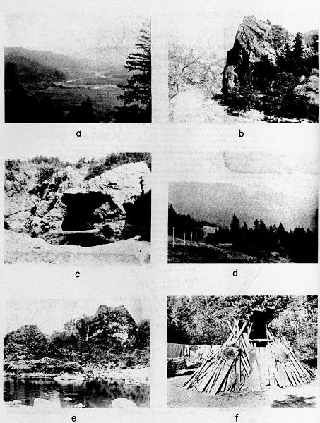
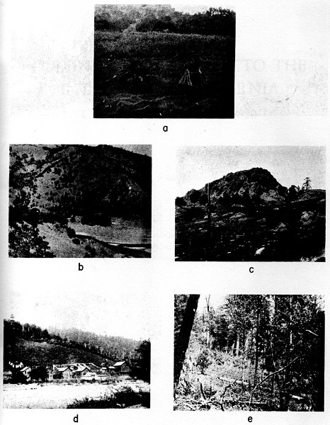
The Kato are the southernmost of the California Athabascans (see pl. 11,
e for a view of Kato territory). They are surrounded on three sides
by Yukian peoples and consequently resemble culturally the peoples of
Central California rather than those of Northwestern California. The
name Kato appears to be of Pomo origin and it was first thought that
the Kato language was a dialect of Pomo (Powers, 1877, p. 147). It was
not until 1903 that Goddard showed their Athabascan affinity (Goddard,
1903b).
Information on the ethnogeography of the Kato is derived from several
sources. Merriam's notes contain some information, which seems to have
come from a man named Bill Ray, who was living near Laytonville on
August 16, 1922. This man had been Goddard's informant in 1906, when Ray
was already between sixty and sixty-five years old (Goddard, 1909, p.
68, pl. 9) and he served also as Kroeber's informant in 1923 (Kroeber,
1925b).
The Merriam notes contain, in addition to several village names, a few
place and tribal names which I present herewith.
Kato: to-chil´-pe ke´-ah-hahng
Jackson V. people (inc. Branscom): sin´-kōk ke´-ah-hahng
Wailaki: we´-tahch
Yuki of Round V.: chinch´
Coast Yuki: bahng´-ke´-ah-hahng
Southern Sinkyone: ketch´-ing ke´-ah-hahng
Tribe on the N side of Rattlesnake Cr. and E of South Fork Eel
division of Wailaki (?): tek´ ke´-ah-hahng
Long V.: kin-tĕhl-pe
Laytonville: ten-tahch-tung
Cahto Pond (now drained): to-chil´-pa
Long V. Cr.: shah´-nah
South Fork Eel R.: nahs-ling´-che
Rattlesnake Cr.: tal-tlōl´-kwit
Main Eel R.: tah-ke´-kwit
Blue Rock: seng-chah´-tung
Bell Springs: sĕch-pis
Round V.: kun-tel-chō-pe
Jackson V.: kus´-cho-che´-pe; kas-tos´ cheek´-be
Branscomb Mt.: kīk; chīs´-naw
The villages of this group are mostly taken from Barrett (1908, pp.
280-283) indicated below by (B). Those taken from Merriam's notes are
distinguished by (M). The information given with each of the villages is
sometimes a direct quotation but most often is paraphrased.
1. netce'līgût (B). At a point about 9 mi. nearly due W of
the town of Laytonville and about 3 mi. SE of the confluence of the
E fork of the South Fork of Eel R. with the South Fork of Eel R.
This village is on top of the ridge separating these two streams
and is on the property of Mr. Jacob Lamb.
2. yictciLti'ñkût, "wolf something-lying-down creek" (B). On
the S bank of Ten Mile Cr. at a point about 5 mi. WNW of the town
of Laytonville.
3. sentca'ūkût, "rock big creek"; or kave'mato (Northern
Pomo dialect name), "rock big" (B). On Big Rock Cr. at a point
about 1-1/2 mi. from its confluence with Ten Mile Cr., or about
5-1/2 mi. nearly due W of the town of Laytonville.
sen-chow´-ten (M). Kato name for their village at Big Rock,
about 4 mi. N of their present rancheria in Long V.
4. ka'ibi, "nuts in" (B). On the NE bank of Ten Mile Cr. at a
point about 3 mi. downstream from the town of Laytonville.
5. nebō'cēgût, "ground hump on-top" (B). On what is
known as the Wilson ranch at a point about 1 mi. W of Laytonville.
6. seLgaitceli'nda, "rock white run-out" (B). About 300 yds. E
of the house on what is known as the "old" John Reed ranch about 1
mi. N of Laytonville.
7. bûntcnōndi'lyi, "fly settle-upon under" (B). Just NW of
Laytonville and but a short distance from the place now occupied by
the Indians near Laytonville.
8. ko'cbi, "blackberry there" (B). About 1-1/2 mi. WSW of
Laytonville and on the SW bank of the Ten Mile Cr.
9. tcībē'takût, "fir tips creek" (B). About a mile SW of
the town of Laytonville and about 1/2 mi. up the creek which drains
Cahto V. from its confluence with Ten Mile Cr.
che-pa-tah-kut (M). A former village in the northern part of
Long V. on the James White place.
10. distēgû'tsīū, "madrona crooked under" (B). On the
western side of Long V. at a point about 2 mi. SSE of Laytonville.
11. tōdji'Lbi, "water? ... in" (B). At the site now
occupied by the Indians at Cahto. This site is on the W bank of the
small creek running from Cahto into Ten Mile Cr.
12. bûntctenōndi'lkût, "fly low settle-upon creek" (B). On
the N bank of the northern branch of the head of the South Fork of
the Eel R. at a point about a mile SSW of Cahto.
13. kûcyī'ūyetōkût, "alder under water creek" (B). On
the N bank of the South Fork of Eel R. at a point about 3 mi. SW of
Cahto. This site is about 1/2 mi. E of the ranch house on the Clark
ranch.
14. ne'īyi, "ground under" (B), probably signifying that
the village was situated under a projecting ridge. On the S bank of
the South Fork of Eel R. at a point about 3 mi. S of Branscomb.
15. sēne'tckût, "rock gravel creek" (B). On the NW bank
of the small stream known as Mud Springs Cr., which is tributary
to the South Fork of Eel R. This site is about 3 mi. a little S
of E of Branscomb. There are on this creek, and not far from this
village site, several springs which flow a very thin blueish mud,
thus giving the creek its name.
16. tontce'kût, "water bad creek" (B). About 1/4 mi. W of the
South Fork of Eel R. and about 1 mi. SW of Branscomb.
17. senansa'nkût, "rock hang-down creek" (B). On the E bank
of the South Fork of Eel R. at a point about 1-1/2 mi. downstream
from Branscomb.
In addition to this list, there are two other sources of information on
villages. First, Curtis (1924, 14:184) presents a list of six villages,
almost all of which it is impossible to locate. None of the names
corresponds to any given by either Barrett or Merriam, and they are
therefore suspect as village names, though they may be valid place names
and are certainly good Athabascan. In the list below Curtis' orthography
has been changed slightly. The changes follow the pattern set by Curtis
in his Hupa village lists (Curtis, 1924, Vol. 13).
Curtis List (1924, 14:184)
| chunsandung, "tree prostrate place" |
1-1/2 mi. W of Laytonville on the site of the cemetery |
| tsetandung, "trail emerges place" |
At the foot of the mountain W of Laytonville |
| totakut, "water center" |
N of tsetandung. On a knoll down which water flowed on two sides |
| chekselgindun, "they killed woman place" |
N tsetandung |
| yitsche Ltindung, "they found wolf place" |
|
| seyuhuchetsdung, "old stone house place" |
|
The second source is the notes of Goddard, who did extensive work in
the area in 1906 (Goddard, 1909), though mostly on language and myth.
His notes contain information on two villages, neither of which can be
located because the township and range coördinates have been changed
since the time of recording and also because the name of the creek
mentioned does not appear on maps in my possession. The two cards
bearing the information have the penciled notations 51 and 52 written
on their corners. This indicates that Goddard had recorded at least 50
other sites for the Kato, a conclusion which is further corroborated
by his own statement (Goddard, 1909, p. 67). Our information on Kato
villages is therefore correspondingly incomplete.
Goddard List (Goddard, Notes)
neεƚsoki, "ground blue tail" SW sec. 26, T. 22
N., R. 15 W. On a flat 200 yds. N of Blue Hill Cr. and 150 yds.
W of the river. There are 3 deep pits on the eastern edge of the
higher flat. Bill thought there were 3 others 100 yds. S where a
white man's house had stood, ne'ƚsōkī kīyahûn.
t'unƚtcintcki, "leaves black tail" W sec. 26, T. 22 N., R.
15 W. On the higher bank 50 yds. N of tûnƚtcintckwōt, the
next creek N of Blue Hill Cr. and 400 yds. W of the river. There is
timber W. Dr. Wilson used to live there. The site has been plowed.
Bill counted six places where he thought houses had been.
The Wailaki, the southernmost group of Athabascans on the Eel River,
are as little chronicled as most of the Athabascan groups. As far as
geography and language are concerned we have very good information
(Goddard, 1923a; 1923b), but there is very little general
ethnography. Kroeber was able to devote to them only a little more than
three pages in the Handbook (1925, pp. 151-154), and we know scarcely
more today.
The territory of the Wailaki lies for the most part outside the redwood
forest (pls. 11b, c) and for that reason they had access to a more
abundant supply of the food, particularly acorns, used by the interior
peoples than did most of the Athabascan groups. Perhaps for this reason,
or perhaps simply because of proximity, the culture of the Wailaki
shows considerable affinity with the culture of Central California and
correspondingly less with that of Northwestern California. This affinity
is particularly evident in their tribelet organization, which obtrudes
itself in the accounts of both Goddard and Merriam. In the groups
farther north such organization receives little attention.
Merriam's information on the Wailaki consists for the most part of
ethnogeography, including villages, tribelets, and place names. His
informants in this group were Fred Major and Wylakki Tip. I have been
able to find out nothing about Fred Major, but Merriam gives the
following statement on Wylakki Tip.
My informant, known as Wylakki Tip, a full blood Tsennahkennes
[Eel R. Wailaki, but see Kroeber's data, p. 229], whose father and
mother were born and lived at Bell Springs, tells me that they
belonged to the Bell Springs Canyon band known as Tsi-to-ting
ke-ah, named from the neighboring mountain tsi-to-ting. He adds
that from the mouth of Blue Rock Creek northward the Tsennahkennes
owned the country to the main Eel, and that the present location of
Bell Springs Station, on the west side of the river, is in their
territory but that the east side of the river from Bell Springs
Station to the mouth of Blue Rock Creek was held by a so-called
Yukean tribe.
In Merriam's notes there is no general statement on the Bahneko or North
Fork Wailaki; he was evidently somewhat undecided whether they were
truly a distinct group. However, he comments on the Tsennahkennes, or
Eel River Wailaki, as follows.
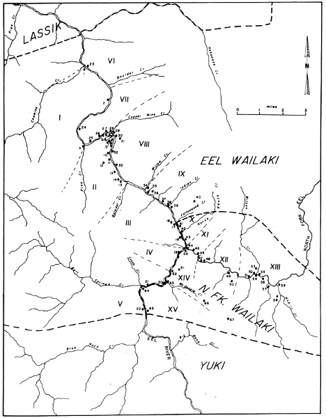
Map 5. Villages and tribelets of the Eel Wailaki and the
North Fork Wailaki. Roman numerals indicate tribelets, arabic numerals
village sites.
Tsennahkennes ... A Nung-gahhl Athabascan tribe in north-central
Mendocino County, California, occupying the greater part of the
mountainous country on both sides of main Eel River from Red Mountain
and the upper waters of East Branch South Fork Eel easterly to Salt
Creek, and from a few miles south of Harris southerly to Rattlesnake
Creek. Their territory thus includes the major part of Elkhorn Creek,
the headwaters of East Branch South Fork Eel, Milk Ranch Creek, and Red
Mountain Creek, practically all of Cedar Creek, and the whole of Bell
Springs and Blue Rock Creeks. The old stage road from Cummings north to
Harris, passing Blue Rock and Bell Springs, traverses their territory.
It is clear that in recording Wailaki words Merriam followed the same
principles that guided him in his published works on other Californian
languages. In transcribing the Achomawi language he said (1928, p. vi),
"All Indian words are written in simple phonetic English, the vowels
having their normal alphabetic sounds." For a more precise determination
I have made a comparison of words recorded by both Merriam and Goddard.
The values of the symbols used by Goddard are taken from a list he
gives in his Wailaki Texts (1923b, p. 77) together with Phonetic
Transcription of American Indian Languages (Amer. Anthro. Assoc., 1916),
a report which Goddard helped prepare.
A total of twenty-eight words recorded by both Merriam and Goddard were
found. Although the discrepancies seem great, this is because Merriam
used Webster's English orthography whereas Goddard used a technical one
modified from the old Smithsonian system. Whatever the limitations of
Merriam's orthography for considerations of grammar (which he did not
try to obtain), his recordings consistently check Goddard's independent
information and serve as complete identifications of places and
ethnographic facts.
Goddard's Wailaki Phonology
|
Labial |
Apical |
Frontal |
Dorsal |
| Stops |
fully voiced |
|
|
|
g |
| medium voiced |
b |
d |
G |
|
| voiceless non-glottalized |
|
t |
|
k |
| voiceless glottalized |
|
t' |
|
k' |
| Affricates |
non-glottalized |
|
ts |
tc |
|
| glottalized |
|
ts' |
tc' |
|
| Spirants |
voiceless |
|
s |
c |
|
| voiced |
|
|
|
|
| Nasals |
|
|
n |
|
ñ |
| Semivowels |
|
w |
|
y |
|
| Laterals |
voiced |
|
l |
|
|
| voiceless |
|
ƚ |
|
|
Goddard gives the following vowels.
i as in pique (written with an iota by Goddard)
e as a in fate
E as in met (written with an epsilon by Goddard)
a as in father
A as u in but (written with an alpha by Goddard)
o as in note
Following is a rough correspondence between Goddard's and Merriam's
orthographies.
Comparison of Orthographies
| Goddard |
Merriam |
| a |
ah (occasionally a or e) |
| A |
ah, e, u, i (in order of frequency) |
| ai |
a, i |
| Ai |
i |
| b |
b |
| c |
s (once sh) |
| d |
d, t |
| e |
e |
| E |
e, ā |
| g |
ƚg written as sk |
| G |
does not occur |
| h |
h |
| i |
ē, ĕ (oi written i) |
| I |
i, u |
| k |
k (ky written ch) |
| k' |
k |
| l |
does not occur |
| ƚ |
kl, often not recorded at all (ƚ written sk) |
| m |
n (Goddard says n sometimes becomes m by assimilation. Evidently it is n phonemically) |
| n |
n (occasionally ng, once not recorded at all) |
| ñ |
ng (occasionally n, twice not recorded at all) |
| o |
o (occasionally u) |
| s |
s |
| t |
t |
| t' |
does not occur |
| tc |
ch (once tch) |
| tc' |
does not occur |
| ts |
does not occur |
| ts' |
does not occur |
| u |
does not occur |
| w |
does not occur |
| y |
y, ky written ch, kiyah always written ke-ah or ka-ah |
The subgroups of the Wailaki (map 5) are called bands by Merriam and
subtribes by Goddard but it is clear that they correspond precisely to
the definition of tribelet given by Kroeber (1932, pp. 258-259), a fact
which Kroeber noted at the time (p. 257). Goddard says (1923a, p. 95):
[They] had definite boundaries on the river as well as
delimited hunting grounds on an adjoining ridge. In the summer
and fall they appear to have been under the control of one chief,
and to have camped together for gathering nuts and seeds and for
community hunting. In winter they lived in villages and were
further subdivided.
I. There is close agreement on the boundaries of the northernmost
Wailaki tribelet on the western side of the Eel. Merriam gives the
names kun-nun´-dung ke´-ah-hahng, ki´-kot-ke-ah-hahng, ki-ketch-e
kā-ah-hahng, and ki-ke´-che ke´-ah-hahng as designations for the
group. He says the territory of this group runs from Chamise Creek
in the north to Pine Creek in the south. Goddard gives the same name
(rendered kaikitcEkaiya) and the same boundaries for the group.
The territory north of Chamise Creek on the west side of the river is
assigned by Merriam to the taht´-so ke´ah tribelet of the Lassik. This
attribution would seem to indicate that Merriam has put his northern
Wailaki boundary too far north, that it should hit the Eel at Chamise
Creek rather than at Kekawaka Creek. Goddard calls these people the
daƚsokaiya, "blue ground people," which no doubt corresponds to
taht´-so ke´ah. He says, "It is doubtful that they should be counted as
Wailaki, but they were not Lassik and probably spoke the same dialect as
the Wailaki."
II. This tribelet is called sĕ-tah´-be ke´-ah-hahng or
sā-tah´-ke-ahng by Merriam. In one place his notes say that the
territory includes land on both sides of the Eel, running south of
Indian Creek on the western side. This is clearly not so, for he refers
several times to a different tribelet occupying that area. That the
tribelet was confined to the east side of the river is further indicated
by Goddard, who gives Pine Creek on the north and Natoikot Creek on the
south as the boundaries. Goddard's name for the tribelet is sEtakaiya.
III. Goddard says that there was a tribelet on the west side of the Eel
whose territory was bounded on the north by Natoikot Creek and extended
south to a point opposite the mouth of North Fork. His name for this
group is taticcokaiya. Merriam's name for the group in this general area
is tah-chis´-tin ke-ah-hahng. He does not give any boundaries for them.
IV. and V. Merriam gives the following names for the tribelet occupying
the territory around Blue Rock and Bell Springs Creeks: tsi-to´-ting
ke´-ah, from the name of Bell Springs Mountain; sen-chah´-ke´-ah;
sĕ-so ke´-ah-hahng, "Blue Rock Band"; then´-chah-tung kā´-ah,
"Blue Rock Band." On the other hand, he gives the following names for
the people who occupied the west bank of the Eel for a mile or more
south of the mouth of North Fork: nin-ken-nētch kā-ah-hahng;
nung-ken-ne-tse´ ke´-ah; nĕ-tahs´ ke-ah-hahng. Goddard says that the
entire stretch from the mouth of North Fork south to Blue Rock Creek
on the west bank of the river was occupied by a single tribelet called
nIñkannitckaiya, a name clearly corresponding to Merriam's names for the
people on the west bank of the Eel, south of North Fork. I am inclined
to think that Merriam is correct and that there were two tribelets in
this area. Merriam's notes include five different references to the
southern tribelet as a separate group, so there is a distinct impression
of autonomy. If Merriam is correct in separating the two groups, the
division line no doubt falls a mile or two north of Bell Springs Creek.
VI. On the eastern side of the river Merriam gives two names for the
tribelet holding the land south from Kekawaka Creek. He says the
yu-e-yet´-te ke´-ah was the tribelet north of Chamise Creek. Their
southernmost village, called sko´-teng, was on the east side of the
river a half-mile or a mile south of Kekawaka Creek. The sko´-den ke´-ah
Merriam gives as the name of the tribelet on the east side of the Eel
River and about a half-mile south of Kekawaka Creek. Goddard gives
iƚkodAñkaiya, corresponding to Merriam's sko´-den ke´-ah, as the
name of the group extending from about two miles south of the mouth of
Chamise Creek nearly to the mouth of Kekawaka Creek. Both Merriam and
Goddard indicate some doubt whether these people were Wailaki.
VII. Merriam gives the names chēs-kot kē-ah-hahng,
chis´-ko-ke´-ah, and tōs-ahng´-kut for the tribelet living in
Horseshoe Bend. The first two names come from the word chis-kot, the
name for Copper Mine Creek. Goddard also gives these last two names for
the group (written tciskokaiya and tosAñkaiya, "water stands people"),
and he says their territory includes the land between Copper Mine Creek
on the south and a point a mile or two south of Chamise Creek on the
north.
VIII. Goddard says that a tribelet named slakaiya or sEyadAñkaiya
occupied the territory between Copper Mine Creek in the north and Willow
Creek in the south. Merriam gives the name nung-ken-ne-tse´ ke´-ah to
this group, which he locates on the east side of the Eel River at Island
Mountain. He gives no boundaries for the group.
IX. Merriam gives two names for the tribelet occupying the Indian Creek
region. The chen-nes´-no-ke´-ah was the band on chen-nes-no´-kot Creek
(Indian Cr.) from Lake Mountain to the Eel River; he also writes this
name ken-nis-no-kut ke-ah-hahng. His other name for the group has the
variants bas-kā´-ah-hahng, bas-ki´-yah, bus-kā-ah-hahng. This
group is said to have been on the east side of the Eel River a mile
or two north of Indian Creek (in the Fenton Range country). Goddard
gives the name bAskaiya, "slide people," corresponding to the last of
Merriam's names, for the tribelet from Willow Creek south to Cottonwood
Creek. The name refers to a hillside, usually of clay, which has broken
loose and has slid down.
X. Merriam identifies no group as occupying the land from Cottonwood
Creek south to the mouth of North Fork. Goddard says the region was
occupied by a tribelet called sEƚtchikyokaiya, "rock red large
people."
XI. Merriam says the sā´-tan-do´-che ke´-ah-hahng was the name of
a tribelet on the north side of North Fork and about a half-mile from
its junction with the main Eel. The name means "rock reaching into the
water." Goddard's name for this same group is sEtandoñkiyahAñ, a clear
correspondence, and he indicates that their land was on about the last
mile of North Fork.
XII. According to Merriam the next group up North Fork was named
sĕ-cho ke´-ah-hahng. Its land was on the north side of North Fork a
mile or more above its mouth. Goddard has the same name for the group,
sEtcokiyahAñ; he says the people occupied both the north and south sides
of a one-mile stretch of North Fork beginning a little way below the
mouth of Wilson Creek and extending downstream from there.
XIII. Merriam says ki´-ye ke´-ah-hahng was the name of the tribelet on
both sides of North Fork at the mouth of Wilson Creek. This is in accord
with Goddard's data. He gives the name as kAiyEkiyahAñ. Neither Goddard
nor Merriam gives the limits of this group up North Fork. Presumably
they coincide with the tribal boundary.
XIV. According to Goddard a tribelet called nEƚtcikyokaiya was in
possession of the territory on the east bank of the Eel from McDonald
Creek northward to the mouth of North Fork. Merriam does not record this
group.
XV. The southernmost tribelet on the eastern side of the Eel is called
sEƚgAikyokaiya, "rock white large people," by Goddard. They are said
to have occupied the territory from McDonald Creek south to Big Bend
Creek. This group is not recorded by Merriam.
The list of villages which follows includes all those contained in
Merriam's notes and also all those given by Goddard (1923a) that could
be located with accuracy (map 5). Occasionally there is a conflict
between Merriam and Goddard and then it has usually seemed best to
accept Goddard's information, since he actually visited the sites of
most of the villages he mentions.
All the data are either from Merriam or Goddard, as indicated by (M)
or (G). Ancillary comment by myself is placed in square brackets. The
notations (Tip) and (Maj) refer to Merriam's informants (see p. 167).
The arabic numbers correspond with those on map 5, indicating separate
villages. These run consecutively from north to south, first on the west
side of the Eel (1-22) and then on the east side (23-67).
Villages on West Side of the Eel
1. The main village of the ki-ketch-e tribelet is said to have
been on the S side of the mouth of Chamise Cr. (M).
kAntEltcEk'At, "valley small on" (G). The most northern
village of the kaikitcEkaiya, whose northern boundary was Chamise
Cr.
[Both Merriam and Goddard give this as the native village
of the wife of Wylakki Tip so there is no doubt that they are
referring to the same village.]
2. kun-tes-che´-kut (M). Said to have been a Wailaki village
on the W side of the Eel R. a half-mile N of Horseshoe Bend Tunnel,
probably nearly opposite Horseshoe Bend Cr. (Tip).
[Horseshoe Bend Tunnel cuts out the meander of Horseshoe
Bend. Horseshoe Bend Cr. appears to enter the Eel from the E about
a mile S of Boulder Cr. If Goddard's kAntEltcEk'At is really
kAntEƚtcEk'At, with the bar on the "l" dropped in error, then
these names are nearly the same. If so, kun-tes-che´-kut might
be the name of village no. 1 even though the location differs
slightly.]
3. basEtcEƚgalk'At, "throw stone outside on" (G). On the
western side of the Eel, just N of the mouth of Pine Cr.
4. sEdAkk'añdAñ, "rock ridge place" (G). On the point of the
ridge around which the Eel turns toward the W at Horseshoe Bend.
5. kit-te-ken-nĕ´-din (Tip), kit-ken-nĕ-tung (Maj) (M).
At or near the S end of Horseshoe Bend Tunnel. It was the biggest
village of the tribelet and was said to have been the native
village of the father of Wylakki Tip.
sĕ-tah´-be (M). A large village on the W side of the Eel
River just S of Horseshoe Bend Tunnel near Island Mt. Station. It
was nearly opposite the mouth of Copper Mine Cr.
tcInnagañtcEdai, "eye closed door" (G). At the base of the
ridge described in no. 4. It was said to have been the home of
Captain Jim.
[These names may or may not refer to the same village. If
they do, it is likely that Merriam's kit-te-ken-nĕ´-din is the
correct one. His sĕ-tah´-be evidently refers to the name of
the tribelet, sEtakaiya, given by both him and Goddard. Goddard's
designation looks as though it might very well refer to the tunnel
and thus would be very modern.]
6. lacEƚkotcEdAñ, "buckeye small hole place" (G). This
seems to have been only a few hundred yards S of Horseshoe Bend.
7. kaigAntcik'At, "wind blows up on" (G). A big winter camp
about 1/4 mi. S of Horseshoe Bend.
8. sait'otcEdadAñ, "sand point on" (G). Also about 1/4 mi. S
of Horseshoe Bend but was about 500 ft. above the river near a big
spring.
9. tcIbbEtcEki, "gather grass tall" (G). A little more than
a mile S of Horseshoe Bend a very small stream runs into the Eel
from the W. On the N side of the mouth of this stream was this
house site where Captain Jim's father used to build his house some
winters and live by himself.
10. sEnanaitAnnik'At, "stone trail across on" (G). About a
mile S of Horseshoe Bend.
11. Isgaikyoki (G). About 1-1/2 mi. S of Horseshoe Bend a
small creek called Isgaikyokot enters the Eel from the W. The
village with this name was situated on the N side of the mouth of
this creek. It was the home of the father of the wife of Wylakki
Tip.
12. IsgaidadAbbIñlai (G). N of the creek mentioned in no. 11
but on higher ground away from the river.
13. ƚtAgtcEbi', "black oaks in" (G). About a mile N of
Natoikot Cr. on a flat above the river.
14. sEnagatcEdAñ, "stones walk around place" (G). About 200
yds. N of no. 15.
15. sEƚsokyok'At, "stone blue large on" (G). About 1/2 mi.
N of the mouth of Natoikot Cr. There was said to have been a pond
here.
16. ƚtcicsEyEbi', "ashes rock shelter in" (G). This shelter
was under a large rock which stood on the hillside a short distance
downstream from no. 17. Two or three families used to spend the
winter in it.
17. bantcEki, "war [ghosts] cry" (G). On the W side of the Eel
a little more than a mile N of the mouth of North Fork and opposite
the mouth of Cottonwood Cr. It was close to a fishing place that
the tribelet shared with the bAskaiya tribelet.
18. tah-tēs-cho´-tung, tah-tēs-cho´-ting, tah-chis´-ting
(M). 1/2 mi. or more N of the mouth of North Fork on the W side of
the main Eel.
taticcodAñ (G). In a grove of oaks about 1/4 mi. downstream
from the mouth of North Fork on the W side of the Eel.
19. ne´-tahs, ning-ken-ne´-tset (M). Ne´-tahs is the name of
the town on a rocky stretch of the river. The town ran for a mile
or more S of the mouth of North Fork (Maj). Ning-ken-ne´-tset was
the name of the village which was at the fishing place opposite the
mouth of North Fork and extending S. It was also called "fishtown."
Tip's mother lived there (Tip).
nEtacbi', "land slide in" (G). About a mile S of the mouth
of North Fork on the W side of the Eel. It was a noted fishing
place. Goddard says: "There is no mention in the notes of a village
at this point, but several Wailaki were spoken of at times as
belonging to the nEtacbi'."
20. sEƚtcabi' (G). Nearly opposite the mouth of McDonald
Cr. It was named for the large rock beneath which it stood.
21. tcoƚAttcik'At, "graveyard on" (G). A large village on
the western side of the river a few hundred yards downstream from
the mouth of djoñkot.
[The stream that Goddard calls djoñkot seems to be the one
that appears on the modern maps as Cinch Cr.; that is the only one
in the vicinity. On his map it is shown entering the Eel about
a mile downstream from the mouth of Bell Springs Cr. but it is
actually a tributary of Bell Springs Cr., joining that stream a
scant hundred yards from its mouth. On the assumption that Cinch
Cr. is, in fact, the stream that Goddard meant to indicate I have
moved the village about a mile to the S.]
22. sa'kAntEƚdAñ, "beaver valley place" (G). About midway
between the mouth of Blue Rock Cr. and Bell Springs Cr. on a fine
large flat.
Villages on East Side of the Eel
23. sEƚkaibi, "make a noise in the throat" (G). Opposite
the mouth of Chamise Cr.
24. tcadEtokInnEdAñ (G). Located only approximately—in
Horseshoe Bend at the point where the river turns toward the NE.
25. k'AcsAndAñ, "alder stands place" (G). About a mile
downstream from the point where the river turns W at Horseshoe Bend.
26. sEtcokInnEdAñ, "rock large its base place" (G). About 1/2
mi. downstream from the point where the river turns toward the W at
Horseshoe Bend.
27. nEtcEdEtcAñk'At, "ground rolling on" (G). A short distance
W of the mouth of Copper Mine Cr. (Tunnel Cr.).
28. dAndaitcAmbi, "flint hole in" (G). On the downstream side
of the mouth of Copper Mine Cr. (Tunnel Cr.).
29. taht-aht (M). On the E side of the Eel R. at Horseshoe
Bend and opposite sĕ-tah´-be. It was a big town (Tip).
kaitcIlIñtadAñ, "Christmas berries among place" (G). There
was a graveyard about 1/4 mi. N of the village and just beyond the
graveyard was Copper Mine Cr.
30. to-chĕ´-ting (M). A big village on the E side of the
Eel R. at Horseshoe Bend (opposite sĕ-tah´-be), only a short
distance S of taht-aht (Tip). It was probably less than 1/4 mi. S
of Island Mt. Station on the opposite side of the river.
kaslInkyodAñ. "spring large place" (G). On the E bank of the
river about 300 yds. S of kaitcIlIñtadAñ, or about 1/2 mi. S of
Copper Mine Cr.
[The names of these two villages are not the same at all and
since Goddard gives many villages in the near vicinity the chances
are good that the names do not represent the same village.]
31. kaslInkyobi, "spring large in" (G). A rock shelter near
Goddard's kaslInkyodAñ. A family used to spend the winter here.
Captain Jim's father-in-law was left here to die after he had been
wounded by the whites.
32. skEtcEƚkascanAñ, "mush thrown away sunny place" (G).
Evidently situated about a mile S of Copper Mine Cr., where the
river makes a slight turn toward the N. Here there is a flat 50 ft.
higher than the river and 150 ft. from it, in which 17 house pits
were counted. This village was just upstream from a rock called
skEtcEƚkaiyE. Each spring a mush-like substance appears on the
face of this rock and is washed away each winter. The thickness of
the deposit is supposed to indicate the abundance of the year's
acorn crop.
33. ah-chahng´-ket (M). On the E side of the Eel a mile or two
S of Horseshoe Bend. It was more than a mile S of to-che-ting (Tip).
akyañk'At, "right here on" (G). Some distance N of Willow Cr.
and on the river.
[These two names doubtless represent the same village but
neither Merriam nor Goddard gives a very exact location for it.]
34. slAsyanbi', "squirrels they eat in" (G). Only a
short distance S of Willow Cr. and back from the river near
nEƚtcAñk'At. slAsyañkot was an alternate name for Willow Cr. and
the name of the village was derived from this.
35. nĕ-chung-ket´ (M). On the E side of the river about
1/2 mi. S of ah-chahng´-ket (Tip). The inhabitants were called
nĕ´-chung ke-ah-hahng (Maj and Tip).
nEƚtcAñk'At, "ground black on" (G). Said to have been the
second one S of Willow Cr.
[It is evident that both Merriam and Goddard have the same
name here. Goddard's location is more precise and thus has been
accepted.]
36. dabAstci'Añdañ, "ants' nest place" (G). A little way S
of the mouth of Willow Cr. The name comes from the name of Willow
Cr.—dabActci'Añkot.
37. dAstatcElai, "string (?) point" (G). Evidently only a
short distance above Indian Cr. It was said to have been a large
winter camp.
38. tcAƚsAl (G). Just N of the mouth of Indian Cr. was a
sharp rock with this name; the Indians camped near this in the
springtime.
39. tAƚdjInlai, "water clayey point" (G). On the S side of
Indian Cr. The large village appears to have stood just a little E
of the NW corner of sec. 36, T. 5 S., R 6 E. Its inhabitants were
exterminated by mixed bands of white men and Kekawaka Indians.
40. tah-bus-che-sahng´-tung (M). A small village in the hills
1 mi. E of the Eel R. and 1 mile S of Indian Cr. (Maj).
41. sEƚtcikyok'At, "red rock large on" (G). 1/4 mi. N of
the first creek downstream from North Fork on the E bank of the
main Eel.
42. chug´-ge´-tah (M). A small village on the E side of the
Eel N of the mouth of North Fork (Maj). It was about 2 mi. S of
Indian Cr.
sEtatcikaiya (G). A tall rock is situated N of the mouth of
the first creek N of the mouth of North Fork. The village was just
to the W of this rock and was named for it.
[The villages given by Merriam and Goddard are in about the
same place but Merriam's location is so indefinite that their
identity is uncertain.]
43. kaiƚtcitadAñ, "redbud place" (G). A short distance N
of the mouth of North Fork a ridge runs down to the river. On the
northern side of the ridge a village was situated.
44. tōn-klan´-be-ko-cho´-be (M). On the E side of the Eel
on the northern side of the mouth of North Fork (Tip).
tonƚEmbi', "streams come together in" (G). Situated on a
terrace N of the mouth of North Fork and on the E side of the main
Eel. In the summer of 1922 10 house pits were counted there, 4 of
them being large and deep.
[These two sites are evidently the same, since both the names
and the locations match.]
45. sā´-tan-do´-che ke´-ah-hahng (M). In a rocky stretch on
the N side of the North Fork about 1/2 mi. above its junction with
the main Eel. The name means "rock reaching into water."
sEtandoñtci, "rock runs to the water" (G). On the N bank of
North Fork about 1/2 mi. above the mouth.
46. sEntciyE, "rock large under" (G). About 3/4 mi. above the
mouth of North Fork. The rock for which it was named, with a large
spruce tree, stands opposite the village site, on the S side of the
stream.
47. sĕ-cho-ke´-ah-hahng (M). A village and band at
sĕ-cho, "big rock," on the N side of the North Fork of the Eel
a mile or more above its mouth. "Thousands of Indians killed here"
(Maj).
sEtcolai, "rock large point" (G). On the N side of North Fork
a little more than a mile above its mouth.
48. lacEnadailai, "horse chestnut stand point" (G). About 60
yds. upstream from no. 47. A house pit 4-1/2 ft. deep was seen
there.
[This site was no doubt included under no. 47 by Merriam's
informant.]
49. About halfway between the main Eel and Wilson Cr. a small
stream enters North Fork from the S (G). Near this there was a
village before the whites came. An incident there is said to have
occurred at a time when the informant's grandmother's grandmother
was small.
50. stAstcok'At, "rope large on it" (G). Somewhat farther
upstream than no. 49 and back a way from the bank of the stream,
also on the S side. The village is said to have been a large one
when the white people came to this region. In 1906 there was still
a house on the site.
51. totAkk'At, "between water" (G). Summer camp a little way
below the mouth of Wilson Cr. on the N side of North Fork.
52. seƚtcidadAñ, "stone red mouth place" (G). An old
village, occupied before the whites came. It stood between no. 11
and the mouth of Wilson Cr.
53. nolEtcotadAñ, "water falls large among" (G). On the N side
of North Fork about 1/2 mi. below Wilson Cr. It was on two levels;
one near the stream, the other on a terrace some yards N.
54. ki´-ye ke´-ah-hahng (M). On North Fork at the mouth of
Wilson Cr. and covering both sides of North Fork and Wilson Cr.
(Maj).
[This name is evidently the same as Goddard's name for the
tribelet on North Fork above Wilson Cr.—kAiyEkiyahAñ.]
55. sEnEsbInnAñkai, "rock tall its slope" (G). On the northern
side of North Fork and about midway E and W of sec. 12, T. 24
N., R. 14 W. is a tall rock called sEnEs. Just W of this was the
village.
56. k'asolEtcobi', "arrowwood rotten flat" (G). On the S side
of North Fork opposite the tall rock mentioned in no. 55. The
informant said his uncle remembered the building of the dance house
when he was a small boy.
57. sā´-yahs kun´-dung (M). A fishing camp for drying
salmon at Fishtown Spring or Upgraff fishery on North Fork about 5
mi. up, "march till creek dries up."
[Upgraff must be an error for Updegraff; the latter is a local
place name whereas the former is not, so far as I can see.]
58. sEnEstconatAñkai, "rock tall large crossing" (G). A small
stream comes into North Fork about 1-1/2 mi. above Wilson Cr. The
village of this name was situated 1/2 mi. S of North Fork and just
to the W of this tributary. The village had not been occupied in
the memory of the informants.
59. Another village not occupied in historic times was
situated on the S side of North Fork just above the mouth of the
stream mentioned in no. 58 (G).
60. sāh-gah´-ket, se-kah´-ke-ah-ahng, se-ki´-ah-hahng (M).
A rancheria on the E side of the Eel R. on the S side of the mouth
of North Fork (named for sā-gah-nah´-ting, the name of the land
on the S side of the mouth of North Fork in the angle between the
two rivers) (Tip).
kaiƚtcitadAñ, "redbud place" (G). This was apparently near
Merriam's sāh-gah´-ket.
[These different names may not represent the same village. If
these were two villages, they were very close together. Goddard
gives kaiƚtcitadAñ as the name of another village N of North
Fork (no. 43) so it may be an error here (see pl. 11, b for a view
of this region).]
61. tsEgolkAllinseyE (G). A rock shelter situated back from
the river a short distance above McDonald Cr. The Indians lived
here in the winter.
62. ne-che´-cho-ket (M). On the E side of the Eel about a mile
S of the mouth of North Fork. It was apparently opposite part of
the elongate village ning-ken-ne´-tset (no. 19). "Salmon stop here;
great fishing; rocky place; Red Hill ground" (Tip).
nEƚtcikyok'at, "ground red large on" (G). On a point of
land running down to the river on the E side just above nEtacbi',
the fishing place of the region.
[Goddard adds some information which explains the statement
of Merriam's informant. He says, "About two-thirds of a mile below
the mouth of McDonald Creek a number of large rocks lie in the bed
of the river. This place is called nEtacbi', 'land slide in,' and
seems to have been a noted fishing place."]
63. sah-nah´-chung-kut, sah-nah-chin´-che ke´-ah-hahng (M).
On the E side of the Eel R. 1-1/2 or 2 mi. S of the mouth of North
Fork and near McDonald Cr. (Tip).
64. sel-di´-kot (M). On the E side of the Eel R. S of Bell
Springs Cr. (Maj).
65. sĕ-ski´-cho-ding (M). Claimed as a Wailaki village
on the E side of the Eel R. at White Rock near Big Bend. On the
opposite side of the river from Bell Springs Station (Tip).
seƚGaitcodAñ (G). On a flat on the E side of the river.
"The east and west section line dividing sections 84 and 85 of T.
24 N., R. 14 W. was noted as passing through this flat."
[These two names doubtless represent the same village; the
names are similar and the locations are the same.]
66. chin-to´-bin-nung (M). On the upper part of McDonald Cr.,
about 3 mi. up from the Eel (Maj).
67. chus-nah-teg-gul-lah chen-ne-tung (M). An old village
about 2 mi. S of North Fork and 3 mi. E of the Eel.
The following list includes ethnogeographic information taken from
Merriam's notes in addition to information on creeks from Goddard
(1923a), the latter being especially important because most villages
are located with respect to streams. All streams and rivers may be found
on map 5. Locations of other features have been given after consulting
the appropriate United States Geological Survey (USGS) quadrangle
but they are not shown on the map. For this area the quadrangles are
Alderpoint (1951), Hoaglin (1935), Leggett (1952), and Spyrock (1952).
Asbill Cr.—djoñot (G).
Bell Springs Cr.—sAlt´okot (G).
Bell Springs Mt.—tsi-to´-ting; si-to´-ting (M). This is the
mountain cut through by Bell Springs Cr.
Bell Springs Station (native name for the site of the
station)—sah´-ten´-tĕ´-te; sah-ten-tĕhl-tĕ (M). Bell
Springs Station is on the W side of the Eel about halfway between
Blue Rock Cr. and Bell Springs Cr., about the same place as village
22. In fact, Merriam's names for this site may correspond to
Goddard's name for village 22, sa'kAntEƚdAñ.
Big Bend Cr.—dAndaikot (G).
Blue Rock—sen-chah´-tung (M). Evidently this is near Blue
Rock Cr.
Chamise Cr.—sah-nah´-ting; shah-nah-ting (M); canAndAñkot (G).
Chamise Cr. crossing—ses-ki´-be (M).
Chamise Cr., mouth of—sun-ti´-che, soon-di´-che (M).
Cinch Cr.—djoñkot (G). Goddard evidently has this creek
placed incorrectly on his map. If I understand his description, it
should be a tributary of Bell Springs Cr. rather than of the Eel R.
directly.
Copper Mine Cr. (Tunnel Cr. on the more recent
maps)—chis´-kot, chēs-kot (M); tciskot (G). Both Merriam and
Goddard say that this name refers to red paint and was probably
suggested by the color of the water in the creek. This is also
responsible for the English name.
Cottonwood Cr.—tgActcEkot (G). The English name is a
translation of the Wailaki name. The creek is unnamed on USGS maps.
Dawson Flat—choo´-e-kun-tes´-te (M). This flat was W of Lake
Mt. between Horse Ranch and Fenton Ranch.
Eel R.—tan´-cho-kut (M). Eel R. valley—bus´-be (M). This
name refers to a part of the valley of the main Eel R., especially
the E side, between Horseshoe Bend and North Fork.
Eel R., E branch of South Fork—to-kā-kut (M).
Eel R., Middle Fork—tahng-cho-skus (M). The junction of the
Middle Fork with the main Eel was called tōs-kahs-kā.
Eel R., North Fork—bah´-ne-kut (M); banikot (G).
Eel R.-North Fork junction—chā-lin´-ding, klā-lin-ding
(M).
Harris region—tah-sahn-ting´, tahs-ahng (M). Harris is a
small town about 8 mi. W of the main Eel R. in the territory of the
Lassik (according to Merriam's boundaries).
Hettenshaw Valley—ken-tes´-tung (M). This valley is in Lassik
territory about 12 mi. N of the Wailaki boundary. It lies between
the headwaters of the North Fork of the Eel and the headwaters of
the Van Duzen R.
Horse Ranch Cr.—kus´-ken-tes´-be (M); canAñtcakot (G). These
are clearly not the same names but sometimes streams have alternate
names. Cf. Willow Cr. below.
Horseshoe Bend—chēs (M). The bend is named for the red
copper spring of Copper Mine Cr. ki´-ke-che (M) is the name for
the western part of the loop of Horseshoe Bend, to-sahng´-kut,
tōs-ahng-kut (M) is the name of the part of Horseshoe Bend N of
Island Mt. Horseshoe Bend is the big switchback curve in the Eel R.
about 6 mi. N of the mouth of North Fork.
Indian Cr.—chen-nes-no´-kut, ken´-nis-no´-kut (M). The name
Indian Cr. does not appear on any of the USGS maps but it is the
name used by Merriam.
Island Mt.—bahng-kut, bahn-kut (M); bañk'At (G). Island Mt.
is a range of hills bordered on the E by the Eel R. and extending
from the mouth of North Fork in the S to beyond Horseshoe Bend in
the N.
Jewett Cr.—sel-di´-kot (M); dAsk'Ekot (G).
Kekawaka Cr.—kas-nā´-kot, kahs´-ne-kot (M); kasnaikot (G).
Lake Mt.—sā-kahn-den, se-kahn´-ting (M). Lake Mt. is about
3 mi. E of the Eel and 3 mi. N of North Fork.
McDonald Cr.—sah´-nah-chin-che (M); canAñtcIntci (G).
Middle Trail—be-ten-na´-be (M). This trail was in the hills E
of the Eel R. about a mile south of Indian Cr.
Mina—to-les´ cho´-be (M). Mina is a modern place name for a
town about 2 mi. N of North Fork and 5 mi. E of the main Eel R.
Natoikot Cr.—no-toi´-kut (M); natoikot (G). I have given this
creek its Wailaki name because it has no English name and is not,
in fact, located on modern maps. It is said to have run into the
Eel R. about 1-1/2 mi. S of Island Mt. Station, which is on the
southern side of Horseshoe Bend. It has been placed on the map in
accordance with the topography shown on USGS Hoaglin Quadrangle.
Pine Cr.—ten-di´-kot (M); lacEtcikot (G). Merriam was not
certain that his name was correct.
Pipe Cr.—taht-so´-kut (M).
Poonkinny Ridge—nel-kis´-te (M). Merriam says this is the
name of the open ridge between the main Eel R. and the northern
part of Round V. That area is marked Poonkinny Ridge on the USGS
Spyrock Quadrangle. It is in Yuki territory.
Rattlesnake Cr.—to-nah´-ling (M). This creek is a tributary
of the South Fork of the Eel R. and forms a part of the southern
boundary of the Eel River Wailaki, according to Merriam.
Rockpile Mt.—sen´-ning ah´-kut (M). This mountain is said to
be on the E side of the Eel R. S of Alder Point, but the name does
not appear on modern maps.
Round V.—ken´-tes-cho´-be (M). The inhabitants of Round V.
were called ken´-tes cho´-be ke´-ah, a locative rather than a
tribal name.
Summit V.—ken-tes´ƚ-be (M). Summit V. lies about 2 mi. SE
of the bend of North Fork and seems to have marked the southeastern
limit of North Fork Wailaki territory. It is said that there was
once much camass there.
Willow Cr.—dabActci'Añkot, slAsyañkot (G). The latter was
used occasionally for the stream.
Wilson Cr.—dat'olkot (G).
The following notes are from Merriam's records.
Badger is called ye-ku-gus-cho, "he pulls into his hole."
The Steller Crested Jay is called chi-cho, while the
California Jay is chi-che. In speaking of related species the
Indians often indicate the larger by the suffix cho, the smaller
by che.
The Owl is called bis-chil-lo-che if it is small, the Great
Grey Owl is bis-chil-lo-cho.
The Crow is kah-chan-che, the Raven is kah-chan-cho.
The Meadow Lark sings in the daytime; the Yellow-breasted Chit
sings at night.
The Bluebird is a dangerous bird. If a person throws a stone
at it, he should shout first to attract its attention, otherwise it
will throw a pain to him.
The Junco is a great rustler, always busy hunting for food.
The Chewink, or Towhee, called Nahl-tse, was instrumental in
procuring the first fire. In the very early days his parents threw
him out. He located the fire and Coyote-man went and got it.
The Kildeer Plover is called nah-til yah-che, "necklace
wearing."
The Toad is Rough Frog.
The Cicada is used as a remedy for headache. The live insect
is pushed up into the nose, where, by kicking around, it makes the
nose bleed, thus curing the headache.
The Dragonfly feeds rattlesnakes.
Oak galls, called kim-mos, are excellent for sore eyes, and
also for suppression of urine in children. For weak eyes, the fresh
juice of a green gall is dropped into the eye. (It is astringent
and an excellent remedy and is a common eye drop among many
California tribes.)
Oak mistletoe is used as a medicinal tea, also as a head-wash,
and sometimes for bathing the entire body.
The thick creamy juice of the milkweed is called "snake milk."
Each tribelet had its own chief and its own hunting, fishing, acorn,
and seed grounds. In winter the families of each band were scattered
along the river in small rancherias, each consisting of from four to
seven families, mostly blood relations, living together in two or three
houses. Usually there were seven or eight people in each house.
The winter houses were of split pine slabs, standing upright or sloping
in at the top to form a conical house (pl. 11, a).
People dying at home were buried. Those dying at a distance were burned
(cremated) and their burned bones were wrapped in buckskin, carried home
in a pack-basket, and then buried.
The Pitch Wailaki are close relatives of the Eel River Wailaki. They
live in the drainage of the North Fork of the Eel above Asbill Creek.
Virtually nothing is known of this group except their villages and
tribelets, which were recorded by Goddard (1924). Presumably they are
similar in culture to the Eel River Wailaki and the Round Valley Yuki.
Merriam's notes contain very little information concerning the Pitch
Wailaki. He apparently was never in contact with any informants from
that group and what information he gives is derived from the Eel River
Wailaki. The following summary is presented verbatim from his notes.
The Che-teg-ge-kay.—The most southeasterly of the southern
Athabaskan tribes of California and consequently the southernmost of
the Nung-gahhl division. They call themselves Che-teg-ge-kah (Pitch
Indians) and are nicknamed Si-yahng (sand-eaters). Neighboring tribes
call them Che-teg-gah-ahng and Wylakke.
Beginning on the northwest just below the junction of Salt Creek with
North Fork Eel River (a short distance southeast of Hoaglin Valley)
their northern boundary extends from Salt Creek northeasterly along the
south side of Rock Creek and of Van Horn Creek to its junction with Mad
River, where it turns easterly, crossing the long ridge known as South
Fork Trinity Mountain immediately south of Kelsey Peak, and continuing
easterly to the upper waters of South Fork Trinity River, the west bank
of which it follows upstream to the southwest of North Yolla Bolla
Mountain, where it ends. From North Yolla Bolla the eastern boundary
follows the crest of the high divide southerly past Hammerhorn Peak to
Buck Rock (4 or 5 mi. north of Anthony Pk.) where it turns westerly.
From this point the southern boundary runs west-northwest to North Fork
Eel River, passing just south of Blue Nose Mountain and Hulls Valley
to the northern part of Summit Valley just south of Bald Mountain, and
crossing North Fork Eel River a few miles south of Mina. Salt Creek
forms the principal part of the western boundary.
They had many summer camps but only two principal winter villages:
To-nis-cho-be (named for an unidentified blue flower), a large village
with a roundhouse situated on the site of Mina on what is now known
as the Charley Moore place; and Uk-ki, situated on Hulls Creek at the
southeast base of Bald Mountain. They always wintered on Bald Mountain
Ridge.
They had also a permanent summer fishing camp called Ko-sen-ten, known
to the whites as Fishtown, located on Fishtown Creek, a small tributary
rising on Buck Rock and emptying into North Fork of Middle Fork Eel
River directly east of Leach Lake Mountain.
Their houses were of bark and conical in form.
Among the enemies of the Che-teg-ge-kah was a related Athapaskan
tribe which they called Theng-tah-hahn (called Then-chah-tung by the
Settenbiden) vaguely described as on the main Eel River between Island
Mountain and Bell Springs.
The rest of the information on the Pitch Wailaki presented here concerns
tribelet and village organization and is taken from Goddard (1924). He
lists four tribelets among the Pitch Wailaki (Roman numerals, map 6).:
I, t'odAnnAñ kiyahAñ; II, t'okya kiyahAñ; III, tc'i'añkot kiyahAñ; IV,
tcokot kiyahAñ.
The villages belonging to each of these tribelets are listed below
(Arabic number, map 6). All are from Goddard's lists.
I. t'odAnnAñ kiyahAñ
1. t'otcadAñ. On the N side of North Fork not far below the
mouth of Hulls Creek. The site was sheltered by ridges on the E and
W and by the main mountainside on the N. Four pits were counted.
This was the only site visited but the names of other villages
of the group were obtained. In their order downstream from Hulls
Creek they are AntcAnyacbAnnAñ, "pepperwood slope;" sEtcAmmi';
nEƚγindAñ; lawasonk'ait; t'AntcankyodAñ. At this last
there is said to have been a large conical earth-covered lodge and
many dwellings.
II. t'okya kiyahAñ
2. ƚEliñkyobi', "streams flow together large in." On the
W side of North Fork just upstream from the mouth of Hulls Creek,
situated close to the hillside on a bench about 50 ft. higher than
the river. The site is divided by a gulch on the upstream side of
which, it was said, there had once been houses. Four distinct pits
and 3 less distinct ones were seen there.
3. tAntcInyasbAnnAñ. Nearly opposite nando'ndAñ on a point
of land running toward the SW. About 75 ft. above the stream 2
pits, one above the other, were seen. No more could well have been
accommodated.
4. nando'ndAñ. On the E side of the river and about 1/4 mi.
above the mouth of Hulls Creek, 30 ft. above the bed of North Fork.
Four house pits were counted there, one of which was 15 ft. in
diameter and 5 ft. deep. This was the village of Goodboy Jack's
father.
5. kAllata. Named for a big jagged rock standing N of the
village site. It was on the W side of the river 1/4 mi. N of
tAntcInyasbAnnAñ and 300 ft. higher than the river. A grove of oaks
stands on a rounded point where 3 house pits were seen. A gulch on
the southern side furnished water in winter.
6. tco'Ammi'. On the W side of the river about 1/4 mi.
upstream from kAllata. The site is on a wide point of land covered
with oaks and pepperwood trees. There is a sheer rock on the
opposite side of the river. Three pits were seen here.
7. tAltcAskIñ. Named from a knoll, tAltcAs. Situated on the
slope of a large ridge around the end of which North Fork swings,
from flowing SE, to S. It was about 500 ft. higher than the stream
and distant from it about 1/8 mi. Here once stood an earth lodge,
the pit of which was 30 ft. in diameter. The center post was said
to have been 18 ft. high. The doorway was toward the N. Goodboy
Jack remembered going into this house when he was a small boy.
Messengers had been sent out to invite people from a distance of
two days' travel and Indians from the main Eel R. and from the
north were present.
8. sAñ'AnyE. Named from a very large rock standing on the
E side of the river. The village was on the W side a little
downstream from this rock. On a bench 30 ft. above the river bed
were seen 5 house pits and above were 6 more, one above the other,
on the slope. In this village lived tAntcAnyacta', who had charge
of the earth lodge at tAltcAskIñ, and si'idonta, who was "boss" of
all the villages of the t'okya kiyahAñ, especially when they camped
together in summertime.
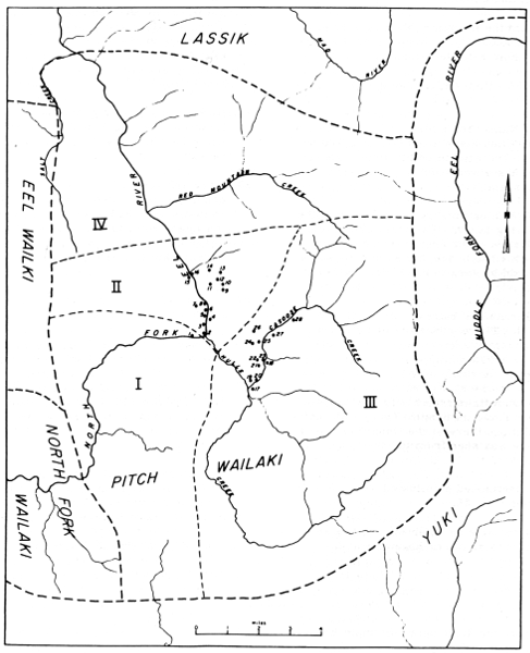
Map 6. Villages and tribelets of the Pitch
Wailaki. Roman numerals indicate tribelets according to Goddard
(1929); arabic numerals mark village sites.
9. t'AntcAntantEƚdAñ, "pepperwood flat." About 100 yds. S
of the large rock called kaiƚtsotci on a small bench on the
mountainside about 1,000 ft. above North Fork. Three pits were
found. A rock shelter higher on the hillside and to the S was
pointed out. At this village, shortly before the coming of white
people, lived dAγa'tco, "large beard," chief of this
village and of annEnE'tcAñ, of all the t'okya kiyahAñ, in fact. He
was succeeded by his son kissEkE', who was killed by the whites.
10. kaiƚtsotci canAndAñ. Named for the large rock
kaiƚtsotci, under the shelter of which the village stood. Four
pits were seen here and N of a small ridge were 3 others.
11. annEnE'tcAñ. On the NE side of the river stand two huge
rocks, the upstream one called sEƚtcAnnAñ, the downstream one
sAnAn. Between these two rocks flows a creek and on its N side, 75
ft. below the summit of the rocks, were 3 house pits in a hollow.
A little S and 100 ft. higher were found in succession 3, 2, and 5
pits.
12. mAntc'aik'At. On the mountainside N of a large rough
ravine and about 900 ft. higher than the bed of North Fork. Four
pits were found.
13. mIstco'ca'nAndAñ. Up the hill from no. 12. It was not
visited.
14. sEƚtcAnnAnt'a. Named for a high rock, sEƚtcAnnAñ, on
the S side of which there are 5 pits and, 100 yds. below, 6 more.
The site is about 700 ft. above North Fork and has a wonderful
outlook on the valley of that stream.
15. k'AckAntEƚdAñ, "alder flat." On the W side of the river
on a curving bench. Two pits were found close to the hillside, and
2 nearer to the stream. Downstream on a little bench there were
also 2 indistinct ones, said by Jack to have been used long ago.
16. sEƚtcAnnAñ yE. At the base of the rock mentioned in no.
14. Three pits were found on a small bench.
III. tc'i'añkot kiyahAñ
17. lonbAstEdAñ. On a flat on the S side of Casoose Cr. a
short way above its mouth. There were some unoccupied buildings
there at the time of Goddard's visit. The place was seen from the
trail on the N side of the creek.
18. sEƚkantcilai'. Mentioned as situated on the E side of
the creek below no. 25.
19. Goddard gives no name or other information for this
village but it is shown on his map.
20. sEttcitcikItdatdAñ, Named for a rock, settci. It was at
the base of a mountain on the N side of the creek and just above
the flood waters. It had a good SE exposure. Three pits in a row
were found.
21. yIctAnnEbi', "wolf's road in." About 300 yds. below the
large butte mentioned in no. 23. It was across an open knoll and
back from the creek somewhat, so the sun reaches the spot. There
are 2 pits there. Steelhead salmon are able to come up the creek
this far.
22. kIlkokyodAn. On the S side of the butte mentioned in no.
23 and about 100 yds. distant. Four large pits were noticed.
23. kIkokyokInnEdAñ. Named for the bushy butte at the base of
which the village stood. The site is 100 ft. higher than the creek,
on its NW side just below a canyon. Three pits were seen.
24. mAñk'AtdAñ. Named from a small pond, near which are
deserted buildings and an old orchard. A hundred yards NE of this
pond, back against the hill, 4 pits were found in a row, 2 more
above them, and 2 others near by, making 8 altogether. The last
chief of this village was named tcAsnainIñaita'.
25. Iƚt'Aktcibi'. Named from black oaks. It is nearer the
creek than no. 24. The number of pits was not recorded but signs of
a village there were unmistakable.
26. t'AntcigIt'tcAñ. On the W side of the creek nearly
opposite no. 27. It was N of a small creek with running water and
of a ridge which runs down to the main creek and terminates in a
great, nearly sheer cliff. The village site is about 500 ft. higher
than the stream. Eight pits in two rows were counted.
27. k'aickontEƚdAñ. On the E side of Casoose Cr. on a flat
100 ft. higher than the creek, which flows just below it. The
village site is near a post which marked the old boundary between
Trinity and Mendocino counties. Two pits were seen.
28. tc'iañmiyE. On the E side of and 100 ft. higher than
Casoose Cr. It was 100 yds. downstream from the beginning of the
canyon. Five pits were counted.
IV. tcokot kiyahAñ
The winter villages of this group were on Red Mountain Cr. Goodboy Jack
said that he did not know the village names. The impression had been
received that Salt Creek V. was inhabited but Jack said it was too cold
to live there in the winter. Presumably it was the hunting ground of the
tcokot kiyahAñ.
The Lassik occupied the drainage of the main Eel River between the
mouths of Dobbyn and Kekawaka creeks and the territory east of there
to the crest of the Coast Range. There is almost no ethnographic
information on this group in the literature except a few notes gathered
by Essene (1942) when he was compiling a Culture Element List for the
area. Even the geographic information on this group is weak. Merriam
does not seem to have spent much time among them. Goddard may have
recorded their villages but, if so, I have been able to find only a
small part of his data. What there is I give below.
Merriam records only random notes on the Lassik. His informant from that
group was Lucy Young, the same woman Essene worked with so effectively
(Essene, 1942; see also Kroeber's data, App. II). According to Merriam,
she lived with her daughter, Mrs. William Clark, on a ranch about two
miles south of Zenia; Mrs. Clark's husband came originally from Hyampom.
Merriam seems to have visited Lucy Young in 1922. His only statement on
the group follows.
Sit-ten-biden keah ... Main Eel River from Fort Seward region
on north, southerly to Harris and Kekawaka Creek; westerly to South
Fork Eel River; easterly to Forest Glen and South Fork Trinity
River near Kelsey Peak.
Merriam's notes contain no systematic information on the tribelets of
this group but do give the following miscellaneous data.
Kos-kah-tun-den ka-ah is the Settenbiden name for a related tribelet in
the Blocksburg region [the territory E of Alder Pt.], now extinct. Their
language is the same as that of the Bridgeville group but with many
words different from Settenbiden.
Sa-tahl-che-cho-be is the Settenbiden name for the band on the east
side of the Main Eel River just below the mouth of Kekawaka Creek.
This tribelet is the "sko-den ke-ah" of the Eel River Wailaki. Neither
Merriam nor Goddard was sure whether the group ought not more properly
to be included in the Lassik or the Wailaki.
Taht-so keah is the name of a tribelet to the north of the Eel River
Wailaki which the latter said was related to them. This group, together
with the sa-tahl-che-cho-be, is said to constitute the then-chah-tung
tribelet of the Lassik.
For the most part the Lassik villages recorded by Merriam (and listed
below) cannot be located, hence they have not been placed on the map.
Kahsh-bahn. A Lassik village on the W side of the main Eel R.
about 2 mi. above (S of) the mouth of Jewett Cr. This was a big
town and there were lots of acorns near there.
Kes-tah-che. On the E side of the main Eel R. nearly opposite
(a little above) the mouth of Jewett Cr.
'Ki-che-be. On the site of the present (1923) store at Ruth on
the Mad R. This was a big town with many houses and a sweathouse.
There were lots of deer, bear, and acorns in this area. During
the cold weather, usually in January, a dance, which lasted three
nights, was held in this village.
Sa-cho-yeh. A large village on the E side of the main Eel R.
about 2-1/2 mi. S of Alder Pt.
Sa-tahl-che-cho-be. The name means "red rocks." On the E side
of the main Eel R. about 1/2 mi. or a mile below the mouth of
Kekawaka Cr. There were falls and a whirlpool there.
Tah-kah-ta-cho-be. On the E side of the Mad R. on a flat near
the Hay place about 10 mi. above Ruth. It was a big town with a
sweathouse.
Taht-so. On the Underhill ranch, which was owned by Glenn or
Green at the time Merriam was in the area (1920's). Evidently it
was somewhere in the Harris region W of the main Eel R.
Tha-cho-yeh. On the main Eel R. on a flat under a high
standing rock. The rock is now called Cain Rock. It is on the E
side of the river about 3 mi. S of Alder Pt.
Tha-ken-nes-ten. The name means "talking rock." The village
was on the E side of the main Eel R. near a big rock which stood at
a bend of the river at the Johnson place (near a big white house).
It was a big town with a sweathouse.
Tha-tah-che. A large winter village in Soldier Basin on the
North Fork of the Eel (near present Gilman place). This was a big
town but had no sweathouse. In the winter they hunted deer and bear
here.
To-be-se-a-tung. On the E side of the Mad R. above the Bushman
place. It was about a mile above the river.
To-sos-ten. On the E side of the main Eel R. a mile or two
above Alder Pt.
There is some ambiguity in Merriam's notes on the status of the Lassik
living in the western part of their territory near the South Fork of
the Eel. The Sinkyone George Burt told Merriam that a group called the
To-kub´-be ke´ah or To´-kah-be held the land on the east side of South
Fork from Rocky Glen Creek south to above Garberville. This tribe was
said to be centered on the east branch of South Fork and in the Harris
region and to be a different tribe from the one on the main Eel River
at Alder Point and Kekawaka Creek, but Merriam himself has refused to
accept this assertion.
Goddard's information indicates that the east bank of South Fork was
owned by the Sinkyone, and it is so detailed that it has been accepted
here (see p. 164).
Goddard's unpublished material on the Lassik consists of a single map
(here reproduced as map 8), which apparently shows the locations of 27
villages. A list of what are presumably the village names accompanies
it, but Goddard changed the numbers on his map. Hence on our map the
correct name may not be assigned to each site.
Goddard's Lassik Villages
1. gastcīkdûñ
2. kōnteltcīdûñ
3. satcinītcīdûñ
4. naslintce
5. ist'etatcīdûñ
6. tōkseye
7. kiñk'ûtekōnteldûñ
8. k'ûctōtōdûñ
9. dīyīckûk
10. nûndûkkatûndûñ
11. kōnteltcīdûñ
12. gōsnōlindûñ
13. tōtcadûñ
14. saitōtcī
15. nûnsûnltcīkkinneεdûñ
16. yīstcûttcadûñ
17. toisībī
18. lesbatcītdûñ
19. k'ûstcīkdûñ
20. tcûggûstatcīε
21. lesbaitcīε
22. setatcīε
23. kastōntcīεdûñ
Goddard lists other names, presumably for the Lassik villages, as
follows: sekûƚne, tectatalindûñ, dûltcīkyacdûñ, t'o-todûñ,
k'ûsnesdûñ, ne ga bī, kûttantcītcōdûñ. The sites corresponding
to these names cannot be located.
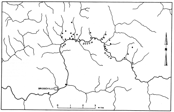
Map 7. Presumed Nongatl villages in the Bridgeville
region.
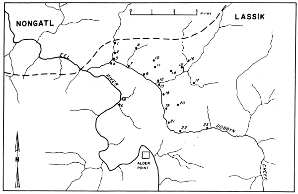
Map 8. Lassik villages in the Alder Point region.
The Nongatl are almost entirely confined to the drainages of the Van
Duzen River and upper Mad River. Their culture is the least known of
any group in northwestern California. Merriam evidently did not work
in their area although he recorded a few of their words given him by
George Burt's wife. George Burt was a Sinkyone, but his wife was born
and raised near Bridgeville. Goddard recorded some villages for this
group, whose names are given below. Nomland worked with someone from the
Nongatl in 1928 (Nomland, 1938, p. 9), but her results have not been
published.
The territory of the Nongatl lies, for the most part, east of the main
redwood belt. It is therefore no doubt well supplied with oaks, and
plant foods are thus readily available. Salmon are abundant in the Van
Duzen River (pl. 10, c) and Yager Creek but not in the Mad River
in eastern Nongatl territory. In much of their territory then, the
subsistence patterns of the Nongatl must have differed from those of
most of northwestern California, where fishing was of primary importance.
According to Merriam (1923) the word Nung-kahhl is "a general or
blanket name used by themselves for all the southern Athapaskan tribes,
from Iaqua and Yager Creek on the north to the northern border of
Round Valley on the south, thus including the Athapaskan Wilakke." In
anthropological literature, however, especially in the work of Kroeber
and Goddard, this name has come to be used for the group living between
Iaqua Buttes and Mad River on the north and Dobbyn Creek on the south.
Merriam's name for this group is Kit-tel´. He does not seem to have
obtained any information from them although one of his notes mentions
the fact that the wife of George Burt, his Lolangkok Sinkyone informant,
was a Kit-tel´ woman.
At times Merriam seems to have confused the Nongatl with the Lassik. In
his general statement on the Nongatl, which follows, he lists them as
Lassik although the area in which he places them marks them as Kit-tel´
or Nongatl.
Las´sik ... Name (from Chief Lassik, now dead) in common use
for a Non-ga´hhl tribe occupying a rather large area, extending
from Iaqua Butte in the latitude of the mouth of Eel River,
southerly to Dobbyn Creek and to the head of Van Duzen River, and
from the eastern boundary of the Lolahnkok of Bull Creek and South
Fork Eel River easterly to Mad River and the crest of the long
ridge known as South Fork Mountain, and southerly to within about
two miles of Ruth on Mad River; to the headwaters of Van Duzen
River (but not reaching Kettenshaw Valley), and to Dobbyn Creek on
the main Eel; thus including the entire course and drainage area of
Larrabee Creek.
There is doubt as to the northern boundary of the so-called
Las´sik for the reason that I have not been able to obtain the
necessary vocabularies for comparison. Goddard's information points
to a division south of the Bridgeville region but I have been told
by both the Nek´-kan-ni´ of Bear River and the Lolahnkōk of Bull
Creek and South Fork Eel that the language is exactly the same from
Iaqua Butte southerly and that the languages of the Nek´-kan-ni´
and Lo-lahn-kōk do not differ essentially from that of the
Larrabee Creek region.
The Indians over whom Chief Lassik held sway had no common
tribal name but consisted of a number of bands or subtribes, now
mostly or quite extinct, said to have spoken the same or closely
allied dialects.
However, since the entire drainage basin of Larrabee Creek is
included in their territory, it may be desirable to adopt the term
Kos´-ten ke´-ah, by which term the Larrabee Creek band was known to
neighbors on the south—the Set-ten-bi´-den ke-ah.
There is evidence of several subgroups among the Nongatl, but it is not
known whether these were tribelets or dialect divisions. Essene (1942,
pp. 90-92) got information from the Lassik woman Lucy Young indicating
that there was a distinct group around Blocksburg, which the Lassik
called Kuskatundun, and another group around Bridgeville they called
Nai'aitci. This latter group is said to have been a roving band which
preyed on all the neighboring peoples.
Goddard's village data indicate six other groups but do not give
boundaries. These were as follows.
bûskōtkīya. In the neighborhood of Indian Cr. in the
upper part of the drainage of Yager Cr. (map 9).
tcillûndûñ. On the upper reaches of North Yager Cr. (map 9).
bûstcōbīkīya. In the vicinity of the junction of
North and Middle Yager creeks. The language of this group was said
to be the same as that of the tcittelkīya (map 9).
senûñka. On upper Larabee Cr. in the vicinity of Blocksburg
(pl. 10, e, f). This no doubt is the same as Essene's
Kuskatundun, which was the Lassik name for the group (map 10).
tcittelkīya. On the Van Duzen R. above Bridgeville. Appears
to be the same name as Merriam's Kit-tel´.
na'aitcikīya. On the Van Duzen above the tcittelkīya
group. This name appears on the Goddard map from which map 1 was
taken but is not otherwise recorded. This is evidently the same as
Essene's Nai'aitci.
kōsdûñkīya. On the South Fork of the Van Duzen,
including Larabee V.
The Nongatl villages recorded below are all taken from Goddard's
unpublished notes (maps 7, 9, 10). This is evidently far from a complete
count but it is clear that there were about as many villages in the area
covered by these maps as in other parts of the Athabascan area.
bûskōtkīya group (1-7, map 9)
1. In the swag of a large ridge running toward the SSE to the
junction of the main components of Indian Cr., perhaps a mile from
it. There is one deep pit. There is a flowing creek 200 yds. E.
2. A single pit found by Pete E of a small stream flowing
south into Indian Cr. from the lowest place in the ridge at Big
Bend of the Mad R. Nearly 1/2 mi. from Indian Cr. W of a hill above
which the wagon road passes. This is where Goddard camped in 1906.
He hunted all around here without finding other pits.
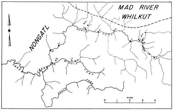
Map 9. Nongatl villages on Yager Creek.
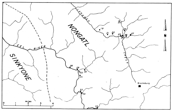
Map 10. Nongatl villages in the Blocksburg
region.
3. k'onûsebī'. On a point running down SSW toward Indian
Cr. There were two pits near the creek and two more 200 ft. up the
hill. A few large and small oaks were growing there. Water was to
be had a few yards E. Pete saw a house there when he was a boy.
4. W of a small stream flowing into Indian Cr. from the N, and
E of a large flat. There was a flat place with dirt thrown out in
front of it but with no pit. About 1/8 mi. E on the round end of a
ridge was a fairly evident pit and a sekal.
5. About 200 yds. E of the small stream mentioned in no. 4
were a few small pits.
6. One pit was on the W bank of a S-flowing branch of Indian
Cr. Small ridges N and S of it form a small basin, giving it
protection from the winds. Madrone and black oaks are growing
there. It is possible that a depression on the southern ridge is
also a house pit.
7. On a small ridge on the E side of the branch of Indian Cr.,
which flows from the S past Fork Baker ranch buildings. About 1-1/2
mi. north of these buildings Pete found 3 pits. He said there were
small streams N and S of the ridge. Goddard did not visit the place
but it was pointed out by Pete as W of a big Douglas spruce tree
and a large rock. Goddard described it as above.
tcillûndûñ group (8-12, map 9)
8. On the slope N of North Yager Cr. close to the county road
and about 100 yds. from the bridge. There are 2 pits close to the
wagon road and 1 or 2 a little farther N. The site is 65 ft. higher
than the bridge.
9. kactcōtcībī', "redwoods..?.. in." On the N side
of North Yager Cr. at the W end of a flat of about an acre. There
are a few redwoods on the opposite side of the creek. Six pits were
found about 100 yds. back from the creek. Pete had heard of the
flat but not that Indians lived there. A hunter told Goddard of the
Indians being killed there by whites.
10. About 1/4 mi. up a branch which flows into North Yager Cr.
from the north. On the W side of the creek on a rounded ridge were
3 pits, 2 of which were very distinct.
11. On a small flat on the N side of Yager Cr. and close to it
Pete saw 2 large deep pits. They were about 1/4 mi. downstream from
the branch where village 10 was found.
12. tse'dûttclbûtta'dûñ. A half-mile N of North Yager Cr.
at the edge of Douglas spruce and tanbark oak timber. Stones used
by the Indians were lying near the water and 2 pits were found
there. To the W, on the crest of the ridge, there were 5 pits at
the S end of the timber. A cabin stands there.
Goddard lists five more sites found in this vicinity on North Yager
Creek but they are not named and their locations are indefinite so they
will not be given here.
bûstcōbīkīya group (13-18, map 9)
13. senindûscīmī. On the W bank of North Yager Cr. 1/4
mi. below a waterfall of the same name. Two pits were located 100
ft. above the creek in brush and timber. On the same side of the
creek but 1/4 mi. downstream were 4 more pits, in one of which a
sekal lay.
14. nakatōdûñ. On the E side of North Yager Cr., on a flat
now covered with huckleberry brush. Pete found 2 pits here. On the
W side of the creek, a little downstream, were 2 more pits. The
flat had been badly washed away by freshets.
15. Two pits were found among the redwoods and thick brush at
the junction of North and Middle Yager creeks.
16. ist'egabī', "madrones in." Just at the eastern edge of
the timber on a point running down toward Middle Yager Cr. were 4
pits.
17. kōntcōwetcīkinnedûñ. About 1/4 mi. N of Middle
Yager Cr. On a small flat on a hillside, facing SW in open timber
above a small stream. There were 7 pits here. Pete had heard that
there used to be a village so situated.
18. An overhanging rock on the N side of Middle Yager Cr.
shows signs of occupation and there is a pit near by.
senûñka group (19-35, map 10)
19. On a little point 200 yds. N of Curless' house. There is
one pit. Charlie Taylor's grandmother was born here, according to
Curless, who showed the site to Goddard. This was the most northern
village of the senûñka on Larabee Cr.
20. t'ōkintcabī'. On the hillside on either side of the
stream which crosses the road about a mile S of Curless' place.
It is nearly a mile from Larabee Cr. and is close to the timber.
The village was in a line of Douglas spruce south of an oat-field.
There were 7 large pits on the W side of the stream and 5 on the E
side. With one exception these were N of the fence; others may have
been filled by plowing.
21. t'ōkintcabī'. On the E side of Larabee Cr. a
good-sized stream flows across the county road by a group of farm
buildings. On the E side of the road close to the N side of this
stream are from 4 to 6 pits. Douglas spruce and tanbark timber with
brush obscured them. On the W side of the road is a large sheep
barn. W of this barn are 4 pits, some quite uncertain because the
ground has been cleared of large Douglas spruce timber. There is a
large plowed flat 1/4 mi. W, near Larabee Cr. Andrew's wife told
Pete of such a place where there used to be many Indians.
22. k'ûcna'aidûñ (?). In a swag on the W side of a gulch lined
with Douglas spruce and tanbark oak timber with exposure toward the
S. There are 5 distinct pits.
23. On a point 200 yds. N of the junction of the two main
components of Larabee Cr., W of a small stream. There were 4 pits,
only one of which was large. The end of a pestle was lying in this
one.
24. On the E side of Larabee Cr., between it and the county
road, on the S side of a small stream. There was one pit. The
building of the road may have destroyed others.
25. On a large flat N of the junction of the two components of
Larabee Cr. and a little to the E. There were 10 pits. There is a
cabin and a corral here and many pits may have been filled in.
26. On the hillside N of the eastern component of Larabee Cr.
Pete thought there were 3 pits. There had been slides there and
Goddard was not sure of them.
27. On the N side of a large branch of Larabee Cr. from the E,
200 yds. N of where it is joined by a stream from the N. The stream
from the E is bûstadûñkōt. There were 3 pits among the Douglas
spruce and black oaks.
28. On the E side of the Eel R. about 3/4 mi. N of the mouth
of Coleman Cr. at the edge of timber on a small bench. There were 2
small house pits.
29. On the E side Of the Eel about 300 yds. N of the mouth of
Coleman Cr., 75 yds. back from the river and 40 ft. above it. There
were 2 large deep pits. The exposure is SW.
30. canakī', "creek tail." On the E side of the Eel R. S of
the mouth of Coleman Cr. There were 3 pits close to the creek but
high above it on the bank, 2 on a flat 25 yds. S, and 2 more near a
dry gulch 200 yds. S of the creek. Near the creek the brakes were
so thick that many pits may have been overlooked. This place was
mentioned by Charlie in 1908.
31. On the E side of the Eel R. about 500 yds. S of the mouth
of Coleman Cr. on a flat close to the S side of a gulch lined with
maple and peppernut trees. There were 8 pits here and 7 or 8 more
from 50 to 75 yds. S.
32. N of the knoll which is just below the forks of Coleman
Cr. There was 1 pit.
33. On the E side of the Eel R. about 300 yds. N of the mouth
of Mill Cr. on a brushy point. There were 5 pits.
34. On the E side of the Eel R. N of the mouth of Mill Cr.
just S of a big rock. There were 2 pits.
35. nadaitcûñ. This name was supplied by Charlie in 1908 as
belonging to the village at the mouth of a large creek on the E
side of the Eel R. above Coleman Cr.
The Sinkyone occupied the territory on the west side of the South Fork
of the Eel from Scotia south to Hollow Tree Creek. From the Mattole
boundary at Spanish Flat south to the Coast Yuki line at Usal Creek they
held the coast.
We have more ethnographic information about the Sinkyone than about
most of the Athabascan groups. Merriam's material and Goddard's data
combined provide a virtually complete village list for the northern,
or Lolangkok, Sinkyone and a few villages for the southern, or Shelter
Cove, Sinkyone. Kroeber's Handbook (1925a, pp. 145-150) gives a fair
amount of general ethnography and this is well augmented by Nomland's
paper (Nomland, 1935).
Sinkyone territory is in the redwood coastal zone and this location no
doubt reduced somewhat the supply of vegetal food. The Sinkyone were,
however, well supplied with fish products by the Eel River, which not
only had an excellent salmon run but also provided quantities of lamprey
eel.
On the basis of Merriam's linguistic evidence the Sinkyone have been
divided into a northern group, called Lolangkok after the native
name for Bull Creek, and a southern group, called Shelter Cove after
a sheltered spot on the coast midway between the Mattole and Yuki
boundaries. This division is rendered somewhat questionable by the
unreliability of Sally Bell, Merriam's Shelter Cove Sinkyone informant.
It is doubtful, however, whether Sally Bell's linguistic information
could be falsified. In any case, the separation is partly verified by
Goddard's data and I have therefore accepted it.
The Merriam notes contain a comparatively large amount of material on
the Lolangkok Sinkyone. The following general statement on that group is
taken verbatim from that source.
The Lo-lahn´-kōk. Information is from George Burt, a member
of the tribe, who was raised on Bull Creek at the rancheria called
Kahs-cho´-chin-net´-tah about seven miles upstream from Dyerville,
at a place now known as Schoolhouse Flat, and who now lives near
Fortuna (1922).
The territory of the Lo-lahn´-kōk began on the north at
Shively and covered a narrow strip on the east side of the main Eel
River to Dyerville, and a much broader area on the west side, and
continued southerly on the west side of South Fork Eel River nearly
to Garberville. On the west it not only covered the South Fork
drainage, but continued over Elk Ridge to the head waters of Upper
Mattole River.
The southern boundary ran a little north of Ettersburg,
Briceland, and Garberville.
Informant states that on the east side of South Fork Eel River
their territory included only the immediate river valley.
Merriam's informant from the Southern Sinkyone was Sally Bell. She had
evidently lived at Briceland for more than thirty years when she was
interviewed in 1923. Nomland (1935, p. 149) says of her that she was
"born Needle Rock; reared from childhood by white settlers, married
Coast Yuki, Tom Bell; blind, senile, sees spirits in rafters, etc."
(See fig. 1, d.) This group Merriam describes only in a brief general
statement, summarized as follows.
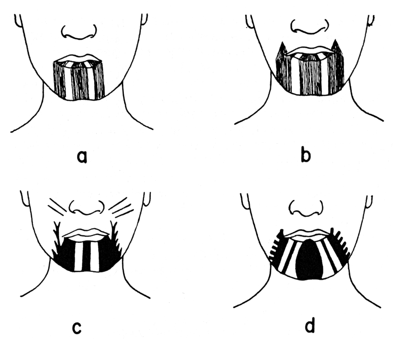
Fig. 1. Athabascan tattooing noted by C. Hart Merriam.
a, b. Whilkut women, c. Bear River woman from a sketch made by
Merriam in 1921. d. From a sketch made by Merriam of the Shelter Cove
woman named Sally Bell.
To´-cho´-be ke´ah is their own name and the Lolahnkok name
for the tribe (and village) in the Briceland region (between the
South Fork of the Eel and the coast). It is used also in a larger
sense for all bands speaking the same dialect from the west side of
the South Fork of the Eel River (in the Garberville region) to the
coast. The Set´tenbi´den [Lassik] call this group Yis-sing´-kun-ne.
The name of the group is pronounced To-cho´-be ke´ah by the
Lolahn´kōk and Taw-chaw´-be-ke´ah by themselves.
None of the tribelets of the Sinkyone is described or located
specifically enough to permit the drawing of boundaries. Hence they are
merely listed here, with available location data. Nomland (1935, p.
151) says: "Two informants always gave names of land areas in place of
village names." These names are no doubt those of tribelets.
chi-chin-kah ke-ah (Merriam). This is the name for the
tribelet between the upper waters of Bull Cr. and Elk Ridge.
Nomland gives the name chacingu´k for the group in the ridge N of
Briceland, which is evidently Elk Ridge.
yese'kuk (Nomland). This is given as the Mattole R. area,
possibly a tribelet designation.
The two tribelets listed above are the only ones noted in the
area of the Bull Creek or Lolangkok Sinkyone. The following, all
from Merriam except where noted, are in the area of the Shelter
Cove Sinkyone.
to-cho-be ke-ah (taw-chaw-be keah). Name for the tribelet and
village in the Briceland region between the South Fork of the Eel
and the coast. Used in the larger sense for all the tribelets from
Briceland south to Usal Cr. totro'bē (Nomland, 1935). This was
the name of the Briceland area.
nahs-lin-che-ke-ah. This was the name of the tribelet on South
Fork S of Garberville. senke'kut (Nomland). This is given as the
area "to the South Fork from Garberville."
tahng-ah-ting keah. This was the Bull Creek Sinkyone name
for the Shelter Cove and Point Delgada tribelet. They were called
tahng-i-keah by themselves and by the Briceland Sinkyone. Kroeber
(1925, p. 145) gives tangating as the place name for Shelter Cove.
Usal (Yosawl). This is the southernmost tribelet of the
Briceland Sinkyone, said to extend from Usal Cr. to Shelter Cove.
According to Kroeber (1925, p. 145) "This word seems to be from
Pomo Yoshol, denoting either the Coast Yuki or the Mankya, both of
whom are north of the Pomo; but yo is 'south' and shol 'eastward'
in that language."
The following names are given by Nomland for Sinkyone areas. They do not
correspond to Merriam's tribelets and are probably just place names.
| anse'ntakuk |
The land south of Briceland |
| cusacic'ha |
The region north of Garberville |
| yenekuk |
The area southeast of Briceland |
| yese' |
The coast area to the Mattole boundary at Four Mile Cr. |
Most of the Sinkyone villages given here are taken from Goddard's notes.
A few are also given by Merriam. In the list the source is indicated
by (G) for Goddard, (M) for Merriam. Merriam's notes contain, besides
the village names, a list of place names on the Eel and on South Fork,
running from Scotia to south of Garberville (see pp. 191-193, map 13).
In areas where Merriam's material can be compared with Goddard's these
place names nearly all turn out to be village names. It seems likely
therefore that, in other areas also, nearly all are village names. In
calculating population (see p. 216), I have occasionally used these to
augment the village count.
Lolangkok Sinkyone villages on the main Eel (map 11).—Of the
following villages, the two north of the mouth of South Fork are from
Merriam's notes, for which George Burt was the informant. Merriam also
gives several place names for the area below the mouth of South Fork,
and it seems probable that most, if not all, of these were actually
villages rather than mere landmarks; this was certainly so farther south
on South Fork.
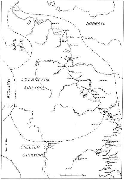
Map 11. Villages of the Lolangkok Sinkyone.
Above the mouth of South Fork the villages are from Goddard's notes; the
informant was Charlie and the information was gathered in 1903 and 1908.
It is possible that these villages are not Sinkyone. However, there is
no specific evidence for attributing this region to the Nongatl and it
is known that Charlie was a Lolangkok Sinkyone, so I have placed them in
this latter group. Goddard has given the section, township, and range
locations as he did for the preceding villages. These have been helpful
in locating the sites, but I have omitted his notations because they
are no longer accurate; the maps have been changed since the time of
Goddard's original work.
1. lah-sā-se´-te (M). At Shively on the main Eel R.
2. kah´-li-cho´-be, "growing flat" (M). At a place now called
Englewood, a small settlement 9 mi. E of Scotia bridge. The name is
said to refer to things growing up there.
3. seûstcelindûñ (G). On the S bank of the main Eel not far
downstream from Dyerville.
4. tōnesdadûñ (G). On the NE bank of the Eel directly
across from seûstcelindûñ.
5. tetcinne (G). On the E side of the Eel upstream from
tōnesdadûñ. A big rock, pointing downstream, is said to project
into the river there.
6. tûggûstcō dasañke (G). On the E side of the Eel S of
tetcinne. A large rancheria in an open place.
7. naltcûñka (G). On the W side of Eel R. S of tûggûstcō
dasañke. There is a big slide there. It is below Camp Grant on the
S side, according to Charlie, 1903.
nahl-tsin´-kah (M). Camp Grant.
8. tōƚtciñyasta' (G). On the E side of the Eel about 1
mi. above naltcûñka. A large rock stands back of the village site.
9. tadûttcī' (G). On the E side of the Eel not far above
tōƚtciñyasta', at the mouth of a large creek in which salmon
run (tadakōk, Thompson Cr.?). Above Camp Grant.
10. tcillûñdûñ (G). On the E side of the Eel 1/4 mi.
above tadûttcī'. An open place without a creek. (Given as
kīlûndûñkīa by Charlie in 1903.)
11. ne'gakak, "moss"? (G). On the W side of the Eel opposite
tcillûñdûñ.
12. ne'tcinkōk (G). At the mouth of a creek on the W side
of the Eel some way above ne'gakak.
13. gactcōbi', "redwoods in" (G). In a large open flat
among the redwoods on the E side of the Eel above ne'tcinkōk.
Given by Charlie in 1903 as kûctcōbekīa on the S side.
14. On the E side of the Eel just S of a creek which flows
down a steep rough bed on a rather high bench are 4 pits. The
ground is black with refuse and cooking stones lie about. The river
enters a canyon N of this creek. A round timbered butte is close to
the mouth of the creek on the N. A great timbered butte seems to
occupy the E bank of the river for several miles.
15. seda'dûn, "rock mouth place" (G). On the E side (W also?),
where the river flows out between rocks. A small creek is there.
About 2 mi. above gactcōbi'.
Lolangkok Sinkyone villages on South Fork (map 11).—
16. ƚtcûnta'dûñ (G). Said to have been on the W side of
South Fork and the S side of the Eel R., where the store and saloon
of Dyerville now stand.
chin-tah´-tah (M). The flat occupied by Dyerville; this is no
doubt the same as the name given by Goddard.
17. kahs-cho´-chin-net´-tah (M). A large village on Bull Cr.
about 7 mi. upstream from Dyerville. The place is now known as
Schoolhouse Flat.
18. ƚōlûñkī' (G). On the S bank of Bull Cr. at its
mouth, in large redwood timber. There were 10 pits along the bank
of South Fork and the pit of a yitco', 8 paces across, about 200
yds. W of the mouth of Bull Cr. A large redwood, hollowed by
fire, had fallen, the floor being 4 ft. below the ground. Charlie
remembered seeing Indians living in it. Charlie thought there used
to be three or four houses on the S side of the creek, but we found
no evidence of them. Three men were once killed here by whites, and
a woman was shot through the hips; she lay here a day or two and
died. One of the white men, named Steve, cut a piece from the arm
of one of the Indians, built a fire, cooked it, and ate it. The
best man of the Indians escaped.
lo-lahn´-kōk (M). Bull Cr. Merriam does not mention a
village at its mouth.
19. ƚōlûñkōk yībañ (G). On the E bank of South
Fork opposite and N of the mouth of Bull Cr. Two pits were seen
directly across from Bull Cr. and 2 about 100 yds. downstream. They
are in heavy redwood timber, but receive a good deal of sun because
they are close to the river, which flows NW at this point.
20. sōsnoibûndûñ (G). On the E bank of South Fork about a
mile S of the mouth of Bull Cr. Five pits were counted in small
redwood timber, where there is a spring which supplied the village.
There used to be a yitco' here, in which Charlie remembered dancing
when he was a small boy.
21. nûnsûntcōtcī', "butte large mouth" (G). On both
sides of the mouth of Brush Cr. (Canoe Cr.) in large redwood
timber. On the N side are 6 pits, 5 of them in a row back about 30
yds. There are seven pits on the S side of the creek, some of them
much plainer than others. The father of Albert's wife, Sally, came
from this village.
nahn´-sin-cho´-ke (M). See Place Names.
22. sedjōcbī' (G). On the E bank of South Fork, which
flows toward the W at this point. A stream from the E (Feese Cr.)
flows in a little above the village. There are many tanbark oaks
growing near by, which Charlie suggested were the reason for the
village's being located here. Seven pits could be distinguished;
the clearing away of timber may have obscured some others. The name
setcōsdiñ was also given by Charlie. Tcōs means vagina, "what
woman has."
sā-chōs-te (M). See Place Names.
23. gûtta'bûndûñ, named from a deep hole in the stream (G). On
the W side of South Fork, where it flows toward the NE just below
Myer's. The site has been completely washed away. Charlie's father
belonged here and Charlie lived here when a boy. Jack, Charlie's
half-brother, was born at this village. There used to be a yitco'
and a large hollow tree in which a family used to spend the winter.
kah-tah´-be (M). See Place Names.
24. tantañaikī' bûndûñ (G). On the E side of South Fork.
A creek, along which are many tanbark oaks, flows into South Fork
on the opposite side and a little above. The name of the creek is
tantañaikōk (Coon Cr.). The site is just below a garden. The
place was so grown up with brakes it was impossible to count the
pits.
25. tōdûnni', "water sings" (G). On the NW corner of Myer's
Flat on the right bank of South Fork, where it completes its course
toward the W and turns toward the NE. The site has been washed
away. There used to be large peppernut trees growing there. A few
are still left. The name of Myer's Flat is kûnteltcōbī. It is
also mentioned as kontelkyōbī.
ken´-tes-cho´-be (M). See Place Names.
26. sestcicbandûñ (G). On the right bank of South Fork on a
narrow bench between the hill and that stream. There is an eddy
in the river just above, which furnished good fishing, and many
oaks are on the hills. The site received plenty of sun because the
river flows W at this point. Four pits were seen. Also given as
sûstcīcbī, "rough like a rasp."
ses-che´-is-ke (M). See Place Names.
27. sebûggûnna', "rock around" (G). On the right side and
close to South Fork just downstream from a rocky point around which
the river changes its direction from S to NW. Fourteen or fifteen
pits could be distinguished, most of them quite distinct.
sā-bug´-gah-nah´ (M). See Place Names.
28. sekōntcōbandûñ (G). On the left side of South Fork
nearly opposite sebûggûnna'. The sandy bench is covered with
brakes. Five pits were made out. Charlie lived here for four
years after he came back from the reservation. Also mentioned as
tañaibī.
29. sōldekōk bûkkī'dūñ (G). On a small flat
covered with large redwood timber on the N side of South Fork and
on the W side of Elk Creek (sōldekōk), which flows into it
from the N. Seven pits were counted along the banks of the river
and the creek.
sōl´-te-che (M). See Place Names.
30. senteƚtcelindûñ, "rock flat flows out place" (G).
Close to the W bank of South Fork near a deep fishing place. There
are three pits between the county road and the river. Also called
sentelduñ.
sen-tĕch-be (M). See Place Names.
31. ca'nakī', "creek trail" (G). On the W bank of South
Fork 100 yds. N of the mouth of Salmon Cr., in large redwoods.
The river has washed the soil away so no evidence of occupation
remains. Willow brush is now growing there. Also called
natonankōk bûttcī'dûñ.
sah-nah´-kōk (M). Name for Salmon Cr. See Place Names.
32. tcīstcībi' (G). On the E bank of South Fork opposite
the mouth of Salmon Cr. It is on the end of a ridge. Charlie had a
ne'yīk' here after returning from the reservation (village site
not visited). This village was mentioned by Sam as his birthplace.
His mother may have been from here. Also referred to by Charlie as
canakī' and tcûstcēkōok.
33. nant'ō' (G). On the N side of Salmon Cr. in a bend.
Large redwoods fill the valley of the creek as well as the
particular site of this village. Five deep, distinct pits were
seen. There are said to be one or two on the south side of the
creek.
34. kōnteƚbī, "flat in" (G). On a large flat, through
which Salmon Cr. flows. The village was on the N side of the creek
near where Tomlinson's barn now stands. There is a spring there
near a pepperwood tree. This flat is now in peach orchard.
35. kaslintcō'dûñ, "riffle large place" (G). On the N side
of Salmon Cr. about 400 yds. upstream from kōnteƚbī'.
36. setcinnabatse tcelindûn (G). On the N side of Salmon Cr.
in a basin-like flat. Four pits were seen near the creek and 4 in a
row back about 50 yds. against the base of the hill. There were 2
more pits in front of the last 4, making 10 in all. There is heavy
Douglas spruce and tanbark oak timber on the southern side of the
creek. About 200 yds. upstream is a waterfall, which provided fine
fishing, since large salmon could not jump the falls.
37. bandûñ (G). On the end of a ridge, W of a small run lined
with peppernut trees. About 200 yds. NE of seƚtcindûñ. There
were 5 pits, 2 of which were very large.
38. setcinnabatse (G). On a flattened end of the ridge E of
seƚtcindûñ, 300 yds. S and a little W of it. Two pits were
certain.
39. seƚtcindûñ (G). On the E side of a gulch, in which
there was flowing water in July, about 300 yds. N of Salmon Cr.
There were 4 or 5 pits. The ground is strewn with black stones.
40. tcebanedûñ (G). On the flattened portion of a ridge, with
southern exposure. Black oaks and buckeyes are growing there.
Seven pits were to be seen with black stones lying in them. Great
broken rocks lie in a gulch to the west. About 350 yds. NNW of
seƚtcindûñ.
41. setcō'seye (G). A large rock, with the overhanging side
facing SE. A rim of earth showed where the house wall used to be on
the W. The E was left open. About 1/4 mi. W of the falls of Salmon
Cr.
42. tōƚelindûñ, "water flows together place" (G). On the
flat W of Salmon Cr. and W of a large creek flowing into it from
the S (South Fork Salmon Cr.). Four pits are close to the bank of
Salmon Cr. and a fifth was partly caved in. One was seen on the
lower part of the flat to the S.
43. nesdai'dûñ (G). Said to be on a side hill.
44. toƚelindûñ, "water comes together place" (G). Said to
be where three creeks join, forming the South Fork of Salmon Cr.,
about 5 mi. from its mouth. Distinguished from the village at the
mouth of the same creek by being called "small."
45. sesōsye' (G). At the end of a ridge running down to
Salmon Cr. from the E. So close to the bank of the stream that
one pit has been undermined. Four remain. About 1/2 mi. NW of
toƚelindûñ.
46. ne'kañkī' (G). In the saucer-shaped end of a ridge,
close to the E bank of Salmon Cr. and facing a little S of W.
Opposite, a large creek, called ne'kañkōk, flows in from the W.
There are 9 pits, which may still be seen. Five of them, situated
close to the base of the hill, are very large and deep. Black oaks
grow there.
47. ne'iƚgaƚdûñ, "land shinny-playing place" (G). On a
flat close to the E side of Salmon Cr., which swings around it. A
gulch heads in the cedar grove N of the Hunter ranch buildings.
Twelve or 13 pits were counted, 5 of which were quite distinct.
48. seistcī' (G). About 1/2 mi. E of Salmon Cr. on the
flattened southern slope of a ridge about 100 yds. from its crest.
There are 8 pits in a row and 1 other, not in line with them. There
is a gulch 100 ft. S of the row of pits. Cedars, black oaks, and
buckeyes grow there. A small pond of water is E of the site.
49. mûñkkasaikōk (G). On the W side of a branch of Salmon
Cr. which flows from the N about 1/2 mi. W of the Burnell ranch
house. Two pits are close to the stream and 4 or 5 are 10 or 15
ft. higher. The higher ones have good sun in the winter. The trail
crosses the creek at this place.
50. setc'ûntōdûñ (G). On the W side of the South Fork of
the Eel about 1/4 mi. above the mouth of Butte Cr. (nûnsûnkōk),
which provided desirable fishing. A large rock stands there close
to the river. There are said to have been four houses. This site
was not visited. It was mentioned by Charlie as sesuñtō; he said
it was the most southerly village of his people. Sam called it
senûnsīmkûk and said it belonged in Charlie's territory.
The first name given by Goddard is evidently related to
Merriam's sā´-chen-to´-te, "water against rock," which was said
to be a place in the river near Goddard's setc'ûntōdûñ. See
Place Names.
Shelter Cove Sinkyone villages (map 12).—The following list of
villages comes almost entirely from Goddard's notes (G); relevant
comments by Merriam are noted (M). Goddard's informants were Sam,
Albert, and Charlie, of whom the first two were Shelter Cove Sinkyone,
the last Lolangkok Sinkyone.
1. ke'kestcī' (G). Close to South Fork on the E side about
1/8 mi. S of the mouth of Fish Cr. (kekekōk). A large house with
a garden is just below. A deep place in the river provided fishing,
in addition to the creek. Three pits and a grinding stone were
found. Plowing had probably filled in other pits. The first store
of Phillipsville stood here. According to Sam (1903), this was the
most northern village of his people.
kă-kes´-kōk (M). Fish Cr.
2. kûtdûntelbī', "flat in" (G). At the NW part of the
Phillipsville flat. It is said to have been a large village. There
is fishing in an eddy just upstream. The site has been washed away
and therefore was not visited.
ket´-tin-tel´-be (M). At a place called Phillipsville, 18 mi.
S of Dyerville. The site is in an orchard on a ranch and has a fine
redwood grove and a good camping place.
3. sebīye, "at base of rock" (G). On the E side of South
Fork at the upper end of the Phillipsville flat. The site has been
plowed and was in fruit and garden when visited. One pit could
still be seen. The river flows nearly W, hence the village has
southern sun. Large redwoods occupy the left bank of the stream. A
deep place here provided fishing.
să-be-yĕ´ (M). The flat on the E side of South Fork, S
of Phillipsville. See Place Names.
4. tcingûlgeƚdûñ (name of a tree) (G). On the right bank
of South Fork just below a turn to the E. Between the road and the
river two pits were seen. There is a schoolhouse on the E side of
the road. Many eels were caught near this village.
chig-gel´-e-yes´-ke (M). A place 1.9 mi. S of Phillipsville.
See Place Names.
5. daƚtcimmûndûñ (G). On the right (S) bank of South Fork,
where it flows W around a long ridge sloping down from the E.
Seven pits were counted between the county road and the river,
which may have carried others away. A large creek, seyekok (Rocky
Glen Cr.), empties N of this place. This village was mentioned as
t'altcimmûndûñ by Albert in 1907.
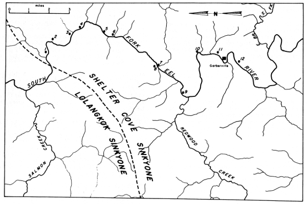
Map 12. Villages of the Shelter Cove Sinkyone.
sĕ-tes´-kōk (M). Rocky Glen Cr. See Place Names.
6. tca'lûñkī' (G). On the E bank of South Fork. A small
stream flows down from the E. Three pits were found on the N side
of it and two on the S side. The place had been plowed. Charlie
said there used to be many houses there. This village was given by
Albert as tca'lûntcī.
7. daƚkaikōk (G). On a flat 50 yds. E of the county
bridge across Buhne Cr. (now called Dean Cr.), along both sides of
the stream. Seven pits were found on the S side of the creek and
two on the N side. The road and plowed fields may have reduced the
number. This village was mentioned by Sam in 1903 as a settlement
of his people.
tahs-ki´-ke (M). Merriam attributes this village to the
to-kub´-be people, who ranged E from here.
8. daƚkaikī' (G). On the W side of South Fork, opposite
the mouth of Dean Cr. Albert said there used to be a village there.
This is evidently the village Merriam refers to in the
paragraph above on village 7.
9. ƚtûgganōbī' (G). On a flat on the E side of South
Fork about 1/4 mi. above the mouth of Redwood Cr. Goddard noted
that the place had a favorable location, but did not find the pits.
Albert said there used to be a village there.
stuk´-kan-no´-be (M). Name for the flat at this place. See
Place Names.
10. kōscīkī (G). A short way below Garberville,
according to Sam (1903). Charlie said it was named kōssetcī'
or kōsetcī' and that it was just below Garberville on the E
side of the river. There used to be a store there.
11. sebīyedadûñ, "rocks under..?... place" (G). A village
at Garberville.
12. kûnteƚtcōbī', "flat large in" (G). On a flat
above Garberville.
ken-tes´-che tahng-ah´-te (M). A beautiful deep valley on
South Fork just SW of Garberville.
13. Usal (not necessarily the native name). Not mentioned by
Goddard, Merriam, or Nomland, but Gifford (1939, p. 304) says that
both Coast Yuki and Sinkyone were spoken here (pl. 11, d).
Following are a number of Shelter Cove Sinkyone villages which I have
not been able to locate precisely.
kahs´-cho-so´-be (M). A village of the Briceland Sinkyone
on South Fork about 4 mi. S of Garberville and not in sight from
the present highway. It may not actually be one of the Briceland
Sinkyone villages.
kaicañkûk (G). On a ridge below Garberville. Information from
Sam, 1903.
ƚtcīkûk (G). On a ridge below seyadûñ on South Fork.
Information from Sam, 1903.
tōkûbbī (G). On a ridge above Garberville. Information
from Sam, 1903. seya(e)dûñ (G). On a ridge on the E side of South
Fork, probably below Garberville.
The first list of place names below was taken by Merriam from George
Burt in 1923. (See map 13.) It starts at Scotia, runs upstream to the
confluence of the Eel and South Fork, and then runs up South Fork as
far as Garberville. Many of the places indicated cannot be located
from maps and it would even be difficult to identify them on the spot.
Merriam seems to have driven by auto from Scotia to Garberville, marking
locations in tenths of miles.
tah´-cho. Main Eel R.
hah´-tin cho´-be. A stretch of land on the S side of the main
Eel extending from Scotia Bridge E at least to Brown's Mill, and S
from the river to the top of the ridge.
kahn-so´-ti-yĕ´, "under maple trees." A big loop of the
river 2 mi. E from Scotia Bridge.
hah´-ting-kōk. Jordan Cr., 2.2 mi. E of Scotia Bridge.
hah´-tin cho´-be. The prairie on top of the ridge S of Jordan
Cr. An old Indian trail goes up there. [Harrow Prairie. Merriam
gives the same name for the prairie and the stretch of land above.
The stretch of land is probably a village named for the prairie.]
ahn´-sin ken-tes´-be, "Pepperwood Flat." A flat on the S side
of the Eel, 3 mi. E of Scotia Bridge. [Pepperwood.]
lah´-sa tal´-kōk, "Buckeye Creek." Bear Cr., nearly 6 mi. E
of Scotia Bridge. "Used to be lots of salmon there."
lah-sā-se´-te. The present town of Shively.
bis´-kahl chum´-me. A bluff on Eel R. where the river makes a
loop to the S. About 6.3 mi. from Scotia Bridge.
sā-tahs´ chā-lin´-te. An extensive gravel flat on the N
side of the Eel in the curve of a big loop in the river, 6.5 mi.
from Scotia Bridge.
sā-tahs´-be. A bluff on the N side of the Eel at the
railroad tunnel 6-3/4 or 7 mi. E from Scotia Bridge. Said to be a
rough place.
ahn-sin´-tah´-be, "Pepperwood Flat." A flat on the S side of
the river 7.5 mi. E from Scotia Bridge. Place now called Pepperwood.
ahn-sin-tah´-kōk, "Pepperwood Creek." A small creek closely
followed by the highway, about 7.5 to 8 mi. E from Scotia Bridge.
[Evidently Chadd Cr.]
kahs-tes´-be. Holmes' lumber camp, on S side of Eel about 7.5
mi. E of Scotia Bridge.
slahn´-kō. Larabee Creek, entering the Eel from the E.
kah´-li-cho´-be, "growing flat." At a place called Englewood,
a small settlement 9 mi. E of Scotia Bridge and continuing to
Englewood Roadhouse at 9.8 mi. The name is said to refer to things
"growing up" there.
tan´-kōs tah´-te (tan´-kōs means Equisitum). A long
ford 10.5 mi. E of Scotia Bridge. It is a long gravel bar on the
N side of the river. It is named for the abundance of Horsetail
(Equisitum) found there.
sā´ cho´-te (sa means "rock"). A big rock projecting into
the river from the S side, 11.5 mi. from Scotia Bridge. [It appears
to be what is now called High Rock.]
sā-tah´-ting. A redwood forest and flat near the rock sa
cho-te and named for that rock.
chin-tah´-tah. An extensive flat on the S side of the Eel from
the mouth of South Fork W, including Dyerville, 13 mi. from Scotia
Bridge.
tsă-vel´-be. An area on the S side of the Eel immediately W
of and adjoining chin-tah´-tah.
lel´-lin teg´-o-be. The junction of South Fork with the main
Eel R.
sin´-ke-kōk. The South Fork of the Eel R.
tah´-tung-i´-kut. South Fork railroad station.
nahl-tsin´-kah (nahl-tsuk´-kah). Old Camp Grant.
·hles-yah´-kah (les-yah´-kah). Fruitland in Elk Prairie.
sā-tah´-be. Eel Rock, about 12 mi. up the Eel from its
junction with South Fork.
tah´-cho. The main Eel R.
nah-tah´-ting i-kā. Dyerville Redwood Flat in the point
between the main Eel and South Fork. The name means "pointed out,"
a descriptive term suggested by the geographical feature.
lo-lahn´-kōk. Bull Cr.
kahs-cho´ chi-net´-tah. Schoolhouse Flat, 7 mi. up Bull Cr.
sā´-es-chā-lin´-te, "rock run out." On the E side of
South Fork 1/2 or 3/4 mi. S of Dyerville.
sit´-se-tahl´-ko. A small creek on the W side of South Fork
about 1/2 mi. S of Bull Cr. [Evidently Decker Cr.]
sā´-es´-kuk, "on top rock." A hill on the E side of South
Fork 0.9 mi. S of Dyerville.
lah´-sā-cho´-te. A straight shoot of South Fork beginning
at sā´-es´-kuk Hill 0.9 mi. S of Dyerville. Lots of eels there
in the spring.
to-be´-ah. Schelling Camp Flat (lumber camp, garden, and
orchard) on the E side of South Fork beginning 2.2 mi. and
extending about 1/2 mi. to the S. [Evidently this is the present
town of Weott.]
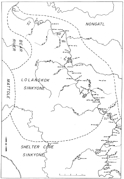
Map 13. Place names of the Lolangkok Sinkyone.
nahn´-sin-cho´-ke. The big hill to be seen on the E side of
South Fork 3 mi. S of Dyerville.
sā-chōs-te (sā-cho-stă), "vulva rock." A long
gravel bar along both sides of the river and including a redwood
flat 4 mi. S of Dyerville. Named for a mark on a rock resembling a
woman's vulva, cho´-sā.
che-ōs-cho´-te. A stretch of river 4.75 mi. S of Dyerville,
including a small but good redwood flat. The name refers to foam on
the water.
sā´-boo-i-chan´-te. A big perforated rock in the river at a
sharp bend 5.1 mi. S of Dyerville.
kah-tah´-be. A stretch along both sides of the river 7.5 mi.
S of Dyerville. It includes the State Redwood Park office building
and adjacent redwoods.
ken´-tes-cho´-be. Myers Flat, a little over 8 mi. S of
Dyerville, including Myers Roadhouse. The Indians say this place
was never covered with timber.
ses-che´-is-ke. A place 8.7 mi. S of Dyerville, above
ken-tes-cho-be.
sā-bug´-gah-nah´. A place 9 mi. S of Dyerville where the
river goes around rocks. [Evidently Eagle Pt.] George Burt once
lived here and his son Guy Burt was born here.
tub´-bel-chin´-tah chā-gel-kōk. A small creek 10 mi. S
of Dyerville, entering South Fork from the E just S of a bend in
the river. [Evidently Bridge Cr.]
sōl´-te-che. A place at the mouth of Elk Cr., on the E side
of South Fork. Includes the eastern part of Bolling Grove.
sōl-te-kōk. Elk Creek, entering South Fork from the E in
Bolling Grove, 10.3 mi. S of Dyerville.
sen-tĕch-be. A rock in the river at a small bend 11.2
mi. S of Dyerville.
ni´-te´-tĕ el-lah´-tĕ, "dog drowned" ... A place where a
new bridge is now (1923) being built across South Fork, 12 mi. S of
Dyerville. [Evidently this refers to the bridge at Blair Grove.]
suk´-ke-chōs kah´-me, "eagle pawn." A big flat on the W
side of the river 12.5 mi. S of Dyerville.
chah´-ni-che´. Another large flat on the W side of the river,
13.5 mi. from Dyerville.
sah-nah´-kōk. Salmon Cr., entering South Fork from the W
nearly opposite Miranda.
kahs´-cho-boo´-ah´-me. This was a small settlement in a flat
at Miranda, 14.5 mi. S of Dyerville.
sā-nan-sung´ (·sā-nan-tsin´-kah). Bear Butte, a
conspicuous peak on the W side of South Fork, about 18 mi. S of
Dyerville.
sā´-chen-to´-te, "water against rock." A place in the river
16 mi. S of Dyerville.
kă-kes´-kōk (kĕ-kes´-kōk). Fish Cr., 16.9 mi. S of
Dyerville.
kin´-tes-tah´-te. A big flat, probably a mile long and very
broad, on the W side of the river, 17.5 mi. S of Dyerville. Just N
of Phillipsville but on the opposite side of the river.
ket´-tin-tel´-be. A flat (now orchard and ranch) and village
on the E side of South Fork, 18 mi. S of Dyerville, at a place now
called Phillipsville. It comprises a fine redwood grove and a good
camping place.
să-be-yĕ´. A flat on the E side of the river 0.7 mi. S
of Phillipsville.
A mile south of Phillipsville there is a good view of Garberville Ridge,
sĕ-chung´-kuk, a fine ridge, part timbered and part open grassy
hillside, which slopes west from Little Buck Mountain, nā-ah-ki´-kah,
the highest point, some distance back on the east.
to-be-yĕ, "prairie under." A small flat on the W side of
the river 1 mi. S of Phillipsville.
yen-nes´-be. A place 1.6 mi. S of Phillipsville.
chig-gel´-e-yes´-ke. A place 1.9 mi. S of Phillipsville.
sĕ´-chin-kōk´. A small stream probably 1.2 mi. S of
Phillipsville. A possibility of error here. If the location is
correct, the stream is probably Ohman Cr.
sĕhl-ki´-kōk. A creek 2.1 mi. S of Phillipsville. The
preceding location is probably an error and this is Ohman Cr.
sĕ-ki´-ke. The land S of sĕhl-ki´-kōk Creek,
reaching to 2.5 mi. S of Phillipsville.
sĕ-tes´-kōk, "hard rock creek." Rocky Glen Cr., 2.5 mi.
S of Phillipsville.
ki-tes´-be, "hard brush." A place 2.9 mi. S of Phillipsville.
There is a small ranch and orchard there now (1923).
chan-tan-che´. A place a little more than 3 mi. S of
Phillipsville. There are two big rocks and a creek there.
sĕ-to´-be. A big rock facing a high bluff 4.3 mi. S of
Phillipsville.
sā-ken-nes´, "talking rock." A big rock on a creek on the W
side of the river, 5.6 mi. S of Phillipsville.
tuk´-ke-tahk. A beautiful open and partly wooded hill on the W
side of the river 6 mi. S of Phillipsville.
tuk´-ă-tah´-be. A place on the E side of the river 6 mi. S
of Phillipsville. Named from tuk´-ke-tahk hill.
tahs-ki´-kōk, "white flag creek." Dean Canyon Cr., 6.4 mi.
S of Phillipsville.
tahs-ki´-ke. Village at the mouth of tahs-ki´-kōk creek. It
belongs to the To-kub´-be tribe.
to´-che-be. A flat on the W side of the river 7.8 mi. S of
Phillipsville.
bus´-ken-nes´, "cliff talking." A cliff or bluff opposite
to´-che-be.
stuk´-kan-no´-be. A big semicircular grassy flat on the E side
of the river beginning about 8 mi. S of Phillipsville. The present
town of Redway.
ahn´-chin-tah´-kōk. Redwood Cr.
se´-ken-tĕch-tĕ. A place 9.5 mi. S of Phillipsville.
sah-nah´-che-chel´-le. A place and creek 9.7 mi. S of
Phillipsville.
bus-ki´-cho. A white bluff on the road 10 mi. S of
Phillipsville.
kōs-kun-tes´-kah. A sloping, grassy, open flat 10.3 mi. S
of Phillipsville. There was a To-kub´-be village here.
ko´-se-che´. The area on both sides of the river 10.6 mi. S of
Phillipsville. Just N of the Garberville bridge across Bear Canyon.
sā-gĕ´-chĕ, "egg rock." A bold upright rock at the
N end of the Garberville bridge across Bear Canyon; 10.6 mi. S of
Phillipsville.
ken-tes´-che tahng-ah´-te. A beautiful deep valley on South
Fork just SW of Garberville. The bridge across the river on the way
to Briceland is in this valley.
si-cho´-kuk. A large village of the To-kub´-be near the site
of the bridge across South Fork on the way from Garberville to
Briceland.
nahs-lin´-che. An area and village in a loop of South Fork a
few miles S or SW of Garberville.
ken´-nahl-lag´-gah-kōk (kan´-no-lig´-ah-kōk). East
Branch of the South Fork of the Eel R.
nā-yahn´-kah. A hill on the W side of South Fork near the
bridge over East Branch.
kahs´-cho-so´-be. A place and village on South Fork about 4
mi. S of Garberville and 3 or 4 mi. from the highway. Not in sight
from the highway.
kahs´-cho so´-ning-i´-be. A large redwood flat (Richardson
Grove) on the W side of South Fork on the Humboldt side of the
Humboldt-Mendocino County line.
West of South Fork Eel
| Bear Buttes |
sa-nan-sin-kah |
| Bear River |
chahn´-kōk |
| Briceland |
to-cho´-be |
| Elk Ridge |
chi-chin´-kah |
| Mattole River mouth |
tah´-che |
| North Fork Mattole |
nahn-tsin-tah´-kōk |
| Rainbow Peak |
tsa-che-be, tsa-bahng´-um |
| Rainbow Ridge |
tsa-bung-ah |
| Taylor Peak |
nahn-tsin´-kah |
| Upper Mattole |
kun-sah´-ke |
On or near the Van Duzen River
| Alton |
chen´-nă-che |
| Bald Jesse Mt. |
kōng-kel-tel´-kah |
| Bridgeville |
ahn´-sin-tah´-che-be´ |
| Buck Mt. |
nahn´-tsin´-kah |
| Carlotta |
yah-hlahn´-che |
| Chalk Mt. |
sā-til-bi´ |
| Chalk Mt. Ridge |
nĕ-chin´-tuk-kah, nā-chin´-tă-kah |
| Fort Baker |
sā-shā-be |
| Iaqua region |
kōng-tel-kil´-kōk |
| Iaqua Buttes |
sĕhl-kus´-ă-kuk ("two points") |
| Larabee Buttes |
yah-kah´-nik-kah (tă´-che-kah) |
| Larabee Cr. |
slahn´-ko |
| Lawrence Cr. |
yah-tlahn´-kōk (ye-tah´-nah-ling´-kōk) |
| Lassik Buttes |
tse´-nahn-tsin´-kah |
| Lassik Pk. |
ki´-chil-kahn-kah |
| Little Larabee Cr. |
so´-kōk |
| Metropolitan |
yah-hlahn´-kuk |
| Rohnerville |
to-ti´-kah |
| Rio Dell |
ken-tel-cho´ (kin-tel´-te) |
| Scotia |
kahs-cho ken-tel´-te |
| Showers Pass |
sā-chă-be |
| Van Duzen R. |
chin´-ne-kok (ken´-ne-kok) |
| Van Duzen R. mouth |
kin´-ne-ke |
| Yager Cr. |
yah-'hlahn´-kōk |
| Yagerville |
chis-sis´-ahn´-tah |
Lolangkok Sinkyone.—The following notes on the Lolangkok Sinkyone are
taken verbatim from Merriam's notes. The informant was George Burt.
The Lolahnkok did not fight much with other tribes but were
sometimes attacked by the Chĕ-teg´-ge-kah of the region north of
Round Valley [Pitch Wailaki]; and they think the Long Valley people
also used to make raids on them to steal women.
Chief Lassik, whose name is often used in a tribal sense,
belonged to the Kittel´ tribe—a tribe reaching from Iaqua south to
Dobbyn Creek [Nongatl].
Chalk Mountain was only a few miles east of the boundary
between the Kittel´ and the Lolahnkok, and the Lolahnkok were
permitted to hunt there.
Shelter Cove Sinkyone.—Trees are felled by means of elkhorn
chisels called beh-cho, and stone mauls called sā´tah—a very
tedious and laborious operation. When the tree has fallen, the logs
are cut in lengths by the same process. Planks are split off from
these logs by driving the elkhorn wedges into the ends of the logs.
After several planks have been split off, one below the other,
another set is started at right angles to the first.
The dugout canoes are made of redwood logs dug out by means
of the elkhorn chisels. After the greater part of the inside has
been removed, fires are used to char the wood, which is then
scraped away by the chisels. This is continued until the walls of
the dugout are sufficiently thin. The fires are spread out thin in
order not to burn too deeply at any one place.
Buckskin is tanned with deer brains, rubbed on with a stick
rolled in ashes, after which the hide is placed on warm ashes
until dried. It is then soaked and rubbed until soft.
Wild tobacco (Nicotiana bigelovi) was always used by the
Bull Creek Sinkyone. It was originally found growing on burned-over
places and the people planted the seeds in ashes, usually on a
burned place.
Buckeye nuts, called lah-sĕ´, were cooked in a basket with
hot stones after the manner of acorns. They were then mashed and
kneaded into dough, which was buried for a while in fine sand.
Wild Ginger (Asarum sp.) is called tan-nas-bos´. It is good
medicine for pain in the stomach. The leaves are pounded and soaked
in cold water. The sick person drinks plenty of this water and
vomits. After a little while he gets well and is hungry and eats.
A species of Angelica is called sōl. If a girl holds off,
rub sōl on your hands, and if you get a chance rub her neck and
she will give in. Sōl is strong medicine.
An aromatic Umbellifer (species not identified) is called
sōl´-che-but-tah´; the root, sōl´-che. It is used for
purification and as a disinfectant. The root is burned and the
smoke wafted around to make the house more plentiful. It does not
grow on Bull Creek or South Fork Eel River but grows on Rainbow
Mountain and some of the other high ridges. The root is highly
prized.
The Spotted Owl (Strix occidentalis caurina) is called
kah-ko´. He is a bad bird. If he flies close to a person, the
person will faint.
The Dove (Zenaidura) is called bi´-yu. His grandmother was
burned to death. Bi´-yu was asked to gamble and replied, "I'll
gamble every winter; in spring and summer I'll cry." Now we always
hear the Dove cry in summer.
The Red-shafted Flicker (Colaptes cafer) is called
mun´-chis-bul. He makes a rattling noise in the spring. He was told
that by doing this he would make the horns of the deer grow. He was
told also that when the deer became fat he would grow fat, but the
people fooled him for he did not grow fat.
The Yellow-bird (Astragalinus tristis) is called
sin-sun-sĕ-gahng-ti-ne tahs´-che, "to take away pain." If the
old folks were suffering, they would get him to sing to take the
pain away.
The Kildeer (Oxyechus vociferus) is called ni´-til-yi´-che
from the necklace, ni-tal-yah, on its throat. In the long ago time
the water was very high and rough; big waves were coming in and
the people were afraid to cross in their canoes, so they got the
Kildeer to take them. He was a high person among the Water People
and could handle a boat better than any of the others. The people
talked about him and said he was the best and the only one to get
them across. So he took them across and saved them.
The Coyote (Canis latrans), called shŭ´-bĕ, and the
Shrewmole (Neürotrichus sp.), called ske´-cho, made the world and
the people. The Coyote had a number of children. The Shrewmole said
that when people died they should come back to live again. Coyote
said, "No, there would be too many people; when they die they had
better stay dead." The Shrewmole agreed. After a while Coyote's
children took sick and died. He wanted them to come back to life,
but the Shrewmole said, "No; you said there would be too many
people and you wanted dead people to stay dead, so your children
cannot come back." Then Coyote cried.
The Raccoon (Procyon lotor) is called nah´-ke-gis´-chah.
A long time ago he was a doctor. He was able to talk to persons
suffering severe pains and could draw the pain out. He would dance
and sing and pull out the pains and fall back. One time he took a
flint out of a sick person.
In the olden time the people tried to make the Elk (Cervus
roosevelti), called yēs´-cho, out of the Cottontail Rabbit
(Sylvilagus sp.). They put horns on his head and sent him into
the brush, but the horns stuck in the bushes and he could not move.
Then the people called him sti´-che and told him he must always
stay in the brush.
The Bat is called nah´-tă-bahn´-se. He wears a robe of bear
hide over his shoulders. A long time ago when the First People were
at war they wanted the Bat to make peace and they hired him to make
peace. The people told him to fix up good. He did so and said, "I
am the one who can talk big." He sang ho-wā´-nah han´-nah. The
enemy agreed, and peace was made.
Our people have songs for the Elk, Deer, Coon, Otter, Mink,
Bat, and some other animals.
Slugs (Arion columbianus) are called nah´-tos. To prepare
[them] for eating, a slender stick is thrust through the head to
hold the animal easily. It is then cut open lengthwise on the belly
and the dark insides removed, after which it is dried. When wanted,
it is roasted in hot ashes and eaten.
Shelter Cove Sinkyone.—These notes are from Sally Bell of the
Briceland-Shelter Cove region.
Acorns of the tanoak (Lithocarpus densiflora) form the
principal vegetable food. Hazel nuts also are eaten.
Among the berries used for food are those of the Elder,
Manzanita, Blackberry, Thimbleberry, Strawberry, Huckleberry,
Salal, wild Currant and Gooseberry.
The sprouts of a species of Angelica are eaten raw in spring
and early summer.
The bulb of the large red Tiger Lily is cooked and said to be
very good. The same is true of the handsome Brodiaea sp.
The seeds of the Manroot (Echinocystis) are roasted and
eaten. The seeds of Godetia amoena are used for making pinole.
Wild Tobacco does not grow along the coast and is not used.
The Wood Sorrel (Oxalis) is used for poultices.
Leaves of the narrow-leaf Iris (Iris macrosiphon) are used
for cord and nets and are much better than the leaves of the
broad-leaf species.
The Mattole occupied the drainage of the Mattole River below the mouth
of Upper North Fork and the coast from Davis Creek south to Spanish Flat.
The village lists of Merriam and Goddard provide a complete picture of
the Mattole settlements but almost nothing is known of them aside from
this. In the Handbook Kroeber reported (1925a, p. 142) that "not a
single item of concrete ethnology is on record regarding the Mattole,
other than the statement that they burned their dead." Almost nothing
has been learned since that time, but Nomland (1938) has published a
monograph on the neighboring Bear River group and the culture of the two
groups was no doubt much the same.
The territory of the Mattole lies wholly within the cold coastal
belt and consequently plant food was less abundant and no doubt less
important. The products of the rivers, when taken together with sea
mammals and other creatures caught in the ocean, provided an ample food
supply.
When Kroeber published the Handbook (1925a), he lumped the Mattole
proper with the Bear River group. Nomland (1938) and Goddard (1929)
showed that these two groups were distinct. This division is supported
by Merriam's data and I have therefore retained it.
Merriam appears to have spent a comparatively brief time among the
Mattole. The only informant mentioned for this group is a man called
Indian Joe Duncan, who is said to have lived at the mouth of the Mattole
River below Petrolia. Merriam seems to have visited the area in 1923.
His statement on these people, taken verbatim from his notes, follows.
The Bettōl´ or Pet´-tōl´, as they call themselves,
(commonly called Mattōl´), inhabit the coast region from Davis
Creek, about six miles south of Bear River, southerly to Spanish
Flat, which is about 12 miles below the mouth of Mattole River.
Their center of distribution appears to have been the Valley of
Mattole River, at whose mouth the four or five survivors still
reside.
They say that before the Whites came they numbered between 300
and 500 persons.
Their southern boundary, Spanish Flat, is the northern
boundary of the Shelter Cove tribe, which reached thence southerly
to or beyond Bear Harbor. The Mattōl´ say that the Shelter Cove
language is materially different from their own, and different also
from that of the Briceland Tribe, and that the Briceland language
is very hard to speak or understand. They declined to give the name
of either of these tribes.
The eastern boundary of the Mattōl´ I was unable to locate
exactly. They gave it as along or near the west base of Elk
Mountain Ridge, including the Valley of Upper North Fork Mattole
River. At the same time they gave the names of two 'tribes' or
bands as inhabiting the Rainbow Ridge and Elk Ridge region. The
Elk Ridge tribe they call Să-bahng-kahng, the Rainbow Ridge
people Sĕ-tso´-ik (from Sĕ-tso-ēk, Rainbow Peak). There is
uncertainty as to the relations and geographic locations of these
bands.
The tribe inhabiting the coast at Needle Rock they call
E´-lĕ-tung. It is the same as the Shelter Cove tribe.
According to Merriam's data, the people at Cooskie Creek in the southern
part of Mattole territory form a distinct band. This agrees with
Goddard's village data, and Goddard also assigns to this group some
of the villages on the upper Mattole. There is no evidence of further
subdivision.
Most of the information on villages of the Mattole is taken from
Goddard's notes. (See map 14.). In addition, there are a few data
recorded by Merriam. Below, Goddard's information is indicated by (G),
Merriam's by (M).
1. sitcībī' (named from sand bar?) (G). On the S side of
Domingo Cr. nearly a mile from the surf. The county road leaves the
coast at this point. Plenty of signs of occupation but no definite
pits.
2. sesnoikō', "rocks stand up creek" (G). About 1/2 mi. E
of the line of the surf, close to the hill through which the stream
in McNutt Gulch comes from the SE. A large quantity of cooking
stones and shells have been exposed by the blowing away of the
soil. Salmon run in the creek.
3. sesnōt, "rocks stand up" (G). N of a large rock which
is 30 or 50 ft. higher than the surrounding sand. Another large
rock stands 300 yds. W, with a chain of rocks and ledge running
out into the surf. Many shells and stones mark the village site.
This village stood in the middle of a 2-mi. stretch of sandy beach,
which reaches from gotxenin to a mile N of this village.
4. sedjildaxdiñ (G). Close up under the hill. The wind has
carried away the soil, leaving a great pile of shells. Just S, a
stream comes down the hillside with only a gulch [La Rue Gulch], no
valley.
5. gotxenin (G). Known to white people as Mussel Rancheria. On
a bench with Peter B. Gulch at the southern end and La Rue Gulch in
the middle. A great quantity of shells were to be seen but no pits.
Joe said the houses were scattered along for nearly a mile. Many
rocks are in the surf.
6. ne'bitt'a, "earth fold" (G). On a bench 1/2 mi. long in a
cove a mile N of the mouth of Mattole R. There is a creek at the S
end, a small gulch in the middle, and a larger one at the N end.
These probably furnished water in winter. Joe said the houses were
scattered along the whole length of the bench. [It is likely that
this is part of no. 5.] Between 500 and 800 yds. from the shore is
a large flat rock (tciyatcise) occupied by sea lions. The Indians
used to swim to it and club the sea lions to death. They kept a
fire going near a rock on shore to warm themselves afterward.
7. sebīye (G). Perched on the steep mountainside just N of
the mouth of the Mattole R. At the southern end two pits could be
made out in the weeds. Slides had covered or taken away most of the
evidences of occupation. The trail was evident and pieces of lumber
were still lying about. The village was not burned, according to
Joe. The burying place is 100 yds. N on a separate bench of the
same mountainside.
să-be´-ah (M). On the ocean beach 1 mi. N of the mouth of
the Mattole.
Goddard and Merriam do not give quite the same location for
these villages but Merriam's description is vague and the names are
evidently the same.
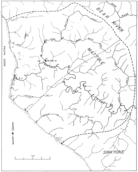
Map 14. Villages and tribelets of the Mattole.
8. bekenō'adiñ (G). This was 300 yds. S of the mouth of
the Mattole R. and 100 yds E of the present surf line. There is an
elevation of broken shells and other refuse on the sandy beach. Joe
Duncan remembers seeing the village when it was inhabited.
9. lasaidûk (G). On the sand of the beach 1/3 mi. S of the
mouth of Mattole R., the second village S of there. The wind has
blown the sand and soil away exposing the shell fragments.
10. dzindiñ (G). By the mouth of a small stream 3/4 mi. S of
the mouth of the Mattole R.
11. sastecdiñ (G). On a small bench N of a little stream a
mile S of the mouth of the Mattole R. Fragments of shells were to
be seen.
12. senalindiñ (G). About a mile and a half S of the mouth of
the Mattole R.; on a small flat with a point of land S of it and a
rocky bluff to the E. Broken shells are to be seen. There are now a
hut and corral on this flat. The point S, a part of Punta Gorda, is
called "Windy Point"; sevinnagintcidin is the Indian name.
13. kailistcī (G). A flat of 3 or 4 ac. immediately N of
the mouth of Four-mile Cr., about 2-1/2 mi. S of the mouth of the
Mattole R.
14. saitcībiε (G). On a bench on the coast S of
a bold headland. A small stream here [Lion Gulch] has a large delta
of gravel. This was the southernmost of the villages of the Mattole
R. tribelet. A house and barn said to belong to John Mackey are on
a higher bench.
15. bitcībī' (G). On the N side of Cooskie Cr. (called
kūskīc by the Indians), 1/4 mi. from its mouth. Unlike
most such streams, this one has something of a valley behind the
bordering sea wall, through a gap in which it reaches the ocean.
Salmon enter it. This was the northernmost village of the Cooskie
tribelet.
koos-ke (kochkshe) (M). A very large band and village
("hundreds of people") formerly on Cooskie Cr. on or near the coast
2-1/2 mi. SE of Punta Gorda Lighthouse. Joe Duncan said these were
the most warlike people of the region.
16. decī (G). On a large flat in a cove on the coast,
immediately N of Spanish Flat. A row of shallow but evident pits
are to be seen 200 yds. S of the northern end of the flat.
17. yīnakī (yīnatcī) (G). On a flat, called
Spanish Flat, 3/4 mi. long and 300 yds. wide between the ocean and
the terrace. It has a creek at its southern end (Spanish Cr.),
with a large deposit of gravel which has almost entirely buried a
group of buildings. Plenty of evidence of Indian occupation but no
decided pits. It is said to have been a very large village. The
men of this village were killed by a band of white men who came
down from the mouth of the Mattole R., which they had likewise
occupied. An Indian ran down the coast to give warning but arrived
too late. The women also were killed some years later.
18. seyetcī (G). On a bench at the W end of a flat on the N
side of the Mattole R. about a mile from its mouth.
19. sedanadaaibīε (G). On the E end of the same
flat on which seyetcī is situated. The site is now said to have
been washed away.
20. daxdeginkatik (G). On a rocky timbered point which is an
extension of the hills N of the Mattole R. This point is 25 ft.
higher than the main flat, called nestik. Several indistinct pits
are still to be seen. The Goff buildings are close by and occupy
part of the village site. This flat was plowed for the Indians in
186..(?). There is water in a gulch W (Jim Goff Gulch).
nes-te´-be (M). On the present Goff Ranch on a bench on the N
side of the Mattole R., about 3 mi. upstream from the ocean.
The names are different but the locations are identical, so
these are no doubt the same village.
21. daaibīε (G). On the SW part of the large
flat W of Petrolia, on the S side of the river. It was here that
the Indians settled when they came back from the reservation.
seb´-bin-ne bug´-gah-be (M). An acorn camp on the S side of
the Mattole R. a little below the present Hanson place, 3 mi. from
the mouth of the river.
The locations for these two villages are the same but the
descriptions are obviously different. It may be that this was
an acorn camp in pre-white times and was subsequently used as a
village site when the preferred land had been taken by the settlers.
22. bisyet'obīε, "slide place" (G). On a point
on the N side of the Mattole R. W of Petrolia, overlooking Wright's
place. Buckeye and peppernut trees are growing there. It has fine
exposure toward the S. There are pits still to be seen.
23. tcegiltcexbīε (G). On the E bank of the
North Fork of the Mattole R.; the site is now included in the
village of Petrolia. It is said to have been a large village.
24. sōLkaiye (G). On a large flat on the W side of the
North Fork of the Mattole, E of the road to Ferndale. A white man's
house, on a higher flat near the creek, has been burned. It was
here the Indian village stood.
25. djetxeniñ (G). On the N side of the North Fork of the
Mattole just W of a creek flowing into it from the N. It is at the
western end of a long crooked canyon. Under a point were five very
large distinct pits. There were evidences of occupation on the
point above (the creek is called Wild Goose Cr.?).
26. djinsibbai, "elbow" (G). In the bed of the North Fork of
McNutt Gulch. The inhabitants of sitcīcbī (no. 1) camped here
in summer to hunt. Timber and brush.
27. djibbedaxtûkkabīε (G). On a point on the S
side of North Fork of Mattole R. Opposite djetxeniñ. Joe saw people
living here when he ran away from the white man who was taking him
away for a slave.
28. natsinnadaat (G). At the junction of two streams which
make up the North Fork of the Mattole (North Fork Mattole and East
Branch, North Fork Mattole). The stream valleys are wide. The
northern one (North Fork Mattole) is badly washed out, as is also
the main valley of the combined streams. A group of ranch buildings
belonging to Si Minor now occupies the village site, and Billy Wood
once lived there. There was a pit on the W side of the stream from
the N and two pits on the N side of the main stream 1/4 mi. below
the junction.
29. sedjegûnkōƚdiñ, "right angle" (?) (G). On a flat on
the N side of the Mattole R. E of the bridge. It is now occupied by
John Evarts.
30. djegaslinabīε (G). At the mouth of the
creek flowing into the Mattole R. from the N, 3/4 mi. W of the
county bridge SE of Petrolia (Conklin Cr.).
31. daƚoidiñ, "wild grape place" (?) (G). At the mouth of
a creek (Indian Cr.) flowing into the Mattole R. from the SE at
the northern end of a flat nearly a mile long. Saw what may have
been pits, one on each side of the road by the duck pond near the
buildings belonging to Cummings. This was the northernmost village
of the Cooskie tribelet.
32. djanōldin (G). On a bench 1/8 mi. long and 200 yds.
wide on the E side of Mattole R., which here flows N. It is at the
ford.
33. saiqōtLûndiñ (G). On a long flat bordering the eastern
side of the Mattole R. Joe said the village was at the southern end
of the flat, which is now owned by Lee Minor.
34. gōdanindjaibī (G). Just E of the mouth of Squaw Cr.,
a large stream flowing into the Mattole R. from the S. The regular
inhabitants were joined by others, who camped here to gather acorns.
35. nōwillenebī (G). On a large flat on the E side of
Mattole R. upstream from the mouth of Squaw Cr. Exact location of
village uncertain. The name may be that of the section, not of the
particular village.
36. gōnsakke (G). A large flat through which the Mattole R.
flows toward the NW. Roscoe lives on the N side. Exact location of
the village is uncertain.
37. Lōitsiske (G). On a flat on the E side of the Mattole
R. The river is here no distance from the road. "Joe got very angry
when I wanted to look for pits."
38. īkediñ, "foot place" (G). On the N side of a small
stream flowing into the Mattole R. from the E, at the SE side of
a flat. There are two deep pits and several, less deep, on the E
side of the wagon road. A large group of buildings are on a higher
flat SE. There is a large flat on the W side of the river also. The
whites killed all of the inhabitants while they were fishing for
eels.
39. ƚīgûcLûndiñ, "snakes many place" (G). Probably on
the W side of the river where there is a large flat around which
the river flows, keeping near the high bank on the E. The road runs
along the eastern side of the river and climbs a considerable grade
at the N.
40. ƚōnītcī, "middle of prairie" (G). On the S
end of a flat on the E side of the Mattole R. Fifteen Indians were
killed here by white people.
41. nōwilkediñ (gacdûlyaidiñ, "like a necktie") (G). Said
to be situated between the Upper North Fork and the Mattole R.
42. djegûllindiñ (G). On the W side of the stream coming into
Mattole R. from the S close to the Humboldt Meridian (Honeydew
Cr.). Indians may also have lived on the E side of this stream. The
application of this name is uncertain.
Goddard also gives the following summer camps of the Mattole, which I
have not been able to locate.
djindillegaxye. A flat on the S side of Mattole R., near its
mouth.
innaslaibi. A long level bench crossed by the county road N
from Petrolia, 1-1/12 mi. from that place. Indians used to camp
here to gather tarweeds. An Indian battleground.
kuntcegilcannebi. Sec. 32, T. 1 S., R. 2 W. On the E side
of the county road. The section lines given by Goddard are not
reliable.
sekexge. A sloping place on one of the branches of McNutt
Gulch.
Upper Mattole villages.—The following village locations were given
to Goddard in 1908 by the Sinkyone named Charlie. Goddard did not
visit them so they cannot be accurately located. I am giving Goddard's
township and range locations, but these were made by guess from an
imperfect map, hence they must be used only with the greatest care.
de'tci'. At the mouth of a big creek (de'kok) flowing into
Mattole R. at Upper Mattole. Perhaps de'kok is Squaw Cr., mentioned
in the Elk and Coyote stories. NW 1/4, sec. 30, T. 2 S., R. 1 W.
ne'nûnyadûñ. On the E side of the river 3 mi. above de'tci'.
There are two creeks there. This may be the village, and de'tci'
the whole Upper Mattole flat. Notes say 3 mi. from Mattole, which
is Charlie's name for Petrolia.
k'atinta'. Above ne'nûnyadûñ on the Mattole R. at the mouth of
kutsai'kok. NE 1/4, sec. 33, T. 2 S., R. 1 W.
tcûlgûnnak'e'. Some distance above k'acinta' on Mattole R.
tcintcûskōdûñ. On a hill on the E side of Mattole R.
tcûstīmī'. On the W side of the Mattole R. on a big
flat, S of tcintcûskōdûñ. No creek empties there.
istannaladûñ. On a large flat on the Mattole R. No creek
empties there.
setûggûttcī'. On the E side of the Mattole R. at the mouth
of setuggukkok. Sec. 14, T. 3 S., R. 1 E.
tceliñkī'. On both sides of a small creek which enters
a larger stream near the latter's junction from the E with the
Mattole R. The valley of the river is wide at this point. A large
group of buildings is now standing on this site. "I rode to this
place in July, 1908, when hunting for Jack's place. The name was
supplied by Charlie from my description." Sec. 31, T. 3 S., R. 2 E.
Lenillīmi', "flow together in." At the junction of two
streams on the W side of the Mattole R. There were formerly many
grizzlies there, and the Indians were afraid of them. This was the
last village S of the Mattole R. Sec. 7. T. 4 S., R. 2 E.
Merriam gives a number of other village names with rather vague
locations. No doubt each of them corresponds to one of Goddard's, since
both men used the same informant, but I have been unable to identify the
villages either by location or name.
tah-tah´-ke-ke. On a small flat on the S side of the Mattole
R. about 1/4 mi. back from the ocean.
tahn'-hrā´-lah-be. At the mouth of the Mattole R. (on a
lagoon near Indian Joe Duncan's place).
yes-să-cheb´-be. On or near the site of an old barn S of
the junction of the North Fork with the main Mattole R., near
Petrolia.
e-nah-sal-li´-be. On a flat on Mattole R., 1/2 or 3/4 mi. S of
Petrolia.
choo-wilch´-kah-be. On the North Fork of the Mattole R. at
Petrolia. The name tek-ko-li-be is also given for a village on the
site of present Petrolia.
This small group, occupying the entire drainage of Bear River and the
coast near its mouth, has been fairly well documented by ethnographers.
Aside from linguistic material, our chief source, a paper by Nomland
(1938), gives as complete an account as could be obtained at such a late
date. Although some villages are noted by Goddard (1929), Nomland, and
Merriam, they do not appear to have been recorded by any of the scholars
in a systematic fashion. The village count therefore is probably not
complete.
The resources of the Bear River group are substantially the same as
those of the Mattole, except that the salmon run is smaller.
Merriam's information on the Bear River tribe is limited but it helps to
augment the data now in print (Nomland, 1938; Goddard, 1929). Merriam's
informant among these people was an old woman named Mrs. Prince. She
came from Bear River, but at the time Merriam spoke to her (July and
September, 1921) she was living at the Rohnerville Reservation. She used
to visit her granddaughter, Ethel Hecker, at Scotia.
Merriam gives the following brief note about these people.
Nek´-an-ni´ ... Athapaskan coast tribe formerly inhabiting
Cape Mendocino and adjacent region from Bear River Hills southward
to Mattole River, and reaching inland (easterly) to the headwaters
of the Bear River. [Nek´-an-ni´ was] their own name for themselves.
All evidence would seem to indicate that the Bear River people
constitute a single tribelet as well as a single dialect group. Even the
village on Oil Creek (village no. 7) was evidently in the same political
division; Goddard (1929, p. 291) says: "There was, however, one village
at the mouth of Van Duzen creek which was allied to Bear river both in
its dialect and politically."
Some villages are given by Merriam (M), Nomland (1938) (N), and Goddard
(1929) (G), but most of the locations are not very certain.
1. chal-ko´-chah (M). Name of the village N of the mouth of
Bear R., used for both the place and the village.
tc'alko´ (N). Largest and most western village in the area. It
included the flat at the mouth of Bear R.
Goddard mentions two villages as being on the ocean N of the
mouth of Bear R. — ƚ'adAlk'AsdAñ and goldElco'dAñ. He gives the
word tc'alko as the word for Bear R. In Nomland's personal copy
of Goddard's paper (1929) she has written the word "tchankok" as
the word for Bear R. She gives the following explanation of the
discrepancy (1938, p. 92): "In checking words given by Goddard with
my Bear River informant, Nora Coonskin, it developed that most
of his information (gotten from Nora's uncle, Peter) was not in
accordance with hers. Upon close questioning, the latter told me
that her uncle preferred to speak Mattole. I checked Peter's words
with Isaac Duncan, my Mattole informant, and found this to be true."
2. sā-cho-tung (sĕ-cho´-tah) (M). On the ocean on the S
side of the mouth of Bear R.
setcodAñ, "rock big" (G). By the lighthouse, a populous place.
The present-day lighthouse stands about 2 mi. S of the mouth of
Bear R.
3. chil-shĕck (N). On the site of the present town of
Capetown.
atcAnco'xEbi' (G). Said to have been where the store and hotel
are at the town of Capetown.
4. chil-en-chĕ (N). Near the present Morrison Ranch.
chul´-lŏ-ko (M). This was the name of the village at
Morrison's, 5 or 6 mi. above the mouth of Bear R.
5. sels-che'o-ch (N). About 3 or 4 mi. up the river from the
Morrison place. The site is now marked by a large red rock. It may
correspond to Goddard's sEtcixEbi, "rock stand in the water", which
is not located.
6. seht-lá (N). About 7 mi. up Bear R. from Capetown.
7. ko-stah-che´ (kōs-tah-che´) (M). Name of the camp on Oil
Cr.
Each author gives some additional villages, which cannot be located.
esta-kana (N). On the largest flat in the upper valley, Gear's
place.
IstEγnadaibi', "madrone stands place" (G).
klaht-el-kōs´-tah (M). Name of the village near the head of
Bear R. (at least 15 or 20 mi. upstream). It was a large town with
a big dance house.
ƚ'adAlk'AsdAñ (G). Where a schoolhouse stands on Bear R.
tlanko (N). Above chil-sheck.
At low tide in the spring the Bear River people waded out to lighthouse
rock to gather the eggs of seabirds—gulls, shags, and others. They
would climb up a sort of stairs in the steep rock, wrap the eggs in
buckskin, and let them down with long ropes.
The illustration (fig. 1, c) is of an old woman, about ninety years
old, from Bear River, sketched in the fall of 1921.
As stated earlier in the discussion of boundaries (p. 164) I have,
following Merriam's data, assigned the Whilkut different territory than
has heretofore been customary. In the present scheme they occupy the
drainage of Mad River from the mouth of North Fork Mad River to the
mouth of Bug Creek, the drainage of North Fork Mad River, and all the
drainage of Redwood Creek above the lower ten miles. The subdivisions of
the Whilkut are: Chilula Whilkut (Kroeber's Chilula) on lower Redwood
Creek, Kloki Whilkut (part of Kroeber's Whilkut) on upper Redwood Creek,
Mad River Whilkut (part of Kroeber's Whilkut) on Mad River above the
mouth of North Fork, and North Fork Whilkut (part of Kroeber's Wiyot) in
the drainage of North Fork Mad River.
Goddard (1914a) and Merriam together give a fairly complete picture of
the organization of villages and subgroups of the Whilkut but aside from
this we have next to nothing in the way of ethnographic information.
They were evidently closely akin to the Hupa in both language and
culture. With the Hupa they form a dialect group as against the Tolowa
on the north and the other California Athabascan groups on the south.
The territory of the Whilkut lies in the dense redwood forest of the
northern coast of California. Thus their economy was based primarily on
the produce of rivers, and this fact is reflected in the placement of
their villages.
Merriam has left a relatively complete record of his visits to the group
which I am calling Whilkut and which he called Hoil´-kut or How´-wil-kut
and Mā´-we-nŏk. (Merriam uses various spellings.) His first visit
to these people was in 1910. The following account is taken from his
California Journals for September 15, 1910.
Talked with several Indians at Blue Lake. The boundary between
the Pah-te-waht [Wiyot] of Lower Mad River, and the 'Hoil´-kut or
Ho-il-let-ha of Redwood Valley lies along North Fork of Mad River
near its mouth, between Korbel and Blue Lake. The Pah-te-waht I saw
today live on Mad River at Blue Lake (on south edge of town), while
the Hoi-let'ha live on the extreme northeast beyond the town and
cemetery.
Merriam's second visit there was in 1918 and the following quotation is
from the California Journals for August 11, 1918.
Sunday, August 11, 1918 was foggy and misty in the forenoon;
partly clear P.M. Took the early morning auto stage from Eureka
to Korbel, but got off between Blue Lake and Korbel and went on
an Indian hunt, landing back at Blue Lake without entering Korbel
proper at all. Returned to Eureka in afternoon.
Went particularly to get additional material from the Redwood
Creek Indians ('How´-wil-kut´-ka or 'HWilkut tribe) who were living
in this region when I was here in September 1910 (see Calif.
Journals, Vol. 1, 90-93, Sept. 15, 1910). Tried to find O'Haniel
Bailey and John Stevens of Redwood Creek, and Stevens' daughter
Laura, from whom I got much information before. After a fruitless
search over the old ground, learned that O'Haniel Bailey died
several years ago; that John Steven is visiting in Hoopa Valley,
and that his daughter Laura is married to a white man.
But after a while I found two old men of the same tribe, who
were born and raised at the Blue Lake rancheria 'Ko-tin´-net, the
westernmost village of the Hă-whil´-kut-kā tribe. They call
themselves and their language by the same name, 'Ho-tin´-net [North
Fork Whilkut]. One is blind and both are old. The blind man's name
is Nelinjak; the other's Denbrook. They were eating breakfast of
fried potatoes, dried fish, and coffee in their poor old shack.
I got some good material from them and after some persuasion took
their photographs.
The blind one said he dreamed last night that a white man with
a book was coming to see them.
I got from them the names of some Pah-te-waht [Wiyot] villages
on lower Mad River and about Arcata.
Merriam's third visit to this group was in 1920. The following account
is from his notes.
About the middle of September, 1920, I visited the site of the
old Hoilkut rancheria called T'chil-kahn´-ting (or T'ch-kahn´-ting)
on the east side of Redwood Creek near the Berry ranch, about a
quarter of a mile below the highway bridge on the road from Arcata
to Willow Creek and Hoopa. It was then abandoned, the Indians
having established another village on higher ground about a mile
below, and like the old one, on the east side of the river.
The old site is on an open sand and gravel bar or flat a
little above high water mark and very near the river. The living
houses were square—never round. The house excavations were
about two feet deep. The excavation for the ceremonial house
("sweathouse") was sixteen or eighteen feet across and deeper than
the others, averaging about three feet below the surface. The
ground floor within was covered with large flattish pebbles. The
building had fallen but I was told that it had a low gabled roof,
with entrance toward the river (on the west side). Under the north
end and still plainly visible was a ditch or flume to supply air
and for a draft when starting the fire. The fireplace was in the
middle.
The graveyard is on the downstream end of the same flat.
The flat is in a forest of Douglas spruce, black and white
oaks, maples, tree alders, and dogwood, with a dense undergrowth
of hazel, spirea (Spirea douglasii), syringa (Philadelphus
lewisii), huckleberry (Vaccinium ovatum), and the wild lilac
(Ceanothus integerrimus). The "three-leaf" or "deer-foot"
also called "sweet after death" (Achlys triphylla) is common
throughout the shady forest.
In the immediate neighborhood the large gray tree squirrel
(Sciurus griseus) was common, the big gray ground-squirrel
(Citellus beecheyi) was abundant, and a few red squirrels and
chipmunks were running about.
Ruffed grouse, mountain quail, and many pigeons were seen;
also crested jays, robins, and flickers.
A few days later I visited the modern inhabited rancheria,
nearly two miles below the bridge. It is on a rather steep slope
about 500 feet above the river.
Among the Indians present were two very old men, the Wilson
brothers, and a half-breed named Ned Woodward from Blue Lake, and
his wife, the former widow of Nathaniel Bailey—with all of whom I
had worked in previous years. With their help I checked my former
vocabularies and added many words.
At Blue Lake during the latter part of October of the same
year I found a number of Indians, mainly Hoilkut, and obtained
additional material, including village names from Ned Woodward.
Worked also with others, especially the Hoilkut Chief, Frank Lowry,
and his wife. She is a full blood with the characteristic chin
tattooing consisting of three broad vertical bars with a narrow one
on each side between the middle and outer ones. [See fig. 1, a,
b for different styles.] A married daughter had three children, a
tiny girl and two boys—one of three and the other five, both big
for their age.
Also of interest are Merriam's ideas about the position of the Whilkut
groups. The following excerpt, taken from his notes, is dated 1939, but
refers to a trip he made to Blue Lake in September, 1910.
Mā´-we-nŏk [Mad River Whilkut] ... An Athapascan
tribe on Mad River, reaching from the junction of North Fork
with main Mad River near Korbel (where they came in contact with
the Pah´-te´waht of Lower Mad River [a Wiyot subgroup] and the
h'Whilkut of North Fork and Redwood Valley) upstream (southward)
for many miles to the ranch of a white man named John Ahlgren,
where their territory ended. This is on or near Bug Creek.
It was told me by a h'Whilkut ('Hoilet´-hah) who stated
further that the Mā´-we-nŏk spoke a language so similar to
his own that he could understand most of their talk.
The statement in the last paragraph comes from an informant Merriam had
in Blue Lake in 1910. Merriam returned to the region in 1920 and at that
time spoke to a member of the Mad River Whilkut group itself. Presumably
the village list given for that group is derived from the second visit.
Merriam discusses the other Whilkut groups as follows.
The Hoil´-kut or Redwood Creek Indians (commonly called
Chilula, Hwilkut, or Whilkut) were until recent years one of the
dominant Athapaskan tribes of Humboldt County in northwestern
California.
Their territory consisted of the whole valley of Redwood Creek
and the adjacent mountains from a point on the creek 10 or 12 miles
above its mouth to Chaparral Mountain at the head of the creek, and
included also the North Fork of Mad River and a short stretch on
the north side of the main Mad River between Blue Lake and Korbel.
Their proper tribal name as spoken by themselves is
Hoich-let´-kah or Ho-ēch-kut-kă, usually slurred
to Hoil´-kut. They also call themselves Ho-ēch-kut
kew-yahn´-ne-ahm, meaning Redwood Acorn eaters.
There are three divisions or subtribes, more or less distinct
according to the point of view: Upper Redwood, Lower Redwood, and
Blue Lakes or North Fork Mad River Indians. In their own language
they are:
1. The Ho-ēch-ke-e´-te (from Ho-ēch-kut,
"Redwood", and e´-te, "north"), the Northern or Lower Redwood
Indians [Chilula Whilkut], inhabiting the valleys and adjacent
slopes of Redwood Creek from its mouth upstream about 12 miles to
the Tom Blair Ranch at the junction of Minor Creek—a distance in
an air line of about 17.5 miles. Goddard thought this division was
the whole tribe and called it Chilula, adopting the term from the
Hoopa, Polikla [Yurok], and Nererner [Coast Yurok] Indians, who
however apply it in a wider sense to both upper and lower divisions
of the Redwood Creek tribe.
2. The Ho-ēch-ki´-e-nok (from Ho-ēch-kut,
"Redwood", and e´-nok, "south"), the Upper or Southern Redwoods
[Kloki Whilkut], inhabiting the valley of Redwood Creek from Minor
Creek (Tom Blair Ranch) up southerly to the head of the river, near
Chaparral Mountain—a distance in an air line of nearly 20 miles.
They also call themselves 'Klo-ke Ching´-ching-e´-nok, meaning
"Prairie place south."
3. The 'Hoch-tin´-net (or 'Ko-tin´-net), the Blue Lake and
North Fork Mad River Indians [North Fork Whilkut], inhabiting the
valley of North Fork Mad River from its head to Korbel and Blue
Lake, and separated from the other divisions by a continuous lofty
ridge 2,000 to 4,000 feet in altitude. At Blue Lake they had a
large village called Kaw-cho´-sish-tin-tang.
South of the 'Hoch-tin´-net are the Mā´-we-nok [Mad
R. Whilkut], a related Athapaskan tribe inhabiting the valley of
Mad River from the junction of North Fork near Korbel, southerly
(upstream) to the Algrehn Ranch on Bug Creek—a distance in a
straight line of about 21 miles. The 'Hoch-tin´-net and the
Mā´-we-nok say that their languages are so similar that either
can understand most of the words of the other.
The Hoilkut do not reach the coast, being separated from it by
a long mountain ridge, on the west side of which dwell two tribes
belonging to widely different linguistic stocks—the Nererner (the
southwestern division of the Polikla or Yurok) and the Pahtewaht
(the northern division of the Humboldt Bay Soolahteluk [Wiyot]).
The Hoilkut say that the coast tribe they call Teswan (the
Nererner) owned the land fronting the ocean from Orick at the mouth
of Redwood Creek south to Trinidad and extending up Redwood Creek
for ten or twelve miles; and that farther south the Pahtewaht
of the coast and lower Mad River owned the country up to Blue
Lake—possibly to the mouth of North Fork Mad River—all of which
agrees with what I have been told by members of these tribes.
The Hoilkut state that their lowermost (northernmost)
villages, Ha-wung´-ah-kut and No-lĕ´-tin, were ten or twelve
miles up from the mouth of the river. Below these they claim no
territory. Above, they had twenty-three permanent villages.
The language is uniform throughout Redwood Creek Valley except
for one or two slight differences of pronunciation. Thus the first
syllable of the tribal name as spoken by the Upper Redwoods is
Hoi´ch; by the Lower Redwoods, Ho-ēch.
Most of the village names in the lists following were recorded by
Merriam or Loud; some Chilula and Kloki Whilkut data from Goddard's
works are added.
Mad River Whilkut villages.—All the names in this list were recorded
by either Merriam or Loud (1918), respectively designated by (M) and
(L). (See map 16.)
1. ti-keo-tchun´-tin (M). Village on the site of present
Riverside.
mis-kenē'huten, "bluff-?-place" (L).
The names are quite different but the locations are identical.
One of them may be in error.
2. djinākhōe-ten (L). Name said to refer to a prairie.
3. tolkai'e-ten (L). Name said to refer to shining gravel.
4. dj'ēndjēe-ten, dj'ēndjē-whot (L). Name said to
refer to a strong sweep of the wind at that place.
5. me´-kawch-ting, me-ke´-awch-ting (M). Village at Jim
Anderson's place about 3 mi. S of Korbel.
6. ārtes-slandjēōlin-tin, "grasshopper-?-place" (L).
Village at the mouth of Dry Cr.
7. ka-tahs-lah-ting, 'ke-ah-tahs-lah-ting (M). Village on the
S side of Cañon Cr. (in air line about 3.5 mi. S of Korbel).
who'ntā, "houses" (L). Village at the mouth of Cañon Cr.
8. whotsdjōtāche-tin (L). Name said to refer to a low
prairie. The village is 3 or 4 mi. below Maple Cr., just below
Foster Cr. There were three houses there.
9. tsā´-te-tis´-ting (M). Camp on Mad R. at Fala ranch, 10
or 12 mi. S of Korbel. It was a camp for catching eels.
tsē-didis-ten (L). Village about 2 mi. below Maple Cr.
There were ten or more houses there.
10. til-chwah-hew'-a-kut, til-tchwa-hŭ-ut (M). Village on
Maple Cr. about 14 mi. (9 in air line) S of Korbel. Large village.
tilchēhūërkut, dilchërhūērkut (L). Village at the
mouth of Maple Cr.
11. hotintēlime (L). Village at the mouth of Black
Cr. The name is said to refer to a prairie near by, known as
hinukerchenditen.
12. yinālinōwhot (L). Village at the mouth of Boulder
Cr. Merriam also lists a village at this place but he does not give
its name or other information about it.
13. me´-mĕh (M). Village at Three Cabins on Mad R. about 3
mi. above Maple Cr. On Tom Blair's Mad R. place.
14. Village near Mountain View, about 3.5 mi. S of Three
Cabins.
15. tseng-nah´-neng-ahl´-ting, tseng-nah´-neng-ah-ten, "rocks
across the river" (M). Large village at John Ahlgren's place on or
near Bug Cr. [This may be the village site shown in pl. 10, b.]
16. ituke-nōle´-tin, "up-waterfall-place" (L). Village on
Foster Cr. The same name also given to a prairie half a mile up the
creek from its mouth; ituk means "up," also "east."
Chilula Whilkut villages.—The information on the villages and camps
of the Chilula Whilkut comes from Merriam's notes and from Goddard's
published material (1914). It appears that Merriam made a systematic
effort to check Goddard's material, thereby enhancing the value of their
combined work. (See map 15.)
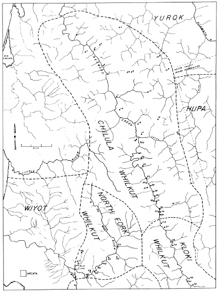
Map 15. Villages of the Chilula Whilkut, North Fork
Whilkut, and Kloki Whilkut (see also map 16).
1. ho-wung´-ah-kut (M). In the Bald Hills N of Redwood Cr.
Northernmost and lowest village.
xōwûnnakût (G). Village probably situated about a mile
E of Redwood Cr. on a small flat S of a ridge along which the
Trinidad trail used to run. A small creek a short distance S,
entering Redwood Cr. from the E, would have furnished excellent
salmon fishing. A depression resembling those characteristic of
sweathouses was seen. Tom Hill's oldest brother used to live at
this village, which was deserted many years ago, probably because
of its nearness to the trail.
2. no-lĕh´-ting (M). Village on Redwood Cr. about 12 mi.
from the coast. The name means "falls."
nōlediñ, "waterfall place" (G). This former large village
remained occupied until 1888, when the Hill family left it and
moved to Hoopa V. The site is at the foot of a long glade which
slopes toward the creek nearly a half-mile distant. A spring N of
the village site supplies water. In the edge of the timber, which
approaches the village site within a few yards on the N, are two
large redwood trees, hollow, with large openings toward the S. In
these trees families used to spend the winter. During our visit in
1906 we spent a rainy afternoon in one of them in which a fire was
maintained, the smoke escaping through the high opening in the side.
The village derived its name and perhaps its existence from
a hole, or waterfall, a short distance up the stream. The creek
bed was formerly choked with huge boulders, causing a fall, which
was jumped by the salmon with difficulty. The fishing for both
salmon and lamprey eels, carried on with nets below the fall, was
excellent. Since the village has been abandoned, several of these
boulders have been displaced so a fall of only 3 ft. remains.
3. yītsinneakûttciñ, "down hill on" (G). Camp site W of
nōlediñ, about halfway up the ridge W of Redwood Cr. The Indians
from nōlediñ used to camp there to gather the acorns of the tan
oak, which are plentiful among the redwood trees.
4. Lōtsxōtdawillindiñ, "prairie water flows down place"
(G). Summer camp about 1-1/2 mi. E of nōlediñ and 1/2 mi. W of
the crest of the ridge. A hollow redwood tree used to be used as a
camping place.
5. tcitdeelyediñ, "dancing place" (G). Glade on a ridge
running toward the E near a branch of Roach Cr., a tributary of the
Klamath. This camp was pointed out from a distance and its exact
location is therefore uncertain. The Indians used to go there from
nōlediñ in the summer to gather seeds and in the fall for acorns.
6. klo-tshim´-mĕy (M). Camp on Redwood Cr. 1 mi. above
no-lĕh´-ting.
Lōtcimme, "small glade in" (G). A former village about a
mile upstream from nōlediñ and 75 yds. E of Redwood Cr., where
it stood in an opening of about an acre. Obscure depressions like
house pits were seen on the N side of the glade near a stream
which provided drinking-water. A weir for lamprey eels used to be
built in Redwood Cr. near by.
7. hoch-tahn-ho-lah´-ting (M). On the E side of Redwood Cr.
above klo-tshim´-mĕy. There is some doubt as to its location.
8. king-keo´-'hli (king-keo´-hĕ-lā) (M). Summer camp on
top of the hill or ridge in Bald Hills about a mile E of Jonathan
Lyon's ranch house.
kiñkyōlai, "big timber point" (G). Large and important
former village situated on the eastern end of a ridge above
Jonathan Lyon's ranch house and about a mile E of it. There is
timber on the northern slope of the ridge. At the edge of the
timber is a spring which supplied the village with water. Besides
the sweathouse site, seventeen house pits were counted. This
village was the home of the Socktish family, many of whom are now
living with the Hupa. The head of the family at the time of the
coming of white people was a man of influence and a noted warrior.
His name was KiLtcil, "crazy." His wife was a Hupa woman and
perhaps for that reason the family moved to Hoopa V.
9. senalmatsdiñ, "stone round place" (G). Summer camp for
gathering seeds in the glade on the S side of the main ridge E of
kiñkyōlai.
10. tesaikut, "projects to water" (G). Camp ground frequented
in the fall of the year for gathering tanoak acorns and hunting
deer by the Indians living at nōlediñ and kiñkyōlai. It is on
the NE slope of the ridge W of Tully Cr.
11. king-yĕ-ke´-ke-ah-mung´-ah (king´-ke-kaw´-mung´-ah)
(M). Village on the E side of Redwood Cr. at the mouth of Coyote
Cr. a little above hoch-tahn-ho-lah´-ting, and a little above
Lyon's place.
kiñyûkkyōmûña, "big timber near" (G). This site was not
visited. It is said to be on the N side of Coyote Cr. below a large
rock. There are said to be house pits there. Tom Hill said this
was the village where the people who lived at kiñkyōlai spent
the colder months of the winter. It is unlikely that two permanent
villages were maintained by the same families. Perhaps the site of
kiñkyōlai is the more recent and it was formerly only a summer
camping place.
12. kitdiLwissakût, "fire drill on" (G). Camp used in the fall
for gathering acorns and hunting. Situated near the corner of the
Hoopa reservation in a glade sloping toward the S, near a spring.
13. new-wil-tso´-me-ah, "coyote camp" (M). Spring and summer
camp on Bald Hills Ridge.
nūwilsōlmīye, "ground in billows under" (G).
Summer camping ground near a cold spring at the head of one of
the branches of Coyote Cr. The Indians used to come here from
nōlediñ.
14. ye-sin´-ning´-i-kut (e-tsin´-ning´-i-kut) (M).
yīsinniñε aikût, "down hill ridge runs on" (G).
Site of a former village 1/2 mi. E of Redwood Cr. and about 500
ft. higher than the creek. It is S of the main ridge S of Coyote
Cr., at the western edge of a glade near a dry gulch. One pit was
found. It is said that Tom Hill's father lived at this village and
that it was not occupied at the time the white people came.
15. tsin´-tse-lah´-ting (M). Village below Stoffer's and below
ho´-tach-ting.
tsinsilladiñ, "bones lie place" (G). Former village not far
from Redwood Cr. on a small flat where the ground shows signs of
having slid. Little Henry's family are said to have lived at this
village.
16. kittcūnamediñ, "its ear swimming place" (G). Summer
camp on the W side of the main ridge, about 200 ft. below its
junction with the E-W ridge N of Lacks Cr. There is a spring by a
Douglas spruce which stands by itself.
17. tō'n-tĕ-nahn´-ting (tōn-din-nun-ting) (M). Old
village on the E side of Redwood Cr. Ned Woodward, who was born
here, tells me the village was on a side hill at or very near
Stoffer's.
tōndinûndiñ, "water facing place" (G). Village site on the
sloping hillside about 700 yds. E of Redwood Cr. and 400 yds. N of
Lacks Cr. Seven house pits were found here. The guide, Dan Hill,
did not know of these pits, but located a village of this name
considerably nearer Redwood Cr. The Albers place, probably the
first settlement in this region, is just S of this village, on a
flat between Redwood Cr. and Lacks Cr.
18. tcwûñxaladiñ, "dung stands up place" (G). On the western
side of the main ridge near its crest. There is a spring in a small
flat.
19. ming´-kah´-te-kĕ´ (mung-kut´-te-kĕ) (M). At Fort
Camp at the mouth of ho-tah´ch-ting Cr. (Lacks Cr.), between
Lyon's and Stoffer's.
miñkûtdekeyimantcintciñ, "lake opposite side" (G). Summer
camp among the redwood trees across the creek from Albers' place,
opposite the mouth of Lacks Cr.
20. ho-tah´ch-tin´-nek (ho´-nahch-tin-ă-kĕ or
ho-nahch-tĕ-nā´-kĕh), (M). Large village or summer
camp right at Stoffer's on the ridge about a mile above (S of)
tōs-kahtch-ting (Cold Spring) and approximately midway between
Bair's and Berry's. At Stoffer's, formerly Hooker's, there is
a place called kooch-mit-tahch or kewch-mit-tahch,
meaning "between the alders," but it appears to be a place name
only.
21. e-nok´-kă-no´-mit-să (M). Former village on the
Howard place.
yīnûkanōmittsediñ, "south door place" (G). Former large
and important village, often mentioned in myths and tales by both
the Hupa and the Chilula. Pits were found on a flat near the creek
about 1/8 mi. SW of the Howard ranch buildings. Other pits were
said to have been obliterated near the middle of this flat.
22. tlōch-tī'k-hah-lah´-ting (M). Camp at an old
schoolhouse 1 mi. S of e-nok´-kă-no´-mit-să.
23. hōn-tĕchl-mĕ´ (M). Camp on the E side of
Redwood Cr. above Lacks Cr.
xōnteLme, "flat in" (G). Former village situated on a large
flat on the E side of Redwood Cr. The village is said to have stood
where the farm buildings formerly belonging to Beaver are located.
Because this flat had been cultivated a long time no pits were
visible.
24. klo-chĕ-kā (M). Village on the E side of Redwood Cr.
Lōtceke (G). Village which stood midway in a flat on the E
side of Redwood Cr. near the stream. House pits were seen on the W
side of the wagon road.
25. klitch´-hoo-ĕ-nah´ch-ting
('hlit-choo-ā-nahch-ten; sit-choo-ĕ-nahch-ting) (M).
Former village about 3 mi. above Beaver's on the W side of Redwood
Cr. above Lacks Cr.
Littcūw̱innauw̱diñ, "dust flies place" (G). Site of a
former village on a long flat on the W side of the creek. It is
surrounded by timber, but receives the sun from the S. Little Henry
was living on the E side of the creek at the time, and said it was
his father's home.
26. ki´-looch-tahch-ting (M). Camp on
the E side of Redwood Cr. about 1 mi. or less S of
klitch'-hoo-ĕ-nah´ch-ting, but on the opposite bank.
kailūw̱ta'diñ, "willows among place" (G). Said to have
been a large village on a small flat about 1/4 mi. S of the last
mentioned village. There were indications of 3 or 4 house pits.
Molasses' wife said there was once a round dance house in this
village, probably the same type as in the Upper Redwood and Mad
River country.
27. kuff-keo´-mĕ (M). Camp on the W side of Redwood Cr.
across from kī'-looch-tahch-ting.
28. kailūw̱tceñeLdiñ, "willows project place" (G). Former
village, which stood at the northern end of a long flat. Two plain
house pits, one of them containing stone implements, were seen.
29. sik´-king´-choo-ma-tah´ch-ting (M). Given as about 2
mi. below Tom Bair's place on the E side of Redwood Cr. Merriam
says he could not find anyone who knew of it.
sikkiñtcwûñmitta'diñ (G). Village occupied in 1914. At the
time of Goddard's visit, it was the home of Tom, a famous blind
medicine man.
30. hōs-tă´-chĕ-mĕ (M). Village or camp on the W
side of Redwood Cr. about 2 mi. above kī´-looch-tahch-ting.
31. ke´-nah´-hung-tah´ch-ting (M). Former big village on
the E side of Redwood Cr. just below Minor Cr.
kinnaxōnta'diñ, "Yurok village place" (G). Important former
village on a flat bordering Redwood Cr. on the E, about 1/4 mi. N
of Tom Bair's ranch house. Four shallow pits were found. A fight
with the volunteer soldiers occurred at this village, in which one
Indian was killed.
32. ke-tan-nah´-tahch-ting (M). Former village on the site
of Tom Bair's place.
33. ho-un´-kut (M). Former village on the W side of Redwood
Cr. about 1/2 mi. from ke-tan-nah´-tahch-ting but on the
opposite side of the creek. The name is nearly the same as that of
the lowermost village of the tribelet.
34. tahch-chā-nahl´-ting (M). Large village on the E
side of Redwood Cr. just below Tom Bair's, near the big barn and
sheep corral.
35. tahs-ung´-chā-kut (tahch-sahn-che-ting) (M). Former
village about 200 yds. above tahch-chā-nahl´-ting on the E
side of the creek.
There are also a number of villages for which the locations are
uncertain. The following names are from Merriam's notes, and the
villages are situated on or near the Bald Hills Ridge between villages 9
and 16.
tahnch-wing-es-hon-ting.
kahtch-wahn-to-ting. Summer camp.
ke-wah´-ahn-tis-ting. Camp on the ridge at the line fence
between Lyon's and Stoffer's ranches.
tos-kahtch´-ting. Camp on the ridge at Cold Spring 1/2 mi.
above ke-wah´-ahn-tis-ting.
tahchmah-no-ah´-ting. Summer camp on Bald Hills Ridge.
One more village is given by both Merriam and Goddard, transcribed
dah´-sun´-chah-kut by the former and dasûntcakût by the latter. They
both say that it was supposed to have been near village no. 31. Goddard
thinks that it was a separate name for a part of village 31 "as is
customary in this region."
Kloki Whilkut villages.—Most of the information on this group
comes from Merriam's notes. Goddard's account of the Chilula Indians
of Northeastern California (1914a) goes only as far as the first
two villages, which he maintains are part of the Lower Redwood group.
Merriam claims they belong to the Upper Redwood group. I have accepted
Merriam's version and these groups are rearranged on the basis of his
information. Goddard's Chilula Texts (1914b) mentions a few villages
of this group but no locations are given, so they have not been
included. (See maps 15 and 16.)
36. mis´-mĕh (M). Former village on the E side of Redwood
Cr. 1-1/2 mi. below kah´-kus-tahch-ting.
misme, "slide in" (G). Former village situated near the creek
on the E side. Many Indians were killed here by the white people.
Perhaps that is why this village was not mentioned by some of the
informants.
37. kah´-kus-tahch-ting (M). Former village on Redwood Cr.
at the junction of Sweathouse Cr., whose name it bears. About 2 mi.
below Berry Bridge.
kaxûsta'diñ, "Philadelphus among place" (G). Former village of
importance on a flat of about 2 ac., near the creek level on the E
side. Four house pits were found on the N side of the flat and four
others in a row about midway of the flat. Two other pits, one of
them near the creek, were probably sweathouses. The flat is called
"Sweathouse Flat" by white people. This village is considered by
the Hupa the last of the villages of the xōilkûtyīdexoi,
or Chilula. It was the last toward the S from which Indians were
allowed to witness the Hupa dances. The Chilula also seem to accept
this as their boundary.
38. t'chil-kahn´-ting (t'chƚ-kahn´-ting;
chis-kahn´-ting) (M). Village on the E side of Redwood Cr. just
under the Berry ranch and about 1/4 mi. below the old covered
bridge near Berry's. The village is now moved to a higher point on
the high slope 1/2 mi. farther S.
39. e-nuk´-kă-cheng´-tish-ting (M). Former village where
the Berry ranch house now stands, on the high ground E of Redwood
Cr. Bridge.
40. es-tish´-chem´-mĕh (M). Former village on the E side of
Redwood Cr. about 4 mi. above Berry Bridge.
41. tsin´-tes-'ki´-mĕh (M). Village on the E side of
Redwood Cr. a little below mes-tă-tim´-teng.
42. mes-tă-tim´-teng (M). Former village on the E side of
Redwood Cr. above es-tish´-chem´-mĕh.
43. tah-nah´-nah-kut (M). Village on the E side back from the
creek and above mes-tă-tim´-teng.
44. chim-mah´-non´-ah-kut (M). Former village on the E side of
Redwood Cr. at Bonny Cragan's ranch.
45. ni´-is-'kwahl´-lă-kut (M). Former village at the head
of Redwood Cr. The last and southernmost village of the group. A
view of the territory here is shown in pl. 10, d.
Merriam lists for this group five other villages, which could not be
located. Presumably they are in correct sequence between village no. 44
and village no. 45.
tsā´-nah-ti´-ă-kut. Village on the E side of Redwood Cr.
far up, near Chaparral Mt.
'klesh-mah´-kut. Former village on the ridge on the E side of
Redwood Cr.
mā´-mā-ă-kut. Former big village on mā´-ma-kut
creek.
'klew-taw-mĕ-ting. Former village on the E side of Redwood
Cr.
nahs-kah´-nah-kut. Former village high up on Redwood Cr.
North Fork villages.—The information on this group comes from
Merriam's notes (M) and from Loud (1918) (L). (See map 15.)
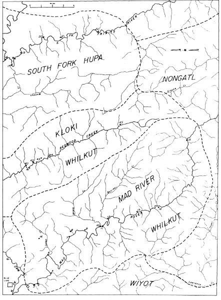
Map 16. Villages of the Mad River Whilkut, the South Fork
Hupa, and Kloki Whilkut. (See also maps 15 and 17).
46. klokeche (L).
47. kaw-cho'-sish-tin-tang (M). Large village at Blue L.
48. me-kā´-tă-met (M). Village on North Fork Mad R.
between Korbel and Riverside (nearer Riverside).
mikētime (L). Name said to refer to being behind North Fork
of Mad R.
49. kā-tsi'-ă-too (M). Camp just below Big Rock at
Korbel.
50. hoo-tso'-e-choo'-kah (M). Village (or camp) on the site of
the present store at Korbel.
51. ki'loo-whit´-teng (M). Fishing camp on North Fork Mad R.
1/4 or 1/2 mi. above Korbel (where gum trees are, just below picnic
ground).
52. kis-tā'-ă-kut (M). Camp for winter fishing on North
Fork Mad R. at Korbel picnic ground (Camp Bar) about 1 mi. above
Korbel.
gestAkAt (L). Name said to refer to a deep fishing hole.
53. noo-lĕh´-mĕh (M). Fishing camp at falls about 1/2
mi. above Korbel picnic ground. Only one kind of salmon can get up
these falls.
54. tsē-inātūlwo-ten (L). tse, "sticks," which were
left there after a prayer.
55. khaiyame (L). Name said to refer to an eddy at the base of
a waterfall.
The following note is taken verbatim from the Merriam files.
The Nose Stick: The Redwood Hoi-let'-hah tell me that their
tribe never perforated the nose during life, but when a person died
they charred a piece of poison oak to make it strong, and sharpened
it and bored a hole with it through the septum of the dead person's
nose and then put handsome Dentalium shell money in the hole before
burying the person.
The Tol-lo-wah of Crescent City and Karok of Upper Klamath
River (Orleans Bar to Happy Camp) were the only Indians the
Redwoods knew who dared wear the nose shell when alive—the other
tribes were afraid to do so.
The Hupa are the best known of the California Athabascan groups. They
live in the drainage area of the Trinity River from a short distance
above its mouth to a little above the mouth of South Fork Trinity and in
the drainage area of the South Fork Trinity up to the mouth of Grouse
Creek (pl. 10, a).
There have been a number of papers published on a variety of aspects
of Hupa life but the main sources of general ethnography are Goddard's
paper (1903a) and Kroeber's Hupa section in the Handbook (1925a,
pp. 128-137). The Hupa are the same, in many ways, as the Yurok, so the
sizable literature on that group is also useful.
The territory occupied by the Hupa differs in several respects from
that of the other Athabascan tribes. The elevation of their lands is
everywhere over 2,000 feet and in places rises to 4,000 or 5,000 feet.
Because of the elevation there is a good deal of snow in the mountains
surrounding the valley and this fact may have somewhat isolated the Hupa
from their Athabascan neighbors during the winter months, although it is
known that they were in close contact with some of the Whilkut.
The fish resources of the Hupa territory also constituted an important
distinction. The Trinity is the only river in the Athabascan area in
which there is both a spring and a fall run of salmon. This resource
must have been very important to the Hupa. It is significant that in the
many intensive studies of the Hupa there is no report of any summer camp
away from the river. The Hupa were evidently even more firmly attached
to their riverine environment than were the other Athabascans, and this
fact may well have been due to the double salmon run.
Merriam's estimate of the position of the Hupa, given below, is taken
verbatim from his notes.
The Tin´-nung-hen-nā´-o or Hoopah.—The Hoopah proper,
who call themselves not Hoopah but Tin´-nung-hen-nā´-o, occupy
the lower part of Trinity River and tributary streams from the
mouth of South Fork Trinity northerly to Bull Creek—a distance of
about 20 miles. On the west they extend to the summit of the long
high mountain range known as The Bald Hills (altitude 4,000 ft.),
which separates their territory from that of the Redwood Creek
tribe, the 'Hwilkut [Chilula]. On the east they reach to the lofty
mountain ridge culminating in Trinity Summit (altitude 6,500 ft.),
the northern part of which separates the drainage area of Mill
Creek from that of Redcap Creek; the southern part, the waters of
Horse-Linto and Cedar creeks from those of the westerly branches of
New River.
Their territory, therefore, is difficult of access, being
protected in all directions by ranges of mountains or deep canyons,
while its western border is about 20 miles from the coast, easterly
from Trinidad. The entire region, except the beautiful Hoopa
Valley, 6 miles in length and a mile or two in breadth, where most
of the villages are located, is mountainous and most of it densely
forested. There are one or two small open stretches on other parts
of Trinity River, and a few grassy slopes on some of the ridges;
elsewhere the forest is continuous.
The Tin´-nung-hen-nā´-o are in contact with five tribes
belonging to three linguistic stocks, namely: the Po-lik´-lah
(often called "Yurok") on the north; the Kar´ok on the northeast;
the Athapaskan E´-tahk-nă-lin´-nă-kah on the east [I have
not been able to identify this group. According to Merriam's
map and according to his own testimony (Merriam, 1930) the Hupa
are bordered on the east by the Shastan Tlo-hom-tah-hoi; the
Athapaskan Ts´ă-nung-whă [Southern Hupa] on the south, and
the Athapaskan 'Hwilkut [Chilula] on the west.]
The Ts´ă-nung-whă.—(An Athapaskan tribe closely
related to the Hoopah.) The territory of the Ts´ă-nung-whă
lies directly south of the Tin´-nung-hen-nā´-o or Hoopah proper,
embracing the drainage basin of South Fork Trinity River from
Grouse Creek to the junction of South Fork with the main Trinity,
and including also the rather narrow strip between South Fork
on the west and the main Trinity on the east as far up as Cedar
Flat. At the mouth of South Fork they crossed the main Trinity
and claimed a narrow strip two or three miles in length on the
north side of the canyon where two of their villages were located,
Ti´-koo-et-sil´-lah-kut on the high bench opposite the mouth of
South Fork, and Me´-mĕh, on the site of the present Fountain
Ranch about 1-1/2 miles east of the other. Their western boundary
was the divide between the tributaries of South Fork Trinity and
those of Redwood Creek (a little west of the courses of Madden
Creek and Mosquito Creek). The eastern boundary was the deep canyon
of Trinity River from the mouth of South Fork to Cedar Flat; the
southern boundary, Grouse Creek and a line running from its mouth
northeasterly and following Mill Creek to the main Trinity at Cedar
Flat—thus including the Burnt Ranch country.
The land of the Ts´ă-nung-whă is mountainous and
forested, and the principal streams flow in deep canyons. It is
roughly circular in outline, and of small extent, measuring in
an air line hardly 15 miles in either direction—north-south or
east-west. Nevertheless it seems to have been rather well populated
for there were at least a dozen villages—all situated on high
benches overlooking the canyons.
Their language differs only slightly from that of the Hoopah.
The Tsa-nung-wha were in contact with four tribes:
the Tin´-nung-hen-nā´-o or Hoopah on the north,
E´-tahk-nă-lin´-nă-kah [Tlo-hom-tah-hoi] and Che-ma-re´-ko
[Chimariko] on the northeast, the Che-ma-re´-ko on the east and
south, the 'Hwi´l-kut [Chilula] on the west.
The following account of Merriam's first visit to the Hoopa Indian
Reservation is taken from his California Journal, Vol. 2, September 5,
1898.
The present Hoopa Valley Indian Reservation Agency is built
around a hollow square, formerly old Fort Gaston. In order to reach
the agency we had to ford Trinity River, here more than a hundred
feet broad, the agency being on the west or coast side. Purchased a
number of sahah baskets.
The night before coming down into Hoopah Valley we camped on
Trinity Mountain where we found a colony of Aplodontia [Mountain
beaver], the Hoopah name of which is Nea't-saas.
The range west of Hoopah Valley between Supply Creek canyon
and Redwood Creek is 3,400 feet in altitude; in other words, 3,000
feet above Hoopah Valley. This range is covered with a rather dense
forest mainly of Douglas Fir, more or less mixed on the warmer
slope with Ponderosa and Sugar Pines and Black, White, and Live
Oaks, among which Madrones, Chinquapins, and Cedars occur.
On the slope east of Hoopah Valley the splendid Rhododendron
californicum occurs. Here also two species of Cornus,
nuttalli and the black-berried sessilis, were seen, and in a
gulch nearby we found the rather rare Lawson Cypress. On this range
at an altitude of 3,250 feet is a stone pile around a post said to
mark the west boundary of Hoopah Reservation.
On this same range the coast Plume Fern is common and
the ground over a considerable area is carpeted with delicate
Vancouveria hexandra.
At Redwood Creek we saw the beautiful ringed tail of a
Bassariscus, which animal is said to be common here.
The Redwood (Sequoia sempervirens) common along the coast
pushes up Redwood River to a point about two miles below the Bair
ranch. The man at the ranch, W. F. Boyce, told me that during
the previous year he had trapped in the region 32 Black Bear, 21
Coyotes, numerous Wildcats, 3 Panthers, and one Badger, besides
killing any number of deer. Other mammals said to occur here in
addition to Deer are Gray Fox, Otter, Fisher, Marten, Mink, big
and little Skunks (Mephitis and Spilogale) in addition to the
Ring-tail Bassariscus, here called kil-how'ch.
One of the commonest trees in Redwood Valley is the Tan Oak
(Lithocarpus densiflora), the bark of which is used for tanning.
Madrones also are common, many of them four feet or more in
diameter.
The rare Cypress (Chamaecyparis lawsoniana) also occurs here
but Douglas Fir is not only the dominant tree but grows to large
size, thousands of them reaching diameters of five to seven feet.
Although the information on Hupa villages comes from extremely diverse
sources, there appears to be fair agreement among them. The basic
material comes from Goddard (1903), and this is for the most part
confirmed by Merriam and Curtis (1924, Vol. 13). In fact, Curtis' data
coincide so closely with Goddard's that they may have been derived from
Goddard's report. However, a few of Curtis' facts do not appear in
Goddard's work so we are probably justified in considering them primary.
Besides these sources, there is a list of village names by Powers (1877)
and also a manuscript map prepared by Gibbs in 1852, reproduced here as
pl. 9; the original is in the Bureau of American Ethnology. Although
this map is not particularly accurate and although the village names are
given in Yurok rather than in Hupa, it still has special value since the
number of houses is given for each village and we therefore have a check
on the data presented by Goddard.
In the following lists the sources are thus indicated: Merriam (M),
Goddard (G), and Curtis, 1924, Vol. 13, (C).
Natinuwhe Villages (map 17)
1. hon-sah-tung (M). Former village on the E bank of the
Trinity R. at the N end of Hoopa V.
xonsadiñ (G), "deep water place." Near the beginning of the
canyon on the right bank at the N end of the valley.
honsading, "deep pool place" (C). On the E bank of the Trinity
R. at the N end of Hoopa V.
Powers (1877) gives hun-sa-tung and Gibbs gives okenope,
corresponding to oknutl, the Yurok name. Gibbs says there were 9
houses in the village while Goddard shows 11 houses.
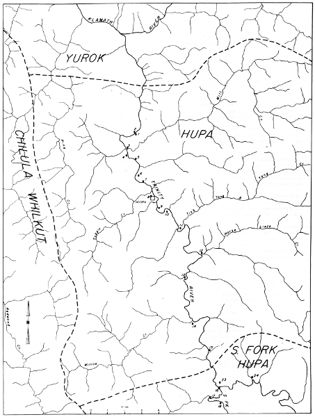
Map 17. Villages of the Hupa and South Fork
Hupa (see also map 16).
2. dakisxankût (G). On the opposite side of the Trinity R.
from xonsadiñ at the base of Bald Hill was a village, the site of
which is now entirely grown up to trees and brush. Goddard shows 7
houses here.
takyishankut (C). On the W bank, opposite honsading.
3. kin-choo-whu-kut (M). On the E side of the Trinity near the
N end of Hoopa V. and just below the mouth of Mill Cr.
kintcūwhwikût, "on a nose" (G). This village occupies a
point of land on the E bank just below the mouth of Mill Cr. Eight
houses are shown at this village.
kinchuwhikut, "its nose upon" (C). On the E bank just below
the mouth of Mill Cr.
The Yurok name for this village is merpernertl (Kroeber, 1925).
4. cha-en-ta-ko-ting, "flopped out" (M). Former village on the
W bank of the Trinity R. a little above Socktish Cr.
tceindeqotdiñ, "place where he was dug up" (G). This village
was a short distance below meskût. Its name refers to a well-known
myth (see Goddard, 1904). Goddard shows 12 houses at this village.
cheindekhoting (C), "dug out place." On the W bank between
miskut and the mouth of Socktish Cr.
Powers (1877) gives the name chan-ta-ko-da for this village
and its Yurok name is said to be kererwer (Kroeber, 1925).
5. mis-kut (M). On the E side below Hostler Cr.
meskût (G). This village was on the E side of the river and
about a mile below takimiLdiñ. It "shows signs of once having been
occupied by many houses." Nine of them are shown.
miskut, "bluff upon" (C). On the E bank on a bluff midway
between Mill Cr. and Hostler Cr.
Powers (1877) gives mis-kut as the name of this village and
Gibbs gives eh-grertsh, corresponding to the Yurok ergerits, and
says that there were 6 houses here.
6. tah-kah-mil-ting (M). The head village of the tribe,
situated on the E bank of the Trinity a little above Hostler Cr.
Contained a large ceremonial house.
takimiLdiñ, "place of the acorn feast" (G). A short distance
below Tsewenaldin on the E bank. It is known as the Hostler Ranch.
This is the religious center for the whole valley. Here there
still stand the xonta nikyao, "house big," and the taikuw nakyao,
"sweathouse big." These are said to have been built by the people
of long ago and to have sheltered the first dwellers in the valley;
but inasmuch as they were burned by a party of Yurok in the early
part of the last century, the statement is to be interpreted
as applying to the foundations only. At this village were held
the acorn feast and two of the important dances, and it was the
starting-point for the third (cf. Goldschmidt and Driver, 1940).
Goddard shows 14 houses in this village.
takimilding, "cook-acorns place" (C). On the E bank a short
distance above Hostler Cr. At the beginning of the acorn season the
people of this village would gather a small quantity of nuts and
prepare a feast of mush and salmon, which all the Hupa attended.
The remnants of the feast were cast into the fire and the cooking
stones were added to the accumulated heap of previous years. This
is the present residence of the northern division of the Hupa,
known as Hostler Ranch, and the ceremonial feast is still observed.
A fishing weir was built in a long riffle near here.
Powers (1877) gives hos-ler as the name of this village and
Gibbs gives ople-goh, corresponding to Yurok oplego (Kroeber,
1925), and says that there are 20 houses here.
7. tsa-wun-al-mit-tung (M). Former village on the E side of
the Trinity in the middle of the valley.
tseweñaldiñ (G). This was a large settlement on the E bank
about a mile below toLtsasdin. It is translated by English tongues
into Senalton. There are many traces of houses here, but the people
were all killed or scattered in the troubled times of the 'sixties.
Six houses are shown here.
tsewenalding, "rock inverted place" (C). This was on the E
bank about 1/4 mi. above takimilding. The locality is now known as
the Senalton Ranch.
Gibbs gives the name olle-potl for this village, corresponding
to the Yurok olepotl (Kroeber, 1925) and says there were 10 houses.
Tinuheneu Villages (map 17)
8. tol-skots-a-tung (M). Former village on the W side of the
Trinity S of the mouth of Supply Cr.
tōLtsasdiñ (G). There are evidences of this village on
the left bank a little S of the mouth of Supply Cr. It has long
been deserted. A prison camp was maintained near this site by the
military.
toltsasding (C). At the N side of the mouth of Supply Cr. It
was inhabited until about the time of the military occupancy.
The Yurok name for this village is erlern (Kroeber, 1925).
9. ma-til-le-tung (M). In the upper part of Hoopa V. on the E
side of the Trinity, 2 mi. from the S end of the valley. It was the
largest village but not the head village, tah-ka-mil-ting being the
head town, ma-til-le-tung was the big boat ranch of the Hupa and
was named for ma-til, dugout canoe.
medildiñ, "place of boats" (G). Just below xowûñkût the river
swings back to the W, meets a spur of the mountain, and then
swings back to the E, forming a peninsula. Here, cut off from the
rest of the valley, is medildiñ (Matilton Ranch). This village,
with those to the S, forms the southern division of the Hupa
people. This division manifests itself especially in religious
matters.
medilding, "canoe place" (C). On the E bank of the Trinity R.
about midway between Supply Cr. and Campbell Cr. It is the present
settlement of the southern division and is known as the Matilton
Ranch. The southern division fish weir is built in the river near
here.
mi-til-ti is the name attributed to this village by Powers
(1877) and Gibbs gives the name kahtetl, which is its Yurok name
(Kroeber, 1925). Gibbs says it had 28 houses whereas Goddard shows
22.
10. ho-wung-kut (M). A village of the southern division, S of
ma-til-le-tung and 1 mi. from the S end of the valley on the W bank
of the river.
xowûñkût (G). About a mile downstream from Tish-Tang-A-Tang
Cr. on the W bank of the river. Goddard shows 14 houses at this
village. The site is now called Kentuck Ranch.
howungkut (C). On the W bank about 1 mi. below Campbell Cr.
This place is locally known as Kentuck Ranch. This appears to
be the village called wang-kat by Powers (1877). Its Yurok name is
pia'getl (Kroeber, 1925).
11. tish-tahng-ah-tung (M). On the E bank of the Trinity R. at
the S end of Hoopa V. proper.
djictañadiñ (G). At the S end of the valley where the river
emerges from the canyon is a point of land on the E side. This
village, known locally as tish-tang-a-tang, was situated on this
point. Just above this village Tish-Tang-A-Tang Cr. from the
mountains on the E empties into the Trinity.
djishtangading, "promontory place" (C). On the E bank opposite
Campbell Cr.
Powers (1877) calls this village Tish-tan-a-tan. According to
Merriam's notes the Yurok name for it is Peht-sau-an and this is
the name Gibbs uses for it. Gibbs says there are 9 houses here,
whereas Goddard shows 13.
12. 'has-lin-ting (M). On the E bank of lower Trinity R. 3 mi.
above Hoopa V. proper. This is the uppermost village classed as
Hupa.
xaslindiñ (G). About 3 mi. S of the valley proper on the E
bank of the river at the mouth of a creek of the same name (Horse
Linto Cr.). Nine houses are shown at this village.
haslinding, "waterfall place" (C). On the E bank about 3 mi.
above djishtangading and the same distance beyond the limits of the
valley. The name is preserved in Horse Linto Cr.
Powers (1877) calls this village hass-lin-tung. According to
Kroeber (1925, p. 129), the Yurok name for this village is yati but
Waterman (1920, p. 188) gives wo'xtoi. This last would correspond
to Gibbs's wauch-ta, which is shown with an approximately correct
location except that it is on the wrong side of the river. This
village is said to have had six houses.
13. seh-ach-pe-ya (Gibbs' map, pl. 9). This is no doubt a
Yurok name, as are all those given by Gibbs, but no one else has
recorded it. There are said to have been four houses here.
14. wang-ulle-watl (Gibbs' map, pl. 9). Again this is probably
a Yurok name. There are said to have been three houses.
15. wang-ulle-wutle-kauh (Gibbs' map, pl. 9). This is probably
a Yurok name. There is said to have been one house here. Kauh is a
Yurok suffix meaning "opposite."
Gibbs also gives a town called weitspek on the W side of the Trinity
just below the mouth of South Fork. There are said to have been three
houses here. Merriam asked about this village and its existence was
denied by his informants.
South Fork Hupa Villages (maps 16, 17)
16. hlah-tung (M). On both sides of the mouth of South Fork
Trinity on high bench ground.
17. til-tswetch-a-ki (M). On the W side of South Fork at the
mouth of Madden Cr. An old important town. About a mile below
chilch-tal-tung.
18. chilch-tal-tung (M). On the E side of South Fork 1-1/2
mi. above its mouth.
19. os-tahn-tung (M). On the E side of South Fork 2-1/2 mi.
above its mouth.
20. 'hlit-chooch-tung (M). On the E side of South Fork 5 or
6 mi. above its mouth.
21. klo-kum-me (M). On the E side of South Fork about 8 mi.
above its mouth (two above 'hlit-chooch-tung).
22. tah-chooch-tung (M). On the E side of South Fork about
10 or 12 mi. above its mouth.
23. ti-koo-et-sil-la-kut (M). On the N side of the main
Trinity on a bench opposite the mouth of South Fork, about 1-1/2
mi. below Fountain Ranch.
24. me-meh; me-a-meh (M). On the N side of the main Trinity on
the site of the present Fountain Ranch about 1-1/2 mi. above the
mouth of South Fork but on the opposite side of the river.
25. hoi-ti sah-ahn-me (M). At Hennessy Ranch, Burnt Ranch
(Post Office in 1921).
26. e-nuk-kut-te-nan-tung (M). At McDonnell Ranch, Burnt
Ranch. Name means "south slope place."
27. tin-nooch-tung (M). At Cedar Flat. Easternmost village
of the tribe, near or adjoining the territory of the Chimariko.
The following ethnographic data are taken verbatim from Merriam's notes.
According to the Hoopah, as told me by James Chesbro of Burnt
Ranch, the First People are called Kit-tung´-whi or Devil People.
They used to fight and kill and eat one another. Later they turned
into animals. After the Flood real (Indian) people came.
In early days the Indians used to get drunk from inhaling
the fumes of Indian tobacco (Min´-tā itch´-wah) which by deep
breathing they would take into the lungs. Their word for drunk is
Ho-nāch-wĭhch. The expression for "many people drunk"
is Yah, ho-nāch-wĕch.
The word for an old person is Kis´-te-ahn; for an old object,
Tah´-ne.
There are two words for good: Chung-whoom for a good or kind
person; and Noo-whōm for a good thing or object. A bad person is
To choong-kōm, "not good person"; while a thing that is not good
is To nooch-kōm, "not good thing."
Chin-tahs, "slow", is said to mean also "heavy"; but the word
given me for heavy is Nit-tahs´.
The word Ho´-chit, meaning real or genuine, occurs frequently:
Thus, deerskin tanned with the hair on is called Ho´-chit te,
te being any blanket or toga. Similarly, the ordinary woman's
apron made of pine nuts and braided grass is Ho´-che ke´-ah; the
woman's hat, Hō-che kōs´-tahn, or real hat; moccasins, Hoch
yā´-che-tahl; the bow, Hō-chĕ tsitch-ting; the stone
arrow-point, Hō-chĕ tin-ti; Indian or wild tobacco, Hō-che
Min´-tā-itch´-wah; the elkhorn box or purse for valuables
Hō´-che kin´-chah.
The Hoopah say that their people did not use the nose-bone or
nose-stick, but had a name for it, which is Hun-choo whang-i. They
say these were worn by the Indians farther north.
The women tattooed the chin, usually in three broad vertical
bands similar to those of the Klamath River tribes. Tattoo marks
are called Wil´-tahch´.
Place names: All place names along the rivers were at one time
the sites of villages or rancherias. The village always takes the
name of the place.
The name for house is Hōn´-tah or Hun´-tow; the ceremonial
house, Mā´-min sin-til; the sweathouse, Tah´-'keo; the menstrual
lodge, Mintch'; the brush wickiup, Mā´-nah-si; the brush blind
or hut for concealing the hunter Kew´-wong wil´-min.
They say that they never burned the dead, but buried them
in graves dug exactly knee-deep by measure. The grave was called
Hot-yung ho-sin. The body was fastened to a slab of wood of the
proper length, and when laid in the grave was covered with the
belongings of the dead person and then with earth.
While they do not burn the bodies, they burn clothing and
other belongings. But the Chemareko of Hyampom burn their dead.
They believed in an evil spirit or Devil called Kit-tung´ hwoi.
A peculiar custom was practised in extending a certain
courtesy to an enemy who wanted to cross the river but had no boat.
If a person having a canoe crossed the river, and his personal
enemy found the canoe, he would go and sit down near it and await
the return of the owner. When the owner came, he would back out
into the stream and then push the bow ashore at the nearest point
to his enemy, and the enemy would step in and sit down, neither
speaking a word. The owner would then paddle across the stream to
his own side, and the enemy would jump out and proceed without
remark.
There were two kinds of doctors: the real doctor or shaman,
sometimes known as "dance doctor," called Kit-ta tow, and the
medicine doctor, who never danced, called Kim-mow-chilch-weh.
Gambling Game: the common gambling game, Ke-now-we, was
played with a bunch of slender sticks 7 or 8 inches long, called
Hol-che-king. One of these, Hung ("ace" or "lucky stick"), has a
black band around the middle. The game consists in guessing in
which hand the opponent holds the marked stick. There are eleven
points or guesses. One stick is given up at each wrong guess.
Small hailstones are called Klew-hahn min-nah from Klew-hahn,
"an eel," and min-nah, "eyes," from the resemblance of small
hailstones to the white eyes of the eel. Big hailstones are
Ke´-lo-ung-hot.
An earthquake is Nin mah-ah tin-nĭch-chwit, meaning
"turns over on edge of world."
Money: The unit of value, which we call "money," consisted
of the valuable kind of dentalium shells, long specimens of which
reached from the base of the finger to the base of the terminal
joint. This was called Ho´-che naht-te-ow or "real money." Small or
broken dentalium shells, from half an inch to an inch in length,
were called Mit-tatch, and were used for beads.
Scalps of the great pileated woodpecker or cock-of-the-woods
(Ceophlaeus pileatus), called Kisl-tā-ke-'keo, also passed
as money.
Names of mammals and birds.—The Grizzly Bear had two names:
Mĕ-chā-e-sahn and Me-kwo ah.
The Mountain Lion or Cougar is called Min´-ning mĭch
'hlā-til-loo, meaning "kills with his face."
They speak of a spotted Panther of large size called Kit-sah´,
which has not been seen for a number of years. It used to make a
great noise.
They speak also of a Water Panther (mythical) called
Ho-tsi´-tow, said to live in holes close to the water of lakes and
pools, never in rivers or on land. Its head and shoulders were
heavy and covered with long shaggy hair, but the hinder parts were
nearly naked.
The Otter is called 'Klōk-e-te-til-le, meaning "he likes
salmon."
The Weasel—and this is particularly interesting—is called
Klewch-mŭ-hung, meaning "snake's husband"—a term doubtless
suggested by its snake-like form and actions.
The Mole is called Min-ni´ ĕ-ting, meaning "eyeless"; the
Bat Haht-la nah-mut, "night flyer."
The Porcupine is 'K'yo. Its quills, usually dyed yellow, were
used to ornament basket hats; and also to pierce the ears for
earrings. When a quill was stuck lightly into the lobe of the ear,
it would slowly work its way through.
The common gray Ground Squirrel (Citellus beecheyi) is
called Tsĕ 'ket-yahng-a, meaning "rock sitting on."
The Jack Rabbit, oddly enough, is called Nahch-ah-tah
'hits-'hlah-hahn, meaning "dry ground deer."
A Hupa ceremonial gray fox skin.—The skin was cased
(opened along the hind legs, the belly not slit lengthwise). The
front feet had been cut off but the skin of each leg was slit in
six or seven strands or narrow ribbons about three inches long.
The skin had been turned inside out and decorated in places;
then turned and left with fur outside. The skin of the hind legs
was painted deep red. The tail also had been slit open on the
underside and the skin painted with the same red paint, and a tuft
of pure white feathers four inches long was sewed to its tip.
The most surprising marking was a double ring or belt band of
red and blue painted around the inside of the skin about two inches
above the base of the tail (and therefore hidden when the skin was
fur-side out). The two bands, each about half an inch wide, were in
actual contact all the way around—the anterior one deep red, the
posterior deep blue.
The skin itself is of interest as being unmistakably the dark
northwest form of the species Urocyon cinereoargenteus. The upper
parts are very dark grizzled; the dorsal stripe from neck to tip of
tail is almost pure black and the tail is about an inch broad. The
flanks, inner-sides of legs, and undersides of tail are fulvous,
palest on the belly. The specimen is an adult male.
Sayings about birds.—Dove (Zenaidura). Called Mi-yo.
Mi-yo, the Dove, was a great gambler. He always gambled all winter.
Once when gambling someone told him that his grandmother was dead.
He said there would be plenty of time to cry next summer. So he
kept on playing. When summer came he cried for his grandmother. And
every summer we hear him crying for his grandmother.
Hummingbird. Called Ko-sos. Ko-sos, the Hummingbird, was a
war bird. His bill was like a long needle. With it he pierced his
enemies. Once he told another bird to start from one end of the
world and he would start from the other. They did this and met in
the middle where they danced.
Notes on adjacent tribes.—Yin´-nah´-chin ("South People,"
Chemar´eko). Extended from Hyampom northerly to Cedar Flat,
easterly along main Trinity to Canyon Creek; and northerly between
the high mountains that form the divide between French Creek and
North Fork Trinity River on the west to Canyon Creek on the east,
as far north as Rattlesnake Creek. (Previously learned from the
Nor´-rel-muk of Hay Fork, a Wintoon Tribe, that the dividing line
on the west between themselves and the Chemareko, called by them
Hyembos, lay along Minor Creek.) Language wholly different from
Hoopah. The Hoopah say that the presence of this tribe on Trinity
River west of Cedar Bar, and on lower New River, is a comparatively
recent intrusion.
Klo´-mĕ-tah´-wha ... Salmon River Indians. Ranges south
over summit to Grizzly Creek and headwaters New River. Language
wholly different.
Ho-ning wil-tatch (meaning "tattooed faces") ... "Yuke" of
Covelo region. Round Valley. Also called Devils, Kit-tung-whoi—a
name applied to the First People, who finally turned into animals.
Language wholly different.
Geography.—There used to be a great fall in Trinity River
at a huge rock which stood in the middle of the river at Burnt
Ranch. Below the fall was a big pool and eddy, which at the proper
season was full of salmon. Everybody came here to catch salmon.
Indians from several tribes met here and feasted and had a
"big time." Finally a terrible earth slide came down the side of
the canyon and moved the rock away. This destroyed the falls.
This occurred during the boyhood of my informant. He tells
me that besides the Hoopah the Indians who used to visit the pool
below the falls for salmon were Poliklah from Wetchpek on Klamath
River, 'Hwilkut from Redwood Creek, and Chemareko from Hyampom.
They used to camp a little below the falls.
Hoopa Geographic Names
| Hoopa V. |
Nah-tin-noo |
| Main Trinity R. |
Hahn |
| Trinity R. "up and down" |
Hahn-nuk-ki |
| Bull Cr. |
Mis-tes-se ah-tung ("sliding place") |
| Mill Cr. |
Mis-kut e-ta-e-tuk ne-lin-na-kah (correct name) and Tsol-tsah muk-kah (nickname from rock with female mark) |
| Socktish Cr. |
Chan-ta-kot ne-lin-na-kah |
| Hostler Cr. |
Tsa-mit-tah ("between two rocks") |
| Site of present settlement in Hoopa V. |
Toos-kahts-tung-kah |
| Campbell Cr. |
Tish-tah-ah-tung mu-mahn-chung ne-lin-nuk-kah |
| Tish Tang A Tang Cr. |
Tish-tahn-ah-tung ne-lin-nuk-kah |
| Horse Linto Cr. |
Hahs-lin-nak-kak |
| Raccoon Cr. |
Sech-ki-uk-kah ("white rock") |
| Willow Cr. |
Ho-whah-chal-tung |
| South Fork Trinity |
'Hlal-tung (at junction with main Trinity) |
| South Fork Trinity |
Ye-sin-ching-ki (whole river) |
| Madden Cr. |
Tilch-wetch uk-kah |
| New R. |
Ye-tok ne-lin-nuk-kah |
| Forks of New R. |
Tsa-nah-ning-ah-tung |
| Ironside Mt. (east of New R. mouth) |
Tsen-nen-kut |
| High Rocky Ridge (northwest of New R. mouth) |
Ta-se-tahn-ne-kut |
| Trinity Summit Ridge |
Mung-kin-ne-kow-a-kut |
| Berry Summit |
Ho-ech-kut mit-ta-kahn |
| Redwood Cr. |
Ho-ech-kut ne-lin-nu-kah |