Larger versions of most illustrations may be seen by right-clicking them
and selecting an option to view them separately, or by double-tapping and/or
stretching them.
on the subject of
WORK IN THE BASKET
❦
Issued by the
Division of Military Aeronautics
U.S. Army
¶ A free translation of the French booklet
“Instructions au sujet du Travail en Nacelle,”
and an added discourse on Balloon Observations
WASHINGTON
GOVERNMENT PRINTING OFFICE
AUGUST, 1918
PART I. BALLOON OBSERVATION. — INTRODUCTORY NOTE. — LIAISON BETWEEN BALLOONS AND ARTILLERY — EMPLOYMENT OF BALLOONS. — GENERAL SURVEYANCE OF ENEMY’S ACTIVITIES. — RANGING AND ADJUSTING OF FIRE.
In this pamphlet will be laid down the general principles
and also the limitations which govern observation
from balloons. Balloon observation includes
more than actual artillery observation. (See “Employment
of Balloons.”)
The details of cooperation between balloons and
artillery are issued from time to time by the General
Staff in the form of pamphlets. Whatever the system
ordered at the time, there are certain principles which
do not change.
In artillery observation it can not be emphasized too
strongly that success depends both on—
1. The efficiency of the balloon observers, including
an intimate knowledge of the ground within view.
2. An intimate knowledge by artillery commanders
of the possibilities and limitations of balloon observation.
The limitations of balloon observation are—
1. Distance from the target.
2. Height of observer.
3. Visibility.
Distance from the target is inevitable, but can be
lessened by advanced positions and winch tracks.
During active operation it has sometimes been possible
to approach balloons within 4,500 meters (4,921
yards) of the line.
The low height of the balloon compared with an
aeroplane is a drawback, as it brings a question of
dead ground and exaggerated perspective.
Visibility is the determining factor of the balloon’s
usefulness. In very high winds, very misty or cloudy
weather, observation is impossible, and owing to its
stationary nature the balloon can not, by any special
effort on the part of its observers, overcome unfavorable
conditions in the same way as is possible in the
case of aeroplane observation.
On the other hand, a balloon flying at a height of
1,500 meters (1,640 yards) and 7,000 meters (7,651
yards) from the line, under favorable weather conditions,
combines in a marked degree many of the advantages
of air and ground observation.
In the first place, glasses can be used. Secondly,
the balloon observer can converse direct with the
battery commander by telephone. Apart, therefore,
from ease and certainty in reporting observations, the
telephone system enables an elastic program of work to
be drawn up and admits of personal conversation between
the battery commander and the observer,
often permitting mistakes or misunderstandings to be
cleared up during shoot instead of afterwards.
Finally, owing to the continuous nature of his observation
from the same spot, the balloon observer is
able to learn his country in the greatest detail and
can keep a close watch on suspected roads or areas of
country.
The work of balloons is principally with the artillery,
and close liaison between these two branches is indispensable
if the best results are to be obtained. This
close liaison should be promoted on the following lines:
(a) Balloon companies should each, as far as possible,
be allotted specific artillery organizations. This
facilitates telephone communication, prevents duplication
of liaison work, and leads to a far more intimate
and personal liaison than does any other method.
(b) Balloon observers must visit batteries frequently,
and sometimes be attached for short periods.
Shoots should be discussed, especially if unsuccessful.
Observers should prepare and take with them when
visiting batteries a list of targets which are clearly
visible from the balloon and on which they can observe
effectively. Similarly, artillery commanders
should let balloon observers know of any further targets
which they especially wish to engage, as work
previously prepared on the ground saves time and
gives better results.
(c) Artillery officers should visit the balloon and
make ascents. They will thus become acquainted
with the extent of view from the balloon and the
ability and difficulties of the observers.
In view of the above, the work most suitable for
balloons is as follows:
(a) Reporting modifications of enemy defensive organization;
detecting movements of convoys and
trains. Their importance and itineraries, locating
infantry signals, and all other activities such as revealed
by fires, smokes, dust, trails, etc.
(b) Spotting active hostile batteries and reporting
hostile shelling. Reporting hostile shelling is a duty
for which balloons are especially suitable, as they are
favorably situated to observe both the flash of the
gun and the fall of the shell. From this information
it is possible to direct not only neutralizing fire on the
hostile battery, but often also to establish the caliber
of the guns and the arc of fire of the battery.
(a) Observing fire for destruction on all targets,
counterbattery, or bombardment.
(b) Reporting fleeting targets and observing fire on
them.
(c) Observing for registration fire.
(d) Observing fire on the enemy’s communications.
(e) Cooperation with aeroplanes.
PART II. WORK IN THE BASKET.
[Translation of French document, “Instructions au sujet du Travail en Nacelle,”
a publication of French G. Q. G., 1918, by Lieut. Kellogg.]
The rapidity and precision of the work in the basket
depend not only on the natural gifts of the observer,
but also very largely on his methods of work.
The object of the following instructions is to tell
the student observers the general methods they should
follow and to explain the use of these methods.
The principal operations which they must be able
to execute rapidly are as follows:
1. Orientation and general reconnaissance of the
terrain.
2. Spotting points on the ground seen on the map
and points on the map seen on the ground.
3. Observation of fire.
Chapter 1. ORIENTATION AND GENERAL RECONNAISSANCE OF THE TERRAIN.
This is the operation which the observer executes
on his first ascension in a new sector; this is how it
should be conducted.
1. Rapidly look over the terrain around the ascensional
point in order to orient the map.
This is done by finding in some direction from the
ascensional point a line giving an easily identified
direction (a road, an edge of woods, etc.). Orient
the map so as to make this line on the map parallel
to the line on the ground.
The map can also be oriented by means of the
compass.
2. Locate the horizontal projection of the balloon.
The observer may know already the winch position,
but the balloon is carried off horizontally from the
winch sometimes as much as 400 or 500 meters (436
to 545 yards). Thus it is essential not to confuse the
winch position with the horizontal projection of the
balloon. If this is done, errors will be made in the
operations which we are going to discuss later, where
we make use of this known point.
It is pretty hard to materialize definitely the vertical
line passing through the basket. The effect of
the wind and the movements of the balloon make it
impossible to use a plumb line. The observer has to
find his projection on the ground by leaning first
from one side of the basket and then from the other
in order to diminish the chances of error. An approximation
of 25 or 50 meters is sufficiently accurate
for the general reconnaissance which it is necessary
to make.
3. Leaving the region beneath the balloon, acquaint
yourself, step by step, with the most prominent points
in different directions—masses of woods, villages, etc.
There are two methods—by the process of cheminement
or tracing landmarks and by the process of
direct alignment.
The process of “cheminement” or tracing consists
in following outlines, such as roads, streams, or hedges,
identifying as you go along details of the terrain
which these lines pass through or near. On account
of the deformations due to the effect of perspective and
to the unevenness of the ground, and particularly on
account of the deformation of angles, if it is a winding
road, this method often leads to errors; it should be
employed only in certain cases defined below:
The process of “direct alignment” consists of
studying the terrain by following successive directions
from the balloon position.
We call the “alignment” of a point the trace, on the
terrain, of the vertical plane passing through this
point and through the eye of the observer; in perspective
vision, when the observer determines the
point in question, this alignment would appear to
him a vertical line. On the map it is nothing more
than the straight line joining the point under consideration
to the vertical projection of the balloon.
The method of alignment, then, consists in first
identifying the most prominent points near the balloon
and finding, by cheminement or tracing, the lines
running from these points. A point found directly
by cheminement should not be considered as
definitely determined until its alignment has
been verified.
This first reconnaissance is not to study the terrain
in all its details, but only to fix in the memory a
certain number of prominent points scattered throughout
the sector in order to facilitate later work.
These points should be very distinct, visible to the
naked eye, and of characteristic forms, so that there
will be no danger of confusing them with others—masses
of woods, important villages, etc. Roads with
borders of trees, large paths for hauling supplies,
when taken together, are very valuable for quickly
finding others.
Chapter II. SPOTTING OF POINTS. — LOCATING ON THE GROUND AN OBJECT SEEN ON THE MAPS. — 1. RESEARCH IN DIRECTION. — 2. INVESTIGATION OF RANGE. — LOCATING ON THE MAP AN OBJECT SEEN ON THE GROUND.
Generalities.—In all spotting operations, whether
working from the map to the terrain or vice versa, the
difficulty is due to the fact that the situation of the
point has to be found on a two-dimension surface.
The best method of work will be, then, that which
suppresses as quickly as possible one of these dimensions
and to conduct the research on a straight line.
Any point can be placed on the terrain or on the
map if you know the following elements:
1. Its “direction” or alignment.
2. Its situation on this alignment—that is, its
“range.”
In oblique vision, a digression in direction is always
much more apparent than a digression of the same
size in range. Thus the direction of a point can
be identified with more facility and precision
than its range. For these reasons, the following
methods consider two distinct phases in all spotting
operations:
1. Investigation of direction.
2. Investigation of range.
The investigation in direction always comes
first, as it is easier, and its result makes the investigation
for range easier.
If it is a question of a very visible point (cross-roads,
an isolated house, a corner of woods, etc.), the spotting
can be done almost immediately, it was found in the
general reconnaissance of the terrain, which was discussed
in chapter 1.
If, on the contrary, the point under consideration is
difficult to find (a piece of trench in a confused and
cut-up region, a battery emplacement, etc.), we must
have recourse to a precise method.
Join on the map the projection of the balloon and
the center of the objective. Identify this direction on
the terrain by finding on the alignment a prominent
point. This line can be drawn in the basket. It is a
good thing to draw the alignment on a vertical
photograph of the objective also, in order to
have a greater number of reference points than
the map could give.
Identify on the map (or photo) two points, one
situated over and one short of the objective. Narrow
down this bracket step by step until the object is
recognized.
As this investigation of the range is the more difficult,
observers must be warned against certain methods
which are to be absolutely avoided—
1. Never identify the range of a point by comparing
it with that of a near-by point situated on
a different alignment.
If these two points are not at exactly the same
height, the deformations due to oblique vision can
falsify their apparent relative range. The point
farthest away can even seem nearer, and the nearest
point farther away.
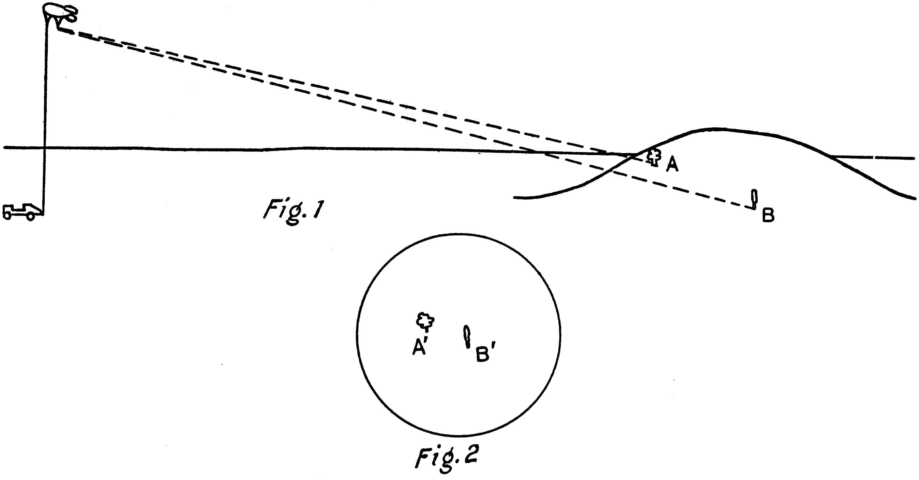
Fig. 1Fig. 2
Example (fig. 1).—Suppose there are two trees, A
and B, A being nearer the balloon and higher than B.
It can happen that, in oblique vision (fig. 2), B having
its image B´ and A its image A´, the depression of the
image B´ is more than that of A´. In this case, the
observer will be tempted to believe that the tree B is
nearer him than the tree A.
2. All oblique alignment in investigating the
range must be absolutely avoided.
Oblique alignment means a line connecting two
points on the map and not passing through the horizontal
projection of the balloon.
You might be tempted to use an alignment to find
the range of an objective after having determined the
direction. The process would consist in finding on the
map two points so placed that the straight line between
them passes through the objective, visualizing
this line on the terrain, and placing the objective at the
intersection of this visualized line and the direct alignment.
This result, which would be accurate if the
ground were absolutely flat, is made erroneous by the
unevenness of the terrain. On account of this, the
oblique alignment does not pass, in oblique vision,
through the same points as its horizontal projection
on the map.
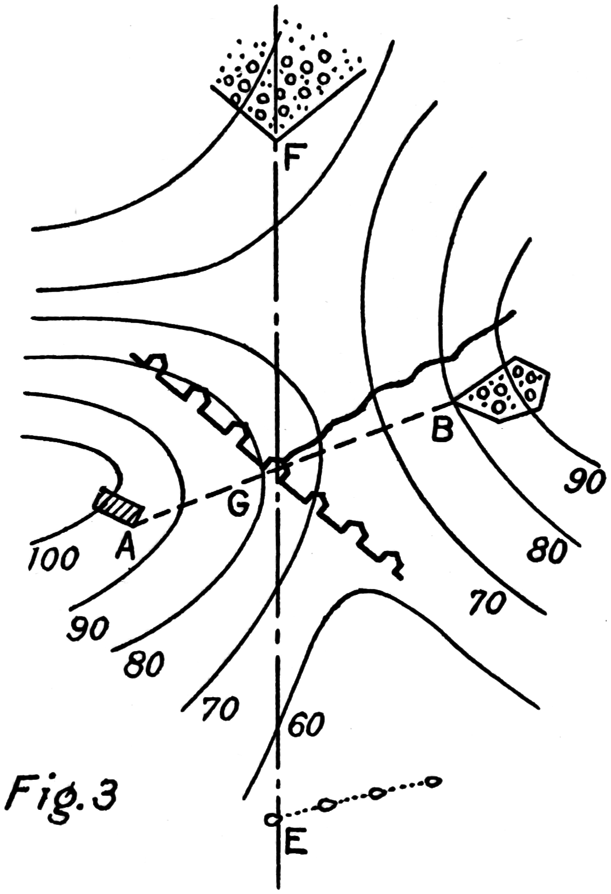
Fig. 3
Example (fig. 3).—On the map C is the objective,
A and B two points so situated that the line AB passes
through C, and EF the direct alignment, or the line
balloon objective. The line AB coincided on the terrain,
with the trace of the vertical plane passing
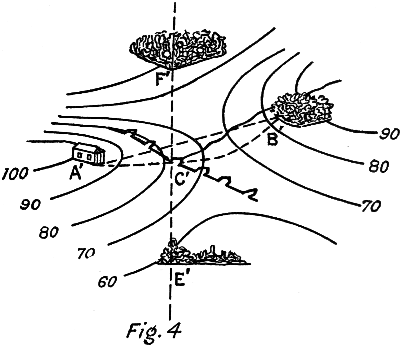
through A and B. In oblique vision (fig. 4) it is different.
The line A′C′B′ is a curve which follows the
irregularities of the ground, and the point C′ is not on
the oblique alignment A′B′.
Fig. 4
1. Determine first on the map the approximate
region where the objective is seen.
A result which you can obtain very quickly, thanks
to the points which you had found in your first reconnaissance
of the terrain.
2. Investigation of direction.
This operation consists in determining the alignment
of the objective. As this alignment is a straight
line, you only have to know two points. One of them
could be the horizontal projection of the balloon; but
you must realize that this position is always changing
a little, and it is hard to determine it with absolute
precision. It is better to carry on the operation independent
of this position, which means applying the
following method:
Choose on the alignment of the center of the
objective two points, one over and one short,
and easily identifiable on the map. Draw with
a pencil in the region of the objective the alignment
thus obtained. These points should be,
as far as possible, precise details of the terrain,
such as a corner of woods, an angle of a house, a
place where roads or trenches cross, an isolated tree,
etc. When the alignment of the objective does not
pass through any such points, the difficulty can be
overcome by determining in what proportions it cuts
a known element, such as an edge of woods or a hedge,
provided this element is plainly perpendicular
to the direction of observation.
This direction can be approximated to the extent of
the thickness of the pencil mark. On its accuracy the
final result depends. The difficulty lies in materializing
the alignment—that is, the vertical line through
the center of the objective—in order to lessen the
chances for mistakes. Student observers should have
frequent practice in this exercise.
When the point to be found is near the edge of the
map it is sometimes necessary to take both reference
points between the balloon and the objective; this
should be avoided as much as possible, because it is
apt to be less exact than when the objective is bracketed
by its reference points.
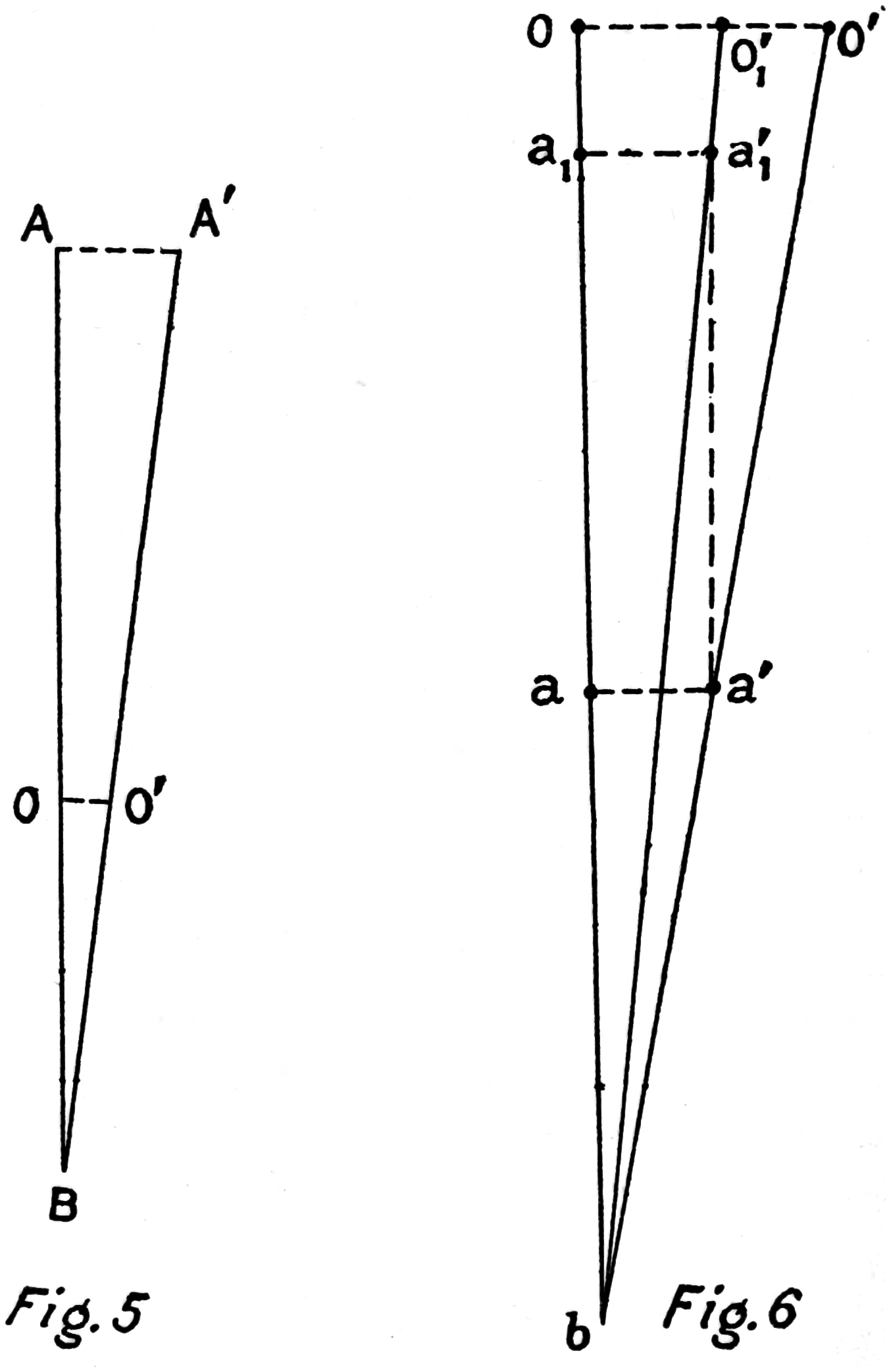
Thus (fig. 5), two reference points A and B determine
the alignment AB, O, the objective, is situated
at some point between A and B. An error AA′ in the
spotting of one of these points leads to a smaller error
in the position of the objective OO′—that is, smaller
than AA′.
Fig. 5Fig. 6
On the other hand, let both the reference points
“a” and “b” (fig. 6) be situated short of the objective
O, “a” being nearer the objective and “b” nearer to the
balloon. An error aa′ in spotting “a” leads to an
error OO′ in the objective greater than aa′. Notice
that this error diminishes as “A” approaches O, thus
“a” being as a₁, the error a₁a′₁ equal to aa′ leads to
an error OO′₁, in the objective, less than OO′. We
would thus obtain an analogous result if we would
move the point “b” farther away.
Therefore, when you are obliged to take the two
reference points between you and the objective,
choose one as near the objective as possible and
the other as near as possible to the balloon.
3. Investigation of range.
Identify details of the terrain situated over and
short of the objective on the alignment. Narrow this
bracket down step by step; situate the objective on
the map according to its relative distance from the
two nearest identifiable reference points, taking into
account the deformations due to the laws of perspective
and the relief of the ground.
If you have a vertical photograph of the region,
trace the alignment on this photograph and make the
investigation in range by the same means.
The dangers against which I warned you before in
connection with the investigation of range apply in
this case also, so it is unnecessary to repeat them.
When the two last identifiable reference points are
some distance from each other, the situation of the
objective has a possible error, of which you know the
size according to the distance between the two reference
points; it might be interesting to remember this
in case different information is obtained on this objective
from that obtained in the balloon.
This error can be considerably diminished if you
use a vertical photograph; the investigation can then
be carried on by the same method as on the map, with
greater precision. In the case of a battery, particularly,
it is for the observer to find the position of each
piece.
In case, on account of dead ground or of a mask
before the battery, the observer sees the flashes or
the smoke without seeing the battery itself, he should
mark the exact alignment in which the flashes or
smoke are seen, and determine the bracket in range—that
is, the reference points nearest the objective
which are clearly over and short. This document
compared with other information can facilitate the
identification of the battery.
Chapter III. OBSERVATION OF FIRE. — 1. PREPARATION OF THE FIRE. — 2. OBSERVATION OF A SHOT. — PRACTICAL ADVICE.
The observation of fire is essentially the following
operation, repeated for each shot or salvo: Locating
on the ground the position of one point, which is the
point of burst, and announcing its situation in reference
to another point, which is the target.
But it has been demonstrated that it is impossible,
without using the map, to determine the error in
range of one point relatively to another point not on
the same alignment.
The operation must consist in:
1. Spotting on the map the point of burst.
2. Reading its position in reference to the target.
The observation of the burst—that is, the spotting
of the point of impact—is the same whether the
observation is direct or lateral.
Draw on the map, and copy if possible on a
vertical photograph, the line balloon target
(alignment of the center of the objective) and
draw through this point a perpendicular to the
alignment. In case the observation is lateral,
draw also the line battery target and its perpendicular.
To draw the line balloon target, it is not necessary
to know the horizontal projection of the balloon. It
is enough to find on the ground a point situated
directly on the alignment of the center of the objective.
When the shell bursts, take quickly an alignment
and reference points in range of the point
of burst; spot this point on the map or on the
photograph; give its error in reference to the line
battery-target, measuring it by the scale on the
map or on the photograph. (It is well to put the
graphic scale on the photos.)
The delicate part of the operation consists in seeing
the shot at the moment of burst. One must try to
spot the apex of the inverted cone formed by the
burst, without paying any attention to the more or
less considerable cloud of smoke which follows and
which will cause mistakes if the burst was not seen
immediately. The method of situating the point is
the same as that described above.
For the direction, one reference point is enough,
because one can consider the alignment of the point
as practically parallel to the balloon-target. For the
range, a rapid study of the terrain before the fire is
sufficient to allow the observer to know the reference
points by which he can guide himself. His eyes
must never leave the point of burst until he has
fixed well in his mind its situation in reference to
appropriate reference points. Not to do this would
lead to errors and to loss of time while he has to find
the point again with his glasses to study it some
more.
When the observation is direct, the direction of the
burst is, of course, known as soon as it is seen. When
the observation is lateral, it is well to remember that
the line battery-target can not be materialized on the
ground because it is in reality an oblique alignment,
leading to the same errors which we have discussed.
It follows all irregularities of the ground and, on
account of this, can not be followed exactly in oblique
vision.
Particularly around batteries, the ground is often
very irregular. There may even be little spaces of
dead ground, caused by hollows which the map does
not always show. The above method, applied with
the help of photographs, allows you to avoid errors
resulting from the existence of these hidden parts.
1. Work sitting down, with the map on your knees and
leaning against the edge of the basket.
This position is preferable to all others, because it
allows the observer—
(a) To correct with his head and shoulders the
movements of the basket.
(b) To have the map always before him. He can
consult it at any moment, mark the necessary alignments
without loss of time, use it as a desk for drawing
or taking notes, or as a wind shield when looking
at photographs.
The observer who works standing up must either
pick up his map from the bottom of the basket every
time he needs it, which is out of the question, or fasten
it outside the basket; the latter solution is inadvisable,
it necessitates working in the wind when the map is
referred to, and every time the observer turns to look
at his map he disturbs the equilibrium of the basket.
It is advisable to work standing up only on days
when there is practically no wind, and the balloon is
continually turning and never becomes oriented.
2. Have always within reach a flat rule, a pencil, and
a duodecimeter rule.
To be able to trace an alignment on the map with
precision, the rule must rest on a firm surface. This
happens when the map is mounted on a drawing
board; when it is mounted on a frame with rollers, the
frame should have, between the two thicknesses of
the map, a board level with the edges of the frame on
which the rule can slide with its whole length on the
map.
With a hard pencil, well sharpened, precise and neat
alignments can be drawn.
The duodecimeter rule is for measuring distances on
photographs and on the map; chiefly in observations
of fire.
3. Hold the field glasses with both hands.
This advice, sometimes ignored by observers without
expedience, has a great influence on the accuracy
of information. When an observer holds the glasses
in one hand, it is much more difficult for him to correct
the movements caused by the balloon and to concentrate
on a point. It is very important, therefore,
to hold the glasses firmly with both hands, especially
when you are making a delicate observation or when
you wish to study an “objective” in detail.
PART III. APPENDIX.
Note 1.—All observations of rounds refer to the
line battery target (b-t) and a line perpendicular to
same passing through the target. Observations are
given in meters right and left and whether the round
is over or short. Indications as to deflection are given
before those of range. Indications as to the amount
of error precede those as to the sense of the error.
Example, 50 meters “Right,” “over.” Owing to the
dispersion of fire when adjusting fire for field artillery
or howitzer, it is unnecessary and of little value to
the battery to give the amount of the error in range
except when asked for by the battery commander or
when the error in range is abnormal (over 200 meters).
When the target is clearly visible and the effect of
a round hitting a target is evident, the observation
“Target” is reported. Unless the observer is certain
of having seen the bursts “Unobserved” will be sent.
If, however, after a few seconds smoke can be seen
rising from trees, houses, etc., in proximity to the
target, the observation “Unobserved, but smoke seen
rising left and over,” may be given.
Note 2.—Observers must beware of being over-confident
in their own powers of observation. True
confidence only comes with experience, and this is
best attained by making ascents with a trained observer
when ranging a battery and checking one’s own
observations with those given by him. An observation
must never be given unless the observer is quite
certain as to its correctness. It is essential to good
results that the artillery may be able to rely absolutely
on the observations sent down. The observer
must watch the target but must avoid straining his
eyes by putting up his glasses as soon as a round is
fired. He should arrange for the chart room to
inform him when a shell is about to fall. The latter
must know the time of flight. Observers must learn
to distinguish readily the bursts of different kinds of
shells.
Note 3.—If the balloon-target line makes an angle
with the battery-target line of more than 30° with
field artillery and 20° with heavy, the balloon position
will be given to the battery, and all observations
will be given with reference to the balloon-target line
and the battery will replot accordingly.