The geological examination of the Oases of the Libyan Desert was
commenced in 1897, when two parties were sent out to Baharia Oasis,
one under the charge of Dr. Ball, who, with Mr. G. Vuta as
topographer, started from Minia and explored the eastern half of
the area, while Mr. Beadnell with Mr. L. Gorringe as his
topographer started from Maghagha and examined the western side of
the oasis. The expeditions commenced work in October, and mapping
on the scale of ¹⁄₅₀₀₀₀ the whole area was surveyed before the end
of the year. The return traverses were made to Minia by the first
party via Farafra to Assiut by the second. The following chapters
and maps set forth the results of this joint exploration, certain
gaps being filled from the data of Ascherson.
BAHARIA OASIS
CHAPTER I.
Introduction.
The Oasis of Baharia (or Northern Oasis), also known as the
Little Oasis, lies between the parallels 27° 48′ and 28° 30′ of
north latitude, and between the meridians 28° 35′ and 29° 10′ east
of Greenwich, being thus situated in the Libyan Desert about 180
kilometres, or four to five days’ march by camel, west of the Nile
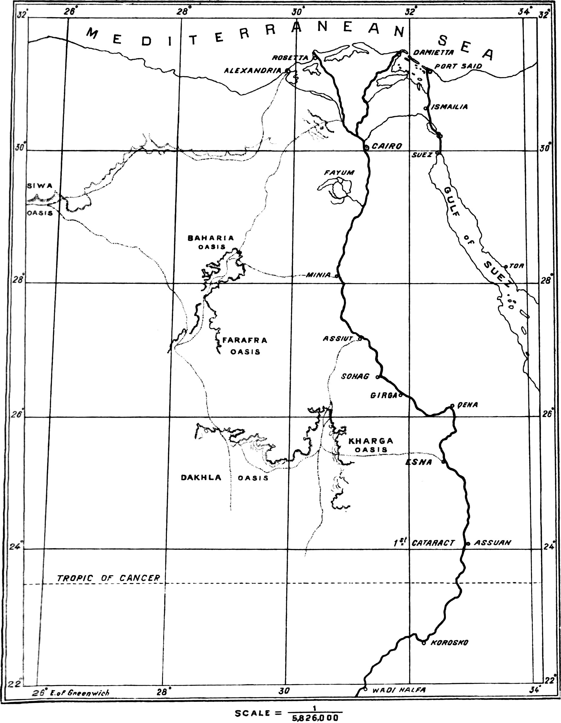
Valley (Sketchmap, Plate II). Like the other
oases of the Western Desert (Farafra, Dakhla and Kharga) to the
south, Baharia is a large natural excavation in the great Libyan
plateau; it differs, however, from those oases, which are open on
one or more sides, in being entirely surrounded by escarpments, and
the vast number of isolated hills within the depression form an
unique topographical feature. In Baharia, as, with the exception of
Dakhla, in the oases generally, the cultivated area bears only a
very small proportion to the total oasis-area, the remainder of the
floor of the natural excavation being barren desert. The oasis
contains four principal villages, all situated in its northern
portion, and it is in the neighbourhood of these that water, and
consequently vegetation, is most abundant.
The early history of Baharia is shrouded in an obscurity greater
even than that surrounding the history of Kharga. That it was
inhabited at a very early date is shown however by a stela of the
reign of Thothmes II (about B.C.
1600-1500) found there by Ascherson, by a tomb of the 19th dynasty
(B.C. 1300) and fragments of two temples,
one dating from the reign of King Apries (B.C. 588-570) and the other from the reign of Amasis
(B.C. 569-526), discovered by Steindorff
in 1900, and by the references to it in the Ptolemaic inscriptions
of the temple of Edfu. The oasis of Baharia is referred to in
the hieroglyphic
inscriptions of its newly-discovered temples as “the northern oasis
of Amenhotep,” and as “the oasis Huye”; by Strabo it is called
δεύτερα “the second” and by Ptolemy ὄασις μικρὰ “the
small oasis.” The Romans have left traces of their occupation
of Baharia in an arch near the village of El Qasr[1] and
other ruins, as well as in numerous wells and underground
aqueducts, which latter are still used by the present inhabitants.
Fragmentary ruins of churches and a Coptic village attest the fact
of the occupation of the place during Christian times. At present
Baharia, along with the neighbouring oasis of Farafra to the south,
is administered as part of the Mudiria of Minia, and is fairly
prosperous, though lacking in enterprise to an even greater extent
than is shown by the two southern oases of Dakhla and Kharga.
The first European traveller to reach the oasis of Baharia
appears to have been Belzoni,[2] who
reached it from Beni Suef on May 26th, 1819, and after spending
some eleven days there returned by the same route. Though his
observations appear to have been correctly made, the description of
his travels is largely coloured by imagination, and his map appears
only to have been a rough sketch. He erroneously confused Baharia
with the oasis of Jupiter Ammon, whose temple he imagined he had
found in the remains of the Roman arch near El Qasr, the chief
village of the oasis. It is hardly necessary to remark that the
oasis of Jupiter Ammon is really that now known as Siwa, situated
some 340 kilometres west-north-west of Baharia.
The earliest connected modern account of the oasis of any value
is that of Cailliaud,[3] who with Letorzec visited
the place in 1820 on his way from Siwa to Farafra, and during a
stay of about six weeks examined and mapped some of its principal
features. He drew attention to its antiquities and gave a careful
description of the hot springs and ancient aqueducts, besides
taking a number of observations of latitude and noting some of the
topographical and geological features, such as the occurrence of
volcanic rocks in the oasis. Cailliaud records his meeting in
Baharia with Hyde, an English traveller, who, however, does not appear to have published
any account of his wanderings.
In the winter of 1823-1824 Baharia was visited by Pacho
in company with F. Muller. In an account of Pacho’s travels[4]
published after his unhappy death, there is no reference to his
observations in this oasis beyond an indication of his route on the
map.
Wilkinson[5] visited the oasis of Baharia in 1825.
The Rohlfs’ expedition of 1874,[6] with the distinguished
scientists K. von Zittel and W. Jordan as geologist and topographer
respectively, added very considerably to our knowledge of Baharia,
more especially in the way of fixing precisely the geographical
positions and levels of its principal points. Zittel, however, did
not visit this oasis, and in consequence its geological structure
was not studied, the few references to it made in the publications
of the Rohlfs’ expedition being based on an examination of
specimens collected by Ascherson.
Probably the most accurate map hitherto existing of Baharia
Oasis is that of Ascherson,[7] who spent nearly three
months there in 1876. Ascherson, who entered the oasis by the road
from the Fayum and returned to Samalut, chiefly directed his
attention to botanical observations, but his memoir contains some
valuable topographical and geological information which supplements
that of previous and later observers in important measure; he has
also the distinction of finding the stela of the reign of Thothmes
III already referred to, and the remains of an Egyptian temple; the
latter is probably identical with one of those discovered by
Steindorff in 1900.
The short memoir by Capt. H. G. Lyons, R.E.,[8]
published in 1894, brought together a number of observations on the
geology of the Libyan Desert generally, and his discovery of
fossils, referred to Exogyra Overwegi, for the first time
established the Upper Cretaceous age of the clays and sandstones forming the floor and
lower part of the scarp in the northern end of the depression.
In 1897 the Geological Survey carried out its examination, the
results of which are set forth in the following chapters.
Since the survey expedition, Baharia has been visited by
Steindorff,[9] who during his five days’ stay in the oasis made
important additions to our knowledge of its antiquities. These will
be further referred to in the chapter on the topography of the
oasis.
[1]This ruin was described by Cailliaud (Voyage à Méroé. etc., vol. I, p.
183) who records that in his time (1820) only the central arcade
remained standing. Steindorff found in 1900 that even this last
fragment had fallen.
[2]Narrative of the Operations and Recent
Discoveries within the Pyramids, Tombs, and Excavations in Egypt
and Nubia, and of a Journey to the Coast of the Red Sea, in search
of the Ancient Berenice, and another to the oasis of Jupiter
Ammon.—London, 1820, pp. 395-433.
[3]Voyage à Méroé, au Fleuve Blanc, an-delà
de Fàzogl dans le midi du Royaume de Sennàr, à Syouah et dans cinq
autres Oasis. Paris, 1826. The work consists of four volumes,
accompanied by numerous maps and plates illustrating the
antiquities.
[4]Relation d’un voyage dans la Marmarique,
la Cyrénaique et les Oasis d’Audjelah et de Maradèh. Paris,
1827. (This date is probably wrong, as a reference is made in the
work, (p. VII) to the suicide of Pacho on Jan. 26th, 1829).
[5]Modern Egypt and Thebes. London,
1843, vol. II, p. 357-371.
[6]See G. Rohlfs,
Drei Monate in der libyschen Wüste, Cassel, 1875;
Jordan, Physische Geographie und
Meteorologie der libyschen Wüste, Cassel, 1876; and
Zittel, Geologie der libyschen
Wüste. Cassel, 1883. Jordan appears to have been the only
member of the Rohlfs’ party to actually visit Baharia. He left the
other members at Lake Sittra (N. lat. 28° 42′ 40″, long. 27° 4′
23″, E. of Green.) and entered Baharia from the N.W. of El Qasr;
after passing about 1½ days in Baharia Oasis he journeyed
southwards via Farafra to rejoin his colleagues in Dakhla.
[7]Zeitschrift der Gesellschaft für Erdkunde
zu Berlin, Band 20, Heft II, 1885. Also Dr. Schweinfurth’s
summary of Ascherson’s results in “Petermann’s Mittheilungen,” 22.
Band, 1876, p. 264.
[8]On the Stratigraphy and Physiography of
the Libyan Desert of Egypt. Q. J. G. S. Nov, 1894, pp.
531-547.
[9]Vorlaüfiger Bericht über seine im Winter
1899-1900 nach der Oase Siwa und nach Nubien unternommenen
Reisen.—Königl. Sächs. Gesellschaft der Wissenschaften zu
Leipzig, 1900, p. 226. Steindorff entered the Oasis from Siwa, and
returned from it via the Fayum. He appears only to have visited the
northern part of Baharia.
CHAPTER II.
Surveying Methods and General Results.
Crossing the Libyan Desert from Maghagha and Minia respectively,
the two parties of the Geological Survey met at a joint camp close
to Zubbo, one of the chief villages of the oasis. It was desirable
to fix this meeting-point as a primary station for the subsequent
plotting of the maps. Cailliaud[10] gave the latitude of Zubbo
as 28° 21′ 47″, and its longitude as 26° 43′ 46″ E. of Paris,
(equivalent to 29° 3′ 55″ E. of Greenwich). Jordan gave for Bawitti
the position N. lat. 28° 21′ 12″, long. E. of Greenwich 28° 56′
45″. Taking the difference of latitude and longitude between
Bawitti and Zubbo as found by the Survey, viz., lat. + 55″, long. +
4′ 16″, we have as the equivalent of Jordan’s latitude for Zubbo
28° 22′ 7″, and for his longitude 29° 1′ 1″ E. of Greenwich. Thus,
while there is a fair agreement between the two authors as regards
latitude, there is a difference of 2′ 54″ in the values of the
longitude.
The longitude is of course always the difficult matter in the
geographical determination of places not easy of access.
Cailliaud’s value rests on the method of distance and azimuths,
both roughly determined only; Jordan, on the other hand, used the
absolute though not very precise method of lunar distances measured
with a sextant. The Survey parties depended entirely on direct
measurement by means of measuring-wheels from known points in the
Nile Valley; the values obtained in this way are tabulated
below[11].
I.—Traverse from Maghagha to
Zubbo.
Maghagha Railway Station,
long. E. of Greenwich
30°
50′
49″
Recorded west departure,
Maghagha to Zubbo, 187·77 km.
1
56
46
Giving long. of Zubbo
28
54
3
II.—Traverse from Minia to Zubbo.
Minia Railway Station,
long. E. of Greenwich
30°
45′
39″
Recorded west departure,
Minia to Zubbo, 176·32 km.
1
47
50
Giving long. of Zubbo
28
57
49
III.—Traverse from Zubbo to
Minia, via the south end of the Oasis.
Recorded east departure,
Zubbo-Minia, 174·87 km.
1°
46′
45″
Minia Railway Station,
long. E. of Greenwich
30
45
39
Giving long. of Zubbo
28
58
54
The arithmetic mean of these three determinations is 28° 56′
55″; owing, however, to the breakdown of the measuring-wheel during
the outward traverse from Maghagha, and the consequent necessity of
estimating a part of the distance traversed by the time taken in
marching, the different traverses are not equal in value, and the
longitude finally adopted by the survey, as the best approximation
after investigation of the various sources of error in the
measurements, was 28° 58′ 34″. It would thus appear that Jordan’s
position may be a little too far east, the difference amounting to
2′ 27″, or about 3½ kilometres, while Cailliaud’s value would place
the position at a rather less distance west of that adopted.
The survey observations confirmed the accuracy of Jordan’s
latitude (28° 22′ 7″), from which the value found by Cailliaud
differs, as already remarked, only slightly.
The surveying operations within the oasis were based on a rapid
plane-table triangulation from a measured base line within it,
details being simultaneously sketched in, on a scale of ¹⁄₅₀₀₀₀.
The site chosen for the base was a level stretch of ground
extending between the camp at Zubbo and an isolated clump of
date-palms to the north-east; the length of this line was found by
repeated wheel-measurement to be 3·88 kilometres. The two parties
ran off their triangulations from this base to the surrounding
hills, and carried on the mapping southward by plane-table, taking
stations chiefly on the hills and prominent points of the scarps,
and not meeting again till Ain el Haiss, in the southern part of
the oasis, was reached. Here a test was made as to agreement of the
two sets of maps, only a small difference being found. The position
of Ain el Haiss, as found by taking the mean of the two
determinations, is latitude 28° 2′ 11″ N., longitude 28° 39′ 19″ E.
of Greenwich; this places the spring about 4′ 18″ east of Jordan’s
determination (lat. 28° 1′ 55″ N., long. 28° 13′ 47″ E. of
Green.).
The two parties
made a third connection at the extreme south end of the
oasis-depression. Our observations for this point give its latitude
as 27° 48′ 13″ N., and its longitude as 28° 32′ 19″ E. of
Greenwich, placing it very near the position shown on Jordan’s
map.
The plane-table method making use of the magnetic meridian, it
was imperative to determine the amount of declination of the
compass. This was done at one point only, viz., at the south end of
the oasis, the value found (by observation of the transit of
Polaris) being 4° 50′ W. The declination is fairly constant over
the entire area, except near the eruptive dolerite masses, the
magnetite in which causes a very sensible deflection of the needle;
in the neighbourhood of these, however, the surveying was carried
on independently of the compass. With regard to the yearly change
of declination, we have as data the previous observations of
Cailliaud, who found the declination at Zubbo in January, 1820, to
be 12° 13′ W.; of Jordan, who obtained the value 6° 56′ W. in
March, 1874; and of Capt. Lyons,[12] whose observations with a
Bamberg declinatorium at Mandisha in April, 1894, gave the value 5°
8·9′ W. Tabulating these:—
Observer.
Date.
Observed Declination W.
Yearly change.
Cailliaud
January 1820
12°
13′
Jordan
March 1874
6°
33′·6
6′·3
Lyons
April 1894
5°
8′·9
4′·2
Geological Survey
December 1897
4°
50′
5′·3
In view of the magnitude of the diurnal variation, which may
range up to 10′ of arc, and our present lack of knowledge of the
distribution of this diurnal variation during the twenty-four
hours, a comparison after so short an interval as that between the
last two observations is not to be trusted. It would seem proved
from the three foregoing observations that the yearly variation is
at present decreasing, the mean from 1820 to 1874 being 6′·3 as
against 4′·2 for the period 1874-1894. This decrease is also
noticeable in comparisons of the declinations observed at different
times in other parts of Egypt.
The altitudes above sea-level of the principal points,
more especially in the eastern half of the oasis, were determined
with a Watkin aneroid barometer, which had been compared with the
Cairo standard mercurial barometer. A fairly long stay was made at
the Zubbo camp, and
the altitude of this point may be regarded as fairly accurately
fixed by the observations tabulated below:—
Date and Time.
Zubbo.
Bar. (corrected).
Cairo.
Bar. (corrected).
Difference.
mm.
mm.
mm.
October
12,
6 p.m.
753·54
761·10
7·56
„
14,
8 a.m.
754·94
763·04
8·10
„
6 p.m.
753·79
761·53
7·74
„
15,
7.30 a.m.
754·55
762·60
8·05
„
9 p.m.
754·30
762·64
8·34
„
17,
7.15 a.m.
754·18
761·84
7·66
„
18,
7 a.m.
753·79
761·64
7·85
noon
752·52
761·34
8·82
„
19,
8.30 a.m.
752·65
762·31
9·66
Nov.,
26,
3 p.m.
754·81
763·29
8·48
„
27,
8 a.m.
754·81
764·12
9·31
Mean
8·32
Since 1 mm. of mercury corresponds at the mean temperature of
observation (20° C.) to 11·4 metres of height, we have height of
Zubbo camp above Cairo observatory = 8·32 × 11·4 = 94·7, or say 95
metres. Since the observatory is 33 metres above sea-level, the
camp at Zubbo is 128 metres above sea-level. Jordan’s altitude for
Bawitti, which probably lies at about the same level as Zubbo, is
113 metres, and when it is remembered that the point of the
Survey’s observation lay not in Zubbo itself, but at the camp on
elevated ground some 10 or 12 metres above it, the results show a
very good agreement.
At Ain el Haiss three barometric observations were taken on
different days; the comparison of these with the Cairo records
would place this point 156 metres above sea-level. Jordan’s value
is 122 metres, the number of observations on which this figure is
based not being stated, it is difficult to say which of the two
altitudes is the more probable.
At the remaining camps within the oasis, and at the camps en
route between the oasis and Minia, corresponding observations
were taken, the number of comparisons with Cairo varying from two
to seven at an individual station. These observations being reduced
and corrected by comparison among themselves gave the levels of the
different camps with some degree of approximation to accuracy, and
the altitudes of intermediate points were found by interpolation
based on barometric readings. The resulting altitudes will be found
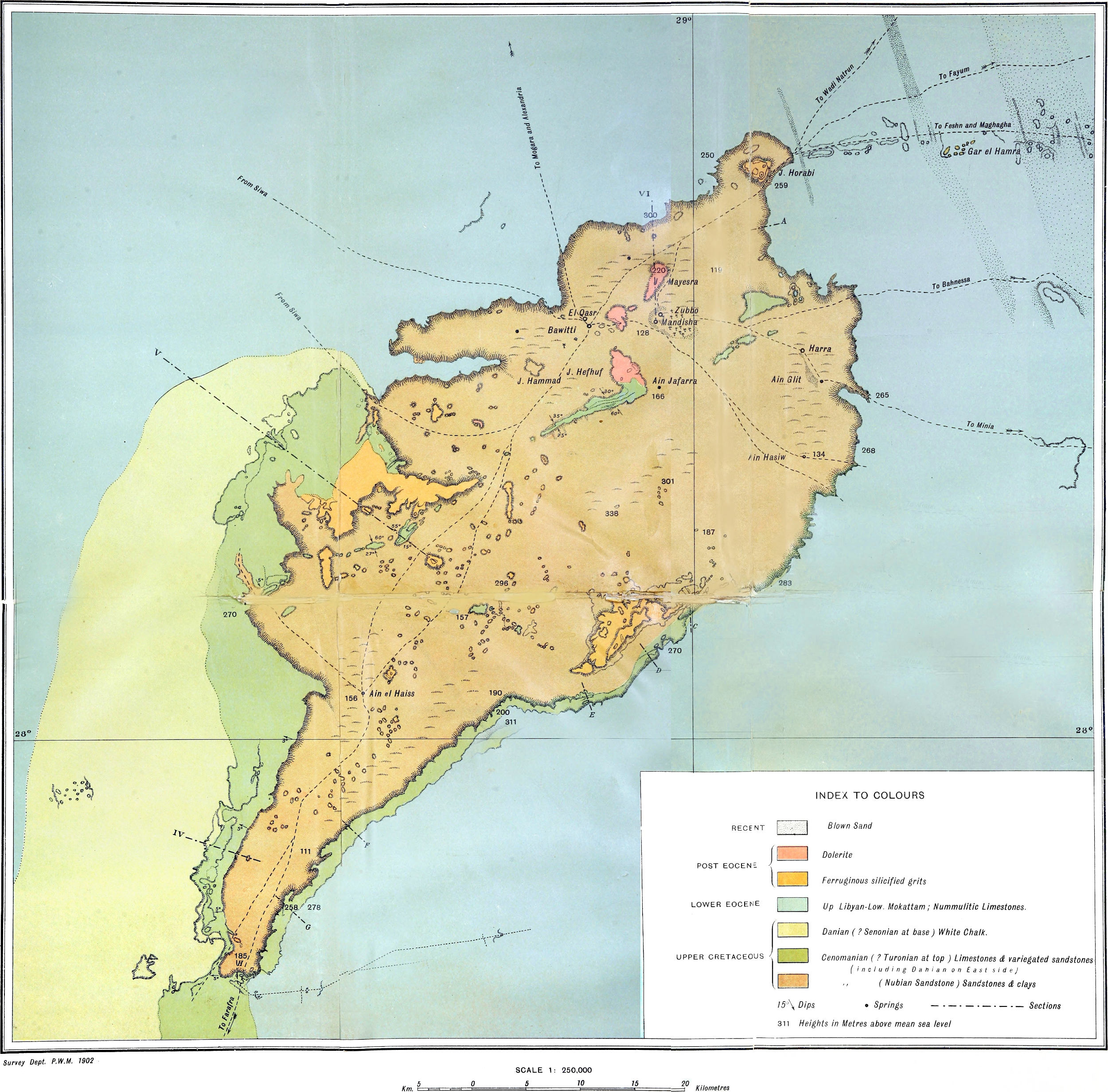
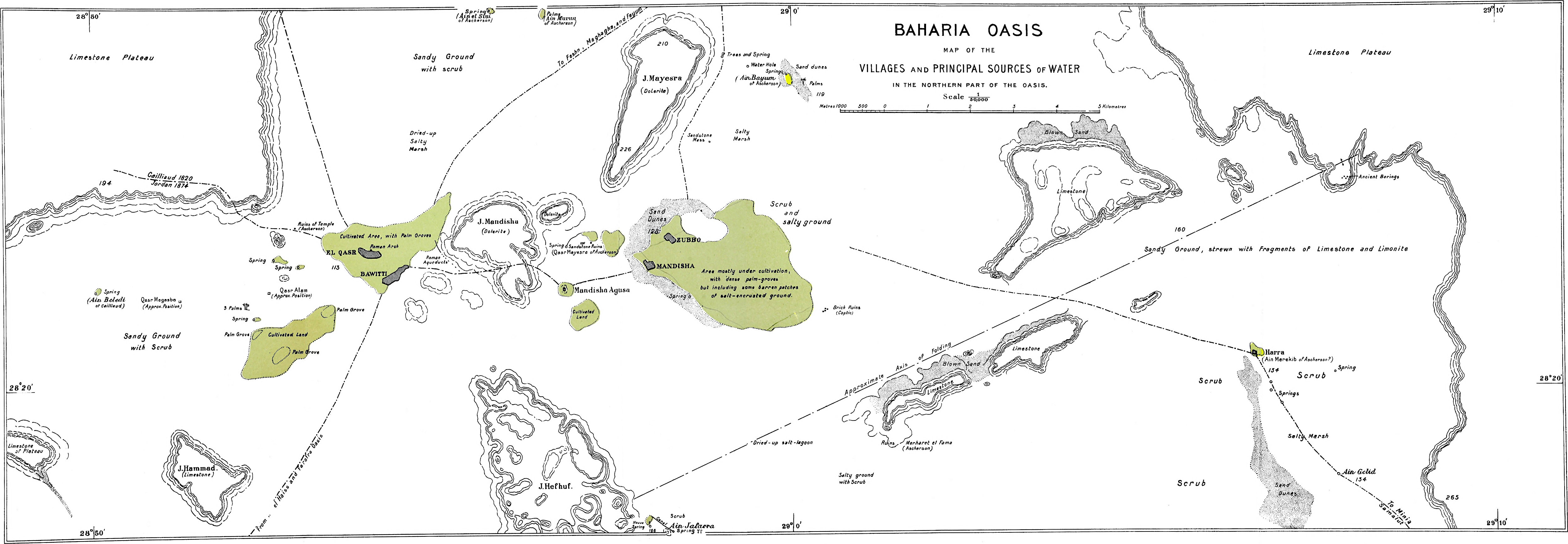
on the map (Plate I); where no altitudes have
been taken by the Survey, the values given by Ascherson on his map
have been inserted.
The statistics
relating to the oasis, and the methods of cleaning out wells, are
based on information supplied by the Government officials at
Bawitti, and may be taken as fairly reliable. The particulars
regarding water-supply are of course based mainly on direct
observation during the survey of the villages.
The botany of the oasis having been fully studied by
Ascherson[13] no attempt was made by the Survey to collect or
describe the plants met with. The abundant growths of the beautiful
maiden-hair fern (Adiantum Capillus Veneris)[14]
will not, however, fail to strike even the casual visitor to the
old Roman aqueducts, which still serve as the principal
water-channels of the oasis. Nor were the animals of the oasis made
the subject of any detailed observations, although the existence of
several of the species of lizards and snakes common to the Nile
Valley was recorded, and specimens collected when easily
obtainable.
Baharia is not rich in archæological remains, and, with few
exceptions, even those existing were not examined by the Survey,
though the positions of all ruins met with during the work were
mapped. In a later chapter will be found a connected though brief
account of all the antiquities noted, the publications of previous
authors being referred to wherever the descriptions cannot be given
from personal observations.
The principal point attended to in the topographical mapping by
the survey was the accurate delineation of the bounding scarps of
the oasis and of the large number of hills within it. These
features, of which an accurate map was essential for any proper
consideration of the geology, had been only rapidly sketched by
previous travellers, and the precise shape of the oasis was still
unknown. In the cultivated spots, on the other hand, much had been
done by Cailliaud, Jordan and Ascherson towards mapping the detail.
Hence, beyond re-determining the precise positions of the main
points and the general limits of the cultivated areas, no attempt
at detailed mapping in these areas was undertaken by the Survey
parties, it being felt that it would be preferable in the limited
time available to concentrate attention on the almost totally
unknown features, so essential to any geological consideration,
rather than to devote considerable time to the details of the
inhabited spots.
Thus, while the field maps resulting from the survey represented
the oasis for the first time in its true shape, and the hills
within it in their
true relative magnitudes and positions, they fell somewhat short of
the maps of Ascherson and Cailliaud in the number of springs,
ruins, etc., shown. The more important ruins overlooked by the
survey have, however, been inserted approximately from existing
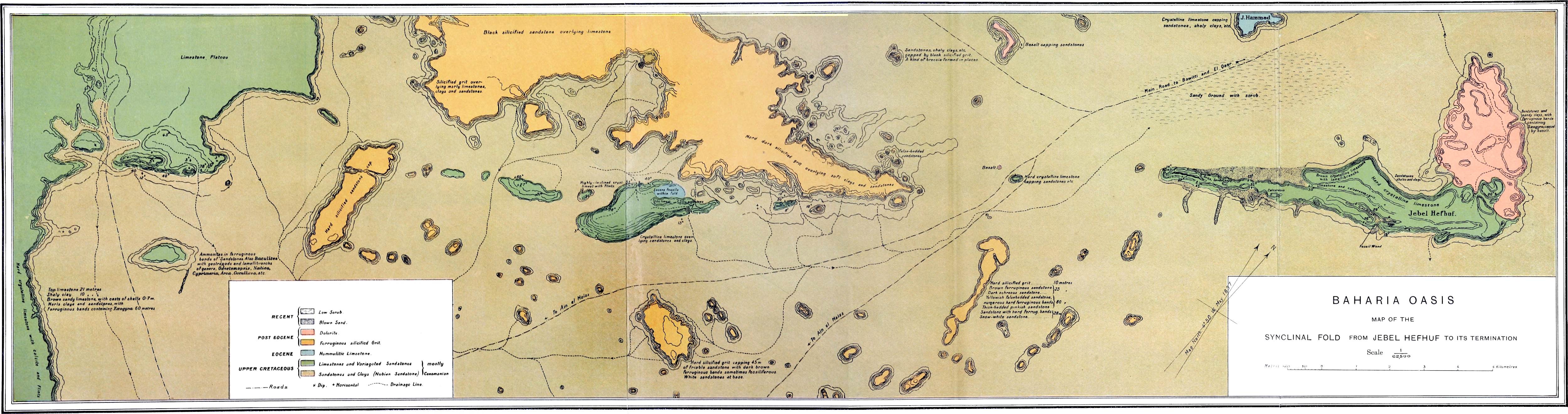
maps, and the whole result (Plates I,III and VII), is an advance on the
existing representations.
The geology of the oasis was very carefully
investigated, this being a field in which comparatively little had
been done, and a number of very interesting results were obtained.
The principal points in this connection worthy of note resulting
from the detailed examination of the scarps and hills are—
(i) The existence of a marked unconformity between the Upper
Cretaceous and Eocene strata, thus confirming the unconformity
between these two great systems which had been noted[15]
earlier at Abu Roash; this unconformity has now been remarked in
many parts of Egypt.[16] The palæontological proofs of this
unconformity were obtained from the western scarp, the beds of the
eastern side, though they show the same thickening, being much
poorer in fossils;
(ii) The occurrence of an extensive series of Upper Cretaceous
beds of Cenomanian to Danian age within the depression and forming
a large part of the desert to the west;
(iii) The precise extent and relations of the dolerite capping
some of the sandstone hills in the north of the depression;
(iv) The existence of well-marked folding having an important
bearing on the origin of the oasis;
(v) The presence of ferruginous sandstone deposits of later
origin than the primary formation of the oasis-hollow, though long
anterior to the date when the work of excavation, which gave the
oasis its present form, took place.
These points will be found discussed at some length in the
chapter on the geology of the oasis.
[11]The positions of the two points of
connection in the valley were determined by Capt. Lyons in
1896.
The return traverse via Farafra to Assiut is left out of
consideration owing to its great length and consequent low value in
the determination of the longitude of Zubbo. It agrees however,
very closely with the others, owing to compensation of errors.
[12]Lyons,
Proceedings of the Royal Society, vol. 71.
[14]The occurrence of this fern in the ravines
of the Fayum may also be recorded here.
[15]Beadnell, H. J. L.,
Geological Magazine. Jan., 1900, No. 427, pp. 46-48;
The Cretaceous Region of Abu Roash, near the Pyramids of
Giza. Geol. Surv. Egypt, Report 1900, Part II, 1902.
[16]See Reports of the Geological Survey on
Farafra, Kharga and the Eastern Desert.
CHAPTER III.
The Roads connecting the Oasis of Baharia with the
Nile Valley and other Oases.
The roads traversed by the Survey parties between Baharia and
other places are three in number, viz., from near Maghagha and from
Minia in the Nile Valley, and from Baharia to Farafra Oasis. Other
well-known routes run from the Fayum, from Bahnessa, Samalut
(Ascherson) and Delga, in the Nile Valley, from Alexandria, via
Mogara, and from Siwa (Jordan, Cailliaud). The Survey’s return
traverse to Minia from the south end of Baharia did not follow any
defined road, but kept on the open plateau on a course computed
from the known positions of the points of departure and
destination.[17]
Road from Feshn and
Maghagha to Baharia.The road from Feshn and Maghagha to
Baharia leaves the edge of the Nile Valley cultivation at Qasr
el Lamlum Bey, which bears 51½° west of true north from Maghagha
railway station, and is distant 15·4 kilometres. From this point
the road is well-defined and easily followed right into the oasis.
In the following description the distances are given from the edge
of the Nile Valley cultivation.
The road at first leads over a strip of drift sand, half a
kilometre broad, with short prickly scrub, passing a white mosque
on the left and then turning off somewhat to a direction 26° south
of west, and continuing in a straight line for 15 kilometres over
an undulating gravelly plain. The high prominent cliffs, about 7 or
8 kilometres to the north-west, are the flanks of Jebel Muailla,
and a valley known as Wadi Muailla leads through them to the Wadi
Rayan in the Fayum depression.[18] At 19 kilometres the
valley scarp, with a number of isolated peaks, is approached on the
right, while ridges and low mounds form the plain below,
well-marked lines of drainage running from here in a south-east
direction towards the cultivation. At 23 kilometres the scarp runs
back, enclosing a large bay, across which the road runs and ascends
to the plateau beyond at 27·8 kilometres. Numerous
isolated parallel
sand-dunes in the form of small ridges are seen running out into
the bay from the cliff at the far end, all lying slightly west of
north and east of south, or parallel to the normal wind
direction.
The escarpment bounding the Nile Valley at this point is only
some 15 metres in height, being thus quite insignificant compared
with the cliffs on the east side. The plateau here was found to be
about 140 metres above the cultivation, the road having risen
gradually throughout. The latter continues for about 1½ kilometres
across the strip of plateau when it again descends, making a slight
detour to the left for easy descent. It then continues 9° south of
west, slightly winding, over gravelly undulating ground. At 31-32
kilometres a line of low hills is passed on the right, while a dark
well-marked range lies 6-7 kilometres to the left.
A ridge of sandstone, known as Jebel el Ghudda, is passed on the
right at 45 kilometres, from the end of which a small dune runs
out; beyond, the plain resumes its monotonous undulating character,
a low ridge being crossed at 61 kilometres. There, the road,
consisting of a number of more or less parallel well-marked narrow
paths worn by camels, which have a somewhat general habit of
marching in line one behind the other, changes its direction to 36°
south of west, falling gradually in level until a patch of scrub is
reached 6½ kilometres further on. This scrub was dead at the time
of the visit, and furnished a useful supply of fuel. From this
point the course is 7° south of west (true), which direction is
maintained for the next 42 kilometres over a remarkably monotonous
undulating gravel-covered desert, the typical “serir” of the Arabs.
At 92 and 93½ kilometres some more patches of dead scrub were
passed on the right, while logs of silicified wood were noticed
strewing the plain on the left. An Arab grave was met with at 96
kilometres, while skeletons of camels lie about near the roadside
at frequent intervals; at 110 kilometres the eye of the traveller
is relieved by a small grove of green thorny flat-topped acacia
trees (Acacia nilotica, or “sunt” of the Arabs) with a patch
of coarse grass; four gazelle (probably Gazella dorcas) were
observed browsing on the scrub here.
The course now continues 12½° south of west, over gently
undulating gravelly “serir”, until the eastern scarp of El Bahr is
reached at 125 kilometres from the cultivation of the Nile Valley.
The “serir” or undulating gravelly type of desert then ceases.
El Bahr is a depression, some 60-70 metres deep, cut out in
white limestone rocks; its breadth at the point crossed by the road
was 8 kilometres. Within it are several high prominent hills, one
of which near the
centre on the left side of the road is called Jebel Gar Marzak. The
bottom of the depression was quite green with vegetation;
sufficient water is said to fall every year to keep these plants
alive, and in 1894 rain is said to have fallen to such an extent
that a pool of considerable size was formed; the silt deposited by
this is plainly visible at the present time. A good deal of blown
sand occurs within the depression. El Bahr evidently corresponds to
the Bahr Bela Ma, (river without water) figured on some authors’
maps, which has been frequently but erroneously referred to as an
old river-course; although this idea was shown to be untenable by
Zittel[19] and Ascherson[20] it has subsequently been
maintained by non-scientific writers. No traces of any river
deposit occur in the depression, which consists simply of a series
of unconnected depressions, eroded by wind-borne sand.[21]
The track leaves the depression at 134 kilometres, rising over
heavy sand; it then continues 3° north of west. The character of
the desert has now completely changed, and instead of the smooth
undulating gravelly “serir,” its surface is rough and hummocky,
being formed of hard bare limestone, cut up into sharp knobs and
grooved into furrows by the powerful action of wind-borne sand; it
resembles closely the surface of the rough open sea. This type of
desert is spoken of as “kharafish” by the Arabs. While the “serir”
forms an ideal surface for travelling over, the “kharafish” is the
worst imaginable, the innumerable hillocks necessitating incessant
small deviations, while the hard rough surface is in some places
very troublesome to camels; moreover, an extensive view is out of
the question and no tracks are visible on the surface, so that the
road is easily lost except where marked by frequent cairns built of
loose stones.
Occasional patches of blown sand are here met with, and the
first well-marked dunes were crossed at 141 kilometres. From here
onwards for kilometres the whole area was more or less sandy with
occasional narrow well-marked ridges or dunes, running almost due
north and south, and varying in breadth from that of a single line
to a number of parallel ridges side by side half a kilometre broad.
The largest dune of this group at 146½ kilometres is known as Ghard
el Shubbab. The steepest sides are those facing west where the
angle may reach 30°.
At the particular locality crossed by this road the sand area is
very easily crossed,
a circuitous route being followed in order to take advantage of the
flatter dunes with the easiest slopes when crossing the steeper
ridges. Probably the road crosses at one of the easiest points.
This remarkable line of dunes, known as the Abu Moharik, has its
origin in the neighbourhood of the oasis of Mogara and runs
southward, almost without a break, across the desert until Kharga
is reached, whence with a slight break owing to the broken
character of the ground it continues southward within the
oasis-depression. The total width of the sand-belt on the road
under description is about 6 kilometres.
At 153 to 156 kilometres a number of black conical hills, Gar el
Hamra, are situate from 1 to 2 kilometres from the road on the
south side. One or two more sand-dunes were crossed and then the
road, maintaining its direction of 2°-3° north of west, lay over a
more or less uneven dark-coloured limestone desert broken up into a
number of small hills. At 169 kilometres a broad ridge of
sand-dunes was encountered, running 18° west of true north. These
light yellow dunes afford a beautiful and remarkable sight, running
northwards away to the horizon over a dark brown-coloured desert in
an almost perfectly straight line and with a sharply maintained
junction-line between the edge of the sand and the desert surface
adjoining.
Within a few hundred metres of the western side of the
sand-dunes the road commences the descent from the plateau into the
oasis-depression. The road enters at the most northerly extremity
of the oasis, the descent being particularly easy at this point,
passing the large dark-coloured hill, Jebel Horabi (or Morabi?), on
the right almost immediately afterwards.
A fine view of the depression is obtainable from the top of the
escarpment, a broad low-lying expanse, bounded by steep escarpments
or walls, stretching away to the south, its monotony relieved by
several large flat-topped hill-masses, near which, on the lowest
portions of the floor, dark areas, the cultivated lands and
palm-groves can be distinguished. The road crosses the depression
in a south-westerly direction, passes a spring known as Ain el
Gidr, the first watering place, and divides in front of the great
hill-masses separating the two groups of villages, the eastern
branch keeping close under the eastern scarp of Jebel Mayesra, to
avoid a large area of soft salty ground, and leading to the
villages of Zubbo and Mandisha, While the western branch continues
its course to the cultivation surrounding El Qasr and Bawitti. The
distance by this road from Qasr el Lamlum Bey to the village of
Zubbo is 190 kilometres and to Bawitti 195 kilometres.
Geology of the
Feshn-BahariaHaving now described the topographical features
of this road, the chief geological characters may be noticed. The
plain between the Nile Valley cultivation and the scarp of the
plateau is covered with sandy gravel, partly downwash from the
higher ground in Recent times, and partly the remains of definite
gravel deposits belonging to the Nile Valley Pleistocene
series.[22] The pebbles now found strewn over the plain
consist chiefly of flints, doubtless derived from the Eocene
limestones forming the deserts on both sides of the Nile Valley,
and occasional pebbles of hard felspar porphyry which must have
originally been derived from the igneous massifs of the Red Sea
Hills. Both are well rounded, although the former are frequently
broken up into angular fragments by temperature changes. White
granular beds of gypsum, of various degrees of impurity, crop out
on the plain in places, and in all probability there was in
Pleistocene times an extensive deposit of this mineral all over the
surface of the low-lying country. In the desert lying between the
Fayum and the Nile Valley further to the north, these gypseous beds
occur of great thickness and wide extent, and the deposits crossed
on this road are doubtless part of the same series.
The cliffs of Jebel Muailla to the north are capped by a hard
dark bed of limestone, which weathers with a vertical face, while
the more gentle slopes, generally more or less hidden with sand,
are doubtless formed of softer limestones, marls, and clays. During
the survey of the Fayum (see foot-note, p. 17) the hills surrounding Wadi Muailla were
found to be formed of Lower Mokattam beds (Middle Eocene) and the
hills seen from this road are doubtless composed of the same beds.
The ridges crossed at 20 kilometres are formed of hard, compact,
close-grained crystalline limestone, covered with more or less
gypsum and flint gravel; the limestone beds forming these ridges
show dips which suggest the existence of a fault running N.E.-S.W.,
parallel to the trend of the cliff behind, and this may be part of
the extensive faults and folds of the Nile Valley. In one small
hill (22 kilometres) shales with Ostrea were noticed at the
base, with occasional hard oyster-limestone bands; the upper part
was formed of 10 metres of gravel consisting of well-rounded
limestone pebbles. This superficial deposit must be classed as
Pleistocene and may be a sea-beach, though no conclusive evidence
was obtainable on this point. The escarpment passed at 23
kilometres is capped by a bed of white limestone, shales forming
the slope, but was not examined at close quarters. The floor of the
bay formed by the receding cliff shows outcropping
brown limestone with
Ostrea, and the escarpment on the far side is capped by a
hard white crystalline limestone with much flint, the latter
forming bands. On the surface is a thin calcareous gypseous gravel
deposit, doubtless of the same age as the gypseous beds already
mentioned as occurring on the plain below. The flanks of the scarp
are hidden by downwash. The cliff bounding this strip of plateau,
1½ kilometres further on, is composed of the same beds, the
limestone being here silicified, with large silicified
Conidæ. With regard to the age of these limestones and clays
they are probably equivalent to part of the Lower Mokattam series
already mentioned as forming the hill-masses round Wadi Rayan,
although no Nummulites gizehensis beds were observed in the
sections examined. A conspicuous black knob among the low gravelly
hills left two kilometres on the right at 32 kilometres, was found
to be a neck of hard dark andesitic basalt, one of the few
occurrences of igneous rocks in the Western Desert. Several other
similar looking dark hills were in sight, but time did not admit of
their examination. The dark well-marked range 6-7 kilometres to the
left of the road is probably identical with a range of hills
occurring 10 kilometres west of Bahnessa, which was mapped[23]
during the survey of the Nile Valley in 1899, and found to consist
of a mass of andesitic basalt similar to that forming the small
neck on this road. Doubtless they are both parts of the same
intrusion. The surface of the plain is still composed in part of
gypseous deposits, with occasional outcrops of the underlying
limestone, the surface being covered with a certain amount of loose
sand with rounded flints and their broken fragments. In the
neighbourhood of Jebel el Ghudda the plain consists of limestone
with numerous individuals of the large Nummulites
gizehensis, and are thus of Lower Mokattam age. Much of the
limestone is crystalline. The hills of Jebel el Ghudda are formed
by younger overlying beds consisting of hard silicified sandstones
and grits (quartzites), which lithologically are very similar to
the beds of Jebel Ahmar near Cairo, of Oligocene age. They may,
however, belong to the Upper Eocene series, so well developed above
the Upper Mokattam in the escarpments to the north of the Fayum, as
this series contains similar beds with similar silicified wood.
They enclose bands of coarse conglomerate and have a peculiar
blackish burnt colour. Occasional patches of these grits are here
and there met with right up to the depression of El Bahr, and the
silicified wood passed at 92 kilometres belongs to the same series
of beds. From the scrub area at 93½ kilometres till the road
approached El Bahr there was hardly a sign either of the grits or
of section anywhere
met with on this road. The depression is cut down through the upper
series of sandstones and grits into the fossiliferous white
limestones and sandstones below. The eastern scarp showed the
following beds:—
Top.
Soft white Sandstone.
Middle Eocene.
⎧
⎨
⎩
Limestone with Nummulites
gizehensis.
⎫
⎬
⎭
Lower Mokattam.
Limestone with Ostrea, Exogyra
and Lucina, etc.
The floor is covered in places with numerous weathered out
individuals of N. gizehensis and large oysters. Some of the
hills occurring within the depression showed brown siliceous
limestone overlying white limestones with beds containing
Nummulites gizehensis, Ostrea, etc., below. In some
of these hills the beds show evidences of folding, which like that
within the Baharia Oasis may have partly caused the formation of
the depression by bringing the softer beds to the surface within
the reach of the agents of denudation. On ascending the western
scarp, beds with Ostrea, Turritella, etc., were
crossed, and near the top thick yellowish sandstones crowded with
Ostrea occur. Two of the species of Ostrea were
afterwards examined by Dr. Blanckenhorn, one of which he regarded
as nearly related to O. Fraasi, and the other as a new
species with affinities to O. Hess, May-Eym.
Probably the whole of these fossiliferous beds belong to the
Middle Eocene Mokattam Series; the lower beds with N.
gizehensis, are certainly Lower Mokattam, and probably the
upper, although the latter may represent the base of the Upper
Mokattam. Whether the upper bed of sandstone capping the eastern
scarp belongs to the same series or is equivalent of the silicified
grits with silicified wood passed further back is open to some
doubt.
Beyond the Bahr the desert is formed of a hard limestone much
cut up by the action of wind-borne sand as already mentioned. This
limestone is very unfossiliferous, occasional obscure nummulites
seen on fractured or smooth surfaces being the only indications of
its Eocene age.
The conical-peaked hills of Gar el Hamra on the left of the road
at 151 kilometres were so striking that a detour was made specially
to examine them. They were found to be composed of black
ferruginous silicified sandstone or quartzite at top, with
false-bedded sandstones below. They overlie nummulitic limestones
forming the surrounding plain, and are not improbable Post Eocene
lacustrine deposits, similar to those within Baharia Oasis (see
pp. 60-62).
From here onwards up to the oasis-depression the plateau
consists of hard brown limestone, more or less silicified, and
contains nummulites and oysters. The Eocene strata, thus extend
right up to the escarpment of the depression on the north side of
the oasis. The geological structure within the depression will be
found discussed in Chapter V.
Road from Minia to
Baharia.Road from Minia to Baharia.—The cultivated
land extends for some 9 or 10 kilometres west of Minia town, and at
the time of the Survey expedition (early in October, 1897) this
area was mostly covered by flood-water. Boats were therefore taken
to the edge of the desert, and the march west was commenced from
Nasl Nadiub Lengat, a small village on the cultivation-limit in
lat. 28° 6′ 24″, long. 30° 39′ 45″ E., bearing from Minia railway
station 9° north of west, distance very nearly 10 kilometres. The
road westward being ill-defined, and the party knowing that any
course followed a little north of west would surely lead to the
oasis, no attempt was made to follow the track precisely, the
course being rather chosen to take advantage of commanding points
so as to map as much topography as possible en route. As
will be seen further on, however, the road was struck some distance
before reaching the oasis, and was thence followed to Zubbo.
On leaving Nasl Nadiub Lengat the course first taken was about
32° north of west. The desert here rises very gradually from the
flood-level, (i.e. about 40 metres above sea-level), there
being no cliff bounding the Nile Valley on the West at this point.
For about 6 kilometres the ground was sandy, with occasional
patches of flood-water and some grass; then came a stretch of level
gravelly ground, and at 11½ kilometres some low sand-dunes were
crossed. The course was now changed to about 3° south of west, and
at 14 kilometres a descent was made from the gravel-plain into a
limestone-depression, with gravel-capped eminences on either side.
At 22 kilometres the gravel-strewn plain was again come on, a few
low mounds, also gravelly, being passed at 31 kilometres, and
camel-tracks, doubtless part of the Minia-Baharia road, being
noticed coincident with the survey line at 37 kilometres.
Continuing following these tracks, another camel-road was found to
branch off at 46 kilometres to the north-west. The march was
continued along the same track going a little more south of west,
over a monotonous
gravelly plain, with limestone showing through it in small patches,
till at 78 kilometres from Nasl Nadiub Lengat a conspicuous though
small mass of fissile gritty limestone was come on, which afforded
a good survey-station. North and west of this are low
gravel-covered hills. Turning a little north of west, a large
extent of low table-like hills was seen on the south. At about 90
kilometres low plateaux of limestone, capped by gravel, closed in
so as to form a defile about a kilometre wide, through which the
line of survey passed, and at 98 kilometres a large sandy and
gravelly depression, bounded by limestone scarps and containing
numerous large limestone hills, was entered. Within the depression
the course followed was about 30° north of west, so as to map
roughly the escarpments on either hand. About 10 kilometres from
the point where the depression is entered a long stretch of heavy
sand was crossed beyond which tracks going west were come on, and
the edge of the limestone plateau on the left curved round so as to
cross the road. Ascending this low scarp at 116 kilometres, the
course lay over white limestone, with sharp angular flints on its
surface, and low limestone hills on either side. At 124 kilometres
the broad belt of sand-dunes, the Abu Moharik, was reached. The
dunes, which are of considerable height, run nearly north and
south, and have a total width of some 4 kilometres; they formed the
most serious obstacle of the entire journey. Beyond the dunes is a
hard limestone plain, crossed by a low ridge (forming part of a
higher plateau) at 136 kilometres. Beyond this ridge are low
limestone-hills on either side, the floor being generally of hard
white limestone. At 151 kilometres an oval depression in the
limestone plateau, with its longer axis (about 4 kilometres)
running W.N.W., was entered; this depression is full of hills of
white chalk, which also forms the floor here. Ascending the
opposite scarp of the depression at 159 kilometres, a narrow strip
of higher plateau of much harder limestone was crossed, the edge of
the scarp of the oasis of Baharia being reached at 160 kilometres,
after marching for 57 hours from Nasl Nadiub Lengat. Up to this
point there had been a gradual rise of the ground, from 40 metres
at the Nile Valley to 265 metres above sea-level at the edge of the
oasis.
The descent into the oasis is not difficult, the scarp being
sandy and the fall gradual. At about 4 kilometres W.N.W. from the
edge of the scarp is the first well or spring of the oasis, Ain
Gelid (lat. 28° 19′ 28″ N., long. 29° 8′ 40″ E. of Greenwich),
a small pool surrounded by grasses and with a tree growing near it.
The barometric observations gave for this point the level 134
metres above sea, so that the total drop from the edge of the scarp is about 130
metres. From Ain Gelid the village of Zubbo bears about 15° north
of west, and is some 17 kilometres distant, but owing to the hills
between the two places necessitating a slight detour, the actual
distance to be traversed is a few kilometres greater.
Geology of the
Minia-Baharia Road.The road from Minia to Baharia shows
essentially the same geological features as the one from Maghagha
already described. The gravel which strews so large a portion of
the road to the east is mainly composed of quartzite and flint
pebbles, of a prevailing brown colour. Some of the rounded flints
show a concentric structure, and are evidently segregation-nodules
derived from chalk-beds; a very fine specimen of these, measuring
some 20 c.m. in diameter, of almost perfectly spheroidal form, was
obtained. The gravelly covering is frequently very thin, the
limestones underlying it showing through in numerous places. No
evidences of the precise age of this gravel have come to the
authors’ knowledge, but it is certainly Post-Eocene. It appears to
be the same formation which is found covering the edge of the
plateau west of Girga[24] and south of Assuan (east bank) and at
various other points of the Nile Valley. It overlies beds of every
age from the Nubian Sandstone to the Lower Mokattam.
The limestones which underlie the gravel near the Nile, and
which are well exposed in the depression crossed 14 kilometres from
the edge of the cultivation, are crowded with nummulites of various
species, N. gizehensis and N. curvispira being
specially common; these rocks belong therefore to the Lower
Mokattam Series (Middle Eocene).
The limestone underlying the gravel further west (from about 30
to 80 kilometres west of the cultivation-limit) is only seen in
small patches; it varies in character, being in some places loose
and tufaceous in texture, and in others gritty and fissile, passing
into a calcareous grit. The mass of gritty limestone at 78
kilometres, noted above, is about 6 metres in length by 2 metres
high and broad; it shows a peculiar stalagmitic structure, the
layers always parallel to the free surface. Several smaller masses
found around all show a similar structure, and where the rock is
exposed on the floor concentric fissuring is frequently seen. The
sand which strews the surface here is largely calcareous, being
doubtless in part derived from the gritty limestones.
The eastern part
of the low hills lying to the left of the track at about 85
kilometres from the cultivation-limit show the following section
(total height about 13 metres):—
Top.
1.
Flinty gravel, the flints containing
nummulites.
2.
Tufaceous white limestone.
3.
Hard pink siliceous limestone.
4.
Fissile sandy marls and gritty
limestones.
On the western part of the hills the gravel covering is absent,
the succession here seen being:—
Top.
1.
Sandy marls, 60 centimetres.
2.
Very hard pink calcareous grit, 1
metre.
3.
White sandy marl, fissile, 2 metres.
4.
Soft red and white marls, 10 metres.
No fossils were seen in these beds except the nummulites in the
gravel, which prove the latter to be at least in part derived from
Eocene deposits.
The hills left of the road a little further on show the
following section:—
Top.
1.
Flinty gravel; thin deposit unconformably
overlying the limestone below.
2.
Tufaceous white limestone (thin
bed).
3.
Hard grey crystalline limestone, 1·2
m.
4.
Slope of sand and debris, doubtless
covering soft marly beds.
On entering the depression at 98 kilometres a band of earthy
reddish limestone with Bryozoa is crossed, this bed appearing to
overlie the fissile sandy limestone already mentioned. From here a
good view of the numerous limestone hills is obtained, the top beds
of hard limestone showing out sharply from the lower sand-covered
slopes; the beds show a stratigraphical depression here in addition
to the eroded surface depression. The floor of the depression is
covered with sandy gravel and Ostrea shells; an examination
of the left scarp, about 3 kilometres after entering the hollow,
showed the following succession of beds (total height of section 20
metres):—
Top.
1.
Hard white limestone with numerous
shell-casts and containing some shaly layers, 3 m.
2.
Debris-covered slope of softer beds with
Ostrea shells, 16 m.
3.
Red earthy limestone with shells at base
of hill.
One of the hills
within the depression, to the left of the track about 6 kilometres
further on, showed in a face of about 28 metres the following
beds:—
Top.
1.
Hard white limestone, sand-eroded.
2.
Brown fossiliferous limestone.
3.
White limestone with many small
fossils.
The slopes of this hill were covered with large black
Ostrea shells.
The floor of the depression further west showed limestones of
varying character, frequently highly fossiliferous. Beyond the
depression the ground passed over was mainly white limestone,
strewn with large sharp angular flints, and many spheroidal
flint-masses derived from the limestones. The surrounding hills
show that we have here two white limestones with brown beds
between, the floor and the hillcaps being white, while the feet of
the hills are brown.
The plateau-rock near the great belt of sand-dunes is a hard
white limestone with large Conidæ. Just beyond the dunes
this rock is very siliceous, the exposed surfaces showing a
smoky-black colour; the rock is however quite white on fracture.
The hills rising from the plateau here consist entirely of
limestone, beds of white chalk alternating with harder yellowish
and brown limestones, in which no fossils were noticed. Further on
the plateau rises, so that at the entrance to the depression the
surface is formed of the same brown limestone-beds which are seen
in the hills behind. The hills within the oval depression here are
composed of alternations of chalky with harder limestones. The
narrow ridge which separates the depression just described from the
oasis-depression is of very hard horny siliceous limestone.
On the descent into the oasis the following beds are passed
through:—
Top.
1.
Very hard yellowish and reddish-brown
siliceous limestone, in part crystalline.
2.
Fissile sandy limestone.
3.
Soft yellow ochreous marly
limestone.
4.
Greyish-white chalky limestone, with
ferruginous layers.
5.
Sand-covered slope, mainly consisting of
clays.
It seems probable that the entire mass of the limestones forming
the surface of the plateau are Eocene, occupying an horizon in and
below that of the Mokattam series. That the fissile sandy limestone
and calcareous grit cannot be the equivalent of the Post Eocene
sandstone deposits
encountered on the road from Maghagha is proved by their being
intercalated in the Eocene limestones of the plateau.
Traverse from south
end of Baharia to Minia.The return journey from Baharia
Oasis to Minia was made, as already mentioned, across the open
desert, not following any road. The starting-point was the point on
the southern scarp of the oasis, where the Farafra road leaves
Baharia. Our observations give for the position of this point[25]
lat. 27° 46′ 13″ N. long. 28° 32′ 47″ E. of Greenwich; height above
sea level, 247 metres. The course was shaped so as to reach the
village of Nasl Nadiub Lengat, whence the outward traverse had
started, so as to give a closed polygon of survey-lines. The
following topographical and geological notes were taken on the
journey.
The first 2½ kilometres of the way, going about S.S.E., lay over
a plateau of sandy limestone, often mammilated and strewn with
limonite-fragments. Sand-dunes of small size were passed on the
left. An ascent was then made of some 35 metres on to a flat-topped
ridge, consisting of white and yellow marls and clays, capped by a
horizontal bed of hard brown calcareous grit, passing into brown
crystalline limestone with calcite shell-casts. On this ridge,
which is about 600 metres in width at the place seen, a turn was
made so as to go almost due east. The descent from the ridge on the
other side is on to a plain strewn with whitish-brown laminated and
mammilated limestone and some limonite, and from the plain rise
hills showing the same structure as the ridge just crossed. A
camel-road running south was crossed 7 kilometres from the
starting-point, and beyond this, the ground having gradually risen
to the level of the brown calcareous grit, we came among numerous
low hills; these consist of white chalk beds, capped by sandy
greyish limestone and then by thick beds of harder greyish-white
limestone, weathered grey on the surface. No fossils were seen
here, but continuing the journey east, over uneven ground of white
and greyish limestone of considerable hardness, a small hill was
met with, at about 12 kilometres from the starting-point, and found
to consist of limestone with Nummulites, and these
foraminifera were found in great abundance a little further on. The
finding of these forms, so distinctively Eocene, is important as
showing that whatever the age of the limestones at the actual edge
of the south part of the oasis may be, the beds forming the plateau
only a few kilometres east of the oasis are, like those which form
the top of the northern scarp, of undoubted Eocene age. The
nummulites were visible in the rocks of the plateau till about 17 kilometres
from the starting-point, none being noticed further on till the
neighbourhood of the great sand-dunes was reached. At 25 kilometres
a slight depression containing numerous hills of white chalk was
entered. The floor of this depression, 267 metres above sea-level,
is strewn with fragments of crystalline calcite, probably derived
from veins or druses in the chalk. The beds here dip slightly to
the south. About 3 kilometres further on the beds dip about 5°
E.S.E., so that higher beds were come on; the dip however soon
diminished. At 29 kilometres the plateau rock consisted of porous
siliceous limestone, generally white, but in places yellow, closely
resembling that found capping the scarp in the northern parts of
the oasis. The march was continued over white limestones of varying
hardness, with flints and fragments of chalcedony on the surface,
and numerous low limestone-hills. At 36 kilometres a chalky area
was entered on, covered with countless small rounded hills of
chalky limestone; these hills, of which there are literally
millions, cover the ground like haycocks in a field; they are
generally about 20 metres high, and up to 100 metres in diameter.
No fossils were seen in the rocks. At 70 kilometres the hills began
to get smaller, becoming presently mere chalk-mounds. A slight
depression, about a kilometre wide, with larger chalk hills, was
crossed at 73 kilometres, beyond which was a long stretch of flat
ground composed of snow-white limestone, chalky to fairly hard,
unfossiliferous, with thin siliceous bands. At 83 kilometres
occasional low limestone hills were seen on ground otherwise fairly
level, strewn with flints. A camel-road going south-east was
crossed at 77½ kilometres. At 92 kilometres numerous small
gasteropod casts were noticed in the chalk, but no other fossils.
The plateau further on was seen to be formed of a hard thin bed of
siliceous limestone, with chalk below; it shows occasional
depressions with low hills within them. At 103 kilometres the great
belt of sand-dunes running N.W.-S.E. was entered on. Close to the
dunes and in the interspaces between them the plateau-rock is hard
semi-crystalline white to brownish limestone, with nummulites and
small gasteropod-casts. The sand contains a good deal of calcareous
matter in addition to the grains of quartz. The dunes have a total
width of about 3½ kilometres, some of them are of great height, and
the passage with heavily laden camels is not without some
difficulty.
Beyond the dunes the limestone is frequently siliceous,
weathered smoky-grey on surface, and crowded with nummulites; the
surface of the ground is generally sandy and flint-strewn. At 113
kilometres a narrow band of highly silicified, superficially
blackened, limestone is crossed. This band, which is only a few
centimetres broad, running north and south, stands up like a vein
above the plateau, and is evidently caused by infiltration of
siliceous solutions in a crack. In the silicified part of the
limestone here the fossils can be easily seen; they are chiefly
corals. Further on, the plateau consists of hard semi-crystalline
and horny white limestone in which fossils are not seen.
At 123 kilometres the course, hitherto nearly eastward, was
changed about 30° to the north, over the same hard semi-crystalline
limestone, with hillocks showing alternations of soft chalky beds
with harder ones. Some large flat-topped hills passed at 130
kilometres consist of horizontal limestone-beds, the lower ones
being chalky, the upper ones hard, grey, and somewhat porous.
Beyond this small rounded flints are seen on the plain, and these
continue, increasing in number, till a low plateau in front is
reached. At 134 kilometres a broad camel-road going south-east was
crossed, and at 135 kilometres the scarp of a higher plateau was
ascended. The lower plain has an altitude of 127 metres above
sea-level, the top of the plateau being some 70 metres higher; the
ground however rises gradually before reaching the escarpment, so
that the actual rise at the scarp is only about 40 metres. The beds
passed through on the ascent are—
Top.
1.
Gravels of rounded flints and pebbles,
thin covering.
2.
White chalk, 2 metres.
3.
Earthy limestone, 60 centimetres.
4.
Red and white clays and marls, about 30
metres.
5.
Sandy limestone, 20 centimetres.
6.
Clayey limestone, 15 centimetres.
7.
Sandy limestone, 60 centimetres.
8.
Limestone conglomerate, 1 metre.
9.
Red and yellow clays at base.
These beds appear to dip slightly eastward. No fossils were
seen.
The top of the plateau is a huge level gravel-plain, with white
chalky limestone showing through occasionally. Sometimes this rock
shows a loose tufaceous texture; at other places it is sandy and
fissile, and now and again it encloses small pebbles. A broad
camel-road going south-east was crossed at 145 kilometres, and
another in the same direction was crossed at 157 kilometres. At 162
kilometres, the gravelly ground having gradually fallen to 179
metres above sea-level, a turn so as to take again an eastward
course was made, and a long stretch of gently undulating gravelly
ground, with white limestone showing through in small patches, was
traversed. A camel-road going east was crossed obliquely at 185 kilometres. At 196
kilometres, low gravel-covered hills of some extent were passed.
The pebbles range up to 10 or 15 centimetres in diameter, and are
well-rounded. In the lower part of one of these hills, sandy chalky
limestone is seen cropping out through the gravel which covers the
slope. Then a little further on are other low hills of white and
grey nummulitic limestone, only thinly sprinkled with pebbles and
sand. Some of the beds here contain cylindrical nearly vertical
holes, one being measured and found to be 8 centimetres diameter
and 45 centimetres deep.
Beyond the hills just mentioned is a further stretch of gravel,
till at 199 kilometres a broad low ridge of white and creamy
limestone, crowded with large nummulites (N. gizehensis) is
reached. The beds of this ridge dip slightly west. The hollows of
the ridge are full of blown sand. Beyond is a flat depression, the
floor of which is strewn with small nummulites (N.
curvispira), and with Ostrea and other shells; then
another small nummulitic ridge is crossed, after which comes some
hard smoky-grey silicified limestone, with much sand on the
surface. At 202 kilometres from the starting-point a slight descent
was made from the limestone on to a shelving gravelly tract with
some sand-dunes. Some 4 kilometres further on the wide belt of low
sand-dunes fringing the cultivated area west of Minia was entered.
This sandy tract has a width of about 4 kilometres; it contains
some patches of grassy land with pools of water.
The village of Nasl Nadiub Lengat, at the edge of the
valley-cultivation, was reached after covering 212 kilometres from
the south point of the oasis, the march having occupied about 60
hours.
To summarise the geology of the area crossed in the traverse
just described, it will be clear that although the beds which form
the top of the scarp at the south end of the oasis are probably of
Upper Cretaceous age, yet these beds are overlain by Eocene
limestone with nummulites at a short distance (about 10 kilometres)
east of the Baharia-Farafra road. It is probable that the entire
stretch of limestone-plateau between this point and Minia is
Eocene, nummulites being recorded both from near the centre of the
tract and from the edge of the desert near Minia. The softer chalky
beds traversed appear stratigraphically lower than the
Nummulite-limestone, and would seem to correspond to the
chalky-limestones with Operculina libyca and Lucina
thebaica which occur so constantly near the base of the Eocene
in Kharga Oasis. The gravels, as already remarked in referring to
the Minia-Baharia road, are of uncertain age, but are certainly
Post-Eocene. The sand-dune belt crossed near the centre of the
tract is the same as
that crossed on the outward journey from Minia, and extends for a
great distance north and south.
Baharia-Farafra
road.The road from Baharia to Farafra, traversed by
Cailliaud in 1820,[26] and by Jordan in 1874[27],
was taken by a party of the Geological Survey in proceeding to
Farafra after surveying the west side of Baharia. The start was
made from the same point as the return traverse to Minia, viz., the
point of ascent of the Farafra road at the south scarp of Baharia
(lat. 27° 48′ 13″ N., long. 28° 32′ 49″ E. of Greenwich), and the
general course taken was in a direction 30°-40° west of south. A
second, almost disused, road from Baharia to Farafra ascends the
western escarpment from the depression 3½ kilometres further north,
follows a narrow plateau at the base of the chalk escarpment and
joins the main road some distance south of the extreme end of the
oasis-depression.
The main road after ascending the scarp at the extreme south end
of the depression, at the point mentioned, proceeds at first in a
direction about 30° west of south, over a limestone plateau, with
sandstones and clays below. After 4 kilometres hard concretionary
grey sandstones are noticed, and 3 kilometres further on a small
hill of hard false-bedded grey sandstone is passed. The escarpment
of the White Chalk now approaches within 2 kilometres of the road
on the right hand, on the left being slightly further away. These
escarpments run parallel with the road for some 5 kilometres,
forming a large bay, until at 12½ kilometres the road passes
through a narrow pass with the cliffs of white chalk quite close on
either side. Almost immediately the cliffs again recede, forming a
small bay opening into another still larger at 14½ kilometres. At
this point an isolated chalk stack, with great masses of fibrous
calcite at the base, is passed, and this hill makes a convenient
point for a survey-station. Several more isolated hills are now
passed and then the chalk scarps on either side close up and join,
the road passing up the escarpment at the end of the bay and
gaining the summit of the white chalk at 20½ kilometres. The beds
forming the plateau between the end of the oasis-depression and
this escarpment of white chalk belong to the middle series of the
Upper Cretaceous, the “variegated clays and sandstones,” fully
described in Chapter V.
From the top of the white chalk escarpment the road continues in
a well-maintained direction of about 40° west of south, over a
more or less level
gravelly plain with outcrops of hard crystalline limestone or
chalk. Another, less used, road to Farafra, via the bay to the
north-east of Ain el Wadi (in Farafra Oasis), probably branches off
about this point. At 35 kilometres a small hill of siliceous
limestone is passed and the chalk forms a slight escarpment a
little way to the left.
About a kilometre further on a ridge of dark brown ferruginous
sandstone is crossed and almost immediately afterwards, at 49
kilometres, the road descends through snow-white chalk cliffs into
the depression of Farafra. The chalk forming the cliffs weathers in
places to a smoky-black colour. At the bottom of the descent, which
is gentle and presents no difficulties, an isolated hill occurs on
the left and from this the dark clump of palms of Ain el Wadi is
plainly visible bearing 9° west of south and distant about 16
kilometres. From Ain el Wadi to Farafra village is another day’s
march of 43 kilometres, the road bearing about 35 west of south,
but for details the reader is referred to the report on Farafra
Oasis.[28] With regard to the geology of the road across
the plateau separating Baharia and Farafra, the age of the beds
first passed over has already been mentioned. After rising on to
the white chalk the surface of this formation is followed right up
to the descent into Farafra. Although occasional crystalline
limestones are crossed, these, with the surface accumulations of
flinty material, are only skin deep and the former probably
represents the upper part of the chalk itself. No Eocene beds were
observed, and it is extremely doubtful if any exist; in the latter
case they would be patches of Operculina-nummulitic limestone from
the base of the Esna Shales, as this limestone is sometimes left
capping the surface of the white chalk after complete denudation of
the shales above, as in the bay to the north-east of Ain el Wadi.
We thus see that the Cretaceous of Baharia is continuous with that
of Farafra and that the intervening desert is not formed of the
Nummulitic limestones of the Eocene as formerly supposed and shown
on the Rohlfs Expedition map.[29]
Other Roads.Besides the routes
already mentioned, there are several other roads connecting Baharia
with Siwa Oasis, the Fayum, and the Nile Valley. Of the principal
of these we have a fairly accurate knowledge from the records of
scientific travellers, such as Jordan and Ascherson, and it may be
well to mention briefly the chief points concerning them.
The road from Siwa[30] was traversed by Jordan in 1874, the
march occupying ten days. Leaving Siwa (N. lat. 29° 12′ 0″, long.
25° 31′ 0″ E. of
Greenwich, altitude 25 metres below sea-level), the road follows an
east-south-east course for about 80 kilometres; it then turns
slightly more southwards, rounding the corner of the plateau (Pacho
Mt. of Rohlfs) and afterwards passing through the deep depressions
of Aradj (- 70 m.) and Uttiah (- 20 m.) to the south side of Lake
Sittra (- 25 m., N. lat. 28° 42′ 40″, long. 27° 4′ 23″ E. of
Greenwich, 170 kilometres distant from Siwa). From Sittra an
easterly course is taken for some 52 kilometres, when another
slight turn to the south is made, the oasis of Baharia being
entered by descending the scarp some 3 kilometres slightly north of
west of El Qasr. Between Sittra and the edge of the oasis the
ground, which is of nummulitic limestone, rises gradually but
steadily, the level at the edge of the oasis being 194 metres above
sea. The distance from Sittra to El Qasr is about 180 kilometres,
making the total distance along the route taken from Siwa about 350
kilometres.
The road from the Fayum to Baharia, taken by Belzoni in 1819,
Pacho in 1823, and Ascherson in 1876, has a total length of about
240 kilometres, and occupies some six days in marching. Leaving
Medinet el Fayum the road proceeds south-west via Gharag to Wadi
Rayan (29 m. below sea-level, about 75 kilometres from Medinet el
Fayum) where a supply of water is obtainable from several different
springs. From Ain Rayan the road proceeds south-west over a rising
nummulitic limestone plateau, crossing the so-called Bahr bela Ma a
little north of the Maghagha-Baharia road. At “El Bahr” (100
kilometres from Ain Rayan) a turn is made to the W.S.W.; the
sand-dunes of Abu Moharik are crossed a little further on, and the
oasis is entered at the northern extremity by the same “agaba” as
that taken by the Maghagha road. Within the oasis the road branches
as already described, the west branch leading to El Qasr and the
east one to Zubbo.
Another route making use of the same point of entry into the
oasis as that just described is marked on Ascherson’s map as coming
from Bahnessa, a large village on the Bahr Yusuf, near the western
edge of the Nile Valley. This road, which is some 190 kilometres in
length, leads almost due west over a monotonous plateau till near
the oasis, where it joins the roads from the Fayum and
Maghagha.
The road between Baharia and Samalut, traversed on his return
journey by Ascherson in 1876, appears to be the shortest connection
between the oasis and the Nile Valley. Its course is due west, and
its total length to Mandisha about 180 kilometres. Leaving Samalut
the cultivation is crossed via Mangatin to Rubi; this latter
village is on the
edge of the desert, about 5 kilometres west of Samalut. The road
proceeds over a monotonous rocky and gravelly plateau, crossing the
great sand-dune belt of Abu Moharik about 122 kilometres west of
Samalut, and entering the oasis near Ain Gelid by the same descent
as that used by the Survey party from Minia. The journey from
Bawitti to Samalut occupied Ascherson four days.
Still another road from the Nile Valley, likewise entering the
oasis near Ain Gelid, is marked on Ascherson’s map as coming from
Delga, a village near the west edge of the valley-cultivation. This
road has a N.N.W. course, and a total length from Delga to Mandisha
of about 190 kilometres. It crosses the sand-dunes of Abu Moharik
about 130 kilometres from Delga, i.e., about 40 kilometres
before reaching the edge of the oasis.
Several other roads start from points still further south, such
as Der el Maragh, Beniadi, Assiut, etc., and most of the villages
along the west side of the Nile Valley between Assiut and the Fayum
have branch tracks which join the main roads at different
points.
[17]For remarks on the surveying of desert
roads, and on the possibility of traversing the open desert, see
Ball Kharga Oasis (Reports of the Geolog.
Survey for 1899, Part II) Cairo, 1901, p. 16.
[18]For details of these hills and Wadi Muailla
see Beadnell, The Topography and
Geology of the Fayum, etc., Survey Dept. P. W. M. Cairo, (in
the press).
[20]See Schweinfurth in “Pet. Mitt.” 1876, p.
265; also Ascherson in “Zeitschrift d. Gesellschaft für Erdkunde”
zu Berlin, 1885, p. 115.
[21]Beadnell,
Découvertes Géologiques Récentes dans la Vallée du Nil et le
Désert Libyen, compte rendu, VIIIe Congrès
Géologique international, 1900; Paris 1901, p. 847.
(Recent Geological Discoveries in the Nile Valley and Libyan
Desert, London, 1900.)
[22]For a brief description of these deposits
see Découvertes Géologiques, etc., pp. 863-865.
[23]Geolog. Mag. Jan. 1900, No. 427, p.
18, and op. cit. (Découvertes géologiques), p.
847.
[27]Physische Geographie der libyschen
Wüste, p. viii.
[28]Beadnell,
Farafra Oasis, its Topography and Geology, Geol. Surv.
Egypt Report, Pt. III, Cairo, 1901.
[29]Découvertes Géologiques Récentes
etc., p. 850.
[30]See the geological map accompanying Zittel’s
Geologie der libyschen Wüste, Cassel 1883.
CHAPTER IV.
Topography of the Oasis.
As already mentioned in the Introduction, Baharia Oasis is a
large natural excavation in the Libyan Desert plateau. Previously
existing maps frequently indicate this depression as being open
towards the east, but one of the results of the survey expedition
has been to show that such a representation is erroneous, Baharia
differing from the southern oases in being entirely surrounded by
an escarpment, for the most part steep and difficult of ascent. In
plan the oasis is of highly irregular outline, more particularly on
its western side; but the general shape of the excavation is that
of a large oval, with its major axis running north-east and
south-west, and with a narrow blunt pointed extension at each end.
The extreme length (N.E.-S.W.) is about 94 kilometres, and its
greatest width, measured at right angles to its length, some 42
kilometres. The average depth from the general desert plateau-level
to the floor of the excavation is rather less than a hundred
metres. Thus, though commonly called the “little oasis” in
contradistinction to the still larger areas of Farafra, Kharga and
Dakhla, Baharia is of considerable size, covering in all over 1,800
square kilometres. Within the excavation, and rising up from its
floor, in some cases to a greater height than the bounding scarps,
are numerous hills, the larger generally having flat tops and the
smaller ones being more or less conical. The cultivated lands,
which lie almost entirely around the villages in the north part of
the oasis, bear only a very small ratio to the entire oasis-area,
probably not exceeding in all, including palm-groves, 11 square
kilometres; the remainder of the floor is, however, by no means
absolutely waterless or totally devoid of vegetation, as numerous
springs exist in certain areas, outside the cultivation-limits, and
desert grasses and scrub cover considerable tracts; extensive
salines, now mostly nearly dried up, are found in some
localities.
It will be convenient to consider the topography of the oasis
under the following principal heads:—
1.
The bounding escarpments;
2.
The hills within the oasis;
3.
The floor of the oasis, including the
villages, hamlets and springs.
I.—The Bounding escarpments.—At the
most northerly point of the oasis is a narrow extension some 4½
kilometres wide, enclosing a large black hill, Jebel Horabi. The
portion of the scarp, or wall, which bounds this extension is lower
and less steep than that further south, as the level of the
oasis-floor rises considerably towards the hill just mentioned. The
roads from Feshn, Maghagha and the Fayum enter at the north-east
point of the extension; the descent is easy, the fall from the
plateau into the oasis-area being about 70 metres, with a further
drop of some 30 metres just after passing Jebel Horabi. At this
latitude the depression opens out considerably, the escarpment on
the one side trending to the south-west, while that on the other
side turns a little east of south; about 8 kilometres further on
there is a sudden widening of the excavation, the scarps retreating
respectively east and west, so that before the latitude of the
villages is reached the oasis has a width of some 28 kilometres.
Between the latitude of the villages and Ain el Haiss a marked
difference in the two scarps is noticeable; both curve round so as
to enclose a wide oval area, but while that on the east side shows
a comparatively smooth outline, broken only by a few small
projecting headlands and gullies, the western bounding wall
displays a highly irregular shape, long irregular tongues of
plateau being separated by wide or narrow “bays.”
On the east side, the most considerable irregularity is near Ain
Gelid; south-east of this spring the road from Minia enters down a
gently-falling open sandy gully, with a long square-ended tongue of
plateau to the south of it. Further south two other roads, perhaps
branches of the one just mentioned, enter by smaller gullies; the
scarp here has become much less formidable than further north, and
the top of the plateau is covered with countless small conical
hills of white chalk. Near the north end of the large hill-mass
E.N.E. of Ain el Haiss, the eastern scarp almost disappears, the
oasis-floor having risen considerably; it becomes more marked
further on, and continues to the south, though of no great height,
with limestone ridges at its foot. Just south of the large
hill-mass referred to, the lower limestone ridges unite so as to
form a regular escarpment, which continues southward as the
limiting-wall of the oasis, the upper scarp now forming the edge of
a higher plateau about a kilometre away from the oasis-edge. The
two escarpments run almost parallel, one forming a step above the
other, to the south end of the oasis; the lower one, forming the
oasis-wall proper, is much more considerable than the upper, and
the edge of the upper one is frequently broken into hills. Small
chalk-hills continue to cover the upper plateau.
From Jebel Horabi,
at the extreme north end of the depression, the western wall, or
escarpment, trends in a general direction of 30° south of west for
about 20 kilometres before it turns and runs some 5 kilometres
south, forming the prominent headland about 2½ kilometres
north-west of El Qasr. This cliff, probably the boldest part of the
whole oasis-wall, attains a height of some 175 metres above the
lowest part of the floor of the depression. It is steep throughout
and the only practicable passes to the plateau above are through
occasional gullies, in which the slopes are of easier gradient. The
main caravan road from El Qasr and Bawitti to Mogara and Alexandria
gains the plateau by the long narrow gully 6½ kilometres N.N.W. of
El Qasr. To the south of the headland, 2½ kilometres north-west of
El Qasr, the escarpment runs back and forms a remarkable narrow
bay, running east and west, with an average width of only 4
kilometres, and extending some 18 kilometres west of El Qasr. This
indentation is separated from a much larger opening to the south by
a long narrow promontory, or tongue of plateau, barely a kilometre
wide in places. The extreme point of this tongue is 9 kilometres
south-west of Bawitti.
The large bay to the south is bounded on the north by the usual
steep wall of rock, but this becomes much less prominent at the
western extremity, where the escarpment is low and easily
accessible to camels. A few kilometres out to the west is another
escarpment of white chalk trending irregularly in a N.N.E. and
S.S.W. direction. An old road, probably joining the main caravan
road from Bawitti to Siwa further west, runs up this bay and on to
the plateau beyond. Numerous large and small hills occur within the
bay. The southern cliff, formed of dark brown or black ferruginous
sandstones, is remarkably irregular, and quite different in
appearance and weathering from the northern wall. The promontory to
the south of this bay juts out boldly into the oasis-area. Further
south the escarpment recedes and runs in the most irregular manner
some 25 kilometres south-west, several times retreating to form
well-marked indentations in the general line of cliff; it
afterwards trends 15 kilometres south-east up to the prominent
corner 4 kilometres west of Ain el Haiss. A road from Ain el Haiss
to Siwa reaches the escarpment 15 kilometres north-west of the
spring, passing up a gully of easy gradient to the plateau. About 7
kilometres further on the chalk escarpment, already mentioned, is
seen running N.N.E. and S.S.W.
About the latitude of Ain el Haiss the east and west escarpments
approach each other considerably, the width of the depression
narrowing from some
36 to about 15 kilometres. This narrowing continues, though more
gradually, to the southern extremity, where the width is only 4
kilometres. The western side, south of Ain el Haiss, is formed of
three separate scarps, one behind the other, the outermost being
that of white chalk which has already been referred to. On the east
a second scarp of less height is found behind the lower. The height
of the main scarp above the oasis floor at the southern end of the
oasis is about 80 metres.
At the extreme south the main road from Baharia to Farafra
ascends up an easy gradient to the plateau above the lowest
escarpment, the others being crossed further to the south.
The Hills within the
Oasis-excavation.—The most striking feature in the topography
of Baharia Oasis is the large number of hills within the area.
These hills impede the view, so that from very few points on the
low ground can any extended outlook be obtained, and they give to
Baharia an appearance entirely different from that which
characterises the other Egyptian oases. For the most part these
hills have a black aspect, due to the nature of the rocks
(ferruginous quartzites and dolerite) capping them; a few are
reddish (ferruginous sandstone and ochreous clay); others again are
white (limestone).
The most strongly-marked group of hills is that extending in a
nearly straight north-easterly direction a few kilometres south of
the villages. Forming a prolongation of the long tongue of the west
scarp already mentioned, this line of hills almost cuts the oasis
in two. The largest hill of the range, Jebel Hefhuf, a narrow,
ridge-like hill of limestone, has a black appearance at its
northern end, being here composed of dolerite; the others capped
entirely by brown limestone and partly swathed in accumulations of
blown sand are of lighter aspect. They rise to a height of some 130
metres above the level of the villages.
The large, dark, dolerite-capped hill between El Qasr-Bawitti
and Zubbo-Mandisha (Jebel Mandisha) divides the two main cultivated
tracts of the oasis from each other, the road from Mandisha to El
Qasr passing over its southern end. A similar mass is Jebel
Mayesra, the large triangular hill north of Jebel Mandisha; the
blackness of Jebel Horabi, in the north end of the oasis, is, on
the other hand, due not to eruptive rocks but to the presence of
iron ore in considerable quantity.
The huge hill-mass near the east scarp, north of the latitude of
Ain el Haiss, is of blackened sandstone, like most of the hills
near it; some of those west of it are, however, white, owing to a
capping of limestone,
and these stand out in striking contrast to the others. No purpose
would be served by a detailed description of the smaller hills;
their positions will be evident from the map (Plate
I), and except in the case of the larger ones, there is a great
monotony of form, nearly all the smaller hills being conical. One
of the most striking conical hills is seen near the west scarp in
lat. 28° 26′ N. (10 kilometres north-east from El Qasr); this,
however, is a limestone-capped hill, thus differing from the
numerous cones in the south part of the oasis, which are mostly
capped by hard dark ferruginous quartzites and sandstones.
The Floor of the Oasis.—The
lowest part of the oasis-floor appears to be in the neighbourhood
of El Qasr, where the altitude above sea-level is about 113 metres.
Mandisha lies somewhat higher, and the hamlet of Harra, with the
springs Ain Gelid and Ain Haswi lie on a level tract some 134
metres above sea-level. Ain el Haiss, according to the Survey’s
barometric comparisons with Cairo, has an altitude of 156 metres
above sea; as Jordan’s determination, however, gave only 122
metres, there is some little uncertainty about the actual altitude
of this point. As might be expected, the lowest parts of the
oasis-floor are those where springs abound; in the neighbourhood of
the hills and escarpments there is always a gradual upward slope
towards the bases of the hills and plateau. The major part of the
oasis-floor is flat or gently undulating ground of sandstones and
clays, strewn with fragments of rock derived from the hills; large
areas, however, are overgrown with grasses and scattered bushes,
notably to the north and west of the villages, in the neighbourhood
of Ain Gelid, south-east of Jebel Hefhuf, and in the vicinity of
Ain el Haiss; while other extensive tracts north of the villages,
as well as south-east of Mandisha and between Harra and Ain Gelid,
are covered by salty marshes, now partly dried up. The white salty
crusts on the ground at these places give them a striking
appearance, like a slightly rough glittering sheet of water. The
tracts north of Zubbo and near Harra still contain much water and
salty sludge; travelling over them needs great caution, as the dry
crust will often support the weight of a man, while a camel sinks
through into the soft mire beneath. Sand-accumulations do not cover
such large tracts in Baharia as in the southern oases; there are,
however, some small dunes around the cultivated lands of Mandisha
and Zubbo, as well as on some of the hill-sides; the dunes support
a scanty growth of tamarisk-bushes.
The principal
villages of Baharia are four in number, all situated near together
in the north part of the oasis in N. lat. 28° 21′ to 28° 22′. They
are separated into two groups by a large hill (Jebel Mandisha), El
Qasr and Bawitti lying to the west, and Mandisha and Zubbo to the
east. The Government officials reside at Bawitti and El Qasr.
According to the last census,[31] the population of the
oasis in 1897 was 6,081 divided among the four villages as
follows:—
The villages are small uninteresting collections of mud hovels,
surrounded by gardens, palm-groves, and cultivated lands. Besides
the cultivated tracts existing close around the villages, there are
others at points more or less distant from them, tilled by men from
the villages. Such are seen, for instance, west of Zubbo; at Ain
Bayum, a spring with a small cultivated area, among the sand-dunes
4½ kilometres north-east of Zubbo, where a clump of date-palms
forms a conspicuous landmark; Ain Sini and Ain Murun, 7 kilometres
north-east of El Qasr; also some small tracts west of, and a large
area south-west of, Bawitti. Ain Auena, El Ayun, and other points
marked on Ascherson’s map, are probably within this last area.
Taking the whole cultivated land, inclusive of palm-groves, at 11
sq. kilometres, the area per individual of population works out to
about 0·43 feddans; this figure is somewhat lower than Kharga (0·56
feddan) and considerably less than that of Dakhla (1·49). While
Kharga exports practically nothing, Baharia does a considerable
export trade with the Nile Valley, principally in dates, although
not on so large a scale as Dakhla.
In and near the villages springs are extremely numerous; the
water is met with at shallow depths, and does not require, as in
Kharga and Dakhla, deep-bored wells. It is led from its sources
along underground aqueducts, which date from the Roman occupation;
a description of these will be found in the chapter on antiquities
(p. 73-80). No attempt
was made by the survey to map or number the wells and springs
within the vicinity of the villages; they are mostly concealed in
the palm-groves and gardens. The water is slightly
ferruginous, and
frequently warm, bubbles of carbon dioxide rising with it. At
Bawitti, the largest spring is cold, but one close by it is warm,
although none approach the high temperature of the Dakhla wells.
One of the principal sources of water in Mandisha, is a well,
situated near the cemetery, 7 metres deep and timbered with palm
trunks; the temperature of the water is 26° C. (air 12° C.), and
when freshly drawn it is turbid with bubbles of carbon
dioxide.[33]
The process of cleaning out wells and boring fresh ones in
Baharia is done with a very simple apparatus, an iron jumper about
1½ metres in length, 5 centimetres diameter, worked by a rope
passing through an eye at one end, being the only boring-tool used.
Cleaning out wells is carried on by this tool in conjunction with
the “fass” (a sort of blunt adze used universally for digging
operations in Egypt) and a rude basket-apparatus for the removal of
sand and sludge. The upper part of the hole having been excavated
by the “fass,” the jumper is worked by hand, no tripod or other
frame being erected; the sludge is raised by a small basket of
plaited grass, fitted on to the lower end of the jumper, lowered
into the hole by a rope, the sand settling in the basket after
jumping the iron tool, with the basket attached, within the well.
The hole is generally made 75 centimetres diameter, and sinking is
said to go on at the rate of ⅓ metre per hour, ten men being
employed, who relieve each other. It does not appear, however, that
this apparatus is capable of sinking new wells, being only used for
cleaning out old ones; most of the water used is derived from
ancient Roman adits.
The water from a single spring often supplies several
land-owners; the usual method of distribution is by means of a
wooden weir, in the upper edge of which rectangular notches are
cut, each individual being entitled to the water which flows
through a certain number of notches. As a rule, the springs are
banked up at night, so that the water accumulates in a large pool
near, and is allowed to run on to the fields in the daytime.
Taxation in Baharia and Farafra is based on the land cultivated
and not, as in Kharga and Dakhla, on the water. Date-palms, are
taxed 15 milliemes per annum. The numbers of trees at the 1897
assessment were, apricots, 4,863; olives, 5,370; palms, 93,000,
or about fifteen of
the latter per inhabitant.[34] The great article of
produce in the oasis is therefore dates, and at the date-gathering
season the inhabitants are busily employed in gathering, drying and
packing the fruit for export to the Nile Valley. Three-fourths of
the whole date production are exported. The dates are of excellent
quality, and find a ready sale, the villages of the oasis being
crowded with camels and traders from the valley each November. A
camel-load of dates, packed in two plaited-grass bags, is bought in
the oasis for 500 milliemes, and is said to be sold in the Nile
Valley for four times that sum, so that the Beduin, to whom the
trading is almost wholly confined, even allowing for difficulties
of transport, make a good profit.
Though dates are the only fruit exported, olives, apricots,
grapes, pomegranates, oranges, lemons, and figs are grown in great
numbers, and about 600 feddans are cultivated with rice, wheat and
barley crops. Clover is sown after the rice crop is gathered. The
area of land cultivated for cereals is said to be slowly
diminishing year by year, having been 900 feddans fifteen years
ago; the decrease is put down to a diminished yield from the
springs, owing to their becoming sanded and choked up, but for this
the inhabitants are themselves largely to blame, as they do not
take sufficient measures to keep the wells free. It may be that
water has been diverted to the palm-groves, these furnishing the
saleable article. It will be apparent, from the figures already
given, that palm-groves cover the greater portion of the irrigated
land around the villages.
The public health of the oasis is far from good. Though free
from the opthalmia which is so prevalent in the Nile Valley, the
inhabitants suffer much from fevers and gastric disorders, and
according to the Government doctor virulent epidemics of small-pox
occasionally visit the place. The low standard of health is partly
attributable to the bad quality of the water, but is probably
highly aggravated by the swampy ground found in many localities. It
is also noticeable that no trouble is taken to protect the
drinking-water from contamination.
Besides the four principal villages already mentioned, small
settlements exist at Mandisha Aguza, 2 kilometres east by south
from Mandisha; at Harra, a tiny hamlet 14 kilometres east of
Mandisha; at Ain Jafarra, 6 kilometres south of Mandisha; and at
Ain el Haiss, in the south part of the oasis. The populations,
etc., of these outlying settlements are included in the figures
given above for the chief villages.
Mandisha Aguza
consists of a group of mud dwellings aggregated round a low
sandstone eminence, surrounded by a small cultivated tract.
Ascherson records that in 1876 the inhabitants still spoke the Siwa
dialect among themselves. Cailliaud had already remarked in 1820
that the spot was peopled by colonists from Siwa. Harra consists of
about half a dozen hovels, sheltering a population which cannot
exceed fifty, with several springs and palm-groves, and a small
tract of cultivated land. The principal spring is marked by a large
pool of clear water, about 40 metres in diameter, lying in a slight
depression to the south of the houses; the water has a temperature
of 24° C. (hotter than the air). There is plenty of water at this
place, and more can easily be got by digging to a small depth.
At Ain Jafarra there is only one house, tenanted by a single
family. At least two springs exist here, one being near the house
and the other at a distance of some 700 metres to the east; the
water from the latter spring is led by a long canal to the small
palm-grove and patch of cultivated land near the house. The water,
though somewhat saline, is drinkable.
Ain el Haiss is an important point on the road from the villages
of Baharia to Farafra. It lies some 40 kilometres S.S.W. from
Bawitti, in about lat. 28° 2′ N., long. 28° 39′ E. of G. It is a
small settlement, being tenanted at the time of survey by only
three or four men. There are two springs, one at a higher level
than the other. The upper spring is close to the house occupied by
the inhabitants; the water, which has a temperature of 15°.6 C.
(i.e. 3° warmer than the air at the time of measurement)
is collected into a shallow muddy pool, surrounded by a mud dam,
whence it flows westward on to the fields. The lower spring forms a
pool of about 400 square metres in extent, the temperature of the
water here being 14° C. It is situated about 400 metres south-west
of the one just described, and like it serves for irrigation. Rice
was the crop growing at the time of our visit. The total irrigated
area at Ain el Haiss is about 60 or 70 feddans, and there are only
a few palms. Besides the house there is a sheikhs’ tomb, which is
an object of veneration in the oasis, a small walled-in garden, and
a large ruin; the last named will be described among the
antiquities of the oasis. Another small cultivated tract, some 15
or 20 feddans in extent, with at least one spring, exists about 3
kilometres north-west of Ain el Haiss. According to Jordan there
are two springs here, named Ain Hassab and Ain el Gharb, owned in
1874 by the Kadi of El Qasr, but the place is usually spoken of as
Ain el Haiss el Bahari.
East of Ain el
Haiss are two considerable patches of cultivated land which were
mapped from the east scarp, and thus not examined by the survey. Of
these, the most northerly one is situated about 9 kilometres east
of Ain el Haiss; according to Ascherson it bears the name of
Tablemun, and its principal spring had a temperature of 27° C. The
ruins of a Coptic village existing here show that the place was
inhabited in early times. It lies some 5 kilometres S.S.W. from
Tablemun, and about 7 kilometres E.S.E. from Ain el Haiss, and thus
forms the most southerly cultivated spot in the oasis. Both these
localities were reported by our men, sent there to obtain water, to
be untenanted; the lands are doubtless cultivated by men sent from
Ain el Haiss or from the villages for the purpose. A long line of
sand-dunes and scrub runs S.S.W., hiding these places from a
traveller approaching from Ain el Haiss.
Besides the springs at the inhabited spots above described, and
those used for irrigated lands more or less near to them, there are
numerous outlying springs, which, while not serving for irrigation,
are important as localities where water may be obtained. The chief
of these are Ain Gelid, on the road from Minia and Samalut, 3½
kilometres south-east of Harra; Ain Haswi, 9½ kilometres due south
of Harra, to which two roads from the east scarp converge; Ain
Beled, 7 kilometres west of Bawitti; and Ain Khaman, half-way
between Ain el Haiss and the south point of the oasis. The water at
Ain Khaman is said to be bitter and the spring is apparently
frequently sanded-up and difficult to find, so that travellers to
Farafra should take in their supplies at Ain el Haiss.
[31]Recensement général de l’Égypte,
tome III, 1896.
[32]Includes about 50 inhabitants of the hamlet
of Harra.
[33]A bottle of the water tightly corked burst
shortly afterwards by gaseous pressure; the bottle having been
filled at the bottom of the well doubtless accounts for this, the
pressure due to the head having caused solution of the gas to a
greater extent than could be supported at the surface. The evolved
gas was at first suspected to be methane, as there is frequently a
great deal of decaying vegetable matter in the mouths of the wells;
but it extinguished a taper, and, moreover, the water runs too
rapidly for any accumulation of gaseous decomposition-products to
take place.
[34]In Dakhla and Kharga Oases there are only
seven and a half and eight trees respectively per inhabitant.
CHAPTER V. — UPPER CRETACEOUS. — DANIAN. — EOCENE. — POST-EOCENE ( Oligocene? ). — RECENT. — The Tectonics of the oasis .
Geology of the Oasis.
Previous geological work.The
earliest geological observations made in Baharia Oasis appear to
have been those of Cailliaud,[35] who visited the district
in 1820, and recorded the occurrence of volcanic rocks within the
depression.
In 1874 the celebrated Rohlfs Expedition was organised, and in
that and the succeeding year traversed large portions of the Libyan
Desert. The work of this Expedition, forms indeed, the basis of our
knowledge of the geology of Egypt generally. The eminent geologist
and palæontologist of that Expedition, Karl A. Zittel, did not,
however, visit Baharia, and the only information with regard to the
geology of this oasis was derived from specimens collected by Prof.
Ascherson. After examining these, Zittel stated[36]
that the floor of the oasis consisted of sandstones, marls, etc.,
presenting a considerable resemblance to the lower part of the
Overwegi stage;[37] but concluded, that as they were
succeeded at a very short interval by Nummulitic Limestone,
precluding the possibility of the higher Cretaceous beds, except in
a very attenuated form, they must be of Tertiary age.
In 1894, Capt. H. G. Lyons, R.E.,[38]
visited Baharia, and 5 miles N.N.E. of Zubbo discovered a bed
containing small examples of Exogyra. These were examined by
Prof. Zittel and referred to as undersized specimens of Exogyra
Overwegi Beyr.[39] This discovery of Capt. Lyons’ thus
showed the series to be undoubtedly of Upper Cretaceous age.
In the latest
edition of Prof. Zittel’s map, the depression was shown as
consisting of Cretaceous beds surrounded by an Eocene plateau,
which was also supposed to separate it from the oasis of Farafra to
the south.
Geological Survey, Oct.-Dec.
1897.A glance at Plate I will be
sufficient to show that the work of the Geological Survey has
resulted in large and important additions to our knowledge of this
oasis. The Eocene is seen to form the surrounding plateau only on
the north; while the Cretaceous, consisting of several well-marked
divisions, occupies not only the depression itself, but forms part
of the surrounding plateaux on the east and west sides, and is
continuous with that of Farafra to the south. Moreover, the
relations of the two great formations of Cretaceous and Eocene are
now shown to be those of unconformability and overlap. The actual
extent of volcanic rocks and post-Eocene lacustrine deposits, the
latter a newly-discovered and important series, is now shown for
the first time.[40] Important folding has been detected and
numerous organic remains have been discovered.
The deposits met with in the district admit of classification as
follows:—
RECENT.
1.
Sand-dunes, salines, and superficial
deposits.
POST EOCENE (Oligocene?).
2.
Basalt and Dolerite intrusions.
3.
Ferruginous sandstones and quartzites,
with limonite and pisolitic iron-ore, probably lacustrine in
origin.
EOCENE (Middle-Lower.)
Lower
Mokattam-Upper Libyan.
⎰
⎱
4.
Limestones with Nummulites,
Operculina, Echinids, Lucina, etc.
UPPER CRETACEOUS.
Danian
|
5.
Thick-bedded White Chalk and grey
crystalline limestone.
Cenomanian
(Some Turonian or Senonian).
⎱
⎰
6.
Limestones and variegated sandstones.
Cenomanian
|
7.
Sandstones, clays and marls.
These groups will now be dealt with in succession, commencing
with the oldest.
Cenomanian.
7.—Sandstones, Clays and Marls—These, the lowest and
oldest beds, form the floor and parts of the walls of the
depression. They are best developed and exposed in the north end,
where their maximum thickness is about 170 metres; the base of the
series is not seen, and thus their total thickness cannot be
estimated. In the north part of the oasis they are capped, with
apparent conformability, by Eocene limestones, although an
intervening band of limestone-grit may occasionally occur. In the
south, the series is followed by the higher Cretaceous divisions,
while in the isolated hills within the depression these beds are
capped either by Eocene limestones, by basalt or dolerite, or by
Post-Eocene ferruginous sandstones and quartzites.
They consist of friable false-bedded variegated sands and
sandstones, with harder dark-brown ferruginous bands, alternating
with sandy shales and clays, passing through every gradation. Some
of the sandstones are micaceous.
The clays are frequently saliferous, and bands of fibrous gypsum
are occasionally seen.
Large well-formed groups of barytes crystals are occasionally
found in the sandstones of the oasis-floor, and hard thin vein-like
masses of a sandstone, in which the cementing material is barytes,
are frequently met with in the eastern part. The weathering of
these veins, which are evidently produced by the action of
infiltrated solutions in cracks, gives rise to the peculiar
spheroidal belted nodules which often strew the ground, and of
which the existence has been already mentioned by Ascherson and
Zittel.
Although these strata are, as a rule, unfossiliferous, organic
remains are common in certain beds, and especially in the
dark-brown ferruginous concretionary bands of the sandstones. The
commonest form is Exogyra, individuals of which are found
crowded together in some bands; in most cases they are pseudomorphs
in ironstone.
In the hills between Mandisha and El Bawitti this series
consists of soft false-bedded variegated sands and sandstones with
ferruginous bands, alternating with sandy shales, the whole locally
showing a slight westerly dip of between 3° and 7°. Some of the
sandstones contain flakes of colourless mica. The whole series is
capped and protected by a hard bed of dolerite, which has been
intruded along a bedding plane into the series, and now forms the
summit of these hills.
The following
section was measured about 4 kilometres west of Mandisha—
Top.
Metres.
More or less columnar dolerite, much
broken up by weathering.
10
Sandstones, sandy clays;
unfossiliferous
65
Ferruginous sandstone with casts of
Exogyra; sandrock and sandstone, with ferruginous
unfossiliferous bands
10
The section is much obscured by downwash and talus of angular
fragments of dolerite, sand, shale, etc. This downwash of shale and
clay is often covered by a hard coating of salt and sand cemented
together, sometimes having the appearance of regular beds.
The following is a detailed section measured at the well-marked
isolated conical hill near the western escarpment, 10 kilometres
north-east of El Qasr (See Plate I.) The series
is here capped by 6 metres of nodular and hard compact limestone
with Nummulites, Operculina, Lucina, etc., of
Lower Eocene (Libyan series) age.
Top.
(Hard compact limestone with Nummulites,
etc., Eocene).
Metres.
Shaly clays with ferruginous bands,
occasionally containing Exogyra shells; alternations of
shales and shaly sandstones.
7·4
Soft shaly and crumbly sandstones, with
many hard ferruginous bands and shaly clays. In the sandstone occur
solid vertical rods of ironstone 5 centimetres in diameter, with
concentric structure
At the extreme north end of the depression the cliffs and the
lower part of the conspicuous dark hill, Jebel Horabi, are composed
of shales, clays and sandstones belonging to this series. The
cliffs are capped by Eocene limestone-grits and limestone as in the
section just described. The upper part of Jebel Horabi, however,
consists of a mass of ironstone, often coarsely pisolitic, with
some limonite, and red and yellow ochre. This iron-ore appears to
replace the sandy beds more or less irregularly at the base, but
the great mass of mineral above is probably a later and quite
distinct deposit. (Vide under Post-Eocene). Traces of shells occur in places.
In the isolated, limestone-capped hill (Plate
I), 6½ kilometres north-west of Ain el Haiss (the northern
spring) these beds are more fossiliferous than usual.
Top.
(Limestone, the basal bed of the intermediate
series).
Limestone, the basal bed of the
intermediate series.
Sandy beds with hard brown ferruginous
concretionary bands, containing numerous casts of Cyprimeria
(Artemis?) Arca, Cucullæa, Odostomopsis
abeitrensis, Baculites aff. syriacus, and
Neolobites Vibrayeanus
⎫
⎬
⎭
50 m.
Clays, often shaly
Hard ferruginous sandstone with pockets
of clean white sand
Numerous other sections at different points were examined and
measured. Such a series is naturally very variable, and individual
beds do not maintain their characters over wide limits, so that
correlation of different sections is not possible, except in the
roughest manner.
In the southern part of the depression fossils are more
frequent, otherwise the beds are very similar.
The series under consideration is by no means poor in organic
remains, although the latter are more or less restricted to certain
bands and localities.
No doubt most of the fossil shells have been removed by solution,
etc., as those now existing are generally preserved as pseudomorphs
in limonite.
The following is a list of fossils which have been obtained from
this series:—[42]
Cucullæa sp.
Odostomopsis abeitrensis.
Arca sp.
Natica sp.
Exogyra
flabellata.
Baculites (syriacus?)
E. mermeti.
Neolobites vibrayeanus.
Venus
(Artemis?) sp.
Fish-teeth and bones.
Silicified wood and plant-remains
(including leaves of Dicotyledons).
As regards the age of these beds, it has already been mentioned
that the discovery of Exogyra by Capt. Lyons some years ago,
in the basal bands of the series, showed them at least to be
Cretaceous, although their correlation with the Overwegi stage, on
the supposition that the specimens collected were referable to
E. Overwegi, is now shown to be inadmissible. The fairly
extensive assemblage of organic remains obtained from this and the
overlying series enables the age of the beds to be determined with
accuracy, and Dr. Blanckenhorn, who had the first opportunity of
making a careful examination of the collection, has pronounced them
to be Cenomanian.[43]
The general lithological character of the beds and the
prevalence of false-bedded sandstones containing in places
silicified wood and plant-remains, including leaves of large trees,
point to the conclusion that the beds of this series were deposited
in fairly shallow water, perhaps in an estuary, at no great
distance from the land.
6.—Limestones and Variegated
Sandstones.—In the walls of the south end of the oasis, the
series just described is always overlain by a bed of hard, and
usually more or less crystalline, limestone. This limestone forms
the lowest member of the series now under discussion. At the
extreme southern end of the oasis, on the western side, this basal
limestone forms a narrow platform, of only some 200 metres width,
separating the respective escarpments of the two series 6 and 7. On
the same side further
north the upper escarpment is usually further back, and in some
localities the beds do not form a single well-marked escarpment at
all.
The series also occurs forming a line of hills within the
depression, these hills owing their existence to a remarkable
syncline, by which the beds in question have been folded down to
the level of the floor of the depression.
The beds of the series form, as a rule, a well-marked group,
individual beds often being traceable for great distances and
correlable in different parts of the oasis.
The group as a whole consists of alternations of brown
limestone[44] (with grey crystalline varieties) and
variegated sandstones and clayey beds. A typical section, as
exposed on the west scarp in N. lat. 27° 53′, is as follows:—
Top.
(Buff-coloured limestone and white
chalk of Division 5.)
Metres.
1.
Soft brown sandstones and sandy beds,
much obscured
7·6
2.
Sandy beds, passing up into a very hard
grey concretionary sandstone, showing ripple-marks
4·6
3.
Thin-bedded dark sandstones, mostly very
hard
1·5
4.
Hard compact thick-bedded grey sandstone,
very concretionary, false-bedded
2·1
5.
Shaly sandy beds with ferruginous
concretions
1·5
6.
Brown impure limestone
0·6
7.
Soft variegated sandy beds and
sandstone
9·0
8.
Rather friable buff-coloured sandstone,
more or less false-bedded, with peculiar iron-staining
6·0
9.
Gray rather concretionary sandstone, with
dark-brown ferruginous bands
3·0
10.
Brown crystalline limestone with calcite,
passing into harder grayish crystalline limestone, flinty at
top
6·1
11.
Gray marls and shaly clays
3·0
12.
Brown crystalline limestone
0·6
45·6
Base.
(Sandstones and clays of Division
7.)
In Jebel Hefhuf, the long narrow ridge-shaped hill a few
kilometres south-east of El Bawitti (Plate
VII), the beds of this series are implicated in the fold, and
are found tilted at angles of 30 and 40 degrees. They here consist
of a considerable thickness of crystalline limestone, calcareous
grits, shaly clays and sandstones; the softer beds always form a
gully between the harder.
The following were
noticed at a point about 7 kilometres from the western end of the
ridge:—
Top.
Metres.
Calcareous grit, usually siliceous, with
bones (often a true bone-bed).
Thick-bedded brown sandstone, siliceous
and ferruginous in part.
Green and gray iron-stained sandy
clays
Thick-bedded brown crystalline
limestone
Brown crystalline limestone with calcite
cavities near base
24
Base.
45
Below come the clays and sandstones of the lowest series, No.
7.
In the section above, the limestones are usually too crystalline
to show any traces of organic remains, although numerous casts of
shells occur at certain points. The calcareous grit, a very
well-marked bed, has been observed at points widely distant within
the oasis; in places it is a true bone-bed,[46]
often highly siliceous and passing into a hard quartzite. Its
occurrence here, at the top of the Cenomanian series and below the
White Chalk (to be described later) is of great interest, as its
position shows it to be probably homotaxial with the bone-beds of
Dakhla Oasis[47] and the Eastern Desert,[48]
where they are of Campanian age. The bone-beds on this horizon must
thus have been deposited over an enormous area.
If followed round from the south end of the oasis along the east
scarp, the beds of this division are found to gradually become more
and more calcareous, consisting often almost entirely of
limestone,[49] and to dip more and more to the south-east,
till in the neighbourhood of the large sandstone-hill near the
scarp in latitude 28° 5′, where the tilting reaches its maximum,
they dip at 45° and partly disappear under the sandy covering of
the ground between the hill and the scarp. Further north the dip
grows less and the beds re-appear, forming the top of the main
scarp at the oasis-edge.
The organic remains in Division 6 include ammonites, echinids,
with Ostrea, Exogyra and masses of Serpulæ;
fossil wood and fragments of bone also occur. These fossils are in
places abundant, some bands being almost entirely formed of the
shells of Exogyra. The ammonites, although apparently specifically identical
with those of the lower series, attain a much greater size. The
assemblage of forms and the prevalence of bands of limestone point
to deeper water conditions than the foregoing underlying
series.
The following is a list of forms obtained as far as
determined:—
Rhabdocidaris, probably
nov. sp.
Diplopodia
marticensis.
Heterodiadema libycum.
Toxaster radula.
Hemiaster lusitanicus
(roachensis?)
Serpula
(Galeolaria) filiformis.
Pinna, probably
nov. sp.
Corbula sp.
**Inoceramus
cripsi.
**Natica sp.
Ostrea sp.
Tylostoma syriaca.
Exogyra
flabellata.
Turritella nov. sp. aff.
nodosa.
E.
olisiponensis.
**Turritella sp.
E. mermeti.
Cerithium sp.
Plicatula
Reynesi.
Pterodonta aff. inflata.
Spondylus (?)
Murex.
Modiola sp.
**Fusus sp.
Cardium sp.
**Drillia pleurotomoides.
Isocardia sp.
Nautilus
Munieri.
**Pachydiscus
peramplus.
Neolobites
vibrayeanus.
[**]Indicative of a somewhat later age than
Cenomanian.
The above fauna taken as a whole has a decided Cenomanian
aspect, although some of the forms (marked **) are indicative of a
somewhat later age, i.e., Turonian and Senonian. As the next bed
above is the Danian White Chalk, it is probable that some of the
upper beds of this series form a transitional stage between the
Cenomanian and Danian. The presence of the bone-bed, as already
mentioned probably of the same age as the Dakhla and Eastern Desert
bone-beds, i.e., Campanian, supports this view. In any case,
however, the great thickness of beds, of Senonian-Danian age, of
the southern oases of Dakhla and Kharga, including the bone-beds,
the Exogyra Overwegi series and the ash-gray shales, is here
apparently only represented by a few metres of deposits.
5. Thick-bedded White Chalk and grey crystalline
limestone.—This series conformably overlies the upper member
of the last. On the west side the chalk forms a well-marked,
snow-white, tortuous escarpment, lying at a considerable distance
(5 to 10 kilometres) from the oasis-wall. Towards the south,
however, it approaches the depression, its escarpment following
immediately above and behind that of the underlying series. South
of the extreme end of the depression proper, the chalk escarpment
forms a long narrow bay, the furthest point of which is 20
kilometres distant. Thence it runs northwards, so that to the
south-east of the depression the beds of the series are seen at
some little distance from the oasis-edge, but further north they
appear to come to the edge and to overlie the brown limestone as
part of the main scarp in the neighbourhood of the large hill
already mentioned in latitude 28° 5′ N., where the strata dip so
steeply into the plateau. There is some difficulty in correlating
the beds of this group on the two sides of the oasis, for while on
the west they are chalky and in places fossiliferous, being only in
part altered to a crystalline limestone, on the east, doubtless
owing to the folding which produced the strong dipping already
referred to, they are almost entirely composed of hard crystalline
and horny greyish-white limestone, apparently devoid of fossils.
(Videp.
60).
Within the depression it is probable that the White Chalk is
represented in part by some of the hard gray crystalline limestone
in the synclinal fold of Jebel Hefhuf.
On the west and south-west sides of the depression the White
Chalk covers a considerable area, which is characterized by its
rough surface and by numerous depressions, some of considerable
size, eroded by wind-borne sand. To the south it extends to
Farafra, being continuous with the chalk of that oasis.
Lithologically, on the west side of the oasis, the series is
represented by a thick-bedded, snow-white, pure foraminiferal
chalk, 30 to 45 metres thick, partly altered in the upper part into
hard gray crystalline limestone. It was probably deposited in water
of considerable depth.
On the west side of the depression the White Chalk yielded a
fair assemblage of fossil-remains, the chief among which were great
numbers of corals. In the upper part Nautili are occasionally met
with, while Spirorbis, Pecten, Gryphæa,
fragments of Inoceramus and other shells are fairly common.
In addition echinids occur sparingly and sharks’ teeth are seen
here and there. One of the best fossil localities is 24 kilometres
north of Ain el Haiss.
The following is a
list of those obtained:—
Cælosmilia.
Exogyra overwegi.
Linthia nov.
sp.
Pecten farafrensis.
Spirorbis.
Spondylus nov. sp. aff. S.
Dutempleanus.
Inoceramus.
Nautilus sp.
Gryphæa vesicularis
Corax pristodontus.
As regards the age of this White Chalk the fossil facies has a
very young Cretaceous aspect. Zittel[50]
has already shown that the White Chalk of the Libyan Desert,
studied by him in Farafra, Dakhla and Kharga, is Danian, and the
identity of the chalk of Baharia with that of those oases was
satisfactorily proved on the traverse from the latter oasis to
Farafra.
The White Chalk brings our description of the Cretaceous series
of Baharia to a close. As will be shown, it is overlain
unconformably by Eocene deposits. Throughout the deposition of the
Cretaceous in this area it is clear from the character of the beds
that the sea-floor had been continually sinking. After the
deposition of the white chalk subsidence probably ceased and the
area became one of elevation, the Cretaceous beds rising to form
land. During this elevation much folding must have taken place, and
subsequently gradual subsidence set in until in Lower Eocene times
the area again became marine and the deposition of the rocks now to
be described began to take place.
4. Limestones with Nummulites and Operculina.—In the
north part of the oasis, both in the walls and in the isolated
hills within the depression, the lower Cenomanian beds, the
“Sandstones, clays and marls,” are directly overlain by
buff-coloured or yellowish limestone of Eocene age, containing
Nummulites, Operculina, Ostrea, etc. The beds
of the two series being horizontal, the junction is one of apparent
conformability, but in many localities the base of the Eocene is
marked by a bed of limestone-grit, indicating the break in
continuity of deposition which is known to have occurred from the
respective ages of the beds in question and from a study of the
same beds further to the south.
In a traverse across the plateau to the west of Bawitti,
Operculina-limestones with nummulites were found to form the
surface of the desert. Again on the traverse from Maghagha to the
oasis, already described, no Cretaceous beds were crossed, so that
the plateau N.N.E. and N.W. of the northern end of the oasis is
entirely formed of Eocene rocks. On the east side, however, no
certain evidence of Eocene age in the beds capping the scarp has
been found south of the fault which cuts the scarp as the
prolongation of the sharp syncline of Jebel Hefhuf.
Further south, on the west side, a very dissimilar succession
was found to that on the north. Here at a distance of 20 kilometres
from the oasis wall, at a point 30 kilometres north-west of Ain el
Haiss, the uppermost member of the Cretaceous, the White Chalk
itself, is overlain by a hard gray crystalline limestone containing
an abundance of Nummulites and Operculina, with
Lucina, Fusus and Natica. The actual junction
of the two series is here difficult to detect, as the White Chalk
is itself altered in its upper part into a hard gray crystalline
limestone, simulating the Eocene beds themselves, and there is
little difference of dip between the two series. The following
foraminifera have been determined from this locality by Mr. F.
Chapman:—[52]
Textularia? gramen
N. discorbina
Globigerina
bulloides
N. sub-discorbina
Operculina
complanata, var. discoidea
Orbitoides (Discocycloides)
dispansa
Nummulites
gizehensis, var. Pachoi
(O. dilabida, Schwager).
N. curvispira
Within the
synclinal fold at one point (Plate VII), 17
kilometres north-east of Ain el Haiss, Eocene echinids and
nummulites were found, but the beds from which they had weathered
had been almost completely removed by denudation. The echinids have
been recognized by Blanckenhorn as the following:—
Porocidaris Schmedeli.
Echinocyamus luciana.
Sismondia Sæmanni.
The following two species of nummulites have been determined by
Chapman:—
Nummulites Beaumonti.
N. sub-Beaumonti.
Beds of east side of depression.In
the scarp due north of Harra, the Cenomanian sandstones and clays
with Exogyra mermeti and E. africana are conformably
overlain by a hard yellow crystalline limestone containing small
nummulites; so that here the Eocene clearly overlies the Cenomanian
beds. If this upper limestone bed be followed southwards along the
scarp (see the sections on Plate VIII) it
appears to be continuous as far as the road leading to Ain Haswi,
where the ground forming the bottom of the oasis-depression rises
to the level of the limestone, and the clays are completely hidden
by sand and limestone-debris. There commences here, however, a
considerable thickening of the limestones, and hard brown
limestones, with calcite-filled cavities, and some soft earthy beds
come in; so that here we have the beginning of the series (No 6)
which has been described as recurring on the opposite scarp in the
same latitude, and which forms the hills north-west of Harra. The
topmost bed of the scarp is a hard crystalline limestone, which
appears continuous with that containing nummulites further north,
and the top of the plateau is therefore probably here also Eocene.
A little further south, the plateau-surface is covered with
countless small hills of white chalky limestones with siliceous
beds; these beds were searched without result for fossils, but as
they overlie the hard crystalline rock, above mentioned as probably
Eocene, they must be of Tertiary age, and therefore do not
correspond with the Danian white chalk of the western plateau. As
the large hill near the plateau east-north-east of Ain el Haiss is
approached, the thickening of the lower crystalline brown and
grayish-white limestones is very marked, and here they probably
comprise both Cenomanian and Danian rocks; but the dip
south-eastward is so strong that the Eocene must be close
to the edge of the
plateau, while the folding doubtless accounts for the crystalline
nature of the rocks and their poverty in fossils. South of the
large hill, a second plateau is met with at a distance of about a
kilometre eastward from the main scarp; this second plateau
consists of soft chalky beds similar to those above-mentioned,
underlain by clays and sandstones, while the main scarp still
exhibits brown and grayish crystalline limestones, though both the
dip and the thickness of these beds become gradually smaller. As
the south point of the oasis is approached the limestones thin out,
till at the end only a few beds of hard yellow-brown limestone
occur in the clays; these beds are continuous with those containing
Cenomanian fossils on the west plateau. Thus at the south-east
portion of the scarp the Danian is either absent, or represented by
very thin beds at a little distance from the oasis. It might be
suggested that the soft chalky limestones which form the second or
upper plateau correspond with the Danian white chalk of the west
side; but several considerations tend to negative this view. In the
first place, it has been mentioned above that similar soft chalky
limestones occur at about the same horizon further north, where
they overlie beds which are probably Eocene. Again, on the line
followed from the south end of the oasis of Minia, nummulites were
found in abundance only a few kilometres away from the oasis. And
lastly, these chalky limestones never show folding comparable with
that of the lower beds, a fact which seems nearly conclusive in
view of the unconformity known to exist at other points between the
Cretaceous and the Eocene.
If the Eocene age assigned above to the chalky limestones of the
eastern plateau be correct, it is possible that the clays and
sandstones which underlie and separate them from the Cretaceous
limestones may represent the Esna Shales of the more southern
oases, though sandstones are elsewhere absent from this series.
Unconformity and overlap.—From
the above description of the Eocene rocks of Baharia we see that
their relation to the underlying Cretaceous system is one of
unconformable overlap.[53] In the north part of the oasis we have the
Eocene (Up. Lib.-Low. Mok.) overlying directly the lower beds of
the Cenomanian; further south, on the west, the same beds overlie
the White Chalk of Danian age, and no doubt at an intermediate
point the Eocene overlies the intermediate beds. On the east side,
though the actual demarcation of the Eocene and Cretaceous beds is
a matter of some difficulty, the difference of dip between the two
systems in some localities is well marked.
It seems certain then that after the deposition of the
Cretaceous beds in this region, elevation took place with a
considerable amount of folding (which will be noticed fully further
on). The land thus formed underwent a marked denudation before
subsidence took it below the surface of the sea and allowed of the
deposition of the Eocene deposits just described.
3. Ferruginous grits and quartzites, with limonite and
pisolitic iron-ore. As already mentioned, one of the most
striking topographical features of the oasis is the number of
isolated black, and for the most part perfectly conical, hills
within the depression. These hills are composed of the lower
Cenomanian sandstones and clays of the Cretaceous, and owe their
existence and dark colour to protecting caps of very hard, dark,
ferruginous, silicified grits and quartzites, often associated with
limonite. The first impression obtained on examining these rocks,
is that they are merely silicified and ferruginous bands of the
sandstone series below, which forms the general oasis-floor and
part of the walls and hills.
A careful investigation of the deposits over a large area,
however, shows this view to be untenable; for while in most of the
isolated conical hills within the depression, the beds in question
cap the lower sandstones and clays (No. 7) of the Cenomanian, on a
portion of the edge of the western plateau they cap the bed of
limestone (basal member of No. 6) which itself caps the lower
sandstones and clays. (Plate I). There must
therefore be an unconformable overlap below the two series.
This is further borne out by the facts, first, that the
ferruginous silicified grit has never been observed to pass under
the limestone in the walls of the oasis, although found capping
hills in close proximity; and secondly, that the limestone never
occurs below the ferruginous silicified grit in the isolated
conical hills. The former would happen if the deposit in question
represented the top of the sandstones and clays, the latter if it
represented the next bed above the limestone.
Furthermore, these
beds are found capping hills close to the oasis-wall, and occurring
on exactly the same level as the limestone capping the latter,
suggesting at first sight some sort of connection between the two;
the beds are, however, so entirely different that it is not
possible to imagine the one to be an altered condition of the
other; moreover, if such were so, the gradual passage of limestone
to the ferruginous beds should be visible, but such has never been
observed.
The only possible view of the origin of these beds, consistent
with the above facts, is that they represent a far younger deposit
than the strata on which they lie, a deposit formed in fact in a
slight depression in the Eocene and Cretaceous rocks, long anterior
to the time when erosion was carving out the area to its present
form. The pisolitic character of the iron-ore of Jebel Horabi and
the usually large amount of ferruginous material, as well as the
general character of the beds, indicate shallow-water lacustrine
deposition and precipitation. No organic remains have as yet been
observed in these deposits.
It should be mentioned here that it is frequently impossible to
draw any sharp of line of demarcation between these deposits and
the undoubted Cenomanian sandstones below, when they rest on the
latter in the hills within the depression. The sandstones
themselves are frequently ferruginous and limonitic in their upper
layers. This, however, is easily explained on the supposition that
there would have been considerable infiltration into these porous
sandstones forming the lake-floor, with consequent deposition of
ferruginous material.
Lithologically the beds in question present a considerable
similarity to the quartzites and hard ferruginous sandstones of
Jebel el Ghudda and Gar el Hamra on the road from Feshn to the
oasis (ante, p. 18,20), and also to the beds
of Jebel Ahmar, near Cairo, and in parts of the Fayum. In the
absence of evidence of their precise age, they may be provisionally
classed as Oligocene.
Jebel
Horabi.A short description of these beds in a few special
localities will now be given.
This well-marked hill, situated at the extreme northerly end of
the depression, consists of a mass of ferruginous material,
including limonite, pisolitic iron-ore, red and yellow ochre, etc.,
lying on a series of sandy shales, clays and sandstones belonging
to the Cenomanian (Series No. 7). Thin bands of limonite, etc.,
occur in the clays and sandstones, but the great mass of mineral
appears to form a distinct deposit capping, and in part replacing,
the former. The iron-ore occurs in every stage of purity.
Samples from Jebel
Horabi, analysed by Mr. A. Lucas, gave the following results:—
Pisolitic ironstone
Ferric oxide
58·68% ≡ 41·07%
iron.
Limonite
„
81·06% ≡ 58·84%
„
Isolated hills in centre of
Oasis.These hills all show the same characters, with the
exception of one or two capped by limestone or basalt.
They consist of sandstones, with occasional shales and clayey
bands, of the Cenomanian series (No. 7) capped by a hard brown or
black silicified ferruginous grit, which frequently passes into a
typical quartzite. This cap may be of any thickness up to some
seven or eight metres. Its junction with the sandstones below is
generally obscured by the mass of talus lying on the slopes, but
where visible it is difficult to draw any line of demarcation
between the two, there being in some cases a more or less gradual
increase of hardness and ferruginous material from the upper part
of the sandstones upwards. In one hill an ordinary yellow sandstone
was observed, when followed up, to contain an increasing number of
ferruginous concretions, at first in isolated lumps, or strings,
but higher in such quantity as to present the appearance of a
breccia, which latter gradually passed up into a hard dense mass of
ferruginous quartzite. This at first sight suggested a similar age
for the whole rock-section, but would be quite explicable on the
supposition of infiltration, as suggested above.
2.—Basalt and Dolerite.—Three
large hills in the north-west of the oasis, notably Jebel Mayesra,
Jebel Mandisha, and the northern half of Jebel Hefhuf, are capped
with a basic volcanic rock, the existence of which was noted by
Cailliaud[54] so long ago as 1820. Ascherson[55]
further studied the distribution of this rock in 1876, and
collected specimens which were carefully examined later by Prof.
Zirkel.[56] The latter diagnosed the rock as a typical
plagioclase-basalt, strongly resembling that of the Giant’s
Causeway; it is finely holocrystalline, containing augite,
plagioclase and olivine, with some magnetite and ilmenite, and very
sparing flakes of biotite; the resemblance of the rock to basaltic
intrusions in Tripoli and at Abu Zabel (between Cairo and Bilbeis)
is remarked on by Zittel and Ascherson, and the opinion that it was
intruded into the sandstones in later Tertiary times is put
forward.
The basaltic
intrusions occur at four separate points in the oasis, representing
two more or less inclusive areas; the total area covered by the
rock is about 14 square kilometres. The intrusion appears to have
been in the form of laccolites; in Jebel Hefhuf the basalt is
intrusively interbedded in the Cenomanian, between the lower
sandstones and the overlying limestone, both of which rocks show
distinct signs of contact-metamorphism. The sandstone shows
generally very little alteration, though in some places much
hardened; while the limestone is highly crystalline and of a
beautiful red colour near the igneous rock. The crystalline nature
is, however, more due to folding than to contact-metamorphism, as
it occurs in all the limestones of the neighbourhood. In several
places the vertical pipes, up which the molten mass was thrust,
with disturbance of the sandstone, can be traced; and dykes are
occasionally seen near the edge of the deposits. The section seen
in Jebel Mandisha is as follows:—
Top.
Metres.
Columnar basalt and dolerite, much broken
up by weathering
9·2
Sandstones, clays and sandy shales
64·0
Ferruginous sandstones with casts of
Exogyra (thin bed)
⎱
⎰
9·2
Sand-rock and sandstone with ferruginous
bands
82·4
In a small ⅂-shaped hill in lat. 28° 46½′ N., long. 28° 48′ E.
of G. a mass of basalt occurs which appears to be mainly the
remains of a large pipe or “neck.” The igneous rock here shows
flow-structure at the sides, being hard and crystalline in the
centre. It has altered the sandstones at the contact very
considerably, converting them into a greenish rock full of
chalcedony. Here, as in the other deposits, the basalt shows
distinct columnar jointing and the resulting blocks weather into
spheroidal masses where exposed.
The igneous rocks of Baharia are therefore Post-Cretaceous in
age and it seems reasonable to assume, as suggested by
Mayer-Eymar,[57] that they are of Lower Oligocene age,
contemporaneous with the basalt-sheets of the Fayum, of Abu Roash
and the desert to the west, and of Abu Zabel. The andesite neck
passed on the road between Maghagha and the oasis (p. 22) and the larger masses of
Bahnessa and other places in the Western Desert were likewise
probably erupted at the same time.
1.—Sand-dunes, Salines and Superficial Deposits.
Blown Sand, carried along by the prevailing north and
north-west winds, is heaped up against all obstacles in its path,
such as hills and vegetation; sometimes it is carried over these
obstacles, only to fall and accumulate in the wind-shadow on the
other side. The cultivated lands of the villages are for the most
part surrounded by sand-accumulations, and some low dunes occur in
various parts of the oasis; the positions of the latter will be
better gathered from the maps than from any mere description.
Baharia itself is more free from sand than any of the oases to the
south of it, but even here the deposits of this material are very
considerable, and as already mentioned extensive sand-dunes occur
on the desert to the east, at a short distance from the
depression.
Salt-swamps occur in the north of
the oasis, having probably been produced by the overflowing of
springs forming lagoons, which have taken the salt from the
surrounding clays, the water from the springs only containing a
small percentage of salt. The salt-swamps round Mandisha are now
covered with a thin rough dry white crust of salt mixed with clay
and sand; when this is broken through a salty sludge is seen to
exist below, sometimes in a quite liquid state; the depth of sludge
is probably not very great, but there is enough to immerse a camel
up to its neck, as was found by experience during the survey.
Clays.—Sandy clays of recent
origin occur at isolated spots on the floor of the oasis, notably
near Ain el Haiss, where they are now being rapidly removed by the
action of the wind. Many of the springs are also depositing a
certain amount of clay on the low ground.
The rocks of the district have undergone a considerable amount
of disturbance along certain lines.
The most important fold is a well-marked syncline beginning at
the west scarp in lat. 28° 7′ N. and running across the depression
in a direction 30° north of east until it strikes the eastern
escarpment in lat. 28° 23′. This synclinal fold is remarkably
sharp, the width being generally only a few hundred metres, but the
dips so strong as to bring the limestone beds nearly vertical in
places. Along the line of fold we find the whole of the series 6
and 7 brought down to the level of the floor of the oasis, but on either side
the beds so quickly regain their horizontal position that no trace
of the folding is to be seen (Plate VII). The
White Chalk in these folds is always altered by pressure into a
hard crystalline limestone, as are also the limestones of the
Cenomanian below. The fold is not actually continuous across the
area, but is in reality made up of a number of long narrow
ellipsoidal depressions, or cup-shaped hills, in which the end-dips
are always less strong than those of the sides. At its most
southerly point, where it runs into the scarp 14 kilometres
north-west of Ain el Haiss, the two series 6 and 7 are found
dipping northwards at angles up to 40° (and at one spot 78°). On
the other side of the fold the same beds dip southwards at only 5°,
and the appearance of the fold at this point suggests the existence
of an accompanying fault (fig. 1).
Fig. 1.—Section across Syncline, 12½ kilometres
N.W. of Ain Haiss.
a. Shales and sandstones with
Exogyra, Arca, Cucullaea, etc., Neolobites
vibrayeanus, etc. b. Hard crystalline limestone with
flints. c. Sandstone passing into hard quartzite.
d. Variegated sandstones with bands of sandy limestone.
e. Hard dark-brown siliceous crystalline limestone.
f. Calcareous grit (≡ bone-bed) passing in part into
sandstone, and capped by hard crystalline limestone with
shells.
Between this point and Jebel Hefhuf the fold is marked by a line
of low isolated limestone-capped, cup-shaped hills, the largest and
best marked of which is 16 kilometres north of Ain el Haiss. Here
the maximum dip amounts to 55° on the western side of the
basin-shaped hill.
Jebel Hefhuf is, perhaps, the most striking part of the fold.
The southern portion owes its existence entirely to this syncline,
consisting as it does of a long, and remarkably narrow,
ridge-shaped hill of folded rocks. Dips of 50° and 60° are common in
places, and the limestones implicated in the fold are usually
rendered hard and highly crystalline. The highest crystalline
limestones in Jebel Hefhuf probably represent the White Chalk, but
the beds are too crystalline to show any traces of fossils.
It is noteworthy that all the basaltic rocks of the oasis occur
on the north-west side, and at no great distance from this
syncline. To the north-east of Jebel Hefhuf the line of fold passes
apparently between the range of elongated hills west of Harra and
the larger somewhat triangular hill to the north of it, and
although the limestones and clays of these hills show a
considerable amount of folding they do not exhibit it in so
striking a manner as Jebel Hefhuf.
Continuing the line till it cuts the last scarp, we arrive at a
prominent sandstone headland, in the gullies on either side of
which the folding can be very well seen. To the west of the
headland the beds are thrown sharply up in the valley so as to be
nearly vertical; this up-throw has resulted in an actual fault, the
denuded edges of the vertical sandstone and clay-beds being
overlain by a horizontal bed of limonite. The nose of the
promontory is of sandstone, this being thrown up somewhat on the
south-east side of the fault; the upper sandstone and clay beds dip
south-east again somewhat sharply on the face of the headland and
come down to the level of the oasis floor. It would seem therefore
that at this point we have the syncline between two sharp
anticlines, the north western of which has culminated in the
fault.
The southern end of the oasis is cut out in a well-marked gentle
anticline.
On the west side from Ain el Haiss southwards the whole
succession of Cretaceous rocks dip steadily to the north-west at
from four to five degrees, while those on the east scarp show an
equally constant dip to the south-east, which increases further
north, till in the neighbourhood of lat. 28° 5′ its magnitude
reaches 45°; it becomes gradually less further northwards. Owing to
this strong tilting of the beds, the large hill near the scarp
consists entirely of sandstones and clays with a cap of quartzite
and limonite, although nearly or quite as high as the scarp; the
beds here recover their nearly horizontal position at a very short
distance north-west of the line of folding, as do also those of the
plateau on the other side the line.
Besides the above-described disturbances of the beds, there are
some smaller local disturbances which are extremely well-marked.
Thus for instance the large flat-topped hill in N. lat 28° 7′ and
E. long. 28° 48′, like several smaller hills E.S.E. of it, bears a
cap of limestones,
although its height is less than that of the sandstone hills around
it. The section of this hill at its western side is as
follows:—
Top.
Metres.
Silicified limestone
0·6
Hard impure chalk
2·4
Silicified limestone
1·2
Pale green soft sandy and
clayey limestone
6·1
Sandy ferruginous
conglomerate
0·3
Clays with sandy and ferruginous layers,
extending to oasis floor.
approximately
22·0
32·6
The beds are horizontal, and the neighbouring smaller hills
which possess a similar limestone covering are precisely of the
same height. It would seem impossible to account for these
limestone caps in the midst of higher sandstone hills except by
assuming that they mark the positions of islands, subsequently
denuded, in the post-Eocene lake which deposited the limonite caps
on the other hills; at the same time they evidently represent part
of a synclinal fold, though the horizontal position and
non-crystalline character of the beds show that this syncline must
have been wide and shallow. It is scarcely possible to think there
can have been a locally calcareous deposit from the lake which
generally deposited the sandstone and limonite; the sudden
transition from the black sandstone and limonite of the surrounding
hills to the snow-white limestones of those under consideration is
so strongly marked in the field as to forbid such a supposition. At
the same time, no fossils were found in the beds, so they cannot be
satisfactorily correlated with the limestones of the oasis-scarps,
and they are of somewhat variable character at different points of
the hill.
It is evident then that in the south part of the depression the
Cretaceous beds as a whole form a large flat anticline, which is
continuous with that of Farafra to the south.[58]
This bears out the statement of Capt. H. G. Lyons,[59]
some years ago, that he believed Baharia and Farafra Oases to lie
on an anticlinal at right angles to that of Dakhla and Kharga. The
anticlinal and synclinal folds of Baharia are parallel and were
evidently produced by the same earth-movements.
Age of the folding.Within the
oasis-area too, some other traces of folding are visible; in lat.
28° 11′ N., long. 29° 1′ E. are two small hills of clays and
sandstones (the
latter locally green in colour), the beds of which dip about 30° E.
and W. respectively, showing a local anticline whose axis runs
nearly north-and-south. In this neighbourhood, as in the oasis
generally, it is not possible to trace the folding in the beds of
the low ground, owing to its thick sandy covering.
Another point of disturbance is on the western plateau in N.
lat. 28° 26′, E. long. 28° 49′, some 11½ kilometres north-west of
El Qasr. Here (Fig. 2) along a N.E. and S.W. line, crossing an
otherwise level plateau, the Eocene beds, and probably also the
Cretaceous below, are thrown up in a sharp anticlinal fold, which
however, is not continuous but consists of a number of isolated
bulges, with dips up to 50°. The plateau at this point consists of
Eocene Operculina and Nummulitic limestone, and the effect of the
anticlinal fold is to expose the beds of sandstone below, which, as
already mentioned, are probably Cretaceous.
Fig. 2.—Sketch showing probable relations of
Eocene and Cretaceous in anticline on Western Desert plateau, 11½
kilometres N.W. of El Qasr.
Eocene.—1. Grey crystalline
limestone. 2. Hard white gritty chalky limestone. 3. Grey
calcareous sandstone. 4. Limestone with Nummulites and
Operculina.
Upper Cretaceous.—5.
Calcareous-grit. 6. White sandstone. 7. Crystalline limestone. 8.
Cenomanian clays and sandstones with Exogyra flabellata,
E. Mermeti and E. olisiponensis, etc.
With regard to the age of the tectonic movements which produced
the synclinal and anticlinal folds of Baharia, it must be admitted
that it is not easy to speak with absolute certainty, owing to want
of evidence at one or two points. It appears certain, however, that
they belong to two great movements, separated by a vast interval in
time. The first disturbance of the beds would appear to have taken
place at the end of the Cretaceous period, when it seems probable
that the area in question underwent upheaval into dry land. It
seems tenable that it was during this movement that the large flat
anticline, so well seen in the south part of Baharia and in the
north of Farafra, was produced, as the Eocene beds forming the
plateau immediately to the east of the Cretaceous beds do not show any sign of
disturbance.[60] The subsiding Cretaceous land, on which these
Eocene deposits were laid down, must therefore have had the form of
a long, flat, irregular ridge of anticlinal structure, probably
extending from Dakhla through the oases of Farafra and Baharia to
Abu Roash.
The other folds of Baharia, being parallel to the anticline just
dealt with, would at first sight appear to date from the same
movement. With regard to the syncline, however, two observations
appear which force us to consider its age as very much later; these
are, first, the occurrence of nummulites and other Eocene fossils
within the fold at a point 16 kilometres north of Ain el Haiss, and
secondly, the fact that at the northern extremity of the fold,
where it meets the eastern scarp, the Eocene beds are affected.
With regard to the first of these, the beds themselves, from which
the fossils had been derived, were not observed to be actually
affected by the fold, and therefore the evidence here, although
suggestive, is not conclusive. The evidence at the north end of the
fold, however, if substantiated, proves that the age of the fold
must be post-Eocene. With regard to the anticlinal fold on the
north-western plateau there is no question, as this clearly affects
the Eocene beds; it also is parallel to the other folds. These
folds affecting Eocene beds, lead us to the conclusion that there
was another period of possibly ever more important earth-movements,
of the exact date of which we cannot be certain, although it is not
impossible that it was closely connected with those great
earth-movements of Pliocene times, which gave rise to the chief
topographic fixtures of N.E. Africa and S.W. Asia.
Summary.Summary of the Geological History of
the Oasis.—The oldest[61] sedimentary deposit in
Egypt is the Nubian Sandstone of the Cretaceous. From the general
absence of marine shells in this rock we may premise that the
deposit was laid down in an inland sea or lake, which must have
covered an enormous extent of country. In the northern part of
Egypt the upper part of the Nubian Sandstone becomes fossiliferous,
the fauna having an undoubted Cenomanian aspect; this is the case
in Wadi Araba, at Abu Roash and in Baharia. Further to the south,
however, as in Dakhla, the Nubian Sandstone first becomes
fossiliferous in Senonian times. We may explain this difference in
the two localities on the supposition that a gradual subsidence was
taking place with a
corresponding gradual encroachment of the sea from the north, which
covered the northern part of the country (including Wadi Araba, Abu
Roash and Baharia) in Cenomanian times but did not reach the
latitude of Dakhla till considerably later, i.e., in Senonian
times.
From the Cenomanian onwards throughout the Cretaceous, the
Baharia area was one of continued subsidence, the lithological and
palæontological characters of the beds showing evidence of a
gradual increase in conditions of depth, until the maximum was
reached in the deposition of the White Chalk in Danian times.
Between the deposition of the uppermost Cretaceous rocks and the
Eocene it is probable that a considerable interval elapsed, during
which the Cretaceous was elevated into land, with much folding and
fracturing of the rocks and subsequent denudation.[62]
It was probably during this upheaval that the Cretaceous of Baharia
assumed its anticlinal structure.
Subsequently, subsidence taking place, the Eocene sea submerged
the area, and deposits were laid down on the uneven Cretaceous land
in an unconformable and overlapping manner. In Baharia the lowest
member of the Eocene of Egypt, the Esna Shales, is not present,
although further to the south towards Farafra it has been observed.
On the east side, some sandstones and clays met with below the
white chalk beds of the outer plateau may belong to this
division.
The first undoubted Eocene deposits in the Baharia area are the
limestones with Operculina and Nummulites which
unconformably overlie different members of the Cretaceous in the
north and west sides, and eastward of the south end. The whole of
the Eocene deposits are here, however, only a few metres thick,
which contrasts strangely with the enormous thickness of the
deposits of the same age in the Nile Valley. This is intelligible,
however, on the supposition that near the subsiding Cretaceous land
the conditions for continued accumulation of deposits were not so
favourable as further to the east, where deeper water conditions
obtained.
Subsequently, in Post-Eocene times, the whole underwent
upheaval, and it is probable that during this elevation the main
synclinal fold[63] was produced, together with the minor
anticline. The evidence for placing the date of the formation of
the syncline anterior to the deposition of the ferruginous grits,
limonite, etc. (Series No. 3) stands on the following basis: the absence of proof of
the folding in question having affected the beds of Series 3, and
the presence of a horizontal deposit of limonite on the upturned
edges of the strata, at the point where the fold meets the eastern
scarp (page 66). About
the same time, probably, basalt and dolerite was intruded into the
Cenomanian rocks below.
Formation of depression.As a
result of the sharp folds the upper limestones were cracked, and
their denudation by natural agencies followed, forming a slight
hollow similar in shape to that which the oasis now exhibits; the
agent of denudation cannot be stated with certainty, but whatever
force came into operation it would find easy work in the cracked-up
rocks, and still easier would be its task in partly removing the
soft Cenomanian sandstones and clays after the harder limestones
had disappeared. The primary excavation of the hollow was followed
by the formation of a great lake, in which were laid down deposits
of sandstone, quartzite, and iron-ore; this lake doubtless
surrounded islands, represented to-day by those hills which still
preserve their limestone-caps; it extended, or similar lakes
existed, beyond the oasis-limits, forming the quartzites and
ferruginous sandstones passed on the way from Maghagha to Baharia,
and was perhaps continuous with the Oligocene and post-Oligocene
sea which covered a large part of the country to the north.
In later times the area finally became continental and
denudation gradually sculptured the oasis to its present form; this
sculpturing would no doubt proceed rapidly in the moist climate
which is known to have existed in Egypt in Pliocene and early
Pleistocene times, and is being continued to-day by the powerful
agency of the desert wind-borne sand and changes of
temperature.
The water-supply of the oasis is probably derived from the
tropical rains of the mountainous regions of Central Africa, the
water from which penetrates the ground and flows northwards along
permeable beds of sandstone, etc., in which it is confined by other
impermeable strata, until tapped naturally or artificially in the
great oases or depressions of the Libyan Desert.
[36]Geologie, u. Palæontologie der Libyschen
Wüste. Cassel, 1883.
[37]Zittel had divided the Cretaceous of the
Western Oases into the following main divisions:—
Top.
1.
Well-bedded limestone and earthy
chalk.
2.
Greenish and ash-grey shaly clays.
3.
Beds with Exogyra Overwegi.
[38]On the Stratigraphy and Physiography of
the Libyan Desert of Egypt, Quart. Jour. Geol. Soc., Nov.
1894, Vol. 50, p. 535.
[39]Letter from Prof. Zittel to Capt. Lyons,
dated May 19th, 1894. It was afterwards suggested (Beadnell, op. cit. Int. Geol. Congress, p. 10)
that these specimens were possibly not E. Overwegi at all,
and Mr. Bullen Newton, of the British Museum, who has undertaken
the determination of the Baharia collection, confirms this, stating
that the so-called specimens of Exogyra Overwegi, referred
to in Capt. Lyons’ paper, are in reality examples of E.
mermeti.
[40]A short account of the geological structure
of Baharia has already been published:— Beadnell, op. cit. (Découvertes Géologiques
Récentes, etc.) Int. Geol. Cong. 1900; Paris, 1900.
[41]This, with the 6 metres of Eocene limestone
above, gives the height of the hill above the floor as 174 metres.
Ascherson gives 162, but the difference is probably due to our
readings being commenced on the lowest ground in the neighbourhood,
where the oldest beds were exposed.
[42]The specific names given in this report are
based on determinations made by Dr. Blanckenhorn in Cairo and by
Mr. Bullen Newton at the British Museum.
[43]In connection with the discovery of
Cenomanian deposits in Baharia Oasis, vide, Geological
Magazine, Nos. 127, 430, 432, 1900 (H. J. L. B.).
[44]A very striking feature of the brown
limestones is the abundance in them of calcite-lined cavities;
these are often arranged in planes parallel to the bedding, as is
well seen for instance in the hills north-west of Harra.
[45]Mr. Gorringe first drew attention to the
presence of fossil wood in these beds.
[46]An analysis of this bone-bed is given in
Report on the Phosphates of Egypt, Geol. Surv. Egypt,
publication, Cairo. 1900.
[47]Beadnell, Dakhla
Oasis, its Topography and Geology. Geol. Surv. Egypt. Report,
1899, Pt. IV. Cairo. 1901, pp. 96-98.
[48]Barron and
Hume, Topography and Geology of the
Eastern Desert of Egypt, Geol. Surv. Report, Cairo, 1903.
[49]It may perhaps be that the lowest limestone
bed disappears, having thinned out, in which case it is difficult
to distinguish the sandstones and clays of this division from those
of the one below.
[51]As it seems probable that the Lower Mokattam
is a somewhat local development of the upper part of the Libyan
Series, and it being difficult or impossible in many areas to
separate the two, we shall in our description of the Eocene of this
oasis make no attempt at a division.
[52]Chapman, Geol.
Mag. Dec. IV, Vol. IX, Feb. and March, 1902, pp. 62-67,
106-114.
[53]It should be noted here that the presence of
an overlap was suspected by Capt. H. G. Lyons as long ago as 1894,
as in his paper (op. cit. 535) he says:—
“At the north-east and east of the Baharia Oasis the Upper
Mokattam beds, characterized by Ostrea Fraasi and O.
Cloti (as kindly determined by Dr. Zittel), occur 30 miles
north-east and 20 miles east of Upper Cretaceous beds containing
Exogyra Overwegi in the oasis, and with a difference in
altitude of less than 200 feet. As there is no marked dip of the
beds, we have evidently an overlap of the remainder of the
Cretaceous beds and the Libyan and Lower Mokattam beds of the
Eocene, and this inference is borne out by the short distance
between the Cretaceous and Miocene outcrops to the west on Dr.
Zittel’s route to Siwa.”
[54]Voyage à Méroé, I., p. 189. The
same observer also noted the presence of nummulites in the northern
scarp, and the ferruginous nature of the sandstones composing the
hills of the oasis (p. 190).
[55]Zeitsch. d. Ges. f. Erdkunde zu
Berlin, 1885, p. 134.
[60]Op. cit. (Découvertes
Géologiques Récentes, etc.) pp. 855-856.
[61]We except, of course, the very local areas
where a Carboniferous fauna has been detected.
[62]Compare, op. cit. The Cretaceous Region
of Abu Roash, etc.
[63]Or, as suggested above, these folds may have
been produced in later times, i.e., Pliocene, when important
earth-movements were known to have taken place in N.E. Africa and
S.W. Asia.
CHAPTER VI. — ( a ) Egyptian Antiquities . — ( b ) Roman Antiquities . — ( c ) Coptic Antiquities .
Antiquities.
The archæological remains of Baharia Oasis admit of a
classification, based on their ages, into the following three
groups:—
(a)
Egyptian, consisting principally
of a stela of the 18th, a tomb of the 19th, and temples of the 26th
Dynasty.
(b)
Roman, including the ruins of an
arch and various other structures; also the subterranean aqueducts
still in use for conveying water from springs to the cultivated
land.
(c)
Coptic, embracing the ruins of
several villages and a church.
As the literature concerning these is mostly fragmentary and
scattered, it may be well to describe briefly the various remains,
following the above classification.
The oldest inscription yet found in Baharia is that on a stela
of the time of Thothmes II, which was discovered by Ascherson in
1876 to the west of Bawitti.
This stela is of historical importance, as being not only the
oldest of all antiquities from the oases, but also older than any
inscription bearing reference to the oases, and as proving that
even at the beginning of the New Empire the Egyptians had taken
possession of the oases and erected temples to their gods
therein.
Ascherson was also the first to record the existence of the
ruins of an Egyptian temple in the oasis. This structure is marked
on his map[64] as existing some 2 kilometres north-west of El
Qasr; he appears, however, to have noted no inscription on the
walls (the only parts remaining) and his brief references to it in
his memoir do not give any data as to its age.
In his recent visit (1900) to Baharia, Steindorff[65]
discovered the remains of two Egyptian temples. The first of these
exists under modern dwellings in the middle of the village of El
Qasr, in a farm
belonging to the Omda. It contains at present only one room, with
no inscriptions except on the roof, whence, however, we learn that
the building was erected during the reign of King Apries
(B.C. 588-570) to “Ammon-Re, the Lord
of the Oasis, who dwells in Desdest,” by a certain
Weh-eb-Re-nofr and one Ded-Khens-ef-Onkh.
The second temple found by Steindorff, erected by the same
“Prince and Ruler of the Oasis”
Ded-Khens-ef-Onkh, lies about 2 kilometres south-west of
El Qasr. It was erected in the reign of Amasis (B.C. 569-526) and is therefore of somewhat later date
than the foregoing. The large room, excavated from sand by
Steindorff, has its walls ornamented with representations of
Egyptian deities, the colours of which are admirably preserved.
It is curious to note that at least one, and perhaps both, of
the temples discovered by Steindorff had been previously visited by
Ascherson in 1876. This observer mentions (op. cit. p.
140) “a well preserved underground chamber which serves as a
dwelling for the servants of the Omda, which may be of Egyptian
origin. On the roof of this chamber (which is 7·25 metres long,
2·40 metres broad, and 2·90 metres high) is a line of inscription,”
which latter he was unable to read owing to the darkness. There can
be no doubt of the identity of this place with the first of the
temples described by Steindorff. Further on in his memoir (p. 142)
Ascherson also mentions a ruin called “Qasr Megasba, a sandstone
structure having its sides oriented to the four cardinal points,
8·5 metres long, 6·9 metres broad, with a small entrance-hall to
the south and a large room which can only be entered through the
smaller one.” He relates that the door-way is walled up with crude
brick, and does not say whether he entered the building or not, so
that it is not certain whether this place is identical with
Steindorff’s second temple. The distance of the ruin from El Qasr,
as shown on Ascherson’s map, is about 4 kilometres, i.e., double
that mentioned by Steindorff, but otherwise the nature of the
building is strongly suggestive of an identity.
In his exploration of the large Necropolis east of El Qasr and
Bawitti, Steindorff records the finding of a tomb of the New
Empire, dating from the beginning of the 19th Dynasty (B.C. 1300). On clearing out this tomb, extremely
interesting decorations were found on its walls. The tomb consists
of several chambers hewn in the rock, only two of which are
decorated with reliefs, and belonged to a certain Amenhotep, prince
of the Northern Oasis and of the Oasis Huye. The explorer records
that on one of the walls of the first chamber Amenhotep is
represented sitting by his wife, his people bringing to him all kinds of drinks and
food, including fish; on another wall he is seen superintending the
manufacture of wine, while on a third is a lively representation of
the funeral of the deceased. The pictures on the walls of the
second room are of similar kind, but of a more religious
character.
Steindorff remarks that this is the first important tomb of
Egyptian age to be found in the oases of the Libyan Desert. It
appears to have been used later on for other interments, as several
clay mummy-shaped coffins were found; from these the mummies had
disappeared, but a few relics such as scarabei, a gold earring, a
bronze mirror, etc., were found.
To the Egyptian period also belongs a limestone statue of the
same Ded-Khens-ef-Onkh who erected the two temples of the
26th Dynasty already mentioned; Steindorff found this in one of the
houses at El Qasr.
A sandstone ruin situate 2 kilometres due west of Zubbo, mapped
but not examined by the Survey, would appear to be that of another
small Egyptian temple. It is marked on Cailliaud’s map as “débris
de Temple,” but is not mentioned in his description.
Yet a fifth temple in Baharia would seem to be represented by
the ruin “Qasr Mayesra,” 2 kilometres north-west of Mandisha,
visited by Ascherson. This ruin, which is also mentioned by
Belzoni, Cailliaud, and Wilkinson, is a small structure of
sandstone 7·91 metres long, 6·24 metres broad, having only one room
(entered from the north), and oriented to the cardinal points. The
stones of this ruin have Greek letters and other signs cut in them,
possibly mason’s marks; they are so striking as to have been seen
from a distance through a telescope by Belzoni.
The rock-tombs south-east of Mandisha, mentioned by Ascherson
(l.c. p. 145), may possibly be further remains of the
Egyptian epoch, and the same is the case with some rock-chambers
found by the Survey in the south part of the oasis, some 3
kilometres south of Ain el Haiss. The latter are excavated in an
isolated rock-mass (sandstone) some 20 metres in diameter and 6
metres high. The chief entrance is on the south-east side of the
rock, by what looks from a short distance like a mere crack; this
entrance leads into a series of four small low chambers (each about
3 metres square), with a deeper channel running along the centre.
Other similar chambers are found entering from the north side. No
inscriptions appear to exist except a few Arabic scratches near the
principal entrance, and the chambers were empty.
The Roman structures in the oasis differ generally from those of
the Egyptian era in being built of crude brick instead of stone.
They show, however, a great solidity of construction; for this
reason these erections of the Romans have in many cases outlasted
those of the Coptic period which were built long afterwards; in
Baharia the old Roman underground aqueducts still serve for the
conveyance of water from the springs to the irrigated tracts, and
the present inhabitants are far too indolent to construct similar
channels for themselves.
According to Ascherson (l.c. p. 140) the village of El
Qasr owes its name to a Roman castle, abundant remains of which
still exist under the modern houses.
The most important of the Roman ruins of Baharia was however
until recently an arch situated close to the north of El Qasr.
Cailliaud (l.c. p. 183) describes the structure (as seen
in 1820) as consisting of an “arc de triomphe” standing on an
embankment 39½ metres long, with a dressed stone revetment;[66]
this embankment rises 10 metres from the ground-level at the north
side, and is level with the soil of the village to the south. The
principal façade is to the north. The courses of the masonry are 27
to 30 centimetres high, and show a peculiar construction, headers
and stretchers being built in alternate courses. The wall, which
was about 2·3 metres thick, and built with a strongly-marked
batter, had an ornamental cornice all round; above this came a sort
of parapet 90 centimetres high. The substance of the embankment is
a kind of concrete of irregularly-shaped stones set in cement.
The arch itself rises from the embankment in the middle of the
north façade, and is of the Doric order, its length being 7·48
metres. At the time of Cailliaud’s visit only the central arcade
was still standing; from it one could descend by a flight of steps
on to the lower ground. The façade was ornamented with pilasters,
and on each side of the arch was a niche decorated with small
columns. In one of the main pillars Cailliaud saw a spiral
staircase leading to a terrace on the top of the arch. The stones
are frequently marked with Greek letters, doubtless to guide the
builders; no hieroglyphs or other evidences of the Ancient
Egyptians could be seen in the ruins.
This interesting ruin was found in a far less perfect state of
preservation on the visit of Ascherson in 1876, the revetment-wall
having mostly
disappeared, possibly owing to an earthquake which is said to have
taken place in the oasis about 1840. The latest traveller to visit
the ruins (Steindorff, 1900) found that the whole structure had
fallen.[67]
The ruin known as Qasr Alam, situated about 2½ kilometres west
of Bawitti, visited by Wilkinson and by Ascherson, is a rectangular
crude-brick structure on a slight eminence. Only the lower parts of
the walls remain, and Wilkinson speaks of it as “an insignificant
crude-brick ruin.” Ascherson obtained a bronze hawk (now in the
Berlin museum) found in this place.
Wilkinson mentions another ruin, similar to the above, 1
kilometre south-west of El Qasr; this does not appear to have been
since noted. There is no evidence to show the date of either of
these structures.
A nearly square building with battered walls and a fortified
appearance, situated among the ruins of the Coptic village some 4
kilometres E.S.E. from Mandisha may possibly be a Roman fort.
Cailliaud gives its size as 14·7 metres long, 12 metres wide, with
walls 8 metres in height, the single door being to the east. The
interior is full of debris, so that the arrangement cannot be well
seen.
The same doubt as to age occurs concerning some underground
chambers at El Qasr, in one of which Virchow[68]
found an urn, and similar structures at Bawitti mentioned by
Ascherson.
There is less uncertainty concerning a large crude-brick ruin in
the south-east part of the oasis, some 6 kilometres E.S.E. of Ain
el Haiss. This ruin, mentioned by Belzoni (l.c., p. 427),
Cailliaud (l.c., p. 194, and Pl. XXXVI, fig. 1), and
Wilkinson (l.c., p. 361), stands conspicuous on an
eminence; it is of considerable size, its length being over 87
metres, and the walls being 6 metres high. In the interior is the
debris of dwellings. It appears to have been a Roman castle.
Belzoni and Cailliaud mention also a square building with small
chambers, with a square pit cut in the rock in the centre; this
lies about 1 kilometre S.S.W. from the castle, and is regarded by
these discoverers as an ancient bath.
To the Roman period may possibly belong a large crude-brick
rectangular enclosure close to Ain el Haiss. This building is 75
paces square, with a main door on the west side, and has walls
about 2 metres in height. The brickwork is peculiar, a course of
stretchers three bricks deep being followed by two courses of
headers set on edge, with one or two rows of bricks in a perpendicular position
down the centre; the walls are 50 centimetres thick. The interior
of the place is a large court, with numerous small rooms at the
north and south sides and two others on the west. The rooms are
used at the present day by the men of Bawitti when they come to
gather the rice-crop at Ain el Haiss. It is not a little remarkable
that no reference to this large structure is to be found in
Cailliaud’s account; its position (some 300 metres only south-west
of the sheikh’s tomb at Ain el Haiss) would seem to preclude the
possibility of confusing it with the other ruins he describes. He
gives however (l.c. p. 195) the latitude of El Haiss as
28° 0′ 32″,[69] “latitude du couvent chrétien,” from which it
would appear likely that he considered this place a convent. There
is no evidence to decide whether the building is of Roman or Coptic
origin.
Far more enduring and more important (in a modern sense) than
any of their buildings, were the extensive excavations carried out
by the Romans for the improvement of the water-supply of oasis. In
the neighbourhood of Bawitti especially, long series of shafts sunk
in the sandstones and clays which form the ground, are frequently
to be seen. These shafts, which vary from 1 to 3 metres in
diameter, are sometimes round, sometimes rectangular, and are
placed at only short distances apart. They are connected below with
long tunnels, along which flows the water from the springs.
Cailliaud mentions the existence of ten of these ancient aqueducts
near Mandisha, eight of which still conveyed water in 1820; he
entered one and followed it for 40 metres. He counted no less than
fourteen shafts connected with this tunnel in a length of 150
metres, and records that one measured had a rectangular shape, 1·45
metres by 0·45 metres, and was perfectly cut in the rock, with
footholds for the descent of the workmen. The largest aqueduct
found by Cailliaud is south-west of El Qasr; its size is such that
a man is able to walk in it. This tunnel, which now contains no
water, leads from an excavation 5 metres in diameter by 8 metres
deep, and in a length of 55 metres it is entered by ten shafts. In
the same neighbourhood Cailliaud counted more than thirty other
aqueducts, mostly coming from the south, like those of Mandisha.
Four of these discharge their water into a huge excavation 70
metres diameter and 12 metres deep. The only example of an
underground aqueduct at present known to exist in the south part of
the oasis is one discovered by Ascherson a few kilometres east of
Ain el Haiss; it is at present dry.
Though more
abundant in Baharia than in any other of the Egyptian oases,
doubtless on account of the relatively shallow depths at which
water is there reached, these Roman levels are not peculiar to
Baharia, several existing in Farafra,[70]
one of which was noticed by Ascherson (l.c. p. 137); other
examples have been found at Ain Um Dababib and near Gennah in
Kharga.[71] It appears, too, that underground aqueducts of
the same nature exist abundantly in the oases of the Algerian and
Moorish Sahara.
Some 4 kilometres E.S.E. from Mandisha are the ruins of a
Coptic[72] village, which appear to be those described and
figured by Cailliaud, although he gives the position as “est 35°
nord de Zabou” Cailliaud characterises these remains as “miserable
ruins,” but mentions specially, besides the fort referred to, two
ruined churches, larger than the other structures. The first of
these is 11·1 metres long, 6·50 metres wide, and has walls still 6
metres high; a principal door opens to the south, while another
smaller door is situated on the north side. The interior presents
only one room, with a niche in the wall; there are three windows on
each of the two longer sides. The second ruin is of about the same
size; on each of its longer sides are nine niches in the wall, and
higher up are six small openings for light. The building appears to
have been vaulted. The ancient habitations which form the remainder
of the ruins are of a uniform type—low vaulted dwellings surmounted
by terraces, access to which is got by steps. The entire village
has a circumference of about 520 metres. The name of the locality
where these ruins exist is not without interest. Ascherson quotes
it as “Denise,” while Wilkinson gives “Bayrees;” the name, like
that of Beris in Kharga Oasis, doubtless comes from the old
Egyptian root “rs” (the south).
Another Coptic village existed in the south-east part of the
oasis, in a district now called Uxor, some 10 kilometres east of
Ain el Haiss. The principal ruin is that of a church, built of
crude brick, 19·8 metres in length.[73] The exterior displays only
four bare walls, battered, with two doors in the east part opening
respectively north and south. In the interior is a nave, and on
each side are three arcades forming small chapels; in the centre is a niche ornamented
with small columns with volute capitals.
Above the chapels a gallery runs round the building. The columns
of the nave have capitals rudely modelled on the plan of the
lotus-flower of the ancient Egyptians. The remains of fresco
paintings can still be traced on the walls, with Greek crosses and
fragments of inscriptions. Ascherson records that he visited this
ruin in 1876 and found it in about the same state as Cailliaud
narrates, though he was unable to discover the inscriptions on the
walls which that author and Wilkinson refer to.
Besides the two above-mentioned, a third Coptic village seems to
have existed about 7 kilometres south-west of Mandisha, at the
south end of the range of hills which will be seen on the map. This
village has not been seen, apparently, by any European traveller,
though its position was pointed out to Ascherson from a distance,
under the name “Merharet-el-Fama.” Information was derived on a
visit to Ain Jafarra (6 kilometres south of Mandisha) that some
ruins existed a short distance to the north-west, and this would
appear to coincide with the position given by Ascherson; time
unfortunately failed for an excursion in search of them.
[64]Zeitschrift der Gesellschaft für
Erdkunde zu Berlin, Band 20, 1885, pp. 110-160.
[65]Berichte der philologisch-historischen
klasse der Konigl. Sachs. Gesellschaft der Wissenschaften zu
Leipzig, 1900, pp. 209-239.
[66]Belzoni, as remarked on p. 8. mistook this revetment-wall for that
of a temple of Jupiter Ammon, and the builder’s stone-marks for the
remains of a Greek inscription.
[68]“Gesichtsurne aus der kleinen Oase”;
Sitzungsber. der Berliner anthropol. Gesellschaft, 1876, pp. 171,
172 (with woodcut).
[69]The Survey observations give 28° 2′ 11″ N.
as the latitude of Ain el Haiss, thus placing it about 3 kilometres
further north. Jordan’s value, 28° 1′ 55″ substantially confirms
this; the small difference is doubtless due to different points of
observation being used.