After I had completed the researches which I undertook for
the purpose of writing this article, I saw that if an able soldier, or
even an intelligent civilian, who had a sufficient knowledge of ancient
warfare, were to ask himself where Caesar landed in Britain, he
could solve the problem after a brief inspection of the Ordnance
Map. He would perceive that there was only one part of the
Kentish coast on which Caesar could have expected to land, in
the face of an enemy, and then to march into the interior, without
incurring unnecessary loss. If he were told that a study of the
tides had proved that Caesar must have landed elsewhere, he would
reply, ‘There must be something wrong in your calculations. Perhaps
you have neglected to allow for the influence which strong
winds and other causes exert upon the tidal currents. Perhaps
you have misinterpreted or unduly strained certain parts of Caesar’s
narrative. It is even possible that Caesar himself may, from lapse
of memory, have mis-stated the day on which he first landed. Any
one of these suppositions is credible: but it is incredible that the
experienced officer whom he sent to reconnoitre the British coast
should have advised him to land below a range of hills when open
country was more easily accessible; still more that he should have
accepted the advice. It is absolutely certain that Caesar did not
commit an act of folly which any general who knew his business
would have avoided.’
But such a summary mode of treating the question would not
convince the scholars who must be convinced before it can be set
at rest; and the conclusion at which they have arrived is that it
is insoluble. So said Mommsen:2930 so say Mr. Warde Fowler,2931
Mr. Tozer,2932 and, apparently, Dr. Hodgkin;2933 so said the late eminent
geographer, H. Kiepert, according to whom the numerous attempts
which have been made to determine Caesar’s landing-place ‘have,
because of the vagueness of many expressions of the principal
source [the Commentaries of Caesar], not attained more than a
hypothetical value, even after three centuries of learned quarrels’.2934
Not because of the vagueness of Caesar’s expressions, but because
those who have commented upon them have not taken the trouble
to inform themselves. The indications which Caesar gives are
sufficient to enable any attentive reader to determine the place
where he landed with such certainty that every doubt shall be
removed,—if he knows how to use them; if, that is to say, he possesses
sufficient collateral knowledge to enable him to understand
what he reads. It is not enough to be a Latin scholar. It is necessary
also to study the ancient geography of the coast of Kent; to be
acquainted with the tidal phenomena of the English Channel; to
have at least an elementary knowledge of seamanship; to know
Caesar’s writings intimately, and not merely read the Fourth and
Fifth Books for the occasion; and, above all, to gain that understanding
of the principles of ancient warfare which can only be
acquired by one who has studied the history of modern campaigns,
and has learned, by experience or from intercourse with practical
men, how things actually happen. No genius is needed; only
industry, backed by common sense and by some intelligence and
acumen; but such industry as may, perhaps, be thought disproportionate
with the object. Not even Mommsen, with his colossal
power of work, could spare the necessary time.
The data which we find in the Commentaries are the following.
Before starting on his first voyage, Caesar sent a military tribune,
named Volusenus, whom he believed to possess the necessary qualifications,
in a ship of war, to make a thorough reconnaissance of
the British coast, and to ascertain what harbours were capable of
accommodating a large flotilla.2935 Volusenus returned to Gaul four
days after his departure, having made all the observations that it
was possible for him to make without landing; for he had not
ventured to put himself in the power of the natives. Caesar himself
marched his army into the country of the Morini, as the shortest
passage to Britain was from their coast. The fleet which he ordered
to assemble consisted of about 100 country-built merchant vessels,
collected from the neighbouring districts, as well as some ships of
war and small fast-sailing vessels, called speculatoria navigia, or
‘scouts’. His intention had been made known in Britain by traders;
and while his ships were assembling, envoys sent by several British
tribes presented themselves before him, and promised to give him
hostages, and to submit to the Roman People. On their return
they were accompanied by Commius, a Gallic chieftain, who acted
as Caesar’s political agent and who took with him about thirty of
his own horsemen. Of the merchant vessels eighteen had assembled
in a harbour 8 Roman miles ‘beyond’ that which sheltered the
rest of the fleet,2936 and were prevented by contrary winds from joining
them. Caesar set sail ‘about the third watch’ (tertia fere vigilia)
in favourable weather, having ordered the cavalry to march to the
‘further’ port, embark there on the eighteen transports, and follow
him. Their movements, however, were somewhat dilatory. ‘About
the fourth hour’ (hora circiter diei quarta) the leading division of
the fleet had approached so close to the British coast that Caesar
could see an armed force of the enemy drawn up ‘on all the heights’
(in omnibus collibus). ‘The formation of the ground,’ he says,
‘was peculiar, the sea being so closely walled in by precipitous
heights that it was possible to throw a missile from the ground above
on to the shore.’2937 Regarding the place as unsuitable for landing,
he waited at anchor ‘till the ninth hour’ (ad horam nonam) for the
arrival of the rest of the fleet. Meanwhile he assembled his generals
and military tribunes, communicated to them the report which he
had received from Volusenus, and gave them all necessary instructions.
They returned to their respective vessels; and, ‘getting
wind and tide simultaneously in his favour,’ Caesar weighed anchor,
sailed on (progressus) about 7 Roman miles, and ran the ships aground
‘on an open and evenly shelving shore’ (aperto ac plano litore).2938
The natives, divining his intention, had sent on ahead their
cavalry and charioteers, who were followed by the rest of the forces.
The important points in Caesar’s description of the disembarkation
are as follows:—some of the enemy, in opposing it, threw missiles
from the shore; others advanced a little way into the water, riding
or driving their horses. The transports, on account of their relatively
considerable draught, had necessarily grounded in deep
water; and on this account the Roman soldiers hesitated before
jumping into the sea to wade ashore. During the conflict Caesar
made some of his war-galleys sheer off a little from the transports,
and take up a position on the enemy’s exposed flank; and later on,
when legionaries who had just dropped into the sea and gathered
in small groups were being hard pressed, he manned the small
fast-sailing craft and the small boats belonging to the galleys, and
sent them to the rescue. The enemy derived an advantage from
their knowledge of the places where the water was shallow. Caesar
concludes his description of the landing by saying that it was impossible
to pursue the enemy far, because ‘the cavalry had not been
able to keep their course and make the island’.
On the fourth day after the landing (the day of the landing being
doubtless reckoned as the first day)2939 the eighteen transports that
carried the cavalry again set sail from the ‘further’ harbour with
a light wind. They were approaching the British coast and were
visible from Caesar’s camp, when a sudden storm came on with
the result that some of them were carried back to the harbour
whence they had started, while the others ‘were driven down in
great peril to the lower and more westerly part of the island’ (ad
inferiorem partem insulae, quae est propius solis occasum, magno suo
cum periculo deicerentur). They anchored: but the waves broke
over them; and they were obliged to stand out to sea in the face
of night2940 and make for the Continent.
On the same night there was a full moon; and Caesar remarks
that full moon causes extraordinarily high tides in the ocean. Owing
to the high tide and the gale, the ships of war, which had been
drawn up on the shore, were waterlogged, and many of the transports,
which were riding at anchor, were driven ashore and wrecked.
A few days later one of the legions was sent out in the ordinary
course to cut corn. Presently Caesar was informed by the troops
on guard in front of the camp that an unusual quantity of dust was
visible in the direction in which the legion had gone. When he had
advanced ‘some little distance’ (paulo longius) from the camp,
he saw that his troops were in difficulties; and he tells us that the
place to which they had gone was the only [accessible] spot in which
the corn had not been cut, and that there were woods close by.
In repelling an attack which was made upon his camp just before
his departure, he made use of Commius’s small troop of cavalry,
and immediately afterwards he ‘burned all the buildings far and
wide’ (omnibus longe lateque aedificiis incensis). On his return
voyage he set sail soon after midnight.
The flotilla with which he sailed for Britain in the following year
consisted of more than 800 vessels. Of these over 540 were transports
and 28 war-galleys, while the rest belonged to individuals.2941
Some of the vessels used in the former expedition had been repaired:
the rest were built and rigged by Caesar’s troops during the winter
of 55-54 B.C., and the following spring. The transports drew very
little water, and were adapted for rowing as well as sailing; and,
to provide room for troop-horses and stores, they were made proportionately
broader than the trading vessels used by the Italians
in the Mediterranean. Carrying five legions and 2,000 cavalry,
they sailed from the Portus Itius ‘about sunset’(ad solis occasum),
with a light south-westerly breeze. About midnight the wind
dropped: the fleet was carried far out of its course by the tidal
stream; and at daybreak Caesar ‘descried Britain lying behind
on the left’ (Britanniam sub sinistra relictam conspexit). He then
followed the turn of the tide, and, as he tells us, ‘rowed hard to
gain the part of the island where, as he had learned in the preceding
summer, it was best to land’ (remis contendit ut eam partem insulae
caperet qua optimum esse egressum superiore aestate cognoverat).
He remarks that the soldiers who rowed the heavily-laden transports
deserved great credit for their unremitting labour, which
enabled them to keep up with the war-galleys. The whole fleet had
reached the coast by about noon. No enemy was to be seen; and
Caesar learned afterwards from prisoners that large forces had
collected at the landing-place, but that, panic-stricken by the sight
of 800 vessels, they had abandoned the shore and retreated to
‘higher ground’ (superiora loca).
After the disembarkation Caesar selected a suitable spot for his
camp. ‘About the third watch’ (de tertia vigilia) he marched to
encounter the enemy, whose whereabouts he had ascertained from
prisoners. He left the ships riding at anchor in charge of ten cohorts
and 300 cavalry; and he describes the anchorage as on ‘a nice
open shore’2942 (litore molli atque aperto). The force which accompanied
him consisted of four legions and 1,700 horse. After a march of about
12 Roman miles he descried the enemy. They advanced with their
cavalry and chariots ‘from the higher ground’ (ex loco superiore)2943
to the banks of a stream, and attempted to prevent the Romans
from crossing. Repulsed by Caesar’s cavalry, they took refuge in
a stronghold in the neighbouring woods, which is described by
Caesar as ‘a well-fortified post of great natural strength’ (locum
egregie et natura et opere munitum).
In a storm which occurred on the following night most of the
ships were driven ashore, about 40 being totally wrecked; and in
order to prevent a repetition of this disaster, the ships were all
hauled up on dry land and ‘connected with the camp by one entrenchment’
(cum castris una munitione coniungi).
In his general description of Britain Caesar says that neither
the beech nor the fir grow in the island.2944 He describes it as triangular,
and says that one of its sides faces Gaul, and that ‘one
corner of this side, by Kent—the part which almost all ships from
Gaul make for—has an easterly, and the lower one a southerly
outlook’. Of the other two sides one, he says, ‘trends westward
towards Spain’ (alterum vergit ad Hispaniam atque occidentem
solem); while the other has a northerly aspect, and ‘its corner
looks if anything in the direction of Germany’ (eius angulus lateris
maxime ad Germaniam spectat).
The territories of Cassivellaunus were ‘separated from those of
the maritime tribes by a river called the Thames, about 80 [Roman]
miles from the sea’.
On the second of the two voyages by which the troops were transported
back to Gaul in 54 B.C., the ships started in a dead calm
(summa tranquillitate) at the beginning of the second watch, and
reached harbour at daybreak.2945
The only piece of evidence worth quoting which is not in the
Commentaries is the statement of Dion,2946 that Caesar, in sailing from
his anchorage to his landing-place in 55 B.C., rounded a promontory.
Some commentators, however, believe that important additional
evidence is furnished by Plutarch and Valerius Maximus; and the
statements in question will be considered in subsequent sections of
this article.
It is absolutely certain, and is universally admitted, that the full
moon which Caesar mentions occurred on the night of August 30-1,
55 B.C.:2947 to speak more precisely, it occurred at 3 h. 33 m. a.m.
on the 31st.2948 Now, with one or two exceptions, which shall be
presently considered, the commentators have concluded that Caesar
landed on the fourth day before the full moon, that is to say, on
the 27th of August. But any one who has read this article with
close attention will have seen that their conclusion rests upon
a careless interpretation of Caesar’s narrative. Caesar says that
the eighteen cavalry transports sailed from Gaul on the fourth day
after he landed in Britain; that when they were approaching
the island they were prevented from keeping their course by a
storm; that some of them were driven westward down the coast
and anchored, but were obliged to run back, in the face of night,
for the Continent; and that on the same night there was a full
moon.2949 Whereupon the commentators leap to the conclusion that
the day on which Caesar landed was the fourth before the full
moon. They forget that what Caesar said was, not that the transports
approached the British coast on the fourth day after he landed,
but that on that day they started from Gaul. The distinction is
important. The transports may have weighed anchor in the night.
On all his four voyages Caesar set sail at night; and Strabo says
that for vessels sailing from Gaul this was the regular practice.2950
Let us assume that Caesar landed on the 26th of August. Then,
if we adopt, as almost all the commentators have done, the inclusive
mode of reckoning, the transports may have sailed from Gaul on
the night of the 29th.2951 On the 30th, in the morning, they would
have been approaching Britain. Then came on the storm. On the
following night—the night of August 30-1—occurred the full moon.
It may be objected that if Caesar had landed in Britain on the
26th of August, and if his transports had set sail on the night of
the 29th, but after midnight—say between 2 and 3 a.m.—he would
have said that they set sail not on the fourth but on the fifth day
after his landing. I will take note of this objection, but I doubt
whether it is valid. In the thirty-third chapter of the Second Book
of the Commentaries, after describing the sortie made by the
Aduatuci, which took place in the third watch of the night, that
is to say after midnight, and their repulse, he goes on to say that
‘on the following day the gates were broken open’ (postridie eius
diei refractis portis &c.); in other words, he loosely reckoned the
third watch of the night as part of the day that preceded the one
which he calls postridie eius diei. It is therefore at least possible,
I think it probable, that he landed on the fifth day before the moon
which he described as full.
But it has been argued that Caesar may have made a mistake
in describing the moon as full. He remarks, as we have seen, that
the full moon produces very high tides in the Channel; and he
states that on the night of this particular full moon many of his
ships were waterlogged by an extraordinarily high tide. But the
strongest spring tides, in the eastern part of the Channel, between
Dungeness and Beachy Head, occur, not at the time of full moon,
but a day and a half later, and east of Dungeness two days later.2952
Airy,2953 premising that ‘it is impossible to judge precisely of the day
of full moon, either from the appearance of the moon’s diameter
... or from the time of moon-rising’, argues that the moon which
Caesar described as full was probably, as a matter of fact, that
which produced the spring tide. Accordingly he assumes that
Caesar landed on the third day before the full moon.
Airy’s argument, however, is unsound. No well-informed man
needs to be told that, long before Caesar’s time, astronomers were
able to predict the phases of the moon with sufficient accuracy for
all ordinary purposes. Livy records that in 168 B.C. a tribune in
the army of Aemilius Paullus told his men that a lunar eclipse
would occur on the following night.2954 It is therefore at least not
unlikely that Caesar should have known on what night the full
moon which followed his landing occurred. The fact that the
extraordinarily high tide occurred on the night which he calls the
night of the full moon, presents no difficulty. The tide on the
night of the full moon, even though, in normal circumstances, it
would not have risen as high as a spring tide, properly so called,
would in any case have been unusually high; and under the influence
of the gale which Caesar mentions, its height would of course have
been increased. Extraordinarily high tides, indeed, have occurred
in such circumstances even at neaps;2955 and it would be just as
reasonable to argue that Caesar ante-dated the day in question as
that he post-dated it. For, as Airy himself assures us, the moon
would have appeared full on the night before it really was so, that
is to say, on the night of August 29-30; and if, as Airy assumes, full
moon had occurred on the night before that to which Caesar assigned
it, he would surely have noticed that the moon appeared
full on the two successive nights which preceded what, on Airy’s
hypothesis, he called the night of the full moon.
The conclusion is that it is not possible to say with absolute
certainty on what day Caesar landed. It is morally certain that he
adopted the inclusive method of reckoning.2956 It is, as we have seen,
probable that he landed on the fifth, but he may have landed on
the fourth day before the moon which he described as full. It is
highly probable that he fixed the day of the full moon correctly;
but we cannot be perfectly sure. Accordingly it seems to me probable
that he landed on the 26th of August: but he may have
landed on the 27th, or possibly even on the 25th.
Nevertheless, I assure the reader that this uncertainty matters
nothing. If he will bear with me to the end, he will see that we
shall be able, notwithstanding, to determine the place of landing.
It remains to inquire whether, in both his expeditions, Caesar landed
at the same place. The commentators are virtually unanimous
in holding that he did; and Napoleon, whose view is an exception
to the rule, believes that the landing-place of 54 B.C. was only
a few kilometres north of that of the preceding year.2957 He and von
Göler2958 both rely on the express statement of Dion Cassius2959; but
Dr. F. Vogel,2960 who attaches no importance to Dion’s testimony on
matters of this kind, reminds us that Caesar ‘speaks only of the
place which he had ascertained in the preceding year to be the best
for landing’,2961 and does not say that he had actually landed there.
I agree with Vogel that Dion’s statement proves nothing; for
there is no reason to suppose that it represents anything but his
own interpretation of Caesar’s words. Nevertheless, it is certain
that Caesar did land in the same ‘part of the island’2962 in 54 B.C.
and in 55. For, as we shall subsequently see, if he landed on both
occasions in East Kent, the coast which answers to the requirements
of his narrative lies within the extreme limits of Walmer and Sandwich:
if in 55 B.C. he landed at any point west of the South Foreland,
it is not possible to suggest any reason why he should have chosen
in the following year a new landing-place also on the west of that
promontory but in a different ‘part of the island’; and not only
has it never been suggested, but it is incredible that he should have
landed in 55 B.C. on one side, and in 54 on the other side of the South
Foreland.
It is hardly necessary to add that before his fleet hove in sight
in 54 B.C. the Britons assembled in great force to oppose his landing:
in other words, they felt sure that he would attempt to land at or
near the place where he had landed the year before.
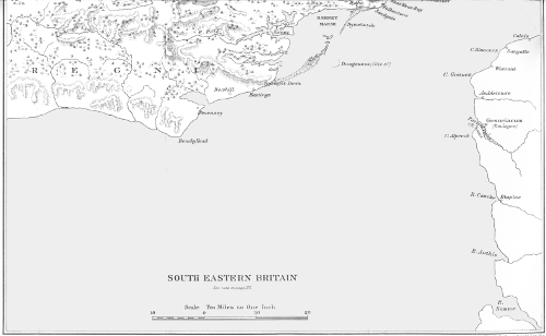
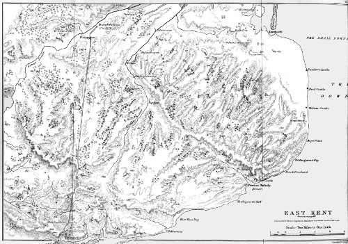
Not less than a dozen different theories have been formed regarding
the place of Caesar’s landing. It has been identified with Weybourne
on the coast of Norfolk; with Richborough; with the
neighbourhood of Sandwich; with Deal, or, to speak more correctly,
the coast between Deal Castle and Walmer Castle; with Dover,
Folkestone, Hythe, Lympne, Hurst on the northern fringe of Romney
Marsh, Bonnington near Appledore, Rye, Bulverhythe, and Pevensey.
Most of these theories, however, obviously fall into groups. Richborough,
Sandwich, and Deal; Hythe, Lympne, Hurst, and Bonnington;
Bulverhythe and Pevensey,—these three groups represent
three main theories, each of which has undergone modification in
detail. The rest may be summarily dismissed. The absurd suggestion
that Caesar landed in Norfolk was elaborated in two successive
pamphlets;2963 and, what is still more amazing, a zealous antiquary
thought it necessary to devote a third2964 to its refutation. Neither
Folkestone nor Rye has now any advocates; and the absurdity of
their pretensions must be self-evident to every intelligent reader of
the Commentaries. The theory that Caesar landed at Dover is only
worth mentioning because it was seriously maintained by the
eminent geographer, Konrad Mannert;2965 and perhaps Heller underestimated
the acumen of his readers when he took the trouble to
confute it.2966 The claim of Bonnington was maintained with considerable
ingenuity by a professional advocate in a book2967 which
George Long,2968 who dissented from its conclusions, commended as
‘a work of real value’; and it would not be safe to ignore it.
Even the view that Caesar landed at Pevensey demands consideration.
It was first put forward in 1852 by the late Astronomer
Royal, who defended it against a series of attacks with equal ability
and vivacity: a few years ago it was resuscitated by Professor
Ridgeway: Mr. Warde Fowler2969 observes that ‘much can be said
in favour of this opinion’; and the late Camden Professor of Ancient
History in the University of Oxford2970 was inclined to accept it. But
the controversies which have attracted most attention have been
centred between the advocates of Lympne or Hythe on the one side
and of Deal or Sandwich on the other. And, although there are
many collateral questions, the chief point at issue is this,—when
Caesar sailed with wind and tide in his favour from the place where
he anchored on the morning of his first voyage, and steered for the
place where he landed, was the tidal stream running up or down
the Channel? Among those who have recently approached the
subject the prevailing belief would appear to be that it has been
proved that he sailed down. ‘The old belief,’ writes Mr. Warde
Fowler,2971 ‘that he turned eastwards and landed at Deal cannot, in
the present state of our knowledge of the tides, be any longer maintained.’
I engage to convince every reader who will give me his
attention that the so-called proof is no proof at all.
Before we attempt to construct a tide-table for the 26th and 27th
of August, 55 B.C., we must first satisfy ourselves whether in that
year, at any given period of the moon’s age, the tidal stream in the
eastern part of the English Channel began to flow and to ebb at
precisely the same time as it does in similar circumstances now.
On this point there has been much divergence of opinion. Dr.
Guest, the late geologist George Dowker, and Professor Montagu
Burrows have all argued that the changes which have taken place
in the configuration of the coast2972 must have produced changes in
the tidal currents. The points on which Dr. Guest laid special
stress were, that in Caesar’s time Thanet was an island; that
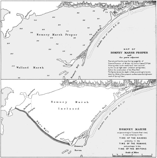
Dungeness did not then exist; that Romney Marsh was covered at
high tide by an estuary 50,000 acres in extent; and that the estuary
of the Thames was far wider than it is now.2973 Dowker called attention
to the great changes which, since Caesar’s time, must have
taken place in the Goodwin Sands: ‘would no effect,’ he asked,
‘be felt by the tides if the Goodwins were now an island?’ Again,
observing that Drew ‘points out how the beach formerly near Rye
had been swept away, and re-deposited in a different direction’,
he concluded that ‘geological changes of outline have altered the
direction and velocity of the currents’.2974 Some years later he returned
to the subject. ‘If,’ he wrote,2975 ‘we assume the Straits
are now one mile wider than when Caesar visited our shores,2976 the
tide which runs with a velocity of about three miles an hour up
Channel, would carry more water into the German Ocean than
a river a mile wide and 15 feet deep.... There are other changes
also that have taken place in the German Ocean, which must have
exerted immense influence on the tides when we remember that
a north-east wind will materially heighten the tidal lever by forcing
up the water of the North Sea. The travelling of beach in an eastward
direction shows that the set of the tide is more strong in that
direction now on some part of the coast than formerly.’ Finally,
Professor Montagu Burrows remarks2977 that ‘Not only may the
depth of the Channel have largely varied, but the space over which
the tides travel must be at least two miles wider than it was some
2,000 years ago,2978 and therefore the point of meeting of the North and
South tide-streams cannot possibly be exactly the same’.
On the other hand, Airy says, ‘I express my opinion without
hesitation that no conceivable changes in the coast within historical
times can have produced any sensible change in the relation
of the tidal currents to the moon’s age.’2979
I have submitted these remarks to Sir George Darwin, the author
of the articles on the tides in the Ninth Edition of the Encyclopaedia
Britannica and the Supplement to that edition. ‘In my opinion,’
he replies, ‘Airy is absolutely right and Burrows and the others
wrong. A channel from Sandwich to Reculver could not have made
any sensible change, and so also it would be impossible to detect
the difference if Goodwin Sands were an island. All the phenomena
now observed must have occurred at the same times within, say,
a minute, and with an intensity measurably identical in the days
of Caesar. Even if you were in a position to indicate exactly the
nature of the changes in the channel since that time, it would be
impossible to compute the nature of the excessively minute changes
in the currents.’
This decisive answer will not be seriously gainsaid. Evidently
the divergence of opinion is between those who are not and those
who are qualified to judge.
Airy says that ‘on the day of Caesar’s landing the tide off Dover
turned to the west about 1 h. in the afternoon, and at 3 h. it would
be running with a strong stream to the west’.2980 Airy, as we have seen,2981
supposes that the day of Caesar’s landing was the 28th of August;
but if the statement which I have just quoted is accurate, it follows
that even on the 26th the tide at 3 p.m. was running westward.
Again, in 1866, the Admiralty Hydrographer affirmed that on the
27th of August, 55 B.C., the current ran westward until 6.30 p.m.;2982
and if he is right, it must on the previous day, unless the circumstances
were abnormal, have continued flowing in the same direction
until 5 p.m. or later. Lewin,2983 relying upon a table compiled by
a Mr. Barton of Dover, and based upon observations made by
‘some experienced pilot or fisherman’, and upon another table
filled up from actual observation ‘on every day of July, 1862’,
states that ‘with high water ... at 7.31 a.m., the tide could not
turn eastward at the earliest until 4.26 p.m., and at the latest not
until 5.21 p.m.’ Nevertheless, he admits2984 that, with high tide at
7.31 a.m., the tide might possibly have turned eastward at 4 p.m.
Finally, Mr. H. E. Malden tells us that ‘at any time that afternoon
between two o’clock and seven, in any part of the Channel between
Dunge Ness and Dover, the tidal current was running westward ...
when Sir George Airy, the greatest authority of the century upon
the tides, says that they were the same then as now, cadit quaestio.
We are lifted out of the uncertainties of historical topography into
the certainties of scientific knowledge.’2985
This pronouncement is certainly calculated to overawe the timid
inquirer. Nevertheless, I venture to suggest that a man who knows
little or nothing about the tides should refrain from patting on the
back one who knew a great deal, but who did not think it necessary
for his purpose to tell all that he knew.
Airy may have been the greatest authority of the century upon
the tides: but, apart from his asseveration that they were the same
then as now, in the contribution which he made to the solution of
the problem which we are investigating he relied upon authorities
which are accessible to everybody. Those authorities (I will mention
a few besides those which Airy used) are the Nautical Almanac;
Tide Tables for the British and Irish Ports (published by order of
the Lords Commissioners of the Admiralty); the Channel Pilot;
Tidal Streams, English and Irish Channels (an Atlas of 12 charts
published at the Admiralty in 1899); Captain Usborne Moore’s
Report on Observations ... in the Straits of Dover (also published
at the Admiralty in 1899); an article by Admiral Sir F. W. Beechey
published in Philosophical Transactions, volume cxli, 1851, pages
703-18; and an article published in Archaeologia, volume xxxix,
1863, pages 277-302. The last-named article includes a report of
observations on the tidal streams in the Straits of Dover, made in
1862 under the superintendence of E. K. Calver, R.N. These
observations were made for the purpose of settling the question
whether the stream with which Caesar sailed from his anchorage
ran up or down the Channel. They were made ‘in comparatively
still weather’ on the 21st of August, the 4th and 5th of September,
and the 4th of October, 1862, at eleven distinct stations within
a space extending to one mile and a half from the shore, and from
the South Foreland to Shakespeare’s Cliff. The days on which
they were made were, reckoning inclusively, respectively the fifth
before the new moon, and the fifth, the fourth, and the fourth before
the full moon. ‘From the average of these observations,’ says
Calver, ‘it appears that, when high water at Dover occurs about
7 h. 30 m. a.m., the inshore flood or easterly-going stream ... turns
4 h. 48 m. after it is high water upon the shore. Taking then, for
example, a 7 h. 31 m. a.m. high water, and assuming that the ebb
or westerly-going stream runs on the average for 6¼ hours, it follows
that the flood or easterly-going stream on that day would turn off
Dover at 12 h. 19 m., and the succeeding ebb ... would run to the
westward until 6 h. 34 m. p.m.2986’ Vice-Admiral W. H. Smyth,
summing up the results of the observations, remarked that the tide
turned westward ‘soonest near the beach and latest in the offing’,
and that ‘the turn is sooner to the east of Dover than to the west,
still not differing more than one hour’.2987
So far as we have yet examined them, the results of these observations
fully bear out what Airy and Lewin maintain,—if it is assumed
that high tide at Dover on the day of Caesar’s landing must have
occurred about 7.30 a.m. But if we scrutinize the tables more
closely, and give due weight to certain other facts emphasized by our
authorities, we shall see that the dogmatism of Airy and Lewin is
unjustifiable. They and their followers make no allowance for the
great influence which winds exert upon the tidal streams in the
Channel.2988 Moreover, it is useless to base conclusions upon the
average of the results obtained in Surveyor Calver’s observations.
If we scan the tables which give those results in detail, we shall find
that although, on the average, the stream turned westward 4 h. 48 m.
after high water at Dover, yet on the 21st of August it turned only
3 h. 40 m. after high water.2989 We shall also find that the duration
of the flood, as observed by Calver, varied from 4 to 7 hours; and
although the duration of the ebb was only observed twice,2990 it may
actually have varied as much. On the first of the two occasions on
which it was observed it was 6 hours, 10 minutes; on the second,
only 5 hours, 53 minutes;2991 and, according to the Channel Pilot,2992 it
is occasionally only 4 hours. Therefore it is possible that if on the
day of Caesar’s landing high water occurred at Dover at 7.31 a.m.,
the tide may have turned westward as early as 11.11 a.m., and
may have continued to run westward for a period not longer than
5 hours, 53 minutes, that is to say, until 5.4 p.m.
But this is not all. It is desirable that the reader should become
acquainted with Lewin’s methods of reasoning. Lewin himself,
after studying the Admiralty Tide Tables for the year 1859, admits
that ‘on January 14th, being the fourth day before the full moon,
high water at Dover is at 5.31 a.m.’, and that it may possibly have
occurred as early on the day of Caesar’s landing. This admission
throws a breaking strain upon his theory; but by dint of dexterous
manipulation of the facts he is just able to make a show of saving
it from ignominious collapse. ‘As’ he says, ‘the stream turns at
four hours after high water, and continues for seven hours, it turns
at the earliest at 9.31 a.m. and runs till 4.31 p.m.... In no case,
therefore, would the tide be running east at 3 p.m.’ But Lewin
is here compelled to ignore observations of which, in another part
of his book, he makes free use. As we have already seen, he admits2993
that on a day when high tide occurred at 7.31 a.m. the stream might
turn eastward at 4.26 or even at 4 p.m. If he is right, it follows
that on a day when high tide occurred at 5.31 a.m. the stream
might turn eastward at 2.26 or even at 2 p.m. To make this admission,
from which, if he had been confronted with his own words,
he could by no subtlety have escaped, would have been to throw
up his case; and such candour would have been too much to expect
from a professional advocate. Let him, however, shift his ground,
if he pleases, and rely upon Calver’s observations. They will not
avail him. We have just seen that, according to Calver, the stream
turned westward on the 21st of August, 1862, 3 h. 40 m. after high
water; and the duration of the westward stream, on one of the
two occasions on which he observed it, was only 5 h. 53 m.2994 According
to these data, if, on the day of Caesar’s landing, high tide had
occurred at 5.31 a.m., the westward stream might have ceased at
3.4 p.m. It would have been impossible for Lewin, if he had been
required to take account of this statement, to deny it. But to admit
it would have been to sign the death-warrant of his own theory.
So far I have only been concerned to show that Lewin’s whole
train of reasoning, examined in the light of the evidence which
he himself adduces, is radically unsound. I have argued on his
hypothesis—that high tide at Dover, on the day of Caesar’s landing,
may have occurred at the earliest time at which it can possibly
occur on the fourth day before the full moon. Neither Lewin nor
Airy nor any other commentator has attempted to determine, by
the aid of lunar tables, the hour at which, on the day in question,
high tide did actually occur.2995 Nevertheless, if the problem which
we intend to solve is to be attacked in a scientific spirit, the hour
ought to be determined. Messrs. John A. Sprigge, William Fraser
Doak, M.A., F.R.A.S., and T. Charlton Hudson, B.A., F.R.A.S.,
all of the Nautical Almanac Office, have been so kind as to determine
it for me. Their calculations are preserved; and at the end of this
article, on page 665, will be found a memorandum, in which they
have described the method on which they worked. It will be sufficient
here to state the results, the error in which, as they point out,
is probably insignificant. On the 26th of August, 55 B.C., the Greenwich
mean time of high water at Dover was 6.21 a.m.; on the 27th,
7.42 a.m.; and on the 28th, 8.44 a.m.2996 Thus it turns out that on
the day of Caesar’s landing high water did not occur at all early.
This fact, however, will not sustain the theory of Airy and Lewin.
Since high water at Dover on the 26th of August occurred at 6.21
a.m., and since the tidal stream, according to one of Calver’s observations,
turned 3 hours, 40 minutes after high water, the stream
may have turned westward at 10.1 a.m. Assuming that the duration
of the westward stream was 5 hours, 53 minutes—the same as
that recorded on one occasion by Calver—the stream would have
ceased at 3.54 p.m. But Calver’s observations were made ‘in
comparatively still weather’;2997 and, to quote Admiral Beechey,
‘winds greatly affect the time of turn of the stream.’2998 Now Caesar
sailed from his anchorage with wind as well as tide in his favour;
and the wind which carried him to his landing-place may have
accelerated the turn of the stream. It is clear, therefore, that on
the day of Caesar’s landing the stream may have turned eastward
earlier than 3.54 p.m.; and if it turned twenty-five minutes earlier,
it turned in ‘the ninth hour’.
But, it will be objected, Caesar may have landed on the 27th of
August; and in that case the stream could not have turned eastward
before the close of the ninth hour. Certainly it could not
have done so unless it had turned westward unusually early, or
unless its westward duration had but little exceeded four hours;
and although this has been shown to be within the bounds of possibility,2999
it is to the last degree improbable. But if he landed on the
26th of August, an assumption which has been proved to be not
inconsistent with his narrative,3000 it is not improbable that the stream
may have turned eastward in the ninth hour; and this is all that
I am concerned at present to show.
It may be said that, in order to refute the dogma of Airy and
Lewin, I have supposed an extreme case. I can only say that I did
not start with the intention either of refuting or defending that
dogma: I merely examined it, and found that it would not bear
examination. And I am justified in supposing an extreme, or rather
an exceptional, case because Airy and Lewin have both affirmed
that it is absolutely impossible that in the ninth hour on the day of
Caesar’s first landing in Britain the tidal stream can have been
running towards the east. But, supposing that it did not turn
eastward until after the ninth hour, still the theory that Caesar must
have sailed in the opposite direction will not stand. For the reader,
if he has patience to bear with me to the end, will convince himself,
from Caesar’s own words, that Caesar did not stir from his
anchorage until after the ninth hour had passed.
The two distinguished advocates of the theory that Caesar landed
at Pevensey are not in complete accord. Airy holds that he sailed
both in 55 and in 54 B.C. from the mouth of the Somme;3001 Professor
Ridgeway from Wissant.3002 It has been proved in my article on the
Portus Itius that he started from Boulogne; and whoever accepts
that proof will, perhaps, skip this section. I am willing, however,
for the sake of argument, to accept in turn both Airy’s identification
of the Portus Itius and that of Professor Ridgeway: but I may
remark that when Airy wrote he had forgotten that in Caesar’s
time there was a natural harbour at Pevensey;3003 and if Caesar had
landed in a harbour he would not have left the fact unnoticed.
If we are to accept the premiss on which Airy himself lays so
much stress, namely, that in 55 B.C. the tidal currents in the Channel,
at any given period of the moon’s age, were the same as they are now,
Caesar did not land at Pevensey. Airy, as we have seen, assumes
that Caesar landed, in 55 B.C., on the third day before the full moon,
and, appealing to the authority of Sir F. W. Beechey, he affirms
that, off Hastings, the current turns westward five miles from the
coast two hours later than it does close inshore. ‘If,’ he concludes,
‘we suppose Caesar to have first attempted the neighbourhood of
St. Leonards, the tide, which a few miles from shore had turned
to the west at 11 h., was, at 3 h., running in full stream to the west.’3004
But, in order to prop up his theory, Airy is forced to place Caesar’s
anchorage at five nautical or nearly six statute miles from the
shore. To prove that such an assumption is absurd, it is only
necessary to say that, at a distance of five nautical miles, Caesar
could not have seen the armed men who, as he tells us,3005 were swarming
upon the cliffs, without the assistance of a powerful telescope.3006
Lewin3007 rightly concludes that Caesar must have anchored within
a mile from the shore, at the outside, and probably within half a mile.
Now high water at Dover on the 27th of August, 55 B.C., occurred
at 7.42, and therefore at Hastings at 7.23 a.m.3008 But off Hastings,
within a mile from the shore, the current turns westward about
the time of high tide,3009 runs westward for about six hours and a half,
and then runs eastward for about six hours. At 3 p.m., therefore,
on the 27th of August, the tide off Hastings would have been running
eastward, and would have continued to do so until about 7.50 p.m.
And on the 28th of August, which Airy wrongly assumes to have
been the day of Caesar’s landing, the tide off Hastings would have
turned eastward about 2.53 p.m., and would have continued to
run in that direction until about 8.53. Consequently, on the theory
of the tides which Airy himself so strenuously maintains, it would
have been impossible for Caesar to sail with the tide from Hastings
or from St. Leonards to Pevensey.3010 Even on Airy’s assumption
that Caesar anchored five nautical miles from the shore, his theory
cannot stand: he can only make a show of propping it up by assuming
that Caesar landed on the 28th of August. On the 27th,
the stream would have turned westward at about 9.30 a.m., and
would have ceased running westward about 4 p.m. Therefore, even
supposing that Caesar started on his seven miles’ sail in the ninth
hour,3011 he would have done so on the very last of the tidal stream,
when it was barely moving; and it would have turned against
him before he had half finished his voyage.
Very wisely, from his own point of view—for his silence has
hitherto passed unnoticed—Airy ignored Caesar’s account of the
voyage of his cavalry transports. Some of them, as we have seen,
were ‘swept down in great peril’ (magno suo cum periculo deicerentur3012),
evidently running before the gale, ‘to the lower and more
westerly part of the island’ (ad inferiorem partem insulac quae est
propius solis occasum3013): the others were carried back to the port
from which they had started. That port, according to Airy, was
the mouth of the Authie. The gale evidently blew from about the
north-east; but, in order to give Airy the fullest latitude, I will
assume that it was from the north-north-east, although in either case
the ships which ran before the wind, once they had got under the
lee of Beachy Head, would have been in smooth water! The
course which the transports would have had to steer for the Authie,
if they had been sighted off Pevensey, would have been SE. by
E. 2° S., or within less than nine points of the wind. But in the
gale they could hardly have made less than four points of lee-way.3014
Therefore, in order to reach their supposed destination, they would
have been obliged to lie within less than five points of the wind,
which they could not have done.3015 ‘No!’ said the harbour-master
of Dover to me, after he had studied the chart, ‘No! they would
have fetched Dieppe.’3016 I have assumed that they could work to
windward: if they could not, it is self-evident that they could not
have returned to the mouth of the Authie.
But if any one is not convinced, let him hear Airy plead his own
cause.
1. Airy argues that Volusenus would never have recommended
Caesar to land under the cliffs of Dover, or at any point under the
cliffs between Folkestone and Hythe. ‘No commander,’ he says,
‘would steer ships to a mural cliff three hundred feet high, with
the intention of landing in order to invade the country; nor would
any defenders station themselves there to repel an invasion; nor
could a “telum” be thrown with any aim. But a daring officer
might steer to a less perpendicular cliff, ten to thirty feet high,
with the intention of forcing a landing.... Such are the cliffs between
Hastings and Pevensey; and I conclude that they answer exactly
to Caesar’s description.’ Assuming that the cliffs off which Caesar
anchored, when he first approached the British coast, were in the
neighbourhood of St. Leonards, Airy affirms that ‘the run of eight3017
miles would bring him to the beach of Pevensey, answering perfectly
to his description’.3018
Now whether Caesar did or did not steer towards ‘a mural cliff
three hundred feet high’, he certainly anchored off cliffs which he
calls ‘precipitous heights’ (angusti montes); and Airy makes too
great a demand upon our credulity when he requires us to believe
that Caesar described by the words angusti montes a ‘cliff ten to
thirty feet high’. So much for the theory that Caesar anchored off
the clifflets of St. Leonards:3019 the argument that he could not have
anchored off the cliffs of Dover shall be considered in its proper
place. The reader has of course already observed that Volusenus,
being a sane man, would never have recommended Caesar to ‘force
a landing’ under any cliffs, great or small.
2. Airy argues that the Britons would naturally have assembled
at Pevensey in order to oppose Caesar’s landing, because ‘Pevensey
was the weakest point of Britain’.3020 No! replies Lewin, Pevensey
was not then the weakest point; for it was ‘backed by the Andred
Forest’.3021 Airy3022 triumphantly observes that William the Conqueror
landed there; but Lewin3023 rejoins that when William landed the
forest presented less difficulty to an invader than in Caesar’s time,
as the Romans and the Saxons must have made clearances. Be
this as it may, it is certain that William did not attempt to march
northward through the forest. He returned, immediately after
his victory, to Hastings: from Hastings he marched eastward to
Romney, and from Romney to Dover.3024 He had his own reasons for
landing at Pevensey: but Caesar, for reasons equally good, chose
the shortest passage; and although, as I have shown,3025 these words
are not to be taken in an absolutely literal sense, they alone exclude
the notion that Caesar landed in Sussex. Obviously it is in the
last degree improbable that Volusenus would have reconnoitred
the coast so far westward as Pevensey; nor could the Britons have
expected that Caesar would be so foolish as to double the length of
his voyage in order to land there.3026
3. Airy argued that, except on the hypothesis that Caesar landed
at Pevensey, it is impossible to account for the long duration of his
first voyage. His rate of sailing, said Airy, if, as Dr. Guest maintained,
he had started from Wissant and anchored off the Dover
cliffs, would not have exceeded two miles an hour. ‘When in Shetland,’
he adds, ‘I have sailed in one of the ordinary fishing-boats
of the country, hoisting a single lug-sail ... with a pleasant, easy
breeze (sometimes dying away), from Lerwick to the head of Balta
Sound, in Unst, in about eight hours. The distance, as measured
on the Admiralty Chart, exceeds forty nautical miles.’3027
This was one of Airy’s more plausible arguments; and it demands
consideration. To begin with, it must be pointed out that Caesar
did not, as Dr. Guest believed, sail from Wissant, but from Boulogne,
which is more than seven nautical miles further from Dover. Airy
assumed3028 that Caesar’s first voyage lasted from midnight till 10 a.m.
But it is impossible to say how long it lasted. Caesar does not say
that he started at midnight: he says that he started ‘about the
third watch’ (tertia fere vigilia); and the third watch lasted, on the
night of the 25th-26th of August, from midnight till 2.32 a.m.,
on the night of the 26th-27th till 2.33 a.m.3029 Nor does he say that
he reached Britain at 10 a.m.; he says that he reached it ‘about
the fourth hour of the day’, which lasted on the 26th of August
from 8.33 to 9.42.3030 As Mr. Peskett says, ‘the possible duration of
the voyage lies between the extreme limits of 9 h. 40′ and 6 hours.’3031
Split the difference, and you will find that the average rate of sailing
would have been about three knots and a half per hour. The answer
to Airy’s argument is that Caesar’s narrative is quite consistent
with the view that his ships may have remained for some time
anchored off the Gallic coast in the expectation that the cavalry
transports would sail out of Ambleteuse harbour to join them;
and, further, that the wind may have shifted to an unfavourable
quarter before the voyage was at an end.3032
4. Airy3033 maintains that a river corresponding with Caesar’s
description of the one on the banks of which he defeated the Britons
on the day after his second landing,3034 is to be found in the neighbourhood
of Pevensey, and of Pevensey only. That river, he says,
was the Rother, and the scene of the victory was Robertsbridge.
He produces evidence to show that if Rye Sluice were broken,
‘the whole valley at Robertsbridge would now become a great tidal
morass.’ This, he continues, ‘was its state in the age of Caesar,
and it must have been a very formidable defence against an army
advancing from the coast.’
Undoubtedly; so formidable that it would have been absolutely
impassable. How Caesar’s cavalry succeeded in forcing their way
over this ‘great tidal morass’ Airy omits to explain. If he had
studied Caesar’s description3035 of the much less formidable morass
over which his ablest marshal, Labienus, tried in vain to construct
a causeway, and from which he was obliged to retreat, he would
hardly have made Caesar attempt to cross ‘a great tidal morass’
in the face of an enemy.
Caesar, as we have seen, descried at daybreak, on his second
voyage, the coast of Britain ‘lying behind on the left’;3036 and if
these words mean, as all commentators except Airy and Professor
Ridgeway maintain, that he had drifted to some point east or north-east
of the South Foreland, they alone dispose of Airy’s theory. Airy
of course saw this; and accordingly he put his own construction
upon the passage. ‘I cannot conceive,’ he says,3037 ‘that the expression
refers to any direction but to that of the drift; it asserts that,
in reference to the direction of tidal current, the coast was on the
left hand. It is therefore indecisive as to place.’
Lewin, in his reply,3038 overlooked one consideration, which by
itself overthrows Airy’s interpretation. If, as Airy would have us
believe, Caesar’s vessel had not drifted as far east as Dover, she was,
owing to the direction of the current, moving parallel with the
British coast.3039 How, then, could Caesar, in the case supposed by
Airy, have said that he saw Britain ‘lying behind on the left’ (sub
sinistra relictam)?
The theory that Caesar landed at Pevensey is irreconcilable with
the fact that the four chieftains who attacked his naval camp in
54 B.C. belonged not to Sussex but to Kent.3040 Airy endeavoured
to answer this objection by the remark that the men of Kent were
more numerous than those of Sussex, and would therefore have
gone to the assistance of their countrymen.3041 But, replied Lewin,3042
‘as the men of Kent were distinct from the Regni, or men of Sussex,
the natural inference to be drawn from the assault of the camp by
the men of Kent surely is that the camp was in Kent.’ I may point
out further that, considering the state of internecine war in which
the Britons habitually lived, and which was only suspended for the
time under the pressure of a common danger,3043 it is not credible that
the men of Kent would have consented to make a long march away
from their own territory in order to undertake an operation which
would have properly devolved upon another tribe, and unlikely
that they would have been sufficiently well organized to feed their
army during a march of such duration.
The distance between the mouth of the Somme, which Airy
identifies with the Portus Itius, and St. Leonards, where he maintains
that Caesar first reached Britain, is, as he himself says,3044 ‘about
52 nautical miles,’ that is to say, rather more than 65 Roman miles:
the distance between the Portus Itius and Britain, according to
Caesar’s estimate,3045 was about 30 Roman miles. To say nothing of
this glaring discrepancy, Caesar’s account of his return voyage from
Britain to Gaul in 54 B.C. presents a difficulty which taxed all Airy’s
ingenuity to explain away. Caesar3046 tells us that he started in the
second watch in a dead calm (summa tranquillitate), and reached
Gaul at daybreak. Naturally the opponents of Airy’s theory insist
that to cross from Pevensey to the mouth of the Somme in this
time would have been impossible.
But Airy is never so confident as when he has to defend an untenable
position. He roundly asserts that his critics do not understand
Caesar’s language. Summa tranquillitas, he tells them, does not
mean ‘a dead calm’: it means ‘a stiff north-west wind’. Professor
Thompson, he informs us, assured him that a favourable wind ‘is
compatible with a “tranquillum mare”’; and he refers, in support
of this view, to a passage in one of Cicero’s letters,3047—‘I am forced
to wait for fair weather owing to the open ships ... of the Rhodians’
(Nos Rhodiorum aphractis ceterisque longis navibus tranquillitates
aucupaturi eramus). He also appeals to two passages in Vergil:—
placidi straverunt aequora venti,
Creber et adspirans rursus vocat Auster in altum,3048
and
postquam alta quierunt
Aequora, tendit iter velis portumque relinquit.3049
‘It appears to me,’ he observes, ‘that Virgil’s idea of circumstances
favourable to navigation always implied the co-existence of brisk
wind and smooth water.’ The idea that Caesar’s fleet was rowed
across the Channel he scouts as ridiculous. ‘If,’ he adds, ‘with
smooth water there had been a brisk breeze, the steerage would
have been good ... the voyage would have been easy ... we have
only to suppose a stiff north-west wind, capable of carrying the ships
7 or 8 miles an hour.’3050
Now as to the first of these passages, the context shows that
Cicero had been weatherbound by the violence of the trade winds;
and he uses the word tranquillitates in the sense of ‘fine weather’
in contrast with these.3051 His vessels were undecked; and therefore
he could not venture to set sail in a rough sea. It can hardly be
inferred from this passage, which Airy does not understand, that
summa tranquillitas means ‘a stiff north-west wind’. The first
passage quoted from Vergil simply says that gentle winds (placidi
venti—an expression by no means identical with summa tranquillitas)
stilled the sea, and that then a southerly wind invited Aeneas to
set sail: the second tells us that Aeneas set sail after the cessation
of a storm. If Cicero does not imply that summa tranquillitas means
‘a stiff north-west wind’, neither does Vergil. If Airy had really
known his authorities, he would have called to mind the passage in
which Cicero3052 relates, in language virtually identical with that of
Caesar, that he was prevented from sailing by ‘an astonishingly
dead calm’ (mirae tranquillitates). And if he had known his Caesar,
he would have thought of the passage3053 which tells how the ships of
the Veneti were becalmed in their fight with Decimus Brutus,—‘suddenly
there was a dead calm, and they could not stir’ (tanta
subito malacia ac tranquillitas exstitit ut se ex loco commovere non
possent). If tanta tranquillitas means ‘such a dead calm’, as it
assuredly does, it is not easy to see how summa tranquillitas can
mean ‘a stiff north-west wind’. If these passages do not fix the
meaning of summa tranquillitas, we may dispense with further
research.3054
I confess that I do not know whether more to admire the audacity
and resource which Airy displayed in controversy, or the sublime
lack of humour which permitted him to translate summa tranquillitas
by ‘a stiff north-west wind’.
So much for the late Astronomer Royal. If I do not ignore the
arguments of Professor Ridgeway, it is because I am unwilling to
appear wanting in due respect for his reputation. But I would ask
him to explain one little difficulty which he has left unnoticed,—namely,
how Caesar’s cavalry transports could have contrived to
return, as, on his theory, they must have done, from a point near
Pevensey to Sangatte, that is to say, to steer E. 9° N. in the teeth
of a gale which unquestionably blew from some point east of north?
Let the professor consult any seafaring man, and he will learn that
such a feat would have been absolutely, absurdly impossible.
1. Professor Ridgeway labours to show that the distance of
Pevensey from Wissant corresponds with the distance, as stated by
Caesar, of Britain from the Portus Itius. He assures us that,
according to certain MSS. (which, however, he does not specify),
that distance was not ‘about thirty’, but ‘about forty miles’
(circiter milium passuum XXXX....a continenti3055).
It is surprising that so distinguished a scholar should have committed
himself to a statement which five minutes’ search in any
critical edition of the Commentaries would have shown to be unfounded.
The MSS. to which he appeals have no existence; or,
if they exist, they have never come to light.3056 But, as I have already
shown, on other grounds,3057 Caesar may have written XXXX; so let
Professor Ridgeway have the benefit of the doubt, though I need
hardly say that the distance of Pevensey, and even of Bexhill, from
Wissant is much more than forty Roman miles.
2. The professor then invokes the authority of Dion Cassius.
‘If,’ he argues, ‘Caesar, on coming into the land of the Morini,
found, as Dio says, that all the landing places opposite the continent
were held by Britons, by which he evidently means the landing
places in the narrow part of the Channel, would Caesar obstinately
persist in crossing at the narrowest spot, or like a wise general seek
for a more suitable, although more distant landing place?’ This view,
he pleads, is supported by the fact that Caesar describes the passage
from the Portus Itius not as the shortest, but simply as the most
convenient (commodissimus).3058
Mr. H. E. Malden makes the obvious reply that Caesar did not,
in point of fact, avoid the landing-places in question for the reason
suggested by Professor Ridgeway; for ‘he landed in the teeth of
a British army’.3059 Moreover, as we have already seen, Caesar tells
us that he sailed from the coast of the Morini ‘because the shortest
passage to Britain was from their country’.
3. The professor contends that his theory is supported by Caesar’s
account of his voyage in 54 B.C. Mr. Malden3060 told him that Caesar
could not have sailed from Wissant [or, as he ought to have said,
from Boulogne] to Pevensey with a south-west wind;3061 and that,
since the tide must have carried him in 54 B.C. at least as far as
the South Foreland,3062 it would have been impossible for his men to
row to Pevensey—a distance of fifty-five miles—between dawn and
noon, that is to say in less than nine hours. The professor replied
to the former objection that Caesar ‘evidently sailed, not direct
for Pevensey, but rather across Channel’.3063 The reply was as true
as it was futile; but it was true only because Caesar was bound,
not for Pevensey but for East Kent. Mr. Malden’s second objection
the professor endeavoured to rebut by the following arguments:—First,
that as Caesar’s men began to row at 3 a.m.,3064 continued rowing
till noon, and had the tide in their favour for the first six hours, they
could, if necessary, have rowed fifty-five miles in nine hours. Secondly,
that fifty-five miles is an excessive estimate; and that the actual
distance was not more than thirty-nine; for accessum est ad Britanniam3065
[the words by which Caesar describes the arrival of his fleet]
‘seems to denote nothing more than what he expressed by the words
Britanniam attigit3066 in the story of the former voyage. But,’ continues
the professor, ‘he did not land at all at the place where he
Britanniam attigit, but dropped down with the tide seven miles
further. Moreover, Caesar does not say that he made for the very
spot where he had landed before, but simply remis contendit ut eam
partem insulae caperet qua optimum esse egressum superiore aestate cognoverat3067
[“rowed hard to gain the part of the island where, as he had
learned in the preceding summer, it was best to land”]. The high
cliffs formed his landmark.’ The professor is presumably referring
to the cliffs eight miles east of Pevensey, which, as Airy points out,
are ‘from ten to thirty feet high’: these cliffs would evidently
have made a most conspicuous ‘landmark’. However, the professor
contrives to reduce the length of the voyage by eight miles at
one end: he curtails it at the other by simply denying, like Airy,
that when Caesar ‘saw Britain lying behind on the left’, he had
drifted past the South Foreland. He insists that Caesar ‘might
use the word relictam [‘left behind’] when, instead of finding
himself close to the shore of Britain, he discovered that, between
the course he had sailed and the way he had drifted, he had moved
away from Britain’.3068 This remark only shows that the professor
did not know what was the direction of the flood tide. Unless
Caesar had got past the South Foreland by the time when he ‘saw
Britain lying behind on the left’, the tide had not carried him ‘away
from Britain’.
The professor’s argument comes to this. He says that Caesar’s
men rowed as hard as they could; that they could have rowed
fifty-five miles in nine hours, but that they only did row thirty-nine!
He asks us to believe that they rowed fifty-five miles in nine hours,
though, on his own showing, the tide was against them for one-third
of that time!3069 Finally, when he argues that because Caesar did not
land in 55 B.C. at the point where he Britanniam attigit, therefore
he did not land in 54 B.C. at the point where accessum est ad Britanniam,
he forgets two things:—first, that Caesar distinctly says that
in 55 B.C. he sailed on seven miles from the point where he first
Britanniam attigit, whereas all commentators except Professor
Ridgeway have drawn from Caesar’s narrative the inevitable
inference that in 54 B.C. he landed at the point where accessum est
ad Britanniam; secondly, that the Britons expected him to land
in 54 B.C. at the point where accessum est ad Britanniam, for ‘large
forces had assembled there’ (magnae manus eo convenissent). Does
the professor seriously mean to argue that if Caesar had landed
elsewhere, he would not have said so?3070
Not a single argument of the least weight has been or can be
adduced to show that Caesar landed at Pevensey or anywhere on
the coast of Sussex.3071 On the other hand, there is not a single
objection which has here been brought against that theory which
is not alone sufficient to overthrow it. The truth is that Airy, with
all his scientific knowledge and controversial skill, was not adequately
equipped to discuss the question: his classical scholarship left
much to be desired; and, having once committed himself to the
preposterous theory that the Portus Itius was in the estuary of the
Somme, he was forced to look for Caesar’s landing-place far to the
west of that part of Britain in which Caesar’s narrative inevitably
places it. To that part of Britain our inquiry must henceforth be
confined. Whether Caesar landed east or west of the cliffs of Dover,
he landed in Kent.
The most dexterous advocate of the theory that Caesar landed on
Romney Marsh was Thomas Lewin; and it says a great deal for his
persuasiveness that not one of his critics appears to have detected
the inconsistencies with which his work abounds. Those which
vitiate his argument, in so far as it relates to the tides, I have mentioned
already.3072 The rest all spring from one and the same source.
When Lewin wrote his book, he adopted a theory as to the configuration
of Romney Marsh which, after obtaining what he considered
‘more accurate information’,3073 he discarded. This information he
embodied in an appendix to his second edition; but at the same
time he allowed the statements based upon his former researches
to stand. Thus on page 65, note 4, he implies that ‘the heart of the
marsh’ was inhabited; but in his preface (pages v-vi) he affirms
that ‘the eastern end of the Marsh where Caesar arrived was as
much terra firma in his day as in our own’, virtually admitting, as
the context and the map which faces page liii alike show, that the
rest was inundated at every high tide. On page 92 he says that
‘the sea, as is proved incontestably by the fragments of ships and
anchors which have been dug up, flowed to the very base of the hill,
and formed there the port of Limne. Stutfall [castle], therefore,
was formed for the protection of the shipping.’ On pages lxviii and
lxix the incontestable proof is not only contested but flung to the
winds: ‘the fragments of ships and anchors’ are silently annihilated;
Stutfall Castle, it now appears, ‘was for the protection, not of the
port, but of Saxonicum littus’; and the ‘Portus Limanis’ (sic)
becomes a ‘narrow gut’, extending from a point near Shorncliffe
to West Hythe behind a bank of shingle broken by a narrow entrance
nearly opposite Hythe. In an article which Lewin contributed to
the fortieth volume of Archaeologia he remarks that if the Portus
Lemanis had been at the foot of Lympne Hill, ‘we should expect
to find some vestiges, however faint, of the port itself’: but, he
adds, ‘I have never heard or read (though I have often inquired)
that any remnant of a pier or sunken vessel, or even any anchor or
other part of a ship’s tackle, was ever discovered in this part.’3074 Are
we to infer, then, Mr. Lewin, that when you told us on page 92 of
your book that ‘fragments of ships and anchors’ had been ‘dug up’
at the foot of the hill, you were romancing? On turning back to
page 42, we find that the above-mentioned ‘narrow gut’ first came
into existence in the time of the Saxons; but on page lxix we learn
with bewilderment that it ‘must have continued such until the
abandonment of Britain by the Romans or nearly so’. In the
article which he contributed to Archaeologia Lewin changed his
mind again. In the map which illustrates this article the ‘narrow
gut’ extends no further westward than Hythe. On page 44 of the
book we read that Caesar landed on ‘the western side’ of ‘the
creek of Limne’ or ‘port of Limne’, the very existence of which
the author’s later and ‘more accurate information’ led him to
deny. On pages lxxii and lxxiv Caesar’s landing-place is silently
transferred from ‘the western side’ of ‘the creek of Limne’ to
Hythe. On page 44 two islands mentioned (according to Lewin)
by Valerius Maximus are identified with ‘two islands’ depicted on
‘old maps’ of ‘the bay of Limne’: on page lxxiii we are asked to
identify them with two ‘islands’ in the ‘narrow gut’ above
mentioned.
The reader now understands that, according to the theory of the
ancient configuration of Romney Marsh which Lewin adopted in
his Appendix and illustrated in the map facing page liii of his book,
it would have been impossible for Caesar to land opposite Lympne,
because on that theory the marsh between Lympne Hill and the
shingle beach was flooded by the sea at high tide. Nevertheless,
I shall consider the arguments by which Lewin defended his original
view—that Caesar landed opposite Lympne—because distinguished
scholars still hold that there was a harbour there in Roman times.
When we come to examine Lewin’s final view—that Caesar landed
at Hythe—we shall find some difficulty in doing justice to it; for
he carefully avoids committing himself to any clear explanation of
his meaning. If we look at his map3075 of the ‘narrow gut’, which
he believed to have extended from West Hythe to a point opposite
Shorncliffe, we shall see that, on his theory, Caesar must have done
one of two things. Either he must have landed on the shingle west
of the mouth of the gut, or he must have landed on the shingle
east of that mouth; for Lewin clearly gives us to understand that
the Roman ships did not sail into the harbour.3076 He maintains that
on the day on which the first landing occurred a fierce struggle took
place between the Romans and the Britons in ‘the field south of
Hythe’.3077 In order to reach this field, the Romans would have had
to walk along the shingle either westward or eastward, and then
along the northern shore of the ‘narrow gut’. But Caesar distinctly
states that as soon as the Romans stood on dry land, that is
to say, on Lewin’s own showing, on the shingle beach, they put the
Britons to flight.3078 What becomes, then, of the imaginary combat
in ‘the field south of Hythe’? Furthermore, Lewin, while he is
constrained to admit that this field is ‘below high-water mark’,
assures us that it was ‘certainly dry at low water’.3079 But he himself
strenuously maintains that the Romans began to land three hours
after low tide.3080 Perhaps he was uneasily conscious that he had
contradicted himself when he suggested that the Britons ‘would
unquestionably have possessed the skill to embank the port and
drain the land in the immediate neighbourhood’.3081
The theory that Caesar landed at or near Hythe involves another
mystery, which Lewin does not attempt to clear up. Where was
the camp which, in 54 B.C., Caesar linked by ‘a single defensive
work’ (una munitione3082) with the ships which he found it necessary
to haul up on dry land, and how was the defensive work constructed?
Lewin tells us that the ships could not possibly have been drawn
up opposite Shorncliffe, because the shore there ‘is rocky and
precipitous’.3083 Therefore, if the landing took place near Hythe,
they must have been drawn up on the beach west of Shorncliffe, and
on the seaward side of the ‘narrow gut’,—as he suggests, opposite
Hythe. If so, of what was the ‘defensive work’ composed? Surely
not of shingle? The entrenchments which a child constructs with
his toy spade at Margate would have been just as effective. But
if not of shingle, what other material was available on a shingle
beach? And what was the direction of the ‘defensive work’ which
connected the ships with the camp? Presumably the camp was
on dry land behind the ‘narrow gut’, and constructed not of shingle
but of earth. Now the entrenchment which protected the ships
and connected them with this camp could hardly have been carried
across the ‘narrow gut’, which was deeply submerged at every
high tide! I can only suppose, then, that the connecting work was
really constructed, by some occult process, of shingle; traced out
along the shingle beach either eastward towards Shorncliffe, or
westward to West Hythe Oaks, and then along the northern shore
of the ‘narrow gut’ until it joined the camp. Or if, as Lewin
suggests, the camp with which the ships were connected was distinct
from the camp which Caesar marked out on an ‘advantageous
position’ (loco idoneo3084) immediately after his second landing; and
if, as he affirms,3085 it ‘must have stood upon the seashore’, and its
site ‘must long since have disappeared’; then it can only be concluded
that camp and connecting work were both constructed of
shingle!
Again, it is incredible that a gale which drove some of Caesar’s
eighteen cavalry transports past Hythe or Lympne to a more westerly
part of the island should have carried the rest back to the port from
which they had started, which Lewin rightly identified with Ambleteuse.
If the ships had been approaching Hythe when the storm
arose, they would have been obliged, in order to return to Ambleteuse,
to steer SE. by E. 9° S.3086 Now Lewin himself maintains that
the gale blew from the north-east.3087 As a matter of fact, if it had
blown from this quarter at Lympne or Hythe, it would have been
practically innocuous; for off either of those places vessels would
have been sheltered from it by the hills, and the transports which
were driven westward would not have been, as they were, swept by
the waves: if the gale had blown from the north-east off Walmer,
its direction off Hythe would have been about east-north-east.3088
Still, for the sake of argument, I will accept Lewin’s view. According
to it, the ships would have been forced to sail within less than eight
points of the wind. But in a heavy gale a ship will make as much
as six points and a half of lee-way.3089 Let us reduce this estimate to
four, which is certainly a liberal reduction.3090 It follows that the hapless
transports would have been required, in order to reach their
destination, to lie within less than four points of the wind, a feat
which, I need hardly say, would have been utterly impossible.3091
Furthermore, Lewin affirms, in an unguarded moment, that the
gale, when a few hours later it wrecked Caesar’s ships as they rode
at anchor, was still blowing from the north-east: but he does not
explain how a north-easterly gale could have driven ashore, that is
to say, driven in a northerly direction, ships anchored off Lympne
or Hythe!
Such are a few of the absurdities in which Lewin’s theory plunges
him. However, he shall be heard in his own defence.
The argument upon which Lewin lays the most stress has been
already refuted.3092 He maintains that at the time when Caesar, on
the day of his first voyage, quitted his anchorage and sailed with
the stream to the spot where he was to land, the stream must have
been running down the Channel.3093 Let us assume, in order to allow
more than its due weight to his argument, that Caesar must have
weighed anchor as early as 3.30 p.m.,3094 though I shall afterwards
prove that the assumption is both unnecessary and false; and let
us also suppose that the tide did not actually turn eastward until
after 5 p.m. Even then, unless Caesar could have calculated the
exact time which it had still to run with more than the certainty of the
experts who prepare the Admiralty Tide Tables, he would have had
to face the risk that, before he could reach his landing-place, it might
turn against him. Even if Heller3095 is not right in interpreting the
words ‘getting wind and tide simultaneously in his favour’ (et
ventum et aestum uno tempore nactus secundum) as meaning that
Caesar weighed anchor just after the stream had turned, there can
be no doubt that this would have been the wisest course to pursue.
1. Having disposed, to his own satisfaction, of the question of
the tides, Lewin remarks that ‘Hythe would be much nearer than
Deal, and was the natural port for vessels from Boulogne’.3096
Yes, nearer by a bare two miles, and a few yards nearer than
Walmer! But, as Lewin himself insists,3097 Caesar, when he sailed
from Boulogne, did not intend to land either at Hythe or at Deal;
and unless he intended to sail direct to one of those places, Lewin’s
argument collapses. Moreover, since the greater part of the voyage
was made upon the easterly-going stream, it would have taken
longer to sail to Hythe than to the coast between Walmer and Deal.
And when Lewin affirms that Hythe ‘was the natural port for
vessels from Boulogne’, he apparently forgets that he has already
told us that ‘Folkestone ... would be the natural port for Boulogne’,3098
that Caesar’s fleet never entered Hythe harbour, and that ‘the
mooring of the Roman vessels within it would be certain destruction’.3099
2. Lewin attempts to show that the wind which carried Caesar
from Boulogne to his anchorage on his first voyage, and which
would, if it had continued, have been in his favour if he had intended
to sail on towards Deal, veered round before he quitted his anchorage.3100
His argument runs as follows:—‘Caesar says that he started from
his anchorage ... having got the wind in his favour, and the Latin
word nactus implies that the wind had undergone a change.... When
he embarked at Boulogne he despatched the cavalry to Ambleteuse ... with
orders to follow him with all haste; but ... they did not
leave that haven for Britain until the fourth day after,3101 and no
plausible reason can be given for this except that, for the whole
of this interval, the wind was contrary; that is ... had shifted.’
In a later passage3102 he maintains that if the wind had not shifted
during the voyage, the length of the passage, and especially the
tardy arrival of the transports, would be inexplicable. Moreover,
he says, the word nactus ‘implies a change either in the wind or
the tide: the tide had not changed, and therefore the change alluded
to must have been in the wind’.3103 While, however, he argues that
the wind must have shifted, he endeavours to secure his retreat by
affirming that, if it had not shifted, Caesar could nevertheless have
sailed to Hythe as easily as to Deal. ‘Supposing,’ he says,3104 ‘the
wind to have blown from the south, it would have been favourable
to a movement, from a point opposite Dover, either to the east or
west.’
I freely admit—indeed I have myself maintained—that the wind
had shifted during the voyage. It had shifted to a point unfavourable,
or comparatively unfavourable, to ships sailing from North-Eastern
Gaul to Britain. I also, like Lewin, maintain that it shifted
again before Caesar quitted his anchorage. The fact is obvious.
But what then? How can Lewin prove that before Caesar quitted
his anchorage the wind did not shift to a quarter which would have
been favourable to a run from a point off the cliffs of Dover towards
Deal? Moreover, it is not true that if the wind had ‘blown from
the south, it would have been favourable to a movement, from
a point opposite Dover, either to the east or west’. If the wind had
blown exactly from the south, it would certainly not have been
called favourable to a movement from a point opposite Dover to
Hythe, that is to say, within less than seven points of the wind; and
if the wind had blown from any point west of south, the word
‘favourable’ would have been still less appropriate.3105
3. Lewin maintains that the wisest course which Caesar could have
pursued when he sailed on from his anchorage in 55 B.C. would have
been to steer westward. ‘Let us first consider,’ he says,3106 ‘a priori,
what a prudent commander might be expected to do under similar
circumstances.... To the right he would see the precipitous chalk
cliffs stretching away ... till they terminated at the South Foreland.... The
lowlands about Walmer and Deal would not be visible; and
it is at least doubtful whether Volusenus had included them in his
survey ... tracing the line of cliffs westward, he could not fail to
see that they terminated at Sandgate, and that a broad level plain
there succeeded.’ At Hythe, he adds, there was a landing-place
‘distinctly visible from his moorings’.3107
This argument rests upon the absolutely groundless assumption
that Volusenus had not reconnoitred the coast on the north of the
South Foreland;3108 in other words, that Volusenus, whom Caesar
specially selected as a thoroughly competent man, had grossly
neglected his duty and disobeyed his instructions. Besides, even
if the landing-place at Hythe had been ‘distinctly visible’ from
Caesar’s moorings,3109 nothing would have been gained; for Caesar
acted, not upon what he could see, but, as he tells us himself,3110 upon
what he had learned from the report of Volusenus. Whether he
could or could not see ‘from his moorings’ the place where he was
to land, he knew the direction in which he intended to sail. Finally,
when Lewin considers ‘a priori’ that ‘a prudent commander might
be expected under similar circumstances’ to land at Hythe or
Lympne, he only advertises his own ignorance of a commander’s
business. As I shall show presently,3111 no commander who was not
hopelessly incompetent would have dreamed, in the circumstances
of ancient warfare, of attempting to land either at Hythe or at
Lympne.
4. Lewin contends in his text that at Lympne and in his appendix
that at Hythe there was a landing-place which exactly corresponded
with Caesar’s description; and he denies that any such landing-place
exists at Deal. He affirms3112 that the shore on the western
side of ‘the creek of Lympne’ was ‘apertum or open, for the heights
to the north were at least a mile distant. The sea-beach was also
molle or soft ... in a sailor’s sense, i.e. it consisted of shingle, than
which nothing can be more favourable to the security of vessels.... Sand,
on the contrary, is, in naval phraseology, of the hardest kind,
as it has no “give”, and a ship beating against it would soon be
dashed to pieces.’ He says that, according to Lucan,3113 Plutarch,3114
and Dion Cassius,3115 there was ‘marshy ground’ at the place where
Caesar landed, and he assures us that marshes were formed by the
streams which entered the port of Hythe.3116 He remarks that,
according to Valerius Maximus,3117 there were two small islands near
the landing-place, which were the scene of an exploit performed by
one of Caesar’s centurions: ‘on looking,’ he says, ‘at the old maps
of this part of the coast, I find ... that the bay of Limne contained ... two
islands.’ Like other people who had learned to measure
the trustworthiness of Valerius Maximus, Lewin had himself been
sceptical about the anecdote of the centurion; but how could he
resist the testimony of the ‘old maps’? He admits that he was
converted:—‘the circumstance, so apocryphal before, becomes thus
no inconsiderable argument for placing the descent in this locality.’3118
Afterwards he changes his mind, and transfers the islands some
distance to the east of Lympne. They actually existed, he tells us,
a few years before the publication of his book, ‘either near to or in
the ancient port of Hythe’; they also are depicted in various old
maps; and they were ‘carted away’ by the late James Elliott,
the engineer of Romney Marsh.3119 Furthermore, he assures us3120 that
the incident described by Valerius Maximus is also noticed by
Plutarch,3121 who ‘lays the scene in sight of Caesar himself, and
therefore close to the camp; and in a marsh or swamp, which, with
the light afforded by the account of Valerius, must be taken to mean
a lagoon subject to the alternations of the high and low tides’.
Now as to the exact meaning of the word apertum in the passage
to which Lewin refers, the commentators are not agreed. While
he insists that the beach on which he believes Caesar to have landed
was ‘open’, because ‘the heights to the north were at least a mile
distant’, Dr. Guest3122 denies that they were ‘open’, because ‘there
is a range of heights at no great distance’. According to Long,3123
‘“open” means that from the beach he could see into the country.’
Now any one who has read the Commentaries attentively will see
that all these explanations are wrong. For in his narrative of the
second expedition3124 Caesar tells us that he ‘felt little anxiety for
the ships, as he was leaving them at anchor on a nice open shore’3125
(eo minus veritus navibus, quod in litore molli atque aperto deligatas
ad ancoras relinquebat). If the explanations which I have quoted
were correct, the word apertum in this passage would be irrelevant.
Whether the ‘heights’ were ‘at no great distance’, or ‘from the
beach Caesar could see into the country’, the security of the ships
would not have been affected in the slightest degree. The word
apertum does not describe the country near the shore: it describes
the shore itself; and, as C. Schneider3126 says, apertum litus means
a shore free from such obstacles or dangers as rocks, boulders, and
the like.3127 But, even assuming that Lewin was right in his interpretation
of the word apertum, this much is certain:—the existence
of the heights to which he refers is alone sufficient to prove that
Caesar did not land either at Lympne or at Hythe or at any point
between those two places. This is a matter on which I confidently
appeal to any military expert who has studied the records of ancient
warfare. Caesar might no doubt have landed at Hythe without
any extraordinary difficulty; but if he had been so foolish as to
land there, he would have found that his difficulties were only
beginning. Never, even when fighting against an uncivilized enemy,
did he attempt to force his way up a hill if it was possible to avoid
doing so.3128 If he had landed either at Lympne or at Hythe, he could
not have turned the line of heights which extends behind those two
places: he could not have penetrated into the interior of the country
unless he had passed them; and he could not have passed them
except at a cost of life which the least experienced of his officers
would have been too prudent to incur. Furthermore, however
‘open’ the country may have been on the western side of ‘the
[imaginary] creek of Lympne’, he could not have landed there if,
as Lewin admits,3129 the country was under water at high tide.
The argument which Lewin bases upon the word mollis has no
value; for he does not fully understand the meaning of the word.
Mollis, in the passage which we are considering, simply means that
the shore was one where the anchorage was good, and where the
ships, if they were driven aground, would suffer comparatively
little:3130 it probably also implies that the shore was gently sloping.3131
Moreover, even if the word mollis implied that the shore on which
Caesar landed was composed of shingle, Lewin would not be justified
in concluding that Caesar landed at Hythe or Lympne unless he
could prove that no other shingle beach in Kent satisfied the requirements
of Caesar’s narrative.
The statements of Lucan, Valerius Maximus, Plutarch, and Dion
Cassius, upon which Lewin lays so much stress, are not really evidence
at all; and if he had been a classical scholar, he would never have
quoted them. Nor, indeed, was his scholarship sufficient to enable
him to understand what they meant. The passage quoted from
Lucan occurs in a rhetorical speech which he puts into the mouth
of Pompey:—
Rheni gelidis quod fugit ab undis
Oceanumque vocans incerti stagna profundi
Territa quaesitis ostendit terga Britannis.
Stagna of course simply denotes the English Channel, about which
Lucan’s ideas were vague; and the point of the line is the
suggestion that Caesar, in order to magnify the difficulties of
his expedition, mendaciously described ‘the pools of a shifting
sea’ as an ocean.3132 As to Valerius Maximus, the idea of going
to his collection of anecdotes for the details of Caesar’s military
operations is really funny;3133 but if he is to be counted an
authority, he does not support Lewin’s theory, but overthrows it.3134
Lewin3135 insists that ‘the vada described by Valerius Maximus as
caused by the flux and reflux of the tide are evidently the vada
referred to by Caesar (iv, 26)’. Now ‘the vada referred to by
Caesar’ were the shallow places of the shore on which he landed;
and ‘the vada described by Valerius Maximus’ were, according
to Lewin’s final view, in Hythe harbour. Yet Lewin emphatically
denies that Caesar landed in Hythe harbour! Furthermore,
Lewin assures us that the ‘islands’ of which Valerius Maximus
speaks were composed of earth, and have been ‘carted away’.
But Valerius Maximus says nothing about islands: the only
island which he mentions is Britain. As to the marshes, Heller3136
points out that Lewin is wrong in concluding from the narratives
of Plutarch and Dion that the coast on which Caesar landed was
marshy. Dion’s word τενάγη is simply his translation of Caesar’s
vada, and means not ‘marshes’ but ‘shallows’.3137 Plutarch, as the
words εἰς τόπον ἑλώδη καὶ μεστὸν ὑδάτων (‘into a marshy place
full of water’), which are explained by the following words ῥεύματα
τελματώδη (‘marshy [or muddy] streams’), clearly show, was not
speaking of a combat on the seashore, but of one which took place
inland; and when Lewin identifies Plutarch’s ῥεύματα τελματώδη
with Dion’s τενάγη, he simply exposes his own ignorance of Greek.
Moreover, Plutarch is so deficient in accuracy and precision that his
description of an incident of this kind is useless for the purpose of
topographical identification.
There is, therefore, no evidence that there was any marshy ground
at or near Caesar’s landing-place; and if there was, the fact does
not prove that he landed at Hythe.3138
5. Lewin3139 next proceeds to examine Caesar’s narrative of the
events which followed his first disembarkation,—the hauling up of
the galleys on dry land, the wreck caused by the storm which
occurred on the night of the full moon, and the subsequent attack
by the British charioteers. The whole account, he tells us, corresponds
with the topography of Lympne and Hythe, but of no other
place. The shingle field between Dymchurch Wall and Shorncliffe,
being ‘sound and dry, without any mixture of ooze’, deserves
Caesar’s epithet, aridum:3140 the ‘steep place’ (declivis ac praeceps
locus3141), down which the British chariots charged, is ‘in this part
of the marsh on the north’; the spring tide, driven by ‘a strong
south-east wind’, would have poured over the shingle, and waterlogged
Caesar’s galleys. ‘It is a singular confirmation,’ says Lewin,
‘of our hypothesis of the debarcation at Romney Marsh that the
range of high water is greater here than at any other point of the
southern coast. At Dungeness, for example, the mean range is
twenty-one feet three quarters, while at Deal it is only sixteen feet.’
Finally, he anticipates the objection that if Caesar had landed near
Hythe, he would have moored his ships within Hythe harbour, and
thereby avoided the destruction which overtook so many of them.
He explains that ‘the narrow and winding gut which constituted
the port’ was ‘little capable of receiving a fleet’, and that, ‘as it ... could
only be entered and quitted at high water, and as its banks
were lined by a hostile population, the mooring of the Roman
vessels within it would be certain destruction,’ but ‘it would be
highly useful for keeping up his communication with the Continent’.
That Caesar’s ships could have been hauled up on the shingle
between Dymchurch Wall and Shorncliffe; that the said shingle
might have been described as ‘aridum’; that a ‘steep place’ existed
‘in this part of the marsh on the north’;3142 and that the tide, driven
by ‘a strong south-easterly wind’, might have waterlogged Caesar’s
ships if they had been drawn up on the beach at Hythe,—all these
things may be admitted: but they avail nothing to establish Lewin’s
theory unless he can prove that on the east coast of Kent there
was no place which answered equally well to Caesar’s narrative;
and it is amusing to find that in another passage3143 he rightly insists
that the wind which he here calls ‘south-easterly’ was ‘from the
north-east’. The comparison which he makes between ‘the range
of high water’ at Romney Marsh and at Deal is irrelevant; for
I doubt whether he would have seriously maintained that a spring
tide between Walmer and Deal, heightened by a storm, would have
been insufficient to cause the damage which Caesar described.
The objection which Lewin anticipates, and waves aside, is not
thereby disposed of. If the reader will examine Lewin’s map, he
will see that Hythe harbour would have been amply large enough
to accommodate Caesar’s fleet;3144 and if it could only be entered at
high water, the Portus Itius, according to Lewin himself,3145 was in
the same case. That Caesar would have landed close to a harbour
which he afterwards found ‘highly useful’, without mentioning its
existence, is, to say the least, unlikely. Moreover, Lewin omits to
tell us in what respect Caesar could have found a harbour ‘highly
useful’ even for ‘keeping up his communication with the Continent’,
if the dispatch vessels which kept up the communication never
entered the harbour; nor does he explain what would have been the
use of their entering the harbour when, on his own showing, they
could not have remained there without ‘certain destruction’, but
after they had entered it, must have forthwith gone out again, and
have been hauled up on the beach outside along with the others.
6. It remained for Lewin to point out the spot on the banks of
a river about twelve miles from the Roman camp, where the Britons
disputed Caesar’s advance on the day after his second landing in
Britain. He maintained that Wye on the Stour, between Ashford
and Canterbury, answered in every detail to Caesar’s account, and
denied that any such place could be found on the theory that Caesar
landed near Deal.3146
Airy3147 objects that the Stour at Wye is ‘little wider than a wide
ditch’, and that, as it flows ‘between sound meadows, where there
is not, and never has been, any marsh or broad stream’, it never
could have been wider. Lewin3148 replies that he has himself seen
the Stour at Wye when it was so full of water that ‘the mill had
constantly at work four pairs of stones from 5.30 a.m. till 8 p.m.,
except for a short time at noon’; and I may add that it is more than
ten yards wide.3149 Caesar does not describe the stream at all: he
merely calls it a flumen; and he calls the Oze and the Ozerain, the
two streams which encompass Alesia3150 (the modern Mont Auxois),
and which are narrower than the Stour at Wye, by the same name.
Moreover, as Lewin3151 justly remarks, Caesar, in describing the combat
which took place on the banks of the stream in question, and the
subsequent attack upon the British stronghold,3152 ‘does not make the
river the important part of the defence.’ The Stour at Wye and
the features of the surrounding country correspond sufficiently well
with Caesar’s account; but this does not constitute a positive
argument in favour of Lewin’s theory unless it can be proved that,
on the theory that Caesar landed in East Kent, it is impossible to
discover a stream which satisfies the requirements of his narrative.
D’Anville, the famous French geographer, added little or nothing
to the case for Hythe. He maintained that the ‘higher ground’
to which the Britons withdrew on descrying the Roman flotilla in
54 B.C. must have been the line of heights which extends just behind
Hythe.3153 But the passage in which Caesar describes the retirement
of the Britons, so far from implying that the ‘higher ground’ was
close to the landing-place, implies the very reverse; for Caesar,
immediately after telling us that the Britons had retired to higher
ground, expressly states that the position on which he found them
posted was about twelve miles from his camp near the sea.3154
Lewin has now had a fair hearing; and those who are interested
in the question will decide whether he has made out his case. Over
and above what has been said in refutation of his arguments there
remain other facts which make it absolutely certain that Caesar did
not land either at Hythe or at Lympne.
1. Caesar, as we have seen, tells us that when he sailed from the
Portus Itius for Britain in 54 B.C. the wind was from the south-west.3155
Now a south-west wind would not have been favourable
to a voyage from Boulogne to Hythe, much less to Lympne. The
wind would have been abeam even if it had been possible to keep
the ships heading in the direction of Hythe, that is to say, even if
they had made no lee-way: the ships, being shallow and flat-bottomed,3156
would have made considerable lee-way; and two or three hours
after the voyage began the current turned east-north-east, and
continued to run in that direction until daybreak3157. It is curious
that so adroit a controversialist as Lewin should have inadvertently
quoted an opinion which damaged his own case. He tells us3158 that
a Mr. John Dougall, in an unpublished tract, remarked that Caesar
would have called the south-west wind favourable if he had sailed
from Boulogne for the South Foreland. But, on Lewin’s theory,
Caesar sailed, not for the South Foreland but for Hythe; and Lewin
naïvely tells us that, in Dougall’s opinion, Caesar would never have
called the wind favourable if it had been on the beam. Certainly
he would not have done so when the tide was setting in the wrong
direction.
2. Another objection to the theory that Caesar landed at Hythe
or Lympne is that it involves the assumption that when he started
on his first voyage, he steered for the unsuitable port of Folkestone,
or else that, although he was in possession of Volusenus’s report,
he did not know where he intended to land, and steered at haphazard.
According to Lewin’s original idea,3159 he first anchored off the cliffs of
Dover. This is the view which naturally commends itself to every
unbiassed reader of the Commentaries; but, as Lewin afterwards
saw, it is irreconcilable with the theory that Caesar sailed from his
anchorage either to Hythe or to Lympne; for Caesar tells us that
he sailed 7 Roman miles, and Hythe is almost 11, Lympne about 14,
Roman miles from the nearest point of the Dover cliffs.3160 Lewin
thus found himself obliged to relinquish his original view, and to
maintain that Caesar anchored off Folkestone,3161 or, as he suggests
in another passage, and implies in his map,3162 off East Wear Bay.
But second thoughts are not always best. Lewin insists that
Folkestone ‘would be the natural port for Boulogne’.3163 Why?
Surely not because the steamboats of the South Eastern and Chatham
Railway Company discharge their passengers there! ‘The natural
port for Boulogne’ would be the port to which, having regard to
the prevailing winds and the currents, it would be easiest to sail,
and which would best accommodate Caesar’s fleet. That port was
Dover. Caesar’s narrative shows that he required a capacious
harbour;3164 and the port of Folkestone was too small.
3. Another consideration—one of several which, strange to say,
have hitherto been overlooked—is alone fatal to the theory that
Caesar landed either at Hythe or at Lympne. He tells us, in regard
to his first landing, that his troops were not able to pursue the
enemy far ‘because the cavalry had not been able to keep their
course and make the island’.3165 These words unmistakably imply
that if he had had his cavalry with him, he would have been able
to make good use of them; and in fact he says expressly that, in
repelling the attack which the Britons made upon his camp just
before his departure from Britain in 55 B.C., he actually did employ
Commius’s small troop of cavalry.3166 The camp, so Lewin assures us
when he is advocating the cause of Lympne, was ‘in the marsh’.3167
How, then, would Caesar have been able to utilize his cavalry?
Would he have sent them up the steep slopes on which stand the
ruins of Stutfall Castle? Even on the incredible hypothesis that
Romney Marsh had been embanked by the Britons3168 the cavalry
would have been useless; for how could they have acted in a country
intersected by sluices?3169 It is possible, indeed, that if Caesar had
landed at Hythe, his cavalry might have acted in ‘the field to the
south and east of Hythe’, in which Lewin finally assumes that the
combat took place on the day of the landing,—if the Britons had
patiently waited to receive their charge, and if the field was not
under water.3170 But before the cavalry could have come into action
the Britons would have been on the hills behind.
I do not deny that the cavalry could have managed to trot up
Lympne Hill or the hills behind Hythe, if Caesar had been so foolish
as to give the order.3171 But the point is that the absence of the
cavalry prevented Caesar from pursuing the fugitives far; and that
the hills would have effectually concealed from him the nature of
the country that lay beyond them, its woods, defiles, and other
obstacles. Does he not tell us himself that when he had gained
a victory on the day after his second landing in Britain, ‘he forbade
[his troops] to pursue the fugitives far, partly because he had no
knowledge of the ground’ (eos fugientes longius Caesar prosequi vetuit,
et quod loci naturam ignorabat,3172 &c.)? Worse ground for the
manœuvring of cavalry than the wooded heights which extended
behind Hythe and West Hythe it would have been hard for Volusenus
to find.
4. Heller3173 has acutely seen that Caesar’s account of the movements
of one division of the ships which carried his cavalry is irreconcilable
with the theory that he landed at any point on the south
coast of Britain. Caesar3174 tells us that the storm which arose when
these vessels were sighted from his camp drove some of them ‘to
the lower and more westerly part of the island’ (aliae ad inferiorem
partem insulae, quae est propius solis occasum, ... deicerentur).
‘This,’ says Heller, ‘can only mean a different side of the island
from that on which Caesar was: if he had meant to designate
a point on the same side, he would have said, paulo infra ac propius
solis occasum.3175 If one compares the expression which he actually
uses in the thirteenth chapter of his Fifth Book—unum latus est
contra Galliam. Huius lateris alter angulus, qui est ad Cantium, quo
fere omnes ex Gallia naves appelluntur, ad orientem solem, inferior
ad meridiem spectat3176—it becomes clear that in the passage in which
the fate of the eighteen ships is described inferior pars insulae means
the southern side of the island. Consequently Caesar implies that
his camp was on the eastern angle.’
5. One of the episodes which Caesar describes in his narrative
of the first expedition is, in spite of the ingenuity with which Lewin
has tried to make it fit in with his theory, irreconcilable with the
view that he landed either at Hythe or Lympne. One day, when
the 7th legion had gone out to cut corn, Caesar learned from the
troops on guard in front of the camp that an extraordinary quantity
of dust was visible in the direction in which the legion had gone.
He marched to the rescue, and, after he had advanced some little
distance (paulo longius), he found that the legion was hard pressed
by the enemy. The place where the legionaries had been reaping
was the only one in which the corn had not yet been cut; and the
enemy, anticipating that they would come there, posted themselves
in ambush in a wood close by.3177 Lewin3178 argues that the camp must
have been in Romney Marsh, ‘probably on the seaside’; but he
stultifies his own argument by admitting, in his appendix, that the
marsh was inundated at every high tide.3179 In his text he admits
that neither the cornfield nor the wood could have been in the
marsh; and he could not at first conceive how, if they had been
anywhere else, the dust raised by the combatants could have been
seen from the ground in front of the camp. But, he continues,
‘when I visited Hythe by land, and walked from it to the old port
of Limne, and mounted the hill, I discovered the explanation. On
reaching the top I stepped at once into a cornfield ... and on my
right was Park Wood.... What I had taken from the sea for a hill
... had no descent on the north side ... and corn growing so near
to the edge that even the reapers, if labouring in that part of the
field, might have been seen from the camp. The whole narrative
was now realized to the mind’s eye.... The legion had marched up
to the standing fields of corn on the high ground, and the Britons,
starting from their lurking-place at the side, had intercepted their
retreat, and surrounded them at just such an interval from the edge
that the combatants were out of sight and hearing, but the dust
flying in the air had attracted the attention of the guard ... at a
mile’s distance below.’
Now observe what becomes of Lewin’s explanation. First, ‘the
old port of Limne,’ to which he walked, became, before the publication
of his second edition, a figment of the imagination! Having
obtained, as he tells us, ‘more accurate information,’ he strenuously
denied its existence, and accordingly transferred Caesar’s landing-place
to Hythe.3180 Yet in this same second edition the ‘explanation’
is offered as confidently as ever! Secondly, he asks us to believe
that the only cornfield which the Romans had left unreaped was
the one nearest them! Thus the ‘explanation’ which Lewin discovered
with such pride collapses; and his theory, which cannot
stand without it, falls like a house of cards. What explanation he
would have discovered on the theory that Caesar landed at Hythe,
he wisely omits to say.
The latest supporters of the theory that Caesar landed on Romney
Marsh are Mr. H. E. Malden and, tentatively, Mr. Warde Fowler3181
and Professor Pelham.3182 Mr. Malden relies upon the argument,
drawn from the study of the tides, which I have already refuted.3183
But on certain points of detail he differs from Lewin. He maintains
that Lewin’s description of Romney Marsh, as it existed in the time
of Caesar, is incorrect, and that ‘the coast-line then ran nearly east
and west from Sandgate towards Appledore’. In other words, he
maintains that the hills which bound Romney Marsh on the north
were accessible ‘by ships sailing over what is now embanked land’.
Accordingly he believes that Caesar landed neither at Hythe nor
at Lympne, but ‘on a broad flat muddy shore’ near Hurst, that is
to say, about three miles west of Lympne. This, he assures us,
‘was a landing-place second to none’; so presumably the mud was
a recommendation. Mr. Malden notes that there was ‘good camping-ground,
wood and water on the slope above’; but a few lines
lower down he observes that ‘there would be good camping-ground
on the slope where Stutfall castle now stands’; that is to say, three
miles off on the east! He assures us, further, that ‘the place agrees
singularly with the account of the battle on the shore’; that ‘the
passage into the inner country would be easy by the break in the
hill above West Hythe’; and that ‘the hill is anywhere accessible’.
Finally, he remarks that ‘in A.D. 893 Hastings the pirate came
here with his fleet’.3184
Now Lewin, as I have already shown,3185 gives three successive and
different descriptions of Romney Marsh as it existed in the time of
Caesar; and Mr. Malden does not say to which of the three he
refers. It is evident, however, that he is thinking of the first;
and I am afraid that he did not take the trouble to read the second
edition of Lewin’s book. In a previous article3186 I have examined
all Lewin’s theories. I will here assume that Mr. Malden is right;
that the coast-line ‘ran nearly east and west from Sandgate towards
Appledore’; and that the northern fringe of Romney Marsh was
accessible ‘by ships sailing over what is now embanked land’.
On this hypothesis and on any other it is absolutely certain that
Caesar could not have landed at the point which Mr. Malden indicates.
He does not know what ‘good camping-ground’, in the
circumstances of ancient warfare, was. If he knew the Commentaries
as intimately as a man who professes to explain them should do, he
would see that neither at Hurst, nor ‘on the slope where Stutfall
castle now stands’, nor at any intermediate point did good camping-ground
exist; for everywhere along this line a camp would have
been dominated by higher ground above. Does Mr. Malden not
remember the words in which Caesar describes the camping-ground
which Reginus and Rebilus were compelled by adverse circumstances
to occupy at Alesia? They ‘were obliged’, he says, ‘to make the
camp on a gentle slope, which gave an assailant a slight advantage’
(necessario paene iniquo loco et leniter declivi castra fecerunt3187). The
slope between Hurst and Stutfall Castle would have given an assailant
not a slight but a considerable advantage. Where, then, could
Caesar have found the ‘advantageous position’ (loco idoneo3188) which
he selected for his camp in 54 B.C.? ‘Hastings the pirate,’ as
I have already proved,3189 did not ‘come here with his fleet’; and
what good Caesar’s cavalry, the absence of which he deplored,
could have done by pounding up the hill, which was overgrown by
woods,3190 Mr. Malden does not explain. The hill, as he says, is
‘everywhere accessible’,—to a pedestrian: but, as I have already
shown,3191 ‘the passage into the inner country,’ in the face of armed
resistance, could only have been effected with heavy loss; and it
would be interesting to hear Mr. Malden account for the fact that
the Britons retired in 54 B.C. to ‘higher ground’ twelve miles from
the landing-place, when, just above the landing-place which he
calls ‘second to none’, there was ground 312 feet above the level
of the sea, and 300 feet above the present elevated level of the marsh.3192
I should also like to hear him explain why Volusenus, a trained
soldier who thoroughly understood his business, should have advised
Caesar to land at Hurst rather than between Walmer and Deal;
what motive could have induced Caesar to attempt to sail from
Wissant (which he identifies with the Portus Itius) to Hurst with
a south-west wind, that is to say, to attempt to sail west-north-west,
on an easterly-going stream, within six points of the wind; how
his cavalry transports contrived to sail back from a point near Hurst
to Sangatte, or even to Ambleteuse, against a gale which drove
their sister ships towards the west; or by what miracle this gale
dashed his ships ashore in a northerly direction!
The late Francis Hobson Appach published in 1868 a book called
Caius Julius Caesar’s British Expeditions, the principal object of
which was to prove that Caesar’s troops disembarked in 55 B.C.
between ‘the foot of the spur from Aldington Knoll’ (which is
about four miles west of Lympne) on the right, and a point ‘about
half way between Bonnington and Bilsington’ on the left;3193 and
that in the following year the left of the line extended as far westward
as Kennardington. This theory differs but slightly in locality
from Mr. Malden’s, but is defended by different arguments; and,
moreover, from Bonnington westward the slope of the hills which
bound Romney Marsh on the north becomes much gentler. Appach
maintains that at least the northern portion, if not the whole, of
the marsh was, in Caesar’s time, submerged, and that its northern
fringe was accessible to ships sailing from the east. His arguments
have already been refuted in an earlier section of this book;3194 but
for the purpose of the present inquiry I will assume that he made
out his case, and that, in Caesar’s time, ‘the Bay of Apuldore,’ to
which he constantly alludes, was, as he assures us, deep enough to
float ‘the heaviest of Caesar’s ships at the lowest spring tides’.3195
Appach, of course, like Lewin and Airy, bases his theory upon
the hypothesis that the tidal stream which Caesar had in his favour
when he sailed from his anchorage to his landing-place must have
set towards the west. Although I have proved that this hypothesis
is untenable, I will assume, in order to do justice to Appach’s arguments,
that Caesar may have sailed with the westward stream.
1. Appach begins by arguing that Volusenus, when he was
reconnoitring the British coast, found on the west of Aldington
Knoll ‘the very ground of which he was in search’, namely, ‘a low
level coast’, which ‘extended as far as Apuldore ... forming the
head of a bay protected from the waves in the Channel by the cliff
at Fairlight ... and the cliff at Folkestone’.3196
It may be freely admitted that this coast, if it was accessible
by sea, would have been a convenient landing-place, if Caesar had
only desired to land, and then to sail away again. But his object
was to invade Britain; and the landing-place which Appach believes
Volusenus to have selected would have led Caesar into the inhospitable
forest of Anderida,3197 where no corn was to be procured. This
objection, indeed, is equally fatal to Mr. Malden’s theory; and
neither he nor Appach attempts to explain how there could have
been ‘buildings far and wide’ (omnibus longe lateque aedificiis
incensis) on those lonely slopes, on which, even now, woods are
abundant, and buildings very few and very far between.3198
2. Appach tells us that Caesar’s original intention was to disembark
between Sandgate and Hythe; and it must be borne in
mind that, according to him, Hythe harbour, as described by Lewin,
did not then exist. ‘This landing place,’ he says, ‘though open
to the south and east, was sheltered on the north and west. It was
also sheltered from the force of the sea and stream in the Channel,
and must therefore have been the principal British port on this
part of the coast in the time of Caesar.’3199
Perhaps (if it had existed),—‘on this part of the coast’. But then
Caesar3200 says that ‘almost all ships from Gaul’ used to make for
what he calls the eastern ‘corner’ of Britain, ‘by Kent.’ He may
have been thinking of Dover, or of Richborough, perhaps of both;
but I doubt whether it is possible to force into his words the meaning
that the harbour where ‘almost all ships from Gaul’ discharged
their freight was between Sandgate and Hythe.
3. But let us assume that Caesar intended, for some inscrutable
reason, to land between Sandgate and Hythe. What, then, were
the ‘precipitous heights’ off which he anchored,—the heights from
which it was possible to throw a missile right on to the shore?
Can Appach find them? Yes! He tells us that they are there,
and that if we look for them anywhere else, we shall look in vain.3201
He bids us note carefully the passage in which Caesar describes
them:—‘there, standing in full view on all the heights, he saw
an armed force of the enemy. The formation of the ground was
peculiar, the sea being so closely walled in by abrupt heights that
it was possible to throw a missile from the ground above on to the
shore’ (in omnibus collibus expositas hostium copias armatas conspexit.
Cuius loci haec erat natura, atque ita montibus angustis mare
continebatur, uti ex locis superioribus in litus telum adigi posset3202).
You are to observe, says Appach, that ‘Caesar uses the word “all” ... thus
pointedly implying, if not ... asserting that there were
more than two hills’. We are then told that, ‘it being about half
an hour after high water, the sea reached quite up to the mouths of
the three valleys between Hythe and Sandgate, so that the bay
of Hythe appeared to Caesar to be shut in by the hills exactly as
he describes it.’
Now these words alone are evidence that Appach did not know
enough Latin to qualify him for the task which he had undertaken.
That he should have misconstrued the words montibus angustis
mare continebatur is not so surprising; but to a man who is familiar
with Caesar’s usus loquendi, the conclusion which Appach draws
from the words omnibus collibus—that Caesar must have seen at
least three separate hills—will appear somewhat forced.3203 If he had
engaged a boat at Dover, and looked at the cliffs stretching away
eastward towards the South Foreland, he would have seen that they
answered exactly to Caesar’s description. The upper edge of the
chalk is not a straight line: it rises and falls in a succession of deep
curves, corresponding with the rolling downs above, which are, so
to speak, divided into a series of heights by well-defined depressions.
Here are the omnes colles, as plain as can be, not three of them but
six,3204 between the Priory Valley and the South Foreland. And
Appach wants us to believe that the hills between Sandgate and
Hythe are ‘precipitous heights’ (angusti montes), from the summits
of which it would have been possible to throw a missile right on to
the shore. Precipitous heights! Go, reader, and look at them.3205
4. Appach candidly admits that Caesar, on his imaginary voyage
from Hythe to Bonnington, lost off Lympne the benefit of the
westward current, and ‘met the eddy in the bay of Apuldore running
from west to east along its northern shore’:3206 but by this
candour he gives away his whole case; for who will believe that
Caesar would have told us that he ‘got the stream in his favour’
if the stream had turned against him before he had completed half
his journey?
5. Again, Appach observes that Caesar’s account of his first
landing implies that the Britons who opposed him used their
chariots as well as their cavalry; and he scoffs at the notion that
the chariot-horses or even the cavalry could have acted on shingle.
Therefore, he concludes, ‘there could have been no shingle at the
place where Caesar landed. Bonnington fulfils this condition.’3207
Quite so; and the coast north of Sandown Castle also practically
fulfils, or once fulfilled, this condition.3208 If Appach’s argument shows
that Caesar did not land on shingle, it does not show that he landed
at Bonnington. Moreover, granting that Caesar’s narrative implies
that chariots were used by the Britons in opposing the landing,
Appach fails to realize the situation. The horses were not required
to gallop into the sea; nor could they have galloped through the
waves at Bonnington any more than at Lympne, or Hythe, or
Deal: but at any of those places they could have seriously obstructed
men who could hardly keep their footing, and who were encumbered
by their armour in the way which Caesar3209 so graphically
describes. All that the horses had to do was to convey their masters
‘a little way into the water’ (paulum in aquam [progressi]), so as
to enable them to throw their missiles with effect; and this they
could easily have done if they had drawn their light cars no faster
than the ancient steeds which drag, or used to drag, bathing-machines
over the shingle at Eastbourne.
6. Finally, Appach cites the well-known passage in which Caesar
tells us that at daybreak on his second voyage he ‘descried Britain
lying behind on the port quarter’ (sub sinistra Britanniam relictam
conspexit). He argues that Caesar’s words would be meaningless
‘if the configuration of the coast had been the same in his day as
it is at the present time, for Britain could not ... have been in any
other position. The expression, however, is peculiarly appropriate
if the sea then filled the Bay of Apuldore; for Caesar, sailing, as he
thought, from Boulogne to Kennardington, of course expected to
see Britain on his right.’3210
Yes, we of course see that, as Caesar was drifting up channel,
‘Britain could not have been in any other position’ than on his
left. But Caesar was not writing for us: he was writing for his
countrymen, who did not know anything about the configuration
of Britain until they had read as far as the thirteenth chapter of
his Fifth Book.3211 Moreover, if Appach had known his Polybius, he
would have remembered the passage in which readers who had passed
their lives in the Mediterranean basin were informed of the self-evident
fact that Hannibal, marching eastward through Southern
Gaul, had the Mediterranean on his right.3212 Furthermore, if Caesar
had steered for Kennardington, he would have had to drift more
than fifteen nautical miles in order to reach a point opposite the
South Foreland: it would have been impossible to drift nearly so
far between ‘about midnight’ and daybreak;3213 and unless he had
drifted further, he could not have seen Britain ‘lying behind’ on
his left.3214
I need hardly add that Appach does not explain how those
cavalry transports got back, in spite of the north-easterly or east-north-easterly
gale, from off Bonnington to Ambleteuse.
Enough has been said to show that, even if ‘the Bay of Apuldore’,
as Appach describes it, existed in Caesar’s time, he never sailed its
waters. We now know where to look for his landing-place: he
must have first set foot in Britain on the eastern coast of Kent.
The oldest English writers whose works have come down to us
believed that Caesar had landed on the north of the South Foreland.
This was certainly the view of Nennius, or of an author whose work
Nennius edited;3215 and Dr. Guest attached great weight to his testimony.3216
I think that, in doing so, he showed less than his usual
judgement; and perhaps he was not aware that Maistre Wace,
who lived in the twelfth century, had anticipated the modern theory
that Caesar landed on Romney Marsh.3217 For some centuries, however,
the prevailing view, first definitely stated, if I am not mistaken,
by Leland,3218 who lived in the reign of Henry the Eighth, was that
the disembarkation took place near Deal.3219
1. We know that Caesar, before he set sail from Gaul, intended
to land, if possible, in one of the harbours of Britain; for he instructed
Volusenus to ascertain what harbours were capable of
accommodating a numerous fleet, and, before he set sail, a deputation
came to him from numerous British tribes to promise submission.3220
The choice, as we have seen, lies between the harbours of
Dover and Folkestone; and it is not credible that Caesar should
have deliberately preferred the small harbour of Folkestone to the
more spacious and more easily accessible harbour of Dover.3221 And
if he steered for Dover harbour, the ‘precipitous heights’ off which
he anchored in 55 B.C. must have been, not the cliffs of East Wear
Bay, but the cliffs between Dover and the South Foreland.3222
Airy,3223 indeed, denies that Caesar ever intended to land in a harbour.
‘This,’ he says, ‘is not the manner of attempting debarkation
in a country possessed by an enemy.... Sir Arthur Wellesley
made no attempt at Lisbon, but put his troops on shore at the
Mondego Beach.’ I wonder whether Airy knew the circumstances
and the motives which determined Wellesley’s action: at all events
his argument will not mislead any reader who has studied the
history of the Peninsular War. Why did Wellesley make ‘no
attempt at Lisbon’? Simply because, as Napier3224 says, ‘the
strength of the French, the bar of the river, the disposition of the
forts, the difficulty of landing in the immediate neighbourhood,
where a heavy surf broke in all the undefended creeks and bays,
convinced him such an enterprise was unadvisable if not impracticable....
It was difficult to find a place to land. The coast, from
the Minho to the Tagus, save at a few points, is rugged and dangerous;
all the river harbours have bars and are difficult of access
even for boats.... Seventy miles northward of the Lisbon Rock,
the small peninsula of Peniché offered the only safe and accessible
bay adapted for a disembarkation; but the anchorage was within
range of the fort, which contained a hundred guns and a garrison
of a thousand men. The next best place was the Mondego river;
there the little fort of Figueras, now occupied by English marines,
secured a free entrance, and Sir Arthur adopted it.’ The reader
will have noticed that Airy not only ignores the circumstances
which forbade Wellesley to attempt a landing at Lisbon, but also
ignores the existence of the Mondego river.3225 Caesar put his troops
ashore on a beach; but he had intended to put them on shore in
the best available harbour, because, unlike Wellesley, he had had
reason to hope that his landing would not be opposed. If he did
not intend to land in a harbour, why did he instruct Volusenus to
report upon the Kentish harbours? And why did he steer towards
‘precipitous heights’, at the foot of which the dullest soldier in
his army knew that it would be madness to land, if he did not intend
to enter the harbour formed by the gap in those cliffs? Why did
the enemy occupy those heights unless they believed that this was
his intention? It might, indeed, be argued that after he received
Volusenus’s report, he decided that Dover harbour was unsuitable,
and therefore abandoned all idea of landing in a harbour. If so,
he would not have steered towards the Dover cliffs; but neither
would he have steered towards those of Folkestone or East Wear
Bay. The only alternative would be to assume that he anchored
off the lower cliffs north of St. Margaret’s Bay in order to wait
for the overdue ships, having intended from the outset of his voyage
to sail on and land north of Walmer.3226 But when he says that ‘he
thought the place [off which he anchored] most unsuitable for
landing’ (hunc ad egrediendum nequaquam idoneum locum arbitratus),3227
he unmistakably implies that he had contemplated the possibility
of landing there; and, as he could have decided with his eyes
shut that it would be absurd to land at the foot of ‘precipitous
heights’, he must have concluded that it would be unwise to attempt
to land, in the face of an enemy, in the harbour which was formed
by the gap in the cliffs. Probably, before he knew that his landing
would be opposed, he intended to observe the harbour with his
own eyes and decide upon its merits himself.
Mr. H. E. Malden, however, remarks that, according to Dion
Cassius, ‘Caesar made the land on the first occasion where he
ought not, οὐ μέντοι καὶ ᾗ ἔδει προσέσχεν.’ ‘Surely,’ Mr. Malden
continues, ‘this implies not that Caesar aimed at a certain point
for a landing place and then abandoned it upon a nearer view,
but that something like what befell him on the second voyage
happened on the first also, and that he drifted out of his course to
a point which he did not intend to reach. If so, this disposes of all
idea of his aiming at Dover as the usual port of landing.’3228
Yes,—‘if so’. According to Mr. Malden,3229 Caesar landed near
Hurst in Romney Marsh. On this theory, he would have anchored
off the coast near Sandgate, which was very little out of his course
if he intended to land near Hurst, and not at all out of his course
if, as Mr. Malden wrongly supposes, he sailed from Wissant. It is
universally admitted, and it is certain that when Caesar was approaching
Britain, and for some hours previously, the tidal stream was
running up the Channel. Will Mr. Malden explain what that current
could have been which would have caused Caesar’s ships, while
steering either from Wissant or from Boulogne for Hurst, to
‘drift’ towards Sandgate on the eastward stream?
2. The reader is already familiar with the subject of the tidal
streams, in so far as it relates to the present discussion.3230 As we have
seen,3231 Caesar may have landed in Britain on the 26th of August,
55 B.C.; and on that day high water should have occurred at Dover
at 6.21 a.m. I say ‘should have occurred’, because observations have
shown that high tide sometimes occurs a few minutes earlier or
later than the time predicted in the Admiralty Tide Tables.3232 Therefore,
accepting the general rule laid down by Admiral Beechey and
Surveyor Calver,3233 the stream off the Dover cliffs would have turned
to the west some time between 10.21 and 11.9 a.m., and again to
the east at 5.24 p.m.
But Caesar, we are assured by Airy and Lewin, weighed anchor
at 3 p.m.; and at 3 p.m. the stream would still have been running
towards the west. The argument has imposed upon weak minds:
the reader will see that it has not the slightest force. There is no
evidence that Caesar weighed anchor at 3 p.m. What he says is
simply that he awaited at anchor the arrival of the rest of the ships—the
ships which had failed to keep pace with the leading division
of the fleet—until the ninth hour. The ninth hour in the latitude
of Dover lasted on the 26th of August from 2.20 till 3.30 p.m.3234
Therefore Caesar, assuming that his statement was literally correct,
may have waited at anchor for the arrival of the laggard ships until
3.30 p.m. Now, as the reader will remember, I have demonstrated,
from the evidence to which Airy appeals—the evidence supplied by
Admiral Beechey and Surveyor Calver—that on the day of Caesar’s
landing the tidal stream may have turned eastward earlier than
3.54 p.m.;3235 and if it turned twenty-five minutes earlier, it turned
in the ninth hour.
Hitherto we have assumed that Caesar’s statements of the hour
up to which he awaited the arrival of his overdue ships was literally
correct. But now let me beg any one who still feels a doubt whether
his narrative agrees with the hypothesis that he sailed eastward
from his anchorage, to use his common sense and to remember that
he has a sense of humour. Airy, Lewin, Mr. Malden, and the rest
argue in this strain:—Caesar waited at anchor till 3 [or 3.30] p.m.,
and not a minute later: the stream was then running westward;
therefore Caesar sailed towards the west.—Q.E.D. This is the sort
of argument that might have been expected, not from an Astronomer
Royal, or from a barrister like Lewin who knew the world, but
from a clever schoolboy. Yet not a single commentator has ever
pointed out its absurdity. Had Airy forgotten the discrepant
statements that were made by officers who had watches in their
pockets as to the hour at which this or that episode occurred in the
campaign of Waterloo?3236 Did Airy or Lewin imagine that Caesar
had a Dent’s chronometer on board his galley, and, the moment
after he weighed anchor, noted down in his diary the words, Hora
nona ancorae sublatae sunt? It is possible that he may have had
a water-clock (clepsydra)3237 on board, which would have enabled him,
if it had been duly corrected for the latitude of Dover, and if the
sea had been so smooth that the ship was motionless, to tell the
time approximately; but surely it is probable that he roughly
estimated the time from his observation of the altitude of the sun?3238
And is it not equally probable that he trusted not to a diary but
to his memory? His estimate may have been right: but also it
may have been wrong; and anyhow it is folly to stake the whole
argument upon its accuracy.
Nor, again, is it even certain that Caesar did weigh anchor at
the time which he called horam nonam. As he says that he waited
for the arrival of his overdue ships till the ninth hour, it may be
presumed that they did not arrive earlier. When they arrived,
their captains had, I suppose, to receive instructions, as the generals
and military tribunes had done already. As Heller3239 and de Saulcy
have argued, we have no right to infer from the words in ancoris
exspectavit that when the period of waiting was over, Caesar ceased
to remain at anchor.3240 And, even if he gave no instructions to the
captains of the laggard ships, but left them to their own devices,
it remains certain that to get the ships into order, to give the signal
for starting, and to weigh anchor, consumed an appreciable time.
But we need not insist upon this argument. We may rest satisfied
with the knowledge that the stream may have turned earlier than
3.54 p.m.3241 We may be assured that Caesar had no means of knowing
exactly at what time he weighed anchor; and therefore, even if he
intended to convey that he weighed anchor in the ninth hour, we are
not compelled to assume that he did so before 3.30 p.m. We know
that Caesar was too wise to start for a seven miles’ sail on the last of
the ebb tide, when the current was slowest, and when he would have had
no certainty that it might not turn against him before he had completed
his voyage; and we are confirmed in this conviction by his own
words, which tell us that he started when he had got wind and tide
in his favour. Finally, we have proved that it is not improbable but
impossible that he landed either at Pevensey or on any part of Romney
Marsh.3242 Thus the question of the direction in which the tide was
running when Caesar sailed from his anchorage, which in itself would
be doubtful, is settled by other considerations. There is but one
conclusion to which we can come, and that conclusion is absolutely
certain: when Caesar weighed anchor off the Kentish cliffs, he
sailed towards the north-east.3243
3. It will be remembered that Caesar, in describing the final
stage of his first voyage, says that he ‘moved on’ (progressus3244),
seven miles from his anchorage. Both Long3245 and Heller3246 regard
the word progressus as a proof that Caesar must have landed on the
coast of East Kent. Had he anchored off East Wear Bay, and
sailed thence to Hythe or to Lympne, he would not, says Heller,
have continued in a straight line the direction of his voyage from
Gaul to Britain; but he would have done so if he had anchored off
the South Foreland and sailed thence to Deal. I do not commit
myself to absolute agreement with this argument, as it stands,
although every one who is familiar with Caesar’s use of the word
progredi3247 will admit that it would apply much better to a run from
the Dover cliffs to Walmer, made in continuation of a voyage from
Boulogne towards the South Foreland, than to a run from East Wear
Bay or from a point off Folkestone to Hythe or Lympne.
4. Dion Cassius says that Caesar, in sailing from his anchorage
to the place where he landed, rounded a promontory.3248 I attach
some importance to these words for the following reasons. Although
Dion is no authority in regard to such matters as the details of
a battle, and although, from carelessness or love of meretricious
ornament, he constantly misunderstood or misused his authorities,
it is not conceivable that he should have made so definite and simple
a statement as this without authority, unless he had invented it.
I am sure that every one who is capable of weighing the credibility
of an historical writer will agree with me that this is not such a statement
as Dion would have invented, and that it is such a statement
as the most careless and rhetorical of writers, if he had found it in an
authority, would have followed correctly. I therefore believe that
Dion took it from some authority which is now lost, and that it is
true. If so, the promontory which Caesar rounded can only have
been the South Foreland. Lewin3249 admits that the statement, ‘if
taken literally, looks as if he went round the South Foreland; but,’
he adds, ‘I am satisfied that if he had done so, Caesar would have
mentioned so remarkable a promontory’. This observation only
shows that Lewin was not familiar with Caesar’s style. Caesar did
not trouble himself about picturesque details, however remarkable
they might be, the mention of which was not essential to the clearness
of his narrative. ‘If,’ continues Lewin, ‘the descriptive words
of so late a writer as Dion are to have any weight, I should interpret
them as meaning only that Caesar sailed round the bend of the
precipitous shore between Folkestone and Sandgate ... or else that
Caesar arrived at first off Eastweir Bay ... and then sailed round
the cliff which shuts in the bay on the west.’ I doubt, however,
whether either ‘the bend’ or ‘the cliff’ could fairly have been
described as ‘a projecting headland’ (ἄκραν προέχουσαν); and
Lewin virtually admits that neither would have been worth mentioning.
But if any one gainsays this argument, we can well afford
to dispense with it.
5. If Volusenus deserved the confidence which Caesar reposed in
him, there cannot be the faintest doubt in the mind of any unprejudiced
man who has studied military history or even Caesar’s
Commentaries, and has taken the trouble to observe the features
of the Kentish coast, as to the landing-place which he would have
selected. He would not have wasted his time by cruising down
the coast of Sussex: the first sight of the lofty hills which hem in
East Wear Bay, of the cliffs which extend from Folkestone to Sandgate,
and of the heights which back the coast from Shorncliffe to
Lympne and beyond, would have warned him not to advise the great
captain whom he served to land beneath them; but, as his galley
glided past Kingsdown and neared Walmer, he saw, stretching away
towards the neighbourhood of Sandwich, the open coast, offering
easy access into the interior, of which he was in search. Here and
here only, if Dover Harbour were held by an enemy, it would be safe
to land. Here and here only it would be possible to follow up a victory
by an effective cavalry charge.
6. Assuming that Caesar landed in East Kent, his narrative of the
adventures of his cavalry transports and of the shipwrecks in 55 B.C.,
which, as we have seen,3250 is inexplicable on any other theory, presents
no difficulty. The transports which returned to the port whence
they started would have been laid to on the port tack, and would
have been carried back to Ambleteuse by the same wind which
drove their sister ships westward down the Channel.3251 This wind,
which could not have driven ashore, in the immediate neighbourhood
of their anchorage, vessels anchored off Lympne or Hythe,
would inevitably have driven ashore, once they had parted their
anchors, vessels lying off the coast between Walmer and Deal.3252
7. Finally, Caesar sailed on his second voyage to Britain with
a south-west wind; and a south-west wind would obviously have
been much more favourable to a voyage either from Boulogne or
from Wissant to Deal or to any point on the coast of East Kent
than to a voyage from Boulogne to Lympne or even Hythe.
It remains to consider objections.
1. I have already refuted Airy’s criticism of the view that Caesar
anchored off the cliffs of Dover; and we have seen that Airy is
compelled by his own argument to identify the cliffs which Caesar
describes as ‘precipitous heights’, and Cicero as ‘astonishing
masses of cliff’3253 with cliffs ‘ten to thirty feet high’.3254 He maintains
that our interpretation of the words angustis montibus ‘must be
guided by consideration of the character of place under which an
officer would think of attempting to land’, and ‘must also depend
upon the possibility of aiming a javelin from the heights’. ‘Both
considerations,’ he insists, ‘exclude such lofty cliffs as those of
Dover and Folkestone.’3255 One might have expected that a man
so clever as Airy would have perceived that Caesar never intended
to land under angusti montes at all, whether they were 300 or, as
Airy will have it, 10 feet high. He intended to land in the gap
between the angusti montes, that is to say, in Dover Harbour.3256
Airy, indeed, contends that ‘neither Caesar nor Volusenus would
think for a moment of pushing his boats into a creek whose defenders
could attack them on both sides’;3257 but he forgets that Caesar
had reason to expect that his landing would not be opposed.3258 As
a matter of fact, Caesar says nothing about javelins; but if Airy
had stood on the beach at the foot of Dover cliffs and allowed an
army standing above to pelt him with missiles, he would have
speedily realized that it was possible to take aim from those ‘lofty
cliffs’; and, if he had survived the experiment, he would have been
a wiser and a sadder man.
2. Lewin3259 says that ‘if we assume that Caesar was wholly ignorant
of the British coast ... he could not have discovered the level
at Deal’.
But what is the use of making absurd assumptions? As we have
already seen, it is certain that before Caesar set foot in Britain he
knew everything about the coast of East Kent that Volusenus could
tell him.3260
3. It has been objected that the distance from Dover to Walmer
exceeds the seven miles which separated Caesar’s anchorage from
his landing-place. But no sensible man maintains that Caesar
anchored exactly opposite Dover Harbour. He anchored off the
cliffs east of Dover. He says that he sailed ‘about seven miles’
(circiter milia passuum VII3261) to his landing-place. The distance
by sea from off Dover to a point just north of Walmer Castle is 7½
English miles, or a little less than 8⅛ Roman miles; from off the
South Foreland to the same point 4⅞ English miles, or a little more
than 5¼ Roman miles. Accordingly, if we assume that Caesar’s
landing-place extended for about one mile north of Walmer Castle,
and that his anchorage extended eastward for about one mile towards
the South Foreland from a point about one mile east of
Dover, the requirements of the Commentaries are satisfied absolutely;
and even if the ship on the left of the line anchored just east of the
harbour, off the Castle cliff, Caesar’s rough estimate, which he
qualified by the word ‘about’ (circiter), is hardly violated. Surely
the difference between ‘about seven’ and 8⅙ is not worth cavilling
over.3262
4. Lewin3263 maintains that the beach at Deal does not correspond
with Caesar’s account of his disembarkation. The Romans, he
argues, evidently landed on a gradually shelving shore; whereas
‘at Deal the beach ... descends so steeply that with a three hours’
flood transports can come up to the water’s edge’.3264 Again, remarking
that Caesar describes the shore on which he landed as ‘open’ (apertum)
and ‘level’ (planum), he says that ‘between Walmer and
Deal ... the ground is uneven, and cannot be called flat’. Lastly,
he recalls the witnesses whose evidence he had cited in support of
his own theory. ‘Caesar, Dion Cassius, Plutarch, and Valerius
Maximus, all ... refer to the marshes at the place of landing ... who
has ever heard of a marsh at Deal.’3265 And again, ‘Valerius Maximus
speaks of two small islands at the landing-place.... It was never
suggested that islands did exist or could have existed at Deal.’3266
Now, to begin with, Lewin assumes that the beach between
Walmer and Deal has undergone no change, and was as steep 2,000
years ago as it is to-day. In a previous article3267 I have shown that
this assumption is untenable. Secondly, Lewin misunderstands
Caesar’s narrative. As some of the Britons threw their missiles
from the shore,3268 it is evident that the deep water3269 in which the
Roman ships grounded was within the range of a sling or of an
arrow, that is to say, quite close to the shore. Thirdly, no shore is
or could conceivably be ‘level’: the shore between Walmer and
Deal is, as anybody may satisfy himself by the evidence of his own
eyes, free from obstructions3270 (apertum) and, speaking generally,
evenly shelving (planum)3271. Caesar applied these epithets to the
shore on which he ran his ships aground, not to ‘the ground’ behind
it. As to the arguments which Lewin bases upon the statements
of Plutarch, Dion Cassius, and Valerius Maximus, I have already
shown3272 that they are worthless; but if the story told by Valerius
Maximus were worth anything, it would not support, but destroy
Lewin’s theory. For, as we have seen, Valerius Maximus3273 speaks
not of ‘two small islands’ but of one large island (Britannica insula),
and a rock (scopulus); and there are no rocks off Hythe or Lympne.3274
Moreover, although the fact is of no consequence, there are rocks,
called the ‘Malms’, which are visible at low water, during spring
tides, opposite Deal;3275 and in the time of Caesar there were marshes
behind the sand-hills north of Deal.
5. General Creuly,3276 referring to Caesar’s description of the storm
by which some of his cavalry transports, after they were descried
from his camp in 55 B.C., were driven further down the coast,3277
maintains that the only point to which they could have been driven
was Dungeness. It follows, he says, that the camp could not have
been at Deal; for its distance from Dungeness is far too great.
The answer to this curious argument is, first, that it is plainly
impossible to indicate the exact point to which the ships were driven;
secondly, that it was certainly not Dungeness, for Dungeness did not
exist in Caesar’s time;3278 thirdly, that there is nothing in Caesar’s
narrative to show how far the point to which the ships were driven
was from his camp; and, fourthly, that if the camp was at or near
Deal, there is nothing in his narrative to show that the ships could
not have run before the gale as far as the longitude of Dungeness, or
even a good deal further. From Deal to Dungeness is only about
28 nautical miles; and if the ships approached the British coast in
the morning,3279 they would have had the greater part of the day in
which to make the run.
6. General Creuly3280 calls attention to the passage, which I have
already more than once quoted, in which Caesar tells us that at
daybreak, on his second voyage, he ‘saw Britain lying behind on
the port-quarter’. If, says the general, Caesar had steered for
Deal, he would have had the coast of Britain on the port side throughout
the voyage, and there would have been no point in the words
sub sinistra. He insists that these words are simply the correlative
of longius: Caesar saw Britain on the left because the flood had
carried him too far.
It will be remembered that Appach used this passage to prove
that Caesar landed in the (assumed) Bay of Appledore.3281 Creuly
uses it to prove that Caesar landed near Hythe. I have shown the
futility of Appach’s argument; and to answer Appach is to answer
Creuly. I may remark, however, that Caesar does not merely say
that he saw Britain ‘on the left’ (sub sinistra): he says that he
saw it ‘lying behind on the left’ (sub sinistra relictam). The coast
could not have been described as ‘lying behind on the left’ until
after Caesar had passed the South Foreland;3282 and, although he
was steering not for Hythe, but for some point on the coast of East
Kent, the flood tide did carry him ‘too far’.
7. Many commentators have argued that Caesar’s account of the
last stage of his second voyage is inconsistent with the theory that
he landed near Deal. It will be remembered that, after telling us
that ‘he saw Britain lying behind on the port quarter’, he goes on
to say that he then followed the turn of the tide, and that all his
ships reached the landing-place by rowing towards midday. The
tide which he followed was of course the westward stream: strictly
speaking, its direction, if he had drifted to some point east of the
Goodwin Sands, was south-west3283 (magnetic), or between south-west
by south and south-south-west (true). It is very doubtful,
Lewin thinks, whether, with a current running at the rate of 3¾
miles an hour, the fleet could, by the mere use of oars, have reached
Deal at all; and it is certain that, in order to do so, it would have
been necessary to steer ‘across, if not actually against the current’.
Caesar ‘could not’, Lewin concludes, ‘be said to follow the tide
when he was steering athwart it. Besides, as it must necessarily
have been almost low water when the tide turned, had he held on
for Deal he would infallibly have struck on the Goodwin Sands.’3284
Airy, on the other hand, asserts that Caesar ‘must have been cast
upon the Goodwin Sands’ during the drift.3285
Now the reader will have already perceived that if Lewin’s argument
tells against the view that Caesar landed near Deal, it is fatal
to the view which Lewin himself defends. For Lewin’s theory
compels him to assume that Caesar had drifted no further than
a point off the South Foreland:3286 in order to reach Hythe he would
have had to row less than thirteen nautical miles, with the stream
throughout; and it is therefore not easy to understand why his
rowers should have been called upon to make any extraordinary
efforts. This point he ignores. Again, he admits, or rather insists,
that Caesar must have drifted as far as the South Foreland; but
it is easy to demonstrate that if Caesar had been steering for Hythe,
he could not have drifted so far. For, as Lewin himself says, the
length of the drift must, in that case, have been not less than twelve
nautical miles.3287 Now the drift only lasted from about midnight
till daybreak; and, assuming that it lasted four hours—a liberal
estimate—the stream actually travelled, at the most, nine miles:3288
of course the ships would not have travelled so far if they had merely
drifted,3289 but the faint breeze, without which they would not have
had steerage-way,3290 may have made up the deficit. But, in order to
give Lewin every chance, let us accept the most favourable of three
estimates with which he himself supplies us. He says3291 that ‘the
greatest velocity of the tide is, according to the Tidal Tables, 3.3
knots an hour.... The drift would, of course, be less than the velocity....
From midnight till daybreak at 4 a.m., would, therefore,
give a drift of twelve miles’. But Caesar’s voyage took place on
or about the 7th of July;3292 and daybreak was about 3.15 a.m. This
consideration alone compels us to reduce Lewin’s estimate to ten
miles and a half; and, moreover, he forgets that the tide never
runs for four consecutive hours, much less for the last four hours,
at its greatest velocity.3293 Thus the argument upon which he relies
to prove that Caesar must have landed at Hythe turns and pulverizes
his already shattered theory.
On the hypothesis that Caesar landed anywhere between Walmer
and Sandwich, the statement that he ‘followed the turn of the
stream’ presents no difficulty unless he meant that from the time
when the tide turned until the time when he reached Britain his
men were rowing hard exactly in the direction of the stream. This
is what Lewin assumes. But Caesar says no such thing. What he
says is that, having followed the turn of the tide, he rowed hard in
order to gain the desired landing-place. So long as the tide served,
hard rowing was obviously unnecessary,—if the Goodwin Sands
existed. In that case the true explanation is a modification of that
offered by C. Schneider,3294 who says, ‘As long as it was possible to
follow the turn of the tide, rowing was unnecessary. But after they
had reached a point where they could do so no longer without being
carried past their destination, they took to rowing.’ Of course they
would not have trusted to the current alone at any time; but,
supposing that the Goodwin Sands then existed or that an island
occupied their site, they travelled south-westward with the current
until they had turned the obstacle, and then rowed hard in a north-westerly
direction, across the current,3295 till they reached the landing
place.3296
The question of the Goodwin Sands has been discussed in an
earlier part of this book.3297 Either they did not exist in the time of
Caesar, the substratum on which they rest being covered by the
sea; or they did exist, but had not accumulated to their present
height, or perhaps to their present extent; or they were virtually
identical with the present sands, though their limits, which are not
constant, may not have been the same as they are now; or, finally,
as Sir Charles Lyell suggested, their place may have been occupied
by an island. The question cannot be positively settled; but, for
reasons which I have already given, I am rather inclined to believe
that either Sir Charles Lyell’s suggestion was right, or the sands
had accumulated sufficiently to be visible, or at all events dangerous,
at certain points at low water. I shall, however, presently take
account of the possibility that neither of these alternatives is true.
Much depends upon the answer which is to be given to the question,
To what point had Caesar drifted when he saw the coast of
Britain? Heller argues that this point must have been about nine
miles due east of Ramsgate; but, as I have shown in the previous
article, his reasoning is unsound.3298 If Caesar had drifted to the
point which Heller indicates, his course to Deal, where, according
to Heller, he disembarked, would have been nearly south-west,
that is to say, nearly identical with the direction of the Gull Stream,
which is described in the Admiralty Tide Tables as SW. ½ W.
(magnetic), or, approximately, SW. by S. true.3299 But, on this hypothesis,
it would be inexplicable that his soldiers were obliged to row
hard. Heller, indeed, conjectures that Caesar steered for the nearest
point of the coast, that is to say, nearly due west, intending to keep
close inshore until he found the landing-place; and he remarks
that this would explain why his men were obliged to use their oars
instead of committing themselves to the stream alone.3300 But Caesar
must have known the whereabouts of his landing-place; and Heller’s
explanation seems to be far-fetched. Besides, as I shall presently
show, Caesar, on his second expedition, did not land between Walmer
and Deal, but in the neighbourhood of Sandwich.
For reasons which I have given in the article on the Portus Itius3301
I think we must conclude with Napoleon the Third,3302 that Caesar
could hardly have drifted much further than a point on the latitude
of Deal and east of the Goodwin Sands. When the tide turned soon
after daybreak—about 4.30 a.m., if, as is probable, the day was the
7th of July3303—he would have dropped down with the ebb as I have
already explained. If, after he had passed the sands or the island, he
had waited till about 9.30 a.m., the stream would have turned, and
have begun to flow NE. ½ N.3304 magnetic, or, approximately, NNE.
true: if he had not waited, he would have had to row hard, as I
have shown above,3305 athwart a stream which was flowing at a rate
varying from three to two knots, until it turned about 9.30.
The objection that, during the drift, Caesar ‘must have been
cast upon the Goodwin Sands’ is as groundless as the objection,
which has just been met, that if he had attempted to row to Deal
[or to the coast between Sandown Castle and Sandwich] ‘he would
infallibly have struck upon the Goodwin Sands’.3306 Captain Iron,
the harbour-master of Dover, traced out upon the chart in my
presence the course which the Roman flotilla would naturally have
steered from Boulogne, and showed that, after the south-west wind
dropped, it would have drifted east of the Sands. If, as is probable,
the flat-bottomed vessels had made so much lee-way that, even
before the wind dropped, they had got a little out of their course,
they would have drifted still further eastward. It may also be
objected that if Caesar, after he had followed the tide south-westward,
had turned the sands or the island which may have occupied
their place, he would have mentioned the fact. The objection
would be quite natural if it came from a writer who had merely
‘got up’ so much of Caesar’s narrative as he thought would be
necessary to enable him to study the question; but every one who
is really familiar with the Commentaries knows that Caesar often
omitted to mention matters, especially geographical, which a modern
historian would feel bound to record. There remains the possibility—perhaps
the probability—that neither the Goodwin Sands nor
the hypothetical island then existed. In this case Caesar would
have had to row across the current: still he might fairly have said
that he followed the turn of the tide. He was bound for Britain,
and could not begin to row until the tide began to set towards
Britain, though in a different direction from his: what other expression
could he have used than aestus commutationem secutus? Lewin
doubted whether he could have reached Britain by rowing at all;
but Lewin did not understand what he was writing about, and ought
to have consulted a treatise on practical navigation.3307 On the other
hand, it might possibly be objected that he would not have taken
till noon to reach his destination: that depends upon the exact
direction of the current, which often varies from the direction
indicated in the Admiralty Tide Tables,3308 and upon the rate at which
the vessels could have been rowed in still water. What he says is
that all his ships reached Britain by about noon; and doubtless
there were stragglers. Of course it may be argued that there were
not, and that all the ships were actually rowed for seven hours.
But if any one thinks that the possible objection which I have
anticipated is valid he will find himself confronted by another
which is absolutely insuperable. For he must needs accept Lewin’s
alternative theory, to which the objection would apply with redoubled
force,—that Caesar took seven hours to row from a point
off the South Foreland (though he could not have drifted so far)
to Hythe; in other words, that by rowing hard Caesar could only
manage to travel two knots an hour with the stream; and that he took
twice as long to row less than thirteen knots with the stream as he had
taken to drift twelve knots without rowing!
8. Airy,3309 remarking that it is evident from the Commentaries that
‘there were forests and cornfields near’ the Roman camp, maintains,
first, that if Caesar had landed near Deal ‘he would have
had for seven miles all round his camp bare chalk-downs, on which
in those days there probably was neither a tree nor a ploughed
field’; secondly, that a night march, such as that which Caesar
made after he landed in 54 B.C., can only be made upon good roads;
that ‘the roads in a woodland and clay-ground country are almost
invariable’; that accordingly the roads of East Kent ‘are in the
very same tracks as in the days of Julius Caesar’; and that Caesar’s
night march, the length of which was 12 Roman miles, would have
brought him to the marshes of the Stour, whereas, if the Britons
had been posted on that river, he would have crossed it ‘at the
sound ground of Canterbury or above it, and would have attacked
their flank’; and thirdly, that if Caesar’s march to the point where
he crossed the Thames had begun near Deal, ‘his course would
have been all the way parallel to the Thames, and the expression
“ad Tamesin”3310 could scarcely have been used.’
The first of these objections is summarily disposed of by Long,3311
who points out that at Worth, between Deal and Sandwich, there
is ‘some of the best wheat land in England’; and by Dr. Guest,3312
who remarks that ‘the uplands round Deal are every autumn white
with corn’;3313 and that, as many of the great forests which once
existed in England have disappeared, the absence of woods in the
neighbourhood of Deal is no proof that there were none there in
Caesar’s time. But, as a matter of fact, there are no less than five
woods at distances varying from about a mile to three miles and
a quarter from Upper Deal;3314 and Caesar only speaks of one wood
as having existed in the neighbourhood of his camp, and implies
that it was a considerable distance off.3315 The second objection is
valid against the theory that Caesar landed between Walmer and
Deal on his second expedition, unless he encountered the Britons on
the Little Stour; but I shall presently show that on that occasion
he landed near Sandwich, and that his march of ‘about twelve
miles’ did bring him either to ‘the sound ground of Canterbury or
above it’, or to Fordwich or Sturry below Canterbury, but of course
not to ‘the marshes of the Stour’. The third objection, from the
point of view of Airy, according to whom Caesar landed at Pevensey,
may to some minds appear plausible; but the view that Caesar
landed at Pevensey is out of the question. But the same objection
has been urged by the advocates of Hythe; and they hardly deserve
an answer. Supposing Caesar’s march had been nearly parallel
with the Thames, what then? If he had landed at or near Hythe,
he must have first encountered the Britons at Wye on the Stour;
and from Wye to Brentford3316 his march would have been hardly
less parallel (if the expression may be pardoned) to the Thames
than from the neighbourhood of Sandwich. In writing the words
ad Tamesim he simply intended to indicate approximately the
distance from his naval camp, either to the point where he crossed
the Thames or to the nearest frontier of the territory of Cassivellaunus;
and the direction of his march is nothing to the purpose.
Whether that direction was nearly parallel to the Thames or at
right angles to it, the distance was about 80 Roman miles.
9. It will be remembered that at the close of Caesar’s second
campaign his camp was attacked by the four chieftains of Kent.3317
General Creuly argues that if the camp had been at Deal, Caesar,
when he was marching to the place where he crossed the Thames,
must have traversed the country of the four chieftains without
having first subdued them. If, on the other hand, says the general,
he had started from Hythe, he would have marched not through
the heart of their territory, but close to their frontier; and for this
very reason they would not have thought it necessary to submit.3318
Heller3319 has taken the trouble to answer this nebulous argument.
He points out that Caesar, having defeated the chieftains in the
engagements which immediately followed his arrival, evidently did
not think them sufficiently dangerous to wait until he had secured
their complete submission. Indeed, if their territory comprised the
whole of Kent, or even that part of it which lies east of Maidstone, it
is evident that Caesar, marching northward from Hythe to the Stour,
and then turning westward or north-westward, would have traversed
the heart of their country. Moreover, as Heller might have added,
it would have been just as hazardous for Caesar to leave the chiefs
unsubdued if he had marched from Hythe as if he had marched
from the neighbourhood of Deal or of Sandwich. Furthermore, he
had no time to spare; and unless he had completely laid waste their
country, and treated their people with the ruthless severity with
which he afterwards treated the Eburones3320—and to do this would
have required the greater part of the time which he had to spend in
Britain—it would have been utterly impossible for him to subdue
them so thoroughly as to prevent them from attacking his camp
in his absence. Think of the Boers!
10. Lastly, it has been objected3321 that Caesar could not have
landed near Deal, or indeed at any point on the coast of East Kent,
because, if he had marched against Cassivellaunus from that neighbourhood,
he must have passed through tracts abounding in beech-woods,
whereas he says expressly that there were no beech-trees in
Britain.3322 But Dr. Guest3323 disposed of this objection by pointing
out that ‘at whatever point on the south coast Caesar landed ...
he must have crossed the North Downs on his way to the Thames,
and so have passed through “tracts abounding in beech-woods”’.
Mr. Mackinder,3324 indeed, asserts, without giving any authority, that
the beech was introduced into this country by the Romans; but it
has been found in submerged forests and in deposits of the Bronze
Age.3325 If by the word fagum Caesar meant the beech, his statement
was incorrect.3326
The commentators who believe that Caesar landed in the neighbourhood
of Sandwich are not agreed among themselves. Napoleon III,
who holds that he landed between Walmer and Deal in 55, and at
or near Sandwich in 54 B.C., argues that the disaster which befell
his ships on the night of the full moon in August, 55 B.C., must have
taught him the danger to which they would be exposed on the beach
near Deal, and that accordingly he must have selected a better
landing-place ‘some kilometres further north’.3327 Others, like the
late George Dowker, maintain that he landed near Sandwich on
both occasions.
Dowker assumes that Caesar’s own ship, if not the rest of his fleet,
anchored in 55 B.C. off the South Foreland; and he goes on to say
that ‘from the South Foreland ... seven miles would bring him near
the mouth of Sandwich Haven’. He decides for Sandwich instead
of Deal because, in his opinion, the Commentaries show that Caesar
landed ‘at or near a point whence he could get his long vessels on the
flank of an enemy’, and at Deal ‘no such bay existed’, whereas at
Sandwich the very bay which he wanted was formed by the mouth
of the Stour.3328
That Caesar did ‘get his long vessels on the flank of an enemy’3329
is unquestionable: but he does not say that he placed them in a bay
or in the mouth of the Stour or any other river; nor is it easy to
understand why a bay or the mouth of a river should have been
necessary for his purpose. The object of placing the ‘long vessels’
on the enemy’s right flank was that the artillerymen, slingers, and
archers who manned them might drive away the enemy who were
trying to stop the disembarkation; and some of the enemy were
standing on the shore, while the rest were wading, or mounted on
horseback, or perhaps standing in their cars in the sea close to the
water’s edge.3330 Why should not the ‘long vessels’ have been in
the sea too? What was to be gained by sending them into the
mouth of a river? When Dowker said that a run of 7 miles would
have brought Caesar from the South Foreland nearly to ‘the mouth
of Sandwich Haven’, his eagerness to prove his point prevented him
from making an accurate measurement. From the South Foreland
to the place which was once the mouth of Sandwich Haven, as
measured within half a mile from the shore on Sheet 290 of the One
Inch Ordnance Map, is just over 11 statute, or 12 Roman miles.
Nor does Battely contribute much to the argument when he pleads
that VIII milia passuum ‘does not occur invariably in all the editions’,
and that Caesar may have made a mistake. We are not concerned
with ‘the editions’, but with the MSS.; and VIII milia passuum
does not occur in any of them, but VII (or septem) milia passuum
in all.3331 It would be strange if Caesar had not made a slight mistake;
but it would be stranger still if he had mistaken twelve miles for
seven. Battely3332 argues that he must have landed at Richborough,
(a) because he says that Cantium, where the Gauls generally landed,
has an easterly aspect, whereas Dover looks south; (b) because
Dion’s description of the landing-place, ‘which, as to the nature
of the shore, directly contradicts Caesar’s narrative,’ is applicable
to Richborough, where there ‘was a marshy and muddy shore, on
which Caesar’s soldiers ... could not keep their footing’;3333 and
(c) because ‘all the time the Romans were masters of our island,
Rutupiae ... was the only port where they disembarked’. Now
Caesar, who never talks nonsense, does not say that the whole of
Cantium, or even that part of it in which the Gauls used to land,
faces the east. He merely says that of the side of Britain which
faces Gaul ‘one corner, by Kent—the part which almost all ships
from Gaul make for—has an easterly ... aspect’ (huius lateris alter
angulus, qui est ad Cantium, quo fere omnes ex Gallia naves adpelluntur,
ad orientem solem ... spectat3334). Besides, nobody would argue that
Caesar landed at Dover; and the coast between Walmer and Deal
has an easterly aspect no less than Richborough. Secondly, when
Battely says that Dion’s description of the landing-place ‘directly
contradicts’ Caesar’s narrative, and then elects to believe the
inaccurate and rhetorical Greek, who wrote two hundred years
after the event, rather than the eye-witness, he shows that he is
incapable of serious criticism. Besides, it is not true that Dion’s
description of the landing-place3335 contradicts Caesar’s narrative either
directly or indirectly; and neither of them says that the shore was
either ‘marshy’ or ‘muddy’.3336 Thirdly, Rutupiae was not ‘the
only port’ where the Romans disembarked after they had become
masters of the island. It is certain that Dover Harbour was in use
during the Roman occupation of Britain, for it is mentioned in the
Itinerary of Antonine;3337 inscribed tiles found at Dover prove that
it was one of the stations of the Classis Britannica,3338—the Roman
‘Channel Fleet’; and the mere fact that two disembarkations
after the time of Caesar are recorded to have taken place at Rutupiae3339
does not prove the contrary.
The conclusion is that Caesar, on his first voyage, did not land
either in the neighbourhood of Sandwich or at Richborough, and
that he did land between Walmer and Deal. The disembarkation
must of course have taken place along a front of considerable extent;
and the most southerly point at which it would have been easily
practicable is quite close to Walmer Castle.
In the following year, however, the fleet must have made the land
somewhere between the site of Deal Castle and the latitude of
Sandwich. For the Romans, as we have seen, on the morning after
their disembarkation, fought a cavalry action on the banks of
a river, at a spot about twelve miles from the camp which Caesar
had constructed near the place of landing: the river, as we shall
afterwards see,3340 was the Stour; and if the length of the march was
estimated with tolerable accuracy, the camp must have been in
the neighbourhood of Sandwich.3341 Besides, Caesar tells us that ‘he
felt little anxiety for the ships, as he was leaving them at anchor
on a nice open shore’ (eo minus veritus navibus, quod in litore molli
atque aperto deligatas ad ancoras relinquebat3342). The meaning of the
epithet, mollis, has been already explained;3343 and, moreover,
although no commentator has noticed the fact, it does not need
much acumen to see that Caesar was here excusing himself for having
left his ships at anchor, in spite of the severe lesson which the storm
of the previous year had given him, by the plea that he had selected
a more favourable anchorage.3344
I began this inquiry early in 1900 with a mind absolutely unbiassed,
resolved to do one of two things,—either to solve the
problem, or, if that could not be done, to show, once for all, that
it was insoluble. The reader knows that I have not neglected any
means of ascertaining the truth; and I have provided him with
the means of controlling every statement which I have made. I have
set down fully and fairly the arguments of those from whom I differ;
and I have kept back nothing, I have called attention to everything,
that might appear to tell against the conclusion to which the evidence
inevitably led. I need not say anything by way of recapitulation,
for no man who has read this article attentively can be lacking
either in patience or in intelligence; and I am sure that the reader
is by this time convinced of these things:—that it has been demonstrated
that Caesar did not land at Pevensey, or anywhere in Sussex;
that it has been demonstrated that he did not land at Hythe, or
anywhere in Romney Marsh; and that it has been demonstrated
that he did land both in 55 and in 54 B.C. in East Kent,—in the
former year between Walmer Castle and Deal Castle, in the latter
north of Deal Castle. That some will still for a time dispute these
conclusions is likely enough; but not those whose judgements
count. For them the problem is solved.
Note.—The following is a transcript of the report of Messrs. Doak, Hudson,
and Sprigge, sent to me from the Nautical Almanac Office, and alluded to on
page 610, supra:—
‘The calculations have proved somewhat more lengthy and complicated than
was at first anticipated, since it was found on examination that no approximate
process would give results of a satisfactory degree of accuracy. In consequence
the following work has been done:—
1. Twelve complete places of the Moon were determined from Hansen’s
“Tables de la Lune”, embodying all the inequalities. Longitude, Latitude,
and Parallax were thus obtained.
2. The Sun’s Longitude, the Obliquity of the Ecliptic and the Sidereal Time
were then computed from Newcomb’s Tables for seven successive Greenwich
Mean Noons. A slight shortening was possible in the case of the Longitude,
but the resulting error cannot, in the opinion of Professor Newcomb, exceed
±30 seconds of arc, and is probably about ±12 seconds.
3. The Moon’s position was then converted from Longitude and Latitude to
Right Ascension and Declination.
4. The Greenwich Mean Time of Moon’s Transit was computed for twelve
transits.
5. The times of High Water at Dover were obtained by applying the proper
quantities from the Admiralty Tidal Curve for Dover to the times of Moon’s
Transit.
6. From the Longitudes of Moon and Sun the time of Full Moon was determined.
7. The whole of the calculations were then examined and duplicated where
desirable.
With the one exception of the Sun’s Longitude the calculations have been
rigorous, and, so far as the computing is concerned, are of the same degree of
accuracy as those published annually in the Nautical Almanac. A very slight
divergence from the truth is, however, possible owing to the fact that the tables
of the Moon and Sun are used for an epoch nineteen-and-a-half centuries ago;
but it is very unlikely that this is large enough to affect the times of high water
or of full moon.
4th October, 1902.’