To understand the situation and historical significance of the more
important antiquities in Southern Mexico and Central America, we must
keep in view their situation relative to the great unexplored forest to
which attention has been called. Examine carefully any good map of
Mexico and Central America, and consider well that the ruins already
explored or visited are wholly in the northern half of Yucatan, or far
away from this region, at the south, beyond the great wilderness, or in
the southern edge of it. Uxmal, Mayapan, Chichen-Itza, and many others,
are in Yucatan. Palenque, Copan, and others are in the southern part of
the wilderness, in Chiapa, Honduras, and Guatemala. Mr. Squier visited
ruins much farther south, in San Salvador, and in the western parts of
Nicaragua and Costa Rica.
The vast forest which is spread over the northern half of Guatemala and
the southern half of Yucatan, and extended into other states, covers an
area considerably larger in extent than Ohio or Pennsylvania. Does its
position relative to the known ruins afford no suggestion concerning the
ancient history of this forest-covered region? It is manifest that, in
the remote ages when the older of the cities now in ruins were built,
this region was a populous and important part of the country. And this
is shown also by the antiquities found wherever it has been penetrated
by explorers who knew how to make discoveries, as well as by the old
books and traditions. Therefore it is not unreasonable to assume that
Copan and Palenque are specimens of great ruins that lie buried in it.
The ruins of which something is known have merely been visited and
described in part by explorers, some of whom brought away drawings of
the principal objects. In giving a brief account of the more important
ruins, I will begin with the old city of which most has been heard.
No one can tell the true name of the ancient city now called Palenque.
It is known to us by this name because the ruins are situated a few
miles distant from the town of Palenque, now a village, but formerly a
place of some importance. The ruins are in the northern part of the
Mexican State of Chiapa, hidden out of sight in the forest, where they
seem to have been forgotten long before the time of Cortez. More than
two hundred years passed after the arrival of the Spaniards before their
existence became known to Europeans. They were discovered about the year
1750. Since that year decay has made some progress in them. Captain Del
Rio, who visited and described them in 1787, examined “fourteen
edifices” admirably built of hewn stone, and estimated the extent of the
ruins to be “seven or eight leagues one way [along the River Chacamas],
and half a league the other.” He mentions “a subterranean aqueduct of
great solidity and durability, which passes under the largest building.”
Other explorers have since visited Palenque, and reported on the ruins
by pen and pencil; but it is not certain that all the ruined edifices
belonging to them have been seen, nor that the explorations have made it
possible to determine the ancient extent of the city with any approach
to accuracy. The very great difficulties which obstruct all attempts at
complete exploration have not allowed any explorer to say he has
examined or discovered all the mouldering monuments hidden in the dense
and tangled forest, even within the space allowed by Del Rio’s “half
league” from the river, not to speak of what may lie buried and unknown
in the dense mass of trees and undergrowth beyond this limit.
The largest known building at Palenque is called the “Palace.” It stands
near the river, on a terraced pyramidal foundation 40 feet high and 310
feet long, by 260 broad at the base. The edifice itself is 228 feet
long, 180 wide, and 25 feet high. It faces the east, and has 14 doorways
on each side, with 11 at the ends. It was built entirely of hewn stone,
laid with admirable precision in mortar which seems to have been of the
best quality. A corridor 9 feet wide, and roofed by a pointed arch, went
round the building on the outside; and this was separated from another
within of equal width. The “Palace” has four interior courts, the
largest being 70 by 80 feet in extent. These are surrounded by
corridors, and the architectural work facing them is richly decorated.
Within the building were many rooms. From the north side of one of the
smaller courts rises a high tower, or pagoda-like structure, thirty feet
square at the base, which goes up far above the highest elevation of the
building, and seems to have been still higher when the whole structure
was in perfect condition. The great rectangular mound used for the
foundation was cased with hewn stone, the workmanship here, and every
where else throughout the structure, being very superior. The piers
around the courts are “covered with figures in stucco, or plaster,
which, where broken, reveals six or more coats or layers, each revealing
traces of painting.” This indicates that the building had been used so
long before it was deserted that the plastering needed to be many times
renewed. There is some evidence that painting was used as a means of
decoration; but that which most engages attention is the artistic
management of the stone-work, and, above all, the beautifully executed
sculptures for ornamentation.
Two other buildings at Palenque, marked by Mr. Stephens, in his plan of
the ruins, as “Casa No. 1” and “Casa No. 2,” views of which are shown in
Figures 27 and 28, are smaller, but in some respects still more
remarkable. The first of these, 75 feet long by 25 wide, stands on the
summit of a high truncated pyramid, and has solid walls on all sides
save the north, where there are five doorways. Within are a corridor and
three rooms. Between the doorways leading from the corridor to these
rooms are great tablets, each 13 feet long and 8 feet high, and all
covered with elegantly-carved inscriptions. A similar but smaller
tablet, covered with an inscription, appears on the wall of the central
room.
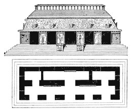 Fig. 27.—Casa No. 1, Palenque—Front View and Ground
Plan.
Fig. 27.—Casa No. 1, Palenque—Front View and Ground
Plan.
“Casa No. 2” consists of a steep and lofty truncated pyramid, which
stands on a terraced foundation, and has its level summit crowned with a
building 50 feet long by 31 wide, which has three doorways at the south,
and within a corridor and three rooms. This edifice, sometimes called
“La Cruz,” has, above the height required for the rooms, what is
described as “two stories of interlaced stucco-work, resembling a high,
fanciful lattice.” Here, too, inscribed tablets appear on the walls; but
the inscriptions, which are abundant at Palenque, are by no means
confined to tablets. As to the ornamentation, the walls, piers, and
cornices are covered with it. Every where the masterly workmanship and
artistic skill of the old constructors compel admiration; Mr. Stephens
going so far as to say of sculptured human figures found in fragments,
“In justness of proportion and symmetry they must have approached the
Greek models.”
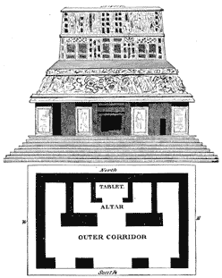 Fig. 28.—Casa No. 2, Palenque (La Cruz)—Front View and
Ground Plan.
Fig. 28.—Casa No. 2, Palenque (La Cruz)—Front View and
Ground Plan.
“Casa No. 2” of Mr. Stephens is usually called “La Cruz” because the
most prominent object within the building is a great bas-relief on which
are sculptured a cross and several human figures. This building stands
on the high pyramid, and is approached by a flight of steps. Dupaix
says, “It is impossible to describe adequately the interior decorations
of this sumptuous temple.” The cross is supposed to have been the
central object of interest. It was wonderfully sculptured and decorated;
human figures stand near it, and some grave ceremony seems to be
represented. The infant held toward the cross by one of the figures
suggests a christening ceremony. The cross is one of the most common
emblems present in all the ruins. This led the Catholic missionaries to
assume that knowledge of Christianity had been brought to that part of
America long before their arrival; and they adopted the belief that the
Gospel was preached there by St. Thomas. This furnished excellent
material for the hagiologists of that age; but, like every thing else
peculiar to these monkish romancers, it betrayed great lack of
knowledge.
The cross, even the so-called Latin cross, is not exclusively a
Christian emblem. It was used in the Oriental world many centuries
(perhaps millenniums) before the Christian era. It was a religious
emblem of the Phœnicians, associated with Astarte, who is usually
figured bearing what is called a Latin cross. She is seen so figured on
Phœnician coin. The cross is found in the ruins of Nineveh. Mr. Layard,
describing one of the finest specimens of Assyrian sculpture (the figure
of “an early Nimrod king” he calls it), says: “Round his neck are hung
the four sacred signs; the crescent, the star or sun, the trident, and
the cross.” These “signs,” the cross included, appear suspended from
the necks or collars of Oriental prisoners figured on Egyptian monuments
known to be fifteen hundred years older than the Christian era. The
cross was a common emblem in ancient Egypt, and the Latin form of it was
used in the religious mysteries of that country, in connection with a
monogram of the moon. It was to degrade this religious emblem of the
Phœnicians that Alexander ordered the execution of two thousand
principal citizens of Tyre by crucifixion.
The cross, as an emblem, is very common among the antiquities of Western
Europe, where archæological investigation has sometimes been embarrassed
and confused by the assumption that any old monument bearing the figure
of a cross can not be as old as Christianity.
What more will be found at Palenque, when the whole field of its ruins
has been explored, can not now be reported. The chief difficulty by
which explorers are embarrassed is manifest in this statement of Mr.
Stephens: “Without a guide, we might have gone within a hundred feet of
the buildings without discovering one of them.” More has been discovered
there than I have mentioned, my purpose being to give an accurate view
of the style, finish, decoration, and general character of the
architecture and artistic work found in the ruins rather than a
complete account of every thing connected with them. The ruins of
Palenque are deemed important by archæologists partly on account of the
great abundance of inscriptions found there, which, it is believed, will
at length be deciphered, the written characters being similar to those
of the Mayas, which are now understood.
The ruins known as Copan are situated in the extreme western part of
Honduras, where they are densely covered by the forest. As already
stated, they were first discovered by Europeans about forty years after
the war of the conquest swept through that part of the country, and were
at that time wholly mysterious to the natives. The monuments seem older
than those at Palenque, but we have only scant descriptions of them.
They are situated in a wild and solitary part of the country, where the
natives “see as little of strangers as the Arabs about Mount Sinai, and
are more suspicious.” For this reason they have not been very carefully
explored. It is known that these ruins extend two or three miles along
the left bank of the River Copan. Not much has been done to discover how
far they extend from the river into the forest.
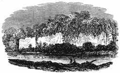 Fig. 29.—Great Wall at Copan.
Mr. Stephens describes as follows his first view of them: “We came to
the right bank of the river, and saw directly opposite a stone wall from
60 to 90 feet high, with furze growing out of the top, running north and
south along the river 624 feet, in some places fallen, in others
entire.” This great wall supported the rear side of the elevated
foundation of a great edifice. It was made of cut stone well laid in
mortar or cement, the blocks of stone being 6 feet long. Figure 29 shows
the wall somewhat imperfectly. He saw next a square stone column
standing by itself, 14 feet high and 3 feet on each side. From top to
bottom it was richly ornamented with sculptured designs on two opposite
sides, the other sides being covered with inscriptions finely carved on
the stone. On the front face, surrounded by the sculptured ornaments,
was the figure of a man. Fourteen other obelisks of the same kind were
seen, some of them being higher than this. Some of them had fallen.
These sculptured and inscribed pillars constitute the chief peculiarity
of Copan. Mr. Squier says of them: “The ruins of Copan, and the
corresponding monuments which I examined in the valley of the
Chamelican, are distinguished by singular and elaborately carved
monoliths, which seem to have been replaced at Palenque by equally
elaborate basso relievos, belonging, it would seem, to a later and
more advanced period of art.”
The great building first noticed stands, or stood, on a pyramidal
foundation, which is supported along the river by that high back wall.
The structure extends 624 feet on the river line. Mr. Stephens described
it as an “oblong inclosure,” and states that it has a wide terrace
nearly 100 feet above the river, on which great trees are growing, some
of them more than 20 feet in circumference. Here, as at Palenque, the
ornamentation was “rich and abundant.” The ruins, greatly worn by decay,
still show that “architecture, sculpture, painting, and all the arts
that embellish life had flourished in this overgrown forest.” Some
beautifully executed sculptures were found buried in the earth, and
there can be no doubt that extensive excavation, if it were possible in
that almost invincible forest, would lead to important and valuable
discoveries. Besides the great building and the monoliths, several
pyramidal structures are mentioned by Mr. Stephens, who points out that
extensive exploration is impossible unless one shall first clear away
the forest and burn up the trees.
Palacios, who described this ruined city nearly three hundred years ago,
saw much more than Mr. Stephens. He described “the ruins of superb
edifices, built of hewn stone, which manifestly belonged to a large
city.” He mentions, in connection with the great wall, an enormous
eagle carved in stone, which bore a square shield on its breast covered
with undecipherable characters. He mentions, also, a “stone giant,” and
a “stone cross” with one arm broken. He saw a “plaza,” circular in form,
surrounded by ranges of steps or seats, which reminded him of the
Coliseum at Rome, “as many as eighty ranges still remaining in some
places.” This “plaza” was “paved with beautiful stones, all square and
well worked.” Six of the great obelisks, which he described as
“statues,” stood in this inclosure, and in its centre was a great stone
basin.
A history of Guatemala, by a writer named Huarros, states that the
“Circus of Copan,” as he calls the “plaza” described by Palacios, was
still entire in the year 1700. He mentions gateways which led into the
inclosure, and says it was surrounded on the outside by stone pyramids
six yards high, near which were standing sculptured figures or obelisks.
No doubt, remains of this remarkable “circus” would be found now, if the
forest should be removed. What else could be found there by means of
careful and thorough exploration may never be known, for the region is
uninviting, the forest very difficult, and such an exploration would
require much more than the means and efforts of one or two individuals.
Not very far away, in the neighboring State of Guatemala, on the right
bank of the River Motagua, to which the Copan is a tributary, are the
ruins called Quirigua. It is manifest that a great city once stood here.
These ruins have a close resemblance to those at Copan, but they appear
to be much older, for they have, to a great extent, become little
more than heaps of rubbish. Over a large space of ground traces of what
has gone to decay are visible. Doubtless important relics of the old
city are now more abundant below the surface than above it. Mr.
Stephens, describing what he saw there, confines his attention chiefly
to a pyramidal structure with flights of steps, and monoliths larger and
higher than those at Copan, but otherwise similar. He states, however,
that while they have the same general style, the sculptures are in lower
relief and hardly so rich in design. One of the obelisks here is twenty
feet high, five feet six inches wide, and two feet eight inches thick.
The chief figures carved on it are that of a man on the front, and that
of a woman on the back. The sides are covered with inscriptions similar
in appearance to those at Copan. Some of the other standing obelisks are
higher than this. It seems reasonable to infer that the structures at
Quirigua were more ancient than those at Copan.
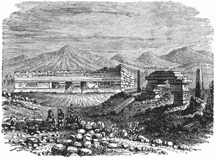 Fig. 30.—Ruins at Mitla.
The ruins called Mitla are in the Mexican State of Oxaca, about twelve
leagues east from the city of Oxaca. They are situated in the upper part
of a great valley, and surrounded by a waste, uncultivated region. At
the time of the Spanish Conquest they were old and much worn by time and
the elements, but a very large area was then covered by remains of
ancient buildings. At present only six decaying edifices and three
ruined pyramids, which were very finely terraced, remain for
examination, the other structures being now reduced to the last stage
of decay. Figures 30 and 31 present views of some of these structures,
as given by Von Temski. Figure 32, from Charnay’s photograph, shows a
ruin at Mitla.
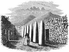 Fig. 31.—Great Hall at Mitla.
These important ruins were not described by Stephens and Catherwood.
Captain Dupaix’s work gives some account of them, and Desiré Charnay,
who saw them since 1860, brought away photographs of some of the
monuments. Four of the standing edifices are described by Dupaix as
“palaces,” and these, he says, “were erected with lavish magnificence; *
* * they combine the solidity of the works of Egypt with the elegance of
those of Greece.” And he adds, “But what is most remarkable,
interesting, and striking in these monuments, and which alone would be
sufficient to give them the first rank among all known orders of
architecture, is the execution of their mosaic relievos, very different
from plain mosaic, and consequently requiring more ingenious combination
and greater art and labor. They are inlaid on the surface of the wall,
and their duration is owing to the method of fixing the prepared stones
into the stone surface, which made their union with it perfect.” Figure
33, taken from Charnay’s photograph, shows part of the mosaic decoration
on a wall of one of the great edifices at Mitla.
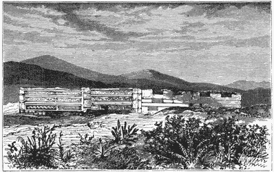 Fig. 32.—Ruined Palace at Mitla.
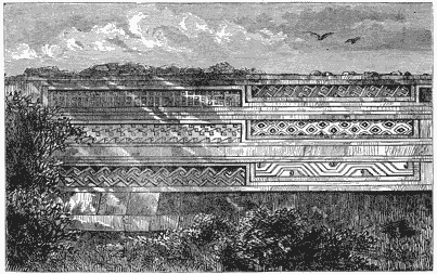 Fig. 33.—Mosaics at Mitla.
The general character of the architecture and masonry is much like that
seen in the structures at Palenque, but the finish of the workmanship
appears to have been more artistic and admirable. These ruins are
remarkable among those of the country where they are found. All who have
seen them speak much as Dupaix speaks of the perfection of the masonry,
the admirable design and finish of the work, and the beauty of the
decorations. Their beauty, says M. Charnay, can be matched only by the
monuments of Greece and Rome in their best days. One fact presented by
some of the edifices at Mitla has a certain degree of historical
significance. There appears to be evidence that they were occupied at
some period by people less advanced in civilization than their builders.
M. Charnay, describing one of them, points out this fact. He says of the
structure:
“It is a bewildering maze of courts and buildings, with facings
ornamented with mosaics in relief of the purest design; but under the
projections are found traces of paintings wholly primitive in style, in
which the right line is not even respected. These are rude figures of
idols, and meandering lines that have no significance. Similar paintings
appear, with the same imperfection, on every great edifice, in places
which have allowed them shelter against the ravages of time. These rude
designs, associated with palaces so correct in architecture, and so
ornamented with panels of mosaic of such marvelous workmanship, put
strange thoughts in the mind. To find the explanation of this
phenomenon, must we not suppose these palaces were occupied by a race
less advanced in civilization than their first builders?”
Two miles or more away from the great edifices here mentioned, toward
the west, is the “Castle of Mitla.” It was built on the summit of an
isolated and precipitous hill of rock, which is accessible only on the
east side. The whole leveled summit of this hill is inclosed by a solid
wall of hewn stone twenty-one feet thick and eighteen feet high. This
wall has salient and retiring angles, with curtains interposed. On the
east side it is flanked by double walls. Within the inclosure are the
remains of several small buildings. The field of these ruins was very
large three hundred years ago. At that time it may have included this
castle.
In this part of Mexico Captain Dupaix examined a peculiar ruin, of which
he gave the following account: “Near the road from the village of
Tlalmanalco to that called Mecamecan, about three miles east of the
latter, there is an isolated granite rock, which was artificially
formed into a kind of pyramid with six hewn steps facing the east. The
summit of this structure is a platform, or horizontal plane, well
adapted to observation of the stars on every side of the hemisphere. It
is almost demonstrable that this very ancient monument was exclusively
devoted to astronomical observations, for on the south side of the rock
are sculptured several hieroglyphical figures having relation to
astronomy. The most striking figure in the group is that of a man in
profile, standing erect, and directing his view to the rising stars in
the sky. He holds to his eye a tube or optical instrument. Below his
feet is a frieze divided into six compartments, with as many celestial
signs carved on its surface.” It has been already stated that
finely-wrought “telescopic tubes” have been found among remains of the
Mound-Builders. They were used, it seems, by the ancient people of
Mexico and Central America, and they were known also in ancient Peru,
where a silver figure of a man in the act of using such a tube has been
discovered in one of the old tombs.
Old ruins, of which but little is known, exist in Guatemala, Honduras,
San Salvador, and the more southern portion of Central America. Mr.
Squier, who tells us more of them than any other explorer, says, “I
heard of remains and monuments in Honduras and San Salvador equal to
those of Copan in extent and interest.” He mentions the ruins of Opico,
near San Vincente, in San Salvador, which “cover nearly two square
miles, and consist of vast terraces, ruins of edifices, circular and
square towers, and subterranean galleries, all built of cut stones: a
single carving has been found here on a block of stone.” Remains of
“immense works” exist in the district of Chontales, near the northern
shore of Lake Nicaragua; and pottery found in Nicaragua “equals the best
specimens of Mexico and Peru.” Don Jose Antonio Urritia, curé of
Jutiapa, gave the following account of a great ruin on a mountain in San
Salvador, near the town of Comapa: it is called Cinaca-Mecallo:
“The walls, or remains of the city wall, describe an oval figure, within
which roads or streets may be traced, and there are various subterranean
passages and many ruined edifices. The materials of construction are
chiefly thin stones, or a species of slate, united by a kind of cement
which in appearance resembles melted lead.” It does not appear that he
made a complete examination of the monuments, but he mentions three that
gained his attention, and left upon his mind a very strong impression.
“The first is a temple consecrated to the sun, chiefly excavated in the
solid rock, and having its entrance toward the east. On the archway of
the entrance are carved representations of the sun and moon.
Hieroglyphics are found in the interior. Besides the sculptured bassi
relievi, these stones bear hieroglyphics painted with a kind of red
varnish which remains unimpaired. The second is a great stone slab
covered with inscriptions or hieroglyphics. The third is the figure of a
wild animal sculptured on a rock or stone, of “great size.”
The remains of ancient cities are abundant in the settled portion of
Yucatan, which lies north of the great forest. Charnay found “the
country covered with them from north to south.” Stephens states, in the
Preface to his work on Yucatan, that he visited “forty-four ruined
cities or places” in which such remains are still found, most of which
were unknown to white men, even to those inhabiting the country; and he
adds that “time and the elements are hastening them to utter
destruction.”
Previous to the Spanish Conquest, the region known to us as Yucatan was
called Maya. It is still called Maya by the natives among themselves,
and this is the true name of the country. Why the Spaniards called it
Yucatan is unknown, but the name is wholly arbitrary and without reason.
It is said to have arisen from an odd mistake like that which occasioned
the name given to one of the capes by Hernandez de Cordova. Being on the
coast in 1517, he met some of the natives. Their cacique said to him,
“Conèx cotoch,” meaning “Come to our town.” The Spaniard, supposing he
had mentioned the name of the place, immediately named the projecting
point of land “Cape Cotoche,” and it is called so still.
At that time the country was occupied by the people still known as
Mayas. They all spoke the same language, which was one of a closely
related family of tongues spoken in Guatemala, Chiapas, Western
Honduras, and in some other districts of Central America and Mexico.
Yucatan was then much more populous than at present. The people had more
civilization, more regular industry, and more wealth. They were much
more highly skilled in the arts of civilized life. They had cities and
large towns; and dwelling-houses, built of timber and covered with
thatch, like those common in England, were scattered over all the rural
districts. Some of the cities now found in ruins were then inhabited.
This peninsula had been the seat of an important feudal monarchy, which
arose probably after the Toltecs overthrew the very ancient kingdom of
Xibalba. It was broken up by a rebellion of the feudal lords about a
hundred years previous to the arrival of the Spaniards. According to the
Maya chronicles, its downfall occurred in the year 1420. Mayapan, the
capital of this kingdom, was destroyed at that time, and never afterward
inhabited.
Merida, the present capital of Yucatan, was built on the site of an
ancient Maya city called Tihoo. It is stated in the old Spanish accounts
of Merida that it was built on that site because there was in the ruins
an abundance of building material. There is mention of two “mounds”
which furnished a vast amount of hewn stone. Mr. Stephens noticed in
some of the edifices stones with “sculptured figures, from the ruins of
ancient buildings;” and he mentions that a portion of an ancient
building, including an arch in the Maya style, was retained in the
construction of the Franciscan convent.
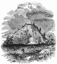 Fig. 34.—Great Mound at Mayapan.
We shall notice only some of the principal ruins in Yucatan, beginning
with Mayapan, the ancient capital. The remains of this city are situated
about ten leagues, in a southern direction, from Merida. They are spread
over an extensive plain, and overgrown by trees and other vegetation.
The most prominent object seen by the approaching explorer is a great
mound, 60 feet high and 100 feet square at the base. It is an imposing
structure, seen through the trees, and is itself overgrown like a wooded
hill. Figure 34 shows one view of this. Four stairways, in a ruinous
condition, 25 feet wide, lead up to an esplanade within 6 feet of the
top, which is reached by a smaller stairway. The summit is a plain stone
platform 15 feet square. This, of course, was a temple. Sculptured
stones are scattered around the base, and within the mound subterranean
chambers have been discovered.
It is probable that the principal edifices at Mayapan were not all built
wholly of stone, for they have mostly disappeared. Only one remains, a
circular stone building 25 feet in diameter, which stands on a pyramidal
foundation 35 feet high. This is represented in Figure 35. On the
southwest side of it, on a terrace projecting from the mound, was a
double row of columns without capitals, 8 feet apart. There are
indications that this city was old, and that the buildings had been more
than once renewed. Brasseur de Bourbourg classes some of the foundations
at Mayapan with the oldest seen at Palenque and Copan. This point,
however, can not be determined with sufficient accuracy to remove all
doubt. Mayapan may have stood upon the foundations of a very ancient
city which was several times rebuilt, but the city destroyed in 1420
could not have been as old as either Palenque or Copan.
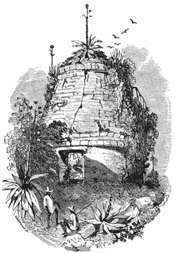 Fig. 35.—Circular Edifice at Mayapan.
The ruins of Uxmal have been regarded as the most important in Yucatan,
partly on account of the edifices that remain standing, but chiefly
because they have been more visited and explored than the others. It is
supposed, and circumstantial evidence appears to warrant the
supposition, that this city had not been wholly deserted at the time of
the Spanish Conquest, although it had previously begun to be a ruin. It
was wholly a ruin in 1673. The area covered by its remains is extensive.
Charnay makes it a league or more in diameter; but most of the
structures have fallen, and exist now only in fragments scattered over
the ground. It may be that many of them were not built wholly of hewn
stone, and had not “Egyptian solidity” with their other characteristics.
The most important of those remaining was named “Casa del Gobernador” by
the Spaniards. It is 320 feet long, and was built of hewn stone laid in
mortar or cement. The faces of the walls are smooth up to the cornice.
Then follows, on all the four sides, “one solid mass of rich,
complicated, and elaborately sculptured ornaments, forming a sort of
arabesque.” Figure 36 gives a view of the south end of this edifice, but
no engraving can show all the details of the ornamentation.
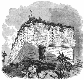 Fig. 36.—Casa del Gobernador, Uxmal.
This building has eleven doorways in front, and one at each end, all
having wooden lintels, which have fallen. The two principal rooms are 60
feet long, and from 11 to 13 feet wide. This structure is long and
narrow The arrangement and number of the rooms are shown in the
following ground plan of the building (Figure 37):
 Fig. 37.—Ground Plan of Casa del Gobernador
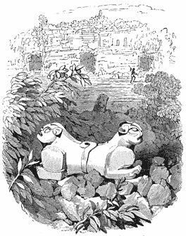 Fig. 38.—Double-headed Figure, Casa del Gobernador.
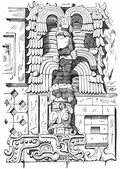 Fig. 39.—Decorations over Doorway, Casa del
Gobernador.
Fig. 39.—Decorations over Doorway, Casa del
Gobernador.
It stands on the summit of one of the grandest of the terraced
foundations. This foundation, like all the others, is pyramidal. It has
three terraces. The lowest is 3 feet high, 15 wide, and 575 long; the
second is 20 feet high, 275 wide, and 545 long; the third, 19 feet high,
30 wide, and 360 long. Structures formerly existed on the second
terrace, remains of which are visible. At the northwest corner one of
them still shows its dilapidated walls, portions of them being
sufficiently complete to show what they were. This edifice was 94 feet
long and 34 wide. It seems to have been finely finished in a style more
simple than that of the great “casa” on the upper terrace. The figures
of turtles sculptured along the upper edge of the cornice have given it
the current designation, “House of the Turtles.” Sculptured monuments
have been found buried in the soil of the second terrace. The opening of
a small, low mound situated on it brought to view the double-headed
figure shown in No. 38. Figure 39 shows part of the sculptured
decoration over the centre doorway of Casa del Gobernador.
Another important edifice at Uxmal has been named “Casa de las Monjas,”
House of the Nuns. It stands on a terraced foundation, and is arranged
around a quadrangular court-yard 258 feet one way and 214 the other. The
front structure is 279 feet long, and has a gateway in the centre 10
feet 8 inches wide leading into the court, and four doors on each side
of it. The outer face of the wall, above the cornice, is ornamented with
sculptures. The terrace without and within the inclosure was found
covered with a very dense growth of vegetation, which it was necessary
to clear away before the walls could be carefully examined. All the
doorways, save those in front, open on the court. Mr. Stephens found the
four great façades fronting the court-yard “ornamented from one end to
the other with the richest and most intricate carving known to the
builders of Uxmal, presenting a scene of strange magnificence which
surpasses any other now seen among its ruins.” The long outer
structure, on the side facing the entrance, had high turret-like
elevations over each of its thirteen doorways, all covered with
sculptured ornaments. This building appears to have inclosed another of
older date. Figure 40 shows the ground plan of “Las Monjas.”
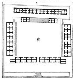 Fig. 40.—Ground Plan of Las Monjas, Uxmal.
Other less important edifices in the ruins of Uxmal have been described
by explorers, some of which stand on high pyramidal mounds; and
inscriptions are found here, but they are not so abundant as at Palenque
and Copan.
The ruins known as Kabah are on the site of what must have been one of
the most imposing and important of the more ancient cities. Here the
most conspicuous object is a stone-faced mound 180 feet square at the
base, with a range of ruined apartments at the bottom. Three or four
hundred yards from this mound is a terraced foundation 20 feet high and
200 by 142 in extent, on which stand the remains of a great edifice. At
the right of the esplanade before it is a “high range of ruined
structures overgrown with trees, with an immense back wall on the outer
line of the esplanade perpendicular to the bottom of the terrace.” On
the left is another range of ruined buildings, and in the centre a stone
inclosure 27 feet square and 7 feet high, with sculptures and
inscriptions around the base. Some of the ornamentation of this building
has been described in the strongest terms of admiration. Mr. Stephens
said of it, “The cornice running over the doorways, tried by the
severest rules of art recognized among us, would embellish the
architecture of any known era.” At Uxmal the walls were smooth below the
cornice; here they are covered with decorations from top to bottom.
This field of ruins is extensive, and only a portion of it has been
examined. It is so overgrown that exploration is very difficult. The
buildings and mounds are much decayed, and they seem to be very old. It
is believed that ruined edifices of which nothing is known are hidden
among the trees in places which no explorer has approached. Mr. Stephens
gave the first account of Kabah, and described three other important
edifices besides that already named. One of these he thought was, when
entire, the most imposing structure at Kabah. It was 147 feet long by
106 wide, and had three distinct stories, each successive story being
smaller than that below it. Another, standing on the upper terrace of an
elevated foundation 170 feet long by 110 broad, was 164 feet in length,
and comparatively narrow. It is mentioned as a peculiarity of this
edifice that it had pillars in its doorways, used as supports. The
other, found standing on a terrace, is also long and narrow, and has a
comparatively plain front.
Remains of other buildings are visible, but in all cases they are so
completely in ruins as to be little more than heaps of débris. Some of
the ruins in the woods beyond that part of the field which is most
accessible, are visible from the great mound described. A resolute
attempt to penetrate the forest brought the explorers in view of great
edifices standing on an elevated terrace estimated to be 800 feet long
by 100 feet wide. The decorations seemed to have been abundant and very
rich, but the structures were in a sad state of dilapidation. One
remarkable monument found at Kabah resembles a triumphal arch. It stands
by itself on a ruined mound apart from the other structures. It is
described as a “lonely arch, having a span of 14 feet,” rising on the
field of ruins “in solitary grandeur.” Figure 41 gives a view of it.
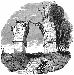 Fig. 41.—Ruined Arch at Kabah.
Kabah was an ancient city. The ruins are old, and the city may have
belonged to the first age of the Maya period.
The ruins of Chichen-Itza are situated east of Mayapan, about half way
between the eastern and western coasts of the peninsula of Yucatan. A
public road runs through the space of ground over which they are spread.
The area covered by them is something less than a mile in diameter. The
general character of the ruined structures found here is in every
respect like that shown by ruins already described.
One of the great buildings at this place has a rude, unornamental
exterior, and does not stand on an artificial terrace, although the
ground before it was excavated so as to give the appearance of an
elevated foundation. It is one hundred and forty-nine feet long by
forty-eight deep. Its special peculiarity consists of a stone lintel, in
a very dark inner room, which has an inscription and a sculptured figure
on the under side. The writing closely resembles that seen at Palenque
and Copan. Was this sculptured stone made originally for the place it
now occupies, or was it taken from the ruins of some older city which
flourished and went to decay before Chichen-Itza was built?
Another structure seen here closely resembles Las Monjas at Uxmal, and
bears the same name, but it differs somewhat from the Uxmal Monjas in
arrangement. In the descriptions, special mention is made of “the
richness and beauty” of its ornaments.
A noticeable edifice connected with the Monjas, called the “Church,” is
26 feet long, 14 deep, 31 high, and has three cornices, the spaces
between them being covered with carved ornaments. There is but one room
in it. One of the most picturesque ruins at Chichen-Itza is circular in
form, and stands on the upper level of a double-terraced platform. It is
22 feet in diameter, and has four doors, which face the cardinal points.
Above the cornice it slopes gradually almost to a point, and the top is
about 60 feet above the ground. The grand staircase of 20 steps, leading
up to this building, is 45 feet wide, and has a sort of balustrade
formed of the entwined bodies of huge serpents. At some distance from
this is the ruined structure known as the “Casa Colorada,” or Red House.
This is shown in Figure 42.
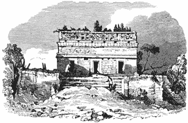 Fig. 42.—Casa Colorada.
It is 43 feet long by 23 deep, and stands on a platform 62 feet long by
55 wide. It was ornamented above the cornice, but the decorations are
much defaced by decay. A stone tablet extending the whole length of the
back wall, inside, is covered by an inscription.
A remarkable structure is found at this place, which Mr. Stephens called
the “Gymnasium, or Tennis Court.” It consists of two immense parallel
walls 274 feet long, 30 thick, and 120 apart. On elevations facing the
two ends of the open space between them, 100 feet from the ends of the
walls, stand two edifices much ruined, but showing, in their remains,
that they were richly ornamented. Midway in the length of the walls,
facing each other, and 20 feet above the ground, are two massive stone
rings or circles 4 feet in diameter, each having in the centre a hole 1
foot and 7 inches in diameter. On the borders around these holes two
entwined serpents are sculptured, as seen in Figure 43.
There was a similar structure in the old city of Mexico, and remains of
one like it are found at Mayapan. They were, probably, used for games of
some kind. Among the other ruins at Chichen-Itza are the remains of a
lofty edifice which has two high ranges or stories. On the outside the
ornamentation is simple and tasteful, but the walls of its chambers are
very elaborately decorated, mostly with sculptured designs, which seem
to have been painted. In one of the upper rooms Mr. Stephens found a
beam of sapote wood used as a lintel, which was covered with very
elegantly carved decorations. The walls of this room were covered, from
the bottom to the top of the arched ceiling, with painted designs
similar to those seen in the Mexican “picture writing.” Decay had
mutilated these “pictures,” but the colors were still bright. There are
indications that painting was generally used by the aboriginal builders,
even on their sculptures. The colors seen in this room were green, red,
yellow, blue, and reddish-brown. Another edifice, standing on a high
mound, is reached by means of the usual great stairway, which begins at
the bottom, with a sort of balustrade on each side, the ends of which
are stone figures of heads of immense serpents.
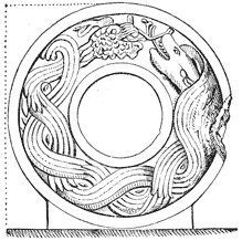 Fig. 43.—Great Stone Ring.
Not far from this is a singular ruin, consisting of groups of small
columns standing in rows five abreast, the tallest being not more than
six feet high. Many of them have fallen. It is impossible to determine
how they were used, or what they mean.
Izamal, Labna, Zayi, and some of the other ruins are sufficiently
important for special notice; but they present every where the same
characteristics, differing a little in the style or method of
ornamentation. At Labna there is among the ruins an ancient gateway,
beautiful in design and construction, a view of which is given in the
Frontispiece. The best account of some of the other ruins on this
peninsula can be found in the volumes of Mr. Stephens, entitled
“Incidents of Travel in Yucatan.” At Zayi there is a singular building,
which, as seen at a distance by Mr. Stephens, “had the appearance of a
New England factory.” But what seemed to be a “factory” is, in fact,
nothing more than a massive wall with oblong openings, which runs along
the middle of the roof, and rises thirty feet above it. The building was
below this wall, but the front part of it had fallen. Among the remains
at Xcoch is the great mound represented in Figure 44.
There is a remarkable ruin at Ake, at the south, which deserves mention.
Here, on the summit of a great mound, very level, and 225 feet by 50 in
extent, stand 36 shafts or columns, in three parallel rows. The columns
are about 15 feet high and 4 feet square. The ruins of Ake, which cover
a great space, are ruder and more massive than most of the others. The
island of Cozumel and the adjacent coast of Yucatan were populous when
the Spaniards first went there, but the great towns then inhabited are
now in ruins.
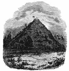 Fig. 44.—Great Mound at Xcoch.
Water is scarce on this peninsula, and a sufficient supply is not
obtained without considerable difficulty. The ancient inhabitants
provided for this lack of water by constructing aguadas or artificial
ponds. These, or many of them, doubtless, are as old as the oldest of
the ruined cities. Intelligence, much skill in masonry, and much labor
were required to construct them. They were paved with several courses of
stone laid in cement, and in their bottoms wells or cavities were
constructed. More than forty such wells were found in the bottom of one
of these aguadas at Galal, which has been repaired and restored to use.
A section of the bottom of this aguada is shown in Figure 45. In some
places long subterranean passages lead down to pools of water, which are
used in the dry season. One of these subterranean reservoirs, and the
cavernous passage leading to it, are shown in Figure 46. The reservoir
is 450 feet below the surface of the ground, and the passage leading to
it is about 1400 feet long. Branching passages, not shown, lead to two
or three other basins of water.
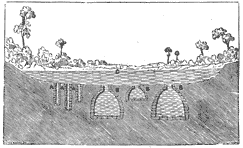 Fig. 45.—Bottom of an Aguada.
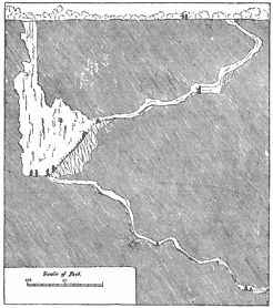 Fig. 46.—Subterranean Reservoir.
The wooden lintels, which are common in Yucatan, do not appear in the
other ruins, and there is a difference in the style of ornamentation
between those at Palenque or Copan, for instance, and those at Uxmal,
but every where the architecture is regulated by the same idea, the
differences indicating nothing more than different periods and
different phases of development in the history of the same people.
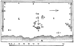 Fig. 47.—Plan of the Walls at Tuloom.
Some of the great edifices in these old ruins, such as the “Palace” at
Palenque, and the “Casa del Gobernador” at Uxmal, remind us of the
“communal buildings” of the Pueblos, and yet there is a wide difference
between them. They are not alike either in character or purpose,
although such great buildings as the “Palace” may have been designed for
the occupation of several families. There is no indication that
“communal” residences were ever common in this part of the country. At
the time of the Conquest the houses of the people were ordinary family
dwellings, made of wood, and we may reasonably suppose this fashion of
building was handed down from the earlier ages. Herrera, who supposed,
mistakenly, that all the great stone edifices were temples, said, in
his account of Yucatan, “There were so many and such stately stone
buildings that it was amazing; and the greatest wonder was that, having
no use of any metal, they were able to raise such structures, which seem
to have been temples; for their houses were all of timber, and
thatched.” But they had the use of metals, and they had the art of
making some of them admirable for use in cutting stone and carving wood.
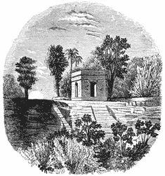 Fig. 48.—Watch-tower at Tuloom.
Among the buildings of later date are some of those on the western
coast, which were still inhabited three hundred and fifty years ago. The
city of Tuloom was inhabited then. Figure 47 shows a ground plan of the
walls of this city, with the position of some of the ruined monuments.
Within the walls are remains of finely constructed buildings on elevated
foundations, none of them, however, very large. One of them had a wooden
roof, and timber seems to have been considerably used here. The walls
still standing were made of hewn stone. Remains of stone edifices exist
all along this coast, but the whole region is now covered by a dense
growth of trees and other vegetation. Tuloom was seen in 1518 by
Grijalva, who sailed along the coast. At that time the island of
Cozumel, where noteworthy ruins are found, was inhabited by many people.
Figure 48 shows one of the watch-towers on the walls of Tuloom.