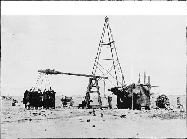
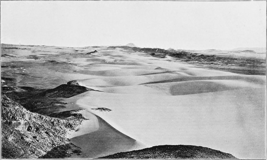
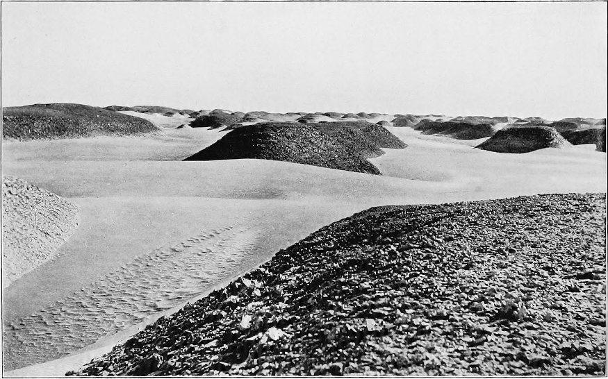
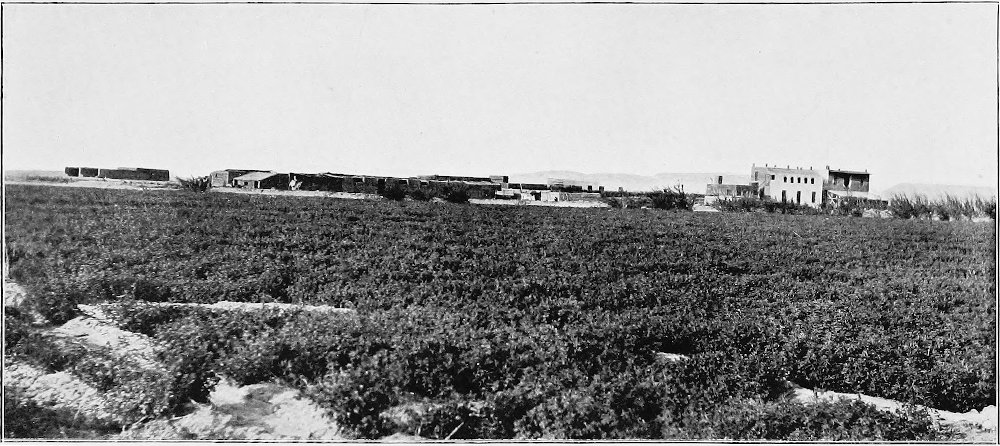
AN
ACCOUNT OF THE OASIS OF KHARGA IN THE LIBYAN DESERT, WITH
SPECIAL REFERENCE TO ITS HISTORY,
PHYSICAL GEOGRAPHY, AND WATER-SUPPLY
BY H. J.
LLEWELLYN BEADNELL F.G.S., F.R.G.S., Assoc.Inst.M.M. FORMERLY OF THE GEOLOGICAL SURVEY OF
EGYPT
WITH MAPS AND
ILLUSTRATIONS
LONDON JOHN MURRAY,
ALBEMARLE STREET, W. 1909
TO THE
MEMORY OF A FRIEND AND FELLOW-GEOLOGIST, THOMAS BARRON,
WHO LOST HIS LIFE IN THE SUDAN
IN FEBRUARY, 1906
PREFACE
The inhabited depressions
of the Libyan Desert, called by Herodotus the ‘Islands of the
Blest,’ are interesting alike to the archæologist, to the
geographer and geologist, and to the tourist who wishes to wander
from the well-beaten tracks, and perhaps none more so than the
Oasis of Kharga, lying 130 miles west of Luxor—the site of ancient
Thebes—and recently connected by railway with the Nile Valley.
Descended from the ancient Libyans, the inhabitants of the
Egyptian oases (numbering over 30,000 souls) are quite distinct
from the Fellahin and Bedawin of the Nile Valley. Isolated by arid
and desolate wastes, these communities occupy quaint walled-in
towns and villages, tucked away among groves of palms, interspersed
with smiling gardens and fields of corn. Rain is almost unknown,
and rivers are non-existent, the trees and crops being irrigated by
bubbling wells, deriving their waters from deep-seated sources.
Kharga—the subject of the present memoir—formed part of the Great Oasis of
ancient days, and was governed in turn by the Pharaohs, the Persian
Monarchs, and the Roman Emperors. Through it the ill-fated army of
Cambyses is recorded to have marched, and in it is to be seen the
most important Persian monument in Egypt, the temple of Hibis. But
most interesting of all is the wonderfully preserved Early
Christian necropolis, dating from the time of Bishop Nestorius, who
was banished to Kharga in A.D. 434.
Juvenal, Athanasius, and other celebrities likewise appear to have
made unwilling acquaintance with this portion of the Roman
Empire.
The character of the people at the present day—a curious mixture
of stupidity, apathy, and shrewdness—seems to reflect in great
measure their past history, as well as the peculiar conditions
under which they still live. A history of the inhabitants since the
withdrawal of the Roman garrisons would resolve itself into an
account of an endless combat with Nature, which, with sand and wind
as its chief agents, has never abated its efforts to recover those
tracts which the Ancients, by the exercise of much skill and
industry, wrested from the desert.
As a member of the Geological Survey of Egypt from 1896 to 1905,
I spent nearly nine years in survey and exploration work in the
Egyptian deserts, and for the past three years I have been in
charge of extensive boring and land-reclamation operations in the particular
oasis with which this book deals, so that I have had exceptional
opportunities of studying at first hand a region of peculiar
interest. Among other questions dealt with are the vast systems of
subterranean aqueducts constructed by the Romans; the extensive
lakes which occupied the floor of the oasis-depression well into
historic times; the rate and mode of movement of desert sand-dunes;
the formation and gradual elevation of the cultivated terraces by
the constant accumulation of wind-borne material; and the
deep-seated water-supplies, a subject which, in view of recent
discussions as to the origin of the artesian waters of arid
regions, is of more than local interest.
Some portions of the book, more especially those dealing with
geology and water-supply, have already been published in somewhat
different form in the Geological Magazine, and I am indebted
to Dr. Henry Woodward, F.R.S., for permission to reproduce them, as
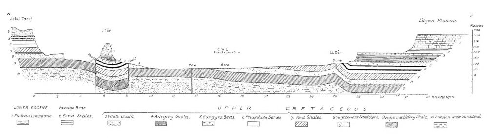
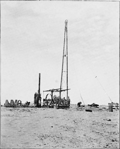
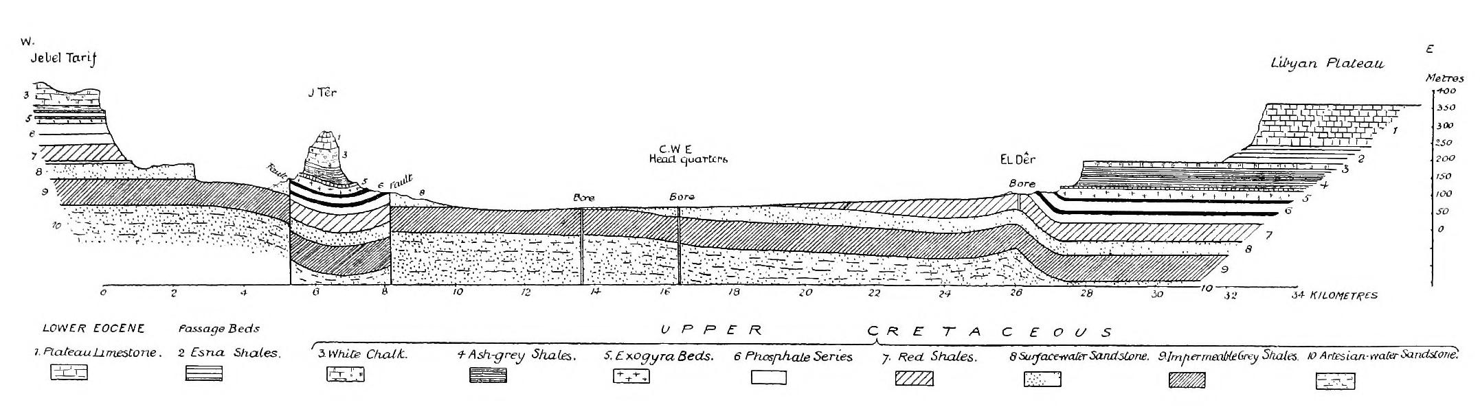
well as the plate showing Bore No. 39 and the geological section
across the oasis.
The illustrations are reproduced from photographs taken by me at
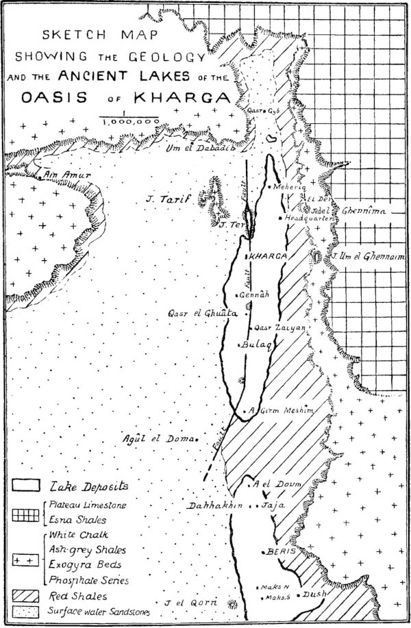
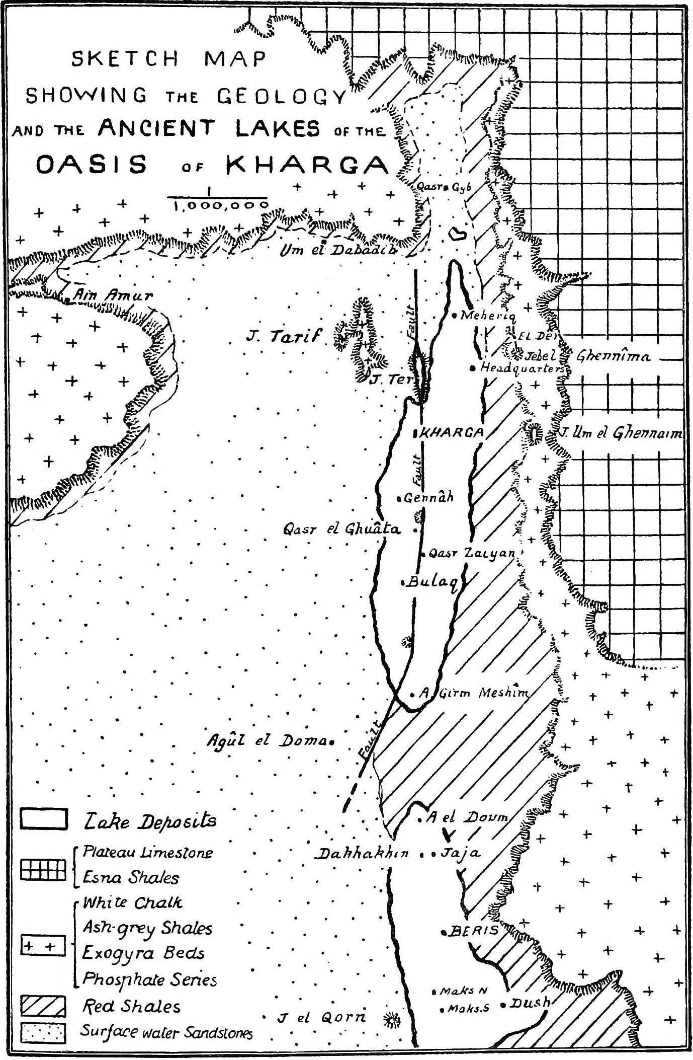
different times during the last few years. The maps, showing the
relative positions of the oasis and the Nile Valley, the caravan
roads, and the geology, have been compiled from all available
published material, chiefly the work of Dr. John Ball and myself.
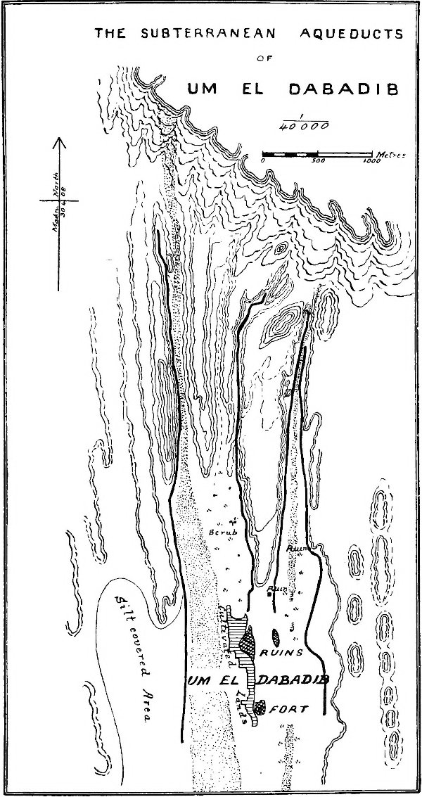
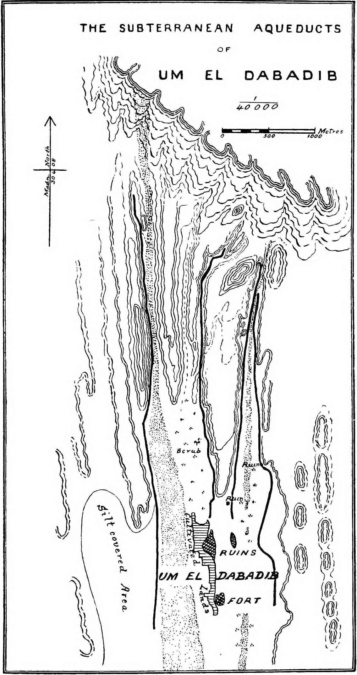
Some portions of these, as well as the plan showing the subterranean aqueducts of Um
El Dabâdib, are now published for the first time. The caravan
routes, while shown with sufficient accuracy for all practical
purposes, have not been surveyed with the same degree of exactness
as the other details shown on the maps.
Contrast of Libyan Desert and Nile Valley — Area
and Geographical Position — Barrenness — Dunes and Sand-submerged
Areas — Underlying Water-charged Sandstones — Early History of
Oases — Condition in Prehistoric Times — Cultivated Lands and
Wells.
No more striking contrast
can be imagined than that between the intensely cultivated Valley
of the Nile and the barren deserts on either side. There are arid
wastes in many parts of the world—in Australia, in the Western
States of America, in Asia—but in point of desolateness, in the
absence of animal and vegetable life, there is probably nothing to
rival the greater portion of the Libyan Desert, on the west side of
the Nile. Its barrenness is aggressive; it is not necessary to
travel far to make its acquaintance; so sharp is the junction that,
in a single step, one may pass from the richly cultivated alluvial
soil of the Nile to the bare sandy plains which skirt the more
rocky interior of the desert. Along the borders of the Egyptian wastes one generally
looks in vain for the Persian poet’s
“Strip of herbage strown,
That just divides the desert from
the sown.”
Geographically the Libyan Desert is the eastern and most
inhospitable portion of the Sahara, or Great Desert of Africa. On
the north and east its boundaries are clearly defined by the
Mediterranean Sea and the Valley of the Nile; on the south it is
bounded by the Darfur and Kordofan regions of the Egyptian Sudan;
to the south-west its limits may be regarded as coterminous with
the elevated districts of Tibesti; while on the west it stretches
to the outlying oases of Fezzan and Tripoli. Its area is about
850,000 square miles, or approximately seven times that of the
British Isles.
With the exception of a narrow belt fringing the Mediterranean,
the region is, to all intents and purposes, rainless, the
occasional thunderstorms being extremely local, and seldom breaking
over the same district in two consecutive years. In the more
elevated deserts on the eastern side of the Nile rains appear to be
of sufficiently frequent occurrence to maintain a water-supply in
the isolated water-holes and valley-springs, and to allow of the
growth of a fairly permanent though scanty herbage in the more
favoured areas. The Eastern desert does, therefore, to some extent,
support a migratory Arab population. On the other hand, the greater
portion of the Libyan
Desert is quite devoid of vegetation and water-holes, and is, in
consequence, uninhabited even by nomad tribes. At the same time,
the extreme barrenness of the region as a whole is in great measure
counterbalanced by a number of isolated fertile oases, in which
there is a permanent resident population, deriving its
water-supplies entirely from underground sources.
The term ‘oasis,’ an ancient Egyptian word signifying a
resting-place, in its strict sense means a fertile spot in a
desert, but in Egypt has usually been applied to a depression as a
whole, each individual cultivated area being known by the name of
the well from which its water is derived. The chief groups of oases
in the Libyan Desert are the Siwan on the north, that of Kufra on
the west, and the Egyptian, including the four large oases of
Baharia, Farafra, Dakhla, and Kharga, on the east. The present
volume deals more especially with the last of these.
The Libyan Desert is primarily divisible into two entirely
different parts, distinguished by the presence or absence of
surface accumulations of blown sand. Extensive dunes are confined
to the western portion, where areas of hundreds of square miles are
literally buried under deep seas of sand, blown into more or less
parallel dunes of great height, lying N.N.W. and S.S.E., in the
direction of the prevailing winds. In this country it is almost
impossible to travel in a latitudinal direction, so that the
sand-covered area forms an effective barrier between the Egyptian oases
and Kufra, one of the strongholds and, at any rate until recently,
the headquarters of the powerful Senussi sect. It is probable that,
within the last century, the area of this sand has extended
considerably to the south, as an old caravan road trending
westwards, and believed to have originally connected the oases of
Dakhla and Kufra, is now lost in the dunes. As long ago as 1874
some of the members of the Rohlfs expedition made an attempt to
penetrate westwards from Dakhla, but on reaching the edge of the
great sand-region, about 170 kilometres W.S.W. of Qasr Dakhl, were
compelled to turn northwards and travel in a direction parallel to
the lines of dunes, from which they emerged, after a long and
wearisome journey of 400 kilometres, in the neighbourhood of the
oasis of Siwa. Outlying portions of this sand invade the Egyptian
oases; for instance, the depression of El Daila, lying to the west
of Farafra, is to a great extent filled with blown sand, while an
extensive area in the south of Farafra itself is buried under
dunes.
On the eastern portion the sand is for the most part confined to
isolated lines of dunes, the most remarkable being that known as
the Abu Mohariq. This commences in latitude 29° 45′ north, at Arûs
el Buqar, some 50 kilometres south-west of the Mogara swamp, in the
low country to the south of the great east and west Miocene
escarpment. From Arûs el Buqar the Abu Mohariq
sand-belt runs in an
almost straight and unbroken line across the Libyan plateau to the
oasis of Kharga, through which it continues into the desert to the
south. The average breadth of this line of dunes is only some 6 or
7 kilometres, whereas its length cannot be less than 650. Less
extensive accumulations of blown sand are found in the oases
themselves, in the depressions of Gharaq and Muailla to the south
of the Fayûm, and encroaching on the cultivated lands of the Nile
Valley between Bahnessa and Mellawi.
The eastern part of the Libyan Desert, in which are situated the
Egyptian oases, is itself divisible into three areas having
essentially different characters, the northern being an undulating
rolling country of sandstones, grits, and gravels; the central
consisting of bare elevated limestone plateaux; the southern a
lower-lying expanse of rugged sandstone, broken only occasionally
by ridges and bosses of granite and other crystalline rocks.
The Egyptian oases are deep and broad hollows or depressions in
the Libyan Desert plateau. In position they appear to coincide with
areas where rocks of comparative softness became exposed at the
surface during the gradual lowering of the country by denudation.
At such points the general rate of weathering must have become
greatly accelerated, with the result that those vast depressions,
which form such conspicuous features in the configuration of the
country at the present day, were eventually cut out.
Underlying the greater part of the Libyan Desert are porous
sandstones, and these, when pierced by deep borings put down from
the lower-lying parts of the floors of the depressions, yield
abundant supplies of water of remarkable purity. As these
sandstones, as well as the shales with which they are associated,
have a general dip or inclination from south to north, we are led
to infer that they outcrop or come to the surface to the south, so
that in all probability the water with which they are so highly
charged has its origin in that direction. Whether the water obtains
access to the sandstones by direct infiltration of the rains of
Abyssinia or the Sudan, from the swamps of the sudd region of the
Upper Nile, or from the Nile itself in the Nubian reaches, has not
yet been decided with certainty. Recent observations, however, show
that far more water is lost in some reaches of the Nile than can be
accounted for by irrigation and evaporation, and it seems probable,
therefore, that the excess disappears by infiltration into these
sandstones.
Little is known of the early history of the oases, though the
remains of ancient towns and cemeteries are abundant, and only
await systematic excavation by Egyptologists to bring our knowledge
of this part of Egypt into line with that of the Nile Valley. That
the oases were inhabited in prehistoric times is evident from the
occurrence of flint implements of Palæolithic types, both on the
margins of the surrounding plateaux and within the depressions,
though there is not at present sufficient evidence to enable us to affirm that the
makers and users of these flints were contemporaneous with
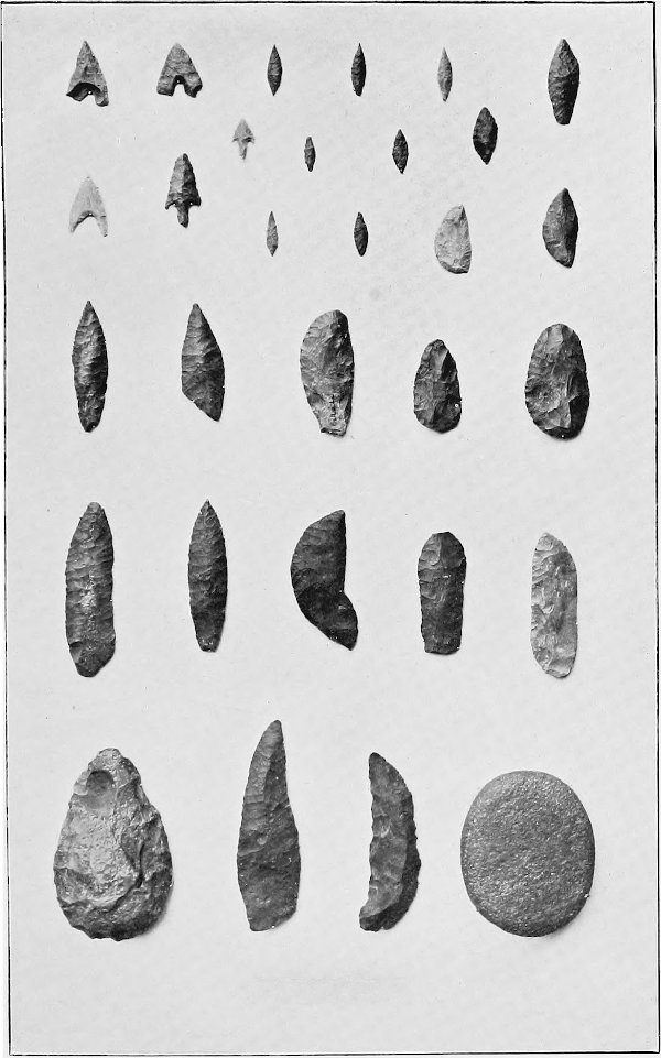
Palæolithic man in Europe. Implements of Neolithic type, often of
finished workmanship, are, moreover, common in places on the floors
of the depressions, but it is probable that these were in use well
into the historic period.
In historic times the oases, according to Sayce, were governed
by Egyptian Kings in the eighteenth dynasty (1545-1350 B.C.), and the oldest monuments as yet found in the
oases-depressions date from this period. The most important of the
earlier remains belong, however, to the Persian epoch, notably the
temple of Hibis near the modern village of Kharga, which was built
by Darius. Ptolemaic remains are also known in Kharga, but the
greater number of the historical monuments date from the time of
Roman occupation, when the oases appear to have attained a
considerable degree of prosperity, which continued to Coptic times.
Since the Mohammedan conquest of Egypt they have fallen into a
state of neglect, and with the consequent diminution of the
water-supply the population has decreased, and large areas of
formerly fertile country have been absorbed by the surrounding
desert.
It is interesting to speculate on the conditions which obtained
in Kharga before the first borings were made, as at the present day
we cannot point, so far as I am aware, to a single natural efflux
of water on the floor of the depression. Surface-water, of quite a different character
from the deep-seated water, is met with at comparatively shallow
depths in various localities, and may either represent drainage
water from the flowing wells and cultivated tracts, or be water
which has escaped from the underground sandstones and found its way
to the surface through fissures. Probably it is derived from both
sources. In prehistoric times natural springs fed through fissures
may have existed here and there within the depressions; and in any
case it is probable that prehistoric man obtained sufficient
supplies by sinking wells into the upper sandstones, which in some
parts of the oasis occur at or near the surface, and contain large
quantities of sub-surface or sub-artesian water. Nothing is known
as to when flowing wells were first obtained, or by whom the
original deep borings were made, and no traces of the implements
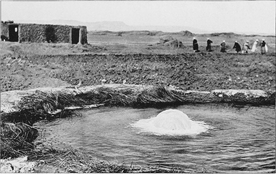
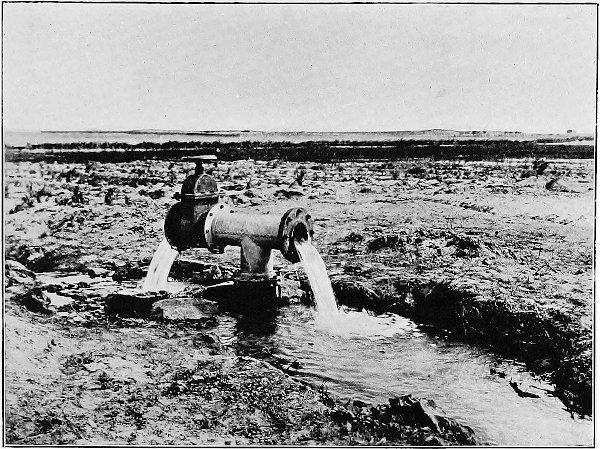
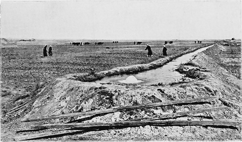
used have been discovered. Many of these ancient wells, frequently
over 120 metres in depth, continue to flow at the present day,
although in most cases with a greatly diminished output; a few,
however, are still running day and night at the rate of several
hundred gallons a minute.
In some parts of the oases water-bearing sandstones occur at or
near the surface, and from these beds the Romans obtained
additional supplies by the excavation of underground collecting
tunnels. Subterranean works of this description are found in all
the oases, the most remarkable being in Baharia and at Um el
Dabâdib and Jebel Lebekha in Kharga. They are frequently of great length,
cut throughout in solid rock, and connected with the surface above
by numerous vertical air-shafts. Many of the latter measure from 30
to 50 metres in depth, so that the construction of these and the
horizontal carrying channels must have involved an immense amount
of labour.
In Roman times water-stations appear to have been maintained at
frequent intervals on the desert roads between the oases and the
Nile Valley, and a great development of the water-supply took
place. After the Arab invasion, however, no attention seems to have
been given to irrigation works, the wells, owing to silting,
becoming gradually choked up. As the result of this neglect the
water-supply diminished to such an extent that a large portion of
the population was compelled to emigrate to the Nile Valley, and
even the remaining inhabitants were scarce able to raise sufficient
supplies for their maintenance. Within the last fifty years a
considerable number of new wells have been made by means of simple
hand-boring appliances sent out by the Egyptian Government; most of
the new bores have been very successful, but latterly, through want
of effective supervision, a great deal of harm has been done by
promiscuous boring. Moreover, a very large amount of water is
wasted owing to the wells not being fitted with regulating and
closing appliances; the water, when not required for irrigation,
continues to run, finding its way to the low-lying lands, and
forming swamps which
furnish ideal breeding-grounds for fever-carrying mosquitoes.
Within the last year or two this part of Egypt has received
renewed attention; extensive boring operations and land reclamation
works have been commenced, and the oasis of Kharga has been brought
into railway communication with the rest of Egypt.
The floor-level of the oases varies considerably, but in general
the cultivated lands lie between 30 and 120 metres above sea-level.
The exact area under cultivation is only known very approximately,
but it is certain that with an increased water-supply it could be
very much augmented. The existing water-supply is totally
insufficient to irrigate the available lands, and such portions of
the latter as are tilled are generally left fallow in alternate
years, and in many cases are only under crops once every four or
five years. Now that an attempt is being made to restore the oases
to their former prosperity, the question of ownership of land has
become of the greatest importance, and it is one bristling with
difficulties. As a general rule the wells are owned collectively,
the different proprietors having the right to utilize the flow for
periods corresponding to the extent of their holdings in the well.
Individual shares may amount to as much as one-third or one-half of
the well, or be only the merest fraction; in the latter case the
small holders combine so as to obtain control of the flow for an
appreciable period. Frequently the whole of the land irrigated by a well is
cultivated collectively, the crop on reaping being divided among
the owners in portions corresponding to their shares of the water.
The question of ownerships is further complicated by there being
persons who own water but no land, and by others who claim land but
own no water.
CHAPTER II EARLY RECORDS
Travellers’ Names inscribed on the Monuments —
Poncet passes through Kharga en route for Ethiopia — Browne
— Cailliaud’s Extensive Researches — Drovetti — Sir Archibald
Edmonstone, Bart., discovers Dakhla Oasis — Hoskins — Exaggerated
Opinions of Ancients regarding the Oases — Names of Explorers on
the Walls of Hibis — Rohlfs’ Expedition — Zittel’s Geological Work
— The words ‘Oasis,’ ‘Wah,’ ‘Otu,’ and ‘Set-ament’ — A Theban Myth
— Dr. Schweinfurth — Brugsch Bey — Captain H. G. Lyons — Government
Survey of the Oases — Dr. John Ball.
Inscribed on the walls of
the ancient monuments in the oasis one frequently comes across the
names of travellers who visited the same scenes fifty, a hundred,
or even two hundred years ago. Many of these explorers wrote
descriptions of their travels and experiences, and such early
records are naturally of the greatest interest and importance;
unfortunately they are now out of print and somewhat difficult to
procure, so that I make no apology for briefly referring to those
which I have been able to examine. Most of these early records are
extremely quaint, and although they are chiefly descriptive of the
personal experiences and impressions of the writers, in some cases
numerous observations are recorded in a sufficiently exact manner to be
of permanent scientific value.
A French physician, Monsieur Poncet, who passed through Kharga
in 1698, en route for Abyssinia, appears to have been the
only traveller who left any written records of the Great Oasis
between the sixteenth and nineteenth centuries. A translation of
the account of his travels was published in English in 1709 (‘A
Voyage to Æthiopia’). Accompanied by one Hagi Ali, an officer of
the Abyssinian Emperor, and by a Jesuit missionary, Father Charles
Francis Xaverius de Brevedent, Poncet set out from the town of
Manfalut in the Nile Valley, and travelled along the Derb el
Arbaîn, the well-known caravan route to the south. His description
of this portion of the journey is as follows:
“We set forward on the 2d of October early in the Morning, and
from that very Day we enter’d a frightful Desart. These Desarts are
extremely dangerous, because the Sands being moving are rais’d by
the least Wind which darken the Air, and falling afterwards in
Clouds, Passingers are often buried in them, or at least lose the
Route, which they ought to keep.”
Poncet refers to the oasis as ‘Helaoue,’ but although his
caravan rested there four days, before proceeding to Dongola, via
Shebb and Selîma, he makes no reference to the antiquities; in
fact, his remarks on this region are extremely meagre. To quote his
own words: “We Arriv’d on the 6th of October at Helaoue; ’Tis a pretty large
Borough, and the last that is under the Grand Signior’
Jurisdiction. There is a Garrison in it of 500 Janisaries and 300
Spahi’s under the Command of an Officer whom in that Country they
call Kachif. Helaoue is very pleasant, and answers fully its Name,
which signifies a Country of Sweetness. Here are to be seen a great
Number of Gardens water’d with Brooks, and a World of Palm-trees,
which preserve a continual Verdure, Coloquintida is to be found
there, and all the Fields are fill’d with Senna, which grows upon a
Shrub, about three Foot High. This Drug which is so esteem’d in
Europe, is of no use in the Country hereabouts. The Inhabitants of
Helaoue in their Illnesses, make only Use of the Root of Ezula,
which for a whole Night they infuse in Milk, and take the day
after, having first Strain’d it thro’ a Sieve. This Medicine is
very Violent, but ’tis what they like and commend very much. The
Ezula is a thick Tree, the Blossom of which is blue; it grows into
a sort of Ball, of an Oval Figure, full of Cotton, of which the
People of that Country make pretty fine Cloth.”
Referring to the deserts which surround the oases, Poncet
remarks: “Those vast Wildernesses, where there is neither to be
found Bird, nor wild Beast, nor Herbs, no nor so much as a little
Fly, and where nothing is to be seen but Mountains of Sand, and the
Carcasses, and Bones of Camels, Imprint a certain horrour in the
Mind, which makes this Voyage very tedious and
disagreeable. It
wou’d be a hard matter, to Cross those frightful Desarts without
the Assistance of Camels. These Animals will continue six or seven
Days, without either eating or drinking, which I cou’d never have
believ’d, if I had not observ’d it very particularly.” Poncet
further relates that he was assured by a venerable old gentleman of
his caravan that camels had been known to cover a desert journey of
forty days and nights without either food or water. Although it is
to be feared that the ‘ship of the desert’ at the present day is
scarcely so abstemious as formerly, we must admit that Poncet’s
description of the sterility of the Libyan Desert is little, if at
all, exaggerated. One may, indeed, travel for hours without seeing
bird, beast, or herb; and even ‘the little fly,’ which seldom fails
to make known its presence for some time after leaving the
inhabited districts, generally forsakes one before the caravan has
proceeded far into the depths of the desert.
W. G. Browne traversed the same route nearly a hundred years
later, passing through the oasis in June, 1793. He relates how he
entered the depression at the northern extremity, at the pass known
as El Ramlia, and camped at Ain Dizé (probably in the neighbourhood
of the modern Ain el Qasr), eight hours’ march from Kharga. Browne
passed through the depression from north to south, visiting Kharga,
Bulaq, Beris, and Maks, whence he followed the usual route to Shebb
and Selîma. Like his predecessor, he makes no mention of the
antiquities.
Cailliaud, a young French mineralogist, explored Kharga in 1818,
and to him we owe the earliest published detailed descriptions and
illustrations of the chief antiquities of the oasis. As the
existence of important monuments in the oasis was at that time
quite unsuspected, Cailliaud’s work attracted considerable
attention, and his drawings and descriptions were purchased and
published by the French Government and dedicated to the King.
Cailliaud set out from Esna in the Nile Valley and crossed the
Libyan plateau to the village of Jaja. After visiting the most
southerly villages of Dush and Beris, he journeyed northwards to
Kharga, then, as now, the chief village, whence, on the completion
of his researches, he returned to Farshut on the Nile, via Dêr el
Ghennîma and the Wadi Samhûd. Cailliaud’s observations are almost
entirely confined to the archæology of the oasis, and his writings
yield little information regarding the villages, wells, and
cultivated lands.
The Chevalier Drovetti, French Consul-General in Egypt, visited
Kharga the same year as Monsieur Cailliaud. He started from
Beniâdi, following the Derb el Arbaîn caravan route southwards, and
entered the depression at the northern extremity. Drovetti
traversed the oasis from north to south, and proceeded thence to
Dongola. Later, on his return journey, he crossed the depression in
the opposite direction, eventually returning to the Nile Valley by
way of the oasis of Dakhla and the Derb el Tawîl.
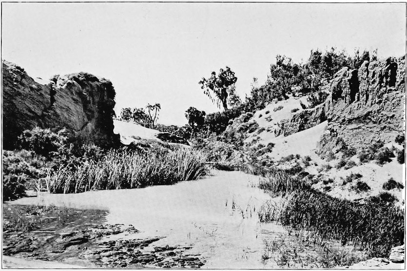
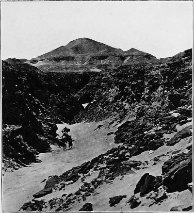
A PASS INTO THE OASIS.
In 1820 Cailliaud again passed through Kharga. He had explored
the oasis of Siwa the previous year, whence he travelled, via
Baharia and Farafra, to Dakhla, and thence past Ain Amûr to Kharga
village. On this occasion no further researches were undertaken in
the depression.
Sir Archibald Edmonstone, Bart., accompanied by two friends,
visited Dakhla and Kharga in 1819, and constructed a rough but
fairly accurate map, showing the relative position of the two
oases, with their bounding escarpments and principal villages.
Their situation in the Libyan Desert, with regard to the Nile
Valley, is, however, greatly in error, being shown fully a degree
too far west and nearly half a degree too far north. Edmonstone
followed the Derb el Tawîl route from Beniâdi in the Nile Valley to
the village of Belat in Dakhla, returning by the Ain Amûr road to
Kharga, and thence to Farshut. The major portion of the account of
his travels refers to Dakhla, of which oasis he must, indeed, be
regarded as the modern discoverer.
Hoskins explored Kharga in 1835, and published a most valuable
and engaging account of his travels a couple of years later. This
work, entitled ‘Visit to the Great Oasis of the Libyan Desert,’
contains a number of illustrations depicting the scenery, the chief
monuments and their hieroglyphics, etc., made from original
drawings and paper casts. Many of the inscriptions are given in
full, both in the original and translated into English, and the
work of all previous writers and explorers is carefully summarized. In some cases I have
verified the accuracy of Hoskins’ drawings by comparing them with
photographs taken from the same points, and have been much struck
with the insignificant amount of decay which some of the buildings
have undergone during the course of over seventy years.
Rizagat, near Thebes, was Hoskins’ starting-point, and he
entered the depression by the Bulaq pass, crossing the oasis-floor
to the eminence known as El Gorn el Gennâh. Surveying the oasis
from this point of vantage, Hoskins remarks that the attractions of
the cultivated portions of the depression, those
“Tufted isles that verdant rise amid the
Libyan waste,”
are apt to be exaggerated, owing to their great
contrast to the surrounding deserts. “The fair appearance then of
this oasis is in a great measure fictitious; and has chiefly its
origin in the relief afforded to the mind, wearied by the monotony
and dreariness of the surrounding wastes. It seems to me therefore,
that the only rational way of accounting for the exaggerated
epithets which the ancient writers and some modern travellers have
applied to this district, is to attribute them to their surprise,
at finding in such a fearful region any verdure, any habitable
spot, and to the exhilarating effect on the spirits of this
agreeable contrast to the dreary deserts which they have just
crossed. But comfortless as was my journey through the wilderness,
and beautiful as the woods of palm-trees, doums, and acacias in the
Oasis certainly are, still the vivid recollection of the superior
loveliness of the banks of the Nile, prevents my consenting to call
these regions ‘the Gardens of the Hesperides’; and sadly must the
oasis have diminished in beauty, if it ever merited the praise
which Herodotus bestowed upon the place, in calling it ‘the Island
of the Blessed.’”
Hoskins, who was accompanied by two other Englishmen, made
splendid use of the fortnight spent in the oasis, although
unfortunately, just before the termination of his visit, he
sustained a violent attack of fever. Their departure is thus
described: “After ascending the mountain which bounds the Oasis, we
lingered some time at the summit, to take, I may certainly say, our
last view of the place; for having, as the Arabs say, got all its
antiquities on paper, and having providentially once escaped its
pestilential atmosphere, we shall never, I think, by any
possibility, have the slightest inclination to revisit such a
baneful region.”
Most of these early explorers found time to cut their names on
the walls of the temple of Hibis, and Cailliaud must have spent
hours in this occupation, as he has left a long and neatly executed
inscription recording himself as the original and genuine
discoverer of that noble edifice. The names of these explorers, who
in some cases suffered considerable hardships in visiting the
oases, are, however, quite overshadowed by the numberless scrawls
made in recent years by a host of otherwise unknown petty officials of the
Government, who have had to take their turn of duty and banishment
in the greatly dreaded desert. The dated names cut in the walls of
the temple are of some value, as an examination of them frequently
yields reliable evidence of the rate of weathering of the stone
since the time at which they were inscribed.
It was not until after the winter of 1873-74, when the great
German expedition, under the leadership of Rohlfs, with Zittel,
Jordan, and Ascherson as geologist, topographer, and botanist
respectively, visited all the chief oases of the eastern portion of
the Libyan Desert, that any connected scientific observations of
importance, other than those dealing with archæology, were
published. The Rohlfs expedition astronomically determined the
positions of selected points in each oasis, and produced a map on
which the principal villages and the approximate limits of the
depressions were correctly shown. Zittel at the same time worked
out the general relations of the different geological formations
found in the country, described their main divisions, and indicated
approximately the areas occupied by them. So thoroughly, indeed,
did this expedition accomplish its mission that its results have
formed a sound basis for all later scientific work in this part of
Egypt.
As the voluminous memoirs recording the observations of the
members of the Rohlfs expedition are easily obtainable at the
present day, it is unnecessary here to do more than
briefly refer to a
few of their more general remarks on the oasis of Kharga. In his
‘Three Months in the Libyan Desert,’ Gerhard Rohlfs states that he
and his companions travelled from Dakhla Oasis by the Ain Amûr
road, and were greeted at Kharga village by Schweinfurth, who was
for the time being residing in a disused alum factory. Rohlfs spent
only two or three days in the neighbourhood of Kharga, and remarks
that the expedition did not undertake detailed work on the
antiquities, as the latter had already been so competently
described by Hoskins and other previous explorers; a few
corrections and amendments of published accounts of the temple
were, however, made. The splendid preservation of the Christian
necropolis, with its mausolea of unburnt brick, is remarked upon,
and Rohlfs adds that, in beauty and ingenious arrangement, this
burial-ground can only be excelled by the necropolis of Cyrene.
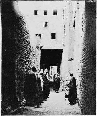
Rohlfs describes Kharga village as being pretty from a distance,
but remarks that the narrow dirty alleys are the pictures of
laziness and poverty; the streets are covered in for protection
against the rays of the sun, a common practice throughout the
Sahara.
The word ‘oasis’ is old Egyptian, as also is the Arabic ‘wah,’
the latter word being also found in Coptic, and signifying an
inhabited place; nevertheless, the word ‘wah’ was never used by the
ancient Egyptians to designate the oases. These they called ‘otu,’
which means a place where bodies are embalmed. ‘Otu’ has its origin in
the Theban myth, according to which Seth, the murderer of Osiris,
was pursued by Horus to Koptos, where he was captured and thrown
into a dungeon. His corpse was afterwards found by his friends, and
taken to the oases for burial.[1] The inscriptions on the
temple of Hibis in Kharga refer to the oases under the
comprehensive name ‘Set-ament,’ the ‘Western Lands.’
About the same time Dr. Schweinfurth, whose services to Egypt in
so many branches of science stand pre-eminent, published important
contributions on some of the archæological remains. Two or three
years later Brugsch Bey brought out an account of the antiquities
of the oasis, with translations of a number of the inscriptions on
the temples of Nadûra and Hibis. The antiquities will be briefly
referred to in my account of the history of the oasis under the
Persians and the Romans, and for fuller details the reader is
referred to the publications of Cailliaud, Hoskins, Schweinfurth,
Brugsch, and some still later writers.
In 1893-94 Captain H. G. Lyons, R.E., in the course of a
military patrol, undertaken in order to ascertain the measures
necessary to protect the inhabitants of the oasis from possible
Dervish raids, made valuable geological observations on the Eocene
and Cretaceous systems, especially in relation to the connection of
folding and water-supply. These he discussed in a paper read before the
Geological Society of London in 1894, and it was mainly due to the
interest it aroused, and to his initiative in pointing out to the
Egyptian authorities the importance of having a comprehensive
examination of the country carried out, that the Geological Survey
of Egypt was established in 1896.
The detailed survey of the Libyan Desert was taken up in
October, 1897, and completed in June of the following year, the
four oases being mapped on the scale of 1 to 50,000 by plane-table
triangulation, checked and adjusted by numerous astronomical
observations. Direct measurements by measuring-wheel were also
employed to a considerable extent. Baharia Oasis was the first to
be taken in hand, Mr. Leonard Gorringe and I taking the western
side, and my colleagues, Messrs. Ball and Vuta, the eastern. This
plan of splitting up an oasis-depression between two surveying
parties was not, however, found satisfactory, and on the completion
of Baharia it was decided that Ball should take up the oasis of
Kharga, while Farafra and Dakhla fell to my lot. The results of
this survey are published in the Memoirs of the Geological Survey
of Egypt.
During the last three years I have been fortunate in having had
opportunities of studying in some detail the topography, geology,
and water-supply of the oasis of Kharga. This detailed examination
has enabled me to revise and amplify pioneer work, and has, in
certain instances, forced me to differ from the opinions expressed by my
predecessors in the same field, views which, in the light of the
evidence available at the time, were doubtless well justified. In
the same way may future research necessitate the modification or
alteration of the conclusions herein expressed, and for many years
to come the region of the oases will offer a vast field for further
scientific work.
Before concluding this brief account of the literature on the
oasis of Kharga, I should like to take the opportunity of
expressing my high appreciation of the energy and purpose of my
former colleague, Dr. John Ball, who, in spite of the many
hardships and difficulties inseparable from scientific work in the
Libyan Desert, in such a short time accomplished so much.
CHAPTER III THE ROADS LEADING TO THE OASIS
Lines of Communication between the Nile Valley,
Kharga, and Dakhla Oasis — Principal Passes out of the Oasis —
Ascent to Plateau with Caravans — Main Roads to Assiut, Sohag,
Karnak, Esna, and Edfu — Nature of intervening Plateau — Ghubbâri
Road to Dakhla — The Upper or Ain Amûr Road — The Railway between
the Nile Valley and the Oasis — Nature of Desert Roads — The
Bedawin Arabs — Cross-Country Traverses as the Crow flies —
Traverse from Farafra to Assiut — Rate of Travelling with
Camels.
The oasis of Kharga is in
communication with Dakhla to the west, and with the Nile Valley to
the east, by a number of caravan routes, the most frequented of
which connect directly with the two villages Kharga and Beris, in
the north and south of the depression respectively. Formerly,
everyone bound for the oasis was compelled to undertake a four or
five days’ journey along one or other of these routes, and although
nowadays most persons will elect to cross the plateau by train, a
description of the oasis would be incomplete without some reference
to the desert roads.[2]
The depression is for the most part bounded by steep and lofty
escarpments, quite inaccessible to camels, except at a few points
where the gradients are less severe, and the loose blocks of rock
and other cliff débris have been removed. The principal passes up
the eastern scarp of the oasis are seven in number, the most
northerly, known as El Ramlia, being in the extreme north-east
corner of the depression. Thirteen kilometres south of this is El
Yabsa pass. The next is the Refûf, at the head of the gully 45
kilometres north-east of Kharga village. A little farther south,
east of the old Roman fort near the foot of Jebel Ghennîma, one of
the two prominent outliers of the eastern plateau, is the pass of
Abu Sighawâl, and 35 kilometres to the south is the Nagab Bulaq,
N.N.E. of the village of Bulaq. In the south end of the oasis there
are passes to the north-east of Jaja, and N.N.E. of Dush. These
seven passes are the main exits from the depression on the east
side, though there are several other little-used routes, up which
lightly laden camels can be taken, for instance, near Jebel Um el
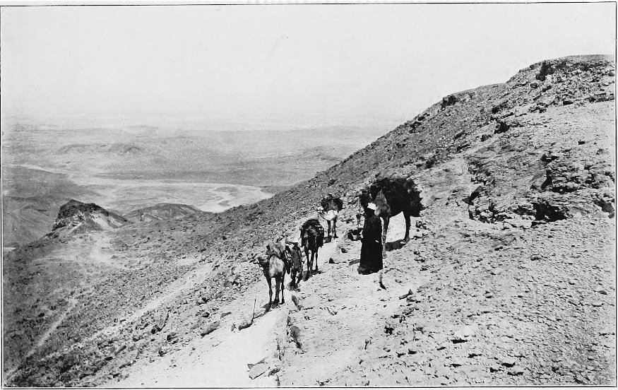
Ghennaim. The illustration showing the descent to the depression
was, in fact, taken at one of the latter.
Although the roads ascend the escarpments at the best available
points, in some cases taking advantage of the easier gradients of
the extensive cake-like masses of calcareous tufa, which in places
have been deposited over the face of the original cliffs, their
ascent with heavily laden camels may at times become somewhat of an undertaking. The
paths are frequently rough, and the difference in height between
the foot of the scarp and the plateau is usually between 200 and
300 metres. The pack-saddles should always be carefully adjusted
and secured by ropes passing round the base of the neck or below
the butt of the tail, according to whether the caravan is making
the ascent or descent; otherwise the loads are likely to slip off,
and the restricted limits of a steep path, in the middle of a train
of camels, is not an ideal place for their readjustment. In hot
weather the ascent to the plateau, though perhaps occupying only
one or one and a half hours, will take as much out of the
pack-animals as a whole day’s march. I experienced no little
trouble on one occasion when returning to the valley after some
months’ survey work in Dakhla Oasis. After halting one day at
Kharga village, we proceeded on our way to Esna by the Bulaq pass.
It was hot weather, towards the end of May, and the ascent of the
pass tired our camels, naturally not in the pink of condition, to
such an extent that Gorringe and I had some difficulty in getting
them across the plateau to the valley. In summer-time it is always
advisable to negotiate this part of the journey in the early
morning or late in the evening, unless the heavier portion of the
baggage can be sent in advance to the top of the scarp, and the
animals taken back and watered at the nearest well.
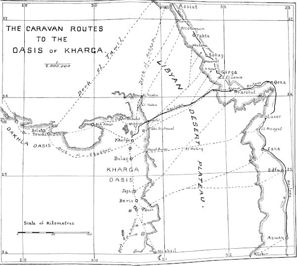
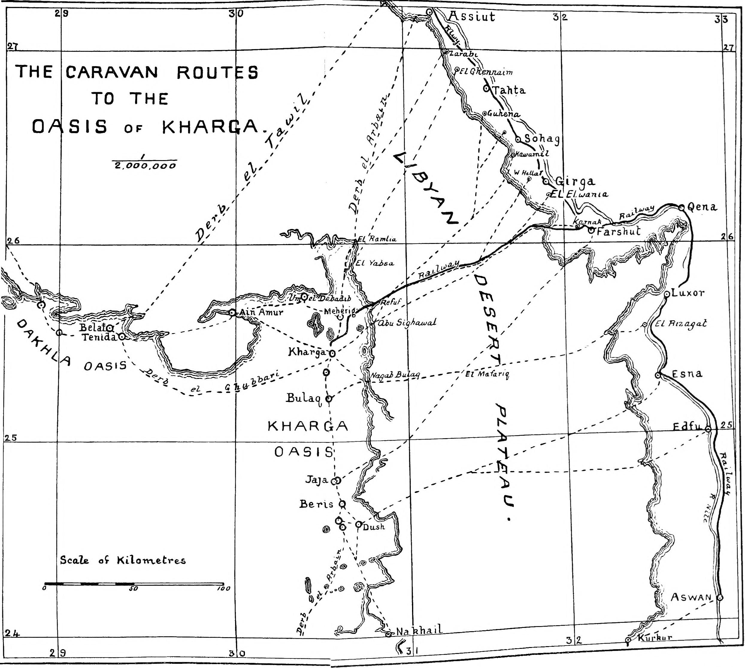
The main roads from the oasis run to Assiut, Kawâmil near Sohag,
Waled Hallaf near Girga, Karnak near Farshut, and to Rizagat, Esna,
and Edfu, and their disposition may be seen on the accompanying
plan.
The Assiut road, after leaving Kharga village, passes the hamlet
of Meheriq and follows the line of wells to Ain el Ghazâl, which is
the last place at which water-skins and tanks can be filled. From
Ain el Ghazâl the most direct route ascends to the plateau by the
Ramlia pass in the extreme corner of the depression, but the Yabsa
exit is recommended as easier and very little longer. After
crossing a tract of country with an abominably rough surface, the
two tracks unite a few kilometres north of the depression, and
about a day’s march farther on the Zarâbi road takes off on the
right. The main road proceeds direct to Assiut, descending the
scarp about 8 kilometres before the town is reached, a by-path to
the little village of Dronka having branched off beforehand.
From the summit of El Yabsa a separate road proceeds direct to
El Ghennaim, a village on the edge of the desert to the north-west
of Tahta. By these roads the distances from Kharga village to
Assiut, Zarâbi, and El Ghennaim, are 210, 200, and 180 kilometres
respectively.
El Refûf, the pass by which the Sohag (Kawâmil) road leaves the
depression, is situated at the head of a gully, and offers an easy
ascent to the plateau. A few kilometres beyond, the road passes to
the north of El Shugera, a prominent detached block perched on end
at the foot of the southern slope of a small limestone range. The road runs in a
fairly steady direction 40 degrees north of east, striking the Nile
Valley scarp 15 kilometres before Kawâmil, on the edge of the
cultivated lands, is reached. About 33 kilometres before reaching
the scarp a branch takes off and runs nearly due north to Guhêna,
south of Tahta; this branch is, in fact, usually referred to as the
Tahta road.
If the traveller, after leaving the Refûf pass, keeps to the
south of El Shugera, he will find a branch road leading to El
Tundaba, a deep shaft in the centre of the plateau, at kilometre
No. 92 on the railway; a little farther east this track strikes the
main road from the Abu Sighawâl pass. The shaft is sunk through a
thick deposit of silt, which has filled a local depression in the
plateau to some depth. The silt must be regarded as rain-wash from
the surrounding country, possibly deposited in the time of
prehistoric man. Flint implements are to be found scattered about,
and from the presence of pottery and graves it would seem that the
place had been inhabited in comparatively modern times. The pit was
evidently sunk for water, although at the present time it is quite
dry; given, however, a heavy thunderstorm within the
catchment-basin, drainage-water would in all probability find its
way to the bottom of the deposit, where it would be held up by the
limestone, and might form a supply lasting possibly for many
years.
The road leaving the depression by the Abu Sighawâl pass, and
leading to villages in the neighbourhood of Girga and Farshut, is reckoned the best
and shortest route between Kharga and the Nile Valley, and, by
making a very short détour, caravans have the advantage of being
able to water at the old Roman fort at the base of Jebel Ghennîma,
27 kilometres after leaving the village. The ascent of the pass was
formerly very rough going, but a good road with an easy gradient
has recently been cut for the transport of heavy boring machinery
into the oasis. From the top of the Abu Sighawâl pass a well-marked
track crosses to El Refûf and connects with the Sohag road, and
care has to be taken by travellers for Waled Hallaf, El Elwania and
Karnak not to make the initial mistake of getting on to this
track.
For the first few kilometres the main road from Abu Sighawâl
runs very straight over a level plain, on which fossil sea-urchins
are so abundant as to attract the attention of the most casual
observer; it then ascends a low escarpment, the Nagab el Jellab.
The somewhat rough limestone country beyond is known as the
Mishâbit, and then El Botîkh, with its countless millions of
spherical chert concretions, is crossed. Beyond El Botîkh the road
passes an isolated limestone hill called El Mograbi, where
tradition has it that a Mograbi Arab from the west and his stolen
oasis bride were overtaken and decapitated by the Kharga people. A
little farther to the east there is a bifurcation, but the branches
soon rejoin, and after passing El Masaâd the plain is fairly level,
though covered with
very angular blocks of crystalline limestone and cherty
concretions. Farther on are the rocks of El Buraig, where large
quantities of broken pottery indicate the site of one of the many
water-stations maintained by the Romans along this road. Garat el
Melh is so called from the occurrence of salt in the limestones of
this locality. A few kilometres to the east of Garat el Melh the
road passes El Suâga, an artificial heap of stones to which every
self-respecting Bedawi is careful to contribute; and a couple of
hours beyond, a fairly conspicuous limestone hill, called Garat
Radwan, is reached.
Shortly after passing Garat Radwan the most prominent landmarks
met with on this road, in the form of two solitary crescent-shape
sand-dunes, loom into sight; these are called El Ghart by the Arabs
and are distant 55 kilometres from Abu Sighawâl. They form part of
a belt of single isolated dunes which crosses this part of the
desert in a N.N.W. and S.S.E. direction. The same line of dunes is
passed by the railway at kilometre No. 100, and I have observed its
continuation still farther north on the Sohag road, at a point 45
kilometres from the Refûf pass. These dunes mark the entrance to an
area of very rough hummocky crystalline limestone known as El
Zizagat, through which the track is not easily followed. On
emerging from El Zizagat the road bears slightly to the north, and
is here only a few kilometres south of El Tundaba. At this point it
bifurcates, the
northern branch proceeding direct to Waled Hallaf near Girga, the
southern continuing over the easy level plains of El Ishab to the
rocks of El Baglûli, and thence past those of Dilail el Kelb to the
twin hillocks of Dubîya. Beyond El Dubîya the road crosses the
shallow drainage-line of Rod el Ghanam, near the head of the Wadi
Samhûd, down which it passes, and thence over the Nile Valley
plains past El Hamera and Hagar Hawara to Karnak and Farshut.
It should be mentioned that at Rod el Ghanam, shortly before
reaching the head of the Wadi Samhûd, a branch road takes off on
the left-hand side and descends by a separate pass to El Elwania;
and here again care has to be exercised to avoid taking the wrong
branch, as the tracks cover a broad area, and the actual junction
may be easily missed.
The Kharga-Waled Hallaf road, via the Abu Sighawâl pass, is the
shortest route from the oasis to the Nile Valley, the distance
being only 160 kilometres; that to Karnak, by the Wadi Samhûd, is
somewhat longer, being approximately 174 kilometres.
The next pass of importance to the south lies east of the
village of Bulaq, whence it takes its name. From the summit a road
runs nearly due east, meeting a second, starting from Beris and
gaining the plateau by the Jaja pass, after one and a half days’
march. From the cross-roads, ‘El Mafâriq,’ routes run direct to
Farshut and Rizagat.
From Beris to Farshut, by the Jaja pass, the distance is
approximately 224 kilometres; from Kharga, by the Bulaq pass, the
roads to Farshut and Rizagat measure about 203 and 198 kilometres
respectively. Another road from Beris leaves the depression by a
pass to the east of the village of Dush; this bifurcates about two
days’ march from the latter, the left-hand track leading to Esna,
the right to Edfu. Other roads lead from the south end of the
oasis, via Nakhail, to Kurkur and Dungun, while the Derb el Arbaîn
runs southwards to Selîma and thence on to the Sudan.
The road between the oasis and Assiut is best known as being the
last and worst portion of the Derb el Arbaîn, or forty days’ road,
which, starting from Darfur, was originally one of the main lines
of communication between Egypt and the Sudan. It was along this
desert route that great numbers of slaves and large quantities of
merchandise, such as ivory, gum, and other products of the Sudan,
were imported into Egypt from the south. After passing the last
spring in the oasis, caravans had still a little over 200
kilometres to cover before reaching the Nile Valley, with a steep
ascent to the plateau at the outset, and thence for a considerable
distance over the very worst surface imaginable—loose sand full of
sharp angular blocks and fragments of flint and cherty limestone.
Little wonder that, overladen and fatigued by the long distance
already covered, the camels died in great numbers on this last
stretch of road. Along most desert routes the dried bones of camels are
of fairly frequent occurrence, but on the Derb el Arbaîn, between
Kharga and Assiut, the skeletons of these poor beasts are met with
in groups of tens and twenties, and must number hundreds and
thousands. In many instances the skeleton still lies undisturbed,
in the position assumed by the luckless animal in its death agony,
the long neck curved back by muscular contraction so that the skull
lies in contact with the spine. When one sees these remains, half
buried in the sand, the bones bleached snow-white by a pitiless
sun, with still adhering fragments of skin and muscle dried hard as
adamant, one cannot but feel pity for those patient ‘ships of the
desert,’ wrecked almost within sight of port.
Cailliaud, in 1817, observed the arrival at Assiut of a large
caravan from Darfur, consisting of 16,000 individuals. It included
6,000 slaves—men, women, and children. He remarks: “They had been
two months travelling in the deserts, in the most intense heat of
the year; meagre, exhausted, and the aspect of death on their
countenances, the spectacle strongly excited compassion.”
The actual width of the plateau varies from 120 kilometres
between Abu Sighawâl and the scarp above Waled Hallaf, to 200
kilometres between Beris and Esna. The maximum elevation above
sea-level is about 550 metres on the latitude of Esna, and on the
whole the plateau has a fairly general slope to the north. As
already mentioned, several distinct types of country, depending on
the nature of the
rocks constituting the surface strata, are met with. Smooth, hard,
level plains, formed of a superficial layer of weathered limestone
covered by a brown veneer of insoluble flint and cherty fragments,
alternate with bare rugged rock desert of hummocky limestone. The
sombre level or gently undulating flint-covered plains, frequently
spoken of as ‘serir’ by the Arabs, have ideal surfaces for
travelling; the light-coloured hummocky country, often called
‘kharafish,’ is in its most developed form made up of innumerable
elongated hillocks, every portion of the exposed rock-surfaces
being deeply scored; the furrows are separated by upstanding edges,
often so sharp and knife-like as to be capable of injuring the feet
of man and beast. The hillocks are separated by deep troughs half
buried in drift-sand, all lying parallel, in the direction of the
prevailing winds, so that progress in a latitudinal direction
through this type of desert is a slow and tedious undertaking. Both
types of country are equally desolate and barren, scrub of any
description being of the rarest occurrence, except after local
thunderstorms. Another type of country, to which we have already
briefly alluded, is the curious desert-surface called El Botîkh
(the water-melons), which results from the weathering of certain
bands of the Lower Eocene formation containing numbers of large
globular concretions; these, it may be mentioned, often lie so
thickly strewn on the surface as to actually obstruct the passing
caravan.
Kharga is connected with the oasis of Dakhla to the west by two
roads, the lower and more southerly, known as the Derb el Ghubbâri,
being the one most frequently used. This road, by taking a wide
sweep to the south, avoids the intervening plateau altogether, so
that the fatiguing ascent and descent are avoided. After leaving
Kharga village the route leads past a group of wells, known as Ain
Khenâfish, distant some 6 kilometres; thence it lies over
wide-stretching plains of sandstone, leading up to the more broken
country formed by the foot-hills of the towering plateau, which is
always plainly visible on the north side of the road. The distance
to Tenîda, the most easterly of the Dakhla villages, is 143
kilometres by the Derb el Ghubbâri.
The alternative route by way of Ain Amûr is appreciably shorter,
though, owing to the extra time involved in negotiating the steep
passes to and from the plateau, there is little saving in time when
travelling with a heavily-laden caravan. Compared with the lower
road, however, this route is much more interesting and picturesque,
and the presence of water at Ain Amûr, about half-way between the
two oases, is a distinct advantage. The road from Kharga village
lies over a broad plain, whose only features are occasional conical
hills of dark ferruginous sandstone. It follows a W.N.W. direction,
heading for the great indentation to the west of the Jebel Tarif
range. After getting well into the recess, but when still
some 15 kilometres
from its head, the road turns abruptly to the south, and winds its
way up an escarpment littered with huge blocks of tufaceous
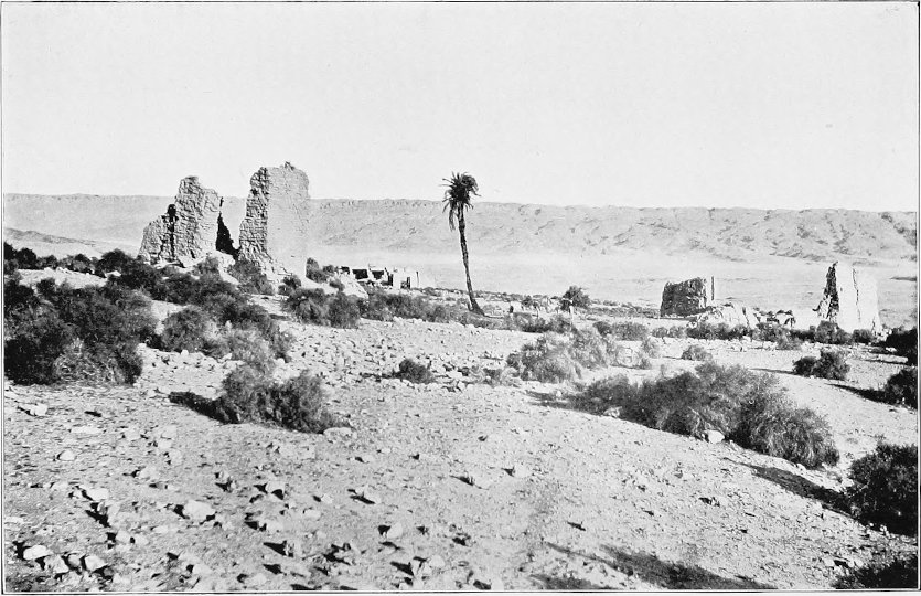
limestone. Perched near the summit of the cliffs stands the
solitary palm which marks the site of the water-hole, in the
immediate neighbourhood of which grows a fair amount of prickly
scrub. The remains of mud-brick buildings and a stone temple show
that this place was formerly inhabited, and of some importance.
The ascent to the plateau from Ain Amûr needs care with laden
camels. The road proceeds up a narrow defile, the actual track
being very rough, and so confined that in places the packs are
liable to be dragged off by the rocks on either side. Once on the
plateau the going becomes first rate, the freedom of the surface
from blown sand being very noticeable. This is due to the isolation
of this portion of the plateau-massif, which is cut off from the
main mass to the north by the deep recess, and is bounded by a
low-lying plain to the south. After a distance of 33 kilometres has
been traversed the road descends into a narrow valley opening on to
the low country to the south, and proceeds in a westerly direction
to Tenîda. The distance from Kharga to Tenîda by this route is 128
kilometres.
It is possible on leaving Ain Amûr to cross to the top of the
indentation, and thence to proceed across the plateau almost due
west, striking the road from Assiut, known as the Derb el Tawîl, at
the top of the pass 25 kilometres from the village of Belat. There is, however, no
track, and the surface is covered with parallel north and south
ridges of rock, the crossing of which is extremely wearisome. Both
near the head of the Ain Amûr recess and in the extreme north-west
corner of the oasis very old tracks trending in westerly and
northwesterly directions are observable, and although unused at the
present day, these may mark the positions of formerly frequented
routes leading to the oasis of Farafra. At the present time that
oasis is not in direct communication with Kharga, the routes used
being from Manfalut in the Nile Valley, from Qasr Dakhl in the
oasis of Dakhla, and from Ain el Hais in Baharia.
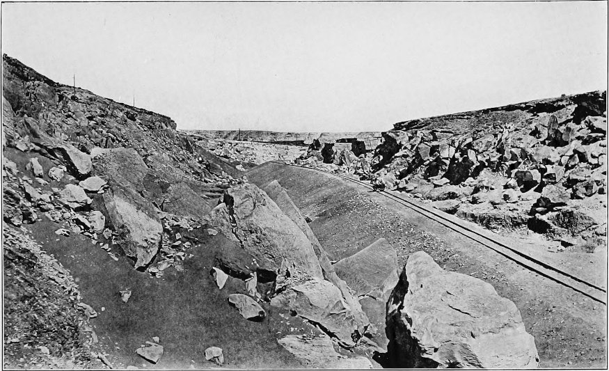
Before leaving the subject of roads we must briefly refer to the
route taken by the railway. The line, which has a gauge of 75
centimetres, was built by the Corporation of Western Egypt,
Limited, to develop their concessions in the oasis. It commences at
Mouaslet el Kharga, a new station on the Egyptian State Railway
near Farshut, and crosses to the border of the desert, a few
kilometres distant, by way of one of the embankments separating two
of the great irrigation basins of Upper Egypt. At the edge of the
desert is the station of El Qara, the point of departure for the
oasis. After skirting the margin of the Nile Valley cultivation for
a short distance it heads straight for the Wadi Samhûd, by means of
which the plateau is gained without encountering any very heavy
gradients. From the top of the Wadi Samhûd the line follows the Abu Sighawâl road for
about 40 kilometres, after which it diverges a few degrees and
proceeds to El Tundaba, the shaft already described, 92 kilometres
from Mouaslet el Kharga. From El Tundaba the railway follows more
or less closely the cross-track, sometimes called the Derb el
Refûf, which joins the Sohag road at El Shugera, and, entering the
depression by the Refûf pass, follows down the gully, and thence
across the plain to the station of Meheriq. From Meheriq it
proceeds nearly due south to the Corporation’s headquarters, and
thence on to its present terminus a few kilometres from Kharga
village.
THE RAILWAY DESCENDING INTO THE OASIS.
My friend Ball lays great stress on the tortuous nature of the
roads between the oasis and the valley, and recommends the
scientific traveller to steer an independent course. But after
traversing the majority of the main caravan roads, and with a
fairly intimate knowledge of the characters of the intervening
areas, I must say that, in my opinion, it would be difficult to
better them. These roads were not laid out yesterday, but result
from the accumulated experience of centuries. The original tracks
may have been tortuous enough, but they have become straightened
out by the cutting off of corners here and there, until at the
present day the roads fulfil the three most important objects in
view—the ascent and descent to and from the plateau at the points
offering the easiest gradients, and the crossing of the plateau
itself as directly as
possible over the smoothest and most level ground available. The
roads give a wide berth to the outcrops of rough limestone, and
anyone who has done much cross-country travelling in the Libyan
Desert will appreciate their doing so.
Nor can I concur with the same author in his opinion that the
Bedawin of this side of the Nile have a poor knowledge of their
beloved desert. It is certainly true that the Arab does, for very
good reasons, prefer to travel on the beaten tracks rather than
undertake exploratory missions as the crow flies, his main object
being to get to his destination as rapidly and easily as possible.
If by chance, however, rain should fall on any portion of the
desert, the Arab will very shortly be found there, taking full
advantage of what Allah has provided in the way of free grazing for
his herds. My own experience has been that the Arabs have among
them a fair proportion of men with an extensive knowledge of the
western desert, and I have frequently been struck by their
wonderful knowledge of the roads and the facility with which many
of them can follow the tracks on the blackest of nights, as even in
broad daylight the landmarks which a European could recognize on
second acquaintance are few and far between. The average Bedawi
cannot be said to have exceptionally long sight, but he is
frequently possessed of a wonderful sense of direction.
Travellers in the Egyptian deserts are apt to underrate the
intelligence of the Bedawin, owing to the fact that they
unconsciously form their impressions from the miserable specimens of humanity so
frequently sent out by the actual owners of the camels to act as
drivers and attendants to a hired caravan. In such caravans there
is seldom more than one man who knows the particular roads to be
followed; the rest are wretched underfed creatures, generally
half-breeds, who for a mere pittance tramp day after day,
uncomplainingly and shoeless, alongside the caravan. They are much
to be pitied, and it would be as unreasonable to expect them to
have any special knowledge of the desert as it would be to look for
information regarding, say, the mountains of Wales among the poorer
classes of a Welsh town.
I do not wish to minimize the value of cross-country traverses
carried out with special scientific objects; they are, indeed,
often necessary for topographical and geological purposes. I would,
however, warn the enthusiastic tyro that, in the Libyan Desert,
travelling as the crow flies is not always so simple and glorious
an affair as it may seem when planning expeditions from a
comfortable arm-chair; and if his object is to get a short cut he
will probably have reason to bitterly regret the moment he left the
beaten track. I have in mind more than one instance where mistakes
of this kind have been made, mistakes which might easily have led
to disastrous consequences. In long cross-country traverses an
error in steering of only two or three degrees will in a few
marches throw a caravan many kilometres out of its course, and
guiding camels over
rough country by compass is by no means an easy undertaking.
Moreover, easily distinguishable landmarks are rare, and the desert
plains over wide areas maintain remarkably persistent
characteristics. Quite recently I recollect an Englishman, whose
Arab attendant had become suddenly incapacitated by an attack of
fever or sunstroke, getting hopelessly astray between the edge of
the plateau overlooking the oasis and rail-head, which was then
only 20 or 30 kilometres distant, in consequence of his missing the
bifurcation of the road at El Shugera, and proceeding, owing to
this mistake, along the route leading to Sohag.
Along the caravan roads the sharp fragments of rock have been
stamped underground or kicked to one side, but elsewhere they
usually litter the surface, and are very trying to camels, whose
pads, though soft and yielding, are easily worn by much travelling
over rough country. This has more than once been painfully
impressed upon me by the antics of my own riding camel, whose mode
of progression at such times resembled more the dance of a fanatic
on red-hot coals than the ordinary gait of a well-bred ‘hegîn.’
Over some areas, however, one can travel in a straight line without
let or hindrance, and in such cases it is only necessary to lay out
the course correctly in the first instance, and to have the courage
of one’s opinion to stick to that course until the destination is
reached. One must not heed the remonstrances of the less sporting
members of the expedition, who will lose no opportunity of predicting disaster, and in
this respect the new chum fresh out from home is generally the
greatest offender.
One of the longest cross-country traverses I myself have
undertaken in the Libyan Desert was from Farafra Oasis to Assiut.
The only road between that oasis and the Nile Valley strikes the
latter near El Qusîya, midway between the towns Manfalut and Derut,
so that travellers who wish to make Assiut have an additional day’s
march southwards alongside the margin of the cultivated lands. On
gaining the summit of the pass above Bir Murr, on the east side of
the Farafra depression, I abandoned the road and set a course
direct for Assiut, steering and plotting my route by compass and
plane-table, the distance being reckoned by measuring-wheel. The
most satisfactory method of procedure on desert traverses is to lay
out a line, representing the correct bearing of the destination,
along the centre of the longer axis of the plane-table, and then to
steer to any well-marked object lying on either side, but within
reasonable distance, of the proper course. At every station the
exact position reached is plotted, and steps are taken, when
selecting the next point on which to march, to converge towards the
correct course marked down the centre of the table.
On this particular traverse I was unaccompanied by Europeans or
Bedawin, my camel drivers being fellahin from the Nile Valley. The
surface proved excellent going, and the Abu Mohariq belt of
dunes, 190 kilometres
from Qasr Farafra, was crossed without trouble. Eight days after
leaving Farafra village we struck the escarpment of the Nile
Valley, having covered nearly 300 kilometres, and found we were
marching on a point only very little to one side of the town of
Assiut. From this traverse it was possible to calculate the
longitude of Farafra with fair accuracy.
The normal rate of travelling of camels carrying ordinary loads
weighing from three to four hundred-weight is 4 kilometres, or
about 2½ miles, an hour, ten hours being the usual day’s march of
caravans when accompanied by Europeans. The native caravans,
carrying dates and other heavy merchandise, usually traverse the
plateau in three days and nights, doing stages of 60 to 70
kilometres at a stretch. By travelling very light with trotting
camels I have, on more than one occasion, crossed from the oasis to
the valley in between thirty and thirty-five hours, doing from 180
to 190 kilometres in two stages of about twelve hours each, with
one stop only of nine or ten hours.
CHAPTER IV TOPOGRAPHY AND GEOLOGY
Dimensions of the Oasis-Depression — Jebel Têr,
Jebel Tarif, and other Hills within the Depression — Aspect of the
Oasis from the surrounding Escarpments — Geological Sequence —
Nature and Thickness of the Strata — Geological History of the
Oasis — Formation of the Depression — Difference of Level of Strata
on either side of the Depression — The Great Longitudinal Flexure —
Height of the Floor compared with Sea-Level — Altitudes.
Kharga, the eastern of the
two southern oases, is a depression lying with its longer axis
north and south, mostly bounded by steep and lofty escarpments, but
open to the south and south-west, on which sides the country rises
gradually from the floor of the oasis. The extreme length of the
depression, from the northern wall to Jebel Abu Bayan, which for
convenience may be regarded as the southern limit of the oasis
proper, is 185 kilometres, or 115 miles. The general trend of the
eastern escarpment is nearly due north and south, but that on the
west is very irregular, while to the south and south-west there is
no definite boundary. The breadth of the depression may therefore
be said to vary from 20 to 80 kilometres.
The ranges of Jebel Têr and Jebel Tarif form isolated
hill-massifs in the centre of the northern part of the depression,
while Jebel Ghennîma and Jebel Um el Ghennaim are conspicuous
outliers of the plateau on the east side. With the exception of
these, the floor is destitute of anything beyond comparatively
insignificant eminences, unless we include the small range of hills
known as the Gorn el Gennâh, to the south-east of the village of
Gennâh, which is noticeable more on account of its sharply-defined
peaks than of its general elevation above the surrounding country.
Referring to the two conspicuous peaks, Ghennîma and Um el
Ghennaim—Jimmy and Jemima, as I have heard them dubbed—reminds me
that on the Survey and on some of the older maps the names are
reversed. I have questioned a number of natives regarding the names
of these hills, and have invariably been informed that Ghennîma is
the more northerly of the two.
The villages, wells, and cultivated lands lie within a north and
south band, occupying the lowest portion of the floor, and
following the general trend of the depression. They are, however,
broken up by a broad area of barren desert into two distinct north
and south groups, of which Kharga and Beris villages are the chief
centres respectively. A description of these is reserved for a
later chapter.
When a traveller, after crossing the broad monotonous plateau,
at length reaches the scarp or wall of the oasis, and sees spread
out before him a vast
depression, stretching in some directions as far as the eye can
reach, in others to the opposite bounding walls dimly discernible
on the far horizon, he can hardly refrain from speculating as to
the causes which have given rise to such huge hollows in the
plateau. When he descends to the cultivated portions of the floor
of the depression, and sees those numerous bubbling springs, which
alone make life possible in the midst of this otherwise deadly
wilderness, his second inquiry is as to whence comes such abundance
of water in one of the most arid regions in the world. These
questions are worth asking, and, so far as the present state of our
knowledge permits, it will be my endeavour to answer them. I
propose, therefore, to briefly place on record such information and
data as I have been able to gain, but as both topography and
water-supply are intimately connected with the geology of the
district, it will be necessary at the outset to devote a few pages
to a consideration of the latter.
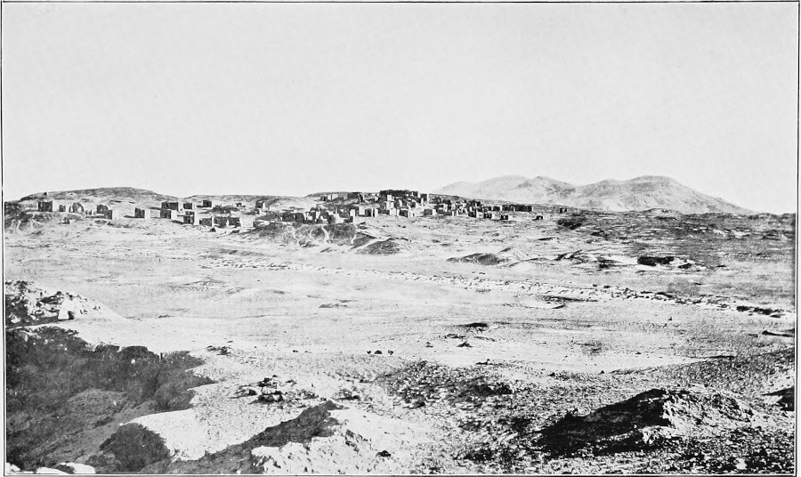
THE CHRISTIAN NECROPOLIS AND JEBEL TER.
The geological deposits found in the oasis of Kharga are
tabulated on the following page, commencing with those most
recently formed. The succession, as shown in the table, is that
which obtains in the northern part of the depression, but as far as
is known the same stages occur throughout the oasis, and do not
vary either in thickness or in lithological characters to any great
extent. Over large areas the lower-lying parts of the oasis-floor
are formed of those beds which we have designated the Surface-water
Sandstone, though in
Geological System.
Stage.
Thickness in Metres.
Recent and
Pleistocene
}
⎧
⎪
⎨
⎪
⎩
Sand-Dunes
⎫
⎪
⎬
⎪
⎭
Very variable
Spring Deposits (modern)
Lacustrine Sands and Clays
Calcareous Tufa
Lower Eocene
Lower Libyan
Plateau Limestone
115
Passage Beds
Esna Shales and Marls
55
Upper
Cretaceous
Danian
⎧
⎨
⎩
White Chalk
⎱
⎰
70
⎧
⎪
⎪
⎨
⎪
⎪
⎩
Ash-grey Shales
Exogyra Beds
30
Campanian (Nubian Series)
⎧
⎪
⎨
⎪
⎩
Phosphate Beds
70
Purple Shales
50
Surface-water Sandstone
45
Impermeable Grey Shales
75
Artesian-water Sandstone
120
Total
630
places the still older underlying grey shales are
exposed. The purple or red shales generally form the rising ground
towards the escarpments, at the base of which are usually found the
phosphatic beds, with hard, pronounced bands made up of
fish-remains and phosphatic nodules. Above come the Exogyra Beds,
with thick bands of limestone almost entirely composed of large
oyster-shells. Rising up above these is the generally well-marked
cliff of grey shales, capped by a snow-white chalk of much the same
age geologically as the well-known chalk of the South of England.
The summit of the chalk frequently forms a separate plateau,
subsidiary to the high desert tableland, and separated from it by
the cliffs formed of the massive Eocene limestones.
The total thickness of the exposed strata is about 435 metres, a
figure obtained by actual measurement. Numerous borings show the thickness of the
unexposed underlying Impermeable Grey Shales to be 75 metres, and
the deepest borings yet made have pierced the still lower
Artesian-water Sandstone to a depth of 120 metres, making a grand
total of known deposits of 630 metres, or 2,067 feet. The depth to
which the water-bearing sandstone extends is at present a matter of
speculation; the point is of great importance in connection with
the water-supply, though up to the present no borings of sufficient
depth have been made to determine its thickness, nature, and
relation to the underlying igneous rocks.
With the exception of a few isolated bosses of eruptive rock in
the desert to the south of the oasis—indications of the granitic
foundation which probably underlies the entire area—the geological
deposits of the oasis-depression, and of the surrounding
escarpments and plateaux, are entirely of sedimentary origin, that
is to say, they were laid down on the shores and beds of
pre-existing seas and inland lakes. The sand-dunes are, of course,
an exception, having been deposited by the wind on the surface of
the land. Although, geologically speaking, the oldest group of
sediments with which we have to deal belongs to the later chapters
of the earth’s history, many hundreds of thousands of years have
elapsed since the sandstones and shales, now forming and underlying
the floor of the oasis, were accumulated on the bed of a vast
inland lake. This sheet of comparatively fresh water was
then invaded by the
sea, which held sway in the region while the whole of the series of
sediments, now exposed in the cliffs of the oasis and some 350
metres in thickness, were being laid down. In Middle Eocene times
the sea commenced to retreat to the north, and the area under
description became dry land with a continually receding shore-line.
Since that time the forces of denudation have constantly been at
work lowering the general surface of the plateau and excavating
those depressions in which alone at the present day man is able to
exist.
The Egyptian oases are deep and extensive depressions or hollows
cut down nearly to sea-level through the generally horizontal rocks
forming the Libyan Desert plateaux, and appear to owe their origin
in great measure to the differential effects of subaërial
denudation acting on rock-masses of varying hardness and
composition. The surface-features or configuration of almost any
land which has long been exposed to the powerful forces of erosion
are more or less intimately dependent on the structure and
lithological characters of the underlying rocks. On relative
hardness, more than on anything else perhaps, depend the ultimate
positions of mountains, hills, and plateaux on the one hand, of
valleys, plains, and depressions on the other. Variation in the
original conditions of deposition, at the time when the rocks now
forming the Libyan Desert were laid down on the floor of the sea,
has resulted in a preponderant development in some areas of soft
clayey or sandy rocks (as compared with the hard limestones), and subsequent
earth-movements have raised these beds more in some districts than
in others. The result has been that wherever, during the gradual
denudation to which the country since its elevation has been
subjected, these soft deposits have become exposed on the surface,
weathering has proceeded at a greatly increased rate, and
eventually produced deep and broad depressions separated by high
limestone tablelands.
SKETCH MAP
SHOWING THE GEOLOGY
AND THE ANCIENT LAKES OF THE
OASIS OF KHARGA
But for the presence of comparatively soft formations such as
the Esna Shales, the Exogyra Beds, and the Nubian Sandstone,
coupled with the facts that they have an unequal development in
different areas, and occur at a greater elevation in some
localities than in others, the great depressions of the Libyan
Desert would not have come into existence, or at any rate would
have been of comparatively little importance in the configuration
of the country.
The oases are true depressions, completely or partially
surrounded by high escarpments. The oasis of Baharia, for instance,
is on all sides hemmed in by cliffs; on the other hand, Dakhla and
Kharga are open to the south, but as the ground in that direction
rises considerably, they, too, cannot be regarded as other than
true depressions. We have no definite grounds for considering that
the erosion of these depressions can have been the work of
previously existing rivers, and there is no evidence to warrant us
in assuming them to have been formed by local subsidence of
portions of the earth’s crust.
What, then, were the agents of denudation and transportation
which operated in the formation of these great depressions? Under
the existing arid conditions the surface rocks, unprotected by
vegetation, are rapidly disintegrated or weathered as the result of
the great diurnal variations of temperature to which they are
subjected (insolation). The weathered material, however, does not
accumulate and form a protective soil-cap, but is carried away by
the wind (deflation), the heavier siliceous grains effecting an
immense amount of abrasion of the exposed rock-surfaces over which
they are swept. Changes of temperature, sand, and wind are, indeed,
the chief agents of erosion and transportation at the present day,
and, given a sufficiency of time and a continuance of favourable
conditions, we can confidently admit the combination to be capable
of effecting a vast amount of earth-sculpture. But the formation,
in this way, of huge hollows 300 to 400 metres deep, and the
removal of material amounting to hundreds of cubic kilometres,
would necessitate the assumption that the present rigorous desert
conditions have obtained for a very considerable period.
Taking all the available evidence of which we are cognizant into
consideration, we do not feel justified in assuming this to have
been the case, especially when we recollect the frequent presence
on the escarpments of thick deposits of calcareous tufa, which it
is evident must have been laid down after the depression had been
carved out to a considerable depth. These tufas are almost certainly of
Pleistocene age, though whether they date from the early or late
part of that period has not been determined. In some localities
they occur as thick, horizontally-stratified beds, and were
evidently deposited on the bottoms of lakes; in other places they
appear as fan-like cakes spread over the face of the cliff, and may
have been formed by springs situated near the summits of the
escarpments. The tufas frequently contain large numbers of
fresh-water shells and an abundance of fossil vegetation, and, from
the presence of casts of the leaves of such trees as the oak, one
is led to refer the deposit to the more humid period which preceded
the incoming of the modern desert conditions.
Although the evidence met with in the field is altogether
against the idea that portions of the plateau have been bodily let
down by subsidence, there are good reasons for believing that
tectonic movements have played an important part in deciding the
general shape of the oases-depressions. For instance, there is
considerable parallelism between the general trend of the Baharia
depression and the folds which pass through that region. As a
result of those folds, it is not improbable that the hard limestone
beds were to some extent broken up, and the soft underlying clays
and sandstones raised as compared with their position on either
side of the folded belt. In Kharga, similarly, the main axis of the
depression is, as we shall show, distinctly parallel to the great
north and south line of flexure, and there is little doubt that a close connection
exists between the two. On the other hand, I know of no folding in
the case of Farafra, which appears to owe its existence solely to
the fact that there was in that region an unusual development of
shales at the base of the Eocene nummulitic limestones. Of the four
Egyptian oases, perhaps Dakhla is the one most easily accounted
for, as this depression may be regarded as simply due to the
general northerly dip of the sedimentary formations, and the
gradual weathering back (northwards) of the great argillaceous
series (Exogyra Beds) capped by the White Chalk. The original
limits of the latter may, indeed, never have been very far to the
south.[3]
While all sedimentary strata—such as the limestones, sandstones,
clays, and shales with which we are now dealing—were originally
deposited either quite horizontally or inclined at only a very low
angle, it by no means follows that this horizontality is maintained
when the strata are elevated into dry land. Over the Libyan Desert as a whole the
successive sedimentary formations dip steadily northwards, but at a
very small inclination. This results in every stage having a wide
outcrop, so much so that, if it were not for the cliff-sections of
the Nile Valley and the oases-depressions, we should have to travel
immense distances to obtain any idea of the true succession of
rocks. This general horizontality of strata appears at first sight
to be well maintained in the oasis of Kharga, as whether we stand
on the summit of the eastern escarpment, on top of the great
central hill-massif of Jebel Tarif, or on the plateau above Ain
Amûr, we see everywhere horizontally-disposed beds of limestone
forming the plateaux and upper portions of the cliffs, with
parallel bands of sandstone, shale, and chalk outcropping on the
slopes below.
A closer examination, however, will show that there is in
reality a difference in level of more than 200 metres between the
same beds on either side of the oasis; for the beds capping Jebel
Tarif belong to the White Chalk of the Cretaceous system, and are
therefore very much older than those of Eocene age forming the
eastern plateau (see map and section). This great difference in
vertical position is due partly to a steady dip from west to east,
partly to a remarkable longitudinal flexure running north and south
through the centre of the depression, and partly to a gentle fold
near the base of the eastern escarpment. Along the actual line of
flexure, which passes through Jebel Têr, Jebel Tarwan, Nadûra, Gorn el Gennâh, and
Gertuma (S.S.E. of Bulaq), the different rock-stages are folded and
fractured to a remarkable degree. Throughout the greater part of
its course the flexure approximates to the type of disturbance
known as a simple monocline, but in places, as in Jebel Têr, it
passes into a syncline bounded by nearly vertical faults; while in
others the beds are bent into almost symmetrical basins or
centroclinal folds, typical examples of these structures being met
with at points 6 kilometres south of Kharga village and 2
kilometres south-west of Qasr Zaiyan.
The importance of this line of folding and faulting must not be
lost sight of, as although the dislocations produced are only
actually visible in the case of the exposed upper beds of the oasis
sequence, the earth-movements to which it owes its origin have had
similar disturbing effects on the underlying and hidden
water-bearing strata. Ball reported that the most striking evidence
of faulting was between Jebel Têr and Jebel Tarif, and showed the
fault as running for a short distance in a N.N.E. and S.S.W.
direction, but, as already mentioned, the line of disturbance is
coincident with the longer axis of the former range, so that the
majority of the wells are on the west or upthrow side of the fault.
The effects of this faulting and folding on the underground
water-supply will be further alluded to in a later chapter.
In the early summer of this year (1908) I followed the line of
flexure southwards in order to determine whether it continued throughout the oasis. As
far as the small eminence of Gala, about 10 kilometres south of
Bulaq, it ran in an almost straight line, but south of that point
its course took a distinct bend to the west, so that the fold was
very soon lost in the great belt of sand-dunes. Beyond this point
its continuation could, however, be inferred by occasional
exposures of steeply inclined sandstones, the most southerly point
to which it was actually traced being in latitude 24° 55′ N., about
15 kilometres S.S.W. of Ain Girm Meshîm.
GEOLOGICAL SECTION ACROSS THE OASIS FROM JEBEL TARIF TO THE
EASTERN ESCARPMENT.
Before concluding our remarks on the geology of the oasis we
must not omit to call attention to the beautiful and varied fossil
remains which are almost everywhere to be met with in the
calcareous beds of the hills and escarpments. It is, of course, by
the study and comparison of these organic remains that geologists
are enabled to determine the relative ages of the beds in which
they occur, and thus to correlate them with the rocks of other
countries. The lower argillaceous and arenaceous deposits of the
oasis are comparatively unfossiliferous.
From any of the points of vantage, such as
are afforded by the higher hills within the depression, the general
level of the floor of the oasis does not appear to vary to any
great extent, but actual levelling shows that this is not in
reality the case; and it is this variation of absolute level which
is the primary cause of the very varying volumes of water yielded
by the artesian wells in the different districts.
The average height of the centre of the depression in the
neighbourhood of the village of Kharga is approximately the same as
that of the Nile Valley plain in the latitude of Farshut.
Ball, by comparison of a series of aneroid barometer readings
with the barometric records for the same period at the Cairo
observatory, deduced the value of a point near Kharga village as 86
metres above sea-level, and used this as his datum in calculating
the levels of other parts of the oasis. Previous aneroid
determinations of the same point had been made by Cailliaud (104
and 118 metres) and by Jordan (68 metres). But even when the
greatest possible precautions are exercised, aneroid
determinations, especially when made with a single instrument, are
necessarily unreliable, and still more so when used for calculating
the levels of different points on a plain having only comparatively
slight irregularities of surface.
Utilizing the figure obtained by the railway surveyors for a
point near the termination of the line, we get values of 58 and 60
metres above sea-level for Kharga village and Bore No. 1 at
headquarters respectively, and a bench-mark at the latter place,
having a value of 60·1, is used as the datum from which all the
heights given in this book are calculated. Unfortunately it is not
possible, owing to the lack of sufficient check-levels, to state
the limit of probable error, and it must therefore be understood
that the value of our datum, which in the meantime may be accepted
as the best obtainable, is subject to future revision.
From this central point (Bore No. 1) lines of levels have
recently been carried in every direction by Mr. F. E. Apted and
myself, with the result that it has been shown that the general
level of the floor of the oasis rises steadily to the north and
falls to the south. These levels have in all cases been checked,
and may, using the datum mentioned, be accepted as fairly reliable,
the closing errors on the different loops being generally within a
very few centimetres. The altitudes of a few reference points in
each district are given here.
District.
Point.
Altitude.
Headquarters
Bore No. 1
60·1
”
Bore No. 44
53·1
Kharga
Bir Ain el Gôs
70·2
”
Ain el Sabbagh
56·9
”
Ain Zaaf
87·7
”
Temple of Hibis (floor)
75·0
Meheriq
Bir Qattara
56·6
”
Ain Mahmud
64·8
”
Ain el Burg
69·6
”
Ain el Qasr
76·0
”
Ain el Ghazâl
84·6
South of headquarters
Ain Harrân
43·5
” ” ”
Ain Ali Morad
33·0
” ” ”
Ain Bellal
28·4
” ” ”
Ain el Tawîl
19·7
Gennâh
Ain Estakherab
71·3
”
Ain Magarin
74·6
”
Ain el Ghuâta (north)
48·2
”
Ain Zaiyan
41·6
”
Qasr Zaiyan
20·7
El Dêr
Bore No. 22
92·3
The Government Survey maps show a portion of the oasis floor as
lying below sea-level, the difference of height between the Kharga village datum
and a point just south of Qasr Zaiyan being given as 104 metres.
Detailed surveying shows that this estimate is excessive, the true
difference being about 37 metres only. Although no actual reading
has yet been obtained below sea-level—the lowest being +2·6 metres
at a point 3½ kilometres north-east of the northern end of the Gorn
el Gennâh, or nearly midway between that hill and Ain el Tawîl—it
is evident that in this district the floor is only very slightly
higher than the sea, and it may be that at one or two points its
level is actually lower.
South of Qasr Zaiyan no revision of previous levels has as yet
been made. According to Ball’s figures, the village of Beris is
approximately 10 metres lower than Kharga.
While discussing the subject of levels it may be useful to note
the relative heights of the escarpments and hills within the oasis.
The edge of the eastern plateau varies from 350 to 400 metres above
sea-level, while the plateau to the north of Um el Dabâdib has a
general level of about 400 metres. Jebel Tarif appears to be very
slightly higher, while the highest peak on Jebel Têr is not much
more than 300 metres. The altitudes of these points with reference
to the village were mostly determined by Ball by trigonometric
observations with an eight-inch theodolite, and can therefore be
relied on as being accurate.
CHAPTER V THE NORTHERN VILLAGES
Population — Relation of Population to Water-Supply
— Trade in Dates — Imports — Taxation on Date-Palms and Wells —
Measurement of Wells — Revenue derived from the Oasis — Origin of
Inhabitants — Kharga Village — Industries — Ancient and Modern
Wells — Meheriq Village — Troubles with Sand — Migration of
Villagers — Ain el Tawîl and other Hamlets — Gennâh Village —
Famous Wells — Ain Estakherab — Ochreous Waters of certain Wells —
Ain el Ghuâta — Bulaq Village — Doum-Palms — Tomb of Sheikh Khalid
Ibn el Walîd.
In point of population
Kharga ranks second of the four great oases of the Libyan Desert.
In 1897 the inhabitants numbered 7,856, and ten years later had
increased to 8,348. The 1907 census showed the male to be slightly
in excess of the female population, a result entirely owing to the
preponderance of men in the northern part of the oasis. The present
distribution of the inhabitants, according to the last census, is
shown in the table on the following page.
In the oases of the Libyan Desert there is a very close
connection between population and water-supply. No water is
intentionally allowed to run to waste, every drop being utilized to
raise
Male.
Female.
Total.
Kharga District
2,819
2,503
5,322
Gennâh District
207
237
444
Bulaq District
487
529
1,016
Beris District
767
799
1,566
Total
4,280
4,068
8,348
the crops of rice, dates, barley, and wheat, which
form the staple food-supplies of the inhabitants. Cut off by a
waterless desert, these people have little intercourse with the
outside world, except for a few weeks in the early winter months,
when they dispose of their surplus date-crop to the Bedawin traders
who cross the desert with droves of camels from the Nile Valley.
The dates are usually paid for in cash, ready-money being required
in order to meet the annual taxes levied by the Egyptian
Government. Practically the only food-stuffs imported consist of
such commodities as tea, coffee, and sugar, which are used
sparingly, and regarded as luxuries even by the better classes.
It is evident, therefore, that the inhabitants rely almost
entirely for subsistence on the products they are able to raise by
their own toil and industry. Owing to there being no rainfall, the
acreage of land which can be put under crops depends absolutely on
the amount of water available for irrigation by wells. The total
yield of the latter has, we know, fluctuated to a
considerable extent
at different times, and one may surmise that, could figures be
obtained giving the number of inhabitants and the volume of the
water-supply for different periods during the last 5,000 years, a
remarkably constant ratio would be observable between the two.
Taxes are levied by the Egyptian Government on both date-trees
and wells. Over 60,000 adult palms exist in the oasis, each one
being subject to a yearly tax of 1½ piastres (about 3½d.). The
output or yield of a well is, for purposes of taxation, determined
in a somewhat rough-and-ready manner by a method which appears to
have been in use for a number of generations. Whenever a new bore
is completed, or an old well requires remeasurement, all the most
influential personages in the oasis, headed by the Omda or chief of
Kharga village, armed with a number of primitive appliances,
solemnly proceed to the spot.
After first ascertaining that the well has not been temporarily
blocked by interested persons—even here in the remote interior of
the desert there is an inherent objection to the paying of
taxes—the bed and sides of the water-channel are made as smooth as
possible for a distance of five or ten paces below the mouth of the
well, so that the water flows away with an even ripple. A small
pointed stick is now inserted in the centre of the bed of the
stream, in such a way that the top of the peg is exactly flush with
the surface of the water. Then the Omda, hitching up his flowing
robes, steps into the stream, and, selecting a gauge of suitable
dimensions, fixes it firmly in the bed of the channel, in such a
position that the whole of the flow passes freely through, without
raising or lowering the surface of the stream above, as indicated
by the peg. The interior of the gauge, a roughly-made wooden frame,
is intended to be a definite number of centimetres in length, but
in many of those used there is a small error. As soon as the stream
flows evenly over the gauge or weir, without its surface-level
being altered, the depth of water is measured on a scale. The
latter is wetted and plunged into a heap of dry sand before being
used, the depth of water being indicated by that portion of the
scale from which the sand has been removed by the immersion.
Observations are made at both ends of the weir to insure any error
due to want of horizontality of the frame being detected.
The actual discharge is reckoned in ‘qirats’ and eighths of a
qirat (tumns), a qirat being a water-section of 64 square
centimetres. For example, if the depth of water passing over a
gauge having an internal length of 40 centimetres was found to be 8
centimetres, the water-section would amount to 40 × 8 = 320 square
centimetres, which would be reckoned as a discharge of 5
qirats.
The Omda and his attendants carry out the operations with the
utmost care and solemnity, and have the most touching faith in the
accuracy of their results. Apart, however, from errors in the
gauges and scales used, and from the want of provision of a free fall on the downstream
side of the weir, the fact that the velocity of the stream is
entirely left out of account is sufficient to give the qirat a very
variable value, low for small and high for large streams, the
result being that the small wells are being taxed at about 50 per
cent. higher rates than the large ones. In order to ascertain the
average value of the qirat for streams of different size, I
arranged with Mr. Patterson, who at the time was the Government
Representative in Kharga, to send the Omda to headquarters and
instruct him to measure a number of new bores belonging to the
Corporation of Western Egypt, as these bores, being cased and
provided with proper outlet valves, lend themselves to exact
measurement better than the majority of the native-owned wells. The
Omda employed the ordinary local native method just described,
while I, using a tank of known capacity and a reliable stop-watch,
made direct measurements immediately afterwards. The results
obtained show that below 2 the qirat has a value of 22 gallons a
minute; from 2 to 4 of 26 gallons a minute; and from 5 to 6 of 38
gallons a minute.
The annual tax levied on the water amounts to 50 piastres (about
10s. 3d.) per qirat. If the average value of the qirat be taken at
25 gallons per minute, the tax works out at approximately 1s. for
every 6,000 cubic metres of water. Looked at from another point of
view, it may be considered that the tax amounts to about 1s. 6d. an
acre, as with every qirat of water the native cultivator
in the oasis will
annually raise about two acres of rice and five of wheat or
barley.
The total revenue derived by the Government from the oasis, by
taxes on date-palms and water, amounts to a little over £1,000 per
annum.
My old friend Sheikh Mustapha, who for more than twelve years
has been Omda of Kharga village, was very anxious to know the
results of the comparative measurements made on the bores. He
professed himself as surprised at the difference in the results,
but emphatically refused to entertain the possibility of there
being any error in his measurements, made by so old-established a
method. Although he was far too polite to so express himself in
words, I felt that the old gentleman had the utmost contempt for my
method of well measurement.
With the exception of the Dakhla peasants,
the inhabitants of the oases differ entirely from the fellahin of
the Nile Valley. According to Brugsch, the original inhabitants
were Libyan (Berber) tribes, but after annexation to Egypt, there
was considerable immigration from Nubia and other parts of the Nile
Valley. Nevertheless, in the oasis of Kharga the physiognomic type
of the Berber race is still predominant.
El Kharga, the chief village of the oasis, containing about
4,500 inhabitants, is situated in a broad belt of cultivated lands
and palm-groves running centrally down the depression from the
southern extremity of Jebel Têr. The village consists of a picturesque compact
conglomeration of houses, built of sun-dried bricks, and of every
shape and size. The streets meander in a very remarkable manner,
and are to a large extent in partial or total darkness, owing to
their being for the most part roofed over and covered by upper
storeys. Without the aid of a guide it is almost impossible to find
one’s way through the intricacies of the underground passages,
though no fears need be entertained on the score of being in any
way molested, the inhabitants being most peaceably inclined. In
some parts of the village the streets are actually cut through the
solid rock. They are generally clean and cool even on the hottest
and dustiest of days, and as a rule the few wayfarers one meets
scuttle like startled rabbits into the dark recesses on either
side, from the depths of which, and through chinks in the wooden
doors and windows, they can gape in safety at the unwonted
spectacle of European visitors.
A STREET IN KHARGA.
KHARGA VILLAGE.
Viewed from the outside, say from the ridge of sand which hems
in the village on the east side, one sees a vast array of walls,
surmounted by screens of dried palm-branches, bound together to
form compact hedges affording protection and privacy to those
portions of the houses open to the sky. Two minarets rise above the
general level, while all around are palm-groves and gardens, with
the open desert rising to the western horizon.
Almost the whole of the population is engaged in agriculture,
and as in some cases the wells are situated far from the village, many of the
peasants daily ride considerable distances to and fro on their
sturdy but diminutive donkeys. There are two or three small shops
in the village, but nothing in the nature of bazaars, the chief
business transacted being the retailing of Nile Valley goods, such
as drapery and groceries. The native women are adepts at basket-
and mat-making, and mention must not be omitted of the very
attractive spherical baskets made of palm-leaves and fibre,
ornamented with coloured wools, and manufactured in every
conceivable size and design. Pretty circular trays are made from
the same substances; in fact, the number of uses to which the waste
materials from the date- and doum-palms can be put is little short
of marvellous.
Everything connected with the village is of the most primitive
description, and until a very short time ago few of the inhabitants
had been beyond the limits of their own fields. The advent of the
railway caused no little commotion and stir in the oasis, and
awakened trading instincts which had lain dormant since Roman
times. Many of the villagers now travel to and fro between Kharga
and the Nile Valley, and the Omda took an early opportunity of
obtaining leave of absence from his onerous duties, and proceeded
to Alexandria for a course of sea-baths!
Outside the village, with the exception of the antiquities, to
which we shall call attention in a separate chapter, there is
little of general interest beyond the wells and gardens, among which
there are many picturesque spots. At Bir Ain el Gôs, a few
kilometres to the north, a primitive form of corn-mill may be seen
working, the grinding-stones being driven by the water of the well
by means of an undershot wheel.
It may be mentioned here that with very few, if any, exceptions
the different streams which collectively make up the water-supply
of the oasis find their way to the surface through artificially
constructed passages. The great majority of these are bores of
ancient construction, though a few have been sunk with modern plant
during the last fifty years. The ancient wells are known as Aiyûn
(sing. Ain), the modern as Abiyâr (sing. Bir); for example, Ain el
Ghazâl, Bir Mansûra. In cases where a modern bore has been
specially sunk to replace an ancient well, the two words are used
in conjunction; for instance, Bir Ain el Gôs. The position of each
well is nearly always conspicuously marked by a thick clump of
acacias, from which (more especially in the isolated settlements in
the northern part of the depression) the main irrigating channel
generally runs in a southerly direction, the cultivated lands being
of triangular form, with the apex at or near the source of the
water, and raised little, if at all, above the general level of the
surrounding plain. By this disposition the fields present the least
possible front to the north, from which side comes the bulk of the
sand which is such a curse to these outlying settlements.
Kharga village, being snugly situated among palm-groves, and
directly to the south of Jebel Têr, is well protected from the
fierce, sand-laden winds which so frequently scour the depression
from north to south. The poor little hamlet of Meheriq, on the
other hand, set on the open plain some 20 kilometres to the north,
is exposed to every wind that blows, with the result that the sand
has accumulated to such an extent that most of the palms have been
buried, and many of the houses have been overwhelmed. The advancing
dunes are, in fact, steadily pushing the hamlet southwards. At
frequent intervals the occupants of the most northerly houses move
their goods and chattels, and betake themselves to new quarters
erected at the southern extremity. This periodical migration has,
indeed, become so ingrained a habit that it is now regarded as of
little moment; it is only when their wells and trees are threatened
and destroyed that the wretched people call on Allah to stay His
hand, and protect them from destruction.
Still farther to the north lie a number of isolated wells with
small areas of cultivation, and at some of these there are
settlements consisting of one or two families. Ain el Tawîl, 8
kilometres south-east of Kharga, is another little hamlet, rendered
more conspicuous than most of these outlying settlements by the
presence of a Sheikh’s tomb surmounted by a rather pointed dome. A
third important dependency of Kharga is known as Um el Dabâdib, and
is situated a day’s journey to the north. This place is of exceptional interest,
in that its water-supply is not derived from wells, but from
extensive tunnels driven into the hills. Some most interesting
ruins exist in the neighbourhood, but a description of these and of
the subterranean aqueducts must be postponed to a later
chapter.
ENCROACHMENT OF SAND-DUNES AT MEHERIQ.
Twelve kilometres to the south of Kharga lies the village of
Gennâh. The intermediate country is largely covered by sand, which
in the neighbourhood of the village has accumulated into large
dunes, threatening it and its magnificent wells, Ain Estakherab and
Ain Magarin, with ultimate destruction. Ain Estakherab is
undoubtedly the finest well in the Libyan Desert, and has been
running for hundreds, if not for thousands, of years; but unless
special measures are taken to cope with the advance of the dunes
immediately to the north and north-west, this splendid flow of
water is doomed to destruction within the next ten or twenty years.
Owing to the encroachment of the sand there is very little land
available for cultivation near the village, the bulk of the water
from the two wells being conducted in an open channel to the
low-lying plain south-east of the hill-range known as the Gorn el
Gennâh. This channel traverses 7 or 8 kilometres of porous desert
before it reaches the first of the cultivated fields in the
neighbourhood of the Gorn, and there is in consequence very great
loss of water through seepage and evaporation.
The famous wells of Gennâh differ from most of those in the northern part of
the oasis in that their mouths are large and deep pools of limpid
water, from the depths of which great bubbles of gas constantly
ascend to the surface. Little or nothing is known as to the age and
depth of either of these wells; they have never been cleaned out in
modern times, and are closed in at a depth of a few metres from the
surface in such a way as to prevent soundings being made. With the
object of determining if the large discharges are due to the wells
being situated on exceptionally low ground, I recently had a line
of levels run from headquarters to Gennâh. Contrary to expectation,
it was found that Ain Estakherab and Ain Magarin discharged at
levels considerably above the average elevation of the wells of the
Kharga district; possibly, therefore, the exceptional flows in this
district are due to its comparative isolation, and to the immunity
thus obtained from the interference of other wells.
Between the villages of Kharga and Gennâh, along a north and
south belt lying somewhat to the east and on the downthrow side of
the fault, are a number of wells whose waters are almost invariably
more or less charged with ochre and alkaline salts. In some cases
the proportion of dissolved salts is sufficiently great to render
the water unfit for either drinking or irrigation, and even where
it can be used for the latter purpose, ochre is deposited to such
an extent as to bind the soil into a hard cake. The occurrence
appears to be due to the geological position of the wells in this
tract, where, owing to the beds being let down by the fault, the
purple shales form the floor of the depression; it is perhaps from
these beds that the waters derive their abnormally high contents of
ferric oxide and other salts.
A PTOLEMAIC TEMPLE, QASR EL GHUATA.
DOUM-PALMS NEAR QASR EL GHUATA.
The wells near Qasr el Ghuâta are of similar nature, and thick
banks of ochre have been deposited along their channels. I
recollect on one occasion using the water of Ain el Ghuâta for
making tea, and being considerably surprised at the inky blackness
of the resulting liquid, although, in spite of the colour and a
markedly ferruginous taste, the brew was not undrinkable.
Near the ruins of Qasr Zaiyan, and southward as far as the
village of Bulaq, the country takes on quite a different aspect,
owing to the numerous scrub-covered areas, dotted everywhere with
semi-wild doum-palms. Doums thrive in very poor soil, and appear to
be self-sown; they are to my mind far more graceful and picturesque
than the ordinary date-palms, from which they differ in many
important respects. The trunk of a well-grown doum-palm is forked,
not once, but many times, the different stems preserving a
considerable amount of symmetry; the branches, which are covered
with the most atrocious hooks, terminate in sharp-pointed, serrated
fan-shaped leaves. The fruit consists of bunches of hard nuts, and
can be eaten either in its raw condition or after being ground into
meal and cooked; most persons, however, except perhaps confirmed
nut-eating vegetarians, would decline it in either state. Although the country
throughout which the doum-palms abound appears to be more or less
deserted, every tree has its owner among the inhabitants of the
nearest village.
Bulaq, distant 25 kilometres from Kharga, has a population of
1,016, and is the centre of the mat and ‘zambile’ trade. The
zambile is an open wide-mouthed basket which is used in every part
of Egypt, and practically replaces the wheelbarrow of western
lands. Formerly only small quantities were made for export, but the
natives have not been slow to take advantage of the railway, and
truck-loads of these baskets may now be frequently seen on the
trains. The Bulaq varieties of mats and baskets are mostly made
from the leaf of the doum-palm.
The village, bounded on three sides by sand and open desert,
with the palm-groves and cultivated lands to the east, cannot be
said to be particularly attractive. A few kilometres to the south
is the tomb of Sheikh Khalid Ibn el Walîd, a large, square,
whitewashed building surmounted by a dome.
CHAPTER VI THE SOUTHERN VILLAGES
Ain Girm Meshîm — Agûl el Douma — The Southern
Villages — Jaja and Dakhakhin — Intermittent Flow and Geyser-like
Action of Wells — Ain Dakhakhin — Fruit Gardens — Raised Cultivated
Terraces formed of Wind-blown Materials — Gradual Elevation of
Wells — Ancient Village of Dakhakhin — Ain Bergis — Beris Village —
Ain el Hushi — Block-Houses and Dervishes — Maks Bahari — Method
Employed in Cleaning out Wells — Ain Bella — Encroachment of Dunes
— Dush — The most Southern Wells of the Oasis — Nakhail.
After leaving the wells
belonging to Bulaq the traveller has to cross a stretch of desert
about 40 kilometres in width before reaching the first well and
cultivated land of the southern group of villages. On this expanse
water is only found in one locality—at Ain Girm Meshîm, a pool with
a very small flow. There is little doubt that this was at one time
a very good well, as traces of irrigating channels extend outwards
to a considerable distance; moreover, a large salt-pan is still
visible to the west, and this could only have been formed at a time
when there was far more water running to waste than at present. The
immediate neighbourhood is picturesquely dotted with
doum-palms, some of
those near the well being magnificent trees.
Agûl el Douma, lying 17 kilometres south-west of Ain Girm
Meshîm, on the opposite (west) side of the belt of dunes, is a
place which, previous to my inspection, had probably never been
visited by Europeans, although known to a few of the Bedawin.
Surface-water can be obtained by digging to a depth of a few feet
near one of the doums. The place, marked by a small area of scrub
and a doum-palm or two, was formerly used to some extent by Arabs
carrying contraband from the south, as by watering here they were
able to pass through the oasis unobserved.
The most northerly of the southern villages are Jaja and
Dakhakhin, but 6 kilometres to the north lies an isolated group of
doum-palms, known as Ain el Douma. At the present time the place is
uninhabited, the old well being completely sanded-up, though water
may be obtained by digging out the centre. Both north and south of
Ain el Douma occur smooth plains of alluvial clay, in the latter
direction extending to the villages of Dakhakhin and Jaja.
Jaja is visible from a distance of many kilometres on account of
a thick clump of dark green acacias, growing on the summit of an
eminence. Dakhakhin, on the other hand, is hidden, being on the
south side of a sandy hill covered with short scrub only. A
low-lying portion of the alluvial-covered plain separates the two
villages, which are situated close together on an east and west
line.
At Jaja there are scattered doums and a number of acacias, as
well as a small dense grove of date-palms, altogether a goodly
number of trees. The well is a broad and deep pool surrounded by
vertical walls of brown clay, representing the material from time
to time thrown out during the process of cleaning. Large bubbles of
gas are generally to be seen rising intermittently to the surface,
while at times the pool becomes perfectly still, except for the
occasional small bubbles which continue to rise at different
points. Then follows a strong flow from the actual bore (situated
near the south side of the pool), the water boiling up and breaking
the surface with considerable force and noise, which may continue
for several minutes before everything becomes quiet again. In all
probability the markedly intermittent flow is due to the temporary
blocking of the bore-hole by the sediment forming the bottom of the
pool, the mud being from time to time forced back by the
accumulating pressure of the water and gas below. The temperature
of the water was found to be 86° F., and the yield was stated to
amount to 1½ qirats, or about 35 to 40 gallons a minute.
Dakhakhin is charmingly situated on the southern slope of an
eminence, alongside a dingle, prettily wooded with tamarisk and
doum-palms. The well is on the north side, and higher up than the
village. One of the irrigating channels, cut out near the bottom of
the western slope, follows the winding of the dingle to a thick
clump of date-palms near the mouth. Higher up, alongside the village,
the water in another channel races down the hill in a series of
little runs and falls, the stream threading its way through
fruit-gardens containing date-palms and vines, fig, mulberry, and
apricot trees, as well as pomegranates and bananas.
Ain Dakhakhin is a huge pool when full, though at times, when
the retaining bank on the south side is cut, a large part of its
sandy bed is exposed. The flow, taxed, I believe, as 3½ qirats (110
to 120 gallons per minute), varies at different times of the year,
and depends to a considerable extent on the amount of sediment in
the pool. Cleaning is periodically undertaken, in order to remove
the sand which drifts in from the north side in large
quantities.
Neither in Ain Jaja nor Ain Dakhakhin is there any trace of
wooden casing similar to that with which the ancient wells of
Northern Kharga are so commonly lined. This bears out the
conclusion to which I was led on other grounds—that the original
outlets were many metres lower than at present, on the level of the
surrounding plain, in fact. The eminences of Jaja and Dakhakhin
appear to have been formed almost entirely by the gradual
accumulation of blown sand and clay-dust, compacted and held
together by vegetation. The material is swept by the prevalent
winds from the clay plains and sandy deserts lying to the north,
and deposited on the cultivated lands, owing to the presence
thereon of water and vegetation. Its deposition is encouraged by
the peasants, as the
admixture of sand and clay forms a loam of suitable texture for
agricultural purposes, and is regarded as having considerable
fertilizing value.
AIN DAKHAKHIN.
There is little doubt that originally nearly all the wells in
Southern Kharga had their outlets on the same level as the plain.
Owing to the periodical deposition of wind-borne materials, the
cultivated lands have gradually risen, until at the present day
they form, in the majority of cases, terraces standing well above
the general level. This continual raising of the land has
necessitated a corresponding elevation of the wells, with the
result that the wooden linings originally put into the bores have
been completely lost sight of. Instead of issuing from a clean,
unobstructed hole, the water has now to force its way upwards
through a great mass of sandy mud, and before it can be utilized it
has to rise to a much higher level than formerly. Little wonder,
then, that the flows of the majority of these wells have very much
decreased, with the consequence that the cultivated tracts are much
smaller than of old. In more than one case the outlet of a well
had, in modern times, risen to such a height that the discharge had
become reduced to a mere trickle. Twenty or twenty-five years ago,
for instance, Ain Dakhakhin was on the summit of an eminence which,
by the slow accumulation of sand and clay, had reached a height of
30 metres above the surrounding plain. Remedial measures were then
taken by the inhabitants, and its level reduced by between 8 and 9
metres, the present
level of the well and highest fields being 23 metres above the
plain.
The height of a cultivated terrace above the general level of
the plain on which the well was originally sunk affords some
measure of its antiquity. It is difficult, however, in the absence
of observations extending over a number of years, to estimate what
the general rate of accumulation may have been. It would, moreover,
vary greatly with local conditions, but if an average rate of a
centimetre a year be assumed, the age of Ain Dakhakhin is indicated
as being something over 3,000 years.
The ancient Dakhakhin lies a kilometre to the S.S.E., and, when
inhabited, must have been as ugly as the modern village is
pleasing. When the diminution of the flow of Ain Dakhakhin became
serious, the people migrated to their present location, so as to be
near the well and under the shelter of the hill. The ruins are only
slightly above the level of the plain, but cover an area many times
greater than that occupied by the modern village. This circumstance
alone shows how insignificant is the present flow compared with
what it must once have been.
The most northerly of the group of wells in the neighbourhood of
Beris is Ain Bergis, situated on the south side of a broad platform
of sandy lacustrine beds. In this case there is a containing bank
across the valley below the well, but at the time of my visit it
was cut, so that the bottom of the pool was exposed. The latter consisted of a
circular basin of soft sediment, through which muddy water was
oozing and bursting in small shoots, suggesting an action in many
respects analogous to that of geysers and mud-volcanoes. The
natives informed me that the basin takes two days and nights to
fill after the bank has been closed.
Between Ain Bergis and Dakhakhin stretches a continuous plain of
alluvial clay, amounting to several thousands of acres. In its
present state this heavy clay land is not regarded as of much value
for cultivation, but in the event of new wells being sunk it could
be lightened and improved by allowing and encouraging the
deposition of blown sand and dust—by following, in fact, the
practice which from time immemorial has been in vogue in this
district.
The best wells in the neighbourhood of Beris are Johar, Foq el
Doum, and El Hushi, the last named yielding 6 qirats, the others 9
each. The remaining wells in the district give from 2 to 4 qirats.
In situation and appearance the Beris wells do not differ
essentially from those already described, so that we may pass on to
a brief notice of the village.
Nothing of particular interest is to be met with in Beris, the
chief village of the southern part of the oasis. It is rather
exposed, and many of the streets are consequently dusty; in fact
some of those on the north side are deep in blown sand. Thick
groves of date-palms enclose the village on the east and south
sides, but not on the north. The cultivated lands lie partly to the north and partly
to the south-east, but are ineffectual in protecting the village
from the dust-laden northerly winds, except to a small extent when
the fields are under full crops. The village well is Ain el Hushi,
a large bubbling pool some 15 metres in diameter, situated in the
palm-groves immediately south of the village.
Solidly-built rectangular mud-brick buildings are found
alongside most of the larger wells in the Beris district, and a
modern visitor would have some difficulty in guessing to what use
they could ever have been put. They were, as a matter of fact,
erected by the Egyptian Government during the time of the Dervish
raids, to serve as block-houses for the garrisons maintained in the
oasis for the purpose of protecting the wells and villages. During
this period several notables and petty officials in this and the
oasis of Dakhla were carried off by the Dervishes into captivity in
the Sudan.
Maks Bahari, the next place to the south, is a tiny little
hamlet on the southern slope of a sandy eminence, with extensive
clay lands studded with numerous doum-palms, but without water to
irrigate more than a small portion of these. The village well is on
the south side, and yields about 80 gallons per minute. As usual,
it forms a pool contained by a bank, the latter being cut
periodically to allow of the well being cleared of sediment.
After the winter crops are harvested in the spring, it appears
to be the general practice for the cultivators to pay special
attention to their water-supply. The retaining banks are cut and the water
allowed to drain off at the lowest level possible, the wells being
sometimes left in this condition for several months, so that they
gradually clean themselves with a minimum of trouble to their
owners. The mud, exposed on the sides of the basin, continually
slides downwards into the central pool, and is carried away in
suspension by the outflowing water.
Drift sand has been very destructive in the neighbourhood of
Maks Bahari. At Ain Bella, 2½ kilometres to the N.N.W., there are
at present only a few acres under cultivation, but the tract
anciently tilled is seen in the eroded remnants of an alluvial
platform to the north and north-east; this is now a deeply-grooved
and ridged hummocky area of loam, full of dead palm-stubs, with
rootlets ramifying in every direction. The original terrace appears
to have extended far to the north, the portion now remaining being
composed of alternating layers of sand and clay, dipping steeply to
the south. At the present day many of the cultivated terraces are
not only being gradually raised by the continual deposition of
wind-borne materials, but are being extended horizontally, owing to
the constant additions of layers of sand and clay-dust to the
steeply-inclined southern or lee faces. In many respects the growth
of these terraces is analogous to that of sand-dunes, though,
unlike the latter, the northern portions of the terraces are
practically stationary.
At one time or another many wells existed to the west, but are now buried in
the dunes, their former presence being testified by isolated
exposures of arable land and by occasional trees and bushes. The
dunes, following their natural S.S.E. course in the direction of
the prevailing winds, seem to be still encroaching on the belt of
country occupied by the existing wells and cultivated lands, and it
is probably only a matter of time, perhaps a few hundred years,
before they blot out the whole of the south part of the oasis. The
sand speedily envelops any settlements which are abandoned, as
nothing encourages the formation of dunes to such an extent as
vegetation, and this nearly always abounds in the neighbourhood of
the wells.
There is little to commend itself to notice at Maks Qibli, the
southern of the two hamlets of the same name; there are scattered
doums, several groves of date-palms, and small patches of
cultivation irrigated by isolated wells, all on high ground. Here,
as elsewhere in this part of the country, much land has gone out of
cultivation, though it must be mentioned that the villagers are
rather progressive in planting trees and maintaining small
vegetable gardens.
Dush lies out of the main line of villages, being 10 kilometres
east of Maks Qibli, not far from the eastern wall of the oasis. It
is a pretty little place, with small clumps of palms, and two white
Sheikhs’ tombs on the north side. Ain el Burrda, the big well
immediately alongside the village, ceased flowing about three years
ago, to the great grief of the inhabitants, who now have to carry their
water from Ain el Karm, itself barely running. Fortunately, the
great Ain Johar, situated to the south but irrigating land to the
north, continues to discharge with unabated vigour. More
conspicuous than the village is the ancient Qasr Dush, occupying
the summit of a small hill to the east. This will be noticed
later.
DUSH VILLAGE.
The wells attached to the hamlets of Dush and Maks mark the
limits of the oasis to the south. The most southerly running well
of any importance is Ain el Qasr, though Ain Zaha el Din, still
farther to the south, just trickles, and irrigates a tiny area of
not more than a few square metres. Ain Mabrûka, a kilometre south
of the last-mentioned well, is overgrown with green weed, and
surrounded by a patch of tamarisk, short prickly scrub, and two or
three wild palms. This is the most southerly point at which exposed
water is to be seen, though in the midst of a large area of scrub
still farther to the south a sanded-up well of the name of Ain el
Terfai is reported to exist.
The scrub-covered area of Ain el Terfai is about 25 kilometres
south of Beris. To the south the surface gradually rises, and is
absolutely devoid of vegetation, the oasis-depression having given
way to the true desert. The next available water is at a place
called Nakhail, 60 kilometres to the S.S.E.; the water there is
good, but only exists in small quantities, obtainable in one or two
spots by digging to a depth of a couple of metres.
CHAPTER VII THE OASIS UNDER PERSIAN AND ROMAN RULE
Previous Descriptions of Archæological Remains —
Mr. Lythgoe’s Excavations — Dr. Ball’s Report — Article by
Professor Sayce — Prehistoric Period — Earliest Historical Records
— Persian Domination — The Army of Cambyses — Temple of Hibis —
Græco-Roman Period — Qasr el Ghuâta — The Roman Emperors —
Proclamations on the Temple of Hibis — Qasr Dush — Nadûra — Ruins
at Ain Amûr — Qasr Zaiyan and the Town of Tchonemyris — Roman
Fortresses — Dêr el Ghennîma — Qasr Lebekha and Um el Dabâdib —
Monasteries — Watch-Tower in Bellaida — Introduction of
Christianity — The Christian Necropolis — Representations of
Biblical Scenes and Personages — Embalming — Celebrities banished
to the Oasis — The Columbaria — Olympiodorus describes the
Fertility of the Oases under the Romans.
The archæological remains
of the oases have been referred to, and in some cases described in
more or less detail, by most of the travellers who have left any
records of their journeys in the Libyan Desert. Among the latter
may be mentioned Cailliaud, Hoskins, Schweinfurth, and Brugsch. At
the same time, compared with the antiquities of the Nile Valley,
those of the oases have received scant attention; indeed, it is
only within the last year or two that any systematic excavations
have been undertaken. At the present time Mr. Lythgoe,
assisted by Mr.
Winlock, is excavating in the neighbourhood of the Christian
Necropolis, for Mr. Pierpont Morgan, on behalf of one of the
American museums, and the results promise to be of the greatest
interest and importance. It is to be hoped, therefore, that, in a
few years, we shall be in possession of a detailed and
authoritative account of the history of the oasis during the last
few thousand years, as it must be admitted that the only
information available at the present day is woefully scrappy and in
many respects unreliable. Ball, in his report on Kharga published
in 1900, gave an excellent summary of all that was at that time
known concerning the antiquities, together with a number of useful
plans of the chief buildings. Since that date, with the exception
of a press article by Professor Sayce, little, if anything, has
been published.
Without making any pretensions to special archæological
knowledge, I shall attempt to give a brief sketch of the past
history of the oasis, at the same time drawing the reader’s
attention to the distribution and general characters of the more
important remains.
Although the oasis of Kharga was doubtless inhabited in
prehistoric times, as, indeed, is shown by the existence of flint
implements of Palæolithic type on the surrounding plateaux, and
also to a lesser extent within the depression, no graves referable
to the prehistoric period of Egyptologists—i.e., the period
immediately preceding that known as the first dynasty, when Menes
united Egypt about
3,300 B.C.[4]—have as yet been discovered.
But while it is known that the Egyptian kings claimed the
allegiance of the inhabitants of the oases as far back as the
eighteenth dynasty (1545-1350 B.C.), the
earliest known monumental records in Kharga date from a much later
period—i.e., the twenty-seventh dynasty—when Egypt was under
Persian domination.
It was at this time that Cambyses, in an endeavour to subdue the
inhabitants of the outlying oases, lost a large portion of his army
in the Western Desert, probably somewhere to the west or north-west
of Kharga. The Persian monarch had recently defeated the Egyptian
king, Psammetikh III., at Pelusium, and made Egypt a Persian
province. On his arrival at Thebes some 50,000 men were detached
from the main army proceeding to Ethiopia, and ordered to march
against the Ammonians and burn the oracular temple of Jupiter
Ammon. This abortive expedition into the Libyan Desert is described
by Herodotus (‘Thalia,’ 26) as follows:[5]
“The men sent to attack the Ammonians started from Thebes,
having guides with them, and may be clearly traced as far as the
city Oasis, which is inhabited by Samians, said to be of the tribe
Æschrionia. The place is distant from Thebes seven days’ journey
across the sand, and is called in our tongue ‘the Island of the
Blessed.’ Thus far the army is known to have made its way;
but thenceforth
nothing is to be heard of them, except what the Ammonians, and
those who get their knowledge from them, report. It is certain they
neither reached the Ammonians, nor ever came back to Egypt. Further
than this, the Ammonians relate as follows: that the Persians set
forth from the Oasis across the sand, and had reached about
half-way between that place and themselves, when, as they were at
their midday meal, a wind arose from the south, strong and deadly,
bringing with it vast columns of whirling sand, which entirely
covered up the troops, and caused them wholly to disappear. Thus,
according to the Ammonians, did it fare with this army.”
In modern times considerable doubts have arisen as to which
oasis was the objective of this army, and certainly the description
of Herodotus is such as to admit of various conclusions being
drawn. Rohlfs considers that Dakhla, not Siwa, was its goal, and
remarks that, however light-headed Cambyses might have been, he
could hardly have been so foolish as to have chosen Thebes as the
starting-point of an army destined for Siwa. The same writer points
out that a temple dedicated to Ammon does exist in Dakhla, and that
the distance of the latter oasis from Thebes corresponds with the
ten days mentioned by Herodotus. Vivien de St. Martin (“Le Nord de
l’Afrique dans l’antiquité,” 1863, pp. 40-41) had, some twelve
years previously, come to somewhat similar conclusions.
Ascherson, on the other hand, regards it as highly improbable that Dakhla, which was
hardly known and certainly of little importance in the time of
Cambyses, could have been the objective of so dangerous and
difficult an undertaking, and points out, moreover, that the temple
of Ammon in that oasis dates from much later (i.e., Roman)
times. He further remarks that Parthey (‘Das Orakel und die Oase
des Ammon,’ Abhandl. der Akademie der Wissenschaften in Berlin,
1862, S. 131-194), in a contemporaneous work, had already met the
objections raised by Vivien de St. Martin. According to the ancient
maps the distance from Memphis to Siwa was much the same as that
from Thebes to Siwa. No reliance, moreover, can be placed on the
distances given by Herodotus. Judged with reference to Thebes, the
country of the Ammonians certainly agrees more or less with the
position of the oasis of Dakhla; but considered in relation to
Augila (a place which has retained its name unchanged up to modern
times), it corresponds with the modern Siwa, where the well-known
oracular temple of Jupiter Ammon actually existed.
It seems to me quite reasonable to suppose that Cambyses only
decided on the despatch of this expedition after reaching Thebes,
and from there the route, via Kharga, Dakhla, and Farafra, would be
fairly direct, and have the advantage of passing through oases,
well provided with water and food-supplies, separated by marches
not exceeding four days. Possibly, moreover, the ‘oasis’
through which the
army is recorded to have safely marched may not have been Kharga at
all, but Baharia, or even Farafra, either of which would have been
reached by striking into the desert along one of the roads leaving
the Nile Valley in the neighbourhood of Assiut or Mellawi; this
would have been quite a likely route for an army starting for Siwa
from Thebes, as over a third of the distance would have been along
the fertile plains bordering the Nile.
The evidence, however, seems to favour the view that the army
proceeded westwards from Thebes, and passed safely through Kharga,
possibly also through Dakhla; in those days the latter may have
been coupled with Kharga, as it was later, when the two together
were called the Great Oasis. As it is impossible to imagine a body
comprising 50,000 men being destroyed by a sandstorm, I am inclined
to agree with Hoskins that the army was purposely misled and
sacrificed by the guides, with the object of preventing the capture
of Siwa and the destruction of the far-famed temple of Jupiter
Ammon. In the deserts to the north and west of Dakhla immense
accumulations of sand cover, without a break, thousands of square
miles of country; only one or two possible tracks cross this
lonesome wilderness, and these, following narrow troughs hemmed in
by hills of sand, are invisible even from the distance of a few
hundred yards. Only a party thoroughly acquainted with desert
travelling could hope to penetrate this region, and nothing would
be easier than to encompass the loss of a large and unwieldy army among these
terrible dunes. It seems probable, moreover, that this body of
troops was as ill-equipped and badly led as the main army which at
the same time was marching southwards to Ethiopia. Led by
circuitous routes till they reached a point many marches distant
from the nearest well, worn out by the incessant clambering over
endless ridges of soft sand, their stores of water and food
exhausted, their tracks obliterated by the ever-moving sand, the
fate of the unfortunate soldiers, deserted at the last by the
treacherous guides, could not long have remained in doubt.
The Persians left a magnificent record of their rule in the
temple of Hibis, situated 4 kilometres north of Kharga village.
Founded (or possibly only rebuilt) by Darius I. between 521 and 486
B.C., in honour of the god Ammon-Ra, it
was enlarged by Nektanebos about 150 years later. In the
hieroglyphics the King is mentioned as having built the temple of
good white stone, and as having covered its portals, made of Libyan
acacia-wood, with bronze from Asia. There are long lists and
representations of the offerings made to Ammon-Ra the sun-god,
commencing with the wine of the oasis. The building is situated in
the midst of fields and palm-groves, and the accompanying
illustrations give a good idea of its general aspect and
architecture. The main portion has its long axis east and west, and
measures 44 by 19 metres, the walls being about 6 metres high. To
the east of the chief entrance there are three isolated
pylons, one of them
being at the present day almost hidden by palms. The entire
building is constructed of Nubian Sandstone, believed to have been
obtained locally, though the quarry has never been located. Hibis
means ‘the town of the plough,’ and is referred to in the Ptolemaic
inscriptions at Edfu as the capital of Kenem (Kharga). It is not
certain whether the town, which probably existed into the Middle
Ages, was in the immediate vicinity of the temple, or, as suggested
by Rohlfs, near Nadûra, a smaller edifice on a marked eminence a
little to the south-east.
THE TEMPLE OF HIBIS.
Apart from the temple of Hibis most of the antiquities in the
oasis belong to the Græco-Roman period, and probably the most
interesting and important of these is the temple now known as Qasr
el Ghuâta, situate 6 kilometres south-east of Gennâh, on a
conspicuous eminence composed of sandstones and shales. Qasr el
Ghuâta dates from the time of the Ptolemies, and, as the cartouche
of Ptolemy III. (Euergetes I.) appears on the entrance walls, it
may be presumed that it was erected during his reign, between 247
and 222 B.C. The actual temple is of
sandstone, and measures approximately 10 by 20 metres, the main
entrance being richly inscribed and having ornamental columns with
beautifully designed capitals. The interior consists of three
courts or rooms, the first plain, the second with four ornamental
columns and walls decorated with exceptionally well-cut
hieroglyphics, while the third is much smaller, and contains
enclosed passages and
cells. The building is hemmed in by numerous crude enclosures, with
partitions of sun-dried brick, the whole of which, forming a large
rectangular block, was originally surrounded by a high brick wall
of considerable thickness. According to Schweinfurth, the outer
crude erections formed the quarters of a garrison at a later
date.
It was during the sway of the Roman Emperors that the Egyptian
oases attained their maximum importance. During this period, from
30 B.C. to about the beginning of the
seventh century, extensive towns existed in Kharga, and the oasis
was strongly garrisoned and protected by forts. Temples and other
edifices were erected, while a great development of the
water-supply took place. During the same period the oases were used
as places of banishment, just as they were in earlier days under
the Pharaohs, and have been, in a way, in quite modern times.
Juvenal, the Latin satirist, was banished to Syene at the beginning
of the second century, as a punishment for his attacks on the
Court, and he appears also to have been for a time confined in
Kharga; Athanasius, Nestorius, and other celebrities likewise made
unwilling acquaintance with this portion of the Empire.
Sayce remarks that the oases under the Romans were thoroughly
cultivated, a brisk trade in wine being carried on, and mentions
that on one of the temple walls there are several inscriptions
which lead one to infer that Kharga yielded a considerable revenue.
One of the best known, dated in the first year of the reign of the
Emperor Galba (A.D. 68), is a long Greek
inscription on one of the pylons of the temple of Hibis; this has
been carefully copied by more than one traveller, and translations
have been published by Young, Letronne, and Hoskins. In it the
Prefect of the oasis, Julius Demetrius, communicated the answer of
the Governor of the province, Tiberius Julius Alexander, to various
complaints made by the inhabitants, not only of the oasis, but of
other districts under the same jurisdiction. The proclamation
admits the justice of the complaints, and lays down at great length
the steps to be taken in regard to the appointment of
tax-gatherers, the payment of debts, and imprisonment for various
offences; it deals with deeds of sale, the marriage portions of
women, rents, military service, legal appeals, the punishment of
libellous informers, etc.; forbids extortion and exorbitant taxes;
orders the restitution of illegally exacted moneys; and ordains
that taxes are to be based on the extent of the Nile
inundation.
A still earlier inscription, on the southern portion of the same
pylon, refers especially to the inhabitants of the oasis, and is
translated by Hoskins as follows:
“Cnœus Virgilius Capito says: I have both heard
long ago some unjust expenses and false charges to be made by
certain persons avariciously and shamefully abusing their powers:
and I have just now been informed, that in the territory of the
Libyans certain things are consumed by those seizing them under
pretence, as it were,
because of their necessities, as being set apart for their expenses
and entertainments; which charges are neither true nor admissible:
and in like manner under the name of the service of couriers.
Wherefore I command those travelling through the nomes, soldiers,
and horsemen, and serjeants, and centurions, and tribunes, and all
others, to take nothing nor to exact the privileges of couriers,
except certain have my warrants; and these passing along only
indeed to be accommodated with lodging: and that it be laid down,
that no man do any thing, beyond what were established by Maximus.
But if any individual may give, or consider any thing as given, and
exact as for the public service, I will exact ten times the amount
of what he has exacted from the nome, and give a fourfold portion
to the informer out of the property of the condemned. The royal
scribes, and the village clerks, and the clerks of the districts in
each nome, shall keep a register of all, that is expended by the
nome upon any one: that, if this or any thing else has been
irregularly committed, they may be recorded, and may repay
sixty-fold. But the inhabitants of the Thebaid may for four months
come up to the tribunals of accounts: and let them address
themselves to Basilides, the freedman of Cæsar, an officer of the
tribunal of accounts, and to the comptrollers; that, if any thing
may be adjudged or done contrary to what is just, I may in like
manner put this in order.”
These are interesting side-lights on life in the oasis in those
days, and show that the people were well treated by their highly
gifted foreign rulers, who, as is well known, respected the customs
and religion of the Egyptians and, other nations over whom they
ruled.
Although there exists in the neighbouring oasis of Dakhla a
temple erected during the reign of Vespasian, the earliest Roman
temple in Kharga is
probably Qasr Dush, the ancient Kysis, erected by Trajan in
A.D. 117, and dedicated to Isis and
Serapis. The temple, standing in the midst of the ruins of a town,
occupies the summit of a hill a couple of kilometres north-east of
Dush. The main building, constructed of stone, has its long axis
north and south, and measures 15 by 7½ metres. It is preceded by a
forecourt, in front of which are two pylons, the first bearing a
Greek inscription relating the date of its erection. Hoskins gives
the following translation of this inscription:
“For the fortune of the Lord Emperor Cæsar Nero.
. . . Trajan Optimus Augustus Germanicus Dacicus, under Marcus
Ruffinus Lupus, Governor of Egypt, to Serapis and the supreme gods,
those of [Cyrene?] having written, erected from a principle of
piety this building. The nineteenth year of the Emperor Cæsar Nero
Adrian Optimus Augustus Germanicus Dacicus.”
There appears originally to have been a colonnade between the
first and second pylons, but only fragments of the columns exist at
the present day. The front of the forecourt is covered with
hieroglyphics, while the interior is unsculptured except at the
portal leading to the main hall, the latter measuring 6 by 5½
metres, and having four columns. On the west side there is an
entrance leading to an inclined passage. The northern part of the
building consists of a central semi-divided portion flanked by two
elongated chambers, all of which have arched roofs. A parapet is
formed by the external walls of the temple, while the roof over the
three southern
chambers is at a lower level than that of the main hall.
THE TEMPLE OF HIBIS (INTERIOR).
The temple proper is in the western portion of an immense
rectangular enclosure bounded by very thick walls of sun-dried
brick; these walls at the present day are in a very bad state of
preservation, but appear to have been of the type common in some
similar buildings in the north of the oasis— i.e., hollow at
the top, so as to enclose a passage by means of which the
custodians could make the circuit of the building without
descending, and from which, unobserved from the exterior, they had
the advantage of a splendid view of the surrounding country. The
measurements and details which I have given above are largely taken
from Dr. Ball’s report, to which the reader is referred for plans
and sections of this and other temples.
One of the most conspicuous ruins in the oasis is the little
temple of Nadûra, situated on a hill 1 kilometre south-east of the
temple of Hibis. The inner building is of sandstone, and roughly
measures 8 by 11 metres, while the outer portion, bounded by walls
of unburnt brick, is very much larger. According to Sayce, the
temple was built by Hadrian between A.D.
117 and A.D. 138. Brugsch, however, refers
it to a somewhat later date, considering it to have been erected by
Antoninus Pius. Several smaller ruins in the neighbourhood are
probably referable to the same period as the temple itself.
The ruins of Qasr Zaiyan, 5½ kilometres north-east of Bulaq, enclose a small
sandstone temple of somewhat doubtful age, though a Greek
inscription over the entrance records that the building was
restored by Antoninus Pius and dedicated to Amenebis (Ammon of
Hibis), god of Tchonemyris, the ruins of which town exist in the
vicinity. The inscription is translated by Hoskins as follows:
“To Amenebis, the supreme god of Tchonemyris,
and to the associated gods of the temple, for the eternal
preservation of Antoninus Cæsar our Lord, and his whole house. The
cell of the temple and the vestibule were repaired and renewed
under Avidius Heliodorus, governor of Egypt; Septimius Macro being
commander-in-chief, Plinius Capito being general of the forces, in
the third year of the Emperor Cæsar Titus Ælius Adrianus Antoninus
Augustus, the Pious. Mesore the eighteenth.”
The Emperor Antoninus Pius reigned from A.D. 138 to A.D. 161, but
antiquities unearthed from the ruins show that the town dates from
the time of the Ptolemies and flourished into the Byzantine
period.
In addition to the above the dilapidated ruins of what were
doubtless once imposing buildings exist at various points within
the depression. One worthy of attention will be noted at Ain Amûr
by travellers to Dakhla along the upper road. The exact age of the
building is uncertain, though Wilkinson discovered thereon a
portion of the name of one of the Cæsars. The small stone temple
stood, like so many others in the oasis, in a courtyard enclosed by
thick walls of unburnt brick, the fragmentary remains of which are
visible in the illustration. The names of the principal deities
inscribed on the temple walls are Kneph, Ammon, and Mut. Both
Edmonstone and Wilkinson came to the conclusion that the temple is
of greater antiquity than the majority of the monuments of the
oasis; but I am inclined to believe, with Hoskins and Rohlfs, that
its somewhat crude design is explicable on other grounds than that
of age.
Perhaps the most remarkable and imposing buildings in the oasis
are the great Roman fortresses, among which may be mentioned Um el
Dabâdib, Qasr Lebekha, and Dêr el Ghennîma. Possibly some of these
were fortified monasteries, though until the ruins, as well as
those of the extensive towns and cemeteries which existed in the
neighbourhood, have been subjected to critical examination, their
exact nature must remain in doubt. The so-called Dêr, near the foot
of Jebel Ghennîma, was certainly a fort guarding one of the chief
passes up the escarpment of the oasis. It is built of immensely
thick walls, strengthened intermediately and at the four corners by
enormous buttresses. The walls taper slightly upwards, and at the
top are double, concealing a passage which ran round the entire
building. In the centre of the court was a deep bore from which the
inmates obtained their water, the surplus supply flowing through an
underground conduit to the cultivated lands outside.
Qasr Lebekha, situated in a lonely part of the depression under
the northern escarpment, 12 kilometres north-west of Meheriq, has many points in
common with the fortress just described. It is, however, much
smaller, and its interior is completely filled with domed chambers,
now falling into shapeless fragments.
The impressive ruin at Um el Dabâdib, 36 kilometres N.N.W. of
Kharga, seems to me to have been a fortified monastery, the
interior being filled with vaulted cells. Its appearance is quite
distinctive, lacking as it does the round buttresses of Qasr
Lebekha and Dêr el Ghennîma, though the walls are still of great
thickness, and loopholed for defence. Outside are the remains of a
town of considerable size, and here doubtless several hundred
workmen were quartered when the extensive subterranean waterworks,
which exist in the locality, were in course of construction.
A fourth large ruin, of somewhat similar architecture, occupies
a conspicuous position on the edge of the escarpment overlooking
the Bellaida district, about 2 kilometres north of the temple of
Hibis. Ball describes this under the name of Qasr Ain Mustapha
Kashef, a name which, of course, merely refers to its position near
a well of that name. The interior consists of tiers of arched
chambers, and according to Schweinfurth there is little doubt that
the building was a monastery.
All the above-mentioned forts and monasteries are built of large
sun-dried bricks measuring, as a rule, 35 × 17 × 9 centimetres, and
it is noteworthy that the walls, where of exceptional thickness,
were built in
sections, perhaps to allow of their drying more readily. Besides
those described, a great many other mud-brick buildings are to be
found scattered through the oasis, the majority of which possess no
very distinctive features. One, however, being sure to attract the
attention of visitors may be specially referred to; this is a high
rectangular tower occupying a very conspicuous position on the open
plain to the west of Jebel Têr, measuring 5 by 6½ metres at the
base, the walls tapering slightly upwards to a height of about 15
metres. It was originally divided into storeys and provided with a
staircase, and may very probably have been used as a watchtower.
The remains of a circular brick or pottery kiln are to be seen
twenty paces to the south.
The exact age of these numerous brick buildings cannot be stated
with certainty, and we can only hope that when the pottery, coins,
and other objects which exist in the ruins of the adjoining towns
have been systematically collected and examined, it may be possible
to date them with more accuracy. At present we can only conjecture
that while the greater number were erected during the Roman
occupation, between 30 B.C. and
A.D. 395, some of them may date from the
succeeding Byzantine period. Many of the cemeteries contain
mummy-cases on which the likeness of the deceased is carved in wood
on the outside, or fashioned in stucco and painted in colours.
Three of these from an ancient burial-place in the Bellaida
district, between Jebel Têr and Jebel Tarif (one of a number of
cemeteries of Roman
age which await the attention of archæologists), are shown in one
of our illustrations.
THE CHRISTIAN NECROPOLIS.
Christianity was introduced into Egypt in the early part of the
Roman domination, and spread rapidly through the country, although
the national Egyptian or Coptic Church was not established until
A.D. 451. Judging by the size and
importance of the cemetery at the south end of Jebel Têr, and by
the numerous monasteries, Christianity must have had a great
following in the oasis of Kharga. During this period many of the
temples in Upper Egypt were converted into churches, and it was not
until A.D. 640, when the Caliphs conquered
the country, that Christianity began to wane.
The Christian Necropolis lies 1 kilometre north of the temple of
Hibis, on the southern extremity of the foot-hills of Jebel Têr.
The cemetery, known at the present day as ‘El Baguat,’ consists of
a great number of tombs built of unburnt brick, the majority
showing a considerable amount of architectural decoration. The
buildings cover a large area, and are to a certain extent laid out
in streets, which, as Ball remarks, give the place the appearance
more of a strange deserted town than of a graveyard. Some are small
tombs, noticeable for their simple beauty; others are large
mausolea and sanctuaries, richly ornamented with columns,
pilasters, and arches. Almost without exception the tombs are
surmounted by domes, though, owing to the walls being carried up
beyond the base of the dome, the latter is not always conspicuous
from the
outside.[6] The interior walls are invariably plastered and
whitewashed, and covered with numerous Greek and Arabic
inscriptions, the old Egyptian ‘Tau,’ the sign of eternal life,
being frequently displayed. In addition, the walls and domes are in
some cases ornamented with crude coloured designs. The pictures
have, unfortunately, been mostly hacked to pieces or covered by
Arabic writings, so that there are now only two tombs in which the
original paintings are anything like intact. On the dome of one of
these, near the south end of the cemetery, a number of familiar
Biblical personages are represented in colours, their names being
inscribed in Greek characters immediately above. Adam and Eve,
Noah, Abraham, Sara and Isaac, Christ, Paul, and others are clearly
distinguishable.
The actual grave is below the centre of the floor of each tomb.
The bodies, which mostly appear to have been embalmed and wrapped
in cloth, have in many cases been plundered of ornaments and thrown
out. Even at the time of Hoskins’ visit in 1837 the majority of the
tombs had been ransacked, and at the present day there are probably
few left intact. With regard to the practice of embalming, Hoskins
writes: “It is highly satisfactory that we have such indubitable
evidence to enable
us to establish the fact, that the custom of embalming the dead was
continued by the first professors of the Gospel in Eastern Africa.
The introduction of Christianity produced great and sudden changes
in the minds, habits, and customs of believers; but a length of
time was no doubt often necessary to root out many of the
prejudices of the people; and it is very possible, that the
practice of embalming may have been continued as a necessary mark
of respect to the dead, long after the doctrine had been entirely
exploded, in accordance with which the custom had been originally
established. This practice, however, even in the most ancient
times, was not confined to the worshippers of Amun. The physicians
of Egypt were forty days in embalming Jacob; and Joseph also was
embalmed in Egypt.”
BIBLICAL SCENES IN A TOMB OF THE NECROPOLIS.
We cannot speak with certainty as to the exact period during
which this cemetery was in use. In the course of the reign of
Constantius (337-361), Athanasius, the champion of the doctrine of
the Trinity, was several times expelled from Alexandria and
compelled to take refuge in the Libyan Desert, where there were
numerous monasteries, which afforded safe asylums from the
followers of Arianism and Paganism. Hoskins states that the name of
Athanasius occurs in one of the Theban sepulchres, and he believes
that “the ruined monasteries in the Oasis Magna were, probably, the
abode of the great champion of the Christian religion.”
During the reign of the Emperors Arcadius and Honorius numerous personages,
including the general Timasius, were exiled to the Great Oasis,
described by a writer (Zosimus) as “a barren place whence no one
could escape when once carried thither; for the way being sandy,
desert, and uninhabited, no one can find it, the wind covering the
traces of people’s feet, nor is there any tree or house to guide
them.”
Nestorius, Bishop of Constantinople, was excommunicated and
banished to the oasis in A.D. 434 by the
Patriarch Cyril of Alexandria, and probably the necropolis contains
the tombs of a large number of his followers. The Bishop, however,
did not die in Kharga, as he was carried thence into captivity by
the Blemmyes, the ancestors of the Bisharin and Ababdeh Arabs, and
died, after suffering great persecutions, at Panopolis (Akhmîm)
about the year 440. It is interesting to note that certain
Christian customs and festival days are still observed in the oasis
at the present time.
Ruins of columbaria are of frequent occurrence in many parts of
Kharga, and judging from the size and shape of the bricks used,
belong to the same period as the forts and monasteries. They are
generally of considerable size, the inner walls being built so as
to provide tiers of cubical niches to serve as nesting-places for
the pigeons. Examples may be seen at Ain el Burg and Ain Tabashîr
in the Meheriq district; in the Bellaida country, and near Ain
Khenâfish; on the slopes of the Gorn el Gennâh; and near the
village of Dush at the south end of the oasis. These ancient pigeon-houses are
called ‘Burg’ by the natives, the Arabic name for dovecot being
‘Burg Hamâm.’
That the oases were very flourishing under the Roman Empire is
shown by Olympiodorus, who lived in the reign of Theodosius II.
(A.D. 408-450), and was born in Upper
Egypt. Writing of the Great Oasis, he calls attention to its
salubriousness, to the abundance of sand everywhere, and to the
numerous wells, which, sunk to a depth of 200, 300, or even 500
cubits,[7] pour forth streams of fresh water at the
surface, which is used in rotation by the owners for the irrigation
of their fields. Barley, he avers, is sometimes sown twice a year,
and millet almost always three times. Writing of the irrigation,
Olympiodorus remarks that in this region the sky is always
cloudless, and that the great fertility of the land is attributable
to the fact that the peasants water their little enclosures every
third day in summer, and every sixth in winter. The same writer
states that dials were made in the oasis.
The presence of marine shells in the rocks of the surrounding
deserts led Olympiodorus to conjecture that the oasis was formerly
an island, separated by the sea from the rest of Egypt, and he
recalls the fact that the place was called by Herodotus ‘the Island
of the Blessed.’
Strabo writes of the Libyan Desert thus: “This continent
resembles a panther’s skin, as being spotted with inhabited
districts, insulated in the midst of a sandy soil and arid deserts;
the Egyptians call these cantons ‘Auasis.’” He refers to the Great
Oasis as follows: “In a parallel line with Abydus, and distant
about three days’ journey across the desert, we find the first of
the three Oases of Lybia; it is a spot well inhabited, well
supplied with water, and producing wines and other commodities in
sufficient abundance.”
With the withdrawal of the Roman garrisons and the Mohammedan
conquest decay set in, and, as Sayce remarks, the aqueducts became
choked, the fields were neglected, and malarial fever invaded a
district which had at one time been regarded as a health
resort.
Of the history of the oases during the succeeding seven or eight
centuries no records are available, but, judging from the writings
of Arabian geographers, between the eleventh and the fifteenth
centuries, it is evident that they gradually became depopulated,
and were regarded as of little importance. El Sherîf el Edrissi,
writing about the middle of the sixth century of the Hegîra, refers
to the oases (Al Vahat) as places formerly containing streams of
water, with lands on which trees were still found growing, and with
ruined, uninhabited towns. He adds that the goats and sheep had
become quite wild, and were trapped by hunters like other wild
animals. It is not improbable, however, that this author was referring to
some of the smaller oases-depressions, such as Kurkur, or perhaps
to some of the more outlying parts of Kharga or Dakhla. It seems
extremely unlikely, as Hoskins remarks, that the Great Oasis as a
whole had become entirely uninhabited.
Still later the emir and historian Ismail Abulfida, about the
beginning of the fourteenth century, speaks of the oases as
abounding with palms and running water, and describes them as
situated like islands, in the middle of the desert, three days’
journey from the Said (Upper Egypt). Jacutus describes the
positions of three oases, and refers to the first of them as being
well cultivated, containing streams and hot springs, palms and
cultivated lands. The inhabitants, he adds, are in a wretched
state. Several other writers allude to the Egyptian oases, but
their information is seldom, if ever, first hand, and the
descriptions are in general so vague that we are left in doubt as
to which particular oasis their remarks refer.
The more modern records, commencing with those of Poncet at the
end of the seventeenth century, have already been referred to in a
previous chapter.
CHAPTER VIII THE EXTINCT LAKES OF THE OASIS
Character and Extension of Lacustrine Deposits —
Modern Erosion by Wind-borne Sand — The Lakes geologically of
Recent Age — Discovery of Pottery and Bones of Domesticated Animals
— Area occupied by the Lakes — Maximum Level of their Waters —
Lacustrine Strata at Gorn el Gennâh — Relation to the Ancient
Monuments — Altitudes of Archæological Sites — Age of the Lakes and
their Persistence into Historic Times — Flint Implements — Origin
of the Lakes — Their possible connection with the Artesian Waters —
Lacustrine Deposits form the Cultivated Lands of Modern Times.
When in 1906 I commenced to
make a special study of the geology of the oasis, with a view to
elucidating certain questions which had arisen in connection with
the water-supply, it came to me as a very great surprise to find
indubitable evidence that the greater part of the floor of the
depression had at one time or another been the site of an immense
lake. No mention had been made by previous observers of the
extensive accumulations of lacustrine sediments which cover so
large a proportion of the floor, and are found from near Ain el
Ghazâl in the north to beyond Beris in the south.
LACUSTRINE DEPOSITS AT EL GALA, NEAR BULAQ.
These deposits consist of horizontal finely-bedded alternations
of sand and clay, or more frequently of an intimate mixture of the
two; local false-bedding is not uncommon, and included fragments of
limestone or sandstone are occasionally met with. The beds have a
prevailing brown tint, and frequently exhibit well-marked
hexagonally disposed shrinkage cracks. Although originally they
must have formed an immense compact and continuous sheet, the
deposits have since been subjected to considerable denudation, so
that at the present day they exist as large isolated patches.
Perhaps the most striking of these is that occupying the centre of
the depression between Kharga village and Jebel el Ghennîma,
covering an area of between 40 and 50 square kilometres, and over
the greater part cut by the sand-blast into thousands of isolated
hummocks, disposed with their longer axes parallel and in the
direction of the prevailing north winds. Individual hummocks have
perhaps an average height of 4 or 5 metres, though many exceed this
considerably; in length they may measure anything up to 40 or 50
metres. The northern end of a hummock is in nearly all cases the
larger, the gradual tapering towards the south being a most
distinctive feature. Their present shape and appearance are, of
course, entirely due to the eroding and sculpturing action of
sand-laden wind.
The finding of these extensive lacustrine deposits naturally
opened up a number of questions of the greatest interest and
importance. To what level had the waters of the lake attained; what
were its limits horizontally; and, most important of all, at what
period had it existed, and what were its relations to the ancient
monuments of the oasis? With the object of solving these problems
it has been my endeavour to collect all possible information
concerning the deposits, and, although it is perhaps too soon to
draw inferences with any great certainty, I propose to put on
record such data as I have been able to obtain, and to indicate the
conclusions to which they appear to lead.
It is, of course, obvious that the lake was, geologically
speaking, of comparatively recent date; the lacustrine deposits
have nothing in common with those of the Cretaceous and Eocene
formations which build up the plateau-massif out of which the
oasis-depression is hewn. The sands and clays are much softer and
less consolidated beds, laid down superficially and unconformably
on the uneven surfaces of the older formations; the depression had,
in fact, almost attained to its modern dimensions before the beds
in question were formed. My first impression was that the lake
dated from prehistoric, if not prehuman, times; that it existed
before the prevailing desert conditions set in, when the Nile
Valley was the site of extensive lakes and the country was
partially wooded. The existence of thick deposits of calcareous
tufa on the upper portions of the cliffs of the depression
suggested a considerable outpouring of water from springs, and it
seemed not improbable that the surplus water collected on the floor of the
depression below.
For some time I was unable to discover any clue to the age of
the deposits, in the shape of organic remains or human relics.
Then, in a pit sunk for surface-water in the neighbourhood of
Headquarters,[8] some fragments of pottery were found at the base
of the deposit. This discovery was followed by the finding of other
pieces of pottery firmly embedded in some of the clay hummocks to
the south-west of Headquarters. These were without question in
situ, and proved that the lake was contemporaneous with
man.
Further search, in which I was greatly assisted by my friend H.
H. Baker, M.B., led to the discovery of human settlements,
apparently on the margins of the lake. In these localities large
quantities of broken pottery were found associated with the bones
of domesticated animals, while the fresh-water gastropod shell,
Melania tuberculata, was found to be abundant in some of the
beds. Careful exploitation of one or two of these sites, about 6
kilometres south-west of Headquarters, enabled us to procure a
number of complete earthenware vessels, the chief types of which
are shown in one of our illustrations. A comparison of these with
pottery of known age must be left until we have referred to the
horizontal and vertical extension of the lake.
Judging from the still existing deposits, and utilizing (in the
northern part of the oasis) a considerable number of levels, I
believe the limits of the lake to have been as shown on the
accompanying plan. From its most northerly point in lat. 25° 45′
N., in the neighbourhood of the modern Ain el Ghazâl, its western
boundary trended S.S.W., passing about 1½ kilometres west of
Meheriq village to the south-west end of Jebel Têr; thence its
shore-line lay at the foot of Jebel Tarwan, rounding which it
projected somewhat into the Bellaida district between Jebel Têr and
Jebel Tarif. South of this it bore slightly west of south, passing
about 2½ and 3 kilometres west of Kharga and Gennâh villages
respectively. From the latter point the shore-line proceeded almost
due south to lat. 25° 2′ N., in the vicinity of Ain Girm
Meshîm.
Its eastern limit appears to have been about a kilometre east of
Ain el Qasr, and some three times that distance east of Meheriq, so
that on this latitude the lake had a breadth of 4½ kilometres. In
the neighbourhood of Headquarters its margin lay 2 kilometres to
the east, whence it ran almost due south for about 12 kilometres.
Here, just to the south-west of Ain Harrân, the lake attained its
greatest width—i.e., 15 or 16 kilometres, gradually
diminishing southwards to Ain Girm Meshîm. The total length of this
portion of the lake was just over 80 kilometres.
Both at Ain Girm Meshîm and Ain el Doum the lacustrine deposits are well seen; over
the intermediate country they were not observed, and as this area
lies at a somewhat high elevation, it seems probable that there was
a break in the continuity of the lake of about 15 kilometres in
extent.
The southern portion appears to have measured approximately 45
by 15 kilometres, its long axis lying along a line passing through
Ain el Doum, Beris, and Maks Qibli. To the south-east the lake had
a local extension in the neighbourhood of Dush. It is thus seen to
have extended, with a possible break of a few kilometres in the
district near Ain Girm Meshîm, almost throughout the length of the
depression, over a distance of 136 kilometres, or 85 miles.
It proved a matter of some difficulty to determine the maximum
height to which the lake had reached, as in most localities the
deposits have suffered considerable denudation, and their margins
are usually obscured by blown sand and superficial detrital
material. The pottery to the south-west of Headquarters was
ascertained to occur at 47 metres above sea-level, the uppermost
limit of the deposits in that area being 62 metres. At Headquarters
the lake clays occur up to between 65 and 66 metres; at Ain Terfai
and Ain Mahmud, north of Meheriq, to 65 and 67 metres respectively.
Still farther north I found there were stretches of similar clays
at 76 metres near Ain el Qasr, and at 84 to 85 metres in the
neighbourhood of Ain el Ghazâl.
On the west side a very well-defined plain formed of the lake
beds occurs immediately to the east of the Necropolis, and was
found to lie at 70 metres above sea-level. But the most valuable
data of all were those obtained at the Gorn el Gennâh. There, as
anticipated, the lacustrine deposits, containing Melania and
Limnæa in abundance, were found to be well developed and
exposed, being piled up on the flanks of the hill on its north,
east, and south sides, the exact limits of the beds being best seen
on the south-east side near the ruins of a columbarium. Immediately
behind the latter the top of the stratified clays was determined as
66½ metres, a figure agreeing remarkably closely with the majority
of the maximum heights farther north. Still higher up, however, are
other clays, which, while similar in general appearance, are either
very irregularly bedded or altogether unstratified. The upper limit
of these clays was found to be 82·76, or, say, 83 metres. While
these highest beds may possibly have been deposited by the waters
of springs issuing from faults and fissures (the line of
disturbance mentioned in a previous chapter passes through the Gorn
at this point), one must, in the absence of any definite evidence
to the contrary, regard them as probably representing the extreme
marginal deposits of the lake.
We may, indeed, conclude that, while the lake presumably at one
time reached to a maximum level of 85 metres, it stood for a
considerable period at about 70 metres above sea-level.
COFFIN-MASKS FROM BELLAIDA.
ANCIENT POTTERY FROM THE LACUSTRINE DEPOSITS.
The next step was to ascertain the altitudes of the
archæological sites and the relation of the latter to the
lacustrine deposits. Up to the present time levels have not been
carried through to the south end of the oasis, and aneroid
determinations are not of sufficient accuracy for our purpose, so
that we must confine our attention in this connection to the
northern portion of the depression. The ground-level of the temple
of Hibis was found to be at 75 metres and the lowest of the tombs
of the Necropolis at 80·6 metres above sea-level. The columbarium
already alluded to, on the south-east side of the Gorn el Gennâh,
is built on the denuded slopes of the lacustrine series at a level
of 57·2 metres, while the base of a number of brick ruins a little
to the north was found to be just over 53 metres. Finally, the
ground-level at the base of the slope on which stands Qasr Zaiyan
was determined as 21 metres, a bench-mark being made on the
southern door of the temple at 24·52 metres above sea-level.
There are several points in connection with the disposition of
the archæological remains which cannot but strike one. In the first
place, they are mostly on or near the extreme margin of the
lacustrine deposits; secondly, they are absent altogether from the
central portion of the lake site; and thirdly, the older monuments
occupy the highest levels, while there are no representatives at
all of the earlier Egyptian periods. While the disposition of the
monuments may, of course, be entirely fortuitous, we are justified, I think, in
assuming that the lake existed well into the historic period, and
may have still stood at the 65 or 70 metre level when the temple of
Hibis was erected by Darius, about 500 years before the
commencement of the Christian era. In the time of the Ptolemies it
was certainly considerably lower, while in still later days, when
the country became a Roman province, the lake had very much
contracted, and probably only existed as a marshy swamp occupying
the lower portions of the depression.
What age, it may be asked, is indicated by the pottery, bones,
and fresh-water shells which, as already mentioned, have been found
in the lacustrine deposits? Unfortunately the shells belong to
species which have a wide distribution, and have persisted from
early Pleistocene times right up to the present day. They do not,
therefore, help us to fix the age of the deposits, except within
wide limits. The bones were submitted to Dr. Andrews, F.R.S., of
the British Museum Staff, and his conclusion is that they belong to
two domesticated animals—one a small, lightly-built ox, the other a
small horse, donkey, or zebra; unfortunately they are not
sufficiently complete to be determined with certainty. Finally, as
to the pottery: the types do not differ in any important respect
from those associated with the towns and cemeteries of Græco-Roman
age in many parts of the oasis. The barrel-shaped pot has, indeed,
persisted to modern times, being, in a slightly different design,
the standard
water-jar at the present day in the oasis of Dakhla. The pottery,
therefore, bears out our conclusions that the lake continued to
exist well into the historic period.
Although flint implements have never yet been detected in
situ in the lacustrine deposits, I have collected a
considerable number from the area originally occupied by the lake.
Some of these were found lying on the denuded surfaces of the lake
beds, in positions which lead me to suppose that they have
weathered out from the deposits. They are decidedly Neolithic in
workmanship and character, and were, in my opinion, used by people
inhabiting the depression at the time of, and probably prior to,
the existence of the lake. A number of examples are shown in one of
the accompanying plates; the figure in the bottom left-hand corner
is, however, that of a palæolith, a typical example of those which
occur on the borders of the plateau, and on or near the eastern
escarpments. In the right-hand bottom corner is figured an object
of very common occurrence in the oasis—a sandstone hand-grinder,
probably of Roman age. With the exception of these two the
specimens illustrated are all implements from the site of the lake.
Flint implements were evidently in use in Kharga at a very late
period, as large numbers of worked flints, mostly in the form of
flakes or tools of very poor finish, occur near many of the old
sanded-up wells. A considerable amount of detailed work will have
to be undertaken before the different flints of the oasis can be satisfactorily
arranged in chronological order.
From what period did the lake date, and to what cause did it owe
its origin, are questions which cannot, I fear, be definitely
answered as yet. While it is quite reasonable to consider, in the
absence of any decisive evidence to the contrary, that the lake
originated in early prehistoric or Pleistocene times—that it dates
possibly from the time of the formation of the tufas of the Nile
Valley and oasis-escarpment, when the climate was certainly much
moister than at the present day—we must not forget the possibility
that it was formed by artificial means during one or other of the
Egyptian dynasties between 3000 and 1000 B.C.
There is good reason to believe that the depression was
inhabited previous to the formation of the lake, and although we
have no information as to when the first deep borings were made,
there is some evidence which leads me to suspect that wells existed
prior to the time when the surface of the lake began to fall, if
not very much earlier. The evidence to which I refer is the
discovery of a portion of an earthenware pipe embedded in
situ in the lake clays at a height of 42·85 metres, of the type
used by the ancients for lining their water-channels. Is it
possible, therefore, that, as the result of the industry of the
ancient well-borers— following their initial discovery of these
deep-seated sources—the long-confined waters welled up with
irresistible force, and gradually flooded the country. At the present day, when the
pressure throughout the artesian basin must be very much less than
formerly, it is not uncommon for new bores to get out of control
and flood considerable areas of country. The same thing may
possibly have happened on a very much larger scale thousands of
years ago, when the first bores were sunk into a previously
untapped artesian basin, fully charged with water under great
pressure.
FLINT IMPLEMENTS.
There is another explanation which it is advisable to keep in
mind, though it has never hitherto, as far as I am aware, been
advanced as a possible cause of the formation of lakes. The very
existence of artesian water depends on the presence of porous
strata overlain by impermeable beds. If one or other of the porous
beds, charged with water under pressure, should, through the action
of denudation on the overlying beds, become exposed at the surface,
the waters would escape through natural springs in very large
quantities. This might, indeed, continue for a long period of time,
until the bed was nearly depleted and the pressure reduced to nil.
There is little doubt that the beds which we have named the
‘Surface-water Sandstone,’ and which are now exposed in places on
the floor of the oasis, were originally entirely covered by
impervious clays, and contained artesian water under pressure; they
may, in fact, have been in the same condition as is the
Artesian-water Sandstone at the present day. It is conceivable,
therefore, that when those beds became exposed at the surface,
owing to the
removal of the overlying confining strata, their contained waters
escaped in such quantities as to have given rise to a lake of
considerable dimensions, if not to one equal in size to that which
we have been considering.
No one can be more conscious than myself of how much there is
still to be learnt regarding the topographical aspects of the oasis
in early historic times, and although the theory that the lake may
have been formed by waters which escaped from the underlying
water-charged beds (either artificially through bore-holes or
naturally as springs) may at first sight appear fanciful, it is one
which, in the present imperfect state of our knowledge, is at least
worth bearing in mind. A more detailed examination of the
lacustrine deposits would probably throw further light on the
matter; and a minute analysis of the nature, composition, and
arrangement of the individual grains would almost certainly show
whether the beds have in the main been formed of sediment carried
into the lake by streams from the neighbouring cliffs and plateaux,
or whether they represent wind-borne accumulations of sand and
clay-dust from the surrounding plains.
At whatever period and in whatever manner the lake may have been
formed, it is quite clear that it existed well into historic times,
and that on its bed were laid down thick deposits of clay and sand,
which at the present day form the bulk of the cultivated lands of
the oasis.
CHAPTER IX THE UNDERGROUND WATER-SUPPLY — The Surface-Water Sandstone. — The Artesian-Water Sandstone.
The Water-bearing Strata underlying the Libyan
Desert — Essential Conditions required to produce an Artesian Basin
— The Surface-Water Sandstone — Collecting Pits — Fissures — Yield
of Water — Flowing Wells from this Sandstone — Bores at El Dêr el
Ghennîma — Variable Quality of Water — Ancient Subterranean
Aqueducts — The Artesian-Water Sandstone — General Characters — The
Headquarters Area avoided by the Ancients — Drilling Difficulties —
Results of New Bores — Factors determining Discharges of Wells —
Temperature and Chemical Composition of Artesian Waters.
When laboriously traversing
the hot and arid plateaux of the Libyan Desert, our thoughts
divided between the fertile plains of the Nile we have left behind
and the still far distant oasis, it is difficult to realize the
presence, within a distance of a few hundred yards, of an abundant
supply of the purest water. Yet there is little doubt that the
water-bearing beds underlie practically the whole of the Libyan
Desert, though it is only on the floors of the depressions that
they lie within accessible distance of the surface. On the high
tablelands the cost of sinking bores to reach the sandstones would
be prohibitive, and without the aid of powerful and costly pumps
the water would not rise to the level of the ground. But although the
subterranean waters of the great desert plateaux cannot
economically be made available at the surface, it must not be
forgotten that the deeply buried sandstones of these regions must
act to a great extent as storage reservoirs capable of replenishing
the beds underlying the oases-depressions, from which large volumes
of water are continuously drawn by the numerous artesian wells.
The essential conditions required to produce an artesian basin,
which, when tapped by borings, will produce self-flowing wells, are
the presence of strata of sufficient porosity to carry water,
enclosed above and below by beds of sufficient impermeability to
prevent the escape of that water; the outcrop of the porous beds in
some higher and distant region, with an adequate exposure to an
abundant source of water, whether rain, river, or lake; and,
finally, the absence of an easy escape at a lower level, unless at
a considerable distance from the sites of the wells.
These requirements are well fulfilled in the Libyan Desert,
where the Nubian Series at the base of the Cretaceous consists of
highly porous sandstones, subdivided by impervious beds of shale,
overlain by a great thickness of absolutely water-tight beds, and
underlain by probably almost equally impermeable crystalline rocks.
These porous sandstones rise gradually to the south, and presumably
outcrop in Nubia and the Sudan, though whether, as we shall see
later, they derive
their water-supplies from the Nubian reaches of the Nile, from the
great swamp regions of the Sudan, or from the rains of Abyssinia or
Darfur, is still, to some extent, an open question.
AN ARTESIAN WELL (BORE NO. 39).
In Northern Kharga we find two similar but distinct sandstones,
separated by a 75-metre band of Impermeable Grey Shale. The upper
bed, which we have for convenience designated the ‘Surface-water
Sandstone,’ is exposed at the surface, and contains standing or
sub-artesian water; while the lower, from which the flowing wells
derive their supplies, never approaches within 80 metres of the
surface, and forms the true ‘Artesian-water Sandstone.’ It will be
convenient to give these sandstones separate consideration.
The stratigraphical position of the Surface-water Sandstone will
be seen by reference to the geological sequence given in a
preceding chapter, and to the section drawn across the oasis. The
beds forming this division have an average thickness of 45 metres,
and consist almost entirely of fine sandstones or coarser grits,
often containing an abundance of oxide of iron, and occasionally
beds of alum and Epsom salts, or, to be chemically exact, hydrous
sulphates of alumina and magnesia. Thin bands of shale are
frequently met with, intercalated in the sandstones, generally near
the top or base of the series. On the level or gently undulating
floor of the oasis,
to the east of the line of disturbance passing through Jebel Têr,
the Surface-water Sandstone has a wide outcrop, while to the west,
where the general level of all the formations is higher, the same
stage forms the foot-hills of Jebel Tarif, of Jebel Têr, and of the
high cliffs which rise to the north of Um el Dabâdib and Ain
Lebekha. It is probable, moreover, that the sandstones which form
the surface of the desert between Kharga and Dakhla, and which
cover immense areas to the south of the oases, also belong to this
group.
Over a portion of the floor in the north of the depression these
sandstones have been entirely removed by denudation, so that in
this area the underlying grey shales form the desert surface. At
one time the sandstone was continuous across the depression, and
entirely covered by an impervious mantle consisting of the Purple
Shales. It was then, in all probability, fully charged with water
under pressure, as is the true Artesian-water Sandstone at the
present day; and it is possible, as we have already suggested, that
when the sandstones in question were first laid bare by the active
agents of erosion, innumerable springs broke forth, and gave rise
to a lake of considerable magnitude, which may, indeed, have been
that which persisted into the historic period.
In the district round Headquarters several pits have been sunk
in this sandstone, from which the water is lifted by power for
purposes of irrigation. In six pits the maximum level of the
water varies from
55·38 to 56·52, the average being 55·74 metres. From Headquarters
the general surface of the country falls to the north, south, and
east, and curiously the water-level in the sandstone falls in the
same directions. In a pit near Bore No. 43, about 3½ kilometres to
the south-west, the water-level is 52·4 metres; at points 640
metres and 2 kilometres to the west it was found to be 52·16 and
50·21 metres respectively; while near Bore No. 33, 4 kilometres to
the north, the surface-water stands at 52·71 metres above
sea-level. The ground-levels at these points are 54·54, 57·90,
53·61, and 57·61 respectively, while that at Headquarters averages
59·57 metres above sea-level.
For irrigation purposes an ordinary bore-hole or small pit is
quite useless, the inflow of water through the pores of this
sandstone being too slow to yield a pumping supply. When a large
pit is excavated, fissures, through which water is seen to be
freely circulating, are nearly always exposed. Experiments show
that—provided a sufficiently large collecting-tank is made,
measuring, for instance, 5 by 4 metres, and sunk from 1 to 2 metres
below the standing water-level—a supply sufficient to yield a
continuous discharge of 8 gallons a minute (equivalent to 11,500
gallons per day of twenty-four hours) can frequently be obtained.
Moreover, by sinking a bore to a depth of 7 or 8 metres from the
bottom of the pit, preferably on one of the fissures, the supply
can be increased threefold, the water emerging from the bore in
considerable volume, though with insufficient pressure to carry it (in
a length of well-casing fixed on the top of the bore-hole) above
the level of 55·74. The latter figure may, indeed, be regarded as
the static head in this neighbourhood of the water in the
Surface-water Sandstone. The fact that from this sandstone we are
unable to obtain an artesian well at the surface, but can get
flowing water at a depth of a few metres, is an important
illustration of the very slight difference in some cases between
flowing and non-flowing wells, and of their close connection with,
and dependence on, the absolute ground-level.
The extent to which this sub-surface source can be drawn on
without lowering its level has not yet been determined, though, in
a pit alongside Bore No. 2, a ‘saqia’ or Persian waterwheel (a
native contrivance adapted for lifting water, worked by oxen or
camels), has been working for about eighteen months without
appreciably affecting the supply.
We have seen that a flowing well can be obtained (in a pit) a
few metres below ground-level, and under certain conditions it may
be possible to obtain flowing wells at the surface from the
sandstone under consideration; the occurrence of artesian water at
El Dêr el Ghennîma, on the east side of the depression, may,
indeed, be a case in point. To the east of Headquarters, as may be
gathered from the section, the Surface-water Sandstone dips gently
under the Purple Shales, the thickness of the latter increasing as
the eastern escarpment is approached. Running north and south through El Dêr is
an anticlinal fold, and flowing water is obtainable from wells sunk
on its crest through the shales to the underlying sandstone. The
original depths of the ancient wells in this district cannot be
determined with certainty, but when one of those to the north of
the ruined fort was cleaned out and cased, flowing water was
obtained when the drill reached a depth of 41 metres. Below this
the ground appeared to be untouched, the bore being carried a few
metres deeper into fresh sandstone, which yielded an increased
supply. This well has given a steady discharge of about 40 gallons
a minute for over eighteen months. Quite recently the flow has been
augmented to just over 50 gallons per minute by its outlet being
lowered about 1½ metres, to 92½ metres above sea-level.
The water here seems to be derived from the Surface-water
Sandstone, though, considering that the well is situated on a line
of folding, it would not be advisable to entirely disregard the
possibility of the presence of fissures, through which the water
might rise directly from the Artesian-water Sandstone below. If, as
appears to be the case from the depth and position of the bore, the
water does have its origin in the Surface-water Sandstone, the
explanation may be that the necessary working head or pressure is
furnished by the difference of level of the sandstone here and in
adjacent districts. In the extreme north of the oasis the same
sandstone lies at a considerably higher level, and, at the
same time, holds
large volumes of water, and it may be that the pressure of this
water, acting on that contained in the beds at lower levels, gives
rise to flowing wells when bores are sunk in favourable
localities.
A very great drawback to the water of these upper sandstones is
its variable quality. In the Headquarters district it is usually
more or less ferruginous, and in some pits may contain as much as
63 grains of dissolved solids per gallon, the salts consisting of
iron, potash, and soda, with traces of lime and magnesia, mostly in
the form of sulphates and chlorides. Mr. William Garsed[9] has
calculated that this water would, if used for irrigation at the
rate of 3 gallons a minute per acre, effect an annual deposition of
over 3 tons of sulphate of potash and common salt on each acre of
land. Salts of this nature in such quantities would, of course,
have a very deleterious effect on the crops, not to mention the
mechanical binding action of the iron on the soil.
It appears that the want of uniformity in the quality of the
water is due to local causes, chief of which may be the relative
abundance of fissures, the purity of the sandstone, and the
presence or absence of mineralized shales. In those areas where the
water is moving only slowly—where, in fact, it tends towards stagnation in the
strata—it is probably liable to become more or less highly charged
with mineral salts; certainly the best qualities seem to coincide
with relative abundance, and the largest supplies are undoubtedly
found where the beds are traversed by fissures.
In many parts of the oasis perfectly sweet water is obtainable
from the sandstones of this series, and this source, as an
auxiliary to the artesian supplies obtained from deep borings, was
taken full advantage of in olden times. The ancients constructed
the most marvellous systems of subterranean aqueducts to tap these
sources, more especially in the neighbourhood of Um el Dabâdib,
Qasr Lebekha, and Qasr Gyb, where such works were especially
applicable, owing to the fact that the sandstones in those
districts form extensive hills above the general level of the
surrounding cultivable ground. These underground works are, in many
respects, of far greater interest than the ancient monuments, and
they will therefore be fully described in a later chapter.
The source of the great majority of the flowing wells of the
oasis is the group of sandstones underlying the Impermeable Grey
Shales. Although the beds of the series are nowhere visible to the
eye, their general characters can be judged by an examination of
the material brought to the surface during drilling operations. The
samples prove that,
in general lithological characters, the Artesian-water Sandstones
do not essentially differ from those just described. Throughout the
area over which boring operations have recently been carried out no
well-defined, continuous, argillaceous bands have been met with,
though lenticular intercalations of clayey strata are not uncommon.
Up to the present time the base of the Artesian-water Sandstone has
not been reached, although the deepest borings have been carried
down to a depth of 122 metres below its junction with the confining
shales above. The different bands vary considerably in coarseness
and porosity, in hardness, and in the amount of cementing material
between the individual grains of the rock, all of which characters
have a marked influence on their capacity as water-carriers.
Judging from their unfossiliferous nature, from the presence of
thin seams of lignite associated with bands and nodules of iron
pyrites, and from certain other considerations, we are led to infer
that these sandstones were originally laid down on the bed of an
immense inland fresh-water lake.
During the past half-century the natives have put down a
considerable number of deep bores in this and the neighbouring
oasis. No written records concerning these are, however, available,
so that in seeking information one has to rely on the memory of the
men who sunk the wells. By careful cross-questioning I have
collected a large amount of interesting and valuable information,
but still, in
describing the artesian wells themselves, it will be more
satisfactory to confine our attention to those which have been
drilled on the Headquarters area during the last two or three
years, and of which accurate and reliable records have been
preserved.
The Headquarters area, occupying the central part of the
depression between Kharga village and Jebel el Ghennîma, is one of
the few large districts entirely devoid of old wells and traces of
former cultivation. A combination of unfavourable circumstances
appears to have led the ancient well-borers to avoid this district.
Firstly, the general elevation is comparatively high, meaning small
flows from wells of ordinary depth; secondly, the superficial
alluvial deposit is clayey and heavy, necessitating a considerable
expenditure of time and labour to bring it into satisfactory
condition for cultivation; and, thirdly, and probably most
important of all, the presence of a copious supply of sub-surface
water, which would have greatly hampered, if not made impossible,
the sinking of wells by the ancient system.
It may therefore be assumed that, owing to the entire absence of
both ancient and modern wells, the sandstones of this district were
practically fully charged with water at the time the first bore was
sunk.
The junction of the Artesian-water Sandstone with the grey
shales above is usually fairly abrupt, the first flowing water
being obtained as soon as the drill strikes the top of the sandstone.
Where alternating sandstones and shales occur at or near the
junction, the former are generally charged with water under feeble
pressure, yielding flows at the surface of from 1 to 5 gallons a
minute. Sometimes, indeed, the piercing of these thin bands, prior
to the main body of sandstone being entered, merely results in a
rise of water in the bore-hole, without actual flow. On drilling
into the sandstone proper, increments of the flow are obtained at
fairly frequent, though irregular, intervals of depth. At times the
discharge is seen to increase slowly but steadily, while a
particularly porous bed is being passed through; at others the rate
of increase is so rapid as to suggest that a fissure charged with
freely flowing water has been struck. As a rule, hard beds of
sandstone, (the ‘shells’ of American drillers) overlie the best
water-carrying layers, and though these act locally as confining
beds, there almost certainly is, nevertheless, an intimate
connection between different parts of the sandstone, as no
persistent argillaceous bands have been met with.
Loose uncemented sands may be encountered at any time, but do
not seem to coincide with marked increases of flow. These
‘quicksands’ form one of the greatest difficulties with which
drillers have to contend, and many bores have perforce to be
discontinued owing to the impossibility of drilling through them.
The loose sands ‘cave’—that is, run in from all sides—the whole
wall of the bore at
times falling in, throughout a length of 5 or 10 metres. The only
remedy against caving is the insertion of casing, but this is
generally undesirable, as it may effect the shutting off of water
already obtained from the upper bands of the sandstone; in some
cases, however, perforated lining may be satisfactorily
employed.
Of thirty-one bores finished in this district, none has failed
to strike water, though three have yielded such small flows that
they may be regarded as comparative failures. The average flow of
the thirty-one wells, the measurements being made in each case a
week or two after completion, was approximately 100 gallons a
minute, the maximum being 315 and the minimum 18 gallons per
minute. All bores have shown a marked decline in discharge for some
time after completion, when, if isolated, they have settled down to
a fairly steady flow, or at least to a flow which decreases at a
constantly diminishing rate.
Owing to the very adverse effect of some of the larger bores
(situated on the lower parts of the area) their flows have been
purposely reduced; and as a further precaution against
over-exploitation, and as a remedy to the waste consequent on
irrigation at night, all wells are, as far as possible, shut down
between sunset and sunrise. The average discharge, therefore, at
the present day is considerably less than the figure mentioned
above, amounting, in fact, to approximately 70 gallons a minute per
bore.
By far the most important factor determining the volume of flow
is the absolute ground-level at the mouth of the well. The floor of
the oasis in the district in question lies between 53 and 61 metres
above sea-level, the general slope being to the west, in the
opposite direction to the dip of the water-bearing sandstones.
Although the actual difference of level is so little, amounting
only to 7 or 8 metres, the difference of flows from wells of equal
depth on either side of the area averages fully 100 per cent. This
indicates that the surface of this area is very near the static
head or limit to which water will rise from bores of this depth; in
fact, if the ground were raised by a very few metres, not one of
the wells would discharge at the surface. This I have proved by
actual experiment, and it is, moreover, borne out by the observed
pressure, which even in the best wells seldom amounts to more than
13 or 14 pounds to the square inch.
Before going further into this important matter of pressure, let
us briefly notice the temperature and chemical composition of the
artesian water. In Dakhla Oasis the temperature of the wells often
rises as high as 90° or 95° F., the highest recorded being 105° F.
in Bir el Dinaria, a bore sunk fifteen or sixteen years ago, and
the deepest and most northerly in that oasis. In Kharga it is
seldom that we meet with temperatures over 90° F., the well-waters
at Headquarters varying from 86° to 88° F. Identical figures were
obtained in the southern part of the oasis.
One of the most noticeable features of the artesian water is its
highly effervescent character when it reaches the surface. In most
of the newer bores the water is so strongly charged with minute
bubbles of gas that it closely resembles the contents of a
newly-opened bottle of highly aerated water, while in many of the
older wells the gas rises to the surface in a slow procession of
large bubbles.
Analysis shows the gas to consist almost entirely of nitrogen,
only small quantities of oxygen and carbon dioxide being present;
and it has been estimated by rough experiment that the volume of
gas issuing from Bore No. 1 (internal diameter, 4¼ inches) amounts
to half a pint per minute. My own opinion is that this nitrogen
represents ordinary air deprived of its oxygen during the
underground passage of the water, and this explanation seems
confirmed by Mr. Lucas, F.C.S., Chemist to the Egyptian Survey
Department, who refers me to several cases in which air is believed
to have been depleted of its oxygen by pyrites, etc., during its
passage underground.
The quality of the artesian water is in all respects excellent,
and when taken direct from a cased well forms, after cooling, a
palatable water free from all danger of contamination. Analyses by
Mr. Garsed of water samples from four bores show the total
dissolved solids to range from 43 to 47 parts per 100,000,
equivalent to from 30 to 33 grains per gallon. In new bores the
water is usually only slightly ferruginous, though, as already
mentioned, in some
of the ancient wells of certain districts it is so highly charged
with ferric oxide that thick deposits of ochre have been formed
along the irrigation channels.
The chemical composition of the dissolved salts, so far as
determined, is shown in the following table:
ANALYSES OF TYPICAL ARTESIAN WATER
OF KHARGA OASIS (HEADQUARTERS DISTRICT).
Bore No. 1.
Bore No. 2.
Bore No. 5.
Bore No. 6.
Total solids (grains per gallon)
33
30
33
32
Composition of dissolved salts, per cent.
Silica
4·2
4·5
4·6
3·4
Ferric oxide
1·7
0·8
1·2
1·3
Lime
6·5
7·0
5·4
5·6
Magnesia
2·9
3·1
2·7
3·8
Sulphuric anhydride
4·5
4·9
4·4
4·4
CHAPTER X FLOWING WELLS: SOME EXPERIMENTS AND OBSERVATIONS
Total Water Discharge of Oasis — Water-Pressures —
Static Head — Importance of Systematic Observations and Records of
Bores — Sensitiveness of Wells — Experiments showing Mutual
Interference of Wells — Bores Nos. 5 and 6 — Bores Nos. 4 and 42 —
The Wells at El Dêr el Ghennîma — Decline in Discharge of New Wells
— Effect of Closing Bores — Rate of Flow of Water in Sandstones —
Danger of Over-Exploitation — Holding Capacity and Porosity —
Experiments on Porosity of Nubian Sandstone — Large Quantities of
Water held in Storage Beds — Economically only partially available
at Surface.
At the present day there
are about 230 native-owned wells in the oasis, yielding a total
discharge of some 295 qirats. We have seen that the qirat has not a
fixed value, but represents a discharge varying from 22 to 38 or
more gallons a minute. Applying these values as far as possible to
the old wells, and adding the known discharge of the new, we shall
not be very far from the truth if we estimate the total discharge
of the oasis wells at 8,000 gallons a minute, or 11,500,000 gallons
(53,000 cubic metres) a day. The largest well in Kharga Oasis is
Ain Estakherab at Gennâh, with a discharge of between 700 and 800 gallons per
minute. The average yield of those which might be described as the
best wells probably does not exceed 150 to 200 gallons, while there
are a great many which only discharge 20 or 30 gallons per
minute.
In some parts of the world the discharges of artesian wells are
measured by thousands, not hundreds, of gallons. In Queensland and
other parts of Australia, for instance, there are numerous bores
throwing over 1,000 gallons a minute; in these regions the depth of
individual bores in many cases amounts to thousands of feet, the
pressure frequently rising as high as 100 pounds to the square
inch. It must, moreover, be borne in mind that the artesian basins
of Australia have only been exploited during a comparatively short
period, and that from the nature of the country the wells are, as a
rule, at considerable distances apart.
The exploitation of the artesian basin of the Libyan Desert has
been in progress for hundreds and thousands of years, and it is
probable, therefore, that in the oases-depressions the general
average pressure has been very much reduced. At the present time
the water-pressures seldom exceed a very few pounds per square
inch, so that the static head, or absolute height to which the
water will rise, is seldom more than a few metres above the actual
surface of the ground. The outlets of the native wells are,
unfortunately, of such a nature that it is not possible to make
even approximate determinations of pressure; but after taking
into account the
influence of ground-level on the volume of flow, we still find
differences which point to there being considerable variation in
the absolute static head in different parts of the oasis—that is to
say, the water will rise higher in some places than in others. This
is probably partly to be accounted for by variations in the level
of the underlying strata and by the presence of faults—for
instance, the static head to the west of the central line of
disturbance is certainly considerably higher than to the east.
In the absence of accurate data, the static head in a district
can be approximately gauged from the ground-level and flow of any
one of the higher and more isolated wells. The maximum static head
judged in this way appears to be 88 metres above sea-level in the
Kharga district on the west side of the fault; but in the
Headquarters area, to the east of the fault, it can be definitely
proved to be very much less.
In order to determine the extent of the local variations
throughout the district where the recent boring operations have
extended, I carried out a number of experiments. For this purpose
four bores in different parts of the area were selected, of similar
diameters, and of approximately equal depths into the
water-sandstone. By means of a flange the casing of each bore was
carried vertically upwards, the ordinary outlet being kept shut
until the pressure ceased to rise, as indicated by a
pressure-gauge. It was then found that in Bore No. 36 the water had risen to 61·6
metres, in Bore No. 38 to 59·55, in Bore No. 42 to 64·26, and in
Bore No. 44 to 62·0 metres above sea-level. The average static head
in this district may therefore be taken as 61·85 metres. The
positions of the four bores in question, with regard to
Headquarters, are as follows: No. 36, 7·7 kilometres N.; No. 38,
2·6 kilometres N.W.; No. 42, 1·6 kilometres S.E.; and No. 44, 3·9
kilometres W.N.W.
To the north of Meheriq the static head appears to rise, as
flowing wells are found up to 76 metres above sea-level (Ain
Mohammed Delaib). The water-level at Ain el Ghazâl is even higher
(84·56), but this well does not actually run.
In the development of an artesian basin this question is of the
utmost importance; only by a knowledge of the static head and the
ground-level can we, with any likelihood of success, estimate
beforehand the discharge to be looked for in any particular
district. If, for instance, we sink a bore in a locality whose
surface is above the static head, the result, so far as a flowing
well is concerned, can only be failure, however great the amount of
water existing in the underlying strata. If a sufficient number of
observations are available, it is possible to construct charts
showing the isopotential lines, or lines of equal pressure, and
these may be of great value when boring is contemplated in
intermediate districts.
It is seldom that accurate records of bores are preserved in the
initial stages of the development of new artesian basins, and to this neglect
is due much of the doubt which frequently arises at a later period
as to the extent and permanence of the underground
water-supplies.
BORE NO. 5.
BORE NO. 14.
In some countries, however, the water-resources have long been
the subject of exhaustive examination, notably in the United
States, where a most valuable and instructive series of
water-supply reports has been issued by the Geological Survey. The
chief difficulties arise from the fact that bores are generally the
property of private individuals, who are seldom both able and
willing to supply accurate information. Discharges, for instance,
are usually given in the roundest of figures, and without regard to
the conditions under which they were taken. In Australia more than
one geologist has called attention to the matter, and quite
recently Mr. G. H. Knibbs, F.R.A.S., of the University of Sydney,
in a valuable and suggestive paper on the hydraulic aspect of the
artesian problem, refers to the want of comprehensive and
deliberate investigation in the past, and admits the inadequacy of
the available data for the determination even of the one question
only—i.e., the extent to which exploitation can be pushed
without fear of exhausting the supply.
When drilling was first commenced in the Headquarters area, the
bores were placed at an average distance apart of 500 metres;
circumstances, however, led to there being a considerable variation
in the depths of the wells, with the result that those
of shallow depth
and those situated on comparatively high ground were adversely
affected by the deeper and more favourably placed bores. The
sensitiveness of any one well to the influence of its neighbours
is, I believe, far greater than is generally supposed, and appears
to be especially dependent on the amount of difference between the
depths, discharges, and surface-levels of the bores. In
investigating this subject I made a number of experiments with the
object of determining the mutual influence of wells, and perhaps
some reference to these may not be without interest and value.
The first experiment to which I shall refer was made on wells
situated comparatively close together. Bore No. 5 is 570 metres
W.S.W. of Bore No. 6, the outlet of the former being at 57·38, that
of the latter at 59·18, a difference of 1·8 metres. No. 5 has an
internal diameter of 5⅝ inches, is 197 metres deep and 95 metres
into the water-sandstone; No. 6 has a diameter of 8 inches, is 146
metres deep, and 61 metres into the sandstone. The two wells had
been flowing continuously for a considerable period, and during the
experiment neighbouring wells were kept shut down, so that there is
no reason to suppose that the observations were affected by other
bores.
Bore No. 5, discharging 114 gallons a minute, was shut down at 7
p.m. on June 12, 1907, and reopened at 7 a.m. on June 13. The
hourly observations, as given in the following table, show the
effects produced on Bore No. 6.
EXPERIMENT TO SHOW MUTUAL
INTERFERENCE OF BORES.
Bore No. 5 closed at 7 p.m., June
12, 1907.
Bore No. 5 opened at 7 a.m., June 13, 1907.
Time.
Discharge of Bore No. 6.
Time.
Discharge of Bore No. 6.
Time.
Discharge of Bore No. 6.
Time.
Discharge of Bore No. 6.
P.M.
Gallons per Minute.
A.M.
Gallons per Minute.
A.M.
Gallons per Minute.
P.M.
Gallons per Minute.
7.0
61·2
1.0
76·6
7.0
83·7
1.0
69·0
8.15
65·6
2.30
77·4
8.0
78·4
2.0
67·7
9.0
68·4
3.0
79·2
9.0
75·0
3.0
66·8
10.0
69·6
4.0
79·7
10.0
73·0
4.0
66·2
11.0
73·2
5.0
82·1
11.0
70·8
5.0
66·6
12.0
74·7
6.0
83·1
12.0
69·6
6.0
65·3
7.0
64·0
From these figures it will be seen that the shutting down of a
flowing or the opening of a closed well may produce a most marked
effect on a neighbouring well within the short space of sixty
minutes, even when the intervening distance is over 500 metres. In
the above instance the rate of increase was most rapid at first,
there being a gain of 7 gallons per minute, equivalent to about 12
per cent., in the first two hours. The total increase in the twelve
hours amounted to 22½ gallons, or about 37 per cent. On reopening
No. 5 it is seen that the discharge of No. 6 at once commenced to
fall, the loss being nearly 9 gallons in the first two hours;
afterwards the rate of decrease gradually diminished, until at 7
p.m., when the observations were discontinued, the flow had fallen
to within 3 gallons of its normal.
A second series of observations was made between two bores considerably farther
apart, No. 4 being 835 metres N.N.W. of No. 42. The difference of
level in this case was found to be 1·18 metres, the outlet of No. 4
being 60·74, and that of No. 42, 59·56 metres. Bore No. 4 has an
internal diameter of 4¼ inches, is 141 metres deep, and draws from
19 metres of sandstone; Bore No. 42 is 6 inches in diameter, 218
metres deep, and 69 metres into the water-sandstone. Previous to
the experiment, No. 4 was flowing 36·75, and No. 42 about 68·5
gallons per minute. Precautions were taken against other wells
influencing the results, the nearest bores having been opened
twenty-four hours previously and being kept in the same condition
throughout the experiment. Bore No. 42 was closed down at 9 a.m. on
March 4, 1908, periodical observations being then made of the
discharge of No. 4 during the next thirty-six hours.
Briefly stated, the result of this experiment was as follows:
The discharge of No. 4 had not perceptibly increased at the end of
the first half-hour, but had done so after one hour. It continued
to increase at a very slow rate, the net gain after thirty-six
hours being only 3 gallons, or between 8 and 9 per cent. In this
case the mutual interference is very much less than that between
Nos. 5 and 6, doubtless largely owing to the greater distance
apart, and to the lesser difference between the outlet-levels of
the wells. In all probability there are many other conditions which
combine with the above in determining the amount of
interference, such
as the positions of the wells with regard to the main lines of
underground flow, the relative depths of the bores, and the
thicknesses of sandstone from which they draw their supplies.
The most marked example of interference with which I have met
was in the case of two ancient wells at El Dêr el Ghennîma,
situated only 88 metres apart, on the crest of an anticlinal fold
running north and south. These wells had been sanded-up for
centuries, but were recently taken in hand and cleaned out. The
difference of level in the outlets is 2·07 metres, the higher well
being 34½ metres in depth, the lower 41 metres. The opening or
closing of the lower well produces an almost instantaneous effect
on the higher, the difference in flow of the latter within thirty
seconds amounting to as much as 11 per cent.
A great many observations were made, but the following are
sufficient to show the rates of decrease and increase:
Gallons per Minute.
Upper well flowed
13·2
when lower well
was open (flow 50·3 g.p.m.).
„ „
20·5
„ „
had been closed
10
minutes.
„ „
23·7
„ „
„ „
20
„
„ „
26·3
„ „
„ „
30
„
„ „
39·4
„ „
„ „
24
hours.
„ „
35·6
„ „
had been open
30
seconds.
„ „
32·5
„ „
„ „
2
minutes.
„ „
26·7
„ „
„ „
7
„
„ „
24·9
„ „
„ „
9
„
„ „
23·4
„ „
„ „
16½
„
„ „
19·7
„ „
„ „
45
„
The closing down of the lower well is thus seen to have
influenced the discharge of the upper to the extent of 100 per cent, in the short
space of thirty minutes, while the flow was trebled in twenty-four
hours. On opening the lower well the discharge of the upper fell to
within 50 per cent. of its normal within forty-five minutes.
As already mentioned, most bores show a marked decline in
discharge for some time after completion, and except in special
cases it seems doubtful if large bores can be expected to maintain
their original flows for long periods of years. During the early
part of its existence a well draws its supplies from fully
saturated beds, the water being forced into it from every side, not
only through the pores of the sandstone, but through any fissures
the bore may have struck. The flow of water through a compact
sandstone is, however, extremely slow, and it is probable that as
time goes on every bore becomes more and more dependent on fissures
for the maintenance of its supply. This supersaturation of the
water-bearing beds, if we may be permitted to use the term, is well
illustrated by the closing of a bore for a few days. The water at
once commences to accumulate around it, and when the bore is
reopened the discharge will generally be found to have increased to
a very great extent. As an example of this I may mention Bore No.
14, which, on April 19, 1907, was flowing at the rate of 225
gallons per minute. The well was then closed down for five days; on
reopening the discharge was found to be 370 gallons per minute, an
increase of 145 gallons, or about 65 per cent., the
pressure during the
same time having risen from below 9 to nearly 16 pounds per square
inch. The discharge took about twelve hours, or one-tenth of the
time, to fall to its normal. On another occasion the same well had
its output increased from 217 to 339 gallons by being closed for
twenty-four hours, a gain amounting to 55 per cent.
The rate of flow of water through an underground sandstone
depends upon a number of conditions, the most important being the
size of the pores or spaces between the component grains, the
porosity or water-holding capacity of the sandstone, the
temperature of the water, and the pressure acting on it. The yield
of a well will depend, of course, not only on all these factors,
but also on the diameter of the bore, its depth into the
water-stratum, the size and number of fissures passed through, and,
last and most important of all, on the absolute height of its
outlet. Large pores, high average porosity, and high temperatures
make for strong flows, though in the absence of pressure greater
than that due to a column of water equal in height to the distance
between the water-stratum and the outlet of the well, they are in
themselves of no avail in the production of an artesian flow.
Moreover, although some of the above conditions may be known
beforehand, the resistance to flow of the strata immediately
surrounding a bore can never be more than approximately
conjectured, as the size and mode of arrangement of the individual
grains of any sedimentary rock must always vary, both horizontally and
vertically, to a very great extent, and on these factors depends in
very large measure the capacity of the strata to transmit
water.
Data are as yet far too insufficient to warrant an attempt to
calculate the supply which can safely be drawn from a given area
without unduly reducing the pressure, lowering the average static
head, and endangering the continuance of the artesian supply. In
some parts of the oasis there are bores many hundreds of years old
still pouring forth their hundreds of gallons a minute; such wells
are probably situated in exceptionally favourable localities, and
are very possibly fed to a great extent by fissures. At the same
time it must not be forgotten that there are throughout the oasis
scores of wells which have ceased to run, either through local
exhaustion of the water-bearing strata, or through failure to keep
the bore-channels open; possibly through a combination of both
circumstances. In some cases time seems to have remedied matters,
as it is not uncommon to meet with instances where new bores, sunk
in the immediate neighbourhood of long extinct wells, have produced
strong discharges of considerable volume.
As I have already stated, the rate of flow of water is largely
influenced by both the size of the pores and the porosity of the
rock, the capacity to transmit water being very much greater for
large than for small pores, and for high than for low porosity. It
must, however, be pointed out that large pores and high porosity do
not necessarily go
together, and that small pores in a rock frequently accompany high
holding capacity. For instance, a fine-grained sample of Nubian
Sandstone will absorb from 25 to 28 per cent. of water, a
medium-grained sample 20 per cent., while a very coarse sample may
take up as little as 15 per cent. The pores and transmitting
capacity of the coarse-grained variety will, however, be very much
greater than in the case of either of the others.
In order to arrive at some sort of idea as to the holding
capacity of the artesian-water strata of the oasis I made an
examination of between sixty and seventy samples of sand brought up
from varying depths from a few selected bores in the oasis. As,
however, owing to the methods of drilling employed, only powdered
samples were available, it was necessary in the first instance to
ascertain the relative porosity of sandstone in its ordinary state
and broken up into the form of sand. For this purpose I collected
eight specimens of the Surface-water Sandstone from various points
in Northern Kharga, and subjected them to absorption tests, both in
the whole and in the powdered states. In six out of the eight
examples the absorption was more when powdered than when whole, the
average for the eight rock samples being 22·44 per cent.; for the
same when powdered, 23·55 per cent. There is, moreover, no reason
to suspect that in ordinary lithological characters the
Surface-water Sandstone differs in any important respect from the
Artesian-water Sandstone, so that if we estimate the
porosity of the
latter from powdered samples, we shall obtain a figure only about 5
per cent. too high.
The average porosity of sixty-four samples, collected from Bores
14, 16, 18, 31, 39, and 44, at various depths in the water-bearing
strata, was found to be 19·45 per cent. If we confine our attention
to a single bore, and examine a representative sample from every
stratum of the water-bearing sandstone, and, in deducing the
porosity, take into account the thickness of each individual bed,
we shall obtain a still more reliable figure. This was done in the
case of Bore No. 18, which passed through 122 metres of
water-bearing strata, thirty-one samples being collected and
subjected to examination. The absorptions obtained varied from 15·3
to 25·5 per cent., the average porosity of the whole column being
calculated as 19·6 per cent. I believe this figure may be accepted
without misgiving as a satisfactory working value for the porosity
of powdered Nubian Sandstone, that of the solid rock being taken as
5 per cent. lower, or, say, 18·5 per cent.
The Artesian-water Sandstone has been proved to reach a
thickness of 122 metres, and probably its total thickness is
considerably more. Assuming, however, a vertical extent of only 122
metres, the water-bearing beds under 1 square kilometre would, if
fully saturated, hold 4,965,000,000 gallons, which is the
equivalent of the water which would be discharged in ninety-four
years by a well flowing at the rate of 100 gallons a minute. When
we consider that
the area of the floor of the depression is some thousands of square
kilometres, and that the water-sandstones, except in the immediate
neighbourhood of the existing wells, are probably fully saturated,
we realize the vast amount of water which is stored under the
depression alone, irrespective of the still greater quantities
which underlie the surrounding plateaux. The movement of the water
through the sandstones, except along fissures and through
particularly porous beds, is, however, very slow, so that the
amount of water which can economically be made available at the
surface is more or less limited, self-flowing wells being only
obtainable over that portion of the area lying below the general
static head.
CHAPTER XI THE ORIGIN OF THE ARTESIAN WATERS — High-Level Springs.
Flow of Water through Porous Rocks — Importance of
Pressure, Porosity, and Temperature — Intermittent Flows —
Abundance of Extinct Wells — Former Prosperity — Possibility of
increasing Present Total Discharge — Local Traditions regarding
Origin of Artesian Waters — Possible Sources of Origin — Seepage
from Nile into Nubian Sandstone — Sandstones as Storage Reservoirs
— The Oasis Waters of Meteoric Origin — Fissures — Rate of Flow —
Strongly-flowing Wells not necessarily dependent on Fissures —
Local Pressure from Variation in Level of Water-Table — Rise of
Water due to Hydraulic Pressure — Points requiring Investigation —
High-Level Springs: Ain Amûr; on Escarpment near Beris; at
Nakhail.
The rate of flow of water
through porous rocks has been investigated by a number of engineers
and geologists, among whom may be mentioned Darcy, Hazen, King,
Slichter, Knibbs, and Baldwin-Wiseman. The subject is an extremely
complicated one, and its study requires a combined knowledge of
mathematics, physics, and geology. Various formulæ for determining
the rate of flow under varying conditions have been devised, but it
will be sufficient for our present purpose to remark that the
average velocity of water in sands does not appear to be more than
3 or 4 kilometres a year. The importance of porosity, pressure, and
temperature on the rate of flow can be illustrated by utilizing
tubes containing equal columns of sand of different degrees of
coarseness, and noting the volumes of water passed under different
conditions of pressure and temperature. The coarse sands will be
observed to permit the passage of water at a far greater rate than
the finer varieties, while any sand can be made to markedly quicken
its rate of discharge by increasing the head of water in the tube
above. Moreover, the rate of flow will be found to increase with
the temperature of the water. In the case of the ordinary water of
the oasis, a difference of only a few degrees was found to cause a
very great difference in the rate of flow; it seems, indeed, as if
the water, when below a certain temperature, deposits its mineral
contents in the pores of the sandstone, so as to block the passages
to a large extent. I have not yet had an opportunity of making the
necessary experiments to ascertain if this explanation is correct,
but if it should prove to be so, the importance of temperature on
the rate of underground flow can hardly be over-estimated.
We have already described the intermittent character of the flow
in the case of some of the larger wells in the southern part of the
oasis. The circumstance is apparently due to the temporary blocking
of the bore-hole by sediment, and the consequent increase of water
and gas pressure below, which at intervals forces the sediment from
the channels and restores the normal flow. Something of the same nature was also
noticed in Bore No. 42, in the course of experiments carried out to
determine the height to which the water would rise in an open pipe
fixed to the end of the casing. At intervals a distinct gurgling
and bubbling took place in the pipe, the water at the same time
rising to as much as 8 centimetres above its normal level, with
distinct oscillations of a pressure-gauge attached to the well. The
ebb and flow did not, however, take place at regular intervals, but
at periods varying from four to nine minutes. I think a sufficient
explanation of these phenomena is the probable variation in the
amount of gas finding its way into the bore; and certainly, after
several years’ observation of the flows of a large number of bores,
I cannot admit that there is the slightest evidence in favour of
the view that the flows of the wells have a periodicity dependent
on the rise and fall of the Nile.
One frequently hears it stated that the oases were far more
thickly populated and better watered in olden times than at the
present day. This belief is based on the existence in many parts of
the depression of extensive remains of temples, forts, and
villages, on the widespread traces of formerly cultivated lands,
and on the abundance of sanded-up wells. It must not, however, be
forgotten that the remains in question belong to successive
generations, and that there is as yet no evidence to enable us to
determine how much of the land, or how many of the wells, were in
use at one and the same time. The evidence is, however,
sufficiently pronounced to justify the conclusion that under the
Romans the oasis of Kharga was far more flourishing than in modern
times, a large part of the population being engaged, not in
agriculture, but in mining, boring, and in the excavation of
subterranean aqueducts.
LANDS UNDER RECLAMATION AT BORE NO. 39.
We have heard the most diverse and dogmatic opinions as to the
feasibility of restoring the oases to their supposed former
prosperity. For my part, I do not think that there is the slightest
doubt that the total discharge of water could be very much
increased, though to what extent it is impossible to say with the
information at present available. One must consider the vast areas
under which the water-bearing sandstones are known to extend, and
the comparatively small extent of country over which the existing
wells occur; that as yet the deepest bores have only penetrated the
water-bearing beds to a depth of 122 metres; that the existing
total discharge is mostly made up of insignificant flows from a
great number of ancient and comparatively shallow wells, which for
centuries have been subject to gradual decay; that so far as
observed the flows increase in volume as deeper beds are struck;
and that it might be possible to use artificial means of lifting
the water to the surface, especially in districts lying above the
level to which the artesian water will rise unaided. The extent to
which the water-supply could be profitably augmented is, however,
quite another question, and one depending on a great number of at present
indeterminable factors.
According to local tradition, the waters of the Kharga wells
come directly from the Nile through subterranean passages under the
intervening plateaux, and the experience of an Arab trader is
frequently related in support of this idea. The Bedawi in question,
while engaged in filling his water-skins on the banks of the Nile,
preparatory to setting out across the desert to the oasis, let fall
his ‘tarbush,’ which was speedily engulfed in an eddy of the river.
Although much annoyed at the time, our friend soon forgot the
incident, until a few days later, when he was refreshing himself
after his journey at a well in the neighbourhood of Beris, the
identical piece of head-gear was borne up from its depths!
Mr. Patterson, whose knowledge of the folklore of the
inhabitants is unique, recently related to me the following
characteristic story: The natives of Beris, as the result of
opening a long sanded-up well, obtained a very large flow of water.
So terrified were they at the magnitude of the discharge—imagining,
indeed, that they had tapped the Nile—that a deputation was hastily
despatched to the Governor of Assiut, with profuse apologies for
the damage done to the river. Needless to say, the Governor was
somewhat taken aback, but realizing the solemnity of the mission,
magnanimously informed its members that the waters of the Nile were
so abundant that they might without fear take all they
required.
At present any attempt to explain the origin of the artesian
waters of the oases must be regarded as little better than
speculation. More information is required concerning the geology of
the country to the south of the oases, and as to the relative
levels of the oases-depressions and the different parts of the Nile
Valley and Libyan Desert, as far south as the more elevated regions
of Kordofan, Darfur, and Tibesti. Little has been written on this
subject, but the source generally assigned appears to have been
Darfur. Possible sources of origin lie in the rainy districts of
the Sudan, in the mountainous region of Abyssinia, in the great
swamps of the Upper Nile, in the Nile River itself, and in past
accumulations of water absorbed from the extensive lakes which
covered parts of the country in the pluvial period which preceded
the existing desert conditions.
In the present state of our knowledge I am personally inclined
to agree with those who regard the Nile River as a present source
of supply. It is known to flow for a considerable part of its
course through a valley cut out in the Nubian Sandstone, and it is
believed to lose an appreciable volume of water into that
sandstone, though the exact amount has not been determined. Mr. J.
I. Craig, of the Egyptian Survey, has estimated that at low Nile as
much as 6,000 cubic metres of water (1,320,000 gallons) per minute
drains back into the river from the sandstones on either side of
the reach between Khartum and Wadi Halfa, and, as Captain Lyons remarks, this
indicates that there is considerable percolation into the
sandstones from the river when in flood.[10]
There is one point of the greatest importance to which we should
like to draw attention, as it is generally entirely overlooked. The
stores of water in the sandstones may represent the accumulations
of hundreds and thousands of years, and the conditions to which the
beds formerly owed their sources of supply may at the present time
have become materially altered. It is quite conceivable that it may
have required centuries or thousands of years to saturate the huge
block of sandstone underlying the Libyan Desert, and even were the
original sources of supply entirely cut off at any particular time,
the effect on a few hundred bores, discharging only 50,000 cubic
metres a day, would not necessarily be appreciable in one, or even
five, centuries.
The total annual discharge of the whole of the wells of Kharga
Oasis is barely equal in volume to the water which can be held by
saturated beds underlying 1 square kilometre of surface, assuming
the sandstone to be only 122 metres thick; that is to say, it would
take between 3,000 and 4,000 years for the existing wells to
discharge the water held by the beds underlying the depression
alone, without considering the vast surrounding desert areas, where there is no
reason to doubt that the water-tables are equally well developed.
It must not, however, for a moment be supposed that bores would
continue to discharge until the sandstones immediately surrounding
them were completely depleted of water; they would, in all
probability, pass into a sub-artesian condition in a very short
time were the sandstones not replenished from more outlying
districts.
In my opinion the subterranean water of the oasis is certainly
of meteoric origin—that is to say, it is water which originally
fell as rain, and has percolated underground from one of the
possible sources above mentioned. It will, however, readily be
admitted that the ordinary explanation of the flow and origin of
artesian wells in regions of moderate or abundant rainfall,
situated in well-defined basins, where the exact position, extent,
and absorbing capacity of the water-table outcrop can be carefully
determined, may be in some respects inadequate to account for the
flowing wells of vast arid regions like the deserts of Africa and
Australia; yet, after due consideration of the arguments for and
against, I am unable to subscribe to Professor J. W. Gregory’s
view[11] that a considerable portion of the waters in
such regions is derived from magmatic or plutonic sources—that is
to say, has its origin in the deep-seated crystalline rocks.
It may seem at first sight almost incredible that in those regions, where the
outcrop of the water-bearing strata is so remote from the wells
themselves and the dip over the intervening country so slight, the
rise of the water in the wells could be due to direct pressure of
water in the higher portions of the beds, unless on the supposition
of large and continuous open fissures. That such fissures exist,
and exist abundantly, is, I think, almost a matter of certainty;
but it does not follow that their presence is essential to the
production of flowing wells. Fissures are visible to the eye in the
Surface-water Sandstone (which, as has been remarked, does not
appear to differ in any important respect from the Artesian-water
Sandstone), and it is through them that the bulk of the sub-surface
water is obtained. The presence of fissures in the Artesian-water
Sandstone is, moreover, in my opinion, almost demonstrated by the
experiments on the mutual interference of wells. It seems hardly
conceivable that the closing or opening of a bore could in the
space of a minute or two affect the discharge of another well over
½ kilometre distant, if there did not exist a more or less open and
direct connection between the two.
Rapid flow through a compact sandstone is impossible owing to
friction, which increases as the size of the channels decreases;
but, as pointed out by Knibbs and others, the hydrostatic pressure
can never entirely disappear through friction, the rate of loss of
head being dependent on the rate of flow. It therefore by no means
follows that a strongly-flowing well cannot be obtained from an unfissured
sandstone, for a rapid flow from the bore itself does not in any
way depend on an equally rapid flow of the water through the
sandstone surrounding the bore. For instance, Mr. Knibbs has
calculated[12] that although in a 10-inch bore, discharging
700 gallons a minute from a 10-foot stratum, the water would have a
velocity of 5½ feet a second at the bore itself, at the distance of
one mile it would only be moving through the stratum at the rate of
about ¹⁄₂₀₀ inch per second, or 18 inches an hour. In other words,
water flowing through a 10-foot bed of sandstone from all sides
towards a 10-inch bore, need, at the distance of one mile, only
have a velocity of 18 inches an hour to produce a discharge from
the well of 700 gallons a minute.
The importance of local pressure arising from variations in
level of a fully saturated water-table in adjacent areas may be of
itself quite adequate to cause flowing wells, especially if
assisted by the presence of large volumes of gas under compression,
such as occur in the Kharga waters. Another theory which has at
times been brought forward as an adequate cause of flowing wells is
rock-pressure— i.e., pressure due to the weight of the
overlying strata. The objections to this theory seem to me,
however, so cogent that we may at once dismiss it from our minds.
There is indeed little doubt that the waters of the oasis are of meteoric
origin, have travelled immense distances underground, and rise
through bores placed in favourable localities by means of
hydrostatic or hydraulic pressure, acting both through the pores of
the rock and through open fissures. Although the rate and direction
of flow through the sandstones as a whole may remain more or less
matters of conjecture, it seems probable that the water of any one
bore is derived from all sides, rising as the result of the
pressure exerted by the water held in the same bed situated at
higher levels, whether in the immediate neighbourhood or at a
considerable distance.
I am conscious of having done little more than indicate the
possible origin of the oasis waters and suggest the causes to which
the flowing wells are due; more than this it is at present
impossible to state with any confidence. The points to which
attention should be directed as likely to throw further light on
the subject are as follows: The area and position of the outcrops
of the Impermeable Grey Shales and the underlying sandstone, and
their relations to possible sources of water, whether rain, river,
or lake; the nature of the bed of the swamp region of the Upper
Nile; the amount and distribution of the rainfall of all
surrounding regions; the volume of water lost in the different
reaches of the Nile over and above that which can be directly
accounted for by evaporation and by water abstracted for purposes
of irrigation; and the total thickness of the water-bearing beds,
the presence within them of impervious strata, and their relation to
the underlying crystalline rocks.
AIN AMUR, ON THE UPPER DAKHLA ROAD.
Before leaving the subject of water-supply we must briefly refer
to two or three remarkable instances where water is found at very
high elevations. The most important of these is on the upper road
between Kharga and Dakhla, where a spring, known as Ain Amûr,
occurs near the summit of the plateau at about 460 metres above
sea-level. The water, which is quite potable, occupies the bottom
of a hole about 3 or 4 metres in depth, at the base of a clump of
palm-stubs, a few paces to the south of a solitary tree; it does
not run, and the water-level is said to fall considerably in the
summer. A small patch of green rushes lies a few paces to the west,
and there is a good deal of scrub in the neighbourhood, from the
position of which one is led to infer that there are several small
springs thrown out along one of the bedding-planes, at the summit
of the marly and clayey beds which underlie the limestones forming
the uppermost portion of the cliff.
The high-level spring on the eastern wall of the oasis, in the
neighbourhood of Beris, consists of a pool of clear sweet water at
the base of a large fallen block of limestone, in a desolate rocky
dingle. Ball determined its height as being 180 metres above Beris,
or 260 metres above sea-level. The pool itself is overgrown with
weeds, and, scattered about on the sides and bottom of the
valley, there is a good deal of vegetation, mostly in the form of
coarse grasses, prickly scrub, and tamarisk bushes. Geologically,
the spring appears to be similarly situated to Ain Amûr—that is to
say, it emerges near, or at the summit of, the argillaceous Exogyra
Series, and below the overlying Danian limestones.
The water obtainable at Nakhail, 60 kilometres S.S.E. of the
oasis, also appears near the summit of the Exogyra Series, and may
therefore be considered to have a similar origin to the springs
just described.
These elevated occurrences, thrown out along more or less
definite geological horizons, must be regarded as natural springs,
quite distinct from the artificially-made wells of the oasis-floor.
As the springs lie several hundred feet above the static head of
the artesian water, and are separated from the water-bearing
sandstones by a great thickness of argillaceous impermeable strata,
it is perhaps permissible to assume that their waters are derived
from an entirely different source. The occurrences known are of
very limited number, and the water only appears in small
quantities, so that it is not unlikely that it is derived from the
very occasional rains which fall on the plateaux. A portion of
these rains would doubtless find its way downwards through fissures
in the limestone, and, in areas where the dip of the beds was
towards the oasis, might travel underground and occasionally be
thrown out as springs on the walls of the depression, at the
junction of the limestones and underlying clays.
CHAPTER XII THE ANCIENT SUBTERRANEAN AQUEDUCTS
Works of Public Utility — The System probably
introduced from Persia — The Bulk of the Works carried out by the
Romans — Trenches connecting Wells with Cultivable Lands — Fortress
Bores and their Underground Connections — Dêr el Ghennîma —
Subterranean Aqueducts of Qasr Gyb — Qasr Lebekha and Um el Dabâdib
— Reopening of Tunnel by Sheikh Hassan Hanadi — Sala Abdulla —
Nature of Tunnels and Shafts — The Magnitude of the Underground
Works — Exploration of the Tunnels — Origin of the Water.
Although the Persians and
Romans left abundant traces of their occupation of the country in
the shape of temples, forts, and monasteries, the determination and
energy with which they prosecuted the colonization and general
development of the oases is best shown by their attention to works
of public utility. At no period in the history of the oases has so
much attention been paid to the water-supply. Not content with
tapping the deep-seated sources by means of bores, they carried out
underground works of considerable magnitude and involving
engineering difficulties of no mean order, so as to obtain
additional supplies from the sandstones lying at or near the
surface. The methods employed were probably introduced from
Persia, where
underground aqueducts, or ‘kareez,’ for the transference of water
from one locality to another, have from an early date been
employed. At the same time, judging by the character of the ancient
buildings in the immediate neighbourhood of the most important of
these works, it seems probable that the latter were for the most
part constructed by the Romans.
Underground aqueducts are found to some extent in all the chief
oases of the Libyan Desert, but in Northern Kharga they far exceed
in magnitude anything known elsewhere. In their simplest form they
consist of deep trenches connecting the wells with low-lying areas
of cultivable land, the object being to tap the bores at the lowest
possible levels, in order to obtain the greatest discharges. Thus,
although a bore, originally sunk on comparatively high ground for
the purpose of irrigating a particular area of land, might through
one cause or another have ceased to flow, it could still be made
available for any low-lying area farther afield by the simple
expedient of tapping it below the surface by means of a trench or
tunnel. This practice was frequently resorted to.
In selecting sites for their forts, monasteries, and other
buildings, the Romans were naturally drawn to eminences commanding
views of the surrounding country. It was, of course, desirable, and
in the case of forts absolutely necessary, to have a supply of
water within the building, and it was the custom, therefore, to
sink a deep bore within the precincts, generally in the centre of the courtyard.
In many cases, however, owing to the elevation, the water would not
rise to the surface, the supplies being drawn up by hand. In order
to make the water of such a well available for irrigating the lands
situated outside the fort, one or more gently inclined tunnels were
excavated so as to tap the bore below the fort; the well was thus
made to serve a double purpose. Excellent examples of such conduits
are to be seen at Dêr el Ghennîma. Here the well is in the middle
of the courtyard, and three underground tunnels converge on it from
the low-lying and anciently cultivated lands to the north and
north-west. Along those portions where the bottom of the channel
was in soft ground, and not more than a metre or two below the
surface, the conduit was made in the form of an open trench, the
sides being carefully built in with stone.
QASR LEBEKHA AND THE NORTHERN ESCARPMENT OF THE OASIS.
When the excavation of the trenches was completed, the open
portions were covered over with large flat slabs of rock, so that
the channels were not only well protected from blowing sand, but
quite invisible on the surface. The underground conduits at Dêr el
Ghennîma were indeed quite unsuspected before they were
accidentally discovered a year or two ago. The tapping of the bore
within the fort had, of course, the effect of still further
lowering the water-level as regards the courtyard; it is quite
likely, therefore, that the inhabitants had a means of blocking the
underground channel when they desired the water to rise to its
maximum level in
the well. But in any case the few extra metres of distance from the
surface to the water could not have been a matter of importance, as
the comparatively small supplies needed for domestic purposes
within the fort were doubtless raised by means of a bucket and rope
attached to a windlass.
These short tunnels, tapping the water of artesian wells bored
on high ground, are quite insignificant compared with the extensive
systems of subterranean aqueducts driven into the solid rock in
various localities in the north of the oasis. The most remarkable
of these are found at Um el Dabâdib, at Qasr Lebekha, and in the
neighbourhood of Qasr Gyb. They were made with the object of
obtaining auxiliary supplies of water from the Surface-water
Sandstone, and were especially applicable to localities where this
sandstone has an extensive development and forms hills or plateaux
above the general level of the floor of the oasis. Although it is
difficult to believe that the supplies of water obtained were
commensurate with the time and labour involved in the construction
of the collecting tunnels, we may safely assume that the engineers
who so carefully planned and carried out the works had fully
considered the results to be looked for. The ruins of villages and
the traces of formerly cultivated tracts show that sufficient water
was obtained to enable fairly large colonies to exist, though after
the withdrawal of the Romans these outlying districts were
abandoned, the aqueducts silted up, and the cultivated lands
reverted to the desert.
The ruins of Um el Dabâdib are situated under the northern wall
of the depression, and distant about 36 kilometres N.N.W. of Kharga
village, the route usually followed lying between the hill-massifs
of Jebel Têr and Jebel Tarif. A better route is afforded by the
caravan road running from Meheriq to Ain Amûr, Um el Dabâdib lying
somewhat to the north of the track at a distance of 25 kilometres
from the village.
Dr. J. Ball, in the course of his survey of the oasis, visited
Um el Dabâdib in 1898, and thought it possible that one of the
tunnels, which he observed ran northwards from the neighbourhood of
the ruins, had originally formed a means of communication with some
unknown and formerly inhabited depression to the north of the
escarpment. Its real nature was, however, well known to the Kharga
people, and a year or two later Sheikh Hassan Hanadi, a brother of
the present Omda of Kharga village, got together a number of men
and cleaned out one of the tunnels from top to bottom, with the
result that, after a lapse of perhaps 1,000 years, water again
flowed from the mouth of the aqueduct, and enabled a small
agricultural colony to establish itself on the ruined site of the
original founders.
Sheikh Hassan informed me that the bulk of the work had been
done under his personal supervision, by a gang of from seventy to
eighty men employed throughout the hot season; he had found
from experience
that the natives worked better in summer than in winter. The main
tunnel was entirely cleared of clay and sand, the silted material
being lifted out through the numerous man-holes or vertical shafts
which connect the aqueduct with the surface above. A great deal of
rough masonry work had also to be undertaken where the sandstone
roof or walls had fallen in. The place was put in thoroughly good
order, and all the shafts again closed, with the exception of two
or three left open to permit of the descent of the men sent down
periodically to examine the channel and keep it free from silted
material.
When I first visited the place in January, 1905, I found the
discharge from the mouth of the aqueduct was between 30 and 35
gallons per minute. A dozen acres or so of land had been reclaimed,
and were tended by seven or eight men, who informed me that the
crops raised there were equal to those in any part of the oasis.
This I can quite believe, as, in spite of the fact that several
dune-belts exist in the neighbourhood, the place is comparatively
sheltered from the northerly winds by the great escarpment to the
north.
The little settlement of Um el Dabâdib, with its adjoining
fertile fields and fruit-garden, threaded by the life-giving stream
emerging from the foot-hills of the stupendous cliffs to the north,
and backed by the grim fort of bygone ages to the south, has in the
midst of this desert an indescribable charm.
RUINS AT UM EL DABADIB.
Sala Abdulla, old Sheikh Hassan’s head-man here, proved to be a
most delightful fellow, and far superior to the average native in
general intelligence. He spun the most fantastic yarns about the
desert tableland to the north, and—a peculiarity I appreciated most
of all—without expecting me to believe him. According to Sala,
traces exist of a formerly much-frequented road, said to lead to a
place called Ain Hamûr, lying somewhere to the north-west of Ain
Amûr. But although he himself had on one occasion set out and
travelled for many hours beyond the summit of the cliffs, he had
been forced to return without finding the place, the exact position
of which is at the present day unknown. This out-of-the-way corner
of the desert is, according to my informant, so undisturbed by man
that the gazelle there live for untold periods, and only eventually
succumb to old age and the increasing weight of their horns, which
grow to such a size that the poor beasts are unable to move about
in search of food!
On my expressing a desire to examine the underground aqueduct,
Sala led the way to one of the man-holes situated a couple of
kilometres to the north, near the upper end of the tunnel.
Producing a palm-fibre rope from under a ledge in a cliff hard by,
he attached it to a log placed across the mouth of the shaft. There
was a hot, steamy current of air ascending from the man-hole, the
interior of which was as black as night. Sala had, however,
provided candles and matches, and when he reached the bottom and shook the rope
as a signal to me to follow, I could see a tiny speck of light in
what seemed to be the bowels of the earth. Fortunately I had had a
good training in the Cornish and Welsh mines at home, so that the
prospect of a descent by the rope did not worry me in the least,
and after scrambling into the shaft I went carefully down hand over
hand.
The shaft, rectangular in cross-section, and beautifully cut
through the solid sandstone rock, measured roughly 1½ metres by ¾
of a metre, tapering gradually downwards. The first few metres,
sunk through the down-wash forming the bed of a valley, were
carefully built in with blocks of limestone, the bottom layer
resting on the solid rock below. Rough footholds on opposite sides
of the shaft facilitate the descent, and when nearing the bottom,
as the rope stretched and contracted like elastic in a most
unpleasant manner, I was glad to avail myself of their assistance.
The shaft, which I afterwards found to have a depth of 40·3 metres
(132 feet), goes down perpendicularly, and when the bottom was
reached, I found myself standing in a gently flowing stream of
water, which I knew continued its underground course for at least 2
kilometres to the south.
The tunnel itself is distinctly coffin-shaped in cross-section,
being widest near the roof, and tapering downwards. Its average
height is about 1½ metres, the mean width near the top being about
60 centimetres—i.e., it measures roughly 5 feet by 2
feet. In some
places it is even narrower, so that a man of average stature not
only has to keep his head very much bent, but is also forced to
progress sideways if he wishes to make his way along the channel.
The place was so sultry, and the cramped position I had to assume
so tiring, that I had soon had enough, and groped my way back to
the base of the shaft. As I had anticipated, the ascent proved
considerably more difficult than the descent, and I was not sorry
when I regained the surface. After the heat of the shaft and the
exertion of climbing, the outside air, despite the fact that it was
an exceptionally hot day, felt bitterly cold, and the rapid
evaporation from our perspiring bodies chilled us to the
marrow.
Although I had vowed at the time that nothing would induce me to
again enter the place, I afterwards reflected that, not having
followed the tunnel to its extreme limits, there might still be
further information to be gained, and at the termination there
might exist an inscription, the deciphering of which would yield
the much-desired information as to when and by whom the work had
been carried out. Moreover, I particularly wished to ascertain
whether the bulk of the water came from one particular point or
whether it represented the accumulated flow from the numerous small
fissures which a tunnel of such length must necessarily traverse. I
therefore took the first opportunity of revisiting the place, this
time providing myself with proper gear to facilitate the descent,
and with
instruments to make a thorough survey of the whole network of
underground waterways.
The accompanying sketch-map, reduced from the detailed plan made
during my last visit, shows that there are four main aqueducts,
running nearly parallel, in a north and south direction, along the
sides of three separate valleys. It is, of course, quite evident
that the tunnels were run under the valleys rather than beneath the
intervening ridges with the express object of keeping as near the
surface as possible, so as to avoid unnecessary excavation in the
sinking of the vertical shafts, and to reduce the labour involved
in hoisting the excavated material to the surface. The engineers
were at the same time careful to avoid the actual beds of the
valleys, as there the soft nature of the ground would have
necessitated a considerable amount of stone pitching, without which
there would have been constant falls of the loose detritus,
consisting of sand and pebbles with large blocks of limestone,
forming the actual floors of the valleys. Alignments were chosen
along the extreme margins, the mouths of the man-holes being
commenced on the sloping sides of the valleys, a metre or two above
their pebbly floors. The great majority were thus excavated
throughout in solid rock, the latter being, as a rule, sufficiently
firm to stand without timbering or masonry supports.
Although only one of the four main aqueducts is open at the
present time, the exact course which each follows can be seen from
the dump-heaps
marking the positions of the shafts. The longest of the tunnels is
the most westerly, measuring 4·6 kilometres from the point of
origin to its exit on the west side of the ruined fort, the four
together having a total length of 14·3 kilometres. The actual
length of horizontal excavation is, however, considerably in excess
of this figure, as there are very numerous subsidiary collecting
branches ramifying from the main tunnels. Moreover, the total
length given is the figure obtained by measuring along the surface
from shaft to shaft; whereas, one of the most striking things
underground is the markedly irregular trend of the tunnel, which
frequently takes a wide bend between two adjacent shafts.
The man-holes, or vertical shafts connecting the underground
waterway with the surface, served a double purpose. Through them
the excavated material was hoisted to the surface, and in addition
they afforded a means of ventilation, without which it is doubtful
whether the work could have been carried out. The excavation of the
man-holes alone must have been a gigantic task, equal to, if not
greater than, that of cutting out the horizontal tunnels. The
cross-section of an average-sized shaft is, if anything, greater
than that of the tunnel; and although in vertical dimension the
man-holes near the mouth of the aqueduct are insignificant, the
depth rapidly increases in the opposite direction, owing to the
upward slope of the ground-surface towards the escarpment.
As already
mentioned, the particular shaft I descended had a depth of over 40
metres, and subsequent levelling, from the exit of the aqueduct to
a point above its origin, showed the most northerly one to have a
depth of not less than 53½ metres (175 feet). Along this tunnel,
which has a total length of 2·9 kilometres, I counted exactly 150
shafts, so that their average distance apart is between 19 and 20
metres.
That the tunnel was most carefully planned and excavated is
evident from its very low and gradual slope, as is indicated by the
depth of water flowing through and by the generally unrippled
character of the stream. Judging by the height of the mouth of one
of the man-holes near the point of origin of the tunnel, and by its
depth to the stream in the tunnel below, there only appears to be a
fall of 1 metre in about 2½ kilometres, or a slope of 1 in 2,670.
It is possible that, owing to the elasticity of the line used,
there may be a slight error in the measurement of the shaft, but
the above figure may be taken as approximately correct.
We have now enough data to calculate the amount of material
excavated from these underground works, and this gives us a good
idea of the magnitude of the task. The average depth of the
man-holes (from the ground-surface to the roof of the horizontal
tunnel) works out at 22 metres— that is to say, they represent a
total length of vertical excavation amounting to 3·3 kilometres.
Adding 10 per cent. to the length of the aqueduct, to allow for the numerous
bends and the side branches, we get 3·2 kilometres of horizontal
excavation, or a grand total of 6·5 kilometres. From a number of
measurements the cross-section of both shafts and tunnels works out
at an almost identical figure—i.e., three-quarters of a
square metre. Thus the amount of rock excavated in this system
alone is about 4,875 cubic metres, and we may safely say that the
construction of the four subterranean aqueducts and the 600 or 700
vertical shafts meant the excavation and removal of over 20,000
cubic metres of solid rock.
In contemplating the time and labour involved in the excavation
and removal of this great mass of material, it must not be
forgotten that the latter represents the construction of
underground passages over twenty miles in length, and of such
restricted size that only one man could have found room to work on
the face of the tunnel or shaft at a time. And although the sinking
of more than one vertical shaft may have been carried on
simultaneously, the cutting of the long aqueducts had almost
certainly to be conducted from one side only—i.e., from
their exits. The accumulation of water would probably have
prevented the cutting out of different sections at one and the same
time by separate gangs of men.
One day, in the summer of 1908, I was
foolhardy enough to follow the aqueduct to its termination, from
the bottom of the ninth shaft—the one I had previously
descended—and in case some future visitor to Um el Dabâdib should feel
inclined to examine for himself these wonderful subterranean works,
it may not be out of place to give a brief account of my
examination of the upper portion and termination of the aqueduct in
question (the second, counting from the most westerly), so that he
may benefit by my experience. My particular objects were to
ascertain if the bulk of the water came from one or more large
fissures, to determine whether any special characteristics marked
the termination of the tunnel, and to discover whether there were
inscriptions which would yield valuable information regarding the
making of the aqueduct. My intention was to descend one of the
uppermost shafts by means of the windlass with which, remembering
my previous experience with nothing better than a very elastic
native-made rope, I had been careful to provide myself. I reckoned
that the distance thence to the point of origin of the aqueduct
could not be so far as to entail any great difficulty or danger
from insufficiency of ventilation.
Unfortunately descent by any of these shafts proved out of the
question in the time available, owing to their mouths having been
carefully closed by great slabs of rock, which I had no facilities
for moving. This discovery upset my calculations in two ways:
unless I abandoned the undertaking altogether, which I was
extremely loath to do after coming so far, it would be necessary to
follow the tunnel from the bottom of the ninth man-hole for at
least 230 metres, and I had already experienced the difficulty of progressing
even a short distance in so confined a space. Secondly, there was
the question of ventilation. With an open shaft near the top there
would at least have been good circulation through the greater part
of the aqueduct; however, I still hoped that the upper man-holes
were not so tightly closed as to render the air below entirely
stagnant.
One of the natives who had taken part in the cleaning out of the
aqueduct many years before asserted that the air was not altogether
bad, and though I could not definitely ascertain whether or no he
had been to the end of the tunnel since the closing of so many of
the ventilating shafts, I determined to accept his word for it, and
we descended safely to the bottom. The water felt cool by
comparison with the air of the tunnel, though my thermometer showed
the temperature of both air and water to be identical, registering
87° F. in both cases. It was quite sweet, though a good deal of
sediment appeared when the stream was stirred up.
After making a number of measurements of the shaft and tunnel,
we proceeded on our way upstream. The sides of the tunnel were
everywhere beautifully cut in a light brown sandstone, the
direction of the pick-marks showing that it had been excavated in
the same direction as that we were following—i.e., from
south to north. Small notches for the lights used by the workmen
were plainly observable on the walls, about half-way between the
floor and the roof. As a rule the tunnel maintains an
elongated oval
form, wider near the top than elsewhere; along one length, however,
where it evidently follows a fissure, both top and bottom taper
sharply, so much so that our feet constantly got jammed in the
narrow, wedge-shaped channel through which the water flows. We
passed many side branches, blind alleys, in fact, and the main
tunnel itself zigzagged considerably, frequently turning at sharp
angles, and more than once almost doubling back on itself.
The air was bad enough at the start, but seemed to get worse as
we proceeded. I trusted, however, to finding a distinct improvement
in the neighbourhood of the shafts, but to my dismay each one in
turn proved to be hermetically sealed with masses of rock just
above its junction with the tunnel, and there was not the slightest
suspicion of any circulation of air, so that the only relief they
afforded was the possibility of resting in an upright position.
Three hundred metres, as I afterwards calculated the total distance
to be, may seem little enough in the open, but to grope one’s way
this distance by the light of a feeble candle along a passage so
restricted that one has to proceed not only with bent head and
shoulders, but half sideways, in a hot, steamy, stagnant
atmosphere, is quite a different matter. My companion, being of
small build and stature, was able to walk upright in comparative
comfort, without continually bumping his head and bruising his
shoulders, so that the want of air did not tell on him to the same
extent; while I became more and more fatigued, owing to the
difficulty experienced of getting sufficient oxygen from such an atmosphere
in the cramped position I had of necessity to assume. On more than
one occasion I sank exhausted into the water, the huge gasps of
breath which I took seeming powerless to relieve the horrible
sensation of stifling, and with the unpleasant prospect of getting
drowned if I escaped suffocation. Yet there seemed to be ten
thousand devils tempting me onwards, and although I did not know
how long life could be supported under such conditions, a mad
desire possessed me to see the thing through; so that whenever I
was able to progress a few yards it was towards the head of the
tunnel.
When eventually we reached our destination, some 15 to 20 metres
beyond the last man-hole, it was only to find that the tunnel just
stopped. There was no more water emerging from the rock at the end
than I had seen entering at a dozen small fissures along the course
we had traversed; there was no vertical excavation downwards; there
were no traces of inscriptions; nothing, in fact. After all our
trouble, we had drawn a blank. Although I positively dreaded the
long crawl back, the very fact that every step took us towards the
fresh air made me feel comparatively cheerful. After making my
examination of the end of the tunnel, however, I found the space
was insufficient to allow of my turning round, so that I was
compelled to proceed backwards for some distance before I found
room in which to turn. I must confess to never having experienced
such a feeling of relief as when we eventually arrived at the bottom of the
open shaft, and were able to fill our lungs with copious draughts
of the air descending from above. We could see the tiny pin-hole of
light far above us, and when sufficiently rested we swung the rope
as a signal to be wound up. Although I got back to the surface none
the worse for my adventure, with the exception of skin bruises, I
would not recommend anyone to attempt the exploration of other
similar tunnels unless there were open shafts on either side to
insure some circulation of air.
It is now quite certain that the aqueducts derived their water
from the numerous small fissures traversed, so that the yield of
any single tunnel must have depended to a great extent on its total
length. The general formation of the country determined the general
direction of the tunnels, which, in order to keep within reasonable
distance of the surface, had to follow the valleys. The latter,
without exception in this district, run in a north and south
direction, having formed at one time drainage-lines from the high
plateau to the north. Many of the short branch tunnels are,
however, driven along east and west fissures, though these could
not be followed to any great distance, owing to the high ridges
separating the valleys. It is also quite certain that the work of
excavation was eventually stopped by the ever-increasing labour
involved in the construction of the vertical shafts, the depth of
which necessarily increased at a rapid rate as the surface of the
ground rose when nearing the actual escarpment. For instance, in the
space of only 230 metres, between the ninth and the first shafts,
the depth of the man-holes increases from 40 to 54 metres, and to
the north of this the increase would have been still more rapid,
until the amount of vertical excavation would have become
altogether disproportionate to the horizontal distance gained by
the aqueduct.
CHAPTER XIII BORING METHODS: ANCIENT AND MODERN
The Skill of the Ancients in Well-Boring — Present
State of the Ancient Wells — Ancient Methods of Boring — Wooden
Casing — Introduction of Machinery by Egyptian Government — Native
Methods of Boring at the Present Day — Cleaning of Wells — Divers
and their Work — Recent Boring Operations — American Steam-driven
Boring Rigs.
Olympiodorus, writing more
than 1,500 years ago, remarked that the inhabitants of the oases
were celebrated for their skill in sinking wells. Although at the
present day a large proportion of the very ancient wells are
completely sanded up, or have suffered great deterioration in
respect of their flows, there are still many examples to be met
with where bores, certainly between 2,000 and 3,000 years old, are
still producing strong discharges of water at the rate of hundreds
of gallons a minute by day and by night.
Although scores of the old wells have been cleaned out and
repaired in modern times, not a single instance has come under my
notice of the finding of implements used by the well-borers of
ancient times. We know, however, that the bores were in practically
all cases lined to a considerable depth with wooden casing, manufactured from
the wood of the doum-palm, date-palm, or acacia, which doubtless
were then, as now, cultivated in large numbers in the oasis. The
timber was carefully fashioned into the required lengths and fitted
together by water-tight joints. During the cleaning operations to
which many of the old wells have been subjected in modern times,
portions of the ancient casing have frequently been extracted, and
some of the examples which I have examined, especially those made
of acacia, proved to be in an excellent state of preservation. The
wood of this particular tree—‘sunt,’ as it is locally called—has
remarkably enduring qualities both in and out of water, though not
when subjected to alternations of wet and dry. Still, that it
should in some cases have retained its original qualities since
Roman times is noteworthy.
It is quite evident, from a comparison of the ancient timbering
and casing with those manufactured and used by the inhabitants of
the oases at the present day, that the methods of well-sinking in
modern times are in many respects identical with those anciently
employed. This is especially the case in sinking through the
superficial strata—i.e., those overlying the actual beds in
which the artesian water is held—though of the methods formerly
practised for carrying the bore through the Artesian-water
Sandstones nothing is known.
We have little, if any, information as to how the inhabitants
kept up their water-supply after the withdrawal of the Romans. Probably there
was a gradual diminution of the total output, as it is not at all
certain that any new wells were subsequently sunk—at any rate,
until after the introduction of modern hand-boring machinery some
fifty or sixty years ago. On that occasion one Hassan Effendi, a
servant of a French engineer of the name of Lefèvre, was sent out
by the Egyptian Government to instruct the inhabitants in the use
of the new machinery. Judging from their present proficiency in
sinking wells through difficult strata with the most hopelessly
worn and antiquated tackle, the natives did not take long to learn
the new system. Unfortunately, when left to themselves without
adequate supervision, they promiscuously sunk a great number of new
bores, without regard to the probable effects on the older wells
irrigating the existing palm-groves and cultivated lands, with the
result that, more especially in the oasis of Dakhla, a great deal
of harm was done. Whole districts suffered a general lowering of
water-level, many of the wells ceasing to flow altogether. This was
the direct outcome of the excessive number of new bores put down in
certain districts where the inhabitants were sufficiently rich and
influential to get and retain possession of the majority of the
newly-imported boring-rigs.
About ten years ago I studied the method of well-sinking used in
the oases, and found it to consist of a combination of ancient and
modern boring practices. Owing to the difficulty and
prohibitive cost of
transporting heavy steel tubes across the desert, the use of
locally-made wooden casing could not be dispensed with, and as
casing of this description could not possibly be made of sufficient
strength to stand ‘driving,’ the upper portion of the well had of
necessity to take the form of an open shaft carried down as near as
possible to the water-bearing beds, the actual boring by means of
the drilling-plant being confined to the later stages.
The first operation consists in sinking a rectangular shaft,
usually 2 metres square; this work is carried out by hand, the
ordinary native ‘fass’ being almost the only implement used. As the
shaft is cut out it is timbered with lengths of palm-wood strung
one below the other, to prevent the walls from falling in. The
excavation is carried as deep as possible, the limit generally
depending on the amount of sub-surface water met with. In the oasis
of Dakhla, where the superficial strata consist almost entirely of
clays, it can usually be continued to a depth of about 30 metres;
but in Kharga the depth varies considerably, owing to the more
frequent intercalations of water-logged sandstones. The success of
the prospective bore depends to a very great extent on the depth to
which this preliminary work is carried, as the succeeding strata,
lying between the base of the shaft and the true artesian beds,
have to be pierced by a hole unprotected by casing, and if of any
very considerable thickness, caving beds are likely to greatly
interfere with, if not prevent, the progress of the work.
On completion of the timbered shaft the wooden casing is placed
centrally in position, so as to form a vertical pipe from the base
of the shaft to the surface of the ground. The pipe may be either
square or round in section, and is usually made of acacia, though
hollowed trunks of doum-palm are sometimes used. It consists of a
number of different sections, joined together in such a way as to
leave no projecting portions either within or without, the whole
length of casing thus preserving a constant diameter from top to
bottom. As a rule, the joints are so well formed that the pipe is,
to all intents and purposes, water-tight after a short soaking. The
square variety of casing usually has an inside width of 36
centimetres, the thickness of the wood being 4 or 5 centimetres;
the circular, and perhaps more common, variety is made with an
inside diameter of 35 centimetres, except when required for
insertion within a previously fixed string of casing, when smaller
sizes have to be used. The casing, of course, eventually forms the
actual channel through which the artesian water flows to the
surface.
The space intervening between the sides of the timbered shaft
and the central pipe is then filled in with a mixture of sand and
clay, firmly packed down, so as to hold the pipe securely in
position, and prevent the escape of water should any of the joints
become leaky.
Up to this point there is good reason to believe that the modern
practice is similar to, if not identical with, that anciently used; but in the
complete absence of evidence, documentary or otherwise, we cannot
conjecture how the old well-sinkers proceeded in subsequent stages.
We surmise, however, that, given sufficiency of time, they were
possessed of the requisite patience and skill to overcome all
ordinary obstacles—as has been the case for generations in
China—and it is probable that the percentage of wells abandoned was
not greater than it is at the present day in countries where
well-boring has become an art, carried out by means of
scientifically designed machinery.
The second part of the modern operations is conducted with an
ordinary percussion hand-boring outfit of European manufacture. As
the method of boring with this type of rig is essentially the same
all over the world, we only propose to describe it in brief. The
proceedings commence with the erection of a timber framework, or
derrick, immediately over the mouth of the pipe; at the summit of
the derrick is a pulley, over which passes the rope or chain which
connects on one side with the drum of the winch, and from the end
of which, on the other side, are suspended the actual tools with
which drilling is continued. The boring-rod is made up to the
required length by screwing together a number of 10-foot sections,
the terminal length being a shorter rod fitted with a chisel,
auger, or sand-pump, according to the work in hand.
The rate of progress depends to a great extent on the rapidity
with which the blows of the chisel are delivered. This, of course, varies
considerably, depending on the depth of the well and consequent
weight of the rods in use. Where the weight is great and the
formation sticky, the rods have to be lifted by means of the winch,
and not more than two or three blows a minute can be struck. When
the rods are light or working freely, as, for instance, when
drilling in sandstones, the winch can be dispensed with, and the
necessary motion conveyed by means of a lever actuated by a number
of men. In this way progress can be very much accelerated, as many
as twenty or twenty-five blows being delivered per minute. At the
best, however, the method of drilling by percussion with a solid
rod is necessarily slow, owing mainly to the fact that the terminal
tool cannot be changed or withdrawn without the entire length of
rod being taken to pieces. It is seldom, therefore, that a well of
120 to 150 metres is completed in less than five months, and the
average time taken is more like nine months or a year.
It will readily be admitted that this method of sinking wells is
in many respects well adapted to the local conditions obtaining in
such isolated localities as the oases, where time is of little
consequence to the inhabitants. The completed wells are frequently
equal in almost every respect to those put down by means of the
most up-to-date appliances; in fact, the only objections to the
method are its slowness, the limited depth to which it is
applicable, and the difficulty of fixing to the wooden casing satisfactory
appliances for regulating the discharge.
The patience and industry of the inhabitants of the oases are
well exemplified by their unceasing attempts to maintain
undiminished the water-supply on which their very existence
depends. The population must always have borne a direct ratio to
the total discharge of the wells, as on the latter depends the
amount of food-supplies which can be raised. At no period, as far
as we can judge, has the output of the wells been greater than the
requirements, and it is probable that there has always been a
population somewhat in excess of that which could be supported by
local products, the surplus portion being disposed of by emigration
to the Nile Valley.
The methods of dealing with wells in which the flows have
diminished or altogether ceased are of considerable interest, as
they have given rise to a class of men called ‘ghattasin’ (divers),
which one would never have expected to find in such remote and arid
localities as the oases of the Libyan Desert.
It is seldom that the poorer inhabitants can command the use of
a hand-rig for the cleaning of their wells, so that they usually
have recourse to appliances of the most primitive description.
Perhaps the simplest form consists of a short iron rod, a sort of
crowbar or jumper, suspended from a palm-fibre rope, and with a
tiny basket attached to the lower end. In some cases the end of
the jumper is itself fashioned into the form of a cup, so that the
basket of plaited grass or palm-leaf can be dispensed with. The rod
is worked up and down in the bore, so as to stir up the sand and
clay at the bottom, which settles in the basket or cup, and is
periodically hoisted to the surface. The rope is worked over a
wooden roller fixed alongside the mouth of the well, a contrivance
which enables the up-and-down motion to be given with a minimum of
energy and friction. The process is often continued for years, the
material which can be removed in a day only amounting to a few
handfuls.
The above method is only applicable to bores in which the wooden
casing is more or less intact. Where the latter has rotted and
allowed the sides of the well to collapse, a much more difficult
and complicated procedure is necessary before the discharge can be
re-established. In a case of this sort the original rectangular
shaft has to be entirely cleared of material, and a new string of
casing placed in the exact position occupied by the original pipe
of the well. Moreover, the timber of the shaft itself has generally
to be repaired or entirely renewed, as otherwise there would be
very great danger of the sides collapsing when the material from
within was removed. The process is rendered extremely difficult and
laborious by reason of the entire work having to be carried on
under water. Although a well may have stopped flowing, the passages
are never so completely blocked as to altogether prevent the water from rising
to within a few feet of the surface, and any excavation made will
always be found to become speedily filled with water. The work can,
therefore, only be carried out by men who have trained themselves
to remain and work under water, and a limited number of these
divers are found in most of the Egyptian oases.
I have frequently watched and chatted with the divers at work on
old wells, both in Dakhla and Kharga. Unlike the usual custom of
remunerating men employed on well-cleaning by shares of the
resulting water, divers are generally paid in cash at the rate of
about a shilling a day, each man receiving his food as well. The
descent is always made feet first, hand over hand down a rope
stretched from the top to the bottom. When the diver wishes to
return to the surface he signals by a motion of the rope to those
at the top, who promptly haul him up.
The rate of progress depends, of course, on the depth at which
the work is proceeding. In a well I once visited near Hindaw, in
the oasis of Dakhla, divers were working at a depth of 29 metres.
Each man descended six or seven times a day, remaining on each
occasion from two to two and a half minutes under water. Work had
been in progress here for four years, and the excavation was still
16 or 17 metres from the bottom of the shaft.
The excavated material is placed in baskets, which, when full,
are drawn up by hand. As soon as the shaft has been cleared to the bottom
the new casing is inserted, the intervening space filled in, and
the work carried on as in a new bore. Many extinct wells have thus
been put into good working order, though in some cases the divers
have been unable to overcome the difficulties encountered, and the
wells have been finally abandoned after months, or even years, of
labour.
In the reclamation operations conducted in the oasis of Kharga
during the last two or three years, both hand and steam boring rigs
have been employed, steel casing being used for all wells. The cost
per foot drilled is somewhat in favour of the hand-rigs, but the
rate of progress is far more rapid in the case of the steam-driven
machines. The method used with the hand-machines is the same in
principle as that employed by the natives and already described,
with the exception that the preliminary excavation is dispensed
with, the bore being drilled from the surface and lined with metal
casing down to the Water-bearing Sandstones. The casing is driven
by means of a heavy weight, or ‘monkey,’ attached to the
boring-rod.
The steam-rigs used are of American manufacture, and of the
design usually employed in the oil-fields of the United States. The
method is a modern adaptation of a practice employed from very
early times in China, free-falling tools attached to a flexible
rope being used in place of a solid iron rod. The actual drilling
tool, which is of great weight, is suspended from a cable, and
worked by steam-power in such a way as to give a rapid succession
of blows of such force as to cut out a circular hole through the
hardest of rocks. The outfit consists essentially of a very high
derrick, a large drum on which the cable is wound, and a
specially-designed engine worked by steam, the boiler in which the
latter is generated being usually placed on a separate carriage. A
second and smaller drum is provided for a fine wire rope, which is
used with various forms of sand-pump for cleaning out the loose
sand or sludge formed by the drilling tool.
A STEAM BORING RIG.
A HAND BORING RIG.
These steam-rigs necessitate the employment of skilled drillers,
and are, moreover, with difficulty kept in proper repair in
out-of-the-way localities. Their initial cost is high; they are
extremely cumbersome to drag from one site to another over the soft
surface of the desert, and they consume a large quantity of fuel.
These drawbacks are, however, partly, if not entirely,
counterbalanced by the rapidity with which the work can be carried
out, the average rate of progress under the conditions met with in
the oasis being 5 to 7 metres per ‘shift’ of eight or ten hours. In
the water-sandstones I have known Mr. B. F. Whiting, who was
recently my drilling superintendent in the oasis, carry a bore down
as much as 20 or 25 metres in a single shift. Breakdowns are, of
course, not infrequent with this system of boring, but the American
drillers are remarkably proficient in the recovery of lost
tools.
CHAPTER XIV THE CONTEST BETWEEN MAN AND WIND-BORNE SAND
The Winds — Wind and Sand as Agents of Denudation —
The Combat of the Inhabitants with Sand-laden Winds — The
Dune-Belts — Origin of the Sand — Composition of Dune-Sand — The
Forms of Dunes — Dimensions and Rate of Movement — Irresistibility
of Blown Sand — Protection afforded by Topographical Features —
Effect of Artificial Obstructions on the Formation of Dunes —
Fixing of Dunes by Vegetation and Moisture — Storm-Walls and Fences
— The Dunes of Gennâh — Wind-borne Sand beneficial in the South of
the Oasis — Formation of Terraces of Wind-borne Materials —
Encroachment of Dunes in the South of the Oasis.
No one who has sojourned in Kharga long enough to
compare it with other parts of Egypt will feel inclined to dispute
the statement that the depression is one of the most windy places
in the country. Only one day in ten or eleven is calm, though if
the wind has been blowing fairly steadily during the day it
generally drops at night. Five times out of six its direction is
from the north, and when unaccompanied by sand the wind acts as a
welcome moderator of the temperature.
In a desert region, owing to the surface being unprotected by vegetation,
there is nearly always an abundance of weathered material loosely
exposed on the surface, the lighter portions of which are quickly
swept up and carried along as soon as the wind attains even a
moderate velocity. On the actual dunes even a light breeze is
sufficient to set the surface-layers in motion, while on the open
plain the wind becomes visibly charged with sand directly it
attains the velocity of a moderate breeze. The frequency with which
the wind blows has already been mentioned, and when we add that on
one day in three it attains a velocity sufficient to enable it to
easily carry sand in suspension, its power as a transporting agent
can readily be conceived. Not only does the wind carry the sand
along from one place to another, dumping it behind or in front of
every obstacle it may meet, but the combination of sand and wind
forms a denuding force of no mean power, capable of planing and
grooving the exposed surfaces of the hardest of rocks.
Now, although opinions may differ as to the part played in the
past by wind and sand in the shaping and formation of the
oases-depressions of the Libyan Desert, there can be no question of
the effects they are producing at the present day. Wind-borne sand
is indeed the curse of the oasis, and although its evil effects may
be mitigated or altogether staved off for a time, the longer this
force of Nature is opposed by man the greater and more overwhelming
is its final victory. If a full account of the human occupation of the oases could be
written, it would be very largely the history of an incessant
combat between man and Nature; and although man may for a time gain
the upper hand, and even make the sand-laden winds to some extent
serve his purposes, he is in the end generally forced to abandon
those places in which he has been at such pains to establish
himself.
In the Libyan Desert, both on the plateaux and in the
depressions, blown sand has a marked tendency to collect into dunes
occupying definite north and south belts of country, lying parallel
to the direction of the prevailing winds. This peculiar and
fortunate disposition depends on a number of circumstances, such as
the mean direction of the wind, the points of greatest supply of
the material, and on other causes which are not perhaps as yet
thoroughly understood.
In Kharga Oasis the best marked and most important belt lies
somewhat to the west of the central axis of the depression. At the
north end, in the neighbourhood of Um el Dabâdib, it consists of a
number of isolated but parallel lines of dunes, which southwards
pass over and round the hill-massif of Jebel Tarif, eventually
uniting and forming a more compact belt of sand, with an average
width of 8 or 10 kilometres, which continues right through the
depression into the desert to the south. This line of sand sets a
limit to the extension of cultivation to the west. A second belt
comes from the plateau to the north of Qasr Lebekha, passes
immediately to the
east of Jebel Têr and the village of Kharga, and continues
southwards until it spreads out and is arrested, more or less by
artificial means, in the vicinity of Gennâh. Other smaller and less
defined belts exist to the south of Ain el Tawîl, to the east of
Headquarters, and near the foot of, and parallel to, the eastern
wall of the depression.
A BELT OF DUNES NEAR QASR LEBEKHA.
Although it has been stated by more than one writer that the
great sand accumulations of the Libyan Desert originate in the
denudation of the Nubian Sandstone which occupies large areas to
the south of the oases, I have never myself met with any evidence
in support of such a view. In my opinion the bulk of the sand must
be regarded as originating in the arenaceous deposits of
post-Middle Eocene age, which largely occupy and are exposed on the
surface of the country between the Mediterranean Sea and latitude
29° N. We know from personal observation that some of the great
sand-belts, which cross the intervening limestone plateau to the
southern oases, commence in this region, and the supply of sand
made available by the denudation of the beds in question is
inexhaustible. During the passage of this sand across the great
desert tableland the individual grains of silica doubtless become
much rounded and reduced by attrition, though the total loss is
probably more than counterbalanced by the very considerable
additions received in the form of calcareous grains, derived from
the limestones forming the surface of the high desert.
An examination of the dunes of Kharga Oasis at once shows that the sand is
not by any means composed solely of siliceous grains, but that
there is a considerable proportion of white granules of limestone.
A number of samples collected at random from the dunes in the
central part of the depression were all found to contain a visible
proportion of calcareous grains, and one of these, collected from
the big dune to the south-east of Headquarters, was qualitatively
examined for me by Mr. Garsed, and shown to contain 7·7 per cent.
of calcium carbonate. It would be difficult to account for the
presence of these calcareous grains on the assumption that the sand
is derived from the Nubian Sandstone, though the denudation of the
latter in and to the south of the oases must give rise to a very
large amount of siliceous sand, which goes to swell the bulk of the
dunes which have invaded this country from beyond the limestone
plateau to the north.
The dominant form of dune in the oasis is of crescentic or
horse-shoe shape, a form specially typical of desert regions where
there are prevailing winds in any one direction. These ‘barchans,’
as they are called, which are always disposed with the concave,
steeply-inclined sides facing southwards, are found of every size,
and exhibit many variations of the simple crescentic pattern. In
many parts of the oasis the sand-belts are made up of a number of
isolated and promiscuously disposed barchans; in others the dunes
have joined together into a compact mass, in which the typical
shape of the individual barchan is more or less obliterated.
Solitary barchans, being well-defined isolated masses, lend
themselves to observation better than the large and continuous
belts of sand. They occur of all sizes, from little baby crescents,
a metre or two across, to enormous masses 30 or 40 metres high and
200 to 300 metres in breadth. In all cases, except when their
steady march southwards has been temporarily interrupted by
southerly winds, the southern face, flanked by the horns of the
crescent, is a straight slope of from 30 to 33 degrees, its
inclination is, in fact, the angle of rest of loose dry sand, and
it is formed of the sand which is continually blown up the opposite
slope and dropped over the crest.
In a moderate breeze the whole barchan progresses steadily in a
southerly direction without loss or gain of sand; in stronger
winds, while still continuing its course, the dune may at the same
time be either losing or gaining in actual bulk. The rate at which
the barchans travel varies with their size. The larger the dune the
greater the amount of material to be moved, so that, as a general
rule, small barchans progress much more rapidly than large ones.
The actual rate may vary from 10 to 20 metres per annum, the
average being about 17. For instance, the big isolated dune on the
road between Headquarters and Kharga village moved 11 metres
southwards between December 8, 1907, and December 8, 1908, while
during the same period a small dune in the Bellaida district
travelled 21 metres in the same direction. The dimensions of these
two dunes is as follows:
Kharga Road Dune.
Bellaida Dune.
Metres.
Metres.
Vertical height of centre of crest
17
10·5
Maximum breadth (east and west)
259
160
Maximum length (north and south)
230
70
These are merely instances from dunes which I have
had under observation for a number of months, full details of which
I hope shortly to publish.
Approached on a bright sunny day from the south side, the angle
of slope within the crescent of a barchan is most deceptive. Nine
out of ten persons will confidently state that the face of the dune
cannot be less than 60 or 70 degrees from the horizontal, though,
as a matter of fact, it never exceeds by more than two or three
degrees a third of a right angle. Unless held together by
vegetation or compacted by moisture, it cannot exceed the angle of
rest of dry blown sand, which is about 32 degrees. In normal
weather this face of a barchan is a straight, unrippled, even slope
of loose sand from top to bottom; when a light or gentle breeze is
blowing from the north, the dune can be seen ‘smoking’ at the top
of the crest, the sand being blown up the much more gentle and
markedly rippled northerly slope, and dropped over the crest on to
the steep, smooth, southerly face. The bulk of this sand in a light
breeze falls on the upper part of the slope, equilibrium being
adjusted from time
to time by a downward sliding of the superficial layers. A
cross-section of the dune, from north to south, would indeed show
it to be composed of well-stratified layers of sand, dipping
steadily southwards at a little over 30 degrees.
In this district I have never observed southerly winds hold for
a sufficient length of time to do more than slightly modify the
general form of a barchan, though during their continuance the
progress of the dune is arrested, the outline of the crest becomes
considerably altered, ripple-marks appear on the steep southerly
face, and an apron of sand of greater or lesser dimensions forms at
its foot.
The irresistibility of drift sand is well seen where isolated
hills lie in the path of the dunes. When such hills are narrow, and
elongated in a north and south direction, they generally act as a
wedge, divide the wind, and force any sand it may be carrying to
pass on either side. When, however, a hill has northerly flanks of
any considerable width, it will only form a temporary check to the
southward passage of the sand. The progress of the latter may be
arrested for a while, until hollows have been filled in and the
general slopes reduced; but eventually the sand will pass up along
the lines of least resistance to the summit. This is beautifully
illustrated at Jebel Tarif, the great isolated, flat-topped,
hill-massif lying between Um el Dabâdib and Kharga village,
standing over 300 metres, or 1,000 feet, above the surrounding
plain. Instead of being diverted by this obstacle, the sand,
coming from the
plateau to the north and north-west of Um el Dabâdib, surmounts the
slopes, and continues in its normal direction across the
flat-topped summit. The latter has been cut up into numberless
parallel north- and south-disposed ridges, separated by deep
troughs, which are now to a considerable extent filled with sand.
Active erosion must, therefore, at the present day be confined to
the upper portions of the slopes of the valleys and to the
intervening ridges.
Naturally in such a region the inhabitants have been quick to
take advantage of any protection afforded by topographical
features, and it is not surprising to find that the most important
of the ancient monuments, as well as the greatest area of modernly
cultivated land, lie in a comparatively sheltered position to the
south of Jebel Têr. Even there, however, trouble is constantly
experienced on the east side, owing to the tendency of the belt of
sand-dunes, which comes from the vicinity of Qasr Lebekha, to
spread laterally. Along the east side of the village the dunes are
close up against the outlying houses, and the sand continually
surmounts and pours over the walls which from time to time are
erected by the natives to act as barricades.
Sheltered places of the above description are rare, the majority
of the smaller settlements being situated on the open plain, where
the only precaution which can be taken is to select the sites for
wells as far away as possible from the well-defined sand-belts. But in windy
weather the sand-blast is not confined to the neighbourhood of the
dunes; the wind rages across the open plains, carrying dense clouds
of sand in suspension, and devastating the works of man wherever
the latter offer the slightest obstacle to its progress.
SAND EROSION ON SUMMIT OF JEBEL TARIF.
In order to protect his crops from the fierce onslaught of
wind-borne sand the native is compelled to erect fences and
barricades along the northern boundaries of his fields. These serve
his purpose for the time being, the sand which would otherwise have
cut and beaten down the growing crops being deposited on either
side of the fence, where the velocity of the wind is checked. The
arrested sand accumulates with increasing rapidity as the size of
the obstruction becomes greater, a veritable dune, constituting a
really efficient protection to the cultivated lands, being formed
over the site of the original small and insignificant hedge.
Unfortunately, this sand continues to collect, and although the
cultivator may have satisfactorily insured himself against the
frequent damage caused to his crops by their exposure to
wind-driven sand, he is now confronted with the still more serious
prospect of having his lands overwhelmed by the ever-increasing
dunes, which have grown to considerable proportions as the result
of his efforts to protect himself.
Fortunately for the occupiers of these outlying settlements, the
progress of such dunes, formed more or less artificially on the
northerly sides of the cultivated tracts, is not at the same rate
as that of isolated
dunes moving across the open desert plain. Owing to the presence of
a certain amount of moisture in the superficial layers of the
ground in the neighbourhood of the wells and the cultivated lands,
plants of various kinds are enabled to thrive, with the result that
the dunes become to some extent ‘fixed’ by wild vegetation. The
most valuable plant in this connection is the tamarisk, which by
means of immensely long roots continues to thrive and keep its head
above growing dunes with remarkable facility. To a certain extent,
moreover, the moisture from the soil itself rises by capillarity
into the base of the sand, and assists the vegetation in binding it
into a compact mass, which is not liable to movement in the same
degree as dry sand. The rate of progress of such dunes may
therefore be reduced to a considerable extent, but the movement can
never be altogether stopped. As we have seen in the case of the
hamlet of Meheriq, the sand eventually gets the upper hand,
blotting out the arable lands, burying the palm-groves, and forcing
man to abandon his habitations.
In the neighbourhood of the Corporation’s Headquarters a
considerable area of the floor of the depression has been brought
under cultivation during the last three years. This tract is
exposed on every side, there being no protection whatever in the
shape of natural features. Although occasional sandstorms are
experienced from the south, and even from the east and west sides,
practically the
whole of the trouble encountered comes from northerly sandstorms
and sand-laden winds. It was found quite impossible to raise crops
unless the fields were protected by storm-walls or fences, the
young plants being cut down as if by a scythe. So long as the
reclamation of land proceeded from south to north at a fairly rapid
rate, the accumulation of sand against these fences was of little
moment, being, indeed, rather welcome than otherwise, as the sand
was found to be of considerable value when spread out and ploughed
into the heavy clay soil with which this area is superficially
covered. When, however, a storm-wall remains for several
consecutive months exposed to the open desert to the north, the
accumulation of sand becomes a more serious matter, and care has to
be taken to avoid the formation of dunes, which it might be
afterwards difficult to get rid of. A fairly satisfactory mode of
procedure is the planting of narrow belts of ‘sesban,’ or other
quickly-growing shrub, along the northern limits of the newly
reclaimed lands; a hedge of this description forms an efficient
shelter to the fields, while at the same time it allows a good deal
of the sand to filter through and become absorbed by the soil.
THE CORPORATION’S HOMESTEAD (HEADQUARTERS).
Most of the dunes in the Gennâh district are more or less
covered with tamarisk and other wild vegetation, but that their
progression southwards has only been retarded, and not prevented,
is evident from an examination of the country. Large
areas of land have
been abandoned owing to the invasion of the dunes, and the
magnificent wells of Gennâh are threatened with destruction within
a very short term of years, unless special measures are adopted to
cope with the advance of the sand. The available land in the
vicinity of the village has long been insufficient to utilize the
water discharged by these wells, which has in consequence to be led
by a channel of several kilometres in length to lower ground
south-east of the Gorn el Gennâh. This channel is being constantly
pushed to the south, and as the ground rises in that direction, it
may eventually become impossible to maintain the conduit at a
sufficiently low level to carry the water of the wells to this
outlying district.
The southern portion of the oasis is the only area where sand
and wind can be said to be of any actual benefit to the
inhabitants, but in this area, owing to the broad plains of
alluvial clay, the suspended material consists to a very great
extent of fine argillaceous particles. At many of the wells in the
Dakhakhin and Beris districts the cultivators encourage the gradual
deposition on their fields of the sand and clay-dust borne by the
northerly winds. The mixture forms an excellent loam, and an annual
dressing of the material is regarded as desirable, and even
necessary, on account of its value as a fertilizer. The result of
this gradual deposition of wind-borne material has been that the
cultivated terraces have in many cases attained to such elevations
that the discharges of the wells have suffered very considerable diminution,
owing to the increased height of the outlets.
To the west of the villages of Maks and Beris the great belt of
sand has already enveloped a number of wells, and appears to be
still encroaching—as the individual dunes follow their normal
course in a direction slightly east of south—on the area occupied
by the existing cultivated lands. Fortunately there are still
extensive tracts of cultivable land comparatively free from
accumulations of drift sand, and doubtless the inhabitants, when
driven by the irresistible forces of Nature from the localities
they now occupy, will again, as they have so frequently been
compelled to do in the past, migrate to pastures new.
CHAPTER XV SOME ECONOMICAL ASPECTS OF THE OASIS
The Staple Crops of the Oasis — Rice the Summer
Crop in Northern Kharga — The Value of Rice in the Reclamation of
Land — The Date Harvest — Conditions under which the Date-Palm
flourishes — Varieties — Propagation — The Doum-Palm — Lucerne —
Its Value in Land-Reclamation — The Vine — Oranges and Other Fruits
— The Wadi Molûk — Earthy Minerals — The Ancient Alum Mines — The
Phosphatic Deposits.
The staple crops of the
oasis are dates, rice, wheat, and barley, while for fodder large
quantities of lucerne are grown. It seems at first sight a curious
anomaly that in an arid region, where water is so scarce and
precious a commodity, rice should be grown as the summer crop. Few,
if any, plants require such an abundance of water as rice, which
from the time of sowing to that of reaping has to be continually
irrigated by fresh water, the fields being, indeed, during the
whole period that the crop is on the ground, in a constant state of
saturation. Rice does not thrive in stagnant water, and it is
noticeable that the best crops in the oasis are raised on lands
which have a decided slope, and over which fresh water can be kept
constantly running. The proper irrigation of a rice-field is
a matter of no
small difficulty, and the ingenious manner in which the oasis
cultivator lays out his irrigating channels and subdivides them by
means of notched weirs, so as to insure every portion of the crop
getting a continuous supply of fresh water, is well worthy of close
examination.
In the Nile Delta, according to Sir William Willcocks,[13]
rice requires about twice as much water as the other commonly-grown
crops, but in the oases I do not think I am mistaken in saying that
it needs three times as much as any other grain. Rice appears to
have been grown from time immemorial, and certainly at the present
day the inhabitants would as soon think of giving up their
date-trees as of replacing it by any other crop. Now, however, that
facilities exist for the export of farm-produce to the Nile Valley
markets, it will be interesting to observe whether rice will to any
extent be replaced by more valuable crops.
In Upper Egypt the summer crop is largely durra millet
(sorghum), but this plant does not thrive in the oasis, though
whether on account of an uncongenial soil or owing to unsuitable
climatic conditions I am unable to say. It has frequently been
tried—in fact, small areas are annually planted, but never produce
crops—at any rate, in the northern part of Kharga—in any sense
comparable with those of the Nile Valley. The very fact that durra
cannot be satisfactorily grown suggests a probable reason why rice, the least
valuable of the Egyptian cereals, and the one requiring most water,
is so universally grown in Northern Kharga. Rice, as is well known,
will grow on land containing a proportion of salts which would be
injurious, or even fatal, to the majority of crops, and will at the
same time exercise a beneficial and cleansing effect on such land.
The growing of rice may therefore have come about through the
actual necessity for a periodical cleansing of land, which would
otherwise have become salted to a sufficient extent to adversely
affect other crops grown on the same ground. At the present day,
barley and wheat alternate with rice.
The thorough and prolonged soaking to which land is subject when
under rice is in itself of considerable value to succeeding crops,
and in the reclamation of heavy clay-lands in the Headquarters
district my experience has been that as a first crop there is
nothing to equal this cereal. In many cases, indeed, it was found
to be the only crop which could be at all satisfactorily raised on
new lands with only a moderate application of manure. A good tilth,
moreover, is far more rapidly obtained than when other crops are
grown, the difference in the second and third years between lands
which have and have not had rice on them being most marked.
I was much surprised to find that rice is not grown in the
southern districts of the oasis, with the exception of a couple of
small areas near Dakhakhin. Extended inquiries failed to elicit
satisfactory
reasons for this remarkable difference from the practice followed
in the north, the universal reply to my questions being that they,
the inhabitants, in not growing rice, were merely following the
custom of their ancestors! I noticed, however, that durra was grown
on a much larger scale than in the north of the oasis, and that the
crops in some cases reached a fairly good standard. It seems
probable, therefore, that in this part of the depression the soil
is of higher average quality, so that the land, renovated by the
annual deposition of a fresh layer of wind-borne sand and clay-dust
in the manner already described, does not need a periodical
cleansing by rice. This, at least, is the only satisfactory
explanation which has occurred to me.
The harvesting of the date-crop in September and October is the
most important event of the year in Kharga Oasis. A large portion
of the crop is exported to the Nile Valley, the Bedawin becoming
traders for the time being, and transporting the produce across the
desert by means of camels. There are over 60,000 adult date-palms,
the chief palm-groves being at Kharga, Gennâh, and Bulaq in the
north, and at Beris in the south. The selling-price in the oasis
fluctuates to some extent, but averages twenty piastres a ‘weba’ of
between 60 and 70 pounds, the weight of a weba varying considerably
according to the moistness of the fruit and the astuteness of the
man entrusted with the measuring. The price works out roughly at 4
pounds for threepence.
In a book[14] entitled “The Great Sahara,” published nearly
fifty years ago, Canon Tristram gives a very full account of the
cultivation of the date-palm in North Africa. The date-palm
(Phœnix dactilifera) is a tree specially characteristic of
the Sahara, where the climate is marked by deficiency of rainfall
and by considerable variations of temperature. Although it
flourishes best in rainless regions, the date-palm will not fruit
unless its roots are well watered; it must, indeed, as the native
proverb puts it, ‘have its head in the fire and its roots in
water.’
In Egypt there are about fifty varieties of date-palm the chief
kinds in Kharga Oasis being the Saîdi, Tamar, Fâlig, and Hamrâwi.
The Saîdi dates of the oases are generally considered to be
superior in flavour to almost any other Egyptian variety, and have
in consequence a ready sale in the Nile Valley. The other varieties
are not exported to any great extent, except, perhaps, the Fâlig;
the Tamar, while producing a heavier crop than the other kinds,
yields fruit of comparatively poor quality, which is on that
account almost entirely used for home consumption. The Hamrâwi
trees are very limited in number, but produce fruit of large size
and excellent flavour; Hamrâwi dates are, however, I believe,
regarded as having bad keeping properties.
Dates are met with of almost every variety of colour except pure black or
white. All the different kinds ripen at or about the same time—in
the early part of September. A tree will bear from eight to ten
bunches, each carrying from 12 to 20 pounds of fruit, so that in
full bearing it will yield from 100 to 200 pounds of dates
annually. The fruit exported from the oases, being entirely
disposed of in the native markets of the Nile Valley, is packed and
sewn up without any special care in palm-leaf baskets. For local
use small quantities of selected fruit are frequently preserved in
a moist state in earthenware jars.
Date-stones cast on the ground and accidentally buried under an
inch or two of soil will germinate freely, but the resulting plants
are of little use. Not one in a hundred will turn out of the same
variety as its parent, so that plants raised from seed must in the
great majority of cases be regarded as bastards, of no value as
fruit-producers. In Kharga all new trees are raised from slipped
plants—that is to say, from the young shoots which spring up at the
butts of the parent trees. These are detached and planted out
separately on new ground. The greatest care has to be taken to
protect them from hot winds and sandstorms, and they must be
watered daily for a number of weeks after being planted. Growth is
very slow for the first two years, and even under the most
favourable conditions the trees will not commence to bear fruit for
five or six years. Date-palms come into full bearing when from
twenty to twenty-five years old, and may live to a century or more. Every year the
lowest ring of branches is cut off, so that the age of a tree can
be fairly accurately ascertained by counting the rings of notches
on the stem. The wild, unkempt, weather-beaten trees occasionally
met with in outlying, uninhabited portions of the oasis have a very
different appearance from the trim, erect palms of the cultivated
areas.
In the oases and in other parts of Egypt a fermented liquor
called ‘lagmi,’ with a peculiar insipid taste, is obtained by
making a deep incision in the top of the date-palm, the liquid
oozing out and being collected in a vessel, generally made of the
rind of a gourd. As much as 10 quarts can be obtained in a day, and
the tree may be bled once or twice a month without sustaining any
harm; the operation may, in fact, prove of considerable benefit to
a sickly palm. A very strong spirit—date-brandy—is also made from
the fruit.
Tristram records that the heart or cabbage of a date-palm, which
in taste is said to resemble the sweet potato, is eaten by the
natives when a tree falls or is blown down. The uses to which the
leaves, fibre, and wood of the date-palm are put are innumerable,
and include the manufacture of such diverse articles as baskets,
mats, ropes, and saddles.
The doum-palm, or gingerbread-tree, flourishes in a semi-wild
state in many parts of the oasis, more especially in the tract of
country lying between Gennâh and Bulaq. The fruit is brown and
mealy, and, in localities where the trees are properly
tended, is said to
be very nutritious, and to resemble gingerbread in taste and
colour. In some parts of the Sahara the spongy internal portion of
the nut forms an important article of food, and when mixed with an
infusion of dates constitutes a cooling drink much valued for use
in cases of febrile disorders.
DOUM-PALMS AT AIN GIRM MESHIM.
Although pasture or grazing lands can hardly be said to exist in
the Western sense of the term, lucerne is very commonly grown in
Kharga to provide a supply of green fodder for cattle. The plant
seems to be peculiarly adapted to the local conditions, and is
often kept on the ground for long periods, the crop providing very
frequent cuttings and improving from year to year. It is seldom or
never grazed direct, probably for the reason that cattle are apt to
pull the plants out by the roots, the ground on which it best
thrives being very loose and sandy. In the reclamation of new
lands, where the soil is deficient in organic matter and nitrogen,
this leguminous plant has been found to be of very great value.
Excellent results were obtained at Headquarters on desert surfaces
which had never previously borne vegetation. On the more sandy
areas the plant quickly established itself, becoming in the second
year an even and strongly-growing crop from 18 inches to 2 feet
high, yielding heavy cuttings every few weeks. For benefiting a
poor soil by the introduction of nitrogen from the atmosphere
probably nothing could be found to excel lucerne, which, judging by
the numerous and well-marked nodules formed on the roots, acts as
a most efficient
host-plant for nitrogen-fixing bacteria. My attention was first
drawn to these nodules by Mr. D. Milne, who was formerly in charge
of the agricultural work at Headquarters, and both he and my
present assistant, Mohammed Said, an Egyptian agriculturist of wide
practical experience, have formed a very high opinion of the
utility of lucerne in the reclamation and fertilization of raw and
new desert soils.
In ancient days the vine was extensively cultivated in the
oases, and under the Romans there appears to have been a
considerable trade in wine. At the present day excellent oranges,
as well as apricots, mulberries, and olives, are grown in both
Kharga and Dakhla, but only in comparatively small quantities,
though the soil and climate appear to be eminently suited to the
cultivation of fruit-trees.
Cotton cannot be said to be cultivated in the oases, as the very
occasional plots one meets with are evidence that its culture is
not understood by the natives, who aim at the production of wood
rather than fibre. Experiments made at Headquarters, however, show
that many Nile Valley crops not hitherto grown in Kharga, such as
cotton, sugar-cane, and beans, can be successfully raised without
difficulty.
There exists in the possession of His
Excellency Johnson Pasha, formerly of the Egyptian Ministry of
Justice, a curious old Arabic document, purporting to describe the so-called Wadi
el Molûk, or Valley of the Kings, a depression or valley in which,
according to tradition, large quantities of gold, silver, and other
precious metals exist. The place is described in true Oriental
fashion, and the manuscript relates in detail how the route,
starting from an old monastery in the neighbourhood of Esna,
proceeds. According to the information given, the Wadi el Molûk
would appear to lie somewhere within the desert triangle between
the points Esna, Aswân, and Beris, but although a number of more or
less serious attempts have been made to discover its whereabouts,
this El Dorado has not yet been located. Judging by the geological
conditions—so far as they are known in the area in question—one
might, with equally good chances of success, search for
metalliferous deposits of gold and silver in the Weald of the South
of England.
Earthy minerals exist in the oasis of Kharga, and appear to have
been extensively mined by the ancients in some localities. Deposits
of ochre occur near several of the wells to the east and south-east
of Kharga village, notably to the west of Ain Aid, to the west of
Ain Khalîl, and to the north of Ain Girgâwi. The best occurrences
are to the south of the Gorn el Gennâh, in which district the
ferruginous waters of certain wells have deposited thick banks of
ochre along their channels.
The sulphates of aluminium and magnesium are widely distributed
in the oasis, though the deposits are seldom of sufficient extent
to repay extraction. They occur as thin bands in the shales and
sandstones of the surface-water series, seldom exceeding a few
centimetres in thickness, and being generally of very limited
horizontal extent. The alum, which is often found in beautiful
fibrous or hair-like crystalline masses, is frequently of a
delicate rose tint, and analysis shows the colour to be due to the
presence of small quantities of cobalt. Epsomite (Epsom salts or
hydrous sulphate of magnesia) is also found in fibrous crystalline
seams, a remarkably pure deposit, containing several hundred tons,
having been quite recently located a few kilometres west of
Headquarters.
In the foot-hills to the north of Bellaida, at the base of the
eastern slopes of Jebel Tarif, and in the hills immediately to the
west of Qasr Lebekha, ancient mines of the most extensive
description are to be seen. The rocks in these localities consist
of variegated sandstones and grits, many of the beds being so dark
and ferruginous that the hills, as a whole, have a blackened and
almost volcanic appearance. They are literally honeycombed with
ancient workings, many of which, both in the form of large chambers
and narrow tunnels, penetrate for long distances underground. Huge
dump-heaps mark the entrances of the workings, and bear witness to
the enormous quantities of ‘country’ rock removed in the winning of
the useful mineral. The rude shelters built by the miners are to be
seen in the immediate vicinity, and in many cases are still
intact.
A WADI IN JEBEL TARIF.
A RIVER OF SAND NEAR UM EL DABADIB.
The extent and magnitude of the underground workings prove that
whatever the mineral mined, it was a substance of considerable
value in those days; and an examination of the blind terminations
of the tunnels occasionally reveals the presence of very thin seams
of aluminium sulphate, which, in the absence of indications of
other useful minerals, we must conclude was the substance sought.
The bands of alum were evidently followed until they thinned out to
a fraction of an inch, or disappeared altogether.
A reference to the geological sequence will show the
stratigraphical position of the phosphatic series of the oasis,
consisting of hard bands composed of fish-remains, coprolites, and
phosphatic nodules. The beds have a wide extension in Northern
Kharga, and are especially well developed on the flanks of Jebel
Tarwan and Jebel Têr, in the centre of the depression. As a rule,
they consist of an upper brown-coloured series, individual beds of
which in places have a thickness of 2 or 3 metres, and a lower
division consisting of three or four thin, hard, and
lighter-coloured bands, in which the phosphatic nodules are often
cemented by iron pyrites. The upper bands may contain anything up
to 60 per cent. of tricalcium phosphate, so that the deposit may be
regarded as of considerable potential value.
CHAPTER XVI SOME NOTES ON SPORT AND NATURAL HISTORY
The Libyan Desert as a Sporting Region — The Dorcas
Gazelle — Snipe — Wild-Fowl — The Local Sportsmen — An all-night
Sitting — Quail — Sand-Grouse — Rock-Pigeons — Turtle-Doves —
Various — Striped Hyæna — Jackals — Three Species of Fox — The
Desert Fox — The True Fennec.
Sportsmen who reckon the
success and pleasures of a shooting expedition only by the contents
of the resulting bag are advised to give a wide berth to the Libyan
Desert, as in that arid region—with the exception of one restricted
area far removed from the oasis under description—no game is to be
found which cannot be obtained far more easily, and in much greater
quantities, in the cultivated plains of the Nile Valley and on the
adjoining desert margins. On the other hand, the sportsman who does
not regard too seriously the actual head of game brought to bag,
and who has no objection to hard work, will find in the oases
undoubted attractions in the way of rough sport. Provided with a
few camels to carry the necessary impedimenta, so as to be rendered
independent and able to wander about at will, a very enjoyable time
can be spent exploring the various isolated portions of the depression where
gazelles abound, and visiting the numerous outlying wells where
wild-fowl, snipe, quail, sand-grouse, and rock-pigeons are to be
met with in fair quantities.
The little Dorcas gazelle ranges over the whole of the Libyan
Desert. On the plateau, owing to the extreme scarcity and
scantiness of vegetation, gazelles seldom remain in the same
locality for any length of time, and even when met with can rarely
be approached, owing to the open nature of the country. In the more
fertile oases-depressions they are to be seen in far greater
numbers, especially in the outlying portions where large tracts are
covered with coarse grasses, tamarisk, and other kinds of scrub.
After nightfall they frequently descend to the cultivated lands to
browse on the crops, almost invariably retiring to the outlying
desert areas at the first traces of dawn, though I recollect on one
occasion bringing a laggard to bag very early in the morning on the
edge of a barley-field at Um el Dabâdib. Gazelles are, in fact,
seldom to be seen, unless carefully sought for in their special
haunts; one might remain for months in the inhabited portions of
the depression and only be aware of their existence from
occasionally meeting with their spoor.
It is advisable when hunting gazelles to pitch camp at some
distance from their grazing grounds, as they are extremely wary,
and not to be approached once they have taken alarm. Extensive
tracts of uninhabited, scrub-covered desert, like those to the north of Ain el
Qasr, affording ample supplies of food, and undisturbed by man, are
the favourite haunts of these extremely shy animals. For shooting
this district an excellent camping-ground will be found on the edge
of the scrub in the neighbourhood of Qasr Gyb, an ancient ruin
conspicuously perched on the summit of a conical hillock, about 20
kilometres north of Meheriq. The dead parts of the scrub supply an
abundance of fuel, and good water is obtainable by clearing out a
section of the ancient underground aqueduct lying a short distance
to the south. From the shelter of any of the higher clumps of
vegetation one can, with the aid of field-glasses, keep a careful
look-out over the surrounding scrub-covered country, and, once
gazelles have been located, getting within range is merely a matter
of patience and careful stalking. After sighting the quarry, it is
best to proceed alone, as natives have an exasperating way of
exposing themselves at the most critical moments. On my last visit
to the north of the oasis there were a good many gazelles about,
including a herd of some seven or eight; it was, however, quite
impossible to get within 500 yards of these, but I had better luck
with a solitary couple a few kilometres to the north of the old
ruin, both of which I succeeded in bagging.
The Dorcas gazelle is one of the smallest and fleetest of the
antelopes. When full grown, the buck stands about 22 inches high at
the shoulder, the horns in my best head—not, however, shot
in Kharga—measuring
exactly 13 inches. Properly cooked, its flesh is excellent, and
certainly superior to the average Egyptian mutton.
For snipe the best time is from December to February, though I
have shot odd birds as early as October and as late as April. Both
the full and the jack snipe are to be met with, their favourite
feeding-grounds being the rice-stubbles immediately after the crops
have been harvested, and before the ground has had time to get hard
and dry. In the cold weather, however, almost any wet patch—and
there are numerous small bogs at the lower ends of the paddy-fields
and alongside leaky irrigation channels—will yield one or two
couple. Formerly there was a very useful bit of ground at Ain el
Tawîl, but the best place of all is close to the village of Gennâh,
where a reedy bog of considerable size at times positively swarms
with snipe. This place is rather difficult to shoot, and I used to
consider I had done well if four or five couple were gathered.
Pools of various size, formed by drainage waters from the
cultivated lands, are found scattered throughout the oasis, and in
the early morning or late evening hours quite a respectable bag of
wild-fowl can sometimes, with a little luck, be secured. I say
sometimes advisedly, as where duck are concerned one has to compete
with the local sportsmen, whose name is legion. Mallard, teal, and
shoveller ducks are the most common, though several of the other
species commonly found in the Nile Valley are also to be met with in
the oasis.
The keenness of the Kharga sportsmen is well illustrated by the
following incident: Encamped on one occasion for a week or two near
the village, I was in the habit of pottering about of an evening
with my gun, visiting the two or three pools within easy walking
distance of the tents; but although there were a good many
wild-fowl about, these had been worried to such an extent that they
only remained on the ponds during the darkest hours of the night,
preferring, indeed, to pass the day in solitude in the open desert
than to turn themselves into targets for the never-ending practice
of the local Nimrods. Thinking to get the better of both duck and
natives, I made arrangements to visit a pool about three miles
distant from the village, starting at an hour early enough to
enable me to take up a good stand before daybreak. Fortified by
biscuits and hot cocoa, I and my faithful retainer, Mohammed Abu
Salem, left camp one chilly morning about three, riding the best
part of the way on camels, over the roughest country imaginable.
Half a mile from the pool we dismounted, and I proceeded alone on
foot across cultivated lands, on which, to my astonishment,
ploughing was already in progress, though it was still dark,
wanting a full hour to dawn. Slowly and with some difficulty I made
my way towards the thin streak of light that I knew marked the
position of the pool, which in my mind’s eye I already pictured as covered with duck.
Presently, to my surprise and disgust, a shot rang out; but this
was nothing to my astonishment a few moments later, when, just as I
was getting up to the water, a regular broadside was discharged.
There seemed to be gunners all over the place, and my only concern
now was to get out of their way as speedily as possible; so,
ensconcing myself behind a small sand-hill, I lighted a pipe and
awaited further developments. By careful manœuvring I was able to
watch in moderate safety the glassy surface of the pond, and did
not have to wait long before I heard a rattle of wings, followed by
the swoop on to the water. No sooner had the birds alighted than
they were greeted with a fusillade from all sides of the pool,
after which silence once more reigned supreme. This performance was
repeated every time duck or coot made their appearance, and few
escaped the effects of the deadly cross-fire to which they were
subjected.
When daylight appeared I counted over a dozen gunners squatting
round the pond, although the latter measured no more than 120 to
130 yards across its widest part. They were armed with every sort
of weapon, from the latest thing in cheap European breech-loaders
to the most antiquated form of flint-lock, the barrel of the latter
type of gun being usually of great length, and not unlike a piece
of gas-pipe. As soon as daylight was sufficiently advanced, the
natives proceeded to gather the slain, the bulk of the bag being
made up of coots,
which at night have a habit of deserting the depths of the
rice-fields for a swim and change of food on the open pools. Each
man seized the birds he considered had fallen to his gun, and I was
struck by the small amount of squabbling which took place over the
division of the spoil, most of the bickering having reference to
complaints of being peppered, though the wonder was that no one had
been killed, or even seriously hurt. As soon as everything was
satisfactorily adjusted the majority of the men, having salaamed
and expressed surprise at my presence, made off towards the
village, only a few of the keener spirits remaining on the chance
of further sport. To my delight, a flight of duck shortly
afterwards put in an appearance, and I was able to score by bagging
a couple as they passed suspiciously over the pond. The laugh was
now on my side, as I need hardly say that the native never risks
wasting his powder and shot on birds on the wing, and after some
mutual banter they departed, leaving me in possession of the
field.
Quantities of quail pass through the oasis on their annual
migration from north to south and on their return journey in the
opposite direction. The best bags can be made in the spring, when
the corn is commencing to ripen, but sport is usually rendered
difficult owing to the number of natives at work in the fields. The
local sportsmen do not seem to consider quail worthy of their
attention, probably because the birds so seldom show
themselves except
when on the wing. A good many are, however, secured by the peasants
in traps.
Sand-grouse are to be met with in many parts of the depression,
more especially near the outlying sparsely cultivated spots, the
commonest variety found being one of the pin-tailed species. The
sandy country round Gennâh is perhaps the best district.
Rock-pigeons frequent the cultivated lands of Bellaida, to the
north of the village of Kharga, and have their homes in the rocky
fastnesses of Jebel Têr and Jebel Tarif, breeding in perfect
security in the fissures which traverse the limestone rocks of
those hills. Turtle-doves are found in the more wooded portions of
the oasis, their favourite haunts being the old spreading acacias
which line the water-channels and mark the sources of the ancient
wells. Although not as a rule regarded as coming into the category
of game-birds, turtle-doves are by no means to be despised when one
has failed to replenish the larder from ordinary sources. When
disturbed in their favourite haunts, the birds fly rapidly from
tree to tree, and shooting has to be both straight and quick if
anything of a bag is to be made. In addition to these an occasional
plover or water-hen may be met with and be considered as worthy of
record in the ‘various’ column of the game diary.
In the Nile Valley the striped hyæna has often afforded me a
day’s amusement if not actual sport, but this animal is certainly
not a resident in the oasis, though on rare occasions an individual
crosses the plateau
and remains for a few days within the depression. Jackals are
common, though not nearly so numerous as in the neighbouring oasis
of Dakhla. At night they prowl about the outskirts of the villages,
and the din that a single couple can make must be heard to be
believed. The cry is most weird, consisting of a succession of long
melancholy wails, each one a little higher pitched than the
preceding, followed finally by a quick succession of sharp yelps or
barks.
Of foxes there appear to be three species in Egypt, the largest
and best known being a variety of the common fox (Canis
vulpes, subsp. ægyptiaca). Although this animal
frequently makes its home on the margins of the bordering deserts,
it is never found at any great distance from the villages of the
Nile Valley, to which it invariably descends at dusk, returning to
its lair in the early morning after spending the night roaming the
cultivated lands in search of food. The smaller desert fox, or
fennec (Canis famelicus), is found not only on the desert
margins, but throughout the interior plateaux and depressions. A
true denizen of the desert, this animal seldom approaches the
abodes of man, and probably never penetrates into the cultivated
lands on either side of the Nile. Thirdly, there is the diminutive
little fox, the true fennec (Canis zerda), which, although
found throughout the interior of the Libyan Desert tableland, is
especially abundant in the oases-depressions.
Of this beautiful species the late Dr. Anderson, in his ‘Zoology of Egypt,’
wrote: “There is no authentic record of the Fennec having been
discovered in a wild state by any European traveller. All the
specimens which have been brought home have been obtained from
Arabs.” This fox is, it is true, a very shy animal, so much so that
during the course of many years’ work in almost every part of the
Libyan Desert I never had the good fortune to observe one in its
natural haunts, though its burrows were often met with, and my men
at night occasionally succeeded in securing specimens in traps.
During the last year or two, however, while resident in Kharga
Oasis, I have been more fortunate, having frequently observed these
interesting little animals sitting near the entrances to their
burrows or sniffing about in search of food on areas sparsely
dotted with desert vegetation. Several pairs had burrows within a
few kilometres of my headquarters, and were, I believe, responsible
for fowls that disappeared from time to time from our farm-yard.
Mr. P. von Adametz kept one of these tiny foxes in the mess for
some time, but this particular animal, which had been caught in the
neighbourhood of Meheriq, was evidently too old to become tame.
Fennecs probably subsist mainly on desert gerbils and jerboas,
which are always to be found in large numbers in those portions of
the desert where vegetation is at all plentiful.
LITERATURE ON THE OASIS OF KHARGA
Poncet, M.
1709.
“A Voyage to Æthiopia, made in the Years 1698,
1699, and 1700.” (Translated from the French.) Printed for W. Lewis
at the Dolphin, next Tom’s Coffee House, in Russel Street, Covent
Garden, London, 1709.
Browne, W. G.
1806.
“Travels in Africa, Egypt, and Syria, from the
Year 1792 to 1798.” Longman, Hurst, Rees, and Orme, London,
1806.
Cailliaud, F.
1822.
“Travels in the Oasis of Thebes, and in the
Deserts situated East and West of the Thebaid, in the Years 1815,
1816, 1817, and 1818.” (Translated from the French, and published
in New Voyages and Travels, vol. vii.) Sir Richard Phillips and
Co., London, 1822.
Drovetti, M. the Chevalier.
1822.
“Itinerary of an Excursion to the Valley of
Dakel,” by M. the Chevalier Drovetti, French Consul-General in
Egypt, about the latter end of 1818, with a previous Itinerary from
Syout to Dongolah and Darfour. In New Voyages and Travels, vol.
vii. Sir Richard Phillips and Co., London, 1822.
Edmonstone, Sir Archibald,
Bart.
1822.
“A Journey to Two of the Oases of Upper Egypt.”
John Murray, London, 1822.
Cailliaud, F.
1826.
“Voyage a Méroé, au Fleuve Blanc, au delà de
Fâzogl dans le Midi du Royaume de Sennâr, a Syouah et dans cinq
autres Oasis; fait dans les années 1819, 1820, 1821, et 1822.”
L’imprimerie Royale, Paris, 1826.
Wilkinson, I. G.
1835.
“Topography of Thebes and General View of Egypt.”
John Murray, London, 1835.
Hoskins, G. A.
1837.
“Visit to the Great Oasis of the Libyan Desert.”
Longman, Rees, Orme and Co., London, 1837.
Schweinfurth, Dr. G.
1875.
“Notizen zur Kenntniss der Oase El-Chargeh” (I.
Alterthümer). Petermann’s Mittheilungen, 21 Band, 1875. Justus
Perthes, Gotha, 1875.
Rohlfs, Gerhard.
1875.
“Drei Monate in der Libyschen Wüste.” Mit
Beiträgen von P. Ascherson, W. Jordan, und K. Zittel. Theodor
Fischer, Cassel, 1875.
Jordan, Dr. W.
1876.
“Physische Geographie und Meteorologie der
Libyschen Wüste.” Rohlfs’schen Expedition. Theodor Fischer, Cassel,
1876.
Brugsch, Dr. Heinrich.
1878.
“Reise nach dem grossen Oase el Khargeh in der
Libyschen Wüste.”
“A History of Egypt under the Pharaohs.” John
Murray, London, 1881.
Zittel, K. von.
1883.
“Beiträge zur Geologie und Palæontologie der
Libyschen Wüste.” Rohlfs’schen Expedition. Theodor Fischer, Cassel,
1883.
Lyons, Captain H. G.
1894.
“Notes sur le Géographie Physique des Oasis de
Khargueh et de Dakhel.” Bull. Soc. Khéd. de Géogr., iv. série, No.
4, 1894.
“On the Stratigraphy and Physiography of the
Libyan Desert of Egypt.” Quarterly Journal of the Geological
Society, vol. 1., London, 1894.
Barron, Beadnell, Lucas, and Hume,
Messrs.
1900.
“The Phosphate Deposits of Egypt.” Survey
Department, Cairo, 1900 and 1905.
Ball, Dr. John.
1900.
“Kharga Oasis: its Topography and Geology.”
Survey Department, Cairo, 1900.
Guest, A R.
1900.
“The Oases of the Mudirieh of Assyut.” The
Geographical Journal, vol. xvi., London, 1900.
Beadnell, H. J. Llewellyn.
1904.
“The Oases and the Geology of Egypt,” in “The
Nile in 1904,” by Sir William Willcocks. E. and F. N. Spon, London,
1904.
Sayce, Professor A. H.
1905.
“History of the Egyptian Oases.” The Egyptian
Gazette, April 6, 1905.
Beadnell, H. J. Llewellyn.
1908.
“Flowing Wells and Sub-Surface Water in Kharga
Oasis.” Geological Magazine, N.S., Decade V., vol. v.,
February—March, 1908.
Lyons, Captain H. G.
1908.
“Some Unsolved Problems of the Nile Basin.” The
Cairo Scientific Journal, vol. ii., No. 18, March, 1908.
Hume, Dr. W. F.
1908.
“The South-Western Desert of Egypt.” The Cairo
Scientific Journal, vol. ii., Nos. 23 and 24, August—September,
1908.
Beadnell, H. J. Llewellyn.
1909.
“The Mutual Interference of Artesian Wells.”
Geological Magazine, N.S., Decade V., vol. vi., January, 1909.
“The Relations of the Nubian Sandstone and the
Crystalline Rocks south of the Oasis of Kharga.” Quarterly Journal
of the Geological Society, vol. lxv., London, 1909.
[1]This legend is stated by Rohlfs, on Brugsch’s
authority, to be recorded on the temple of Horus at Edfu.
[2]Reference to the plan showing the different
roads and passes out of the oasis-depression will facilitate the
perusal of the following pages.
[3]Since writing the above, I have read with
much interest a paper on the South-West Desert of Egypt, in which
my friend and former colleague, Dr. W. F. Hume, in a discussion of
the formation of the oases-depressions, refers to the importance of
soft and hard strata, and to the action of folding in exposing the
former to the agents of denudation. This is striking confirmation
of the views promulgated by me since my first acquaintance with the
oases many years ago. Of great interest and value, being new, is
the suggestion that the topography of the southern oases and
surrounding desert may be, to a considerable extent, due to
denudation acting on the country as it was in process of being
elevated from the sea in which the deposits forming it had been
laid down.
[4]The dates given in this chapter are those
assigned by Professor Steindorff.
[6]That even occasional rains can effect a
considerable amount of erosion of soft materials is shown by the
present state of these domes, from which a skin of some thickness
has been washed away, leaving the surfaces bristling with the sharp
fragments of rock which were included in the original mixture of
sand and clay from which the bricks were manufactured.
[7]The royal cubit was the chief unit of length,
and measured 20·6 inches; 300 and 500 cubits would therefore be
equivalent to 515 and 858 feet respectively.
[8]The Headquarters of the Corporation of
Western Egypt, Limited (see map).
[9]I should like to record my indebtedness to
Mr. Garsed, who, while in the oasis, undertook, at my request, a
considerable amount of special analytical work, in addition to his
regular duties.
[10]‘The Nile Flood and Rains of the Nile Basin,
1906,’ Survey Department, Cairo, 1907; ‘Some Geographical Aspects
of the Nile,’ the Geographical Journal, November, 1908, vol.
xxxii., No. 5.
[11]‘The Dead Heart of Australia’; John Murray,
London, 1906.
[12]‘The Hydraulic Aspect of the Artesian
Problem,’ Proceedings of the Royal Society of New South Wales, vol.
xxxvii., p. 30.
[13]‘Egyptian Irrigation,’ second edition, E.
and F. N. Spon, Limited, London, 1899.
[14]‘The Great Sahara,’ by H. B. Tristram; John
Murray, London, 1860. See also ‘Tropical Agriculture,’ by P. L.
Simmonds.
Transcriber's note:
pg 3 Changed:
latitudina direction to: latitudinal
Spelling and formatting inconsistencies have been left
unchanged