XXI.
THE ROCKIES AND PACIFIC COAST.
The Lone Star State—The Sunset Route—Port Arthur—Galveston—Houston—Dallas—Fort
Worth—Great Staked Plain—Austin—San
Antonio—The Alamo—David Crockett—James
Bowie—Sam Houston—Cattle Ranches—Rio Grande River—El
Paso—Arizona—Tucson—Phœnix—Prehistoric Cities—Yuma—Canyons
of the Colorado—Colorado Desert—Southern
California—San Bernardino Valley—San Diego—Coronado
Beach—The Early Missions—Climate and Scenery—Los
Angeles—Santa Monica Bay—San Gabriel Valley—Santa
Barbara—Monterey Bay—Del Monte—Santa Cruz—Santa
Clara Valley—San José—Lick Observatory—San Joaquin
Valley—Stockton—Gold Mining—The Big Trees—Yosemite
Valley—Rocky Mountains—The Atchison Route—Indian
Territory—Oklahoma—Raton Pass—Las Vegas—Santa Fé—Albuquerque—Mesa
Encantada—Flagstaff—Mojave Desert—The
Union Pacific Route—Cheyenne—Colorado—Denver—Boulder
Canyon—Clear Creek Canyon—Colorado Springs—Pike's
Peak—Manitou—Garden of the Gods—Pueblo—Veta
Pass—Cripple Creek—Leadville—Grand Canyon of the Arkansas—Marshall
Pass—Black Canyon of the Gunnison—Wyoming
Fossils—Utah—Echo and Weber Canyons—Ogden—Great
Salt Lake—Salt Lake City—The Mormons—Promontory
Point—Nevada—Virginia City—Comstock Lode—Lake
Tahoe—Donner Lake—Sacramento—The Northern Pacific
Route—Butte—Anaconda Mine—Helena—Idaho—Spokane—Columbia
River—Oregon—Snake River Canyon—Shoshoné
Falls—The Dalles—Cascade Locks—The Great Northern
Route—The Canadian Pacific Route—Regina—Moose Jaw—Medicine
Hat—Calgary—Banff—Mount Stephen—Kicking
Horse Pass—Rogers Pass—Mount Sir Donald—Glacier House—Eagle
Pass—Great Shuswap Lake—Kamloops—Thompson
Canyon—Fraser Canyon—Vancouver—Victoria—Gulf of
Georgia—Alaska—Fort Wrangell—Sitka—Juneau—Treadwell
Mine—Muir Glacier—Lynn Canal—Chilkoot and Chilkat—Skaguay
and Dyea—The Yukon River—The Klondyke—St.
Michaels—Cape Nome—Puget Sound—Port Townsend—Everett—Seattle—Tacoma—Mount
Tacoma—Mount St. Helens—Portland—Crater Lake—Mount Shasta—Benicia—Mare
Island—Oakland—University of California—Menlo
Park—Leland Stanford, Jr., University—San Francisco—Point
Lobos—The Golden Gate.
THE LONE STAR STATE.
Westward from the Mississippi River the "Sunset
Route" to the Pacific leads across the sugar
plantations of Louisiana. This Southern Pacific
railway passes many bayous having luxuriant growth
of bordering live oaks, magnolias and cypress, hung
with festoons of Spanish moss, crosses the Atchafalaya
River at Morgan City, and beyond, skirts along
the picturesque and winding Bayou Teche in a region
originally peopled by colonies of French Acadian
refugees from Nova Scotia. Ultimately the route
crosses Calcasieu River at Lake Charles, and thirty-eight
miles beyond, goes over the Sabine River into
the "Lone Star State" of Texas, the largest in the
Union. The name of Texas comes from a tribe of
Indians found there when La Salle made the first
European settlement on the coast at Fort St. Louis
on Lavaca River in 1685, but after the Spanish occupation
in the eighteenth century the country was
long known as the New Philippines, that being the
official designation in their records. At the mouth
of Sabine River is Sabine Lake, where Port Arthur
has been established as a prosperous railway terminal,
having access to the Gulf by a ship canal with
terminating jetties, deepening the channel outlet to
the sea. Farther along the coast is Galveston, the
chief Texan seaport, built on the northeastern extremity
of Galveston Island, which spreads for thirty
miles in front of the spacious Galveston Bay, covering
nearly five hundred miles surface. The entrance
from the sea is obstructed by a bar through which
the Government excavated at great expense a channel,
flanked by stone jetties five miles long. It is a
low-lying city with wide, straight streets, embowered
in luxuriant tropical vegetation, while the equable
winter temperature makes it a charming health-resort.
A magnificent sea-beach spreads along the Gulf front
of the island for many miles. Galveston, in September,
1900, was swept by a most terrific cyclone and
tidal wave, destroying thousands of lives and a vast
number of buildings.
Texas was a Province of Mexico, under Spanish
and afterwards Mexican rule, and its many attractions
in the early nineteenth century brought a large
accession of colonists to the eastern portions from the
adjacent parts of the United States. The Americans
became so numerous that in 1830 the Mexican Congress
prohibited further immigration, and the result
was a revolt in 1835, the organization of a Provisional
Government, a war which ended in the defeat
of the Mexicans in the battle of San Jacinto in
1836, and the final independence of Texas. The
people then sought annexation to the United States,
but the State was not admitted until 1845, the Mexican
War following. Two men of that time were
prominent in Texas, Stephen F. Austin, who brought
the first large colony from the United States settling
on the Colorado and Brazos Rivers, and Sam Houston,
who, after being Governor of Tennessee, migrated to
Texas, led the revolt, commanded their army, and
was made the first President of the independent
State. The latter has his name preserved in the
active city of Houston on Buffalo Bayou, a tributary
of Galveston Bay, and about fifty miles northwest of
Galveston. Houston is a busy railway centre, handling
large amounts of cotton, sugar and timber, and
is rapidly expanding, having sixty thousand people.
The Trinity River is the chief affluent of Galveston
Bay, flowing down from Northern Texas, and
having upon its banks another busy railway centre,
Dallas, with fifty thousand people and an extensive
trade. About thirty miles above, on Trinity River,
is the old Indian frontier post of Fort Worth, now a
town of forty thousand population and the headquarters
of the cattle-raisers of Northern Texas.
For many miles in all directions are the extensive
cattle ranges, and to the north and west spreads the
"Great Staked Plain," a vast plateau elevated nearly
five thousand feet above the sea, covering some fifty
thousand square miles, and being surrounded by a
bordering escarpment of erosion to the lower levels,
much resembling palisades. The stakes driven by
the early Spaniards to mark their way are said to
have given this plain its name, and it has now become
an almost limitless cattle pasturage. When
Austin's American colony settled on the Colorado
River west of Houston, his name was given the town
which was ultimately selected as the State Capital,
where there are now twenty thousand people who
look out upon the magnificent view of the Colorado
Mountains. Here is the Texas State University
with seven hundred and fifty students, and one of
the finest State Capitols in the country, a splendid
red granite structure, which was built by a syndicate
in exchange for a grant of three million acres of
land, the building occupying seven years in construction
and costing $3,500,000. Two miles above the
city an enormous dam seventy feet high encloses the
waters of Colorado River for the water supply and manufacturing
power, and thus makes Lake McDonald,
twenty-five miles long. A heavy storm and flood
in the spring of 1900 broke this dam and let out
the lake, causing great loss of life and damage in
the city.
Eighty miles southwest of Austin is the ancient
city of San Antonio, known as the "cradle of Texas
liberty," a Spanish town upon the San Antonio and
San Pedro Rivers, small streams dividing it into
irregular parts, the former receiving the latter and
flowing into the Gulf at Espiritu Santo Bay. There
are sixty thousand people in San Antonio, of many
races, chiefly Americans, Mexicans and Germans,
and it is a leading wool, cattle, horse, mule and cotton
market. The Spaniards penetrated into this
region in the latter part of the seventeenth century
and established one of their usual joint religious-military
posts among the Indians upon the plan of colonization
then in vogue. The Presidio or military
station was called San Antonio de Bexar, while
during the early eighteenth century there were
founded various religious Missions, the chief being
by Franciscan monks, the Mission of San Antonio
de Valero. There are four other Missions in and
near the city, dating from that early period, their
ancient buildings partly restored, but some of them
also considerably in ruins. To the eastward of San
Antonio River was built in a grove of the alamo or
cottonwood trees in 1744 a low, strong, thick-walled
church of adobé for the Franciscans, called from
its surroundings the Alamo. When the Texans
revolted, they held San Antonio as an outpost with
a garrison of one hundred and forty-five men,
commanded by Colonel James Bowie, the famous
duellist and inventor of the "bowie knife," who was
originally from Louisiana. Bowie fell ill of typhoid
fever, and Colonel Travis took command. Among
the garrison was the eccentric David Crockett of
Tennessee, who had been a member of Congress,
and joined them as a volunteer. General Santa
Anna marched with a large Mexican army against
them, arriving February 22, 1836, and the little
garrison retired within the church of the Alamo,
which they defended against four thousand Mexicans
in a twelve days' siege. The final assault was
made at daylight, March 6th, a lodgment was
effected, and until nine o'clock a battle was fought
from room to room within the church, a desperate
hand-to-hand conflict at short range, and not ceasing
until every Texan was killed; but this was not
until two thousand three hundred Mexicans had
fallen. Upon the memorial of this terrible contest, at
the Texas State Capital, is the inscription: "Thermopylæ
had her messenger of defeat, but the Alamo
had none." This butchery caused a thrill of horror
throughout the United States. "Remember the
Alamo" became the watchword of the Texans, much
aid was sent them, and the succor, coming from the
desire to avenge the massacre, contributed largely to
their ability to defeat the Mexicans in the subsequent
decisive battle on San Jacinto River, down near Galveston
Bay, which was fought in April. The old
Church of the Alamo, since restored, is preserved as
a national monument on the spacious Alamo plaza.
The name of Houston, the Texan leader, is given to
Fort Sam Houston, the United States military post
on a hill north of San Antonio. The old Alamo is
the shrine of Texas; and as visitors stroll around
the place they are weirdly told how the spirits of the
departed heroes, Crockett, Bowie, Travis and others,
when the storms rage at night about the ancient
building, wander through the sacristy with the heavy
measured tread of armed troopers. It was in the
midst of a storm that the Mexicans broke through a
barred window and thus gained entrance in the
siege. On the southern border of San Antonio are
the extensive Fair Grounds, where Roosevelt's
Rough Riders, largely recruited from the neighboring
Texan ranches, were organized for the Spanish
War in 1898. The most extensive Texas cattle
ranches are south and west of San Antonio, the
largest of them, King's Ranch, near the Gulf to the
southward, covering seven hundred thousand acres,
and being stocked with three thousand brood mares
and a hundred thousand cattle.
ARIZONA.
The railway from San Antonio goes westward
across the cattle ranges to the Rio Pecos, flowing for
eight hundred miles down from the Rockies in a region
largely reclaimed by irrigation, and then falling
into the Rio Grande del Norte, the national boundary
between Texas and Mexico. This noble stream, the
Spanish "Grand River of the North," comes out of
Colorado and New Mexico, and is eighteen hundred
miles long. The Southern Pacific Railway crosses
the Pecos on a fine cantilever bridge three hundred
and twenty-eight feet high, and reaches the Rio
Grande a short distance beyond, following it up
northwest and passing the Apache Mountains, where
at Paisano it crosses the summit grade at five thousand
and eight feet elevation, the highest pass on this
route to the Pacific coast. It finally reaches El Paso
on the upper Rio Grande, a town of twelve thousand
people, having on the Mexican bank of the river,
with a long wooden bridge between, the twin town
of Juarez, or El Paso del Norte, the road over the
bridge being the chief route of trade into Mexico.
The original Spanish explorer, Juan de Onate, named
this crossing "the Pass of the North" in 1598, and
after long waiting it has finally developed into an
active town in cattle raising and silver mining, and
also a health-resort, its balmy atmosphere being most
attractive. The muddy river by its periodic inundations
has made a very fertile intervale, which has
a population of sixty-five thousand, and here are seen
picturesque Mexican figures, the men in peaked
sombreros and scarlet zarapes, and the women with
blue rebozas. Beyond, the route crosses the southwest
corner of New Mexico and enters Arizona, passing
amid the mountain ranges to Tucson, the chief
town of the Territory, having six thousand people, a
quaint and ancient Spanish settlement, which has
considerable Mexican trade. It was originally an
appanage to the old Spanish mission of St. Xavier,
nine miles southward, and it now thrives on its cattle
trade, mining and magnificent climate, being also the
location of the Territorial University.
To the northwest, in the well-irrigated valley of
Salt River, is Phœnix, the capital of Arizona, with
fifteen thousand population, the irrigation systems
having produced great fertility in the adjacent region.
The Salt River is a tributary of the Gila, the latter
flowing out westward to the Colorado. In these
Arizona valleys have been disclosed the remains of
several prehistoric cities, chiefly located on a broad
and sloping plain beginning at the confluence of the
Salt with the Gila, and stretching down to the Mexican
boundary. At Casa Grande is a famous ruin
of a prehistoric temple with enormous adobé walls,
the Government having made a reservation for its
protection. These people were worshippers of the
sun, and there have been discovered the remains of
many towns with large population, the Gila Valley
for ninety square miles disclosing these ruins, which
are relics of the Stone age. Irrigation canals made
by these prehistoric people, the oldest in the world,
are also found throughout the region. Extensive
explorations of these ancient cities have been made,
and several have been named, among them Los
Acequias, Los Muertos and Los Animos, the last being
the largest, and there being strong evidence that
it was destroyed by an earthquake which killed many
thousands of the inhabitants. The railway follows
the Gila Valley westward to its confluence with the
Colorado, and here at the California boundary is
Yuma, another of the early Spanish missions to the
Indians, situated just north of the Mexican border,
the Yuma Indians still living on a reservation adjoining
the Colorado, their name meaning "the sons of
the river." This town has its tragic history, for in
1781 the Indians made a savage raid upon the mission,
destroyed the buildings and massacred the missionary
priests.
The Colorado and its tributaries drain nearly the
whole of Arizona, and it is one of the most remarkable
rivers in the world. Its head branches have their
sources in Wyoming, Colorado and Utah, uniting in
the latter State, flowing four hundred miles across
Arizona and seventy miles into Mexico to discharge
through a delta into the Gulf of California. The
river and most of its tributaries in Arizona pass
through canyons that are among the wonders of
the world, exposing to view geological strata of all
the formations in their regular places to the thickness
of twenty-five thousand feet. At first, the
Colorado flows out of Utah and south into Arizona
for one hundred and eighty miles, passing through
the Marble Canyon, so called from the limestone
walls, nearly four thousand feet deep. It then turns
westward by irregular course, flowing nearly two
hundred and fifty miles through the Grand Canyon,
the most stupendous in existence, and having at
places six thousand feet depth and walls spreading
at the surface five or six miles apart. These huge
walls are terraced and carved into myriads of pinnacles
and towers, often brilliantly colored, and far
down in the bottom the river is seen like a silvery
thread of foam. Major Powell, who first explored it
in 1869, went through in a boat. He calls it "the
most profound chasm known on the globe," and believes
the river was running there before the mountains
were formed, and that the canyon was made by
the erosion of the water acting simultaneously with
the slow upheaval of the rocks. The river has a
rapid flow in the canyon, winding generally through
a lower chasm and having a descent of five to twelve
feet to the mile, sometimes with placid reaches, but
frequently plunging down rapids filled with rocks.
The surrounding country is largely volcanic, with
lava-beds and extinct craters. When the visitor
first approaches the brink of the great chasm, he is
almost appalled with the sight. There seem to be
scores of deep ravines and enclosed mountains, the
main wall opposite being miles away, and the intervening
space filled with peaks and ridges of every imaginable
shape and color, rising from the abyss below.
There is a trail down the side of the canyon, a steep
and narrow path winding along the face of the
Grand View Gorge, giving startling glimpses into
ravines thousands of feet deep, and disclosing the
massive magnificence of this enormous abyss. Down
goes the trail, one gorge opening below another until
the verge of the final gorge is reached, in which the
river runs at a depth of a thousand feet farther.
Everything is desolate, the vegetation sparse, and a
few stunted trees appearing, while the river, which
seemed from above to be only a far distant silvery
streak down below, is expanded by the nearer view
into large proportions. This Grand Canyon of the
Colorado is one of the most wonderful constructions
of nature in its stupendous size and extraordinary
character; with the myriads of pinnacles, towers,
castles, walls, chasms and profound depths it contains
and the gorgeous coloring given most of the surfaces.
It is among the greatest of the attractions that
America, the land of wonders, presents to the seeker
after the picturesque.
SOUTHERN CALIFORNIA.
Beyond the California boundary the Southern Pacific
Railway traverses the broad Colorado desert.
This is a barren, sandy wilderness, growing nothing
but yuccas and cactus, and is depressed far below
the sea-level. It is an inland salt-water lake that
has mostly dried up, the belief being that it was formerly
an extension of the Gulf of California. The
railway route beyond passes between the San Jacinto
and San Bernardino Mountains, crossing the
latter. These peaks rise over eleven thousand feet,
and beyond is the pleasant fruit-growing San Bernardino
Valley, originally settled by the Mormons in
1851. To the southward is Riverside, in the fertile
district where the seedless navel oranges are successfully
cultivated, the groves giving an attractive exhibition
of orange-growing. Here is the famous
Magnolia Avenue, one hundred and thirty feet wide
and ten miles long, with its double rows of pepper
trees, and extending all the way through orange
groves. In its park is one of the finest cacti collections
in existence. Adjacent is Redlands, also a
flourishing orange-growing city, its sidewalks bordered
by stately palms, rose-bushes, pepper trees
and century plants, while everywhere are orange
trees in their perpetual livery of brilliant green.
Around it encircle the high San Bernardino Mountains,
thoroughly protecting the fertile valley. To
the southward the route then runs out to the Pacific
Ocean bound to Southern California, and following
down the coast near San Juan passes Dana's Point,
over which, in the early Californian days, the hides
were thrown for shipment, as narrated by Dana in
Two Years Before the Mast. Ultimately it reaches
the grand bay of San Diego, near the Mexican
boundary, which, next to San Francisco, is the best
harbor on the Pacific coast.
Here, spreading along the shores of the beautiful
bay, is the ancient Spanish town of San Diego, long
sleepy, but lately enjoying a "boom" when it found
itself becoming a popular watering-place. To the
northward is the old Mission of San Diego, the first
settlement by white men in California, noted for its
prolific olive groves. In the town of adobé houses
lived "Ramona" of whom Helen Hunt Jackson has
written, and there are still preserved here the original
church bells sent out from Spain to the colony.
The outer arm of San Diego Bay is Coronado Beach,
a narrow tongue of sand, stretching twelve miles
northward, and ending in spacious expansions known
as the North and South Beaches. Upon the South
Beach is the famous watering-place of Coronado,
with its great hotel alongside the ocean, the tower
commanding an extensive view, and its spacious surrounding
flower-gardens being magnificently brilliant.
There are Botanical Gardens, a Museum and
an interesting ostrich farm, with railways for miles
along the pleasant shores, and at Point Loma are the
lighthouses guarding the entrance from the sea, the
uppermost, elevated five hundred feet, being the
highest lighthouse in the world. Down near the
Mexican boundary is the suburb of National City, surrounded
by olive groves, and the visitors sometimes
cross over the border to visit the curious Mexican village
of Tia Juana, a name which being freely translated
means "Aunt Jane." Extensive irrigation works
serve the country around San Diego, and the great
Sweetwater Dam, ninety feet high, closing a gorge,
makes one of the largest water reservoirs in existence.
This wonderful land of California into which we
have come has a name the meaning of which is unknown.
One Ordonez de Montalva in 1510 published
a Spanish romance wherein he referred to the
"island of California, on the right hand of the Indies,
very near the Terrestrial Paradise." When Cortez
conquered Mexico, his annalist, Bernal Diaz del Castillo,
gave this name, it is said in derision, about
1535, to the lower peninsula of California, then supposed
to be an island, it having been discovered the
previous year by the Spanish explorer Ximenes.
The Jesuit missionaries came in the seventeenth century
to the lower peninsula, and in the eighteenth
century to California proper. It is an enormous
State, stretching nearly eight hundred miles along
the Pacific, and inland for a width of two hundred or
more miles. It is mainly a valley, between the
Coast Range of mountains on the west and the Sierra
Nevada, meaning the "snowy saw-tooth mountains,"
on the east. The Sacramento and San Joaquin
Rivers flow in the central valley, which stretches
north and south for five hundred miles. To the
southward the mountain ranges join, and below them
is the special and favored region of Southern California.
When first settled, there were established
from San Diego up to Sonoma twenty-one Jesuit
Missions, whose ruins and old buildings are now
found so interesting, and these early establishments
converted the Indians, of whom it is said that the
charming climate offered them no inducements to develop
savagery, so that when the conversion time
came they were easily made serfs for the Missions,
and worked in a way that few other Indians ever
did. There are two California seasons, the rainy
and the dry, the former lasting from November to
May, while there is almost unchanging dry weather
from May till October. The rainy season, however,
is not as in the tropics, where there are deluges
daily, but it means that then it will rain if ever, and
there are in fact days without rain at all. California
is a land of climatic attractiveness, where, as it has
been well said, "it is always afternoon." Through
vast irrigation systems, despite the dry season, much
of the surface has been made a garden. Water runs
everywhere copiously down from the mountains, and
the shrubbery of all parts of the world has been
brought hither and successfully grown. The region
presents an universal landscape of foliage and flowers,
luxuriant beyond imagination. In Southern California
the wild flowers, of which the golden poppy
is one of the most prominent, are extraordinary in
their number, variety and brilliancy. "The greatest
surprise of the traveller," writes Charles Dudley
Warner, "is that a region which is in perpetual
bloom and fruitage, where semi-tropical fruits mature
in perfection, and the most delicate flowers dazzle
the eye with color the winter through, should have
on the whole a low temperature, a climate never
enervating, and one requiring a dress of woollen
in every month."
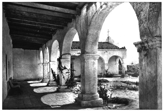
Cloister of Mission, San Juan Capistrano
LOS ANGELES AND SAN JOAQUIN.
The metropolis of this land of sunshine, fruits and
flowers, fifteen miles back from the sea, is La Puebla
de la Nuestra Senora la Reina de Los Angeles, or "the
City of Our Lady, the Queen of the Angels;" a
lengthy title which the matter-of-fact Americans
some time ago happily shortened into Los Angeles.
From it Los Angeles River flows south to the sea at
San Pedro Bay. The Spaniards founded the town
in 1781, but it had only a sleepy existence until
1880, when the railways came along, and it became
a centre of the pleasure and health-resorts, and the
extensive fruit growing of Southern California, expanding
so rapidly that it has seventy thousand people.
Originally, the houses were of adobé, but now
it has many fine buildings and a magnificent development
of residences, the whole city being embowered
in luxuriant vegetation. In the neighborhood
are petroleum wells and asphalt deposits, while
the adjacent district has many irrigation canals.
Down on the ocean shore is San Pedro, the port of
Los Angeles, where the harbor has been improved by
a large outlay, and twenty miles away is the beautiful
mountainous island of Santa Catalina, a popular resort,
which is in reality an ocean mountain top.
Santa Monica Bay, to the southwest, is the coast
bathing-place of Los Angeles, and near by is the
popular Redondo Beach, with its spacious Chautauqua
Assembly Building. Pasadena is a charming suburb
of the city off to the northeast, a perpetual garden
and favorite place of residence. It is in San Gabriel
Valley, over which rises the great Sierra Madre
Range, eleven thousand feet high, the glossy green
orange groves on its sides gradually melting into the
white snow-capped summits of this towering mountain
wall. A railway ascends Echo Mountain north
of Pasadena, on which is the Lowe Observatory.
To the southeast is the old San Gabriel Mission in
the valley, surrounded by vineyards and orchards.
San Buenaventura was another Mission, and is
now a health-resort at the coast outlet of Ventura valley,
and beyond is Santa Barbara, the "American Mentone,"
one of the most charming California resorts.
The old Spanish Mission, with its towers and corridors,
is famous, and was built in 1786, being well-preserved
and having a few of the Franciscan monks
yet in charge. A curiosity of the neighborhood is
La Parra Grande, the "Great Vine," having a trunk
four feet in diameter and covering a trellis sixty feet
square, its annual product being eight thousand
pounds of grapes. Farther along the coast is the
charming Bay of Monterey, with the Spanish town
of Monterey on its southern shore. In 1770 the
Mission of San Carlo de Monterey was founded here,
and it was the Mexican capital of California until the
American conquest in 1846, then depending chiefly
on a trade in tallow and hides. It has not grown
much since, however, and the old adobé buildings
have not undergone change in a half-century. It is
now a popular resort, having the noted Hotel Del
Monte, the "Hotel of the Forest," located in spacious
and exquisite grounds, the park embracing seven
thousand acres. Upon the northern side of Monterey
Bay is Santa Cruz, its chief town, also a summer-resort,
having a background made by the Santa Cruz
Mountains. This was a Mission founded in 1791,
and five miles northward is the Santa Cruz grove of
big trees, containing a score of redwoods or sequoias,
of a diameter of ten feet or more, the largest being
twenty-three feet. Within a hollow in one of these
trees General Fremont encamped for several days in
1847. To the northward is the prolific fruit region,
the Santa Clara Valley, where Mission Santa Clara
was founded in 1777. The city of this valley is San
José, with twenty thousand people, distantly surrounded
by mountains, and, like all these places, a
popular resort. The Calaveras Mountains are to the
eastward, and here, on Mount Hamilton, twenty-six
miles southeast, is the Lick Observatory, at forty-two
hundred feet elevation. It was founded by a
legacy of $700,000 left by James Lick, of San
Francisco, and is attached to the University of California,
being among the leading observatories of the
world. It has one of the largest and most powerful
refracting telescopes in existence, the object-glass
being thirty-six inches in diameter. Mr. Lick is
buried in the foundation pier of this great telescope
which he erected. There is a magnificent view from
the Observatory, which is exceptionally well located,
its white buildings, shining in the sunlight, seen from
afar.
Across the Coast Range of mountains, eastward
from San José, is the extensive San Joaquin Valley,
noted as the "granary of California," two hundred
miles long and thirty to seventy miles wide between
the mountain ranges. It produces almost limitless
crops of grain, fruits and wines. Through this great
valley the San Joaquin River flows northward, and the
Sacramento River southward in another valley as
spacious, and uniting, they go out westward to San
Francisco Bay. We are told that in the days when
the earth was forming, the sea waves beat against the
slopes of the Sierra Nevada, but ultimately the
waters receded, leaving the floor of this vast valley
of central California stretching nearly five hundred
miles between the mountain ranges. The first comers
among the white men dug gold out of its soils, but
now they also get an enormous revenue from the prolific
crops. Railways traverse it in all directions.
The chief city is Stockton, at the head of navigation
on the San Joaquin, a town of twenty thousand people,
having numerous factories. Here in the slopes
and gulches of the Sierras, stretching far away, were
the first gold-mines of California, when the discoveries
of the "Forty-niners" set the world agog.
Here, at Jackson, was tapped the famous "Mother
Lode," the most continuous and richest of the three
gold belts extending along the slope of the Sierras, and
so-called by the early miners because they regarded
it as the parent source of all the gold found in the
placers. This lode is in some parts a mile wide, and
extends a hundred miles, being here a series of parallel
fissures filled with gold-bearing quartz-veins,
while farther south they unite in a single enormous
fissure. The mineral belts paralleling it on both sides
are rich in copper and gold. The country all about
is a mining region with prolific "diggings" everywhere,
and smokes arising from the stamp-mills at
work reducing the ores. Here are Tuttletown and
Jackass Hill, the home of "Truthful James," and
the localities made familiar by Bret Harte and Mark
Twain. Here is Carson Hill, there having been
picked up on its summit the largest gold-nugget ever
found in California, worth $47,000. What this gold-mining
has meant is shown by the results, aggregating
since California first produced the metal a total
of nearly $1,350,000,000 gold given the world. As
the San Joaquin Valley is ascended, it develops its
wealth of grain-fields, orchards and vineyards, and
displays the grand systems of irrigation which have
contributed to produce so much fertility.
Eastward from San Joaquin Valley are the famous
groves of Big Trees, the gigantic sequoias, which
Emerson has appropriately called the "Plantations
of God." There are two forests of giants in Calaveras
and Mariposa Counties displaying these enormous
trees, of which it is significantly said that some
were growing when Christ was upon the earth. The
Calaveras Grove, the northernmost, is at an elevation
of forty-seven hundred feet above the sea, upon
a tract about two-thirds of a mile long and two hundred
feet wide, there being a hundred large trees
and many smaller. The tallest tree standing is the
"Keystone State," three hundred and twenty-five
feet high and forty-five feet in circumference. The
"Mother of the Forest," denuded of its bark, is
three hundred and fifteen feet high and sixty-one
feet girth, while the "Father of the Forest," the biggest
of all, is prostrate, and measures one hundred
and twelve feet in circumference. There are two
trees three hundred feet high, and many exceeding
two hundred and fifty feet, the bark sometimes being
a foot and a half thick. This grove, however, being
less convenient, is not so much visited as the Mariposa
Grove to the southward. It is in Mariposa (the
butterfly) County, at sixty-five hundred feet elevation,
and near the Yosemite Valley. The tract of
four square miles is a State Park, there being two
distinct forests a half-mile apart. The lower grove
has a hundred fine trees, the largest being the
"Grizzly Giant," of ninety-four feet circumference
and thirty-one feet diameter, the main limb, at two
hundred feet elevation, being over six feet in diameter.
The upper grove contains three hundred and
sixty trees, and the road between the groves is tunnelled
directly through one of them, which is twenty-seven
feet in diameter. Through this living tree,
named "Wawona," the stage-coach drives in a passage
nearly ten feet wide. These trees are not so
high as in Calaveras Grove, but they are usually of
larger girth. The tallest is two hundred and seventy-two
feet, ten exceed two hundred and fifty feet,
and three are over ninety feet in circumference,
while twenty are over sixty feet. Many of the
finest have been marred by fires. There are eight
groves of these Big Trees in California, these being
the chief.
YOSEMITE VALLEY.
Into the San Joaquin flows Merced River, coming
from the eastward down out of the Sierras through
the famous Yosemite Valley. Most of its waters are
diverted by irrigation canals leading for many miles
over the floor of the broad San Joaquin Valley. The
road to the Yosemite leads eastward up the slope,
crosses the crest, and at Inspiration Point, fifty-six
hundred feet elevation, gives the first view, then
steeply descending to the river bank, it enters the
western portal. Yosemite is a corruption of the Indian
word "A-hom-e-tae," which means the "full-grown
grizzly bear," and is supposed to have originally
been the name of an Indian chief. This
magnificent canyon, on the western slope of the
Sierra Nevada, is a deep gorge eight miles long,
traversed by Merced River, its nearly level floor
being about thirty-eight hundred feet above the sea-level.
The enclosing rocky and almost vertical walls
rise from three thousand to five thousand feet above
the river, the space between varying from a half-mile
to two miles. Over the valley floor winds the
beautiful green current of the diminutive Merced,
bordered by trees and vegetation, the surface being
generally grass-grown. The high vertical walls, the
small amount of débris at their foot, and the character
of the Yosemite chasm itself, have led the geologists
to ascribe its formation not to erosion or glacial action,
but to a mighty convulsion in the granite rocks,
whereby part of them subsided along lines of fault-crossing
nearly at right-angles. The observer, standing
on the floor, can see no outlet anywhere, the
almost perpendicular walls towering on high in every
direction.
The Valley is a Government Park, which also includes
the watershed of the streams flowing into it.
Originally it was the home of the Digger Indians, a
tribe of Shoshonés, and a rather low type, of whom
a few still survive. It was first seen by white men
in 1851, when a detachment of troops pursuing these
Indians came unexpectedly upon it. The attractions
soon became widely known, and visitors were numerous,
especially after the opening of the Pacific Railways.
Entering the Valley, the most striking object
is its northwestern buttress, the ponderous cliff El
Capitan, rising thirty-three hundred feet, at a very
narrow part, its majestic form dominating the view.
There are two vertical mountain walls almost at right
angles, these enormous bare precipices facing west
and south. On the opposite side, forming the other
portal, rise the imposing Cathedral Rocks, adjoined
by the two slender Cathedral Spires of splintered
granite, nearly three thousand feet high. Over these
rocks on their western side pours the Bridal Veil
Fall, about seventy feet wide, and descending vertically
six hundred and thirty feet. As the winds often
make the foaming column flutter like a white veil,
its title has been appropriately given. Adjoining El
Capitan descends the Ribbon Fall, or the Virgin's
Tears, falling two thousand feet, but losing much of
its waters as the summer advances. Eastward of
El Capitan are the peaks called the Three Brothers,
the highest also named the Eagle Peak, rising three
thousand feet. To the eastward of this peak and in
a recess near the centre of the Valley are the Yosemite
Falls, one of the highest waterfalls in the
world. Yosemite Creek, which comes over the
brink with a breadth of thirty-five feet, descends
twenty-five hundred feet in three leaps. It pours
down a vertical wall, the Upper Fall descending
nearly fifteen hundred feet without a break, the
column of water swaying as the winds blow with
marvellous grace of motion, the eddying mists fading
into light summer clouds above. The Middle Fall
is a series of cascades descending over six hundred
feet, and the Lower Fall is four hundred feet high.
This is one of the grandest features of the Valley,
but its vigor, too, dwindles as the season advances.
There is a high and splendid ice cone formed at the
foot of the Upper Fall in the winter. Alongside,
upon a projection called Yosemite Point, at over
thirty-two hundred feet elevation, is given one of the
best views of the famous Valley.
At the head of the Yosemite, it divides into three
narrow tributary canyons, each discharging a stream,
which uniting form the Merced. The northernmost is
the Tenaya, and overshadowing it rises the huge
North Dome, more than thirty-seven hundred feet
high, having as an outlying spur the Washington
Column. Opposite, and forming the eastern boundary
of the valley, is the South or Half Dome, of
singular shape, towering almost five thousand feet,
and like El Capitan, at the other extremity, being a
most remarkable granitic cliff. Its top is inaccessible,
although once it was scaled by an adventurous
explorer by means of a rope attached to pegs driven
into the rock. It is one of the most extraordinarily
formed mountains in existence, standing up tall, gaunt
and almost square against the sky, the dominating
pinnacle of the upper valley. Upon the southern
side rises Glacier Point, nearly thirty-four hundred
feet, giving a splendid view over the valley, having
to the westward the Sentinel Dome, nearly forty-three
hundred feet high, ending in the conspicuous face of
the Sentinel Rock. Thus environed by vast cliffs, this
grand valley displays magnificent scenery. Within
the upper canyons are also attractions, that of the
Merced River, the central gorge displaying the Vernal
and Nevada waterfalls. The Vernal Fall is
seventy feet wide and descends three hundred and
fifty feet, having behind it the Cap of Liberty, a
picturesque cliff. Farther up the river is the Nevada
Fall, a superb cataract, having a slightly sloping descent
of six hundred feet. Just within Tenaya Canyon
is the Mirror Lake, remarkable for its wonderful
reflections of the North and South Domes and adjacent
mountains. Some distance to the eastward is
the Cloud's Rest, a peak rising more than six thousand
feet above the valley and nearly ten thousand
feet above sea-level, that is ascended for its splendid
view of the surrounding mountains and the enclosing
walls of the valley, which can be plainly seen
throughout its length, stretching far away towards
the setting sun. This view of the Yosemite surpasses
all others in its comprehensiveness and grandeur.
THE ROCKIES
The great "backbone" of the American Continent
is the Rocky Mountains, and the summits of its main
range make the parting of the waters, the "Continental
Divide." Its name of the Rockies is appropriate,
for on these mountains and their intervening
plateaus, naked rocks are developed to an extent
rarely equalled elsewhere in the world. The leading
causes of this are the great elevation and extreme
aridity, the scanty moisture preventing growth of
vegetation, and the high altitudes promoting denudation
of the rock-material disintegrated at the surface.
Enormous crags and bold peaks of bare rocks, mostly
compose the mountains, while the streams flow at
the bases of towering precipices in deep chasms and
canyons filled with broken rocks. Being unprotected
by vegetation, the winds sweep the hills clean of
soil and sand, the steep slopes of the valleys are
strewn with fragments of the enclosing cliffs, and the
rivers are usually without flood-plains or intervales,
where soils may gather. In the extensive and
highly-elevated plateaus, the streams usually run in
the bottoms of deep canyons, their channels choked
with débris. Added to this the whole Rocky Mountain
region has in the past been a scene of great volcanic
activity, many extinct volcanoes appear, broad plains
are covered with lava, and scoria and ashes are
liberally deposited all about. The aridity is not a
feature of the Pacific coast ranges, however, for the
moisture from that ocean abundantly supplies water;
there are good soils, and in the northern parts usually
dense forests. The Rocky Mountain system extends
from Mexico up to Alaska and the Arctic Ocean, its
greatest development being between 38° and 42°
north latitude, where the various ranges cover a
breadth of a thousand miles. The highest peak of
the Rockies is Mount Logan, in British America, on
the edge of Alaska, rising nineteen thousand five
hundred and thirty-nine feet. In the United States
these mountains rise from a general plateau extending
across the country, and reaching its maximum
elevation of about ten thousand feet in Colorado,
whilst towards the north the surface descends, entering
Canada at an elevation of four thousand feet.
The plateau descends westward into the basin of the
Colorado River, then the surface rises in Nevada to
six thousand feet, and thence farther westward it
gradually descends to the base of the Sierra Nevada
in California. To the eastward the plateau throughout
steadily descends in the long, undulating and
generally treeless slope of the Great Plains to the
Mississippi, the many tributaries of the Father of
Waters carving their valleys down through its surface.
There are numerous mountain ranges, plateaus
and parks, under different names in this extensive
mountain region, and the higher peaks in the United
States generally rise to thirteen to fifteen thousand
feet elevation. These mountains and the plains to
the eastward compose the vast arid region constituting
fully two-fifths of the United States, where
irrigation is necessary to agriculture, and, in consequence,
less than ten per cent. of this large surface
bears forests of any value. We are told that so
scant is the moisture, if the whole current of every
water-course in this district were utilized for irrigation
it would not be possible to redeem four per cent.
of the land. Some of this surface, however, bears
grasses and plants that, to an extent, make pasturage.
The precious metals and other useful minerals
are found in abundance, and various parts of the
region have been developed by the many valuable
mines, making their owners enormous fortunes.
Through this vast mountain district, over deserts
and along devious defiles, a half-dozen great railways
lead from the Mississippi Valley to the Pacific slope.
The Southern Pacific Railway we have already followed
from New Orleans across to Southern California.
Northward from its route at El Paso a railway
leads through New Mexico to the next great transcontinental
line, the Atchison system, coming from
Chicago by way of Kansas City and Santa Fé southwestward
The main line traverses Kansas, and
branches go south into the Indian Territory and
Oklahoma. In the former are the reservations of
the civilized tribes of Indians originally removed
from east of the Mississippi—the Choctaws, Cherokees,
Creeks, Chickasaws and Seminoles, with some
others—who number nearly two hundred thousand
souls, most of them engaged in agriculture. To the
westward, south of Kansas and Colorado, is the
"Boomers' Paradise" of Oklahoma, or the "Beautiful
Land," a fertile and well-watered region, originally
part of the Indian reserved lands, but bought
from them by the Government. People from Kansas
long had a desire to occupy this prolific land, and
only with great difficulty were they kept out. The
portion first got ready was opened to settlement by
proclamation at noon on April 22, 1889, a large force
of troops being in attendance to preserve order.
Over fifty thousand people crossed the boundaries
and entered the Territory the first day, taking up
farms and starting towns. The "Cherokee Strip"
along the northern line was subsequently obtained
and opened to settlement in September, 1893, when
ninety thousand people rushed in. These great invasions
of the "Oklahoma boomers" became historic,
cities of tents springing up in a night; but
while there then was much suffering and privation
from want of food and shelter, yet the new Territory
has since become a most successful agricultural community.
The Atchison route, after crossing Kansas, enters
Colorado, passing La Junta and Trinidad, and then
turning southward rises to the highest point on the
line, crossing the summit of the Raton Pass, at an
elevation of seventy-six hundred and twenty feet,
by going through a tunnel, and emerging on the
southern side of the mountain in New Mexico. The
railway is then laid along the slope of the Santa Fé
Mountains, and on their side are Las Vegas Hot
Springs, about forty of them being in the group,
their waters used both for bathing and drinking, and
having various curative properties. The Glorieta
Pass is subsequently crossed at seventy-five hundred
feet elevation, and beyond is Santa Fé, the capital
of New Mexico. This is a curious and antique
town, the oldest in the United States next to St.
Augustine in Florida. It was an Indian pueblo or
town in the very early times, and in 1605 the Spaniards
came along, captured it, reduced the Indians to
slavery, and worked the valuable gold and silver
mines. In 1680 the Indians revolted, expelled the
Spaniards and destroyed their churches and buildings,
but they recovered control a few years later.
There are now about seven thousand people of all
races, having a good trade, and being chiefly employed
in mining. It is a quaint old place, with
crooked and narrow streets and adobé houses surrounding
the central Plaza, on one side of which is the
ancient Governor's Palace, a long, low adobé structure
of one story, wherein the Governors of Spanish,
Mexican and American rule have lived for nearly
three centuries. It contains various historical paintings
and relics, and here General Lew Wallace wrote
Ben Hur while Governor of New Mexico in 1880.
Beyond Santa Fé is the Rio Grande River, which
the railway follows down through a grazing country
past Albuquerque, its mart for wool and hides.
Turning westward an arid region is traversed, with
an occasional pueblo, and near Laguna is the famous
Mesa Encantada, or the "Enchanted Table Land."
This eminence rises precipitously four hundred and
thirty feet above the surface, and is only accessible
by ladders and ropes. The summit gives evidence
of former aboriginal occupancy, and the tradition of
the neighboring Acomas Indians is that their ancestors
lived upon it, but were forced to abandon the
village when a storm had destroyed the only trail and
caused those remaining on the summit to perish.
To the westward the "Continental Divide" is crossed
at seventy-three hundred feet elevation, but with
nothing indicating the change, as it is on a plateau.
The Navajo Indian Reservation is crossed, Arizona
entered and traversed, and at the Flagstaff Station
is the Lowell Observatory, and here the nearest route
is taken to the Grand Canyon of the Colorado.
There rises to the northward the huge San Francisco
Mountain, a fine extinct volcano, while off to the
southwest are the great United Verde Copper Mines,
among the largest in the world, and the town of
Prescott, in a rich mineral region. The Colorado
River is crossed into California, and then the railway
traverses the wide Mojave Desert towards the Pacific
coast.
DENVER AND ITS SURROUNDINGS
The Union Pacific Railway route across the Continent
was the first constructed, the Government
giving large subsidies in money and land grants. It
was opened in 1869, and greatly encouraged travel
to the Pacific coast. The Union Pacific main line
starts at Council Bluffs and Omaha on the Missouri
River and crosses Nebraska into Wyoming. Here is
Cheyenne, a leading cattle-dealers' town on the edge
of the Rockies, five hundred miles west of the Missouri,
where there are fifteen thousand people. Fort
Russell, an Indian outpost at the verge of the Black
Hills, is to the northward. At Cheyenne, the main
Union Pacific line is joined by the Denver Pacific
branch, which starts on the Missouri River at Kansas
City, traverses Kansas, passing Fort Riley and the
Ogden Monument there, marking the geographical
centre of the United States, and enters Colorado,
and at Denver turns northward to Cheyenne.
Denver is the great city of the Rockies, whose
snow-capped summits are seen to the westward in a
magnificent and unbroken line, extending in view for
one hundred and seventy miles from Pike's Peak
north to Long's Peak, with many intervening summits,
most of them rising over fourteen thousand
feet. Denver stands on a high plateau, through
which the South Platte River flows, and it is at
nearly fifty-three hundred feet elevation. This
"Queen City of the Plains" was settled by adventurous
pioneers as a mining camp in 1858, and
through the wonderful development of mining the
precious metals has had rapid growth, so that now
there is one hundred and seventy thousand population.
It has many manufactures and some of the
most extensive ore-smelting works in the world, the
annual output of gold and silver being enormous.
The high elevation and healthy climate make it a
favorite resort for pulmonary patients. There are
many fine buildings, and a noble State Capitol with
a lofty dome, erected at a cost of $2,500,000, and
standing on a high hill, so that it gives a superb outlook.
The city was named in honor of General
James W. Denver, who was an early Governor of
Kansas and served in the Civil War. He first suggested
the name of Colorado for the Territory (now
a State), and thus his name was given its capital.
Denver has built for its water-works, forty-eight
miles south of the city, the highest dam in the world,
two hundred and ten feet, enclosing a gorge on the
South Platte to make an enormous reservoir holding
an ample supply.
Being so admirably located, Denver is a centre
for excursions into one of the most attractive mountain
regions in America. The great Colorado Front
Range, or eastern ridge of the Rockies, stretches
grandly across the country and has behind it one
range after another, extending far westward to the
Utah Basin. Towering behind the Front Range is
the Saguache Range, the chief ridge of the Rockies,
which makes the Continental Divide. Among these
complicated Rocky Mountain ranges are various extensive
Parks or broad valleys, nestling amid the
peaks and ridges, which were originally the beds of
inland lakes. Out of this mountain region flow
scores of rivers in all directions, the affluents of the
Mississippi to the east, the Rio Grande to the south,
and the Colorado and the Columbia westward. All
of them have carved down deep and magnificent
gorges, two to five thousand feet deep, and in places
the wonderful results of ages of erosion are displayed
in the peculiar constructions of vast regions, and in
special sections, where the carvings by water, frost
and wind-forces have made weird and fantastic
formations in the rocks on a colossal scale, as in the
"Garden of the Gods." These mountains and
gorges are also filled with untold wealth, and the
mines, producing many millions of gold and silver,
have attracted the population chiefly since the Civil
War, so that the whole district around and beyond
Denver is a region of mining towns, which are
reached by a network of railways disclosing the
grandest scenery, and in many parts the most startling
and daring methods of railroad construction.
Whenever land can be reclaimed for agriculture or
grazing on the flanks of the mountains and in the
protected valleys and parks, it is done, so that the
district has extensive irrigation canals, in some parts
diverting practically all the available flow of water in
the streams. This is particularly the case with the
Upper Arkansas River, such diversion of the headwaters
in Colorado having robbed the river of its
water to such a degree that the people of Kansas,
whither it flows on its route to the Mississippi, are
greatly annoyed and have protracted litigation about
it.
COLORADO ATTRACTIONS.
Northwest from Denver is the picturesque Boulder
Canyon, and here at the mining town of Boulder is
the University of Colorado, with six hundred students.
Beyond are Estes Park, one of the smaller
enclosed parks among the mountains, having Long's
Peak on its verge, rising fourteen thousand two
hundred and seventy feet. Westward from Denver
is the Clear Creek Canyon, and the route in that
direction leads through great scenic attractions, past
Golden, Idaho Springs and Georgetown, where silver-mining
and health-resorts divide attention, the mountains
also displaying several beautiful lakes. Beyond,
the railway threads the Devil's Gate, climbing up
by remarkable loops, and reaches Graymont at ten
thousand feet elevation, having Gray's Peak above
it rising fourteen thousand four hundred and forty
feet. In this district is the mining town of Central
City, while to the northwest is the extensive Middle
Park, of three thousand square miles area, a popular
resort for sportsmen. Southward from Denver the
railway route passes the splendid Casa Blanca, a
huge white rock, a thousand feet long and two hundred
feet high, and crosses the watershed between
the Platte and the Arkansas, at an elevation of over
seventy-two hundred feet. Here, amid the mountains,
seventy-five miles from Denver, upon a
plateau at six thousand feet elevation, is the famous
city of Colorado Springs, having twenty-five thousand
people and being a noted health-resort. It is
pleasantly laid out, with wide, tree-shaded streets,
like a typical New England village spread broadly
at the eastern base of Pike's Peak. Here live large
numbers of people who are unable to stand the rigors
of the climate on the Atlantic coast, and it has been
carefully preserved as a residential and educational
city, saloons being prohibited, with other restrictions
calculated to preserve its high character. The settlement
began in 1871, but there are no springs
nearer than Manitou, several miles away in the spurs
of Pike's Peak. The climate of Colorado Springs is
charming, and it has, on the one hand, a magnificent
mountain view, and on the other a limitless landscape
eastward and southward, across the prairie land.
Here are the Colorado College and other public institutions,
and the National Printers' Home, supported
by the printers throughout the country. In
the pretty Evergreen Cemetery is buried the authoress,
Helen Hunt Jackson, who died in 1885.
Probably the best known summit of the Rockies
is Pike's Peak, rearing its snowy top over Manitou,
and about six miles westward from Colorado Springs,
to an elevation of nearly fourteen thousand two hundred
feet. As it rises almost sheer, in the Colorado
Front Range, this noble mountain can be seen from
afar across the eastern plains. A cog-wheel railway
nine miles long ascends to the summit from Manitou,
rising seventy-five hundred feet. There is a small
hotel at the top, and a superb view over the mountains
and glens and mining camps all around. In
1806 General Zebulon Pike, then a captain in the
army, led an exploring expedition to this remote region
and discovered this noble mountain, which was
given his name. Forests cover the lower slopes, but
the top is composed of bare rocks, usually snow-covered.
Below it a huge tunnel is being bored through
the range to connect Colorado Springs with the Cripple
Creek mining district to the westward. Manitou
has a group of springs of weak compound carbonated
soda, resembling those of Ems, and beneficial
to consumptive, dyspeptic and other patients. They
are at the entrance of the romantic Ute Pass, a gorge
with many attractions, which was formerly the trail
of the Ute Indians in crossing the mountains. Nearby,
upon the Mesa, or "table-land," is the "Garden of
the Gods," a tract of about one square mile, thickly
studded with huge grotesque cliffs and rocks of white
and red sandstones, their unique carving being the
result of the erosive processes that have been going
on for ages. They are all given appropriate names,
and its Gateway is a passage just wide enough for
the road, between two enormous bright red rocks
over three hundred feet high. Farther south on the
Arkansas River is Pueblo, an industrial city of thirty
thousand people in a rich mining district, where there
is a Mineral Palace, having a wonderful ceiling formed
of twenty-eight domes, into which are worked specimens
of all the Colorado minerals. The route then
crosses the Veta Pass at ninety-four hundred feet
elevation, whereon is the abrupt bend known as the
"Mule Shoe Curve," and beyond this it descends
into the most extensive of the Colorado Parks, the
San Luis, covering six thousand square miles. Sentineling
its western side is the triple-peaked Sierra
Blanca, the loftiest Colorado Mountain, rising almost
fourteen thousand five hundred feet. The Rio Grande
flows to the southward, and there is Alamosa, and
up in the mountains Creede, an extraordinary development
of recent silver mining, which began its
career when the ore was discovered in 1891, has
seven thousand people, and has produced $4,000,000
silver in a year.
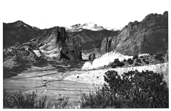
Gateway, Garden of the Gods, Colorado
Following up the Arkansas River from Pueblo, a
route goes northward behind and west of Pike's
Peak into the Cripple Creek district, situated at an
elevation of nearly ten thousand feet among the
mountains, where in 1890 was a remote cattle ranch.
The next year gold was found there, a new population
rushed in, and it has since become a leading gold
producer, its output of fourteen to twenty millions
of gold annually almost turning Colorado from a silver
to a gold State. There is now a population of
twenty thousand, and the town has many substantial
buildings. Westward the route crosses the Continental
Divide and descends into the extensive South
Park, covering two thousand square miles, reaching
Leadville beyond, renowned as a mining camp that
has developed into one of the highest cities of the
world. In the early Colorado days this was the
great gold placer mining camp of California Gulch.
Afterwards it produced enormous quantities of silver
from the extensive carbonate beds discovered in
1876, and the population expanded to thirty thousand,
its name being changed to Leadville. Of late,
its gold mining has again become profitable, and its
population now is about fifteen thousand, the yield
of silver, which once reached $13,000,000 annually,
being much reduced owing to the decline in value.
To the westward, the Colorado Midland Railway
crosses the Continental Divide by the Hagerman
Pass, at eleven thousand five hundred and thirty feet
elevation, the highest elevation of any railway route
across the Rockies. It descends rapidly to Aspen,
where $8,000,000 of silver and gold are mined in a
year. North of Leadville is the noted Mountain of
the Holy Cross, fourteen thousand two hundred feet
high, named from the impressive cruciform appearance
of two ravines crossing at right angles and
always filled with snow.
The Grand Canyon of the Arkansas is one of the
most magnificent gorges in the Rocky Mountains.
This river above Pueblo forces its passage through a
deep pass known in the narrowest part as the Royal
Gorge, where the railway is laid alongside the boiling
and rushing stream, with rocky cliffs towering
twenty-six hundred feet above the line. It ascends
westward, beyond the sources of the Arkansas, crossing
the Continental Divide by the Marshall Pass, at
ten thousand eight hundred and fifty-eight feet elevation,
the route up there showing, in its abrupt and
bold curves, great engineering skill. The Pass is
always covered with snow, and the descent beyond
it is to the mining town of Gunnison. The Gunnison
River is followed down through its magnificent
gorge, the Black Canyon giving a splendid display
for sixteen miles of some of the finest scenery of
the Rockies. The river is an alternation of foaming
rapids and pleasant reaches, and within the canyon
is the lofty rock pinnacle of the Currecanti Needle.
The adjacent gorge of the Cimarron, a tributary
stream, gives also a splendid display of Rocky Mountain
wildness, and below it the river passes through
the Lower Gunnison Canyon, bounded by smooth-faced
sandstone cliffs, and finally it falls into Grand
River, one of the head-streams of the Colorado.
The combined magnificence of these canyons and
mountains makes the environment of the Colorado
mining region one of the most attractive scenic districts
in America. The railways have arranged a
route of a thousand miles through the mountains,
starting from Denver, under the title of "Around
the Circle," which crosses and recrosses the Continental
Divide, threads the wonderful canyons, surmounts
all the famous passes over the tops of the
Rocky ranges, and includes the most attractive
scenery of the district.
WYOMING FOSSILS.
The Union Pacific Railway, westward from Cheyenne
in Wyoming, gradually ascends the slope and
crosses the Continental Divide at Sherman, the pass
being elevated eighty-two hundred and forty-five
feet. Here, alongside the track, is the monument
erected in memory of Oakes and Oliver Ames of
Massachusetts, to whose efforts the construction of
this pioneer railway across the Continent was largely
due. Upon the western slope of the mountains the
descent is to the Laramie Plains, an elevated plateau
in Wyoming which is one of the best grazing districts
of the country. In the midst of the region on
the Big Laramie River is Laramie City, with ten
thousand people, a prominent wool and cattle mart.
To the north and west high mountains rise, out of
which the river flows, and in this district is the great
fossil region of Wyoming. This state is the most prolific
producer of the skeletons of the enormous beasts
that roamed the earth in prehistoric times. About
ninety miles northwest of Laramie City are the greatest
fossil quarries in existence, and the scientific
hunters from all the great museums have been finding
rich treasures there. We are told that in an
early geological period Wyoming had numerous lakes
and swamps and a semi-tropical climate. These
huge animals then inhabited the lakes and swamps
in large numbers. In dying, they sank into the
mud, and their bones were covered by other deposits
and became petrified. The extensive deposits of
these bones are found where are supposed to have
been the mouths of great water-courses, the huge
animals, after death, having floated to where they are
deposited in such large numbers. The belief is that
through the geological eras these animals became
covered with possibly twenty thousand feet of rock.
Afterwards, the process by which the Rocky Mountains
were formed tilted these rock beds, and the
subsequent erosion of the strata brought to light
these bone-deposits, made millions of years ago. For
many years the scientists have been exhuming these
skeletons, and have recovered the bones of over
three hundred different species. They are of all
sizes and characters, and here has been found the
most colossal animal ever discovered on the earth, a
dinosaur, nearly one hundred and thirty feet long,
and thirty-five feet high at the hips and twenty-five
feet at the shoulders. The skeleton of this immense
creature, who is called a diplodocus, weighs twenty
tons, and it is believed that when living he weighed
sixty tons, having a neck thirty feet long and a tail
twice that length. Yet his head was very small, and
the weight of the brain was not over five pounds. In
comparison with the mammoth, heretofore regarded
as so large, this huge beast, whose foot covered a
square yard of earth, was in size as a horse is compared
to a dog. Such are the contributions Wyoming
is making to our great museums of science.
To the southward of the Laramie Plains is the Colorado
North Park, among the mountains of that State,
having an area of over two thousand square miles.
Beyond, the railway route goes westward among hills
and over the plateaus. This route is not as picturesque
as some of the other Pacific railways, but in
crossing the Continent it discloses very curious scenery.
At places there are great Buttes, water-worn
and rounded, rising in isolated grandeur; the plains
and terraces are carved into elongated and wide depressions,
as if abandoned rivers had run through
them; there are long and regular embankments,
strange hills of fantastic form, huge mounds, broken-down
pyramids, vast stone-piles, and the most strange
and extraordinary fashionings of nature, showing
both water and fire to have been at work. Then
the route passes the snow-clad Uintah Mountains to
the southward, and crossing the Wahsatch range,
enters Utah, traversing its remarkable enclosed basin,
where the waters have no outlet to the sea, but flow
into salt lakes which lose their surplus supplies by
evaporation in the summer. Beyond, is the wild
and picturesque Echo Canyon, with the green valley
of Weber River and the Weber Canyon. Here is
the gigantic Castle Rock, a rugged stone-pile fantastically
carved by nature, having a giant doorway and
all the semblance of a mountain fortress. Here is
also the "One Thousand Mile Tree," on the northern
side of the road, being that distance west of Omaha.
In the Echo Gorge is the Hanging Rock, where
Brigham Young, as the Mormon Pilgrims journeyed
to their Utah home, is said to have preached the first
sermon to them in the "Promised Land." The old-time
emigrant trail passes through these canyons
alongside the railway and the river. A remarkable
sight within the Weber Canyon is the Devil's Slide,
where on the face of an almost perpendicular red
mountain, eight hundred feet high, there is inlaid a
brilliantly white strip of limestone about fifteen feet
wide, all the way from top to bottom, having enclosing
white walls, the whole work being as regularly
constructed as if built by a stonemason. Beyond,
we come to Ogden, a busy industrial town of twenty
thousand people, the western terminus of the Union
Pacific Railway, and having another railroad leading
thirty-seven miles southward to Salt Lake City.
GREAT SALT LAKE.
In the centre of the Rockies, occupying a large
portion of Utah and adjacent States, is the "Great
Basin," which, as remarked, has no drainage outlet
for its waters. The geologists tell us that in
ancient times this region was covered by two extensive
lakes, one of them in the Pleistocene era occupying
the now desert interior basin of Utah. This
extinct lake, whose ancient shores can be distinctly
traced, has been named Lake Bonneville. When at
its greatest expansion, it covered twenty thousand
square miles, and the waters were nearly a thousand
feet deep, overflowing to the northward into a
branch of Shoshoné River through a deep pass, and
going thence to the Pacific. The waters of this
lake, by climatic changes, gradually dwindled, the
loss by evaporation overcame the rainfall supply, the
overflow ceased, and then the lake dried up, revealing
the desert bottom. Of its waters there now remain
the Great Salt Lake of Utah, about eighty
miles long and from thirty to fifty miles wide, very
shallow, averaging only twenty feet depth, and not
over fifty feet in the deepest place, having monotonously
flat shores on the desert plateau, elevated
forty-two hundred feet above the sea. Its dimensions
vary according to the rainfall, the surface rising
and falling in various periods of years. Several
streams flow in, among them the Jordan River, forty
miles long, draining Utah Lake to the southward.
The waters are densely salt, varying from fourteen
to twenty-two per cent. as the lake is high or low
(compared with three to four per cent. in the ocean),
and it is estimated to contain four hundred million
tons of salt. Not a fish can live there excepting a
small brine shrimp. A bath in the lake is novel, as
the density makes the body very buoyant, easily
floating head and shoulders above the water.
To this desert region, after being driven from
Nauvoo on the Mississippi, Brigham Young brought
his first Mormon colony by a long journey across the
plains and mountains, a band of one hundred and
forty-three persons, arriving in July, 1847, Utah
then being Mexican territory. They organized the
State of Deseret, and it afterwards became a Territory
of the United States. By prodigious labors,
constructing irrigation canals to bring in the mountain
streams, they made the soil productive, and now
it is one of the most fertile valleys in the country.
Almost the whole flow of the Jordan River is thus
used for irrigation. Colonies and proselytes were
brought in from various parts of the world, until two
hundred thousand Mormons came to Utah, and after
protracted conflicts with the Government, polygamy
was declared illegal, and its discontinuance was
ordered by proclamation of the Mormon President.
Twelve miles from the Great Salt Lake is the Utah
capital and Mormon Zion, Salt Lake City, where the
Latter-Day Saints and Gentiles together exceed fifty
thousand. Its prosperity is largely due to the extensive
mining interests of the surrounding country.
The lofty Wahsatch Mountains are close to the city
on the northern and eastern sides, while to the south,
seen over a hundred miles of almost level plain, is a
magnificent range of snow-covered mountains, this
being the perpetual and awe-inspiring view from all
parts of the city. The streets are wide and lined
with shade trees, the residences surrounded by gardens,
and irrigation canals border all the thoroughfares,
so that the whole place is embosomed in foliage,
and the delicious green adds to its scenic attractiveness.
The Temple Block of ten acres, the sacred
square of the Mormons, is the centre from which the
streets are laid towards the four cardinal points of
the compass. A high adobé wall surrounds it, and
here is the great Mormon Temple of granite, which
was forty years building, and cost over $4,000,000,
having three pointed towers at each end, the loftiest
being surmounted by a gilded figure of the Mormon
angel Moroni. Here is also the Mormon Tabernacle,
a huge oval-shaped structure, surmounted by a
roof rounded like a turtle-back, the interior accommodating
twelve thousand people. This is their
great meeting-place, and they also have a smaller
Assembly Hall for religious services. These are the
chief buildings of Salt Lake City. To the eastward
in the suburbs is the military post of Fort Douglas,
where the troops are barracked that guard the Mormon
capital. In the earlier period, when there were fears
of trouble, a large garrison was kept at this extensive
fortification to maintain government control.
OGDEN TO SACRAMENTO.
Westward from Ogden in Utah the Union Pacific
route to California is continued upon the Southern
Pacific system, that company having absorbed the
original Central Pacific road. It passes Corinne, the
largest Gentile city in Utah, and then through the
Promontory Mountains, on the northern verge of
Great Salt Lake. It was at Promontory Point on
May 10, 1869, that the railway builders of this original
transcontinental line, coming both ways, met,
and joined the tracks. The last tie was made of
California rosewood, trimmed with silver, and the
last four spikes were of silver and gold. The final
golden spike was driven with a silver hammer in the
presence of a large and silent assemblage. The
locomotives coming from the East and the West met,
as Bret Harte has written:
"Pilots touching—head to head
Facing on the single track;
Half a world behind each back!"
Beyond, the Great American Desert, an alkaline
waste, is crossed, the State of Nevada is entered,
the Humboldt River is followed for awhile, and then
Truckee River is ascended through the Pleasant
Valley, leading into the Sierra Nevada, the lower
mountain slopes covered with magnificent forests and
the railroad protected from avalanches by snow-sheds.
The Humboldt River has no outlet. It
spreads out in an extensive sheet of water known as
the "Carson Sink" and evaporates. At Reno is the
Nevada State University, and as this is a silver region
there are extensive smelting mills. Thirty-one
miles southward is Carson, the capital of Nevada,
and twenty-one miles farther the famous silver-mining
town of Virginia City, with ten thousand
people, built half-way up a steep mountain slope and
completely surrounded by mountains. Virginia City
stands directly over the noted Comstock Lode, and
here are the Bonanza Mines, which were such prolific
producers in the great silver days. This lode
has produced over $450,000,000, chiefly silver, and
it is drained by the Sutro Tunnel, nearly four miles
long, which cost $4,500,000 to construct. Nearby,
on the California boundary, and at six thousand feet
elevation, is the beautiful Lake Tahoe, one of the
loveliest sheets of water in the world, twenty-two
miles long, very deep, surrounded by snow-clad
mountains, and yet it never freezes, its outlet being
the Truckee River. In a region of many lakes, it
is known as "the gem of the high Sierras." To the
westward of Reno is another lovely sheet of water,
Donner Lake, embosomed in the lap of towering
hills, its name coming from an early explorer, Captain
Donner, who, with many of his party, perished
on its shores during a heavy snowstorm in 1846.
The top of the Sierra Nevada is crossed through a
tunnel at Summit Station, elevated seven thousand
feet, and beyond there is a complete change both in
climate and vegetation, the descent being rapid and
the transition from arctic snows to sub-tropical
flowers very quick. The line is in many places
carved out of the faces of startling precipices, and
here it rounds the famous beetling promontory known
as Cape Horn. Then, coming down among the
orchards and vineyards, it enters the wide and fertile
Sacramento Valley, and almost at sea-level comes
to the capital of California, the city of Sacramento,
built on the eastern bank of Sacramento River just
below the mouth of the American River. It is a
busy city with thirty thousand people, and has a
large and handsome State Capitol.
TRANSCONTINENTAL ROUTES.
The Northern Pacific Railway, the next route
northward, after following up the Yellowstone River
to Livingston, at the entrance to Yellowstone Park
in Montana, ascends the Belt Mountains, crossing
them through Bozeman Tunnel at an elevation of
nearly fifty-six hundred feet. This range is an outlying
eastern spur of the Rockies. The road passes
the mining town of Butte, there being forty thousand
people in the neighboring settlements. Here are
many gold, silver and copper mines, including the
great Anaconda Mine, which was sold in 1898 to the
company at present working it for $45,000,000, the
product of the mine being silver and copper. The
Butte copper output is two hundred and fifty million
pounds annually, and the smelting-works at Anaconda
are the largest in the world. At Three Forks, not
far away, is the confluence of the Madison, Jefferson
and Gallatin Rivers, forming the Missouri. Beyond
is Helena, the capital of Montana, built in the
Prickly Pear Valley near the eastern base of the
main Rocky Mountain range and having fifteen
thousand population. This is in another rich mining
district, and the "Last Chance Gulch," running
through the city, has yielded over $30,000,000 gold,
while all around are gold, silver, copper and lead-deposits.
Twenty-four miles from Helena, the main
range of the Rockies is crossed by the Mullen's Pass
tunnel at fifty-five hundred and fifty feet elevation.
At Gold Creek in the valley beyond, the last golden
spike of the Northern Pacific Railway was driven in
September, 1883, uniting the tracks which had advanced
from the east and west and met there.
President Henry Villard made this the occasion of
great festivity, bringing many train-loads of distinguished
men to the ceremony, and shortly afterwards
the company, which was heavily in debt, went into a
Receivership. The railroad follows the Missoula and
Pend d'Oreille (the "earring") Rivers, which unite in
Clark's Fork, a tributary of the Columbia River, and
enters Idaho, "the gem of the mountains," or, as
called by the Nez Perces, Edah-hoe; finally coming
to Spokane in Washington State. This busy
manufacturing town of over twenty thousand people
was burnt in 1889, but has entirely recovered from
the calamity. The Spokane River descends one
hundred and fifty feet in two falls within the town,
furnishing an admirable water-power. To the southwest
is the confluence of the Snake and Columbia
Rivers, and beyond, the railway penetrates the defiles
of the Cascade Mountains, the northern prolongation
of the California Coast range, the Northern
Pacific line finally terminating at Tacoma on Puget
Sound.
The great Columbia is the chief river draining
the western slopes of the Rockies. It has a broad
estuary, and in May, 1792, Captain Robert Gray of
Boston, coasting along the shore in his bark "Columbia
Rediviva," discovered it, was baffled more than a
week before he could cross the shallow bar at its
mouth, and gave it the name of his vessel. The
Spaniards marked his discovery on one of their maps
without any head to the river, recording alongside in
Spanish y-aun se ignora—meaning "and it is not yet
known" where the source of the river is situated.
The famous Danish geographer, Malte-Brun, reading
this, made the mistake of recognizing the word
ignora as Oregon, and published it in the early nineteenth
century as the name of the country, to which it
has stuck. Thus is Oregon, like California, a name
given without meaning. The Columbia is an enormous
river, over twelve hundred miles long, rising in
Otter Lake, just north of the Dominion boundary,
making a long loop up into British America, then
coming down into the United States between the
Rockies and the Cascades with another broad western
loop, and swinging around to the southeast,
finally turning westward to form the boundary between
Oregon and Washington State to the Pacific.
The chief tributary is Snake River, known also as
Lewis Fork, which comes out of the western verge
of the Yellowstone Park, makes an extensive southern
bend through Idaho and is nine hundred miles
long, being a most remarkable river. West of the
Rockies is an enormous area, estimated at two hundred
and fifty thousand square miles, that has been
subjected to volcanic action, being overflowed by
what is known as the "Columbia lava," in deposits
from one-half mile to a mile in thickness. Through
this region the Snake River has carved out its extraordinary
canyon in places four thousand feet deep,
and in some respects rivalling the canyons of the
Colorado. Down in the bottom of this gigantic fissure
can be seen the ancient rocky formation of the
mountains, elsewhere covered by the sheet of lava.
The curious sight is also given of various tributaries
sinking under the strata of lava and ultimately
coming out through the sides of the canyon, pouring
their waters down into the main river far below.
Within this canyon the Snake River goes over the
noted Shoshoné Falls, a series of cataracts. The
first one is the Twin Falls descending one hundred
and eighty feet, then the river goes down the Bridal
Veil of eighty feet descent, and finally it pours in
grandeur over the great Shoshoné Falls, nearly a
thousand feet wide, and descending two hundred and
ten feet, a most magnificent cataract. After the
confluence with the Columbia, the latter river leaves
the region of sands and lava for the rocks and mountains,
and here are the Dalles. These are mainly
flagstones that make troughs and fissures, and compress
the channel. At first the river, a mile wide,
goes over a wall twenty feet high and stretching
completely across, and the enormous current is compressed
not far below into a narrow pass only a hundred
and thirty feet wide and nearly three miles
long, encompassed by high perpendicular cliffs of
such regular formation that they seem as if constructed
of masonry. The Dalles make crooked,
trough-like channels through which the waters wildly
rush. The amazing way in which the agile fish are
able to ascend these rapids and cataract through all
the turmoil, seeking the quiet river reaches above,
caused the Indians to call the place the Salmon Falls.
Here is the town of the Dalles, the supplying market
for the Idaho mining district, an active manufacturing
place with five thousand people. There are various
islands in these rapids, most of them having been
used for Indian burial-places and some having numerous
graves. Below, the Columbia presents very fine
scenery in passing the defiles of the Cascade Mountains,
and to the southward is the noble form of
Mount Hood, rising over eleven thousand feet, displaying
glaciers and having snow-covered peaks
all about. At the Cascade Locks the Columbia descends
another rapid, where huge rocks buffet the
turbulent waters, the whirling foaming torrent wildly
rushing among them. Here the descent is twenty-five
feet, and the Government has improved the
navigation by a spacious ship canal a mile long, built
at a cost of $4,000,000. Enormous cliffs, some of
grand and imposing form, environ the river in passing
through these Cascade Mountains, some rising
twenty-five hundred feet. We are told these mountains
were first named from the numerous cascades
which pour in from tributary streams coming over
the cliffs and through the crevices of this tremendous
chasm. Often a dozen of these fairy waterfalls can
be seen in a single river reach, some dissolving into
spray before half-way down, others stealing through
crooked crannies, and many being tiny threads of
glistening foam apparently frozen to the mountain
side. Here is Undine's Veil pouring over a broader
ledge, and the Oneonta, Horse Tail, La Tourelle and
Bridal Veil cataracts, with the far-famed Multnomah
Fall, the most beautiful of all, eight hundred feet
high, descending with graceful gentleness over the
massive cliffs a long and filmy yet matchless thread
of silver spray. Emerging, the Columbia receives
the Willamette River, coming up from the south on
the western verge of the Cascades, and then proceeds
grandly by its broad estuary to the Pacific.
Near the Canadian border the Great Northern
Railway crosses the continent, surmounting the
Rockies at the lowest elevation of any of the transcontinental
lines. Starting from St. Paul, it traverses
the Devil's Lake country in Montana, passes
Fort Buford on the Upper Missouri, and crosses the
Rockies at fifty-two hundred feet elevation. Beyond
is the Kootenay gold district, and the road comes to
Spokane, crosses the Columbia River and surmounts
the Cascades at thirty-three hundred and seventy-five
feet elevation, the mountain top being pierced
by a three-mile tunnel. Then traversing sixty miles
of fine forests, the railway terminates at Everett on
Puget Sound.
THE CANADIAN PACIFIC ROUTE.
The Canadian Pacific Railway, crossing the Continent
in the Dominion of Canada, west of Winnipeg
traverses the prairies of Manitoba and Assiniboia
until they gradually blend into the rounded and
grass-covered foothills of Alberta, finally rising
nearly a thousand miles west of the Red River into
the snow-capped peaks of the Rockies. This is the
garden region of the Canadian Northwest for wheat-growing
and cattle-grazing, and it stretches in almost
limitless expanse a fertile empire far northward to
Edmonton and Prince Albert, with branch railways
leading up there, the rich black soils testifying the
wealth in the land. At Regina is the capital of the
Northwest Territory, three hundred and fifty-seven
miles west of Winnipeg, the headquarters of the
Canadian "North West Mounted Police," a superb
body of one thousand picked men who control the
Indians and maintain order in the Northwest Territory.
The Lieutenant-Governor residing here is a
potentate governing a wide domain spreading out to
the Rockies and up to the North Pole. The town
which is his capital is scattered rather loosely over
the prairie. In early times a hardy pioneer came to
this frontier, and at the crossing of a little stream
west of Regina his cart broke down. The Cree
Indians watched him mend it, and afterwards spoke
of the stream in their language as "The creek where
the white man mended the cart with a moose jawbone."
This elaborate name has since been contracted
into Moose Jaw, a town where a branch line
comes into the Canadian Pacific up through Dakota
from St. Paul and Minneapolis. The route farther
westward is in the land of the Crees, and crosses the
South Saskatchewan River at Medicine Hat, a settlement
which the matter-of-fact people call "The
Hat" for short. The Indians say that the Great
Spirit had a breathing-place in the river nearby,
where it never was frozen even in the coldest winters.
He always appeared in the form of a serpent,
and once, when a chief was walking on the shore,
the serpent came and told him if he would throw his
squaw into the opening as a sacrifice, he would become
a great warrior and medicine man. He was
ambitious, but did not wish to lose her, so he threw
his dog in, but the indignant serpent demanded the
squaw. The Indian told her of the conditions, she
consented to the sacrifice, her dead body was thrown
in, and after a night of vigil the chief received from
the serpent a warrior's medicine hat, handsomely
trimmed with ermine, and was always after victorious.
Thus the locality became the Medicine Hat,
and the Indians watch the river in severe winters,
glad to find the spot is not frozen and that the Great
Spirit still has his breathing-place and remains with
them.
To the westward the snow-capped Rockies become
visible, and here are the reservations of the Blackfeet
Indians, who were the most warlike tribe of the
region, and hunted the buffalo as far south as the
Missouri. The memory of Crowfoot, their leading
chief, is preserved in the name of the railway station.
The Bow River, an affluent of the Saskatchewan, is
followed up to Calgary, the centre of the ranching
district of Alberta, a town at thirty-four hundred
feet elevation, having high mountains overhanging
its western verge. Here are branch railways
north and south, leading along the eastern foothills
of the Rockies, which are filled with herds of cattle
and horses, the roads going up to Edmonton and
down into the United States. The warm "Chinook"
winds from the Pacific coast, coming through the
mountain passes, temper the cold, making the balmy
atmosphere favoring grass and animals alike. The
Pacific route follows the Bow River Valley into the
heart of the mountains, with magnificent snow-covered
peaks all about, their saw-like edges, gaunt
crags and almost denuded surfaces justifying their
name of the Rockies.
BANFF.
The display of mountain scenery along the Canadian
Pacific line in passing through the Rockies is
the finest in North America, coming largely from two
causes, each contributing to the grandeur and impressiveness
of the view. The width of the Rocky
Mountain ranges in Alberta and British Columbia is
not much over three hundred miles, while in the
United States they are scattered and spread over
a thousand miles of space with intervening tameness.
The railway passes also are lower in British
Columbia, so that the adjacent peaks rise higher
above the valleys, making them really grander
mountains for the spectator, who is thus brought to
the very bases of such stalwart peaks as Mount
Stephen and Mount Sir Donald, rearing their snow-covered
summits on high for a mile and a half above
his head. Both in concentration and elevation, as
well as by the terrific wildness of the Kicking Horse
and Rogers Passes, by which the ranges are crossed,
the magnificence of this part of the Rockies is displayed.
Just within the eastern verge of the mountains
are the Banff Hot Springs, which, with their
environment, make the "Canadian Rocky Mountains
Park." This reservation covers the Bow River
Valley and adjacent mountains. The winding river
comes from its glacier sources in the west through a
broad deep fissure. This is crossed almost at right
angles by another valley, having the Spray River
coming up from the south through it to join the Bow,
while to the north the floor-level of this valley is
higher, but without any distinctive stream. These
valleys and their enclosing peaks are all formed on a
scale of stupendous magnificence, yet so clear is the
atmosphere that distance is dwarfed, making the
views perfect. Going down to the river bank, where
the deep, trough-like gorges come together, it is
found that the action of the waters has thoroughly
displayed the geological formation of these mountains,
the enormous rock strata standing up inclined
from the perpendicular generally at an angle of about
30°, being all tilted towards the eastward. Where
these strata-edges and ends are eroded, they are cut
off almost vertically, and thus they rise on high into
sharp jagged peaks like saw-teeth. Stunted firs
cover much of the lower slopes, but the tops are all
bare, being rough, or denuded and smoothed rocks,
snow-clad, excepting where the slope is too steep to
hold it.
Along the winding canyon from the northwest
rushes the Bow River, sliding in noisy turmoil, with
ample spray and silvery foam, down a series of cascades,
making a most beautiful cataract, then turning
sharply at a right angle to the northeast to go
around the end of a mountain. The bright green
waters in full volume swiftly glide around the bend
and away through the narrow gap formed between
two towering cliffs into a deep gorge several miles
long. The smaller, but even more swiftly-darting
Spray River, dashes along rapids and joins the Bow
just at the bend. Such is the scene giving the central
point of beauty within this grand amphitheatre
of high mountains, overlooked from an elevated plateau
above the waterfall, where the landscape is
finest. The Rocky Mountains Park includes about
two hundred and sixty square miles of streams, lakes
and enclosing mountains, improved by many miles
of good roads and bridle-paths to develop its beauties.
The original attraction was the Banff warm
sulphur springs, appearing along the side and base
of Sulphur Mountain, rising on the southern bank of
Bow River above the waterfall. The temperature
of the waters changes little from 90°, and they are
extensively used for bathing, being recommended for
rheumatic troubles. One spring of copious flow is
a pool within a capacious dome-shaped cavern, hollowed
out of a mound of calcareous tufa. This is
the crater of an extinct geyser, the orifice at the top,
which had been its vent, being availed of for light
and ventilation. High up among the mountains to
the eastward is the Devil's Lake, a beautiful crescent-shaped
sheet of water much like a river, eleven
miles long, and enclosed by towering peaks.
BANFF TO VANCOUVER.
Westward from Banff the main range of the
Rockies is crossed at an elevation of fifty-three hundred
feet, the Continental Divide. The Bow River
Valley is followed up to Mount Stephen, which is encircled
to the northward. This splendid duomo-like
mountain rises thirteen thousand two hundred feet,
being named after George Stephen, Lord Mountstephen,
the first president of the railway. In approaching,
there are passed scores of towering snow-clad
peaks. At Laggan, among them, at more than
six thousand feet elevation, are three gems of the
mountains, the Lakes of the Clouds—Louise, Mirror
and Agnes. At the summit of the pass a rustic
signboard bears the words "The Great Divide,"
marking the backbone of the Continent, whence tiny
rills flow alongside the railway in both directions, a
little brook leading eastward down to the Bow, whose
waters go out to Hudson Bay and the Atlantic, while
to the westward another diminutive stream is the
head of Wapta River, flowing into the Columbia
and thence to the Pacific. Three pretty green lakes
start the Wapta or Kicking Horse River, its northern
branch coming from a huge glacier nine miles
long, and its volume expanding from a hundred
cascades and brooks tumbling down from the snowbanks
and ice-fields all about. Then it crosses the
flat floor of a deep valley, which soon develops into
a series of terrific gorges, as with rapids and cataracts
the stream suddenly drops into an abyss and
foams and roars deep down in an impressive canyon.
The railway repeatedly crosses this stupendous
chasm in getting down the Kicking Horse Pass,
giving grand views of high mountains all around,
and after a scene of true alpine magnificence it
comes out at the broad valley of the Columbia.
This river goes northward between the Rockies and
the Selkirks, the next western range, and turning
westward penetrates them and flows southward on
their western flanks into the United States.
Our railway route next goes up the Beaver River
gorge to cross the Selkirks through the Rogers Pass
at forty-three hundred feet elevation, where Mount
Sir Donald guards the Pass. It traverses a region
displaying grand scenery, mounting high above the
streams, the gorge filled with giant trees between
Mounts Sir Donald and Hermit, with frequent airy
bridges thrown across the subsidiary ravines, down
which come sparkling cataracts. This narrow gorge
has frequent avalanches, so that much of the road is
covered by ponderous snow-sheds. This is the
Rogers Pass, displaying savage grandeur, and was
first entered by white men from British Columbia
under Major Rogers in 1883, when the railway route
was surveyed. It is also reserved for a Canadian
National Park. The Hermit Mountain overlooks the
pass from the north, while on the south side a range
extends westward to the ponderous and lofty pyramidal
top of Mount Sir Donald, rising ten thousand
seven hundred feet, named for Sir Donald Smith,
Lord Strathcona, President of the Bank of Montreal.
Alongside is the great glacier of the Selkirks, whose
waters flow into the deep valley of the Illecillewaet
River, the "Dancing Water," by which the railway
goes westward out of the mountains. Having crossed
the summit of the pass, the railway makes a short
curve into this valley, and gives a grand view of the
great glacier covering all of its head. Here is the
Glacier House, on a flat surface of delicious greensward
alongside the line, having a silvery cascade
pouring for a thousand feet down the opposite mountain.
Beyond, the Illecillewaet descends rapids and
the railway has a difficult task in getting down the
steep and contorted gorge by startling loops until,
finally emerging from the mountain fastness on the
western slope of the Selkirks, it comes a second time
to the open Columbia Valley, the river now flowing
with greater volume southward towards the United
States. Across the Columbia is the Gold range, the
third mountain ridge to be crossed. This is done
by the Eagle Pass, less difficult than the other
passes through the Rockies, the crossing being made
at two thousand feet elevation, and the route descending
westward along Eagle River and several
pleasant lakes that make its source and cover the
floor of the higher valley. This stream leads into
the Great Shuswap Lake, the largest body of water
in British Columbia, spreading its sinuous arms like
an octopus among the mountain ridges. This lake
has over two hundred miles of coast-line, and is
drained westward by Thompson River. To the
southward it has a tributary flowing out of the long
and slender Okanagan Lake, a sheet of water among
the mountains extending seventy miles and having
fertile shores.
The Coast range of the Rockies is still beyond us,
the fourth and last ridge of these wonderful mountains,
through which the Canadian Pacific makes its
way by going down the remarkable canyons of
Thompson and Fraser Rivers for nearly three hundred
miles. At the junction of the two forks of the
Thompson is the town of Kamloops, its Indian name
meaning "the confluence." It is in a good ranching
district, and like all the settlements in British Columbia
has quite an elaborate "China-town." Beyond
Kamloops the Thompson canyon is entered, a
desolate gorge almost without vegetation, through
which a rapid torrent rushes, the high steep shores
being composed of a rotten rock which water and
frost have moulded into strange and fantastic shapes,
while the stream constantly burrows more deeply
into it. The mud-colored banks are thus carved
into massive turrets, cones and pyramids, with groups
of impressive columns standing on high, having colossal
ranks of ghostly statues looking down from above.
In one place a grand semicircular group of cowled
and hooded monks with their backs to the river are
kneeling apparently around a gigantic altar. Almost
every conceivable form has been wrought by the
running waters on these precipitous bluffs. Not a
tree is seen, and all seems bleak desolation. At the
Black Canyon the scene is mournfully terrific, the
walls composed of an almost black sand, wherein the
whirling river rapids have scooped out immense amphitheatres
mounting almost perpendicularly for a
thousand feet. Then a change comes, the steep and
barren walls developing varieties of color, being
streaked with creamy white, red, purple, yellow,
maroon, dark brown and black in richest form, as the
waters have run the different hued soils over them
from top to bottom, the rushing river below being
a bright emerald. It is a picture of parti-colored
desolation, the gaudy hues and strange forms of
these precipitous cliffs being the gorgeous exhibition
of a most beautiful desert. This remarkable canyon
is followed nearly a hundred miles until the Thompson
flows into the Fraser River.
The Fraser Canyon is deep, and carries a larger
river among higher mountains. Its shores are steep,
but are composed of firmer rocks, along which the
railway is constructed largely on galleries, with frequent
tunnels. Deep in the fissure are Indians
spearing for salmon, and an occasional Chinaman
may be seen on a sand-bar washing out the silt to
find gold, as both these rivers bring down gold-bearing
sands. The rocky development of the
Fraser and the magnitude of its canyon increase as
it plunges deeper among the higher Coast range
mountains. For thirty miles below North Bend, a
place where enough flat land is left on a terrace for
a little railway station, is the most impressive portion,
and the final scene of grandeur on this route
through the Rockies. Almost perpendicular enclosing
mountains tower above, and the river is compressed
by high walls of black rocks, so steep that
the road is placed upon a shelf hewn out along them.
Through this deep, contracted canyon the river
winds, at times confined into such narrow crooked
straits that the water rushes in swiftly-moving massive
billows like the Niagara rapids. Tunnels pierce
the jutting cliffs, bridges and walls carry the railway
along, and at intervals wild cascades leap through
fissures down the mountain sides. The ever-present
and industrious Indians are seen in most perilous positions
down by the river catching the bright-colored
salmon, which they hang upon rude drying-poles
among the crags. There is a brief little village, now
and then, along this dreary canyon, where there may
be a sparse bit of flat terrace, enabling a few white
people to live in company with Indians and Chinamen,
the "Joss House" of the Celestial and his
queer-looking cemetery, with its tall poles and
streamers to keep away the dreaded birds and evil
spirits, being conspicuous. Thus the river forces
its passage through the Coast range, until at Yale
the mountains recede, the canyon gradually broadens
into a flat intervale between distant ridges, and there
are farms and pastures. As the railway emerges
from the mountains, the gleaming white dome of the
isolated snow-capped Mount Baker is seen glistening
under the sunlight sixty miles away just beyond the
United States border. The Fraser River finally
flows into the Gulf of Georgia, after a course of six
hundred miles through the mountains from the northward,
the chief river of British Columbia. It was
named for Simon Fraser of the Northwest Fur Company,
who explored it to its source amid incredible
hardships and difficulties in 1808. The finest timber
grows throughout this region. The railway terminates
at the city of Vancouver, on Burrard Inlet, a
fine harbor of the Gulf of Georgia, founded in 1885,
and having eighteen thousand people, with considerable
manufactures and an extensive trade. The
lower Fraser River is a great salmon-canning region,
the shores having many canning-factories, while at
New Westminster, the chief town, are large sawmills,
the two products of this district being fish
and lumber, and the Chinese, who are numerous,
doing most of the labor.
BOUND TO ALASKA.
Westward from the Gulf of Georgia is Vancouver
Island, stretching parallel to the coast and nearly
three hundred miles long, the larger part of it being
composed of mountains, some reaching an elevation
of over seven thousand feet. It has fine forests and
valuable coal mines at Nanaimo and Wellington,
which furnish fuel supplies along the Pacific coast.
The redoubtable Spanish adventurer, Juan de Fuca,
discovered it in 1592, and his name was given the
strait at its southern extremity, separating the island
from the United States. The Spaniards held it until
near the close of the eighteenth century, when Captain
George Vancouver came with a squadron and it
was surrendered to the English by the Spanish Governor
Quadra, its name afterwards being called for
many years Quadra and Vancouver, after the two
officers. Upon a little harbor at the southeastern
extremity in 1842, the Hudson Bay Company established
Fort Victoria, which has since become the
capital of the Province of British Columbia. This
is a pleasant city of twenty-five thousand population,
having an extensive Chinese quarter. To the westward
is the important British naval station and dockyard
of Esquimalt, upon an admirable land-locked
harbor of large capacity.
For over a thousand miles, a series of internal
waters behind large islands, with bays, straits and
archipelagoes, lead northward from the Gulf of
Georgia to Alaska, making one of the most admirable
scenic routes in America. Their shores are high
mountains covered with superb forests, and the voyage
over these waters is most attractive. From the
Gulf of Georgia the route passes through Discovery
Passage, the Seymour Narrows (where the tide
rushes sometimes at twelve knots an hour), Johnstone
Strait, Broughton Strait, and Queen Charlotte
Sound. North of Vancouver Island there is a short
passage on the open sea and then Fitzhugh Sound is
entered, opening into the Lama Passage and Seaforth
Channel to Millbank Sound, where there is another
brief open sea journey. Then various interior
waters lead to Greenville Channel and Chatham
Sound. High mountains are everywhere, and deep,
narrow fiords run far up into the land, the journey
displaying so much magnificent scenery that the
mind soon becomes satiated with the excessive supply
of unadulterated grandeur. In this region is the
Nasse River, where in the spring the Indians catch
the Oulichan or "candle-fish," which gives them
light, this fish being so full of oil that when dry and
provided with a wick it burns like a candle. Just
beyond is the boundary of Alaska at fifty-four degrees
forty minutes north latitude, the famous "fifty-four
forty or fight" boundary of 1843, when the
United States claimed that Oregon extended up to
the Russian territory at that latitude, but afterwards
abandoned the claim. Alaska is a very large country,
exceeding one-sixth the area of the United
States, and was bought from Russia by Secretary
Seward in 1867 for $7,200,000, a price then deemed
extravagant, but the purchase has been enormously
profitable. The name is derived from the Indian
Al-ay-ek-sha, meaning the "Great land." Besides
its large extent of main land, it includes some fifteen
thousand islands, and its enormous river, the Yukon,
flowing into the Behring Sea, has a delta sixty miles
wide at its mouth, is three thousand miles long, and
is navigable for almost two thousand miles. Although
Alaska's productiveness seems just beginning to be
realized, yet it has yielded in gold and furs, fish and
other products, since the purchase, over $150,000,000.
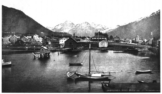
Sitka, Alaska, from the Sea
Within Alaska, the route of exploration continues
through Clarence Strait to the Alexander Archipelago,
comprising several thousand islands, many of
which are mountainous, and about eleven hundred
of the larger ones have been charted. Here is Fort
Wrangell, seven hundred miles from Victoria, on
one of the islands, a little settlement named after
Baron Wrangell, the Russian Governor of Alaska in
1834. Upon landing, the visitors see the Indians and
their chief curiosity, the "totem poles," erected in
front of their houses, and carved with rude figures
emblematic of the owner and his ancestors. These
poles are twenty to sixty feet in height, and two to
five feet in diameter. The natives are divided into
clans, of which the Whale, the Eagle, the Wolf and
the Raven are the chief representatives and are said
to have been the progenitors. These are also carved
on the poles and show the intermarriages of ancestors,
the leading families having the most elaborate
poles. Beyond Fort Wrangell are Soukhoi Channel
and Frederick Sound, leading into Chatham Strait,
having on its western side Baranoff Island, on the
outer edge of which is Sitka Sound. Here is Sitka,
the capital of Alaska, in a well-protected bay dotted
with pleasant islands in front and having snow-covered
mountains for a high background. Alexander
Baranoff founded the town in 1804, the first Russian
Governor of Alaska, and there are now about twelve
hundred inhabitants, mostly Indians. The old wooden
Baranoff Castle, which was the residence of the
Russian Governors, is on a hill near the landing-place.
The main street leads past the Greek
Church, surmounted with its bulbous spire, having
six sweet-toned bells brought from Moscow, and adjoining
it are various old-time log houses built by
the early Russians. The church is still maintained
by the Russian Government. The visitors buy
curiosities and invest their small change in the Indians
who get up monotonous dances or exciting
canoe races for their amusement. It is a curious
fact that, owing to the Kuro Siwo, or Japanese warm
current coming across the Pacific, Sitka has a mild
and most equable climate, the summer temperature
averaging 54° and the winter 32°, the thermometer
seldom falling to zero.
The Stephens Passage leads north from Frederick
Sound, and into it opens Taku Inlet, a large fiord
displaying fine glaciers. Here at Holkham Bay in
1876 began the first placer gold-mining in Alaska.
Just beyond is Gastineaux Channel, between the
mainland and Douglas Island. Upon its eastern
bank, nine hundred miles from Victoria, is Juneau,
the largest town in Alaska, having fifteen hundred
population, about half of them whites; an American
settlement, begun in 1880 under Yankee auspices,
and named after the nephew of the founder of Milwaukee,
Wisconsin. The people are mostly gold-miners.
The little white houses are on a narrow
strip of comparatively level land along the shore,
having a high and precipitous mountain behind.
Juneau deals in furs and Chilkat blankets, the latter,
when genuine, being made of the hair of mountain-goats
and colored with native dyes. It is also a
starting-point for the Klondyke and Yukon regions.
Across the narrow strait, upon Douglas Island, is the
famous Treadwell gold-mine, having three enormous
ore-crushing mills, the largest in the world, aggregating
nearly eight hundred stamps. This is a huge
mountain of gold-ore which John Treadwell bought
in 1882 from its owner for $430. It has paid since
then $9,000,000 in dividends, and now with increased
output crushes three thousand tons of ore daily, netting
$4 gold per ton, and pours into the laps of the
Rothschilds, its present owners, probably $2,000,000
annually from the enlarged product. The ore actually
in sight in the mountain is estimated to be worth five
times as much as was originally paid for the whole
of Alaska. There is a native Indian cemetery adjoining
Juneau, having curious little huts containing
the cremated remains of the dead, with each one's
personal effects.
THE GREAT MUIR GLACIER.
Passing west of Douglas Island and through Icy
Strait to Glacier Bay, a magnificent view is presented.
Snow-covered mountains rise six and seven
thousand feet all around, and to the northwest is the
imposing Mount Fairweather range, elevated over
fifteen thousand feet. Glacier Bay extends forty-five
miles up into the land, its width gradually contracting
from twelve to three miles. Small icebergs
and floes cover much of the surface, as they are
constantly detached from the glaciers descending into
it. At the head of the bay is the greatest curiosity
of Alaska and the most stupendous glacier existing,—the
Muir Glacier,—named in honor of Professor
John Muir, the geologist of the Pacific coast, who
first saw it in 1879 and thoroughly explored it in
1890. When Vancouver was here at the close of
the eighteenth century he wrote that a wall of ice
extended across the mouth of the bay. The belief
is that the glacier once filled the entire bay and has
gradually receded. Near the middle of the bay is
Willoughby Island, a rock two miles long and fifteen
hundred feet high, showing striated and polished surfaces
and glacial grooves from bottom to top. This
glacier far exceeds all the Swiss ice-fields put together,
and it enters the sea with a front one mile
and a half wide and two to three hundred feet high.
Unlike the dirty terminal moraines of the Swiss
glaciers, this is a splendid wall of clear blue and
white ice, built up in columns, spires and huge crystal
masses, displaying beautiful caves and grottoes.
It goes many hundreds of feet below the surface of
the water, and from its front, masses of ice constantly
detach and fall into the bay with noises like thunder
or the discharge of artillery. Huge bergs topple
over, clouds of spray arise, and gigantic waves are
sent across the water. Every few minutes this goes
on as the glacier, moving forward with resistless motion,
breaks to pieces at the end. The field of ice
making this wonderful glacier is formed by nine
main streams and seventeen smaller arms. It occupies
a vast amphitheatre back among the mountains,
thirty to forty miles across, and where it breaks out
between the higher mountains to descend to the sea
is about three miles wide. The superficial area of
this mass of ice is three hundred and fifty square
miles. It moves forward from seven to ten feet
daily at the edges and more in the centre, and in
August, when it loses the most ice, the estimate is
that about two hundred millions of cubic feet fall into
the bay every day. It loses more ice in the summer
than it gains in the winter, and thus steadily retrogrades.
The visitors go up to its face, although it
cannot be ascended there, and then landing alongside
approach it through a lateral moraine, and can
there ascend to the top and walk upon the surface.
The character and appearance of this famous glacier
were much changed by an earthquake in 1899.
Among the attractions are the mirages that are frequent
here, which have been the origin of the
"Phantom City," which early explorers fancifully
described as upon Glacier Bay. Other huge glaciers
also enter these waters, among them the Grand Pacific,
Hugh Miller and Gelkie Glaciers.
THE KLONDYKE AND CAPE NOME.
Northward from the Gastineaux Channel stretches
the grand fiord of the Lynn Canal for sixty miles.
Snow-crowned mountains surround it, from whose
sides many glaciers descend. At the upper end this
Canal divides into two forks—the Chilkoot and Chilkat
Inlets, at 59° north latitude. This begins the
overland route to the Klondyke gold region, and
upon the eastern inlet, Chilkoot, are on either bank
the two bustling little towns that have grown out of
the Klondyke immigration—Skaguay on the eastern
and Dyea on the western shore. Each of them has
three to four thousand people, with hotels, lodging-places
and miners' outfitting shops. Dyea is the
United States military post, with a garrison, and
here begin the trails across the mountain passes to
the upper waters of the Yukon. A railway is constructed
over White's Pass to Bennett Lake, and is
now the chief route of travel. Pyramid Harbor and
Chilkat with salmon-canning establishments are on
Chilkat Inlet. Beyond White's Pass, which crosses
the international boundary, the land descends in
British America to the headwaters of the Yukon
River, which are navigated northwest to Dawson
and Circle City and other mining camps of the
Klondyke region, where the prolific gold-fields have
had such rich yields, there having been $40,000,000
gold taken out in two years. The Yukon flows a
winding course westward to Norton Sound on the
Bering Sea, discharging through a wide-spreading
delta. The port of St. Michaels is to the northward.
There are two routes to the Klondyke from San
Francisco—via Skaguay and overland a distance of
about twenty-three hundred miles, and via St.
Michaels and up the Yukon forty-seven hundred
miles.
The Alaskan coast beyond the Muir Glacier is
bordered by the great St. Elias mountain range, rising
in Mount Logan to nineteen thousand five hundred
and thirty-nine feet, the highest of the Rockies,
and in Mount St. Elias nearer the coast to eighteen
thousand and twenty-four feet. From the broad
flanks of St. Elias the vast Malaspina Glacier flows
down to Icy Bay on the Pacific Ocean. There are
mountains all about this region, which the official
geographers are naming after public men, among
them being Mount Dewey. To the westward the
vast Alaska peninsula projects far out, dividing the
Pacific Ocean from the Bering Sea, terminating in
the Fox Islands, of which Ounalaska is the port, and
having the Aleutian Islands spreading beyond still
farther westward. It is a remarkable fact, indicating
the vast extent of the United States, that the
extremity of the Aleutian group is as far in latitude
westward from San Francisco as the Penobscot River
and coast of Maine are eastward. To the north is
the Bering Strait, having the Russian East Cape of
Siberia projecting opposite to the Alaskan Cape
Prince of Wales to guard the passage into the Arctic
Ocean. Here, upon the southern shore of the protruding
end of Alaska, and fronting Norton Sound
up almost under the Arctic Circle, is the noted Cape
Nome, the latest discovered gold-field, about a hundred
miles northwest of St. Michaels. Fabulous
golden sands are spread out in gulches and on the
beaches, and Nome City has become quite a settlement.
This is the latest El Dorado to which such
an enormous rush of prospectors and gold-hunters
was made in the early spring of 1900, many thousands
filling up every available steamer that could be
got to sail northward. The prolific output of these
gold-bearing sands is said to exceed the Klondyke in
its yield, and this will be the golden Mecca until
somebody crosses over into Siberia or goes up nearer
the North Pole, and finds there a new deposit of
treasure. Already it is said that Nome City spreads
practically for twenty miles along the sea-beach, and
that the industrious miners are getting much gold by
dredging far out under the sea, and expect to secure
fifty millions annually from this remote but extraordinary
region.
Nome City, like everywhere else that the hardy
American pioneer raises the flag for discovery and
settlement, has its newspaper, the Gold Digger, and
this enterprising publication thus poetically describes
the new El Dorado of the Arctic seas, the "Golden
Northland":
"High o'er the tundra's wide expanse,
Mount Anvil lifts its God-wrought crown,
Bold guardian of a shining shore,
That's ever garbed in golden gown.
"Here nature, lavish with her store
To those of nerve and strong of hand,
Outpours a glittering stream of wealth
To all the miners of the land.
"The ledge-ribbed hills on ev'ry side,
To feasts of ore invite mankind,
Nor Bering's waves may bar the way
To golden courses milled and mined.
"The fresh'ning breezes from the Pole
Bear far the miners' joyous cry,
As point of pick turns back the sod
'Neath which the glist'ning nuggets lie.
"Here may the rover of the hills
Find fickle Fortune's long sought stream,
And revel in the boundless wealth
That's ever been his life-long dream.
"O, tundra, beach and lavish stream!
O'er thee a world expectant stands;
With Midas measure may'st thou fill
The myriad eager, outstretched hands."
Wonderful is our latest American Continental possession—the
rich territory of Alaska. Limitless are
its resources, unmatchable its possibilities. One of
its admirers thus sounds its praises: "In scenery,
Alaska dwarfs the world. Think of six hundred
and seventeen thousand square miles of landscape.
Put Pike's Peak on Mount Washington or Mount
Mitchell and it would hardly even up with Mount
Logan. All the glaciers of Switzerland and the
Tyrol dwindle to pitiful summer ice-wagon chunks
beside the vast ice empires of Glacier Bay or mighty
Malaspina. Think of a mass of blue-green ice forty
miles long by twenty-five miles wide, nearly the size
of the whole State of Rhode Island, and five thousand
feet thick, glittering resplendently in the weird,
dazzling light of a midnight sun. Imagine cataracts
by scores from one thousand to three thousand feet
high; ocean channels thousands of feet deep, walled
in by snow-capped mountains; sixty-one volcanoes,
ten of them still belching fire and smoke; boiling
springs eighteen miles in circumference, used by
hundreds of Indians for all their cooking; schools of
whales spouting like huge marine fire-engines and
tumbling somersaults over each other like big lubberly
boys, weighing one hundred to two hundred
thousands of pounds each; rivers so jammed with
fish that tens of thousands of them are crowded out
of the water high up on the shore; and woods alive
with elk, moose, deer, bear, and all sorts and conditions
of costly fur-clad aristocrats of the fox, wolf,
lynx and beaver breeds. Growing country, this of
ours."
PUGET SOUND TO SAN FRANCISCO.
Captain George Vancouver, already referred to,
who named Vancouver Island, had among his officers
a Lieutenant Puget. From him came the name of
Puget Sound, stretching eighty miles southward from
Vancouver Island and the Strait of Juan de Fuca
into Washington State, ramifying into many bays
and inlets, and having numerous islands. The Sound
covers two thousand square miles and has eighteen
hundred miles of coast line, being a splendid inland
sea with admirable harbors. Its peculiar configuration
makes very high tides, sometimes reaching
twelve to eighteen feet. At the entrance near the
head of the Strait of Juan de Fuca is the United
States port of entry, Port Townsend, in a picturesque
situation with the large graystone Custom House on
the bluff, a conspicuous structure. Three formidable
forts, Wilson, Casey and Flagler, guard the entrance
from the sea. Opposite, on the eastern shore of the
Sound, is Everett with a fine harbor, the terminal of
the Great Northern Railway. To the northwest, a
sentinel outpost of the Cascade Range, rises Mount
Baker, nearly eleven thousand feet high. To the
southward, on the circling shores of Elliott Bay, is
Seattle, named after an Indian chief and founded in
1852, built on a series of terraces rising above the
water, the chief commercial city of Puget Sound,
and having sixty thousand population. On the
southeastern arm of the Sound, called Commencement
Bay, is Tacoma, the terminal of the Northern
Pacific Railway, with fifty thousand people. Its Indian
name comes from its great lion, Mount Tacoma
(sometimes called Rainier), a giant of the Cascades,
rising fourteen thousand five hundred and twenty
feet, and in full view to the southeast of the city.
Fourteen glaciers flow down its sides, the chief one,
Nisqually Glacier, seven miles long, on the southern
slope, being considered the finest on the coast south
of Alaska. This mountain, like other peaks of the
Cascades, is an extinct volcano, its crater still emitting
sulphurous fumes and heat. Mount St. Helens,
not far away, which was in eruption in 1898, is regarded
as the most active volcano in the range, its
massive rounded dome rising over nine thousand
feet. Across on the southwestern shore of Puget
Sound is the capital of Washington State, Olympia,
with five thousand people.
Portland, the chief town of Oregon, is but a short
distance south of Puget Sound, on the Willamette
River, twelve miles from its confluence with the
Columbia, and at the head of deep-sea navigation,
one hundred and ten miles from the ocean. This is
the leading business centre of the Pacific northwest,
having seventy thousand people and extensive trade.
It is finely situated, and from the heights on its
western border is given a most superb view of the
Cascades, the range grandly stretching over a hundred
miles. The Mazama Club of earnest mountain
explorers at Portland have done much to make
known to the world the scenery and grandeur of
these attractive mountains. Fifteen miles up the
Willamette, at Oregon City, are the Falls, where
that river descends forty feet in a splendid horseshoe
cataract, displaying great beauty and furnishing valuable
power. To the southward is Salem, on the
Willamette, the capital of Oregon, having five thousand
population. The "Oregon trail," as the route
from San Francisco into this region was called, ascends
the Rogue River, so named from the Indians
of the region, crosses the Siskiyou Mountain, and descends
on the southern side to the headwaters of the
Sacramento. To the eastward, near the California
boundary, high up in the Cascades, is the strangely
constructed Crater Lake. It is at over sixty-two
hundred feet elevation, and occupies an abyss produced
by the subsidence of an enormous volcano,
being six miles long and four wide. A perpendicular
rocky wall one to two thousand feet high entirely
surrounds it, and the water, without outlet or apparent
inflow, is fully two thousand feet deep and
densely blue in color. In the centre is Wizard
Island, rising eight hundred and fifty feet, an extinct
volcanic cone, thus presenting one crater within another.
The district containing this wonderful lake
has been made a reservation called the Oregon National
Park. Some distance to the southward, the
whole country being mountainous and the lower
slopes covered with forests of splendid pines, is the
grand snow-covered dome of Mount Shasta, one of
the noblest of the Cascades (in California called the
Coast Range), rising fourteen thousand four hundred
and forty feet, a huge extinct volcano, having a
crater in its western peak twenty-five hundred feet
deep and three-quarters of a mile wide. Beyond,
the Sacramento Valley stretches far away southward,
passing Chico and Marysville, to Sacramento. It
was to the eastward, near Coloma, that the first discovery
of California gold was made in February,
1848, on the farm of Colonel Sutter, the county
having been appropriately named El Dorado.
SAN FRANCISCO BAY AND CITY.
The San Joaquin and Sacramento Rivers, having
united, flow westward into Suisun Bay, thence by a
strait to the circular and expansive San Pablo Bay,
which in turn empties into San Francisco Bay. On
the strait connecting Suisun and San Pablo Bays is
Benicia, where lived the famous pugilist John C.
Heenan, the "Benicia Boy," and the immense forge-hammer
he wielded is on exhibition there. At the
head of San Pablo Bay is Napa, or Mare Island, the
location of the Navy Yard. Upon the mainland opposite
is Vallejo, whence a railway runs up the fertile
Napa Valley, through orchards and vineyards
and among mineral springs, to Calistoga. Near here
is the strange Petrified Forest, where there are
scattered upon a tract of four square miles the remains
of a hundred petrified trees. The Bay of
San Francisco is a magnificent inland sea, fifty miles
long and ten miles wide, connected with the Pacific
Ocean by the strait of the Golden Gate, five miles
long and a mile wide. The bay is separated from
the ocean by a long peninsula, having the city of
San Francisco on the inside of its northern extremity.
Over opposite, on the eastern shore of the
bay, is Oakland, the terminal of the Southern Pacific
Railway routes from the East, a city of fifty thousand
people, named from the numerous live-oaks
growing in its gardens and along the streets. It has
extensive manufactures and a magnificent view over
the expansive bay and city of San Francisco and the
distant Golden Gate, where the enclosing rocky
shores can be seen rising boldly, the northern side to
two thousand feet height. In the Oakland suburbs
is Berkeley, where are some of the College buildings
of the University of California, founded in 1868 and
having twenty-three hundred students, many of them
women. The attractive grounds cover two hundred
and fifty acres, and the endowments exceed $8,000,000.
South of Oakland is the pleasant suburban
town of Alameda. On the western shore of the bay,
south of San Francisco, is Menlo Park, a favorite
place of rural residence for the wealthy San Francisco
people, having many handsome villas and
estates with noble trees. Here is Palo Alto or the
"tall tree," taking its name from a fine redwood tree
near the railway, an estate of over eight thousand
acres, which is the location of the noted Leland Stanford,
Jr., University. This is the greatest educational
endowment in America, having a fund of over
$30,000,000, the gift of Senator and Mrs. Leland
Stanford in memory of their only son. The University
has twelve hundred students, many being women.
The buildings, which in a manner reproduce the
architecture of the ancient Spanish Missions, are of
buff sandstone, surmounted by red-tiled roofs, picturesquely
contrasting with the oaks and eucalyptus
trees which are so numerous and the many tropical
plants that have been brought there. The Palo
Alto estate is one of the great California stock-farms.
Two Franciscan monks in 1776 founded on this
famous bay the Indian Mission of San Francisco de
Assis, often called the Mission Dolores, and in course
of time there started upon the shore, which had
much wild mint growing about, the village of Yerba
Buena, named from it the "good herb." Just about
the time this lonely little village had got a small
Spanish population and built a few houses, Richard
Henry Dana came into the bay in 1835 on the
voyage which he so pleasantly recounts in Two Years
Before the Mast. He then prophetically wrote:
"If ever California becomes a prosperous country,
this bay will be the centre of its prosperity. The
abundance of wood and water; the extreme fertility
of its shores; the excellence of its climate, which is
as near to being perfect as any in the world; and its
facilities for navigation affording the best anchoring-grounds
in the whole Western coast of America, all
fit it for a place of great importance." In the summer
of 1846, during the Mexican War, the American
navy made various important occupations on the
California coasts, and a man-of-war came into San
Francisco Bay and took possession for the United
States. The next year the name of the village was
changed to San Francisco. There were about six
hundred inhabitants here when gold was discovered
in 1848, and most of them at once left for the gold-fields;
but the favorable location for trade soon attracted
a large population and an extensive commerce.
The young city had the usual mishaps from
fires, suffering from a half-dozen serious conflagrations
in its early career; while the peculiar character
of the population made it then so lawless that twice
the better element had to take summary control of
the municipal government by "Vigilance Committees,"
who did not hesitate to promptly execute notorious
criminals. There are now three hundred and
fifty thousand people, the heterogeneous population
including almost every nationality in the world.
San Francisco is in a fine situation on the shore
of the bay and the steep hills to the westward, and
is gradually spreading across the peninsula towards
the ocean. It is, in fact, built on a succession of
hills, of which a group extends westward from the
bay, varying in height from less than two hundred
to over nine hundred feet. Conspicuous among
them are the Telegraph Hill, Nob Hill, Park Peak,
the Mission Peaks and others. For the purpose of
readily climbing these hills, the cable street railway
and its peculiar "grip" were invented and first put
into successful operation, and a British visitor writes
of San Francisco that "one of its most characteristic
sights is the cable cars crawling up the steep inclines
like flies on a window-pane." The country around
is treeless, with little fertile land, owing to the copious
rivers of sand which steadily flow over it, being
blown from the seashore by the strong westerly trade-winds.
Thus have naturally come the historical San
Francisco "sand lots," the scene of public meetings
and not infrequent disturbances in former times. An
immense amount of grading, cutting down hills, filling
gullies, and reclamations of overflowed lands was
necessary in building the city; and over $50,000,000
has been expended in improving the site which, as
nature fashioned it, was so illy fitted for a city. The
great charm is the spacious bay environed by mountains,
furnishing such an admirable harbor, and across
it the ferry steamers ply in all directions. Upon it,
guarding the Golden Gate entrance, are Alcatraz
Island, Goat Island and Angel Island, strongly fortified,
while Fort Mason is on the heights north of the
city, overlooking the famous strait. The charming
waters of the noble bay are thus rhythmically described
by Ada Abbott Dunton:
"How beautiful the waters of the Bay
Lie shimmering, gem-embossed and turquoise-blue,
Rippling and twinkling! Emerald shores in view
Reflected from its surface. This calm day
Utters no note of discord. Far away
And overhead, the tireless, winged sea-mew
Skims languidly the air, sun-warmed anew
And freshly blown with each succeeding day.
"O San Francisco Bay! Upon thy shore,
What wondrous argosies are anchored here!
What giant masts are silhouetted fair
'Gainst the eternal blue which bendeth o'er,
As though a Titian hand were carving clear,
Majestic monuments in upper air."
The great "Ferry Depot," an ornamental structure
with a high tower, is the centre of the San
Francisco harbor front, whence the steamboats ply
across the spacious bay. From this, the chief business
highway, Market Street, stretches far southwest
to the Mission Peaks, rising over nine hundred feet
and nearly four miles away. Northward, Kearney
Street with the leading stores extends past Telegraph
Hill, rising almost three hundred feet and giving a
magnificent outlook from the summit. Upon Market
Street, in Yerba Buena Park, is the magnificent City
Hall, completed in 1896 at a cost of over $4,000,000
and containing a library of one hundred thousand
volumes. There is a Branch Mint of the United
States which coins much of the gold mined on the
Pacific Slope. The ancient church of the Mission
Dolores, built of adobé is still preserved with the
little churchyard. Upon Nob Hill are many of the
finest residences, while to the northwestward is the
Presidio, originally the Mexican and now the United
States Military Reservation, adjoining the Golden
Gate for some four miles, and a park of almost three
square miles where troops are garrisoned. Here the
military band plays in the afternoon and the walks
and drives afford beautiful views. The Chinese
Quarter of San Francisco, where there is a population
of about fifteen thousand, is a characteristic
feature, the inhabitants swarming in tall tenements
divided by narrow alleys. Its attractions, however,
are of a kind usually prepared with a view to induce
contributions from visitors.
THE GOLDEN GATE.
The Golden Gate Park, a half-mile wide, stretches
from the city three miles to the ocean shore, the
western extremity being mainly the sand-dunes of
the coast, while the eastern portions have been reclaimed,
improved and planted with trees. Here
are tasteful monuments. The author of the Star-Spangled
Banner, Francis Scott Key, is commemorated
by Story, and the Spanish discoverer of the
Pacific Ocean, Vasco Nuñez de Balboa, by Linden,
unveiled in 1898. Here also rises Strawberry Hill,
an eminence giving an unrivalled outlook. Adjoining
the park are the great cemeteries of the city,
Laurel Hill and the Lone Mountain, with others, the
Presidio being to the northward. To the westward,
on the ocean front, is the historic landmark of the
coast—Point Lobos, or the "wolves"—having on its
elevated surface the Sutro Heights, where the sandhills
have been converted into a fine estate and garden,
and out in the sea, a cable's length from shore,
are the celebrated Seal Rocks, which are nearly
always covered with seals basking in the sun. Some
are very large, and their movements are quite interesting,
their curious barking being distinctly heard
above the roar of the surf. To the northward of
Point Lobos is the ocean entrance to the Golden
Gate. The portals are a mile apart, and seen from
the sea its guardian heights rise two thousand feet
on the left hand, stretching up to the peak of Tamalpais
to the northward. On the right hand the
heights are lower, but still lofty. The slopes are
bare and sandy, and between them within the strait
can be distinctly seen the island fortress of Alcatraz,
guarded on the one hand by Goat Island and on the
other by the high green slopes of Angel Island. Up
on the Presidio proudly floats high above the shore
the American flag standing out in the breeze. Behind
it is the great city. This Golden Gate seen
from within, looking westward, is a narrow pass,
giving a vista view of the broad Pacific, its waves
rolling towards us thousands of miles from the distant
shores of China and Japan.
Here ends this pleasant recital. The desire has
been to give an idea of the vast and wonderful land
we live in, and to impress the noble and patriotic
thought of Thoreau's so essential to all of us:
"Nothing can be hoped of you, if this bit of mould
under your feet is not sweeter to you than any other
in the world." We have travelled over this broad
land of ours from the tropics to the Arctic Sea, and
from the Atlantic to the Pacific, and as our journey
closes, with Whittier can sing:
"So shall the Northern pioneer go joyful on his way;
To wed Penobscot's waters to San Francisco's Bay;
To make the rugged places smooth, and sow the vale with grain;
And bear, with Liberty and Law, the Bible in his train:
The mighty West shall bless the East, and sea shall answer sea,
And mountain unto mountain call, Praise God, for we are free!"
THE END.